I-95 at Pioneer Trail Interchange Project Development and ...
125
I-95 at Pioneer Trail Interchange Project Development and Environment (PD&E) Study Indirect and Cumulative Effects Evaluation Technical Memorandum ETDM No.: 14193 Financial Management No.: 436292-1-22-01 Federal Aid Project No.: N/A January 2020 Prepared for: Federal Highway Administration Prepared by: Florida Department of Transportation District Five
-
Upload
khangminh22 -
Category
Documents
-
view
1 -
download
0
Transcript of I-95 at Pioneer Trail Interchange Project Development and ...

I-95 at Pioneer Trail InterchangeProject Development andEnvironment (PD&E) Study
Indirect and Cumulative Effects Evaluation Technical Memorandum
ETDM No.: 14193
Financial Management No.: 436292-1-22-01
Federal Aid Project No.: N/A
January 2020
Prepared for: Federal Highway Administration
Prepared by:
Florida Department of Transportation District Five

I-95 at Pioneer Trail Interchange PD&E Study FM 436292-1-22-01/ ETDM 14193 / Volusia County
Indirect and Cumulative Effects Evaluation Technical Memorandum
-i- January 2020
Table of Contents 1.0 BACKGROUND ............................................................................................................................... 3
1.1 INTRODUCTION ....................................................................................................................... 3 1.2 PURPOSE AND NEED ............................................................................................................. 3 1.3 ETDM SCREENING AND DIRECT EFFECTS ......................................................................... 6
2.0 INDIRECT EFFECTS ANALYSIS .................................................................................................... 8 2.1 STEP 1: ASSESS POTENTIAL FOR INCREASED ACCESSIBILITY .................................... 14 2.2 STEP 2: ASSESS THE POTENTIAL FOR INDUCED GROWTH ........................................... 20 2.3 STEP 3: ASSESS THE POTENTIAL FOR IMPACTS ON SENSITIVE RESOURCES .......... 25 2.4 STEP 4: ASSESS POTENTIAL MINIMIZATION AND MITIGATION MEASURES ........................... 41
3.0 CUMULATIVE IMPACT ANALYSIS ................................................................................................... 44 3.1 DETERMINATION OF SENSITIVE RESOURCES FOR CUMULATIVE IMPACTS ANALYSIS ............ 47 3.2 STEP 1: DESCRIBE RESOURCE CONDITIONS AND TRENDS ................................................... 47 3.3 STEP 2: SUMMARIZE EFFECTS OF THE PROPOSED ACTION ON KEY RESOURCES ........... 51 3.4 STEP 3: DESCRIBE OTHER ACTIONS AND THEIR EFFECTS ON KEY RESOURCES. ............ 52 3.5 STEP 4: ESTIMATE COMBINED EFFECTS ON KEY RESOURCES ............................................. 52 3.6 STEP 5: CONSIDER AV O I DA N C E / MINIMIZATION AND MITIGATION ........................................ 54
4.0 CONCLUSION ............................................................................................................................... 55
LIST OF TABLES
Table 1-1. ETDM Programming Screen Degree of Effect Summary ............................................................ 7 Table 2-1. Estimated Travel Time Savings within Study Area .................................................................... 17 Table 2-2. Potential Permit List .................................................................................................................. 23 Table 2-3. Travel Demand Model Socioeconomic Data (Horizon Year 2045) ............................................ 24 Table 2-4. Moderate Degree of Effect Resource Evaluation List ................................................................ 25 Table 2-5. Land Use and Habitat Cover in Study Area .............................................................................. 26 Table 2-6. Potential Protected Species and Habitat in Study Area ............................................................. 27 Table 2-7. Land Use and Habitat Cover in Study Area .............................................................................. 29 Table 2-8. Wetland Coverage in Study Area .............................................................................................. 35

I-95 at Pioneer Trail Interchange PD&E Study FM 436292-1-22-01/ ETDM 14193 / Volusia County
Indirect and Cumulative Effects Evaluation Technical Memorandum
-ii- January 2020
LIST OF FIGURES
Figure 1-1: Project Location ......................................................................................................................... 4 Figure 1-2: Regional Planned Developments ............................................................................................... 5 Figure 2-1: Indirect Effects Study Area ........................................................................................................ 9 Figure 2-2: Potential Induced Growth Parcels ............................................................................................ 10 Figure 2-3: Induced Growth Area ............................................................................................................... 11 Figure 2-4: Independent Growth Parcels (No-Build Condition) ................................................................... 12 Figure 2-5: Induced Growth Parcels (Build Condition) ............................................................................... 13 Figure 2-6: Distance to Work Census Block for Home Census Block (NSB) .............................................. 15 Figure 2-7: Distance to Work Census Block for Home Census Block (CPO) .............................................. 15 Figure 2-8: Worker Flows of All Jobs ......................................................................................................... 16 Figure 2-9: Employment Destinations for Homes in New Smyrna Beach ................................................... 18 Figure 2-10: Employment Destinations for Homes in Port Orange ............................................................. 19 Figure 2-11: Wetland and Water Resources (Indirect Effects Study Area) ................................................. 36 Figure 2-12: Potential Growth Parcels (Wetland Coverage) ....................................................................... 37 Figure 2-13: Wetland and Water Resources (Induced Growth Area) ......................................................... 38 Figure 2-14: Independent Growth Parcels (No-Build Condition) - Wetland Coverage ................................ 39 Figure 2-15: Induced Growth Parcels (Build Condition) - Wetland Coverage ............................................. 40 Figure 2-16: Potential Growth within Induced Growth Area ........................................................................ 43 Figure 3-1: Cumulative Effects Study Area ................................................................................................ 45 Figure 3-2: Regional Planned Developments ............................................................................................. 46 Figure 3-3: Cumulative Effects Study Area - Public and Conservation Lands ............................................ 48 Figure 3-4: Cumulative Effects Study Area - FEMA Flood Zones ............................................................... 50
LIST OF APPENDICES
APPENDIX A – ETDM SCREENING REPORT

I-95 at Pioneer Trail Interchange PD&E Study FM 436292-1-22-01/ ETDM 14193 / Volusia County
Indirect and Cumulative Effects Evaluation Technical Memorandum
-3- January 2020
1.0 BACKGROUND
1.1 INTRODUCTION
The Florida Department of Transportation (FDOT) is preparing a Type 2 Categorical Exclusion (CE) as part of the Project Development and Environment (PD&E) Study to evaluate effects or impacts of the proposed action. Adherence to FDOT’s PD&E process ensures compliance with the National Environmental Policy Act (NEPA) of 1969, Title 42 U.S.C. § 4321 et seq.
The proposed project is a new Interstate 95 (I‐95) interchange at Pioneer Trail (County Road 4118) at Milepost (MP) 19.032 in Volusia County. The proposed interchange is located between two existing interchanges on I-95: SR 44/ Lytle Avenue at MP 16.287, approximately 2.75 miles to the south and SR 421/ Dunlawton Avenue at MP 23.300, approximately 4.25 miles to the north) as shown in Figure 1-1.
The Council on Environmental Quality (CEQ) regulations for implementing the procedural provisions of NEPA require that environmental effects be evaluated for proposed federal actions. Potential effects or impacts can be direct, indirect (secondary), and cumulative. Direct, indirect and cumulative effects are defined as follows, according to 40 Code of Federal Regulations (CFR) 1508.7 and 1508.08:
• Direct effects are caused by the action and occur at the same time and place.
• Indirect effects are caused by the action and are later in time or farther removed in distance but are still reasonably foreseeable.
• Cumulative impacts result from the incremental impact of the action when added to other past, present and reasonably foreseeable future actions, regardless of what agency (Federal or non-Federal) or person undertakes such other actions.
The direct effects of this proposed action have been evaluated as part of the PD&E Study. The purpose of this memorandum is to identify and assess the indirect and cumulative effects (ICE) resulting from or anticipated to result from the proposed action (new interchange).
To analyze indirect effects and cumulative impacts, it is important to first understand the proposed purpose and need, issues identified in the Efficient Transportation Decision‐Making (ETDM) screening, the direct effects of the Preferred Alternative, and agency coordination.
1.2 PURPOSE AND NEED
The purpose of the proposed interchange at I-95 and Pioneer Trail is to relieve traffic congestion on the two adjacent interchanges north and south of the project: I-95 at State Road 421 (SR 421)/ Dunlawton Avenue and I-95 at State Road 44 (SR 44)/ Lytle Avenue. The project also aims to support economic development associated with existing and approved developments, including several Developments of Regional Impact (Farmton, Restoration and Pavilion at Port Orange) as shown on Figure 1-2.

!P
!P
!P
Mile Post 23.300
4.26 mi
Project Location Proposed Interchange
I-95 at Pioneer Trail
2.74 mi
Mile Post 16.287
§̈¦95
")44
§̈¦95
")421
")44
!I
LegendProject Interchanges!P Existing Interchange
!P Proposed Interchange
City BoundariesNEW SMYRNA BEACH
PONCE INLET
PORT ORANGE
January 2020Indirect and Cumulative Effects EvaluationTechincal Memorandum - 4 -
0 2,640 5,2801,320Feet
1 inch = 5,280 feet
FLORIDA
GeorgiaAlabama
I-95 at Pioneer Trail Interchange PD&E StudyFM 436292-1-22-01 / ETDM 14193 / Volusia County
FIGURE 1-1: PROJECT LOCATION
VOLUSIA
LAKE
SEMINOLE
FLAGLER
LegendStudy Area
Other Florida Counties
Volusia County
Bordering States

!P
§̈¦4
£¤92
Project Location Proposed Interchange
I-95 at Pioneer Trail
§̈¦95")44
§̈¦95
")44
PPO276
SP242
SPV243
RST271
FRM0
FMRE
COWOPCWE
WOHA
VEHP
!I
January 2020Indirect and Cumulative Effects EvaluationTechincal Memorandum - 5 -
0 10,000 20,0005,000Feet
1 inch = 20,000 feet
I-95 at Pioneer Trail Interchange PD&E StudyFM 436292-1-22-01 / ETDM 14193 / Volusia County
FIGURE 1-2: REGIONAL PLANNED DEVELOPMENTS
Development Code Development NameFRME Farmton/RestorationCOWO Coastal WoodsPCWE Planned Community WestsideWOHA Woodhaven
VEHPVerano/Venetian Bay/ Hampton
Village/Promenade Park
Table 1: 2045 Developments
DRI Code DRI NameSP242 Spruce Creek
SPV243 Spruce Creek VillagePPO276 The Pavilion at Port OrangeRST271 RestortationFRM0 Farmton
Table 2: Approved DRI Developments (2017)
LegendProject Interchange!P Proposed Interchange
Indirect Effects Study Area
2045 Planned Developments
Developments of Regional ImpactFarmton
Restoration
Spruce Creek
Spruce Creek Village
The Pavilion at Port Orange

I-95 at Pioneer Trail Interchange PD&E Study FM 436292-1-22-01/ ETDM 14193 / Volusia County
Indirect and Cumulative Effects Evaluation Technical Memorandum
-6- January 2020
The need for the project was identified in the previously approved Interchange Justification Report (April 2017) prepared by FDOT and can be summarized into four primary categories:
• Reduce congestion at adjacent interchanges
• Enhance regional mobility
• Improve emergency evacuation
• Support economic viability associated with future development
1.3 ETDM SCREENING AND DIRECT EFFECTS
The ETDM screening process provides the opportunity for early input and consideration of the environment in transportation planning. It occurs before the PD&E Study to identify potential key issues and concerns related to the project. The Environmental Screening Tool (EST) is a comprehensive digital database that provides geographical information system (GIS) data for use and analyses by members of the Environmental Technical Advisory Team (ETAT). The ETAT typically includes representatives from environmental, planning, and transportation agencies who provide input and review that results in a programming screen summary report with an assigned degree of effect for each environmental issue/ resource. The degree of effect is based on the potential for effects as follows: 0 ‐ None, 1 ‐ Enhanced, 2‐ Minimal, 3 ‐ Moderate, 4 ‐ Substantial, or 5 ‐ Dispute Resolution. This ranking includes the direct effect potential of resources, as well as secondary and cumulative effects. The FDOT ETDM Coordinator reviews the ratings for each resource to determine the overall degree of effect.
For this action, the ETDM screening occurred in 2017; Table 1-1 shows the degree of effect summary. The degree of effect ratings ranged from N/A – Not Applicable/ No Involvement to 4 ‐ Substantial. No agency submitted a degree of effect of 5 ‐ Dispute Resolution.
• 3 ‐ Moderate degree of effect was identified for Historic and Archeological Sites, Water Quality and Quantity, Wildlife and Habitat and Special Designations
• 4 ‐ Substantial degree of effect was identified for Wetlands and Surface Waters
A summary of each agency’s comments for resources with a 3 ‐ Moderate, or 4 ‐ Substantial degree of effect is provided in Appendix A. None of the ETAT review agencies provided comments in the Indirect and Cumulative Effects category. These ETDM comments were used as guidance in development of the PD&E Study interchange alternative configurations. The results of the investigations into direct effects performed during the PD&E study are summarized as follows for items that were ranked as Degree of Effect 3 - Moderate and 4 ‐ Substantial in ETDM:
• Degree of Effect 3 ‐ Moderate. Resources with a 3 ‐ Moderate degree of effect:
− Cultural Resources – No effects were noted to any cultural resources during the PD&E Study, including historic and archaeological sites that are listed or eligible for listing in the National Register for Historic Places (NRHP).

I-95 at Pioneer Trail Interchange PD&E StudyFM 436292-1-22-01/ ETDM 14193 / Volusia County
Indirect and Cumulative Effects Evaluation Technical Memorandum
-7- January 2020
− Water Quality and Quantity – Stormwater management facilities have been proposed to meet water qualityand water quantity criteria under St. Johns River Water Management District regulatory guidelines for theproposed project.
− Wildlife and Habitat – All potential listed species were analyzed for potential involvement from the proposedproject. All federally listed species were given determinations of either “May Affect, but not Likely toAdversely Affect” or “No Effect”, and all state listed species were given “No Adverse Effect” determinations.
− Special Designations – The project is adjacent to a tributary of Spruce Creek which is an OutstandingFlorida Water (OFW). Appropriate permitting will be required to meet the special designation criteria forprotecting water quality.
Table 1-1. ETDM Programming Screen Degree of Effect Summary Social and Economic Cultural Natural Physical
Legend
Land
Use
Cha
nges
Soci
al
Rel
ocat
ion
Pote
ntia
l
Farm
land
s
Aest
hetic
Effe
cts
Econ
omic
Mob
ility
Sect
ion
4(f)
Pote
ntia
l
His
toric
and
Arc
haeo
logi
cal S
ites
Rec
reat
ion
Area
s
Wet
land
s an
d Su
rface
Wat
ers
Wat
er Q
ualit
y an
d Q
uant
ity
Floo
dpla
ins
Wild
life
and
Hab
itat
Coa
stal
and
Mar
ine
Noi
se
Air Q
ualit
y
Con
tam
inat
ion
Infra
stru
ctur
e
Nav
igat
ion
Spec
ial D
esig
natio
ns
N/A Not Applicable/ NoInvolvement
0 None (after12/5/2005)
1 Enhanced
2 Minimal
3 Moderate
4 Substantial
5 Dispute Resolution(Programming Screen)
Alternative #1 - I-95 Interchange at Pioneer Tr From: Williamson Blvd. To: Turnbull Bay Road Published: 11/03/2017 Reviewed from 08/03/2017 to 10/02/2017)
1 2 N/A 2 2 1 1 2 3 N/A 4 3 2 3 0 2 2 2 2 N/A 3
• Degree of Effect 4 ‐ Substantial. Resources with a 4 ‐ Substantial degree of effect:
− Wetlands and Surface Waters – Alternatives were considered to minimize direct effects to wetland systemsand appropriate mitigation was identified for potential unavoidable impacts to forested and emergentwetlands systems.

I-95 at Pioneer Trail Interchange PD&E Study FM 436292-1-22-01/ ETDM 14193 / Volusia County
Indirect and Cumulative Effects Evaluation Technical Memorandum
-8- January 2020
2.0 INDIRECT EFFECTS ANALYSIS
The Indirect Effects Analysis was conducted using the guidance provided in the American Association of State Highway and Transportation Officials (AASHTO) Practitioner’s Handbook 12, Assessing Indirect Effects and Cumulative Impacts under NEPA (AASHTO, 2016) and the FDOT Cumulative Effects Evaluation Handbook (FDOT, 2012). Selection of the temporal study frame was based on the planning horizon/ design year used in the transportation planning forecast efforts for this project; the time horizon for this analysis is 2045. Also included were areas of significant development that have already been planned and will be constructed during this timeframe. Three Developments of Regional Impact (Farmton, Restoration and Pavilion at Port Orange) occur within the study area during this timeframe.
Several methods were evaluated to delineate the indirect effects study area. The study area was developed based on the categories of resources that would potentially be impacted including socioeconomic, natural and cultural. The specific method used to delineate the study area for this project included evaluation of various geographic boundaries including: groupings of traffic analysis zones (TAZs) from the travel demand model (used to identify areas of potential induced growth), limits of environmental systems such as natural watershed areas identified by hydrologic unit code (HUC) boundaries and wildlife management/ species habitat areas that may include potentially impacted resources. Further, guidance for indirect and cumulative impact analysis suggests that the potential for induced growth effects of freeway interchanges generally extends up to a one-mile radius and up to two to five miles along major feeder roadways to the interchange. The resulting overall Indirect Effects Study Area is shown on Figure 2-1.
Potential future growth was analyzed for the study area based upon the guidance described above. The area of potential growth (Figure 2-2) is defined as those parcels within the larger Indirect Effects Study Area that meet the criteria for future development (currently vacant, appropriate zoning or future land use designation, frontage and/or access) or are currently under a plan for future development. The area of Induced Growth is defined as the area within a 1 mile radius of the proposed interchange and up to 2 miles along the major roadways that would be influenced by the interchange (Figure 2-3). The Independent Growth Parcels referred to as the “No-Build Condition” are those parcels within the Induced Growth Area where planning for development has already occurred (or is currently occurring) independent of the proposed project (Figure 2-4). The Induced Growth Parcels are those parcels within the induced growth area that would be subject to future growth based upon the proposed project (Figure 2-5).
Indirect effects have already occurred in the region based upon the construction of I-95 in its original state, subsequent widening, and interchanges such as SR 44 and SR 421 (Dunlawton Avenue) in the area. The Williamson Boulevard extension project has also added to the impacts within the study area. There are also numerous projects that are currently approved and/or under construction within the study area (independent growth parcels). Large scale residential developments within the study area include additional phases to Venetian Bay, and new developments such as Coastal Woods, Shell Pointe Colony, Turnbull Crossings, and Woodhaven, and a yet unnamed development at Elbert Land Estates.
The AASHTO handbook prescribes a four‐step process to assess indirect effects; the following describes how these steps were applied to address the proposed project.

!P
§̈¦95
")44
§̈¦95
")421
")44
")415
£¤1
Project Location Proposed Interchange
I-95 at Pioneer Trail
!I
Legend!P Proposed Interchange
Indirect Effects Study Area
January 2020Indirect and Cumulative Effects EvaluationTechincal Memorandum - 9 -
0 3,250 6,5001,625Feet
1 inch = 6,500 feet
I-95 at Pioneer Trail Interchange PD&E StudyFM 436292-1-22-01 / ETDM 14193 / Volusia County
FIGURE 2-1: INDIRECT EFFECTS STUDY AREA

!P
§̈¦95
")44
§̈¦95
")421
")44
")415
£¤1
Project Location Proposed Interchange
I-95 at Pioneer Trail
!I
January 2020Indirect and Cumulative Effects EvaluationTechincal Memorandum - 10 -
0 3,250 6,5001,625Feet
1 inch = 6,500 feet
FIGURE 2-2: POTENTIAL GROWTH PARCELSI-95 at Pioneer Trail Interchange PD&E Study
FM 436292-1-22-01 / ETDM 14193 / Volusia County
Legend!P Proposed Interchange
Indirect Effects Study Area
Potential Growth Parcels (12,200 ac)

!P
§̈¦95")44
§̈¦95
")421
")44
")415
£¤1
Airport Rd
Williamson BlvdPioneer Trl
Turn
bull B
ayRd
!I
Indirect and Cumulative Effects EvaluationTechincal Memorandum - 11 -
0 3,250 6,5001,625Feet
1 inch = 6,500 feet
I-95 at Pioneer Trail Interchange PD&E StudyFM 436292-1-22-01 / ETDM 14193 / Volusia County
FIGURE 2-3: INDUCED GROWTH AREA
Legend!P Proposed Interchange
Indirect Effects Analysis Study Area
Induced Growth Area (4,000 ac)
January 2020

!P
§̈¦95")44
§̈¦95
")421
")44
Airport Rd
Williamson Blvd
Pioneer Trl
Turn
bull B
ayRd
!IIndirect and Cumulative Effects EvaluationTechincal Memorandum - 12 -
0 2,250 4,5001,125Feet
1 inch = 4,500 feet
I-95 at Pioneer Trail Interchange PD&E StudyFM 436292-1-22-01 / ETDM 14193 / Volusia County
FIGURE 2-4: INDEPENDENT GROWTH PARCELS (NO-BUILD CONDITION)
Legend!P Proposed Interchange
Induced Growth Area (4,000 ac)
Independent Growth Parcels (2,000 ac)
January 2020

!P
§̈¦95")44
§̈¦95
")421
")44
Airport Rd
Williamson Blvd
Pioneer Trl
Turn
bull B
ayRd
!IIndirect and Cumulative Effects EvaluationTechincal Memorandum - 13 -
0 2,250 4,5001,125Feet
1 inch = 4,500 feet
I-95 at Pioneer Trail Interchange PD&E StudyFM 436292-1-22-01 / ETDM 14193 / Volusia County
FIGURE 2-5: INDUCED GROWTH PARCELS (BUILD CONDITION)
Legend!P Proposed Interchange
Induced Growth Area (4,000 ac)
Induced Growth Parcels - Build Condition (900 ac)
January 2020

I-95 at Pioneer Trail Interchange PD&E Study FM 436292-1-22-01/ ETDM 14193 / Volusia County
Indirect and Cumulative Effects Evaluation Technical Memorandum
-14- January 2020
2.1 STEP 1: ASSESS POTENTIAL FOR INCREASED ACCESSIBILITY
Part of the purpose and need for this project is increased accessibility to I‐95 and improving regional mobility in southeast Volusia County while supporting economic viability associated with future development. The responses to the AASHTO handbook questions provide further clarification.
2.1.1 What geographic areas will experience increased accessibility, in the form of faster travel times or more direct access to a transportation facility?
The proposed interchange lies at the boundary of two cities: Port Orange and New Smyrna Beach. Thus, communities primarily within the cities of New Smyrna Beach and Port Orange are expected to experience increased accessibility due to the proposed interchange. However, other areas of Volusia County are also expected to benefit from the proposed interchange. A review of the future land use maps shows that both cities are largely comprised of residential areas with supporting commercial, public, institutional and recreational uses. Mixed-use, commercial and activity centers are concentrated in areas adjacent to the two existing major interchanges along I-95: SR 421 in Port Orange and SR 44 in New Smyrna Beach. With the proposed interchange in place, increased accessibility would be provided for the communities surrounding the interchange, such as the Venetian Bay master planned community, Sugar Mill neighborhoods in New Smyrna Beach, Spring Forest and Samsula-Spruce Creek neighborhoods in unincorporated Volusia County and Cypress Head in Port Orange. This would also serve those DRI’s (Farmton, Restoration and Pavilion at Port Orange) currently planned or in development. Additionally, commuters traveling between New Smyrna/ Port Orange and other parts of the County are expected to benefit from increased accessibility. Major employers in this region of Volusia County include Daytona State College, Embry Riddle Aeronautical University, Daytona Beach International Airport, International Speedway Corporation, Teledyne Oil and Gas, U.S. Foods Inc. and Boston Whaler.
A work destination analysis using the U.S. Census Bureau, Center for Economic Studies OnTheMap Tool was completed. The analysis showed that in 2017 the majority of employment areas (work census blocks) for home census blocks within the cities of New Smyrna Beach and Port Orange were located at a distance greater than ten miles as shown in Figures 2-6 and Figure 2-7, respectively. The percentage share of those traveling at a distance greater than 50 miles from the home census blocks in 2017 more than doubled compared to the five years prior in 2013 for both cities, illustrating that a larger share is traveling farther from home for work-related trips. Additionally, the census data reveals that the largest employment destinations outside of the home census block areas are located to the north/ northwest (Daytona Beach) and to the southwest (DeLand). Finally, based on the inflow/ outflow counts of all jobs in 2017, increased accessibility is anticipated for commuters that are traveling to work in New Smyrna Beach and Port Orange and that live in areas of Volusia County outside of these two cities as shown in Figure 2-8.

I-95 at Pioneer Trail Interchange PD&E StudyFM 436292-1-22-01/ ETDM 14193 / Volusia County
Indirect and Cumulative Effects Evaluation Technical Memorandum
-15- January 2020
Less than 10 miles 10 to 24 miles 25 to 50 miles Greater than 50 miles
All Jobs for All Workers in 2017 Distance Count Share Total All Jobs 9,701 100.0 Less than 10 miles 3,320 34.2 10 to 24 miles 2,555 26.3 25 to 50 miles 1,505 15.5 Greater than 50 miles 2,321 23.9 (Source: U.S. Census Bureau)
Figure 2-6: Distance to Work Census Block for Home Census Block (NSB) (City of New Smyrna Beach)
Less than 10 miles 10 to 24 miles 25 to 50 miles Greater than 50 miles
All Jobs for All Workers in 2017 Distance Count Share Total All Jobs 23,535 100.0 Less than 10 miles 11,125 47.3 10 to 24 miles 4,040 17.2 25 to 50 miles 2,699 11.5 Greater than 50 miles 5,671 24.1 (Source: U.S. Census Bureau)
Figure 2-7: Distance to Work Census Block for Home Census Block (CPO) (City of Port Orange)

I-95 at Pioneer Trail Interchange PD&E StudyFM 436292-1-22-01/ ETDM 14193 / Volusia County
Indirect and Cumulative Effects Evaluation Technical Memorandum
-16- January 2020
2.1.1 How much will travel times improve? What specific areas experience the greatest improvements in travel times?
There are two existing interchanges along I-95: SR 421/ Dunlawton Avenue approximately 4.25 miles to the north of Pioneer Trail and SR 44/ Lytle Avenue approximately 2.75 miles to the south. Pioneer Trail has intersections with area roadways such as Williamson Boulevard and Airport Road to the west of the Interstate and Turnbull Bay Road and Sugar Mill Drive to the east. Currently these collector and arterial roadways are being used to access the existing interchanges at SR 421 and SR 44. The direct connection to I-95 from Pioneer Trail is expected to have a small influence on trip-making behavior including changes in trip destinations, patterns and frequency which can affect travel times. Travel times are expected to improve along the neighborhood roadways because users have the option to directly access a higher speed, limited access facility (70 mph for I‐95 versus 40 to 50 mph on collector/ arterial roads). Furthermore, the area immediately surrounding the proposed Pioneer Trail interchange has been identified as an urban transition area in the future land use plans. Thus, shorter distance trips are anticipated to the new destination (e.g., employment, commercial) locations adjacent to the interchange. Additionally, the new direct access to I-95 will allow for emergency vehicles to have faster response times for incident management along this stretch of the I-95 corridor as well as for the surrounding communities adjacent to the Pioneer Trail interchange.
The travel times vary depending on the origin and destination of travel and will fluctuate depending on the desired traffic route. Data from the regional travel demand model, Central Florida Region Planning Model (CFRPM), was used to extract travel time information for the proposed project. The model runs were completed for the No Build and Build scenarios in future year 2045. The Build scenario assumes a new interchange at I-95 and Pioneer Trail and accounts for mode and route shifts associated with induced travel. The resulting travel time reductions are shown in Table 2-1. It should be noted that the model is for large-scale regional planning purposes and the data for individual localities is imprecise and should be considered as such. Based on the information provided in Table 2-1, the greatest benefits in
City of New Smyrna Beach City of Port Orange Employed in Selection Area, Live Outside Live in Selection Area, Employed Outside Employed and Live in Selection Area City Limits
Figure 2-8: Worker Flows of All Jobs

I-95 at Pioneer Trail Interchange PD&E StudyFM 436292-1-22-01/ ETDM 14193 / Volusia County
Indirect and Cumulative Effects Evaluation Technical Memorandum
-17- January 2020
travel times are anticipated for the communities within the cities of New Smyrna Beach and Port Orange and in unincorporated areas of Volusia County adjacent to the proposed interchange. However, travel time improvements may also result for trips to and from other locations such as Daytona Beach and DeLand which have a substantial share of the employment-related trips as shown in Figure 2-9 and Figure 2-10.
Table 2-1. Estimated Travel Time Savings within Study Area Roadway Link Limits Travel Time Reduction/ Savings
Pioneer Trail Eastbound I-95 and Williamson Boulevard 1 minute 17 seconds
Pioneer Trail Westbound I-95 and Williamson Boulevard 1 minute 36 seconds
Williamson Boulevard Southbound SR 421 and Pioneer Trail 1 minute 2 seconds
Williamson Boulevard Northbound SR 421 and Pioneer Trail 42 seconds
2.1.2 Are there any noteworthy differences among the build alternatives in terms of the travel time savings or new access points that they would provide? For example, do the alternatives vary in terms of the specific geographic areas that would experience faster travel times?
There are no noteworthy differences in the build alternatives as each alternative is a different interchange configuration at the same general location. There is not enough variation in the design of the alternatives to significantly affect accessibility or travel times.

I-95 at Pioneer Trail Interchange PD&E StudyFM 436292-1-22-01/ ETDM 14193 / Volusia County
Indirect and Cumulative Effects Evaluation Technical Memorandum
-18- January 2020
All Jobs from New Smyrna Beach to Work Places in 2017 Places (Cities, CDPs, etc.) as Work Destination Area Count Share All Places (Cities, CDPs, etc.) 9,701 100.0 New Smyrna Beach city, FL 2,053 21.2 Daytona Beach city, FL 1,086 11.2 DeLand city, FL 746 7.7 Port Orange city, FL 492 5.1 Edgewater city, FL 416 4.3 Orlando city, FL 306 3.2 Jacksonville city, FL 295 3.0 Ormond Beach city, FL 215 2.2 Sanford city, FL 132 1.4 Tampa city, FL 103 1.1 All Other Locations 3,857 39.8
(Source: U.S. Census Bureau)
Figure 2-9: Employment Destinations for Homes in New Smyrna Beach

I-95 at Pioneer Trail Interchange PD&E StudyFM 436292-1-22-01/ ETDM 14193 / Volusia County
Indirect and Cumulative Effects Evaluation Technical Memorandum
-19- January 2020
All Jobs from Port Orange to Work Places in 2017 Places (Cities, CDPs, etc.) as Work Destination Area Count Share All Places (Cities, CDPs, etc.) 23,535 100.0 Daytona Beach city, FL 5,518 23.4 Port Orange city, FL 3,420 14.5 DeLand city, FL 1,632 6.9 Ormond Beach city, FL 920 3.9 New Smyrna Beach city, FL 752 3.2 Jacksonville city, FL 726 3.1 Orlando city, FL 688 2.9 South Daytona city, FL 447 1.9 Holly Hill city, FL 402 1.7 Daytona Beach city, FL 324 1.4 All Other Locations 8,706 37.0
(Source: U.S. Census Bureau)
Figure 2-10: Employment Destinations for Homes in Port Orange

I-95 at Pioneer Trail Interchange PD&E StudyFM 436292-1-22-01/ ETDM 14193 / Volusia County
Indirect and Cumulative Effects Evaluation Technical Memorandum
-20- January 2020
2.1.3 Are there important uncertainties in the estimates of travel time savings? For example, are the travel time savings provided by this project contingent on other transportation system improvements that have not yet been constructed? Uncertainty can be important in determining whether induced growth is foreseeable.
The estimates of travel time savings provided by the regional planning model included the planned roadway improvements identified in the River to Sea Transportation Planning Organization (TPO) 2040 Long Range Transportation Plan (LRTP). Minor uncertainties are a part of the funding and timing of LRTP roadway improvement projects. If the LRTP improvements (such as widening Pioneer Trail from two to four lanes) were not constructed, the travel times between origins and destinations may be impacted. Increased travel times for the unimproved facilities could result in decreased travel time savings for the new interchange. However, areas abutting interchanges are prime locations for development activity (such as commercial centers with office/retail uses), thus the interchange itself will provide some of the induced growth that is foreseeable in this area. Therefore, uncertainties in travel time savings is not expected to be the determinant of whether induced growth is foreseeable.
2.1.4 To what extent is the travel model capable of taking into account induced travel? Is induced travel a factor that could meaningfully affect travel time savings?
Induced demand or induced travel is described as “the observed increase in traffic volume that occurs soon after a new highway is opened or a previously congested highway is widened” (FHWA, 2017). More broadly, induced demand includes changes in travel demand as a direct or indirect result from a new infrastructure investment. Induced travel accounts for the increases in travel beyond that which would occur anyway as a result of demographic changes such as population and employment growth, increased income, increased vehicle ownership, fuel prices and workforce participation. Since induced travel adds traffic to an area, additional vehicles are expected to increase travel time thereby impacting travel time savings. The typical 4-step modeling process considers the cost of travel (primarily determined by time) as well as the demographics within each traffic analysis zone to pair origins and destinations within the trip distribution step. The model then routes travel between origins and destinations by shortest travel time using the provided network within the highway assignment step. The shortest travel time is impacted by infrastructure improvements and can change the pairing of origins and destinations, mimicking induced travel/ demand. While it is not a function of a regional travel demand model, a substitute procedure to determine the effects of induced travel/ demand can be accomplished. CFRPM can provide results that skip the origin-destination shifts due to the travel time changes created by an infrastructure investment. In the case of the Pioneer Trail interchange with I-95, the differences between travel times with and without induced travel are not meaningful.
2.2 STEP 2: ASSESS THE POTENTIAL FOR INDUCED GROWTH
The AASHTO handbook states that induced growth includes changes to the “type, location, and place of growth.” The areas for potential induced growth include undeveloped land parcels that currently do not have any permits or are in any stage of current planning/ development and are not located within conservation/ preservation areas. The existing and future land use maps along with aerial maps and data from community development and the current planning divisions of the Cities of New Smyrna Beach and Port Orange were reviewed to determine where current developments exist and to identify areas for potential future growth. The majority of the land within the induced growth area is currently undeveloped, though a significant portion is under planned development, as shown on Figure 2-4. The current land

I-95 at Pioneer Trail Interchange PD&E Study FM 436292-1-22-01/ ETDM 14193 / Volusia County
Indirect and Cumulative Effects Evaluation Technical Memorandum
-21- January 2020
use includes primarily residential uses, conservation lands and agriculture. The parcels in three of four quadrants of the proposed I-95 and Pioneer Trail interchange are currently vacant (a nursery is located in the southeast corner). Development plans exist for portions of all four quadrants.
2.2.1 Is growth already occurring in the Indirect Effects Study Area? Is it likely that the current growth trends would continue regardless of whether the project is implemented?
Steady growth has been occurring within and surrounding the indirect effects study area over the last two decades. According to the US Census Bureau and University of Florida, Bureau of Economic and Business Research (BEBR, 2018), the average annual growth rate was 2.2% for New Smyrna Beach and 1.1% for Port Orange, based on the population change between 2010 and 2018. Comparatively, the average annual growth rate was 0.92% for Volusia County as a whole and 1.35% for the state of Florida for the same time period. Development planned for the indirect effects study area is described in the Future Land Use Element of the cities’ respective Comprehensive Plans (City of Port Orange, 2010 & City of New Smyrna Beach, 2016). The area surrounding the proposed interchange is currently undeveloped, but all of the quadrants are anticipated to be developed in the near future as part of the development occurring in this fast-growing region of the County. Based on data from the current planning divisions of the cities of Port Orange and New Smyrna Beach, portions of the adjacent vacant lands are under various phases of development including planning, zoning and/or construction. In the northwest and northeast quadrants of the proposed interchange, the Woodhaven 983-acre Planned Unit Development (PUD) for which a master development agreement has been executed proposes approximately 1,300 dwelling units and 650,000 square feet of non-residential use including an outdoor village shopping district. The southwest quadrant is proposed as a 745-lot residential subdivision (Shell Pointe Colony) with two village shopping centers. East of the southeast quadrant, the approximate 870-acre Coastal Woods PUD is planned for 1,330 residential units and commercial uses that include 341,000 square feet for a regional shopping center, 407,000 sq. ft. of office, industrial and public/civic land uses and a 98-room hotel. The future land use element of the City of New Smyrna Beach projects continued growth near the proposed interchange and surrounding areas based on several key trends: urban development that has already occurred around the I-95 and SR 421 interchange to the north, the need for quality residential communities to support employment growth associated with the Regional Activity Center planned near the SR 44 interchange, and for workers employed in the Orlando Metropolitan area and residing in or maintaining second homes near the coastal communities. Based on the historic growth trends and current rate of land development activity, development of the adjacent lands is not expected to be entirely dependent on the interchange being built. However, the type of development and timing has the potential to be impacted by the interchange.
2.2.2 What is the magnitude of the increase in accessibility? Would the travel time reductions be large enough to influence travel patterns? For example, would the project bring currently rural areas within a reasonable commuting time of a major metropolitan area?
The most common measure of increase in accessibility is travel time savings. As far as the travel demand model is concerned, even small changes in travel time can influence travel patterns. As previously shown in Table 2-1, travel time savings ranged from 42 seconds to over 90 seconds for some of the key corridors in the project study area. The project lies within the City of New Smyrna Beach, and the City of Port Orange is immediately to the north, as previously shown in Figure 1-1. The next closest metropolitan area (population over 50,000) is the City of Orlando, which is

I-95 at Pioneer Trail Interchange PD&E Study FM 436292-1-22-01/ ETDM 14193 / Volusia County
Indirect and Cumulative Effects Evaluation Technical Memorandum
-22- January 2020
approximately 55 miles to the southwest, a commuting time of at least one hour. Based on commuting characteristics data from the U.S. Census 2013-2017 American Community Survey, the mean travel time to work is 26.4 minutes in the U.S., 27.0 minutes in Florida and 25.4 minutes in Volusia County. Thus, a commute time in excess of one hour is not deemed to be reasonable when compared with the average commuting times based on the Census data. As such, this action would not bring current rural areas within a reasonable commute of the City of Orlando. The effect on travel patterns of the project is expected to be more localized. The addition of the new interchange is anticipated to mainly affect accessibility and commuting time from residential areas to employment centers within the existing and/or planned activity centers in New Smyrna Beach and Port Orange as well as the Deltona-Daytona Beach-Ormond Beach metropolitan area.
2.2.3 For areas that would experience improved accessibility, what other factors are present that might enable or inhibit growth?
This project is consistent with Volusia County and the River to Sea Transportation Planning Organization (R2C TPO) 2040 Long Range Transportation Plan (LRTP). It is also supported by the local governments of City of New Smyrna Beach and City of Port Orange. In addition, public and private stakeholders in the region including property owners, reported interest in and support of an interchange at Pioneer Trail at the April 2019 public meeting for the project. This interest represents one facet of development in attracting commercial uses and related employment opportunities that could contribute to accelerated growth. Furthermore, the Future Land Use Elements of City of Port Orange and City of New Smyrna Beach Comprehensive Plans have specified preferred land use categories with maximum development densities/ intensities for each type of use. Development of currently vacant individual parcels would be dictated by the Comprehensive Plans, and any future adjustments would require the local planning agency’s approval. The future land use elements also set limitations on development of rural areas such that growth occurs in an effective manner in conjunction with the availability of public services and facilities and in consideration of the area’s natural features. Other factors that affect growth are: natural limitations such as topography and soil condition, the cities’ development guidelines that include minimum design standards, land development regulations and smart growth initiatives that promote sustainability and protection of natural and cultural resources while promoting development that contributes to livability as well as the economic health of the area.
2.2.4 If current laws or policies limit growth, is it likely that those restrictions would be modified if the project were constructed?
The current laws do not limit growth; however, there is a regulatory framework for sustainable development as outlined in Table 2-2. The federal Clean Water Act (CWA) Section 404 and SJRWMD Environmental Resource Permit (ERP) regulate wetlands, wildlife, water quantity and quality and floodplains. The Florida Fish and Wildlife Conservation Commission (FWC) has species‐specific permits if impacts occur. Finally, Volusia County and City of New Smyrna Beach have specific open space, buffers, and wildlife linkage corridors required for development. There are no restrictions to growth for which modifications to these laws and policies would be required.

I-95 at Pioneer Trail Interchange PD&E StudyFM 436292-1-22-01/ ETDM 14193 / Volusia County
Indirect and Cumulative Effects Evaluation Technical Memorandum
-23- January 2020
Table 2-2. Potential Permit List Permit/
Approval Agency Regulated Activity Authority Comment
CWA Section 404 Permit USACE
Section 404 (dredge and fill
permit) 33 U.S.C. 1251 et seq.
• Required permit• USFWS is consulting agency for
habitat • Requires mitigation for wetland
impact
Environmental Resource Permit
(ERP) SJRWMD
Wetlands, habitat, stormwater, and
floodplain
40C‐4, 40C‐40, 40C‐41, 40C‐42
F.A.C.
• Required permit• Mitigation for unavoidable wetland
impact • FFWCC is consulting agency for
habitat
Gopher Tortoise Relocation Permit FWC Tortoise
relocation
Rules 68A‐25.002 and 68A‐27.004
F.A.C.
Required if avoidance of burrows is not feasible at design.
Local Development
Approval
City of New
Smyrna Beach
Land Development Regulations
Article VII 701 Article VII 702 Article VII 704
Wetland protection, mitigation Flood prone areas
Historical, architectural or archeological resources
City of Port
Orange
Land Development
Code
Ch. 9, Article I, Sec. 3-4 Ch. 9, Article II, Sec. 9-22 Ch. 9, Article III, Sec. 25
Ch. 9, Article IV, Sec. 31-33
Wetlands protection, mitigation Tree preservation
Spruce Creek environmental corridor Listed species protection
Volusia County
Land Development Regulations
Sec. 72-884 Sec. 72-886 Sec. 72-887
Wetlands permits, buffer, mitigation
Sec 72-745 Flood Hazard areas, Floodplain permits
Sec. 72-831 – 72-845 Open Space & Tree Preservation Tree protection, retention areas,
relocation requirements
Sec. 72-1141 Gopher Tortoise protection standards
2.2.5 Are there noteworthy differences within the study areas in terms of the potential for induced growth?
A review of the travel demand model for the design year 2045 shows that in the study area the Traffic Analysis Zones (TAZs) with the highest population and employment densities occur around the existing I-95 and SR 421 interchange which is completely built out and located north of the indirect effects study area. Numerous residential projects are

I-95 at Pioneer Trail Interchange PD&E Study FM 436292-1-22-01/ ETDM 14193 / Volusia County
Indirect and Cumulative Effects Evaluation Technical Memorandum
-24- January 2020
proposed within the indirect effects study area. Several of these include mixed-use centers that would create new destinations for employment, shopping or recreational trips. To the south of the proposed Pioneer Trail interchange, a regional activity center is currently in various stages of development at the I-95 and SR 44 interchange. The northwest and southeast quadrants are partially developed with commercial retail and/ or medical office uses while the other two quadrants are vacant. Future phases of development around the SR 44 interchange will include a variety of mixed uses that would provide high-intensity employment bases as well as recreational and shopping destinations for the surrounding neighborhoods. Based on the planned developments currently approved and the socioeconomic data in the travel demand model as shown in Table 2-3, it is possible that the I-95 and Pioneer Trail interchange will develop with housing and population densities similar to the SR 421 existing interchange to the north and employment density similar to the SR 44 interchange to the south.
Table 2-3. Travel Demand Model Socioeconomic Data (Horizon Year 2045)
Location CFRPM Traffic Analysis Zone
(TAZ) Dwelling Units Population Employment
I-95 & SR 421 Interchange Area 2412, 2414, 2416, 2417, 2175, 2182,
2183, 2193 6,485 12,969 8,591
I-95 & Pioneer Trail Interchange Area
2425, 2426, 2432, 2433, 2469, 2480,
2481 5,207 11,746 2,168
I-95 & SR 44 Interchange Area 2437, 2444, 2480, 2523, 2524 2,242 3,970 1,303
2.2.6 Is it feasible to quantify the amount of additional growth that is expected to occur, either in the study area as a whole or in specific zones within the study area?
The travel demand model developed for this project utilized a socioeconomic data set for future year 2045 based on Census population and employment projections for Volusia County. The data was disaggregated by proportionality to develop estimates for each of the Traffic Analysis Zones (TAZs) within the study area. The same population and employment data set was used for year 2045 for both No-Build and Build scenarios. The difference in the model between the two scenarios was a modification to the highway network to include the proposed interchange at Pioneer Trail. Thus, while the model shows the projected changes in traffic and shifts in routes due to the new interchange, it is not possible to quantify the amount of additional growth based on the travel demand model. However, as previously noted, based on the current planned developments and the development patterns of the existing adjacent interchanges to the north at SR 421 and to the south at SR 44, the potential exists around the four quadrants of the interchange and along the main feeder roadways that provide connectivity and access to the future interchange. However, as previously mentioned, there are proposed developments that have either already been approved or have begun construction within two of the four quadrants at the interchange, and along both Pioneer Trail and Turnbull Bay Road. Therefore it is not feasible to consider the entirety of these areas for induced growth, as the growth is occurring prior to and independent of the interchange.

I-95 at Pioneer Trail Interchange PD&E Study FM 436292-1-22-01/ ETDM 14193 / Volusia County
Indirect and Cumulative Effects Evaluation Technical Memorandum
-25- January 2020
2.2.7 Are there important areas of uncertainty that affect the assessment of induced growth?
The Comprehensive Plans for both the City of Port Orange and City of New Smyrna Beach have designated future land use based on several factors including economic, social, physical, environmental and political influences. Although preferred land uses and maximum allowable densities have been designated, land development regulations allow for changes in zoning as part of local development review processes. Additionally, although transportation infrastructure improvements influence land use and development patterns, there are other factors which have the potential to impact induced growth. These include changes in income levels, local governmental policies/ tax structure, changes in fuel prices and vehicle affordability, usage and ownership.
2.3 STEP 3: ASSESS THE POTENTIAL FOR IMPACTS ON SENSITIVE RESOURCES
The potential for impacts on sensitive resources is the “final step in the chain of causation” of the connection between induced growth and environmental impacts. The process to determine the potential sensitive resources started with the ETDM screening comments, direct effects evaluation, and agency coordination, summarized in Section 1 of this report. The ETDM resources that were ranked as 4 ‐ Substantial (Wetlands and Surface Waters) are found within the Indirect Effects Study Area and are considered as a potentially sensitive resource. The resources ranked with a 3 ‐ Moderate degree of effect (Historic and Archeological Sites, Water Quality and Quantity, Wildlife and Habitat and Special Designations) were evaluated further to determine applicability for the Indirect Effects Analysis as shown in Table 2-4.
Table 2-4. Moderate Degree of Effect Resource Evaluation List
Resource with Overall Degree of Effect Rating 3 ‐
Moderate
Focus of Agency Concerns
Evaluation to Identify Potential Sensitive Resources for the Indirect Effects Analysis
Historic and Archaeological Sites
• No documented field surveys • High probably of unrecorded
cultural resources
• Cultural Resources Survey provided in this action with concurrence from the SHPO for no effects.
• Each project in Florida requires an ERP with SHPO concurrence required for permit issuance.
• Conditions of the permit address any archaeological finds during construction.
• Conclusion to remove Historic and Archaeological Sites from consideration as a resource for evaluation
Water Quality and Water Quantity
• Project is located within Northern Coastal Basin; Spruce Creek – Outstanding Florida Water
• Stormwater harvesting potential • Surficial aquifer system and
recharge area • Potential for increase in water
quality degradation
• The project was determined to lie inside the Volusia Aquifer boundaries. Sole Source Aquifer review had a finding of “no significant impact” by US EPA Region 4 office.
• Future SJRWMD permits for the project require stormwater ponds to address water quality and quantity.
• Conclusion to remove Water Quality and Quantity from consideration as a potential sensitive resource.

I-95 at Pioneer Trail Interchange PD&E StudyFM 436292-1-22-01/ ETDM 14193 / Volusia County
Indirect and Cumulative Effects Evaluation Technical Memorandum
-26- January 2020
Table 2-4. Moderate Degree of Effect Resource Evaluation List Resource with
Overall Degree of Effect Rating 3 ‐
Moderate
Focus of Agency Concerns Evaluation to Identify Potential Sensitive Resources for the Indirect Effects Analysis
Wildlife and Habitat
• Habitat loss from roadwaysurface area, drainage retentionareas and cleared land
• Potential adverse effects toFederally or State listed species
• Potential for water qualityimpacts
• Natural Resources Evaluation has been conducted for the project• No adverse effects to listed wildlife or habitat• Future SJRWMD permits for the project require stormwater ponds
to address water quality and quantity.• Conclusion to include Wildlife and Habitat as a potential sensitive
resource.
Special Designation
• Project area connected toSpruce Creek – OutstandingFlorida Water
• Future SJRWMD permits for the project require stormwater pondsto address water quality and quantity to meet Special Designationrequirements.
• Special Designation is not directly within project area.• Conclusion to remove Special Designation from consideration as
a potential sensitive resource.
2.3.1 What sensitive resources are present in the study area? What is the condition of those resources?
As identified in the preceding section, Wetlands and Surface Waters and Wildlife and Habitat are the sensitive resources present in the Indirect Effects Study Area. The wetlands in the study area consist of hardwood forest (2,975 acres, 42%), forested mixed (2,108 acres, 30%), vegetated, non-forested (1,121 acres 16%) and coniferous forest (917 acres, 13%). Reservoirs (896 acres, 73%), streams and waterways (317 acres, 26%) and lakes (19 acres, 2%) comprise the surface waters in the study area. The wetlands are primarily concentrated throughout the central portion of the study area on both sides of Interstate 95, while the surface waters are found along the eastern and western periphery of the study area. Spruce Creek borders the study area to the north and consists of approximately 2,040 acres designated as Outstanding Florida Waters. An additional approximately 1,550 acres of conservation area is located with portions of Spruce Creek and extending south toward the northeast quadrant of the proposed interchange. The remainder of the wetlands and surface waters in the study area are situated on private, undeveloped lands. The wetland resources identified are in good condition and are not depleted. The existing land uses based on designations from Florida Land Use, Cover, and Forms Classification System (FLUCCS) are shown in Table 2-5 .
Table 2-5. Land Use and Habitat Cover in Study Area Land Use
Land Use Description
2110 Improved pasture 2130 Woodland Pastures 3200 Shrub and brushland 4110 Pine Flatwoods 4210 Xeric Oak 4410 Coniferous plantations 5100 Streams and waterways 5130 Ditch/Swale

I-95 at Pioneer Trail Interchange PD&E StudyFM 436292-1-22-01/ ETDM 14193 / Volusia County
Indirect and Cumulative Effects Evaluation Technical Memorandum
-27- January 2020
5300 Stormwater Drainage Features 6210 Cypress 6250 Hydric Pine Flatwoods 6300 Wetland Forested Mixed 6420 Saltwater marshes 6430 Wet Prairies 6460 Mixed scrub-shrub wetland 8140 Roads and Highways 8145 Right-of-Way/ Median 8146 Primitive/Trail/Field Road
Wildlife and habitat resources with potential to occur within the indirect effects study area within were identified using FLUCCS and species lists from FWS and FWC for this portion of Volusia County. Table 2-6 Lists the federal and state listed species with potential to occur within the indirect effects study area and are described in detail in the following sections.
Table 2-6. Potential Protected Species and Habitat in Study Area
Common Name Scientific Name Listing Status
Habitat within Indirect Effects
Study area
Habitat within Induced Growth
Area Federal Listed Animals
Eastern indigo snake Drymarchon couperi T Yes Yes Atlantic salt marsh snake Nerodia clarkia taeniata T Yes No
Florida scrub-jay Aphelocoma coerulescens T Yes Yes Bald eagle Haliaeetus leucocephalus N/A* Yes Yes Wood stork Mycteria americana T Yes Yes
Red-cockaded woodpecker Picoides borealis E No No Everglade Snail kite Rostrhamus sociabilis plumbeus E No No
Piping Plover Charadrius melodus T No No Red knot Calidris canutus rufa T No No
West Indian Manatee Trichechus manatus T Yes No Federal Listed Plants
Rugel’s pawpaw Deeringothamnus rugelii E Yes Yes Okeechobee Gourd Cucurbita okeechobeensis spp.
E No No
Fragrant prickly apple Harrisia fragrans E No No State Listed Animals
Gopher tortoise Gopherus polyphemus T Yes Yes Southeastern American kestrel Falco sparverius paulus T Yes Yes
Florida sandhill crane Grus canadensis pratensis T Yes Yes Florida burrowing owl Athene cunicularia floridana T Yes Yes
Roseate spoonbill Ajaia ajaja T Yes Yes

I-95 at Pioneer Trail Interchange PD&E StudyFM 436292-1-22-01/ ETDM 14193 / Volusia County
Indirect and Cumulative Effects Evaluation Technical Memorandum
-28- January 2020
Table 2-6. Potential Protected Species and Habitat in Study Area
Common Name Scientific Name Listing Status
Habitat within Indirect Effects
Study area
Habitat within Induced Growth
Area Little blue heron Egretta caerulea T Yes Yes Tricolored heron Egretta tricolor T Yes Yes
Least tern Sterna antillarum T Yes Yes State Listed Plants Golden leather fern Acrostichum aureum T Yes Yes
American toothed spleenwort Asplenium dentatum E Yes Yes Auricled spleenwort Asplenium erosum E Yes Yes
American bird’s nest fern Asplenium serratum E Yes Yes Ashe’s savory Calamintha ashei E Yes Yes
Sand butterfly pea Centrosema arenicola E Yes Yes Sand-dune spurge Chamaesyce arenicola E Yes Yes
Large-flowered rosemary Conradina grandiflora T Yes Yes Coastal vervain Glandularia maritima E Yes Yes Tampa vervain Glandularia tampensis E Yes Yes
Hartwrightia Hartwrightia floridana T Yes Yes Lake-side sunflower Helianthus carnosus E Yes Yes
Star anise Illicium parviflorum E Yes Yes Atlantic Coast Florida lantana Lantana depressa var floridana E Yes Yes
Nodding pinweed Lechea cernua T Yes Yes Pygmy pipes Monotropsis reynoldsiae E Yes Yes
Narrowleaf naiad Najas filifolia T Yes Yes Celestial lily Nemastylis floridana E Yes Yes
Florida beargrass Nolina atopocarpa T Yes Yes Hand fern Ophioglossum palmatum E Yes Yes
Widespread polypody Pecluma dispersa E Yes Yes Plume polypody Pecluma plumula E Yes Yes Comb polypody Pecluma ptilota var.
E Yes Yes
Terrestrial peperomia Peperomia humilis E Yes Yes Giant orchid Pteroglossaspis ecristata T Yes Yes Chaffseed Schwalbea americana E Yes Yes Buckthorn Sideroxylon lyciodes E Yes Yes Pinkroot Spigelia loganiodes E Yes Yes
Coastal hoary-pea Tephrosia angustissima var
E No No Variable-leaf crownbeard Verbesina heterophylla E Yes Yes
Ocala vetch Vicia ocalensis E Yes Yes Redmargin Zephyrlily Zephyranthese simpsonii T Yes yes
E=Endangered, T=Threatened

I-95 at Pioneer Trail Interchange PD&E StudyFM 436292-1-22-01/ ETDM 14193 / Volusia County
Indirect and Cumulative Effects Evaluation Technical Memorandum
-29- January 2020
2.3.1.1 Eastern indigo snake
The eastern indigo snake was listed as Federally threatened on January 31, 1978, (43 Fed. Reg. 4028), due to population declines caused by habitat loss, over-collecting for the domestic and international pet trade, and mortality caused by rattlesnake collectors who gas gopher tortoise burrows to collect snakes. A 5-year review was completed in 2008 resulting in no change to the species designation (FWS 2008). No critical habitat has been designated for the eastern indigo snake. FWS also does not have a designated consultation area for this species. Documented occurrences of the eastern indigo snake were reviewed through GIS databases and the closest documented sighting of the Eastern indigo snake is from 2003 within the New Smyrna coastal strand, over 7 miles to the southeast of the project location and outside of the indirect effects study area.
2.3.1.2 Florida scrub-jay
The FWS has designated Consultation Areas for the Florida scrub-jay which include the project study area. Consultation Areas encompass all areas where specific species populations exist. Volusia County environmental permitting keeps official “Landcover with Florida Scrub Jays and Scrub Natural Communities” mapping. Based on the map of the Port Orange area, several parcels along the east and west sides of I-95 north of Pioneer Trail and parcels on the north and south sides of Turnbull Bay Road east of Pioneer Trail have been identified as landcover with Florida Scrub Jays. Additionally, parcels along the east side of I-95 and south of Pioneer Trail have been identified as natural scrub communities. Field surveys determined that much of this habitat is no longer suitable for scrub-jays. A five-day scrub-jay survey was conducted during late July and early August 2019 in the areas of remaining habitat along Pioneer Trail south of Turnbull Bay Road. Survey stations were established along both sides of Pioneer Trail south of Turnbull Bay Road in areas of potential habitat. No scrub-jays were identified during the survey.
2.3.1.3 Bald eagle
The bald eagle was de-listed by the FWS in 2007; however, it is still federally protected by the Bald and Golden Eagle Protection Act (BGEPA) in accordance with 16 United States Code 668 and the Migratory Bird Treaty Act of 1918. Bald eagle nests within Florida are closely monitored by the FWC, and the FWC Center for Biostatistics and Modeling maintains a website of known bald eagle nest locations, which is current through the 2016-2017 nesting season. Three nesting territories were identified within the indirect effects study area as shown in Table 2-7, though none were identified within the project study area.
Table 2-7. Land Use and Habitat Cover in Study Nest ID Approximate Location Last Survey Last Known Active
VO041 5.3 miles southeast of proposed interchange 2016 2016 VO097 2.5 miles northeast of proposed interchange 2016 2012 VO122 2.5 miles east of proposed interchange 2016 2009
2.3.1.4 Wood stork
The wood stork was listed as endangered under the Endangered Species Act (ESA) on February 28, 1984 (49 Fed. Reg. 7332). On July 30, 2014, the FWS reclassified the U.S. breeding population of the wood stork from endangered to threatened (79 Fed. Reg. 37078). No critical habitat has been designated for this species. FWS also does not have

I-95 at Pioneer Trail Interchange PD&E Study FM 436292-1-22-01/ ETDM 14193 / Volusia County
Indirect and Cumulative Effects Evaluation Technical Memorandum
-30- January 2020
a designated consultation area for this species. According to the FWS wood stork colony website, the closest wood stork nesting colony is over 20 miles to the west (Hontoon Island), outside of the FWS-defined core foraging area (CFA) which encompasses a 15-mile buffer surrounding a wood stork rookery.
2.3.1.5 Red-cockaded woodpecker
The red-cockaded woodpecker (RCW) was listed as endangered under the ESA in 1973. A 5-year review was completed in 2006 resulting in no change to the status of the species (FWS 2006a). No critical habitat has been designated for this species. The FWS has designated Consultation Areas for the RCW which occur approximately 13 miles to the west of the project study area. The closest documented red-cockaded woodpecker cluster is east of Barberville, approximately 20 miles to the northwest of the project area. During field events, biologists inspected large slash and longleaf pine within the pine flatwoods habitats of the corridor footprint for signs of red-cockaded woodpecker cavities. No cavities were identified within the proposed interchange or roadway footprint areas.
2.3.1.6 Everglade Snail kite
The Everglade snail kite was listed as endangered under the ESA in 1973. In total, about 841,635 acres of critical habitat for the Everglade snail kite were designated in 1977 (42 Fed. Reg. 40685 (Aug. 11, 1977)). No critical habitat for the Everglade snail kite has been designated in Volusia County. The FWS has designated Consultation Areas for the Everglade snail kite which occur approximately 4.3 miles to the west of the project study area. The habitats within the proposed interchange and the associated roadway do not provide substantial habitat for their preferred food source, the apple snail. The closest documented snail kite occurrence is in southern Brevard County within the marshes that surround the upper St. Johns River.
2.3.1.7 Additional Federally Listed Species
The threatened red knot and piping plover lack habitat within the project area for direct impacts. These birds all prefer coastal habitats including intertidal, marine, estuaries and bays. The threatened west Indian Manatee is a federally listed mammal that occurs within large aquatic habitats in Volusia County. The threatened Atlantic salt marsh snake is a federally listed reptile that occurs within Volusia County. The closest areas of potential habitat for these species are within Spruce Creek to the north and the tidal wetlands associated with Turnbull Bay to the east.
2.3.1.8 Rugel’s pawpaw
This plant species endemic to Volusia County occurs within open slash pine or longleaf pine flatwoods with wiregrass and saw palmetto in the understory and is federally listed as endangered. There is habitat (pine flatwoods) within the project study area that could support this species if it was properly managed (prescribed fire or mowing). However, in its current condition, the pine flatwoods are far too overgrown. Field surveys were carried out to ascertain whether this species is within the corridor. No individual pawpaw were observed within the study area.
2.3.1.9 Okeechobee Gourd
The Okeechobee Gourd is a vine with long, twisting tendrils and slender stems that is endemic to central Florida. This member of the gourd family listed as endangered by FWS occurs within pond apple swamps and mucky soils on Lake Okeechobee shores and islands as well as floodplain forests along the St. Johns River. The project corridor is over 20

I-95 at Pioneer Trail Interchange PD&E Study FM 436292-1-22-01/ ETDM 14193 / Volusia County
Indirect and Cumulative Effects Evaluation Technical Memorandum
-31- January 2020
miles east of the St. Johns River. Nonetheless, the large wetland forests within the floodplain area were inspected for this gourd. No specimens of Okeechobee gourd were found during field surveys
2.3.1.10 Fragrant prickly apple
This endangered plant is a member of the cactus family and is found in coastal hammocks and shell middens. These habitat types do not occur within the project study area and no specimens of cactus were observed during field reviews.
2.3.1.11 Gopher tortoise
This gopher tortoise is a medium-sized land tortoise listed as threatened by the FWC. The tortoise prefers areas of well-drained loose soils that support adequate low-growing herbs. Very few gopher tortoise burrows were identified within the project study area during field reviews. Most of the upland habitat within the study area has a high-water table that is not ideal for this species, which prefers well-drained soil types to dig its burrows in.
2.3.1.12 Southeastern American kestrel
The southeastern American kestrel is the smallest falcon within the United States. This non-migratory subspecies is listed as threatened by the FWC, and is most common in peninsular Florida, and rarer in the panhandle. Another subspecies of the American Kestrel (Falco sparverius sparverius) which is indistinguishable from the southeastern subspecies is a non-listed wintering migrant bird species that is found throughout Florida between September and March. There is a small amount of suitable kestrel foraging habitat within open portions of the woodland pasture; however, most of the project study area is much too overgrown to be suitable habitat for this species. The dead pine trees observed within the corridor were inspected for signs of nesting kestrel, although none were observed. There have been no documented sightings of the kestrel within one (1) mile of the project corridor and there was no direct observation of a southeastern kestrel or a nest during field reviews.
2.3.1.13 Florida sandhill crane
The Florida sandhill crane is a tall, long necked and long-legged bird with a red head and is listed as threatened by FWC. The greater sandhill crane (Grus canadensis tabida), another species of crane, is a migratory winter visitor to Florida and is indistinguishable in the field. No sandhill cranes have been observed during field reviews, nor have any nest sites been identified.
2.3.1.14 Florida burrowing owl
The Florida burrowing owl is a small, long-legged, ground-dwelling burrowing owl that is listed as threatened by FWC. The marsh systems within the corridor are typically much too shallow to provide nesting habitat; although foraging habitat is plentiful. Foraging and nesting habitat within the project study area is restricted to the maintained utility easements and roadsides grass side slopes (foraging only). There were no direct observations of this species foraging within the corridor during field reviews.
2.3.1.15 Roseate spoonbill
The roseate spoonbill is a large pink and white wading bird with a flat, spoon-like bill and is listed as threatened by the FWC. There is foraging habitat for this species within the project corridor; however, there is no nesting habitat. The

I-95 at Pioneer Trail Interchange PD&E Study FM 436292-1-22-01/ ETDM 14193 / Volusia County
Indirect and Cumulative Effects Evaluation Technical Memorandum
-32- January 2020
closest wading bird rookery is over five miles to the southeast. No direct observations of the roseate spoonbill were made during field reviews of the project corridor.
2.3.1.16 Little blue heron
The little blue heron is a medium-sized, slate-blue, wading bird that is listed as threatened by the FWC. The preferred habitats are fresh and saltwater habitats including fresh and saltwater mudflats and marshes, beaches, mangrove swamps, cypress swamps, hardwood swamps, wet prairies and bay swamps. A specimen of little blue heron was observed utilizing a drainage ditch west of I-95. The closest wading bird rookery is over 5 miles to the southeast.
2.3.1.17 Tricolored heron
The tricolored heron is a medium-sized, two-toned, wading bird that is listed as threatened by the FWC. This bird prefers both fresh and saltwater habitats such as fresh and saltwater marshes and mudflats, brackish marshes, beaches, mangrove swamps, hardwood and cypress swamps, and wet prairies. Although habitat is available within the study area, no tricolored herons were observed during field reviews. The closest wading bird rookery is over 5 miles to the southeast.
2.3.1.18 Least tern
The Least tern is a light grey bird with a black cap and nape and is listed as threatened by the FWC. This species occurs in both fresh and saltwater habitats. Beaches, open fresh and saltwater, fresh and saltwater marshes, wet prairies, and agricultural environments are preferable habitats for the species. While there is freshwater marsh within the study area, no least terns were observed during field reviews.
2.3.1.19 State Listed Plant Species
A number of State listed plant species have the potential to occur within the study area as shown in Table 2.6. State listed species are regulated by the Florida Department of Agriculture and Consumer Services (FDACS), and state regulations only address the harvesting, transport, and/or sale of listed plant species. State rules do not specifically regulate or prohibit the incidental taking of state listed plants in the course of project activities, but general principles of avoidance and minimization are applied to projects that may impact listed state plants.
2.3.2 Is it possible to determine the general locations where induced growth is likely to occur?
As stated in Section 2.2.1, steady growth has been occurring within and surrounding the indirect effects study area over the last two decades. The rate of development activity in the cities of New Smyrna Beach and Port Orange reflects this growth. The addition of new infrastructure is assumed to benefit existing and planned future communities by providing the needed accessibility and relief to traffic congestion in the region. Numerous projects are already in planning, construction or other stages of development without an interchange at Pioneer Trail. It may be assumed that there would be some amount of induced growth attributable to a new facility. In general, this growth can be expected to occur in the immediate quadrants of the proposed interchange and along the frontage of the other roadways connecting to Pioneer Trail that would provide access to the interchange (see Figure 2-3). Again, as previously stated, there are

I-95 at Pioneer Trail Interchange PD&E Study FM 436292-1-22-01/ ETDM 14193 / Volusia County
Indirect and Cumulative Effects Evaluation Technical Memorandum
-33- January 2020
developments that have been approved, and others already under construction within this area, reducing the areas available for induced growth (Figure 2-4).
2.3.3 If induced growth is expected in areas where sensitive resources are present, are there reasons to believe that impacts to those resources will be avoided? For example, are regulatory or land use restrictions in place that can be relied upon to protect those resources? Overall, what specific resources are most likely to be impacted by induced development as a result of this project?
Based on the information presented in Section 2.3 of this report and in the Natural Resources Evaluation (NRE) for this project, two sensitive resources, Wetlands, and Wildlife and Habitat, were identified for further assessment for indirect impacts. Regulatory protections and land use/ planning restrictions exist to safeguard these sensitive resources.
2.3.3.1 Indirect Effects on Wildlife and Habitat
The I-95 at Pioneer Trail Interchange Natural Resources Evaluation (NRE) identified those species with potential habitat in the direct impacts area for this project. The six federally protected animals and three plant species were analyzed for potential involvement with the proposed project. A “not likely to adversely affect” determination was made for four of the federally-listed species (eastern indigo snake, Florida scrub-jay, bald eagle, and wood stork) and for two of the plant species (Rugel’s pawpaw and Okeechobee gourd), with the other three animals and one plant being given a “no effect” determination. The project’s direct effects study area also had the potential to contain habitat for nine potential state protected animals and 32 state protected plants. Wildlife surveys for both animals and habitat were conducted. No adverse effects are anticipated with any state protected animal or plant. Since the project is already demonstrating that there is no direct effect (no impact or no likely adverse effect) for the species identified to potentially occur in the direct impacts study area, it is further assumed that there will be no indirect effects in the overall indirect effects study area to these species from the proposed project. Since regulatory protections are in place to assess projects that would be part of any induced growth or encroachment, the potential for these species to have indirect effects from this project are limited.
Among the possible indirect effects of the project on wildlife in the project area are restrictions on the ability to use controlled burning to maintain habitat, habitat fragmentation due to induced growth from the project, and habitat connectivity and wildlife movement.
• Indirect Effects from Suppression of Controlled Burning
Prescribed burning is essential to managing habitat for scrub‐jay. Prescribed burning maintains and enhances scrub habitat within conservation lands, as stated in the Florida Prescribed Burning Act (Chapter 590 F.A.C.):
“Most of Florida’s natural communities require periodic fire for maintenance of their ecological integrity. Prescribed burning is essential to the perpetuation, restoration, and management of many plant and animal communities. Significant loss of the state’s biological diversity will occur if fire is excluded from fire‐dependent systems”.
There are relatively few areas of scrub habitat within the indirect effects study area, limiting the chances that this will be a significant indirect effect.

I-95 at Pioneer Trail Interchange PD&E Study FM 436292-1-22-01/ ETDM 14193 / Volusia County
Indirect and Cumulative Effects Evaluation Technical Memorandum
-34- January 2020
• Indirect Effects from Habitat Fragmentation
Habitat fragmentation can occur as a direct result of the project, but later in time, or from growth induced by the project. Habitat fragmentation will not occur as a result of constructing the interchange but could potentially occur from additional roadways that occur within the effects area at a later time. I-95 already has severed habitat in the area, though a significant connection is still maintained just to the north of the project area at the large bridge over Spruce Creek. There are also numerous connections via culvert all along I-95 in Volusia County.
Wetland regulations would prevent the direct loss of foraging habitat and minimize wetland habitat fragmentation for wetland dependent species, such as the wood stork and Everglade snail kite, though the study area is not within any Core Foraging Area for wood storks. The proposed interchange and the areas of growth induced by the project would not represent a barrier to movement of either the wood stork or Everglade snail kite because both species are wide‐ranging and frequently fly over roadways.
Scrub‐jay habitat in the indirect effects study area will not be impacted by induced growth related to the interchange and will not be fragmented by the project. Regulatory guidelines would still be in place should future projects propose impacts to any occupied habitat.
The eastern indigo snake in central Florida inhabits a variety of environments and does not nest exclusively in gopher tortoise burrows, but also uses other animals’ burrows, hollows, and trash piles as nests. The ideal environment for eastern indigo snakes involves both xeric sandhills with gopher tortoise burrows, and wetlands. There is little xeric habitat in the study area, though some is present. Very few gopher tortoise burrows were identified within the area of direct impacts, though they are common in upland communities in Volusia County.
Sufficient habitat will remain after the project is constructed to allow the eastern indigo snake and gopher tortoise to survive, although some potential habitat may be lost. The FFWCC requires the relocation of gopher tortoises from areas subject to development if they cannot be avoided and requires restoration and management of suitable habitat at their relocation sites (Rules 68A‐25.002 and 68A‐27.004 F.A.C.).
Gopher tortoises have very small home ranges, generally less than 0.01 square miles, which decreases the likelihood that their movement patterns will be disrupted by the construction of the project.
There are no old‐growth, longleaf pine communities (red‐cockaded woodpecker habitat) within or adjacent to the project area or within the indirect effects area. Due to the range of the red‐cockaded woodpecker (0.9 mile), the likelihood of occurrence in the project area is very low. The nearest known colony is east of Barberville, approximately 20 miles northwest of the project area. Habitat fragmentation is not an issue for the red‐cockaded woodpecker in relation to the project.

I-95 at Pioneer Trail Interchange PD&E StudyFM 436292-1-22-01/ ETDM 14193 / Volusia County
Indirect and Cumulative Effects Evaluation Technical Memorandum
-35- January 2020
2.3.3.2 Indirect Effects on Wetlands
A total of 20 individual wetlands and 11 other surface waters (OSW) were located within the direct impacts project study area. Seventeen wetlands and eight OSWs would be directly affected by the recommended alternative evaluated in the study. A UMAM analysis of each wetland impacted by the preferred alternatives results in an estimated functional loss of 27.53 UMAM units associated with the project.
Additionally, development associated with induced growth could potentially affect wetlands and surface waters in the indirect effects study area. These potential indirect effects to wetlands include placement of fill that could produce degradation/ changes in wetland functions. The total estimated wetlands in the indirect effects study area as shown on Figure 2-11 is approximately 7,500 acres (25.5%). The wetlands within the potential growth parcels within the Indirect Effects Study Area shown on Figure 2-12 is approximately 3,700 acres (30.3%). The amount of wetlands within the Induced Growth Area (Figure 2-13) is approximately 1,000 acres (25%). Of these, approximately 600 acres (30%) are within the boundaries of the No Build planned future development growth areas (those areas with planned developments at the current time unrelated to this project) as shown on Figure 2-14. Wetlands in the induced development parcels identified in the Build forecasted growth area (Figure 2-15) include approximately 200 acres (22.2).
Any proposed development has to comply with regulations for the filling and encroachment of wetlands as specified in Sections 401 and 404 of the Clean Water Act. Additionally, the federal regulatory program has a policy in place of no overall net loss of aquatic resource functions, which is achievable through compensatory mitigation for any unavoidable impacts. Based on the estimated limited involvement with wetlands in the entire indirect effects study area and considering that any unavoidable impacts to those wetlands would be governed by regulatory policy requiring mitigation, the indirect effects on wetlands is deemed to be unsubstantial.
Table 2-8. Wetland Coverage in Study Area Description Area (acres) Wetlands (acres) Wetlands (%)
Indirect Effects Study Area 29,400 7,500 25.5% Potential Growth Parcels 12,200 3,700 30.3%
Induced Growth Area 4,000 1,000 25% Independent Growth Parcels (No-Build) 2,000 600 30%
Induced Growth Parcels (Build) 900 200 22.2% Notes:
1) Wetland area includes Surface Waters that are Streams or Lakes2) Area is approximate to the nearest:
10 for >100, <1,000100 for > 1,000

!P
§̈¦95
")44
§̈¦95
")421
")44
")415
£¤1
Project LocationProposed Interchange
I-95 at Pioneer Trail
!I
Indirect and Cumulative Effects EvaluationTechincal Memorandum - 36 -
0 3,250 6,5001,625Feet
1 inch = 6,500 feet
I-95 at Pioneer Trail Interchange PD&E StudyFM 436292-1-22-01 / ETDM 14193 / Volusia County
FIGURE 2-11: WETLAND AND WATER RESOURCES(INDIRECT EFFECTS STUDY AREA)
Legend!P Proposed Interchange
Indirect Effects Study Area
Existing Wetland and Water Resources (7,500 ac)5100 : Streams and Waterways
5200 : Lakes
6100 : Wetland Hardwood Forest
6200 : Wetland Coniferous Forest
6300 : Wetland Forested Mixed
6400 : Vegetated Non-Forested Wetlands
January 2020

!P
§̈¦95
")44
§̈¦95
")421
")44
")415
£¤1
Project Location Proposed Interchange
I-95 at Pioneer Trail
!I
Indirect and Cumulative Effects EvaluationTechincal Memorandum - 37 -
0 3,250 6,5001,625Feet
1 inch = 6,500 feet
I-95 at Pioneer Trail Interchange PD&E StudyFM 436292-1-22-01 / ETDM 14193 / Volusia County
FIGURE 2-12: POTENITAL GROWTH PARCELSWETLAND COVERAGE
Legend!P Proposed Interchange
Indirect Effects Study Area
Potential Growth - Wetlands (3,700 ac)
January 2020

!P
§̈¦95
")44
")421
")44
Project LocationProposed Interchange
I-95 at Pioneer Trail
!I
Indirect and Cumulative Effects EvaluationTechincal Memorandum - 38 -
0 2,250 4,5001,125Feet
1 inch = 4,500 feet
I-95 at Pioneer Trail Interchange PD&E StudyFM 436292-1-22-01 / ETDM 14193 / Volusia County
FIGURE 2-13: WETLAND AND WATER RESOURCES (INDUCED GROWTH AREA)
Legend!P Proposed Interchange
Induced Growth Area
Existing Wetland and Water Resources (1,000 ac)5100 : Streams and Waterways
5300 : Reservoirs
6100 : Wetland Hardwood Forest
6200 : Wetland Coniferous Forest
6300 : Wetland Forested Mixed
6400 : Vegetated Non-Forested Wetlands
January 2020

!P
§̈¦95")44
§̈¦95
")421
")44
Airport Rd
Williamson Blvd
Pioneer Trl
Turn
bull B
ayRd
!IIndirect and Cumulative Effects EvaluationTechincal Memorandum - 39 -
0 2,250 4,5001,125Feet
1 inch = 4,500 feet
I-95 at Pioneer Trail Interchange PD&E StudyFM 436292-1-22-01 / ETDM 14193 / Volusia County
FIGURE 2-14: INDEPENDENT GROWTH PARCELS (NO-BUILD CONDITION) WETLAND COVERAGE
Legend!P Proposed Interchange
Induced Growth Area (4,000 ac)
Independent Growth Parcel Wetlands (600 ac)
January 2020

!P
§̈¦95")44
§̈¦95
")421
")44
Airport Rd
Williamson Blvd
Pioneer Trl
Turn
bull B
ayRd
!IIndirect and Cumulative Effects EvaluationTechincal Memorandum - 40 -
0 2,250 4,5001,125Feet
1 inch = 4,500 feet
I-95 at Pioneer Trail Interchange PD&E StudyFM 436292-1-22-01 / ETDM 14193 / Volusia County
FIGURE 2-15: INDUCED GROWTH PARCELS (BUILD CONDITION)WETLAND COVERAGE
Legend!P Proposed Interchange
Induced Growth Area (4,000 ac)
Induced Growth Parcel Wetlands (200 ac)
January 2020

I-95 at Pioneer Trail Interchange PD&E Study FM 436292-1-22-01/ ETDM 14193 / Volusia County
Indirect and Cumulative Effects Evaluation Technical Memorandum
-41- January 2020
2.3.3.3 Summary of Indirect Effects on Resources
The resources most likely impacted are as follows:
Wetlands and surface waters within the study area that would be impacted would be subject to permitting guidelines and would require mitigation.
Potential habitat for listed species such as wood stork and eastern indigo snake may be impacted, though for wood stork, this would be offset via wetland mitigation during permitting, and any undeveloped land could be considered suitable for a habitat generalist such as the indigo snake.
The FFWCC requires the relocation of gopher tortoises if they cannot be avoided and requires restoration and management of suitable habitat at their relocation sites (Rules 68A‐25.002 and 68A‐27.004 F.A.C.).
2.3.4 Will the project have incremental effects, in combination with other projects that are affecting the same resource?
Potentially, though as described previously, there are numerous projects that will occur prior to and without the interchange, and others that may be related. Figure 2-16 depicts this growth pattern. This is further described in Section 3.0
2.3.5 To the extent that impacts are identified, what measures are available to minimize and mitigate those impacts? Who would be responsible for implementing those measures?
Minimization and mitigation were previously discussed in Section 2.3.3. Any landowner/developer will be responsible for mitigating the impacts from their projects. The FDOT commits to avoidance and minimization practices during design and permitting of the interchange and other projects in the future. Please refer to Section 2.3.3 regarding wildlife and habitat issues.
2.4 STEP 4: ASSESS POTENTIAL MINIMIZATION AND MITIGATION MEASURES
Minimal impact will occur for the key resources identified above in the Indirect Effects Analysis. The following are potential mitigation:
Wildlife and Habitat. As discussed in 2.3.3.2, indirect effects on wildlife are related to habitat loss, and increased habitat fragmentation. Habitat fragmentation has already occurred from I-95 and will not increase significantly from this project. During permitting, all potential gopher tortoise habitat that could be impacted by the project will be systematically surveyed according to the current guidelines published by the Florida Fish and Wildlife Conservation Commission (FWC). If gopher tortoise burrows are found, all practicable design measures will be employed to avoid impacts to the burrows. For burrows which cannot be avoided, a permit will be obtained from FWC for relocation of gopher tortoises and commensals, and relocation will be performed at a time as close as practicable to the start of

I-95 at Pioneer Trail Interchange PD&E StudyFM 436292-1-22-01/ ETDM 14193 / Volusia County
Indirect and Cumulative Effects Evaluation Technical Memorandum
-42- January 2020
construction activities at the site of the burrows. Gopher tortoises will be relocated to areas of suitable habitat which are required to be restored and managed for gopher tortoises (Rules 68A‐25.002 and 68A‐27.004 F.A.C.).
Wetlands. As discussed in Section 2.3.3.3, direct and indirect effects on wetlands have been avoided as much as possible. State and federal permitting processes ensure mitigation for unavoidable impacts to wetlands. It is anticipated that wetland mitigation credits will be purchased from a bank to offset the direct and secondary impacts from this project. All mitigation will occur within the same drainage basin as the project impacts.

!P
§̈¦95")44
§̈¦95
")421
")44
Airport Rd
Williamson Blvd
Pioneer Trl
Turn
bull B
ayRd
!IIndirect and Cumulative Effects EvaluationTechincal Memorandum - 43 -
0 2,250 4,5001,125Feet
1 inch = 4,500 feet
I-95 at Pioneer Trail Interchange PD&E StudyFM 436292-1-22-01 / ETDM 14193 / Volusia County
FIGURE 2-16: POTENTIAL GROWTH WITHIN INDUCED GROWTH AREA
Legend!P Proposed Interchange
Induced Growth Area (4,000 ac)
Induced Growth Parcels - Build Condition (900 ac)
Independent Growth Parcels (2,000 ac)
January 2020

I-95 at Pioneer Trail Interchange PD&E Study FM 436292-1-22-01/ ETDM 14193 / Volusia County
Indirect and Cumulative Effects Evaluation Technical Memorandum
-44- January 2020
3.0 CUMULATIVE IMPACT ANALYSIS
Cumulative impacts can result from individually minor, but collectively significant, actions that take place over a period of time. Such impacts include the total of all impacts to a particular resource that may have occurred, are occurring, and will likely occur as a result of any action or influence, including the direct and reasonably foreseeable indirect effects of the proposed action. In addition to the proposed project and the indirect effects resulting from the proposed project, the cumulative effects analysis includes past, present, and reasonably foreseeable future projects that do not depend on the proposed project but contribute to the state of the resources.
Study Area for Cumulative Impacts Analysis The study area is the same as for the indirect effects analysis previously detailed in this report (Figure 3-1). The study area was developed based on the categories of resources that would potentially be impacted including socioeconomic, natural and cultural. The specific method used to delineate the study area for this project included evaluation of various geographic boundaries including: groupings of traffic analysis zones (TAZs) from the travel demand model (used to identify areas of potential induced growth), limits of environmental systems such as natural watershed areas identified by hydrologic unit code (HUC) boundaries, and wildlife management/ species habitat areas that may include potentially impacted resources/ features. Further, guidance for indirect and cumulative impact analysis suggests that the potential for induced growth effects of freeway interchanges generally extends up to a one-mile radius and up to two to five miles along major feeder roadways to the interchange.
Utilizing the development plans for both New Smyrna Beach and Port Orange, as well as the transportation program from FDOT, a list of major projects has been identified that presents the potential to affect the state of the resources.
Major projects that have been identified as occurring within this study area either currently or in the future include:
• I-95 from SR 44 to I-4 Widening (from 4 to 6 lanes) - completed
• Coastal Woods – future
• Woodhaven – future
• Shell Pointe Colony – future
• Venetian Bay – current/future
• Turnbull Crossings – current
• Elbert Land Estates – current/future
• Ocean Gate – future
• The Palms at Ashton Lakes – future
Additional projects have also been identified as planned, approved, or under construction within the study area that are not considered as “major”. Figure 3-2 depicts the areas where these projects occur.

!P
Project Location Proposed Interchange
I-95 at Pioneer Trail
§̈¦95
")44
§̈¦95
")421
")44
!I
January 2020Indirect and Cumulative Effects EvaluationTechincal Memorandum - 45 -
0 3,250 6,5001,625Feet
1 inch = 6,500 feet
I-95 at Pioneer Trail Interchange PD&E StudyFM 436292-1-22-01 / ETDM 14193 / Volusia County
FIGURE 3-1: CUMULATIVE EFFECTS STUDY AREA
LegendProject Interchange!P Proposed Interchange
Cumulative Effects Study Area
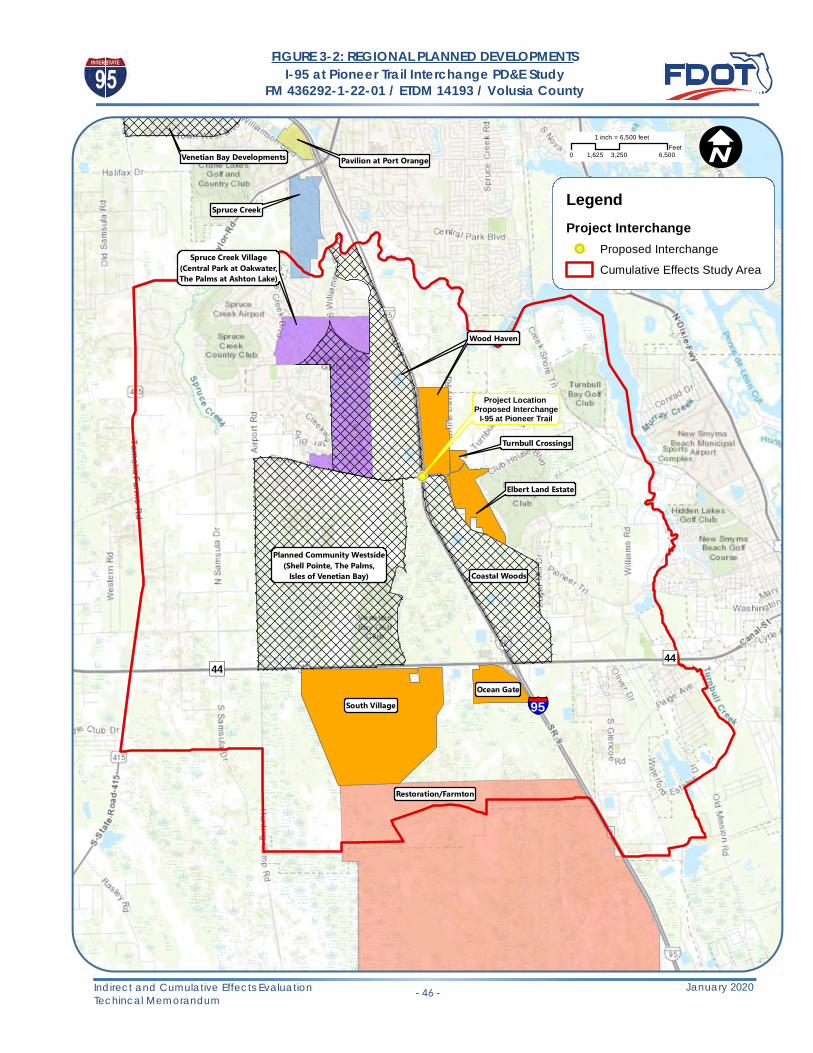
!P
Project Location Proposed Interchange
I-95 at Pioneer Trail
§̈¦95
")44 ")44
Venetian Bay Developments Pavilion at Port Orange
Spruce Creek
Spruce Creek Village(Central Park at Oakwater,The Palms at Ashton Lake)
Wood Haven
Planned Community Westside(Shell Pointe, The Palms,
Isles of Venetian Bay) Coastal Woods
Elbert Land Estate
Turnbull Crossings
South Village
Restoration/Farmton
Wood Haven
Ocean Gate
!I
Indirect and Cumulative Effects EvaluationTechincal Memorandum - 46 -
0 3,250 6,5001,625Feet
1 inch = 6,500 feet
I-95 at Pioneer Trail Interchange PD&E StudyFM 436292-1-22-01 / ETDM 14193 / Volusia County
FIGURE 3-2: REGIONAL PLANNED DEVELOPMENTS
LegendProject Interchange!P Proposed Interchange
Cumulative Effects Study Area
January 2020

I-95 at Pioneer Trail Interchange PD&E Study FM 436292-1-22-01/ ETDM 14193 / Volusia County
Indirect and Cumulative Effects Evaluation Technical Memorandum
-47- January 2020
3.1 DETERMINATION OF SENSITIVE RESOURCES FOR CUMULATIVE IMPACTS ANALYSIS
According to the AASHTO handbook: “A cumulative impacts analysis typically focuses on a sub‐set of the resources considered in the analysis of direct and indirect effects.” Impacts to wetlands and floodplains, while not minimal, are subject to well‐established regulations which require mitigation, and will be discussed together. Additional concerns are for public lands, including wildlife habitat management within the public lands; and impacts to threatened and endangered species and their habitat. Species of concern include the Florida scrub‐jay, eastern indigo snake, and wood stork.
3.2 STEP 1: DESCRIBE RESOURCE CONDITIONS AND TRENDS
The current conditions for resources in the study area varies from place to place. There are presently several large tracts of undeveloped wetlands that are part of a larger regional system in east central Florida. There are a number of developments both in planning and already approved that will convert areas of natural land use. I-95 has been in place in this location since the early 1970’s bisecting the land in some form. Widening projects and other interchange projects have further impacted the resources. Major arterial roadways such as SR 44 and SR 421 have provided access to I-95 from adjacent development. The general trend within the study area is for increased residential development with the associated commercial and retail development supported by the population increase. Regulatory practices minimize impacts to resources, and typically ensure protection over those wetlands not impacted by a project. Conservation areas have increased in the study area as a result of the regulatory practices of requiring preservation of wetlands not directly impacted. No significant impacts to listed species have been noted as available habitat is not optimal for those species with the potential to occur in the study area.
3.2.1 Public Conservation/Recreation Lands
The only significant public lands within the study area is the Spruce Creek Preserve. This is located to north of the proposed project east of I-95. Smaller parcels such as the Howe and Currier parcels are very small “postage stamp” parcels, and the Turnbull Colony Historic Park is also included in the study area (Figure 3-3).
3.2.2 Wildlife and Habitat
Florida scrub‐jay. Previous surveys have identified Florida scrub-jays within the study area, though a survey for this project did not find any present within the project area.
According to the Florida Scrub‐Jay Umbrella Habitat Conservation Plan and Environmental Assessment (USFWS,2007), scrub‐jays were originally found in all Florida counties except Monroe County. The 1992‐1993 state‐wide scrub‐jay census estimated that scrub‐jays were extirpated in Alachua, Broward, Clay, Dade, Duval, Gilchrist, Hernando, Hendry, Pinellas, and St. Johns Counties and functionally extinct in Flagler, Hardee, Levy, Orange, and Putnam Counties. Because of the protection afforded this bird under the ESA, any project that may affect the bird or occupied habitat must undergo consultation with USFWS for analysis of the project impacts.

!P
§̈¦95
")44
§̈¦95
")421
")44
")415
£¤1
Howe and Currier Parcels
Turnbull Colony Historic Park
Spruce Creek Preserve(Doris Leeper)
!I
Indirect and Cumulative Effects EvaluationTechincal Memorandum - 48 -
0 3,000 6,0001,500Feet
1 inch = 6,000 feet
I-95 at Pioneer Trail Interchange PD&E StudyFM 436292-1-22-01 / ETDM 14193 / Volusia County
FIGURE 3-3: CUMULATIVE EFFECTS STUDY AREAPUBLIC AND CONSERVATION LANDS
Legend!P Proposed Interchange
Cumulative Effects Study Area
Conservation Areas (1,550 acres)
Outstanding Florida Waters-OFW (2,040 acres)
January 2020

I-95 at Pioneer Trail Interchange PD&E StudyFM 436292-1-22-01/ ETDM 14193 / Volusia County
Indirect and Cumulative Effects Evaluation Technical Memorandum
-49- January 2020
Some remnant scrub habitat remains in the study area based upon the data provided in the 1992 Statewide Florida scrub-jay survey. This is located north and east of the proposed interchange north of Turnbull Bay Road.
Eastern indigo snake. Eastern indigo snake in south‐central Florida inhabits a variety of environments. According to the Survey Protocol for the Eastern Indigo Snake, Drymarchon couperi, in North and Central Florida(USFWS, 2011) and the Eastern Indigo Snake, Drymarchon couperi 5‐Year Review: Summary and Evaluation (USFWS, 2008) the “broad distribution and large territory size of the eastern indigo snake complicate evaluation of its population status and trends.” The use of gopher tortoise burrows is found in central and coastal Florida sandy ridge habitats.
As with the scrub-jay, this species is listed under the ESA and any project that proposed potential impacts to the animal or a significant acreage of suitable habitat (greater than 25 acres of xeric oak) must be assessed by FWS. The fact that I-95 has already bisected the study area for a species such as this that requires a large home range leaves less potentialthat this type of project will provide significant additional effects. The long bridge at Spruce Creek provides a largeconnection for animals to the north of the study area already. Documented sightings of this animal are rare, with theclosest sighting being well east of the study area in the coastal strands at New Smyrna Beach in 2003. No documentedsightings have been made within the project area.
Wood stork. The entire study area lies within the core foraging area of eight known colonies of wood storks. According to the Wood stork (Mycteria americana) 5‐Year Review: Summary and Evaluation (USFWS, 2007), a decline of the nesting pairs decreased from 20, 000 in the 1930’s to 10,000 nesting pairs in 1960. The lowest total was 2,500 pairs in 1978. Based on this summary, the Florida population “declined in southern Florida and increased in northern Florida, Georgia, and South Carolina.” Also, “between 1983 and 1995 surveys documented a population in the Southeast U.S. ranging between 4,073 and 7,853 pairs.” Subsequent surveys showed increased numbers with the 2006 survey documenting 11,279 pairs, which was “the first time the nesting population was greater than 10,000 pairs since the early 1960s.” The Effect Determination Key for the Wood Stork in Central and North Peninsular Florida (USACE, USFWS, State of Florida, 2008), was developed to facilitate review and mitigation for impacts on foraging habitat.
Regulatory requirements require projects that impacts foraging habitat for wood storks to provide compensatory mitigation to offset these impacts already. Additionally, projects that occur within the proximity of nesting colonies must be assessed by FWS for impacts under the ESA. The study area does not contain any documented nesting colonies and does not intersect with the 15.0 mile Core Foraging Area of any nesting colony. As such, the wetlands within the study area will not be designated as suitable foraging habitat for this bird.
3.2.3 Wetlands and Floodplains
As reported in the National Wetland Inventory (NWI) publication Status and Trends of Wetlands in the Conterminous United States: 1986 to 1997 (NWI, 2000), “wetlands have been drained, dredged, filled, leveled, flooded to the extent that less than half of the original wetland acreage remains.” The trend of wetland and floodplain loss, however, is decreasing. Between the mid 1950s and the mid 1970s, the rate of wetland loss in the continental United States was 458,000 acres per year; from the mid 1970s to the mid 1980s, the loss decreased to 290,000 acres per year; and from 1986 to1997, the loss further decreased to 58,500 acres per year. This reduction reflects the efforts to protect and restore wetlands and floodplains. Wetlands within the study area are depicted on Figure 2-11, while floodplains are shown on Figure 3-4.

!P
§̈¦95
")44
§̈¦95
")421
")44
")415
£¤1
!I
Indirect and Cumulative Effects EvaluationTechincal Memorandum - 50 -
0 3,000 6,0001,500Feet
1 inch = 6,000 feet
I-95 at Pioneer Trail Interchange PD&E StudyFM 436292-1-22-01 / ETDM 14193 / Volusia County
FIGURE 3-4: CUMULATIVE EFFECTS STUDY AREA FEMA FLOOD ZONES
Legend!P Proposed Interchange
Cumulative Effects Study Area
Cumulative Effect Study Area Flood ZonesFlood Zone A (10,282 acres)
Flood Zone AE (2,412 acres)
Flood Zone AE/Floodway (296 acres)
January 2020

I-95 at Pioneer Trail Interchange PD&E Study FM 436292-1-22-01/ ETDM 14193 / Volusia County
Indirect and Cumulative Effects Evaluation Technical Memorandum
-51- January 2020
Similarly, the Integrated Water Quality Assessment for Florida (FDEP, 2012) states that “the state lost as many as 46% of its original wetlands between the 1780s and the 1980s.” The assessment notes, however, that the rate of wetland loss has significantly slowed since the mid‐1970s, which is when federal and state wetland regulatory programs began.
Consistent with federal and state trends, in Volusia County, wetlands and floodplains were impacted or drained for agriculture as well as for development starting more than 60 years ago. With a significant acreage of wetlands and floodplains now protected within conservation/recreation lands, the overall condition of this resource is good.
Both state and federal regulatory programs review projects for impacts to wetlands and floodplains, and compensatory mitigation is required for impacts.
3.3 STEP 2: SUMMARIZE EFFECTS OF THE PROPOSED ACTION ON KEY RESOURCES
A summary of the effects on key resources of the proposed action was previously discussed in the indirect effects portion of this document.
Table 3-1: Summary of Proposed Action on Key Resources Resource Direct Effect Indirect Effect
Public Conservation and Recreation
• None • Minor potential for reduced burning if part of management plan, loss of some upstream habitat outside of boundary.
Resource Direct Effect Indirect Effect
Wildlife and Habitat (Florida scrub‐jay, eastern indigo snake, wood stork
• Does not directly impact protected species • Potential impacts to Florida scrub‐jay (from suppression of prescribed burning), eastern indigo snake (from potential habitat loss), and small terrestrial mammals (from habitat loss).
Wetlands • Direct wetland impacts were avoided and minimized as much as possible. Mitigation will be provided for all direct and secondary impacts.
• Indirect wetland impacts will be avoided and minimized as much as possible. Additional projects subject to regulatory control and mitigation.
Floodplains • Direct floodplain impacts were avoided and minimized as much as possible. Mitigation will be provided for the direct impacts through construction of floodplain compensation ponds. Cross drains will be sized to prevent a significant increase in flood elevation.
• Indirect impacts to floodplains will be minimized by providing compensating storage for the lost floodplain volume, and appropriate sizing of conveyance structures. Additional projects subject to regulatory control.

I-95 at Pioneer Trail Interchange PD&E StudyFM 436292-1-22-01/ ETDM 14193 / Volusia County
Indirect and Cumulative Effects Evaluation Technical Memorandum
-52- January 2020
3.4 STEP 3: DESCRIBE OTHER ACTIONS AND THEIR EFFECTS ON KEY RESOURCES.
The other actions that have been considered include a number of developments that have either been approved by local agencies (New Smyrna Beach, City of Port Orange, Volusia County) via planning, or have actively pursued permits for construction and land clearing with state and federal regulatory agencies. The consideration of these actions are “major” improvements, that involve multiple acres of land and have the potential to impact resources. A number of “minor” actions are also either in planning or construction, and typically refer to those projects that involve a single parcel and do not pose the same level of impact threat. Those projects that have been approved from a planning standpoint have been identified as either future or current, and the footprints of these developments have been shown on the Regional Planned Developments map (Figure 3-2).
Each of these projects will result in some level of impact on resources. Land use changes, stormwater systems, floodplain compensation, and introduction of large amount of impervious surface will no doubt affect the resources within the study area. However, a key consideration is that the vast majority of these projects have been approved and even begun construction without the requirement of this interchange on I-95. Each project must undergo the same level of impact analysis in order to proceed to construction and is to be judged on the impacts proposed as well as any mitigation efforts to compensate for the loss incurred. Major roads such as SR 44 have provided the connection to I-95 required for approval of many of the residential projects, and additional connections to the surface roads via the Williamson Boulevard extension provide sufficient travel routes. The traffic analysis has indicated that these projects are all self sufficient without the need of the proposed interchange. Each project is still responsible for its own impacts, regardless of the proposed interchange.
FDOT and County transportation plans have also been consulted for projects that may occur within the study area. With the exception of the I-95 six-laning project, there are no capacity improvement projects currently either in planning phases or study phases.
3.5 STEP 4: ESTIMATE COMBINED EFFECTS ON KEY RESOURCES
The overall effects on the resources consider the Direct and Indirect Effects (Step 2) and the Other Projects (Step 3).
• Public Lands
Direct Effects – None. The recommended alternative does not impact any public lands (See Figure 3-3).
Indirect Effects – If there is any use of prescribed fire on the Spruce Creek Preserve, it may be altered in the future if managers determine that burning would cause potential dangers near the interchange. This seems unlikely as the cover type within the preserve is not typical for high burn frequency.
Other Actions – The project and induced growth will not impact any public lands. Some areas of growth upstream of the Spruce Creek Preserve will convert land use from natural to developed and may have an effect on some aspects of the land.
Cumulative Impacts – The developments planned will potentially create altered land uses upstream of the preserve. Each of the projects will be required to be reviewed for direct and secondary impacts at that time, and potential mitigation to offset these will be required.

I-95 at Pioneer Trail Interchange PD&E Study FM 436292-1-22-01/ ETDM 14193 / Volusia County
Indirect and Cumulative Effects Evaluation Technical Memorandum
-53- January 2020
• Wildlife
Direct Effects – The recommended alternative will not adversely impact any listed species or habitat directly. Effects determinations made utilizing the Endangered Species Act Consultation Guidelines received concurrence from FWS staff.
Indirect Effects – Potential impacts to wetlands may reduce foraging area for wading birds such as the wood stork, though since the project study area is not within a CFA, suitable foraging habitat in not designated. Impacts to potential habitat for a habitat generalist such as the eastern indigo snake is possible, though no documented sightings have been made in the study area (or anywhere near it). Permitting will result in the creation of additional conservation lands via preservation, providing habitat continuity through future development.
Other Actions – All of the additional development projects have the potential to impact natural habitat, though as previously discussed, there are no documented sightings of listed species within the project area, with the exception of the 1992-1993 statewide Florida scrub-jay survey, which identified birds north of Turnbull Bay Road. Each subsequent project will still have to be analyzed under the ESA Consultation Guidelines and be subject to the regulatory controls in place. Minor impacts to habitat via suppression of prescribed fire, wetland development, and habitat fragmentation are still possible.
Cumulative Impacts – Development induced by the project and Other Actions have the potential for impacts to habitat suitable for scrub-jay, wood stork, eastern indigo snake, wading birds, and small terrestrial mammals due to fragmentation and habitat destruction. Still, via permitting, remnant wetland areas will be required to be placed under conservation, and compensatory mitigation has been determined to provide appropriate offsets for impacts for projects. All projects are still subject to the regulatory controls in place.
• Wetlands
Wetland impacts due to direct and indirect effects of the project as well as those from Other Actions are expected to be minimal due to regulations requiring avoidance and minimization efforts during design. Impacts will be reduced during both state and federal permitting processes to achieve the least environmentally damaging project alternative. Compensatory mitigation will still be required to offset impacts, and preservation of those wetlands not impacted will be included in the mitigation plan.
Cumulative Impacts – The cumulative effect of all of the development on wetlands will result in a net loss of wetlands in the study area. This is still acceptable under the regulatory guidelines as the compensatory mitigation to offsets the impacts will remain within the impacted basin. The Farmton Mitigation Bank is within the same basin as the impacts, and provides a significant ecological benefit to the region, more so than the individual wetland systems impacted by the development. Many if not all of the wetland systems have already been impacted (either directly or indirectly) from I-95, SR 44, Pioneer Trail, Turnbull Bay Road, and Williamson Blvd. Though hydrologic connections have been maintained, edge effects and fragmentation will have already reduced the functionality of all of these systems. Maintaining the existing systems that are outside of the impact areas and providing further mitigation at a regionally significant site such as Farmton provides the best long term ecological result.
• Floodplains

I-95 at Pioneer Trail Interchange PD&E Study FM 436292-1-22-01/ ETDM 14193 / Volusia County
Indirect and Cumulative Effects Evaluation Technical Memorandum
-54- January 2020
Direct and indirect floodplain impacts as well as those from Other Actions are subject to regulations requiring compensation floodplains are filled. This, along with the hydraulic study that determines the appropriate sizing of conveyance structures will maintain the floodplains within the study area. These resources have been protected from development by environmental regulations for a number of years and will continue to remain under protection. The floodplains are shown on Figure 3-4.
Cumulative Impacts – Any projects that propose impacts to floodplain resources will still be subject to the regulatory guidelines and have to offset these impacts via direct compensation and / or mitigation.
3.6 STEP 5: CONSIDER AV O I DA N C E / MINIMIZATION AND MITIGATION
• Avoidance and minimization
Avoidance and minimization measures are intended to avoid and/or reduce the adverse impacts of an action to wetlands and surface waters, which can include aquatic dependent wildlife and their habitat. During this PD&E Study, surveys were conducted to identify potential wetlands and wildlife concerns within the project study area. However, since the concept of the project is to place a new interchange at the intersection of I-95 and Pioneer Trail, there is no opportunity to look for alternative sites for the project. The location of the existing wetlands in relationship to the interstate and Pioneer Trail cannot be changed. The concept alternatives studied are primarily based upon engineering to be able to achieve the purpose of the project within the confines of the two roads.
Based on the engineering and environmental factors and public and agency input, the recommended alternative is the Partial Cloverleaf 2 Alternative as it provides the best balance between improved transportation service and minimization of the social, physical and natural impacts associated with the proposed roadway improvements while gaining the most public support.
Federal regulations require that applicants consider avoidance and minimization as a first step in the analysis of a site development plan. The project itself will be subject to an avoidance and minimization exercise during the design phase. This will consider all options for reducing impacts where feasible. Mitigation is inherent in the permitting process and will be applicable should unavoidable impacts be proposed. All projects (Other Actions, induced growth, etc.) are subject to the same requirements during permitting and will minimize impacts and provided mitigation as appropriate.
FDOT will continue to apply practices during design to reduce impacts and will be proactive in taking measures to mitigate for impacts as necessary. This includes working with regulatory agencies on local and regional plans where possible and participating in regional projects or partnerships with local governments when feasible.
It can be expected that the private development plans that have been permitted, are being permitted and will be permitted in the future will also be considering avoidance and minimization associated with site plan development. Avoidance and minimization is driven not only by regulatory constraints but also costs. The activities required to develop on wetlands (de-mucking, bringing in fill material, onsite compensation for floodplain impacts, and offsetting wetland impacts through wetland mitigation bank) make it cost prohibitive and therefore primarily an action that is avoided. An exception is squaring off development or the dredge and fill of isolated wetlands that are less than 0.5 acres in size.

I-95 at Pioneer Trail Interchange PD&E Study FM 436292-1-22-01/ ETDM 14193 / Volusia County
Indirect and Cumulative Effects Evaluation Technical Memorandum
-55- January 2020
The plan developments that have been approved or will be approved typically avoid large onsite wetland systems. A prime example is the Elbert Land Property development adjacent to Pioneer Trail and Turnbull Bay Road that currently has an application being reviewed by the SJRWMD. Their site plan is proposing 1.38 acres of wetland impact and the avoidance of the remaining 65 acres.
• Mitigation
Both state and federal regulatory authorities generally require that impacts to wetland resources are offset within the same basin and/or have a service area that includes the proposed area of impact. For the USACOE, the basin is defined in accordance with the 8-digit Hydrologic Unit Code (HUC 8). The study area is wholly within the Daytona-St. Augustine 8-digit HUC code (0308201). The USACOE will accept credits for the project impacts areas from banks within the service area.
A total of five mitigation banks: Port Orange Mitigation Bank, Lake Swamp, Fishtail, St. Marks Pond and Brick Road) occur within the Daytona-St. Augustine Basin. However, Brick Road, St. Marks Pond, and Fishtail do not have USACOE permitted service areas that overlap the project impacts. The Port Orange Mitigation Bank currently does not provide mitigation credits for projects outside of their City. An additional bank (Farmton) is outside of the HUC Basin but has a Federally permitted service area that overlaps the project study area. There are also an additional three mitigation banks (Pelicer Flats, Lake Swamp Expansion, and Tiger Bay) within this HUC basin that are pending permit issuance and credit release that could also potentially offset wetland impacts associated with this project.
The state of Florida has established Cumulative Impact Basins that are incorporated under the cumulative impact requirements of subsections 373.414(8)(a), F.S., 40C-4.301 (3), F.A.C., and 12.28, ERP A.H. The project study area is located within the Halifax River Cumulative Impact Basin (Basin 17). A total of two state permitted banks occur within this basin (Farmton, and Lake Swamp). Please note that this basin loosely follows the USACPE HUC basin but has two distinct differences; one, the basin is extended further to the south and, two, it is cut off to the north around the Flagler County line rather than around St. Augustine. The State of Florida will only allow a mitigation bank that is outside the Cumulative Impact Basin that contains the impact when a Cumulative Impact Study has been conducted and approved.
At the time of this PD&E study, there are two permitted mitigation banks that meet both state and federal criteria to offset impacts associated with this project. All planned developments (approved or pending approval) generally have to abide by Federal and State criteria that has a clear preference for mitigation banks. None of the mitigation banks occur within the cumulative impact study area, however, the Farmton Mitigation Bank does occur less than 4 miles to the south of the study area. This 23,922-acre site is the largest mitigation bank in the country.
4.0 CONCLUSION
This analysis for the proposed project has assessed the potential for Indirect Effects and Cumulative Effects within the study area. Direct effects were established in the individual PD&E Reports prepared for the project and included in the

I-95 at Pioneer Trail Interchange PD&E Study FM 436292-1-22-01/ ETDM 14193 / Volusia County
Indirect and Cumulative Effects Evaluation Technical Memorandum
-56- January 2020
examination for both the Indirect and Cumulative Effects from the project. This analysis has demonstrated that the proposed project may have some indirect and cumulative effects to the study area, but that primarily, impacts will be related to a number of large developments that have been planned independent of the proposed project. The amount of induced growth that may occur as a result of this project is limited (as shown on Figure 2- 5), and the cumulative effects of the project on the study area are limited as well due to the regulatory requirements in place. Wetland impacts are the primary effect, though due to the large amount of available mitigation credits at banks such as Farmton, the overall impact to the basin will be minimal. No adverse effects are anticipated to listed species and habitat from the project, and no impacts to public or conservation lands are anticipated either.

APPENDIX A

ETDM Summary Report
Project #14193 - I-95 Interchange at Pioneer Trail
Preliminary Programming Screen - Published on 11/03/2017
Generated by Kathaleen Linger (on behalf of FDOT District 5)
Printed on: 11/03/2017
Table of Contents
Florida Department of TransportationRICK SCOTTGOVERNOR
605 Suwannee StreetTallahassee, FL 32399-0450
MIKE DEWSECRETARY
Chapter 1 Overview 2Chapter 2 Project Details 3 2.1. Purpose and Need 3
Chapter 3 Alternative #1 6 3.1. Alternative Description 6 3.2. Segment Description(s) 6
Chapter 4 Eliminated Alternative Information 33 4.1. Eliminated Alternatives 33
Chapter 5 Project Scope 34 5.1. General Project Recommendations 34 5.2. Required Permits 34 5.3. Required Technical Studies 34 5.4. Dispute Resolution Activity Log 35
Appendices 36 6.1. Preliminary Environmental Discussion Comments 36 6.2. Advance Notification Comments 42 6.3. GIS Analyses 42 6.4. Project Attachments 42 6.5. Degree of Effect Legend 42

Screening Summary Report
Introduction to Programming Screen Summary Report
The Programming Screen Summary Report shown below is a read-only version of information contained in the Programming Screen Summary Report generated by the ETDM Coordinator for the selected project after
completion of the ETAT Programming Screen review. The purpose of the Programming Screen Summary Report is to summarize the results of the ETAT Programming Screen review of the project; provide details concerning
agency comments about potential effects to natural, cultural, and community resources; and provide additional
documentation of activities related to the Programming Phase for the project. Available information for a Programming Screen Summary Report includes:
Screening Summary Report chart
Project Description information (including a summary description of the project, a summary of public comments on the project, and community-desired features identified during public involvement activities)
Purpose and Need information (including the Purpose and Need Statement and the results of agency
reviews of the project Purpose and Need)
Alternative-specific information, consisting of descriptions of each alternative and associated road
segments; an overview of ETAT Programming Screen reviews for each alternative; and agency comments
concerning potential effects and degree of effect, by issue, to natural, cultural, and community resources.
Project Scope information, consisting of general project recommendations resulting from the ETAT
Programming Screen review, permits, and technical studies required (if any)
Class of Action determined for the project
Dispute Resolution Activity Log (if any)
The legend for the Degree of Effect chart is provided in an appendix to the report.
For complete documentation of the project record, also see the GIS Analysis Results Report published on the same date as the Programming Screen Summary Report.
Page 1 of 65 Summary Report - Project #14193 - I-95 Interchange at Pioneer Trail Printed on: 11/03/2017

1. Overview
Issues and Categories are reflective of what was in place at the time of the screening event.
#14193 I-95 Interchange at Pioneer TrailDistrict: District 5 Phase: Programming ScreenCounty: Volusia From: Williamson Blvd.Planning Organization: FDOT District 5 To: Turnbull Bay RoadPlan ID: Not Available Financial Management No.: 436292-1-22-01Federal Involvement: FHWA Funding Other Federal Permit
Contact Information: Heather Grubert 386-943-5540 [email protected] Data From: Programming Screen Summary Report Published on 11/03/2017 by Kathaleen Linger
Social and Economic Cultural Natural Physical
Land
Use
Cha
nges
Soci
al
Relo
catio
n Po
tent
ial
Farm
land
s
Aest
hetic
Eff
ects
Econ
omic
Mob
ility
Sect
ion
4(f)
Pot
entia
l
His
toric
and
Arc
haeo
logi
cal S
ites
Recr
eatio
n Ar
eas
Wet
land
s an
d Su
rfac
e W
ater
s
Wat
er Q
ualit
y an
d Q
uant
ity
Floo
dpla
ins
Wild
life
and
Hab
itat
Coas
tal a
nd M
arin
e
Noi
se
Air
Qua
lity
Cont
amin
atio
n
Infr
astr
uctu
re
Nav
igat
ion
Spec
ial D
esig
natio
ns
Alternative #1 - I-95 Interchange at Pioneer TrFrom: Williamson Blvd. To: Turnbull Bay Road Published: 11/03/2017 Reviewed from 08/03/2017 to10/02/2017)
1 2 N/A 2 2 1 1 2 3 N/A 4 3 2 3 0 2 2 2 2 N/A 3
Page 2 of 65 Summary Report - Project #14193 - I-95 Interchange at Pioneer Trail Printed on: 11/03/2017

2. Project Details2.1. Purpose and Need
Purpose and NeedPROJECT STATUS
The project is located within the jurisdiction of the River to Sea Transportation Planning Organization (TPO), which covers
Volusia County and parts of Flagler County. An Interchange Justification Report (IJR), sponsored by Volusia County, was
accepted by the Federal Highway Administration (FHWA) in May 2017. The Project Development and Environment
(PD&E) Study is documented in the TPO's 2040 Long Range Transportation Plan (LRTP) as a local transportation project.
PURPOSE
The purpose of the interchange at I-95 and Pioneer Trail is to relieve traffic congestion on the two adjacent interchanges
north and south of the project: I-95 at State Road 421 / Dunlawton Avenue and I-95 at State Road 44 / Lytle Avenue,
respectively and to support economic development associated with existing and approved developments, including three
Developments of Regional Impact (Farmton, Restoration, and Pavilion at Port Orange).
NEED
The need for the project is based on transportation demand/capacity and economic development.
ECONOMIC DEVELOPMENT
An economic impact analysis prepared by Fishkind and Associates of the proposed I-95/Pioneer Trail interchange
concluded that the interchange would add $2.5 billion to the local economy; employ nearly 700 temporary construction
and construction-related jobs; support 13,410 permanent jobs; and provide an additional $775 million per year of
permanent, ongoing economic activity related to new households and office/retail/hotel activity and employment. An
increased economic efficiency value of $1,779,687, due to savings in travel time and reductions in pollution, was also
identified.
TRANSPORTATION DEMAND
In the no-build condition, the southbound ramps at the existing interchange of I-95 and SR 421 / Dunlawton Avenue are
projected to operate at LOS F during the design year (2042), while the northbound ramps are projected to operate at LOS
E. In the build condition, the southbound ramps are projected to operate at LOS E in 2042, while the northbound ramps
are projected to operate at LOS C. Also in the no-build condition, both the southbound and northbound ramps at the
existing interchange of I-95 and SR 44 / Lytle Avenue are projected to operate at LOS E in 2042; however, in the build
condition the northbound ramps are projected to operate at LOS C, while the southbound ramps are projected to operate
at LOS D under signalized conditions. Additionally, relief to segments of SR 421 / Dunlawton Avenue and SR 44 / Lytle
Avenue is also anticipated given the redistribution of traffic.
Project DescriptionThis project involves a new interchange along Interstate 95 (I-95) at Pioneer Trail (County Road 4118) at Milepost (MP)
19.032 in Volusia County, Florida. The proposed interchange would be located between two existing interchanges on I-95:
State Road 421 / Dunlawton Avenue at MP 23.300, approximately 4.25 miles to the north, and at State Road 44 / Lytle
Avenue at MP 16.287, approximately 2.75 miles to the south.
Summary of Public CommentsSummary of Public Comments is not available at this time. Planning Consistency Status Lead Agency
Purpose and Need
Page 3 of 65 Summary Report - Project #14193 - I-95 Interchange at Pioneer Trail Printed on: 11/03/2017

FDOT Office of Environmental Management Participating and Cooperating AgenciesParticipating and Cooperating agencies are not applicable for this class of action. Exempted Agencies
Community Desired FeaturesNo desired features have been entered into the database. This does not necessarily imply that none have been identified. User Defined Communities Within 500 FeetNo user defined communities were found within a 500 ft. buffer distance for this project. Census Places Within 500 Feet- Glencoe- New Smyrna Beach- Port Orange Purpose and Need Reviews FL Department of Agriculture and Consumer Services
FL Department of Economic Opportunity
FL Department of Environmental Protection
FL Department of State
FL Fish and Wildlife Conservation Commission
National Marine Fisheries Service
National Park Service
Agency Name Justification DateFederal Rail Administration There are no FRA facilities within the project area. 07/06/2017
Federal Transit Administration FTA has requested to be exempt from reviewing any non-transit projects. 10/07/2014
US Forest Service There are no USFS resources within the project area. 07/06/2017
National Park Service There are no NPS resources within the project area. 07/06/2017
Acknowledgment Date Reviewed Reviewer CommentsUnderstood 09/07/2017 Steve Bohl
Taking traffic away from the DRI's may have an economicimpact.
Acknowledgment Date Reviewed Reviewer CommentsUnderstood 10/02/2017 Matt Preston
No Purpose and Need comments found.
Acknowledgment Date Reviewed Reviewer CommentsUnderstood 09/05/2017 Suzanne Ray
No Purpose and Need comments found.
Acknowledgment Date Reviewed Reviewer CommentsUnderstood 08/09/2017 Ginny Jones
none
Acknowledgment Date Reviewed Reviewer CommentsUnderstood 09/22/2017 Jennifer Goff
No Purpose and Need comments found.
Acknowledgment Date Reviewed Reviewer CommentsUnderstood 08/17/2017 Jennifer Schull
No Purpose and Need comments found.
Acknowledgment Date Reviewed Reviewer Comments
Page 4 of 65 Summary Report - Project #14193 - I-95 Interchange at Pioneer Trail Printed on: 11/03/2017

Natural Resources Conservation Service
Saint Johns River Water Management District
US Army Corps of Engineers
US Coast Guard
US Environmental Protection Agency
US Fish and Wildlife Service
The following organizations were notified but did not submit a review of the Purpose and Need:- FDOT Office of Environmental Management- Seminole Tribe of Florida
Understood 09/19/2017 Anita Barnett([email protected])
No Purpose and Need comments found.
Acknowledgment Date Reviewed Reviewer CommentsUnderstood 08/10/2017 Rick Robbins
No Purpose and Need comments found.
Acknowledgment Date Reviewed Reviewer CommentsUnderstood 09/07/2017 Gary Haddle
No Purpose and Need comments found.
Acknowledgment Date Reviewed Reviewer CommentsUnderstood 08/29/2017 Randy Turner
No Purpose and Need comments found.
Acknowledgment Date Reviewed Reviewer CommentsUnderstood 08/11/2017 Randall Overton
There are no navigable waters of the United States impacted bythe proposed project as it currently scoped.
Acknowledgment Date Reviewed Reviewer CommentsUnderstood 09/28/2017 Roshanna White
No Purpose and Need comments found.
Acknowledgment Date Reviewed Reviewer CommentsUnderstood 09/05/2017 Zakia Williams
No Purpose and Need comments found.
Page 5 of 65 Summary Report - Project #14193 - I-95 Interchange at Pioneer Trail Printed on: 11/03/2017

3. Alternative #1
3.1. Alternative Description Alternative Description
3.2. Segment Description(s) Segment Description(s) Location and Length
Jurisdiction and Class
Base Conditions
Interim Plan
Needs Plan
Cost Feasible Plan
Funding SourcesNo funding sources found. Project Effects Overview for Alternative #1 - I-95 Interchange at Pioneer Tr
Alternative #1 - I-95 Interchange at Pioneer Tr
Name From To Type StatusTotal
Length Cost Modes SISI-95
Interchangeat Pioneer Tr
WilliamsonBlvd.
Turnbull BayRoad
TrafficOperation
EnhancementETAT Review
Complete ? mi. Roadway Y
SegmentRecord
SegmentName
FacilityName
BeginningLocation
EndingLocation
Length(mi.) Roadway Id BMP EMP
S-005 Pioneer Trail Pioneer Trail 1.065 Digitized
S-004I-95
InterchangeI-95
Interchange 1.065 Digitized
Segment Record Segment Name Jurisdiction Urban Service Area Functional ClassS-005 Pioneer Trail In/Out
S-004 I-95 Interchange In/Out
Segment Record Segment Name Year AADT Lanes ConfigS-005 Pioneer Trail
S-004 I-95 Interchange
Segment Record Segment Name Year AADT Lanes ConfigS-005 Pioneer Trail
S-004 I-95 Interchange
Segment Record Segment Name Year AADT Lanes ConfigS-005 Pioneer Trail
S-004 I-95 Interchange
Segment Record Segment Name Year AADT Lanes ConfigS-005 Pioneer Trail
S-004 I-95 Interchange
Issue Degree of Effect Organization Date Reviewed
Social and Economic
Land Use Changes 1 Enhanced FL Department of EconomicOpportunity 10/02/2017
Social 2 Minimal US Environmental ProtectionAgency 09/19/2017
Farmlands 2 Minimal Natural Resources ConservationService 08/10/2017
Economic 1 Enhanced FL Department of EconomicOpportunity 10/02/2017
Cultural
Historic and Archaeological Sites 3 Moderate FL Department of State 08/09/2017
Recreation Areas N/A N/A / No Involvement National Park Service 09/19/2017
Recreation Areas 0 None FL Department ofEnvironmental Protection 09/05/2017
Page 6 of 65 Summary Report - Project #14193 - I-95 Interchange at Pioneer Trail Printed on: 11/03/2017
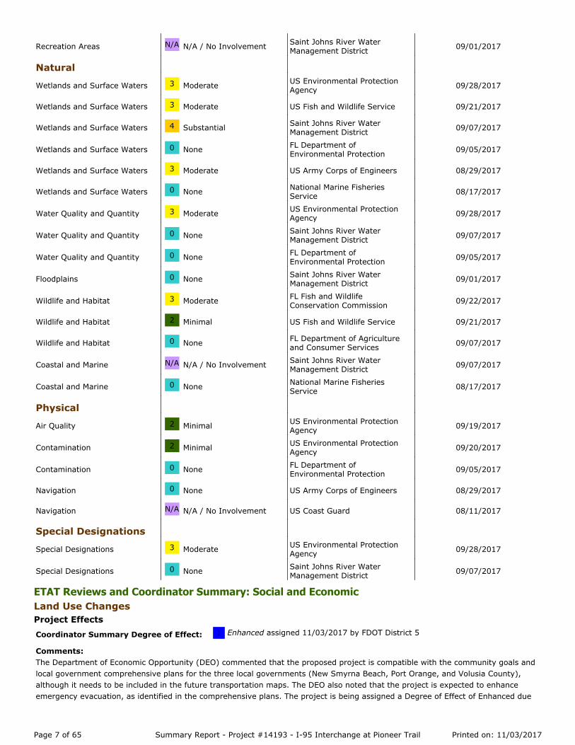
ETAT Reviews and Coordinator Summary: Social and Economic Land Use Changes Project Effects
Recreation Areas N/A N/A / No Involvement Saint Johns River WaterManagement District 09/01/2017
Natural
Wetlands and Surface Waters 3 Moderate US Environmental ProtectionAgency 09/28/2017
Wetlands and Surface Waters 3 Moderate US Fish and Wildlife Service 09/21/2017
Wetlands and Surface Waters 4 Substantial Saint Johns River WaterManagement District 09/07/2017
Wetlands and Surface Waters 0 None FL Department ofEnvironmental Protection 09/05/2017
Wetlands and Surface Waters 3 Moderate US Army Corps of Engineers 08/29/2017
Wetlands and Surface Waters 0 None National Marine FisheriesService 08/17/2017
Water Quality and Quantity 3 Moderate US Environmental ProtectionAgency 09/28/2017
Water Quality and Quantity 0 None Saint Johns River WaterManagement District 09/07/2017
Water Quality and Quantity 0 None FL Department ofEnvironmental Protection 09/05/2017
Floodplains 0 None Saint Johns River WaterManagement District 09/01/2017
Wildlife and Habitat 3 Moderate FL Fish and WildlifeConservation Commission 09/22/2017
Wildlife and Habitat 2 Minimal US Fish and Wildlife Service 09/21/2017
Wildlife and Habitat 0 None FL Department of Agricultureand Consumer Services 09/07/2017
Coastal and Marine N/A N/A / No Involvement Saint Johns River WaterManagement District 09/07/2017
Coastal and Marine 0 None National Marine FisheriesService 08/17/2017
Physical
Air Quality 2 Minimal US Environmental ProtectionAgency 09/19/2017
Contamination 2 Minimal US Environmental ProtectionAgency 09/20/2017
Contamination 0 None FL Department ofEnvironmental Protection 09/05/2017
Navigation 0 None US Army Corps of Engineers 08/29/2017
Navigation N/A N/A / No Involvement US Coast Guard 08/11/2017
Special Designations
Special Designations 3 Moderate US Environmental ProtectionAgency 09/28/2017
Special Designations 0 None Saint Johns River WaterManagement District 09/07/2017
Coordinator Summary Degree of Effect: 1 Enhanced assigned 11/03/2017 by FDOT District 5
Comments:The Department of Economic Opportunity (DEO) commented that the proposed project is compatible with the community goals andlocal government comprehensive plans for the three local governments (New Smyrna Beach, Port Orange, and Volusia County),although it needs to be included in the future transportation maps. The DEO also noted that the project is expected to enhanceemergency evacuation, as identified in the comprehensive plans. The project is being assigned a Degree of Effect of Enhanced due
Page 7 of 65 Summary Report - Project #14193 - I-95 Interchange at Pioneer Trail Printed on: 11/03/2017

to the project responding to planned growth in the area.
Degree of Effect: 1 Enhanced assigned 10/02/2017 by Matt Preston, FL Department of Economic Opportunity
Coordination Document: No Involvement
Direct EffectsIdentified Resources and Level of Importance:Comprehensive Plan(s) Reviewed:City of New Smyrna Beach Comprehensive Plan 2025, adopted on April 12, 2011; City of Port Orange Comprehensive Plan 2010-2025, adopted in October of 2010; and, Volusia County Comprehensive Plan 2025, adopted on March 12, 2008.
Comments on Effects to Resources:Compatibility with Community Development Goals and Comprehensive Plan:The project is consistent with the applicable comprehensive plans and compatible with community development goals.
The three local governments' (New Smyrna Beach, Port Orange, and Volusia County) community development goals are compatiblewith the proposed I-95 interchange at Pioneer Trail. This area is in an urban transitional area, consisting of existing and futureplanned unit developments and activity centers. Currently, most of the residents in this area commute daily to the Orlandometropolitan area for employment. The local governments comprehensive plans contain polices intended to reverse this trend byproviding the necessary urban infrastructure and services in the area, including improved road access, in order to support existingand planned development and employment growth.
In addition, specific policies ensure coordination of land uses with transportation facilities, where existing and proposed land uses areconsistent with the transportation modes and available services. The project is expected to enhance emergency evacuation asidentified in the comprehensive plans.
Future Transportation Map:The proposed project is not included on any of the City or County future transportation maps. DEO staff recommends that the City ofNew Smyrna Beach, City of Port Orange, and Unincorporated Volusia County update their respective maps to include this project.Land Uses:Future land uses surrounding the project include:City of New Smyrna Beach - Rural, Low Density Residential, and Urban Transition Area Overlay.City of Port Orange - Conservation, Rural Transition, and Mixed-Use Center.Unincorporated Volusia County - Rural, Agriculture Resources, and Low Impact Urban.Parks:The project is not located within a quarter mile of any City or County parks.
Area of Critical State Concern (ACSC), Coastal High Hazard Area (CHHA), and Military Bases:The project is not located within an Area of Critical State Concern, or the CHHA; nor does it encroach on any military installations(contacted Matt Schellhorn, CPLO NAS Jax/NS Mayport).
Other Planning-Related Items:Planned Unit Developments, Activity Centers, and New Smyrna Beach Municipal Airport are located in close proximity to theproposed project.
Contact Information:Jeff Gove (City of New Smyrna Beach) - Phone Number: (386) 410-2800. Penelope Cruz (City of Port Orange) - Phone Number:(386) 506-5671. Susan Jackson (Volusia County) - Phone Number: (386) 736-5959.
Recommended Avoidance, Minimization, and Mitigation Opportunities:
Additional Comments (optional):
CLC Recommendations:
Indirect EffectsIdentified Resources and Level of Importance:
Comments on Effects to Resources:
Recommended Avoidance, Minimization, and Mitigation Opportunities:
Page 8 of 65 Summary Report - Project #14193 - I-95 Interchange at Pioneer Trail Printed on: 11/03/2017

Social Project Effects
Relocation Potential Project Effects
FDOT District 5 Feedback to FL Department of Economic Opportunity's Review (11/03/2017): Thank you for your reviewand comments. The FDOT will continue to coordinate with the Cities of New Smyrna Beach, Port Orange, and Volusia County duringthe PD&E Study. Any impacts / land use changes that may occur due to the project will be coordinated with these local governmentsand documented in the Preliminary Engineering Report and the environmental document.
Coordinator Summary Degree of Effect: 2 Minimal assigned 11/03/2017 by FDOT District 5
Comments:USEPA reviewed this issue with a Degree of Effect of Minimal. However, due to noted public opposition to the proposed project, arobust public involvement program will be carried out during the PD&E Study. The public involvement program, and components ofthe PD&E Study, will address public opposition in addition to indirect and cumulative effects.
Degree of Effect: 2 Minimal assigned 09/19/2017 by Roshanna White, US Environmental Protection Agency
Coordination Document: Tech Memo RequiredCoordination Document Comments:Sole Source Aquifer Impact Determination
Direct EffectsIdentified Resources and Level of Importance:The EPA is assigning a minimal level of importance to social impacts of the construction of a new interchange along I-95 at PioneerTrail. The demographics of the area have been documented in terms of the existence of minority and low-income populations, alongwith a description of the US Census geographic units in the sociocultural data report.
Comments on Effects to Resources:The construction of a new interchange along I-95 at Pioneer Trail direct social impacts may result in construction detours and trafficpattern disruptions for the residential population. The changes may temporarily effect quality of life for some individuals.
Recommended Avoidance, Minimization, and Mitigation Opportunities:Ensure effective public involvement that enables transportation professionals to develop systems, services, solutions that meet theneeds of the public; and include benefits from the associated developments of the interchange construction.
Additional Comments (optional):Sole Source Aquifer Impact Determination
CLC Recommendations:
Indirect EffectsIdentified Resources and Level of Importance:
Comments on Effects to Resources:
Recommended Avoidance, Minimization, and Mitigation Opportunities:
FDOT District 5 Feedback to US Environmental Protection Agency's Review (11/03/2017): Thank you for your review andcomment. As stated above, the FDOT will carry out a comprehensive public involvement program as part of the PD&E Study toaddress and minimize any impacts to social resources.
Page 9 of 65 Summary Report - Project #14193 - I-95 Interchange at Pioneer Trail Printed on: 11/03/2017

None found
Farmlands Project Effects
Coordinator Summary Degree of Effect: N/A N/A / No Involvement assigned 11/03/2017 by FDOT District 5
Comments:No ETAT Reviews were submitted for this issue. Because no relocations are anticipated, a Degree of Effect of Not Applicable / NoInvolvement is being assigned to this resource.
Coordinator Summary Degree of Effect: 2 Minimal assigned 11/03/2017 by FDOT District 5
Comments:As noted by the Natural Resources Conservation Service (NRCS), "there are no soils designated as Prime Farmland at all bufferwidths within the Project footprint. However, there are areas currently used for agricultural production (primarily woodlandpastures) at all buffer widths". The FDOT concurs with the NRCS that this project will have minimal impact on lands designated"farmlands or unique/local importance / prime farmlands"; therefore, a Degree of Effect of Minimal is being assigned to this issue.
Degree of Effect: 2 Minimal assigned 08/10/2017 by Rick Allen Robbins, Natural Resources Conservation Service
Coordination Document: No Involvement
Direct EffectsIdentified Resources and Level of Importance:The USDA-NRCS considers soil map units with important soil properties for agricultural uses to be Prime Farmland (ImportantFarmland soils). Prime Farmland (as defined in ETDM) is classified in several different categories based on specific criteria. PrimeFarmland must meet specific soil-related criteria, as defined by the USDA-Natural Resources Conservation Service. Farmland ofUnique Importance is based on the ability of the soil to grow very specific crops, such as citrus, vegetables, sugar cane, and otherhigh-value specialty crops. It is also based on the extent that a soil is used for these crops within a specific county. Therefore, a soilin one county may be Unique Farmland, but not in an adjacent county. Farmland of Local Importance is classified as beingimportant to the local entities (counties) and worthy of special consideration. Locally Important Farmland soils were designated bylocal governance (Soil and Water Conservation Districts).
Nationally, there has been a reduction in the overall amount of Prime, Locally Important, and Unique Farmlands through conversionto non-farm uses. This trend has the possibility of impacting the nation's food supply and exporting capabilities.
Comments on Effects to Resources:Conducting GIS analysis of Prime Farmland (using USDA-NRCS data) and Important Farmland Analysis (using 2009 SJRWMD dataand 2015 SSURGO data) has resulted in the determination that there are no soils designated as Prime Farmland at all buffer widthswithin the Project footprint. However, there are areas currently used for agricultural production (primarily woodland pastures) at allbuffer widths. Acreage of woodland pastureland ranges from 5.61 to 13.88 acres from 100 to 500 foot buffer widths.
Recommended Avoidance, Minimization, and Mitigation Opportunities:
Additional Comments (optional):
CLC Recommendations:
Indirect EffectsIdentified Resources and Level of Importance:
Comments on Effects to Resources:
Recommended Avoidance, Minimization, and Mitigation Opportunities:
FDOT District 5 Feedback to Natural Resources Conservation Service's Review (11/03/2017): Thank you for your reviewand comment. The FDOT concurs with your review and comments regarding the potential impacts / conversion of farmlands and willassign a degree of effect of minimal to this issue.
Page 10 of 65 Summary Report - Project #14193 - I-95 Interchange at Pioneer Trail Printed on: 11/03/2017

Aesthetic Effects Project Effects
None found
Economic Project Effects
Mobility Project Effects
Coordinator Summary Degree of Effect: 2 Minimal assigned 11/03/2017 by FDOT District 5
Comments:No ETAT Reviews were submitted for this issue. Given the undeveloped nature of the project area, impacts to aesthetics, view shed,etc. are anticipated to be minimal. The FDOT will work with the project stakeholders, local governments and others to minimize, andwhere possible, enhance aesthetics.
Coordinator Summary Degree of Effect: 1 Enhanced assigned 11/03/2017 by FDOT District 5
Comments:Future land uses have been designated by New Smyrna Beach, Port Orange, and Volusia County; therefore, this project isresponding to planned growth. As DEO noted, the project is anticipated to enhance the economic conditions by providing support foreconomic and development initiatives within the study area.
Degree of Effect: 1 Enhanced assigned 10/02/2017 by Matt Preston, FL Department of Economic Opportunity
Coordination Document: No Involvement
Direct EffectsIdentified Resources and Level of Importance:Comprehensive Plan(s) Reviewed:City of New Smyrna Beach Comprehensive Plan 2025, adopted on April 12, 2011; City of Port Orange Comprehensive Plan 2010-2025, adopted in October of 2010; and, Volusia County Comprehensive Plan 2025, adopted on March 12, 2008.
Comments on Effects to Resources:The project is not located within a Rural Area of Opportunity.
The project has the potential to attract new development and could potentially provide additional employment opportunities asmentioned in the Compatibility section above.
Recommended Avoidance, Minimization, and Mitigation Opportunities:
Additional Comments (optional):
CLC Recommendations:
Indirect EffectsIdentified Resources and Level of Importance:
Comments on Effects to Resources:
Recommended Avoidance, Minimization, and Mitigation Opportunities:
FDOT District 5 Feedback to FL Department of Economic Opportunity's Review (11/03/2017): Thank you for your reviewand comment. The FDOT concurs that the project has an opportunity to complement and therefore enhance the economicdevelopment objectives of the three municipalities in the study area.
Coordinator Summary Degree of Effect: 1 Enhanced assigned 11/03/2017 by FDOT District 5
Comments:
Page 11 of 65 Summary Report - Project #14193 - I-95 Interchange at Pioneer Trail Printed on: 11/03/2017

None found
ETAT Reviews and Coordinator Summary: Cultural Section 4(f) Potential Project Effects
None found
Historic and Archaeological Sites Project Effects
No ETAT Reviews were submitted for this issue. Because the project will enhance mobility within in the study area in addition to theinterchange locations north of (I-95 and Dunlawton Avenue) and south of (I-95 and State Road 44) the study area, a summaryDegree of Effect of Enhanced is being assigned to this issue.
Coordinator Summary Degree of Effect: 2 Minimal assigned 11/03/2017 by FDOT District 5
Comments:No ETAT Reviews were submitted for this issue. The potential for impacts to resources protected under Section 4(f) have beenreviewed and are anticipated to be minimal.
Coordinator Summary Degree of Effect: 3 Moderate assigned 11/03/2017 by FDOT District 5
Comments:In agreement with the Department of State's review, a Degree of Effect of Moderate is being issued for this issue due to the factthat a majority of the study area has no documented field survey. As noted, it is unlikely there are any structures over 50-years oldin the project area, but there is high probability that there are unrecorded cultural resources in the project vicinity based on thehistoric use of Pioneer Trail/Ft. Kingsbury to Smyrna Road and historic intersection of Pioneer Trail and Turnbull Bay Road, whichcould likely contain archaeological remains.
Degree of Effect: 3 Moderate assigned 08/09/2017 by Ginny Leigh Jones, FL Department of State
Coordination Document: PD&E Support Document As Per PD&E ManualCoordination Document Comments:Since the project area has not been comprehensively surveyed, a survey should be conducted for this project. All cultural resources,including potential historic districts, within the area of potential effect should be documented and assessed for NRHP eligibility. Theresultant survey report shall conform to the specifications set forth in Chapter 1A-46 Florida Administrative Code, FDOT PD&EManual Part 2, Chapter 12 and will need to be forwarded to this agency (or the appropriate Federal Agency) for review andcomment.
The project area is within the boundaries of the Volusia County Certified Local Government (CLG), so the county historicpreservation officer should be contacted during the survey and provided an opportunity to comment on the project.
Direct EffectsIdentified Resources and Level of Importance:As reported in the PED, there are 2 roadways (VO7656 and VO7660) recorded in the project area and the entire project area has notbeen comprehensively surveyed.
There is high probability that there are unrecorded cultural resources in the project vicinity based on the historic use of PioneerTrail/Ft. Kingsbury to Smyrna Road, and its close proximity to Old Kings Road (VO255). The current location of the intersection ofPioneer Trail and Turnbull Bay Road is also historic. The intersection of so many historic roadways makes it likely to containarchaeological remains.
It is unlikely there are any structures over 50-years old in the project area, but that should be verified during field work.
Comments on Effects to Resources:Ground disturbance from construction could have an adverse effect to archaeological sites in the project area.
Recommended Avoidance, Minimization, and Mitigation Opportunities:
Page 12 of 65 Summary Report - Project #14193 - I-95 Interchange at Pioneer Trail Printed on: 11/03/2017

Recreation Areas Project Effects
This office will consult with the project sponsors to avoid, minimize, or mitigate any adverse effects to significant cultural resources.
Additional Comments (optional):Since the project area has not been comprehensively surveyed, a survey should be conducted for this project. All cultural resources,including potential historic districts, within the area of potential effect should be documented and assessed for NRHP eligibility. Theresultant survey report shall conform to the specifications set forth in Chapter 1A-46 Florida Administrative Code, FDOT PD&EManual Part 2, Chapter 12 and will need to be forwarded to this agency (or the appropriate Federal Agency) for review andcomment.
The project area is within the boundaries of the Volusia County Certified Local Government (CLG), so the county historicpreservation officer should be contacted during the survey and provided an opportunity to comment on the project.
CLC Recommendations:
Indirect EffectsIdentified Resources and Level of Importance:
Comments on Effects to Resources:
Recommended Avoidance, Minimization, and Mitigation Opportunities:
FDOT District 5 Feedback to FL Department of State's Review (11/03/2017): Thank you for your review and comments.Further coordination with your agency will take place during the PD&E study and a Cultural Resource Assessment Survey will beconducted.
The following organization(s) were expected to but did not submit a review of the Historic and Archaeological Sites issue for thisalternative: Seminole Tribe of Florida
Coordinator Summary Degree of Effect: N/A N/A / No Involvement assigned 11/03/2017 by FDOT District 5
Comments:The National Park Service and Saint Johns River Water Management District assigned a Degree of Effect of N/A/ No Involvement forthis project, while FDEP assigned a Degree of Effect of None. No recreation areas are present within the study area; a summarydegree of effect of not applicable / no involvement is being assigned to this resource.
Degree of Effect: N/A N/A / No Involvement assigned 09/19/2017 by Anita Barnett, National Park Service
Coordination Document: No Involvement
Direct EffectsIdentified Resources and Level of Importance:
Comments on Effects to Resources:
Recommended Avoidance, Minimization, and Mitigation Opportunities:
Additional Comments (optional):
CLC Recommendations:
Indirect EffectsIdentified Resources and Level of Importance:
Comments on Effects to Resources:
Recommended Avoidance, Minimization, and Mitigation Opportunities:
FDOT District 5 Feedback to National Park Service's Review (11/03/2017): Thank you for your review.
Page 13 of 65 Summary Report - Project #14193 - I-95 Interchange at Pioneer Trail Printed on: 11/03/2017

ETAT Reviews and Coordinator Summary: Natural Wetlands and Surface Waters Project Effects
Degree of Effect: 0 None assigned 09/05/2017 by Suzanne E. Ray, FL Department of Environmental Protection
Coordination Document: PD&E Support Document As Per PD&E Manual
Direct EffectsIdentified Resources and Level of Importance:
Comments on Effects to Resources:
Recommended Avoidance, Minimization, and Mitigation Opportunities:
Additional Comments (optional):
CLC Recommendations:
Indirect EffectsIdentified Resources and Level of Importance:
Comments on Effects to Resources:
Recommended Avoidance, Minimization, and Mitigation Opportunities:
FDOT District 5 Feedback to FL Department of Environmental Protection's Review (11/03/2017): Thank you for yourreview.
Degree of Effect: N/A N/A / No Involvement assigned 09/01/2017 by Ken Lewis, Saint Johns River Water Management District
Coordination Document: No Involvement
Direct EffectsIdentified Resources and Level of Importance:
Comments on Effects to Resources:
Recommended Avoidance, Minimization, and Mitigation Opportunities:
Additional Comments (optional):
CLC Recommendations:
Indirect EffectsIdentified Resources and Level of Importance:
Comments on Effects to Resources:
Recommended Avoidance, Minimization, and Mitigation Opportunities:
FDOT District 5 Feedback to Saint Johns River Water Management District's Review (11/03/2017): Thank you for yourreview.
Coordinator Summary Degree of Effect: 4 Substantial assigned 11/03/2017 by FDOT District 5
Comments:The Wetlands and Surface Water issue was given a Moderate Degree of Effect by the US Environmental Protection Agency (USEPA),US Fish and Wildlife Service (USFWS), and US Army Corps of Engineers (USACOE), while the Florida Department of EnvironmentalProtection (FDEP) and National Marine Fisheries Service (NMFS) assigned a Degree of Effect of None. Saint Johns River WaterManagement District (SJRWMD) assigned a Degree of Effect of Substantial. The FDOT recognizes the potential impacts to wetlandsand surface water and will therefore assign an overall degree of effect of substantial to this resource. This is based on the agency
Page 14 of 65 Summary Report - Project #14193 - I-95 Interchange at Pioneer Trail Printed on: 11/03/2017
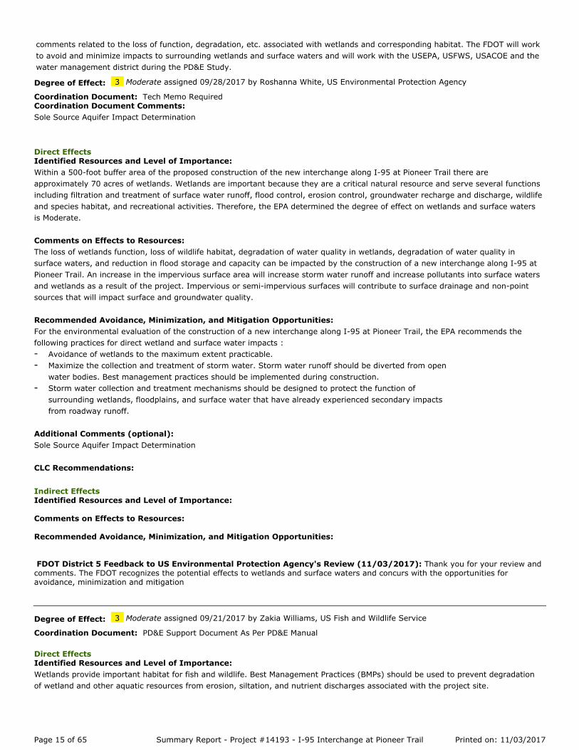
comments related to the loss of function, degradation, etc. associated with wetlands and corresponding habitat. The FDOT will workto avoid and minimize impacts to surrounding wetlands and surface waters and will work with the USEPA, USFWS, USACOE and thewater management district during the PD&E Study.
Degree of Effect: 3 Moderate assigned 09/28/2017 by Roshanna White, US Environmental Protection Agency
Coordination Document: Tech Memo RequiredCoordination Document Comments:Sole Source Aquifer Impact Determination
Direct EffectsIdentified Resources and Level of Importance:Within a 500-foot buffer area of the proposed construction of the new interchange along I-95 at Pioneer Trail there areapproximately 70 acres of wetlands. Wetlands are important because they are a critical natural resource and serve several functionsincluding filtration and treatment of surface water runoff, flood control, erosion control, groundwater recharge and discharge, wildlifeand species habitat, and recreational activities. Therefore, the EPA determined the degree of effect on wetlands and surface watersis Moderate.
Comments on Effects to Resources:The loss of wetlands function, loss of wildlife habitat, degradation of water quality in wetlands, degradation of water quality insurface waters, and reduction in flood storage and capacity can be impacted by the construction of a new interchange along I-95 atPioneer Trail. An increase in the impervious surface area will increase storm water runoff and increase pollutants into surface watersand wetlands as a result of the project. Impervious or semi-impervious surfaces will contribute to surface drainage and non-pointsources that will impact surface and groundwater quality.
Recommended Avoidance, Minimization, and Mitigation Opportunities:For the environmental evaluation of the construction of a new interchange along I-95 at Pioneer Trail, the EPA recommends thefollowing practices for direct wetland and surface water impacts :
Avoidance of wetlands to the maximum extent practicable.-Maximize the collection and treatment of storm water. Storm water runoff should be diverted from openwater bodies. Best management practices should be implemented during construction.
-
Storm water collection and treatment mechanisms should be designed to protect the function ofsurrounding wetlands, floodplains, and surface water that have already experienced secondary impactsfrom roadway runoff.
-
Additional Comments (optional):Sole Source Aquifer Impact Determination
CLC Recommendations:
Indirect EffectsIdentified Resources and Level of Importance:
Comments on Effects to Resources:
Recommended Avoidance, Minimization, and Mitigation Opportunities:
FDOT District 5 Feedback to US Environmental Protection Agency's Review (11/03/2017): Thank you for your review andcomments. The FDOT recognizes the potential effects to wetlands and surface waters and concurs with the opportunities foravoidance, minimization and mitigation
Degree of Effect: 3 Moderate assigned 09/21/2017 by Zakia Williams, US Fish and Wildlife Service
Coordination Document: PD&E Support Document As Per PD&E Manual
Direct EffectsIdentified Resources and Level of Importance:Wetlands provide important habitat for fish and wildlife. Best Management Practices (BMPs) should be used to prevent degradationof wetland and other aquatic resources from erosion, siltation, and nutrient discharges associated with the project site.
Page 15 of 65 Summary Report - Project #14193 - I-95 Interchange at Pioneer Trail Printed on: 11/03/2017

Comments on Effects to Resources:The USFWS recommend that the project be designed to avoid these valuable resources to the greatest extent practicable. If impactsto wetlands are unavoidable, we recommend that the FDOT provides mitigation that fully compensates for the loss of wetlandresources.
Dependent upon the alternative(s) selected, the proposed project is expected to result in minimal to moderate involvement withwildlife and habitat resources. If it is determined the project will affect and federally listed species and/or their habitat, theDepartment will initiate consultation with FWS during the Project Development process.
Recommended Avoidance, Minimization, and Mitigation Opportunities:
Additional Comments (optional):
CLC Recommendations:
Indirect EffectsIdentified Resources and Level of Importance:
Comments on Effects to Resources:
Recommended Avoidance, Minimization, and Mitigation Opportunities:
FDOT District 5 Feedback to US Fish and Wildlife Service's Review (11/03/2017): Thank you for your review andcomment. As noted, the FDOT will utilize "Best Management Practices (BMPs) to prevent degradation of wetland and other aquaticresources from erosion, siltation, and nutrient discharges associated with the project site."
Degree of Effect: 4 Substantial assigned 09/07/2017 by Gary Haddle, Saint Johns River Water Management District
Coordination Document: Permit RequiredCoordination Document Comments:Individual ERP from SJRWMD will be required.
Direct EffectsIdentified Resources and Level of Importance:Based on the design it appears that the project will have wetland and surface water impacts and will require mitigation.
Comments on Effects to Resources:Proposed wetland and surface water impacts will require mitigation.
Recommended Avoidance, Minimization, and Mitigation Opportunities:There appears to be multiple mitigation opportunities in the basin (Regulatory Mitigation Basin 17, Halifax River) including multiplemitigation banks with available credits. In order to receive the Environmental Resource Permit from the SJRWMD the expectation isthat the adverse wetland and surface water impacts will be reduced and eliminated to the greatest extent practicable, and fullymitigated and offset.
Additional Comments (optional):Individual ERP from SJRWMD will be required.
CLC Recommendations:
Indirect EffectsIdentified Resources and Level of Importance:Based on the design it appears that the project will have wetland and surface water impacts and will require mitigation.
Comments on Effects to Resources:Proposed wetland and surface water impacts will require mitigation.
Page 16 of 65 Summary Report - Project #14193 - I-95 Interchange at Pioneer Trail Printed on: 11/03/2017

Recommended Avoidance, Minimization, and Mitigation Opportunities:There appears to be multiple mitigation opportunities in the basin (Regulatory Mitigation Basin 17, Halifax River) including multiplemitigation banks with available credits. In order to receive the Environmental Resource Permit from the SJRWMD the expectation isthat the adverse wetland and surface water impacts will be reduced and eliminated to the greatest extent practicable, and fullymitigated and offset.
FDOT District 5 Feedback to Saint Johns River Water Management District's Review (11/03/2017): Thank you for yourreview and comment and for identifying the mitigation opportunities in the basin (Regulatory Mitigation Basin 17, Halifax River). TheFDOT recognizes the issuance of the ERP from the SJRWMD will be contingent upon reduction of adverse impacts to wetlands andsurface waters.
Degree of Effect: 0 None assigned 09/05/2017 by Suzanne E. Ray, FL Department of Environmental Protection
Coordination Document: PD&E Support Document As Per PD&E Manual
Direct EffectsIdentified Resources and Level of Importance:
Comments on Effects to Resources:
Recommended Avoidance, Minimization, and Mitigation Opportunities:
Additional Comments (optional):
CLC Recommendations:
Indirect EffectsIdentified Resources and Level of Importance:
Comments on Effects to Resources:
Recommended Avoidance, Minimization, and Mitigation Opportunities:
FDOT District 5 Feedback to FL Department of Environmental Protection's Review (11/03/2017): Thank you for yourreview.
Degree of Effect: 3 Moderate assigned 08/29/2017 by Randy Turner, US Army Corps of Engineers
Coordination Document: Permit RequiredCoordination Document Comments:There are nowaters of the U.S. (navigable waters) that are jurisdictional under Section 10 of the Rivers and Harbors Act, however,the proposed project would require a Department of the Army (DA) authorization for impacts to any waters of the U.S. (wetlands)under Section 404 of the Clean Water Act. The project as proposed, would need to be permitted using a Standard Individual Permitwhich includes the need to publish a Public Notice to other federally and State resource agencies as well as all adjacent propertyowners. If the wetland impacts are 0.5 acre or below, the Corps recommends using the Nationwide Permit 14 (NWP-14) for anyproposed impacts to waters of the U.S. (Wetlands or surface waters).
Direct EffectsIdentified Resources and Level of Importance:A review of the EST revealed the presence of approximately 69.86 acres of palustrine wetlands within a 500 foot buffer; 23.34 acresof palustrine wetlands within a 200 foot buffer; and, 9.57 acre of palustrine wetlands within a 100 foot buffer. Any palustrinewetland impacts would most likely be a majority of palustrine forested wetlands with a small amount of palustrine emergent (wetprairie) associated with Spruce Creek to the north and Spruce Creek Swamp to the south of the project area. The level of importancewould be moderate.
Comments on Effects to Resources:Any palustrine wetlands in the project area deemed to be jurisdictional within this major interchange roadway already have beensecondarily impacted so a functional assessment should reveal a lower quality of wetlands. Given the dispersed wetland locations
Page 17 of 65 Summary Report - Project #14193 - I-95 Interchange at Pioneer Trail Printed on: 11/03/2017

surrounded by roadways, any wetland impacts to jurisdictional wetlands would be moderate.
Recommended Avoidance, Minimization, and Mitigation Opportunities:The Corps recommends a continued emphasis on wetland avoidance and minimization opportunities throughout the planningprocess. A wetland survey should be conducted within the study area to identify the wetlands and a jurisdictional determinationshould be completed. A review of the Corps RIBITS indicates that the proposed project corridor would traverse the geographicalservice areas of the Farmton Mitigation Bank (WRAP Credits) that currently has 3,884.77 palustrine credits; Lake Swamp MitigationBank (UMAM Credits) that currently has 0.72 palustrine emergent credits and 57.87 palustrine forested credits available; and PortOrange Mitigation Bank (WRAP Credits) that currently has 216.62 palustrine forested credits available. All banks are assessed ineither WRAP or UMAM. Any unavoidable wetland impacts should be assessed using WRAP or UMAM dependent on the functionalassessment of the bank that is proposed. The project as proposed, would need to be permitted using a Standard Individual Permitwhich includes the need to publish a Public Notice to other federally and State resource agencies as well as all adjacent propertyowners. If the wetland impacts are 0.5 acre or below, the Corps recommends using the Nationwide Permit 14 (NWP-14) for anyproposed impacts to waters of the U.S. (Wetlands or surface waters).
Additional Comments (optional):There are nowaters of the U.S. (navigable waters) that are jurisdictional under Section 10 of the Rivers and Harbors Act, however,the proposed project would require a Department of the Army (DA) authorization for impacts to any waters of the U.S. (wetlands)under Section 404 of the Clean Water Act. The project as proposed, would need to be permitted using a Standard Individual Permitwhich includes the need to publish a Public Notice to other federally and State resource agencies as well as all adjacent propertyowners. If the wetland impacts are 0.5 acre or below, the Corps recommends using the Nationwide Permit 14 (NWP-14) for anyproposed impacts to waters of the U.S. (Wetlands or surface waters).
CLC Recommendations:
Indirect EffectsIdentified Resources and Level of Importance:See direct effects.
Comments on Effects to Resources:New, previously non-disturbed, adjacent wetlands would incur secondary effects along the or new interchange footprint.
Recommended Avoidance, Minimization, and Mitigation Opportunities:See direct impacts.
FDOT District 5 Feedback to US Army Corps of Engineers's Review (11/03/2017): Thank you for your review and commentand for identifying the potential mitigation opportunities. The FDOT recognizes the proposed project would require a Department ofthe Army (DA) authorization for impacts to any waters of the U.S. (wetlands) under Section 404 of the Clean Water Act.
Degree of Effect: 0 None assigned 08/17/2017 by Jennifer Schull, National Marine Fisheries Service
Coordination Document: PD&E Support Document As Per PD&E Manual
Direct EffectsIdentified Resources and Level of Importance:Based on our review of the information provided on the EST website, GIS-based effects analysis on wetlands and interpretation ofaerial photographs, NOAA's National Marine Fisheries Service (NMFS) has determined that mixed forested wetlands, hydric pineflatlands, mixed hardwood wetlands, mixed scrub-shrub wetlands, wet praries, emergent aquatic vegetation, and cypress are locatedwithin the project corridor. These wetlands range from low to high in quality. There are no coastal or marine habitats within theproject area.
Comments on Effects to Resources:The wetlands within the project corridor provide water quality functions, such as removal of sediments, excess nutrients, andcontaminants, which benefit and support these aquatic ecosystems. Wetlands may be impacted from construction activities, fill, andthrough sedimentation and runoff. Through hydrological connections, these wetlands also contribute plant material and otheruseable nutrients (both dissolved and particulate organic matter) into aquatic food webs that include recreationally, commercially,and ecologically important species within downstream estuaries. If wetland impacts are unavoidable, sequential minimization andmitigation should take place.
Page 18 of 65 Summary Report - Project #14193 - I-95 Interchange at Pioneer Trail Printed on: 11/03/2017

Water Quality and Quantity Project Effects
Recommended Avoidance, Minimization, and Mitigation Opportunities:Magnuson-Stevens Act: Based on the project location, information provided in the ETDM website, and GIS-based analysis ofimpacts, NOAA's National Marine Fisheries Service (NMFS) concludes that essential fish habitat (EFH) would not be impacted by theproposed action; accordingly, we offer no comments pursuant to the EFH provisions of the Magnuson-Stevens Act (P.L. 104-297);and this project will not require an EFH Assessment. Further consultation on this matter is not necessary unless future modificationsare proposed and you believe that the proposed action may result in adverse impacts to EFH.
Endangered Species Act: We are not aware of any threatened or endangered species or critical habitat under the purview of NMFSthat occur within the project area. However, it should be noted that a "no effect" determination must be made by the action agencyand the reasoning underlying the determination should be documented in a project file. Please coordinate closely with the U.S. Fishand Wildlife Service for other species listed under the Endangered Species Act that may require consultation.
Fish and Wildlife Coordination Act: The comments NMFS provided regarding sequential mitigation are in accordance with the Fishand Wildlife Coordination Act.
Additional Comments (optional):
CLC Recommendations:
Indirect EffectsIdentified Resources and Level of Importance:
Comments on Effects to Resources:
Recommended Avoidance, Minimization, and Mitigation Opportunities:
FDOT District 5 Feedback to National Marine Fisheries Service's Review (11/03/2017): Thank you for your review and foridentifying that this project will not require an EFH Assessment.
Coordinator Summary Degree of Effect: 3 Moderate assigned 11/03/2017 by FDOT District 5
Comments:The US Environmental Protection Agency, Saint Johns River Water Management District, and Florida Department of EnvironmentalProtection all reviewed this issue. Because the project is within the Spruce Creek basin, a summary degree of effect of moderate isbeing assigned to this issue. The FDOT will work with agency partners to reduce impacts to water quality and quantityrequirements.
Degree of Effect: 3 Moderate assigned 09/28/2017 by Roshanna White, US Environmental Protection Agency
Coordination Document: Tech Memo RequiredCoordination Document Comments:Sole Source Aquifer Impact Determination
Direct EffectsIdentified Resources and Level of Importance:The construction of the new interchange along I-95 at Pioneer Trail is located within a 500-foot buffer of a principle aquifer, SurficialAquifer System, and recharge area; and Spruce Creek, an Outstanding Florida Water. Both the Surficial Aquifer System and SpruceCreek affect Florida water quality, so water quality and quantity degree of effect on these resources is Moderate.
Comments on Effects to Resources:It is important to maintain and protect good quality water because it provides drinking water for human health, and contributes tothe health and habitat of wildlife. The new interchange at I-95 at Pioneer Trail can cause disturbance of vegetation and soils due tovehicular passing during project activities. Soil erosion and disturbance of vegetation due to the use of heavy equipment andvehicular passing lead to the detachment of soils. Soil erosion and sediment delivery to surface water results in turbidity increase
Page 19 of 65 Summary Report - Project #14193 - I-95 Interchange at Pioneer Trail Printed on: 11/03/2017

and mobilizes fine sediments. Construction runoff and storm water effect the increase in turbidity of the water body which can causean increase in water temperature, as turbid waters heat more rapidly when exposed to sunlight. Turbidity decreases primaryproduction and dissolved oxygen levels. Therefore, there is a potential for an increase in water degradation.
Recommended Avoidance, Minimization, and Mitigation Opportunities:For the environmental evaluation of the new interchange at I-95 at Pioneer Trail, the EPA recommends the following practices fordirect water quality and quantity impacts :
Explain how adequate sediment and erosion control measures will be used to prevent the discharge of.-Use best management practices to control erosion, sediment release, and storm water surface runoff tominimize adverse impacts on water resources.
-
Stabilize soils to reduce the effects of erosion, sedimentation, and runoff to maintain or improve waterquality.
-
Identify and quantify incremental and cumulative impacts on water quality as a result of the past,present, and reasonably foreseeable actions, including the proposed project and other land use actions.
-
Reduce the impact of pollution runoff from the roadway.-Construction plan should provide erosion and sediment control.-Preventive maintenance plan to reduce the potential amount of waste generated.-Recommend that contractors reduce the amount of hazardous and toxic materials used to the maximumextent possible.
-
Additional Comments (optional):Sole Source Aquifer Impact Determination
CLC Recommendations:
Indirect EffectsIdentified Resources and Level of Importance:
Comments on Effects to Resources:
Recommended Avoidance, Minimization, and Mitigation Opportunities:
FDOT District 5 Feedback to US Environmental Protection Agency's Review (11/03/2017): Thank you for your review andcomment. The FDOT concurs with your assessment of the effects to resources and the corresponding avoidance, minimization andmitigation options.
Degree of Effect: 0 None assigned 09/07/2017 by Gary Haddle, Saint Johns River Water Management District
Coordination Document: Permit RequiredCoordination Document Comments:Stormwater Harvesting potential may be present for this project, as there will be volume created. Nearby needs have beenidentified, including a nearby golf course, sod farm, and permitted subdivision (not yet constructed). Please contact Marc von Canal,(407) 659-4841, [email protected] for further discussion.
Direct EffectsIdentified Resources and Level of Importance:
Comments on Effects to Resources:
Recommended Avoidance, Minimization, and Mitigation Opportunities:
Additional Comments (optional):Stormwater Harvesting potential may be present for this project, as there will be volume created. Nearby needs have beenidentified, including a nearby golf course, sod farm, and permitted subdivision (not yet constructed). Please contact Marc von Canal,(407) 659-4841, [email protected] for further discussion.
CLC Recommendations:
Indirect EffectsIdentified Resources and Level of Importance:
Page 20 of 65 Summary Report - Project #14193 - I-95 Interchange at Pioneer Trail Printed on: 11/03/2017

Floodplains Project Effects
Comments on Effects to Resources:
Recommended Avoidance, Minimization, and Mitigation Opportunities:
FDOT District 5 Feedback to Saint Johns River Water Management District's Review (11/03/2017): Thank you for yourreview and comment. The FDOT acknowledges your comment regarding stormwater harvesting potential and will coordinate with Mr.von Canal as stated.
Degree of Effect: 0 None assigned 09/05/2017 by Suzanne E. Ray, FL Department of Environmental Protection
Coordination Document: PD&E Support Document As Per PD&E Manual
Direct EffectsIdentified Resources and Level of Importance:
Comments on Effects to Resources:
Recommended Avoidance, Minimization, and Mitigation Opportunities:
Additional Comments (optional):
CLC Recommendations:
Indirect EffectsIdentified Resources and Level of Importance:
Comments on Effects to Resources:
Recommended Avoidance, Minimization, and Mitigation Opportunities:
FDOT District 5 Feedback to FL Department of Environmental Protection's Review (11/03/2017): Thank you for yourreview.
Coordinator Summary Degree of Effect: 2 Minimal assigned 11/03/2017 by FDOT District 5
Comments:Given the conditions in the area, a Degree of Effect of Minimal is being assigned to this issue. A Location Hydraulics Report will beprepared as part of the Project Development and Environment (PD&E) study. An evaluation of floodplain impacts and alternatives toavoid adverse effects and incompatible development in the floodplains will be undertaken. Efforts will be made to avoid or minimizeimpacts to floodplain resources and functions. Engineering design features and hydrological drainage structures will be designedsuch that stormwater transport, flow, and discharge meet or exceed flood control requirements.
Degree of Effect: 0 None assigned 09/01/2017 by Ken Lewis, Saint Johns River Water Management District
Coordination Document: Permit Required
Direct EffectsIdentified Resources and Level of Importance:
Comments on Effects to Resources:
Recommended Avoidance, Minimization, and Mitigation Opportunities:
Additional Comments (optional):
CLC Recommendations:
Indirect EffectsIdentified Resources and Level of Importance:
Comments on Effects to Resources:
Page 21 of 65 Summary Report - Project #14193 - I-95 Interchange at Pioneer Trail Printed on: 11/03/2017

Wildlife and Habitat Project Effects
Recommended Avoidance, Minimization, and Mitigation Opportunities:
FDOT District 5 Feedback to Saint Johns River Water Management District's Review (11/03/2017): Thank you for yourreview. The FDOT will continue to coordinate with the water management district to avoid and compensate for floodplain impacts.
Coordinator Summary Degree of Effect: 3 Moderate assigned 11/03/2017 by FDOT District 5
Comments:Because of the potential wildlife and habitat issues in the area, the FDOT will assign an overall Degree of Effect of Moderate to thisissue.The FDOT will conduct wildlife surveys during the Project Development and Environment (PD&E) study phase and coordinatewith the USFWS and FWC.A Natural Resource Evaluation (NRE) will be conducted during the PD&E Study to assess potential impacts to listed species, developavoidance and minimization efforts as part of the project coordination, and to document any involvement with wildlife and habitatresources. The NRE will assess potential floral and faunal species within the corridor, as well as potential habitat for these species.The results of the NRE will be coordinated with federal and/or state resource/regulatory agencies as applicable.
Degree of Effect: 3 Moderate assigned 09/22/2017 by Jennifer Goff, FL Fish and Wildlife Conservation Commission
Coordination Document: To Be Determined: Further Coordination Required
Direct EffectsIdentified Resources and Level of Importance:Florida Fish and Wildlife Conservation Commission (FWC) staff has reviewed ETDM #14193 in Volusia County from FDOT District 2 ofthe Florida Department of Transportation (FDOT) and provides the following comments related to potential effects to fish and wildliferesources on this Programming Phase project.
The Project Description Summary states this project involves construction of a new Interchange on I-95 at Pioneer Trail to supporteconomic development including three Developments of Reginal Impact in this area of Volusia County. While the project area iswithin or immediately adjacent to the boundary of the City limits of New Smyrna Beach, the proposed Interchange site in a ruralundeveloped area with three large freshwater wetland systems located within the Northeast, East, and near the Southwestquadrants of the project area. The Project Description did not specifically address the probable need or location for new DrainageRetention Areas (DRAs) to handle stormwater from the expanded roadway surface area and cleared land, which will also result inadditional habitat loss.
An assessment of the project area was performed on lands within 500 feet of the proposed alignment to determine potential impactsto habitat which supports listed species and other fish and wildlife resources. Our inventory included a review of aerial and ground-level photography, various wildlife observation and landcover data bases, along with coordination with FWC biologists and otherstate and federal agencies. A GIS analysis was performed using the Florida FDOT's Environmental Screening Tool to determine thepotential quality and extent of upland and wetland habitat, and other wildlife and fisheries resource information. We have reviewedthe Preliminary Environmental Discussion Comments Report provided by the FDOT, and offer the following comments andrecommendations.
Our assessment reveals that landcover within the 500-foot assessment area along the roadway includes upland forests (69.2 acres,34.4%), wetlands (76.4 acres, 39.5%), and High and Low Impact disturbed lands (50.9 acres, 25.4%) which for the most partincludes the existing Right-of-way (ROW) and recovery zone along the north and southbound lanes of I-95 and cleared ROW alongPioneer Trail. Uplands consist of dry prairie (1.1 acres, 0.6%), mixed hardwood pine forests (2.5 acres, 1.2%), pinelands (50.3acres, 25.0%), sand pine scrub (2.2 acres, 1.1%), xeric oak scrub (4.5 acres, 2.2%), and shrub and brushland (8.7 acres, 4.3%).Wetlands consist of cypress swamp (37.8, 18.8%), hardwood swamp (0.2 acres, 0.1%), freshwater marsh (5.6 acres, 2.8%), mixedwetland forest (24.0 acres,12.0%), shrub swamp (7.1 acres, 3.5%), and open water (4.7 acres, 2.3%).
Based on known range and preferred habitat type, the following species listed by the Federal Endangered Species Act (ESA) and theState of Florida as Federally Endangered (FE), Federally Threatened (FT), State-Threatened (ST), or State Species of SpecialConcern (SSC) have the potential to occur in or near the project area: red-cockaded woodpecker (FE), Eastern indigo snake (FT),
Page 22 of 65 Summary Report - Project #14193 - I-95 Interchange at Pioneer Trail Printed on: 11/03/2017

wood stork ((FT), gopher tortoise (ST), Sherman's fox squirrel (SSC), Southeastern American kestrel (ST), Florida pine snake (ST),little blue heron (ST), and the tricolored heron (ST), while the Florida scrub Jay (FT) has been documented within one mile of theproject area. The project area is within the Central Bear Management Unit and our FWC's data base shows that the black bear isabundant in the regional area, and one black bear roadkill has been reported near the project area.
The GIS analysis identified specific characteristics associated with lands along the project alignment that provide an indication ofpotential habitat quality or sensitivity that will require field studies to verify the presence or absence of listed wildlife species and thequality of wildlife and habitat resources. FWC's Integrated Wildlife Habitat Ranking System shows that a total of 135.9 acres orapproximately 67.7 percent of the land within 500 feet of the project overpass location on I-95 is ranked as either medium ormoderately high quality wildlife habitat. FWC's Reclassification of Wetland Habitats of High Priority to Endangered and ThreatenedSpecies also shows that 64.9 acres of upland habitat can support 1 to 3 focal species; 72.3 acres of wetlands can support 1 to 3focal species; and 6.2 acres of wetlands can support 4 to 6 focal species. Also, 107.4 acres or 59.5 percent of habitat within theproject assessment area is ranked as medium quality in FWC's Strategic Habitat Conservation Priority Rankings. Furthermore, a totalof 107.4 acres or 53.5 percent of the assessment area is within a defined strategic Habitat Conservation Area where the habitatcapable of supporting the Swallow-tailed kite. And finally, the Spruce Creek Florida Forever Board of Trustees project is locatedwithin 500 feet of the project area, while the mountain mullet has been documented within Middle Spruce Creek.
Comments on Effects to Resources:Primary wildlife issues associated with this project include: potential direct loss and degradation of upland and isolated wetlandhabitats due to roadway expansion and construction of Drainage Retention Areas outside of the cleared ROW; impacts due toimproved access for future commercial development around the Interchange, and improved access for residential development,along with potential adverse effects to a number of species listed by the Federal Endangered Species Act as Threatened, or by theState of Florida as Threatened or Species of Special Concern; and the potential for water quality impacts. Based on the projectinformation provided, we believe that direct and indirect effects of this project could be in the hig-moderate range due the need foradditional offsite stormwater ponds which will result in the loss and degradation of upland and wetland habitat. Impacts to naturalhabitats could be minimized by the strategic location of Drainage Retention Areas in disturbed areas, and the use of BestManagement Practices and a project commitment to control and treat roadway runoff to avoid water quality degradation in streamsand wetlands.
Recommended Avoidance, Minimization, and Mitigation Opportunities:We recommend that the Project Development and Environment Study address natural resources by including the following measuresfor conserving fish and wildlife and habitat resources that may occur within and adjacent to the project area.
1. Plant community mapping and wildlife surveys for the occurrence of wildlife species listed by the Federal Endangered Species Actas Endangered or Threatened, or by the State of Florida as Threatened or species of Special Concern should be performed along theROW and within sites proposed for equipment staging. Basic guidance for conducting wildlife surveys may be found in the FWC'sFlorida Wildlife Conservation Guide at http://myfwc.com/conservation/value/fwcg/.
2. Based on the survey results, a plan should be developed to address direct, indirect, and cumulative effects of the project onwildlife and habitat resources, including listed species. Avoidance, minimization, and mitigation measures should also be formulatedand implemented. Equipment staging areas should be sited in previously disturbed sites to avoid habitat destruction or degradation.The plan should address specific habitat needs which are biologically compatible with the recovery of the target species. Forguidance in this effort, FWC's Species Action Plans should be consulted at http://myfwc.com/wildlifehabitats/imperiled/species-action-plans/.
3. Due to the potential presence of gopher tortoises in the project area, we recommend that the applicant refer to the FWC's GopherTortoise Permitting Guidelines (Revised January 2017) (http://www.myfwc.com/license/wildlife/gopher-tortoise-permits/) for surveymethodology and permitting guidance. Survey methodologies require a burrow survey covering a minimum of 15 percent ofpotential gopher tortoise habitat to be impacted by development activities including staging areas (refer to Appendix 4 in the GopherTortoise Permitting Guidelines for additional information). Specifically, the permitting guidelines include methods for avoidingimpacts (such as preservation of occupied habitat) as well as options and state requirements for minimizing, mitigating, andpermitting potential impacts of the proposed activities. Any commensal species observed during burrow excavation should behandled in accordance to Appendix 9 of the Gopher Tortoise Permitting Guidelines.
4. Sherman's fox squirrels are known to utilize habitats with mature oaks and pines and are often found foraging along road edges.Because of this, we recommend the applicant review permitting guidelines (http://myfwc.com/media/4105895/Final-Shermans-Fox-squirrel-Species-Guidelines-2016.pdf) for this species. Recommendations for appropriate surveys to identify nests, individual animals, andevidence of foraging can be found within the Species Guidelines. Surveys should include 20% of the suitable habitat, which includesroad edges, open forests, and pastures. If fox squirrel nests are found within the development area, then those trees should beflagged and avoided. It is recommended that large mature hardwood trees are preserved because they are important habitat for fox
Page 23 of 65 Summary Report - Project #14193 - I-95 Interchange at Pioneer Trail Printed on: 11/03/2017

squirrels.
5. A compensatory mitigation plan should include the replacement of wetland, upland, or aquatic habitat functional values for listedspecies which are lost due to the project. Replacement habitat for mitigation should be type for type, as productive, and equal to orof higher functional value. Please notify us immediately if the design, extent, or footprint of the current project is modified, as wemay choose to provide additional comments and/or recommendations.
We appreciate the opportunity to provide input on highway design and the conservation of fish and wildlife resources. Please contactBiologist Terry Gilbert at (850) 728-1103 or [email protected] initiate the process for further overall coordination on this project.
Additional Comments (optional):
CLC Recommendations:
Indirect EffectsIdentified Resources and Level of Importance:
Comments on Effects to Resources:
Recommended Avoidance, Minimization, and Mitigation Opportunities:
FDOT District 5 Feedback to FL Fish and Wildlife Conservation Commission's Review (11/03/2017): Thank you for yourreview and comments. The FDOT has noted USFWS' assessment of the study area, the potential effects to resources and the keypoints related to avoidance, minimization and mitigation and will address these issues in the Natural Resources Evaluation.
Degree of Effect: 2 Minimal assigned 09/21/2017 by Zakia Williams, US Fish and Wildlife Service
Coordination Document: PD&E Support Document As Per PD&E Manual
Direct EffectsIdentified Resources and Level of Importance:Wood Stork (Mycteria americana)The surrounding area mainly consists of wetland forests, pine flatwoods, scrub-shrub wetlands, wet prairies, and has emergentaquatic vegetation. Although, the project doesn't directly fall within the Core Foraging Area (CFA) for the wood stork the project areadoes provide suitable foraging habitat for the wood stork.
Eastern Indigo Snakes (Drymarchon corais couperi)It is very likely that this species may occur within the action area. The addition of a new roads and the widening of roads will likelyincrease the risks to this species from direct mortality and indirectly from habitat fragmentation and noise disturbance.
Coordination with the Office of Migratory birds will be needed for an eagle nest located within 200 feet of corridor.
Surveys for all federally listed plants found in Volusia County (the list can be found on our website http://www.fws.gov/northfloridashouldbe conducted by a trained botanist during the appropriate time of year.
Comments on Effects to Resources:Wood Stork (Mycteria americana)To minimize adverse effects to the wood stork and other wetland dependent species, we recommend that impacts to suitableforaging habitat be avoided. If avoidance is not possible, minimization measure should be employed and best management practicesto avoid further degradation of the site. Mitigation for wetland impacts should be discussed with USFWS and will require furthercoordination. Please refer to the North Florida Field Office website for WOST colony locations. http://www.fws.gov/northflorida
Eastern Indigo Snakes (Drymarchon corais couperi)Individual snakes may have large home ranges of 200 to 250 acres. Direct impacts from vehicles, loss and fragmentation of habitatwould contribute to the further decline of this species. Implementing the current standard construction conditions and protectionmeasures for EIS will reduce the direct risks to snakes during the construction phase but not the long term impacts from habitatfragmentation and loss of individuals from interactions with vehicles for the life of the facility. Complete surveys for gopher tortoiseburrows (currently a federal candidate species, which may be listed as Threatened before construction begins) should be conducted.
Page 24 of 65 Summary Report - Project #14193 - I-95 Interchange at Pioneer Trail Printed on: 11/03/2017

Coastal and Marine Project Effects
Protection guidelines can be found on the North Florida Ecological Services website: http://www.fws.gov/northflorida. Surveys forgopher tortoise burrows will also facilitate the use of the EIS Effect determination key utilized by the Army COE.
Recommended Avoidance, Minimization, and Mitigation Opportunities:
Additional Comments (optional):
CLC Recommendations:
Indirect EffectsIdentified Resources and Level of Importance:
Comments on Effects to Resources:
Recommended Avoidance, Minimization, and Mitigation Opportunities:
FDOT District 5 Feedback to US Fish and Wildlife Service's Review (11/03/2017): Thank you for your review andcomments. The FDOT has noted your comments as they related to the Eastern Indigo Snake, Wood Stork and plant species. TheFDOT will review the materials provided or suggested and incorporate all actions in the Natural Resources Evaluation.
Degree of Effect: 0 None assigned 09/07/2017 by Steve Bohl, FL Department of Agriculture and Consumer Services
Coordination Document: No Involvement
Direct EffectsIdentified Resources and Level of Importance:
Comments on Effects to Resources:
Recommended Avoidance, Minimization, and Mitigation Opportunities:
Additional Comments (optional):
CLC Recommendations:
Indirect EffectsIdentified Resources and Level of Importance:
Comments on Effects to Resources:
Recommended Avoidance, Minimization, and Mitigation Opportunities:
FDOT District 5 Feedback to FL Department of Agriculture and Consumer Services's Review (11/03/2017): Thank youfor your review.
Coordinator Summary Degree of Effect: 0 None assigned 11/03/2017 by FDOT District 5
Comments:A summary Degree of Effect of None is being assigned to this issue and agrees with the National Marine Fisheries Serviceassessment regarding the lack of coastal or marine habitats within the project area. NMFS also noted that for the currently proposedproject an Essential Fish Habitat (EFH) Assessment will not be required.
Degree of Effect: N/A N/A / No Involvement assigned 09/07/2017 by Gary Haddle, Saint Johns River Water Management District
Coordination Document: No Involvement
Direct EffectsIdentified Resources and Level of Importance:
Page 25 of 65 Summary Report - Project #14193 - I-95 Interchange at Pioneer Trail Printed on: 11/03/2017

Comments on Effects to Resources:
Recommended Avoidance, Minimization, and Mitigation Opportunities:
Additional Comments (optional):
CLC Recommendations:
Indirect EffectsIdentified Resources and Level of Importance:
Comments on Effects to Resources:
Recommended Avoidance, Minimization, and Mitigation Opportunities:
FDOT District 5 Feedback to Saint Johns River Water Management District's Review (11/03/2017): Thank you for yourreview.
Degree of Effect: 0 None assigned 08/17/2017 by Jennifer Schull, National Marine Fisheries Service
Coordination Document: PD&E Support Document As Per PD&E Manual
Direct EffectsIdentified Resources and Level of Importance:Based on our review of the information provided on the EST website, GIS-based effects analysis on wetlands and interpretation ofaerial photographs, NOAA's National Marine Fisheries Service (NMFS) has determined that mixed forested wetlands, hydric pineflatlands, mixed hardwood wetlands, mixed scrub-shrub wetlands, wet praries, emergent aquatic vegetation, and cypress are locatedwithin the project corridor. These wetlands range from low to high in quality. There are no coastal or marine habitats within theproject area.
Comments on Effects to Resources:The wetlands within the project corridor provide water quality functions, such as removal of sediments, excess nutrients, andcontaminants, which benefit and support these aquatic ecosystems. Wetlands may be impacted from construction activities, fill, andthrough sedimentation and runoff. Through hydrological connections, these wetlands also contribute plant material and otheruseable nutrients (both dissolved and particulate organic matter) into aquatic food webs that include recreationally, commercially,and ecologically important species within downstream estuaries. If wetland impacts are unavoidable, sequential minimization andmitigation should take place.
Recommended Avoidance, Minimization, and Mitigation Opportunities:Magnuson-Stevens Act: Based on the project location, information provided in the ETDM website, and GIS-based analysis ofimpacts, NOAA's National Marine Fisheries Service (NMFS) concludes that essential fish habitat (EFH) would not be impacted by theproposed action; accordingly, we offer no comments pursuant to the EFH provisions of the Magnuson-Stevens Act (P.L. 104-297);and this project will not require an EFH Assessment. Further consultation on this matter is not necessary unless future modificationsare proposed and you believe that the proposed action may result in adverse impacts to EFH.
Endangered Species Act: We are not aware of any threatened or endangered species or critical habitat under the purview of NMFSthat occur within the project area. However, it should be noted that a "no effect" determination must be made by the action agencyand the reasoning underlying the determination should be documented in a project file. Please coordinate closely with the U.S. Fishand Wildlife Service for other species listed under the Endangered Species Act that may require consultation.
Fish and Wildlife Coordination Act: The comments NMFS provided regarding sequential mitigation are in accordance with the Fishand Wildlife Coordination Act.
Additional Comments (optional):
CLC Recommendations:
Indirect EffectsIdentified Resources and Level of Importance:
Comments on Effects to Resources:
Page 26 of 65 Summary Report - Project #14193 - I-95 Interchange at Pioneer Trail Printed on: 11/03/2017

ETAT Reviews and Coordinator Summary: Physical Noise Project Effects
None found
Air Quality Project Effects
Recommended Avoidance, Minimization, and Mitigation Opportunities:
FDOT District 5 Feedback to National Marine Fisheries Service's Review (11/03/2017): Thank you for your review andcomments.
Coordinator Summary Degree of Effect: 2 Minimal assigned 11/03/2017 by FDOT District 5
Comments:No ETAT Reviews were submitted for this issue. A Degree of Effect of Minimal will assigned to this issue given the lack of existingnoise receptors in the study area.
Coordinator Summary Degree of Effect: 2 Minimal assigned 11/03/2017 by FDOT District 5
Comments:In agreement with USEPA, a summary Degree Effect of Minimal is being assigned to this issue.
Degree of Effect: 2 Minimal assigned 09/19/2017 by Roshanna White, US Environmental Protection Agency
Coordination Document: Tech Memo RequiredCoordination Document Comments:Sole Source Aquifer Impact Determination
Direct EffectsIdentified Resources and Level of Importance:A wide variety of air pollutants can be emitted from mobile sources. The EPA establishes the National Ambient Air Quality Standards(NAAQS) to protect public health and public welfare and regulates emissions of hazardous air pollutants. The project area of I-95Interchange at Pioneer Trail is in an attainment area, so criteria pollutants under NAAQS are considered to be an acceptable level.Therefore, EPA expects the project to have minimal impact on air quality.
Comments on Effects to Resources:The I-95 Interchange at Pioneer Trail project can possibly effect air quality through airborne dust, and other ambient air pollutantsfrom project construction.
Recommended Avoidance, Minimization, and Mitigation Opportunities:The EPA recommends that the I-95 Interchange at Pioneer Trail project follow the Florida State Implementation Plan to ensureconsistency with the state's emissions levels. The EPA also recommends the use of diesel controls, cleaner fuel, and cleanerconstruction practices for on-road and off-road equipment used for transportation, soil movement, or other project activities,including:
Use of clean diesel through add-on control technologies like diesel particulate filters and diesel oxidation catalysts, repowers, ornewer, cleaner equipment.
-
Additional Comments (optional):Sole Source Aquifer Impact Determination
CLC Recommendations:
Indirect EffectsIdentified Resources and Level of Importance:
Page 27 of 65 Summary Report - Project #14193 - I-95 Interchange at Pioneer Trail Printed on: 11/03/2017

Contamination Project Effects
Comments on Effects to Resources:
Recommended Avoidance, Minimization, and Mitigation Opportunities:
FDOT District 5 Feedback to US Environmental Protection Agency's Review (11/03/2017): Thank you for your review andcomment. An Air Quality Technical Memorandum will be completed during the project.
Coordinator Summary Degree of Effect: 2 Minimal assigned 11/03/2017 by FDOT District 5
Comments:The USEPA reviewed the project and noted that contamination may have a minimal adverse effect on the STORET Stations and wellsince construction of the project may affect ground water quality. A summary Degree of Effect of Minimal will be assigned to thisissue. A contamination screening evaluation will be conducted in Project Development, and a Contamination Screening EvaluationReport (CSER) will be prepared.
Degree of Effect: 2 Minimal assigned 09/20/2017 by Roshanna White, US Environmental Protection Agency
Coordination Document: Tech Memo RequiredCoordination Document Comments:Sole Source Aquifer Impact Determination
Direct EffectsIdentified Resources and Level of Importance:The interchange at I-95 and Pioneer train construction activities may effect ground water quality. Therefore, contamination has aminimal adverse effect on the STORET Stations and well.
Comments on Effects to Resources:Construction activities (i.e. clearing of land, over spraying of water as a dust control measure, and excavations) may increaseground water vulnerability to pollution.
Recommended Avoidance, Minimization, and Mitigation Opportunities:Ensure that contaminated groundwater and any other contaminated materials are managed, stored or disposed of appropriately inaccordance to federal and state law. Preserve and maintain all existing and future monitoring wells, notify EPA and FDEP of anydamaged monitoring wells, and receive approval from EPA and FDEP before removing or replacing any monitoring wells. Use bestmanagement practices (BMPs) that reduce environmental impact.
Additional Comments (optional):Sole Source Aquifer Impact Determination
CLC Recommendations:
Indirect EffectsIdentified Resources and Level of Importance:
Comments on Effects to Resources:
Recommended Avoidance, Minimization, and Mitigation Opportunities:
FDOT District 5 Feedback to US Environmental Protection Agency's Review (11/03/2017): Thank you for your review andcomment. The FDOT concurs with the USEPA's assessment of the study area resources and the recommended avoidance,minimization and mitigation opportunities presented.
Degree of Effect: 0 None assigned 09/05/2017 by Suzanne E. Ray, FL Department of Environmental Protection
Page 28 of 65 Summary Report - Project #14193 - I-95 Interchange at Pioneer Trail Printed on: 11/03/2017

Infrastructure Project Effects
None found
Navigation Project Effects
Coordination Document: PD&E Support Document As Per PD&E Manual
Direct EffectsIdentified Resources and Level of Importance:
Comments on Effects to Resources:
Recommended Avoidance, Minimization, and Mitigation Opportunities:
Additional Comments (optional):
CLC Recommendations:
Indirect EffectsIdentified Resources and Level of Importance:
Comments on Effects to Resources:
Recommended Avoidance, Minimization, and Mitigation Opportunities:
FDOT District 5 Feedback to FL Department of Environmental Protection's Review (11/03/2017): Thank you for yourreview.
Coordinator Summary Degree of Effect: 2 Minimal assigned 11/03/2017 by FDOT District 5
Comments:No ETAT Reviews were submitted for this issue. The EST's GIS analysis results do not show any Infrastructure resources within the500 foot project buffer area. The FDOT will assign a Degree of Effect of Minimal.
Coordinator Summary Degree of Effect: N/A N/A / No Involvement assigned 11/03/2017 by FDOT District 5
Comments:As confirmed by the US Army Corps of Engineers and US Coast Guard, there are no navigable waterways within the project limits.The FDOT is assigning a Degree of Effect of Not Applicable / No Involvement to this resource. The comments from the USACOE areaddressed in the Wetlands and Surface Waters section of the summary report.
Degree of Effect: 0 None assigned 08/29/2017 by Randy Turner, US Army Corps of Engineers
Coordination Document: Permit RequiredCoordination Document Comments:There are nowaters of the U.S. (navigable waters) that are jurisdictional under Section 10 of the Rivers and Harbors Act, however,the proposed project would require a Department of the Army (DA) authorization for impacts to any waters of the U.S. (wetlands)under Section 404 of the Clean Water Act. The project as proposed, would need to be permitted using a Standard Individual Permitwhich includes the need to publish a Public Notice to other federally and State resource agencies as well as all adjacent propertyowners. If the wetland impacts are 0.5 acre or below, the Corps recommends using the Nationwide Permit 14 (NWP-14) for anyproposed impacts to waters of the U.S. (Wetlands or surface waters).
Direct EffectsIdentified Resources and Level of Importance:No navigational resources exist within the proposed project area.
Comments on Effects to Resources:N/A
Page 29 of 65 Summary Report - Project #14193 - I-95 Interchange at Pioneer Trail Printed on: 11/03/2017

ETAT Reviews and Coordinator Summary: Special Designations Special Designations
Recommended Avoidance, Minimization, and Mitigation Opportunities:N/A
Additional Comments (optional):There are nowaters of the U.S. (navigable waters) that are jurisdictional under Section 10 of the Rivers and Harbors Act, however,the proposed project would require a Department of the Army (DA) authorization for impacts to any waters of the U.S. (wetlands)under Section 404 of the Clean Water Act. The project as proposed, would need to be permitted using a Standard Individual Permitwhich includes the need to publish a Public Notice to other federally and State resource agencies as well as all adjacent propertyowners. If the wetland impacts are 0.5 acre or below, the Corps recommends using the Nationwide Permit 14 (NWP-14) for anyproposed impacts to waters of the U.S. (Wetlands or surface waters).
CLC Recommendations:
Indirect EffectsIdentified Resources and Level of Importance:No navigational resources exist within the proposed project area.
Comments on Effects to Resources:N/A
Recommended Avoidance, Minimization, and Mitigation Opportunities:N/A
FDOT District 5 Feedback to US Army Corps of Engineers's Review (11/03/2017): Thank you for your review andcomments. The comments from the USACOE are addressed in the wetlands and surface waters section of the summary report.
Degree of Effect: N/A N/A / No Involvement assigned 08/11/2017 by Randall D Overton, US Coast Guard
Coordination Document: No Involvement
Direct EffectsIdentified Resources and Level of Importance:There are no navigable waters of the United States impacted by the proposed project as it currently scoped.
Comments on Effects to Resources:
Recommended Avoidance, Minimization, and Mitigation Opportunities:
Additional Comments (optional):
CLC Recommendations:
Indirect EffectsIdentified Resources and Level of Importance:
Comments on Effects to Resources:
Recommended Avoidance, Minimization, and Mitigation Opportunities:
FDOT District 5 Feedback to US Coast Guard's Review (11/03/2017): Thank you for your review and comments.
Page 30 of 65 Summary Report - Project #14193 - I-95 Interchange at Pioneer Trail Printed on: 11/03/2017
Project Effects
Coordinator Summary Degree of Effect: 3 Moderate assigned 11/03/2017 by FDOT District 5
Comments:The US Environmental Protection Agency and Saint Johns River Water Management District reviewed this issue. The FDOTrecognizes the importance of the Spruce Creek and Tomoka Hydrologic Basins, and is assigning a Degree of Effect of Moderate tothis issue.
Degree of Effect: 3 Moderate assigned 09/28/2017 by Roshanna White, US Environmental Protection Agency
Coordination Document: Tech Memo RequiredCoordination Document Comments:Sole Source Aquifer Impact Determination
Direct EffectsIdentified Resources and Level of Importance:The new interchange at I-95 at Pioneer Trail is within a 500-foot buffer of tributary to Spruce Creek. Spruce Creek specialdesignation is to protect its existing good water quality. Therefore, this special designation is of moderate level of importance.
Comments on Effects to Resources:The new interchange at I-95 at Pioneer Trail can potentially have construction runoff, soil erosion, and storm water runoff, whichincreases water pollutants and degrades water quality. Therefore, the preservation of wetlands can assist with maintaining goodwater quality. Wetlands are a critical natural resource and serve several functions including filtration and treatment of surface waterrunoff, flood control, erosion control, groundwater recharge/discharge, and wildlife habitat. Therefore, avoiding and minimizing anydegradation to these reserves and wildlife refuge and management areas will contribute to the maintenance of good water quality.
Recommended Avoidance, Minimization, and Mitigation Opportunities:For the environmental evaluation of the new interchange at I-95 at Pioneer Trail, the EPA recommends the following practices fordirect special designation impacts :
Avoidance of wetlands to the maximum extent practicable.-Use best management practices to control erosion, sediment release, and storm water surface runoff tominimize adverse impacts on water resources.
-
Maximize the collection and treatment of storm water. Storm water runoff should be diverted from openwater bodies. Best management practices should be implemented during construction.
-
Storm water collection and treatment mechanisms should be designed to protect the function ofsurrounding wetlands, floodplains, and surface water that have already experienced secondary impactsfrom roadway runoff.
-
Additional Comments (optional):Sole Source Aquifer Impact Determination
CLC Recommendations:
Indirect EffectsIdentified Resources and Level of Importance:
Comments on Effects to Resources:
Recommended Avoidance, Minimization, and Mitigation Opportunities:
FDOT District 5 Feedback to US Environmental Protection Agency's Review (11/03/2017): Thank you for your review andcomment. The FDOT concurs with the recommendations by the EPA.
Degree of Effect: 0 None assigned 09/07/2017 by Gary Haddle, Saint Johns River Water Management District
Coordination Document: Permit Required
Direct EffectsIdentified Resources and Level of Importance:Proposed project is located within the Spruce Creek and Tomoka Hydrologic Basin, which is subject to the applicable regulatory
Page 31 of 65 Summary Report - Project #14193 - I-95 Interchange at Pioneer Trail Printed on: 11/03/2017

criteria in Section 13.5 of the Applicant's Handbook Volume II.
Comments on Effects to Resources:
Recommended Avoidance, Minimization, and Mitigation Opportunities:
Additional Comments (optional):
CLC Recommendations:
Indirect EffectsIdentified Resources and Level of Importance:
Comments on Effects to Resources:
Recommended Avoidance, Minimization, and Mitigation Opportunities:
FDOT District 5 Feedback to Saint Johns River Water Management District's Review (11/03/2017): Thank you for yourreview and comment. Section 13.5 of the Applicant's Handbook Volume II will be consulted during the preparation of theenvironmental and supporting documents.
Page 32 of 65 Summary Report - Project #14193 - I-95 Interchange at Pioneer Trail Printed on: 11/03/2017

4. Eliminated Alternative Information4.1. Eliminated Alternatives
There are no eliminated alternatives for this project.
Eliminated Alternatives
Page 33 of 65 Summary Report - Project #14193 - I-95 Interchange at Pioneer Trail Printed on: 11/03/2017

5. Project Scope
5.1. General Project Recommendations General Project RecommendationsThere are no general project recommendations identified for this project in the EST.5.2. Required Permits Anticipated Permits
5.3. Required Technical Studies Anticipated Technical Studies
Project Scope
Permit Type Conditions Assigned By DateDredge and Fill Permit FDEP FDOT District 5 11/02/17
Environmental ResourcePermit
FDEP FDOT District 5 11/02/17
NPDES General Permit FDEP FDOT District 5 11/02/17
Gopher Tortoise Permit FFWCC FDOT District 5 11/02/17
Section 404 NationwidePermit
USACE FDOT District 5 11/02/17
Standard (Individual)Permit
USACE FDOT District 5 11/02/17
Sole Source AquiferReview
USEPA FDOT District 5 11/02/17
Technical Study Name Type Conditions Assigned By DateFinal PreliminaryEngineering Report(signed and sealed)
ENGINEERING FDOT District 5 11/02/2017
Location HydraulicsReport
ENGINEERING FDOT District 5 11/02/2017
Geotechnical Report ENGINEERING FDOT District 5 11/02/2017
Typical Section Package ENGINEERING FDOT District 5 11/02/2017
Value EngineeringInformation Report
ENGINEERING FDOT District 5 11/02/2017
Public Involvement Plan ENVIRONMENTAL FDOT District 5 11/02/2017
Noise Study Report ENVIRONMENTAL FDOT District 5 11/02/2017
Contamination ScreeningEvaluation Report
ENVIRONMENTAL FDOT District 5 11/02/2017
Public Hearing Transcript ENVIRONMENTAL FDOT District 5 11/02/2017
Secondary andCumulative ImpactEvaluation
ENVIRONMENTAL FDOT District 5 11/02/2017
Comments andCoordination Report
ENVIRONMENTAL FDOT District 5 11/02/2017
Public InvolvementSummary
ENVIRONMENTAL FDOT District 5 11/02/2017
Preliminary EngineeringReport
ENGINEERING FDOT District 5 11/02/2017
Air Quality TechnicalMemorandum
ENVIRONMENTAL FDOT District 5 11/02/2017
Water Quality ImpactEvaluation (WQIE)
ENVIRONMENTAL FDOT District 5 11/02/2017
Design Variations andExceptions Package
ENGINEERING FDOT District 5 11/02/2017
Type II CategoricalExclusion
ENVIRONMENTAL FDOT District 5 11/02/2017
Utility AssessmentPackage
ENGINEERING FDOT District 5 11/02/2017
Traffic OperationsAnalysis Report
ENGINEERING FDOT District 5 11/02/2017
QA/QC Plan ENGINEERING FDOT District 5 11/02/2017
Lighting JustificationReport
ENGINEERING FDOT District 5 11/02/2017
Pond Siting Report ENGINEERING FDOT District 5 11/02/2017
Page 34 of 65 Summary Report - Project #14193 - I-95 Interchange at Pioneer Trail Printed on: 11/03/2017

5.4. Dispute Resolution Activity Log Dispute Resolution Activity LogThere are no dispute actions identified for this project in the EST.
Sole Source AquiferLetter
ENVIRONMENTAL FDOT District 5 11/02/2017
Natural ResourcesEvaluation (NRE)
ENVIRONMENTAL FDOT District 5 11/02/2017
Page 35 of 65 Summary Report - Project #14193 - I-95 Interchange at Pioneer Trail Printed on: 11/03/2017

6. Appendices
Appendices6.1. Preliminary Environmental Discussion Comments
Land Use Changes Project LevelComments:Land uses within the 500 foot project buffer area (District 5 Generalized Land Use) are 56.16%agricultural, 10.21% public/semi-public, 7.92% acreage not zoned for agriculture, 0.88%other, 0.37% vacant residential, and 0.29% water. The future land use (2008) at the 500 footbuffer area shows this area as primarily medium density residential (30.95%), conservation(24.02%), agricultural (23.94%), and low density residential (21.06%). Social Project LevelComments:The Environmental Screening Tool (EST) Sociocultural Data Report (SDR) was used fordemographic data (the SDR can be found within the Community Coordination section of theEST). The SDR uses the Census 2015 American Community Survey (ACS) data and reflects theapproximation of the population based on a 500-foot project buffer area intersecting theCensus Block Groups along the project corridor. Using the 500-foot project buffer area, the SDRidentified the following demographics:Population and IncomeThe SDR identified 42 households with a population of 112 people. The median householdincome is $63,229. Several households are below poverty level (7.14%), although none receivepublic assistance, according to the data. Although looking a bit farther out, as noted under theEconomic issue, according to the 2015 ACS Block Group Data, 5,298 housing units are within1/2 mile of the project area, with 987 of the households below the poverty level (and 46households on public assistance). Seventy-eight of those households had no vehicle available.Race and EthnicityThe minority population makes up 18.75% of the total population comprising of "Black orAfrican American Alone" with a population of 11 people (9.82%), "Asian Alone" with 4 people(3.57%), and "Some Other Race Alone" also with 4 people (3.57%) within the 500-foot projectbuffer area. There are 5 people (4.46%) that have a "Hispanic or Latino of Any Race" ethnicity.Ageand DisabilityThe median age is 48, and persons age 65 and over comprise 24.11% of the population. Thereare 6 people (10.53%) between the ages of 20 and 64 that have a disability.HousingThere are 51 housing units. The housing consists of single family units (98%), multi-familyunits (2%), and 0 mobile home units (<1%). These units are owner occupied (73%), renteroccupied (10%), and vacant units (16%).LanguageThere is only 1 person that reported that they speak English "not well" within the 500 footbuffer identified within the SDR report. Although looking a bit farther out, as noted under theEconomic issue, according to the 2015 ACS Block Group Data, of the 11,994 persons living in
Preliminary Environmental Discussion Comments
Social and Economic
Page 36 of 65 Summary Report - Project #14193 - I-95 Interchange at Pioneer Trail Printed on: 11/03/2017

the census data blocks within a half mile of the project, 85 speak no English, and 73 do notspeak English well. Limited English Proficiency (LEP) services may be required. Refinement ofthe LEP population totals and requirements will be further evaluated in Project Development aspart of the public involvement efforts.
The EST Geographic Information System (GIS) analysis did not identify any existing communityfacilities within the 500-foot project buffer area.
This project will be developed in accordance with the Civil Rights Act of 1964, the Civil RightsAct of 1968, along with Title VI of the Civil Rights Act, Executive Order 12898 (EnvironmentalJustice), which requires Federal agencies to take the appropriate steps to identify and addressany disproportionately high and adverse human health or environmental effects of Federalprograms, policies, and activities on minority and low-income populations. Where there ispotential for disproportionately high and adverse effects on minority and low-incomepopulations, proactive measures will be taken to involve the affected community in thedecisions related to alternative selection, impact analysis, and mitigation.
The social characteristics identified will serve as a baseline for data collection activities thatwill take place during the PD&E Study. The public involvement plan will be conducted toincorporate the concerns of residents regarding the proposed development and associatedinterchange. Relocation Potential Project LevelComments:Although additional right-of-way may be needed for the proposed interchange, roadway anddrainage improvements, it is not anticipated to result in any residential relocations or businessdisplacements. Farmlands Project LevelComments:Within the 500 foot buffer area, there are no Prime Farmlands, although 56.16% of the projectarea within a 500 foot buffer is agriculture according to the Generalized Agricultural Land Usedata layer. Aesthetic Effects Project LevelComments:According to the GIS analysis, there are three 2010 census designated places within the 500foot buffer area of the project: Port Orange, New Smyrna Beach, and Glencoe. During the PD&EStudy, coordination with local governments and stakeholders will occur regarding potentialaesthetic enhancements at the interchange and along the project corridor.
Page 37 of 65 Summary Report - Project #14193 - I-95 Interchange at Pioneer Trail Printed on: 11/03/2017

Economic Project LevelComments:According to the 2015 American Community Survey Block Group Data, within 1/2 mile therewere 5,298 housing units of which 840 were vacant; 987 of those households were below thepoverty level with 46 households on public assistance. Seventy-eight of those households hadno vehicle available. Of the 11,994 persons living in the census data blocks within a half mile ofthe project, 85 speak no English, and 73 do not speak English well. Within the four block groupnumbers adjacent to the project, there was 14.9%, 10.7%, 9.7%, and 10.6% of the populationbetween age 20 to 64 with a disability. The largest overall population group was age 50 to 64.
The interchange is anticipated to support economic development by providing thetransportation infrastructure needed to support approved development in the area. Mobility Project LevelComments:The proposed interchange would enhance mobility in the area by adding a new access pointalong I-95. Additionally, the proposed interchange is anticipated to relieve congestion at the I-95 and Dunlawton Avenue interchange and at the I-95 at SR 44 interchange. The proposedroadway improvement has the potential to enhance mobility by providing pedestrian andbicycle facilities and connections to other important roadways in the project area.
Section 4(f) Potential Project LevelComments:As noted under the Recreation Area PED summary, according to the data in the EST and a 2015report for Spruce Creek on DEP's website, the northeast quadrant of the proposed Pioneer Trailinterchange falls within what is designated as the Florida Forever conservation and acquisitionarea. However, the Volusia County Property Appraiser's current data shows that the propertycurrently remains under private ownership.
Other data showing in the EST under this issue is the Ft. Kingsbury to Smyrna Rd./PioneerTrail. As mentioned in the Historic and Archaeological Sites issue summary, it shows as havinghad insufficient information for determination of listing on the NRHP by SHPO, althoughevaluation notes show that it "does not maintain the majority of the 7 aspects of historicalintegrity and no longer conveys its significance as a pioneer trail and is considered ineligible forNRHP listing."
If it is determined that the project may have involvement with a potential Section 4(f)resource, a Determination of Section 4(f) Applicability will be conducted during the PD&EStudy.
Cultural
Page 38 of 65 Summary Report - Project #14193 - I-95 Interchange at Pioneer Trail Printed on: 11/03/2017

Historic and Archaeological Sites Project LevelComments:There are two Florida Site File resource groups found within the 100 foot buffer: Ft. Kingsburyto Smyrna Rd./Pioneer Trail are listed as Linear Resource(s). They show as having hadinsufficient information for determination of listing on the NRHP by SHPO, although evaluationnotes show that it "does not maintain the majority of the 7 aspects of historical integrity andno longer conveys its significance as a pioneer trail and is considered ineligible for NRHPlisting." A Cultural Resource Assessment Survey (CRAS) will be conducted during the PD&EStudy as over a third of the area within a 500 ft buffer of the proposed project limits has nofield survey present. Recreation Areas Project LevelComments:There are no parks or trails located within the 500 foot project buffer area. According to thedata in the EST, the northeast quadrant of the proposed Pioneer Trail interchange falls withinwhat is designated as the Florida Forever conservation and acquisition area; however, theproperty was never acquired and remains under private ownership as shown by the VolusiaCounty Property Appraiser website.
Wetlands and Surface Waters Project LevelComments:Wetlands fall within 3 of the 4 quadrants of this project. The St. John River Water ManagementDistrict Wetlands 2009 shows 49.65 acres of wetland forested mixed, 8.63 acres of hydric pineflatwoods, 8.29 acres of mixed wetland hardwoods, 1.6 acres of mixed scrub-shrub wetland,1.02 acres of wet prairies, .7 acres of emergent aquatic vegetation, and .3 acres of cypresswithin the 500 foot project buffer area. Potential impacts to wetlands will be avoided orminimized to the extent practicable. A Natural Resources Evaluation (NRE) will be conductedduring the PD&E Study. Water Quality and Quantity Project LevelComments:According to the GIS analysis, the project area is located within a principal aquifer (SurficialAquifer System) and recharge area for the Floridan Aquifer. Spruce Creek, identified as one ofthe Special or Outstanding Florida waters, falls within a 500 foot buffer of the project area.There are no Basin Management Action Plans or impaired water bodies within the 500 footproject buffer area. No potable water wells are located within the project area. A Water QualityImpact Evaluation (WQIE) will be completed as part of the PD&E Study. Floodplains
Natural
Page 39 of 65 Summary Report - Project #14193 - I-95 Interchange at Pioneer Trail Printed on: 11/03/2017
Project LevelComments:Within the 500 foot buffer area, there are 69.7 acres of DFIRM 100 year Flood Plain area. Anarea of 113.33 acres with the 500 foot buffer of the proposed project is classified as SpecialFlood Hazard Areas within Zone A, subject to inundation by the one percent annual chanceflood event. Wildlife and Habitat Project LevelComments:The USFWS IPac report (attached) identified several species (i.e., Southeastern Beach Mouse,West Indian Manatee, Everglade Snail Kite, Florida Scrub Jay, Piping Plover, Red Knot, WoodStork, Atlantic Salt Marsh Snake, Green Sea Turtle, Hawksbill Sea Turtle, Leatherback SeaTurtle, and Loggerhead Sea Turtle) that could occur in the project's county (Volusia), butaerials and maps show no habitat for these species. Field visits would need to identify thelikelihood of the following additional species listed: Red-cockaded Woodpecker, Eastern IndigoSnake, Okeechobee Gourd, and Rugel's Pawpaw. Field evaluation for state listed species for thegopher tortoise would be conducted as well. An NRE (Natural Resources Evaluation) will beconducted during the PD&E Study to evaluate the likelihood of involvement with any of thesespecies and to document avoidance and minimization and potential impacts to their habitats. Coastal and Marine Project LevelComments:The project falls within the Daytona-St. Augustine Coastal Drainage Area.
Noise Project LevelComments:According to the EST's data layers, no noise receptors are present in the proposed project areaof effect. A noise study will be conducted during the PD&E Study to determine and documenthighway traffic noise levels.
The proposed project is expected to result in minimal to no involvement with noise issues. Air Quality Project LevelComments:The project is not located in an air quality maintenance area. Air Quality Modeling is notanticipated to be conducted for this project (located in an attainment area). Contamination Project Level
Physical
Page 40 of 65 Summary Report - Project #14193 - I-95 Interchange at Pioneer Trail Printed on: 11/03/2017

Comments:Based on the preliminary analysis of data from the EST and FDEP's Map Direct Gatewaywebsite, there are two STORET Sampling Stations on the unnamed canal in the SE quadrant.That quadrant also contains a 700 foot deep well owned by the USGS that could be impacted bythe project. According to satellite imagery and aerials, a small impromptu plant nursery waspresent in that same area in the recent past.
A contamination screening evaluation will be conducted in Project Development, and aContamination Screening Evaluation Report (CSER) will be prepared. Any source identified willbe assessed to determine the need for remediation during construction. Infrastructure Project LevelComments:The EST's GIS analysis results do not show any Infrastructure resources within the 500 footproject buffer area. Impacts and enhancements to existing and planned infrastructure will beevaluated during the PD&E Study. Navigation Project LevelComments:There are no navigable waterways within the project limits.
Special Designations: Outstanding Florida Waters Project LevelComments:According to the GIS data in the EST, the proposed interchange falls within the 500 foot bufferarea of a tributary to Spruce Creek, an Outstanding Florida Water. Special Designations: Aquatic Preserves Project LevelComments:There are no Aquatic Preserves located within the 500 foot buffer area of the project. Special Designations: Scenic Highways Project LevelComments:The proposed project is not on a designated Scenic Highway. Special Designations: Wild and Scenic Rivers Project LevelComments:
Special Designations
Page 41 of 65 Summary Report - Project #14193 - I-95 Interchange at Pioneer Trail Printed on: 11/03/2017

There are no Wild and Scenic Rivers within the 500 foot buffer area of the project.
6.2. Advance Notification Comments
6.3. GIS Analyses
Since there are so many GIS Analyses available for Project #14193 - I-95 Interchange at Pioneer Trail, they have not been includedin this ETDM Summary Report. GIS Analyses, however, are always available for this project on the Public ETDM Website. Please clickon the link below (or copy this link into your Web Browser) in order to view detailed GIS tabular information for this project: http://etdmpub.fla-etat.org/est/index.jsp?tpID=14193&startPageName=GIS%20Analysis%20Results Special Note: Please be sure that when the GIS Analysis Results page loads, the Programming Screen Summary ReportPublished on 11/03/2017 by Kathaleen Linger Milestone is selected. GIS Analyses snapshots have been taken for Project#14193 at various points throughout the project's life-cycle, so it is important that you view the correct snapshot.6.4. Project Attachments
There are no attachments for this project.6.5. Degree of Effect Legend
Advance Notification CommentsFL Department of State Comment --no additional comments
--Ginny Leigh Jones, 8/9/2017
No response
US Army Corps of Engineers Comment --The Corps has no issues with the Advance Notification Package and concurs with the initial assessment of Wetlands and SurfaceWater and Navigation issues. Further comments on project effects are provided in the Review Project tool.
--Randy Turner, 8/29/2017
No response
GIS Analyses
Project Attachments
Degree of Effect LegendColor Code Meaning ETAT Public Involvement
N/A Not Applicable / NoInvolvement
There is no presence of the issue in relationship to the project, or the issue is irrelevant in relationship to the proposedtransportation action.
0 None (after 12/5/2005)The issue is present, but the project will have no impact on theissue; project has no adverse effect on ETAT resources; permitissuance or consultation involves routine interaction with theagency. The None degree of effect is new as of 12/5/2005.
No community opposition to the planned project.No adverse effect on the community.
1 Enhanced Project has positive effect on the ETAT resource or can reverse aprevious adverse effect leading to environmental improvement.
Affected community supports the proposedproject. Project has positive effect.
2 MinimalProject has little adverse effect on ETAT resources. Permit issuanceor consultation involves routine interaction with the agency. Lowcost options are available to address concerns.
Minimum community opposition to the plannedproject. Minimum adverse effect on thecommunity.
2Minimal to None(assigned prior to12/5/2005)
Project has little adverse effect on ETAT resources. Permit issuanceor consultation involves routine interaction with the agency. Lowcost options are available to address concerns.
Minimum community opposition to the plannedproject. Minimum adverse effect on thecommunity.
3 Moderate
Agency resources are affected by the proposed project, butavoidance and minimization options are available and can beaddressed during development with a moderated amount of agencyinvolvement and moderate cost impact.
Project has adverse effect on elements of theaffected community. Public Involvement is neededto seek alternatives more acceptable to thecommunity. Moderate community interaction willbe required during project development.
Page 42 of 65 Summary Report - Project #14193 - I-95 Interchange at Pioneer Trail Printed on: 11/03/2017

4 Substantial
The project has substantial adverse effects but ETAT understandsthe project need and will be able to seek avoidance andminimization or mitigation options during project development.Substantial interaction will be required during project developmentand permitting.
Project has substantial adverse effects on thecommunity and faces substantial communityopposition. Intensive community interaction withfocused Public Involvement will be required duringproject development to address communityconcerns.
5 Potential Dispute(Planning Screen)
Project may not conform to agency statutory requirements and maynot be permitted. Project modification or evaluation of alternativesis required before advancing to the LRTP Programming Screen.
Community strongly opposes the project. Project isnot in conformity with local comprehensive planand has severe negative impact on the affectedcommunity.
5 Dispute Resolution(Programming Screen)
Project does not conform to agency statutory requirements and willnot be permitted. Dispute resolution is required before the projectproceeds to programming.
Community strongly opposes the project. Project isnot in conformity with local comprehensive planand has severe negative impact on the affectedcommunity.
No ETAT Consensus ETAT members from different agencies assigned a different degree of effect to this project, and the ETDM coordinatorhas not assigned a summary degree of effect.
No ETAT Reviews No ETAT members have reviewed the corresponding issue for this project, and the ETDM coordinator has not assigned asummary degree of effect.
Project-Level Hardcopy Maps
Page 43 of 65 Summary Report - Project #14193 - I-95 Interchange at Pioneer Trail Printed on: 11/03/2017

Page 44 of 65 Summary Report - Project #14193 - I-95 Interchange at Pioneer Trail Printed on: 11/03/2017
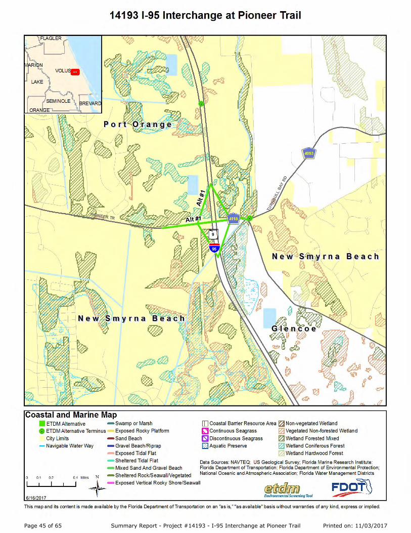
Page 45 of 65 Summary Report - Project #14193 - I-95 Interchange at Pioneer Trail Printed on: 11/03/2017

Page 46 of 65 Summary Report - Project #14193 - I-95 Interchange at Pioneer Trail Printed on: 11/03/2017

Page 47 of 65 Summary Report - Project #14193 - I-95 Interchange at Pioneer Trail Printed on: 11/03/2017

Page 48 of 65 Summary Report - Project #14193 - I-95 Interchange at Pioneer Trail Printed on: 11/03/2017

Page 49 of 65 Summary Report - Project #14193 - I-95 Interchange at Pioneer Trail Printed on: 11/03/2017

Page 50 of 65 Summary Report - Project #14193 - I-95 Interchange at Pioneer Trail Printed on: 11/03/2017

Page 51 of 65 Summary Report - Project #14193 - I-95 Interchange at Pioneer Trail Printed on: 11/03/2017
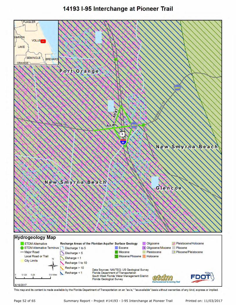
Page 52 of 65 Summary Report - Project #14193 - I-95 Interchange at Pioneer Trail Printed on: 11/03/2017

Page 53 of 65 Summary Report - Project #14193 - I-95 Interchange at Pioneer Trail Printed on: 11/03/2017

Page 54 of 65 Summary Report - Project #14193 - I-95 Interchange at Pioneer Trail Printed on: 11/03/2017

Page 55 of 65 Summary Report - Project #14193 - I-95 Interchange at Pioneer Trail Printed on: 11/03/2017

Page 56 of 65 Summary Report - Project #14193 - I-95 Interchange at Pioneer Trail Printed on: 11/03/2017

Page 57 of 65 Summary Report - Project #14193 - I-95 Interchange at Pioneer Trail Printed on: 11/03/2017

Page 58 of 65 Summary Report - Project #14193 - I-95 Interchange at Pioneer Trail Printed on: 11/03/2017

Page 59 of 65 Summary Report - Project #14193 - I-95 Interchange at Pioneer Trail Printed on: 11/03/2017

Page 60 of 65 Summary Report - Project #14193 - I-95 Interchange at Pioneer Trail Printed on: 11/03/2017

Page 61 of 65 Summary Report - Project #14193 - I-95 Interchange at Pioneer Trail Printed on: 11/03/2017

Page 62 of 65 Summary Report - Project #14193 - I-95 Interchange at Pioneer Trail Printed on: 11/03/2017

Page 63 of 65 Summary Report - Project #14193 - I-95 Interchange at Pioneer Trail Printed on: 11/03/2017

Page 64 of 65 Summary Report - Project #14193 - I-95 Interchange at Pioneer Trail Printed on: 11/03/2017

Page 65 of 65 Summary Report - Project #14193 - I-95 Interchange at Pioneer Trail Printed on: 11/03/2017

Page 65 of 65 Summary Report - Project #14193 - I-95 Interchange at Pioneer Trail Printed on: 11/03/2017