Hydrological properties of a Mediterranean soil burned with different fire intensities
9
This article was originally published in a journal published by Elsevier, and the attached copy is provided by Elsevier for the author’s benefit and for the benefit of the author’s institution, for non-commercial research and educational use including without limitation use in instruction at your institution, sending it to specific colleagues that you know, and providing a copy to your institution’s administrator. All other uses, reproduction and distribution, including without limitation commercial reprints, selling or licensing copies or access, or posting on open internet sites, your personal or institution’s website or repository, are prohibited. For exceptions, permission may be sought for such use through Elsevier’s permissions site at: http://www.elsevier.com/locate/permissionusematerial
Transcript of Hydrological properties of a Mediterranean soil burned with different fire intensities

This article was originally published in a journal published byElsevier, and the attached copy is provided by Elsevier for the
author’s benefit and for the benefit of the author’s institution, fornon-commercial research and educational use including without
limitation use in instruction at your institution, sending it to specificcolleagues that you know, and providing a copy to your institution’s
administrator.
All other uses, reproduction and distribution, including withoutlimitation commercial reprints, selling or licensing copies or access,
or posting on open internet sites, your personal or institution’swebsite or repository, are prohibited. For exceptions, permission
may be sought for such use through Elsevier’s permissions site at:
http://www.elsevier.com/locate/permissionusematerial

Autho
r's
pers
onal
co
py
Hydrological properties of a Mediterranean soil burned
with different fire intensities
O. Gonzalez-Pelayo *, V. Andreu, J. Campo, E. Gimeno-Garcıa, J.L. Rubio
Soil Degradation and Conservation Unit. Centro de Investigaciones sobre Desertificacion – CIDE (CSIC–Universitat de Valencia–Generalitat Valenciana),
Camı de la Marjal, s/n. 46470 Albal, Valencia, Spain
Abstract
The influence of vegetation cover on soil hydrological properties and its response to the impact of different fire intensities, in a
Mediterranean forest environment, has been evaluated. The study was carried out in the Permanent Experimental Field Station of La
Concordia (Llıria–Valencia, Spain), on a set of nine erosion plots (4�20 m2). The Station is located on a calcareous hillside S–SE oriented,
with soils of Rendzic Leptosol type and supporting Mediterranean shrubland vegetation. All runoff generated and sediment produced in every
rain event was collected from each plot. The set up includes a system of sensors for the continuous monitoring of climatic parameters (air
temperature and humidity, rain volume, intensity, etc.).
In June 1995, a set of experimental fires was carried out to the Station. Three of the plots were burned with high intensity fire, three with
moderate intensity and the remaining were left unaltered. Soil water content and water retention capacity (WRC) were measured in the
different plots and in two different vegetation covers: under canopy (UC) and in bare soil (BS). The pF curves were also obtained for each fire
treatment.
A year after the fires (June 1995–June 1996), great differences, reaching 77.15%, in runoff generation between fire treatments and the
control plots were observed.
No significant differences were detected on water retention capacity between soils UC and BS in the burned plots. However,
these differences appeared in the control plots, giving UC and BS values of 13% and 18%, respectively. Plots corresponding to the
high intensity fire treatment showed values of WRC significantly higher than those of the moderate intensity and of the control
treatments.
The pF curves show that the values of water volume, at the different pressure points studied, were slightly greater on UC soil. Values
obtained for BS samples are higher in the fire treatments, showing significant differences in respect to the control plots at pF 1 and 2. These
differences were also observed for UC soil, but in this case at pF 2, 2.5 and 4.2.
D 2006 Elsevier B.V. All rights reserved.
Keywords: Forest fires; Soil hydrology; Mediterranean environment; Water retention capacity; pF
1. Introduction
In Mediterranean areas, shrubland vegetation is often
structured in a spotted spatial configuration, playing a
significant role in controlling runoff generation and soil
loss. The interaction between vegetation development, soil
surface properties and water movement strongly influences
the structure of Mediterranean ecosystems (Cammeraat and
Imeson, 1999). Theses patterns could change as a result of
fire (Moreno, 1999).
Forest fires have become a common phenomenon during
summer in many European Mediterranean countries. Their
effects are more evident on environments like those
characteristic of the Mediterranean area (Trabaud, 1990;
Rubio and Recatala, 2005). The immediate consequences
are the loss of protective vegetation cover and a strong
visual impact on the landscape.
0341-8162/$ - see front matter D 2006 Elsevier B.V. All rights reserved.
doi:10.1016/j.catena.2006.04.006
* Corresponding author. Tel.: +34 96 122 05 40; fax: +34 96 127 09 67.
E-mail addresses: [email protected] (O. Gonzalez-Pelayo),
[email protected] (V. Andreu).
Catena 68 (2006) 186 – 193
www.elsevier.com/locate/catena
Autho
r's
pers
onal
co
py
The soil environment, during and after fire is affected
directly by the input of heat and ashes. In the field, the effects
of these factors are concomitant, making the identification of
individual causes of changes in soil properties, such as
degradation of organic matter or changes in aggregate size
distribution, between others, difficult (Giovannini and
Luchesi, 1997).
Post-fire conditions on soil surface are of key importance
because they determine its response to raindrop splash,
overland flow and the development of water-repellent soil
conditions (De Bano, 1981).
One of the most useful ways to study the effects of fire
on the soil system is carrying out fires in experimental
plots. With this approach, it is possible to know and
measure soil conditions before, during and after the fire
experiment and to improve knowledge about the hydrology
of the zone affected by different intensities of fire (Rubio
et al., 1994).
The aim of this study is to evaluate post-fire changes
in hydrological properties of a typical Mediterranean
slope comparing fire-affected and unaffected soil. The
evolution of soil response to runoff processes was also
studied in each rainfall event for a year after the fire
experiments.
2. Materials and methods
2.1. Study area
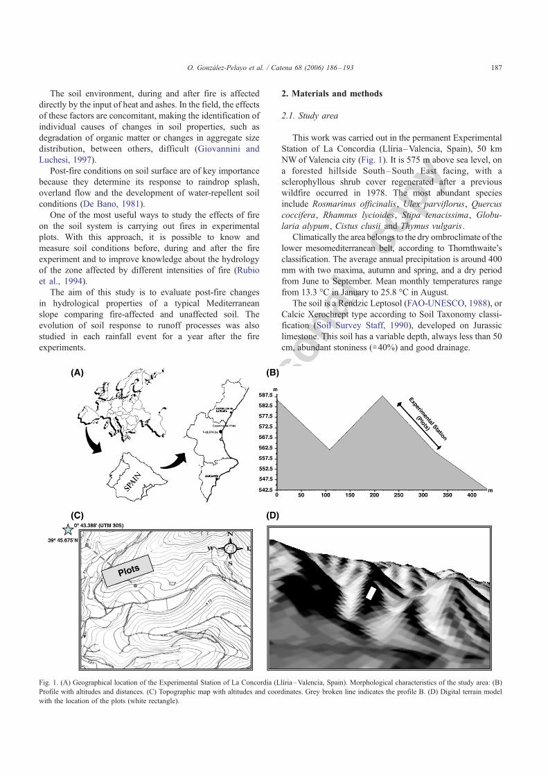
This work was carried out in the permanent Experimental
Station of La Concordia (Llıria–Valencia, Spain), 50 km
NWof Valencia city (Fig. 1). It is 575 m above sea level, on
a forested hillside South–South East facing, with a
sclerophyllous shrub cover regenerated after a previous
wildfire occurred in 1978. The most abundant species
include Rosmarinus officinalis, Ulex parviflorus, Quercus
coccifera, Rhamnus lycioides, Stipa tenacissima, Globu-
laria alypum, Cistus clusii and Thymus vulgaris.
Climatically the area belongs to the dry ombroclimate of the
lower mesomediterranean belt, according to Thornthwaite’s
classification. The average annual precipitation is around 400
mm with two maxima, autumn and spring, and a dry period
from June to September. Mean monthly temperatures range
from 13.3 -C in January to 25.8 -C in August.
The soil is a Rendzic Leptosol (FAO-UNESCO, 1988), or
Calcic Xerochrept type according to Soil Taxonomy classi-
fication (Soil Survey Staff, 1990), developed on Jurassic
limestone. This soil has a variable depth, always less than 50
cm, abundant stoniness (;40%) and good drainage.
Fig. 1. (A) Geographical location of the Experimental Station of La Concordia (Llıria–Valencia, Spain). Morphological characteristics of the study area: (B)
Profile with altitudes and distances. (C) Topographic map with altitudes and coordinates. Grey broken line indicates the profile B. (D) Digital terrain model
with the location of the plots (white rectangle).
O. Gonzalez-Pelayo et al. / Catena 68 (2006) 186–193 187

Autho
r's
pers
onal
co
py
2.2. Experimental set-up
The Station consists on a set of nine erosion plots; 4 m
wide�20 m long each, with similar characteristics such as
soil morphology, slope gradient, rock outcrops and vegeta-
tion cover. The selection of each plot location was made
after intensive surveys of the vegetation, soil and morphol-
ogy patterns, based on across-slope transects every 2 m.
Plots were oriented parallel to the slope and bounded by
bricks. At the foot of each plot, a 2 m wide collector ran into
a 1500 L tank to record all runoff and sediment produced
during each rainfall event. Inside each tank there was a 30 L
tank to concentrate the sediments produced, facilitating their
collection.
A random design of two different fire intensity treatments,
with three plots each, was used. These different fire
intensities were achieved by the addition of different amounts
of fuel load to the plots of each treatment, 40 t ha�1 to reach
the high intensity fires and 20 t ha�1 for the moderate
intensity ones (Gimeno-Garcıa et al., 2000). The fuel
necessary to obtain the two fire intensities was taken from
the surrounding area using vegetation similar to that present
on the plots, and its quantity was calculated using a
modification of the method proposed by Etienne and Legrand
(1994). The remaining three plots weremaintained unburnt to
be used as control. The temperatures on soil surface and their
duration were measured, on each square metre, by means of
thermosensitive paints and thermocouples (Gimeno-Garcıa et
al., 2000). Statistically significant differences were observed
for themean soil surface temperatures, between high intensity
fire and moderate intensity fire treatments being 439 -C and
232 -C, respectively (Table 1). The mean values of residence
time in soil of temperatures greater than 100 -C, for each firetreatment, also showed significant differences. These mean
values were 36V22� in the high intensity fire treatment and
17V45� in the moderate intensity fire treatment (Gimeno-
Garcıa et al., 2000, 2004).
2.3. Soil analysis and measurements
Soil samples were taken from the first 5 cm of the soil
surface before and immediately after fire. These were taken
from under canopy (UC) and bare soil (BS). After that, they
were air-dried, screened to remove the fraction >2 mm
diameter and stored in plastic boxes for analysis. The mean
surface volumetric water content before fire experience was
8%.
Soil water content (SWC) was calculated for the
potentials: 0, �10, �33, �300, and �1500 kPa, or pF 1,
2, 2.5, 3.5, 4.2, using the pressure membrane method
(Richards, 1947). Soil water retention capacity (WRC) was
calculated for each soil sample using the equations of
McLaren and Cameron (1996):
ðaÞ WRC ¼ h10 � h1500ð ÞTqb
ðbÞ WRC ¼ h33 � h1500ð ÞTqb
where WRC is water retention capacity, h10, h33, h1500 are
gravimetric water volumes at �10, �33, and �1500 kPa,
and qb is the bulk density of soil samples. The results were
obtained for volumetric units in percentages.
Water retention capacity with field capacity at �10 kPa
and �33 kPa was calculated for the different plots; the pF
curves were determined as well.
Climatic parameters and the intrinsic characteristics of
the different rainfall events were monitored by a logging
system of sensors with GSM transmission of data. Runoff
generation dynamics were monitored in each rain event
during the studied period. Rainfall intensity was calculat-
ed for the maximum volume of precipitation occurring in
30 min (I30).
Soil organic matter content was determined by oxidation
with potassium dichromate (Jackson, 1958). Electrical
conductivity was measured in soil saturation extracts by
the method of Richards (1964). Aggregate stability was
assessed using a wet-sieving procedure (Primo-Yufera and
Carrasco, 1973). Calcium carbonate content were deter-
mined using the Bernard calcimeter method (MAPA, 1986)
and pH was determined in saturated paste (Richards, 1954).
Analysis of variance (ANOVA) was used to test
significant differences between temperature data of the
two fire treatments. Standard statistical analyses were
applied at 95% confidence interval. Analysis of variance
and Tukey’s test at a =0.05 were used to detect differences
in WRC according to the different fire treatments and
vegetation cover. Climatic parameters were also analyzed
with ANOVA.
3. Main results and discussion
3.1. Rainfall characteristics
Total rainfall collected during the one year period after
the experimental fires (June 1995–June 1996) was 386.62
mm. The total volume of erosive rainfall, with runoff
production, was 321.26 mm distributed in 24 events,
showing an average I30 of 10.38 mm h�1. The maximum
value of I30 was 35.36 mm h�1 on 18th September,
coinciding with the period when the most aggressive rains
Table 1
Summary statistics for temperature data (-C) measured with the thermo-
sensitive paints
Fire
treatment
High (4 kg m�2) Moderate (2 kg m�2)
Plots 1 4 8 2 6 7
N 80 80 80 80 80 80
Mean (-C)a 417.78a 448.09a 434.91a 239.90b 239.46b 217.54b
Median 420 454 420 226 226 198
S.D. 118.78 132.63 147.32 90.71 91.58 81.61
a Different lower case letter among High and Moderate treatments
indicates statistically significant difference at P <0.05.
O. Gonzalez-Pelayo et al. / Catena 68 (2006) 186–193188

Autho
r's
pers
onal
co
pyin the Mediterranean region usually occurs (Perez Cueva,
1994). The lowest value was 1.4 mm h�1 on 15th December
(Fig. 2A).
In winter, the total rain was 172.8 mm (distributed in 15
events), similar to autumn and spring together (148.46 mm
in 9 events), but the duration of storms was three times
Fig. 2. Volume (A, left), intensity (A, right), and duration (B) of erosive rains occurring during the studied period.
Table 2
Mean values of some soil properties for each fire treatment and vegetation cover in 1995, after fire experiment
Before fire experience
Vegetation cover AS (%) pH (water) EC (dS m�1) CaCO3 (%) OM (%)
UC – 7.29a 1.14a 45.42a 12.11a
BS – 7.50b 0.61b 50.15b 8.49b
After fire experience
Vegetation cover Treatment AS (%) pH (water) EC (dS m�1) CaCO3 (%) OM (%)
UC High 33.68a 7.20a 3.59a 45.85a 12.85a
UC Moderate 31.59a 7.34a 2.51ab 46.94a 11.85a
UC Control 35.32a 7.33a 1.04b 45.65a 12.33a
BS High 28.13a 7.21a 2.71a 48.35a 9.57ab
BS Moderate 23.46a 7.38ab 1.70b 49.01a 11.18a
BS Control 23.53a 7.52b 0.68c 49.00a 7.98b
UC, under canopy; BS, bare soil; AS, aggregate stability; EC, electrical conductivity; CaCO3, calcium carbonate; OM, organic matter.
Values not sharing the same letter in columns indicate significant differences between fire treatment for the different vegetation cover using Tukey’s test
( P <0.05).
O. Gonzalez-Pelayo et al. / Catena 68 (2006) 186–193 189

Autho
r's
pers
onal
co
py
higher than in the rest of year (average of 641 min and 216
min, respectively) (Fig. 2B). Moreover, duration was 72%
higher and the I30 was 70% lower in winter than in the rest
of the study period; as a consequence, two periods
according to rain characteristics can be differentiated during
the year of study: the last dates of summer 1995 plus
autumn and spring 1996 (Period 1), and winter 1995/96
(Period 2).
3.2. Hydrological trends
Table 2 reports some soil characteristics analyzed after
the fire experience, distinguishing between vegetation cover
(under canopy and bare soil) and fire treatments.
During the first year after the fire experiment, there are
marked differences in runoff generation between fire treat-
ments and control plots. Plots affected by high intensity fire
give 80% more runoff than control plots, meanwhile on
plots affected by moderate intensity there is 74% more
runoff than on control ones (Fig. 3). Benavides-Solorio and
Mac Donald (2001), shows that runoff rates after the impact
of fire on soil produce an increase of even three orders of
magnitude in erosion.
However, if these data are divided according the two
periods defined by rain characteristics, important differences
in runoff yield between treatments and periods can be
observed. As it was explained above, Period 1 is character-
ized by erosive rains of medium/high I30 (average=18.49
mm h�1) and short duration. Period 2 shows rains of low I30(average=5.51 mm h�1) and long duration, with high soil
water content during this period and low runoff values. In
this way, runoff in Period 2 was 57%, 65%, 18% lower than
in Period 1 for the plots affected by high intensity, moderate
intensity and control, respectively (Fig. 4A). It may be
explained by the fact that the soil profile had not been
completely saturated, favouring lower infiltration rates than
Period 1 but similar for the different fire treatments (Fig.
4B), according to the observations made by Cerda (1996) on
similar environments.
The data obtained for the burned soils are in agreement
with those obtained by different authors (Rubio et al., 1997;
Andreu et al., 2002), indicating that, in burned soils, the
main factors that control runoff are the I30 and the rain
distribution during the year, hence a direct relation between
runoff yield, rainfall volume and intensity was observed.
Furthermore, some authors, such as Lavee et al. (1998),
Boix Fayos et al. (1998), and Puigdefabregas et al. (1999),
conclude that, in the Mediterranean environment and in
natural conditions, runoff rate is highly dependent on rain
regime and antecedent soil moisture conditions. Robichaud
(2000) also observed that the rain characteristics after a
wildland fire are partially responsible for the runoff rates
generated. So, low rainfall intensities could facilitate a
gradual wetting of the soil profile, favouring changes or the
disappearance of the hydrophobic substances generated on
topsoil after the fire, allowing then a normal infiltration rate.
This could be the reason for the difference in infiltration
rates between the treatments in Period 2. The differences in
the rainfall distribution through the year of study influence
the hydrological trends in runoff yield and in infiltration rate
(Fig. 4).
3.3. Water retention capacity
The soils burned with high intensity fire showed values
of WRC significantly higher than those of the moderate and
control treatment (Fig. 5). After the fire experiment, the
burned plots presented homogeneous conditions on WRC
for the different vegetation cover, although the WRC in BS
samples was slightly lower compared to those in UC
samples (Fig. 5).
Fig. 3. Total values of runoff yield (L m�2) corresponding to the different
fire treatments during the studied period. Values not sharing the same letter
indicate significant differences between fire treatment using Tukey’s test
( P <0.05).
Fig. 4. Total values of runoff yield (L m�2) (A) and infiltration rate (mm h�1) (B) for the different treatments and periods described during 1995–1996. Values
not sharing the same letter indicate significant differences between fire treatment using Tukey’s test ( P <0.05).
O. Gonzalez-Pelayo et al. / Catena 68 (2006) 186–193190

Autho
r's
pers
onal
co
py
These results could indicate changes in physical proper-
ties at the soil surface (Giovannini, 1994; Andreu et al.,
2001). These changes could be produced in particle-size
distribution and aggregation by the re-agreggation of clay-
sized particles into sand-sized particles (Giovannini and
Luchesi, 1997). When the WRC is calculated based on a
matrix potential of �33 kPa, the possible effect of the water
held by the sand-sized particles is eliminated, and the
differences between fire treatments disappear. The fire effect
could favour high water holding at low pF values. Between
the values �10 kPa and �33 kPa, the water content held is
75% and 55% higher for high and moderate intensity
treatment, respectively, than control values (Fig. 5). Then,
there is a significant amount of water held in soil at low pF
values for the high intensity treatment. This water is
probably retained in the gaps generated by the re-aggrega-
tion of clay particles into sand size particles. Guber et al.
(2003), classifying aggregates by size, using the average
water content at �10, �33 and �1500 kPa, found that
larger aggregates show the greatest variation of water
content and the greatest values for this parameter.
Only control plots show significant differences between
vegetation cover on WRC (Fig. 5). Soil samples taken from
bare soil show higher WRC, which is possibly due to the
high superficial stoniness that covers the major part of the
soil surface (a mean of 59T3% of surface stoniness). Then,
the evapotranspiration rates could be lower because rock
fragments block the upward movement of water to the soil
surface where evaporation can occur (Nobel, 1992).
Because of this, the water retained between these pF values
is mostly in the bare soil. Bellot et al. (1999) found that
under canopy soil, and in a Mediterranean environment, not
all the rainfall is received by the soil surface since the
shrubland canopy interception reduces soil water content
due, among others factors, to the major evapotranspiration
rates generated by vegetation.
Cerda (1998) and Bellot et al. (1999) found that
depending on the shrubland type developed on the same
soil, aggregate stability and soil water content can change.
Therefore, in natural unburned areas, the WRC depends,
mainly, on the vegetation type and on soil characteristics.
3.4. pF curves
Table 3 shows significant differences between burnt and
control treatments for all pF points in UC, except for pF 1,
and pF 3.5. In BS the differences between fire treatment
values and control ones were only appreciable at low pF
values, so the characteristics of the BS samples make easier
the physical re-aggregation of clay-size particles to sand-
size particles after fire impact than in UC soil (Molina and
Llinares, 1998; Llinares et al., 2001). The soil UC in control
plots retains more water than the soil UC and BS in the plots
affected by the impact of fire. The pF curves for the high
intensity treatment did not show significant differences
between UC and BS (Table 3), which could indicate that the
pass of fire makes homogeneous soil conditions, as it was
observed by Boix Fayos (1997). In the moderate intensity
Fig. 5. Water retention capacity (WRC) calculated at matrix potentials of �10 kPa and �1500 kPa (left side) and of �33 kPa and �1500 kPa (right side) for
the different fire treatments and vegetation cover, immediately after the fire experiment (1995). UC, under canopy; BS, bare soil. Values not sharing the same
letter indicate significant differences for the different vegetation cover (lower case) according to Tukey’s test. Differences between treatments are also shown
(upper case) according to Tukey’s test ( P <0.05).
Table 3
Water content (%), for the different vegetation cover and treatments for the
soil samples, taken after the fire experiment
Levels of comparison pF 1 pF 2 pF 2.5 pF 3.5 pF 4.2
(A)
UC High I 47.79a 38.56a 24.49a 22.44a 15.67a
Moderate I 48.76a 32.96b 30.03b 22.48a 15.64a
Control 47.52a 34.35b 27.46ab 23.81a 20.87b
BS High I 45.37a 37.09a 27.30a 22.95a 14.95a
Moderate I 52.05b 31.78b 28.71a 24.28a 15.72a
Control 47.47ab 33.19b 28.24a 22.65a 14.99a
(B)
High UC 47.79a 38.56a 24.49a 22.44a 15.67a
Intensity BS 45.37a 37.09a 27.30a 22.95a 14.95a
Moderate UC 48.76a 32.96a 30.03a 22.48a 16.64a
Intensity BS 52.05a 31.78a 28.71a 24.28b 15.72a
Control UC 47.52a 34.35a 27.46a 23.81a 20.87a
BS 47.47a 33.19a 28.24a 22.65a 14.99b
UC, under canopy; BS, bare soil.
(A) Significant differences in water content between fire treatments
depending on vegetation cover and (B) significant differences in water
content between vegetation cover depending on fire intensity treatments, for
different pF values according to ANOVA.
Values not sharing the same letter in a column indicate significant
differences for the different treatment and vegetation cover using Tukey’s
test ( P <0.05).
O. Gonzalez-Pelayo et al. / Catena 68 (2006) 186–193 191

Autho
r's
pers
onal
co
py
treatment, there are significant differences only for pF 1 and
3.5; meanwhile, for the control plots, significant differences
were observed for pF 4.2. Those differences between UC
and BS on control samples could be due to a reorganization
in the microaggregate fraction because at this pF values (pF
4.2), the main factor that possibly determines the matrix
water retention are the texture and the specific surface of the
soil material that join water and soil by adsorption forces
(Hillel, 1980).
The values of water content for BS samples of fire
treatments are higher than those of control samples. In this
way, the fire effect on bare soil in relation to its
hydrological properties could bring about, initially, an
increase in the water content mainly at low pF values (pF
1 and 2). This increase shows significant differences for pF
1 and 2 (Table 3).
The fact that values of water content in BS samples
increase probably depends, among others factors, on the
structural changes in the topsoil after the fire. These
structural changes are related to an increase in the macro-
aggregates fraction favoured by particle cementation pro-
cesses (Molina and Llinares, 1998; Llinares et al., 2001;
Andreu et al., 2001).
The possibility of a macroaggregate’s increase in soil
surface layers could explain the volume of water retained at
low pF values by the soils affected by fire. At these values,
the amount of water depends primarily on the capillary
effect and the pore-size distribution, and hence, it is strongly
affected by soil structure (Hillel, 1980). The rise in the
macroaggregate fraction on soil surface accompanied by the
decrease of microaggregates, immediately after the fire
experiment (Molina and Llinares, 1998; Llinares et al.,
2001), could probably produce an increase on pore volume
and water content of soil. These large aggregates present the
greatest variations in water content and the greatest values in
this parameter (Guber et al., 2003).
4. Conclusions
The rain distribution during the year after the experi-
mental fires shows clearly two different periods. One is
characterized by medium/high intensity and low duration
rains in spring and autumn, and the other, in winter, with
rains of long duration and low I30 characteristics.
The impact of fire on soil has important hydrological
consequences in spring and autumn (Period 1), which were
the most aggressive rainfall seasons. The observed differ-
ences in runoff generation between Period 1 and winter are
above 20% for values obtained in control plots and 60% for
those the burned ones. These values emphasize the
importance of rainfall characteristics in the immediate
period after the fire experiments.
The hydrological properties of soil are also affected by
the impact of fire. It produced the homogenization of water
retention capacity values between vegetation covers (under
canopy and bare soil), and the increase in water content of
the bare soil in burned plots versus control ones at low pF
values. This increase in water content at low pF values
could indicate structural changes in the soil surface.
In relation with water retention capacity, the pF curves
show substantial differences between UC and BS. In some
points of the pF curves there are higher values in BS than in
UC (statistically not significant). However, in the pF range
between 3.5 and 4.2, on control plots, the values of soil
water retention under canopy soil are slightly higher than on
bare soil.
In the Mediterranean area, the impacts of fires are
magnified by the changing characteristics of the rain regime.
This fact and the increase in frequency of forest fires could
favour the progressive ecosystem degradation and the
increase of desertification risk.
Acknowledgements
This work has been supported by the European Union
(QLRT-2000-00289), the Spanish Ministry of Science and
Technology (CICYT) REN2001-1716 and Convenio
(Agreement) Generalitat Valenciana – CSIC (02020024).
References
Andreu, V., Imeson, A.C., Rubio, J.L., 2001. Temporal changes in soil
aggregates and water erosion after a wildfire in a Mediterranean pine
forest. Catena 44, 69–84.
Andreu, V., Rubio, J.L., Gimeno-Garcıa, E., Cernı, R., 2002. Water erosion
trends under the impact of different forest fire intensities in a
Mediterranean environment. Proceeding de 12th ISCO Conference.
Tsinghua University Press, Beijing. China, pp. 632–637.
Bellot, J., Sanchez, J.R., Chirino, E., Hernandez, N., Abdelli, F., Martınez,
J.M., 1999. Effect of different vegetation type cover on the soil water
balance in semi-arid areas of south eastern Spain. Physical Chemistry
Earth 24, 353–357.
Benavides-Solorio, J., Mac Donald, L.H., 2001. Post-fire runoff and erosion
from simulated rainfall on small plots, Colorado Front Range.
Hydrological Processes 15, 2931–2952.
Boix Fayos, C., 1997. The roles of texture and structure in the water
retention capacity of burnt Mediterranean soils with varying rainfall.
Catena 31, 219–236.
Boix Fayos, C., Calvo-Cases, A., Imeson, A.C., Soriano-Soto, M.D.,
Tiemessen, I.R., 1998. Spatial and short-term temporal variations in
runoff spoil aggregation and other soil properties along a Mediterranean
climatological gradient. Catena 33, 123–138.
Cammeraat, L.H., Imeson, A.C., 1999. The evolution and significance of
soil –vegetation patterns following land abandonment and fire in Spain.
Catena 37, 107–127.
Cerda, A., 1996. Seasonal variability of infiltration rates under contrasting
slope conditions in southeast Spain. Geoderma 69, 217–232.
Cerda, A., 1998. Soil aggregate stability under different Mediterranean
vegetation types. Catena 32, 73–86.
De Bano, L.F., 1981. Water repellent soils: a state of the art. Gen. Tech. Rpt.
PSW-46. USDA For. Serv., Pacific Southwest Forest and Range Exp.
Sta., Berkley, CA, 21 pp.
Etienne, M., Legrand, C., 1994. A non-destructive method to estimate
shrubland biomass and combustibility. Proceedings 2nd International
O. Gonzalez-Pelayo et al. / Catena 68 (2006) 186–193192

Autho
r's
pers
onal
co
py
Conference on Forest Fire Research, vol. 1, B25, Coimbra, November,
1994, pp. 425–434.
FAO-UNESCO, 1988. Soil map of the world. Revised legend 1:5.000.000.
Roma.
Gimeno-Garcıa, E., Andreu, V., Rubio, J.L., 2000. Changes in organic
matter, nitrogen, phosphorous and cations in soil as a result of fire and
water erosion in a Mediterranean landscape. European Journal of Soil
Science 51, 201–210.
Gimeno-Garcıa, E., Andreu, V., Rubio, J.L., 2004. Spatial patterns of soil
temperatures during experimental fires. Geoderma 118, 17–38.
Giovannini, G., 1994. The effect of fire on soil quality. In: Rubio, J.L., Sala,
M. (Eds.), Soil Erosion and Degradation as a Consequence of Forest
Fires. Geoforma, Logrono, pp. 15–29.
Giovannini, G., Luchesi, S., 1997. Modifications induced in soil physico-
chemical parameters by experimental fires at different intensities. Soil
Science 162, 479–486.
Guber, A.K., Rawls, W.J., Shein, E.V., Pachepsky, Ya.A., 2003. Effect of
soil aggregate size distribution on water retention. Soil Science 168,
223–232.
Hillel, D., 1980. Fundamentals of Soil Physics. Academic Press, San Diego.
Jackson, M.L., 1958. Soil Chemical Analysis. Prentice Hall Inc., London.
Lavee, H., Imeson, A.C., Sarah, P., 1998. The impact of climate change on
geomorphology and desertification along a Mediterranean-arid transect.
Land Degradation & Development 9, 407–422.
Llinares, J.V., 2001. Efectos de la intensidad del fuego y evolucion a corto
plazo de las propiedades fısicas, erosionabilidad, humedad y temper-
atura del suelo. PhD thesis, CIDE–CSIC, Universidad de Valencia.
Spain.
MAPA, 1986. Metodos oficiales de analisis (suelos). Ministerio de
Agricultura, Pesca y Alimentacion. Madrid. 531 pp.
McLaren, R.G., Cameron, K.C., 1996. Soil Science. Sustainable Production
and Environmental Protection, 2nd edition. Oxford University Press,
Auckland, USA.
Molina, M.J., Llinares, J.V., 1998. Soil water dynamics in burned areas after
a late summer rain. The role of fire intensity, microsite, sampling depth,
and time measurements. In: Uso, J.L., Brebbia, C.A., Power, H. (Eds.),
Ecosystems and Sustainable Development, Advances in Ecological
Sciences, vol. 1. Computational Mechanics Publications, Southampton,
pp. 581–590.
Moreno, J.M., 1999. Forest fires: Trends and implications in desertification
prone areas of southern Europe. In: Balabanis, P., Peter, D., Ghazi, A.,
Tsomas, M. (Eds.), Mediterranean Desertification. Research Results and
Policy Implications, Proceedings of International Conference, vol. 1,
pp. 115–149.
Nobel, P.S., 1992. Influence of rocks on soil temperature, soil water
potential, and rooting patterns for desert succulents. Oecologia 92,
90–96.
Perez Cueva, A.J., 1994. Atlas Climatico de la Comunidad Valenciana.
Coleccion Territori. Conselleria de obras publicas, urbanismo y trans-
porte. Valencia, Spain.
Primo-Yufera, E., Carrasco, J.M., 1973. Quımica Agrıcola. I. Suelos y
Fertilizantes. Alambra, Madrid.
Puigdefabregas, J., Sole, A., Gutierrez, L., Del Barrio, G., Boer, M., 1999.
Scales and processes of water and sediment redistribution in drylands:
results from the Rambla Honda field site in Southeast Spain. Earth-
Science Reviews 48, 39–70.
Richards, L.A., 1947. Pressure–membrane apparatus, construction and use.
Agricultural Engineering 28, 451–454.
Richards, L.A., 1954. Diagnosis and improvement of saline and alkali soils.
In: USDA (Ed.), Agriculture Handbook, vol. 60. Washington, DC,
USA.
Richards, L.A., 1964. Diagnosis and improvement of saline and alkali soils.
In: USDA (Ed.), Agriculture Handbook, vol. 6. Washington, DC, USA.
Robichaud, P.R., 2000. Fire effects on infiltration rates after prescribed
fire in Northern Rocky Mountain forests, USA. Journal of Hydrology
231–232, 220–229.
Rubio, J.L., Recatala, L., 2005. The relevance and consequences of
Mediterranean desertification including security aspects. In: Kepner,
W.G., Rubio, J.L., Mouat, D., Pedrazzini, F. (Eds.), Proceedings of the
NATO Mediterranean Workshop. Desertification in the Mediterranean
Region: A security Issue. Valencia, Spain, pp. 133–165.
Rubio, J.L., Andreu, V., Cerni, R., 1994. A monitoring system for
experimental soil erosion plots. In: Rickson, R.J. (Ed.), Conserving
Soil Resources: European Perspectives. CAB International, Walling-
ford, UK, pp. 127–135.
Rubio, J.L., Forteza, J., Andreu, V., Cernı, R., 1997. Soil profile character-
istics influencing runoff and soil erosion after forest fire: a case of study
(Valencia, Spain). Soil Technology 11, 67–78.
Soil Survey Staff, 1990. Keys to Soil Taxonomy, 4th edition. SMSS
Technical Monograph, vol. 6. SMSS-USDA, Blacksburg.
Trabaud, L., 1990. Is fire an agent of desertification? In: Rubio, J.L.,
Rickson, R.J. (Eds.), Strategies to Combat Desertification in Mediter-
ranean Europe. Commission of the European Communities. Brussels,
pp. 104–131.
O. Gonzalez-Pelayo et al. / Catena 68 (2006) 186–193 193