Hurricane Mitch: A Regional Perspective on Mangrove Damage, Recovery, and Sustainability
33
Hurricane Mitch: A Regional Perspective on Mangrove Damage, Recovery, and Sustainability By Donald R. Cahoon and Philippe Hensel USGS Open File Report OFR 03-183 U.S. Department of the Interior U.S. Geological Survey
-
Upload
independent -
Category
Documents
-
view
8 -
download
0
Transcript of Hurricane Mitch: A Regional Perspective on Mangrove Damage, Recovery, and Sustainability

Hurricane Mitch: A RegionalPerspective on Mangrove Damage,Recovery, and Sustainability
By Donald R. Cahoon and Philippe Hensel
USGS Open File ReportOFR 03-183
U.S. Department of the InteriorU.S. Geological Survey

This report is preliminary and has not been reviewed for conformitywith U.S. Geological Survey editorial standards
Any use of trade, product, or firm names is for descriptive purposesonly and does not imply endorsement by the U.S. Government.
Suggested citation:
Cahoon, D.R., and Hensel, P., 2002, Hurricane Mitch: a regionalperspective on mangrove damage, recovery and sustainability:USGS Open File Report 03-183, 31 p.

USGS ACTIVITY B6 AND B7
Hurricane Mitch: A Regional Perspective on MangroveDamage, Recovery and Sustainability
By
Donald R. Cahoon1 and Philippe Hensel2
1USGS, National Wetlands Research Center, Lafayette, LA, USA
2Johnson Controls Inc., National Wetlands Research Center, Lafayette, LA, USA
2
Contents
Background 3
Hurricanes and mangroves 4
Regional Assessment Approach 6
Hurricane Mitch 7
Fig. 1 8
Fig. 2 11
Fig. 3 12
Regional assessment of storm impacts, trajectories of mangrove recovery and
restoration needs 13
Table 1 14
Wind damage 15
Wave damage 16
Sediment burial 17
Honduras 17
Costa Rica 18
Fig. 4 20
Fig. 5 21
Table 2 23
Summary 25
Acknowledgments 27
Literature Cited 27

3
Background
Mangrove forests along both coasts of Central America provide economically important
goods for human society. Mangroves serve as both nursery and habitat for economically
important fisheries such as shrimp and estuarine fish species. Along the Pacific coast of
Honduras and Nicaragua (Gulf of Fonseca), this nursery role is especially important for
the shrimp mariculture industry (an important component of the Honduran and
Nicaraguan economies) that relies in part on native shrimp stock. In addition to
providing food, mangroves are also a source of firewood and construction material for
local human populations.
In addition to economic benefits, mangrove forests provide several important ecological
services for coastal ecosystems. For example, they protect seagrass flats and coral reefs
from sedimentation and eutrophication. In riverine settings, mangrove forests
accumulate, stabilize, and cause sediments to settle out before they reach critical shallow
water habitats (Wolanski and Chappell, 1996, Wolanski and others, 1997, Wolanski and
others, 1998). Mangrove forests also sequester dissolved nutrients from the estuarine
environment (Rivera-Monroy and others, 1995), thereby limiting the development of
asphyxiating algal blooms in the vicinity of seagrass flats and coral reefs. Mangrove
biomass is a source of energy for the food chain within the forest ecosystem. This
biomass is also exported from the forest as plant and animal matter, which stimulates
productivity within the larger coastal environment. These ecological services help
support a growing tourism industry in places such as the Bay Islands, Honduras, where
diving on coral reefs is a popular tourist activity. As human development places further

4
pressure on the natural resources of places such as the Bay Islands, the protection of
mangrove ecosystems becomes increasingly important to safeguard the reason for the
growth of this economic activity: a healthy and luxurious coral reef ecosystem.
Despite tangible mangrove-derived benefits (e.g., fisheries catches, sediment retention,
and storm protection), mangrove ecosystems have witnessed an important decrease in
area as a result of human activities over the recent past. The coastlines of Honduras and
Guatemala contain over 200,000 ha of mangrove forest, accounting for about 10% of the
total area in Latin America and Caribbean (Suman, 1994). Total mangrove area in
Honduras was reported at 145,800 ha in 1992 (Suman, 1994); by 2000, the estimate was
down to 117, 000 ha –without considering the losses due to Hurricane Mitch
(COHDEFOR, unpublished report; cited by World Conservation Monitoring Center,
2000). In addition, broader-scale, chronic impacts may now impinge on mangrove
communities in the form of global climate change, including sea level rise, increased
mean temperatures, and increased hurricane frequency and intensity.
Hurricanes and Mangroves. Hurricanes are a common occurrence in the Wider
Caribbean Region (Reading, 1990) where they can destroy entire mangrove populations
(Jimenez and others, 1985), causing significant long-term effects to the ecosystem.
Mangroves are particularly sensitive to storms and hurricanes because of their exposed
location within the intertidal zone, their shallow root systems and the noncohesive nature
of the forest soils. Mechanisms of storm and hurricane damage are related to a variety of
factors such as wind fields, wave energy, water levels, and sediment dynamics, which

5
may affect characteristics of mangrove sensitivity to a greater or lesser extent. However,
mangrove forests also have the ability to recover from large impacts. Whether and how
fast a forest can recover depends on the severity of mangrove damage and mortality,
mangrove species composition, the degree of sediment disturbance, and propagule
availability.
Hurricane impacts to mangrove ecosystems can be a combination of both direct and
indirect factors. Direct factors include wind shear, which defoliates vegetation, uproots
trees, and destroys human constructions. Winds also cause set-up of water bodies,
resulting in tidal surges and coastal flooding. Winds produce strong waves and near-
shore currents that can mobilize sediments, causing both erosion and sediment
deposition. Indirect impacts are largely due to the position of coastal systems within the
receiving basin of the larger watershed. Intense rainfall often leads to flooding on land,
which causes erosion, landslides, and debris flows. The accumulation of this water,
sediment, and debris results in even more flooding and sedimentation within coastal
mangroves. The introduction and accumulation of terrigenous pollution during flood
events is also of concern for mangrove forests located in human-dominated landscapes.
The hurricane impacts described above can have severe consequences for the long-term
sustainability of mangrove ecosystems. For example, although mangrove forests can be
sediment traps, too much sedimentation can lead to mangrove mortality as the sediments
asphyxiate the respiratory structures that allow for gas exchange within the roots
(lenticels, aerenchyma; Ellison, 1999). Mangrove mortality can then lead to sediment

6
instability and the loss of vegetated surfaces. Hurricanes can also affect the long-term
sustainability of mangroves with primarily organic (i.e., peat) soils such as those occuring
on Caribbean islands located far from terrigenous sources of sediment. In these soils,
continual addition of new organic matter (i.e., roots) is required to maintain mangrove
sediment elevation because the peat is constantly decomposing (Middleton and McKee,
2001). When the catastrophic winds and flooding associated with a hurricane cause mass
mortality of these mangrove forests (Jimenez and others, 1985), the sediment elevation of
the forest would collapse without renewed tree growth (Cahoon and others, 2002). In the
absence of forest regeneration, the mangrove sediments would eventually become
submerged as sea level rises and the intertidal forest would be converted to subtidal open
water habitat. Given the sensitivity of coastal mangrove ecosystems to both direct and
indirect hurricane related impacts, and the projected increase in hurricane intensity as
predicted by global climate change models (Giorgi and others, 2001), an understanding of
the mechanisms of damage and trajectories of recovery is important for the sustainable
management of these ecosystems.
Regional Assessment Approach
In this report, we provide an overview of the extent and types of damage of mangrove
forests in the central region of Central America, and their potential for recovery. We
summarize empirical findings and field observations on forest structure and sediments for
Honduras and Guatemala (presented in USAID reports prepared by the USGS: Hensel
and Proffitt, 2002; Cahoon and others, 2002; McKee and McGinnis, 2002), and for Costa
Rica (conducted by Delgado and others, 2001). We evaluate the potential for forest
7
recovery by impact type and geomorphic setting (e.g., Caribbean vs. Pacific coasts), as
well as the implications for long-term sustainability of the mangrove ecosystems. Lastly,
we explain the regional implications of the findings.
Hurricane Mitch
Hurricane Mitch was the fourth most intense hurricane of the century in the Atlantic
Basin and the second most deadly in 200 years (National Climatic Data Center, 1999).
The storm remained at a Category 5 status for 33 h and maintained winds of 155 knots
for 15 h (National Oceanic and Atmospheric Association, 2001). An estimated 11,000
lives were lost, 70-80% of agricultural crops were destroyed, and over 1 million people
were displaced from their homes (Guiney and Lawrence, 1999, US Geological Survey,
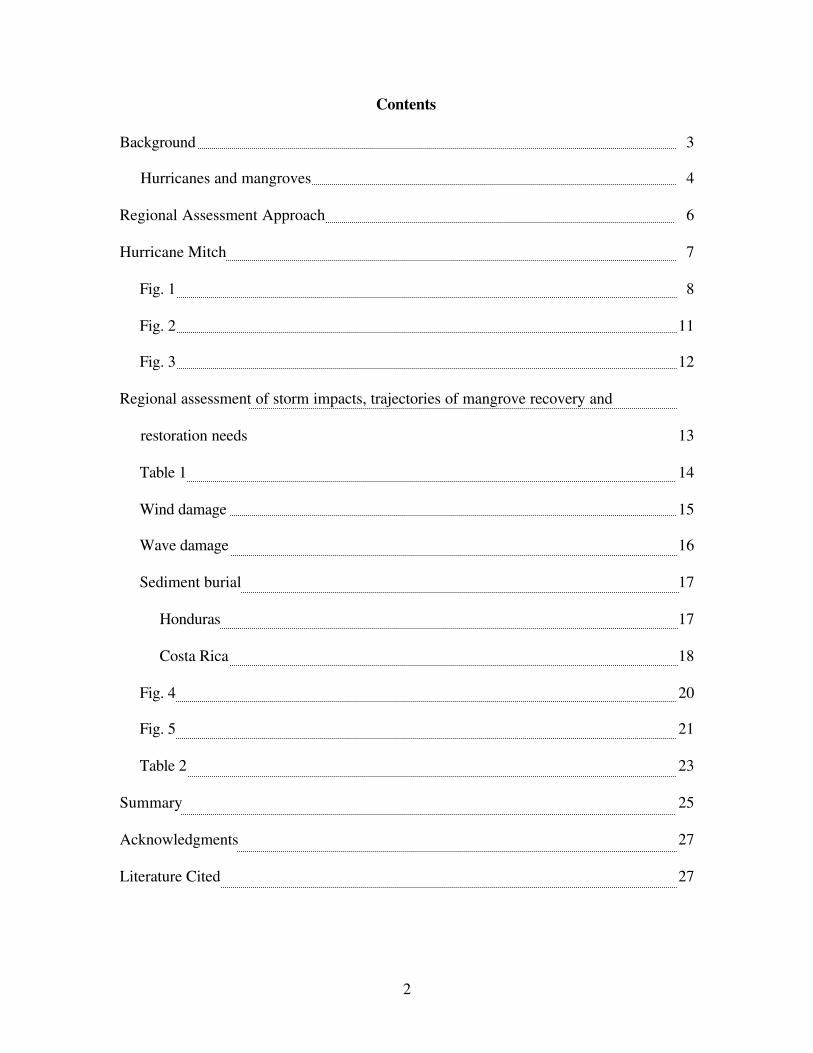
2001). Hurricane Mitch developed from a tropical depression that formed on October 21,
1998 in the southern Caribbean Sea to the northeast of Panama (National Oceanic and
Atmospheric Association, 2001; fig. 1). The storm drifted northwest for two days and
increased in intensity from October 23 to 26, during which it attained a Category 5
hurricane status, with sustained winds of 287 kph (Guiney and Lawrence, 1999). The
hurricane stalled in proximity to the Bay Island of Guanaja, Honduras, from the evening
of October 27 to the evening of October 29 (fig. 1). These two days of 200+ kph winds
caused nearly complete defoliation of the vegetation on the island (DeSomviele, 1999),
and the taller trees were either broken or uprooted. Local inhabitants described a storm
surge that caused extensive flooding of the mangrove forests for these two days. The
combined effect of defoliation and flooding ensured the near-complete mortality of the
8
Fig. 1. Storm track of Hurricane Mitch, October 21 – November 5 1998 (CIMSS,
University of Wisconsin; URL:
http://cimss.ssec.wisc.edu/tropic/archive/1998/storms/mitch/mitch.html, accessed 4
December 2001 )

9
island’s mangroves. The nearby island of Roatan was not as hard hit, and most mangrove
forests survived the combination of strong winds and storm surge-induced inundation
(Hensel and Proffitt, 2002).
Coastal margins near the hurricane path suffered similar wind-induced defoliation and
flooding, as well as wave-induced erosion and sedimentation (Hensel and Proffitt, 2002;
McKee and McGinnis 2002). Coastal margins as far away as Punta de Manabique in
Guatemala were damaged from the storm. Strong waves and associated surge caused up
to 50 m of landward beach erosion and deposited these sediments to the interior, within
mangrove and other brackish ecosystems. Mangrove sediment surfaces were buried and
mangrove trees were toppled. In some cases, as the beach eroded, the new shoreline
encroached on mangrove forests that had previously lined interior bays (Cahoon and
others, 2002, Hensel and Proffitt, 2002).
The trajectory of Hurricane Mitch through the center of Honduras caused massive rainfall
(1.3-1.8 m over 5 days; maximum recorded rainfall of 0.64 m over 6 h; National Climatic
Data Center, 1999), with ensuing erosion, landslides, and debris flows that accumulated
in the Gulf of Fonseca (Pacific coast). Rivers overflowed, and in one case (Choluteca
River), a river changed its course and created an avulsion over tens of kilometers. Large
expanses of low-lying coastal areas were flooded with sediment- and debris-laden water.
These flood waters destroyed large expanses of mangrove forests and shrimp mariculture
ponds by covering surfaces with in some cases over one meter of sediments (McKee and

10
McGinnis, 2002). Debris entrained by these same flows impacted mangrove forests
Gulf-wide, from the Chismuyo Bay to the San Bernardo estuary.
Hurricane Mitch exerted both direct and indirect effects over the larger Central American
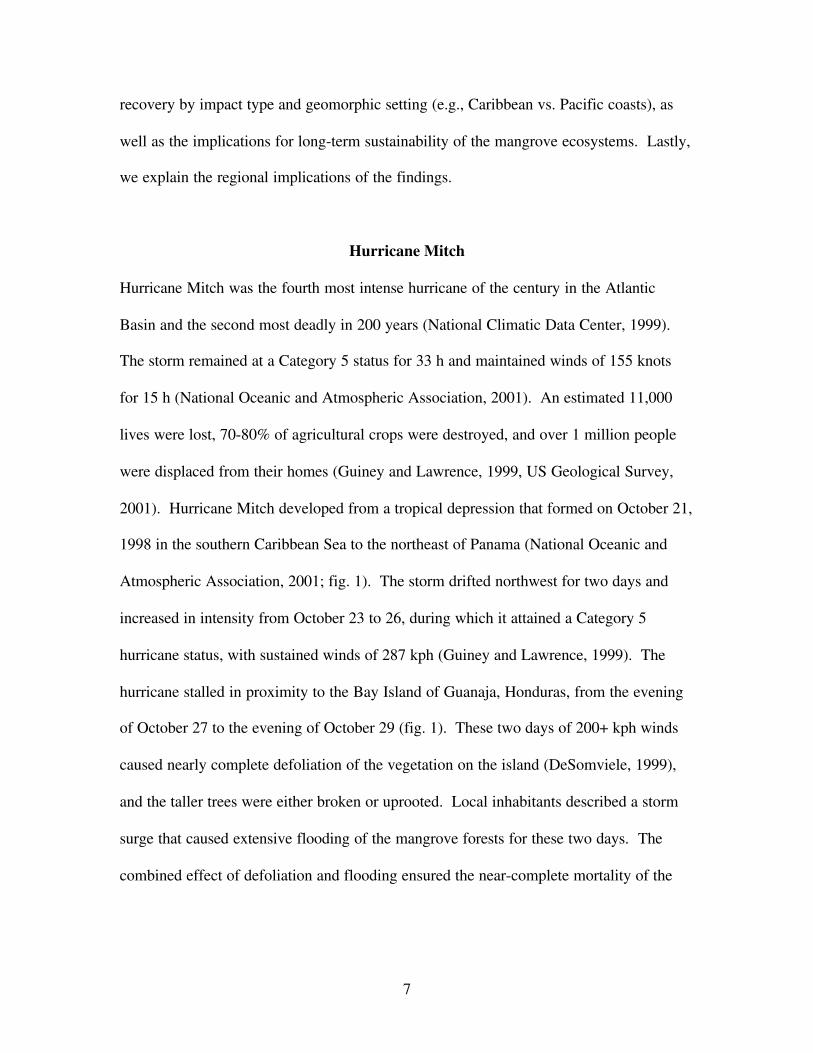
region. On October 21, 1998, as Mitch was forming in the southwestern Caribbean,
warm, humid air masses were already being entrained from the Pacific, causing
rainfallover the narrow isthmus of Costa Rica and Panama (National Oceanic and
Atmospheric Association, 2001). By October 25, one day after Mitch became a
hurricane, a well-developed cloud cell was present over northwestern Costa Rica (fig. 2).
Satellite imagery suggests that many such cells occurred over Central America and
became part of the larger hurricane system (fig. 2). As the hurricane crossed Honduras
on October 30 and 31, its outer rim extended across the Pacific coast of Central America,
from El Salvador to northwestern Costa Rica, producing locally-extreme rain events (e.g.,
26 cm recorded on October 31 at Amapala, Honduras; Guiney and Lawrence, 1999).
Hurricane Mitch therefore extended its effects over the larger Central American region
during the period October 21-November 5 1998.
High rainfall was recorded in the Gulf of Nicoya, Costa Rica, in association with both the
development of hurricane-related storm cells and the widening of the hurricane system as
it made landfall. Rain began on October 21st, with peak events recorded on October 22,
24 and November 2 (fig. 3, 1998 data). High daily rainfall is not uncommon in this area,
but most storms last one to a few days. Figure 3 shows that a large rain event associated
with the development of Hurricane Mitch lasted 17 days in the vicinity of the Nicoya
11
Fig. 2. Satellite photographs of Hurricane Mitch over Central America (NOAA OSEI
2001). Panel A shows development of hurricane-associated storm cells (e.g., red arrows).
Panel B shows the development of these cells into the larger hurricane system.
A. October 25 1998, 21:15h GMT
B. October 26 1998 21:45h GMT

12
Fig. 3. Daily rainfall between October 1-November 6 over the period 1996 - 2001 near
the Gulf of Nicoya, Costa Rica. Data from the Organization for Tropical Studies’ Palo
Verde Biological Station, Parque Nacional Palo Verde, Guanacaste, Costa Rica
(www.ots.ac.cr, accessed 10 April 2002).
1996
0
40
80
120
1-Oct
8-Oct
15-O
ct
22-O
ct
29-O
ct
5-Nov
Ra
infa
ll (m
m)
1997
0
40
80
120
1-Oct
8-Oct
15-O
ct
22-O
ct
29-O
ct
5-Nov
Ra
infa
ll (m
m)
1998
0
40
80
120
1-Oct
8-Oct
15-O
ct
22-O
ct
29-O
ct5-Nov
Ra
infa
ll (m
m)
1999
0
40
80
120
1-Oct
8-Oct
15-O
ct
22-O
ct
29-O
ct
5-Nov
Ra
infa
ll (m
m)
2000
0
40
80
120
1-Oct
8-Oct
15-O
ct
22-O
ct
29-O
ct
5-Nov
Ra
infa
ll (m
m)
2001
0
40
80
120
1-Oct
8-Oct
15-O
ct
22-O
ct
29-O
ct
5-Nov
Ra
infa
ll (m
m)
10/22
10/24

13
Peninsula. A comparison of rainfall for the period October 1-November 6 over six years
suggests that this rainfall was an unusual occurrence, both in terms of duration (17 days)
and magnitude (767 mm; fig. 3). Indeed, total rainfall for the month of October 1998
was the highest on record at the Palo Verde Biological Station (693 mm; table 1). This
station is located near the mouth of the Tempisque River, the largest river flowing into
the Gulf of Nicoya. A review of available rain gauge stations within the larger
Tempisque watershed confirms that this monthly was an extreme event; similar totals
occurred only four times over a 32-year period (Instituto Costaricense de Electricidad,
unpub. data 1999).
Regional Assessment of Storm Impacts, Trajectories of Mangrove Recovery, and
Restoration Needs
The type and extent of damage to mangrove forests from Hurricane Mitch varied across
the Central American region depending on the forest’s proximity to the path of the storm
and geomorphic setting (Hensel and Proffitt, 2002; McKee and McGinnis, 2002; Cahoon
and others, 2002). On the Caribbean coast, mangrove forests on oceanic islands were
damaged by extremely strong winds and storm surge while mangrove forests on the
mainland coast were damaged by strong waves, erosion and deposition of beach sands,
and coastal flooding. On the Pacific coast, although not directly affected by hurricane-
force winds, mangrove forests were buried under sediments eroded from uplands as a
result of the intense rainfall generated by the storm. Hurricane-associated flooding and
sedimentation occurred over a wider region along the Pacific coast, extending as far south
as Costa Rica.

14
Table 1. Total monthly rainfall in the Tempisque River watershed, Gulf of Nicoya, Costa
Rica. Units are in millimeters of rain. Data from the Organization for Tropical studies’
Palo Verde Biological Research Station, Parque Nacional Palo Verde, Guanacaste, Costa
Rica (www.ots.ac.cr). October 1998 (in bold type) coincides with the peak rainfall
associated with the passage of Hurricane Mitch in Central America.
Month 1996 1997 1998 1999 2000 2001
January 18 0 55 0 0February 1 0 16 1 0
March 12 0 0 0 5April 52 3 166 22 5
May 9 204 204 30 181June 465 124 143 93 41July 94 167 30 31 42
August 47 163 231 135 125September 240 236 436 293 259 344
October 478 178 693 268 54 238November 298 217 253 81 88 91December 57 79 87 4 0 8

15
Wind Damage. The damage to mangrove forests on the Bay Islands in Honduras is
typical of the type and extent of damage that occurred on oceanic islands located in and
near the storm path. On the island of Guanaja, located close to the path of the storm, the
extreme winds and flooding caused mass mortality (97%) of the mangrove forests
(LeBigre and others, 2000). Forest regeneration has yet to occur, apparently because
there are few sources of mangrove propagules available within the vicinity of the island
(Hensel and Proffitt, 2002). In the absence of root growth, sediment elevation is
declining precipitously as the highly organic peat soils decompose (Cahoon and others,
2002). There was little, if any, sediment deposited by the storm to offset the collapse of
the peat. As the sediment elevation continues to collapse to lower levels within the tidal
range, the likelihood for successful natural recolonization by propagules will decrease
because seedling establishment is controlled in large part by sediment elevation in
relation to tide height. In addition, abiotic soil conditions (e.g., Eh, sulfides, interstitial
salinity) become less suitable for mangrove growth under the more frequent flooding
conditions that occur at lower intertidal elevations. Consequently, the potential for
natural recovery of the mangrove forests on Guanaja is low and will continue to decrease
with time. Some form of active restoration will therefore be needed to stabilize the
sediment, ameliorate soil conditions, and repopulate the area with mangrove seedlings.
This restoration is deemed critical for the recovery of Guanaja’s mangroves within a
decadal time scale. However, it is unclear whether current sediment elevations and soil
conditions are suitable to support seedling survival.

16
In contrast to Guanaja, the mangrove forests on the island of Roatan, located 7-15 km
further away from the path of the storm, were less severely damaged. Mangrove forests
on the north shore, particularly at the eastern end of the island, were directly exposed to
onshore storm winds and tidal surge. Interior mangrove forests on the north shore,
dominated by black mangroves, suffered mass mortality in some areas with associated
peat collapse (Hensel and Proffitt, 2002; Cahoon and others, 2002). However, natural
regeneration is occurring in these damaged parts of the interior forest because propagules
are readily available. Forest structure and sediment elevation were stable in the fringe
mangrove forest on the north shore, which was dominated by the red mangrove
Rhizophora mangle L. Mangrove forests located on the lee, or south, shore were
protected from storm impacts and suffered no serious damage. Consequently, despite
some moderate damage, a strong natural recovery is evident for the mangrove forests on
Roatan.
Wave damage. The damage to mangrove forests on the coast of Punta Manabique in
Guatemala is typical of the type and extent of damage that occurred on the coastal areas
of Guatemala and Honduras located in the northeast quadrant of the storm. These areas
were directly exposed to onshore winds and tidal surge. The shoreline retreated
significantly as a result of wave-induced erosion, destroying fringing mangrove trees and
placing interior mangrove trees in the surf line. Eroded beach sand was deposited
landward on interior mangrove forests, burying trees under as much as 1.2 m of sediment
(McKee and McGinnis, 2002). Because of the exposed nature of this shoreline setting,
sediment elevation in the mangrove forests underwent repeated erosion and deposition

17
events, and will continue to do so (Cahoon and others, 2002). Mangrove forests on the
leeward side of Punta de Manabique (Bahia la Graciosa) were protected from storm
impacts and exhibited no storm damage. Although some recovery is suggested by this
study (i.e., existence of live trees and incremental increases in tree diameters along the
high impact shoreline; Hensel and Proffitt, 2002), the continued reworking (erosion and
deposition) of sands will preclude the successful establishment of new mangrove recruits,
either natural or planted. Both the sustainability of this altered mangrove system and the
potential for recovery of pre-Mitch forest conditions will depend on where and how
quickly the shoreline becomes stable, if ever. Consequently, the potential for natural
recovery of these mangrove forests is difficult to predict. By the same reasoning, active
restoration by plantings should not be undertaken on this very wide, high energy exposed
coast, unless shoreline conditions become more stable.
Sediment Burial.
Honduras. The damage to mangrove forests in the Conchalitos estuary in Honduras is
typical of the type, although perhaps not the extent, of damage that occurred in other
regions of the Gulf of Fonseca (including Nicaragua and El Salvador). Mangrove forests
in the upper Conchalitos estuary were buried under 15-100 cm of sediment when the
Choluteca River overflowed its banks (McKee and McGinnis, 2002). Forests buried
under 15 cm of sediment suffered no mortality and as a result of the added sediment
elevation, they are less vulnerable to the potential impacts of future sea-level rise
(Cahoon and others, 2002). Forests buried by 50-100 cm of sediment suffered extensive
mortality but also showed strong signs of forest regeneration (Hensel and Proffitt, 2002).

18
Sustainability of these recovering forests likely depends on their ability to restore root
biomass near the new sediment surface, which will bind sediments, enhancing both
inorganic soil retention and organic soil formation, and allow for gas exchange to the
roots. Nevertheless, it is likely that there will be important shifts in species composition
in these forests because white mangroves (Laguncularia racemosa (L.) Gaertn. f.)
recovered more quickly than red and black mangroves (Rhizophora mangle L. and
Avicennia germinans (L.) Stearn, respectively). In addition, the large increases in
elevation altered tidal flooding patterns, which may affect forest structure in the long-
term. In this seasonally arid region, reduced tidal flooding associated with high elevation
results in both water and salinity stress. Under these stresses, mangrove tree growth is
stunted, resulting in scrub dwarf forests. If elevation is too great, salinas may develop.
Consequently, the potential for natural recovery of these mangrove forests is good, but
the recovered forests may have a significantly altered structure. Current mangrove
recovery in this area suggests that there is no immediate need for restoration. Abundant
sources of propagules are present within the estuary, and seedling establishment has been
observed (Hensel and Proffitt, 2002). Continued monitoring of the development of these
mangrove forests would be helpful to ensure their long-term sustainability.
Costa Rica. The effects of Hurricane Mitch within mangrove forests in the Tempisque
River estuary, Costa Rica, were related to the flooding of local rivers and the deposition
of floodwater sediments. It is likely that these types of effects, and their extent, were
similar across the Gulf of Nicoya, and along the wider Pacific coast of Costa Rica.
Flooding occurred as the result of prolonged, heavy rains that accompanied the
19
development of hurricane-related storm cells, and the widening of the Mitch system as it
made landfall in Honduras (National Oceanic and Atmospheric Association, 2001).
During the passage of the hurricane, the Tempisque River rose approximately one meter
above its banks, inundating many of the seasonally dry lagoons and bottomland
hardwood forests within the floodplain (author, unpublished data). Under normal
conditions, the Tempsique River carries high suspended sediment loads, in both rainy and
dry seasons (Delgado, 2001). It is likely that the high river discharge associated with
Hurricane Mitch carried a proportionally large amount of sediments. However, the
deposition of storm-related sediments within mangrove forests did not coincide with the
period of maximum flooding. Rather, high sedimentation within shoreline mangroves of
the Tempisque and Bebedero Rivers (as measured on paper filter pads deployed
biweekly) appeared to lag behind peak rainfall, and occurred later in the following dry
season (fig. 4). This lag may be due to a phenomenon of resuspended shallow-water
(gulf) deposits, enhanced under conditions of low water levels and high (trade) winds
(Delgado, 2001). It is unclear how much sedimentation can be related exclusively to
hurricane-derived sediments. However, measurements of vertical accretion in the same
forests confirm that this sedimentation was at a significantly higher rate than at other
times within a subsequent three-year period (fig. 5). The highest rate of vertical accretion
was recorded over a period extending 6 months after the passage of Hurricane Mitch (at a
rate of 116 mm yr-1; fig. 5). This rate was significantly higher than accretion during the
same time period in the subsequent year (48 mm yr-1; P = 0.02). It is therefore likely that
the high rate of sediment deposition seen over several months after Hurricane Mitch was
influenced by the remobilization of hurricane-derived sediments.

20
Fig. 4. Short-term sediment deposition within shoreline mangrove forests along the
Tempisque Estuary, Costa Rica, and associated rainfall for the period July 1998 – June
1999 (Rainfall data from the Organization for Tropical Studies’ Palo Verde Biological
Station, Parque Nacional Palo Verde, Guanacaste, Costa Rica; URL: www.ots.ac.cr,
accessed 10 April 2002).
0
50
100
150
200
250
300
350
400
450
Jul-2
5
Aug-12
Sep-6
Sep-1
8
Oct-17
Nov-18
Dec-5
Jan-
6
Jan-3
0
Feb-2
7Apr-
8
Jun-1
6
Date
Se
dim
en
t D
ep
ositio
n
(gm
-2d
-2)
0
100
200
300
400
500
600
700
Cu
mu
lative
Ra
infa
ll (m
m)
Sediment Deposition Cumulative Rainfall

21
Fig. 5. Cumulative accretion and elevation change in shoreline mangrove forests in the
Tempisque River estuary, Gulf of Nicoya, Costa Rica. The interval “A” covers a 6
month period subsequent to Hurricane Mitch . The interval “B” covers a similar 6 month
period in the subsequent year.
0
20
40
60
80
100
120
140
160
180
0 10 20 30 40
Date
Accre
tio
n, E
leva
tio
n C
ha
ng
e
(mm
)
Elevation Accretion
Nov. May Jan. Jun. Aug.
1998 1999 2000 2001
Hurricane Mitch
A
B
22
No clear evidence suggests that Hurricane Mitch caused any acute impacts to the
mangroves of the Tempisque River. The greatest flooding and sedimentation in this area
occurred within shoreline mangrove forests on point bars and islands, both of which are
dominated by the white mangrove, Laguncularia racemosa (L.) Gaertn. f.. Percent
mortality in Laguncularia was similar both before and after the hurricane (table 2). The
existence of some low level, chronic, hurricane-related stress cannot be evaluated with
the available measures of forest structure. The accumulation of any chronic stress over
33 months after Hurricane Mitch, however, seems unlikely given that the dominance of
Laguncularia in these sites may be related to the high level of disturbance (flooding
frequency and sedimentation) that these areas normally experience (Delgado and others,
2001).
Although the geomorphic setting of the Gulf of Nicoya is comparable to the Gulf of
Fonseca to the north, the extent of Hurricane Mitch-related impacts in Nicoya may have
been limited due to a variety of factors. Both systems are a large bay complex along the
Pacific coast, have high tidal ranges (over 2 m in upstream reaches), and lie within dry
tropical forest life zones (sensu Holdridge, 1967) largely converted into irrigated
agriculture. Mangrove forests in both areas develop on eroded upland sediments
deposited within the estuaries and bays. However, the drainage basins of Fonseca are
much larger and mountainous, draining a large portion of the central Honduran highlands.
Upland soils in Honduras may be more prone to erosion due to widespread deforestation
and the burning of ground cover. Under conditions of extreme rainfall that occurred

23
Table 2. Mortality of Laguncularia racemosa, the dominant mangrove species in
shoreline forests of point bars and islands in the Tempsique River estuary, Gulf of
Nicoya, Costa Rica. The values from August 1998 represent only one of six sites; all six
sites were sampled in the periods subsequent to Hurricane Mitch (January 1999 and
August 2001). Mortality is expressed as the fraction of dead stems out of the total
number of stems recorded for this species (1.0 = 100%).
Sampling Date
August 1998 January 1999 August 2001
Diameter size classSapling 0.34 0.05 0.170 – 1.9 cm 0.21 0.2 0.28
2 – 4.9 cm 0.05 0.07 0.175 – 9.9 cm 0.02 0.05 0.01
10 – 19.9 cm 0.0520+ cm 0.00

24
within the Fonseca watershed during Hurricane Mitch, it is clear that much more water
and sediments were delivered to this gulf. Despite these differences in geomorphic
settings, data suggest that Nicoya routinely experiences a higher sedimentation rate
compared to Fonseca. Over a three-year period subsequent to Hurricane Mitch, rates of
vertical accretion were five times higher in the Tempisque than in the Conchalitos (74
mm yr-1 vs. 14 mm yr-1, respectively; Cahoon and others, 2002). High sedimentation
along the Tempisque may not only affect the development of mangrove forest structure
(dominance of Laguncularia on accreting surfaces) but may also allow these forests to
withstand a greater degree of sediment burial than other mangrove forests not adapted to
such high sedimentation rates. Furthermore, the extensive development of scrub dwarf
mangrove forests in Fonseca, attributable in part to a drier climate, may render this
system more prone to sediment burial. Therefore, in comparison to the Gulf of Fonseca,
it is likely that Hurricane Mitch-related damage in the Gulf of Nicoya, Costa Rica, may
have been mitigated by lower amounts of flooding and sediment delivery as well as an
enhanced ability to survive moderately high sedimentation.
Lastly, mangrove forests in the Gulf of Nicoya may have benefited from Hurricane Mitch
by the accumulation of a net positive elevation gain (fig. 5). The high rate of sediment
deposition in the six months period after the storm resulted in a concomitant increase in
sediment elevation, although the increase was smaller because of compaction. Thus, these
shoreline mangrove forests in the Gulf of Nicoya are better poised to withstand future
increases in sea level.

25
Summary
Hurricane Mitch was the second deadliest hurricanes on record, and the fourth strongest
October hurricane on record (National Climatic Data Center, 1999). The eye of the storm
passed directly over three countries (Honduras, Guatemala and Mexico), yet damage
spread over the whole Central American region. As the hurricane developed, warm,
humid air masses from the Pacific were entrained into the storm, causing locally severe
rainfall as far south as Costa Rica. Damage to the region’s coastal mangrove ecosystems
resulted from three different mechanisms; winds, waves, and sediment burial. Extreme
winds of up to 287 kph (Guiney and Lawrence, 1999) defoliated and uprooted mangrove
trees along the Caribbean coast, most notably in the Bay Island of Guanaja, which lost
some 97% of its mangrove forest cover (Ls Bigre and others, 2000). High wave activity
eroded shorelines some 200 km to the southwest, along the Caribbean coast of Guatemala
(Punta de Manabique). Mangrove forests within the eroded zone were destroyed, and
remaining mangroves were buried with up to 1.2 m of sand. Along the Pacific coast,
damage was primarily due to burial of mangrove forests by upland sediments, brought to
the coastal area by massive flooding, upland erosion, and mud and debris flows.
These three mechanisms of hurricane damage had different impacts on coastal mangroves
and led to different trajectories of recovery. The area of greatest damage and concern is
the Bay Island of Guanaja, where high mortality and the lack of natural regeneration
make active restoration a priority. Without live mangrove cover, the highly organic soils
in this area are rapidly decomposing and losing elevation. Mangroves need to be
26
reestablished to stabilize sediment elevation. Before planting is undertaken, however, the
suitability of the soils (e.g., physico-chemical conditions and elevation relative to sea
level) should be determined. On the mainland coast of the Caribbean, wave damage has
resulted in continued shoreline instabilities more than 2 years after the hurricane.
Although shoreline stability is a requirement for successful mangrove recovery, evidence
suggests that some recovery is occurring. The abundance of local propagule sources also
point to an eventual recovery along appropriate elevation zones of the new shoreline.
Sediment burial along the Pacific has led to high sediment elevations and high mortality
of the red mangrove, (Rhizophora spp.). The white mangrove (Laguncularia racemosa)
dominates the stressed, but surviving, forests, which may result in an important species
shift in the most highly affected areas. The sustainability of these buried forests is not
easy to predict, given the continued reworking of hurricane-related deposits. In areas far
from the storm track, significant hurricane-related sedimentation occurred as far south as
Costa Rica, although no evidence of negative impact was seen in these mangrove forests.
This study of hurricane damage and recovery in coastal mangrove forests of Central
America has shown that hurricane-related impacts were of both acute and chronic nature,
with both local and regional repercussions. Despite extensive damage occasioned by
Hurricane Mitch, however, many mangrove forests appear to be rather resilient. Most
coastal mangrove forests will likely recover without the need for any active restoration,
with the notable exception of the Bay Island of Guanaja. The long-term sustainability of
present mangrove resources, nevertheless, also depends on the extent and frequency of
other, nonhurricane-related impacts. The widespread expansion of human activities
27
within the coastal zone, for example shrimp mariculture, agriculture, and tourism, may
have already limited the extent of mangrove forests and may eventually place limits on
the ability of mangrove forests to withstand future storm impacts.
Acknowledgments
The authors would like to extend special acknowledgments to the following people,
without whose contribution this project would not have been realized: Jeff Phillips
(USAID, HN), Adrian Oviedo (SERNA, HN), Gloria Wilkie (USAID, HN), Elsy Phillips
(USAID, HN), Jorge A. Jimenez (OTS, CR), Eugenio Gonzales (OTS, CR) and Patricia
Delgado (ULL, USA).
Literature Cited
Cahoon, D. R., Hensel, P, Rybczyk, J., and Perez, B. C., 2002, Hurricane Mitch:
impacts on mangrove sediment elevation dynamics and long-term mangrove
sustainability.: Reston, VA, Va., U.S. Geological Survey Open File Report, in
press.
Delgado, P., 2001, Factors affecting community structure of mangroves associated with
point bars and islands in a Costa Rican estuary: Baton Rouge, LA, Louisiana State
University, Ph.D. Thesis, 143 p..

28
Delgado, P., Hensel, P., Jimenez, J., and Day, J. W., Jr., 2001, The importance of
propagule establishment and physical factors in mangrove distributional patterns
in a Costa Rican estuary: Aquatic Botany, v. 71, p. 157-178.
DeSomviele, B. 1999. Etude de la reforestation de l’île de Guanaja après l’ouragan
Mitch: Paris, France, Ecole National de Génie Rural, des Eaux et des Forêts, 42
p.
Ellison, J.C., 1999, Impacts of sediment burial on mangroves: Marine Pollution Bulletin,
v. 37, p. 420-426.
Giorgi, F., Hewitson, B., Christensen, J., Hulme, M., Von Storch, H., Whetton, P., Jones,
R., Mearns, L., and Fu, C., 2001, Regional climate information – evaluation and
projections, in Houghton, J. T., Ding, Y., Griggs, D. J., Noguer, M., van der
Linden, P. J., Dai, X., Maskell, K. and Johnson, C.A., eds., Climate Change 2001:
The Scientific Basis. Contribution of Working Group I to the Third Assessment
Report of the Intergovernmental Panel on Climate Change: Cambridge, U. K.,
Cambridge University Press, p. 583 – 638.
Guiney, J.L., and Lawrence, M.B., 1999, Preliminary report: Hurricane Mitch 22
October-5 November 1998: Miami, Fla, National Hurricane Center, 8 p.
29
Hensel, P. and Proffitt, C. E., 2002, Hurricane Mitch: acute impacts on mangrove forest
structure and an evaluation of recovery trajectories: Reston, VA, Va., U.S.
Geological Survey Open File Report, in press.
Holdridge, L.R., 1967, Life zone ecology: San José, Costa Rica, Tropical Science Center,
206 p.
Jiménez, J.A., Lugo, A.E., and Cintrón, G., 1985, Tree mortality in mangrove forests:
Biotropica, v. 17 n. 3, p. 177-185.
LeBigre, J-M., Portillo, P., and Thompson, W., 2000, Quel avenir pour les mangroves de
l’archipel de la Bahía (Honduras)?, in Conference of the Commission de
Geographie de la Mer et du Littoral, Dunkerque, France, 2000, Espace Littoraux
en Mutation, 10 p.
McKee, K.L. and McGinnis, T.E., II, 2002, Hurricane Mitch: effects on mangrove soil
characteristics and root contributions to soil stabilization: Reston, Va., U.S.
Geological Survey Open File Report, in press.
Middleton, B.A. and McKee, K.L., 2001, Degradation of mangrove tissues and
implications for peat formation in Belizean island forests: Journal of Ecology, v.
89, p. 818-828.

30
National Climatic Data Center, National Oceanographic and Atmospheric Association,
1999, Mitch: The Deadliest Atlantic Hurricane Since 1780:
http://lwf.ncdc.noaa.gov/oa/reports/mitch/mitch.html, accessed 3 December 2001.
National Oceanic and Atmospheric Association, Operational Significant Event Imagery,
2001, Hurricane Mitch Special Coverage 10/22/98 – 11/04/98:
http://www.osei.noaa.gov/mitch.html, accessed 3 December 2001.
Reading, A.J, 1990, Caribbean tropical storm activity over the past four centuries:
International Journal of Climatology, v. 10, n. 4, p. 365-376.
Rivera-Monroy, V. H., Day, J. W., Jr., Twilley, R. R. , Vera-Herrera, F., and Coronado-
Molina, C., 1995, Flux of nitrogen and sediment in a fringe mangrove forest in
Terminos Lagoon, Mexico: Estuarine, Coastal and Shelf Science, v. 40, p. 139-
160.
Suman, D. O., 1994, Status of mangroves in Latin America and Caribbean Basin, in
Suman, D.O., ed., El Ecosistema de manglar en America Latina y La Cuenca del
Caribe: su manejo y conservacion: Miami, Fla, University of Miami. p. 11-20.
U. S. Geological Survey, 2001, USGS Hurricane Mitch Program hurricane overview:
http://mitchnts1.cr.usgs.gov/overview.html, accessed 4 December 2001.

31
Wolanski, E. and Chappell, J., 1996, The response of tropical Australian estuaries to a
sea-level rise: Journal of Marine Systems, v. 7, p. 267-279.
Wolanski, E., Spagnol, S., and Lin, E. B., 1997, The importance of mangrove flocs in
sheltering seagrass in turbid coastal waters: Mangroves and Salt Marshes, v. 1 p.
187-191.
Wolanski, E., Spagnol, S., and Ayukai, T., 1998, Field and model studies of the fate of
particulate carbon in mangrove-fringed Hinchinbrook Channel, Australia:
Mangroves and Salt Marshes, v. 2, p. 205-221.
World Conservation Monitoring Center, 2000: http://www.wcmc.org.uk/cgi-
bin/mp_countryquery.p, accessed 4 December 2001.