HSR Station Location Choice and its Local Land Use Impacts on Small Cities: A Case Study of Aveiro,...
10
Procedia - Social and Behavioral Sciences 111 (2014) 470 – 479 1877-0428 © 2013 The Authors. Published by Elsevier Ltd. Selection and/or peer-review under responsibility of Scientific Committee doi:10.1016/j.sbspro.2014.01.080 ScienceDirect EWGT2013 – 16 th Meeting of the EURO Working Group on Transportation HSR Station Location Choice and Its Local Land Use Impacts on Small Cities: A Case Study of Aveiro, Portugal Yu Shen a, *, João de Abreu e Silva a , L. Miguel Martínez a a CESUR, Instituto Superior Técnico, Av. Rovisco Pais 1, Lisbon 1049-001, Portugal Abstract According to the Trans-European HSR network planning, in Portugal, Aveiro HSR station will be an important rail hub, of which the current planned location is distant from the city center without any existing public transport service to the urban area. Based on the current urban transport network and HSR planning, this paper examines two proposed HSR station location alternatives in and away from Aveiro city, with various travel times to the station by different travel modes. In this study, by consulting the evidences of land use impacts on Ciudad Real in Madrid-Seville HSR line of Spain as a benchmark model, we develop a land cover agent-based model to simulate the potential urban land use impacts on Aveiro city with various station location scenarios, according to the improvement of regional accessibility and population growth in each square land cell as individual decision-maker. The obtained results from this work reveals the positive impacts on land use development intensities of Aveiro city if the HSR station is located in the same place as the current rail station. Nonetheless, this paper also yields that the city of Aveiro hardly receive any benefits if the station is located away from the city center. A deceleration of land use development is also a possible consequence depending on the attractiveness of the new HSR station. Keywords: Agent-based model; High-speed rail; Land use; Spatial discrete choice. 1. Introduction After the first implementation of high-speed rail (HSR) in Japan during the 1960s, several countries in Europe (e.g. France, Germany, and Spain), have shown increasing interest in the construction of HSR lines. To unify the national planning of HSR into one framework under the coordination of European Union, the Trans-European Transport Network (TEN-T) Program has been developed since 1996. According to the HSR network planning under this framework, in Portugal, Aveiro HSR station is planned as an important hub connecting northwards to * Corresponding author. Tel.: +351-21-8419865; fax: +351-21-8409884. E-mail address: [email protected], [email protected], [email protected]. Available online at www.sciencedirect.com © 2013 The Authors. Published by Elsevier Ltd. Selection and/or peer-review under responsibility of Scientific Committee
Transcript of HSR Station Location Choice and its Local Land Use Impacts on Small Cities: A Case Study of Aveiro,...

Procedia - Social and Behavioral Sciences 111 ( 2014 ) 470 – 479
1877-0428 © 2013 The Authors. Published by Elsevier Ltd. Selection and/or peer-review under responsibility of Scientific Committeedoi: 10.1016/j.sbspro.2014.01.080
ScienceDirect
EWGT2013 – 16th Meeting of the EURO Working Group on Transportation
HSR Station Location Choice and Its Local Land Use Impacts on Small Cities: A Case Study of Aveiro, Portugal
Yu Shena,*, João de Abreu e Silvaa, L. Miguel Martíneza aCESUR, Instituto Superior Técnico, Av. Rovisco Pais 1, Lisbon 1049-001, Portugal
Abstract
According to the Trans-European HSR network planning, in Portugal, Aveiro HSR station will be an important rail hub, of which the current planned location is distant from the city center without any existing public transport service to the urban area. Based on the current urban transport network and HSR planning, this paper examines two proposed HSR station location alternatives in and away from Aveiro city, with various travel times to the station by different travel modes. In this study, by consulting the evidences of land use impacts on Ciudad Real in Madrid-Seville HSR line of Spain as a benchmark model, we develop a land cover agent-based model to simulate the potential urban land use impacts on Aveiro city with various station location scenarios, according to the improvement of regional accessibility and population growth in each square land cell as individual decision-maker. The obtained results from this work reveals the positive impacts on land use development intensities of Aveiro city if the HSR station is located in the same place as the current rail station. Nonetheless, this paper also yields that the city of Aveiro hardly receive any benefits if the station is located away from the city center. A deceleration of land use development is also a possible consequence depending on the attractiveness of the new HSR station. © 2013 The Authors. Published by Elsevier Ltd. Selection and/or peer-review under responsibility of Scientific Committee.
Keywords: Agent-based model; High-speed rail; Land use; Spatial discrete choice.
1. Introduction
After the first implementation of high-speed rail (HSR) in Japan during the 1960s, several countries in Europe (e.g. France, Germany, and Spain), have shown increasing interest in the construction of HSR lines. To unify the national planning of HSR into one framework under the coordination of European Union, the Trans-European Transport Network (TEN-T) Program has been developed since 1996. According to the HSR network planning under this framework, in Portugal, Aveiro HSR station is planned as an important hub connecting northwards to
* Corresponding author. Tel.: +351-21-8419865; fax: +351-21-8409884. E-mail address: [email protected], [email protected], [email protected].
Available online at www.sciencedirect.com
© 2013 The Authors. Published by Elsevier Ltd. Selection and/or peer-review under responsibility of Scientific Committee

471 Yu Shen et al. / Procedia - Social and Behavioral Sciences 111 ( 2014 ) 470 – 479
Oporto, southwards to Coimbra and Lisbon, and eastwards to Salamanca in Spain. Yet, for this HSR station, there are two proposed locations. The first one is to use the current Aveiro rail station at city center, whereas the alternative is to build a new HSR station along the A1 expressway (Steer Davies Gleave, 2007). The new station is about 15 km east from the city of Aveiro, located among the municipalities of Aveiro, Albergaria-a-Velha and Estarreja, without any existing public transport service to either of these urban areas (see Fig. 1).
Fig. 1. Aveiro HSR Station planned location. Source: authors’ revision based on Steer Davies Gleave (2007)
Academic studies aiming to forecast HSR’s impacts on small cities provide abundant evidences that the arrival of HSR affects the relocation of residents and households, as well as the local economic development on these cities. One typical experience is the impacts of HSR on Ciudad Real, Spain. A study from Garmendia, Ureña, Ribalaygua, Lean and Coronado (2008) reveals that the inauguration of HSR in Ciudad Real attracted more people to live in, leading to a booming demand for dwellings near the station area. It also shows that HSR opened an opportunity for Ciudad Real to be integrated into the Greater Madrid metropolitan area. In Sweden, a similar conclusion is drawn based on the study of Svealand HSR, which brings more residents to live in Eskilstuna and to commute to Stockholm (Fröidh, 2005). Both cases indicate that the residential location decisions are related with the location of HSR stations, hinting that the integration of HSR into the local transportation may play a key role. By investigating how HSR stations are integrated into the HSR network in Spain, Ureña, Garmendia, and Coronado (2009) yield that the location of HSR station varies due to its regional locations, technical difficulties, etc. Different station locations also result in various impacts of HSR services on Spanish cities, which is summarized by Bellet (2009).
From a planning perspective, there are several methodologies to determine and to analyze the site of an HSR station and its impacts. Norman and Vickerman (1999) raise the importance of balancing the benefit conflicts among different levels of political regimes during the HSR station location choice and construction. In HSR station location planning of Portugal, Mateus, Ferreira, and Carreira (2008) apply a multi-criteria decision analysis (MCDA) approach to choose the best HSR station location from the planned set of location proposals in Oporto. Repolho, Antunes, and Church (2012) present a mixed-integer optimization model to select the optimal location and number of stations along the Portuguese HSR corridor between Lisbon and Oporto.
In this study, despite the potential regional impacts of HSR and its station locations, we simply focus on the local impacts of HSR on the city of Aveiro, under different HSR station location alternatives. Due to the case studies in Ciudad Real of Spain, it is not irrational to expect that the opening of HSR in Aveiro has the potential

472 Yu Shen et al. / Procedia - Social and Behavioral Sciences 111 ( 2014 ) 470 – 479
to attract more dwellings and to catalyze the local economy development. Additionally, Aveiro also shares some common characteristics with Ciudad Real. Firstly, they are both small cities, and also the capitals of their EU NUTS-3 regions. Similar as Ciudad Real, Aveiro is not politically considered as a part of Greater Metropolitan Area of Oporto. Nonetheless, the arrival of HSR opens an opportunity for Aveiro to be integrated into the Oporto metropolitan area. Hence, based on the common features of the two cities, this paper develops a land cover agent-based approach to simulate the HSR land-use impacts on the city of Aveiro in various HSR planning scenarios, by introducing a spatial discrete choice model calibrated for Ciudad Real as a benchmark reference.
The structure of this paper is as follows. Section 2 describes the data adopted for this study, and Section 3 introduces the modeling methodologies. The results and analyses in different scenarios are shown in Section 4. At the end, a final conclusion is offered together with some discussions about issues relevant to orient future research paths.
2. Data
The agent-based model of this study comprises the data involving two countries, the Spanish data of Ciudad Real for the benchmark model, and the Portuguese data of Aveiro for the agent-based simulation. Since the results generated by the benchmark model should be referenced by the simulation in the Portuguese scenarios, the data from both countries ought to follow the same category, listed in the following two subsections.
2.1. Data for Ciudad Real benchmark model
In order to study the historical impacts of HSR on Ciudad Real, this paper models the land use changes from 1991 to 2006, by selecting three periods among this 15 years, 1991, 2001 and 2006. Since the Madrid-Seville HSR line has been inaugurated in 1992, these three periods indicate the situations of 1 year before operation, 9 years after and 14 years after the opening of service respectively. The HSR station catchment area is defined as a station-centered area with 6 km radius, crossing the municipalities of Ciudad Real, Miguelturra, Poblete, and Carrión de Calatrava. To build a spatial discrete choice model for Ciudad Real, this station area is divided into 2,949 square grids with 200-meter length as the individual decision makers in the model.
For each grid, a specific type of land use is defined based on the CORINE land cover provided by the National Geographic Information Center (CNIG) of Spain. Based on the official nomenclature defined by the European Commission (1994), this study classifies the land use into 5 categories, which are continuous urban fabric, discontinuous urban fabric, business and commercial areas, construction sites, and non-artificial land covers.
Besides the land covers, this study also uses population census data, local road transportation network data, as well as the regional conventional rail and HSR network data for modeling. The population data is extracted from the Spanish national population and housing census for 1991 and 2001, with municipal registration in 2006, at the census section level in the municipalities mentioned above, shared by National Statistics Institute (INE) of Spain. And the census section GIS map is drawn based on CNIG CartoCiudad web map service. The local transportation network used in this study is the CNIG CartoCiudad road and street network, calibrated based on the changes of CORINE land cover for different years. The regional conventional rail and HSR network data is a subset of the European rail network data provided by TEN-T Program, comprising the Spanish national rail network connecting all 47 Spanish continental provinces, labeled by its design speed.
2.2. Data for Aveiro agent-based simulation
The data adopted for the agent-based land-use simulation model are consistent with the ones for Ciudad Real benchmark model. Due to the smaller scale of Aveiro city, the station catchment area is drawn as a 2 km radius area centered on the current Aveiro rail station, which is divided into 2040 square grids with 80-meter length.

473 Yu Shen et al. / Procedia - Social and Behavioral Sciences 111 ( 2014 ) 470 – 479
Similar to the benchmark model, the CORINE land cover file is also used for the classification of land-use typologies, provided by National System of Geographic Information (SNIG) of Portugal. The population is gathered from the demographic census of Portugal for 1991, 2001 and 2011, at census section (BGRI) level, whereas the population in 2021 is estimated based on 1% average growth per year since 1991. The local road network of Aveiro is extracted from the Portuguese national road network data, while the regional rail traveling in Portugal is considered as the official suggested travel time according to Comboios de Portugal (CP), from Aveiro to all the capitals of the other 17 Portuguese continental districts, except Bragança and Portalegre, as there are no rail intercity services to these two districts. The regional travel time in 2021 shows the theoretical minimum regional travel time when Portuguese HSR lines are assumed to be in operation.
Table 1. Data in Ciudad Real, Spain and Aveiro, Portugal. (Source: author’s calculation)
Ciudad Real, Spain Aveiro, Portugal Year 1991 2001 2006 1991 2006 2011 2021
Statistics of land-use typologies (percentage in parentheses) 1 No. of continuous urban fabric grids
135 (4.58%)
150 (5.09%)
156 (5.29%)
291 (14.26%)
301 (14.75%)
n./a.
t.b.s.
2 No. of discontinuous urban fabric grids
92 (3.12%)
179 (6.07%)
194 (6.58%)
421 (20.64%)
641 (31.42%)
n./a. t.b.s.
3 No. of business and commercial area grids
15 (0.51%)
41 (1.39%)
70 (2.37%)
58 (2.84%)
178 (8.73%)
n./a. t.b.s.
4 No. of construction sites grids
0 (0.00%)
13 (0.44%)
59 (2.00%)
39 (1.91%)
0 (0.00%)
n./a. t.b.s.
5 No. of non-artificial land-use grids
2707 (91.79%)
2566 (87.01%)
2470 (83.76%)
1231 (60.34%)
920 (45.10%)
n./a. t.b.s.
Statistics of land parcel attributes (standard deviation in parentheses) Average population [No. of inhabitants]
20.70 (107.70)
23.88 (121.02)
26.70 (127.45)
14.20 (27.28)
n./a 15.97 (27.20)
17.37 (29.93)
Regional travel time from station [min]
289.89 (105.35)
249.30 (105.78)
235.38 (104.57)
199.20 (128.00)
n./a 163.87 (104.95)
93.13 (82.32)
Car travel time to railway station [min]
20.33 (10.46)
17.89 (9.91)
17.67 (9.94)
7.47 (3.74)
n./a 7.47 (3.74)
7.47 (3.74)
Walking time to railway station [min]
69.43 (24.19)
66.74 (23.45)
65.81 (23.40)
26.89 (8.39)
n./a 26.89 (8.39)
26.89 (8.39)
Car travel time to new HSR station [min]
n./a. n./a. n./a. n./a. n./a n./a. 15.92 (4.33)
Walking time to new HSR station [min]
n./a. n./a. n./a. n./a. n./a. n./a. 196.00 (12.62)
Note: n./a. = not available. t.b.s. = to be simulated.
The basic statistics figures are listed in Table 1. In terms of the development of land covers, during the same
15-year period, the 97.93% increase of the total artificial land-use areas in Ciudad Real station catchment area (9.68 km2 to 19.16 km2), is much greater than the 38.42% increase in Aveiro station area, which rises from 5.18 km2 to 7.17 km2. And the number of inhabitants in Ciudad Real station area also grows by almost 30%, whereas the growth in Aveiro is relatively smaller. The regional travel time shows the average shortest travel time by rail from the station in each city to all other regional capitals in its country. The decrease of travel time in Spain is due to the opening of HSR in 1992, and the decline in Portugal is caused by the introduction of Alfa Pendular tilting trains since 1999. In both cities, the local travel time from the centroid of each grid to the HSR station is also calculated through the shortest road network route. Two travel modes, by car and by walking, are both taken into account. The car travel time in each link is derived according to the design speed of various types of roads at common EU standard (Federal Highway Administration, 2001). The walking speed is defined as 5 km per hour. The average travel time to HSR station in Ciudad Real is longer than the one in Aveiro due to the larger area. But the travel time in Ciudad Real declines from 1991 to 2006, due to the extension of local road network, whereas

474 Yu Shen et al. / Procedia - Social and Behavioral Sciences 111 ( 2014 ) 470 – 479
the road network around the Aveiro station area remains essentially the same, leading to a constant local travel time estimated for these years. In Table 1, the car and walking travel time to the proposed new Aveiro HSR station are also listed. In this study, the implementation of walking time amplifies the locational impacts of HSR station. The average walking time to the current Aveiro station is roughly 4 times greater than the car travel time, but the ratio of the accessing time to the proposed HSR station increases to more than 12.
3. Methodology
3.1. Accessibility calculation
For the purposes of transportation analysis and land-use planning, accessibility is an essential attribute for both local and regional scales of areas. For HSR impacts analysis, various forms of indicators are applied, including weighted average travel time (Guitérrez, González, & Gómez, 1996), and economic potential (Vickerman & Ulied, 2009), just to name but a few. In this study, the weight average travel time (WATT) accessibility is used, of which the calculation takes the form according to following:
( ) ( )1 1
J J
it jt ijt jtj jW P T P
= == ⋅ , (1)
where Wit indicates the accessibility from origin i at year t; TTijt is the minimum travel time from i to destination j at year t; and Pjt is the population in j at year t. Different from the economic potential indicator, this form does not reflect distance decay, meaning that it does not emphasize short distances. However, the WATT indicator expresses the impacts from a locational point of view, and the results provide the time savings due to the opening of a new link (Guitérrez, 2001).
Based on equation (1), two different types of accessibility indicators are tested in this study, namely local accessibility and regional accessibility. The local accessibility measures the travel time between the centroid proximity between each pair of grids, and the changes of accessibility are due to the local road network expansion. Specifically, at year t, the local travel time from i to j is calculated as:
( ) ( )1min , ,L Euc R Lijt ij imt mnt njt ij tTT TT TT TT TT TT −= + + , (2)
where the travel time is the minimum between direct walking time through a Euclidean path, travel time through the existent road network, and the travel time of the same OD pair in the previous period t-1. Specifically, the travel time through the road network at year t equals the sum of walking time TTimt from origin i to its closest road node m, travel time TTR
mnt via road network R to the closest node, n, of destination j by car or by walking, and walking time TTnjt to destination j. To calculate the regional accessibility, the regional travel time is calculated as:
R L Fijt ist sjtTT TT TT= + , (3)
where TTRijt indicates the local travel time from local origin i to HSR station s, plus the railway travel time TTF
sjt from HSR station to the regional destination j.
3.2. Spatial discrete choice methods
Following the previous discussion, to estimate the land-use evolution behavior, the spatial discrete choice method is introduced to estimate the interaction between land cover, population growth, as well as the changes of local and regional accessibility. As an improvement of the spatial model applied by Shen, Martínez, and de Abreu e Silva (2013), this study applies a mixed logit model with panel data structure, in which the choice set for each grid cell at year t comprises its current choice, its choice in previous period t-1, and the land cover characteristics of its Moore neighborhood . For the individual land parcel n choosing land cover j at year t, the utility function is expressed as:

475 Yu Shen et al. / Procedia - Social and Behavioral Sciences 111 ( 2014 ) 470 – 479
njt nt njt njtU xβ ε′= + . (4)
Set a sequence of alternatives 1{ ,..., }Ti i=i , one for each time period. By taking a draw of from normal distribution f( ), the unconditional probability for the land parcel n making choices i of follows the form as:
( ) ( )1
1
Prob n ni t n njtt
t
TJx x
n ni t njtjt
I e I e f dβ β β β′ ′
==
= ⋅ ⋅∏i , (5)
where Injt equals one if the land cover alternative j is available for individual n at period t, and zero otherwise. See Train (2009) for a more detailed explanation. To estimate the coefficients, BIOGEME software package (Bierlaire, 2003) is applied, with CFSQP feature for the maximum log-likelihood optimization (Lawrence, Zhou, & Tits, 1997).
3.3. Agent-based model behavior
There are several alternatives to simulate the urban configuration and land-use evolution when HSR becomes available in Aveiro under various station location circumstances. As a conventional approach, cellular automata (CA) has been adopted widely for the study of land use growth. In the Netherlands, White and Engelen (2000) investigate the urban land use transition of 500m×500m cells, as the synthesis of neighborhood attractions, accessibility, land use properties and zoning regulations. As an evolution of the Dutch CA model, and similar to the Latin American urban dynamic agent-based model (ABM) developed by Barros (2012), this study develops a land cover ABM by setting each land cell n as an agent. Although this ABM shares some common features with CA identified by Crooks and Heppenstall (2012), e.g. the cell’s location does not move, the agent in this model is given its own “intelligence” and “memory”, thereby being able to make its own decisions for the evolution of its land use, according to the reference discrete choice model, by taking into account of the land uses of its neighborhoods, population growth, and accessibility due to the arrival of HSR service.
Specifically, in this ABM, for each agent n, by applying the coefficients of the benchmark model as equation (4), the simulated observed utility function for choosing land cover j is written as:
n̂jt njt nt njtV xα β ′= + , (6)
where njtα is a random number drawn from normal distribution estimated by the benchmark mixed logit model. The probability for agent n choosing each alternative j follows equation (5). To simulate the choice for each agent n, a random attitude indicator kn is generated following standard uniform distribution. The ABM simulation generates choice j for agent n, if
1
1 1Prob Prob
j j
nj n njk− ≤ < . (7)
When alternative jt at year t is chosen, another rule is applied to prevent the demolition and reconstruction of land use, meaning that the artificial land covers cannot roll back to non-artificial ones, and the constructed buildings cannot be demolished. Finally, an additional rule is adopted due to the Aveiro Lagoon and saline located west of the urban area, in order to keep all aquatic land parcels unchangeable in the simulation.
4. Results
4.1. Results of discrete choice modeling
The modeling results of Ciudad Real used as benchmark reference are estimated, by generating 10,000 random draws of each model. Table 2 lists the estimation results of 2 panel models with different modal accessibility indicators. The standard deviation (sigma) of continuous urban fabric is normalized to 0. Generally, by testing different variable combinations, the estimation shows that, in cities like Ciudad Real, the increase of
476 Yu Shen et al. / Procedia - Social and Behavioral Sciences 111 ( 2014 ) 470 – 479
local accessibility does not generate significant impacts on the change of land use typologies, whereas the increase of regional accessibility brought by HSR plays a more important role. In particular, the model shows that the decline of regional WATT is likely to drive the land cover towards continuous urban structure or to the land use with more business and commercial facilities. The sign of each parameter is reasonable, with statistically significant t-statistics. The results also indicate that, by fixing the constant of continuous urban fabric at 0, there is no significant preference difference from business and commercial land use in Ciudad Real. But their parameters are both significantly greater than the others.
Table 2. Mixed logit model results with different accessibility indicators by mode (Source: authors’ calculation)
Car accessibility model Walking accessibility model Coefficient T-test Coefficient T-test Alternative specific constants Continuous urban fabric (CUR) 0 fixed 0 fixed Discontinuous urban fabric -31.7 -3.79 -29.8 -3.46 Business/commercial area (BUS) -7.56 -1.11** -0.370 -0.06** Construction sites -14.9 -2.39 -13.2 -2.08 Non-artificial land covers (NOA) -10.5 -1.97 -8.94 -1.65* Parameters Regional WATT for CUR (E-2) -6.29 -2.63 -4.97 -2.29 Regional WATT for BUS (E-2) -4.76 -1.71* -6.02 -2.50 Population for NOA (E-1) -1.05 -3.95 -0.997 -3.64 Standard deviation from normal distributions
for continuous urban fabric 0 fixed 0 fixed for discontinuous urban fabric 38.0 4.58 37.5 4.47 for business/commercial area 8.11 2.25 6.80 2.52 for construction sites 14.0 2.78 13.7 2.70 for non-artificial land covers 11.6 4.37 11.4 4.11
Statistical summary Log-likelihood at 0 -1551.813 -1551.813 Log-likelihood at -908.957 -909.867 Adjusted 2 0.407 0.407 Note: *= significant at 90% confidence interval. **= insignificant.
Looking into the parameters, although the travel time differs, both models produce, essentially, the same
results. As the Ciudad Real HSR station locates not far from the city center, we may conclude that, in small cities, if the HSR station is located inside the city, with good local transportation integration, the differences of accessibility indicators due to various travel modes do not result in different impacts on land use covers. It may also indicate that, for the intra-city HSR station, the urban growth may not be dependent on car ownership levels. However, if the station locates outside the city, this assumption may not hold. Therefore, for the simulations in different scenarios for ABM, the model with walking accessibility is adopted.
4.2. Agent-based modeling scenarios
By applying the rules defined in Section 3.3, 3 scenarios are simulated, based on the land use in 2006, namely a do-nothing scenario (scenario B), a HSR scenario with the station located within the city boundaries (scenario C), and a HSR scenario with the planned HSR station near A1 expressway (scenario D). Fig. 2 (a) shows the land use circumstance in 2006, according to the CORINE land cover. Based on the land use configuration in 2006, Fig. 2 (b) to (d) demonstrate the most likely simulated land use situations in 2021 with 1,000 simulations for each scenario. Specifically, scenario B simulates the natural land use changing without the implementation of HSR in Portugal. The only parameter driving land-use development is the 1% annual population growth. The two HSR scenarios show the land use impacts for HSR with different station locations, besides natural growth. In Fig. 2, 4
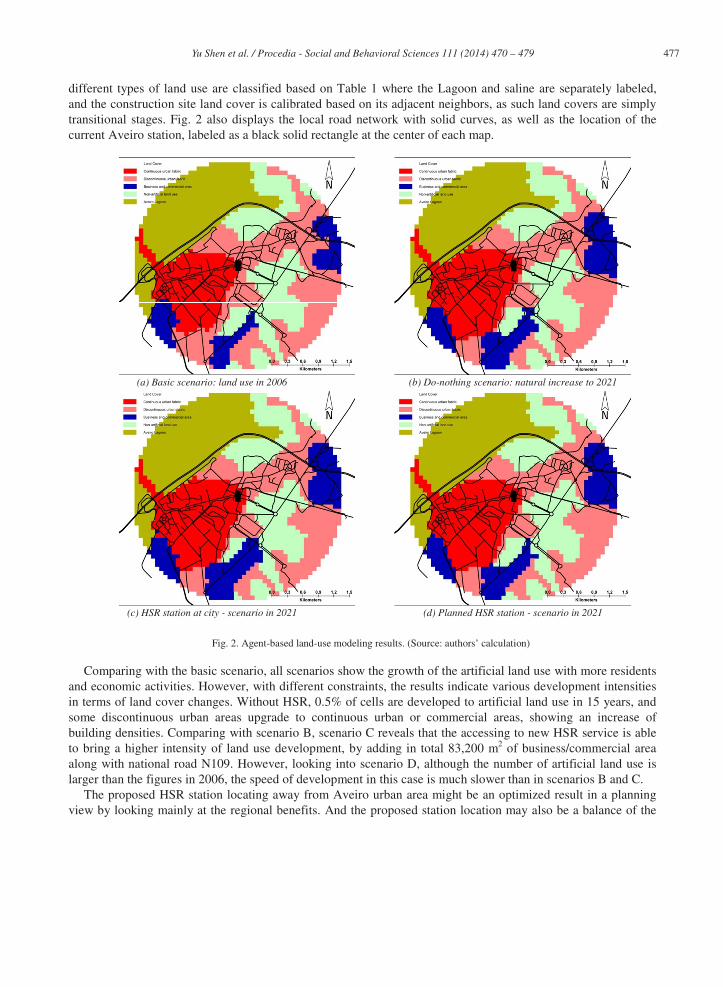
477 Yu Shen et al. / Procedia - Social and Behavioral Sciences 111 ( 2014 ) 470 – 479
different types of land use are classified based on Table 1 where the Lagoon and saline are separately labeled, and the construction site land cover is calibrated based on its adjacent neighbors, as such land covers are simply transitional stages. Fig. 2 also displays the local road network with solid curves, as well as the location of the current Aveiro station, labeled as a black solid rectangle at the center of each map.
(a) Basic scenario: land use in 2006 (b) Do-nothing scenario: natural increase to 2021
(c) HSR station at city - scenario in 2021 (d) Planned HSR station - scenario in 2021
Fig. 2. Agent-based land-use modeling results. (Source: authors’ calculation)
Comparing with the basic scenario, all scenarios show the growth of the artificial land use with more residents and economic activities. However, with different constraints, the results indicate various development intensities in terms of land cover changes. Without HSR, 0.5% of cells are developed to artificial land use in 15 years, and some discontinuous urban areas upgrade to continuous urban or commercial areas, showing an increase of building densities. Comparing with scenario B, scenario C reveals that the accessing to new HSR service is able to bring a higher intensity of land use development, by adding in total 83,200 m2 of business/commercial area along with national road N109. However, looking into scenario D, although the number of artificial land use is larger than the figures in 2006, the speed of development in this case is much slower than in scenarios B and C.
The proposed HSR station locating away from Aveiro urban area might be an optimized result in a planning view by looking mainly at the regional benefits. And the proposed station location may also be a balance of the

478 Yu Shen et al. / Procedia - Social and Behavioral Sciences 111 ( 2014 ) 470 – 479
conflicts between different stakeholders. One cannot deny that the planned Aveiro HSR station area has the potential to increase residential and commercial attractiveness, if supportive policies and projects are implemented properly. However, if we simply study the land use development in Aveiro city instead of looking at the regional planning, the ABM simulation reveals that the city may suffer a risk of recession due to the bypass of new HSR service, meaning that the speed and magnitude of development is reduced. One possible reason is that the new HSR service may attract more commuters and residents to relocate away from Aveiro and closer to the new HSR station site. And potential new residents of Aveiro may also reevaluate their decisions to migrate to the city. This argument is supported by a study of HSR in France. Vickerman and Ulied (2009) show that the operation of HSR via Lille, France, grabs the customers crossing the Franco-Belgian border from conventional rail via Maubeuge, France and Mons, Belgium, both of which lost an important number of inhabitants. Nonetheless, the location of a HSR station in an undeveloped area away from the city center does not results in new residential or commercial/services areas. A study in France concludes that the HSR stations located far from the center of some French cities have failed to induce significant growth in the areas around them, despite the initial high expectations from the local governments (Thompson, 1998). If this occurs in the new Aveiro station, the potential future land use in Aveiro will be similar to scenario B. In short, if the Aveiro HSR station is located away from the city, either scenario B or D can happen depending on the attractiveness of the new HSR station. On the contrary, scenario C has the potential to accelerate land use development in the city of Aveiro.
5. Conclusions
This paper applies an ABM simulation framework to estimate the potential land use impacts resulting from different locations for the HSR station of Aveiro. The simulation model uses a spatial discrete choice model of land use in Ciudad Real as a benchmark reference model. As discussed in the previous sections, the ABM simulation shows that the city of Aveiro hardly receives benefits if the HSR station is located away from the city, while a deceleration of land use development is also a possible consequence. Based on the existing literature, we have found that the speed of land use development depends on the attractiveness of the new HSR station. In the scenario of using the current Aveiro rail station, as the new HSR station, the simulation reveals positive impacts resulting in higher urban growth in the city of Aveiro.
The ABM proposed in this study is an evolution of conventional CA approaches for urban land use simulation, by giving each agent its “intelligence” and “memory”. Different from the other land cover agent-based models developed in recent years, e.g. Peripherisation Model (Barros, 2012), which also set land cells as agents, this model integrates discrete choice methods with spatial constraints based on socio-economic activities as well as the changes of accessibility, which simulates the agents’ behavior based on existent benchmark models. The model also releases the demanding data requirements when compared with the models setting the agents as individuals or households, e.g. ABLOoM (Otter, van der Veen, & de Vriend, 2001). As presented above, the data used in this paper was obtained from public resources, which enhances the portability of this ABM. Therefore, it can be easily transplanted to other cases, in order to study their urban dynamics.
Finally, a more detailed database is suggested as a base for future research. In this paper, the data availability may limit the findings, due to the insufficient socioeconomic data at local level. In addition, besides the features that the land use transition of each agent is constrained by its previous status, the model allows a more sophisticated structure in which the constraints due to municipal and regional plans could also be included in future developments. This means that to each agent specific “goals” are set by the planning documents. As a result, the introduction of planning objectives and restrictions allows the model to obtain a generalized cost for approaching different planning aims, thereby providing more solid and robust results, as well as deeper insights about the effects of HSR on local development. Last but not least, the competition between modes and the variety of operating schemes of HSR service can also be considered for future studies, by taking HSR as a part of the whole transportation and society system.

479 Yu Shen et al. / Procedia - Social and Behavioral Sciences 111 ( 2014 ) 470 – 479
Acknowledgements
This research was developed in the framework of the EXPRESS Research Project (MIT/SET/0023/2009) sponsored by the Portuguese national research funds through FCT/MCTES (PIDDAC) and co-financed by the European Regional Development Fund (ERDF) under the Operational Agenda for Competitiveness Factors - COMPETE. We acknowledge INE Spain, CNIG Spain, INE Portugal, SNIG Portugal, and TEN-T Program for sharing data for our study. We also appreciate the invaluable help given by Prof. J. M. Ureña and Prof. M. Garmendia from University of Castile-La Mancha.
References
Barros, J. (2012). Exploring Urban Dynamics in Latin American Cities Using an Agent-Based Simulation Approach. In A. J. Heppenstall, A. T. Crooks, L. M. See, & M. Batty (Eds.), Agent-Based Models of Geographical Systems (pp. 571-589): Springer Netherlands. Bellet, C. (2009). The introduction of the high speed rail and urban restructuring: the case of Spain. In City Future in a Globalising World: An international conference on globalism and urban change. Madrid. Bierlaire, M. (2003). BIOGEME: A free package for the estimation of discrete choice models. In 3rd Swiss Transportation Research Conference. Ascona, Switzerland. Crooks, A. T., & Heppenstall, A. J. (2012). Introduction to Agent-Based Modelling. In A. J. Heppenstall, A. T. Crooks, L. M. See & M. Batty (Eds.), Agent-Based Models of Geographical Systems (pp. 85-105): Springer Netherlands. European Commission. (1994). CORINE Land cover - Part 2: Nomenclature. In European Enviroment Agency Publications. Federal Highway Administration. (2001). Geometric design practices for European roads. In (pp. 1-36). Washington, DC: U.S. Department of Transportation. Fröidh, O. (2005). Market effects of regional high-speed trains of the Svealand line. Journal of Transport Geography, 13, 352-361. Garmendia, M., Ureña, J. M., Ribalaygua, C., Leal, J., & Coronado, J. M. (2008). Urban residential development in isolated small cities that are partially integrated in metropolitan areas by high-speed train. European Urban and Regional Studies, 3, 265-280. Guitérrez, J. (2001). Location, economic potential and daily accessibility: an analysis of accessbility impact of high-speed line Madrid-Barcelona-French border. Journal of Transport Geography, 9, 229-242. Guitérrez, J., González, R., & Gómez, G. (1996). The European high-speed train network: Predicted effects on accessibility patterns. Journal of Transport Geography, 4, 227-238. Lawrence, C., Zhou, J., & Tits, A. (1997). User’s guide for CFSQP version 2.5. University of Maryland. Mateus, R., Ferreira, J. A., & Carreira, J. (2008). Multicriteria decision analysis (MCDA): Central Porto high-speed railway station. European Journal of Operation Research, 187, 1-18. Norman, C., & Vickerman, R. (1999). Local and regional implications of trans-European transport networks: The Channel Tunnel Rail Link. Environment and Planning A, 31, 705-718. Otter, H. S., van der Veen, A., & de Vriend, H. J. (2001). ABLOoM: Location behaviour, spatial patterns, and agent-based modelling. Journal of Artificial Societies and Social Simulation, 4, 1147-1152. Repolho, H. M., Antunes, A. P., & Church, R. L. (2012). Optimal location of railway stations: The Lisbon-Porto High-speed Rail line. Transportation Science, Articles in Advance, 1-14. Shen, Y., Martínez, L. M., & de Abreu e Silva, J. (2013). Short-term high speed rail land-use imapcts on large metropolises: A case study of Madrid, Spain. In the 92nd Transportation Research Board Annual Meeting. Washington D.C. Steer Davies Gleave. (2007). Modelo integrado de procura de passageiros - Relatório 2: Estimativas de procura de passageiros e receitas. In Modelo Integrado de Procura de Passageiros da Rede Ferroviaria de Alta Velocidade. London. Thompson, I. B. (1998). The production of urban space by the Train à Grande Vitesse: three case studies of Gares-bis. Modern & Contemporary France, 6, 21-32. Train, K. E. (2009). Discrete choice methods with simulation. New York: Cambridge University Press. Ureña, J. M., Garmendia, M., & Coronado, J. M. (2009). Nuevos procesos de metropolización facilitados por la Alta Velocidad Ferroviaria. Ciudad y Territorio: Estudios Territoriales, 41, 213-232. Vickerman, R., & Ulied, A. (2009). Indirect and wider economic impacts of high speed rail. In G. de Rus (Ed.), Economic Analysis of High Speed Rail in Europe (pp. 89-118). Madrid: Fundación BBVA. White, R., & Engelen, G. (2000). High-resolution integrated modelling of the spatial dynamics of urban and regional systems. Computers, Environment and Urban Systems, 24, 383-400.