Holocene environments and climate in the Mongolian Altai reconstructed from the Hoton-Nur pollen and...
16
This article appeared in a journal published by Elsevier. The attached copy is furnished to the author for internal non-commercial research and education use, including for instruction at the authors institution and sharing with colleagues. Other uses, including reproduction and distribution, or selling or licensing copies, or posting to personal, institutional or third party websites are prohibited. In most cases authors are permitted to post their version of the article (e.g. in Word or Tex form) to their personal website or institutional repository. Authors requiring further information regarding Elsevier’s archiving and manuscript policies are encouraged to visit: http://www.elsevier.com/copyright
Transcript of Holocene environments and climate in the Mongolian Altai reconstructed from the Hoton-Nur pollen and...

This article appeared in a journal published by Elsevier. The attachedcopy is furnished to the author for internal non-commercial researchand education use, including for instruction at the authors institution
and sharing with colleagues.
Other uses, including reproduction and distribution, or selling orlicensing copies, or posting to personal, institutional or third party
websites are prohibited.
In most cases authors are permitted to post their version of thearticle (e.g. in Word or Tex form) to their personal website orinstitutional repository. Authors requiring further information
regarding Elsevier’s archiving and manuscript policies areencouraged to visit:
http://www.elsevier.com/copyright

Author's personal copy
Holocene environments and climate in the Mongolian Altai reconstructed fromthe Hoton-Nur pollen and diatom records: a step towards betterunderstanding climate dynamics in Central Asia
Natalia Rudaya a,1, Pavel Tarasov b,*,1, Nadezhda Dorofeyuk c, Nadia Solovieva d, Ivan Kalugin e,Andrei Andreev f, Andrei Daryin e, Bernhard Diekmann f, Frank Riedel b,Narantsetseg Tserendash g, Mayke Wagner h
a Institute of Archaeology and Ethnography SB RAS, Ak. Lavrentieva 17, Novosibirsk 630090, Russiab Palaeontology Department, Institute of Geological Sciences, Free University of Berlin, Malteserstrasse 74-100, Building D, Berlin 12249, Germanyc Severtsov Institute of Ecology and Evolution RAS, Leninsky Prospect 33, Moscow 119071, Russiad Department of Geography, University College London, Gower Street, London WC1E 6BT, UKe Trofimuk United Institute of Geology, Geophysics and Mineralogy SB RAS, Ak. Koptyuga 3, Novosibirsk 630090, Russiaf Alfred Wegener Institute for Polar and Marine Research, Research Unit Potsdam, Telegrafenberg A43, 14473 Potsdam, Germanyg Institute of Geology and Mineral Resources of MAS, Enkhtaivnii orgon choloo, 63 Bayanzurkh duureg, Ulaanbaatar 210351, Mongoliah Department of Eurasian Archaeology, German Archaeological Institute, Im Dol 2-6 House 2, Berlin 14195, Germany
a r t i c l e i n f o
Article history:Received 15 July 2008Received in revised form7 October 2008Accepted 13 October 2008
a b s t r a c t
This study presents the results of the palynological and diatom analyses of the sediment core recoveredin Hoton-Nur Lake (48�3701800N, 88�2004500E, 2083 m) in 2004. Quantitative reconstruction of the Holo-cene vegetation and climate dynamics in the semiarid Mongolian Altai suggests that boreal woodlandreplaced the primarily open landscape of northwestern Mongolia at about 10 kyr BP (1 kyr ¼ 1000 cal yr)in response to a noticeable increase in precipitation from 200–250 mm/yr to 450–550 mm/yr. A declineof the forest vegetation and a return to a predominance of open vegetation types occurred after 5 kyr BPwhen precipitation sums decreased to 250–300 mm/yr. Prior to 11.5 kyr BP diatom concentrations arerelatively low and the lake is dominated by planktonic Cyclotella and small Fragilariaceae, suggesting theexistence of a relatively deep and oligotrophic/mesotrophic lake. The great abundance of Staurosirellapinnata from the beginning of the record until 10.7 kyr BP might imply intensified erosion processes inthe catchment and this is fully consistent with the presence of scarce and dry vegetation and thegenerally arid climate during this period. From about 10.7 kyr BP, more planktonic diatom taxa appearedand increased in abundance, indicating that the lake became more productive as diatom concentrationincreased. This change correlates well with the development of boreal woodland in the catchment.Decrease in precipitation and changes in the vegetation towards steppe are reflected by the rapidincrease in Aulacoseira distans from about 5 kyr BP. The Holocene pollen and diatom records do notindicate soil and vegetation cover disturbances by the anthropogenic activities, implying that the maintransformations of the regional vegetation occurred as a result of the natural climate change. Ourreconstruction is in agreement with the paleomonsoon records from China, demonstrating an abruptstrengthening of the summer monsoon at 12 kyr BP and an associated increase in precipitation and inlake levels between 11 and 8 kyr BP, followed by the stepwise attenuation of the monsoon circulationand climate aridization towards the modern level. The records from the neighboring areas of Kazakhstanand Russia, situated west and north of Hoton-Nur, demonstrate spatially and temporally differentHolocene vegetation and climate histories, indicating that the Altai Mountains as a climate boundary areof pivotal importance for the Holocene environmental and, possibly, habitation history of Central Asia.
� 2008 Elsevier Ltd. All rights reserved.
1. Introduction
Mongolia lies in the centre of Asia. It comprises an area of1.566 � 106 km2 and has an average population density of less thantwo people per square kilometer. Mongolia experienced a peak in
* Corresponding author. Tel.: þ49 30 83870280; fax: þ49 30 83870745.E-mail address: [email protected] (P. Tarasov).
1 These authors contributed equally to this paper.
Contents lists available at ScienceDirect
Quaternary Science Reviews
journal homepage: www.elsevier .com/locate/quascirev
0277-3791/$ – see front matter � 2008 Elsevier Ltd. All rights reserved.doi:10.1016/j.quascirev.2008.10.013
Quaternary Science Reviews 28 (2009) 540–554

Author's personal copy
the paleoenvironmental studies during the 1970s–80s whenradiocarbon-dated sedimentary records from over twenty lakesand key sequences were published in Russian (see Gunin et al., 1999for detailed summary). During the past ten years a few publicationsreporting new results of paleoenvironmental studies haveappeared in English (Grunert et al., 2000; Peck et al., 2002; Fowellet al., 2003; Miehe et al., 2007; Prokopenko et al., 2007; Schlutzet al., 2008).
The current study is primarily focused on Hoton-Nur (alsoknown as Khoton Nuur), a large fresh-water lake in the MongolianAltai (Fig. 1). The lake was first cored in 1980 and the core sedi-ments were radiocarbon dated and coarsely analyzed for pollen anddiatoms (Tarasov et al., 1994). These records indicate an ameliora-tion of the regional climate in the early-mid-Holocene and a shift
towards drier environments during the late Holocene (Gunin et al.,1999; Tarasov et al., 2000). Such pattern resembles climatic changereconstructed in monsoonal China, but is notably different fromthat recorded in the regions controlled by the Atlantic air masses(Tarasov et al., 2007b).
The Altai Mountains with elevations above 4500 m and anextension of more than 1200 km is the most prominent sub-longitudinal mountain range in Central Asia. The northwest part ofthe range (also known as the Russian Altai or simply the Altai)merges with the Sayan Mountains in the east and with theMongolian Altai in the south. From the northwestern corner ofMongolia the range extends southeast, where it gradually becomeslower and finally merges into the high plateau of the Gobi Desert.The location of the Altai Mountains in the centre of Asia at the
80°E 90°E 100°E
M o n g o l i aK a z a k h s t a n
R u s s i a
C h i n a
0 150 300
km
Yenisei R.Ob' R.Ir
tysh
R.
B
Hoton-Nur
Hurgan-Nur
Hara-Nur
Coring site
Hoton-1
Coring site
Hoton-2
Ak-S
u
Kara
tyr
Khovd
A
Alta
i
Mo
Alta
i
lian
ngo
Altai
3382 m
3507 m
2083 m
48°3
5’ N
3 km
2072 m
H-N
Bayan Nuur
Achit-NurPashennoeOzerki
Ulagan
Bayan-Sair
Tuva
Kharkhiraa
Gobi
48°4
5’ N
50°N
45°N
55°N
Manas
88°20’ E 88°40’ E
Fig. 1. Map of Central Asia (A) and the region around Hoton-Nur with locations of the analyzed pollen and diatom records (B).
N. Rudaya et al. / Quaternary Science Reviews 28 (2009) 540–554 541

Author's personal copy
limits of both Pacific and Atlantic influences implies that thismountain system is an important climatic boundary in Central Asia,and thus requires careful investigation.
In this paper we present (i) the results of the fine-resolutionpalynological and diatom analyses of the sediment core recoveredfrom Hoton-Nur in 2004; (ii) quantitative reconstructions of theHolocene lacustrine environments, vegetation and climate; further,(iii) we interpret these new results in terms of the regional envi-ronmental dynamics in the Mongolian Altai, and (iv) discuss themtogether with the environmental records from the neighboringregions of Kazakhstan, Russia and China.
2. Regional setting
Hoton-Nur (48�400N, 88�180E, 2083 m) is situated in theintermountain depression in the sparsely populated northernpart of the Mongolian Altai (Fig. 1). The lake has an area of 50 km2
with a maximum water depth of 58 m (see Tarasov et al., 1994 fordetails and references). It has inflow from the rivers Karatyr, Ak-Suand several small streams and outflow southward to Hurgan-Nurand further to the Khovd River. Geomorphological and geologicalinvestigations suggest that the formation of the Hoton-Nur basinoccurred during the late Pleistocene, when the valley wasdammed by the end moraine deposits of the mountain glaciers.Earlier studies suggest that during the late Pleistocene mountainglaciers extended to lower elevations than they do at present,but, because of the dry climate, did not occupy large areas in theregion. However, the history of the Pleistocene glaciation inthe Mongolian Altai is still not satisfactorily understood (Guninet al., 1999).
The climate around Hoton-Nur is characterized by long, cold, drywinters and short, cool, relatively wet summers (National Atlas,1990). Mean temperatures vary between�20 and�25 �C in Januaryand are about 12–15 �C in July. Mean annual precipitation (Pann) isaround 250 mm at the lake level, reaching 300 mm at elevationsabove 3000 m. The bioclimatic variables calculated by a weighteddistance interpolation method applied to the global meteorologicaldataset representing the 1961–1990 observation interval (Leemansand Cramer, 1991) are �20 �C for mean January (coldest month)temperature (Tc),14 �C for mean July (warmest month) temperature(Tw) and 0.45 for moisture index (a–ratio of actual over potentialevapotranspiration sensu Prentice et al.,1992), corresponding to thepresent-day cool steppe biome (Tarasov et al., 2000).
Modern vegetation distribution in the Mongolian Altai reflectsits cold and semi-arid climate modified by the altitude and slopeorientation (Volkova, 1994). In the lower alpine belt (w3000 m)vegetation is dominated by shrubby birch (Betula rotundifolia) andnorthern willow (Salix glauca), grasses and sedges. Steppecommunities generally occur in the elevation belt between 1800and 2400 m, but may penetrate up to 3200 m a.s.l. In the easternand northern parts of the Hoton-Nur basin cold-tolerant steppevegetation is widespread and often intercalated with kobresian andsedge communities. Semi-desert vegetation grows in the dry iso-lated intermountain basins. A narrow and discontinuous forest beltdominated by larch (Larix sibirica) and spruce (Picea obovata) occursin the western and north-western part of the Mongolian Altai at thealtitudes of 1900–2000 m a.s.l. L. sibirica open stands weredescribed north of Hoton-Nur and in the upper part of the Ak-SuRiver valley (National Atlas, 1990; Volkova, 1994) and closestP. obovata stand is located 50 km north of the lake. Pollen of a fewother tree taxa was identified in the Hoton-Nur record, includingSiberian pine (Pinus sibirica), Scots pine (P. sylvestris) and fir (Abiessibirica). The nearest to Hoton-Nur P. sibirica woods grow about50 km north of the lake in the Tsagan-Gol and Ak-Su River valleys.P. sylvestris and A. sibirica distribution areas do not reach theMongolian Altai (National Atlas, 1990; Gunin et al., 1999) and are
restricted to the Russian and Kazakh parts of the Altai Mountains(Alpat’ev et al., 1976; Ogureeva, 1980).
The area of the Olgiy Aymag, where Hoton-Nur is located, ishome to about eighty thousand people (National Atlas, 1990). Thetraditional life style of the local population is nomadic andanimal breeding is the main occupation. Present-day anthropo-genic pressure on the ecosystems may reach the moderate tohigh level in the river valleys and in the coastal area aroundHoton-Nur mainly due to overgrazing (Ecosystems of Mongolia.Atlas, 2005).
3. Data and methods
3.1. Coring and lithology
In August 2004, the 257 cm long sediment core (Hoton-2) wasrecovered from 32 m depth in the southeastern part of Hoton-Nur(48�3701800N, 88�2004500E, Fig. 1b). Coring was carried out bya gravity corer of 100 mm diameter with a blade catcher. Therecovered core consists of compact inorganic gray-blue clay(below 205 cm) and striate gray clay and silt (above 205 cm) witha touch of organic matter (Fig. 3). A sharp boundary between thetwo units may point to a sedimentary hiatus. However, suchsuggestion requires further proof. The grain-size analysis of thecore material performed with a 0.5 cm step shows very littlevariations in the median diameter of the sedimentary particles(Fig. 3). Quartz, feldspar, light and brownish mica are identified inthe mineral composition of the core. The sediment compositionshows a slight change towards an increase in the contents ofFe2O3, TiO2 and MgO and a slight decrease in SiO2 and magneti-zation between 185 and 150 cm. Gradual changes in the vegeta-tion cover and/or in availability of the eroded moraine sedimentsin the lake catchment area can both be invoked to explain theseminor lithological changes.
3.2. Radiocarbon dating and age–depth model
Small organic remains from the Hoton-2 core were hand-pickedfor accelerator-mass spectrometer (AMS) dating. The analysis of sixsamples among them showed not enough material for the dating.Among the remaining four samples (Table 1), two demonstratedages exceeding the limit of the 14C method. The older ages are relatedto the scarcity of the organic material and reworked character of thefound non-identifiable particles. The sample from 236.5–237 cmdepth was dated to 32,450 � 380 14C yr BP, suggesting that the lowerclay unit accumulated during the late Pleistocene. Alternatively, this
Table 1AMS and conventional 14C dates from the Hoton-2 (this study) and Hoton-1 (Tarasovet al., 2000) core sediments.
Core depth,cm
14C ages(14C yr BP)
Calibrated 14C ages(cal yr BP)
Laboratoryno.
Hoton-2 core49.5–50 55,000þ5220/�3140 Age is too old KIA32074144.5–145 53,580þ2870/�2110 Age is too old KIA32075174.5–175 9130 � 40 10,304 � 56 KIA32076236.5–237 32,450 � 380 Age is possibly too old KIA29869
Hoton-1 core70–95 2950 � 80 3122 � 119 TA-1471147–170 3900 � 140 4331 � 199 TA-1440195–220 5360 � 80 6141 � 106 TA-1472245–270 5975 � 150 6841 � 188 TA-1439295–320 7910 � 120 8780 � 166 TA-1473350–375 9070 � 150 10,195 � 229 TA-1419
Calibration was performed using the latest version of the CalPal University ofCologne Radiocarbon Calibration Program Package (http://www.calpal.de).
N. Rudaya et al. / Quaternary Science Reviews 28 (2009) 540–554542

Author's personal copy
date could be also interpreted as being too old. The date9130� 40 14C yr BP obtained for the 174.5–175 cm level seemed tobe the only reliable one. However, it was held to be insufficient forreliable age control given the poor quality of the other dates.
In order to construct an adequate age–depth model for theHoton-2 core and to verify the reliability of its single date wedecided to include in the analysis 14C dates obtained for theHoton-1 core recovered in 1980 (Tarasov et al., 1994). The earliercore was taken from the central part of a relatively small baylocated in the northeastern part of Hoton-Nur at a water depth of4.8 m (Fig. 1b). The distance between the Hoton-1 and Hoton-2coring sites is w11 km. The near-shore location of the Hoton-1site in the semi-closed bay, stable sedimentation environmentswithout river inflows and high organic content of the Hoton-1core sediment allowed to obtain a sequence of six 14C dates(Table 1).
For the purpose of this study we performed the following steps:(i) calibrated radiocarbon dates from Hoton-1 core (Table 1); (ii)applied the established age–depth model to the Hoton-1 pollenrecord; (iii) compared Hoton-1 and Hoton-2 pollen records andtransferred ages of all coinciding changes in the relative abundanceof the 21 terrestrial pollen taxa commonly identified in bothrecords from the Hoton-1 age model to the Hoton-2 record; and (iv)used the resulting set of calibrated ages inferred via pollen-basedcorrelation of two records to construct the age–depth model for theHoton-2 records presented in this study (Fig. 2). The age–depthmodel represents a regression line with the second-degree poly-nomial fit. To our satisfaction the early-Holocene date from theHoton-2 core (Table 1) fitted well into the newly constructed age–depth model, thus strengthening the Hoton-2 chronology.However, we left unresolved the age determination for the lowerpart of the Hoton-2 core (205–257 cm). In this paper, calibratedages before present (expressed as kyr BP, where1 kyr ¼ 1000 cal yr) are used throughout the text.
3.3. Pollen analysis
A total of 100 samples, each consisting of one or two grams ofthe dry sediment taken with an average interval of 2.5 cm from theHoton-2 core, were treated for pollen analysis using standardprocedure (Faegri and Iversen, 1989). Lycopodium spore tablets
were added to each sample in order to calculate total pollen andspore concentration. Pollen residues mounted in glycerin wereanalyzed under the light microscope with a �400–1000 magnifi-cation. The identification of the pollen and spores was performedusing reference pollen collection and regional pollen atlases(Kuprianova and Alyoshina, 1972; Reille, 1992, 1998).
In total, 51 pollen and spore taxa representing vascularplants were identified in the Hoton-2 core (Appendix A), e.g.2.5 times more than in the low-resolution Hoton-1 record. Inthis study pollen of Pinus was separated into two morphologicaltypes. In the study area and surrounding regions these twopollen types are produced by P. sylvestris and P. sibirica trees,respectively. Betula pollen was also divided into two morpho-logical types–B. sect. Nanae (shrub birch) and B. sect. Albae (treebirch).
The microscopic analysis revealed moderately high pollenconcentration and generally good preservation of pollen grains inthe upper sedimentary unit (0–205 cm), allowing an easycounting of up to 500 terrestrial pollen grains per sample.However, pollen spectra from the lower unit demonstratedextremely low pollen concentration, which resulted in countingof less than 100 terrestrial pollen grains per sample. Such lowpollen sums are not recommended for further statistical analysis(Faegri and Iversen, 1989). Conventionally, we showed onlya presence or absence of a certain pollen taxon in the pollendiagram below 205 cm depth (Fig. 3). For the remaining spectra,percentages were calculated based on a total sum of all pollentaxa taken as 100%.
3.4. Non-pollen palynomorphs
Samples prepared for the pollen analysis were also used tocount coniferous stomata and other recognizable non-pollenpalynomorphs (NPP). Identification of stomata was carried outusing published reference keys (Trautmann, 1953; Sweeney, 2004);fungi spores, remains of green algae colonies, eggs of Tardigradaand chironomid remains were identified using descriptions,pictures and photographs published by Jankovska (1991), van Geel,(2001), and Komarek and Jankovska (2001). The NPP counts areprovided in Appendix A and the simplified results are plottedtogether with the results of pollen analysis (Fig. 3).
0
0 – core top, modern age1 – peak of NAP and Artemisia pollen2 – decrease of Pinus, and Artemisia pollen3 – peak of Chenopodiaceae pollen4 – AP minimum and peak of Artemisia pollen5 – peak of Pinus pollen; decrease of Artemisia
6 – upper peak of Picea pollen7 – rise of Artemisia and Chenopodiaceae; decrease of Picea pollen8 – peak of Picea pollen9 – peak of Larix pollen10 – rise of NAP11 – lower AP maximum12 – rise of Picea pollen13 – 10,304±56 cal. yr BP – AMS date, Hoton-2 core14 – lower Artemisia maximum and high NAP values
R2 = 0.95
y = 1E-06x2 + 0.0012x
50
100
150
200
0
4
1
6
2 35
7
8
9 10
11
12
13 14
Ho
to
n-2 co
re d
ep
th
, cm
0 1 2 3 4 5 6 7 8 9 10Age, cal. kyr BP
1211
Fig. 2. Age–depth model applied to the pollen record of Hoton-Nur Lake (Hoton-2). Dots mark characteristic changes in the pollen assemblages which are parallel in the Hoton-1(Tarasov et al., 2000) and Hoton-2 (this study) pollen records.
N. Rudaya et al. / Quaternary Science Reviews 28 (2009) 540–554 543

Author's personal copy
PteridophytaOphioglossum
Botrychium
Pteridium aquilinum
Lycopodium
Glomus
Pediastrum cf. boryanum
Botryococcus braunii
Larix stomataPicea stomataChironomidaeMacrobiotus spp.
1030
Pollen concentration
100300
Total sumof pollen and spores
×103grains/cm
3
400800
Sumof squares
CO
NISS
Pollen zones
H5
H4
H3
H2
H1
AsteroideaeCichorioideaeCaryophyllaceaeLamiaceae
20 Other herbs
050
100
150
200
250 Depth, cm
Age, cal. kyr BP
0234567891011
Vascular cryptogamspores
Non-pollen
palynomorphs
10 striate clay & silt
compact clay
Lithologyand
median
grain size
Size, µm
20 Poaceae
20 Cyperaceae
RanunculaceaeThalictrum
Rosaceae
20
Artemisia
20 Chenopodiaceae
2060
Picea
20 Pinus sibirica-type
Pinus sylvestris-typeAbies
20 Larix
20 Ephedra
Betula sect. Albae
Betula sect. Nanae
Alnus sp.Duschekia fruticosa
Salix
Taxapercentages, %
Pollen of treesand shrubs (AP)
Herbaceous
pollen(N
AP)
40
low pollen
sums80
0
AP
NAP
Total pollendiagram
30
Loss onignition(550 °C
)
48
0LOI, w
t %
0
Fig. 3. Diagram presenting lithological characteristics and results of palynological analysis of the Hoton-2 core produced with the Tilia/TiliaGraph software (Grimm, 1991). Thevisual definition of the pollen zones is supported by CONISS (Grimm, 1987). Black dots indicate presence of a certain taxon in the given spectrum (see Appendix A for furtherdetails).
N. Rudaya et al. / Quaternary Science Reviews 28 (2009) 540–554544

Author's personal copy
3.5. Diatom analysis
A total of 58 samples, picked up with the 5-cm step, wereprepared for diatom analysis using the standard technique anddisintegration method in hydrogen peroxide (Battarbee, 1986).Aliquots of evaporated suspensions were embedded in Naphrax.At least 500–600 diatom valves per sample were counted onhorizontal transects in the light microscope with phase-contrastoil immersion objectives at �750 magnification. Diatom concen-trations were calculated using an equation (Schrader, 1974)adapted for the continental diatoms (Davydova, 1985). Diatomnomenclature followed Krammer and Lange-Bertalot (1986–1991).The total sum of all diatoms counted in each sample (Appendix B)was taken as 100%, based upon which the relative abundances ofindividual taxa were calculated in order to construct the diatomdiagram (Fig. 4).
To facilitate discussion of the diatom record, we accepted thefollowing abundance classes for the individual taxa (Dorofeyukand Tsetsegmaa, 2002): <1% ¼ rare; 1–5% ¼ common; 5–10% ¼subdominant; and >10% ¼ dominant. The AL:PE diatom-pH modelwas used for pH inference (Cameron et al., 1999). The pH recon-struction (Fig. 4) was performed with the aid of the internet-basedEuropean Diatom Database (http://craticula.ncl.ac.uk/Eddi/jsp/index.jsp) facility. Summary prediction statistics are given inTable 2. Inverse regression was chosen for the presentation of thefinal results as it generated a slightly lower root mean square errorof prediction (RMSEP).
3.6. Quantitative methods of vegetation and climate reconstruction
The method applied in the biome reconstruction is a quantita-tive approach introduced by Prentice et al. (1996) which has provedto be a powerful tool for the objective vegetation reconstructionfrom the late Quaternary pollen data and for data-model compar-ison (Texier et al., 1997; Prentice et al., 2000). The method has beenadapted for the reconstruction of the northern Eurasian, particu-larly Mongolian biomes (Tarasov et al., 1998, 2000; Gunin et al.,1999). In this paper we use the biome-taxon matrix and calculationequation proposed in the latter studies, in which all commonlyidentified pollen taxa are attributed to ten biomes growing inMongolia and in northern Eurasia. When applied to 102 surfacepollen spectra from Mongolia, this method assigns 83% of thesamples to the correct biome (Gunin et al., 1999).
The pollen records from Mongolia have been frequently used forqualitative interpretation of the Holocene climate (Gunin et al.,1999; Grunert et al., 2000; Tarasov et al., 2000; Fowell et al., 2003;Prokopenko et al., 2007). In this study we applied the quantitativetechnique known as the ‘‘best modern analogue (BMA) method’’(Overpeck et al., 1985; Guiot, 1990) to the Hoton-Nur pollen recordsin order to reconstruct atmospheric precipitationda climaticvariable, which controls regional vegetation distribution (Alpat’evet al., 1976; Gunin et al., 1999). The BMA method was tested usingan extensive surface pollen and meteorological datasets fromnorthern Eurasia and Mongolia, and performance statisticsdemonstrated a capability to reproduce modern bioclimatic vari-ables with a high degree of confidence (e.g. Solovieva et al., 2005).In the present study we used the BMA design and reference modernpollen/climate datasets from Tarasov et al. (2007a), who appliedthe method to the Eemian and Holocene pollen records from LakeBaikal. In the reference data set, the sum of 81 terrestrial pollentaxa from northern Eurasia, including all taxa identified in theHoton-1 and Hoton-2 records, is taken as 100%. All calculationswere performed with Polygon 1.5 software (Nakagawa et al., 2002;http://dendro.naruto-u.ac.jp/wnakagawa/).
4. Analytical results
4.1. Pollen
The Hoton-2 pollen diagram (Fig. 3) is subdivided into fivepollen zones (PZ) on the basis of changing pollen taxa compositionand abundance. Below we provide a brief characteristic of theHoton-2 pollen zones from the bottom to the top of the core.
PZ H5 (257–205 cm, >11.5 kyr BP). The pollen concentrations (upto 1.8� 103 grains/cm3) and abundances are extremely low preventingfrom the pollen percentage calculation. Pollen of non-arboreal (NAP)taxa, including Chenopodiaceae, Artemisia, Cyperaceae and Ephedraare relatively abundant (Appendix A). Only single grains of Picea,P. sibirica-type and Larix representing arboreal pollen (AP) taxa arefound.
PZ H4 (205–175 cm, 11.5–10.7 kyr BP) is characterized by thehigh pollen concentrations (up to 21 �103 grains/cm3) and thepredominance of herbaceous taxa (up to 85%) including Chenopo-diaceae (up to 35%) and Artemisia (up to 35%). The content of bothCyperaceae and Poaceae pollen may reach 10% and the relativeabundance of Ephedra pollen may reach up to 15%. Among the APtaxa Picea predominates over P. sibirica-type and Larix.
PZ H3 (175–97.5 cm, 10.7–7.9 kyr BP). This zone reveals thehighest pollen concentrations (up to 25 � 103 grains/cm3) anda sharp increase in AP percentages (up to 75%). The Picea pollencontent may reach 70% and percentages of P. sibirica-type, Larix andB. sect. Nanae pollen also become higher in this zone. Among theNAP taxa a relative increase in Poaceae percentages is noticeable.
PZ H2 (97.5–40 cm, 7.9–4.9 kyr BP). This zone is notable for thedecrease in pollen concentrations (up to 20 � 103 grains/cm3)accompanied by abrupt variations in the AP and NAP taxapercentages, e.g. the content of Picea varies between 10% and 75%.Abies reaches its maximum (4%) and P. sibirica-type amounts to 15%.Among herbaceous pollen taxa Artemisia, Chenopodiaceae, Poa-ceae, and Cyperaceae are most abundant.
PZ H1 (40–0 cm, 4.9–0 kyr BP) shows a general decrease inpollen concentrations (up to 6.3 � 103 grains/cm3) and in APpercentages. Picea pollen abundance varies between 10% and 40%.However, P. sibirica-type percentages reach a maximum in this zone.The share of NAP increases to 60–70%, and Artemisia, Chenopodia-ceae, Poaceae and Cyperaceae remain among the dominant taxa.
4.2. Non-pollen palynomorphs
Coniferous stomata are found in a total of 27 samples, represent-ing all pollen zones, except for the lowermost PZ H5 (Fig. 3). Theirabundance is generally lowand does not exceed 5 stomata per sample(Appendix A). The Larix stomata are found in 27 samples, morefrequently in PZ H3 and PZ H2 and only occasionally in PZ H4 and PZH1, while stomata of Picea are found only in 3 samples from PZ H3.
Other NPP are also found in relatively low numbers (Appendix A).Remains of colonial green alga Botryococcus braunii show the highestfrequencies and appear already in PZ H5 (Fig. 3), where no other NPPare found. B. braunii is a widely distributed alga inhabiting lakes andrivers from the arctic to tropical latitudes. It is mainly observed in theupper photic zone and is most characteristic of the oligotrophic lakes,although occurrence in the mesotrophic waters is possible (Tyson,1995; Smittenberg et al., 2005). In PZ H4, except B. braunii few remainsof colonial alga Pediastrum cf. boryanum are found in 2 samples. In PZH3, except permanently present B. braunii, P. cf. boryanum is found inone sample and eggs of Macrobiotus hibernicus and M. hufelandirepresenting Tardigrada appear in the sediments younger than9.5 kyr BP. Between 8 kyr BP and the core top their content is fairlystable, e.g. 2–7 eggs per sample. Jaws of chironomids (Cladotanytarsusand Mesocricotopus) are also found (1–7 per sample) in the PZ H3 in
N. Rudaya et al. / Quaternary Science Reviews 28 (2009) 540–554 545

Author's personal copy
050
10
0
15
0
20
0
25
0
40
80
80
01
60
02
40
0
Su
m o
fsq
ua
res
4 3 2 1
02345678910
11
Be
nth
ic
Ep
iph
ytic
Pla
nkto
nic
5
0
Dia
tom
zo
nes
Core depth, cm
Age, cal. kyr BP
CO
NIS
S
Reconstructed pH
75
92
04
06
02
04
02
04
02
04
06
02
02
02
04
04
08
0
Aulacoseira distans
Aulacoseira italica
Ta
xa
pe
rce
nta
ge
s, %
×1
06
va
lve
s/g
Cyclotella bodanica
Cyclotella ocellata
Ellerbeckia arenaria v. teres
Stephanodiscus minutulus
To
tal
co
nce
ntra
tion
Staurosirella pinnata
Staurosira construens
Pseudostaurosira brevistriata
Navicula farta
Martyana martyi
Cymbella delicatula
Campylodiscus noricus
Achnanthidium minutissimum
20
60
Fig. 4. Diatom stratigraphy and AL:PE-reconstructed pH from the Hoton-2 core. Construction of the diatom diagram was performed with Tilia/TiliaGraph software (Grimm, 1991),and local diatom zone boundaries were drawn on the basis of the visual inspection supported by CONISS (Grimm, 1987).
N. Rudaya et al. / Quaternary Science Reviews 28 (2009) 540–554546

Author's personal copy
the sediment younger than 9 kyr BP. Single Glomus spores are foundin two samples from PZ H2 and in one sample from PZ H1.
4.3. Diatoms and reconstructed pH
Dorofeyuk and Tsetsegmaa (2002) reported that the moderndiatom flora of Hoton-Nur consists 57 taxa. The fossil diatom florafrom the Hoton-2 core is richer and consists of 294 taxa from 65genera (Appendix B). Among them 90 taxa identified in this studyare new for deep-water lake sediments and 13 taxa are found forthe first time in Mongolia. These include Cyclotella operculata var.unipunctata, Amphora dusenii, Brachysira brebissonii, Caloneis tenuis,Cavinula jaernefeltii, C. lacustris, Cymbella behrei, Diploneis dom-blittensis, Eunotia polydentula, Gomphonema abbreviatum, Luticolaundulata, Navicula farta and Stauroneis anceps var. siberica.
The diatom diagram (Fig. 4) has been subdivided into thefollowing five diatom zones (DZ).
DZ 5 (257–205 cm; >11.5 kyr BP). Diatom concentrations varybetween 3.1 and 20.7 � 106 valves/g. The dominant complex isrepresented by planktonic Cyclotella ocellata and C. bodanica, andStaurosirella pinnata which can be planktonic as well as benthic(Dorofeyuk and Tsetsegmaa, 2002). The lower part of this zone(257–227.5 cm) is notable for its relatively low concentrations (3.1–13.1 �106 valves/g) and species diversity (31–48 taxa). The domi-nant species is C. ocellata (below 250.5 cm) and C. bodanica (above250.5 cm). The uppermost part (227.5–205 cm) is characterized byan increase in diatom concentrations (4.5–22 � 106 valves/g) andnumber of species (58 taxa) and the predominance of C. ocellata,C. bodanica and S. pinnata.
DZ 4 (205–172.5 cm; 11.5–10.7 kyr BP) is characterized by thefurther increase in concentrations up to 69 � 106 valves/g at185 cm. However, a drop in concentration down to 9 � 106 valves/gis recorded in the upper part of the zone. The dominant taxa areC. ocellata, which is abundant in the bottom part of the zone,S. pinnata, which reaches a maximum at 185 cm, and C. bodanica,prevailing in the interval between 209.5 and 191.5 cm. Anothernotable feature of this zone is the appearance of planktonicAulacoseira italica, a widespread species in continental mesotrophicand eutrophic waters.
DZ 3 (172.5–72.5 cm; 10.7–6.6 kyr BP) experiences high diatomconcentrations (60–81 �106 valves/g) in the lower part (172.5–140.5 cm; 10.7–9.6 kyr BP). The dominant species is C. bodanica(26–43%) accompanied by S. pinnata. The upper part of this zonedemonstrates greater variations in diatom concentrations (28–70� 106 valves/g) and the predominance of C. ocellata andC. bodanica.
DZ 2 (72.5–47.5 cm; 6.6–5.6 kyr BP) experiences high diatomconcentrations (69–91 �106 valves/g) and is characterized by thepredominance of planktonic A. italica var. italica and A. italica var.tenuissima. C. ocellata and C. bodanica are also abundant, but theirrole becomes less pronounced in this zone.
DZ 1 (47.5–0 cm; 5.6–0 kyr BP) is characterized by the decreasein diatom concentrations down to 23–73 � 106 valves/g. Aulacoseiradistans reaches 61% at 5 cm depth and together with planktonic A.italica, C. ocellata, and C. bodanica predominates within this zone.
The reconstructed pH profile (Fig. 4) shows little changethroughout the Hoton-2 core, fluctuating between minimum 6.10
(10 cm) and maximum 7.15 (235 cm). There is no sign of eithernatural or anthropogenic acidification as the lake is well bufferedand remote from possible pollution sources. It is likely that theAL:PE model slightly underestimates the lake pH, since themeasured pH is about 7.5. Generally, the reconstructed pHcompares well with the reconstructed pH profile from the Hoton-1core, with the Hoton-1 record being slightly more acidic.
5. Interpretation
5.1. Vegetation dynamics
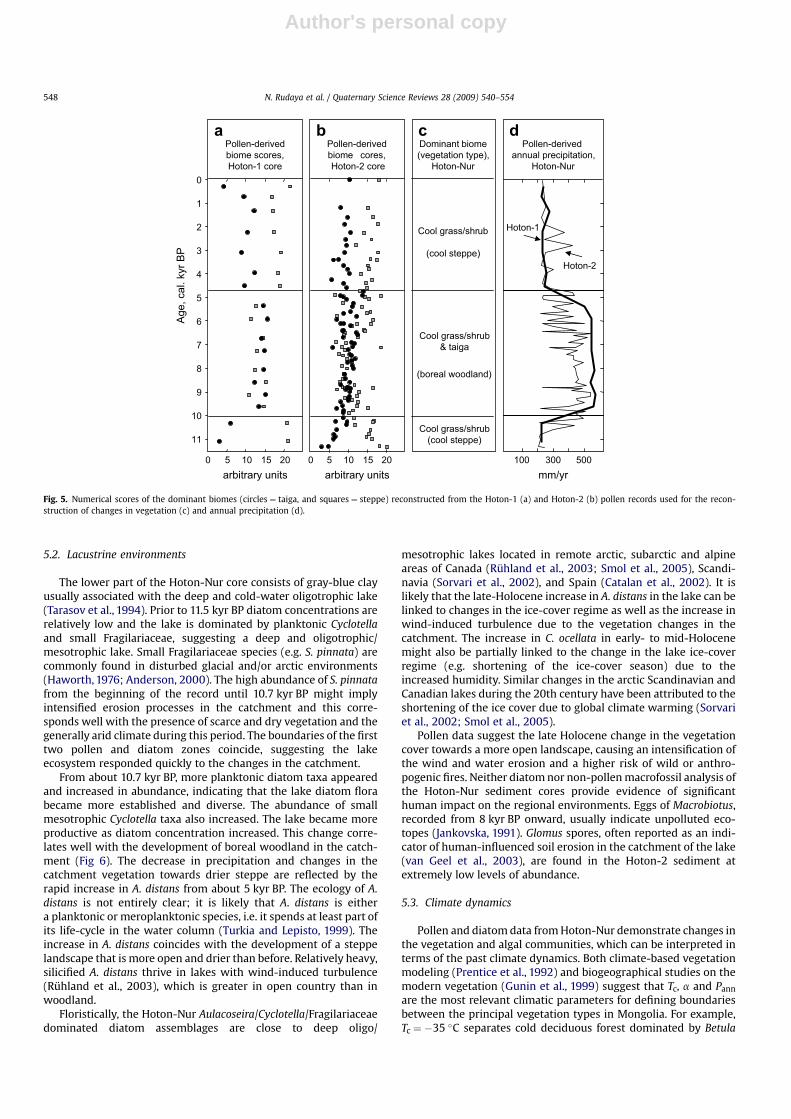
Prior to 11.5 kyr BP very low pollen concentrations and thepredominance of NAP taxa well adapted to both dry and coldenvironments (Fig. 3) suggest a treeless and probably discontin-uous vegetation cover around the lake, similar to that of themodern dry steppes and semi-deserts. The early Holocene pollenspectra reveal an increase in pollen concentrations but the pollencomposition remains similar to the late Pleistocene phase. Biomereconstruction (Fig. 5a,b) demonstrates that steppe biome scoreshave the highest values, suggesting the predominance of thisvegetation type (Fig. 5c), and scores of taiga and tundra biomes arerelatively low between 11.5 and 10.7 kyr BP. Relatively highpercentages of Ephedra pollen may as well point to the opencharacter of vegetation and the wide spread of dry steppe andsemi-desert communities around the lake.
After 10.7 kyr BP vegetation cover became denser as suggestedby the higher pollen concentrations. Both pollen spectra composi-tion and biome reconstruction suggest the spread of trees aroundthe lake from this period onward. One of the main indicators of thelocal presence of coniferous trees, including Larix and Picea, is thepresence of their stomata in the lake sediment (Parshall, 1999;Sweeney, 2004). The finds of Larix stomata are especially impor-tant, considering that larch pollen is usually strongly underrepre-sented in the pollen diagrams (Gunin et al., 1999; Pisaric et al.,2001). Biome reconstruction demonstrates a decrease in steppescores and an associated increase in taiga scores, suggesting thespread of boreal trees and open woodland vegetation aroundHoton-Nur 10–8 kyr BP. The increase in B. sect. Nanae pollenpercentages suggests that shrub birches became spread in thesedge-grass alpine belt or/and in the woodland understorey.However, reconstructed tundra scores do not change significantlyin comparison with the earlier time interval.
After 7.9 kyr BP the decrease in pollen concentrations and strongvariations in the AP and NAP taxa percentages suggest ratherunstable environmental conditions and an increased importance ofthe non-arboreal vegetation in the region. Occurrence of Picea andLarix stomata and relatively high quantities of Picea, Abies, P. sibir-ica-type and Larix pollen suggest that trees were still well presentin the regional vegetation until 5 kyr BP. Relatively high scores oftaiga biome supports this interpretation.
From 4.9 kyr BP the greater role of semi-desert and steppe taxain the pollen spectra indicate a strengthening of these vegetationcommunities in the area around Hoton-Nur and an associatedretreat of the boreal woods to the refugia with slightly bettermoisture conditions. The reconstruction shows the increase in thesteppe biome scores during the past 5 kyr consistent with thequalitative interpretation of the pollen record. Relatively highpercentages of coniferous taxa, particularly of P. sibirica-type andPicea, in the late Holocene pollen spectra likely indicate theirtransport from the taiga forests growing in the northern and north-western parts of the Altai Mountains, rather than the presence oflocal woods. This interpretation is supported by relatively lowpollen concentrations and the disappearance of conifer stomatafrom the analyzed sediments.
Table 2Apparent and prediction statistics of AL:PE pH model.
Apparent statistics Prediction ‘‘jackknife’’ statistics
RMSE 0.297 RMSEP 0.356r2 0.847 r2 0.780Average bias 0.0005 Average bias 0.001Max. bias 0.495 Max. bias 0.624
N. Rudaya et al. / Quaternary Science Reviews 28 (2009) 540–554 547
Author's personal copy
5.2. Lacustrine environments
The lower part of the Hoton-Nur core consists of gray-blue clayusually associated with the deep and cold-water oligotrophic lake(Tarasov et al., 1994). Prior to 11.5 kyr BP diatom concentrations arerelatively low and the lake is dominated by planktonic Cyclotellaand small Fragilariaceae, suggesting a deep and oligotrophic/mesotrophic lake. Small Fragilariaceae species (e.g. S. pinnata) arecommonly found in disturbed glacial and/or arctic environments(Haworth, 1976; Anderson, 2000). The high abundance of S. pinnatafrom the beginning of the record until 10.7 kyr BP might implyintensified erosion processes in the catchment and this corre-sponds well with the presence of scarce and dry vegetation and thegenerally arid climate during this period. The boundaries of the firsttwo pollen and diatom zones coincide, suggesting the lakeecosystem responded quickly to the changes in the catchment.
From about 10.7 kyr BP, more planktonic diatom taxa appearedand increased in abundance, indicating that the lake diatom florabecame more established and diverse. The abundance of smallmesotrophic Cyclotella taxa also increased. The lake became moreproductive as diatom concentration increased. This change corre-lates well with the development of boreal woodland in the catch-ment (Fig 6). The decrease in precipitation and changes in thecatchment vegetation towards drier steppe are reflected by therapid increase in A. distans from about 5 kyr BP. The ecology of A.distans is not entirely clear; it is likely that A. distans is eithera planktonic or meroplanktonic species, i.e. it spends at least part ofits life-cycle in the water column (Turkia and Lepisto, 1999). Theincrease in A. distans coincides with the development of a steppelandscape that is more open and drier than before. Relatively heavy,silicified A. distans thrive in lakes with wind-induced turbulence(Ruhland et al., 2003), which is greater in open country than inwoodland.
Floristically, the Hoton-Nur Aulacoseira/Cyclotella/Fragilariaceaedominated diatom assemblages are close to deep oligo/
mesotrophic lakes located in remote arctic, subarctic and alpineareas of Canada (Ruhland et al., 2003; Smol et al., 2005), Scandi-navia (Sorvari et al., 2002), and Spain (Catalan et al., 2002). It islikely that the late-Holocene increase in A. distans in the lake can belinked to changes in the ice-cover regime as well as the increase inwind-induced turbulence due to the vegetation changes in thecatchment. The increase in C. ocellata in early- to mid-Holocenemight also be partially linked to the change in the lake ice-coverregime (e.g. shortening of the ice-cover season) due to theincreased humidity. Similar changes in the arctic Scandinavian andCanadian lakes during the 20th century have been attributed to theshortening of the ice cover due to global climate warming (Sorvariet al., 2002; Smol et al., 2005).
Pollen data suggest the late Holocene change in the vegetationcover towards a more open landscape, causing an intensification ofthe wind and water erosion and a higher risk of wild or anthro-pogenic fires. Neither diatom nor non-pollen macrofossil analysis ofthe Hoton-Nur sediment cores provide evidence of significanthuman impact on the regional environments. Eggs of Macrobiotus,recorded from 8 kyr BP onward, usually indicate unpolluted eco-topes (Jankovska, 1991). Glomus spores, often reported as an indi-cator of human-influenced soil erosion in the catchment of the lake(van Geel et al., 2003), are found in the Hoton-2 sediment atextremely low levels of abundance.
5.3. Climate dynamics
Pollen and diatom data from Hoton-Nur demonstrate changes inthe vegetation and algal communities, which can be interpreted interms of the past climate dynamics. Both climate-based vegetationmodeling (Prentice et al., 1992) and biogeographical studies on themodern vegetation (Gunin et al., 1999) suggest that Tc, a and Pann
are the most relevant climatic parameters for defining boundariesbetween the principal vegetation types in Mongolia. For example,Tc ¼ �35 �C separates cold deciduous forest dominated by Betula
0
1
2
3
4
5
6
7
8
9
10
11
10 15 200 5 0 5 10 15 20
Pollen-derivedbiome scores,Hoton-1 core
Pollen-derivedbiome cores,Hoton-2 core
(boreal woodland)
Dominant biome(vegetation type),
Hoton-Nur
Cool grass/shrub
(cool steppe)
Cool grass/shrub(cool steppe)
arbitrary units arbitrary units mm/yr
Hoton-1
Pollen-derivedannual precipitation,
Hoton-Nur
500300100
Hoton-2
Cool grass/shrub& taiga
ba c d
Age,
cal
. kyr
BP
Fig. 5. Numerical scores of the dominant biomes (circles ¼ taiga, and squares ¼ steppe) reconstructed from the Hoton-1 (a) and Hoton-2 (b) pollen records used for the recon-struction of changes in vegetation (c) and annual precipitation (d).
N. Rudaya et al. / Quaternary Science Reviews 28 (2009) 540–554548

Author's personal copy
and Larix from taiga where boreal deciduous and evergreen conif-erous (e.g. Picea, Abies, P. sibirica) taxa can grow together (Prenticeet al., 1992). Similarly, a ¼ 0.65 separates cool steppe from forestbiomes. The use of a is limited to the modeling studies, while Pann ismore frequently used in the paleoclimate research based on bio-logical and sedimentary proxies and can be easily compared withmeteorological observations and climatic maps. The modernclimatic variables at Hoton-Nur (e.g. 0.45 for a, 250 mm/yr for Pann
and �20 �C for Tc) suggest that the modern steppe vegetationaround the lake and small isolated woody stands are more sensitive
to the moisture parameters, while only a large drop in Tc candestabilize the system. The results of the pollen-based precipitationreconstruction are shown in Fig. 5d. Both Hoton-1 and Hoton-2records suggest that the regional climate was relatively dry(Pann w 200–300 mm/yr and a w 0.3–0.5) prior to 10 kyr BP. Theclimate became substantially wetter (Pann w 300–550 mm/yr anda w 0.5–0.8) during the following interval between 10 and 5 kyr BP.The onset of a relatively dry climate comparable to the presentoccurred soon after 5 kyr BP. This climate reconstruction (Fig. 5d) isconsistent with the vegetation reconstruction (Fig. 5a–c).
Atlan
tic O
cea
n
Pacific
Ocean
15° 45° 75° 105° 135° 175°15°
Arctic Ocean
Siberia
Europe
WR
I
NR
AsiaCentral
East Asia
Norwegian
Sea
c
d
e
f
g
h
30°
45°
75°
60°
ER
0-9
18O(o/oo)
-7dry450 490 530
Precipitation(mm/yr)
300 6004020 40 60 800 0
Arborealpollen (%)
Lake hydrologyand climate
wet
Arborealpollen (%)
July insolation(W/m2)
16
August SST(°C)
8 12-30
Relative sealevel (m)
0-60
Age,
cal
. kyr
BP
1
2
3
4
5
6
7
8
9
10
11
12Dongge Cave
D4, China (Yuan et al., 2004)
60°N(Berger andLoutre, 1991)
Hoton-NurMongolia
(this study)
W. Russia(Wohlfarth
et al., 2006)
Pashennoe(Kremenetskiet al., 2005)
Uzunkol(Blyakharchuket al., 2004)
Lake
Ner
o
Lake
Cha
shni
tsy
Lake
Zao
zer‘e
a
Norwegian Sea(Birks andKoç, 2002)
c
Barbados(Peltier and
Fairbanks, 2006)
db e f g h
Peator/and
sedimentaryhiatus
Fig. 6. Summary chart showing the distribution of the Holocene paleoclimate records from Eurasia discussed in the text (upper panel) and a comparison of selected global forcingsand several paleoclimate proxies from Eurasia plotted along the time axis (lower panel). Individual graphs show (a) July insolation at 60� , (b) relative sea level changes (e.g. globalice volume equivalent) from the Barbados corals, (c) diatom-based August sea-surface temperature reconstruction from the Norwegian Sea, (d) lacustrine environment and itsclimatic implication for three lakes from the Yaroslavl’ Region in central European Russia, (e) AP percentages from Pashennoe Lake in eastern-central Kazakhstan representative ofthe Western Region (WR) of Central Asia which experienced the late-Holocene westerly-associated moisture increase, (f) AP percentages from Uzunkol Lake in the Russian Altairepresentative of the Northern Region (NR) of Central Asia which experienced both the early-Holocene monsoon-associated moisture increase and the late-Holocene westerly-associated moisture increase, (g) pollen-based precipitation reconstruction from Hoton-Nur representative of the Eastern Region of Central Asia which experienced the early-Holocene monsoon-associated moisture increase but late-Holocene moisture decrease, and (h) oxygen isotope record (e.g. indicator of the Pacific summer monsoon intensity) fromthe stalagmite D4, Dongge Cave, China.
N. Rudaya et al. / Quaternary Science Reviews 28 (2009) 540–554 549

Author's personal copy
Comparison of the results inferred from the deep-water Hoton-2 record with the reconstruction based on the Hoton-1 recordobtained from the coastal bay reveals greater pollen/climate vari-ability in the Hoton-2 record (Fig. 5d). For example, during the late-Holocene the climate reconstruction from Hoton-1 demonstratesprecipitation values similar to today, while the Hoton-2 recordsuggests a 50–100 mm increase in precipitation between 3 and2 kyr BP. Another example is several short-term variations in thepollen percentages and in the pollen-based reconstructions ofbiome scores and precipitation values from the Hoton-2 record,particularly during the mid-Holocene humid interval. Observeddiscrepancies between the Hoton-1 and Hoton-2 records can beexplained by (i) larger sample size and lower temporal resolution ofthe pollen analysis of the Hoton-1 core and/or (ii) a differentsampling site location and the various sources of pollen entering it.In a large overflowing lake, pollen spectra from its central deep-water part (Hoton-2) tend to represent a larger region, receivinggreater input from regional, rather than local or extra-local vege-tation to the pollen assemblages (Jacobson and Bradshaw, 1981). Inthe Hoton-Nur basin more arid vegetation communities areconcentrated at the lower elevations south and east of the lake(Volkova, 1994). Thus, the contribution of the dry taxa to the Hoton-2 pollen assemblages is greater in comparison with the Hoton-1,and this is consistent with the reconstruction of generally lowertaiga biome scores and precipitation values of the Hoton-2 record(Fig. 5). In several cases during the early and late Holocene thehigher taiga scores/precipitation values are derived from theHoton-2 pollen assemblages with very low pollen concentration(Fig. 3). In latter cases, the reconstruction might be an artefactcaused by an increasing role of the long-distant AP transport duringthe arid intervals characterized by the low local pollen productionin the Hoton-2 record (Tarasov et al., 2007b). Overall, the Hoton-1core collected from a small and relatively closed bay without directriver inflow shows a more stable signal.
6. Discussion: Holocene climatic and environmentalchanges in Central Asia
6.1. Holocene vegetation and climate records from the AltaiMountains and neighboring areas
Occupying a central position in the mid-latitude Asian interiors,the Altai Mountains resemble a gigantic ‘‘T’’, which splits the areainto three characteristic geographical regions: eastern, western andnorthern. In this section the Holocene vegetation records fromthese three regions are summarized to facilitate further discussionsof the spatial pattern of the Holocene climate and its backgroundmechanisms.
6.1.1. Eastern Region (ER): the Mongolian AltaiThe Hoton-1 and Hoton-2 records demonstrate generally
parallel changes in the reconstructed environments (Fig. 5), sug-gesting that the area was characterized by a relatively dry climateand cool steppe vegetation prior to 10 kyr BP. Generally wetter thanpresent conditions occurred between 10 and 5 kyr BP causinga spread of boreal trees. The re-establishment of steppe asa dominant vegetation type was associated with a significantdecrease in atmospheric precipitation after 5 kyr BP. Other vege-tation records from the ER are in line with this reconstruction. Forexample, the pollen data from Achit-Nur (49�300N, 90�360E,1435 m, Fig. 1) demonstrate a quick increase in AP from less than 5%prior to 10.5 kyr BP to 35–50% between 10 and 5 kyr BP (Guninet al., 1999), suggesting a wetter than present mid-Holoceneclimate and open woodland vegetation. The ‘‘Kharkhiraa southside’’ pollen record (49�260N, 91�150E, 2570 m, Fig. 1) providesfurther proof of humid conditions between 10.6 and 5.3 kyr BP and
dry vegetation and climate during the earlier and later periods(Schlutz, 2000). The palynological study of the Bayan Nuur(50�000N, 93�580E, 932 m, Fig. 1) core also suggests a phase ofhigher humidity during the middle Holocene, as indicated by thehighest AP percentages between 10 and 6.9 kyr BP (Krengel, 2000;Grunert et al., 2000). Radiocarbon dating of numerous Picea, Abiesand Larix wood fragments identified in peat deposits from Bayan-Sair (47.75�N, 96.91�E, 2600 m, Fig. 1) proves the disappearance ofspruce and fir from the local vegetation between 5 and 3.8 kyr BP,while larch was present until 3 kyr BP (Gunin et al., 1999). The mid-Holocene presence of taiga woods in the southern Mongolian Altaiwould require Pann to be w100–150 mm/yr higher than present(Tarasov et al., 2000).
6.1.2. Western Region (WR): the Kazakh UplandPollen records from Ozerki Swamp (50�240N, 80�280E, 210 m,
Fig. 1) in the Irtysh River valley and from Pashennoe Lake (49�220N,75�240E, 871 m, Fig. 1) in the Karkaraly Mountains (Kremenetskiet al., 1997; Tarasov et al., 1997) reveal the high percentages ofsteppe- and desert-associated herbaceous taxa throughout the lateglacial, early and middle Holocene. The Ozerki pollen recordsuggests a local presence of the riparian birch forests in the IrtyshRiver valley around 8.5 kyr BP. However, the encroachment of thepine forests into the Kazakhstan steppe became a distinctivefeature of the second half of the Holocene. Pollen records fromlakes Mokhovoe (53�460N, 64�150E) and Karasye (53�020N, 70�130E)situated in northern Kazakhstan (Kremenetski et al., 1997; Tarasovet al., 1997) suggest that the pine-dominated island forests wereestablished in the northern part of the WR about 6 kyr ago and thenspread southwards. Around remotely located Lake Pashennoe(Fig. 1) the forest apparently reached its maximum spread onlyduring the last millennium (Tarasov et al., 2007b).
6.1.3. Northern Region (NR): the Russian AltaiThe pollen records from the Ulagan Plateau (50�270–50�300N,
87�060–87�400E, 1985–2150 m, Fig. 1) suggest that the treesappeared in the area from 12 kyr BP (Blyakharchuk et al., 2004).However, the full expansion of the evergreen boreal coniferousforests occurred rapidly only after 10 kyr BP. The role of Picea andAbies in these forests decreased by about 7.5 kyr BP and the vege-tation cover has changed very little since that time until today. Thepollen records from lower elevation Dzhangyskol (50�110N,87�440E, w1800 m) also suggest spread of woods after 11 kyr BP(Blyakharchuk et al., 2008). However, maximal expansion of borealforests in the area coincides with the highest lake levels inDzhangyskol during the late Holocene. By contrast to the westernarea, the pollen records from Tuva (50�150–50�160N, 89�270-89�370E, 2204–2413 m, Fig. 1) located in the relatively dry easternpart of the NR indicate the taiga development in response toincreased humidity between 11 and 6 kyr BP, and a shift to a drierclimate similar to present after 6 kyr BP (Blyakharchuk et al., 2007).
6.2. Mechanisms driving the Holocene vegetation and climatedynamics in Central Asia
The records summarized in Section 6.1 demonstrate spatiallyvariable Holocene vegetation and climate histories in the large areaof Central Asia separated by the main watersheds of the AltaiMountains into three well-defined geographical regions. Therecorded regional differences imply different driving mechanismsof the post-glacial environmental dynamics and encourage a searchfor those mechanisms.
Great distances separate the Altai Mountains from all the oceansand thus from the main sources of precipitation in the Eurasianmid-latitudes. The present-day precipitation and plant-availablemoisture in the WR is mainly controlled by cyclonic advections
N. Rudaya et al. / Quaternary Science Reviews 28 (2009) 540–554550
Author's personal copy
from the Atlantic Ocean (Alpat’ev et al., 1976; Martyn, 1992).However, the ER bordered from the west by the Altai Mountainsstays in the rain shadow. In eastern Asia, the modern precipitationpattern is controlled by the summer monsoon transporting mois-ture from the Pacific Ocean (Domros and Peng, 1988). The modernlimit of the summer monsoon is commonly placed along theeastern border of Mongolia and as far as the eastern parts of theTibetan Plateau (Winkler and Wang, 1993; Wei and Gasse, 1999).However, meteorological observations suggest that in the Mongo-lian Altai incursions of Pacific air masses amplified by the mountainrelief are responsible for the precipitation during the warm season(Tarasov et al., 2000). In the NR, precipitation is controlled bywestern and northwestern cyclones bringing warm and moist airduring the summer season (Alpat’ev et al., 1976). In winter, verycold, sunny and predominantly dry weather caused by the Siberiananticyclone prevails in all the discussed regions of Central Asia(Martyn, 1992).
Vegetation and climate reconstructions for the ER have beeninterpreted as evidence of the early–middle Holocene strength-ening of the summer monsoon (Harrison et al., 1996; Tarasov et al.,2000). The study on oxygen isotopes in lacustrine sediments fromwestern and northwestern China (Wei and Gasse, 1999) suggested,for its part, that the Pacific monsoon did influence northwesternChina between 11 and 4.5/3.5 kyr BP and provided constantly highprecipitation in northeastern and central Tibet 11–8 kyr BP (Weiand Gasse, 1999). Prior to 11 kyr BP desert-like environments arereconstructed around Lake Manas (45�450N, 86�000E, Fig. 1) fol-lowed by a 3 kyr episode when the lake became fresh and deep andsteppe vegetation grew around it (Rhodes et al., 1996). The d18Orecord from Manas correlates very well with the environmentalreconstructions for the Mongolian Altai presented in this study,suggesting the same mechanism for the early- to mid-Holoceneincrease in precipitation.
The early- to mid-Holocene monsoon-associated increase insummer rainfall in the upper Irtysh River, which originated fromnorthwestern China, may well account for the local development ofthe riparian birch forests in the Irtysh River valley around 8.5 kyr BP,as seen in the Ozerki pollen diagram (Kremenetski et al., 1997; Tar-asov et al., 1997), but not in the other records from Kazakhstan sit-uated beyond the range of Irtysh influence. By contrast to the ER(Fig. 6g), the first half of the Holocene was drier than at present in theWR, where a shift towards wetter conditions did not occur until7 kyr BP. The late Holocene spread of pine and birch forests innorthern and central Kazakhstan (Fig. 6e), indicating an increase inprecipitation or a decrease in evaporation losses, has been noted(Kremenetski et al., 1997; Tarasov et al., 1997). Recently it was sug-gested (Tarasov et al., 2007b) that both the movement of Atlantic airmasses driven by a northward shift in westerly flow, and the effi-ciency of advective water recycling during moisture transport to theAsian interiors, may be responsible for the late Holocene improve-ment of the regional water balance. The late Quaternary lake-status(Harrison et al., 1996) and isotope (Bar-Matthews and Ayalon, 2004)records demonstrate that the Mediterranean region, which atpresent receives precipitation associated with the winter westerlies,became drier than before after 6 kyr BP, while the region of northernEurope experienced a shift towards wetter conditions after 5 kyr BPand most of the analyzed lakes there reached the highest levelsduring the last millennia (Harrison et al., 1996; Barber et al., 2004;Snowball et al., 2004). Wohlfarth et al. (2006) also demonstratedthat the lakes in the central Russian Plain, recently controlled by thewesterly through most of the year, experienced very low levelsbetween 13 and 5.5 kyr BP, before turning to more humid conditionsafter that (Fig. 6d).
The present-day atmospheric circulation and precipitationregime of the WR (including Kazakhstan) resemble those ofnorthern and eastern Europe (Martyn, 1992). Taking into account
a similarity in the reconstructed Holocene changes in the regionalprecipitation/water budgets we assume that they have the samebackground mechanism. The transition from warm and dry earlyand middle Holocene to cool and wet late-Holocene in westernEurasian mid-latitudes was explained by declining summer inso-lation (Fig. 6a), the cooling of Arctic waters (Fig. 6c) and reducedsummer temperatures/evaporation (Snowball et al., 2004). Aparallel increase in winter insolation and sea level rise (Fig. 6b)indicating a decrease in the global ice volume (Peltier and Fair-banks, 2006) could also play an important role, as it might beresponsible for the weakening of the winter monsoon in Siberia,which then allowed farther eastward penetration of the relativelywarm and wet Atlantic air masses. This process was complicated bya number of regional factors, which could be responsible fora highly meridional circulation pattern over Europe during the firsthalf of the Holocene in comparison to a zonal circulation patternobserved today (Harrison et al., 1996).
The pollen records from the NR (Fig. 6f) show the humidity/precipitation pattern, which makes it similar to the ER before6 kyr BP and to the WR after that. Ilyashuk and Ilyashuk (2007),using chironomid and lithology records and results of the diatomanalysis (Westover et al., 2006), suggested that the Pacific monsoonbrought precipitation to the Russian Altai in the early Holocene,whereas cyclones associated with the Atlantic westerlies werelikely responsible for the moisture transport during the second halfof the Holocene. The reconstructed mid-Holocene phase of rela-tively dry climatic conditions falls in an interval when a majortransformation of the atmospheric circulation occurred in Eurasia.During this period the attenuation of the Pacific monsoon circula-tion and the retreat of the summer monsoon front documented inthe records from western Mongolia and north-western Chinacaused a reduction of precipitation in the Russian Altai, whereasthe Atlantic influence in the NR, as proved independently by theevidence from Kazakhstan and Russia. A comparison between thepollen/vegetation/climate records from the western (e.g. Ulagan,Dzhangyskol) and eastern part (Tuva) of the NR demonstrates thatboth areas had two precipitation maxima. However, the earlyHolocene (summer monsoon-associated) maximum was morepronounced in the eastern part, and the late Holocene (westerly-associated) maximum could be better seen in the western part ofthe NR, in line with the records from Kazakhstan and Mongolia.
6.3. Holocene vegetation dynamics in the Mongolian Altai: climatechange or human activities?
The interpretation of changes in AP content in terms of climateis not unambiguous, since the forest degradation and associatedchanges in the pollen assemblages can be also explained by humanactivities. Thus, pollen-based climatic inferences benefit fromadditional evidence from independent proxies. Changes in themoisture balance reconstructed from 11 Mongolian lakes (Tarasovet al., 1996; Walter et al., 2003) closely resemble the pollen-basedclimate reconstruction (Fig. 6g), and support the assumption thatthe vegetation dynamics reconstructed from the Hoton-Nur recordare primarily driven by the changes in precipitation.
Archaeological records, e.g. a great number of petroglyphicimages and ritual structures in the river valleys of Tsagaan Salaaand Baga Oigor (49�250N, 88�150E, w2350–2650 m) situated 75 kmnorth of Hoton-Nur, suggest more or less continuous habitation ofthe Mongolian Altai since 12 kyr BP (Jacobson, 2001). Smallcommunities subsisting on hunting of forest- and steppe-associ-ated animals, fishing and gathering were present in the region priorto 4 kyr BP. The number of images of forest animals (e.g. bear, truedear and elk) decreases after 4 kyr BP and images of wild boar, aninhabitant of the riparian forests and shrubs, and wild yak,preferring open steppe landscapes, become more important in line
N. Rudaya et al. / Quaternary Science Reviews 28 (2009) 540–554 551

Author's personal copy
with our environmental reconstruction (Fig. 5). The emergence ofmounted pastoralism after 3 kyr BP concluded the transition froma hunting-gathering economy to a nomadic or semi-nomadicpastoral economy in the Mongolian Altai (Jacobson, 2001). Wood ofconiferous trees (mainly Larix) was commonly used to constructtomb chambers during 2.9–2 kyr BP (Parzinger, 2006; Heussnerand Sljusarenko, 2007), e.g. only after the main transformationfrom woodland to steppe was completed as the result of the climatechange towards aridity. It is possible that the disappearance of Larixfrom the Gobi Altai after 3 kyr BP (Gunin et al., 1999; Miehe et al.,2007) was initially triggered by climate change and then aggra-vated by human activities under conditions unsuitable for treere-growth. However, the absence of diagnostic anthropogenicindicators in the Hoton-Nur pollen and diatom records indicatesthat human disturbance of soils and vegetation cover was lesssignificant than might have been expected. Our conclusion isconsistent with the recent results from the Khentey Mountains(49�0404800N, 107�1701500E, 900–1600 m, Schlutz et al., 2008), wherethe absence of charcoal and other anthropogenic indicators inthe palynological records until modern times imply that the steppeislands are of natural origin and not a replacement of the formertaiga due to burning or grazing.
7. Conclusions
1. A quantitative reconstruction of Holocene vegetation andclimate dynamics was inferred from the Hoton-Nur recordsfrom the semiarid Mongolian Altai. Our reconstructionsuggests a rapid forestation in the primarily open landscape ofnorthwestern Mongolia after 10 kyr BP in response toa noticeable increase in precipitation from 200–250 mm/yr to450–550 mm/yr. A return to a predominance of open vegeta-tion types occurred after 5 kyr BP when precipitationdecreased to modern values of 250–300 mm/yr.
2. This reconstruction is in agreement with the d18O records fromChina, demonstrating an abrupt strengthening of the monsoonin the early Holocene and an associated increase in precipita-tion and in lake levels in northwestern China between 11 and8 kyr BP, followed by the stepwise attenuation of the monsooncirculation and climate aridization towards the modern levelbetween 8 and 4.5/3.5 kyr BP.
3. Occupying a central position in the mid-latitude Asian inte-riors, the Altai Mountains resemble a gigantic ‘‘T’’, which splitsthe area into three characteristic geographical regions: eastern(ER), western (WR) and northern (NR). Comparisons of recordsfrom the Mongolian Altai (ER), the Kazakh Upland (WR) andthe Russian Altai (NR) reveal spatially and temporally differentHolocene vegetation and climate histories.
4. During the first half of the Holocene the WR was drier thanpresent whereas the ER was moister than present. A shifttowards wetter conditions occurred in the WR only during thesecond half of the Holocene, when the mid-latitudinal belt,stretching from the Baltic Sea to northern Kazakhstan andsouthern Siberia, came under the control of the Atlantic airmasses. At the same time conditions in the ER became dry.Productivity of the steppes shifted from east to west at about3 kyr BP, so migration movements of animal-keeping humancommunities proved by archaeological and historical recordsare the logical consequence.
5. The pollen/vegetation/climate records from the NR, however,display two precipitation maxima during past 12 kyr BP. Whilethe early Holocene (summer monsoon-associated) maximumwas more pronounced in the eastern part of the region, the lateHolocene (westerly-associated) maximum could be better seenin the western part, in line with the records from the ER andWR, respectively.
6. Despite the more or less permanent presence of humans in theMongolian Altai since the early Holocene, the absence ofdiagnostic anthropogenic indicators in the Hoton-Nur pollenand diatom records indicates that human disturbance of soilsand vegetation cover was less significant than might have beenexpected. The emergence of mounted pastoralism after3 kyr BP and well-documented use of wood to construct tombchambers in the NR (2.9–2 kyr BP) occurred only after the maintransformation from woodland to steppe in the ER wascompleted as the result of the climate change towards aridity.
Acknowledgments
The paper is a contribution to the DFG-sponsored Program‘‘Interdynamik’’ (Ref. TA 540/1). N.R. was supported by the DAAD(Ref. 325, A/05/00162), INTAS Young Scientist Fellowship (Ref. 06-1000014-5781), the Russian Foundation for Basic Research (grants08-05-00773 and 06-05-64931) and by the Russian Academy ofSciences, Siberian Branch (Project Nr. 108). We are grateful to V.Jankovska, L. Nazarova and A. Ebel for consultations; to T. Seminaand N. Gorban for cartographic assistance; and to N. Roberts andtwo anonymous reviewers for valuable comments.
Appendixes A and B. Supplementary data
Supplementary information for this manuscript can be found inthe online version, at doi:10.1016/j.quascirev.2008.10.013.
References
Alpat’ev, A.M., Arkhangel’skii, A.M., Podoplelov, N.Y., Stepanov, A.Y., 1976. Fiziche-skaya geografiya SSSR (Aziatskaya chast’). Vysshaya Shkola, Moscow (inRussian).
Anderson, N.J., 2000. Diatoms, temperature and climatic change. European Journalof Phycology 35, 307–314.
Barber, K., Zolitschka, B., Tarasov, P., Lotter, A.F., 2004. Atlantic to UralsdtheHolocene climatic record of Mid-Latitude Europe. In: Battarbee, R.W., Gasse, F.,Stickley, C.E. (Eds.), Past Climate Variability through Europe and Africa.Developments in Paleoenvironmental Research, Vol. 6. Springer, Dordrecht,pp. 417–442.
Bar-Matthews, M., Ayalon, A., 2004. Speleothems as palaeoclimate indicators, a casestudy from Soreq cave located in the eastern Mediterranean region, Israel. In:Battarbee, R.W., Gasse, F., Stickley, C.E. (Eds.), Past Climate Variability throughEurope and Africa. Developments in Paleoenvironmental Research, Vol. 6.Springer, Dordrecht, pp. 363–391.
Battarbee, R.W., 1986. Diatom analysis. In: Berglund, B.E. (Ed.), Handbook of Holo-cene Palaeoecology and Palaeohydrology. Wiley, Chichester, pp. 527–570.
Berger, A., Loutre, M.F., 1991. Insolation values for the climate of the last 10,000,000years. Quaternary Science Reviews 10, 297–317.
Birks, C.J.A., Koç, N., 2002. A high-resolution diatom record of late-Quaternarysea-surface temperatures and oceanographic conditions from the easternNorwegian Sea. Boreas 31, 323–344.
Blyakharchuk, T.A., Wright, H.E., Borodavko, P.S., van der Knaap, W.O., Ammann, B.,2004. Late-glacial and Holocene vegetational changes on the Ulaganhigh-mountain plateau, Altai Mountains, southern Siberia. Palaeogeography,Palaeoclimatology, Palaeoecology 209, 259–279.
Blyakharchuk, T.A., Wright, H.E., Borodavko, P.S., van der Knaap, W.O., Ammann, B.,2007. Late Glacial and Holocene vegetational history of the Altai Mountains(southwestern Tuva Republic, Siberia). Palaeogeography, Palaeoclimatology,Palaeoecology 245, 518–534.
Blyakharchuk, T.A., Wright, H.E., Borodavko, P.S., van der Knaap, W.O., Ammann, B.,2008. The role of Pingos in the development of the Dzhangyskol lake-Pingocomplex, central Altai Mountains, Southern Siberia. Palaeogeography, Palae-oclimatology, Palaeoecology 254 (4), 404–420.
Cameron, N.G., Birks, H.J.B., Jones, V.J., Berge, F., Catalan, J., Flower, R.J., Garcia, J.,Kawecka, B., Koinig, K.A., Marchetto, A., Sanchez-Castillo, P., Schmidt, R.,Sisko, M., Solovieva, N., Stefkova, E., Toro, M., 1999. Surface-sediment and epi-lithic diatom pH calibration sets for remote European mountain lakes (AL: PEProject) and their comparison with the Surface Waters Acidification Programme(SWAP) calibration set. Journal of Paleolimnology 22, 291–317.
Catalan, J., Pla, S., Rieradevall, M., Felip, M., Ventura, M., Buchaca, T., Camarero, L.,Brancelj, A., Appleby, P.G., Lami, A., Grytnes, J.A., Agustı-Panareda, A.,Thompson, R., 2002. Lake Redo ecosystem response to an increasing warmingin the Pyrenees during the twentieth century. Journal of Paleolimnology 28,129–145.
N. Rudaya et al. / Quaternary Science Reviews 28 (2009) 540–554552

Author's personal copy
Davydova, N.N., 1985. Diatomovye vodoroslidindikatory prirodnykh usloviivodoemov v golotsene. Nauka, Leningrad (in Russian).
Domros, M., Peng, G., 1988. The Climate of China. Springer, Heidelberg.Dorofeyuk, N.I., Tsetsegmaa, D., 2002. Conspectus of algae flora of Mongolia. Nauka,
Moscow (in Russian).Ecosystems of Mongolia. Atlas, 2005. Nauka, Moscow.Faegri, K., Iversen, J., 1989. Textbook of Pollen Analysis. John Wiley & Sons,
Chichester.Fowell, S.J.B., Hansen, C.S., Peck, J.A., Khosbayar, P., Ganbold, E., 2003. Mid to late
Holocene climate evolution of the Lake Telmen Basin, North Central Mongolia,based on palynological data. Quaternary Research 59, 353–363.
Grimm, E., 1987. CONISS: A FORTRAN 77 program for stratigraphically constrainedcluster analysis by the methods of incremental sum of squares. Computers &Geoscience 13, 13–15.
Grimm, E., 1991. TILIA and TILIAGRAPH, Springfield, IL.Grunert, J., Lehmkuhl, F., Walther, M., 2000. Paleoclimatic evolution of the Uvs Nuur
basin and adjacent areas (Western Mongolia). Quaternary International 65/66,171–191.
Guiot, J., 1990. Methodology of the last climatic cycle reconstruction from pollendata. Palaeogeography, Palaeoclimatology, Palaeoecology 80, 49–69.
Gunin, P.D., Vostokova, E.A., Dorofeyuk, N.I., Tarasov, P.E., Black, C.C. (Eds.), 1999.Vegetation Dynamics of Mongolia. Kluwer Academic Publishers, Dordrecht.
Harrison, S., Yu, G., Tarasov, P., 1996. Late Quaternary lake-level record fromNorthern Eurasia. Quaternary Research 45, 138–159.
Haworth, E.Y., 1976. Two late-glacial (Late Devensian) diatom assemblage profilesfrom northern Scotland. New Phytologist 77, 227–256.
Heussner, K.-U., Sljusarenko, I., 2007. Die Dendrochronologie von Ar�zan 2. In:Menghin, W., Parzinger, H., Nagler, A., Nawroth, M. (Eds.), Im Zeichen desgoldenen Greifen. Konigsgraber der Skythen. Prestel, Berlin, pp. 83–84.2007.
Ilyashuk, B., Ilyashuk, E., 2007. Chironomid record of Late Quaternary climaticand environmental changes from two sites in Central Asia (Tuva Republic,Russia)dlocal, regional or global causes? Quaternary Science Reviews 26,705–731.
Jacobson, E., 2001. Tsagaan Salaa/Baga Oigor: The physical content and palae-oenvironmental considerations. In: Jacobson, E., Kubarev, V., Tseevendorj, D.(Eds.), Repertoire des petroglyphes D’Asie Centrale. Memoires de la MissionArcheologique Française en Asie Centrale, Vol. 6. De Boccard, Paris, pp. 7–15.
Jankovska, V., 1991. Unbekannte Objekte in PollenpraparatendTardigrada. Proc.. ofthe Pan-European Palaeobot. Conf. Vienna, Austria, pp. 19-23.
Komarek, J., Jankovska, V., 2001. Review of the Green Algal Genus Pediastrum;Implication for Pollen-Analytical Research. Bibliotheca Phycologica. Band 108,Berlin, Stuttgart.
Krammer, K., Lange-Bertalot, H., 1986-1991. Bacillariophyceae. Gustav Fisher Verlag,Stuttgart.
Kremenetski, V., Tarasov, P., Cherkinsky, E., 1997. Postglacial development ofKazakhstan pine forests. Geographie physique et Quaternaire 51, 391–404.
Krengel, M., 2000. Discourse on history of vegetation and climate in Mongo-liadpalynological report of sediment core Bayan Nuur I (NW-Mongolia).Berliner geowissenschaftliche Abhandlungen A 205, 80–84.
Kuprianova, L.A., Alyoshina, L.A., 1972. Pyl‘za i spory rastenii flory Evropeiskoi chastiSSSR. Nauka, Leningrad (in Russian).
Leemans, R., Cramer, W., 1991. The IIASA climate database for mean monthly valuesof temperature, precipitation and cloudiness on a global terrestrial grid, RR-91–18. International Institute of Applied Systems Analysis, Luxemburg.
Martyn, D., 1992. Climates of the World. Developments in Atmospheric Sciences 18.Elsevier, Amsterdam.
Miehe, G., Schlutz, F., Miehe, S., Opgenoorth, L., Cermak, J., Samiya, R., Jager, E.J.,Wesche, K., 2007. Mountain forest islands and Holocene environmental changesin Central Asia: A case study from the southern Gobi Altay, Mongolia. Palae-ogeography, Palaeoclimatology, Palaeoecology 250 (1-4), 150–166.
Nakagawa, T., Tarasov, P., Kotoba, N., Gotanda, K., Yasuda, Y., 2002. Quantitativepollen-based climate reconstruction in Japan: application to surface and lateQuaternary spectra. Quaternary Science Reviews 21, 2099–2113.
National Atlas, 1990. National Atlas of Mongolian People’s Republic. Ulan-Bator,Moscow (in Russian).
Ogureeva, G.N., 1980. Botanicheskaya Geografiya Altaya. Nauka, Moscow (inRussian).
Overpeck, J.T., Webb III, T., Prentice, I.C., 1985. Quantitative interpretation of fossilpollen spectra, dissimilarity coefficients and the method of modern analogs.Quaternary Research 23, 87–108.
Parshall, T., 1999. Documenting forest stand invasion: fossil stomata and pollen inforest hollows. Canadian Journal of Botany 77, 1529–1538.
Parzinger, H., 2006. Die fruhen Volker Eurasiens vom Neolithikum bis zum Mitte-lalter. Verlag C.H. Beck, Munchen.
Peck, J., Khosbayar, P., Fowell, S., Pearce, R., Ariunbileg, S., Hansen, B.,Soninkhishig, N., 2002. Mid to Late Holocene climate change in north centralMongolia as recorded in the sediments of Lake Telmen. Palaeogeography,Palaeoclimatology, Palaeoecology 183, 135–153.
Peltier, W.R., Fairbanks, R.G., 2006. Global glacial ice volume and Last GlacialMaximum duration from an extended Barbados sea level record. QuaternaryScience Reviews 25, 3322–3337.
Pisaric, M.F.J., MacDonald, G.M., Cwynar, L.C., Velichko, A.A., 2001. Modern pollenand conifer stomates from north-central Siberian lake sediments: their use ininterpreting late Quaternary fossil pollen assemblages. Arctic, Antarctic andAlpine Research 33, 19–27.
Prentice, I.C., Crameer, W., Harrison, S.P., Leemans, R., Monserud, R.A.,Solomon, A.M., 1992. A global biome model based on plant physiologyand dominance, soil properties, and climate. Journal of Biogeography 19,117–134.
Prentice, I.C., Guiot, J., Huntley, B., Jolly, D., Cheddadi, R., 1996. Reconstructingbiomes from palaeoecological data: a general method and its application toEuropean pollen data at 0 and 6 ka. Climate Dynamics 12, 185–194.
Prentice, I.C., Jolly, D., BIOME 6000 participants, 2000. Mid-Holocene and glacial-maximum vegetation geography of the northern continents and Africa. Journalof Biogeography 27, 507–519.
Prokopenko, A., Khursevich, G., Bezrukova, E., Kuzmin, M., Boes, X., Williams, D.,Fedenya, S., Kulagina, N., Letunova, P., Abzaeva, A., 2007. Paleoenvironmentalproxy records from Lake Hovsgol, Mongolia, and a synthesis of Holoceneclimate change in the Lake Baikal watershed. Quaternary Research 68, 2–17.
Reille, M., 1992. Pollen et Spores d’Europe et d’Afrique du Nord. Laboratoire deBotanique Historique et Palynologie. URA CNRS, Marseille, France.
Reille, M., 1998. Pollen et spores d’Europe et d’Afrique du nord. Supplement 2.Laboratoire de botanique historique et palynologie. URA CNRS, Marseille,France.
Rhodes, T.E., Gasse, F., Lin, R., Fontes, J.-C., Wie, K., Bertrand, P., Gibert, E.,Melie‘res, F., Tucholka, P., Wang, Z., Cheng, Z., 1996. A Late Pleistocene-Holocenelacustrine record from Lake Manas, Zunggar (northern Xinjiang, westernChina). Palaeogeography, Palaeoclimatology, Palaeoecology 120, 105–121.
Ruhland, K.M., Smol, J.P., Pienitz, R., 2003. Ecology and spatial distributions ofsurface-sediment diatoms from 77 lakes in the subarctic Canadian treelineregion. Canadian Journal of Botany 81, 57–73.
Schlutz, F., 2000. Palynological investigations in the Turgen-Kharkhiraa mountains,Mongolian Altay. Berliner geowissenschaftliche Abhandlungen A 205, 85–90.
Schlutz, F., Dulamsuren, C., Wieckowska, M., Muhlenberg, M., Hauck, M., 2008. LateHolocene vegetation history suggests natural origin of steppes in the northernMongolian mountain taiga. Palaeogeography, Palaeoclimatology, Palaeoecology261, 203–217.
Schrader, H.-J., 1974. Proposal for a standardized method of cleaning diatom-bearing deep sea and land-exposed marine sediments. Nowa Hedwigia 45,403–409.
Smittenberg, R.H., Baas, M., Schouten, S., Sinninghe Damste, J.S., 2005. The demiseof the alga Botryococcus braunii from a Norwegian fjord was due to earlyeutrophication. The Holocene 15, 133–140.
Smol, J.P., Wolfe, A.P., Birks, H.J.B., Douglas, M.S.V., Jones, V., Korhola, A., Pienitz, R.,Ruhland, K., Sorvari, S., Antoniades, D., Brooks, S., Fallu, M.-A., Hughes, M.,Keatley, B., Laing, T., Michelutti, N., Nazarova, L., Nyman, M., Quinlan, R.,Paterson, A., Perren, B., Rautio, M., Saulnier-Talbot, E., Siitonen, S., Solovieva, N.,Weckstrom, J., 2005. Climate-driven regime shifts in the 845 biologicalcommunities of arctic lakes. Proceedings of the National Academy of SciencesUSA 102, 4397–4402.
Snowball, J., Korhola, A., Briffa, K.R., Koç, N., 2004. Holocene climate dynamics inFennoscandia and the North Atlantic. In: Battarbee, R.W., Gasse, F., Stickley, C.E.(Eds.), Past Climate Variability through Europe and Africa. Developments inPaleoenvironmental Research, Vol. 6. Springer, Dordrecht, pp. 465–494.
Solovieva, N., Tarasov, P., MacDonald, G., 2005. Quantitative reconstruction ofHolocene climate from Chuna Lake pollen record, Kola Peninsula, north-westRussia. The Holocene 15 (1), 141–148.
Sorvari, S., Korhola, A., Thompson, R., 2002. Lake diatom response to recent Arcticwarming in Finnish Lapland. Global Change Biology 8, 171–181.
Sweeney, Ch., 2004. A key for the identification of stomata of the native conifers ofScandinavia. Review of Palaeobotany and Palynology 128, 281–290.
Tarasov, P.E., Harrison, S.P., Saarse, L., Pushenko, M.Ya., Andreev, A.A., Aleshinskaya, Z.V.,Davydova, N.N., Dorofeyuk, N.I., Efremov, Yu.V., Khomutova, V.I., Sevastyanov, D.V.,Tamosaitis, J., Uspenskaya, O.N., Yakushko, O.F., Tarasova, I.V., 1994. Lake statusrecords from the former Soviet Union and Mongolia: data base documentation.NOAA Palaeoclimatology Publications Series Report No. 2, Boulder.
Tarasov, P.E., Pushenko, M.Ya., Harrison, S.P., Saarse, L., Andreev, A.A.,Aleshinskaya, Z.V., Davydova, N.N., Dorofeyuk, N.I., Efremov, Yu.V., Elina, G.A.,Elovicheva, Ya.K., Filimonova, L.V., Gunova, V.S., Khomutova, V.I., Kvavadze, E.V.,Neustrueva, I.Yu., Pisareva, V.V., Sevastyanov, D.V., Shelekhova, T.S.,Subetto, D.A., Uspenskaya, O.N., Zernitskaya, V.P., 1996. Lake Status Recordsfrom the Former Soviet Union and Mongolia: Documentation of the SecondVersion of the Data Base. NOAA Paleoclimatology Publications Series ReportNo. 5, Boulder.
Tarasov, P., Jolly, D., Kaplan, J., 1997. A continuous Late Glacial and Holocene recordof vegetation changes in Kazakhstan. Palaeogeography, Palaeoclimatology,Palaeoecology 136, 281–292.
Tarasov, P.E., Webb III, T., Andreev, A.A., Afanaseva, N.B., Berezina, N.A.,Bezusko, L.G., Blyakharchuk, T.A., Bolikhovskaya, N.S., Cheddadi, R.,Chernavskaya, M.M., Chernova, G.M., Dorofeyuk, N.I., Dirksen, V.G., Elina, G.A.,Filimonova, L.V., Glebov, F.Z., Guiot, J., Gunova, G.S., Harrison, S.P., Jolly, D.,Khomutova, V.I., Kvavadze, E.V., Osipova, I.M., Panova, N.K., Prentice, I.C.,Saarse, L., Sevastyanov, D.V., Volkova, V.P., Zernitskaja, V.P., 1998. Present-dayand mid-Holocene biomes reconstructed from pollen and plant macrofossildata from former Soviet Union and Mongolia. Journal of Biogeography 25,1029–1053.
Tarasov, P., Dorofeyuk, N., Metel’tseva, E., 2000. Holocene vegetation and climatechanges in Hoton-Nur basin, northwest Mongolia. Boreas 29/2, 117–126.
Tarasov, P., Bezrukova, E., Karabanov, E., Nakagawa, T., Wagner, M., Kulagina, N.,Letunova, P., Abzaeva, A., Granoszewski, W., Riedel, F., 2007a. Vegetation andclimate dynamics during the Holocene and Eemian interglacials derived from
N. Rudaya et al. / Quaternary Science Reviews 28 (2009) 540–554 553

Author's personal copy
Lake Baikal pollen records. Palaeogeography, Palaeoclimatology, Palaeoecology252 (3-4), 440–457.
Tarasov, P., Williams, J., Andreev, A., Nakagawa, T., Bezrukova, E., Herzschuh, U.,Igarashi, Y., Muller, S., Werner, K., Zheng, Z., 2007b. Satellite- and pollen-basedquantitative woody cover reconstructions for northern Asia: Verification andapplication to late-Quaternary pollen data. Earth and Planetary Science Letters264, 284–298.
Texier, D., de Noblet, N., Harrison, S.P., Haxeltine, A., Jolly, D., Joussaume, S., Laarif, F.,Prentice, I.C., Tarasov, P., 1997. Quantifying the role of biosphere-atmospherefeedbacks in climate change: coupled model simulations for 6000 years BP andcomparison with palaeodata for northern Eurasia and northern Africa. ClimateDynamics 13, 865–882.
Trautmann, W., 1953. Zur Unterscheidung fossiler Spaltofnungen der mitteleur-opaeischen Coniferen. Flora 140, 523–533.
Turkia, J., Lepisto, L., 1999. Size variations of planktonic Aulacoseira Thwaites (Dia-tomae) in water and in sediment from Finnish lakes of varying trophic state.Journal of Plankton Research 21 (4), 757–770.
Tyson, R.V., 1995. Sedimentary Organic Matter, Organic Facies and Palynofacies.Chapman and Hall, London.
van Geel, B., 2001. Non-pollen palynomorphs. In: Smol, J.P., Birks, H.J.B., Last, W.M.(Eds.), Terrestrial Algal and Siliceous Indicators. Tracking Environmental ChangesUsing Lake Sediments, Vol. 3. Kluwer Academic Press, Dordrecht, pp. 99–119.
van Geel, B., Buurman, J.J., Brinkkemper, O., Schelvis, J.J., Aptroot, A., van Reenen, G.,Hakbijl, T., 2003. Environmental reconstruction of a Roman Period settlement
site in Uitgeest (The Netherlands), with special reference to coprophilous fungi.Journal of Archaeological Science 30, 873–883.
Volkova, E.A., 1994. Botanicheskaya geographiya Mongolskogo i Gobiiskogo Altaya.St.-Petersburg (in Russian).
Walter, M., Wunnemann, B., Tschimeksaichan, A., 2003. Seen und Palaoseen in derMongolei und Nordwestchina. Petermanns Geographische Mitteilungen 147,40–47.
Westover, K.S., Fritz, S.C., Blyakharchuk, T.A., Wright, H.E., 2006. Diatom paleo-limnological record of Holocene climatic and environmental change in the AltaiMountains, Siberia. Journal of Paleolimnology 35, 519–541.
Wei, K., Gasse, F., 1999. Oxygen isotopes in lacustrine carbonates of West Chinarevisited: implications for post glacial changes in summer monsoon circulation.Quaternary Science Reviews 18 (12), 1315–1334.
Winkler, M.G., Wang, P.K., 1993. The late-Quaternary vegetation and climate inChina. In: Wright, H.E., Kutzbach, J.E., Webb III, T., Ruddiman, W.D., Street-Perrott, F.A., Bartlein, P.J. (Eds.), Global climates since the last Glacial Maximum.University of Minnesota Press, Minneapolis, pp. 221–261.
Wohlfarth, B., Tarasov, P., Bennike, O., Lacourse, T., Subetto, D., Torssander, P.,Romanenko, F., 2006. Late glacial and Holocene palaeoenvironmental changesin the Rostov-Yaroslavl’ area, West Central Russia. Journal of Paleolimnology 35(3), 543–569.
Yuan, D.X., Cheng, H., Edwards, R.L., Dykoski, C.A., Kelly, M.J., Zhang, M.L., Qing, J.M.,Lin, Y.S., Wang, Y.J., Wu, J.Y., Dorale, J.A., An, Z.S., Cai, Y.J., 2004. Timing, duration,and transitions of the Last Interglacial Asian monsoon. Science 304, 575–578.
N. Rudaya et al. / Quaternary Science Reviews 28 (2009) 540–554554