HISTORY AND ANTIQUITIES OF DISTRICT GHIZER
264
HISTORY AND ANTIQUITIES OF DISTRICT GHIZER: A CASE STUDY OF TEHSIL PUNYĀL, GILGIT-BALTISTAN by MUEEZ UD DIN DEPARTMENT OF ARCHAEOLOGY UNIVERSITY OF PESHAWAR 2015
-
Upload
khangminh22 -
Category
Documents
-
view
0 -
download
0
Transcript of HISTORY AND ANTIQUITIES OF DISTRICT GHIZER

HISTORY AND ANTIQUITIES OF DISTRICT GHIZER:
A CASE STUDY OF TEHSIL PUNYĀL, GILGIT-BALTISTAN
by
MUEEZ UD DIN
DEPARTMENT OF ARCHAEOLOGY
UNIVERSITY OF PESHAWAR
2015

ii
HISTORY AND ANTIQUITIES OF DISTRICT GHIZER:
A CASE STUDY OF TEHSIL PUNYĀL, GILGIT-BALTISTAN
Dissertation submitted to the Department of Archaeology, University of Peshawar
(Pakistan) in partial fulfilment of the requirements for the award
of
Doctor of Philosophy in Archaeology
Approved by
Prof. Dr. M. Nasim Khan (T.I.),
Meritorious Professor, _______________________
Department of Archaeology, Supervisor
University of Peshawar.
_______________________
External Examiner
_______________________
Internal Examiner
DEPARTMENT OF ARCHAEOLOGY
UNIVERSITY OF PESHAWAR
2015

iii
Dedicated to my Father, Muhibuddin

iv
Abstract
This research is an attempt to understand the archaeology of District Ghizer, based
on the data gathered through investigations in the research area, particularly in
Tehsil Punyāl. As an outcome, the establishment of an archaeological inventory
becomes possible, besides understanding the details of such sites and monuments.
Moreover, an indepth and analytical study, based on synchronic and diachronic
analysis, in relation to similar archaeological discoveries in the surrounding world,
has helped in understanding the cultural profile of the area, on preliminary grounds.
More than this, the focus of our learning is on the unique graves, known locally as
bumbati or gumbati (mausoleums), dated to the formative phases of Islamic culture.
This dissertation, presenting the investigation, is offered in six chapters. The first
chapter attempts to introduce District Ghizer with special reference to Tehsil
Punyāl. The second chapter is specified on the past investigations, conducted on the
archaeology of District Ghizer. This portion of dissertation presents a brief review
of ancient literature in broader context of Gilgit-Baltistan, besides that of colonial
and post colonial attempts towards understanding the history of Ghizer zone. Our
third and main chapter let us know the recent archaeological explorations, with the
descriptive details of the explored sites of archaeological and historical significance.
It includes the details about the selected archaeological sites, including the type
sites of rock art, megalithic graves, settlement sites of proto-historic or early
historic periods, Buddhist-age sites, structural dumps of medieval-age and
monuments of Khuśwaqte and Buruśe period. The fourth chapter focus to explain
the details of the gumbati (mausoleums). This portion also offers the influence of
this burial tradition upon our contemporary model of Islamic grave and burial in
Punyāl, in its adjacent valleys of Yasin, Gupis and Ishkōman, and that in Hunza.
The fifth chapter is an attempt towards establishing the cultural history,
reconstructed from an analytical study of explored antiquities. It help in
understanding the cultural outline of this region, in relation to the archaeological
evidences of ancient cultures in and around Gilgit-Baltistan. The last and sixth
chapter of this study is our conclusion.

v
Contents
Abstract iv
Contents v
Acknowledgement viii
Table of conversion x
List of illustrations xi
List of abbreviations xvii
Chapter I INTRODUCTION 1-11
1.1. Sources for the historiography of Ghizer area 2
1.2. Statement of the problem, research objectives and the scope of study 3
1.3. Geography of District Ghizer 4
1.4. Historical backround 6
1.5. Topographic details of Tehsil Punyāl 8
Chapter II PREVIOUS ARCHAEOLOGICAL INVESTIGATIONS 12-22
2.1 John Biddulph’s archaeological discoveries 14
2.2 Ghulam Muhammad’s contribution 16
2.3 Archaeological and historical findings of Mark Aurel Stein 16
2.4 Discovery of Hatun Inscription 17
2.5 Decipherment of the inscription at Hatun 18
2.6 Re-discovery of Houses of the deads 19
2.7 Discovery Tibetan inscriptions in Ghizer 19
2.8 Pak-German Archaeological Mission 19
Chapter III ARCHAEOLOGICAL EXPLORATIONS 23-76
3.1 Methodology adopted for archaeological survey in a mountain area 23
3.2 Exploration of sites, monuments and other antiquities 26
3.3 Inventory of archaeological sites and monuments 31
3.4 Illegal digging for artefacts 42
3.5 Local mythology involved in the protection of archaeological sites 42
3.6 Sites’ suitable for archaeological excavation 43
3.7 Rock art sites 44
3.7.1 Thingdas 44
3.7.2 Sujo Ṭhōki 45
3.7.3 Ziyratei Lāṭh and Loe Kho, Singul 46
3.7.4 Drawings of ibexes in Ishkōman and at Daldas in Darmandar 46

vi
3.8 Megalithic graves 46
3.8.1 Hatun megalithic graves 47
3.8.2 Gōm megalithic grave 48
3.8.3 Manichi megalithic graves 49
3.8.4 Chaṣi megalithic grave 49
3.8.5 A megalithic grave at the junction of the rivers of Yasin and Gupis 49
3.9 Settlements and burials of proto-historic or early historic periods 49
3.9.1 Bachimal 50
3.9.2 Karōsingal 51
3.9.3 Akṣēmī Kuī 54
3.9.4 Findings from Ayaśi 56
3.9.5 Shukur Muhammad-e Agon in Upper Ghakuch 58
3.9.6 Śetikei 59
3.9.7 Structural findings and ancient burials from Tehsil Gupis 59
3.9.8 Structures, burials and other antiquities from Tehsil Ishkōman 61
3.10 Antiquities of Buddhist-age 61
3.10.1 Rock art and inscriptions 62
3.10.2 Sculptures and reliefs 67
3.10.3 A monastic establishment at Sumāl 69
3.11 Structural remains 70
3.11.1 Kuturōṭ Kōṭ, Gich 70
3.11.2 Ziyārat-ei Lāṭh, Singul 71
3.11.3 Leo Kho, Singul 71
3.11.4 Kaṣiṣal, near Yangal 71
3.12 Monuments of Buruśe and/or Khuśwqate period 72
3.12.1 Yasin Fort 72
3.12.2 Mudurī Fort, Sandi 73
3.12.3 Ishkōman Kōṭ 73
3.12.4 Takht-e Khatān 73
3.12.5 Royal Cemetry of the House of Khuśwaqte 75
3.12.6 Gahkuch Fort 75
3.12.7 Maghjut Ziyārat, Ishkōman 76
Chapter IV THE TOMBS OF COLLECTIVE BURIALS: ARCHITECTURAL
DETAILS AND CONNECTED FUNERAL TRADITIONS 78-88
4.1 Geographical expansion and architectural features 79
4.2 Hypothetical reconstruction of pre-gumbati funeral cultures 80
4.3 A gumbat in Badurē tribe’s cemetery 81
4.4 A gumbat in Jarau Malik cemetery 82
4.5 A gumbat near Upper Gahkuch graveyard 83

vii
4.6 Houses of the Deads in Gurunjur graveyard 83
4.7 Dom-Rā at Bubur 85
4.8 House of the Deads at Gupis 86
4.9 House of the Deads at Yasin 86
4.10 Thusho-ei Bumbat at Gulapur 87
4.11 Growth of mausoleums and impacts on prevailing style of burial tradition 87
Chapter V THE CULTURAL HISTORY 90-104
Chapter VI SUMMARY AND CONCLUSION 107-110
Bibliography 113
Glossary 120
Index 121
Tentative time scale 127
Illustrations: maps 128
Illustrations: figures 128
Illustrations: plates 164

viii
Acknowledgement
I feel honoured to be a student of Prof. (Dr.) M. Nasim Khan (Tamgha-i-Imtiaz),
who not only supervised this research but also worked as my mentor. It is he who
highly encouraged me to get enrolled in M. Phil, appreciated me to lead the courses
further for the degree of PhD, and motivated me to work on the archaeology of
Gilgit-Baltistan, I extend all my thanks to him.
This day I should acknowledge the services of Government of Pakistan; Higher
Education Commission; Vice Chancellor, Prof. (Dr.) Muhammad Rasul Jan;
Director Admissions, Prof. (Dr.) Hizbullah Khan; the members of Graduate and
Research Management Council (GRMC) of this University; and the members of
Graduate Studies Committee of Department of Archaeology.
In the completion of this research work, I received the appreciation from experts in
different fields of study. Let me acknowledge the help and encouragement of the
Worthy Vice Chancellor, Karakoram International University (KIU), Prof. (Dr.) M.
Asif Khan (T.I.); Innayatullah Shimāli, Advisor Culture and Tourism, G-B; my
respectable elder Sherbaz Bercha, Librarian (r.) Buddulph Library Gilgit; Col. (r.)
Salman Baig and Saffiullah Baig of Aga Khan Cultural Service, Pakistan; Prof.
(Dr.) Harald Hauptmann, Director, Pak-German Archaeological Mission to
Northern Pakistan; Akhtar Ruzvi, Secretary Excise and Taxation, G-B; Prof. (Dr.)
Ashraf Khan, Director Taxila Institute of Ancient Civilizations, Islamabad; (Dr.)
Muhammad Arif, Director General Archaeology, Islamabad; Prof. (Dr.) Aqila
Shaheen (Ex.) Dean, Faculty of Natural Sciences, KIU; (Dr.) Samad, Director,
Directorate of Archaeology, Khyber Pakhtunkhwa; (Dr.) Shakirullah Khan,
Assistant Professor, Archaeology Department, Hazara University; and (Dr.)
Muhammad Zahir, Assistant Professor, Hazara University.
I owe the kind support of Prof. (Dr.) Livia Holden, Dean, Faculty of Humanities
and Social Sciences, KIU, and her husband Mr. Marius Holden. I am very much
thankful to Prof. (Dr.) Jonathan Mark Kenoyer, for his kind guidance, and I am very
glad to American Institute of Pakistan Studies for organising an important
workshop on archaeological studies for the seekers of knowledge in this field of
study.

ix
My teachers have always appreciated and supported me in learning the archaeology.
Among them Prof. (Dr.) Abdur Rehman, Prof. (Dr.) Taj Ali, Prof. (Dr.) M. Farooq
Swati, Prof. (Dr.) Gul Rahim Khan, Prof. (Dr.) Mukhtar Ali Durrani, (Dr.) Shah
Nazar, Prof. (Dr.) Naeem Qazi, (Dr.) Ibrahim Shah, (Dr.) Zakirullah Jan, Mr.
Naeem Bacha and Mr. Nidaullah Sehrai. I extend my thanks to all my teachers
individually, as I am indebted for their moral and academic support. Technical and
clerical staff helped me a lot in the process of this work, I shall acknowledge their
services. This day, I pray for the soul of Mr. Asad Ali, Photographer of this
Department, who contributed his services in archaeology till the last breath, and
received the highest honour of shahadat in a bomb blast at a mosque in Peshawar.
I am very thankful to colleagues, fellows, seniors and juniors who motivated me for
hard work. Among them, Mr. Mir Muhammad Khan, Mr. Zafar Hayat Khan, Mr.
Zarawar Khan, Mr. Ghayur Shahab and Mr. Nasha Roziadi Khaw have always
played a supportive role.
During my field work, I should not forget the names of the people, who honoured
me to be their guest at their villages in Ghizer. I am grateful to Mr. Nawaz Naji,
Member Legislative Assembly Gilgit-Baltistan; Peace Committee of Gahkuch; Raja
Niyat Wali, Mr. Mobin and Mr. Ghulam Murtaza of Gahkuch; the family of
Namberdar Sahib of Gurunjur including Adnan Shah; Mr. Shahfaraz of Bubur; Mr.
Shah Alam; Mr. Kamal and his friends; Mr. Janguin of Ishkōman, his grandson Mr.
Niyaz and his family; Mr. Takbir Khan and his family from Pakora, for their warm
hospitality at their homes. My special thanks are for Raja Jahan Zeb of Khuśwaqte
at Yasin, and his honourable family honoured me to participate in Hēmās festival,
2014.
My Grand-father, Ghulamuddin Ghulam is always an inspiration to me, and indeed,
this work is the continuity of that he produced. The hand behind all my activities,
the moral and financial backing is of my father, Muhibuddin. It is only he who
made it possible to bring this work in front of you all. I owe this as a lesson from a
father to a son.
(Mueezuddin)
PhD Research Scholar, University of Peshawar.

x
Table of conversion1
f ف tz ڎ a2 ا
q ق r ر ā آ
k ک ṛ ڑ b ب
g گ z ز p پ
l ل zh ژ t ت
m م ẓ ڙ ṭ ٹ
n ن s س th ث
w و ś/sh ش j ج
h ه ṣ ۺ ch چ
ح ḥ ص ŝ ء ‛
i/ī ى ẑ ض kh خ
ị ٌى ṯ ط ćh څ
y ے ż ظ d د
ỵ ٌع ‛ ے ḍ ڈ
gh غ dh ذ
1 Excluding the commonly accepted names like Silpi, Sherqilla etc. not following the local
phonology, are retained as they are known. 2 Vowel letter and others: ‘u’ use for ' ُ and ‘o’ for اے e’ for‘ ا ٌ i’ for ‘ ’ا اوٌ

xi
List of illustrations
Maps
Map I: Location map of Ghizer District in context to its surrounding world. 128
Map II: Archaeological sites in District Ghizer. 129
Map III: Selected rock art sites. 130
Map IV: Megalithic graves. 131
Map V: Settlement and burial sites of proto-historic or early historic periods. 132
Map VI: Sites of Buddhist period. 133
Map VII: Structural remains. 134
Map VIII: Geographical expansion of gumbati (mausoleum). 135
Map IX: Sites of Kuśwaqte and Buruśe period. 136
Map X: Archaeological remains in Hatun, near the confluence of Hanisārī
(Ishkōman River) and Yasin River (after Stein 1944) 137
Figures
I: Hatun—Plan and section of megalithic grave ‘A’. 138
II: Hatun—Plan and section of megalithic grave ‘B’. 139
III: Bijayōt (Yasin)—plan of megalithic grave at Gōm. 140
IV: Yasin—plan of Manichi megalithic grave. 141
V: Gurunjur—Karōsingal, exposed structures. 142
VI: Khalti—Kōṭ/Noghor, fortified settlement. 143
VII: Selected pottery—decorated with incised lines. 144
VIII: Selected pottery—rims’ variety. 145
IX: Ayaśi—beads. 146
X: Ayaśi—beads. 147
XI: Ayaśi and Karōsingal—beads. 148
XII: Deshing, Khalti and Ḍōli II—beads. 149
XIII: Imit—copper cauldern and bronze rhyton. 150
XIV: Hatun—inscription. 151
XV: Gich—Kutorōṭ Kōṭ. 152
XVI: Singul—Ziyārat-ei Lāṭh. 153
XVII: Singul—Loi-Kho ‘A’. 154
XVIII: Singul—Loi-Kho ‘B’. 155
XIX: Kaṣiṣal near Yangal (Tehsil Gupis)—a settlement. 156
XX: Upper Gahkuch—Jarau Malik, location of cave. 157

xii
XXI: Jarau Malik—entrance and section of cave. 158
XXII: Bubur—Dom-Rā, plan of complex. 159
XXIII: Dom-Rā—phases of construction. 160
XXIV: Gurunjur—cemetery of bumbati mausoleums. 161
XXV: Gupis—a gumbat and adjacent shrine. 162
XXVI: Sections showing development in burial culture. 163
Plates
I: Singul and Thingdas—a bird eyes view. 164
II: Singul—ravine and road leading to Singul Gah, a short access to Darel. 164
III: Ishkōman Valley—marshy zone. 165
IV: Darmandar—road leading to Daldas. 165
V: Gupis valley—a view from Gaut. 166
VI: Thingdas—rock art. 166
VII: Thingdas—details of art on rock surface. 167
VIII: Thingdas—details of upper portion. 167
IX: Upper Gahkuch—Sujo Ṭhōki, hunting snow leopard. 168
X: Sujo Ṭhōki—animals breading. 168
XI: Sujo Ṭhōki—snow leopard and its hunt. 169
XII: Sujo Ṭhōki—hunting scene. 169
XIII: Sujo Ṭhōki—details of hunters. 170
XIV: Sujo Ṭhōki—details of hunting scene. 170
XV: Sujo Ṭhōki—mountain ecology. 171
XVI: Sujo Ṭhōki—details of hunting scenes. 171
XVII: Sujo Ṭhōki—hunting techniques and supporting dogs. 172
XVIII: Loe Kho, Singul—stone bearing carvings reused in structures. 172
XIX: Ishkōman—drawings of ibexes. 173
XX: Darmandar—Daldas rock art. 173
XXI: Daldas—details of rock art. 174
XXII: Hatun—grave ‘C’ and grave A and B are also in view. 174
XXIII: Hatun—megalithic burial ‘A’. 175
XXIV: Hatun—interior of megalithic grave ‘A’. 175
XXV: Hatun—exterior of grave ‘A’. 176
XXVI: Hatun—grave ‘B’. 176
XXVII: Hatun—robber’s trench in grave ‘B’. 177
xiii
XXVIII: Hatun—robber’s trenches on megalithic graves. 177
XXIX: Bijayōt, Yasin—megalithic grave at Gōm. 178
XXX: Bijayōt—details of grave. 178
XXXI: Yasin—Manichi megalithic grave. 179
XXXII: Yasin—grave walls, exposed by illegal digging at Manichi. 179
XXXIII: Bubur—Bachimal and village below. 180
XXXIV: Bubur—Bachimal. 180
XXXV: Karōsingal—picture showing the landscape. 181
XXXVI: Karōsingal—location of site and the surrounding landscape. 181
XXXVII: Karōsingal—exposed trench A. 182
XXXVIII: Karōsingal—exposed trench B. 182
XXXIX: Gurunjur—Singal-ei Laṭh, robbers’ tenches. 183
XL: Kānćhi—Akṣēmī Kui, boulder in centre and surrounded wall. 183
XLI: Akṣēmī Kui—terraced fields in ‘area A’. 184
XLII: Akṣēmī Kui—details of a wall in ‘area A’. 184
XLIII: Akṣēmī Kui—fertile soil of field in ‘area A’. 185
XLIV: Akṣēmī Kui—fortification wall and mound in ‘area B’. 185
XLV: Akṣēmī Kui—robber’s trench at the top of mound in ‘area B’. 186
XLVI: Akṣēmī Kui—section of robber’s trench. 186
XLVII: Akṣēmī Kui—robber’s trenches in ‘area C’. 187
XLVIII: Akṣēmī Kui—wall showing the extension of fields 187
XLIX: Akṣēmī Kui—deep quern on surface of the site in ‘area A’ 188
L: Hatun—illegal digging in progress 188
LI: Dain—Chator-Mali, digging for antiquities, in progress. 189
LII: Dain—Duran Sor, excavated graves. 189
LIII: Duran Sor—details of excavated grave. 190
LIV: Duran Sor—another burial in area, beside our resource persons. 190
LV: Duran Sor—ruins of settlement. 191
LVI: Chator Khand—Pucutnēni, ruins at top of the hillock. 191
LVII: Ayaśi—granary pit. 192
LVIII: Heium—Śetikei, granary pit. 192
LIX: Collection of antiquity dealer—stylised horse from Ghizer. 193
LX: Duran Sor—a zoomorphic figure in bronze. 193
LXI: Majini Phari—a bell. 194
LXII: Ayaśi—a seal. 194

xiv
LXIII: Karōsingal—a metallic bar. 195
LXIV: Ayaśi—drop earring. 185
LXV: Ayaśi—a metallic bead. 185
LXVI: Ayaśi—metal ore. 195
LXVII: Khalti—Deshing, broken bronze ring and bell 196
LXVIII: Ayaśi—fingure rings. 196
LXIX: Imit—a rhyton and a cauldern. 197
LXX: Sections of selected of potsherds from different sites. 197
LXXI: Deshing, Khalti—variety of potsherds. 198
LXXII: Kōṭ, Khalti—shard with two incised designs of comb impression. 198
LXXIII: Akṣēmi Kui, Kānćhi—variety of potsherds. 199
LXXIV: Akṣēmi Kui—rim of a jar. 199
LXXV: Darmandar—Ḍōli II, variety of potsherds. 200
LXXVI: Ḍōli II—a sherd of painted pot. 200
LXXVII: Duran Sor—handmade pottery. 201
LXXVIII: Duran Sor—conch shells. 201
LXXIX: Ayaśi—findings of Mirdullah Khan in a handmade pot. 202
LXXX: Ayaśi—beads of unknown soft material. 202
LXXXI: Ayaśi—beads of carnelian, a kind of agate and others. 203
LXXXII: Ayaśi—beads of agate 203
LXXXIII: Ayaśi—beads. 204
LXXXIV: Ayaśi—beads. 204
LXXXV: Karōsingal—beads. 205
LXXXVI: Deshing, Khalti—beads in variety of shapes and kinds. 205
LXXXVII: Ali Ahmad Jan (private collection)—relief from Ghizer. 206
LXXXVIII: Balengdas, upper Gahkuch—metallic sculpture of Buddha. 206
LXXXIX: Bubur—relief of Buddhistic figure. 207
XC: Ali Ahmad Jan house, Gilgit—current condition of preservation. 207
XCI: Burbur—relief of Buddha, on other side of same rock. 207
XCII: Ali Ahmad Jan house, Gilgit—current condition of preservation. 207
XCIII: Hatun—rock bearing inscription. 208
XCIV: Hatun—Proto-Shārada Inscription of seven lines. 208
XCV: Hatun—Close view of the inscription. 209
XCVI: Hatun—remains of Makaravehini. 209
XCVII: Gutōmus, Hōl/ Lower Gahkuch—stone I. 210

xv
XCVIII: Gutōmus—stone II. 210
XCIX: Gutōmus—stone II, current condition preservation. 211
C: Gutōmus—stone III. 211
CI: Gutōmus—stone IV. 212
CII: Gutōmus—stone V. 212
CIII: Gutōmus—stone VI. 213
CIV: Gutōmus—stone VII. 213
CV: Gutōmus—stone VII current condition preservation. 214
CVI: Gutōmus—stone VIII, Tibbetan inscription. 214
CVII: Sumal, Gupis District—monastic establishment called Kōṭ. 215
CVIII: Sumal—southern wall of Kōṭ. 215
CIX: Sumal—cell exposed as a result of digging at the top of site. 216
CX: Sumal—details of masonry. 216
CXI: Kōṭ Sumal—a grinding stone. 217
CXII: Kōṭ Sumāl—a chatra of stupa. 217
CXIII: Kōṭ Sumāl—rough opposite side of pl. XCV. 218
CXIV: Gich—ruins of Kutorōṭ Kōṭ. 218
CXV: Gich—eastern portion of fortified settlement. 219
CXVI: Ziyārat-ei Lāṭh, Singul—structural remains. 219
CXVII: Loi-kho ‘A’, Singul—structural remains. 220
CXVIII: Loi-kho ‘B’, Singul—structural remains. 220
CXIX: Kaṣiṣal—structural remains. 221
CXX: Kaṣiṣal—terraced fields. 221
CXXI: Sumāl—Ṣei Tham dado (Zyārat). 222
CXXII: On track to Mathan Ter—Maghjut Ziyārat (a votive shrine). 222
CXXIII: Jarau Malik, Upper Gahkuch—cave entrance. 223
CXXIV: Jarau Malik—cave entrance (l.) and interior (r.) 213
CXXV: Upper Gahkuch—a gumbat in the graveyard of Badurē clan 224
CXXVI: Upper Gahkuch—interior of above gumbat 224
CXXVII: Upper Gahkuch—a gumbat at Jarau Malik graveyard. 225
CXXVIII: Upper Gahkuch—interior of Gumat at Jarau Malik. 225
CXXIX: Upper Gahkuch—a gumbat at the road side near the village. 226
CXXX: Upper Gahkuch—interior of gumbat connected to road. 226
CXXXI: Gurunjur—a general view of cemetery of bumbati (mausoleums). 227
CXXXII: Gurunjur—a bird eye view of the bumbati mausoleums. 227

xvi
CXXXIII: Gurunjur—exterior of grave no. 1. 228
CXXXIV: Gurunjur—interior of grave no. 1. 228
CXXXV: Gurunjur—exterior of grave no. 2. 229
CXXXVI: Gurunjur—interior of grave no. 2. 229
CXXXVII: Gurunjur—covered roof over the grave no. 2. 230
CXXXVIII: Gurunjur—side pit of grave 2. in view. 230
CXXXIX: Gurunjur—interior of grave no. 3. 231
CXL: Gurunjur—interior of grave no. 3. 231
CXLI: Gurunjur—exterior of grave no. 5. 232
CXLII: Gurunjur—interior of grave no. 5. 232
CXLIII: Gurunjur—interior of grave 6. 233
CXLIV: Gurunjur—eastern wall of grave 6. 233
CXLV: Gurunjur—remaining mausoleums no. 8, 9, 12 and 13. 234
CXLVI: Ḍom Rā, Bubur—cultral material, nearly one metre thick. 234
CXLVII: Ḍom Rā—a general view. 235
CXLVIII: Ḍom Rā—façade of mausoleum. 235
CXLIX: Ḍom Rā—façade, present condition of preservation. 236
CL: Ḍom Rā—opening into the grave. 236
CLI: Ḍom Rā—interior of grave during 1964. 237
CLII: Ḍom Rā—current condition of above nich. 237
CLIII: Gupis—a mausoleum attached to road leading to Yasin. 238
CLIV: Gupis—attached shrine to a gumbat. 238
CLV: Yasin—a mausoleum of Nani-mo Ziyārat. 239
CLVI: Nani-mo-Ziyārat, Yasin—nich under western wall. 239
CLVII: Upper Gahkuch—mound of Gahkuch Fort. 240
CLVIII: Upper Gahkuch—remnants of fortification wall, eastern portion. 240
CLIX: Upper Gahkuch—Chibi Śikāri (watch tower) of Gahkuch Fort. 241
CLX: Upper Gahkuch—interior of Pīr Khānah inside fort area. 241
CLXI: Upper Gahkuch—façade of Jamā’at Khāna inside fort area. 242
CLXII: Upper Gahkuch—decorated entrance of Jamā’at Khānah. 242
CLXIII: Yasin—the only standing remnant of Yasin Fort. 243
CLXIV: Yasin—decorated entrance of royal cemetery of Khuśwaqte. 243
CLXV: Yasin—panji, at Khuśwaqte royal cemetery. 244
CLXVI: Ishkoman Kōṭ—A decorated column. 234
CLXVII: Sumal—A decorative design on column. 234

xvii
CLXVIII: Sandi—location of Muḍuri Fort. 245
CLXIX: Sandi—Muḍuri Fort. 245
CLXX: Sandi—remnants of fortification at the bottom of cliff. 246
CLXXI: Sandi—a close view of bastion. 246
CLXXII: Sandi—ruins at the top of cliff. 247
CLXXIII: Sandi—bird eye view of lower fortification wall. 247
List of abbreviations
A.D. Anno Domini
A.H. After Hijri (Islamic calendar)
A.P.A Assistant Political Agent
B.C. Before Criest
D.P. Datum Point (right location of GPS point)
F.C.R. Frontier Crimes Regulations
G-B Gilgit-Baltistan
GPS Global Positioning System
KIU Karakoram International University
LHS left hand side
P.A. Political Agent
RHS right hand side
UoP University of Peshawar

1
Chapter - I
INTRODUCTION
Gilgit-Baltistan3 is making the northern part of Pakistan, expands over a rugged
mountainous topography of 72,496 square kilometres area (Map I). This area share
its borders with four countries and that with a province in its surroundings, include:
China in the North, Tajiskistan across the Wakhan corridor in the North-West,
Afghanistan in the West, Indian held Kashmir in the East and Khyber Pakhtunkhwa
province is located in the South. The region houses the three great mountain chains
of the world such as Himalaya, Hindukush and Karakoram.
This mountain area is administered under the three major Divisions, futher
distributed into ten Districts. First, the Gilgit Division (Buruśal) encompasses the
areas of Gilgit, Ghizer, Hunza and Nagir Districts; second, the Baltistan Division
consists of Skardu, Shigar, Kharmang and Ganche Districts; and third, the Diamir
Division (Dardistan) covers the areas of Astor and Diamir Districts of Gilgit-
Baltistan (G-B).
Our study attempts to reconstruct the history of Ghizer District, in Gilgit Division;
which is further divided into four Tehsils: namely, Punyāl, Ishkōman, Gupis, and
Yasin. However, our special emphasis is on Punyāl, the valley located at the
opening, and/or south-eastern cornor, of this District.
The Head Quarter of the District and that of Tehsil Punyāl is Gahkuch. From
Gahkuch there are two openings: (1) the valley on the right leads to Ishkōman
Tehsil with Head Quarter at Chaṭorkhand and (2) that to the left leads to Tehsil
Gupis with Head Quarter at the town with the same name. Near Gupis town, valley
once again splits into two: (1) the valley to the right leads to Yasin Tehsil with
Head Quarter at the main town named Yasin; and (2) the valley to the left leads to
the border lands of Gupis at Shandur Pass. Anyhow, Yasin was also known as
Woorshigoom, means the land Woorshik4, or Virchik of Wakhis.
In broader geographical context, District Ghizer is situated on the cross-road, which
connects ancient Gandhāra (South Asia) with significant areas of Central Asia and
3Formerly, this mountain area was called Northern Areas of Pakistan, before 1970s this area was
known as Gilgit Agency with its administrative head quarter at Gilgit. 4Khowar terminology for the speakers of Buruśaski (Biddulph 1878 [Reprint 2001]: 56), probably it
is a distorted form of Buruśik—Buruśo with attached suffix ‘ik’.

2
China from archaeological context. From this District, the southern regions can be
reached directly through the track from Singul Gah in Punyāl, across the passes
leading into Darel/Tangir and onward to access Gandhāra; the northern regions can
be approached through the passes in Ishkōman and/or Yasin Valleys; the western
areas can be find through the valley and across the passes in Gupis; and the eastern
places can be accessed alongside the river’s flow through Gilgit. The tracks from
these passes are indeed some of the shortest routes among the tracks connecting
Pamir steppes and trans-Pamir regions with Gandhāra proper.
1.1. Sources for the historiography of Ghizer area
History is always reconstructed by investigating and re-investigating multiple
sources and evidences of the past. The sources involved in the historiography of
Ghizer include: (1) oral tradition, (2) written (foreign) records, and (3)
archaeological evidences.
The indigenous oral source for history is merely recalling of the past memories
either in their (1) actual, or (2) distorted forms. This source, let us understand the
era of Khuśwaqte and Buruśe (17th
century to mid 19th
) with higher degree of
certainty, and the stories related to the uncertain periods, prior to the said era, can
be included in the category of folk-tales. In the past, the oral history was narrated in
the form of stories for entertainment and in the courts of local rulers, remembered
and transferred to the next generations. However, there was no any formal system
of proper documentation involved in keeping the records of such events. Though,
another way of memorising some of the very significant events, was in the form of
songs, which transfers from one generation to other, normally with minimum major
changes.
In the ancient literature (pp. 12-14) of the foreign world, one can get a general
understanding about the area. Ancient accounts let us know about the mountain
landscape of this region, where the source of the Indus lie, its richness in gold, some
information about the survival of Bonism/Shamanism, Sino-Tibetan conflicts of 8th
century in Ghizer, and the names of important places like ‘Shiltas’ (Chilas), ‘Klkt’
(Gilgit) and ‘Asvir’ or in broader geographical terms, ‘Buruźa’, ‘Balur’ or
‘Baluristan’.

3
Among such names, ‘Asvir’ of Alberuni as a place in this area is now identified
(Dani 1989 [Rept. 2007]: 47) with Astor. However, this name ‘Asvir’ can also be
related with Azvair or Azvār,5 an alternative name for Ghizer. The another name of
this area, known from a clue in the oral tradition (pp. 4-5) is also endorsed by an
epigrahical source in Hatun mentions it as Hanesāra, should be located in the
modern administrative geographies of Punyāl and/or Ishkōman.
In this scenario, the only source on which we can mainly rely is the archaeological
data, which can help us in developing the understanding about the cultural profile of
this area. However, the historiography from this source needs several attempts
towards the object, in order to understand the precise idea; which can let us know
about the answers related to the aspects of upcoming problems.
1.2. Statement of the problem, research objectives and the scope of study
The study of ancient history of this area through archaeological research is indeed
in its infancy. At the inception of this research, the major issues related to Ghizer
archaeology, under our consideration, were three: first, the actual or approximate
number of archaeological sites in Punyāl area, in relation to their periods were
unknown to us; second, the cultural profile of this region was uncertain; and third,
no one had investigated the geographical expansion of gumbati (mausoleums) in
Ghizer, as well as their details and influences on the surviving burial culture.
Therefore, keeping such academic problems in view, this study seeks:
1. To prepare an inventory of archaeological sites and monuments in
the Ghizer District.
2. To reconstruct a complete cultural profile of the area6.
3. To investigate the mausoleums of collective burials from Ghizer
valley, interpret their geographical expansion, and establish an
understanding about their influences on the surviving burial
tradition.
5 The area, including all four tehsils of District Ghizer, is known in Hunza and Nagir as Azvār, or in
Gilgit with little variation in pronunciation called Azvair, which can be (Biddulph 1878 [Rept.
2001]: 56) another version for word Ghizer. 6 One of the main objectives of this research was to conduct an archaeological investigation through
excavation at any of the important archaeological site, in order to endorse the cultural profile, but
unfortunately we were unable to achieve this object due to connected financial and legal issues.

4
Thus, based on said objects, this study attempted to establish an inventory of
archaeological sites in this District (pp. 31-42), by conducting an archaeological
survey in all four Tehsils, focusing mainly on Punyāl area. The collected data
during this survey is classified on typological grounds and studied synchronically
and diachronically, that has helped us to reconstruct an outline of the cultural
history (pp. 90-105). More than this, a special focus of our study is on the unique
burial tradition of mausoleums, locally called gumbati or bumbati (pp. 78-89).
1.3. Geography of District Ghizer
This District, located in the mountain ranges of the Karakoram and the Hindukush
(Koh-e-Ghizer), geographically covers the area between Northing 35° 55’ to 36°
51’ and Easting 72° 29’ to 74° 15’ encompassing 9,635 square kilometres. Ghizer,
one of the seven Districts of G-B, is surrounded by the Districts of Gilgit in the
East; Hunza-Nagir in the North-East; Chitral (Kyber Pakhtunkhwa) is demarcated
by the Shandur pass shares its Northern, North-Western, and Western
administrative borders; Kohistan and Darel-Tangir valleys of Diamir District are
located in the South; and the Wakhan corridor of Afghanistan lies in the North and
North-West.
The borders of this District are protected by mountains just like a fortified wall.
Passes in them give an access to enter into the area. Famous of them are, the
Karumbar Pass, the Darkut Pass, the Shandur Pass, the Gupteir Pass, the Shahgichi
Pass, the Sheobat Pass, the Chileli Pass and the Batakhun Pass. Due to heavy snow
and glaciers, only few passes in the North, the West and the South give a seasonal
way to enter into this valley. However, from the main valley, Gilgit is the only
place remains in connection with Punyāl in all seasons, alongside the river Gilgit
also known as Hanisārī or Anisārī7. This river emerges in the Karumbar valley of
Tehsil Ishkōman, which flows down to meet the river of Hunza near Gilgit, a
tributary of the River Indus.
Water, being one of the primary sources for survival, and the cause of emergence of
civilisations, starts to flow in the valleys here. Streams gathering the share of water
from different small ravines, sourced in glaciers, get enough quantity to form a
rivulet. In Ghizer, such kind of rivulets can be seen in the inner regions, like the
7Hanisārī is the version known in Gilgit area whereas Anisārī is pronounced in Ghizer, it is due to
regional variation in pronunciation of the same name.

5
Karumbar valley of Ishkōman, Darkut valley of Yasin, the areas beyond Phandar
valley; and several small gorges on the both sides of main valley with the major
river, can also be included in the same category. Such rivulets flow down in the
ravines in order to contribute their share of water into the main rivers. The rivers of
such kind emerge in the three corner valleys of Ghizer, well-known to us as Yasin,
Gupis and Ishkōman. The river of Yasin meets that of Gupis, rich in fish, very near
to headquarter of Gupis Tehsil, known by the same name. The formed river, from
two, with more quantity of water is known among us as the river of Yasin. This
river further flows down to meet and forms Hanisārī, by joining it nearby Gahkuch.
According to 1998 Census, this district was having the population of 88,366
individuals (Arif 2001: 15). However, the current demography must cross the limits
of one hundred thousand souls, which is comprised of the diverse ethnolinguistic
groups. The major division of people is based on their linguistic backgrounds, and
the distribution is very prominent on the ground, which clearly demarcates the
ethnic geography of this mountain area. The spoken languages (Fussman 2001
[Reprint 2007]: 52-67) are Khowar, Ṣinā, Buruśaski, Wakhikwar,8 and Gojari.
Khowar, being an ancestral dialect of the ruling families of both Khuśwaqte and
Buruśe of Yasin and Punyāl respectively, seems the superior language above all.
This language, remained the language of the Courts of the rulers in the past, is now
spoken by the majority, beside their own mother tongues. Buruśaski, the vernacular,
is only spoken in Yasin. The Buruśaski dialect of Yasin is very different than that
spoken in Hunza and Nagir, and also influenced by the Khowar language. However,
the survival of Buruśaski in antiquity outside the areas of Yasin in the valleys of
Punyāl and Ishkōman is marked by the names of fields, important places, villages
and pastures9. A clan of musicians in Bijayōt (Yasin) speaks Ṣinā on their
household level. In Gupis, Khowar is the major spoken language besides the Ṣinā;
in Punyāl Ṣinā is common; in Ishkōman both Wakhikwar and Ṣinā are spoken,
beside the major Khowar.
8 It is the Khowar terminology for the Wakhi language, a Persian-like dialect spoken in Wakhan and
adjacent areas (Fussman 2001: 52-67). The ethnic group or speakers of this language are known in
Chitral as Wakhik, in Ghizer and Gilgit as Gōje and in Hunza as Guicho and their land in Hunza is
called (little) Gōjāl, can be the land of Gōje. 9 Some Buruśaski names in Ishkōman are: Ṣiqam Ter, means green pasture; Chang Ter, narrow
pasture; Mathan Ter, pasture located at far distance; Han Das Mal, one barren field etc. And in
Punyāl, Silpi or more accurately Tzil-api, a place without water; Dal mal field located above and
khat mal, below field, Ayaśi the place in sky etc.

6
The belief system of this land is Islam, however, three interpretations of it survive
in this District. The largest population, roughly speaking, more than eighty percent,
believes in Shī’ah Imāmi Ismā’ili interpretation of Islam. A small portion of the
population believes in Sunni Hanafi, the orthodox interpretation of religion, are next
to the former in number. Mainly, the royals of Khuśwaqte, and also a portion of
Buruśe beside Gojars of Darmandar are the believers of this sect, joined by a small
group of Pashtoons. There are few houses of the followers of Shī’ah Imāmi
Ithnā’aśari Islam in Yasin, reached with the family of Raja Mehbub Ali Khan from
Nagir was appointed as the governor of Yasin, settled here during the early half of
the last century.
1.4. Historical background
The region of Ghizer, before seventeeth century, was under the sovereignty of
Tarakhan rulers of Gilgit or governed by the local kings; about this we do not have
any clear information in the tradition. It is also known in oral history to be invaded
by Taj Mughul (Dani 1989 [Reprint 2001]: 71, 72, 174 and 175) from northern
Afghanistan and introduced Ismā’ili interpretation, and Ali Sher Khan Anchan
(Dani 2001 [Reprint 2001]: 91), during the late sixteenth or early seventeenth
century, from Baltistan in the East. However, the history, particularly that
mentioned in the Khowar song of Ajāro, carolled in Hēmās10
festival, keeps intact
the context of the story related to the assassination of the last among the kings of
ancient line, known in tradition as Bari. In Yasin the tradition calls him to be a
cannibal sovereign and killed by throwing him into the burning well. This story
seems similar to the legend of Śrī Badat (Muhammad 1905: 114-119, see also pp.
100-102) popular in Gilgit, Hunza and Nagir.
However, the tradition speaks that this ruler was replaced by Shah Raees11
, a prince
came from Chitral or more rightly Ćhitrar, mentioned in the same song. This ruling
house is known to us as the Raīsān-e Chitral. So, it means this territory became the
part of Chitral, with the extension of the power of the Raisān. After this, when this
10
A festival of seed sowing, was celebrated everywhere in the days of spring harvest in the areas of
Buruśal (p. 1.), known differently in different localities: at Gilgit, it is called with Bī Phau/ Shino
Bazono (Muhammad 1905: 97-98), in Hunza and Nagir as Bo-Phau but in Ghizer, everywhere it is
called Hēmās. 11
Text of the song starts with: Sharaiso takht nishini, Sharaiso ghalkurini, ho do-Dorkhan ho
Chumarkhan, Shahraiso takht nishni… its translation is: the enthronement of Shahrais, the polo
plying of Shahrais, at Dorkhan and Chumarkhan (two villages in Yasin) the enthronement of
Shahrais…
7
dynasty was replaced by three succeeding families, inherit the kingdom from
Raisān and divided the country of Chitral into three parts. First, the Khuśwaqte
established themselves as the masters of Upper Chitral including Mastuj and
Yarkhun beside Gupis, Ishkōman and Yasin, and Yasin remained the Capitals of
this kingdom; second, Buruśe being another branch of Khuśwaqte, ruled over the
country of Punyāl, the territory between the kingdom of Yasin and Gilgit; and third
the Kaṭurs hold the present lower or proper Chitral.
In short, the regular invasions of Khuśwaqte Mehtars of Yasin, particularly that of
Gohar Aman Tham on Gilgit ended the actual line of Tarakhans, the throne of Gilgit
left empty with no male successor to be raised on, and the last princess holding the
pure blood, named Sahib Numa, left alone. In this situation, with object to keep the
bloodline pure, according to local myths, the loyal subjects of Tarakhans at Gilgit
accepted Ishkandar Khan of Maghlots12
of Nagir earlier and his brother Karim
Khan later as their masters, once again repeating a model of previous several such
examples in history. Later, Iskandar Khan was killed by Gohar Aman, so his
brother went to seek the help of Dogras during the early half of the fourth decade of
the nineteenth century.
The reach of Sikh power into this land leads several battles between the locals of
mountain states and the forces of the Dogras. With the rise of Dogras of Kashmir in
this territory, the political geography of this land abruptly changed. In 1862, three
years after the death of Gohar Aman, with Dogras’ invasion at Ghizer and massacre
at Yasin (Dani 1989 [Rept. 2007]: 253-260), the Mehtar Mulk-e Aman son of
Gohar Aman fled to Tangir and his Brother Mir Wali replaced him. The latter was
succeeded by Ghulam Muhiuddin commonly known as Pehlavan Bahadur at the
throne of Yasin. Before the events in 1862, Punyāl was under the suzerainty of
Yasin, and the date after the territory of Punyāl came under the direct control of the
Dogras, through the local rulers, decedents from the old royal families.
British Indian Government, in order to stop the Russian movement towards the
South, established the Gilgit Agency in April 1877 (Chohan 1985 [Reprint 1998]:
22-50). Thus, the area of Ghizer, came under the direct control of the British, under
12
The line of Maghlote is considered pure in Gilgit, and directly decedents from the daughter of Śrī
Badat (pp. 101-102) without any break in the line of male hirers to the throne. Like several examples
in the past, this time it was also accepted to bring any prince from Nagir in order to continue the pure
blood line of Śrī Badat, at Gilgit when there was no option left for the continuity of kingship.

8
the Frontier Crimes Regulations (F.C.R.). Thus, the scattered territory of Yasin,
under the Colonial administration, was divided into three by establishing two more
Political Districts: first Gupis, and second Ishkōman. The local Rajas working as
the Governors were given the monetary benefits by the Political Office of the
Government.
In this connection, ruler of Wakhan, Ali Mardan Shah was placed as the Governor
of Ishkōman. Latter, many of the Wakhis taking refuge in this territory returned
back to Wakhan and re-established there on their ancestral lands, with the death Ali
Mardan Shah. They migrated with the body of their master; following his words on
the death bed, to shift his body to Wakhan. This was fulfilled by keeping him
temporarily buried in winters at Imit and shifted when the borders opened in the
spring season.
During the later half of 1947, when the British was rolling its rule in India back, the
locals being unhappy from the Dogra power, expelled them out from their land. In
this situation, without any condition, the locals offered their will to the newly
formed Musim majority country of Pakistan. The same kind of administration
continued under Pakistani Political Office at Gilgit. Beside the Governor, Assistant
Political Agents (A.P.As.) were working at Gupis and Chatorkhand (Ishkōman) till
the early 1970s. When the then Prime Minister of Pakistan Mr. Zulfiqar Ali Bhutto
abolished the system under the F.C.R., and the territory was started to be called as
Northern Areas. This change introduced a new administrative setup consist of the
Districts and Tehsils, as the units of administration. In this connection, Ghizer was
established as District in September 1974, (Dani 1988 [Rept. 2007]: 410) and due to
financial constraints it was merged again with District Gilgit. In Early 1990s, this
District was re-established with two Tehsils earlier and later distributed the area
into four Tehsils, based on the model of four Political Districts of Colonial era and
succeeding periods.
1.5. Topographic details of Tehsil Punyāl
Punyāl also known locally as Puñā or Puñāỵ is situated at the eastern corner and at
the entrance of District Ghizer. Starting the travel from Gilgit city by a road beside
the river Hanisārī on its right bank, one can enter into the territory of this Tehsil, at
a distance of twenty five kilometres. The administrative borderline between Tehsil

9
Punyāl or in broader geographic and administrative terms District Ghizer and
District Gilgit lies in the mid fields of the village of Sikārkuī, next to the twin
villages of Śirōt and Śikoyōt on Ghizer Road from Gilgit.
Next village is Gulapur, on the other side of the river against this village Chēr or
Chēr-qil’a is normally brought in writing as Sherqila is located. The landscape of
both villages of Gulapur and Chēr, being situated on the right and left banks of the
river, below the steep mountains presents the opening of Ghizer Valley. In such
narrow valleys, above the mountains on both sides, the pastures locate. Such
meadows are called gah in Ṣinā, used by the locals as the grazing lands for their
household animals in the summers are covered by snow in the winters. Above the
village of Gulapur, the pasture is known as Gulapur Gah, whereas, on the other side
of the river, right above village Chēr, Bichar Gah and Chēr Gah are located.
However, a track from Bichar Gah, leads us to reach the pastures of Naltar in Gilgit
District.
Proceeding further, the next village after Gulapur is Dalnāti and the pastures above
are known as Dalnāti Gah and Mund Gah. The next to it on the road is Goharabad,
and the settlement on the opposite side of the river, across the bridge is called
Hamuchal. Goharabad is a resort-like tourist place on the mid road between Gilgit
and Gahkuch. After Goharabad, villages of Japuke and Gich can be reached. Gich
Gah is sharing enough water to the river, during the summer time. Singul, where
facilities of better quality for health and education are available is next after Gich.
Village Thingdas next to Singul is separated by the ravine flows down from Singul
Gah (Plate I). Singul Gah (Plate II), a valley itself is one of the tributaries of
Hanisārī, which share a good quantity of water in both winters and summers. This
is a track which gives a seasonal way to reach Darel across the pass of Batakhan on
the way between the two lakes called the Majā-Sar. In this valley there are several
grazing localities of them popular are: Shatucho Gah, Kurgiza Gah and Sar Gah.
Animal barn is in local languages of Ṣīna as well as in Buruśaski is called Harāỵ. In
pastures, for cattle management and their security a Harāỵ can play a very
significant role. It is not important for any Harāỵs to be built on proper plan. But
there are some necessary components that can be seen everywhere common to such
arrangements. Major components of any Harāỵ are two: (1) a room for shepherds,
and (2) a space for cattle. Cattle place is sometimes covered, but normally not,

10
however compound wall occasionally with bushes is necessary to protect the cattle
from beasts and to place the animals gathered at night. Such Harāỵs are also found
here in these pastures. The popular Harāỵs in Shatucho Gah of Singul Gah are (1)
Ghuṭumi Harāỵ, (2) Musē Harāỵ and (3) Duga Harāỵ.
Gulmuti and Bubur, on the right and left banks of the river, respectively, are next in
the series of villages. Gulmuti is on the road, whereas Bubur can be reached by
crossing the river with a wooden suspension bridge. The village of Bubur is rich
from the archaeological perspective. An important village of Gurunjur from the
same point of view is located right next to Bubur on the same side of the river. It
can be approached from two sides: first, from a wooden bridge in Gurunjur village,
leads us to the innermost part of the village; and second, is from the next bridge in
village Kānćhi, a track bringing Kānćhi into direct connection with Gurunjur, leads
towards the village.
Kānćhi Bridge lets us cross the river on the road leading to the valley of Ishkōman
(Plate III). After crossing a barren space between Gulmuti and Gahkuch, we can
reach this bridge at the eastern extreme of Gahkuch town, the head quarter of the
District and that of Tehsil Punyāl. The landscape of Gahkuch area is divided into
two terraces: upper terrace and lower terrace. Upper terrace locates in a lap of the
mountain in the South and the lower terrace, consist of marshy area near to the
river, and alluvial flood deposits locates in the western portion of lower town area,
and eastern portion is separated by a cliff like a step from the upper village.
At enough height on the western side of Upper Gahkuch, against the connected
ravine, the village of Ayaśi or also called Ēshī locates. The landscape of this village
is little elevated in comparison to the former. The pasture above Gahkuch and Ayaśi
is known as Gahkuch Gah. On the road from Hōl or Lower Gahkuch towards west,
there are three villages located in series, namely: Damas first, Heium second and
Hoper third. The pasture above Heium and Hoper is rich archaeologically with
ancient settlement known as Śetikei. Hoper is the last villages in the western area of
Tehsil Punyāl. And the administrative demarcation between Tehsils of Gupis and

11
Punyāl is near the Bridge leading into the valley and pastures of Darmandar (Plate
IV)13
.
Near the villages of Damās and Heium, across the Yasin River is Hatun. This
village rich in archaeology, can be approached from its two sides: first, a wooden
bridge on the Yasin River near village Heium, leads into this village from its south-
western side; second, a bridge of same kind, but not in a good condition now, let us
reach from the north-eastern side of the village. A jeep-able road joins the two
bridges from the village Hatun, between them. On Ishkōman road across Kānćhi
Bridge, the first village is Kānćhi and above it Akṣēmī Kuī, an ancient settlement
locates. The next villages are Silpi, Gulodas, Hasis, Phamani and Birgal, on the
same road. These villages, once part of the Ishkōman Political District, are now
included in the territory of Tehsil Punyāl.
13
It is the only modern settled village we saw in this area, where horses and donkeys are still used for
transportation.
12
Chapter - II
PREVIOUS ARCHAEOLOGICAL INVESTIGATIONS
The understanding of Vedic priests about the area where the source of River Indus
(Sindhu) lie, and that about its course, can be identified from a hymn in the Rig
Veda (Rig Veda: X. 75, 5,). It speaks, “First thou goest united with Tṛṣṭāmā on this
journey, with the Susartu, the Rasa, and the Sveti [Swat], O Sindhu, with Kubha
(Kophen, Kabul River) to Gomati (Gomal), with Mehatnu, to Krumu (Kurum)—
with whom thou proceedest together” (Das 1920 [Ed. 1980]: 70). The classical
sources to understand the mountain area in the North of ancient Gandhāra with
reference to the ethnic group of Dards mainly include the accounts of Herodotus
and the fragments of Megasthenes quoted by Strabo (XV.1.44). Dards were neither
depicted in earlier bas reliefs of Persepolis nor mentioned in the Achaemenid
inscriptions (Tucci 1977: 11). It is Herodotus (Book VII: 66) who let us know that
both Gandhārians and Dadicæ were placed in the same category by Achaemenids,
and were commanded together by a single leader. Both of them also share the same
kind of equipment with Bactrian, Parthian, Khorasmian and Soghdian. Such sources
let us understand that Dards (Jettmar 2002: 189-201) were paying tribute to the
Achaemenids, and contribute their power into the Empire in the time of war. In
more detail, as per the references from Megasthenese, the highlands near Gandhāra,
expands over 3000 stadia in circumference, where underneath the mines of gold
locate. Herodotus (Book III: 102-105) further records about the mysterious ants of
the size nearly of dogs, digging the gold in the desert area located in the inner
region of this part of the world.
From such ancient sources, we also know about Sakas or Scythians, also subjugated
by Achaemenids, locate themselves along the northern borderlands of the Empire.
They established their own style of art, wearing peaked caps and burying their
deads with grave goods, as we got this information from the Behistun Inscription.
Herodotus in his book VII in 64 (Rawlinson 1862: 52-53), calls for the battle axe of
Scythian “Sakan Sagaris”. Naqsh-e Rustam Inscription of Darious I divide this
group of nomads into three: Sakā Haumavargā of Ferghana, Sakā tigraxaudā of
region beyond Syr Darya and Sakā tayaiy paradrayā or European Sakas (Abetekov
and Yusupov 1996: 26). After the end of Scythian rule in Bactria, with the invasion
of Yüeh-chih—Kushanas of succeeding period, Scythians had established their

13
Kingdom at Taxila, with the raid of Moga (Maues). Several evidences in rock-art
and ancient inscriptions associated to Scythians alongside the River Indus in Upper
Indus Valley, help us to consider the direction of attack on Indo-Greek King
Appolodotus II at Taxila was from the North, i.e. the Karakoram region (Puri 1996:
185, Bivar 1984: 5-15).
The Chinese pilgrim, Fa-Hsian (Remusat, et al. 1848: 31-36) crossed ‘Congling or
Onion Mountains’ during A.D. 401 (Cunningham 1854: 2, Tsuchiya 2006: 101-
103), by travelling for one month in difficult mountain terrain, where he noticed
that the snow never melts, and proceed to the kingdom Tho-ly, which can be
identified with Darel or Chilas zone (p. 22). The difficult terrain for travel in this
area is documented by him, besides the religion (Beals 1869: 19-25). The
travelogue of Sung Yun is also describing the difficulties in travel from this
mountainous region (Dani 1995: 15-18).
Xuan Zang (Tsuchiya 2006: 102) also documented the area of Darel or Diamir and
the colossal gilded statue in wood of Meitreya Buddhisattva therein. He calls for
Darel or Diamir as Ta-li-lo, and Po-lu-lo for Po-lu-lae of Fa-Hsian. Sino-Tibetan
conflicts in Ghizer are recorded in the annals of T’ang dynasty describes the march
of the Chinese army to the borderlands of Ghizer and fought therein with Tibetans,
in order to stop them to be allies of Muslims (p. 16), the emerging power of its time
(Stein 1922: 113-114).
Tibetan sources of the 8th century A.D., let us know about Buruźa or Buruśal,
which was a centre of Bonism or Shamanism. It also describes the marriage
between the royals of Tibet and Buruźa, and from this place several Bon priests
used to visit Tibet (Hoffmann 1950: 212, Chakravarti 1954: 230). As per the
records of Azraqi, two inscriptions on the throne of Kabul Shah, Maharaj Pati
Dhomi, reached to K’aba during A.D. 814-16, with the Orders of Khalifa al-Mamun
of Abbasids. It mentions about the conquest of Islam over Bakhan (Wakhan) Balur
(G-B), Tibet and Kashmir beside the territory of Kabul Shah (Ghafur 1965-66: 4-
12).
Raja Tarangni of Kalhana also mentions the region as Darada Desha and Darada
Puri. Alberuni in his monographs on India, mentions about the important places
known as Klkt, Sheltas and Asvira (p. 2). Hudud-ul Alam, let us know about the

14
king of Balur, calling himself, son of the sun. Mirza Haider Dughlat’s Tarikhe
Rashidi records the infidels of Balur in 1526/27 (Jettmar 2001 [Rept. 2007]: 82).
Based on such historical sources from the classical age to Rajatarangni, probably
Leitner (1893) suggested Dardistan for the whole mountain area in the North of
Gandhāra. With whom Biddulph, much familier with local data (Biddulph 1880
[Rept. 2001]: 12), do not agrees, and argues that the locals of Kohistan, the
residents on the right bank of river Indus in villages of Dubair, Pattan, Seo and
Kandia call Dard to the people, living on the left bank, but nowhere else it is
known.
Like other parts of the Indo-Pakistan Subcontinent, archaeology of this region also
attracted the attention of colonial officials and explorers. Amongst the pioneers, the
most important are John Biddulph (1870s), the first Political Agent (P.A.) at Gilgit
and Ghulam Muhammad (1990s), the then Chief Clerk. They, however, mainly
contributed to linguistics, ethnography and history of the region. Following them
Mark Aurel Stein (1920s-1940s), Chakravarti (1950s), Jettmar (1950s-1980s), Dani
(1970s-2000s), and several members of the Pak-German Archaeological Mission,
continued the tradition of learning ancient history of human culture from the
material remains in this mountainous area, since 1979. This Mission is now headed
by Prof. (Dr.) Harald Hauptmann.
2.1 John Biddulph’s archaeological discoveries
Biddulph (1880 [Rept. 2001]: i) visited this District two times: the first time in
1876, he toured Punyāl and Yasin; and the second time in 1878 beside re-visiting
the said areas, he also visited the valley beyond Gupis and further to Chitral. During
his earlier visit he noticed circular graves of huge size in Yasin area, and more to
his understanding was added by his later visit, and attempts to record (Biddulph
2001: 57-58) such megalithic graves, he calls ‘circular stone tables’:
“…They are about 30 feet in diameter, and are formed of huge boulders,
arranged with great precision with a flat side outwards, so placed as to
form a perfect circle about 31\2 feet high. On these are placed a number of
flattish boulders of nearly equal size, projecting a few inches beyond the
edge of circle all round… …In Chashi and Yassin there are collections of
several of these tables placed close together…”

15
He further mentions that he never found or heard about similar erections in
neighbouring valleys. However, the graves of such kind from Astor mentioned by
Vigne are referred by him. According to him, the grave in the best condition of
preservation is located on the land at the junction of rivers of Yasin and Gupis. He
assumes them as the funeral mounds, based on the similarity with prehistoric
circular graves, found from central India.
He (Biddulph 2001: 150-154) also documents and interprets the oral history of twin
dynasties of Punyāl and Yasin known as Buruśe and Khuśwaqte, respectively,
beside the details related to Kaṭurs14
of Chitral. The topics he discusses mainly, is
the common origin of said ruling houses including that of Kaṭurs. In brief, towards
the ends of the sixteenth century, and at the beginning of the seventh century, the
country of Chitral was ruled by the family of Rais. The last ruler in the line was
having no hirer to inherit the throne of Chitral, so he adopted a son of Baba Ayoub,
a noble of Khurasan settled in Chitral. Third in succession from him was Shah
Sangali, a powerful ruler, often considered as the real founder of this ruling house.
To his son named Muhammad Beg, the twins had born, named Khush Ahmad and
Khushwaqt. Khushwaqt succeeded him in the Northern region. Who was succeeded
by Fermoz, It is he who conquered (or re-conquered (?)) the area of Yasin.
Furthermore, he (1880 [Rept. 2001]: 137-140) elaborates the rivalry of Khuśwaqte
of Yasin and Tarakhans of Gilgit, during the early nineteenth century. With detailed
explanation he mentions about the decline of prosperity in Gilgit with the murder of
grandson of Dadī Jawari from her son Habi Khan, named Suleiman Khan, titled
Gowritham Khan by Suleiman Shah of Khuśwaqte during his refuge at Gilgit. With
the invasion of Muhammad Khan, the successor of Gowrithum, on Punyāl the real
enmity started. This revenge swallowed the peace and prosperity in Gilgit, leads the
continuous enmity for generations, this internal conflict resulted to bring the Dogra
power into the region. More than this he established the genealogy of Khuśwaqte of
Yasin, Buruśe of Punyāl and Kaṭurs of Chitral.
14
The oral history of Kaṭurs is in visibly in conflict with that from the historical sources, which links
them back to Kushans (Khan 1991: 111-114).

16
2.2 Ghulam Muhammad’s contribution
He devoted an attempt, interpreting the various aspects of intangible cultural
heritage of this mountainous area is titled Festivals and Folklore of Gilgit. Beside
the information he mentions (Muhammad 1905: 94) about Pre-Dogra rule in Gilgit
with reference to the rulers of Yasin and Punyāl, he documents (Muhammad 1905:
121) the tradition related to the grave of Thusho-ei Bumbat, located at Gulapur in
Punyāl. It is the first time to mention about such a House of the Deads (pp. 18-19)
which were later also entitled as the Tombs of Collective Burial (p. 21). He
documents the structure of this grave and related tradition. Putting his description in
brief wording, it is a form of small vault in Gulapur (Punyāl) in which Wazir
Thusho, a rich and influential person of this village, was killed by Badshah (?), the
Mehtar of Yasin, and buried with his twelve sons together in one grave (p. 87).
2.3 Archaeological and historical findings of Mark Aurel Stein
Stein visited the then Gilgit Agency and its borderlands three times (Ikle 1968: 147-
151), of them twice he crossed Ghizer. The first time he set out for his travel in May
1900 from Mohand Marg, his mountain camp in Kashmir, towards the regions of
Kashghar and Khotan in the North of the present G-B Province (Stein 1902: 575-
590, Ikle 1968: 147). In 1906, he started his second journey towards Central Asia
over went from Peshawar to Kashghar, via Swat, Chitral, Darkut (Yasin) and
Burughul (Chitral) passes (1922: 112, Ikle 1968: 148). His third visit started in
1913, travelled from Kashmir to Kashghar via Darel-Tangir and through the
Taghdum-bash Pamirs (Ikle 1968: 150). It seems that all of his visits to the G-B
were not due to his interest in the archaeology of this region, but to approach
eastern Central Asia, his area of study from different routes of this mountain area.
However, Stein focused his attention towards the archaeology of Ghizer in 1920s,
when he demonstrated his interest by writing an article (1922: 112-131) on the
expedition of Chinese in connection to Sino-Tibetan conflicts during A.D. 747. He
(1932: 103-106) also attempted to write on ancient jewellery and a specimen of
Buddhisattva in bronze found from Yasin provided by the P.A. for analysis, beside
his observations about archaeological findings in Yasin and Darel valleys. It was he
(1944: 6-8, Chakravarti 1954: 226) who was informed by the P.A. about the Hatun
Inscription (p. 17), and published it first time in 1944, describing the archaeology of

17
the region focussing on the Hellenistic bronze vassal from Imit (Ishkōman) and
Buddhist rock art and inscriptions from Chilas.
As mentioned above, he contributed on three topics related to the archaeology of
this area: First, he focussed on the movement of Chinese and Tibetan Army in our
study area around mid of 8th
century. The Tibetans, in order to have a joint
collaboration with rising Muslim power in Central Asia against the Chinese,
reached the land of Baltistan “Great P'o-lii” of the Chinese Annals through Ladakh
and marched further into the territories of Gilgit and Yasin, “Little P'o-lii”, which
provides the direct access to Wakhan area. They reached “Great P'o-lii”, i.e.
Baltistan, during A.D. 722 and attacked further to “Little P'o-lii” in succeeding
decades. In order to stop this development against Chinese interest, Kao Hsien-chih
marched with a force of 10,000 cavalry and infantry, in the Spring of A.D. 747 from
An-his, the then headquarters of the Chinese administration in the Tarim basin, and
reached to the borderlands of Yasin, won the fight, enthroned the local chief and
returned back through Ishkōman or from the valley of Hunza. (Stein 1922: 112-131)
Third, he produced an article covering the data from Ghizer and Chilas. From
Ghizer, the location map of Hatun drawn by Afrazgul presented by him, which
covers different details at Hatun village. The study covers its interpretation from a
historical perspective and archaeological importance based on the preliminary
decipherment of Inscription at Hatun by Chakravarti. He also studied the inscription
in relation to the depicted remains on the map produced by Afrazgul. In the same
work he added the information about the cauldern and rhyton found from a site in
Imit during 1940. The depicted human figure with horse legs was identified by him
with centaur of the Greek mythology and associated to the Hellenistic work of art.
2.4 Discovery of Hatun Inscription
Captain A. W. Redpath (Chakravarti 1954: 226), the then A.P.A., while touring
Ghizer Valley near Silpi in Punyāl, noticed Hatun Inscription for the first time, in
1941, and exposed photographs. These photographs were forwarded by him to
Major G.C.L. Crichton, the then P.A., who mailed further to Sir Aural Stein, in a
letter dated 8th
May 1941. Stein, who identified the script as Śāradā with Sanskrit
language, dispatched the photographs of the inscription for preliminary examination
of the Director General of Archaeology. Dikshit, the then Director General, passed

18
on the photographs to N.P. Chakravarti. Chakravarti (1954: 227) felt the need of
estampage of the inscription for the full decipherment. For the task of attaining the
required proper paper impressions (estampage) of inscription, Stein (1944: 6)
suggested the name of his survey assistant, Khan Bahadur Afrazgul Khan. Afrazgul
took the impression of inscription on a piece of cloth, which was delivered to
Chakravarti.
During this visit of Afrazgul Khan, to prepare impressions of Hatun Inscription, he
also prepared a map (Stein 1944: 4) of archaeological remains in Hatun area.
Depicting the remains in the surroundings of the inscription on the map, he
identified the remains like ancient canal, graves and settlements. These findings
may include the remains of city Makarapura, later known from the decipherment of
Hatun inscription (Chakravarti 1954: 231).
2.5 Decipherment of the inscription at Hatun
Based on pictures exposed by Redpath in 1941 and the drawing of Inscription
sketched by Khan Sahib during 1942/43, Chakravarti, deciphered the inscription,
and came up with its interpretation from historical context.
This study added, amazing and new information to the history of this region. It was
adding the list of Paṭola Ṣāhīs, earlier only a name of ruler ‘Śrideva Ṣāhi Surendra
Vikramaditya Nanda’ and that of his Queen was known from Gilgit Manuscripts
(Dutt 1939 [Rept. 1984]: 40). The next important information is about the clan
Kañchudi, associated with the patron of inscription named Makarasiṃgha. The
word Kanjūt is another name of Hunza popular among its Northern neighbours.
Based on said sources, he relates implausibly the inscription speaking about Hunza.
Among the titles of Makarasiṃgha, he found Giligitta Saramgha. For Saramgha he
interpreted as the chief of the Army at Gilgit. And the name of the village in which
the inscription locates find inside the inscription.
Later, Sircar (Fussmann 1993: 7) brought some corrections, in the earlier work. He
offered some changes in transliteration of lines 4 to 7, which effected the
understanding of its meaning. Dr. Rehman (1979: fig 5) also investigated the
inscription on palaeographic grounds in relation to the Proto-Śāradā inscriptions
from Kabul, Rānīgat, Gumbatūna and Tochī Valley. Following him Fussman also
offered an attempt of investigation. This attempt of transliteration (Fussman 1993:

19
9) brought some major changes in the understanding about wording and which has
impact of change in inderstading of the inscription. Following Fussman, it is the
attempt of Hinüber (2004: 48-52) which reviewed the past researches and the most
improved transliteration and translation is offered. (see also pp. 62-65)
2.6 Re-discovery of Houses of the deads
On road from Gilgit to Chitral at upper Gahkuch, Prof. Adolf Friedrich, the leader
of the first expedition, identified a grave, a kind of which from Gulapur was earlier
mentioned by Ghulam Muhammad (pp. 15-16). The additional information he
mentioned about the details of this tradition. The nomenclature he used to call this
burial tradition is "Totenhaus" can be translated as "House of the Deads" in Punyāl.
Friedrich was mentioning (Jettmar 1967: 69, Jettmar and Sagaster 1993: 123) the
details in his record that in the subterranean chamber of the grave the bodies were
laid to decay, after which the bones were separated by sexes and age groups, pushed
into niches on the sides. The skulls are placed in a row on the opposite of the
access. He further demonstrates that these collective funerals were dated the period
when the Islam was already known in Ghizer as an official religion.
2.7 Discovery Tibetan inscriptions in Ghizer
Karl Jettmar (1967: 69-70) visited the region for the first time in the latter half of
1950s. Before his approach to Punyāl, he found above mentioned details in the
diary of Prof. Dr. Adolf Friedrich, after his passing away. Assuming the above the
information fake, Jettmar hurriedly reached Punyāl to know the facts behind. He
visited an example of such graves in Bubur called ‘Collective Tombs of Islamic
Period’ and studied in comparison with burial traditions in surrounding countries
(Jettmar, 1967: 59-82). During this academic visit to Ghizer, he discovered a site of
rock art and Tibetan inscriptions at Hōl or Lower Gahkuch (Jettmar and Sagaster
1993:123-139). He also discussed the Hatun Inscription and had a brief discussion
on the sculptural reliefs recovered from the site near Bubur (Jettmar 1981: 1-18).
2.8 Pak-German Archaeological Mission
Amazing archaeological explorations increased the significance of the then
Northern Areas of Pakistan (now G-B), leads to form an archaeological
collaboration between Pakistani and German archaeologists during 1979. It was

20
entitled Pak-German Archaeological Mission, and was headed by eminent scholars
like Jettmar and Dani. This collaborative scholarship gave a platform to the
archaeological studies of this region. Beside this, the construction of Karakoram
Highway (KKH) made it easy to access the data, for its systemetic recording and
study.
In this connection, Jettmar and Sagaster (1993: 123-140) studied the earlier
discovered outline drawings of a stupas or stupa-like structures with Tibetan
inscriptions from Hōl in Gahkuch area. In this attempt, beside the descriptive study
of the carvings of stupas, they put an effort on the decipherment of seven specimens
of inscriptions written in Tibetan characters (pp. 65-67).
Artefacts explored during 1940s from Imit (p. 16), were showing close cultural
relation with similar findings from different parts of Central Asia. This adds to our
understanding (Litvinskij 2002: 148-149) that Central Asian articles of Scythian-
age have close assimilation to the discoveries from this area. This close assimilation
of such evidences on stylistic grounds with two miniature bronze cauldrons in a
Saka or Scythian period hoard from the bank of Bezgas River, establishes the
cultural links between Ghizer and Pamir regions (Litvinskij 2002: 130).
The analytical study of metallurgy of antiquities having provenance in Imit, reveals
that cauldron is made in copper, whereas, rhyton is in composite bronze. The date
of this cauldron falls somewhere between 4th
to 2nd
c. B.C., established by
radiocarbon identification of contents (Litvinskij 2002: 129). Moreover, the rhyton
with the centaur, standing on its four legs has close assimilation with those of early
Greek rhytons, for them authorities agree (Stein 1944: 15, Dani 1989 [Rept. 2007]:
112, Litvinskij 2002: 129) as classic by form but not by style. Based on this view,
rhyton is considered later than the former and can be dated somewhere between 4th
to 1st centuries B.C.
Fussman also offered the study of Hatun Inscription in relation to other its
contemporary inscriptions in this mountain area. He also brought little changes in
transliteration and translation in earlier attempts. It is a kind of revisiting the
inscription in transliteration and translation and its interpretation from historical and
cultural point of view, in relation to the Proto Shāradā inscriptions found from other
parts of G-B. Beside this work he (Fussman 2001 [Rept. 2007]: 55-61) also

21
attempted to understand the languages as a source for history. He studied all the
languages of the region based on their Dardic and non-Dardic origin. In same
regard, Hinüber (1985, 1989, 2004, and 2010) contributed in understanding the
history and culture of ancient G-B, based on epigraphic sources, mainly contributed
in understanding the history of Palola Ṣāhi.
Besides the colonial and post-colonial history of Ghizer area with reference to
Chitral and Kashmir (Dani 1989 [Rept. 2007]: 16-17), Dani contributes to the
ancient history of this area, attempting to reconstruct it from archaeological remains
and historical sources. He places the megalithic graves (pp. 46-49) and pit graves
(p. 61) from Duran Sor in the same category and period (1989 [R. ed. 2001, Rept.
2007]: 118). And he (Dani 1989 [Rept. 2007]: 111) furthers suggests that the big
circles of stone from Chaṣi and Yasin represent the graves of chiefs or noble,
whereas other graves surrounded (?) by them might belong to the common people.
Here, Dani (2007: 420-429) attempts to understand the migration of Dardic hordes,
a group of Indo-Aryan ethno-linguistic group, from the remains of graves found
with concentration in this District. He also includes circular graves at Bubur, at
Gurungur, upper Gakuch to the list. At Hatun near the inscription, he also claims for
the discovery of such graves. Of such kind of graves at Duran Sor, half a kilometre
away from Dain, near Chotor Khand in Ishkōman, Nazir Khan excavated three pit
graves during 1994-95 (Dani 2001 [Rept. 2007]: 422-423). Likewise, the evidences
from this area are suggested by Hauptmann (n.d. 26-27) earlier than the similar
evidences from Kasmir and South Asia, as marking the movement of nomads.
At Duran Sor (Dani 2001 [Rept. 2007]: 423) the graves are in two rows. Circular in
plan, constructed of boulders, entrance are provided from south-west, in the middle
lies human skeletons, with burial objects: trunnion axe, drop earring, antimony rod,
hairpins, conch-shell, and small beads, bronze dumbles, finger rings and handmade
pottery. Such grave goods are visibly different than the material available in
Gandhara Grave Culture which helped Dani to imagine about the origin of Dardic
people, because he feels that the conch-shells are closely associated with that used
by the people of Kalash of our contemporary era.
Dani relates the burial remains of gumbati mausoleums to Zoroastrians, and tried to
connect this style of burial with Azur known from oral tradition and mentions the
exaggerated form of the name as “Gumbad-e Raisan” to such graves (Dani 1989

22
[Rept. 2007]: 164). In his another monograph on wooden architecture, Dani (1989:
154-155) also let us know about the monuments of architectural importance and
their remains in Ghizer valley, including Sher Qila Fort and the mosque, and the
ruins of old forts at Gahkuch, Gupis and Yasin.
Later Jettmar (2001 [Rept. 2007]: 83-84) also changed his mind about the graves of
collective burials fall in Islamic Period, and supported a new hypothesis of having
associated with Raisan-e Chitral (?), a ruling family of Chitral ruled right before the
Kaṭurs.
After field oriented accomplishments in Ghizer and Darel regions, Tsuchiya (1998:
47- 48, 2006: 101-103) a Japanese scholar reached to the conclusion that Fa-Hsien,
in fact, travelled through the track of Ishkōman and Punyāl to approach Darel
(Cunningham 1854: 2 and 1872: 82-83, Tsuchiya 2006: 101-103) or Chilas zone
(Dani 1983: 3-4, 50-52 and 1995: 15), where the existence of a colossal statue of
the Bodhisattva was mentioned by him. However, another view about other possible
routes of his travel has been attempted to explore by authorities (Deeg 2000 and
2005) from Baltistan or Hunza Valley to reach Chilas zone.
Since 1989, the research on this area is succeeded by Harald Hauptmann
(Hauptmann (?) 2006: 2-3). The team, headed by him until this time, is mainly
focussig on the proper documentation of rock art in Chilas area, particularly those
which are going to be affected by the construction of Diamir-Basha Dam.

23
Chapter - III
ARCHAEOLOGICAL EXPLORATIONS
The object of any research can be achieved successfully only by adopting proper
methodology. It include the whole procedure from pre-exploration research,
through data collection, and further its analysis, helping a researcher to establish a
plausible understanding about the academic problem under consideration, can be
presented in the form of a research report or dissertation as an end product.
3.1 Methodology adopted for archaeological survey in a mountain area
In our case, pre-exploration research includes the inquiries about the natural and
cultural landscape of the study area, from different sources, in general; and previous
archaeological investigations, in particular (pp. 12-22). Such investigations have
helped us in establishing a theoretical framework and understanding the academic
problems, which played a key role in defining the objectives of this research. This is
added by the examination of available artefacts, reached the antique dealers at
Gilgit, as a result of illegal digging on the archaeological sites in Ghizer. Majority
of them were beads; terracotta pottery; bronze objects like a Sytho-Siberian styled
crouched legs horse (Plate LIX), a figure of boar, bangles, needles, axes; and etc.
This inquiry is followed by our second phase of the reseach i.e. exploration. In
order to collect the data from primary sources—the archaeological sites—a
researcher needs some instruments, which include a proforma or a questionnaire, a
Global Positioning System (GPS), a digital camera, a measuring-tape, some graph
papers, a field diary, scales/ranging road, a compass, a map of District Ghizer, pens
or pencils and some bags for collecting the artefacts from the surfaces of the sites,
were used during the fieldwork in the study area. Field diary was maintained on
daily basis, in order to plan and record the daily activities.
The collection of data is made with the help of all above instruments, including the
major instrument of questionnaires, designed to record the explored data. Any
additional information if available was kept attached with this proforma. During
field activities, one of the major aims was to explore new archaeological sites, in
order to add archaeological inventory of this District. In exploration of such sites of
archaeological significance, field interviews played an important role. During our

24
fieldwork, we observed that general villagers and headmen know the information
about the historical sites in their villages, but mostly in the cases of the sites located
far away from settlements, are normally not visited by them. Selection of our
resource person varies from case to case, but particularly for the sites located away
from the settled area, we preferred to ask cow boys and shepherds, who visit such
sites on regular bases. They normally give us better information about the location
of archaeological sites located in outskirts.
After approaching the sites, we always have a general visit, by exposing some
pictures randomly, helpful in understanding and presenting a general landscape of
the area and important features of the site, if visible. After this activity, we used to
fill the proforma or questionnaire by using the instruments with us. In the proforma,
some basic and necessary information was documented first, which introduces the
survey on the site, such as: date of the survey, the name of sites, kind of site and the
name of the landowner. If possible the period of the sites was tentatively suggested,
based on the available data, on preliminary grounds. Details required under the
heading of address/location, were answered accordingly, and the spaces asking the
geographic coordinates were filled, as per the readings of GPS and describing the
access to the site.
Detailed archaeological photography of such sites, an important task of this survey,
is the major record about the archaeological site. Scaled (digital) photographs were
exposed in the field and organized in folders, in the database later, and tracking
number were kept mentioned in the questionnaire. Measurements of sites—if
possible—and artefacts available at the surface were gathered. Collected artefacts
from sites’ surfaces were organised in different bags, as it is necessary to manage
these bags by marking the proper numbers and sites’ codes from where such
antiquities are collected. The additional information about each artefact was
recorded in an Index Card, kept attached with. The artefacts inside the bags were
also marked with a number and sites’ codes.
At third phase of this research, the data, concealing the information about past was
classified keeping the type and/or approximate or tentative date based on relative
grounds of any site/ artefact in view, on preliminary grounds. Thus, we receive
seven different groups of antiquities: (1) sites of rock art; (2) megalithic burial sites;
(3) proto-historic or early historic settlement and burial sites; (4) Buddhist period

25
art, architecture, and epigraphic records; (5) medieval period structural remains; (6)
gumbati (mausoleums); and (7) monuments and settlements of Buruśe and/or
Khuśwaqte-age.
In order to understand each type in detail, every type is studied based on synchronic
and diachronic analysis. In the synchronic analysis, we studied the artefacts by
comparing with the similar explorations reported from other regions in the
surrounding world. And in the diachronic analysis, we placed the archaeological
sites in chronological order by establishing the cultural connection between, and
showing the development or decline in cultures throughout the human history, here
in this land15
. With the help of Geo-spatial analysis, we have attempted to
understand and elaborate the cultural history with the help of maps (I-XI) using a
Arc GIS 10.1 software. A provisional time scale of such sites is also established
based on this study. This is how, we reached the plausible conclusion of our study.
It is only the surface data from the sites, which is not strong enough to place the site
in chronological framework of the area with certainty. Anyhow, analysis of ceramic
findings helps us to understand the broader classification of site on chronological
grounds. Terracotta pottery is one of the variables, helping us to identify the sites
dated to ‘proto-historic’, ‘early historic’ and ‘Buddhist ages’, different than those of
‘medieval and post medieval’ which do not yield any kind of terracotta pottery. In
more detail, Pre-Buddhist and Buddhist period sites yield pottery of terracotta and
have samples available on the surfaces of the sites, but those sites dated to medieval
and succeeding periods, not show the culture of terracotta material. It is probably
due to this fact that the current population and their ancestors did not inherit the art
of pottery making in terracotta, or the preparation of burnt bricks for the
construction, so this art do not survives here.
The analysis of rock art is made by observing the visual analysis of patination and
the subject matter. The work of art is placed in the framework of chronology by
studying the relation of the features with the examples from the area and
surrounding world.
To determine the difference between Buddhist and pre-Buddhist period sites, we
can base the cross cultural comparative approach. In this connection, the sites where
15
It is presented in the next chapter titled “The Cultural History”.
26
one can observe the elements related to Buddhist cannon are placed in the period of
Buddhism. Whereas, the sites culturally connected to proto-historic sites in Central
Asia are classified as Pre-Buddhist archaeology of this area. The classification is
mainly based on the evidences of burial tradition, related to eras before the
introduction of Buddhism. Anyhow, those sites which are being clearly marked by
the features of Buddhistic era, like Proto Shārada inscriptions, sculptures and
sculptural reliefs, structures similar to the monastic establishment, etc. can be
placed in the period of Buddhism. The common feature between both Buddhist and
pre-Buddhist is the ceramics. However, based on deep observation, and
comparative study, one can clearly differentiate the pottery of Buddhist age and that
of the earlier kinds.
Transitional periods between cultural transformations cannot be detected visibly in
the remains at the surface level. So, the precise and certain understanding of their
introduction and the factors of decline are still something beyond the limits of our
understanding, at the current stage of research. Nevertheless, the difference in
different group of sites is noticeable. Based on this, a rough sketch of the classified
periods establishing a general outline of cultural history can be presented as: the
period of the earliest known rock art is dated somewhere between 5th
to the 2nd
millennium B.C.; the period of the burials in megaliths along with that of
protohistoric or early historic settlements and burials, can be placed during second
or first millennium B.C., and in fact it is pre-Buddhist period; from 1st/ 2
nd c. A.D.
(?) to the 9th
/10th
c. A.D, it is the period of Buddhism on this area; Medieval era is
not much prominent in the archaeology of this region, however, a kind of structural
remains have been proposed to be placed; and in continuation, post-Medieval
period can be dated from 15th
/ 16th
century A.D. to the date.
After going through all the above mentioned procedure, we reached the fourth and
last phase of this activity, which is the drafting of research report, as we have
presented this dissertation in six chapters (see p. iv).
3.2 Exploration of sites, monuments and other antiquities
Our field activities in Ghizer valley can be divided into four periods: first, from
January 1st to 12
th of 2014; second, from 24
th to 30
th of the same month; third,
during February 15th
to 19th
of the same year; and the fourth is from March 2th
to
27
11th
. Thus, the total working days in field were comprised of thirty one days. The
intervals were due to the snowfall and/or very cold weather in the valley.
The first site which we documented is that of Kutorōṭ Kōṭ. This site is located in
village Gich. The track alongside the ravine’s water flow down from Gich Gah
leads us to the right location of structural dump. It is at the top of the village, giving
a panoramic view of Gich and Japuke villages. The valley, cut down into two by the
river, can be seen from the location of this settlement site. The drawing of the
visible plan of the structures was prepared, by measuring the site and its details,
showing the plan of the remains (Fig. X). The photographs were exposed mainly
related with the detailed features of this site (Plate CXIV).
After the survey of the ancient ruins at Gich, we directly reached Gahkuch and
continued our work in the upper terrace of this capital town. It can be reached, by a
road from lower town of Gahkuch to Upper village. A gumbat (Plate CXXV), in the
graveyard of Badurē clan, at Upper Gahkuch, is second to record for this thesis.
This graveyard is located in its southern portion of the village, in area of slope
landscape on the right side of the road. This grave is in its worst condition of
preservation, with broken roof and fallen walls of the upper room. We attempted to
prepare its drawing by measuring its plan and also prepared a photographic record
of it. In the same village, we recorded a cave with scattered human bones. This
cave, used as a burial is known to locals with Jarau Malik. It is located in the middle
of the upright standing rocky cliff, demarcating upper and lower terraces of
Gahakuch’s landscape. Beside its photographic record (Plate CXXIII), we prepared
its plan (Fig. XXI) and sections (Fig. XXII). Next under our study is the gumbat in
the graveyard connected to Jarau-Malik, we prepared its plan by taking required
measurements and also collected data in photographic form (Plate CXXVII). After
this we visited the fort area. There, we collected the required information known
among the people. We also attempted to study, the sole surviving watch tower of
the fort, constructed in the traditional model of wooden frame and columns (Plate
CLIX), the granary, Pīr Khānah (Plate CLX) and Jamā’at Khānah (Plate CLXI). A
photographic record of all of its aspects is also prepared during this survey.
The next village, which we visited during this survey, was Bubur. This village is on
the left bank of river Gilgit, can be approached with a wooden bridge. In the
extreme eastern portion of the village there is another gumbat. It is known among

28
locals as Dom Rā or Dong Rā. It was recorded by Karl Jettmar (p. 18 ) and studied
in comparison with burial traditions in Central Asia and others. The current
condition (Plate CXLIX) of the grave was very different than that in the 1960s
(Plate CXLVIII). Then we moved to find the exact location of the Buddha, now in
the custody of Ali Ahmad Jan’s family. It was from Khutum in Bubur, shifted by
him during 1978/79. Sarfaraz, and his son, who excavated it from their field, named
Tehsildar Shahfaraz told me that Police Office shifted this artefact from the site to
the house of Ali Ahmad Jan. He also showed me another site called Bachimal.
From 2005 and onward, many people attempted for so-called eye-beads and found a
huge quantity of antiquities here, and now the site is almost destroyed.
Our next acaemic visit was to Gurunjur, located on the northern side and left bank
of the river Gilgit, connected to Bubur. This village is also rich in archaeology.
Local boys guided me in finding the sites, where people have found artefacts in the
past. First was the site of Bumbati burials. There is a complex of thirteen examples
of such kind of Graves (Fig. XXV). We also documented the connected site of
Shaheed-e Khat and Karōsingal. Both Shaheed-e Khat and Karōsingal are located in
one area along above mausoleum and most probably both are contemporary too.
After this, we also visited the place named Singal-e Laṭh, located at the top of the
village.
After Gurunjur, we paid a special visit to the area structures of fields above the
village Kānćhi. The site can also be seen from Gahkuch region. This site, known
among locals as Akṣēmī Kuī is located right above the Kānćhi village in Silpi
portion of Gurunjur.
While on return from the said site to town Gahukuch, we stopped on way at Guchīn
at Hōl/ Lower Gahkuch. We also paid a visit to the location of ancient inscriptions
in Tibetan script discovered from Gutōmus in Hōl by Jettmar (p. 19). From this site,
we collected the pottery samples also, which in different than other examples.
After Hōl, we planned to visit Hatun. In this village, we searched out the location of
Inscription, megaliths and some other sites of archaeological value. Hatun
Inscription, located very near to the canal, we visited and also noticed the stones
depicting the ancient canal. This inscription is near to the village’s school, in the
central area of the village. Megalithic grave are located at the northeastern extreme

29
of the village. This site is very near to the road which lead to Ishkōman is brought
into connection with Hatun by a wooden suspension bridge. Crossing the bridge,
nearly at a distance of one Kilometre, the road bifurcates, to right on a jeep-able
bumpy track leading towards the exact place of megalithic graves. This group of
megalithic circles is comprised of three examples.
Remains can also be noticed at Magīni Mal. There are two places from where
archaeological remains have been noticed by the locals. Kōṭ, connected to the main
road in Hatun, has archaeological evidences of structures. It is at the edge of the
village with structural remains.
After gathering data from Hatun, we directly reached Singul and Thingdas
connected to it. There in these villages, we visited three sites: two in the town of
Singul and one at Thingdas. Structural remains located in the barren area above the
town Singul include Ziyārat-ei Lāṭh and Loi Kho, whereas, at the side of Thingdas
we only find the remains at the location of present graveyard.
After this we planned to travel towards the Ishkōman valley. We directly reached
Imit, where we visited a graveyard of Islamic period and also the field from where
recently villagers destructed an old granary. From the site, we collected pottery and
exposed pictures. It was too cold and snow was also there, and was impossible to
move further into the valley of Karumbar, so we returned to Ishkōman on the other
side of river Hanisārī. In Ishkōman, we went to the extreme limit of the village, to
the opening of Mathan-ter, where a votive shrine, is being paid a high regard. After
this we visited the fort area and a rock art site in the same locality near Faizabad.
And directly reached Pakora, from Pakora we visited Duran-Sor and Chator Mali at
Dain. Sites around the house of honourable Mr. Governor of Gilgit-Baltistan, Pīr
Karam Ali Shah called Puchutnēni, Musulmānano Noghor and Kafirāno Noghor.
We collected all the possible information from the sites and reached back to
Gahkuch.
Our next trip was paying a special focus on the ancient settlement site in the pasture
of Śetikei, above Heium and Hoper. To reach this site we did a field walk on the
mountain track of almost three kilometres from Heium, leads us to find this huge
village site. On the way back, we noticed scattered examples of rock art depicted on
the surfaces of stones and boulders at several locations.

30
Next, two sites were noticed at Gaut, near Gupis besides the monumental building
of Governor of Gupis Political District (Plate CLXXV) in the area. Our next
academic tour was in an archaeologically important village of Sumāl. From this
village, two sites have been discovered. First is Śai-tham-dādo Shrine and second
Noghor/Kōṭ. Noghor seems to be a monastic establishment. On the road, between
Gahkuch and Gupis there is the site of Kaṣiṣal. This is a settlement site, with ruins
of terraced fields (Fig. XX).
We toured into Darmandar valley across the brige and track leading into. The main
village of this pasture land is Ḍōli. Beyond this village the whole area is the grazing
land. In Ḍōli, a semi-nomadic nature tribe of Gojars settles in winters and shift to
above pastures in summers. People also speak about the ruins of ancient settlements
at the pastures, but we were unfortunate to visit them. However, at the opening of
pasture, right above a cliff, there are remains of ancient fortified settlements. People
also found beads, while digging for the foundations of the building for Dispensary.
During our visit, we noticed people digging in a field, right below the fort site, their
findings include: beads, bones and terracotta pottery. At the first village of
Darmandar named Daldas (Plate XXI), there is a rock with a depiction of
anthropomorphic and zoomorphic depictions.
Now, moving into the valleys beyond Gupis, the western extremes of our survey in
the area of Tehsil Gupis, is marked by the village and the lake of Khalti. In this
village we found two sites: first one is the burial area of proto-historic/early historic
period; the second one is a settlement located above on a cliff, probably of the same
age. On both sites, pottery (Plate LXXI and Plate LXXII) is scattered on the
surface, however former site also yielded beads too (Plate LXXXVI).
In the area of Yasin, we visited to the limits of Sandi, where the Muḍuri fort (Plate
CLXVIII) locates. In this village, above a hill at ideal strategic location, the fort
locates. This fort is popular here due to its connection with the battle fought with
Dogra forces, in which, Yasin fall into the hands of Dogras during 1862. At the
proper town of Yasin, remains of fort locates and the cemetery of royals of
Khuśwaqte like Gohar Aman and others is very near to it, across the ravine. An
example of gumbat is also located here, near to the house of Raja Jahan Zeb. Three
Megaliths were known from the valley; however, now two of them exist. First one
is in Bijayōt and another is at Manichi in Proper Yasin. Bijayōt, a village in Yasin,

31
popular for its unique style of local musicology, can be called School of Bijayōt. In
the centre of this village, at the very place known as Gōm there is a megalithic
grave.
Thus, as a result of such field oriented activities in the research area, by following
the mentioned methodology of field work, we explored more than fifty
archaeological sites in Ghizer region. Anyhow, to the earlier researchers, of them
around twenty sites were known from Ghizer, now, this activity has added more
than thirty sites of different periods to the list, located in different villages in and in
the surroundings of Tehsil Punyāl.
3.3 Inventory of archaeological sites and monuments
The catalogue of sites, presented below, is classified based on sites’ typology (Map
II). Under the heading of each site type the sites are listed with basic data, include
(1) Geographic Coordinates, (2) name of land owner, (3) location or address of the
site, (4) its type and the (5) provissionally suggested date or period.
A. Rock art sites
1. Thingdas
Geographic Coordinates: X 36.11233 and Y 73.88571
Land owner: community graveyard
Location: at a top of foot hill, in the mouth of Singul Gah leading to Darel,
where the present graveyard locates, in Thingdas Punyāl.
Type site: rock art and settlement site
Period: Holocene-age rock art
2. Sujo Ṭhōki
Geographic Coordinates: X 36.160194 and Y 73.78285
Land owner: community
Location: at the eastern portion of village upper Gahkuch.
Type site: rock art site
Period: Bronze/ Iron-age
3. Daldas
Geographic Coordinates: X 36.300792 and Y 73.635347
Land owner: Naji
Location: at the first village of Darmandar Nala called Daldas, near to local
mosque.

32
Type site: rock art
Period: uncertain
4. Rock art site in Ishkōman proper
Geographic Coordinates: X 36.56823 and Y 73.78872
Land owner: community
Location: at the upper road leading from Faizabad towards the Ishkoman
Fort site.
Type site: rock art
Period: Uncertain
B. Megalithic graves
5. Hatun Megalithic Graves (A, B & C)
Geographic Coordinates: X 36.27206 and Y 73.77233
Land owner: Nazim S/o late Qadir Shah
Location: above the bridge connecting Hatun with Ishkoman road.
Type site: burrial
Period: Bronze-age
6. Gōm Megalithic Grave, Bijayōt
Geographic Coordinates: X 36.34971 and Y 73.34651
Land owner: Ghulam Shah
Location: at the centre of the fields, near to road at Bijayōt in Yasin
Type site: burial
Period: Bronze-age
7. Manichi Megaliths (Yasin)
Geographic Coordinates: X 36.35751 and Y 73.34186
Land owner: Sayurj Khan
Location: at Manichi near to Jami mosque in proper Yasin
Type site: burial
Period: Bronze-age
8. Chaṣi Megalithic grave
Geographic Coordinates: X ? and Y ?
Land owner: ?
Location: at village Chaṣi in Gupis.
Type site: Burial
Period: Bronze-age

33
9. Sileharan
Geographic Coordinates: X ? and Y ?
Land owner: ?
Location: at the confluence of the rivers of Yasin and Gupis.
Type site: Burial
Period: Bronze-age
C. Settlement and/or burial sites
10. Bachimal
Geographic Coordinates: X 36.15719 and Y 73.86259
Land owner: community
Location: a barren area above the canal where illegal digging has destroyed
the site.
Type site: settlement/burial
Period: proto historic/ early historic
11. Shahīd-e Khat
Geographic Coordinates: X 36.16787 and Y 73.83264
Land owner: community
Location: connected to the Bumbate, yield pottery, beads and structural
remains.
Type site: burial
Period: proto historic/ early historic
12. Karōsingal
Geographic Coordinates: X 36.16957 and Y73.82921
Land owner: community
Location: at the extreme western portion of Gurunjur.
Type site: settlement
Period: proto historic/ early historic
13. Singal-e Lāṭh
Geographic Coordinates: X 36.16379 and Y 73.84597
Land owner: community
Location: at the top of a mound of sand, right above Gurunjur village.
Type site: settlement.
Period: proto historic/ early historic
14. Akṣemī Kui
Geographic Coordinates: X 36.18319 and Y 73.80972

34
Land owner: Community
Location: right above the village Kānćhi
Type site: settlement
Period: proto historic/ early historic
15. Guchīn
Geographic Coordinates: X 36.17052and Y 73.77556
Land owner: Daud Khan, Sana Khan and brothers
Location: in Hōl to left hand of side of road, while entering Gakuch from the
East.
Type site: burial
Period: proto historic/ early historic
16. Kōṭ (Hatun)
Geographic Coordinates: X 36.26787 and Y 73.76494
Land owner: Wali Khan and brothers
Location: on the South eastern most edge of the village Hatun.
Type site: settlement
Period: proto historic/ early historic
17. Majini Phari I
Geographic Coordinates: X 36.26381 and Y 73.75874
Land owner: Ṣēli Khan
Location: in the field near to road leading to school in Hatun.
Type site: settlement
Period: proto historic/ early historic
18. Majini Phari II
Geographic Coordinates: X 36.26419 and Y 73.74941
Land owner: Mir Faraz
Location: near to canal of Hatun in upper portion of Majīni Phari.
Type site: settlement
Period: uncertain
19. Imit Centre
Geographic Coordinates: X 36.50517 and Y 73.90485
Land owner: ?
Location: at connected fields very near to the road at central Imit in
Ishkoman.
Type site: Settlement (?)

35
Period: proto historic/ early historic
20. Duran Sor
Geographic Coordinates: X36.352117 and Y 73.824561
Land owner: community
Location: in the southern portion of Dain, right above the limits of water
channel.
Type site: burial with settlement
Period: proto historic/ early historic
21. Chator-Mali
Geographic Coordinates: X 36.35806 and Y 73.83221
Land owner: Shaheen Khan
Location: near pologround in the Northern portion of village Dain in
Ishkoman.
Type site: burial
Period: proto historic/ early historic
22. Puchuṭnēni
Geographic Coordinates: X 36.339992 Y 73.851189
Land owner: Pīr Karam Ali Shah
Location: above the palace o Pīr Sahib, in mountains, and two other sites
very connected to it are, Musulmanano Noghor and Kafirano Noghor
Type site: burial/settlement
Period: proto historic/ early historic
23. Shukur Muhammad-e Agon
Geographic Coordinates: X 36.158311 and Y 73.76681
Land owner: Shukur Muhammad
Location: at the Southern portion of village Upper Gahkuck, little below
Balengdas.
Type site: settlement/burial (?)
Period: proto historic/ early historic
24. Śetikei
Geographic Coordinates: X 36.24298 and Y 73.66947
Land owner: community pasture
Location: pasture right above Hoper but is in the territory of Heim, Tehsil
Punyal
Type site: settlement, burial etc.
36
Period: proto historic/ early historic
25. Gaut I
Geographic Coordinates: X 36.23268 and Y 73.46889
Land owner: community
Location: above the village Gaut, at the left side of Gaut ravine.
Type site: cattle barns (?)
Period: proto historic/ early historic
26. Gaut II
Geographic Coordinates: X 36.227403 and Y 73.473192
Land owner: settlement
Location: in the garden of Shehzada Ali Ahmad Jan
Type site: settlement
Period: proto historic/ early historic
27. Ḍōli I
Geographic Coordinates: X 36.305722 and Y 73.638961
Land owner: Government Dispensary
Location: at the centre of village Ḍōli in Darmandar valley.
Type site: settlement
Period: Proto Historic/ Historic (?)
28. Kōṭ (Ḍōli)
Geographic Coordinates: X 36.311281 and Y 73.638517
Land owner: community
Location: at a top of cliff above the village Ḍōli, near to Ḍōli-aga-din, on the
opposite side of Balibar.
Type site: settlement
Period: proto historic/ early historic
29. Ayaśi
Geographic Coordinates: X 36.172606 and Y 73.733197
Land owner: Mirdullah Khan
Location: at the centre of village Ayaśi, very connected to the House of
Mirdullah Khan
Type site: settlement (?)
Period: proto historic/ early historic
30. Ḍōli II
Geographic Coordinates: X 36.309867 and Y 73.640267
37
Land owner: ?
Location: right below the settlement of Ḍōli Kōṭ.
Type site: burial
Period: Iron-age
31. Deshing (Khalti)
Geographic Coordinates: X 36.24821 and Y 73.35149
Land owner: Muhammad Nabi
Location: near to bridge over lake in village Khalti.
Type site: burial
Period: proto historic/ early historic
32. Kōṭ/ Noghor (Khalti)
Geographic Coordinates: X 36.252292 and Y 73.353272
Land owner: community
Location: above the village of Khalti
Type site: settlement
Period: proto historic/ early historic
D. Antiquities Buddhist-age
33. Provenance of Buddha now at Ali Ahmad Jan’s house at Gilgit
Geographic Coordinates: X 36.15496 and Y 73.85481
Land owner: Ziyārat Khan
Location: at the western portion of Bubur known as Khat-Mal, in Punyal,
the sculpture was unearthed during 1976/77.
Type site: Buddhist period site.
Period: 8/9th
century A.D.
34. Hatun Inscription
Geographic Coordinates: X 36.25476 and Y 73.74563
Land owner: Nabiullah
Location: near to school, connected to cannal in Hatun.
Type site: inscription
Period: Buddhist (8th
century A.D.)
35. Balengldas
Geographic Coordinates: X 36.15675 and Y 73.767508
Land owner: Ghulam Murtaza
Location: at the Southern portion of village Upper Gahkuck, inside the
forest

38
Type site: monastery (?)
Period: Buddhist-age
36. Kōṭ/ Noghor (Monastry)
Geographic Coordinates: X 36.249717 and Y 73.571881
Land owner: Harmazan Jan
Location: at the lands of royal house, at Dalti in the centre of village Sumal.
Type site: monastery (?)
Period: Buddhist-age
37. Ghutōmus
Geographic Coordinates: X 36.180106 and Y 73.756561
Land owner: ?
Location: on road, in lower Gahkuch, leading to Upper part of village and
Eshi.
Type site: inscriptions
Period: Buddhist-age
E. Structural dumps
38. Kuturōṭ Kōṭ
Geographic Coordinates: X 36.09799 and Y 73.93121
Location: settlement located above the village of Gich, can be reached
following the track alongside the ravine, flow down from Gich Gah.
Land owner: Sawab Khan
Type site: settlement
Period: Medieval (?)
39. Ziyārat-ei Lāṭh
Geographic Coordinates: X 36.10643 and Y 73.89631
Land owner: community
Location: at a top of foot hill above the town Singul, Punyal.
Type site: settlement
Period: Medieval (?)
40. Loe Kho
Geographic Coordinates: X 36.10336 and Y 73.90046
Land owner: community
Location: nearly at a kilometre distance from Ziyatei Lāṭh to the eastern
direction, in Singul, Punyal.
Type site: settlement

39
Period: Medieval (?)
41. Kaṣiṣal
Geographic Coordinates: X 36.254033 and Y 73.629125
Land owner: Mirbaz
Location: connected to road with other ancient remains of fields, near to
village Rauṣun.
Type site: settlement
Period: Medieval
F. Monuments of Buruśe and/or Khushwaqte
42. Gahkuch Fort
Geographic Coordinates: X 36.16478 and Y 73.77095
Land owner: community
Location: at the centre of village upper Gahkuch, not in direct connection to
road. Pologround of colonial period is attached with it
Type site: settlement
Period: Buruśe period
43. Maghjut Ziyārat
Geographic Coordinates: X 36.56721and Y 73.78857
Land owner: community
Location: at the opening of pasture, Mathan Ter above Ishkoman proper.
Type site: votive shrine
Period: Islamic
44. Ishkōman Kōṭ
Geographic Coordinates: X 36.56724 and Y 73.78855
Land owner: community
Location: on this site where present Jamā’at Khānah has been constructed. It
is located between two ravines.
Type site: settlement
Period: Khuśwaqte/ Buruśe
45. Shaitham Dādo (Votive Shrine)
Geographic Coordinates: X 36.25031 and Y 73.57225
Land owner: Haidaro and brothers
Location: in the Western portion of village Sumal.
Type site: settlement and votive shrine
Period: Islamic

40
46. Khay (Yasin)
Geographic Coordinates: X 36.37626 and 73.33945
Land owner: Raja Jahan Zeb
Location: near pologround connected to ravine in Yasin.
Type site: settlement
Period: Khuśwaqte era
47. Muḍuri, Sandi
Geographic Coordinates: X 36.43281 and Y 73.39167
Land owner: community
Location: above a hill, between two ravines of village Sandi.
Type site: fortified settlement
Period: Khuśwaqte era
48. Gupis Fort
Geographic Coordinates: X 36.227411 and Y 73.455564
Land owner: Government property
Location: at the centre of Gupis town near to Football ground.
Type site: Fort site
Period: Colonial era
G. The tombs of collective burials
49. A gumbat in Budure clan’s graveyard
Geographic Coordinates: X 36.15973 and Y 73.76652
Location: it is a mausoleum located at a corner of Badure clan’s grave yard
in the southern area, above the road at Upper Gahkuch.
Land owner: Badure clan
Type site: burial
Period: Early Islamic
50. Cave of Jarau Malik
Geographic Coordinates: X 36.16818 and Y 73.77202
Land owner: (Raja) Niyat Wali
Location: a cave inside the rocky cliff, right above lower Gahkuch, or at the
lower edge of upper Gahkuch, at a distance of half a kilometre from the fort
site.
Type site: burial
Period: Pre-Islamic/ Medieval (?)
41
51. A gumbat in Jarau Malik cemetery
Geographic Coordinates: X 36.16794 and Y 73.77222
Land owner: community
Location: in a graveyard, above the cliff, very near to the cave of Jarau
Malik in upper Gahkuch.
Type site: burrial
Period: Early Islamic
52. Dom-Rā
Geographic Coordinates: X 36.13993 and Y 73.87093
Land owner: community
Location: at the extreme eastern part of village of village Bubur, above to
the grave modern grave yard at a top of natural mound.
Type site: burial
Period: Early Islamic
53. Bumbatē, Gurunjur cemetery
Geographic Coordinates: X 36.16707 and Y 73.40801
Land owner: community
Location: at the western portion of Gurunjur village, where the settlement
ends.
Type site: burial
Period: early Islamic
54. Ziyārat, Gupis
Geographic Coordinates: X 36.23405 and Y 73.43793
Land owner: Makan Khel tribe
Location: connected to road, at the graveyard of Makan Khel clan in the
western portion of Gupis.
Type site: Burial
Period: Early Islamic
55. A gumbat in Nani-mo-ziyārat graveyard (Yasin)
Geographic Coordinates: X 36.36594 and 73.33228
Land owner: community
Location: at a graveyard called Nani-mo-ziyārat near the house of Raja
Jahanzeb in Yasin proper.
Type site: burrial
Period: Early Islamic

42
56. Thosho-ei Bumbat
Geographic Coordinates: X ? and Y ?
Land owner: ?
Location: at village Gulapur, in Punyal
Type site: burial
Period: Early Islamic
3.4 Illegal digging for artefacts
Same to the archaeology of other parts of the country, dealers of antiquity
appreciate poor villagers of this area with wealthy dreams, to dig artefacts for them.
Another technique used by the dealers is by getting permission to convert the land
into cultivable fields and recovered artefacts are promised to be divided in equal
proportion between the landowner and the dealer. Before doing such kind of
activities they prefer to use a metal detector which identifies the treasure, according
to them. In several places such activities have been made from the decade of 1990s
and onward. During our survey, we found the people digging on Guchīn in
Gahkuch, Karōsingal in Gurunjur, Majini phari in Hatun, and Chator Mali (Plate
LI) and Duran Sor in Dain.
Beside such illegal activities, trial excavations have also been conducted two times
on a site called Duran Sor in Dain. At Duran Sor (Plate LII, Plate LIII and Plate
LIV), first Nazir Khan excavated in 1996-97 (Dani 1998: 156, 2001 [Rept. 2007]:
422) and later in 2011/12, by a foreign team conducted an excavation based activity
only for two days. Our resource persons mentioned that, during this hurry
excavation with the help of local labours they found human bones inside the grave,
two axes, some terracotta pottery, hair pins and rings.
3.5 Local mythology involved in the protection of archaeological sites
In Ghizer, we noticed everywhere the sites are under destruction to trade artefacts
unlawfully. This activity, on one hand helps us to explore and identify new site of
archaeological value, but on the other hand it destroys the surviving or known
monuments of historical significance. Here, we are going to discuss few case
studies, and the positive impact of local mythology on illegal digging for artefacts,
that we observed during our fieldwork in the study area.

43
The locals believe that the involvement in such activities like digging for ancient
treasures takes mārī, the tax in the form of human life, thus, whosoever involves
himself in digging on such places (archaeological sites), certainly will die. It is also
believed that such sites are protected by the fairies on the mountains, their anger can
be known through the Shamans and it is Shaman locally called Dañal (Ṣinā) or
Biṭan (Buruśāskī), who can get permission from the fairies for their excavation.
This believing is not only known in Ghizer, beside in Gilgit region—Sat-maqso, the
land of seven provinces—Hunza and Nagir.
The site of Akṣēmī kuī, is little disturbed by such illegal activities, as people do not
allow their villagers or family members to conduct such diggings on the site,
because they believe that this site is under the strong protection of fairies.
Sometimes the people offer sacrifices in order to make the fairies happy before
attempting such diggings. In Chatorkhand, at Kafirano-Noghor, nearly five years
back locals offered the blood of an animal before the start of their work of digging
to find treasure. After this sacrifice they destroyed whole site and sold allot of beads
and other artefacts. In Hatun, when the megalithic grave ‘A’ was first time
destructed during 2001/2 by the landowner, a villager saw a dream and the anger of
God, he started to recite the Holly Qur’an on the site for an interval of time daily. In
Yasin at Manichi in Sayurj Khan’s compound there is a megalithic grave. As per
our resource person, he had a happy life before their destruction by illegal diggers.
This unfortunate permission given by him to diggers, disturbed his family life. He
felt uncomfortable to live inside the compound area. Therefore, he dismantled his
house near to the grave and constructed a new one in his field outside the place of
the site.
3.6 Sites’ suitable for archaeological excavation
During survey in Ghizer, more than fifty sites (p. 31-41) were identified in different
villages. These sites can be dated to different periods on relative grounds and are
expected to add new information to the knowledge. Important site very suitable to
investigate through excavations are few, namely: circular megalithic burial at
Bijayōt, in Yasin, same in the opening of the Yasin valley, Akṣēmī Kuī and
Karōsingal at Gurunjur in Punyāl; Duran Sor at Dain in Chatorkhan; Kōṭ at Ḍōli in
Darmandar; Kōṭ or Noghor in Sumāl; Mudurī Fort in Yasin; and more than twenty
examples of gumbati mausoleums from different localities, are the most important

44
sites and very suitable for archaeological excavations to know about the forgotten
ancient history of this region.
3.7 Rock art sites
The scattered examples of depicted art on rocks surfaces are noticeable everywhere
in Ghizer. However, we do not have any huge cluster of rock art and inscriptions, as
explored more than thirty thousand specimens of rock art (Bandini-Kӧnig et al.
1997: 32, Nasim Khan 1998: 45) and more than five thousand inscriptions
(Bandini-Kӧnig et al. 1997: 66, Nasim Khan 1998: 41) in Chilas valley. Selected
sites of rock art in Ghizer zone include (Map III), (1) scattered engravings on
boulders in the graveyard area above Thingdās, at (2) Sujo Ṭhōki in Upper
Gahkuch, on the road from (3) Faizabad to the fort (Kōṭ) site at Ishkōman and (4)
Daldas at Darmandar. Similarly, we have scattered evidences at Ziyārat-ei Lāṭh and
Loe Kho in Singul, at several locations on the track leading from Heium to its
pasture at Śetikei, on several points between Gupis and Phandar and at Phitidas in
Nazbarnala, Yasin (Dani 1989 [Rept. 2001]: 100).
3.7.1 Thingdas
The rock art site lies in the area of the present graveyard of village Thingdas and
located in the opening of Singul Gah leading directly into the valley of Darel (Plate
II). The area is comprised of several carvings scattered on different stones but a
cluster of carvings is visible on the smooth surface of a big boulder. A small portion
of this rock has been exploded. It is depicted with two kinds of engravings. The first
kind of carvings, with darker vernished-like patination, depicted on the eastern face
of the boulder (Plate VII), can be classified into (A) zoomorphic and (B)
anthropomorphic depictions. Zoomorphic figures include the depiction of Ibexes in
outline drawings and hollowed depictions can also be seen more prominently.
Among numerous depictions of anthropomorphic carvings include three visible
major engravings: first, a man in contact with the other; second, a cluster of several
attached human figure represents the socialised man; and third, raised hands of
men, showing their aesthetics of dance. At the same rock, right above such
depictions, there are nine specimens of hand impressions (Plate VIII), in light
patination. Of them, four are the impressions of right hand and remaining five are
that of the left hand. Beside hand impressions, there are three examples of mounted

45
horsemen and more than six samples of ibex are drawn. All of the carvings, in light
petination, are looking contemporary to one another, and this carved over the earlier
examples seems contemporary to the depictions mentioned above, on the ground of
of patination on the same boulder. Around this rock, there are several other
depictions of Ibex drawn on different various stones. Whereas, at the same location,
structural remains of ancient times can also be seen, which yield broken sherds of
terracotta pottery.
3.7.2 Sujo Ṭhōki
Sujo Ṭhōki, is a rock art site, located in the eastern most portion of Upper Gahkuch.
The name of this site, Sujo Ṭhōki, means the sacred mound. It may not be confused
from its name with a heap of soil, but it is a hillock made of rock, among a few
others of such kind in Upper Gahkuch, which is granitic in nature. The highest point
of this site is more or less twenty five metres elevated from the surface level of the
ground. In this area, rock carvings are scattered everywhere on the rock surfaces at
the site.
On this site, there is the cluster of the work of art, depicted almost on every flat
surface, where ancient man found a better ground to draw his experience or deep
observation in nature. At enough height, in the upper western portion of the hillock,
there are carvings depicting a scene of preying snow leopard (Plate IX). Another
depiction portrays the breeding animals, (Plate X), showing their domestication.
There is another standing leopard, is shown waiting for its hunt wandering behind
the ridge, represented by a line depicted in between both (Plate XI). One more
hunting scene (Plate XII) showing the scattered ibexes below being gathered by the
pet dogs, and four men hiding behind the ridge loose their arrows shown striking
them. Some of the scenes (Plate XVII) show clearly the techniques used in hunting.
It depicts that bows and arrows with the hunters, were unable to hunt at long
distances. Therefore, in order to bring the prey closer, they used the trained dogs.
With the help of such pet dogs, they were able to strike the sensitive parts of animal
precisely. It is shown (Plate XVII) that the right place to penetrate the arrow into
the heart is possible by striking at the back of frontal legs, across the ribs. This work
of art, presents the selection of hunt too. The hunter is neither striking the nurturing
ibex with kids and not that which seems younger, both near to him, but preys that
46
one which is at a distance and the largest in Ibex’s family. It also let us feel about
the selection of hunt, giving a little gesture of conservation.
3.7.3 Ziyratei Lāṭh and Loe Kho, Singul
At Ziyārate Lāṭh and Loe Kho, in the surroundings of two connected settlement
sites, few scattered examples of rock art are visible on the surfaces of different
stones. Few of the stones had been re-used, (Plate XVIII) in the structures of such
sites of the medieval period (?), found on both sites. Some of the depicted carvings
bears the figures of mounted horsemen, beside several other carvings of scattered
ibexes.
3.7.4 Drawings of ibexes in Ishkōman and at Daldas in Darmandar
The drawings of carvings of ibexes at a flat surface of boulder can be seen in village
Ishkōman somewhere on the upper road between Mominabad and Kōṭ (Plate XIX).
These carvings are more than twenty five in number depicting ibexes with long
recurved horns. Of such zoomorphic figures, seventeen are facing to the right and
ten are facing to left. Carvings are visibly varied in colour of patination, few seem
darker and the majority are light.
On another rock at Daldas (Plate XXI) in Darmandar, we have several carvings of
wild goats or ibexes, more appropriately with zoomorphic (A) and anthropomorphic
(B) figures, drawn on the rock surface. Horns of such ibexes are shown recurved
(A/1), straight or straight with tips extending outwards (A/2), and zigzag (A/3).
There are six carving of ibexes with recurved horns, one is with the horns’ tips
extending outward, two examples of ibexes are with straight horns, and two more
are of the zigzag horns animal. However, seven of the drawn ibexes are carved out
facing to right and one to left. Similarly, there are also two depictions
anthropomorphic figures.
3.8 Megalithic graves
The graves constructed on a large circular plan with big boulders, have been
reported from different areas of G-B, as mentioned above (pp. 14-15). From Ghizer
District, such megaliths are known to us since 1880s. Based on all primary and
secondary sources, so far, there are eight examples of such graves, located at five
different localities in District Ghizer (Map IV). At (1) Hatun in Punyāl, there are
47
three graves located in one place. In Tehsil Yasin, we have three surviving
examples of four of such monuments—including the one located in the opening of
(2) Yasin valley near Gupis town, another one is at (3) Gōm in Bijayōt and one
more is located at (4) Manichi in Yasin town. Near to this megalith at Manichi,
there was another one which is now completely lost. In the area of Gupis, there is so
far single example, known from (5) Chaṣi. More about the lost megalithic grave,
which was surviving before 1990s, has been disappeared, and at the right location
now the constructions are made by the land owner.
Including this surviving grave at Manichi Yasin, five examples from different
localities are in their worst condition of preservation. In all of the graves excluding
that at Bijayōt (Tehsil Yasin) and that in the opening of Yasin valley, illegal diggers
have attempted to find socalled treasures. This grave at Bijayōt, not being disturbed
by such diggers for antiquity is comparatively in better condition of preservation.
Another one at the opening of Yasin valley is also reported in good condition of
preservation.
3.8.1 Hatun megalithic graves
In the eastern portion of the village Hatun, these ancient graves are located,
constructed in line at one place in northeast and southwest arrangement (Plate
XXII). The space between all, three of them is same and is nearly 36 metres. Of
them, the one with the largest in plan is located in the southwestern side, the grave
in the middle is smaller than the former, and the northeastern one seems the
smallest among all three, half swallowed by the intervals of floods in the connected
river flows down from Ishkōman. Here, for easy understanding, we can call the
southwestern one as ‘A’, the middle one is named ‘B’ and that at the northeastern
end is said to be ‘C’.
Among all the examples, grave ‘A’ (Fig. I / Plate XXIII) is with largest boulders
ever used in any grave in Ghizer. The average height of stones placed in a circle is
nearly 1.9 metres and the average width of each stone is more than a metre. The full
diameter of this grave in circular plan is 8.2 metres. This grave is badly destroyed
by the owner (late) Qadir Shah during 2001 and 2002. During this dig, the digger
found a grave in the centre. Locals claimed that there was nothing else buried as a
grave good and no one was able to explain the position of the body. Two stages are

48
visible on the exterior of the grave: below at first stage, stones of larger size are
placed standing and above at the second stage, elongated smaller stones are placed
horizontally, projecting outward.
The grave ‘B’ (Fig II / Plate XXVI) constructed between graves ‘A’ and ‘C’ is
comparatively smaller in circumference than grave ‘A’ and seems larger than ‘C’.
The diameter of this circle is 7.2 metres. It was fully intact till 2012, when robbers
dig into the grave and badly destroyed the site of burial. Locals told me that they
found only bones right underneath the grave stone at the centre of the circular
grave. The body was covered with stone planks and pebbles around. The grave is
constructed with a circle of standing stones around it. The average size of each
stone exposed from modern ground surface is 0.7 metres. The even surface of the
stone is shown exposed and rough part of it is kept hidden in the arrangement of
them. Above the standing stones the stones in triangular-like section are placed
above by exposing the thick portion of it to the outer-side.
Grave C (Plate XXII) is not fully intact, but a portion of it is intact until now. Its
destruction is due to the connected river, which cut the bed down to the present
level. Major components of the grave are destroyed by these activities. However,
eight standing stones represent this grave. This circular alignment of standing
stones helps us to determine the size of a grave: can be of size of nearly 5.5 metres.
The characteristic of this grave must be same with the remaining two, when it was
constructed, but now only standing stones are available to us. The placement of of
stones is on same grounds as mentioned above and the sizes of standing stones are
uniform with 1.2 metre.
3.8.2 Gōm megalithic grave
Word ‘Gōm’ might be a corrupt form of grama means village in Sanskrit, is called
gām in Ṣinā, giram in Buruśaski, all may have the influence of Sanskrit during its
classic period. Coming to the point, Megalith grave (Plate XXIX) at this village is
the largest in diameter. It is the largest grave of its kind with largest plan and is
located at Gōm, in Bijayōt, Yasin. Its size is 9.9 metres in diameter from every
angle and is truely measured circle in plan. Its radius is 4.95 metres and
circumference is 31.11 metres. The stones are aligned in their standing position at

49
the lower stage and on upper stage the stones of triangular section are placed with
bit expose to front, as normal. It is the better preserved grave of its kind.
3.8.3 Manichi megalithic graves
Earlier, before 1990s, there were two examples of megaliths available at Manichi in
proper Yasin. However, now, one (Plate XXXI) of them has been completely
destroyed and the remains of others can be observed at the location. Latter, is
partially intact grave is located in the garden of Sayurj Khan. Its plan’s diameter is
8.2 metres. This grave is also badly destroyed by the illegal activities. Our
informants told us that during digging they found bones covered by stone slabs,
broken sherds of terracotta pottery and scattered small beads, white in colour, found
inside the grave. It also presents that burial (Plate XXXII) was made on ground
level and a wall was constructed around the body, covered by planks and a heap of
soil the mixed withs stones was depisited around, and circle of megaliths were
arranged as similar to cases mentioned above.
3.8.4 Chaṣi megalithic grave
Another example of this type of megalithic grave is mentioned by Biddulph (p. 14),
also reffered by Jetmar, and Dani located at Chaṣi. It has same characteristic
features as all above others. Circular in plan, the standing stones at the lower stage,
at the upper stage horizontally placed stones lie.
3.8.5 A megalithic grave at the junction of the rivers of Yasin and Gupis
On the right bank of the river Yasin, near the junction of rivers, at a barren place
there is well preserved grave of this kind. We were unfortunate to visit this grave.
But it was among the graves which were visited by Biddulph and mention about its
best condition of preservation (pp. 14-15). This grave was also recorded by Pak-
German Archaeological Mission.
3.9 Settlements and burials of proto-historic or early historic periods
Field accomplishments in the area of study reveal the introductory information
about several sites of ancient settlements and connected burials (Map V). Such sites
show their cultural connectivity with the same kind of sites of proto-historic and
early historic sites and antiquities recovered from Central Asia. At our stage of

50
research, this connection is on provisional grounds. The higher degree of our
certainty will be achieved, when it will be re-confirmed or rejected through more
intensive field work in the area mainly based on careful archaeological excavations
on different sites. Such future researches will prove the cultural growth during
proto-historic and historic periods. All of the sites of same characteristic features
are grouped here one together. The names of some of the important settlements with
burial sites, also explained below are: (1) Bachimal, located in northern portion of
village Bubur in Punyāl; (2) Karōsingal in Gurunjur, located in the western barren
portion of the village, in the same Tehsil; (3) Akṣēmī-Kuī, in the area of Kānchi, a
village in Silpi on the opposite site of Gahkuch, the head quarter; some scattered
remains in Upper Gahkuch and also in (4) Ayaśi; (5) Śetikei, a pasture above
Heium and Hoper; in the jurisdiction of Tehsil Gupis sites at (6) Ḍōli in Darmandar,
a fortified settlement at (7) Gaut, (8) Deshing below and (9) Kōṭ above at Khalti. In
the Jurisdiction of Ishkōman Tehsil, (10) Duran Sor at Dain and (12) Puchunēni at
Chator Khand in same Tehsil are of this category known to us.
3.9.1 Bachimal
This site, known as Bachimal is located in the northern part of village Bubur, above
the limits covered by the canal, on the site of modern grave-yard of the village. It
can be approached through walking from streets in the area of Khat-Mal. In Bubur,
like other places of Ghizer, names are in Buruśaski language. Name ‘Bachi-Mal’ if
decomposed are comprised of two Buruśaski words: first Bachi and second Mal.
Word ‘Bachi’, a meaningless word, can be understood by again decomposing both
‘ba’ and ‘chi’. Root word ‘ba’ may be corrupt form of ‘bar’ means both ‘word’ or
‘ravine’ and sometime used as a meaning of pasture too. Word ‘chi’ always
indicates towards any location, in Buruśaski nomenclatures and, always used as
suffix. Word ‘mal’ clearly means field. So, Ba(r)chi-Mal means the field in pasture
or field near the ravine flow down from a pasture. On ground, the site is located in
the opening of the track leading to the pasture above, so, bar may be indicating
towards the grazing lands.
The site (Plate XXXIII) was identified by locals around ten years back, while
digging for the modern graves on the surface. The recovery of pottery from the site
indicated for them, towards the artefacts. With object to find them, the majority of

51
the villagers attempted their luck in these old ruins. Thus, the destruction (Plate
XXXIV) of site was made by the villagers.
During our fieldwork we were in search to know the exact location of the Buddha,
displaced by Ali Ahmad Jan (Plate XC). This site has been destroyed by illegal
digging, is revealing a bulk of broken sherds of terracotta pottery, the people have
found a big number of beads of several kinds, metallic tools and objects like horses
and that of aesthetic significance have also been found from this area.
The structural remains can be divided into two parts: first, the settlement area and
second is area of burial. Settlement area is located in the eastern area, whereas, the
graves are located to the west. In settlement area, properly constructed square
rooms can be noticed whereas at the location of burials, plans of stone arrangement
at the ground level in almost a circle, doors/ entrances to graves are made of stone
and haphazardly constructed.
3.9.2 Karōsingal
The site is located on the track (Plate XXXV) connecting Gahkuch, the head quarter
of the District, with the village Gurunjur through Kānchi Bridge. A jeep-able
bumpy track connects this site with Kānchi Bridge on Ishkōman road. There is
another way to find this site is by crossing the river Gilgit through the wooden
bridge of village Gurunjur, leading us to reach the village first and further moving
westwards, and one can reach the site. Anyhow, later is very complicated than the
former.
These ruins at the location of Karōsingal have been found (Plate XXXVI) by the
locals under a thick alluvial deposit, more than twenty years ago. This site is located
right under the strike of flash flood on one side and rising and falling river at the
foot, on the other, which is not looking suitable for a safe settlement from natural
hazards.
The area between the mountain above and river below is a narrow strip: narrower in
North-South plan and expands in the East-West direction. In bit detail, the space
between the foot of mountain and the river is very narrow in the extreme western
limits of the area however it opens more wide, when we move towards the eastern

52
side from the location of the site, or to the western limits of modern settlement of
Gurunjur.
The archaeological landscape of the area is comprised of structural remains, also
can be noticed in surroundings, beside the one now under our study, in the same
locality. The present ground surface of the area of ancient ruins is much higher than
the level of cultural material in it. The thickness of superimposed deposit varies and
has uneven surface. It should be correct to believe that this thick deposit of alluvial
material over the remains of ancient settlement is due to several intervals of flash
floods, brought from the connected mountain, in past. The material over such
ancient structures is comprised of loose soil, with gravels and stones of various
sizes. The boulders and stones seen above the surface are with dark impressions of
weathering.
This site is under the destruction, since the day of its identification made by
villagers for artefacts. Locals being appreciated by dealer of antiquity to find eye-
beads for them, and giving good prices in return, are in search to find them and
attempt for their best on this site. During their digging for artefacts, they have never
shown their concern with structural remains, pottery, art etc. of archaeological
value. This digging by destroying everything and searching out the only the eye-
beads of high market value from the site has destroyed the site.
A large portion of this site is being damaged as a result of such digging, but one of
its portions is intact. It seems from the digging, that the diggers have started from
the lower most part of it, near to the road. And slowly and gradually they have
extended further their work to the North. The place of earlier digging has been filled
again by the material dug later to it, in its North. So, now, the features are not
visible to document them here.
Villagers also informed us about the valuable cultural material recovered from this
site in past, diggings that have already been sold. In the past, the terracotta pottery
not attracted the attention of diggers for treasures, and several number of beads of
different kinds, the stylised horse is found from this site is the prominent among
them. Locals told me that many of pottery have been recovered in better conditions

53
during their digging but now lost. Same like all others; Himat Khan16
, a villager has
also attempted his luck in the ruins recently, and found some artefacts. Now, the
only material under our study is that recovered by said person and the structure
exposed recently by other locals.
In the northern extreme of this excavated portion of site, the recent digging has been
made. It is the only place in whole site, where the diggers comparatively less
destroyed the structures and a portion of it, is intact. These structures or walls, when
we reached the site, were partly exposed, enough visible to understand the plan of
rooms. The structures are of the two separate rooms, room A and room B,
connected to one another. Both of them are exposed by digging two trenchers by the
treasure hunters (Fig. V): trench 1 is to right on room A and trench 2 is to the left
exposing room B. The third trench which let us know about the actual ground
surface of the site is the trench 3 of illegal diggers.
Trench 1 (Plate XXXVII) exposes two walls of room A, with its Northern corner:
wall A1 is to the North-Eastern side and wall A2 is to the North-Western side of
square room. The size wall A1 is nearly 2.9 metres and wall A2 is of 2 metres.
Beside the corner of room in trench 1, treasure hunters dig the area down to the
level of slightly more than a metre, without demolishing this structure. So, walls are
exposed little more than a metre, vertically. Soil debris from this trench is dumped
in the remaining area inside the room, not shifted to other place. We do not have
any information about the findings of this dig, but a pot unearthed was received in
broken condition near the trench. The masonry of exposed wall is rubble, in which
used stones are placed undressed but in in organised way.
Trench 2 (Plate XXXVIII) is exposed in the same way as the former. It seems, room
B is partly exposed, which can be square in plan but the angle slightly turned to the
West in plan than the former. The North-Western corner of this room is exposed,
which was taken down by diggers. The size of Northern exposed wall (B1) is nearly
3 metres and the Eastern wall (B2) is also of the same size. The debris is not shifted
to other place but dumped in the earlier dug portion of trench. The masonry of both
walls is same to earlier example. Wall is constructed on proper plan and both wall
coincides one another in right angle and forms the corner.
16
Thanks for his generosity in sharing experience on this site and recently recovered artefacts and
allowing me for the study.

54
Trench 3, being excavated in irregular plan, almost in a circle. It is located next to
trench B, attached to the Western side. The debris is dumped out to the southern
side of this trench. There, we can not see the cultural material such as structural
remains, exposed out from this trench. However, it shows the fertile ground,
underneath a thick layer of deposit of alluvial material. The fertile soil is visible
around the depth nearly two metres from the ground level at this position of site.
The antiquity recovered recently includes beads, a metallic bar and several sherds of
pottery including that of a pot, which is reconstructed in drawing (Fig. VII). Three
beads of semi-precious stones of different kinds including one example of agate,
toruquse, are being recently uncovered beside many of them in past.
Several sherds belonging to a pot, has been reconstructed by joining all parts of pot-
sherd, including that of upper portion of pot or body sherd or base, are drawn
together which make us to understand in its almost full shape. This pot has
decorative design of two parallel incised lines, depicted in a form of band in zigzag
pattern around the neck. The height of this pot is 17 cm., diameter at the top (neck,)
is 9.5 cm., average thickness of pot’s wall is 6 mm. A sherd of upper part of pot is
bearing a broken part of lug handles in vertical position. This pot has flat string cut
base.
3.9.3 Akṣēmī Kuī
The settlement site of Akṣēmī Kuī is located right above the Kānchi village in Silpi
portion of Gurunjur at enough height, on the opposite side of Upper Gahkuch,
against the river.
The village of Kānchi, right below this site is at distance of nearly at two kilometres
from Gahkuch, the capital town of Ghizer District, on Ishkōman road across the
bridge. From the village, there is hilly track of nearly of half a kilometre, to reach
the site located at the upper terrace of landscape. No any modern population occupy
this ancient village to re-establish.
Word ‘Akṣēmī’ in Ṣīna language means ‘bad people’ or ‘people with bad habits’,
an appropriate word for its replace in English can be ‘pagans’ and kuī a common
word in the same language means ‘village’ therefore in English it can be called
‘The Pagans’ Village’.

55
The archaeological landscape of this ancient village, streaches nearly a Kilometre in
the East-West plan. Whereas, the village spreads on land extends for more than half
a Kilometre in its North-South plan. The land with slop is developed with fields,
arranged in terraces.
Two of the ravines distribute the whole area into three portions. Portion in the
western extreme with fields only and a circle of wall around a big stone, on the
other side of flood ravine can be called ‘A’ middle portion with traced fields and a
settlement portion can be called ‘B’ and the third portion where several terraced
fields are on upon other is the third part called here as ‘C’. Everywhere the walls of
field are constructed of stone in rubble masonry. A thick deposit of fertile soil in the
fields shows its survival for a long period of time. Several case of extension in walls
shows time to time development in the settlement (Plate XLVIII). The beginning of
settlement seems to be connected with the ravine, a source of water drain, in which
water flows until now, we can notice a deposit of cultural material here, near to the
water source for this settlement. And the remains of compounded orchards can be
noticed area C.
Antiquities found at the surface are quite interesting. Around the settlement area we
find two examples of grounding stones. First one is larger in size than the later one.
In portion ‘A’ (Plate XLI) we do not find any example of pottery. However, pottery
can be gathered at the surface at the top of settlement mound (Plate XLV), where
the treasure hunters, attempted to dig into. Sherds of terracotta were scattered on the
surface. It is red ware, and some of them are decorated with incised lines.
The fields are very fertile (Plate XLIII) and soil reached into the fields, in mud form
with water of summers, is thickly deposited. This depicts that the site was surviving
for several centuries and the practice of agriculture on fields is much visible.
Several extensions in fields can also be noticed in several locations.
Walls around the orchards in the eastern portion of the village are clearly
demarcates the division of land and the construction of walls to protect the fruits
and fruit trees from human and animal damages.
Water the source for agriculture was properly channelized, present scarcity in water
and the size of huge settlement forces us to believe that either at the age of its

56
settlement water was more available than that of our time, or if not so, it was
managed properly and organised systematically for agricultural and drinking
purposes.
The settlement located in area B is giving a gesture of mound like site. At the top of
mound there is an attempt made by illegal diggers (Plate XLVI), exposes some
cultural material and a layer of burnt wood and charcoal can also be seen. Two
samples sherds there are decorative motifs in the form of incised crosses depicted
like a band around the necks of pots. Near this settlement area we also noticed two
samples of quern in stone.
3.9.4 Findings from Ayaśi
Ayaśi, also pronounced as Ēśi, in Buruśaski it means the place in sky. It describes
the elevated location and the position of its landscape in the valley of Gahkuch,
where two rivers of Hanisārī and Yasin meet one another at feet. The area is rich in
archaeological remains. Modern population, settled in this village, their ancestors
migrated from Nogām in Astor.
In Ayaśi, a villager named Mirdullah Khan was digging to extend his field
connected to his house, found a small granary pit (Plate LVII) with having depth of
a metre, constructed in circular plan with stones and a foundation of structural
remains. Within these structural remains he found a handmade pot full of beads and
other artefacts. From this pot, he found around sixty (Fig. IX, X and XI/1- 4.) beads
of various shapes (Plate LXXIX), sizes and semiprecious stones.
The variety of beads in their designs can be studied based on their plans and
sections: thus, we have three major designs in plan—first cylindrical (with rounded
section) or rectangular (with square section), second oblong and third lozenge.
Whereas, for section we have six different designs: first rounded, second square,
third oblong, fourth triangular, fifth hexagonal and sixth heptagonal.
Based on such three designs in plan and six in section, the total collection of beads
in hoard can be classified into eight groups. First, we have six similar examples of
beads with rectangular plan and square section (Fig IX/1, Fig. X/1, 4, 5, 7 and Fig.
XI/5). Second, there are two examples having a shape made on sylindrical plan and
rounded in section (Fig. X/3 and Fig. XI/1). Third, there is one example of bead
57
with same plan and heptagonal section (Fig. XII/3). Fourth, there is huge variety of
beads with oblong plan and rounded section (Fig. IX/3, 4, 5, 6 and Fig. XI/2, 3, 4).
Fifth, with both oblong plan and section we have two examples (Fig. XII/2 and Fig.
XI/6). Sixth, we have thirty three examples presents the pattern of lozenge plan and
rounded section (Fig. IX/2 and Fig. X/ 8 ‘32 examples’). Seventh, we have one
example with lonzenge plan and hexagonal section (Fig. X/2). And eighth with
lozenge pan and heptagonal section we have one example (Fig. X/9).
The study of stone types, designs and sizes of beads drawn in Fig. IX have
following details: A bead (Fig. IX/1) in rectangular plan with distorted section,
probably due to its long usage, has size in diameter 1.0 cm. and length of 2 cm.
Another bead (Fig. IX/2) of agate produced in lozenge plan and rounded section has
size in length is 2.1 cm and the diameter its section is 1.3 cm. A bead (Fig. IX/3) of
same type of stone and almost same shape has diameter 1.2 cm. and length is 2.5
cm. In same variety of stone, the next sample (Fig. IX/4) has size of its diameter is
1.4 cm. and length 2.7 cm, it is oblong in plan and rounded in section. There are
two more examples of same type stone and design, oblong in plan and rounded in
section, but different in sizes: the first one (Fig IX/5) has size 1.2 cm. in diameter
and its length is 2.2 cm. and the second one (Fig. IX/6) is 1.9 cm. in diameter and
length is 2.5 cm. Next example is of quartz, designed in vertically extended
rectangular plan with cut edges and rounded in section has diameter of 1.6 cm. and
it length 1.0 cm. There are more than thirty beads of dark greyish (Plate LXXX)
colour are found in this hoard. The uniform designs of such beads are with lozenge
plan and rounded sections, and have the average size in diameter of 1.2 cm. and
length is also 1.2 cm.
Similarly, the details of beads drawn in Fig. X are as following: A bead (Fig. X/1 or
Plate LXXXII) in cylindrical shape is having the size of 1.9 cm. in its diameter and
3.1 cm. is the length of this artefact. It is of carnelian stone, red in colour but not
shining: it can be due (?) to improper work of cutting and polishing or may be used
extensively. Another bead, (Fig. X/2) is of unidentified semiprecious stone,
produced in lozenge shape as its plan and section is hexagonal. Its size in maximum
diameter can be measured at centre 0.9 cm. and the length of this bead is 1.9 cm. A
small bead (Fig. X/3) of carnelian has size 0.7 cm. in diameter and length is 0.8 cm.
It is cylindrical with little swollen to out in plan and rounded in section. Another

58
bead (Fig. X/4) of same stone carnelian, has size in diameter is 0.9 cm. and length is
1.7 cm., is rectangular in shape. A bead (Fig. X/5) in the same design and of same
stone has size of 0.9 cm. diameter and its length 1.9 cm. Another bead (Fig. X/6)
with same stone but shape in oblong in plan and triangular in section has size 1.2
cm. is diameter and its length is 2.1 cm. A specimen in another variety of Agate
(Fig. X/7) has size 0.7 cm. in diameter and length 2.7 cm. There are two beads of
same carnelian stone, design and size; with lozenge plan and rounded section have
sizes 0.9 cm. in its diameters, and lengths is 1.7 cm. Another group comprised of
two beads are lozenge in plans and heptagonal in sections having sizes of 1.1 cm. in
diameters and 2.1 cm. in lengths.
There are four more specimens of beads in Agate, presented in Fig. XI (Plate
LXXXIII) from 1- 4. All of them are oblong in plan and rounded in section. Their
sizes are: (Fig. XI., 1) diameter 0.1 cm. and length 3.2 cm.; (Fig. XI., 2) diameter
0.9 cm. and length 1.1 cm.; (Fig. XI., 3) diameter 1.5 and length 2.5 cm. and (Fig.
XI., 4) diameter 1.1 cm. and length 2.4 cm.
Beside large variety of beads, there are some pieces of metal ore (Plate LXVI), a
silver bead (Plate LXV) earring (Plate LXIV) and a seal (Plate LXII). Similar to a
bead fixed in droped portion of earring and looking to be a broken part of it. The
earring of silver bar is having a bead sealed from one side by the provided hole for
lock and by a string of same metal from other side, looking like a spring. The bar
with delicate turnings and forming ‘U’ like shape and further it has curve towards
the tip of bar, to be placed in the hole provided for lock.
The seal (Plate LXII) made of bronze, is giving an impression of flower like design,
with circle and dot in centre and four petals showing the gesture of flower in bloom.
The die of seal is welded with a bar having hole at top.
3.9.5 Shukur Muhammad-e Agon in Upper Ghakuch
At archaeologically rich area of Upper Gahkuch, there is another site, falling in this
group of sites. The site is named locally with reference to the name of owner as
Shukur-Muhammad-e Agon, or the orchard of Shukur Muhammad. The site is
located in southern areas of village Upper Gahkuch, where the villagers of our age
have established the orchards. The site yields the pottery of terracotta beside some

59
structures. We can also find the bones there. Probably, this site can be a burial site
of proto historic or early historic period.
3.9.6 Śetikei
This ancient settlement of agrarian society, present the practice of inhumation as
their burial pattern, using terracotta pottery at their household for cocking and
dining, is located the high pasture above Heium and Hoper, known as Śetikei. This
ancient village was established on the water from two ravines; of them one is dried
now. It is big settlement even bigger than that of Aksemi Kui (56-58).
The site is comprised of terraced fields, walls are constructed of stone makes the
fields visible. The whole area can be divided into four parts: first, the area can be
called ‘A’, second ‘B’, third ‘C’ and fourth ‘D’. The whole cultivable area, seems to
be established on two major ravines, can be called ‘ravine 1’ and ‘2’. Area ‘A’ is
located in the western extremes of this ancient village; area ‘B’ is separated from
area ‘A’ is by the ‘ravine 1’. A slope landscape between area ‘B’ and area ‘C’ there
is no evidence of any human alteration to the nature. However, across this gape of
nearly hundred metres, there are remains of fields and dwelling area, known here as
‘C’ and ‘D’. There are numerous of fields in terraces at this area. Field in both areas
of ‘C’ and ‘D’ seems to be established on ‘ravine 2’, dried now. This settlement and
burial can be noticed in the lower portion of area ‘C’.
3.9.7 Structural findings and ancient burials from Tehsil Gupis
In Darmander at a cliff, above the village of Ḍōli this site known as Kōṭ means fort
among the locals. The site being located at the top, give a panoramic view over all
its directions from. From this site, one can see the pasture to the North, area of
village granary to the West, whole Southern portion of Darmandar valley, including
that of Ḍōli, can be easily seen. So, location is very ideal from the strategic point of
view. This site can be reached from two tracks, first which leads us by foot is short
the difficult approach, second is the horse track let us reach the site.
At the top of the cliff, there is scattered dump of structural remains. The walls seen
at the top are constructed in rubble masonry. The structure was probably fortified,
and fully protected. Its entrance can be located to the northern side, because it is the
only approach towards this cliff. It does not cover a big area to be assumed as the

60
residential area of bigger population, anyway, it can be assumed as a castle. The
people of this area knew the art of terracotta pottery, because sherds of such pottery
can be find in the dumps of structural remains.
Right below the fort or Kōṭ site, there are some artefacts found by the locals when
we were on survey into the valley. Connected to the house of local Gojar, they were
digging for a water tank, locals found a button of stone (Fig. XII/4, 5) and a bead,
bones terracotta pottery and a layer coal and ash aove. There is nothing visible on
the ground surface, which marks the location to be a place grave but it seems a
settlement. Sherds of terracotta pottery, found in the burnt area below the fort are
exactly of the same verities as we have noticed at Bachi-Mal, Karōsingal, and
Akṣēmi Kui. Further, southwards when we move on the location of present
Dispensary at Ḍōli, during its construction, the locals found a huge bulk of beads
and bones.
At Gaut in Gupis, there are two locations where we have structural remains: First,
to the left side of ravine above at enough elevation there are the remains of ancient
cattle barns. There are also some carvings depicted on few stones in this area. The
area of cattle barn is separated from the remaining portion by a wall. However, in
the locality we find circular rooms with entrances made of stones. From the site we
find a sherd of terracotta pot also. Second, in the land of the family of the earlier
Governor of Political District of Gupis, there are the remains of a huge settlement
site. These remains include a foundation wall of fortification nearly 3.5 m. thick.
Inside this fortification wall we find ruins of structures, which yield a big number of
broken sherds of terracotta pottery.
Travelling further towards the western parts of Gupis, there is the lake of Khalti,
above the village with same name, on the other side of the lake or on its left bank,
above the cliff, there are the fortified remains of ancient period (Fig. VI). The site
yield pottery (Plate LXXII) and has structures of irregular pattern shown by the
surface plan. Below this settlement site near to the bridge on the lake, in fields,
some illegal diggers identified the remains with the help of metal detectors. At the
location of the site, the land owner attempted to find the treasure detected by the
machine. He found graves, yielding terracotta pottery, bronze objects such as bells
and rings, ornamental objects include beads of several different kinds (Plate LXXI

61
and Plate LXXXVI). The beads found in grave are having low quality than that we
found in the settlement sites.
3.9.8 Structures, burials and other antiquities from Tehsil Ishkōman
From Imit area, bronze couldren and copper rhyton (Fig. XIV and Plate LXIX) is
already known from the Colonial era. However, a detailed archaeological survey in
Karumbar Valley is still awaited. During our survey, we paid a short visit to Imit,
the capital town of Political District of Colonial period and following three decades.
Potsherds finding on the surfaces of almost every field, in the area, is very common.
We also picked some samples of terracotta sherds from such a field, from where the
locals have earlier found a wine cellar or granary. Focussing on the earlier
discoveries from the area, we asked many to let us know about the exact location of
these two discoveries in the area. Villagers, from whom we inquired, were unable to
provide any information about the exact location. However, the villagers know
about several ancient settlements in different villages in the Karumbar Valley.
Duran Sor (p. 21), is the site located in Dain village, at the opposite of the Chator
Khand, across the river. The site includes the remains of settlement beside the
graves of Bronze-age. Such remains yield large quantity of broken pottery.
Structural remains are scattered and graves can be seen at the lower portion of this
settlement.
This site is comprised of both burial area and settlement site. The settlement (Plate
LV) site is located at a little elevation some two hundred metres away from the
below area of burial site. The pit graves are constructed in rows. The internal walls
are being exposed by such digings in the area. The constructions are in rubble
masonry. At the ground level, a circle like cenotalph marks the existence of such
graves.
3.10 Antiquities of Buddhist-age
The remains of Buddhist period (Map VI) can be further classified on typological
grounds in (1) rock art and inscriptions, (2) sculptural reliefs and sculptures and (3)
monestic establishments.

62
3.10.1.1 Rock art and inscriptions
So far we do not have any evidence which endorse the survival of the art of writing
prevailing before 7th
Century A.D., in this area. In this regard, the evidences we
only have, are the inscrptions from two localities: first at Hatun and second at Hōl
in Gahkuch. Beside these two, from Sumāl an inscription was found by a local three
years back but unfortunately they lost it now.
Hatun Incription of seven lines is executed at upper portion of a boulder, on the
smooth surface, in Proto-Shārada characters. This inscription adds our
understanding in the fields of (1) history of Paṭōla Ṣāhis, (2) ancient administrative
unit of Hanesāra, (3) Kanjūti (Buruśo) clan, estatablishment of (4) Makarapura, (5)
origin of ruling families and connected mythology, and etc.
The first decipherment of this inscription by Chakravarti was based on pictures
exposed by Redpath in 1941 and the drawing of Inscription sketched by Khan Sahib
during 1942/43. Chakravarti came with its decipherment and its interpretation from
historical context. Based on same data Sircar offered the reading bit differently.
Fussman having updated data of the inscription added some more changes into its
decipherment, which was furture studied by Hinüber. Indeed, the later attempts are
based on the first one.
The decipherment of first line produced by Chakravarti is: “Oṁ svasti||
sa[ṃ]vatsarē [sa]ptachatva[riṁ]śa(ti)tamē 47 Pōshya (Pausha)- śhukala-
trayo(da)śyaṁ 13 śri-Bhagadatta-vaṅśa (vaṁśa)-saṁbhūta- paramabhaṭṭā” There
is no changes offered by Sircar, however, Fussman suggests a little change in
“vaṅśa” as“vatśa” with whom Hinüber do not agrees and endorse the eariest
attempt of Chakravarti as “# svasti||saṃvatsare saptachatvariśatitame 47 poṣya
śukla-trayodaśyaṃ 13 śri bhagadattavaṅśa-saṃbhūta-paramabhaṭṭā-”. Its
translation can be “Heil! In forty-seventh 47 year, (in the month) Pauṣya, on the
thirteenth 13 day, in the reign of Paramabhattaraka decended in the lineage of Śri
Bhagadatta…”

63
Chakravarti decipherd the second line as: “raka-mahārājādirāja-
paramēsva(śva)ra-Paṭōladēva-Shāhi-śri-Nava Sur(ē)ndrāditya- nandi(dē)va-
pravardhamāna-rājayē”. This attempt is endorsed by all of the later contributers.
The translation of this line is “…Maharajadhiraja Parameśvara Paṭōladēva Shahi,
Śri Navasurendrādityanandideva, during his prosperous reign…”
The third line of first decipherment is: “nirantara-śrī-Shāhidēva-pāda-bhakta-
Kā[ñchu]dīya-mahāgajapa[t]i-mahāmāttyavara mahāsā-dha(ma)-” In which
Fussman suggested a change in “…Kā[ñchu]dīya…” as “…Kāñudīya…”. It is due
to the confusing letter between gutral ‘kā’ and dental ‘da’ with medial vowel ‘i'.
However Hinüber opts the earlier “…Kāñchudīya…”. He further suggest change in
“…mahāgajapa[t]i…” as “…mahāgaṃjapati”. His attempt is “…śrī-ṣāhi-dēva-
pādabhakta-Kāñchudīya-mahāgaṃjapati-mahāmattyavara mahāsādha-”. The
translation can be, “…faithful of śrī-Shāhidēva, the Kanjudi, the Treasurer, the
Lord among Mahāsādhantas (Mahāsāmantas)…”
The fourth line of inscription, deciphered in the first attempt is: “ntādhipati-
Giligitta-Sarāṃgha-Makarasiṃghē(na)Haṇēsarā-vishayā[yē] Hātūna [grā]ma-
maddhyē” However, minor additions offered by Sircar are “…Haṇesarā-viṣayāt…”
with whom Fussman agrees, but Hinüber supports the decipherment as
“…Haṇesarā-viṣayā… in the transliteration “…-Giligittā-Sarāṃgha-
Makarasiṃghēna Haṇēsarā-viṣayā Hātūna-grāma-maddhyē”. The translation of
this line can be “…the Chief Minister at Gilgit-Sarāṃgha (or Sārgin Gilit)
Makarasiṃgha in viṣayā Hanesara, at the middle of the village Hatuna…”
The fifth line, is transliterated differently by all four: first attempt is, “[pūrva]-
prāntaṃ yāva[t] hasta-saha[sarāṇi] dvātṛiṃ(triṃ)śa 32000 [dvātriṃśa]-sahasra
chat. shkaṃ ka (?) makaravāhinī[nā]”. In which some additions are offered by
Sircar as, “dvātṛiṃśa 32000 X X X X hastacatuṣk[ā]t makaravāhinī[nā]”. More
than this, Fussman suggests changes as, “pūvra brantyāṃ yāvata Pūsa[ta]raṃ[.i]
dvāttṛṃśasata X X X sva X ṣa X X makaravāhinī-nā”. However, Hinüber deciphers
as “pū(r)va-prāntāṃ yāva hastasaha[srāṇi]dvātṛṃśa 32 000 +++ hasta ++ṣṭ(h?)a
+ Makaravāhinī-na-” can be translated as “…from the ancient edge measured thirty
two thousand 32000- -the channel Makaravahini was extended…”
64
The sixth line of inscrption was read for first time as, “ma kuly[āṁ] apakṛishya
[Rēvānsō?]māla nāma aṭavyā[ṁ] abhinava-[Ma]karapur-ākhyaṁ paṭṭaṇaṁ kṛitaṁ
||”. The suggestion of Sircar in this regard were different, “…apakṛiṣya
[Kha]nsōmāla nāmāṭavyāṃ abhinava-[Ma]karapur-ākhyaṃ paṭṭaṇaṃ kṛitaṃ ||”.
Similarly, Fussman also sugessted a different transliteration, “…apakṛiṣya
Rēvārmomāla [nā]ma aṭavyāṃ abhi[na]va X X X purākhya[ṃ]…”. Hinüber
deciphers it as “makulyām aprakṛṣya Revārmmomālanāma aṭavyāṃ
Abhinava(makara)purākhyaṃ paṭṭaṇaṃ kṛtaṃ”. In each attempt, the word
following apakṛiṣya is deciphered in a different way. In the first attempt it was
[Rēvānsō?]māla, in second [Kha]nsōmāla, in third Rēvārmomāla and in fourth
Revārmmomālanāma. This is due to two confusing letters between ligature ṣya and
long labial mā. However, this confusing character can be agreed for sō, as
suggested by earlier two epigraphists. It is because, this letter completes the name
of connected village Sōmāl or Sumāl. The translation of this line can be “it
prolongs to forest/wilderness of Revano Sōmāla the new establishment is called
Makarapura declared as city…”
The last and seventh line of inscription is first time disciphered as, “yāvaśch(ch-
cha)ndr-[ārka]-pṛithvī [pitṛi-māṭṛī-kalatra] sarva-sattv-ōpakāraṇaṁ kṛitaṁ=iti
[||]”. Sircar diciphered differently, “…pṛithvī-varttamāna-k[ā]laśca
sarvasattvopakāra-ṇaṃ kṛitaṃiti…”. Fussman recommends, “yāvaścandr[ā]rkapṛ
[thvī] va[rtta]mānakāla[nca] sarvasattva[naṃ] sukāranaṃ kṛitam iti”. However,
later Hinüber offers the transliteration as “yāvaś candrārka-pṛthvī[ṃ] varttamāna-
kālasya sarvasatvopakāraṇaṃ kṛtam iti”. Can be translated as “…lets this last so
long as the moon, the sun and the earth last, it is for the support of all beings”.
The minor differences in transliteration are in first, third and fourth lines, however,
in decipherment of second line all the four agree on one. Anyhow, the major
difference of openion is in the fifth, sixth and seventh lines of the inscription. In this
research we revisited the inscription and attempted to confirm the dicipherment and
to understand the problems. The translation of whole text of inscriptions based on
first and last attempts, can be further developed including our new understanding
about the history of this area.
Now, we are going discuss the drawings of stupa or stupa-like structures (Nasim
Khan 1997-98: 35-45) with Tibetan inscriptions discovered by Jettmar (pp. 18-19)

65
carved on ten stones in one location from Ghotōmus at Hōl in Gahkuch. The
inscriptions have been dislocated from actual place and shifted to Gilgit during
early 1990s. The reason behind the Official shift is connected with the construction
of a road and their endangered location. In Gilgit now, we can find some of them in
the collection of Archaeology department, one (Stone VI) in Biddulph Liberary, and
remaining two (Stone II and VII) are in their worst condition of preservation in the
private collection of the family of AIG (r.) late Ali Ahmad Jan of Nagir.
Outside the geographical limits of Tibet, beyond the borders of Tibet-e Khurd i.e.
Baltistan, the western most evidence (?) of Tibetan writing is marked by these
inscriptions. It presents the movement of Tibetans in this area during the era of their
climax, as also marked by historical sources (p. 16) The transliteration and also
translation have already been presented by Sagaster (1993) from the data collected
by Jettmar (p. 21).
Stone I:
Now, this inscription (Plate XCVII) is in the collection of Archaeology section of
Tourism Department, G-B. The inscribed stone, has inscription below the drawing
of sacred structure above. The drawn structure is comprised of podium, a transition
of converging three rectangular stages between the plinth, and the dome. A line
showing yaśti drawn across the hermika and the small dome and three lines shows
at the top of yaśti are the chatras. The hanging bands can be seen on both sides. The
inscription at foot of this drawing is transliterated by Sagaster (1993: 128) as:
“Pho kyoṅ śes bya (?)”
Stone II:
This stone with carving is in its worst condition of preservation, now, in the
collection of Ali Ahmad Jan. On horizontally open space, there is the stupa-like
figure, drawn on the stone flanked by the inscription. There are four steps toped by
the dome, including the podium. Hermika is drawn above dome and trident/ triratna
is toped by the yashti across the dome and hermika. Currently the inscription is not
much visible, excluding few prominent letters. Transliteration is:
“Line 1 su(?) mor blon ch(en)
Line 2 srid kyi guṅ blon
Line 3 chen po’i (?) bd(ud)
Line 4 dul ?”
66
Stone III:
The carved stone is now in custody of G-B Tourism Department. On one side of
stone there is the outline drawing of stupa-like figure and on the other side there is
the inscription in Tibetan characters. There are five converging stages/steps toped
by a hemi-sperical dome with hermika yaśti, drawn accros the centre of figure.
Hermika is toped by tri-rattna and flages are shown hanging on both sides. The
inscription in two lines is transliterated by Sagaster as:
“Line 1 rgya źi na (order rgya źi ni)
Line 2 khyan pa la”
Stone IV:
This drawing of stupa quite different than the earlier models in the drawing of
mains structure of base and drum. Lower three converging steps are leading to a
drum. Transition between dome and drum is by over shadowing, extending
plateform. On this plateform dome is depicted. From dome across hermika the yaśti
stands, toped by tri-ratna. However from the foot of dome the flages are shown
hanging. Below the drawing of the sacred structure, the inscription is decipered in
past as:
“Line 1 blon chen bra…
Line 2 …n…”
Stone V:
The stupa here is almost similar to earlier case, however, more clear and nicely
carved. There are three steps at base, the narrow transition of drum is there between
base for dome and and base of whole structure. Base for drum is extending out, is in
three stages. Upper and lower are equal in length and middle one is expands bit
more. From dome of structure the yaśti stands, which is toped by tri-ratna. As other
examples inscription is worked out below the carved structure. The reading of
earlier attempt is:
“ja ya ma ni (?) ja ya (ma ni svā hā) ja ya ma”
Stone VI:
Now, this stone is in better condition of Preservation at Biddulph House Liberary,
Gilgit. This carved image of stupa-like structure is having converging four bars,
showing a jesture of stages. In the centre there is the impression of steps. Above
which there is dome and hermika. There are three carved lines representing chatras
and all are connected with lines at both ends. Probably toped by lotus flower,

67
different than the tri-ratnas depicted in remaing examples. Two line legible
inscription is at the foot of monument. It was presented in past investigation as:
“Line 1 nama pu’u da sta
Line 2 mo myig rtsa”
Stone VII:
This stone has only the drawing of stupa. The base is showing the hollowness and
impression of track, as a standing model in Ladakh (Sagaster 1993: Abb. 10 and
Abb. 11). Drum is depicted in three stages and uppermost is the thickest. Dome is
not giving a gesture of reality but a circle buldging or pointing downwards, which
an impression of circle in centre.
Stone VIII:
A stone bears the inscription in three lines. First line has ten characters, second line
has nine letters and lasr has five. It is a legible script and is in the collection SRO
Gilgit. Its transliteration is:
“Line 1 srog gcad (=gcod)rku daṅ g’ye
Line 2 m pa daṅ ‘dod pa rnams (?)
Line 3 daṅ chags…”
Stones IX, X, XI, and XII:
However, the remaining examples have no carving of inscription. Stones IX and X
has drawings of ibexes and stones XI and XII have drawings of stupa-like
structures. As usual the drawings are depicted base, and steped drum leading
towards the dome toped by hermika, yaśti in it and tri-ratna or circle at top.
3.10.2 Sculptures and reliefs
There are four such examples, so far known from the area of ancient Haṇēsarā: First
two examples of reliefs ‘A’ and ‘B’ are carved in two facit reliefs in a standing
rock, unearthed from Bubur, now in the custody and collection of the family of late
AIG (r.) Ali Ahmad Jan. Third example of this art is from the same collection but
sperately and partially broken of relief, is claimed to be came from Ghizer. Fourth
example is a figure of Buddha on pedistle, unearthened from Balengdas in upper
Gahkuch. It was in the collection of Nazir Khan. Three of them are reliefs on
granitic stone, and one is a miniature sculpture in metal.

68
Buddha from Bubur: Relief A
This low relief figure is carved in a vertically elongated granitic rock, comprised of
two different materials, having different size of Cristal (Plate XCI and Plate XCII):
the relief executed in stone is softer in nature than rock in background. Soft material
in stone provided the artist a soft ground for executing the figure. The height of
carved relief is 4 feet 10 inches, width at bottom is 2 feet 9 inches, stone tapering to
its height, and width at top is 1 foot 7 inches. This standing relief of Buddha having
sacred features common to such sculptures include: uṣniśa; elongated ears; its right
hand in reassurace pose; left holding sanghati in fist; but urna is not visible.
Head of Buddha is topped by hemispherical uṣniśa, the area of its hair is separated
from its forehead by a line nibing down right above the nose. The hairy portion of
head is rough and executed in little relief from the level of the forehead. Ears are as
long as touching the shoulders and lobes are shown cut from the centre. Eyes are as
large as covering the eye sockets, depicted with an outer line and the dot in it marks
pupil. Chubby cheeks are buldging out with deeper mouth between. However, the
nose is broken. Head covers more area than the remaining body, so, there is no
balance between both. Around the neck there is a little relief giving a band like
gesture from one shoulder to other, around the neck, probably presenting the
sanghati. Its right hand is gesturing abhaya mudra. Mudra is not shown in a natural
way and is managed its depiction in an artificial approach, by carving the hand on
chest. All the five figures of the hand are carved out as per the availability of space
right above the chest, of figure each fingure is identified by incised carving, striking
to right at the top. However, its left arm is hanging down with little curve, hand is
shown holding the sanghati, hanging down below the arms. The lower portion of
body, below nave seems similar to the female body with abdominal cavities and
buldging thighs, which narrows down to the feet. Two sitting figures are flanked the
main figure at the level of feet below.
Buddha from Bubur: Relief B
The relief (Plate LXXXIX and Plate XC) is actually destroyed by its careless shift
from the original place in Bubur to Gilgit, through the Police Office. The size of
stone is as same as above. A line distorting the figure divides it into two. Long hairs
can be seen on both sides of the face of this figure. The headdress is missing and
broken now. The execution of eyes is similar to above carved in large size, in an
unnatural way with a dot in centre. Same to above one, a band of decoration around

69
the neck from shoulder to shoulder probably marks the sanghati. Its broken right
hand might depict the mudra of abhaya, and the hanging left hand is also broken.
Like the one above, it is depicted naked and lower body is similar to that of a
female. Elongated strips on two sides of lower body falling down from the level of
hands and converging on the feet of sculpture, represents the monastic robe.
Another relief from Ghizer
The actual provenance of this figure is unknown, but the keepers of it claim it to be
from Ghizer area and half of it is broken (Plate LXXXVII), is in custody of family
of Ali Ahmad Jan. It is near a metre in height. The figure is adorned with the
headdress. The crown is presented with three joint triangles with the impressions of
dots at the edges. It is carved out with large size eyes same to above and bulging
cheeks. Its long hairs are shown above the shoulders but ears are not exposed in
depiction. It is in sitting posture and having an impression of the monastic robe
around the neck.
Bronze figure from Upper Gahkuch
Whereas, the site of Balengdās, located right above the orchard of Shukur
Muhammad, is the place from where during 1990 a villager found a Buddhistic
figure (Plate LXXXVIII). Word Balengdās, itself indicates towards its
archaeological importance. Baleng in Buruśaski means walls and dās literally
means barren area. So, its meaning becomes the barren area of structures or the
ruins of structures. However, presently there is no evidence of any visible
structures, but during the dig in the area for the construction of an agricultural field.
A villager named Sifat Wali found three artefacts of archaeological significance.
First, a figure of Buddha in Abhaya Mudra, sold to a Pashtoon dealer, second, a
Buddha, taken by Nazir Khan during 1993 and with latter example, they found a
figure of a camel, it is still with the family. Our informant, Ghulam Murtaza told us
about the findings of his father Niat Wali.
3.10.3 A monastic establishment at Sumāl
In core of Sumāl village (Plate CVII), where the lands of family of Khuśwaqte
dewll, on the left bank of river Yasin, there is a mound of ancient ruins called
among locals as Kōṭ in Ṣina and Noghor in Khowar. The site is very unique and
70
significant too. The height of mound from vergin level is roughly 10 to 12 metres
(Plate CVIII).
On this mound the land owner constructed a house for himself two times. The
cultural deposit was not able to hold the weight of new contructions on it. So, the
new building was caused crack. Thus, the inhabitants quit anymore constructions on
the mound. The land owner, dug a trench vertically nearly 3 metres into the mound,
and explored a room in rectangular plan (Plate CIX). There is no evidence of door,
probably it was the second story of building. At the lowest point of this dig there are
some marks of wooden rafters, which prove it to be so. We never noticed such a
quality in the art of masonry (Plate CX), used in this monument anywhere applied
in Ghizer. The owner mentioned to me that while digging into the cultural material,
he noticed several layers of charcoal. Beside this, from this site they found a
circular stone with a hole in the centre (Plate CXII and Plate CXIII). This can be a
chatra of stupa. If it is so, than there is large possibilities for this monumental
building to be a monastery.
3.11 Structural remains
The structures constructed in a plan of fortification, built in rubble masonary are
group together here in the category of structures of medieval (?) period (Map VII),
which is different than earlier and later examples. These sites of settlements are
located at enough height, seems that it is due to the security reasons behind. This
visibly speaks about unsettled peace situation in the area. Possibly internal conflicts
and external invasions were common to this age. There are four sites of this kind
are known to us. First, Kutorōṭ Kōṭ situated in Gich. Second, Ziyat-ei Laṭh and,
third, Loi-kho both located in the area above the town of Singul. The fourth one of
this kind of settlement is located in Gupis area, named Kaṣiṣal.
3.11.1 Kuturōṭ Kōṭ, Gich
This site of Kuturōṭ Kōṭ, is located above the village Gich, on a cliff to the right of
the ravine, flows down from the Gich Gah. The site is now a dump of structural
remains (Plate CXIV). This dump is showing the plan of structures (Fig. X), which
help us to know about the fortification of this settlement site, and the majority of
rooms constructed inside with stone in rubble masonry. On different localities at the

71
site, illegal diggers attempted to dig for artefacts. These small trenches executed on
different corners of the rooms inside the site are seven in number.
The innermost portion of the site is not revealing a plan of any structure; however,
the external-most structure is a fortification wall, marking the outer limit of the site;
which has an average thickness of a metre. Connected to the fortification, to inner
side, the walls show the outline of construction inside this fort. These are the walls
of twenty three rooms connected to the outer wall. Ruins are not yielding the
pottery of terracotta.
The tradition relates this settlement with Kuturē clan, who were in enmity with the
inhabitants of lower two more forts, located below the site in an area around the
road in Gich, now there is nothing which marks these settlements of sites. The
settlements were known as Mayuri Kōṭ and Um Kōṭ. The people of Kuturē clan
were of Rono tribe and assuming themselves superior over all clans and used abuse
the remaining two. One day the people of lower two settlements jointly invaded
over, while they were busy in amusements with drinks and dances, and put no
mercy. Two men of them were successful to escape from this place and reached
Yasin. The families descended from these two are now in proper Yasin.
3.11.2 Ziyārat-ei Lāṭh, Singul
Right a bove the lower plan area of Singul, there is a cliff with a little open area to
its back is known to the locals as Ziyārat-ei Lāṭh, means the mound of shrine. On
the location, the locals told me that there was a shrine on the site which is now lost.
On the site there are remains of ancient settlement (Plate CXVI and Fig. XVII). The
site donot yield pottery, it is a dump of structures constructed in rubble mesonary.
The main entrance to the structure is visible to the North. There are several rooms
shown by the marks of foundation of structures.
3.11.3 Leo Kho, Singul
Leo Kho means the cave of fox. The site is situated to the eastern side of Ziyārat-ei
Lāṭh. The structures are scattered in two fortifation areas: can be called, area A
(Plate CXVII and Fig. XVIII) and area B (Plate CXVIII and Fig. XIX).
3.11.4 Kaṣiṣal, near Yangal
72
It is a small settlement area, surrounded by terraced fields on both sides of present
road in Kaṣiṣal near Yangal (Plate CXIX). The walls are constructed of rubble
masonary. The mesonary is similar to the sites of medieval age. However the walls
are comparatively thicker than that in remaining three examples. The size of
thickness is every where uniform, unlike others. A portion of it is affected by road
construction (Plate CXX). However, the foundations of remaining three rooms are
intact.
3.12 Monuments of Buruśe and/or Khuśwqate period
Punyāl was the country of Buruśe and Yasin was the centre of rule of Khuśwaqte.
The twin dynasties came to rule after the Raisan in Chitral, extending their power to
Ghizer area. The style of architecture during this period is based on the model of
wooden frame and cribbage column. This style is also popular, in Hunza, Nagir,
Baltistan, Kohistan, Swat, Dir and Chitral. The earliest known surviving
architectural monument, marked by the radiocarbon dating, is the Watch Tower in
Altit Fort (Hunza) and based on relative chronology the decorative work on door
frames and that on columns in same fort are dated to 10th
/11th
century A.D. Area of
Ghizer is also been inspired by this style of wooden architecture. However, in the
remains of medieval period we do not have any evidence of survival of this style
during early medieval ages. However, the style can be dated as early as 16th
and 17th
century in Ghizer Area. In the area of this district we have few surving examples of
this architecture. Include (Map IX) the ruins of (1) Gahkuch Fort, (2) Yasin Fort,
(3) Takht-e Khatan, Yasin and (4) Ishkōman Kōṭ. The Fortification of (5) Muḍuri
has no connection with such wooden style of monumental architecture. There are
some votive shrines, without any grave but marks the mythological signifance of
the place. Such shrines are also very popular in Hunza region. The evideces of such
shrines are (6) Maghjut Ziyārat in the opening of Mathan Ter in Ishkoman, and (7)
Shaitham Dado Ziyārat in Sumāl.
3.12.1 Yasin Fort
In Proper Yasin, near to the ravine of Nazber Nala, and old pologround, there is the
location of old fortified settlement. This settlement is known as Khay means
settlement area in Buruśaski. Now, there are some ruins of this settlement, working
as a representative of the style of architecture. The ruins include a ramnent of

73
fortification wall and watch tower (Plate CLXIII). The extensive use of wood in
both fortification-wall and watch tower includes the monumental building into the
category of wooden style of architecture.
3.12.2 Mudurī Fort, Sandi
The material evidence of battle ground of 1862 in Yasin is the fort of Muḍuri (Plate
CLXVIII). With an unexpected invasion of Dogras on Ghizer, the master of Yasin,
son of Gohar Aman, Mulke Aman fled to Mastuj, country was devastated by the
invading forces, even for children they kept no mercy, old men and women were
sent to prison at Gilgit, and youngsters were sold in slavery. In this situation, the
last refuge of the people of Yasin was the strong fort of Muḍuri, later also fell into
the hands of Dogras. The walls of fort were raised to its eastern side. The only side
from where one can attack on it. These walls seem to be constructed in hurry. Two
walls were constructed: Upper wall (Plate CLXIX) and Lower wall (Plate CLXX).
Mud morter is used in the construction of walls with small sticks placed at each
interval. In lower wall, rectangular bastions are provided at regular interval. From
the area around the site we also collected some terracotta potsherds. This marks an
existence of ancient settlement at the very location.
3.12.3 Ishkōman Kōṭ
Ishkoman Kōṭ is the name of whole area, where the earlier fortified settlement of
eight houses was located. From these eight houses, the eight clans of Ishkoman
developed. At the very location of fortified settlement, modern Jamā’at Khānah of
Ishkōman Kōṭ is constructed. Till 1990s, there was a standing watch tower, in the
area which is lost now. In the area there was a house, highly adorned with wooden
decoration. We only observed the columns of this destructed house/room, in the
area of Jamā’at Khānah. The column bears the decoratives of floral designs (Plate
CLXVI).
3.12.4 Takht-e Khatān
Takht-e Khatān in Khowār litrally means the house of throne. It is the house in the
settlement area of proper Yasin, where the rituals connected to Hēmās are
performed. They include the music and fire rituals with branches of juniper. In more
detail, at first night of festival, the keeper of house belonging to Diramkutz tribe,
perform the ritual in house with the permission of the King. King encrowns the

74
keeper by tighting his head with turbun and wearing the royal robe. He catches the
branches of of Juniper tree brought down from skylight of house and throws on all
the people in surrounding. Underneath, in fireplace, the fire was given to the
branches. In this ritual, three times the flour is hurled into the fire with following
verses in Buruśaski:
Tūli Thamē bo yānimī
Bubli-gas ghāya dūsomō
Dal phar manā ghendiṣ śulimī
Khat phar manā burī śulimī
Sā daghā doghom, maghā doghom Hēmās
TRANSLATION
Tuli king hold the seed (in hands)
Queen Bubli, reach out to see all this
Turn yourself up (or right and see), gold raining
Turn yourself down (or left and see), silver raining
Sā (of the sun) daghā doghom (flour), maghā doghom (flour) Hēmās 17
From this fire a torch is lit, which is taken to the connected field, where a big fire is
made from. The King throws the seed of barley three times on the people and
around this fire, he turns the oxen three times by plaughing. And this fire is taken
burning with torches to the house of the king where a born fire is made, and dances
and amusements are made till mid night. Next morning after having a gathering of
dances and performing of some rituals at Takht-e Khatan, lined the marching
horses, allowed to jump over a wall and a tench in the fields, and pollo is played in
the ground. The game is started by the King with striking the ball on the running
horse.
Architecturally, it is same to all traditional houses. With two elevated spaces on
both sides and deep area I nave, yorchi in between, where the fireplace locates. The
roof is hold by four columns, and in the central area, above the nave/ fireplace/
yorchi it is adorned a skylight in lentern pattern, as usual.
Next night, common people celebrate the hēmās. At the house of every individual
the day is celebrated and the fire is burn in the same way but spell is different.
17
‘sā’ and ‘doghom’ in Buruśaski of Yasin means ‘of the sun’ and ‘flour’ respectively, however the
meaning of remaining wording is understandable.

75
Ume, ume, ume,
Thamō tziriṣ gārtziṣ,
Pīriśō mulk maniṣ,
Sā daghā doghom, maghā doghom Hēmās
TRANSLATION
Theirs’ teeth, theirs’ teeth, theirs’ teeth
The roots (dynasties) of kings shall dry (end),
The country would be of pīrs (saints),
Sā daghā doghom, maghā doghom Hēmās
3.12.5 Royal Cemetry of the House of Khuśwaqte
The graveyard located on the left bank of ravine, near Yasin Fort, is surrounded by
a wall of mud bricks with a single door of wooden frame, provided to the East. This
frame is decorated with floral and geometrical desings (Plate CLXIV). Inside the
area there are several graves, some of them are identified now. Among these graves,
two are made more monumental by the constructions of two panjis. The walls of
both panjis inside the cemetery are constructed with sundried bricks. The
construction of wall or façade at each side is made in ‘W’ shaped elevation: fall
down from cornors, deepens and gets triangular height in the centre. First panji, the
northern one from both, is of 7.0 m. by 7.61 m. in plan is consist of several graves
in it, the burials are anonymous. The connected panji of almost same size is of Shah
Sulaiman Shah. Outside the area of panjis, to the southern side, there are two
connected graves of Gohar Aman and his son Ghulam Muhiuddin commonly
known as Palavan. The grave of Akbar Aman brother of Gohar Aman is located
near the exterior wall, attached to the west of main entrance of graveyard.
Cenotaphs of some of the important graves are reconstructed recentaly, with more
monumental outlook.
3.12.6 Gahkuch Fort
The fort at Upper Gahkuch was the capital of Buruśe dynasty of Punyāl. It was the
place of royals and the settlement of subjects, living together. Now, it is a mound of
structural remains, beside some intact erections restored by Aga Khan Culture
Survice, Pakistan. This intact portion includes Chibi Śikāri (a watch tower Plate

76
CLIX), Granary, Pīr Khāna (Plate CLX) and Jamā’at Khāna (Plate CLXI).
Whereas, the mound (Plate CLVII) at the backside of these standing monuments, is
a heap of debris of structures, where the plans of some later period quarters are
visible at its topmost level, and was surrounded by the fortification wall comprised
of several watch towers, now, only the foundation plan of two towers is intact,
beside the standing one.
Chibi Śikāri, the sole standing watch tower is located to the northern corner of the
whole fortified area. Underneath this watch tower, there is a spring, becoming a
source of drinking water at night when doors were closed and in the time of war.
For the store of food (mainly grains) the granary was there connected to the tower.
This granary of size 4 by 2.5 metres has four openings, in the covered roof.
Pīr Khāna, the house of Pīr, was the place where the religious saints of Shi’a Imāmi
Ismā’ili tradition of Islam, with object to preach the religion used to stay
temporarily. The people of this area have high emotional attachment with the Pīrs
and their preaching. Several Ismā’ili or Moulaī Pīrs from Central Asia used to visit
such places. Pīrs were always in travel, never enjoying the settled life and always
preaching the message of Ismā’ilism and its basic concepts. The local settled
Khalifas (vicegarent) of Pīrs used to follow their principles taught by them, and on
behalf of the Pīr the Khalifas perform the rituals connected to an individual, from
birth to death. The house of Pīr is built on the model of traditional living room:
comprised of elevated places at three sides and roof holded by four columns, and
lantern pattern of skylight is provided to the centre of the roof.
Jamā’at Khānah, the house of Jamā’at or community is a place where a murīd or a
member of this community receives the guidance of a Pīr about the right path of the
Imām leading towards the salvation. Jamā’at Khānah is the place where a murīd
can perform some particular prayers, and listen to their master. Architecturally, this
place is a rectangular hall in plan, faces in the direction to Qibla and door provided
to the centre of its eastern wall and a narrow porch is surrounding from its two
sides. The door frame of prayer hall is adorned with floral designs (Plate CLXII).
3.12.7 Maghjut Ziyārat, Ishkōman
A shrine (Plate CXXII) related to a legend of a saint and a flood devastating the
nearby village Ghutolti, is located in the opening of Taghun gah, is called Maghjut

77
Ziyārat. The tradition let us know that, one day, a preaching saint reached the
village Ghutolti and his activities annoyed the villagers. As a consequence, the
villagers chased him to kill, holding the axes, swards, etc. At the very place of
shrine, the locals believe that, the saint cursed the people and disappeared, and only
the impressions of his feet left. As a result, it is believed that a flash flood
devastated the village. In this memory, the people of that time preserved his feet
impressions, and paid high regard to them.
The shrine is comprised of two walls in rubble: first a wall circular plan to interior
and; second a square wall to exterior. The inner circular wall is nearly 1.3 m. in
height, which in its center, encloses some feet-like impressions in stone and grass is
grown in surrounding. This grass is the first to be green in the area, as observed by
the locals. Arround this circular wall a path is kept for circumambulation, and
square wall with height of nearly a metre is surrounded by it. The central place,
circular plan wall is having size of 2.74 m. and the surrounding wall in square plan
is 6.95 m., in diameter.

78
Chapter - IV
THE TOMBS OF COLLECTIVE BURIALS: ARCHITECTURAL
DETAILS AND CONNECTED FUNERAL TRADITIONS
during our field work in the valleys of Gupis and Yasin, we found one at the
graveyard of the Makān Khēl clan in Gupis town and another at the graveyard of
Nani- A vault, where several people being buried in the fractional form18
, in a
single properly constructed monumental grave is known as ‘gumbat’ or ‘bumbat’ in
Punyāl. Such kinds of graves are popular among the villagers of Upper Gahkuch as
gumbat whereas the people of other villages of Gurunjur and Gulapur call bumbat
as a singular noun. However, gumbati or bumbati with suffix ‘i’ is giving a plural
sense in Ṣinā language. This slight variation in pronunciation on regional grounds is
due to replacing of guttural sound ‘ga’ with labial ‘ba’ or vice versa. Either, word
gumbat or slightly corrupted bumbat may be derived from the same term used for
‘dome’ in Persian, very common in the Islamic world of monumental burial. But
architecturally, there is no connection of such examples of burials with domical
structures of Islamic tradition.
During our survey in Ghizer District, we came across such graves, about which we
were having fragmentary information in literature (pp. 15 and 18). The first of its
kind, we saw was at the cemetery of the Badurē clan in Upper Gahkuch. Another, in
the same village at the Jaṛau Malik graveyard, nearly at a distance of a kilometre to
the northern direction from the former one, was next to it. The same characteristic
features increased our curiosity towards this culture. Next, one more we saw at the
Dom-Rā cemetery in Bubur. This is the place where a problem in our mind became
clear. Furthermore, a cluster of thirteen examples of such kind of Burials at
Gurunjur, confirmed it as one of the formal style of the burial in Ghizer. While
revisiting Upper Gahkuch, with object to know more about its archaeological
significance, we come across one more examples connected to the road, very near
to the modern graveyard. While mo-Ziyārat, means mother’s shrine, in the town of
Yasin. There is another grave of this kind mentioned by Ghulam Muhammad (1905:
52-54 and p. 15) in Gulapur, namely Thosho-ei Bumbat, unfortunately we were
unable to visit this mausoleum. Thus, more than twenty examples of such graves
18
As per the record earlier contributor, dead bodies were kept to decay inside and latter pushed into
niches on the both side, keeping the sex and age in view (Jettmar 1967: 66).

79
from eight different localities of such kind, attests it to be a formal style of burial in
this area.
4.1 Geographical expansion and architectural features
In Upper Ghakuch, located above the lower town and the Head Quarter of the
District Ghizer has not less than three examples of such mausoleums. Gurunjur
being located at a distance of six kilometres to the East of the principal town, across
the bridge and/or the river, there is the largest graveyard of such burials with
thirteen mausoleums. At Bubur, located next to Gurunjur, on the other side of the
road leading to Gilgit from Gahkuch, on the left bank of river Hanisārī has another
example of its kind among the graves of Islamic model. Furthermore, at a distance
of thirty kilometres on the road towards Gilgit from Gahkuch, there is an example
of its kind at Gulapur. There is another mausoleum of this kind located in Gupis
town, at a distance of thirty kilometres to the West from Gahkuch; and at proper
town Yasin, in the valley across the river Gupis, nearly at a distance of thirty five
kilometres from Gupis. Similar graves are also recorded by Gufran (1893: 67) at
Proper Chitral, are known with reference to the Raisān, called Gumbate Raisān.
Thus, the tradition of this burial was popular in Ghizer and Chitral regions. In
Ghizer it expends from Gupis and Yasin to Gulapur. The eastern limit of this burial
tradition is marked by an example at Gulapur. The concentration of such evidences
seems to be at Punyal, more precisely in Gurunjur (Map VIII). The tombs of this
kind are built with the following characteristic features:
a) All of them are located in the graveyards of the Islamic period;
b) built on a square plan;
c) constructed in alignment to the North;
d) have burial room below and its replicating living rooms right above at
the ground level;
e) walls are constructed normally with stones around and plastered with
adobe;
f) chambers for depositing the bones are provided underneath the eastern
and the western walls in burial room;
g) the roofs of the lower burial rooms are made of wood and clay slurry is
plastered over;

80
h) the wood used in the roofs is normally of the juniper (juniperous
marcocarpa) locally called chilī, in Ṣinā and gal in Buruśaski, it the sujo
means sacred tree in local myths19
;
i) the planks of approximately 7 cm. thick, varying in width, length
according to the size grave (average 5 m) are arranged in the East-West
alignment, there is no concept of rafter visible here;
j) the entrance to upper room is provided from the South;
k) however, to the southernmost portion of the roof, planks are arranged in
opposite direction (north-south) to the former for its easy re-opening as
we have the evidence at Dom Rā; and
l) a door provided to the unique example at Gurunjur (grave 3) different
than the remaining mausoleums, constructed with steps are leading us to
enter into the lower burial room of the tomb are attached to the southern
wall, right under the wooden planks, kept for the reopening.
4.2 Hypothetical reconstruction of pre-gumbati funeral cultures
There is no strong evidence which marks the pre-gumbati funeral cultures of Ghizer
area. However, anthropologically speaking, there can be (?) two sources to establish
a hypothesis about such traditions in Ghizer zone. Firstly, one can infer from the
rituals, of our contemporary times, and second from the material evidences helping
us to understand more about.
In Ghizer we noticed some sticks of almost of human body size, in a bumbat (grave
no. 3) at Gurunjur (Plate CXXXIX) and also in similar mausoleum at Yasin (Plate
CLV). On our inquiry, it is told by the locals at Gurunjur that it is a custom to
throw, such a stick at the day of funeral, into the old graves or to the river. This
ritual most probably indicates towards the earlier cultures, probably in practice now
in its symbolic forms.
Being establishing a rough idea about such custom from said rituals there can be
two possibilities of burial practices mainly: first, to let the deads flow in the river;
or second, possibility is to deposit inside the caves. The former example is well
attested by a proverb popular in Gilgit, “Hanisārī, kunī ẓākī” (p. 100) means the
19
Mostly used in rituals of various kinds and also used to make the smoke of it for shamans to bring
them in trans which creates their connection with fairies or mothers on mountains and also used in
various rituals.
81
river Hanisārī, the dragger of dead bodies. This information about the dragger river
of dead bodies, in tradition, probably indicates towards the past funerals of
throwing the dead into the river, and probably this practice preserves now in its
symbolic form.
The evidence of depositing deads in old burial places like caves (Plate CXXIV), is
well attested by the cave of Jarau Malik20
, located in a cliff between Hōl (below)
and Upper Gahkuch (above). It is situated at the middle of the cliff and there is a
track leading the cave, only from Upper Gahkuch. The size of entrance is nearly a
metre in extreme opening, which narrow down to few centimetres. The mouth of
this cave is looking just like a female reproductive organ, and its interior is also
narrow and deep. The vagina-like entrance seems not a naturally made, but
impressions clearly show the formation is due to human interference (Plate
CXXIV). This door clicks the mind towards the mythology of a group of people,
most probably were believing in the birth of mankind from female and they have to
return back to the same place (?), after their death. The interior of this cave give us
an expression of a womb, organ in the pelvic cavity of females. It is 5.7 m. long and
width near to its entrance is 1.6 m. that becomes narrower to the innermost portions,
and it is naturally made. People told me that it was full with bones, two decades
back. However, treasure hunters have thrown them away, now some of them can be
still seen inside the grave. Though, no one found anything associated to the material
culture of this age from this grave but only human bones. It is not the only one
example in the area, there is another about which locals of Shikyot in the
administrative area of Gilgit, adjecent to Punyāl, speak about it in their village
above the mountains.
4.3 A gumbat in Badurē tribe’s cemetery
One of the sites of such mausoleums in Upper Gahkuch, is the burial ground of
Badurē clan. This graveyard is located in the area of said clan. It can be find by
crossing a narrow streets to the southern slope from road, in the southern area of
Upper Gahkuch. Now, the graveyard is full for more burials, and it is already
abandoned by the villagers for burial since thirty years ago. In whole ground there
is a single gumbat, located in the northern corner of the graveyard.
20
A similar grave is also located in Shirot, near the ancient settlement of Dadai Kōṭ outside the
limits Punyāl in Gilgit region, as my resource persons informed, but I was unfortunate to visit this
site.

82
This grave in Upper Gahkuch is now exposed by the broken covered roof of burial
room (Plate CXXV). The burial house is square in plan and its size is 6.5 by 6.5 m.
This square house is aligned according to the cardinal direction, seems to made in
relation to the rising and setting of sun, or true North, so magnetic North falls with
tilt to the western direction.
The house has two components (Plate CXXVI): first the burial room below is
underground portion (basement); second is its copy at the ground level (first floor).
The room at the ground level has only walls, and the stones of walls are scattered
around. The depth of lower burial room is uncertain, however can be guessed nearly
of 2 to 2.5 m. Lower burial room was covered with the wooden rafters of Juniper
tree were covered over the room by placing them in east-west alignment over
eastern and western walls. Masonry is rubble applied for the construction of both
rooms above and below. Burial pattern is unknown, and needs to be excavated to
know more about it.
4.4 A gumbat in Jarau Malik cemetery
Cemetery of Jaṛau-malik, comprised of several Islamic graves. This graveyard is
located above the cliff, which demarcated lower town and upper village parts of
Gahkuch. In the cliff very near to this graveyard there is a cave of Jaṛau Malik,
mentioned above. A mound of soil used here for burial located right above the cliff,
was used as burial ground till recent times and abandoned to use it around thirty
years ago by the current population. Among these graves of Islamic period, there is
a trench of 4.9 by 5.4 m., visible with collapsed wooden roof and walled around
(Plate CXXVII). There are evidences of thick deposit soil over the grave, must be
the remnants of super structure constructed over the lower burial house. It is also
constructed as per the direction suggested by the true North. Its depth cannot be
established on true grounds but can be guessed around 2 to 2.5 m. The walls are
constructed in proper plan in rubble masonry. The remnants of rafters/ thick planks
of rafters are aliened in east-western direction, over the grave.
The story of its discovery of this grave as narrated by locals21
is: Several years ago,
at the ground surface there was no any impression of the existence of any such
21
I extend special thanks to my informant (Raja) Niyat Wali for narrating about its discovery and
Peace Committee of village, and provided me the local guide Mr. Mobin, in finding and
documenting these sites.

83
structure. One day, local boys playing at the site find a hollow inside the land. The
earth around the hole was sounding different when boys jumping on it and
indicating something hollow inside. This made the locals very curious about it, and
attempted to open it, to find the ancient hidden treasure. But unfortunate locals
found bodies and the remains of skeletons. There were four laying skeletons, heads
where to the North, laid in stretched position, and bones were as fragile as the dust.
The people still remember that, when it was opened an year followed a German
scholar visited that and documented the details, however, they did not remember his
name. Might be he was Adolf Friedrich.
4.5 A gumbat near Upper Gahkuch graveyard
On road in Upper Gahkuch, near the modern cemetery and Health Centre, there is a
mausoleum of this kind. This structure is on the southerm side of road, leading
towards core area of Upper Gahkuch, inside the compound of orchard. The size of
grave is 4.5 by 5 m. From inside the lower burial house of the mausoleum, a tree
(kikar) is grown now, and the tree trunk stands by breaking the roof. The wall of
upper house in intact from its two sides however remaing two are fallen, but their
foundations are clearly visible. It was not possible to measure the depth of grave but
it can be assumed similar to the above mentioned examples.
4.6 Houses of the Deads in Gurunjur graveyard
In Gurunjur, such graves are called bumbat as singular and bumbati as plural. These
graves are located over the alluvial deposit underneath the ruins of ancient
settlement can be seen, a portion of it is exposed in the same area at Karōsingal by
treasure hunters. Such kinds of graves are located among the modern graves, and
burial ground is still used by the locals. This site is located at the western portion of
Gurunjur village. From two sides it can be approached: first from the track diverges
from Kānćhi Bridge; and second from the wooden bridge leading us the core of the
village.
There are thirteen examples of such graves (Fig. XXV). It is the largest
concentration of such kind of burials in the region (Plate CXXXI and Plate
CXXXII). The whole group can be classified into four sets according to their
grouping in construction: set ‘A’ consist of three graves lined together numbered 1,
2, and 3; set ‘B’ include two adjacent graves at the northern side set ‘A’ numbered 5

84
and 6; in set ‘C’ there are two more only touching their corners their number in
serease is 8 and 9. And the graves included in the fourth set ‘D’ is consist of
scattered are numbered as 4, 7, 10, 11, 12 and 13. Some of the elders told me about
the graves that they remember some of them were single story and some were also
constructed double story. Now, it is difficult to determine their floors, due to their
worst condition of preservation. People also heard from their earlier generations
that the bodies were exposed outside the graves and when they have been consumed
by the wild life, their bones were deposited inside such structures.
The first among the three examples of set ‘A’ is consisting of two parts: first part is
the structure of grave and second part is a portico in front (Plate CXXXIII and Plate
CXXXIV). The function of frontal portico, is quiet difficult to determine, it is not a
grave however can assumed to a platform for exposing the dead bodies to the nature
(?). The grave 1 in front of portico is having the size of 4.9 by 4.5 m. Most probably
this is the second earliest grave among the whole thirteen graves. This mausoleum,
with the opening from the southern side, is consist of two portions: first the burial
room below inside the ground; was covered by the planks of Juniper (now broken);
and the upper room at the ground level. The masonry of grave is rubble. The current
condition of preservation of graves is not satisfactory and the planks are broken
down into the lower burial room.
The next grave, in the same set is grave 2 (Plate CXXXV). The size of grave is 4.9
m. from northern, western and southern sides but the eastern wall sharing with
grave 1 is 4.5 metres (Plate CXXXVI). The wall running beside the facade of grave
in continuation but the extension of western wall shows the extension in the size of
grave. By shape it is same to all other examples. Similar to previous example the
current condition of grave is not good. Roof of juniper planks have been broken
down (Plate CXXXVII). To the north-eastern corner, a rafter of eastern nich is
visible (Plate CXXXVIII).
The plan of third example of the grave is in perfect square with 4.9 by 4.9 metres
(Plate CXXXIX). This grave visibly shows the inception this culture. It is the
attachment of door frame (Plate CXL) as entrance to the grave to enter the dead
bodies into. The remaining structure is same to the earlier mentioned examples,
including masonry and the roof of burial room, which is also broken.
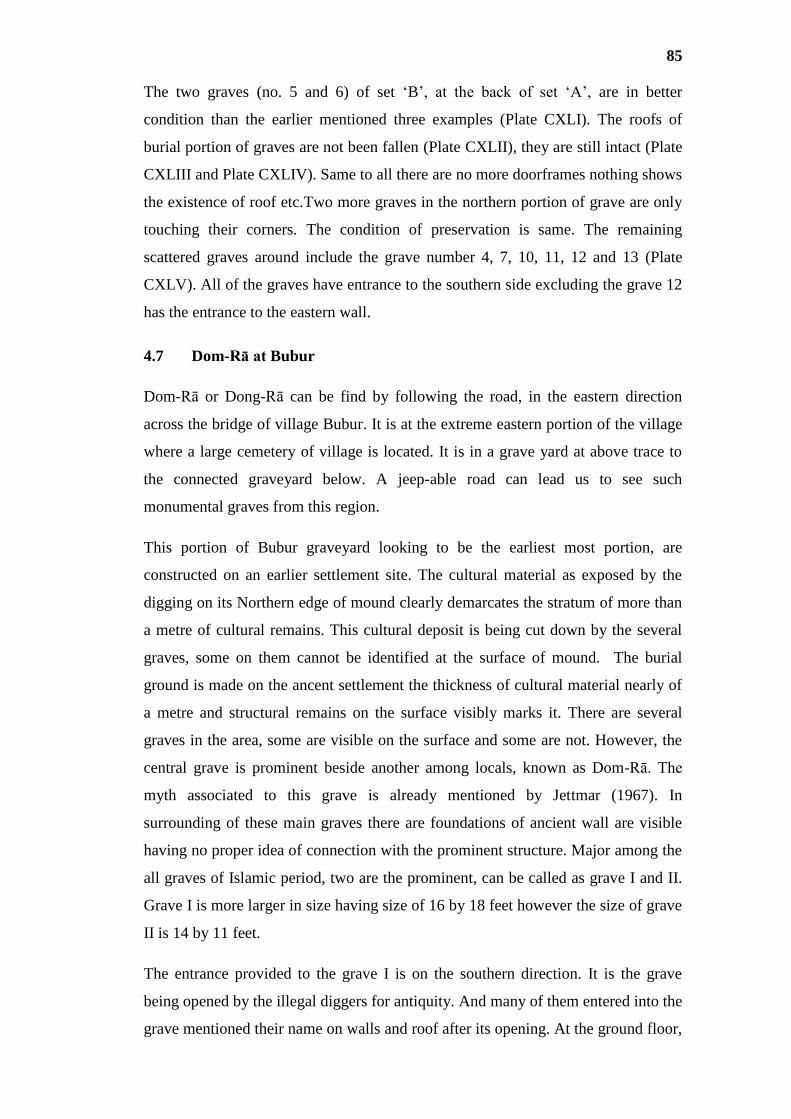
85
The two graves (no. 5 and 6) of set ‘B’, at the back of set ‘A’, are in better
condition than the earlier mentioned three examples (Plate CXLI). The roofs of
burial portion of graves are not been fallen (Plate CXLII), they are still intact (Plate
CXLIII and Plate CXLIV). Same to all there are no more doorframes nothing shows
the existence of roof etc.Two more graves in the northern portion of grave are only
touching their corners. The condition of preservation is same. The remaining
scattered graves around include the grave number 4, 7, 10, 11, 12 and 13 (Plate
CXLV). All of the graves have entrance to the southern side excluding the grave 12
has the entrance to the eastern wall.
4.7 Dom-Rā at Bubur
Dom-Rā or Dong-Rā can be find by following the road, in the eastern direction
across the bridge of village Bubur. It is at the extreme eastern portion of the village
where a large cemetery of village is located. It is in a grave yard at above trace to
the connected graveyard below. A jeep-able road can lead us to see such
monumental graves from this region.
This portion of Bubur graveyard looking to be the earliest most portion, are
constructed on an earlier settlement site. The cultural material as exposed by the
digging on its Northern edge of mound clearly demarcates the stratum of more than
a metre of cultural remains. This cultural deposit is being cut down by the several
graves, some on them cannot be identified at the surface of mound. The burial
ground is made on the ancent settlement the thickness of cultural material nearly of
a metre and structural remains on the surface visibly marks it. There are several
graves in the area, some are visible on the surface and some are not. However, the
central grave is prominent beside another among locals, known as Dom-Rā. The
myth associated to this grave is already mentioned by Jettmar (1967). In
surrounding of these main graves there are foundations of ancient wall are visible
having no proper idea of connection with the prominent structure. Major among the
all graves of Islamic period, two are the prominent, can be called as grave I and II.
Grave I is more larger in size having size of 16 by 18 feet however the size of grave
II is 14 by 11 feet.
The entrance provided to the grave I is on the southern direction. It is the grave
being opened by the illegal diggers for antiquity. And many of them entered into the
grave mentioned their name on walls and roof after its opening. At the ground floor,

86
there are two burial pits under the wall, nearly six inches deeper than the ground.
Walls are plastered all around. Roof is made of wooden planks arranged in east-
western alignment. There are four burial pits with human bones, under the eastern
and western walls.
The bones of these graves are very fragile and are not in better position to
understand their rituals and clear position of body. However the scattered bones
reveal that the head was in position to North and placed in stretched position.
The grave visited and documented by Karl Jettmar (1967). It was in better condition
when was visited by him. Its upper room was well perserved. Probably maintianed
by the tribesmen. Now nothing is in good condition, only the ramnent walls are
standing, above the burial room.
4.8 House of the Deads at Gupis
This house of the deads is located in the western portion of the town Gupis, at the
graveyard of Makan Khel tribe. The tomb (Plate CLIII) is connected to a shrine of a
saint (Plate IV), with grave and wall in rubble around, highly respected in the town.
Its size is 7.0 m in the East-West and 6.4 m. in the North-South plan. It is almost
square in plan and the only intact wall is to the Southern side of the wall. The walls
are of Sun dried brick, which is a different material of construction for such graves,
among the so far known examples. The roof over the grave seems bent down at the
surface level, and possible will fall soon.
4.9 House of the Deads at Yasin
At the location of Nani-mo-Ziyārat (Plate CLV) in the central town of Yasin, is
known by the same name, is a grave of the same kind. There is no particular name
called for such graves in Yasin. This grave was exposed by the locals in early
1990s. People claim that half of their bodies were buried and half was exposed. All
the characteristic features are same to examples in Punyāl area. Its size is 3.1 by 3.1
metres and square in plan. In the lower burial room there are only two niches under
eastern and western walls, different than the exposed example at Bubur.
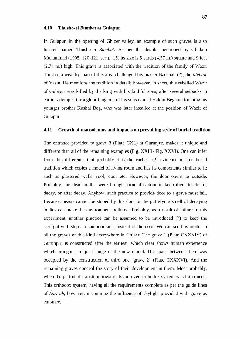
87
4.10 Thusho-ei Bumbat at Gulapur
In Gulapur, in the opening of Ghizer valley, an example of such graves is also
located named Thusho-ei Bumbat. As per the details mentioned by Ghulam
Muhammad (1905: 120-121, see p. 15) its size is 5 yards (4.57 m.) square and 9 feet
(2.74 m.) high. This grave is associated with the tradition of the family of Wazir
Thosho, a wealthy man of this area challenged his master Badshah (?), the Mehtar
of Yasin. He mentions the tradition in detail; however, in short, this rebelled Wazir
of Gulapur was killed by the king with his faithful sons, after several setbacks in
earlier attempts, through bribing one of his sons named Hakim Beg and torching his
younger brother Kushal Beg, who was later installed at the position of Wazir of
Gulapur.
4.11 Growth of mausoleums and impacts on prevailing style of burial tradition
The entrance provided to grave 3 (Plate CXL) at Gurunjur, makes it unique and
different than all of the remaining examples (Fig. XXIII- Fig. XXVI). One can infer
from this difference that probably it is the earliest (?) evidence of this burial
tradition which copies a model of living room and has its components similar to it:
such as plastered walls, roof, door etc. However, the door opens to outside.
Probably, the dead bodies were brought from this door to keep them inside for
decay, or after decay. Anyhow, such practice to provide door to a grave must fail.
Because, beasts cannot be stoped by this door or the putrefying smell of decaying
bodies can make the environment polluted. Probably, as a result of failure in this
experiment, another practice can be assumed to be introduced (?) to keep the
skylight with steps to southern side, instead of the door. We can see this model in
all the graves of this kind everywhere in Ghizer. The grave 1 (Plate CXXXIV) of
Gurunjur, is constructed after the earliest, which clear shows human experience
which brought a major change in the new model. The space between them was
occupied by the construction of third one ‘grave 2’ (Plate CXXXVI). And the
remaining graves conceal the story of their development in them. Most probably,
when the period of transition towards Islam over, orthodox system was introduced.
This orthodox system, having all the requirements complete as per the guide lines
of Śarī’ah, however, it continue the influence of skylight provided with grave as
entrance.

88
The prevailing style of burial, covering the basic concepts of orthodox approach in
Islamic tradition: The grave is constructed in orientation to Qibla by closing nearly
80 percent of burial pit with provided walls by covering with planks and keeping a
square skylight in the extreme southern portion. This becomes the entrance for
grave to enter the dead body. Usually, two men support for placing the dead body
inside the grave: first person standing in the entrance passes the body to the second
inside the grave. A person, inside the grave, who placed the body by turning his
head to right means Qibla, placing left hand on nave and right hand of dead person
placed straight in parallel to the leg. This person after placing dead body in said
posture, while coming out from the grave, dispels his foot impressions inside the
grave. Addition to this, in Hunza a person who dies on Wednesday, inside his grave
an Iron nail(s) is dragged, in order to seal the line of deaths in continuity after him,
according to their local myths. The same is also done for a person belonging to the
clan of Dhatusin-kutz, the flag holders of the State of Hunza. People believe that if
a person dies from this clan, he will take many with himself.
After the burial, usually on third day from death, a cenotaph is constructed and later
a wall is added around the grave, at the ground surface called Panji. This wall
around the grave is not unique, also known in other areas, but the ritual performed
after its construction of such wall are very unique, in which a big feast is offered for
the public, by slaughtering the animals, became full inside the walls around the
cenotaph of the grave with drinks, details are mentioned by Jettmar (1967: 71-72).
The geographical expansion of this burial tradition includes all the areas of Ghizer,
excluding the Wakhik or Ismā’ilis of Imit, not performing the same. In Imit the
Suni population practice this tradition but not Ismā’ilis. At Imit majority of
Isma’ilies are immigrants of Wakhan and Sunis are came from southern valleys
particularly from Punyāl. Both traditions of Islam, Ismā’ilis and Sunnies practice
this kind of burial in remaining Ghizer area. Ismā’ilism later in 1820/30s introduced
in Hunza, continues this modle in that area. In Chitral this culture is not popular
among Ismā’ilis. Thus this tradition is popular in Ghizer including Yasin and Gupis,
Punyal and a part of Ishkōman and in Hunza too. This is the third style of grave
architecture in Islamic tradition of burial, beside two known others.
This concept of burial is probably evolved on two grounds. First, continued the
model of covered grave with skylight entrance for burial and second grave cover the

89
basic principles of orthodox system, which is not challenged by this style. Making
it easier to understand, the skylight entrance was the need of architecture in gumbati
burials, whereas, it is not the requirement of Islamic grave. The concept of making
the grave house-like before the conduct of burial seems the influence of earlier of
gumbati burials model upon the modern Islamic one.
In very brief wording, firstly, the grave of gumbat was constructed with a door to
enter, which probably not continued. One can infer the cause of its discontinuity can
be due to the failure of the door in sealing the smell caused by the process of
decaying bodies. Than it was constructed with out providing a door, but the concept
of keeping a place as skylight was kept for its re-opening. With the decline of this
culture, and with the introduction of orthodox methods a skylight continued, which
even continues until now in majority area of Ghizer and in Hunza. (see
development in Fig. XXVII)

90
Chapter - V
THE CULTURAL HISTORY
In Punyāl, the earliest (?) signs of human existance are found marked on the surface
of a rock in village Thingdas, with a darker and varnished-like patination (p. 44).
Both, the subject matter and the depicted carvings can be related to similar
engravings dated to late Holocene era, in the Chilas zone (Dani 1983: 18, Salim
1998: 290, Hauptmann n.d.: 24-25), roughly falling somewhere between 5th
to 3rd
millennium B.C. Such discoveries, supports the idea of reconstruction of
environmental conditions of Holocene period, during post glaciation ages, when
thick glaciers were receding back (Schlütz 1999: 116-117, 121) and due to the rise
of precipitation in the valleys (Hauptmann (?) 2006: 4), one can visualise the lush
green summers and richness of the mountain areas in the availability of wild
animals. Probably, such green valleys, having good opportunities for the hunters
had attracted (?) the first human to this area.
Rock art at Sujo Ṭhōki, continues the story of man in this part of the world. When a
man has short range bows and arrows, cannot strike the wild animal at a distance, so
he used the trained dogs to gather them for easy hunting. The hunters of this age,
having the sense of selection of better hunt, give a little gesture of conservation (?)
of wild animals. The art (Plate XVI and Plate XVII) noticeably shows that, they
select the animals of old age, neither with kids and nor too young in age. Their
expertise in hunting is also visible here. They loose the arrow in the direction,
striking at the ribs right behind the front legs of the animal, where an arrow can
directly penetrate into the heart, and at the right movement the animal can fall.
More than this, the intellectual degree of man, before he was introduced to writing,
seems quite high. The depicted art (Plate IX) vividly show the observation of artists
toward the ecosystem, where the carnivores are shown stalking and hunting the
herbivores. The man of this age also domesticated various animals and particularly
the cow (Plate X) for the production of milk and meat. So, it means he was partially
dependent on hunting and gathering. The domestication of animal marks, the shift
in economy from hunting and gathering towards the practice of agriulture, which
can be dated (Salim 1998: 290) to Neolithic period (4000-2000 B.C).

91
Such anthropomorphic and zoomorphic carvings, illustrate human and animal
bodies normally with incised lines. Similarly, ancient man depicted animal figures
also with outline drawings, mostly hollowed and few filled. The carvings are
executed out by pecking. Such engravings on rock surfaces are very common in the
rock art sites of the Upper Indus Valley, mainly at Chilas I, Thalpan, Thor and
Gichi valleys (Mughal 1985: 214, Nasim Khan 1997-98: 169). Similarity of such
carvings as suggested by Jettmar (1982: 19) and Dani (1983: 15-24) to the drawings
presented on Neolithic and Bronze-age pottery from Central Asia.
The dipictions of carving related to ibex-types at Daldas in Darmandar (p. 45) can
let us know about three kinds of wild goats (Plate XXI): first, with recurved horns
presenting the Himalyan or Capra ibexes; second, with straight horns looks like (?)
the animal related to the genus of Oryx. This animal is also shown (?) sometime
with horns converging inward or tips extanding outward, and the third type of goat
is with zigzag horns is representing the Capra Falconeri Jerdoni or Markhor. There
are some more examples of its third type, depicted with long zigzag horns at
Thalpan (Bandini-Kӧnig et al. 1997: 48-49).
Next phase, in the cultural development, seems to be related with the megalithic
builders (Dani 1989 [Reprint 2001]: 118-119). In Ghizer District, there are eight
megalithic circles known so far from five different localities (pp. 46-49). Of them,
three are located in Hatun, one is in the opening of the Yasin valley near the
confluence of the rivers attached to town Gupis, another one is in Bijayōt (Yasin).
There were two more examples of this burial tradition at Manichi in Proper Yasin,
unfortunately one of them is lost now, and the other one is intact in its worst
condition of preservation. We have one more example of this culture, located at
Chaṣi in Gupis Tehsil. Such monumental graves have following characteristic
features:
a) The builders of such tombs had selected the site near the ancient banks of
the rivers normally, now bit away from. As we have noticed in Hatun, the
tomb near Gupis town, an example located at the confluence of the River
Gupis and the River Yasin, a case at proper Yasin, at Bijayōt, and that at
Jutal in Gigit area. In Hatun, the burials help us to imagine the height of the
river bed during the age of their construction, and three graves lined together
are very close to the river. In Yasin valley, such tombs are located in a plain

92
area now, but at the time of their construction, it seems to be very close to
the flowing river. In Jutal at Gilgit, the case is same to that at Hatun. Thus, it
is understandable that most probably the builders of such graves were
nomads who selected the site for their burial near the rivers. It also lets us
think that they may use to camp on the banks of the rivers, during their
seasonal stay, beside the water resources.
b) It seems that the dead body was not buried by digging a pit in the soil, but
kept on the surface at the ground level in East-West (?) direction, as we
observed the evidence at Manichi in proper Yasin (Plate XXXII),
surrounded by wall around and sealed by planks of stones over, which is
further covered with gravels with or without soil were filled around the
burial.
c) The filling inside the tomb was made of pebbles only or gravels mixed with
soil were deposited till the limits of the outer wall of vertically placed large
stones. In two cases, including that of Bijayōt and that located in the
opening of Yasin valley we have only the deposit of pebbles. Conversely, in
remaining five cases: one at Manichi in Yasin, three at Hatun and one at
Jutal the filled material is comprised of gravels mixed with soil.
d) The size of the grave, in its circumference and/or diameter and that of
vertically placed stones varies from grave to grave. The largest grave in
circumference is in Bijayōt with full diameter of 10.05 m. The tomb ‘A’ at
Hatun and that at Jutal have size in diameter by 8.2 m. Differently, the
megalithic grave ‘B’ at Hatun has size 7.2 m. in diameter. The smallest
example of this kind seems to be the tomb ‘C’ at Hatun its reconstructed
size seems (?) 5.5 m. in diameter.
e) Stones of huge and uniform size, preferably from the rivers were arranged
for the monumental construction of such graves. The heights of vertically
placed stones vary from tomb to tomb: In case of Hatun ‘A’ the stones
height from the present ground level is 0.7 m. but actual sizes of stones are
nearly 2 m. Hatun ‘B’ the height of standing stones from present ground
level is also 0.6 m. but actual size is unknown. In case of Hatun ‘C’, the
total height is 1.2 m. In Bijayōt the height is nearly a metre, from ground
level. And same is the size at Manichi in Yasin.
f) The outer wall, after the burial at ground surface, was constructed in three
stages can be classified as first, second and third:

93
a. At the first stage, megalithic stones are being placed in a circular
plan around the grave. During the placement of stones, builders kept
this in their mind that the smooth surfaces of the stones must be kept
exposed; however, the rough parts should be kept hidden to the
interior side. Between the two megaliths gapes were filled with
smaller ones.
b. On upper or second stage, elongated stones comparatively smaller in
size are placed horizontally with slightly projecting out from the
limits of standing megaliths.
c. On the third stage, the upper surface or the floor is made smooth by
placing the circular stones in the mosaic or left unfinished. The
evidence of floor is marked by the tomb of Hatun ‘B’. However, in
all other cases there is no visible evidence.
d. In the centre, right above the grave a big circular boulder was placed,
which marks the location of the grave below, as we have only the
evidence of grave ‘B’ at Hatun (Fig. II and Plate XXVI).
This phase of burial at our stage of research, it is purely inhumation. There is no
concept of cremation visible to us, so far. However, there must be some rituals,
such as those associated to fire (?), in this burial tradition, about which there is no
evidence left. Interestingly, such sites are not connected to any ancient settlements,
therefore, it can be assumed for these graves to be related with ancient nomads
(Hauptmann n.d.: 26), rather that of the settled people.
Large size stone cenotaph of burials are compareable to the circles of stones in
India (Gullapalli 2009: 442-444), proto-historic burial mounds between Aral Sea
and Pamir (Litvinskij 1984: 11-139) and to similar constructions in wood from
different localities in the Xinjiang region, as it is defined as as Gumugao II culture,
related to similar stone circles categorised as Andronovo Culture (Chen and Hiebert
1995: 253-257) including such examples in Siberia (Panyushkina et. al. 2008: 459-
469). This culture of proto-historic nomadic hordes is not only concentrated in
Ghizer area, but also extends to Astor (Vigne 1842, Dani 2001 [Rept. 2007]: 420-
428), Darel (Nasim Khan 2000: 110-113), Tangir, Goharabad (Gor) near Chilas,
Jutal on the opposite side Nomal in Gilgit (Dani 2001 [Rept. 2007]: 422).

94
The evidences of in big circles are comparable to the circles, also found in Siberia,
Urumqi and Kazakistan are dated on Radio Carbon analysis of data from several
sites which dates this culture to the latter half of 3rd
millennium and early half of 1nd
millennium B.C. (Chen and Hiebert 1995: 249-251, Panyushkina et. al. 2008: 464-
467). Indeed, the plan of tomb indicates towards the Solar cult. Such graves are
implausibly linked by Jettmar (1975: 229-230) to the memorial of raised plateform,
perticularly for the women Sīli spent her life with honour, called Sīlo-vei thali
(Ghulam Muhammad 1905: 102) in Ṣinā.
However, it contemporary and culturally related proto-historic burial tradition
known from Chitral, Dir, Swat and proper Gandhāra presents a complicated story
(Zahir 2012: 120). In this case, in dates, it shows the parallel to the earlier and fall
in between third millennium to fourth century B.C (Zahir 2012: 80). The later
culture is known to us with Gandhāra Grave Culture (Dani 1979: 42-56) or Swat
Valley Culture (Gupta 1979: 296-219, Müller-Karpe 1982: 12-128), broader
classified in three forms of burials: (1) inhumation, (2) cremation and (3) fractional
burial.
A systemetic study of ethnolography based on scientific investigation through
genetics can help us in understanding the complicated data of such cultures in
Central Asia and that in Chitral, Dir, Swat and Gandhāra. This is how the problem
of ethnic migration of nomadic groups into the valleys in and around Gandhāra can
be understandable. If in case the studies will unsuccessful to reveal the evidences of
ethnic migration, then the cultural connection during Bronze or Iron-age can be
assumed as the major reason behind the common origin of Indo-European
langauges. This can help us to resolve the unsettled academic puzzle of Aryan
Problem, divided the world’s scholarship into two areas of understanding
(Dhavalikar 2006: 1-2).
One can easily imagine about the development of burial cultures from inhumation
(?) into three of its above mentioned forms during Vedic Ages. It means in
Gandhāra, it is the transition from the inhumation towards the cremation, occurred
between 1500 to 500 B.C. It can also be assumed, of all the three, cremation
become popular in the later phases of development, and was in practice at the time
of Buddha during 6th
c. B.C. The similarities in the architectural features of
megalithic tombs and hemispherical Dharmarajikas vividly show the cultural

95
connection, and forces us to believe the origin of stupa cult rests in such earlier
models of monumental burials gesticulating towards the solar cult.
Contemporary to such nomads of Central Asia, settled culture can also be seen in
the ruins at Ghizer area (pp. 49-61). Their burials show to some extent their
connection to the above mentioned model. However, it is a pit burial, also different
than those of Gandhāra Grave Culture, and those of megalithic graves, above. Their
settlements are very close to such kind of burial sites of inhumation, such as in case
of (1) Bachimal in Bubur, (2) Karōsingal in Gurunjur, (3) Duran Sor in Dain, (4)
Kōṭ Ḍōli, (5) Kōṭ Khalti and (6) Deshing.
There is the evidence of terracotta pottery found from such sites, and makes it
visible that the inhabitants of this era knew the art of ceramics. We do not have any
evidence so far, which let us know about their writing. Besides so-called eye-beads,
people remember the findings of horse-like figures, from such sites which let us
think about cultural connection of this area with Central Asia, during the
millennium right before the Christian era. We found human bones from the sites
which indicate towards the burial tradition. It is inhumation, but to know the details
of such burial, whether it was fractional or pure inhumation, we need proper and
careful excavations.
Pottery collected from such settlements and burials have following characteristic
features:
a) All sites yield red ware.
b) Pottery is found both handmade and wheel turned also.
c) Sherds recovered from these sites show the same level of quality in their
manufacturing:
a. Everywhere, the soil is not well refined or not properly sewed out, to
raise the quality—soil is in a mixture of gravels of tiny size—and poorly
levigated (Plate LXX).
b. A small proportion of sand is also in mixture for making such kind
pottery; shining mica is visible in several sherds.
c. Baking pottery was there.
d) Variety of decorations on pottery includes only the technique of incised
lines.

96
e) From the surface we have only single evidence of painted pottery, black
applied on red ware.
f) The kinds of pots so far known include storage jars, cooking pots and dining
pots.
Locals have been found beads from several sites, but we came across from four
sites which reveal the sample of beads for this research. The sites include,
Karōsingal, Ayaśi, Deshing, and Ḍōli (Darmandar). These four sites yield around
seventy samples of various kinds of beads. Such beads are also different in their
sizes, weights, shapes and variety of semi-precious stones.
A hoard of beads is from Ayaśi, found by a villager in his field, in hand made
terracotta pot. Beside beads, some pieces of metal ore, an earring, finger rings, a
metallic bead, and a bronze seal have been found together. The bead in the hoard
includes fifty eight (58) examples as a whole: comprised of twenty nine (29)
samples of unknown semi-precious stone, nine (9) samples of carnelian, six (6)
samples of agate and one (1) of quartz and remaining are of variety of unidentified
semi-precious stones.
Three samples have been uncovered by a villager on the site of Karōsingal. Of
them, one sample is of agate, one of turquoise, and other is of unknown semi-
precious stone white in colour. Such beads are in fact comparable with the similar
socalled eyebeads from the sites in Indus Valley Civilization; its culture begins
around 7000 B.C. at sites like Mehrgarh (Kenoyer 2013: 1-17).
In Gupis from Ḍōli at Darmandar, locals dig out two examples: one is button made
of stone of schist (?) and the other is a bead made from the fossil shell. From
Deshing in Khalti the land owner found the beads while digging into beside pottery.
Of them majority was broken and of agate and other semi-precious stones.
Burials of this age with circular-like cenotaph with pit grave can be find in Duran
Sor, Bachimal and Shaheed-e Khat near Karōsingal. The stones are arranged in a
circle-like square in plan with a door provided from one side. In Duran Sor, Nazir
Khan found a pit grave below such circle with grave goods beside the human burial.
Grave goods include beads, metal objects of axes, figure of leopard and handmade
pottery of terracotta.

97
Dating this period in cultural history by adopting the methodology of relative
chronology, we are going to discuss the cultural relation between the antiquities of
this from Ghizer with such findings in the surrounding world. The seal giving an
impression of floral design, found in a hoard from Ayaśi among other artefacts in a
handmade terracotta pot is comparable with a seal with almost similar impression
found from Namazga IV and V of Early Bronze Age (2500-2000 B.C.). Seals from
Namazga IV and V include a seal with almost similar to the impression with four
petals (Gupta 1979: 137/ fig. 3.1), an another seal from site Atin Tepe from same
cultural level of Namazga V (Gupta 1979: 162/ fig. 1 of 3.15) we have nearly
similar seal of four petals/wings and another seal in copper with five petals/wings
(Gupta 1979: pl. XXXIII), found from Namazga V.
A pot, reconstructed from sherds of Karōsingal (Fig. VII, a.) is almost similar in
shape to (Gupta 1979: pl. VIII, d.) a pot found from Namaga V cultural level. So far
available pottery at the surfaces or that dig out by the treasure hunters from sites in
Ghizer are mainly decorated with designs of incised lines. Though, investigations in
Central Asia have brought a huge variety, in pottery types and also in decorations
executed in both painted and incised lines. Based on such evidence we need a huge
variety of data. Similarly, an Axe found from Duran Sor (Dani 1998: 162) is closely
similar to the discoveries from Daina (Gupta: 161).
From two sites in Ghizer namely Bachimal and Karōsingal, the local diggers claim
about the findings of horses-like metallic figures. Likewise, from Duran Sor, we
have similar finding but the figure is of a leopard (Plate LX) in bronze. A villager
named Himat claimed for a finding of a horse at Karōsingal, his description seems
similar to the stylised horse, we found in the collection of antiquity dealer at Gilgit
(Plate LIX). Dealer also informed us on our inquiry that it came from Ghizer
several years ago. The maximum length of this figure is 8.9 cm. and that of width is
6.3 cm. Head is carved with very similar features as of horse having same ears, nose
and mouth. The bent neck and six triangular extensions present its hairs. Its
abdominal portion is shown squeezing to inner portion, whereas crouched frontal
and back legs are turned inward and horseshoes are shown touching and the tail
hangs down at the back of the animal. Three circles with dots in the centre are
pressed on different parts of the body: two of the same size impressions are on front
and back thighs and a similar impression but of smaller size presents the eye of the
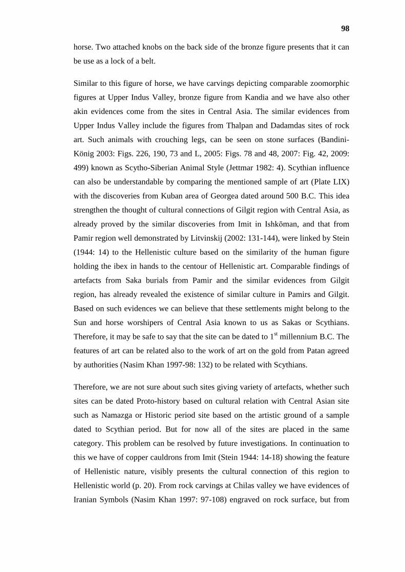
98
horse. Two attached knobs on the back side of the bronze figure presents that it can
be use as a lock of a belt.
Similar to this figure of horse, we have carvings depicting comparable zoomorphic
figures at Upper Indus Valley, bronze figure from Kandia and we have also other
akin evidences come from the sites in Central Asia. The similar evidences from
Upper Indus Valley include the figures from Thalpan and Dadamdas sites of rock
art. Such animals with crouching legs, can be seen on stone surfaces (Bandini-
König 2003: Figs. 226, 190, 73 and L, 2005: Figs. 78 and 48, 2007: Fig. 42, 2009:
499) known as Scytho-Siberian Animal Style (Jettmar 1982: 4). Scythian influence
can also be understandable by comparing the mentioned sample of art (Plate LIX)
with the discoveries from Kuban area of Georgea dated around 500 B.C. This idea
strengthen the thought of cultural connections of Gilgit region with Central Asia, as
already proved by the similar discoveries from Imit in Ishkōman, and that from
Pamir region well demonstrated by Litvinskij (2002: 131-144), were linked by Stein
(1944: 14) to the Hellenistic culture based on the similarity of the human figure
holding the ibex in hands to the centour of Hellenistic art. Comparable findings of
artefacts from Saka burials from Pamir and the similar evidences from Gilgit
region, has already revealed the existence of similar culture in Pamirs and Gilgit.
Based on such evidences we can believe that these settlements might belong to the
Sun and horse worshipers of Central Asia known to us as Sakas or Scythians.
Therefore, it may be safe to say that the site can be dated to 1st millennium B.C. The
features of art can be related also to the work of art on the gold from Patan agreed
by authorities (Nasim Khan 1997-98: 132) to be related with Scythians.
Therefore, we are not sure about such sites giving variety of artefacts, whether such
sites can be dated Proto-history based on cultural relation with Central Asian site
such as Namazga or Historic period site based on the artistic ground of a sample
dated to Scythian period. But for now all of the sites are placed in the same
category. This problem can be resolved by future investigations. In continuation to
this we have of copper cauldrons from Imit (Stein 1944: 14-18) showing the feature
of Hellenistic nature, visibly presents the cultural connection of this region to
Hellenistic world (p. 20). From rock carvings at Chilas valley we have evidences of
Iranian Symbols (Nasim Khan 1997: 97-108) engraved on rock surface, but from

99
Ghizer valley we do not have any avidence so far, which can be classified under
this group of antiquities from Upper Indus Valley.
Among the factors of decline of such settlements, for now, two are visible at the
surface: first is the flash floods, we can see a thick deposit of alluvial material over
the structural remains Karōsingal and Bachimal; and second is human conflict as it
is revealed by ashy layers at topmost stratums at Akṣēmī Kui, Ḍōli II and Kōṭ
Hatun.
Buddhism being introduced by Siddhartha during 6th
century B.C., became the
religion of Indo-Pakistan Subcontinent, when it received the royal patronage of the
Emperor Aśoka (Anand, A. K. 1996: 2-4). This was the time when this belief
system reached to the valleys of Gandhāra and Udhyana in the south of present G-B
(Zwalf 1996: 30). But it is unknown so far, whether, during this period, this beleif
system was introduced in the mountain region in the north of ancient Gandhāra or
not (?). Second patron of this religion after Aśoka was indeed Kaniṣka I of Kuṣanas
(Hauptmann n.d.: 29), ruled during earlier half of 2nd
c. A.D. It was this time when
Mahayana interpretation of Buddhism evolved, sprung from Gandhāra, and spread
to the remaining world including Afghanistan, Chinese Turkistan and Central Asia,
around present G-B. G-B is giving a short approach but difficult terrain on road
between Gandhāra, Central Asia and Chinese Turkistan. In said all regions we have
evidences of introduction of Buddhism, dated to mentioned period. So, G-B on road
between all, should receive the theology of Buddhism, during 2nd
c. A.D. However,
this is not visible is the ruins of Ghizer area. Conversely, Buddhism can be seen in
Punyāl area visibly during to 7th
/ 8th
c. A.D. This can be the age of its climax in
ancient Haṇēsarā.
Significance of epigraphy is always there to understand the ancient history of this
area (Hinüber 1989: 53-68). Haṇēsarā, being mentioned in important epigraphic
evidence at Hatun (pp. 62-67) as Viṣaya or District, is under our discussion now.
But presently, we do not have any genuine source, to identify the exact
geographical limits of this ancient District. This problem was for the first time felt
by Mark Aurel Stein (1944: 10), and was confused either this district was modern
Punyāl or Ishkōman. Latter, Dr. Chakravarti (1987: 227) blindly identified it with
Hunza, which was wrong (Dani, 1985: 5). However, Dr. Dani (1989 [2007 Rept.]:

100
34-35) suggested on probable grounds, that ancient Haṇēsarā could be present
Punyāl.
We do not have any story in tradition about the ancient names of Punyāl or
Ishkōman. But the name of the river Gilgit, only with its tributary of Ishkōman river
emerged in Karumbar Valley is known as Hanisārī or Anisārī in tradition, as also
told in a well-known Ṣinā proverb, “Hanisārī, kunī ẓākī” (p. 80). Biddulph (1880
[Rept., 2001]: 56), also defines and interprets this tradition as, “The river from its
source in Karoomber Valley [Ishkōman] to the Indus, is sometime called Anisari,
from anisar, which in the Khowar language, signifies a mountain lake,—referring
to the lake formed by the glaciers in the Karoomber Valley.”
Geographically, Hatun Inscription is very connected to Tehsil Punyāl22
, not now in
the administrative limits Ishkōman. It means Punyāl should be a part of ancient
Haṇēsarā, as already suggested by Dani. But the relation of river Hanīsāri with
Ishkōman River, in tradition, is indicating towards some relationship of ancient
Haṇēsarā with modern Ishkōman, in Antiquity. If this assumption based on the
information from said two sources is true, then ancient Haṇēsarā may be comprised
of both present Tehsils of Punyāl and Ishkōman. This epigraphic evidence also
proves that the District with this name survives thirteen centuries back, far before
the introduction of the Khowar Language in this area, therefore this term has
nothing to do with this language of Kho in Chitral, as assumed by Biddulph.
From this inscription, one can clearly understand the myth behind the kingship in
Gilgit region, which evidently mentions the Paṭolas were the descendents of Śri
Bhagadatta23
. Similarly, according to the tradition, the first and most important
qualification towards the acceptance as the King of Gilgit is his pure blood line. The
King must hold the royal blood from Śrī Badat through his paternal and/or maternal
lineage. The confusing and corrupt oral history of Gilgit always starts from this
name Śrī Badat. The same thing we can feel in the inscription at Hatun that the
Paṭolas were the descendents of Śri Bhagadatta. The tradition of Śrī Badat is related
to the Jataka of Brahmadatta by Mock (1998: 658-659). However, this story
concealing the truth behind, places Śrī Badat right before the dynasty of Tarakhans,
seems different to us. In Gilgit, the dynasty of Tarakhans is assumed to be the
22
It was earlier part of Ishkoman Political District, and part of the Kingdom of Yasin ruled by
Khuśwaqte family, before Colonial period. 23
Literally means the gift of Vedic god Bhaga (Kazanas 1999: 22)
101
descendent of Śrī Badat from his daughter remembered as Nur, keeping secret the
illicit relations with Azur, an external (Persian) prince and caused the birth of a
baby boy. Tradition (Muhammad 1905: 114-119) further narrates, in order to keep
this truth secret from her father, she was used in a conspiracy of Azur, and
frustrated nobles of Śrī Badat, to kill him, the King made of an Iron body and the
heart of Butter. This king is told in the tradition as a cannibal sovereign, who
imposed the tax of a baby to be slaughtered for him on his subjects, annually. His
daughter was the only person knowing the secrets of the possible way of his
murder. She knew that his heart was made of butter and can be killed with burning,
thus she exposed this to Azur. Tradition further narrates that his nobles and
suppressed subjects made a big fire, in front of the main entrance of the fort at the
midnight, keeping it the top-secret from him. But the family of the keeper of stores,
Ghulchin has not participated in it, and actually was the supporter of the King. In a
hurry, at the latter half of the night, the king was wrongly informed that his
kingdom is being attacked by the enemy. And was asked to reach the main gate of
the fort, where he was pushed into the burning well. People believe that he was
having godly powers, he sank into the soil came out in Punyāl. Where he demanded
water from a farmer. The farmer offered the wine to his Master, which lead him
towards the ultimate death. In the memory of this event, at Hunza and Nagir the
festival of Thumuśalling is celebrated, which continues until now. Now, the annual
date of its celebration is day and night of the 20th
December, and the morning of the
21st.
It seems (?) that this is the local or oral version of the story of Mahabharata
(Thadani 1935: 608-609). Probably, the story and scene presents the bettle of
Arjuna and Śri Bagadatta, in a different way. It is most probable that in oral
narration the Arjun is pronounced at Azur and Śri Bagadatta as Śri Badat in the long
period of more than thirteen centuries, when this traditions was first time brought in
writing. The inscription of Hatun is clearly mentioning the name of Śri Bagadatta,
from whom the Paṭolas were decendents. The subjects of Gilgit, Hunza and Nagir,
never accepted any one as their King until and unless he is not the direct decendent
of Śrī Badat. In Gilgit region, the blood line of the rulers of Nagir, the Magholote is
considered pure and directly decendent from Śri Badat. In past, several times, when
there was no male hierer to hold the throne of Gilgit. At such several occasions the
people of Gilgit approched Nagir and brought a prince from their in marriage with

102
their own female decendents of late Kings, in order to keep the bloodline pure.
From both sources of informations—oral and epigraphic—we can infer that the
Kings of Gilgit were the decendents of Paṭolas. On such grounds, it would be safe
to say that there would not be any break of ruling family between the Tarakhans and
Paṭalos.
From the same inscription in its fourth line, mentions after the long title of
Makarasiṁgha “...Bakhta Ka[ñchu]diya mahamāttyavara mahāsādha(ma)ntipati...”
a word “Gilgittā Sarāṃgha” appears. Chakravarti (1954) translates this non
Sanskritic word by analysing it with word “sar-hang” of Persian and assumes the
meaning chief commander of the army for it. However, it seems implausible. The
complete name of Gilgit, is locally pronouned as Sārgin Gilit. Long history already
coroupted the word Giligitta as Gilit pronounced by the Ṣinā speakers, and its more
coroupted form Gīlt is spoken by the speakers of Buruśaski and plausibly Sārgin
may be a distorted form of Sarāṃgha, already suggested by Dani (1989 Rept.
2007]: 46). Thus, on this ground we can infer, both words refers it to the complete
name of city Gilgit.
Several investigations have already been made to establishing the chronology of
Paṭōla Ṣāhis decended from Śri Bhaghadatta. The first person to notice a name of
ruler belonging to this forgotten dynasty was Nalinaksha Dutt (1939 [Rept. 1984]:
34) found mentioned the manuscript of come from Gilgit during 1930s. The
manuscript mentions the name of Śrīdeva Śāhi Surendra Vikramāditya Nanda.
During hurry excavation at the same site in 1938, Kaul Shastri found another
manuscript of the mahamayuri mentioning the name of Nava Surendraditya
Nandideva (Mukherjee 1987: 25).
When inscription of Hatun was deciphered (Chakravarti, 1954: 230-231) we again
come to know about the name of śri Nava- Surēndrāditya Nandidēva. Similar to
the evidence from colophons of Gilgit manuscript, further adds the names of other
Kings, including Vajradityanandi, Vikramaditya Nandi and Surendra Vikramaditya
Nandi. A single line inscription discovered by Jettmar (Hinüber 1985: 63) near
Hudur speaks “Śr[i] (pa)lola Shahi (Surendradityanandis sarva) dharmoyaṃ”.
Hinüber (2004: 85-99) attempted to establish the genealogy of nine rulers of
Paṭolas, from Somana to Surendraditya dated between 5th
/6th
to 8th
century A.D.,
based on epigraphical evidences. In connection to this, an inscription on incense

103
burner adds the name śri śīlādityanandin to the list (Hinüber 2010: 3-8). The
broader geography of soverignity of the dynasty of Paṭōlas, is demarcated by
mentioned epigraphical evidences, and center of rule seems at Gilgit, However, a
group of authorities believe it to in Baltistan for the first time argued by Jettmar
(1989: XIX). The inscription from Hatun, has marked Ghizer part of soverignity of
this ruling house. So, the centre of the rule of this dynasty is awaited to be resolved
with more strong evidences.
When this inscription was identified by A.P.A. in 1930s, with the suggession of
Stein, Afrazgul Khan was directed to Hatun in order to take an impression of Hatun
Inscription (Stein 1940: 103). Beside this activity, he also sketched the map of
archaeological remains in the area (Map XI). Including the ruins of ancient canal,
mounds of settlements and the graves of megaliths. Later, when Chakravari (1950)
deciphered it, the inscrption was found speaking about a canal named
Makaravahini, of size 32000 hastas (around 1.25 kilometres). We can still see a line
of stones leading towards the Insciption from its eastern side marking the existance
of canal (see Plate XCVI). Its construction is commemorated by this inscription on
Friday 19 December 671.
Specimens of Buddhist art are mainly presented in the sculptural and relief
examples from this region. This is what we are going to explain here. Data is not
enough available to establish the development in relation to the art history but it is
sufficient enough to understand its basic and esthetic features to study in relation to
similar examples reported from ancient world of Buddhism in and around G-B.
Two reliefs workout on one stone from Bubur (pp. 67-69) let us know about the
Buddhist art of ancient Haṇesāra dated to eight century A.D. The figure ‘A’ of
Buddha to front is much eye catching than the distorted figure carved on the other
side of the stone. This work of art is closely assimilated to the depictions of Kargha
Buddha and that of Mulbe Chamba Ladakh (Dar 1985: 194). The depiction of
abhaya is also same to that of Kargah. Eyes are large, depicted as fully covering the
eye sockets and ear lobes are touching the shoulders and body below the nave is
that of feminine. Another example of figure of Buddha from Upper Gahkuch, marks
the same characteristic features: with large eyes, and ear lobes touching the
shoulders. Thus the ear lobes touching shoulders with cut in it and large eyes with
feminine lower body are the unique characteristic features of this work of art at

104
Gilgit and Ghizer area. The features of this figure closely relate to the features of
so-called Gilgit-Kasmir Bronzes, however, a detailed study is needed to understand
the linkages.
The architecture, of Buddhist period is marked by the structure at Sumāl (pp. 69-
70). The building seems to be a monastery, as a circular stone with a hole (Plate
CXII) suggests being a chatra of a stupa. The illegal digging on the site, exposed a
room rectangular in plan is probably a monastic cell. The walls are constructed with
elegantly placed stones and small ones around the bigger to fill the empty spaces in
the wall. It is almost looking to be a copy of semi dapper mesonary of Buddhist age
from proper Gandhāra and Taxila.
Tibetan inscription of same period indicate towards the movement of Tibetan from
this area during the period of their climax. Seven inscriptions with ten specimens of
stupa drawings visibly mark the sacredity of the place and may be connected to
Sino-Tibetan conflict. From the site we also collected several sherds of terracotta
potery, which marks about ancient offerings brought to these sites of religious
importance.
There is no visible evidence which marks the existence of Hinduism here. However
recent researches24
prove the survival of Shivism in Gilgit and Chilas zones based
on rock art evidences (Arif 2001: 35). Probably after the decline of Buddhism,
Bonism or Shamanism, regained it popularity, was already known in this region and
survived even beside Buddhism. There is no evidence of monumental architecture
falling to this age. However, we have evidences of structural remains in four
localities. The places are known as Kuturot Kōṭ, Kaṣiṣal, Loe Kho and Ziyārat-ei
Lāṭh. All the sites are build with same style of mesonary in rubble and strucral
dumps can be suggested contemporary to one another. Anyhow, the problem will be
resolved by future insvestigations through excavations on the sites.
Ismā’ilism was already introduced in Central Asia, due to the unique preaching of
baṯini (esoteric) interpretation of Islam by Nasir-e Khisrow (394 A.H./1004 to
1077) and his disciples, centred in Yumgan, Khurasan and Badakhshan; extended to
Gilgit region too with the invasion of Taj Moghul (Hunzai 2004: 151). However,
archaeology of this region proves the hypothesis of Daftari (1998: 205) about dating
24
An inquiry about Gilgit Fort site and archaeological evidences related this site are helping us
understand about Hinduism, an investigation is in pipeline, will be available for the readers soon.

105
the re-introduction of Ismā’ilism here during Anjdan period, 16th
/ 17th
c. A.D. It is
connected to bringing of the renaissance in Ismā’ili preaching in Central Asia and
India. In this connection, Imām Mustansirbillah II of Nizāri line of Ismā’ilis
despatched several trusted Da’is to Central Asia, Afghanistan and Persia beside
Indian subcontinent (Daftari 1998: 171). Thus, the Shi’i interpretation of Islam
with Ismā’ili model again reached, Chitral, Ghizer and further expanded to the
region of Hunza (Hunzai 2004: 152). This introduction of Islam probably forced the
locals to change their burial traditions. Thus, most probably a transitional model of
burial tradition of gumbati (mausoleums) emerged out between the pagan funeral
model(s) and orthodox burial based on Islamic principles (pp. 78-89). There must
be the gradual and regular preaching which can shifted this model into the proper
Islamic style. However, a small architectural inspiration of former style of keeping
the skylight to southern side of the grave, left retained in orthodox model. This
orthodox model most probably emerged in Punyāl, reached further to Hunza during
early half of 19th
c. A.D. Based on the oral tradition, it is believed that Ismā’ilism
reached Hunza from Badakhshan (Hunzai 2004: 152). However, the similar and
unique burial tradition in Ghizer and Hunza let us think that it may reached Hunza
after flourishing in Ghizer first. So, it is more logical to say that Ghizer worked as a
centre for Ismā’ili preaching during late 18th
century and beginning of 19th
century
A.D. The climax of Ismā’ili preaching in Ghizer, probably ended the vernacular
belief system having shamanistic approaches. Most probably, it is this reason that,
now, Shamanism cannot be seen in Ghizer. However, it still survives in Gilgit,
Hunza and Nagir areas. Currently, in Ghizer people believe much in the decendents
of Ismā’ili Pīrs.
Before the reach of Dogra/colonial power into this area, the present District of
Ghizer was divided into two principalities: Yasin and Punyāl. However, Gohar
Aman of Khuśwaqte family ruled both of the principalities, jointly. We have some
architectural monuments can be dated to this age. The specimens include the forts
and fortified settlements. Such architectural examples were constructed in wooden
frame or kaṭor, which can be seen very popular in whole region during this age. The
decorations on the columns and door frames are very common, adorned with floral
and geometrical designs. The sites of this period include the remains of Yasin Fort,
Muduri Fort Sandi, Ishkōman Kōt, Takht-e Khatan (Yasin), Royal Cemetry of

106
Khushwaqte Family, Gahkuch Fort. However two votive shrines of Maghjut Ziyarat
at Ishkōman and Shetham dādo Ziyarat can be included in the same category.
Anglo-Indian architecture became a popular style during the colonial period in
South Asia. Due to the Great Game and expansion of Dogra/Colonial power,
particularly to Yasin (Hopkrick, 1990 [Rept. 2006]: 340) brought the style of
Colonial architecture into this mountain area. Among some of the buildings of this
era the fort of Gupis is the prominent example of this style of architecture. The
masonry is semi-ashler. It is a military fort constructed on rectangular plan.

107
Chapter - VI
SUMMARY AND CONCLUSION
Among the sources that help in the reconstruction of the ancient history of Ghizer,
foreign accounts contribute a minor share (pp. 12-14). Likewise, the oral tradition is
creating a vague picture connected to the events in remote past (pp. 2-3). In this
scenario, we have only the archaeological data, which can help us to establish an
outline of the cultural history. Thus, to understand the cultural profile of District
Ghizer, an exploration based archaeological investigation is conducted in this
region, with special emphasis on Tehsil Punyāl (pp. 23-31).
Before approaching Ghizer, we knew about eight topics on archaeology and/or
history of this area, from previous attempts (pp. 12-22). In chronological order, the
first topic that let us know about the earliest evidences of human presence in Punyāl
was the Bronze/Iron-age graves, for the first time documented by Biddulph, which
were inferred as the remains of Dards (?) by Dani, are suggested earlier than the
similar evidences in Kashmir and South Asia dated to Iron-age by Hauptmann. The
second topic is about two artefacts from Imit, which provide with a better
understanding about the cultural connections between Ghizer area, Central Asia and
Hellenistic world, was studied for the first time by Stein, and later by Jettmar, Dani
and Litvinskij have also contributed with new information about these antiquities.
The third topic deals with the Chinese pilgrim Fa-Hsian, who, according to
Tsuchiya travelled through Ghizer to reach Darel. The fourth topic is about the
Hatun Inscription, deciphered for the first time by Chakravarti. Later on Sircar
amended the same information, which was again investigated by Fussman. In this
connection, the Hatun Inscription was interpreted from a historical perspective by
Jettmar, Dani, Fussmann and Hinüber in order to understand the history of Paṭōla
Ṣāhis, (p. 103) in particular. The fifth topic is about the city of Makarapura,
established by Makarasingha, mentioned in the same inscription; its remains are
shown in a map drawn by (Khan Sahib) Afrazgul Khan but published by Stein. The
sixth aspect is about Sino-Tibetan Conflicts in Yasin, which Stein has attempted to
eleborate. Seventh topic is about the mausoleums of gumbati, which was narrated
for the first time in a legend connected to an example from Gulapur, by Ghulam
Muhammad. This burial tradition was later re-discovered by Friedrich at Upper
Gahkuch, unaware about the information mentioned before. However, later Jettmar

108
visited a mausoleum of same kind at Bubur following the footprints of Friedrich
and studied in comparison to the burial cultures in Central Asia. The eighth and last
topic is about the twin dynasties of Ghizer, explained by Biddulph.
Field work of a month in the area of study was conducted in four intervals during
the first quarter of 2014 (p. 26-31). During this survey, proper procedure and
methodology was adopted to gather the maximum accessable data. Field interviews
played a key role in this exploration. Following the guidance received in such
interviews, we approached the sites through field walk. The archaeological remains
in the area were documented according to the details asked in the proforma. The
visible features were captured in photographs, with the record of their description,
and the surface collection of samples.
This investigation adds one more specimen to the evidences of earliest human in
this region can be dated back to somewhere between the 5th
and 3rd
millennium B.C.
So far, the only material evidence which represents the prehistoric periods is a
evidence of rock art at Thingdas (Punyāl). This work of art is very similar to the
depictions of late Holocene-age examples from the Chilas region (p. 91). The
human of this age, illustrated on rock surface is looking socialised in character.
The site only mentioned in the past with reference to its location, named Sujo Ṭhōki
(p. 91-92) adds new to our understanding about the development of human toward a
higher level culture leading towards civilisation. Several depictions of hunting
scenes on rock surfaces and depictions of domestic animals clearly show the
domestication of cows and oxen, and the human of this age was partially dependent
on hunting and gathering. Hunting of wild animals was made with the help of tools
like bows and arrows, and with the support of trained dogs. More than this, the
higher level of their understanding about the ecology of the mountain area is
observable here. It is the evidence of their deep observation and understanding
about their environment. Hunt selection, visibly shows their approach towards the
hunting assortment. It lets us know that animals selected for the hunt must be older
in age, neither with kid(s) and nor too young. From this act, one can understand
their approach towards hunt selection or can feel the sense animal conservation (?).
In the past inquires, Bronze-age graves constructed with megaliths, arranged in a
circular plan, were not studied collectively. Here it is attempted to understand this

109
burial culture of such megaliths, in more detail, in relation to Andronovo burial
tradition of nomads in Innermost Areas of Asia (pp. 91-94). The similarity in
features of such graves with the examples in Chinese Turkistan, Siberia and
Mangolia of 3nd
or 1st millennium B.C. has clearly marked alike. From this
similarity, one can easily infer about the Central Asian nomads perhaps travelling in
between the limits of Siberia in the North and G-B in the South.
A settlement and a burial site of pit graves, different than that of megaliths were
only known to previous investigators from Dain in Ishkōman. Such settlements and
burials of this age were in dire need of an extensive survey, as felt necessary by
Dani (1989 [Rept. 2007]: 118-119). It is this research, which improves the previous
understanding about such ancient settlements and adds more than twenty sites (Map
VII, pp. 49-61 and 94-98), to the list of this category, from the surface information.
From such sites, we have evidences of practice of agriculture, use of beads as
jewellery, metallic instruments, ceramics and their burial practices, mainly.
Such settlements were established on the glacier water. The cultivable terraced
fields were constructed to produce varieties of agricultural products. The water,
flows in ravines was canalised and brought to the fields in a systematic way. Thick
deposits of fertile soil in such fields, reached with mud brought by muddy glacier
water of summers, clearly show that the agriculture was practiced here for a very
long period. The extensions of the walls of a terraced field built in rubble masonry
marks the development of agriculture should be for a very long period, extending
over several centuries. Now, the majority of such fields are re-established by a
modern population, everywhere in Ghizer. Anyhow, the untouched ancient
settlements of such kind include Akṣēmī Kuī and Śetikei. The sites of this age,
probably dated to proto historic or early historic periods, reveal both handmade and
wheel turned red ware, bronze ornaments, bronze seal and a variety of beads, both
from settlement and burial sites of this age. Here the settlements and burial are
found together in same locations, such as in case of Duran Sor, Bachimal and
Karōsingal.
Buddhism perhaps reached this area during 1st or 2
nd century A.D. (pp. 98-99).
However, Shamanism, the vernacular belief system, can believe to be in co-
existence alongside Buddhism. From the material remains, one can easily note the
climax of Buddhism during 5th
/6th
to 8th
century A.D. However, contemporary

110
information from Tibetan sources, we know the popularity of Bon or Shaman
priests in this area (p. 13). Beside the works of art related to Buddhism, we have an
evidence of monastic establishment at Sumāl. We have also the monumental
inscription of Hatun, letting us know about various cultural and historical aspects
and particularly about Paṭōlas (pp. 99-103). The findings related to Buddhist
specimens of art from Upper Gahkuch, Hōl and Bubur help us to understand the
local features, in relation to its contemporary art. Historical sources help us to know
the Sino-Tibetan Conflicts in Ghizer (pp.16-17). However, we do not have any
evidence which marks the survival of Hinduism here in Ghizer area.
Buddhist art (p. 103) of this age has a stylistic connection with that of Ladakh,
which has deep roots in Mathuran styles of Kushana Art. However, the elongation
of ear lobes, touching the shoulders; feminine lower body of such figures are the
unique stylistic features. The monastic robe in the works of art of this period is
depicted in an artificial way around the neck, which drops down from the shoulders
and below arms it become visible at the lower part body, below nave and hands,
unlike two garments of earlier Indian style.
Structural dumps of fortified settlements, not attracted the proper attention of earlier
scholars, seem to be of Medieval-age (?), include the ruins of Kuturōṭ Kōṭ, Ziyārat-
ei Lāṭh, Loe Kho and Kaṣiṣal (pp. 69-70). In majority cases, it seems that the
locations of such settlement sites were selected by keeping the security point in
view. So, such sites are located on a cliff above the main valley in three cases, but
one of them, a site at Kaṣiṣal is different and located in the basin of the valley, near
the river. The masonry is everywhere same as rubble. The outer walls are thick as
large as a metre and inner walls are thin as 0.3 m., as an average. Three earlier sites
are located separately than cultivable area, but the last settlement is located among
the terraced fields. They all do not yield any kind of pottery in terracotta. Thus, the
decline in use of terracotta in this area was probably around 9th
to 12th
century A.D.
The focus of our investigation, according to the objectives of this research, is on the
analytical study of gumbati mausoleums. Such graves are called by Friedrich (pp.
18-19) as ‘Totenhaus’, Jettmar mentioned them as ‘Collective Tombs of Islamic
period’, and also styled in exaggerated form by Ahmad Hasan Dani as ‘Gumbad-e
Raisan’ and associated this culture with Zoroastrians (p. 21). The geographical
expansion of such burial extends from Gulapur to Yasin, however, the

111
concentration of such graves is in Punyāl area, particularly in Gurunjur (p. 78). The
examples of such burials are located, in every case, at Islamic period graveyards. In
every grave yard the oldest Islamic are surrounded by such mausoleum and the
latter examples spread around. Thus, this tradition indicates towards the inception
of Islamic burial culture in this area, and can be placed in the transitional phase
leading towards Islamisation, by supporting the idea of Friedrich and that of
Jettmar’s earlier view, this culture is dated some where around 16th
/17th
century,
contemporary to the Anjdan period (pp. 88-90 and 105) of Ismā’ili History, when
the renaissance was brought in preaching the religion in Central Asia.
We have two sources to know about the pre-gumbati funeral culture from an
anthropological prespective: first, the sticks wrapped in funeral cloth are flowed
into the river; or second, the same sticks are thrown in old graves. The optional
rituals help us to establish a hypothetical understading about the burial culture(s),
which not lived any strong material proof. From this ritual one can assume it either
related to let the dead bodies allowed to flown in the river first, or second, may be
dumped inside the caves (pp. 79-80). The first hypothsis, is supported by the
evidence of known proverb, mentions the river Hanisārī as the dragger of dead
bodies. The second hypothesis is supported by evidence of caves with scatered
bones from Upper Gahkuch and from Shirot (?). This kind of new tradition having
few examples, more developed than the earlier models, was most probably
introduced by the Pīrs of Qasim Śāhi Nizāri Ismā’ili interpretation, having their
centre at Anjdan, connected to the revival of Ismā’ili preaching in Central Asia.
Most probably this tradition was a transitional model (?) between the practice of
exposing the dead bodies to the nature, and the development towards the orthodox
burial tradition of Islam. Probably the earliest example of this tradition is in
Gurunjur, Grave number 3 (pp. 82-84 and p. 86). This transitional culture most
probably survided for a short period, which has a structural impact on the local style
of Islamic burial tradition, continues till our age. The graves constructed with
covering sealing planks of stones over the majority portion of the burial pit, with
keeping an opening in the skylight-like form, to enter the dead body into the grave
(pp. 86-88). This style is not known beyond Imit, Darkut (?) and Phandar (?).
Though, along with the preaching of Pīrs, having their centre at Ghizer have copied
and introduced this model in the area of Hunza. So, this style is also common

112
among the Ismā’ilis of Hunza, beside the Ismā’ilis and Sunis of Ghizer. A culture of
construction of graves, with only keeping the skylight-like opening before the
burial, is most probably the continuity of that in collective burial, which is in
practice till our age.
There are several unresolved academic issues related to Ghizer archaeology and/or
history. In this regard, future investigations can focus on the following five areas of
study, including intensified field research by systemetic documentation of
archictectural monuments and other antiquities: First, archaeological explorations
are needed in Gulapur and Sherqila villages of Punyāl. Second, the pasture lands of
Ishkōman, Gupis and Yasin can be investigated through extensive survey from
where locals have collected different kinds of artefacts. Third, the area of Yasin
particularly beyond Sandi is in need of proper investigation. Fourth, the region of
Gupis beyond Khalti can be archaeologically surveyed in detail. And fifth, the
problems in understanding the cultural development during proto-historic or historic
periods (p. 49), Buddhist and medieval ages can be resolved by investigating the
settlement and burial sites of different periods mainly by conducting systematic
excavations. Such studies will add significantly to the understanding about the
cultural history of Ghizer.
113
Bibliography
Abetekov, A. and H. Yusupov. 1996. Ancient Iranian Nomads in Western Central Asia.
In J. Harmatta (ed.), History of Civilizations of Central Asia Volume II. (pp.24-29).
Paris. UNESCO Publishing.
Anand, A. K. 1996. Buddhism in India, from the Sixth Century B.C. to the Third
Century A.D. (Religion, Civilisation, Indology). New Delhi: Gyan Publishing
House.
Arif, M. 2001. Study of Petroglyphs of Buddhist Period along the Silk Road between
Shatial and Khunjarab Pass Northern Areas, Pakistan. University of Karachi:
Thesis Submitted for PhD Degree in General History.
Bandini-König, D. 2003. Die Felsbildstation Thalpan I. In H. Hauptmann (ed.),
Material zur Archäologie der Nordgebiete Pakistans Band 6. Mainz: Philipp von
Zabern.
Bandini-König, D. 2005. Die Felsbildstation Dadamdas. In H. Hauptmann (ed.),
Material zur Archäologie der Nordgebiete Pakistans Band 5. Mainz: Philipp von
Zabern.
Bandini-König, D. 2007. Die Felsbildstation Thalpan II. In H. Hauptmann (ed.),
Material zur Archäologie der Nordgebiete Pakistans Band 7. Mainz: Philipp von
Zabern.
Bandini-König, D. 2009. Die Felsbildstation Thalpan IV. In H. Hauptmann (ed.),
Material zur Archäologie der Nordgebiete Pakistans Band 9. Mainz: Philipp von
Zabern.
Bandini-Kӧnig, D., M. Bemmann and H. Hauptmann. 1997. Rock Art in Upper Indus
Valley. In H. Hauptmann (ed.), The Indus Cradle and Crossroads of Civilizations ,
29-70.
Beals, S. 1869. Travels of Fa-Hian and Sung Yun, Buddhist Pilgrims from China to
India. London: Trübner and Co.
Biddulph, J. 1880 [Rept., 2001]. Tribes of the Hindoo Koosh. Lahore: Sang-e-Meel
Publications.
Bivar, A.D.H. 1984. Maues at Taxila. Journal of Central Asia, 7, pp. 5–15
Cunningham, A. 1854 Ladảkh, Physical, Statistical, and Historical; with Notices of the
Surrounding Countries. Lodon: WM. H. Allen and Co. 7, leadenhall Street.
114
Chakravarti, N. P. 1954. Hatun Rock Inscription of Patoladeva. In N. L. Sircar (ed.),
Epigraphia Indica Volume XXX (1953-54) (pp. 226-230). Janpath, New Delhi: The
Director General Archaeological Survey of India.
Chen, K. and F. T. Hiebert. 1995. The Late Prehistory of Xinjiang in Relation to Its
Neighbors. Journal of World Prehistory, Vol. 9, No. 2, pp. 243-300.
Chohan, A. S. 1985 [Reprint 1998]. The Gilgit Agency. New Delhi: Atlantic Publishers
and Distributers
Daftari, F. 1998. A Short History of Ismailis. Edinburgh: University Press.
Dani, A. H. 1978. Gandhara Grave Culture and the Aryan Problem. Journal of Central
Asian Studies, Vol. I No. 1, pp. 42-56.
Dani, A. H. 1983. Chilas, the City of Nanga Parvat (Dyamar). Islamabad: Published by
Author.
Dani, A. H. 1985. The Sacred Rock of Hunza. Journal of Central Asia Vol. VIII No.2,
5-85.
Dani, A. H. 1989 [R. ed. 2001, Rept. 2007]. History of Northern Areas of Pakistan
(Upto 2000 AD). Lahore: Sang-e-Meel Publications.
Dani, A. H. 1989. Islamic Architecture: The Wooden Style of Northern Pakistan.
Islamabad: National Hijra Council.
Dani, A. H. 1995. Human Records on Karakorum Highway. Lahore: Sang-e-Meel
Publications.
Dani, A. H. 1998 or 2001 [Rept. 2007]. Origin of the Dardic Culture: A New Discovery
in the Northern Areas of Pakistan. Journal of Asian Civilization (Formerly Journal
Central Asia) Vol. XXI No.1, 153-183. or In A. H. Dani, History of Northern
Pakistan (pp. 420-429). Lahore: Sang-e-Meel Publications.
Dar, S. R. 1985. Rock-cut Standing Figure at Kargah, near Gilgit: Some Throughts on
its Identification, Origin and Date. Journal of Central Asia, Vol. VIII No. 2
December, 191-211.
Das, A. C. 1920 [Ed. 1980]. Rgvedic India (Cultural History of India as depicted in the
Rgveda). New Delhi: Cosmo Publication.
Dhavalikar, M. K. 2006. Archaeology of the Aryans. Annals of the Bhandarkar
Oriental Research Institute, Vol. 87 pp. 1-37.
Dutt, N. 1939 [Rept. 1984]. Gilgit Manuscripts. Delhi: Sri Satguru Publications.
Eggermont, P. H. L. 1984. Ptolemy, the Geographer, and the People of Dards:
Alexander in Buner, the Aornos Problem and the Dards of Dyrta. Journal of
Central Asia, Vol. VII No. 1 July, 73-124.

115
Fussman, G. 1993. Chilas, Hatun et les Bronzes Bouddhques du Cachemire. In K.
Jettmar (ed.), Antiquities of Northern Pakistan, Reports and Studies (pp. 1-60).
Mainz: Verlag Philipp von Zabern.
Fussman, G. 2001 [Rept. 2007]. Languages as a Source for History. In A. H. Dani,
History of Northern Pakistan (pp. 52-67). Lahore: Sang-e-Meel Publications.
Gafur, M. A. 1965-66. Two lost Inscriptions relating to Arab Conquest of Kabul on the
North-West Region of West Pakistan. Ancient Pakistan, Vol. II, 4-12.
Ghufran, M. M. 1893. Tārīkh-e Chitrāl (Fārsī) Nuskha-e Thānī. www.
Mahraka.com/ghufran/chapter-3.html.
Gullapalli, P. 2009. Early Metal in South India: Copper and Iron in Megalithic
Contexts. Journal of World Prehistory, Vol. 22, No. 4, 439-459.
Gupta, S. P. 1979. Archaeology of Soviet Central Asia and the Indian Boarder Land.
Vol. II, Delhi: B. R. Publishing Corporation.
Hauptmann, H. n.d. Pre-Islamic Heritage in the Northern Areas of Pakistan. In S.
Bianca (ed.), Karakoram Hidden Treasures in the Northern Areas of Pakistan. Aga
Khan Trust for Culture.
Hauptmann, H. (?) 2006. Rock Carvings and Inscriptions along the Karakorum
Highway. Heidelberger Akadamie der Wissenschaften.
Hinüber, O. V. 1985. Royal Inscriptions from Northern Pakistan. Journal of Central
Asia, Vol. VIII, No. 1, July, 59-67.
Hinüber, O. V. 1989. Brāhmī Iscriptions on the History and Culture of the Upper Indus
Valley. In K. Jettmar (ed.), Antiquities of Northern Pakistan, Reports and Studies
(pp. 41-72). Mainz: Verlag Philipp von Zabern.
Hinüber, O. V. 2004. Die Palola Ṣāhis: Ihre Steininschriften, Inschriften ouf Bronzen,
Handschriftenkolophone und Shutzzauber—Materalien zur Geschichte von Gilgit
und Chilas. In H. Hauptmann (ed.), Antiquites of Northern Pakistan, Reports and
Studies Mainz: Verlag Philipp von Zabern.
Hinüber, O. V. 2010. An Insribed Incense Burner from the MacLean Collection in
Chicago. Annual Report of The International Research Institute for Advace
Buddhology at Soka University for the Academic Year 2009, Vol. XIII, 3-8.
Hoffmann, H. 1950. Quellen zur Geschichte der tibetischen Bon Religion. Jahrgang:
Mainz.
Hopkrick, P. 1990 [Rept. 2006]. The Great Game On Secret Services in High Asia,
London: John Murray (Publishers).
116
Hunzai, F. M. 2004. A Living Branch of Islam: Ismailies of the Mountains of Hunza,
Oriente Moderno Nuova Serie, Anno 23 (84), Islam in South Asia, 147-160.
Ikle, F. W. 1968. Sir Aurel Stein. A Victorian Geographer in the Tracks of Alexander.
Isis, Vol. 59, No. 2 Summer, 144-155.
Jettmar, K. 1961. Bronze Axes from the Karakoram. Results of the 1958 Expedition in
Azad Kashmir. Proceedings of the American Philosophical Society, Vol. 105, No. 1,
98-104.
Jettmar, K. 1967. The Middle Asiatic Heritage of Dardistan (Islamic Collective Tombs
in Punyal and Their Background). East and West, 59-82.
Jettmar, K. 1975. Die Religionen des Hindukusch mit Beitragen von Schuyler Jones
und Mak Klimburg. Die Religionen der Mehschheit hrsg. V. Christel matthias
Schroder Band 4,1. Stuttgard.
Jettmar, K. 1977. Rock Carvings and Stray Finds in the Mountains of Northern
Pakistan, Archaeology before Excavation. South Asian Archaeology Vol II, 917-
926.
Jettmar, K. 1981. The Gilgit Manuscripts: Discovery by Instalments. Journal of Central
Asia, Vol. 4, No. 2, 1-18.
Jettmar, K. 1982. Rock Carvings and Inscriptions in the Northern Areas of Pakistan.
Islamabad: Institute of folk Heritage.
Jettmar, K. 1989. Introduction. In K. Jettmar (ed.), Antiquities of Northern Pakistan,
Reports and Studies (pp. XI-LVII). Mainz: Verlag Philipp von Zabern.
Jettmar, K. and K. Sagaster, 1993. Ein Tebetisches Heiligtum in Punyal. In K. Jettmar
(ed.), Antiquities of Northern Pakistan, Reports and Studies (pp. 123-140). Mainz:
Verlag Philipp von Zabern.
Jettmar, K. 2001 [Rept. 2007]. Northern Areas of Pakistan—An Ethnographic Sketch.
In A. H. Dani, History of Northern Pakistan (pp. 68-96). Lahore: Sang-e-Meel
Publications.
Jettmar, K. 2002. Beyond the Gorges of the Indus: Archaeology before Excavation.
Oxford University Press.
Kazanas, N. 1999. The Ṛigveda and Indo-Europeans. Annals of the Bhandarkar
Oriental Research Institute, Vol. 80, No. 1/4, 15-42.
Khan, H. 1991. The Genesis of the Royal Title ‘Shah Kaṭur’ Journal of Central Asia
Vol. XIV, No. 1, 111-114.
Kenoyer, J. M. 2013. Eye Beads from the Indus Tradition: Technology, Style and
Chronology. Journal of Asian Civilizations. Vol. 36, No. 2, 1-22.

117
Leitner, G.W. 1893. Dardistan 1866, 1886 and 1893 Working. New Delhi: Bharvana
Books and Prints.
Litvinskij, B. A. 1960. Archaeological Discoveries on the Eastern Pamirs and the
Problems of Contacts between Central Asia, China and India in Antiquity. Moscow:
Oriental Literature Publishing House.
Litvinskij, B. A. 1984. Eisenzeitliche Kurgane zwischen Pamir and Aral See. In Verlag
C. H. Beck München, Materialien zur Allgemeinen und Vergleichenden
Archäologie. Band 22.
Litvinskij, B. A. 2002. Copper Cauldrons from Gilgit and Central Asia. East and West
Vol. 52, No. 1/4 127-149.
Mc Crindle, J. W. 1979. Ancient India as Described in Classical Literature. New Delhi.
Mock, J. 1998. The Cannibal King of Gilgit. In I. Stellrecht (ed.). Karakorum-
Hindukush-Himalaya: Dynamic Change (Part II) 653-661. Kӧln: Rudiger Rӧppe
Verlag.
Mughal, M. R. 1985. The significance of Some Pre-and Protohistoric Discoveries in the
Karakoram Region. Journal of Central Asia Vol. VIII, No. 1.
Muhammad, G. 1905. Festivals and Folklore of Gilgit. Memoirs of the Asiatic Society
of Bengal (Vol. I, pp. 98-127). Culcutta: Baptist Mission Press.
Mukherjee, B. N. 1987. The Dating of Nawapur (Gilgit) Stupa No. C And Its Contents.
Journal of Central Asia Vol. X, No. 2 23-35.
Müller-Karpe, H. 1983. Jungbronzezeitlich-früheisenzeitlichen Gräberfelder der Swat-
Kultur in Nord-Pakistan. In Verlag C. H. Beck München, Materialien zur
Allgemeinen und Vergleichenden Archäologie. Band 20.
Nasim Khan, M. 1997. Iranian Symbols in the Rock Carvings of the Upper Indus
Valley. In F. A. Durrani (ed.), Āthāriyyat (Archaeology). 97-108.
Nasim Khan, M. 1997-98. Some Thoughts on the Nature of the Gold Ornaments from
Pattan (Indus Kohistan). Ancient Pakistan, Vol. XII, 117-138.
Nasim Khan, M. 1997-98. a. Fauna in the Rock-Carving Site of Thor North (Northern
Areas of Pakistan) Ancient Pakistan, Vol. XII, 169-176.
Nasim Khan, M. 1998. Epigraphy in Pakistan. In F. A. Durrani and Ihsan Ali. The
Glory that was Pakistan. 39-44. Peshawar: Department of Archaeology, University
of Peshawar and National Heritage Foundation.
Nasim Khan, M. 1998. a. Rock Art in Pakistan. In F. A. Durrani and Ihsan Ali. The
Glory that was Pakistan. 35-48. Peshawar: Department of Archaeology, University
of Peshawar and National Heritage Foundation.

118
Nasim Khan, M. 2000. Archaeological Discoveries in Darel Muzot: An Iron Period
Grave Culture Site. Ancient Pakistan, Vol. XIII , 19-119.
Panyushkina, I. P., B. J. Mills, E. R. Usmanova, and L. Cheng. 2008. Calendar Age of
Lisakovsky Timbers Attributed to Andronovo Community of Bronze Age in
Eurasia. Radiocarbon, Vol 50, No 3, 459–469.
Puri B. N. 1994. The Sakas and Indo-Parthian. In History of Civilizations of Central
Asia. Vol. II (The Development of Sendentary and Nomadic Civilizations 700 B.C.
to A.D. 250) Paris, Printed by Darantière, Quétigny.
Rawlinson, G. 1862. History of Herodotus Vol IV. London: John Murray Albemarle
Street.
Rehman, A. 1979. The Last Two Dynasties of Shahis (An analysis of their history,
archaeology, coinage and palaeography). Islamabad: Centre for the Study of the
Civilizations of Central Asia.
Remusat, Klaproth and Landresse, 1848. The Pilgrimage of Fa-Hian. Culcutta: Baptist
Mission Press.
Rig Veda, Translated by R. T. H. Griffith, 1889 [Ed. 1896]. The Hymns of the Rig Veda
in http://www.sacred-texts.com/hin/rigveda/index.htm.
Salim, M. 1998. Ancient Man in the Northern Areas of Pakistan. In I. Stellrecht (ed.).
Karakorum-Hindukush-Himalaya: Dynamic Change (Part II) 289-295. Kӧln:
Rudiger Rӧppe Verlag.
Sircar, D.C. 1965. Indian Epigraphy. Delhi
Stein, M. A. 1902. A Journey of Geographical and Archæological Exploration in
Chinese Turkestan. The Geographical Journal, Vol. 20, No. 6, 575-610.
Stein, M. A. 1922. A Chinese Expedition across the Pamirs and Hindukush, A. D. 747.
The Geographical Journal, Vol. 59, No. 2 Feb., 112-131.
Stein, M. A. 1928. Innermost Asia, Detailed Report of Explorations in Central Asia,
Kan-su and Eastern Īrān, (Vol. I). Oxford: The Clarendon Press.
Stein, M. A. 1932. Note on a find of Ancient Jewellery in Yasin. Indian Antiquary Vol.
61, 103-106.
Stein, M. A. 1944. Archæological Notes from the Hindukush Region. Journal of the
Royal Asiatic Society of Great Britain and Ireland, Vol. 76, No. 1 Apr., 5-24.
Thadani, N. V. 1935 The Mystry of Mahabharata, the Explanation of Epic, Part II.
Karachi: Bharat Publishing House

119
Tsuchiya, H. 1998. Field Research along the Ancient Routes in the Northern Areas of
Pakistan (1991-1995). In I. Stellrecht (ed.). Karakorum-Hindukush-Himalaya:
Dynamic Change (Part II) 45-70. Kӧln: Rudiger Rӧppe Verlag.
Tsuchiya, H. 2006. The Darel Valley: The Chinese Sources and the Field Research
(1998-2004). Ancient Pakistan,Vol. XVII, 101-118.
Tucci, G. 1974. On Swāt, The Dards and Connected Problems. East and West, Vol. 27,
No. 1/4 (December 1977), 9-103.
Vigne, G. 1842. Travels in Kashmir, Ladakh, Skardu. London: Henry Colburn
Publishers.
Yong, M. 1989. The Chinese Inscription of The “Da Wei” Envoy of the “Sacred Rock
of Hunza” In K. Jettmar (ed.), Antiquities of Northern Pakistan, Reports and
Studies Vol. 1. pp. 139-157.
Zahir, M. 2012. Proto-Historic Cemetries of North West Pakistan: The Deconstruction
and Reinterpretations of Archaeological and Burial Traditions. Thesis submitted
for the degree of Doctor of Philosophy at the University of Leicester.
Zwalf, W. 1996. A Catalogue of the Gandhāra Sculpture in the British Museum. Great
Britain: Cambridge University Press.

120
Glossary
gumbat or bumbat, n. (Ṣina) Mausoleum of collective burials in Ghizer.
panji, n. (Ṣina/ Buruśaski) A wall constructed around the grave normally
in rectangular or square plan. After its
construction a feast is also offered.
harāỵ, n. (Ṣina/ Buruśaski) cattle barn
Ghulchin, n. (Ṣina/ Buruśaski) keeper of stores or stocks, a ranked position
under the King in veracular system of
administration.
Hanisārī, n. (Ṣina/ Buruśaski) River Gilgit.
Jamā’at Khānah, n. The hall of prayer, popular among Isma’ilies,
and other few sects of Islam.
kaṭor, n. (Ṣina/ Buruśaski) rafters used in wooden constructions, root kāṭo
(Ṣina) mean wood.
Worshigoom n. (Khowar) Yasin, or the land of Buruśaski speakers,
popular in Chitral.
Virchik n. (Wakhi) Ethnic group of Buruśaski speakers, the name
popular among Wakhi people.
Kanjūt n. (Wakhi) Hunza, the name popular among its northern
neighbours.
Hēmās n. (Buruśaski) Seed sowing anniversary.
Yorchi n. (Buruśaski) nave or space around the fire place under
skylight of traditional houses.
Pīr Khānah n. (Persian) House of the Pīr or saint.
Ghalawar n. (Ṣina/ Buruśaski) a congregational music, being beaten to call
for the gathering of public.
Sat-maqso n. (Ṣina/ Buruśaski) the land of seven provinces, proper Gilgit and
surrounding areas.

121
Index
A
Abbasids · 13
Achaemenid · 12
Afghanistan · 4, 98, 103
Ajāro · 6
Akṣemī Kui · 33
Akṣēmī Kuī · 11, 28, 43, 54, 131, 132
Alberuni · 3, 13
Ali Mardan Shah · 8
Ali Sher Khan Anchan · 6
An-his · 17
Anisārī · 4, 98
Anjdan · 103, 109
Astor · 1, 3, 55, 92
Asvir · 3
Ayaśi · vi, 5, 10, 38, 49, 55, 56, 94,
95, 133, 134, 135, 179, 181, 182,
183, 189, 190, 191
Azur · 21, 99, 100
Azvair · 3
Azvār · 3
B
Baba Ayoub · 15
Bachimal · 28, 32, 49, 50, 93, 95,
107, 167
Bactrian · 12
Badshah · 16, 86
Badure · 27, 31, 80
Balengldas · 36
Baltistan · viii, ix, xviii, 1, 6, 17, 63,
71, 101
Balur · 3, 13
Baluristan · 3
Bari · 6
Batakhun Pass · 4
Bichar Gah · 9
Behistun Inscription · 12
Bijayōt · 6, 30, 39, 43, 46, 48, 90, 91,
127, 165
Birgal · 11
Bonism · 2, 13, 103
British Indian Government · 7
Bubur · vi, vii, 10, 19, 21, 27, 32, 49,
50, 66, 67, 77, 78, 84, 85, 93, 102,
105, 108, 146, 147, 150, 167, 194,
221
Buddhisattva · 16, 67
Buddhism · 26, 97, 102, 103
Buddhist art · 102, 108
Bumbatē · 4, 33
bumbati · iv
Burughul · 16
Buruśal · 13
Buruśal · 5, 6
Buruśaski · 1, 5, 9, 48, 50, 55, 68, 71,
72, 79, 100
Buruśe · iv, 2, 5, 6, 7, 15, 25, 32, 36,
70, 74
Buruśo · 61
Buruźa · 3, 5, 13
C
Central Asia · 2, 7, 16, 17, 20, 26, 28,
49, 75, 90, 93, 94, 96, 98, 103, 105,
109, 111, 112, 113, 114, 115, 116
Chaṣi · vi, 21, 41, 46, 49, 90
Chaṣi Megalithic grave · 41
Chatorkhand · 8, 42
Chator-Mali · 36, 176
Chēr · 9
Chēr Gah · 9
Chibi Śikari · 74, 228
Chilas · 2, 16, 17, 22, 89, 90, 92, 106,
112
Chileli Pass · 4
China · 2, 114
Chinese · 13, 16, 98, 105, 107, 116,
117
Chinese Turkistan · 98, 107
Chitral · 4, 5, 6, 14, 15, 16, 18, 20, 22,
70, 87, 93, 99, 103
Ċhitrar · 6
Chotor Khand · 21

122
D
Dadicæ · 12
Dain · 21, 29, 36, 42, 43, 49, 60, 93,
107, 176, 188
Daldas · vi, 30, 38, 43, 45, 46, 90,
152, 160, 161
Dalnāti · 9
Dalnāti Gah · 9
Damas · 10, 11
Darada Desha · 13
Darada Puri · 13
Dard · 14
Dardic people · 21
Dardistan · 14, 114
Dards · 12, 105, 112, 116
Darel · 2, 4, 9, 13, 16, 22, 35, 44, 92,
105, 115, 116, 151
Darious I · 12
Darkut · 4, 5, 16, 110
Darkut Pass · 4
Darkut valley · 5
Darmandar · vi, 6, 11, 38, 43, 45, 46,
49, 59, 90, 94, 95, 136, 152, 160,
187
Deshing · 39, 49, 93, 94, 95, 132,
136, 183, 185, 192
Dhatu-sing-kutz · 87
Diamir · 1, 4, 22
Diamir-Basha Dam · 22
Dogra · 8, 15, 30, 71
Dogras · 7, 30, 60, 71
Ḍ
Ḍōli I · 38
Ḍōli II · 38, 97, 136, 187
D
Dubair · 14
Duga Harāỵ · 10
Duran Sor · 21, 36, 42, 43, 49, 60, 93,
95, 96, 107, 176, 177, 178, 180,
188
F
Fa-Hsian · 13, 105
Ferghana · 12
Fermoz · 15
G
Gahkuch · 5, 9, 10, 18, 19, 21, 27, 28,
29, 30, 31, 32, 37, 41, 44, 49, 51,
54, 55, 58, 61, 63, 66, 68, 71, 74,
77, 78, 80, 81, 82, 102, 105, 108,
109, 144, 155, 193, 197, 210, 211,
212, 213, 227, 228, 229
Gahkuch Fort · vi, 227, 228
Ganche · 1
Gandhāra · 2, 12, 14, 93, 98, 102
Gandhara Grave Culture · 21, 112
Gaut I · 37
Gaut II · 37
G-B · viii, xviii, 1, 4, 13, 16, 19, 20,
46, 64, 97, 102, 107
Ghowrithum · 15
Ghulchin · 99
Ghutolti · 75
Ghutōmus · 41
Gich · 27, 31, 69, 139, 205, 206
Gich-gah · 27
Gilgit · iv, viii, ix, xviii, 1, 2, 3, 4, 5,
6, 7, 8, 9, 14, 15, 16, 17, 18, 27, 28,
29, 32, 42, 47, 51, 63, 65, 66, 67,
71, 78, 79, 80, 91, 92, 96, 97, 98,
99, 100, 101, 102, 103, 112, 113,
114, 115, 194
Gilgit-Baltistan · iv, 1, 29
Giligitta Saramgha · 18
Gilit · 100
Gitch · 9
Gitch Gah · 9
Gohar Aman · 7, 30, 71, 74, 104
Goharabad · 9, 92
Gojars · 6, 30
Gōm Megalithic Grave · 39
Great P'o-lii · 17
Greek · 17, 20
Guchīn · 28, 33, 41, 132

123
Gulapur · 9, 16, 18, 41, 77, 78, 86,
105, 109, 110
Gulapur Gah · 9
Gulmuti · 10
Gulodas · 11
Gumbad-e Raisan · 21, 109
gumbat · 27
gumbati · iv, 3, 4, 43, 79, 105, 108,
148
Gumbatūna Insription· 18
Gupis · 2, 5, 6, 7, 8, 11, 14, 15, 21,
30, 39, 41, 43, 46, 49, 59, 60, 69,
77, 78, 85, 87, 90, 95, 104, 110,
143, 149, 153, 202, 225
Gupis Fort · 41
Gupteir Pass · 4
Gurunjur · ix, 10, 28, 33, 42, 43, 49,
51, 54, 77, 78, 79, 82, 86, 93, 109,
129, 148, 150, 170, 214, 215, 216,
217, 218, 219, 220
Gutumi Harāỵ · 10
H
Habi Khan · 15
Hamuchal · 9
Hanesāra · 3, 62
Hanisārī · 4, 5, 8, 9, 29, 55, 78, 79,
98
Harāỵ · 9
Hasis · 11
Hatun · xxx, 11, 16, 17, 18, 19, 20,
21, 28, 29, 34, 42, 46, 47, 61, 90,
92, 97, 98, 100, 101, 108, 111, 112,
126, 138, 161, 162, 163, 164, 175,
195, 196
Hatun Inscription · vi, 28, 34, 105,
196
Hatun Megalithic Graves · 34
Heium · 10, 11, 179
Hēmās · ix, 6, 72, 73
Herodotus · 12, 115
Himalaya · 1
Hinduism · 103, 108
Hindukush · 1, 4, 116
Hōl · 10, 19, 28, 34, 63, 80, 108, 197
Hoper · 10, 29, 37, 49
Hunza · iv, 1, 3, 4, 5, 6, 17, 18, 42,
71, 87, 98, 100, 103, 110, 112, 117
Hunza-Nagir · 1, 4
I
Imit · 8, 16, 17, 20, 29, 35, 60, 87, 97,
105, 110, 137, 184
India · 8, 13, 15, 103, 111, 114, 115
Indo-Pakistan Subcontinent · 14, 97
Indus · 4, 14, 90, 96, 98
Ishkōman · iv, vi, 2, 3, 4, 5, 7, 8, 10,
11, 16, 17, 21, 22, 29, 35, 36, 43,
45, 47, 49, 51, 54, 60, 71, 72, 87,
97, 98, 107, 110, 152, 160
Iskandar Khan · 7
Islam · 6, 13, 19, 75, 86, 87, 103, 109
Ismā’ili · 75, 103, 109
Ismā’ilis · 87, 103, 110
J
Jamā’at · 75
Jamā’at Khānah · 27, 75
Japuke · 9, 27
Jarau Malik · 27, 31, 32, 80, 81, 144,
145, 210, 212
Jawari · 15
K
Kabul · 13, 18, 113
Kabul Shah · 13
Kalash · 21
Kalhana · 13
Kanchi · x, 10, 11, 28, 33, 82, 170,
186
Kañchuti · 18
Kandia · 14
Kanjūt · 18
Kanjūti · 61
Kao Hsien-chih · 17
Karakoram · viii, xviii, 1, 4, 114, 115
Karakoram Highway · 19
Karim Khan · 7
124
Karōsingal · vi, 28, 33, 42, 43, 49, 51,
59, 82, 93, 94, 95, 96, 97, 107, 129,
131, 132, 135, 168, 169, 182, 192
Karumbar · 4, 5, 29, 60, 98
Karumbar Pass · 4
Karumbar valley · 4, 5
Kashghar · 16
Kashmir · 7, 13, 16, 20, 71, 114, 116
Kaṣiṣal · 39, 69, 70, 108, 143, 208
Kaṭurs · 15, 22
Khalifa Al-Mamun · 13
Khalti · 30, 39, 40, 49, 60, 93, 95,
110, 130, 132, 136, 183, 185, 192
Khay · 40, 71
Khorasmian · 12
Khotan · 16
Khowar · 1, 5, 6, 68, 98, 99
Khurasan · 15, 103
Khush Ahmad · 15
Khushwaqt · 15
Khushwaqte · 6, 7
Khuswaqte · 2, 7, 25
Khuśwaqte · iv, vi, ix, 5, 7, 15, 30,
36, 40, 68, 70, 74, 98, 104, 230,
231
KKH · 19
Klkt · 2, 13
Kohistan · 4, 14, 71
Kōṭ · vi, 29, 30, 34, 35, 38, 39, 40, 43,
45, 49, 59, 68, 69, 71, 72, 80, 93,
97, 103, 130, 131, 185, 202, 204,
205, 231
Kōṭ (Ḍōli) · 38
Kōṭ/ Noghor (Monastry) · 39
Kurgiza Gah · 9
Kushana Art · 108
Kutorōt Kōt · 27, 69, 139
Kuturōṭ Kōṭ · 31, 69, 108
Kyber Pakhtunkhwa · 4
L
Ladakh · 17, 65, 102, 108, 116
Little P'o-lii · 17
Loe Kho · 29, 35, 45, 103, 108, 159
London · 113, 115, 116
M
Maghjut Ziyārat · vi, 35, 71, 75, 209
Maghlots · 7
Majini Phari I · 34
Majini Phari II · 34
Makarapura · 18, 61, 105
Makarasingha · 18, 105
Mangolia · 107
Manichi · 30, 40, 46, 48, 90, 91, 128,
166
Manichi Megaliths · 40
Mathan-ter · 29
Megasthenes · 12
Mehtar · 7, 16, 86
Mirza Haider Dughlat · 13
Mohand Marg · 16
Moscow · 114
Moulaī · 75
Muduri · 30, 40, 71, 232
Muhammad Beg · 15
Muhammad Khan · ix, 15
Mulk-e Aman · 7
Mund Gah · 9
Musē Harāỵ · 10
Muslims · 13
N
Nagir · 3, 5, 6, 7, 42, 63, 71, 100, 104
Naltar · 9
Naqsh-e Rustam Inscription · 12
Nawapur · 115
Nazbarnala · 43
Noghor · 29, 30, 36, 39, 40, 42, 43,
68, 130
Nomal · 92
Northern Areas · 1, 8, 19, 112, 114
P
Political Agent, P.A. · xviii, 14, 16,
17, 101
Pak-German Archaeological Mission
· v, viii, 14, 19, 49

125
Pakistan · ii, viii, ix, 1, 8, 14, 19, 74,
97, 111, 112, 113, 114, 115, 116,
117
Pamir · 2, 20, 97
Pamirs · 16, 114, 116
Panji · 87, 231
Parthian · 12
Paṭola Ṣāhīs · 18· 101, 105
Pattan · 14
Persipolis · 12
Peshawar · ii, ix, xviii, 16, 115
Phamani · 11
Phandar · 5, 43, 110
Phitidas · 43
Pīr · 27, 29, 36, 74, 75, 228
Pīr Khāna · 74, 75
Pīr Khānah · 27
Pīrs · 73, 75, 104, 109, 110
Plinius · 12
Pliny · 12
Po-lu-lae · 13
Po-lu-lo · 13
Proto-Śāradā · 18
Puchutnēni · 29, 36
Puñāỵ · 8
Punyāl · iv, v, 1, 2, 3, 4, 5, 7, 8, 10,
11, 14, 15, 16, 17, 19, 22, 31, 43,
49, 70, 74, 77, 80, 85, 87, 89, 98,
100, 103, 104, 105, 109, 110
Q
Qasim Shahi Nizāri Ismā’ili · 109
Qibla · 75, 87
R
Rais · 15
Raīsān-e Chitral · 6
Raja Mehbub Ali Khan · 6
Raja Tarangni · 13
Rānīgat Inscription· 18
Russian · 7
S
Sahib Numa · 7
Saka · 12, 20, 97
Saka Humavarga · 12
Saka tayaiy paradraya · 13
Saka tighrakhuda · 12
Sakas · 12, 97
Sandi · 30, 40, 71, 110, 232, 233, 234
Sar Gah · 9
Sārgin Gilit · 100
Śarī’a · 86
Scythian · 12, 20, 97
Seo · 14
Śetikei · vi, 10, 29, 37, 43, 49, 58,
107, 179
Shah Kaṭur · 114
Shah Raees · 6
Shah Sangali · 15
Shaheed-e Khat · 28, 95
Shahgichi Pass · 4
Shahīd-e Khat · 33
Shaitham Dādo (Votive Shrine) · 39
Shamanism · 13, 103, 104, 107
Shandur Pass · 4
Shatucho Gah · 9, 10
Sheobat Pass · 4
Sherqila · 9, 110
Shī’ah Imāmi Ismā’ili · 6
Shī’ah Imāmi Ithnā’aśari Islam · 6
Shikoyōt · 9
Shiltas · 2
Shirōt · 9
Shukur Muhammad-e Agon · vi, 37,
58
Siberia · 92, 93, 107
Sikārkoi · 9
Silpi · x, 5, 11, 17, 28, 54
Ṣ
Ṣinā · 5, 9, 42, 48, 77, 79, 98, 100
S
Singal-e Lāṭh · 33
Singul · 2, 9, 10, 29, 44, 45, 69, 70,
140, 141, 142, 151, 159, 206, 207
Singul Gah · 2, 9, 10, 44
Sino-Tibetan conflicts · 2, 13, 16
126
Sino-Tibetan Conflicts · 105
Skardu · 1, 116
Soghdian · 12
South Asia · 2, 104
Śrī Badat · 6, 7
Śrideva Ṣāhi Surendra Vikramaditya
Nanda · 18
Strubo · 12
Sujo Ṭhōki · vi, 37, 44, 89, 106, 155,
156, 157, 158, 159
Suleiman Khan · 15
Suleiman Shah · 15
Sumāl · vi, xv, 30, 43, 61, 62, 68, 71,
102, 108, 204, 205, 209
Sung Yun · 13
Swat · 16, 71, 93
Syr Darya · 13
Sytho-Siberian styled crouched legs
horse · 23
T
T’ang dynasty · 13
Taj Mughul · 6
Ta-li-lo · 13
Tangir · 4, 7, 16, 92
Tarakhan · 6
Tarakhans · 7, 15, 99, 100
Tarim basin · 17
Thingdas · 9, 29, 35, 44, 106, 151,
153, 154
Thosho-ei Bumbat · 41, 77
Tibet · 13, 63
Tibetan · v, 2, 5, 13, 16, 19, 20, 28,
63, 64, 102, 105, 108
Tibetans · 13, 16, 63
Tochī Valley Inscription· 18
Tombs of Collective Burial · 16
Totenhaus · 19, 108
U
Upper Gahkuch · ix, 10, 27, 44, 49,
58, 77
Upper Indus Valley · 96, 111, 113
V
Virchik · 1
W
Wakhan · 4, 5, 8, 13, 17, 87
Wakhik · 5, 87
Wakhikwar · 5
Wakhis · 1, 8
Wazir Thusho · 16
Woorshigoom · 1
Woorshik · 1
X
Xuan Zang · 13
Y
Yasin · iv, vi, vii, ix, xxx, 2, 5, 6, 7, 8,
11, 14, 15, 16, 17, 21, 30, 39, 40,
43, 46, 48, 49, 55, 68, 70, 71, 72,
73, 74, 77, 78, 79, 85, 86, 87, 90,
91, 98, 104, 105, 109, 110, 116,
127, 128, 165, 166, 225, 226, 230,
231
Z
Ziyārat, Gupis · 39
Ziyārat-ei Lāṭh · 29, 35, 70, 103, 108,
140
Zoroastrians · 21

127
0
A.D. 500
A.D. 1000
A.D. 1500
A.D. 2000
Tibetan Inscriptions from Gutōmus
(?)
(?)
Settlements
and burials
(?)
(?)
Thingdas petroglyphs 3000 B.C.
2500 B.C.
2000 B.C.
1500 B.C.
1000 B.C.
500 B.C.
.
Akṣēmi kui, Ayaśi, Bachi-Mal, Deshing (Khalti),
Duran Sor (Dain),
Gawut,
Karōsingal,
Kōṭ Dōli (Darmandar),
Kōṭ Hatun,
Kōṭ Khalti,
Puchutnēni, Shukur-Muhammad-e Agon (Upper Gahkuch), Singal-e Lāṭh, Sujo Thōki Rock Art, and
Śetikei (pasture above Heium)
Megalithic
burials
Bijayot megalithic grave,
Chaṣi megalithic grave,
Hatun megalithic graves,
Manichi megalithic grave
(Yasin) and
Sileharan (Yasin)
Kaṣiṣal,
Kutorōṭ Kōṭ,
Loe Kho, and
Ziyarat-e Lāṭh
Kōṭ Sumāl (monastery)
Gumbati
(mausoleums)
Badur-e Tribe’s Gumbat,
Dom-Rā (Bubur),
Gahkuch grave yard Jarau
Malik Mausoleum,
Group of thirteen examples
of Mausoleums in Gurunjur
grave-yard,
Gumbat at Gupis,
Gumbat at Yasin, and
Thosho-ei Bumbat Gulapur
Forts and
Settlements
Gahkuch Fort
Gupis Fort
Kōṭ (Ishkōman)
Muḍuri Fort (Sandi)
Takht-e Khatān (Yasin) and
Yasin Fort
Sculpture from Balengdas (Upper Gahkuch)
and reliefs from Bubur
Copper cauldron and
bronze rhyton from Imit
(?)
Hatun Inscription
Sujo-ṭhōki petroglyphs
Tentative Time Scale
(?)

128
Illustrations: maps
Map I: Location map of Ghizer District in context to its surrounding world.

129
Map II: Archaeological sites in District Ghizer.

130
Map III: Selected rock art sites.

131
Map IV: Megalithic graves.
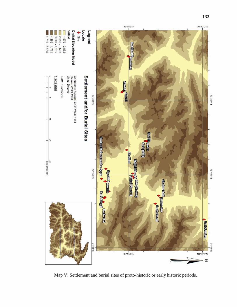
132
Map V: Settlement and burial sites of proto-historic or early historic periods.

133
Map VI: Sites of Buddhist period.

134
Map VII: Structural remains.
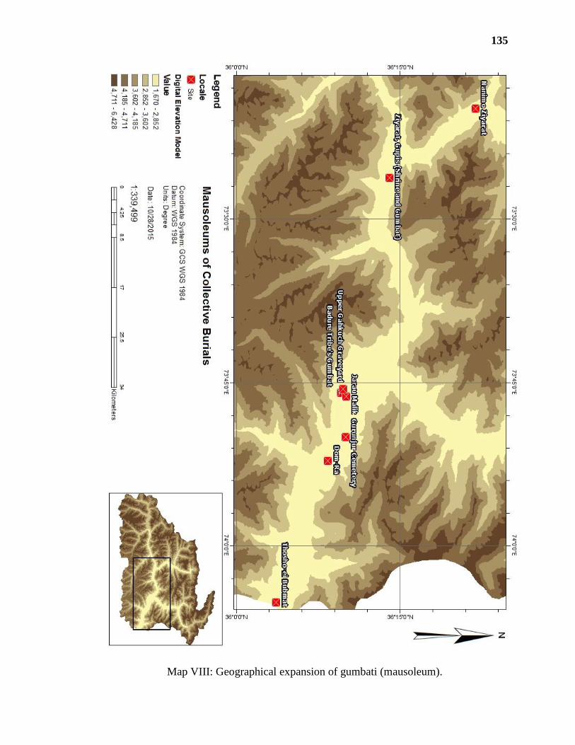
135
Map VIII: Geographical expansion of gumbati (mausoleum).
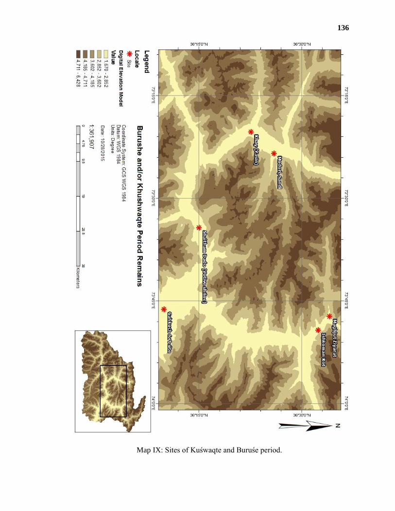
136
Map IX: Sites of Kuśwaqte and Buruśe period.

137
Map X: Archaeological remains in Hatun, near the confluence of Hanisārī (Ishkōman
River) and Yasin River (after Stein 1944)
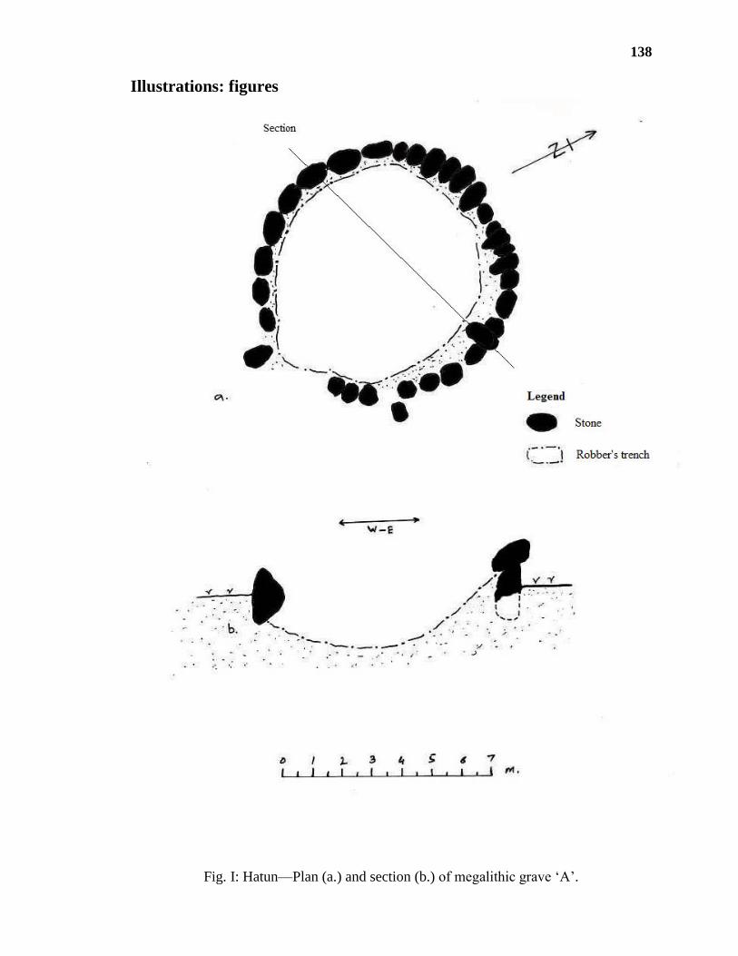
138
Illustrations: figures
Fig. I: Hatun—Plan (a.) and section (b.) of megalithic grave ‘A’.

139
Fig. II: Hatun—Plan (a.) and section (b.) of megalithic grave ‘B’.
a.
b.

140
Fig. III: Bijayōt (Yasin)—plan of megalithic grave at Gōm.

141
Fig. IV: Yasin—plan of Manichi megalithic grave

142
Fig. V: Gurunjur—Karōsingal, exposed structures

143
Fig. VI: Khalti—Kōṭ/Noghor, fortified settlement

144
Fig. VII: (a.) Karōsingal, (b. & c.) Akṣēmī Kuī, and (d) Kōṭ Kalti—decorated pottery
with incised lines.
a.
d.
c.
b.
a. Pot reconstructioned, decorated
with incised band of two
diagonal lines, in zigzag pattern.
b. Upper part of pot with a band of
crosses on its sholders.
c. Body sherd bearing a band of
interconnected crosses.
d. Comb decoration—at upper
stage in zig-zag pattern and at
lower stage in straight lines
pattern.

145
Fig. VIII: (a.- b.) Karōsingal, (c.- d.) Guchīn, (e.) Akṣēmī Kuī, and (f.- g.) Deshing,
Khalti—rims’ variety of terracotta pottery
a.
b.
c.
d.
e.
f.
g.
a. Globular pot with sloping
plain rim.
b. Neck and inverted sloping
plain rim of a pot.
c. Neck with vertical plain rim.
d. Pot with externally thickened
rim.
e. Angularly flattened edge
inverted rim.
f. Inverted rim of spouted jar.
g. Plain inverted rim.

146
Fig. IX: Ayaśi—beads (see Plate LXXXI)
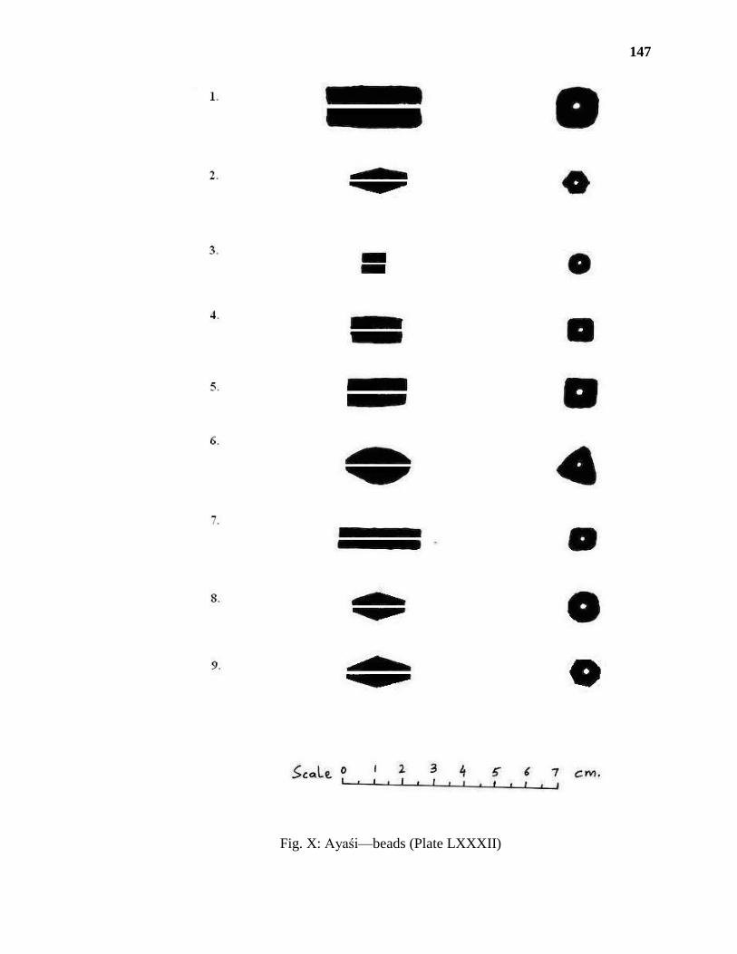
147
Fig. X: Ayaśi—beads (Plate LXXXII)

148
Fig. XI: (1.- 4.) Ayaśi (Plate LXXXIII) and (5.- 7.) Karōsingal (LXXXV)—beads

149
Fig. XII: (1. - 3.) Deshing, Khalti and (4. - 5.) Ḍōli II, Darmandar—beads (Plate LXXXVI)

150
Fig. XIII: Imit—(a.) copper cauldern and (b.) bronze rhyton (after Litvinskij 2002). (see
Plate LXIX)

151
Fig. XIV: Hatun—inscription (after Chakravarti 1954).

152
Fig. XV: Gich—Kutorōṭ Kōṭ.

153
Fig. XVI: Singul—Ziyārat-ei Lāṭh.

154
Fig. XVII: Singul—Loi-Kho ‘A’.

155
Fig. XVIII: Singul—Loi-Kho ‘B’.
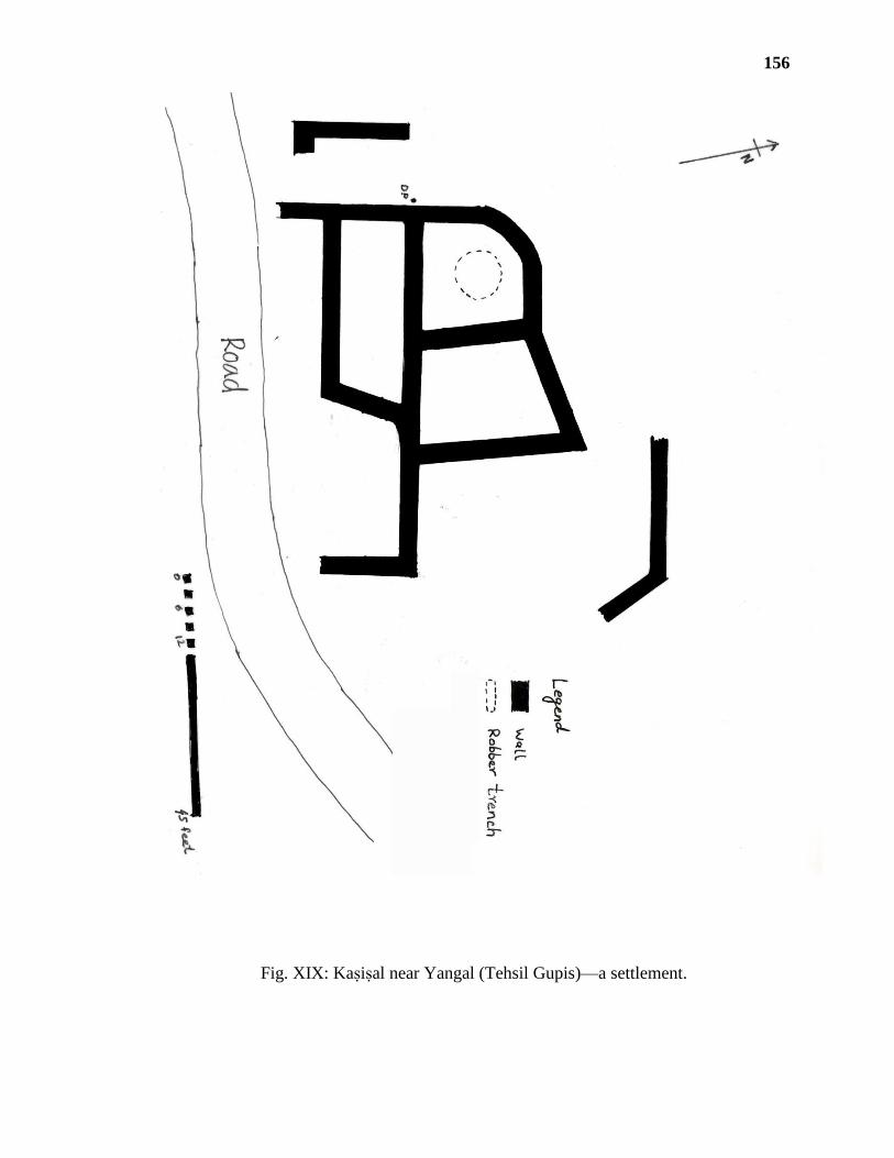
156
Fig. XIX: Kaṣiṣal near Yangal (Tehsil Gupis)—a settlement.

157
Fig. XX: Upper Gahkuch—Jarau Malik, location of cave in section of valley (a.) of lower
Gahkuch and plan of cave (b.).

158
Fig. XXI: Jarau Malik—entrance (a.) and section (b.) of cave.

159
Fig. XXII: Bubur—Dom-Rā, plan of complex; (a.) plan of central grave at ground; and
(b.) foundation levels.

160
Fig. XXIII: Dom-Rā—phases of construction, (a.) first phase (b.) second phase (c.) and
third Phase (courtesy Muhibuddin, not to scale).
c.
b.
a.

161
Fig. XXIV: Gurunjur—cemetery of bumbati mausoleums 1-13.

162
Fig. XXV: Gupis—a gumbat and adjacent shrine.

163
Fig. XXVI: Sections showing development in burial culture— (a.) Grave 3, Gurunjur (b)
Dom Rā, Bubur (c.) our contemporary local style of Islamic grave, right before burial.

164
Illustrations: plates
Plate I: Singul and Thingdas—bird eyes view.
Plate II: Singul—ravine and road leading to Singul Gah, a short access to Darel.

165
Plate III: Ishkōman Valley—marshy zone.
Plate IV: Darmandar—road leading to Daldas.
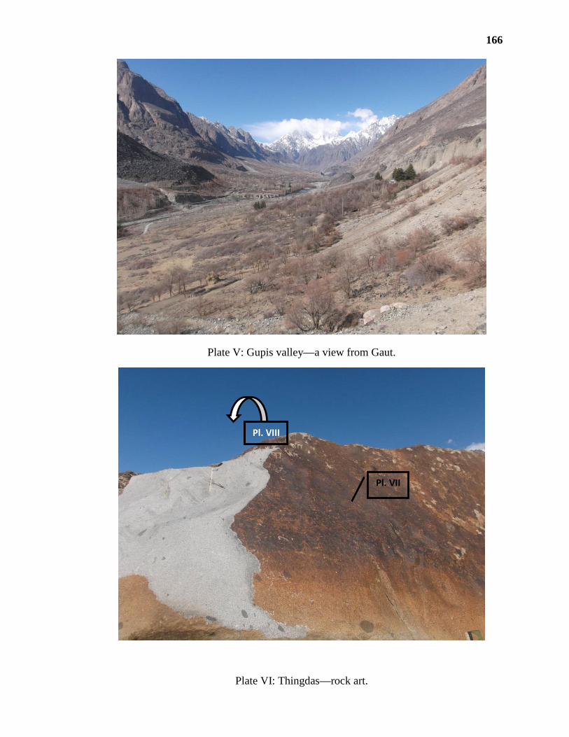
166
Plate V: Gupis valley—a view from Gaut.
Plate VI: Thingdas—rock art.
Pl. VIII
Pl. VII

167
Plate VII: Thingdas—details of art on rock surface.
Plate VIII: Thingdas—details of upper portion.
A
B/1
A
B/3
A
B/2
A
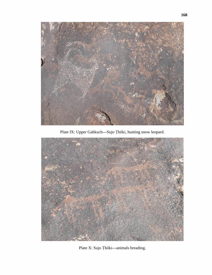
168
Plate IX: Upper Gahkuch—Sujo Ṭhōki, hunting snow leopard.
Plate X: Sujo Ṭhōki—animals breading.

169
Plate XI: Sujo Ṭhōki—snow leopard and its hunt.
Plate XII: Sujo Ṭhōki—hunting scene.
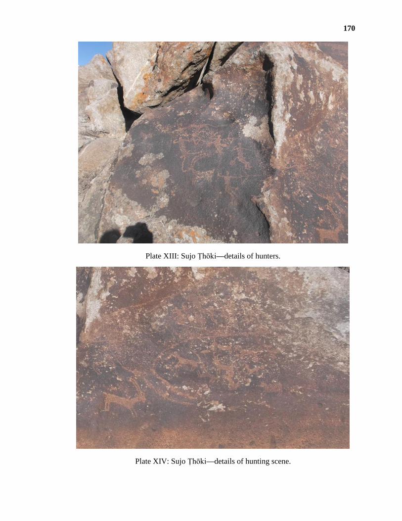
170
Plate XIII: Sujo Ṭhōki—details of hunters.
Plate XIV: Sujo Ṭhōki—details of hunting scene.

171
Plate XV: Sujo Ṭhōki—mountain ecology.
Plate XVI: Sujo Ṭhōki—details of hunting scenes.

172
Plate XVII: Sujo Ṭhōki—hunting techniques and supporting dogs.
Plate XVIII: Loe Kho, Singul—stone bearing upside down carvings reused in structures.

173
Plate XIX: Ishkōman—drawings of ibexes.
Plate XX: Darmandar—Daldas rock art.

174
Plate XXI: Daldas—details of rock art.
Plate XXII: Hatun—grave ‘C’ and grave A and B are also in view.
A B
C
A/1
A/2
B A/3
B

175
Plate XXIII: Hatun—megalithic burial ‘A’.
Plate XXIV: Hatun—interior of megalithic grave ‘A’.

176
Plate XXV: Hatun—exterior of grave ‘A’.
Plate XXVI: Hatun—grave ‘B’.

177
Plate XXVII: Hatun—robber’s trench in grave ‘B’.
Plate XXVIII: Hatun—robber’s trenches on ancient graves around the megaliths.

178
Plate XXIX: Bijayōt, Yasin—megalithic grave at Gōm.
Plate XXX: Bijayōt—details of grave.

179
Plate XXXI: Yasin—Manichi megalithic grave.
Plate XXXII: Yasin—details of grave walls, exposed by illegal digging at Manichi.

180
Plate XXXIII: Bubur—Bachimal and village below.
Plate XXXIV: Bubur—Bachimal.
Fig. XXXIV
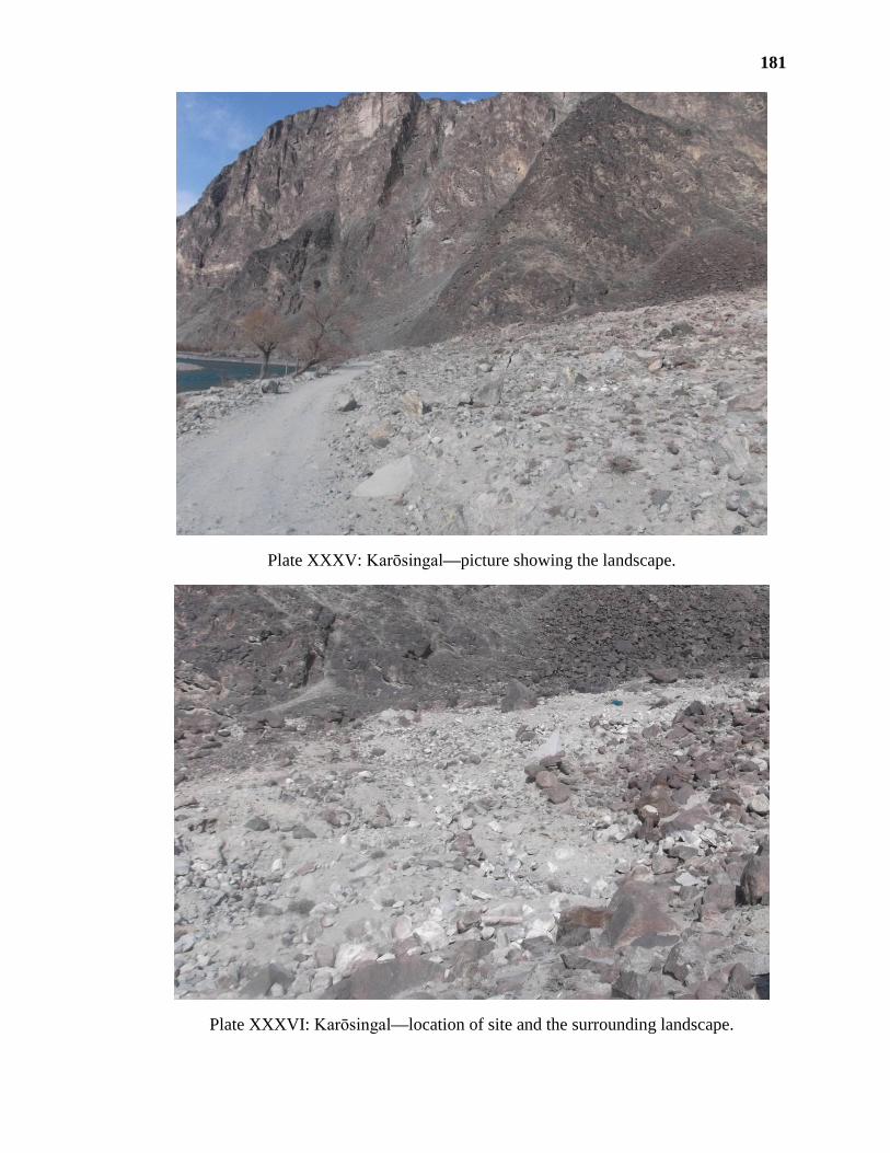
181
Plate XXXV: Karōsingal—picture showing the landscape.
Plate XXXVI: Karōsingal—location of site and the surrounding landscape.

182
Plate XXXVII: Karōsingal—exposed trench A.
Plate XXXVIII: Karōsingal—exposed trench B.
A/1
A/2
B/1 B/2
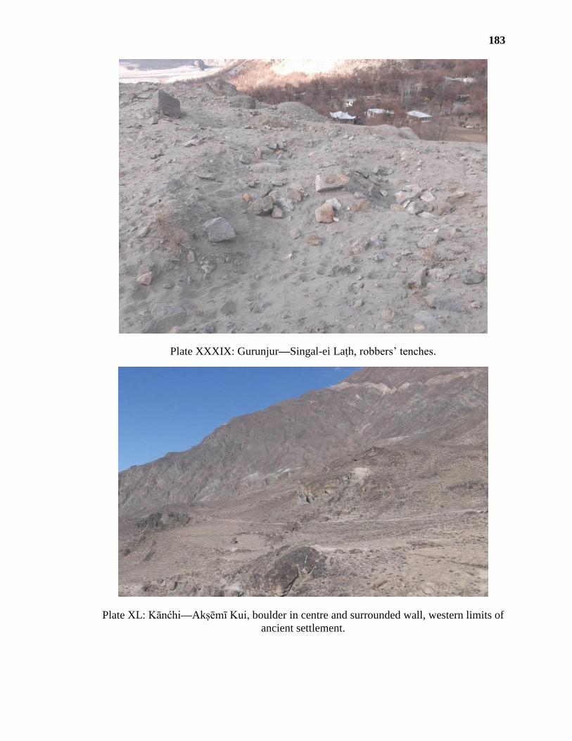
183
Plate XXXIX: Gurunjur—Singal-ei Laṭh, robbers’ tenches.
Plate XL: Kānćhi—Akṣēmī Kui, boulder in centre and surrounded wall, western limits of
ancient settlement.

184
Plate XLI: Akṣēmī Kui—terraced fields in ‘area A’.
Plate XLII: Akṣēmī Kui—details of a wall in ‘area A’.

185
Plate XLIII: Akṣēmī Kui—fertile soil of field in ‘area A’.
Plate XLIV: Akṣēmī Kui—foundations of fortification wall and mound in ‘Area B’.
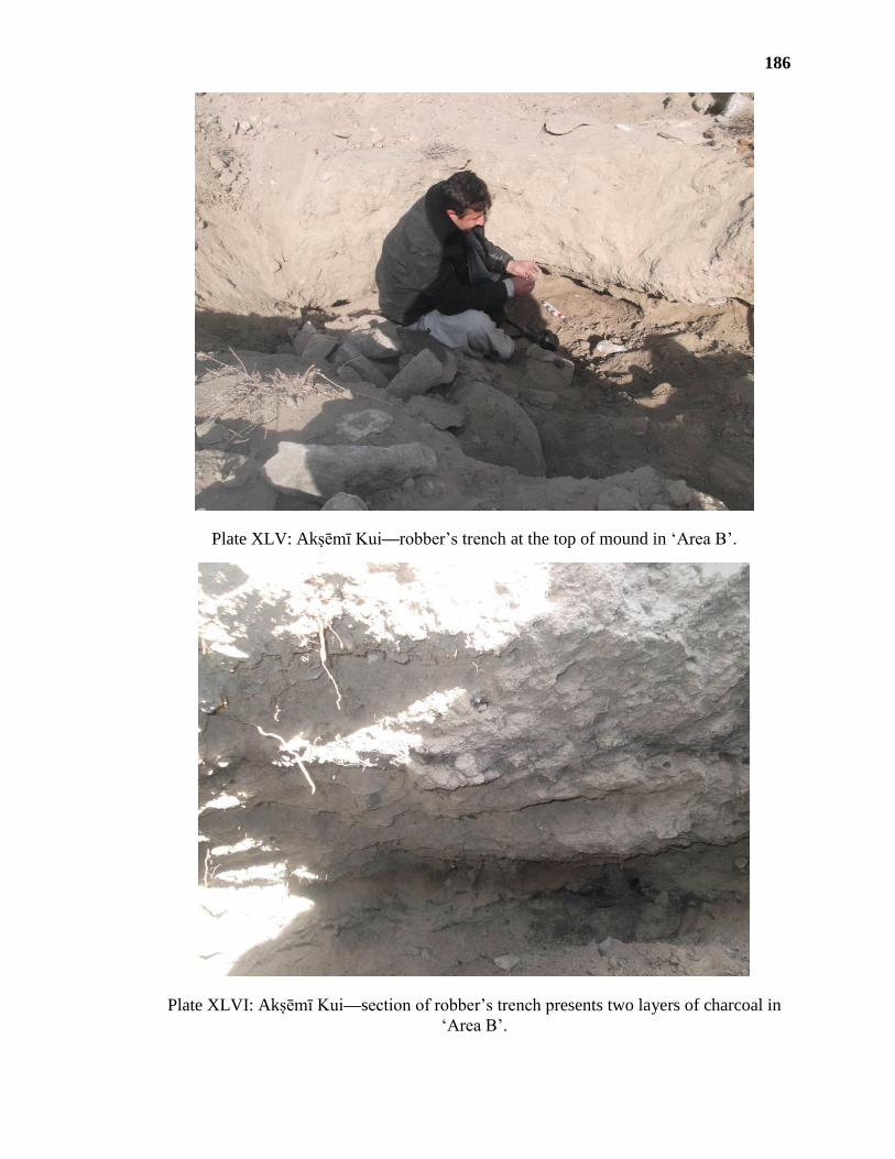
186
Plate XLV: Akṣēmī Kui—robber’s trench at the top of mound in ‘Area B’.
Plate XLVI: Akṣēmī Kui—section of robber’s trench presents two layers of charcoal in
‘Area B’.
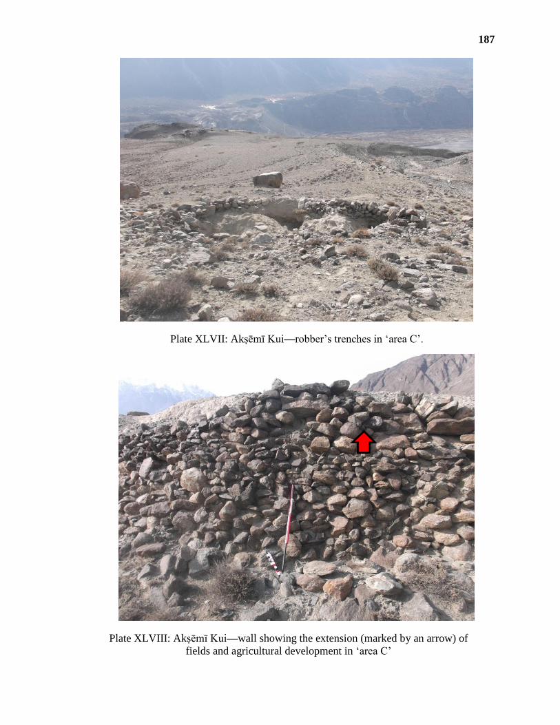
187
Plate XLVII: Akṣēmī Kui—robber’s trenches in ‘area C’.
Plate XLVIII: Akṣēmī Kui—wall showing the extension (marked by an arrow) of
fields and agricultural development in ‘area C’
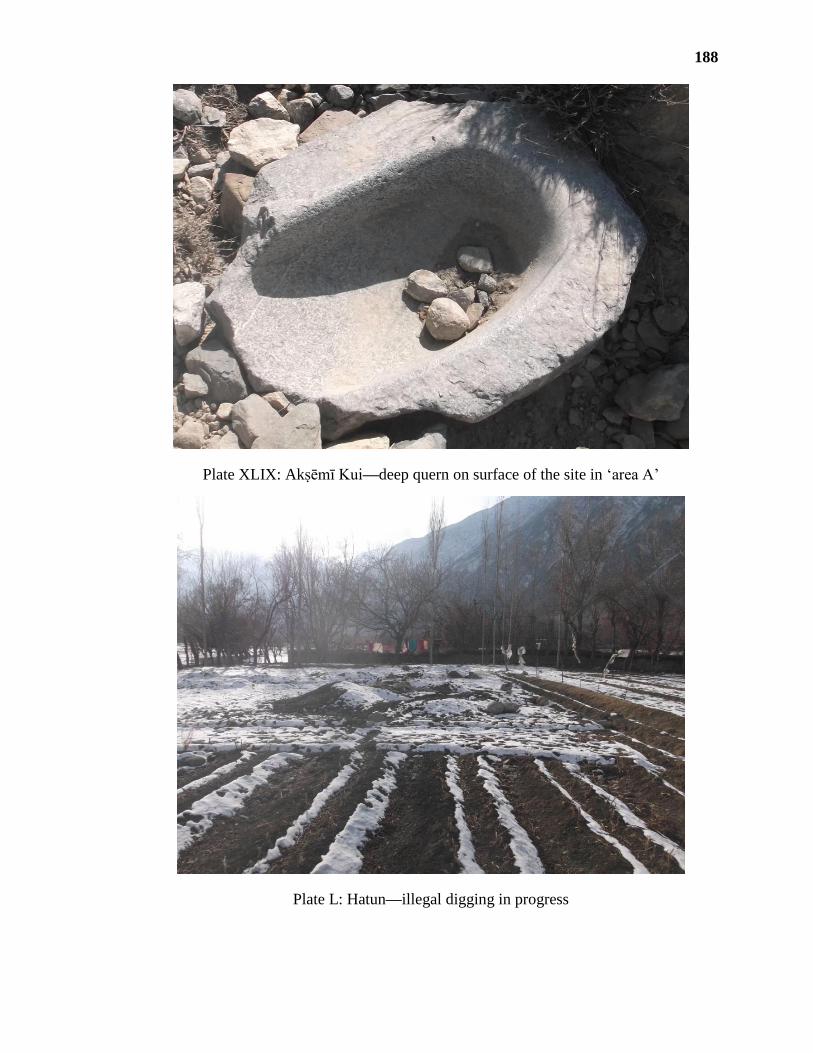
188
Plate XLIX: Akṣēmī Kui—deep quern on surface of the site in ‘area A’
Plate L: Hatun—illegal digging in progress
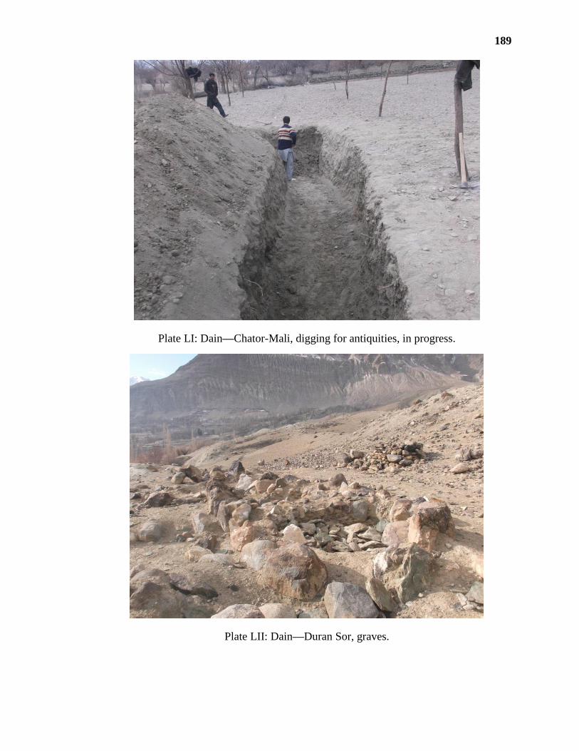
189
Plate LI: Dain—Chator-Mali, digging for antiquities, in progress.
Plate LII: Dain—Duran Sor, graves.

190
Plate LIII: Duran Sor—details of a grave.
Plate LIV: Duran Sor—another burial in area, beside our resource persons.
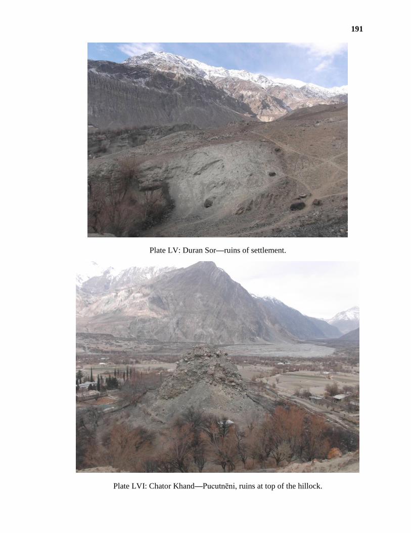
191
Plate LV: Duran Sor—ruins of settlement.
Plate LVI: Chator Khand—Pucutnēni, ruins at top of the hillock.
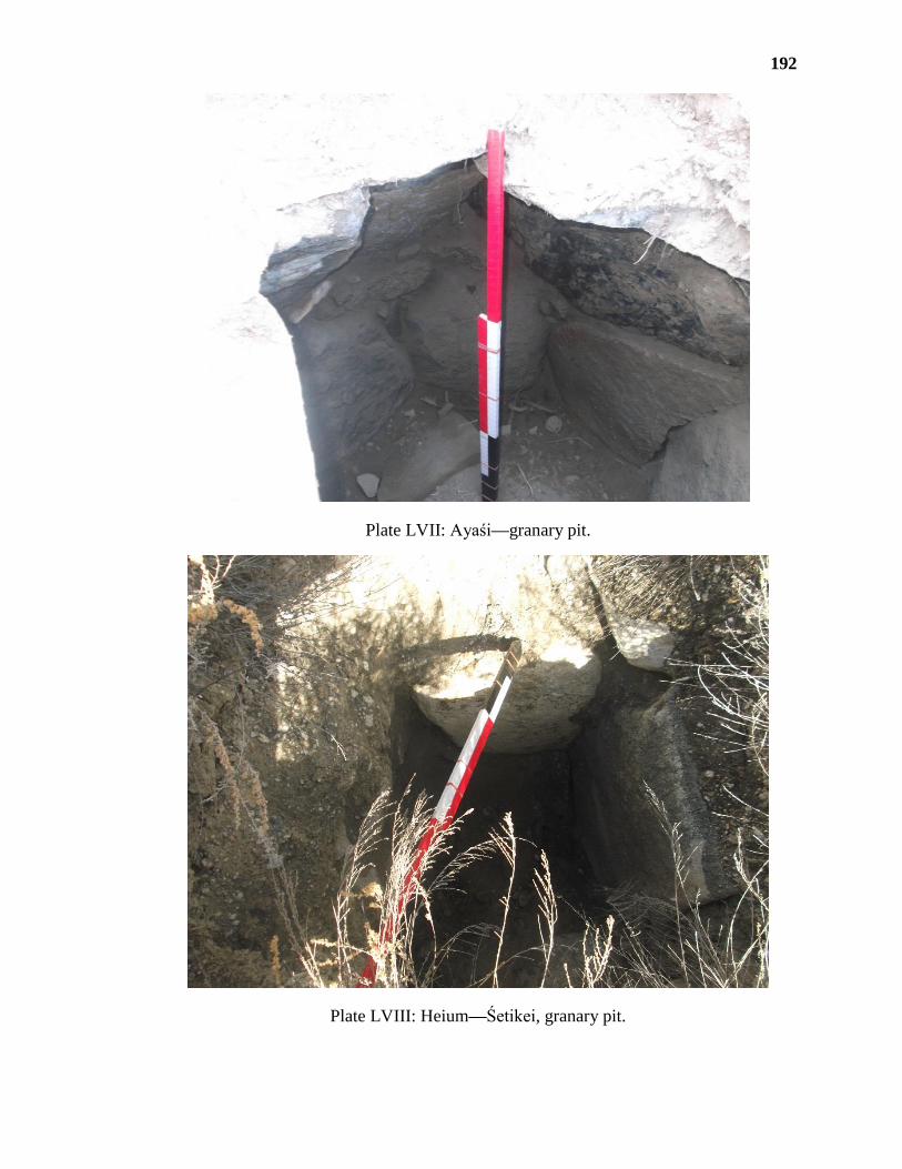
192
Plate LVII: Ayaśi—granary pit.
Plate LVIII: Heium—Śetikei, granary pit.

193
Plate LIX: Collection of antiquity dealer—stylised horse from Ghizer.
Plate LX: Duran Sor—a zoomorphic figure in bronze (after Dani 1989 [R. ed. 2001,
Rept. 2007]).

194
Plate LXI: Majini Phari—a bell.
Plate LXII: Ayaśi—a seal.

195
Plate LXIII: Karōsingal—a metallic bar.
Plate LXIV: Ayaśi—earring.
Plate LXV: Ayaśi—a metallic bead.
Plate LXVI: Ayaśi—metal ore.
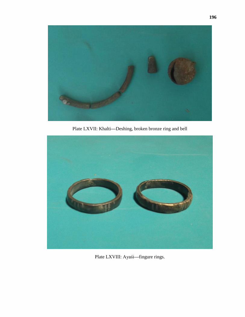
196
Plate LXVII: Khalti—Deshing, broken bronze ring and bell
Plate LXVIII: Ayaśi—fingure rings.

197
Plate LXIX: Imit—a rhyton and a cauldern (after Stein 1944).
Plate LXX—Sections of selected of potsherds from different sites.

198
Plate LXXI: Deshing, Khalti—variety of potsherds.
Plate LXXII: Kōṭ, Khalti—shard with two incised designs of comb impression.

199
Plate LXXIII: Akṣēmi Kui, Kānćhi—variety of potsherds.
Plate LXXIV: Akṣēmi Kui—rim of a jar.

200
Plate LXXV: Darmandar—Ḍōli II, variety of potsherds.
Plate LXXVI: Ḍōli II—a sherd of painted pot.
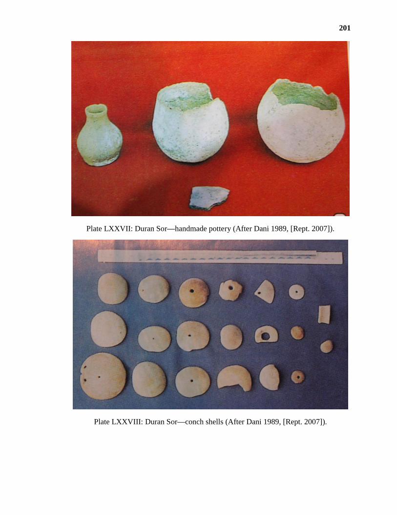
201
Plate LXXVII: Duran Sor—handmade pottery (After Dani 1989, [Rept. 2007]).
Plate LXXVIII: Duran Sor—conch shells (After Dani 1989, [Rept. 2007]).

202
Plate LXXIX: Ayaśi—findings of Mirdullah Khan in a handmade pot.
Plate LXXX: Ayaśi—beads of unknown soft material.

203
Plate LXXXI: Ayaśi—beads of agate
Plate LXXXII: Ayaśi—beads of carnelian, a kind of agate and others.

204
Plate LXXXIII: Ayaśi—beads.
Plate LXXXIV: Ayaśi—beads.

205
Plate LXXXV: Karōsingal—beads.
Plate LXXXVI: Deshing, Khalti—beads in variety of shapes and kinds.
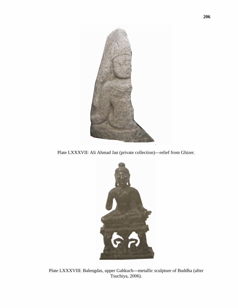
206
Plate LXXXVII: Ali Ahmad Jan (private collection)—relief from Ghizer.
Plate LXXXVIII: Balengdas, upper Gahkuch—metallic sculpture of Buddha (after
Tsuchiya, 2006).

207
Plate LXXXIX: Bubur—relief of
Buddhistic figure in Ali Ahmad Jan
private collection (after Dani 1989 [2007
Reprint]).
Plate XC: Ali Ahmad Jan house,
Gilgit—current condition of preservation
of pl. LXXXIX.
Plate XCI: Burbur—relief of Buddha, on
other side of same rock as in pl.
LXXXIX (after Tsuchiya, 2006)
Plate XCII: Ali Ahmad Jan house,
Gilgit—current condition of preservation
of pl. XCI.

208
Plate XCIII: Hatun—rock bearing inscription.
Plate XCIV: Hatun—Surface engraved with Proto-Shārada Inscription of seven lines

209
Plate XCV: Hatun—Close view of the inscription.
Plate XCVI: Hatun—remains of Makaravehini, a canal leading to Hatun Inscription.

210
Plate XCVII: Gutōmus, Hōl/ Lower Gahkuch—stone I (after Jettmar and Sagaster 1993).
Plate XCVIII: Gutōmus—stone II (after Jettmar and Sagaster 1993).

211
Plate XCIX: Gutōmus—stone II, current condition preservation.
Plate C: Gutōmus—stone III (after Jettmar and Sagaster, 1993).

212
Plate CI: Gutōmus—stone IV (-do-).
Plate CII: Gutōmus—stone V (-do-).

213
Plate CIII: Gutōmus—stone VI (-do-).
Plate CIV: Gutōmus—stone VII (-do-).

214
Plate CV: Gutōmus—stone VII current condition preservation.
Plate CVI: Gutōmus—stone VIII, Tibbetan inscription (-do-).

215
Plate CVII: Sumal, Gupis District—arrow marks the location of monastic
establishment called Kōṭ.
Plate CVIII: Sumal—southern wall of Kōṭ.
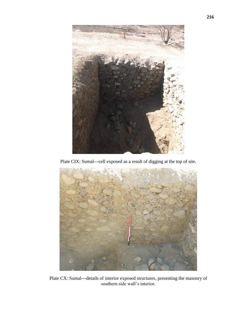
216
Plate CIX: Sumal—cell exposed as a result of digging at the top of site.
Plate CX: Sumal—details of interior exposed structures, presenting the masonry of
southern side wall’s interior.

217
Plate CXI: Kōṭ Sumal—stone in circular plan with burrow in centre, a grinding stone.
Plate CXII: Kōṭ Sumāl—average 7 cm thick round stone with a hole in centre, a chatra
of stupa.
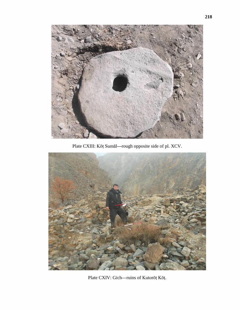
218
Plate CXIII: Kōṭ Sumāl—rough opposite side of pl. XCV.
Plate CXIV: Gich—ruins of Kutorōṭ Kōṭ.
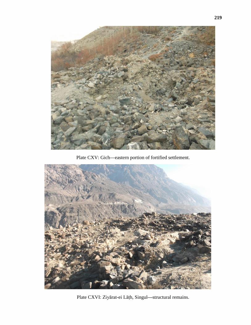
219
Plate CXV: Gich—eastern portion of fortified settlement.
Plate CXVI: Ziyārat-ei Lāṭh, Singul—structural remains.

220
Plate CXVII: Loi-kho ‘A’, Singul—structural remains.
Plate CXVIII: Loi-kho ‘B’, Singul—structural remains.

221
Plate CXIX: Kaṣiṣal—structural remains.
Plate CXX: Kaṣiṣal—terraced fields.
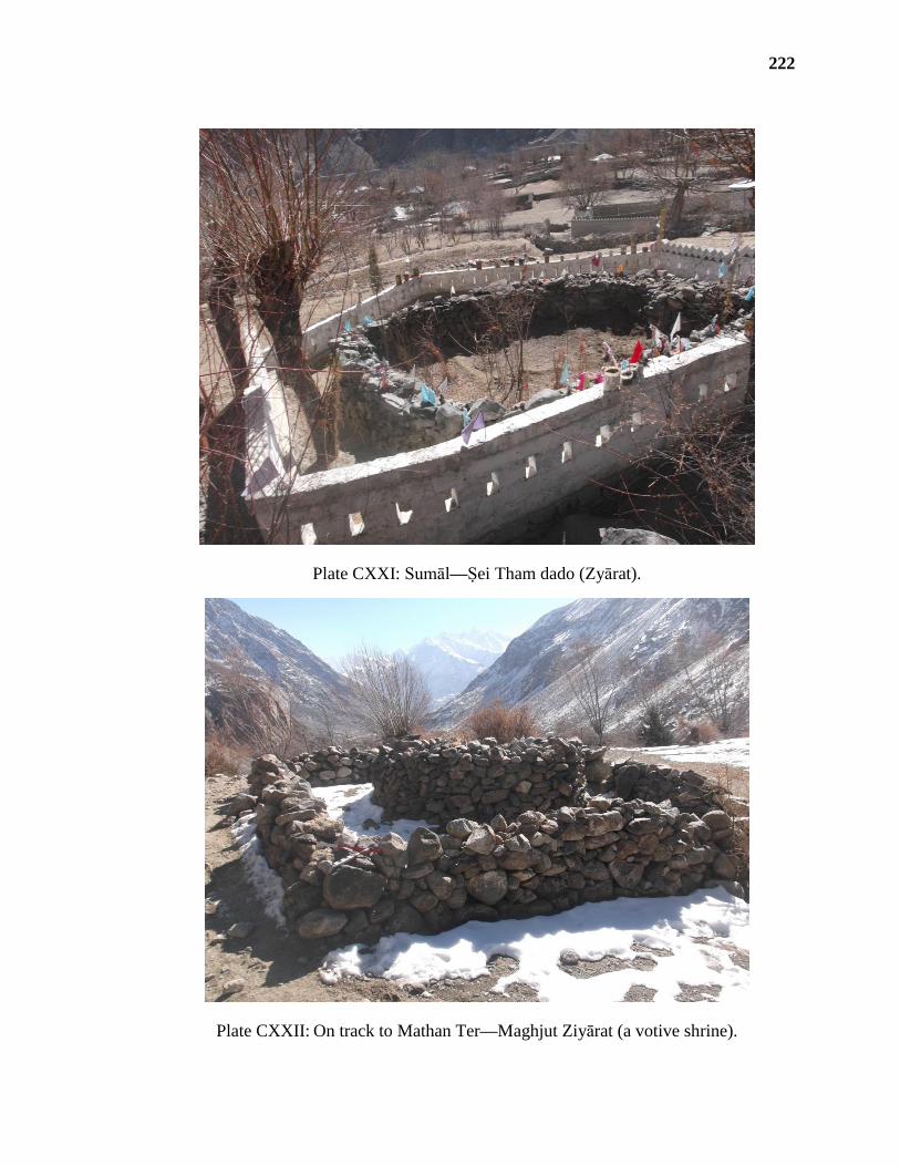
222
Plate CXXI: Sumāl—Ṣei Tham dado (Zyārat).
Plate CXXII: On track to Mathan Ter—Maghjut Ziyārat (a votive shrine).

223
Plate CXXIII: Jarau Malik, Upper Gahkuch—cave entrance and a bird eye view of lower
town in background (arrow marks for entrance).
Plate CXXIV: Jarau Malik—cave
entrance (l.) and interior (r.)

224
Plate CXXV: Upper Gahkuch—a gumbat located in the graveyard of Badurē clan
Plate CXXVI: Upper Gahkuch—interior of above gumbat

225
Plate CXXVII: Upper Gahkuch—a gumbat at Jarau Malik graveyard.
Plate CXXVIII: Upper Gahkuch—interior of Gumat at Jarau Malik.

226
Plate CXXIX: Upper Gahkuch—a gumbat at the road side near the village graveyard
(arrow shows the mausuleum).
Plate CXXX: Upper Gahkuch—interior of gumbat connected to road.

227
Plate CXXXI: Gurunjur—a general view of cemetery of bumbati (mausoleums).
Plate CXXXII: Gurunjur—a bird eye view of the bumbati mausoleums.

228
Plate CXXXIII: Gurunjur—exterior of grave no. 1.
Plate CXXXIV: Gurunjur—interior of grave no. 1.

229
Plate CXXXV: Gurunjur—exterior of grave no. 2.
Plate CXXXVI: Gurunjur—interior of grave no. 2.

230
Plate CXXXVII: Gurunjur—covered roof over the grave no. 2.
Plate CXXXVIII: Gurunjur—side pit of grave 2. in view.
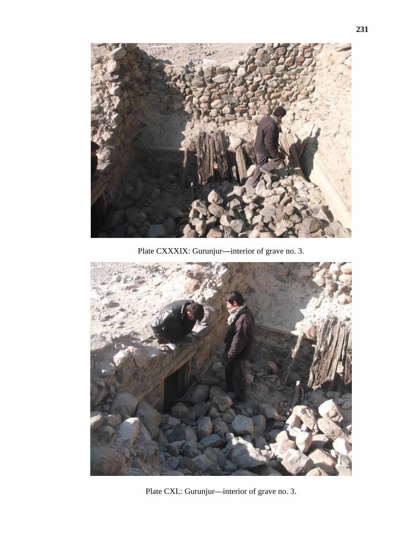
231
Plate CXXXIX: Gurunjur—interior of grave no. 3.
Plate CXL: Gurunjur—interior of grave no. 3.

232
Plate CXLI: Gurunjur—exterior of grave no. 5.
Plate CXLII: Gurunjur—interior of grave no. 5.

233
Plate CXLIII: Gurunjur—interior of grave 6.
Plate CXLIV: Gurunjur—eastern wall of grave 6.

234
Plate CXLV: Gurunjur—remaining mausoleums no. 8, 9, 12 and 13.
Plate CXLVI: Ḍom Rā, Bubur—cultral material, nearly one metre thick.

235
Plate CXLVII: Ḍom Rā—a general view.
Plate CXLVIII: Ḍom Rā—façade of mausoleum (After Jettmar 1964).

236
Plate CXLIX: Ḍom Rā—façade, present condition of preservation.
Plate CL: Ḍom Rā—opening into the grave.

237
Plate CLI: Ḍom Rā—interior of grave during 1964 (After Jettmar).
Plate CLII: Ḍom Rā—current condition of above nich.

238
Plate CLIII: Gupis—a mausoleum attached to road leading to Yasin.
Plate CLIV: Gupis—attached shrine to a gumbat.

239
Plate CLV: Yasin—a mausoleum of Nani-mo Ziyārat.
Plate CLVI: Nani-mo-Ziyārat, Yasin—niche under western wall.
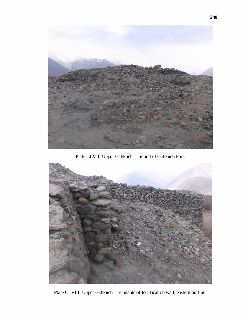
240
Plate CLVII: Upper Gahkuch—mound of Gahkuch Fort.
Plate CLVIII: Upper Gahkuch—remnants of fortification wall, eastern portion.

241
Plate CLIX: Upper Gahkuch—Chibi Śikāri (watch tower) of Gahkuch Fort.
Plate CLX: Upper Gahkuch—interior of Pīr Khānah inside fort area.

242
Plate CLXI: Upper Gahkuch—façade of Jamā’at Khāna inside fort area.
Plate CLXII: Upper Gahkuch—decorated entrance of prayer hall of Jamā’at Khānah.

243
Plate CLXIII: Yasin—the only standing remnant of Yasin Fort.
Plate CLXIV: Yasin—decorated entrance of royal cemetery of Khuśwaqte.

244
Plate CLXV: Yasin—panji, a wall around the central grave in Khuśwaqte royal cemetery.
Plate CLXVI: Ishkoman Kōṭ—A
decorated column
Plate CLXVII: Sumal—A decorative
design on column at a private house near
Shai tham dado Ziyārat.

245
Plate CLXVIII: Sandi—location of Muḍuri Fort (marked by arrow).
Plate CLXIX: Sandi—eastern elevation of landscape toped by remnants of
fortification at Muḍuri Fort.

246
Plate CLXX: Sandi—remnants of fortification at the bottom of cliff.
Plate CLXXI: Sandi—a close view of bastion.

247
Plate CLXXII: Sandi: ruins at the top of cliff.
Plate CLXXIII: Sandi: bird eye view of lower fortification wall (arrow marks).