Heitkamp F, Sylvester SP, Kessler M, Sylvester MDPV, Jungkunst HF (2014) Inaccessible Andean sites...
27
http://ppg.sagepub.com/ Progress in Physical Geography http://ppg.sagepub.com/content/early/2014/08/07/0309133314544918 The online version of this article can be found at: DOI: 10.1177/0309133314544918 published online 8 August 2014 Progress in Physical Geography Felix Heitkamp, Steven P. Sylvester, Michael Kessler, Mitsy D.P.V. Sylvester and Hermann F. Jungkunst Inaccessible Andean sites reveal human-induced weathering in grazed soils Published by: http://www.sagepublications.com can be found at: Progress in Physical Geography Additional services and information for http://ppg.sagepub.com/cgi/alerts Email Alerts: http://ppg.sagepub.com/subscriptions Subscriptions: http://www.sagepub.com/journalsReprints.nav Reprints: http://www.sagepub.com/journalsPermissions.nav Permissions: http://ppg.sagepub.com/content/early/2014/08/07/0309133314544918.refs.html Citations: What is This? - Aug 8, 2014 OnlineFirst Version of Record >> at UZH Hauptbibliothek / Zentralbibliothek Zuerich on August 18, 2014 ppg.sagepub.com Downloaded from at UZH Hauptbibliothek / Zentralbibliothek Zuerich on August 18, 2014 ppg.sagepub.com Downloaded from
-
Upload
independent -
Category
Documents
-
view
0 -
download
0
Transcript of Heitkamp F, Sylvester SP, Kessler M, Sylvester MDPV, Jungkunst HF (2014) Inaccessible Andean sites...
http://ppg.sagepub.com/Progress in Physical Geography
http://ppg.sagepub.com/content/early/2014/08/07/0309133314544918The online version of this article can be found at:
DOI: 10.1177/0309133314544918
published online 8 August 2014Progress in Physical GeographyFelix Heitkamp, Steven P. Sylvester, Michael Kessler, Mitsy D.P.V. Sylvester and Hermann F. Jungkunst
Inaccessible Andean sites reveal human-induced weathering in grazed soils
Published by:
http://www.sagepublications.com
can be found at:Progress in Physical GeographyAdditional services and information for
http://ppg.sagepub.com/cgi/alertsEmail Alerts:
http://ppg.sagepub.com/subscriptionsSubscriptions:
http://www.sagepub.com/journalsReprints.navReprints:
http://www.sagepub.com/journalsPermissions.navPermissions:
http://ppg.sagepub.com/content/early/2014/08/07/0309133314544918.refs.htmlCitations:
What is This?
- Aug 8, 2014OnlineFirst Version of Record >>
at UZH Hauptbibliothek / Zentralbibliothek Zuerich on August 18, 2014ppg.sagepub.comDownloaded from at UZH Hauptbibliothek / Zentralbibliothek Zuerich on August 18, 2014ppg.sagepub.comDownloaded from

Article
Inaccessible Andean sitesreveal human-inducedweathering in grazed soils
Felix HeitkampGeorg-August-University Gottingen, Germany
Steven P. SylvesterUniversity of Zurich, Switzerland
Michael KesslerUniversity of Zurich, Switzerland
Mitsy D.P.V. SylvesterUniversity of Zurich, Switzerland; Universidad Nacional del San Antonio Abad del Cusco, Peru
Hermann F. JungkunstUniversity Koblenz-Landau, Germany
AbstractHuman activity affects properties and development of ecosystems across the globe, to such a degreethat it is now challenging to get baseline values for undisturbed ecosystems. This is especially true forsoil development, which is potentially affected by land-use history and holds a legacy of past humaninterventions. Therefore, it is still largely unknown for most ecozones how soil would have developed‘naturally’. Here, we show undisturbed soil development, i.e. the processes of weathering and accumu-lation of soil organic matter (SOM), by comparing pristine with grazed sites in the high Andes (4500 m)of southern Peru. We located study plots on a large ledge (0.2 km2) that is only accessible with moun-taineering equipment. Plots with pristine vegetation were compared to rangeland plots that were pre-sumably under relatively constant grazing management for at least four millennia. Vegetation change,induced by grazing management, led to lower vegetation cover of the soil, thereby increasing soil sur-face temperatures and soil acidification. Both factors increased weathering in rangeland soils. Formationof pedogenic oxides with high surface area explained preservation of SOM, with positive feedback toacidification. Higher contents of pyrophosphate extractable Fe and Al oxides indicated the importanceof organo-mineral associations for SOM stabilization on rangeland sites, which are likely responsible fora higher degree of humification. This higher degree of humification induced melanization (darker col-our) of the rangeland soils which, together with sparse vegetation cover, also feeds back to soil tem-perature. With this work, we present a conceptual framework of positive feedback links between
Corresponding author:Felix Heitkamp, Landscape Ecology, Faculty of Geoscience and Geology, Georg-August-University Gottingen,Goldschmidtstr. 5, 37077 Gottingen, Germany.Email: [email protected]
Progress in Physical Geography1–26
ª The Author(s) 2014Reprints and permission:
sagepub.co.uk/journalsPermissions.navDOI: 10.1177/0309133314544918
ppg.sagepub.com
at UZH Hauptbibliothek / Zentralbibliothek Zuerich on August 18, 2014ppg.sagepub.comDownloaded from

human-induced vegetation change, soil development and accumulation of SOM, which is only possibledue to the unique baseline values of a pristine ecosystem. Using ‘inaccessibility’ as a tool to quantifyhuman impact in future interdisciplinary studies may push research forward on evaluating anthropo-genic impact on Earth’s ecosystems.
KeywordsAnthropocene, feedbacks, grazing, human impact, mountain soils, soil development, soil organic matter,weathering
I Introduction
Anthropogenic alteration of ecosystems, land-
scapes and corresponding biogeochemical
fluxes is spreading virtually everywhere across
the globe (Rockstrom et al., 2009). Quantifi-
cation of the human footprint has recently
received great scientific and political interest
(Malanson et al., 2014) with extensive global
networks being set up to monitor changes in
atmospheric trace gases, while land-use and
land-cover changes are studied by more and
more sophisticated remote sensing tech-
niques. The human footprint has become so
large that there is even debate over whether
we have entered into a new geological epoch,
called the Anthropocene (Crutzen, 2002).
Although the term Anthropocene is now
common in science, there is consensus nei-
ther on its existence nor on its start. There
are arguments that the start of industrializa-
tion (c. 250 years BP; Crutzen, 2002), globa-
lization (c. 60 years BP; Steffen et al., 2004)
or anthropogenic alterations of soils (at least
2000 years BP; Certini and Scalenghe, 2011)
should be used as a ‘golden spike’ to indicate
the proposed start of this potential geological
epoch. Certini and Scalenghe (2011) sug-
gested the occurrence of Anthrosols (‘man-
made soil’; IUSS Working Group WRB,
2007) as the start of the Anthropocene.
According to Jenny (1941), soils are seen as
the product of the cumulative influences of cli-
mate (cl ), organisms (o), topography or relief
(r), geology or parent material (p) and time (t),
so the nature and properties of soil (S ) is a func-
tion of these ‘state-factors’, expressed as:
S ¼ f cl; o; r; p; tð Þ ð1ÞMore recently, the state-factor model has
been advanced to explain properties of whole
ecosystems, and humans were included as a
state-factor (Amundson and Jenny, 1997; Jenny,
1980). Although this is a widely accepted con-
cept, the isolation of the influence of a single
factor on soil genesis remains challenging.
The reasons mainly are (a) autocorrelation, for
example between climate and topography, and
(b) unknown and temporarily varying land-use
history (Amundson and Jenny, 1997). Climo-,
chrono- or toposequences are used as tools for
identifying the effects of these factors on soil
formation (Amundson and Jenny, 1997; Chapin
et al., 2012). An important challenge is to isolate
human influence (Malanson et al., 2014).
Anthropogenically induced changes may occur
in high frequencies with different amplitudes and
with time lags between events and effects on eco-
systems and soil development (Richter, 2007).
Direct quantification of anthropogenic effects
on soil formation by experiments is nearly
impossible to perform (Richter, 2007) and
quantification by observation via paired plots
is challenging (Leuschner et al., 2009), because it
is necessary to find adjoining sites among which
the only differing factor is the presence or absence
of continuous, preferably static, human land-use.
Initial processes of soil formation are weath-
ering of parent material and accumulation of
2 Progress in Physical Geography
at UZH Hauptbibliothek / Zentralbibliothek Zuerich on August 18, 2014ppg.sagepub.comDownloaded from
soil organic matter (SOM). Physical weathering
essentially weakens or breaks structures of solid
rock. Susceptibility to chemical weathering
increases with increasing surface area and pri-
mary minerals are dissolved, transformed or
translocated (Brimhall and Dietrich, 1987; Egli
et al., 2003; Kleber et al., 2005; Schlesinger and
Bernhardt, 2013). The weathering process of
any material is strongly affected by tempera-
ture, moisture and proton activity (Amundson
et al., 2007; Schlesinger and Bernhardt, 2013).
Since land-use changes (1) are associated with
vegetation changes, (2) can be associated with
acidification (e.g. cation export by grazing or
harvesting; Panichini et al., 2012), (3) alter the
microclimate (energy budget, temperature, eva-
potranspiration, etc.; Foley et al., 2003) and (4)
affect soil hydrological conditions (partitioning
of infiltration, runoff and storage; Buytaert
et al., 2006), it is likely that weathering pro-
cesses in soil can be affected by human land
management.
Chemical weathering is often quantified by
chemical mass-balance approaches on pedon or
watershed scales (Brimhall and Dietrich, 1987;
Chadwick et al., 1990; Egli and Fitze, 2000;
Price et al., 2012; White and Blum, 1995). Using
a watershed-based approach, White and Blum
(1995) analysed effects of climate on weathering
rates of Si and Na from granitic parent material
by comparing 89 sites. As expected, they could
show that weathering rates increased with mean
annual temperature and precipitation. Most
importantly, White and Blum (1995) showed that
temperature and precipitation had interactive
effects: while weathering rates were linearly
related to precipitation, the relation to tempera-
ture followed the Arrhenius equation (White and
Blum, 1995). Consequently, increasing precipi-
tation affects weathering rates more at high tem-
peratures. This pattern was basically confirmed
for alpine soils using pedon-scale mass balances.
In most regions, however, gradients in climate
are related to gradients in vegetation, which may
interact with or superimpose effects of climate on
soil development and weathering (Goudie and
Viles, 2012; Verboom and Pate, 2013).
Plants affect weathering in basically three
different ways: indirectly by (1) influencing
water availability as well as directly by (2) alter-
ing solution chemistry and (3) distribution of
elements across the soil profile (Goudie and
Viles, 2012; Lucas, 2001). Water partitioning
strongly depends on vegetation type. In general,
forests exhibit higher evapotranspiration, com-
pared to grass- and cropland (Foley et al.,
2003). Therefore, under humid conditions
downward percolation and, thus, leaching of
weathering products is potentially higher in
non-forest ecosystems. This effect was also
shown by Price et al. (2012), where watersheds
with lower forest cover had higher silica losses
with stream water. Exudation of organic acids,
as well as root respiration, changes the chemis-
try of soil solution. Acidic conditions enhance
weathering speed. Moreover, organic sub-
stances in soil solution may form organometallic
associations, theoretically enhancing or inhibit-
ing mobility of metals and organic matter. By
nutrient uptake and litter-fall, plants, especially
trees, function as a ‘biological pump’ (Bockheim
and Gennadiyev, 2000; Lucas, 2001). This pro-
cess counteracts leaching of some elements
(‘biological base enrichment’; Bockheim and
Gennadiyev, 2000) and also affects solution
chemistry (Lucas, 2001). Whereas the general
effect of plants on weathering (compared to the
pure ‘abiotic’ process) is relatively well under-
stood, the effect of vegetation types or functional
species composition on weathering seems to be
largely unknown (Verboom and Pate, 2013).
The same factors (temperature, precipita-
tion, vegetation) affecting weathering are also
involved in processes of SOM accumulation.
Vegetation markedly affects the quantity and
quality of organic matter input in soil, whereas
acidification, temperature and moisture essen-
tially affect decomposition processes (Jenny,
1941; Swift et al., 1979). Contrary to anthropo-
genically induced changes in weathering,
Heitkamp et al. 3
at UZH Hauptbibliothek / Zentralbibliothek Zuerich on August 18, 2014ppg.sagepub.comDownloaded from
changes in the terrestrial carbon pool have
received great interest in recent years, even
though both are linked. Therefore, weathering
should be included in concepts and models for
soil carbon accumulation and sequestering
(Amundson et al., 2007).
Estimates of terrestrial C-loss driven by land-
use changes are in the range of 48–114 Pg until
1850 and then 108–188 Pg in the industrial era
(Houghton, 2012), with about 25% of the loss
originating from SOM. However, quantifying
below-ground C stocks is tedious (Jungkunst
et al., 2012) and this is even more true for quan-
tifying their changes (Heitkamp et al., 2012).
Basically, two challenges exist: (1) the lack of,
or objective choice of, reliable baseline values
and (2) the natural variability of soils (White
and Walker, 1997). Extensive grazing manage-
ment is one of the earliest and most widespread
human activities. Globally, about 1.5 billion
people depend on livestock and about 70% of
agricultural land (25% of the ice-free Earth sur-
face) is used as pasture or rangeland (Neely
et al., 2009). Many pasture and rangeland soils
are degraded, which is a threat to the livelihood
of those dependent on livestock while also
forming a source of atmospheric CO2 (Conant,
2012; Neely et al., 2009). Smith et al. (2008)
estimated that 2 Pg of atmospheric CO2 could
be sequestered per year in pasture soils until
2030 by improved management and restoration.
Such estimates require data of best management
practice, but, ideally, also baseline values for
‘natural’ conditions as reference values (White
and Walker, 1997). However, a major short-
coming is the lack of pristine sites to quantify
reference values. Hence, only decades of land-
use change or land-use abandonment can be
compared to continuously used land in experi-
mental approaches, such as fencing. Most stud-
ies reviewed by Tanentzap and Coomes (2012)
have durations of, at most, a few decades. Con-
sequently, effects of grazing exclusion on SOC
stocks were on average around zero in most eco-
systems (between decreases of 1.5 to increases
of 3.8 Mg C ha-1) and only limited conclusions
could be drawn regarding long-term (centuries
or millennia) effects of soil degradation and
recovery. Two major concerns arise from these
experimental studies: (1) the timescale is hardly
long enough to induce major effects on pedo-
genesis (Richter, 2007) and (2) the ‘treatment’
is recovery from management and the ‘control’
is used land and not the natural ecosystem state.
Only one study claims a control site that was
never grazed (Neff et al., 2005). This study was
located in Utah, USA, and grazing management
by cattle ranchers took place from 1900 to 1974.
Results showed strong effects of wind erosion
on grazed sites as well as depletion of SOM and
soil microbial biomass. However, the grazing
period was limited to some decades, and the for-
mer land-use by natives remains unknown.
Besides environmental conditions, accumula-
tion of SOM in soils is also strongly determined
by organo-mineral interactions (Heitkamp et al.,
2012; Schmidt et al., 2011). Pedogenic oxides
and clay, which develop during weathering of
parent material, provide a highly reactive sur-
face area, and SOC is stabilized by various sorp-
tion mechanisms in the form of organo-mineral
complexes. If weathering would be altered by
human impact, this would, in turn, also have
effects on SOC accumulation.
In this study, in the high Andes of southern
Peru, the human state-factor is isolated by
comparing adjoining sites which differ in their
level of accessibility to grazing livestock and
human-induced ground-spreading fires. These
sites are identical in climate, time, parent mate-
rial and topography, but differ in their land-use
history by the inaccessibility of one of the two
sites. The accessible site has been subject to
constant grazing and burning of the vegetation
most likely continuously over several millen-
nia. Here we investigate if pristine and grazed
sites, differing in the state-factor ‘humans’ by
inaccessibility, reveal different trajectories in
soil development, i.e. weathering and accumu-
lation of organic matter.
4 Progress in Physical Geography
at UZH Hauptbibliothek / Zentralbibliothek Zuerich on August 18, 2014ppg.sagepub.comDownloaded from
II Land-use history of the regionCusco, Peru
Hunting activities in the Andes have been docu-
mented by bone deposits, dating back to the end
of the last glacial period (Marin et al., 2007;
Wing, 1974) but the early ecological impact of
men remains uncertain (MacNeish, 1971).
Domestication of camelids began some 6000
years ago (Wheeler, 1988; Wing, 1974) and
quickly led to widespread soil erosion as docu-
mented by lake sediments (van der Hammen
and Noldus, 1985) and dust deposits on Andean
glaciers (Binford et al., 1997; Thompson et al.,
1988). It has been hypothesized that the social
and cultural development of Andean cultures
was driven by the ecological degradation of
Andean ecosystems and agrosilvopastoral
innovations, especially as a result of periodic
drought phases during which human popula-
tion densities exceeded the carrying capacity
of these ecosystems (Bauer, 2004; Chepstow-
Lusty et al., 2009). During the Inca period
(c. AD1000–1533), up to 20–30 million people
are believed to have inhabited the central
Andes (Bauer, 2004). Palynological evidence
indicates that reforestation was actively pro-
moted by the Incas in their effort to restore
Andean ecosystems (Mosblech et al., 2012).
When the Spaniards arrived in the Andes,
they encountered a densely settled landscape
with huge agricultural areas and camelid herds
numbering in the tens of millions (Sanabria
Fernandez et al., 1961). The human population
crash of up to 80% after the conquest (Bauer,
2004; Crosby, 1986) appears to have led to
some ecological recovery (Mosblech et al.,
2012). The human footprint is not only
restricted to regions close to large population
centres but extends to even the most remote
regions (Toivonen et al., 2011). Hunters and
pastoralists can be found days away from the
closest human settlements and commonly use
fire to clear grasslands for hunting or as graz-
ing grounds (Kessler, 2002). Accordingly, over
99% of the Andean landscapes have been
directly affected by human use, mostly extend-
ing over millennia, to such a degree that the
natural condition of soil and vegetation is
largely unknown. Up to 98% of the native high
Andean forest vegetation has been removed
and it is likely that the grassland vegetation
that now dominates these landscapes is of
anthropogenic origin (Kessler, 2002).
III Methods
1 Location and site conditions
The study site, locally called ‘Cancha Cancha’,
is situated in the Cordillera Urubamba in Cusco
province, southern Peru, 30 km north of the
town of Urubamba (13�14’35’’S 72� 1’18’’W)
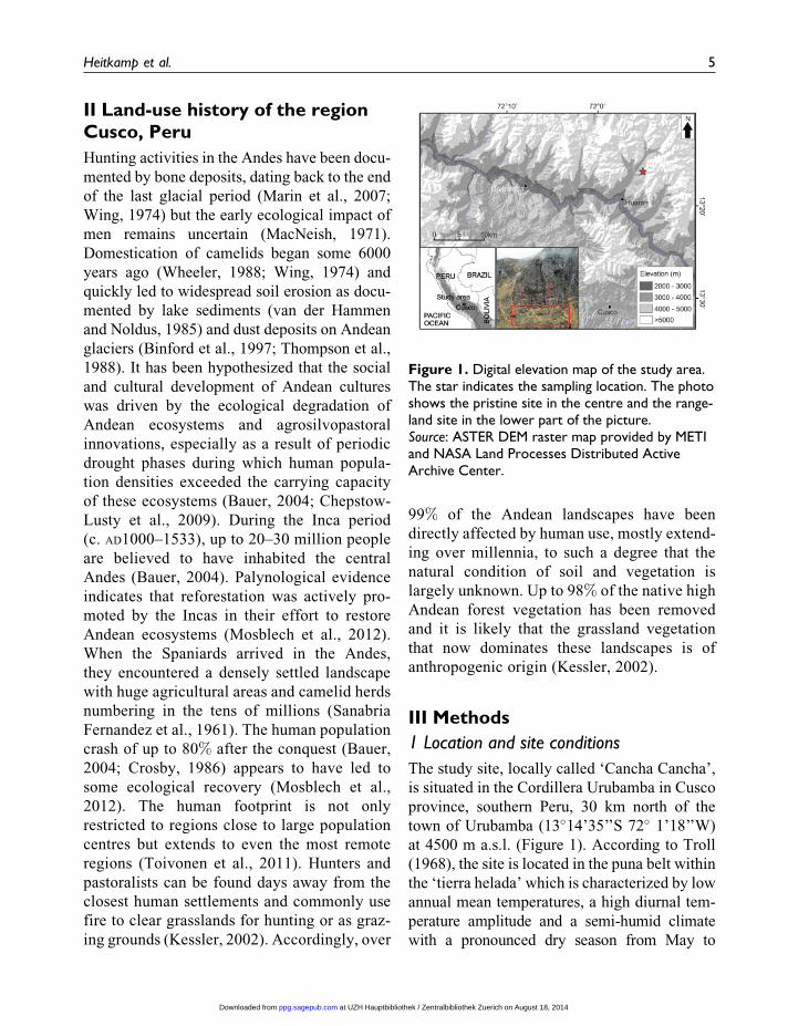
at 4500 m a.s.l. (Figure 1). According to Troll
(1968), the site is located in the puna belt within
the ‘tierra helada’ which is characterized by low
annual mean temperatures, a high diurnal tem-
perature amplitude and a semi-humid climate
with a pronounced dry season from May to
Figure 1. Digital elevation map of the study area.The star indicates the sampling location. The photoshows the pristine site in the centre and the range-land site in the lower part of the picture.Source: ASTER DEM raster map provided by METIand NASA Land Processes Distributed ActiveArchive Center.
Heitkamp et al. 5
at UZH Hauptbibliothek / Zentralbibliothek Zuerich on August 18, 2014ppg.sagepub.comDownloaded from
October. Mean annual precipitation in the closest
climate stations ranges from 454 mm (Urubamba,
2863 m a.s.l.) to 1606 mm (Winaywayna, 2800
m a.s.l.) (Toivonen et al., 2011). Since our
study site lies 1600 m above the climate sta-
tions, the data are hardly comparable. Never-
theless, orography and vegetation pattern in
Cancha Cancha indicate that mean annual preci-
pitation ranges at the higher end of these records.
Air temperatures were recorded at the site using
sensors and digital data loggers (DS1923 Hygro-
chroni Buttons). Since Cancha Cancha is less
than half a day’s travel away from the bottom
of the Inca’s fertile ‘Sacred Valley’, it is likely
that the site has been intensively used as range-
land for, at least, 4000 years.
The pristine site was formed of zonal vegeta-
tion located on a ledge of approximately 0.2 km2
size. Inaccessibility was guaranteed by steep
mountain cliff faces (Figure 1) that inhibited
access to grazing animals and the spread of
human-induced ground fires from the sur-
rounding landscape. The site could be accessed
from above by a 60 m controlled descent down
the cliff using mountaineering equipment. The
accessible site plots were located as close as
possible to the pristine site, with the distance
no more than c. 500 m. Both sites were well
above the shoulders of the U-shaped valley,
indicating no direct glaciation in the last gla-
cial maximum. The aspects of all plots were
similar in NW direction and ranged from
290� to 310�. Animal trampling was wide-
spread on accessible slopes, as typical for the
whole region. An impression of the landscape
and the different plots is shown in Figures 1
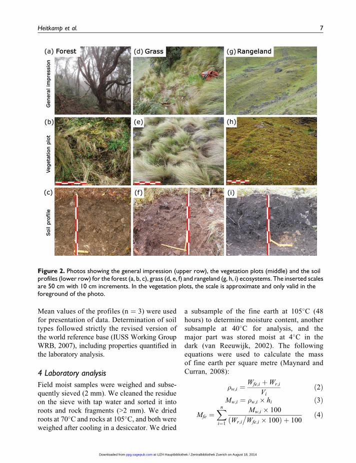
and 2.
2 Vegetation records
We partitioned the study area into two main
habitats: (1) pristine forest/grassland mosaic
located on the inaccessible cliff ledge men-
tioned above (Figure 2, a–f ); and (2) rangeland
(Figure 2, g–i), located on the accessible grazed
slopes surrounding the pristine site, that was
formed of mostly herbaceous taxa, some woody
shrubs and single trees. The pristine forest/
grassland mosaic consisted of different vegeta-
tion types, i.e. forest with a densely closed
canopy, interspersed with several forest gaps
dominated by bunchgrasses. No forest was
found in accessible areas due to excessive tim-
ber and firewood extraction from the local cam-
pesino population of Cancha Cancha (Sylvester,
personal observation).
Within each habitat, we studied 20–33 2 �2m2 plots for species composition and abiotic
variables from representative patches of vege-
tation. Voucher specimens were collected and
identified in the field or in the herbarium and
are deposited at the herbaria of Cusco, Peru
(CUZ), Zurich, Switzerland (Z), and La Paz,
Bolivia (LPB). Abiotic variables studied
include elevation, soil depth, slope gradient
and aspect. Abiotic variables were controlled
for as much as possible between habitats with
quadrats being placed in areas with similar
aspect, elevation, etc., so that differences in
vegetation could be attributed largely to the
level of accessibility.
3 Sampling and soil characterization
In the field we chose three pits per vegetation
type (pristine forest, pristine grass and range-
land). A different slope angle class was chosen
for every replicate within each vegetation type.
According to the guidelines of soil description
(FAO, 2006), slope classes were strongly slop-
ing (10–15%), moderately steep (15–30%) and
steep (30–40%). No obvious signs of erosion
were visible. Due to the thickness of the
A-horizon, sampling was done in strata (0–5,
5–10, 10–20, 20–30, 30–40 cm). For every
depth increment, we took a known volume of
sample from the profile wall by the volume
replacement method described in Maynard and
Curran (2008). We combined triplicate sam-
ples to one bulk sample of 300–500 ml volume.
6 Progress in Physical Geography
at UZH Hauptbibliothek / Zentralbibliothek Zuerich on August 18, 2014ppg.sagepub.comDownloaded from
Mean values of the profiles (n ¼ 3) were used
for presentation of data. Determination of soil
types followed strictly the revised version of
the world reference base (IUSS Working Group
WRB, 2007), including properties quantified in
the laboratory analysis.
4 Laboratory analysis
Field moist samples were weighed and subse-
quently sieved (2 mm). We cleaned the residue
on the sieve with tap water and sorted it into
roots and rock fragments (>2 mm). We dried
roots at 70�C and rocks at 105�C, and both were
weighed after cooling in a desiccator. We dried
a subsample of the fine earth at 105�C (48
hours) to determine moisture content, another
subsample at 40�C for analysis, and the
major part was stored moist at 4�C in the
dark (van Reeuwijk, 2002). The following
equations were used to calculate the mass
of fine earth per square metre (Maynard and
Curran, 2008):
�w;i ¼Wfe;i þWr;i
Vi
ð2ÞMw;i ¼ �w;i � hi ð3Þ
Mfe ¼Xn
i¼1
Mw;i � 100
ðWr;i
�Wfe;i � 100Þ þ 100
ð4Þ
Figure 2. Photos showing the general impression (upper row), the vegetation plots (middle) and the soilprofiles (lower row) for the forest (a, b, c), grass (d, e, f) and rangeland (g, h, i) ecosystems. The inserted scalesare 50 cm with 10 cm increments. In the vegetation plots, the scale is approximate and only valid in theforeground of the photo.
Heitkamp et al. 7
at UZH Hauptbibliothek / Zentralbibliothek Zuerich on August 18, 2014ppg.sagepub.comDownloaded from

where �w is the bulk density of the weathered
pedon (i.e. fine earth and rock fragments;
g cm-3) of layer i, Wfe,i is the weight of oven-
dry fine earth (g) of layer i, Wr,i is the weight
of rocks (g) in layer i, Vi is the total volume (g
cm-3) of the undisturbed sample (i.e. the hole in
the profile wall) in layer i, Mw,i is the mass of the
weathered pedon (kg m-2) in layer i, hi is the
height (mm) of layer i and Mfe is the mass of fine
earth (kg m-2) of the whole profile. The bulk den-
sity of fine earth (�fe, g cm-3) of layer i was cal-
culated as:
�fe;i ¼Wfe;i
Vi � ðWr;i
�2:65Þ
ð5Þ
where 2.65 is the assumed density of rocks
(g cm-3).
We determined particle size distribution by
sieving and sedimentation (van Reeuwijk,
2002). Values of pH were determined in 0.1 M
CaCl2 solution in a 1:5 soil: solution (v/v) ratio
(ISO, 2005). CaCl2 was chosen, because Ca was
dominant on the exchange sites. Effective
cation exchange capacity was determined by
extraction with 1M NH4Cl (Luer and Bohmer,
2000). We measured cations by ICP-OES
(Optima 4300 DV, Perkin Elmer Instruments,
Norwalk, USA). Total carbon and nitrogen con-
tents were measured by dry combustion (950�C,
Truspec CHN LECO, St Joseph, MI, USA). Due
to the low pH, we assumed no presence of car-
bonates and total carbon thus equals SOC.
Stocks of SOC were calculated as the product
of concentration and mass of fine earth. We
determined total element concentrations in soil
and parent material after HNO3/HF digestion
(Konig and Fortmann, 1999) with ICP-OES.
In the same extracts, rare earth elements (REE)
were measured by ICP-MS (PlasmaQuad STE,
Fisons/VG, Winsford, UK). REE concentra-
tions were normalized to Cl-chondrite values
(Anders and Grevesse, 1989) and presented as
so-called Spider diagrams, i.e. the REE are
arranged by their atomic weight on the x-axis
against the logarithm of chondrite-normalized
REE concentrations on the y-axis. These were
often used in provenance studies of different
materials due to their unique signatures (Kurtz
et al., 2001; McLennan and Taylor, 1991).
Therefore, Spider diagrams of REE are ideally
suited to indicate homogeneity of bedrock and
soil (Caspari et al., 2006), i.e. if bedrock is the
unique parent material or not (Sako et al.,
2009). Using total element concentrations, the
chemical index of alteration (CIA;Nesbitt and
Young, 1982) was calculated as a molar ratio
(note that the molar ratio of oxides was used
originally):
CIA ¼ Al
Al þ Caþ Naþ K� 100 ð6Þ
Fractions of Fe and Al were extracted with
sodium dithionite-citrate-bicarbonate (Fed and
Ald), ammonium oxalate (Feo and Alo) and
sodium pyrophosphate (Fep and Alp) and ele-
ment concentrations were measured by
ICP-OES as described in van Reeuvijk (2002).
Oxides develop during pedogenesis due to
weathering of parent material. In general, every
agent is supposed to extract specific forms of Fe
and Al. Extraction with sodium dithionite-
citrate-bicarbonate is a measure for the sum of
pedogenic Fe oxides and includes crystalline,
amorphous and organically complexed forms
of Fe. This extraction is less specific for forms
of Al and Si. Extraction with ammonium oxa-
late is a measure for amorphous and organically
complexed Fe and ammonium oxalate is sup-
posed to extract imogolite, allophanes, poorly
defined aluminosilicates and organically com-
plexed forms of Al. Furthermore, ammonium
oxalate extracts Si from allophanes. Extraction
with sodium pyrophosphate is generally used
to quantify organically complexed forms of Fe
and Al. Several ratios can be calculated indicat-
ing different processes. The Feo/Fed ratio indi-
cates the degree of crystallization of Fe
oxides. In general (aerobic conditions), crystal-
lization increases with time of soil development
(Torrent et al., 1980), but can be affected by
8 Progress in Physical Geography
at UZH Hauptbibliothek / Zentralbibliothek Zuerich on August 18, 2014ppg.sagepub.comDownloaded from

vegetation or presence of certain organic sub-
stances (Dumig et al., 2008). The ratios of Fed/
total Fe (FeT) and Alo/total Al (AlT) indicate the
states of weathering and degree of soil develop-
ment (Torrent et al., 1980; Vacca et al., 2009).
5 Statistics
Concentration data for the whole soil profile
(A-horizon) were averaged by weighting accord-
ing to soil mass in the corresponding layers. We
checked the data for normality (Kolmogorov-
Smirnov test) and homogeneity of variances
(Levene test). In the few cases of skewed distribu-
tions the data was successfully log-transformed.
All variances were homogeneous. We treated the
data as a balanced and fully randomized design.
We performed one way-ANOVA with SPSS
(IBM SPSS Statistics 20.0.0), followed by Fish-
er’s least significant difference in case of signifi-
cant (p�0.05) effects (Webster, 2007). We
calculated the pooled coefficient of variation as
a measure of dispersion.
IV Results and discussion
1 Vegetation
Pristine sites represented a mixture of Polylepis-
subsericans J.F. MACBR. forest of different clo-
sures and bunchgrass-dominated clearings. This
forest mosaic is presumed to be the original vege-
tation in large parts of the region (Fjeldsa, 2002;
Kessler, 2002). The trees provide relatively
dense crown cover (56%) and grow to an average
height of almost 5 m (Table 1). There was little
bare soil on the ground, which was covered by
densely rooted litter consisting of exfoliated bark
and some leaf litter. On average, eight species of
bunch grasses and herbs were found in each 2
�2-m square in the understorey. Six species were
found in the bunch grass clearings, which were
dominated by tall Deyeuxia spp. and Festuca
spp. bunch grasses (Figure 2). The species rich-
ness per square area was significantly lower in
these pristine grasslands than in the rangelands,
presumably because the bunch grasses outcom-
peted smaller herbs (Borer et al., 2014). Bunch
grasses are well known to be susceptible to fire
and strong grazing pressure, and their scarcity
in the rangelands is in accordance with previous
studies in, for example, North America (Collins
et al., 1998; Fuhlendorf and Engle, 2001).
Vegetation of the rangeland sites was very
different (Figure 2, g and h). The mean vegeta-
tion height was only 3 cm at the end of the rainy
season, when vegetation development was at its
maximum. Litter was practically absent and the
proportion of bare soil was much higher (21%)
in comparison with the pristine sites (2–4%,
Table 1). This result indicates the high grazing
pressure on these rangelands, which are situated
close to human settlement (30–60 minutes’
walk). The higher species richness per square
area in rangelands presumably reflects the influ-
ence of disturbance which inhibits the domi-
nance of highly competitive species (Connell,
1979; Warren et al., 2007). For instance, grazing
Table 1. Vegetation characteristics end of March/beginning of April 2011.
Pristine Managed
Forest (n ¼ 15) Grass (n ¼ 7) Rangeland (n ¼ 26) CVP p<F
Bare soil (%) 4a 2a 21b + 83% <0.001Litter cover (%) 60a 64a 4b + 48% <0.001Forb height (cm) 24a 31b 3c + 63% <0.001No. of forb species 8a 6a 28b + 28% <0.001Canopy cover (%) 56 – – + 56% –
CVP: pooled coefficient of variation
Heitkamp et al. 9
at UZH Hauptbibliothek / Zentralbibliothek Zuerich on August 18, 2014ppg.sagepub.comDownloaded from
prevents fast-growing and shade-tolerant spe-
cies from outcompeting slow-growing and
light-demanding plant species, thereby opening
up niches for a higher number of different spe-
cies (Borer et al., 2014). The continual burning
and grazing on the rangeland sites favours the
establishment of plants with adaptations to sur-
vive these anthropogenic pressures, such as the
ability of species to grow close to the soil sur-
face, the presence of toxins in their leaves, or
spiny habit. These findings are in line with other
studies conducted in the puna (Wilcox et al.,
1986) and paramo (Lægaard, 1992).
Thus it appears that human land-use led to
fundamental changes in the vegetation, from a
dense, species-poor, tree- and bunch grass-
dominated ecosystem with high above-ground
biomass to an open, species-rich and herb-
dominated system with very little biomass
(Figure 2). While no temporal data are avail-
able, the longevity of the plants in the pristine
ecosystems suggests that these are rather stable
over time, whereas the herb-dominated vegeta-
tion in grazed sites may well be more dynamic.
For example, a close-by, fenced-off area with-
out grazing at Abra Malaga (c. 30 km northwest
of this study’s location) showed marked differ-
ences in the herb vegetation after only 11 years
of fencing compared to nearby grazed sites (Syl-
vester et al., 2014).
2 Bedrock
The bedrock was classified as vulcanite Ande-
site, as also described by Mamani et al. (2010)
for this region. It was characterized by high por-
tions of fine-grained matrix with embedded pla-
gioclase feldspar, quartz crystals and little
chlorite. Some differences between the thin sec-
tions (Figure 3) from pristine and rangeland
plots occurred: in the sections of the pristine
site, more quartz-filled cracks occurred, the
amount of matrix material was slightly higher
and more veins and embedded particles of
black, opaque material (ore) were present.
However, bulk elemental composition was not
significantly different between the samples
(Table 2) and they had the same mineralogical
assemblage. Moreover, only two thin sections
were analysed, whereas chemical composition
was measured for every profile.
Patterns of rare earth elements indicate that
most profiles were derived from similar bed-
rock. Only profile 9 (Figure 4) showed deviation
from the other REE pattern by not having a pro-
nounced negative Europium (Eu) anomaly (i.e.
lower concentrations of Eu compared to the
neighbouring elements; McLennan and Taylor,
1991). This indicates different conditions in the
original melt (i.e. plagioclase fractionation;
McLennan and Taylor, 1991), which is also
expressed in the chemistry of the rocks: the rel-
atively high K content with a high coefficient of
variation in rocks of rangeland plots (Table 2)
was induced by the higher K concentration
mainly in profile 9.
3 Homogeneity of parent material
Soils on slopes are potentially prone to erosion
and mass movements. Hence, mountain soil
profiles are often truncated or buried (sedimen-
tation or rockfall). Furthermore, atmospheric
inputs of dust or volcanic ashes may markedly
contribute to parent material (Derry and Chad-
wick, 2007; Kurtz et al., 2001). With the aim
of comparing pedogenesis with and without
anthropogenic influence, it is essential to under-
pin the assumption of in situ development of the
profile. There are indicators that the chosen pro-
files in this study were not buried, did not expe-
rience major amounts of rockfall and did not
receive larger amounts of allochthonous dust
or volcanic ash inputs:
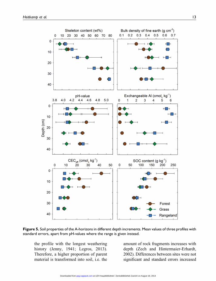
� The content of rock fragments (Figure 5)
gradually increased downward. This pat-
tern is typical for in situ pedogenesis: the
weathering front proceeds from the top
downwards, so the topsoil is the part of
10 Progress in Physical Geography
at UZH Hauptbibliothek / Zentralbibliothek Zuerich on August 18, 2014ppg.sagepub.comDownloaded from
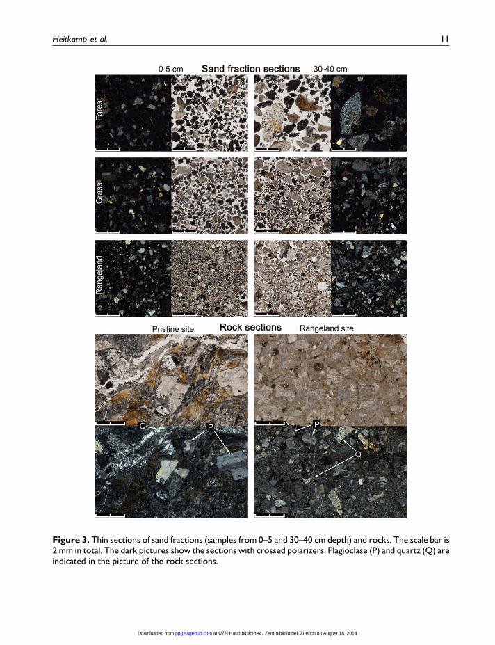
Figure 3. Thin sections of sand fractions (samples from 0–5 and 30–40 cm depth) and rocks. The scale bar is2 mm in total. The dark pictures show the sections with crossed polarizers. Plagioclase (P) and quartz (Q) areindicated in the picture of the rock sections.
Heitkamp et al. 11
at UZH Hauptbibliothek / Zentralbibliothek Zuerich on August 18, 2014ppg.sagepub.comDownloaded from
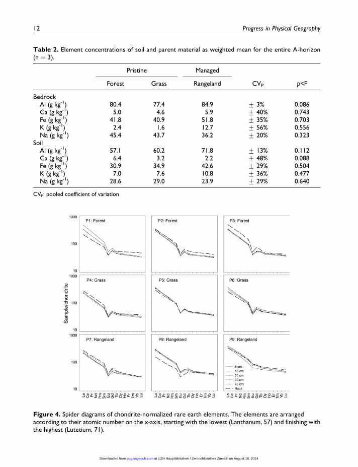
Table 2. Element concentrations of soil and parent material as weighted mean for the entire A-horizon(n ¼ 3).
Pristine Managed
Forest Grass Rangeland CVP p<F
BedrockAl (g kg-1) 80.4 77.4 84.9 + 3% 0.086Ca (g kg-1) 5.0 4.6 5.9 + 40% 0.743Fe (g kg-1) 41.8 40.9 51.8 + 35% 0.703K (g kg-1) 2.4 1.6 12.7 + 56% 0.556Na (g kg-1) 45.4 43.7 36.2 + 20% 0.323
SoilAl (g kg-1) 57.1 60.2 71.8 + 13% 0.112Ca (g kg-1) 6.4 3.2 2.2 + 48% 0.088Fe (g kg-1) 30.9 34.9 42.6 + 29% 0.504K (g kg-1) 7.0 7.6 10.8 + 36% 0.477Na (g kg-1) 28.6 29.0 23.9 + 29% 0.640
CVP: pooled coefficient of variation
Figure 4. Spider diagrams of chondrite-normalized rare earth elements. The elements are arrangedaccording to their atomic number on the x-axis, starting with the lowest (Lanthanum, 57) and finishing withthe highest (Lutetium, 71).
12 Progress in Physical Geography
at UZH Hauptbibliothek / Zentralbibliothek Zuerich on August 18, 2014ppg.sagepub.comDownloaded from
the profile with the longest weathering
history (Jenny, 1941; Legros, 2013).
Therefore, a higher proportion of parent
material is transformed into soil, i.e. the
amount of rock fragments increases with
depth (Zech and Hintermaier-Erhardt,
2002). Differences between sites were not
significant and standard errors increased
Figure 5. Soil properties of the A-horizons in different depth increments. Mean values of three profiles withstandard errors, apart from pH-values where the range is given instead.
Heitkamp et al. 13
at UZH Hauptbibliothek / Zentralbibliothek Zuerich on August 18, 2014ppg.sagepub.comDownloaded from
with depths. This pattern of coarse frag-
ment distribution indicates that rockfall
was not important during the time of ped-
ogenesis. Otherwise, contents of coarse
fragments would have been higher on top
of the profile, or sudden shifts in rock
content would have been observed.
� The morphology of the sand fractions
were different between samples taken
from 0–5 or 30–40 cm depths. Thin sec-
tions of the sand fraction (Figure 3) of the
lower parts of the profile show sharp-
edged, relatively unaltered rock frag-
ments, whereas sand at 0–5 cm had a
higher degree of alteration. The sharp
edges indicate the relatively low degree
of soil development, as well as little
movement. Less matrix material and sin-
gle plagioclase fragments separated from
the matrix, the latter occurring less fre-
quently at depth, additionally indicate in
situ soil development.
� The patterns of REE indicate that input of
allochthonous material did not occur in
the profiles in amounts large enough to
affect REE pattern. If bedrock was the
source for soil (i.e. bedrock and parent
material are identical) the REE pattern
in Figure 4 should show parallel lines and
the same Eu anomaly throughout the pro-
file (Kurtz et al., 2001). This is the case
for most profiles, which even show ideal
cases of the expected pattern (profiles 2,
4, 5, 6, 7 and 9). Solely for profile 1 we
cannot completely rule out dust input,
erosion or soil movement as some devia-
tion from the ideal pattern was found. The
Europium anomaly was still apparent and
therefore, just as for profiles 3 and 8, it
could also be derived from translocation
processes during soil development (Cas-
pari et al., 2006). With the REE pattern
we cannot completely rule out dust input
from local sources with the same signa-
ture. However, all profiles were dug
proximate to each other (200 m) and pro-
file 9 was the one with greater distance to
the others (400 m). The latter profile
already showed a different REE signature
(lower Eu anomaly) compared to the
eight other profiles and such signals
would likely affect REE pattern if dust
inputs had occurred in relevant amounts.
Due to the three lines of evidence (rock con-
tent, thin sections of the sand fraction, REE sig-
nature of bedrock and soil) we conclude that
all of the chosen profiles developed in situ
and did not receive major material input by
allochthonous sources. Hence, the chosen
sites and profiles are well suited for studying
in situ pedogenesis with and without land
use.
4 Soil description
In the following paragraphs soils will be
described according to the key of the IUSS
Working Group WRB (2007). Thereafter,
results of this study are discussed in context
with other published studies.
Organic layers were present on pristine
sites, especially in forest plots. However, a
dense root mat overlaid the mineral soil; this
pattern did not fully fit the definition of an
O-layer, although organic fragments and pel-
lets of mineral soil (probably worm casts) were
intermixed into the roots. All profiles were
characterized by having a thick mineral
A-horizon overlying an R- (bedrock) or thin
(< 5 cm) CB- over R-horizon (Figure 2, c, f and
i). The CB-horizons were found exclusively in
rangeland soils and may eventually develop
into Bw-horizons given enough time. In fact,
B-horizons were frequently found in valleys
that appear more humid in comparable land-
scape positions on glacial till (personal obser-
vation). Organic carbon contents (Figure 5)
were lower than required for ‘organic material’
and classification as Histosols could be ruled
14 Progress in Physical Geography
at UZH Hauptbibliothek / Zentralbibliothek Zuerich on August 18, 2014ppg.sagepub.comDownloaded from

out. Depth of the A-horizon comprised, as a
mean, between 30 cm and 37 cm (Table 3).
Profile depth did not differ significantly (p ¼0.721) between vegetation types and was highly
variable (CV¼ 44%). Soil depth was higher and
rock content lower as required for classification
as Leptosol. The following eight Reference
Groups in the key were clearly ruled out, due to
lack of high clay content (Vertisol, Solonetz),
direct anthropogenic impact (Anthrosol, Techno-
sol), ice (Cryosol), fluvial material (Fluvisol),
readily soluble salt (Solonchak) or reducing con-
ditions (Gleysol). Occurrence of Andosols was
possible, as reported before for parts of the Andes
(Hofstede, 1995). Soils require andic or vitric
properties to qualify as Andosols. Low bulk den-
sity (< 0.9 g cm-3), high phosphate retention
(85%) and Fe/Al chemistry are criteria for andic
properties. The proportion of Aloþ 1/2Feo has to
be higher than 2%, which was not the case (Table
4). The value was, however, larger than the 0.4%required for vitric properties in the rangeland
profiles. Nevertheless, vitric properties require
volcanic glass in the sand fraction, which was not
present. The next Reference Groups were ruled
out because soils did not have spodic (Podzols),
plinthic (Plintosols), nithic (Nitisols) or ferralic
(Ferralsols) horizons and lacked stagnic colour
patterns (Planosols, Stagnosols).
Due to accumulation of organic matter and a
high base status in pristine soil profiles, mollic
horizons were identified. Five criteria must be
fulfilled for the identification of mollic horizons:
(1) a sufficient soil structure that the horizon is not
both massive and hard when dry; (2) Munsell col-
ours with chroma < 3 when moist and a value < 3
when moist or < 5 when dry; (3) SOC� 6 g kg-1 or
SOC� 25 g kg-1 when colour requirements are
waived; (4) a base saturation of 50% or more
and (5) a thickness of either 25 cm or more
or 10 cm or more if overlying continuous
rock. Whereas pristine soils meet all the cri-
teria, rangeland soils solely fail to meet the
requirement for high base saturation. Conse-
quently, an umbric horizon was identified for
rangeland soils. Due to the absence of
cementing materials or clay illuviation, ran-
geland soils were classified as Umbrisols.
Table 3. Soil properties of the pristine and rangeland sites. Sum or mean (weighted by soil mass) of thewhole profile (n ¼ 3).
Pristine Managed
Forest Grass Rangeland CVP p<F
WRB classification lePHsolaar lePHsolaar leUMhdla – –Munsell colour 2.5Y3/1 10YR3/2 10YR1.7/1 – –Structure grþwc gr cr – –Fine roots (dm-2) > 200 >200 50–200 – –Profile depth (cm) 30 32 37 + 44% 0.721Soil mass (kg m-2) 153 164 216 + 44% 0.529SOC stock (kg m-2) 16.3 15.3 21.6 + 30% 0.283C/N ratio 16 14 15 + 7% 0.106Base saturation (%) 95a 72b 23c + 21% <0.001Al saturation (%) 1a 19a 75b + 69% <0.001Sand (%) 78.3a 71.0a 60.5b + 7% 0.009Silt (%) 20.3a 27.0a 38.3b + 18% 0.006Clay (%) 1.4 1.9 1.2 + 41% 0.504Texture class LS LS SL – –
CVP: pooled coefficient of variation; gr: granular; wc: wormcasts; cr: crumbly; LS: loamy sand; SL: sandy loam
Heitkamp et al. 15
at UZH Hauptbibliothek / Zentralbibliothek Zuerich on August 18, 2014ppg.sagepub.comDownloaded from
Pristine profiles with a mollic horizon could
potentially be classified as Chernozem, Kas-
tanozem or Phaeozem. Since the former two
require a calcic horizon, pristine soils were
classified as Phaeozems. All soil profiles had
continuous rock within 1 m depth and receive
the prefix ‘Leptic’. Pristine sites had textures
of loamy sand and receive the suffix ‘Are-
nic’. Moreover, high proportions of
exchangeable Mg (Mg þ Na > 15%; Figure
6) on the exchange complex led to classifica-
tion as ‘Sodic’. The base saturation of the
rangeland soil was below 20% justifying the
‘Hyperdystric’ suffix. Although not specifi-
cally listed for the Reference Soil Groups
Umbrisol and Phaeozem, the suffix ‘Laxic’
(� < 0.9 g cm-3) seems important to describe
all soils. Hence, pristine soils were classified
as Leptic Phaeozems (Sodic, Laxic, Arenic)
and those of the rangeland as Leptic Umbri-
sols (Hyperdystric, Laxic).
In general, soils of the high Andes within the
moist puna or paramo biomes were described as
carbon rich and acidic in nature (Alexander and
Pichott, 1979; Hofstede, 1995; Miller and Bir-
keland, 1992; Wilcox et al., 1988). This notion
fits well to the results of this study (Figures 2
and 5, Table 3). Moreover, bulk density was
commonly very low, which was generally
attributed to the influence of volcanic material
(Hofstede, 1995). Alexander and Pichott
(1979), however, stated that low bulk densities
were also a common feature of soils above
2000 m a.s.l. regardless of volcanic influence
(Cordillera Oriental, Colombia). In our study
area, animal trampling led to compaction of the
top 20 cm in rangeland soil, which is in agree-
ment with data of other studies (Hamza and
Anderson, 2005; Hofstede, 1995). Compared
to other studies (Miller and Birkeland, 1992;
Wilcox et al., 1988), the soils we encountered
are relatively weakly developed, which is
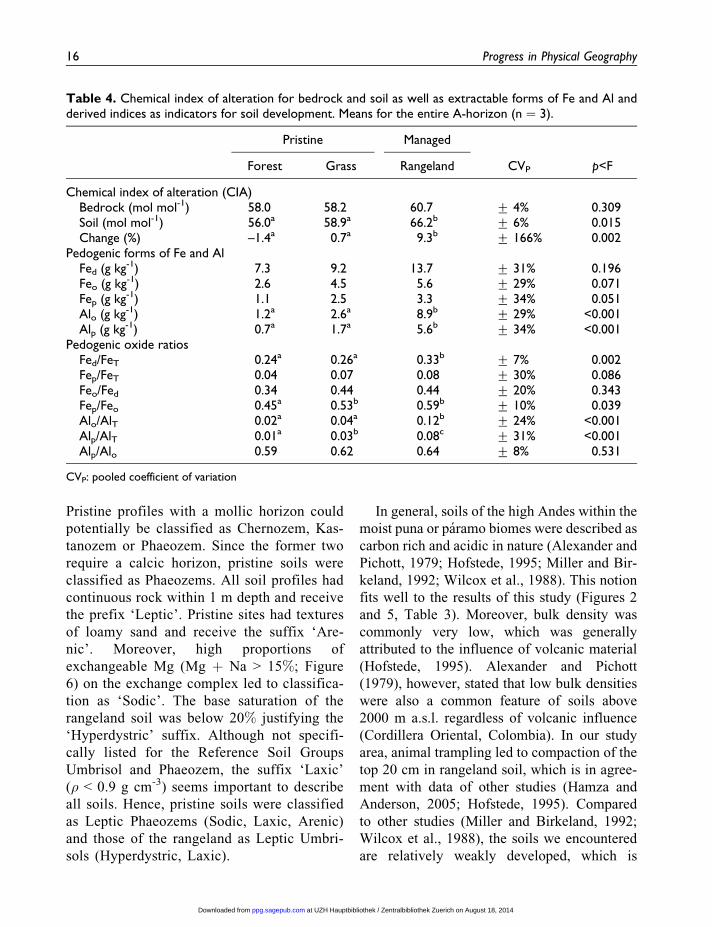
Table 4. Chemical index of alteration for bedrock and soil as well as extractable forms of Fe and Al andderived indices as indicators for soil development. Means for the entire A-horizon (n ¼ 3).
Pristine Managed
Forest Grass Rangeland CVP p<F
Chemical index of alteration (CIA)Bedrock (mol mol-1) 58.0 58.2 60.7 + 4% 0.309Soil (mol mol-1) 56.0a 58.9a 66.2b + 6% 0.015Change (%) –1.4a 0.7a 9.3b + 166% 0.002
Pedogenic forms of Fe and AlFed (g kg-1) 7.3 9.2 13.7 + 31% 0.196Feo (g kg-1) 2.6 4.5 5.6 + 29% 0.071Fep (g kg-1) 1.1 2.5 3.3 + 34% 0.051Alo (g kg-1) 1.2a 2.6a 8.9b + 29% <0.001Alp (g kg-1) 0.7a 1.7a 5.6b + 34% <0.001
Pedogenic oxide ratiosFed/FeT 0.24a 0.26a 0.33b + 7% 0.002Fep/FeT 0.04 0.07 0.08 + 30% 0.086Feo/Fed 0.34 0.44 0.44 + 20% 0.343Fep/Feo 0.45a 0.53b 0.59b + 10% 0.039Alo/AlT 0.02a 0.04a 0.12b + 24% <0.001Alp/AlT 0.01a 0.03b 0.08c + 31% <0.001Alp/Alo 0.59 0.62 0.64 + 8% 0.531
CVP: pooled coefficient of variation
16 Progress in Physical Geography
at UZH Hauptbibliothek / Zentralbibliothek Zuerich on August 18, 2014ppg.sagepub.comDownloaded from

shown by the shallow profile, lack of a
B-horizon and low clay contents (1.2–1.9%,
Table 3). Soils of this study are also (presum-
ably) rather young. Although signs of direct
glaciation are below the landscape position of
the profiles, periglacial conditions must have
been rather harsh. We presume that any existent
soil or saprolith was eroded from the slopes and
soil development started anew with the onset of
vegetation cover. As a rough estimation, soils
are younger than 10–5 kyears, a range also
given for soils developed on glacial till near the
study region (Miller and Birkeland, 1992; Wil-
cox et al., 1988). These soils were described
as somewhat deeper as in this study and B-
horizons with clay illuviation were identified.
Soil development on glacial till, however,
should be faster compared to development on
continuous bedrock, due to higher amounts of
fine-grained particles which increase surfaces
available for chemical reactions (Gabet and
Mudd, 2009). Weathering resistant bedrock
may also explain the low clay contents: one pro-
file described by Wilcox et al. (1988) developed
on an andesitic colluvium (footslope) and
exhibited much lower clay content (c. 10%)
compared to glacial till (20–50%). In the Alps
(1760 a.s.l.), Egli et al. (2001) reported similarly
low clay contents (0.7–2.4%) in a 10 kyear old
Haplic Podzol developed on granitic parent
material. Moreover, the semi-humid sites in this
study are northwest-exposed (Southern Hemi-
sphere), which generally promotes evapotran-
spiration and inhibits profile development
compared to shaded, moister slopes (Birkeland
et al., 2003). The low degree of development
is typical for high mountain soils of the Andes
(Zech and Hintermaier-Erhardt, 2002) due to
the rather short time of development (glacial
retreat c. 15–10 ka ago; Zech et al., 2009), the
cool climate and the pronounced dry season.
Overall, the general features of the soils
described in this study fit the limited obser-
vations from the study region (Miller and
Birkeland, 1992; Wilcox et al., 1988).
Although located on steep mountain terrain,
Miller et al. (1993) reported by using 14C
measurements that slopes were quite stable
during the Holocene, i.e. the period of soil
development was also stable. It should be
noted that the present study does not intend
to describe common soil types of the study
region, which is also characterized by glacial
till, alluvial fans and slope debris, but to find
sites with in situ soil development to quantify
the influence of the human state-factor.
Although all soils had many features in com-
mon, rangeland and pristine soils were classi-
fied differently due to their opposing state
regarding exchangeable bases and Al.
Despite being grouped into different Refer-
ence Groups of the IUSS Working Group
WRB (2007) and not just qualifiers (the pre-
fixes and suffixes of the Reference Group),
one may argue that different base status is a
minor effect for millennia of anthropogenic
influence. Soil genesis was, however, not
very advanced, which impedes larger differ-
entiation per se and more pronounced human
impact was unlikely as grazing management
Figure 6. Proportions of different cations on effec-tive cation exchange capacity (CEC). Soil-mass-weighted mean values (n¼ 3) of the whole A-horizon.Proportions of Naþ and Fe3þ are too small to berecognized.
Heitkamp et al. 17
at UZH Hauptbibliothek / Zentralbibliothek Zuerich on August 18, 2014ppg.sagepub.comDownloaded from
in the region, even with its long history, is
not, and is unlikely to ever have been, very
intensive.
5 State of weathering
The soil texture and the thin sections of the sand
fraction indicate differences in the state of phys-
ical alteration. For instance, the proportion of
sand is significantly higher in forest and grass
soils (78.3 and 71.0%, respectively) compared
to rangeland soils (60.5%, Table 3). Since we
ruled out relevant deposition of aeolian material
(Figure 4), coarser texture of pristine soils may
only be explained by two processes: depletion
of fines on the pristine sites by wind erosion
or advanced physical alteration on rangeland
sites. On the one hand, wind erosion on pristine
sites does not seem likely, regarding the vegeta-
tion cover, which protects the soil surface well
(Table 1, Figure 2), especially when compared
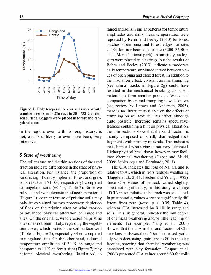
to rangeland sites. On the other hand, a diurnal
temperature amplitude of 24 K on rangeland
compared to 11 K on forest sites (Figure 7) may
enforce physical weathering (insolation) in
rangeland soils. Similar patterns for temperature
amplitudes and daily mean temperatures were
reported by Rehm and Feeley (2013) for forest
patches, open puna and forest edges for sites
c. 100 km northeast of our site (3200–3600 m
a.s.l., Manu National park). In our study, no log-
gers were placed in clearings, but the results of
Rehm and Feeley (2013) indicate a moderate
daily temperature amplitude settled between val-
ues of open puna and closed forest. In addition to
the insolation effect, constant animal trampling
(see animal tracks in Figure 2g) could have
resulted in the mechanical breaking up of soil
material to form smaller particles. While soil
compaction by animal trampling is well known
(see review by Hamza and Anderson, 2005),
there is no literature available on the effects of
trampling on soil texture. This effect, although
quite possible, therefore remains speculative.
Besides containing a hint on physical alteration,
the thin sections show that the sand fraction is
mainly composed of small, sharp-edged rock
fragments with primary minerals. This indicates
that chemical weathering is not very advanced.
Higher physical breakdown, however, may facil-
itate chemical weathering (Gabet and Mudd,
2009; Schlesinger and Bernhardt, 2013).
The CIA indicates the loss of Na, Ca and K
relative to Al, which mirrors feldspar weathering
(Buggle et al., 2011; Nesbitt and Young, 1982).
Since CIA values of bedrock varied slightly,
albeit not significantly, in this study, a change
of CIA in soil relative to bedrock was calculated.
In pristine soils, values were not significantly dif-
ferent from zero (t-test, p � 0.05, Table 4),
whereas CIA increased by 9.1% in rangeland
soils. This, in general, indicates the low degree
of chemical weathering and/or little leaching of
elements. For example, Yang et al. (2006)
showed that the CIA in the sand fraction of Chi-
nese loess soils was about 60 and increased gradu-
ally with decreasing grain size to 80 in the clay
fraction, showing that chemical weathering was
associated with clay formation. Caspari et al.
(2006) presented CIA values around 80 for soils
Figure 7. Daily temperature course as means withstandard errors over 326 days in 2011/2012 at thesoil surface. Loggers were placed in forest and ran-geland plots.
18 Progress in Physical Geography
at UZH Hauptbibliothek / Zentralbibliothek Zuerich on August 18, 2014ppg.sagepub.comDownloaded from

in Bhutan (1500–3800 m a.s.l.). Due to the poly-
genesis of soils, however, it was difficult to assign
baseline values for parent material. Moreover,
transformation does not necessarily mean translo-
cation if leaching is low, which might be the case
under semi-humid to semi-arid conditions.
Therefore, pedogenic oxides were analysed to
indicate transformation processes.
The Fed contents ranged from 7.2 to 13.7
g kg-1 and did not differ significantly (Table
4). As a proportion of total Fe (Fed/FeT), how-
ever, rangeland soils showed significantly
higher proportions of pedogenic Fe (0.24,
0.27 and 0.33 in forest, grass and rangeland
soil, respectively). The relatively low propor-
tions indicate pedogenesis during the Holocene
and are well comparable to values by Egli et al.
(2001) for alpine Podzols (10 kyears, granitic
parent material, 1760 m a.s.l.). The ratio of
Feo/Fed, representing the degree of crystalliza-
tion of pedogenic Fe-oxides, has been used to
evaluate the state of weathering, assuming a
higher degree of crystallization with age, i.e.
development (Torrent et al., 1980). In this
study, the Feo/Fed ratio did not differ signifi-
cantly. If seen as an indicator for soil age
(Torrent et al., 1980), this is consistent with
our assumption that pedogenesis commenced
at the same time on all sites. Although
weathering (as indicated by the Fed/FeT-ratio)
was significantly faster in rangeland soils
(see also discussion below), the same propor-
tion of pedogenic Fe-oxides crystallized. The
Feo/Fed-ratio can be affected by vegetation
cover, presumably due to specific properties
of SOM derived from certain vegetation
types. It has been shown that grass vegetation
inhibits and forest vegetation promotes crys-
tallization of Fe-oxides, presumably due to
complexation of Fe and SOM (Dumig et al.,
2008). In our study, this was indicated by a
trend (Table 4, p ¼ 0.051) of higher Fep con-
tents and a significantly higher Fep/Feo ratio
under grass-dominated vegetation (managed
rangeland and pristine grass).
Although significant, the difference of the Fed/
FeT ratio between managed and pristine soils was
relatively small. Pedogenic forms of Al showed
much more pronounced effects (Table 4). For
instance, Alo concentrations were 3.4 (grass) to
7 times (forest) higher in rangeland soil. Similar
marked differences were found for Alp concentra-
tions and the corresponding proportions Alo/AlTand Alp/AlT. The higher release of Al by weath-
ering is also reflected in the proportion of Al3þ
on the CEC (Table 3, Figure 6). The ratio of Alp/
Alo > 0.5 indicates that Al is strongly associated
with SOM (IUSS Working Group WRB, 2007;
Vacca et al., 2009). Although the formative ele-
ment ‘aluandic’ (Alp/Alo > 0.5, also called
non-allophanic) is in the World Reference Base
reserved for Andosols, it was pointed out that
Al-SOM-complexes may be relevant for non-
Andosols (Dumig et al., 2008; Vacca et al.,
2009). For instance, Dumig et al. (2008) reported
the outstanding importance of Al-SOM-
complexes in the genesis of highly weathered
Umbrisols in southern Brazil. High proportions
of Al-SOM-associations may explain the very
high SOC concentrations encountered in all soil
profiles of this study.
Summarizing the findings above, rangeland
soils exhibited a state of more intense physical
and chemical weathering compared to pristine
forest and grass soils. This was also shown by
Price et al. (2012) for Si weathering comparing
watersheds with different proportions of forest
and agricultural land. Since SOM is well known
to be stabilized by organo-metallic interactions,
the state of weathering may determine the level
of organic carbon stored in soils.
6 Soil organic carbon storage
Stocks of SOC were not significantly different
between the sites, although rangelands showed
somewhat higher stocks, (21.6, 16.3 and 15.3 kg
m-2 in rangeland, forest and grass soils, respec-
tively; Table 3) due to (insignificantly) higher soil
mass. Our finding corroborates the results of
Heitkamp et al. 19
at UZH Hauptbibliothek / Zentralbibliothek Zuerich on August 18, 2014ppg.sagepub.comDownloaded from
Zimmermann et al. (2010) who showed no differ-
ences in SOC stocks of grassland and forests
between 3000 and 3900 m a.s.l., close to our study
site. A review by Tanentzap and Coomes (2012)
showed that SOC stocks were not uniformly
affected by grazing. Furthermore, in a meta-
analysis Guo and Gifford (2002) showed a mar-
ginal mean increase of 8% in SOC stocks after
conversion of forest to pasture.
Concentrations of SOC gradually decreased
with depth, but were very high throughout the
profiles (Figure 5). The mean for the forest plots
in 0–5 cm was 211 g kg-1. Bunchgrass and range-
land soils had lower concentrations of c. 135 g
kg-1. However, differences were not significant
and converged down the profile to 55–77 g kg-1
in 30–40 cm depths. The high SOC concentra-
tions compare well with the findings of Zimmer-
mann et al. (2010) between 3000 and 3900 m
a.s.l. (Manu National Park, c. 100 km northeast
of our site) and correspond well to the deceler-
ated soil genesis of the cold and semi-humid cli-
mate (Zech and Hintermaier-Erhardt, 2002). It
has been shown that SOC concentrations in
grassland decrease significantly by clipping and
removing (as grazing simulation) above-ground
biomass regularly (Lajtha et al., 2014). That this
effect has not been observed may, on the one
hand, be explained by increased root turnover
on rangeland sites, which increases below-
ground C-input (Bardgett and Wardle, 2003).
Root input seems to favour build-up of SOC
compared to above-ground C input (Rumpel and
Koegel-Knabner, 2011), which, however, is a
conclusion derived from short-term experiments
that has been recently challenged (Lajtha et al.,
2014). On the other hand, preservation of SOC
may be explained by the changing importance
of stabilization mechanisms: the finer texture in
rangeland soils offers a higher specific surface
area and more SOC can be stabilized compared
to coarse-textured soils (Schleuß et al., 2014).
Moreover, higher contents of organically com-
plexed Al (Alp, Table 4) indicate that this
mechanism is of major importance to prevent
SOC loss (Heitkamp et al., 2012; Stevenson,
1994; von Lutzow et al., 2006).
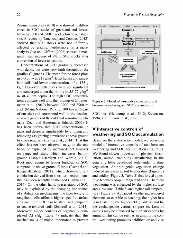
V Interactive controls ofweathering and SOC accumulation
Based on the state-factor model, we present a
model of interactive controls of and between
weathering and SOC accumulation (Figure 8).
We found slower processes of physical (inso-
lation, animal trampling) weathering in the
generally little developed soils under pristine
vegetation. Anthropogenic vegetation change
induced increases in soil temperature (Figure 7)
and acidity (Figure 5, Table 3) that forced a pos-
itive feedback loop in rangeland soils. Chemical
weathering was enhanced by the higher surface
area (less sand, Table 3) and higher soil tempera-
ture (Figure 7). Advanced weathering rendered
elements susceptible to leaching; the higher loss
is indicated by the higher CIA (Table 4) and by
the exchangeable cations (Figure 6). Loss of
cations may be enhanced by nutrient exports by
animals. This can be seen as an amplifying con-
trol: weathering promotes acidification and vice
Figure 8. Model of interactive controls of andbetween weathering and SOC accumulation.
20 Progress in Physical Geography
at UZH Hauptbibliothek / Zentralbibliothek Zuerich on August 18, 2014ppg.sagepub.comDownloaded from
versa. The intensified weathering in rangeland
soils possibly gives way to SOC preservation,
mainly in Al-SOM complexes (Kleber et al.,
2005). The finer texture of rangeland soils prob-
ably increased this effect (Heitkamp et al., 2012;
Schmidt et al., 2011), although this cannot be
proven yet by our data. Accumulation of SOC
and humification is accompanied with the pres-
ence of organic acids (Stevenson, 1994), which
feeds back to acidification. Acidification in turn
decreases microbial activity (Swift et al., 1979),
slowing down decomposition. However, this is
in contrast to a potentially increased microbial
activity caused by increased temperature (David-
son and Janssens, 2006), provided there is suffi-
cient soil moisture (Swift et al., 1979).
Nevertheless, protection from mineralization by
complexation and/or sorption slows down turn-
over of SOM (Heitkamp et al., 2012; von Lutzow
et al., 2006) and, hence, proportions of more
humified SOM will be higher. A stronger degree
of humification may, therefore, be responsible
for the darker soil colour (Figure 2, Table 3) in
rangelands which, in turn, amplifies the tempera-
ture increase due to sparse vegetation cover
(Table 1).
Some of the presumed processes involved in
the feedbacks have to be confirmed by further
analysis and the presented model of anthropo-
genic effects on soil development has to be
tested for more general validity. It is open to
question if this feedback loop will be valid
under different conditions, such as different cli-
mate, vegetation, relief, parent material or time
of soil development. Moreover, a different land-
use, such as more intensive cropland, may have
more pronounced effects. It should be noted
that, even on steep slopes, erosion seemed to
be of minor importance, as also indicated by
Miller et al. (1993). This may well be different
at locations with less precipitation, where
plant cover and SOC concentrations are lower
(Maetens et al., 2012). For instance, Coppus
et al. (2003) showed that erosion was a relevant
process in semi-arid locations of southern Bolivia.
VI The use of inaccessibilityas a tool
Our case study analysed soil development in the
puna region of the tropical high Andes. We were
able to clearly isolate the human influence on
soil and derive a model about the processes and
their feedbacks on soil (Figure 8), which were
triggered by vegetation change and animal
trampling. It has already been shown that inac-
cessibility can be used as a useful tool to iden-
tify the potential natural vegetation of areas of
the puna where grazing exclosure experiments
are not in place (Sylvester et al., 2014). Our
research shows that inaccessible ledge habitats
can be used to infer the potential natural soil
conditions of areas of the puna that are heavily
impacted by anthropogenic pressures, as is the
case almost everywhere.
The challenge now is to apply the tool of
inaccessibility to other localities, where state-
factors are different. This includes areas with
differing classical factors of climate, organisms,
relief, parent material and time, but especially
areas with a differing archaeological, historical,
cultural and technological component of the
human factor. Including more sophisticated
methods such as isotopic or trace elements anal-
ysis to quantify weathering rates and measure-
ment of element fluxes, such as carbon cycling
or chemical mass balances, will enable us to use
the proposed model more quantitatively, as
recently proposed for the state-factor ‘time’ and
the relation between pedogenesis and plant spe-
cies richness (Laliberte et al., 2013).
Of course, the tool, as every other tool, has its
drawbacks. Obviously, pristine sites will mainly
be found in mountain ecosystems or extremely
remote areas. In remote areas, it may be hard
to find comparable sites with human impact,
whereas in mountainous regions, the land-use
practices are often restricted. Nevertheless, hav-
ing such a tool available in mountain ecosys-
tems is still valuable, because elevational
gradients reflect (again not without restrictions)
Heitkamp et al. 21
at UZH Hauptbibliothek / Zentralbibliothek Zuerich on August 18, 2014ppg.sagepub.comDownloaded from
the global latitudinal patterns of climates and
ecosystems (Malhi et al., 2010; von Humboldt
and Bonpland, 1805). It should also be taken
into account that atmospheric deposition and
climate change are anthropogenic alterations
that are affecting even the most remote and
inaccessible locations meaning that the baseline
values obtained may not reflect past natural soil
conditions. Nevertheless, in the absence of
palaeoecological data, experimental approaches
using inaccessible soil conditions as baseline
data are the most objective way for looking at
anthropogenic influence on soil development.
This study justifies ‘humans’ as a soil and
ecosystem forming factor and validates that
‘inaccessibility’ can be used as a suitable tool
to assess the human impact on soil develop-
ment. We propose to combine our methodologi-
cal approach with other scientific disciplines,
such as palaeosciences (Kiage and Liu, 2006),
anthropology (Isendahl, 2010) and historical
ecology (Balee, 2006), and apply it in the frame-
work of the state-factor model (Amundson and
Jenny, 1997; Jenny, 1941). We are confident
that interdisciplinary, rigorous use of this tool
will be a step forward in quantifying regionally
valid thresholds and landscape sensitivities,
which will help in defining a ‘safe operating
space for humanity’ (Rockstrom et al., 2009).
Acknowledgements
We are thankful to Petra Voigt, Anja Sodje and
Michael Reimann for their skilful lab work. Further-
more, we are indebted to Axel Vollbrecht and Chris-
tian Nikolajew (Department of Structural Geology,
GAUG Gottingen) for introduction in thin-section
microscopy and to Klaus Simon (Geochemistry,
GAUG Gottingen) for ICP-MS measurements and
discussions about the use of geochemistry in the
manuscript’s context.
Author Contributions
Conceived the field design: MK, SPS; conceived and
designed the soil study: FH, HFJ; performed field-
work: SPS, FH, MDPVS; analysed soil samples and
data: FH; wrote the manuscript: FH, HFJ, SPS, MK.
Declaration of Conflicting Interests
The author(s) declared no potential conflicts of inter-
est with respect to the research, authorship, and/or
publication of this article.
Funding
The author(s) disclosed receipt of the following
financial support for the research, authorship and/
or publication of this article: This work was sup-
ported by the Deutsche Forschungsgemeinschaft
[grant numbers HE 6726 5/1; JU 2748/6-1]; the
Leverhulme Trust, UK, provided a studentship grant
to SPS.
References
Alexander EB and Pichott JH (1979) Soil organic matter in
relation to altitude in equatorial Columbia. Turrialba
29: 183–188.
Amundson R and Jenny H (1997) Thinking of biology: On
a state factor model of ecosystems. Bio Science 47:
536–543.
Amundson R, Richter DD, Humphreys GS, et al. (2007)
Coupling between biota and earth materials in the
critical zone. Elements 3: 327–332.
Anders E and Grevesse N (1989) Abundances of the ele-
ments: Meteoritic and solar. Geochimica et Cosmo-
chimica Acta 53: 197–214.
Balee W (2006) The research program of historical ecol-
ogy. Annual Review of Anthropology 35: 75–98.
Bardgett RD and Wardle DA (2003) Herbivore-mediated
linkages between aboveground and belowground com-
munities. Ecology 84: 2258–2268.
Bauer BS (2004) Ancient Cuzco: Heartland of the Inca.
Austin, TX: University of Texas Press.
Binford MW, Kolata AL, Brenner M, et al. (1997) Climate
variation and the rise and fall of an Andean civilization.
Quaternary Research 47: 235–248.
Birkeland PW, Shroba RR, Burns SF, et al. (2003) Inte-
grating soils and geomorphology in mountains – an
example from the Front Range of Colorado. Geomor-
phology 55: 329–344.
Bockheim JG and Gennadiyev AN (2000) The role of soil-
forming processes in the definition of taxa in Soil Tax-
onomy and the World Soil Reference Base. Geoderma
95: 53–72.
Borer ET, Seabloom EW, Gruner DS, et al. (2014) Her-
bivores and nutrients control grassland plant diversity
via light limitation. Nature 508: 517–520.
22 Progress in Physical Geography
at UZH Hauptbibliothek / Zentralbibliothek Zuerich on August 18, 2014ppg.sagepub.comDownloaded from
Brimhall GH and Dietrich WE (1987) Constitutive
mass balance relations between chemical composition,
volume, density, porosity, and strain in metasomatichy-
drochemical systems: Results on weathering and pedo-
genesis. Geochimica et Cosmochimica Acta 51: 567–587.
Buggle B, Glaser B, Hambach U, et al. (2011) An eva-
luation of geochemical weathering indices in loess–
paleosol studies. Quaternary International 240: 12–21.
Buytaert W, Celleri R, De Bievre B, et al. (2006) Human
impact on the hydrology of the Andean paramos.
Earth-Science Reviews 79: 53–72.
Caspari T, Baumler R, Norbu C, et al. (2006) Geochemical
investigation of soils developed in different lithologies
in Bhutan, eastern Himalayas. Geoderma 136: 436–458.
Certini G and Scalenghe R (2011) Anthropogenic soils are
the golden spikes for the Anthropocene. Holocene 21:
1269–1274.
Chadwick OA, Brimhall GH and Hendricks DM (1990)
From a black to a gray box –a mass balance inter-
pretation of pedogenesis. Geomorphology 3: 369–390.
Chapin FS III, Matson PA and Vitousek PM (2012)
Principles of Terrestial Ecosystem Ecology. New York:
Springer.
Chepstow-Lusty AJ, Frogley MR, Bauer BS, et al. (2009)
Putting the rise of the Inca Empire within a climatic and
land management context. Climate of the Past 5: 375–388.
Collins SL, Knapp AK, Briggs JM, et al. (1998) Modulation
of diversity by grazing and mowing in native tallgrass
prairie. Science 280: 745–747.
Conant RT (2012) Grassland soil organic carbon stocks:
Status, opportunities, vulnerability. In: Lal R, Lorenz K,
Huttl RF, Schneider BU and von Braun J (eds) Recarbo-
nization of the Biosphere. Dordrecht: Springer, 275–302.
Connell JH (1979) Diversity in tropical rain forests and
coral reefs. Science 199: 1302–1310.
Coppus R, Imeson AC and Sevink J (2003) Identification,
distribution and characteristics of erosion sensitive
areas in three different Central Andean ecosystems.
Catena 51: 315–328.
Crosby A (1986) Ecological Imperialism: The Biological
Expansion of Europe 900–1900. Cambridge: Cam-
bridge University Press.
Crutzen PJ (2002) Geology of mankind. Nature 415: 23–23.
Davidson EA and Janssens IA (2006) Temperature sensi-
tivity of soil carbon decomposition and feedbacks to
climate change. Nature 440: 165–173.
Derry LA and Chadwick OA (2007) Contributions from
Earth’s atmosphere to soil. Elements 3: 333–338.
Dumig A, Schad P, Kohok M, et al. (2008) A mosaic of
nonallophanic Andosols, Umbrisols and Cambisols on
rhyodacite in the southern Brazilian highlands. Geo-
derma 145: 158–173.
Egli M and Fitze P (2000) Formulation of pedologic mass
balance based on immobile elements: A revision. Soil
Science 165: 437–443.
Egli M, Fitze P and Mirabella A (2001) Weathering and
evolution of soils formed on granitic, glacial deposits:
Results from chronosequences of Swiss alpine envir-
onments. Catena 45: 19–47.
Egli M, Mirabella A, Sartori G, et al. (2003) Weathering
rates as a function of climate: Results from a climose-
quence of the Val Genova (Trentino, Italian Alps).
Geoderma 111: 99–121.
Fjeldsa J (2002) Polylepis forests – vestiges of vanishing
ecosystem in the Andes. Ecotropia 8: 111–123.
Foley JA, Costa MH, Delire C, et al. (2003) Green surprise?
How terrestrial ecosystems could affect Earth’s climate.
Frontiers in Ecology and the Environment 1: 38–44.
Food and Agriculture Organization of the United Nations
(FAO) (2006) Guidelines for Soil Description. Rome:
FAO.
Fuhlendorf SD and Engle DM (2001) Restoring het-
erogeneity on rangelands: Ecosystem management
based on evolutionary grazing patterns. BioScience
51: 625–632.
Gabet EJ and Mudd SM (2009) A theoretical model cou-
pling chemical weathering rates with denudation rates.
Geology 37: 151–154.
Goudie AS and Viles HA (2012) Weathering and the
global carbon cycle: Geomorphological perspectives.
Earth-Science Reviews 113: 59–71.
Guo LB and Gifford RM (2002) Soil carbon stocks and
land use change: A meta analysis. Global Change
Biology 8: 345–360.
Hamza MA and Anderson WK (2005) Soil compaction in
cropping systems: A review of the nature, causes and
possible solutions. Soil and Tillage Research 82:
121–145.
Heitkamp F, Jacobs A, Jungkunst HF, et al. (2012) Pro-
cesses of soil carbon dynamics and ecosystem carbon
cycling in a changing world. In: Lal R, Lorenz K, Huttl
RF, Schneider BU and von Braun J (eds) Recarboni-
zation of the Biosphere. Dordrecht: Springer, 395–428.
Hofstede RGM (1995) The effects of grazing and burning
on soil and plant nutrient concentrations in Colombian
paramo grasslands. Plant and Soil 173: 111–132.
Heitkamp et al. 23
at UZH Hauptbibliothek / Zentralbibliothek Zuerich on August 18, 2014ppg.sagepub.comDownloaded from
Houghton R (2012) Historic changes in terrestial carbon
storage. In: Lal R, Lorenz K, Huttl RF, Schneider BU
and von Braun J (eds) Recarbonization of the Bio-
sphere. Dordrecht: Springer, 59–82.
International Organization for Standardization (ISO)
(2005) ISO 10390:2005: Soil quality – determination of
pH. Geneva: ISO, 5 pp.
International Union of Soil Sciences (IUSS) Working
Group WRB (2007) World Reference Base for Soil
Resources 2006. World Soil Resources Reports 103.
Rome: Food and Agriculture Organization of the
United Nations (FAO). Electronic update 2007.
Available at: http://www.fao.org/ag/agl/agll/wrb.
Isendahl C (2010) The Anthropocene forces us to recon-
sider adaptationist models of human-environment
interactions. Environmental Science and Technology
44: 6007–6007.
Jenny H (1941) Factors of Soil Formation: A System of
quantitative Pedology. New York: McGraw-Hill.
Jenny H (1980) The Soil Resource: Origin and Behaviour.
New York: Springer.
Jungkunst HF, Kruger J-P, Heitkamp F, et al. (2012)
Accounting more precisely for peat and other soil
carbon resources. In: Lal R, Lorenz K, Huttl RF,
Schneider BU and von Braun J (eds) Recarbonization
of the Biosphere. Dordrecht: Springer, 127–158.
Kessler M (2002) The ‘Polylepis problem’: Where do we
stand? Ecotropica 8: 97–110.
Kiage LM and Liu K-B (2006) Late Quaternary paleoen-
vironmental changes in East Africa: Areview of mul-
tiproxy evidence from palynology, lake sediments, and
associated records. Progress in Physical Geography
30: 633–658.
Kleber M, Mikutta R, Torn MS, et al. (2005) Poorly crystal-
line mineral phases protect organic matter in acid subsoil
horizons. European Journal of Soil Science 56: 717–725.
Konig N and Fortmann H (1999) Probenvorbereitungs-,
Untersuchungs- und Elementbestimmungs-Methoden
des Umweltanalytik-Labors der Forstlichen Versuchsan-
stalt. 1. Erganzung: 1996–1998. Teil 3: Untersuchungs-
und Probenvorbereitungsmethoden, Geratekurzanleitun-
gen, Qualitatskontrolle, Datenverarbeitung. Berichte
des Forschungszentrum fur Waldokosysteme der Uni-
versitat Gottingen, 200 pp.
Kurtz AC, Derry LA and Chadwick OA (2001) Accretion
of Asian dust to Hawaiian soils: Isotopic, elemental,
and mineral mass balances. Geochimica et Cosmochi-
micaActa 65: 1971–1983.
Lægaard S (1992) Influence of fire in the grass paramo
vegetation of Ecuador. In: Balslev H and Luteyn JL
(eds) Paramo: An Andean Ecosystem under Human
Influence. London: Academic Press, 151–170.
Lajtha K, Townsend K, Kramer M, Swanston S, et al.
(2014) Changes to particulate versus mineral-
associated soil carbon after 50 years of litter manip-
ulation in forest and prairie experimental ecosys-
tems. Biogeochemistry 119: 341–360.
Laliberte E, Grace JB, Huston MA, et al. (2013) How does
pedogenesis drive plant diversity? Trends in Ecology
and Evolution 28: 331–340.
Legros J-P (2013) Major Soil Groups of the World:
Ecology, Genesis, Properties and Classification. Boca
Raton, FL: CRC Press.
Leuschner C, Jungkunst HF and Fleck S (2009) Functional
role of forest diversity: Pros and cons of synthetic
stands and across-site comparisons in established for-
ests. Basic and Applied Ecology 10: 1–9.
Lucas Y (2001) The role of plants in controlling rates and
products of weathering: Importance of biological
pumping. Annual Review of Earth and Planetary Sci-
ences 29: 135–163.
Luer B and Bohmer A (2000) Vergleichz wischen Perkolation
und Extraktion mit 1 M NH4Cl-Losung zurBestimmung
der effektiven Kationenaustauschkapazitat (KAKeff) von
Boden. Journal of Plant Nutrition and Soil Science 163:
555–557.
McLennan SM and Taylor SR (1991) Sedimentary rocks
and crustal evolution: Tectonic setting and secular
trends. The Journal of Geology 99: 1–21.
MacNeish RS (1971) Early man in the Andes. Scientific
American 224: 36–46.
Maetens W, Vanmaercke M, Poesen J, et al. (2012) Effects
of land use on annual runoff and soil loss in Europe and
the Mediterranean: A meta-analysis of plot data. Prog-
ress in Physical Geography 36: 599–653.
Malanson GP, Scuderi L, Moser KA, et al. (2014) The
composite nature of physical geography: Moving from
linkages to integration. Progress in Physical Geo-
graphy 38: 3–18.
Malhi Y, Silman M, Salinas N, et al. (2010) Introduction:
Elevation gradients in the tropics: Laboratories for
ecosystem ecology and global change research. Global
Change Biology 16: 3171–3175.
Mamani M, Worner G and Sempere T (2010) Geochemical
variations in igneous rocks of the Central Andean
orocline (13�S to 18�S): Tracing crustal thickening and
24 Progress in Physical Geography
at UZH Hauptbibliothek / Zentralbibliothek Zuerich on August 18, 2014ppg.sagepub.comDownloaded from

magma generation through time and space. Geological
Society of America Bulletin 122: 162–182.
Marin JC, Zapata B, Gonzalez BA, et al. (2007) Sistema-
tica y taxonomıa y domesticacion de alpacas y lamas:
Nueva evidencia cromosomica y molecular. Revista
Chilena de Historia Natural 80: 121–140.
Maynard DG and Curran MP (2008) Bulk density mea-
surement in forest soils. In: Carter MR and Gregorich
EG (eds) Soil Sampling and Methods of Analysis. Boca
Raton, FL: Taylor and Francis, 863–869.
Miller DC and Birkeland PW (1992) Soil catena variation
along an alpine climatic transect, northern Peruvian
Andes. Geoderma 55: 211–223.
Miller DC, Birkeland PW and Rodbell DT (1993) Evi-
dence for Holocene stability of steep slopes, northern
Peruvian Andes, based on soils and radiocarbon dates.
Catena 20: 1–12.
Mosblech NAS, Chepstow-Lusty A, Valencia BG, et al.
(2012) Anthropogenic control of late-Holocene land-
scapes in the Cuzco region, Peru. The Holocene 22:
1361–1372.
Neely C, Bunning S and Wilkes A (2009) Review of evi-
dence on dryland pastoral systmes and climate change:
Implications and opportunities for mitigation and
adaption. Land and Water Discussion Paper 8. Rome:
Land Tenure and Management Unit, Land and Water
Division, Food and Agriculture Organization of the
United Nations (FAO), 50 pp.
Neff JC, Reynolds RL, Belnap J, et al. (2005) Multi-
decadal impacts of grazing on soil physical and biogeo-
chemical properties in southeast Utah. Ecological
Applications 15: 87–95.
Nesbitt HW and Young GM (1982) Early Proterozoic
climates and plate motions inferred from major element
chemistry of lutites. Nature 299: 715–717.
Panichini M, Matus F, Mora ML, et al. (2012) Carbon
distribution in top- and subsoil horizons of two con-
trasting Andisols under pasture or forest. European
Journal of Soil Science 63: 616–624.
Price JR, Hardy CR, Tefend KS, et al. (2012) Solute
geochemical mass-balances and mineral weathering
rates in small watersheds II: Biomass nutrient
uptake, more equations in more unknowns, and land
use/land cover effects. Applied Geochemistry 27:
1247–1265.
Rehm EM and Feeley KJ (2013) Forest patches and the
upward migration of timberline in the southern Peruvian
Andes. Forest Ecology and Management 305: 204–211.
Richter DD (2007) Humanity’s transformation of
Earth’s soil: Pedology’s new frontier. Soil Science
172: 957–967.
Rockstrom J, Steffen W, Noone K, et al. (2009) A safe
operating space for humanity. Nature 461: 472–475.
Rumpel C and Koegel-Knabner I (2011) Deep soil organic
matter – a key but poorly understood component of
terrestrial C cycle. Plant and Soil 338: 143–158.
Sako A, Mills AJ and Roychoudhury AN (2009) Rare earth
and trace element geochemistry of termite mounds in
central and northeastern Namibia: Mechanisms for
micro-nutrient accumulation. Geoderma 153: 217–230.
Sanabria Fernandez H, Coimbra SanzG, Ribera Arteaga L,
et al. (1961) Cronistas Crucenos del Alto Peru Vir-
reynal. Santa Cruz: Universidad Gabriel Rene Moreno.
Schlesinger WH and Bernhardt ES (2013) Biogeochemistry:
An Analysis of Global Change. Amsterdam: Elsevier.
Schleuß P-M, Heitkamp F, Leuschner C, et al. (2014)
Higher subsoil carbon storage in species-rich than
species-poor temperate forests. Environmental Research
Letters 9: 014007.
Schmidt MWI, Torn MS, Abiven S, et al. (2011) Persis-
tence of soil organic matter as an ecosystem property.
Nature Geoscience 478: 49–56.
Smith P, Martino D, Cai Z, et al. (2008) Greenhouse gas
mitigation in agriculture. Philosophical Transactions
of the Royal Society B 363: 789–813.
Steffen W, Andreae MO, Bolin B, et al. (2004) Abrupt
changes: The Achilles’ heels of the earth system.
Environment 46: 8–20.
Stevenson FJ (1994) Humus Chemistry: Genesis, Com-
position, Reactions. New York: Wiley.
Swift MJ, Heal OW and Anderson JM (1979) Decomposition
in Terrestial Ecosystems. Oxford: Blackwell Scientific.
Sylvester SP, Sylvester MDPV, Kessler M, et al. (2014)
Inaccessible ledges as refuges for the natural vegetation
of the high Andes. Journal of Vegetation Science. doi:
10.1111/jvs.12176.
Tanentzap AJ and Coomes DA (2012) Carbon storage in
terrestrial ecosystems: Do browsing and grazing her-
bivores matter? Biological Reviews 87: 72–94.
Thompson LG, Davis ME, Mosley-Thompson R, et al.
(1988) Pre-Incan agricultural activity recorded in dust
layers in two tropical ice cores. Nature 336: 763–765.
Toivonen JM, Kessler M, Ruokolainen K, et al. (2011)
Accessibility predicts structural variation of Andean
Polylepis forests. Biodiversity and Conservation 20:
1789–1802.
Heitkamp et al. 25
at UZH Hauptbibliothek / Zentralbibliothek Zuerich on August 18, 2014ppg.sagepub.comDownloaded from
Torrent J, Schwertmann U, Schulze DG, et al. (1980) Iron
oxide mineralogy of some soils of two river terrace
sequences in Spain. Geoderma 23: 191–208.
Troll C (1968) Geo-Ecology of the Mountainous Regions
of the Tropical Americas. Bonn: Dummlers.
Vacca S, Capra GF, Coppola E, et al. (2009) From andic
non-allophanic to non-andic allophanic Inceptisols on
alkaline basalt in Mediterranean climate: A topose-
quence study in the Marghine district (Sardinia, Italy).
Geoderma 151: 157–167.
van der Hammen T Noldus GW, et al. (1985) Pollen anal-
ysis of the Telarmachay rockshelter. In: Lavallee D,
Julien M, Wheeler JC and Karlin C (eds) Telarmachay
Chasseurs et Pasteurs Prehistoriques des Andes I. Paris:
ADPF, 379–387.
van Reeuwijk LP (2002) Procedures for soil analysis, sixth
edition. Technical Paper 9. Wageningen: International
Soil Reference and Information Centre (ISRIC), Food
and Agriculture Organization of the United Nations
(FAO), 120 pp.
Verboom WH and Pate JS (2013) Exploring the biological
dimension to pedogenesis with emphasis on the eco-
systems, soils and landscapes of southwestern Aus-
tralia. Geoderma 211–212: 154–183.
von Humboldt A and Bonpland A (1805) Geographie des
Plantes Equinoxiales. Paris: Langlois.
von Lutzow M, Kogel-Knabner I, Ekschmitt K, et al.
(2006) Stabilization of organic matter in temperate
soils: Mechanisms and their relevance under different
soil conditions –a review. European Journal of Soil
Science 57: 426–445.
Warren SD, Holbrook SW, Dale DA, et al. (2007)
Biodiversity and the heterogeneous disturbance
regime on military training lands. Restoration
Ecology 15: 606–612.
Webster R (2007) Analysis of variance, inference, mul-
tiple comparisons and sampling effects in soil
research. European Journal of Soil Science 58: 74–82.
Wheeler JC (1988) Origin and evolution of the South
American Camelidae. In: Thomsen GM and Weide KD
(eds) Selected Papers from the 60th Western Veterinary
Conference. Las Vegas, NV: Western Veterinary
Conference, 290–300.
White AF and Blum AE (1995) Effects of climate on
chemical weathering in watersheds. Geochimica et
Cosmochimica Acta 59: 1729–1747.
White PS and Walker JL (1997) Approximating nat-
ure’s variation: Selecting and using reference
information in restoration ecology. Restoration
Ecology 5: 338–349.
Wilcox BP, Allen BL, Bryant FC, et al. (1988) Description
and classification of soils of the high-elevation grass-
lands of central Peru. Geoderma 42: 79–94.
Wilcox BP, Bryant FC, Wester D, et al. (1986) Grassland
communities and soils on a high elevation grassland of
central Peru. Phytologia 61: 231–250.
Wing ES (1974) Animal domestication in the Andes. In:
Reed CA (ed.) Origins of Agriculture. The Hague:
Moulton, 837–859.
Yang S, Ding F, Ding Z, et al. (2006) Pleistocene chemical
weathering history of Asian arid and semi-arid regions
recorded in loess deposits of China and Tajikistan. Geo-
chimica et Cosmochimica Acta 70: 1695–1709.
Zech R, Smith J, Kaplan MR, et al. (2009) Chronologies of
the Last Glacial Maximum and its termination in the
Andes (~10–55�S) based on surface exposure dating.
In: Vimeux F, Sylvestre F and Khodri M (eds) Past
Climate Variability in South America and Surrounding
Regions: From the Last Glacial Maximum to the
Holocene. Dordrecht: Springer, 61–86.
Zech W and Hintermaier-Erhardt G (2002) Boden der
Welt: Ein Bildatlas. Darmstadt: Wissenschaftliche
Buchgesellschaft.
Zimmermann M, Meir P, Silman M, et al. (2010) No dif-
ferences in soil carbon stocks across the tree line in the
Peruvian Andes. Ecosystems 13: 62–74.
26 Progress in Physical Geography
at UZH Hauptbibliothek / Zentralbibliothek Zuerich on August 18, 2014ppg.sagepub.comDownloaded from