GROUNDWATER HYDROCHEMISTRY AND MASS TRANSFER IN A STRATIFIED AQUIFER SYSTEM (JEFFARA-GABES BASIN,...
14
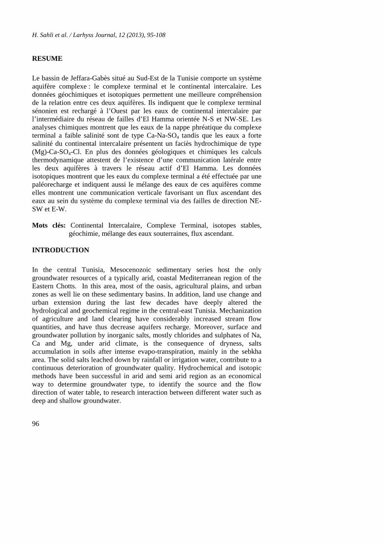
Larhyss Journal, ISSN 1112-3680, n° 12, Janvier 2013, pp. 95-108 © 2013 Tous droits réservés Larhyss/Journal n° 12, Janvier 2013 GROUNDWATER HYDROCHEMISTRY AND MASS TRANSFER IN A STRATIFIED AQUIFER SYSTEM (JEFFARA-GABES BASIN, TUNISIA) SAHLI H., TAGORTI M.A., TLIG S. UR-GAMM, Université Tunis-El Manar, Faculté des Sciences de Tunis, Campus Universitaire 1060 Tunis [email protected] ABSTRACT The present work exposes the existence of a real mass transfer in the aquifer system of the Jeffara-Gabès basin. The main aquifers (Complexe Terminal) include Mio-Plio-Quaternary and Senonian sequences associated to stratified lower Cretaceous sandstone of the Continental Intercalary aquifer. Geochemical and isotopic data of groundwater aquifers needed to better understand the relationship between different stratified layers and aquifers. It indicates that Senonian aquifer has been recharged to the West of the area of study by the Continental Intercalary via the El Hamma fault network oriented N-S and NW- SE. The major elements analysis shows that water table of the Complex Terminal with low salinity fit to Ca-Na-SO4 type while waters with high total dissolved salts belong to Na-(Mg)-Ca-SO4-Cl type which characterizes the Continental Intercalary hydrochemical facies. Chemical analyses In addition to geological data and thermodynamic calculation attest the existence of an evident lateral communication between Continental Intercalary aquifer and the Jeffara aquifer system through the El Hamma active faults. Isotopic data show that Complex Terminal groundwater has been affected by a paleorecharge and indicate a mixing of Continental Intercalary and Complex Terminal groundwater. Also, the results show an upward leakage from the Senonian aquifer to the uppermost mio-plio-quaternary reservoir via NE-SW and E-W oriented faults. keywords: Continental Intercalaire, Complexe Terminal, stable isotopes, geochemistry, mixing groundwater, upward leakage
Transcript of GROUNDWATER HYDROCHEMISTRY AND MASS TRANSFER IN A STRATIFIED AQUIFER SYSTEM (JEFFARA-GABES BASIN,...
Larhyss Journal, ISSN 1112-3680, n° 12, Janvier 2013, pp. 95-108© 2013 Tous droits réservés
Larhyss/Journal n° 12, Janvier 2013
GROUNDWATER HYDROCHEMISTRYAND MASS TRANSFER IN A STRATIFIED
AQUIFER SYSTEM(JEFFARA-GABES BASIN, TUNISIA)
SAHLI H., TAGORTI M.A., TLIG S.
UR-GAMM, Université Tunis-El Manar, Faculté des Sciences de Tunis, CampusUniversitaire 1060 Tunis
ABSTRACT
The present work exposes the existence of a real mass transfer in the aquifersystem of the Jeffara-Gabès basin. The main aquifers (Complexe Terminal)include Mio-Plio-Quaternary and Senonian sequences associated to stratifiedlower Cretaceous sandstone of the Continental Intercalary aquifer. Geochemicaland isotopic data of groundwater aquifers needed to better understand therelationship between different stratified layers and aquifers. It indicates thatSenonian aquifer has been recharged to the West of the area of study by theContinental Intercalary via the El Hamma fault network oriented N-S and NW-SE. The major elements analysis shows that water table of the ComplexTerminal with low salinity fit to Ca-Na-SO4 type while waters with high totaldissolved salts belong to Na-(Mg)-Ca-SO4-Cl type which characterizes theContinental Intercalary hydrochemical facies. Chemical analyses In addition togeological data and thermodynamic calculation attest the existence of an evidentlateral communication between Continental Intercalary aquifer and the Jeffaraaquifer system through the El Hamma active faults. Isotopic data show thatComplex Terminal groundwater has been affected by a paleorecharge andindicate a mixing of Continental Intercalary and Complex Terminalgroundwater. Also, the results show an upward leakage from the Senonianaquifer to the uppermost mio-plio-quaternary reservoir via NE-SW and E-Woriented faults.
keywords: Continental Intercalaire, Complexe Terminal, stable isotopes,geochemistry, mixing groundwater, upward leakage
H. Sahli et al. / Larhyss Journal, 12 (2013), 95-108
96
RESUME
Le bassin de Jeffara-Gabès situé au Sud-Est de la Tunisie comporte un systèmeaquifère complexe : le complexe terminal et le continental intercalaire. Lesdonnées géochimiques et isotopiques permettent une meilleure compréhensionde la relation entre ces deux aquifères. Ils indiquent que le complexe terminalsénonien est rechargé à l’Ouest par les eaux de continental intercalaire parl’intermédiaire du réseau de failles d’El Hamma orientée N-S et NW-SE. Lesanalyses chimiques montrent que les eaux de la nappe phréatique du complexeterminal a faible salinité sont de type Ca-Na-SO4 tandis que les eaux a fortesalinité du continental intercalaire présentent un faciès hydrochimique de type(Mg)-Ca-SO4-Cl. En plus des données géologiques et chimiques les calculsthermodynamique attestent de l’existence d’une communication latérale entreles deux aquifères à travers le réseau actif d’El Hamma. Les donnéesisotopiques montrent que les eaux du complexe terminal a été effectuée par unepaléorecharge et indiquent aussi le mélange des eaux de ces aquifères commeelles montrent une communication verticale favorisant un flux ascendant deseaux au sein du système du complexe terminal via des failles de direction NE-SW et E-W.
Mots clés: Continental Intercalaire, Complexe Terminal, isotopes stables,géochimie, mélange des eaux souterraines, flux ascendant.
INTRODUCTION
In the central Tunisia, Mesocenozoic sedimentary series host the onlygroundwater resources of a typically arid, coastal Mediterranean region of theEastern Chotts. In this area, most of the oasis, agricultural plains, and urbanzones as well lie on these sedimentary basins. In addition, land use change andurban extension during the last few decades have deeply altered thehydrological and geochemical regime in the central-east Tunisia. Mechanizationof agriculture and land clearing have considerably increased stream flowquantities, and have thus decrease aquifers recharge. Moreover, surface andgroundwater pollution by inorganic salts, mostly chlorides and sulphates of Na,Ca and Mg, under arid climate, is the consequence of dryness, saltsaccumulation in soils after intense evapo-transpiration, mainly in the sebkhaarea. The solid salts leached down by rainfall or irrigation water, contribute to acontinuous deterioration of groundwater quality. Hydrochemical and isotopicmethods have been successful in arid and semi arid region as an economicalway to determine groundwater type, to identify the source and the flowdirection of water table, to research interaction between different water such asdeep and shallow groundwater.
Groundwater hydrochemistry and mass transfer in a stratified aquifer system(Jeffara-Gabes basin, Tunisia)
97
The aim of this study is to determine the main geochemical reactions whichcontrol the composition of groundwater in the arid region of the Eastern Chottsand Gabès oasis, to identify the natural induced processes which define therehydrochemical evolution measured in the aquifer system, based on geochemicaland isotopic mass balance model.
GEOLOGICAL SETTING
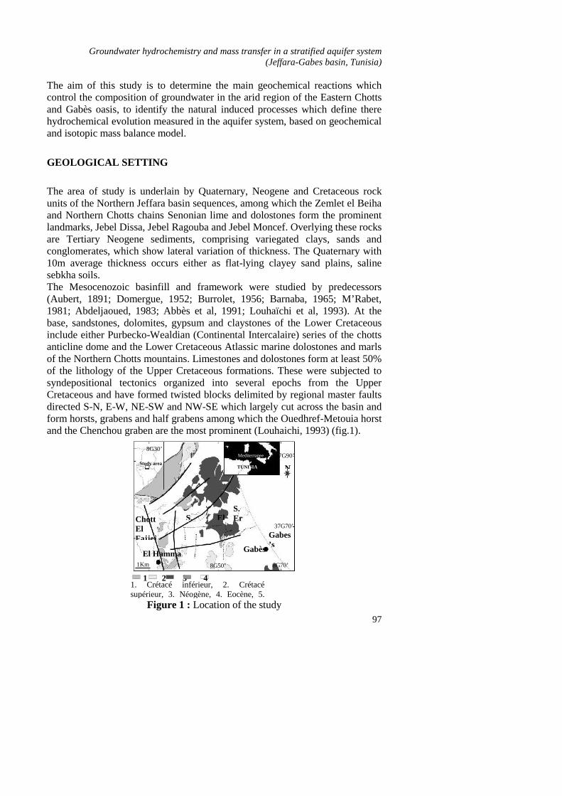
The area of study is underlain by Quaternary, Neogene and Cretaceous rockunits of the Northern Jeffara basin sequences, among which the Zemlet el Beihaand Northern Chotts chains Senonian lime and dolostones form the prominentlandmarks, Jebel Dissa, Jebel Ragouba and Jebel Moncef. Overlying these rocksare Tertiary Neogene sediments, comprising variegated clays, sands andconglomerates, which show lateral variation of thickness. The Quaternary with10m average thickness occurs either as flat-lying clayey sand plains, salinesebkha soils.The Mesocenozoic basinfill and framework were studied by predecessors(Aubert, 1891; Domergue, 1952; Burrolet, 1956; Barnaba, 1965; M’Rabet,1981; Abdeljaoued, 1983; Abbès et al, 1991; Louhaïchi et al, 1993). At thebase, sandstones, dolomites, gypsum and claystones of the Lower Cretaceousinclude either Purbecko-Wealdian (Continental Intercalaire) series of the chottsanticline dome and the Lower Cretaceous Atlassic marine dolostones and marlsof the Northern Chotts mountains. Limestones and dolostones form at least 50%of the lithology of the Upper Cretaceous formations. These were subjected tosyndepositional tectonics organized into several epochs from the UpperCretaceous and have formed twisted blocks delimited by regional master faultsdirected S-N, E-W, NE-SW and NW-SE which largely cut across the basin andform horsts, grabens and half grabens among which the Ouedhref-Metouia horstand the Chenchou graben are the most prominent (Louhaichi, 1993) (fig.1).
8G70’8G50’1Km
El Hamma
ChottElFajjej
Gabès
37G70’
37G90’
N
Gabes’s Gulf
S.ErRahia
Study area
8G30’Mediterraneen seaTUNISIA
Fig. 1: Location of the studyfield
1 2 3 451. Crétacé inférieur, 2. Crétacé
supérieur, 3. Néogène, 4. Eocène, 5.Quaternaire, Faults.
S. El
Maleh
Figure 1 : Location of the study
H. Sahli et al. / Larhyss Journal, 12 (2013), 95-108
98
In the basin, the Upper Cretaceous fractured and folded formations haveemerged during the Paleogene and were later prograded over by the Beglia andSégui Formations encompassing the whole Miocene to Quaternary. The BegliaFormation is coarse-grained sands. The Ségui formation includes molasse andlacustrine facies of clayey sandstones and silts which admit thin alternations ofconglomerates. The uppermost beds represent either evaporite-bearing sebkhasoils, nebkhas or a veneer of fine sand plains sloping majorly to the East.
HYDRGEOLOGYCAL SETTING
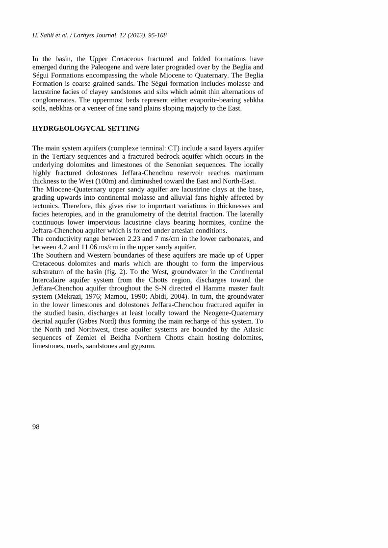
The main system aquifers (complexe terminal: CT) include a sand layers aquiferin the Tertiary sequences and a fractured bedrock aquifer which occurs in theunderlying dolomites and limestones of the Senonian sequences. The locallyhighly fractured dolostones Jeffara-Chenchou reservoir reaches maximumthickness to the West (100m) and diminished toward the East and North-East.The Miocene-Quaternary upper sandy aquifer are lacustrine clays at the base,grading upwards into continental molasse and alluvial fans highly affected bytectonics. Therefore, this gives rise to important variations in thicknesses andfacies heteropies, and in the granulometry of the detrital fraction. The laterallycontinuous lower impervious lacustrine clays bearing hormites, confine theJeffara-Chenchou aquifer which is forced under artesian conditions.The conductivity range between 2.23 and 7 ms/cm in the lower carbonates, andbetween 4.2 and 11.06 ms/cm in the upper sandy aquifer.The Southern and Western boundaries of these aquifers are made up of UpperCretaceous dolomites and marls which are thought to form the impervioussubstratum of the basin (fig. 2). To the West, groundwater in the ContinentalIntercalaire aquifer system from the Chotts region, discharges toward theJeffara-Chenchou aquifer throughout the S-N directed el Hamma master faultsystem (Mekrazi, 1976; Mamou, 1990; Abidi, 2004). In turn, the groundwaterin the lower limestones and dolostones Jeffara-Chenchou fractured aquifer inthe studied basin, discharges at least locally toward the Neogene-Quaternarydetrital aquifer (Gabes Nord) thus forming the main recharge of this system. Tothe North and Northwest, these aquifer systems are bounded by the Atlasicsequences of Zemlet el Beidha Northern Chotts chain hosting dolomites,limestones, marls, sandstones and gypsum.
Groundwater hydrochemistry and mass transfer in a stratified aquifer system(Jeffara-Gabes basin, Tunisia)
99
Gafsa
Gabes
TUNISIA
CI
CT
ALGERIA
LIBYA
MEDITERRANEENSEA
50Km
Fig. 2 Extension and groundwater pathway of aquifersystem in the Southeastern of Tunisia
Direction flow of Complexe TerminalGroundwater
Direction flow of Continental IntercalaireGroundwater
Figure 2 : Extension and groundwater pathway of aquifer system in the south-eastern of Tunisia
- - - - : Direction flow of continental intercalary- - - - : Direction flow of complex terminal
The system feeding the hot springs at el Hamma consists of a thick carbonateand sandy (Kimmeridgian-Neocomian) aquifer located in the core of the Chottel Fejej anticline. It is confined by the thick gypsum-containing, clayey andimpervious Bouhedma Formation (Mamou, 1990; Abidi, 2004; Kamel, 2006).The Eastern periclinal termination of the broad chott el Fejej anticline is deeplycut by master faults directed majorly NW-SE and N-S, among which the elHamma fault striking to the North, blocks the sandy series of the ContinentalIntercalaire against the younger Eastern Jeffara basin fill, predominantlylimestones and dolostones aquifer sequences.The flow direction of groundwater is generally to the north-east and the flowsystem discharges occur mainly in the large el Melah-el Mekhacherma and theEaster Errouhïa sebkha system located near Mediterranean coast, and via wellsand boreholes. The depth of the water table in the Quaternary-Neogene sandunconfined aquifers decreases north-eastwards from 35m to the West to 5m
H. Sahli et al. / Larhyss Journal, 12 (2013), 95-108
100
near the Mediterranean coast. The lower Jeffara-Chenchou aquifer is confined,with a water-level virtually above the natural terrain.The groundwater located beneath the el Hamma city, in the aquifer deeplytransacted by the network of master, reactivated and perennial faults, emergesthrough a line of springs which follows the oued el Hamma, with a salinity of2500 to 5400 mg/l 1975 (Mekrazi, 1976; Mamou, 1990; Edmunds et al, 2003)and a high temperature gradient (50-70°C). Figure 3 describes in detail thedifferent aquifer dominated springs and observation bores around the Chottsarea. It is seemingly that the NW-SE directed el Hamma regional fault acts as apreferential pathway of the Continental Intercalaire groundwater to the surface.The average transmissivity calculated from pumping tests performed withinwells drilled in the Chotts anticline approximates 4.320 m²/d (range: 520-8.640m²/d) of waters confined under a pressure of 8-10 bar (ERESS, 1969; SASS,2003). These transmissivities indicate a conductivity of 2-35 m/d for an aquiferaverage thickness of 250m.
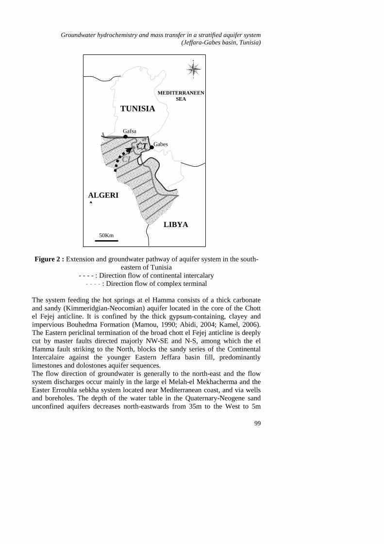
METHODOLOGY AND ANALYSES
Geochemical data for more than 300 samples from wells and boreholes, weredonated to us by the DRE (Direction des Ressources en Eaux; Ministry ofAgriculture and Gabes's Hydraulic Resources). The data from 30 wells andboreholes which represent the typical hydrological zoning and geochemicaltypes of the aquifers were performed for this study (Fig. 3; Table 1).In each of all of the wells and boreholes, an acidified (HNO3, N/10) sample forthe cations (Ca2+, Mg2+, K+ and Na+), and another unacidified for the anions (F-,Cl-, SO4
=,…) measurements were collected in 500 ml polyethylene bottles.Temperature, hydrogen potential and electric conductivity in situ of the waterswere measured in the field using portable equipments; notably the pH meter wascalibrated with common commercial buffer solutions of pH 4.00 and pH 7.00.
1Km
N
SabkhaEl M-M
Ouedhref
El Metouia
Gabès
Zemlet ElBidha
Sabkha ElHamma
El Hamma
SabkhaerRahia
O. ElAkhdher
O. El Habaji
O. El Maleh
O. GueleteAïcha
O. El Maleh
O.El Mazra
Gabes'sGulf
Chenchou
1
21
29
20
3011
10
9
8
76
5
4
3
23
22
21
13
14
15
19
18
17
16
29
28
27
26
25
24
31
WE
Fig. 3: Samples geographical location in the study areaFigure 3 : samples geographical location in the study area
Groundwater hydrochemistry and mass transfer in a stratified aquifer system(Jeffara-Gabes basin, Tunisia)
101
The pH measurements were in three replicates and the pH error on calibrationwas checked to lie in the commonly accepted range (+ 0.5 units).The analytical determinations by the DRES were carried out in the Directiondes Ressources en Eaux Laboratory in Tunisia. In all cases, the bicarbonateHCO3
- was determined as the total alkalinity by the classic titration with HCl(N/10) in the presence of methyl orange as the indicator of pH 7.00. Analyses ofalkalinity and the cations, in particular Ca2+ were checked to be performed inthe 24h of sampling. The gravimetric barium sulphate method was used toanalyse SO4
=; whereas direct potentiometry using coupled specific electrodesmeasured Cl- and F-. Analytical results for each of all the samples considered inthis study yielded an ionic balance of less than 5%.Samples for stable isotope analysis were analysed by gas source massspectrometry. These analyses have been done for different studies projectswhich concern the south Tunisian aquifer system (ERESS 1969; RAF/8/0071985; INT/05/844 1999 and RAF/8/35 2003) (Table 2).
RESULTS AND DISCUTIONS
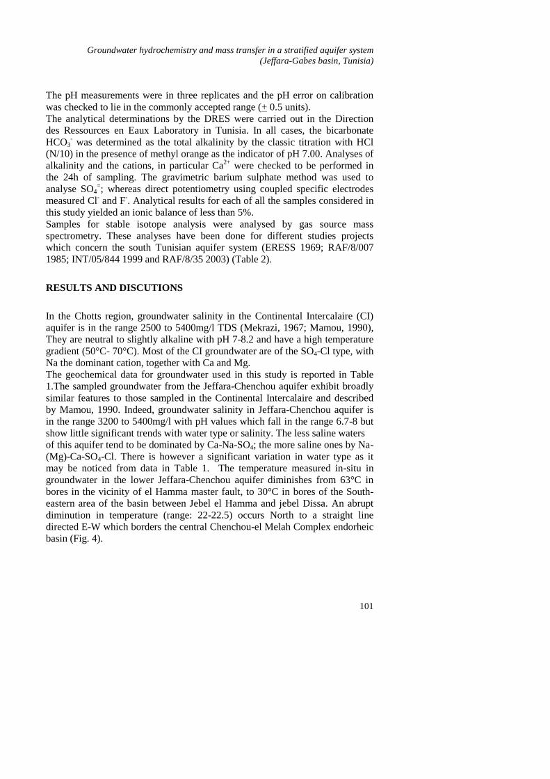
In the Chotts region, groundwater salinity in the Continental Intercalaire (CI)aquifer is in the range 2500 to 5400mg/l TDS (Mekrazi, 1967; Mamou, 1990),They are neutral to slightly alkaline with pH 7-8.2 and have a high temperaturegradient (50°C- 70°C). Most of the CI groundwater are of the SO4-Cl type, withNa the dominant cation, together with Ca and Mg.The geochemical data for groundwater used in this study is reported in Table1.The sampled groundwater from the Jeffara-Chenchou aquifer exhibit broadlysimilar features to those sampled in the Continental Intercalaire and describedby Mamou, 1990. Indeed, groundwater salinity in Jeffara-Chenchou aquifer isin the range 3200 to 5400mg/l with pH values which fall in the range 6.7-8 butshow little significant trends with water type or salinity. The less saline watersof this aquifer tend to be dominated by Ca-Na-SO4; the more saline ones by Na-(Mg)-Ca-SO4-Cl. There is however a significant variation in water type as itmay be noticed from data in Table 1. The temperature measured in-situ ingroundwater in the lower Jeffara-Chenchou aquifer diminishes from 63°C inbores in the vicinity of el Hamma master fault, to 30°C in bores of the South-eastern area of the basin between Jebel el Hamma and jebel Dissa. An abruptdiminution in temperature (range: 22-22.5) occurs North to a straight linedirected E-W which borders the central Chenchou-el Melah Complex endorheicbasin (Fig. 4).
H. Sahli et al. / Larhyss Journal, 12 (2013), 95-108
102
0
1
2
3
4
5
6
19086 13445 16729 17668
SITE
CO
MPO
SITI
ON T°C
TDS
Cl
Na
SO4
22 23 165
Fig. 4: Concentration evolution of temperature, salinity and major elements in W-Eflow direction of groundwater between El Hamma and the coast
Figure 4 : Concentration evolution of temperature, salinity and major elementsin W-E flow direction of groundwater between El Hamma asn the coast
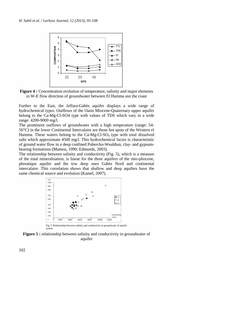
Farther to the East, the Jeffara-Gabès aquifer displays a wide range ofhydrochemical types. Outflows of the Oasis Miocene-Quaternary upper aquiferbelong to the Ca-Mg-Cl-SO4 type with values of TDS which vary in a widerange: 4200-9000 mg/l.The prominent outflows of groundwater with a high temperature (range: 54-56°C) in the lower Continental Intercalaire are those hot spots of the Western elHamma. These waters belong to the Ca-Mg-Cl-SO4 type with total dissolvedsalts which approximate 4500 mg/l. This hydrochemical facies is characteristicof ground water flow in a deep confined Pubercko-Wealdian, clay- and gypsum-bearing formations (Mamou, 1990; Edmunds, 2003).The relationship between salinity and conductivity (Fig. 5), which is a measureof the total mineralisation, is linear for the three aquifers of the mio-pliocene,phreatique aquifer and the tow deep ones Gabès Nord and continentalintercalaire. This correlation shows that shallow and deep aquifers have thesame chemical source and evolution (Kamel, 2007).
CS
MPCI
Conductivityus/ms
0 2000 4000 6000 8000 10000 12000
TDSmg/l10000
9000
8000
7000
6000
5000
4000
3000
1000
0
Fig. 5: Relationship between salinity and conductivity in groundwater of aquifersystem
Figure 5 : relationship between salinity and conductivity in groundwater ofaquifer
Groundwater hydrochemistry and mass transfer in a stratified aquifer system(Jeffara-Gabes basin, Tunisia)
103
Major elements evolution
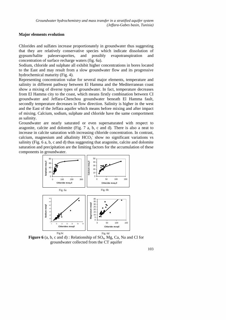
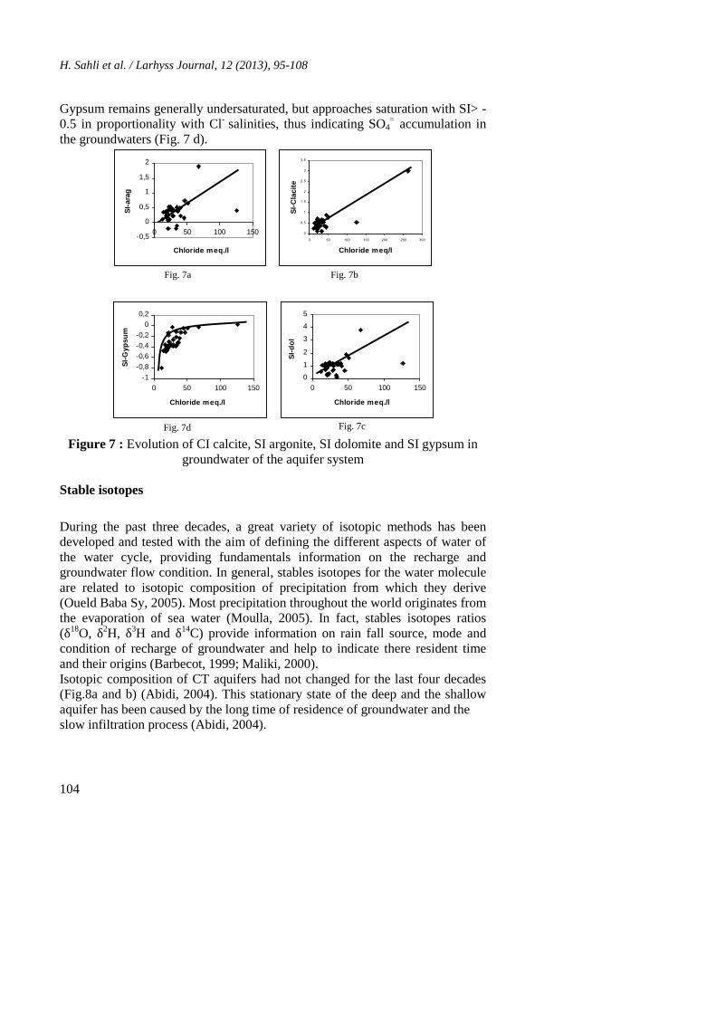
Chlorides and sulfates increase proportionately in groundwater thus suggestingthat they are relatively conservative species which indicate dissolution ofgypsum/halite paleoevaporites, and possibly evapotranspiration andconcentration of surface recharge waters (fig. 6a).Sodium, chloride and sulphate all exhibit higher concentrations in bores locatedto the East and may result from a slow groundwater flow and its progressivehydrochemical maturity (Fig. 4).Representing concentration value for several major elements, temperature andsalinity in different pathway between El Hamma and the Mediterranean coastshow a mixing of diverse types of groundwater. In fact, temperature decreasesfrom El Hamma city to the coast, which means firstly combination between CIgroundwater and Jeffara-Chenchou groundwater beneath El Hamma fault,secondly temperature decreases in flow direction. Salinity is higher in the westand the East of the Jeffara aquifer which means before mixing and after impactof mixing. Calcium, sodium, sulphate and chloride have the same comportmentas salinity.Groundwater are nearly saturated or even supersaturated with respect toaragonite, calcite and dolomite (Fig. 7 a, b, c and d). There is also a neat toincrease in calcite saturation with increasing chloride concentration. In contrast,calcium, magnesium and alkalinity HCO3
- show no significant variations vssalinity (Fig. 6 a, b, c and d) thus suggesting that aragonite, calcite and dolomitesaturation and precipitation are the limiting factors for the accumulation of thesecomponents in groundwater.
0
20
40
60
80
0 100 200 300
Chloride meq./l
Sulp
hate
meq
./l
Fig. 6a
0
10
20
30
40
50
0 50 100 150
Chloride meq./l
Cal
cium
meq
./l
Fig. 6b
0
20
40
60
80
100
120
140
0 20 40 60 80 100 120
Chlorides meq/l
Sodi
um m
eq/l
Fig.6c
05
10152025303540
0 50 100 150
Chloride meq/l
Mag
nisi
um m
eq/l
Fig. 6d
Fig. 6 a, b, c and d: Relationship of SO4, Mg, Ca, Na and Cl for groundwatercollected from the CT aquifer
Figure 6 (a, b, c and d) : Relationship of SO4, Mg, Ca, Na and Cl forgroundwater collected from the CT aquifer
H. Sahli et al. / Larhyss Journal, 12 (2013), 95-108
104
Gypsum remains generally undersaturated, but approaches saturation with SI> -0.5 in proportionality with Cl- salinities, thus indicating SO4
= accumulation inthe groundwaters (Fig. 7 d).
-0,5
0
0,5
1
1,5
2
0 50 100 150
Chloride meq./l
SI-a
rag
Fig. 7a
0
0,5
1
1,5
2
2,5
3
3,5
0 50 100 150 200 250 300
Chloride meq/l
SI-C
laci
te
Fig. 7b
-1-0,8-0,6-0,4-0,2
00,2
0 50 100 150
Chloride meq./l
SI-G
ypsu
m
Fig. 7d
0
1
2
3
4
5
0 50 100 150
Chloride meq./l
SI-d
ol
Fig. 7c
Fig. 7: Evolution of SI calcite, SI argonite, SI dolomite and SI gypsum ingroundwater of the aquifer system.
Figure 7 : Evolution of CI calcite, SI argonite, SI dolomite and SI gypsum ingroundwater of the aquifer system
Stable isotopes
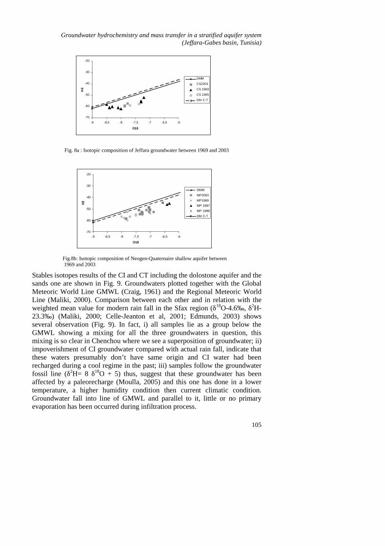
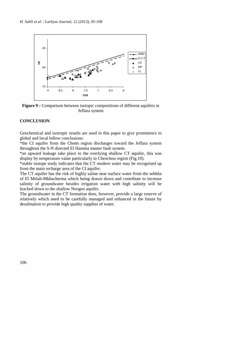
During the past three decades, a great variety of isotopic methods has beendeveloped and tested with the aim of defining the different aspects of water ofthe water cycle, providing fundamentals information on the recharge andgroundwater flow condition. In general, stables isotopes for the water moleculeare related to isotopic composition of precipitation from which they derive(Oueld Baba Sy, 2005). Most precipitation throughout the world originates fromthe evaporation of sea water (Moulla, 2005). In fact, stables isotopes ratios(δ18O, δ2H, δ3H and δ14C) provide information on rain fall source, mode andcondition of recharge of groundwater and help to indicate there resident timeand their origins (Barbecot, 1999; Maliki, 2000).Isotopic composition of CT aquifers had not changed for the last four decades(Fig.8a and b) (Abidi, 2004). This stationary state of the deep and the shallowaquifer has been caused by the long time of residence of groundwater and theslow infiltration process (Abidi, 2004).
Groundwater hydrochemistry and mass transfer in a stratified aquifer system(Jeffara-Gabes basin, Tunisia)
105
Fig. 8a : Isotopic composition of Jeffara groundwater between 1969 and 2003
-70
-60
-50
-40
-30
-20
-9 -8,5 -8 -7,5 -7 -6,5 -6
O18
H2
DMMMP2003MP1969MP 1997MP 1999DM C-T
Fig.8b: Isotopic composition of Neogen-Quaternaire shallow aquifer between 1969 and 2003
-70
-60
-50
-40
-30
-20
-9 -8,5 -8 -7,5 -7 -6,5 -6
O18
H2
DMM
CS2003
CS 1969
CS 1985
DM C-T
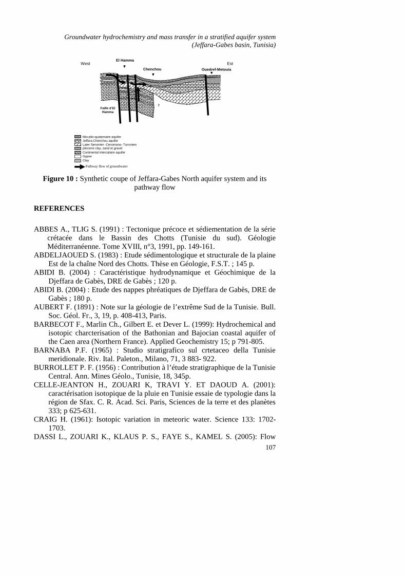
Stables isotopes results of the CI and CT including the dolostone aquifer and thesands one are shown in Fig. 9. Groundwaters plotted together with the GlobalMeteoric World Line GMWL (Craig, 1961) and the Regional Meteoric WorldLine (Maliki, 2000). Comparison between each other and in relation with theweighted mean value for modern rain fall in the Sfax region (δ18O-4.6‰, δ2H-23.3‰) (Maliki, 2000; Celle-Jeanton et al, 2001; Edmunds, 2003) showsseveral observation (Fig. 9). In fact, i) all samples lie as a group below theGMWL showing a mixing for all the three groundwaters in question, thismixing is so clear in Chenchou where we see a superposition of groundwater; ii)impoverishment of CI groundwater compared with actual rain fall, indicate thatthese waters presumably don’t have same origin and CI water had beenrecharged during a cool regime in the past; iii) samples follow the groundwaterfossil line (δ2H= 8 δ18O + 5) thus, suggest that these groundwater has beenaffected by a paleorecharge (Moulla, 2005) and this one has done in a lowertemperature, a higher humidity condition then current climatic condition.Groundwater fall into line of GMWL and parallel to it, little or no primaryevaporation has been occurred during infiltration process.
H. Sahli et al. / Larhyss Journal, 12 (2013), 95-108
106
-70
-50
-30
-9 -8,5 -8 -7,5 -7 -6,5 -6
O18
H2
DMMD C-TCSMPCI
Fig. 9: Comparison between isotopic compositions of different aquifers injeffara system
Figure 9 : Comparison between isotopic compositions of different aquifers inJeffara system
CONCLUSION
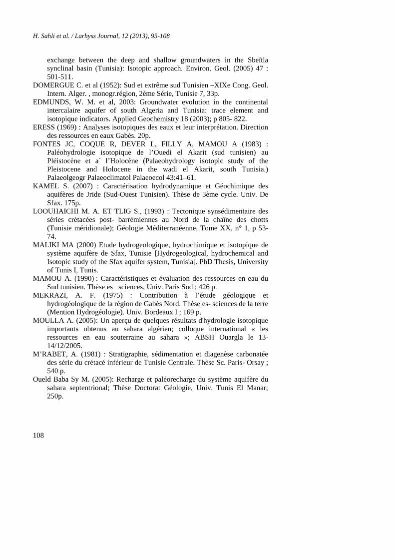
Geochemical and isotropic results are used in this paper to give prominence toglobal and local follow conclusions:*the CI aquifer from the Chotts region discharges toward the Jeffara systemthroughout the S-N directed El Hamma master fault system.*an upward leakage take place to the overlying shallow CT aquifer, this wasdisplay by temperature value particularly in Chenchou region (Fig.10).*stable isotope study indicates that the CT modern water may be recognised upfrom the main recharge area of the CI aquifer.The CT aquifer has the risk of highly saline near surface water from the sebkhaof El Melah-Mkhacherma which being drawn down and contribute to increasesalinity of groundwater besides irrigation water with high salinity will beleached down to the shallow Neogen aquifer.The groundwater in the CT formation does, however, provide a large reserve ofrelatively which need to be carefully managed and enhanced in the future bydesalination to provide high quality supplies of water.
Groundwater hydrochemistry and mass transfer in a stratified aquifer system(Jeffara-Gabes basin, Tunisia)
107
Ouedref-Metouia
El Hamma
Chenchou
Jeffara-Chenchou aquiferMio-plio-quaternaire aquifer
pliocene clay, sand et gravelLater Senonien -Cenomano- Turronien
Continental intercalaire aquiferGypseClay
West Est
Fig. 10: Synthetic coupe of Jeffara -Gabès Nord aquifer system and itspathway flow.
?Faille d’ElHamma
Pathway flow of groundwater
Figure 10 : Synthetic coupe of Jeffara-Gabes North aquifer system and itspathway flow
REFERENCES
ABBES A., TLIG S. (1991) : Tectonique précoce et sédiementation de la sériecrétacée dans le Bassin des Chotts (Tunisie du sud). GéologieMéditerranéenne. Tome XVIII, n°3, 1991, pp. 149-161.
ABDELJAOUED S. (1983) : Etude sédimentologique et structurale de la plaineEst de la chaîne Nord des Chotts. Thèse en Géologie, F.S.T. ; 145 p.
ABIDI B. (2004) : Caractéristique hydrodynamique et Géochimique de laDjeffara de Gabès, DRE de Gabès ; 120 p.
ABIDI B. (2004) : Etude des nappes phréatiques de Djeffara de Gabès, DRE deGabès ; 180 p.
AUBERT F. (1891) : Note sur la géologie de l’extrême Sud de la Tunisie. Bull.Soc. Géol. Fr., 3, 19, p. 408-413, Paris.
BARBECOT F., Marlin Ch., Gilbert E. et Dever L. (1999): Hydrochemical andisotopic charcterisation of the Bathonian and Bajocian coastal aquifer ofthe Caen area (Northern France). Applied Geochemistry 15; p 791-805.
BARNABA P.F. (1965) : Studio stratigrafico sul crtetaceo della Tunisiemeridionale. Riv. Ital. Paleton., Milano, 71, 3 883- 922.
BURROLLET P. F. (1956) : Contribution à l’étude stratigraphique de la TunisieCentral. Ann. Mines Géolo., Tunisie, 18, 345p.
CELLE-JEANTON H., ZOUARI K, TRAVI Y. ET DAOUD A. (2001):caractérisation isotopique de la pluie en Tunisie essaie de typologie dans larégion de Sfax. C. R. Acad. Sci. Paris, Sciences de la terre et des planètes333; p 625-631.
CRAIG H. (1961): Isotopic variation in meteoric water. Science 133: 1702-1703.
DASSI L., ZOUARI K., KLAUS P. S., FAYE S., KAMEL S. (2005): Flow
H. Sahli et al. / Larhyss Journal, 12 (2013), 95-108
108
exchange between the deep and shallow groundwaters in the Sbeïtlasynclinal basin (Tunisia): Isotopic approach. Environ. Geol. (2005) 47 :501-511.
DOMERGUE C. et al (1952): Sud et extrême sud Tunisien –XIXe Cong. Geol.Intern. Alger. , monogr.région, 2ème Série, Tunisie 7, 33p.
EDMUNDS, W. M. et al, 2003: Groundwater evolution in the continentalintercalaire aquifer of south Algeria and Tunisia: trace element andisotopique indicators. Applied Geochemistry 18 (2003); p 805- 822.
ERESS (1969) : Analyses isotopiques des eaux et leur interprétation. Directiondes ressources en eaux Gabès. 20p.
FONTES JC, COQUE R, DEVER L, FILLY A, MAMOU A (1983) :Paléohydrologie isotopique de l’Ouedi el Akarit (sud tunisien) auPléistocène et a` l’Holocène (Palaeohydrology isotopic study of thePleistocene and Holocene in the wadi el Akarit, south Tunisia.)Palaeolgeogr Palaeoclimatol Palaeoecol 43:41–61.
KAMEL S. (2007) : Caractérisation hydrodynamique et Géochimique desaquifères de Jride (Sud-Ouest Tunisien). Thèse de 3ème cycle. Univ. DeSfax. 175p.
LOOUHAICHI M. A. ET TLIG S., (1993) : Tectonique synsédimentaire desséries crétacées post- barrémiennes au Nord de la chaîne des chotts(Tunisie méridionale); Géologie Méditerranéenne, Tome XX, n° 1, p 53-74.
MALIKI MA (2000) Etude hydrogeologique, hydrochimique et isotopique desystème aquifère de Sfax, Tunisie [Hydrogeological, hydrochemical andIsotopic study of the Sfax aquifer system, Tunisia]. PhD Thesis, Universityof Tunis I, Tunis.
MAMOU A. (1990) : Caractéristiques et évaluation des ressources en eau duSud tunisien. Thèse es_ sciences, Univ. Paris Sud ; 426 p.
MEKRAZI, A. F. (1975) : Contribution à l’étude géologique ethydrogéologique de la région de Gabès Nord. Thèse es- sciences de la terre(Mention Hydrogéologie). Univ. Bordeaux I ; 169 p.
MOULLA A. (2005): Un aperçu de quelques résultats d'hydrologie isotopiqueimportants obtenus au sahara algérien; colloque international « lesressources en eau souterraine au sahara »; ABSH Ouargla le 13-14/12/2005.
M’RABET, A. (1981) : Stratigraphie, sédimentation et diagenèse carbonatéedes série du crétacé inférieur de Tunisie Centrale. Thèse Sc. Paris- Orsay ;540 p.
Oueld Baba Sy M. (2005): Recharge et paléorecharge du système aquifère dusahara septentrional; Thèse Doctorat Géologie, Univ. Tunis El Manar;250p.