GRAZING EFFECTS ON SPRINGSNAILS, CASCADE-SISKIYOU NATIONAL MONUMENT, OREGON 2004 REPORT
188
consultants Deixis GRAZING EFFECTS ON SPRINGSNAILS, CASCADE-SISKIYOU NATIONAL MONUMENT, OREGON 2004 REPORT Fluminicola n. sp. 11 toothed pebblesnail, actual height 3.3 mm Prepared for: WORLD WILDLIFE FUND Cascade-Siskiyou Ecoregion Office 116 Lithia Way, Suite 7 Ashland, OR 97525 TERRENCE J. FREST & EDWARD J. JOHANNES June 30, 2005
-
Upload
independent -
Category
Documents
-
view
0 -
download
0
Transcript of GRAZING EFFECTS ON SPRINGSNAILS, CASCADE-SISKIYOU NATIONAL MONUMENT, OREGON 2004 REPORT

consultants
Deixis
GRAZING EFFECTS ON SPRINGSNAILS, CASCADE-SISKIYOU NATIONAL MONUMENT,
OREGON
2004 REPORT
Fluminicola n. sp. 11 toothed pebblesnail, actual height 3.3 mm
Prepared for: WORLD WILDLIFE FUND Cascade-Siskiyou Ecoregion Office 116 Lithia Way, Suite 7 Ashland, OR 97525
TERRENCE J. FREST & EDWARD J. JOHANNES June 30, 2005

DISCLAIMER
This report was prepared by Deixis Consultants as an account of work sponsored by the World Wildlife Fund (WWF). Neither Deixis Consultants nor the WWF makes any warranty, express or implied, or assumes any legal liability for the accuracy, completeness, practicality, or usefulness of any information, or represents that its use would not infringe privately owned rights. This report is based upon information believed by its authors to be true and correct at the time of its preparation. Because the conditions of its application are beyond our control, Deixis Consultants assumes no responsibility for any consequences of the use of this report, or of actions or activities based upon this report. The views and opinions of authors expressed herein do not necessarily state or reflect those of the WWF or of Deixis Consultants, or of the report authors.

i
GRAZING EFFECTS ON SPRINGSNAILS, CASCADE-SISKIYOU NATIONAL MONUMENT, OREGON
2004 REPORT
Terrence J. Frest and Edward J. Johannes
Deixis Consultants 2517 NE 65th Street
Seattle, WA 98115-7125
Prepared for: WORLD WILDLIFE FUND Cascade-Siskiyou Ecoregion Office 116 Lithia Way, Suite 7 Ashland, OR 97525
June 30, 2005

ii
TABLE OF CONTENTS
INTRODUCTION ............................................................................................... 2 METHODS .......................................................................................................... 7 BACKGROUND ............................................................................................... 11 Ecology ............................................................................................... 11 Distribution ............................................................................................... 21 Biogeography .................................................................................... 21 RESULTS ......................................................................................................... 35 ACKNOWLEDGEMENTS ..................................................................................... 75 REFERENCES ............................................................................................... 76 APPENDIX A. SITES .................................................................................. 84 APPENDIX B. BACKGROUND ..................................................................... 114 Ecology .............................................................................................. 114 Distribution .............................................................................................. 115 Biogeography ................................................................................... 116 APPENDIX C. TAXONOMY OF SELECTED SPECIES .......................... 122 Introduction .............................................................................................. 122 General Features ................................................................................... 123 Monument Malacofauna ........................................................................ 125 Overview of Sensitive Taxa .............................................................. 129 Identification Needs ................................................................................... 132 APPENDIX D. SENSITIVE TAXA ........................................................................ 134 Gastropods .............................................................................................. 134 Fluminicola n. sp. 1 ............................................................. 134 Fluminicola n. sp. 3 ............................................................. 135 Fluminicola n. sp. 10 ............................................................. 137 Fluminicola n. sp. 11 ............................................................. 138 Fluminicola n. sp. 12 ............................................................. 139 Fluminicola n. sp. 13 ............................................................. 140 Fluminicola n. sp. 14 ............................................................. 142 Fluminicola n. sp. 15 ............................................................. 143 Fluminicola n. sp. 16 ............................................................. 144 Fluminicola n. sp. 17 ............................................................. 146
Fluminicola n. sp. 17? ............................................................. 147 Fluminicola n. sp. 32 ............................................................. 148 Fluminicola n. sp. 33 ............................................................. 149 Fluminicola n. sp. 34 ............................................................. 150 Fluminicola n. sp. 35 ............................................................. 151 Fluminicola n. sp. 36 ............................................................. 152 Fluminicola n. sp. 37 ............................................................. 153

iii
Fluminicola n. sp. 38 ............................................................. 154 Fluminicola n. sp. 39 ............................................................. 155 Fluminicola n. sp. 40 ............................................................. 156 Fluminicola n. sp. 43 ............................................................. 157 Fluminicola n. sp. 44 ............................................................. 158 Fluminicola n. sp. 45 ............................................................. 159 Juga (C.) acutifilosa ............................................................. 160 Lanx alta .................................................................................. 161 Freshwater Bivalves ....................................................................... 163 Pisidium (Cyclocalyx) n. sp. 1 .................................................. 163 Pisidium (Cyclocalyx) ultramontanum ........................................ 164 APPENDIX E. WATCH LIST TAXA ............................................................. 166 Freshwater Snails .................................................................................. 166 Pristinicola hemphilli ............................................................. 166 Freshwater Bivalves ....................................................................... 167 Anodonta oregonensis ............................................................ 167 Gonidea angulata ....................................................................... 168 Margaritinopsis falcata ............................................................. 169 APPENDIX F. GLOSSARY ........................................................................ 171 APPENDIX G. KEY TO MONUMENT Fluminicola ........................................ 177 APPENDIX H. MONUMENT MALACOFAUNA .................................................. 179 FIGURE 1 Map of Study Area ............................................................. 3 FIGURE 2 Location of Study Area Fluminicola sites ............................. 9 FIGURE 3 Map of Monument Area Showing Drainages ............................. 12 FIGURE 4 SW Oregon Showing Small Fluminicola Distribution ....... 22 FIGURE 5 Distribution of the Keene Creek Pebblesnail .................. 24 FIGURE 6 Distribution of the Nerite Pebblesnail ............................. 25 FIGURE 7 Distribution of the Keene Creek Pebblesnail .................. 26 FIGURE 8 Distribution of Seven Endemic Fluminicola .................. 27 FIGURE 9 Distribution of the Topaz Pebblesnail ............................. 28 FIGURE 10 Distribution of the Fall Creek Pebblesnail .................. 29 FIGURE 11 Distribution of the Shoat Springs Pebblesnail …….….…. 30 FIGURE 12 Mollusk Site Diversity in Study Area ........................................ 31 FIGURE 13 Regional Freshwater Mollusk Diversity ............................. 31 FIGURE 14 Proportion of Springs With Springsnails ............................. 32 FIGURE 15 Sympatric Monument Fluminicola ........................................ 32 FIGURE 16 Number of Fluminicola Taxa Per Site ........................................ 33 FIGURE 17 Major Monument Area Fluminicola Endemic Centers ....... 34 FIGURE 18 Number of Sites Per Fluminicola Species ............................. 35 FIGURE 19 Mollusk provinces and drainages ........................................ 117 FIGURE 20 Range of Large Fluminicola .................................................. 119 FIGURE 21 Range of Small Fluminicola .................................................. 120 FIGURE 22 General Features of Fluminicola shell ........................................ 126

iv
FIGURE 23 General Features of Colligyrus animal ............................. 126 TABLE 1 ONHP Sensitive Monument Mollusks ....................................... 5 TABLE 2 Survey and Manage Mollusk Taxa ....................................... 6 TABLE 3 Water Quality Measurements .................................................. 13 TABLE 4 BLM Site Information Prior to This Survey ............................ 18 TABLE 5 Drainage Basin Location of Survey Sites ............................ 36 TABLE 6 Grazing Evaluations of 2003-2004 Sites ............................ 39 TABLE 7 2003-4 Primary Site Faunal Lists: Gastropods ................. 49 TABLE 8 2003-4 Primary Site Faunal Lists: Bivalves ............................ 59 TABLE 9 2003-4 Secondary Site Faunal Lists: Gastropods ................. 69 TABLE 10 2003-4 Secondary Site Faunal Lists: Bivalves ................. 70 TABLE 11 Rogue Sites Selected Parameters ........................................ 71 TABLE 12 Jenny Creek Sites Selected Parameters ............................. 72 TABLE 13 Fall Creek Sites Selected Parameters ....................................... 73 TABLE 14 Site Ownership ....................................................................... 73

GRAZING EFFECTS ON SPRINGSNAILS, CASCADE-SISKIYOU NATIONAL MONUMENT, OREGON
2004 REPORT
Terrence J. Frest and Edward J. Johannes Deixis Consultants 2517 NE 65th Street
Seattle, WA 98115-7125
June 30, 2005

2
INTRODUCTION The Cascade-Siskiyou National Monument, located in Jackson Co., Oregon (Figure 1) was established by then-President William Clinton in Presidential Proclamation 7318, dated June 9, 2000. Among the explicitly most important reasons for setting up this 52,000-acre land management unit was the area’s exceptional biodiversity. This has already been established in several plant and animal groups. Among these are certain invertebrates, notably butterflies and both terrestrial and freshwater mollusks (for background, see especially DellaSala et al., 2000 and references therein). The Monument was also the subject of a recent AAAS Pacific Division symposium (e.g., Frest & Johannes, 2005; DellaSala, 2005). As regards mollusks, much of the information regarding the region’s fauna derives from relatively recent surveys. These included work by Medford BLM on District springs; ROD surveys for certain freshwater and terrestrial mollusks; and work for the Monument management Plan (Medford BLM, 2002, 2005). More particularly, a base line survey of five southwestern Oregon counties (Frest & Johannes, 1999a, 2000a) provided much up to date information from about 60 Jackson County sites. Unfortunately this project was terminated before scheduled completion. For this reason, and also because the region’s mollusk biodiversity proved far greater than expected from past work, the terrestrial malacofauna remains only partly known in the Monument vicinity (Frest & Johannes, 2000a). While freshwater mollusks were a focus of the baseline survey, they took a back seat in comparison to terrestrials, in part because federal species conservation efforts in the area have tended to focus more intensely on forest dwelling forms in the strictest sense. This is particularly true for federal land management units involved in timber production and multiple use management, such as the Forest Service and Bureau of Land Management. Freshwater taxa have not been completely ignored, however, partly because a total divorce of terrestrial species and habitats from freshwater is not practicable. Interactions and intergradations are obvious and significant. This has become especially clear for the freshwater taxa well known to the general public, such as salmonids and other fishes. However, the global decline of freshwater quality, habitat, and biota has increasingly become an area of intense interest and effort (Stiassny, 1999). In part the stimulus has been the realization that, while freshwater makes up only about 1% of all water habitats, it contains a disproportionate proportion of biodiversity: about 8% in the case of mollusks (Wares & Turner, 2003). Moreover, terrestrial land use practices, such as cattle grazing, have definite, and possibly negative, effects upon the freshwater environment (see several papers in Wuerthner & Matteson, 2002). Many other such interactions, such as domestic and stock water usage and fire management and control, make the interaction more than intuitive. Consequently, land usages other than grazing, such as road building or logging, have quick, clear, and major impacts upon freshwater quality and habitats. Even in unmanaged habitats, interactions between the terrestrial and freshwater environments are intense and integral, so that the two cannot be discussed in isolation (Gray, 1988).
As one result, U.S. bioscientists with major interests in freshwater taxa have frequently found themselves concerned also with freshwater habitat quality and its widespread decline (Benke, 1990). Malacologists specializing in freshwater mussels have long been in the forefront of such studies (Williams et al., 1992). More recently such studies have actively been extended to all freshwater mollusks (Lydeard et al., 2003; for review and bibliography, see Lydeard et al. 2004). Locally, efforts have lagged somewhat. Until recently, it was widely assumed that most western U. S. mollusk species had been found long ago and had been formally described. However, efforts to evaluate the Pacific Northwest mollusk fauna for the Clinton Forest Plan (FEMAT) and the Eastside Forest Plan (ICBEMP) led to the conclusion that the West as a whole had no more than about 40% of its mollusks as yet known to science, even in the sense of being formally named (Frest & Johannes, 1993, 1995a; Frest & Roth, 1995). Only one state, Idaho, has had a recent review of its full non-marine mollusk fauna completed and a modern bibliography published (Frest, 1999; Frest & Johannes, 2001; Frest et al., 2002). Partly as a result of concentration on a few taxa and areas, however, some portions of the West are comparatively better known.

3
FIGURE 1. MAP OF STUDY AREA IN SOUTHWESTERN OREGON. Note location of Cascade-Siskiyou National Monument (heavy black line); numbered mollusk sites (see APPENDIX A for details), locations of major drainages, Monument (red) lands, adjoining Medford BLM (yellow), and Rogue River National Forest (green). Private holdings lack fill. Heavy red line separates Rogue (NW) from Klamath (SE) drainages. One especially notable group of interest has been springsnails. These small freshwater snails are believed to have been essentially ubiquitous in the West prior to extensive disturbance (Sada & Vinyard, 2002). While almost no large area with no substantial disturbance remains, there is reason to think that in relatively undisturbed situations to which springsnails had access most or all permanent springs should have springsnails. For example, more than half of the springs in the Upper Sacramento-Pit R. drainage appear to have springsnails: and they are nearly ubiquitous in the least disturbed nasmodes (Frest &

4
Johannes, 1995b). Springs are exceptionally important as reservoirs of mollusk diversity in the western U. S. (Frest, 2002a, b; Frest & Johannes, 2002a). Springsnails are important indicators of good water quality and of truly persistent, “permanent” water sources. Their ability to migrate from drainage to drainage is limited and likely proceeds slowly (Frest & Johannes, 1995; Sada et al., 2001; Hershler & Liu, 2004). Two local examples may be helpful to explicate what a “snail’s pace” may mean here. In the Upper Klamath Lake drainage in Oregon, springsnails are very widespread in the southern portion of the drainage. But they are absent from the northern portion, which was heavily affected by Crater Lake (Mt. Mazama) volcanic ash from an eruption almost 7,000 years ago (Frest & Johannes, 2000b, 2002b). Similarly, the springsnail genus Fluminicola has been unable to re-invade most areas covered by Late Pleistocene glaciers until roughly 10,000 years ago in Washington and Idaho, even though excellent habitat is present today (see discussion below). Loss of springsnails from sites degrades diversity and would be extremely slow to be repaired by natural processes.
Research in the last twenty years has more than doubled the known western U. S. springsnail fauna. Currently, more than 170 species are known to be present in the West (Hershler et al., 2003). Largely as a result of concentrated efforts by the National Museum of Natural History’s Robert Hershler and a few others, large parts of the West have received detailed recent treatment. Systematic reviews of all of the previously known springsnail genera have been published (Hershler, 1994, 1998, 1999; Hershler & Frest, 1996), for example. Detailed coverage of the many novelties turned up is underway. One area of especially intense recent effort is the Great Basin, from which over 60 springsnail taxa have been described since 1990 (Hershler, 1998, 1999; Hershler & Sada, 2002). Still, much more remains to be done (Frest, 1995).
Some Federal and state efforts have been made to protect various springsnails. As one result, a very useful guide to managing, restoring, and conserving western U. S. springs was recently published by the BLM (Sada et al., 2001). Hershler’s 1994-1996 field efforts were financed largely by the BLM. Among the more significant efforts at protection is a Memorandum of Understanding (MOU, 1999) involving the major Great Basin federal land management agencies. Though inspired by Great Basin studies, it is a national memorandum mandating protection of springsnail sites. It includes Oregon as an affected state. Desert springs and their biota have been a focus of conservation and management interest for some time, as witness organizations like the Desert Fishes Council and such references as Williams et al. (1985) and Shepard (1993). Interest in springsnails has not been as extensive in areas outside of the Great Basin. But springs are just as vital in regions like the Monument as habitat and reservoirs of biodiversity. Some non-specialist publications (e.g., Frest 2002a, b) have attempted to address western non-desert springs. Many of our survey and summary reports have emphasized the importance of Western spring habitats generally to biodiversity (e.g., Frest & Johannes, 1993, 1995a-b, 1997, 1998, 1999a-b, 2000a-b, 2002a-b). Relatively few spring taxa were included in the Westside and Eastside federal forest plans, despite our best efforts (Frest & Johannes, 1993, 1995a). Some species from our original lists, however, did make it into the FEMAT (1993), the ROD report (ROD, 1994) and its follow-up (FSEIS, 2000), and equivalent ICBEMP documents (Niwa et al., 2001). These, however, came from only a couple of the many then-known hot spots. Klamath and Rogue drainage taxa, for example, were largely ignored. However, some of these taxa are listed as Sensitive by the Oregon Natural Heritage Program (ONHP, 2001). These are listed in Table 1. Note that this areally very limited region has at least 14 out of Oregon’s 56 currently Sensitive freshwater mollusks; and that 10 of these are considered Endangered or Threatened throughout their range (OHNP, 2001: List 1 taxa). Note also that OHNP misses the Fredenburg pebblesnail.
A field guide covering many of the Oregon Federal Survey and Manage freshwater taxa has been published as well (Frest & Johannes, 1999b). A list of these species follows (Table 2). Three taxa occur locally and most of the rest are found in immediately adjacent drainages. Aside from the Survey and Manage mollusks, a number of additional freshwater taxa have either been considered Sensitive by BLM and Forest Service units or are Riparian Reserve taxa. Examples here include Juga (Calibasis) acutifilosa. Many of the Sensitive taxa are discussed individually below (APPENDIX D). As regards Monument freshwater mollusks, there is a fair amount of recent information. Aside from the direct partial

5
TABLE 1. Sensitive Monument Freshwater Mollusks According to ONHP (2001).
SCIENTIFIC NAME
COMMON NAME
OREGON OCCURRENCE
(DRAINAGE)
ONHP LIST
BLM 2005
Amnicola sp. nov.1 Link River duskysnail UKL, middle Klamath 1 - Fluminicola sp. nov. Fredenburg pebblesnail Jenny Creek - x Fluminicola sp. nov. diminutive pebblesnail Fall Creek 1 x Fluminicola sp. nov. Fall Creek pebblesnail Fall Creek 1 x Fluminicola sp. nov. Keene Creek
pebblesnail Keene Creek 1 x
Fluminicola sp. nov. Klamath pebblesnail middle Klamath, UKL 1 - Fluminicola sp. nov. Klamath Rim pebblesnail Fall Creek, Klamath
Rim 1 -
Fluminicola n. sp. 1 nerite pebblesnail Fall Creek 1 x Fluminicola n. sp. 1 toothed pebblesnail Fall Creek 1 x Juga acutifilosa scalloped juga Fall Creek 1 - Pristinicola hemphilli pristine springsnail drainage generally 3 - Pyrgulopsis archimedis Archimedes pyrg UKL, middle Klamath,
middle Pit 1 -
Lanx alta highcap lanx UKL, middle Klamath 2 - Pisidium ultramontanum montane peaclam UKL, middle Klamath 1 - Pisidium sp. nov. Modoc peaclam UKL, middle Klamath 1 -
1 all taxa in this document referred to Amnicola are better ascribed to Colligyrus currently.
coverage in Frest & Johannes (1999a, 2000a), BLM surveys of many of the region’s springs between 1998 and 2002 have provided much data, particularly on springsnails (one example is Miles, 2003). Medford District in particular has made notable efforts, inspired in part by the presence of two or three Survey and Manage Fluminicola species on their lands (some now included in the Monument). Rogue River National Forest has also made some survey efforts. Both of these endeavors are particularly valuable in that they concentrated on spring habitats. Most material from these surveys has been identified by Frest & Johannes (various pers. comms. to Medford BLM and Rogue River NF, 1999-2004). Aside from springsnails, these surveys often made observations on flora, grazing condition, and water and habitat quality (e.g., Miles, 2003). This provides some very valuable background and baseline information and was very useful to this study. Such efforts, including some quantitative work, continued at least through 2004 and we are very grateful to the BLM and its personnel, past and present, especially Karen Bolda and Steve Miles, for their efforts and cooperation.
Ecology and unique aspects of spring habitats are as yet poorly understood. In studies of Nevada springs Sada & Nachlinger (1996, 1998) found that spring size and condition influence aquatic invertebrates and spring associated groups such as butterflies (Pyle, 2002) and, critically, spring-dwelling or spring-oriented (crenophile) biota (including springsnail populations (Hershler, 1994; Frest & Johannes, 1993, 1995a, 2000a; Sada et al., 2001; Frest, 2002a, b). Aside from the many endemic or precinctive taxa in such habitats, springs in arid or semiarid areas often harbor regionally rare taxa adapted to more mesic environments, as well as many more typical regional taxa (Sada et al., 2001; Frest, 2002a, b). They thus often constitute important floral and faunal reservoirs harboring a disproportionate number of regionally common, as well as absolutely or regionally rare, taxa relative to their size.

6
TABLE 2. Summary Information for Currently Recognized Survey and Manage Freshwater Mollusks.
ROD
SCIENTIFIC NAME
ROD
COMMON NAME
OCCURRENCE
(DRAINAGE)
R6 CODE
Fluminicola n. sp. 1 Klamath pebblesnail Upper Klamath & Upper Klamath Lake
FLNS50
Fluminicola n. sp. 2 tall pebblesnail Upper Klamath Lake FLN950 Fluminicola n. sp. 3 Klamath Rim pebblesnail upper Klamath FL1150 Fluminicola n. sp. 113 Fredenburg pebblesnail upper Klamath FLN150 Fluminicola n. sp. 14 Potem pebblesnail Pit River FLN350 Fluminicola n. sp. 15 flat-top pebblesnail Upper Sacramento R. FLN450 Fluminicola n. sp. 17 disjunct pebblesnail Upper Sacramento R. FLN650 Fluminicola n. sp. 18 globular pebblesnail Pit River FLN750 Fluminicola seminalis Sacramento pebblesnail Upper Sacramento R. FLSE50 Juga (Oreobasis) n. sp. 2 basalt juga Columbia River Gorge JUNS50 Juga (Oreobasis) n. sp. 3 cinnamon juga Upper Sacramento R. JUN150 Lyogyrus1 n. sp. 1 Columbia duskysnail Columbia River Gorge LYNS50 Lyogyrus1 n. sp. 2 Washington duskysnail eastern Washington LYN150 Lyogyrus1, 2 n. sp. 3 canary duskysnail Pit River LYN250 Vorticifex klamathensis sinitsini
Sinitsin rams-horn Upper Klamath Lake VOKL50
Vorticifex n. sp. 1 knobby rams-horn Pit River VONS50 Modified from Table 1 of Frest & Johannes (1999b). Bold type indicates local occurrence. 1Now placed in the genus Colligyrus Hershler, 1999. 2 Recently described as Colligyrus convexus Hershler, Frest, Liu & Johannes, 2003. 3 Listed as n. sp. 17 herein.
Federal documents addressing Sensitive and other special status species on the Monument include Medford BLM (2000, 2001, 2002, 2005). The four main references however, do not adequately consider extant information on either terrestrial or freshwater species, even those specified above, in ROD (1994), or in USDA (2001, pp. 324-326). In particular, recent updates, such as Frest & Johannes (1999a, 2000a, 2004) are not fully utilized. Other supplementary documents, such as Parker (1999), have the same limitations. The Cascade-Siskiyou National Monument draft study of livestock impacts (Medford BLM, 2001) does include a plan for determining effects of livestock on aquatic habitats. In Medford (2002) only the Fredenburg pebblesnail is mentioned as having Survey and Manage status in this region. The section on aquatic mollusks (Medford BLM, 2002, pp. 50-51), however, lists a much more complete set of confirmed and probable Monument freshwater mollusks, derived from Frest & Johannes (1999a), and including the other two taxa from USDA (2000). Medford BLM (2005, p. N-6) mentions five Fluminicola as Bureau Sensitive species (Table 1)
Particular emphasis is placed in the federal documents upon evaluation of the effects of livestock grazing. This was explicitly included in the original presidential Proclamation and has been addressed directly in the Medford documents referred to above. Grazing is thought to constitute an especially serious threat to western U. S. riparian ecosystems generally (Kaufman & Krueger, 1984; Fleischner, 1994; Belsky & Blumentahl, 1997; Belsky et al., 1999, 2002: see especially the latter and several other papers in Part IV of Weurthner & Matteson, 2002). More specifically, it is thought to negatively impact biodiversity. Aquatic communities of larger and minimally altered springs are more diverse than are those of small and more disturbed springs. Sada & Vinyard (2002) established that 158 of 199 Great Basin endemic aquatic animal taxa are found only or primarily in mid- to low-level springs. These authors concluded that spring degradation and biotic population decline and loss were primarily due to anthropogenic factors, including livestock grazing in mollusk-occupied spring habitats.

7
METHODS This study is intended to help assess the effects of livestock grazing on cold spring springsnails in the Monument and near vicinity. Prior to commencement of fieldwork we reviewed the relevant literature and collections for possible sites. Collections we consulted are listed in Frest & Johannes (2000a). On October 2, 2003 we participated in a meeting between Medford BLM and WWF representatives intended to outline criteria for site selection and specify possible localities for sampling. The general format for the first year’s sampling anticipated visits to 40 sites. In the second field season, after assessment of early results, 20 of the previous sites would be revisited and an additional 20 added. Thus, a minimum of 40 sites per field season and a minimum of 60 different sites in toto would be assessed over the project duration. It was hoped that sites would be on or near areas now included in the Monument. ‘Near” was acceptable, as it appeared uncertain that enough suitable sites could be found on Monument grounds. Also, it was deemed desirable that several members of the same spring family (“spring province” of Sada et al., 2001; nasmode in our usage: see glossary in APPENDIX F) be sampled. The idea was to ensure representation of a range of grazing conditions while maintaining relative malacofaunal uniformity (see BACKGROUND below and more extensive version in APPENDIX B for complications in this regard). Such nasmodes do not observe land ownership boundaries, except fortuitously. Aside from attempts to include various grazing conditions from nil to severe, distribution over the Monument and variation in “size” (basically, water volume and areal extent) were desirable. Absence of springsnail sites from part of the Monument (southwestern and central southern portion: Figures 1 & 2) was a complicating factor.
Past assessments by BLM hydrologic teams and surveyors for springsnails were in part used to guarantee spring permanence, as springsnails in the strict sense occur only in springs that are permanent over a very long time range. We also wanted to eliminate, as much as possible, yearly water volume fluctuations. Hence, springs with regular groundwater discharge and thus a guaranteed minimum, regardless of volume, were preferable. We were not, however, restricted solely to BLM-selected sites, useful though that reservoir of information is. We drew on our rather extensive experience with western U. S. spring habitats generally (some 2,000 sites) and in this area particularly to make selections. Among our criteria was the current or past presence of certain vascular plant species characteristic of wetland and well-watered habitats. Plant identifications were made using Hitchcock et al. (1984), Hickman (1996), Munz (1973), Cooke (1997), and Guard (1995). Mollusk identifications derive from Burch (1975, 1989), Clarke (1981), the more recent periodical literature in malacology, notably the many papers of R. Hershler; and our own papers, collections and reports, some included in the REFERENCES. We compiled a list of freshwater mollusk taxa known or likely to occur in the Monument (APPENDIX H). It is derived mostly from our past reports and collecting in this region, especially in Jackson County (preeminently Frest & Johannes, 1999a, 2000a, but also including other sites done as part of our own research or for federal land management units, 1990-2005). This list was revised and updated during the project and supercedes earlier versions in our reports. As it was not likely that all sites could be placed within the Monument borders, we attempted to spread our sites where possible and favored inclusion of a wide range of grazing and physiographic conditions regardless of ownership. Thus, some sites in private ownership were included. To aid in future site selection, we compiled a map of all known springsnail occurrences in the Monument and closely surrounding lands (Figure 2), emphasizing but not limited to BLM ownership. Our sites are listed in APPENDIX A. During the 2003 field season, we visited a total of 61 sites between 10/3/03 and 10/20/03. In 2004, sites 62-114 were added between 9/17 and 9/27/04. A number of old sites were also revisited in the 2004 field season. So far, there appear to be 58 known Fluminicola sites within the border of the Monument and roughly 31 in near proximity. We have visited many of these sites (minimally, 68 are included in this report) either prior to this survey or during it (filled circles in Figure 2).
At least one hour per visit was spent at each. This has proven in past projects to be sufficient to locate and sample all major habitats, collect water quality parameters, and to turn up all species present.

8
In some cases, however, such as exceptionally large limnocrenes, a much longer period was spent. And many sites were visited more than once. We were guided by past experience in this area and throughout the West in making such evaluations. We have visited many of our sites previously, so that past results could be compared readily with those of this survey and necessary site data expeditiously collected. In truly large limnocrenes, such as those of Schoolhouse Meadow and parts of the Spring Creek drainage, we have made repeated visits and spent up to several days of collecting without making further additions to the fauna or site descriptions beyond those here required. Our collection protocol was similar to that in Frest & Johannes (1999b), so that narrow-mesh dip net collecting, macrophyte examination, and substrate sampling of larger liths by brush and tray were emphasized.
Evaluations of mollusk faunas at our sites involved qualitative estimates of relative abundance as well as more precise assessment of freshwater mollusk diversity from systematic sampling at each site. Particular emphasis was on the more sensitive springsnails, mostly Fluminicola, and members of the pleurocerid genus Juga. A few other taxa known from previous experience to be present locally are so termed in APPENDIX H and on the faunal lists of Tables 7-10. However, we attempted to collect and preserve all taxa present, often by spot collecting over the site. Where springsnails were rare, we tried to limit collecting only to that necessary to correctly identify the taxon. We recorded several parameters qualitatively or semi-quantitatively. Springsnail (Fluminicola) abundance was categorized as follows: 1-absent; 2-rare (<100 individuals in an hour of searching); 3-uncommon (between 100-500 individuals collected in an hour of searching); 4-common (500-1000 individuals per hour of searching; 5-abundant (>1,000 individuals per hour of searching). Habitat “size” was rated similarly, generally being a rough composite of water body width, volume (recorded as depth) and velocity: 1-trickle but permanent; 2-small run or limnocrene; 3-medium run, creek, or limnocrene; 4- large run, creek, or limnocrene; 5- very large run, creek, or limnocrene. Grazing impact, as measured by a combination of factors, was rated on a scale with the same range, as follows: 1- nil or nearly so; 2- light; 3- moderate; 4-heavy; 5- severe. These are not claimed to be quantitative measures but merely attempts to divide a complex range continuum, often multi-faceted in cause, into more or less proportionate segments. These are recorded in APPENDIX H and Tables 6, 11-13. Among factors considered were: insolation (canopy closure); floral diversity, both that of trees and of forbs; floral composition in terms of native diversity vs. introduced taxa and of dryland vs. wetland indicators; presence or absence of cow pies and their apparent age; observation of cattle upon the sites when visited; degree of floral cropping: height of plants cropped by grazers; and extent of cropping/trails over the site. Other considerations included presence or absence of terrestrial mollusks at the site; water quality and condition, i.e., oligotrophic conditions vs. eutrophic, clear vs. turbid; development of trails; degree of evident trampling; continuity of the spring run; disturbed vs. undisturbed substrate, etc. Some of these factors are further discussed below. Note that we also attempted to list those unusual or unique features of sites that might influence faunal features. This would include factors like location along a road; high slope angle; presence or absence of a pump chance and its location, site location under power lines, etc. Such site features are mentioned in APPENDIX A and occasionally in the tables. Aside from the range breakdowns, additional comments on the composition and density of the mollusk fauna and on grazing extent are made in Table 6 (see also APPENDIX A). It would appear from our results (Table 7) that Juga might not be widespread enough to be analyzed in the same manner as Fluminicola. But as a sensitive genus, it is important to note all occurrences. This pleurocerid is well distributed in some areas, especially in Fall Creek and associated springs (including those of Spring Creek and Close Butte).
We followed our standard collection and relaxation protocols for hydrobiids, pleurocerids, and other mollusks, as supplied previously to Medford BLM and summarized in Frest & Johannes (1999b, 2000a), with one exception. Rissooidean (hydrobiid) and pleurocerid taxonomy now requires collection of a sample suitable for DNA analysis as well as sufficient representation of shells and anatomy for both genders. Hence, a subsample from each site was preserved separately in undenatured 95% ethyl

9
FIGURE 2. MAP OF STUDY AREA showing location of springsnail (Fluminicola) sites. Solid dots are sites visited during this survey; tori indicate sites not visited for this survey. Boundaries and fill as in previous figure. alcohol. Quite often, we also photographed live material of important taxa, as well as recording salient morphological features most easily observed live. These features can aid considerably in species-level identification, especially in the field. There is no budget here for DNA samples or live photography; but we compiled and underwrote these aspects of the project ourselves. This will allow for future research and extraction of maximum information from our samples, thus decreasing needs for future collection or negative impact upon these sometimes very rare animals. The photography and examination of both live and preserved material was done using a Leica Wild M3Z stereoscope equipped either with a camera

10
lucida or phototube and Leica Leicaflex 6 camera. Lab observations often used a Leica MZ75 stereoscope, sometimes similarly equipped.
While a minimum of 80 sites was required, in practice we exceeded this number to allow for more project flexibility and site loss or access problems. Our 2003 primary site list (APPENDIX A, Tables 7-8) thus covered 51 sites. In order to better cover the complete ranges of rare taxa and to more completely represent the fauna, we also did some secondary or supplementary sites, numbered 52 to 61 (also APPENDIX A, Tables 7-8). In 2004, we nearly doubled our primary site list to fill in some previously uncollected areas and revisit significant sites. We thus concluded with some 114 primary and secondary sites. At our primary sites, we measured a variety of water quality parameters (Table 3). These included water temperature, dissolved oxygen (DO), pH, conductivity, resistivity, TDS (total dissolved solids), and oxidation-reduction potential (ORP). We also supplemented these measurements with more qualitative estimates of turbidity and velocity. Our sites were often so shallow that instrumental measurements of velocity and turbidity were somewhat problematic. In some cases, so little free water was available that some measurements could not be taken. DO figures were especially problematic. DO and temperature data were collected using a YSI Model 55 handheld dissolved oxygen and temperature system, recording observations as they were made. The other parameters were collected using a Myron L Ultrameter 6P waterproof meter. Both instruments were calibrated and corrected according to appropriate protocols for recent purchases. As the Ultrameter also had a temperature function, cross calibration and correction between the two instruments were partially possible. We operated under the assumption that temperature measurements of the YSI instrument were likely to be more accurate. Often water was so shallow that it was necessary to collect a water sample using a neoprene (Nalgene) bottle and to fill the Ultrameter well for each measurement. We did some secondary sites similarly in 2003 and added measurements for the rest in 2004, as it became apparent that inclusion of at least some of these high-diversity sites was justified. One of our sites, site 61, is an exception. This locality in the Klamath River itself is sufficiently distinct that it cannot be analyzed in the same manner as the other sites. It was included, however, to complete the faunal list and to contrast with the creek and spring sites. Note (APPENDIX H) that well over half of the fauna at this site is not found elsewhere, i.e., in typical Monument sites. Some measurements require additional comment. Resistivity is useful where a wide range of either or both resistivity or conductivity can be expected. However, the range here is rather limited, particularly as neither pH nor TDS varies much (e.g., more acidic pH might be expected in bogs or more alkaline pH in areas with limestone bedrock; but not at typical Western springsnail sites). Also, resistivity is effectively the inverse of conductivity. Hence, we did not record this parameter in the 2004 set of measurements. Similarly, there is relatively little range in turbidity (Table 3). This is in good part because spring flows are typically not turbid, even if severely grazed, unless disturbance has just occurred. We would suggest that this parameter be left qualitative, with some other parameters, such as TDS and conductivity, accepted as effectively covering this; or that a more accurate measuring device, such as a nephelometer, be used to obtain it. Note also that depth here is often so shallow and variable within very short distances that most velocity meters cannot operate effectively in this habitat. A flash meter or equivalent would be required. Floral indicators included overall forb and arboreal diversity; proportion of sedges vs. grasses; presence and condition of such genera as Parnassia, Saxifraga, orchids such as Listera, Platanthera, and Spiranthes. Viola; Aconitum, Pyrola and many others were also useful indicators. We noted dryland, high insolation, and disturbance indicators as well. Generally a high proportion of dryland plant indicators, such as Sorbus, Rosa, Lemna, Typha, etc., vs. wetland indicators such as Salix, Cornus alternifolia, Cicuta, dense Rorippa etc., indicated rather degraded springs. Well-developed and diverse spring meadows seemed preferable to sensitive mollusks. Often degree of cover also seems significant, with cover by either forbs or arboreal vegetation or both preferable to more open sites. Wetland plant indicators were most useful when restricted to those most typical of cold, flowing, oligotrophic, and groundwater-influenced sites. Thus presence of bog plants and/or warm water species, such as Typha and Scirpus, do not generally correlate well with springsnail or sensitive mollusk presence. Aside from floral indicators, several other site features were assessed qualitatively in order to arrive independently at an evaluation of grazing condition. Grazing level (height of plant stem stubs); presence or absence of cow pies and their freshness; presence or absence of cows themselves; depth and width of cattle trails; presence/absence

11
of terrestrial mollusks, terrestrial mollusk diversity, and other factors were considered. Extensive site invasion by non-native plants, for example, may be more characteristic of highly disturbed sites. Spring and pump chance locations were derived in several ways. We used the most current version of the BLM Medford District and the Cascade-Siskiyou National Monument maps to determine basic boundaries. The pump chances numbers and locations were derived especially from the Ashland Resource Area Transportation Map, as revised through 5/17/99. The Medford District hydrology team prepared an up-to-date map of spring sites known to them (Oct. 7, 2003 by Iz usrr3/workarea/ natmonument/fishhead.ami). The U. S. Geological Survey 7.5’ topographic quadrangles maps were extremely useful and were used extensively in the field to plot data and to crosscheck other sources. We note that no single source is completely accurate for any of the subjects of special interest and recommend heavy use of all. The experiences of the BLM spring survey crews were freely shared with us and proved invaluable. We crosschecked all data of interest in the field, using the quadrangles especially as base maps. On occasion, use of a Trimble GPS system was also helpful. Sites were visited specifically for this survey between and including October 3 to October 11 and October 20, 2003; and between September 7 and September 27, 2004. Taxonomy herein is based upon shell features, anatomy, and features of the living animal. This involved ample usage of Hershler (1994), Hershler & Ponder (1998), and Hershler & Frest (1996). More recently, molecular techniques, especially usage of characters derived from DNA sequencing, has become more and more prevalent in phylogenetic and taxonomic studies. Only one such, Hershler et al. (in press), has involved Fluminicola extensively. That study, involving Fluminicola from the Upper Sacramento-Pit River drainage, proceeded methodologically by first-level DNA results determining possible taxa. To be described as species, the DNA taxa had to be corroborated by the traditional anatomic and morphological character suite. Frest & Johannes (1995) had originally determined about 14 taxa to be present in the region based upon morphologic and anatomical features. The Hershler et al. study accepts two previously described taxa and describes 13 new forms. Congruence is strong between the two approaches, but not exact. A few morphologic species have very similar DNA and a few forms cryptic morphologically were found to have distinct DNA signatures. With this work as a foundation, further studies will likely of necessity use the approach pioneered by Hershler et al. (in press).
BACKGROUND Ecology It is important to keep in mind that springsnails do not always occur in the full range of freshwater habitats available to mollusks. Moreover, Western U. S. habitats differ somewhat from those prevalent over much of the continent. Here, substrate is typically volcanic or igneous in origin and often relatively young geologically. Drainage changes are frequent and due to active tectonics. General ecological formulations for freshwater invertebrates, like the Intermediate Disturbance Hypothesis and the River Continuum Concept, may not apply to freshwater mollusks generally and specifically to Western springsnails (Frest & Johannes, 2002a). While warm water and turbid water forms do exist here, these make up only a very small part of the springsnail fauna locally. Western springsnails more commonly occur in springs, spring ponds (limnocrenes), and spring runs. Water is often from ground water sources. It may be unusually cold, clear, and nutrient (as N or P) poor. Macrophytes aside from Rorippa and other such specialists are comparatively rare. Hard substrate (gravel to cobbles) is predominant; DO levels are often high except at spring sources; water is often shallow. The range of such parameters as pH (often near neutral or slightly alkaline), conductivity, and TDS is often rather limited. Seasonal flow and temperature variations in groundwater-influenced habitats may be comparatively small as compared to run-off dominated streams. These and other features of Western freshwater environments should be kept in mind when evaluating habitat parameters. See APPENDIX B for more detailed discussion of this subject.

12
FIGURE 3. MAP OF MONUMENT AREA SHOWING MAJOR DRAINAGES. The Rogue River drainage has major tributaries Emigrant Creek and Little Butte Creek; upper Klamath River drainage includes Camp Creek; Jenny Creek; and Fall Creek. Heavy black line delineates the Monument boundary. Green fill indicates Rogue River drainage; yellow indicates upper Klamath River drainage. For ownership see previous figures.

13
TABLE 3. Water Quality Measurements at Selected Sites (Primary: 1-51, 62-114; Secondary 52-61).
DEIXIS SITE NO.
DEIXIS LOC. NO.
BLM SITE NO.
INSIDE CSNM
HABITAT
DATE COLL.
TEMP (oC)
DO2
(mg/L)
pH
COND (mS)
TDS
(ppm)
ORP (mV)
TURBIDITY
VELOCITY
11, 2 623 - Yes Creek 10/3/03 11.6 10.71 8.02 112.7 74.41 144 Clear Slow-medium 9/17/04 10.1 9.73 8.11 148.2 95.41 120 Clear Slow-medium 2 626 - Yes Spring 10/3/03 13.6 8.71 7.75 93.77 61.51 126 Clear Slow-medium 9/17/04 11.9 8.31 7.99 105.2 61.19 180 Clear Slow 3 5039 24-00 Yes Spring 10/3/03 11.4 5.52 7.94 199.6 133.4 169 Clear Slow-medium 4 5829 - No Spring 10/3/03 - - - - - - Clear Medium-fast 5 5830 - Yes Spring 10/3/03 10.8 5.43 6.99 241.4 162.5 144 Somewhat Slow-medium 6 5831 - No Spring 10/3/03 9.7 9.51 7.75 143.4 94.32 116 Clear Medium 7 5832 - Yes Spring 10/3/03 10.8 10.38 7.60 97.85 63.96 102 Somewhat Slow-medium 81, 2 1515 - No Spring 10/4/03 11.0 8.88 7.48 186.6 122.7 139 Clear Medium 9/25/04 11.1 7.48 7.78 200.9 129.7 71 Clear Slow-medium 91 1633 - No Spring 10/4/03 9.0 10.33 7.46 140.8 91.90 158 Clear Medium-fast 9/25/04 9.1 9.75 7.73 158.4 99.54 63 Clear Slow-medium 101, 2 5833 - Yes Spring 10/4/03 9.0 10.74 7.43 147.4 94.20 125 Clear Slow-medium 111, 2 5835 - Yes Creek 10/5/03 10.1 10.58 7.89 147.2 94.18 246 Clear Medium-fast 122 5836 - Yes Spring 10/5/03 12.9 - 7.91 149.1 94.20 192 Clear Slow-medium 131, 2 5838 - Yes Spring 10/5/03 10.0 11.10 7.73 147.9 95.11 179 Clear Medium-fast 14 4625 - Yes Creek 10/6/03 11.6 8.71 7.41 166.8 106.3 116 Clear Slow-medium 15 4733 22 Yes Spring 10/6/03 6.8 10.02 6.96 101.6 65.07 147 Clear Slow 16 5843 10 Yes Spring 10/6/03 14.0 8.87 8.04 233.0 151.7 120 Clear Slow-medium 9/23/04 13.6 7.66 8.38 241.6 155.2 79 Clear Slow-medium 17 4653 - Yes Creek 10/7/03 9.5 10.03 7.71 157.3 100.8 193 Clear Slow 9/19/04 8.6 7.92 8.89 149.6 97.04 72 Clear Medium-fast 18 4654 - Yes Spring 10/7/03 10.3 10.25 8.00 142.2 91.06 209 Clear Slow-medium 9/18/04 7.1 9.60 8.64 142.1 92.59 74 Clear Slow-medium 19 4656 - Yes Spring 10/7/03 10.3 9.96 8.02 133.9 85.23 194 Clear Medium-fast 9/19/04 7.2 9.83 8.87 134.7 85.87 78 Clear Medium-fast 20 4658 - Yes Spring 10/7/03 9.8 9.88 8.00 163.6 104.8 211 Clear Medium-fast 211 4660 50 Yes Spring 10/7/03 8.3 9.83 7.88 251.3 163.4 198 Clear Slow-medium 22 5010 60? Yes Spring 10/7/03 9.1 10.24 7.85 162.3 104.1 213 Clear Medium-fast 9/19/04 6.5 10.21 8.36 218.8 143.7 86 Clear Fast

14
TABLE 3. Water Quality Measurements at Selected Sites (Primary: 1-51, 62-114; Secondary 52-61 (cont.).
DEIXIS SITE NO.
DEIXIS LOC. NO.
BLM SITE NO.
INSIDE CSNM
HABITAT
DATE COLL.
TEMP (oC)
DO2
(mg/L)
pH
COND (mS)
TDS
(ppm)
ORP (mV)
TURBIDITY
VELOCITY
23 5844 - Yes Spring 10/7/03 11.6 8.76 7.87 148.0 95.32 208 Clear Slow-medium 9/19/04 8.5 8.74 7.96 147.8 100.2 80 Clear Slow 24 5845 - Yes Spring 10/7/03 - - - - - - Clear Slow 9/19/04 8.4 7.84 8.02 166.7 109.6 99 Clear Slow 25 5846 - Yes Creek 10/7/03 9.9 10.15 8.11 161.1 103.3 200 Clear Slow-medium 26 3974 15-00 No Spring 10/8/03 11.5 9.64 8.30 247.7 160.9 171 Clear Medium-fast 9/23/04 11.7 8.85 8.62 257.7 168.2 65 Clear Medium 27 3975 14-00 No Spring 10/8/03 - - - - - - Clear Slow-medium 9/23/04 11.9 7.21 8.05 262.6 170.4 74 Clear Slow 28 4638 - No Spring 10/8/03 - - - - - - Clear Slow 29 4634 - No Spring 10/8/03 - - - - - - - - 30 4635 - No Creek 10/8/03 9.3 10.04 7.84 233.7 151.3 154 Clear Slow-medium 31 4637 - No Creek 10//8/03 8.9 10.28 8.18 211.7 137.5 152 Clear Slow-medium 32 4640 - No Creek 10/8/03 11.2 8.49 7.93 199 128.6 157 Clear Medium 33 5028 12-00 No Spring 10/8/03 11.3 5.95 7.38 504.4 332.8 170 Clear Slow 34 5849 - No Creek3 10/8/03 16.1 10.32 8.64 96.57 61.92 109 Moderate Medium-swift 35 5850 - No Seep 10/8/03 - - - - - - Clear Very slow 36 5851 - No Spring 10/8/03 11.3 9.22 8.11 205.9 133.8 130 Clear Medium 37 5852 - No Spring 10/8/03 11.2 6.46 7.95 134.4 86.13 147 Clear Slow 38 5853 - No Spring 10/8/03 - - - - - - Clear Medium-swift 392 4643 21-00 No Spring 10/9/03 6.6 10.89 7.93 98.59 63.15 126 Clear Medium 9/21/04 5.6 10.26 8.42 102.1 65.5 78 Clear Medium 40 5037 22-00 No Spring 10/9/03 6.5 10.66 7.91 120.6 77.81 126 Clear Medium-swift 9/21/04 7.4 9.41 8.42 133.1 81.11 51 Clear Slow-medium 41 5854 - No Spring 10/9/03 - - - - - - Clear Slow-medium 9/21/04 - - - - - - Moderate Slow 42 5855 - No Seep 10/9/03 - - - - - - - Nil 431, 2 629 - Yes Spring 10/10/03 10.5 10.82 8.00 148.4 95.13 129 Clear Medium 9/26/04 11.2 8.84 8.20 152.7 97.7 105 Clear Medium-fast 442 5859 - Yes Spring 10/10/03 9.3 11.50 7.94 148.7 95.25 149 Clear Slow-medium 452 627 - Yes Spring 10/11/03 9.5 - 8.05 236.6 154.0 109 Clear Slow-medium 461 5906 - Yes Spring 10/11/03 7.6 9.68 7.81 165.0 106.1 138 Clear Slow-medium

15
TABLE 3. Water Quality Measurements at Selected Sites (Primary: 1-51, 62-114; Secondary 52-61 (cont.).
DEIXIS SITE NO.
DEIXIS LOC. NO.
BLM SITE NO.
INSIDE CSNM
HABITAT
DATE COLL.
TEMP (oC)
DO2
(mg/L)
pH
COND (mS)
TDS
(ppm)
ORP (mV)
TURBIDITY
VELOCITY
47 4629 1 Yes Spring 10/11/03 7.0 11.37 8.17 191.6 124.1 146 Clear Slow-medium 48 4631 - Yes Spring 10/11/03 8.1 11.48 8.18 194.1 125.4 125 Clear Medium-swift 49 3981 No # No Creek 10/9/03 7.0 10.90 8.08 160.8 103.2 168 Clear Medium 50 3982 No # No Spring 10/9/03 7.5 11.21 8.26 193.0 125.4 164 Clear Medium 51 5856 - No Spring 10/9/03 7.0 11.46 8.28 212.6 138.5 164 Clear Slow-medium 521 5834 - Yes Spring 10/4/03 - - - - - - Clear Medium-fast 53 5867 - No Seep 10/20/03 - - - - - - Moderate Slow-medium 541 5868 - No Spring 10/20/03 - - - - - - Clear Medium 551 5869 - No Spring 10/20/03 - - - - - - Clear Medium 561 5870 - No Spring 10/20/03 - - - - - - Clear Slow-medium 571 5871 - No Spring 10/20/03 - - - - - - Clear Medium 581 5872 - No Spring 10/20/03 - - - - - - Clear Medium-swift 591 5873 - No Creek 10/20/03 - - - - - - Minor Swift 601 5875 - No Creek3 10/20/03 - - - - - - Clear Medium 61 5874 - No River 10/20/03 - - - - - - Very Nil 62 6103 - Yes Spring 9/17/04 8.4 7.56 8.39 242.6 155.50 145 Clear Very slow 63 3929 - Yes Creek 9/17/04 9.5 9.09 8.68 196.7 125.70 132 Clear Medium 641 4723 20 Yes Spring 9/17/04 7.2 10.24 8.69 149.3 96.10 120 Clear Medium-fast 65 6104 - Yes Spring 9/17/04 7.2 9.76 8.17 150.6 97.35 130 Clear Medium 66 4647 56 Yes Spring 9/18/04 7.0 8.13 8.86 248.3 108.7 127 Clear Slow 67 4648 55 Yes Spring 9/18/04 5.4 9.84 8.46 169.5 104.3 125 Clear Medium 68 6068 54? Yes Spring 9/18/04 - - - - - - Slight Slow-medium 69 4650 43 Yes Spring 9/18/04 5.6 8.61 8.57 155.6 100.8 94 Clear Slow-medium 70 4651 40 Yes Spring 9/18/04 7.6 5.58 8.08 144.0 90.66 85 Clear Slow 71 4652 - Yes Spring 9/18/04 5.8 8.70 8.38 155.2 87.62 91 Clear Slow 72 5840 64? Yes Spring 9/19/04 - - - - - - Clear Slow 73 6105 - No Creek 9/19/04 6.6 9.57 8.76 164.7 103.6 94 Clear Medium-swift 74 4622 7-00 Yes Spring 9/20/04 6.9 9.31 8.50 290.5 192.8 114 Clear Slow 75 5024 8-00 Yes Spring 9/20/04 7.6 8.24 8.52 214.6 142.2 100 Minor Slow 76 6106 - No Spring 9/21/04 7.3 6.57 8.58 224.3 143.5 82 Minor Slow 77 6107 - No Seep 9/21/04 - - - - - - Minor Slow 78 6108 - No Spring 9/21/04 - - - - - - Minor Slow

16
TABLE 3. Water Quality Measurements at Selected Sites (Primary: 1-51, 62-114; Secondary 52-61 (cont.).
DEIXIS SITE NO.
DEIXIS LOC. NO.
BLM SITE NO.
INSIDE CSNM
HABITAT
DATE COLL.
TEMP (oC)
DO2
(mg/L)
pH
COND (mS)
TDS
(ppm)
ORP (mV)
TURBIDITY
VELOCITY
79 6109 - No Spring 9/21/04 - - - - - - Clear Slow 80 4641 11-00 No Spring 9/21/04 7.2 8.55 7.75 153.1 98.93 105 Clear Very slow 81 5040 25-00 No Creek 9/22/04 - - - - - - Minor Very slow 82 6112 - Yes Creek3 9/22/04 8.0 9.43 8.48 240.0 157.5 83 Clear Medium-fast 83 6114 - Yes Creek3 9/22/04 7.8 9.55 8.28 176.1 114.4 83 Clear Medium 84 6115 - No Creek 9/22/04 9.7 9.30 8.57 236.8 154.9 76 Clear Medium-fast 85 6116 - No Spring 9/22/04 6.8 9.26 8.41 117.1 75.44 88 Clear Medium 86 3923 No # No Spring 9/23/04 9.5 7.39 8.12 264.5 173.3 98 Clear Slow-medium 87 6117 - No Spring 9/23/04 - - - - - - Minor Slow 88 6118 - No Spring 9/23/04 - - - - - - Clear Slow-medium 89 5032 16-00 No Creek 9/23/04 12.0 8.76 8.58 369.5 246.0 38 Clear Medium-fast 90 6120 - No Spring 9/23/04 - - - - - - Minor Slow 91 4627 - Yes Spring 9/23/04 9.8 7.50 7.25 236.7 154.1 103 Minor Slow 921 1502 - Yes Creek 9/23/04 10.8 9.66 8.32 175.9 112.7 88 Clear Medium-fast 93 6121 - Yes Creek3 9/24/04 9.8 9.00 8.36 169.9 109.1 53 Clear Medium-fast 94 6122 - Yes Creek3 9/24/04 - - - - - - Clear Medium 95 6123 - Yes Seep 9/24/04 - - - - - - Minor Very slow 96 6124 - Yes Seep 9/24/04 - - - - - - Minor Very slow 97 6125 - Yes Creek3 9/24/04 14.0 8.74 8.38 119.0 75.89 60 Clear Slow-medium 98 6126 - Yes Spring 9/24/04 - - - - - - Clear Slow 99 6127 - Yes Spring 9/24/04 - - - - - - Minor Slow 100 6128 - Yes Spring 9/24/04 - - - - - - Minor Very slow 1011 6129 - Yes Creek 9/25/04 11.7 8.98 8.47 180.8 112.6 57 Clear Medium 1021 6130 - Yes Creek3 9/25/04 16.6 9.21 8.78 2.69 176.6 61 Clear Medium-fast 103 6131 - Yes Spring 9/25/04 - - - - - - Clear Slow 104 6132 - Yes Canal 9/25/04 15.4 2.66 7.48 253.2 164.3 86 Minor Very slow 105 6133 - Yes Spring 9/26/04 12.0 8.75 8.25 238.9 155.5 49 Clear Slow 1061, 2 6135 - Yes Spring 9/26/04 9.5 9.80 7.82 152.6 98.82 109 Clear Medium-fast 1071, 2 6135 - Yes Spring 9/26/04 9.3 10.81 7.94 153.3 97.92 89 Clear Medium-fast 108 6138 - Yes Creek3 9/26/04 - - - - - - Clear Medium 109 6139 - Yes Creek3 9/26/04 - - - - - - - - 110 5016 35 No Spring 9/27/04 - - - - - - Clear Slow

17
TABLE 3. Water Quality Measurements at Selected Sites (Primary: 1-51, 62-114; Secondary 52-61 (cont.).
DEIXIS SITE NO.
DEIXIS LOC. NO.
BLM SITE NO.
INSIDE CSNM
HABITAT
DATE COLL.
TEMP (oC)
DO2
(mg/L)
pH
COND (mS)
TDS
(ppm)
ORP (mV)
TURBIDITY
VELOCITY
111 6141 - Yes Spring 9/27/04 - - - - - - Clear Medium-fast 112 6142 - No Spring 9/27/04 7.5 8.34 7.34 168.6 108.6 93 Clear Slow 113 3927 No # No Spring 9/27/04 9.8 6.91 7.16 120.6 78.48 63 Clear Slow 114 2293 - No Creek 9/27/04 11.2 8.07 7.92 72.7 46.72 76 Clear Slow-medium
Site numbers in bold are localities with Fluminicola (all springsnails except site 61) 1 Sites with Juga present 2 Sites with land snails present 3 Creek that is not spring influenced
18
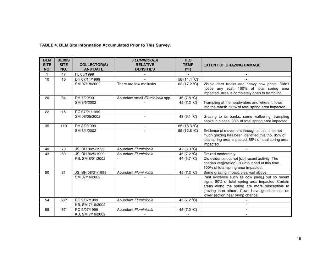
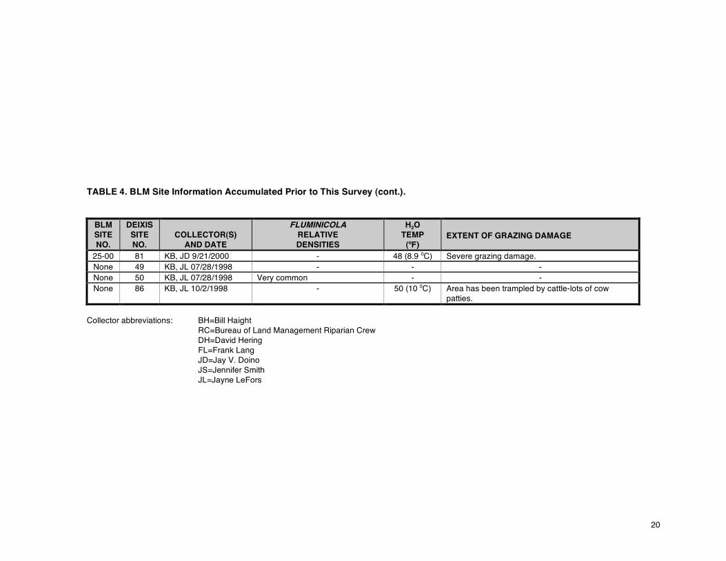
TABLE 4. BLM Site Information Accumulated Prior to This Survey.
BLM SITE NO.
DEIXIS SITE NO.
COLLECTOR(S)
AND DATE
FLUMINICOLA RELATIVE DENSITIES
H2O TEMP
(oF) EXTENT OF GRAZING DAMAGE
1 47 FL 05/1999 - - - 10 16 DH 07/14/1999 - 58 (14.4 0C) -
SM 07/18/2002 There are few mollusks 63 (17.2 0C) Visible deer tracks and heavy cow prints. Didn’t notice any scat. 100% of total spring area impacted. Area is completely open to trampling
20 64 DH 7/20/99 Abundant small Fluminicola spp. 46 (7.8 0C) - SM 8/5/2002 - 45 (7.2 0C) Trampling at the headwaters and where it flows
into the marsh. 50% of total spring area impacted. 22 15 RC 07/21/1999 - - -
SM 08/05/2002 - 43 (6.1 0C) Grazing to its banks, some wallowing, trampling banks in places. 98% of total spring area impacted.
35 110 DH 8/9/1999 - 65 (18.3 0C) - SM 8/1/2002 - 55 (12.8 0C) Evidence of movement through at this time; not
much grazing has been identified this trip. 85% of total spring area impacted. 85% of total spring area impacted.
40 70 JS, DH 8/25/1999 Abundant Fluminicola 47 (8.3 0C) - 43 69 JS, DH 8/25/1999 Abundant Fluminicola 45 (7.2 0C) Grazed moderately.
KB, SM 8/01/2002 - 44 (6.7 0C) Old evidence but not [sic] recent activity. The riparian veg[etation]. is untouched at this time. 100% of total spring area impacted.
50 21 JS, BH 08/31/1999 Abundant Fluminicola 45 (7.2 0C) Some grazing impact, clear-cut above. SM 07/16/2002 - - Past evidence such as cow pies[,] but no recent
signs. 80% of total spring area impacted. Certain areas along the spring are more susceptible to grazing than others. Cows have good access on lower section near pump chance.
54 68? RC 9/07/1999 Abundant Fluminicola 45 (7.2 0C) - KB, SM 7/16/2002 - - -
55 67 RC 9/07/1999 Abundant Fluminicola 45 (7.2 0C) - KB, SM 7/16/2002 - - -
19
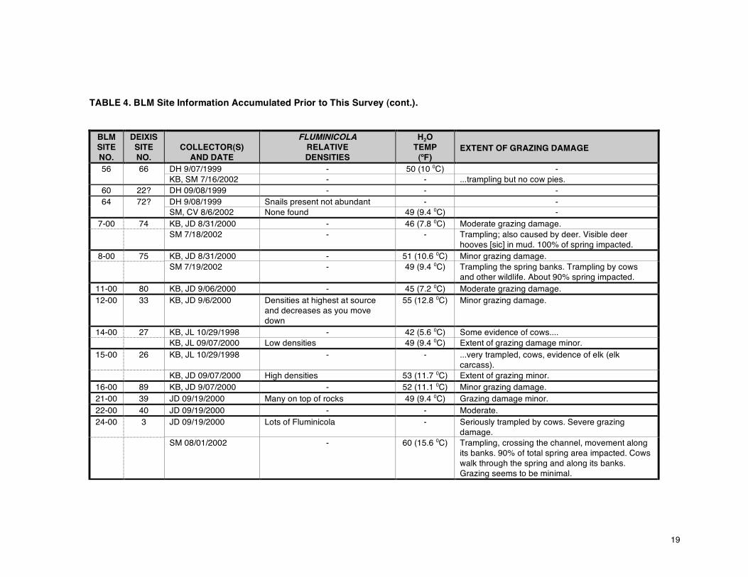
TABLE 4. BLM Site Information Accumulated Prior to This Survey (cont.).
BLM SITE NO.
DEIXIS SITE NO.
COLLECTOR(S)
AND DATE
FLUMINICOLA RELATIVE DENSITIES
H2O TEMP
(oF) EXTENT OF GRAZING DAMAGE
56 66 DH 9/07/1999 - 50 (10 0C) - KB, SM 7/16/2002 - - ...trampling but no cow pies.
60 22? DH 09/08/1999 - - - 64 72? DH 9/08/1999 Snails present not abundant - -
SM, CV 8/6/2002 None found 49 (9.4 0C) - 7-00 74 KB, JD 8/31/2000 - 46 (7.8 0C) Moderate grazing damage.
SM 7/18/2002 - - Trampling; also caused by deer. Visible deer hooves [sic] in mud. 100% of spring impacted.
8-00 75 KB, JD 8/31/2000 - 51 (10.6 0C) Minor grazing damage. SM 7/19/2002 - 49 (9.4 0C) Trampling the spring banks. Trampling by cows
and other wildlife. About 90% spring impacted. 11-00 80 KB, JD 9/06/2000 - 45 (7.2 0C) Moderate grazing damage. 12-00 33 KB, JD 9/6/2000 Densities at highest at source
and decreases as you move down
55 (12.8 0C) Minor grazing damage.
14-00 27 KB, JL 10/29/1998 - 42 (5.6 0C) Some evidence of cows.... KB, JL 09/07/2000 Low densities 49 (9.4 0C) Extent of grazing damage minor.
15-00 26 KB, JL 10/29/1998 - - ...very trampled, cows, evidence of elk (elk carcass).
KB, JD 09/07/2000 High densities 53 (11.7 0C) Extent of grazing minor. 16-00 89 KB, JD 9/07/2000 - 52 (11.1 0C) Minor grazing damage. 21-00 39 JD 09/19/2000 Many on top of rocks 49 (9.4 0C) Grazing damage minor. 22-00 40 JD 09/19/2000 - - Moderate. 24-00 3 JD 09/19/2000 Lots of Fluminicola - Seriously trampled by cows. Severe grazing
damage. SM 08/01/2002 - 60 (15.6 0C) Trampling, crossing the channel, movement along
its banks. 90% of total spring area impacted. Cows walk through the spring and along its banks. Grazing seems to be minimal.
20
TABLE 4. BLM Site Information Accumulated Prior to This Survey (cont.).
BLM SITE NO.
DEIXIS SITE NO.
COLLECTOR(S)
AND DATE
FLUMINICOLA RELATIVE DENSITIES
H2O TEMP
(oF) EXTENT OF GRAZING DAMAGE
25-00 81 KB, JD 9/21/2000 - 48 (8.9 0C) Severe grazing damage. None 49 KB, JL 07/28/1998 - - - None 50 KB, JL 07/28/1998 Very common - - None 86 KB, JL 10/2/1998 - 50 (10 0C) Area has been trampled by cattle-lots of cow
patties.
Collector abbreviations: BH=Bill Haight RC=Bureau of Land Management Riparian Crew DH=David Hering FL=Frank Lang JD=Jay V. Doino JS=Jennifer Smith JL=Jayne LeFors
21
Distribution On a familial basis, the freshwater fauna of North America is typically uniform, much the same families being found over the continent. However, Western faunas may have the endemic Lancidae and lack the widely distributed (on a world-wide basis) Viviparidae. Many of the more diverse Eastern groups are less speciose here or have representatives with atypical ecology, such as Lanx or Vorticifex. Rissooideans radiate extensively in both areas; but pleurocerids and unionids do so much less in the West. Glacial lakes and well-developed stream systems are less important here than in the East or Midwest. On the other hand, springs are of exceptional importance here, as they are in many parts of the world, as centers for diversification and reservoirs of both diversity generally and endemicity in particular (Shepard, 1993; Sada & Nachlinger, 1996, 1998; Sada et al., 2001; Frest, 2002a, b). Tectonics shapes land and freshwater mollusk distribution much more obviously here than in the East. Moreover, while the basic Western terrain is much younger geologically, factors influencing distribution of mollusks may be more long-term. Eastern U. S. unionid distributions, for example, are heavily influenced by Pliocene-Pleistocene glaciation. This seems to have had basically a negative effect in the West, excluding some taxa from habitats they could now occupy. Western drainages are younger and the drainage network less developed. Eastern rivers are more likely to be more ancient and the network quite fully developed and permanently occupied; but the last set of major changes may be comparatively very recent. Consequently, faunal equilibrium and stability are on the whole more evident in the East; and large-scale geologic influences on mollusk distribution proportionately more evident in the West.
Such factors are locally highly significant. The range of small Fluminicola, for example, cuts across several current major river drainages (Figure 4). Large Fluminicola are oddly absent from the Rogue but not from the streams to the north and south. The faunal history of the Rogue, Klamath, and Sacramento river systems intertwines in complex ways that are also reflected in their fish faunas. The Klamath itself is a recent composite of a basically Great Basin portion, Upper Klamath Lake, and a coastal portion. The Rogue, Klamath, and Umpqua may have captured the upper halves (or “middle” third in the case of the Klamath) from an ancestral, north-south trending Sacramento. In these systems, as in Western drainage systems generally, allopatric speciation in the headwaters may be the prevalent form of species origination. See APPENDIX B and below for more detailed discussion. Biogeography The current mollusk fauna may reflect complex past drainage history in certain ways. The predominant Western U. S. springsnail genus, Pyrgulopsis, is largely confined to Great Basin drainages. Ringing these is what Taylor (see 1985 for summary discussion) called the fishhook pattern of distribution. While the relevance of this distribution has recently been questioned (e. g., by Hershler & Liu, 2004), we would argue its continuing relevance from the same data, as well as distribution of Fluminicola and other freshwater mollusks. This is especially evident in the major local springsnail genus, Fluminicola, which is largely absent from the Great Basin. In turn, large (>6mm length) Fluminicola occur primarily peripheral to the small (< 4mm length) clades, which ring the western and northern Great Basin. Juga is currently deployed similarly. Note that these distributions very poorly correlate with the current east-west drainage pattern particularly prevalent near the Coast (see extended discussion and figures in APPENDIX B). In southwestern Oregon, large Fluminicola species are found in the Umpqua and Klamath rivers but do not occur in the Rogue drainage (Frest & Johannes, 2000a). In contrast, most freshwater mollusk genera inhabit the mainstem of all three rivers: Lanx is one notable example. Juga may be found throughout all three mainstem rivers and also in tributaries and springs. The smaller spring and small creek Fluminicola species of the same region occur only within portions of some of the current major drainages, as depicted in Figure 4. Note that the distribution rather abruptly terminates at about the

22
middle or upper third of each drainage, basically ¾ of the distance from the Coast to the Cascades axis, along a fairly distinct north-south line just east of Ashland. This abrupt termination, which continues into
FIGURE 4. MAP OF SOUTHWESTERN OREGON showing distribution of small taxa in the springsnail genus Fluminicola. Black dots may designate more than one site (total indicated by number next to dot); distribution continues to the east. Note western north-south termination (red line) cutting current major drainages. California at least through much of the Upper Sacramento and Pit river drainages, does not reflect spring distribution, which is fairly uniform though the affected systems. It may be due to historic factors as we suggest here, although its lack of applicability to spring Juga species in the same drainages is puzzling.

23
Within the larger distribution, the pattern for Fluminicola is for highly local endemism in particular river or even creek drainages. Such hotspots usually seem to have one common and several to a dozen very local endemics. Each spring usually has one or, less commonly, two Fluminicola species. The exception locally is the Fall Creek area, in which 5 or more taxa may be sympatric. This is very noteworthy, even for spring hydrobiids on a continent-wide basis. Juga is common in the lower Umpqua, Rogue, and Klamath, but rare in the upper Rogue, upper Umpqua, and middle to upper Klamath. The exception again is Fall Creek, in which several species may be present and most springs have the genus. Oddly, the genus is common east of the Monument, rare in the western half, and much more common, even in Jenny Creek, on a north-south trend, paralleling that of small Fluminicola, toward the eastern Monument border. As the Monument drainage is complex, so also is springsnail distribution. The Monument is drained mostly by Jenny Creek and Fall Creek (upper Klamath River drainage); but some Rogue River and other Klamath creeks drain the western portions (Figure 3). The next few figures (Figures 5-11) depict presently known distribution of 16 Fluminicola taxa found in and near the Monument. It seems likely that the Monument contains parts of at least four Fluminicola centers of endemism: Little Butte Creek, Jenny Creek [SE side of Little Chinquapin Mountain]), Emigrant Creek, and Fall Creek-Close Butte. Even these may be complex. Southern Emigrant Creek forms (Tyler Creek and vicinity) seem to differ from those of Walker Creek and its tributaries; and the Jenny Creek drainage may include subdivisions as well (see Table 5 and APPENDIX B). Over much of the Monument, one Fluminicola, the Keene Creek pebblesnail (n. sp. 16) is prevalent (Figure 5). More typically, each Fluminicola is strongly endemic and generally restricted to headwater springs, with less than 10 occurrences per taxon. Examples of such distributions are shown in Figures 5-11. Some taxa, such as the Pilot Rock pebblesnail (n. sp. 40) are found at only 1 or 2 nearby sites (Figure 8). Cumulative occurrences of all freshwater mollusks and of Fluminicola species in the Monument are given in Figures 13 and 18. This pattern, a left-skewed curve with a long “tail”, may be typical of both Pyrgulopsis and Fluminicola across their respective ranges. Headwater freshwater mollusk diversity is typically rather low per site in the western U. S. Our sites follow this pattern in that, overall, each site has a diversity of roughly 3-4 taxa, often split approximately equally between gastropods and bivalves (Figure 12, Tables 7-10). We illustrate diversity at Monument sites in Figure 12. Note that diversity is not evenly distributed: there is a secondary peak at perhaps a mean of 6 taxa. The single site with 15 taxa is a spring-influenced river site unique to this set of sites. Overall diversity in a western U. S. stream system is generally much higher, as headwaters endemism is seemingly characteristic of western drainages (Frest & Johannes, 2002a). We compare the Monument regionally in Figure 13. Note that this small portion of the upper Klamath River drainage compares favorably with the diversity of the much larger Upper Sacramento-Pit River and Upper Klamath Lake drainages, as against the very large Interior Oregon and similar-sized Sycan-Klamath Marsh areas. Only the combined Rogue-Umpqua system, obviously, has a substantially greater diversity. The pattern of headwaters endemism is here due especially to the large number of narrowly precinctive Fluminicola species, much as Great Basin endemism is particularly striking in the springsnail genus Pyrgulopsis (Hershler, 1994, 1998).
The extraordinary burst of springsnail diversity here appears due to two factors in particular. The first is that springs in the Monument, despite past usage, may still be in unusually good condition. Figure 14 compares proportions of springs with springsnails west to east across southern Oregon from the Monument (Monument only vs. Medford District generally) to the adjoining Winema National Forest and Klamath Falls District BLM (Upper Klamath Lake drainage) and east into the Interior Oregon Lakeview District, BLM. Of our 151 Monument sites, 93 lacked mollusks altogether or had mollusks, but not Fluminicola, most often the almost ubiquitous sphaeriid bivalves, and 58 springs had Fluminicola populations. Note that this high proportion is higher than that for the surrounding and inclusive Medford BLM lands generally (Figure 14). This may suggest that another factor other than grazing condition, which appears to increase in severity from west to east (possibly related to average forage volume per land unit or to duration of grazing or animal density per unit?) may be in play. One such factor may be presence of endemic hot spots or diversity clusters occurring differentially in particular drainages. To

24
FIGURE 5. DISTRIBUTION OF THE KEENE CREEK PEBBLESNAIL, Fluminicola n. sp. 16, and 3 other much more narrowly endemic taxa (mostly Fall Creek, Spring Creek, and Close Butte) in and near the Monument. Dark fill- Rogue River National Forest; medium-Monument; light-Medford BLM. assess this possibility we compared the number of Fluminicola species found at each site and ranked the occurrences from smallest to largest (Figure 15). The curve for the ranked sites was expected to show a typical strongly left-skewed distribution, if sites with no springsnails are discounted. Interestingly, the actual curve is left-skewed, indicating that most sites had single Fluminicola or 2 taxa sympatric. However, the graph also indicates a second peak, albeit small in amplitude, at higher per site diversities. Plots of Fluminicola site diversity show an interesting, non-random pattern (Figure 16). Note that areas
25
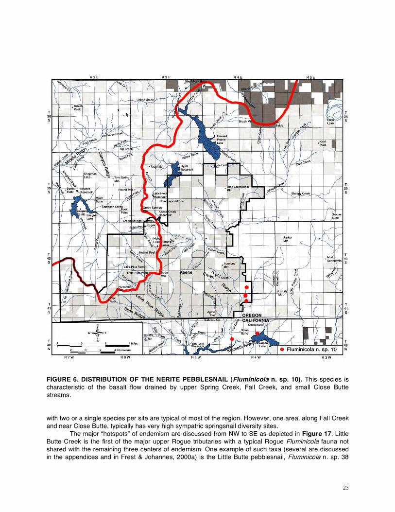
FIGURE 6. DISTRIBUTION OF THE NERITE PEBBLESNAIL (Fluminicola n. sp. 10). This species is characteristic of the basalt flow drained by upper Spring Creek, Fall Creek, and small Close Butte streams. with two or a single species per site are typical of most of the region. However, one area, along Fall Creek and near Close Butte, typically has very high sympatric springsnail diversity sites.
The major “hotspots” of endemism are discussed from NW to SE as depicted in Figure 17. Little Butte Creek is the first of the major upper Rogue tributaries with a typical Rogue Fluminicola fauna not shared with the remaining three centers of endemism. One example of such taxa (several are discussed in the appendices and in Frest & Johannes, 2000a) is the Little Butte pebblesnail, Fluminicola n. sp. 38

26
(distribution shown on Figure 8). In the upper Bear Creek drainage, mostly at the headwaters of the Emigrant Creek drainage, is another center of endemism, with such taxa as Fluminicola n. sp. 17? (again,
FIGURE 7. DISTRIBUTION OF THE TOOTHED PEBBLESNAIL (Fluminicola n. sp. 11). This taxon is also characteristic of the small Fall Creek-Close Butte drainage. see Figure 8 for known distribution of this form). Despite occurrence in the Rogue drainage strictly speaking, affinities of the Fluminicola found here are with the upper Klamath River drainage instead. Much of the upper Rogue has public lands primarily within Rogue River National Forest; but for this center of endemism Medford BLM has extensive remaining holdings. This section of the Emigrant Creek drainage was likely captured from the upper Klamath drainage and hence retains an upper Klamath

27
springsnail fauna. The next “hot spot” is situated solidly within the Cascade-Siskiyou National Monument. Most sites involved have the Chinquapin springsnail, Fluminicola n. sp. 39, as a characteristic element (its
FIGURE 8. DISTRIBUTION OF SEVEN Fluminicola ENDEMIC TO VARYING DEGREES. Some taxa are more widely distributed forms, although still strongly endemic, characteristic of subdrainages, e.g. Fluminicola n. sp. 17? (parts of the Emigrant Creek headwaters) and Fluminicola n. sp. 39 (Jenny Creek headwaters on Chinquapin Mountain). Others are extremely precinctive. distribution is mapped on Figure 8).
On the southeastern side of the Monument and into adjacent eastern portions of the Medford, Oregon and Klamath, California District BLM, is a narrow region of especially notable endemism and sympatry. Some taxa, such as the Fall Creek and Topaz pebblesnails (Fluminicola n. sp. 13 & 14
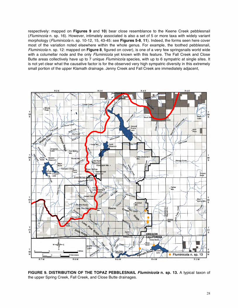
28
respectively: mapped on Figures 9 and 10) bear close resemblance to the Keene Creek pebblesnail (Flumincola n. sp. 16). However, intimately associated is also a set of 5 or more taxa with widely variant morphology (Fluminicola n. sp. 10-12, 15, 43-45: see Figures 5-8, 11). Indeed, the forms seen here cover most of the variation noted elsewhere within the whole genus. For example, the toothed pebblesnail, Fluminicola n. sp. 12: mapped on Figure 8, figured on cover), is one of a very few springsnails world wide with a columellar node and the only Fluminicola yet known with this feature. The Fall Creek and Close Butte areas collectively have up to 7 unique Fluminicola species, with up to 6 sympatric at single sites. It is not yet clear what the causative factor is for the observed very high sympatric diversity in this extremely small portion of the upper Klamath drainage. Jenny Creek and Fall Creek are immediately adjacent,
FIGURE 9. DISTRIBUTION OF THE TOPAZ PEBBLESNAIL Fluminicola n. sp. 13. A typical taxon of the upper Spring Creek, Fall Creek, and Close Butte drainages.

29
FIGURE 10. DISTRIBUTION OF THE FALL CREEK PEBBLESNAIL Fluminicola n. sp. 14. Another of the Fall Creek area precinctives. almost in contact in their lower reaches at one point (Figure 1). However, all the high diversity sites do appear to be situated on a small basalt flow from Grizzly Mountain. This has been dated as Miocene, in contrast to the generally Pliocene bedrock of much of the region. A portion of upper Spring Creek, currently part of the Jenny Creek drainage, lies on this same basalt flow and shows the same high diversity. We think it likely that this area was until recently part of the Fall Creek drainage and only recently was captured by headward erosion by Jenny Creek or its tributaries. If all springsnail taxa are

30
included, the Monument shows the expected left-skewed, long-tailed distribution. As many as 16 taxa may be present regionally. We emphasize here, though, that the distribution of Monument springsnail
FIGURE 11. DISTRIBUTION OF THE SHOAT SPRINGS PEBBLESNAIL Fluminicola n. sp. 43. Note occurrence in Jenny Creek drainage as well as Fall Creek but only in the upper Spring Creek drainage. diversity measured as sites per taxon (Figure 18) is similar to that shown by site diversity, that is, left skewed with a possible minor rise among some right-tail taxa (Figure 12 vs. Figure 18). Once again, the unusual nature of the Fall Creek center of endemism stands out and partially overrides the more typical diversity pattern of the region as a whole. However, even with this regionally unique drainage included, the basic overall diversity pattern is evident.

31
FIGURE 12. MOLLUSK SITE DIVERSITY in 114 Cascade-Siskiyou National Monument sites.
FIGURE 13. REGIONAL FRESHWATER MOLLUSK DIVERSITY. Note that the Monument, a small drainage, compares favorably with the combined Rogue-Umpqua, Upper Klamath Lake, and Upper Sacramento-Pit River drainages. Data from various Frest & Johannes (1998-2004) reports.

32
FIGURE 14. PROPORTION OF SPRINGS WITH SPRINGSNAILS in southern Oregon federal lands.
FIGURE 15. SYMPATRIC Fluminicola FROM CASCDE-SISKIYOU NATIONAL MONUMENT and vicinity sites with mollusks vs. number of sites.

33
FIGURE 16. NUMBER OF Fluminicola TAXA AT INDIVIDUAL SITES in the Cascade-Siskiyou National Monument and proximal areas.
It should be evident from the above: 1) that this drainage has a complex diversity pattern, and 2) that analysis of the Monument and other western U. S. springsnail faunas is at least as dependent upon knowledge of certain historical factors, such as geology, as upon presumably independent current ecological considerations. Any analysis of grazing effects must take into account the major features of springsnail evolution, distribution, and biogeography, and the local complexities of geology and usage history as well, to avoid oversimplification. See APPENDIX B for lengthier discussion.

34
FIGURE 17. FOUR MJOR ENDEMIC CENTERS WITHIN OR NEAR THE MONUMENT. The NW
Rogue center (Little Butte Creek) taxa appear only distantly related to members of the other three areas. Emigrant Creek headwater taxa appear closely related to those of the upper Klamath drainage.

35
FIGURE 18. NUMBER OF SITES PER Fluminicola SPECIES IN THE MONUMENT AREA. Note strongly skewed distribution of sites with Fluminicola and possible secondary peak near center of spread.
RESULTS Water quality parameters measured at Monument sites in 2003 and 2004 were presented on Table 3. Table 4 records past information at sites visited also by BLM survey crews. Note that much additional such data is available in several internal BLM documents. We categorize site distribution by drainage in Table 5. Table 6 summarizes results at our sites. Further comments, sometimes including the results of prior visits to the same sites, either by us, by BLM personnel, or by both, are made in the site descriptions (APPENDIX A). These may date to the 1990s and can provide some perspective on past condition of some sites’ mollusk fauna, or on condition of this and other site fauna and flora in other seasons. Refer to Figure 1 and Appendix A for precise locations and more detail, including limited information on flora. Grazing evaluations and some additional ancillary information is summarized in Table 6. Note that our interpretations of grazing conditions are subjective; and we make no representations as to quantitative accuracy. We also do not have the data to analyze past grazing history of our sites. We are not grazing specialists but can claim some experience ancillary to our primary area of interest. Our observations are primarily useful as crude checks against more professional evaluations made independently for this study. Note also that our observations were done virtually at the end of the

36
grazing season. Comparisons (APPENDIX A) with earlier visits to the same sites by either us or BLM personnel or both, when available, may be instructive.
Site faunal lists, as collected and identified so far, constitute Tables 7-10. Monument springs are mostly part of the upper Klamath River drainage. However, some situated in stream drainages tributary to the Rogue River are faunally similar to Klamath sites and hence are considered here also (Figures 1, 11). Even among sites on upper Klamath River tributaries, species distribution and diversity are not uniform. Roughly 60 sites so far are in the Jenny Creek system (Table 5, Figure 1). Strictly, according to present drainage arrangements (Figure 1), the 17 sites of the Shoat Springs-uppermost Spring Creek should be counted here also; but faunally these clearly group with Fall Creek instead, as do those of Close Butte. The Jenny Creek sites typically have single species of Fluminicola but may have two. Most widely distributed is Fluminicola n. sp. 16 (Keene Creek pebblesnail), which can occur in both spring-influenced creeks and springs of various sizes. In some cases, this is the only springsnail species present, especially TABLE 5. Drainage Basin Location of 2003-2004 Sites.
DRAINAGE
SUBDRAINAGE
SITE NUMBER
ROGUE RIVER Emigrant Creek south (Tyler Creek, Sampson
Creek, & vicinity) 3, 4, 5, 6, 26, 27, 28, 32, 80, 81, 88, 89, 90
north (Walker Creek & vicinity) 33, 37, 38, 39, 40, 41, 42, 76, 77, 78, 79
Baldy Creek 93, 94, 95, 96, 98, 99 Upper 74, 75, 82, 83 Little Butte Creek Lost Creek 49, 50, 51 KLAMATH RIVER Klamath River
61
Camp Creek Dutch Oven Creek 97 Jenny Creek Jenny Creek 46, 60, 100, 101, 102, 112 Keene Creek 1, 2, 7,14, 15, 16, 29, 30, 31, 34,
35, 36, 46, 62, 63, 64, 65, 84, 85, 86, 87, 91, 92, 100, 101
Chinquapin Mountain (Beaver Creek)
17, 18, 19, 20, 21, 22, 23, 24, 25, 66, 67, 68, 69, 70, 71,72, 73, 108, 109
other 8, 45, 47, 48, 103, 104, 105, 110, 111, 113, 114
Fall Creek Shoat Springs-upper Spring Creek1
9, 10, 11, 12, 13, 44, 52, 106, 107
Schoolhouse Meadow 43 other Fall Creek 59 Close Butte 53, 54, 55, 56, 57, 58
1 =Faunally a part of the Fall Creek drainage, despite current connection to Jenny Creek. Boldface numbers are secondary sites; primary sites are in plain type.

37
in Keene Creek and related drainages (Tables 7 & 9). In the Beaver Creek drainage near Chinquapin Mountain, there are several springs with the Chinquapin pebblesnail (Fluminicola n. sp. 39) as well as, or instead of, n. sp. 16 (compare Figures 5 & 8). The Fall Creek springs have a unique set of possibly 7 taxa that overlap little with those of Jenny Creek. Neither the Keene Creek nor the Chinquapin pebblesnails appear to occur in this region, but the adjacent Close Butte springs also have the typical Fall Creek taxa.
As noted above, Shoat Springs and the first few miles of its run, Spring Creek, have a mollusk fauna much like that of Fall Creek and the adjacent Close Butte springs east of its mouth (Figure 1). All three have Juga (Calibasis) acutifilosa and likely share additional unique Juga species, as well as at least one very narrow endemic, Juga (Oreobasis) cf. nigrina. Jenny Creek mostly has so-called Juga (Juga) silicula shastaensis, a broadly regional endemic lacking in Fall Creek. At least five of the very distinctive Fall Creek Fluminicola are shared by Close Butte, Fall Creek, its Schoolhouse Meadow (Schoolhouse Creek) headsprings, plus Shoat Springs and the first few miles of its run. Additionally, occasional taxa appear to be either strictly endemic to one or the other of these areas as well, or are virtually so. Site diversity in some areas is extraordinarily high, with five or even more Fluminicola sympatric commonly in relatively pristine springs (Figure 15) An extraordinary showing for springs worldwide and almost unprecedented in North America (see APPENDIX B).
Reasons for the extraordinary endemism are not readily apparent. The Fall Creek drainage, including upper Spring Creek and Shoat Springs, flows on a coherent small basalt unit that can be distinguished from those to the west and east; but it is not clear as to why this should matter so drastically. This basalt may be older than most flows in the vicinity; perhaps early colonization or greater age has allowed greater species accumulation or sympatric speciation. The Fall Creek drainage is extraordinarily rich in nasmodes and includes some of the largest in Oregon. In fact, above the confluence of Schoolhouse Meadow Creek with Fall Creek, Fall Creek is generally impermanent. However, the equally large nasmodes and limnocrenes of the Pit River system immediately to the south, while rich in endemics (Hershler et al., 2003; in press), do not produce such extraordinary sympatric diversity; nor do those of the Upper Klamath Lake drainage. Similarly, small springs in this area may have much less diverse springsnail faunas. Whatever the cause, in analyzing effects of grazing in this area it is perhaps necessary to consider Fall Creek sites, plus Shoat Springs, separately from the rest of the middle Klamath tributaries. This treatment of upper Spring Creek basically acknowledges the possibility that substrate similarity and fauna indicate recent capture by Jenny Creek of a stream formerly tributary to Fall Creek. Reinforcing the probability of such a capture is the fact that the artificial Spring Creek diversion rather easily has directed Spring Creek flows to Schoolhouse Meadow. It is not, however, a good conduit for migration upstream of Schoolhouse Meadow taxa (it is too swift to support much in the way of Fluminicola); and there is a small waterfall at the west edge of Schoolhouse Meadow). Moreover, all taxa involved at Shoat Springs, even if unique to the springs, have their nearest congeners elsewhere in the Fall Creek drainage. Additionally, the springs between Shoat Springs and Schoolhouse Meadow regardless of size mostly have Fall Creek endemic taxa.
Complicating matters further are the interrelationships between Jenny Creek and some surrounding Rogue River tributaries. As noted above, the Rogue set of Fluminicola species is largely distinct from that of Jenny or Fall Creeks. However, there appears to be some overlap in the headwaters of the Emigrant Creek drainage. While there are some unique taxa as well, it appears that n. sp. 16 and the Emigrant pebblesnail (n. sp. 17?) occur at some sites in this drainage, while forms more characteristic of the Rogue swarm are often absent. The Rogue Fluminicola are incompletely known; and it is possible that more than one set of taxa is present. For example, Little Butte Creek and its tributaries appear to have a unique form, Fluminicola n. sp. 38, known only from the upper Rogue drainage. Similarly, there appear to be faunal differences in the Emigrant Creek drainage between the south portion of the drainage, basically Tyler Creek and smaller tributaries, and Walker Creek and its tributaries to the north, with Jenny Creek influence most evident in the south portion of Emigrant Creek’s drainage.
We would suggest the possibility that some parts of the Emigrant Creek drainage represent recent captures originally part of the Jenny Creek drainage. Fortunately, most of the Rogue possible hotspots seem to show a site diversity and sympatry pattern identical to that of Jenny Creek. This is to say that usually one or two Fluminicola taxa are present per site; and one taxon seems to characterize
38
most stream and spring sites within a particular drainage. Hence, it may be reasonable to compare sites within or near the Monument based upon only two sets of prevailing sympatry and diversity conditions: the extraordinary features typifying Fall Creek plus the Spring Creek headwaters and Close Butte; and those typical of the rest of the Monument streams. Note that because some Rogue tributary species may occur on the Monument and some definitely occur at certain of our sites we have included all such that are relevant as possible members of the Monument malacofauna (APPENDIX H). Because of this complication and additionally because of the preliminary nature of our data, we have refrained from detailed analysis of results so far. However, the sensitive species can evidently tolerate relatively light grazing; but severe practices have a negative effect.
There are some suggestive features of Tables 3-6 that should be mentioned as corroborating this conclusion. In general, high diversity, high abundance, or both of springsnails have seemed to correlate with some combination of high floral diversity; high terrestrial mollusk diversity; and relatively minor evidence of severe and/or recent cattle grazing. Also, the proportion of springs with any springsnails at all seems directly related to regional springsnail diversity and abundance, with a larger percentage of presence apparently directly related to springsnail abundance and diversity (for examples, see Frest & Johannes, 2000b: note that the Medford District as a whole scores high on this criterion: Figure 14). Similarly, excellent freshwater habitat as determined from water quality seems to correlate with large springsnail populations. The same relationships also seem to hold for other sensitive freshwater taxa.
Abstraction of some selected water quality and other parameters from Tables 3 & 6 suggests other correlations. The primary and secondary sites were divided into three categories (Tables 11-13) depending on their location in the Rogue River drainage, Jenny Creek drainage, and Fall Creek drainage, thus isolating the three major nasmodes encountered on the Monument. Collectively, the springs and creek sites are cool and have low turbidity. The range of pH is limited, with slightly alkaline conditions prevalent. The observed temperature and TDS ranges are also comparatively narrow, and note that both are rather low as compared to many freshwater environments. Velocity generally does not seem to correlate well with springsnail diversity or abundance. In some drainages, perhaps all, colder water temperatures and higher DO seems related to greater springsnail abundance and higher probability of occurrence. The Rogue River and Jenny Creek sites (Tables 11 & 12) typically had rather low sensitive species diversity, with Fluminicola usually the sole genus in this category. Fall Creek sites (Table 13) were highly diverse as regards sensitive taxa, with several Fluminicola and at least one Juga typical at each site, in contrast to the 1-2 taxa more characteristic of Jenny Creek and Rogue drainage sites. In all three areas, Sensitive taxon abundance and diversity tended to be lowest in severely grazed situations. Fall Creek has relatively large sites and high diversity, although this is not universal. Rogue River sites so far tend to be smaller and colder, especially those along Little Butte Creek. Areas we rated as severely grazed are more likely to lack springsnails entirely or to have low densities. These sites also tend to have less diverse floras and to lack terrestrial mollusks.

39
TABLE 6. Grazing Evaluations of 2003-2004 Sites.
SITE NO.
LOC. NO.
BLM SITE NO.
BLM
LAND
INSIDE CSNM
PUMP
CHANCE
DATE
VISITED
SIZE
SEN. DIV.
FLU. DEN.
MOLLUSK FAUNA/
COMMENTS
GR. IM.
EXTENT OF GRAZING/
COMMENTS 1 623 - Yes Yes No 10/3/03 45 1 5 Abundant 1 Nil: very little indication of recent grazing. 9/17/04 4 1 3 Uncommon
except locally 5 Vegetation cropped down to 4” or below.
Old cow pies present. Severe grazing and trampling. Downed wood broken up by cattle trampling.
2 626 - Yes Yes No 10/3/03 3 1 4 Common 1 Nil: very little indication of recent grazing. 9/17/04 3 1 4 Common 3 Cow trails along spring run and evidence
of areas trampled by cows. Fresh cow pies. Grasses cropped down to 6” or below. Moderate grazing damage.
3 5039 24-00 Yes Yes No 10/3/03 2 2 2-3 Common locally; rare overall
4-5 Heavy-severe: fresh cow pies present. Spring run destroyed by cattle grazing below collection site; there, only sphaeriids present. Cattle tromped and trails where Fluminicola occur.
4 5829 - No Yes No 10/3/03 1 0 1 No mollusks 3 Moderate grazing impact. 5 5830 - Yes Yes Yes 10/3/03 3 0 1 No mollusks 5 Severe; spring source and run severely
trampled. Grasses mostly cropped by cattle. Cattle present at site during our visit. Cow pies abundant.
6 5831 - No Yes No 10/3/03 3 1 5 Abundant 1 Nil: grasses along run show some evidence of grazing (very minor). No cow pies seen.
7 5832 - Yes Yes Yes 10/3/03 2 0 1 No mollusks 5 Severe; heavily grazed (surrounding area bare dirt). Fresh cow pies.
81, 2 1515 - No No Yes 10/4/03 2 2 2 Uncommon 4-5 Heavy-severe: area outside fence heavily grazed and trampled. Fresh cow pies.
9/25/04 2 2 2 Uncommon 4 Grazing heavy. Recent and old cow pies. 91 1633 - Yes No No 10/4/03 5 6 5 Very abundant 1 Nil: area protected by fence.
9/25/04 5 6 5 Very abundant 1 Aquatic plants more abundant inside enclosure than outside enclosure. Grazing heavy outside spring enclosure (forest denuded of understory vegetation).

40
TABLE 6. Grazing Evaluations of 2003-2004 Sites (cont.).
SITE NO.
LOC. NO.
BLM SITE NO.
BLM
LAND
INSIDE CSNM
PUMP
CHANCE
DATE
VISITED
SIZE
SEN. DIV.
FLU. DEN.
MOLLUSK FAUNA/
COMMENTS
GR. IM.
EXTENT OF GRAZING/
COMMENTS 101, 2 5833 - Yes No No 10/4/03 5 4 5 Very abundant 2-3 Slight-moderate; no cow pies seen. 111, 2 5835 - Yes Yes No 10/5/03 45 7 4 Common 3 Moderate; some grazing evident.
Somewhat old cow pies present. Cow trails along creek.
122 5836 - Yes Yes No 10/5/03 2 2 4 Abundant 3 Moderate; some evidence of grazing (sedges and grasses cropped). Cow pies (not recent) present.
131, 2 5838 - Yes Yes No 10/5/03 2 7 3 Uncommon-common
1-2 Nil-slight grazing impact. No cow pies present.
14 4625 - Yes Yes No 10/6/03 25 1 2 Somewhat uncommon
5 Severe; intensive grazing damage.
15 4733 22 Yes Yes No 10/6/03 3 2 4 Very common 3 Moderate; somewhat cowed but partially protected by fallen trees and steep slope and boulders at source. Cow pies somewhat old.
16 5843 10 Yes Yes No 10/6/03 2 1 2 Rare 4 Heavy; spring run and surroundings heavily trampled.
9/23/04 2 1 2 Rare 4 Grazing and trampling of spring heavy. Cropping below 2". Fresh cow pies. Cow paths present.
17 4653 - Yes Yes No 10/7/03 25 0 1 Sphaeriids only 3-4 Moderate-heavy: heavy grazing impact along road including creek, moderate grazing damage elsewhere.
9/19/04 2-3 0 1 Sphaeriids only 1 Grazing nil at spring. Heavy in surrounding areas. Some cropping along road.
18 4654 - Yes Yes No 10/7/03 2 2 3 Uncommon 2 Light: some evidence of light cattle grazing.
9/18/04 2 2 3 Uncommon 3-5 Moderate-severe (outside run).

41
TABLE 6. Grazing Evaluations of 2003-2004 Sites (cont.).
SITE NO.
LOC. NO.
BLM SITE NO.
BLM
LAND
INSIDE CSNM
PUMP
CHANCE
DATE
VISITED
SIZE
SEN. DIV.
FLU. DEN.
MOLLUSK FAUNA/
COMMENTS
GR. IM.
EXTENT OF GRAZING/
COMMENTS 19 4656 - Yes Yes No 10/7/03 2 0 1 No mollusks 2-3 Light to moderate grazing evident.
9/19/04 2-3 0 1 No mollusks 3 Grazing moderate (saved by steepness). Old cow pies present. Cow trails in the vicinity. Landslides occurring nearby.
20 4658 - Yes Yes No 10/7/03 2 1 3 Abundant 3 Moderate grazing impact. 211 4660 50 Yes Yes Yes 10/7/03 3 2 4 Common 3-4 Moderate-heavy trampling and moderate-
heavy grazing. Cow pies (fresh) and cows present near site.
22 5010 60? Yes Yes No 10/7/03 2 0 1 No mollusks 2 Light: some grazing evident. 9/19/04 2 0 1 No mollusks 1 Very little evidence of grazing.
23 5844 - Yes Yes No 10/7/03 2 1 2 Very rare 5 Severe and extensive grazing damage. Spring trampled by cattle.
9/19/04 2 1 2 Rare 1 Old cow pies at road. Little evidence of grazing.
24 5845 - Yes Yes No 10/7/03 2 0 1 Sphaeriids only 4 Heavy; grazing evident, whole area disturbed.
9/19/04 2 0 1 Sphaeriids only 1 Grazing nil. 25 5846 - Yes Yes No 10/7/03 45 0 1 No mollusks 5 Extensive-severe grazing damage; fresh
cow pies; area trampled down to soil. 26 3974 15-00 Yes No Yes 10/8/03 2 2 5 Abundant 3 Moderate gazing impact.
9/23/04 2 2 4 Common 3 Moderate grazing and trampling around pump chance and incoming spring channel. Grazing damage less so where run is steep and incised. Cropping 12-18".
273 3975 14-00 Yes No Yes 10/8/03 2 0 1 No mollusks seen 4 Heavy; extensive grazing and trampling damage still evident despite fence.
9/23/04 2 1 3 Uncommon 1 No grazing due to new fence around spring. S. side of fence needs to be repaired.
28 4638 - Yes No No 10/8/03 1 0 1 No mollusks 4 Heavy grazing impacts. 29 4634 - Yes No No 10/8/03 1 0 1 No mollusks 4 Heavy: fresh cow pies. Sedges and
grasses cropped by cattle. Area severely trampled by cattle.

42
TABLE 6. Grazing Evaluations of 2003-2004 Sites (cont.).
SITE NO.
LOC. NO.
BLM SITE NO.
BLM
LAND
INSIDE CSNM
PUMP
CHANCE
DATE
VISITED
SIZE
SEN. DIV.
FLU. DEN.
MOLLUSK FAUNA/
COMMENTS
GR. IM.
EXTENT OF GRAZING/
COMMENTS 30 4635 - Yes No No 10/8/03 35 2 4 Common 4 Grazing heavy. Grasses along creek
cropped, banks trampled. Fresh cow pies present.
31 4637 - Yes No No 10//8/03 35 0 1 No mollusks 4 Impacted by cattle grazing. Heavy grazing, bare soil, trampled banks, grasses cropped down.
32 4640 - Yes No No 10/8/03 2 1 1 Very rare 4-5 Heavy-severe: extreme cattle trampling of creek and surroundings.
33 5028 12-00 Yes No No 10/8/03 2 1 1 Uncommon 4 heavy: run and meadow extensively grazed; grasses cropped down, run trampled. Fresh cow pies present.
34 5849 - No No No 10/8/03 4 0 1 Sphaeriids/ Physella
4 Heavy grazing impact. Grasses cropped low to ground. Banks of creek trampled.
35 5850 - No No No 10/8/03 1 0 1 No mollusks 4-5 Heavy-severe cattle grazing; grasses cropped low.
36 5851 - Yes No No 10/8/03 2 2 3 Uncommon 4 Heavy: spring run trampled; surroundings heavily grazed. Fresh cow pies present.
37 5852 - Yes No No 10/8/03 2 0 1 No mollusks 3 Moderate: somewhat old cow pies present. Some grazing impact evident.
38 5853 - Yes No No 10/8/03 2 0 1 No mollusks 5 Run trampled severely and surroundings heavily grazed.
392 4643 21-00 Yes No Yes 10/9/03 3 2 3-4 Uncommon-common
3 Moderate grazing damage.
9/21/04 3 1 4 Locally common 3 Some trampling of spring. Cropping very minor. Grazing moderate. Nil in inaccessible areas of run. Cow trail along run.

43
TABLE 6. Grazing Evaluations of 2003-2004 Sites (cont.).
SITE NO.
LOC. NO.
BLM SITE NO.
BLM
LAND
INSIDE CSNM
PUMP
CHANCE
DATE
VISITED
SIZE
SEN. DIV.
FLU. DEN.
MOLLUSK FAUNA/
COMMENTS
GR. IM.
EXTENT OF GRAZING/
COMMENTS 40 5037 22-00 Yes No No 10/9/03 2 1 2 Uncommon 5 Severe: surroundings trampled by cattle
to bare dirt (remnant cropped grasses locally). Extensive grazing damage, trampling of channel except in areas protected by fallen trees and where the channel is deeply incised.
9/21/04 2 1 4 Locally common 3 Moderate grazing damage. Cropping 8”. Fresh and old cow pies.
41 5854 - Yes No No 10/9/03 2 0 1 No mollusks 5 Severe: extensive cattle grazing damage; grasses cropped very short.
9/21/04 2 0 1 No mollusks 5 Severe grazing. Abundant cow fresh pies. Cropping 4” or below.
42 5855 - Yes No No 10/9/03 1 0 1 No mollusks 5 Severe cattle grazing damage. Fresh cow pies present.
431, 2 629 - Yes Yes No 10/10/03 5 6 5 Very common 3 Moderate grazing. 9/26/04 5 6 5 Abundant 3-4 Moderate to heavy grazing damage.
Trampling of banks evident. Cropping 4" and below.
442 5859 - Yes Yes No 10/10/03 3 5 5 Abundant 3 Moderate grazing impact (plants recovering). Cow pies (not fresh).
452 627 - No Yes No 10/11/03 2 1 2 Uncommon-rare 5 Severe grazing but some protection by steep slope and trees.
461 5906 - Yes No No 10/11/03 4 2 5 Abundant 3 Moderate grazing damage. 47 4629 1 Yes Yes No 10/11/03 3 1 2 Extremely rare 2 Slight grazing. 48 4631 - Yes Yes Yes 10/11/03 2 1 3 Common locally 2 Slight cattle grazing. 49 3981 No # Yes No No 10/9/03 35 1 3 Common locally 5 Severe: hammered by cattle grazing.
Fresh cow pies. 50 3982 No # Yes No No 10/9/03 3 1 3 Uncommon-very
locally common 4-5 Moderate-severe; banks and immediate
area trampled by grazing cattle. Grasses cropped.
51 5856 - No Yes No 10/9/03 3 1 3 Uncommon 5 Very severe cattle grazing/trampling of steam and surrounding area.
521 5834 No Yes No 10/4/03 5 8 5 Very abundant 2-3 Slight-moderate: no cow pies seen. 53 5867 - No No No 10/20/03 1 3 1 Gyraulus/Physella 5 Severe grazing damage. Fresh cow pies.

44
TABLE 6. Grazing Evaluations of 2003-2004 Sites (cont.).
SITE NO.
LOC. NO.
BLM SITE NO.
BLM
LAND
INSIDE CSNM
PUMP
CHANCE
DATE
VISITED
SIZE
SEN. DIV.
FLU. DEN.
MOLLUSK FAUNA/
COMMENTS
GR. IM.
EXTENT OF GRAZING/
COMMENTS 541 5868 - No No No 10/20/03 3 4 5 Very common 2 Cattle grazing damage very light. 551 5869 - No No No 10/20/03 2 4 5 Very common 1 Cattle grazing nil. 561 5870 - No No No 10/20/03 2 4 4 Common 1 Grazing very light. 571 5871 - No No No 10/20/03 3 3 3 Common 1 Grazing very light. 58 5871 - No No No 10/20/03 3 2 3 Common 1 Grazing very light. 59 5871 - No No No 10/20/03 55 5 5 Common 1 Grazing very light. 60 5871 - No No No 10/20/03 55 0 1 Common 1 Grazing very light. 61 5871 - No No - 10/20/03 -6 - - Common - - 62 6103 - Yes Yes No 9/17/04 1 0 1 Uncommon
sphaeriids 5 Very severe grazing damage; cow pies
mostly old, a few recent. Cow trails on both sides of spring run. Vegetation cropped between 4-6”.
63 3929 - Yes Yes No 9/17/04 35 1 4 Common 4 Heavy grazing damage. Cow pies present (recent-old). Vegetation cropped below 6". Trampling of surroundings evident.
641 4723 20 Yes Yes No? 9/17/04 4 2 5 Very abundant 1-3 Area moderately grazed. Hillside not grazed. Cropping to 6". Old and fresh cow pies present.
651 6104 - Yes Yes No? 9/17/04 4 2 5 Very abundant 3 Fresh cow pies present. Moderate grazing damage. Cropping down to 6".
66 4647 56 Yes Yes No 9/18/04 2 1 3 Uncommon 2 Grazing light. Old cow pies present. 67 4648 55 Yes Yes Yes 9/18/04 4 1 4 Common to
locally abundant 1 Grazing nil.
68 6068 54? Yes Yes No 9/18/04 2 0 1 Uncommon sphaeriids
1 Very little grazing evident.
69 4650 43 Yes Yes No 9/18/04 2 1 3 Uncommon 5 Severe grazing damage 70 4651 40 Yes Yes Yes 9/18/04 3 1 3 Uncommon 5 Severe grazing damage. Old cow pies.
Enclosure around spring source mostly broken down.
71 4652 - Yes Yes Yes 9/18/04 3 1 4 Common 3 Moderate grazing damage. Fresh cow pies present. Fence enclosure mostly broken down.
72 5840 64? Yes Yes No 9/19/04 1 0 1 Sphaeriids rare 5 Severe grazing damage. Trampling evident.

45
TABLE 6. Grazing Evaluations of 2003-2004 Sites (cont.).
SITE NO.
LOC. NO.
BLM SITE NO.
BLM
LAND
INSIDE CSNM
PUMP
CHANCE
DATE
VISITED
SIZE
SEN. DIV.
FLU. DEN.
MOLLUSK FAUNA/
COMMENTS
GR. IM.
EXTENT OF GRAZING/
COMMENTS 73 6105 - Yes No Yes 9/19/04 3 0 1 No mollusks 2-3 Light-moderate grazing damage. Fresh
cow pies. 74 4622 7-00 Yes Yes Yes 9/20/04 2 1 3-4 Uncommon-
common 1 Grazing damage nil.
75 5024 8-00 Yes Yes No 9/20/04 2 1 2 Rare 1 Grazing by deer. 76 6106 - Yes No Yes 9/21/04 2 0 1 No mollusks 5 Severe cattle grazing damage. Abundant
old and recent cow pies. Grasses cropped down below 6". Trampling of spring heavy.
77 6107 - Yes No No 9/21/04 1 0 1 No mollusks 5 Severe grazing damage both from trampling and grazing. Fresh cow pies present. Cropping 2-8”.
782 6108 - No No No 9/21/04 24 1 2 Extremely rare 4 Heavy grazing trampling impact below source and outside area around the densely vegetated spring source. Grasses cropped down below 2". Old and fresh cow pies present.
792 6109 - Yes No No 9/21/04 2 1 2 Rare 3-5 Moderate-severe grazing and trampling damage. Old-recent cow pies. Spring trampled. Cow paths crossing spring run with intervening areas of heavy vegetation further away from road. Cattle trails on both sides of spring run. Lower part of spring run just above road hammered (severe). Upper part spring run where Fluminicola occur less impacted by cattle (steeper slope than below).
80 4641 11-00 Yes No Yes 9/21/04 2-3 1 3 Uncommon 4 Fresh cow pies. Heavy grazing (cropped down to 6"). Trampling evident.
81 5040 25-00 Yes No No 9/22/04 25 0 1 No mollusks 5 Severe cattle grazing and trampling. Cropped 6" or less.
822 6112 - No Yes No 9/22/04 25 0 1 No mollusks 1 Grazing not evident. 83 6114 - Yes Yes No 9/22/04 25 0 1 No mollusks 1 No evidence of grazing 84 6115 - No No No 9/22/04 25 1 3-4 Uncommon-
common 4 Grazing and trampling heavy. Old and
new cow pies. Cropping 6”.

46
TABLE 6. Grazing Evaluations of 2003-2004 Sites (cont.).
SITE NO.
LOC. NO.
BLM SITE NO.
BLM
LAND
INSIDE CSNM
PUMP
CHANCE
DATE
VISITED
SIZE
SEN. DIV.
FLU. DEN.
MOLLUSK FAUNA/
COMMENTS
GR. IM.
EXTENT OF GRAZING/
COMMENTS 85 6116 - No No No 9/22/04 2-3 0 1 Sphaeriids only 4 Heavy grazing throughout the area. Old
and new cow pies in enclosure. Cropping and trampling evident.
86 3923 No # Yes No Yes 9/23/04 2 1 2 Rare 4 Cows present in vicinity. Heavy grazing and trampling damage. Cropping down 4" or less. Fresh and old cow pies.
87 6117 - Yes Yes No 9/23/04 2 0 1 Stagnicola only 4 Heavy grazing and trampling. Old and fresh cow pies. Cropping down 2".
882 6118 - Yes Yes No 9/23/04 2 0 1 Sphaeriids only 4 Very common old and fresh cow pies. Heavy grazing and trampling but relatively slight cropping.
89 5032 16-00 Yes Yes No 9/23/04 25 1 2 Very rare 1 No evidence of grazing. 90 6120 - Yes No No 9/23/04 2 0 1 Sphaeriids only 3-4 Moderate to heavy grazing. Trampling
evident. Cow trails. Cow pies old. 91 4627 - Yes Yes No 9/23/04 2 1 2 Extremely rare 4 Heavy grazing and trampling damage.
Cropping 2" or below. Fresh cow pies. 921 1502 - No Yes No 9/23/04 45 2 5 Abundant 2 Grazing very minor. 93 6121 - Yes Yes No 9/24/04 35 0 1 No mollusks 4 Cattle grazing heavy along road and 20'
above. Cropping down 4" or below. Tramping of creek and banks. Cow pies fresh.
94 6122 - No Yes No 9/24/04 25 0 1 No mollusks 5 Grazing and trampling severe. Cropping down to 1".
95 6123 - No Yes No 9/24/04 2 0 1 No mollusks 5 Severe trampling and grazing damage. Cropping down to 1".
96 6124 - No Yes No 9/24/04 2 0 1 No mollusks 5 Severe grazing and trampling damage. Cropping down to 1".
97 6125 - Yes Yes Yes 9/24/04 25 0 1 No mollusks 4 Heavy grazing. Old and fresh cow pies. Cropped down to 4".
98 6126 - Yes Yes No 9/24/04 2 0 1 No mollusks 5 Severe grazing and trampling damage. Cropping 4" or less.
99 6127 - Yes Yes Yes 9/24/04 1-3 0 1 No mollusks 5 Severe grazing and trampling damage of springs and surrounding area. Cropping 4" or less. Fresh cow pies present.

47
TABLE 6. Grazing Evaluations of 2003-2004 Sites (cont.).
SITE NO.
LOC. NO.
BLM SITE NO.
BLM
LAND
INSIDE CSNM
PUMP
CHANCE
DATE
VISITED
SIZE
SEN. DIV.
FLU. DEN.
MOLLUSK FAUNA/
COMMENTS
GR. IM.
EXTENT OF GRAZING/
COMMENTS 100 6128 - Yes Yes No 9/24/04 2 0 1 No mollusks 2-4 Steep but cow accessible except for tiny
area protected by fallen trees. Vegetation cropped 2"-14" depending on plant. Grazing and trampling light-heavy.
1011 6129 - No Yes No 9/25/04 35 2 2 Rare 3 Grasses cropped 2-4" along stream. Grazing moderate (locally).
1021 6130 - Yes Yes No 9/25/04 35 0 1 M. falcate, Radix, Juga (dead), etc.
1 No grazing damage evident. No cow pies seen.
103 6131 - Yes Yes No 9/25/04 2 0 1 Physella 3 Moderate grazing damage. Old cow pies. 104 6132 - Yes Yes No 9/25/04 - 0 1 Planorbella &
Gyraulus 1 Grazing nil.
1052 6133 - Yes Yes No 9/26/04 3 1 3 Uncommon 3-4 Fresh cow pies present. Cropping 4" or less and spring run and area around it trampled. Moderate to heavy grazing damage. Cows recently present despite no grazing policy. Lower part of run heavily damaged and water is not in a distinct channel. Fence bisecting run just below source. Source protected by dense Cornus stolonifera thicket.
1061, 2 6135 - Yes Yes No 9/26/04 3 2 5 Abundant 1 No evidence of cattle grazing. 1071, 2 6135 - Yes Yes No 9/26/04 4 2 5 Abundant 1 No grazing evident. One fresh cow pie
seen. 108 6138 - No Yes No 9/26/04 2-35 0 1 No mollusks 1 No grazing. 109 6139 - No Yes No 9/26/04 25 0 1 No mollusks 1 No grazing. 110 5016 - No No No 9/27/04 2 1 2 Very rare 1 Grazing damage nil due to steep slope. 111 6141 - Yes Yes No 9/27/04 2 1 2-3 Uncommon-rare 1 Very little grazing damage due to steep
slope. 112 6142 - Yes No No 9/27/04 2-3 1 4 Common locally 5 Recent-old cow pies. Severe grazing and
trampling.

48
TABLE 6. Grazing Evaluations of 2003-2004 Sites (cont.).
SITE NO.
LOC. NO.
BLM SITE NO.
BLM
LAND
INSIDE CSNM
PUMP
CHANCE
DATE
VISITED
SIZE
SEN. DIV.
FLU. DEN.
MOLLUSK FAUNA/
COMMENTS
GR. IM.
EXTENT OF GRAZING/
COMMENTS 113 3927 No # Yes No Yes 9/27/04 3 1 3 Uncommon 3 Moderate grazing. Cropping 8". Old cow
pies. 114 2293 - Yes No No 9/27/04 35 1 3 Uncommon 3-4 Moderate-heavy grazing damage. Fresh
cow pies present. EXPLANATION: Site Numbers in bold are localities with Fluminicola Fluminicola density/1hr. effort Grazing intensity “Size” 1Sites with Juga 1= absent (0) 1= nil 1= trickle 2Sites with land snails 2= rare (<100) 2= light 2= small 3Fluminicola was not found during 2003 field season 3= uncommon (>100-500<) 3= moderate 3= medium 4Spring reduced by diversion 4= common (>500-1000<) 4= heavy 4= large 5Creek habitat, all others springs 5= abundant (>1000) 5= severe 5= very large 6River habitat SEN. DIV.= Number of Fluminicola & Juga (Sensitive) taxa; FLU. DEN.= Fluminicola abundance; GR. IM.= Grazing impact (intensity)

49
TABLE 7. PRIMARY CASCADE-SISKIYOU NATIONAL MONUMENT AND ADJOINING DRAINAGE FAUNAL
LISTS, 2003: GASTROPODS.
SITE NUMBER TAXON NAME
1
2
3
4
5
6
7
8
9
10
11
Ferrissia rivularis Fluminicola n. sp. 1 Fluminicola n. sp. 10 X Fluminicola n. sp. 11 X X Fluminicola n. sp. 12 X Fluminicola n. sp. 13 X Fluminicola n. sp. 14 X Fluminicola n. sp. 15 X X Fluminicola n. sp. 16 X X X X Fluminicola n. sp. 17 Fluminicola n. sp. 17? Fluminicola n. sp. 38 Fluminicola n. sp. 39 X Fluminicola n. sp. 40 Fluminicola n. sp. 43 X X Fluminicola n. sp. 44 X X Fluminicola n. sp. 45 X X Fossaria (B.) bulimoides Fossaria (Fossaria) modicella Fossaria (Fossaria) parva Gyraulus (T.) parvus Helisoma (C.) newberryi Juga (Calibasis) acutifilosa X X Juga (Juga) silicula shastaensis
X
Juga (O.) "nigrina" X Juga (O.) n. sp. 1 X Juga (O.) n. sp. 2 Lanx alta Lymnaea stagnalis appressa Menetus (M.) callioglyptus Physella (Physella) gyrina Planorbella (P.) subcrenata *Psuedosuccinea columella Pyrgulopsis archimedis Pyrgulopsis n. sp. 1 *Radix auricularia Stagnicola (H.) caperata Stagnicola (Stagnicola) elodes Valvata humeralis Vorticifex effusus effusus
Fill indicates no mollusks at site. Sensitive taxa shown by bold face type. See next table for site diversity.

50
TABLE 7. PRIMARY CASCADE-SISKIYOU NATIONAL MONUMENT AND ADJOINING DRAINAGE FAUNAL
LISTS, 2003: GASTROPODS (cont.).
SITE NUMBER TAXON NAME
12
13
14
15
16
17
18
19
20
21
22
Ferrissia rivularis Fluminicola n. sp. 1 Fluminicola n. sp. 10 X Fluminicola n. sp. 11 Fluminicola n. sp. 12 Fluminicola n. sp. 13 Fluminicola n. sp. 14 X Fluminicola n. sp. 15 X X Fluminicola n. sp. 16 X X X X X Fluminicola n. sp. 17 Fluminicola n. sp. 17? Fluminicola n. sp. 38 Fluminicola n. sp. 39 X X X Fluminicola n. sp. 40 Fluminicola n. sp. 43 Fluminicola n. sp. 44 Fluminicola n. sp. 45 X X Fossaria (B.) bulimoides Fossaria (Fossaria) modicella Fossaria (Fossaria) parva Gyraulus (T.) parvus X Helisoma (C.) newberryi Juga (Calibasis) acutifilosa X Juga (Juga) silicula shastaensis
Juga (O.) "nigrina" X Juga (O.) n. sp. 1 X Juga (O.) n. sp. 2 Lanx alta Lymnaea stagnalis appressa Menetus (M.) callioglyptus Physella (Physella) gyrina X Planorbella (P.) subcrenata *Psuedosuccinea columella Pyrgulopsis archimedis Pyrgulopsis n. sp. 1 *Radix auricularia Stagnicola (H.) caperata Stagnicola (Stagnicola) elodes Valvata humeralis Vorticifex effusus effusus
Fill indicates no mollusks at site. Sensitive taxa shown by bold face type. See next table for site diversity.

51
TABLE 7. PRIMARY CASCADE-SISKIYOU NATIONAL MONUMENT AND ADJOINING DRAINAGE FAUNAL
LISTS, 2003-4: GASTROPODS (cont.).
SITE NUMBER TAXON NAME
23
24
25
26
27
28
29
30
31
32
33
Ferrissia rivularis Fluminicola n. sp. 1 Fluminicola n. sp. 10 Fluminicola n. sp. 11 Fluminicola n. sp. 12 Fluminicola n. sp. 13 Fluminicola n. sp. 14 Fluminicola n. sp. 15 Fluminicola n. sp. 16 X X X X X Fluminicola n. sp. 17 X? Fluminicola n. sp. 17? X Fluminicola n. sp. 38 Fluminicola n. sp. 39 X Fluminicola n. sp. 40 Fluminicola n. sp. 43 Fluminicola n. sp. 44 Fluminicola n. sp. 45 Fossaria (B.) bulimoides Fossaria (Fossaria) modicella Fossaria (Fossaria) parva Gyraulus (T.) parvus Helisoma (C.) newberryi Juga (Calibasis) acutifilosa Juga (Juga) silicula shastaensis
Juga (O.) "nigrina" Juga (O.) n. sp. 1 Juga (O.) n. sp. 2 Lanx alta Lymnaea stagnalis appressa Menetus (M.) callioglyptus Physella (Physella) gyrina Planorbella (P.) subcrenata *Psuedosuccinea columella Pyrgulopsis archimedis Pyrgulopsis n. sp. 1 *Radix auricularia Stagnicola (H.) caperata Stagnicola (Stagnicola) elodes Valvata humeralis Vorticifex effusus effusus
Fill indicates no mollusks at site. Sensitive taxa shown by bold face type. See next table for site diversity.

52
TABLE 7. PRIMARY CASCADE-SISKIYOU NATIONAL MONUMENT AND ADJOINING DRAINAGE FAUNAL
LISTS, 2003-4: GASTROPODS (cont.).
SITE NUMBER TAXON NAME
34
35
36
37
38
39
40
41
42
43
44
Ferrissia rivularis Fluminicola n. sp. 1 Fluminicola n. sp. 10 X X Fluminicola n. sp. 11 X Fluminicola n. sp. 12 X Fluminicola n. sp. 13 X Fluminicola n. sp. 14 X Fluminicola n. sp. 15 X Fluminicola n. sp. 16 X X X Fluminicola n. sp. 17 X Fluminicola n. sp. 17? Fluminicola n. sp. 38 Fluminicola n. sp. 39 Fluminicola n. sp. 40 Fluminicola n. sp. 43 Fluminicola n. sp. 44 Fluminicola n. sp. 45 X Fossaria (B.) bulimoides Fossaria (Fossaria) modicella Fossaria (Fossaria) parva Gyraulus (T.) parvus Helisoma (C.) newberryi Juga (Calibasis) acutifilosa X X Juga (Juga) silicula shastaensis
Juga (O.) "nigrina" X Juga (O.) n. sp. 1 X Juga (O.) n. sp. 2 Lanx alta Lymnaea stagnalis appressa Menetus (M.) callioglyptus Physella (Physella) gyrina X Planorbella (P.) subcrenata *Psuedosuccinea columella Pyrgulopsis archimedis Pyrgulopsis n. sp. 1 *Radix auricularia Stagnicola (H.) caperata Stagnicola (Stagnicola) elodes Valvata humeralis Vorticifex effusus effusus
Fill indicates no mollusks at site. Sensitive taxa shown by bold face type. See next table for site diversity.

53
TABLE 7. PRIMARY CASCADE-SISKIYOU NATIONAL MONUMENT AND ADJOINING DRAINAGE FAUNAL LISTS, 2003-4: GASTROPODS (cont.).
SITE NUMBER
TAXON NAME
45
46
47
48
49
50
51
62
63
64
65
Ferrissia rivularis Fluminicola n. sp. 1 Fluminicola n. sp. 10 Fluminicola n. sp. 11 Fluminicola n. sp. 12 Fluminicola n. sp. 13 Fluminicola n. sp. 14 Fluminicola n. sp. 15 Fluminicola n. sp. 16 X X X X X X Fluminicola n. sp. 17 X Fluminicola n. sp. 17? Fluminicola n. sp. 38 X X X Fluminicola n. sp. 39 Fluminicola n. sp. 40 Fluminicola n. sp. 43 Fluminicola n. sp. 44 Fluminicola n. sp. 45 Fossaria (B.) bulimoides Fossaria (Fossaria) modicella Fossaria (Fossaria) parva Gyraulus (T.) parvus Helisoma (C.) newberryi Juga (Calibasis) acutifilosa Juga (Juga) silicula shastaensis
Juga (O.) "nigrina" Juga (O.) n. sp. 1 x X X Juga (O.) n. sp. 2 Lanx alta Lymnaea stagnalis appressa Menetus (M.) callioglyptus Physella (Physella) gyrina Planorbella (P.) subcrenata *Psuedosuccinea columella Pyrgulopsis archimedis Pyrgulopsis n. sp. 1 *Radix auricularia Stagnicola (H.) caperata Stagnicola (Stagnicola) elodes Valvata humeralis Vorticifex effusus effusus
Fill indicates no mollusks at site. Sensitive taxa shown by bold face type. See next table for site diversity.

54
TABLE 7. PRIMARY CASCADE-SISKIYOU NATIONAL MONUMENT AND ADJOINING DRAINAGE FAUNAL LISTS, 2003-4: GASTROPODS. (cont.)
SITE NUMBER
TAXON NAME
66
67
68
69
70
71
72
73
74
75
76
Ferrissia rivularis Fluminicola n. sp. 1 Fluminicola n. sp. 10 Fluminicola n. sp. 11 Fluminicola n. sp. 12 Fluminicola n. sp. 13 Fluminicola n. sp. 14 Fluminicola n. sp. 15 Fluminicola n. sp. 16 Fluminicola n. sp. 17 Fluminicola n. sp. 17? Fluminicola n. sp. 38 Fluminicola n. sp. 39 X X X X X Fluminicola n. sp. 40 X X Fluminicola n. sp. 43 Fluminicola n. sp. 44 Fluminicola n. sp. 45 Fossaria (B.) bulimoides Fossaria (Fossaria) modicella Fossaria (Fossaria) parva Gyraulus (T.) parvus Helisoma (C.) newberryi Juga (Calibasis) acutifilosa Juga (Juga) silicula shastaensis
Juga (O.) "nigrina" Juga (O.) n. sp. 1 Juga (O.) n. sp. 2 Lanx alta Lymnaea stagnalis appressa Menetus (M.) callioglyptus Physella (Physella) gyrina Planorbella (P.) subcrenata *Psuedosuccinea columella Pyrgulopsis archimedis Pyrgulopsis n. sp. 1 *Radix auricularia Stagnicola (H.) caperata Stagnicola (Stagnicola) elodes Valvata humeralis Vorticifex effusus effusus
Fill indicates no mollusks at site. Sensitive taxa shown by bold face type. See next table for site diversity.

55
TABLE 7. PRIMARY CASCADE-SISKIYOU NATIONAL MONUMENT AND ADJOINING DRAINAGE FAUNAL LISTS, 2003-4: GASTROPODS (cont.).
SITE NUMBER
TAXON NAME
77
78
79
80
81
82
83
84
85
86
87
Ferrissia rivularis Fluminicola n. sp. 1 Fluminicola n. sp. 10 Fluminicola n. sp. 11 Fluminicola n. sp. 12 Fluminicola n. sp. 13 Fluminicola n. sp. 14 Fluminicola n. sp. 15 Fluminicola n. sp. 16 X X X X Fluminicola n. sp. 17 Fluminicola n. sp. 17? X Fluminicola n. sp. 38 Fluminicola n. sp. 39 Fluminicola n. sp. 40 Fluminicola n. sp. 43 Fluminicola n. sp. 44 Fluminicola n. sp. 45 Fossaria (B.) bulimoides Fossaria (Fossaria) modicella Fossaria (Fossaria) parva Gyraulus (T.) parvus Helisoma (C.) newberryi Juga (Calibasis) acutifilosa Juga (Juga) silicula shastaensis
Juga (O.) "nigrina" Juga (O.) n. sp. 1 Juga (O.) n. sp. 2 Lanx alta Lymnaea stagnalis appressa Menetus (M.) callioglyptus Physella (Physella) gyrina Planorbella (P.) subcrenata *Psuedosuccinea columella Pyrgulopsis archimedis Pyrgulopsis n. sp. 1 *Radix auricularia Stagnicola (H.) caperata X Stagnicola (Stagnicola) elodes Valvata humeralis Vorticifex effusus effusus
Fill indicates no mollusks at site. Sensitive taxa shown by bold face type. See next table for site diversity.

56
TABLE 7. PRIMARY CASCADE-SISKIYOU NATIONAL MONUMENT AND ADJOINING DRAINAGE FAUNAL LISTS, 2003-4: GASTROPODS (cont.).
SITE NUMBER
TAXON NAME
88
89
90
91
92
93 94
95
96
97
98
Ferrissia rivularis Fluminicola n. sp. 1 Fluminicola n. sp. 10 Fluminicola n. sp. 11 Fluminicola n. sp. 12 Fluminicola n. sp. 13 Fluminicola n. sp. 14 Fluminicola n. sp. 15 Fluminicola n. sp. 16 X Fluminicola n. sp. 17 Fluminicola n. sp. 17? X? X? Fluminicola n. sp. 38 Fluminicola n. sp. 39 Fluminicola n. sp. 40 Fluminicola n. sp. 43 Fluminicola n. sp. 44 Fluminicola n. sp. 45 Fossaria (B.) bulimoides Fossaria (Fossaria) modicella Fossaria (Fossaria) parva Gyraulus (T.) parvus Helisoma (C.) newberryi Juga (Calibasis) acutifilosa Juga (Juga) silicula shastaensis
Juga (O.) "nigrina" Juga (O.) n. sp. 1 X Juga (O.) n. sp. 2 Lanx alta Lymnaea stagnalis appressa Menetus (M.) callioglyptus Physella (Physella) gyrina Planorbella (P.) subcrenata *Psuedosuccinea columella Pyrgulopsis archimedis Pyrgulopsis n. sp. 1 *Radix auricularia Stagnicola (H.) caperata Stagnicola (Stagnicola) elodes Valvata humeralis Vorticifex effusus effusus
Fill indicates no mollusks at site. Sensitive taxa shown by bold face type. See next table for site diversity.

57
TABLE 7. PRIMARY CASCADE-SISKIYOU NATIONAL MONUMENT AND ADJOINING DRAINAGE FAUNAL LISTS, 2003-4: GASTROPODS (cont.).
SITE NUMBER
TAXON NAME
99
100
101
102
103
104
105
106
107
108
109
Ferrissia rivularis Fluminicola n. sp. 1 Fluminicola n. sp. 10 X Fluminicola n. sp. 11 Fluminicola n. sp. 12 Fluminicola n. sp. 13 X X Fluminicola n. sp. 14 X Fluminicola n. sp. 15 X Fluminicola n. sp. 16 X Fluminicola n. sp. 17 Fluminicola n. sp. 38 Fluminicola n. sp. 39 Fluminicola n. sp. 40 Fluminicola n. sp. 43 Fluminicola n. sp. 44 Fluminicola n. sp. 45 X X Fossaria (B.) bulimoides Fossaria (Fossaria) modicella Fossaria (Fossaria) parva X Gyraulus (T.) parvus Helisoma (C.) newberryi Juga (Calibasis) acutifilosa X X Juga (Juga) silicula shastaensis
X
Juga (O.) "nigrina" X X Juga (O.) n. sp. 1 X Juga (O.) n. sp. 2 Lanx alta Lymnaea stagnalis appressa Menetus (M.) callioglyptus Physella (Physella) gyrina X Planorbella (P.) subcrenata X *Psuedosuccinea columella Pyrgulopsis archimedis Pyrgulopsis n. sp. 1 *Radix auricularia X Stagnicola (H.) caperata Stagnicola (Stagnicola) elodes Valvata humeralis Vorticifex effusus effusus
Fill indicates no mollusks at site. Sensitive taxa shown by bold face type. See next table for site diversity.

58
TABLE 7. PRIMARY CASCADE-SISKIYOU NATIONAL MONUMENT AND ADJOINING DRAINAGE FAUNAL LISTS, 2003-4: GASTROPODS (cont.).
SITE NUMBER
TAXON NAME
110 111 112 113 114
Ferrissia rivularis Fluminicola n. sp. 1 Fluminicola n. sp. 10 Fluminicola n. sp. 11 Fluminicola n. sp. 12 Fluminicola n. sp. 13 Fluminicola n. sp. 14 Fluminicola n. sp. 15 Fluminicola n. sp. 16 X X X X Fluminicola n. sp. 17 Fluminicola n. sp. 17? X? Fluminicola n. sp. 38 Fluminicola n. sp. 39 Fluminicola n. sp. 40 Fluminicola n. sp. 43 Fluminicola n. sp. 44 Fluminicola n. sp. 45 Fossaria (B.) bulimoides Fossaria (Fossaria) modicella Fossaria (Fossaria) parva Gyraulus (T.) parvus Helisoma (C.) newberryi Juga (Calibasis) acutifilosa Juga (Juga) silicula shastaensis
Juga (O.) "nigrina" Juga (O.) n. sp. 1 Juga (O.) n. sp. 2 Lanx alta Lymnaea stagnalis appressa Menetus (M.) callioglyptus Physella (Physella) gyrina Planorbella (P.) subcrenata *Psuedosuccinea columella Pyrgulopsis archimedis Pyrgulopsis n. sp. 1 *Radix auricularia Stagnicola (H.) caperata Stagnicola (Stagnicola) elodes Valvata humeralis Vorticifex effusus effusus
Fill indicates no mollusks at site. Sensitive taxa shown by bold face type. See next table for site diversity.
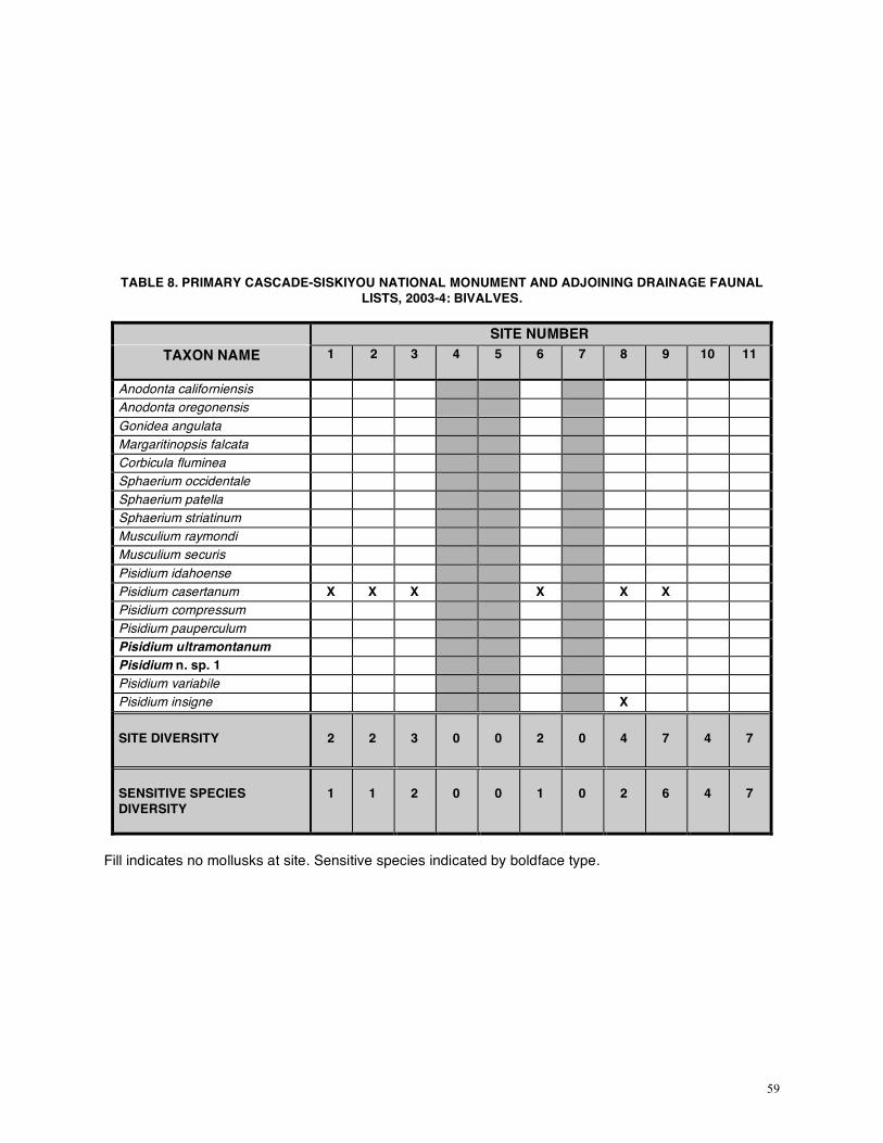
59
TABLE 8. PRIMARY CASCADE-SISKIYOU NATIONAL MONUMENT AND ADJOINING DRAINAGE FAUNAL
LISTS, 2003-4: BIVALVES.
SITE NUMBER TAXON NAME
1
2
3
4
5
6
7
8
9
10
11
Anodonta californiensis Anodonta oregonensis Gonidea angulata Margaritinopsis falcata Corbicula fluminea Sphaerium occidentale Sphaerium patella Sphaerium striatinum Musculium raymondi Musculium securis Pisidium idahoense Pisidium casertanum X X X X X X Pisidium compressum Pisidium pauperculum Pisidium ultramontanum Pisidium n. sp. 1 Pisidium variabile Pisidium insigne X SITE DIVERSITY
2
2
3
0
0
2
0
4
7
4
7
SENSITIVE SPECIES DIVERSITY
1
1
2
0
0
1
0
2
6
4
7
Fill indicates no mollusks at site. Sensitive species indicated by boldface type.

60
TABLE 8. PRIMARY CASCADE-SISKIYOU NATIONAL MONUMENT AND ADJOINING DRAINAGE FAUNAL
LISTS, 2003-4: BIVALVES (cont.).
SITE NUMBER
TAXON NAME
12
13
14
15
16
17
18
19
20
21
22
Anodonta californiensis Anodonta oregonensis Gonidea angulata Margaritinopsis falcata Corbicula fluminea Sphaerium occidentale Sphaerium patella Sphaerium striatinum Musculium raymondi Musculium securis Pisidium idahoense Pisidium casertanum X X X X X X X X Pisidium compressum Pisidium pauperculum X X X Pisidium ultramontanum Pisidium n. sp. 1 Pisidium variabile Pisidium insigne X X SITE DIVERSITY
2
9
2
3
1
3
3
0
4
4
0
SENSITIVE SPECIES DIVERSITY
2
7
1
2
1
0
2
0
1
2
0
Fill indicates no mollusks at site. Sensitive species shown by boldface type.

61
TABLE 8. PRIMARY CASCADE-SISKIYOU NATIONAL MONUMENT AND ADJOINING DRAINAGE FAUNAL
LISTS, 2003-4: BIVALVES (cont.).
SITE NUMBER
TAXON NAME
23
24
25
26
27
28
29
30
31
32
33
Anodonta californiensis Anodonta oregonensis Gonidea angulata Margaritinopsis falcata Corbicula fluminea Sphaerium occidentale Sphaerium patella X X X Sphaerium striatinum Musculium raymondi Musculium securis Pisidium idahoense Pisidium casertanum X x X X X Pisidium compressum Pisidium pauperculum X X Pisidium ultramontanum Pisidium n. sp. 1 Pisidium variabile Pisidium insigne SITE DIVERSITY
3
1
0
3
5
0
0
3
0
1
4
SENSITIVE SPECIES DIVERSITY
1
0
0
2
1
0
0
2
0
1
1
Fill indicates no mollusks at site. Sensitive species shown by boldface type.

62
TABLE 8. PRIMARY CASCADE-SISKIYOU NATIONAL MONUMENT AND ADJOINING DRAINAGE FAUNAL
LISTS, 2003-4: BIVALVES (cont.).
SITE NUMBER
TAXON NAME
34
35
36
37
38
39
40
41
42
43
44
Anodonta californiensis Anodonta oregonensis Gonidea angulata Margaritinopsis falcata Corbicula fluminea Sphaerium occidentale Sphaerium patella Sphaerium striatinum X Musculium raymondi Musculium securis Pisidium idahoense Pisidium casertanum X X X X X X X Pisidium compressum Pisidium pauperculum X Pisidium ultramontanum Pisidium n. sp. 1 Pisidium variabile Pisidium insigne SITE DIVERSITY
2
0
3
0
1
3
2
0
0
8
7
SENSITIVE SPECIES DIVERSITY
0
0
2
0
0
2
1
0
0
6
5
Fill indicates no mollusks at site. Sensitive species shown by boldface type.

63
TABLE 8. PRIMARY CASCADE-SISKIYOU NATIONAL MONUMENT AND ADJOINING DRAINAGE FAUNAL
LISTS, 2003-4: BIVALVES (cont.).
SITE NUMBER
TAXON NAME
45
46
47
48
49
50 51
62
63 64 65
Anodonta californiensis Anodonta oregonensis Gonidea angulata Margaritinopsis falcata Corbicula fluminea Sphaerium occidentale Sphaerium patella X X X Sphaerium striatinum Musculium raymondi Musculium securis Pisidium idahoense Pisidium casertanum X X X X X X X X Pisidium compressum Pisidium pauperculum X Pisidium ultramontanum Pisidium n. sp. 1 Pisidium variabile Pisidium insigne X SITE DIVERSITY
2
3
2
2
4
3
1
1
2
4
2
SENSITIVE SPECIES DIVERSITY
1
2
1
1
1
1
1
0
1
2
2
Fill indicates no mollusks at site. Sensitive species shown by boldface type.

64
TABLE 8. PRIMARY CASCADE-SISKIYOU NATIONAL MONUMENT AND ADJOINING DRAINAGE FAUNAL LISTS, 2003-4: BIVALVES (cont.).
SITE NUMBER TAXON NAME
66 67 68 69 70 71 72 73 74 75 76
Anodonta californiensis Anodonta oregonensis Gonidea angulata Margaritinopsis falcata Corbicula fluminea Sphaerium occidentale Sphaerium patella X X X X X Sphaerium striatinum Musculium raymondi Musculium securis Pisidium idahoense Pisidium casertanum X X X X X X X X Pisidium compressum Pisidium pauperculum Pisidium ultramontanum Pisidium n. sp. 1 Pisidium variabile Pisidium insigne SITE DIVERSITY
2
3
1
3
3
3
1
0
3
1
0
SENSITIVE SPECIES DIVERSITY
1
1
0
1
1
1
0
0
1
1
0
Fill indicates no mollusks at site. Sensitive species shown by boldface type.

65
TABLE 8. PRIMARY CASCADE-SISKIYOU NATIONAL MONUMENT AND ADJOINING DRAINAGE FAUNAL LISTS, 2003-4: BIVALVES (cont.).
SITE NUMBER TAXON NAME
77 78 79 80 81 82 83 84 85 86 87
Anodonta californiensis Anodonta oregonensis Gonidea angulata Margaritinopsis falcata Corbicula fluminea Sphaerium occidentale Sphaerium patella X Sphaerium striatinum Musculium raymondi Musculium securis Pisidium idahoense Pisidium casertanum X X X X X Pisidium compressum Pisidium pauperculum X Pisidium ultramontanum Pisidium n. sp. 1 Pisidium variabile Pisidium insigne SITE DIVERSITY
0
3
1
2
0
0
0
2
1
3
1
SENSITIVE SPECIES DIVERSITY
0
1
1
1
0
0
0
1
0
1
0
Fill indicates no mollusks at site. Sensitive species shown by boldface type.

66
TABLE 8. PRIMARY CASCADE-SISKIYOU NATIONAL MONUMENT AND ADJOINING DRAINAGE FAUNAL LISTS, 2003-4: BIVALVES (cont.).
SITE NUMBER TAXON NAME
88 89 90 91 92 93 94 95 96 97 98
Anodonta californiensis Anodonta oregonensis Gonidea angulata Margaritinopsis falcata Corbicula fluminea Sphaerium occidentale Sphaerium patella Sphaerium striatinum Musculium raymondi Musculium securis Pisidium idahoense Pisidium casertanum X X Pisidium compressum Pisidium pauperculum Pisidium ultramontanum Pisidium n. sp. 1 Pisidium variabile Pisidium insigne SITE DIVERSITY
1
1
1
1
2
0
0
0
0
0
0
SENSITIVE SPECIES DIVERSITY
0
1
0
1
2
0
0
0
0
0
0
Fill indicates no mollusks at site. Sensitive species shown by boldface type.

67
TABLE 8. PRIMARY CASCADE-SISKIYOU NATIONAL MONUMENT AND ADJOINING DRAINAGE FAUNAL LISTS, 2003-4: BIVALVES (cont.).
SITE NUMBER TAXON NAME
99 100 101 102 103 104 105 106 107 108 109
Anodonta californiensis Anodonta oregonensis Gonidea angulata Margaritinopsis falcata Corbicula fluminea Sphaerium occidentale Sphaerium patella Sphaerium striatinum Musculium raymondi Musculium securis Pisidium idahoense Pisidium casertanum Pisidium compressum Pisidium pauperculum Pisidium ultramontanum Pisidium n. sp. 1 Pisidium variabile Pisidium insigne SITE DIVERSITY
0
0
2
6
1
2
4
5
4
0
0
SENSITIVE SPECIES DIVERSITY
0
0
2
2
0
0
2
5
4
0
0
Fill indicates no mollusks at site. Sensitive species shown by boldface type.

68
TABLE 8. PRIMARY CASCADE-SISKIYOU NATIONAL MONUMENT AND ADJOINING DRAINAGE FAUNAL
LISTS, 2003-4: BIVALVES (cont.).
TAXON NAME
110 111 112 113 114
Anodonta californiensis Anodonta oregonensis Gonidea angulata Margaritinopsis falcata Corbicula fluminea Sphaerium occidentale Sphaerium patella X Sphaerium striatinum Musculium raymondi Musculium securis Pisidium idahoense Pisidium casertanum X X Pisidium compressum Pisidium pauperculum Pisidium ultramontanum Pisidium n. sp. 1 Pisidium variabile Pisidium insigne SITE DIVERSITY
1
1
3
1
2
SENSITIVE SPECIES DIVERSITY
1
1
1
1
1
Fill indicates no mollusks at site. Sensitive species shown by boldface type.

69
TABLE 9. SECONDARY CASCADE-SISKIYOU NATIONAL MONUMENT AND ADJOINING DRAINAGE FAUNAL
LISTS, 2003: GASTROPODS.
SITE NUMBER TAXON NAME
52
53
54
55
56
57
58
59
60 61
Ferrissia rivularis Fluminicola n. sp. 1 X Fluminicola n. sp. 10 X X X Fluminicola n. sp. 11 X X Fluminicola n. sp. 12 X Fluminicola n. sp. 13 X X X Fluminicola n. sp. 14 X Fluminicola n. sp. 15 X X X X Fluminicola n. sp. 16 Fluminicola n. sp. 17 Fluminicola n. sp. 38 Fluminicola n. sp. 39 Fluminicola n. sp. 43 X X X X Fluminicola n. sp. 44 X Fluminicola n. sp. 45 X X X X X Fossaria (B.) bulimoides Fossaria (Fossaria) modicella X X Fossaria (Fossaria) parva Gyraulus (T.) parvus X X Helisoma (C.) newberryi Juga (Calibasis) acutifilosa X X Juga (Juga) silicula shastaensis
X
Juga (Oreobasis) "nigrina" X Juga (Oreobasis) n. sp. 1 Juga (Oreobasis) n. sp. 2 X X X X X Lanx alta Lymnaea stagnalis appressa Menetus (M.) callioglyptus Physella (Physella) gyrina X X X Planorbella (P.) subcrenata X *Psuedosuccinea columella Pyrgulopsis archimedis X Pyrgulopsis n. sp. 1 *Radix auricularia X Stagnicola (H.) caperata X Stagnicola (Stagnicola) elodes Valvata humeralis X Vorticifex effusus effusus X
Fill indicates no mollusks at site. Sensitive species indicated by boldface type. For site diversity see following table.

70
TABLE 10. SECONDARY CASCADE-SISKIYOU NATIONAL MONUMENT AND ADJOINING DRAINAGE FAUNAL
LISTS, 2003: BIVALVES.
SITE NUMBER
TAXON NAME
52
53 54 55 56
57
58
59
60 61
Anodonta californiensis Anodonta oregonensis Gonidea angulata Margaritinopsis falcata Corbicula fluminea Sphaerium occidentale Sphaerium patella Sphaerium striatinum X Musculium raymondi X Musculium securis Pisidium idahoense Pisidium casertanum X X X X X x x X X Pisidium compressum X Pisidium pauperculum Pisidium ultramontanum Pisidium n. sp. 1 Pisidium variabile X Pisidium insigne SITE DIVERSITY
9
3
5
7
6
4
3
6
1
15
SENSITIVE SPECIES DIVERSITY
8
3
4
4
4
3
2
5
0
1
Fill indicates no mollusks at site. Sensitive species shown by boldface type.

71
There is some indication of nearly complete loss of sensitive springsnails (reduction in diversity)
at one site, 27 (3975). When first visited by BLM, this site had abundant Fluminicola. By our first visit, the springsnail appeared to be extirpated, a conclusion reinforced by 2 subsequent visits by BLM personnel and by us. The site was fenced subsequent to the earliest visits. At first visit, springsnails still appeared to have been extirpated. However, later visits indicated somewhat of a resurgence of one Fluminicola. The serves to emphasize that multiple site visits may be needed to ensure accurate detection of springsnails, even by trained and experienced personnel. Material from the first collection indicated the presence of two taxa at this site. So far we have detected the return of only one.
TABLE 11. ROGUE R. DRAINAGE SITES: COMPARISON OF SELECTED PARAMETERS
DEIXIS SITE NO.
DEIXIS LOC. NO.
TEMP (oC)
DO2
(mg/L)
pH
COND (mS)
SIZE
SEN. DIV.
FLU. DEN.
GR. IM.
3 5039 11.4 5.52 7.94 199.6 2 2 2-3 4-5 4 5829 - - - - 1 0 1 3 5 5830 10.8 5.43 6.99 241.4 3 0 1 5 6 5831 9.7 9.51 7.75 143.4 3 1 5 1
26 3974 11.5 9.64 8.30 247.7 2 2 4 3-4 273 3975 - - - - 2 0 1 5 28 4638 - - - - 1 0 1 5 32 4640 11.2 8.49 7.93 199 2 1 1 5 33 5028 11.3 5.95 7.38 504.4 2 1 1 5 37 5852 11.2 6.46 7.95 134.4 2 0 1 3 38 5853 - - - - 2 0 1 4
39 2 4643 6.6 10.89 7.93 98.59 3 2 3 3 40 5037 6.5 10.66 7.91 120.6 2 1 2 5 41 5854 - - - - 2 0 1 5 42 5855 - - - - 1 0 1 5 49 3981 7.0 10.90 8.08 160.8 3 1 3 5 50 3982 7.5 11.21 8.26 193.0 3 1 3 4 51 5856 7.0 11.46 8.28 212.6 3 1 3 5 74 4622 6.9 9.31 8.50 290.5 2 1 3-4 1 75 5024 7.6 8.24 8.52 214.6 2 1 2 1 76 6106 7.3 6.57 8.58 224.3 2 0 1 5 77 6107 - - - - 1 0 1 5 78 6108 - - - - 2 1 2 4 79 6109 - - - - 2 1 2 3-5 80 4641 7.2 8.55 7.75 153.1 2-3 1 3 4 81 5040 - - - - 2 0 1 5 82 6112 8.0 9.43 8.48 240.0 2 0 1 1 83 6114 7.8 9.55 8.28 176.1 2 0 1 1 88 6118 - - - - 2 0 1 4 89 5032 12.0 8.76 8.58 369.5 2 1 2 1 93 6121 9.8 9.00 8.36 169.9 3 0 1 4 94 6122 - - - - 2 0 1 5 95 6123 - - - - 2 0 1 5 96 6124 - - - - 2 0 1 5 98 6126 - - - - 2 0 1 5 99 6127 - - - - 1-3 0 1 5
For abbreviations see Tables 3 & 6.

72
TABLE 12. JENNY CREEK DRAINAGE SITES: COMPARISON OF SELECTED PARAMETERS
DEIXIS SITE NO.
TEMP (oC)
DO2
(mg/L)
pH
COND (mS)
SIZE
SEN. DIV.
FLU. DEN.
GR. IM.
1 11.6 10.71 8.02 112.7 4 1 5 1 2 13.6 8.71 7.75 93.77 3 1 4 1 7 10.8 10.38 7.60 97.85 2 0 1 5
81, 2 11.0 8.88 7.48 186.6 2 2 2 4 14 11.6 8.71 7.41 166.8 2 1 2 5 15 6.8 10.02 6.96 101.6 3 2 4 3 16 14.0 8.87 8.04 233.0 2 1 2 5 17 9.5 10.03 7.71 157.3 2 0 1 4 18 10.3 10.25 8.00 142.2 2 2 3 2 19 10.3 9.96 8.02 133.9 2 0 1 3 20 9.8 9.88 8.00 163.6 2 1 3 3
211 8.3 9.83 7.88 251.3 3 2 4 3 22 9.1 10.24 7.85 162.3 2 0 1 2 23 11.6 8.76 7.87 148.0 2 1 2 5 24 - - - - 2 0 1 4 25 9.9 10.15 8.11 161.1 4 0 1 5 29 - - - - 1 0 1 5 30 9.3 10.04 7.84 233.7 3 2 4 4 31 8.9 10.28 8.18 211.7 3 0 1 5 34 16.1 10.32 8.64 96.57 4 0 1 5 35 - - - - 1 0 1 5 36 11.3 9.22 8.11 205.9 2 2 3 4
452 9.5 - 8.05 236.6 2 1 2 5 461 7.6 9.68 7.81 165.0 4 2 5 3 47 7.0 11.37 8.17 191.6 3 1 2 2 48 8.1 11.48 8.18 194.1 2 1 3 2
601 - - - - 5 0 1 1 62 8.4 7.56 8.39 242.6 1 0 1 5 63 9.5 9.09 8.68 196.7 3 1 4 4
641 7.2 10.24 8.69 149.3 4 2 5 1-3 65 7.2 9.76 8.17 150.6 4 2 5 3 66 7.0 8.13 8.86 248.3 2 1 3 2 67 5.4 9.84 8.46 169.5 4 1 4 1 68 - - - - 2 0 1 1 69 5.6 8.61 8.57 155.6 2 1 3 5 70 7.6 5.58 8.08 144.0 3 1 3 5 71 5.8 8.70 8.38 155.2 3 1 4 3 72 - - - - 1 0 1 5 73 6.6 9.57 8.76 164.7 3 0 1 2-3 84 9.7 9.30 8.57 236.8 2 1 3-4 4 85 6.8 9.26 8.41 117.1 2-3 0 1 4 86 9.5 7.39 8.12 264.5 2 1 2 4 87 - - - - 2 0 1 4 90 - - - - 2 0 1 3-4 91 9.8 7.50 7.25 236.7 2 1 2 4
921 10.8 9.66 8.32 175.9 4 2 5 2

73
TABLE 13. Fall Creek Drainage Sites: Comparison of Selected Parameters.
DEIXIS SITE NO.
TEMP (oC)
DO2
(mg/L)
pH
COND (mS)
SIZE
SEN. DIV.
FLU. DEN.
GR. IM.
91 9.0 10.33 7.46 140.8 5 6 5 1 101, 2 9.0 10.74 7.43 147.4 5 4 5 2 111, 2 10.1 10.58 7.89 147.2 4 7 4 3
122 12.9 - 7.91 149.1 2 2 4 3 131, 2 10.0 11.10 7.73 147.9 2 7 3 1 431, 2 10.5 10.82 8.00 148.4 5 6 5 3 44 2 9.3 11.50 7.94 148.7 3 5 5 3 521 - - - - 5 8 5 2 53 - - - - 1 3 1 5
541 - - - - 3 4 5 2 551 - - - - 2 4 5 1 561 - - - - 2 4 4 1 571 - - - - 3 3 3 1 581 - - - - 3 2 3 1 591 - - - - 5 5 5 1
1061, 2 9.5 9.80 7.82 152.6 3 2 5 1 1071, 2 9.3 10.81 7.94 153.3 4 2 5 1
For abbreviations see Tables 3 & 6 TABLE 14. Site Ownership.
OWNER
SITES
Medford District, BLM (total 85 (50 Fluminicola; 11 Juga; 67 springs; 11 spring influenced; 52 on CSNM))
[1]*, 2*, 3*, 5, 7, [11]*+, 12*, 13*+, [14]*, 15*, 16*, [17], 18*, 19, 20*, 21*+, 22, 23*, 24, 25, 26*, 27*, 28, 29, [30]*, 31, [32]*, 33*, 36*, 37, 38, 39*, 40*, 41, 42, 43*+, 44*, 46*+, 47*, 48*, [49]*, 50*, 51*, 52*+, 62, [63]*, 64*+, 65*+, 66*, 67*, 68, 69*, 70*, 71*, 72, [73], 74*, 75, 76, 77, 79*, 80*, [81], 83, 86*, 87, 88, [89]*, 90, 91*, 93, 97, 98, 99, 100, 102+, 103, 104, 105*, 106*+, 107*+, 111*, 112*, 113*
Lakeview District, BLM (total 1 (1 Fluminicola; 1 spring influenced))
[114]*
other (total 29 (17 Fluminicola; 12 Juga; 18 springs; 3 spring influenced; 13 on CSNM))
4, 6*, 8*+, 9*+, 10*+, 34, 35, 45*, 53, 54*+, 55*+, 56*+, 57*+, 58*+, [59]*+, 60+, 61*, 78*, 82, [84]*, 85, [92]*+, 94, 95, 96, 101*+, 108, 109, 110*
*=sites with Fluminicola present (total 68 (all springsnails except site 61)) +=sites with Juga present (total 23) bold=sites that are springs (total 85) []=sites that are spring influenced (total 15) underline=sites within Cascade-Siskiyou National Monument (CSNM) (total 65)
We noticed severe reductions at several other sites, such as 32 (4640). It was quite clear that high population density of springsnails correlated well with minimal grazing. Mollusks were sometimes

74
completely absent at heavily grazed sites. As commonly, the fauna was reduced to non-sensitive, generalist taxa, such as sphaeriids and Physella, at such sites. Generally, there was a strong correlation between high diversity and/or large springsnail populations and the presence of terrestrial mollusks. It should be noted that, in this region particularly, springs and spring meadows harbor rich terrestrial mollusk populations absent now from most land areas. Frest & Johannes (2000a) noted a large number of undescribed, evidently narrow endemics from Monument sites and immediate surroundings, but also including Survey and Manage forms such as Vespericola sierranus (inexplicably missing from Medford documents, despite reports dating back a number of years). Criteria for evaluating grazing included presence/absence of fresh cow pies; degree of forb and grass cropping; development of grazer trails; direct observation of grazing animals, etc. While hardly quantitative, all of these seemed to provide useful information. Similarly, assessment of floral richness and canopy closure was also very useful; and there seemed to be a good correlation between native understory diversity and sensitive mollusk diversity and population size. It would be useful to quantify this, however, especially through survey of spring flora.
We observed some plant taxa of interest that seem to be missing from Medford (2000, Appendix O) lists. For example, Parnassia at Fall and Jenny Creek and Close Butte sites appeared to us to be californica instead of fimbriata; we noted a number of occurrences of Spiranthes, Platanthera and Listera populations at some sites, etc. Many of these are early bloomers that should be surveyed for in late spring to early summer on spring sites. They are notoriously difficult to identify in the fall.
Comparison of on- and off-Monument springsnail sites found to date may indicate that the Monument as constituted manages to capture a sizable number of springsnail sites. For this study, we did 65 sites (30 in 2003; 35 in 2004) on the Monument (48 springs, 17 creeks). Thirty-eight (59%) had Fluminicola, of which 32 (66% of spring sites) were springs and 6 (35% of creek sites) from spring influenced creeks. We added 9 Fluminicola sites to those known from the Monument during the 1st year’s field work and additional 6 the 2nd year’s field work, bringing the total known here to 58 (5 (9%) in creeks and 53 (91%) in springs) (see Figure 2 for locations). We did a total of 49 sites (31 in 2003; 18 in 2004) outside the Monument (36 springs; 12 creeks). Twenty-eight of these (57%) had Fluminicola; 22 spring sites maintained this genus (61% of spring sites) and 6 (50% of creek sites) from spring influenced creeks. Three new Fluminicola localities were found during the 2003 field season and 4 for 2004 field season for sites outside the Monument. Collectively, our 113 2003-2004 sites (again excluding the Klamath River mainstem site) included 85 springs and 28 creeks. Sixty-eight sites had springsnails, of which 55 (81%) were springs and 13 (19%) were spring influenced creeks. On average, 59% of all sites had Fluminicola and 64% of the springs.
Note that the proportion of survey sites with springsnails is higher than the historic average for Medford District, BLM. By our tabulations, including sites done during this project with past projects, a total of 151 freshwater sites in the Monument have been visited by either the BLM, us, or both to date (28 along creeks; 113 springs; 5 pump chances whose original status cannot be determined (likely springs also); and 4 others). Fifty-eight sites (38% of all sites) have Fluminicola; 48 (42% of spring sites) were springs and 10 (28% of creek sites) were from spring influenced creeks. Off the Monument, we, the BLM, or both have visited 85 sites (21 in creeks, 64 in springs) in the near vicinity (Figure 1), of which 31 (36% of all sites) have Fluminicola. In this smaller sample, 27 Fluminicola sites were springs (42% of all springs); the remaining 6 were spring-influenced creeks (29% of all creeks). Only 36% of all off-Monument sites have Fluminicola. Looking solely at spring sites, 32% have Fluminicola. The Monument thus may have a disproportionately high number and percentage of springsnail sites. Almost all springsnail taxa have been found within the Monument borders; but not all; and not all are on public lands. So far, there are 89 Fluminicola sites within or near to the Monument from a total of 236 sites sampled, a proportion of about 0.38. Our finds of 22 new sites in and near the Monument during the two field seasons indicate that others remain to be discovered. However, we have visited a substantial (although uncertain) proportion of the known permanent springs, including most of the larger examples. It is worth noting also that a number of sites seem to lack mollusks entirely (Table 8: sites 4, 5, 7, 19, 22, 25, 27, 28, 29, 31, 35, 37, 41, 42, 73, 76, 77, 81, 82, 83, 93, 94, 95, 96, 97, 98, 99, 100, 108, 109). One site (16) still has springsnails but lacks bivalves, although now mostly lacking springsnails where they were once common. They may soon be extinct at this site. More frequent are sites still retaining sphaeriid bivalves but lacking gastropods entirely (sites 17, 24, 33, 38, 62, 68, 72, 85, 88, 90: compare

75
Tables 7 & 8); one additional lacks Sensitive gastropods but retains widespread species and sphaeriids (an example here would be site 34). Such sites are commonly rather severely grazed as well (compare Tables 6-8). In general, sphaeriids seem more successful and stress-tolerant than other mollusks (Dillon, 2000). This may in part be explained by their life history and presumed comparative ease of distribution by animal vectors, as well as by the pollution and disturbance tolerance of many (not all!). In any case, most taxa are widespread, often Holarctic, and there are few sphaeriid endemics. Perhaps the most widely distributed freshwater mollusk world wide is the sphaeriid Pisidium casertanum (Taylor, 1981,1988b). It is the species encountered at the most Monument sites as well (Table 8).
Work this field season also seems to have added at least three undescribed springsnail species to the Monument. All three are from the Fall Creek area. We have reevaluated all taxa, with the result that we now favor split of n. sp. 17 into two sister taxa. Thus far, there are about 17 Fluminicola in the Monument or its near vicinity, i.e., as mapped on Figures 1-2. Note that other taxa, such as the Klamath Rim pebblesnail, occur just beyond the map boundaries. It remains likely that additional taxa would be encountered with additional fieldwork. We also found minimally two Juga species, likewise new, and suspect that as many as 6 live in the Monument. Preliminary DNA work on Juga indicates that J. (C.) acutifilosa is composite, and that Oreobasis probably represents several major clades. We have begun to revise all of the Rogue-Umpqua-middle Klamath Fluminicola from all sites, in order to better assess regional diversity. We expect to continue collection of DNA samples for important taxa, especially species of Fluminicola and Juga. We now have indications of persistence of some Upper Klamath Lake taxa in very limited portions of the middle Klamath (see APPENDIX H) and hope to examine the relationship of this fauna to that of the Monument, especially in the Fall Creek area. With submission of the first DNA-based revision of Fluminicola (Hershler et al., in press), we hope to establish a strong basis for revision of the whole group, including those on the Monument. The first segment of a projected revision of Juga is in draft stage currently and must be completed by November, 2005. Completion of such studies is of course dependent upon funding availability.
We expect that addition of more sites and further work in this region will help clarify the analysis and enable detailed statistical treatment, despite the unusual biogeographic complexities of the area. In particular, there is a need for additional water quality parameters and sites from the Fall Creek drainage in order to facilitate formal statistical analysis (i.e., so that available sites with complete information will exceed n= 20). The numerous Fall Creek-Close Butte taxa are not evenly distributed in the area of occurrence and there is obvious microhabitat segregation at many sites. Note also that the number of nasmodes present on or near to the Monument can perhaps be regarded as more than five and the number of discrete endemism hot spots at least three. In particular, it may be useful to split the Rogue drainage sites into two sets, Walker Creek and tributaries and Tyler Creek and tributaries. Similarly, Little Butte Creek has some claims to discrete status. Likewise, it may prove useful to separate Jenny Creek generally or in the vicinity of Chinquapin Mountain from Keene Creek and its tributaries. ACKNOWLEDGEMENTS We especially thank Medford BLM personnel, in particular Jayne LaFors, Karen Bolda, and Steve Miles, but including many others, for their interest and help in pursuing this project. Results of past BLM grazing, spring and springsnail surveys were integral to this study. We equally heartily thank the World Wildlife Fund, especially the Cascade-Siskiyou Ecoregion Office and its head, Dominick Della Sala, for sponsoring and supporting this study. Brian Barr (WWF-CSEO) deserves many kudos for his administration of and contributions to this project, not least of which is putting up with our good-hearted but rambunctious retrievers, Suzie and Bert, in the field; and for organization and execution of the 2005 AAAS Western Division Symposium on the Cascade-Siskiyou National Monument.

76
REFERENCES [Note: we have not always included references found only in species write-ups in APPENDICES C and D in order to keep this report more succinct. For these additional references, see Frest & Johannes (2000a).] Arnold, W. H. 1965. A Glossary of a Thousand-and-One terms used in Conchology. The Veliger, 7
(supplement), 50 pp. Baker, F. C. 1945. The molluscan family Planorbidae. University of Illinois Press, Urbana, Illinois. xxxvi +
530 pp. Belsky, A. J., & D. M. Blumenthal. 1997. Effects of Livestock Grazing on Stand Dynamics and Soils in
Upland Forests of the Interior West. Conservation Biology 11(3): 331-349. Belsky, A. J., A. Matzke, & S. Uselman. 1999. Survey of livestock influences on stream and riparian
ecosystems in the western United States. Journal of Soil and Water Conservation 54(1): 419-431. Belsky, A. J., A. Matzke, & S. Uselman. 2002. What the River Once Was. Livestock Destruction of
Waters and Wetlands, pp. 179-187, in G. Weurthner & M. Matteson (eds.) Welfare Ranching: The Subsidized Destruction of the American West. Foundation for Deep Ecology, Sausolita, California, by Island Press. xv + 346 pp.
Benke, A. C. 1990. A Perspective on America's Vanishing Streams. North American Benthological
Society 9: 77-88. Burch, J. B. 1975. Freshwater Sphaeriacean Clams (Mollusca: Pelecypoda) of North America.
Malacological Publications, Hamburg, MI. xi + 96 pp. Burch, J. B. 1989. North American freshwater snails. Malacological Publications, Hamburg, Michigan. viii
+ 365 pp. Burch, J. B. 1991 [1993]. Glossary for North American freshwater malacology. I. Gastropoda. Walkerana
5 (14): 263-288. [Title page of number bears a 1991 date; but copyright on inside front page dates to 1993]
Clarke, A. H. 1981. The Freshwater Molluscs of Canada. National Museum of Natural History, National
Museums of Canada. 446 pp. Cooke, S. S. (ed.). 1997. A Field Guide to the Common Wetland Plants of Western Washington and
Northwestern Oregon. Seattle Audubon Society, Seattle, WA. vi + 417 pp.
DellaSala, D. A. 2005. Cascade-Siskiyou National Monument – What It Means to be in an Ecological Crossroads [abstract]. Proceedings of the AAAS Pacific Division, 24(1): 52. DellaSala, D. A., S. Reid, T. J. Frest, J. R. Strittholt and D. M. Olson. 2000. A Global Perspective on the
Biodiversity of the Klamath-Siskiyou Ecoregion. Natural Areas Journal 19: 300-319. Dicken, S. N. 1980. Pluvial Lake Modoc, Klamath County, Oregon, and Modoc and Siskiyou counties,

77
California. Oregon Geology 42: 179-187. Dillon, R. T., jr. 2000. The Ecology of Freshwater Mollusks. Cambridge University Press. xii + 509 pp. FEMAT. 1993. Forest Ecosystem Management: An Ecological, Economic, and Social Assessment. U. S.
Department of Agriculture, Forest Service, Portland, Oregon. xi + 729 pp. appendices. Fleischner, T. L. 1994. Ecological costs of grazing in western North America. Conservation Biology 8:
629-644. Frest, T. J. 1995. Review of A Review of the North American Freshwater Snail Genus Pyrgulopsis
(Hydrobiidae), by R. Hershler. The Veliger 38: 77-78. Frest, T. J. 1999. A review of the land and freshwater mollusks of Idaho. Prepared for the Idaho
Conservation Data Center, Boise, Idaho. Seattle, Washington. vii + 302 pp., appendices. Frest, T. J. 2002a. Native Snails: Indicators of Ecosystem Health. Wild Earth 12(2): 44-50. Frest, T. J. 2002b. Native Snails. Indicators of Ecosystem Health, pp. 211-215 in G. Weurthner & M.
Matteson (eds.) Welfare Ranching: The Subsidized Destruction of the American West. Island Press. xv + 346 pp.
Frest, T. J. & E. J. Johannes. 1993. Mollusc Species of Special Concern within the Range of the
Northern Spotted Owl. Prepared for FEMAT, Portland, Oregon. Deixis Consultants, Seattle, Washington. 137 pp.
Frest, T. J. & E. J. Johannes. 1995a. Interior Columbia Basin Mollusk Species of Special Concern.
Prepared for ICBEMP, Walla Walla, Washington. Deixis Consultants, Seattle, Washington. xi + 362 pp.
Frest, T. J. and E. J. Johannes. 1995b. Freshwater molluscs of the Upper Sacramento System, California,
with particular reference to the Cantara Spill. 1994 yearly report prepared for California Department of Fish and Game, Redding, California. Deixis Consultants, Seattle, Washington. iii + 88 pp., appendices.
Frest, T. J. & E. J. Johannes. 1997. Upper Sacramento System Freshwater Mollusk Monitoring,
California. 1996 final report to Cantara Trustee Council, Redding, California. Deixis Consultants, Seattle, Washington. iii + 221 pp
Frest, T. J. and E. J. Johannes. 1998. Freshwater Mollusks of the Upper Klamath Drainage, Oregon.
1998 yearly report prepared for Oregon Natural Heritage Program, Portland, Oregon, and Klamath Project, U. S. Department of the Interior, Bureau of Reclamation, Klamath Falls, Oregon. Deixis Consultants, Seattle, Washington. vii + 200 pp., appendices.
Frest, T. J. and E. J. Johannes. 1999a. Mollusk Survey of southwestern Oregon, with emphasis on the
Rogue and Umpqua river drainages. Final report prepared for Oregon Natural Heritage Program, Portland, Oregon. Deixis Consultants, Seattle, Washington. v + 278 pp., appendices.
Frest, T. J. and E. J. Johannes. 1999b. Field Guide to Survey and Manage Freshwater Mollusk Species.
U. S. Department of Interior, Bureau of Land Management, Oregon State Office, U. S. Fish and Wildlife Service, Northwest Regional Ecosystems Office, and U. S. Department of Agriculture, Forest Service, Region 6, Portland, Oregon. BLM/OR/WA/PL-99/045+1792. viii +117 [118] pp. [On-line version available at: http://www.or.blm.gov/surveyandmanage/]

78
Frest, T. J. & E. J. Johannes. 2000a. A Baseline Mollusk Survey of Southwestern Oregon, with emphasis
on the Rogue and Umpqua River Drainages. Final Report prepared for Oregon Natural Heritage Program, Portland, Oregon. Deixis Consultants, Seattle, Washington. vii + 403 pp., appendices.
Frest, T. J. & E. J Johannes. 2000b. A Mollusk Survey of Klamath and Sycan marshes and vicinity. Final
Report prepared for Oregon Natural Heritage Program, Portland, Oregon. Deixis Consultants, Seattle, Washington. ii + 77 pp., appendices.
Frest, T. J. and E. J. Johannes. 2000 [2001]. An Annotated Checklist of Idaho Land and Freshwater
Mollusks. Idaho Academy of Science, Journal 36(2): 1-51. [cover with December, 2000 date: published early September, 2001]
Frest, T. J. and E. J. Johannes. 2002a. The Intermediate Disturbance Hypothesis and River Continuum
Concept do not work for Western Stream Mollusks. Western Society of Malacologists, Annual Reports 33: 11-23.
Frest, T. J. and E. J. Johannes. 2002b. Biogeography, Endemism, and Ecology of an Ancient Lake
Mollusk Fauna: Upper Klamath Lake Drainage, South-Central Oregon, pp. 3-11-3-25, in Y. Everett, M. George, and A. King (eds.), and G. H. Trehey (compiler), Proceedings of the 2001 Klamath Basin Fish & Water Management Symposium. Klamath River Inter-Tribal Fish & Water Commission and Humboldt State University College of Natural Resources & Science Arts, Humanities & Social Sciences, Arcata, California. [various pagination] [on CD-ROM with February, 2002 publishing date; received last week of May, 2002] [On-line version available at: http://www.humbolt.edu/klamath/proceedings2001/]
Frest, T. J. & E. J. Johannes. 2005. Extraordinary Endemic Springsnail Radiation in the Cascade-Siskiyou National Monument, Southwest Oregon [abstract]. Proceedings of the AAAS Pacific Division,
24(1): 55. Frest, T. J., E. J. Johannes, W. H. Clark, G. Stephens, and M. G. Plew. 2001 [2002]. A Bibliography of
Idaho Freshwater and Terrestrial Mollusks. Idaho Academy of Science, Journal 37(2): 1-51. [cover with December, 2001 date: initial distribution likely late October or very early November, 2002. Authors separates received November 22, 2002]
Frest, T. J. & B. Roth. 1995. Mollusk Conservation and Ecosystem Management in the Western United
States. American Malacological Union, Inc., Ann. Mtg. 61:26. [abstract] FSEIS. 2000. Final Supplemental Environmental Impact Statement For Amendment to the Survey &
Manage, Protection Buffer, and other Mitigation Measures Standards and Guidelines. U. S. Department of Agriculture, Forest Service, and U. S. Department of Interior, Bureau of Land Management, Portland, Oregon. vol. I. xlviii + 516 pp.; vol. II 346 pp.
Furnish, J.[L.], R. Monthey, and J. Applegarth. 1997. Survey protocol for aquatic mollusk species from the
Northwest Forest Plan[.] Version 2.0 - October 29, 1997. U. S. Department of Agriculture, Forest Service, Portland, Oregon. 2 unpaginated + 61 pp.
Gray, J. 1988. Evolution of the freshwater ecosystem: the fossil record. Palaeogeography,
Palaeoclimatology, Palaeoecology 62: 1-214. Guard, B. J. 1995. Wetland Plants of Washington and Oregon. Lone Pine Publishing, Vancouver, British
Columbia, 239 pp.

79
Harold, A. S., & R. D. Mooi. 1994. Areas of Endemism: Definition and Recognition Criteria. Systematic Biology 43(2): 261-266.
Hawkins, C. P. & J. L. Furnish. 1987. Are snails important competitors in stream ecosystems? Oikos 49:
209-220. Hershler, R. 1994. A Review of the North American Freshwater Snail Genus Pyrgulopsis (Hydrobiidae).
Smithsonian Contributions to Zoology 554. iv + 115 pp. Hershler, R. 1998. A Systematic Review of the Hydrobiid Snails (Gastropoda: Rissooidea) of the Great
Basin, Western United States. Part I. Genus Pyrgulopsis. The Veliger 41(1): 1-132. Hershler, R. 1999. A Systematic Review of the Hydrobiid Snails (Gastropoda: Rissooidea) of the Great
Basin, Western United States. Part II. Genera Colligyrus, Eremopyrgus, Fluminicola, Pristinicola, and Tryonia. The Veliger 42(4): 306-337.
Hershler, R. and T. J. Frest. 1996. A Review of the North American Freshwater Snail Genus Fluminicola
(Hydrobiidae). Smithsonian Contributions to Zoology 583. iii + 41 pp. Hershler, R., & H.-P. Liu. 2004. A molecular phylogeny of aquatic gastropods provides a new perspective
on biogeographic history of the Snake Rive Region. Molecular Phylogenetics and Evolution 32: 927-937.
Hershler, R., T. J. Frest, H.-P. Liu, & E. J. Johannes. 2003. Rissooidean snails from the Pit River Basin,
California. The Veliger 46(4): 275-304.
Hershler, R., H.-P. Liu. T. J. Frest, & E. J. Johannes (in press). Extensive diversification of pebblesnails (Lithoglyphidae: Fluminicola) in the upper Sacramento River Basin, northwestern United States. Zoological Journal of the Linnaean Society of London
Hershler, R., H.-P. Liu, & F. G. Thompson. 2003. Phylogenetic relationships of North American
nymphophyline gastropods based upon mitochondrial DNA sequences. Zoologica Scripta 32: 357-366.
Hershler, R. and W. F. Ponder. 1998. A Review of Morphological Characters of Hydrobioid Snails.
Smithsonian Contributions to Zoology 600. iv + 55 pp. Hershler, R. and D. W. Sada. 2002. Biogeography of Great Basin Aquatic Snails of the Genus
Pyrgulopsis, pp. 255-276, in R. Hershler, D. B. Madsen, and D. R. Curry (eds.), Great Basin Aquatic Systems History. Smithsonian Contributions to Earth Sciences 33. iv + 405 pp.
Hershler, R. & F. Thompson. 1988. Notes on morphology of Amnicola limosa (Say, 1817) (Gastropoda:
Hydrobiidae) with comments on the status of the Subfamily Amnicolinae. Malacological Review 21:81-92.
Hickman, J. C. (ed.) 1996. The Jepson Manual. Higher Plants of California. University of California Press, Berkeley. xvii + 1400 pp. 3rd printing, with corrections.
Hitchcock, C. L., A Cronquist, M. Ownbey & J. W. Thompson. 1984. Vascular Plants of the Pacific
Northwest. University of Washington Press, Seattle. 5 parts (volumes). 5th printing. Holznagel, W. E. 1997. A phylogeny of pleurocerid snails (Caenogastropoda: Cerithioidea) based on
molecular and morphological data. American Malacological Union, Program Abstracts, 63rd

80
Annual Meeting, p. 32. Holznagel, W. E. & Lydeard, C. 1996. Phylogenetic inference on the generic relationships of North
American snails of the family Pleuroceridae based on mitochondrial DNA sequences. American Malacological Union, Program Abstracts, 62nd Annual Meeting, p. 39.
Holznagel, W. E. & Lydeard, C. 2000. A molecular phylogeny of North American Pleuroceridae
(Gastropoda: Cerithioidea) based on mitochondrial 16S rDNA sequences. Journal of Molluscan Studies (2000) 66: 233-257.
Kauffman, J. B., & W. C. Kreuger. 1984. Livestock impacts on riparian ecosystems and streamside
management implications. A review. Journal of Range Management 37: 430-438. Lydeard, C., A. E. Bogan, P. Bouchet, R. H. Cowie, K. S. Cummins, T. J. Frest, D. G. Herbert, R.
Hershler, O. Gargominy, K. Perez, W. F. Ponder, B. Roth, M. Seddon, E. E. Strong, & F. G. Thompson. 2003. The Global Decline of Non-marine Mollusks. American Malacological Society, Inc., Ann. Mtg. 69, Abstracts, p. 51-52.
Lydeard, C., R. H. Cowie, W. F. Ponder, A. E. Bogan, P. Bouchet, S. A. Clark, K. S. Cummings, T. J.
Frest, O. Gargominy, D. G. Herbert, R. Hershler, K. E. Perez, B. Roth, M. Seddon, E. E. Strong, & F. G. Thompson. 2004. The Global Decline of Nonmarine Mollusks. Bioscience 54(4): 321-330.
Medford BLM. 2000. Cascade Siskiyou Ecological Emphasis Area. Draft Management
Plan/Environmental Impact Statement. Medford District BLM, Medford, Oregon. vol. I 20 unnumbered pp. + xxxviii + 328 pp.; vol. II 226 pp.
Medford BLM. 2001. Cascade-Siskiyou National Monument. Draft Study of Livestock Impacts on the
Objects of Biological Interest. Medford District BLM, Medford, Oregon. 203 + 3 unnumbered pp. Medford BLM. 2002. Cascade-Siskiyou National Monument. Draft Resource Management Plan/
Environmental Impact Statement. Medford District BLM, Medford, Oregon. vol. 1 xxxvi + 308 pp.; vol. 2 492 pp.
Medford BLM. 2005. Cascade-Siskiyou National Monument. Proposed Resource Management Plan/Final Environmental Impact Statement. Medford District BLM, Medford, Oregon. xiii + 429 pp.
Miles, S. M. 2002. [Revisits to BLM springsnail sites, 2002]. Medford District BLM, Medford, Oregon. 69
pp. MOU. 1999. Memorandum of Understanding Concerning the Conservation of Springsnails in the Great
Basin. BLM MOU WO230-9903, Information Bulletin No. 99-156, 10pp. Munz, P. A.1973. A California Flora and Supplement (combined ed.). University of California Press,
Berkeley. 1681 pp. + 224 pp. supplement. Niwa, C. G., R. E. Sandquist, R. Crawford, T. J. Frest, T. Griswold, P. Hammond, E. Ingham, S. James,
E. J. Johannes, J. Johnson, W. P. Kemp, J. LaBonte, J. D. Lattin, J. McIver, J. McMillin, A. Moldenke, J. Moser, D. Ross, T. Schowalter, V. Tepedino, and M. R. Wagner. 2001. Invertebrates of the Columbia River Basin Assessment Area. U. S. Department of Agriculture, Forest Service, Pacific Northwest Research Station, Portland Oregon, General Technical Report PNW-GTR-512. 4 unpaginated pp. + 74 pp. [T. M. Quigley (series editor), Interior Columbia Basin Ecosystem Management Project: Scientific Assessment]
81
Parker, M. 1999. Aquatic Survey of Oregon Gulch, Skookum, Camp, Dutch Oven, Scotch and Slide creeks. Unpublished report, Medford, OR, Ashland Resource Area, Medford District BLM, 12 pp.
Pyle, R. M. 2002. The Butterflies of Cascadia. Seattle Audobon Society, Seattle, Washington. 420 pp. ROD. 1994. Record of Decision for Amendments to Forest Service and Bureau of Land Management
Planning Documents Within the Range of the Northern Spotted Owl. Standards and Guidelines for Management of Habitat for Late-Successional and Old-Growth Forest Related Species Within the Range of the Northern Spotted Owl. U.S. Department of Agriculture, Forest Service, Portland, Oregon. ii + 73 pp.; viii + 143 pp.
Sada, D. W., & J. L. Nachlinger. 1996. Spring Mountain Ecosystem: Vulnerability of Spring-fed Aquatic
and Riparian Systems to Biodiversity Loss. 46pp + 5 appendices. Report to U. S. Fish & Wildlife Service, Reno, Nevada.
Sada, D. W., & J. L. Nachlinger. 1998. Spring Mountain Ecosystem: Vulnerability of Spring-fed Aquatic
and Riparian Systems to Biodiversity Loss. Part II. Springs sampled in 1997. 46pp + 5 appendices. Report to the U. S. Bureau of Land Management, Las Vegas, Nevada.
Sada, D. W., & G. L. Vinyard. 2002. Anthropogenic changes in Biogeography of Great Basin Aquatic
Biota, pp. 277-293, in R. Hershler, D. B. Madsen, and D. R. Curry (eds.), Great Basin Aquatic Systems History. Smithsonian Contributions to Earth Sciences 33. iv + 405 pp.
Sada, D. W., J. E. Williams, J. C. Silvey, A. Halford, J. Ramakka, P. Summers, & L. Lewis. 2001. Riparian
area management: A guide to managing, restoring, and conserving springs in the Western United States. Technical Reference 1737-17. Bureau of Land Management, Denver, Colorado. BLM/ST/St-01/001+1737. 70 pp.
Shepard, W. D. 1993. Desert springs—both rare and endangered. Aquatic Conservation: Marine and
Freshwater Ecosystems 3: 351-359. Smith, D. G. 2001. Systematics and Distribution of the Recent Margaritiferidae, pp. 33-49, in G. Bauer &
K. Wåchtler (eds.) Ecology and Evolution of the Freshwater Mussels Unionoida. Springer Verlag, XXII + 394 pp.
Smith, G. R., T. E. Dowling, K. W. Gobalet, T. Lugaski, D. K. Shiozawa, & R. P. Evans. 2002.
Biogeography and Timing of Evolutionary Events among Great Basin Fishes, pp. 175-234, in R. Hershler, D. B. Madsen, and D. R. Curry (eds.), Great Basin Aquatic Systems History. Smithsonian Contributions to Earth Sciences 33. iv + 405 pp.
Stiassny, M. L. J. 1999. The Medium is the Message: Freshwater Biodiversity in Peril, pp. 53-71, in J.
Cracraft and F. T. Grifo (eds.) The Living Planet in Crisis. Biodiversity Science and Policy. Columbia University Press, NY. xxiv + 311pp.
Taylor, D. W. 1981. Freshwater Mollusks of California: a Distributional Checklist. California Fish and
Game 67(3): 140-163. Taylor, D. W. 1985. Evolution of freshwater drainages and molluscs in western North America, pp. 265-
321. In Smiley, C. J. (ed.), Late Cenozoic History of the Pacific Northwest. Pacific Division AAAS and California Academy of Science, San Francisco. 417 pp.
Taylor, D. W. 1988a. Phylum: Mollusca, pp. 33-57. In J. Gray, Evolution of the freshwater ecosystem: the
fossil record. Palaeogeography, Palaeoclimatology, Palaeoecology 62: 1-214.

82
Taylor, D. W. 1988b. Aspects of Freshwater Mollusc Ecological Biogeography. Palaeogeography,
Palaeoclimatology, Palaeoecology 62: 511-576. Taylor, D. W. 2003. Introduction to Physidae (Gastropoda: Hygrophila);. biogeography, classification, and
morphology. Revista de Biologîa Tropical, vol. 51 supplement 1, 287 pp. Taylor, D. W., & T. Uyeno. 1965. Evolution of host specificity of freshwater salmonid fishes and mussels
in the North Pacific region. Venus 24: 199-209. Thompson, F. G., & R. Hershler. 2002. Two genera of North American freshwater snails: Marstonia
Baker 1926, resurrected to generic status, and Floridobia, new genus (Prosobranchia: Hydrobiidae: Nymphophylinae). The Veliger 45(3): 269-271.
Turgeon, D. D., J. F. Quinn, jr., A. E. Bogan, E. V. Coan, F. G. Hochberg, W. G. Lyons, P. M. Mikkelsen,
R. J. Neves, C. F. E. Roper, G. Rosenberg, B. Roth, A. Scheltema, F. G. Thompson, M. Vecchione, and J. D. Williams. 1998. Common and Scientific Names of Aquatic Invertebrates from the United States and Canada: Mollusks. American Fisheries Society, Special Publication 26. ix + 526 pp. [2nd edition; also available in CD format]
USDA. 2000. Final Supplemental Environmental Impact Statement For Amendment to the Survey &
Manage, Protection Buffer, and other Mitigation Measures Standards and Guidelines. Volume I-Chapters 1-4. xlvii + 516 pp. Volume II-Appendices. 346 pp. U.S. Department of Agriculture, Forest Service and U.S. Department of the Interior, Bureau of Land Management, Regional Ecosystem Office, Portland, Oregon. BLM/OR/WA/PT-00/065+1792. U.S. GPO 2000-689-086
Wagner, H. M., C. B. Hansopn, E. P. Gustafson, K. W., Gobalet, & D. P. Wheeler. 1997. Biogeography of Pliocene and Pleistocene Vertebrate Faunas of Northeastern California and their Temporal
Significance to the Development of the Modoc Plateau and the Klamath Mountains Orogeny. San Berdino Museums Association Quarterly, 44(1): 13-22.
Wares, J. P. & T. F. Turner. 2003. Phylogeography and Diversification in Aquatic Mollusks, pp. 228-269,
in C. Lydeard & D. R. Lindberg (eds.) Molecular Systematics and Phylogeography of Mollusks. Smithsonian Books, Washington, DC. xv + 312 pp.
Watters, G. T. 2001. The Evolution of the Unionacea in North America, pp. 281-307, in in G. Bauer & K.
Wåchtler (eds.) Ecology and Evolution of the Freshwater Mussels Unionoida. Springer Verlag, XXII + 394 pp.
Weurthner, G. & M. Matteson (eds.). 2002. Welfare Ranching: The Subsidized Destruction of the
American West. Foundation for Deep Ecology, Sausolita, California, by Island Press. xv + 346 pp. Wilke, T., G. M. Davis, Z. Gong, & H.-X. Lu. 2000. Erhaia (Gastropoda: Rissooidea): phylogenetic
relationships and the question of Paragonimus coevolution in Asia. American Journal of Tropical Medicine and Hygiene 62(4) : 453-459.
Wilke, T., G. M. Davis, A. Falniowski, F. Giusti, M. Bodon & M. Szarowska. 2001. Molecular systematics
of Hydrobiidae (Mollusca: Gastropoda: Rissooidea): testing monophyly and phylogenetics. Proceedings of the Academy of Natural Science of Philadelphia 151: 1-21.
Williams, J. D., M. L. Warren, jr., K. S. Cummings, J. L. Harris & R. J. Neves. 1992. Conservation Status of Freshwater Mussels of the United States and Canada. Fisheries 18: 6-22.

83
Williams, J. E., D. B. Bowman, J. E. Brooks, A. A. Echelle, R. J. Edwards, D. A. Hendrickson, & J. J. Landeye. 1985. Endangered aquatic ecosystems in North American deserts with a list of vanishing fishes of the region. Journal of the Arizona-Nevada Academy of Science 20: 1-62.

84
APPENDIX A. SITES.
Map coordinates are from the latest available USGS 7.5' series topographic maps. Legal coordinates are given when practical; where survey is irregular, projected coordinates are given, orienting from the northwest section corner wherever possible. Some areas have not been surveyed, or the survey is sufficiently irregular as to make use of township and range difficult. Hence, UTM coordinates are also supplied, in the format favored by Crawford (1983). Road names, road numbers and land ownership were confirmed using DeLorme Mapping’s Oregon Atlas and Gazetteer, plus Medford District, BLM road atlases and maps, including the Ashland Resource Area Transportation Map (5/17/99). Site descriptions are a partial dump from Deixis MolluscDB™. Site entry format: Project site number, Deixis locality number [in brackets], locality name, coordinates (UTM; legal), quadrangle (name and year), county, drainage, mountain range, valley, geographic description, elevation, depth, locality remarks, habitat description, collector remarks, date collected, and collectors. Collector abbreviations as follows: BB= Brian Barr, World Wildlife Fund, Ashland Office BH= Bill Haight, Medford District, BLM DH= David Hering, Medford District, BLM EJ= Edward Johannes FL= Frank Lang, Medford District, BLM JD= Jay Doino, Medford District, BLM JJ= James Johannes JL= Jayne LeFors, Medford District, BLM JS= Jennifer Smith, Medford District, BLM KB= Karen Bolda, Medford District, BLM, RC= Riparian Survey Crew, Medford District, BLM RW= Robert Wisseman, Aquatic Biology
Associates, Corvalis, OR SM= Steve Miles, Medford District, BLM SW= Steve Welty, Dubois, WY [deceased] TF= Terrence Frest CV= Chris Volpe, Medford District, BLM

85
1. [623] Keene Creek south of Tubb Springs State Wayside. Zone 10: 546,120E 4,661,920N. Center SW1/4 NW1/4 NW1/4 sec. 11, T40S R3E, Soda Mountain 1988 quad., Jackson Co., Oregon. Keene Cr.-Jenny Cr.-Klamath R., Siskiyou Mts. Keene Creek 0.7 mi. off (S. of) OR66 (Green Springs Highway) at bridge of BLM 40-3E-2.0, S. of Tubb Springs State Wayside, Cascade-Siskiyou National Monument (Medford District, Bureau of Land Management). Elev. 3820'. Depth 4-36".
1st and 2nd visit observations: Medium-sized cold, rocky creek with common blue green algae. Fluminicola hand collected. Many juveniles and eggs, very few adults. 8/14/1991 TF, EJ, JJ! Abundant Fluminicola hand collected. 10/11/1992 TF, EJ!
3rd visit observations: Spring influenced creek with cobble (basalt) substrate; Myriophyllum, Hydrocotyle ranunculoides, Rorippa; Carex, and Equisetum, somewhat rich understory with Vaccinium parvifolium, Rosa, Acer, and abundant Salix. Overstory with Pinus ponderosa. Abundant Fluminicola dip net collected and washed off cobbles into a tray. Very little indication of recent grazing. Very old cow pies seen. 10/3/2003 TF, EJ!
4th visit observations: Cold spring influenced creek with cobble substrate; Rorippa (trampled); Lemna; Ceratophyllum; Rosa; Cicuta; Salix; Carex. Fluminicola uncommon except locally; not collected. Vegetation cropped down to 4” or below. Old cow pies present. Severe grazing and trampling. Downed wood broken up by cattle trampling. 9/17/2004 TF, EJ! 2. [626] Spring 1 south of Tubb Springs State Wayside. Zone 10: 546,460E 4,662,100N. NW1/4 SW1/4 NW1/4 NE1/4 NW1/4 sec. 11, T40S R3E, Soda Mountain 1988 quad., Jackson Co., Oregon. Keene Cr.-Jenny Cr.-Klamath R., Siskiyou Mts. Unnamed spring run crossing BLM 40-3E-2.0, 0.5 rd. mi. off (S. of) OR66 (Green Springs Highway). Spring run below Tubb Springs State Wayside, Cascade-Siskiyou National Monument (Medford District, Bureau of Land Management). Elev. 4000'. Depth 0-1".
1st, 2nd, and 3rd visit observations: Muddy spring run with occasional rocks. No macrophytes. Mostly full adult Fluminicola, moderately common. Deixis Consultants site #7 under contract CR1394-OREFO. 8/14/1991 TF, EJ, JJ! Rare Fluminicola hand collected. 10/11/1992 TF, EJ! Fluminicola n. sp. dip net collected. 10/27/1998 TF,EJ, KB, JL!
4th visit observations: Spring run with mud-cobble (basalt) substrate; Lemna and Hydrocotyle ranunculoides. Somewhat diverse understory with Pyrola, Symphoricarpos (snowberry), Sambucus, Rosa, grasses. Pseudotsuga forest. Well shaded. Hand collection. Locally common Fluminicola dip net collected. Very little evidence of grazing. 10/3/2003 TF, EJ!
5th visit observations: Small cold spring with gravel substrate. Very local Lemna; common bryophytes; Streptopus; Hydrocotyle ranunculoides; Salix; grasses; mosses; Lily; Trillium; some Vaccinum; Cornus stolonifera; Viola; Chimaphila umbellata (Prince’s pine); some Pteridium aquilinum. Fluminicola common (DNA and anatomical sample collected). Abundant Planaria present. Cow trails along spring run and evidence of areas trampled by cows. Fresh cow pies. Grasses cropped down to 6” or below. Moderate grazing damage. 9/17/2004 TF, EJ!
3. [5039] Spring south of Hobart Lake. Zone 10: 543,010E 4,660,270N. SW1/4 NW1/4 SE1/4 NW1/4 NW1/4 sec.16, T40S R3E, Soda Mountain 1988 quad., Jackson Co., Oregon. Hobart Lk.-Tyler Cr.-Emigrant Cr.-Bear Cr.-Rogue R., Siskiyou Mts. Spring S. of Hobart Lake, W. of Hobart Bluff, 0.13 mi. E. of BLM 39-3E-32.3, 0.4 mi. N. of Hobart Peak, Cascade-Siskiyou National Monument (Medford District, Bureau of Land Management). Elev. 4830'. Depth 0-1". Spring not shown on USGS 7.5' map.
1st visit observations: Spring is small creek and downcut [near] by entrance to Hobart Lake. Flows through wooded area (Doug firs [Pseudotsuga menziesii]) to open meadow. Substrate: Silt/organics 70%; small gravel 10%; cobble 20%. 50% of spring shaded. Vegetation composition (calculated from 30 points, % of total): dirt 47%; grass 7%; sedge 10%; forbs 3%; moss 10%; wood 3%; rock 10%. Herbaceous 10%. Seriously trampled by cows. Spring feeds Hobart Lake and is SE of Rd. 39-3E-32.3. Severe grazing damage. [Snails] found in silt. Medford District, BLM site #24-00. 9/19/2000 JD!
2nd visit observations: The spring originates in the trees and flows down into a damp meadow. Areas of good root mass and brushy vegetation. Description of where the spring is: Above Hobart Lake (south) on the right side of the south face among the D. firs. Keep hiking until you come to the hill and

86
spring is on right side. [Snails] black w/elongated coils on the mud. Trampling, crossing the channel, movement along its bank. 90% of total spring area impacted. Cows walking through the spring and along its banks. Grazing seems to be minimal. Recommendations: None. When we 1st check[ed] this site all the vegetation looked healthy and the system had recovered from the previous year [grazing]. Medford District BLM site #24-00. 8/1/2002 SM!
3rd visit observations: Medium-sized cold spring with mud-cobble substrate; Hydrocotyle ranunculoides, grasses (grazed); spring run in narrow cut channel above site. Riparian zone with Ribes lacustre, Shepherdia canadensis, Sorbus, Acer, Pseudotsuga menziesii; Salix, invasive plants which include Cirsium arvense and Daucus carota lower down run. 50% shaded; open canopy. Spring run below site in shallow valley (meadow) with Salix (heavily grazed). Fluminicola hand and dip net collected. Locally common. Fresh cow pies present. Spring run destroyed by cattle grazing below collection site; only sphaeriids present. Cattle tromped and trails where Fluminicola occur. Difficult for cattle to access upper spring run due to steep slope and incised channel. Spring run E. of this one is now dry. 10/3/2003 TF, EJ! 4. [5829] Spring east of Schoolhouse Ranch. Zone 10: 543,120E 4,663,030N. SE1/4 SE1/4 SE1/4 SW1/4 NW1/4 sec. 4, T40S R3E, Soda Mountain 1988 quad., Jackson Co., Oregon. Schoolhouse Cr.-Tyler Cr.-Emigrant Cr.-Bear Cr.-Rogue R. Spring 0.9 rd. mi. S. of OR66 on BLM 39-3E-32.3, E. side, 1.8 mi. E. of Schoolhouse Ranch, Boise Cascade inholding in Cascade-Siskiyou National Monument. Elev. 4480'. Depth 0-0.5". Spring not shown on USGS 7.5' map. Small cold spring with predominately mud substrate; Hydrocotyle ranunculoides and Carex. No mollusks. Spring impacted by road building. No water quality measurements possible. 10/3/2003 TF, EJ! 5. [5830] Spring southwest of Hobart Lake. Zone 10: 542,725E 4,660,327N. SW1/4 NE1/4 SE1/4 NE1/4 NE1/4 sec. 17, T40S R3E, Soda Mountain 1988 quad., Jackson Co., Oregon. Unnamed Cr.-Tyler Cr.-Emigrant Cr.-Bear Cr.-Rogue R. Spring on E. side of BLM 39-3E-32.3, ca. 2.65 rd. mi. S. of OR66 junction, 0.2 rd. mi. SW of BPA power lines, 0.4 mi. W. of Hobart Bluff, SW of Hobart Butte, Cascade-Siskiyou National Monument (Medford District, Bureau of Land Management). Elev. 4790'. Depth 0-1". Spring not shown on USGS 7.5' map. Cold spring with mud substrate; Hydrocotyle ranunculoides and Lemna. Poor understory diversity with some Viola, mostly grasses. Overstory dominated by Thuja plicata. Source fairly shaded. Multiple channels at source. No mollusks. Spring source and run severely trampled. Water sample taken at source. Spring channel diverted along road to pump chance. Grasses mostly cropped by cattle. Cattle present at site during our visit. Cow pies abundant and fresh.10/3/2003 TF, EJ! 6. [5831] Spring run north of Hobart Lake. Zone 10: 542,960E 4,661,115N. SE1/4 NE1/4 SW1/4 NW1/4 SW1/4 sec. 9, T40S R3E, Soda Mountain 1988 quad., Jackson Co., Oregon. Unnamed Cr.-Tyler Cr.-Emigrant Cr.-Bear Cr.-Rogue R. Spring run on E. side of BLM 39-3E-32.3, ca. 2.3 rd. mi. S. of OR66 junction, 0.3 mi. N. of Hobart Lake, in holding in Cascade-Siskiyou National Monument. Elev. 4690'. Depth 0-4". Cold spring run with mud substrate. Understory with Carex, orchids, chokecherry, and grasses. Overstory locally Acer. Well shaded. Abundant Fluminicola dip net collected. Grasses along run show some evidence of grazing (very minor). 10/3/2003 TF, EJ! 7. [5832] Springs at Cabin 69. Zone 10: 543,260E 4,658,780N. SW1/4 SW1/4 NW1/4 NE1/4 NW1/4 sec. 21, T40S R3E, Soda Mountain 1988 quad., Jackson Co., Oregon. S. Fk. Keene Cr.-Keene Cr.-Jenny Cr.-Klamath R. Springs near Cabin 69 below BPA power lines, 0.1 rd. mi. E. of Soda Mountain Road (BLM 39-3E-32.3) on S. side of BLM 39-3E-16.0, Cascade-Siskiyou National Monument (Medford District, Bureau of Land Management). Elev. 5220'. Depth 0-1". Springs not shown on USGS 7.5' map. Pump chance #155 below road and pump chance #17 above road. See Medford District, BLM Ashland Resource Area Transportation Map (5/17/1999). Cold springs with mud substrate; grasses, Scirpus. Mostly open with some Acer macrophyllum, Pseudotsuga menziesii, and Sambucus locally. Very poor understory. Springs flow into pump chance below road. No mollusks. Heavily grazed (surrounding area mostly bare dirt). Fresh cow pies. 10/3/2003 TF, EJ!

87
8. [1515] Rattlesnake Spring west of Copco Road. Zone 10: 554,800E 4,656,730N. SW1/4 NW1/4 SW1/4 SW1/4 NE1/4 sec. 27, T40S R4E, Parker Mtn. 1988 quad., Jackson Co., Oregon. Jenny Cr.-Klamath R., Siskiyou Mts. Rattlesnake Spring below (W. of) Copco Road (BLM 40-4E-3.1), on Jenny Creek Rim (E. of creek), US Timberland. Elev. 3510'. Depth 0-1". Spring run captured by pump chance #152. See Medford District, BLM Ashland Resource Area Transportation Map (5/17/1999).
1st and 2nd visit observations: Heavily modified spring, impoundment below source. Mostly mud substrate; some basalt cobbles and wood fragments; scattered Rorippa, locally abundant where protected; some Mimulus. Fluminicola n. sp. rare. Dip net collection. Much of area heavily damaged by grazing. Common Juga (Oreobasis) in spring run; partly capped at source. 5/19/1991 TF, EJ! Fluminicola n. sp. rare. Dip net collection. Much of area heavily damaged by grazing. Source now fenced. Common Juga (Oreobasis) in spring run; partly capped at source. 4/29/1995 TF, EJ, SW!
3rd visit observations: Small cold spring and run with mostly mud-gravel substrate; occasional cobbles (basalt). Source protected by wooden fence enclosure (thick grasses and Carex within). Outside enclosure understory very sparse (some Carex clumps). Sparse Rorippa and Lemna in run below enclosure. Fluminicola (uncommon), Juga (somewhat uncommon), and sphaeriids dip net and hand collected. Area with wooden fence enclosure with thick grasses and Carex. Area outside fence heavily grazed and trampled. Fresh cow pies present. Grasses heavily grazed. 10/4/2003 TF, EJ!
4th visit observations: Small cold spring and run with mostly mud-gravel substrate; occasional cobbles (basalt). Vegetation as before. Juga much reduced near springhead, more common 15' below. Fluminicola uncommon. Grazing heavy. Recent and old cow pies. 9/25/2004 TF, EJ! 9. [1633] Shoat Spring off Copco Road. Zone 10: 555,080E 4,654,950N. SW1/4 SE1/4 NW1/4 NE1/4 & NW1/4 NE1/4 NW1/4 SE1/4 sec. 34, T41S R4E, Parker Mtn. 1988 quad., Jackson Co., Oregon. Spring Cr.-Jenny Cr.-Klamath R., Siskiyou Mts. Shoat Spring run just outside W. end of spring enclosure, source of Spring Creek, off Copco Road (BLM 40-4E-3.1), ca. 0.3 mi. W. by logging access road. US Timber, in holding in Cascade-Siskiyou National Monument. Elev. 3480'. Depth 0-12".
1st and 2nd visit observations: Large cold spring run. Substrate predominantly basalt cobbles and gravel; some liths with encrusting red algae. Common Lemna trisulca, Mimulus, Rorippa, bryophytes; locally common Elodea, Chara, Veronica. Portions well shaded. Fluminicola spp. and Juga hand, dip net, and tray collected. 5/19/1991 TF, EJ! Common-abundant Fluminicola (4 spp.) and Juga. Rather rare Vespericola sierranus around E. and S. margins of spring. Hand, brush and tray, and dip net collections. Partly affected by grazing and past logging. 8/19/1991 TF, EJ!
3rd visit observations: Very large cold spring run with cobble substrate; very abundant Mimulus and Rorippa; very common Hydrocotyle ranunculoides and Lemna. Abundant Fluminicola and common Juga acutifilosa and uncommon Juga (Oreobasis) washed off cobbles and wood into a tray. Dip net collected off macrophytes. Yellow-legged frog present. Spring now enclosed by wooden fence put up by Weyerhauser. 10/4/2003 TF, EJ!
4th visit observations: Very large cold spring run with cobble substrate; very abundant Mimulus, Rorippa, Hydrocotyle ranunculoides and Lemna. Cobbles covered by bryophytes. Fluminicola and Juga abundant. Aquatic plants more abundant inside enclosure than outside enclosure. Grazing heavy outside spring enclosure (forest denuded of understory vegetation). 9/25/2004 TF, EJ! 10. [5833] Shoat Spring source and adjacent pool. Zone 10: 555,025E 4,654,930N. NE1/4 NW1/4 NE1/4 NW1/4 SE1/4 & SE1/4 SW1/4 SE1/4 SW1/4 NE1/4 sec. 34, T41S R4E, Parker Mtn. 1988 quad., Jackson Co., Oregon. Spring Cr.-Jenny Cr.-Klamath R., Siskiyou Mts. Shoat Spring at source springs and adjacent pool, source of Spring Creek, off Copco Road (BLM 40-4E-3.1), ca. 0.3 mi. W. by logging access road. US Timberlands in holding in Cascade-Siskiyou National Monument. Elev. 3440'. Depth 0-12". Two large, closely connected very cold springs, partly pooled at source. Substrate predominantly basalt cobbles and gravel; some liths with encrusting red algae. Common Lemna trisulca, Mimulus, Rorippa, Parnassia californica, bryophytes; locally common Elodea, Chara, Veronica. Portions well shaded. 2 Fluminicola at source and 3 spp. in adjacent pool. Very abundant Fluminicola and less common Juga dip net collected.10/4/2003 TF, EJ!

88
11. [5835] Spring Creek downstream of Spring Creek diversion. Zone 10: 544,747E 4,654,030N. SE1/4 NE1/4 NE1/4 NE1/4 NW1/4 sec. 3, T41S R4E, Parker Mtn. 1988 quad., Jackson Co., Oregon. Spring Cr.-Jenny Cr.-Klamath R., Siskiyou Mts. Spring Creek just downstream (S.) of Spring Creek diversion, Cascade-Siskiyou National Monument (Medford District, Bureau of Land Management). Elev. 3350'. Depth 0-5". Cold spring influenced creek with mud-cobble (basalt) substrate; sporadic bryophytes and Rorippa. Banks with mixed Pinus ponderosa, Alnus, Pseudotsuga, and Pinus lambertiana. Understory somewhat diverse with Carex, orchids and somewhat thick grasses along creek, sparse elsewhere. Spring creek diversion incorrectly shown 0.2 mi. N. of its actual position on USGS 7.5' map. Fluminicola and Juga collected by dip net and washed off cobbles into a tray. Some grazing evident. Somewhat old cow pies present. Cow trails along creek. 10/8/2003 TF, EJ! 12. [5836] Spring 1 above Spring Creek diversion canal. Zone 10: 554,780E 4,653,960N. SE1/4 SE1/4 NE1/4 NE1/4 NW1/4 sec. 3, T41S R4E, Parker Mtn. 1988 quad., Jackson Co., Oregon. Spring Cr.-Jenny Cr.-Klamath R., Siskiyou Mts. Spring above (E. side of) Spring Creek diversion canal, ca. 0.03 mi. from Spring Creek diversion, ca. 0.5 mi. N. of Schoolhouse Meadow, ca. 0.52 rd. mi. N. on canal access road from BLM 40-3E-3.2, Cascade-Siskiyou National Monument (Medford District, Bureau of Land Management). Elev. 3360'. Depth 0-2". Spring not shown on USGS 7.5' map. Spring Creek diversion incorrectly shown 0.2 mi. N. of its actual position on USGS 7.5' map. Cold spring with mud substrate; Rorippa and Lemna. Spring flows down a shallow slope, steeper upstream. Understory rather rich with Parnassia californica, Carex, minor Vaccinum, orchids, abundant Spiranthes, minor black berry invasion, and abundant grasses in spring channel. Overstory mostly Pinus ponderosa locally. Abundant Fluminicola dip net collected. Seem to prefer all substrate types (wood, cobbles, Rorippa). Spring too shallow for O2 measurement. Some evidence of grazing (Carex and grasses cropped). Cow pies (not recent) present. 10/5/2003 TF, EJ! 13. [5838] Spring 2 above Spring Creek diversion canal. Zone 10: 554,825E 4,653,800N. SW1/4 SW1/4 SW1/4 NW1/4 NE1/4 sec. 3, T41S R4E, Parker Mtn. 1988 quad., Jackson Co., Oregon. Spring Cr.-Jenny Cr.-Klamath R., Siskiyou Mts. N.-most spring run of a extensive spring complex above (E. side of) Spring Creek diversion canal, ca. 0.15 mi. from Spring Creek diversion, ca. 0.35 mi. N. of Schoolhouse Meadow, 0.42 rd. mi. on canal access road from BLM 40-3E-3.2, Cascade-Siskiyou National Monument (Medford District, Bureau of Land Management). Elev. 3360'. Depth 0-0.5". Spring not shown on USGS 7.5' map. Spring Creek diversion incorrectly shown 0.2 mi. N. of its actual position on USGS 7.5' map. Medium-sized cold shallow spring run with mostly cobble (basalt) substrate. Spring flows down a steep slope. Diverse understory with Parnassia californica, Cornus stolonifera, Aquilegia formosa, and Pteridium aquilinum. Diverse coniferous forest. Fluminicola (2 spp.) uncommon-common. Juga uncommon. Dip net collected and washed off cobbles into a tray. Nil-slight grazing impact. No cow pies present. 10/5/2003 TF, EJ! 14. [4625] Unnamed spring creek tributary of Lincoln Creek. Zone 10: 548,180E 4,659,920N. NW1/4 SE1/4 SW1/4 SE1/4 NW1/4 sec. 13, T40S R3E, Soda Mountain 1988 quad., Jackson Co., Oregon. Unnamed Tributary-Lincoln Cr.-Keene Cr.-Jenny Cr.-Klamath R., Siskiyou Mts. Unnamed spring creek collected on W. side of BLM 40-3E-12.1 (Lincoln Creek Road), Cascade-Siskiyou National Monument (Medford District, Bureau of Land Management). Elev. 3900'. Depth 0-2".
1st visit observations: Spring-fed creek (dry above site); mud-cobble substrate; rare mosses. Uncommon Fluminicola; most found in moss. Dip net collected. 8/20/2000 TF, EJ!
2nd visit observations: Cold spring creek with cobble (basalt) substrate; Lemna, Hydrocotyle ranunculoides; bryophytes. Alnus, Salix, and Thuja plicata. Understory poor (almost all grass). Fluminicola somewhat uncommon. Intensive grazing damage. Fresh cow pies present. 10/6/2003 TF, EJ! 15. [4733] Spring north of Parsnip Lakes. Zone 10: 544,930E 4,662,135N. SE1/4 NW1/4 NW1/4 NE1/4 NW1/4 sec. 10, T40S R3E, Soda Mountain 1988 quad., Jackson Co., Oregon. Keene Cr.-Jenny Cr.-Klamath R., Cascade Range. Spring on S. side of Keene Creek, ca. 100' downstream (SE of) BLM 40-3E-2.0 Keene Creek crossing, N. of Parsnip Lakes, Cascade-Siskiyou National Monument (Medford District,

89
Bureau of Land Management). Elev. 4130'. Depth 0-2". Spring not shown on USGS 7.5' map. Spring Medford District, BLM hydro #1303.
1st visit observations: Huge spring. Snails [Fluminicola n. sp. 14 (Fall Creek pebblesnail?)] found by Riparian Survey Crew-"huge spring"-site most likely already sampled by Bolda and others in 1998 [Seems unlikely a Bolda site based on coordinates]. Medford District, BLM site #22. 7/21/1999 RC!
2nd visit observations: Good water flow, there are fallen logs and sandy substrate. Grasses are abundant around the bank. Good shade provided by trees and bushes. Description of where spring is: Just down from the road that crosses Keene Cr. the spring is on the south bank of Keene Cr. and flows into Keene Cr. Description: black, tiny, snail-like. Where found in spring: on sandy substrate, rock and aquatic vegetation. Impacts: grazing to its banks, some wallowing, trampling banks in places. PFC Rating: not functioning. Percent of total spring area impacted: 98%. Recommendations: Come back before cows are turned out to determine if fencing would be prudent. Medford District, BLM site #22. 8/5/2002 SM!
3rd visit observations: Medium-sized cold spring with mud-silt substrate; occasional basalt cobble; downed wood; Rorippa (common), some Myriophyllum, bryophytes (2 genera) on cobbles, Hydrocotyle ranunculoides, and grasses. Flood plain and bank with Alder, Salix and mixed coniferous forest; understory with Cornus stolonifera, Athyrium, Pteridium, Symphoricarpus (snowberry), Lonicera (honeysuckle), and Rosa. Fluminicola (common) and sphaeriids dip net collected off macrophytes. Somewhat cowed but partially protected by fallen trees and steep slope and boulders at source. Cow pies somewhat old. Frogs present (heard them) and saw Taricha granulosa under boulders at spring source. 10/6/2002 TF, EJ! 16. [5843] Spring 0.05 mile from BLM 40-3E-24.0 junction. Zone 10: 548,470E 4,659,010N. NW1/4 NW1/4 NW1/4 NW1/4 NE1/4 sec. 24, T40S R3E, Soda Mountain 1988 quad., Jackson Co., Oregon. Lincoln Cr.-Keene Cr.-Jenny Cr.-Klamath R., Siskiyou Mts. Spring run across BLM 40-3E-12.1 (Lincoln Creek Road) just (0.05 rd. mi.) N. of junction with BLM 40-3E-24.0, Cascade-Siskiyou National Monument (Medford District, Bureau of Land Management). Elev. 4060'. Depth 0-0.5". Spring not shown on USGS 7.5' map.
1st visit observations: Spring run. Fluminicola [Fluminicola indet. (no bodies, likely 2-3 species present, possibly Fluminicola n. sp. 16 and Fluminicola n. sp.]. Sampled above road. Snails associated primarily w/woody material. Medford District BLM site #10. 7/14/1999 DH!
2nd visit observations: Spring starts as a moist area with flowing water. There are lots of areas with the spring that are very muddy. The substrate is mud with woody debris, very few pebbles. Spring runs across 40S 3E 12.1 just north of junction with 40S 3E 24.0. Small, black, very snail like shell [Fluminicola]. On pebbles, wood and mud below the culvert ca. 30'. Visible deer tracks and heavy cow prints. Didn't notice any scat. 100% spring impacted. There are few mollusks. Vegetation looks good and there are lots of trees stabilizing the banks. Area is completely open to trampling. Medford District BLM site #10. 7/18/2002 SM!
3rd visit observations: Small cold spring with mud substrate; Lemna, Hydrocotyle ranunculoides, and Equisetum. Understory with Carex (rare), Pyrola elliptica, strawberries, Listera orchid, and Pteridium aquilinum. Fluminicola very rare collected below road, none found at spring source above road. Spring run and surroundings heavily trampled. Fresh cow pies present. 10/6/2003 TF, EJ!
4th visit observations: Small cold spring with mud substrate; Hydrocotyle; Carex; grasses; Pteridium aquilinum; woody debris. Fluminicola very rare; mostly found on woody debris. Hand collected off wood and dip net collected. Grazing and trampling of spring heavy. Cropping below 2". Fresh cow pies. Cow paths present. 9/23/2004 TF, EJ! 17. [4653] Corral Creek at BLM 39-3E-35.2 crossing. Zone 10: 547,820E 4,665,680N. NW1/4 NW1/4 SE1/4 SW1/4 SW1/4 sec. 25, T39S R3E, Hyatt Reservoir 1988 quad., Jackson Co., Oregon. Corral Cr.-Beaver Cr.-Jenny Cr.-Klamath R., Cascade Range. Corral Creek at crossing of Beaver Creek Road (BLM 39-3E-35.2), 1.6 rd. mi. NE of junction with BLM 39-3E-35.0, SE side of Chinquapin Mountain, Cascade-Siskiyou National Monument (Medford District, Bureau of Land Management). Elev. 4850'. Depth 0-2".
1st visit observations: Creek with silt-cobble bottom; no macrophytes. No mollusks. 8/22/2000 TF, EJ, KB, JD!

90
2nd visit observations: Spring-influenced creek with mud substrate; rare Hydrocotyle ranunculoides. Understory along bank with Ribes and Salix (very narrow riparian zone). Overstory of Thuja. Sphaeriids dip net collected. Heavy grazing impact along road including creek, moderate grazing damage elsewhere. 10/7/2003 TF, EJ!
3rd visit observations: Small-medium sized spring-influenced creek flowing over bedrock; sporadic silt-cobble substrate patches; very steep slope. Mimulus, Salix, Ribes, Cicuta douglasii, lilies, Equisetum, and some Carex present. Forest with Thuja, Pseudotsuga, and Abies. Sphaeriids (2 spp.) not collected. Grazing damage nil along creek. Heavy elsewhere. Some cropping evident along road. Very old cow pies seen. 9/19/2004 TF, EJ! 18. [4654] Chinquapin Mountain spring 6. Zone 10: 548,140E 4,665,980N. NW1/4 SE1/4 SW1/4 NE1/4 SW1/4 sec. 25, T39S R3E, Hyatt Reservoir 1988 quad., Jackson Co., Oregon. Unnamed Cr.-Corral Cr.-Beaver Cr.-Jenny Cr.-Klamath R., Cascade Range. Spring 0.3 rd. mi. NE of Corral Creek on NW side of Beaver Creek Road (BLM 39-3E-35.2), 1.9 rd. mi. NE of junction with BLM 39-3E-35, E. side of Chinquapin Mountain, Cascade-Siskiyou National Monument (Medford District, Bureau of Land Management). Elev. 4835'. Depth 0-1". Spring not shown on USGS 7.5' map. Medford District, BLM hydro #1378.
1st visit observations: Cold spring with mud-cobble substrate; Hydrocotyle ranunculoides. Abundant Fluminicola n. sp. dip net collected. 8/22/2000 TF, EJ, KB, JD!
2nd visit observations: Narrow cold spring run with mud-cobble (basalt) substrate; bryophytes on cobbles. Understory moderately diverse with grasses, some orchids, and abundant Streptopus. Uncommon Fluminicola dip net collected. Some evidence of light cattle grazing. Not as trampled as locality #5844. Somewhat richer understory than locality #5844. 10/7/2003 TF, EJ!
3rd visit observations: Small cold spring with mud-gravel-cobble substrate. Lilies, Asarum caudatum, some Salix, and abundant Equisetum present. Fluminicola uncommon (not collected). Grazing moderate-severe (outside run). 9/18/2004 TF, EJ! 19. [4656] Chinquapin Mountain spring 7. Zone 10: 548,220E 4,666,015N. SW1/4 NW1/4 SE1/4 NE1/4 SW1/4 sec. 25, T39S R3E, Hyatt Reservoir 1988 quad., Jackson Co., Oregon. Unnamed Cr.-Corral Cr.-Beaver Cr.-Jenny Cr.-Klamath R., Cascade Range. Spring 0.35 rd. mi. NE of Corral Creek on N. side of Beaver Creek Road (BLM 39-3E-35.2), 1.95 rd. mi. NE of junction with BLM 39-3E-35, E. side of Chinquapin Mountain, Cascade-Siskiyou National Monument (Medford District, Bureau of Land Management). Elev. 4820'. Depth 0-1". Spring not shown on USGS 7.5' map.
1st visit observations: Cold spring with mud-cobble substrate; wood debris; Hydrocotyle ranunculoides. No mollusks. 8/22/2000 TF, EJ!
2nd visit observations: Small cold spring with mud-cobble substrate; woody debris. Understory with thick grasses, Equisetum (abundant locally), Carex, and Salix. Overstory Thuja and other conifers. No mollusks found. Light to moderate grazing evident. 10/7/2003 TF, EJ!
3rd visit observations: Cold small-medium springs (braided run). Equisetum abundant; Scirpus; Pyrola elliptica; Thuja; Pinus lambertiana. No mollusks. Old slide in spring run. Grazing moderate. Old cow pies present. Cow trails in the vicinity. BLM road near spring is collapsing due to landslide. 9/19/2004 TF, EJ! 20. [4658] Chinquapin Mountain spring 8. Zone 10: 548,310E 4,666,050N. SE1/4 NW1/4 SE1/4 NE1/4 SW1/4 sec. 25, T39S R3E, Hyatt Reservoir 1988 quad., Jackson Co., Oregon. Unnamed Cr.-Corral Cr.-Beaver Cr.-Jenny Cr.-Klamath R., Cascade Range. Spring 0.4 rd. mi. NE of Corral Creek on N. side of Beaver Creek Road (BLM 39-3E-35.2), 2.0 rd. mi. NE of junction with BLM 39-3E-35, E. side of Chinquapin Mountain, Cascade-Siskiyou National Monument (Medford District, Bureau of Land Management). Elev. 4820'. Depth 0-2". Spring not shown on USGS 7.5' map. About 50' W. of locality #5845. Medford District, BLM hydro #1365.
1st visit observations: Cold spring with mud-cobble substrate; Hydrocotyle ranunculoides. Very abundant Fluminicola n. sp. dip net collected; no cattle grazing. Found marker which indicated this is BLM Hydro site #1365. 8/22/2000 TF, EJ!

91
2nd visit observations: Small cold spring with mud substrate. Rorippa, Hydrocotyle ranunculoides, Spiranthes, Salix, Cicuta douglasii, and Equisetum. Thick understory. Fluminicola (abundant) in small pool above road. Dip net collected. 10/7/2003 TF, EJ! 21. [4660] Spring run from Crane Prairie. Zone 10: 549,020E 4,669,280N. SW1/4 NW1/4 SE1/4 NE1/4 SE1/4 sec. 13, T39S R3E, Hyatt Reservoir 1988 quad., Jackson Co., Oregon. Unnamed Cr.-Beaver Cr.-Jenny Cr.-Klamath R., Cascade Range. Spring run just N. of junction of BLM 39-3E-13.2 on E. side of BLM 39-3E-19.3, SW of Crane Prairie, Cascade-Siskiyou National Monument (Medford District, Bureau of Land Management). Elev. 4910'. Depth 0-2". Spring run not shown on USGS 7.5' map.
1st visit observations: Spring tributary to pond/chance. Substrate cobble/fines. Down cutting runoff channel and rutted road above. Abundant Fluminicola, small "Juga-like." [Fluminicola n. sp. 16 (Keene Creek pebblesnail), Juga (Oreobasis) n. sp. (not seen elsewhere), Radix auricularia (introduced species)]. Some grazing impact, clear-cut above. Medford District BLM site #50. 8/31/1999 JS, BH!
2nd visit observations: Spring run with mud-cobble substrate; no macrophytes. Fluminicola n. sp. and Juga (Oreobasis) hand and dip net collected. Fluminicola very abundant on rocks and mud substrate; Juga somewhat abundant on mud substrate, less so on cobbles. 8/22/2000 TF, EJ!
3rd visit observations: [Spring with] cobble/fine sediments. There is great vegetation and root mass along the system. The spring flows from above road 39-3E-11.0 down into the pump chance. The Fluminicola could be found 100' from the pump chance. [Snails] black; elongated coil. Where found in spring: cobble/fine sediments. Impacts: past evidence such as cow pies[,] but no recent signs. 80% of total spring area impacted. Certain areas along the spring are more susceptible to grazing than others. Cows have good access on lower section near pump chance. Medford District BLM site #50. 7/16/2002 SM!
4th visit observation: Medium cold spring run with silt-cobble (basalt) substrate; Hydrocotyle ranunculoides and traces of Rorippa; bryophytes uncommon on cobbles. Common Juga and Fluminicola dip net collected. Trampling and moderate-heavy grazing. Cow pies (fresh) and cows present near site. 10/7/2003 TF, EJ! 22. [5010] Chinquapin Mountain spring 17. Zone 10: 547,790E 4,665,630N. SW1/4 SW1/4 sec. 25, T39S R3E, Hyatt Reservoir 1988 quad., Jackson Co., Oregon. Corral Cr.-Beaver Cr.-Jenny Cr.-Klamath R., Cascade Range. Spring on W. side of Beaver Creek Road (BLM 39-3E-35.2), just less than 1.6 rd. mi. NE of junction with BLM 39-3E-35.0, SE side of Chinquapin Mountain, Cascade-Siskiyou National Monument (Medford District, Bureau of Land Management). Elev. 4850'. Depth 0-1". Spring not shown on USGS 7.5' map. Just downhill of locality #5009 (spring BLM hydro #2012).
1st visit observations: Small but flowing spring, sandy substrate, cool water. Bivalves [sphaeriids]. Medford District BLM site #60. 9/8/1999 DH!
2nd visit observations: Spring creek with silt-cobble substrate; bryophytes on cobbles. Riparian area very narrow. Rather rich understory with Aquilegia formosa, Cicuta douglasii (abundant), Cornus stolonifera, Asarum, Rosa, Salix, and Streptopus. Overstory with Alnus, Betula, and mixed conifers. No mollusks. Some grazing evident. Channel above road has been diverted. 10/7/2003 TF, EJ!
3rd visit observations: Habitat as observed during the second visit. No mollusks. Little evidence of grazing. No cow pies. 9/19/2004 TF, EJ! 23. [5844] Chinquapin Mountain spring 22. Zone 10: 548,180E 4,666,020N. SE1/4 NE1/4 SW1/4 NE1/4 SW1/4 sec. 25, T39S R3E, Hyatt Reservoir 1988 quad., Jackson Co., Oregon. Unnamed Cr.-Corral Cr.-Jenny Cr.-Klamath R., Cascade Mountains. Spring 0.31 rd. mi. NE of Corral Creek on N. side of Beaver Creek Road (BLM 39-3E-35.2), 1.91 rd. mi. NE of junction with BLM 39-3E-35, E. side of Chinquapin Mountain, Cascade-Siskiyou National Monument (Medford District, Bureau of Land Management). Elev. 4820'. Depth 0-0.5". Medford District, BLM hydro #1379.
1st visit observations: Cold small spring run with mud substrate; very sparse understory with grasses, some Spiranthes romanzoffiana, Equisetum (abundant above road in small stretch of run), some Streptopus. Overstory with Salix and Thuja locally. Very rare Fluminicola dip net collected. Severe and extensive grazing damage. Spring trampled by cattle. 10/7/2003 TF, EJ!

92
2nd visit observations: Very small cold spring with mud substrate; 2 spp. Equisetum; Spiranthes; lilies; common Aconitum; Asarum caudatum; Streptopus; Jeffersonia; Linnaea; Pyrola eliptica; Podophyllum peltatum; Cornus canadensis. Fluminicola (not collected) rare. Old cow pie at road. Little evidence of grazing. 9/19/2004 TF, EJ! 24. [5845] Chinquapin Mountain spring 23. Zone 10: 548,355E 4,666,030N. SW1/4 NE1/4 SE1/4 NE1/4 SW1/4 sec. 25, T39S R3E, Hyatt Reservoir 1988 quad., Jackson Co., Oregon. Unnamed Cr.-Corral Cr.-Beaver Cr.-Jenny Cr.-Klamath R., Cascade Range. Spring just over 0.4 rd. mi. NE of Corral Creek on N. side of Beaver Creek Road (BLM 39-3E-35.2), just over 2.0 rd. mi. NE of junction with BLM 39-3E-35, E. side of Chinquapin Mountain, Cascade-Siskiyou National Monument (Medford District, Bureau of Land Management). Elev. 4820'. Depth 0-0.5". Spring not shown on USGS 7.5' map. About 50' E. of locality #4658.
1st visit observations: Small cold spring with mud substrate and woody debris; understory with Carex, grasses, Salix, Spiranthes, and Asarum. Very open with sparse understory. Sphaeriids dip net collected. Unable to take water quality measurements due to insufficient depth. Grazing evident, whole area disturbed. 10/7/2003 TF, EJ!
2nd visit observations: Small cold spring with mud substrate. Salix, Cicuta douglasii, Spiranthes, traces of Rorippa, and some Carex. Sphaeriids not collected. Grazing nil. No cow pies seen. 9/19/2004 TF, EJ! 25. [5846] South Fork of Beaver Creek at BLM 39-3E-35.2. Zone 10: 549,110E 4,666,820N. NE1/4 SW1/4 SE1/4 NE1/4 NE1/4 sec. 25, T39S R3E, Hyatt Reservoir 1988 quad., Jackson Co., Oregon. S. Fk. Beaver Cr.-Beaver Cr.-Jenny Cr.-Klamath R., Cascade Range. South Fork Beaver Creek on W. side of BLM 39-3E-35.2 (Beaver Creek Road), E. side of Chinquapin Mountain, Cascade-Siskiyou National Monument (Medford District, Bureau of Land Management). Elev. 4790'. Depth 0-3". Small creek with mud-cobble substrate; no macrophytes. No mollusks. Extensive-severe grazing damage; fresh cow pies; area trampled down to soil. 10/7/2003 TF, EJ! 26. [3974] Spring 1 above BLM 39-3E-17.0. Zone 10: 540,820E 4,669,820N. NW1/4 NW1/4 SE1/4 NE1/4 sec. 18, T39S R3E, Emigrant Lake 1983 quad., Jackson Co., Oregon. Unnamed Cr.-Sampson Cr.-Emigrant Cr.-Bear Cr.-Rogue R., Siskiyou Mts. Unnamed spring run above (N. of) and below BLM 39-3E-17.0, ca. 0.35 rd. mi. N. of BLM 39-3E-18.1 junction, NE of Round Mountain, Medford District, Bureau of Land Management lands. Elev. 4930'. Depth 0-0.5". Spring shown below road on USGS 7.5' map, source actually above road. Spring flows into pump chance #186 (see Medford District Ashland Resource Area Transportation Map (5/17/1999)), which is below BLM road. Locality called 39-3E-18 (1) by Medford District, BLM.
1st visit observations: Open meadow, trickles down to pump chance. Gradient: 20%. Aspect: SW 244 degrees. Shading: left 28 degrees; right 48 degrees. Substrate percent: silt 80%; sand 20%. Fluminicola sp. (small) collected from vegetation. Minor grazing damage. Open meadow, trickles down to pump chance, very trampled, cows, evidence of elk (elk carcass). 10/29/1998 KB, JL!
2nd visit observations: Spring with mud-cobble substrate. Open meadow, trickles (spring) down to pump chance. Lemna; Carex; Veronica; rushes; Pseudotsuga menziesii; Calocedrus decurrens; Quercus garryana. Spring at source flowing over a travertine covered basalt bedrock surface. Fluminicola n. sp. locally abundant (2 spp.). Fluminicola were washed off wood and grass into a tray. 8/21/2000 TF, EJ!
3rd visit observation: Vegetation composition (calculated from 30 points, % of total): grass 37%; rush 3%; sedge 10%; forbs 40%; moss 3%; rock 3%; herbaceous 3%. Nice! Lots of vegetation and located on steep bank. Small "waterfall" of sorts. Spring extends up hill to source. Extent of grazing minor. High densities of Fluminicola, found on both sides of culvert. Medford District, BLM site #15-00. 9/7/2000 KB, JD!
4th visit observations: Cold spring run with mud-gravel substrate. Thick grasses, Hydrocotyle ranunculoides, abundant Sorbus, and Rosa. Abundant Fluminicola dip net collected below road culvert and above pump chance. 10/8/2003 TF, EJ!

93
5th visit observations: Small-medium cold spring with mud-gravel substrate; plants same as last visit except for the addition of Aconitum. Fluminicola common. Moderate grazing and trampling around pump chance and incoming spring channel. Grazing damage less so where run is steep and incised. Cropping 12-18". 9/23/2004 TF, EJ! 27. [3975] Spring 2 above BLM 39-3E-17.0. Zone 10: 540,870E 4,669,760N. NE1/4 SE1/4 NW1/4 SE1/4 NE1/4 sec. 18, T39S R3E, Emigrant Lake 1983 quad., Jackson Co., Oregon. Unnamed Cr.-Sampson Cr.-Emigrant Cr.-Bear Cr.-Rogue R., Siskiyou Mts. Unnamed spring above (NE of) BLM 39-3E-17.0, ca. 0.3 rd. mi. N. of BLM 39-3E-18.1 junction, NE of Round Mountain, Medford District, Bureau of Land Management lands. Elev. 4930'. Depth 0-0.5". Spring flows into pump chance (BLM #187) below site and above BLM road. See Medford District BLM Ashland Resource Area Transportation Map (5/17/1999). Locality called 39-3E-18 (2) by Medford District, BLM.
1st visit observations: Nice spring, turns to seep at road. Gradient: 28%. Aspect: W 246 degrees. Shading: left 56 degrees; right 82 degrees. Substrate percent: silt 30%; sand 65%; boulders 5%. Pisidium casertanum, Catinella avara, and Fluminicola n. sp. 16 and 17. Fluminicola collected from undercuts; sphaeriids from everywhere. Some evidence of cows, but nice spring, turns to seep at road. 10/29/1998 KB, JL!
2nd visit observations: Spring is in a open area with lots of grass and rushes. Vege[tation] includes oaks and Pinus ponderosa on margins of meadow. Silt/organics 100%. Vegetation composition (calculated from 30 points, % of total): dirt 7%; grass 63%; rush 7%; sedge 10%; forbs 10%; herbaceous 3%. Low densities of snails [Fluminicola]. Extent of grazing damage minor. Spring is on NW side of road 39-3E-17. There is a pump chance (*187 on transportation map). Medford District BLM site #14-00. 9/7/2000 KB, JD!
3rd visit observations: Spring run with very shallow with mud substrate; grasses, Carex and some Hydrocotyle ranunculoides. Open area. Fluminicola now no longer occur. No measurements taken due to inadequate water depth. Spring recently fenced. Extensive grazing/trampling damage still evident despite fence. 10/8/2003 TF, EJ!
4th visit observations: Small cold spring with mud-fine gravel substrate; Hydrocotyle ranunculoides; Mimulus; Scirpus; grasses. Fluminicola uncommon. No grazing due to new fence around spring. S. side of fence needs to be repaired. 9/23/2004 TF, EJ! 28. [4638] Spring 3 above BLM 39-3E-17.0. Zone 10: 540,510E 4,670,040N. NE1/4 NE1/4 SW1/4 NW1/4 NE1/4 sec. 18, T39S R3E, Emigrant Lake 1983 quad., Jackson Co., Oregon. Unnamed Cr.-Sampson Cr.-Emigrant Cr.-Bear Cr.-Rogue R., Cascade Range. Spring on NW side of BLM 39-3E-17.0, 0.65 rd. mi. E. of BLM 39-3E-18.1 junction, Medford District, Bureau of Land Management lands. Elev. 4900'. Depth 0-1".
1st visit observations: Spring with mud substrate; Lemna and Carex. Channel dug and straightened. No mollusks. 8/21/2000 TF, EJ!
2nd visit observations: Very small cold spring (trickle) with mud substrate flowing down steep slope above road; Salix and abundant Pteridium aquilinum. No mollusks. No water quality measurements taken due to low water levels. Heavy grazing impacts. 10/8/2003 TF, EJ! 29. [4634] Burnt Creek spring tributary. Zone 10: 542,600E 4,668,780N. NE1/4 SW1/4 SE1/4 SE1/4 SE1/4 sec. 17, T39S R3E, Hyatt Reservoir 1988 quad., Jackson Co., Oregon. Burnt Cr.-Keene Cr.-Jenny Cr.-Klamath R., Cascade Range. Unnamed spring run on N. side of Burnt Creek Road (BLM 39-3E-21.0), about 0.2 rd. mi. NW of Little Hyatt Prairie Road (County 9112) junction, Medford District, Bureau of Land Management lands. Elev. 4790-4800'. Depth 0-1". Spring and run not shown on USGS 7.5' map.
1st visit observations: Spring run with mud substrate; Carex in run. Succineid not collected. 8/21/2000 TF, EJ!
2nd visit observations: Dry channel with abundant Carex, grasses; unvegetated patches in meadow; no canopy. No mollusks. Fresh cow pies. Carex and grasses cropped by cattle. Area severely trampled by cattle. 10/8/2003 TF, EJ!

94
30. [4635] Burnt Creek south of Burnt Creek Road. Zone 10: 542,620E 4,668,740N. SE1/4 SW1/4 SE1/4 SE1/4 SE1/4 sec. 17, T39S R3E, Hyatt Reservoir 1988 quad., Jackson Co., Oregon. Burnt Cr.-Keene Cr.-Jenny Cr.-Klamath R., Cascade Range. Burnt Creek S. of Burnt Creek Road (BLM 39-3E-21.0), about 0.2 rd. mi. NW of Little Hyatt Prairie Road (County 9112) junction, Medford District, Bureau of Land Management lands. Elev. 4830'. Depth 0-8".
1st visit observations: Creek spring-fed; mud-cobble bottom; grasses; some Cicuta douglasii and Hydrocotyle ranunculoides. Fluminicola sporadically common; dip net collected. 8/12/2000 TF, EJ!
2nd visit observations: Spring influenced creek with silt-gravel substrate; Lemna, Scirpus, and grasses. Overstory of Alnus. Common Fluminicola dip net collected. Grazing heavy. Grasses in along creek cropped, banks trampled. Fresh cow pies present. 10/8/2003 TF, EJ! 31. [4637] Burnt Creek at BLM 39-3E-17.0 crossing. Zone 10: 542,320E 4,669,040N. NE1/4 NE1/4 NE1/4 SW1/4 SE1/4 sec. 17, T39S R3E, Hyatt Reservoir 1988 quad., Jackson Co., Oregon. Burnt Cr.-Keene Cr.-Jenny Cr.-Klamath R., Cascade Range. Burnt Creek at BLM 39-3E-17.0 crossing, Medford District, Bureau of Land Management lands. Elev. 4915'. Depth 0-2".
1st visit observations: Creek with mud-cobble substrate; grasses and Hydrocotyle ranunculoides. No mollusks. Impacted by cattle grazing. 8/21/2000 TF, EJ!
2nd visit observations: Creek with silt-fine gravel-cobble-boulder (basalt) substrate; Hydrocotyle ranunculoides and grasses. No mollusks. Heavy grazing, bare soil, trampled banks, grasses cropped down. 10/8/2003 TF, EJ! 32. [4640] Sampson Creek below BLM 39-3E-17.0. Zone 10: 540,200E 4,671,920N. SE1/4 SW1/4 NE1/4 NE1/4 SW1/4 sec. 7, T39S R3E, Emigrant Lake 1983 quad., Jackson Co., Oregon. Sampson Cr.-Emigrant Cr.-Bear Cr.-Rogue R., Cascade Range. Sampson Creek below (W. of) BLM 39-3E-17.0, 0.6 rd. mi. S. of BLM 39-3E-21 junction, Medford District, Bureau of Land Management lands. Elev. 4880'. Depth 0-2".
1st visit observations: Spring influenced creek below road; mud-cobbles; scattered rare Mimulus; common Carex; abundant Equisetum. Fluminicola hand collected off rocks in the creek below BLM road; none were found in the creek above BLM road. 8/21/2000 TF, EJ!
2nd visit observations: Spring influenced creek with mud-cobble substrate; Hydrocotyle ranunculoides (uncommon), grasses (cropped down), and Carex (rare). Fluminicola very rare; hand collected. Extreme cattle trampling of creek and surroundings. 10/8/2003 TF, EJ! 33. [5028] Spring run east of Little Prairie. Zone 10: 539,880E 4,671,560N. NE1/4 SE1/4 SE1/4 NW1/4 NW1/4 sec. 7, T39S R3E, Emigrant Lake 1983 quad., Jackson Co., Oregon. Unnamed Cr.-S. Fk. Cove Cr.-Cove Cr.-Walker Cr.-Emigrant Cr.-Bear Cr.-Rogue R., Siskiyou Mts. Spring run W. of (below) Burnt Creek Road (BLM 39-3E-21.0), 0.25 rd. mi. N. of BLM 39-3E-17.0 junction, Medford District, Bureau of Land Management Lands. Elev. 4940'. Depth 0-1".
1st visit observations: Source is covered by sedge/grass in open area. It is a wide wetland type area. Spring channels and becomes creek like as you move downstream. Substrate: silt/organics 100%. Vegetation composition (calculated from 30 point, % of total): dirt 33%; grass 17%; forbs 23%; wood 23%; rock 3%. Spring is marshy and crosses road 39-3E-21. Source is immediately below road. Snails [Fluminicola] extend down from source and pass through 2 culverts. Densities are highest at source and decrease as you move down. Minor grazing damage. Medford District BLM site #12-00. 9/6/2000 KB, JD!
2nd visit observations: Spring run with mud substrate; Lemna, Scirpus, Hydrocotyle ranunculoides, grasses, and scattered Salix. Run in extensive meadow. Uncommon Fluminicola dip net collected. Run and meadow extensively grazed; grasses cropped down, run trampled. Fresh cow pies present. 10/8/2003 TF, EJ! 34. [5849] Keene Creek at Little Hyatt Prairie Road crossing. Zone 10: 542,498E 4,667,080N. NW1/4 NE1/4 NW1/4 NE1/4 NE1/4 sec. 29, T39S R3E, Hyatt Reservoir 1988 quad., Jackson Co., Oregon. Keene Cr.-Jenny Cr.-Klamath R., Siskiyou Mts. Keene Creek above (upstream of) crossing of Little Hyatt Prairie Road (Jackson County 9112), below (S. of) Little Hyatt Reservoir. Elev. 4600'. Depth 0-3". Creek

95
with silt-cobble (basalt) substrate; Potamogeton crispus (very abundant), Myriophyllum, Elodea, and traces of Lemna. Banks unstable with Carex, Salix, and grasses. Sphaeriids and Physella dip net collected. Heavy grazing impact. Grasses cropped low to ground. Banks of creek trampled. 10/8/2003 TF, EJ! 35. [5850] Spring northeast side of Burnt Creek Road. Zone 10: 542,800E 4,668,680N. NW1/4 NW1/4 NW1/4 NW1/4 NW1/4 sec. 21, T39S R3E, Hyatt Reservoir 1988 quad., Jackson Co., Oregon. Burnt Cr.-Keene Cr.-Jenny Cr.-Klamath R., Siskiyou Mts. Spring NE side of Burnt Creek Road (BLM 39-3E-21.0), 0.1 rd. mi. N. of Little Hyatt Prairie Road (Jackson County 9112) junction. Elev. 4800'. Depth 0-0.5". Spring seep with mud substrate; Carex, grasses, Salix (remnant). No mollusks. Very little water, unable to take water quality measurements. Heavy-severe cattle grazing; grasses cropped low. 10/8/2003 TF, EJ! 36. [5851] Spring run on northeast side of Burnt Creek Road. Zone 10: 542,200E 4,669,200N. SE1/4 NW1/4 SE1/4 NW1/4 SE1/4 sec. 17, T39S R3E, Hyatt Reservoir 1988 quad., Jackson Co., Oregon. Burnt Cr.-Keene Cr.-Jenny Cr.-Klamath R., Siskiyou Mts. Spring run on NE side of Burnt Creek Road (BLM 39-3E-21.0), 0.2 rd. mi. N. of BLM 39-3E-17 junction, Medford District, Bureau of Land Management lands. Elev. 5000'. Depth 0-1". Spring run with silt-cobble substrate; sticks; Hydrocotyle ranunculoides, Lemna, Carex (uncommon), and Salix (abundant). Poor understory. Overstory locally Thuja. Uncommon Fluminicola dip net collected and washed off cobbles into a tray. Spring run trampled; surroundings heavily grazed. Fresh cow pies present. 10/8/2003 TF, EJ! 37. [5852] Spring run south of Henry Ranch. Zone 10: 540,320E 4,673,000N. SE 1/4 SE1/4 NE1/4 SE1/4 NW1/4 sec. 6, T39S R3E, Emigrant Lake 1983 quad., Jackson Co., Oregon. Unnamed Cr.-S. Fk. Cove Cr.-Cove Cr.-Walker Cr.-Emigrant Cr.-Bear Cr.-Rogue R., Siskiyou Mts. Spring run on E. side (above) Burnt Creek Road (BLM 39-3E-21.0), 3.18 rd. mi. S. of Dead Indian Memorial Road (Jackson County 722), W. side of Henry Mountains, Medford District, Bureau of Land Management lands. Elev. 5070'. Depth 0-1". Spring not shown on USGS 7.5’ map. 0.5 rd. mi. S. of locality #5853. Spring run with mud-cobble substrate; steep slope; grasses and Hydrocotyle ranunculoides. No mollusks. Somewhat old cow pies present. Some grazing impact evident. 10/8/2003 TF, EJ! 38. [5853] Spring run northeast of Henry Ranch. Zone 10: 540,700E 4,673,740N. NE 1/4 NE1/4 SE1/4 SW1/4 SE1/4 sec. 31, T38S R3E, Emigrant Lake 1983 quad., Jackson Co., Oregon. Unnamed Cr.-N. Fk. Cove Cr.-Cove Cr.-Walker Cr.-Emigrant Cr.-Bear Cr.-Rogue R., Siskiyou Mts. Spring run on E. side of Burnt Creek Road (BLM 39-3E-21.0), 2.6 rd. mi. S. of Dead Indian Memorial Road (Jackson County 722), NW side of Henry Mountains, Medford District, Bureau of Land Management lands. Elev. 5220'. Depth 0-0.5". 0.5 rd. mi. from locality #5852. Spring run with mud substrate (cobbles locally); Hydrocotyle ranunculoides. Very poor understory diversity. Overstory Alnus locally. Sphaeriids dip net collected. Unable to take water quality measurements, too shallow. Run trampled severely and surroundings heavily grazed. 10/8/2003 TF, EJ! 39. [4643] Spring northwest of Cottonwood Glades. Zone 10: 541,280E 4,674,250N. NW1/4 SW1/4 NE1/4 NW1/4 SW1/4 sec. 32, T38S R3E, Hyatt Reservoir 1988 quad., Jackson Co., Oregon. Big Cr.-N. Fk. Cove Cr.-Cove Cr.-Walker Cr.-Emigrant Cr.-Bear Cr.-Rogue R., Cascade Range. Spring on N. side of Burnt Creek Road (BLM 39-3E-21.0), 0.4 rd. mi. S. of BLM 39-3E-32.1 junction, and 0.8 mi. NW of Cottonwood Glades, 2.0 rd. mi. S. of Dead Indian Memorial Road (Jackson County 722), Medford District, Bureau of Land Management lands. Elev. 5150'. Depth 0-1". Spring not shown on USGS 7.5' map. Above pump chance #67 (see Medford District, BLM Ashland Resource Area Transportation Map (5/17/1999)).
1st visit observations: Spring with mud-cobble substrate; abundant Hydrocotyle ranunculoides. Fluminicola common; hand and dip net collected. 8/21/2000 TF, EJ!
2nd visit observations: Well vegetated, flowing spring, stymied by road. Thistle, mullein present. Substrate: silt/organics 70%; small gravel 20%; large gravel 10%. 50% of spring shaded. Vegetation composition (calculated from 30 points, % of total): dirt 3%; grass 21%; forb 62%; moss 3%; rock 3%; herbaceous 7%. Fluminicola present. Off road 39-3E-21 on section 32 just as you hit BLM. Pump chance

96
on left, spring on other side of road. WSW of Rd. 39-3E-21. Goes through culvert into pump chance, spring continues below pump. Many on top of rocks, out of water. Grazing damage minor. Medford District, BLM site #21-00. 9/19/2000 JD!
3rd visit observations: Medium-sized cold spring with 2 runs (old pump chance divides channel); mud-gravel (cobble locally); wood debris; rich understory; Hydrocotyle ranunculoides, Rorippa, abundant bryophytes, Cicuta douglasii, Viola, Athyrium, and Parnassia californica. Overstory with Alnus, Salix, Acer, and Picea. Uncommon-common Fluminicola dip net collected. Moderate grazing damage. 10/9/2003 TF, EJ!
4th visit observations: Medium cold spring runs with mud-cobble substrate. Vegetation as found during last trip except add liverworts. Fluminicola dip net collected. Locally common. Some trampling of spring evident. Cropping very minor. Cow trail along spring run. 9/21/2004 TF, EJ! 40. [5037] Spring on northeast side of Burnt Creek Road at MP 1.3. Zone 10: 541,100E 4,675,410N. NE1/4 SE1/4 NE1/4 SE1/4 SE1/4 sec. 30, T38S R3E, Emigrant Lake 1983 quad., Jackson Co., Oregon. Unnamed Cr.-Ice House Cr.-Frog Cr.-Walker Cr.-Emigrant Cr.-Bear Cr.-Rogue R., Cascade Range. Spring on NE side of Burnt Creek Road (BLM 39-3E-21.0), 0.3 rd. mi. S. of BLM 38-3E-30.0 junction, 1.3 rd. mi. S. of Dead Indian Memorial Road junction, Medford District, Bureau of Land Management lands. Elev. 5220'. Depth 0-1". Spring not shown on USGS 7.5' map.
1st visit observations: Headwaters of stream, not actual spring winds up through true fir forest, lots of....Substrate: silt/organics 55%; sand 20%; small gravel 20%; cobble 5%. 80% of spring shaded. Vegetation composition (calculated from 30 points, percent of total): grass 20%; forb 3%; moss 3%; wood 20%. Off road 39-3E-21 at boundary of section, just below hairpin turns before quarry. Draw above road. Found in silt off road 39-3E-21 headwaters of stream, lots of Flume[inicola] in [sic; on] substrate. Medford District, BLM site #22-00. 9/19/2000 JD!
2nd visit observations: Spring run with mud-gravel substrate; Hydrocotyle ranunculoides, small Rorippa, and cropped grasses. Very poor understory diversity. Overstory mostly Picea. Uncommon (locally common) Fluminicola dip net collected. Surroundings trampled by cattle to bare dirt (remnant cropped grasses locally). Extensive grazing damage, trampling of channel except in areas protected by fallen trees and where the channel is deeply incised. 10/9/2003 TF, EJ!
3rd visit observations: Small cold spring with mud-gravel substrate. Incised channel. Locally abundant Rorippa; abundant Hydrocotyle; fair amount of bryophytes; rare Cirsium. Well-wooded area; abundant downed wood. Fluminicola dip net collected. Locally common. Moderate grazing damage. Cropping of vegetation down to 8". Old and fresh cow pies present. 9/21/2004 TF, EJ! 41. [5854] Springs on northeast side of Burnt Creek Road at MP 1.35. Zone 10: 541,160E 4,675,370N. SW1/4 SW1/4 NW1/4 SW1/4 SW1/4 sec. 29, T38S R3E, Emigrant Lake 1983 quad., Jackson Co., Oregon. Unnamed Cr.-Ice House Cr.-Frog Cr.-Walker Cr.-Emigrant Cr.-Bear Cr.-Rogue R., Cascade Range. Two adjacent springs (one higher up the hillside than the other) on NE side of Burnt Creek Road (BLM 39-3E-21.0), 0.35 rd. mi. S. of BLM 38-3E-30.0 junction, 1.3 rd. mi. S. of Dead Indian Memorial Road junction, Medford District, Bureau of Land Management lands. Elev. 5220'. Depth 0-0.5". Spring not shown on USGS 7.5' map.
1st visit observations: 2 spring runs with mud-cobble substrate; Hydrocotyle ranunculoides, mostly grasses, and some Carex. No mollusks. Extensive cattle grazing damage; grasses cropped very short. Could not take water quality measurements. 10/9/2003 TF, EJ!
2nd visit observations: 2 cold spring runs with mud-cobble substrate; open; mostly grasses. No mollusks. Unable to take water quality measurements. Severe trampling and grazing damage. Abundant fresh cow pies. Cropping 4" or below. 9/21/2004 TF, EJ! 42. [5855] Springs on east side of Burnt Creek Road at MP 1.45. Zone 10: 541,160E 4,675,210N. SW1/4 SW1/4 SW1/4 SW1/4 SW1/4 sec. 29, T38S R3E, Emigrant Lake 1983 quad., Jackson Co., Oregon. Unnamed Cr.-Ice House Cr.-Frog Cr.-Walker Cr.-Emigrant Cr.-Bear Cr.-Rogue R., Cascade Range. Two adjacent springs on E. side of Burnt Creek Road (BLM 39-3E-21.0), 0.45 rd. mi. S. of BLM 38-3E-30.0 junction, 1.45 rd. mi. S. of Dead Indian Memorial Road junction, Medford District, Bureau of Land

97
Management lands. Elev. 5240'. Springs not shown on USGS 7.5' map. 2 nearby spring runs with mud-cobble substrate; Hydrocotyle ranunculoides and mostly grasses. Area open with surrounding Picea forest. Both runs nearly dry with some seepage. Runs combined before going through a culvert. No mollusks. Severe cattle grazing damage. Fresh cow pies present. Too shallow to measure water quality. 10/9/2003 TF, EJ! 43. [629] Unnamed spring creek below Schoolhouse Meadow. Zone 10: 554,860E 4,653,020N. NW1/4 SE1/4 SW1/4 NW1/4 SE1/4 sec. 3, T41S R4E, Parker Mtn. 1988 quad., Jackson Co., Oregon. Fall Cr.-Klamath R., Siskiyou Mts. Spring creek tributary of Fall Creek E. of Schoolhouse Meadow where BLM 40-3E-3.2 parallels the creek, below fenced portion of Yreka municipal water supply source, Cascade-Siskiyou National Monument (Medford District, Bureau of Land Management). Elev. 3320'. Depth 0-16". Schoolhouse Meadow receives drainage from Spring Creek diversion and from W. spring run from a large W. spring complex. A E. spring run from a large E. spring complex comes in below this site. This site also visited by Robert Wisseman, Aquatic Biology Associates, Corvallis, OR, ca. 1990-1991.
1st-5th visit observations: Spring creek with a substrate of nearly pure mud to predominantly basalt cobbles downstream (some with encrusting red algae). Common Chara; Lemna trisulca; bryophytes; locally common Elodea, Veronica. Portions well-shaded. Fluminicola n. spp. & Juga spp. Dip net and tray collected. 5/19/1991 TF, EJ! Hand, dip net, brush & tray collections. Five Fluminicola spp., Juga (Calibasis) acutifilosa, etc. Redband trout and Pacific Giant salamanders present at site. 8/14/1991 TF, EJ, JJ! Hand, dip net, brush & tray collections. Five Fluminicola spp., Juga (Calibasis) acutifilosa, etc; recollected for Fluminicola. 10/11/1992 TF, EJ! Hand, dip net, brush & tray collections. Five Fluminicola spp., Juga (Calibasis) acutifilosa, and 1 small Lanx? specimen. 4/29/1995 TF, SW! Fluminicola n. spp. & Juga spp. Dip net and tray collected. 9/19/1998 TF, EJ!
6th visit observations: Cold spring run (higher than usual) with clay-silt-cobble (basalt) substrate; Scirpus and grasses. Wood debris. Macrophytes much reduced. Juga and Fluminicola dip net collected. Moderate grazing. 10/10/2003 TF, EJ, BB!
7th visit observations: Deep cold spring channel with silt-cobble substrate; Scirpus; grasses; red algae on cobbles. Juga and Fluminicola abundant. Moderate to heavy grazing damage. Trampling of banks evident. Cropping 4" and below. 9/26/2004 TF, EJ! Juga and Fluminicola abundant. Moderate to heavy grazing damage. Trampling of banks evident. Cropping 4" and below. 44. [5859] Spring 3 above Spring Creek diversion canal. Zone 10: 554,830E 4,653,800N. SW1/4 SW1/4 NW1/4 SW1/4 NE1/4 sec. 3, T41S R4E, Parker Mtn. 1988 quad., Jackson Co., Oregon. Spring Cr.-Jenny Cr.-Klamath R., Siskiyou Mts. Spring above (E. side of) Spring Creek diversion canal, ca. 0.34 mi. from Spring Creek diversion, ca. 0.25 mi. N. of Schoolhouse Meadow, 0.23 rd. mi. on canal access road from BLM 40-3E-3.2, Cascade-Siskiyou National Monument (Medford District, Bureau of Land Management). Elev. 3360'. Depth 0-2". Spring not shown on USGS 7.5' map. Spring creek diversion incorrectly shown 0.2 mi. N. of its actual position on USGS 7.5' map. Lower cold spring run with silt-cobble substrate; Parnassia californica, abundant bryophytes, abundant Mimulus, and Rorippa. Somewhat rich understory with ferns, Cornus stolonifera, Ribes, abundant Sorbus, Aquilegia formosa. Fairly well shaded and rather mossy. Overstory locally Alnus within a diverse conifer forest. Abundant Fluminicola dip net collected and washed off cobbles into a tray. Moderate grazing impact (plants regrowing). Cow pies (not fresh) present locally. 10/10/2003 TF, EJ! 45. [627] Fredenburg Spring north of Jenny Creek. Zone 10: 555,650E 4,668,140N. SW1/4 NE1/4 SE1/4 SE1/4 NE1/4 sec. 22, T39S R4E, Little Chinquapin Mtn. 1988 quad., Jackson Co., Oregon. Jenny Cr.-Klamath R., Siskiyou Mts. Fredenburg Spring above (N. of) BLM 40-4E-23.3 and Jenny Creek near bridge of BLM 40-4E-3 (Jenny Creek Road), below confluence of Johnson Creek, approximately 3.0 rd. mi. off OR66 (Green Springs Highway), US Timberlands, in holding in Cascade-Siskiyou National Monument. Elev. 3710'. Depth 1-2".
1st-2nd visit observations: Small and very shallow spring run 0-60' above road with a slaty(?) substrate. Saxifraga rather common. Hand collected. Fluminicola mostly small; few adults, few juvenile. 8/14/1991 TF, EJ, JJ! Uncommon Fluminicola hand and dip net collected. 8/20/2000 TF, EJ!

98
3rd visit observations: Small cold spring run with Saxifraga; mud substrate. Cicuta douglasii, Salix, grasses, Equisetum, and Alnus locally. Fluminicola uncommon to rare. Dip net collected. Severe grazing but some protection by steep slope and trees. 10/11/2003 TF, EJ! 46. [5906] Jenny Creek Spring run. Zone 10: 554,270E 4,672,280N. NE1/4 SE1/4 NW1/4 SW1/4 SW1/4 sec. 3, T39S R4E, Little Chinquapin Mtn. 1988 quad., Jackson Co., Oregon. Jenny Cr.-Klamath R., Cascade Range. Jenny Creek Spring run on W. side of BLM 38-4E-32.2, above (N. of) crossing and junction of BLM 39-4E-3.3, Medford District, Bureau of Land Management lands. Elev. 4405'. Depth 0-3". Somewhat large cold spring run; mud-cobble; Hydrocotyle ranunculoides; Myriophyllum(?), and bryophytes (sporadic). Rather open with poor understory of mostly grasses. Very abundant Juga and Fluminicola dip net collected. Moderate grazing damage. 10/11/2003 TF, EJ! 47. [4629] Blue Jay Spring run at BLM 39-4E-5.0. Zone 10: 555,650E 4,670,100N. NW1/4 SE1/4 SE1/4 NE1/4 NE1/4 sec. 15, T39S R4E, Little Chinquapin Mtn. 1988 quad., Jackson Co., Oregon. Blue Jay Spr.-Jenny Cr.-Klamath R., Cascade Range. Blue Jay Spring run above (W. of) BLM 39-4E-5.0 crossing, Cascade-Siskiyou National Monument (Medford District, Bureau of Land Management). Elev. 3780'. Depth 0-10".
1st visit observations: [Spring]. Fluminicola [Fluminicola n. sp. 16 (Keene Creek pebblesnail)]. Medford District BLM site #1. May 1999 FL!
2nd visit observations: Spring with mud-cobble substrate; high gradient; Cicuta douglasii dominant; local Rorippa and Equisetum; abundant woody debris. Fluminicola dip net collected. 8/20/2000 TF, EJ!
3rd visit observations: Cold medium sized spring run with silt-cobble substrate; Cicuta douglasii; Salix; Alnus. Somewhat diverse understory. Extremely rare Fluminicola dip net collected. Slight grazing. 10/11/2003 TF, EJ! 48. [4631] Blue Jay Spring run at BLM 39-4E-9.2. Zone 10: 554,860E 4,669,890N. NE1/4 SE1/4 NE1/4 SE1/4 NW1/4 sec. 15, T39S R4E, Little Chinquapin Mtn. 1988 quad., Jackson Co., Oregon. Blue Jay Spr.-Jenny Cr.-Klamath R., Cascade Range. Blue Jay Spring run above (W. of) BLM 39-4E-9.2 crossing, Cascade-Siskiyou National Monument (Medford District, Bureau of Land Management). Elev. 4190'. Depth 0-2". Spring run captured by pump chance #181. See Medford District, BLM Ashland Resource Area Transportation Map (5/17/1999).
1st visit observations: Spring run with mud-cobble substrate; no macrophytes. Fluminicola hand and dip net collected; sphaeriids dip net collected only. Pump chance dug below site just above road (no Fluminicola found in pump chance). 8/20/2000 TF, EJ!
2nd visit observations: Medium cold spring run with cobble substrate; sticks; leaves. No macrophytes. Somewhat diverse understory with Athyrium and Polystichum. Overstory dense forest of Alnus and Thuja plicata along run. Fluminicola common locally on side of channel. Found common on leaves and sticks; uncommon on cobbles. Dip net collected and washed off leaves into a tray. Slight cattle grazing. 10/11/2003 TF, EJ! 49. [3981] Lost Creek tributary 1. Zone 10: 539,160E 4,681,760N. NW1/4 NE1/4 SW1/4 SE1/4 SE1/4 sec. 1, T38S R2E, Grizzly Peak 1988 quad., Jackson Co., Oregon. Lost Cr.-S. Fk. Little Butte Cr.-Little Butte Cr.-Rogue R., Cascade Range. Spring influenced creek at crossing of BLM 38-2E-11, 0.78 rd. mi. E. of BLM 37-3E-31.0, Medford District, Bureau of Land Management lands. Elev. 4580'. Depth 0-2".
1st visit observations: Creek. Fluminicola n. sp. 16. Found by stream survey crew in reaches 1394, 1332, 1330. In the headwaters of Lost Creek, above lost lake. 7/28/1998 KB, JL!
2nd visit observations: Medium-sized cold spring influenced creek with mud-boulder substrate; bryophytes and Hydrocotyle ranunculoides. Understory with Polystichum, Athyrium, and abundant Ribes. Overstory locally with Acer glabrum and Picea. Fairly well shaded. Channel incised in a steep slope. Common Fluminicola locally. Dip net collected off mud substrate. Area hammered by grazing cattle. Fresh cow pies. 10/9/2003 TF, EJ!

99
50. [3982] Lost Creek tributary 2. Zone 10: 539,700E 4,683,010N. NW1/4 NW1/4 SE1/4 NW1/4 NW1/4 sec. 6, T38S R3E, Grizzly Peak 1988 quad., Jackson Co., Oregon. Unnamed Cr.-Lost Cr.-S. Fk. Little Butte Cr.-Little Butte Cr.-Rogue R., Cascade Range. Spring influenced creek at BLM 37-3E-31.0 crossing, 0.2 rd. mi. N. of BLM 38-2E-11.0 junction, Medford District, Bureau of Land Management lands. Elev. 4540'. Depth 0-2".
1st visit observations: Spring. Fluminicola n. sp. 16. Found by stream survey crew in reaches 1500, 1502, and 1298. Very common. Headwaters to Lost Creek. 7/28/1998 KB, JL!
2nd visit observations: Medium-sized spring run with mud-boulder substrate; good flow; abundant Hydrocotyle ranunculoides and bryophytes (on cobbles); wood debris. Understory was once diverse. Equisetum; Athyrium; Acer circinatum; Picea; Thuja; Salix; conifers diverse. Uncommon to locally common Fluminicola dip net collected from mud substrate. Banks and immediate area trampled by grazing cattle. Grasses cropped. 10/9/2003 TF, EJ! 51.[5856] Lost Creek tributary 4. Zone 10: 539,700E 4,682,890N. SW1/4 SW1/4 SE1/4 NW1/4 NW1/4 sec. 6, T38S R3E, Grizzly Peak 1988 quad., Jackson Co., Oregon. Unnamed Cr.-Lost Cr.-S. Fk. Little Butte Cr.-Little Butte Cr.-Rogue R., Cascade Range. Spring run on E. side of BLM 37-3E-31.0, 0.15 rd. mi. N. of BLM 38-2E-11 junction, Medford District, Bureau of Land Management lands. Elev. 4580'. Depth 0-1". Spring run diverted into a pump chance #63 below BLM road. See Ashland Resource Area Transportation Map (5/17/1999). Medium-sized cold spring run with silt-uncommon cobbles substrate; wood debris; bryophytes; Mimulus. Acer, Athyrium, Ribes, and Polystichum. Diverse coniferous forest. Well shaded. Uncommon Fluminicola dip net collected. Very severe cattle grazing/trampling of steam and surrounding area. Formerly diverse understory. 10/9/2003 TF, EJ! 52. [5834] Shoat Spring run. Zone 10: 555,000E 4,654,940N. NW1/4 NW1/4 NE1/4 NW1/4 SE1/4 sec. 34, T41S R4E, Parker Mtn. 1988 quad., Jackson Co., Oregon. Spring Cr.-Jenny Cr.-Klamath R., Siskiyou Mts. Shoat Spring run, ca. 100' below W. fence line of enclosure around spring source, off Copco Road (BLM 40-4E-3.1), ca. 0.34 mi. W. by logging access road. US Timberlands in holding in Cascade-Siskiyou National Monument. Elev. 3439'. Depth 0-3". Large cold spring run with silt-cobble (basalt) substrate. Macrophytes include Chara, Veronica, Elodea, and bryophytes. Well-shaded. Very abundant Fluminicola and less abundant Juga acutifilosa and Juga (Oreobasis) hand and dip net collected. Slight-moderate grazing impact. No cow pies seen. 10/4/2003 TF, EJ! 53. [5867] Spring 1 on Close Butte. Zone 10: 556,360E 4,648,580N. SE1/4 NW1/4 SE1/4 NW1/4 NW1/4 sec. 28, T48N R4W, Copco 1984 quad., Siskiyou Co., California. Unnamed Cr.-Klamath R. E.-most spring on S. side of Close Butte, N. side of Iron Gate Lake Road (Siskiyou County 9K02) at MP 21.06, NW of Copco Lake (Reservoir), N. of power lines (wooden poles), Klamath Rim E. of Copco. Elev. 810 m. Depth 0-0.5". Nearly dry cold spring with mud substrate. Open, grassy area. Physella, Gyraulus, and Pisidium dip net collected. Severe grazing damage. Fresh cow pies present. 10/20/2003 TF, EJ! 54. [5868] Spring 2 on Close Butte. Zone 10: 556,250E 4,648,560N. SE1/4 NE1/4 SW1/4 NW1/4 NW1/4 sec. 28, T48N R4W, Copco 1984 quad., Siskiyou Co., California. Unnamed Cr.-Klamath R. Second spring from E.-most spring on S. side of Close Butte, N. side of Iron Gate Lake Road (Siskiyou County 9K02) at MP 21.0, NW of Copco Lake (Reservoir), N. of power lines (wooden poles), Klamath Rim. Elev. 810 m. Depth 0-4". Medium sized cold spring with silt-cobble (basalt) substrate; Mimulus, Equisetum, and abundant Rorippa. 3 major runs. Understory locally with Salix, Toxicodendron diversilobum, Rosa, and abundant Ramnus. Overstory with walnut and Alnus. Very common Fluminicola and less common Juga (Oreobasis) dip net collected and washed off cobbles into a tray. Cattle grazing damage very light to nil. 10/20/2003 TF, EJ! 55. [5869] Spring 3 on Close Butte. Zone 10: 556,170E 4,648,565N. NE1/4 SW1/4 SW1/4 NW1/4 NW1/4 sec. 28, T48N R4W, Copco 1984 quad., Siskiyou Co., California. Unnamed Cr.-Klamath R. Third spring from E.-most spring on S. side of Close Butte, N. side of Iron Gate Lake Road (Siskiyou County 9K02) at MP 20.95, NW of Copco Lake (Reservoir), N. of power lines (wooden poles), Klamath Rim E. of Copco.

100
Elev. 810 m. Depth 0-2". Medium sized cold spring with silt-cobble (basalt) substrate; Equisetum, some Mimulus, and abundant Rorippa. Banks with overstory of Alnus. Common Juga (Oreobasis) and very common Fluminicola dip net collected off macrophytes. Cattle grazing nil. 10/20/2003 TF, EJ! 56. [5870] Spring 4-10 on Close Butte. Zone 10: 556,090E 4,648,463N. NE1/4 NE1/4 NE1/4 SE1/4 NE1/4 sec. 29 & NW1/4 NW1/4 NW1/4 SW1/4 NW1/4 sec. 28, T48N R4W, Copco 1984 quad., Siskiyou Co., California. Unnamed Cr.-Klamath R. Fourth-tenth spring from E.-most spring on S. side of Close Butte, N. side of Iron Gate Lake Road (Siskiyou County 9K02) at MP 20.86-20.93, NW of Copco Lake (Reservoir), S. of power lines (wooden poles), Klamath Rim E. of Copco. Elev. 810 m. Depth 0-2". Springs not shown on USGS 7.5' map. 7 major springs (with many seeps) on hillside above road. Rorippa and Mimulus in ditch; silt-cobble substrate. Many runs coming out of ground just above road. All are ditched. Overstory with Acer, Alnus, Quercus, and Carya sp. Common Juga (Oreobasis) and Fluminicola dip net collected. Grazing light-nil. 10/20/2003 TF, EJ! 57. [5871] Spring 11 on Close Butte. Zone 10: 555,922E 4,648,460N. SW1/4 SW1/4 SE1/4 NE1/4 NE1/4 sec. 29, T48N R4W, Copco 1984 quad., Siskiyou Co., California. Unnamed Cr.-Klamath R. Eleventh spring from E.-most spring on S. side of Close Butte, N. side of Iron Gate Lake Road (Siskiyou County 9K02) at MP 20.79, NW of Copco Lake (Reservoir), under power lines (wooden poles), Klamath Rim E. of Copco. Elev. 810 m. Depth 0-1". Spring not shown on USGS 7.5' map. Medium-sized cold spring with cobble substrate; flows down a steep slope. Bryophytes on cobbles; mud-silt substrate in ditched section with Rorippa and Mimulus. Surroundings with Acer, Salix, and Cornus stolonifera. Common Juga (Oreobasis) and Fluminicola dip net collected and washed off cobbles into a tray. Grazing very light. 10/20/2003 TF, EJ! 58. [5872] Spring 12 on Close Butte. Zone 10: 555,800E 4,648,400N. SW1/4 NE1/4 NW1/4 SE1/4 NE1/4 sec. 29, T48N R4W, Copco 1984 quad., Siskiyou Co., California. Unnamed Cr.-Klamath R. Twelfth spring from E.-most spring on S. side of Close Butte, N. side of Iron Gate Lake Road (Siskiyou County 9K02) at MP 20.7, NW of Copco Lake (Reservoir), S. side of power lines (wooden poles), Klamath Rim E. of Copco. Elev. 810 m. Depth 0-6". Spring not shown on USGS 7.5' map. Medium-sized cold spring run with a waterfall over bedrock; pool below along road with cobble substrate. Ditch along road with mud substrate; Rorippa, Mimulus, and Parnassia. Common Juga (Oreobasis) and Fluminicola dip net collected and washed off cobbles into a tray. Grazing very light. 10/20/2003 TF, EJ! 59. [5873] Fall Creek above Copco Road bridge. Zone 10: 552,930E 4,648,000N. NE1/4 SW1/4 SW1/4 SW1/4 NW1/4 sec. 30, T48N R4W, Copco 1984 quad., Siskiyou Co., California. Fall Cr.-Klamath R. Fall Creek on NW side of Copco Road bridge, above (upstream) of Fall Creek Fish Hatchery, just W. of Copco. Elev. 755 m. Depth 0-6". Very cold creek with mostly cobbles (basalt) substrate, local sand and silt; some Rorippa in quiet areas. No epiphytic algae. Abundant Fluminicola and common Juga (Calibasis) acutifilosa dip net collected and also washed off cobbles into a tray. 10/20/2003 TF, EJ! 60. [5875] Jenny Creek above mouth on Iron Gate Reservoir. Zone 10: 549,950E 4,647,200N. NE1/4 SE1/4 SE1/4 SW1/4 SW1/4 sec. 26, T48N R5W, Iron Gate Reservoir 1984 quad., Siskiyou Co., California. Jenny Cr.-Klamath R. Jenny Creek above mouth on Iron Gate Reservoir, N. of Copco Road and picnic area. Elev. 709 m. Depth 0-4". Creek with silt-cobble-boulder substrate; bryophytes; abundant tree roots. Juga (Juga) hand and dip net collected. Human/horse trail above creek. No evidence of grazing. 10/20/2003 TF, EJ! 61. [5874] Klamath River just downstream of mouth of Fall Creek. Zone 10: 552,430E 4,646,670N. NE1/4 SE1/4 NE1/4 SW1/4 NE1/4 sec. 36, T48N R5W, Copco 1984 quad., Siskiyou Co., California. Klamath R. Klamath River (Iron Gate Reservoir) just downstream of mouth of Fall Creek, at a picnic area. Elev. 708.9 m. Depth 0-4'. River with mud substrate; Potamogeton crispus, algae, Typhus near shore; backwater. Valvata, Vorticifex, Fluminicola, Physella, Pyrgulopsis archimedis, and sphaeriids dip net collected. 10/20/2003 TF, EJ!

101
62. [6103] Spring east of Hobart Peak. Zone 10: 544,950E 4,659,470N. SE1/4 NW1/4 SW1/4 NE1/4 sec. 15, T40S R3E, Soda Mountain 1988 quad., Jackson Co., Oregon. Unnamed Cr.-S. Fk. Keene Cr.-Keene Cr.-Jenny Cr.-Klamath R., Cascade Range. Small spring on S. side of BLM 40-3E-15.3, ca. 0.6 mi. from BLM 40-3E-15.1 junction, 1.3 mi. E. of Hobart Peak, Cascade-Siskiyou National Monument (Medford District, Bureau of Land Management). Elev. 4800'. Depth 0-0.5". Spring not shown on USGS 7.5' map. Small cold spring with mud-scattered cobble substrate; abundant downed wood; flowing down a steep slope; flow just a trickle. Abundant bryophytes and Carex; traces of Rorippa; few Viola; Sorbus; introduced grasses. Coniferous (mostly Pinus ponderosa) forest rather open locally with sparse understory (mostly Sorbus). Flow just a trickle. Mostly bare soil near spring run. Rare Pisidium casertanum not collected. Very severe grazing damage; cow pies mostly old, a few recent. Cow trails on both sides of spring run. Vegetation cropped between 4-6”. 9/17/2004 TF, EJ! 63. [3929] Mill Creek at BLM 40-3E-15.1 terminus. Zone 10: 545,770E 4,659,040N. NW1/4 SE1/4 SW1/4 SE1/4 SE1/4 sec. 15, T40S R3E, Soda Mountain 1988 quad., Jackson Co., Oregon. Mill Cr.-Keene Cr.-Jenny Cr.-Klamath R., Siskiyou Mts. Mill Creek at the terminus of BLM 40-3E-15.1, 2.6 mi. from BLM 40-3E-2.0 jct., Cascade-Siskiyou National Monument (Medford District, Bureau of Land Management). Elev. 4480'. Depth 1-5".
1st visit observations: Spring creek with sand-cobble bottom; no macrophytes. Fluminicola n. sp. hand collected. 10/27/1998 TF, EJ, KB, JL!
2nd visit observations: Cold spring influenced creek with silt-cobble-boulder substrate; no macrophytes. Surroundings with Linnaea, Arctostaphylos uva-ursi, Viola, and Pseudotsuga forest (fairly mature); sparse understory. Fluminicola (common); Pisidium insigne (not collected). Heavy grazing damage. Cow pies present (recent-old). Vegetation cropped below 6". Trampling of surroundings evident. 9/17/2004 TF, EJ! 64. [4723] Spring northeast of Parsnip Lakes. Zone 10: 545,350E 4,661,520N. Center SW1/4 SW1/4 NE1/4 sec. 10, T40S R3E, Soda Mountain 1988 quad., Jackson Co., Oregon. Unnamed Cr.-Keene Cr.-Jenny Cr.-Klamath R., Cascade Range. Spring NE of Parsnip Lakes, above (S. of) marsh, Cascade-Siskiyou National Monument (Medford District, Bureau of Land Management). Elev. 4200'. Spring not shown on USGS 7.5' map. A marshy pond is shown however in the correct area.
1st visit observations: High volume spring feeding marshy pond complex. Well shaded, NE aspect, gravel substrate. Snails [Fluminicola n. sp. 16 (Keene Creek pebblesnail)] found mostly under moss lining spring source. Medford District BLM site #20. [This site may have been revisited the next day by the riparian crew]. Medford District, BLM site #20. 7/20/1999 DH!
2nd visit observations: The spring starts as a seep and flows into a marshy area. The spring is stream-like for flow [sic]. There is an old road off of 40-3E-2 road, just before the BLM boundary, that will take you to the marsh the spring feeds into. Spring approximately 1500' X 5'. Black with extended coil [Fluminicola]. On leaves, moss and rocks. Trampling at the headwaters and where it flows into the marsh. 50% of spring impacted. Although there is grazing the spring looks beautiful. Nice pools and riffles, good shade, nice vegetation and root masses supporting banks. Medford District, BLM site #20. 8/5/2002 SM!
3rd visit observations: Cold spring flowing down steep slope; silt-boulder substrate; level part of run with silt-occasional cobbles. Some plants but more abundant Rorippa; some Lemna; abundant bryophytes; Marchantia; Typha, Cicuta douglasii (small amount); Cystopteris fragilis; Ribes; rare Salix; some Betula occidentalis; abundant Acer and conifers. Spring run flows into a Scirpus marsh. Fluminicola, Juga, and sphaeriids very abundant. Dip net collected. Area moderately grazed. Hillside not grazed. Cropping to 6". Old and fresh cow pies present. 9/17/2004 TF, EJ! 65. [6104] Spring run northeast of Parsnip Lakes. Zone 10: 545,420E 4,661,560N. NE1/4 NE1/4 SW1/4 SW1/4 NE1/4 sec. 10, T40S R3E, Soda Mountain 1988 quad., Jackson Co., Oregon. Unnamed Cr.-Keene Cr.-Jenny Cr.-Klamath R., Cascade Range. Spring run below marsh, NE of Parsnip Lakes at terminus of old BLM road W. of BLM 40-3E-2 (junction just inside BLM boundary), Cascade-Siskiyou National Monument (Medford District, Bureau of Land Management). Elev. 4155'. Depth 0-5". Spring not

102
shown on USGS 7.5' map. Cold spring run with mud-cobble substrate; abundant bryophytes; some Lemna; Betula occidentalis; abundant Rorippa and Mimulus. Spring channel running through a Scirpus marsh. Abundant sphaeriids; very abundant Fluminicola and Juga dip net collected. Fresh cow pies present. Moderate grazing damage. Cropping down to 6". 9/17/2004 TF, EJ! 66. [4647] Chinquapin Mountain spring 1. Zone 10: 547,410E 4,665,180N. NE1/4 SE1/4 SW1/4 NE1/4 NE1/4 sec. 35, T39S R3E, Hyatt Reservoir 1988 quad., Jackson Co., Oregon. Unnamed Cr.-Corral Cr.-Beaver Cr.-Keene Cr.-Jenny Cr.-Klamath R., Cascade Range. Spring on NW side of BLM 39-3E-35.0, 0.1 rd. mi. S. of BLM 39-3E-35.1 junction, ca. 0.64 mi. E. of BLM 39-3E-35.2 junction, SE side of Chinquapin Mountain, Cascade-Siskiyou National Monument (Medford District, Bureau of Land Management). Elev. 5280'. Depth 0-1". Spring not shown on USGS 7.5' map. Spring BLM hydro #1290.
1st visit observations: Spring with mud, some embedded gravel. Spring is diverted by road ditch. Snails sampled in ditch. No snails collected (no vial). Looked same as nearby springs. Medford District, BLM site #56. 9/7/1999 DH!
2nd visit observations: Spring with mud-cobble substrate; Hydrocotyle ranunculoides, Mimulus, some Spiranthes. Fluminicola n. sp. dip net collected. Medford District, BLM site #56. 8/22/2000 TF, EJ, KB, JD!
3rd visit observations: Spring following out of road [sic] which is then completely contained by roadway. No grazing impact seen. There is a lot of healthy vegetation in/around spring. The flow is good but the road has diverted the flow from natural course which we thought would influence rating. 7/16/2002 KB, SM!
4th visit observations: Small cold spring with mud-cobble substrate. Cicuta; abundant Equisetum; abundant Mimulus; uncommon Rorippa; Aconitum; Spiranthes; Lemna minor; grasses; Saxifraga. Coniferous forest with mostly Pinus ponderosa. Huge boulder and outcrop where spring flows from hillside. Fluminicola common. Dip net collected. Old cow pies present. Grazing light. Spring flows out from hill slope on N. side of road. 2 distinct spring sources. Spring ditched some distance along road. 9/18/2004 TF, EJ! 67. [4648] Chinquapin Mountain spring 2. Zone 10: 547,440E 4,665,390N. SW1/4 NW1/4 NE1/4 NE1/4 NE1/4 sec. 35, T39S R3E, Hyatt Reservoir 1988 quad., Jackson Co., Oregon. Unnamed Cr.-Corral Cr.-Keene Cr.-Jenny Cr.-Klamath R., Cascade Range. Springs on E. side of BLM 39-3E-35.1 and above (W. of) BLM 39-3E-35.0 and pump chance, ca. 0.05 rd. mi. NW of BLM 39-3E-35.0 junction, SE side of Chinquapin Mountain, Cascade-Siskiyou National Monument (Medford District, Bureau of Land Management). Elev. 5260'. Depth 0-1". Spring not shown on USGS 7.5' map. Springs Medford District, BLM hydro sites #2027 & 2028. Hydro #2027 flows into hydro #2028 (which is this site). Pump chance is hydro #2026.
1st visit observations: Springs with moderate flow feeding pump chance. Gravel, coarse organics, mud substrate. Abundant Fluminicola. Collected by 1999 stream survey crew. Medford District, BLM site #55. 9/7/1999 RC!
2nd visit observations: Springs with mud-cobble substrate; multiple channels; Hydrocotyle ranunculoides, Carex, Athyrium filix-femina, Mimulus, Spiranthes, Aconitum, Lilium columbianum, some bryophytes. Pump chance below spring source with Lemna. Fluminicola n. sp. abundant. Dip net collected. Very little impact from cattle grazing. Medford District, BLM site #55. 8/22/2000 TF, EJ, KB, JD!
3rd visit observations: Many [spring] arms, flowing into pump chance. Very lush, lots of plant diversity, ferns, flowers, and small cedars. Black [Fluminicola]. [In] loose detritus. Sasquatch or trampling. Has no cow pies. 10% of spring impacted. Right after junction with 39-3E-35.1 and 39-3E-35, above pump chance. Pictures taken from tagged tree, 1 up and 1 down. Medford District, BLM site #55. 7/16/2002 KB, SM!
4th visit observations: Medium-large cold spring with silt-cobble substrate. Abundant Lilium columbianum; Aconitum; common Streptopus; abundant Carex; common Asarum caudatum; 2 spp. Pyrola (abundant); Saxifraga; Athyrium abundant; Pteridium aquilinum; common Ribes; common-abundant Spiranthes and Liparis. Surroundings with Cornus canadensis, Thuja, Abies, Pseudotsuga, and Pinus ponderosa. Fluminicola common-locally abundant. Dip net collected. 9/18/2004 TF, EJ!

103
68. [6068] Chinquapin Mountain spring 26. Zone 10: 547,460E 4,665,465N. NE1/4 NW1/4 NE1/4 NE1/4 NE1/4 sec. 35, T39S R3E, Hyatt Reservoir 1988 quad., Jackson Co., Oregon. Unnamed Cr.-Corral Cr.-Beaver Cr.-Keene Cr.-Jenny Cr.-Klamath R., Cascade Range. Spring on W. side of BLM 39-3E-35.0, ca. 0.1 rd. mi. N. of BLM 39-3E-35.1 junction, SE side of Chinquapin Mountain, Cascade-Siskiyou National Monument (Medford District, Bureau of Land Management). Elev. 5235'. Depth 0-1". Spring not shown on USGS 7.5' map. Spring Medford District, BLM hydro #2022.
1st visit observations: Spring with substrate of gravel and wood. Abundant Fluminicola collected by 1999 stream survey crew. Medford District, BLM site #54. 9/7/1999 RC!
2nd visit observations: Very muddy shallow cold spring; abundant Streptopus; Asarum caudatum; grasses; Carex; Spiranthes; Saxifraga; local Linnaea; common lily. No Fluminicola; Pisidium casertanum not collected. Very little grazing evident. 9/18/2004 TF, EJ! 69. [4650] Chinquapin Mountain spring 4. Zone 10: 547,310E 4,666,100N. NE1/4 NW1/4 NW1/4 NE1/4 NE1/4 sec. 26, T39S R3E, Hyatt Reservoir 1988 quad., Jackson Co., Oregon. S. Fk. Corral Cr.-Corral Cr.-Beaver Cr.-Jenny Cr.-Klamath R., Cascade Range. Spring on SW side of BLM 39-3E-26.1, ca. 0.2 rd. mi. W. of BLM 39-3E-35.0 junction, NE side of Chinquapin Mountain, Cascade-Siskiyou National Monument (Medford District, Bureau of Land Management). Elev. 5565'. Depth 0-2". Spring not shown on USGS 7.5' map.
1st visit observations: Cold spring with mud-cobble substrate; liverwort, bryophytes, Mimulus; abundant grasses, Saxifraga, Asarum, Spiranthes, Viola, and Circaea alpina. Well shaded by big conifers. Abundant Fluminicola, bivalves [Fluminicola n. sp. 16 (Keene Creek pebblesnail), Sphaerium patella]. Flows across Rd 39 3E 26.1 [sic: actually BLM 39-3E-35], substrate mud/veg, sampled head down to below road, snails throughout. Grazed moderately. Predominately Carex, well shaded big conifers. Medford District, BLM site #43. 8/25/1999 JS, DH!
2nd visit observations: The spring starts on the south side of road and flows down to the road, along the roadside and through the culvert. Good grasses along the edge. Abundant Fluminicola n. sp. Dip net collected. Moderate to heavy grazing impact. Medford District, BLM site #43. 8/22/2000 TF, EJ, KB, JD!
3rd visit observations: Spring. Right before the monitoring site #40. It is directly off the road in an open area. The culvert leads to the lower 1/2 of spring. Black with normal snail shell [Fluminicola]. Below-on woody debris. Impacts: old evidence but not recent activity. The riparian vegetation is untouched at this time. 100% of the spring impacted. Flow through the culvert, open to grazing, out many tree root systems stabilizing the banks. Medford District, BLM site #43. 8/1/2002 KB, SM!
4th visit observations: Small cold spring with mud substrate; Carex: Lemna minor; abundant Mimulus; Saxifraga; Marchantia. Uncommon Fluminicola dip net collected. 9/18/2004 TF, EJ! 70. [4651] Chinquapin Mountain spring 5 run. Zone 10: 547,120E 4,667,310N. NW1/4 NE1/4 SE1/4 SW1/4 SE1/4 sec. 23, T39S R3E, Hyatt Reservoir 1988 quad., Jackson Co., Oregon. S. Fk. Corral Cr.-Corral Cr.-Beaver Cr.-Jenny Cr.-Klamath R., Cascade Range. Spring run on W. side of BLM 39-3E-35 just N. of power lines, NE side of Chinquapin Mountain, Cascade-Siskiyou National Monument (Medford District, Bureau of Land Management). Elev. 5555'. Depth 0-2". Spring not shown on USGS 7.5' map.
1st visit observations: Springhead formerly boxed, fenced. Grasses, Carex, some Juncos and Veratrum californicum. Spring run sampled below locality #4652 outside enclosure around spring source. Abundant Fluminicola, some clams. [Fluminicola n. sp. aff. 17 (Fredenburg pebblesnail)]. Spring under power line, running under road 393E26.1 into pond. Springhead formerly boxed, fenced. Medford District, BLM site #40. 8/25/1999 JS, DH!
2nd visit observations: Cold spring run with mud-fine gravel; Hydrocotyle ranunculoides, Carex, and grasses. Fluminicola n. sp. dip net collected. 8/22/2000 TF, EJ, KB, JD!
3rd visit observations: Cold spring runs with silt-cobble substrate; abundant Mimulus; less common Rorippa; common Saxifraga. Fluminicola uncommon. Severe grazing damage. Old cow pies. Enclosure around spring source mostly broken down. 9/18/2004 TF, EJ!

104
71. [4652] Chinquapin Mountain spring 5. Zone 10: 547,100E 4,667,300N. NW1/4 NE1/4 SE1/4 SW1/4 SE1/4 sec. 23, T39S R3E, Hyatt Reservoir 1988 quad., Jackson Co., Oregon. S. Fk. Corral Cr.-Corral Cr.-Beaver Cr.-Jenny Cr.-Klamath R., Cascade Range. Spring source (in a fenced enclosure) W. of BLM 39-3E-35 just N. of power lines, NE side of Chinquapin Mountain, Cascade-Siskiyou National Monument (Medford District, Bureau of Land Management). Elev. 5555'. Depth 0-2". Spring not shown on USGS 7.5' map. Spring source sampled above locality #4651.
1st visit observations: Cold spring run with mud substrate; Hydrocotyle ranunculoides, Carex, some Juncus, and grasses. Common Fluminicola n. sp. dip net collected. 8/22/2000 TF, EJ, KB, JD!
2nd visit observations: Medium cold spring with mud substrate; abundant Rorippa and uncommon Mimulus. Few Saxifraga. Traces of Aconitum. Area around spring Carex and grasses. Spring source in an enclosure. Fluminicola uncommon. Moderate grazing damage. Fresh cow pies present. Fence enclosure mostly broken down. 9/18/2004 TF, EJ! 72. [5840] Chinquapin Mountain spring 24. Zone 10: 548,510E 4,666,120N. SE1/4 SW1/4 NW1/4 NW1/4 SE1/4 sec. 25, T39S R3E, Hyatt Reservoir 1988 quad., Jackson Co., Oregon. Unnamed Cr.-Corral Cr.-Beaver Cr.-Jenny Cr.-Klamath R., Cascade Range. Spring 0.6 rd. mi. NE of Corral Creek on N. side of Beaver Creek Road (BLM 39-3E-35.2), 2.2 rd. mi. NE of junction with BLM 39-3E-35, E. side of Chinquapin Mountain, Cascade-Siskiyou National Monument (Medford District, Bureau of Land Management). Elev. 4800'. Spring not shown on USGS 7.5' map. Spring Medford District, BLM hydro #1355.
1st visit observations: Spring. Fluminicola [Fluminicola n. sp. 16 (Keene Creek pebblesnail), [Fossaria parva], bivalves [sphaeriids]. Spring #1355, snails present not abundant collected w/ snails from #1382. Medford District, BLM site #64. 9/8/1999 DH!
2nd visit observations: Steep, little flow, flow captured by old road. . Located below road 39-3E-35.2. Flow is captured by decommissioned road below. Spring size 75' X 1'. No mollusks. 8/6/2002 SM, CV!
3rd visit observations: Very small cold spring; mud substrate. Woody debris. Mostly grass and Equisetum cover; Cornus canadensis; Chimaphila umbellata in shaded areas; Pyrola; common Liparis; uncommon Spiranthes; common Streptopus; lilies; local Carex. Rare sphaeriids. Water quality measurements not possible. Severe grazing damage. Trampling evident. 9/19/2004 TF, EJ! 73. [6105] South Fork Beaver Creek at BLM 40-4E-7.1. Zone 10: 548,800E 4,666,915N. NE1/4 NE1/4 SE1/4 NW1/4 NE1/4 sec. 25, T39S R3E, Hyatt Reservoir 1988 quad., Jackson Co., Oregon. S. Fk. Beaver Cr.-Beaver Cr.-Jenny Cr.-Klamath R., Cascade Range. South Fork Beaver Creek on E. side of BLM 40-4E-7.1, ca. 5.3 rd. mi. from BLM 39-3E-35.2 junction, Cascade-Siskiyou National Monument (Medford District, Bureau of Land Management). Elev. 4910'. Depth 0-6". Small cold spring with mostly gravel substrate, some mud and occasional cobble present. Channel well incised. Uncommon Spiranthes, common Cicuta douglasii, abundant Hydrocotyle, grasses and Carex along channel. No mollusks. Low-moderate grazing damage. Fresh cow pies present. 9/19/2004 TF, EJ! 74. [4622] Spring 1 north of Pilot Rock. Zone 10: 536,340E 4,654,490N. SE1/4 SW1/4 NW1/4 SW1/4 sec. 35, T40S R2E, Siskiyou Pass 1983 quad., Jackson Co., Oregon. Emigrant Cr.-Bear Cr.-Rogue R., Siskiyou Mts. Spring on E. side of (above) BLM 40-2E-35.0 at MP 0.35 off BLM 40-2E-33, E. of Emigrant Creek, N. of Pilot Rock, W. of Porcupine Mountain, Cascade-Siskiyou National Monument (Medford District, Bureau of Land Management). Elev. 4650'. Depth 0-15". Spring incorrectly shown on USGS 7.5' map. Source actually above the BLM road. Spring is marked as pump chance #363 on Medford District BLM Ashland Resource Area Transportation Map (5/17/1999).
1st visit observations: Spring with mud-cobble substrate; pump chance below source with mud substrate; Lemna; grasses. Fluminicola n. sp. hand and dip net collected. Fluminicola collected from source to pump chance, not found in run below road. 8/19/2000 TF, EJ!
2nd visit observations: Steamlike with lots of wood and moss, gravel. Silt/organics 80%; small gravel 10%; cobble 10%. 90% of spring shaded. Vegetation composition (calculated form 30 points, % of

105
total): dirt 52%; forb 17%; moss 24%; herbaceous 7%. Fluminicola present. Moderate grazing damage. Nice! Small spring, runs into pump chance, no Fluminicola below pump chance. Medford District BLM field #7-00. 8/31/2000 KB, JD!
3rd visit observations: It is a small but very nice flowing spring. Cold water and a great canopy. There is lots of woody debris but no vegetation root masses that hold the banks. It could be PF but low vegetation is minimal. [Fluminicola] black [not collected]. [Fluminicola] right above the pump chance. Only problem is that pump chance. The spring is directly up from the pump chance, which is clearly visible from the road 40S-2E-35.0. Pilot Rock Road. Size of spring approximately 2 m X 12 m. Trampling; also caused by deer. Visible deer hooves [sic] in mud. 100% of spring impacted. Medford District, BLM site #7-00. 7/18/2002 SM!
4th visit observations: Small cold spring with mud-cobble substrate above pump chance; abundant woody debris; abundant bryophytes; common grasses; Lemna; heavily shaded (dense coniferous forest) above pump chance; moderate slope. Mud substrate in pump chance. Fluminicola common in shallow edges of small pump chance, uncommon in spring run above pump chance. No Fluminicola in run flowing from pump chance. Fluminicola dip net collected from pump chance. Grazing damage nil. Hill slope and vegetation protects spring run from grazing. 9/20/2004 TF, EJ! 75. [5024] Spring 3 north of Pilot Rock. Zone 10: 536,300E 4,654,170N. SW1/4 SW1/4 SW1/4 sec. 35, T40S R2E, Siskiyou Pass 1983 quad., Jackson Co., Oregon. Emigrant Cr.-Bear Cr.-Rogue R., Siskiyou Mts. Spring on S. side of BLM road, 0.1 mi. off BLM 40-2E-33, E. of Emigrant Creek, N. of Pilot Rock, SW of Porcupine Mountain, Cascade-Siskiyou National Monument (Medford District, Bureau of Land Management). Elev. 4530'. Depth 0-1". Spring not shown on USGS 7.5' map.
1st visit observations: Spring is small, streamline. A small seep occurs on NE side of spring channel near where water dries up. Substrate silt and small gravels. Silt/organics 40%; small gravel 20%. Bedrock 40%. 60% of spring shaded. Vegetation composition (calculated from 30 points, % of total ): dirt 28%; grass 10%; forb 34%; moss 14%; wood 3%; rock 10%. Fluminicola n. sp. Spring channel and side seep have Fluminicola. Minor grazing damage. Medford District, BLM site #8-00. 8/31/2000 KB, JD!
2nd visit observations: Spring is a small creek like body of water with good water flow. . [Fluminicola] black, tiny. On woody debris and fine sand. About 400' from the junction with road 40S-2E-33. Hike down to the creek bed [un]til you hit flowing water. Pilot Rock Road. Spring size about 1 mi. long. Impacts: trampling the spring banks. Trampling by cows and other wildlife. The spring looks good. Only spotted a few spring crossings. Some grasses along its bank; good vegetation diversity. About 90% spring impacted. Medford District, BLM site #8-00. 7/19/2002 SM!
3rd visit observations: Small cold spring in a stream channel with silt-cobble substrate; sporadic exposed bedrock substrate; bryophytes abundant on cobbles. Spring run entrenched; run very steep below collecting site. Grasses, Viola, Carex, and Sorbus in a coniferous forest Fluminicola rare. Grazing damage from deer. 9/20/2004 TF, EJ! 76. [6106] Spring 1 along BLM 39-3E-30.1. Zone 10: 540,470E 4,675,230N. SE1/4 SW1/4 SW1/4 SE1/4 sec. 30, T38S R3E, Emigrant Lake 1983 quad., Jackson Co., Oregon. Unnamed Cr.-Ice House Cr.-Frog Cr.-Walker Cr.-Emigrant Cr.-Bear Cr.-Rogue R., Cascade Range. Spring on SE side of BLM 39-3E-30.1, ca. 0.17 rd. mi. S. of BLM 39-3E-30.0 junction, Medford District, Bureau of Land Management. Elev. 4800'. Depth 0-0.5". Pump chance below spring is #65 on Medford District BLM Ashland Resource Area Transportation Map (5/17/1999). Small cold spring run; mud-gravel substrate; few bryophytes. Nearby vegetation includes Salix, grasses, Ribes, and rare Carex. No mollusks. Severe cattle grazing damage. Abundant old and recent cow pies. Grasses cropped down below 6". Trampling of spring heavy. 9/21/2004 TF, EJ! 77. [6107] Spring 2 along BLM 39-3E-30.1. Zone 10: 540,500E 4,675,480N. SE1/4 NE1/4 NW1/4 SW1/4 SE1/4 sec. 30, T38S R3E, Emigrant Lake 1983 quad., Jackson Co., Oregon. Unnamed Cr.-Ice House Cr.-Frog Cr.-Walker Cr.-Emigrant Cr.-Bear Cr.-Rogue R., Cascade Range. Spring on E. side of BLM 39-3E-30.1, just S. of junction with BLM 39-3E-30.0, Medford District, Bureau of Land Management. Elev. 4820'. Depth 0-0.5". Former spring with very little flow. Mostly a poor seepy grass meadow. Very rare

106
Equisetum, 1 Betula occidentalis, 1 Salix, and mostly grasses. No mollusks. Water quality measurements not possible. Severe grazing damage both from trampling and grazing. Abundant fresh cow pies present. Cropping 2-8”. 9/21/2004 TF, EJ! 78. [6108] Spring at head of Big Creek. Zone 10: 541,030E 4,674,120N. SE1/4 NW1/4 SE1/4 NE1/4 SE1/4 sec. 31, T38S R3E, Emigrant Lake 1983 quad., Jackson Co., Oregon. Big Cr.-N. Fk. Cove Cr.-Cove Cr.-Walker Cr.-Emigrant Cr.-Bear Cr.-Rogue R., Cascade Range. Spring on S. side of BLM 39-3E-21 (Burnt Creek Road), 2.25 rd. mi. S. of Dead Indian Memorial Road (Jackson County 722), NW side of Henry Mountain, Henry Ranch. Elev. 5390'. Depth 0-0.5". Formerly large cold spring much reduced by diversion into a pipe at source. Multiple runs with mud-cobble substrate; small amount of Rorippa; rare bryophytes, Mimulus; abundant Cicuta douglasii; Urtica; patches of Ribes; grasses abundant; Sambucus; Betula occidentalis; dense Salix. Dense and large vegetated area around spring run. Spring piped to Henry Ranch. Evidence of former springs in the vicinity. Fluminicola extremely rare. Hand and dip net collected. Measurements not possible due to low flow. Heavy grazing trampling impact below source and outside area around the densely vegetated spring source. Grasses cropped down below 2". Old and fresh cow pies present. 9/21/2004 TF, EJ! 79. [6109] Spring 0.3 mile east of Little Prairie. Zone 10: 540,030E 4,671,625N. SW1/4 NE1/4 SW1/4 NE1/4 NW1/4 sec. 7, T39S R3E, Emigrant Lake 1983 quad., Jackson Co., Oregon. Unnamed Cr.-S. Fk. Cove Cr.-Cove Cr.-Walker Cr.-Emigrant Cr.-Bear Cr.-Rogue R., Cascade Range. Spring on E. side of BLM 39-3E-21 (Burnt Creek Road), 0.3 rd. mi. N. of junction with BLM 39-3E-17, Medford District, Bureau of Land Management. Elev. 5000'. Depth 0-1". Very small cold spring with mud-cobble substrate. Common grasses; common Viola and Salix along road; abundant bryophytes, Hydrocotyle, and Streptopus; some Equisetum and Ribes; Cornus stolonifera; Cicuta douglasii; downed wood common. Evidence of former spring to the SW (now dry). Fluminicola rare. Dip net collected. Moderate-severe grazing and trampling damage. Old-recent cow pies. Spring trampled. Cow paths crossing spring run with intervening areas of heavy vegetation further away from road. Cattle trails on both sides of spring run. Lower part of spring run just above road hammered (severe). Upper part spring run where Fluminicola occur less impacted by cattle (steeper slope than below). Tiny vegetation plot enclosure near road. Water quality measurements not possible. 9/21/2004 TF, EJ! 80. [4641] Cold Spring. Zone 10: 540,390E 4,671,250N. SE1/4 NW1/4 SW1/4 SW1/4 NE1/4 sec. 7, T39S R3E, Emigrant Lake 1983 quad., Jackson Co., Oregon. Sampson Cr.-Emigrant Cr.-Bear Cr.-Rogue R., Cascade Range. Cold Spring on S. side of Burnt Creek Road (BLM 39-3E-21.0), 0.5 rd. mi. E. of junction with BLM 39-3E-17.0, Medford District, Bureau of Land Management lands. Elev. 5200'. Depth 0-2". Spring run captured and flooded by pump chance #107. See Medford District, BLM Ashland Resource Area Transportation Map (5/17/1999).
1st visit observations: Spring with mud bottom; covered by dense grass, Carex, and some Hydrocotyle ranunculoides. Fluminicola dip net collected. Fluminicola restricted to spring source only; spring run dug out and dammed below (pump chance); source partially impacted by impoundment from pump chance. 8/21/2000 TF, EJ!
2nd visit observations: Spring. Silt/organic 50%; sand 25%; small gravel 25%. 100% of spring is shaded. Vegetation composition (calculated from 30 points, % of total ): dirt 7%; 37%; sedge 33%; forb 20%; wood 3%. Little flowing water. Fluminicola present. Moderate grazing damage. Pump chance present. Source is intact, but pump chance is huge and close to source. Immediately SW of road 39-3E-21. Pump chance is visible from road. Medford District BLM field #11-00. 9/7/2000 KB, JD!
3rd visit observations: Small-medium cold spring with mud substrate; grasses abundant; Carex; some Hydrocotyle ranunculoides. Fluminicola uncommon. Dip net collected. Fresh cow pies. Heavy grazing (cropped down to 6"). Trampling evident. Pump chance not flooding the source spring at the time site was collected. 9/21/2004 TF, EJ! 81. [5040] Spring 0.8 mile northwest of Green Springs Mountain. Zone 10: 540,520E 4,666,820N. NE1/4 NE1/4 SW1/4 NW1/4 NE1/4 sec. 30, T39S R3E, Emigrant Lake 1983 quad., Jackson Co., Oregon.

107
Unnamed Cr.-Right Fk.-Sampson Cr.-Emigrant Cr.-Bear Cr.-Rogue R. Spring at junction of BLM 39-3E-32.0 and BLM 39-3E-30.1, 0.8 mi. NW of Green Springs Mountain, SE of Round Mountain, Medford District, Bureau of Land Management. Elev. 2245'. Depth 0-0.5". Spring not shown on USGS 7.5' map.
1st visit observations: Collapsed slump, water trickling out in various places, trickles to road. Substrate: silt/organics 100%. 30% of spring shaded. Vegetation composition (calculated form 30 points, percent of total): dirt 34%; grass 21%; rush 3%; sedge 14%; moss 7%; wood 10%; herbaceous 3%. No mollusks. Severe grazing damage. This isn't quite where spring is shown on topo map. Medford District BLM field 25-00. 9/21/2000 KB, JD!
2nd visit observations: Small cold spring with mud substrate. Grasses (abundant), Lemna, Hydrocotyle, Equisetum, Ribes, and Salix. No mollusks. Severe cattle grazing and trampling. Cropped 6" or less. Measurements not possible. 9/22/2004 TF, EJ! 82. [6112] Porcupine Creek southeast of BLM 39-2E-34. Zone 10: 538,780E 4,655,950N. NW1/4 NW1/4 NE1/4 sec. 36, T40S R2E, Siskiyou Pass 1983 quad., Jackson Co., Oregon. Porcupine Cr.-Emigrant Cr.-Bear Cr.-Rogue R., Siskiyou Mts. Porcupine Creek SE of BLM 39-2E-34 (Emigrant Creek Road), 0.9 mi. NE of Porcupine Mountain, 0.5 rd. mi. S. of BLM 40-2E-25.0 junction, Boise Cascade in Cascade-Siskiyou National Monument. Elev. 3820'. Depth 0-4". Small cold creek with silt-cobble substrate; no macrophytes; liverworts; abundant bryophytes; some Vaccinum; Cornus stolonifera; lilies. No mollusks. No grazing impact seen. 9/21/2004 TF, EJ! 83. [6114] Emigrant Creek southwest of BLM 39-2E-34. Zone 10: 537,480E 4,656,370N. NE1/4 SW1/4 SW1/4 NE1/4 SE1/4 sec. 26, T40S R2E, Siskiyou Pass 1983 quad., Jackson Co., Oregon. Emigrant Cr.-Bear Cr.-Rogue R., Siskiyou Mts. Emigrant Creek above (SW of) BLM 39-2E-34 (Emigrant Creek Road), ca. 1.0 mi. NW of Porcupine Mountain, below waterfall, Cascade-Siskiyou National Monument (Medford District, Bureau of Land Management). Elev. 3460'. Depth 0-1". Small cold creek with silt-cobble substrate; no macrophytes. Heuchera; mosses; Goodyera; Blechnum spicat;um Ribes; Salix; Equisetum; some Prunus and Vaccinium. No mollusks. No evidence of cattle grazing. 9/22/2004 TF, EJ! 84. [6115] Burnt Creek above Little Hyatt Road. Zone 10: 542,810E 4,668,450N. NW1/4 SW1/4 NW1/4 NW1/4 sec. 21, T39S R3E, Hyatt Reservoir 1988 quad., Jackson Co., Oregon. Burnt Cr.-Keene Cr.-Jenny Cr.-Klamath R., Cascade Range. Burnt Creek above (W. of) Little Hyatt Prairie Road (Jackson County 9112), 0.08 rd. mi. S. of BLM 39-3E-2.1 (Burnt Creek Road) junction. Elev. 4700'. Depth 0-2". Small cold creek with mud-cobble substrate (mostly cobble); no macrophytes. Creek slightly incised. Abundant Betula occidentalis, Carex, and Salix along bank. Fluminicola uncommon-common. Hand collected off cobbles. Fluminicola occur below road to about 200' above confluence with Keene Creek. Cattle grazing and trampling heavy. New and old cow pies abundant. Cropping to 2". 9/22/2004 TF, EJ! 85. [6116] Spring east of Table Mountain. Zone 10: 542,730E 4,671,510N. NE1/4 NE1/4 SE1/4 NE1/4 sec. 8, T39S R3E, Hyatt Reservoir 1988 quad., Jackson Co., Oregon. Unnamed Cr.-Cottonwood Cr.-Keene Cr.-Jenny Cr.-Klamath R., Cascade Range. Spring 0.5 mi. E. of Table Mountain, ca. 0.35 rd. mi. NW off of BLM 39-3E-3 on a private road. Elev. 5550'. Depth 0-1". Small-medium cold spring with mud-cobble substrate; bryophytes; Hydrocotyle; grasses; Sambucus and Betula occidentalis thicket. Wooden fence built around spring recently. Sphaeriids uncommon. Dip net collected. Spring damaged by heavy grazing before wood fence was put up. Heavy grazing throughout the area. Old and new cow pies in enclosure. Cropping and trampling evident. 9/22/2004 TF, EJ! 86. [[3923] Spring north of Hyatt Reservoir. Zone 10: 545,540E 4,672,590N. SE1/4 SE1/4 NE1/4 NW1/4 SE1/4 sec. 3, T39S R3E, Hyatt Reservoir 1988 quad., Jackson Co., Oregon. Keene Cr.-Jenny Cr.-Klamath R., Cascade Range. Unnamed spring N. of Hyatt Reservoir off BLM 38-3E-33, about 0.2 rd. mi. NW on BLM 38-2E-3.1 (spring on S. side of road), Medford District, Bureau of Land Management lands. Elev. 5100'. Depth 1-2".
1st visit observations: Aquatic macrophytes present: horsetails, American speedwell, watercress, rushes. Degrees shade: 20 left bank; 90 right bank. Gradient: 20%. Aspect E 94 degrees. Percent

108
substrate type: gravel 80%; silt 20%. Developed spring-piped. Cedar, Douglas fir. Open grassy meadow. Ocean spray, snowberry, white fir, Pinus ponderosa. Green snails [Fluminicola] appear to be associated w/woody debris. Clams found w/watercress. Area has been trampled by cattle-lots of cow patties. Developed spring (piped). 10/2/1998 KB, JL!
2nd visit observations: Cold spring with mud-some cobble (basalt) bottom; wood debris present; Rorippa common. Fluminicola n. sp. 16. Spring impacted by cattle. 10/27/1998 TF, EJ, KB, JL!
3rd visit observations: Medium-sized cold spring with mud substrate; Saxifrage; some Carex; Equisetum telmatiea; Hydrocotyle; Spiranthes near source; abundant Mimulus, Lemna, and Rorippa. Pump chance below spring now mostly filled with sediment. Spring piped at source. Fluminicola rare. Cows present in vicinity. Heavy grazing and trampling damage. Cropping down 4" or less. Fresh and old cow pies. 9/22/2004 TF, EJ! 87. [6117] Springs on southwest side of Burnt Creek. Zone 10: 541,850E 4,669,460N. SW1/4 NW1/4 NW1/4 SE1/4 & E1/2 NE1/4 NE1/4 SW1/4 & SE1/4 SE1/4 NW1/4 sec. 17, T39S R3E, Hyatt Reservoir 1988 quad., Jackson Co., Oregon. Burnt Cr.-Keene Cr.-Jenny Cr.-Klamath R., Cascade Range. Spring complex 0.2 mi. long on SW side of Burnt Creek, ca. 0.7-0.9 rd. mi. N. on Burnt Creek Road (BLM 39-3E-21) from Little Hyatt Prairie Road (Jackson County 9112) junction, Medford District, Bureau of Land Management lands. Elev. 5000-5080'. Depth 0.5". Springs not shown on USGS 7.5' map. Extensive spring slope with multiple springs; many small and shallow; all with mud substrate; bryophytes diverse; fair amount of grass and Carex; local Saxifrage; Populus tremuloides; some Salix; fair amount of Betula occidentalis; abundant Spiranthes; some Viola. No distinct channels. Varies from closed to very open canopy. Stagnicola (not retained). Heavy grazing and trampling. Old and fresh cow pies. Cropping down 2". Water quality measurements not possible. 9/23/2004 TF, EJ! 88. [6118] Spring 5 along BLM 39-3E-17.0. Zone 10: 540,400E 4,670,490N. NE1/4 NW1/4 SW1/4 SW1/4 SE1/4 sec. 7, T39S R3E, Emigrant Lake 1988 quad., Jackson Co., Oregon. Unnamed Cr.-Sampson Cr.-Emigrant Cr.-Bear Cr.-Rogue R., Cascade Range. Spring on E. side of BLM 39-3E-17.0, ca. 0.9 rd. mi. from BLM 39-3E-21 junction, Medford District, Bureau of Land Management lands. Elev. 4900'. Depth 0-0.5". Spring not shown on USGS 7.5' map. Small cold spring with mud substrate; abundant Equisetum; grasses; Carex; basal Salix; uncommon lily; Saxifraga; Viola; Streptopus; uncommon bryophytes; Thuja basally; mostly muddy with common woody debris; moderate below to steep above. Rare sphaeriids dip net collected. Water quality measurements not possible. Very common old and fresh cow pies. Heavy grazing and trampling but relatively slight cropping. 9/23/2004 TF, EJ! 89. [5032] Sampson Creek at BLM 38-3E-18.1 crossing. Zone 10: 539,910E 4,670,640N. NW1/4 NW1/4 NW1/4 SE1/4 SW1/4 sec. 7, T39S R3E, Emigrant Lake 1983 quad., Jackson Co., Oregon. Sampson Cr.-Emigrant Cr.-Bear Cr.-Rogue R. Sampson Creek on both sides of BLM 38-3E-18.1, Medford District, Bureau of Land Management. Elev. 4390'. Depth 0-2".
1st visit observations: Head of Sampson Creek. Clear water. Lots of horsetail and in sparsely wooded area with Douglas fir and Pinus ponderosa. Substrate: silt/organics 80%; cobble 20%. Vegetation composition (calculated from 30 points, percent of total): dirt 23%; grass 7%; rush 53%; forb 7%; moss 3%; wood 3%; herbaceous 3%. Water is shaded by horsetail. Fluminicola. Grazing minor. Medford District, BLM site #16-00. 9/7/2000 KB, JD!
2nd visit observations: Spring influenced small creek; silt-gravel substrate; steep gradient; Salix; abundant Carex and Equisetum. Fluminicola very rare; not found on cobbles. No evidence of grazing. 9/23/2004 TF, EJ! 90. [6120] Spring above BLM 39-3E-18.2. Zone 10: 540,170E 4,670,400N. NE1/4 SW1/4 SE1/4 SE1/4 SW1/4 sec. 7, T39S R3E, Emigrant Lake 1988 quad., Jackson Co., Oregon. Unnamed Cr.-Sampson Cr.-Emigrant Cr.-Bear Cr.-Rogue R., Cascade Range. Spring on E. side of BLM 39-3E-18.2, ca. 0.38 rd. mi. N. of BLM 39-3E-18.1 junction, 1.3 mi. N. of Round Mountain, Medford District, Bureau of Land Management lands. Elev. 4640'. Depth 0-0.5". Spring not shown on USGS 7.5' map. Small cold spring with mud substrate; Equisetum; Streptopus; Spiranthes; Salix at base; Hydrocotyle ranunculoides. Rare

109
sphaeriids not collected. Moderate to heavy grazing. Trampling evident. Cow trails. Cow pies old. 9/23/2004 TF, EJ! 91. [4627] Spring on west side of Lincoln Creek Road. Zone 10: 548,390E 4,659,160N. SW1/4 NE1/4 SE1/4 SE1/4 SW1/4 sec. 13, T40S R3E, Soda Mountain 1988 quad., Jackson Co., Oregon. Lincoln Cr.-Keene Cr.-Jenny Cr.-Klamath R., Siskiyou Mts. Spring on W. side of BLM 40-3E-12.1 (Lincoln Creek Road), 0.15 mi. N. of BLM 40-3E-24.0 junction, Cascade-Siskiyou National Monument (Medford District, Bureau of Land Management). Elev. 4050'. Depth 0-1". Spring not shown on USGS 7.5' map.
1st visit observations: Spring Carex meadow with mud substrate; no macrophytes. Very rare Fluminicola and sphaeriids dip net and hand collected. Spring very badly damaged by cattle grazing. 8/20/2000 TF, EJ!
2nd visit observations: Small cold spring with mud substrate; Scirpus; Lemna minor; grasses; Thuja scattered throughout; abundant Pteridium aquilinum and Mimulus. Fluminicola extremely rare; found live near spring source only, dead only 20' below source. Heavy grazing and trampling damage. Cropping 2" or below. Fresh cow pies. 9/23/2004 TF, EJ! 92. [1502] Keene Creek east of bridge of Mill Creek Road. Zone 10: 548,620E 4,661,370N. Projected form NW corner NE1/4 NW1/4 NW1/4 SE1/4 sec. 12, T40S R3E, Soda Mountain 1988 quad., Jackson Co., Oregon. Keene Cr.-Jenny Cr.-Klamath R., Siskiyou Mts. Keene Creek E. of bridge of Mill Creek Road (BLM 40-3E-12.0), SW of Lincoln, Cascade Boise in holding in Cascade-Siskiyou National Monument. Elev. 3560'. Depth 4-34".
1st visit observations: Medium-sized cold, rocky creek with small dammed pool; Potamogeton crispus, other macrophytes. Mostly mud locally with scattered basalt boulders; mostly cobbles and shallow (<6") to E. of site. Abundant small Fluminicola n. sp., rare Juga. Hand and dip net collections. 10/11/1992 TF, EJ!
2nd visit observations: Medium-sized cold spring influenced creek with silt-boulder substrate; Salix abundant on banks; uncommon bryophytes; abundant freshwater insects. Fluminicola and Juga abundant. Dip net collected. Grazing very minor. 9/23/2004 TF, EJ! 93. [6121] Baldy Creek north tributary. Zone 10: 541,760E 4,659,020N. SW1/4 SW1/4 SE1/4 SE1/4 SW1/4 sec. 17, T40S R3E, Soda Mountain 1988 quad., Jackson Co., Oregon. Unnamed Cr.-Baldy Cr.-Emigrant Cr.-Bear Cr.-Rogue R., Siskiyou Mts. N. unnamed tributary of Baldy Creek, E. side of Baldy Creek Road (BLM 40-3E-5), 3.2 rd. mi. S. of Tyler Creek Road (Jackson County 1142), ca. 1.4 mi. N. of Little Pilot Peak, Bureau of Land Management (Cascade-Siskiyou National Monument). Elev. 4330'. Depth 0-4". Medium-sized cold creek with silt-boulder substrate; some bryophytes; some Hydrocotyle; grasses. No mollusks. Cattle grazing heavy along road and 20' above. Cropping down 4" or below. Tramping of creek and banks. Cow pies fresh. 9/24/2004 TF, EJ! 94. [6122] Baldy Creek at Baldy Creek Road. Zone 10: 541,570E 4,658,300N. NE1/4 SE1/4 SE1/4 SW1/4 NW1/4 sec. 20, T40S R3E, Soda Mountain 1988 quad., Jackson Co., Oregon. Baldy Cr.-Emigrant Cr.-Bear Cr.-Rogue R., Siskiyou Mts. Baldy Creek on E. side of Baldy Creek Road (BLM 40-3E-5), 3.7 rd. mi. S. of Tyler Creek Road (Jackson County 1142), ca. 0.98 mi. N. of Little Pilot Peak, in holding in Cascade-Siskiyou National Monument. Elev. 4240'. Depth 0-0.5". Small creek flowing over bedrock (colluvium (angular conglomerate; volcanic; petrified wood present)) surface; secondary calcite. No macrophytes. No mollusks. Creek to shallow for water quality measurements. Grazing and trampling severe. Cropping down to 1". 9/24/2004 TF, EJ! 95. [6123] Spring 1 along Baldy Creek. Zone 10: 541,519E 4,658,300N. NE1/4 SE1/4 SE1/4 SW1/4 NW1/4 sec. 20, T40S R3E, Soda Mountain 1988 quad., Jackson Co., Oregon. Baldy Cr.-Emigrant Cr.-Bear Cr.-Rogue R., Siskiyou Mts. Spring just on E. side of Baldy Creek Road (BLM 40-3E-5), S. bank of Baldy Creek, 3.7 rd. mi. S. of Tyler Creek Road (Jackson County 1142), ca. 0.98 mi. N. of Little Pilot Peak, in holding in Cascade-Siskiyou National Monument. Elev. 4240'. Depth 0-0.5". Spring not shown on UGSS 7.5' map. Small cold spring with mud substrate; abundant bryophytes; secondary grasses; rare

110
Hydrocotyle; extremely rare Saxifraga; Salix. No distinct channel. Secondary calcium. Spring flows down shallow slope. No mollusks. Severe trampling and grazing damage. Cropping down to 1". Too shallow for water quality measurements. 9/24/2004 TF, EJ! 96. [6124] Spring 2 along Baldy Creek. Zone 10: 541,600E 4,658,280N. NW1/4 SW1/4 SW1/4 SE1/4 NW1/4 sec. 20, T40S R3E, Soda Mountain 1988 quad., Jackson Co., Oregon. Baldy Cr.-Emigrant Cr.-Bear Cr.-Rogue R., Siskiyou Mts. Spring ca. 100' E. of Baldy Creek Road (BLM 40-3E-5), S. bank of Baldy Creek, 3.7 rd. mi. S. of Tyler Creek Road (Jackson County 1142), ca. 0.98 mi. N. of Little Pilot Peak, in holding in Cascade-Siskiyou National Monument. Elev. 4250'. Depth 0-0.5". Spring not shown on USGS 7.5' map. Small cold spring with mud substrate; abundant bryophytes. No distinct channel. Secondary calcium. Spring flows down a steep slope. No mollusks. Severe grazing and trampling damage. Cropping down to 1". Water quality measurements not possible. 9/24/2004 TF, EJ! 97. [6125] Dutch Oven Creek at BLM 40-3E-29.0 crossing. Zone 10: 541,920E 4,658,070N. NW1/4 NE1/4 NE1/4 SE1/4 SW1/4 sec. 29, T40S R3E, Soda Mountain 1988 quad., Jackson Co., Oregon. Dutch Oven Cr.-Camp Cr.-Klamath R., Siskiyou Mts. Dutch Oven Creek on N. side of BLM 40-3E-29.0, ca. 0.47 mi. N. of Little Pilot Peak, Cascade-Siskiyou National Monument (Medford District, Bureau of Land Management). Elev. 4940'. Depth 0-1". Pump chance (BLM #367) below site and BLM road. See Medford District, BLM Ashland Resource Area Transportation Map (5/17/1999). Small cold creek flowing over basalt bedrock surface overlain by pebbles and cobbles in patches; some Hydrocotyle ranunculoides and Aconitum; little bit of Cicuta and Ribes; rare Equisetum; slope above densely covered by Pteridium aquilinum. No mollusks. Heavy grazing. Old and fresh cow pies. Cropped down to 4". 9/24/2004 TF, EJ! 98. [6126] Spring northwest of Little Pilot Rock. Zone 10: 541,070E 4,658,080N. SE1/4 SE1/4 NE1/4 sec. 19, T40S R3E, Siskiyou Pass 1983 quad., Jackson Co., Oregon. Unnamed Cr.-Baldy Cr.-Emigrant Cr.-Bear Cr.-Rogue R., Siskiyou Mts. Spring on E. side of Baldy Creek Road (BLM 40-3E-5), 4.1 rd. mi. S. of Tyler Creek Road (Jackson County 1142), ca. 0.4 rd. mi. S. of Baldy Creek, ca. 0.2 mi. NW of Little Pilot Rock, Cascade-Siskiyou National Monument (Medford District, Bureau of Land Management). Elev. 4310'. Depth 0-1". Spring not shown on USGS 7.5' map. Small cold spring with mud substrate; Cornus stolonifera; rare Prunus; Salix; grasses; very rare Equisetum. No distinct channels. No mollusks. Severe grazing and trampling damage. Cropping 4" or less. No water quality measurements possible. 9/24/2004 TF, EJ! 99. [6127] Three springs west of Hobart Peak. Zone 10: 542,220E 4,659,365N. NW1/4 NW1/4 NE1/4 SW1/4 SE1/4 sec. 17, T40S R3E, Soda Mountain 1988 quad., Jackson Co., Oregon. Unnamed Cr.-Baldy Cr.-Emigrant Cr.-Bear Cr.-Rogue R., Siskiyou Mts. Three nearby springs W. of BLM 40-3E-17.0, ca. 0.3 rd. mi. S. of BLM 39-3E-32.3 junction, 0.45 mi. W. of Hobart Peak, Cascade-Siskiyou National Monument (Medford District, Bureau of Land Management). Elev. 4960'. Depth 0-1". Springs not shown on USGS 7.5' map. Pump chance shown on USGS 7.5' map is below the springs. Three closely spaced cold springs: N.-most spring with mud substrate; little flow; grasses and Scirpus. Middle spring with mud substrate; almost dry; no macrophytes. S. spring in a cut channel; mud-cobble (basalt) substrate; some flow; no macrophytes. All springs flow into one channel before reaching a pump chance. No mollusks. Water depth insufficient for water quality measurements. Severe grazing and trampling damage of springs and surrounding area. Cropping 4" or less. Fresh cow pies present. 9/24/2004 TF, EJ! 100. [6128] Spring north of Soda Mountain Lookout. Zone 10: 543,500E 4,657,590N. NE1/4 SW1/4 NE1/4 SE1/4 SW1/4 sec. 21, T40S R3E, Soda Mountain 1988 quad., Jackson Co., Oregon. Mill Cr.-Keene Cr.-Jenny Cr.-Klamath R., Siskiyou Mts. Two springs on W. side of BLM 39-3E-32.3, ca. 0.3 rd. mi. N. of junction with road to Soda Mountain Lookout, ca. 0.5 mi. NE of Soda Mountain Lookout, Cascade-Siskiyou National Monument (Medford District, Bureau of Land Management). Elev. 5440'. Depth 0-0.5". Spring not shown on USGS 7.5' map. Small cold springs with mud substrate; Salix; Carex and grass covered; some Hydrocotyle ranunculoides; Athyrium clumps; very open and exposed. Channels indistinct in largest spring. Springs flows down a steep slope. Some secondary iron oxide deposits. No mollusks.

111
Steep but cow accessible except for tiny area protected by fallen trees. Vegetation cropped 2"-14" depending on plant. Grazing and trampling light-heavy. 9/24/2004 TF, EJ! 101. [6129] Keene Creek at BLM 40-4E-7.0 bridge. Zone 10: 550,120E 4,660,340N. SE1/4 NW1/4 NE1/4 sec. 18, T40S R4E, Soda Mountain 1988 quad., Jackson Co., Oregon. Keene Cr.-Jenny Cr.-Klamath R., Cascade Range. Keene Creek below (E. of) bridge of BLM 40-4E-7.0, ca. 0.3 mi. E. of mouth of Lincoln Creek, in holding in Cascade-Siskiyou National Monument. Elev. 3380'. Depth 0-6". Medium-sized creek with mostly gravel-cobble substrate; almost no macrophytes. Common Salix, Betula, and grasses along banks. Large Juga (Oreobasis) uncommon; rather rare Fluminicola. Both hand collected off cobbles. Grasses cropped 2-4" along stream. Grazing moderate (locally). 9/25/2004 TF, EJ! 102. [6130] Jenny Creek at Box O Ranch. Zone 10: 553,650E 4,655,890N. NE1/4 NW1/4 SW1/4 SE1/4 SE1/4 sec. 28, T40S R4E, Parker Mtn. 1988 quad., Jackson Co., Oregon. Jenny Cr.-Klamath R., Siskiyou Mts. Jenny Creek at crossing of ranch road, Box O Ranch, Cascade-Siskiyou National Monument (Medford District, Bureau of Land Management). Elev. 3120'. Depth 0-5". Medium creek with cobble substrate (covered by patches of filamentous algae and silt); Elodea and Potamogeton crispus beds; epiphytic algae sparse. Salix, Carex, and grasses along bank. Radix, Juga (Juga) (dead), sphaeriids, Physella, and M. falcata dip net collected. No grazing evident. No cow pies seen. 9/25/2004 TF, EJ! 103. [6131] Spring west of Rattlesnake Spring. Zone 10: 554,280E 4,656,580N. SW1/4 SE1/4 SE1/4 SW1/4 NW1/4 sec. 27, T41S R4E, Parker Mtn. 1988 quad., Jackson Co., Oregon. Jenny Cr.-Klamath R., Siskiyou Mts. Spring on former Box O Ranch, 0.3 mi. W. of Rattlesnake Spring, E. side of road paralleling abandoned ditch, ca. 0.4 rd. mi. from junction with road to Box O Ranch, 0.84 mi. NE of mouth of Oregon Gulch, Cascade-Siskiyou National Monument (Medford District, Bureau of Land Management). Elev. 3220'. Depth 0-0.5". Spring not shown on USGS 7.5' map. Small cold spring with mud-cobble substrate; common Hydrocotyle ranunculoides; Carex; Heuchera. Physella juveniles hand collected. Moderate grazing damage. Old cow pies. 9/25/2004 TF, EJ! 104. [6132] Ditch west of Rattlesnake Spring. Zone 10: 554,250E 4,656,580N. SW1/4 SE1/4 SE1/4 SW1/4 NW1/4 sec. 27, T41S R4E, Parker Mtn. 1988 quad., Jackson Co., Oregon. Jenny Cr.-Klamath R., Siskiyou Mts. Abandoned ditch on former Box O Ranch, 0.3 mi. W. of Rattlesnake Spring, E. side of road, ca. 0.4 rd. mi. N. of junction with road to Box O Ranch, 0.84 mi. NE of mouth of Oregon Gulch, Cascade-Siskiyou National Monument (Medford District, Bureau of Land Management). Elev. 3210'. Depth 0-24". Ditch with mud substrate. Typha, Scirpus, Sagittaria, grasses, and Salix present. Planorbella and Gyraulus dip net collected. Grazing nil. 9/25/2004 TF, EJ! 105. [6133] Spring southwest of Rattlesnake Spring. Zone 10: 554,340E 4,656,380N. SE1/4 SE1/4 NE1/4 NW1/4 SW1/4 sec. 27, T41S R4E, Parker Mtn. 1988 quad., Jackson Co., Oregon. Jenny Cr.-Klamath R., Siskiyou Mts. Spring on former Box O Ranch, 0.35 mi. SW of Rattlesnake Spring, above E. side of road paralleling abandoned ditch, ca. 0.3 rd. mi. N. of junction with road to Box O Ranch, 0.8 mi. NE of mouth of Oregon Gulch, Cascade-Siskiyou National Monument (Medford District, Bureau of Land Management). Elev. 3280'. Depth 0-1". Spring not shown on USGS 7.5' map. Medium-sized cold spring (2 runs) with mud-cobble substrate; Saxifraga; Lemna; Hydrocotyle ranunculoides; Mimulus. Source emerging below rock cliff with dense Cornus stolonifera thicket in front of it. Somewhat common-uncommon Fluminicola (only in small portion of run just below source). Fresh cow pies present. Cropping 4" or less and spring run and area around it trampled. Moderate to heavy grazing damage. Cows recently present despite no grazing policy. Lower part of run heavily damaged and water is not in a distinct channel. Fence bisecting run just below source. Source protected by dense Cornus stolonifera thicket. 9/26/2004 TF, EJ! 106. [6135] Spring 4 above Spring Creek diversion canal. Zone 10: 554,830E 4,653,790N. SW1/4 SW1/4 SW1/4 NW1/4 NE1/4 sec. 3, T41S R4E, Parker Mtn. 1988 quad., Jackson Co., Oregon. Spring Cr.-Jenny Cr.-Klamath R., Siskiyou Mts. Second spring from the N. of a extensive spring complex above (E. side of) Spring Creek diversion canal, ca. 0.15 mi. from Spring Creek diversion, ca. 0.35 mi. N. of Schoolhouse

112
Meadow, 0.42 rd. mi. on canal access road from BLM 40-3E-3.2, Cascade-Siskiyou National Monument (Medford District, Bureau of Land Management). Elev. 3360'. Depth 0-1". Spring not shown on USGS 7.5' map. Spring Creek diversion incorrectly shown 0.2 mi. N. of its actual position on USGS 7.5' map. Medium-sized cold shallow spring run with mostly cobble (basalt) substrate. Spring flows down a steep slope. Diverse understory with Parnassia californica, Cornus stolonifera, Aquilegia formosa, and Pteridium aquilinum. Diverse coniferous forest. Fluminicola and Juga abundant. No evidence of cattle grazing. 9/26/2004 TF, EJ! 107. [6136] Spring 5 above Spring Creek diversion canal. Zone 10: 554,830E 4,653,785N. SW1/4 SW1/4 SW1/4 NW1/4 NE1/4 sec. 3, T41S R4E, Parker Mtn. 1988 quad., Jackson Co., Oregon. Spring Cr.-Jenny Cr.-Klamath R., Siskiyou Mts. Third spring from the N. of a extensive spring complex above (E. side of) Spring Creek diversion canal, ca. 0.15 mi. from Spring Creek diversion, ca. 0.35 mi. N. of Schoolhouse Meadow, 0.42 rd. mi. on canal access road from BLM 40-3E-3.2, Cascade-Siskiyou National Monument (Medford District, Bureau of Land Management). Elev. 3360'. Depth 0-1". Spring not shown on USGS 7.5' map. Spring Creek diversion incorrectly shown 0.2 mi. N. of its actual position on USGS 7.5' map. Large cold shallow spring run with mostly cobble (basalt) substrate. Spring flows down a steep slope. Diverse understory with Parnassia californica, Cornus stolonifera, Aquilegia formosa, Cicuta, Mimulus, Pteridium aquilinum, and abundant bryophytes. Diverse coniferous forest. Fluminicola and Juga abundant. No grazing evident. One fresh cow pie seen. 9/26/2004 TF, EJ! 108. [6138] Corral Creek at BLM 40-4E-7.1. Zone 10: 549,700E 4,663,970N. SW1/4 SW1/4 SW1/4 SE1/4 SW1/4 sec. 31, T39S R4E, Hyatt Reservoir 1988 quad., Jackson Co., Oregon. Corral Cr.-Beaver Cr.-Jenny Cr.-Klamath R., Cascade Range. Corral Creek at BLM 40-4E-7.1 (Jackson County 3721) crossing, in holding in Cascade -Siskiyou National Monument. Elev. 3790'. Depth 0-2". Medium-small cold creek with silt-cobble substrate; silt on cobbles; no macrophytes. No mollusks. Water quality measurements not taken. 9/26/2004 TF, EJ! 109. [6139] Beaver Creek at BLM 40-4E-5 crossing. Zone 10: 551,045E 4,665,010N. NE1/4 SE1/4 NW1/4 SW1/4 NW1/4 sec. 32, T39S R4E, Hyatt Reservoir 1988 quad., Jackson Co., Oregon. Beaver Cr.-Jenny Cr.-Klamath R., Cascade Range. Beaver Creek at BLM 40-4E-5 crossing, Box R Ranch within Cascade-Siskiyou National Monument. Elev. 3670'. Creek nearly dry (damp); mud substrate; grasses. No mollusks. 9/26/2004 TF, EJ! 110. [5016] Spring 1 west of mouth of Soda Creek. Zone 10: 552,100E 4,671,470N. NE1/4 SW1/4 NW1/4 SE1/4 NE1/4 sec. 8, T39S R4E, Little Chinquapin Mtn. 1988 quad., Jackson Co., Oregon. Soda Cr.-Jenny Cr.-Klamath R., Cascade Range. Low volume spring/seep heading below (S. of) canal road and above (N. of) BLM 39-4E-5.0, ca. 0.7 mi. W. of canal overflow flume crossing, ca. 0.9 mi. W. of Soda Creek mouth, ca. 0.95 mi. from BLM 39-4E-9.0 junction, US Timberland. Elev. 4350'. Depth 0-1". Spring not shown on USGS 7.5' map.
1st visit observation: Gray muddy (claylike?) substrate. Sampled 2 small pools at source (planar snails) dry channel above. Bivalves, Fluminicola, small planar snails [Fluminicola sp. indet. (empty shells, not well preserved; recollect), Gyraulus (T.) deflectus]. Medford District BLM site #35. Fluminicola found in shaded spring run below, identified by Frest as Keene Ck pebblesnails at mollusk training. 8/9/1999 DH!
2nd visit observation: ca. 0.7 mi. from the canal crossing. The spring flows through a culvert that connects with Soda Creek. Spring starts at the base of same tree as a seep and then pools and flow continue down slope. On a relatively steep slope. Spring is seepish [sic] on the upper portion and more flow on the bottom. Black with elongated coils [Fluminicola]. On detritus. Evidence of movement through at this time; not much grazing has been identified this trip. 85% of total spring area impacted. Animal traffic, culvert, and road are impacts. 8/1/2002 SM!
3rd visit observations: Very small spring with mud substrate; flowing down steep slope; bryophytes; Hydrocotyle; grasses; Mimulus; Spiranthes; Salix. Fluminicola very rare. Unable to take water quality measurements. Grazing damage nil due to steep slope. 9/27/2004 TF, EJ, KB, SM!

113
111. [6141] Spring 2 west of mouth of Soda Creek. Zone 10: 553,250E 4,671,840N. SE1/4 SE1/4 NE1/4 NE1/4 NW1/4 sec. 3, T39S R4E, Little Chinquapin Mtn. 1988 quad., Jackson Co., Oregon. Soda Cr.-Jenny Cr.-Klamath R., Cascade Range. Spring on N. side of BLM 39-4E-5, ca. 0.05 mi. E. of canal overflow flume, ca. 0.15 mi. W. of Soda Creek mouth, 0.2 rd. mi. from BLM 39-4E-9.0 junction, Cascade-Siskiyou National Monument (Medford District, Bureau of Land Management). Elev. 4160'. Depth 0-0.5". Spring not shown on USGS 7.5' map. Very steep small cold spring; silt-cobble substrate; Angelica covered low down; Equisetum upslope; fair amount of Cornus stolonifera; uncommon Aconitum; woody debris. Fluminicola uncommon to rare. Very little grazing damage due to steep slope. Recent landslides locally. 9/27/2004 TF, EJ! 112. [6142] Jenny Creek Spring source. Zone 10: 554,170E 4,672,520N. SE1/4 NW1/4 SW1/4 NW1/4 SW1/4 sec. 3, T39S R4E, Little Chinquapin Mtn. 1988 quad., Jackson Co., Oregon. Jenny Cr.-Klamath R., Cascade Range. Jenny Creek Spring source W. of BLM 38-4E-32.2, head of Jenny Creek, Medford District, Bureau of Land Management lands. Elev. 4420'. Depth 1-2". USGS 7.5' map shows only one spring, actually several separate runs (up to 5?) in a spring meadow. Pump chance #77 above spring in same drainage, ca. 0.6 mi. upstream. Small-medium cold spring; mud-cobble substrate; abundant Mimulus, Saxifraga, Rorippa, Carex, grasses; uncommon Hydrocotyle ranunculoides; rare Spiranthes. Fluminicola common locally. Juga not found at source. Recent-old cow pies. Severe grazing and trampling. 9/27/2004 TF, EJ! 113. [3927] Nameless Spring. Zone 10: 557,160E 4,674,210N. NE1/4 NW1/4 SE1/4 NE1/4 SE1/4 sec. 35, T38S R4E, Little Chinquapin Mtn. 1988 quad., Jackson Co., Oregon. Green Cr.-Johnson Cr.-Jenny Cr.-Klamath R., Cascade Range. Nameless Spring on E. side of BLM 39-4E-35.11 just off BLM 39-4E-35 (Nameless Springs Road), Medford District, Bureau of Land Management lands. Elev. 4670-4680'. Depth 1-4". Spring unnamed on USGS 7.5' map. Spring dug out below source by BLM for a pump chance.
1st visit observations: Substrate type: cobble, muck. Gradient: 12%. Aspect: S 190 degrees. Shading: left 40 degrees; right 80 degrees. Substrate percent: silt 5%; small cobble 80%; large cobble: 10%; boulders 5%. List of aquatic macrophytes: watercress, lichens, moss, algae ears [sic]. Surrounding riparian vegetation: grasses, bracken ferns, clover sp., oceanspray, willows, twinflowers. Grand fir, Douglas fir, incense cedar, Pinus ponderosa, trailing blackberry, huckleberry. [Fluminicola aff. n. sp. 17] No evidence of grazing. Developed pump chance below sample site. 10/14/1998 KB, JL!
2nd visit observations: Cold spring with mud-cobble substrate; some Rorippa and mosses; Rivularia. Fluminicola n. sp. dip net collected. 10/27/1998 TF, EJ, KB, JL!
3rd visit observations: Medium-sized cold spring with mud substrate (some cobbles present); abundant Spiranthes, Mimulus, Rorippa, bryophytes; Liparis; grasses; some Nostoc; Rivularia; rare lilies; Ribes; Viola; uncommon Carex; invasive plants present. Uncommon Fluminicola dip net collected. Moderate grazing. Cropping 8". Old cow pies. 9/27/2004 TF, EJ, KB, SM! 114. [2293] Johnson Creek above crossing of Surveyor Meadows Road. Zone 10: 562,900E 4,676,590N. SE1/4 SW1/4 NE1/4 NE1/4 NW1/4 sec. 28, T38S R5E, Surveyor Mountain 1985 quad., Klamath Co., Oregon. Johnson Cr.-Jenny Cr.-Klamath R., Cascade Range. Johnson Creek collected just above Surveyor Meadows Road crossing (BLM 38-5E-28.1), Lakeview District, Bureau of Land Management. Elev. 5140'. Depth 1-5".
1st visit observations: Shallow medium spring-fed creek; predominantly basalt cobble an mud substrate; locally common bryophytes; rare epiphytic algae; extremely patchy Rorippa; local pools, common deciduous leaves. Uncommon small Fluminicola above road only; absent in BLM pool SW of road crossing and in creek for 100' below pool; sphaeriids in both areas. Modified below road crossing; burned and partly logged to the NW. 10/27/1995 TF, EJ!
2nd visit observations: Medium-sized cold spring influenced creek with bryophytes covered cobbles; some mud; no macrophytes; Betula occidentalis-lined banks. Fluminicola common. Dip net collected. Moderate-heavy grazing damage. Fresh cow pies present. 9/27/2004 TF, EJ!

114
APPENDIX B. BACKGROUND. In order to fully evaluate the results of this study, some information concerning freshwater snail ecology, and biogeography is helpful. Each is best considered in reference to two rather different spatial and time scales, the first very broad and the last more local. Ecology A recent book on North American freshwater snails emphasizes the similarities between habitats assessed across the U. S. (Dillon, 2000). However useful such generalizations may be, we will take a different tack here than does this eastern U. S.-oriented work. Western habitats differ substantially in several salient aspects. To begin with, there are very few western rivers with large and permanent flow. In the more arid regions, such as the Great Basin, it is standard for mainstem rivers to segment into pools, particularly in the summer. Only rivers of the western slope of the Cascades and Coast Range seem closer to the eastern-central pattern; and even here, some of the generalizations applicable to the rest of the U. S. may be inaccurate or irrelevant. For example, Eastern unionid faunas increase in diversity downstream, at least once they begin to occur at all (they are often absent from headwaters), Unionids are perhaps too sparsely speciose in the West to follow this pattern. From benthic invertebrate data, primarily insects, diversity gradients have been generalized to formulate the so-called Intermediate Disturbance Hypothesis, which briefly states that diversity is greatest in an intermediate disturbance régime, such as that characterizing the middle reaches of streams. However, for western U. S. freshwater gastropods, headwater diversity is most striking, while that in the permanent stream reaches is lower (Frest & Johannes, 2002a). While site (α) diversity in an individual spring is generally low, the aggregate (γ) diversity in western headwater springs is quite impressive. This is perhaps because springsnails make up so much of western U. S. freshwater mollusk diversity and unionids so little; but this seems insufficient to completely explain observed conditions. For example, there appear to be only three or so native hydrobiids in the lowermost reaches of the Columbia, the biggest Western river by far; but the Columbia Basin hydrobiid fauna will likely exceed 200 taxa when fully described. In contrast, the mainstem Mississippi River has over 30 unionid mussels in its lower reaches while only 10 or so occur anywhere in the West. Western U. S. freshwater habitats are more often characterized by oligotrophic conditions, with clear, cold, swift water; low dissolved nutrients, low turbidity, and relatively high dissolved oxygen content. Macrophyte density is comparatively low and the proportion of hard substrate is rather high. Hence, planorbids and lymnaeids are widespread but spotty in their occurrence, while forms adapted to cold oligotrophic environments, like hydrobiids and pleurocerids, thrive. Groundwater influence is more prominent here; and eutrophic or hypereutrophic lakes are quite rare. The numerous midwestern Pleistocene lakes, resulting from Late Wisconsinan continental glaciation, have only a minor reflection in the West. In contrast, the many springs of the Western U. S. deserts and semi-arid lands have a major proportion of this region’s available habitat.

115
Distribution We have emphasized the differences in proportions of certain habitats in the West. These have major effects on faunal composition. With the exception of a very few very local families (such as the Western Lancidae and the exclusively Eastern Viviparidae), the basic faunal composition in both regions is very similar on the Superfamily and Family levels. But the difference in prevalent habitats, even as measured only by standard water quality parameters, affects faunal composition. A combination of these factors means that some forms very common in the central and eastern U. S. are present but less widespread here. Among these would be members of the Pulmonata, often well adapted for warmer, more turbid, slower, and mud-rich environments. Specifically, such families as Planorbidae, Ancylidae, Lymnaeidae, and Unionidae either are not very diverse here or have ecologically atypical representatives. One example might be the Western U. S. endemic genus Vorticifex, a cold-water, limpet-like planorbid. Similarly, the widespread pulmonate Lymnaeidae have few taxa present regionally but has the limpet-like, lungless Lancidae instead. Most Western Physidae are often cold adapted, while the diverse Eastern forms are more likely snails of warm and slow waters. There are extensive radiations of rissooideans in both areas; but the impressive adaptive radiations of Eastern pleurocerids and unionid mussels are not matched in the West. The Eastern and Central parts of the U. S. are characterized by well-developed river systems over most of the area, with lake habitats largely confined to the northern third of the country, that affected by Pleistocene continental glaciation. Even this area, however, is drained by a well-integrated surface water system of some antiquity. The Mississippi, for example, has flowed in more or less its present position since at least the Cretaceous (65 million years ago). A large part of the West, in particular the states of Washington and Oregon, were not even consistently non-marine until about 35 million years before the present: and the oldest parts of California were not even emplaced on the continent until about 100 million years ago. Much Eastern bedrock is calcareous (limestones and dolomites). The Rocky Mountain areas are of considerably greater antiquity than most of the more coastal West and share the prevalence of calcareous substrate and regolith. Western rivers and streams are geologically young and exist in a geologically active terrain characterized by volcanism, mountain building, and other catastrophes on a grand scale, of which the Bonneville and Missoula floods are only the last and perhaps most minor. Mountainous terrain is prevalent and basalt is the most widespread bedrock, while calcareous ideologies are uncommon except perhaps in the Great Basin. Large areas of the West are involved in internal or poorly developed drainage systems, often of relatively recent origin. The East is comparatively older, flatter, and more stable, with glaciation the largest agent of drainage change to occur in some time. Stream habitats, while subject to alteration, especially coastally or in glaciated terrain, are for the most part relatively stable. Freshwater mollusks are essentially ubiquitous over both East and West, with the regional differences and similarities as noted above. The pulmonate comprise a very substantial element in the East also, while of much less significance locally. One result of the comparatively geologically active history of Western drainages is that current distributions often do not reflect current drainages but are a clue to past (and probably more long-term) drainage connections. Taylor (1985) gives some salient examples of Western U. S. drainage changes and divides ranging in age from Miocene to Pliocene to recent. In this context, even the Late-Wisconsinan Bonneville and Missoula floods seem trivial in their effects, certainly as compared to mountain building, Columbia Plateau flood basalts, and formation of the Basin and Range. One example with local consequences is the distribution of the springsnails currently constituting Fluminicola, admittedly prophylactic or polyphyletic (Hershler & Frest, 1996). For purposes here, Fluminicola may be broadly divided into two major mostly non-overlapping lineages (each likely containing smaller monophyletic clades). Larger Fluminicola, that is, taxa with height exceeding 1 cm, are distributed as in Figure 4 (discussed in regional context below). The distribution is basically coastal and thence into the Columbia Basin up through the upper Snake River drainage. Note that the genus has been largely unsuccessful in reestablishing itself in areas to the north of the Wisconsinan glaciation border. Also, penetration into the Great Basin is comparatively minor and peripheral. Finally, coastal distribution to the south becomes

116
somewhat patchy. The genus is absent from the Rogue, but present in the Klamath, with basically a single taxon. The Sacramento drainage has forms related to F. seminalis only. North of the Rogue, most taxa appear to be related to F. virens. Note that glaciation seems to restrict the genus’ occurrence but that coverage by the Latest Pleistocene-Holocene floods does not. Current distribution is a result of both geologic and phylogenetic history. This will be explored using freshwater mollusks generally and Fluminicola as a specific example below. Biogeography As one might expect from the different tectonic and environmental styles of the two great U. S. regions, mollusk biogeography differs considerably on both the regional and local scales. Geologic and phylogenetic history is well reflected in the malacofaunas at all levels. For example, the Eastern U. S. rissooidean radiation is most obvious in the lithoglyphinid genus Somatogyrus and involves some elements, such as Fontigens and related genera, not even present in the West. In the Subfamily Nymphophylinae, Eastern Marstonia and Cincinnatia have Pyrgulopsis as a faunal counterpart, the Western equivalent to Somatogyrus and Gillia being Fluminicola. This broad pattern shows up also in the amnicolids, with Amnicola and Lyogyrus prominent in Eastern faunas while Colligyrus is in the West. Similarly, while the Eastern radiation of seven pleurocerid genera and perhaps hundreds of species is only weakly reflected in Western faunas, the Western forms (Juga) are only distantly related to any of the Eastern (Holznagel & Lydeard, 1996, 2000; Holznagel, 1997). Faunal origins are as yet obscure, in part because the Eastern region lacks an extensive fossil record. While spotty, that of the West is notably more extensive. The pulmonates and sphaeriids in both areas seem closely related and appear to be part of a basically Holarctic fauna with physids perhaps either originating or proliferating first in western North America (Taylor, 2003). Origins of the unionid fauna are unclear, with most of the Eastern forms perhaps being descendants of Rocky Mountain Cretaceous forms (Watters, 2001). Western U. S. forms are more distinctly Asian and more recent in origin (Taylor, 1988a,b). Rissooidean and pleurocerid faunal origins are very unclear; but Western U. S. forms appear to have more Asian and geologically recent derivation, while those of the East are arguably more closely related to those of Europe and very likely were older immigrants. Biogeographic units reflect faunal history. Much of Eastern North America and the northwest part of the continent are part of the extensive Eastern Division, which has relatively few provinces but extensive area. Western North America is mostly in the Western Division, which has several small provinces. The Continental Divide forms the boundary between the two (see Frest & Johannes, 2000a, Figure 1). Interestingly, this scheme with minor variations dates to the 1850s but has held reasonably well into modern times. Still more strikingly, the same divisional scheme is useful for both terrestrial and freshwater mollusks. The same is partially true for provinces. In the Western U. S., we recognize 6 provinces, including the recently defined Klamath (Frest & Johannes 2001: Figure 19 herein). Each of these is spatially limited but faunally very distinct, often on the generic and even familial level. The terrestrial land snail family Helminthoglyptidae, for example, is found primarily in the Californian Province, with secondary representation in the Klamath Province. The Bradybaenidae occur largely in the Klamath and Oregonian provinces. Oreohelix (Oreohelicidae) typifies particularly the Rocky Mountain and Washingtonian provinces, The Klamath Province is characterized by a fairly large number of strict endemic species with small ranges. In freshwater forms, these would include small (under 4 mm maximum dimension) Fluminicola and Juga (mostly Oreobasis but nearly the whole of the rage of Calibasis). This Province also includes the range of Lanx, except for 1 disjunct species. Rare here are large Fluminicola (only seminalis and related forms) and Pristinicola; Pyrgulopsis s.l. is uncommon. The Great Basin portion of the Rocky Mountain Province to the east has large numbers of strictly endemic Pyrgulopsis; no large Fluminicola; no Pristinicola; and minor representation of small Fluminicola, Vorticifex, or Juga. The Oregonian Province to the north has a somewhat sparse freshwater mollusk fauna, with major areas still not adjusted to the last glaciation. Juga are mostly Juga (Juga); large Fluminicola overwhelmingly belong to the virens clade of

117
Hershler & Frest, 1996; and small Fluminicola are peripheral only. Lancids and Vorticifex are mostly absent; so is Pyrgulopsis except for the mainstem Columbia River. The Washingtonian Province nearly lacks Juga. Small Fluminicola species are rare and local but Pristinicola is widespread. Pyrgulopsis is rare to absent except near the southern border. Fluminicola mostly belong to the fuscus clade of Hershler & Frest (1996). Most of the range of the lancid Fisherola is in this Province.
FIGURE 19. Mollusk Provinces and drainages near Cascade-Siskiyou National Monument. Star symbol indicates Monument location. The Cascade National Monument is located largely within the Klamath mollusk Province, on the border between the Klamath drainage and that of the Rogue.

118
Much of the Monument area is ostensibly in the Klamath drainage. The Klamath has a complex history that needs to be outlined in order to evaluate the Monument mollusks. The Upper Klamath drainage has historically been largely peripheral Great Basin in affinities, only recently (Late Pleistocene) becoming connected to the rest of the present Klamath system (Dicken, 1980). Thus we refer to the Klamath in the Monument area as upper Klamath, instead of middle, reflecting its long-term history. Frest & Johannes (1998, 2000b) have recently surveyed the freshwater mollusks of the Upper Klamath Lake drainage in some detail. The fauna is notable for the rarity of Pyrgulopsis; widespread and diverse small Fluminicola; only one large Fluminicola; and rare and peripheral Juga occurrence. Also interesting is the presence of other more typically Great Basin elements as well as Pyrgulopsis. These include the small bivalve Pisidium ultramontanum and Helisoma (Carinifex) newberryi. Shared with the California Upper Sacramento-Pit drainage, Juga (Calibasis) does not occur in this drainage, despite the abundance of large limnocrenes and occurrence in adjacent drainages to the west and south. Penetration of the Upper Klamath and possible downstream migration of some forms into the middle Klamath has had about 10,000 years to occur and has begun. Pisidium ultramontanum is found now as far downstream as Hornbrook, California; and the Modoc peaclam also occurs in the middle, but not lower, Klamath. The Modoc peaclam is also shared between the Upper Sacramento-Pit system and the Upper Klamath, along with P. ultramontanum. Carinifex has a similar distribution and may also occur in the middle Klamath. It occurs most often in large springs but so far has not been found in those in the Monument vicinity, despite occurrence in such habitats to the south and east (Upper Klamath Lake, Upper Sacramento-Pit drainages). Colligyrus and a Pyrgulopsis suggestive of P. archimedis have now been found as far down stream as Copco Lake, associated with large springs formerly flowing exposed but now submerged in this reservoir lake.
Taylor (1985) has indicated an especially close relationship, most likely pre-Pleistocene, between the Upper Klamath and the Upper Sacramento-Pit mollusk faunas. We have recently surveyed the latter in some detail: our results strengthen Taylor’s surmise, which is also evident from both systems’ fish faunas (Smith et al., 2002). One Pit Pyrgulopsis has recently been placed in P. archimedis, originally thought to be an Upper Klamath endemic (Hershler et al., 2003). DNA and anatomical work indicates that Upper Klamath and Upper Sacramento-Pit Colligyrus are closely related. Recently, an Upper Klamath Colligyrus and a Pyrgulopsis likely to be P. archimedis have turned up in Copco and Iron Gate reservoirs, the only place in the middle Klamath with these taxa. The current fish faunas also indicate close relationship, as demonstrated by Wagner et al. (1997) and Smith et al. (2002) and All three drainages here compared are hot spots for endemic small Fluminicola. Nearly complete work-up of the Upper Sacramento-Pit forms indicates perhaps 15 taxa, mostly narrow endemics (Hershler et al., in press). The Upper Klamath Lake drainage appears to have roughly 14; and the middle Klamath may well be comparable. Curiously, there are as yet relatively few indications of overlap between these three species swarms. The Rogue drainage to the north has at least several small Fluminicola (possibly a dozen); but that is nearly their northern extent on this side of the Cascades. Again, the small Fluminicola appear to be largely endemic. The Umpqua has only a single small species. Large Fluminicola is curiously lacking from the Rogue, while present in the Umpqua. The Rogue malacofauna has been termed depauperate by Taylor (1985), as that system lacks not only large Fluminicola but also Vorticifex. However, Lanx still occurs; and there is some indication of affinities between the Rogue and Umpqua and the Klamath, not least of which is presence of a high diversity of small Fluminicola species. Great Basin elements, though, are mostly absent from the Rogue and the Umpqua. Known small Fluminicola occurrences regionally are mapped on Figure 4. We have emphasized the tendency for Western streams to reflect older drainage relationships and large geologic events. In this context, mountain building (the Cascades, for example, date only to the Miocene), Deccan-style flood basalts like those of the Columbia Basin, and possibly continental glaciation give some indication of the scale of geologic phenomena necessary to produce long-lasting change. In comparison, events like the Missoula and Bonneville floods are ephemeral and appear to have left little impression. One example with local implications involves the distribution of Fluminicola, here used in the wide sense of (Hershler & Frest (1996). Possibly several monophyletic clades are present in this rissooidean “genus”. Basically, it is divisible into large (length greater than 1 cm) and small (under 6 mm) groups, each of which likely comprises two or more smaller monophyletic clades. Distribution of large

119
FIGURE 20. RANGE OF”LARGE” Fluminicola IN THE PACIFIC NORTHWEST. Note present drainage boundaries. Fluminicola is portrayed in Figure 20. This group occupies the Pacific Coast from central California to the glacial limit in WA-BC. It is prevalent also in the Columbia Basin as far east as the upper Snake drainage, again limited to the north by inability to reoccupy “recently“ (ending about 10,000 YBP) glaciated terrain. This group fringes the Great Basin but has not established itself widely except along its periphery. Taxic distribution is by no means uniform over this clade’s range. Large Fluminicola are absent from several coastal steams in the Klamath Province and most taxa seem related to Fluminicola seminalis. The Klamath R. taxon is unique. North of the Rogue, most coastal species appear to belong to

120
FIGURE 21. RANGE OF SMALL Fluminicola SPECIES IN THE NORTHWEST. Note present drainage boundaries.

121
to a group typified by Fluminicola virens. Such forms occur at scattered sites in the inner Columbia Basin but most species there are related to Fluminicola fuscus. On the Coast and over much of the Columbia Basin, the usual occurrence is in streams, with each harboring a single taxon. Snake River fuscus-like forms, however, can occupy both springs and streams with equal facility, although again usually limited to one taxon per site.
The smaller taxa have a very different distribution (Figure 21). They are primarily interior rather than coastal but still tend to fringe the core Great Basin. Their distribution peripherally overlaps with that of the larger forms, although much lies deeper into the continent. They seldom occur with fuscus-group forms and avoid the high deserts, although scattered across the Oregon Interior basins. Even more than do the larger forms, the distribution of smaller taxa cuts across current drainage divides and even effectively bisects them (Figure 4). For example, these springsnails appear to be absent from the lower Klamath and Trinity and also from the lower half of the Rogue and lower two-thirds of the Umpqua. In the Sacramento system, nearly all sites occur on the east side of the Sacramento Valley, with only a few on the west side, mostly in the uppermost reaches of the system. Occurrences are mostly as single species per site, although sites with two taxa are merely uncommon and sites with five or more seem relatively frequent in the Fall Creek (Oregon) valley. Regionally, the smaller taxa appear to occur in distinct species clusters, or hotspots, usually confined to single major creek or river drainages. So far, there appears to be relatively little overlap between such clusters.
The common pattern in each hot spot seems to be that one taxon is comparatively widespread (Fluminicola turbiniformis is an example: see Hershler, 1999 for distribution map and discussion), with several to many others much less common. The upper Klamath occurrences appear to follow this pattern. Absent from the lower parts of the system, which does have excellent habitat but has springs with Juga only, they appear abruptly along a north-south gradient on the east side of the Shasta Valley. They continue, with relatively high diversity hot spots, across the upper Klamath River drainage east into the Upper Klamath Lake drainage. Diversity in the more easterly portions of Oregon so far appears to be much reduced. In the Rogue system, small Fluminicola appear suddenly, crudely along a continuation of the same north-south gradient, located roughly east of Ashland (Figure 4). The sole small Umpqua species appears to be distributed similarly, again cutting off suddenly part way down the drainage. Most small Fluminicola species are distinct crenocoles, with relatively few thriving even in heavily spring-influenced streams. When such do occur, they often have relatively broad distributions (for these springsnails: note that this is quite restricted by general freshwater mollusk standards!), occurring throughout small drainages, which frequently have several to many spring-confined taxa. In this area, most species occur in cold springs on basalt substrates. In many cases, involved springs have year-round connections to the rest of their drainage network. All are permanent springs with groundwater discharge. Generally, diversity correlates crudely with spring discharge; but very small to very large springs may have single taxa. Small Fluminicola sites may have other springsnails or Sensitive taxa present. Among these are Pyrgulopsis, Colligyrus, Juga, and Pisidium ultramontanum. See APPENDICES C, D, E, & H for taxa relevant here.

122
APPENDIX C. TAXONOMY OF SOME CASCADES-SISKIYOU NATIONAL MONUMENT SENSITIVE FRESHWATER GASTROIPODS
Introduction This section is intended to help identify many of the 50 or more currently recognized freshwater gastropods thought to occur on the Cascades-Siskiyou National Monument and adjacent drainages (APPENDIX H). It is thus focused on those taxa found in the greater Jenny Creek and Fall Creek (Klamath River, north side) drainages; middle Klamath as used by Frest & Johannes, 1998, 1999a). However, it also includes certain taxa from immediately adjacent Klamath or Rogue River drainages of known or possible occurrence on the Monument. It is modified from a similar section in the BLM field guide to ROD (1994) [Record of Decision] Survey and Manage freshwater mollusks (Frest & Johannes, 1999b). This version differs in some ways. First and foremost, it has been updated to reflect very recent changes in taxonomy. The basic arrangement is taxonomic, following that in Turgeon et al. (1998). Note that, like the Survey and Manage taxa, all of the taxa so far covered are freshwater gastropods (snails). We hope to expand coverage to include all of the 20 likely freshwater bivalves (APPENDIX H) in the future. Terminology for these taxa is somewhat unfamiliar even to biologists and is not yet completely standardized. In this work, we follow Hershler & Ponder (1998) for rissooideans (hydrobioids), the majority of both the Survey and Manage species and those we regard as Sensitive. Other terminology may be derived from Burch (1989), which see. A more comprehensive overview of terminology is provided in Frest & Johannes (1999b), Arnold (1965), and Burch (1993). Also consult the Glossary (APPENDIX F) below. We added a few terms from Frest & Johannes (1999b) specifically to better cover the widespread Monument genus Fluminicola. Identification of these animals is complicated by their relatively small size. Many when adult are less than 4 mm in maximum dimension. Also complicating matters is the fairly large number of possibly co-occurring, non-ROD (or at least non-Survey & Manage) taxa. However, many of these other taxa, as well as most Survey & Manage taxa, are Riparian Reserve or otherwise special-status species. So far, we regard most of the springsnail taxa on the Monument as Sensitive, as they are regional or strict endemics with decreasing ranges. Hence, all are covered here. Fluminicola is a rather generalized rissooidean genus that lacks extensive variation in some features traditionally used to discriminate species and genera in the superfamily. For example, the verge is usually simple and lacks the apocrine glands and glandular structures, which can characterize cochliopinid taxa and Pyrgulopsis species, for example. Also, there is a real possibility that the user will encounter species not known to the authors at the time this report was compiled. Fortunately, many Sensitive Monument taxa occur in relatively well-surveyed drainages. Quite often, detailed recent reports (e.g., Frest & Johannes, 1995a, 1998a, 2000: see REFERENCES) will be available for the drainages in which the Sensitive taxa are found. Consultation with these may be very helpful. However, the usual pattern of distribution of small Fluminicola is such that essentially every permanent spring in each drainage must be surveyed to ensure representation of all taxa. Species-area curves for each endemic Fluminicola hotspot approximate a steep parabola, so that one taxon or so is reasonably common (occurs in more than a few sites) while the rest are found in just one to a few sites. To render the identification process somewhat easier, we included in Frest & Johannes (1999b) some detailed keys to this and to immediately adjacent drainages with similar and possibly related faunas. These were selected due to proximity and indications of biogeographically related biotas (see BIOGEOGRAPHY). Keys 1-3 cover Fluminicola endemic to particular large drainages. These include: 1) the Upper Klamath Lake area, southern Oregon (3 Survey & Manage freshwater mollusk taxa); 2) the Upper Sacramento-Pit River drainage, northern California (8 such taxa), and 3) the middle Klamath River-Jenny Creek drainage, southern Jackson County, Oregon and adjacent northern Siskiyou County, California (3 taxa). We have revised the Jenny Creek-Fall Creek key for this report (APPENDIX G). In each of these cases, a large swarm (> 7) of endemic Fluminicola species is known to be present, of which only a few are Survey & Manage. Many or all are (or should be) Sensitive taxa, most presently undescribed, and most are relatively recent discoveries. The keys cover all known Fluminicola species from each endemic region known at present. Note that each key covers very specific geographic areas.

123
They should not be used outside of these areas, even for streams immediately adjacent to them. So far, faunal overlap between these drainage units appears small. The remaining three keys of Frest & Johannes (1999b) are not presented here. They cover the less speciose genera. Key 4 includes all western U. S. Amnicolidae (formerly subfamily Amnicolinae). This group has Colligyrus (until recently [Hershler, 1999] “Lyogyrus”), with 2 Survey & Manage taxa, as a constituent. Key 5 covers Survey & Manage and related taxa in the family Pleuroceridae; here, two taxa, both in the genus Juga, are involved. Finally, Key 6 covers all known species of the planorbid genus Vorticifex, which includes 2 Survey & Manage taxa. See Frest & Johannes (1999b) for these. General Features of Freshwater Gastropods It is useful to know both some common features of freshwater snails (gastropods) and certain specialized characteristics of the Sensitive, Survey & Manage, and ROD taxa in order to make identification easier, especially in the field. Terminology for shell and body morphology has varied considerably through time and is still not completely formulaic. That used here will be derived largely from two sources: Burch (1989) generally, and Hershler & Ponder (1998) for rissooideans, with Frest & Johannes (1999b) contributing a few modifications and additions. The first and third cited sources each have glossaries; one is provided here also to clarify usage (APPENDIX F). In the following discussion, bold face type words are likely to be defined in the Glossary. Keep in mind that older literature, and some current works, may employ different terms. To keep this guide user-friendly, we emphasize shell terminology and external body morphology here. Readers wishing more detail should note that anatomical features or, less often but increasingly, biochemical properties, can be the most significant determinants. All freshwater snails have a shell, a hard structure covering most of the body, providing protection (there are no freshwater slugs). That shell normally consists of several layers, one to several inner mostly mineral (calcium carbonate, usually in the form of aragonite) and an outermost (periostracum), composed mostly or entirely of organic material and usually pigmented. The shell is basically a tube containing the body coiled variously around an imaginary central pillar, termed an axis. Each complete 360o turn is a whorl. Generally, the first 1 or 2 whorls are formed before the snail egg hatches and are termed embryonic, neanic, nepionic, or nuclear, whorls. Collectively, these make up the protoconch or nepioconch. Often, coiling or surface morphology of these whorls is different from those following, collectively termed postembryonic or teleoconch whorls. While most mollusks do not have determinant growth, strictly speaking, the total number of whorls is a pretty stable feature of adults of each species. The whole shell is termed the conch, while all whorls except the last one make up the spire. The final (last, ultimate, body) whorl also frequently differs morphologically in some way from those preceding, most often in terms of aperture (mouth; shell opening proper: its rim or border is termed the peristome) features. Such differences may include direction of coiling, thickness, rather sudden acquisition of apertural features such as lamellae, an umbilical shelf or callus, etc. These are mostly manifest only when the shell is mature; and descriptions without specification always refer to mature (adult; sexually capable) individuals. The whorl preceding may also be discriminated as the penultimate whorl and can sometimes differ morphologically from those formed earlier or later.
The line of contact between adjacent whorls is the suture. Usually, it is sunken to some degree, i. e. impressed. Whorl profile is a significant feature, also. Generally, whorls in side view are rounded to some degree. If very evenly so, they are convex; often, they may be more or less flattened. If flattened adapically, the whorl may appear shouldered or flat. The whorl periphery may be even, so that the outermost point is at midwhorl; or whorls may be shouldered to varying extents, with the outermost point displaced either toward or away from the shell apex (adapically or abapically: see below for definition). Whorls can also be angular instead of rounded; if the periphery is strongly so, it is keeled or carinate. There may be more than one carina; and to be a carina rather than a rib or lira the angle must be expressed on the corresponding internal as well as external surface of the whorl. Features expressed externally only are considered ornament and will be discussed below.

124
Orientation is more or less standardized for descriptions or illustrations. Shells are generally oriented with the earliest whorls uppermost (north: Figure 23) and the aperture and peristome directly facing the observer. In such an orientation, the top (earliest formed whorls) is the shell apex; the aperture of a dextrally (right) coiled shell will be to the observer’s right (east) and of a sinistrally coiled shell to the observer’s left (west). In this position, the direction toward the shell apex is termed adapical (with the animal in the shell, this would be posterior: Figure 24) and movement toward the shell base or aperture is termed abapical (with the animal included, this is the anterior end). With or without the animal, there are left or right sides to the shell (and animal); apertural terminology differs, however. With the animal, the base of the aperture is termed anterior and the summit (often angled) posterior. In shell-only terms, aperture and peristome terminology is more complicated, as a number of shell modifications commonly are seen at this location. In freshwater forms, these are more straightforward than in marine; so only the minimum terminology is used here. The peristome has four quadrants: a basal located at the lowest end of the aperture; that along the columella (that part of the shell directly around the axis, mostly covered but including a part exposed at the aperture, often pillar shaped), termed columellar; a parietal portion where the last whorl meets or approaches the preceding; and an outer. The aperture is seldom evenly round, so the parietal quadrant and the outer often form an angle at the uppermost part of the aperture. The peristome portions are walls or lips, with the appropriate specifier added. Degree of contact with preceding whorls varies and so affects the parietal wall; contact mostly or all along it is appressed; minor contact is adnate; with none, the whorl portion and wall are disjunct.
Degree of whorl contact obviously may affect sutural morphology and other features such as aperture shape. There is a range of terms, mostly common sense, to describe apertural shape, such as circular; angular; lunate (shaped like a crescent moon), etc. (see Burch, 1989, fig. 9 for one useful scheme). Appressed-aperture forms tend to have the posterior aperture angular to varying degrees; disjunct apertures are usually circular. The peristome may be simple and thin; or it may be reinforced with extra mineral matter in various ways. Most commonly, it is the columellar peristome or wall that is reinforced and the parietal not; the basal and outer walls may also be. In rissooideans, the columellar reinforcement is termed a columellar shelf. As might be expected, other modifications are also more or less restricted to the columellar area. Important here is the columellar furrow of some rissooideans and a few other taxa. The columellar furrow is an excavated area to the left of the columella, beginning at some point (not necessarily basal) on it and terminating adapically, often in the umbilical area but sometimes extending across the parietal wall or terminating below the umbilicus. The columellar furrow is often lunate or wedge-shaped (almost always narrower abapically). Its left border is the columellar ridge and its right border is the left edge of the columellar shelf or wall and/or parietal wall. The area in between often bears exaggerated growth lines or columellar grooves and is commonly dark-colored. Rarely in freshwater forms, the peristome may have extra complications, such as raised lamellae (teeth; denticles; nodes), furrows or plaits; again, these are most often seen on the columellar wall. The aperture as a whole may vary in orientation between taxa. If the upper or adapical part leans forward instead of being planar, it is prosocline; if the lower (basal, adapical) portion is so advanced, it is opisthocline; if even, it is termed orthocline. The aperture edge may be straight or curved in side view; and it may terminate sharply and evenly; or be expanded, reflected; or even begin to roll (then termed revolute). The axially- positioned opening at the shell base, if present, is the umbilicus. Its size and morphology also provide diagnostic characters for many taxa. If covered, the shell is anomphalous or has a closed umbilicus; otherwise the umbilicus is open or the shell phaneromphalous. If the aperture lip partly covers the umbilicus, the latter is rimate; a really minute open umbilicus is termed perforate. In adult Fluminicola, most taxa have the umbilicus closed rather than open; if open, it is usually to a minor degree. The primitive condition seems to be slightly open, so that all juveniles and adults of some species will have small open umbilici. In Pyrgulopsis, most adults lack an open umbilicus; while an open umbilicus seems characteristic of amnicolids like Colligyrus. Rate of whorl expansion is also significant. Generally, it is termed rapid if few whorls are required for the adult or slowly increasing if whorls are many and have subparallel sides instead of the outer noticeably diverging. Other details of shell shape and sculpture have similarly elaborate terminology, especially if the character involved is useful for taxonomy. Shell shape is usually described by such names as conic; trochoid; turbinate; globose; depressed; or discoidal, often with modifiers such as high,

125
low, moderately, sub-, narrowly, globosely, etc. (for illustrations of most of these, see Burch, 1989, figs. 4-5). More precisely, a shell may be termed narrowly conic if the sides make an acute angle with the apex of roughly 20o; around 30o would be elongately conic; roughly 60o ovately or broadly conic; 70o or so globosely conic; and over 90o depressed conic. Description of the whorl translation rate, or rate of downward coiling relative to the axis, is also helpful. Quite often, the initial whorls (protoconch) coil differently than the later whorls; sometimes, the ultimate whorl also coils differently than the other teleoconch (spire) whorls; and occasionally, other spire whorls may change translation rate more than once during ontogeny. Sculpture is particularly evident in the periostracum; but some features continue into, or originate in, the inorganic layers. Periostracal and shell thickness and color (mostly in the periostracum) and opacity or translucence are significant. Sculptural features may be divided into two general classes, depending upon whether they are aligned primarily parallel to the aperture (radially or transversely across the whorl) or at a right angle to it (in the direction of coiling; spirally). Ribs may be fine to coarse: a spiral rib is a lira (plural lirae); coarse transverse ribs are costae (singular costa); these are solid raised features, while hollow elongate raised transverse features are plicae (singular plica). Sharp or strongly raised spiral ribs are carinae (singular carina); one or a few major angular “plicae” spiral on the whorl periphery may be keels. Other ornament may include knobs or nodes. Depressed lineate features are striae (singular stria) when fine, as they usually are; shells with such features are striate, carinate, etc. Almost all shelled gastropods have transverse, often collabral (parallel with the aperture lip) growth lines. These are usually somewhat irregular (if completely regular, they are transverse sculpture) and often rather fine. Growth lines may be orthocline (parallel to the shell axis), prosocline, or opisthocline, even if the aperture properly is oriented differently. Occasionally, shell sculpture may be punctate (small pits) or reticulate (crossed transverse and spiral ribs). Sometimes, extra periostracum, often brown, may accentuate raised sculptural features into fringes or hairlike structures (periostracal setae). Many of these conditions are illustrated in Burch (1989, fig. 7). Other surface features may include a malleate (hammered) or wrinkled surface and development of spines or nodules. The corneous cover which some taxa can use to seal the aperture is termed an operculum. Depending on number of whorls, it is paucispiral or multispiral; if the nucleus is central, it is generally concentric; it may instead and more commonly have an excentric or submarginal nucleus. Shape varies, mostly with aperture shape. The body in hydrobioids (here including hydrobiids, lithoglyphids, and amnicolids) can readily be divided a head-foot and mantle (visceral coil) regions (Figure 24). The former includes a head, with snout; cephalic tentacles; and eyespots, either on lobes or not; neck; and foot, with opercular lobe posterior and anterior propodium and mucus gland. Female genitalia are mostly interior; male genitalia include an exterior portion consisting of a penis, with or without accessory lobe, glands, etc. Body and organ pigment patterns are significant; and can be described in some detail. For much more involved terminology for this and other features, see Hershler & Ponder (1998, figs. 1-17). However, the smaller number of terms used consistently here should be sufficient for good identification of the Monument taxa Several collection and relaxation method descriptions are available. One is the Forest Service-BLM draft protocol for Northwest Forest Plan aquatic mollusk surveys (Furnish, Monthey, & Applegarth, 1997); others include Frest & Johannes (1995a, in press). We provided another such in APPENDIX A of Frest & Johannes (1999a, 2000a). Specialized protocols for rissooideans and pleurocerids are available from us as well. Monument Malacofauna

126
FIGURE 22. GENERAL FEATURES OF FRESHWATER GASTROPOD SHELL (rissooidean; Lithoglyphidae: idealized Fluminicola [pebblesnail]). Approximate shell height 4.0 mm. From Frest & Johannes (1999b, Figure 1).
FIGURE 23. GENERAL FEATURES OF FRESHWATER GASTROPOD ANIMAL (rissooidean; Amnicolidae: Colligyrus n. sp. 2 [Washington duskysnail]). Actual shell height 3.3 mm. From Frest & Johannes (1999b, Figure 2).
127
By far the majority of Monument species, described or undescribed, belong to the very large prosobranch Superfamily Rissooidea (conventionally termed Hydrobioidea). Until recently, U. S. hydrobioid forms were generally placed in the single family Hydrobiidae (e.g., Burch, 1989: Turgeon et al., 1998). However, more recent usage has changed higher taxonomy in this group somewhat and will likely do so further in the future. In particular Wilke et al. (2000, 2001) partly on molecular and partly on anatomical (Hershler & Thompson, 1988) evidence have raised the subfamily Amnicolinae to familial status. The local member is the genus Colligyrus, recently separated from the Eastern forms by Hershler (1999). Colligyrus is not yet known to occur on the Monument itself, but is found in the Upper Sacramento and Pit River system just to the south, as well as in the Upper Klamath Lake drainage (Frest & Johannes, 1995b, 1997, 1998; Hershler et al., 2003). Colligyrus is also known to occur in Iron Gate Reservoir and Copco Lake but not lower in the Klamath system. Specimens we have examined from this area resemble the undescribed form from the Link River, Upper Klamath Lake drainage, Oregon, more than they do the newly described Pit River limnocrene and spring-fed stream form Colligyrus convexus Hershler, Frest, Liu, & Johannes, 2003. The Klamath form was designated KL Colligyrus sp. in Figure 6 of Hershler et al. (2003).
A parallel action in hydrobiids s.s. makes Pyrgulopsis a western genus and recognizes eastern forms placed in the former by Hershler (1994, 1998) as more properly termed Marstonia and Floridobia (Thompson & Hershler, 2002). Recent molecular genetic work on Pyrgulopsis strongly indicates that this speciose genus (131 species currently: Hershler & Sada, 2002) will eventually be subdivided (Hershler, Liu, & Thompson, 2003). In any event, Pyrgulopsis s.l. is now known from at least six species in the Pit drainage, just below the middle Klamath River and Upper Klamath Lake drainages. It also occurs in the Upper Klamath Lake drainage (Frest & Johannes, 1998). At least two taxa were recently reported from here (Hershler et al., 2003, figure 10: Pyrgulopsis archimedis and Pyrgulopsis sp.). A form of P. archimedis is shared with the Pit drainage (Hershler et al., 2003), although shell morphology is very distinct between the populations in each area. A taxon resembling P. archimedis has also been collected from the Iron Gate Reservoir and Copco Lake, as have 4 immature hydrobiids possibly belonging to another taxon in this genus. Both the Colligyrus and Pyrgulopsis representatives appear to come from very limited areas within these reservoirs; and we suspect that they may occur only in the vicinity of drowned springs. The Pit and Upper Klamath taxa share predominantly limnocrene occurrence; and absence from the large Fall Creek limnocrenes is surprising.
Limited molecular and other data (Wilke, 2000, 2001 and references therein) support separation of the Subfamily Lithoglyphinae from other hydrobiids as a separate family (Lithoglyphidae) as well. This is relevant here, as species of the genus Fluminicola s.l. make up much of the Monument’s freshwater mollusk fauna (APPENDIX H). This genus was last revised on the basis of anatomical and morphological evidence in 1996 (Hershler & Frest, 1996). They recognized seven species and concluded that the so-called genus was paraphyletic. Hershler (1999) added two new forms. Revision of the Upper Sacramento-Pit taxa, based on molecular, anatomic, and other evidence, indicates that a substantial number of endemic taxa are present, and these likely belong to more than a single clade (Hershler, Frest, Liu, and Johannes, in prep.). We believe from our own studies in the Upper Klamath region (see especially Frest & Johannes, 1998, 2000, 2002b) that a similar swarm, largely distinct from the Upper Sacramento-Pit taxa, is endemic to that region. Included is one separate clade, based on penial morphology, seemingly limited to the Upper Klamath drainage. Others are shared at the generic level with adjacent drainages.
We had begun studies of the springsnails in the Monument and surrounding area prior to this project (Frest & Johannes, 1999a, 2000a). These indicated that there are at least two separate species swarms within or near the Monument’s boundaries. These may be termed “regions of endemism” in the sense of Hershler & Sada, 2002: as yet, rather than areas of endemism, as the latter term implies congruence of both distributional and phylogenetic patterns (Harold & Mooi, 1994). There are as yet few rigorous studies of phylogeny in particular Western springsnail species swarms. We anticipate, however, that such congruence will prove frequent in Western springsnails. Note that most pebblesnail taxa here are spring dwellers or inhabit particularly pristine creek stretches, especially if these are spring-fed or have obvious spring influence. The Klamath River itself, for example, usually has only one taxon, the ROD species Fluminicola n. sp. 1. Associated with the Rogue system is one set of species, which occupies springs east of Ashland to the river source area at Crater Lake. Another set seems associated with the tributaries of the middle Klamath River system. Indications were available since 1990 that the

128
middle Klamath taxa might actually be composed of two separate components. Over most of the tributaries on the north side of the river, a small set of species, perhaps six in number, occupies most streams. This would especially include most of the Jenny Creek drainage, including Keene Creek. One or two taxa, specifically the Keene Creek pebblesnail and secondarily the Chinquapin pebblesnail, seem to inhabit a number of springs, although they are regional (found in one or a few small drainages) endemics. Other taxa, such as the Klamath Rim pebblesnail and the Fredenburg pebblesnail, occupy only one to a few springs and hence can be considered very narrowly precinctive.
The Fall Creek drainage, although quite limited in area (Figure 1), seems to be an independent center of endemism. We originally (1989-1991) explored mostly the Schoolhouse Meadow and immediately adjacent areas off the Copco Road, although we did do Shoat Springs, a site on Spring Creek, and a couple of sites elsewhere in the lower Fall Creek system. This indicated at least five precinctive endemics, as well as possible traces of at least two more, and turned up several sites with five species sympatric. In 2003, we covered Shoat Springs in more detail and began more detailed coverage of Spring Creek (a Jenny Creek tributary, ostensibly) and of the several springs associated with the Spring Creek diversion, which flows into Fall Creek at the west side of Schoolhouse Meadow. This led to the discovery of at least two more narrowly precinctive forms (APPENDIX H), one or more possibly restricted to the Shoat Springs sources. It would also appear that the Schoolhouse Meadow forms occur in the upper five miles or so of Spring Creek, including the large run from Shoat Springs. Some of these forms also occur in the springs along the diversion channel.
The diversion channel itself has beheaded several tributary springs, while some of the tributary spring drainage flows underneath the concrete portion of the diversion channel in places. Much, however, of the tributary flow appears to find its way into the diversion channel. Despite this, there are very few Fluminicola individuals or species in nearly any of the diversion channel. Possibly, the artificial nature of the channel or its very swift flow and sometimes-significant volume changes may discourage colonization from the tributary springs. Juga seems to be more successful in the diversion; but freshwater mollusk diversity overall is rather low in comparison to either Spring Creek below the diversion and for a short stretch or Spring Creek closer to Shoat Springs. The area immediately above the diversion is also low in mollusk diversity and abundance. Note that colonization from the tributary springs likely occurs frequently, as small-scale landslides into the diversion channel from the artificially steepened tributary spring runs appear to be frequent. A likely secondary effect of the location of the diversion channel is to channel cattle traffic along the south side of the diversion (where it has a concrete channel base) but impede traffic onto the north side spring sources. Relationships of the Fall Creek endemics to the regional fauna are complex. At least two sites, Rattlesnake Spring and one of the diversion channel springs (our sites 8 (1515) and 12 (5836) respectively) seem to have very low-diversity faunas suggestive of the region in general. All others seem to have remarkably high springsnail diversity and endemism, essentially regardless of size. It was formerly possible to access the Copco hydropower project (PacifiCorps) on lower Fall Creek in California via the Copco Road. As this was no longer feasible, we used the Iron Gate Reservoir Road to resample and expand our sampling in the Copco Lake area. In particular we sampled the seven or more springs immediately east of Fall Creek on Close Butte and collected near the mouths of Jenny and Fall creeks, which are less than a mile distant in their lowermost reaches. Jenny Creek lacks springsnails at this point but Fall Creek retains five or more. The Close Butte springs varied in diversity from 0 to 5 or more sympatric taxa. Most of these were evidently the same taxa as in Fall Creek (precinctive endemics) but one either represents the Klamath Rim pebblesnail (previously known from a single site on the Klamath Rim to the east) or a related new taxon. We must emphasize here that the degree of local springsnail endemism and sympatry in the Fall Creek area is exceptional for North America and quite unusual on a worldwide basis. Perhaps the closest example is Steptoe Valley, a very small internal drainage basin in Nevada, which has five endemic Pyrgulopsis within a few square miles (Hershler, 1994; Hershler & Sada, 2002). However, these five taxa are not sympatric at a single site. Occurrences of more than one species of a springsnail genus per site are rather unusual, although 2-3 taxa may co-occur at a few Amargosa Valley (NV) springs (Hershler & Sada, 2002). The usual pattern for Fluminicola is for single taxon/site occurrence; but two per site is not unusual in the Upper Klamath Lake drainage (Frest & Johannes, 1998) and one site with perhaps four

129
sympatric taxa is known from one of the Upper Sacramento nasmodes (Frest & Johannes, 1995b). Fall Creek is, however, very exceptional. We are currently at a loss to explain the unusual species diversity here. Fall Creek and associated sites occur on a small and narrow basalt flow that may predate those surrounding. Interestingly, that portion of Spring Creek with high diversity and Fall Creek taxa lies on the same basalt, while the lower, species- and endemic-poor reaches do not. This suggests the possibility that Jenny Creek captured upper Spring Creek only recently and historically was part of the Fall Creek system, flowing into the Fall Creek drainage at a point not far removed from the present diversion. Infiltration of the Fall Creek endemics seems unlikely, as this would occur upstream via a species-poor habitat. However, the springsnail fauna of Shoat Springs vs. Schoolhouse Meadow is not completely homogeneous; and that of lower Fall Creek and the Close Butte springs differs slightly from headwaters Fall Creek, so that the history of this small drainage may be quite complex. Similar possible drainage captures or transfers are evident elsewhere in the area. The springsnail fauna of Emigrant Creek and its tributaries, draining now into the Rogue River, seems to be much more closely related instead to that of the middle Klamath than to such Rogue tributaries as Little Butte Creek or the streams of Stewart State Park. This is especially true of the central and southern portions of the Emigrant Creek drainage. Fall Creek aside, the Monument freshwater mollusk fauna seems relatively uniform, except where taxa from adjoining diversity hotspots may be encountered. In the area north of Hyatt Reservoir and in other Monument lands drained by Rogue tributaries, the predominant Rogue forms, such as the Little Butte Creek pebblesnail, may be expected to occur. Overview of Sensitive Taxa There may be as many as 200 freshwater gastropod taxa in the range of the Northern Spotted Owl. The likely total number of genera is at least 30 (Frest & Johannes, in press). For general keys to western U. S. freshwater gastropods, see Frest & Johannes (1999b) and Burch (1989). For common names and taxonomic lists of presently accepted species and genera (unfortunately, subspecies are not consistently covered), see Turgeon et al. (1998). More useful here is a brief description of the four genera with taxa we regard as Sensitive and the families to which they belong. Note that, at present, there is no complete guide to western U. S. freshwater mollusk species and that perhaps 50% or more are undescribed (Frest & Roth, 1995). Addition of new forms is taking place rapidly (e.g., Frest, 1995; Hershler, 1998, 1999; Hershler et al., 2003), so that the recent periodical literature should also be watched for new relevant works. Four genera of especial concern here are in the prosobranch superfamily Rissooidea (formerly Hydrobioidea). This is a very large worldwide group of over 400 Recent and fossil genera and 1,000 species (Hershler & Ponder, 1998). Higher classification is currently not completely resolved; but a general framework of morphological characters has been proposed (Hershler & Ponder, 1998) and is used here. Over the last few years, a more robust, partly phylogenetic classification has been proposed (e.g., Wilke et al., 2003). These small spring and stream snails, often collectively called hydrobiids, generally have a solid shell with thin periostracum and a horny operculum. Most are small (under 2 cm height); most U. S. forms are under 1 cm in maximum dimension. Many have separate sexes but the shells are not often dimorphic. Most forms have a conical spire; but flat, trochoid, neritiform, and uncoiled forms are known. In the northwestern U. S., there are four common genera: Fluminicola, Colligyrus (=“Lyogyrus” of past works), Pyrgulopsis, and Pristinicola. All four genera are likely present on Monument lands. There is a minimum of 170 described Western U. S. forms (Hershler et al., 2003). Perhaps 30 or more are found in Jackson County, Oregon. Pristinicola hemphilli, the pristine pyrg, is a small, pupa-shaped form (length 1.5-3.0 mm) with a white shell and pigmentless animal (note: at present, there is only one species of Pristinicola). It occurs commonly in very small springs, seeps, and springs; and need not concern us too much further here. For description and illustrations, see Hershler et al. (1994). Pristinicola appears to be an annual (one-year life cycle) form with very small individual egg capsules, generally laid on rock undersides in sheltered areas. The snails are primarily aufwuchs grazers in cold to very cold clear shallow waters with few macrophytes, hard substrate, and high water quality. Pristinicola is not a Survey & Manage taxon. The genus has been

130
extended down the west Cascades axis and Coast to NW California recently (Frest & Johannes, 2000a). There are few sites as yet in Jackson County (e.g., Table Rock); but it is quite possible that this genus could occur on the Monument. At present, it is placed in the Lithoglyphidae; but this is really only by default. It is likely composite, given the large geographic and morphologic range. Pristinicola occurs on a variety of well-oxygenated substrates. Pyrgulopsis, comprising the pyrgs and springsnails proper, is a large western genus with over 130 species now known. Most (80: Hershler & Sada, 2002) of these are found in the Great Basin. The smaller number found here are mostly high conical snails 2-5 mm high. As with all hydrobiids, the shell form is simple, so that taxonomy is mostly based on soft part and, increasingly, molecular genetic studies. Pyrgulopsis generally has an elongate snout and long tentacles; and the verge generally has one or more glandular areas. It may consist of a penial filament (often stout) only; or, more frequently, a penial filament and blunt accessory lobe, plus various glandular areas. The periostracum is often gray, bluish, tan, yellow, or other colors (seldom with any color pattern). For excellent coverage, see Hershler (1994, 1998) and references therein; for phylogenetics at present reference Hershler, Liu, & Thompson (2003). This genus appears to commonly be annual and strongly seasonal, so that grazing timing could very well vary in its population impact. It lays small, hemispherical egg capsules with single embryos in each, often in protected situations on hard substrate. Most species seem to be aufwuchs grazers, and the genus is particularly characteristic of cold springs, although amniphile and thermophile taxa do occur as well. Most species are saxicoles but pelophiles are not infrequent. The lithiphile taxa seem to prefer smaller stones, i.e., cobbles or smaller). None of these springsnails are yet known from the Monument proper, but one or possibly two taxa occur in the Copco and Iron Gate reservoirs. Species are also known from the Sacramento-Pit drainage to the south (Frest & Johannes, 1995b, 1997; Hershler et al., 2003) and the Upper Klamath drainage to the east (Frest & Johannes, 1998, 2001). So far, there are no Rogue or Umpqua drainage taxa. Fluminicola has about 9 described species (Hershler & Frest, 1996; Hershler, 1999) and at least 50 undescribed. The so-called pebblesnails fall into two groups, one generally 2-6 mm high and the other often 6-12 mm high. Both tend to have an evenly yellow, green, or tan (less often reddish, purplish, gray) solid shell, often low conical in shape. The snout is broad and cephalic tentacles short (as preserved: longer than the snout and narrow when alive). The male verge has a non-glandular penial filament only. This may be broad and triangular; long and sickle-shaped; or club-like with a prominent wing on the left side. Most species have epithelial dark-pigmented cephalic tentacles and proximal snout; but some have nearly completely black bodies and a few lack dark pigment altogether. Yellow or white pigment is common in the epithelium of the mantle, eyespots, etc. Most Fluminicola have melanin on the buccal mass and many on the ganglia and radular sac as well; but none in connective tissue, unlike amnicolids such as Colligyrus greggi. Fluminicola may be found in streams of all sizes (usually the larger species group) or in cold springs (often but not always the smaller forms). This genus includes some of the most abundant, widespread, and characteristic northwestern U. S. freshwater snails; and 12 ROD species (Table 2). Locally, almost all are lithophiles; but some can tolerate oxygenated soft substrate. Most species seem to have an annual life cycle; eggs are laid as individual, low hemispherical capsules, often quite large considering the size of the animal (nearly the width of the aperture in small taxa). The most recent revision, based upon shell and anatomical characters, is Hershler & Frest (1996); a phylogenetic revision incorporating molecular data is now under way. Colligyrus (formerly “Lyogyrus”) is the term currently applied to most small northwestern U. S. amnicolids. The old name was coined for eastern U. S. forms: Hershler (1999) reassigns two western taxa to the new genus Colligyrus; and most probably will be placed there eventually. The duskysnails are so called because their shells often have a partial or complete dark mineral coating. They are often very small (3 mm length or less); have thin shells, often with low conical spires, and are somewhat secretive in their habits, perhaps because some are photophobic. Many have little body pigment; when they do, it is commonly subepithelial as well as epithelial. The thin shell is often transparent; and the color an even yellow, tan, whitish, or orange. The verge consists of two lobes, a generally long, thin penial filament and a narrow accessory lobe, originating at the base of the penis; neither is glandular. There are about a dozen western U. S. species, mostly recently discovered and undescribed. Favored habitats include very cold springs and streamlets and sheltered areas of large, rocky limnocrenes. They are almost always

131
lithophiles. Three Survey & Manage taxa (Table 2) are covered in detail here. One of these is newly described from the Upper Sacramento-Pit drainage; another was formerly known from the Upper Klamath drainage only but is now known to occur in Iron Gate and Copco reservoirs. These diminutive snails are most often found on rock undersides (although one species prefers deciduous leaves and two can live on soft substrates) in cold (often 9o C or less), high-quality oligotrophic habitats. The egg capsules are small, single and have a prominent longitudinal ridge. Most species appear to have an annual life cycle. They are found mostly in spring-fed streams and large nasmodes, generally in the coldest and most sheltered (shaded) areas, including spring sources. Limnocrene forms are known from the large spring families of the Upper Klamath and Sacramento-Pit (e.g., Hershler et al., 2003) but so far they have not been found in Monument springs. Western U. S. streams and springs often have incredible numbers of larger (2 to 5 cm long) thick-shelled, very high-spired snails, often with many whorls and a dark appearance overall due to mineral deposits. Without these, the periostracum is often yellow or greenish yellow (can be cinnamon or brown); and there are frequently a few broad red or tan spiral stripes. These are the pleurocerids of the genus Juga (common name also juga), often notable as the dominant single invertebrate species in terms of numbers and mass in pristine, level, cold-water streams (Hawkins & Furnish, 1987). Aside from the high spire and large size, the small operculum is characteristic. The body ground color is generally dark; the snout blunt and short; and the cephalic tentacles long, slender, and active; when alive, the body is often densely and finely striped with yellow or orange. As preserved, the body is generally blue, grey, or black. There are no obvious external genitalia, even when well preserved. At present, about 30 forms are recognized, less than a dozen of which are described. There are three subgenera, recognized from the very early postembryonic whorls: Juga (Juga) with many prominent, regularly arranged transverse plicae; Juga (Oreobasis) with early whorls smooth or with a few low, scattered plicae; and Juga (Calibasis), with several strong radial ribs. Two species are Survey & Manage taxa. For illustrations of described forms, see Burch (1989); for known forms, see Frest & Johannes (in press). These snails likely live 2-7 years. The egg masses are unordered finger-like strings or more irregular, elongate masses with thousands of individuals in each. Unlike most hydrobiids, Juga can reproduce once per year over several years. Juga seems capable of easy survival on both soft and hard substrates, as long as the stream or spring concerned is oligotrophic and has water of high quality. Species may consume either deciduous leaf fall-in or aufwuchs or both. Two undescribed taxa in Oreobasis are Survey & Manage species (Table 2). There are likely to be a number of undescribed endemic forms in this group, as in Fluminicola, including taxa on the Monument. As well, all of the known Oregon populations of Juga (Calibasis) acutifilosa occur in or near the Monument borders. There are only about 20 populations known altogether. We suspect that the “species” acutifilosa is composite; and are investigating the molecular phylogenetics of the Upper Sacramento and Pit populations currently. Most eastern U. S. planorbids are warm, still water forms; but the dominant cold oligotrophic flowing water regimes of the northwestern U. S. have produced a response in this family with the endemic genus Vorticifex. Of the dozen or so known taxa, two are Survey and Manage taxa (Table 2). Vorticifex has a low, often almost limpet-like spire with a few, rapidly expanding whorls. It is most common in flowing water situations with hard substrate and good or excellent water quality. The shell is thin and low and most often dark reddish-brown in color and 1-2 cm in width. It is essentially annual, laying low, tough circular egg capsules on rocks, often in protected situations. Each capsule may contain from 6 to 30 or so embryos. The best references are Baker (1945) and Frest & Johannes (1999b, in press). Locally, Vorticifex occurs primarily in the Klamath River; but nasmode forms are quite frequent in the Upper Klamath drainage, which appears to have a small endemic species cluster, and in the Upper Sacramento and Pit system. The genus is absent from the Rogue system.
Vorticifex, with its few whorls and low, limpet-like shell, is very strongly atypical of the Planorbidae. More characteristic are the small flat-coiled forms of the genera Gyraulus, Menetus, and Planorbella, all present on the Monument. So far, taxa encountered seem to be rather widespread forms. This may relate to the current tendency to lump most Vorticifex into a single taxon; however, there is an apparent small species swarm in the Upper Klamath Lake drainage. At least one taxon in the large nasmodes of the middle Pit system is likely new as well. Still, this genus is oddly missing from the large Fall Creek nasmodes. There is also some chance that the middle Klamath River form represents a

132
separate taxon as well. We have studies under way currently to resolve these problems. Also commonly present are the high-spired, thin-shelled forms belonging to the Lymnaeidae. Included genera would be the native Lymnaea, Fossaria, and Stagnicola and the introduced Radix.
Possibly present is the large lancid limpet Lanx, known from the Rogue, middle and Upper Klamath drainages, and from the Upper Sacramento-Pit. The Lancidae is a relict western endemic family with just a few species, almost all with very restricted distributions. Occurrence is generally in swift currents and the organisms are obvious saxicoles. These limpets have neither gills or gill-like organs (ctenidia of hydrobiids and pleurocerids) nor the lung-like structures of pulmonates such as planorbids or lymnaeids and hence must respire directly through the vascularized mantle. They are thus restricted to sustained, high-oxygen situations. Unlike many lymnaeids, lancids reproduce only once and have a one-year life cycle. Egg capsules are small and contain only a few (usually less than a dozen) eggs, in contrast to the large gelatinous egg masses of many pulmonates. Lanx, aside from amniphile sites, is characteristic of large limnocrenes in the Upper Sacramento-Pit and the Upper Klamath drainages. Thus far, the genus is of uncertain occurrence on the Monument. We have collected a couple of juvenile specimens from Fall Creek (Schoolhouse Meadow) but have been unable to regularly replicate the find. The small freshwater limpets of the widespread family Ancylidae likely occur widely on the Monument (APPENDIX H). Given scant mention here is the fauna of the middle Klamath River itself. We noted above, however (Tables 7-8: site 61) that half or more of the freshwater forms found here are not found in the tributaries. There are some odd features of the middle Klamath in the Monument area that deserve study. First, some Sensitive species such as Pisidium ultramontanum and Pisidium n. sp. 1 occur here. A likely new Juga species from Close Butte may also occur in this stretch; alternatively, it may be a related new taxon. Certainly, Vorticifex (possibly a new taxon) and Lanx alta (another Sensitive taxon, in our opinion) do. The two reservoirs, Copco Lake and Iron Gate Reservoir, drowned a number of springs when they were established. Possibly for that reason, either there appears to be some spring-like elements persisting or the springs encourage the survival of unusual elements very locally in this river stretch. Mollusk species include apparent Pyrgulopsis archimedis, possibly another Pyrgulopsis species, and Colligyrus. It is also possible that Close Butte-type Fluminicola are found here, as well as Fluminicola n. sp. 1, the latter a ROD taxon of certain occurrence. Occurrence of Upper Klamath Lake endemic fish species, including at least two of the three listed suckers, has long been known. Likely, the drowned or subaqueous springs provide spawning habitat for such fish. It would be interesting to know if the fish and “Upper Klamath Lake” mollusks were established before or after reservoir construction. Old maps indicate rather large springs; so either possibility (long-standing occurrence or later migration) could be entertained. Unfortunately, there appear to be insufficient old mollusk collections to settle the point. Recent migration of the fish, or even deliberate or inadvertent human introduction, is fairly easy to envision. The mollusks, all cold-water stenophiles and disjunct a considerable distance, are more problematic. This stretch of the middle Klamath should be studied carefully and in detail. Identification needs
For correct identification, relaxed, fully-grown adults sometimes may be necessary. Dead shells may change in color and other morphological features. Shell color is preserved in alcohol; but body pigment, except for black (melanin) may be lost quickly in preservatives. For these reasons, we emphasize fresh shell features and the more permanent body features here. Note that formal descriptions are generally based upon preserved specimens, in which the body proportions and appearance may also differ from live material. For most of these taxa, at least a few adults should be present year round; but late spring or late fall collection sometimes may be necessary to ensure that many adults are taken. In many Fluminicola, the peristome is thin until the onset of maturity, at which point one or more apertural walls may be thickened along the periphery (a few begin to do this early on); many Juga and Vorticifex do likewise, particularly with the columellar lip. As these animals do not much modify the simple shell at maturity, sexual maturity may also be used to define adulthood. This is determined by the presence of

133
mature, external male genitalia for Fluminicola and Colligyrus on some properly relaxed specimens. Similar considerations apply for the male genitalia of the hermaphroditic Vorticifex. Juga is more difficult, as even relaxed specimens may be gender-cryptic; and there is no external male verge. Females, however, have an oviductal groove that is obvious when the animal is alive and often differentiated by epidermal pigment. In general, here and with the other genera, there should be a substantial class of large specimens present at a site, which normally should be adults. While anatomical considerations are paramount for accurate taxonomy, shell characters are often sufficient. The most important features will be discussed below. Still, it is best to at least examine the external body morphology, including shape of cephalic tentacles and snout; morphology of relaxed male genitalia (if any); and body color and distribution of black pigment on the extruded portions of the body and on the surface of the visceral coil. The body can be removed from the shell by boiling if relatively fresh; for long-preserved specimens, the body must be freed by dissolving the shell in acid, formalin, Bouin’s Solution, or similar agents; or by careful crushing. Many Fluminicola and Juga differ comparatively little morphologically, so that molecular genetic or similar study may be necessary for accurate determination. Samples for such study should be preserved in undenatured 95% ethanol. or live-frozen and so retained until expert processing is possible. So far, there are few phylogenetic studies of the relevant taxa. However, as part of another project, we are engaged in collaborative efforts to assemble phylogenetic classifications for Fluminicola, Colligyrus, Pyrgulopsis, Juga, Vorticifex, and Lanx. The first such effort has been published (Hershler et al., 2003) and several others are in various stages of completion. While these were originally directed at Upper Sacramento-Pit taxa, they also formulate phylogenies for described species of each group. Hence, background work will be available for each major problematic Monument genus.

134
APPENDIX D. SENSITIVE TAXA KNOWN OR LIKELY TO BE PRESENT
Gastropods
Fluminicola n. sp. 1 Klamath pebblesnail
Type locality: None, as the species has yet to be described. Description: See Frest & Johannes (1995b; 1998, in prep.) for description; also consult key, APPENDIX G. The tall subglobose conch, dark tentacles and eye patches but light body; and sickle-shaped, moderately large penis are distinctive features. This is a large (i.e., > 6 mm height) Fluminicola species with yellow to yellowish brown periostracum. The description from Frest & Johannes (1999a) is as follows:
Conch tall subglobose (Figures 3 & 4); adults with about 5.25-5.75 whorls; shell height usually between 8.0-10.2 mm; width 6.2-7.5 mm; H/W ratio 1.31; shell moderately thick; whitish; periostracum yellow, yellow-green, or yellowish tan; sculpture consists of very weak, slightly irregular growth lines only; protoconch generally with about 1.5 whorls; diameter ca. 0.31 mm; almost flat, small in relation to rest of shell; post-embryonic whorls coiled consistently; teleoconch whorls slightly flattened convex, with periphery central, not shouldered; suture deeply impressed; aperture large, height to 0.48 total shell height, broadly lunate, narrowed above; complete (thin glaze only across parietal wall) outer lip usually thin; parietal lip mostly thin (glaze) except for small area adjoining umbilicus; appressed, in contact with preceding whorl for full length; columellar swelling moderately thick, barely covering umbilicus; shelf does not continue basally; columellar ridge moderately developed; subparallel to columellar lip; extending almost full length of columellar lip; moderately wide, width equal to or less than width of columellar callus; shell typically anomphalous; body as preserved with dark tentacles, anterior and posterior edge, and snout but light body; and penis sickle-shaped, moderately large. This is a large (i.e., > 5 mm height) Fluminicola species, often with yellow to yellowish-brown periostracum. Live specimens have the eye patches bright canary yellow; this fades completely within a few days in preserved material. The combination of a large, tall subglobose conch and sickle-shaped penis are distinctive in the Upper Klamath Lake region; other similar species have an alate penis, green periostracum, and/or completely pigmented (black) body (except for eye spots).
Discussion: This taxon was cited as Fluminicola n. sp. 1 in Frest & Johannes (1993c, 1995a, b, 1996a, b. 1998a, 1999a): see Tables 7-10 and Frest & Johannes, in press. It may be present in some collections under the name F. seminalis. About 22 sites are currently known: see below for reference to detailed map of presently recognized sites. Fluminicola is a large and difficult genus (or soon will be), and we do not recommend identification of material from areas in which similar species are known or likely to occur from shells alone. Consultation with a specialist is especially important for this genus. Ecology: This species occurs in Upper Klamath Lake, a few major tributaries, and part of the Klamath River, generally in areas with gravel-boulder substrate, spring influx, and some flow. This species, like most Fluminicola, prefers clear, cold, oligotrophic flowing water with high DO. It is found only rarely in springs and avoids areas with dense macrophyte beds. It sometimes occurs with other endemic Fluminicola spp., Lanx alta or Lanx klamathensis, Lyogyrus spp., Helisoma (Carinifex) newberryi, or Pisidium ultramontanum. Predominantly a perilithon grazer and lithophile.

135
Original distribution: Klamath River, Siskiyou County, California, and Klamath County, Oregon; Upper Klamath Lake, Klamath County, Oregon; probably once very widespread in this area. Current distribution: Middle and upper Klamath River, but now very sporadic (absent from impoundments and polluted stretches), Siskiyou County, California; Upper Klamath Lake and major spring-fed tributaries, Klamath County, Oregon, including sites in Winema and Rogue River National Forests and Upper Klamath Lake National Wildlife Refuge. Other localities are on Medford District BLM lands. See Map 1 of Frest & Johannes (1999b); for more detailed map, see Frest & Johannes (1995c, map D2). Threats: Much of Upper Klamath Lake is strongly eutropified, so that live populations of this species are restricted to areas with spring influx or influence, even though dredged shells indicate past ubiquity in the lake. This hydrobiid is absent from or rare in slow-moving or polluted impoundments, such as reservoirs. Springs in the lake bottom proper are badly affected by past dredging to facilitate log transport and by current severe nutrient enhancement and sedimentation. The species does not occur in areas with dense beds of such macrophytes as Myriophyllum and Elodea, or in area subject to eutropification or periodic hypoxic episodes. Many springs in the area are so heavily grazed as to completely extirpate or greatly reduce this species. Others are connected to irrigation canal systems; resulting sedimentation and eutropification either eliminates or greatly reduces this species. Channeling for such systems, and for log transport long ago, has also much reduced habitat, even when water quality remains excellent. Criteria for inclusion: Local endemic; occurrence on public lands; riparian associate; ongoing and past threats; very substantial reduction in habitat. This species is undoubtedly declining in numbers and in number of sites. We are currently engaged in a comprehensive survey of Upper Klamath Lake freshwater mollusks; from first-year results (Frest & Johannes, 1995b) we do not anticipate major increase in either the geographic range of, or the number of sites with, this taxon. Recommended status: This species is currently a ROD Survey and Manage and Riparian Reserve taxon (ROD, 1994). It was recommended for listing by Frest & Johannes (1993c). The Forest Service, BLM, and other land management and wildlife agencies should minimally consider it a Sensitive species. There is sufficient recently collected information, and recent survey work, to indicate that Federal and State (Oregon) listing as Endangered is appropriate, in our opinion. In mitigation for listed and candidate fish species in the Upper Klamath Lake area, care should be taken to avoid impact to this species, which can occur in sucker spawning areas. References: Frest & Johannes (1993c, 1995b); Deixis collections, 1991-2003.
Fluminicola n. sp. 3 Klamath Rim pebblesnail
Type locality: None has been designated yet for this recently discovered species. Description: See Frest & Johannes (1995b; 1998, in prep.); and key (APPENDIX G). Distinctive features of this taxon are the small size (height under 1.5 mm), rather evenly gray body, mantle, and tentacles, and the narrow, elongate, sickle-shaped, unpigmented penis. Coiling is normal in this taxon; and the shell is average in thickness, as contrasted with the diminutive pebblesnail (q.v.). The operculum, is thin; light to medium orange in the center, almost colorless on the edges; ranging from somewhat streaky orange to strongly even in the exact center. We (Frest & Johannes, 1999b) described this taxon as follows:
Conch low conical to subturbinate, small for genus (2.1-2.4 mm height; width 1.8-2.0 mm; H/W ratio ca. 1.20); height and width nearly equal; whorls generally 3.4-3.7; apex flat, protoconch of 1.5 whorls, prominent, diameter about 0.32 mm; rest of shell consistently coiled; shell

136
semitransparent, moderately thick for size; periostracum thin, clear greenish-yellow on later teleoconch, apex usually white; ornament consists of indistinct collabral growth lines and slightly more distinct very narrow, low spiral microribs, most distinct near whorl midpoint; whorls well-rounded, convex; suture deeply impressed; whorl periphery at midpoint until last half whorl, where displaced slightly below midpoint; aperture barely adnate, in contact with preceding whorls mostly at apex of pariety; well-shouldered above, deep suture; aperture triangular-ovate, definitely angled above, evenly rounded below, large (height to 0.6 shell height); columellar shelf thin but distinct, continues evenly across whole of parietal wall; outer and basal lip thin; columellar furrow broadly lunate, originating slightly above base of columellar wall and disappearing into umbilicus; columellar ridge distinct; grooves distinct; complex well excavated, almost twice as wide maximally as columellar shelf; umbilicus distinctly open, width ca. 0.3 mm. Body light grey; tentacles and snout only slightly darker, if at all; visceral coil also consistent medium grey; penis narrow, elongate, sickle shaped, unpigmented. Distinctive features of this taxon are the small size (height under 2.5 mm), rather evenly gray body (including mantle) and tentacles, and narrow, elongate, sickle-shaped penis. Coiling is normal in this taxon; and the shell is average in thickness, as contrasted with the diminutive pebblesnail (q.v.).
Discussion: Only a few Fluminicola taxa are this small as adults. In this area, the diminutive pebblesnail (Fluminicola n. sp. 12; see key, APPENDIX G) is somewhat similar. But that taxon has a thick, squat shell and the last whorl is noticeably deflected. Fluminicola n. sp. 3 was cited under the same name in Frest & Johannes (1993c, 1995a,b, 1996a, b, 1998a). Fluminicola is a large and difficult genus (or soon will be), and we do not recommend identification of material from areas in which similar species are known or likely to occur from shells alone. Consultation with a specialist is especially important for this genus. Ecology: Small cold spring run; very shallow water; gravel-cobble substrate; no macrophytes present. The snail occurs only in shaded areas and may be photophobic. A perilithon grazer and lithophile. A few sites in the lowermost Fall Creek and Close Butte area have a taxon that may be identical. We place these sites here pending further study. Original distribution: Uncertain; likely restricted to the middle portion of the Klamath drainage, i.e., below Upper Klamath Lake and above Copco Reservoir; Klamath County, Oregon and Siskiyou County, California. Current distribution: Single definite site in Klamath County, Oregon, on Medford District BLM lands. The area is currently badly grazed; adjacent springs do not have this species. We are currently engaged in a comprehensive survey of Upper Klamath Lake freshwater mollusks (see Frest & Johannes (1995b); it is unlikely that future work will expand the geographic range and number of sites sufficiently as to militate against listing. Note possible occurrence at new sites near Close Butte and very low in Fall Creek (Table 7). Threats: Grazing is severe in the region, and badly affects the only known sites. Springs in the area either lack mollusks due to heavy grazing or have other mollusk species. Diversion and capping of springs for stock usage is widespread in this area, and has eliminated many springs. Criteria for inclusion: Local endemic; occurrence on public lands; riparian associate. Recommended status: This species currently a ROD Survey and Manage and Riparian Reserve taxon (ROD, 1994). It should be considered a Sensitive species by the Forest Service, BLM, and other land management and wildlife agencies. Federal and State (Oregon) listing as Endangered is appropriate; this species was recommended for listing previously by Frest & Johannes (1993c). There is sufficient recently collected information, and recent survey work, to demonstrate that listing is justified.

137
References: Frest & Johannes (1993c; 1995c; 1998a); Deixis collections, 1991, 2003.
Fluminicola n. sp. 10 nerite pebblesnail
Type locality: Will not be designated until the formal description is published. Description: This small form most closely resembles the monotypic Lepyrium showalteri among described hydrobiids. It has a short, rapidly expanding, globose-neritiform spire of about 2 3/4-3 whorls, with strongly reinforced apertural margin and columella and very strongly developed columellar furrow and shelf. The columellar grooves are also prominent, the distal tentacles and snout are black above; most of the rest of the head-neck is colorless as preserved. No other western North American form is readily comparable. Discussion: For key to Jenny Creek-Fall Creek area Fluminicola species, see key, APPENDIX G. This drainage has an exceptional number of sympatric Fluminicola (s.l.) species (perhaps 5-6 sympatric at some sites); but morphological diversity is, fortunately, correspondingly great. Even so, Fluminicola is a large and difficult genus (or soon will be), and we do not recommend identification of material from areas in which similar species are known or likely to occur from shells alone. Consultation with a specialist is especially important for small members of the genus, such as this taxon. Ecology: Large cold springs and their outflows, including spring-influenced creeks, with exceptional water quality, gravel-boulder substrate. Rarely associated with macrophytes; perilithon and periphyton grazer. This species is associated with other endemic Fluminicola spp. and with Juga (C.) acutifilosa and other endemic Juga. The nerite pebblesnail is particularly characteristic of less disturbed larger portions of Spring and Fall creeks and is generally absent from spring heads, although it may occur fairly close to large spring sources. It is rare, for example, in the lower portions of two of the largest spring runs in the Close Butte nasmode but absent from most. Original distribution: So far, known only from the Fall Creek and Spring Creek drainages; absent from immediately adjoining drainages, including the rest of the Jenny Creek drainage. This species, like other southwestern Oregon-northwestern California Fluminicola, is a narrow endemic, likely confined to part of a single river system (middle Klamath River). Current distribution: Several spring sites in parts of Fall and Spring Creek drainage and Close Butte springs, all tributary to Klamath River, Jackson County, Oregon. Sites are on private, U. S. Timberlands, Pacific Power, and Medford District BLM lands; some are part of a municipal water supply (Yreka, California) and power system (Pacific Power), have been modified, and are lightly grazed. There is a small power plant and fish hatchery on Fall Creek at Copco, CA. Many of the Close Butte springs are impacted by road building and grazing and by old railroad modifications near their sources. Springs along Spring Creek and east to Schoolhouse Meadow have been impacted by the Spring Creek diversion. Associated with potentially Endangered endemic fish stocks, e.g., the Jenny Creek redband. This area lies within a few miles of DCA OD-22, and occurrence on it is probable. Threats: See above. This area is a checkerboard of BLM, U. S. Timberlands, and other private ownerships. Part of the creek and spring flow is diverted for municipal water supply (City of Yreka, California) and for power generation lower on Fall Creek; an originally adjacent drainage (Spring Creek) has been diverted into Fall Creek for this purpose, and the rare snails are absent from the diversion areas. tributary springs are affected by the diversion. Despite fencing by the BLM of a portion of the spring meadow, incursion by cattle has been observed repeatedly. U. S. Timberlands and others have logged much of the surrounding watershed; other portions are currently (late 1997) being logged,

138
although some effort by BLM at Rattlesnake Spring and by Weyerhauser (formerly) at Shoat Springs may protect some areas. Much of the larger Jenny Creek and Fall Creek system has been impacted by grazing, e.g., horses on one ranch lower on Fall Creek (snails much reduced in this area) or by irrigation diversions, which are quite extensive. Some of the springs in this drainage are soda springs and their diversion or mixing with adjacent water bodies effectively sterilizes them. A small Pacific Power hydroelectric operation lower on Fall Creek also impacts portions of it. Some historic springs in this drainage have been completely diverted for various purposes, e.g., Tubbs Springs. It should be noted that fish populations in the Jenny and Fall Creek system are unusual also; and that fish, plant and amphibian/reptile diversity appears unusually high and likely includes endemics (Jenny Creek redband, sucker). Additionally, rare land snails (Vespericola sierranus) and slugs (the Klamath tail-dropper; Prophysaon dubium) may also occur at sites with this aquatic snail. Criteria for inclusion: Local endemic; occurrence on public lands; riparian associate. Recommended status: This species is currently a ROD Riparian Reserve taxon (ROD, 1994). It should be a ROD Survey and Manage species; and minimally ought to be considered a Sensitive species by the Forest Service, BLM, and other land management and wildlife agencies. There is sufficient recently collected information, and recent survey work, to demonstrate that it should be listed as Endangered in Oregon and federally. References: Deixis collections, 1991-1992, 1995-1997; 2000-2003.
Fluminicola n. sp. 11 toothed pebblesnail
Type locality: To be designated when the formal description is published. Description: This small form is emerald green, with a subconic spire; distinctly open umbilicus even as a juvenile; disjunct final whorl; strongly developed columellar furrow; and prominent node central on the columella. No other U. S. hydrobiid known to date develops a columellar lamella, tooth, or node. The node develops rather early in ontogeny but does not persist internally as a ridge on the columella. The complete spire has about 3 1/2 whorls; disjunction begins after about 2 1/2 whorls. Discussion: For comparisons to other Jenny Creek-Fall Creek area Fluminicola species, see key, APPENDIX G. Consultation with a specialist is especially important for small members of the genus, such as this taxon. Fluminicola is a large and difficult genus (or soon will be), and we do not recommend identification of material from areas in which similar species are known or likely to occur from shells alone. Ecology: Very large cold springs and their outflows; exceptional water quality, gravel-boulder substrate. Rarely associated with macrophytes; perilithon and periphyton grazer. This is one of the least widespread of the Fall Creek endemics (see Current distribution). Original distribution: As yet known only from about 3 sites in two adjacent creek drainages; not found in immediately adjoining drainages. Probably always a narrow endemic, likely limited to tributaries of the Fall Creek drainage, middle Klamath River, Oregon-California. This species is associated with other endemic Fluminicola spp. and with Juga (C.) acutifilosa and other endemic Juga. Current distribution: Several sites in three large spring complexes in Spring Creek (only in vicinity of Shoat Springs), Fall Creek, and Close Butte springs, all tributary to Klamath River, Jackson County, Oregon. Sites are on private, U. S. Timberlands, and Medford District BLM lands. Some source areas are part of a municipal water supply and have been modified (Yreka, California); part of the area is sometimes

139
grazed also. Associated with potentially Endangered endemic fish stocks. The sites are within a few miles of the east boundary of DCA OD-22. This taxon is rather restricted in occurrence, being found only in large portions of large spring runs and not in source areas, unlike (say) the contrary and nerite pebblesnails. Apparently rare to absent in the middle part of Fall Creek and rare in the lowermost. Threats: This area is a checkerboard of BLM, U. S. Timberlands, and other private ownerships. Part of the creek and spring flow is diverted for municipal water supply (City of Yreka, California) and power generation (small Pacific Power plant and fish hatchery at Copco, CA); an originally adjacent drainage (Spring Creek, a tributary to Jenny Creek) has been diverted into Fall Creek for this purpose, and the rare snails are absent from the diversion areas. The Spring Creek diversion has beheaded and destabilized some tributary springs between the diversion and Schoolhouse Meadows. Despite fencing by the BLM of a portion of the spring meadow, incursion by cattle has been observed repeatedly. Much of the surrounding watershed has been logged by U. S. Timberlands; other portions are currently (late 1997, 2002) being logged, although some effort by BLM at Rattlesnake Spring and by Weyerhauser (formerly) at Shoat Springs may protect some areas. Much of the larger Jenny Creek and Fall Creek system has been impacted by grazing, e.g., horses on one ranch lower on Fall Creek (snails much reduced in this area) or by irrigation diversions, which are quite extensive. Some of the springs in this drainage are soda springs and their diversion or mixing with adjacent water bodies effectively sterilizes them. A small Pacific Power hydroelectric operation lower on Fall Creek also impacts portions of it. Some historic springs in this drainage have been completely diverted for various purposes, e.g., Tubbs Springs.
It should be noted that fish populations in the Jenny and Fall Creek system are unusual also; and that fish, plant and amphibian/reptile diversity appears unusually high and likely includes endemics (Jenny Creek redband, sucker). Also, rare land snails (Vespericola sierranus) and slugs (the Klamath tail-dropper; Prophysaon dubium) occur at sites with this aquatic species. Criteria for inclusion: Local endemic; occurrence on public lands; riparian associate. Recommended status: This species is currently a ROD (1994) Riparian Reserve species; and minimally ought to be considered a Sensitive species by the Forest Service, BLM), and other land management and wildlife agencies. It should also be considered a ROD Survey and Manage Taxon. There is sufficient recently collected information, and recent survey work, to demonstrate that it should be listed as Endangered in Oregon and federally. References: Deixis collections, 1991-1992, 1995-1997; 2000-2003.
Fluminicola n. sp. 12 diminutive pebblesnail
Type locality: To be designated in formal publication of the species. Description: This is a very small (<1.5 mm height), dark green (with whitish spiral streaks) form with thick shell; closed umbilicus; well and evenly- reinforced pariety; and slightly disjunct final quarter whorl in adults. The body is pale gray. The shell often appears slightly eroded; the spire is rather short, subparallel-sided, and blunt-topped. The small size (especially the narrow width: height distinctly > width) and slightly disjunct nature of the last part of the body whorl are unmistakable. Juveniles of other sympatric taxa tend not to reinforce the aperture, especially not completely around. Discussion: See key, APPENDIX G, and Key 2C (Jenny Creek-Fall Creek area Fluminicola species), APPENDIX A, Frest & Johannes, 2000a, for regional comparisons. Fluminicola is a large and difficult genus (or soon will be), and we do not recommend identification of material from areas in which similar

140
species are known or likely to occur from shells alone. Consultation with a specialist is especially important for small members of the genus, such as this taxon. Ecology: Exceptionally large cold springs and their outflows; rarely associated with macrophytes; perilithon and periphyton grazer. Found in areas with excellent water quality, gravel-boulder substrate; very cold and clear flowing water. This species is associated with other endemic Fluminicola spp. and with Juga acutifilosa. This taxon appears to be characteristic of the lowest and largest parts of Spring Creek with endemics and of the larger and most intact parts of Fall Creek (absent from the central parts of the system and from source areas, even of very large springs). Original distribution: Found only in two large spring complexes, at about 3 separate sites; absent from immediately adjoining drainages and their tributary springs. Another local endemic, likely confined to portions of the middle Klamath River drainage. Current distribution: Two large spring complexes in two creeks tributary to Klamath River, Jackson County, Oregon; sites are on private, U. S. Timberlands, and Medford District BLM lands. The source areas have been modified and are part of a municipal water supply (Yreka, California); part of the area of occurrence is grazed. Associated with potentially Endangered endemic fish stocks. Localities are a few miles from the east border of DCA OD-22, and occurrence within this area is probable. Threats: This area is a checkerboard of BLM, U. S. Timberlands, and other private ownerships. Part of the creek and spring flow is diverted for municipal water supply (City of Yreka, California). An originally adjacent drainage, Spring Creek, has been diverted into Fall Creek for this purpose, and the rare snails are absent from the diversion areas. Despite fencing by the BLM of a portion of the spring meadow, incursion by cattle has been observed repeatedly. Much of the surrounding watershed has been logged by U. S. Timberlands; other portions could be logged, although some effort by BLM at Rattlesnake Spring and by Weyerhauser (former owner) at Shoat Springs may protect some areas. Much of the larger Jenny Creek and Fall Creek system has been impacted by grazing, e.g., horses on one ranch lower on Fall Creek (snails much reduced in this area) or by irrigation diversions, which are quite extensive. Some of the springs in this drainage are soda springs and their diversion or mixing with adjacent water bodies effectively sterilizes them. A small Pacific Power hydroelectric operation lower on Fall Creek also impacts portions of it. Some historic springs in this drainage have been completely diverted for various purposes, e.g., Tubbs Springs. It should be noted that fish populations in this system (Jenny and Fall creeks) are unusual also; and that fish, plant and amphibian/reptile diversity appears unusually high and likely includes endemics (Jenny Creek redband, sucker). Moreover, rare land snails (Vespericola sierranus) and slugs (the Klamath tail-dropper; Prophysaon dubium) also occur at sites with this aquatic snail. Criteria for inclusion: Local endemic; occurrence on public lands; riparian associate. Recommended status: This species is currently a ROD Riparian Reserve species (ROD, 1994); and minimally ought to be considered a Sensitive species by the Forest Service, BLM), and other land management and wildlife agencies. It should also be a ROD Survey and Manage species. There is sufficient recently collected information, and recent survey work, to demonstrate that it should be listed as Endangered in Oregon and federally. References: Deixis collections, 1991-1992, 1995-1997; 1999; 2001-2003.
Fluminicola n. sp. 13 topaz pebblesnail

141
Type locality: Will be designated when the species is formally described. Description: This is a small (2-3 mm height), Fluminicola (s.l.) with topaz (yellow-green) low, subconic spire, rather thin apertural margin and shell, very weakly developed-absent columellar furrow, closed umbilicus, and only weakly reinforced columella. The whorls are evenly rounded and moderately convex. The operculum is medium darkish orange. Quite frequently, at least half of the spire has the whorls covered by a thin, dark brownish coating. Discussion: For comparisons to other Jenny Creek-Fall Creek area Fluminicola species, see key , APPENDIX G, and Frest & Johannes (2000a, Key 2C, APPENDIX A). This is a rather undistinguished taxon with the major discriminants anatomical. Consultation with a specialist is especially important for small members of the genus, such as this taxon. Fluminicola is a large and difficult genus (or soon will be), and we do not recommend identification of material from areas in which similar species are known or likely to occur from shells alone. Ecology: Confined to two large spring-influenced creeks; the species occurs mostly on undersides of larger liths in swift flows. Water quality is exceptional; high DO, clear, very cold. Associates include other endemic Fluminicola spp. and Juga (C.) acutifilosa. This taxon is very rare in the Fall Creek drainage except in the very lower portions but more common in parts of Spring Creek. It tends to be rare or absent from source areas proper and from smaller springs and their runs. Original distribution: Uncertain; likely always a narrow endemic confined to tributaries of the middle Klamath River in Oregon and California. Current distribution: Known only from two large spring runs in Jackson County, Oregon, Spring Creek (a Jenny Creek tributary originally) and a tributary to Fall Creek, both tributary to the middle Klamath River. The known sites are on private, U. S. Timberlands, and Medford District BLM lands. The source areas for the spring run have been modified and are part of the Yreka, California water supply. They are in part grazed from time to time. Associated with potentially Endangered endemic fish stocks, such as the Jenny Creek sucker and Jenny Creek redband. The site is located a few miles east of the east border of DCA OD-22. Threats: This area is a checkerboard of BLM, U. S. Timberlands, and other private ownerships. Part of both creeks and their tributary spring flow is diverted for municipal water supply (City of Yreka, California). Spring Creek, an originally adjacent drainage tributary to Jenny Creek, has been diverted into Fall Creek for this purpose, and the rare snails are absent from the diversion areas. Despite fencing by the BLM of a portion of the spring meadow, incursion by cattle has been observed repeatedly. Much of the surrounding watershed has been logged by U. S. Timberlands; other portions could be logged, although some effort by BLM at Rattlesnake Spring and by Weyerhauser, the previous owner, at Shoat Springs may protect some areas. Much of the larger Jenny Creek-Fall Creek system has been impacted by grazing, e.g., horses on one ranch lower on Fall Creek (snails much reduced in this area) or by irrigation diversions, which are quite extensive. Some of the springs in this drainage are soda springs and their diversion or mixing with adjacent water bodies effectively sterilizes them. A small Pacific Power hydroelectric operation lower on Fall Creek also impacts portions of it. Some historic springs in this drainage have been completely diverted for various purposes, e.g., Tubbs Springs. It should be noted that fish populations in this system (Jenny and Fall creeks) are unusual also; and that fish, plant and amphibian/reptile diversity appears unusually high and likely includes endemics (Jenny Creek redband, sucker). Note also that rare land snails (Vespericola sierranus) and slugs (the Klamath tail-dropper; Prophysaon dubium) occur at the same sites as this aquatic snail. Criteria for inclusion: Local endemic; occurrence on public lands; riparian associate.

142
Recommended status: This species is currently a ROD Riparian Reserve species (ROD, 1994); and minimally ought to be considered a Sensitive species by the Forest Service, BLM), and other land management and wildlife agencies. It should also be a ROD Survey and Manage species. There is sufficient recently collected information, and recent survey work, to demonstrate that this very rare taxon should be listed as Endangered, both in Oregon and federally. References: Deixis collections, 1991-1992, 1997.
Fluminicola n. sp. 14 Fall Creek pebblesnail
Type locality: None designated, pending formal description of the species. Description: This small-medium sized form (3-4 mm height) has a moderately to low conic, medium apple-green spire with evenly convex whorls and closed umbilicus. The aperture is reinforced slightly all around, slightly more so along the columella. The columellar furrow is minor but persistently developed; the body is generally gray, with darker cephalic tentacles, snout, and anterior and posterior foot margins. Quite often, adult shells decollate the upper half of the spire. The shell is generally uncoated but may appear slightly eroded in decollate individuals. The operculum is darkish orange and commonly has a dark incrustation on the outer side. Discussion: Key 2C (APPENDIX A) in Frest & Johannes (2000a) and key, APPENDIX G herein, compares this species to other Jenny Creek-Fall Creek area Fluminicola species. As with the last species, this taxon has no greatly striking shell features which distinguish it from sympatric taxa. Fluminicola is a large and difficult genus (or soon will be), and we do not recommend identification of material from areas in which similar species are known or likely to occur from shells alone. Consultation with a specialist is especially important for small members of the genus, such as this taxon. Ecology: Occurs in large cold exceptionally pristine springs and their outflows, including medium-sized creeks. Common on gravel-cobble substrate, but also associated with dense Rorippa stands in relatively shallow water. This species is associated with other endemic Fluminicola spp. and with Juga acutifilosa. This taxon appears to be particularly characteristic of the Fall Creek drainage below Schoolhouse Meadows. It is generally absent from the upper Spring Creek (Shoat Springs) and from spring sources, large or small. It is found also in lower Fall Creek. Original distribution: Likely confined to a few large spring complexes and spring-influenced creeks in the Fall Creek drainage, middle Klamath drainage in Jackson County, Oregon, and parts of Siskiyou County, California. Current distribution: The known sites are on private, U. S. Timberlands, and Medford District BLM lands. One creek has been impounded locally for a PG & E (PacificCorps) hydropower development. The source area for another spring run has been modified and is part of the Yreka, California water supply. Much of the area has been grazed to varying extents, and the species is less common or absent in such areas. Associated with potentially Endangered endemic fish stocks, such as the Jenny Creek sucker and Jenny Creek redband. The known localities are located a few miles east of the east border of DCA OD-22. Occurrence on OD-22 is probable. Threats: This area is a checkerboard of BLM, U. S. Timberlands, and other private ownerships. Part of the creek and spring flow is diverted for municipal water supply (City of Yreka, California); an originally adjacent drainage (Spring Creek and its source, Shoat Springs, originally tributary to Jenny Creek) has been diverted into Fall Creek for this purpose, and the rare snails are absent from the diversion areas and

143
lower in Spring Creek. Despite fencing by the BLM of a portion of the spring meadow, incursion by cattle has been observed repeatedly. Much of the surrounding watershed has been logged by U. S. Timberlands; other portions could be logged, although some effort by BLM at Rattlesnake Spring and by Weyerhauser, the previous landowner, at Shoat Springs may protect some areas. Much of the larger Jenny Creek system has been impacted by grazing, e.g., horses on one ranch lower on Fall Creek (snails much reduced in this area) or by irrigation diversions, which are quite extensive. Some of the springs in this drainage are soda springs and their diversion or mixing with adjacent water bodies effectively sterilizes them. A small Pacific Power hydroelectric operation lower on Fall Creek also impacts portions of it. Some historic springs in this drainage have been completely diverted for various purposes, e.g., Tubbs Springs. It should be noted that fish populations in the Jenny and Fall Creek system are unusual also; and that fish, plant and amphibian/reptile diversity appears unusually high and likely includes endemics (Jenny Creek redband, sucker). Rare land snails (Vespericola sierranus) and slugs (The Klamath tail-dropper; Prophysaon dubium) also occur at sites with this aquatic taxon. Criteria for inclusion: Local endemic; occurrence on public lands; riparian associate. Recommended status: This species is currently a ROD Riparian Reserve species (ROD, 1994); and minimally ought to be considered a Sensitive species by the Forest Service, BLM), and other land management and wildlife agencies. It should also be a ROD Survey and Manage species. There is sufficient recently collected information, and recent survey work, to demonstrate that it should be listed as Endangered in Oregon and federally. References: Deixis collections, 1991-1992.
Fluminicola n. sp. 15 contrary pebblesnail
Type locality: None as yet; to be designated when the species is named and formally described. Description: A small (2.0-2.5 mm height) Fluminicola (s.l.) with semitransparent, yellow shell, often coated with epiphytes and mineralization and hence appearing dark brown in adults; spire low conic, with last half whorl and aperture commonly slightly disjunct; aperture lunate; reinforced all around; columellar furrow well-developed. Body pale except for dark pigment patches around eyes (the reverse of the pattern noted for all other Fluminicola species, which tend to have lighter eye patches than ground color). Buccal mass with longitudinal black streaks. When live, eyes with white pigment surrounding eyes proper and inside dark patches. Spring populations often small, to only 1.5 mm height; generally small in comparison with most co-occurring species. Operculum quite opaque but bright even orange, generally with no exterior incrustation. Discussion: For key to Jenny Creek-Fall Creek area Fluminicola species, including this taxon, see APPENDIX G Fluminicola is a large and difficult genus (or soon will be), and we do not recommend identification of material from areas in which similar species are known or likely to occur from shells alone. Consultation with a specialist is especially important for small members of the genus, such as this taxon. Ecology: Found in a large spring-influenced creek and a large spring run. The species occurs on sides and undersides of cobbles and boulders in rather swift flow. This taxon may be photophobic; it appears to graze on perilithon, including red algae. Associated mollusks include Juga acutifilosa and other endemic Fluminicola spp. This rather striking species appears to prefer headspring environments, regardless of size, being the dominant taxon in several Spring Creek tributary springs and in the much larger Cabin

144
Spring. It is also found in a couple of the Close Butte spring runs. Populations vary in size and in details of morphology. Original distribution: Uncertain; likely always a narrow endemic confined to large spring-fed tributaries of the Fall Creek drainage, middle Klamath River in Oregon and California. Current distribution: Known from several small to large springheads and small runs, all tributary to the middle Klamath River in the Fall Creek and part of the Spring Creek drainages Jackson County, Oregon. Also occurs in a few Close Butte spring runs. The known sites are on private lands; other colonies may occur on immediately adjacent Medford District BLM and U. S. Timberlands property. The source areas for the spring run have been modified and are part of the Yreka, California water supply; this species is absent from grazed portions of the spring complex. Associated with potentially Endangered endemic fish stocks, such as the Jenny Creek sucker and Jenny Creek redband. The occurrence is a few miles from the east boundary of DCA OD-22. Threats: This area is a checkerboard of BLM, U. S. Timberlands, and other private ownerships. Part of the creek and spring flow is diverted for municipal water supply (City of Yreka, California); an originally adjacent drainage has been diverted into Fall Creek for this purpose, and the rare snails are absent from the diversion areas. Despite fencing by the BLM of a portion of the spring meadow, incursion by cattle has been observed repeatedly. Much of the surrounding watershed has been logged by U. S. Timberlands; other portions could be logged, although some effort by BLM at Rattlesnake Spring and by the previous landowner, Weyerhauser, at Shoat Springs may protect some areas. Much of the larger Jenny Creek system has been impacted by grazing, e.g., horses on one ranch lower on Fall Creek (snails much reduced in this area) or by irrigation diversions, which are quite extensive. Some of the springs in this drainage are soda springs and their diversion or mixing with adjacent water bodies effectively sterilizes them. A small Pacific Power hydroelectric operation lower on Fall Creek also impacts portions of it. Some historic springs in this drainage have been completely diverted for various purposes, e.g., Tubbs Springs. It should be noted that fish populations in this system (Jenny and Fall creeks) are unusual also; and that fish, plant and amphibian/reptile diversity appears unusually high and likely includes endemics (Jenny Creek redband, sucker). Rare land snails (Vespericola sierranus) and slugs (The Klamath tail-dropper; Prophysaon dubium) occur at the sites with this aquatic species. Criteria for inclusion: Local endemic; occurrence on public lands; riparian associate. Recommended status: This very rare taxon is currently a ROD (1994) Riparian Reserve species; and minimally ought to be considered a Sensitive species by the Forest Service, BLM), and other land management and wildlife agencies; it should also be a ROD and Survey and Manage species. There is sufficient recently collected information, and recent survey work, to demonstrate that it should be listed as Endangered in Oregon and federally. References: Deixis collections, 1991-1996; 200-2003.
Fluminicola n. sp. 16 Keene Creek pebblesnail
Type locality: Will be designated as part of the formal species description. Description: A medium-sized (to 4.5 mm height) Fluminicola (s.l.) with low trochoid-subglobose spire of 3-4 whorls; dark green-greenish brown periostracum; barely closed umbilicus; small but persistent columellar furrow; and large, well-rounded aperture, slightly reinforced on outer wall; more prominently in

145
columellar region. Many populations have the shells and operculum at least partially covered with brown mineralization as adults Discussion: For comparisons between this and other Jenny Creek-Fall Creek area Fluminicola species, see Frest & Johannes, 2000a), key 2C, APPENDIX A, or APPENDIX G herein. This is a fairly average-looking taxon, somewhat difficult to discriminate from sympatric Jenny Creek-Fall Creek species. The Little Butte Creek pebblesnail is generally taller and frequently has part of the body whorl slightly downward deflected. Fluminicola is a large and difficult genus (or soon will be), and we do not recommend identification of material from areas in which similar species are known or likely to occur from shells alone. Consultation with a specialist is especially important for small members of the genus, such as this taxon. Ecology: Found in small to medium-sized springs and spring-influenced creeks. Can occur from headsprings to fairly sizeable spring-fed creeks. Seems unusually tolerant of soft substrates, such as silts, and abundant also in macrophytes and on liths. Prefers shaded and less degraded areas in such habitats. Original distribution: Probably restricted to portions of the middle Klamath drainage in Jackson County, Oregon and part of Siskiyou County, California. Current distribution: Seems restricted to portions of the Jenny Creek drainage; some sites are on Medford District BLM lands, including areas within DCA OD-22. Seems fairly broadly distributed in the region, except for the Fall Creek drainage. Threats: This area is a checkerboard of BLM, U. S. Timberlands, and other private ownerships. Part of one large creek and spring flow is diverted for municipal water supply (City of Yreka, California) and for power generation on a small scale (Copco; also has a nearby fish farm) ; an originally adjacent drainage has been diverted into Fall Creek for these purposes, and the rare snails are absent from the diversion areas. Other large diversions or impoundments for irrigation are spread through this system. Much of the surrounding watershed has been logged by U. S. Timberlands; other portions are currently being logged (late 1997), although some effort by BLM at Rattlesnake Spring and by Weyerhauser (the previous land owner) at Shoat Springs may protect some areas. Much of the larger Jenny Creek system has been impacted by grazing, e.g., horses on one ranch lower on Fall Creek (snails much reduced in this area) or by irrigation diversions, which are quite extensive. Some of the springs in this drainage are soda springs and their diversion or mixing with adjacent water bodies effectively sterilizes them. A small Pacific Power hydroelectric operation lower on Fall Creek also impacts portions of it. Some historic springs in this drainage have been completely diverted for various purposes, e.g., Tubbs Springs. It should be noted that fish populations in this system (Keene is a tributary of Jenny Creek) are unusual also; and that fish, plant and amphibian/reptile diversity appears unusually high and could include endemics like the Jenny Creek redband and sucker . Not surprisingly, rare land snails (Vespericola sierranus) and slugs (The Klamath tail-dropper; Prophysaon dubium) also occur at sites with this aquatic species. Criteria for inclusion: Local endemic; occurrence on public lands, including a DCA; riparian associate. Recommended status: This taxon is currently a ROD (1994) Riparian Reserve species; and minimally ought to be considered a Sensitive species by the Forest Service, BLM), and other land management and wildlife agencies; it should also be a ROD Survey and Manage species. There is sufficient recently collected information, and recent survey work, to demonstrate that it should be listed as Endangered in Oregon and federally. Much of the Jenny Creek system has been modified for a municipal water system (Yreka, California); there are major reservoirs on Keene Creek and Jenny Creek, and a major flume system eliminated or modified many springs along the Jenny Creek corridor. Most of the smaller springs have been grazed out, and there is extensive grazing impact along some portions of the larger creeks.

146
References: Deixis collections, 1991-1995; 1998-2004.
Fluminicola n. sp. 17 Fredenburg pebblesnail
Type locality: None as yet; the species has not been described. Description: A low conic, small (ca. 2 mm height) Fluminicola species with yellow-green periostracum, generally slightly shiny and with little or no opaque coating; rather thick shell; aperture reinforced slightly all around; closed umbilicus; and small columellar furrow. Body as preserved almost colorless but with light dusting of black pigment over snout (except tip and lips) and neck; colorless patch around eyes; faint dark streak down center of upper surface of tentacles; anterior edge of anterior lobe with very thin darkish streak; same for posterior edge; operculum with central medium orangish area, except for exact center (lighter); edges light yellow; generally no incrustation; opposed darkish streaks under operculum forming “parenthesis” set parallel to columellar edge. Buccal mass moderately developed; thin dark streaks parallel along upper sides; second subparallel set intersects ends below, forming narrow loops. Mantle barely visible through semi-opaque shell; dark in upper half or less, particularly in young specimens; lighter brown in half or more of adult shell. The description of this taxon from Frest & Johannes (1999b) may be helpful:
Conch low conical-subturbinate, small to medium-sized for genus (3.0-3.3 mm height; width 2.4-2.8 mm; H/W ratio ca. 1.19); height slightly exceeding width; whorls generally 3.3-3.8; shell apex flat, protoconch of 1.5 whorls, prominent, diameter about 0.46 mm; rest of spire consistently coiled; shell opaque, white, solid, thick for size; periostracum thin, greenish-yellow; ornament consists of indistinct collabral growth lines, with every 4th-5th more distinct; spiral striation seemingly absent; whorls well-rounded, convex; suture deeply impressed; whorl periphery at midpoint; aperture broadly in contact with preceding whorl; shouldered above, deep suture; aperture subcircular-ovate, angled above, evenly rounded below, comparatively large (height to 0.57 shell height); columellar shelf moderate in thickness, continues, thinning slightly, across whole of parietal wall; most of outer lip also distinctly thickened, only part of basal lip thin; columellar furrow small, originating at base of columella as very thin strip, widening abruptly near top of columella into small, lunate area and continuing into umbilicus; columellar ridge indistinct; grooves few, closely spaced; columellar furrow only slightly excavated, much narrower than columellar shelf; umbilicus very small, width ca. 0.15 mm; generally shell appears. Body light grey; tentacles and snout only slightly darker, if at all; visceral coil also light-medium grey; penis narrow, elongate, sickle-shaped, unpigmented. Distinctive features of this taxon are the small size (height under 3.3 mm), rather evenly gray body and tentacles, and narrow, elongate, sickle-shaped penis. Coiling is normal in the Fredenburg pebblesnail; and the shell is average in thickness, as contrasted with the diminutive pebblesnail (q.v.).
Discussion: This species has somewhat generalized morphology that is mostly notable for its lack of specialized features. Growth lines in this taxon are more than usually prominent; but not regular enough to constitute collabral lirae. Other taxa of similar shell appearance but different anatomy occur in the Upper Sacramento and Upper Klamath Lake drainage systems. For key to Jenny Creek-Fall Creek area Fluminicola species, including this one, see APPENDIX G. Cited as Fluminicola n. sp. 11 in Frest & Johannes (1993c, 1996a); and as Fluminicola n. sp. 17 in Frest & Johannes (1995a, 1999b, in press). Fluminicola is a large and difficult genus (or soon will be), and we do not recommend identification of material from areas in which similar species are known or likely to occur from shells alone. Consultation with a specialist is especially important for small members of the genus, such as this taxon.

147
Ecology: Occurs in a narrow and shallow small cold spring run, on cobbles and gravel. Associated with Saxifragus, Mimulus and Rorippa. Appears to be an obligate crenocole, found only in limited, protected areas (by chance of physiography) at the type site. Other sites of this or a similar species occur particularly in upland, small, shaded springs in the Emigrant Creek drainage. Original distribution: Uncertain; likely a narrow endemic confined largely to a few spring runs tributary to the middle Klamath drainage, Jackson County, Oregon. Current distribution: Found at a single site; several other springs in the immediate area have been completely trampled out by grazing cattle. Appears to be in DCA OD-22, on lands included in Medford District BLM holdings. Possible sites also occur in the south part of the Emigrant Creek drainage east of Ashland, Oregon. Threats: This area is a checkerboard of BLM, lumber company, and other private ownerships, as well as widespread grazing allotments. Locally, springs are diverted for cattle and other agricultural usage. This spring is badly grazed and has no forest cover. It also flows under a road and is channelized below. Most to all of the area below the road lacks springsnails. The above-road run is channelized naturally; and this offers some protection to parts of it. Criteria for inclusion: Local endemic; occurrence on public lands, including a DCA; riparian associate. Recommended status: This very rare taxon is currently a ROD (1994) Riparian Reserve and Survey and Manage species; and minimally ought to be considered a Sensitive species by the Forest Service, BLM), and other land management and wildlife agencies. There is sufficient recently collected information, and recent survey work, to demonstrate that it should be listed as Endangered in Oregon and federally. Should be listed as Oregon and federally Endangered; the only known site was heavily impacted in 1992 by cattle and at an earlier date by road building. Adjacent small springs are grazed out and lack mollusks. The whole surrounding area has been impacted heavily by grazing. References: Deixis collections, 1991-1996; 2000; 2003-2004.
Fluminicola n. sp. 17? Emigrant Creek pebblesnail
Type locality: None as yet; the species has not been described. Description: A low conic, small (ca. 2.5 mm height) Fluminicola species with green periostracum, and with moderate opaque coating; rather thick shell; aperture reinforced slightly all around; closed umbilicus; and small columellar furrow. Body as preserved almost colorless but with moderate dusting of black pigment over snout (except tip and lips) and neck; colorless patch around eyes; faint dark streak down center of upper surface of tentacles; anterior edge of anterior lobe with very thin darkish streak; same for posterior edge; operculum orange, except for exact center (lighter); edges light yellow; generally no incrustation. Buccal mass moderately developed; thin dark streaks parallel along upper sides; second subparallel set intersects ends below, forming narrow loops. Mantle barely visible through semi-opaque shell; dark in upper half or less, particularly in young specimens; moderately dark in lower half or more of adult shell. Discussion: This species has somewhat generalized morphology that is mostly notable for its lack of specialized features. Growth lines in this taxon are more than usually prominent; but not regular enough to constitute collabral lirae. Other taxa of similar shell appearance but different anatomy occur in the

148
Upper Sacramento and Upper Klamath Lake drainage systems.. Most notably, this taxon closely resembles the Fredenburg pebblesnail (q.v.). However, it is genuinely imperforate; slightly larger; has more convex whorls; a less blunt apex; a darker mantle; and the periostracum is yellow-green. Because of the close resemblance, this snail needs to be confirmed as distinct via molecular methods. The distribution is somewhat disjunct from that of the Fredenburg pebblesnail. One or two populations low in the Jenny Creek drainage could also be this taxon or another; but this needs to be confirmed by further study. Ecology: Occurs in shallow small to medium cold springs, often with macrophytes, with substrate ranging from mud to cobbles and gravel. Associated with Saxifragus, Mimulus and Rorippa; and often with sedge or grass cover. An obligate crenocole, found especially in limited, protected (covered) areas, but also in relatively open, seepy meadows. Many sites are upland, small, marginally shaded springs in the Emigrant Creek drainage. Original distribution: Uncertain; likely a narrow endemic confined largely to a few spring runs tributary to the southern half of the Emigrant Creek (bear Creek) drainage, upper Rogue River and adjacent middle Klamath drainage, Jackson County, Oregon. Current distribution: See above. Sites throughout the south part of the Emigrant Creek headwaters appear possible. The northern half of this creek’s headwaters appears to lack this taxon. A few sites in the adjoining portions of the Jenny Creek headwaters are also known. Threats: This area is a checkerboard of BLM and other private ownerships. Several springs in this area have been converted to stock usage; and lower elevation springs on private lands in this area that we have tried have not retained springsnails. Grazing is strong in parts of this area. Many springs now lack cover or have pump chances or other modifications. Criteria for inclusion: Local endemic; occurrence on public lands; riparian associate. Recommended status: This rare taxon may be currently a ROD (1994) Riparian Reserve and Survey and Manage species; and minimally ought to be considered a Sensitive species by the Forest Service, BLM), and other land management and wildlife agencies. There is sufficient recently collected information, and recent survey work, to demonstrate that it should be listed as Endangered in Oregon and federally. Should be listed as Oregon and federally Endangered; all known sites are grazed and much reduction in population size has been observed recently. Some adjacent small springs are grazed out and lack mollusks. The whole surrounding area has been impacted heavily by grazing. References: Deixis collections, 1991-1996; 2000; 2003-2004.
Fluminicola n. sp. 32 Rogue pebblesnail
Type locality: Will be designated when species is described. Description: This is a medium-sized Fluminicola with subturbinate-medium conical spire; small nuclear whorls; ca. 4-4.5 whorls at 5 mm length; spire commonly decollate when mature; cephalic tentacles dark gray above, light gray below; dark snout and foot margins; light gray body otherwise; medium-sized, bluntly elongate, unpigmented verge; light horn operculum; shell white, thick; columella, pariety, and base moderately thickened, rest of peristome thin; periostracum yellow; shell with closed umbilicus; whorls somewhat convex, slightly flattened medially; suture not strongly impressed.

149
Discussion: An odd feature of the Rogue drainage malacofauna is the absence of any large (>1 cm) Fluminicola species, corresponding to those in the adjoining Klamath, Sacramento, Umpqua, and Willamette systems. This taxon occupies a niche similar to that utilized by Fluminicola n. sp. 19 in the Upper Sacramento and Fluminicola n. sp. 18 in the Umpqua system. It does not appear closely related to either of these taxa, however. There are indications that a large endemic cluster of Fluminicola species may be present in this drainage. Fluminicola is a large and difficult genus (or soon will be) in any case. We do not recommend identification of material from shells alone found in areas in which similar species are known or likely to occur. Consultation with a specialist is especially important for this genus in this particular drainage. Ecology: Found in headwaters portions of the Rogue River, near shore in areas with relatively slow current, shallow water, and no macrophytes, generally on gravel-cobble substrate. Apparently an amniphile not found in nearby springs. Original distribution: Probably ubiquitous in the headwaters portions of the Rogue system. Current distribution: Noted thus far from a single site in Jackson County, Oregon. Threats: The upper Rogue watershed has been heavily logged; and much of that not already logged is so slated in the near-immediate future. Major areas are impounded (Lost Creek Lake, area north of Prospect) and other such projects are planned. Grazing and irrigation have modified much of the Upper Rogue not otherwise affected, as has such practices as log fleeting. Approaching Crater Lake, much of the area drained by the system has heavy Crater Lake ash falls; and the species seems to be absent from such areas. Criteria for inclusion: Occurrence on public lands; original range mostly in public lands (Rogue River National Forest); continued threats over whole of original range; likely upper system endemic. Recommended status: This recently discovered taxon has no special status at present: it should be considered a Sensitive species minimally by appropriate State (Oregon) and federal wildlife and other management agencies; and should be listed federally as Endangered. This taxon should also be a ROD Survey and Manage and Riparian Reserve species. References: Deixis collections, 1995.
Fluminicola n. sp. 33 Stewart pebblesnail
Type locality: Will be designated when the species is described. Description: This is a medium-sized, thin-shelled subglobose-subneritiform taxon with light yellow, semitransparent shell; 3 -4 whorls at height of 3.2 mm; very lightly pigmented body; nearly circular aperture. See key, APPENDIX G, for regional comparisons. Discussion: Sometimes occurs with the Evergreen pebblesnail (Fluminicola n. sp. 34). Note that there are indications that a large endemic cluster of Fluminicola species may be present in the Rogue River drainage. Fluminicola is a large and difficult genus (or soon will be) in any case. and we do not recommend identification of material from shells alone found in areas in which similar species are known or likely to occur. Consultation with a specialist is especially important for this genus in this particular drainage.

150
Ecology: Found in medium to large cold spring runs. The substrate is generally medium gravel or cobbles. Macrophytes, especially Rorippa and Mimulus, may be locally dense in finer-substrate area; bryophytes are locally abundant. Some cobbles have common epiphytic algae. Areas with this taxon generally are shallow (< 3 cm), with moderate currents; and often are partly or strongly shaded by forest. Original distribution: Probably extensive in the middle-upper portions of the Rogue River drainage. Current distribution: Currently known from a couple of sites. The best of these are on Stewart State Park Property. Threats The upper Rogue watershed has been heavily logged; and much of that not already logged is so slated in the near-immediate future. Major areas are impounded (Lost Creek Lake, area north of Prospect) and other such projects are planned. Grazing and irrigation have modified much of the Upper Rogue not otherwise affected, as has such practices as log fleeting. Approaching Crater Lake, much of the area drained by the system has heavy Crater Lake ash falls; and the species seems to be absent from such areas. Criteria for inclusion: Occurrence on public lands; original range mostly in public lands (Rogue River National Forest); continued threats over whole of original range; likely upper system endemic. Recommended status: This recently discovered taxon has no special status at present: it should be considered a Sensitive species minimally by appropriate State (Oregon) and federal wildlife and other management agencies; and should be listed federally as Endangered. This taxon should also be a ROD Survey and Manage and Riparian Reserve species. References: Deixis collections, 1995, 1997.
Fluminicola n. sp. 34 Evergreen pebblesnail
Type locality: Will be designated when the species is formally described. Description: This is a small to medium sized (to 3.2 mm), medium to high-spired conical species with evenly convex whorls; dark green periostracum; consistently gray body with darker cephalic tentacles, snout, and anterior and posterior foot margins; and simple, aciculate verge. See key, APPENDIX G, for regional comparisons. Discussion: This species appears more broadly distributed and eurytopic than most of the Rogue rhithron and rhithron tributary taxa. So far, none of the smaller Somatogyrus-like forms have been found in the Rogue potamon or its tributaries. There are indications that a large endemic cluster of Fluminicola species may be present in this drainage. We especially recommend consultation with a specialist for this genus in this particular drainage. Fluminicola is a large and difficult genus (or soon will be) in any case. and we do not recommend identification of material from shells alone found in areas in which similar species are known or likely to occur. Ecology: Found in small-large springs, spring runs, and spring-influenced streams; most abundant on gravel-small cobble substrate, in shallow water with some Rorippa and/or Mimulus cover; and rather slow currents. This taxon can occur with other Fluminicola spp. and is evidently a perilithon feeder and crenophile. Original distribution: Probably once widespread in the upper portions of the Rogue system.

151
Current distribution: Known from five sites in the upper Rogue system in Jackson County, Oregon, including sites in Rogue River National Forest and near Butte Falls fish hatchery. Threats: The upper Rogue watershed has been heavily logged; and much of that not already logged is so slated in the near-immediate future. Major areas are impounded (Lost Creek Lake, area north of Prospect) and other such projects are planned. Grazing and irrigation have modified much of the Upper Rogue not otherwise affected, as has such practices as log fleeting. Approaching Crater Lake, much of the area drained by the system has heavy Crater Lake ash falls; and the species seems to be absent from such areas. The City of Medford, Oregon, draws its water supply from streams and springs with or formerly with this species. Modification of springs in national forest campgrounds is a problem here also. Criteria for inclusion: Occurrence on public lands; original range mostly in public lands (Rogue River National Forest; Medford District, BLM; State of Oregon lands); continued threats over whole of original range; likely upper system endemic. Recommended status: This recently discovered taxon has no special status at present. It should at least be considered a Sensitive species by appropriate State (Oregon) and federal wildlife and other management agencies; and we recommend that it be listed federally as Endangered. This taxon should also be a ROD Survey and Manage and Riparian Reserve species. References: Deixis collections, 1994-1995, 1997.
Fluminicola n. sp. 35 Camp Creek pebblesnail
Type locality: Will be designated when the species is described. Description: This is a small-sized, thin-shelled turbinate taxon with light yellow, semitransparent shell; 3.5 -4 whorls at height of 2.8 mm; moderately pigmented body; nearly circular aperture. See key, APPENDIX G, for regional comparisons. Discussion: Looks similar to the Evergreen pebblesnail; but not as tall and with less pigmented body. The Evergreen pebblesnail is also thicker-shelled. Ecology: Found in small to medium cold spring runs. The substrate is generally medium gravel or cobbles. Macrophytes, especially Rorippa and Mimulus, may be locally dense in finer-substrate areas; bryophytes are locally abundant. Some cobbles have common epiphytic algae. Areas with this taxon generally are very shallow (< 2 cm), with moderate currents; and often are partly or strongly shaded by forest. See Tables 7-10 for faunal list for sites with this taxon. Original distribution: Probably extensive in the middle-upper portions of the Rogue River drainage, but not found elsewhere. Current distribution: Currently known from a single definite site and possibly three others nearby. Southwestern Oregon distribution: We (and BLM and FS personnel) have now (1998-2000) rather thoroughly covered the upper Rogue River drainage. We do not seem to have located large numbers of additional populations, so that this taxon has a limited distribution. No population is very large. This is a very local southwestern Oregon endemic.

152
Threats The upper Rogue watershed has been heavily logged; and much of that not already logged is so slated in the near-immediate future. Major areas are impounded (Lost Creek Lake, area north of Prospect) and other such projects are planned. Grazing and irrigation have modified much of the Upper Rogue not otherwise affected, as have such practices as log fleeting. Approaching Crater Lake, much of the area drained by the system has heavy Mount Mazama ash falls; and the species seems to be absent from such areas. Criteria for inclusion: Occurrence on public lands; original range mostly in public lands (Rogue River National Forest); continued threats over whole of original range; likely upper system endemic. Recommended status: This recently discovered taxon has no special status at present: it should be considered a Sensitive species minimally by appropriate State (Oregon) and federal wildlife and other management agencies; and should be listed federally as Endangered. This taxon should also be a ROD Survey and Manage and Riparian Reserve species. References: Deixis collections, 1997-2000.
Fluminicola n. sp. 36 Clarke pebblesnail
Type locality: Will be designated when the species is described. Description: This is a medium-sized, thick-shelled turbinate to low conical taxon with a yellow-green to tannish green, opaque shell; 3.5 -4 whorls at height of 3.6 mm; moderately pigmented body; nearly circular aperture. See key, APPENDIX G, for regional comparisons. Discussion: May sometimes occur with the Evergreen pebblesnail (Fluminicola n. sp. 34) or other taxa. Note that there are indications that a large endemic cluster of Fluminicola species may be present in the Rogue River drainage. Fluminicola is a large and difficult genus (or soon will be) in any case, and we do not recommend identification of material from shells alone found in areas in which similar species are known or likely to occur. Consultation with a specialist is especially important for this genus in this particular drainage. This taxon somewhat resembles the Upper Sacramento drainage Fluminicola n. sp. 2. Ecology: Found in medium to large cold spring runs. The substrate is generally medium gravel or cobbles. Macrophytes, especially Rorippa and Mimulus, may be locally dense in finer-substrate area; bryophytes are locally abundant. Some cobbles have common epiphytic algae. Areas with this taxon generally are shallow (< 3 cm), with moderate currents; and often are partly or strongly shaded by forest. See Tables 7-10 for faunal lists for sites with this taxon. Original distribution: Probably extensive in the middle-upper portions of the Rogue River drainage. Current distribution: Currently known from possibly several sites. The best of these occur along Clarke Creek. Southwestern Oregon distribution: We (and BLM and FS personnel) have now (1998-2000) rather thoroughly covered the upper Rogue River drainage. We do not seem to have located any additional populations, so that the limited distribution cited originally still pertains. This is a very local southwestern Oregon endemic.

153
Threats The upper Rogue watershed has been heavily logged; and much of that not already logged is so slated in the near-immediate future. Major areas are impounded (Lost Creek Lake, area north of Prospect) and other such projects are planned. Grazing and irrigation have modified much of the Upper Rogue not otherwise affected, as have such practices as log fleeting. Approaching Crater Lake, much of the area drained by the system has heavy Mount Mazama ash falls; and the species seems to be absent from such areas. Criteria for inclusion: Occurrence on public lands; original range mostly in public lands (Rogue River National Forest); continued threats over whole of original range; likely upper system endemic. Recommended status: This recently discovered taxon has no special status at present: it should be considered a Sensitive species minimally by appropriate State (Oregon) and federal wildlife and other management agencies; and should be listed federally as Endangered. This taxon should also be a ROD Survey and Manage and Riparian Reserve species. References: Deixis collections, 1995, 1997-2000.
Fluminicola n. sp. 37 Beaverdam pebblesnail
Type locality: Will be designated when the species is described. Description: This is a medium-sized, thin-shelled subconical taxon with light yellow, semitransparent shell with a distinctive blunt apex; 3.5 -4 whorls at height of 3.0 mm; very lightly pigmented body; nearly circular aperture. See key, APPENDIX G, for regional comparisons. Discussion: Occurs with another taxon, possibly Fluminicola n. sp. 36, in only part of the large spring complex that is the only presently known site. Note that there are indications that a large endemic cluster of Fluminicola species may be present in the Rogue River drainage. Fluminicola is a large and difficult genus (or soon will be) in any case, and we do not recommend identification of material from shells alone found in areas in which similar species are known or likely to occur. Consultation with a specialist is especially important for this genus in this particular drainage. Ecology: Found in medium to large cold spring runs. The substrate is generally mud, silt, or fine gravel with rare cobbles. Macrophytes, especially Rorippa and Mimulus, may be locally very dense in finer-substrate area; bryophytes are very abundant. Areas with this taxon generally are shallow (< 2 cm), with moderate currents; and are strongly shaded by forest. See Tables 7-10 for faunal lists for sites with this taxon. Original distribution: Probably extensive in the middle-upper portions of the Rogue River drainage. Current distribution: Currently known from one definite site. The drainage needs further exploration; but other springs were tried without success nearby. Southwestern Oregon distribution: This species was first noted in 1998. We (and BLM and FS personnel) have now (1998-2000) rather thoroughly covered the upper Rogue River drainage. We do not seem to have located any additional populations. This is a very local southwestern Oregon endemic. Threats The upper Rogue watershed has been heavily logged; and much of that not already logged is so slated in the near-immediate future. Major areas are impounded (Lost Creek Lake, area north of Prospect) and other such projects are planned. Grazing and irrigation have modified much of the Upper

154
Rogue not otherwise affected, as have such practices as log fleeting. Approaching Crater Lake, much of the area drained by the system has heavy Mount Mazama ash falls; and the species seems to be absent from such areas. Criteria for inclusion: Occurrence on public lands; original range mostly in public lands (Rogue River National Forest); continued threats over whole of original range; likely upper system endemic. Recommended status: This recently discovered taxon has no special status at present: it should be considered a Sensitive species minimally by appropriate State (Oregon) and federal wildlife and other management agencies; and should be listed federally as Endangered. This taxon should also be a ROD Survey and Manage and Riparian Reserve species. References: Deixis collections, 1998-2000.
Fluminicola n. sp. 38 Little Butte pebblesnail
Type locality: Will be designated when the species is described. Description: This is a medium-sized, thick-shelled turbinate taxon with green, semiopaque shell; 4 –4.25 whorls at height of 3.8 mm; moderately darkly pigmented body; nearly circular aperture. See key, APPENDIX G, for regional comparisons. Discussion: Seems confined to the Little Butte Creek drainage, NE of Ashland. Note that there are indications that a large endemic cluster of Fluminicola species may be present in the Rogue River drainage. Fluminicola is a large and difficult genus (or soon will be) in any case. and we do not recommend identification of material from shells alone found in areas in which similar species are known or likely to occur. Consultation with a specialist is especially important for this genus in this particular drainage. Ecology: Found in medium to large cold spring runs. The substrate is generally medium gravel or cobbles. Macrophytes, especially Rorippa and Mimulus, may be locally dense in finer-substrate area; bryophytes are locally abundant. Some cobbles have common epiphytic algae. Areas with this taxon generally are shallow (< 3 cm), with moderate to swift currents; and often are partly or strongly shaded by forest (note that much of this region has rather dry, somewhat open forest even if not otherwise disturbed). The headwaters of the drainage seem to lack this taxon. See Tables 7-10 for faunal lists for sites with this taxon. Original distribution: Probably extensive in the middle-upper portions of the Rogue River drainage. Current distribution: Currently known from a couple of sites. The best of these are on Stewart State Park Property. Southwestern Oregon distribution: We (and BLM and FS personnel) have now (1998-2000) rather thoroughly covered the upper Rogue River drainage. We do not seem to have located many additional populations, so that the limited distribution cited above is pertinent. This is a very local southwestern Oregon endemic. Threats The Little Butte Creek valley and surrounding watersheds has been heavily logged; and much of that not already logged is so slated in the near-immediate future. Grazing and irrigation have modified much of the Little Butte not otherwise affected, and there are many small mining claims. Approaching
155
Crater Lake, much of the area drained by the system has heavy Mount Mazama ash falls; and the species seems to be absent from such areas. Criteria for inclusion: Occurrence on public lands; original range mostly in public lands (Medford BLM, Rogue River National Forest); continued threats over whole of original range; likely upper system endemic. Recommended status: This recently discovered taxon has no special status at present: it should be considered a Sensitive species minimally by appropriate State (Oregon) and federal wildlife and other management agencies; and should be listed federally as Endangered. This taxon should also be a ROD Survey and Manage and Riparian Reserve species. References: Deixis collections, 1995, 1997-2000.
Fluminicola n. sp. 39 Chinquapin pebblesnail
Type locality: Will be designated when the species is described. Description: This is a small-sized, moderately thick-shelled high turbinate taxon with a yellow-green semi opaque shell, with a distinctive blunt apex; 3 –3.5 whorls at height of 3.2 mm; moderately pigmented body; slightly open umbilicus; and elliptical aperture. See key, APPENDIX G, for regional comparisons. Discussion: This taxon appears characteristic of the parts of the Klamath drainage in Jackson County (Jenny Creek); and overlaps slightly into the adjacent Bear Creek drainage (Rogue River) at its extreme eastern edge. These occurrences, as in the headwaters of Sampson Creek, may be stream captures from the Klamath drainage.
Note that there are indications that a large endemic cluster of Fluminicola species may be present in the Rogue River drainage. Fluminicola is a large and difficult genus (or soon will be) in any case. and we do not recommend identification of material from shells alone found in areas in which similar species are known or likely to occur. Consultation with a specialist is especially important for this genus in this particular drainage. Ecology: Found in medium to large cold spring runs; so far, not in creeks, as does the Keene Creek pebblesnail. May occur with other springsnail species. The substrate is generally medium gravel or cobbles, with a substantial portion of mud and silt locally. Macrophytes, especially Rorippa and Mimulus, may be locally dense in finer-substrate area; bryophytes are often very abundant. Some cobbles have common epiphytic algae. Areas with this taxon generally are shallow (< 3 cm), with moderate currents; and often are strongly shaded by mature forest. Some sites have steep gradients. See Tables 7-10 for faunal lists for sites with this taxon. Original distribution: Probably extensive in the Oregon tributaries to the middle Klamath drainage in Jackson County (Jenny Creek and surrounding drainages). Current distribution: Currently known from at least six sites. Southwestern Oregon distribution: We (and BLM and FS personnel) have now (1998-2000) rather thoroughly covered the Medford District (Jackson County) Klamath River drainage. We do not seem to have located large numbers of populations, so that the distribution seems very limited. This is a very local southwestern Oregon endemic. Searches in the California parts of the middle Klamath drainage have turned up other Fluminicola species; but apparently not this one.

156
Threats The Jenny Creek and surrounding watersheds has been heavily logged; and much of that not already logged is so slated in the near-immediate future. Grazing and irrigation have modified much of the middle Klamath not otherwise affected, as has such practices as log fleeting. Approaching Crater Lake, much of the area drained by the system has heavy Mount Mazama ash falls; and the species seems to be absent from such areas. Criteria for inclusion: Occurrence on public lands; original range mostly in public lands (Medford BLM; Cascades-Siskiyou National Monument); continued threats over whole of original range; likely upper system endemic. Recommended status: This recently discovered taxon has no special status at present: it should be considered a Sensitive species minimally by appropriate State (Oregon) and federal wildlife and other management agencies; and should be listed federally as Endangered. This taxon should also be a ROD Survey and Manage and Riparian Reserve species. References: Deixis collections, 1997-2000, 2003.
Fluminicola n. sp. 40 Pilot Rock pebblesnail
Type locality: Will be designated when the species is described. Description: This is a medium-sized, thick-shelled subglobose-subturbinate taxon with a deep green, semiopaque shell; 3.5 -4 whorls at height of 4.5 mm; very lightly pigmented body except for certain well-delimited areas; nearly circular aperture. See key, APPENDIX G, for regional comparisons. Discussion: Known from a single site in an incompletely explored drainage. Lower elevation sites surveyed so far lack this species and other Fluminicola. Note that there are indications that a large endemic cluster of Fluminicola species may be present in the Rogue River drainage. Fluminicola is a large and difficult genus (or soon will be) in any case. We do not recommend identification of material from shells alone found in areas in which similar species are known or likely to occur. Consultation with a specialist is especially important for this genus in this particular drainage. Ecology: Found in a medium-sized spring run very near the source. The substrate is generally mud, with some medium gravel or cobbles and abundant fallen wood. Macrophytes, especially Rorippa and Mimulus, are rather rare; bryophytes are locally abundant. Areas with this taxon generally are shallow (< 1 cm), with slow current; and are partly or strongly shaded by forest. See Tables 7-10 for faunal list for site with this taxon. Original distribution: Probably extensive in the middle portion of the Rogue River drainage (Bear Creek drainage). Current distribution: Currently known from one site only. Southwestern Oregon distribution: We (and BLM and FS personnel) have now (1998-2000) rather thoroughly covered the upper Rogue River drainage and part of the middle Rogue. We do not seem to have located any additional populations, so that the limited distribution cited still pertains. Much of the Bear Creek drainage is urbanized and private property. This is a very local southwestern Oregon endemic.

157
Threats The middle Rogue watershed has been heavily logged and cleared for agriculture and urbanization (Ashland and vicinity); and much of that not already logged is so slated in the near-immediate future. Grazing and irrigation have modified much of the middle Rogue not otherwise affected. Criteria for inclusion: Occurrence on public lands; original range mostly in public lands (Medford BLM); continued threats over whole of original range; likely upper system endemic. Recommended status: This recently discovered taxon has no special status at present: it should be considered a Sensitive species minimally by appropriate State (Oregon) and federal wildlife and other management agencies; and should be listed federally as Endangered. This taxon should also be a ROD Survey and Manage and Riparian Reserve species. References: Deixis collections, 1999-2000.
Fluminicola n. sp. 43 Shoat Springs pebblesnail
Type locality: Will be designated when the species is described. Description: This is a small-sized, moderately thick-shelled low-spired taxon with a greenish opaque shell. The spire resembles that of Colligyrus convexus in being equal to or wider than high, with very strongly convex whorls. Whorls usually 2 3/4 3 –3 1/2 whorls at height of 1.9 mm; moderately pigmented body; distinctly open umbilicus; and round, almost detached (rimate) aperture. In many populations, the spire is somewhat eroded on adult specimens. The mantle and visceral coil usually cannot be seen through the shell but are relatively dark with melanin. The apertural margin is somewhat reinforced around the whole periphery, The operculum is thin and light-colored, with orange pigment most noted near its center, Discussion: This taxon appears characteristic of Shoat Springs and perhaps a small part of Spring Creek and a few adjacent springs. it appears to be absent from Schoolhouse meadow and is most characteristic of the sources of Shoat Springs. It somewhat resemble the Klamath Rim pebblesnail; but that taxon is higher than wide; has a transparent shell; and appears confined to the Klamath Rim and perhaps occasional intervening springs (Close Butte) up to Fall Creek. The Klamath Rim taxon has a reinforced columella; but the rest of the aperture is comparatively thin. The umbilicus is much wider in the Shoat Springs taxon as well. See key, APPENDIX G, for regional comparisons. Ecology: Found in medium to large cold spring runs, often only in or near their sources; so far, not in creeks, Creek pebblesnail. May occur with other springsnail species and Juga (Calibasis) acutifilosa. The substrate is generally medium gravel or cobbles, with a minor portion of mud and silt locally. Macrophytes, especially Rorippa and Mimulus, may be present but are relatively minor as cover; Parnassia may be dense locally; bryophytes are often also abundant. Areas with this taxon generally are very shallow (< 3 cm depth) and very cold, with moderate to swift currents; and often are strongly shaded by mature forest. See Tables 7-10 for faunal lists for sites with this taxon. Original distribution: Possibly extensive in Fall Creek near its head springs, middle Klamath drainage in Jackson County; Fall Creek and immediate vicinity only. Current distribution: Currently known from at least 3 sites. Essentially confined to the Shoat Springs sources.

158
Southwestern Oregon distribution: The head spring occurrence, and near restriction to the very small and peculiar Fall Creek drainage, probably indicates that few sites remain to be found. This is a very local southwestern Oregon endemic. Searches in the California parts of the middle Klamath drainage have turned up other Fluminicola species; but apparently not this one. Threats Jenny Creek, Fall Creek, and surrounding watersheds have been heavily logged; and much of that not already logged is so slated in the near-immediate future. Quite severe logging has taken place very recently in the Fall Creek drainage. Grazing and irrigation have modified much of the middle Klamath not otherwise affected. The Spring Creek diversion may have affected this taxon. The Close Butte springs have been rather heavily grazed; and some now have very little cover. Criteria for inclusion: Occurrence on public lands; original range mostly in public lands (Medford BLM; Cascades-Siskiyou National Monument); continued threats over whole of original range; likely upper Fall Creek system endemic. Recommended status: This recently discovered taxon has no special status at present: it should be considered a Sensitive species minimally by appropriate State (Oregon) and federal wildlife and other management agencies; and should be listed federally as Endangered. This taxon should also be a ROD Survey and Manage and Riparian Reserve species. References: Deixis collections, 2003.
Fluminicola n. sp. 44 subglobose pebblesnail
Type locality: Will be designated when the species is described. Description: This is a medium-sized, moderately thick-shelled, very low-spired taxon with a greenish opaque, subglobose, rather thick shell. The barely elevated spire resembles that of some Upper Sacramento-Pit forms, such as the Big Springs pebblesnail, but not other taxa in this drainage. Whorls usually 3 –3 1/2 at height of 3.0-3.5 mm; moderately pigmented body; closed umbilicus; and rounded aperture, with columellar shelf well developed, parietal callus present, and remainder of aperture slightly reinforced. Whorls rounded, not strongly convex; suture not strongly impressed. The mantle and visceral coil usually cannot be seen through the shell but are relatively dark with melanin. The apertural margin is somewhat reinforced around the whole periphery, but more widely at the columella. This taxon resembles the Big Springs pebblesnail but the columellar shelf is less exaggerated and the spire taller. The operculum is thin and fairly evenly dark orange-colored. See key, APPENDIX G, for regional comparisons. Discussion: This taxon appears characteristic of Shoat Springs and a small part of Spring Creek and a few adjacent springs. It may be present in very small numbers in the Schoolhouse Meadow spring runs, but is most typical of the pooled areas of Shoat Springs and upper run. A similar taxon (perhaps the same one) occurs in lower Fall Creek and perhaps in one or two of the Close Butte springs. Ecology: Found in large cold spring runs and spring pools, often near their sources but not in such cold or shallow water except possibly in very small numbers; so far, and may occur in heavily spring-influenced creeks. May occur with up to five or more other springsnail species, and commonly with Juga (Calibasis) acutifilosa. The substrate is generally medium gravel or cobbles, with a sizable portion of mud and silt locally. Macrophytes, especially Rorippa and Mimulus, are often present in relatively substantial numbers. Bryophytes are often also abundant locally. Some cobbles at sites with this taxon have common epiphytic red algae. Areas with this species generally are moderately deep for a spring (> 3 cm) and cold,

159
although not as cold as adjoining source areas. Water velocity ranges from almost nil to moderate. Sites are often well shaded by mature forest.. See Tables 7-10 for faunal lists for sites with this taxon. Original distribution: Possibly extensive in Fall Creek; middle Klamath drainage in Jackson County ; Fall Creek and immediate vicinity only. Current distribution: Currently known from at least 3 sites, near the Spring Creek head springs, (Shoat Springs) and present in small numbers also lower in the system and possibly in the main combined run in Schoolhouse Meadow, but not at the Meadow spring sources. Southwestern Oregon distribution: The large spring near-source and spring pool occurrence and near restriction to the very small but exceptionally diverse Fall Creek drainage probably indicates that few sites remain to be found. This is a very local southwestern Oregon endemic. Searches in the California parts of the middle Klamath drainage have turned up other Fluminicola species; but apparently not this one. Threats Jenny Creek, Fall Creek, and surrounding watersheds have been heavily logged; and much of that not already logged is so slated in the near-immediate future. Quite severe logging has taken place very recently in the Fall Creek drainage. Grazing and irrigation have modified much of the middle Klamath not otherwise affected. The Spring Creek diversion may have affected this taxon. Criteria for inclusion: Occurrence on public lands; original range mostly in public lands (Medford BLM; Cascades-Siskiyou National Monument); continued threats over whole of original range; likely upper Fall Creek system endemic. Recommended status: This recently discovered taxon has no special status at present: it should be considered a Sensitive species minimally by appropriate State (Oregon) and federal wildlife and other management agencies; and should be listed federally as Endangered. This taxon should also be a ROD Survey and Manage and Riparian Reserve species. References: Deixis collections, 2000, 2003.
Fluminicola n. sp. 45 picayune pebblesnail
Type locality: None designated for this as yet undescribed taxon. Description: This Fluminicola is a small (ca. 2.2-2.8 mm height), low-spired form with a more or less transparent greenish shell. The mantle is moderately dark; the body is moderately gray. The whorls are moderately well rounded and the aperture more or less circular. This taxon has a closed umbilicus and slightly thickened columella lip. It is fairly generalized in morphology; hence the common name. The somewhat similar Fall Creek pebblesnail is taller; larger, but frequently decollates the upper shell whorls. See key, APPENDIX G, for regional comparisons. Discussion: This taxon has few obvious distinguishing features. It is unusually average, considering the wide variation in shell morphology shown by other, co-occurring Fall Creek Fluminicola. Ecology: Found in large cold spring runs and spring pools, but not in such cold or shallow water as spring sources; and may also occur in heavily spring-influenced creek settings. May occur with up to five or more other springsnail species and commonly with Juga (Calibasis) acutifilosa. The substrate is generally medium gravel or cobbles, with a sizable portion of mud and silt locally. Macrophytes, especially Rorippa and Mimulus, are often present in relatively substantial numbers. Bryophytes are often also

160
abundant locally. Areas with this species vary in depth; but most are well shaded and cold, although not as cold as adjoining source areas. Water velocity ranges from almost nil to moderate. See Tables 7-10 for faunal lists for sites with this taxon. Original distribution: Possibly extensive in Fall Creek; middle Klamath drainage in Jackson County ; Fall Creek and immediate vicinity only. Current distribution: Currently known from at least 3 sites, including Spring Creek head springs (Shoat Springs), and present in small numbers also lower in the system and possibly in the main combined run in Schoolhouse Meadow, but not at the Meadow spring sources. May occur in a couple of the Close Butte springs and low in Fall Creek. Southwestern Oregon distribution: The large spring run and spring creek and near restriction to the very small but exceptionally diverse Fall Creek drainage probably indicates that few sites remain to be found. This is a very local southwestern Oregon endemic. Searches in the California parts of the middle Klamath drainage have turned up other Fluminicola species; but apparently not this one. Threats Fall Creek and surrounding watersheds have been heavily logged; and much of that not already logged is so slated in the near-immediate future. Quite severe logging has taken place very recently in the Fall Creek drainage. Grazing and irrigation have modified much of the middle Klamath not otherwise affected. The Spring Creek diversion may have affected this taxon. The lower Fall Creek and Close Butte area can be very open, with considerable introduced vegetation, mostly non-native grasses. Criteria for inclusion: Occurrence on public lands; original range mostly in public lands (Medford BLM; Cascades-Siskiyou National Monument); continued threats over whole of original range; likely upper Fall Creek system endemic. Recommended status: This recently discovered taxon has no special status at present: it should be considered a Sensitive species minimally by appropriate State (Oregon) and federal wildlife and other management agencies; and should be listed federally as Endangered. This taxon should also be a ROD Survey and Manage and Riparian Reserve species. References: Deixis collections, 2000, 2003.
Juga (Calibasis) acutifilosa (Stearns, 1890) scalloped juga
Type locality: '"Eagle Lake," actually the nearby head of Willow Creek, Lassen County, California' (Taylor, 1981, p. 148). We have corrected the common name from Turgeon (1988), which lists this taxon as the topaz juga. This Willow Creek is a tributary to the Honey Lake interior basin in Great Basin California. Description: This is a comparatively large, high-spired form with weakly convex whorls; deep red to cinnamon red color, and generally with narrow, moderately raised and numerous irregular spiral ribs. An excellent illustration of the more lirate form is in Burch (1989, fig. 450). Discussion:. There is considerable variation in teleoconch morphology, with populations at some sites essentially smooth (and hence difficult superficially to distinguish from some Oreobasis species) while others develop 7-10 strong lirae, which persist to gerontic individuals. Morphology of the nepionic whorls and immediately following 2 whorls, however, varies little between all populations examined. Preliminary mitochondrial DNA work suggests that this species is composite.

161
Ecology: "Large springs and their outflows, often narrowly restricted to the source area" (Taylor, op. cit. ). Occurs only in unpolluted, cold, well-oxygenated water, generally with stable gravel substrate. Low to medium elevations only. Often occurs with other endemic mollusks, such as Fluminicola spp. Original distribution: Reported from eight isolated populations in large spring complexes, most in northern California, with one population in an Oregon spring complex (summarized in Taylor, 1981). Current distribution: Taylor (1981) reports that the species is only known in California to occur in seven spring complexes and believes few if any additional populations will be found. The number of now-extant populations is uncertain. Most populations are to the east of the Spotted Owl's range, but at least 2 in California and 1 in Oregon are within it. The species occurs primarily in the Klamath drainage, Jackson County, Oregon and Siskiyou County, California; and in the Pit drainage, California (Shasta County, Lassen County). A few populations also occur on the periphery of the Great Basin in California (Modoc and Lassen counties). Some sites are on National Forest lands, i.e. Modoc National Forest and Lassen National Forest, or on state lands, e.g., Ahjumawi Lava Springs State Park. A small number of additional sites are likely on BLM lands in the Fall River Mills area and in Lassen National Forest east of Hat Creek. The Jackson County, Oregon site is partly on Medford District BLM lands and is a few miles east of DCA OD-22. Southwestern Oregon distribution: We (and BLM personnel) have now (1998) rather thoroughly covered the Jenny Creek and adjacent Klamath River drainages. It appears that the limited distribution for this taxon in Oregon (as well as elsewhere!) cited originally still is accurate. Locally, the taxon is confined to Fall Creek and the larger springs and spring runs making up part of its drainage. It occurs in Shoat Springs and the source springs of Schoolhouse Meadow and much of Fall Creek proper if not degraded. It is absent from the Close Butte springs. This is a local southwestern Oregon and northeastern California endemic. Threats: In both the Upper Sacramento and Klamath systems, springs are often preferentially used, capped, or diverted for irrigation or for domestic and stock water supply. They are even more likely to be dried, diverted, or ruined by road and railroad siting and maintenance. Larger springs and limnocrenes, the preferred habitat for this taxon, are especially subject to diversion or modification, as they provide an obvious and dependable water source in the generally arid terrain inhabited by this taxon. Diversions for fish hatcheries are especially noted for this taxon. Large limnocrenes are also particularly prized as sites for human habitation. Problems locally have been specified under many of the endemic Fluminicola discussions above. Criteria for inclusion: Local endemic; occurrence on public lands; proximity to a DCA; riparian associate. Recommended status: This species is currently a ROD (1994) Riparian Reserve taxon. It should minimally be considered a Sensitive species by State (California, Oregon) and appropriate federal wildlife and land management agencies. Given its typical occurrence and rarity, it should also be a ROD Survey and Manage taxon as well. Should be Federal Threatened and State (California, Oregon) Endangered. References: Clarke (1976); Taylor (1981); Burch (1989); Deixis collections, 1991-2003.
Lanx alta (Tryon, 1865) highcap lanx
Type locality: Klamath River (no specific locality). Holotype ANSP 21960; paratypes ANSP 330081.

162
Description: The best description and illustrations are those of Baker (1925). see also poor illustrations in Burch (1989). Distinctive shell features of this lancid are the relatively large, evenly dark red shell and height about 2/3 of greatest shell length; width generally slightly exceeds height. In older specimens, the shell center (apex) may be reddish brown and the periphery yellowish-brown. Most adults are about 15 mm in length. As typical for the genus, apex on midline, with significant posterior displacement; muscle scar ring-like, jagged at one point on right side but complete. Discussion: Burch (1989) recognizes subgenera in Lanx; but, like Taylor (1981) we see no reason at present for distinguishing Walkerola Hannibal, 1912, which is based solely on the low shell. Ecology: "Large rivers and major tributaries, on boulders or rock in current" [Taylor (1981, p. 157)]. Low to medium elevations; the species is an amniphile, perilithon feeder, and lithophile found in areas with stable cobble-boulder substrate and excellent water quality. Like other lancids, this species respires through an unusual system unique for pulmonates; a heavily vascularized mantle and enlarged heart are elements (Baker, 1925). Lack of gills or lungs typical of many pulmonates limit the habitat of the lancids generally to areas not subject to hypoxia or anoxia, and generally to cold, clear, flowing waters, especially oligotrophic streams and areas with considerable spring influence. Original distribution: "Drainages of Umpqua and Klamath rivers, Oregon, to South Fork of Trinity River (tributary to Klamath River), California; Smith River, California" (Taylor, 1981, p. 157). Counties are Josephine, Jackson, and Curry on the Rogue River (including sites in Siskiyou National Forest: sites in Rogue River National Forest may be extirpated); and Del Norte, Humboldt, and Siskiyou counties [California], plus Klamath County, Oregon (Klamath River). Old sites were in Winema, Klamath, Six Rivers, and Trinity National Forests. Some of these sites are known to survive. The species also occurs in the Rogue National Wild and Scenic River. Relevant to this work are occurrences in the upper part of the Klamath River below Link River and in the Williamson River. Current distribution: Recently (1991-1994) collected alive by us in the Klamath River in California and Rogue River in Oregon; now extinct in most of the Klamath River and part of the Rogue River; status in other rivers in its range uncertain. Umpqua specimens are better assigned to Lanx subrotundata (q.v.), as in Burch (1989). Systematic position of populations in the Williamson River, collected by us from 1991-1994, is not yet clear, although these bear some resemblance to Lanx alta. See Frest & Johannes (1995b) for discussion. We are currently surveying the Upper Klamath drainage for this and other freshwater mollusk species. The first report from this survey is nearly completed (Frest & Johannes, 1995b). A similar taxon occurs in the Smith and Shasta rivers in California. Southwestern Oregon distribution: We (and BLM personnel) have now (1998) rather thoroughly covered the Jenny Creek and adjacent Klamath River drainages. We have also added substantially to our Rogue River sites. This taxon appears to be limited in the Rogue to parts of the lower and middle reaches, i.e., is absent above Ashland. It appears that the limited distribution for this taxon in Oregon (as well as elsewhere!) cited originally still is accurate. The Rogue populations need to be examined critically to determine if assignment to alta or subrotundata or a separate taxon is most supported. This is a local southwestern Oregon and northeastern California endemic. Threats: Much of the upper Klamath River is impounded; the species does not generally occur in such areas. Lanx alta is also absent from areas downstream from wastewater returns, i.e. below as well as in John Boyle Reservoir. Warm, slow, nutrient-enriched, or turbid water also lack this species, so that much of the Klamath and Rogue rivers are now unsuitable habitat. Criteria for inclusion: Local endemic; occurrence on public lands; riparian associate.
163
Recommended status: This taxon is a ROD (1994) Riparian Reserve species. It minimally should be considered a Sensitive species by the Forest Service, BLM, and other land management and wildlife agencies; it should also be designated a ROD Survey and Manage species. We recommended listing of this species previously (Frest & Johannes (1993c). Minimally, the Forest Service, BLM, and other land management and wildlife agencies should consider it a Sensitive species. Existing evidence is sufficient that this species should be Federal and State (Oregon and California) Endangered. References: Taylor (1981); Burch (1989); Frest & Johannes (1993c, 1995b); Deixis collections, 1991-1994. Freshwater Bivalves
Pisidium (Cyclocalyx) n. sp. 1
Modoc peaclam
Type locality: None designated as yet; undescribed taxon. Description: None available at present. The only published reference is Taylor & Bright (1987), as “Modoc Plateau Pisidium” . Discussion: We refrain from description of this taxon, presuming that Taylor will do so in the future. Ecology: Found only in relatively large, spring-influenced streams and lakes, characteristically in areas with high mollusk diversity. Associates may include other Species of Special Concern, such as Lanx klamathensis, Helisoma newberryi, Pyrgulopsis archimedis, Fluminicola n. sp. 1, and Lyogyrus spp. This species is effectively both an amniphile and limnophile, with spring influence apparently also a desideratum. Original distribution: Upper Klamath Lake drainage in Oregon to Klamath River and middle-upper Pit River, Oregon-California, Klamath County, Oregon and Siskiyou, Shasta, and Modoc counties, California. The fossil record extends across southern Oregon (Oregon Interior Basins) to southeastern Idaho (Taylor & Bright, 1987, fig. 6). Current distribution: There are six historic populations, mostly on the Modoc Plateau (Taylor & Bright, 1987, fig. 6). Some populations are extinct, including some or all of those in the Klamath River and Pit River. Known to survive in the Upper Klamath Lake area (possibly including sites in Winema National Forest and Upper Klamath National Wildlife Refuge) and possibly in the middle or upper Pit River. The species is definitely declining in number of sites, range, and numbers. Threats: Best remaining populations may be in the Upper Klamath Lake area. Much of the lake habitat for this Upper Klamath Lake endemic is considerably eutropified, has soft substrate, or both; the species is absent from such areas. Most of the large springs peripheral to Upper Klamath Lake were modified for log transport and are now part of irrigation projects; the species is absent from most areas so modified, as spring influence no longer compensates for the lake’s general condition. Even in the lake areas adjacent to best remaining spring pools and spring-fed creeks feeding into the lake, the species seems to be confined to limited areas with the best water quality. Remaining sites are threatened by eutropification, urban, agricultural, and industrial pollution, and habitat modification to accommodate Endangered sucker species. The Link River site in Klamath Falls is subject to development and urbanization pressures in its

164
own right. Klamath River and some or all Pit River sites may now be extinct, due to impoundment and water pollution. Great Basin populations in general presumably occurred in large river environments. Overpumping of ground water; grazing; diversion and capping of springs for stock, industrial, and domestic water supply; and geothermal development are problems for populations in this area, if any remain. Criteria for inclusion: Local endemic; occurrence on public lands; continued threats to very specialized habitat. Recommended status: Currently this undescribed form has no status. Minimally, the Forest Service, BLM, and other appropriate federal and state wildlife and land management agencies should consider it Sensitive. Sufficient recent survey work has been done in the species’ known current and fossil range (e.g., Frest & Johannes, 1993c, 1994, 1995c; see also various Snake River surveys by Frest & Johannes and others, summarized in USFWS, 1993) to establish that this taxon should be considered Endangered in California, Oregon, and federally. References: Taylor & Bright (1987); Deixis collections, 1991-1994, 1996, 1997.
Pisidium (Cyclocalyx) ultramontanum Prime, 1865 montane peaclam
Type locality: "Canoe Creek (now Hat Creek), probably at Rising River, Shasta County, California" (Taylor, 1981, p. 146); cotypes MCZ 19847. Description: See Burch (1972, 1975a, fig. 17b) for description and illustrations. This is a rather large Pisidium (adult diameter generally at least 4 mm); with well-rounded outline; shell color yellow; only slightly inflated beaks; heavy ridge on the beak but additional ridges periodically elsewhere on the shell. Discussion: No other North American sphaeriid closely resembles this taxon, with the exception of the Modoc Plateau peaclam. This latter taxon sometimes occurs at sites with P. ultramontanum. Cited under the same name in Frest & Johannes (1993c). Ecology: Generally found on sand-gravel substrate in spring-influenced streams and lakes, and occasionally in limnocrenes; characteristically in areas with high mollusk diversity. Associates often include other Species of Special Concern, such as Lanx klamathensis, Helisoma newberryi, Pyrgulopsis archimedis, Fluminicola n. sp. 1, and Lyogyrus spp. This species is effectively both a crenophile and limnophile. Original distribution: Periphery of the Great Basin in Oregon to Klamath River and Pit River, Oregon-California, as well as some of the larger lakes (Upper Klamath Lake, Tule Lake, Eagle Lake, possibly Lower Klamath Lake), Klamath County, Oregon and Siskiyou, Lassen, and Modoc counties, California. Current distribution: Some populations are extinct, including those in the Tule Lake and Lower Klamath Lake areas. Known to survive in the Upper Klamath Lake area (including sites in Winema National Forest and Upper Klamath National Wildlife Refuge), the middle Pit River (Frest & Johannes, 1993c, 1994, 1995c), and at Eagle Lake (Lassen National Forest). Sites may exist in Shasta National Forest also, although old sites there appear to be extinct. The species is definitely declining in number of sites, range, and numbers. Occurs in the middle Klamath River as far downstream as Hornbrook; apparently occurs in the Iron Gate and Copco reservoirs. So far not found in the Monument limnocrenes.

165
Threats: Best remaining populations are in the Upper Klamath Lake area. Much of the lake habitat for this Upper Klamath Lake endemic is considerably eutropified, has soft substrate, or both; the species is absent from such areas. Most of the large springs peripheral to Upper Klamath Lake were modified for log transport and are now part of irrigation projects; the species is absent from most areas so modified, as spring influence no longer compensates for the lake’s general condition. Even in the lake areas adjacent to best remaining spring pools and spring-fed creeks feeding into the lake, the species seems to be confined to limited areas with the best water quality. Remaining sites are threatened by eutropification; urban, agricultural, and industrial pollution; and habitat modification to accommodate Endangered sucker species. The Link River site in Klamath Falls is subject to development and urbanization pressures in its own right. Klamath River sites may now be extinct, due to impoundment and water pollution. Great Basin populations in general occur(ed) in large spring pools (limnocrenes). Overpumping of ground water; grazing; diversion and capping of springs for stock, industrial, and domestic water supply; and geothermal development are problems for these populations. Criteria for inclusion: Local endemic; federal listing candidate; occurrence on public lands; riparian associate. Recommended status: Until recently a C2 candidate (USFWS, 1994a). Otherwise, has no special protected status; minimally, the Forest Service, BLM, and other appropriate land and wildlife agencies should consider this a Sensitive species. It should be considered Endangered in California and Oregon: and federally as well. References: Taylor (1981, 1985a); Frest & Johannes (1993c, 1994, 1995c); Deixis collections, 1991-1992, 1994, 1996, 1997; 2001-2003.

166
APPENDIX E. WATCH LIST TAXA: SENSITIVE, BUT NOT CRITICALLY.
Freshwater Snails
Pristinicola hemphilli (Pilsbry, 1907) pristine springsnail
Type locality: Uncertain, and probably extirpated in any case; Kentucky Ferry [sic], Snake River, Washington; for information on the likely location of this Hemphill site, see Henderson (1936b) and Hershler et al. (1994). Lectotype ANSP 31176; paralectotypes ANSP 368405. Description: See Hershler et al. (1994) for detailed anatomy and shell description and illustrations. The small, elongate, Bythinella-like conch is unique in western North America. Shell white, partly translucent, elongate pupiform: height generally 2-3 mm; whorls 5 1/2; flattened, gently convex; sutures deeply impressed. Aperture reinforced slightly all around, orthocline; last whorl often slightly disjunct and reflected. Body almost pigmentless except for small eyespots. Discussion: As presently construed, the taxon embraces a wide range of shell morphology. With further study, Pristinicola may prove to be a species group, rather than a monospecific genus. This divergent “lithoglyphinid” does not appear to be closely related to typical western North American taxa, such as Fluminicola (s.l.). Ecology: Occurs mostly in very small springs and seeps; sometimes in larger springs, spring runs, or strongly spring-influenced small streams. A crenophile taxon, generally a perilithon grazer and lithophile. Substrate is usually coarse; Rorippa, Mimulus, and bryophytes are the commonly associated plants. Most sites are in semiarid areas, in low-medium elevation sage scrub; but Cascades sites are in fairly dense Douglas fir forests at low-medium elevations. Often this is the only common mollusk; the most frequent associates are Pisidium insigne and Fossaria spp. At some sites, this taxon occurs with Lyogyrus spp., Juga spp., or Fluminicola spp. Sites are generally very shallow; very cold, clear; have slow-moderate flow; and are relatively undisturbed. Original distribution: Scattered sites in part of the Columbia Basin, including a few large tributaries; and south in the Willamette and the coastal drainages at least to southwestern Oregon and Del Norte County, California. Absent from northern Washington; interior Oregon except for the Blue Mountains (especially John Day River ; but also Snake River) and Deschutes River drainage; and from all except western Idaho (not in the Snake system upstream of the Weiser area). Current distribution: See Hershler et al. (1994) for detailed site descriptions. Surviving sites are often on public lands, including BLM (Baker District); Hells Canyon National Scenic Area; the Grand Coulee area (Bureau of Reclamation); Gifford Pinchot National Forest; state and federal fish hatcheries in the Columbia Gorge, etc. In southwestern Oregon and northwestern California, this species is now known to occur in the Rogue, Umpqua, and Smith river drainages. Threats: The small semiarid grassland to mesic forest springs and seeps preferred by this species are very readily subject to modification and destruction from a variety of causes. Recently extinct sites of which we are aware were extirpated by road building and maintenance (Washington 14; I-84), grazing (Baker District BLM), dam construction and maintenance (Hells Canyon Dam, John Day Dam); and diversion and capping for campground, hatchery, stock, and domestic water supply (Columbia Gorge area). In the Columbia Basin part of the range, grazing is probably the biggest single problem. On the Westside (west Cascades and Coast ranges), logging and urbanization are the primary concerns. In

167
some areas, nutrient-enriched groundwater is a problem also, e.g., Grant County, Washington. In both areas, diversion, modification, or outright destruction of small springs is rampant. Criteria for inclusion: Local endemic; occurrence on public lands; loss of historic sites and habitat loss and threats to the remaining localities. Recommended status: None at present; there are about 70 sites presently known, some of which could be secure. The BLM, Forest Service, and other appropriate land management and wildlife agencies should regard the species as Sensitive. With further study, there is some possibility that this taxon will be divided into several species, each of which would then possibly require protection. At present, this taxon should not be listed in Washington or Oregon; but as there are few sites in Idaho and California, state listing as Threatened may be appropriate. There are very few sites in southwestern Oregon or northwestern California; so that this taxon should perhaps be given protected status in this region. References: Henderson (1929a, 1936b); Hershler et al. (1994); Deixis collections, 1987-2000. Freshwater Bivalves
Anodonta oregonensis Lea, 1838 Oregon floater
Type locality: Near the mouth of the Willamette River, Columbia County, Oregon; holotype USNM 85073. Description: This is a moderately large, thin- to moderately thin-shelled species, commonly ranging from 8 to 12 cm or more in length; nacre blue-white; periostracum commonly greenish, yellow-green or greenish-brown; shell somewhat narrowly elliptical; moderately inflated in profile (mostly at median); shell ventral margin (opposite beaks) commonly curved; length/height ratio less than 2; shell posterior barely inflated; beak sculpture with 7-10 elongate, rather narrowly-spaced ridges, even in height. This species is not alate; nor is it as inflated as A. kennerlyi. Most specimens are distinctly smaller than A. californiensis or A. kennerlyi. Ecology: This anodontid is frequently found in slower-moving portions of very small to large permanent streams. It is also found occasionally in river lakes or river run impoundments; and occasionally in lakes or ponds as well. It is more tolerant of coarse substrates than A. kennerlyi. Areas with this mussel often have other species, especially M. falcata. It is generally found in relatively small populations. Specimens have been noted on substrates ranging from rather stable muds to coarse gravels; most often on sands or gravels, in very cold, clear streams with minor or no macrophytes. This taxon seems to be more of an amniphile than are most western anodontid species. Original distribution: This taxon has been confused with other western anodontid species, including A. kennerlyi or even A. californiensis. As construed here, the species is primarily a taxon of the Olympic Mountains, extending from southern British Columbia through Washington, into southern Oregon; and of interior southern British Columbia, Washington, Oregon, and (rarely) northeastern California. Current distribution: Scattered sites within the original range. While many streams and lakes in Washington and many in Oregon and British Columbia have been modified to varying degrees, occasional populations of this species may persist over much of the original range. We construe most of the distribution to be outside of the Cascades (either side); but in some instances, populations have been established in Cascades streams.

168
Threats: Modification of native fish fauna in streams and lakes; poisoning of introduced aquatic macrophytes or fish; sewage and other human pollution of streams; extensive diversion and modification, including damming, of NW streams of all sizes; irrigation and hydroelectric projects. Criteria for inclusion: This taxon occurs, or did occur, on public lands, including National Wildlife refuges and BLM holdings. Most historic sites appear to have been extirpated; much of the preferred habitat over its’ whole range has been modified extensively. Southwestern Oregon distribution: Sporadic in the survey area. Old records include the Umpqua River and some major tributaries, such as Elk Creek. Old sites need rechecking. Present certainly in Jackson and Douglas counties; likely in all. Recommended status: None at present; requires further study. While this species has lost most of its original range, we have not yet collected enough sites to be certain of its current status. References: Burch (1973, 1975b); Taylor (1981); Frest & Johannes (1993e, 1994, 1995d, 1997a); Deixis collections, 1987-1993, 1995-1998.
Gonidea angulata (Lea, 1838) western ridgemussel
Type locality: “Lewis’s River” [Snake River], Idaho; holotype USNM 86759. Johnson (1964) interpreted Lea’s type locality as being the Lewis River, a Columbia tributary in Cowlitz, Clark, and Skamania counties, Washington. Taylor (1981) more reasonably interpreted it as the Snake River, under one of its’ oldest names. There are sporadic occurrences of G. angulata in southwestern Washington; but not in the Lewis, so far as we are aware. Description: See Burch (1973, 1975b) for best short description and illustration (1973, figure 11). This taxon is very distinctive. Gonidea angulata lacks hinge teeth; has a sharp posterior ridge; the posterior length exceeds the anterior; but the shell is not winged; shell periostracum generally greenish, sometimes lightly rayed with yellow; shell generally thin; nacre coppery blue-white; length 7-more than 9 cm. Ecology: Found mostly in creeks and rivers of all sizes; rarely in lakes or reservoirs unless with substantial flow. This amniphile, filter-feeding taxon can live on firm mud substrate as well as on more coarse materials (which are more typical). More pollution-tolerant than some unionids; but still absent from highly polluted areas and places with unstable or very soft substrate. The host fish for the glochidia of this species is (are?) unknown. Original distribution: “Southern British Columbia to southern California, eastward to southern Idaho and northern Nevada” (Taylor, 1981). It should be noted that the species had a limited distribution west of the Cascades, particularly in Washington and Oregon, where most sites north of southwestern Oregon are doubtful. There are valid sites from southwestern Washington, where the species appears quite sporadic. Current distribution: Uncertain. Known to be extirpated from many of the old sites, including much of the Snake system; but still common in some areas. Still occurs sporadically in some major tributaries to the Columbia and Snake, such as the Okanogan River (Washington) and Clearwater River, Hells Canyon, and middle Snake River (Idaho). Formerly in Little Granite Reservoir (Frest & Johannes, 1992b); but this population is believed to have been extirpated by the 1993 drawdown.

169
Southwestern Oregon distribution: Umpqua River; Rogue River; possibly in major tributaries; Klamath River. Very few recent records; historically likely present in all counties. Threats: Extensive diversion of California rivers for irrigation, hydroelectric, and water supply projects has much reduced the California range of this species. This species can tolerate some water pollution; but not heavy nutrient enhancement or similar problems. For some recent records, see Taylor (1981), Frest & Johannes (1991a, 1992b, 1993e, 1994, 1995a, c, d; 1996b; 1997a; 1998a, in press). Much of the middle Snake River in Idaho is rapidly becoming eutropified, due to agricultural runoff, fish farms, and urbanization along the river corridor. Much of the river is impounded behind a series of small dams; this is also detrimental for cold-water species such as this taxon. The area has been declared water-quality limited by EPA and the State of Idaho. Fine sediment influx, generally from the same causes, is also a major problem. A recent (1994) landslide impacted some of the historic sites. For some recent Idaho sites for this species, see references under Frest & Johannes (in part). In the lower Columbia River region threats include impoundments; continued siltation and other impacts on the few remaining sites with habitat characteristics approximating pre-impoundment conditions on the lower Columbia. Harbor and channel “improvements” in the vicinity of Portland, The Dalles, and John Day Dam; nutrient enrichment of the lower Columbia due to agricultural run-off. This taxon is declining, in terms of area occupied and number of sites and individuals. Note that the fate of the fish larval host(s) also limits and determines the distribution of this species. Criteria for inclusion: Regional endemic; loss of historic sites; human modification throughout range; concentration of human activities within preferred habitat; occurrence on public owned or regulated lands. Recommended status: We do not recommend Federal or State (Washington, Oregon, Idaho) listing as this point, although the species minimally should be considered Sensitive by the BLM, Forest Service, and other appropriate land management and wildlife agencies. More survey work needs to be done on this species, particularly in Oregon. References: Burch (1973, 1975b); Taylor (1981); Frest & Johannes (1991a; 1992; 1993e; 1994, 1995a, c, d; 1996b; 1997a, 1998a, in press); Deixis collections, 1987-1994, 1996-1998.
Margaritinopsis falcata (Gould, 1850) western pearlshell
Type locality: “Puget Sound, Oregon” [sic: now Washington]; holotype USNM 5893, according to Johnson (1964). This is the taxon long known under the generic name Margaritifera. The revision by Smith (2001) places it in Margaritinopsis. Aside from anatomy, the species biogeography, host associates (Taylor & Uyeno, 1965), and history support this placement. Description: For best short description and illustration see Burch (1973, 1975b). The generally purple nacre, gonad morphology, and hermaphroditic condition are distinctive as compared to Margaritifera margaritifera, the most closely related North American species. See also discussion in Taylor (1988b) and in Smith (2001). Ecology: Primarily an amniphile species; medium-sized streams are preferable, although sometimes found in streams considerably narrower than 1 m (contra Clarke, 1981); rarely, in lakes with stream-like conditions. Generally in fast, clear, very cold areas with coarse substrate. In undisturbed streams, this species may cover the bottom. Host fish for the glochidia include chinook salmon, rainbow trout, brown trout, brook trout, speckled dace, Lahontan redside, and Tahoe sucker (Clarke, 1981).

170
Original distribution: “Southern Alaska to central California, eastward to western Montana, western Wyoming, and northern Utah” (Taylor, 1981). Current distribution: Extinct in most of the Snake system (except for upper tributaries, including the Blackfoot River (Idaho) and some major creeks in Idaho and Wyoming); extinct from many of the coastal streams, in which it was once ubiquitous. Status of interior populations needs further work; extinct in the Okanogan River, e.g., many populations do not appear to have reproduced for many years. Populations persist locally in parts of the Coeur d’Alene system, including the Coeur d’Alene River and St. Maries River. Southwestern Oregon distribution: Still occurs sporadically in the Rogue and Umpqua and some of their major tributaries. A few very large populations were noted during this survey. Probably present in all counties, at least historically. Threats: Extensive diversion of rivers for irrigation, hydroelectric, and water supply projects has much reduced the Washington, Oregon, Idaho, and California range of this species. This species is not as tolerant of water pollution as Gonidea angulata and Anodonta kennerlyi; heavy nutrient enhancement, siltation, unstable substrate, or similar problems extirpate populations. For some recent records, see Taylor (1981), and Frest & Johannes (1991a, 1992, 1993e, 1994, 1995a, c, d, 1996b, 1997a, 1998a, in press). Much of the middle Snake River in Idaho is rapidly becoming eutropified, due to agricultural runoff, fish farms, and urbanization along the river corridor. Much of the river is impounded behind a series of small dams; this is also detrimental for cold-water species such as this taxon. The area has been declared water-quality limited by EPA and the State of Idaho. Fine sediment influx, generally from the same causes, is also a major problem. A recent (1994) landslide impacted some of the historic sites. For some recent Idaho sites for this species, see references under Frest & Johannes (in part). Conditions in the Snake are typical for many of the rivers in this species’ range. We have seen no live specimens from the mainstem Snake recently. In the lower Columbia River region threats include impoundments; continued siltation and other impacts on the few remaining sites with habitat characteristics approximating pre-impoundment conditions on the lower Columbia. Harbor and channel “improvements” in the vicinity of The Dalles and John Day Dam; nutrient enrichment of the lower Columbia due to agricultural run-off. We have seen no live specimens from the mainstem Columbia recently. This taxon is declining, in terms of area occupied and number of sites and individuals. Note that the fate of the fish larval host(s) also limits and determines the distribution of this species. Criteria for inclusion: Regional endemic; loss of most historic sites; human modification of habitat throughout the range; occurrence on public lands. Recommended status: We do not recommend formal Federal or State (Washington, Oregon, Idaho, Montana, Wyoming, Nevada, & Utah) listing at this point, although the species should be considered Sensitive by the BLM, Forest Service, National Park Service, and other land management, wildlife, and water regulatory agencies. Further work needs to be dome to document range changes. it should be noted, however, that populations showing repeated reproduction (at least several age classes) are now the exception rather than the rule. References: Burch (1973, 1975b); Taylor (1981); Frest & Johannes (1991a, 1992, 1993e, 1994, 1995a, c, d, 1996b, 1997a, 1998a, in press), Deixis collections, 1987-1994.

171
APPENDIX F. GLOSSARY. [For other terms, see Arnold (1965), Burch (1993); Hershler & Ponder (1998) and Frest & Johannes (1999b).] abapical (adj.) Directed away from the shell apex. abaxial (adj.) Directed away from the shell axis (q.v.). accessory lobe (n.) Part of the verge (external male genital system) in such groups as the Hydrobiidae; a lobe other than that bearing the vas deferens (penial filament). adapical (adj.) Directed toward the shell apex. adaxial (adj.) Directed toward the shell axis (q.v.). adnate (adj.) Barely attached to or in contact with; refers generally to contact of last whorl with preceding one. See appressed. alate (adj.) Wing-shaped. amnicole (n., adj.) Organism living only in or preferring stream environments; stream dweller. amniphile (n.) Preferring stream environments; river-dweller by preference; amniphilic is the adjective. angular, angulate (adj.) Having an angle (or having the tendency to form an angle), rather than a round contour. anomphalous (adj.) With a closed, rather than open umbilicus; see also phaneromphalous; rimate; perforate. anoxic (adj.) Without or very low in dissolved oxygen; said of water bodies. Compare hypoxic. appressed (adj.) Well-attached to or clearly in contact with; refers generally to contact of last whorl with preceding one. See adnate. aperture (n.) The opening of a snail shell, through which the body protrudes when the snail is active (Burch & Pearce, 1990, fig. 9.3). aufwuchs (n.) The organic coating on stones or other underwater surfaces impermanent water bodies; consists of diatoms, protozoans, small algal epiphytes; fungi; and bacteria. The major food resource for lithophile taxa, and for perilithon and periphyton feeders (q.v.). axis (n.) The central structure of a spiral shell, around which the volutions revolve. basal (adj., n.) That part of shell peristome opposite the apex; a tooth or lamella located in that portion of the shell aperture. As regards the natural life position, the base is the anterior end. When held with the apex directed upward, the base is the bottom of the shell. broadly conic (adj.) Shell conic, as wide or wider than high.

172
cephalic tentacle (n.) Either of the pair of elongate, flexible organs on the top of the head (base of the snout) of certain freshwater snails; generally with an eye near the lateral base, borne on a more or less distinct lobe. collabral (adj.) Parallel to the lip of a snail shell. Refers to shell sculpture such as ridges, growth lines, or ribs. Sometimes the alternative “transverse” is used (Burch & Pearce, 1990, fig. 9.3). Another commonly seen older synonym is the term “axial”. columella (n.) The internal column around which the whorls revolve; the axis of a spiral shell; especially the exposed expression of this structure on the last whorl. The adjective is columellar. columellar furrow (n.) Depressed area immediately adjacent to columella, and less often also the parietal edge of the aperture, often crescent- or wedge-shaped, generally excavated (scooped-out or furrowed) to varying degrees, with abcolumellar border often developed as columellar ridge (q.v.). Closely spaced prominent growth lines or striae, termed columellar grooves (q.v.) lie between this ridge and the border of the columellar shelf (q.v.). Used in regard to shells of Hydrobiidae and other freshwater snail families. columellar groove (n.) Any of several narrow grooves or growth lines situated in the columellar furrow (q.v.) between the columellar ridge (q.v.) and the edge of the columellar shelf (q.v.). columellar ridge (n.) Abcolumellar border of columellar furrow (q.v.), with depressed crescent- or wedge-shaped area of columellar ridges or grooves situated between it and columellar shelf border. columellar shelf (n.) Shelf-like (often flat externally) thickening of shell material deposited along the columella. compressed (adj.) Appearing flattened; relatively plane as opposed to convex: applied to shell whorls, the body whorl specifically, or the shell base. concentric (adj.) Having bands, lines, or the like disposed in even increments around the same center of origin; refers to operculum (q.v.) morphology. conic, conical (adj.) Said of a shell having approximately the shape of a cone, i.e., tapering evenly from a wide, circular base to a point. crenocole (n., adj.) Obligate spring dwelling or dweller. crenophile (n., adj.) Preferring to live in springs; snail with such a preference; crenophilic is the adjective. crescentic (adj.) Having the shape of a crescent moon; applied to aperture or lamellar shape. deflected (adj.) Bent downward from the preceding growth trajectory; most often refers to the final portion of the last whorl of some snail shells. depressed (adj.) Flattened dorso-ventrally (from apex to base); see Burch & Pearce,1990, fig. 9.5d; often used in combination with other adjectives describing shell shape (see next entry). depressed conic (adj.) Conic shell depressed dorso-ventrally or postero-anteriorly; more specifically, with an apical angle of about 100˚ (see Burch, 1989, fig. 5e). detritivore (n.) Aqueous taxon feeding on organic particles in sediment.

173
dimorphic (adj.) Having two forms; often referring to mollusks in which different shell morphology characterizes different genders. disjunct (adj.) Refers to whorls or portion of shell not in contact with preceding whorls (portion of shell); detached; loosely coiled shell, wholly or in part, with the whorls not touching one another. elongate conic (adj.) Conic spire with an apical angle of about 30o (see Burch,1989, figs. 4a, 5b). excentric (adj.) Not placed in the center; refers most often to the nucleus of an operculum. glandular areas (n.) In the Hydrobiidae and related groups, variously morphologically differentiated surficial body tissue, often on the verge but sometimes on the body, believed to have a specialized though presently unknown function. globose (adj.) Shaped like a sphere, i.e. with equal width and height and broadly rounded sides (see Burch, 1989, fig. 4c). globosely conic (adj.) Conic spire with an apical angle of about 70˚ (see Burch, 1989, fig. 5d). hermaphroditic (adj.) Having both sets of functional sexual organs present in the same individual. hydrobiid (n. or adj.) Of or belonging to the mollusks of the family Hydrobiidae: often used formerly almost as a synonym for members of what is now more properly termed the superfamily Rissooidea. hypoxic (adj.) Having low concentrations of dissolved oxygen; refers generally to bodies of water. imperforate (adj.) Having no umbilicus, either due to appression of inner whorls along the shell axis, leaving no central axial cavity; or having such a cavity but in adult shells with a callus or reflected columellar lip completely covering the opening (Burch & Pearce, 1990, fig. 9.10a). inflated (adj.) Appearing swollen; strongly convex as opposed to flattened; applied to shell whorls generally, the body whorl in particular; or the shell base. lamella (n.) [pl. lamellae] A calcareous plate, blade, tooth, or scale like structure on a snail shell; most often refers to such structures located in the shell aperture (Burch & Pearce, 1990, fig. 9.49), particularly those occurring on the parietal (q.v.) and columellar or basal apertural sides, those on the outer (or palatal) sides being termed “folds” or “plicae” (Burch & Pearce, 1990, fig. 9.47, 9.49). In the Pupillidae and similar families, the lamellae (or teeth) or termed parietal or angular, subangular; columellar; basal; and palatal(s) respectively (Pilsbry, 1948, fig. 469; Burch, 1962, fig. 83). lamellar (adj.) Acutely rounded as opposed to broadly rounded; plate-, blade-, or scale-like; generally applied to ribs, lirae, or other shell sculptural structures. lappet (n.) A fold, small flap, lobe, or loose hanging portion; generally applied to the lip of a shell. lineolate (adj.) Marked with minute lines. lirate (adj.) Ornamented with sharp, raised threads, marked with parallel grooves or ridges; having thread-like sculpture (lira, pl. lirae). lithophile (n. or adj.) Animal preferring to live on stones or graze their surfaces; aufwuchs grazer.

174
mantle (n.) The fleshy tunic or membranous covering of a mollusk, which secretes the shell. multispiral (adj.) Refers to an operculum (q.v.) in which there are numerous, very slowly enlarging whorls, spirals, or coils. Compare paucispiral; concentric; excentric (q.v.). nacre (n.) The pearly or iridescent shell layer that lines the inside of some shells. nasmode (n.) A set of nearby, generally large springs deriving from a common source; spring complex; spring family. nasmodic (adj.) Having large numbers of springs. neanic (adj.) Early; used especially of whorls; sometimes used as a synonym for embryonic or protoconch whorls; but sometimes refers to immediate post-embryonic teleoconch whorls. neritiform (adj.) Shaped like Nerita; i.e. subglobose or hemispherical, with few, rapidly enlarging whorls, very reduced spire, and a heavily callused and expanded parietal apertural margin. node (n.) A knob or swelling; generally on the outside shell surface or aperture periphery. oligotrophic (adj.) Waters with relatively low levels of dissolved nutrients; or more specifically, lakes at an early stage of their development. operculum (n.) A horny (corneous) or calcareous plate borne on the posterior foot of the prosobranch freshwater and certain land snails, which closes the aperture when the snail withdraws into its shell. parietal (adj.) Pertaining to the inside wall of the shell aperture, i.e., that portion in contact with the preceding whorl ; that part of the shell aperture formed over or representing the outer wall of the preceding whorl (Burch & Pearce, 1990, fig. 9.3). A lamella developed on this wall is called a parietal lamella: also termed parietal tooth or parietal denticle. paucispiral (adj.) Refers to an operculum (q.v.) with relatively few whorls, spirals, or coils. perforate (adj.) Having a narrow but distinct umbilicus; compare rimate. perilithon (n.) Those organisms growing on stones; usually refers to the smaller (near to microscopic, and consisting of just one or a few cells per individual) and inconspicuous epiphytic algae, diatoms, protozoans, bacteria and fungi, rather than to larger organisms or plants; aufwuchs (q.v.), in part. periostracum (n.) The thin, proteinaceous outer shell layer, most likely to be pigmented and often not calcareous. periphery (n.) The edge of the shell as seen in outline view (see Burch & Pearce, 1990, fig. 9.7); there are specialized terms for several commonly seen periphery shapes. periphyton (n.) Those organisms growing on submerged stems and other parts of aquatic macrophytes; usually refers to the smaller (near to microscopic, and consisting of just one or a few cells per individual) and inconspicuous epiphytic algae, diatoms, protozoans, bacteria and fungi, rather than to larger organisms or plants; aufwuchs, in part. peristome (n.) The thickened rim or lip around the mouth; the lip or margin of the aperture of a spiral shell. The part of the shell surrounding the aperture (q.v.).

175
phaneromphalous (adj.) Having an open umbilicus; as compared to anomphalous (q.v.); see also rimate; perforate. photophobic (adj.) Tending to avoid light. plication (n.) Small fold or corrugation that affects the whole shell but does not thicken it. Also plica (s.); plicae (pl.). post embryonic (adj.) Those shell whorls formed after the gastropod has hatched from its egg; teleoconch whorls. Whorls formed in the egg constitute the protoconch. protoconch (n.) That portion of the shell of a freshwater snail that is developed in the egg, prior to hatching; also termed embryonic whorls. Ornament and other morphological features of this portion of the shell often differ from those of later (postembryonic) whorls (teleoconch or neanic (q.v.) whorls). pseudobranch (n.) A false or secondarily derived gill; a vascularized fleshy outgrowth near the opening of the pulmonary cavity (pneumostome) of aquatic pulmonate snails, which aids in respiration. Not a true ctenidium. reflected (adj.) Turned back; refers to edge of peristome (q.v.) or lip. retractive (adj.) Oriented opposite of the direction of coiling. revolute (adj.) Rolled back; refers to edge of peristome (q.v.). rheocrene (n.) A flowing spring or spring run. rimate (adj.) Having a very narrowly perforate umbilicus; barely umbilicate. rugae (n., pl.: singular ruga, seldom seen) Convex, usually collabral (q.v.) undulations of the shell surface, roughening it but not as prominently as do ribs. Rugae in cross section appear as outward shell undulations, rather than actual thickenings (ribs, lirae (q.v.)). rugate (adj.) having a rough or rough-appearing surface. saxicolous (adj.) Tolerating or preferring substrate areas with rocky substrate. Saxicole, n.) s.l. (adv.) Abbreviation for sensu late [Latin], in the broad sense; loosely speaking. s.s. (adv.) Abbreviation for sensu stricto [Latin], in the strict sense; strictly speaking. snout (n.) That part of the gastropod head forward of the neck, eyes, and cephalic tentacles, terminating in the mouth and including the buccal mass, radula, and most of the (circumoral) nerve ganglia. solid (adj.) Firm, substantial, as opposed to delicate or thin; said of shell thickness or aspect. spiral (adj.) Coiling around a central axis; coiled around a central point and continually receding from it, with or without concomitant lateral translation; applied to shell form generally, and also to shell sculptural features such as ribs or striae; as opposed to “collabral” (q.v.) or “transverse”. spire (n.) The whole series of whorls of a spiral shell, excepting the last (body whorl). stenothermal (adj.) Preferring or adapted to a narrow temperature range. Contrast eurythermal (q.v.).

176
striae (n., pleural; singular stria [rare]) A narrow superficial groove or fine furrow on the outer shell surface (Burch & Pearce, 1990, fig. 9.13). Properly refers to negative features only, although sometimes mistakenly used for positive sculptural features, such as fine lirae or ribs, raised above the shell surface. subangulate, subangular (adj.) Refers to a shell periphery (q.v.) in which the conjunction of the top and bottom [=upper and lower] shell surfaces as seen in profile [=side] view is a rounded angle. sulcus (n.) A relatively broad, shallow furrow on a shell surface. suture (n.) The line of junction or seam along which two hard structures join; a continuous spiral line marking the junction of whorls in a gastropod shell. teleoconch (adj.) The entire gastropod shell except for the protoconch. thermophile (n. or adj.) Preferring warm waters. trochoid (adj.) Having the form of a top shell (family Trochidae); coiled and flat-sided; resembling a top. tumid (adj.) Swollen in appearance; broad as contrasted to slender; used in reference to shell whorls generally, the body whorl in particular; or the shell base. turbinate (adj.) Like a Turbo; coiled, with a broad base, convex whorls, and a sharp apex. umbilicus (n.) An indentation or cavity or a circular depression at the axial base of a spiral shell; the hollow formed in spiral shells when the inner side of the volutions do not join; the central opening or cavity along the axis of the shell when the inner whorl sides are not appressed (see Burch & Pearce, 1990, fig. 9.3). The adjective is umbilicate; other terms describe relative size or proportions more specifically, e.g. rimate, perforate, etc. unionid (n. or adj.) A member of the bivalve Order Unionoida; the larger freshwater mussels, particularly characteristic of eastern and central North America. varix (n.) A collabral (q.v.: transverse) thickening of the inner or outer wall of a shell. The term is generally limited to a structure that occurs once or a few times during shell growth, as contrasted to regular, closely repeated ribs or striae; often, the term is limited further to rather coarse or large-scale thickenings. verge (n.) 1) In freshwater snails, particularly Hydrobiidae, the external expression of the male genital system, consisting of a penis (with vas deferens) and sometimes of various other associated lobes, ducts, glands, or some combination; 2) in certain land snails, a protuberant copulatory structure at the summit of the penis, ranging from a short, stubby process to an elongate, finger-like structure. The seminal duct is enclosed within it, with the opening (meatus, II.) either terminal or subterminal. visceral coil (n.) That part of the gastropod body above the head and foot, containing the digestive and other organs and usually covered by the shell (not extrudable) that part of the body covered by the mantle.

177
APPENDIX G. Key to Most Monument Fluminicola species
At present, about 15 taxa of this genus are known from the Jenny Creek-Fall Creek area. Note that further exploration may modify this number; and that some adjacent drainages also have Fluminicola. Only a few of these taxa are included here. Consultation with a specialist is very helpful in identifying taxa from this region; and soft part criteria are also very important.
1 Adult shell large (> 1 cm height); low conic to trochoid spire; river habitat ...................................... .................................................................................... Fluminicola n. sp. 1 (Klamath pebblesnail)
Adult shell small (< 6 mm height); spring or creek habitat .......................................................... 2
2 Adult shell comparatively large (4-6 mm height); spire conic to trochoid ................................ 3 Adult shell smaller (1.5-4 mm height) .................................................................................... 5 3 Shell low trochoid-low conic, to 5 mm height; dark green; aperture slightly reinforced all around,
more heavily along columella .......................... Fluminicola n. sp. 16 (Keene Creek pebblesnail) Shell medium-high conic, to 6 mm height; apple green; aperture slightly reinforced all around ... 4 4 Shell with high spire; usually 4-5 mm but generally strongly decollate as adult ......................... ............................................................................... Fluminicola n. sp. 14 (Fall Creek pebblesnail) Shell medium conic; to 6 mm height; often coated ................................................................
.................................................................... Fluminicola n. sp. 38 (Little Butte Creek pebblesnail) 5 Adult shell small; generally under 2 mm height ...................................................................... 6 Adult shell larger; generally 2-4 mm height ...................................................................... 8 6 Adult shell under 1.5 mm in length; whorls slightly flattened; shell thick, subglobose; aperture
heavily reinforced; last 1/4 whorl deflected ....... Fluminicola n. sp. 12 (diminutive pebblesnail) Adult shell > 1.7 mm in length; whorls strongly convex ........................................................... 7
7 Adult shell higher than wide; transparent; small open umbilicus ................................................... ............................................................................ Fluminicola n. sp. 3 (Klamath Rim pebblesnail)
Adult shell wider than high; opaque; large open umbilicus ................................................... ......................................................................... Fluminicola n. sp. 43 (Shoat Springs pebblesnail)
8 Shell transparent .............................................................................................................. 9 Shell opaque ......................................................................................................................... 10 9 Shell transparent yellow; often with brown coating; last whorl and aperture disjunct; aperture
reinforced all around, lunate; body pigment lacking except around eyes .................................................................................. Fluminicola n. sp. 15 (contrary pebblesnail)

178
Shell transparent greenish or greenish-yellow; dark mantle; nondescript aperture ................................................................................. Fluminicola n. sp. 45 (picayune pebblesnail)
10 Aperture with thin margin all around; length 3 mm; whorls moderately convex; light yellow-green .........................................,,,,,,,,,,,,,,,,,,,,,,,,,,,,,,,,,,......... Fluminicola n. sp. 13 (topaz pebblesnail) Aperture with somewhat thickened margin, at least at columella ....................................... 11 11 Aperture margin thickened slightly all around; length 2 mm; normal apex; whorls slightly flattened;
head light ,,,,,,,,,,,,,,,,,,,,,,,,,,,,,,,,,,,,................................................................................ 12 Aperture margin thickened slightly; blunt apex; barely adnate aperture; aperture D-shaped; slightly open umbilicus ; head moderately pigmented ………………………………………………… ............................................................................. Fluminicola n. sp. 39 (Chinquapin pebblesnail)
12 Umbilicus small but open; shell light yellow-green …………………………………………….
……………………………………………… Fluminicola n. sp. 17 (Fredenburg pebblesnail) Umbilicus closed; shell green ……………..… Fluminicola n. sp. 17? (Emigrant pebblesnail)

179
APPENDIX H. FRESHWATER MOLLUSKS OF THE CASCADES-SISKIYOU NATIONAL MONUMENT AND ADJOINING DRAINAGES, JACKSON CO., OREGON.
SPECIES
COMMON NAME
HABITAT
GASTROPODA
Valvata humeralis Say, 1829 glossy valvata perennial water bodies, rivers Juga (Calibasis) acutifilosa Stearns, 1890 scalloped juga smaller perennial streams,
springs Juga (Juga) silicula shastaensis Shasta juga smaller perennial streams,
springs Juga (Oreobasis) n. sp. 1 Close Butte juga smaller perennial streams,
springs Juga (Oreobasis) n. sp. 2 Rattlesnake Spring
juga smaller perennial streams, springs
Juga (Oreobasis) "nigrina" Frest & Johannes, 1995b
Schoolhouse Meadow juga
large springs and larger streams
Pyrgulopsis archimedis Berry, 1947 Archimedes pyrg spring-influenced area in large lake
Pyrgulopsis n. sp. 1 Frest & Johannes, 1995a
Link River springsnail large springs and spring-fed creeks, lakes
Colligyrus convexus Hershler, Frest, Liu, & Johannes, 2003
convex duskysnail large spring-fed lakes or rivers
Colligyrus n. sp. 4 Frest & Johannes, 1995a nodose duskysnail large spring-fed lake Colligyrus n. sp. 5 Frest & Johannes, 1995a Williamson duskysnail large springs or spring-fed
streams Fluminicola n. sp. 1 Frest & Johannes, 1995a
Klamath pebblesnail spring-influenced rivers, large springs
Fluminicola n. sp. 3 Frest & Johannes, 1995a
Klamath Rim pebblesnail
spring sources or small springs
Fluminicola n. sp. 10 Frest & Johannes, 1995a
nerite pebblesnail larger springs
Fluminicola n. sp. 11 Frest & Johannes, 1995a
toothed pebblesnail larger springs
Fluminicola n. sp. 12 Frest & Johannes, 1995a
diminutive pebblesnail small springs
Fluminicola n. sp. 13 Frest & Johannes, 1995a
topaz pebblesnail small springs and spring-fed streams
Fluminicola n. sp. 14 Frest & Johannes, 1996a
Fall Creek pebblesnail large springs, spring-influenced streams
Fluminicola n. sp. 15 Frest & Johannes, 1996a
contrary pebblesnail spring-fed creek
Fluminicola n. sp. 16 Frest & Johannes, 1996a
Keene Creek pebblesnail
springs
Fluminicola n. sp. 17 Frest & Johannes, 1996a
Fredenburg pebblesnail
springs
Fluminicola n. sp. 32 Frest & Johannes, 1996a
Rogue pebblesnail springs and spring-fed creeks or rivers

180
FRESHWATER MOLLUSKS OF THE CASCADES-SISKIYOU NATIONAL MONUMENT AND ADJOINING DRAINAGES, JACKSON CO., OREGON (cont.).
SPECIES
COMMON NAME
HABITAT
GASTROPODA
Fluminicola n. sp. 33 Frest & Johannes, 1998 Stewart pebblesnail springs and spring-fed creeks Fluminicola n. sp. 34 Frest & Johannes, 1998
Evergreen pebblesnail springs
Fluminicola n. sp. 35 Frest & Johannes, 1998
Camp Creek pebblesnail
springs and spring-fed creeks or rivers
Fluminicola n. sp. 36 Frest & Johannes, 1998
Clarke pebblesnail springs and spring-fed creeks
Fluminicola n. sp. 37 Frest & Johannes, 1998
Beaverdam pebblesnail
springs
Fluminicola n. sp. 38 Frest & Johannes, 1998
Little Butte Creek pebblesnail
springs and spring-fed creeks or rivers
Fluminicola n. sp. 39 Frest & Johannes, 1998
Chinquapin pebblesnail springs and spring-fed creeks
Fluminicola n. sp. 40 Frest & Johannes, 1998
Pilot Rock pebblesnail springs and spring-fed creeks or rivers
Fluminicola n. sp. 43 Frest & Johannes Shoat Springs pebblesnail
springs and spring-fed creeks
Fluminicola n. sp. 44 Frest & Johannes subglobose pebblesnail
springs and spring-fed creeks or rivers
Fluminicola n. sp. 45 Frest & Johannes picayune pebblesnail springs and spring-fed creeks *Radix auricularia (Linnaeus, 1758) big-eared radix widespread, often w/
abundant macrophytes Lymnaea stagnalis appressa Say, 1821 swamp lymnaea lakes, ponds, slow streams Stagnicola (Hinkleyia) caperata (Say, 1829) wrinkled marshsnail small –large water bodies Stagnicola (Stagnicola) elodes Say, 1821) marsh pondsnail water bodies and slow
streams Fossaria (Bakerilymnaea) bulimoides (Lea, 1841)
prairie fossaria seeps and small streams
Fossaria (Fossaria) modicella (Say, 1825) rock fossaria shallow water, amphibious along stream edges
Fossaria (Fossaria) dalli (Lea, 1841) dusky fossaria amphibious around small water bodies
Lanx alta (Tryon, 1865) highcap lanx large-medium rivers, ? large spring pools; middle Klamath
Lanx klamathensis Hannibal, 1912 scale lanx large spring-fed lakes, large spring pools; Upper Klamath drainage

181
FRESHWATER MOLLUSKS OF THE CASCADES-SISKIYOU NATIONAL MONUMENT AND ADJOINING DRAINAGES, JACKSON, CO., OREGON (cont.).
SPECIES
COMMON NAME
HABITAT
GASTROPODA
Gyraulus (Torquis) parvus (Say, 1816) ash gyro almost ubiquitous Helisoma (Carinifex) newberryi newberryi (Lea, 1858)
spring-influenced lakes, rivers, and creeks; on mud substrate
Planorbella (Pierosoma) subcrenata (Carpenter, 1857)
western rams-horn slow streams, water bodies at high elevations
Planorbella (Pierosoma) tenuis (Dunker, 1850)
mexican rams-horn slow streams, water bodies
Vorticifex effusus effusus (Lea, 1856) well-oxygenated lakes, springs, streams
Menetus (Menetus) callioglyptus (Vanatta, 1895)
button sprite lakes and streams
Ferrissia rivularis Newcomb, 1863 fragile ancylid almost ubiquitous in well-oxygenated water
Ferrissia californica (Say, 1817) creeping ancylid almost ubiquitous in well-oxygenated water
Physella (Physella) gyrina (Say, 1821) tadpole snail almost ubiquitous BIVALVIA
Anodonta californiensis Lea, 1852 California floater lakes, rivers Anodonta oregonensis Lea, 1838 Oregon floater lakes, rivers Gonidea angulata (Lea, 1838) western ridgemussel large creeks, rivers, rarely
lakes Margaritinopsis falcata (Gould, 1850) western pearlshell rivers, large creeks *Corbicula fluminea (Müller, 1774) asiatic clam artificial or disturbed water
bodies, streams Sphaerium occidentale (Lewis, 1856) Herrington peaclam swamps, areas which may
dry part of the year Sphaerium patella (Gould, 1850) Rocky Mountain
fingernail clam perennial lakes and streams
Sphaerium striatinum (Lamarck, 1818) striated fingernail clam creeks, rivers, lakes Musculium raymondi (Cooper, 1890) lake fingernail clam perennial water bodies Musculium securis (Prime, 1852) pond fingernail clam fluctuating perennial water
bodies Pisidium (Pisidium) idahoense Roper, 1890 giant northern peaclam large cold springs
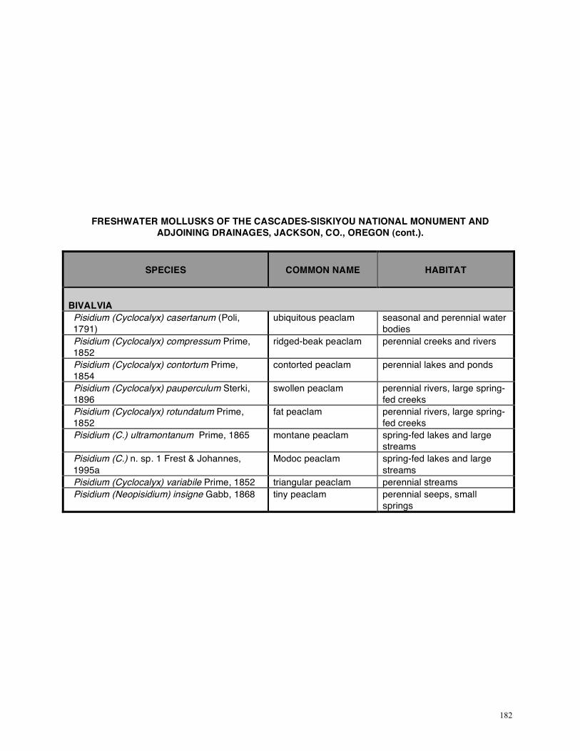
182
FRESHWATER MOLLUSKS OF THE CASCADES-SISKIYOU NATIONAL MONUMENT AND ADJOINING DRAINAGES, JACKSON, CO., OREGON (cont.).
SPECIES
COMMON NAME
HABITAT
BIVALVIA
Pisidium (Cyclocalyx) casertanum (Poli, 1791)
ubiquitous peaclam seasonal and perennial water bodies
Pisidium (Cyclocalyx) compressum Prime, 1852
ridged-beak peaclam perennial creeks and rivers
Pisidium (Cyclocalyx) contortum Prime, 1854
contorted peaclam perennial lakes and ponds
Pisidium (Cyclocalyx) pauperculum Sterki, 1896
swollen peaclam perennial rivers, large spring-fed creeks
Pisidium (Cyclocalyx) rotundatum Prime, 1852
fat peaclam perennial rivers, large spring-fed creeks
Pisidium (C.) ultramontanum Prime, 1865 montane peaclam spring-fed lakes and large streams
Pisidium (C.) n. sp. 1 Frest & Johannes, 1995a
Modoc peaclam spring-fed lakes and large streams
Pisidium (Cyclocalyx) variabile Prime, 1852 triangular peaclam perennial streams Pisidium (Neopisidium) insigne Gabb, 1868 tiny peaclam perennial seeps, small
springs