Glaciation of the Puo~et ound - WA - DNR
275
L HENRY LANDE , tate ol "'I t Glaciation of the Puo~et ound Ro: n B . HARLE OLl'lll'IA, WA.SH.: .FIUNB: 1,1, LA.KllOBN I'UBLIC 1'1l1NT11B. 19]8
-
Upload
khangminh22 -
Category
Documents
-
view
0 -
download
0
Transcript of Glaciation of the Puo~et ound - WA - DNR
L
HENRY LANDE , tate ol "'I t
Glaciation of the Puo~et ound Ro: n
B . HARLE
OLl'lll'IA, WA.SH.:
.FIUNB: 1,1, LA.KllOBN I'UBLIC 1'1l1NT11B. 19]8


.B ARD OF I L RVE-Y .
Go\'ernor ER • .:EST L TER, lwirman.
i utcnant Gonrnor Lo F. fuRT.
tate Trea urer EDWAR.l) ! E.ATU, ecretary.
Pr ident T. F. KA.·E.
Pr ident E. A. BRYAN.
HENl!. LA WES, tatc G ologiat.
o Cf I 7

LETTER OF TRANSMITTAL.
Govern-0r Ernest Lister, Chairman and Members of the Board of Geological Swrvey:
GENTLEMEN: I have the honor to submit herewith a report entitled "Glaciation of the Puget onnd Region" by J. Harlen Bretz, with the recommendation that it be printed as Bulletin No. 8 of the Survey reports.
The surface deposits about Puget ound, as shown in the sea-di.ff exca ations for stre.et tunnels and elsewhere have always attracted much attention. They are of economic importance, not alone from an agricultural standpoint but because of the valuable beds of clay sand and gravel which they contam. Local chapters in the tory of tbe glaciation oi Puget Sound have been contributed by different writers at different times but this bulletin by Mr. Bretz i the first detalled account covering all phases of an intere tfag portion of the geological history of the region. This report by Mr. Bretz ha imrolved several years of field-work and study, the expen es of which were ustained by him personally, except that a small allowance toward the cost of the field-work was granted him by the urvey during the summer of 1911.
Very re pectfully, IIENR y LANDES,
State Geologist. University tation, Seattle May 1, 1918.

tNTRODUCTION
CHAPTER I.
CHAPTER II.
CHAPTER Ill.
CHAPTER IV.
CHAPTER V.
TABLE O co TTE TS.
Page 9
0UTLTh"E OF TlIE PLEI TOOBNE Hr TOBY OF TKE
REGJO • . . . • . • . . . • • . . . • • . • • . . • . • . • • • • • . • • • • 13
THE TE!lMINAL MonA.INE OF Puom: SOUND. • • • • • • 23
EXTRA·MORAllilO 00'1:WASR OF Tl:CE PuGET SOUND
REGION • • . • • • • • • • • • • . . • • • • • . • • • . . • • . • • • . • . . 38
VASlION fucES JONAL MORAINE AND TTEN'DA.1'IT
OU'l'WASR . . • • . . • . . . . . . . . . . . • . . . . . . • • • . • . . • . 61
THE °M'.Otm'D6 OF TRE VA.SRON 00'1'\VASH... .. . . .. 81
CHAPTER VI. TlIE GLAOlAL L.uo:.;s A.ND DRAL'l'AOE C:e:ANGES OF
TBE VASHO GLAOL!.T.JON ........ ... ......... , 109
CHAPTER vrr. TRE ADMIRALTY Gu.ourroN .................... 11s
CHAPTER VIII. 0BIG.J.N OF THE TROUGHS OF PuGE'I' SOtn.'D ••••..•• 195
CHAPTER IX. R.Er.ATIO S OF GLACTATlO OF THE FLA.NKINO MOUNTAINS TO TIIAT OF THE PuoET SOUND
BASIN ..................................... 221
CHAPTER X. Pu:t TOOEN.E AND PO T·PLEt TOOEN& Du..STROPlllBK 226
WASHINGT STATE L1BRAR

Plate I
ILL U TRATIOr Facing Page
40 ..................................................... ····· Fig. 1. The Satsop Red Gravel Ten-ace.
2. Surface of Satsop Red Gravel Terrace. 3. Section of Red Gravel in Satsop Terrace.
II . . . . . . . . . . . . . . . . . . . . . . . . . . . . . . . . . . . . . . . . . . . . . . . . . . . . . . . . . 48
Ill
Fig, 1. Mound Section in N. P. R. R. Pit, Mima Pra1rle. 2. Mound Topography on Mi.ma Prairie.
Fig. 1. Large Intermound Area on Mirna Prairie. 2. Typical Mounds on. Mima Prairie.
56
IV . . . . . . . . . . . . . . . . . . . . . . . . . . . . . . . . . . . . . . . . . . . . . . . . . . . . . . . . . 64
Fig. 1. Mounds on the Northern Portion of Mlma Pralrle. 2. Kettle Among Mounds, !1lma Pralrie.
V ........................... . ............................. 72
Fig. 1. Rocky Pralrie Mounds with Intermound Cobbles. 2. Rocky Prairie Mounds.
VI . . . . . . . . . . . . . . . . . . . . . . . . . . . . . . . . . . . . . . . . . . . . . . . . . . . . . . . . . 80
VII
Fig. 1. Mounds of Rocky Prairie. 2. Mounds of Rocky Prairie.
Flg.1. Delta at Corner Seneca St. and Sixth Ave., Seattle. 2. Mounds cut by Highway, Mima Prairie.
88
VIII. An Area of Typical Mounds on Mima Prairie.... . .... . . . . 96
IX
Fig. 1. Ford Type Mound on Grand Mound Prairie. 2. Bedding of Mi.ma Prairie Outwash Gravel.
104
X ...... ... ............................................... 112
XI
XII
Fig. l. Prairie Oalt, klJled by Invading Fir Forest. 2. Upper FalJs of the Des Chutes River.
Fig. 1. Section in the Steilacoom Delta. 2. Section In the Richmond Delta.
Fig.1. Distorted Admit'alty Sediments, McNeil's Island. 2. Structure of the Quatsap Point Delta Beds.
120
152

Plate XIII. XIV.
xv
XVI
Illustrations 7
Facing Page
Cole Point, Anderson Island ............................ 160 Denny Hlll Regrade .................................... 176
Fig. . Old River Channel above Kennydale Delta. 2. Percival Creek Channel. 3. "Spite Hlll" of Denny Hill Regrade.
Fig. 1. Portion of Denny Hill Regrade, Seattle. 2. The Grade on Bell Sireet, Denny Hill Regrade, Se
attle.
184
192
XVII. Crumpled Clay Stratum of Camano Island. . . . . . . . . . . . . . 200
xvnr
xrx
Fig. 1. Vashon Till Sea Cliff at Tip of Cape Horn. 2. Drumllnold Forms of Vashon TIU on Fox Island.
Fig. 1. Vas.hon Till Sea Clift. Brisco Point, South End or Hartstene Island.
2. Vashon Tlll on Ma1Towstone Island, Admiralty Inlet.
208
216
XX ........................................................ 224
XXl
Fig. l. Drowned Valley of Chambers' Creek at Low Tide. 2. Cattle Point Hill, San. Juan Island.
Fig. 1. Sea Cllfl' In South Rill, San Juan Island. 2. Erratic on Vashon Ground Moraine, near Port Gam
ble.
232
XXII. Pleistocene Surface Deposits or Puget Sound Basin .. In Pocket
XXIH. Moraine and Outwasb South of Puget Sound ......... In Pocket XXIV. Batbymetrlc Map ot Puget Sound ................... In Pocket

8 Illustrations
F(gure. Page 1. Profile of the Vashon Terminal Moraine..................... 36 2. Glacial Drai.nage f:rom Eastern Lobe ot Puget Sound Glacier,
at its Maximum E~'tent. . . . . . . . . . . . . . . . . . . . . . . . . . . . . . . . . . 44 3. Glacial Drainage from Ee.stern Lobe o! Puget Sound Glacier,
during bu1lding of Mirna and Tenalquat Prairies........... 55 4. Glacial Drainage from Eastern Lobe of Puget Sound Glacier,
during building of Rocky Prairie......................... 63 5. Diagrammatic Cross Section of Tena.lquat Prairie. . . . . . . . . . . . 65 6. Glacial Drainage, etc., during building of. Yelm Prairie...... 70 7. Time and Space R elations o! the Glacial Lakes during Vashon
Retreat . . . . . . . . . . . . . . . . . . . . . . . . . . . . . . . . . . . . . . . . . . . . . . . . . 111 8. Lake Puyallup and Early Lake Russell .................... 124 9. A portion of the City of Tacoma, showing Location of the
Tacoma Delta, the Various Pits in it, the South Tacoma Channel Head, and Position of Ice Front at Time of Delta Formation . . . . . . . . . . . . . . . . . . . . . . . . . . . . . . . . . . . . . . . . . . . . . . 129
10. Lake Tacoma, Lake isqually and Early Lake Russell. . . . . . . 132 11. Lalce Skokomish and Lake Russell. . . . . . . . . . . . . . . . . . . . . . . . . . 144 12. Lake Hood and Lalte Russell. .............................. 147 13. Mouth of the Dusewalllps River Valley, d:rawn from chart
6450 of the U. S. C. & G. S., showing the Brinnon Delta ..... 149 14. Glacial Lake Sammamish. . . . . . . . . . . . . . . . . . . . . . . . . . . . . . . . . . 152 16. The Redmond Delta and Environs. . . . . . . . . . . . . . . . . . . . . . . . . . 155 16. Lalte Snohomish and Maximum Lake Russell ................ 168 17. Relation of the Richmond Delta to Lake Russell and the Puget
Sound Glacier . . . . . . . . . . . . . . . . . . . . . . . . . . . . . . . . . . . . . . . . . . . 161 18. Vicinity of rllngton and Marysville. . . . . . . . . . . . . . . . . . . . . . . 167 19. Profiles of the Glacial Lakes of Puget Sound, projected on a
North and South Line ................................... 169 20. Profiles ot the Glac1al Lakes of Puget Sound, projected on an
East and West Line ........ . ............................ . 172 21. Relation of Admiralty Sediments to Vashon Till ............. 198 22. Oblique Truncation of Quatsa.p Point Delta Foreset Beds .... 201 23. Interglacial Drainage Pattern. . . . . . . . . . . . . . . . . . . . . . . . . . . . . . . 203 24. North ShoJOe of Hales Passage .............................. 206 25. Course of Radiating T11l Ridges on Wollochet Bay. . . . . . . . . . . 207 26. Chambers Creek and Environs. . . . . . . . . . . . . . . . . . . . . . . . . . . . . . 235 27. Dlastrophic Movements of the Puget Sound Basin since Ad
miralty Glaciation . . . . . . . . . . . . . . . . . . . . . . . . . . . . . . . . . . . . . . . 237
I TTRODU TI
GENERAL PHYSIOGRAPHY OF THE PUGET SOUND REGION.
The ba in or d pre ion of Pug t ound in we-tern a h-ington lies betw n th Olympic Mountain on the we t and the a cade Mountain on the a . In it northern portion, it open to the Pacific cean through th great valley occupied b the trait of Juan de Fuca between the Olympic fountains and Vancouver 1 land. The ba in i. enclo ed. on the outh by a low dj ide betw eo the ound nncl the Cbebali River, the latter flowing to he Pacific outh of the Olympic .
The name "Puget ound' was originally given by Vancouver to tha portion of the c inland arm or the ea which Ii outh of the arrow near Tacoma. , ancouver distin ui h d two oth r main portion of the e inlet · Hood anal and dmiralty In] t. Hi u ag wa re pected by Wilke of the nited tates
Exploring Expedition a ball century later, but today the term 'Puget ound mbi-ace all three portion and i frequen I u ed to in lude all marine water connected with the
trait of Juan de Fuca outh of the Intern tional boundary line. In th.i broad en e it is u ed in the title of thi paper.
The depre ion of Puget ound i genetically ynclinal, belonging to the mo t we tern synclinorium of North Am rica. The ulf of Georo-io. north of it, and the Willamette alley of Or gon the Great Vall y of California and the Gulf of California oath of it ar likew:i e portion f thi tructural trough. Th re are interruptio in it and iff r nt parts have doubtle s had different hi toric . The Puget ound depre sion it elf i partially interrupt d by a mountainou pur of the a en.des extending diagonall a ro s toward the northwe t ju t north of the trait of Juan de Fuca. The mountain range of Vancouver I land i perhap a continu tion 0£ the pur.
The area tudi d e.·tends from the International boundary on the north to lh divide betwe n lhe hehali and olumbia ri er on the outh a di tance of 170 mile and from the

10 Bulletim No . 8 Washmgton Geological Survey
ba e of the Ca cade to that of the Olympics in an east and we t direction, thi distance averaging 50 mile . South of the Olympic , the hehali Valley ha been tudied from the low divide between it and the ound ba in to the Pacific Coa t. Though beyond the limit of glaciation outwa b from the Puget
ound Glacier wa carried through everal gap in the rock hill to the hehalis River, and thence down the valley of thi rjver to the head of Gray Harbor on the Pacific.
The fore ts on the we tern coa t of r orth America, from Puget ound to AJa ka, have been repeatedly de cribed as almo t tropical in den it . ewberry Ru ell, Willis and other who have worked on the o-eology of Puget ound, note the remarkable luxuriance of the fore t and their almost impenetrable character except along routes of travel. The. p1·e ence of thi primeval forest over a con iderable portion of the country embrnced in thi tudy ha offered the greatest difficulty encountered in it: pro ecution. It has been po ible to examine many large area only along rajJroad grade , roadwa and trail , and in uch ca e no detailed tudy wa attempted. Bu ·ned-ovcr or logged-off land of Puget Sound, unles taken up for agricultw·e are u ually quickJy Tefore ted and the econd growth i almo t a great an ob truction to the tudent of topography as i the original fore t .
Five nited tate Geological urve map ha e been made tlm far in the area embraced in this paper cove1·ing about three tenth of the whol . b ence of uch map for the larger part of the region ha been an obstacle to ati factory interpretation.
Altitudes have been determined chiefly by aneroid u ing railroad profile largely for check tation . A few United
tate Geological Survey bench mark ha e been available in ome parts of the region . Much of the country along the in
let ha been examined with no better check tation than the coast line with it tidal range varying with ea on, locality, etc.
PREVIOUS WORK ON THE SUBJECT.
1845 J:I.AltLEs WILKE . aptain harle Wilke of the "United tales '>..--ploring Expedition," now known by hi name,

Glaciation of the PU,get SoU,nd Regi011 11
spent several month in urve ing Puget ound. Hi narrative, , ol. 4, pp. SIS a.nd U5 refer to the puzzling mound on the outwa h plains outh of the oand.
I 78 GEORGE GmB . Thi author publi bed an account of a geological reconnais ance of the northwe tern boundary of the nited State , in the Journal of the American Geographical ociety for 1873. He des ribed and figured the mound of the outwa h prairie , gave ection of the drift of Puget Sound and noted elevated marine terrace on San Juan I land.
187S and 1874 JoSE:Plt LE o 'TE. In a paper entitled 'On the Great Lava Flood of the W t, and on the Structure and Age of the a cade Mountain ' publi hed in the Proceeding of the aliEorn.ia Academ of Science in 1878 and in more complete form in the American Journal of Science in 1 74 Jo eph Le onte di cu sed the origin of the Puget ound fiords nnd the g ne i of the mound occurring on the plain outh of the ound. He recognized the occurrence of a Glacial, a Champlain and a Terrace epoch in the region.
1884 Jo1rn EWD.ERR ·. paper pre ented by John ew-
berry befor the ew York Academy of cience, entitled 'On the Origin of the Fiord of Puget ound' i printed by title in the ' Tran action ' of that bod for 1884. Kimball, noted below credit ewberry with the idea that the fiords were glacially eroded by northward flowing ice, and with frankly confe mg the mounds to be inexplicable.
1893 G. O. RooER . The American Geologi t, Vol. II, o. 61 contain an article on the ever popular ubject of the remarkable mound of the outwash region of Puget ound. The paper briefly de cribe the e fo1·m di cu · e variou hypothese for their origin, and add a new one to the li t.
1897 JAMES P. KnrnALL. In the American Geoloai t Vol. 19 o . 4 and 5, thi ob erver de cribe the "Phy iographic Geology of the Puget Sound Ba in . ' He con ider a Pliocene ba e]evelling to have preceded the Plei tocene, and further e. cavation to have been accompli hed by later glacial ero ion.

12 Bulletin 1', o. Wa hington Geol-Ogical wroey
But one glaciation i alluded to. Po t glacial trearn ero ion produced the valle now occupied by the ound. Po t glacial crustal movement thu Jiave been (1) an elevation, (2) a sub-idence, and (8) from the pre ence of raised beache. a slight
re-elevation.
1 97 BAIT.EY Wu.us. In a paper publi bed in the Bulletin of the Geological ociet of America VoJ. 9 ntitled ''Drift Phenomena of Puget ound ' Willi present bi generalization of Puget ound glacial hi tory from work on the Tacoma quadrangle. Fo1lo in Ru ell whose note on thi reg1on were never publi bed, h di tingui he two gla iation and make inference a to the character of the intergl1tcial epoch. The contact of Puget ound i e with Ca cade i i partially drawn ·various feature of the last glaciation are d . cribed and the origin of the fiord-like valle and their eparating highland is considered.
1899 BAILEY Wu.u AND GEORGE Oris lUITU, Tacoma Folio o. 54. . Geological urvey. The Plei tocene hi -tory of the Tacomn quadrangle i de cribed in detail.
1904 WA.Rn.EN UPHAM. American Geologi t Vol. M o. 4. The article here not d on "Glacial and Modified Drift n ar
eattle, Tacoma and Olympia' wa ba ed on too little field work and much of it is in error.
1905 ALlIBllT R.:e..\GAN. Kansa Academy of cience. A de cription i given of ome Plei tocene and recen feature of the re ion between Bellingham and the International boundar and interpretation are attempted.
1908 Wan.REN PRA t. A brief paper comparing the Puget Sound coa t line with that of the Saguenay River. b-stract published in Science.
1910 J. H. BnETz. A preliminary paper on the 'Glacial Lake of Puget ound. Journal of Grology Vol. 1 o. 5.
1911 J. H. BRETZ. 'Terminal oraine of the Puget ound lacier." Journal of Geology Vol. 19 o. ~-
CHAPTER I.
OUTLINE OF THE PLEISTOCENE HISTORY OF THE REGION.
SYNOPSIS.
CRAllACTEn. OF THE PLIOCENE. PLIOCENE ELEVATIONS YEl' EXISTL.--.G IN THE BASIN.
EPocas OF THE PLEISTOCENE KNoWN m WESTERN W ASR-
INGTON.
ADMIRALTY EPOCH (GLACIAL).
PUYALLUP EPOCH (INTERGLACIAL).
VASHON EPOCH (GLACIAL).
DIAST.ROPHISM OF THE PLEISTOCENE IN THE REGION.
CHARACTER OF THE PLIOCENE.
Most of the formations outcropping in the Puget Sound basin are of Tertiary age, and all of them south of the Strait belong to this division of geological history. Eocene and Miocene sedimentary beds record a shallow sea, with frequently changing depths and shore lines. Beds of terrestrial sediments are interstratified with the marine, many of the Tertiary coal seams of Puget Sound preserving forest floors with tree stumps in aitu. The Tertiary Sound region was one of constantly shifting land and water areas, and of frequent alternations of fresh and salt water. Contemporary lava Bows, both from fissures in the basin and from extrusions which originated in the surrounding areas, are intercalated among the sedimentary beds.
For this region, the Pliocene period was primarily a time of diastrophic movement and erosion. The Eocene and Miocene beds were domed and folded, the whole area was lifted higher than at p1·esent, and subaerial erosion developed great relief in the weak Tertiary rocks already deposited. li'urther Java flows occurred, of the same character as the earlie1· ones, but apparently no volcanic cones were produced.

14 B1illetin No. , n aahington Geological uroey
PLIOCE :E ELEVATIONS YET EXISTlNG I • THE BASIN.
In he ucceeding Pl i to ne great edimcntt-1.ry depo it of glacial origin buri d th Pliocene topography. drift plain wa aggrad d whi h r a h d from one ide of the ba in to the other. bo e thi ro i land-like, a few re ion of
originally greater uplift. The chief Pliocene elem n of the pr c.nt topography are ( ) be ruagonal mountain pur from th a cade aero to ancouver I land includin the an
Juan Island group (2) the Blue Hills between Hood anal and dmiralty In.le , (3) wen tle Hill and quak Mountain ea t of eattle and ( 4) the Black H.m , B ald Hill and o her marginal elevated area on th outh.
EPOCHS OF THE PLEISTOOENEl KNOWN IN WESTERN WA.SHINGTON.
Ru ell fir t noted the ·i ten e of two till h t and of inter-till ediment in Pug t ound. Willi later named the three recorded epochs dmiralty (glacial) Puyallup (inter
glacial) and Ya hon (gbcial).
AD ITRALTY EPOCH (GLACIAL).
Good expo ure of the till of the Admiralty glaciation are 1·ar , there being hardly a cor in the many mil s of ea-cli ff on Puget ound. The epoch and it till ar nam d from dmiralty Inlet, along , ho l1or the till wa exo.min d by both Ru ell and Willi . . Th ba e of the tiil o far n known by the wri er i e~'PO ed in but two or three p]a e in the entire r gion and nowhere along clmiralty Inlet. Willi note he ab ence of e\.-idenc of orlier glaciation , within the limit
of hi tudy. The dmiralty till in po iti ely identifi ·po ur
nowhere deeply weath r d, h ugh in ome place. tain d b percolating water. Its pebbl o.re for the mo t part firm but decay ha oftened them in ome ca . The e variation in the amount of weatherin app ar to have been d termined by the thickne of co er o er th till of an locality during th int rglacial epoch. To e~timate can be given of the thickne of the

Glacuzticn of the Puget Sownd Region 15
till sheet, and the topography of its urface i unknown. The character of the urface o er which the Admiralt ice advanced i al o Wlknown.
A few expo ure of deeply weathered cr]acial drift have be.en found in which the decay of all but highly iliceou material far urpa es the alteration of Admiralty till where the latter i clearly identified. u picion ha ari en from di covery of these expo ure that a drift older than the Admiralt e.xi ts in Puget ound. Admiralty till however ha not been identified m ection above the uppo ed older drift.
PUYALLUP EPOCH (INTERGLACIAL).
Exten i e tream aggradation occurred in the ound ba in after the de.po ition of Admiralty tm and b fore the advent of the following glaciation. It i not an e..xaggerntion probably, to ay that nine-tenth of the Pl i tocene depo its of Puget ound expo ed above ea le,rel belong to thi erie . The material i a orted glacial drift and probabl , a deri ed largely from the wanincr droiralt ice. Its bed a expo eel in the pre ent ea-cliff rar ly retain the ame cl1an1.cter for more than a mile· Jen tructurc, abrupt trnn ition or gradual hange in chara ter being the rule. In many place fore t
floor and swamp bed are p1·e erved in the erie as lignitic eams and a few clny beds at tl1e ba e contain marine mollu can
and cru tacean remain . tream bedding i common in the gravel , delta bedding i rare. In the outhem part of the ba in the tructure of the depo it indicnte outhward flow of the depositing water. A few intercalated till lenses prove that glacier ice was till in the re ion. o indications are known of extended ubaerial expo ure of the Admiralty till before de.po it.ion of these bed . In brief a great plain of terrestrial depo it , containing a few marine beds in the lower portion, i conceived to have been aggradcd in front of the ,vaning Admiralt glacier a it withdrew· to the north. Thi conception i e entially imilar to that advanced by Tarr and

16 Bulletin No. 8, Washington Geological Suroey
by Blackwelder for the genesi of the Yakutat foreland of Alaska.•
Following this exten ive aggradatjon uplift of the region, relative to sea level, occurred, and a long period of atmospheric expo ure and tream erosion en ued. The gravels and sands became stained and locally cemented with .iron oxide, and near the surface were somewhat decomposed. The impervious clay , however, were unaffected by the percolating waters which stained the gravel many feet below the weathered zone. A soil must have been formed during thl time of exposure, but it has not yet been found preserved beneath the later till.
Consequent drainage developed on the surface of the plain. The southern portion appear to have drained southward to the Chehalis River and Grays arbor, while the northern portion sent its waters to the ea by way of the Juan de Fuca Valley. A part of this interglacial dninaO'e system can be reconstructed today with considerable probability.
Stream erosion advanced in the unconsolidated drift to submaturity. The area became deeply inci ed by broad trunk valleys, and minor tributary valleys were well distributed on the div:ide slopes. A gene1·al north to outh orientation of main valley prevailed throughout largely determined, pre umably, by the original lope of the Admiralty drift plain.
Willis names this interglacial epoch from tratified sands, typical of the edimentar erie , which, with Va hon till unconformably overlying, are exposed near tl1e town of Puyallup. The a,nd tru1y are inter-till in po ition, but only their staining and the erosion of tl1e valley in whose sides they are expo ed, are considered as interglacial. According to this interpretation, no interglacial ediment are known in PuO'et Sound, and the Puyallup interglacial epoch is to be considered chiefl as one of weathering and ero ion, so far a thi reg10n 1s con-
• Tarr, R. S. "The Yakutat Bay Region." Professional Paper o. 64, U. S. Geological Survey.
Blackwelder, Eliot, "The Yakutat Coastal Plaln of Alaska," Am. Jour. Sci. Vol. 27, 1909.

Glaciation of the Puget ownd Region 17
ccrned. Presentation of the e id nee for this and other conclu ion briefly tated in thi chapter will be given later.
VASHON EPOCH (GLACIAL).
The late t glacier of Puget ound advanced from the north, a did its predecessor the .Admiral the ice being suppliV largely from the snow field of Briti b Columbia. r 0nly a minor part of the ice of the Puget ow1d Glacier came from the margining mountain , and tl1at portion outh of the trait of Juan de Fuca cannot be looked upon a a piedmont glacier fed by vaTiey glacier from the Olympics and Ca cades. Evidence will be pre ented to how that the Puget Sound ice of the Vashon glaciation wa actually thru t up into some of the e mountain alley , in the face of their de cending glaciers.
At the maximum, the .ice of tbi epoch e..'\.-tended at lea t as far as that of the Admiralty epoch. Admiralty drift i found beneath one portion of the Vashon terminal moraine, but nowhere be ond it. El ewhere, the fre h Va hon till of the terminal moraine overlies rock apparently. never glaciated previou ly.
A terminal moraine swing aero the outhern portion of the depre ion from the Ca cade to the 01 mpics. A a topographic form it i in.significant in mo t places becoming here and there a mere moraine terrace on the north side of rock hill against which the ice jmpinged nt it maximum and ju other places, e pecially in valley , being largely buried by out1va h gravel. In it great t development it apparent height i due in part to buried rock lull who e trata outcrop on the southern lope. It cour e record the exi tence of two lobes of the glacier front the re-entrant being cau ed by the domed uplift known a the Black Hill .
Compared with thi minor moraine development the a""tent of the outwash from the , a hon Ghicier i a toni bing. Relatively great areas are covered deeply with coar e, clean gravel, producing broad terile plain of low gradient. Two wide pathway existed aero the rock bill south of the ba in of

18 Bulletim No. 8, Washitngton Geological wrvey
the ound at Gate and about Matlock. Through the e cbiefly, the gra,•el flood entered the hehali Vnlley, and a part of it wa carried to the head of Gray Harbor. The Black Hill con tituted the elevated area tanding be ween the two pathway and minor gravel train were al o canied aero. them to the hehali . With ra el entering the latter valley at cveral point along it cour earliest b the Gate Pathway
and later by the more we tcm routes, an imperf ctly imbri ated erie of gravel de.po it wa con tructed which in it pre ent
fragmentary condition th1·ough ub equent trea.m ·o 100 1
difficult satisfaetoril to re olve into it component element . Rece ional moraine and outwa h plain for a few mile
back of the terminal moraine record a varied hi tory of margino.1 drainage jn the early tag of retreat. Gravel plain adju ted to po ible outlet at OTIC po. ilion of the ice front ,vere b·enched and in ome ca e largely removed b the opening of new cour e 11 retreat progrc ed or were abandoned and left a high-lying gra el plateau with moraini depo it., and ice-contact slope on their northern descents.
On many of the e outwa h plain , pe ially tl o e clo ely a ociatcd with th terminal moraine there is a remarkable development of thou and of ymmetrical gravel mound of fairly uniform ize, clo el paced but of a ymmetrical di tribution and of heterogcneou tructure. Many hypothese have been advanced to account for them but no one e'lrplanation i ati factor . The writer has failed to find in phy iographic
literature any de crip ion of natun1] mound imilu to the e, and believe them to be unique so far as present knowledge goe . The mound are re olvable into two type . The origin of one type w· be explained but that of the other remain an un olved problem.
The extensive moraine and outwa h depo it. laid down during early 1 a hon retreat appear to have comple el objjtemted the interglaciaJly eroded vaUey lyin in the southern part of the Pu et ound basin. The produced an upland plain notably different from the deep! trenched depre ion containing Puget

Gl.aciation of the Puget ownd Rea--ion 19
ound. Farther north however the supply of debri a much le per w1it area, and in mo t place a thin mantle of ground moraine alone overlie the interglacial topograph developed in the Admiralty drift plain. The Va hon till heet i thu largely a wide pread veneer of fre h material on the lope and ummit of the interglacial hill and in many place on the floor of the interO'lacial ,•alleys. Locally to s and le depo its of Va hon till attain a thickne ufficient to obscure the interglacial, trea.m-formed topography. Locally al o, ero ion by the Va hon ice notably deepened thee trunk valley . Thi deepening, however, j submerged beneath the waters of Puget Sound, and i revealed only by the sounding of the oa t and Geodetic urve .
After the frontal margin of the Va hon Glacier had withdrawn ome di tance from the outhern region of heavy aggradation, it appear to have been melted back more rapidly than during the fir t few mile oF retreat. E ·cept at the outh. the valleys expo ed by glacial retreat were little modified by outwash or recessional moraine depo it . The aggraded outhern region, however prevented free drainage from these vulle into the Chehalis. With a mountain range flanking the depre -ion on both the ea t and we t, and with the glacier complete}
filling it north of tbe bared portion, the e valle filled with water until overflow occurred aero the outwa h plain and through the Gate Pathway to the Chehalis YaUcy. Thu wa
.!!_egun the complicated hi tor of the ice-dammed lake of Puget Sound.
Further retreat exposed more valley developed by interglacial tream and modified by the 1 ashon ice. Such of these all y
a be1onged to the river y tem , hich di charged through the Gate Pathway during the Pu allup interglacial epoch became a part of the glacial lake behind the divide of Va l10n drift, then but newly formed between the ound and the hebalis Valley. Where however trough belonging to the two other :interglacial river • y tern of Puget ound outh of the tra.it were fre d from ice they fil1ed to the level of the lowest places

iO Bulletvn No. 8 Washvngton Geological Survey
in the.il' borders, aero which they di charged to the master lake of the Sound ba.i;in in the Gate Pathway valley ystem. Later, the retreat of the ice from ucces ively lower passes determined succes ive levels in the e independent lakes. In most cases, open connection with the ma ter lake was eventually made, and all the lakes became one. Though the Vashon Glacier left no definite rece ional moraine north of its aggraded plain until after the Stmit of Juan de Fuca ivas opened and the glacial lakes were de troyed, vidence of an o cillato1-y behavior of the ice edge ha been found in the record of the lakes. These record are limited ch.ie.fly to deltas and outlet channel , and the general rule i that lake level become progre sively lower throughout the period of their e..xi tence. Where, however, a delta how alteruating fore et and top et bed in the same ection, we have indi putable evidence of an abrupt rise in ta.tic water level. Other data show this ri e to be due to re-advance of the glacier and closure of the lake' outlet.
The large gla ial lake of Puget Sound, by increase in length northward as the ice front retreated, and by the addition of the area of former tributary lake , eventually became more extensive than that portion of Puget ound which lie south of the latitude of Everett. In an earlier paper• this water body wa named Lake Russell, though its northward e..xtent was not then definitely known. The northern margin can be dra n now with a fair degree of certaint .
Eventually, the we tward-open:ing Strait of Juan de Fuca was cleared of ice, and Lake Ru sell was drnined to ea level, marine waters replacing it in the valleys whose bottoms were belmv sea level. A few glacial lake , entirely unrelated to Lake Russell, and to the drainage into the Chehalis River, we.re formed a the ice front retreated acros the mountainou region which partially interrupts the Sound ba in. ucceeding the glacial lake of Puget Sound there wa an epoch of ubmergence be-
•J. H. Bretz, "Glacial Lakes of Puget Sound," Jour. Geol. Vol 18, No. 5.

Glaciation of the Puget ownd Regi-on !U
neath ea ater. Thi introduc the object of cru tal movements in the Puget ound region during the Plei tocene.
DIASTROPBISM OF .THE PLEISTOCENE IN THE REGION.
The earlier cru tal movement of the Pleistocene in thi region can be de ciphered only in their broad outline . The postVo. hon movement , however can be dealt '\ · b quantitati,•ely.
The land wa high during the liocer re umably higher than a any ub equent tim . If we · ionall corr late the known glacial epoch of Puget ound the norlh rn hemi phere, a plnu iblc cor lion a great part of the Quntcrnar period ha no r cord · , the cdiment of the
region. Altitude and moYement of the Puget ound ba. in for much of the Quaternary therefore are unknown. urther, very little i known of the Admiralty glaciation. At the time of the r treat of the Admiralty i e, however, the r gion wa lightly JO\ er than at pre ent; marine organi m in the dmir
alt edim nt having been found in situ a few feet above pr -ent high tide.
ar]y in the Puyallup int rglacial epoch the region wa probabl a thou and feet high r than now. This permitt d the tr am of that time to carve th d ep trough in the dmirally
drift plain which are now occupied b the Sound. t the maximum of Va hon glaciation, outw-n h gra els were pour d we tward down the hehali as far as the present head of ray H r or where the now Jie S5 feet above tide ith tr am bedding. From thi we may conclude thnt the land had lowered from it. high interglacial po ition to one near that of the pr ent. fter Va hon retreat opened the trait and marine water replaced Lake Ru ell in the Sound outh of it, ub equcntly outwa hed gravel w re adju led to the new tatic wale · le cl . Though the evid nee i not as clear a could be wi hed the ea appear to hn c filled the ound bn in and to ha e tood 50 feet or les above the present level.
Iarine littoral hell have been found on the bluff of uget und in ome places accompanied by wave-cut terrace every
where ov rlyin.,. the Vashon till beet, and in ome depo it

22 Bulletin No. 8, Washington Geological Survey
lying on the Lake Ru ell delta , and even back in the valley of Plei tocene river di charging into thi lake. In the pre -ence of the e helJ there i po itive evidence of a po t-glacial ubmergence of the Puget oun.d ba in to a depth of 250-280
feet more than now. helJ are mo t common at the lower level , here fairly definite strand may be worked ou . The higher occurrence of }jttoral he11s are rare and ield no more evidence than that of the verity of the occurrence. Data ill be pre ented in Chapter X to show that these shells occur in situ.
When the submergence was 120 feet or more in exce of the pre ent, Grays Harbor and Puget ound were connected by tide water aero the site of Lake Ru ell's discharge-way, and the Olympic Mountains con tituted an i land. The topographic effect of thi ubmergence are today almost nil. o definite shore line higher than 100 feet remain, no river delta of the time have been found, and were it not for the shells, there would be no evidence whatever, to record positively the higher level of the ea during tbi epi ode. Since strikingly developed river deltas record Lake Ru ell today, and ince elsewhere throu""bout the region post-Va hon tream ero ion ha been very slight, it is to be concluded that no bore or tream feature of prominence were ever developed during the
marine ubmergence. We conclude therefore that it wa very brief.
Dm-ing the dia trophic movements wruch have submer""ed the ba in of Puget ou.nd to at lea t 250 feet below the present sea level and which have re-ele atcd it approximately to it immediately po t-glacial po itio11 the level of Lake Ru ell
have not been appreciably tilted or warped. The evidence for thi cooclu ion will be presented in Chapte1· VI and X.

CHAPTER II.
THE TERMINAL MORAINE OF PUGET SOUND.
SYNOPSIS.
CONTACT OF PUGET 8001-,-n AND CASCADS MOUNTAIN GLACIERS.
THE l\foltAINE AND THE NonnIBnN HILLS OF THE HucxtE-DERRY ivfoUNTA1N GROUP.
THE MonArnE ON ·1·ftE GATE PATHWAY PLAIN.
THE BLACK lirLLs AND THE MOJI.AINE.
THE M:ouAINE ON THE l\,lATLOCK PATHWAY.
CoNTACT OF P UGET Souim a.~D OLYMPIC l\loUNTAIN GLACIERS.
GENERAL CONSIDERATIONS.
The eastern and western margins of the Puget Sound Vashon Glacier are indefinjteJy recorded in the glacial deposits. It appears that coalescence between the ice from the north and the glaciers from the Cascades occurred in the northern part of tl,e region, and that no east and west margin can be said to have existed. Fa1iher south, lines of contact appea1· between the great cenfral invading mass from British Columbia, and the Cascade and Olympic glaciers which descended to it from either side. A definite margin between the area covered by the Puget Sound Glacier and the driftless sw·face south of it is usually to be found. The description of this margin is the chief purpose of this chapter.
CONTACT OF PUGET SOUND AND CASCADE MOUNTAIN GLACIERS.
From the work of WiJlis and Smith on the Tacoma quadrangle, Puget Sound drift is known to overlap t]1e deposits of a Cascade pieumont glacier of the Vashon epoch, which they name the Osceola Glacier. Eskers deposited from the Puget Sound Glacier lie on the western margin of a wide till plain composed of material derived from the east, and much flatter than the region immediately west, wl1ich is assuredly the product of the northern glacier. An irregular course is mapped for the

24 Bullctim No. 8, Washington Geological Survey
contact between the two contemporaneou drift heet . Thi is not to be con idered a markin..,. the contact of the two ice ma e , ince he po ition of uch contact biftcd and no one line can indicate it for all tages.
The writer ha not worked in this region of the O ceola (Ca -cade) Glacier and the work of Willi and mith is accepted for mo t of the Tacoma quadrangle. Error has b en found however, in their mapping of the contact between Puget Sound and Mount Rainier glacial ice in the outhea tern part of the quadrangle. The northern glacier pu bed well up again t the flank of Mount Rainier and it ground moraine complete] cover the drift hill of the Pu et ound plain which abut again t the flank of the foothills . o fragments of l\Iount Rainier lava have been een in thi ground moraine, while bowlder of variou kind of granite t pical of Puget ound drift are abundant up to the ba e of the foothill . Tl1e character of the till - it color texture dearee of fiymne s and coherence, tructure and compo ition,-agree with that of till which i undi putably of Puget Sound origin. Thi i true of the counh for a few mile outh of outb Prairie, about Kapow in and on the ea t side of the Obop glacial drainage channel at Eatonville. Tl,e Tacoma folio map the line of contact a running diagonally to the southwe t from the region of Orting but the ontact really lies along a line drawn almost stro.i..,.ht ouU1 from that place.
Obop VaUey is a long deep1y inci ed mai-gina1 drainage channel which connects the Pu aUup , alle. from a point two miles outh of Orting with the 1 isqually River Yalley a few miles outhwe t of Eatonville. It wa the di chargeway for the glacial water of he White, Carbon and Puyallup river from Mount Rainier while the Puget ound Glacier blocke the lower draina e comses ,vest and north. It al o car1·ied e caping water from the Puget ound Glacier much of , bich o-atbered in a high-level lake in the Puyallup trough about Orting.
nearly north to south line from Orting to Eatonville lie from on to two mile wet of the probable ontact of the

Glaciation of the Puget owru], Region
Rainier and Puget ound ice when the latter wa at it maXJmum. It will al o approximate) divide the plain on the we t from the rock hill which 1•i e toward Mount Rainier on the east. Eatonville i bunt on earl outwa h gravel of the Puget ound Glacier which reco1·d caping glacial water before retreat had begun on the north and northw t ide of Mount Railller. The Puget Sound Glacier at it maximum, howc er pu heel up on the rock hill lope ove1·Io0king Eatonville on the ea t, to an altitude of ':1:60 feet abo,,e thi outwush plain 1!260 feet above the ea. A fairly d finite morai e 1·idging bRck on the hill ummit
here b ar an abundance of Puget und drift material uch a various granite garnetifcxou mica chi t gnei etc. tl1e pre ence of which in Rainier lacial drif i urLknown and altogether improbable.
'a t of tbi terminal moraine d po it at the top of the teep ro k lope there i · little evidence of an glacintion. The region b ar a maQ'Jlificent primeval fore t and e..'i:po ure ar afforded dnly by overturn d tr e and by hallow cut a.long an old road between Eatonville and Elbe. In pite of the paucity of data it i apparent Lhat Rainier glacial ice never altered the region more than to remove a re idual oil. Only three erratic fragments were found along about ten mile of road. The
i qually Ri er emerge from the foothill 6 e mile outh of Eatonville and enter· the Pug t Sound drift plain at it mo t outhea tern portion. H re the Rainier foothill on the ea t
and the Bald Hill and the Huckleberry fountain on the outh form a right angle in the mountain wall o,•erlooking he plain, which lie to the northwe t. The Pug t Sound Gle.cier crowded up on these lop as at Eatonville and granite erratic· have been found a high a 1 fWO feet above ide.
Deposit of the Pug t Sound Glacier partially obliterated the pre-, a hon i quail YaUey at thi angle and the po tglacial stream failing to follow it former cour e, ha subsequently cut through 40 feet of outwa h containing Puget Sound drift and 300 feet into ande ite lava. The canyon thus formed in the rock i a deep a it i wide where cro cd by

Q6 Bulletin o. , lV a hington Geological urvey
the cable footbridg a rand . The gravel ab v the n-•on brink i nearl 1 000 fc t above tide, the high t altitude
known to have been attain d by out\ a h gravel of th Pug t ound Glacier. The riv r i apparently flm ing n th pre-
Va hon valley floor at th h ad of the canyon two mil bov the footbridge at L Grand . Th cit of Tacoma h d ,, 1 ped th water power re ulting fr m thi glacial div r ion of th river cour ·e b • the xcavn i n of 11 tunnel throuah th nnde it r k from the head of th can ·on to the deep t p int at c-
rand · and the con ruction of pen tock and turbine t that pln.
THE MORAI E AND THEl NORTHERN HILLS OF THE HUCKLEBERRY iOUNTAIN GROUP.
The Bald Hill from L rnnde w tward for ral mile pr • nt a bold north rn fa e toward the drif plain. Th country i dense) for d nd littl i known of h moraine in thu. r ion. Th D hut River h ad in th un une)' d
r gion lying outh of th Duld Hill and fl.ow out on th drift plain of Puget ound w t of thj hill group. Th northern
luci r crowded back up thi vall omewhat impinging on both north and we t lop of the Bald Hill . finor v Ue . . on the e lope have b n dammed b the morain producing lake and mar he . nc uch valle po e e thr mar he. d ccnding in order from outh to north each with n perfect moraine ridge damming the vnll and the hiah t with ovcrl oking rock cliff ri · ing dir tly from the mar h. ittle Bald Hill ake i the r ul of a imilar moraine dammin of a pr -
·i tina tream all . Ioraine ridges are abundant in the fore t h r and ver
harpl defined though it i impo ible to mak out a y -temati grouping because of the ob uring fore t growth. The ridg damming on mar h ri 140 feet abov it, and i o harp er ted that th r i barely room for the nn.rrow roadwa
whi b follow it ummit. \ of Bald Hill the moraine i mor bowlder trewn and po e harper ridge than at any oth r place known in it ntir extent. Bowldcr ar o abun-

Glaciation of the Puget o'l.lm.d Region 27
dant here that the are in man. place piled up on each other and the fore t appear to be gro1Yi.ng on a huge bowld r heap.
A lake marginal to the glacier wa apparentl formed in tl1c D hute River alle abo,•e the moraine. In. the vicinity of the falls of the De lmte (Pl. r ig. 2) the valley floor wa
aggraded by depo it in thi lake tbe exi tence of which ha determined th location of few mall farm up among the hills. Pebble of Puget ound drift are found a high as l 200 feet in the De Chutes nll y.
We t of the Bald Hill the plain region extend farther outh, and the glaci r ac ordingl advanced further in that dire tion. It margin from l\Iount Rainier w h ard to Tenino wa contr lied entirely b the rock hill ] ing outh of thi poxtion of the ound ba in the ice having pu hed up on their northern flank for varying cli -tance .
]ear Lake on the Bald H.iJJ road li entir ly among bmvldery morai.ne hills. The numerou lakelets and bog of the vidnity a.re like, i e the re ult of the moraine topography .
wampy north to outh valle. immediate} we t of lear Lake connect the De hute River valley with tJ1at of the i quail Rive1· to the north. The col or divide in the old water cour e i within a fraction of a mil of the De Chut - and there i a unjform de cent thence northward to the i qually River. Glacial drainage appear to have been the cau e of thi abandoned val] y but it i not known how uch dr11inagc could have tlm cd north toward th i e front a th grade r ecord . nother Ylll
ley of the ame character nnd with the ame puzzl concerning it gene i occur two mile farther we t. The high water of the pring of 1910 actuall di charg d from th De hute 11. ro the fie.Id in thi old drninage chann 1 to he i quall .
outh of Ruth Prafrie the moraine fails to a cend the rock hills which ar cro d b the road to the old 1ulqu en ranch on the koolmm buck. A bowldery ridge about 50 f et high lie along the base of the hill lope, cparntcd from it by a wamp-floored marginal drainage channel formed at the nia}l.-i
mum extent of the ice. Though t-ill and errati bowlder are
28 Bulletim, No . 8, Washmgton Geological Survey
found on the south ide of the channel they do not occur higher than 50 feet above its floor. The Puget ound Glacier here appears to have topped just at the base of the hill region, though both ea t and west of thi place it thru t its debri up on these lopes.
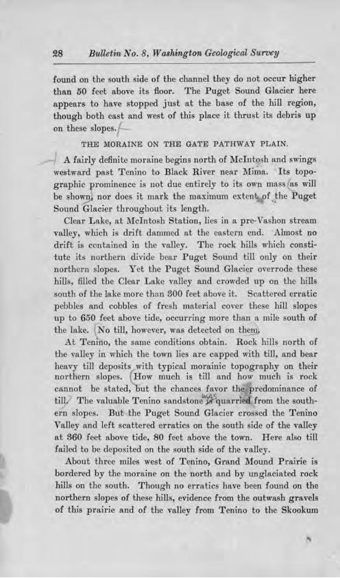
THE MORA.I 'E 01 THE GATE PATHWAY PLAIN.
A fairly definite morniae begins north of Mclnto h and wing westward pa t Tenino to Black River near Mima. Its topographic prominence i not due entirel to it own mass 8.-5 will be hown nor doe it mark the maximum extent pf . the Puget
ound Glacier throughout it length. Clear Lake, at Mcinto h tation lies in a pre-Va hon stt-eam
valley, which i drift dammed at the ea tern end. Al.mo t no drift is contained in the valley. The rock h-ill which constitute it northern divide bear Puget ound till only on their northern lopes. Yet the Puget Sound Glacier overrode these hill filled the Clear Lake valley and crowded up on the hill outh of the lake more than SOO feet above i . cattcred erratic
pebbles and cobbles of fre h material cover these h.ill slopes up to 650 feet above tide, occuning more than a mile outh of the lake. No tm, however , a detected on the1n,
t Tenino, the same condition obtain. Rock hill north of the valley in which the town lie are capped with till, and bear heavy till depo its with typical moramic topography on their northern slope . How much i till and bow much i rock cannot be tated, ut the chances favor the predominance of till. The valuable Tenino sand tone"'Ji\u rri d from the southern lope . But the Puget Sound Glacier cro . ed the Tenino , alley and left cattered erratic on the outh ide of the valley at S60 fe t above tide, 80 feet above the town. Here al o till failed to be depo ited on the outh ide of the valle .
About three mile we t of Tenino, Grand Mound Prairie i bordered by the moraine on the north and by unglaciated rock hill on the outb. Though no erratic have been found on the northern lope of these hills, evidence from the outwash gravels of th.is prairie and of the valley from Tenino to the Skookum

Glaciation of the Puget Sownd Region
huck at Bucoda, indicate that the glacier abutted again t the e hill at it ma.·imum, and forced drainage to take a circmtou our e that it abandoned e8.1'1 in the retreat. Tbe data on thi que tion are mon~ fully di cu ed in the following chapter.
The only known inci ion in the moraine ridge between the De Chute Ri er near 1\Iclnto band the Black Hills near Little Rock occur one and one-half mile cast of T enino and at Muna Prairie. The tran -morainic channel nea1· Tenino never carried a great volume of water aero from the north and the extensive outwa h gra,•el of the two Tenino- rand Mound route were t1ms depo. ited by drainage directly from U1e ice when it overtopped the moraine. The Mirna Prairie incision is virtually a complete breaking down of tl1e moraine topography perhap largely bee :u e practically all glacial drainage from Pu ... ct ouml, from the earl rece ional tage of ice retreat to the opening of the trrut at the north 11nd th de truction of Lake Ru sell pn ed aero the moraine at thi place.
orth of Tenino the moraine ri e to 550 feet above tide i50 feet above it ba e on either ide. An outcrop of hale appears in a road cut aero s it ere t more than 100 feet above the base of the moraine. The width more than the altitude appear to be a function of drift depo ition. It is two miles wide north of Tenino and a few mil farther west it increa es to a width of about four mile being in this portion without the rock outcrop at lower altitude, and broken into a number of eparate ridge.
The recent con truction of the hicago, 1 Iilwaukee & Puget Sound Railroad through thi region ha afforded a number of valuable cctions in the moraine. The railroad follows a route of e caping glacial drainage along the north ide of the moraine from Rocky Prairie to Little Rock where it u e the Mirna Prairie inci ion to cro to the outh of the moraine. Almost every cut how the fre h Vashon till underlain b decompo ed and tained drjft of much greater age and in many places al o by
rotted Tertiary hale . Con iderable commingling of f re b and

30 Bulletin No. 8 W ashingtcm Geological urvey
decompo ed materjal occar , the fresh drift in uch case being di colored b iron ox.id from the older material.
, a hon till i e:..-po ed in road and railroad cuts bebveen Little Rock and Mirna Prairie. On the we t ide of thi prai1·ie it overlie an old 1·edden d and deca ed till in a railroad gravel pit close to the ea tern ba e of the driftlc Black Hill .
THE BLACK HILLS AND THE l\JIORAINE.
From 1Vlima Prairi th margin of the Puget Sound gla ·al ch-ift ha an almo dfrect north, ard com· for nearly ten mile , and in that di tance ri e grndually higher on th flank of the Bla k Hill . Waddc]l r e.k i a outlH1•ard-flowing tream ju t within the ea tern mar in of the e bi1J emer ing from them on Mirna Prairie. The hill ro ufficiently high about it headwater and alonO' it a tern ide to ba1· the ice and drainage from the Puget ound Glacier for mo t of the tream s length. But anomalously tbi outh-flowing ream wa ice dammed at it exit from the hill and though the glacier never succeeded in enterinO' the valle , glacial drainage wa turned into it from the lower portion, and the vall filled with water until an outlet wa fonn we twud to edar reek. cattered glacial p bble are found jn the re idual oil on the lope of Waddell
reek valley lo an altitude of about 650 feet the altitude of the outlet to edar re k. Above thi height erratic material abruptly cea e . The highe t glacial drift found on the ea t lope of the hill in the icinity of the former dam i about 350
feet above tide though th ice mu t ha e been a high a 650 feet. ,/ The ea tern lope of the Black Hills is den el fore ted and
·ceedingly difficult to examjne. The pre ent tudy ha been content to locate the upper limit of the drift in a sufficient number of place to jndicate the general cour e and altitude of it margin. l\loraine ridge are not known anywhere about the Black Hill .
The re idual oil of the Black Hill I m triking contra t with the drift flanking it. It u ually con titu a deep red

Glaciati<m of the Puget S0U1T1d Regi(J'11, Sl
clay so completel co,•ering the rock in place that the region j de cribed b • the wood men a one of pebblele clay hills. Outcropping led e are not common. Tl,e log which are cut on the hills and dragged dmV"n the lope are uniformly meared with a coat of the unctuou. red cla .
The Puget ound Glacier crm dcd up on the north lope of the Bla k llills outl1ea t of ummit Lake to 1 460 feet above ea level failing by a few tens of feet to top the divide and
move down the valley of W add 11 reek from it head. Two moi:ainic terrac s lie agnin t thi northern lo e at 00 and 1,400 feet re pectivel the upp r one being indi tinct.
ummit or rooked Lake i due to a drift-dammed preglacial valJ who e former direction of di charge wa outhward, at lea t through the portion now occupied by the lake. The lake urface i about 420 feet above ea level.
The margin of tJ1e Puget ound Glacier i next known at the imp on col through which the gravcJs of thP Wildcat Valle
train pa ed and through wbi h 11 minor glacial lake di charged later. The upper limit of the drift wa not found here granite pebble being plentiful among the angular ba al fragm nt on the summit of the higher flanking lull 4150 feet above the col and perhap 95 feet above tide. It i probable that glacial ice crowded thrnugh thi col £or a little wa though no till ba been found outh of it.
THE MORAINE ON THE MATLOCK PATHWAY.
From imp on col the g lacier mnrgin swing in a wide curve convc.:· we tward a ro the l\ atlock Pathway to the outheastern foothill of the Olympic . Its po ition i recorded by a few till hill ri ing above th g1·avel plain which here dominates the topography. definite cour e may ome da be found in the e hill , but the pre cnt fore ted condition and the lack of road have allowed only a reconnai ance thu far and the moraine cour e i mapped on1 approximately . The till in the e hills i imilar in almo t all detail to that on the northern lope of the Bald Hills and to that of the ground moraine in
the region of the Puget ound rough . The uniformity of

32 Bulletin 1i. o. 8, Washington Geological Survey
character of the Vashon till of the Puget ound glacier is remarkable. Almo t everywhere, it i light blui h gray in color, arenaceous in texture, filJed with rounded fragments of rock which re emble b·ea:m pebble and which ar.e eldom striated or planed. It rarely cal'l'ies bowlder in its mas though uch are abundant on jts uxface in ome place . From the Black Hills to Matlock the till commonly how a large proportion of deep red cla ey mate.rial, intermingled with fre h pebbles. The gravel of the Wildcat valley train likewi e possess a reddi h color the suggestion of age which it gives being belied by the fr hne in the interior of the pebble . It eem probable that incorporation of re idual oil from the basaltic country rock i responsible for this coloration.
Lake ahwatz 1 lies in the most exteu ivc morainic country known in thi region. The general expre ion of the topography is identical with that about Clear Lake near the Bald Hills. Moraine hills here rise 50 feet above the lake urface on all side .
The moraine i next found at Lake Cushman, in the Skokom.i h River valley. It cour e between Matlock and Lake Cu hman wa doubtle controlled by the rock hills alona the north side of the Matlock Pathway, and it i thu mapped.
CONTACT OF PUGET SOUND .AND OLYMPIC MOUNTAIN GLA-CIERS.
The gene j ol Lake u hman is intimately related to the Puget Sound Glacier. The lake lie in the couTSe of the kokomish River at an altitude of 800 feet l1emmed in by mountain walls except to the east, where a broad drift plateau, from 400 to 950 feet above tide, lies between it and Hbods Canal. Puget Sound drift is abundant over tbi plateau, and the p1·e ence of granite from the northern Cascade Mountain within le s than a mile of the lake proves that the Puget Sound Glii ier pu bed up to the very mouth of the Skokomi h River' mountain valley. Though the drift has a morainic topography clo e to the lake, there i no trace of Puget Sound glacial material along the lake.ward slope ave where a stream of some length enters from the surface of the drift plateau. On the contrary, t~e rock types

Glaciatfon of the Puget Sownd Regio1i SS
hown on the lope facing the lake are foreign to the drift deposited by the Puget Sound Glacier.
The valley of the kokomi h River i thu ee.n to be dammed by a great deposit of the Puget ound Glacier which here crowded up the river valley and hcld back the local glacier that normally would have deployed in the Puget ound basin. The deposits of the local glacier in the kokomi h Valley give the lakeward face of the dr.ilt dam its different c11aracter. A till darker than that of the Puget ound Glacier po e ing angular rock fragments of kind entii·e]y diffe1·ent from those of Puget ound drift lie back of Lake Cu bman on the lopes of Mount Ellinor about 1 300 feet above tide. It doubtless is a depo it of a local glacier which occupied the Lake Cu hman ba in of today.
Views of Lake Cu hman and vicinit from the trail up Mount Ellinor show the relation d cribed above al.mo t with the clearne of a diagram. From the soclllled Hnlf Way Rock" along the trail it require 01tly a slight effort of the imagination to see below one the dammed-ha k Skokomisb Glacier oppo ed by the mightiei· Puget Sound ice mas which crowded westward against the mountruns.
Lake Cu hman in early po t-glacial time was much larger than at present. The Skokomish River j rapidly filling it with a delta which now has a greater area than the portion of the lake remaining. Incj ion of the morainic dam ha lowered the lake level probably as much a 100 feet. At it former altitude the lake must have reached con iderably farther back up the river valley. Stratified clays of the former higher lake level are n'!)o ed along the tage road near the ferry, and a fine serie of river terrace i vi ible from thi road a few miles below the lake.
It has not been practicable to determine clo ely the form and position of the Puget om1d Glacier on the ea t face of the Olympic Mountain . Granite pebbles exi t at least four mile up the valley of the Du ewallip River, and no granite in situ,
-2

34 Bulletin No. 8, Washitngto'l'I, Geological Suruey
ha ever been reported from the lympic i\lountain . The Puget Sound drif cm,er th region we t of Dabop Bay for fi e miles or more back from the water. It also con titute the surfa e material on Quimper Penin ula about Port Discovery, and between Port Di covery and Quilcene all of which are in the tructm·al valle and a part of the drift plain.
GENERAL CONSIDERATIO 1S.
Wil1i found di·if t of the Puget ound Glacier on the northern flanks of l\Iount Rainier, 1,600 feet above ea leveL The writer
V ha found an upper limit marked by morainic ridging on the we tern lope of R ainier foothill country at l,!WO feet, near EatonviJle. On the north rn -flank of the .Bald Hills, the highe t known err tic are at an elevation of 1 !1l9!0 feet, though the moraine j about 800 feet lower. ear Tenino, the highe t erratic are 650 feet above ea level , hile the moraine ummit doe not reach abov 550 f et. The e cattered eITatic in ome ca e ma ha e been tran port d by floating ic in mar
ginal lake , but in other ituation , the glacier undoubtedly 1·e t d at their altitude on the hill lope though con iderable bodie of till failed to be depo ited ther .
In the plain which lead outhward to the Gate Pathway the moraine reaches it lowe t altitude. orth of l\Iima Prairie it lie about 175 feet above ea le el though a ha been noted thi low altitude is in part due to the ero ive action of e caping glacial drainage. Yet ince the a hon till de cend belm 1SO feet in thi region it i po ible tl1a.t the pre-, a hon urface wa lower here than at an other place in the enti re glacial periphery. Though the urface i till lo,,·er to the outh tl1e glacier did not advance beyond Mirna Prafrie.
The ice margin a cended along th ea tern face o/ the :Black Hills from .M'ima Prairie to the region of ummit Lake, and po e ed a maximum gradien of SO feet to the mile for that distance. The altitude of 1 460 feet, reached by the glacier on the no1-tlnrnrd angle of the :Black Hill , i more than 200 feet higher than at any other point along the entire outhern margin here facing d1·iftle country. The moraine in the

EATON'IILLE 1260
LAGRANOE. I ?20
MclNTOSH 660
LITTLE ROCK ISO
SUMMIT LAKU'l6
SIMPSOH 9SO
CLOQUALLUM 4SO
MATLOCK 4SO
LAl<E. CUS\lMAH '3SO
ci
~ .. ~ c C
~ ~ ~
= 0 .., ~ > "' QJ .Cl ....
7 ... Cl1 0 _J ., ,a a
0 QI a::
!/)
... c {;;

S6 Bulletin No. 8 Washington Geological u1"Vey
Matlock Pathway lie about 1,000 feet lower than thi higbe t point, that in the Gate Pathway about 1 SOO feet lower. (See Fig. 1.)
The thicknes of the Puget Sound Glacier north of the moraine region is not definite]y known. ince the neighboring mountains were glaciated by ice of local derivation, the height of glaciated urface can be no criterion. or can the height of erratic material serve our purpo e, save where such material i po itively identified a foreign to the whole adjoining mountain region which might have contributed to former glaciation. Mid-ha in hill of ufficient height to have risen above the glacier are nece ary for an accurate e timate and such do not exi t.
A hill which answer the purpose to some extent is l\ifount Issaquah, 15 miles east of eattle. It is an isolated peak about 3,000 feet above ea level, without the usual mantle of finely comminuted rock fragments found on unglaciated hills of the region. The comparative fre hne of material covering the top is in harmony with the pre ence of scattered erratic pebbles on the summit the number of which increases on the lower lope . Both indicate glaciation of the peak b the Puget
Sound Glaci.er. ince Admiralty Inlet attains depths of nearly 1 000 feet west of Mount Issaquah, the total thickne of the glacier in the latitude of Seattle was at lea t 4 000 feet.
The only evidence of ero ive action of the Puget Sound Glacier near its margin are a few in ta.nces of incorporation of weathered material from the pre-Va hon urface into the £re h Vashon till. Knobs of old drift and hillock of decayed hale are seen beneath the Va hon till in many place with no suggestion of deformation from thru t of the overriding ice. Thi , of course, i not true ome di ta.nee back from the moraine.
Pre ent data how that the Vashon glaciation of Puget Sound, probably to be cqrre1ated with the Wi con in glaciation east of the Cordilleras, was fully as extensive a any preceding glaciation of the region. The terminal moraine from Mclnto h aero s the Gate Path,vay plain to Little Rock overlie a former region

Glaciation of the Puget Sound Beg-ion
of low hills of old drift, some of which i undoubtedl_y till . o old till has been found south of the moraine limits, and no obviously old and weathered erratic are known in po itions indicative of former and more extensive glaciation.

CHAPTER III.
EXTRA-l\IORAINIC OUTWASH OF THE PUGET SOUND REGION.
SYNOPSIS.
THE PRE-VASHON R ED GRAV.ELS OF TEtE CHEHALIS V ALLEY.
ADMIRALTY GLACI.ATION AND THE COWLITZ VALLEY.
VASHON GLACIATION AND 'rRE CHEHALIS VALLEY TRAIN.
SKOO.h..'UM CHUCK GRAVELS.
STONY POI.NT VALLEY TRAL.'f, T .EN1No-Gn,u,'l> MouND GLACIAL DRAINAGE R ouTES,
GATE PATHWAY.
GATE VALLEY T1tAJN.
OuTWASH WEST oF THE B LACK lirLLs.
l\focx CHEHALIS VALLEY T .nAIN
CLOQUALLUM VALLEY TnAIN.
SATSO:P VALLEY TRAIN.
ECONOMIC PHJ\S.ES OF THE CH.EIIALIS GLACIAL GRAVELS.
VASHON GLACIATION AND THE COWLITZ VALLEY.
l\UNERAL LA.h..'"E GA.P. NAPAVINE Dl\11DE,
NEWAUKUM R1VER CoL.
In the two known glaciations of the P uget Sound Basin, the invading ice came from the Cordilleran Glacier of British Columbia, and advanced sufficienUy fa r southward between the Cascade and Olympic mountains to close effectually the basin at the north. Water discharging from the Puget Sound 1·egion was forced into stream valleys lying south of that basin . There are two river valleys to be considered in this com1cction : the Cowlitz and the Chehalis. T he Cowlitz River heads in the glaciers on the south side of .l\Iount Rainier and flows west to the structurnl valley of which Puget Sound is a pal't. H e!'e it turns south to enter the Columbia. There are two low areas across the northern divide of the Cowlitz Valley where glacial drainage could have cnte1·ed it from Puget Sound. The Che-

Glacia.ticm, of tlie Puget ou11il R egion 99
hali , aJle head in th low coa t range outh of t11e Olympic de cend their ca tern lope to the . ame tructurnl valle which it enter 15 mile north of the entrance of the owlitz , alle . Her it ha a northward cour e for 10 mile and then wing about to a we tward cour e outh of the Black ill whence it continue to th Pacific. The hchalis Valle li closer to Puget ound than the owlitz Yalle · and betw en it and PuO'
ound there are everal gap in the rock ]1i11 two of con iderable width. The e gap afforded ample opportua.it for the entrance of glacial water in the valley.
THE PRE-VASHON RED GRAVELS OF THE CHEHALIS VALLEY.
The maximum c..:tent of the Pug t Sound Admiralty Glaci r
i not .known. Id drift, pre umably of dmiralty a e und rlie the Va hon terminal moraine in the vicinity oC Littl Ro k, but i not knO\ n beyond that locality. There i , how ver an old gravel deposit in the h halis alle found at interval from Gate to tl e ocean and lhe.it e 111 ng U1e oa. t ,·hich i ve1·y probably Pl i tocene in age, and a portion of \1·hi b ma.v be outwa h of the dmiralty glaciation.
The mo tea tern remnant of the old gravel known at pre cnt i at Helsing Junction on the outh ide of the Chehali Valle oppo it Gate where the Oregon-Wa hington Railroad and
avigation ompan and the hicago 1 lilwaukce and Pug t ound Raih a.y unite on their common tl·ack down to Gray
Harbor. The ravel cap - the bluff above the rai1wa grade along the river for two mile . It maximum thickn i 35
feet and it overlies the Tertiary hale unconformably with the contact about 70 feet above the river and about 190 feet above tide. The gnwel i deep} tained by iron oxide po c -ing a true ' fenetto ' color almo t tlwoughout. It pebble arc
o oftened b dcca that a blm of the hammer \Vlll break them ea ily. l\Io t of them can be carv d with a lrn.ife lik ha1·dened cla . The bedding i horizontal. r o granite, and no metamorphic or sedimentary rock were found among the pebbl , the depo it being compo ed almo t entirely of fragment of ande itic lava.

40 Bulletvn No. 8, Washington Geological urvey
A deposit of catterecl gravel on the north side of the Chehalis River lie a mile we t of Oakville at the wnmit of a quarry ection, perhap 160 feet above tide. In th.i gra el, granite js
abundant. The pebble are somewhat oftened on the uTface, but are firm within. The are le s tained than the I- el ing Junction gravel , appea1·1ng fre her al o than the old drjft near Little Rock. The are however older than Va hon outwa h which lie a a broad terrace at the foot of the cliff.
There are several occurrence of the red gravel about Elma. It i found on Wildcat Creek at VVhite s Mill, and here po e es current bedding dipping outhward down the p1·e ent valley in which it lies. It con titutes the larger part of a great terrace which form the north side of the Chehalis Valley from Elma to Sat op, with a ummit level of about 59l5 feet above tide. It is well expo ed a mile and a l1alf we t of outh Elma on the joint lin1:: of the Oregon-Wahington and Chicago, Mih aukee and Puget Sound railway . Here its ba e i 100 feet abo e tide and it summit con t.itute a considerable plain w·face probably to be correlated with the terrace on the north side and vi ible for several miles from the north ide of the valley (Pl. I, Fig. 9l). The decay and taining of the gravel it1 this cut are comparable to that of tbe Heling Junction gravel , which they re emble also in composition. More of thi earl gravel filling remains in the vicinity of Elma and Sat op than at an other place in the Chehalis Valley. Thi al o appear to be the onl place where the surface of the filling i till pre erved.
A mile we t of at op village, a prominent tabl.e-topped pw· projecting from the nol"th ide of the valley (Pl. I Fig. 1)
i compo ed of thi red gravel. It summit is 130 feet above tide and its thickne is about 90 feet . The at op River, which enter the Chehali Valle here, has eroded 15-20 feet belm the ba e of the gravel a.nd has expo cd thejr unconfonnRble contact with the underl ing Tertiary and tone. On the top of the terrace the red gravel ha been excavated for road material and is apparentl identical in degree of decompo ition, in tructure and in compo it ion with the Hel ing Junction and the

\VARUINO'l'O.N • t: I •oit·Ar •• 11 1n•1-: , · r~1...ivr1-: I
Ji'rn. 1. 'l ' ll e Satsop n cl ,rnv 1 T n ae. ·r1t ,• hl!?h re(] gr1rv,,1 t l'l'lll'f' n th s utll 1(1,• or tlw f" l1~lrnlls t•nu h,• rul nll) ••·••ll.
Fu:. 3. ·lion of Red rav I In at-op Terl'a
'l'hl• •ru vel l di' ,olorr I o.llo,•r lhl' lrregulnr tr1111 \'Prst• lhw. buL I 11 c 01ul'11 derored u" brlow. 'urr,•nt h ding dip with th~ pn•lll'DI rn11,,,,,

Glaciation of the Puget Sownd Region 41
South Elma gravel . Locally it urface part are completely <lecolored to a depth of se eral feet, but it decayed character how it to be the same depo it as the re t of the terrace, and not
material of later age. ( ee Pl. I, Fig. S.) Though the height of thi terrace doe not conform with that of the terraces about Elma, yet the imilarity of material and of alteration are convincing evidence that they are portion of the same depo it. The plane of the terrace a mile west of Sat op eems be t explained a due to ubsequent ero ion and not to original deposition.
At the down tream angle between the Wyn.ooche and :behali valleys a red-stained and decayed graveJ i expo ed along the highway. The ummit of the gravel i about 110 feet above tide, and it bears approximately 50 feet of ellow clay above it. The bed of the gravel are partly horizontally bedded and partly fore et with dip down tream. It agrees with the previou ly described deep graveJ depo its in its red color, its softened pebbles and it lack of material which can be unhesitatingly identified as having come from a Cordilleran glacier.
Old gravel, oftened and deeply tained is e .posed in many cut beb·een l\Iontesano and Aberdeen. The structure is either horizontal or fore et; where the latter, the dip i down the present valley. Gravel of the same character i found for everal miles along the Wisbkah River above it mouth. It also occur in exposures at Cosmopoli , on the outh ide of the head of Grays Harbor but there i a greater variety of rock represented than in mo t exposures. Granite, however, was not found.
The be t expo m·es of this red gravel in the Chehalis Valley are in the sea cliff on the north side of Grays Harbor, which is the drowned continuation of the river alley. The maximum thickness here expo ed is about 100 feet with the base above high tide in but one place. The bedding of the gravel i prevailingly horizontal though foreset beds with westward dip are of common occurrence and locally con titute nearly the whole st1·ucture. Bed dipping at the same angle eastward are seen at a few places. In most of the thicker section , the

4!~ Bulletin No. 8, Washington Geological Survey
taining is perccptibl greater neu the top the ba al stra.ta being in place ahno t u.n tained. The a.me gradation i hown in the oftening by deca . ear the ite of the old Gray Harbor Cit , a median bed of clay lie behvecn two gravel member . Ero ion urfa e eparate the three. Farther , e t, one ection how everal alternating bed of red clay and red gravel each tratum averaging four or five feet i_o tnick.n.e . Jame I land
i a picture que tack of the red gravel , 1 ing off the nodb bore of the Hru·bor.
R d tai.ned partiall decompo ed and partially cemen ed nwel of the rune character a that of the hehali alley
· known along the Pacific oa t north to the Strait of Juan de Fuca. B tween Gra Harbor and foclip at lea t it compo e a foreland about U mile wide.
Wherever the ba e of thi old gravel i een, it rests unconfom,ably on Tertiary formation . In di trihution it i limited to alle s and the coa t line. Di tortion of the underlying trata i common but no di tortion i known in the gravel it elf ave at outh Elma, where a Jjde ha evidently been the cau e.
The conclu ion cems probable. that the e red gravel are Plei tocene tream depo it in tbe Pliocene or early Plei to ene hebali Valley, and on a Pliocene. or early Pleistocene wave-cut coa tal he]f. Their decay and taini.ng are omewhat greater than that of known Admiralty gra el in the Puget ound ba in and with one exception no gra ·te or other rock ha been found in them by which the could be identified with Puget
ound glaciation. The one exception the akvillc quauy e tion it elf fail to confo1·m sati factorily to the other e."i:
po u.re . 1 or the pre ent, therefore, we mu t conclude tl1at ufficient
evidence is not ln10wn to shm the e old Plei tocene gravels of the hebali to be related geneticall to the Admiralty glaciation of Puget ound or to be glacial at all.
ADMIRALTY GLACIATION AND TEE COWLITZ VALLEY.
iuce the pa e from the Pu.,.et ound to the owlitz alley are higher and farther di tant than those of the hehali , it

Glaciatio-n of the Pziget Oll!nd Region 43
seems unlikel that th<! Cowlitz received outwa h of th.i glaciation if uch failed to entex the hehali . o old drift of nny kind i :known at pre ent in the owl.itz Valle .
VASHO GLACIATIO AND THE CHEHALIS VALLEY TRAI:'11.
KOOK.UM HU K Ga VEX.. The kookum huck Ri"er head in the un ur eyed Huck) berry i\Iountain which lie outhwe t of Mount Rainier between Puget ound and th owl.itz River, and flow we tward to join the h hali. at C ntralia. It roughly paraJlel the Puget ow1d terminal moraine for ome di tance, lying a few mile outh of il. It. course, however i ,vith:in th Tertiary bill region outhea t of the Puget ound bu in. For mo t of it length the e hill ro e sufficient} hi<>'h to prevent entrance of di-ainage from the glacier which pu bed up on their northern flank ·. The tr am valle r , here thu protected howev r po e e a con idernble quantity of grnvcJ which appear to ha e been o rapidly introduc d that del'ang -ment of drainage followed. An abandoned farm known a 1\Iul
queen (Fig. fl) lie ome mile up the kookum huck alley on an alluvial flat among the rock hill . Immediately below thi the tream enter a gorge , ith ,,e1·tical wall appearina to have been fairly recent! upcrpo. ed on a rock pur in to which it l1a cut. uch an incident ould logically follow ero ion of a valley train. But a car ful ea.rcb for ix mile along thi length has failed to bring any Puget ound d1·ift material to light and the flat at 1\Iulqueen lie 180 feet above the Puget ound moraine directly north of it. The filling whate,·er it our e i not to be referred to the glaciation of Puget ound.
T02'"Y PoINT VALLEY TnAIN. Tl1ere are tlu·ee gap through ,vh.ich Pug t ound outwa h did enter the kookum huck Valley, two of them of con iderable ize. ( ee Fig. i.) The mo t easterly of the e will be de ignated the ton Point gap. At th max.imum of , a hon Jaciation outwa h from the entir margin of the glacie1· lying ea t of th.i gap entered the kookum huck throucrl1 it. The outwa h built a gravel train which eontain many granite pebble and other Puget ound drift ma-

'-I
I ' J
1-
\- -- \ ,_ -----
I-The G~tet'a\hway i-Ten·,no -Bucoda Route
_, I
-
~- Glacial Lake SouU, of Mc: lnto5h 4- Stony Point (h4nnel s- LaKe Cheh41is 6-Glac·,al Lake of Y'laddells Creel(
ralungo trow the Ea.stern LQbc ot Puget Sound Glnclcr, nt Its Marl.mum mirteut.

Glaciati01i of the Puget Sound Regioo 45
terial . The coar ene of the gravel i probably re pon ible for its unforested condition. The altitude of th col in the Stony Point gap ha not yet been accurately determined, but it lie below 350 feet. Clear Lake at Mclnto h ation altitude 346 feet wa never u ed by marginal drainage though as the ice withdrew from it maximum tand the lake ,,alley la in o favorable a po ition and at uch an altitude that the gap was earlier held to ha,•e been una"oidably o u cl, in pite of the ab ence of glacial gravels. The only e},,--planation for outwa h holding to the tony Point channel until a 1·oute on the north ide of the hills north of Clear Lake was opened westward is
that the tony Point channel was lower t],an the lake. Hence the confidence in the inference regarding the altitude of the gap. From the col to Bucoda along the valley train the di -tance is 11 miles, and the descent cannot exceed 100 feet. This i a grade of less than 10 feet to the mile.
A few miles west of the Stony Point gap the glacier clo ed a northward descending valley and produced a lake who e discharge was outh to the Skookum Chuck. But since this lake caught all oubvash gravel , the gap u ed b the outlet was urumportant in building the kookum Chuck valley train.
TENINO-GRAND :Momrn GLACIAL DRAINAGE RouTE . The Tenino-Bucoda gap is the large t of the three which led glacial water to the kookum huck. Together with the kookum Chuck Valley below the point of junction, it con titutes a through valley from Tenino to the Chehali at entralia. In thi there wa probably a preglacial lO\v divide. The greatest con triction occur ju t outh of Bucoda, and it is po ible that the preglacial Skookum Chuck turned northward near that town and flowed to the depre sion now occupied by Grand Mound Prairie. A triangular driftle area i sunounded by the Tenino-Bucoda-Centralia gravel train on the outhea t Grand l\Iound Pn.irie on the north, and the gravel-filled hehali Valle on the southwe t. ( ee Fig. fl and Pl. XXIII.) Outwa h from the vicinity of Tenino which took the Bucoda route rounded the outhern tip of th:i area and returned to Grand found,

46 Bulletin Washington Geological m--vey
from , hence i wa carried to Gate and down the hehali Valley. · The di tance from Ten.ino to Grand found by thi cLrcuitou route i 16 mile , and the de cent of the gravel floor in that di tance i I9l9i feet. long Grand i\Iound Prairie on the north side of thi area, the di ta.11ce i nine and one-half mile and the route i traight. utwa h , ould never have taken the longer rou e ,vith o low a gn1.di nt if the more direct route along Grand :Mound Prnirie had been open. The only cau e , h.ich could have operated to clo e it i advance of glacier ice from the po ition of the terminal moraine borde1·ing the prairie on the north, until it impinged on the triangular hill area. Though no rrntic material ha been found on the northern lope of the e driftle hill , the grade of the gra el outwa h
make it obviou that the Puget ound Va hon Glacier at it ma.ximum actually reached thi po ition.
The grade of thi Tenino- entralia-Grand Mound floor i surpri ing]y variable. Between Tenino nnd Bucoda it de cend ix feet to tl1 mile; between Bucoda and Centralia nea.rl thir
teen feet to the mile; and from entralia to Grand Mound the de cent i but five f et to the m'le. Tm la t gradient i probably of no value ince the vjcinity of Grand ]\found received grav l from the north after transportation b the Tenino-
entralia route cca ed. But he change i~ gradient near .Bucoda ju a gravel train which today floor the entire valle and obviou 1 i practically the ame s. when abandoned by the glacial ri er need explanation. T,vo hypoth are ad-anccd · one that the tony Point gravel train which enter d
the through valley at Bucoda wa of o much greater olum that it vfrtually damm d the T nino-Bucoda length the other that a pre-Va hon rock divide exj ted in the omewhat constricted valley jut outh of Bucoda, and erved to back up the gravel to form a low gradient.
Fragment of a hlgher grn.vel filling lie 310 to 39l0 feet above tide on both ide of the alley at Tenino, and scattered glacial pebble occur up to 360 feet . The fl80 foot terrace on which the town is bui]t i continued without break toward Bucoda but

Glaciation of the Puget ownd Region 47
end abruptly , ith a 30-45 foot de cent to Scatter reek alley, whlch leads we tward along Grand :i\Iom1d Prairie. mile or so wes of Tenino only a. broad median ridge in the axial part of the prairie remain at the lenl of Tenino the lower urface el ewhere recording the later work of glacial drainage
along the clir ct route from Tenino to Grand l\found. The prairie urface i undulating and no one figure can be given for it gradient. From the broad bottom of catter reek at Tenino, to Grand Mound however the de cent i not quite ten f et to the mile and Lhi may be taken a an ap roximation of the gradient of the gravel along Grand l\lound Prai1·ic.
T.aE G.ATE PATHW. Y . The Gate Pathwa from Puget ound to the he.bali River i full iaht mile in \\'idth. It i interrupted b the i olat d hill from which the tat.ion and the prairie of Grand Mound are named, and by a plateau-.like outlier about e. mile in diameter near Roche ter. The gra\!cl plain of Va hon outwa h completely urround eacl1 hill . The plain i highest on the eastern side of the pathwa , and lowest on the we t at Gate thi being becau e glacial water entered it on the ea t and northea t and flowed diagonally aero s to the we t and outhwe t, and al o becau e a the volume of e caping wut r waned it became concentrated on the we tern portion, perhap lowering thl till more. The altitude of the mounded gravel prairi at Gate i about flO feet abo"e tide, and it i 40 mile di tant from the mo t we tern occurrence of a hon gra el in the hebali Valley, which lie nt 3 feet above tide. Furthermore, gravel terrace which contain Puget ound a hon material ituated far dmvn the alle lie a high or nearly a high,
a at Gate. It i imm diately obvio that no one simple gravel train can embrace the e diver ely ituated gravel terrace , or could extend that di ta.nee with a low a gradient a two feet to the mile. The e ·planation i to be found in the exi tence of tributary valley train which head in the outwash plain of the we tern lobe of the Puget ound Glacier and which enter lhe hehali \ alley from the north. The e brought in gi·eat quaotitie of gravel and each created virtuall a new

48 Bulletin No. 8 Washington Geological Survey
valley train in the Chehalis . In each of the e tributary train the entering gravel wa hjgber than the urface of the outwa h gravel which had entered ome di tance farther up the valley. By relays, a it were, the Vashon gravel succeeded in reaching the head of tide water on the Pacific Coast. ( ee Plate XXID for areal di tribution of the e differ nt gravel . )
GATE VALLEY TRAIN. The remnant of the Gate train constitute au almost continuou terrace urface from the town of Gate we tward to Malone where it blend with and becomes ob cured by the ounger Mock hehali train. Gate or Baker' Prairie, Oakville Prairie, edarville Prairie and Ford Prairie are portion of ~he Gate train. Smaller fragments al o e.ci t in the valley mouths of Cedar and Porter creeks.
The topoaraphy of about half the prairie area of the Gate train j remarkably mounded. The genesi of these mound i treated in hapter V of thi paper. Their presence involving a relief of a much as 30 feet, with many delta-formed terrace and other irregularitie of doubtful origin make the construction of a sati factory profile for thi train almo t impo ible. Under the limitation of thi study it ha not been attempted. In general however the gradient of thi train is urprisingl almost unbelievably low. The longe t di to.nee between bench mark on thi train j from Gate to Porter. Railroad altitudes are here depended upon, and they give a .,.radient of ix and onethird feet to the mjle. The gravel, wherever shown, is horizontally bedded or po es e a westward dip, and the material was undoubtedly transported by running water to it pre ent position.
In con ideration of the minimum grade a gra el train may possess, the pre ent Chehali River grade is in tructive. Thi stream de cends about four feet to the mile from Rel ing Junction to at op a~ the head of tide water, and is today weeping the rehandled outwa h gravel ea.ward along thi tretch during flood ea on at least. The glacial Chehali , recejving at Gate at lea t half of the drainage of the Puget Sound basin south of the Strait, was thus presumably capable of carrying the gravel of thi valley train even on the low gradient noted.

W.\!HIING'J'OlS (h:OLOGICAL $rRVEY B "OLLETtN No. S PLATE 1 1
F10. 1. Mound Section in Northern Pacific Railway Pit, Mlma Prairie. Double co n1•ex IortD of the bluck slit. Clean stratlficu gr1wel below.
F 10 2. Mound Topography on :Mirna Prairie.

Glaciati()'TI, of the Puget Sownd Regio'll, 49
Terrace occur along Porter reek for a mne above its junction with the Chebali . Their material i entirely of local derivation but they are believed to be contemporaneous with deposition of the Gate train. Here the grave1 flood dammed the tributary alley which in con equence wa aggl'aded by stream debris brought down from its unglaciated upper course. Though Porter Creek is the only valley l"llown at pre ent to how this filling it is to be expected in man tributary valley of that portion of the Chehalis aff'ected by glacial outwa b.
OuTWASH WEST OF THE BLACK HILL . The function of the Black Hills in the production of the double lobe of the Puget Sound Glacier ha been noted. In crowding up on the northern flanks of these hill the glacie1· o ertopped low divide in two place , and ent lender train of fre h, light-colored glacial gravel southward along the tream , alleys. The gra el of these trains i in remarkable con;tra t with the black pebbles and deep red re idual oH derived from the ba altic hills.
THE Mocx CHERAI..ni VALLEY TRAIN. The mo t eastern of the e valley train is that of the Mock Chehalis, a creek entering the Chehali at Malone. Two terraces of glacial gra el occm· at the mouth of Porter Creek and Cedar Creek but such are simply remnants of the valley train filling which entered by the Gate Pathway, and these creek valley above the.ii- mouth are entirely without glacial gravel. The l\fock Chehalis train begin somewhere in the fore ted region of Summit Lake.
o altitude are known in its valley, and it grade has not been determined. It e..x:i tence ha determined the location of a number of farm along the stream while both Potter and Cedar Creek valleys lacking the flat bottom are yet covered by the primeval forest or but party logged off, and have no farms above their mouth .
Mo t of the Mock Chehali train till bears the original fore t, and no higher terrace }lave been found except at Sine and again near the head in the vicinity of Summit Lake. Between Sine on the Mock Chehali and McCleary, on Wildcat

50 Bulletin No. 8 Washimgton Geological Survey
reek, a tributary of the loqua.llum, tbe rock hill !ail, and a. broad fairly level area ri e onl a few ten of f et above either place. McCleary lie on the outwa h plain which pow·ed down Wildcat reek from the vicinity of Summit ( or Hillg1·ove). The pre ence of cattered granite pebble among the uhangular ha alt cobble which CO\ er the low djvide prove a former connection between th Wildcat B.Dd l\lock behali train and toaether w-itl1 a terrace 30 f~t high ju t ea t of
ine and other terrace near ummit Lake, prove the pre ent :Cock Chebali t ·ain to have been originally aggraded to a level
higher than it now po. e. e . Between Malone and Elma it j probable that commingling
of gravel from the Gate and l\Iock hehali train occurred· but the Gate train her lo t its individuality, and in two 01· three mile below falone the gravels largely lie too high to po ibly come into the Gate train profile.
igni.ficant terrace lie two miles ea t of Ehna on the highway along the no.rtb ide of the river. It altitude i 80 feet, higher than the large loguallum train entering at Ehna, and higher than the l\Io k he]1ali train where it i ue at l\falone. Inclined trata shown in its ections dip con i tently westward. Thi rem.ove the po ibility of the terrace being a portion of a former fan-like preading of the loqual1um train which enter the hel1ali just below it. It i confidently referred to outwa h tlwough the lock hehali , befor tl1e filling of that valley was eroded by later glacial drainage to it p1·e ent dimen ion . It thu corroborate the evidence of the terraces at and abo e ine.
THE CLOQU.ALL l\[ V AI.LEY TnAIN. The fourth vane tl·ain
to enter the :hebali River valle i that of the loquaUum, near the mouth of which Elma i ituated. Thi i compo ed of two di tinct uniting train · one from mnmit, or Hillgove in tl1e a!Iey of ildcat reek the other de cending the loquallum prope ·. The Wildcat men ber probabl tl1e laracr is th second train to the "'e t ruch wa poured aero the Black Hill the gravel floor a cending witl1 a con taut] increa ing gradient northwa1·d to imp on col a definite notch at the Yall y

Glaciaticm of the P11,get onnd Region 51
head where the Puget om1d Ya hon Glacier reached it maximum. The loqunllum member begin in the broad plain which wa pread out in front of the we tern glacial lobe in the l\Iatlock Pathwa .
The head of the Wildcat train i a uniform plain evera.l square mile in extent, broken b a few rock hHl which ri e like i land above the gravel. ' o tream have yet inci ed it in the vicinity of l\!c 'lear and ummit. beautiful vallc y tern i developing on the middle portion, and ravine head are rapidly adnm ing into tl1e undrained upper tra t. Farther down the 'N1lle both the loquallum and th ildcat have cut tl1rough tl1e gravel to th widerlyina earlier Ple.i tocene red gTavel and Tertiur rock.
From railroad altitude i.ncludiug ome from a logging railway the Wildcat train descend more -than 40 feet to the mile between Simp on and ~a. The e united train extend out into the h hali Valley in a broad unbroken terrace which reaches down the valley a far a at op tl1e grad decreasing to even and one-half feet to the mile between Elma and at op though a11 ection in thi length how current bedding dipping wet\ ard.
o po itivc evidence ba been found for an earlier higher m·face of the C1oqual1um train or either of it member except
the cattered granite pebble between 1\Ic leary and i.ne. The signifi a.nee of thi fact will be di cu ed later.
THE ATSOP VALLEY TRAIN. The outwa h in the fatlock Pathway i largel covered with fore t . It po cs e but few pro.me none of them comparable in ident with tho e on the outwa h of the ca tern lobe. The altitude of thi rout i known onl approximately from un·ey of the logging railwa both fatlock and Cloquallum being given 00 fe t above tide. The width of the plain in the broad gap i probably qual to that at Gate, about eight or nine mile though the
fore t and the wn te of logging where the heavy growth ha been remo"ed have prevented more than a reconnai ance of the region.

5~ Bulletvn No . 8 Washimgton, Geological Survey
The outwash plain and moraine of the Matlock Pathway are drained by e eral ea tern branche of the Satsop River, and by Cloquallum reek. The west fol'k of the Satsop never received outwa h from the Puget ound Glacier.
The valley train heading in thi outwa h area and u'tending down the Satsop and tl1ence down the hehali i the longe t of all the extra-morainic train of the Va hon Glacier of Puget
ound. It also originally lay hjgher above pre ent valley bottom than any other, and further, ha been more largely de-tro ed by post-rrlacial erosion. Its lowe t level con titute a
terrace reaching from a point two miles above the junction of the Satsop with the Chehali Valley, to Monte a.no, a distance of seven miles. At lonte ano terrace of fre h glacial gravel with stream bedding dipping , e t,vard lie at 40 and 65 feet above tide. In. the north part of the city i a terrace 120 feet in altitude, in which wells without exception find fre h gravel beneath a few feet of yellow oil. Though no pit exist in this terrace to show the material, there can be little doubt that its gravel i of Va hon age. There i no higher fre h gravel in the Chehalis Valley below Gate.
Half way between Montesano and Aberdeen the highway for about two mile traverse a terrace surface well above the valley bottom one mile of it being 80-85 feet above tide. Its topography practically unbroken by rs.vines, i indicative of youth. ections how the material to be typical Va hon crlacial outwash, with many fresh granite pebbles. The stream bedding records a westward cunent at the time of deposition. ome exposure how a peculiar mingling of stained and an tained gravel, trata or masse of stained material alternating with fresh granite-bearing gra el. The staining is irregular and neve1· very dark. It may perhaps be due to local infiltration of the fine reddish alluvium which covers the tei:race top, and po -sibly to the incorporation of older Pleistocene red gravel which underlie thi terrace.
The be t residence district of tl1e city of Aberdeen is situated on a gra el terrace whose ummit i S0-35 feet abm•e sea level.

Glaciation of the Puget ownd Region 53
The gravel i perfectly fre b and un tained in ome ctions, but near the ba e of the hill lope again t which the terrace lies, it material i red like an old gravel lhougb the taining i not o deep or uniform. Granite pebbl nre not common, but can
be found and are firm and unweathered. The bedding i horizontal w1th a f w trata dipping we tward. The p bble arc noticeably mall r than in gravel near r the moraine.
On the hill lope abo,,e the terrace, con iderable tre t grading ha revealed many tream-worn pebble in the residual arth, and tained by it to it own hue. lide and creep seem
to have interrupt d any continuity which ma have exi ted originally, but a con iderable b d lie ba 1 of the old hi h chool bui]cling, ea t of the ravine back of the t. Ro e cademy. It i 90-95 feet above tide. Some p bble in 1t are fairly fre h, but mo t of the material i weathered.
The e high gravel terrace along the lower hehali in places actuall overlool...-ing tide water, can mean but one thing; namely that the at op valley train ,vhere it enter th hehali Valley ha b en degraded far below it original level. The e terrace mu t be remnant indicating the level to which
the valley wa on e filled. They ug t that hi h terrace c rre ponding with the e urviving portion of a former deep filling hould be found up the at op toward the l\!tt lo k outwa h pla1n unl th y have be n r moved by ero ion. The at-op Valle hould now be examin d.
For the lower portion of the at op \ alley there are few glacial gravel abov the pre ent Rood plain. Tl1e lowe t terrace urface, which extend down lo , Ionte ano may be followed up the at op for two mile . In one place n mnll terrace ri e about fl5 f t above it. n the en t ide of th trcam a lender terrace f fre h gravel lie nlong the vall y lop for
a mile and a half. Between the junction of the ea t and we t fork of the at op the road which follow the ea t fork a cends to hafer' Prairie who e altitude i about ISO feet above tide. Thi i compo ed of lacial gravel but i not high enough to be

54 Bulletin No. 8, Washimgton Geological Survey
correlated with the high terrace at Monte a.no, or with any terrace west of that place.
The bluff which border ha.fer' Prairie on the west is r ally a ridge parall l to tl1e edge of the prairie. Beyond it c1·e t there i a small tream valle , beyond which there i till higher land . The ridge appear to be stream-formed though lying parallel to the adj a.cent prairie. Its altitude i 90 feet above tbe prairie, or flQO feet above tide, and it how fre h glacial gravel on both s1opes and ere t . imilar gravel occurs al o on the a cen to the higher land beyond bu doe not reach above 220 feet in altitude.
Though the de cribed ridge parallel to the prairie which lie in the atsop alley i omewhat unu ual and not to be con idered a terrace it appear to ha e been left b the ero ion of a fol'mer plain agg-raded by glacial gravel to the level of its ere t. The pre ence of the gravel i the vital] important fact. It here lie high enough to allow a de cent of 11 feet to the mile to tbe highe t terrace at lonte ano, and a continuation of a similar grade dO\vn the Chehali will ouch the 0-85 foot terrace betwe n fontesano and Aberdeen and the S0-35 foot terrace at berdeeu. From the outwa h gravel about l\1atlock, there i a de cent of 15 feet per mi1e to this high gravel overlooking hafer's Prairie. The outwa h plain about Matlock i probably con temporaneou w-ith the lower level of the
at op train, and earlier filling about Matlock, correlati e with the high gravel above Shafer's Prairie ha probably be.en detroyed in production of tn.e lower level . The g ·adient of 15
feet per mile should therefore be indefirutel increa ed .
Thu with one exception the whole erie fall into a cousi tent stream profi] from the moraine region to tl1e . ca, the grade becoming more gentle and the material more fine with increa -ing di tance from the moraine. The cxeeptiou noted i the hiO'h gravel at Aberdeen, 90-95 feet above tide. Nothing more tha.n 1ender hypothesis can be advanced for the occurrenc of thi gra el, and inee it pre ence i not believed to affect con-

ScaH
J,'10. (J. Glaelal rawoi.u !rom Ul Ea t~rn Lob~ o t T' u rot • ound Glad r Arrows lodlt'llll' dralna I' ' during building o( Wma and T OOUl'l!C, of lhl stag • l'rullquat pralrl 9•

56 Bulletin No. 8, Washimgtan Geological urvey
clusion on our pTesent problem, it is not further considered beJ·e.
When it is con idered that the western lobe of the Puget ound Glacier advanced to within 15 mile of the Chehali Val
ley, where it stood 400 feet above tide a rea on for the original great development of he atsop Valley train i apparent. Thi train probably reached the Chehalis Valley before tho e entering at Elma and 1 la.lone since the !Catlock route wa doubtles much lower at the clo e of the inte.1·glacia1 epoch of ero ion and perhap was a through valley from Puget ound to the Chehali . t maximum development, the Sat op , alley train must have effectively dammed the hehali Valley above the point of entrance.
The ab ence of higher terrace of glacial gra el in the Cloqual1um Valley i taken to mean that it train did not extend to the hehali at the time of the Sat op train maximum development. Had it done o, trenching would have resulted when the Sat op train dam was removed, and terrace would be pre -ent. ub equent lowering of the surface of the Satsop train by less heavily laden waters brought the outwa h dam down so that the foquallum tro.in could extend out to and down the Chehali . There wa no ub equent lowering of the Cloquallum train pre umably becau e glacial water did not continue to u e the valle much afte1· the time of maximum depo-ition.
Terrace in the Mock Chehalis gravel both within the creek valley and out in the wider Chehali Valley are thought to have been cau ed by a imilar damming of the Chehali at Elma by the loquallum train. Lowering of this banier by the glacial Chehali permitted the lower levels of the Mock Chehali train to form.
A con iderable sand terrace lies against the north ide of the valley between Elma and atsop. Its altitude i recorded a 90 feet abo e tide with con iderable chance for error because of barometric changes. It is higher than the gravel of the Cloquallum train between Elma and Satsop. ince tratified sand is almo t never found in the outw11Sh depo it of the Puget

W.\Slll:<t';TflS C':t:<>L,'IOJC.U. Srun:v l'I,\TI: Ill
Fto. 1. Large lntermound Area on '.\lima Prairie.
F10. 2. Typical Mounds on l'IUma P rairie. For('ground o. portion o! Plate VU I. S1111rt11g dt•wlopmeot of lnti>rmound 1whbleK.

Glaciation of the Puget oumd Region 5'1
ound G1acieT, ome pecial conditions pre umably operated to produce tbi terrace. It i he.re noted becau e a po ible cau e may have been a slackened current or ponded water produced b the at op train dam in the Chel1ali Valley.
The ummit of the prominent flat-topped pur of old red gravel in the ea tern angle between the Sat op and Chehalis valleys ha an elevation of 130 feet above tide and it urface gmdually a cends northwai-d along the at op. It is lower tba11 the level of the red gravel terrace of the vicinity and 4'0 feet below the profile of the highe t level of the at op Valley tram a.t thi place. It 1 therefore to be con idered a the product of b:eam ero ion in the de kuction of the at op train. o fre h
pebbles, however were found on it, a hould be e:\.-pected . . l\1Iore careful search should find them.
EcoNoMrc PHAsEs OF THE CHEHALIS GLACIAL GRAVl:L. The rock of the Chebali ba in i Tertiary sand tone o.nd shale, and Tertiar or younger ba alt. The and one j fine grained and doe not fo1·m a very andy oil on di integration. The re idual material resulting from the decay of the e rncks is sand loam or 1ny.
The agricultural development of the country i demanding highways which are pa sable in the rainy winter . The e are never secured from the residual soil , however well graded Md dra.ined. The road mu t be graveled or urfaced with cru hed rock. The latter i too expensive for the more par e.ly settled parts of the valle .
Loca1ly the old r d gravel are excaval d for road con truct ion. They oon pack and turn waler fairly well but are so oft that the wear rapidly. Indeed from the ver fir t they
fail to give the harp cnmcl1 to hobnailed hoe or iron-tired wheels, ·which good road guvel give . The contra t .i much the ame a that between the noi e of traffic on a brick and an a phalt pavement.
tream grovel have been considerably u ed for road construction but their lack of fine material renders them difficult to pack and hence un ati factory.

58 Bulletim No. 8 lJ ashimgton Geological Survey
A a on equence of the e factor the glacial gravel of the hehali alle are of great value. Hundred of pit hinre b en
opened in them from me.re road ide excavation to he ambitiou :\.'P]oitation of the Ford Prairie pit, covering everal hundred
acre , which i owned jointly by the Oregon-W ashingtou Rail-10ad and a ,rigation ompany and th hi1.ago Milwaukee and Puget ound Raih a . The glacial gravel have tlm u.ffered a conda.ry di tt·ibution by man into linear pattern of diYer e character. In the citie of Aberdeen and Hoquiam they have been di tributed in rectangular pattern o,•er the re idual red cla of the region· on the country road , the radiate in general from the river· in the Black HiTI they have entered edar
r ek a the ballo. t of a loaging railwa , where th glacier ju fail d of pouring them through a a valle train from the north, and on the rail.road the have been di po ed in long ribbon aero mile of country where the once ex.isl cl ere po tglacial erosion removed them, and ov r divid into region whither they could ha e been carried onl b man.
VASHON GLACIATIO A D THE COWLITZ VALLEY.
WERAL AXE AP. noted in the openina paragraph of thi chapter th re are two pa e into the Cm litz Ri er Val-ley from the north through wh1ch dra.inag from Pugc ou.nd ma have entered e.t the time of ma..,-imum glaciation. ne of the e j the valley 1 ing between }\fount Rainier and the Hucklcberry Mountain (J'roup. The Tacoma Ea tern Railway u e it to reach the Big Bottom ountr of the owlitz making thi. agricultural region ributary to a Puget ound city. The
alle Darth of the pa i occupied b Mineral r ek h·ibutary to the i qually the va1ley outh of the pa i occupied b Tilton RiYer tributar to the owlitz. The exi tence of J\:Iin-era.l Lake jn the valle ugge t gla ial occupation and a plau jble hypothe i in ab ence of fi eld tud would be tha Pug t ound laciation wa re pon ible for it exi tence. Examh1ation of the Tj qually Vall y b tween Eatonville and Park~ Junction hows a definite southern fonit to the Puget ound ice at L eGrande a tatcd in the preceding chapter. The 1 -

Glaciation of the Puget 01wd Region 59
qually Valley for a few mile above that place, po se e very few trace of former glaciation. The arnc i true of the valley of fineial reek a f1.u up a the lake. 1\1.ineral Lake lie in a vane ributar to l\,lineral reek, damrn d by a moraia which cro e the major valle al o. Granite i abundant in it but doe not exhibit the wide range of character hown by the granitic bowlders of the Puget 0W1d di-ift. Thi moraine with other till d po its farther outh, i to be referred to glacier from l\Iount Rainier. The col between l\Iineral reek and Tilton River i 1660 feet above tide. It i a broad drift-filled valI ,y but it wa doubtles clo ed b :Mount Rainier ice long before the Puget ound Glacier crowd · d up on the north slope of the Bal<l Hill , in a po ition ,vhere it might conceivabl have ent a valley train over to the owlitz. Further the altitude
of the col i abou 00 feet above the higbe t Puget ound drift about LeGrande o that even if the Ni qually Valley up to Park Jun tion and the l\Iineral reek-Tilton River valley had been open it i doubtful if drainage would have flowed aero .
NAPAVINE DrvmE. The low t place in th divide b tween the hehali and o, litz River lie in the axi of the great tructural vall y of which the Puget ound Tegion i a portion.
The illage of apavine 444 feet above tide lie near it lowest point and 11 mile outl1 of Centralia, whei- the outwa b gravel 1Yhich entered the kookun1 buck reached the h halis . At
entra]ia he e gra,,el lie 1 feet abo e tide ancl con titute th valJe filling on which the city i built. But they hard] reach beyond the city limit and no trace of Puget ound gravel ha been found outh of thi place av whe1·e man ha obviou ly tran ported it. The divide lie about fl50 feet hi o-her and, almo t without further on ideration migl,t be dismi ~ ed a a po ible route for glacial outwa h from Puget ound. Railroad cu aero it give po itive e,ridence that onl a deep re idual oil occupie the divide .
.EWAUK R1vE11 Co... \. great out, a h filling occupie the 'owlitz River ,,alle below l\Io Rock. In the vicinity of

60 Bulletin No. 8, Washvngton Geological u1· ·ey
Ethel it i everal miles wide, and well 150 feet deep fail to penetrate through it. It con titute an almo flat divjde between Lacamas 1·eek and ewaukum River and its gravels were carried down the latter toward the Chehali .
Thu we find that no outwa h from Puget ound glaciation ever crossed to the Cowlitz Valley, but on the contrary, drainage from the outh ide of Mount Rainier actually invaded the province of the Puget Sound Glacier.

CHAPTER IV.
VASHON RECESSIONAL MORAINES AND ATTENDANT OUTW ASH.
SYNOPSts.
REGION OF FRONTAL l\loRA.urns.
RECESSIONAL 1\IoRAil-'ES AND OuTWASH OF THE EASTERN LoBE.
INTRODUCTORY. TENALQUAT A.ND ROCKY PRAIRIE 0 UTWASH.
THE lNTERLOl3ATE MORAINE, AND D:nAINAG-E UNDER ITS CONTROL.
RE0F.ss10NAL FEATURES OF PmncE CouNTY.
lNTRA-MonAINic OuTWASH OF THE WESTE.RN LOBE. Mon.AINES NORTH OF THE CASCADE l\fouNTAIN SPUR OF THE
PUGET SOUND BASIN.
WHATCOM COUNTY MOR.AINES. SAN Ju,w CoUNTY MoRAINEs.
REGION OF FRONTAL MORAINES.
The g1·eat relief of much of the Puget Sound basin was un
favorable to the development of distinct moraine ridges. As a consequence, they are well developed only ( 1) on the upland
plains between the Sound and the Chehalis Valley, and about
Matlock, and (fl) on the lower plains in Whatcom County, ne.ar Bellingham. Their complete absence elsewhere seems to indicate that there were no long pauses as the edge of the ice re
treated northward. The absence of frontal moraines was noted
by Willis in 1897.
RECESSIONAL MORAINES AND OUTW ASH OF THE EASTERN LOBE.
INTRODUCTORY. For the successful delineation of the systematic relations of moraine ridges, a forested country is about
the last place to choose. Since much of the Puget Sound region possessing these moraines is densely wooded, the data herewith
presented, and the correlations suggested, are to be considered as the result of reconnaissance only.

6i Bulletin No. 8, Washingtcm Geological Survey
Except the Bellingham a~ea, the reces ional moraine lie o clo e to the terminal moraine of Puget ound that they
might almost be con idered a part of that moraine belt. But change of ome magnitude in the drainage during the early stages of retreat, and in the outline of the glacier' margin, a.re thought to justify the u e of the term 'rece sional.'
The belt of rece . ional moraine extend from near Orting and apow in on the ea t to Little Rock on the we t lying t]1rough~on the Puget Sound drift plain. Its one great feature i an interlobate moraine, the mo t ma h,e moraine of Puget ound, which record the re olution of the ea tem glacial lobe into two during retreat.
Intra-morainic outwash plain and drainage channels offer the best data with which to w01·k .in any attempt to re olve the rece iona] moraine ridge of Puget ound into a equential cheme. They have been relied on entirely in the pre ent chapter.
When the glacier wa at its maximum, four di:ff~rent routes carried e caping water from its ea. tern lobe to the hehali River; the tony Point cha.Mel the outlet of a mall glacial lake just south of Mclnto h the Tenino-Bucoda route, and the Gate P athway. The tony Point channel, o named from Stony Point choolhou e where tbi valley train enters the Skookum Chuck, received all drainage from the entire glacial margin ea t of it at maximum advance and remained in u e during the early stage of retreat. The ..,.Jacial lake outl t and the Tenino-Bucoda route oon cea ed to carry glacial water, while he Gate Pathway remained a drain ge line a long a the gla ier kept the ba in clo ed north of the Olympic Mountains. ( ce Plate XXID for uea] distribution of m01·aine and outwa h.)
TENALQ AT A..~D ROCKY P.RA.IltlE O TWA H. Tenalquat Prairie i a gravel plateau several qua.re mile in extent, ying north of the village of Rainier. It urface is di po ed in great terraces running ea t and we t, the erie de cending northward. ln general, the urface of each terrace ha a we tward lope. The highest and large t plane urface of the prairie de cends


64 Bulletin
outhwe tward. The fo. of the teep de cent between the terrace are in som pla e cl an cut ero ion carp and in others definite ice contact lope . The ea tern margin of th prairie, like the northern, de end by b ·oad terro.ce which are pnrated by ice contact or ero ion lope .
Tenulquat Prairie i compo ed of horizontall tratified gra el good ection of which are expo ed in ut along the Chicago irilwaukee and Pug t ound Railway w t of Rainier, where the depth of uch maleri l i at lea t 50 f e t.
The prairie reach a maximum altitude of about 510 feet near the northea tern ortion of it hlghe t plane urface. Thi wide tract of unforc t d countr overtop all adjacent land. The floor of the gla ial drainage chann I on which Rainier is built lie at the foot of an abrupt lope de ccnding 70 feet or more to the outh and outhwe t. The de cending ea tern and northea tern lope from thi high plane are covered with till and the flora i characteri tic of till. urther, the pre ence of bowld r up to everal feet in diamet r on the lope make it clear that the front of the glacier re t d again t
them while the gravel plain to the outh wa aggrad d. Morainic surfaces to the north and ea t lie about 75 feet lower than the highest plane of the prairie.
Tenalquat P.rair.ie, thu bounded on the north and ea t by lope which prove the pre ence of the glacier when the high
plain wa built and with a urface de cending outhwe tward away from the ice i l arly an outwa h plain built up at the front of the retreating uget ound Glacier. The teep outhern and outhwe tern lope are the result of ero ion by later glacial drainage. The nltitud of thi prairie and the direction of lope of it: high t portion indicate that gla ial wat r were e capiog by the tony Pojnt l1anneI wl1e11 it wa formed. ( ee fig. S). A de c nt of approximately 50 f t t the mile exi t between the outhern margin of the grav l platetiu and the pre ent col in the tony Point channel. The gravel filling probabl once continuou aero thi interval ha een remo,1ed by . llh equent glacial drainage in the dev lopment of

WA$TILN01'0X C.:ot.OOICAL l:lt•nn:,· l'r .. vm LV
Fro. 1. Mounds on the Northern Portion or Mirna Prairie.
Fm. 2. Kettle among Mounds, Mirna Prairie. A rcw !uinlly de \'elopt•cl mounds lie ou slopes aucl hotl om.

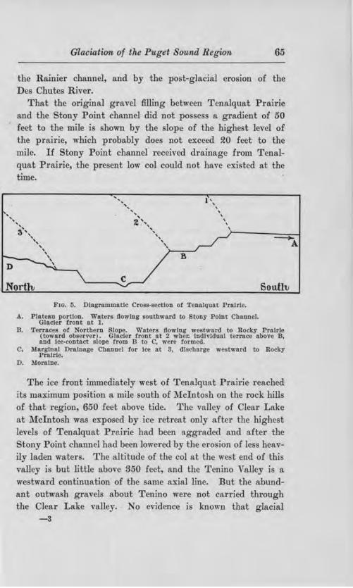
' ' '
Glaciation of the Puget SCJund Region 65
the Rainier channel, and by the po t-glacial ero ion of the De Chute River.
That the original gro.Yel filling between Tenalquat Prairie and the tony Point chflDnel did not po sess a gradient of 50 feet to the mile i hown by the lope of the highe t level of the prairie, which probabl does not exc ed 20 feet to the mile. If Stony Point channel received drainage from Tenalquat Prn.irie, the pre ent low col could not have e:ri ted at the time.
' 3','\ ',,
' ' ' ' ' '
' '
' ' ' 2~''\ ', ',
' ,, B
I \ \
\
' \ \
\
, Northi South,
F10. 5. Diagrammatic r11ss-sec l11n or T~cnlguat PrnJrlc.
A. Plateau portion. Waters .Oowlng soutllwartl to tony rolnt Channel. Glader trout at l.
B. Terraces or ortbern Slape. Waters flawing westward to Rocky PrnJrle (toward ob erver). Glacier trout at 2 wbe.r. lndlvlduo.l teno.ce above B, and Ice-contact slope from B to C, were formed.
C, .Marginal Drn.lnage Cb.o.DDel !or lee at S, dl6Cllarge we tward to Rocky Pro.Ide.
0. Moraine.
The ice front immediately west of Tenalquat Prairie reached its maximum po ition a mile outh of l\folnto hon the rock hill of that region 650 feet above tide. The valle of ]ear Lake at McIntosh was expo ed by ice retreat onl after the highest levels of Tenalquat Prairie bad been aggraded ruJd after the
tony Point channel had been lowered by the ero ion of le s heavily laden water . The altitude of the col at the w t end of thi valley is but little above 350 feet and the Tenino '\ alley i a westward continuation of the same ax.ial line. But the abundant outwa h gravels about Tenino were not carried through the Clear Lake valley. No evidence i known that glacial
-3

66 Bulletin "l\ o. 8 TV a.shington Geological uruey
water ever u ed thi alley a a drainage route. Its altitude appear to have been ju t enough higher than that of the
tony Point channel to keep it free from the invading gravels. ot until the glacier had withdrawn from the northern lope
of the moraine which is banked up on rock hill from Mcinto h to Tenino, did glacial drainage abandon the Stony Point channel.
The lower route then expo ed led we tward aero Rocky Prairie, and throufl'h the Maytown channel to Rutledge and Mirna prairies outh of Little Rock, there cro sing the moraine and entering the Chehali Valley a few mile farther south. ( ee fig. 4.)
Glacial drainage from the east cros ing the southern and lower portion of the plain oon cut a channel that eparated the Tenalquat Prairie gravel from the head of tony Point channel (fig. 4). To thi lat drainage cour e belong the outwa h plains of mith Prai1·ie Ruth Prairie and the channel floor on which the town of R ainier tand .
Terrace ri e above the ea tern end of Rocky Prairie. South of Lake Off ut the are 285 feet above tide on the northern flank of the moraine 15-20 feet above the adj a.cent prairie level. Rocky Prairie thus wa aggraded to a higher level by early glacial drainage and eroded b later drainage at its head to the depth indicated. Many outwa h area of the Puget ound Glacier r ecord the same glacial l1i tory of early maximum depo itiou and sub equent removal of a portion of the depo it. uch ha alread been noted for the outwa h about Tenino and on the fock hehali and atsop valley train . It will b een to be true al o of Tenalquat Prairie, Mirna Prairie and other outwa h area .
The .mjnor tran -morainic channel a mile and a half ea t of Tenino (fig. 8) had no part in the hi tor of the Rock Prairie outwa b. It .i a narrow valley without gravel terrace with a wampy floor and with it col 886 feet above ea le el. Thi altitude how that drainage from Tenalquat Prafrie

Glaciation of the Puget Sownd Region 67
never used trus route, which obviously wa of but local importance.
By the time that retreat of the ice had opened Rocky Prairie a a drainage route the front of the glacier had withdrawn from the northern carp of Tenalquat Prairie plateau, and drainage which j ued from its retreating edge built the ucce ive terrace that characterize the northern part of
Tenalquat Prairie. Each terrace i g netically a broad alley floor, possessing but the outheni wall the ice having formed it northern side. ( ee fig . 5.) The erie , de cending in order toward the north i to be correlated probably with the terraces of Rocky Prairie. There i a lope of nearly 50 feet to the mile between the fir t terrace on the nOl'thcrn de cent from the Tenalquat plateau, and the highe t terrace of Rocky Prairie to the west. As on the south ide of the plateau so on the we t, the later work of glacial and po tglacial drninage has isolated Tenalquat Prairie from the gravels which lie farther down the fo1·mer courses of drainage.
We t from Rocky Prairie, glacial waters conv rged into an ir regular channel among moraine hills leading to Rutledge and :Mirna prairies and con titating the drainage route here described a the Maytown channel. [This i hown on Plate XXIII and fig. 4.] Locally a at l\laytown, mall prairies exi t on the oulwa h gravel in the channel, though swamp and fore t cover much of thi drainage cour e. The Ma town channel i now drained b Bea-ver Cre k which enter Black Ri er at Little Rock.
THE !NTERLODATE l\1oRAJNE, A.NJ) DRAIN GE UNDER ITS
Co ' T.B.OL. ragments of rece ional moraine lie north of Rocky Prairie and Walrick Prairie and probably indicate po ition of the glacial margin while the drainage wa following the course mentioned above. orlh of Tenulguat Prairie the morainic urfa.ce gradually becomes more pronounced until it reaches a maximum altitude of ~00 feet above the plain in a great spur of morainic hills projecting northward between Lake t . lair and the Jj qually River. The material of the e
·,
hiU till. Erratic bowlder of granite are ommon, and lakelet bog , and undrained depression among l1ort, choppy hill characterize the topography. o outcrop of bed rock a1·e kaown b r ident of the region who are familiar with the e hill . '!'hi northward projection of the moraine graphically hown on accompan ing maps (Plate XXII and XXIII and
fig. 6) record a con iderable indentation in the glacial margin in which depo ition took place from the ice on both ide form~ ing the interlobate moraine.
A long n the glacier la again t thi ]1igh moraine depo it, which j the great t produced by the Puget Sound Va hon Glacier glacial drainage from the ea t wa forced to pa south of Tenalquat Prairie and aero Rocky Prairie to the Ma town channel. When the ice retreated from th.is spur, a
lower pa wa opened around it norU1ern end for the water coming from the glacier margin and from local drainage east of thi point. The Rainie1· channel W alricks Prairi and the east end of Rock Prairie were abandoned, and a new gravel plain wa built lying along the a tern flank of the high morainic area. ec fig. 6. The portion of thi plain which is now he le i known a Yelm Prairie. The water flowed towru·d the northwe t and acrgraded a plain who e lope i not more than 15 feet to the mile. The altitude at the northern angl of the interlobate hill j about fl70 feet above the ea. The cour e of the current after rounding thi pur wa outhward for a fe, mile turning wet again near he outhern part of the Wm. White donation claim, and continuing thence to the present com e of the De hut River.
During the earlier perjod of thi drainage n gravel plain wa built along the route de cribed to the northern end of Rock Prairie. The northern end of Rock Prafrie i too high however to allow correlation wjth the ~70-foot terrace north of the moraine hill near Lake t. lair and mu t be con idered as a depo it of water directly from the ice.
Later u e of thi drainage route from Yelin Prairie at\d Lake St. lair developed a definite channel from the prairie land oc-

Glaciation of the Pu,g ct ownd Regi0?1 69
cupied b the Wm. bite donation claim to the cour~e of the De hute . drainage from the Pun-ct ound Glacier ea t of thj channel and from fount Rainier ( except the owlitz River) flowed in the lean ut old rin1· bed now occupied by
pu rgeon reek. ( ee fig. 6.) Anoth r northward projecting morainic ar a exi t we t of
Rocky Prairie and in a wa illlllar to that alread de cribed the glacial drainage found it lowe t route north of tl1e hil . On the we t side of thi econd moraine pur the water spread out a broad, flat gravel plain in tl1e ,,icinit of outl1 nion. Between thi plac and Little Rock the country i 1 Yel and except where ditched, i co, ered with wamp. It i doubtle an outwa l1 plain of exceptional flatne , and is probably compo ed of material finer than the prevailing grin•el.
The hi h morainic l1ills l ·no- north of T enalquat Prairie which con rolled the formation of Yelm Prau·ie and the depo ition of outwa h outh of Lake t. lair, are i.nterlobate in orio-in. The rid(J'e whicl1 compo a them in their northern and mo t emphatically mora.inic portion lie parnllel to the tn·o id of th acute anglc which the moraine ma form . The 1 atcr which fl.owed northward along Yelm Prairie directly to,vard the fre front met ome ob tacle which doe not now ex.i t nam ly the glacier it eU and turn d it back to the outh for three or four mile to the purgcon reek course wliereas lower surface at pre ent lie farther nortl . Two mon1inic 1,ill lie on the north side of this southward loop and doubtl mark th po ition of the ice front , hen it had fir t withdrawn from the interlobate d po it.
Tb c i difficulty in mapping moraine and outwa h urea in the northern part of Th · ton ount . Relief of the morainic tract i light in mo t place. , and they ma bear but a thin outwa h gravel cov r and et be effectually concealed unle excavation renal their true nature. Kettle cannot be taken a criteria for di tinaui hing between moraine and outwa 11 b cau e the ue common in area of deep outwa h gravels. Both topography an oil ma. fajJ to di tingui h the hrn type and how-


Glaciation of the Puget Sownd Rcgio'll, 71
ever the pre ent mapping may delineate the re pective area it i probable that ucceeding tude.nt of the 1·egion will disagree with it.
R:EcEssroNAL FEATURE IN PIE1t E o TNTY, Ea t of the Ni qually River little Tecord ha been found of varied and changing conditions during glacial retreat from the terminal moraine. Much of the region i heavily forested, and road acros it are few. On the whole the region between McKenna which i 7 miles ea t of Rainier, and the Ohop Valley may be characterized as ground moraine, and an area outh of McKenna and we t of the i qually River also po e e thi character. The Ohop Valley and Yelm Prairie alone give data on which to ba e conclusions regarding the po ition of the ice front. The e will be con idered presently.
Mora.inic elevation ju t we t of Eaton ille ri e 150 feet above the outwa h on which the town i ituated. They are ituated with 1onger diameter ea t and we t and are probably
of rece ional moraine character. Their paralleli m with the southern d ·ift boundary and entire indifference to the much neare1· eastern margin of the Puget Sound drift which lie at a right angle to their our e indicates that the Puget
ound Glacier wa not wa ting on it ea tern margin in a "'ay at all comparable with the retreat of it outhern edO'e, The e elevation near Eatonvill con titutc the only knm n rece ional_... moraine depo jt in thi part of the country. From here northward and northwe bvard the country i apparently a uniform plain of till here and there inci ed by minor glacial drainage line . The region i travei· ed from north to outh in its central part b the ]\fount Rainier hi(J'hway. Another good road between l\fcKcnna and Eatonville allows examination of the region. To the north, and at a lower altitude, lie the "'l"eat teilacoom outwash plain of Pierce County ituated northea t of all outwa h thus far de cribed in thi paper. cent from the teilacoom / plains, most of which are prairie, to the densely fore ted till plain, i in many places over definite morainic ridge who e orientation parallel the line of contact between gra,•el and till

72 Bulletim, No. 8, Washvngton Geological Survey
An a cent of 200 feet i made .in one mile on the Mount Rain.ier highway, over morain.ic country, on the northern margin of the till plain. outh of Muck and three miles west of the Mount Rainier highway, harp mo ·ainic ridge exist, bearing small kume-like hill of gravel on their southern slopes. Again, between Roy and McKenna a eries of at lea t three till ridges lies ea t of the Chicago, Milwaukee and Puget ound Railway, trt:nd.ing -8 W . Their trend i out of harmony with evidence from the outwa ha to the po ition of the edge of the ice on this area a will be hown a little later.
The till plain ea t of McKenna on the Eatonville road is abundantly strewn with angular granite bowlder . Recent road grading has left them freshly exposed in a region where a heavy growth of lichen and mo ordinarily df ectually conceal the character of road ide bowlders. A few cut in the construction of the road how the characteri tic Vashon till of the Puget Sound Glacier.
To under tand the correlation here attempted between moraines and outwash of thi region, and the ame of that portion of Thw· ton County al.ready described lying we t of the 1s
qually River, a bit of glacial lake history mu t be con idered. From Orting northwu·d the P uyallup River Bo~ in one of the troughs of the interglacially eroded topography which Va hon glaciation failed to obliterate. Being a northward trending valley it held a marginal lake while the glacier withdrew along
length. Thi lake named from the river now flowing in the trough, first had it outlet into the Ohop Valley, which then ca.Hied the di charge from the White, Carbon and Pu allup river in addition . But mo t of the we tern margii1 of the Puyallup trough i lower than the col in the Ohop Valley outh of Lake Ka.pow in, and to bold the lake and the rivers named to th.i cour e; the ice edge mu t have la1n o. far outh a Orting. ( ee fig. 7.)
Now the altitude of the hop Valley floor where cro ed by the Mount Rainier road near Eatonville, 465 feet allows a de cent of about 10 feet to the mlle from thi cros ing to the

W M,111~<11'"" (lf:O I.Hlll!'AL Rl ' lll'f:I nni,u:ri . :--11. ,
Fw. 1. o ky Pra!rl 1ound wllb lnlermound ob!JI \' [l.8bQn ll'rmltml mornln,• In lhr dlst1ln c1•.
Fm. 2. Ro 0 ky Pralrl Mounds.
:mall mouudl -- tr:11' t nt th~ left.
)'f..\T f: \'

Glaciation of the Puget Sownd Region '78
lowe t tenace of the glacial i qually at :McKenna. Tiu terrace lie too low to be correlated with the 270-foot terrace on the northern pur of the interlobate moraine, and hence is younger than he purgeon reek l1annel it elf younger than all other outwa h feature of Thur ton County thus far described.
It thu ma be oncluded with ome degree of confidence t at the Pug t ound Glacier hugged the northern flank of Mount Rainier not retreating north of Orting until the morainic lake region of Thui· ton aunty wa expo ed by the retreat of the ice. harnber Prairie, ju t outh of the e lake , i thought to have canjed the draina"'e of tl1i time we t to Bu h Prairie and the Black River channel.
The correlative of Yelm Prairie i found in isqually Prairie on the ea t ide of the Ni qually River. The river valley between the e two prairie i ounger than the depo ition of the gravel and i consequent on the northward lope of a once ontinuous outwa h plain. Th ero. ion of thi valley ha divided the original plain into two longitudinal portion , consti uting 1 -
qually and Yelm prairie re pectively. From the grade of the outwa h grave1s on both ide of the
interlobate pur west of the river, the ice front i known to have po es ed an acute re-entrant angle in thi part of the ea tern lobe. Per i tence of thi angle a the front of the glacier retreated is indicated by phenomena of Tj qually Prairie described in the following paragrapl1.
Along the northeastern side of this prairie haTp ere ted hill of Va hon till ri e in three or four group above the gravel pla:ins. They separate i qually Pra.i1·ie from the broad Steilacoom gravel plain fart her nort.hea t. Through the gap between the e group , outwa h Cl'ravel appear to have been poured laterally onto i gually Prairie who e descent i toward the northwe t, at right angle to the direction of this tributary flow. Only with ice well removed from the lake country of Thur ton County, could glacial drainage on Nisqually Prairie flow o far toward the northwest· and only with
74 Bulletin No. 8, Washitngton Geological Survey
the ice front re ting on or directly behind thi linear series of morninc bi1l , could glacial drainage have been pow·ed imultaneou ly from the gap among them onto isqually PTairie.
nle en-or has been made in ob er ation, the conclu ion i valid that there i here record d the ea tern ide of the re-enb-ant angle which developed early in the retreat of the larger lobe of the Puget Sound Glacier.
In Pierce Count , further reti·eatal tage of the glacier are poorly recorded. The great predominance of outwash gravel on the teilacoom Plain south of Tacoma, i the striking feature of the topography. Since they are uninterrupted by morainic eminence , it hn not been po ible in this tudy to differentiate them in the manner which has been attempted for the oubva h of Thur ton County. Thei r northern portion will, however, be di cu sed in connection with the glacial lake hi tory in which the area played an important part.
INTRA-MORAINTC OUTW ASH OF THE WESTERN LOBE.
The difficulty of examination of the region occupied by this lobe ha been noted in the chapter on the terminal moraine. In four tr aver e between tidewater of Puget Sound and this moraine, covering about all the route of tra el whi h e..'"; t in the region, no rece sional moraine have been found.
Outwa h plain back of the moraine of the we tern lobe are identical in almost all detail with outwa h of the ea tern lobe. There i the a.me clean well-rounded gravel of perfectly fre h appearance in ection and the ame topographic di po ition in terrace , with low grndient of the plane urface. . The e plain , unlike the plains of the eastern lobe, are fore ted but the fore t i thin. It con ist of a ca.ttered tand of fir with the fore t floor entirely free from bu he or young tree in many place . From an agricultural vie,v point the country is nearly hopeles . There i no inhabitant for 11 mile along the 1·oad between Matlock and helton, and for 16 miles no stream i cro sed by the road.
Basalt hill ri e above the ground moraine and outwa h about the headwater of helton and Gold borough creek , and com-

Glaciatfrm of the Puget Sound Region 75
pl tel enclo e Go nell-Mill and Little kookum creek outh and outh"·e t of helton. They may be con idered a a low northern portion of the Black Hill .
The western lobe of the glacier di charged its drainage into the at op and loquallmn valley aero a ummit altitude of appro.·unatel 400 feet, while drainage from the ea tern lobe cro cd the terminal moraine on a floor no higher than 175 feet at the beginninCT of retrea.t. It i tbe1·efore to be expected that when the jce of the re-entrant angle about the Black Hill withdrew to an altitude below about 350 feet, the lowe t glacial channel known a ro the l\latlock Pathmiy diver ion of the drainag of the we tern lobe from the atsop to the Gate valley train would follow. But the hill above de cribed beneath the ice at thi re-entrant angle offered ucce ively expo ed barrier o that not until the interglacial valley of helton Creek wa ice
free, did the diver ion re ult. nd becau e the open valley of helton reek became an a.rm of Lake Ru ell a oon a
clear d of ice all outwa h gravel carr.ied outhward by the hifted current came to re t in a great delta who e ]akeward
face con titutes the northern valley bluff at helton . About 15 mile of tanding wa er in Lake Ru ell intervened between the Shelton delta and Black River channel by which drainage of the we tern lobe reached the hehali at Gat .
By t11e time thi diYer ion occurred the whole hi tor of the ea tern lobe reviewed in thi chapter had been con ummated, and the ucceeding hi tor of the glacial lakes ,,..as being enacted. The tardy rece ion of the we tem lobe of the ice may find explanation in it more northern location and it omewhat higher altitude. It i al o to be noted that the r egion of the we tern lobe receive at pre ent about 30 inche more rain annually than the region covered b the eastern lobe. If a imilar greater precipitation prevailed during the Ya hon glaciation and came in the form of snow it hould have effecti el retarded retreat of the we tern lobe.
In adj u tment to the new and lower level only tho e intramorainic gravel plain lying between the Skokomi h River and

76 Bulletin. ~o . 8 Washington Geological urvey
Shelton reek wer altered. A per i tent terrace carp along the road from Seo ts Prairie, northwe t of helton to the Skokomi h River i attributC'd to such adju tment by gla ial drainage from the head of Hood anal to helton. The carp po e e feature which no ice-contact lope or delta face could have, and lack character they should po e . Terrace carp de cencling ea tward, are cro ed between cott Prairie and Lake Tahwatzel, and are thougl1t to be attributable to the same cau e. The later change on the gravel plain betwe n the
kokomi h River and helton belong properly to the histoTy of the glacial lake and will be di cu sed under that ubj ect.
MORAINES NORTH OF THE CASCADE MOUNTAIN SPUR OF THE PUGET SOUND BAS1 .
T:a::E WHATCOM o NTY MonAINE . The plain region of Whatcom County lie we t of the Ca cade and north of the pur of mounta inous hills , hich were described in the introduc
tion as interruptinu the Puget Sound ha in. It is included in the Blaine and Suma quadrangle of the . Geological urvey and it topography i almo t entirely determined b ground moraine and by the post-glacial alluvial depo it of the ooksak River. A fe, area exist where the glacial till ha been left in true frontal moraine ridge , among the fir t to be built m the retreat of the Puget ound Glacier after those of Pierce and Thur ton countie .
A moraine ridge begin outhea t of Ferndale and extends northea twa.rd £or five miles, pa mg ju t outh of Laurel. Another moraine ridge li immediat ly ea t of thi . Other mora1mc area omewhat cattered, occur along the Bellingham Bay and Briti h olumbia Railroad near Wahl and Go hen, and al o close to learbrook and umas . Yet other areas of imilar character lie between Nook ak and Geary School (Dam
town). The Laurel moraine i the one of most intere t. It orienta
tion a:ff ord a clue to the form of the Puget ound Glacier' front on withdrawal from the mountainou interruption of the ba in. The moraine' ground plan d cribe a curve mth 't

Glaciation of the Puget Sound Region 77
concavity to the north. The heav fronU1l mo1·aine depo it on the ea tern face of the large interglacial hill we t of Ferndale, together w:ith the Laurel moraine give a complete outline for this p01·tion of the front of the glacier. It indicate that the ice wa moving almo t directly from the north when the depo it in question were formed.
onoborative evidence for this conclu ion i ecured from glacial groo ing on the huckanut sandstone in the outhern part of the cit of Bellingham the trend of which i magnetic north and south. An element of doubt remain a to e.'\'.act direction of movement becau e it could not be determined whether the edges of outcropping trata ere re pon ible for the exact direction taken . In O"eneral, however, the ice mu t have moved approximate] outh in production of the groovings.
Another item of con iderable intere t attaching to the Laurel moraine i the fa.ct that mo.rine hell occur in it. An i olated moraine bill two mil we t and one mile outh of Laurel was opened ome year ago under the irupre ion that it wa a driftcovered rock outcrop with the hope of finding coal which ex.i ts in the Tertiary edimentarie of the region. The tunnel wruch wa driven penetrated a tony hardpan o firm that no timbering wa required. lam hells were reported a occurring in large number in thi till. The writer picked up a few fragment of barnacle hell from the old dump of the tunnel.
Half a mile outh of Laurel, a gravel pit ha been opened in the ame moraine. The ection thu made how about three feet of Vashon till at the top ery like that near the urface in th mo t outhern depo it of the Puget olUld Glacier. Below it is three feet of a ton clay, different from lhe overlying till. It contains and and gravel, but ],a no foliation like the overlying till. In tead, it i cut by roughly vertical crudely conchoidal joint along which the cla' part on drying. Thee urface are tained a dull purpli h-brown by p rcolating water
the clay elsewhere being gray. Be ide their preniling vertica1ity, the e joint al o radiate to a minor deg.-ee in all di1·ection from th laro-ei- p ebble in the ma . harp line of con-

78 Bulletin ~o. 8, TVashington Geological Survey
tact exi ts between the till and this clay. In the clay were found a number of fragile marine shells, some with the valves still attached.
Beneath the hell-bearing clay is strntified and, and beneath this in turn i the gra el for wfoch the pit wa opened. The gravel is undoubt dly of Va hon age. It hows fore et beds which dip toward he outh and southwe t. The upper urface of these beds wa irregularly eroded b running water before deposition of tbe over] ing and. All the e evidence indicate that the moraine was ubaerially depo ited, and the included marine hell of tl1e peculiar clay apparently mu t be explained as having been plowed up by the glacier. The shell-bearing cla therefore is a till of pe uliar facies. Further cliscussion of this subject will be found in hapter X in connection with data on shell-bearing ground moraine of the region.
Tlill SAN Ju.AN OUNTY Mo:RAINE, The rocky an Juan Island group, con tituting the county 0£ the same name lie in the line of prolongation of the ascade Mountain pur which i south of Bellingham. A a rule, the drift deposits of the e islands are limited to the valley . Ground moraine, however, con titute a large part 0£ Lopez I land, and i pre ent on much of San Juan I land. But the only topographic featw·e 0£ considerable relief which are composed of glacial drift, occur on San Juan Island.
Cattle Point, the mo t outhea tern tip of San Juan Island, is an elongated pen.in u1a trending a little outh of ea t. It bears a triple ere ted hill of drift near the end ri ing nearly 300 feet above the ea at it foot. Between the hill and the main part of the i land is o. ridge of drift, le s than half the height of the hill.
The Cattle Point hill (Pl. XX, Fig. !2) i fore ted only on the northern lope and the ridge is completely treele s. The soil where the fore t ha failed to grow is gravelly, and bears the flora of the outwo. h prairie south of the ound. On the northern slope borings with soil auger by Mr. Geo. B. Rigg of

Glaciation of the Puget Sownd Regi.on 79
the Univer it of Wahington have hown the pre ence of a clayey gravel or till beneath the forest humu .
A ea.cliff along the outhern foot of the hill hows the surface gravel to attain depth of 20 to 50 feet. Below it i a zone of intimate] mjngled till and gravel trata, the product of water escaping in the pre ence of glacial ice. a hon till of typical facie appear beneath thi zone and in turn, rest on strongly glaciated country rock with groove a much as six inche deep. Plucking ha interrupted the grooves to ome extent.
The gravelly outhern face of this great hill of Va hon drift is interpreted a having been originally a teep alluvial fan built on a frontal till ridge at the debouchure of a glacial tream. The gra el in the eacliff how an imperfect and variable outhward dip, which i neYer a teep a the fore et tructure of a delta. It is believed to be the original alluvial fan bedding. The till on the northern slope records the ice wall again t which the deposit was banked.
The ridge which connects the tri.fi.d hill with the main part of the island constitutes the most perfect frontal moraine in the Puget Sound country. It outhern slope j an outwa h apron of more gentle de cent than that of the Cattle Point hill. It bears many large bowlders strewn over the urface. The northern slope i teeper and i imilarly bowlder- trewn.
This moraine ridge wa the ite of the American militar camp during the years when Great Britain and the nited States held joint pos e ion of the i lands. E ·cavation for the earthwork thrown up in 18p9 U"PO ed till which ha never ubsequently become covered with egetation.
A few miles north of the Cattle Point moraine, and within a mile of the town of Friday Hal"bor, j South Hill, almost a replica of the Cattle Point hill except that it hn not the trifid ere t. It southern lope is compo ed of treel prairie gravel and its fore ted northern lope i compo ed of till. Till intimately a ociated with the gravel i bown in a ea.cliff on it southern slope. o moraine ridge i a ocinted with it, a with

80 Bulletin No . 8, Washington Geological Survey
the Cattle Point hill and it i considered to record a briefer pau e of the retreating edge of the ice.
The absence of fore t on the outhern lope of the e two hill has been explained a due to the trong ind from the broad Strait of Juan de uca to which these slope are expo ed. The tree at the ere t are gnarled and wind-twisted, and the wind i certainly of ome importance in the ecological problem in,•olved. It i hel·e held however that the difference in soil on the two lope i the chief can e for the distribution of the fore t. The moraine ridge of attle Point, with a gravelly soil on both slopes, i unforested, and the rock hill of the i land are fore ted on all lope alike. The grave.lly lope are treeless for the ame rea on that the outwa h plain outh of Puget ouod are prairie.
The San Juan I land exhibit many fine illu tration of striated rock urfaces. Space cannot be given to a catalogue of them, and uch i not nece ary ince all known tdae and groove ti-end between true north and south and magnetic north and outb a range of 24°. The Cattle Point moraine lie at right angles to th.i di:cection a to be u.-pected. The great glacier which overrode the e i land , overtopping even Mount on titution 2,409 feet above tide, had a dominant outhward movement toward Puget ound, a movement re
corded alike on the broad top of Mount Con titution, and on the rock shor of the i land group.

WAIIIIIXIJ1"0X G1mt.(l(Jll'AI, ~l UVI'!\ Rt' Ll,ETIS ~O. $
Fw. 1. Mounds of Rocky Prairie.
~olt• 11lo1w,•rs or a 11osslltl.1· ln\lrHllng roresi.
l•'10. 2. lllounds or Rocky Prairie.
Pr.ATE VI
l

CHAPTER V.
THE l\IOUNDS OF THE VASHON OUTWASH.
SYNOPSIS.
CHAllACTER OF THE R EGION.
NATURE OF THE 1\foUNDS.
TYPES OF Momtos.
THE MrnA TYPE l\fouNDs.
FORM Al\"'D SIZE.
Gnou.PING, SPACING.
COMPOSITION OF MOUNDS AND INTER.MOUND AREAS.
STRUCTURE.
THE Fon.D TYPE MouNDS.
Four AND SizE.
Gn.OUPING, SPACING.
COMPOSITION OF MOUNDS AND lNTERMOUND AREAS.
STRUCTURE.
TAl3uLATED CoMPAl!.ISON OF CH.AllACTEns OF THE FoRD AND
MIMA TYPE MouNns.
AREAL DISTRIBUTION OF THE MOUNDS.
DisTnmuTJON OF MouNDs WITH RELATION TO Pn..Alll,JES.
DrsTn.muTION OF Mou)).'DS WITH RELATION TO MORAINES.
DrsTRil3UTION OF l\fOUNDS WITH RELATION TO ALTITUDE OF
PRAIRIES.
DISTRIBUTION OF MOUNDS WITH R ELATION TO DIFFERENT
AGES OF THE 0 UTW ASH GRAVEL.
D:rsTRillUTION OF l\louNDS WITH R ELATION TO SLOPE OF
PLAIN SURFACES.
AREAL INTER-RELATIONS OF THE T,vo MiouND TYPES.
SUMMARY OF AREAL DISTRIBUTION OF THE MOUNDS.
HYPOTHESES.
THE MIMA TYPE.
Co:i:-."DITIONS CONTROLLING CoNSTRUCTION OF AccEPTABLE
W ORXING H YPOTHESES.
HYPOTHESES PREVIOUSLY ADVANCED.
WEAKNESS OF ABOVE HYPOTHESES.
LIMITATIONS OF A SucoESSFUL HYPOTHESIS.
THE Fon.o TYPE.
LIM1TATI0NS OF A SUCCESSFUL HYPOTHESIS.

B!!a Bulletin 1\ o. 8, Washimgton, Geological Survey
CHARACTER OF THE REGIO .
The Vashon drift of Puget Sound may be divided into two different areas, the northern portion being p1·edorninantly ground moraine and the outhern part being characterized by outwash plains . These plain are largely prafries, because of the coar eness and sterility of the oil. The latitude of Tacoma affords a convenient divi ion line between these hvo areas.
The outwash from the Va hon Glacier of Paget Sound di -charged into the CbehaH River by two main routes, one on either side of the Black Hill . The Black Hill lie on the west side of the axi of the tructural valley containing Puget Sound. They bear till on their no1·thern flailk and are entirely surrounded by outwa h gravel.
NATURE OF THE MOUNDS.
The remarkable mound which have often been referred to, cover large areas of these gravelly outwash plains. Their character, distribution and gene is are the ubject of this chapter.
TYPES OF MOU:NDS.
At the outset two types of these mounds are to be distingui hed. They will be termed the Mirna type and the Ford type. Though a ca ual ob erver might fail to discriminate between them, they are believed to be distinct in origin .
THE Mlll1A TYPE .MOUNDS.
FmtM AND SIZE. Where be t developed, the open prame bearing mounds of this type appear like a meadow dotted with haycocks. The mound have a mmetrical, flowing outline, appearing to the eye to be egme.11 of phere tl1ough their lower slopes blend into t11e adjacent ground with a surface concave upward. They range in height from tho e o little as to be just preceptible, to a maximum of seven or eight feet, and in diameter from six to even feet to ixty feet or more. In any one locality there i a triking uniformity in the size of these mounds. Almost none exceed the dimen ions prevalent in that locality and few fall below. This is the te timony of the eye,
Glaciation of the Puget ou,nd Region 83
though if careful mea urement are made a number will be found failing to 1·each the a erage dimen ion , hich by rea on of incon picuou ne were not noted in a vi ual survey.(Illu trations of the l\fima t rpe mound are pre eated on Plate II to VII.)
They are uniform in hape a well a size. There is commonly an elongation o that one diameter exceed the other at right angle~ to it by a small fraction. Two mound crests may be so clo ely placed that the ba es blend with only a addle between the crests. The elongation,, when. pre ent doe not conform to nny definite orientation.
Gno Pl 'G, SPACING. All ob erver agree tbat no orderly arrangement of the mounds in ground plan can be detected. Plate VIII j a map of an area on :Mirna Prairie 400 by 500 feet
• on which the mound have been carefully located and measured. The lack of orde1·ly grouping i apparent.
In the matter of pacing the Mima type mounds are usually clo ely set. There i but rarely an inte.rmound area with a diameter greate1· than that of the larger mound of the vicinity. An exception to thi tatement i found on certain prairies. The urface of Rocky Prairie in padicular i affected by long sags and well with a relief of carcely more than ten feet. The mound are almost ·without exception limited to the higher portions and from the e portion , more like platforms than swells, the descent is abr~pt to the bottom of the ag .
CoMPOS1TlO OF 1\
84 Bulletin No. 8, Washington Geological Sitrvcy
mound are con tantly being made. The black silt here ha a thickness of but a few inches between the mounds. In the mound section however, the ilt i seen to de cend lower than in the intermound space , giving, ·with the mound "· profile, a di tinct double conve.'l: len hape to the black silt aggregation, a hown in Plate II, fig . 1.
The lower limit of the ilt in the l\lima ections in many places has broad, blunt, root-like downward projections, eldom more than a foot in length. The e bend abruptly here and there in the plane of the ection or appear a patches of black silt in the gravel ju t below the mounds, where the ection ros e their direction of bend. Roots of the herbaceou plants
which grow on the mound are found practically a abundant at the lower margin of the silt as elsewhere in it, but they term· inate abruptly in contact with the clean gravel below, e.'{cept where eepage line occur.
amples of the mingled gravel and ilt compo ing the mounds on Mirna Prairie were wa hed and the fine black material was thu removed . An ordinary g ravel and and like that immediately below the mound was left. Practically all of the sus· pended black material ettled in twenty-four hour . A ample of it wa ignited to determine the or""anic content. Almo t no lo s of weight re ulted the material imply lo ing it dark color and becoming a fine gritty clay . The organic content thu i -ver mall . Black ilt unmingled ,vith gravel or and taken from hamber s Prairie, a moundle outwa h area, gave the ame evidence of light organic conten . Thi conclusion fail to harmonize with the generaJ impre sion of the character of the black ilt. It j u uully con idered a having a high percentage of humus and i so de cribed in the soil urve of Puget Sound.
In prairie other than l\1ima, ome mound ection how a greater abundance of gravel but where be t developed the com· po ition of Mirna Prairie mound is pra tically duplicated.
In Rock Prairie typically the intermound areas are thickly over ed with cobbl tone and mall bowlders (Plate 1, fig. 1

Glaciation of the Puget Sound Region 85
and Plate, I fig . 1 and f). None were een , ith a maximum diameter of more than two feet. There i no hint of a closer pacing or piling up of these boulder on the margin of the
mounds than el ewhere, uch as would occm· if they had been distributed evenly at the out et over the whole area and bad since gravitated to the fotermound pace . At the we t end of the prairie, mounds of pronounced development with abundant intermound cobble , lie with a harp line of eparation adjacent to lower mounds on a lower surface, and with no cobble whatever among them. Among these lower mound i an area 200 feet long and !20 feet ,vide, elongated ea t and west, which ha no hint of mound but i covered with cobble (Pl. VI, fig. !2) . It i on thi prairie al o that the be t development of sag and platform is found . In many ca e the cobble cea e as abruptly on the upper edges of the platforms a-s do the mounds, I1ere and there overlying the brink, but howing no tendency to move down and accumulate at the foot of the lope. umerous road a:nd railroad section on thi prairie ho, the mounds them elves to contain no cobbles or bowlder .
Other prairies show this intermound cobble accumulation in varying trength of development. n place the stones are very few and only large pebble in size. This is the case over much of :Mirna prairie and here deep ection how the entire gravel bed to be lacking in cobble and bowlder , while a well in Rocl-y Prairie how the underlying clean gravel to po e s many large tone , comparable in size to tho e in the intermound area . On Walrick Prairie railroad ections e.'i:hibit the truct-01·e of a mound-bearing portion with bowlder- trcwn intermound pace . The bowlder or cobbles here arc seen in the ections to
continue from one ide of a mound in o. pla.ne directly beneath it and reappear in the intermound a1·ea 011 the oppo ite ide.
STR CTURE. No tratification or other tructure ha ever been ob erved in ection of the l\:Iima t pe mound.. ( ec Plate II fig. 1.) All ob erver who have published on the ubject find thi unreservedly true. There j bown in all section a loose bomoge.neou ma of mall gravel mh,ed with black ilt.

6 Bulletin o. 8, W a liington Geological un:cy
There do not eem to be a gr ater proportion of ilt near the udac of the mound ma than at the ba e. In p1·airi 111.cking
th mound but having th urficial ilt depo it gravel p bble d not o cur di tribu d through the ilt a they do in the mounds.
T.Et.E FORD TYPE IO ~TD .
01uu ~TJl tz"E. TI h re a beautiful ymmetr and uniformity haracterize the 1\IiJJla t p mounds tho e of th Ford t p ue
un mmetrical and irregular in form and variabl in izc. The large t area of the e mound i on edarville Prairi ' in the hehaU Vall y . The urfac of hi prairie in om pla i almo t tumultuou ly heaped with the gravel pile · in oth r place it i nearly plane and in oth r it i di posed in long g ntlc lope . • n lo ed hollow are common, drainage by eepag b in p r-
fe t howev . i.rcula.r or lightl ellip ica] mound re not ommon. The maximum range in altitude between mound top
and adjacent depr ion i about iO feet. On Grand found Prairie one Ford t ·pe mound tand f.!5-80 feet above it urrounding . Thi particular mound (Plate IX fig. I) po -
e even peculiar aucer-Like depre ion on it ummit arranged in a somewhat longate group transver e to the length of he medial broad ridge of the prafrie. With the no.rrow rims a int r- aucer area hey ov r the ntire ummjt. Their avera diam ter i ten f t and a crage depth Ii- inche . Each bear a mall flat mound in h c nter and thu con titute only a mnrginal circular depr ion being nearly 611 d in the c nter.
obble occur in th annular depre ion and al o tr , the id of thi ord mound. The e aucer with the mound in the enter, are triking) imilar to those de cribed in he icinity
of fuck. The general chare. ter of the form of the ord type mound may e bes de crib d a e sentially kame-Jik a tatement hich cannot be made on erning the fima t pe mound .
llOUPING, PA ING. o trace ha been found of an y -tematic di po ition of the e mound or of the hollow among them.

Glaciation of the Puget Sownd Region 87
COMPOSITION OF IouNDS • n INTERMOUND REAS. umer-ous excavation bO\v the Ford type mound to be wholly of gravel. There i no more black ilt on their urfaces than on the intermound pace , and none enter m.to the composition of the ma of the mound. No aggregation of cobble among the e mound ha been ab erved.
STRUCTURE. In Ford Prairie belmv Cedarville, excavation by the Oregon-Wahington Railway and avigation ompany for railroad ballast have afforded section of the mound of this type, comparable to the ection of the Mirna type mound in
the fima. pit. The material i ma:nly h01·izonta1Jy bedded but i overlain in one part of the pit by delta bedded gravel dipping wesbvard down the valley the depth of these bed not exceeding 8 feet. Above the delta.,bed the tructure i confused, current bedding prevailing with no definite fore et or horizontal tratitication. Thi extend to the top of the cut and at the
time of the WTiter' examination included sections of several Ford type mounds. The beds in the mound ection in a few ca e bowed fore et tructure, dipping toward the center. One such fore et stratum had grown from one side of the mound across almo t to the oppo ite side.
TABULATED COMPAll.ISO~ OF THE CHARACTERS OF FORD
AND MIM.A TYPE MOUNDS.
The following tabulation gives the point of distinction between the two mound type above de cribed:
Mll\[A TYPE
Named from the perfecUon 01' development on the upper portion of l\11ma Pra1rle. 1. Symmetry o! form. 2. Uniformity of size In any one
area. 3. Structureless. 4.. Black prairie soil to base. 5 Maximum relief between
mound sum.mits and lntermound areas, 7 feet.
6. Usually with intermound cobbles.
7. Closed depressions rare. 8. Unlformtty of distribution the
rule.
FOllD TYPE
Named from Ford Prairie which bas given sections that reveal the origin of this type. 1. Asymmetry of form. 2. Lack of uniformity of size. 3. Fol'eset bedding dipping to
ward center. 4. No Jncreased thickness of
vrairle soll. 5. Maximum rellef between
mound summits and intermound areas 30 feet.
6. Never w1th intermound cobbles.
7. Closed depressions common. 8. No uniformity of distrbutJo.n.

8 Bulletin No. 8, Washington Geological Survey
AREAL DISTRIBUTION OF THE MOUNDS.
DISTJUBUTlO~ OF THE J\10 ms i\' JTR RELATION TO PRAIRIE •
There are three cla se of prairie in the Puget Sound country (1) tho c occurrino- on rock hill lope , where the oil doe not upport a fore t growth (fl) tho e where the oil i too wet for tree growth, and (3) those on the glacial outwa h. Our problem deal only with prairie on glacial gravel .
The outwash gravels dealt with in thi chapter are of Vashon ag probably to be correlated with tl1e Wi con in drift. They occur largely as outwa h plains with moraine or ice contact lope along their highest margin. ince all di charg"mg water
from Puget ound wa receh,ed by the wide Chehali alley, the gravel carried fe.rthe t take the form of a valley train which differs in no e ential detail from the outwa h plains. Fragment of the valley train between Gate and Aberdeen which have e caped po tglacial ero ion con titute prairie with all the feature of tho e of the gravel plain nearer the glaciated region. In all prairie of the oulwa h gra el, evidence of flowing water at the time of their formation i to be found (1) in terrace (fl) in the bedding, where e.xpo ed, or (S) imply in the general lope.
In t11e map accompanying this bulletin the areas of glacial outwa h are hown and the outer margin of the terminal moraine is indicated. The mound-bearing prairie are indicated on Plate XXIII. In order of development of the Mima t pe mound , Mirna and Rocky Prairie lead all the other , though each ha area without mound . Walricks or Eaton Prairie follow in order with numerou but lower mounds. Grand Mound Prairie po e c a strongly accented mound urface near the ea tern end, but the mound gradually become flatter we tward until they die ou in the vicinity of Grand Mound.
Cedarville Prairie po se e the be t development of the Ford type mound . Gate or Baker Prairie and Oakville Prairie follow. Ford Prairie .Mirna Prairie and Grand Mound :Prairie a o po , e a few mound of thi type.
The prairie above noted are all located on the outwa h gravel

W.ISlll!,(l'[I)'( (;i::nw ll'AT, .1,in:Y
Fr . 1. D Ila nl Corner or en ::t treet and lxth Av nue,
'I' ll· dark ror '" •I l,edH ,1r~ eompo~1•1l or llgolit•.
Fiu. 2. Mounds ul by Hi hway, i\llma Prairie.
f'l u\TI: \ "Jf
altl •


Glaciation of the Puget ownd R gi-0'11, 89
of the glacial lobe lying ea t of the Black .ills re-entrant angle. The e caping water from thi lobe converged at Gate jnto one valley, and produced a ,,alley train which reinforced b acces-ion of outwash from the we tern lobe was originally continuous
from Gate to Gra Harbor. Mound-bearing portion do not occur below 1\lalone at the mouth of the Mock hehali which j the fir t point of entrance of gravel from the we tern lobe into the Chehali , all
The large t area of prairie country lie northea t of the i qua.Uy River the region being known in genenl as the
Stejlacoom Plain . Imperfect l\Iima typ mound are found here and there on thi area well within the limit of the terminal morame.
On the outwa h from the , e tern lobe, between the Black Hill and the 01 mpic l\Iounta.in prairie are le common in proportion to the extent of gravel-covered u.rface than ea t of the Black Hill . l\Iound are known in but one place. This is on Lo t Lake Prairie, within the limits of the moraine. The mound are low and incon picuou , and do not occur over the whole prairie. There can be little doubt however, that the e mound are of the ame gene i as those o well developed on Mirna and Rocky Prairie .
DISTI1Ill TION OF MO l<.'l> "'ITH llELA TION TO MORAINE •
In general di tribution the mound-bearing prairie are a ociated with depo it of the ea tern and lower lobe of the glacier. The :Mirna type attain it maximum development 011 l\lima Prafrie ju tout ide the terminal moraine and on Rocky Prairie, betweel'( the terminal moraine and a rece ional moraine. Grand Mound Prairie fourth in ord r of development of 1\Iima type mound :flank the terminal moraine on it outer ide.
n Mirna Prairie the mound may be traced up on the ba al slope of the low morainic area , ruch lies north of he prairie. In thi po ition the are irregular in ize form and pacing, and are a ociated with a f w hallow kettle hole . One :kettle (Pl. 1' Fig. ~) i flO feet deep and UO feet in diameter a.nd bears a few wea.kl developed mound on the ide and bottom.

90 Bulletin l\ o. 8 Washingt()'Tl, Geological urvey
On Grand Mound Prairie, in the place e amined, they are lacking in proximity to .the moraine. On Rocl-."Y Prairie they exist within 1 s than ~00 feet of the front of the rece ional moraine, uniform in size shape and pacing with tho e elsewhere on this prairie. At thi di tance from the moraine slopes, they terminate on the prairie surface, a mounclle level zone of the indicated width margining the frontal edge of the moraine.
Walricks or Eaton Prairie lie ju t ea t of Rocky Prairie and, like it, i bounded on the north and south by the terminal an.d a rece sional moraine. It mounds are low in relief. No relation between the proximity of the till ridge at the north and the character of the mound wa een .
orth of Off ut Lake i a thinly fore ted counb-y with small prairie area inter per ed. The topography i very much broken by kettle , but no morainic ln1ob occur in the immediate vicinity, the area being apparently a pitted plain . l\:lima type mow,d are common on the level area be :ween the kettle , but do not occur on the side or bottom of the depres ion .
A drift surf ace bearing mound-like form. , which hould be noted here, i to be found on the frontal or sou hern lope of the most northern ridge of the till area outh of Muck Po t Office. The mound here are catte:.red and irregular in form both Ford and :Mirna type apparent} being pre ent. About a dozen :Iima type mounds were een on the outhern lope of the ridge which i heavily covered with outwa b gravel. Till exposed beneath the gra el how the ridge to be of morainic origm. Each mound lies in a more or les di tinct aucer-haped depre ion the rim of which i broken in most case ,
and the depth of which wa about equal to the height of the mound. The e mound-and- aucer arrangement do not occur on the tceper lope but lie at the foot . Cobble and mall bowlder lie in the aucer urrounding the mound. The gravel outwa h here i 20 f et or more in depth. The form de cribed are thus of outwa h devclopm nt and not morainic in nature.
The ea tern portion of Grand Moun.cl Prairie bear a median,

Glaciation of the Puget Sownd Region 91
flat higher area elongated ea t and we t in harmony with the longer diameter of the prairie and parallel to the moraine at the north. On it are the fe.w Ford type mound pos e sed by thi prairie while Mirna type mound are di tributed everywheJ"e except along the pre ent floor of catter reek Valley, and the teep r de cent to it.
Mirna Prairie is di po ed in two level the higher being almost plane and abutting again t a moraine. A long pur of this higher portion run southward aero s tl1e lower level and bear the Ford type mound of tbi prairie. :l'ilima t pe mound are common on much of the lower urface.
:Both north and outb of the terminal moraine the: mounds dimini h in degree of development though they extend farther beyond it tl1an back within the glaciated area. Cedarville Prairie l! mile beyond he moraine, ha the greate t development of Ford type mound of the region.
DISTRm TIO OF MOUNDS WITH RELATION TO ALTlT DE OF
PR.A.Ill IE ,
An exnmfoation of the altitude of the mound-bearing and moundlc prairie of both lobe of the Puget ound Glacier l1ow the Mirna type of mound on the highe t Tenalquat
Prairie 500 feet above tide, and on one of the lowe t near Elma 60 f et above tide. Grand Mound Prairie de cend fro !270 feet to 160 f et in t n mile and the Mima type mounds are large t and be t developed at the head and lacking at the foot while on Ro k Prairie the e mound are be t developed on the low extent and ab cnt at lhe head. Ford type mound have their bighe t kno,1'11 occurrence on Grand .i\Iound Prairie, i80 f et above tide and their lowe t on Ford Prniri . 60 feet above tide.
DISTRIBUTION OF MO 'NlJ WITH RELATI0,' TO DlFFERE,'T AG-E OF
THEO TWA H GRAVEL.
Outwa h from the ice at the time of maximum extent formed certain grav U area which were abandoned by e caping water a oon a the ice retreated a mile or o from the terminal

92 Bulletin o. 8 1 ashington Geological urvey
moraine and expo ed lower drainage lin . One of he arlie t outwa h area to be abandon d wa the Tenino end of Grand Mound Pra:irie and the valley train ,vhicb extend outh from Tenino to the Skookum huck at Bucoda. The e gravel ju t we t of Ten_ino are mound-bearing. Both type arc well de-
eloped though the ord type mound are few in number. The black ilt and int rmound cobble of the l\1ima t pe arc pre ent. South of Bu oda the mound di appear, and none have been found on the wide gravel plain about entra1ia.
Di charging glacial water cea ed to flo,v through the marginal drainage channel deboucbina at Tenino at the h ad of Grand Mound Prairie when the ice retrea ed to a po ition north of Rocky Prnirie. ( e Fig. 4). Depa ition of outwa b gravel therefo1·e cea cd at th head of Grand 1.ound Prairie and at no uh equcnt time ,va renewed. The ruoWJd near Tenino tl1ere
for lie on th oldc Va hon outwa h. During the pau e at the rcce iona1 moraine north of Wal
rick and Ro k Prairie the gravel of the. e prairi were depo -ited. The e capi..ng wa er fl.owed we twtnd along the rear of the terminal moraine to Mirna Prafrie. evcral mall prairie exi t along the rout on 0£ the e Rutledg Prairie bearing wel1 developed :Iima type mound . Mirna Prairie therefore wa an area of agaradation during the two pau e of the ice front and the mound of at lea t i lmf"er portion ar no older than tho e of all'ick and Rocky Prai1ie de pite the ·tra moraini po ition.
arther back from the terminal moraine of the ea tern lobe than the prairie above di cu ed there are but four gl'Oup of mound known to th wri r and the e are all of tl1e llma type. The are relativ l in icrnificant being faint 1rreo-ular and scattering.
Lo t Lake Prniric on the area covered b the we tern lobe lie a few mile back of the limit attained by the glacier. It mound are faintly developed and con titute the on) known occurrence of th e form on the outwa b from this lobe.
· 'rom the abo c. ur ey it would appear that only outwash

Glaciation of t7,c Puget oumd Region 95
grave] immediately a ociated with moraine development are mound-bearing and that onl outwa h of earl deposition bear mound . Thi generalization i omewhat weakened however, by the following data concerning the hehalis Valle train.
the ea tern lobe of the , a hon Glacier retreated north of the latitude of OJympia the trough of Puget ound became gradually uncovered, and tanding water at the ice front re-ulted. E:: cept on local divides and over the troughle area
south of Tacoma outwa h gravel cea ed to be depo ited. E -caping water from Lake Ru ell• ponded fo front of the ice, flowed clo e along the ea tern foot of the Blnck Hill to Gate ther entering the hehalis Yalley. Thi water rehandled the dr'ft over whi h it fl0\•1ed and carri d a con iderable quantit of gravel into the Chehali , alley. It eroded it outlet channel at lea t 40 feet d ep at the pre ent col. It appear to have eroded a wide channel on the ea t ide of l\!ima Prairie. The di charge of Lake Ru ell continued to flow through thi valley now occupied by Black Lake and Bia k River and thence down the h hali until the ice had retreated at lea t a far north a • oulweather Bluff between ood anal and dmiralty Inlet.
oroewhere nor h of thi l1eadland the ice dam failed and the level of L ke Ru ell , a lowered to that of the ea. The outwa h gravel along the Black- hehali drainage line thu may have received their uppermo t d po it at a time when the ice front wa many mile to the north in it final retreat. An alternative view i that the di charge of Lake Ru ell eroded a channel in the hehali valle train and did not prend over the whole urface. Let u now examine thi urface .
.,,,---- fima Prairie i dispo ed in two great level eparated by a more or le abrupt lope de ·ce11ding about !20 feet. l\lound are be t developed on the upper level, but occur in typical developm nt on the slope and on the lower level. Thi lo";er urface graduall de cend ea tward to the pre ent floodplain of Black River, and bear mound o for down the lope ti at flood wate
• J. B. Bretz, "Glacial Lakes or Puget Sound," Jour. Geo!., Vol. 18, No. 6, and chanter VI of tbls bulletin.

94 Bulletin No. 8, Washingtcm, Geological Survey
of the present river almo t reache them. Their occurrence here po sibly may be a ociated with the operation of the Black Lake outlet of Lake Ru ell.
At Gate, the prairie i mound-bearing the mound belonging to the Ford type. cattered Ford typ mound occur on the higher area of the Oakville Prairie. Cedanrille Prairie po -e se splendid Ford type mound over mo t of it surface. Ford
Prairie ha a few of thi type. T1u·ee mile above Elma is a low fragment of the valley train who e gravel probe.bl came from the ea tern lobe though below the point of entrance of the Mock Chehalis valle train . It bear faint mounds of the Mime. type, the lowe t and mo t we tern occu1Tence known. There i thus abundant evidence to ugge t that the cau e of mound formation operated at a considerable distance from the edge of the ice, and perhap late in Va hon deglaciation. These mound of the Chehalis valley train belong to the Ford type, there being but one occurrence of weak Mirna type mounds. The alternative view con ide.r that later di charging water through the Black-Chehali drainage line did not occupy the whole width of the gravel-filled valley, and hence mounds on the higher portions of the valley train may have been formed at an early date. Po tglacial ero ion has removed o much of the Chehali valley train tl1at t.m que tion can hardly be ettled satisfactorily.
DIST1U1I TlON OF MOU ,'D WITR RELATION TO LOPE OF PLAIN
llFACE.
Mo t of the flat gravel plain of the region po se a gentle grade de cending in the direction the water flo1ved at the time of their depo ition. Herc and there are teeper lopes of the gravel occurring on the flank of moraine ridge , on the lopes l:ietween terrace or on the id of kettle . In one direction the grnvel plain may extend from an almo t level urface up on low moraine flanks, the mounds here lacking characteri tic form and arrangement; in an oppo ite direction the plains may descend aero s a terrace carp, without notable change in the characte1· of the moru1d .

Glaciation of the Puget Sound Regi()11, 95
In general mound on a moraine lope do not po es characteristic form and di tribution. They are best developed on a gravel plain with a lope too gentle to be detected by the eye, and they are rarely pre ent on the lope of kettle .
AllEAL INTER-RELATION OF 1.'RE TWO MO ND TYPES.
Mirna and Ford type mounds have not been found as ociated with each other in maximum areal development. Grand Mound and Mirna prairies po es a few Ford type mounds, on the higher portion of the prairie urface urrounded b thousand of the M.ima t pe mound . The rever e relation, a few Mirna type mound di tributed among many of the larger kind, has not been found. On both the above-named prairies Mirna type mound lie undoubtedly up on the Ban.ks of the Ford type. Nothing ha been seen to suggest uperpo ition of the Ford t pc on ound of the Mirna type.
SUJ\111:tARY OF AllEAL DISTRIBUTION OF THE MOUNDS,
(1) The mounds occur on outwa h gravel from the ea tern and lower lobe of the Puget Sound Glacier, only one occurrence of faint .Mirna type mound and none of the Ford type being known for the we tern Jobe.
(2) The be t Mirna type development i found on prairies closely a sociated with the terminal and earlie t rece ional moraines though faintly de,,eloped mound of thi type are found on the Chehali Valley train fa1· from the moraine .
(3) Ford type mound l1ave been found almo t entirely on the Chehalis Valley train and adjoining extra-morainic outwash plains.
( 4) o igniflcant relation ha been found between the altitude of the gra el plain and the occurrence of mound of either type.
(5) Mirna type mound are mo t typically developed on the earlier oatwa h of Va hon age though large area of thi are moundles . The Ford type find it be t development on that portion of the hehalis valley train which entered by the

96 Bulletil,i No. 8 Washington Geological Survey
Gate Pathway. The question regarding its age has been indicated.
(6) Mirna type mounds attain their best development on nearly plane gravel urface , depre ed or steeply loping areas being commonly moundless. Ford type mound , where scattered, occur on the higher prairie area , i olated abo~ e the urrounding surf ace.
HYPOTHESES.
Previous .field work on the mound of Puget Sound glacial drift has been limited to hasty examination of the chief prairies bearing the Mirna type. The Ford type mound have not been previously recognized. The J'.\,lima type mound are o striking in appearance, and o different from topographic forms ordinarily seen, that even the car-window ob erver is at once interested, and the range of hypotbe e for their origin has been considerable. T.he tudy herewith pre ented will be justified if it succeeds in showing the intricate nature of the problem, and in narro,ving the range of hypothese . Distinction of the two mound types must be made, hence each will be treated independently.
THE M1MA TY:PE.
C0ND1TI0Ns CoNT.ROLLING THE CoNsTRUCTION OF AccEPT
Al3LE Woll.KING HYPOTHESl!: • Any working hypothe is for tl1e origin of the e mounds to be of value mu t include recognition of the follo,ving general facts :
( 1) The mound have a regularity of form that is remarkable. In the hundreds of acres of the mound prairie , there are but few exceptions to the general form of a spl1erical egment.
(2) found in any one locality a1·e nearly uniform in size. There are nowhere large mounds cattered in an area of small mound though the Conver e i true in ome place . For any one region there i a maximum size, above which a.Imo t none go and to which most attain.
(3) There is almo t in aria.bl an accumulation of cobbles or pebble on the surface among the mound . Where section


•
l
I I . ' . .
Glaciation of the Puget Sown.d R egion 9'7
are afforded stones of the ize of tho e in intermound areas in ome places continue as a cobble txatum through the mounds
them elve . In other pla e where the intermound areas are cobble-bearing no cobble are found in the mound ection .
( 4) All prairie of the region bear a urficial black ilt. In the mounds, the ilt ha accumulated to a thicknes as great a the mound hejght, and in place greater o that it form a len - haped accumulation, w11ile between the mound the ilt i thin.
(5) The mound are be t developed on plane urface of slight grade. They ne"er occur on suTfaces other than t~o e of glacial gravel.
(6) The mound are structurele .
HYPOTRE ES Pn.EVI.OUSLY Anva •CE]). (1) ilke . The earliest discu ion of the 1¥funa type mound known to the ,vriter is that of Charles Wilkes in volume four of the Report of the United State Exploring Expedition during the years 1838-184\t Wilkes twice cro ed one of the mound prairfos, probably Mirna, and on the econd trip he had three of the mounds excavated in the endeavor to find relic of human agency which he conceived a 1·e pon ible for their origin. othing wa found indicati e of the ' 1wage labor ' of which he notes that they po se s the mark , except a pav ment of round tone at the ba e. ' He wa certain that the were not place
of burial and wa inclined to attribute them to the Indian medicine men though he found no tradition ex.i ting among the Indians concerning their origin.
(!e) Gibbs (Aga iz). In the Journal of the American Geographical Society for 1873 George Gibb describes a reconnai ance of the northwe tern boundary of the nited tate in which he e. amined a number of the mound prairies
of Puget Sound. On hi return to the ea tern tate he decribed the tructure and exhibited e. ketch of the mound to
Loui ga iz who "unbe itatingly pronounced them to be the ne ts of a pecie of sucker. Aga iz stated that this fish
-4

98 Bulletin No . 8, Washington Geological urvey
was at that time con tructing similar mound in the ponds about Boston. Gibbs ace pt the explanation noting that it agrees w:ith the occurrence ot "lacu trine ' terrace which are commonly associated w:ith the prairies.
(8) Le onte. In the ame year Joseph LeConte pubJi bed a hypothe js for the origin of these puzzlinrr features, in the Proceedings of the California Academy of cience. He conceived that the gravel and silt were ediment in the water of Puget Sound, which he assumed to ho. e once covered the region. ucceeding the withdrawal of the ound waters, ero ion attacked the u.rface and removed the finer oil in certain area . Vegetation encroa hed at the same time and obtained a foothold in the higher region , holding them while the inter-area were lowered. Increa mg dryne of the climate ha cau ed the di appearance of this vegetation .
(4) ewberry. In 1884 John ewberry pre ented a paper before the ew York Academy of cience on the origin of the fiords of Puget ound. He frankly confe ed the mo11nds to be inexplicable.
(5) Roger . The American Geologi t for June 893, contained an article by G. 0. Rogers on ''Drift Mound near Olympia Washington.' This writer reviewed LeConte' de cription and arguments and objected to his statement that the intermound area contain larger pebbles than occur in the mound LeConte having presented thi a evidence of the ero ion of the finer material. Evidently Roger e a.mined that portion of M'ima Prairie which i without cobbles among the mound while LeConte may have een Rocky or Grand Mound Prairie where cobble di tribution is remarkably developed. Roger bypothe i i that the gravel plain was covered by a piedmont ice heet which on ablation, was traversed by escaping drainage in floods o that the entire surface wa covered by washed debri .
uch material on coming to re t tended to accumulate in heaps . In olation cau ed the e heap to sink in the ice, and liding of scattered material into the depre sion further tended to con-

GlaciatiQ11, of the Puget Sowrul Region 99
centrate the wa hed drift. Final melting of the tagnant ice depo ited the heap as the present mounds.
(6) pham. In 1904 Warren Upham published in the American Geologist ome hasty observations from a reconnais-ance of a part of the Puget Sound country. He crossed Mirna
and Gate or .Baker prairie and concluded that the mounded surface were 'correlative with the commonly hilly moraine belt of other drift area . l"Om per onal observation of the e b o prairies and from verbal de cription of other prairie of the region having mounds he mapped the terminal moraine belt of Puget ound a a broad curve convex outhward with the mo t u--tended portion reaching to Gate.
(7) Other Explanation .111 Conception of the origin of the mounds more or le related to tho e pre ented above, have emanated from many ource . Mo t are valueless because based on no careful study of the region. Two leading ideas are tho e of plant or animal origin. One faxmer who ha lived on Mirna Pl·airie for a number of year i convinced that the mound which bear clump of the stunted oak common to the gravelly oil are increasing in height. He tated that in leveling the
mound for a roadwa the hor e plunged knee deep repeatedly in the gravel and ilt after the sodded mface of the mound had been broken, infening from thi that hollow e~·i ted where tree root bad decayed.
WEAKNE SE OF THE Anov:e HYPOTHESES. rom the pre-ceding de cription of the tructure form number and distribution of the mounds, and from the fact that no r lie of hwnan origin have ever been found in or u. ociated with them though hundred have been opened the hypothe i of human origin for any pul"po e whatever must be abandoned. It is not held today by re idents of the region though it is the most educti,re of all CA'Planat:ions to the common mind.
• M. R. Campbell discusses "Naturo.l Mounds" 1n the Journal of Geology, Vol. 14, No. 6. His study was devoled to mounds in the valley or the rkansas, differing widely in composition, and In character of the subsoil, from those features found in the Puget Sound country. His conclusion of animal origin cannot apply here.

100 Bulletin No. 8 Washington Geological urvey
No one who bas been in the reg.ion a.nd een the splendid sweep of billowy topography over a thickly mounded prairie surface can give credence to the idea that fl 11 have heaped up the Mima. type mounds. It is obviou ly much farther from the troth than the hypothe i of human origin. The prairies have never been submerged in fresh water, and probably only the lower ones were beneath the po tglacial ea water, and that but for a short time. Mirna type mounds also occur on the plateaulike summit of Tenalquat Prairie 500 feet above tide, untouched by any water but direct rainfall since cessation of the glacial outwash.
The impos ibility of depo ition of the gravel in Puget Sound does not weaken LeConte's idea. The objection which i fatal o bi conceptjon i that the porou gra. el so effecti ely ab orb
rainfall that hardly a trace of ero ion ha been detected on any prairie ave that of a few traver ing tream "·ho e runoff is largel ecured from other area . Con ider ble tream flow on to some oi the e prairie from adjacent and more impervious urfaces after beav rain and the water i o greedil absorbed by the gravel that the tream di appear in a fraction of a mile. The pit in Mirna Prnirie show "open work" gravels for a dept11 of S0--40 feet below the surface oil. In the face of thi evidence LeConte compari on with the mound produced by ero ion in ea tern Oregon is invalid.
Roger 's conception of the inter-action of glac-ier ice and escaping wate.r fail to explain the mound of Grand l\Iound Prairie about Bu oda and ju t above Elma. on the hehalis, all of which lie beyond the tcrmina1 moraine and ome of which were perhap formed on the Chehali valle train during the last tage of glacial retreat from the Puget ound ha in. Further the many section in the outwa h prairie back of the terminal moraine fail uniformly to record any re-advance of the ice over the1r urface after tream aggradation on them had cea ed and Ro(7ei· s hypothe i fail here a well.
In ,;-iew of tbi la t point and ince the terminal moraine

Glaciation of the Puget ownd Region 101
of the Puget ound Glacier i a definite tiU ridge at one place two mile wide and 250 feet high, flanked by the e outwa.sh prairies, Upham s ha ty conclu ion cannot be con idered eriou ly. In order to fit hi hypothe i thi writer al o guessed Lake Kapow in to lie in a kettle hole which it does not, and mapped the moraine as traversing the Black Hill from Gat to Elma, all of which tretch i driftle and ome of it l 500 f~t or more above tide. fony other errors in the paper referred to make it almost valueless.
A pecies of large black ant Formica .samguim-ea inhabib the sparse fir fore t growing in many places on the gravelly area of Puget ound outwa h and con truct hill ome five feet high. uch ant hill are built almo t entirely of bits of twig and pine needles. o ant hill could contain the pebble found in the mound . eit11er ant nor burrowing animal could pro-
duce the regularity of form and the uniformity of size in an one localit . The gravel trata below the I\.lima mound an undi turbed and no barrow have ever e.xi ted beneath them in any wa competent to account for the ma s of the mound .
That trees have grO\VD on the :Mirna mound where none now exist i ugge ted b the loo ene of the interior which allowed hor e to plunge to the knee in i]t and gravel by the occa ional occurrence of unken area a foot or so ncro on the e mound and b the root-like form in which the black ilt in place penetrates the underlying gra,,eJ. The mall unken area are o recent that the od ba not healed over the marginal cracks. To te t thj, hypothe i more carefull an area was sought where the oak and other fore t tree are growing on the mound . Such a region wa found on a part of Rocky Prairie. But no hint of tree clump or group could be made out, the distribution and thriftiness of the tree not being rclnted in an way to the occurrence on mounds or intermound aren .
It i tated hat the Indian formerly burned over the e prairies annually and deshoyed the trees growing on them. It i certain that today the fore t i encroaching. In retracing surveyor' lines run 50 years ago the limit of fore t growth are

102 Bulletirn No. 8 Washirngton Geological Survey
found to have advanced on the prairie .• The we tern pa1·t of Rocky Prairie bear many attered small fir . (Pl. VI, Fig. 1.) The e were found to po e from eight to ten annual ring at the ba e though some were en feet high and some hardl ten inche . Evidently a wet ea on a few year ago a.llowed the eedling to end their root deep enough to urvive the drought
of ordinary ummer . The older re ident all te tify to the former greater extent of the prairies. Many gnarled keleton of the broad- preadin"' prairie oaks are found mouldering in a den e growth of young Bi· which ha killed them in the la t half century. ( e Pl. Fig. 1.) Though much praide land thu i being :invaded by the forest there are large moundhearing area whe1·e he dry oil probably never can upport tree growth and probably ne er ha .
LThnTATION OF uccEssFUL HYPOTHE IS. (1) The mound were formed at the time of deposition of the gravel outwa h. Many facts already cited lead toward thi general condu ion. The ab ence of mound on the kettle lope and their pre ence between the kettle of the pitted plain north of Offut Lake and the entire lack of topographic change over the prairie surface since glaciation save rare tream incisions, are the most definite facts supporting this conclu ion .
(2) The mound were formed only during the la t tages of outwa h action over an one area. o trace of their formatio during depo ition of the tratified gravel on the gradually aggrading plain in front of the ice now con tituting Mima Prairie i shown in the ol'thern Paci.fie Raih-oad gravel pit. 'l'he ection whfoh thi pit afford :i half a mile long and 30 feet in mean depth and i disposed parallel to the direction of flow of e caping water. The rune conclusion is drawn from the
hicago Milwaukee and Puget ound Railroad cut of the same prairie, dispo ed at right angle to the above direction. W er the mound formed at any earlier horizon, tructurele len es of gravel bould appear in the ection .
• Communicated by Henry Landes, State Geologist of Washington.

Glaciation of the Puget Sound Region 103
(S) The mound are e sentially con tructive form . The evidence again t postglacial ero ion of the gravel plain has been presented above. The fono of the mound i trongly opposed to any conception of partial ero ion by glacial water of previous depo it . In Plate VIII is hown one of the most de(iojte c annel-like areas among the mound on Mirna Prairie. The impossibility of channel origin. for that area i at once apparent from the map. The sags 0£ Rocky Prairie might be accounted for by the a sumption of cro ion b e caping glacial water but the mound 1.II1d intermound cobble are found on the intervening platform and are rarely in the sags.
(4) The intermound cobbles were probably not dcpo ited or aggregated by the ageoc which formed the mound . It has already been explained that they have not gravitated to the intermound area from an original equable di tribution mrer
the prairie urface sub equent to formation of the mound . The W alricks Prairie sections show beyond any doubt that a portion of thi prairie su ·face was uniformly cobble strewn, and that sub equent to this, the 1ima type mound were con-tructed on thi floor, burying the cobble beneath them and
leaving the portion in the inte1·mound areas still cobble trewn. Cobbles of the intermound type an not known to occur in the gravel and ilt of the mounds, but are found in the stratified gravel immed" ely below them. Where the cobbles are large, the gravel below contain large stones and where the cobbles are lacking or repre ented only by large pebble the ubjacent gravel is deficient in fragment of cobble stone ize.
The cobble on Grand J.\! ound Praii-ie decrea. e in ize to accompany decrease in dimen ion of the mound westward. But in the town of Tenino, at the head of thi outwa h area mound are not prevalent though the urf ace cobbles are veritable bowlders and of great abundance. In order to secure lawns, in the ea tern part of the town the inhabitants di po e of them b constructing tone walls about their property. The explanation of decrea e in size of bowlder and cobbles westward from Tenino i plausibly that of weakening current of e cap-

104 Bulletvn No. 8, Washingtori Geological Survey
ing glacial drainage. It does not follow that this p1·oves their distribution to have been contemporaneous with the formation of the mounds, since the mounds may be due (a) to a rehandling of the upper few feet of gravel, assorting the coarser from the finer and heaping the latter into the mounds, (b) to additional deposition to form the mounds after the cobble strewn surface had been produced, as well as ( c) to the possible formation at the lime when the upper few feet of gravel were first deposited.
(5) The origin of the black silt is not believed to be intimately related to that of the moun<ls. The black silt seems best explained as being largely the clay tmd 6ne sand of the original unsorted drift, not thoroughly removed from the gravel. In the Mirna Praide sections, beds of clay occu_r interstratified with the gravel and considerable clayey material may be seen on close examination on pebble sUI·faces and in interstices among the p ebbles, though the "open work" effect is fou_nd practically throughout. The black color appears to be a color only, the vegetal material imparting it being insignjficant in amount in the silt.
This same black silt has been fou_nd on small level prairies of the Chehalis valley train as far down as l'\fontesano, and on steeply sloping prairies of glacial outwash as far north as the San Juan Islands, in neither place being accompanied by a suggestion of mound topography. The prairie vegetation and the dryness of the soil a1·e believed to be in some way intimately related to its occunence. The subject affords an interesting ecological problem.
The mounds are thus to be considered as composed virtually of all the constituents of till, save bowldcrs, and to be as lacking in structure as till. There is a great difference, however, in the appearance of the loosely aggregated mound material, and the compact till of the adjacent moraine, beside that of color.
The sharp demarkation between black silt and gravel at the base of the mounds is thought to be due to some local factors

Bn.u;rr, X . , f'L\Tt; IX
Fu;. 1. 1' rd Trp lound n Grand :\lou.nd Prnlri
Fu,. 2. B dding or :\lima Pr:l.h-ie Outwa b ravel.

Glaciation of the Puget Sownd Regi<m 105
controlling the prairie "eg tation. Re ult of uch factor are perhap e.~pressed (a) in the abundance of mall plant root in the ilt and grave] and (b) their abrupt termination at the upper surface of the clean gra el and po ibly also (c) in the downward e>,.i;en ion of black ilt beneath ome of the mound re ulting in the doable convex 1en form of the black oil in mound section .
(6) Agenci whi h might have operated under the limitation above enumerated are practicall limited to ice and water either of which may have been tanding or moving or both. The time of operation wa during Vashon glacial retreat and deposition of the outwash. Current bedding and delta bedding in the Mirna gravel pit how that water operated in both ways during the aggradation of the gravel plain. If ice wa present, it obviou ly wa in fragmentary ma e from the adjacent glacier, or had formed on the surface of standing water beyond the ice. If it operated in dynR.m.ic pha e in construction of the mound , its motion mu t have come from the energy of flowing water or from e . .pan ion due to freezing, ince no glacial ice thrust could have occurred in many mound localitie nor in mo t of them where adjacent to the moraine, without having left ome indi putable record of its occurrence.
It may be ugge ted tentatively that if a heet of ice several feet thick could be formed over the urface of an outwa h gravel plajn and could ub equently be flooded so that tream-carried debri would be deposited on it surface, it might, on melting develop pit into which the urficial debris would gravitate.
ince water is dense t at S9° F . the lower inter tices of the gravel in the pits of the po tulated sheet of ice would become filled with water at this temperature. Since uch water would be 7° warmer than the adjacent ice, it would cau e deepening and enlarging of the pit after the earthy accumulation had become so thick that warming of the gravel by the sun cea ed to be a direct factor in formation of the pit . Sliding and washing of the surface debri into these pit would expo e interpit a ea and the melting of such area would then proceed

106 Bulletin No. 8 Washingtcm, Geological Survey
more lowly than when rock fragment trewed it and absorbed the sun's hea .
Some such set of condition might give ri e, on final melting of the ice, to mounds· the e being without structure, without as ortment, and uperposed on current-bedded gravels a are the l\i1ima t pe mound . Cobble strewing of the prairie ur
face i kno\Vll at lea t locally to have antedated the formation of the mound and require no place in the conception.
The great range in altitude and tlie ,vide pread di tribution of the 1\l(ima type mounds constitute a erious objection to this hypothe i . We might concei e of an outwa h plain becoming :flooded with water and a beet of ice forming over the whole through some ·ceptiona1 and local combination of conditions, but it is almo t impos ible to postulate the repetition of such an
~ccuuence on every mound-bearing u.rface, e pecially lope .
- The ~-planation of the origin of the 1\1.ima type mound of Va hon outwasb of Puget ound glaciation is believed to lie in ome combination of water and ice action under the limitation
imposed above, such effective combination being unique so far a the w1·iter is aware. Details of thi explanation can probably go no farther until ob ervation has detected the formation of im:ilar deposit in the outwa h of exi ting piedmont glaciers or foe sheets.
P'OltD TYPE.
LnnT TIO OF A SUCCESSFUL YPOTB'.ESIS. A satisfactory hypothe is for the genesis of the Ford type mounds mu t recognize-
(1) Their prevailing extra-morainic position. (2) Thei1· notable development on that part of the heha.li
valley train which entered the valley at Gate. (3) Their great variability in size and form . (4) Their relation to adjacent Mirna type mounded sur
faces. ( 5) Their composition, and ( 6) Their structure. The hypothesis need not necessarily

Glaciation of the Puget Sownd Regi()'11, 107
explain each item but it must contain no incongruou element in their consideration.
The composition and tructur of the e mound item ( 5) and (6) form the ba j for the explanation to be advanced.
umerous section how that the e mound are compo ed entirely of stream gr:i el . The ection of Ford Prairie have hown the structure of the e gravel to be largely foreset with the beds dipping toward the cente1· of the mound from different ides. Thi delta structure i confu ed and imperfect, tbe layers dipping in di verse direction ome bein CJ" superpo ed on others with a different dip. But every bed bm the original flow of the water which depo ited the gravel to have been roughl centripetal with reference to the center of the mound.
The only sati factory explanation of the phenomenon of hummock or mound compo ed largely of centripetally fore et gravel is that the mound ite were originally pool and that water flowing into these pools and carrying the gravel which filled them, came from adj a.cent urfoce higher than the pre -ent hummock summits lying where the depre ions and intermound area are situated now. rom thi it eem that we must admit the pre ence of ice blocks tranded on the surface of the delta- and tream-bedded gravel on which the mound are built, deposition of tream gravel taking place in the spaces among them.
The uppo ed ice blocks may have been derived from the Puget ound Glacier or the breaking up of lake or stream ice and
then transported down t e glacial Chehali , or they ma have been marine floe ice drifted back up the Chehalis. All the evidence favors glacial tream or lake origin for the ice. The practical limitation of Ford type mounds to the Chehali valle train, item (~), i ignificant. Limitation to that portion which received its supply through the Gate Pathway may be taken to show that the ice blocks were river-borne glacial berg because the greate t volume of escaping glacial water pa sed through here, and at Little Rock, but a few mile from Gate the Va hon Glacier front reached its lowest altitude.

108 Bulletin "cvo. 8, Washington Geological Survey
The great variation in form and ize among the Ford mound , item (3), with the con equent production of undrained hollows among them, and the lack of any orientation of hummocks or hollow , are facts wholly consonant with the h pothe i advanced; indeed, wholly corroborative of it. An extra-moraine po ition, item (1) ugge t formation at the maximum of Va hon glaciation though occurrence in intra-morain.ic ituation would not nece aril ,veaken the h pothe i .
Mirna type mound lie on the flanks of the few Ford type mound of Mirna and Grand Mound prairies. This appear to how the ame r 1ation that i believed to obtain between the
Mirna type mound and their intermound cobbles· namely, that uh equent uperpo ition ha placed the smaller ymmetrical
mounds on the lope of the older kame-like pile. The absence of the black ilt tluoughout the mass of the Ford
type mounds and its presence in the Mi.ma type mound i harmon.ious with the preceding view . The Ford type mounds are composed of stream gravels, which would contain little or no ilt; the Mirna type mound , according to the e.11,.-planation ten
tatively held, should po ses a con iderable proportion of silty material. In both cases, thi is the ob erved fact . If the black ilt has had the origin uggested, it should be found throughout
the Mirna type mounds whfoh have afforded a better o.il than the "open work" gravels and not at all in mound of the Ford type. Thi al o is borne out by ob ervation.

CH.APTER VI.
D DRAI AGE CHANGES OF GLACIATION.
SYNOPSIS.
b1TRODUCTIOK.
GLACIAL LAKE DURING ADVANCE OF TRE VASHON PUGET
SouNn GLAcmn.
GLACIAL LAKEs OF THE TIME OF MA..XIMUM VA HON GLACIATION.
Mn:on. LAKES OF THE BALD Hn..Ls.
GLACIAL LAKE OF THE DES HUTES RIVER VALLEY.
GLACIAL LAKE SouT.a: oF McINTOSH.
LAXE BucoDA.
Lura CHEHALIS.
LAKES OF THE CHEHALIS VALLEY TRArn. w ADDELL CREEK LAKE.
GLACIAL LAXES DUJtING RETREAT OF THE VASHON PUGET SOUND
GLACIER.
EARLY LAKE RussELL.
BLACX LAKE OUTLET.
SHElU,OCK DELTA.
LAxE PuYALLm>.
OHO!' CIIA.N:N:EL.
CLOVER C1tEEK CHANNEL.
LAxE TACOMA.
TACOMA DELTA.
SOUTH T COMA CH.ANN.EL.
CORRELATION OF TACOMA DELTA AND CHANNEL.
AUDURN DELTA.
KENNYDALE DELTA,
ConnELATION OF LAKE PUYALLUP, TACOl\lA ND R u ssELL.
STEILACOOM PLAINS.
STEILACOOM DELTA.
SEQUALICHEW DELTA.
LAKE r QUALLY AND OnLITERATION OF EanLY LAKE RusSELL.

110 Bulletin No. 8 Washington Geological urvey
GLACIAL Lurns o ORTR.ERN SLOPE OF THE BLACK Hu.L •
LATER LAKE RUSSELL AND THE SHELTON DELTA.
LAKE KOXOMISH.
LAKE Hoon.
CLIFTON OUTLET.
BnIN ON DELTA.
POULSBO CHANNEL.
LACK OF V RON DELTAS OF 0LYMPlC RtvER.
GLACIAL LAKE SAMMAMI H .
FmsT STAGE.
SECOND TAGE.
THIRD STAGE REDMO 'D DELTA.
LAKE SNOHOMISH.
HisTon.Y OF LATER L.urn R s ELL.
RICllMO D DELTA.
UW-FOOT LEVEL OP' LAKE RUSSELL.
OllTRERN LUU'.l' OF LAKE R SSELL.
LAcK OF VASHON DELTAS OF CASCADE RIVER .
KAME Tun.RACES.
DRAINAGE MODIFICATIONS OF THE STILLAGUA.MISH RrvER.
GLACIAL LAKE WHATCOM.
INTRODUCTION.
The general topographic relations of the Puget Sound basin -clo ed on the ea t and we t by mountain range at the outh by a low divide, and open to the north hence came the invading Cordilleran ice-favored the accumulation of standing water in the ba in while the ice front retreated northward. Be au e the la t glaciation found a topography of trong relief in the Puget Sound ba in, and failed to obliterate it by ero ion or deposition the opportunity for a lake hi tory of varied character during the epoch of Va hon glaciation was greatly increa ed.
The lake hi tory may be subdivided into tluee periods, determined by the advance, the maximum and the retreat of the Vashon Puget ound Glacier. Lakes of only the la t of thee divi ions of the Va hon epoch have left record of much importance. Little is known of lake of the advance of the Va hon Glacier. Tho e of the maximum glaciation were but mall bodie

LAKE. PUYALLUP (Ohop Outlet)
Clover Cr; tlet
EARLY LAKE ~USSELL
EARLY LAKE. TACOM
LAKE NISOUALLV
LAKE.TACOMA
LATER LAKE. RUSSE.LL
GLACIA.L LAKE SAMMAMISM (E.ar!y Outlets)
LAl<E SHOHOM ISH
YorK Outlet
LAKE SKOKOMISH
LAKE. HOOD
F itLU"e of lhe ice dttn.1. a.nd enlrtm e of the ea.
F!G. 7. Time 11.11d Space Relatlona of the Glacial Lakes during Vashon Retreat.

112 Bulletin No. 8, TV ashington Geological Survey
of water fringing the margin of the glacier where it closed the mouth of the earlier tream valley .
The retreat of the Va hon Puget ound Glacier permitted the formation of Lake Rus ell a water body occupying the valleys of Puaet ound and di charging to the hehali River at Gate. The level of the lake throughout mo t of it ex.i tence was 160 feet above present mean tide, perhap ISO feet above sea level of that time. The lake was lowered 40 feet by erosion of its outlet during the later tages of its hi tory.
During the early hi tory of Lake Ru ell the retreating Puget Sound Glacier readvanced a few miles with an altered marginal outline nearly de troyed the ma ter lake, and forced the ponded water in the pre-Va hon valleys to discharge b a higher outlet. Thi gave origin to Lake i qually. The level of two contemporary tributary lakes, Puyallup and Tacoma, were not changed by thi readvance.
Subsequent retreat de troyed Lake Ni qually and allowed Lake Ru ell to re-form Lake Puyallup and Tacoma early merging with it. No more o cillations of the glacier front are known to have occurred while Lake Rus ell lengthened northward to it maximum extent. On the west, tributary Lakes kokomi h and Hood were formed, and then de troyed by uncovering of lower outlets du1·ing thi retreat· on the ea t, g.lacial Lake ammami h and Lake Snohomi h were farmed. The latter maintained an independent existence until failure of the ice dam eventually
brought the glacial lake history of Puget ound to a close. Figure 7 indicate the time relation of the glacial lakes dur
ing Vashon retr at. The pace relation are al o approximated if the top of the diagram be considered as south and the right and left sides as we t and east.
The following ynop i correlates the more important event of the glacial lake hi to1· during Vashon retreat.
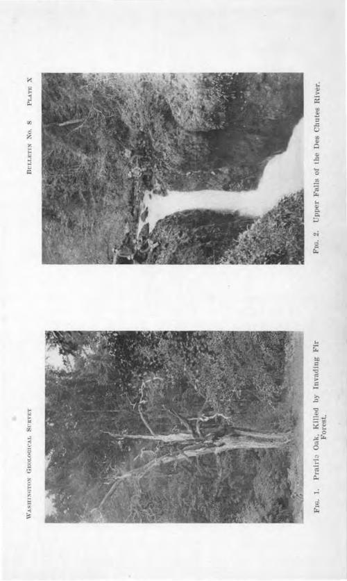
X <.: ;. j c..
c z " i= "' .., ...: ~
~
,_ "' ... = ii.
,.; .. 2 "' ~ :::, .::
:!' Cl
-= .... 0
.!!! '2 r:. .. C:
r£
... .0
"C

Glaciation of the Puget cnmd Regi()'II, 113
toq(!.1/ of Ma,r r Lol,c. Oontcm11on1n 011, Oo11 tcmoora11coua D ltua of Maatcr Lake. Tnbutorv Loku.
art Lalre Ru II. h rloek D'1ta. Lake Puyallup. (100 fL Black Lake outleL) .,tetlacoom and Early Lok Tacoma.
qu111tchcw Deltas.
l,endvance of Glncler Front and Obllt ration ot Early Lake Rua II.
Lair Nls1111ally. ( lmmber Prnlrle ouU t?) I tellllcoom nod \ Le.k Pui·ollup.
SeQnnllch w Deltas. toke 'roeomn.
Retreat ot Glacier Front. Re-formation of Lake RUBSe.11, ConUnu~ Glnclol Retr o L
Let r Lake R II. (l O ft. P ertl HJ ti! •It ch.an· nnl to Black Lo.k outle Lakes Puyallup and Tacoma cooJcsced with Lnke Rus9ell.)
(120 tt. Percival N' k clHIDD 1 to Black Lake outt t. LakeB Puyallup, Tacoma, kokomlllh. 8ood and ammaml b coal ced with Lall: Ru II.
Lak kokomlah. Lalt Dood. [ml!!b GlaclaJ J.ake , ammaLoke nohomleb.
take nobomlab.
GLACIAL LAKES DURING THE AD ANCE OF THE VASHON P GET SOUND GLACrEIR.
The low divide b twe n the ound and the hehali River ha b en hown to be due lar ely to depo it of the , a hon Gla ier. Eviden e J1a been found which argu that the hehali - ound divide a at the 'arrow near Tacoma during the interglacial epo h, in tend of where it i now. U thi onclu ion i orre t, the tream flowing in the int rgla inl
outh of the r arrow were then tributar to the hehnli . ati fa tor vidence uggc t that the Hood anal
interglaciaI river flowed to the hehali through the ia.tlock athwa.y. If the interglacial drainage was dispo ed a ug
g t d above th advancing Va hon lacier could have ponded water in front of it only in the trough of Admiralty Inlet and it tributary vnll y . Early drainag of thi pond d water hould have occurr aero the low ountr about th northern
part of Hood 'anal to that trough and thence to the hehali . d ance of the ice would ea.rl clo thi , however and would
hift the outlet of the upposed Jak to the ite of the arrow .

11 Bulletin o. 8 Washington Geological urvcy
Here it may be con ide,:ed to have remained until ad ance of th glacier to that lati ud d tro ed the lake.
ittle positive data can b ·pected on such a ubj e t. The hypothetical lake level lay b low 250 feet at it high t and doubtle became lower hil it exi ted, by the down-cutting of the arrows. D elta depo it hould have been form d in uch
a lake but they are not likely to have been pre ervcd ince they were immediately overri d n by a great glacier.
delta depo it which may be connected with thi hypothetical l ke of Va hon advance occur in the city of the harbor slope of Fir t Hill. It tructure ha ~ po ed by treet grading pecially at the corner neca treet and Sixth Avenue. ( I. VII, ig. 1.) Its maximum
hi •kne s i a.bout 30 f t, it bed dip outh, e t, and it r t unconformably on the tratified dmiralty clay which beneath th Va hon till, form the hill of the cit . The a hon till co er the delta bed and ha a mo.xi.mum thickne here of 15
feet. 'l'he triking feature of the delta ection i the pr en e
of fragmen of lignite whi h in ome trata con titut half of the material of the for et bed . The smaller piece re well rounded many of them b ing fragment of wood. well , rn fragment of a mammoth tooth ha al o been found in the e fore et beds. .
The line of contact between the fore et beds and he a hon till i about 200 feet abo"e a Jevel a .figure which would bring the water le el within the limits impo ed b the retical con ideration .
The e fore et gra el rata are expo ed aJong tJ1e lop for near1y five b]ocks. They ba e not been een to run back into the hill and thu to belong to the Admiralty serie . They apparently con titute a po it on the hill lope int ·m diate in time, as in place betw n the underlying clay and the overlying till.
Tl1 tream which built the delta came from the nodb norlhea t, or ea t, and mu t have inci ed an old wamp bed
Glaciation of the Puget S()'IJ,nd Region 115
wruch wa rapidly eroded. A con iderable current must have exi ted to detach and bear along the larger fragment . The de tro ed lignite bed lay fairly near the delta el e the weak material would have been di integrated and reduc d to mailer fragment . The ligmte bed wa oon ut through and the fore et bed lying south of and therefore younger than tho e so hea ily charged with lignite, contain little or none of it. Thi is further evidence of a rapidly eroding tream.
The po ition of the delta high on the hill lope, and the dip of it bed , make it diflicu lt to explain the ource of the depo iting stream. apitol Hill to the ea t could never collect ufficient water to form the tream which here left it record, and if the stream came from the di.rection it fore et bed indicate, it ii°' ed over surface which do not now exist and derived its gravel from them. The wamp which gave origin to the lignite wa de troyed, and it depo it con olidated by burial beneath other material long before the stream wa formed which tore up the old swamp bed and redepo ited it debri in th delta.
The tream which built the eneca treet Delta i believed to have taken origin from the melting of the advancing Va hon Puget Sound Glacier and to have cro ed a tretch of land omewhere on the northern part of Capitol or Fir t hills, here
incising the lignite bed i ell a. portion of the Admiralty edimentary serie . Depo it wa inferentially in he upposed lake can ed by the ad ance of the Va hon Puget ound Glacier. Shortly after the delta' formation the glacie1· pa. ed over it, a.nd sealed it beneath a cover of a hon till.
This conclusion explain {l) the source of the stream, ( i) the volume and trength of the tream (3) the rapidity of removal of the lignite bed ( 4) the consolidation of the peat, (5) the unconformity on the underlying clay and (6) the freshnes of the gravel which i not tained in a
manner comparable to that of the Admiralty gravels.

116 Bullet-in 1' o. 8 Washington Geological Survey
The ice overrode thi uncon olidated delta material without di tarting jt en ibly. In one ection a cobble wa found to ha e projected for half it ruameter above the subjacent gravel urface and to have been held o rigidly that a furrnw at least
three f cet long wa formed in the under ide of the till sheet by it. Jt offer po itive evidence that the gravel wa solidly frozen when the glacier pa ed m•er and thi explains the lack of distortion.
GL CIAL LAKES OF THE TIME OF MAXIMUM VASHO GLACIATION.
In impinging on the no1·thern lope of the rock hill which lie outh of the drift plain, the Vashon Puget Sound Glacier undoubtedly dammed many small aUey , and produced a seTies of marginal lake1ets which have left no record except in a few cases where surviving drift-dammed lake an.d wamp attest their former e. i tence. Larger marginal lake of the maximum stand of the ice a a rule left better record .
MINOR LAXES OF TKE BALD lllLLS.
The front of the Puget ound Glacier cro ed the i qually Valley at LeGrande where the river emerge from the foothills of Mount Rainier to the plain. Though an ideal ituation for a glacial lake if U1e valley above were empty the probable presence of ice from Mount Ra.inier is thought to have prevented the formation of a lake.
On the northern lope of the Bald Hill , there were mall glacial lake , noted in the chapter on the terminal moraine (Ch. II). These are recorded by mar hes and drift-dammed lakes which till exi t . There are several bolcl outhern lopes among the e hills where the volcanic agglomerate ha been weathered so deeply a to leave the larger bowlder of its mass isolated on pede tal , forming anvil- and obeli k-shaped projection . Among the e are cattered erratic pebbles. Since the e pebble lie higher than the moraine, and on slope facing away from the glacier the are refen-ed to ice floating in marginal water glacially dammed among the hill .

Glaciatwn of the Puget Soum.d Region 117
GLACIAL LAKE OF THE DES CHUTES RIVER VALLEY,
The Puget ound Gla ier cro ed the De Chutes River valley where it emerged from the Huckleberry Mountain . The upper part of the De hute Valle was protected by the Huckleberry Mountains against invasion of ice from l\Ionnt Rainier and it wa dammed by Puget Sound ice at it debouchure on the plain. Thi gave rise to a glacial lake. The pebbly clay depo ited in this lake probab1 i re pon ible for the :flat on which i the grnup of mall farm and the Bald Hill
chool, a mile or two above the moraine cros .ing. The lake depo its and the moraine have been re pon ible for
the uperpo ition of the river on a rock spm of it pre-Vashon valley, and the consequent formation of the De Chute Falls, a beautiful double cataract with a picture que canyon below it. (Plate X, Fig. 2).
An intere ting problem is afforded by a comparison between the Ni qually and De hutes river where they enter the Puget Sound drift plain. Both were diverted after the glaciation, and forced to cut through rock for a hol't di tance. Both po ess deep po t-glacial canyon , but the Des Chutes has a cataract at the head of its canyon while the grade of
, the Ni qually rises gradually through the canyon until it is at the level of the pre-Va hon valley. The rock i a fairly uniform den e lava in the Ni qually canyon and a volcanic agglomerate in the Des Chute canyon. Both are cut by dikes of more resi tant rock which project on the canyon slope . The De Chutes canies over its fall debris secured by the erosion of the rock in the uppe1· part of its valley while the i qually carrie outwash gravel from the pre ent Ni qually Glacier on Mount Rainier. The 1·ea on why one tream posse es a fall in it postglacial gorge while the other doe not may be found in this difference of amount of debri carried, or may lie in other factor .
GLACIAL LAJUl SOUTH OF MC INTOSH.
Near Mclnto b and Tenino the glacier at it maximum ex-tent reached a mile or more beyond the southern margin of the

118 Bulletin No. 8, Washington Geological Survey
terminal moraine. This i recorded in scattered glacial gravel on the hills south of the Clear Lake valley the moraine lying north of the valley.
The outhern lope of the moraine here has numerous rock outcrop and it appears that a line of low rock hills, nearly paralleling the edge of the ice wa here o erridden a hort di -tance. The e hills appear to have caught the ba al debri on their northern Bank and thu to have determined the location of the moraine. The a'"tra-morainic gravel above noted doe not repre ent a depo it from ponded water becau e over mo t of the hill slopes the topography i uch that a lake could not have exi ted wherever the ice front stood.
There i further evidence that the ice crossed the Clear Lake-Tenino Valley outh of the moraine, and rested against the hills on the south side of this valley. This evidence i found in the delta depo its of the two glacial lake whose exi tence required an ice dam hard against the hills outh of Clear Lake and Tenino.
Back among these fore ted hill there i a beautiful valley :Bat lying a little west of outh from McIntosh, and a little outh of ea t from Tenino. It ramifie in several green meadow
al'.ll'.ls among the hills, and dxain northward to Scatter Creek. At the glacial maximum this northward-draining valley was dammed, and out:Bmv from the resultant lake was aero the divide to the Skookum Chuck on the outb. (See Figure 2.) Sediments deposited in the lake contributed to the filling of the ~·alley though sub equent wamp depo its hav'e done much al o. A delta deposited in the lake i cros ed by a road which enter the valley from Tenino. Its sw·face i 450 feet above the sea, and its structure, ~'"Posed in a road ide gravel pit, i perfectly and uniformly foreset, the beds being flO feet thick and dipping to the outh. The level top of this delta i a noticeable feature of the local topography. Though the outlet channel ha not been found the delta probably records the chief level of the lake.
The valley today ha.s an outlet northward 100 feet or so

Glaciation of the Puget Sownd Region 119
lower than the delta, and eroded in & drift filling in the lower part of the alley. Thi driit dam held a lake £o ome time after the ice withdrew, and the outlet meandered in cro ing the glacial accumulation of sand and clay. The stre1tm has sub equently entrenched the e meanders, and, with the as i tance of encroaching vegetation ha de troyed the lake.
LAKE DU-CODA.
A little more than a mile outh of Tenino, near Blu.mauer's ~ delta bed , dipping southward, are expo ed in a terrace of glacial gravel whose surface is 8!5 feet above sea level. The delta lie just within the Tenino-Bucoda.Centralia through valley which carried glacial drainage to the Chehali . The valley is widely open directly north of thi delta, and could have been clo ed there only by advance of the ice front at lea t S mile outh of the terminnl moraine. (See Fig. 2.) In Chnpter ill, the outwash gravel which floor this valley, about 45 feet lower than the delta are shown to prove also that the ice front closed the Tenino-Bucoda.Centralia valley at the north.
The delta gravels a.re only half explained, however, , hen the existence of a glacial dam i proved. The valley today is open to the south; but it mu t have been closed at the time of depo ition of the delta gravels near Blumauer's Mill. The same two hypothe es are entertained to e.xplain such damming that were advanced in Chapter III for the low gradient of the gra el between Tenino and Bucoda. (1) .Either there was a low preglacial divide in the valley south of Bucoda cut down by glacial drainage, or ( 2) the Stony Point valley. train, which joins the Tenino-Centralia valley at Bucoda, caused the damming. In either case, glacial gravels of Va hon age should be found near Bucoda at altitudes approaching 325 feet. Investigation has not been exhaustive, but as far as it has gone it has failed to :find Va hon gravels above ~7'0 feet about Bucoda, at which level they occur in a terrace on the west ide of the valley south of the village. Nor have gravel

UO Bulletitn No. 8 Washington Geological urvey
terraces higher than the pre e11t tony Point valley train been found along it cour e. The need of more careful tudy of the region i evident.
LAKE CHEHALlS.
The gravel which entered the hehali River valley at entralia coming from the Tenino-Bucoda and Stony Point route con titute the mo t outhern occurrence of Vn hon outwa h of Puget Sound. The entered the larger valle from the northea t and were wung back to a no1·thwe t cour e at an angle acute to their route to the hehalis. Their volume was so great as to fill the Chehalis Valley up to an altitude of 188 feet con-iderably above the pre-Va hon vaUey bottom. Excavation at
Centralia penetrate these clean fresh gravels for 75 feet without reaching their ba e.
The city of Chehalis i about four miJe. up the river from entralia, and tand at the ame altitude on the ame flood
plain. But wherea outwa h gravels are at least 75 feet deep beneath Centralia, hehali i built on a valley filling of river aUuvium and lacu trine depo it , and no trace of a-lacial gravel has been found in the region, save where tran ported by human agen y . The region of the city of hehali received no gra el becau e the flowing water turned down b·eam on entering the Chehali VaUey at entralia and the invading gravel were carried back toward the glacier. Only tanding water ould have e j ted at the ite of hchali when the gravel were depo ited for the valley wa dammed by outwa h about entralia and water mu t have backed up the ewaukum, heho.li and "Big wamp va.Ue .
Dammed by Va hon outwa h, Lake Chehali (Plate XXITI) came into ex.1 tence at the time of maximum glaciation. It slowly d,vindled as river and swamp depo it filled the depression, never being lowered more than a few feet by inci ion of the gravel filling. Dam?'led by a permanent barrier it probably wa longer lived than any other glacial lake of the region. It position i the mo t southerly of all water bodies originating in con equence of Va hon glaciation.

Di:r,t.ETrx ~n. !I l'l~\TE XI
F m. I. Section in lhe Slelliwoom Delea.
F'w. 2. Section in tile IUchmond Delta. ('outac, IH'l\\'Pt•u tnr .. ~1•i tHu-l top~•'I h(•fl~ h, lti:""1 ft•t' I nhu,t,, "iPH li•vti1 .

Glaciation of the Puget Sound Regi(>TI, Ull
Evidence for the exi tence of Lake hchali are largely in the topographic configuration of the region and in the presence of the gravel filling at the north. A the gravel front ad,•anced outhward on the out ide of he curve in the glacial drainage cour e at Centralia a delta structure must have been formed in the lake· but ground water i o clo e to the urface of the :flood plain at Centralia that exca. ations are filled to within ten or fifteen feet of the surface and the gravel structure i concealed. The few feet of gravel een above the , ater po e tream bedding with outhwa:rd dip.
Well a.bout hehali have frequently brought buried timber to light, oak tree trunk having been found 50 feet down m clay and and. o gravel i reported in the well record .
LAKE OF THE CHERALl VA.I.LEY TRAIN.
When the .flood of glacial gravel wa poured down the length of Chehalis Valley it dammed the mouths of the tributary valley which bore no contributing gravel train . In the e obtructed valleys lakes uo e in the ame rnanner that Lake he
hali wa produced. one of the valley o dammed were of con iderable size and no lake of consequence were produced.
e,,eral linear wamp among the driftle s hill about Centralia. ue referred to damming of preglacial tre.am valley b the valie train. A terrace depo it compo ed entirely of local matena.l e:s:i ts in the lower cour e of Porter reek which :Bow from the Black Hill . It rea he a mile back from the Chehali Valley, an.cl its level probabl repre ent the altitude reached by the granl filling in the main valley. Thi depo it affords the soil and the plane urface wl1ich have permitted everal farm to be developed in the lower valley.
WADDELL CR.EEK LA.KE.
Waddell Creek which enter Black River from the Black Hills, wa dammed by the glacier at the point where it emerged from the hills. Standing water accumulated here to a height of 650 feet, at which altitude a pa , e tward through the hills to the head of Cedar Creek permitted e cape of the ri ing water.

12~ Bulletin No. 8, Washington Geological Survey
(See Figure ~-) Floating ice caITied glacial drift bnck m the valley and di tributed t11e pebble throughout the finer clay which settled in the lake. Much of the clay is fine re idual soil which wa derived from the surrounding hill lopes. The scattered pebbles are found no higher than 650 feet on the valley ides. A 1acu trine -flat re ulted from this lake imilar to that of the De Chutes and in a imilar way it is re ponsible for everal farm back in a hilly region which is most unpromising agriculturally.
GLACIAL LAKES DURING THE RETREAT OF THE V SHON PUGET SOUND GLACIER.
Tl1e wane of Va hon glaciation afforded ideal conditions for the development of a complicated series of glacial lakes in the Puget Sound basin. In many ways thi region resembles the Finger Lakes country of central ew York. In both the trend of the topographic features is north and south and in both the major form were produced before the la t glaciation. Ponding in the linear valley occurred in both region dm·ing glacial retreat, and the general rule in both wa that withdrawal of the ice opened succe ive lower outlet to the north.
But in Puget Sound all water e caping from glacial lake in the different valley wa forced to pa s over tlle Chehali -Sound divide into one drainage line. The result of this control of glacial drainage by one pa wa to limit ubsidence of ponded wate1·s whose valleys had successively lower outlet expo ed by ice retreat. Gradually, water iu the trough and fiord of ufficient depth in the outhern part of the area united at a common level; hat determined by the pre ent ChehalisSound divide east of the Black Hill . The water bod who e level wa thus controlled ha been named Lake Ru ell*. Its foception wa coeval with glacial retreat from Budd Inlet the most outhern arm of Puget ound. It maximum wa attained just before its final di appearance, the lake then extend-
• J. H. Bretz, "Glacial Lakes oe Puget Sound," Jour. Gaol., Vol. 18, 0. 5.
Glaciation of the Puget ound Regi-0-n US
i.ug from Olympia nearl to Everett a distance of nt !en t 6fty mile .
EARLY LAKE It SSELL,
BLACK LAKE OUTLET. lacial retreat aero Thur ton ounty developed a low draino.g line clo e to the ea tern foot
of the Blnck Hill the use of , hich b di charge from Lake
Ru ell wa continued after th dge of the ice had withdrawn from the region. There wer b o and perhap mor channels leading out of thi lake but c nv rging within a few mile into one which continue a a ide , ampy valley of low rnde to the behali . It i now occupi d by Black Lake 11nd la k Riv r. Two of these converging ch nnel leave the wtlley of Budds Inlet, and one may come from the head of Eld Inlet vall . ( ee Plate XXII.)
The t o channels from Budd Inlet are epar ted by a bo. o.ltic bill w t of Tumwater. lo ely hugging the outh s.id of thi hill a channel floor 150 to 155 feet above ea le\'el pa e we t from Budds Inlet v ll to Black Lake. The altitude of the ravel plain imm diately to the outh i only ] 60 fe t plu there being an imperc ptible ri e outhward. It wa of our form d by glacial dra.inag probably by drainage dir ct
from th ice rather than from th gla ia.l lake. The £ii· ·t appearance of a lake would favor on entration of thi drain ge and developm nt of a channel.
he hannel on the north idc of the rock hill ha been largely d troyed clo e to Budd Inlet. by the development of tbe rci •al reek po t-glncinl valley. The head of thi valle ha receded a little mor than ll mile from the water and h I'e i ut in a broader vall now abandoned. t the head of the er ek in the old channel i the di ide betwe o drainage for uget ound and for the h hali 1ver. It i no more than two mile from tidewat r,in ound but more thnn 60 mile to the rune le el in ray Harbor.
The orthern Pacific R ilroad u es the alle of Perci 1 reek to climb from ea le el to the col or divide in the old
channel in a di ta.nee of littl mor than a mile. The col bear

j

Glaciation of t1,e Puget Sound Region Hl5
a long narrow wamp which i drained both to Puget Sound and to Gray Harbor. A cleo.i-ed field at the head of the creek valley (Plate V, Fig. ~) shows the old channel• here to be less than one fom·tb of a mile wide and to be l:hicl<ly bowlderand cobble-strewn. Its altitude here i about UO feet above mean tide, The southern margin i a gravel bluff ri ing to 150-160 feet and reaching back at thi level for a considerable distance. The northern margin bears a gravel terrace 140 feet above sea level and a few rods wide and another at 160 feet, the surface rising from tlu as a fairly definite bluff to till surfaces at higher altitude . One can follow the 120-foot floor ea tward from the cleared field at the head of Percival Creek ravine along the north ide of the valley until, landing on the easternmo t remnant, the water of Budd Inlet can be een. The terrace urface here i covered with bowlders and
cobbles. Black Lake, in the col wamp i two and a half miles long and
half a mile wide. It longer axi lie with the channel and it surf ace is nearly 120 feet above tide. From its we tera side the shore ri e abrupt] to a 155-160-foot tream floor. Gravel terraces with broad leYel urfa e 130 135 and 155 feet in altitude are cro ed by the road in the dense wamp at the northern end of the lake. The 155-foot ten:ace here lie in the middle of the channel, with lower urfaces on each side.
third su pected channel i of le er magnitude than the first de cribed. It kirt the ca tern ba e of an outlier of the Black Hill near the outh end of Eld Inlet perhap entering the swamp above the head of Black Lake. I ts altitude near Eld Inlet j 1S5 feet. Its definjtene i for Jes than that of the Percival reek channel. There i a pos ibility of a fourth, and yet les definite, watercour e ha ing been in use early jn the hi tory of Lake Ru ell. Thi doubtful feature lies about half way between Budd and Eld Inlets. The point of weak-
'"Warren Upham (American Geol., Vol. 34-, No. 4) has noted thls channel, which ls plainly recognized Crom the train, and has suggested that it may have carried overflow rrom a glacial lake In Puget Sound.
126 Bull.etin No. 8 Washington, Geological uroey
n in both of the e u p ct d channels i that a ontinuou tracing aero the di ide ha not been made, becau of the almo t impa able nature of the wamp exi ting there.
Withdrawal of th dge of th ice from Thur ton ount left both the De hute and i qual1y river free to flow dir ctl northward to th rowm bod of water in the unoblit rated interglacial "alle . The i quall carried a larg "olume
f water when it fir ent r d ake Ru sell in e the hop channel till contributed the drainage of the north rn and w tern lope of Mount aioier. It appear to ha e entered the we tern ide of the interglacial Gate Pathway River valley and to ha"e contributed con iderably toward the bliteration of that valley by depo ition of the herlock clta.
THE RE1.tLOCK DELT . Th front of thi anci nt river delta ri e abruptly 90 fe t abo e the flood plain outh of herlo k. The altitude of i upper margin i 115 feet abo e tide.
arther we t the front i I abrupt and the altitude of the margin i 120 feet. n oth lop , fine fore et bed of rounded
rav I are .po ed dippin northward toward the ound. The for t covering of the delt i o d n e that it wa not pra ticable to examine it topol:!'raph in detail. The delta wa found how r to po e the 60-foot portion back f om th margin and apparent} to ha ea few hallow ke tle in it urfoce.
The Des Chute i a minor tream and wa carrying no glaial drainage when Lak Ru ell came into exi t n e. It .i
doubtful whether delta depo it in Lake Ru ell can be found that ma be referred confid ntly to thi stream.
LAKE l" Y ALLUl'.
The comparative tudy of outwa h terrace and chann 1 ha given ati factory evidence that L ake Puyallup, in the Pu allup River trough, did not length n north of Ortinr:r until the ice had withdrawn som wlier in the vicinity of tl1e group of lnke in northern Thur ton aunt and had expo ed hamber Prairie and Bu h Prairie a drainage routes. ince Lake Ru ell came into e.i i ten oon after retreat of the ice from

Glaciation of the P11,get Sownd Region
this region it is doubtful whet.her t.be master lake can claim priority in the glacial lake histo1·y.
THE OnoP CHANNEL. The Ohop channel (Pl. XXII and II and Fig. 8), which was the outlet of L!\ke Puyallup and
the route of the Carbon and Puyallup river to the i qual]y contain Ohop Creek and Ohop Lake outh of the pre ent col, and Lake Kapowsin and the Puyallup River north of that point. The col i 595 feet above sea level and Obop Creek entering the channel here from the foothills of Mount Rainier, divides on the col the major portion of the tream turning southward to, ard the Ni qually, and the smaller branch entering Lake Kapowsin and the Puyallup River. Alluviation by this stream has doubtless formed the divide at this point and produced Lake Kapowsin in the same way that .Bergh Creek ha probably produced Ohop Lake in the old channel. The earlier po it.ion of the divide was probably between the north end of Lake Kapow in, and entrance of the Puyallup River into the old channel, and the earlier divide was somewhat lower than the
~~~ / At the pre ent col the valJey is about 500 feet , "de at the V
bottom, and 340 feet deep. At the cro sing of the Mount Rainier road, a few mi]es from Eatonville it i 200 feet deep and perhaps 2000 feet wide. Between these two points there is a descent of about 14 feet to the mile from the present divide in the channel. From this point to the lowe t terraces of gla-cial drainage at McKenna the grade is about 10 feet to the mile.
The narrows of the Puyallup River valley between Kapow in and Orting are cau ed by the superpo ition of the earlier southward-flowing drainage on a rock hill buried in the drift, and the maintenance of this course by the present northward-flowing drainage.
The ,ve tern side of the Puyallup trough lie at an altitude of about 550 feet from a point nearly two miles south of Orting to a point three miles north of that town. We t of thi rim is lower land leading to Lake Russell. Whether this altitude uf-

1~8 Bulletin No. 8, Washington Geological Survey
£iced to hold Lake Puyallup to the Ohop channel has not been yet definitely determined. If the Kapowsin col has been rai ed 50 feet or more by alluviation of Ohop Creek it i probable that the lake ilischar ge held to the Ohop channel and, with the Carbon, White, and Puyallup river , welled the volume of the
isqually until the glacier withdrew nearly to the bifurcation of the frough "\'alley near the town of Puyallup .
THE CLoVJl!n. CREEK CHANNEL. W 1en this region was
cleared of ice, Lake Puyallup found a new outlet we tward through Clover Creek channel to the Steilacoom Plain south of Tacoma and thence to Early Lake Ru sell in the vicinity of Steilacoom. ( ee Figure 8.) The col in the Clover Creek channel on the summit of the bluff outh of Puyallup, is a little below 400 feet in altitude. From it a well marked glacial river cour e leads south, and then north,vest, to the broad gravel plains about Spana.way Lake. Salsich Junction, on the Tacoma Eastern Railway, is on the brink of the old valley which the railroad cro ses at this place. Lake Puyallup persisted with gradual northward increa e of area until the site of the city of Tacoma was cleared of ice. A lower pa s was then opened, and becau e of thi and other changes, the history of Lake Puyallup may be considered to end at thi time, it area becoming part of Lake Tacoma.
LA.KE TACOMA.
A very interesting region in the tudy of the glacial lakes of Pug t Sound lies in the southea tern pa1·t of Tacoma. The bluff on which tbi city i built is a large 1·eentrant angle opening northward toward the tide flats of Puyallup River . The business section of the city lies on the western .ide of the angle.
re idence ection occupie the outhern ide, where the glacial lake hi tory i to be xead. ( ee ig. 9.)
THE TACOM DELTA. A number of gravel pits are located in ·this part of Tacoma, forming amphitheater-like niche in the face of the bluff. They all agree in exhibiting delta-bedded gravels which dip between north ,:md northwe t toward the

ll'm. 9. A p0rtlou of lb c:lty of Tacoma, showing location of the Tacoma Deltn. th various Pita In It. the II •nd or th uLh Tncomn b8.J1D('I, ll.Dd PosiUon of Jee Front at Time ot Delea l~ormatlou.
-5

130 Bulletin No. 8, Wa hington Geological Survey
present Sound. The altitude of contact between top et and foreset bed , however, i not the same in each pit.
In the_ cit t of the Hawthorn School at Thirtieth Street South and D Street, top et beds 10 feet thick rest on foreset bed at an altitude of 265 feet. The delta urface above the pit can be traced easily southward with a ri e of 10 feet in half a dozen blocks. The delta :fiat here is a noticeable feature of the topography. To the northeast, McKinley Hill, SSO feet above tide, ri es like a buttress between thi delta :fiat and the adjacent Puyallup trough.
Another pit has been opened on the east side oi Gallf!g_he~s Gulch, a few blocks nearer the apex oi the right angle described by t e bluffs. The lower portion of the pit is in interglacial gravel, and expose an intercalated stratum of Admiralty till. A thin layer of Va hon till caps the old, stained gravel, and is succeeded by fre ~. unstained uncon olidated gravel with an abundance of granite pebble of various kind and none of the soft, pink purple, or gray lava pebbles found commonly in the lower gravel. This fre h material can be traced without break to a pit in the delta-bedded gravel near by, and definitely places the delta bed as sub equent to deposition of the Va hon till.
The Harrison pit is lo.wed.- venu1:_ and Thirty-second treet South in the apex of the right angle. Its foreset strata dip to the northwe t, and the altitude of their contact with topset bed is S20 feet above tide. The gravel here is exposed to a depth of 60-70 feet all but the upper few feet being foreset beds.
If the delta flat south of the Hawthorn School be follo~ved southeastward, the direction from which the stream came, as indicated by the foreset beds and the grade of the surface it leads to an abrupt descent to the Puyallup Valley, L treet lying along the brink. This lope is somewhat irregular and has no pits like the northward lope just described. ell p,enetrate a. clayey gravel unlike the material in the Hawthorn and Harrison pit . Till i exposed in shallow cuts, and at the

Glaciation of the Puget ownd Region un
ummit of the lope, gravel bedding record · a current flowing northward away from the lope and onto the flat.
On the adjoining higher land about the e delta gravel there ar no evidences whatever of a tream cour e , hich could have supplied them. All evidence collected point to the L Street margin of the Hawthorn chool delta fiat a the ource of the gravel. The bluff here de ccnding to the Puyallup Valley bear - -many of the mark of an ice contact lope. The conclu ion is evident that the river w-hich depo ited the Tacoma Delta came directly from the urface of the Puget ound Glacier when its front lay again t the ea t lope of the delta .Bat de ribed.
The lack of harmony among the altitudes of the tops of the fore et beds records a water body w:ith changing levels. Thi
i to be expected where a glacial margin i adjacent because change in it po ition may change the location and le el of the outlet. Such wa not, however, the cau e of the various altitudes of Lake Tacoma's surface a will be hown.
THE SouTa TACOMA Ca.u.TNEL. Q_aJJagher' h and DeLynn treet Gulch are two po tglacial ravine which enter the Puyallup trough at the apex of the reentrant right angle in the bluff . Both are utilized by railroad to a cend the bluffs. The Northern Pacific follow the DeLynn Street Gulch to an altitude of 230 feet, where the ravine head in a flat-floored valley, one-fourth of a mile ·ae with no pre ent stream. Terrace of thi alley floor, into which the DeLynn Sti·eet Gulch ha cut, extend toward the ound on both ide , while we tward a.long the orthern Pacific track the grade, which follow the old ,,alley at once begins a gentle de cent toward the Steilacoom Plain . The old valley at the head of the gulch 1 70 feet deep. It here po ses es a terrace 250 feet above tide. Farther outh, a higl1 level gra,,el terrace on the west side of the abandoned valley at about 810 feet above tide ramifies back amon{J' the till ridge which bound the valley. Its location is approximate] we t of outh Tacoma, which j built on the channel floor.

jrgg490
Typewritten Text
Channels and Deltas of this stage are crosshatched. Outlet of Lake Nisqually approximated.
jrgg490
Typewritten Text
jrgg490
Typewritten Text
jrgg490
Typewritten Text

Glaciation of the Pv.get ound Region 1SS
OllREk\'l'ION OF TACOMA D •LTA AND llA~'N.EL. Here then the e capewa of a con iderable quantity of water who e
cou.r e wa outhward. The channel head on the rim of the Puyallup trough near the apex de crib d. Water discharging through it deepened it at lea t O feet. Behind it wa the water bod in which the Tacoma Delta wa built, at le,el between 265 and 320 feet. There can be no he itation in correlating outlet and delta level even though altitude a ·e not the rune. It is ufficicnt that the range in altitude of the outlet include the delta level . There i no other place for di -charge of Lake Tacoma. f the Narrow had been open the delta level would have correlated with the Black Lake channel and th Tacoma Delta would belong to Lake Ru ell who e high t altitude wa mon than 100 feet lower than the lowe t level of the Tacoma Delta. The discrepanc in level of delta and outlet i imply because the cbannel continued to carry glacial drainage and wa eroded after ice had withdrawn from the head of the Tacoma D lta. (See Fig. 10.)
The most wes ern level of the Tacoma Delta i the highe t and tl:be mo t ea tern i the lowe t . In thi i recorded the po ition of the ice front on the ite of Tacoma while the outl t channel wa lowered 55 feet . Slight rece ion during tl1i time allowed lower delta surface to form ucce ivel a tward their po ition being determi11ed b the unknown cour e of the glacial tream and the local outline of the ice margin, and their altitude by the do cutting of the outh Tacoma channel.
Baile Willi ha di cu ed the Tacoma Delta in two paper . • He concluded that the above de crib d outh Tacoma outlet channel wa. the cour e of the river which depo ited th delta 1 gra I . In regard to thi conclu ion it i to be noted
(1) that the direction of dip of the fore et beds i in all ca e toward not away from the outh Tacoma channel and that the neare t bed (Harrison pit) dip almo t dinctly toward tl1e nearby channel l1cad;
• Taeoma FolJo ' o. 64, . S. Geo!. Survey 1899. Bull. Geo!. Soc. Amer., Vol. 9, 1897.

134 Bulletin No. 8, Washingto-n Geological urvey
(!2) that the grade of the Hawthorn chool delta flat does not permit the application of hl interpretation; and
(8) that the grade of the outh Tacoma channel it elf ab olutely forbid bi interpretation unle tilting has reversed this channel grade in a 1·egion where po tglacial tilting has not been recognized. Data on the teiJacoom Plains to be pre-entcd hortly will throw further light on the subject.
THE UDURN DELTA. A mile ea t of the town of Auburn, the orthern Pacific Railroad Compau ha excavated e ctensively in the face of the ·valle bluff for balla t gravel. In the ection thus expo ed there are plendid fore et delta beds some
of them 50 feet long clipping west toward the pre-Va hon trough in which Auburn lies. The delta nature of the bluff
· would hardly be recognized from the topograph . rI'he grnvel has two summit levels at !235 and 260 feet above fde, but a.Imo t immediately back from the edge of the delta it ul'face descends in a huge kettl~ that de tro s completely all semblance to a delta urface. White Lake lie in thi kettle at an altitude of 105 feet. The outh side of the kettle completely breaches the delta front and pre ent a re emblance to a rive'l· channel as Willis has interpreted it. Tbe northern rim ri e to 160 feet, however, and the pre ence of man smaller inegular kettles on the delta urface i ati factory e"idence that the Auburn D lta wa built on the marrrin of the waning gla ier block of who e ice were buried in the river depo it, to melt out after depo ition had cea ed.
The uburn Delta a depo ited by Green River in glaciall. ponded wat r along the margin of an ice tongue lingering in the White River trough. The corre pondence of levels in the
ubu.rn and Tacoma deltas strongly ugge ts that Lake Tacoma po e ed a long marginal arm of water reaching nortbwal'd to Auburn on the ea t ide of the White River trough immediately aft r the Tacoma D elta was abandoned and after the ice had ,vithdraw-n from contact again t the bluff at L treet, T a oma. The lowe t level of the Auburn Delta. corre pond with the col in the South Tacoma channel and

Glaciation of the Puget ounrJ, Region 195
completes the record of river depo ition to accompany all stages of ero :ion of the outh Tacoma channel. o other outlet exist for the waters in which the Auburn Delta wa built except the arrow , and if the had b~n open, the Aubu~ Delta would correlate with the level of Lake Russell, at least 65 feet lower.
THE KBNNYDALE DELTA, On the ea tern bluff of Lake Wa hington about Kennydale lie a broken- urfaced depo it of a.nd aud gravel, of considerable extent and depth. El ewhere the lake bluffs are of till. A level urface exists at the summit of the slope about a mile back from the lake, 290 feet above the sea. May Creek bas cut a can on into tbi perhaps 225 feet deep. Fine sand con titutes the urface material and well stmtified gravel i found in hallow excavation .
Followed back from the lake, terrace fragment are replaced by a continuou floor on both side of the creek. It has a mooth urface ri es gently ea tward, and i composed of well wa bed gravel. Definitely cut bluffs border the outhern side of this valley and the canyon of May Creek hallows rapidly until the tream three mil from Lake Wa hington, i flowing in a wamp wide-bottomed old channel, in place a quarter of a mile wide ,vith bluff 50 feet high. Thi old valley i ve1·y di tinct along the foot of quak Mountain (Pl. XV, Fig. 1) where a col in -it about 315 feet above sea level divid s the head water of Ma reek and I saquah Creek. Willi • note the existence of the upper portion of this old valley, and a cribes it to the work of Cedar River sometime during gla ial retreat. 'l'he strength of development shown by the hannel i equal to that exhibited in the pre ent lower Cedar River valle , and sug(J'e t a con iderable period when the river emptied into the pre-Va hon valley four mile north of it pre ent junction and adjusted its channel to a water level about i90 feet above tide.
The Kennydale Delta i too high to be correlated with Lake
• Tacoma Fo1Jo, No. 54, U. S. Geo!. Survey, 1899, Bailey Willis and G. 0. Sm1tb.

136 Bulletin No. 8 Washingtcm Geological urvey
Tacoma level north of the Tacoma Delta. Thi latter form definitely proves that Lake T acoma ,va lowered to an altitude of 265 feet a the time the foe contact lope of L tree wa abandon d and the lake became free to e:x.tend northward. The Kenn dale Delta i to be interpreted more atisfactorily a a depo it in a local lake between the ice tongue of the Lake Wa hington valle and the bluff being b·ibutary either to Lake Tacoma or to Lake Rus ell whjch ub equently r plac d the earlier water levels.
CORRELATION OF LAlCE l'UYALLUl' TACOMA AND RU SELL.
TRE TEll..ACOOM PLAIN . Thi large area of outwa h gra\lel po e e a uniform we tward de cent from the broadening out of lover reek channel near panawa Lake to the abrupt truncation of the plain b the b]uff of Puget ound on the we t . ( ee Fig . 8 and 10.) The grade commonly i b t\ een 10 and 15 f et to the mile. The urface of the plains is di po ed in delta-like terrace in many place , and long channel are to be recognized on the we tern porti6n, de cending we tward \Vith the gen ral lope. ome portion ar rolling and ugge t mo1·0.inic topo.,.raphy, but till i rarely expo ed in ection . Faint lVIima type mound are found on orne of the
plain , outhea t of Hiillmr t for ex1,1mple. The area i largely natural prajrie interrupted b fore ted portion . The conr e gravelly oil provide an exces ive under drainage and the plains are of little value agt·ictt1turaJl . The region ha a-i en th . S. Bureau of oil thefr pans.way type of gravelly soil.
Lake Puyallup empti d through the lover reek channel onto the t ilacoom Plain at their ea tern terminu , bile the northern ide of their area recei-ved the di charge from the earlie t tage of Lake Tacoma then a mall body of water in the re-entrant angle wbi h contain th Tacoma D elta. Following retreat of the ice from the L treet lope, Lake Puyallup water found a Im ,r outlet throurrh th outh Tacoma cham1el and became a part of Lake Tacoma. By the u e of both of the e w chargeway the glacial gravel pr iously

Glaciation of the Puget ound Region 13'1
depo ited on the tcilacoorn Plajn were rehandled and added to. Though the gradient i low for trerun-depositcd gravel· it · paralleled in man place in uget ound outwash, where other conditions make it certain that uch grade were produced only b glacial drainage and that they are without di cerrubJe ub quent deformation.
The we tward-faci.ng bluff which terminate the teilacoom lain afford furth r indi putable evid nee that they are
trerun gravel . The town of tcilacoom i built on the we tern lope of a J1ill o! morrunic a pect which ri e above gra.,rel
plain on the n01·th ea t and outh and intenupt the continuit of their bluff lin on Puget ound. ( ee Pl. L"'{Il and ig. 10.) Immediate] north of teiJacoom the bluff i of fr h gravel for two mile , ith an even ere t line of 180-!00 feet.
orth of thi to Tacoma the bluff xpo e till urfaces and edge of trnncated Admiralty sediments ri ing to 400 feet above tide. The hill on which teilacoom i built form the bluff for three miles outh of the town and i then ucceeded b a bluff of fre h gravel with even ere t line, nowhere more than 200 feet high, thi continuing to the mouth of the i qually Ri er. The e gravel bluff con titute the we tern edge of the teilacoom Plain .
THE STEILACOOM DELTA. Exten ive e...xcavation have been made in the face of the blu1f north of teilacoom by the Pioneer and and Gravel ompan of cattle. The gravel i Juiced out b b draulic method , cal'ried to the bunke1· , and
there sorted, all by gravity. The pit are abandoned when their floor are lowered o that running water will not succe full carry the ara.vel from pit bead to bunker. Great amphitheater are thu formed in the bluff and the tructure of the gravel i plendidly hown. ( ce Pl. XI Fig. 1.)
Without exception, tl1e material from bluff top to ea level is fre h un tained uncon olidated Va hon gra el and this gravel is di po ed e erywhere in fore et and top et bed . It eems evident that the whole wall of Puget ound here has
been advanced on the inlet by delta growth.

188 Bulletin No. 8, Washington Geological Survey
The large t pit has sides 100 feet high in which, at the time of examination, great, unbroken foreset beds certainly more than 100 feet Jong were expo ed without interruption. The e bed de cend we tward toward the Sound with an aver-age lope of 15°. affected them.
o faulting or other deformations have
Above the long, unbroken fore et bed i a stratum of top et beds, about rn feet thick near the eaward end. Shallower fore et bed overlie thj in turn, with a depth of 10 feet, and their truncated edges disappear upward in the smface soil. A broad ridge of gravel, overlying the upper fore et beds, is cut in section by the outh side of the pit.
With such evidence, no hesitation can be felt in saying that the teilacoom Delta was deposited in rising water. The water level stood for a long time at the upper plane of the great Joreset trata which largely compo e the ection. The altitude of this is between 160 and 165 feet . The delta front was extended at this time until it reached much beyond the present bluffs, top et bed being U feet thick here. Originally they must have reached out with gradually diminishing thickne to nothing at the delta edge.
A rise of the water level to 180 feet en ued. Fore et beds were now begun back on the ubmerged delta plain, and were advanced seaward until the second fore et stratum 10 feet thick at the edge of the bluff, wa depo ited.
II top et beds ever accumulated on the e, they have been removed by ubsequent changes. The cros section of the broad ridge overlying the upper fore et bed ha a diagonal tratj6cation, which dips landward at about the ame angle
at which the foreset bed dip eaward. The ridge lies parallel to the edge of the blu.ff. o explanation for this form ha been found, save that of a wave-built bar. The trata are not arranged with seaward dip to record accretion on the expo ed face, and the only ati factory explanation is that the bar , a being driven inland aero the top of the delta

Glaciation of the Pugd Sound Rcgum IS9
by wave which eroded the eaward face and threw the gravel over its crest to be depo ited in the anomalou 1 dipping beds.•
The urface of the de1to. was originally thinly fore ted, but to supply tJ,e gravel wo1·k with fuel the fore t has been sufficiently removed to expose everal acre of urface. It is surpri ing that the configuration of the urface i frregular and un ystematic giving almost no hint of the nature of the underlying material.
By the a.id of the nea.rb sections, the irregularities are identi:6ed, l\,jth ome reserve, as bars and channels on the top of the delta.
The occurrence of a terrace 200 feet above tide back a little from the head of this pit, and not cut so a to show structure possibly indicates that the water level ro e 20 feet above the upper f oreset beds of the sections. The presence of the supposed bars above the same foreset beds is further evidence of such submergence. This highest water level may be considered as of so short a duration that the delta plain was not completely built up to the new level.
The gravel plain back from the edge of the Steilacoom Delta rises very gradually eastward and widen out as the Steilacoom Plains. A somewhat lower portion of it gradually narrows northward until it become the old outlet channel of Lake Tacoma. The waters of this lake lowered the grade of the South Tacoma channel from about 13 feet to the mile to a little more than five feet to the mile.
TKE SEQ1JALICHEW DELTA. The gravel blu.ff between teilacoom and the mouth of the i qually River i being exploited for grave] by the ame compan which i operating jn the Steilacoom Delta. Two pit have been opened half a mile north of Sequalichew Creek, and in one of them tl1e tructure of the gravel i clearly revealed. n the outh side of the pit, during the ummer of 1911 the tructure bown was identical with that described for the Steilacoom Delta. The highest level
• GUbert, to Monograph 1, U. S. Geol. Survey, has described a slml-11ll' procedure of wave action In Toronto Harbor.

140 Bulletin o. 8, Washingt01lt Geological Survey
of foreset bedding i here at an altitude of 185 feet, in tead of 180 feet, and no bar exist abo e it. The a.me hi tory i thu recorded that ha been read for the teilacoom D elta. The udace of the equalichew Delta i omewhat irregular and
fails to re olve it elf into channel or bar . A ati.sfactory explanation for the irregularitie ha not been found .
Fore et bed exi t in the ea cliff of the equalichew Delta, and back in the valle of Sequalichew Creek. Thi parallels the occurr nee of fore et bedding in the valley of hambers
reek which imilarly inci es the teilacoom Delta. Both creek valley how the delta gravel on the coa t to be the full depth of the bluff height, though they become ballower a mile inland. At the ]Jead of the Sequalichew Creek near DuPont, the gravel i but 50 feet thick. It i here era bedded in intricate fa hion, indicating changing currents during a ri ing water level. rom the head of the ravine, the level prairie urface extend eastward with lowly ri ing altitude, being one and the same plain which form the Steilacoom Delta front.
Thu. the teilacoom Plain are proved to be a great fl.at of tream aggradation, whose materials were rehandled and
brought to lower gradients by ub equent work of le s heavily laden ,vaters coming from glacial Lake Puyallup and Tacoma. The abrupt we tern face is clearly a delta front in the glacially pond d water of Puget Sound. El ewhere the plain are urrounded b ground and rece ional moraine urface of higher altitude .
Willi and Smith* bave interpreted the teilacoom gravel plain a the depo it of a glacial lake who e di charge wa northward by the lover reek and outh Tacoma channel to the Puyallup trough. Thi conclu ion i untenable for the following rea ons:
(1) The two channel de cend toward not awa. from, the plain .
• Bailey WUlls and G. 0. Smith, Tacoma. Folio, No. 64:, U. S. Geol. Survey.
Gl.aciation of the Puget ownd Region 141
(fl) The plain continue the lope of the channel we tward to the bluff of the Sound.
(3) The delta bedding of the teilacoom and equalicbew deltas indicate we tward-flowing water across the e plain .
(4) There would have been no outlet for the ponded ater in the Puyallup trough bebveen Tacoma and Puyallup if drainage had taken the cour e they a umed.
(5) Their Lake teilacoom had no we tward retaining walJ it being impo sible that the ice could o erve, and their lake till have a n01·thward outlet.
LA.KE NI QUALLY A 'D THE OBLITERATIO ' OF EARLY LA.KE
l\.USSELL.
The lower fore et beds in both the Steilacoom and equalichew deltas, at an altitude of 160 feet, are \Vithout que tion, to be referred to Lake Ru ell at it highe t level. The ri e in level to 180 feet, and po ibly flOO feet, can only mean a clo ure of Black Lake outlet while the two deltas were still growing, the lake finding a new outlet at higher level corre ponding to the level of the higher f oreset bed .
Differential cru ta.I movement do not enter as a po sible cause of this change in outlet the evidence throughout the Puget Sound country being that there has been no warping nor tilting ince the Va hon ice wa at it maximum. lo ure of the outlet by land lide would be impo ible. There was no vulcanism in the region during the Quaternary. All but one of the possible way of cau ing thi ri e in water level are ruled out. Thi one is the clo ure of outlet b read ance of the glacjer. This conclu ion has been reached b a proces of elimination becau e no corroborati·'i'e field evidence for ucb advance has been found.
A readvance of the glacier . ufficient to clo e the Black Lake outlet to drainage from the ea tern part of the region necessitated a. frontal po ition in the vicinity of Lacy, and the morainic country enclo ing the lake of Thm ton ounty. ( ee Fig. 10.) Advance to thi po ition would turn the i qua.lly River

14i Bulletin No . 8 Washingt()'Tl, Geowgical Survey
and the drainage of the Steilacoom Plains aero s Chambers and Bush prairie , a before the birth of Lake Russell. It would so horten the a1·ea of ponded water in Budd Inlet that, at the most, only a small lake would have remained about Tumwater .
During thi advance the areas of Lake Puyallup and Lake Tacoma were not sei·iou ly encroached on . Both the Clover Creek and outb Tacoma channel continued to be u ed, and drainage acros the gravel plains adju ted grades to the 180-foot level. At this time the front of the ice had 11.n approximately northea t-southwe t course between Tacoma and Olympia. (See Fig. 10.)
For this body of water, changed in level and in outlet, the name Lake Nisqually is proposed. The term Early Lake Russell is restricted to the glacial lake occupying the southern portion of Puget Sound before the advance which formed Lake Nisqually. When the ice retreated again, the lake which reoccupied the outhern part of the Sound did not differ materia.Ily from the fir t in depth or area. It again di charged across the Black Lake channel at the original 160-foot level. It appenr , however, that ]earing of the arrow occurred during this retreat, and that Lake Tacoma was thu lowered and became a part of Lake Ru ell. The evidence for this conclu ion i the fact that the 180-foot level of the Steilacoom and equalichew deltas wa not eroded sub equent to the ree tab]i hment of the 160-foot level, di charge through the South Tacoma channel having apparently ceased.
If this conclusion j correct, the Auburn Delta of Lake Tacoma was building at the time Early Lake Russell wa obliterated · the Tacoma Delta had been already constructed and abandoned, the ice front having withdrawn from the L Street slope. At be t there are weakne ses in tl1e preceding correlation which can be rerno ed only by further study of the region.
GLACIAL LAXES ON THE NORTHERN SL0°PE Oll' THE l3LAOK HILL •
With the retreat which destroyed Lake Nisqually and gave rise to Later Lake Ru sell, there wa sufficient withdrawal of

Glaciation of the Puget Sownd Region 143
the ice on the northern slope of the Black Hills eventually to permit drainage from the western lobe of the glacier to enter Lake Russell. During this retreat, two minor glacial lakes were formed, one m. the Little Skookum Creek valley, and one in Gosnell-Mill Creek valley. The Little koolnun glacial lake discharged at first over the Simpson col to Wildcat Creek its e caping water flowing on the gravel train built here during the maximum of Va hon glaciation. It probabl early found a
lower outlet around to the eastern lobe. The head of GosnellMill Creek valley contained a small glacial lake, discharging across the outwash plain of Lost Prairie to the Satsop valley train. Both of these lakes owed their exi tence to the rock hills of the region already referred to as the cau e of the tardy diversion of drainage from the western lobe to the Gate Pathway.
LATER LAKE RUSSELL AND THE SHELTON DELTA.
With the clearing of Hammersley Inlet the water of Lake Russell backed up into it and into the two tributary valleys of Shelton Creek and Oakland Bay. As the edge of the glacier withdrew from the vicinity of helton, outwa h gravels carried southward across the tract between Hoods Canal and Hammersley Inlet were deposited in a large delta on the north side of the Shelton Creek arm of Lake Russell. (Fig. 11.) The front of this delta now forms at least a mile of the northern bluff of the val1ey.
Seen from Shelton, a few feet above tide, the crest of the delta front is strikingly level. According to the aneroid, it ranges between 160 and 175 feet in altjtude for the unforested mile of length which has been examined. Foreset beds were seen in two places on the steep front. The material is gravel, with sand in some portions. Back from the edge of the delta, the surface is the typical outwash prairie of Puget Sound, with a thin forest covering much of it a few mile farther north. The whole outwa h plain lope gently outhward toward the delta.
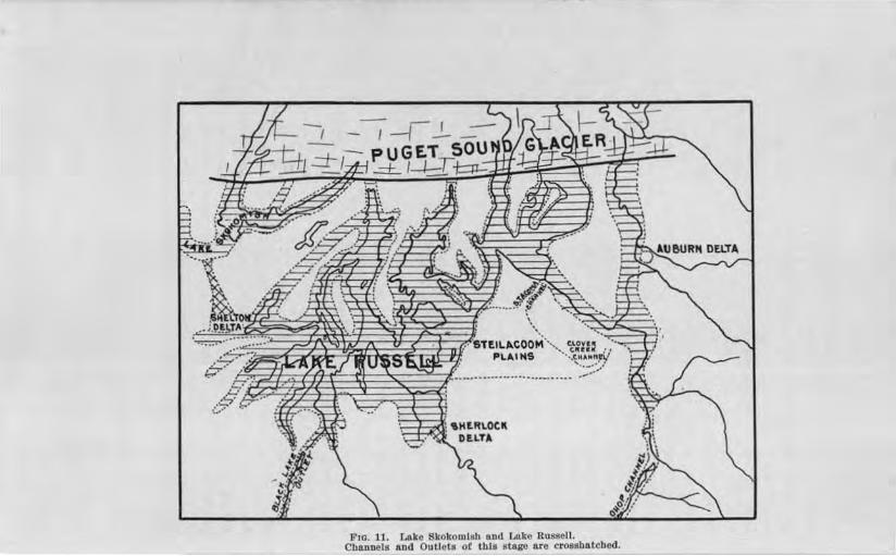
'· ..... • •
06'T!IL,,.COOM···~ ~ovu • .. l .... ic.l'l~a.M I' / PL ... IHS ···,':_HAMN~/
,/ :.__-:.~'
li'to. 11. Lako Skokom!sb o.nd f,a.ke Russell. Cbaunels n.na OutlQtB ot lhle stage a.re crosebe.tched.

Glaciation of the Puget ound Region Ho
There i no gnwel on the south ide of Shelton r ek valle . The lop are 11ll of ground moraine, and ri high r than the delta on the north ide. ' rom thi fact and from the uniform lev l of th edge of the d !ta it i inferred tha the helton Delta wa never built complet ly aero the creek valle thouah advance of th fr nt of the d ltu con. ide.rably on tricted the valle a mil above helton.
There wa outwa h aero th gnwel plain beb n he1ton and Hood anal b fore th Jin ring ice tongu in th valle of the Hammer le Inlet group had been me1te ufficien tly to allow water of Later Lake Ru ll to enter th m. The evidence on whfoh thi onclusion i - ba ed i found in a channel from the gra cl plain ea two.rd aero moraine hill to Oakland Bay. Th channel floor aero the moraine depo it is about ~10 f in altitude the highe terrace overlooking the bay being 20 f t abon~ it.
The depo i a the mouth of thi pillway i "cry irregular in frontal outline nd in urfac . It apparent! wa d po ited against, or on or in creva e of, tagnant ice lying in the valley of Oakland Ila . The altitud of the high t rrn.ce !!l.00 feet prov tJ,at locally pond d water and not the water of
ake Ru ell wa pre ent.
LAlIB KOKO.YI a.
The depr i n of ood anal i, divided into two gr a arm at it head, a h recurving in the form of a hook. The ea tern arm contain ti l water toda · th we tern one ha b o e.xten-ively filled with allm•ium b) th kokomi h River.
The glacial lake fir t forming in Hood anal tilled the e two valley and a part of th maiu valle a , II. It outlet over the pre~ent divide at the outh wa at an approximate altitude of 350 feet. Two 01· hr e abandoned channel are known aero the northern pa1·t f the gravel plain. They were cat in the hi her graded urfa b water c caping from the lake and fl wing to the h ton Delta. Thi tage of glacially pond d water in Hood anal may be named Lake
kokomish (Fig. 11). It wa ho rt-lived becau e glacial re-

146 Bulletin No. 8 Washington Geological Survey
treat soon expo ed a lower outlet from Clifton, at the head of the northeast a1·m, across to that part of Lake Russell in Cases Inlet ( orth Bay).
L, KE HOOD,
The second stage thus inaugurated may be named Lake Hood. While the Clifton outlet , as u ed, the waters of Lake Hood gradually extended northw:ird for nearly the entire length of the Canal As in the case of Lake Puyallup, the only record of this lake is its outlet. Figure 12 indicates the area of Lake Hood at its maximum.
THX CLIFTON CHANNEL. The Clifton outlet channel is a definite feature aero the divide on which it lies. It is 60 feet deep at Lake Deborah in the col, 220 feet above tide. This lake now drains both to Cases Inlet and Hoods Canal. Gravel terraces exist along the channel, and one terrace on the east side continues as a small chs,nnel directly eastward to Cases Inlet, on whose lopes it opens . The Clifton channel ends in the forest west of Allyn, 160 feet above tide, corresponding with the dominant water plane of Lake Russell.
THE BxINNO ~ DELTA. The only delta of Vashon age known in the valley of Hoods Canal i at the mouth of the Dusewallips River, on the north ide of the valley. (See Fig. 13.) At the seaward upper margin, it is 120 feet above the Sound. Its surface .is a plane, sloping toward the trough of Hoods Canal. Its altitude make it obviou ly a feature produced subsequent to Lake Hood, whose waters were 100 feet higher.
TKE PouLSBO CHANNEL. The Kitsap County peninsula between Hoods Canal and Admirnlty Inlet is sufficiently high to have confined Lake Hood as far north as Breidablik, northwest of Dogfish (Liberty) Bay. A meridional trough of the preVa hon topograph , styled the Poulsbo Valley in this paper, era es the peninsula here, Dogfish Bay lying in the southern portion. A swampy col occms midway of its length at an altitude of 1~0 feet and a stream terrace lies on the eastern side of the valley near the col, at an altitude of 150 feet. Other

.. -~.
\\ ·""'~ ...l..R!~!..._ ,.
. ··-····· ...... ::::.-.-----,,'--,(>~\-+--c--t+-
F1G. 12. Lake Hood, Glaclal Lake Sammamlsb 11.Dd Lake Russell. Cbannels and Deltas of thls stage are crosshatched.

148 Bulletin No. 8, Washington Geological Survey
terrace , po sibl of the rune gene i occur at 190 and 225 feet. There i evidence here of con ideni.ble tream ero ion in the Poulsbo Valley which can be con i tently correlated with data. already pre ented on the glacial lake hi tory of Puget
ound.
In the Poul ho, alley, Lake Hood appear to have found an outlet lower than the Clifton channel and to have entered Lake Ru ell at the head of Dogfi h Ba north of the latitude of eattle. (Fig. 16.) Th 120-foot col and tl1e 150-foot terrace record the ame change of level that are found along the Percival Creek channel. The Brinnon Delta i to be corr lated with the UO-foot level of L ake Ru ell . The two lakes may be con idered as one at thi stage, Lake Hood sinking by erosion of the Poulsbo channel to the level of Lake Rus ell, and becoming an arm of it. If the ice dam cau ing Lake Rus ell remained effective during the next few mile of retreat, a there is good reason for believing Lake Russell levels obtained in Hood Canal with broad connection aero s the low northe n tip of Kitsap County penin ula a few mile nortl1 of the Poulsbo channel.
LACK OF VASHON D ELTAS OF OLYMPIC RrvERS. everal vig-orou tream enter Hoods Canal from the Olympic M10unta.in , and are depo iting actively in the ound today; but their valleys have no delta at the level of the glacial lake .
The valley of Quilcene River ha a long gravel lope gradually de cending from altitude above Lake Russell to tide,vater. Fore et bedding exi ts in tbi gravel, and the surface is terraced but no definite delta le el have been recognized. TheDuckabusb Valley ha a long terrace on the north ide, evidently aggraded to levels higher than tbo e of the water in the Canal now, but falling belm the leYel of Lake Ru ell at its lower end. The valley of the Hama Rama and kokomi h river are den ely wooded where Va hon deltas hould exist. Though ome laboriou earcb on the fore ted floodplain and adjacent slopes ha been made no delta of the e stream referable to the glacial Juke have been found.

PRESENT
DELTA
Fro. 13. '.rhe Brlnnon D<!Jt:a at the loulb or the Du wamv RI r. A rock led!l"e occu.n, at the con.strlctlon lndJcatl'd, and bas "d t oded" tb mtlng portion of lbP original d lta. Or&'ll"D Crom Chart 8'lo0 ot th . . C. & G. .

150 Bulletin No. 8, Washington Geological Survey
It cannot be con idered a eriou objection to the interpretations advanced that deltas have not been found at the mouth of all entering river . Sub equent stream ero ion ha apparently regraded the late Plei tocene gravel of two of the e valley . The other two have not been u:fficiently tudied to make it certain that no such deltas exi t though if thi i true it will not be trange. •
GL CIAL LAXE SAM {Al\IlSH.
The trough occupied by thi ancient lake is parallel to and east of that containing Lake Wa hington. It is about flS miles long and has an average width of three-fow-tb of a mile. It deepen gradually southward to its abrupt termination by three rock hill 1 500, ~,000 and 8 000 feet above tide, near Issaquah. The ea tern of the two pa e leading outh from the valley is 315 feet high and the we tern one is between 350 and 400 feet high. (See Fig. H for a graphic representation of the history of thi lake.)
FmsT TAGE, Ea t of I aquah, on the northern flank of Mount I aqua11, the highe t of the three rock hills i a considerable level area at an altitude of 4~5 feet, more than 300 feet above the floor of the trouah. Back from the margin the terrace ri e ~O feet higher, and has a still more exten ive level area continuing ea tward. On the southern margin of thl high-level gra el depo it are imperfect terrace as high a 465 feet. At the we tern foot of this plateau, gravel spreads out widely on the valley floor in terraces 215, 195 175, 160 and 120 feet above tide.
The ea t fork of I aquah Creek cuts the gravel plateau to a depth of 300 feet, and sections in the gorge show streamrolled glacial gravel in bed of variable positions, indicative of hifting currents with con iderable variation in velocity.
o true delta structure was seen.
• The remnant o! a Vashon delta in tbe DusewaUips Valley Is preserved only by an outcrop of rock at Its head ln the manner o! a "defended" terrace of alluvium. (See Fig. 13.)

Glaciati()11, of the Puget Sownd Reg-ion 151
The grade of tl1e East Fork of Is aquah Creek ascends rapidly ea tward until at High Point the creek i no longer ru hi.ng along the bottom of a narrow gorge, but wandering through a wide, flat-bottomed wampy valley, in which the stream appear incongruou ly small and ineffective. Two mile ea t of High Point, this old floor uddenly ends at 540 feet above tide, wjth the valley at full width. There is a de cent here of about 100 feet to Raging River which come in from U1e outhea t and turn northward at thi point. Rep1·e ented b terraces, the old valley floor continues up the valley of Raging River for four or five miles where the gl·ade of the latter ha risen to the level of the old floor. Fragmentar terraces along Snoqualmie River, between the Fall and the junction with Raging River and along this river between the junction and Preston, indicate that the e stream formerly united at Pre ton, and that their combined water built the Issaquah depo it.
At the time of thi gravel depo it, the escaping water of these river was held back probably by an ice tongue in the ammami h Valley which dammed the tream where the depo it now lie . The cols in the two pas es among the hills terminnating the Sammami h trough at the south are too low to ha,,e caused the ponded water in which the I aquah gravels were laid down. This, hardly to be con idered a a lake deposit, is the olde t record of glacial water in the ammami h Valley. The di charge of the Snoqualmie River through the Pre ton-I saquah valley was cau ed by ice blockade of the more northern and lower route followed later by that stream.
SECOND S·rAG-E. A glacial lake of limited extent mu t have formed in the outhern portion of the ammami h Valley a little after depo ition of the I aquab gravels. Di charge from tbi { lake wa outhwud th1·ough the two rock-walled valle , b:yth of which are floored with coar e tream gravel the eastern on carrying the larger amount of water and for the longer time.
A channel exists acros the till ridge between Lakes Wa higton and Sammami h at the north base of ewcastle Hill, the lowest of the three rock hill de cribed. Its altitude is some-

~ 'Roc.K Hills
~ Ground Moro·ine
§3 Issaquah Gravelsondl?edmond Delta 0 Gl~cial Dr-oinaQe Channels
and Glociol lal<e Areas.
F 1G. 14. Map Showlng Prlnclpnl Events In the History of Glacial Lake Sammamish.
/

W .\SlJ ll/OTON f:t-:OLOCt(·.u, Sr111VF,\' Bn.1,E'l'IN :--o. 8 T'LA1't; X I [
FrG. 1. Distorted Admiralty Sediments, McNeil's lsland.
Pw. 2. Structure of the Qualsap Point Delta Beds.

Glaciation of the Puget ounzd Regi()'TI, 153
what above SOO f ct tl o,• tide. It i Boor d \Villi coar e gr vel. ther channel at a lightly low r altitude exi t a mile
fartb r no1·th alon th line o! Phant m and Lar n lak oth of U1 e I Ting in a d finit chann I wo and a. half mil
long aero the ridg .
outhwnrd di char from the ammami h alley b twe n tl1e hill did not 10\ r the glacial Ink . urface below about 315 f abO\·e tide the altitude of h c l in th old edar Riv r
channel outh of quak )fountain to which the lower en tern hannel wa tributar ' · The two chnnn I ju t de crib d hen
mu t l1av been in u contempornn ou ·I or nearly o ith
tJ1 ou hward e cap . ( e Plate XI . ) Th channels how no p rceptibl de. cnt on cro m the
rid L ke a bin ton. The h.antom-Lar en Lake chan-nel nd in a wamp almo ·t on the brow of an abrupt d c nt
of Ul5 fe t at the brue of , hich lie unmodified kame rrn The. e mu t be ounger than the channel which it elf mu t ha di. ·harg d to tanding wa er omcwhat below 800 f abo c tid . These two minor apewA. on th north .id of 1 -
ill pro abl ' I d to the ame water body in , hi ·b the d le elta wa built. The kam t rra , liahtl
f aboYe ti . h , that ice wa pre ent in th Wa ·hingt n trough la er than the time f amm.ami ' h
charge b the rout de cribed, and therefor mu t have be n in th allc at the i111 of the lak r ferr cl to. ttles and broken topocrraph on the Kcnnydale D Ito. are additional ,·iden of the immedin e pr n e of ic at ti time of it. gr wth.
TmRD T.\GE. RED.:llOND ELT • Th T are terra · in the aquah gnl\'el dep ~it at 11! itude lJ tw n 215 and lflO f
low r than an outl channel thu fur ·ribecl for lo. in.l
Lak ammami h. 'l h fr ri in will b b tt r under tood ufte1· con id ration of th R elm nd Delta.
t the north end of the pre ent lake and on the ea. t idc of th vall, there i a depo it of tr am ra \'el hich ha b n
giv n more tud than any ther fentur of the entire re ion.
It will b ailed the Redmond Delta.

154 Bulletvn No. 8, Washingto,n Geological Survey
East of Redmond, a considerable trough from the no1·th unites with the Sammamish depre ion. In common with the majority of valleys in the region it i of pre-Vashon age, not the product of postglacial erosion. Depo ition by streams has produced a fairly level floor in thi valley, the altitude near the mouth being 50 feet abo e tide.
Southeast of this alluvial plain a semicircular scarp ri es abruptly. It is convex toward the plain, and -faces west, north and east. It is a con picuous feature from the valley floor wherever the view j unobstructed. Its ha e line i nearly horizontal and about 50 feet above tide. Its summit profile i made up of four levels at 120, 130, 140 and 160 feet respectively.
On examination the scarp i found to be composed of coarse gra.vels, everywhere disposed almost a teeply as they will lie. On r eaching the top, level terraces of coarse gravel are seen stretching back at the several altitudes noted, covel'ing about a square mile. The 160-foot area is the mo t e ·ten ive and lie in the outh and we t po1·tion of the depo it. The north and nol"thea t ide are made by the 120- and ISO-foot terraces. A considerable portion of the ea t side i broken and irregular from the pre ence of two large, rouO'bly linear kettles. The Jack of a teep de cent along much of the ea t ide is due probably, to breached kettles along that edge. On the south, the 160-foot terrace abuts against higher till hills. These relation are hown in Fig. 15.
Evans Creek approache Lake Sammami h from the east, the Redmond Delta lying in the direct continuation of its upper course. Tl e tream make a detour to the north to pass around the delta, and reach the lake. It rises in a mar hy col in a wide valley which extend outhe:i. tward for 11 miles, from the Redmond Delta to the pre ent noqualmie River valley. The broad floor at the col is 160 feet in altitude, and two splendidly developed river terrace between the col and the delta are 140 and 200 feet above tide. East of the col, fragmentary terraces continue the a cending profile of the old -floor ea tward

I Redmond

156 Bulletin l\ o. 8, Washvngton Geological urvey
toward the a ca.de Mountain . The r lation of thi valley and the gravel depo it j w1doubtedly genetic.
It eem c1ear tl111t the noqualmie River took the Patter onEvans reek cham1el to Lake ammam:i h a oon a the retreat of the · ce had e ·po ed the lower grnund which it cro es that glacial Lake Sammami h had b thi time found a lower outlet and it urface tood no highe_r than 160 feet above tide and that, in the lake valle near Redmond ice till lingered when the delta began. ( on ult Fig . 14, 15 and 16.) The succe ive level of the R edmond Delta ho,v that the higher terraces were being dis ected while the lower one were being de eloped . The be t in tance of uch di ection occur in a channel 100 feet wide and 10 feet deep, cro ing the 160-foot terrace from ea t to we t and po e ing a miniatUI·e but clearly di cernible delta on tl1e lakeward face of the larger feature . (Fig. 15.) An excavation at its foot r veal fore et tructure in the stratification of the gravel. The occurr nee of th HWfoot poTtion between the ISO- and 140-foot terrace al o how di ection.
Three-fourth of a mile north of tl1e delta here i a con id-erable fragment of thi depo it on the a ide of the Bear
reek trough. It t p i level and UO feet in altitude. It i compo ed of stratified gra 1 at lea t 40 feet in depth. Di ection at a period later than that of the delta growth ha destroyed a large portion of he original d po it and ha left thi area wide) eparated from the main bod .
The outlet fo1· the glacial lake a the time of depo ition of the highe t terrace of the R edmond Delta cro es the till ridge between Lake arnmami h and Washin ton in the vicinity of York, or Willow: a few mile north of R edmond. (Sec Fig. 16.) The ummit of the York channel i 160 feet high and no de cent i perceptible to he e ,e in the warnpy floor to the we t . Thi argue 11 imilar level of ponded water in the Lake Washington vaUey. The lake m·face today i ISO feet lm er than thi col. Di charge for the lower tages of the glacial lake recorded in the Redmond Delta and jn the lowe t terrace about

Glaciation of the Pliget Sownd Region 157
I aquah pas ed tbJ:ough the pre-Ya hon valle to Bothell by which the two paraUel lake are connected toda at the north.
The 160- and UO-foot te.nace of the Redmond Delta, with short, open channel connectin Glacial L ke Sammrunjsh with Lake Wa h.ington Valley indicate that thi third tage of the local lake recorded by the Redmond Delta, i really a portion of Lake Rus ell hi tory. Glacial retreat b thi time had allowed the northwal'd-extendina, water of the ma ter lake to occupy the Lake 11 hington trough and to control the later static water record in the Sammami h Valley.
LA KE NOHOill H.
The old noqualmie Rive1· channel now occupied by E an and Patter on creek leading to the Redmond Delta does not continue uninterrnptedl up into the a cade Mountain . It breaks off abrnptly on reaching the pre ent noqualmie Valley, which i much lower in the ame fa hion that the old valle ea t of High Point break off at Pre ton except that in the present ca e sub equent ero ion b Patter on reek ha largely de troyed the eastern portion of tl1e old tream floor and it is really a projected profile wrucl1 i abruptly termmated.
noqualmie Rivei· i flowing in a trough valley of interglacial ero ion which lies uallel to and ea t of, the Sammami h Valley, t111d i open to Puget ound at it northern end. The abrupt d cent which take place at the ea t end of the projected profile up the valley of Enins and Patter on creeks to the pre ent noqualmie River nlley thu j not the work of postglacial ero ion a it i at Pre ton. n the contrai- ponded ,vater mu t have filled thi Yalley to the height of the truncated profile in order to flow westward aero the divide to the Redmond Delta. Thi water con tituted Lake nohomish. (Fig . 14 and 16.)
Few definite data can be pl'e ented concerning thi lake. Its altitude wa abou 9l50 feet when di charging to the Redmond Delta. Earlier outlet channel to Glacial Lake ammami h occur parallel to the Evan -Patterson 1·eek channel and south

F10. 16. Lllke Snohomlsh and L11ke Rus ctll, at mn.x..lmum extent ot 100-toot atnge. Chll.ll· nels and Deltas ot this stage ore crosshatched.

Glaciation of the Puget Sownd Region 159
of it, but their altitude are unknown. It appears probable that this lake backed up at it higher stages to the foot of Snoqualmie Falls, into which that cataract plunged. The lake extended northward a long di tance, perhaps nearly to Everett, but apparently never sank to the level of Lake Russell.
HISTORY OF LATER. LA.KE R.USSELL.
The retreat which de troyed Lake Ni qually and allowed the re-formation of Lake Ru ell early cleared the Narrow and brought about the destruction of Lake Tacoma also. Lake Russell then extended ea t and south up the Puyallup trough, and north into the White River trough where the Auburn Delta. of Lake Tacoma records the earlier presence of tanding water.
The Hammer ley Inlet arm of the lake originated soon afterward, and the Shelton Delta wa then formed. Lake kokomish quickly pa ed through its brief history, and Lake Hood began when the Clifton outlet came into exi tence. Its level persi ted while the glacier retreated for a distance of 26 miles. During this time, the channel of the Clifton outlet wa cut to a depth of 60 feet but at the time it was abandoned its grade was still !25-50 feet to the mile. A rapid retreat for the ice for the length of Lake Hood i thu indicated el e the grade of the outlet would have been reduced to a lower slope. The opening of the Poul bo channel records the pre ence of the 160-foot level of Lake Russell in Dogfi h Bay, and con equently in the great trough of Admiralty Inlet as far north as this latitude.
Presumably the history of Glacial Lake Sammami h and Lake Snohomi h was being enacted contemporaneou ly with that of Lake Hood. Both Glacial Lake Sammami h and Lake Hood became a part of Lake Ru ell before the Percival Creek channel to Black Lake outlet had lowered the ma ter lake to the UO-foot level.
THE RicHMoND DELTA. For more than a mile south of Richmond the bluffs of Admiralty Inlet are compo ed largely of fresh Va hon o-ravel with a hon till u ually expo ed be-

160 Bulletin No. 8, Washington Geological Si£rvey
neath. Foreset tructure i to be recognized in the ea cliff despite the loose character of the matei· ial, though the opening of a large pit by the Enamel Brick and oncrete Company offer the be t opportunity for tudy of the gra el. Predomi-nance of foreset tructure (PI. , Fig. 2) immediately recall the pit in the te.ilacoorn and equalichew Delta . The re-emblance i complete, eJccept that there i no second et of
fore et bed above the top et. The altitude of the upper plane of the e delta strata i 165 feet above the adjacent ound. At the head of the pit top et bed are 20 feet thick. Back from the edge of the pit the urface i plane, ri ing from 185 to ~00 feet in half a mile or o, to the lope of higher hill . A breached kettle in the face of the delta soutl1 of the pit, interrupts the continuity of the bluff. The bottom of the kettle bears no gravel, and the ice block mu t have come to the urface of the delta, or even projected above, when the gravel wa depo ited, and must have remained until depo ition cea ed. Another kettle, 60 feet deep and with an irregular form lie back in the plain, tl1e eaward face of the delta being unaffected b it.
A narrow, elongated depo it uch a the Richmond Delta, with the trough of Admiralty Inlet on one ide, and ground moraine on the other higher than the aggraded plain can find e ·planation on]y in the a umption that ice wa pre ent in the great troug11 at the time of delta growth, and formed the retaining wall which ha now vani bed. ( ee figure 17.) The presence of the kettles corroborate thi hypothe i .
The fore e bed dip we twa1·d, hm ever at a l-:ight angle to the length of the delta. The stream wh:icb depo ited the gravels was confined to a outhward cour e between higher uriaces of ice on the we t and earth on the east. n. reaching the beginning of the curve of the ice front in Admiralty Inlet, the stream turned abruptl we tward to the trough. A the ice front withdrew along the mile where the delta now exi t thi procedure of the tream wa continued, the delta depo it growing northward a the ice retreated, and the fo1·e et bed dipping westward throughout. The northern portion of the delta herefore is

lkLJ.ETI~ X . Pf •. Tt: Xlll
Cole Point. ud r on 1 land. A s a cillI ot .hlrulrult)• and.

Glaciatio11, of the Puget ound Region 161
the young t, though ne re t the channel which gave origin to the depo it.
The trenm hich made the Richmond eltn entered from the north. I channel i to b traced with di tinctn for a mile northward toward Edmond to the poin where the nclo ing
Fm. 17. Rela.Uon o! the UJchmond Delta lo LAk Ou 11 ond th Pu t ound Glo..cler.
treo.m-cut bluffs po.rat , nnd the urfo e b come brok n an moro.inic. In thi di nnc the channel floor ri e gradually from the altitude of the delta plain to S40 feet. Intcre ting detail of the head of the channel in the morainic tmct ha,·e been worked out, but pace cannot b giv n for their pr entation. uffice it to y, that the tr am here originat d at the glacier fron
-6

162 Bulletin No. 8, Washiington Geological uroey
and flowed a mile or so before entering Lal<e Russell. Its behavior wa similar to that of th tream which built the Tacoma Delta.
The edge of the ice over the pre-Vashon ridge which is parallel to Admiralty Inlet on the ea t, apparent] lay but a mile or so north of that in the inlet, though the ridge here is 400 feet above the Sound and the Point Jefferson Deep (PI. XX.IV) 918 feet below sea level lie direct y off the delta face, It would be expected that thi relief would cause the ice in the trough to linger long after the hill had been bared and thu produce a notably fingered margin to the glacier.
TR.E UO-FooT LEVEL OF LAKE RussELL. The Richmond Delta tabli he the presence of the 160-foot tage of Lake Ru ell a far north as the latitude of Richmond ( ig. 16). It prove that Lake Hood sank to thi tage when the Poulsbo channel came into u e and establi he the fact of a broad connection at the 160-foot level betw en the ammamish and L ake Wa hington trough through the pre-Va hon valley at Bothell.
The front of the glacier retreated and the Richmond Delta was abandoned by the glacial river be£ ore the lake ank to 120 feet. Yet a retreat of the ice front of but a few mile from the Richmond Delta would have allowed open connection between Hoods Canal and Admiralty Inlet, and the Poul bo channel never would have been eroded to the 120-foot level. It i therefore evident that Lake Ru ell wa lowered to the HlO-foot level immediately after the Richmond Delta was made and that a con iderable pau e of the retreatjng glacier front just north of the delta wa nece ary to hold Lake Hood to the Poul bo channel, until it likewi e had been lowered to 120 feet .
The Brinnon Delta and the lowest portions of the Sherlock Delta and the Redmond Delta are tream deposits in Lake Rusell when it surface wa 120 f et above sea level.
THE N on.THERN LIMIT OF LAKE R u S:ELL. It i probable that a definite northern limit of Lake Russell will never be determined. Evidences of the lake's eXJ tence are cattered, and a continuou record, such as a hore line i required to e tabli h

Glaciation of the Puget Sownd Region 163
a definite margin. The limit can be drawn however, in the form of an ea t and we t zone at the north end of the lake, north of the outhern edge of which the ice undoubtedly retreated and beyond the northern edge of which it never retreated during the lake' existence. The outhern edge of such a zone is drawn ju t north of the Richmond Delta. The northern edge may be drawn through the city of Everett for the following reasons :
(1) The nohomi h trough which contained Lake nohomi h and nm i u ed by the Snoqualmie Ri er for mo t of its length is open to Admiralty Inlet only at Everett. It one other opening i the Evan -Patter on Creek channel the outlet of Lake Snohomi h the u e of which built. the Redmond Delta. The exi tence of the UO-foot level in the Redmond Delta proves that the glacier retreated from the 160-foot Richmond Delta, and that the lowe t tage of Lake Ru ell wa inaugurated before the Redmond Delta the product of the outlet of Lake Snohomish was completed. In other words, Lake nohom.ish did not share in the 120-foot level, becau e the glacier front till lay outh of Everett where open connection exi ts with
the trough of dmiralty Inlet. ( ee Fig. 16.)
(2) The Pilchuck River which enter the nohomish trough at the town of Snohomish (Pl. II) carried also the waters of the outh Fork of the Stilaguami h River for a time during glacial retreat. Condition thu were favorable apparently for the formation of a delta in the nohomi h trough, and a channel floor adju ted to it level. Since no trace of either has been found but in their place i a glacial river valley , ho e floor is clo e to pre ent ba e le el, it i evident that no ponded water near Lake Rus ell level ex:i ted in the Snohomi h Valley when the region north of Snohomi h and Everett wa bared by glacial retreat. Failure of the ice dam which had held up Lake Russell and it tributary lakes, i thus indicated to have occurred while the glacial margin wa somewhere between Richmond and Everett.
LAcx OF VASHON DELTAS OF THE CA CADE RIVERS. Named in order from south to north the Puyallup, White, Green, Cedar,

164 Bulletin l\ o. 8 lV ashington Geological Survey
and Snoqualmie ( outlet of Lake Snohomi h) river entered Lake Russell from the ascade Mountain . Only one of these po -sesses a delta built into that lake.
The Puyallup River has aggraded its trough so largely in the vicinity of Orting that the valley floor now lie above the level of Lake Ru ell. Any former delta that may have exi ted at tho e levels i of cour e completely concealed.
White and Green river enter the meridional White River trough but two or three mile from each other. Po t-glacial depo ition ha formed a wide plain here about 100 feet above sea level, on which the rivers meander in con ta.ntly hifting courses. White River has divided until recently into two di -tsibutarie ; one tuck River, flowing to the Puyallup and thence to Commencement Bay at Tacoma, the other continuing north to Elliott Bay at eattle.
Though Green River made a delta in Lake Tacoma no trace of a delta made by either of these stream in Lake Russell has been found. A ufficient rea on may exist in the meandering behavior of the e river which ea ily could have de tro ed such forme1· depo its. The Auburn Delta, or uch part of it as remain ha been pared because of its location at the tip of the divide between the two tream .
No delta made by Cedar River in Lake Ru ell remains, but gravel pit on both ides of the valley at R enton where it enters the Lake Wa hington trou(J'h expo e fore et bed dipping down trerun and lying a(J'ainst the higher till-covei:-ed slopes. Their altitude fall a little below Lake Russell level , but the upper portion of the delta which would how contact of foreset and topset beds has been removed by ero ion. The e fore et trata may be interpreted confidently as the remnants of a
delta of edar River in Lake Russell the main ma of the depo it ha ing been de troyed by lateral planation of the river during po t-Vashon time.
LAcK OF no11E LINE A, D DIMENTs OF L XE RussELL. The narrow land-locked arm of L ake Ru ell were not favorable for the development of ver effective wave , such as would

Glaciatio-n of the Puget Sownd Region 165
produce la ting 1·e ult in a comparatively hort time. The bluffs are generally so teep that, were sea cliffs and ave-cut terraces once developed, the chance for escape from de truction by ubsequent sliding, or by wave undercutting at the present sea level, , hich has exi ted much longer than did Lake Russell, would be small. Under such circum tance , no attempt will be made to correlate the few dou_btful old shore records lying high on the Puget Sound bluff which might be a cribed to the glacial lake .
For the reason that Puget ound at pre ent occupie most of the area covered by Lake Russell, and other portion once occupied by the lakes are now covered by fre h-water lake or recent alluvium few occurrences of sediments of this lake can be expected. And because, ub equent to the lake's eJd tence, the ba in wa even more deeply submerged this time beneath the ea unfossiliferous s diment , found overlying Va hon till below
the former lake level cannot be unhe itatingl referred to Lake Ru ell.
One area onl ha been found where a clay and and deposit without much que tion ma be referred to depo ition in Lake Ru sell. This :i a few mile northeast of Olympia~ nearl north of Lacy. The area i a pitted plain grading laterally into ground moraine on all ide . The depo it i composed of fine sand and clay practically free from gravel and afford an e..'l:cellent oil. The area now i largely cleared and cultivated while adjoining surfaces of ground moraine are til1 in fore t or have a few truggling or abandoned farm . It i worthy of note in this connection that till from the adjacent ground moraine ha been u ed on the road of thi tract with remarkable uccess a surfacing ten year old being today in a nti factor condition even in the rainy winter .
K.ura T.e1t1tACE . ame tenace form a prominent feature 1
of the modified drift of the uget ound country. The were fir t identified in the region, and have been de cribed in the Tacoma quadrangle by Willi . The ha"Ve been found b the writer to be abundant on the eattle quadrangle, immediately

166 Bulletini No. 8 Washmgton Geological Survey
north of the former. Since kame tenace are the product of stream with ice pa sively cooperating tl1e should be expected to terminate wherever the depositing tream entered tanding water. And if the water of Lake Ru ell extended northward into all the trough which were uffici entl low as the fingers of ice shrank within the valley kame terrace hould be completely lacking below the level of tha.t lake.
No kame terraces of the region are known below the 160-foot contour. evera.l well developed ternce end at about thi level and the topography of the gravel becomes very subdued where the depo it i continued farther down the valley. orth Creek flowing into Lake Wa llington near Bothell, has a krune terrace ix mne long, which at an altitude of about 9l00 feet behave a de cribed above. From Bittei· Lake to Green Lake -in the northern pa.rt of eattle i a large kame terrace which di appears benc.ath the latter body in a penin ula heavily covered with gravel reappear beyond the lake, and continue down the general trough toward Lake Union. It de cends below 160 feet in a short distance south of Green Lake, its character changing at thi point to that of a wate1·-laid depo it, and its mas dimini hino- notably . Other in 1tances of the same character might be cited but these two illu trate the di tribution and behavior of kame terraces sufficiently to show their bearing on the existence of Lake Ru ell. The pre ence of tanding water in the e valley at the altitude of 160 feet is recorded by the failure of kame terrace to extend below this altitude.
DRAIN GE MODIFIC TIO S OF THE STILAGUA.MISB: JI.IVER.
The earlie t expo ed part of the Stilaguami h River valley was the South Fork, which emerges from the Cascade Mountains on the drift plain at Granite Falls. The ri er now flows eight miles north before joining the orth Fork; but when first exposed by glacial retreat it water were turned southward into Pilchuck River, a tributary of the Snohomi h. At Granite Falls, little more than a mile of low land separates the two stream . ( See Plate XXII.)

Glaciation of th-e Puget Sownd Region 16'1
When retreat of the ice had progressed sufficiently to free the valley of the North Fork the two stream joined at Arlington, and :Bowed south th1·ough the broad interglacial Mary vi11e Valley to Port Gardner at the town of l\'.la.ry viJle. This valley ,vas filled to an unknO\m depth with and and gravel
Fm. 18. Vicinity of rllngtou aud Marysville.
which now constitutes a plain about three miles ,vide by nine miles long de cending 145 feet from Arlington to Mary ville, a grade of 15 feet to the mile. (See Fig. 18.)
The urface in the vicinity of Arlington i strongly terraced, The town i built on two benche both compo ed of gravel to their base. The bu ine portion is on the lower bench, 110

168 Bulletin No. 8, Washington Geological Survey
feet above tide and the residence portion i on the higher bench, at an altitude of 160 fe t. nmerou pits and street cut expo e the material which i tumnltuou ly tream-bedded in both. The upper term e corre pond with one aero s the ri er to the north. Both are obviously remnant of a valley train which came down the orth Fork alley from the Ca cade Mountain .
The 110-foot terrace at Arlington i too low to belong to drainage which flowed outhward from Arlington to l\fary -ville. It wa formed by the fir t drainage which flowed westward along the pre en t com of the Stilagua.mi h River from Arlington to tanwood. Thi later route wa blocked by the retreating glacier at the time the Arlington-Mar ville valley train wa formed, but when opened, proved to be the lower, and ha held po tglacial drainage to it our e.
Ero ion in development of the pre ent route west from Arlington ha expo ed a ection of the filling of the Mary ville Valley at its northern end. Thi i compo d entirely of and and ravel to a depth of 50 feet. A road cut in one place exposes a great deal of pumice and volcanic and or a h in a terrace corre ponding t o the 110-foot Arlington bench.
The Stilaguami h quadrangle ea t of the area di cu ed in the present paper, how ome i11te1·e tin drainage chang which make it ev.ident that the Sauk uiattle and Skagit River former! flowed out on the drift plain of Pucret ound at rlington, and confributed to the formation of the Arlington-Mary ville vall y train. From the tilaguam.i h quadrangle the valley train can b tra ed up the North Fork valley to D arrington with a O'rttde of about 16 fee t to the m:ile.
Big Lake and Mcl\!lll'ra ;Lake lie in a 1101.·th and south val-1 y in the diagonal .pur of the C cade 1\Iountain which jut out into the drift plain north of Arlington . The valley at Big Lake i floored with till . No glacial tream pa sed tluough the valley though the till i di po ed on the lower lope in hucre flutings and furrow that re emble the terraces of a gravel train.

--LAKE PUYALLUP !.SO(OHOP) -,
LAKE. PUY ALL.U P 400 ~CLOVlJH.R.) I
LAKE SKOKOMISM 350
' EAR LY LA /ff TACOMA 32 0 LAKE SAMMAMISH 300 -,
I
LAKl SNOH0"1 1SH 2!>0 23S LlKE Tkt 0t1A I
I
LAKf HOOD ?lO I
LAt<E N 1SOUALLY 180 LAKE. ltUSSE.LL 160
LAI\£ RUSS [Ll 120
NORTH PRESEHT 1'1ARIN£. OCC.UPANtY SOUTH
F10. 1.9. ProOJc~ o( the Glacial Lnkca ot Pngd Sound, proJectcd on a North a.nil South I'lanl'. ro .. 11100 o.t ou.tlct ln the ph1nc @bown by the ebort vertical llno attllched to eac.b proote. ReJalh•e nttltu,Jcs, lt>ngths,
and latJtudloal pOW:ltlonB aboWD, the la.tter corrupondlog roogbl7 to t.be sequence o! lolre !ormaUoo.
' I
I

1 '10 Bulletin No. 8, W ashvngton Geological S'IJ,r()ey
A glacial lake occupied the valley now containing both Big Lake and McMurray Lake, and had its outlet southward to Pilchuck Creek, a ti-ibutary of the Stillaguamish below Arlington. This stream is to be distinguished from the Pilchuck which flows to the Snohomish River. The divide in the old channel today is just south of McMurray Lake, and about fl50 feet high. A long glacial drainage channel leads south from it to the village of Pilchuck where postglacial erosion has obscured the outlet. The two lakes now drain northward to the Skagit Rive1·. The ice clam held up a glacial lake probably eight miles long north of the divide, and turned its drainage to the Stilaguamish. A lower spillway appears to have been used for a brief time across the drift plain to the vicinity of Mount Vernon before final disappearance of the lake.
GLAOIA.L LAKE WHATCOM.
Lake Whatcom occupies the valley of a northward-flowing stream of pre-Vashon age, eroded in the northern slope of the diagonal mountain spw· of the basin. The retreating Vashon glacier left a heavy moraine deposit in the mouth of this valley, causing the present lake.
There are two broad drift-filled valleys opening northward to the low plain of Whatcom County from the northern end of the lake. They are separated by Squalicum Mountain. Either of them is oriented favorably for the continuation of the preglacial valley, but without data on the depths of drift in them, the question cannot be settled. The lake extends farther into the western valley and discharges through it. Whatcom Creek, carrying the outflow, crosses bed 1·ock close to the lake, but is so far over to one side of the filled valley that the rock in the sti-eam bed is probably only a portion of the preglacial valley slope on which the stream has been superposed.
During the retreat of the Vashon ice across this region the glacial front formed a dam too high for northward flow and glacial Lake Whatcom was formed, with discharge from the

Glaciation of the Puget Sownd Region 171
southea t tip to a tributary of Samish River. The col in the outlet valley lies just north of Mirror Lake at an altitude of 375 feet. A drift filling here has been incised to a depth of 30 feet.
The valley which carried di charge of the glacial lake unjtes
with a larger one at Wickersham. High terrace of glacial gravel occur in this larger valley. At Prairie, three miles outh of Wicker ham, these terraces are 3'1!0 feet in altitude
and farther south of here they widen out into a broad plain which leads to the Skagit River.
This train which floor the valley to which Glacial Lake Whatcom di charged came down the main valley from the north. Its extent north of Wickersham ha not been studied.
After the margin of the ice had withdrawn from qualicum Mlountain and after Glacial Lake Whatcom had ceased to discharge over the Mirror Lake col, the gravel train wa largely eroded by the diverted South Fork of the N ooksak River, which for some time after the disappearance of Glacial Lake Whatcom, was blocked by ice at the north and forced to be tn"butary to the Skagit. Its cour e at thi time was southwe t from Prairie to the present Samish, emerging on the Skagit Delta three miles north of Burlington.
At the inception of standing water at the south end of Lake Whatcom valley, the outhwestern arm contained a mall independent lake with outlet to Samish River about three mile below Sa.mi h Lake. The outlet channel lies on the north side of the drift-filled valley connecting the Whatcom and Samish valleys, with an altitude of about 415 feet.

LAKE SKOKOM 15 H 350
LAKE HOOD no
LAKE RUSSELL 160
LAKE. RUSSELL 1?0
LAK E PUYALLUP SSO (OI-IOP OUT LU) -,-
LAKE. PUYALLUP ,400 (CLOVER CREEK OUTLE.T)
EARLY LAKE TACOMA 320
UK!:. NISQUALt'f 180 I
1 LAKE 'e1AMMA"11SH 300
L 0AKE TACOMA ?35 LAKE SNOHOMISH· 2SO
WE ST ----------'P""'R'"-E:;.S:;.E:;.N;.;..;.T_M....;A.;..;R..:..;l..:..;N....;;E;......;;0....;C;.:;C....;U_P_A.;.;N....;C;;..Y;._ ____ _ EAST
FrG. 20. ProHle ot th Glacial L&lrel of Puget uod, proJ ct d on n.o a1tt BDd w plane looklng north. Position ot ontlet In tb plan shown by abort vertlclll Uno attach d o eacb profll • llclnllv alllLude ond Joogltudloal vosl Ion, and "r nteet east O.llll west c.xtenll! abown. l'be grOuJ)iog shows tho casteru or Cascade side ot the basio to bnve bad t.bc more varied b18tory.

CHAPTER Vll. THE ADMffiALT GL IATIO .
THE MIRALTY TILL. GllEE POINT.
H..ul.T TENE lsLA:i,m.
DENN ' Hn.L. Po n. GENE¥I,
YNOP IS.
THE Ao un LTY EDIME 'T .
GEN RAL DESCRIPTION.
TAINlNG A D DECAY OF THE All llALTY EDU!ENT •
VEGET L REMAJN •
Al.'TMAL RE lAlN .
L"ITERCALAT.&D Tn.L. T.B..E EU.SI LAND ECTION.
SEcTlO' o UsELES B.a.Y. DELTAS IN THE A.J>MIJI.ALTY EDIMENT ,
GENE I OF T .ADMIRALTY . DlMENT •
UM:MAlt O • THE C'HAl'T:E.R,
THE ADMIRALTY TILL.
The hi tory of glaciation in Puget ound preceding the Va hon epo h i ,•ery meager in detail , and probably alway will remain o. The cover of Va hon till and outwa b in the Puget ound b in i almo t complete. Drift older than the Va hon i expo d only in excavation in tream bluff and in the ea cliff along the hore of tJie ound. In uch ituations the
Va hon till li almo t everywhere on tain d nnd, eathered stntilied drift of con iderable thickne . This tratifi.ed material i known in f w place to re t on ti.n older till heet, named the .Admiralty Till by Willis.
GR.EE!-/' POINT.
Admiralty and Va bon till are ·po ed in the rune ea cliff in a few in tanc the e afTording e · ptiona1 opportunity for

174 Bulletin No. 8 Washington Geological Survey
the comparison of the two tills. The cliff at Green Point, between Hales Passage and Carrs Inlet (Henderson Bay) shows both tills, with brown-stained sand behveen, the and constituting probably only a part of the tratified drift eries. The two tills are very similar in color, compo ition degree of consolidation, size, abundance and rounding of pebble ab ence of bowlders, etc. Both are gray the Va hon till being somewhat lighter.
HAll.TSTENE ISLA.ND.
Both tills, separated by stained sediments are hown on the ea tern ide of Hart tene I land. o great difference in the two till is to be detected, the Admiralty being weathered or stained near its upper surface, and the Va hon being lighter gray throughout. The Admiralty till here may contain a slightly larger proportion of pebbles than the Vashon till and they are somewhat more angular.
DENNY BILL.
In the Denny Hill regrade of the city of Seattle a bill compo ed largely of Admiralty ediment wa removed by hydraulic method from more than twenty city blocks the maximum cut being 125 feet. (See plate XIV, XV, Fig. S and XVI.) Vashon till capped and veneered the hill with an average thickness of 10 feet, and Admiralty till was exposed in the deepest sluiceways, on Bell Street. The only diff rence between the two tills thus closely juxtaposed was (1) the omewhat weathered condition of the upper portion of the Va hon till involving a difference in color, and (Q) the greater consolidation of the lower till.
l'OS ESSION HEAD.
Rus ell, , ho first recognized the existence of two till sheet in the Puget ound basin, cites Pos e ion Head1 at the outh end of Whidby I land, a exhibiting the two tills separated by "medial'' ands, gravels and lignite. The writer has found Po -se ion Head to show three di tinct till strata eparated by stained sediments. There i little difference among the tills, each being gray in color, and compo ed apparently of fre h

Glaciation of the Puget Sound Region 175
materjaJ. The upper urface of each i somewhat tained. The lignite beds reported by Ru sell lie in the ediment between the upper and middle till . The lowe t who e ba e i below high tide, contain many pockets and lense of gravel, the presence of vhich may explain why Ru ell did not recognize it a a till.
The Posse sion Head section is not closely paralleled in Puget ound. It ugge tion of three glaciations, the till of the
oldest being apparently a fre h a that of the younge t is not borne out by a study of the sea cliff e:\.-posures elsewhere in Puget Sound. The explanation advanced tentatively i that both of the two lower tills are of Admiralty age, a light retreat and readvance of the Admiralty Glacier accounting for the intercalated sediments. The tained condition of the e ediments beneath un tained Admiralty till is thought to be the result of percolation of ground water throughout their mass during the interglacial period, while uch would occm· through the non-porou overlying till only along ea.ms, leaving the till ma as a whole unstained.
GENERAL CRARACTERS.
In the other e~1>osures of Admiralty till known about Puget Sound, the character is very similar to that of the younger Vashon till. Foliation is hown in many expo ures, rounded pebbles are usually abundant, the matrix is arenaceous, and the color i u ually an unweathered gray. Granite of variou kinds are as common in it as in Va hon till. There are no e sential diagnostic di.fferences in the character of the tills themselves, and tratigraphic relations must usually be taken into account in identification.
Willis• has described the Admiralty till as changing to a dense stratified clay in many places, both horizontally and vertically. A similar relation was expo ed in he Denny Hill regrade of eattle sub equent to Willis tudy of the region. Elsewhere jn Puget 0W1d the writer has failed to find this rela-
• Balley Wl11ls, "Drift Phenomena of Puget Sound," Bul. Geo1. Soc. Am., Vol. 9, 1897.
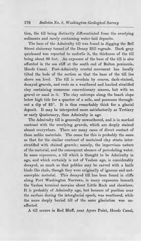
176 Bulletin No . 8 Washington Geological SU1·vey
tion the till being di tin tly differentiated from the overlying ediment and ruely ontaining water-laid depo it .
The ba e of the dmiralty till wa found in digging the Bell treet sluiceway tunnel of the Denny Hill regrade. Dark gray
qui k and wa report d to underlie it, the thickne of the till being about 20 feet. An expo ure of the ba e of the till is al o afforded in the c.a cliff at the outh end of Bolton peninsula, Hoods anal. Po t-Admiralty cru tal movement has locally tilted the bed of the section o that the ba e of the till lies above ea level. The till i overlain by coar e dark- tained decayed gravel and rest on a weather d and leached stratified clay containing numerou. concretionary masses, but with no gra el or and in it. The clay outcrop along the beach lope below high tide for a quarter of a mile, and pos esse throughout a dip of 25° . It i thus remarkably thjck for a gla ial deposit. It ma b interpreted more ati factorily a Tertiary or early Quaternary, than Admiralty in age.
The Admiralt till i generally unweathered, and i in marked contra t with the ov rl ing grave , which are deeply stained al.mo t everywhere. There are many ca e of direct contact of these unlike materials. The cau e for thi is probably the same as that for the imilar contra t of un tained clay trata interstratified with tained gravels · name] the impei-vious nature of the material and the con equent ab ence of percolating water. In ome ex-po ure , a till which i thought to be dmiralt in age, and which certainly i not of Va hon age, i con iderably decayed o much o that pebble may be carved with a knife blade like hale though they were originally of igneou and metamorphic material. Thi deca red til1 ha been found in cliff along Port W a hington arrows, in many e ·po ure beneath the Vashon terminal moraine about Little Rock a.nd el ewhere. It i probably of Admfralty age but becau e of po ition near the surface during he interglacial epoch was weathered, while the more deeply buried till of the a.me glaciation was unaffected.
A till occur in Red Bluff', near Ayer Point, Hoods Canal,

WASI11N<l1'0!< GF.OT,OGIC.U. SURVEY R1' LT,E1'1:< Nn. 8 Pl, ATIJ >..'TV
Denny Hill Regrade, Seattl ...

Glaciation of the Puget ownd Regi011, 177
in w]1jch decay has been more profound than js shown elsewhere in Puget ound. The extent of thi decay exceeds that shown by the 1·ed gra,,els of the hehali Valley. Excepting the pebbles of quartz, a knife ut through pebble and matrix alike "l'"ithout difficulty. The large t fragments 8 inche in wameter l1a"e no trace of a firmer central paTt. Decayed granite pebble retain the appearance of the parent rock, but cru h to sand and clay between the 6ng rs. The redru h color of the whole i deeper than i u ual for the drilt of Puget Sound and gives the bluff it name. Above and on both side of thi expo ure of old drift the bluff i covered with vegetation. The tratigraphic relation of the decayed drift are therefore unknown. It may be very pos ibly the deposit of a glaciation preceding th Admiralty epoch.
With but two expo ures of the ba e of the Admiralty till, no estimate of its thickne can be made. It i wholly a matter of inference to style it a till bePt. Whether thi till overlies older glacial drift, or Pleistocene sediments or re ts on Tertiary rock i unknown. There are no data regarding the character of the topography overridden by the Admiralty ice and al.mo t none regarding the topography of its depo its.
o glacial drift in the Puget ound basin i )mown to lie south of the Va hon terminal moraine and its attendant outwa h, and in many place tl1i moraine lie directly on previou ly unglaciated rock. Con ide1·ing our pre ent meager knowledge of the Admiralty glaciation it is perhap idle to inquire into the cau es which allowed tl1e Va hon ice to exceed the limit reached during the Admiralt epoch. A local cau e may be found to obtain. It may be ugge ted that if the Puget Sound ba in lay higher, relative to the trait of Juan de Fuca, during the Admiralty than during the , a hon epoch a greater prop01·tion of the Cordilleran ice would have passed westward to the Pacific during the Admiralty epoch, than in the ucceeding ~pocb.

178 Bulletim, No. 8, Washmgton Geological Survey
THE ADMIRALTY SEDIMENTS.
GENERAL DESCRll'TION',
The tratified beds between the Va hon and Admiralty till are appro. 'mately horizontal in po ition wherever expo ed in the hundreds of sea cluf s of Puget Sound. These beds are truncated abruptly by the luffs, and by the lower surface of the Va hon till where that overlie slope in which a sea cliff ha been developed. The e relation are hown in the accompanying diagrammatic ketch. (Fig. U .) Fully nine-tenths of the glacial drift exposed in the sea cliffs is compo ed of the e inter-till sediment . From the few expo ures of the Admiralty till above ea level, the average altitude of it upper surface may be inferred to be somewhat below that plane, and the total thickness of the stratified beds must be correspondingly greater.
The material of the depo it ranges from clay to fine gravel. Coarse gravel, with pebbles fist-size or larger, i known only along the border of the Olympic Mountains on the lowland. In ome places the material is clay for a considerable area and depth. The business portion of Seattle and the residence districts on First, Capitol, Madrona, Renton and Beacon hills are underlain by a finely laminated clay which, in the Jackson Street and Dearborn Street regrade has been excavated to a depth of at least 75 feet without exposing its base. Other areas how a predominance of sand in the sections. This is notably
the case in the sea cliffs of Camano and Gedney (Hat) island , and ome of those of Wbidby and Marrow tone islands.
A a rule, there are numerous alternation of material, both vertically and horizontally. Willis ha attempted to classify these deposit for the Tacoma quadrangle, di tinguishing the Puyallup sands, the Orting gravel , etc. The method can hardly be a pp lied to the entire basin of Paget Sound. since the character of any one deposit seldom per ists fo1· more than one or two miles .
Usually the gravel are bedded horizontally, but they possess stream cross-bedding in almost every section. They rarely form extensive or thick deposits, as do the finer materials.

Glaciation of the Puget ownd Region, 179
STAJ:NING Al,"I) DECAY 017 TBE ADMIRALTY SEDThffi'.NTS.
The gravel and sand of this serie are almost everywhere stained by iron oxid, in some places to a color a deep as that of the red gravels of the Chehali Valley. The sand i colDJ)lonly buff colored, the gravel a yellow or orange hue. Rarely uflicient iron ox.id is pre ent to i.ndurate the gravel o that wave erosion culpture mall tack and caves in it. The stain is uniformly distributed in the thicke t beds een. The clay beds of the eries are not stained though gravel below clay may be notably stained. Though decay has not greatly affected these sediments none of the gravel i as fre h and firm a that of Va hon age. U ually a test with a knife blade will show a considerable difference in average hardness. Admiralty gravel is not u ed commercially becau e of it oftness, while the Va hon gravel depo its are opened everywhere for building and road material.
Vl!:G-ETAL REMA.IN •
Depo its of peat or lignite are interbedded with the e stratified materials in many place . The lignite -is u ually compo ed of wamp deposits, the bulk of it being finely macerated material with seeds, cones, twig etc., scattered through it. Rarely, tree and brushwood stump are found m situ at the bottom of such beds. The deposit m ome cases are of water-worn driftwood ; in other beds, the presence of in ect wing , thin-bladed grasses, etc., shows accumulation in tagnant water. A bed of this lignite ~rith a maximum thickne of 10 feet, wa di -covered in the Denny Hill regrade, its area covering several blocks . Mo t of it wa of finely comm:inuted organic mate1;a1, in some places with con iderable clay, but large tree trunks, crushed flat by the pre ure of overlying beds, were exposed in the excavation. This deposit and one on the outh ide of Ander on I land have yielded charre.d log and tick and many fragments of charcoal scattered throughout the comminuted material.
A lignite bed on the ea t bluff of Admiralty Inlet at De Moine is composed entirely of drift wood in one portion, and

180 Bulletin No. 8, Washington Geological Survey
pebbles of pumice are plentifuJl di persed among the drift wood fragments, the pumice being likewi e tream-drift material. Such material could not have come from the glacial drift, and it record the pre ence of a a cade river on th.is central portion of the plain during the depo ition of the Admiralty sediments.
In two instance , at least, the lignite beds of the Admiralty ediment have been mistaken for Tertiary coal strata, and
pro pect tunnel ha e been driven in them. One of these is at the head of Hood anal near nion City. The other is in the valley of Feeny Creek, Colvo (We t) Pas age. In the latter case, two horizontal tunnels were driven for a number of feet with the hope that the material would get harder" farther back from the outcrop. The lignite in thi place occurs in fa o beds, three and five feet thick re pectively, separated by 10 feet of clay. The upper lignite bed is more re i tant than the clay, and has given ri e lo a pretty little wa.t :rfall in the creek.
Lignite has been found from ba e to summit of the stratified drift between the Admiralty and Vashon till sheets, outcropping below low tide in several places along Admiralty Inlet. Any explanation of the origin of the stratified beds between the Admiralty and V a.shon till mu t take account of this vertical di -tribution of the lignite.
ANIMAL REMAiNS,
The Admiralty ecliment have yielded mammoth teeth and tu k throughout mo t of the Puget ound region. No ma todon teeth have been found. A fragment of a tu k five feet long and eight inches in diameter at the butt was found in gravel belmv the Vashon till in a bluff along Hood Canal. Mammoth teeth were found in the Denny Hill Tenth venue and Seneca.
treet regrades in ea.ttle. Many earlier find are on record. Two occurrence of marine shell in the clays of the Admiralty
erie are known. A stony cla outcrops a few feet above tide at the ba e of Foulweather Bluff. l\Iarine shells are abundant in it fragile pec.inl n occurring with valve till attached. The Admiralty till lie direc ly beneath. Dr. Wm. H. Dall has

Gla.ciation of the Puget ound Region 181
kindly examined pecimen collected from thi bed and has identified the follo";n pccie :
(I) Macoma balthica Lin. {!) (S) (4)
ilacoma calcMca Gm Hn. Ma coma (probably oung ,middendorffii, Dal]). Cardiwm islandicumi Fabr.
( 5) crripes gronlandicus Beck. (6) Mya truncata Lin., oung. ('7) ucula p. (like belloti ds.). ( ) a, icava arctica L. (9) Leda fo sa Baird.
(10) Bela. p. ind. Dr. Dall tate that a)] pecie found are living at pr ent in
the colder water of Pug t ound and thence northward to the Arctic.
Two cla pits at outh Seattl cavated in the ha e of the we tern lope of Beacon Hill ha e al o re ea.led marine remain . The clay i like that o frequently expo ed beneath the bu ine portion of the city of attle in the J a k on, Dearborn and T nth ve. regrade and el ewhere. Much the ame mollu can fauna wa found a in the Foulweatber Bluff ection and in addition ru tacean claw ere di covered. In
the outhern pit owned and operated by l\Ir. ieder e ae , elk antler and a whale ( ?) vertebra have b en found a f w feet above the horizon at which the mollu can remains occur. Mr. Jerb rt the foreman of the pit who witne ed the di covery of the antler i careful to di tingui. h lidden material from clay in aitu, and hi tatement ma e taken without h itation.
careful watch wa kept !or vertebrate remain during the de truction of the D nny Rill ligiiite b d but none w re found.
The occurrence of marine hell in oulweather Bluff clo e to the ba e of the dmiralty edimen nff rd a probl rn which will be olved on! by the discover of more marine remain in the e ed.iment . The problem i wh ther the ea enter d b way of the trait of Juan de Fuca, or e.·tended back from an

18~ Bulletin No. 8, Washmgton Geological St1.rvey
estuary in the Chehalis Valley. If the e ediments are largely outwa h from the dmiralty Glacier, it eems impo ible that the sea couJd have entered from the trait at the north at the time of their depo ition.
The occurrence of marine remain only at the base or clo e to the base of the stratified drift eries, o far as observation ha gone, is a significant fact which mu t enter into any explanation of the gene is of the ediment .
INTERCALATED TILL.
Till bed intercalated with the edimentary trata have been found in a few places. The ea tern bluff of Admiralty Inlet two mile outh of De Moine , the outh ide of Danas Passage and Tsutsko Point on Toando Peninsula, exhibit ucb i;elation. T e section of Pos ession Head, de cribed in a preceding paragraph, i thought to belong in this category. Deposition of till in thi position must have been contemporaneous with accumulation of the edimentary serie and i explained as the product of an oscillatory re-advance of the ice during the Admiralty retreat.
THE MC NEILS ISLAND SECTION.
A few in tance of considerable deformation of these Admiralty ediment are known. The mo t pronounced case i the bluff of McNeil Island along the water front of the United
tate Penitentiary. The deformation here take the form of folding, in places so pronounced that the a.nticlinal fl.exures are ba:rply apexed and somewhat overturned. ( ee Plate XII Fig. 1.) The material affected is unconsolidated sand and gravel, and the fold are probably not more than ten feet &cross. That thi disturbance wa not produced by the overriding of the Va hon ice is shown by the exi tence of horizontal bed of the Admiralty erie above the folded trata the fresh Vashon till overlying both. Sliding or lumping cannot have caused the deformation, since it i persi tent in greater or less degree for a mile along shore, a.nd is in coarse material , hich does not ordinarily slide. There are al o no faults uch a sliding would produce.

Glaciation of the Puget Sownd Regi01i 183
Two other explanations remajn; ice thrust during deposit1on of the series, and crustal movement subsequent to deposition. There is apparently a till layer in the upper part of the blnff at the Penitentiary dock, with stained gravels above it. Inaccessibility of the summit of the bluff prevented positive identification, but the presence of contemporaneous till is practically required, if ice thrust produced the defonnation.
Crustal movement seems totally inadequate to produce the sha1p crumpling of the gravel beneath nearly horizontal strata of the same age. The surrounding region has not suffered severe dia.strophism since the T ertiary. The disturbed gravels of McNeils I sland are therefore interpreted as due probably to ice thrust immeruately subsequent to their deposition.
SECTIONS OF USELESS llAY, ETC,
An unusual distorted structm·e of stratified sand and clay is shown in the bluffs (1) on the north side of Useless Bay on Whidbey Island, (~) near Algiers Bay on Camano Island, and (S) along Hoods Canal a few miles south of Foulweather Bluff.
The seacliff of Useless Bay referred to, a mile east of Double Bluff, is nearly 800 feet high. It is composed almost entirely of stratified clay, sand and gravel, a. fe,v feet of Vashon till appearing in places at the top of the section. Lignite is present in strata not exceeding two and a half feet in thickness. The thickest lignite stratum is of considerable length, and is uniform in thickness, indicating formation on a flat plain instead of in a channel or kettle hole depression. There is no evidence of the proximity of ice during deposition of the series, and no b1l is exposed at the base of the section.
A zone about twenty feet wide is exposed in the lower part of the entire bluff, composed of clean gray sand mingled with yellow clay in a most striking fashion. The clay occurs in fantastically irregular masses, ten feet or so in diameter, and distributed horizontally SO to 50 feet apart. These masses are usually elongated vertically, and possess very irregular arms projecting vertically and horizontally into the sand.

184 Bulletin No. 8, Was7rimgton Geological Survey
Current-bedded and lie below and horizontally bedded and and clay lie abo,·e th deformed trata.
The ea.cliff on the a t ide of Hood anal thL·ee miles south of Foulweather Bluff pre ent a imilar tructure. In th e ection , the yellow clay ma e bear a rnde re emblance to a heaf of ribbon , bound o.t the top and crumpled and pread at the bottom under it own weight. Smaller ma e of the cla re emble pir thru t vertically up into the overlying ma . Horizontally tratified cla lie below the e di torted bed , and practically horizontal] tratified clean gray sand lies among the " heave ."
Distorted clay trata of the ame nature are e...~o ed in ea.cliffs of amano I land, a little south of Algier Bay. The distorted tratum is about two feet thick and in mo t place is so completely bent and crumpled a to have lo t re emblance to a tratum, and to po e the ragged appearance of the clay ma e in the ea cliff north of U ele Bay. ome of these clot-like ma- e are I completely deformed, and the stratum of ellow clay can be traced from either ide into them and to the summit, a hown on Plate VII the appearance then being more like the heaf form of the Hoods Canal occurrence . Very little trace of bedding can be seen in the sand which lie between the crumpled ma of clay. The trata of and immediately overlying the distorted zone are un
disturbed.
~ In the production of the di tortion the clay tratum either I ha been ho ·tened b lateral compression thu lo ing a large
fraction of i original length or bas been queezed thinner by vertical compre ion which ha forced the clay to ri e in
I the e fonta tic ' clot " or "sheave " to di po e or the di placed material
There i no evidence in any of the e ection that the ediments above or below the deformed zone have been affected. In two a es a light unconf orm.ity e1,.---i t above the deformed zone in one of which the tip of an upthru t ma i truncated

:... rn
i; 0:
=& :. QI
'fl !!r!
...:;

Glaciation of the Puget Sownd Region 185
(Plate X II). Thi indicate depo ition of the over ying beds after di tortion of the clay.
The deformation of the e bed certain] occurred during the depo ition of the and immediately overlying the deformed clay trata. Cru tal movement or action of glacier ice can hardJy have been the cau e, either of which would have affected the beds above and belo"' and the latter of which , ould have left it own cli tinctive deposit uperpo ed. On] vertical compre ion could produce the deformation and leave the underlying trata unaffected.
It i a i{J'nificant fact that quicksan.d are expo ed at low tide at the foot of the pre aciling and bluff of amano and Wlridbey I land . uch beach material i derived without doubt from the erosion of the e eacliff of fine and. Quick-and are not known to the writer to occur elsewhere on the hare of Puget ound.
A ombination of pla tic clay beneath quick and e pecially when the material contains much inter titial water becau e of the recency of deposition and tl1e lack of complete settling might po a mobility t hich could allO\v the deformative change known in the Hood anal Wbjdbey I land and aroano I land ection . The force producing the deformation mu t have been directly gravitative. The change produced a greater compactne of th material by expul ion of inter-+.itial water, o that ub equent depo i of quick and we1·e
not affected. The ugge tcd genesi of the e di torted ma es
is somewhat imilar to that advanc d by Hilgard for the Missi ippi Delta mudlump • and tbe cro ection here de-r.ribed po es in ome place omething of the on.ion truc-
bire of the mudlump .
DELTA IN THE AD:\IIRALTY ED:nIENT .
In the identification of delta b dding in the Admiralt edi-ment cli tinction i to be made between the long fore of a delta ma . and the horter and commonly interrupted
• E. W. Hllgard, Science, Dec. 28, 1906.

186 Bulletin No. 8, Washington Geological Survey
foreset beds of mall delta-like deposit built in channel depresion . The latter are common in the hori.zontally stratified
gravel of the Admiralty serie , while only four occurrences of foreset delta bed of Admiralty age are known.
(1). seacliff on Dabop Bay about a mile north of Pulali Point, u-pose horizontally bedded dai-kly tained coar e gravel l_ ing laterall and unconformably again t and over
finer gravel of the arne character but with a dip of fl0° .. E. outh of thi gravel with northward dip are other
old gravels of the same character but with the tumultuous bedding produced by swift stream . Pebble of granite, though rare, exi t in each of the three portion of the bluff.
The whole is of drnirally ag . The bedding with fl.0 ° dip doubtle s originated a the delta depo it of an 01 mpic river in a lake formed during the dmiI"alty retreat. Later the lake was drained the delta partially eroded and the area then aggradedi with the horizontally"' and current-bedded coarse gravel . The granite pre ent wa probably earlier carried up into the Olympics by dm.iralty ice at it maximum ju t as wa done during the Vashon glaciation.
(!). The penin ula tipped by Quatsap Point form an exceptional projection into ood anal. I ts northern hore is composed of basalt, .and its southern bluff present a splendid section of another delta of Admfralty age. The eacli.:ff for a length rof half a mile i compo ed of brown-stained stratified gravel with a northeast dip of about 20° . (See Plate XII, Fig. Q.) Va hon till overlies its eroded upper urface. The gravel contains no pebble of granite or other holocry talline t;ock. At the west end of the ection the delta bedding has b en truncated by ero ion and a later depo it of buff- tained, horizontally bedded and overlap the gravel. Both a re of Admiralty age, and overlain by the Va hon till .
The tratified gravel of Quat ap Point cannot be inte1·preted a tilted trata for two reason . (a) The thicknes , if the trata were horizontal, would far exceed that of any known
Admiralty ediments, and would po sess the unique 'feature,

Glaciation of the Puget Scnund RegiQ11, 187
among th e ediment of being of one character throughout. (b) There i an oblique truncation of some of the foreset bed by o erlyi.ng one which are di po ed at a lightly flatter angle, as in figure 2fl. This could not be formed in .strata deposited horizontally while it i a normal delta tructure cau ed by a slight shifting of tl1e dir ction of current, just at the debouchure on the edge of he delta top.
The Quat ap Point Delta wa built of Olympic crravel by the Duckabu h River at the time of Admiralty retreat, and in a Jake ponded in front of the Admiralty Glacier. Like the stream which depo ited the PuJali Point Delta the direction of the flow which con tmcted the portion now e..'l:i ting wa northward though in each case this portion may be imply the northern part of an originally emi-circular delta.
The base of the Quatsap Point Delta is below ea-level and it ummit plane ba been eroded, o that the depth and altitude of the surface of the former lake can not be known. That the two delta belong to one lake i probable.
The exi ting remnant of each delta has been protected by an outcrop of rock directl north, guarding it from ero ion by the P uget ound Glacier of the Va hon epoch.
(S). North of Point Lowell on the ,vest side of Camano I land fore et-bedded gravel appears in the ection , overlain by Va hon till. It is irregularly stained but apparentl belong to the Admiralty sediment . The dip j :northward and the thickne expo ed i about 25 feet. A lake which received drainage from the outh during Admiralty retreat i thu recorded. Like the Admiralty lake of the Quatsap Point and Pulali Point deltas, it was probably ice-dammed.
( 41) . Willi ha de ribed and figured delta-bedded gravels of the Admiralty series in the bluffs above the Torthern Facific dock at Tacoma•. They are not a well developed as are the fore et beds described above. They are to be referred probably to ome a. cade River which ·i ted during the retreat of the Admiralty ice. Will.is wa not fully ati fied that they and
• Willis, Balley, Bui. Geo!. Soc. Am., Vol. 9, 1897.

188 Bulleti,n No. 8, Washington Geological urvey
the Tacoma (Va hon) Delta were distinctly different depo it . ince they are epara.ted by the Va hon till, there i little
doubt that they are ery different in age.
GENESIS OF TRE ADMillALTY SEDii\U: TS,
The trati.fied material bet\ een the Admiralty and Vashon till sheets was depo jted during the later tage of glaciation of the basin by the Admiralty ice- beet. Thi conclusion i supported by the following evidence.
(1) Rock materials, foreign to the neighboring mountains, are present in the trata. Thi is e pecially notable along the Olympic margin of the ha in where plendid expo ure by the sea cliff of Hood Canal how no dominance, and indeed no considerable pToportion, of Olympic wa te in the material.
(2) Till i inte1·bedded with the tratified depo it . (S) The trata in ome place are deformed apparently by
the thru t of glacier ice. ( 4) There i an ab ence of tructm·e and of gradation
in material which would indicate derivation of he detritu from the flankinu mountain .
Two conception may be advanced for the origin of the dmiralty ediment , both ba ed on the ame premi e ; that they are compo ed largely of glacially tmn ported material, and ha e been derived only to a mall extent from the drainage ba in of the Sound.
I. It may be conceived, first that tongue of Admiralty ic lay where the trough or inlet of Puget Sound now are and that the inter pace became aggraded by water-borne debr.i from melting of the ice and by depo .it from the ice direct! . Final melting would then leave the present hills or ridges separatino- the d pre ion whi h were pre erved b the ice during the aggradation. B uch me hod of origin certain structure would be formed in the depo it the presenc or ab ence of which in the ea cliff of Puget ound hould rea onabl te t thi hypothe i .
II. The Admiralty edirnent al o may be conceived a having been ontinuous original] over the whole of the drift-cov-
Glaciation of the Puget Sound Region 189
ered lowland of Puget ound, the trough and ridge being the re ult of sub equent ero ion of thi plain. The melting ice largely re pon ible for the aggradation lay to the north, and a it margin retreated, the tream and standing water deposits buried i'ts till. The plain du.ring aggradation, wa traver ed by river which were continually filling their channels and shifting their courses over the tretches of low flat land betlveen them. Tract of quiet, hallow water probably stood over considerable area at different times. By thi method of origin of the Admirally ediments, certain structures also would be formed wl10 e pre ence or absence in the sea cliff and other ection will be the te t of this hypothe is.
The difficulty met at once in consideration of the fir t hypothesis is the lack of a a.ti factor e.rplanation in harmony with the fa t for the occurrence of glacial tongue on the Puget Sound lowland oriented in general north and outh and separated by interval of low but ice-free land. Willi who ha prev:iou ly advanced thi hypothe i conceived that a pre-Admiralty topography determined the pre nee of tongue of t11e Admiralty ice on the ite of the trough valleys of Puget Sound. An examination will be made in the following chapter of the evidence which hould be found if thi hypothesis is correct.
A glance at the map of Puget ound will how that if the ridge and hill were formed between tongue of ice, mo t of them must have been the site of lakes ince the lateral trou(J'hs (the casts of ice tongu ) generally unite at the outh, so that free drainage could not have es:i ted. Depo it laid down under such condition would have tl,e following character :
(1) Except near hore lake ediment are clay and fine sand, easily carried out from bore in u pen ion. ince gravel cannot be o carried it i depo ited about the hore in the fore et and top ct trata of delta and in beach accumulation the tratification dipping t ward the lake and away from the source of the tream. nl • on complete filling or on draining of a lake can stream traver e the area and de.po it horizontally bedded gra,1el over the finer material . On the other hand

190 B'IJ,lletin No . 8 Washington Geological Survey
thick lake clays could never overlie horizontally tratified gravels unle s the lake level ro e after the ice-bound depres ion had once been filled.
(2) wamp depo it of peat and lignite likewi e are po i-ble in ueb a series only after the lake has been shallowed by filling with ediment or by lowering of outlet. Lake clays above peat or lignite might ·ceptionally be produced by a rise in lake level. ·
(8) Marine depo i in the lower bed of such a erie would be very improbable.
( 4) Ice thru t from the adj a.cent glacial tongu might be of common occurrence. Thi would gi e ri e to crumpled ed.iments and layers of intercalated till.
(5) ince mo t of .the erie would accumulate under tand-ing water ero ion uncomformit-ies between strata (caused by hifting tream channel ) , ould be very improbable in the
lower beds. (6) There would be no pos ibility of correlation of trata
in any two such lake deposits. U the Admiralty ediment were depo ited by heavily laden
stream which hifted to and fro o er an aggrading plain as the econd hypothesi holds the following character hould be formed in the stratified series :
(1) Deposit from wHt treams luggish streams and standing water "ould be superpo ed above each other in all parts of the region without regard to what kind of ediments lay beneath. Thu there would be no vertical equence of ediment and horizontally tratified gravel would belong as much among the ba al bed a among the uppermo t.
(~) Since wamp might form at all tage of tl1e aggradation lignite and peat might occur from base to ummit of the series.
(S) Marine organisms would be most likely to occur at the ba e of the eries, before aggradation rai ed the level of the plain above the ea. SneU of marine mollusc would not occur in the upper beds unless the region ank during aggradation.

Glaciation of the Puget Sound Region 191
(4) The immediate presence of glacier ice i not required by tl1i conception and crumpling of the edi.ments by its movement should be rare. Corre pondingly len es or seams of till interbedded with the tratified material hould be uncommon, and associated chiefly with the lower bed .
(5) The lateral hifting of stream over a plain which i being aggraded would erode the surface of bed already depo ited and ould produce unconformity in the bedding. Th.is phenomenon should be common from base to ummit of the series.
( 6) Correlation of strata aero the pre ent troughs might be po sible in ome place , though the epeated horizontal change in cbaracte1· of the ediment would render correlation difficult, if not impo sible, in most ca e .
To bring the whole problem into concise form a summary of the feature hown in the ea cliff i herewith presented and their bearing on the two hypothe i indicated.
(1) Horizontally bedded gravel and clay are inter- t:ratified without reference to the verti.cal sequence demanded by the first hypothe i but in entire conformity with the econd. Deltabedded gravel aTe rare in the great mass of sediment , and where pre ent do not dip from the trough toward the ridges.
(2) Lignite bed range from the lowest to the highest portions of the sedimentary eri,e . Thi i very improbable under the fu·st hypothesis, but in perfect accord with the second.
(3) Rema1n of marine orgo.ni m have been found only in the lowe t bed above tide, this evidence favoring the econd hypothesi .
(4) Crumpling of the sediment by ice-thru t during deposition of the serie i rare, and i practically confined to basal bed . It should be fairly common throughout the, hole vertical range according to the fir t hypothesi . Inte1·bedded till j
rare. By the fir t J1ypothesi , it should be a fairly common feature in the ection in the periphery of the ridge and hills.
(5) nconformjties of a few feet in vertical range caused by tream ero ion, exist from ea level to the highest sections

192 Bulletin No. 8, Wa him,gt()'TI, Geological Survey
throughout the entire erie being e pecially common m the gravels. This is pnctically impo ible by the first method of origin.
(6) Fairly probable conelation of depo its aero trough have been made indicatin(l' their former extent completely aero , and origin of the trough by ub equent ero ion.
A summary of this -amination find the fir t hypothe i -
that of aggradation of the r.idge between tongue of icehopeles ly di puted on everal point and ,vithout definite upport from any. The cumulatiYe value of the evidence cited houJd e tabli h conclu ivel that the hills and ridge of Puget ound are remnant of a once continuou plain of tratified
drift. The hypothe i of acer tio:n, or glacial con truction, of the
P uget Sound ridge anrd hills may be applicable in ome ca es for the Va hon glacial depo it when tongue of Va hon ice lay in the valley of interglacial ero ion and outwa h accumulated on hilltop but .it fails for the earlier d posit which compo e by far he greater bulk of the drm of Puget Sound. The Puget ound be. in then i to be con idered a having been floored from rim to rim ,vith a great plain of mingled marine, la.cu trine fluvial and glacial depo it b the clo e of the Admiralt epoch. ub eq uent ero ion ha produced the troughs in thi plain.
ummit levels of the major dxift hills and ridg of Puget Sound accord b·ikingl in the profile of a plane extending from the Olympic to the a cade . W11 re the Ca cade diagonal mountain pur inter ec the bn in fine view are afforded of contra ted drift hill and rock hill profile . ong and nearly horizontal line mark the ummit of tbe drift hjli abo e which the rock hill ri e from a few hundred to a f ew thou ands of feet. Thi contra t i a trongl mark d on t.he outh or lee side of the mountain pur a else, here, a feature to be expected in a plain aggraded largely b runninO' water.
In a. study of the Olympic margin of the Puget ound drift plain, alluvial fan and delta tructure current bedding with

\Y,\. lll'<G111. {h:IILlltllC.lL "' nn:Y l!t 1.1.Kl'IS , 'u.
F1 . 1. Portion of Dem y Hill R grade. :urle.
Fio. 2. The Grade of Bell tr t, D nny H111 R grade. attl .

Glaciation of the Puge.t o1JJTl,l}, Re.gion 193
a tward dip prevailing! coar e material and a high average level of hill wnmit have not been found to be important fea-ture of the Admiralt ewment . ati factor evidence i thu at hand that the l mpi Mountain di.cl not upply a,n important part of the Admiralty ecliment .
Expo ure are more rare along the ba e of the Ca cade Mountain . uch a ha,•e been e. ·au1i.ned, chiefly the tained gravel of the dar River Valley indicate outflowing water from the a cade to the dmiralty drift plain. The material i not coar c however and in ome place contains lignite. That the Admiralty plain reached back in to the lower a ca.de Mountain valley i well hown on the edar Lake quadrangle of the
nited tate Geological urvey. Its altitude i 800 to 900 fee where abutting on the mountain ba e near the entrance of the edar and Green river on the drift plain. The mid-ba in altitude of th di ected dmiralty drHt plain in thi latitude, i 400 to 500 feet at a di tance of about !!5 mile from the foot of the mountain .
The a ca.de Mountain thu appear to ha e contributed con-iderably to tl1e building of the Admiralty drift plain contrast
ing with the Olympic in a way to be expected ince their area i greater and their river are larger. Yet the evidence eems conclu ive that though both borderjna mountain ranges contributed, much the larger portion of the Admiralty sediments :is outwa h from the ordilleran Glacier and was derived from the mountain of Briti h Columbia north of the Puget Sound basin.
The gravest objection to the hypothe i here advocated for the origin of the Admiralty ediment i their great thickne tt.nd the large amount of fine material and thick bed of lignite in them. The length of time repre ented by tin series i per
hap too great to e. ign to even a very low retreat of the Admiralty Glacier along the ba in of Puget Sound. When the northward and westward extension of the Admiralt drift plain is stuwed carefully, more light may be thrown on thi que tion .
-7

194 Bulletvn No . 8, Wasl,ingtO'Tl, Geological SuTvey
The great thickne of the Admiralty ediments in the Puget Sound ba in contra t tri.kingly mth the light amount of preVa hon Pleistocene aggradation in the portion of the structural valley to the north and south. This di..fference clearly indicate favorable local conditions and the one dominant condition appear to have been the lingering of ordilleran ice in the ba in.
SUMMARY OF TKE CHAPTER.
(1) tratified ediment between the Admfralty and Va hon tills compo e at least nine-tenths of the Pleistocene deposit of Puget ound above ea level.
(2) These sediment were deposited probably largely by water :flomng from the melting Admiralty Puget ound Glacier.
(8) The level of the ea during their depo ition was close to pre ent sea level, lignite being found today from below tide to the ummit of the erie 400 feet above tide and marine fo il occurring only in the lower beds, close to the pre ent sea level.
( 4) The tratified depo its were laid down a a wide plain in the geo yncline of Puget ound.
(5) The ba al portion of these Admiralty sediment is marine in part. The greater part of tbe serie i terre trial.

CH.APTER vm. ORIGIN OF THE TROUGHS OF PUGET SOUND.
SYNOPSIS.
GENERAL DESCRIPTION.
TnE ORIGIN OF THE TROUGB'.S.
THE INTERGLACIAL DRAINAGE SYSTEM: SOU'l'll OF THE STRAIT
OF JUAN DE FucA.
ITEMS CONTROLLING RECONSTRUCTION OF THE DRAINAGE
SYSTEM.
PLIOCENE ELEVATIONS ABO\'E TUE ADMIRALTY PLAIN.
SLOPE 01!' TKE ADMillALTY PLAIN.
PosT-ADMmALTY DEFORMATION,
ORIENTATION OF TROUGHS OF PUGET SOUND.
RELATIONS OF VASll'ON TILL TO Tlil: T1tOUGRS.
RECONSTRUCTION OF THE DRAINAGE PATTERN.
THE GATE PATHW'AY RIVER.
THE 1\l(ATLOCK PATHWAY Rrvl::n. THE ADMIRALTY RIVER.
SuB-1\L.TmUTY OF Ttu: INTERGLACIAL EnosioN.
THE INTERGLACIAL DRAINAGE NORTH OF THE ST.RA.IT OF JUAN
DE FucA.
THE "DEEPS" OF PUGET SOUND.
"iUINOR RmGING OF VASHON ORIGIN.
GEK'ERAL DESCRIPTION.
The most notable feature of the topography of the Puget Sound basin, south of the Cascade Mountain spur, is the meridional parallelism of major forms. The observc1· with an eye to the origin of this persistent feature is at once impressed with the fact that these meridional valleys and divides, at least abo"e low tide, have been fashioned almost entirely in glacial drift and stratified Fleistocene sediments.
The only part of the basin south of the mountain spur where

196 Bulletin No. 8, W ash111igt011, Geological Survey
the troughed and ridged topography fails, is south of Tacoma and Olympia, in the region of greatest deposition during the Vashon epoch.
The greatest trough of Puget Sound occupies the meridional axis of the synclinal valley, and contains Admiralty Inlet. The length of this inlet is 60 miles and its average width is 3 to 4 miles. It maintains a depth between 57 5 and 900 feet below sea level for a distance of 45 miles. The average height of the bounding bluffs is a.bout 200 feet. The deepest place in the trough is probably off W est Point, Seattle, where the water is 800 feet deep, and the bluffs on both sides are 300 feet high.
Like the other smaller but still considerable troughs of Puget Sound, this great valley is a Pleistocene product. The largest trough west of it is Hoods Canal, and the largest on the east is the Marysville-Snohomish-Snoqualmie Valley. The vigorous rivers from the Cascade Mountains have filled the eastern troughs with alluvium, so that the Sound today floods only the middle and western part of the trough system.
THE ORIGIN OF THE TROUGHS.•
Three different modes of origin have been suggested for the Puget Sound trough valleys ; stream erosion, glacial erosion and glacial accretion.
Considered from a map alone, the origin of Puget Sound appears a simple problem. Many have referred to it as a dro,V"ned river system of preglacial development, confusing it with the river- and glacier-carved fiord coast northward to Alaska. Upham uses it to prove bis high continental elevation which brought on the ice age, and when visiting the region, persistently mistook the stratified Admiralty clays for T ertiary shales. Kimball bas argued for the postglacial erosion of these valleys.
Newberry probably was the first to bespeak an origin by glacial erosion for these troughs. He thought the glaciers
• References to the literature will be found in the introduction to this paper.
Glaciation of the Puget Sownd Region 197
moved northward toward the trait of Juan de uca. ub-equently, other have re er ed the direction of glacial mo,•e-
ment but have held to the idea that a piedmont ice ma s or broad glacial tongue de eloped the plexu of trough valley beneath it elf. The eductive featme of thi hypothesi of glacial ero ion .i the rude para.lleli m of the troughs vrith the direction of glacial movement.
Ru ell has advanced and Willi ha upported the accretion or con truction hypothe i for the origin of the Puget
ound valley . Thi view is e entially the fir t hypo he is ad,1anced in our di cu sion of the origin of Admiralty ed.iment . Will.is remove the difficulty of ecuring independent ice tongue on the lowland by a urning a pre--exi ting valley y tem corr ponding to that of the pre ent, on the d.i ·ac of which the glacial and edimentary erie wa depo ited.
By repetition of thi proces [ice occupancy of the troughs and depo ition on the inter-area ] the antecedent divide were built out to plateau forms and the axes of the original valley were maintained a relatively shallow hollow wruch are thu the ca t · of glacial tongues. '*
In the above tatement Willi definitely commits him elf to the hypothe i of glacial con traction. Hi statement apparent] includes Admiralty as well a Vashon glaciation. The great improbability of uch origin ha been hown in the pre-ceding chapter and it may be added further that a tudy which has included almost every sea cliff of tl1e Puget ound country ha failed uniformly to find any trace of underlying rock ma e suppo ed to exist in the ridges and plateaus of glacial drjft. Where rock does appear in a ea cllit' it bears no relation to the hj]ls of drift, and in many places interrupt or con ti·jct the trough , a relation which would be impo ible if they we1·e preglacial valley .
In the volume on Glaciers and Glaciation of the Harriman Ala ka Expedition report G. . Gilbert agge t: that Admiralty Inlet may have been the lower cour e of the Columbia River
• Bailey Willis, Bul. Geo!. Soc. Am., Vol. 9, 1897.

19 Bulletin No. 8, Washington Geological urvey
which in pre-glacial time may have flowed northwa1·d m the tructural valley, from Portland to the trait of Juan de uca.
Data presented in previou chapter of tlu paper make it clear that uch a hypothe is finds nothing in the field to upport it and that there are insuperable obj ection to it. The divide at a.pa vine probably ha never b en crossed b a tream, certain] not ince the deep decay of the Tertiar , rock. The Gate Pathway interrupted b two rock hills 1 too narrow for the pa age of a tream like the olumbia. The Pliocene
Ii'10. 21. Relation of Vashon Till to .Admlralty ediments.
Dlngra.m shows truocntion of straU!led ..Adw.lralty sedlm(!llts by n sea clill' ( facing observer) nnd by a pre--Veshon Hoston slope (on the left) bcariDg Vllllhoo till.
hehali alley i wide open from Gate to the ocean and the olwnbia would have taken that course had it ever cro ed
the di,ride at r apa ine. And, finall_ the troughs of Pug t ouncl eroded in Pleistocene deposi , are interglacial, not pre
glacial in age.
It i believed that any attempt to e}.'}>lain the origin of the topography of Puget ound by one proce i doomed to fuilUl' , that the trough have had a pol genetic origin, and that stud of each trough i nece ary to olve the prnbl m of it gene i . Later in thi chapter, the variou trough will be con idered individually and thi cone ption developed in more detail . evera1 of the hypothe es ad anced arliel' have touched upon the truth. PregJacial and interglacial ti·eam ero ion have function ad glacial ern ion has ope1·ated apparently in cer-

Glaciation of the Puget Sounid Region 199
tain ituations and glacial depo ition ha increa ed the height of some hill relative to the adjacent trough , during the Va hon glaciation. Of the e everal proce e , that of interglacial stream erosion has been by far the mo t important.
The evidence for the predominance of thi proce may be summarized a follow : Mo t of the troughs how the character and relations of tream valley , and they po t-date the depo ition of the Admiralty ediment and antedate the Vashon glaciation. Data have already been pre ented (Ch. VII) whfoh bear on the above point , and more will be advanced in the following paragraph .
THE INTERGLACIAL DRAINAGE SYSTEM SOUTH OF THE STRAIT OF JUAN DE FUCA.
After the Admiralty glaciation, uplift of the Tegion of Puo,et ound occurred accompanied by local defonnation of the gla
cial depo it . Thi po t- dmiralty uplift wa probabl about 1,000 feet greater than that which ha followed the Vashon glaciation and produced pre ent altitude . A long pau e in crustal movement followed, while tream ero ion cut deep valley in the urface of the plain. ince the material was uncon olidated and the tre m gradient were high, the work of eroding a drainage ystem wa brief compared to the development of uch on a rock tenane.
The stream valley which were eroded at thi time in the Admiralty glacial depo it wer ma k d but little in general by the Va hon glaciation. ocall they were apparently deepened bv ero ion of the Va hon Glacier. Valley lying at right angle to the cour e of ice movement were ob cured more than tho e with other orientation. In the outhern part of the ba in the troughed topograph wa completely obliterated by the peripheral depo it of the , a hon Puget Sound Glacier.
lTEi'lrS CO"NTROLLTNG THE RECO • TRUCTION OF THE DRAINAGE
Y TE::II.
Any attempt at recon truction of the interglacial drainacre sy tern mu t recognize the follo"~ing item :
(1) The ele,•ation of the Pliocene topograph which rose

!00 Bulletin No. 8 Washington Geol.ogica.l Survey
above the Admiralty drift plain and controlled the inception of the intergla ial drainage pattern:
(2) The original lope of the Admiralty plain: (S) The po ible deformation of thi slope. (4) The orientation of the major trough of Puget Sound. (5) Tbe relation of the Vashon till to the interglacial val-
ley.
(1) ELEVATIO OF TllE PLIOCE ~ TOPOGRAPHY Al!OVE THE
AnMDtALTY PLAIN. Ia the con ideration of this item account need be taken of but two ana be idr the hill and mountain marginjng the tructural ba in.
The Blue Hills are ituated centrally in the ba in. The ri e a few hundred feet above the ridge and plateau of drift which s parate the trough of Puget ound. The e hill lie between the two ma ter trough now flooded ; Hoods Canal on th we t and Admiralty Inlet on the east. Though not sufficient! lon~at d to erve a a divide the area of the Blue Hill mu t have been the eff ctive factor in determining the con equent drainage which produced the e two great b·ough .
The Blad Hills con titute a larger and higher remnant of the preglacial topo raphy. hey lie north of the hehali Ri er and eparate the Gat and Matlock Pathway which are al o preglacial topo raphic feature . In the ab ence of deep borings nothing i known of the depth of the drift in each broad gap. In thi lie the weake t point in the re onstruction of the intergla ial drainage y tern of Puget ound a will appear ho'rtl . It has not been proved e that the red gravel of the Cheha.lj Valley nre outwa h of Admiralty aae carried through the Gate and Matlock Pathway though the current b dding of the Admiralty gravel in the southermo t part of Puget ouad po e es a per i tent outh, ard d-ip toward the Gate Pathway.
(!) LOPE Ol!' THE ADMIRALTY PLAIN. Since the Admiralty plain wa aggraded probably b water flowing toward the outh ( h. VII), the debri and water being upplied largely
by the Admiralty Glacier at the north the original lope mu t

:
! .. C ,.

Glaciati()11, of the Puget S()'Und Region io1
have been southward. The common hallow for et- or cur.ren.tbedding of the Admiralty outwa h gravel nearly everywhere dip in conformity with thi theoretical consideration. Thi fa.ct make it probable that the red grave] of the hehali Valley are orrelative of the gravel of the Admiralty plain though granite, the cbaracteri tic rock of Pug t ound drift has not been identified in them.
Though the region of Pug t ound ha been elevated and depre ed repeatedly ince the aggradatjon of this plain, th eacliff' ection reco1·d only local and light deformation of the trata re ulting from the e mo ement . The ummits of the
ridges and plateaus of the former plain become gradually lower
F10. 22. Oblique Truncation of the Foreset Bede of Quateap Polnt Delta.
southward from the latitude of Seattle or Tacoma and thi de cent may record the original lope of the Admiralty plain .
We have een that during the retreat of the Va hon Glacier from the ound, diversion of glacial water from the Cbehali Valley at the outh, to the trait of Juan de Fu a at the north occurred before the front of the ice had receded to the trait. It i entirely probable that the hi tory wa imilar during the retreat of the Admiralty Glacier. If o the Admiralty plain in the northern part of the ba in hould have bad a. northward and we tward lop , and tbi lope hould be recorded today in a northward and we tward dip to the current-bedded ediment and perhap al o in & gradual lowering of ummit levels in the ame general direction.

202 Bulletitn No. 8, Washington Geological Survey
The Tacoma, at le and i\lt. Vernon quadrangle together cover a meridional distance of about 100 mile in the ba in of Puget ound and mu t include the latitude at which the dmiralty drainage abandoned the outhward cour e and began to flow to the trait. Except near the mountain the ummit of the ridge and plateau of drift for the whole di tance are about 550 feet in altitude and no evidence of the former divide i found in the p1·esent topography.
urrent bedding in fine and of dmiralty age beneath Va hon till i e)..-po ed in the ea cliff on the east ide of Marro tone I land. The dip j al.mo t without exception toward the north. and ot much the aine haracter acros d:rniralt Inlet on Whidbe Island po es e current bedding with dip in the ame direction. Though thi dip doe not prevail in the dmiralt ediments of thi part of the ound it is s ldom disputed by outhwa ·d dip in the cro -bedding, and the conclu ion appear ound that water flowed northward or northwe tward aero thi portion of the dmiralty plain dm·ing the time of it aggradation.
The deduction from thi con ideration of the lope of the Adm.ii-al y plain i that the interglacial drainage pattern wa. probably controlled by a mid-ba in low divide which cros ed f ·om the a cade to the 01 mpic outh of the latitude of Everett. The hehali Ri er received the water from the outhern . lope and from river debouching on it from the
bordering mountain w·hile the Strai of Juan de Fuca recejved the dire t and contributed runoff of the northern part.
(3) Po T-An:llllltALTY lliF01tMATI0N. The sh'ata of the dmiralty drift plain hM•e been elevated twice ince tl1eir depo-
ition a downward movement intervening. ince however the plain i made of terre tial depo its with the tratifica.tion produced by con tan 1 arying conditions of swift luggi h, and tandu1g water in differen localitie no stratigrnphic method
for detection of deformation, other than continuous tracing of individual bed , can be u ed.
Deformation shown in the ea cliff of Puget Sound a.re only

Gin iatiQn of the Puget ound Region 203
local though . haTpl"" 11 centcd in plac and by fo.T the larger numb Tofu-po urc i"e no ugg tion of di turbance. ~ hatever inAuenc he e moY m n ma have had in ho.ping the topography and in d teTmining the con equent drainage it
• to. 23. lnterglaolal Dralna P11tteJ"11 ot the dmlra.lty Plain.
prnbahly wa not gene.Tal. The third factor thu apparently
i negligible. ( 4) ORIENT TION OF TUE TaouoRs o:F PuG:ET ouND. The
orientation of the valley of Puget ound i obviou ly the factor of great t importance in a recon truction of the inter-

204 Bulletin No. 8 Washington Geological Survey
glacial drainage y tern. It mu t be conditioned, however, by con ideration of (a) relative depth of trough (b) relative length (c) relative width, and (d) the ex.i tence of trough containing fre h water, or with floor above sea level. The fifth and last point mu t al o be considered in thi connection ; namely the relation of deposits of Vashon till to the trough .
By con truction of bathymetrical lines from the ounding on the U. S. Coat urvey charts of Puget Sound, (Plate XXIV) the forms and proportionate ize of those parts of the trough no,v below sea level are well shown. For tbe portions of the trough above ea level, the proportion are approximated by 20-foot contours on these chart and are correctly delineated for the Seattle Tacoma, and Mount Vernon quadrangles on the topographic maps of the U. S. Geological
urvey. These maps and charts and a field tudy of the entire region are the ha is for the selection of certain trough a trunk channel , and the grouping of others a primary or econdary tributaries.
( 5) RELUIO s OF VA.SHON TILL TO THE Tll.OUGHS. The detailed examination of nearly every trough ha hown that the Va hon till mantles their slopes down to sea level at lea t truncating the edge of the horizontal Admiralty strata. (See Fig. 21.) Tbj position is entirely in harmony with the fir t two topics d-iscu sed, and clearly how the troughed topography of Puget Sound to be pre-Vashon in origin.
lU:CON TRUCTION OF THE DRAINAGE PATTERN.
Briefly surnmerized the interglacial drainage y tern of Puget Sound outh of the Strait is beli ved to have consi ted of three river ; one flowing north to the valley now occupied by the Strait of Juan de Fuca, a.nd two Bowing outh to the
heha1is River (Fig. le3). dmiralty Inlet is the trunk val-ley of the north-flowing river ( Aibmiralty River) , and Hoods
anal is the main alley of the western river (Matlock Pathu,ay River) di charging to the hehan . The main poTtion of the valley of the second southward-flowing river (Gate Pathway River) is thought to be largely obliterated by Va hon moraine

Glacia.tion of the Puget Sownd Region 205
and outwa h ac umulation but to have lain betwe n i qually Reach and th town of Gate, pa ing through the Gate Pathwa to the Cbehali . The lower portion of the Hood Canal river through the Matlock Pathway i thought to be buried deeply in a similar manner by depo its of Vasl1on drift. ( ee sketch map fig. 23.)
n wa noted earlier that the weake t point in the recon truction here advanced i the ab ence of data on the depth of the drift in these two pathways. The sugge ted recon truction mu t remain hypothetical until deep borings ha e been made in one of these pathways. At the rune time there is o much evidence corroborative of the view advanced that thi recon-truction ha been ventured.
The pattern ecured by grouping the trough of Puget Sound into three dilferent river tern h.a ome incongruous element though in general it i harmoniou with con equent drainage on the Admiralty drift plain.
TRE GATE PATHWAY RivE1t. remnant of the former trunk valley of this river probably exi t in the troughed portion of the i qually River valley, between the mouth of the river and the bead of McAlli ters Creek. A broad, pre-Va hon valley extend here about five miles outhward from Puget Sound. Early in the history of Lake Ru ell the i qually River emptied into thi valley building the herlock Delta on the southeast margin of the then exi ting bay of the glacial lake. Thi delta partially obliterated that portion of the interglacial valley which had previou ly remained because of its po ition north of the zone of greatest depo ition.
The remaining portion of the trough lying north of the herlock Delta ( ee Plate XXIII) i amply proportioned for
a trunk valley for the region belie,1ed to luJ.Ye been tributar to it. Toward it the Carr Inlet (Hoder on Bay) and Ca c Inlet ( orth Ba ) troughs converge deepenin,:,, and widening like normal con equent tributaries on a loping plain, and to them in turn mo t of the mjnor trough and valle of pre--

fl06 BuJ:letim, No. 8, Washington Geological, Survey
Vashon origin also converge deepen and widen. A study of the bathymetrical line on Plate XXIV ,viU how this clearly.
In this southern portion of Puget ound which is the original Puget ound of VancouveT, the average thickne of the Va hon till exposed in the ea cliff , doe not exceed 10 feet. I t i locally thicker in to end or lee end depo it , as on Hartstene Island ( ee Pl. Fia. 1) outh Head, and el ewhere, but the evidence overwhelming that the interglacial topo-
F10. 24. North bore of Bnles PnssPge, sbowtog drumllnotd till ridges truocated by sea clJD's. Drawn from n photogrnpll.
graphy of thi portion of the ound ba in lies now almo t as it did before the Va hon glaciation. There are many minor bays and inlet in this region, of which Wollochet Ba on Hale Pas age and aughn Bay on ase Inlet are typical e..xample of large ize. In uch valleys the Va hon till entirely veneers the lopes and descend to sea level with long smooth lopes. Where in place these even-flowing outlines are cut by sea cliffs Va hon till i everywhere expo ed at the top with stained Admiralty sediments below con t-ituting the real relief features. It i evident that tl1e e minor valleys antedate the Va hon glaciation from which they have received a veneer of fre h glacial till over tl1e weathered and taiued urface of the interglacial topography.
Hale Pa age i a drowned cross-trough of the old river system, the former divide in it probably being nea1· the west end. Almo t at right angles to the direction of glacial movement, it shows an intere ting modification of the Vashon till veneer,

Glaciation of the Puget Sown.a Regi-011, 207
a modification which con titute the di tingui bing topographic feature of the pas age. The north lope bears many elongated, drumlin-like ridges de cending toward tide water at right angles to the length of the trough. (See Fig. 24.) few exi t on the outh side al o. ( ce Pl. XVIII, Fig. 2.) At sea level the e rounded ridge are truncated b sea cliffs and are shown to be composed entirely of Va hon till . The summit
FIG. 25. Cou.rae of RadJaUDg Tlll Ridges about '\Vollocllct Ba,. Arrows ln· dlcate the rJdges.
of the bluff along the north side of Hales Pa age tbu has a calloped appearance in section, as shown in figure 24.
In the angle between Ha.le Passage and Wollochet Bay, twelve di tinct, truncated ridge of till are to be seen along the hore. They appear to radiate somewhat from the higher land
in this angle as though in de cending the north lope of the passage basal ice wa deflected by the valley of Wollochet Bay. (See Fig. 25.)
A few minor alleys opened northward toward the ice which overwhelmed them. Three uch valley lie ide by ide on the

208 Bulletin No. 8, Washington Geological Suruey
south shore of arr Inl~t (Hender-on Bay). The northern tip of each peninsula between the drowned ,ralle j a to end depo it of Va hon till. The till thin out and it ba e ri e from ea level with approach toward the mainland along the length of the penin ula until the bluff eA--po e only pre-Va hon material severely crumpled by the overriding glacier. ou th Head i the mo t con picuou of the e to s end accumulation of till.
The orientation of Eld Inlet (Mud Bay), Totten Inlet (Oyster :Bay) and Skookum and Hammer ley Inlet j apparently anomalous for on equent d1·ainage on thi portion of the Admiralty di·ift plain. However, ince each i the drowned lower portion of a tream valley descending the north . lope of the Black Hills, their orientation doe no violence to the hypoth i .
Budds Inlet doe not I ad back to a valley in the Black Hill . Its course is directly north and appear out of harmony with the re tored Gate Pathway trunk river. But low rock hill lie between the head of thi inlet and Little Rock and probably decided the original consequent drainag which produced a northward-fl.owing tributary to a outbward-flowing river.
The cour e of the trunk tream aero Thur ton County to the Chehalis River can be outlined within fairly narrow limits. From the vicinity of Sherlock, it probably fl.owed outhwest toward the location of Off'ut Lake thence along the
area now bearing Rocky Prairie pa ing clo e to Grand Mound on entering the Chehali . Practically all other route are clo ed becau e of the known ex:i tence of bed rock or Admiralty drift well above the channel leve1. The crucial region for the future tudy of thi que tion is the we tern part of Rocky Prairie and
the terminal moraine from three to five mile we t of Tenino. The mo t con tricted portion of the entire valley was here, rock outcrops being known within ~ or !!Yz mile of each other, between which the stream mu t have pa ed.
ince the sy tern of interglacial valleys that di charcred through Gate Pathway is now in open connection with dmiralty Inlet, direct evidence mu t be pre ented that a divide exi t-

\V EOI ICAL , "RIT.T Dn.r.t::TL No. PI--AT& XYl II
F,o. 1. Vashon TIii Sen .llfr al Tip or ap Horn.
Fm. 2. Dru1 lino Id Forms of oshon Till on • o · lsland. Lon ltmllnnl n~1>s trnn ,·,•r, • t 11, h•n nb r llnl I' s,m~,·. In whl,•ll th 'l lit•.

Glaciation, of the Puget Sownd Region ~09
ed. between the Admiralty River and the Gate Pathway River previou to the Va hon glaci tion. hould thi evidence fail to be atisfactory the entire cheme well ma be rejected aa too tenuous for erious consideration.
The arrow , near Tacoma uniting the troughs of the Gate Pathway River with tho e of the Admiralty Ri er cro e the upposed former divide at about it narrowest place. A tidal
range averaging 16 feet for the inlets constitutin(J' Vancouver's Puget ound result in a current of i. mile an hour through the arrows with every change of tide. ndoubtedly thi urrent i widening the pa sage and perhap deepening it. All indication are that the arrow h s been widened and deepened by tidal current since the retreat of the Va hon ice. The pa sage i a mile wide, and no wind , ave of importan e can develop on it, yet it walls are a teep a the Ad.mira.ll and and gravel will tand and much of them is bare cliff face.
Onl the urging tidal current can be re pon ible for their notable development in a water body o narrow.
The maximum depth of the arrow i SO fathoms. olvo (We t) Pa age and Admiralty Inl t, a few miles north are 65 and 100 fathom deep re pcctively. Five mile south of the
arrows, the depth is again 100 fathom . Though glacial erosion probabl ha had ome part in this deepening both north and outh of the arrows the arrow i much too hallow and constricted, even in its pre ent enlarged condition
to be con idered a trunk channel connecting trough to the north and south of it.
The relation of the Va hon till to the 1arrow Valley form the final argument for the existence of a pre-Va hon divide at thi place. The sea cliff of practicaUy all inlet of Puget Sound fail to reacl1 to the top of the valley lope , a more gentle slope co ered with Va hon till lying abo e the top of he cli_ffs . In places the Va hon till de cend the ide of the
valley to ea level and theoretically did o originall for all inlet . Wave work ha ince teepened the lower portion of the ide of the trough and removed the veneer of till, leaving

210 Bulletin No. 8 W asliington Geological Survey
it capping the section and covering the lope above the cli:ff s. In the arrow , the cliff reach nea1·l to the height of the surrounding land, and in it_he Point Defiance ection, on the ea t ide of the alTOW a few feet of Va hon till con titute a flat cover to the ummit of the hill. The interglacial hill north of Point Fo dick, which i at the junction of Hales Pa age and the Narrow , ha a long, g entle lope to Hale Pa age on the outb cove1·ed with , hon till, while the :ide toward the Narrow j abruptly truncated to the top, Va hon till overlying the stratified outwa h of Admiralty age. Figure 21 expres es this relation the ob erver looking we t from the Tarrows along the trough of Hale Pa age. From such relation , it appear probable that at the be
ginning of the Vashon glaciation the1·e was only a mall valley at the site of the Nanow , pe.rhap tributary to the Gate Pathway River. A low divide at it head wa cut aero s during the Va hon epoch. A con iderable part of uch inci ion wa produced probabl by di charge from the hypothetical lake
; which existed durj11g the advance of the Va hon Glacie1·. When J;.ake Russell level ga e place to the post-Vashon marine ubmergence, and tidal curren were initiated aero this divide, their ero ive power fa thought to have been sufficient to complete the trough to the pre ent proportions.
THE l\1ATLOCX PATH' AY RrvEn. Evidence for the former exi tence of a river flowing from the Admiralty drift plain through the Matlock Path,vay i le definite than for the Gate Pathway stream. Theoretically dmiralty outwa b hould have pa sed through both broad valley in the manne · of the Va hon outwa h of later date. But it doe not follow that both valley would drain the region afterward the Vashon filling being a ca e in point the Matlock P athway being left 800 feet higher than the Gate Pathway.
The trough whi h are connected with Hood an.al, and which are, with little doubt, tream valley of the interglacial epoch of ero ion, afford the mo t uggestive evidence in favor of the exi tence of the hypothetical river of the Matlock Path-

Glaciation of the Puget Souri.d Region flll
way. The "alley of the Great Arm of the anal which join the Canal at it outhern end i a continuation of Union Ri er valley thi trelllII being the ucce or of the pre- a hon river which ga e origin to the vall y. The broad, deep nlley of the Tahuyeh Riv r a tributal' to thi arm i imilarly oriented toward the outbwe t, a normal po ition for con equent tributarie on a southward- loping plain.
kokomi h River valley, the lower portion of which i of interglacial age, i lilmvi e headed toward the Matlock Pathwa . The Hood Canal trough continues south for three miles beyond the head of tidewater, and there top abruptly with the outwa h and morainic accumulation of Va hon age apparently damming it from further extension in that direction.
Dewatto Creek occupie another tributary valley of interglacial origin, correct! oriented for ou h, ard flow of the trunk stream. Thi arrangement of tributary trough i found a far north a Quilcene and Dabop Bay.
Hood ~rough it elf fail to harmonize with its tributary troughs in deepening and widening outbward. It deepens gradually from both northern and southern extremities to a maximum depth in th middle. Such cannot be due to orimnal stream ero ion. El ewhere in thi paper it will be explained a a re ult of Va hon glacial ero ion. Whether due to this or to era tal movement, which i the onl plau ible alternative view does not concern us here.
The ea li.ff ection in the northern part of Hood anal fail ignally to indicate an interglacial divide as at the arrows. From the tip of Toando penin ula n01·thward to Port Gamble, the ea tern lop of the anal are low and bear a cover of Va hon till wit] characteri tic :flowing contours. The till here attain a maximum thickne of mo1·e than 50 feet, and Adm.i alty material i eldom expo ed. A more fa orable
tretch for the location of an interglacial divide is between Port Gamble and Hood Head where Admiralty ediment are more common in the bluH , and where few gentle lope bearing Va hon till exi t.

2Hl Bulletin No. 8 Washimgton Geological urvey
A certain feature of the region of Foulweathei· Bluff render the location of an interglacial divide difficult· indeed, make it problematical wl1ether any uch divide ever ex.i ted. It i the occunence of "through vaUeys," trough which appear to have cro ed the ridges between Hood Canal and Admiralty Inlet, though not to have been very deep being more like con iderable notche aero the hill . Such are (1) the trou,,.h containing the Poul bo channel of Lake Hood, (2) the valley aero the penin ula ju t outh of Foulweather Bluff, and (S) the valley we t of Hood Head. If formed by interglacial tream erosion, they apparently mu t be referred to head, ard ero ion of tream on opposite ide of a divide.
The hallowing of Hood Canal about Foul,veather Bluff accord with the conception of a former divide in thi region but shallowing of the ame apparent character exi ts at the mouth of Admiralt Inlet where, without doubt, a principal drainage way to the Strait formerly existed. The , hole region mu t be treated at pre ent a one too greatly altered durin..,. Va hon glaciation to permit the interglacial topography to be deciphered wi h the degree of succe s possible farther outh in the Sound.
THE AnMlllALTY RIVER. Thi river sy tem uffered most from the Va hon glaciation. (I) Ero ive action of the ice in the pre-exi ting trough wa greater becau e of it more nortJ1-ern po ition and becau e of the greater capacity of its trunk valley. (fl) Va hon till i thicker than in region farthersouth in ome places attaining a thickne of 100 feet. The evidence however, is convincing that the greatest of the interglacial river of the Admiralty plain :Bowed northward through the valley now occupied b dmiralty Inlet.
The Admiral y River y tern i w-ideJ at variance with a consequent stream pattern. Bathymetrical Imes and the seacliff ection make it appear that the Colvos (West) Pa ageriver flowed south pos :ibly from Dogfi h (Liberty) Bay and very probably from Blake I land at least to Tacoma, therejoining the Admiralty River and completely rever ing it direc-

Glaciatio1i of the Puget Sownd Region 213
tion of flow, an impos ible thing for con equent drainage on an aggraded plain. The D e Inlet and a hington arrm tream al o flowed outh to Sinclair Inlet, , hich 1 a tributary
to the olvo Pas age river. inclairs Inlet and Gor t Creek which enter .it at its head, lie largely in a. preglacial valley excavated in Tertiary rock, which wa re-excavated during the interglacial epoch and in some places failed to be located in the old cour e. It orientation a a cros -trough is due to control by the underlying rock.
The ame incongrrnty i hown in the orientation of the Lake Wahington and White River troughs east of the master valley. Neither of these discharged to the Admiralty River by way of the Elliott Bay valley, through which they now reach Puget Sound. The Duwamish Valley extending from eattle Harbor to Renton Junction in the White River trough, i con-tricted by rock outcrop a. few miles south of eattle and could
not have been more than a minor interglacial valley. The Puyallup trough at Tacoma. is, however, sufficiently capacious for the purpose. If the interglacial river in the Lake Washington-White River trough flowed outh to the Puyallup Valley before joining the Admiralty River, whose :flow wa northward, jt duplicates the olvo Passage River in its anomalou relation to the trunk tream.
The depth of Admiralty Inlet uffers a. remarkable diminution northward toward the Strait. From an average depth of 100 fathoms, it hallow to 40 fathoms at its entrance into the
trait of Juan de Fuca. The Strait is al o hallow in a. ay that suggests Va hon depo its. In Admiralty Inlet the hallow portion is indicated on the Coa t urvey charts a po -ses ing a rocky bottom. If th:i is bed rock and not tide-wept drift bowlders it apparently must indicate a con ider
able bowing up of the ba in Boor since the Puyallup interglacial epoch, a movement which ha not been found recorded in the adjacent hill summits of the dmiralty drift plain.
From thi long recital of objections to consideration of the Admiralty River as normal, the reader may turn with a. sus-

i14 Bulletin No. 8, Washingto-n Geological ur ey
picion that river ero ion did not produce the trough. An examination of Bainbridge I land, l ing between dmiralty Inlet and Port rchard Jet, hou1d do much however to bring convjction that in terglacia.1 tream have formed the northern roughs of Puget ound.
According to the hypotbe i advocated :Bainbridge I land repre ent a divide beh een two parallel b·eam nlley , and if it ha not been too greatly oh cured by ub cquent glaciation evidence bould be found to prove thi contention. The i land po e e six minor drowned valley which are ca iJy made out from an map of the coa t line. Of these the best developed are Blakeley Harbor and Eagle Harbor on the east ide and Greek Georges Bay on the west.
Eagle Harbor is ch·owned for mo1·e than two mile back from Admiralty Inlet and the valley extend nearly a mile farther back into the i land. triking feature of Eagle Harbor valley i the pre ence of drumlinoid furrow a.nd ridges de cending the northern lope of the ea t and we t valley and in le perfect form, a ending the outhern lope. The e broad ridges parallel the clirection of movemen of the Va hon ice and are compo ed of Va hon till overlying Adminlt ediment . They are comparable in e ery way except ize to the till ridge of Hale Pa age and Wollochet Bay. Wing Point at the moutl1 of the harbor i an exaagerated ridge of tlu character.
Greek George Bay e tend back into the i land for more than half a mile and pos e e a broad embayment at its head. Lodge moraine depo it of the retreatina a hon Glacier lie in this embayment and clearl indicate with the Eagle Harbor drunilinoid ridge the pre-Va hon origin of the e minor valle , and the failure of the a hon ice to ob cure them.
ea cliff of :Bainbridge I land how the ame relations beb een the underlying dmfralty ediment and the a hon till that have been found in the outhern part of Puget ound. Long-continued ubaerial expo nre bas weathered and stained the more porou Admira1ty material and tream ero ion has

Glaciation of the Puget SD'und Region U5
car ed the minor valley which today con titute the indentation in the i land coa t line.
The 10 9t0 and 30 fathom line off the ea t sl1ore of the i land afford further information on thi ubject. Blakeley Rock, which lie off the mouth of Blakele Harbor, i ituated at the tip of a ubmerged dj"ide continuing out from Wing Point. The Eagle Harbor drowned valley continue outh from the mouth of tl1e harbor to the Blakeley Hubor valley within Blakeley Rock and the ubmerged divide before entering the major trouo-h of Admiralty Inlet. ( ee Plate XXIV.) This di po ition of the ubmerged contour harmonize perfectly with the conception of origin of thi topography b tream ero ion, and can hardl be explained otherwi e. The great increa e in gradient, ju t after union of tl1e two valle bown on Plate XXIV, i due to deepening of the main trough ub equen to development of the e minor valley . It will be dealt with presently.
It i evident from the preceding paragraph that the problem of the interglacial drainage system at lea t north of the arrows i highly complex and till far from elution. Careful and detailed examination of the trough by future tudent hould thrmv more light on the ubject.
13-l\IA.TURITY OF THE INTERGLACIAL ERO O • .
By the clo e of the Pu allup interglacial epoch in Puget ound the tream of the region had brought the Admfralty
drift plain largely to a condition of lope . The broader plateau portion of the drift of Puget ound at pre ent are due u ually to depo ition of Va hon ill and outwash as Willis ha well hown for the Tacoma quadrangle. Few flat-topped divide
of the interglacial topography with a width of more than two miles exi t in the region.
INTERGLACIAL DRAINAGE NORTH OF THE STRAIT OF JUAN DE FUCA.
The extent of the dmiralty drift plain north of the mountainou spur interrupting the basin ha not been atisfactorily determined. ontemporary drift deposits were laid down

!16 Bulletin No . 8, Washitngton Geological Swroey
in the Whatcom County lowland and were eroded during the interglacial epoch by the ook ak Ri er and other treams. Post-Vashon ma1·i.ne and alluvial depo it in the e interglacial ,•alley ha,,e produced the fertile farming land of Whatcom and Skagit Countie .
THEJ 'DEEPS" OF PUGET SOUND.
The soundings on the two Coa t Sur ey chut of Puget Sound how a number of remarkably deep depre sions in the bottom of the major trouah.. (See Plate XXIV.) They are elongated with the length of the trough in all ca e , and curve with the trough where located at a bend in it axis. Deformation is totally inadequate to e ·plain them, and their ituation in tream formed valleys give no clue to their gene i . They bear
a definite relation to the form of the troughs however which throw much light on their origin.
The following Ii t tabulates the important data for each deep.
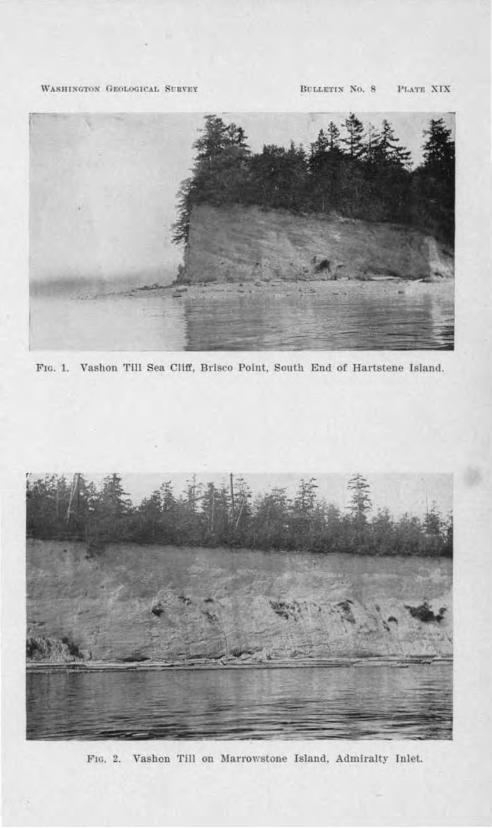
nrw:.cr,~ 1·,._\ n: x1.·
Ft . 1. Vashon Till ea LI.fr, Brisco Point, outh • nd of Hart l n Island.
1''1 . 2. \ ashen Tlll on lnn·o,·:ston Island, Admlrnltr rol t.

Name ot Deep. Bit11atfon. Por-m. Malt'. D,·ptll.
BOODS CA.NA1,-Bood1 Canal deep .••••......• 1 South . or two valle)'ll uniting 11.eugtb lndellnlte, width bait ot I 05 tatboma
from lilt' north.. C11011.l. (5i0 rt.
Oabop BllJ' deep ...... , ...... ·
BrOWDB Point deep .•.........
Roods Orad deep • ............
ADMIBALTY TNLE .. -T,agoon Pt. deep ..•.....•....
SC11tcllet lfagtt) Bead deep ..
South or two nJteys unlUng from north. By aide of con· strlctlon caused by Pulall Pt. (rock).
Constrlelloo LD trough chle.O.y above aea level, cauaecl by blgh blulTa ot AdmJralty m11terlal.
Constriction caused br Hoods Bead Interglacial hit .
ionstrlciloo 11hovc sea level by blgh blu!r of Admlro.lty m11-terlo.l on \VbJdbcy lelaod.
oru,trlcUon below sea I half tbe width above. to junction ot, and In of. two V11lleys uolUD north.
vet to Close
linger Crom
l:lloogatl'd, 8 m!. loo,. . ....... .
Gentle alopee below sea level, IUI e1tcopl.loo to rule.
Pt. Eldmuol'I deep ...... ...... , I Constriction below Ra lovel .... , Elongated below sea level with• out detln.lte rlm.
Pt. J etter110D deep .•.......... oUJltrlctleo by Bllhmerged 8.llll· eat. Deepest place ID Puget Sound.
West PL deep ••...•......... I Constriction below 11ea level ....
AIJd Polnt-Restore.tloo Pt. deep.I Constriction by rock peoln&lllll. ___ o:..:D:;....;c~IICb 11lde.
Very 1tee11 slopes, !lat bottom, eloogate.
102 fathoms (6]:?rt.J.
63 fntbOOl l a;s rt.1.
73 fathoms ('!138 (t.).
104 !albomR (624 (t.).
1'18 fathoms (888 fL) .
118 !&U1om1:1 (708 rt.).
153 !e.thom (918 fL),
138 fathoms (828 ft.).
H2 flltboma !!'52 Ct.).
De11th. Bulo10 a,,,..
30 !n tbOIDll (180 tr.).
13 fathom, 78 tt.).
24 ratboru (14'1. ft.).
38 tn.thom11 (:?28 (t.).
5S fathom11 (318 ft).
18 rathom11 (l08tt.).
32 tnthon18 (l 02 rt._l . _
~ ('>
s· No
f C) --;:,-~
"t:I ~ ~ .,..
§ ~
~ ~ 5· ... ...
~~ .... ...J.
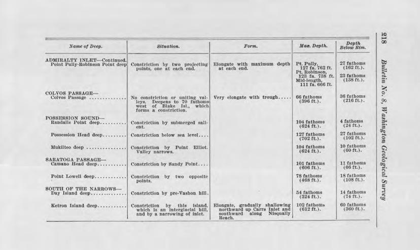
Nani~ of D6eg, Bltu.a11on.. Forni.
ADMIRALTY T LmT onll.D11 d. Point PuJ!y-Roblnson Point d ep on trlctlon by two projecting Elongate with maxlm\J.ID depth
points, one nt aeb end. o.t each end.
Ma~. Depth.
Pt. Pully, 127 ln. 702 lt.
PL Ilohl.nson, 123 ta. 78 rt.
Mid-I ngth. 111 fu. 600 ft.
OLVO PA GE-Colyos Pa age . . . . . . . . . . . . . . o constriction or uni Ing vol- Very elongate with trough..... 06 fathoms
I ye. D opens to 70 fathoms ( 396 tt.). west of 13lak J I.. which forms a constriction.
POSSESSION OU D--!-ta.ndallij Folnt deep.......... onstrlctlon by submerg d so.II·
ent.
Po e h:m Beacil de p. . . . . . . . . onstrlctlon below sea level ....
Mukilteo deep
S RATOGA PA AGE--
Con h-lctlon by Point alley narrows.
, lllot.
Camano aead deep........... Co.nstrJctlon by a.ody Point ... .
Point Lowell deep............ Com,trlctlon by two opposite points.
SOUTll OF Tlllll ARRO S-Oay !Bland deep. . . . . . .. . . . . . . Constriction by pre-Vashon hill.
Ketron Island deep. . . • • . • • . . . Constrlctlon by thls lsln.nd, whlc!J Is an lntl.'rglncla.l hlll, o.nd by n narrowing of Inlet.
miongote, .gradually shallowloJ( northward up Carra Inlet and southward along Nlsqutllly Reach.
104 fathoms (624 tt.).
127 fathoms (702 ft.).
104 fathoms (624 ft.).
101 fathoms (606 rt.J.
78 fathoms (468 ft.).
54 to.thorns (824 rt.).
02 rathom~ (812 ft.).
Daptl, Below JU1n.
27 fathoms (182 ft.).
23 fathoms (13 ft.).
36 fathoms (218 tt.).
4 fathoms (2.tlt.).
27 fathoms (102 Ct. .
10 fnthoms (60 ft.).
11 fathoms (GO ft.).
l fathoms 10 Ct. ) .
14 fathoms (7'1 ft. ) .
60 l'.ll.lhoms (360 rt. ).

Glaciation of the Puget ound Region U9
The above catalogue bring out the clo e corre pondence of deep to con triction of the trough of pre-Va hon origin. The conver e relation i al o largely true; that no pre-Vashon constriction in a major trough j , ithout an accompanying deep.
Another relation of the e deep to the pre-Va hon topography is their occurrence at the junction of two southward-trending trough .
These deep place in the Puget ound trough are referred to erosion by the Va hon Glacier of the ba in. The special condition for their formation wa the pa age of he ba al ice through a con tricted portion of a trougl , hich otherwise afforded free om\'ard rnoYement or whn.t i the ame thing in prine'iple, the crowding of ba al ice from two trougl into one.
uch condition hould fa or ero ion. It i conceivable that ero ion might occur .here while on the general urface that wa overridden depo ition took place. The survival of the headland and alients whi h cau ed the con triction indicate that the glac-ial ero ion did not notably widen the troughs.
The idea of glacial era ion ma be carried fal'ther and the great depth of the main trough ma be a cribed largely to Va hon glacial era ion beneath the thicker ice ma whicl1 lay over the c valley . An e ·treme view would be that all of Admiralt Inlet below 40 fathom or o the depth of that portion "ith rocky bottom near Po1·t Town end had been produc d by glacial e1·0 ion. There i a check however by which the amount of gracictl deepening can be limited. The bath metric chart (Plat XX1' ) how cveral ubmerged snl ient in Admiralty Inlet and other major trough~ who e po ition is on the in ide of a curve in the cour e of the deeper portion. Tho e off Jeff r on Poin and catchet ( kn.git) Head are characteri tic. WhateYer their origin the em incompatible with the hypothe. i of glacial ero ion of the larger part of th trough.
MINOR RIDGI G OF VASHO ORIGIN.
ote has already been made of rounded till ridcres oriented in the direction of glacial man.men and compo ed of Va hon till which occur on the slope of the intercrlacial valle . The

220 Bull.etitn No . 8 W a-shimgton Geological, Swrvey
be t group of uch in Puget ound i on the north lope of Hales Pa age. (Fig. 24.) The mo t triking ingle ridge of this character i Cape Horn on Hammer Jey Inlet. (Map on Plate photog1·apb on Plate XVIII Fig. 1.)
Wing Point on Eagle Harbor and almon Bay Narrow , at the Government lock in Ballard Harbor are two imilar ca es, though with le s pronounced ·pre ion. Till ridge are finely developed in the Dogfish (Liberty) Ba depression.
Thi ridging of the ground moraine i not limited to cro -valley where it eems to find it best development. It al o occur on the u.mmits of the drift hill throughout the entire region. Almost any east and we t traver e of llit ap County or the northern part of Mason aunty on the Great Penin ula of Puget ound will describe a con istent1y ascending and descending profile acros long till ridge . In contra t with thi , north and south roads may extend for mile without much grade if they hold to the ridges or adj a cent furrow . In the outhern part of Tacoma such ridge of the ground moraine have been cut across in street grading. They are compo ed of Va hon till to the ba e.
These form originated apparently by local accretion of ground moraine, the flowing contou.r being produced by the overriding glacial ice. They cliff er from drumlins in being more elongated, and in occurring on an earlier topography of
greater relief. Where no section exists, they may be taken occasionally for features of the pre-Va hon topog.raphy. They are u ually much mailer, however tban the ridge of the interglacial topography.

CH.APTER IX.
RELATIONS OF GLACIATION OF THE FLANKING MOUNTAINS TO THAT OF THE PUGET
SOUND BASIN.
Very few data a.re at hand for an intelligent discussion of th.is subject. Field work bearing on it has been nothing more than reconnaissance, and that only in a limited number 0£ mountain valleys.
THE OLYMPIC MOUNTAIN GLACIATION.
In chapter II the relation of the Vashon Glacier of Puget Sound to the Skokomish Glacier was discussed, and it was shown that the greater ice mass pushed up into the lower end of the Olympic Mountain valley in the face of a descending local glacier.
Theoretically, with the oncoming of glacial climate, glaciers from the Olympic and Cascade Mountains would descend to the Puget Sound plain before the Cordilleran ice sheet entered the basin. The Skokomish Glacier then originally may ha.ve extended some distance farther down its valley, and the arrival of the far greater ice mass crowded it back, or overrode and destroyed its lower portion. No superposition of Puget Sound till on Olympic till is known in the Skokomish Valley, but a locality a few miles north on Hoods Canal affords a section that is to the point.
On the east side of this inlet, !llldway be"t\veeo the mouth of the Lilliwaup Creek and Rama Rama River, a dark-colored till overlying the weathered drift of Admiralty age is exposed in a sea cliff. The till is unlike either Admiralty or Vashon till anywhere in Puget Sound. Its color is far too dark, its pebbles are subangular instead of rounded, and it possesses no granite or other holocrystalline rock. Fine-grained, dark-colored rocks prevail, some being basalt, some metamorphosed sedimentaries. Pebbles with a bright green vein-stuff, and pebbles of bright red jasper are conspicuous in it. The till is very firm. A block

•
222 Bulletin r-; o. 8 W ashvngton Geological urvey
everal feet in diameter fell from a ea cliff for a di tance of 40 feet without di ruption came to re ton the beach beb een tide , and ha ince been carved by the wave into a tack 10 feet high.
The c.bara ter enumerated tamp thi till a Olympic in origin. It fre hne indicate a hon age and it po ition directly abo e the old weathered dmiralty drift hows that deployment of Olympic glaciers had filled and cro ed the preVa hon Hood anal trough before the ordilleran ice entered the field. The po ition of thi till in failing to lie oppo-ite a valley from the lympic i evidence that a piedmont
condition of the deplo •ed 01 mpic ice wa attained to be later desb-oyed by the ordilleran Glacier from he north.
everal expo ure about the mouth of the Du ewallip River bow an Olympic till po e ing the ame O'eneral c aracters
found in the till above de cribed. It underlie the Brinnon Delta and appeai·s along the hore for a short di tance north of the mouth of the vall , again indicating a deplo ment of Olympic ice beyond the mountain before the ordilleran invasion . Though Puget ound Va hon till ha not been found to overlie it, the occurrence of pebble of granite in tlie Dusewallips Valley, two mile above it exit from the mountain proves that Puget Sound ice crowded ba k that far over the local ice. The lack of a ground moraine of the greater glacier, and the scarcity of Puget ou d drift material in the Du ewallip Valley may mean that the ba al portion of tl1e ice in the valley remained Olymp.ic and onl the upper jce of the Puget Sound Glacier wa pu hed up the Yalle .
Till with pebble of granite li on the bottom of the Duckabu h River valle clo e to it mouth. Here the Puget ound Glacie1· evidentl di placed the local glacier in the lower valley at lea t.
Granitic erratic have been found b Profe 01· Henry Lande , State G ologi t fo1· !25 or 30 mile up the Elwha River valley, on the northern lope of the 01 mpic . Thi i further evidence of the dominance of Corclilleran ice on the lowland.

Glaciation of the Puget ound Region !~S
THE CASCADE MOUNTAIN GLACI:ATION.
Willi and mith have identified a plane tract of g1·ound moraine in the ea tern part of the Tacoma quadrangle a the depo it of a piedmont glacier upplied from the Ca cade Moun- \J tains to the ea t. This they name the O ceola Glacier. They also consider that a broad glacial beet pread out from i\fount Rainier, and met the ordilleran ice on the Puget ound drift plain. The pre ent tudy has failed to verify this latter conception as ha been noted. It is true, however, tl1at Va hon outwa h in the outhem part of the Puget ound ba in in many places bears a large proportion of l\Iount Rainier lava even as far we t as the Rainier-Walrick Prai1·ie drainage channel, eroded in the earlier-built TenaJquat Prairie (Chap. IV). A terrace of the glacial Nisqually River is traver ed for two miles out of McKenna by the road to Eatonville. Its urface · littered with coar e material largely of l\Iount Rainier la a, many fragment being four feet in diameter. Granite i not abundant. Ascent from thi terrace i to the ground moraine of the Puget ound Glacier which i trewn with large, angular -bowlders of granite, typical of Pu"'et ound drift, and among which not one bowld of Mount Rainier lava wa found.
The writer ob ervation in the n cade Mountain have been limjted to the noqualmie and Cedar River valley - in neither of which ha a line of con tact been found between Puget Sound drift and 11 cade l\Iountain drift. edar River valley below Barne ton i of po t-Va hon origin, and the stream has been uperposed on an old chift topography doubtle s of Puyallup interglacial age. The Vashon outwash depo its bere are so deep that little has been made out of the glacial hi tory of the region. The Admiralty drift plain i thought to be recognized in the great drift filling which extend back into the mountain alleys.
Cedar River appear to have ftowed originally to the Snoqualmie, but by glacial derangement of the drainage to have been turned -outhwe tward through a narrow mountain-walled
•

29l4 Bulletin No. 8, Washvngtvn Geological urvcy
valley to enter the Puget ound drift plain at a more outhern point.
The triking feature of th noqualmie River valle in the mountains are the lower fall 268 feet in height, and the broad floodplain vhich tretche back from the fall for even mile or so up among the mountain . The view of tbi :floodplain from the ummit of Mount Si 3 700 feet almo t directly above it, embraces a remarkable a emblage of tream meande1·s oxbow lakes and ere centic wamp , the whole being mo t tri:kingl contra ted with the cataract who e ab1·upt plunge uc-e d thi aimle loitering cour e of the river.
The lower part of the :floodplain de ribed is bounded b bluff which ri e to the high plateau of drift a1on(J' the we tern foot of the a cade Mountain the noqualmie here having inci ed it deep) . o expo ure of th tructure of thi plateau of drift are known. The que tion of it age mu t be approached from anotl1er point of iew one that involve the origin of the falls . ..,.
Snoqualmie River plung over a cliff of lava who e outcrop ri e 100 feet or o above the falls on the outhern ide. On the north rn ide of tl1e fall i the truncated end of a morainic ridge which ro e the valley in line with the cataract. Excavation for a power plant and a railway grade ha.ve afforded instructive section of hi moraine from which it i evident that the morain i the can e of the deflection of the river to the oath ide of the valley . Thi deflection ha au ed the tream
in it down-cutting to become uperpo ed on a pur of the preVa hon noqualmie Valley which ha gi en rj e to the falls . The presence of thi moraine aero the valley and the lack of down-cutting at the fall have cau ed the broad aggraded floodplain which i so out of harmon with the cataract below it. 'J..A number of great terrace-like surface above pre ent valley
floors can be een in the valley of edar River and the South and Middle Fork of noqualmie River from the mountain ummit of the region . The e terrace appear to lie in a common plane, and have a perceptible de cent we tward. Grouse Ridge

WASIIINOTO, ,~: t 11'.U, ' n\'E\'
Fm. 1. Dro ~·n d Vall y of hamber's r k at Low Tld~.
itnrlm• KhPlls J.JO rcrl nhovc 1hc Hen w~rt• rouoll nl X .
. 2. Call.I Potnl BIii , an .Juan l.sland .
Wl\\'(•-cut lwnrhr•" un outlwrn 11r1lrh· t11c1•. >11t\\·n•h nprnn t1f 'lllllt• l'nlnt 11,orrtl11,• In forl'irromul.

Glaciation of the Puget Sound Region !t!/?5
one of the e flat-topped area in the outh Fork Valley. It lie on the north ide of the river and is cro ed by the Ellensburg Road. It i compo ed of clrif and apparently i to be correlated with the depo it of drift in which the huge excavations ha e been made at Ragnar on tl1e hicago l\lilwaukee and Puget Sound Railway on the outh ide of the vall y.
The e broad tracts in the mountain valle , everal of which are known to be compo ed of glacial debri , probably can be correlated in a continuous profile of a. former drift filling. uch an aggradation of glacial drift in the capaciou valleys of the Ca cad Mountain further probably can be correlated with the Admiralty drift plain of Puget ound. Though no tai.ned 4D.d weathered ediment l1ave been found in the mountain valley , tbi filling ha been deeply and broadly excavated where the :floodplain of Snoqualmie River above the fall now lie , and in it have been depo ited two or three rece ional moraine of a Va hon valley glacier, the terminal moraine occurring at the fall beyond the mountain-walled portion.
o evidence ha been found to show that the Puget ound Glacier crm ded back into the a cade Mountain a it did in the Olympic . uch evidence i not to be e."pected since the glacier from the Ca cade Mountains were of much greater mass than tho e from the ma11er Olympic Mountain .
-8

CHAPTER X.
PLEISTOCENE AND POST -PLEISTOCENE DIASTROPHISM.
SYNOPSt S.
ALTITUDE DURING THE ADMIRALTY EPOCH.
MOVEMENTS AND ALTITUDE DURING THE P UYALLUP EPOCH,
ALTITUDES DUltfNG THE VASHON EPOCH.
T nE CHEHALTS VALLEY TRAIN. T HE CATTLE P OINT MORAINE.
TRE SQUALICUM D ELTA.
SHELL-BEARING TILL OF WRATCOllI COUNTY.
P osT-VAsnoN CHANGES Il-' ALTITUDE oF THE R EGION.
liI<;H-LEVEL 1\1,\RlNE SHELLS L'7 SEATTLE.
~Lutl NE SHELLS ON THE R rcu:'lrnNu D ELTA.
1\lARIN.E SH.ELLS ON THE SEQUALICREW DELTA.
l\UBTh"E SELLS AT Hrnn ALTITUDES IN THE SAN JUAN IstANDS.
BEAcn R IDGES OF WHATCOM CouN"TY.
CHAMBERS GREEK A2''D THE STEILACOOM D ELTA,
GENERAL CoNsIDERA'l'IONs.
ALTITUDE DURfNG THE ADMIRALTY EPOCH.
T he k:no,m history of Pleistocene c1·ustal movement of Puget Sound begins with the retreat of the Admiralty Glacier. The lower beds of the Admiralty sediments nre known to contain marine sheJls at a1titudes of a few feet above present high tide. T he altitude of the land was thus slightly lower than at present. Its attitude did not deput much, if at all, from that of t he present.
MOVEMENTS AND ALTITUDES DURING THE PUYALLUP EPOCH.
Aggradation of the drift plain was completed while the land lay at this low level. Subsequent to the formation of tbis terrestrial deposit, regional uplift elevated western Washington at least 1,000 feet above present altitudes. The deeper Puget Sound troughs produced by the interglacial erosion attest a

Gla-ci-0tion of the Puget ownd Region 227
long duration of thi high altitude, probably u.ffi.ciently long to permit the development of a graded condition in the valleys and the be(l'inning of ,,alley w1dening.
The duration of this ubaerial expo ure was . ufficiently long to allow weathering to soften the gravel and till expo ed at the surface. Limonite, from oxidation of urficial material, was wideJy di tribute\! by ground water in the deeper Admiralty gra el and cau ed the taining which i a con pi uou feature of the porou Admiralty ediment in the ea cliff in the Sound. A duration many times the length of po t-Va hon time wa nece ary for the eros1on and weathering accompli hed during he Puyallup interglacial epoch.
The uplift at the beginning of the interglacial epoch produced local deformation of the Ad.mi ·alt ediment . Admiralty gravel at tbe ea t end of ox land is faulted in places and light] tilted. Deep] tained dmiralty and in Magnolia Bluff cattle Harbor i omewhat bowed up in the section just south of We t Point. The beds of the Quatsap Point Delta are faulted Jigbtl . ( ee Plate XII, Fig. 2.) Va.riou other section show comparable deformation of the variou ediment composing the comple · ma of the Admiralty plain.
The greate t deformation known in the . dmiraJty sediment j at the south end of Bolton penin ula. The Admiralty till, and its overlying gravel and underlying cla are tilted to the northward and have a dip of 25° . The movement which produced thi deformation wa trictly local for the entire eastern ide of Bolton penin ula and the we tern ide of the adjacent Toando penin ula are e:,,.""Po ed by ea cliff and no hint of exten ion of tl11 di tu.rbance into them ha been found.
ALTITUDES DURI1 G THE VASHON EPOCH.
At the t:ime of the marimum Va hon glaciation, the region stood at about it pre ent altitude. The time of lowering from the intergla ial higher altitude ma have preceded or been contemporaneou with the advance of the Va hon ice epoch · it was attained at least by the time outwash reached Gray Harbor at the mouth of the Cbehali . The hell-bearing till of the

!tfl8 Bu/,letin No. 8 Washingtorb Geological Survey
Laurel moraine ma indicate that locally at lea t the sea had crept back up the interglacial valley before the advancing Va hon ice had reached the northern pol'tion of the ba in.
THE CHEHALIS VALLEY TllA.IN .
The hel1alis Valley wa filled by the Puget ound Va hon outwa h to a level much abo e the rock floor and the gradients in the valley train de cribed in hapter II were adju ted to a ea level not far from that of the present. The 35-foot ter
race of glacial gravel jn the city of Aberdeen at the head of Gra Harbor pos e es tream-beddi.ng from top to bottom, with cro -bedding in place d cend.ing we tward. It i possible that Vashon outwa 11 built a marine delta in thi protected bay but if so it has been completely de troyed by subsequent changes.
A ide from the we tern terminu of the Chehalis valley train no record of the altitude of the region wa left until glacial retreat had opened the trait of Ju n de Fuca, and Lake Ru ell had been drained. Outwa h gravels, which, except subglacially, or in delta , had never been depo i.ted below Lake Ru ell's levels in Puget ound, now came to be adjusted to the ea level of the Va hon epoch. The vidence from thi i not as conclu ive as might be U"}>ected but give a range of about 40 feet, within whi.ch the sea level surely lay.
THE CATTLE POINT £ORAi.NE.
The material of the southern lope of Cattle Point Hill of
an Juan I land has the stratification of an alluvial fan. There is nothing in the tratification to ugge t that it was formed in tanding water. As expo ed in the ea cliff, the subaerially depo ited trata descend to within 25 feet or so of high tide. The ea. level wa evidently omewbat below thi level at time of depo itioo.
In the bluff overlooking the city of Mt. Vernon, in the same latitude a Cattle Point, Va hon outwa h gravel shows streambedding to the ba e of the expo ure, altitude 4;0 feet. Though delta-bedding is present, it occurs only in individual horizontal

Glaciati011, of the Puget Sou71a Regio1i ~~g
beds in which the gravel i fore et. Thi ection thu indicate that the ea was below 40 feet above tide when the Va hon ice retreated aero thi region.
THE Q. ALIC lit DELTA,
A marginal 1·iver formed along the edge of the Paget ound Glacier as it withdrew nor hward from qualicum Mountain east of Bellingham. Its channel i followed by the Bellingham Bay and Briti h olumbia Railroad between oon and Bellingham, and descend we tward to open out toward the bay in a broad flat of and and gravel in the northern part of the city of BellinO"ham. Exten ive excavations and railroad cuts m the valley of Squalicum reek e.: po e the tructure of thl delta but the tratification i not in an way comparable to the beautiful structure of ome of the Lake Ra ell delta .
trata dipping award are common, though of no great length or thickne . uch fore et bed po e no definite up-per limit by which the ea leYel may be determined. treo.rn-bedding occur con picuou 1y at the top bearing and trata with fine cro -bedding dipping ea.ward. But gravels with rude horizontal tratification occur beneatl1 the fore et bed , at a vertical di tance from the and too gl'eat to fall within the tidal range of Bellingham Bay. Beneath the hole is an eroded urface of and whi h i a fre b a the gravel above and
doubtle belong to the o.me dcpo it. In the upper part of the gra: el is a er i tent cloy tratum one to three feet thick.
Ob,riou ly thi i the depo it 0£ a heavily loaded stream which flowed through the qualicum channel. The plain cau ed by thi delta-like depo it ha an altitude of '75 feet. From this mu t be subtracted the variable thickne of the top et bed to obtain the J,eiO"ht of the sea at the time of depo ition. This wa perhap 50 feet above pre ent ea level. Horizontal and fore et bedding both are to be found within 30 feet of pre ent mean tide. ·
The sea cliffs of the northern portion of the qualicum delta plain show 10-!W feet of clay at the top. ince thi i at the a.me level n the andy and gravelly portion , it must be con-

230 Bulletirn No. 8 Washington Geological Survey
temporaneou . It ma be explained a part of the delta which during the la t(l,ge. of growth wa not reach d b di tributary cun· nt the clay ettling in the till water. Thi conception demand how ver an altitude of 75 feet for the ea level.
The qualicum elta plain i bounded on the north by ground moraine which rise 30 feet above it. ea cliff ctions how fore et ll'ravel b n ath the till. The till .i p1·obably the re ult of a light readvance of the a hon ice while tlie delta was being bum.
The conclu ion drawn from the quali um Delta regarding ea level during Va hon retreat i that thi plane lay omewbere
between 30 and 75 feet above p1·e ent mean tide.
SHELL-:BEAll~G TILL OF WHATCOM CO NTY.
The ea cliff of the qual.icum Delta and of the hore we tward along Bellingham Ba , di play two till beet eparated by brown and and localJy by the overridden portion of the delta. The basal till i gra , the upper one is yello"ri h . The brown- tained ands are identical in color , ith the stained Admiralty ediment . :Both till are more argillaceou than is usual for Puget ound and both contain marine hell , the lower one the mo1·e. large, thin, entire Peet n "alve wa found in the lower till.
The topography of hj area immediately north of the qualicum Delta, overlyh1g the hell-bearjng t n lay, i hummock and po e num rou kettJe hole . It i a typical morain.ic urface. Tl1e intercalated fore et b d , abo" described afforded further evidence that the hell-bearing tony cla i a true ground morain and not a depo it from floating ice near a glacier front. The tained and i considered a conte.mporaneou with the delta gravel the taining being due probably to the almo t exclu i"e u e of thi porou tratum by ground water.
The bell-bearing tony cla over! ing the Laurel moraine at an altitude of 100 fe t 1 es entially he rune a thi till of the Bellingham Bay ection . If the latter i a till beet of

Glaciation of the Puget Sownd Region ~SI
Va hon age produced by two ucc i e advance , little hesitancy need be felt in explaining imilarly the marine hellbearing ton clay of the Laurel moraine 6. e and a half mil north. The hell of th Laurel moraine 100 feet above tide, therefore do not en te1· our pre ent problem of the height of th sea level during Va hon retxeat.
POST-VASHON CHA GES IN ALTITUDE OF THE REGI01 .
From the foregoing imperfect data, Lake Russell appear to have been betw en llO and 130 feet above ea level at it maximum tage, the plane of which now tand· 160 feet above tide. But the histwy of po t-Va hon marine occupancy of Puget
ound i complicated more than i indicated by thi evidence of an upward movem nt of 80-50 feet. It i obviou that a check might be had on the , a hon sea level from marine trands if ince the la t glaciation, there bad b en but this upward movement. But the occuri-ence of mruine shell overlying Vashon till up to nearly 800 feet above mean tide, de troy all chance of using uch a check.
1 umerou ob erver have report d marine hell beds on waveut terraces of po tglacial age a high a 30-40 feet in Puget ound. The writer ha not d earlier the occurrence of marine hell up to 100 f et above ide inferring from limited data
that the Va hon ea Jev l wa at that altitude. fore tudy of the region ha ho"·n that po t-Plei tocene marine trand , reorded by bell bed lie 130 feet above the level of the Pleisto
cene Lake Ru ell, and perhap !250 feet above the altitude of the Va hon ea.
HIG-H-LEVEL M.UlINE HELLS L.-: EATTLE.
Tl1e b t oc urrence of marine hell at high level known at pre ent i 011 the we t lope of Queen nne Hill in the city of
eatt.le. The shell ai·e betwe n Tenth and Eleventh Avenues, directly we t of the end of 1\IcGraw treet. The lie on a. loping terrace, a foot or o beneath od and loo e oil, but above the Ya 11011 till. The hell con titute an almo t continuous depo it between 195 and ~no feet above tide. The g nera

!23!2 Bulletin No. 8 Washington Geological s ,uruey
Mactra (clam), Paphia (clam), Cardiwm (cockel) Natica (snail), Thais (periwinkle), Mytilm,s (mu el) and BaZanius (barnacle) were found. The amount and the comminuted nature of the material the di tribution, the relation to the terrace and the inedibility of ome of the specie represented render origin of the depo it by human or animal agency very improbable. It i a true ea beach with the full tidal range represented.
Dire Uy aero the Inte.rbay Valley from thi occurrence, on Fort Lawton Hill, a few brittle fragment of Mytilus hell were found in plowed groW1d at an altitude of MS feet. o terrace ex:i t here. hells were found al o at 1 0 and 14!0 fe t above tide on the Fort awton ide of the Interbay alle .
1\:tA.RlNE RELLS O • THE RICHMOND DELTA.
A hall°'v cut along a econdary road which traver es the surface of the Richmond Delta a quarter of a mile back from the edge of it de cent to the Sound, ha revealed a bed of shell material largely commi.nuted, beneath the fore t floor. Shell of Balanius Cardiwrn, Myt,Hus, a crastropod and everal other pelecypod were found in thi . The altitude of the bed i 190 feet.
A mile north of the delta, on the andy floor of the channel which leads to it, fragment of Balamus Na.tica and CardiW1n w:ith other unidentified hell fragment we.re found at an altitud of !250 feet.
MAJtINE KELLS ON THE SEQUA.LICHEW DELTA.
A few piece of weathered sea bells were picked up on the surface of the equalichew D lta at an altitude of 190 feet. Alone, th y signify little, ince they may have been carried there. The altitude, however i the a.me a that of the bed on the Richmond Delta which is very probably in si,tu.
MARINE SHELL AT HIGH LEVELS IN THE s J " r L\ ros.
The e i land are composed so largely of rock that the com-mon b ach pecie with hea y bell uch a the clam and the

\ ARIIINO'l'Cl ' G~ I O I AL UVFlY Titrr, !,E1'1N N .
F1tl , J. a lilf ln outh Hlll, an Juan Island, wllh ti ook At1I1 nd d.
F1 . 2. El'l'at on Va hon round lora10 , n ar Pon Gamble.

Glaciation of the Puget Sounul Region 2SS
large sand-burrowing nail, N atica, are rare in the pre ent littoral fauna. For the same rea on, they were lacking during the earlier high marine levels. Occurrence of bells on the e i lands are limited to the mar he. and pocket of accumulated finer materials in embayment of the rock hill .
The highe t postglacial marine hells yet known in the Puget Sound country occur on Orcas Island. Ditching in a mar h on the old Cap. Olden place, near the quarry of the owell Lime Company di clo ed many clam shell in the clay and peat. The e were o friable that they crumbled completely on e."qJosure to the air. The altitude of the marsh i 270 feet. well on the propert of Mr. H. F. Pearmain of Deer Harbor has yielded fragment of hell at an altitude of 290 feet, this being the higbe t occurrence yet known. The material in which the hells occur i clay for the d pth of the well, 18 feet. It i
undoubt dly a marine cla accumulated in a mall mud flat near the old sea level.
an Juan and opez I land po se everal hell-bearing mar hes at altitudes above 100 feet. The Beaverton Valley between Friday Harbor and Roche Harbor i reported to have
ield d clam hells in many ditche . Its altitude is about 100 feet. hell nre found occa ionally in stratified clay on Lopez I land near Richard on the highe t occunence being in a well on Mr. W. F. Bolton' farm one mile north of Richard on at an altitude of Hl5 feet.
The mo t conspicuous record of the former marine submergence of the an Juan I land is the terracing of Cattle Point Hill and outh Hill. Di tinct benche are preserved in the sod-bound gravel on the outhern face of Cattle Point Hill (Plate XX, Fig. 2), the two highest being 240 and 17'5 feet above tbe adjacent ea. outh Hill ha a imilar bench at 265 feet but none below.
'.B.EAC"'F.t RIDGES OF WHATCOM COUNTY.
The broad plains of postgla.cia] marine and fluvial aggro.dation which con titute the fertile farming country of Wbatcom County in places bear beach ridge recording the former ma-

~34 Bulletin No. 8, TV ashimgtcm, Geological urvey
rine ubmergcnce. uch beache are con picuous on the plain north and we t of Lamel. They ar omewhat irregular in ere t, and inclined to be duney and h nee axe not u ed for ridge road . ome are very low and carcely to be detected. They are compo ed of lean brown and with row1ded grain . umerou thin wavy cam or trata of clay o cur in them but no hell remains were found in them.
The large t 1·idge ob erved trend northea t to outhwe t along the edge of a terrace, the ridge being !20 feet above the plajn on the northwe t and 10-12 feet above that on the outhea t . This ridge is cut in three places by the road between Ferndale and Laurel, and once by the Pacific Highway north of Laurel. The cour e of Tenmile reek i parallel to the ridge.
:Beach ridge are numerou between Lynden and umas and are commonly compo ed of fine gravel. A ection afforded by one of these howed strata dipping we tward, obviously produced by accretion on the eaward face of the beach.
The hlghe t known occurrence of beach and on the hat-com Count plain i ea t of E er on at an al itudc of about 100 feet. It doe not have the form of a ridge but from it ur-6cia1 po ition and fr edom from clay it i be t explained a a shore depo it on the ground moraine. It contains a peaty layer in a position in entfre harmony with bench oriofo but difficult to explain otherwi e.
CHAMDER CREEK AND THE STEILACOOM DELTA.
The above eviden e indicat that the region sank after retreat of the a hon ice and ha ri en ub equently to an altitude omewhat greater th::i.n that po e cd during th a hon deglaciation. It i not y t e tabli hed that the e movem nts con-titute the whole of po t- a hon dia trnphism in Puget ound.
Puzzling relation have been found between hambers reek valley and the teilacoom Delta which po sib]y may add to the iliastrophlc hi tory.
Chamber reek i a po tglacial trea.m which ha deeply in-ci ed the Steilacoom D elta. Gravel, with fore et bedding, ha been recognized on both side of the mouth of the creek valley,

Glaciation of the Puget Sound Region 235
and the delta plain i ea ily recognizable in the bluff ummit on either ide. It eem e ident that the creek alley mu t be po tglacial.
Yet thl valley is drowned for a mile back from the ound at high tide. ( ee Plate Fig. 1 and Fig. 26.) In it el£ uch drowning miglit be the re ult of recent inking but the
following fact need llll entirely different e:..--planation. On the outh side of the valley fully 1 000 fe t back from
the mouth, marine belJ have been found 11t an altitude of 110
r---' : .:s
I • .;)
: Q.., '~
Cl / : z: :e :) :c, o :! UJ : 11/1
:~ : a : r:D (. ___ _
Top
FIG. 26. Lower VnJJey ot Cbamb r·. Creek n.nd Environ~. X-Occurrenccs ot MarllJe bells.
Drawn trom tbe U. . . G. . hart No. 6-100.

236 Bulletvn No . 8, Washington Geological Survey
feet. Below them and omewhat nearer the Sound, though yet within the valley, 11eavy hell bed up o SO feet in altitude are conspicuou .
Tl1e equence of event recorded in Chamber Creek valley is apparently as follm :
(a) Depo ition of the teilacoorn Delta in Lake Ru ell aud 1isqually.
(b) Ero ion of the lower portion of Chamber Creek valley. ( c) Submergence in the po tglacial high marine tages. (d) Emergence to pre ent altitude thi falling ho1·t of
the immediately post-Va hon altitude leaving the Chamber reek valley partially drowned. Since the land during Vashon
retreat wa S0-50 feet lower than at pre ent and the ba e level to whi h hamber reek valley has been eroded wa lower than that of today the above hi tory require the insertion of item
(a1 ) · uplift exceeding 50 feet before ero ion of the hambers reek ,alle . Before acceptance of thi additional uplift and depre 10n
with a con iderable interval of ero~ion antedating the marine submergence the hypothe i must be verified from two different point of view:
(1) Other occurrence of marine shell vn situ in postglacially eroded and p erhap partially drO\ ned stream valleys mu t be found.
(2) It mu t be proved conclu i ely that the lower part of hamber Creek valley i not largely an embayment between
lobations of the delta front. ince neithe · ha been e tabli hed yet, the po tglo.cial dia trophic hi tory of the Puget Sound basin mu t tand for the pre ent a (a) depres ion which suc-eeded Va hon retreat and ubmerged the region to at least 290
feet above pre cnt ea level, and (b) uplift to present altitudes.
GENERAL CONSID.lllRATlONS.
It is of in ere t to note that thi c1·u tal movement wa downward after the retreat of the ice, not upward as wa the case on the Atlantic coa t. It doc not in thi it1 tance bear out the conception of i o ta tic adj u tment, con equent on deglaciation.

~
I ,,_
" - ..P.'IU!-l- +--l-+-r,-1-~-1-1-~e--1---1----,e-1 ,- - H--+-t-t-+-rt-+-rf-+-+--l-+-i-1~=+--1---++-1-+-rl-+--H-+--~~1-+-+-1-+~-i-.-+-J4 -+-i
,-.. ' '" •-- - 1~-+-t-t~ -t-t-+-~1+--lH--HH--+-H--+-t-t--+-H--+-H---+-+--t-+-+-+-++-t-+-P-IH-+IH
-1-+-+-~1-+-t-t--+-i-~•--+-+--l--+-+--l-+--1-1-+--1-1---++-1---+rl-+--H'-l--~H--+-1-+-+-i-.-1-1--I I
,- T I
_J~t--t--t-+-t--1--H-l-+--l-l-+--l-+-+l-++IH•-+-H-+-·1-+-+-H--l-+--l~
_,_,_,._,___,-+~ ·-A Mv d ~r'r¥'1'~1-'1'11-1'-R--'i-"ff1"'+'-\'4!'+++H-++1--1-1-+-1-1--1-1 I
•• b
I .... .,., . I- , -
- -·I-J-+.-rl-+-+--l-t--t-,H--t--H·+.l-++-H-+-l-+-~H-+-H--+-+--t-1---1-1-+-i
.... .,, i..,
" ~ lJ ,r - ,_ la - - .,.~1;~ Ir. if J ' ' I
I
1<, -
--, .. '·' ·- -- I-
I --·· -' -- ·-- ~
"' .. I g ... -CL ~~ Dh~ I ~
FIG. 27. OJostrophJc Movements ot the Pu~t ouod Basin alnce Ad· miralty Glaclatio.n. Time relations, ltidlcated by vertical dlataoces, are only appro:1:Jmate.

iss Bulletin l\ o. 8, 'ff ashitngto,n Geological Survey
The glacial ma pared to the dorean origin.
wa however, of relati,;,ely light amount comontinental ice- hect of K ewatin and Labra-
Marine helJ on tl1e bluff of Puget Sound are rarely accompanied by wave- ut terra e . The 210-foot shell bed on Queen Anne Hill lie on a fragment of a terrace, and a 105-foot hell bed on Hoo anal ju t north of the Ha.ma Hama Ri er occur on a definite ben h. But the duration of the higher marine stages appears to have been too brief for the development of many shor line trong enough to per ist to the pre ent. A further evjdence of the brevity of the submergen e is the lack of tream deltas at the marine levels. During the perhaps equally brief exi tence of Lake Rus ell the stream were heavily laden with glacial outiva h, and delta probably grew far more rapidJ than a any . uh equent time.
Little warpinO' or tiltinO' of the region ha occurred during the e po t-Va hon movements. The highe t level of the Black Lake outlet of Lake Ru sell i 160 feet. The top of the foreset bed of the Richmond Delta, more than 50 mile north, i 165 feet and the upper margin of the R dmond Delta, 40 mile northea tward i 160 feet . The e altitude have been determined with aneroid, and more refined measurement may how slight deformation. For general purpo e bmveve-r we ma consider the depre sion and uplift of po tglacial time to have been about equal in all part of the region.
There i a final point regarding the Plei tocene deformation of the region which i intimately concerned with the hypothe i of the Admiralt intergla ial river. It i the hallowing of Admiralt Inlet near it junctjon mth the Strait of Juan de Fuca where the Coa t w·ve chart indicate a rocky bottom.
If uch hallowing is due to Va hon depo ition, hi gives an unparalleled thjcJrne of Va 110n drift of at least 300 feet the inlet here being hallower than the average depth farther south by that amount. The thickest section of Va hon till abo e ea level are about 100 feet . T hi . upposed depo it lie , further where ero ion in tead of depo ition would be expected. The

Glaciation, of the Puget Sound Regi<>n ~39
"rky" of the Coast Survey chart, under this hypothesis, must be considered to indicate a bottom strewn with bowldery drift.
If this shallowing is due to a differential uplift of the region, it should affect also the hills between the troughs. No evidence of such has been found as yet. The time of the differential movement may best be placed in the late Puyallup or early Vashon epoch, when lowering occurred from the high interglacial altitudes.
The depth of the Strait must be considered here also. The depth is 80 fathoms at Port Angeles, ·gradually increasing toward the ocean, exactly as a stream valley would deepen, possessing a grade of about 9 feet to the mile. CordiUeran ice discharged westward through the Stnit, as well as southward into the Puget Sound basin, but has left no hint of its presence in the conflglll'ation of the bottom of the Strait Valley. This valley at its present altitude is too high to have served as the outlet of the Adminlty River, though the evidence that it did so serve is convincing. Its present altitude may be due to differential movement of the Strait and Sound regions, or may be ascribed to a drift fllling which has left a regular seawardsloping floor.
The very deep channels among the San Juan Islands, attaining a maximum of 204 fathoms ( l ,!Z~4 feet), are largely the product of preglacial stream erosion, and demand a deep Pliocene Strait Valley, as the Admiralty River demands a deep valley to the ocean during the Puyallup interglacial epoch.


INDEX.
Poqo Aberdeen • . . • • . • • . . • . . . • . . . • . . . • . . • . • • . . . • . • • . . • • . . • . . . • • • . . . • . . • . . • 52 Admiralty Glacial Epoch ............................................ 14-173 Admiralty lnJet, dlmew;lons o! . ...•.......••............•..•.........• 100 Admlrnlt:y Plolo ........•....................•..•...•.•.••..•......• 200 Admiralty River •.............••.••...••........•.....•...•...•... 204-212 Admiralty Sediments ..••.••••...•.. . •......•.•..•.•••..•...•...•..• 15-liS Admiralty Till •••••..•••••...........•••.••...•••••.••..••...••••• 14-173 Agnsslz, Louls . • • . . . • • . . • • . . • • . • • . • • • • . • • • . . • . • • • • . • • • • . • . . . • . . . . . . • 97 Anderson Is.lond . . . . . . • • . . . . . . . . . . . • . . . . . . . . • • . • • • • • • • . • • • . . . . . . . . . • 179 Animal Remlllns lo Admiralty Sedlments ................................ 180 Arllogtoo . . . . . . . . . . . • . • . . . . • . . . . . . . • • • • • • • . • . . . . • . . • . . . . . . . . . . . . . . . • 167 X Auburn Delta •...•..•.••.•.........••..•....••..••.•.•.••...•......• 134 Ba.lobrldge Island ••..•..............•.•.•••••••.•••••••.•••••••....• 214 Bald 8-llls •..••••••...••.••..••..••••••••••...•••.....••.......... 25·114 Belllogham •.....•...•••.••..•...••.••..••••..•.....•••.........•. 77!220 Big Lnke . . . . . . . . . . . . . . • . • . . . • . . . . . . . . . . . . . . . . . . . . . • . . • • . . . . . . . . • . • • 168 Black B.llls ••..••..••..••.••••.•••....•••..••.•••..•...•.......• 17-30-200 Black Lnke Outlet. . • . . . . • . . • . . . . • . . • . . . . • • . • . . . . • . . . . • . • • . . . . . . . . • • • 123 Blackwelder, l!lllot • . . • . . . . . • . • • . . . . . . . . . . . . . . . . . . • . . . . . . • • . . . . . . . • . • • 16 Blakeley Barbor . . . • • . . . • . . • • . . . • . . • . • . • . . • • . . . • . . . • • . . • • . • • • • • . . . . • 215 Blue Rllls . • . • . . . . . . • . . . . . . . . . . . . . . • . • . . • . . . • . . • . . . • . . • • . . . . . . . . . . . 200 Bothell ..•••.............•.............................•...•..•• 157-162 Bretz, J. B. . . • . . . . • • . • . . . . . . . . . . . . . . . . . . . . . . . . . . . . • . . • • . . . . . . . . . . . . 12 Brtooon Delta ..•...........•............•...........•...•.....•• 146-222 Bucoda ...................................................... 29-45-92-110 Camano Island ................................................... 184·186 Cape Born . . . . . . . • • . . . . . . . . . . . . . . • . . . . . . . . . . . . . . • • . . • • . . • • . . • . . • • • . 220 Casc&de Mouota.ln glaelatlon. . • . • . . • • . . • • . • . • • • • • . . • • • . • . . . . . . . . . . . • • • 223 Cattle Polot Moraine .••••••••.••.••..•••...•.......•..•.••••....•.• 78-228 Cedar Creek (Black BJUa) •..••.•..•••••........•....•...•..••••. 30·40-58 ~ Cedar River . . . . • . . • • . . . . . . . . . . . . . . . • . . . . • . . . . . . . • • • • . • • • • . . . . . • • • . • 223-1!: Cedarvllle Pralrte mound&. • . . . . • • • • . • • • • • • • . • • • . . • • • . • • . . . • • . • . . . . . . • 88 Centralia ........•.•..•.......•..•.....•..........•••••...•.... 45-59-120 '). Chambers Creek •.••••....•.•..••••.••.•••..••• . ..•.••..•••..•.••.•• 284 Chehalis ( crty) • . . • • • • • • • • . . • • • • . • • • • • • • • • • • • • • • • • • • • • • • • • • • • • • • • . • • 120 Chehnlls (glaclal) Lake •........•............•.•••••••••••.•..•••..•• 120 Chehalts glacial gravels, economic phases of...... . ......... . . . . . . . . . . . . . 117 Clear Laite (Bald B111s) . . • . • . . . • • • • • • . • • • . . . • . . • • • . • • . . . . . . . . . . • • . • • • 27 Clear Lake (McIntosh) •••.•••••••.••..•••..•.•.....••.•••..•.. 28-45·65·118 cunon Channel . . . . . . . . . . . . . . • . . . . . . . . . . . . . . . . . . . . . . . . . . . . . . . . . . . . . . 146 Cloqualluro valley tralo. . . . • . . • • • . • • • . • • . . . • • . . • • . . • . . . • • • • . . • • • . • . • • 50 Clover Creek Channel. . . . . . . . . . • . . . . . . . . . . . • . . . • . . • • • . . • • • . . . • • • • . • • • 128 Ccostltutlon, Mount . . . . • . . . . . . • • • . . . . . • . . . • . . . • • • • • • • • • • • . • • . . • • . . . . 80 Cordilleran glacier ot British Columblo. •.•.....••..•••.••..••...•...•.. 17-38 Cosmopolis . . . . . . . . . . • . . . . . . . . . . • . . . . . . . • • . . • • • • . • • . . . • • . . . . . • . • • . . . 41 CowUtz Valley ...... .. ................................ . .......... 88-42-58 Cy, Mount • . . . . . • . • . . • . . . . . . . . . . . . . . . . . . . . . . • . . . • • . . . . . . . • . . • . . . . . . 224
Dabop Bay . • • • • • • • • . • • • • . . • • • . . • • • • • • . . • • . . • . • . • . • . . . . . . . . . • . . • • • . • 186 De.II, Wm. H.. • . • • • . . • • • • . . . • • . . . . . . • • • . . . • . . . • . . . . . . . . . • • . . . . • . • • • . • 180 Deeps ot Puget S<,und •••••...•••••••.••................•..•...•. . .... 216 Deltas in the Admiralty Sediments .................................... 185

Inderc
Paye Denny 11111 ..•.•••••••••••.• •••••••• ••••••••••...••••.•..•..•.••• 174--lT JJes Chutes rtlvl.'r tau .....•...•.••.......•...........••.•........•. 27-117 Des alolncs . . . . . . . . . . . . . . . . . . . . . . . . . . . . • . . . . . . . . . . . • . . . . . • . . . . . . . . . . l 79 Din trophl m ot the Puget ouoil Region .............................. 21-:?:?0 Drumlln-Hke rld,!rtng of tbe Vashon dll ..........•................... !!06-:?lO.X Du~knl)u b \"nlley .••.....•.•..•..••.......•..•....... •..•.•. . .... J-1 -:?22
uscwnlll[)s Volley ......•..........•..•..•..••...........•.•..• 33-Hll-:?::2
Eugl • Ilarllor . . . . . . • . • . . . . . . . . . • . . • . . • . . • . . • . . • • . . . . . . . • . . . . . . . . • . . • 214 .lllatonvlll ...................... . •..... . ..................•...... :N-:?6-71 fllbe • . . • • . . • . . • . . . . • . • • . . . • . . . . . . . . • . . . . . . . . . ... . . . . . . . . . . . . . . . . • . . 26 Ell!nor, M unt . . . . . . . . . . . . . . . . . . . . . . . . . . . . . . . . . . . . . . . . . . . . . . . . . . . . . . . 33 Bllllu •.•.••.••••••....•.••..........•..... . ....•............•.... .40-JO Eroalon, gladlll, l.n trough ot Puget ound. . . . . . . . . . . . . . . . . . . . . . . . • . . . . :?19 i-Everett . . . . . . . . . . . . . . . • . . . . . . . . . . . . • . . . . . . . • . . . . . . . . . . • . . • . . . . . • . . . lli3 Ford type mounds ..........•........••.....•....••..•..... , . . . . . 6-9(;-106 h'oulwcather Blull' •..•.......................•.••...•...•............ 1 1
(,-ate . . . . . . • • . . . . . . . . . . . • . . . . . • . . . . . . . . . . . . . . . . . . . . .. . . . . . . . . . . . . . . . ~7 Gat Pnlhwny •..........••..•............ .......• ............ :! -8'!-36-47 Gnt~ 'u tllwny River .........•.••....•..••.......•..........•...... 2 'io-205 Gate Prairie mounds ...•.....•..• .. ..•....................• ,......... 8 Gu tc vnll y trn!n . . . . . . . . . . . . . . . . . . . . . . . . . . . . . . . . . . . . . . . . . . . . . . . . . . . . 4 Gibb , t>Orge ..............................................•....... 11-97
Ube rt, (;, ••. . . . . . . . . . • . . . . . . • . . . . • . . . • . . . . . . . . . . . . . . . . . . . . . . • . . . . . 101 Ure.nil llound Prnlrlc ••..•.........................•...... . ...•... 2 · -90 OrnnJLe h'a.JIH •••••••••••••••••••• , ••••.•••••••.••••••.•.•.•••••••••• 1U6 Gre n I'o!nt •.........•.....•....................................... 174
I-1nl~a l'ossuge .......................•.............................. 206 I:lartst n~ Island •..•.............................•........ . ........ l H. Ilels1ng JunCL1on ....•..•....... , . . . . . . . . . . . . . . . • . . • . . . . . . . . . . • . . . . . • 39 ll!I •nrd. E. \~ .................................................•... , . l 5 Dood glllClal) Lo.kc. . . . . . . . . . . . . . • . • . . . . . . • . . • . . • . . • . . . • . • . . . . . . . . • • 146
Interglaclnl drnlonge ystcm . • . . • . . . . . . . . . . . . . • . . • . . . . . . . . . . . . . • . . . • . l 9 / lnlerlolnne moraine . . . . . . . . . . . . . . . . . . . . . . . . . . . . . . . . . . . . . . . . . . . . . . . . . . 67 " lsaaqullb .........•...•.•...• , .........•.....•...................... 1:;;o 1 nquuh, :\lounc .................... . ..........................•.. 36-150
Knme t rrac s ...............•..•..... , ..•............ ......... .. ... ll.l5V Kopowsln ........ ....•. .•..•..•.••..•.......••..•.•.•...••........• 24-62 .,.Kennydnlo Delta ...•......•....•.••..••.•.•...••..•.•..•.••...... 135-1153 Kimball, J. P ..........•..•.......•..•..•••..•• , •••. . .. . . . •........• 11-196
Lnnde , llenry .. , .....••...................•........•...........•.. , 222 Lnrsen Loke .. . .....•..•.....•.............••..•..•.....•........... 153 Laurel ID rn.lnc . . . . . . . . . . . . . . . . . . . . . . . . . . . . . • . . . . . . . . . . . . . . . . . . . . . . . 76 Le onte, Jo •pll .. . .......•............ . .. ......•........... ..... .. • 11-9
rand . . . . . . . . . . . . . . • . . . . . . . . • . . . . . • . . . . . • . . . . . . . . . . .. . . • . . . . . . . . 26 -LlbertJ' ( ogft hJ Bo.y ..... •.•. ..•.•..••.......•...•.•....• •. .•... .... 220 Little Bo.Id Jllll Lake. . . . . . . . . • . . . . . . . . . . . . . . . . . . . . . . . . . . . . . . . . . . • . . . . 26 Little Rock . . . . . . • . . . . • . . . • . . . . . . • . . . . . . . . . . . . . . . . . . • . . • . . • . • • . . . . . 29, Lost Lnkc Prairie • . . • . . • . • • . . • . . . . . • . . . • . • . . . . . • • • • . . . . . • • . • . . . . . . . . 89
Mu.lone ..........•....•.....••.......... , . . . . . • . . . . . . . . . . . . . . . . . . . . . 0 Marysville .............•..........•...... , . . . . . . . . . . . . . . . . . . . . . . . . . . 167 Matloek Path\\'ny .•...•...•••.•.••.••.••.••..••...............•.. 31-36-51 llntlock Pothwuy liver ......... ............ ... .. .................• 204-210 Mclnto b .......................................................•. 2 -J.17 Mcf{ewm ...•..•• , ...••.• , , •• , . , , . , , • , .•. , •...• , , ..........••..••. , • 73 Mc l ary . . . . . . . . . . . . . • . . . . • • . . • . . . . . . . . • . • . . . • . . . . • . . . ... . . . • . . . . . • 49 McUurray Lake . . . . . . . . . . . . . . . . . . . . . . . . • . . • • . . . . . . . • . . . . . . . . . . • . • • . . 168

Index ~4S
Paqe, l\lcNells 1 land . . . • . . . . . . . . . . . . . . . . . . . . . . . . . . . . . . . • . . . . . . . . . . . . . . • . . 1 2 Mlmn. Pro.lrfa ...........•...........•..... . ................... 29- 91-03 lUma cype mounds .........•...................................... 2-95-96-Mlnero.l Lake ga.p, •..•. , .•.................... , ..........• , ... , • . • . . • 58 Mock Cbebo.Jls vo.lley train............................................ .JO Mocllps . . . . . . . . . . • . . . . . . . . . . . . . . . . . . . . . . . . . . . . . . . . . . . . . . . . . . . . . . . . . 42 Montesa.no . . . . . . . . . . . . . . . . . . . . . . . . . . . . . . . • . . . . . . . . . . . . . . . . . . . . . . . . . . 52 Mulqu~cns ...•............................ . ...........•....•.....•. 2i...J3
Nnhwottel, Lake . . . . . . . . . . . . . . . . . . . . . . . . . . . . . . . . . . . . . • . . . . . . . . . . . . . . 32 Nnpo.v1nc divide . . . . . . . . . . . . . . . . . . . . . . . . . . . . . . . . . . . . . . • . . . . . . . . . . . . . . li9 Nnrrows ................................... , .. , .•... , .. , .113-H.2-150-209 Ncn·n.ukum River col ...... , , •.......... , ....• , . • • . . • . . . • . . . • • . . . . . . . . 50 Newberry. Jobn ..••..•..•• , •••...........• . .•••..•••..•..••..... ll·O -196 Newcastle bUI •.•••.•••.••.....•.....••...•..•... , •...•..•.•. . ... ... • 101
!squally canyon . , . , •..•...•••......•..••...•..................... 2.i-117 !squally {glacial) Lnke ............................................. Hl
Nl,;quB.lly Prairie . . . . . . . . . . . . . . . . . . . . . . . . . . . . . . . . . . . . . . . . . . . . . . . . . . . . 73
Oakland Bay .. , ................... , ...• , ..••..•...•...••.••........ 145 Oakville ........•........•....•................... .. .. .... .......... 40--12 OakvJJJe Pro.lrle mounds.......................................... . . . . 88 OJruts Lake ................................................... , .••. 66-90 Ohop Vnlley •..•.......••..•.•.••............................ , .• 24-72-127~ OJymDIC ?>fountain glaciation .... , ..•... , ..•....•...................•.. 221
rtlng .....•..••......•...••...•................................ 2si-62-72.....-0sceoln Glacier . . . . . . . . . . . . . . . . . . . . . . . . . . . . . . . . . . . . . . . . . . . . . . • . . . • • . 28 -Percival Creek • . • • . . • . . . • . . . . . . . . . . . . . . . . . . . . . . . . . . . . . . . . . . . . . . . . . . • 123 -Pb11Dtom Lake •..•..........••......................................• 163 Pllyslography. generll.l, of tbe Puget ouncl Region. . . . . . . . . . . . . . . . . . . . . . . . I)
Pilcbuck Creek . . . . . . . • . . • . . . • • . . . . . . . . . . . . . . . . . . . . . . . . . . . . . . . . . . . . . . 170 Phllchuck .River ••...•...••..••.....•....• , ..•••.•• , , , •. , • • • • • • . . . . . 183 Pliocene of tlll! Puiret ouncl Jwglon ...............•.................. 13-200 Porter Creek ............................. , . . . . . . . . . . . . . . . . . • . . . . . . . 49 Po es Ion Uerul ........•...•••. , .... ... , . • . • • • . . • • . • • • . . • • . . . . . . . . . 17'1 Poulsbo bann~I • . . • . . . . . . . • • . . . . . . . . . . . • . . • . . . • • . • . • . . • • • • • • • . . • . . . 146 Pre-.Admlrnlt)• UII ...•.....•...••.•••..•••..••.•••.•.•••.••.••.•.... 15-170 Pre ton .......... . ................................................ . 151 Puget ound, Vane<111ver's usage oC the term.. . . . . . . . . . . . . . . . . . • . • . . . . . . O .Puyallup. (glnclaJ l La~ ........................................... .. . 126 ,__ Puyallup lntcrglaclo.l epoch .............................. . ........... 15-~26
Qoa.t~Deltn .................................................... 1 6-227 Qnllccne Riv r ..•........ . ... • .......... , .......••..••..••.......... 1.J.
Rnlnler (town) ......... ... ........•........•...... .... ............. 64.-80 Ro.Infer blgbway ....... .. .•............•........................... 71-72 Rengnn, Alllert . . . . . . • . . • . . . . . . . . . • . . . . . . • • • • • • . • • . . . . • . . • • . . • • . . • • . 12 Red Gravels ol the bebnltg Valley. . . • . . . . . . . • . . • . . . . . . . . . . . . . . . . . . . . . 39 Redmond Del i.11. • • • • • • • • • • • • • • • • • • • . • • . • • • • • • • • • • • • • • • • • • • • • • • • • • • • • • 1113 Renton Delta .................................................••.... 164 Richmond ltn ......•................ ........ ...•............... 1S9-232 Rocky Prnlrle mounds. . . . . . . . . . . . . . . . . . . . . . . . . . . . . . . . . . . . . . . . . . . . . . . -90 Rocky Prn.lrle outwnsl.l. . . . . . • . . . . . . . . . . . . . . . . . . . . . . . . . . . • • . . . . . . . . . . . 62 Rogers. 0. 0 ........................................................ 11-08
.Russell, lsrael C ......................... , ...................... 14-174-107 Russell, Early La.kc ...................•.......••.•...... .. ........ 123-141 Russell, Later Lake ..........•.......•.......................•..• lol3-150
almon Bey narrows.. . . • . . • • • . • • • . . • • . . . . . . . . . . . . . . . . . . . . . . . . . . . . . . . 220 Samlsb River ........... .. .....•....... .. .•........................ lil

Ind.ex
Paga ammamlsb, Glacial Lake. . . . . . . . . . • . . • • . . . . . . . . • . . • . . . . • • . . . . . . . . . . . . 150
So.n Juo.n County mora.LDes--78, high-level marine shells ..........•....... 232 Satsop . . . . . . . . . . . . . . . . • • . . . . • • . • • . • . . . . . . . . . . . • . . • . . . • • . . . • . . . • . . . . 40
atsop valley tralD. . • • . . • . . . . • • . • • . • • . • • • • • . • . . . . . . . . . . . . . . . . . . . . . . . 51 eattle ...•..•.••.••••..••.•......••.•.••.••...•••.... 114-166-178-l 1-231
Beguallchew Dolta ...••••• •• ..••.••.••.•.•••.•...•... ......•.. .... 139-232 bell•bearlDg tlll .....•..............•.....•..•......... ...... ..... 79,230 belton Delta ..•.••.••..•.•......... . ....• . ...... .. ...... •... . .... 75-143 berlock Delta .••••..•.........••....•..•.••.••.••.••..•...••...• . • 126 kokoml b, (glacial) Lake ..••.•..••...••....•.......................• 145 kookum Chuck valley traln ....•••.•..•....••....•..•.•......•.....•. 28-42 lope or l!llrlace of the Puget Sound Glacier. . . • • . • . . . . • • . • . . • . . • . . • . . • 34
Smith, G. O .........••......................••..•.•......••..... 12-23-140 Snobomls.b, (glacl.al) Lake . . ..... . ......•.... • ...... .................. 157 Snoqualmie Falle •.•..•..•..••.•..................... .. ..... .. ... 159-224 Snoqualmle Blver .....••.•..•.••.••..•..•..•..•........ ... 151-156-157-224
outh Elma . . . • • . . • . . . . . . . . . . . . . . . . . . . . . . . . . . . . . . . . . . . . . . . . . . . . . . . . 40 South .PraJrlc . . . . • • • . • . . . . . • . . • . . • . . • . • • . . . . . • . . . . • . . . . . . . . . . . . . . . . . 24 y Sou.tb 'l'acoma Channel . .• ... ..•.••.•..•.•••.••.•..•••...•....•...•.. 131
purgeon Creek glacllll dralDage cb.ao.nel. . . . . • • . . . . . . • . . . . . . . . . . . . . . . • . 69 qua.II Moun taln . • . . • • . . . . . . . . • . . . . . . . • . . . . . . . . . . . . . . . . . . . . . . . . . . . . . 163 quallcu.m Delta •........••..•...• •.. • • .•..•... .. •......•....•...... 229
Squalicurn ?.fountllln ......................•..•..•• .•..... ........ . 170-229 teilacoom Delta . . . . . . . . . . . . . . • . . . . . . . . . . . . . . . . . . . . . . . . ...... ... 137-284
SteUacoom Plains . . . . . . . . . . . . . . . . . . . . . . . . . . . . . . . . . . . . . . . . . . . . . . . . . . . 136 StUaguamls.b River .•..... ..... .. ...... ...• ...........•........... 163-166 Stony .Point Chsnnel and valley train .......... ... .. .. ..... . ...... .43-62-119}( Summit Lake .......•....•......................•.................. 31-49
Tacoma ..•.•.•••.••.••....•.....................................•.. 220 Tacoma Delta (Admiralty age) . . • . . • . . • . • • . . . . . . . • • . • . . • . . . . . . . . • . . • . • 1 7 Tacoma, (glacla.l) Lake and Delta (Vashon age) . . . . . . . . . . . . . . . . . . . . . . . . 12 Tarr, Ralph . . . . • . . . . . . . . . . . . . . . . . . . . . • . . . . . . . . . . . . . . . . . . . . . . . . . . . . 16 Tenalguat Prairie outwasb. . . . . . . . . . . . . . . . . . . . . . • . . . . . . . . . . . . . . . • . . . . . 02 Tenino •........•.••....•..•.................•.. . ....•. 2 -29-46-65-92-103 Tenino-Grand Mound glacial drainage.................................. 43 Upbam, Warren ........................•....................... 12-99-196
Yasbon glacial epoch • . ... . •..............•..•.•..... . .......••..•.. 17-227 Vashon glaciation, age ot. . . . . . . . . . . . . . . . . . . . . . . . . . . . . . . . . . . . . . . . . . . . 36 Vashon moraines ........ . ............. . ... .............. ..... ...... 17-23 Vashon ou wash •............................................... 17-36-61 Vashon till, relation o!, to the troughs or Pu~t ound. . . . . . . . . . . • . . . . . . 204 Vegetal deposits lu Admiralty sediments . .... ... ..................... . . 179
WaddoUs Creek •..•.......•...•....•..••.••.•..•.•••.•..•..•.••..• 30-121 Walrlcks Pralrle • • . . . . . . . • . . . . . • . . . . . • . . • . . • . . . . • . . . . . • . . • . . . . . ·00-103 Wruihlngton, Lake •..•....•..•..•.••..•..•.•.•...• ....... ..... 135-151·136 Whatcom county moralnes-76, beach ridges. . . . . . . . . . . . . . . . . . . . . . . . . . . . 238 Whatcom, Glacial Lak.e . . . . . • . . . . . . . • . • . . . . . . . . . • . . • . . . . . . . . . • . . . . . . . 170 Whldbey Isla.nd .....•.••. ... .. ... ................................ 1 3-202 Whites Mlll • • . • • • • . . • • . • • . • • . • • • • • • • . . • • . • . . • . • • . • • . • • . • • • • • . . • . . • 4.0 Wickersham ••••........••... ..•..•........ .. .. . • ....... .• . ... ... ... 171 W'lldcat reek .•........•..................................••.•.. 40-49-51 Wilkes, ,=:barlee .••......•••.••....•.....•..•.•••••.••....•......... 10·96 Willis, ~alley ..••....•.••.••.. 12-14-16-23-61-l.33-134-140-171!·178-187-189-197 Wing Point • . . • . • . . . • . • • . . • • . • • . • . • • . . • . . . . • . . . • • • . . • . . • . . • . . . . . . . . 220 Wlshkah Valle:r . . . . . . . . . . . . . . . . . . . . . . . . . . . . . . . . . . . . . . . . . . . • . . . . . . . . 41 Wynooche Velley . . . . • . . . . . . . . . . . . . . . . . • . . . . . . . . . . . . . . . . . . . . . . . . . . . • 41
Yelm Pralrle •...... ..•..•..•.. ..•..••.• •.••.•..••.•.. . ..•.•...... . 68·73

I ) 7

p TI OF' THE
WAH T GEOLO ICAL URVEY.
Volume 1.-Annual Report for 1901. Part l, Creation of the Slate Geological Survey, and An Outline of the Geology or Washington, by Henry Landes: part 2, The Metalliferous Resources of Washington, Except Tron by Henry Landes, William S. Tbyng, D. A. Lyon and Milnor Roberts; part 3, The OD-Metalliferous Resources of Washington, Except Coal, by Henry Landes; part 4, The Iron Ores of Washington, by S. Shedd, and the Coal Deposits of Washlngton, by Henry Landes: part 6, The Water Resources or Washington, by H. G. Byers, C. A. Ruddy and R. E. Heine; part 6, Bibliography of the Literature Referring to the Geology of Washington, by Ralph Arnold. Out of print.
Volume 2.-Annual Report for 1902. Part 1, The Building and Ornamental Stones of Washington, by S. Shedd; part 2, The Coal Deposits of WashlngtoD, by Henry Landes and C. A. Ruddy. Postage 20 cents. Address, Stale Librarian, Olympia Washington.
Bulletin !.-Geology and Ore Deposits of Republtc Mining District, by Joseph B. Umpleby. Bound in cloth; price, 35 cents. A.ddress, State Librarian, Olympia, Washington.
Bulletin 2.-The Road Materials of Washington, by Henry Landes. Bound in cloth; price, 60 cents. Address, State Librarian, Olympia, Washington.
Bulletin 3.-The Coal Fields of King County, by Geo. W. Evans. Bound In cloth; _price, 75 cents. Address State Librarian, Olympia, Washington.
Bulletln 4,-The Cement Materials of Washington, by S. Shedd and A. A. Hammer. In preparation.
Bulletin 6.--Geology and Ore Deposits or the Myers Creek and Orov1lle-N1ghthawk Districts, by Joseph B. Umpleby. Bound In cloth; price, 50 cents. Address, State Llbrarlan, Olympia, Washington.
Bulletin 6.--Geology and Ore Deposits of the Blewett Mining District, by Charles E. Weaver. Bound In cloth; price, 60 cents. Address, State Librarian, Olympia, Washington.
Bulletin 7.--Geology and Ore Deposits of the Index Mining District, by Charles E. Weaver. Bound in cloth; price, 50 cents. Address, State Librarian, Olympia, Washington.
Bulletin 8.--Glaclation of the Puget Sound Region, by J. Harlen Bretz. Bound la. cloth; price, 60 cents. Paper cover; price, 36 cents. Address, State Librarian, Olympia, Washington.
Bulletin 9,-The Coal Fields of KitUtas County, by E. J. Saunders. In preparation.
Bulletin 10.-The Coal Fields of Pierce County, by Joseph Daniels. In preparation.
Bulletin 11.-The MlneraJ Resources of Washington, with statistics for 1912, by Henry Landes. In preparation.
Bulletln 12.-Blbllography or Washington Geology and Geography, by Gretche.n O'DonneJJ. Paper cover; price, 26 cents. Address, State Librarian, Olympla. Washington.
Bulletin 13.- Preliminary Report on the Tertiary Formations of Western Washington, by Charles E. Weaver. In preparation.

Bulletin 14.-The QuJncy Valley frrlgnl!on Project, by Hear)' Landes, A. W. Mangum, H. K. B nson, E. J . aunders, and Jo eph Jacobs. Bound In pap r; price, 20 c obi. Addr as, State Llbrarlao, Olympia, Washington.
Bulletin 15.- Preliminary R por on the Tertiary Pal ontology or W at rn V.'asbington, by Chas. E. W av r. Bound in paper: prlc , 20 c nts. Address, State Ltbrarlfln, Olympia, Washington.
Bulletln 16.-Geology and Ore poal s of tbe Covada Mlnlng Dis-trict, by Charles El. Weav r. Pn.11 r ov r; llrlce, 25 cents. Address, State Librarian, Olympia Washington.
UBLICATIO, S OF THE . GEOLOGICAL URVEY, 1N CO· OPERATIO ' WITH THE A. HINGTO •
GEOLOGICAL SURVEY.
(For copies of these publtcallons addr ss the Director, U. S. Geological survey, Washlngton, D. C.J
Topographic Maps of the Following Quadrangles: 1ount Vernon, Quincy, Winchester, Moses Lake, B verly and Red Rock, Cedar Lake. Price, 10 cents each.
Wat r Supply Paper No. 2ii3: Wat r Powers of the Cascade Range, Part I, Southern asblngton.
at r up ply Paper o. 313: Wat r Powers of the Cascade Range, Part IT. Cowlitz, . '!squally, Puyallup, Wblte, Green, and Cedar Draln· age Basins.
Wal r Supply Paper . ·o .... : Wat r Power of the Cascade Range, Part m. In preparation.
Wat r upply Paper ·o. 272: urrace Water Supply ot th United Stal s, 1909. Part XII, North Pacific Coas
Wat r Supply Paper o. 292: Surface ater Supply or lhe Unit d Stal e, 1910, Part XU, North Pacific Coast.
Water Supply Paper o. 312, 1911. lo preparation. Wat r Supply Paper No. 332, 1912. In pr paratlon.
P BLI ATIO OF THE . S. DEPART JENT OF AGRIC LT RE, B REAU OF SOIL, Ir CO-OPER TIO. WITH THE
WASHINGTON GEOLOGICAL SURVEY.
{For copies or these publications add.r ss one ot the m mb rs ot congr HS rrom Washington.)
R connolssance Soll Surv y ot lb Eastern Part of the Pugel Sound Basin.
Reconnotsse.nce Soil Surv y of tb stern and Southern Parts ot th Pug l Sound Basin.
R connotssance Soll Survey or South e tern Washington. R connolssance Soil Suney or the Quincy Area.


WASHINGTON GEOLOGICAL SURVEY
;:--......-u 7' -:---.,.
C' o
V
ft .... 4. ,-:::-_ _ , . 8 ---. -~-1J C}..
01' ----.-}; Y JUAI! D
PLEISTOCENE SURFACE DEPOSITS OF
PUGET SOU~D BASIN SCALE: 1 Iocb =6 ~tiles
o Outw .. " G,avels
f:''':'''; I O,I,nlll:' C"annel,
o Alluyium Ind Mlrine Oeposin
D Drift·bea,ini Rock Hm,
o Orlftle .. Ate ..
~ •• , .1 •• __ • Oelt ..
..!..!.e......
U Unsurveyed Are ..
I-~--,·---·--·- ... ---
..... ,/:
" ..
.'
'.
I--~-.--.----------------.---:<"~-04
" ." . OLYMPIA
"",
I
... <:>
'1>' ~ & ,
\ ~~ ~~
) /
/ I
/ ,
/ I
'po ./ \ b ,
t-\ ,
t ,
f1 \
• HtUhu.I'eb
FO REST
RESERVE
BULLE1IN NO.8 PLATE XXII
• Prairie , ...•.•. .... -, .. ,
.A
11
~
....... ~. co, ..... ,,~.

WASHINGTON GEOLOGICAL SURVEY
MORAINE - ---·-· ------·-AND -·-OUTW ASH SOUTH OF - ·- ·- -- --·- --·,----PUGET SOUND I 1-T. erminal and Recessional u0 · m ra1nes
2 ITIIJ]] Ground Moraine
3 ~ Maximum s th ou em Extent of the Vashon GI • r-~-~ ""' -:-:-- Outwash of the Eastern lobe 5 L:6 ~ I :-o-"+,"j Mound Prairie
7 ~~·=·:~ H' rgher Terraces of the Mock Ch h , 6 ahs Valley Train
s l~ZU,:'J Cloquallum Valley Train
9 ~
101
-11- Sa.tsop Valley Train lo T · west erraces
Satsop Valley Train Middl T ' e erraces
Satsop Valley Train, Highest Terraces
Glacial Drain&ae Ch -a. annels
lake Chehalis Area and the N' ,squally Bottoms
Rock Hills w'th • thin or scattered Drift
Driftless Areas Scale. , inch=3 miles
i j
• BULLETIN No. 8 PLATE XXII,
• N a,pa:vi,ne
A ••OllN. CO LtrJ..TtMOD&.

WASHINGTON GEOLOGICAL SURVEY BULLETIN No. 8 PLAT£ XXIV
I s l~
0Br~idctblich.
TACOMA
BATHYMETRIC MAP OF
PUGET SOUND NOTE: BATHYMETR[C INTERVAL = 20 FATHOMS
SCALE; 1 Jnoh-2.56 MHM OLYMPIA