theresa wildlife area - dnr managed & other public lands
12
M o h awk R d . Eas t B ra nch R o ck Ri ver Koh l s vi l l e Ri ver East Branch Rock River N o N a m e C r ee k W a y n e C r e ek L o m i r a C r e e k K u m m e l Cr e ek Lone Rd Bluemound Rd S Island Dr E Iowa Rd Aurora Dr F a i r v i e w D r S o o R d Raccoon Rd Sunset Dr Badger Dr Rock Rd N e n n o R d Hiawatha Rd Mountain Rd Butternut Dr W e i s S t (2 ) Hillcrest Dr St Kilian Heights W Iowa Rd Superior Dr St Anthony Rd Wayne Center Dr Rolling Dr Town Hall Rd Ferris Rd Doyle Rd M c Arthur Rd Skyline Dr Pierce Rd Aurora Rd Ohio Rd W e st B e nd R d N Lake Bernice Dr Beaver Dam Rd Beechnu t Dr Zion Church Rd Freedom Rd Allen Rd Midland Dr Hochheim Rd Mohawk Rd Washington County Dodge County Fond du Lac County H BB PS DD U TW AH D DW WW W W P AY 67 28 33 175 41 0 0.5 1 Miles NORTHERN KETTLE MORAINE REGION DNR MANAGED & OTHER PUBLIC LANDS Washington Winnebago Dodge Fond du Lac Calumet Ozaukee Sheboygan Manitowoc 151 151 151 45 45 45 41 41 41 43 THERESA WILDLIFE AREA Bureau of Facilities and Lands July 07, 2016 MAP D-1 WM-NKMG-MP-A kmh WISCONSIN DEPARTMENT OF NATURAL RESOURCES Theresa Marsh Project Boundary DNR Managed Lands Fee Title Easement Easement (Closed to Public Access) Ozaukee/ Washington Land Trust Voluntary Public Access Land County Line
-
Upload
khangminh22 -
Category
Documents
-
view
0 -
download
0
Transcript of theresa wildlife area - dnr managed & other public lands

Mo hawk Rd.
East Branch Rock River
Kohlsville River
East Branch Rock River
NoNa
meCre
ek
Wayne
Creek
LomiraCr eek
Kummel Creek
Lone
Rd
Bluem
ound
Rd S
Islan
d Dr
E Iowa Rd
Auror
a Dr
F air v
iewDr
SooRd
Raccoon Rd
Sunset Dr
Badger Dr
Rock Rd
NennoRd
Hiawa
tha R
d
Mountain Rd
Butternut Dr
WeisSt(2)
Hillcrest Dr
St Kil
ian H
eights
W Iowa Rd
Superior Dr
St Anthony Rd
Wayne Center Dr
Rollin
g Dr
Town
Hall
Rd
Ferris
Rd
Doyle
Rd
McArthur Rd
Skyli
ne D
r
Pierce
Rd
Aurora Rd
Ohio Rd
West Bend Rd N
Lake
Berni
ce D
r
Beaver Dam Rd
Beechnut Dr
Zion Church Rd
Freed
om R
d
Allen RdMi
dland
Dr
Hochheim Rd
Mohawk Rd
W a s h i n g t o n C o u n t y
D o d g e C o u n t y
F o n d d u L a c C o u n t y
H
BB
PS
DD
U
TW
AH
D
DWWWW
W
P
AY
67
28
33
175
41
0 0.5 1Miles
NORTHERN KETTLE MORAINE REGION
DNR MANAGED & OTHER PUBLIC LANDS
Washington
Winnebago
Dodge
Fonddu Lac
Calumet
Ozaukee
Sheboygan
Manitowoc
151151
15145
45
45
41
41
41 43
THERESA WILDLIFE AREA
Bureau ofFacilities and Lands
July 07, 2016
MAP D-1WM-NKMG-MP-A kmh
WISCONSIN DEPARTMENTOF NATURAL RESOURCES
Theresa MarshProject Boundary
DNR Managed LandsFee TitleEasementEasement (Closed to Public Access)
Ozaukee/WashingtonLand TrustVoluntary PublicAccess LandCounty Line

THERESA
Wayne Creek
East Branch Rock River
Lomira Creek
Kummel Cre ek
Mulle
n Roa
d Ln
Ramp
Memo
rial D
r
N Po
le Rd
Lone
Rd
Soo R
d
Rolling Dr
St Kil
ian H
eights
Superior Dr
Skyline Dr
Midla
nd D
rWest Bend Rd N
Moha
wk R
d
TW
DD
H
AH
P
W
28
28
175
175
W a s h i n g t o n C o u n t y
F o n d d u L a c C o u n t y
D o d g e C o u n t y
41
41
NORTHERN KETTLE MORAINE REGION
EXISTING & PLANNEDPROPERTY INFRASTRUCTURE
OzaukeeWashington
ManitowocWinnebago
Fonddu Lac
Dodge
Calumet
Sheboygan151151
15145
45
45
41
41
41 43
THERESA WILDLIFE AREA--NORTH
Bureau ofFacilities and Lands
July 08, 2016
MAP D-2AWM-NKMG-MP-A kmh
WISCONSIN DEPARTMENTOF NATURAL RESOURCES
Theresa ProjectBoundaryDNR Managed LandsSeasonal Closed Area
0 0.5 1Miles
Planned Parking AreaTheresa Parking AreaTheresa Vista/Wildlife ViewingBuildingPlannedBuildingRemoval
Boat AccessCanoe AccessPlanned Canoe AccessPlanned Boat AccessCounty LineRailroad CorridorSnowmobile Trail
*DNR RoadsSee Existing Road Infrastructure MapPowerlinePlanned Dog Training AreaAlternative DogTraining Area
DamDikeGateWater ControlPump Station

Wayne C
reek
No Name Creek
Kohls v
ill eRiv
er
East Branch Rock River
Ramp
Butternut Dr
Wild
Life R
d
Sunset Dr
Ramp
Lone
Rd
Watercress Rd
Allen Rd
St Anthony Rd
Commercial Ln
West Bend Rd NIda
ho R
d
Islan
d Dr
Nenn
o Rd
Weis
St (2)
Hochheim Rd Beaver Dam Rd
Beechnut Dr
Midla
nd D
r
Ohio Rd
D
DW
D
U
WW
W
PS
W
33 33
175
175
W a s h i n g t o n C o u n t y
D o d g e C o u n t y
41
NORTHERN KETTLE MORAINE REGION
EXISTING & PLANNEDPROPERTY INFRASTRUCTURE
OzaukeeWashington
ManitowocWinnebago
Fonddu Lac
Dodge
Calumet
Sheboygan151151
15145
45
45
41
41
41 43
THERESA WILDLIFE AREA--SOUTH
Bureau ofFacilities and Lands
July 08, 2016
MAP D-2BWM-NKMG-MP-A kmh
WISCONSIN DEPARTMENTOF NATURAL RESOURCES
Theresa ProjectBoundaryDNR Managed LandsSeasonal Closed Area
0 0.5 1Miles
Planned Parking AreaTheresa Parking AreaTheresa Vista/Wildlife ViewingBuildingPlannedBuildingRemoval
Boat AccessCanoe AccessPlanned Canoe AccessPlanned Boat AccessCounty LineRailroad CorridorSnowmobile Trail
*DNR RoadsSee Existing Road Infrastructure MapPowerlinePlanned Dog Training AreaAlternative DogTraining Area
DamDikeGateWater ControlPump Station

THERESA
East Branch Rock River
Kohlsville River
Wayne Creek
Lomira Creek
East Branch Rock River
Kummel Creek
St Kilian Dr
Wayne Center Dr
Wilson Dr
Mountain Rd
Wolco
tt Dr
Ramp
Katze
nburg
Dr
Water
Stree
tRd
NPo
leRd
Lone
Rd
Islan
d Dr
Soo R
d
Hiawa
tha R
d
Memo
rial D
r
Rolling Dr
St Kil
ian H
eights
Superior Dr
Skylin
e Dr
Cloverland Dr
Allen Rd
West Bend Rd N
Midla
nd D
r
Mohawk Rd
DD
TW
H
AH
W
P
67
28
28
175
175
W a s h i n g t o n C o u n t y
D o d g e C o u n t y
F o n d d u L a c C o u n t y
41
41
NORTHERN KETTLE MORAINE REGION
EXISTING ROAD INFRASTRUCTURE
Washington
Winnebago
Dodge
Fonddu Lac
Calumet
Ozaukee
Sheboygan
Manitowoc
151151
15145
45
45
41
41
41 43
THERESA WILDLIFE AREA--NORTH
Bureau ofFacilities and Lands
July 08, 2016
MAP D-2.1 AWM-NKMG-MP-
WM-8650-MP-D-2.1 A kmh
WISCONSIN DEPARTMENTOF NATURAL RESOURCES
Theresa ProjectBoundaryDNR Managed LandsOther Project Boundary
0 0.5 1Miles
Planned Parking AreaTheresa Parking AreaCounty LineRailroad Corridor
DNR Roads KeyPublic UseOpen = BlackClosed = CherrySeasonal = Orange
NR 44 Road ClassificationLightly DevelopedPrimitive

Limestone Creek
East Branch Rock River
Kohlsvill eRiver
Wayne Creek
No Name Creek
East Branch Rock River
E Iowa Rd
Ramp
Sunset Dr
Wilson Dr
Watercress Rd
Blueb
erry R
d
Hillcrest Dr
Sunset Dr
Fairv
iew D
r
Hillcrest Dr
Hillcrest Rd
CommercialLn
Zion Church Rd
Idaho
Rd
Lone
Rd
Islan
d Dr
Wild
Life R
d
Nenn
o Rd
Butternut Dr
Weis
St (2)
Allen Rd
St Anthony Rd
Wayne Center Dr
Doyle
Rd
West Bend Rd NHochheim Rd Beaver Dam Rd
Beechnut Dr
Ohio Rd
Midla
nd D
r
W
D
DW WW
UPS
W
D
33
175
33
175
W a s h i n g t o n C o u n t y
D o d g e C o u n t y
41
NORTHERN KETTLE MORAINE REGION
EXISTING ROAD INFRASTRUCTURE
Washington
Winnebago
Dodge
Fonddu Lac
Calumet
Ozaukee
Sheboygan
Manitowoc
151151
15145
45
45
41
41
41 43
THERESA WILDLIFE AREA--SOUTH
Bureau ofFacilities and Lands
July 08, 2016
MAP D-2.1 BWM-NKMG-MP-
WM-8650-MP-D-2.1 B kmh
WISCONSIN DEPARTMENTOF NATURAL RESOURCES
Theresa ProjectBoundaryDNR Managed LandsOther Project Boundary
0 0.5 1Miles
Planned Parking AreaTheresa Parking AreaCounty LineRailroad Corridor
DNR Roads KeyPublic UseOpen = BlackClosed = CherrySeasonal = Orange
NR 44 Road ClassificationLightly DevelopedPrimitive

THERESA
East Branch Rock River
Wayne Creek
East B
ranch Rock River
Lomira Creek
Kummel Creek
Ramp
N Po
le Rd
Memo
rial D
r
Lone
Rd
Allen Rd
Soo R
d
Rolling Dr
St Kil
ian H
eights
Superior Dr
Skyline Dr
Midla
nd D
r
West Bend Rd N
Moha
wk R
d
AH
H
DD
TW
W
P
28
67
28
175
175
W a s h i n g t o n C o u n t y
D o d g e C o u n t y
F o n d d u L a c C o u n t y41
41
NORTHERN KETTLE MORAINE REGION
PLANNED ROAD INFRASTRUCTURE
Washington
Winnebago
Dodge
Fonddu Lac
Calumet
Ozaukee
Sheboygan
Manitowoc
151151
15145
45
45
41
41
41 43
THERESA WILDLIFE AREA--NORTH
Bureau ofFacilities and Lands
July 08, 2016
MAP D-2.2 AWM-NKMG-MP-
WM-8650-MP-D-2.2 A kmh
WISCONSIN DEPARTMENTOF NATURAL RESOURCES
Theresa ProjectBoundaryDNR Managed Lands
0 0.5 1Miles
Planned Parking AreaTheresa Parking AreaCounty LineRailroad Corridor
DNR Roads KeyNR 44 Road Classification
Lightly DevelopedPrimitive
Public UseOpen = BlackClosed = CherrySeasonal = Orange
Planned Change

No Name Creek
WayneCreekEast Branch Rock River
Kohlsv il leRiver
East Branch Rock River
Ramp
Zion Church Rd
Ramp
Butternut Dr
Watercress RdWi
ld Lif
e Rd
Sunset Dr
Lone
Rd
Commercial Ln
Idaho
Rd
Allen Rd
St Anthony Rd
Islan
d Dr
Nenn
o Rd
West Bend Rd N
Weis
St (2)
Wayne Center Dr
Hochheim Rd Beaver Dam Rd
Beechnut Dr
Midla
nd D
r
Ohio Rd
PS U
W
DW
D
D
WW
W
33
33
175
175
W a s h i n g t o n C o u n t y
D o d g e C o u n t y
41
NORTHERN KETTLE MORAINE REGION
PLANNED ROAD INFRASTRUCTURE
Washington
Winnebago
Dodge
Fonddu Lac
Calumet
Ozaukee
Sheboygan
Manitowoc
151151
15145
45
45
41
41
41 43
THERESA WILDLIFE AREA--SOUTH
Bureau ofFacilities and Lands
July 08, 2016
MAP D-2.2 BWM-NKMG-MP-
WM-8650-MP-D-2.2 B kmh
WISCONSIN DEPARTMENTOF NATURAL RESOURCES
Theresa ProjectBoundaryDNR Managed LandsTheresa Wildlife AreaProject Boundary
0 0.5 1Miles
Planned Parking AreaTheresa Parking AreaCounty LineRailroad Corridor
DNR Roads KeyNR 44 Road Classification
Lightly DevelopedPrimitive
Public UseOpen = BlackClosed = CherrySeasonal = Orange
Planned Change

THERESA
Kummel Creek
No Name Creek
East Branch Rock RiverEast B
ranchRock River
Wayne Creek
Lomira Creek
Kohlsville River
W a s h i n g t o n C o u n t y
D o d g e C o u n t y
F o n d d u L a c C o u n t y
H
TW
DD
W
AH
D
W
P
67
28
175
28
175
Wolco
tt Dr
Ramp
St Kilian Dr
Wilson Dr
N Po
le Rd
Memo
rial D
r
Beechnut Dr
Wayne Center Dr
Lone
Rd
Doyle
Rd
Islan
d Dr
Fairv
iew D
r
Soo R
d
Rolling Dr
St Kil
ian H
eights
Superior Dr
Rollin
g Dr
Zion Church Rd
Skyli
ne D
r
Allen Rd
Cloverland Dr
West Bend Rd N
Midla
nd D
r
Mohawk Rd
41
41
0 0.5 1Miles
Bureau ofFacilities and Lands
July 06, 2016
MAP D-3AWM-NKMG-MP-A kmh
WISCONSIN DEPARTMENTOF NATURAL RESOURCES
NORTHERN KETTLE MORAINE REGIONEXISTING LAND COVER
Washington
Winnebago
Dodge
Fonddu Lac
Calumet
Ozaukee
Sheboygan
Manitowoc
151151
15145
45
45
41
41
41 43
AgricultureGrasslandLowland ShrubShrub
Upland HardwoodUpland ConiferAspenBottomland Hardwood
Swamp HardwoodEmergent VegetationWetland-Non ForestedWaterCounty Line
THERESA WILDLIFE AREA--NORTH
Land cover information is derived from Wisconsin DNR Forestry Division, forest reconnaissance (WisFIRS), UW Milwaukee,Wisconsin Wetland Inventory, 2006 National Land Cover Data and regional staff aerial imagery interpretation. Land cover designations have been generalized for the master plan process.
Theresa MarshProject Boundary
Kohlsville River
East Branch Rock River
No Name Creek
East Branch Rock River
Kohlsville River
W a s h i n g t o n C o u n t y
D
DW
D
U
W
W
33 33
175
175
Westview Rd
W Be
nd R
d SWe
st Be
nd R
d S
Ramp
Sunset Dr
St Anthony Rd
Ramp
Watercress Rd
Commercial Ln
Idaho
Rd
Hochheim Rd
Nenn
o Rd
Weis St (2)
Beaver Dam Rd
Midla
ndDr
Beechnut Dr
Ohio Rd
41
0 0.5 1Miles
Bureau ofFacilities and Lands
July 06, 2016
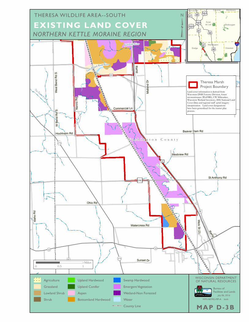
MAP D-3BWM-NKMG-MP-A kmh
WISCONSIN DEPARTMENTOF NATURAL RESOURCES
NORTHERN KETTLE MORAINE REGIONEXISTING LAND COVER
Washington
Winnebago
Dodge
Fonddu Lac
Calumet
Ozaukee
Sheboygan
Manitowoc
151151
15145
45
45
41
41
41 43
AgricultureGrasslandLowland ShrubShrub
Upland HardwoodUpland ConiferAspenBottomland Hardwood
Swamp HardwoodEmergent VegetationWetland-Non ForestedWaterCounty Line
THERESA WILDLIFE AREA--SOUTH
Land cover information is derived from Wisconsin DNR Forestry Division, forest reconnaissance (WisFIRS), UW Milwaukee,Wisconsin Wetland Inventory, 2006 National Land Cover Data and regional staff aerial imagery interpretation. Land cover designations have been generalized for the master plan process.
Theresa MarshProject Boundary

East Branch Rock RiverWayne Creek
Lomir
aCreek
Kohlsville River
Kummel Creek
No Name Creek
Ramp
St Kilian Dr
Wilson Dr
Wood
lawnD
r
N Po
le Rd
Katze
nburg
Dr
Water
Stree
tRd
Nenn
o Rd
CommercialLn
Lone
Rd
Islan
d Dr
FairviewDr
Soo R
d
Ferris
Rd
Hiawa
tha R
d Rolling Dr
Beechnut Dr
Wayne Center Dr
St Kil
ian H
eights
Superior Dr
Doyle
Rd
Rollin
g Dr
Sky lin
e Dr
Zion Church Rd
Cloverland Dr
Allen Rd
West Bend Rd N
Midla
nd D
r
Mohawk Rd
W a s h i n g t o n C o u n t y
D o d g e C o u n t y
F o n d d u L a c C o u n t y
H
DD
TW
AH
D
W
W
P
67
28
175
28
175
41
41
0 0.5 1Miles
Bureau ofFacilities and Lands
July 07, 2016
MAP D-4AWM-NKMG-MP-A kmh
WISCONSIN DEPARTMENTOF NATURAL RESOURCES
NORTHERN KETTLE MORAINE REGIONPLANNED LAND COVER
Washington
Winnebago
Dodge
Fonddu Lac
Calumet
Ozaukee
Sheboygan
Manitowoc
151151
15145
45
45
41
41
41 43
AgricultureGrasslandLowland ShrubShrub
AspenUpland HardwoodUpland ConiferBottomland Hardwoods
Emergent WetlandWetland - Non ForestedWaterCounty Line
THERESA WILDLIFE AREA--NORTH
Land cover information is derived from Wisconsin DNR Forestry Division, forest reconnaissance (WisFIRS), UW Milwaukee,Wisconsin Wetland Inventory, 2006 National Land Cover Data and regional staff aerial imagery interpretation. Land cover designations have been generalized for the master plan process.
Theresa MarshWildlife Area

East Branch Rock River
WayneCreek
Kohlsville RiverEast B
ranch Rock River
No Name Creek
Kohlsville River
W Be
nd R
d SWe
st Be
nd R
d S
Ramp
Allen Rd Island Dr Butternut Dr
Blueb
erry R
d
Ramp
Watercress Rd
Sunset Dr
St Anthony Rd
Commercial Ln
Wild
Life R
d
Idaho
Rd
Nenn
o Rd
Hochheim Rd
Weis St (2)
Beaver Dam Rd
Beechnut Dr
Midla
nd D
r
Ohio Rd
W a s h i n g t o n C o u n t y
D o d g e C o u n t y
W
DW
U
W
D
WW
D
3333
175
175
41
0 0.5 1Miles
Bureau ofFacilities and Lands
July 07, 2016
MAP D-4BWM-NKMG-MP-A kmh
WISCONSIN DEPARTMENTOF NATURAL RESOURCES
NORTHERN KETTLE MORAINE REGIONPLANNED LAND COVER
Washington
Winnebago
Dodge
Fonddu Lac
Calumet
Ozaukee
Sheboygan
Manitowoc
151151
15145
45
45
41
41
41 43
AgricultureGrasslandLowland ShrubShrub
AspenUpland HardwoodUpland ConiferBottomland Hardwoods
Emergent WetlandWetland - Non ForestedWaterCounty Line
THERESA WILDLIFE AREA--SOUTH
Land cover information is derived from Wisconsin DNR Forestry Division, forest reconnaissance (WisFIRS), UW Milwaukee,Wisconsin Wetland Inventory, 2006 National Land Cover Data and regional staff aerial imagery interpretation. Land cover designations have been generalized for the master plan process.
Theresa MarshWildlife Area
Mo hawk Rd.
East Branch Rock River
Kohlsville River
East Branch Rock River
NoNa
meCre
ek
Wayne
Creek
LomiraCr eek
Kummel Creek
THERESA
H
W
BB
WPS
DD
U
TW
H
AH
D
DWWW
W
P
AY
67
33
28
175
33
175
28
41
41
Lone
Rd
Bluem
ound
Rd S
Islan
d Dr
E Iowa Rd
Auror
a Dr
F air v
iewDr
Soo R
d
Raccoon Rd
Sunset Dr
Badger Dr
Rock Rd
NennoRd
Hiawa
tha R
d
Mountain Rd
Butternut Dr
WeisSt(2)
Hillcrest Dr
St Kil
ian H
eights
W Iowa Rd
Superior Dr
St Anthony Rd
Wayne Center Dr
Rollin
g Dr
Town
Hall
Rd
Ferris
Rd
Doyle
Rd
McArthur Rd
Skyli
ne D
r
Pierce
Rd
Aurora Rd
Ohio Rd
West Bend Rd N
Lake
Berni
ce D
r
Beaver Dam Rd
Beechnut Dr
Zion Church Rd
Freed
om R
d
Allen RdMi
dland
Dr
Hochheim Rd
Mohawk Rd
W a s h i n g t o n C o u n t y
F o n d d u L a c C o u n t y
D o d g e C o u n t y
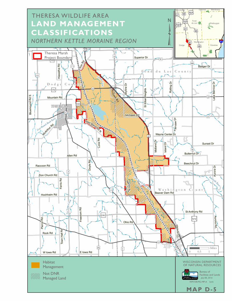
NORTHERN KETTLE MORAINE REGION
LAND MANAGEMENT CLASSIFICATIONS
OzaukeeWashington
ManitowocWinnebago
Fonddu Lac
Dodge
Calumet
Sheboygan151151
15145
45
45
41
41
41 43
THERESA WILDLIFE AREA
Bureau ofFacilities and Lands
July 08, 2016
MAP D-5WM-NKMG-MP-A kmh
WISCONSIN DEPARTMENTOF NATURAL RESOURCESHabitat
ManagementNot DNRManaged Land
0 0.5 1Miles
Theresa MarshProject Boundary