Fish Habitat Rehabilitation Procedures - Forests, Lands ...
313
Fish Habitat Rehabilitation Procedures Watershed Restoration Technical Circular No. 9 Funded by: Watershed Restoration Program Ministry of Environment, Lands and Parks and Ministry of Forests The formatting and images in this document may vary slightly from the printed version.
-
Upload
khangminh22 -
Category
Documents
-
view
1 -
download
0
Transcript of Fish Habitat Rehabilitation Procedures - Forests, Lands ...
Fish Habitat Rehabilitation Procedures
Watershed Restoration Technical Circular No. 9Funded by:
Watershed Restoration ProgramMinistry of Environment, Lands and Parks
and Ministry of Forests
The formatting and images in this document may vary slightly from the printed version.

Fish Habitat Rehabilitation Procedures
Editors
P.A. Slaney and D. Zaldokas
Watershed Restoration Technical Circular No. 9
Watershed Restoration ProgramMinistry of Environment, Lands and Parks
2204 Main Mall, UBCVancouver, BC V6T 1Z4
1997

Canadian Cataloguing in Publication DataMain entry under title:Fish habitat rehabilitation procedures
(Watershed restoration technical circular ;no. 9)
Includes bibliographical references: p.ISBN 0-7726-3320-7
1. Fish habitat improvement - British Columbia.2. Watershed management - British Columbia.3. Salmon - Habitat - British Columbia.I. Slaney, P. A. II. Zaldokas, Daiva 0.III. British Columbia. Watershed RestorationProgram. IV. Series.
SH157.8.F57 1997 333.95’656153’09711 C97-960217-3
i
Preface
Recent reviews of the status of anadromous salmonid stocks of the western United States andBritish Columbia indicate that in less than a century, wild stocks have gone from a pristine state toone of numerous extinctions, threatened status or uncertain status (Nehlsen et al. 1991; Slaney etal. 1996). The causes of the declines are linked (as described by Cederholm et al. in Chapter 8) tovarious impacts dominated by overharvesting of weaker stocks, problems associated withhatcheries, hydroelectrical developments, and habitat loss. Nehlsen et al. (1991) concluded that formany stocks to survive and prosper in the next century, there is a need for a major shift to restorehabitats and ecosystem function, rather than rely on artificial production.
There is little doubt that past industrialized forest harvest practices have played a key role inhabitat losses because most watersheds in the province have had some level of forestry activity,which has altered drainage patterns, increasing erosion with greater sediment delivery to fish-bearing streams. Over the past decade, hillslope failures from roads and gullies have become muchmore evident as logging has shifted to steeper slopes and old roads have failed from overloadedside-casts that frequently incorporated decaying woody debris. Historically, most streams werelogged to the stream banks (at almost all coastal streams until 1988, but less often at larger interiorstreams), leaving a legacy of bank erosion and a major deficit in the resupply of large mature woodto stream channels, the primary structuring element for juvenile fish habitat for summer rearingand overwintering. Although the role of wood in streams in providing habitat was establishedearlier, the linkage to its long-term recruitment was not well-recognized until the 1980’s. Pastfisheries legislation that promoted wood removal, and past practices by fisheries and watermanagement agencies that resulted in removal of wood, especially of log jams, has compoundedthe problem further. Channelized or uniform sections of streams are also common where streamshave been aligned or diverted to protect logging roads, crossings, log sorting and milling sites.Adult fish passage at road culverts has been a long-standing concern, but most culverts are likelyimpassable to juveniles, which often require off-channel refuges to successfully overwinter.Oligotrophication, resulting from combined impacts of industrial forestry and commercial fishing,is a more subtle impact that is receiving greater recent attention as declining trends in escapementsof salmon become more evident; recent stable isotope studies (e.g., Bilby et al. 1996) demonstratethe key role of marine-derived nutrients in the smallest of salmon streams. Earlier forestrypractices also favoured natural restocking of trees, which resulted in a dominance of deciduoustrees, promoting damming activity by beavers of small streams utilized by migrant fish species.
The lack of any mechanisms to ensure the rehabilitation or offsetting measures for adverselyimpacted hillslopes, riparian areas and streams resulted in B.C.’s Watershed Restoration Program(WRP), which was implemented in mid-1994. In combination with recent forest practiceslegislation in B.C. (Forest Practices Code), there is an opportunity to reverse habitat lossesassociated with past and new forest harvesting. Both restoration and the Code are based on severaldecades of research on watershed processes, limitations to salmonid production in streams, andhabitat rehabilitation techniques described in Chapters 5 through 15. These provide the technicalbasis for a suite of integrated restorative measures to accelerate natural recovery
ii
processes in forested watersheds impacted by past practices that would otherwise require decades,even centuries to recover naturally. Success will be closely associated with training and skillsdevelopment initiatives, as well as effectiveness monitoring, which is needed to refine predictivebiostandards (as described by Koning and Keeley in Chapter 3), to capture innovations and tofacilitate adaptive management.
Clearly a watershed focus is required for such a program to be successful, as emphasized inChapter 2 in this guide, as well as elsewhere (Slaney and Martin 1997). The “River ContinuationConcept” (Vannote et al. 1980, modified by Triska et al. 1982) is a useful ecological template forsuch a holistic approach, in recognition that fluvial geomorphic processes, within a drainage fromits headwater gullies to the stream mouth, largely regulate biological processes involving energyinput, nutrient spiralling, organic matter transport, storage, and use by aquatic biota includinginvertebrates and fishes; functioning of downstream communities is contingent on upstreamcontributions of materials. Thus, hillslope stabilization is typically a requisite in advance of streamrestoration, with the exception of protected off-channel habitats located along floodplains.Accordingly, in addition to the 15 stand-alone chapters in this guide, there are eight publishedguides (or technical circulars) that provide the technical standards for aquatic ecosystemrestoration in B.C.’s integrated Watershed Restoration Program. [An expanded terrestrialecosystem focus, with greater incorporation of wildlife values, may be incorporated as technicalstandards are developed.] These circulars include: (1) guidelines for planning integrated projects,with flow charts for the implementation sequence in watersheds, for shifting from assessment toimplementation phases, and a decision strategy for shifting from restoration to rehabilitation tomitigation (see Johnston and Moore 1995; Figs. 1, 2 and 3); (2) watershed assessment procedures(now a Code guidebook); (3) road rehabilitation standards; (4) forest site rehabilitation; (5) gullyassessment procedures (now a Code guidebook); (6) riparian assessment and prescriptionprocedures; (7) channel condition assessment and prescriptions; (8) fish habitat assessmentprocedures; (9) fish habitat rehabilitation procedures; and (10) monitoring and evaluationprotocols (in preparation). About the same time in 1993-1994, the National Forests of Washingtonand Oregon developed a remarkably similar integrated watershed program, the AquaticConservation Strategy of the Northwest Forest Plan, although some hillslope and considerablestream restoration had been underway for at least a decade.
It is assumed throughout this guide that recovery of structural diversity and nutrient sources(often salmon carcasses) will eventually restore aquatic communities or the biodiversity ofdisturbed aquatic ecosystems. The loss of the large old-growth trees in stream channels with theirmassive rootwads as anchors, is the type of structure that cannot be easily duplicated, which is therationale for cable anchoring of woody complexes to streamside trees and instream boulders, atleast on the first pass. Salmon spawners, in particular, are keystone species as the vital linkbetween aquatic and terrestrial communities, especially within the riparian zone (see Ashley andSlaney, Chapter 13).
Most of the procedures in this guide are focused on the short term (20-50 years). For the longterm, riparian protection and restoration needs to be implemented and maintained to recoverriparian functions, to provide future desired conditions for fish and wildlife resources and toprovide shrubs and deciduous trees for leaf litter mixed with mature coniferous trees for largewood recruitment and fluvial-resistive root systems. Finally, although practitioners of restorationhave little control over fish harvest rates or ocean (or lake) conditions that cause shifts in migrantsurvivals, it is assumed that wise stock management in the fishery will ensure sufficient spawningescapements to these streams.
iii
Acknowledgements
The Ministry of Environment, Lands and Parks, Watershed Restoration Program, wishes tothank the Fisheries Research and Development section and the various agencies and consultingfirms whose staff contributed to this reference guide as authors, resource consultants, reviewers oradvisors, including the British Columbia Ministry of Forests, Research Branch; the Government ofCanada, Department of Fisheries and Oceans (DFO), Resource Restoration Division; the U.S.Department of Agriculture, Forest Service, Region 6. the University of British Columbia,Department of Zoology and Department of Civil Engineering; BriMar Consultants Ltd.; ECLEnvirowest Consultants Ltd.; Babakaiff and Associates Geoscience; Hay & Company ConsultantsInc.; Agua Tierra Environmental Consultants Inc.; D.B. Lister & Associates Ltd.; the BritishColumbia Conservation Foundation; Wild Salmonids; River Masters Engineering Inc.; PiscesEnvironmental Consulting Services Ltd.; River Engineering Branch, Alberta EnvironmentalProtection; Newbury Hydraulics; FSCI Biological Consultants, and Kerr Wood Leidal AssociatesLtd. Wendell Koning reviewed and edited Chapters 1 and 9, and Jeff Cederholm providedcomments on Chapter 1. Vince Poulin assisted with reorganizing the section on regulatoryapprovals in Chapter 1. Cover design and conceptual drawings for Chapter 9 were completed byDiana McPhail from sketches by Daiva Zaldokas and Pat Slaney, respectively. Gary Logan, MattFoy and Mel Sheng (DFO) reviewed Chapter 7 and, with Dave Duff (Steelhead Society HabitatRestoration Corp.), provided information and costs on off-channel projects. Bruce Ward provideduseful suggestions and editorial comments that improved the final set of chapters. InternationalWordsmiths Ltd. assisted with formating the guide. Graphic Knights Service Bureau provided theprepress services. Leanne Haywood-Farmer reviewed the final drafts of several chapters andEmily Standen assisted in reorganizing the reference section.
Funding for the development and production of this technical guide on fish habitatrehabilitation procedures was provided by Forest Renewal BC.
iv
Table of ContentsPreface ............................................................................................................................................. iAcknowledgements ....................................................................................................................... iiiPART I. PLANNING STREAM RESTORATION PROJECTSChapter 1 Planning Fish Habitat Rehabilitation: Linking to Habitat Protection
Pat A. Slaney, and Alan D. Martin ........................................................................ 1-1Chapter 2 Watershed Geomorphology and Fish Habitat
Dan L Hogan, and Bruce R. Ward......................................................................... 2-1Chapter 3 Salmonid Biostandards for Estimating Production Benefits of Fish
Habitat Rehabilitation TechniquesC. Wendell Koning, and Ernest R. Keeley ............................................................. 3-1
Chapter 4 Screening Criteria for Restoration ProjectsBrian L. Scarfe....................................................................................................... 4-1
PART II. APPLYING REHABILITATION TECHNIQUESChapter 5 Restoring Fish Access and Rehabilitation of Spawning Sites
Ian W. Whyte, Scott Babakaiff, Mark A. Adams, and Paul A. Giroux...................5-1Chapter 6 Rehabilitating Stream Banks
Scott Babakaiff, Duncan Hay, and Christian Fromuth .........................................6-1Chapter 7 Rehabilitating Off-channel Habitat
D. Brent Lister, and Rheal J. Finnigan ................................................................. 7-1Chapter 8 Rehabilitating Stream Channels and Fish Habitat Using Large
Woody DebrisC. Jeff Cederholm, Larry G. Dominguez, and Tom W. Bumstead.........................8-1
Chapter 9 Accelerating the Recovery of Log-jam Habitats: Large WoodyDebris-boulder ComplexesPat A. Slaney, Rheal J. Finnigan, and Robert G. Millar.......................................9-1
Chapter 10 Using Boulder Clusters to Rehabilitate Juvenile Salmonid HabitatBruce R. Ward...................................................................................................... 10-1
Chapter 11 Rehabilitating Mainstem Holding and Rearing HabitatJim H. Allan, and Sheldon Lowe ......................................................................... 11-1
Chapter 12 Restoring Habitats in Channelized or Uniform Streams Using Riffleand Pool SequencesRobert Newbury, Marc Gaboury, and Dave Bates .............................................. 12-1
Chapter 13 Accelerating Recovery of Stream, River and Pond Productivity byLow-level Nutrient ReplacementKen I. Ashley, and Pat A. Slaney ......................................................................... 13-1
Chapter 14 Augmenting Minimum Streamflows in Sediment Deposition ReachesJ. Alex Wood ........................................................................................................ 14-1
Chapter 15 Managing Beaver Habitat for Salmonids: Working with BeaversRheal J. Finnigan, and David E. Marshall.......................................................... 15-1
Glossary .............................................................................................................................. G-1References .............................................................................................................................. R-1
Planning Fish Habitat Rehabilitation 1-1
Part I. Planning StreamRestoration Projects
Chapter 1
Planning Fish Habitat Rehabilitation:Linking to Habitat Protection
Pat A. Slaney1, Alan D. Martin2
INTRODUCTION: SETTING THE STAGE FOR STREAM RESTORATION
It is widely recognized that past land management practices have degraded water quality andfish habitat in western Canada and the northwestern United States (Slaney et al. 1977 a, b;Cederholm et al. 1980; Tripp and Poulin 1986; Hall et al. 1987; Hartman et al. 1987; Hartman andScrivener 1990; Koski 1992; Murphy 1995). In most instances there were no mechanisms in placeto ensure rehabilitation of degraded or threatened aquatic resources in forested watersheds inBritish Columbia. Although it is becoming more accepted that habitat protection measures, such asriparian buffer zones, are more cost-effective than habitat rehabilitation (Koski 1992), there is alarge province-wide legacy of impacted hillslopes and streams in British Columbia. Thisnecessitates a long-term initiative to rehabilitate impacted areas, where feasible, to environmentalstandards consistent with the new Forest Practices Code of British Columbia, and therebyaccelerate natural recovery processes in forested watersheds. Furthermore, it was also evident thatthe efficacy of new forest practices regulations and the effectiveness of restoration of watershedareas impacted by practices of the past are co-dependent, and need to be implementedsimultaneously. The effectiveness of these measures will also depend on practicing risk-averse,sustainable fisheries resource management by fish harvesters and fisheries management agencies.
The purpose of an introductory chapter on planning stream restoration, linked closely tohabitat protection under the policy of no-net-loss of habitat, is to set the stage for several technicalhabitat rehabilitation chapters that follow. For ease of reference, the contents of this chapter aresummarized as:
• Sustainability: watershed restoration and the Forest Practices Code ..................................p. 1-2• Goals of B.C.’s Watershed Restoration Program ................................................................p. 1-3• Historical impacts of logging on aquatic resources .............................................................p. 1-4• Scale of stream rehabilitation needs ....................................................................................p. 1-8
________________________1 Ministry of Environment, Lands and Parks, Watershed Restoration Program, 2204 Main Mall, UBC,Vancouver, BC V6T 1Z42 Ministry of Environment, Lands and Parks, Forest Renewal Coordination Office, Suite 300 - 1005 BroadSt., Victoria, BC V8W 2A1

Planning Fish Habitat Rehabilitation 1-2
• Linking assessment and restoration phases..........................................................................p. 1-9• Operational principles of restoring stream ecosystems .....................................................p. 1-10• Design targets and costs of stream rehabilitation projects.................................................p. 1-11• Regulatory approval process for B.C stream restoration projects .....................................p. 1-12• Coupling fish habitat rehabilitation with riparian restoration ...........................................p. 1-16• Summary of common fish habitat rehabilitation techniques .............................................p. 1-18• Estimating fish habitat rehabilitation benefits ...................................................................p. 1-21• Training and evaluation strategies for restoration .............................................................p. 1-22
SUSTAINABILITY: WATERSHED RESTORATION ANDTHE FOREST PRACTICES CODE
In the absence of simultaneous implementation of both a watershed restoration program (for“old logging”) and advanced forest practices regulations (for “new logging”), there would besignificant risks to the sustainability of the provincial fisheries resources, which can besummarized (from the section on impacts of past forest harvesting practices) as:
• an increasing incidence of landslides and debris flows to streams on the coast, and surfaceerosion and sediment transport to streams from expanding road systems in the interior;
• an increasing incidence of eroding stream banks, and sediment-infilled stream channels;• a high frequency of culverts, many passable to adult fish, but blocking or impairing passage of
juvenile fish into seasonal off-channel refugia (tributaries, groundwater channels and alcoves,side-channels, ponds, wetlands and lakes) from severe winter conditions;
• an increasing loss of riparian functions, resulting in a declining recruitment of large woodydebris (LWD) to stream channels, and stream bank instability on floodplains as old-growthroot-masses decay;
• continuing loss of large woody debris (LWD) in stream channels, causing a substantial loss offish habitat until resupply of LWD over a duration of 100-200 years;
• declining trends in salmon carcass-derived marine nutrient and carbon influxes to mostanadromous fish streams, resulting in oligotrophication, with depression of fish growth andsize-dependent survival in freshwater and saltwater (from both land-use and overfishingimpacts).
Greater than 40% of the Provincial Forest has been harvested under logging practices of thepast, and most of the productive low-land streams have been logged to their stream banks. Afterseveral decades of research, case studies and audits of practices, it is now evident that many of thepast practices resulted in impacts that would require decades to two centuries to recover. Somehillslope sites were also left at risk of failure with downstream consequences of debris torrents andflows. In the remaining Provincial Forest, resource values of streams, wetlands and riparian areasshould be protected by new forest practice regulations (Forest Practices Code or FPC) that makeuse of knowledge gained over the past several decades on the processes leading to such impacts.Without the FPC, there are potential impacts from new logging on restored areas situateddownstream, and also without restoration, the intended results of applications of the FPC may notbe achieved, or may be lost. For example, maintenance of habitat resource values in a FPC-regulated reach of a valley can be impaired by debris torrents from gullies causing debris-sedimentflows, in turn caused by failure to restore natural drainage patterns and restore road slopes onblocks logged in the past. Similarly, the new FPC may result in maintenance and protection of keyspawning habitat for salmonids in an upper reach. In a lower reach after several decades of loss ofLWD without recruitment, as well as a loss of bank stability and the cutoff of overwinteringrefugia, protection of the upper reach under the new regulations of the Code will
Planning Fish Habitat Rehabilitation 1-3
have negligible benefits to salmonids dispersing downstream for rearing. Either restoration orlegislation can be of limited effectiveness without coordinated implementation at a watershedscale. Clearly, the Forest Practices Code and Watershed Restoration Program are a “packagedeal”.
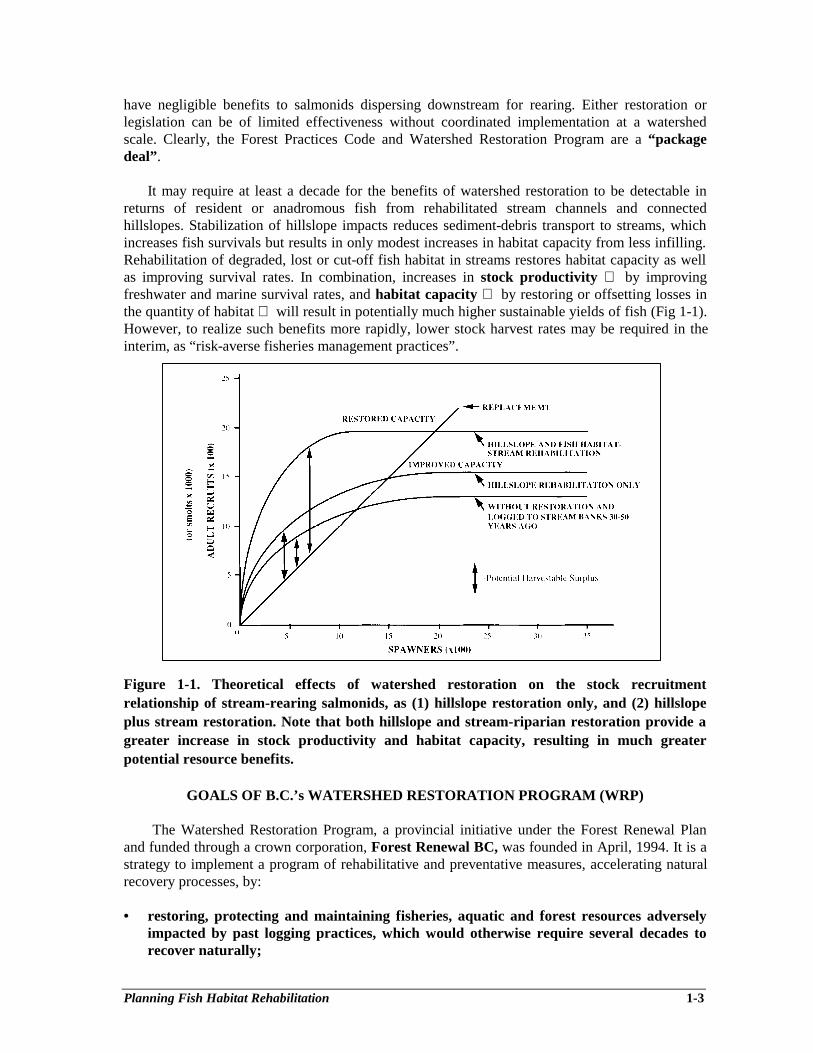
It may require at least a decade for the benefits of watershed restoration to be detectable inreturns of resident or anadromous fish from rehabilitated stream channels and connectedhillslopes. Stabilization of hillslope impacts reduces sediment-debris transport to streams, whichincreases fish survivals but results in only modest increases in habitat capacity from less infilling.Rehabilitation of degraded, lost or cut-off fish habitat in streams restores habitat capacity as wellas improving survival rates. In combination, increases in stock productivity by improvingfreshwater and marine survival rates, and habitat capacity by restoring or offsetting losses inthe quantity of habitat will result in potentially much higher sustainable yields of fish (Fig 1-1).However, to realize such benefits more rapidly, lower stock harvest rates may be required in theinterim, as “risk-averse fisheries management practices”.
Figure 1-1. Theoretical effects of watershed restoration on the stock recruitmentrelationship of stream-rearing salmonids, as (1) hillslope restoration only, and (2) hillslopeplus stream restoration. Note that both hillslope and stream-riparian restoration provide agreater increase in stock productivity and habitat capacity, resulting in much greaterpotential resource benefits.
GOALS OF B.C.’s WATERSHED RESTORATION PROGRAM (WRP)
The Watershed Restoration Program, a provincial initiative under the Forest Renewal Planand funded through a crown corporation, Forest Renewal BC, was founded in April, 1994. It is astrategy to implement a program of rehabilitative and preventative measures, accelerating naturalrecovery processes, by:
• restoring, protecting and maintaining fisheries, aquatic and forest resources adverselyimpacted by past logging practices, which would otherwise require several decades torecover naturally;
Planning Fish Habitat Rehabilitation 1-4
• providing community-based employment, training and stewardship opportunitiesthroughout the province; and
• providing a mechanism to bridge historical forest harvesting practices and the newstandards established by the Forest Practices Code (FPC), diversifying jobs in the forestsector.
The provincial Ministry of Environment, Lands and Parks (MELP), and the Ministry ofForests (MOF) manage the stream and hillslope components, respectively. The federal Departmentof Fisheries and Oceans is also cooperatively involved in stream and off-channel projects. TheProgram is largely “proponent driven” by the forest industry, First Nations, conservation societies,community groups, and government agencies, typically in partnerships of stakeholders who havevested interests in rehabilitating resource values, targeting on small- to moderate-sized watersheds.Funding for the Forest Renewal Plan was made available by an increase in stumpage fees, inrecognition that there was a compelling need for reinvestment in stewardship of resource values ofour provincial forested watersheds, as well as in the stability of logging-dependent communitiesthroughout the province.
To achieve substantial resource benefits, an integrated watershed approach is the fundamentalprinciple of the Program, in recognition of the interconnections between physical and biologicalprocesses within impacted watersheds, where streams are either functioning at risk or have becomenon-functional. Projects are cooperatively developed and implemented by stakeholders andresource management agencies, using a sequence of condition assessments of watershedcomponents, followed by prescriptions, restoration and monitoring (Johnston and Moore 1995;Slaney and Martin 1997).
HISTORICAL IMPACTS OF LOGGING ON AQUATIC RESOURCES
Logging activities potentially alter all the primary environmental components that affect theproductive capability of fish habitat as well as the food chains upon which fish depend. Loggingimpacts have been difficult to document because of the large natural variability associated withnatural stream systems and multiple activities affecting watersheds, including overfishing (Larkin1975). Case studies, such as the Alsea Watershed study (Hall et al. 1987) and the Carnation Creekstudy (Hartman et al. 1987) have assisted in the understanding of the functioning of streamecosystems. Shorter-term investigations including the Slim Creek study in the interior of B.C.(Slaney et al. 1977a, 1977b), the Clearwater River study on the Olympic Peninsula (Cederholm etal. 1980), comparisons of streamside logging practices in S.E. Alaska (Murphy et al. 1986) and theFish-Forestry Interaction Program on the Queen Charlotte Islands (Tripp and Poulin 1986) havealso added to our knowledge of how logging activities affect fish habitat. These and relatedhydrologic studies have made predictions of the effects of logging on fish production more reliablealbeit incomplete. Other examples, more striking, but less well documented, have alsodemonstrated that impacts can be severe; e.g., substantial losses (80-90%) of important stocks ofsummer-run steelhead (Oncorhynchus mykiss) and coho salmon (0. kisutch) at Deer Creek, innorthwest Washington (Doyle et al. in press). Estuarine back-channels and eel grass areas havealso been historically impacted by accumulations of organics associated with marine log sorting.Any benefits of logging, such as improved growth rates of juveniles in cool salmonid rearingstreams (Slaney et al. 1977b), can be offset by cumulative impacts (Murphy et al. 1986;Cederholm et al. 1980).
There are several primary alterations that are evident as a result of forest harvesting to thestream bank, which was the common practice in much of B.C. until the introduction of the
Planning Fish Habitat Rehabilitation 1-5
Coastal Fisheries-Forestry Guidelines in 1988, superseded by the Forest Practices Code in 1995.There are changes in solar radiation, water temperature, forest canopy and stream bank vegetation,stream bank stability, suspended solids, fine woody debris, coarse woody debris, channelmorphology, substrate sediments, streambed stability, nutrient supply, and stream flows. Someeffects are transient or fluctuate (nutrients can increase then decrease), some recover in decades(stream temperature) and some require over a century (large woody debris from mature or old-growth windfalls) (Koski 1992). Negative changes are diverse and interactive, but there is littleargument that the more restrictive logging practices of the Forest Practices Code are necessary toprotect what is remaining in watersheds still dominated by old growth, as well as those watershedsthat will be logged in the near future as second growth forests.
Landslides and increased peak flows that impact water quality, fish habitat and forest siteshave become more evident, especially on steeper slopes in the coastal regions. “Torrenting” ofdebris-loaded gullies on the coastal regions have been well documented (Cederholm et. al 1980;Hogan 1986). Moderate rates (>25 %) of deforestation are known to increase peak stream flows,especially as a result of rain-on-snow events (Harr and Fredriksen 1979). These two processescause an increase in sediment transport from hillslopes and stream banks, with bedload sedimentsmoving through less stable channels of unconfined, and frequently logged, floodplains. Theresultant widening of mainstem channels, infilling of coarser substrates, and blocking of side-channels, has caused declines in salmon and steelhead stocks, such as that documented at theSan Juan River on southern Vancouver Island where 428 landslides were recorded in loggedterrain by Northwest Hydraulic Consultants in 1994. Also, 495 landslides have been documentedby the Ministry of Forests in the Gordon River watershed on southern Vancouver Island, whichwere mainly caused by overloading fill-slopes of logging roads. Similarly, failures of 20-year-oldlogging roads above a gully on Jones Creek in south coastal B.C. have eliminated a spawningchannel utilized by pink (0. gorbuscha) and chum salmon (0. keta), and caused chronicsedimentation of fish habitat in the stream since 1993. Accordingly, both spawning andoverwintering substrates are frequently degraded, and thereby the productivity of fish stocksdeclines, increasing the risk of overharvest of weakened stocks in mixed stock fisheries. Althoughthe use of Coastal Fisheries-Forestry Guidelines since 1988 have improved protection of fishhabitat, slope failures and debris flows from logged gullies persisted from past practices on steeperslopes (Tripp 1994).
Chronic surface erosion from logging roads can degrade water quality, resulting in impacts onboth domestic water supplies and fish habitat. Suspended solids in some community water suppliesincreased as a result of road slope failures and surface erosion (e.g., Chapman and MashiterCreeks in the Sechelt and Squamish Forest Districts). Also, studies in the central interior of theprovince have demonstrated that transport of fine sediments from logging roads and skid trails,located in terraced lacustrine soils, can impair water quality, fish spawning gravels, rearing areasand aquatic insect abundance (Slaney et al. 1977a, b). In May to July, mean suspended sedimentconcentrations were 37 mg⋅L-1 (peak, 257 mg⋅L-1) in upper Centennial Creek (logged), 75 mg⋅L-1
(peak, 467 mg⋅L-1) in Centennial Creek (logged with terraced lacustrine road settings) versus 14mg⋅L-1 (peak, 60 mg⋅L-1) in the adjacent unlogged Donna Creek. Amounts of fine sedimentdeposition (clays, silts and fine sands < 0.3 mm diameter) in simulated spawning redds were afunction of suspended sediment loading (or dose) from May to July (Slaney et al. 1977a).Revegetation of erodible road slopes by hydroseeding is necessary to retard sediment transportfrom the silty side-slopes of logging roads.
There is also recent evidence of a more subtle and insidious negative impact of past loggingand overfishing practices because a lower abundance of spawner carcasses reduces the
Planning Fish Habitat Rehabilitation 1-6
availability of nutrients that support the salmonid food chain (Schuldt and Hershey 1995). Coastaland many interior streams in British Columbia are oligotrophic, with dissolved inorganicphosphorus concentrations less than or near detection limits of 1 µg⋅L-1 (Slaney and Ward 1993).Recent studies of the nutrient and carbon movement in food chains of a small coho salmon streamhave demonstrated that returning salmon spawners provide 30-40% of the nitrogen and carbon tojuvenile salmonids (Bilby et al. 1996). Because survival of salmonids through freshets is stronglycorrelated with fish size reached by fall in streams (Scrivener and Brown 1993), or size atmigration to a larger waterbody, the abundance of fish carcasses is potentially crucial tomaintenance of fish populations that rear in streams (i.e., trout and char species, chinook salmon(0. tshawytscha) and coho salmon). Runs of adult fish may continue to decline as logging impactsincrease, returning less nutrients and carbon to streams, which are already nutrient-carbondeficient. The problem is exacerbated when combined with overfishing of a (now) less productivestock (Larkin and Slaney 1996).
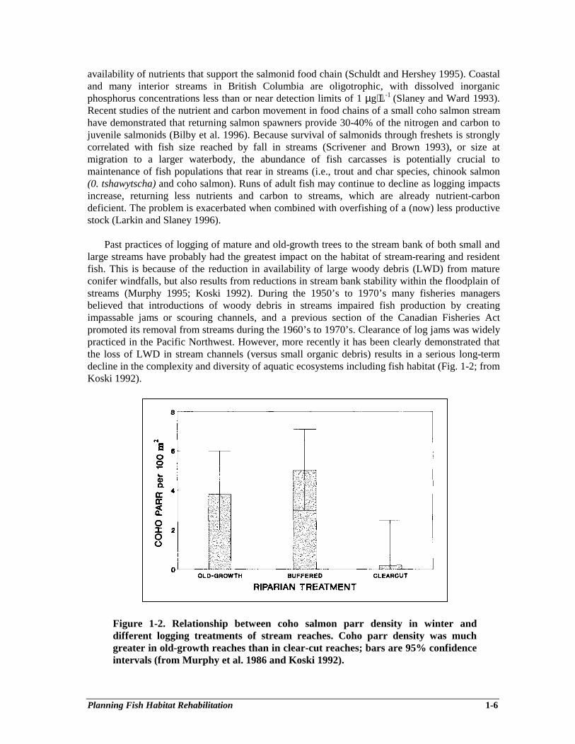
Past practices of logging of mature and old-growth trees to the stream bank of both small andlarge streams have probably had the greatest impact on the habitat of stream-rearing and residentfish. This is because of the reduction in availability of large woody debris (LWD) from matureconifer windfalls, but also results from reductions in stream bank stability within the floodplain ofstreams (Murphy 1995; Koski 1992). During the 1950’s to 1970’s many fisheries managersbelieved that introductions of woody debris in streams impaired fish production by creatingimpassable jams or scouring channels, and a previous section of the Canadian Fisheries Actpromoted its removal from streams during the 1960’s to 1970’s. Clearance of log jams was widelypracticed in the Pacific Northwest. However, more recently it has been clearly demonstrated thatthe loss of LWD in stream channels (versus small organic debris) results in a serious long-termdecline in the complexity and diversity of aquatic ecosystems including fish habitat (Fig. 1-2; fromKoski 1992).
Figure 1-2. Relationship between coho salmon parr density in winter anddifferent logging treatments of stream reaches. Coho parr density was muchgreater in old-growth reaches than in clear-cut reaches; bars are 95% confidenceintervals (from Murphy et al. 1986 and Koski 1992).
Planning Fish Habitat Rehabilitation 1-7
Because almost half of the provincial forest has been logged, including the riparian zone ofmost of the salmonid streams at lower elevations, a serious LWD deficit continues to worsen. Theeffects of stream bank logging at Carnation Creek on the production of coho smolts has beeninitially moderated or offset by the remaining old-growth LWD in the mainstem and by thepreservation of off-channel overwinter habitat (logging roads were excluded from the floodplain),and also by modestly elevated stream temperatures. Regardless, since logging (1976-81) both theaverage coho fry abundance in late summer and the average return of mature coho adults per smolthave declined, suggesting a significant decline in stock productivity, from a stock-recruitmentperspective. Although there was no external control (unlogged) for the Carnation Creek casestudy, a gradual declining trend in coho smolt production from the mainstem can be predicted inthe long term because only very limited mature large wood is recruitable from the logged riparianzone. Moreover, the abundance of chum salmon and steelhead trout have been depressed becauseof impacted spawning and overwintering habitat in the mainstem of Carnation Creek, respectively(Scrivener and Brown 1993).
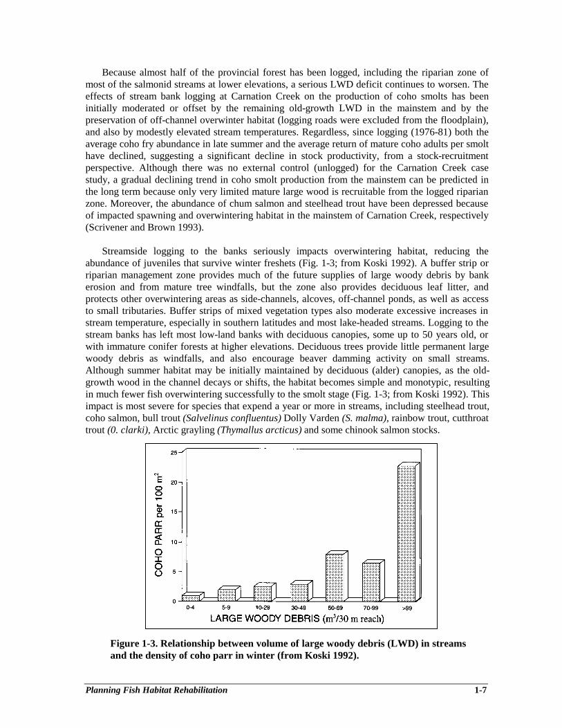
Streamside logging to the banks seriously impacts overwintering habitat, reducing theabundance of juveniles that survive winter freshets (Fig. 1-3; from Koski 1992). A buffer strip orriparian management zone provides much of the future supplies of large woody debris by bankerosion and from mature tree windfalls, but the zone also provides deciduous leaf litter, andprotects other overwintering areas as side-channels, alcoves, off-channel ponds, as well as accessto small tributaries. Buffer strips of mixed vegetation types also moderate excessive increases instream temperature, especially in southern latitudes and most lake-headed streams. Logging to thestream banks has left most low-land banks with deciduous canopies, some up to 50 years old, orwith immature conifer forests at higher elevations. Deciduous trees provide little permanent largewoody debris as windfalls, and also encourage beaver damming activity on small streams.Although summer habitat may be initially maintained by deciduous (alder) canopies, as the old-growth wood in the channel decays or shifts, the habitat becomes simple and monotypic, resultingin much fewer fish overwintering successfully to the smolt stage (Fig. 1-3; from Koski 1992). Thisimpact is most severe for species that expend a year or more in streams, including steelhead trout,coho salmon, bull trout (Salvelinus confluentus) Dolly Varden (S. malma), rainbow trout, cutthroattrout (0. clarki), Arctic grayling (Thymallus arcticus) and some chinook salmon stocks.
Figure 1-3. Relationship between volume of large woody debris (LWD) in streamsand the density of coho parr in winter (from Koski 1992).
Planning Fish Habitat Rehabilitation 1-8
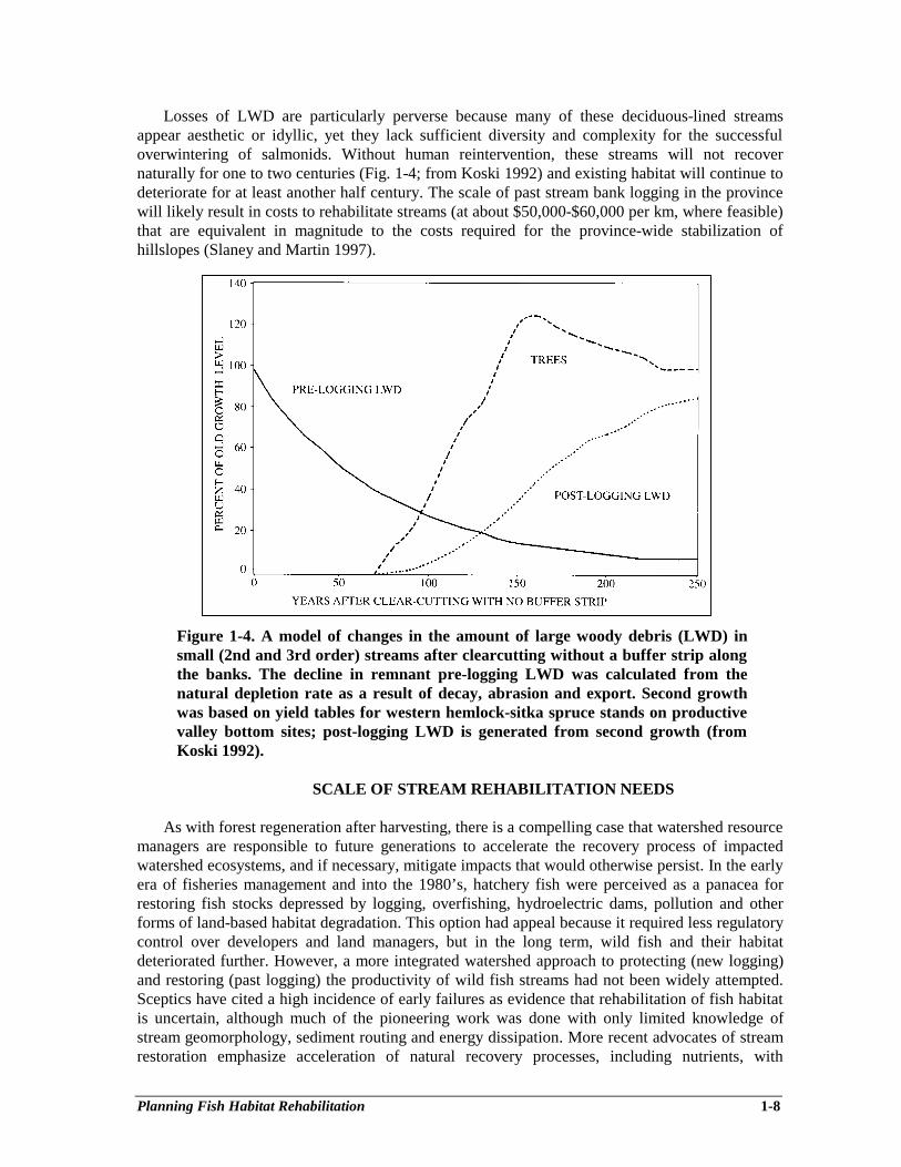
Losses of LWD are particularly perverse because many of these deciduous-lined streamsappear aesthetic or idyllic, yet they lack sufficient diversity and complexity for the successfuloverwintering of salmonids. Without human reintervention, these streams will not recovernaturally for one to two centuries (Fig. 1-4; from Koski 1992) and existing habitat will continue todeteriorate for at least another half century. The scale of past stream bank logging in the provincewill likely result in costs to rehabilitate streams (at about $50,000-$60,000 per km, where feasible)that are equivalent in magnitude to the costs required for the province-wide stabilization ofhillslopes (Slaney and Martin 1997).
Figure 1-4. A model of changes in the amount of large woody debris (LWD) insmall (2nd and 3rd order) streams after clearcutting without a buffer strip alongthe banks. The decline in remnant pre-logging LWD was calculated from thenatural depletion rate as a result of decay, abrasion and export. Second growthwas based on yield tables for western hemlock-sitka spruce stands on productivevalley bottom sites; post-logging LWD is generated from second growth (fromKoski 1992).
SCALE OF STREAM REHABILITATION NEEDS
As with forest regeneration after harvesting, there is a compelling case that watershed resourcemanagers are responsible to future generations to accelerate the recovery process of impactedwatershed ecosystems, and if necessary, mitigate impacts that would otherwise persist. In the earlyera of fisheries management and into the 1980’s, hatchery fish were perceived as a panacea forrestoring fish stocks depressed by logging, overfishing, hydroelectric dams, pollution and otherforms of land-based habitat degradation. This option had appeal because it required less regulatorycontrol over developers and land managers, but in the long term, wild fish and their habitatdeteriorated further. However, a more integrated watershed approach to protecting (new logging)and restoring (past logging) the productivity of wild fish streams had not been widely attempted.Sceptics have cited a high incidence of early failures as evidence that rehabilitation of fish habitatis uncertain, although much of the pioneering work was done with only limited knowledge ofstream geomorphology, sediment routing and energy dissipation. More recent advocates of streamrestoration emphasize acceleration of natural recovery processes, including nutrients, with
Planning Fish Habitat Rehabilitation 1-9
emphasis on use of natural morphological features (as templates), based on both sound structuraldesigns of structures and fluvial science, as well as wisdom obtained from past trials andmisapplications (Slaney 1994; Slaney and Martin 1997).
Restoration, or more aptly rehabilitation, must be approached from an integrated perspective,in recognition of the interconnections between physical and biological processes within awatershed. Restoration must include logging-impacted hillslopes, gullies, riparian areas, streamchannels and estuaries. Restorative activities within a watershed are conducted on a priority basis,ranking impacts and risks of impacts. Watershed assessments, including condition of roads, slopes,gullies, riparian zones, stream channels, and instream and off-channel fish habitat, are conductedby setting priorities for site prescriptions for preventative and rehabilitative treatments. Initially, agreater proportion of restorative effort and funding has been directed at hillslopes to accelerateslope stabilization and to reduce mass wasting or chronic erosion, which affect water quality andfish habitat located downstream. However, as hillslope impacts are stabilized, more effort must bedirected at rehabilitating riparian areas and fish habitat in stream channels that were historicallyimpacted.
The backlog of logging-impacted streams is uncertain. This would include off-channel fishand wildlife habitats within the riparian reserve and management zones that will requirerestoration and rehabilitation to accelerate the recovery process, or to offset habitat losses.Eventually, condition assessments will provide quantitative estimates. However, it is known that itrequires up to 100-200 years to recover recruitment of large woody debris as mature windfalls(Fig. 1-4; from Koski 1992). The cost to restore or rehabilitate fish habitat in streams is expensive,or on average about C$50,000-$60,000 per km of stream, and it can be much higher if engineeringand geomorphic design specifications are required (see Table 1-1). Similarly, riparian restorationis reported to cost C$15,000 per hectare of riparian area including some stream bank restoration(Koski 1992). If about 2,000 anadromous and resident fish streams have been logged to the streambanks for an average distance of 10 km, the scale and duration of stream and riparian restoration issubstantial, requiring several decades to complete.
LINKING ASSESSMENT AND RESTORATION PHASES
Three WRP procedural guides are available for assessing the condition of fish habitat (lossesand impairment related to past logging), the status of stream channels (degree of geomorphicdisturbance related to logging and current stability of the channel), and functional condition of theriparian zone, indicating needs for silvicultural prescriptions to restore fish and wildlife habitat inthe long term.
Overview assessments will typically indicate whether more intensive levels of assessment arerequired, and in which reaches or segments of reaches (see Johnston and Moore 1995 forguidelines for planning watershed restoration projects). The intention is for condition assessmentsto be conducted simultaneously to achieve cost efficiency. Note that channel assessments areselectively used to assist in assessing the degree of disturbance and risk of prescribing andimplementing in-stream restorative measures. Clearly, systematic channel assessments are oftennot required, as they are unwarranted where channel conditions are judged as stable fromoverviews (i.e., from reconnaissance inspections, air photos and/or aerial overflights). A carefulreview of the chapter on fluvial geomorphology in this guide will provide a basis for judging ifsystematic channel assessments are needed, and in which geomorphic settings “seasoned”professional advice is advised. The assessment of Proper Functioning Condition (PFC) of the
Planning Fish Habitat Rehabilitation 1-10
riparian-stream bank zone also provides a classification protocol to assist in deciding if a moredetailed channel assessment is advised to assess risk of instream prescriptions (Barrett et al. 1995).
Restoration practitioners need to ensure that the assessment phase is thorough but notexcessive, thereby adding a burden on cost effectiveness of the project (see economic screeningcriteria; Chapter 4). Clearly, if habitat impacts are obvious, overzealous recording of habitat orchannel or riparian conditions and applications of diagnostics is neither cost-effective nor wisespending. The assessment phase is based on standards that are repeatable, but need to beefficiently conducted, to shift rapidly to the detailed prescriptive and restorative phase.
The Fish Habitat Assessment Procedures (Johnston and Slaney 1996) provide diagnostics forassessing limiting factors related to past logging impacts, and thus provide direction towardspreliminary options and opportunities as restorative or mitigative measures. The Fish HabitatRehabilitation Procedures (WRP Tech. Circ. 9) then provide a guide for prescriptions ofrehabilitative measures including decision charts for the types of prescriptions suitable to variousgeomorphic settings (Figs. 8-2A, 8-2B). In the planning-prescriptive phases the use ofbiostandards (Chapter 3) and a basic benefit-cost analysis (Chapter 4) will rapidly indicatewhether a project is cost effective, or its ranking compared to other project options in thewatershed. Regardless, the key to success will be use of natural instream and off-channeltemplates, plus advice or “mentorship” from “seasoned” practitioners of fish habitatrehabilitation.
OPERATIONAL PRINCIPLES OF RESTORING STREAM ECOSYSTEMS
Sequencing Hillslope and Stream Rehabilitation
As a general principle, watersheds impacted by past practices need to be treated holistically tominimize risks to instream rehabilitative works. As an example, during the mid- 1980’s LWD wasrestored in 14 km of Fish Creek, a fifth order steelhead and coho stream situated in a steep valleyin northern Oregon (Shively and Hickman 1996). As at Carnation Creek in B.C., fish abundanceevaluations at Fish Creek were constrained by a lack of a paired external control (to adjust for acoincident decline in the coast-wide status of salmon stocks). Also, only minor hillslopestabilization was undertaken and a watershed analysis was not completed until 1994. After almost10 years of stability, a 100-year flood event in February, 1996 resulted in severe landsliding (236)causing extensive debris torrenting (24 km), resulting in considerable channel changes andadjustments in Fish Creek. Substantial numbers of LWD attached to boulders were exported (53%of pool transects lost) as a result of debris-sediment flows, followed by a substantial depression infish survival and smolt production in 1996 (Shively and Hickman 1996). Although durability ofstructures in this productive stream was maintained for a decade before the 100-year flood, inhindsight, a watershed analysis with identification of at-risk drainages and slopes could have beenused to reduce hillslope failures and prevent much of the impacts to restored habitat.
Although instructive, such a graphic example does not lead to the conclusion thatrehabilitative works cannot ever be undertaken until completion of hillslope rehabilitation, nordoes it infer that instream restoration can be safely conducted after restoring natural hillslopedrainage patterns and stabilizing slopes and roads. Historical logging of floodplains can destabilizestreams for several decades as a result of loss of root stability and woody armouring of banks(Kellerhals and Miles 1996). Where channel instability is evident or at risk, “seasoned” judgementwould direct stream rehabilitation prescriptions to low risk off-channel habitat mitigation,especially where fish stocks are at risk (e.g., Jones Creek). Similarly, there is little risk to
Planning Fish Habitat Rehabilitation 1-11
improvement of fish access, or selective riparian treatments in advance of most hillsloperehabilitation.
Thus, operational principles in sequencing stream rehabilitation are:
• as a general principle, undertake hillslope stabilization first (see “flow charts” inJohnston and Moore 1995), but not exclusively;
• examine the biological need for off-channel mitigation before or simultaneously withhillslope work to maintain or salvage fish stocks at risk from destabilized channels;
• as a priority, focus restoration on sub-watersheds that are less highly impacted to ensuremore rapid recovery and watershed-level benefits to fish stocks. (A strategy endorsed inAquatic Conservation Strategy for watershed restoration in the National Forests ofOregon and Washington);
• emulate nature by use of natural templates or analogues within undisturbed reaches ofstreams as the key to a successful stream restoration strategy.
Emulating Natural Processes in Stream Rehabilitation
A hierarchical restoration strategy is consistent with the federal Habitat Management Policy,which is supported in principle (as a no-net loss provision) in the Ministry of Environment, Landsand Park’s 5-year Fisheries Program Strategic Plan. This strategy is largely outlined in Fig. 3 of“Guidelines for Planning Watershed Restoration Projects” (Johnston and Moore 1995) (the termsrestoration, rehabilitation and mitigation are defined in the glossary of this guide):
• assess if the resource (channel and fish habitat) is impaired and to what extent;• estimate the time to recovery without managed restorative actions;• if more than a few years to recover naturally, assess if restoration is feasible;• where restoration is not feasible examine rehabilitative options as a second priority;• examine and document all restorative and rehabilitative options and opportunities to
maintain and recover resource losses to habitat and its productivity;• as a last recourse, search for and identify feasible mitigative options, first at the impact
site, then elsewhere in the watershed, and if necessary in an adjacent watershed.
Clearly, watershed restoration, or specifically fish habitat restoration, is directed at wild fishhabitat. However, habitat impairment in highly destabilized streams can be severe, and even afterreplacement of instream and off-channel habitat, fish populations may be at or near depletion.Cautious and very limited short-term use of fish culture using stronger native stocks from the samewatershed may accelerate recovery of depleted stocks from degraded sub-watersheds. Use ofnative early-fry to restock depleted rehabilitated habitats should be beneficial initially becauseselective juvenile mortality will result in near-wild progeny. Some fish culturists may take anactive role in habitat rehabilitation projects, particularly during seasonal ebbs in hatcheryactivities. For example, hatchery salmon carcasses originating from within the same watershedhave been transported to rehabilitated local streams and mitigative off-channel projects toaccelerate the restoration of nutrients and carbon and to stimulate biological productivity (Larkinand Slaney 1996).
DESIGN TARGETS AND COSTS OF STREAM REHABILITATION PROJECTS
A design target to withstand a “one in 50-year” flood event has a reasonable probability of10-20 years of functional durability, a time frame that has economic support in fish habitatimprovement and restoration projects (Ward and Slaney 1979). Although a 50-year event is a

Planning Fish Habitat Rehabilitation 1-12
useful design target, there are instances where lesser protection is more cost effective and shouldbe considered. For example, dyking necessary to protect an off-channel restoration project fromoverwash from a 50-year flood event can make some projects extremely costly, with a negativeeconomic appraisal using the screening criteria and method outlined in Chapter 4 in this guide, aswell as confining the natural functioning of the floodplain. However, past experience in southcoastal B.C. has demonstrated that most flood impacts are usually only temporary, and with minormaintenance costs, most off-channel projects can be re-operational within a few days of anextreme storm event (M. Foy, Department of Fisheries and Oceans, Vancouver, B.C., pers.comm.).
Costs of fish habitat restoration can increase substantially with the degree of engineeringdesign detail. For example, at Porter Creek in southern Washington, large wood structures wereinstalled in the stream channel by two approaches in two reaches: (1) detailed engineering designdrawings with engineering control surveys at each site, and (2) on-site placements and attachmentsof local large wood by forest workers. The cost of the former was four times the cost per km,adjusted for differences in pieces of LWD placed (Table 1-1), or prohibitive from an economicperspective. Alternatively, most instream restoration treatments require only a set of conceptualdesigns, such as LWD configurations. An experienced individual undertaking prescriptions simplyselects the best alternative design concept and specifications for the specific geomorphic site.Then the site is flagged in the field according to the selected concept code. This approach has beenused very successfully in the Pacific Northwest and more recently in British Columbia in aSquamish River tributary (Shop Creek) and at the Keogh River near Port McNeill. Costs wereconsiderably lower, or about $50,000-65,000 per km. Similarly at a 5th order stream in Oregon,LWD was increased to historical frequencies at a cost of about $50,000 per km over 14 km, usingdesign concepts (D. Heller, USDA Forest Service, Portland, OR, pers. comm.). Note that a secondpass is usually required the next year to refine and selectively add structures after a seasonalfreshet.
The design concept approach is appropriate for LWD and lateral LWD complexes (withboulder ballasts), boulder cluster and simple weir prescriptions, minor fish access improvements,and groundwater-fed alcove channels. However, more conventional engineering design surveysand drawings are typically required by regulatory agencies for major stream bank armouring anddykes, major groundwater channel and pond excavations, and water intake structures, and larger-scale channel reconstructions or reconfigurations. The proximity of structures located downstreamincluding bridges and structures on private property can influence requirements for engineeringdesign drawings. Instream restoration of LWD using design concepts for lower gradient habitatwithin smaller 2nd and 3rd order coastal streams has had very low failure rates in Washington andOregon (Heller et al. 1996).
REGULATORY APPROVAL PROCESS FOR B.C.STREAM RESTORATION PROJECTS
There are four main Acts and Legislation that apply to WRP fish habitat restoration and off-channel projects within the riparian management area. Project managers and supervisors must bewell aware of requirements of these regulations, and the advance timing (minimum of 60 days)necessary to provide notifications, obtain approvals or permits. They are as follows:
• Canadian Fisheries Act and Habitat Policy;• B.C. Water Act - Section 7 Regulation (revised to Section 9);• B.C. Forest Practices Code;• Navigable Waters Act.
Planning Fish Habitat Rehabilitation 1-13
In addition, if the stream is in a municipality, there are usually municipal bylaws thatmay restrict access to, alterations to, or work in and around a watercourse. Approvals maybe required from the Municipal Engineering Department.
Table 1-1. Estimated costs (1996 $C) per km of instream and off-channel fish habitatrehabilitation projects, funded by various sources in the USA and BC. (More detailed costsby area and km are presented in the technique chapters; geometric mean cost = $ 70,000per km)._______________________________________________________________________________________
Stream and Location Year Rehabilitation Prescription Cost per km ($C)
Upper Keogh R., BC 1977-80 Various boulder designs; clusters, 30,000Ward and Slaney 1979 small LWD bundles: 1 km.
Confederate Creek, MN 1986 Log sills and step dams. 76,000from Koski 1992
Fish Creek, OR 1986 Attached LWD: 14 km 50,000D. Heller, pers. comm. “Spider” and epoxy method.
Porter Creek, WA 1991-92 Attached LWD: 0.5 km 18,000J. Cederholm pers. comm. “Loggers Choice Section”
(120 pieces per km).
Porter Creek, WA 1992 Attached LWD: 0.5 km 224,000J. Cederholm pers. comm. “Engineered Section”
(444 pieces per km).
Shop Creek, BC 1994-95 Log V-weirs, large LWD, 60,000D. Duff pers. comm. boulder clusters, pond and 2 small(donated time: add 20 %) groundwater side-channels.
Coquitlam R. Mainstem, BC 1993 Opposing wing deflectors 90,000M. Rosenau, pers. comm. pool and run reconstruction
(2 structures = $20,000).
Or Creek, BC 1995 Intake pond, side channel 75,000R. Finnigan, pers. comm. and woody pond (phase 1).
Coquitlam R., BC 1994-95 Side channel and pond-channel 80,000R. Finnigan, pers. comm. complexes: 1.5 km.
Slesse Creek, BC 1995-96 Groundwater-side-channel and pools- 200,000R. Neuman, pers. comm. alcoves: 1 km
(with dyke protection and repairs).GEOMETRIC MEANCOST per km $70,000
Canadian Fisheries Act and Habitat Policy
The Fisheries Act contains provisions to prevent:• the harmful alteration (removal) of fish habitat (Section 35);• the obstruction of fish passage (Sections 22 and 26);• the deposition of deleterious substances to fish including sands, silts and clays; fuels and oils;
and toxic preservatives.

Planning Fish Habitat Rehabilitation 1-14
The Act is administered by two agencies:• Department of Fisheries and Oceans Canada (DFO),
- from district offices by habitat management and enforcement (fisheries officer) staff,- focus on salmon habitat in freshwater & all marine fish;
• B.C. Ministry of Environment, Lands and Parks; Habitat Protection Section,- focus on all freshwater fish. (Key contacts are Fisheries and Habitat Protection staff.)
Both agencies subscribe to a “no net loss” of habitat policy (DFO handbook), which requiresthat habitat management and protection staff support restoration projects that result in a “net gain”of fish habitat.
Action Required: notification and request for approval from MELP and DFO is advised to ensurefisheries agencies support the rehabilitative habitat measures (including fertilization) of the WRPproject and also approve, by letter, measures to minimize and mitigate temporary alterations. (Notethat approval letters are needed at the work site to inform agency staff, as environmental monitors,of the conditions of approvals.)
B.C. Water Act: Section 7 Regulation (Section 9 in revised Water Act)
B.C. Water Management Branch licenses and regulates water under the Water Act. Section 7Regulation (recently revised to Section 9) contains provisions to ensure that changes in and abouta stream meet provincial standards for the protection of water quality, aquatic habitat and privateproperty, such as:• prevention of sedimentation and deposition of deleterious substances into streams;• timing instream operations to least sensitive periods;• maintaining minimum flows;• salvage of fish if at risk; and• ensuring private property is not adversely impacted by sedimentation, erosion or channel shifts
related to works in and about a stream.
Action Required: Notification and approval in writing is required for all instream and off-channelprojects.
Section 9 notification requirements vary by activity as:
(1) WRP projects requiring both notification and Section 9 approval:• constructing side-channels and off-channel ponds;• reconfiguring the channel morphology of a stream section;• installing mainstem structures for restoring or rehabilitating fish habitat; and• constructing fish screens, permanent counting weirs and intakes.
(2) WRP projects requiring notification but not Section 9 approval:• restoration work to existing works; and• routine channel and fish habitat maintenance.
(3) projects not requiring notification:• emergency repair of dykes and erosion control structures;• emergency clearing of an obstruction from bridges and culverts; and• work carried out by a person authorized under the Forest Practices of British Columbia Act,
Forest Act or Range Act. (Consult with district staff.)
Planning Fish Habitat Rehabilitation 1-15
Also, all WRP projects proposing to divert or store water normally require a water license, anda longer processing time. For a diversion, plan on 60 days, and for a storage dam, plan on sixmonths to a year depending on the complexity of the WRP project. Minor diversion, where aportion of stream is diverted and returned within the same adjacent section of stream, may notrequire a water license because of non-consumptive water use, but is subject to a site-specificdecision by the Water Management Branch who may refer the proposal to federal and provincialfisheries agencies in the region and district.
Notification procedures vary by region and therefore local contact of district staff or regionalstaff is advised. An applicant completes an application for an environmental review including thefollowing information:• name of applicant;• location of works (or fertilization treatment, e.g., nutri-stones);• specification of who is doing the work and supervising it;• description of proposed works or treatment;• site plan, map area, and engineering drawings where applicable (restoration of large woody
debris typically requires only conceptual drawings);• proposed timing of project activities from start to completion;• any fish and wildlife restrictive covenants including mitigative measures to avoid impacts,
thus complying with site conditions related to land ownership, water quality, habitatprotection, other water users, public safety, and legal requirements.
This information is sent (by registered mail or equivalent delivery by courier) to both theregional/district habitat officer (or via a regional officer of the Water Management Branch,depending on regional protocols) of the B.C. Ministry of Environment, Lands and Parks, and theDepartment of Fisheries and Oceans. Currently, under subsection 40(2) of Section 7 of the WaterAct, if no response is received within 45 days, the WRP-related works may proceed, but this doesnot apply to Department of Fisheries and Oceans where a response is made available at the locallevel. Responses typically specify restrictions and conditions that must be adhered to, includingtiming and mitigative measures to minimize impacts to fish and fish habitat such as isolating thework site or capture and temporary relocation in complex projects. Note that in the recentlyrevised Water Act there is a 45-day time limit for an environmental review, but no time limit for aSection 9 approval. Water Management will assess if a Section 9 approval is required, based onthe project description.
Forest Practices Code (FPC) and Related Land Approvals
WRP project supervisors typically undertake several activities, which require approval underthe Forest Practices Code, and these are:• cutting of or damage to trees;• use of trees as large woody debris;• access of equipment through the riparian area (there is an allowance in the FPC for access to
undertake fish habitat projects);• constructing a new side-channel in the riparian management area.
The project supervisor should contact the local WRP Habitat Officer for advice and assistance(or contact local forest tenure holders, and then obtain an approval from the MOF DistrictManager or designate) and habitat protection staff for the activities listed above.

Planning Fish Habitat Rehabilitation 1-16
Watershed restoration projects proposed on B.C. Crown lands require approval by theregulatory agency; provincial Ministry of Forests, or Ministry of Environment, Lands and Parks(Parks Branch) for B.C. parks, or Lands Branch (Crown lands not within the provincial forest). Onfederal lands, such as airports and military lands, the local federal agency must be contacted toobtain permits. On private lands, where a stream project has been approved, the provincial LandTitles Office can provide the name and location of the land owner, from whom a letter of covenantis required by Forest Renewal BC to ensure rehabilitative instream or off-channel works areprotected against damage or removal. Municipal bylaws also may apply and approvals may berequired from the Municipal Engineering Department.
Navigable Waters Act
The Navigable Water Protection Act of Canada regulates any activity in and around and overnavigable waters (related to commerce, transportation and recreation) in the province. The Act isadministered by the Canadian Coast Guard of the Department of Fisheries and Oceans Canada.Approvals are required for WRP projects that require works below the high water mark or above anavigable water, including dredging, placement of bank armouring, boulders or large woody debrisat streams of a sufficient size for navigation by boats including canoes. Bridge and major culvertreplacements require a referral. Provided the proposed restoration measures do not impedenavigation, approval is routine, especially for structures associated with stream banks wherenatural woody structures are common features in streams utilized for navigation. A copy of aSection 7 Application for Environmental Review is an acceptable notification form, and aconditional approval can be processed efficiently.
A “Fast-Track Guide” to the Regulatory Referral Process
A referral review process has evolved historically to ensure stream-related projects provide anet gain in habitat, and that risks to other resources and landowners is minimized or negligible. Aflow chart is included that provides a recommended procedure for WRP applicants or supervisorsto streamline the approval process (Fig. 1-5). Note that involving either the Ministry ofEnvironment, Lands and Parks, or the federal Department of Fisheries and Oceans as a resourcerestoration partner in a WRP project may facilitate the agency acting as the applicant, thuscarrying the approvals and permits, and associated liabilities under conditions of due diligence bythe project operators. A protocol is being developed in the near future to streamline the federal andprovincial review process for WRP applications to ensure unnecessary delays and duplications areminimized, but the onus is on the applicant to allow sufficient “lead time” for review of theproposal (i.e., a minimum of 60 days). The key is contact of agency staff early in the process andon-site.
COUPLING FISH HABITAT REHABILITATION WITH RIPARIAN RESTORATION
It will require one to two centuries to re-establish large mature conifer windfalls from theriparian zone, and therefore, rehabilitation of fish habitat in mainstems and side-channels will berequired in the short term to bridge the lengthy time-gap for natural resupply of large woodydebris. Prior to the B.C. Coastal Fisheries-Forestry Guidelines of 1988, there was no provision forleaving strips of mature or old-growth trees to contribute to LWD, to maintain fish habitat andaquatic biodiversity, and to provide windfalls as coarse woody debris for wildlife biodiversity.Similarly, in the interior of the province, protective “leave strips” were only left on streams andlake shores with higher salmon and/or recreational fishery values. The abundance of fish instreams, (and probably lake shores) is closely related to habitat complexity provided by large

Planning Fish Habitat Rehabilitation 1-17
woody debris (Figs. 1-2, 1-3) (Koski 1992; Scrivener and Brown 1993). Replanting of rapidlygrowing cuttings of deciduous species on stream banks will reduce bank erosion and supplycarbon and nutrients to the stream, yet, short- and long-term benefits as structural elementsproviding fish habitat are usually not significant except in very small streams. Much of this type ofwork has been done in agricultural settings in the Pacific Northwest and Europe by communityenvironmental groups, but it is not a sound alternative to stream ecosystem restoration whererecovery of instream structures is also a primary objective.
Figure 1-5. A “streamlined” procedure to facilitate rapid review andapproval of stream restoration projects by regulatory agencies. Note thatsubmission of an application or notification is required well in advance ofthe target date for implementation (minimum 60 days; preferably 90 days).
To achieve success in the long term, riparian restoration must be implemented aggressively,and where the riparian reserve zone is comprised solely of hardwood stands (a commoncondition), stewardship will be required to accelerate recovery of mature conifers for bankstability and the recruitment of large wood to the channel (WRP Technical Circular No. 6;
Planning Fish Habitat Rehabilitation 1-18
McLennan and Johnson 1996). Riparian selective spacing, replanting and tending will greatlyaccelerate ecologically balanced native mixes of deciduous and conifer trees (roughly 40:60%), aswell as shrubs, to provide, in the long term, natural riparian functions. Deciduous stands of alderand poplar, in particular, are a challenge because after thinning and replanting of the spaces withadvanced young conifers, several years of seasonal tending and protection from browsing isrequired, thus requiring a continuing stewardship role by licensees or conservation groups. Thekey aquatic function is to provide streamside sources of mature trees as large woody debris thatprovide both summer and winter fish habitat. Other key aquatic functions are large root massesfrom mature conifers and deciduous trees for bank stability, provision of deciduous leaf litter atthe stream bank, nutrient supply from nitrogen-fixing vegetation (e.g., red alder, (Alnus rubra)),and in some settings, rapidly growing deciduous trees on the banks for temperature moderation orerosion control. Riparian assessment and restoration specialists are a fish habitat biologist and asilviculturist, but advice of other technical specialists including forest ecologists, wildlifebiologists and geomorphologists should be sought where possible. Forest workers includingfallers, spacers, planters, trained equipment operators and manual labourers undertake prescribedrestorative works to achieve a “future desired condition”. As a critical interface, the riparian zonemay require special treatments because fish habitat, both in the mainstem by LWD and off-channelin overwintering areas, are within a sensitive fish and wildlife zone, which is well-recognized inthe Forest Practices Code. Restoration of the riparian zone provides an opportunity to integrateforestry and fisheries, striving for both aquatic and terrestrial biodiversity (Barrett et al. 1995).
SUMMARY OF COMMON FISH HABITAT REHABILITATION TECHNIQUES
Restoring Fish Access as a Priority
Past logging access practices typically resulted in considerable road building on floodplains infish bearing watersheds, which also frequently cut off fish producing side-channels and ponds aswell as smaller water courses that are utilized as overwintering refuges. As a first priority inhabitat assessments, all culverts and crossings are assessed for the passage of fish, and especiallyoverwintering juveniles. Steep extended culverts are typically impassable to migrant fish,particularly juveniles, and these are replaced, or baffles installed to facilitate migration. Perched orelevated culverts are a common problem and fish passage is restored by backwatering, installingstable drop-structures, or by replacing the culvert. Similarly, historical side-channel refugesisolated by roads or debris flows are re-opened to fish access as overwintering refugia.
Restoration specialists, in their eagerness to restore habitat, can easily overlook numerousblockages to fish passage, especially culvert slopes and velocities that have historically eliminatedaccess of juvenile salmonids to overwintering refuges from anchor ice and floods, including lakes,ponds and groundwater-fed wall-based channels and ponds.
Large Wood and Stream Bank Restoration
Fish habitat in stable streams can be restored by replacing pieces of LWD and “log jam”complexes in suitable geomorphic settings. In many streams, large woody debris (LWD) wasremoved from the channel by forestry-fisheries “practices of the day”, and logs and rootwads weretypically left on stream banks or nearby. The number of pieces of large wood in streams logged tothe stream banks is typically reduced to <1 piece per channel width, whereas at least three piecesper channel width is common in unlogged streams (Johnston and Slaney 1995). (This equates to<100 (logged) and >300 (unlogged) pieces per km, in 2nd-3rd order streams.) Stream
Planning Fish Habitat Rehabilitation 1-19
rehabilitation crews can rewinch some of the more preserved logs and log-rootwads into thechannel and secure them as outlined in Chapters 8 and 9 to provide prime fish habitats. Whererequired, excavators are utilized to build small streamside access trails or tote-roads and to installinstream structures including log-rootwad-boulder complexes. Where access is difficult or thereare environmental risks, helicopters are frequently used to sling in 500-700 kg boulders and logs.Costs can be similar to tote-road access (Ward and Slaney 1979), but can be several-fold greaterwith larger capacity helicopters for larger logs and rootwads. Large woody debris restoration insmall- to medium-sized streams has been demonstrated by the U.S. Forest Service to withstand 35-75 year floods of 1990 in the Mt. Baker Snoqualmie National Forest (Doyle 1991; loss rate ofstructures, 12%).
Stream bank and channel stabilization is undertaken selectively as outlined in Chapter 6.Boulder and boulder-secured log armouring, brush matting, geotextiling, cut-tree staking, andplanting of deciduous cuttings and rooted tree stock on upper stream banks are employed to reducebank erosion and restore ecological riparian functions at the stream bank interface. Largerexcavator and earth moving equipment is used to reroute and restore diverted channels, wherelogging-induced bedload aggradation has rerouted streams into riparian forest lands on historicallylogged floodplains. Stream bank and bar reconfiguration or stabilization of stream reaches, usingboulder-secured LWD within unstable logged-over floodplains, is a geomorphic technique in itsinfancy, but holds promise because there are many templates in unlogged moderate-sized streams.Applications of these techniques on anything but a small scale requires the advisory and designinput of a highly experienced fluvial geomorphologist and hydraulic engineer, respectively, asinferred from Chapter 2 on watershed geomorphology and fish habitat.
Salmonid smolt production is dependent on near-natural LWD structures, as was recentlydemonstrated by a six-year intensive study at Porter Creek near Olympia. Coho smolts in PorterCreek increased about four-fold by systematically securing large wood in the channel, but thebenefits to salmonid abundance were not detectable until post-winter, as described in Chapter 8.Similarly, numbers of coho migrants at two streams in Oregon were increased 3 to 5-fold byrestoration of large wood in the channel (Solazzi 1992 in Murphy 1995). “Mentorship” and on-sitetraining of workers is necessary to assure that the most successful techniques are repeated withprecision, and that less reliable techniques such as cross-stream structures (V-logs) are generallyavoided unless the stream is small or very stable (Frissel and Nawa 1992; Ward and Slaney1993b).
Restoration of fish habitat with LWD has been less successful in medium to larger streams,which have not been “storm proofed” or are naturally unstable (Doyle 1991; Ward and Slaney1993b; Olson and Doyle 1996). Inspections of 400 LWD structures were conducted after recordstorm flows in 1996 in central coastal Washington (post >50-year events of mid-winter) in restoredtributaries of the White River. Percentages of functional structures (in-place including 10%moved) were 80, 78 and 86% in West Fork White, Huckelbury and Greenwater Creeks,respectively. Failed structures (lost or buried) were mainly log deflectors and log cover securedwithin larger depositional channels, and frequently associated with stream bank erosion and roadfailures (Olson and Doyle 1996). Recovery of fish populations in larger streams has beenattributed to combined hillslope and stream restoration. Large populations of summer-runsteelhead and coho salmon have recovered from near extinction at Deer Creek, Washington, toabout 40% of their historical abundance (Doyle et al. in press).
As described in Chapter 9, natural templates can also be used to design and install woodydebris catchers and boulder-secured log jams and reefs in stable reaches of streams that
Planning Fish Habitat Rehabilitation 1-20
are deficient in habitat complexity. Submerged stream reefs, constructed of log rafts weighted withcobbles and boulders, and analogous to the well-proven artificial marine reefs, are abioengineering innovation being tested in the Program.
Channel Morphology Reconstruction Techniques
Simple instream boulder structures can be used to effectively rehabilitate channel morphologyand especially fish habitat, where the availability of more natural LWD is limited. LWD structuresare most effective in simple shallow pools and glides, and boulder structures are most effective inriffles as well as the head of runs. Boulder clusters of 3 to 7 boulders are one of the primarytechniques as described in Chapter 10. Note that in terms of fish per boulder, single boulders arenot nearly as effective as clusters or as a series of several boulders angled downstream. Forexample, juvenile and adult brown trout avoided single boulders in a large stream, but highlyutilized horseshoe configurations of boulder clusters, as well as loose boulder wings and boulder-log bank covers (Shuler et al. 1994).
In some salmonid streams that are relatively stable, more technically complex instreamstructures are required to accelerate recovery of fish rearing, holding and spawning sites,especially where the natural pool-riffle sequence has been lost by channelization, or there is risk ofdislodgement of simple LWD structures (i.e., in larger streams). Where steeper stream sections(> 2% gradient) have been channelized or simplified, complex pool-riffle sequences are re-established by use of steep low-profile boulder ramps that are keyed well into the stream banks,and installed at a “natural frequency” of six channel widths as described in Chapter 12. Naturalmeander patterns can also be restored, although channelization upstream of road crossings usuallyprecludes this option. Pools and runs can also be re-established in lower gradients with opposingwing deflectors and weirs in uniform sections of streams, as described in Chapter 11. The key tobiological effectiveness of both procedures is to ensure “backwatering” that creates shallowextended “flats” is minimized. Also, installation of attached or buried LWD, especially submergedrootwads, is typically needed to maintain and enhance scour pools and cover, while providingoverwintering and escape refugia for juvenile fishes.
Nutrients and Carbon Replacement
Where runs of fish (including kokanee in inland streams) are depressed and streams areoligotrophic, nutrient and carbon inputs to stream ecosystems may be limited by the availability ofspawner carcasses (Bilby et. al. 1996; Schuldt and Hershey 1995), or a condition referred to as“oligotrophication” (the opposite of eutrophication). Streams in British Columbia are typicallyhighly infertile and the base of the food chain of fish is phosphorus- and, to a lesser extent,nitrogen-limited. In highly destabilized anadromous streams that retain some overwinteringhabitat, there may be no option other than attempting to increase smolt production by adding low-level nutrients, provided some structural elements remain. The overwinter survival of salmonids ispositively correlated with the size juveniles attain by autumn, to the degree that a 1 cm increase insize of fall-fry may double their overwinter survival (Scrivener and Brown 1993). In destabilizedoligotrophic streams with depressed returns of migrant fish, seasonal low-level stream fertilizationcan accelerate summer growth and overwinter survival of salmon and trout, as an inexpensiveinterim measure to accelerate recovery. At Grilse Creek and the unstable Salmon River onVancouver Island, the mean weights of steelhead underyearlings and Parr were increased 2 to 3-fold over a distance of 15 km by adding inexpensive low-level nutrients additions (Slaney andWard 1993). As described in Chapter 13, once-annual applications of slow-release nutrients ascompressed “nutri-stones” are being applied in several streams and off-channel habitats, which is
Planning Fish Habitat Rehabilitation 1-21
beneficial to ecosystem recovery. Similarly, the addition of salmon carcasses from hatcheries inthe same watershed will accelerate recovery of stream productivity, although there is evidence itseffectiveness is contingent on the availability or restoration of LWD to collect and retaincarcasses.
Off-channel Habitat Restoration and Mitigation
In streams where the recovery of channel stability will require decades, off-channel habitatrestoration and mitigation projects are undertaken to create stable groundwater or intake side-channels and ponds. About 100 of these have been constructed and successfully maintained withminimal maintenance over the past 15 years, mainly by the Resource Restoration Division of thefederal Department of Fisheries and Oceans, including 40 groundwater channels by 1990, whichwere designed for production of chum and coho salmon (Bonnell 1991). Because of the higherrisks of structural failure in larger unstable streams, off-channel projects are one of the mostcommon technical options employed by the Watershed Restoration Program. These channels arevery productive because of their stability, groundwater sources of nitrogen and the contributions ofsalmon eggs and carcasses to phosphorus and nitrogen, and to energy flow as carbon. Restoredside-channels can produce 1.6 adult chum salmon per m2. High levels of coho smolt productionhave been documented (0.5 to 1.0 smolts per m2 on average from complex deep ponds and boulderlined channels resulting in 0.07-0.09 adults per m2). Juvenile coho and some trout migrate intochannel-pond complexes to overwinter as described in Chapter 7, utilizing woody refuges in thechannels. Deeper areas (>2 m) of the ponds provide wintering refuges for these and other rearingspecies. The productivity of oligotrophic channels with surface intakes can also be improved byannual applications of slow-release nutrients (nutri-stones), until provided naturally by speciessuch as chum salmon and sockeye or kokanee spawners. Access of fish into productive beaverimpoundments can also be accomplished by working with beavers to retain or improve ponds, butalso impeding beaver access by the use of floating rafts of LWD at pond outlet streams.
ESTIMATING FISH HABITAT REHABILITATION BENEFITS
The Watershed Restoration Program will protect and improve aquatic habitats of wild fish thatcontribute to fresh and saltwater sport, commercial and aboriginal fisheries, which generateconsiderable benefits annually in the province. The Program could increase freshwater survivals ofwild anadromous fish in impacted watersheds by at least two-fold by improving stock productivity.Survival of salmon and steelhead in freshwater are typically less than 10%. Hillslope and channelrestoration that substantially reduce erosion could double freshwater survival of wild fish,strengthening the productivity of weak fish stocks. Similarly, projects that restore habitatcomplexity in streams or improve habitat productivity can readily increase salmon and steelheadcarrying capacity or smolt output by at least two-fold on average, and thus, combined with gainsin stock productivity, can at least double the numbers of adult fish (Keeley et al. 1996). Results ofinstream population estimates of juvenile steelhead and coho salmon (Ward and Slaney 1979), andenumerations of coho smolts in coastal Oregon and Washington (as described in Chapter 8)provide convincing support that 3 to 5-fold improvements are achievable in smaller streamsystems with sparse LWD. Catchable-sized resident fish populations, supporting highly-valuedsport fisheries in British Columbia, can be re-established as well.
Stocks of wild fish “at risk” should receive greater priority to strengthen their productivity.These stocks are typically vulnerable because of the “double-barrelled” impact of overharvest incommercial fisheries targeted on more productive salmon stocks, and habitat impacts that furtherreduce their survival rates. A cooperative, integrated approach with fisheries management agencies
Planning Fish Habitat Rehabilitation 1-22
and commercial and sport fishing associations will be needed to achieve risk-averse fisheriesmanagement to assure that sustainable benefits are generated by focusing restoration on weakerstocks of fish within a drainage basin.
Greater biodiversity of fish and wildlife will result from more diverse and complex habitats instream channels and riparian zones, which will be an added benefit of the Watershed RestorationProgram. The riparian zone, in particular, a complex and sensitive fish and wildlife area ofwetlands, ponds, side-channels, groundwaters, and backwaters, provides primary benefits asoverwinter refugia for fish. As well, it is a critical corridor that more than 90% of wildlife speciesdepend upon for at least one stage in their life history.
To ensure selection of the most beneficial watershed restoration projects on a regional basis,“biostandards” have been developed for estimating and predicting the benefits derived from alarge range of fish habitat rehabilitation treatments. As described in Chapter 3, these provide a firstlevel prediction of benefits that can be used to compare projects or in advance of more intensiveevaluations. Comparing the economic benefits of projects is useful as a check to be sure thatprojects are justified as “well within the ball park.” Comparisons permit the selection of projectswith the highest economic “pay-offs”, beyond regional rankings of them as within prioritywatersheds, providing community stability and employment benefits.
TRAINING AND EVALUATION STRATEGIES FOR RESTORATION
“Mentorship” at Demonstration Training Sites
Training and education is required to implement stream restoration soundly because of theneed for technical and operational expertise and the environmental sensitivity of restoration ofaquatic habitats. A critical shortage of experienced stream and riparian restoration specialists willbe managed over the years by emphasis on technique-focused short courses and workshops thatfocus on field instruction and techniques demonstrations, plus by on-site mentorship by “seasonedpractitioners”. Vital to meeting the aquatic employment and stewardship goal, is the rapiddevelopment of demonstration training sites, which, with the addition of monitoring, areinstructive models of stream and riparian restoration. Community-based demonstration trainingsites, integrated where feasible with hillslope sites, are expanded in scope and diversity over thatof routine projects, then coupled with trails and signage to demonstrate the full range of more thanten techniques described in this procedural guide (e.g., Upper Squamish R. tributaries, Keogh R.,Chilliwack R. (off-channel), with interior sites in progress in the West Kettle and Willow R.watersheds).
Evaluation and Monitoring of the Effectiveness of Fish Habitat Rehabilitation
Project evaluation is essential to improve our effectiveness as the program proceeds, and todemonstrate Program effectiveness or “wise spending” in the long term. Monitoring andevaluation are defined according to four categories of intensity and complexity: (1)“implementation monitoring” (contract monitoring; or determining if the work is done correctlyaccording to specified standards); (2) “routine monitoring” (simple visual site inspections andcounts); (3) “project effectiveness monitoring” (more intensive monitoring of a subset of projectsselected on the basis of risk and/or innovations that potentially lead to adaptive managementbenefits); and (4) more complex controlled (paired) evaluations. Research can determine whattechniques are most effective in which settings, and can be combined with project effectivenessmonitoring, to capture innovations. The overall effectiveness of the Program is best accomplished
Planning Fish Habitat Rehabilitation 1-23
by more intensive evaluation of a subset of replicated logged watersheds established in treated anduntreated (control) pairs. Alternatively, comparisons to “biostandards”, as described in Chapter 3,(for streams, side-channels and ponds) or “riparian silvicultural standards” (for the riparian reservezone) should also be utilized as benchmarks or indicators of benefits where before-and-aftercontrolled comparisons or replicated pairs are unavailable for effectiveness evaluations.
It is anticipated that the benefits of the Watershed Restoration Program to fish abundance, asone of the key indicators, will be substantial, provided experience in effectiveness monitoring istransferred rapidly through province-wide training initiatives delivered at demonstration sites inforestry-dependent communities. The challenge to the Program’s administrators, planners,prescribers, and operational workers will be to efficiently achieve a “net gain” of productivehabitats on a large enough scale to benefit succeeding generations of British Columbians.
Watershed Geomorphology and Fish Habitat 2-1
Chapter 2Watershed Geomorphology and Fish Habitat
Dan L. Hogan1, Bruce R. Ward2
INTRODUCTION
The purpose of this chapter is to consider the physical watershed factors important to fluvialgeomorphology and fish habitats. Channel characteristics typical of the different locations within awatershed, the common types of disturbances and their natural recovery times are considered. Theparticular channel type and its natural characteristics direct salmonid distribution and habitatutilization. We discuss these issues in general terms, along with the appropriate types of fishhabitat restoration activities.
Many of the physical factors that control stream channel environments are a function ofprocesses operating at the watershed scale. That is, the channel morphology at any point along thedrainage network is strongly influenced by physical processes operating in upstream catchmentareas, since stream channels transfer water, sediment and debris from headwater areas downstreamalong the drainage network to the stream mouth. The physical shape of each channel along thenetwork results from the interaction of sediment and debris being transferred and stored throughthe drainage system. Therefore, rehabilitation of stream channels should be considered in awatershed context; complex interactions between upslope catchments and downstream channelnetworks exist and must be understood if successful channel restoration is to be accomplished.
The nature, severity and duration of stream channel disturbances are also partially dependentupon watershed considerations. Headwater streams are often more resilient to disturbance, andrecover more quickly, than larger downstream channels. Headwater channels are commonlycoupled to the hillslope so the fluvial environment is directly influenced by terrestrial processes.Conversely, streams located further downstream have relatively lower channel gradients, finertextured bed sediments and alluvial banks. These channels, although not coupled to the hillslope,are prone to fluvial disturbances resulting from relatively small storms; often the damage canpersist for decades.
Salmonids have adapted to B.C. streams in direct relation to the physical attributes of thecoastal and interior watersheds. For example, the Fraser River remains the greatest producer ofsalmonid fishes of any single large river in the world. As Northcote and Larkin (1966)summarized, causes lie in its geological, morphometric and hydrological features: salmonidsrequire clean, cold rivers with abundant cover and food. Successful restoration of salmonid habitatstherefore involves the understanding of not only the many biological factors (e.g., life history traitssuch as fecundity, growth, size, and age at maturity, and behaviours such as migration, feeding, andspawning) and interactions (e.g., competition and predation), but also an equally diverse and
________________________1 Ministry of Forests, Research Branch, c/o A Fisheries Centre, 2204 Main Mall, UBC, Vancouver, BCV6T 1Z42 Ministry of Environment, Lands and Parks, Fisheries Research and Development Section, Fisheries Centre,2204 Main Mall, UBC, Vancouver, BC V6T 1Z4
Watershed Geomorphology and Fish Habitat 2-2
complex set of physical factors and interactions, which must be considered and accounted forduring the operational phase of habitat restoration. The correct biological-physical mix isnecessary, but difficult to realize, in restoration projects. The link between salmonid habitat andgeomorphology is critical to effective rehabilitation, and appropriate; trout standing crop has beenrelated to geomorphic variables as accurately as stream habitat variables (Lanka et al. 1987).
WATERSHED AND STREAM CHANNEL MORPHOLOGY
The general physical characteristics of a stream, including its channel shape and appearance,depend on many watershed factors. Those that govern channel conditions have been summarizedby Church (1992):
• the flood regime characteristics of the stream,• the amount, timing and nature of sediment delivered to the stream,• the nature of the materials through which the stream flows, and• the local geological history of the area.
Several secondary factors also govern channel appearance:• local climate,• the nature of riparian vegetation,• human modification of the channel (direct effects), and• land use (indirect effects).
These factors interact to produce a wide array of different channel types, each with varying bank,bed, bar and planform pattern characteristics (Fig. 2-1). The variety of possible channel types are afunction of the dynamics of channel stability and sediment supply, and thus impact the quantityand quality of the salmonid spawning and rearing habitat (Fig. 2-1).
Although the specific characteristics of a stream depend on many factors, certain generalitiesare evident at the watershed level. Flood regime, sediment delivery and material types vary alongthe drainage network. In a typical watershed, channel morphology changes with distance from thedrainage basin divide (Fig. 2-2). As distance increases, the amount of water, channel size and waterforce increases, while bed material sizes and overall channel gradient are reduced. As a result,streams range from those with steep gradient, step-pool morphology channels to those with lowgradient, meandering pool-riffle systems. Pool-riffle morphologies will not occur in steep channels(where gradients exceed 4%) and pool-step morphologies will not be found in low gradient, largechannels. Therefore, habitat restoration techniques must mimic the appropriate natural setting.
The salmonid community also changes with the channel morphology as a function of distancefrom the drainage basin divide (Fig. 2-2, and see Sullivan et al. 1987). The area of step-poolsnearer the headwaters may be devoid of salmonids or have resident fish such as cutthroat orrainbow trout, or Dolly Varden, in small populations isolated by impassable sections, unless lake-headed or in a zone that has high stream discharge for part of the year. Higher flows may allowaccess for juvenile or adult migrants. More typically, the area of anadromous salmonid utilizationbegins in the cascade-pool section, where coho, steelhead, and cutthroat may spawn and rear.Chinook salmon and sockeye salmon may be present if flows are suitable for migration andspawning, or if a large, accessible headwater lake is present. Riffle-pool habitats, lower in thewatershed and at gradients of <1 to 4% have fish communities that are dominated more bysalmonids that spawn in large numbers, such as chinook, chum, and pink salmon. They alsocontain smaller fish, which require months to years of stream residence in the variety of main-stem
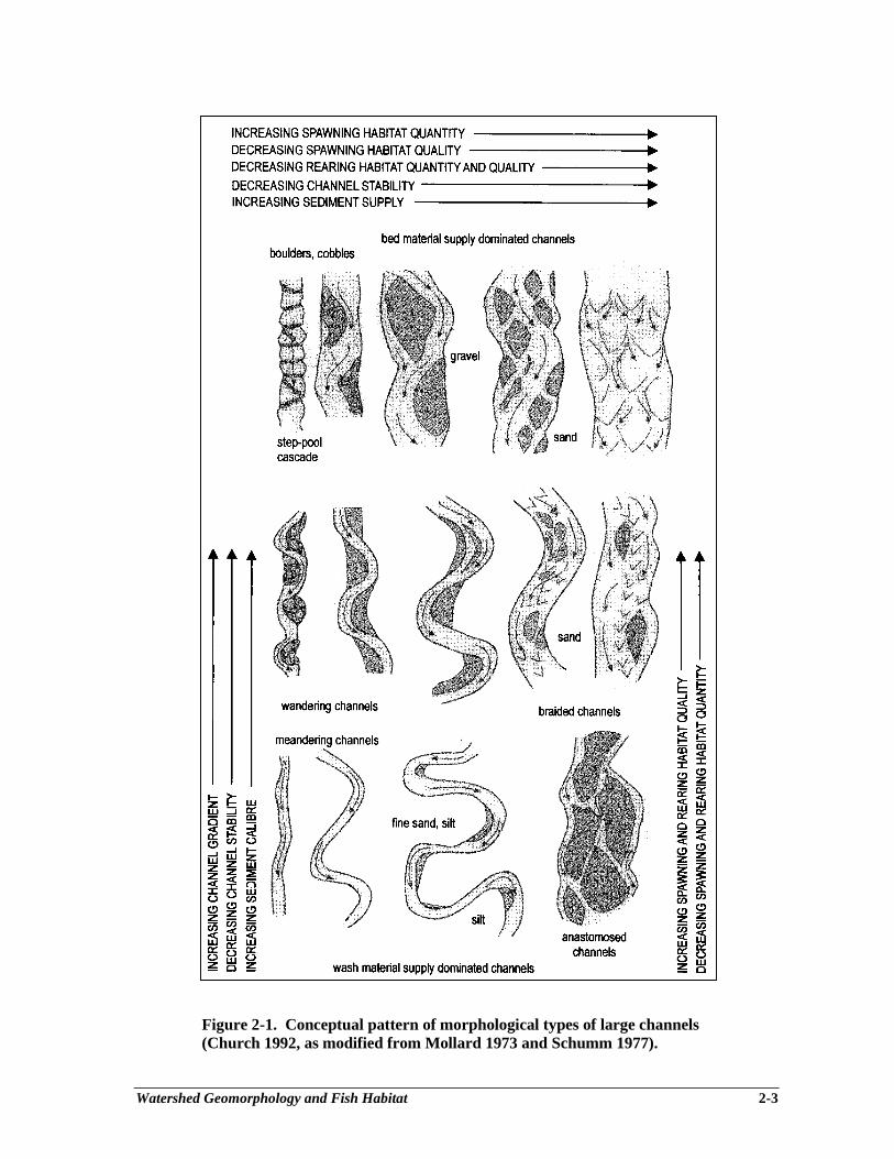
Watershed Geomorphology and Fish Habitat 2-3
Figure 2-1. Conceptual pattern of morphological types of large channels(Church 1992, as modified from Mollard 1973 and Schumm 1977).
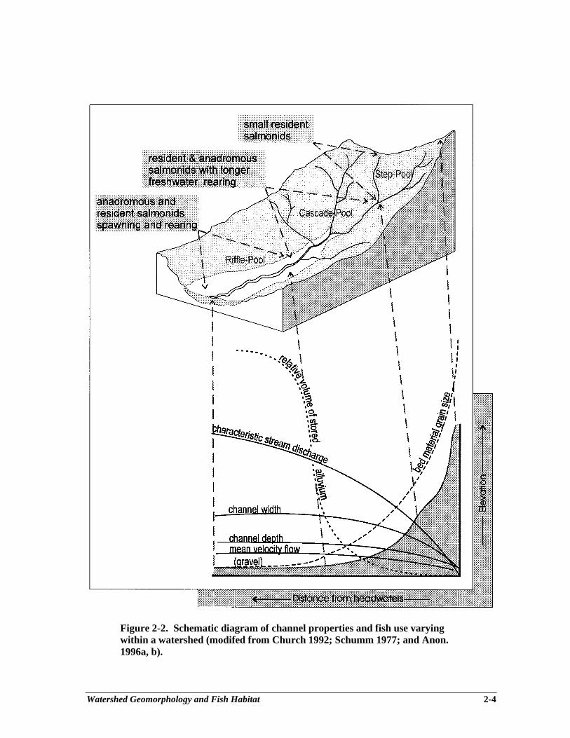
Watershed Geomorphology and Fish Habitat 2-4
Figure 2-2. Schematic diagram of channel properties and fish use varyingwithin a watershed (modifed from Church 1992; Schumm 1977; and Anon.1996a, b).
Watershed Geomorphology and Fish Habitat 2-5
and off-channel habitats characteristic of that area, such as juvenile steelhead and cutthroat trout,Dolly Varden, chinook and coho salmon. The transition in the salmonid community, towardsincreased diversity and production, from the headwaters to higher order medium-sized rivers, isconnected to the change from an ecosystem dependent on terrestrial inputs to one that relies mainlyon algal production and upstream leakage. Vannote et al. (1980) based this river continuumconcept on the energy equilibrium theory of fluvial geomorphologists.
CHANNEL MORPHOLOGY TYPES
Stream morphology varies along the stream network, in accordance with changes in channelproperties (as seen in Fig. 2-2), within all watersheds. Several of the properties that change can beused to determine the channel morphology. The relevant properties are bankfull width (Wb),bankfull depth (db), dominant bed sediment size (D) and channel gradient (S).
The Channel Assessment Procedure (CAP) is used operationally to classify channels into threeabsolute and seven relative sizes (Anon. 1996a and b). The absolute sizes (small, intermediate andlarge) are used commonly as general descriptors but are not as useful for morphologicalclassification purposes. For example, a small channel is usually referred to as one having Wb lessthan 10 m. However, depending on S, the small channel can have a wide range of morphologies;these can vary between coarse-bedded step-pool and fine-textured, low gradient meanderingmorphologies. The seven relative sizes are used to describe channel morphology. There is a generalrelation between absolute and relative size but there are several exceptions that make thedistinction between the two necessary. For instance, small channels usually have relative roughness(D/d) values greater than 1; intermediate channels usually have D/d values between 0.1 and 1.0 andlarge channels have D/d values of less than 0.1, commonly less than 0.01. Exceptions occur when,for example, as noted by Church (1992) “... a sand channel on a beach over which one can stepwith impunity would not be a ‘small’ channel”. This channel has a small absolute size (Wb<0.5)but a large size morphology (D/d <0.1). Similarly, it is possible in very powerful systems (streamswith steep gradients and large streamflow discharges) to have wide channels with a small sizemorphology such as boulder-controlled steps and pools.
The relation between specific channel attributes and morphological type have been consideredin the literature (e.g., Grant et al. 1990; Church 1992; Schumm 1977; Mollard 1973). The relationbetween slope, sediment size, expressed as relative roughness, and channel width, expressed asrelative width (D/Wb), is summarized in Anon. (1996b). The seven types of morphology used inCAP (Table 2-1) are based on: a) bed material size (dominant); b) channel attributes (depth, widthand slope); c) bed roughness (whether individual clast or clast aggregate controlled); and d) LWDpresence and function (prevalence and importance). The three basic morphologies are illustrated inFig. 2-3a, b and c; additional details appear in Table 2-2.
Table 2-1. Channel types and associated characteristics. Type Morphology Sub-Code Bed material LWD RP riffle-pool RPg-w gravel functioningRP riffle-pool RPc-w cobble functioningCP cascade-pool CPc-w cobble present, minor functionCP cascade-pool CPb boulder absentSP step-pool SPb-w boulder present, minimal functionSP step-pool SPb boulder absentSP step-pool SPr boulder-block absent

Watershed Geomorphology and Fish Habitat 2-6
a) Step-Pool morphology (after Church 1992)
b) Cascade-Pool morphology (after Grant et al. 1990)
c) Riffle-Pool morphology
Figure 2-3. Channel morphologies of small- and intermediate-sized channels (Anon. 1996a, b).
Watershed Geomorphology and Fish Habitat 2-7
Table 2-2. Typical channel and aquatic characteristics with the major morphological types.
General Characteristics Small Intermediate LargeChannels:morphology step-pool cascade-pool, riffle-pool
riffle-pool, sand bed forms
bed sediment size boulder, cobble cobble, gravel gravel, sand
Typicallya
bankfull width, Wb (m) <10 10-30 >30
bedform spacing (Wb)b 1-4 3-5 5-7
channel gradient (%) >4 <4 <2
valley wall-channel relation coupled partially coupled uncoupled
bank materials boulder, bedrock sand, gravel, cobble alluvium
functional role of LWD minor-moderate major minor
stream order (1:50,000) 1-2 3-5 >5
stream productivity allochthonous allochthonous and autochthonousautochthonous
insect community shredders, collectors collectors, grazers collectors
fish community one or two species, three or four species, a diversity of species andsmall adults large adults life histories in a variety
of habitats
principal fish use residence, or juvenile incubation, juvenile spawning, off-channelrearing, restricted rearing and spawning rearing, passagewaypassage
dominant salmonid habitat plunge pools with abundant spawning large pools, off-channelcanopy cover, boulder gravel; LWD holds creeks and pondsclusters gravel, forms pools,
and provides cover
Notes: aTypical channel characteristics are presented, exceptions occur.bBedform spacing refers to the average number of bankfull channel widths covering one bedform sequence.
The steepest and coarsest stream morphology is referred to here as block-Step-Pool (SPr). Suchstreams have very large boulders (with some single boulders larger than the channel is wide anddeep) that form steps along the channel The boulders do not move even during extreme floodevents, but can be moved by debris flows. Pools are present between the boulder blocks, butbecause the boulders are not moved by normal fluvial processes, there is no regular step-poolspacing pattern. Boulder-Step-Pool (SPb) morphologies form in slightly lower gradient channels,compared to block-Step-Pool channels, and are formed by clusters of boulders that are as big as thechannel is deep but only about one-third as wide as the channel (D/d >1, Wb=3D). The bouldersand cobbles cluster into lines that cross the channel and form stable steps with intervening pools.
Watershed Geomorphology and Fish Habitat 2-8
Debris-boulder-Step-Pool (SPb-w) morphologies are similar to boulder-Step-Pool channelsexcept that LWD is present, though it does not influence the trapping or scouring of bed and banksediments to any significant extent. The stone lines (boulder steps) remain the primary stabilizinginfluence on the channel; the boulder and cobble clusters form most of the steps.
Such step-pool habitats are usually not accessible to fish, but small, isolated “dwarf”populations (e.g., cutthroat trout, bull trout) may be present, perhaps remnants from periods whenthe stream section may have been more accessible from the mouth, or through headwater capture.If present, adults may have spent several years rearing to maturity with low fecundity, along withrelatively few cohorts in adjacent pools. Where block Step-Pools are accessible to anadromoussalmonids, the pool area is likely highly important as a refuge for migrant adults and highly valuedas a station for juveniles feeding on the abundant and large insects in the drift.
Boulder-Cascade-Pool (CPb) channels are typically steep (6%<S<10%) but are much widerthan commonly expected for small-sized channels, often exceeding 10 m in width (Wb>>10D). Thebed sediments are very large because of the steep gradients and high stream power. Debris-cobble-Cascade-Pool (CPc-w) morphologies are typically found in channels ranging in steepness from 4 to6%, approximately. The steps in these channels are formed by clusters of cobbles, boulders andsometimes LWD. Although steps are predominant, steep-faced cascade riffles also form in thesechannels. Pools are large, often accounting for over two-thirds of the channel area, and have a widerange of shapes and sizes.
Salmonid spawning habitat may be limited to very few riffles with gravel substrate, but rearinghabitat within the cascade-pool channel type can be plentiful. Conditions conducive to survivalmay be poor, however, given the high gradient and possible extremes of discharge, as well as therelatively close connection with hillslope processes, where debris slides and sedimentation mayreduce productivity at times. Due to high gradient in this channel type, fish refuge in off-channelponds and groundwater sloughs during catastrophic events may be limited. Here, and in other pooltypes, the nature of the seasonal discharge characteristics interacts with the channel morphology todetermine suitability for salmonid spawning and rearing. Northcote (1992) presented typicalhydrographs for major B.C. drainages, which indicated two general forms. Watersheds tend to bedominated by rainfall events (coastal rivers during the fall and winter; Cowichan, Keogh) or snowmelt events (interior rivers; upper Fraser, Skeena). In coastal nvers, one might expect to findextensive rearing by juvenile salmonids in accessible cascade pools, riffles, and runs. However,during the spring and summer snow melt, interior rivers are likely to be uninhabitable in thesesections, although it is likely that adult sockeye or steelhead may be passing through, wherepossible.
Intermediate-sized channels commonly consist of cobble-Riffle-Pool (RPc) and gravel Riffle-Pool (RPg) morphologies. Both types have relative roughness values of less than 0.1, but doinclude features that range up to D/d=l (occasional large stones) Channel widths are usuallybetween 10 m and 30 m. The fundamental morphological features are riffles (on relatively steepbed slope and composed of coarse sediment textures), pools (on flat, average bed slope andcomposed of finer-textured materials), and bars (accumulations of bed materials). Bars are moreextensive in the RPg types. Intermediate channels include a diverse range of pool and riffle types(Sullivan 1986; Grant et al. 1990).

Watershed Geomorphology and Fish Habitat 2-9
The riffle-pool channel morphology is likely responsible for the majority of salmonidspawning and rearing. Channel gradient, width, and bed materials, as well as stream power,discharge regime, and the associated riparian community combine to generate stream morphologiesto which salmonids may gain access, find adequate water depths and velocities, rest or hide insufficient cover, and feed on a variety of food sources that are derived from both terrestrial andaquatic sources. The four key ingredients of salmonid habitat food, water, cover, andpassageway for all trout, salmon and char life stages may be provided by the intermediate sizeand nature of riffle-pool channels. Species presence or absence may be a function of their specifichabitat requirements, post-glacial distribution, natural catastrophic events, and interactions withhumans.
The morphology of large rivers with fine-textured beds and banks varies with discharge, butcertain channel attributes, such as pattern, bar and island types and lateral stability, can beclassified on aerial photographs (Kellerhals et al. 1976). Large river morphology classification andassessment for forestry operations is considered in Anon. (1996a).
Salmonid rearing in large channels is limited to stream margins and off-channel areas, duelargely to velocity limitations in the mainstem. Species with short life stages in freshwater such aspink and chum salmon may use large rivers, and the mouths of rivers, for spawning in the fall, andmay do so in large congregations over extensive riffle habitats. Other salmonids may appearseasonally, but the period is often critical to their overall survival (overwinter, or feeding on eggsor fry). They may hold for long periods in deep pools during spawning migrations (e.g., summer-run steelhead), or may rest briefly (a few weeks) in these areas, or off-channel, during feeding orsmolt migrations.
STREAM CHANNEL RESPONSE TO DISTURBANCE
Forestry activities within a watershed directly and indirectly influence several of the factorslisted above. For example, timber harvesting and road building can change flood characteristics,particularly increasing peak flows (Jones and Grant 1996), increase sediment delivery (Roberts andChurch 1986; Schwab in press; Rood 1984), alter riparian vegetation (Anon. 1993) and disturbchannel integrity (Tripp 1994). The importance of each factor differs regionally. For example, incoastal areas the most important influence is usually on coarse-textured sediment and debrisproduction and delivery to the stream. Changes in flood flows and the generation of fine-texturedsediments are often the main concerns in interior zones where snow accumulation and meltpatterns and soil conditions can be strongly influenced by logging practices.
The expected generalized channel response to increased sediment supply and stream flow issummarized in Table 2-3. The importance of the channel type and its associated watershed positionare again evident because these elements partially account for the type, extent and severity of bothpast and potential channel impacts. Theoretically, for example, channel width should increase withelevated sediment supply levels (Schumm 1977). However, width will not change if the channel isconfined by bedrock hillslopes, as is common in headwater areas. Conversely, channels flowingthrough alluvial deposits can widen dramatically with increased sediment supply. Floodplains areparticularly sensitive to channel change, particularly if the stream banks are disturbed (Kellerhalsand Miles 1996). It is, therefore, inappropriate to expect increases in channel width, depth andgradient in step-pool or cascade-type channels, but these changes are expected in pool-rifflechannels or those located farther down the drainage system. Changes to the salmonid communitywith stream channel disturbance are numerous and complex, and have been summarized inChapter 1.
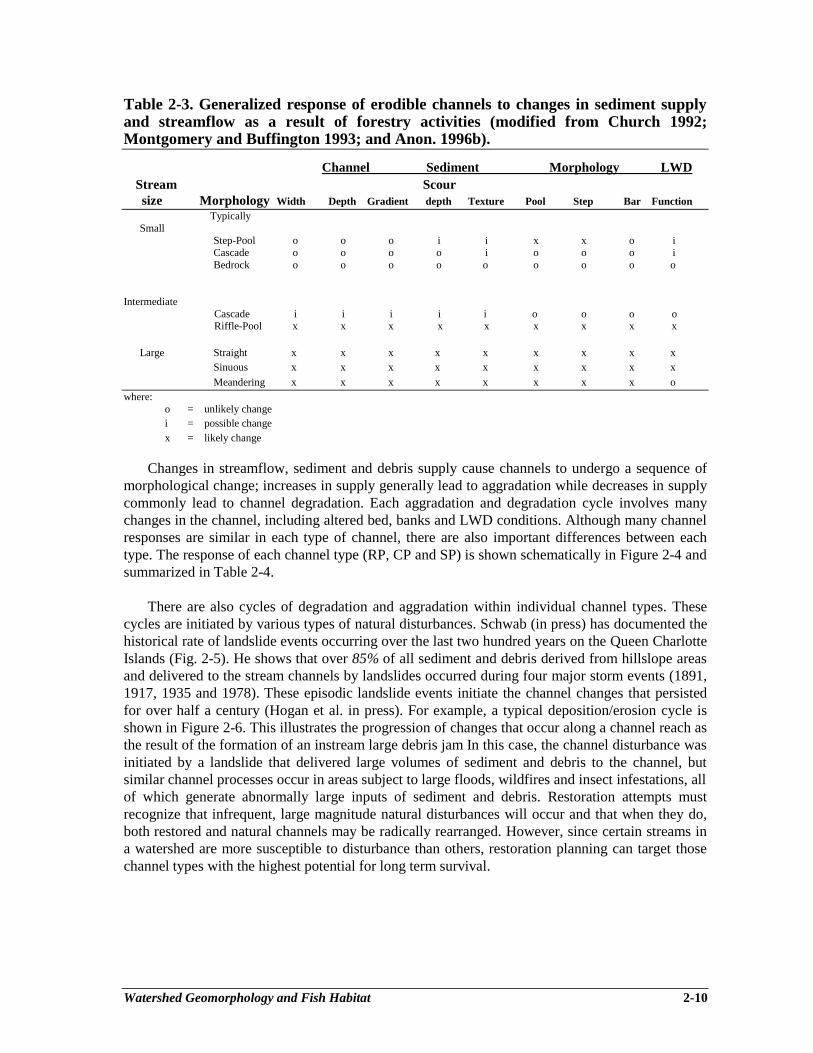
Watershed Geomorphology and Fish Habitat 2-10
Table 2-3. Generalized response of erodible channels to changes in sediment supplyand streamflow as a result of forestry activities (modified from Church 1992;Montgomery and Buffington 1993; and Anon. 1996b).
Channel Sediment Morphology LWDStream Scoursize Morphology Width Depth Gradient depth Texture Pool Step Bar Function
Typically Small
Step-Pool o o o i i x x o iCascade o o o o i o o o iBedrock o o o o o o o o o
IntermediateCascade i i i i i o o o oRiffle-Pool x x x x x x x x x
Large Straight x x x x x x x x xSinuous x x x x x x x x x
Meandering x x x x x x x x owhere:
o = unlikely changei = possible changex = likely change
Changes in streamflow, sediment and debris supply cause channels to undergo a sequence ofmorphological change; increases in supply generally lead to aggradation while decreases in supplycommonly lead to channel degradation. Each aggradation and degradation cycle involves manychanges in the channel, including altered bed, banks and LWD conditions. Although many channelresponses are similar in each type of channel, there are also important differences between eachtype. The response of each channel type (RP, CP and SP) is shown schematically in Figure 2-4 andsummarized in Table 2-4.
There are also cycles of degradation and aggradation within individual channel types. Thesecycles are initiated by various types of natural disturbances. Schwab (in press) has documented thehistorical rate of landslide events occurring over the last two hundred years on the Queen CharlotteIslands (Fig. 2-5). He shows that over 85% of all sediment and debris derived from hillslope areasand delivered to the stream channels by landslides occurred during four major storm events (1891,1917, 1935 and 1978). These episodic landslide events initiate the channel changes that persistedfor over half a century (Hogan et al. in press). For example, a typical deposition/erosion cycle isshown in Figure 2-6. This illustrates the progression of changes that occur along a channel reach asthe result of the formation of an instream large debris jam In this case, the channel disturbance wasinitiated by a landslide that delivered large volumes of sediment and debris to the channel, butsimilar channel processes occur in areas subject to large floods, wildfires and insect infestations, allof which generate abnormally large inputs of sediment and debris. Restoration attempts mustrecognize that infrequent, large magnitude natural disturbances will occur and that when they do,both restored and natural channels may be radically rearranged. However, since certain streams ina watershed are more susceptible to disturbance than others, restoration planning can target thosechannel types with the highest potential for long term survival.
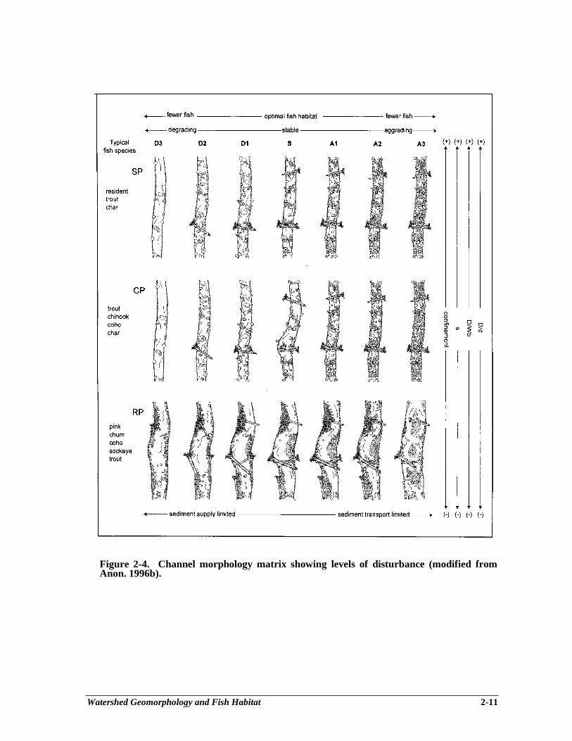
Watershed Geomorphology and Fish Habitat 2-11
Figure 2-4. Channel morphology matrix showing levels of disturbance (modified fromAnon. 1996b).
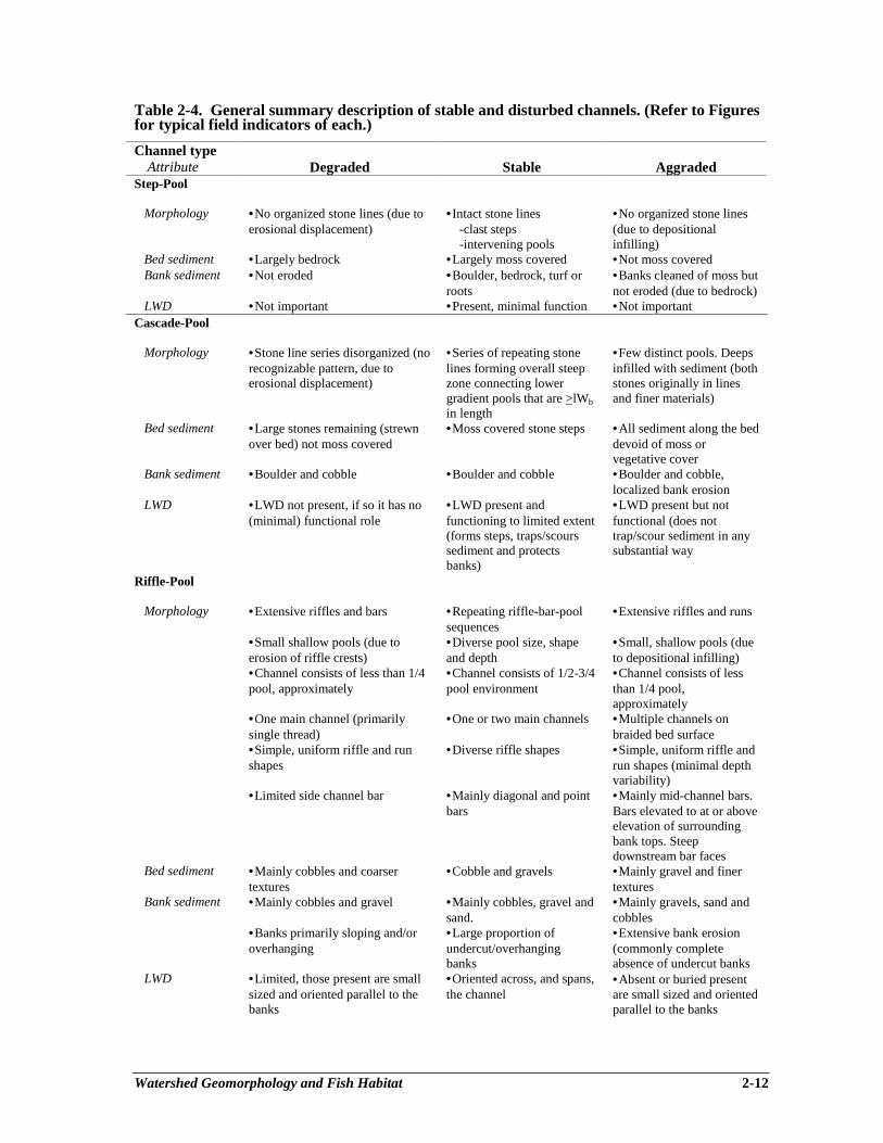
Watershed Geomorphology and Fish Habitat 2-12
Table 2-4. General summary description of stable and disturbed channels. (Refer to Figuresfor typical field indicators of each.)
Channel typeAttribute Degraded Stable Aggraded
Step-Pool
Morphology •No organized stone lines (due toerosional displacement)
•Intact stone lines-clast steps-intervening pools
•No organized stone lines(due to depositionalinfilling)
Bed sediment •Largely bedrock •Largely moss covered •Not moss covered Bank sediment •Not eroded •Boulder, bedrock, turf or
roots•Banks cleaned of moss butnot eroded (due to bedrock)
LWD •Not important •Present, minimal function •Not importantCascade-Pool
Morphology •Stone line series disorganized (norecognizable pattern, due toerosional displacement)
•Series of repeating stonelines forming overall steepzone connecting lowergradient pools that are >lWb
in length
•Few distinct pools. Deepsinfilled with sediment (bothstones originally in linesand finer materials)
Bed sediment •Large stones remaining (strewnover bed) not moss covered
•Moss covered stone steps •All sediment along the beddevoid of moss orvegetative cover
Bank sediment •Boulder and cobble •Boulder and cobble •Boulder and cobble,localized bank erosion
LWD •LWD not present, if so it has no(minimal) functional role
•LWD present andfunctioning to limited extent(forms steps, traps/scourssediment and protectsbanks)
•LWD present but notfunctional (does nottrap/scour sediment in anysubstantial way
Riffle-Pool
Morphology •Extensive riffles and bars •Repeating riffle-bar-poolsequences
•Extensive riffles and runs
•Small shallow pools (due toerosion of riffle crests)
•Diverse pool size, shapeand depth
•Small, shallow pools (dueto depositional infilling)
•Channel consists of less than 1/4pool, approximately
•Channel consists of 1/2-3/4pool environment
•Channel consists of lessthan 1/4 pool,approximately
•One main channel (primarilysingle thread)
•One or two main channels •Multiple channels onbraided bed surface
•Simple, uniform riffle and runshapes
•Diverse riffle shapes •Simple, uniform riffle andrun shapes (minimal depthvariability)
•Limited side channel bar •Mainly diagonal and pointbars
•Mainly mid-channel bars.Bars elevated to at or aboveelevation of surroundingbank tops. Steepdownstream bar faces
Bed sediment •Mainly cobbles and coarsertextures
•Cobble and gravels •Mainly gravel and finertextures
Bank sediment •Mainly cobbles and gravel •Mainly cobbles, gravel andsand.
•Mainly gravels, sand andcobbles
•Banks primarily sloping and/oroverhanging
•Large proportion ofundercut/overhangingbanks
•Extensive bank erosion(commonly completeabsence of undercut banks
LWD •Limited, those present are smallsized and oriented parallel to thebanks
•Oriented across, and spans,the channel
•Absent or buried presentare small sized and orientedparallel to the banks
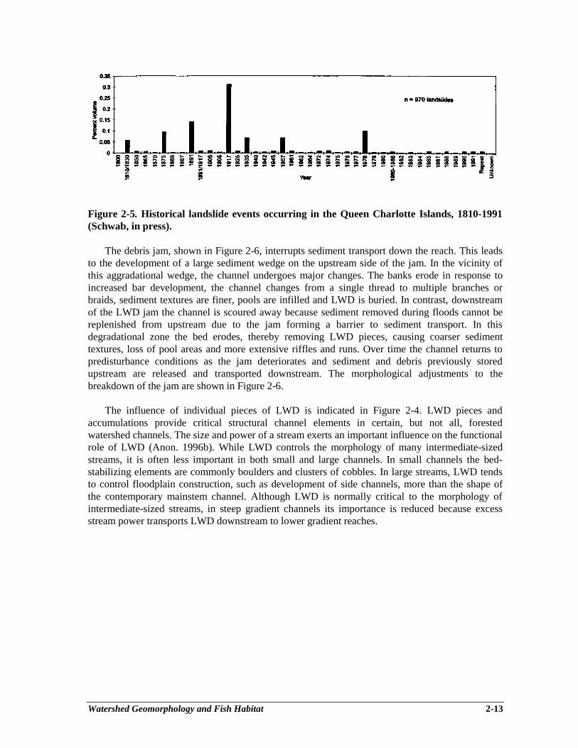
Watershed Geomorphology and Fish Habitat 2-13
Figure 2-5. Historical landslide events occurring in the Queen Charlotte Islands, 1810-1991(Schwab, in press).
The debris jam, shown in Figure 2-6, interrupts sediment transport down the reach. This leadsto the development of a large sediment wedge on the upstream side of the jam. In the vicinity ofthis aggradational wedge, the channel undergoes major changes. The banks erode in response toincreased bar development, the channel changes from a single thread to multiple branches orbraids, sediment textures are finer, pools are infilled and LWD is buried. In contrast, downstreamof the LWD jam the channel is scoured away because sediment removed during floods cannot bereplenished from upstream due to the jam forming a barrier to sediment transport. In thisdegradational zone the bed erodes, thereby removing LWD pieces, causing coarser sedimenttextures, loss of pool areas and more extensive riffles and runs. Over time the channel returns topredisturbance conditions as the jam deteriorates and sediment and debris previously storedupstream are released and transported downstream. The morphological adjustments to thebreakdown of the jam are shown in Figure 2-6.
The influence of individual pieces of LWD is indicated in Figure 2-4. LWD pieces andaccumulations provide critical structural channel elements in certain, but not all, forestedwatershed channels. The size and power of a stream exerts an important influence on the functionalrole of LWD (Anon. 1996b). While LWD controls the morphology of many intermediate-sizedstreams, it is often less important in both small and large channels. In small channels the bed-stabilizing elements are commonly boulders and clusters of cobbles. In large streams, LWD tendsto control floodplain construction, such as development of side channels, more than the shape ofthe contemporary mainstem channel. Although LWD is normally critical to the morphology ofintermediate-sized streams, in steep gradient channels its importance is reduced because excessstream power transports LWD downstream to lower gradient reaches.
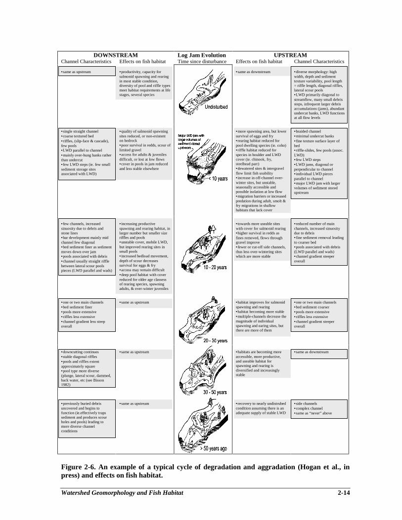
Watershed Geomorphology and Fish Habitat 2-14
DOWNSTREAM Log Jam Evolution UPSTREAMChannel Characteristics Effects on fish habitat Time since disturbance Effects on fish habitat Channel Characteristics
•same as upstream •productivity, capacity forsalmonid spawning and rearingin most stable condition,diversity of pool and riffle typesmeet habitat requirements at lifestages, several species
•same as downstream •diverse morphology: highwidth, depth and sedimenttexture variability, pool length= riffle length, diagonal riffles,lateral scour pools•LWD primarily diagonal tostreamflow, many small debrissteps, infrequent larger debrisaccumulations (jams), abundantundercut banks, LWD functionsat all flow levels.
•single straight channel•coarse textured bed•riffles, (slip-face & cascade),few pools•LWD parallel to channel•mainly over-hung banks ratherthan undercut•few LWD steps (ie. few smallsediment storage sitesassociated with LWD)
•quality of salmonid spawningsites reduced, or non-existenton bedrock•poor survival in redds, scour oflimited gravel•access for adults & juvenilesdifficult, or lost at low flows•cover in pools in jam reducedand less stable elsewhere
•more spawning area, but lowersurvival of eggs and fry•rearing habitat reduced forpool dwelling species (ie. coho)•riffle habitat reduced forspecies in boulder and LWDcover (ie. chinook, fry,steelhead parr)•dewatered sites & intergravelflow limit fish usability•increase in off-channel over-winter sites, but unstable,seasonally accessible andpossible isolation at low flow•migration barriers or increasedpredation during adult, smolt &fry migrations in shallowhabitats that lack cover
•braided channel•minimal undercut banks•fine texture surface layer ofbed•riffle-slides, few pools (assoc.LWD)•few LWD steps•LWD jams, diagonal orperpendicular to channel•individual LWD piecesparallel to channel•major LWD jam with largervolumes of sediment storedupstream
•few channels, increasedsinuosity due to debris andstone lines•bar development mainly midchannel few diagonal•bed sediment finer as sedimentmoves down over jam•pools associated with debris•channel usually straight rifflebetween lateral scour poolspieces (LWD parallel and wads)
•increasing productivespawning and rearing habitat, inlarger number but smaller sizeriffles and pools•unstable cover, mobile LWD,but improved rearing sites insmall pools•increased bedload movement,depth of scour decreasessurvival for eggs & fry•access may remain difficult•deep pool habitat with coverreduced for older age classessof rearing species, spawningadults, & over-winter juveniles
•towards more useable siteswith cover for salmonid rearing•higher survival in redds asfines removed, flows throughgravel improve•fewer or cut-off side channels,thus less over-wintering siteswhich are more stable
•reduced number of mainchannels, increased sinuositydue to debris•fine sediment removal leadingto coarser bed•pools associated with debris(LWD parallel and wads)•channel gradient steeperoverall
•one or two main channels•bed sediment finer•pools more extensive•riffles less extensive•channel gradient less steepoverall
•same as upstream •habitat improves for salmonidspawning and rearing•habitat becoming more stable•multiple-channels decrease themagnitude of individualspawning and earing sites, butthere are more of them
•one or two main channels•bed sediment coarser•pools more extensive•riffles less extensive•channel gradient steeperoverall
•downcutting continues•stable diagonal riffles•pools and riffles extentapproximately square•pool type more diverse(plunge, lateral scour, dammed,back water, etc (see Bisson1982)
•same as upstream •habitats are becoming moreaccessible, more productive,and useable habitat forspawning and rearing isdiversified and increasinglystable
•same as downstream
•previously buried debrisuncovered and begins tofunction (ie.effectively trapssediment and produces scourholes and pools) leading tomore diverse channelconditions
•same as upstream •recovery to nearly undistrubedcondition assuming there is anadequate supply of stable LWD
•side channels•complex channel•same as “never” above
Figure 2-6. An example of a typical cycle of degradation and aggradation (Hogan et al., inpress) and effects on fish habitat.
Watershed Geomorphology and Fish Habitat 2-15
The importance of LWD in large and small streams to provision of salmonid habitat cannot beoveremphasized, and is reflected in the frequent reference to LWD in this technical circular onstream rehabilitation, and elsewhere (reviewed in Ward and Slaney 1993a, see also Fausch et al.1988). In large streams, salmonids are distributed near stream banks, where LWD can play a keyrole in the creation of suitable depth and velocity, as well as cover, for many species and life stages(e.g., chinook fry and smolts, rainbow trout in the Nechako River, Slaney et al. 1993; cutthroattrout in the St. Mary’s River, Slaney and Martin 1987).
The time for recovery of disturbed channels also depends on watershed conditions. Steeperchannels that have a step-pool morphology are relatively resilient to flood disturbance; largestorms, with recurrence intervals exceeding 20 years, are required to alter the channel features(Church 1992). The step-pool channels can be completely altered by debris flows that can occur ona more frequent basis. Recovery of these channel types varies on the type of disturbance. If thechannel is scoured then recovery is slow (10-30 years), but if it is aggraded then recovery is rapid(<10 years).
Riffle-pool morphology channels are commonly disturbed by intermediate-sized storms(recurrence intervals between 2 and 20 years) and recovery to predisturbance conditions occurs intime spans ranging from 35-50 years (Fig. 2-6). There has been no documentation of the recoverytimes for cascade-pool morphology channels, but the times are probably in between those requiredfor recovery of step-pool and the riffle-pool channels.
The time of recovery of salmonid populations from major disturbance events may also requiredecades, and likewise increases from the headwater to the mouth. Disturbances in headwater areasmay be more frequent, but less severe (clear water and clean habitat soon after), and recoveryfollows quickly if fish colonization is permitted. Riffle-pool channels are affected for longerperiods. The differing strength of odd-and-even-year pink salmon runs may reflect pastdisturbances during fall spawning or winter egg incubation of one or the other of the runs, and thisdifference can require several generations and recruitment cycles to rebuild. Furthermore, thedifference in run strength can be further maintained by subsequent events, which may continue tosuppress recovery. The threatened and endangered status of some salmonid populations in BritishColumbia has been linked to habitat condition (Slaney et al. 1996). And the increased frequencyand impact of disturbance events in the many small headwater coho streams, for example, maywell explain the poor status of many coho stocks (a situation that can be made worse byoverharvest in commercial and recreational fisheries and declining oceanic conditions forsalmonids). Larger climatic shifts, which can increase the magnitude and frequency of channeldisturbances in logged areas, may induce a major reduction, or even elimination, of a juvenilesalmonid year class (Ward and Slaney 1993b), or complete blockage of the channel to access bysalmonids. In many instances, disturbance events occurring in step-pool or cascade-pool areas arepropagated downstream through the watershed, during subsequent storm events, such that changesin channel morphology and large woody debris impact salmonid spawning and rearing habitatthroughout the drainage network (see Chapter 1).
STREAM CHANNEL RESTORATION
Restoring stream channels to a predisturbed state is a daunting challengeone that involves anextensive procedure involving many important steps. To restore the physical features of a channel,it is first necessary to determine the level of forestry-related channel disturbance. It is thennecessary to determine what the channel condition was before it was disturbed by forestryactivities so that restoration activities can be designed to return it to the predisturbance state. In the
Watershed Geomorphology and Fish Habitat 2-16
absence of historical information or robust theoretical predictions, it must be assumed that theoriginal, or undisturbed, channel state would have been the “typical” morphology for the particularstream size and type. Restoration should aim to return the “aggrading” and “degrading” conditions(Table 2-4 and Fig. 2-4) to the stable condition (Table 2-5). Estimation of the predisturbancechannel state is often a problem because of the large natural variability inherent in forestedstreams. These channels experience episodes of natural disturbance and undergo cyclic periods ofaggradation and degradation; the cycles are associated mainly with sediment supply and transportlimitations interacting with LWD jams, and the morphology changes as a consequence. As a result,distinguishing between natural and forest management related factors can often be difficult.Furthermore, the time spans over which channel changes occur are sufficiently long that evaluationof restoration works is limited; it is common for evaluations to be conducted within a decade ofcompletion of the works, but the works’ proper function may not be achieved for several decades.Because of all of these considerations, stream channel restoration must be approached in awatershed context.
The watershed provides a framework within which much of the natural morphologicalvariability can be taken into account. Several guiding watershed “rules-of-thumb” can be followedwhen planning fish habitat restoration works:
- determine the cause of the documented channel disturbance and ensure that it has beenrehabilitated before the habitat restoration work is implemented (e.g., if bed aggradation isthe concern then the cause of elevated sediment supply levels, perhaps a landslide, must berectified);
- ensure that upstream watershed conditions that influence downstream channel morphologyand the longevity of completed habitat restoration works (e.g., sediment and debrisproduction and delivery mechanisms) are evaluated (see the CCPA, Hogan et. al. 1997);
- do not consider using LWD placements in stream types where LWD does not normallyhave a structural function (e.g., in steeper step-pool morphologies);
- do not consider placing large boulders in stream types where boulders do not normallyhave a structural function (e.g., in riffle-pool morphologies);
- do not consider using bank stabilization techniques in stream types where non-erodiblebanks are prevalent (e.g., in steeper cascade-pool and step-pool morphologies);
- do not consider constructing back-channels in stream types where lateral channeldevelopments are not normal (e.g., in steeper cascade-pool and step-pool morphologies);
- in areas with floodplains that are normally characterized by abundant back and sidechannels (e.g., in riffle-pool morphologies), ensure that back and side channels are, in fact,limited before proceeding to develop new ones;
- even in channel types with naturally high volumes of LWD, exercise caution in the steeperlengths of channel (e.g., riffle sections) because LWD placed in these areas are moreunstable than those placed in the lower gradient lengths;
- be very careful in floodplain areas with naturally active channels (e.g., broad valley-flatswith riffle-pool morphologies) because the normal high rate of lateral movement will tendto undermine the longevity of instream works.
Consideration of these rules of thumb will help ensure that watershed conditions areconsidered and that natural conditions are recreated along rehabilitated streams.
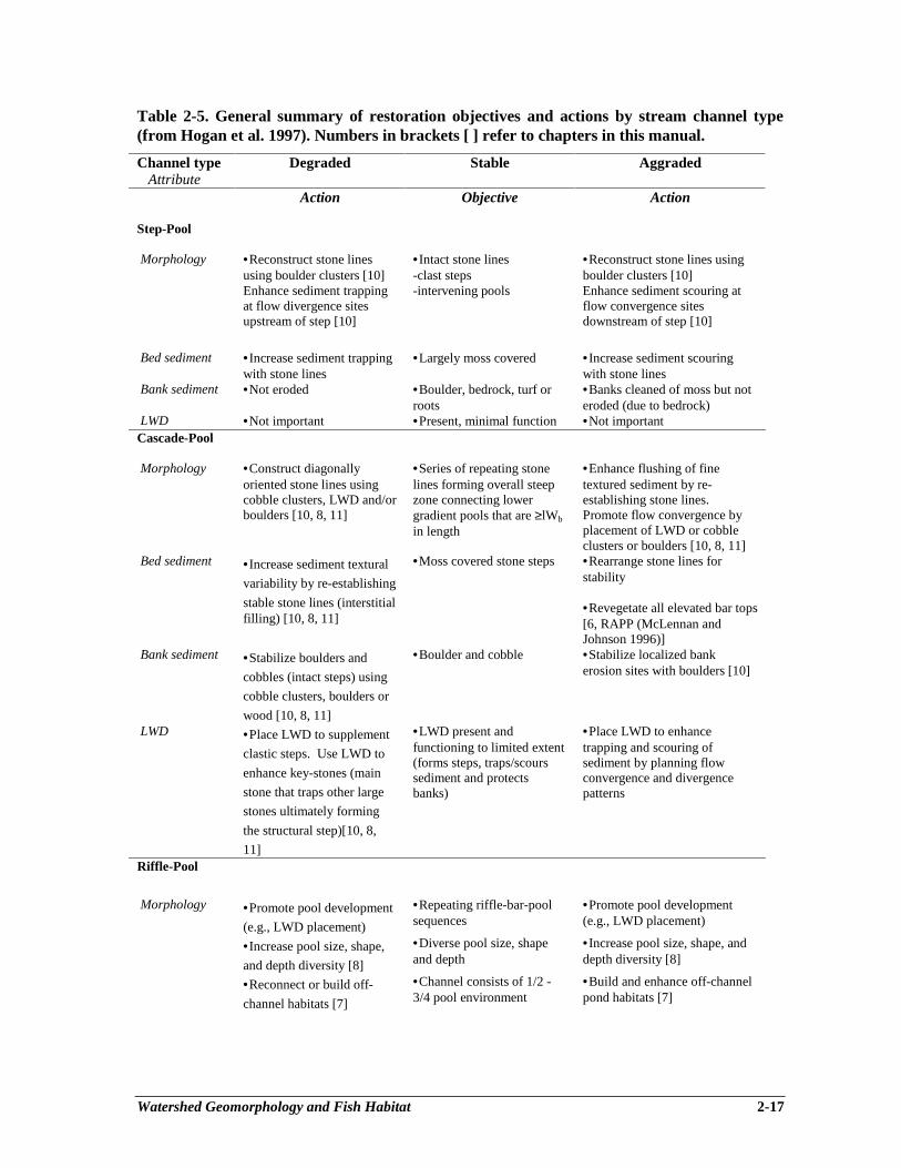
Watershed Geomorphology and Fish Habitat 2-17
Table 2-5. General summary of restoration objectives and actions by stream channel type(from Hogan et al. 1997). Numbers in brackets [ ] refer to chapters in this manual.
Channel type Degraded Stable Aggraded Attribute
Action Objective Action
Step-Pool
Morphology •Reconstruct stone linesusing boulder clusters [10]
•Intact stone lines-clast steps
•Reconstruct stone lines usingboulder clusters [10]
Enhance sediment trappingat flow divergence sitesupstream of step [10]
-intervening pools Enhance sediment scouring atflow convergence sitesdownstream of step [10]
Bed sediment •Increase sediment trappingwith stone lines
•Largely moss covered •Increase sediment scouringwith stone lines
Bank sediment •Not eroded •Boulder, bedrock, turf orroots
•Banks cleaned of moss but noteroded (due to bedrock)
LWD •Not important •Present, minimal function •Not importantCascade-Pool
Morphology •Construct diagonallyoriented stone lines usingcobble clusters, LWD and/orboulders [10, 8, 11]
•Series of repeating stonelines forming overall steepzone connecting lowergradient pools that are ≥lWb
in length
•Enhance flushing of finetextured sediment by re-establishing stone lines.Promote flow convergence byplacement of LWD or cobbleclusters or boulders [10, 8, 11]
Bed sediment •Increase sediment textural
variability by re-establishing
stable stone lines (interstitialfilling) [10, 8, 11]
•Moss covered stone steps •Rearrange stone lines forstability
•Revegetate all elevated bar tops[6, RAPP (McLennan andJohnson 1996)]
Bank sediment •Stabilize boulders and
cobbles (intact steps) using
cobble clusters, boulders or
wood [10, 8, 11]
•Boulder and cobble •Stabilize localized bankerosion sites with boulders [10]
LWD •Place LWD to supplement
clastic steps. Use LWD to
enhance key-stones (main
stone that traps other large
stones ultimately forming
the structural step)[10, 8,
11]
•LWD present andfunctioning to limited extent(forms steps, traps/scourssediment and protectsbanks)
•Place LWD to enhancetrapping and scouring ofsediment by planning flowconvergence and divergencepatterns
Riffle-Pool
Morphology •Promote pool development
(e.g., LWD placement)
•Repeating riffle-bar-poolsequences
•Promote pool development(e.g., LWD placement)
•Increase pool size, shape,
and depth diversity [8]
•Diverse pool size, shapeand depth
•Increase pool size, shape, anddepth diversity [8]
•Reconnect or build off-
channel habitats [7]
•Channel consists of 1/2 -3/4 pool environment
•Build and enhance off-channelpond habitats [7]

Watershed Geomorphology and Fish Habitat 2-18
Channel type Degraded Stable Aggraded Attribute
Action Objective Action
Riffle-Pool
Morphology •Interrupt long runs[8, 10,
12]
•One or two main channels •Promote two main channelthreads, cut off other branches tobecome flood channels [11]
•Increase riffle variability[8]
•Diverse riffle shapes •Increase depth variability [8,11, 12]
•Place LWD andcobble/boulder clusters toincrease sediment storagealong channel margins [8,10]
•Mainly diagonal and pointbars
•Scalp (remove) elevated, mid-channel bars.
Bed Sediment •Increase textural variabilityby LWD storage [8] andcobble/boulder clusters [10]
•Cobble and gravels •Promote local downcutting toincrease fluvial sorting ofsediment. Revegetate elevatedbar tops.
Bank Sediment •Revegetate banks toenhance over-bank sedimenttrapping [RAPP]
•Mainly cobbles, gravel andsand
•Revegetate banks to enhanceover-bank sediment trapping[RAPP]
•Place LWD to re-establishbank location and shape
•Large proportion ofundercut/overhanging banks
•Revegetate banks to enhancebank stability [RAPP]
LWD •LWD piece and jamplacement [8, 9]
•Oriented across, and spans,the channel
•Excavate predisturbance LWD(exhume LWD). LWD piece andjam placement [8, 9]
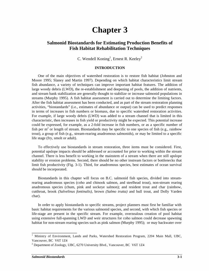
Salmonid Biostandards 3-1
Chapter 3Salmonid Biostandards for Estimating Production Benefits of
Fish Habitat Rehabilitation Techniques
C. Wendell Koning1, Ernest R. Keeley2
INTRODUCTION
One of the main objectives of watershed restoration is to restore fish habitat (Johnston andMoore 1995; Slaney and Martin 1997). Depending on which habitat characteristics limit streamfish abundance, a variety of techniques can improve important habitat features. The addition oflarge woody debris (LWD), the re-establishment and deepening of pools, the addition of nutrients,and stream bank stabilization are generally thought to stabilize or increase salmonid populations instreams (Murphy 1995). A fish habitat assessment is carried out to determine the limiting factors.After the fish habitat assessment has been conducted, and as part of the stream restoration planningactivities, “biostandards” (i.e., estimates of abundance or output) can be used to predict responsesin terms of increases in fish numbers or biomass, due to specific watershed restoration activities.For example, if large woody debris (LWD) was added to a stream channel that is limited in thischaracteristic, then increases in fish yield or productivity might be expected. This potential increasecould be expressed, for example, as a 2-fold increase in fish numbers, or as a specific number offish per m2 or length of stream. Biostandards may be specific to one species of fish (e.g., rainbowtrout), a group of fish (e.g., stream-rearing anadromous salmonids), or may be limited to a specificlife stage (fry, smolt or adult).
To effectively use biostandards in stream restoration, three items must be considered. First,potential upslope impacts should be addressed or accounted for prior to working within the streamchannel. There is less benefit to working in the mainstem of a stream when there are still upslopestability or erosion problems. Second, there should be no other instream factors or bottlenecks thatlimit fish productivity (Fig. 3-1). Third, for anadromous species, best estimates of ocean survivalshould be incorporated.
Biostandards in this chapter will focus on B.C. salmonid fish species, divided into stream-rearing anadromous species (coho and chinook salmon, and steelhead trout), non-stream rearinganadromous species (chum, pink and sockeye salmon); and resident trout and char (rainbow,cutthroat, brook (Salvelinus fontinalis), brown (Salmo trutta) and bull trout, and Dolly Vardenchar).
In order to apply biostandards to specific streams, project planners must first be familiar withbasic habitat requirements for the various salmonid species, and second, with which fish species orlife-stage are present in the specific stream. For example, overzealous creation of pool habitatusing extensive full-spanning LWD and weir structures for coho salmon could decrease spawninghabitat for non-stream rearing species such as pink salmon (Murphy 1995); or may backwater over
________________________1 Ministry of Environment, Lands and Parks, Watershed Restoration Program, 2204 Main Mall, UBC,Vancouver, BC V6T 1Z42 Department of Zoology, UBC, 6270 University Blvd., Vancouver, BC V6T 1Z4
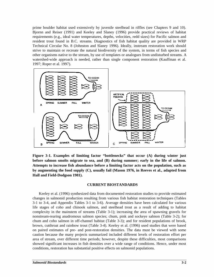
Salmonid Biostandards 3-2
prime boulder habitat used extensively by juvenile steelhead in riffles (see Chapters 9 and 10).Bjornn and Reiser (1991) and Keeley and Slaney (1996) provide practical reviews of habitatrequirements (e.g., ideal water temperatures, depths, velocities, redd sizes) for Pacific salmon andresident trout found in B.C. streams. Diagnostics of fish habitat quality are provided in WRPTechnical Circular No. 8 (Johnston and Slaney 1996). Ideally, instream restoration work shouldstrive to maintain or recreate the natural biodiversity of the system, in terms of fish species andother organisms native to the stream, by use of templates or analogues from undisturbed streams. Awatershed-wide approach is needed, rather than single component restoration (Kauffman et al.1997; Roper et al. 1997).
Figure 3-1. Examples of limiting factor “bottlenecks” that occur (A) during winter justbefore salmon smolts migrate to sea, and (B) during summer; early in the life of salmon.Attempts to increase fish abundance before a limiting factor acts on the population, such asby augmenting the food supply (C), usually fail (Mason 1976, in Reeves et al., adapted fromHall and Field-Dodgson 1981).
CURRENT BIOSTANDARDS
Keeley et al. (1996) synthesized data from documented restoration studies to provide estimatedchanges in salmonid production resulting from various fish habitat restoration techniques (Tables3-1 to 3-4, and Appendix Tables 3-1 to 3-6). Average densities have been calculated for variouslife stages of coho and chinook salmon, and steelhead trout as a result of adding to habitatcomplexity in the mainstem of streams (Table 3-1); increasing the area of spawning gravels fornonstream-rearing anadromous salmon species; chum, pink and sockeye salmon (Table 3-2); forchum and coho salmon in off-channel habitat (Table 3-3); and for resident populations of brook,brown, cutthroat and rainbow trout (Table 3-4). Keeley et al. (1996) used studies that were basedon paired estimates of pre- and post-restoration densities. The data must be viewed with somecaution because the many projects summarized included different levels of restoration effort perarea of stream, over different time periods; however, despite these difficulties, most comparisonsshowed significant increases in fish densities over a wide range of conditions. Hence, under mostconditions, restoration has substantial positive effects on salmonid populations.
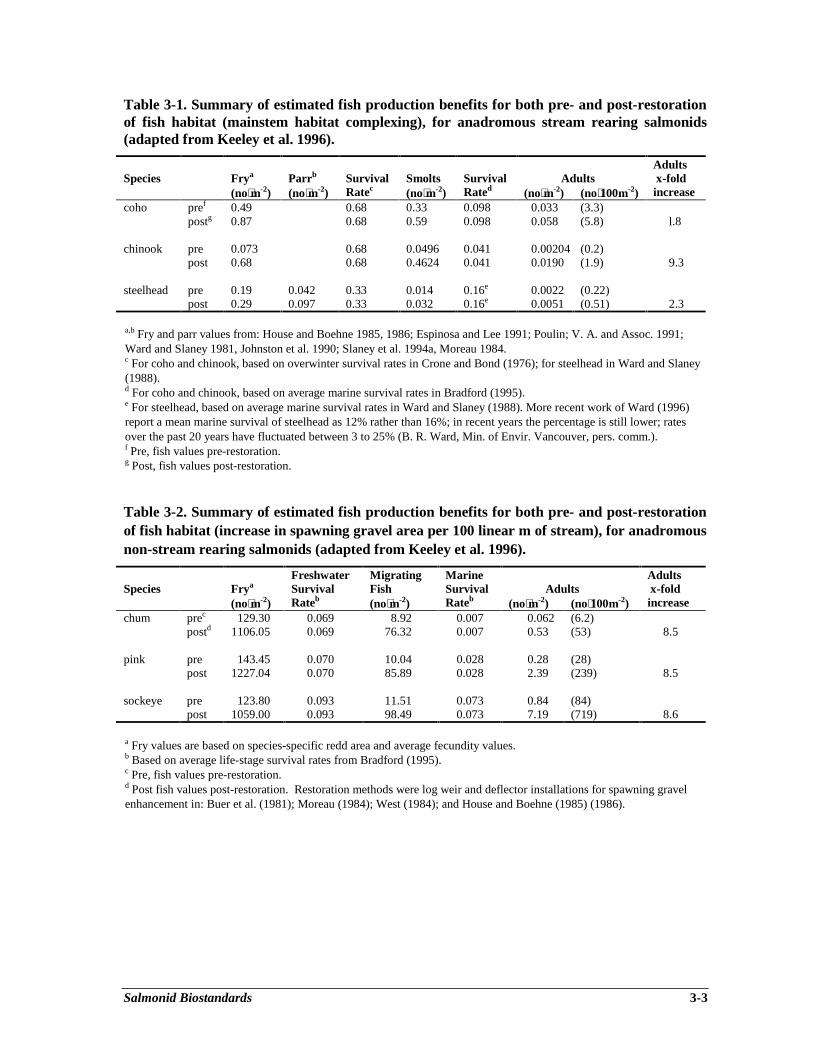
Salmonid Biostandards 3-3
Table 3-1. Summary of estimated fish production benefits for both pre- and post-restorationof fish habitat (mainstem habitat complexing), for anadromous stream rearing salmonids(adapted from Keeley et al. 1996).
Species Frya Parrb Survival Smolts Survival AdultsAdults x-fold
(no⋅m-2) (no⋅m-2) Ratec (no⋅m-2) Rated (no⋅m-2) (no⋅100m-2) increasecoho pref 0.49 0.68 0.33 0.098 0.033 (3.3)
postg 0.87 0.68 0.59 0.098 0.058 (5.8) l.8
chinook pre 0.073 0.68 0.0496 0.041 0.00204 (0.2)post 0.68 0.68 0.4624 0.041 0.0190 (1.9) 9.3
steelhead pre 0.19 0.042 0.33 0.014 0.16e 0.0022 (0.22)post 0.29 0.097 0.33 0.032 0.16e 0.0051 (0.51) 2.3
a,b Fry and parr values from: House and Boehne 1985, 1986; Espinosa and Lee 1991; Poulin; V. A. and Assoc. 1991;Ward and Slaney 1981, Johnston et al. 1990; Slaney et al. 1994a, Moreau 1984.c For coho and chinook, based on overwinter survival rates in Crone and Bond (1976); for steelhead in Ward and Slaney(1988).d For coho and chinook, based on average marine survival rates in Bradford (1995).e For steelhead, based on average marine survival rates in Ward and Slaney (1988). More recent work of Ward (1996)report a mean marine survival of steelhead as 12% rather than 16%; in recent years the percentage is still lower; ratesover the past 20 years have fluctuated between 3 to 25% (B. R. Ward, Min. of Envir. Vancouver, pers. comm.).f Pre, fish values pre-restoration.g Post, fish values post-restoration.
Table 3-2. Summary of estimated fish production benefits for both pre- and post-restorationof fish habitat (increase in spawning gravel area per 100 linear m of stream), for anadromousnon-stream rearing salmonids (adapted from Keeley et al. 1996).
Species FryaFreshwaterSurvival
MigratingFish
MarineSurvival Adults
Adults x-fold
(no⋅m-2) Rateb (no⋅m-2) Rateb (no⋅m-2) (no⋅100m-2) increasechum prec 129.30 0.069 8.92 0.007 0.062 (6.2)
postd 1106.05 0.069 76.32 0.007 0.53 (53) 8.5
pink pre 143.45 0.070 10.04 0.028 0.28 (28)post 1227.04 0.070 85.89 0.028 2.39 (239) 8.5
sockeye pre 123.80 0.093 11.51 0.073 0.84 (84)post 1059.00 0.093 98.49 0.073 7.19 (719) 8.6
a Fry values are based on species-specific redd area and average fecundity values.b Based on average life-stage survival rates from Bradford (1995).c Pre, fish values pre-restoration.d Post fish values post-restoration. Restoration methods were log weir and deflector installations for spawning gravelenhancement in: Buer et al. (1981); Moreau (1984); West (1984); and House and Boehne (1985) (1986).
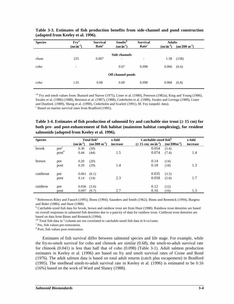
Salmonid Biostandards 3-4
Table 3-3. Estimates of fish production benefits from side-channel and pond construction(adapted from Keeley et al. 1996).
Species Frya Survival Smoltsb Survival Adults(no⋅m-2) Ratec (no⋅m-2) Ratec (no⋅m-2) (no⋅100 m-2)
Side channelschum 225 0.007 - - 1.58 (158)
coho - 0.67 0.098 0.066 (6.6)
Off-channel ponds
coho 1.01 0.68 0.69 0.098 0.068 (6.8)
a.b Fry and smolt values from: Bustard and Narver (1975), Lister et al. (1980), Peterson (1982a), King and Young (1986),Swales et al. (1986) (1988), Beniston et al. (1987), (1988), Cederholm et al. (1988), Swales and Levings (1989), Listerand Dunford. (1989), Sheng et al. (1990), Cederholm and Scarlett (1991), M. Foy (unpubl. data).c Based on marine survival rates from Bradford (1995).
Table 3-4. Estimates of fish production of salmonid fry and catchable size trout (≥ 15 cm) forboth pre- and post-enhancement of fish habitat (mainstem habitat complexing), for residentsalmonids (adapted from Keeley et al. 1996).
Species Total fisha x-fold Catchable-sized fishb x-fold(no⋅m-2) (no⋅100 m-2) increase (≥ 15 cm; no⋅m-2) (no⋅100m-2) increase
brook prec 0.30 (30) 0.054 (5.4)postd 0.44 (44) 1.5 0.074 (7.4) 1.4
brown pre 0.20 (20) 0.14 (14)post 0.29 (29) 1.4 0.18 (18) 1.3
cutthroat pre 0.061 (6.1) 0.035 (3.5)post 0.14 (14) 2.3 0.058 (5.8) 1.7
rainbow pre 0.036 (3.6) 0.12 (12)post 0.097 (9.7) 2.7 0.16 (16) 1.3
a References Riley and Fausch (1995), Binns (1994); Saunders and Smith (1962); Binns and Remmick (1994), Burgessand Bider (1980); and Hunt (1988)b Catchable-sized fish data for brook, brown and rainbow trout are from Hunt (1988). Rainbow trout densities are basedon overall responses in salmonid fish densities due to a paucity of data for rainbow trout. Cutthroat trout densities arebased on data from Binns and Remmick (1994).a,b Total fish data in a-column are not correlated to catchable-sized fish data in b-co1umn.c Pre, fish values pre-restoration.d Post, fish values post-restoration.
Estimates of fish survival differ between salmonid species and life stage. For example, whilethe fry-to-smolt survival for coho and chinook are similar (0.68), the smolt-to-adult survival ratefor chinook (0.041) is less than half that of coho (0.098) (Table 3-1). Adult salmon productionestimates in Keeley et al. (1996) are based on fry and smolt survival rates of Crone and Bond(1976). The adult salmon data is based on total adult returns (catch plus escapement) in Bradford(1995). The steelhead smolt-to-adult survival rate in Keeley et al. (1996) is estimated to be 0.16(16%) based on the work of Ward and Slaney (1988).
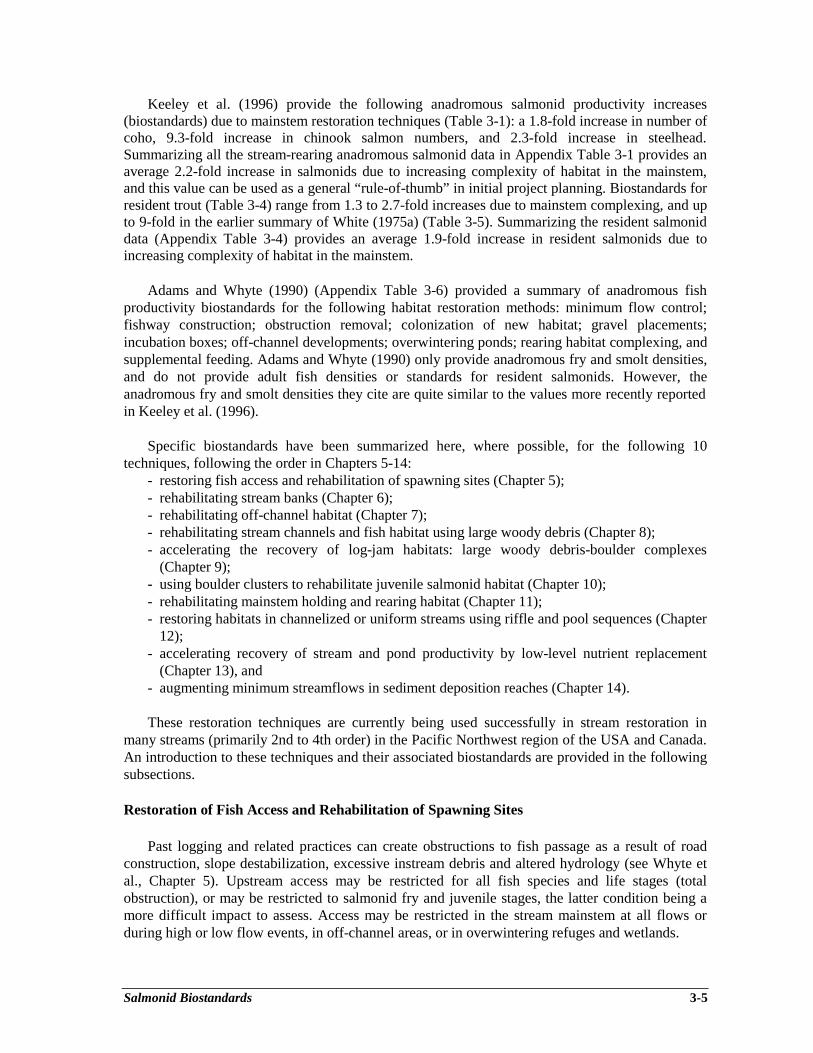
Salmonid Biostandards 3-5
Keeley et al. (1996) provide the following anadromous salmonid productivity increases(biostandards) due to mainstem restoration techniques (Table 3-1): a 1.8-fold increase in number ofcoho, 9.3-fold increase in chinook salmon numbers, and 2.3-fold increase in steelhead.Summarizing all the stream-rearing anadromous salmonid data in Appendix Table 3-1 provides anaverage 2.2-fold increase in salmonids due to increasing complexity of habitat in the mainstem,and this value can be used as a general “rule-of-thumb” in initial project planning. Biostandards forresident trout (Table 3-4) range from 1.3 to 2.7-fold increases due to mainstem complexing, and upto 9-fold in the earlier summary of White (1975a) (Table 3-5). Summarizing the resident salmoniddata (Appendix Table 3-4) provides an average 1.9-fold increase in resident salmonids due toincreasing complexity of habitat in the mainstem.
Adams and Whyte (1990) (Appendix Table 3-6) provided a summary of anadromous fishproductivity biostandards for the following habitat restoration methods: minimum flow control;fishway construction; obstruction removal; colonization of new habitat; gravel placements;incubation boxes; off-channel developments; overwintering ponds; rearing habitat complexing, andsupplemental feeding. Adams and Whyte (1990) only provide anadromous fry and smolt densities,and do not provide adult fish densities or standards for resident salmonids. However, theanadromous fry and smolt densities they cite are quite similar to the values more recently reportedin Keeley et al. (1996).
Specific biostandards have been summarized here, where possible, for the following 10techniques, following the order in Chapters 5-14:
- restoring fish access and rehabilitation of spawning sites (Chapter 5);- rehabilitating stream banks (Chapter 6);- rehabilitating off-channel habitat (Chapter 7);- rehabilitating stream channels and fish habitat using large woody debris (Chapter 8);- accelerating the recovery of log-jam habitats: large woody debris-boulder complexes
(Chapter 9);- using boulder clusters to rehabilitate juvenile salmonid habitat (Chapter 10);- rehabilitating mainstem holding and rearing habitat (Chapter 11);- restoring habitats in channelized or uniform streams using riffle and pool sequences (Chapter
12);- accelerating recovery of stream and pond productivity by low-level nutrient replacement
(Chapter 13), and- augmenting minimum streamflows in sediment deposition reaches (Chapter 14).
These restoration techniques are currently being used successfully in stream restoration inmany streams (primarily 2nd to 4th order) in the Pacific Northwest region of the USA and Canada.An introduction to these techniques and their associated biostandards are provided in the followingsubsections.
Restoration of Fish Access and Rehabilitation of Spawning Sites
Past logging and related practices can create obstructions to fish passage as a result of roadconstruction, slope destabilization, excessive instream debris and altered hydrology (see Whyte etal., Chapter 5). Upstream access may be restricted for all fish species and life stages (totalobstruction), or may be restricted to salmonid fry and juvenile stages, the latter condition being amore difficult impact to assess. Access may be restricted in the stream mainstem at all flows orduring high or low flow events, in off-channel areas, or in overwintering refuges and wetlands.
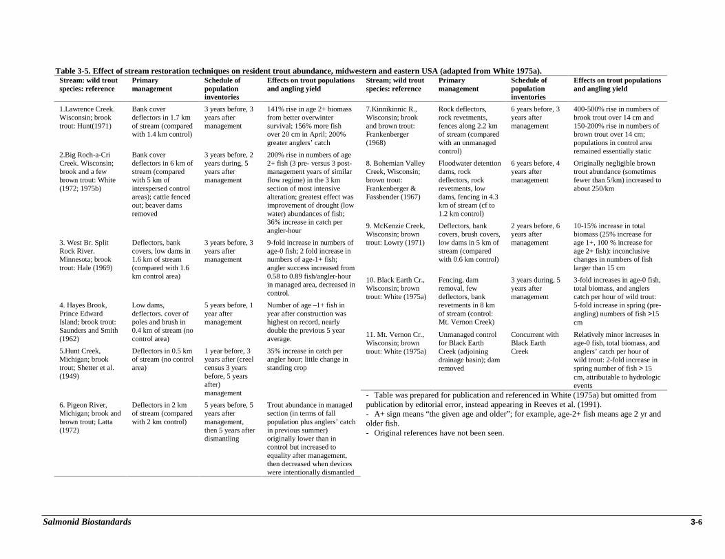
Salmonid Biostandards 3-6
Table 3-5. Effect of stream restoration techniques on resident trout abundance, midwestern and eastern USA (adapted from White 1975a).Stream: wild troutspecies: reference
Primarymanagement
Schedule ofpopulationinventories
Effects on trout populationsand angling yield
1.Lawrence Creek.Wisconsin; brooktrout: Hunt(1971)
Bank coverdeflectors in 1.7 kmof stream (comparedwith 1.4 km control)
3 years before, 3years aftermanagement
141% rise in age 2+ biomassfrom better overwintersurvival; 156% more fishover 20 cm in April; 200%greater anglers’ catch
2.Big Roch-a-CriCreek. Wisconsin;brook and a fewbrown trout: White(1972; 1975b)
Bank coverdeflectors in 6 km ofstream (comparedwith 5 km ofinterspersed controlareas); cattle fencedout; beaver damsremoved
3 years before, 2years during, 5years aftermanagement
200% rise in numbers of age2+ fish (3 pre- versus 3 post-management years of similarflow regime) in the 3 kmsection of most intensivealteration; greatest effect wasimprovement of drought (lowwater) abundances of fish;36% increase in catch perangler-hour
3. West Br. SplitRock River.Minnesota; brooktrout: Hale (1969)
Deflectors, bankcovers, low dams in1.6 km of stream(compared with 1.6km control area)
3 years before, 3years aftermanagement
9-fold increase in numbers ofage-0 fish; 2 fold increase innumbers of age-1+ fish;angler success increased from0.58 to 0.89 fish/angler-hourin managed area, decreased incontrol.
4. Hayes Brook,Prince EdwardIsland; brook trout:Saunders and Smith(1962)
Low dams,deflectors. cover ofpoles and brush in0.4 km of stream (nocontrol area)
5 years before, 1year aftermanagement
Number of age –1+ fish inyear after construction washighest on record, nearlydouble the previous 5 yearaverage.
5.Hunt Creek,Michigan; brooktrout; Shetter et al.(1949)
Deflectors in 0.5 kmof stream (no controlarea)
1 year before, 3years after (creelcensus 3 yearsbefore, 5 yearsafter)management
35% increase in catch perangler hour; little change instanding crop
6. Pigeon River,Michigan; brook andbrown trout; Latta(1972)
Deflectors in 2 kmof stream (comparedwith 2 km control)
5 years before, 5years aftermanagement,then 5 years afterdismantling
Trout abundance in managedsection (in terms of fallpopulation plus anglers’ catchin previous summer)originally lower than incontrol but increased toequality after management,then decreased when deviceswere intentionally dismantled
Stream; wild troutspecies: reference
Primarymanagement
Schedule ofpopulationinventories
Effects on trout populationsand angling yield
7.Kinnikinnic R.,Wisconsin; brookand brown trout:Frankenberger(1968)
Rock deflectors,rock revetments,fences along 2.2 kmof stream (comparedwith an unmanagedcontrol)
6 years before, 3years aftermanagement
400-500% rise in numbers ofbrook trout over 14 cm and150-200% rise in numbers ofbrown trout over 14 cm;populations in control arearemained essentially static
8. Bohemian ValleyCreek, Wisconsin;brown trout:Frankenberger &Fassbender (1967)
Floodwater detentiondams, rockdeflectors, rockrevetments, lowdams, fencing in 4.3km of stream (cf to1.2 km control)
6 years before, 4years aftermanagement
Originally negligible browntrout abundance (sometimesfewer than 5/km) increased toabout 250/km
9. McKenzie Creek,Wisconsin; browntrout: Lowry (1971)
Deflectors, bankcovers, brush covers,low dams in 5 km ofstream (comparedwith 0.6 km control)
2 years before, 6years aftermanagement
10-15% increase in totalbiomass (25% increase forage 1+, 100 % increase forage 2+ fish): inconclusivechanges in numbers of fishlarger than 15 cm
10. Black Earth Cr.,Wisconsin; browntrout: White (1975a)
Fencing, damremoval, fewdeflectors, bankrevetments in 8 kmof stream (control:Mt. Vernon Creek)
3 years during, 5years aftermanagement
3-fold increases in age-0 fish,total biomass, and anglerscatch per hour of wild trout:5-fold increase in spring (pre-angling) numbers of fish >15cm
11. Mt. Vernon Cr.,Wisconsin; browntrout: White (1975a)
Unmanaged controlfor Black EarthCreek (adjoiningdrainage basin); damremoved
Concurrent withBlack EarthCreek
Relatively minor increases inage-0 fish, total biomass, andanglers’ catch per hour ofwild trout: 2-fold increase inspring number of fish > 15cm, attributable to hydrologicevents
- Table was prepared for publication and referenced in White (1975a) but omitted frompublication by editorial error, instead appearing in Reeves et al. (1991).- A+ sign means “the given age and older”; for example, age-2+ fish means age 2 yr andolder fish.- Original references have not been seen.
Salmonid Biostandards 3-7
Activities involved in restoring fish access include excavating gravel bars, removing barriers(debris jams poorly installed culverts), restoring dewatered reaches, creating velocity refuges, andby adding or cleaning spawning gravel. Restoring fish access to upstream fish habitat results incorresponding increases in fish carrying capacity.
Spawning habitat restoration can benefit non-stream rearing salmonids, such as chum, pink andsockeye salmon. Activities to rehabilitate habitat include gravel cleaning or addition, creation ofgravel catchment structures (spawning platforms), use of full or partial spanning weirs and wingdeflectors, and creation of off-channel spawning habitat. On average, increases in spawnable gravelarea per given length of stream (Appendix Table 3-5), due to addition of log weirs and deflectorsprovide a 8.5-fold increase in chum, pink and sockeye salmon densities (Table 3-2) based on thework of Buer et al. (1981), Moreau (1984), West (1984), and House and Boehne (1985) (1986).
Stream Bank Rehabilitation
Past logging practices can affect stream bank erosion and subsequent channel responsesthrough increases in total yield, intensity and timing of delivery of water, sediment and woodydebris to the channel from adjoining hillslope and riparian areas (see Babakaiff et al., Chapter 6).Loss of a “proper functioning condition” (Barrett et al. 1995) in riparian vegetation due to loggingto the stream bank may further alter sediment loading to the stream channel. Impacts of bankerosion include loss of protective cover, reduced nutrient inputs, increased stream temperatures,infilled pools and smothered spawning gravels.
Bank stabilization techniques include rock methods (rock toe keys, deflectors, revetments,turning rocks, and tie-backs), vegetative methods (brush mattresses, facines, live cuttings,herbaceous ground cover) and integrated methods using rock, logs, soil and plants (vegetatedgeogrids, live cribwalls, tree revetments) (Babakaiff et al., Chapter 6). Planted trees and shrubs,besides establishing root systems that stabilize the banks and reduce sediment input, also provideshade, input of organic debris and food materials, and overhanging cover for fish. Bank armouringwith riprap boulders reduces sediment input, and if large boulders are placed instream at the toes,also provides habitat for juvenile stream rearing salmonids (e.g., coho and resident trout); however,excessive smooth armouring reduces habitat complexity. Bank armouring with riprap in the pasthas frequently been the “first option of choice” due to its simplicity of design and effectiveness;however, critics of the method argue that rip-rapped stream banks permanently separate the streamchannel from riparian habitat without allowing for any future natural recovery or dynamic changein the stream system.
Reduction of sediment input due to stream bank rehabilitation is not easy to measure. Based onlaboratory studies, Bjornn and Reiser (1991) provided egg-to-fry survival in relation to percent finesediment in spawning gravel (up to 60% fines). They found that the relationship was not linear. Areduction in fine sediments (in spawning gravel) from 60 to 40% resulted in increased egg survivalfrom approximately 5 to 10 percent; from 20 to 0% fine sediment in spawning gravel resulted inincreased egg survival from 10 to 80%. Thus, in streams subject to significant erosion, a 50%decrease in input of fines due to erosion control mechanisms could result in increased egg survivalfrom 2 to 8-fold, assuming that post-restoration flushing flows are able to remove the accumulatedfines from the impacted reaches. Similarly, Bjornn and Reiser (1991) provide the relationshipbetween winter habitat use by juvenile steelhead and embeddedness of the stream by fine sediment.Fine sediment can reduce the amount of cover available in the streambed by filling interstitial
Salmonid Biostandards 3-8
spaces. A reduction in embeddedness of 50% may result in an approximately 1.5 to 2.5-foldincrease in juvenile steelhead numbers per m2 of streambed.
As a “rule-of-thumb”, Keeley et al. (1996) provided a general estimate of a 2.2-fold increase instream-rearing anadromous salmonids and a 1.9-fold increase in resident salmonids due toincreases in mainstem habitat complexity, provided the stream bank project is designed to integrateboth bank protection (erosion control) and restoration of fish habitat.
Off-channel Habitat Rehabilitation
Off-channel habitats (overwintering pools, protected alcoves, groundwater channels, streamintake channels and channel pond complexes) can provide highly productive fish habitat for certainspecies and life stages of salmonids, especially for chum and coho salmon (with minor numbers ofsteelhead, chinook and Dolly Varden). Where appropriate, they provide cover for rearing juvenilesalmonids, protection from peak flows and stable overwintering habitat. Off-channel habitatdevelopment and rehabilitation is an attractive option for high-energy coastal streams whereextreme flows and channel instability make it impractical to rehabilitate the mainstem river, and inthe interior, where winter conditions, in combination with degraded habitat in the mainstem may betoo severe (Lister and Finnigan, Chapter 7). Groundwater-fed off-channel habitat projects are bestconstructed in floodplains along low gradient streams. Surfacewater-fed off-channel projects arebest located on a bench or in the upper floodplain, and the water supply must be reliable, year-round (Lister and Finnigan, Chapter 7).
Keeley et al. (1996) provided predictions of 158 adult chum and 6.6 adult coho salmon per 100m2 side-channel habitat, and 6.8 coho per 100 m2 off-channel pond (Table 3-3). Narver (1978,Carnation Creek) reported that overwinter survival of juvenile coho in a natural side-channeltributary averaged 74% over four winters, while comparable survival in the main channel was23%. Everest et al. (1986) in Fish Creek, Oregon constructed an off-channel pond where the pondrepresented less than 1% of the basin’s habitat but contributed 50% of the coho salmon smolts 3years after construction. In addition, overwinter survival of the coho salmon juveniles exceeded50% in the pond but was less than 30% in other areas. Beaver ponds are considered to be a specialtype of off-channel habitat (Finnigan and Marshall, Chapter 15).
The number of salmonid fish that can be held in a pond increases with pond size (Fig. 3-2);however, the slope of the line (Fig. 3-2) is less than one and thus smaller ponds are relatively moreproductive. For example, in Appendix Table 3-3, Lister et al. (1980) report a total of 268 coho per100 m2 in an off-channel pond of 0.056 ha, and Cederholm and Scarlet (1991) report 288 coho per100 m2 in a 0.018 ha pond. The time of year at which ponds are sampled may affect fish densityestimates (Lister and Dunford 1989); values reported in Appendix Table 3-3 are from wintermonths.
Similar to off-channel pond size and fish densities, the number of chum fry migrating fromside-channel habitat increases with increasing density of spawning females (Fig. 3-3); however,density of migrating fry reaches a maximum of about 500 fry per m2 when female spawner densityreaches about 1 spawner per m2 (Keeley et al. 1996).
Rehabilitation of Stream Channels and Fish Habitat Using Large Woody Debris
Instream large woody debris (LWD) abundance has been greatly diminished in the past due tologging of stream banks and stream clearance practices (Cederholm et al., Chapter 8). LWD is
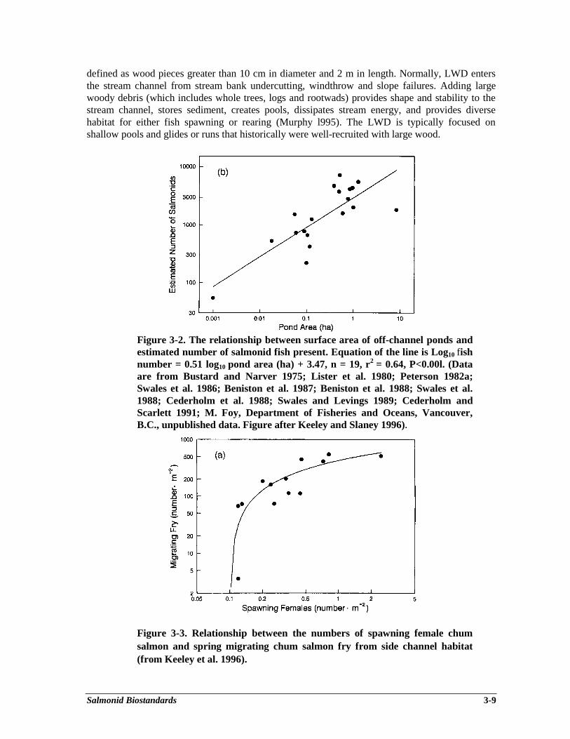
Salmonid Biostandards 3-9
defined as wood pieces greater than 10 cm in diameter and 2 m in length. Normally, LWD entersthe stream channel from stream bank undercutting, windthrow and slope failures. Adding largewoody debris (which includes whole trees, logs and rootwads) provides shape and stability to thestream channel, stores sediment, creates pools, dissipates stream energy, and provides diversehabitat for either fish spawning or rearing (Murphy l995). The LWD is typically focused onshallow pools and glides or runs that historically were well-recruited with large wood.
Figure 3-2. The relationship between surface area of off-channel ponds andestimated number of salmonid fish present. Equation of the line is Log10 fishnumber = 0.51 log10 pond area (ha) + 3.47, n = 19, r2 = 0.64, P<0.00l. (Dataare from Bustard and Narver 1975; Lister et al. 1980; Peterson 1982a;Swales et al. 1986; Beniston et al. 1987; Beniston et al. 1988; Swales et al.1988; Cederholm et al. 1988; Swales and Levings 1989; Cederholm andScarlett 1991; M. Foy, Department of Fisheries and Oceans, Vancouver,B.C., unpublished data. Figure after Keeley and Slaney 1996).
Figure 3-3. Relationship between the numbers of spawning female chumsalmon and spring migrating chum salmon fry from side channel habitat(from Keeley et al. 1996).
Salmonid Biostandards 3-10
Keeley et al. (1996) provided a general estimate of a 2.2-fold increase in stream-rearinganadromous salmonids and 1.9-fold increase in resident salmonids due to increases in mainstemhabitat complexity. Other studies have shown similar or higher increases. Cederholm et al. (inpress) reports coho smolt production increases of 4 to 6-fold after LWD was added. Solazzi andJohnson (1994) report increases of approximately 3-fold and 25-fold in coho smolt output afterexperimental addition of large woody debris (conifer logs) to debris-poor streams in two basins inwestern Oregon. Riley and Fausch (1995) (see Appendix Table 3-4) installed drop logs in six smallRocky Mountain streams in Colorado. They found no increase in fish growth rates or survival forbrook, brown, rainbow and cutthroat trout, and attributed the increase in fish abundance (in 250 msections), from roughly 2-fold to 7-fold increases over control reaches, to immigration from otherparts of the stream (based on low recaptures of marked fish, high captures of unmarked fish).Regardless, the end result was still an increase in the overall carrying capacity of the stream.
Accelerating the Recovery of Log-jam Habitats: Large Woody Debris-boulder Complexes
Large woody debris catchers are normally employed in moderate gradient mainstem sites inrivers, and not in tributaries because the former transport woody debris. They provide juvenile andadult fish rearing habitat for anadromous and resident stream rearing salmonids. Large woodydebris catchers have been used with some success within the province of B.C. Slaney et al. (1994a)reported mean numbers of juvenile chinook in debris catchers (pipe and rail types) at 277 and 522fingerlings per catcher in May and June, respectively. On the West Kettle River, one of fourcatchers (V-log type) successfully trapped woody debris floating downstream, and in the process,created a large lateral scour pool. At this catcher, 18 rainbow trout (15 - 30 cm lengths) and 50mountain whitefish (Prosopium williamsoni) (20 - 35 cm lengths) were observed by underwatercounts during early September 1996 (P.A. Slaney and W. Koning, unpublished data). Fish were notobserved elsewhere in the vicinity. The other three catchers were unsuccessful in capturing debrisand therefore were not successfully functioning. Debris catchers in use on the St. Mary River, oncecompleted with collected debris and when sited properly, provided habitat for a mean of 8 adultcutthroat per structure (Oliver 1994). Properly locating debris catchers has been found to be acrucial component of their success, based on the work in the West Kettle and St. Mary Rivers (PA.Slaney, B.C. Ministry of Environment, Lands and Parks, Vancouver, pers. comm.).
More recent design and installations of debris catchers incorporates the use of logs and cabled(or epoxy fastened) boulders (e.g., Keogh River) in a lateral jam design (Chapter 9), which is more“natural” than the pipe and rail types. This is quite a recent trend and thus little data is available,but positive results (in fish productivity) are reported when adding wood to boulder clusters(Chapter 10) and boulder deflectors (Chapter 11).
Artificial fish reefs constructed of log cribs and sunk with boulders are being experimentallyinstalled in Shovelnose Creek (R. Finnigan, British Columbia Conservation Foundation, Surrey,pers. comm.). Fish reefs provide a combination of LWD and boulder habitat. They are easy toconstruct and of low cost materials (Chapter 9), and they are expected to provide habitat forjuvenile coho and steelhead. Similar to the lateral jam design described above, little in the way ofmonitoring data is currently available and therefore there are no biostandards at this time, but fishdensities should be higher than those provided by boulders or large wood alone.
Boulder Clusters to Rehabilitate Juvenile Salmonid Habitat
Boulder clusters provide rearing habitat for juvenile salmonids. Ward and Slaney (1993b)reported up to 0.1 steelhead parr per m2 (about 8 parr per 100 m2, or 1 parr per boulder in a cluster)
Salmonid Biostandards 3-11
and 0.3 coho fry per m2 (about 3 fry per boulder in a cluster) in areas of a coastal stream that werealmost completely absent of fish previously. Most boulder clusters had a small amount of woodydebris attached. Mean survival of 1+ parr to smolt was estimated at 65% (Ward and Slaney 1993b),and therefore each treated site could increase returns by 0.5 adult steelhead (based on 3-4 wildsmolts per cluster of 5-7 boulders). Where scour occurred below the boulder clusters, coho fryincreased by 4-fold and 3-fold after 1 and 2 years, respectively, post-placement. After 12 yearspost-placement, steelhead parr were still at 6 parr per site, compared to zero parr pre-placement,although many of the boulder clusters had lost their woody attachments. Espinosa and Lee (1991)report 10 steelhead parr per 100 m2 due to boulder cluster installations and 65.3 chinookunderyearlings per 100 m2 of treated habitat in an interior stream system of Idaho. Griffith (1982)reported a 3-fold increase in abundance of steelhead Parr in a boulder treated section.
Deflectors and Weirs to Rehabilitate Mainstem Holding and Rearing Habitat
In destabilized watersheds, excessive bedload combined with higher than normal peak flowsmay result in infilling of deep runs and pools. Opposing wing deflectors and weirs are structuresthat can be constructed at natural pool-riffle sequences to encourage streambed scour, thusrestoring lost deeper water habitat in uniform channels (see Chapter 5 for use of weirs anddeflectors to create spawning habitat). Log weirs or sills cause water to plunge downward and thusencourage streambed scour; deflectors narrow the channel, increasing stream velocity andsubsequently encouraging downstream scour (Allan and Lowe, Chapter 11). Opposing wingdeflectors simulate obstructions that constrict streamflow, and thereby create pools and cover bynarrowing and deepening the stream; weirs create plunge pools downstream and dammed poolsupstream (Murphy 1995). Care must be taken to ensure excessive backwatering is not created atstream gradients of less than 2%.
In two southern Alberta streams, up to 68 juvenile and 62 adult rainbow trout, and 16.7juvenile and 13.9 adult bull trout were found per 100 lineal meters of V-weir run. Up to 11.8juvenile and 2.4 adult rainbow trout, and 2.4 juvenile and 2.4 adult bull trout were found per 100lineal meters of opposing deflector run (see R.L.&L. data in Chapter 11). At the Keogh River,Vancouver Island, Ward and Slaney (1993b) compared boulder deflectors with and without largewood added. Deflectors with large wood carried about twice as many juvenile steelhead parr andcoho young-of-year. Keeley et al. (1996) provide a general estimate of a 2.2-fold increase instream-rearing anadromous salmonids and a 1.9-fold increase in resident salmonids due toincreases in mainstem habitat complexity.
Restoring Habitats in Channelized or Uniform Streams Using Riffle and Pool Sequences
Restoring habitat that has been previously channelized or made uniform (for example, to alignlogging roads) creates additional meanders, pools and riffles, and thus reduces stream gradient,stream velocities and adds depth (Newbury and Gaboury 1993). Restoring channelized habitatrebuilds diverse hydraulic conditions that would otherwise naturally be present (based on a naturalpattern of a pool approximately every 5-7 channel widths). Properly designed, rock-riffles enhancepools, recruit gravel re-aerate flows, and assist fish passage; they increase the availability ofspawning habitat, assist in fry passage, and provide overwintering habitat, especially in steepcoastal streams (Newbury et al., Chapter 12). Similar to the less structurally stable upstream V-weirs, care is required to avoid use in gradients less than 1.5 to 2% to minimize backwatering ofexisting habitat (see exception below).
Salmonid Biostandards 3-12
Positive results are reported from reconstruction of channelized habitat in both low gradient(0.3%) and higher gradient (3%) streams (Chapter 12). In the low gradient stream (Mink Creek inManitoba), egg viability of walleye (Stizostedion vitreum) spawning in the reconstructed sectionwas slightly higher than for the channelized reach, averaging 73 and 68%, respectively, for thesamples taken over a 6-year period, post-rehabilitation. The effect of walleye eggs being scouredoff of spawning substrates was reduced by 150% in the reconstructed section, in comparison to thechannelized section. Low gradient examples such as Mink Creek are only appropriate in B.C. tothe northeast section of the province where walleye are present; in other parts of the province lowgradient work could create undesirable cyprinid habitat. In the higher gradient stream (OuletteCreek, Howe Sound, south coastal B.C.), productive pool habitat increased 450% (4.5-fold) frompre-restoration levels, with a subsequent increase in age 1+ steelhead and cutthroat trout of up to5.4-fold over pre-restoration levels (Chapter 12).
Accelerating Recovery of Stream and Pond Productivity by Low-Level Nutrient Replacement
In certain B.C. streams, primary production is limited by nutrient deficiencies (Slaney et al.1986; Johnston et al. 1990; Slaney and Ward 1993). In some streams, low nutrient conditions arethe natural oligotrophic condition; in others, these conditions are due to habitat impacts (includingpast timber harvesting practices) or overharvest of fish (primarily anadromous fish). Nutrientaddition as a stream restoration technique involves the addition of nitrogen (N) and phosphorous(P) to obtain an in-river target concentration of approximately 5 µg per liter P and 20 µg per literN. This stimulates the food chain (algae-to-invertebrates-to-fish) resulting in increases in fishbiomass and densities. Studies in S.E. Alaska established a strong positive correlation betweenalgal standing crop and coho abundance (see Murphy 1995, Fig. 5.14). Increased food abundancemay also result in decreased feeding territory sizes thereby increasing stream carrying capacity,e.g., with juvenile coho salmon, in Dill et al. (1981).
An alternative to addition of inorganic nutrients is the addition of salmon carcasses. Bilby et al.(1996) added coho carcasses to a western Washington state stream with the hope of doublingreturning coho adults. Bilby’s prediction of a 2-fold increase is based on the added food sourceincreasing the size of individual juvenile coho with a resultant increase in instream overwinteringsurvival and increased ocean survival, based largely on studies at Carnation Creek, VancouverIsland (Scrivener and Brown 1993). Larger coho fry are found to have higher freshwateroverwintering survival rate, and larger smolt size increases their ocean survival rate (Scrivener andBrown 1993; Quinn and Petersen 1994).
Fertilization of the Keogh and Salmon Rivers resulted in up to 2 to 3-fold increase in theaverage weight of juvenile steelhead trout after only 2 to 3 months of fertilization (Slaney et al.1986; Johnston et al. 1990; Slaney and Ward 1993). Slaney and Ward (1993) report that the meanweights of age 1+ and 2+ steelhead parr were 55 and 24% larger within the treated reach comparedto the untreated reach after approximately 10 weeks of nutrient treatment. Steelhead fry densities inthe control reach were 86, and 77 fry per 100 m2 (1985); and were 116, 108, and 120 fry per 100m2 in the treated reaches (Slaney and Ward 1993). An increase in steelhead parr-length of 10 mm,from 50 - 60 mm, was associated with a doubling of survival to the smolt stage (from 25-50%).
There was a 65% increase in steelhead smolts and adults (2-2.5 fold in one year), with lessimpact on coho since they reared in the tributaries and not in the fertilized mainstem (Ward andSlaney 1993). Steelhead and rainbow trout size increased 2 to 3-fold in the Salmon River due tonutrient addition (Slaney et al. 1994b); and steelhead parr and smolt trapping numbers exhibited astrong positive trend (Chapter 13, Table 13-2).

Salmonid Biostandards 3-13
With only a 6-week growth window in the Kuparuk River in northern Alaska, age 0+ Arcticgrayling showed a 1.4 to 1.9-fold increase in size and adult grayling an increase of up to 1.5 to 2.4-fold in weight gain as a result of stream fertilization (Deegan and Peterson 1992). Fish in thefertilized reach gained up to three times as much length as fish in the control reach (0.9 cm versus0.3 cm, respectively), but not in each year of fertilization (Deegan and Peterson 1992). Preliminaryresults in the Mesilinka River (northern B.C.), in year two of nutrient addition suggest that theweight of adult rainbow trout, age 4+, were up to 34% greater in the fertilized reach compared tothe control reach (Koning et al. 1996).
Nutrient addition should only be used as a stream restoration technique where food is limited(oligotrophic streams) and all other habitat factors are suitable; however, where habitat is notlimiting overwinter survival and influx of nutrients from salmon carcasses is depressed (Larkin andSlaney 1996), nutrient addition (replacement) is a viable option, and in fact may be the only option.In streams that are naturally oligotrophic and in pristine condition, adding nutrients would beinappropriate.
Augmenting Minimum Streamflows in Sediment Deposition Reaches
Past forest harvesting practices have created hydrological changes in watersheds such that insome highly disturbed systems the entire streamflow subsurfaces at much higher flows in thesediment accumulation zone in comparison to the steeper gradients upstream (Wood, Chapter 14).Potential impacts include a reduction in rearing area for anadromous juvenile salmonids andresident fish populations, higher summertime water temperatures, and delayed adult migrations.One of the primary risks to chinook salmon from flow reduction in the Nechako River was apossible decrease in cover (Slaney et al. 1994a).
Summer low flows can be augmented in lake-headed streams by construction of low dams witha small fishway between the lake and the stream below, provided there is sufficient water storagecapacity in the lake (Chapter 14). Base summer flows can also be augmented by increasing thegroundwater component and intercepting subsurface flows; replacement of the main channel byexcavation of side-channels is another option.
Flow augmentation increases the wetted area of stream. An increase in summer base flows of50% may increase effective pool and riffle area by 30% with a corresponding increase in fishproduction, in particular coho, steelhead and resident trout (Chapter 14). Where flow augmentationresults in additional availability of spawning gravels per unit area of stream, Keeley et al. (1996)predicted an average 8.5-fold increase in chum, pink and sockeye salmon production.
OCEAN SURVIVAL
Productivity estimates for anadromous adult salmonids are highly dependent on ocean survivalrates, and these rates may vary between streams and regions, and over time. In comparison to theocean survival rates cited in Bradford (1995) and used in Tables 3-1 to 3-3 (one average numberper species), ocean survival rates provided in Lucchetti and White (1995) (synthesizing the data ofothers), are separated into “high”, “low” and “mean” values - the actual rate chosen would dependon the specific project. Survival rates ranged from 4 to 23% for sockeye salmon, 0.1 to 1% forchinook, 10 to 20% for coho, and from 5 to 15% for steelhead. A mean ocean survival value of28% was provided for anadromous cutthroat trout. High, low and mean values are an appropriatealternative to the Bradford averages when comparing different streams where, for example, streamtemperature and nutrient status are quite variable, since temperature and nutrient availability have a
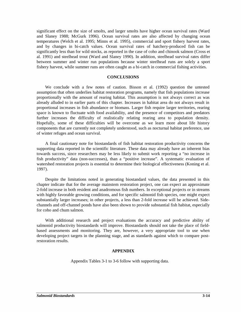
Salmonid Biostandards 3-14
significant effect on the size of smolts, and larger smolts have higher ocean survival rates (Wardand Slaney 1988; McGurk 1996). Ocean survival rates are also affected by changing oceantemperatures (Welch et al. 1995; Minns et al. 1995), commercial and sport fishery harvest rates,and by changes in bi-catch values. Ocean survival rates of hatchery-produced fish can besignificantly less than for wild stocks, as reported in the case of coho and chinook salmon (Cross etal. 1991) and steelhead trout (Ward and Slaney 1990). In addition, steelhead survival rates differbetween summer and winter run populations because winter steelhead runs are solely a sportfishery harvest, while summer runs are often caught as a bi-catch in commercial fishing activities.
CONCLUSIONS
We conclude with a few notes of caution. Bisson et al. (1992) question the untestedassumption that often underlies habitat restoration programs, namely that fish populations increaseproportionally with the amount of rearing habitat. This assumption is not always correct as wasalready alluded to in earlier parts of this chapter. Increases in habitat area do not always result inproportional increases in fish abundance or biomass. Larger fish require larger territories, rearingspace is known to fluctuate with food availability, and the presence of competitors and predatorsfurther increases the difficulty of realistically relating rearing area to population density.Hopefully, some of these difficulties will be overcome as we learn more about life historycomponents that are currently not completely understood, such as nocturnal habitat preference, useof winter refuges and ocean survival.
A final cautionary note for biostandards of fish habitat restoration productivity concerns thesupporting data reported in the scientific literature. These data may already have an inherent biastowards success, since researchers may be less likely to submit work reporting a “no increase infish productivity” data (non-successes), than a “positive increase”. A systematic evaluation ofwatershed restoration projects is essential to determine their biological effectiveness (Koning et al.1997).
Despite the limitations noted in generating biostandard values, the data presented in thischapter indicate that for the average mainstem restoration project, one can expect an approximate2-fold increase in both resident and anadromous fish numbers. In exceptional projects or in streamswith highly favorable growing conditions, and for specific salmonid fish species, one might expectsubstantially larger increases; in other projects, a less than 2-fold increase will be achieved. Side-channels and off-channel ponds have also been shown to provide substantial fish habitat, especiallyfor coho and chum salmon.
With additional research and project evaluations the accuracy and predictive ability ofsalmonid productivity biostandards will improve. Biostandards should not take the place of field-based assessments and monitoring. They are, however, a very appropriate tool to use whendeveloping project targets in the planning stage, and as standards against which to compare post-restoration results.
APPENDIX
Appendix Tables 3-1 to 3-6 follow with supporting data.
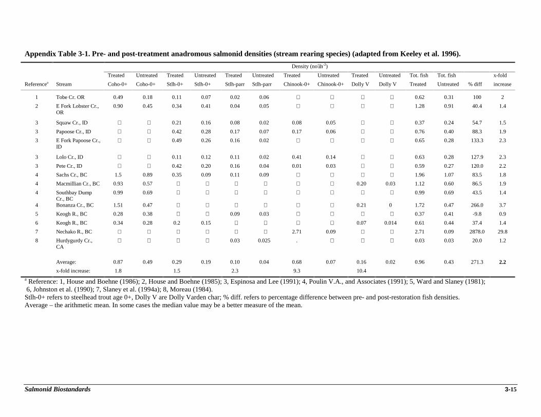
Salmonid Biostandards 3-15
Appendix Table 3-1. Pre- and post-treatment anadromous salmonid densities (stream rearing species) (adapted from Keeley et al. 1996).
Density (no⋅m-2)
Treated Untreated Treated Untreated Treated Untreated Treated Untreated Treated Untreated Tot. fish Tot. fish x-fold
Referencea Stream Coho-0+ Coho-0+ Stlh-0+ Stlh-0+ Stlh-parr Stlh-parr Chinook-0+ Chinook-0+ Dolly V Dolly V Treated Untreated % diff increase
1 Tobe Cr. OR 0.49 0.18 0.11 0.07 0.02 0.06 ⋅ ⋅ ⋅ ⋅ 0.62 0.31 100 2
2 E Fork Lobster Cr.,OR
0.90 0.45 0.34 0.41 0.04 0.05 ⋅ ⋅ ⋅ ⋅ 1.28 0.91 40.4 1.4
3 Squaw Cr., ID ⋅ ⋅ 0.21 0.16 0.08 0.02 0.08 0.05 ⋅ ⋅ 0.37 0.24 54.7 1.5
3 Papoose Cr., ID ⋅ ⋅ 0.42 0.28 0.17 0.07 0.17 0.06 ⋅ ⋅ 0.76 0.40 88.3 1.9
3 E Fork Papoose Cr.,ID
⋅ ⋅ 0.49 0.26 0.16 0.02 ⋅ ⋅ ⋅ ⋅ 0.65 0.28 133.3 2.3
3 Lolo Cr., ID ⋅ ⋅ 0.11 0.12 0.11 0.02 0.41 0.14 ⋅ ⋅ 0.63 0.28 127.9 2.3
3 Pete Cr., ID ⋅ ⋅ 0.42 0.20 0.16 0.04 0.01 0.03 ⋅ ⋅ 0.59 0.27 120.0 2.2
4 Sachs Cr., BC 1.5 0.89 0.35 0.09 0.11 0.09 ⋅ ⋅ ⋅ ⋅ 1.96 1.07 83.5 1.8
4 Macmillian Cr., BC 0.93 0.57 ⋅ ⋅ ⋅ ⋅ ⋅ ⋅ 0.20 0.03 1.12 0.60 86.5 1.9
4 Southbay DumpCr., BC
0.99 0.69 ⋅ ⋅ ⋅ ⋅ ⋅ ⋅ ⋅ ⋅ 0.99 0.69 43.5 1.4
4 Bonanza Cr., BC 1.51 0.47 ⋅ ⋅ ⋅ ⋅ ⋅ ⋅ 0.21 0 1.72 0.47 266.0 3.7
5 Keogh R., BC 0.28 0.38 ⋅ ⋅ 0.09 0.03 ⋅ ⋅ ⋅ ⋅ 0.37 0.41 -9.8 0.9
6 Keogh R., BC 0.34 0.28 0.2 0.15 ⋅ ⋅ ⋅ ⋅ 0.07 0.014 0.61 0.44 37.4 1.4
7 Nechako R., BC ⋅ ⋅ ⋅ ⋅ ⋅ ⋅ 2.71 0.09 ⋅ ⋅ 2.71 0.09 2878.0 29.8
8 Hurdygurdy Cr.,CA
⋅ ⋅ ⋅ ⋅ 0.03 0.025 . ⋅ ⋅ ⋅ 0.03 0.03 20.0 1.2
Average: 0.87 0.49 0.29 0.19 0.10 0.04 0.68 0.07 0.16 0.02 0.96 0.43 271.3 2.2
x-fold increase: 1.8 1.5 2.3 9.3 10.4
a Reference: 1, House and Boehne (1986); 2, House and Boehne (1985); 3, Espinosa and Lee (1991); 4, Poulin V.A., and Associates (1991); 5, Ward and Slaney (1981); 6, Johnston et al. (1990); 7, Slaney et al. (1994a); 8, Moreau (1984).Stlh-0+ refers to steelhead trout age 0+, Dolly V are Dolly Varden char; % diff. refers to percentage difference between pre- and post-restoration fish densities.Average – the arithmetic mean. In some cases the median value may be a better measure of the mean.
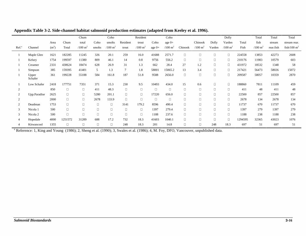
Salmonid Biostandards 3-16
Appendix Table 3-2. Side-channel habitat salmonid production estimates (adapted from Keeley et al. 1996).
Chum Coho Resident Coho Dolly Total Total Total
Area Chum total Coho smolts Resident trout Coho age 0+ Chinook Dolly Varden Total fish stream stream rear.
Ref.a Channel (m2) Total /100 m2 smolts /100 m2 trout /100 m2 age 0+ /100 m2 Chinook /100 m2 Varden /100 m2 Fish /100 m2 rear.fish fish/100 m2
1 Maple Glen 1621 182285 11245 326 20.1 259 16.0 41688 2571.7 ⋅ ⋅ ⋅ ⋅ 224558 13853 42273 2608
1 Kelsey 1754 199597 11380 809 46.1 14 0.8 9756 556.2 ⋅ ⋅ ⋅ ⋅ 210176 11983 10579 603
1 Creamer 2331 430624 18474 628 26.9 31 1.3 662 28.4 27 1.2 ⋅ ⋅ 431972 18532 1348 58
1 Simpson 385 159395 41401 5 1.3 7 1.8 58001 15065.2 13 3.4 ⋅ ⋅ 217421 56473 58026 15072
1 UpperSchafer
361 199228 55188 584 161.8 187 51.8 9588 2656.0 ⋅ ⋅ ⋅ ⋅ 209587 58057 10359 2870
1 Low Schafer 2418 177751 7351 371 15.3 230 9.5 10493 434.0 15 0.6 ⋅ ⋅ 188860 7811 11109 459
2 850 ⋅ ⋅ 411 48.3 ⋅ ⋅ ⋅ ⋅ ⋅ ⋅ ⋅ ⋅ 411 48 411 48
2 Upp.Paradise 2625 ⋅ ⋅ 5280 201.1 ⋅ ⋅ 17220 656.0 ⋅ ⋅ ⋅ ⋅ 22500 857 22500 857
2 2000 ⋅ ⋅ 2678 133.9 ⋅ ⋅ ⋅ ⋅ ⋅ ⋅ ⋅ ⋅ 2678 134 2678 134
2 Deadman 1753 ⋅ ⋅ ⋅ ⋅ 3141 179.2 8596 490.4 ⋅ ⋅ ⋅ ⋅ 11737 670 11737 670
3 Nicola 1 500 ⋅ ⋅ ⋅ ⋅ ⋅ ⋅ 1397 279.4 ⋅ ⋅ ⋅ ⋅ 1397 279 1397 279
3 Nicola 2 500 ⋅ ⋅ ⋅ ⋅ ⋅ ⋅ 1188 237.6 ⋅ ⋅ ⋅ ⋅ 1188 238 1188 238
4 Hopedale 4000 1251572 31289 688 17.2 732 18.3 41603 1040.1 ⋅ ⋅ ⋅ ⋅ 1294595 32365 43023 1076
4 Kitwancool 1355 ⋅ ⋅ ⋅ ⋅ 248 18.3 201 14.8 ⋅ ⋅ 248 18.3 697 51 697 51
a Reference: 1, King and Young (1986); 2, Sheng et al. (1990); 3, Swales et al. (1986); 4, M. Foy, DFO, Vancouver, unpublished data.
Salmonid Biostandards 3-17
Appendix Table 3-3. Off channel ponds habitat salmonid production estimates (adapted from Keeley et al. 1996).
Total
Total Total coho Total Total Total Total
Area Total Total fish coho smolts Total coho Total stlh Total Dolly V Total Chinook
Referencea (ha) fish fish/ha /100 m2 smolts /100 m2 coho /100 m2 stlh /100 m2 Dolly V /100 m2 Chinook /100 m2
1 0.85 4100 4824 48.2 3613 42.5 4100 48.2 ⋅ ⋅ ⋅ ⋅ ⋅ ⋅1 1.29 5430 4209 42.1 1534 11.9 5430 42.1 ⋅ ⋅ ⋅ ⋅ ⋅ ⋅2 1 1979 1979 19.8 ⋅ ⋅ 1954 19.5 ⋅ ⋅ ⋅ ⋅ 25 0.3
2 0.1 214.5 2145 21.5 ⋅ ⋅ 171 17.1 ⋅ ⋅ ⋅ ⋅ 43.5 4.4
2 0.13 1233.5 9488 94.9 ⋅ ⋅ 1017.5 78.3 ⋅ ⋅ ⋅ ⋅ 216 16.6
3 0.97 4300 4433 44.3 ⋅ ⋅ 4024 41.5 ⋅ ⋅ ⋅ ⋅ 37.2 0.4
3 0.06 714 11900 119.0 ⋅ ⋅ 706.5 117.8 ⋅ ⋅ ⋅ ⋅ 7.5 1.3
4 8.3 1802 217 2.2 ⋅ ⋅ 1459 1.8 ⋅ ⋅ 343 0.4 ⋅ ⋅5 0.001 54 54000 540.0 ⋅ ⋅ 54 540.0 ⋅ ⋅ ⋅ ⋅ ⋅ ⋅6 0.056 1500 26786 267.9 11 2.0 1500 267.9 ⋅ ⋅ ⋅ ⋅ ⋅ ⋅7 0.018 519 28833 288.3 503 279.4 519 288.3 ⋅ ⋅ ⋅ ⋅ ⋅ ⋅8 0.5 3715 7430 74.3 4805 96.1 3715 74.3 ⋅ ⋅ ⋅ ⋅ ⋅ ⋅9 0.39 4649 11921 119.2 ⋅ ⋅ 2585 66.3 2064 52.9 ⋅ ⋅ ⋅ ⋅9 0.09 761 8456 84.6 ⋅ ⋅ 623 69.2 138 15.3 ⋅ ⋅ ⋅ ⋅9 0.52 7064 13585 135.8 ⋅ ⋅ 5831 112.1 1233 23.7 ⋅ ⋅ ⋅ ⋅9 0.6 1563 2605 26.1 ⋅ ⋅ 330 5.5 1233 20.6 ⋅ ⋅ ⋅ ⋅
10 0.1053 652 61.9
10 0.777 2794 36
11 0.118 414 35.1
a Reference: 1, Peterson (1982a); 2, Swales and Levings (1989); 3, Swales et al. (1986); 4, Swales et al. (1988); 5, Bustard and Narver (1975);6, Lister et al. (1980); 7, Cederholm and Scarlett (1991); 8, Cederholm et al. (1988); 9, M. Foy, DFO, Vancouver, unpublished data;10, Beniston et al. (1987) (1988); 11, Lister and Dunford (1989).
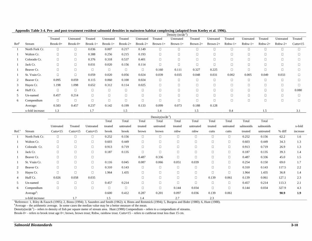
Salmonid Biostandards 3-18
Appendix Table 3-4. Pre- and post-treatment resident salmonid densities in mainstem habitat complexing (adapted from Keeley et al. 1996).Density (no⋅m-2)
Treated Untreated Treated Untreated Treated Untreated Treated Untreated Treated Untreated Treated Untreated Treated Untreated Treated
Refa Stream Brook-0+ Brook-0+ Brook-1+ Brook-1+ Brook-2+ Brook-2+ Brown-1+ Brown-1+ Brown-2+ Brown-2+ Rnbw-1+ Rnbw-1+ Rnbw-2+ Rnbw-2+ Cutts<15
1 North Fork Cr. ⋅ ⋅ 0.036 0.007 0.217 0.149 ⋅ ⋅ ⋅ ⋅ ⋅ ⋅ ⋅ ⋅ ⋅1 Walton Cr. ⋅ ⋅ 0.388 0.256 0.215 0.193 ⋅ ⋅ ⋅ ⋅ ⋅ ⋅ ⋅ ⋅ ⋅1 Colorado Cr. ⋅ ⋅ 0.376 0.318 0.537 0.401 ⋅ ⋅ ⋅ ⋅ ⋅ ⋅ ⋅ ⋅ ⋅1 Jack Cr. ⋅ ⋅ 0.031 0.020 0.156 0.114 ⋅ ⋅ ⋅ ⋅ ⋅ ⋅ ⋅ ⋅ ⋅1 Beaver Cr. ⋅ ⋅ ⋅ ⋅ ⋅ ⋅ 0.160 0.111 0.327 0.225 ⋅ ⋅ ⋅ ⋅ ⋅1 St. Vrain Cr. ⋅ ⋅ 0.059 0.020 0.056 0.024 0.039 0.035 0.048 0.031 0.002 0.005 0.049 0.033 ⋅2 Beaver Cr. 0.095 0.059 0.115 0.060 0.100 0.024 ⋅ ⋅ ⋅ ⋅ ⋅ ⋅ ⋅ ⋅ ⋅3 Hayes Cr. 1.198 1.098 0.652 0.312 0.114 0.025 ⋅ ⋅ ⋅ ⋅ ⋅ ⋅ ⋅ ⋅ ⋅4 Huff Cr. ⋅ ⋅ ⋅ ⋅ ⋅ ⋅ ⋅ ⋅ ⋅ ⋅ ⋅ ⋅ ⋅ ⋅ 0.080
5 Un-named 0.457 0.214 ⋅ ⋅ ⋅ ⋅ ⋅ ⋅ ⋅ ⋅ ⋅ ⋅ ⋅ ⋅ ⋅6 Compendium ⋅ ⋅ ⋅ ⋅ ⋅ ⋅ ⋅ ⋅ ⋅ ⋅ ⋅ ⋅ ⋅ ⋅ ⋅
Average: 0.583 0.457 0.237 0.142 0.199 0.133 0.099 0.073 0.188 0.128
x-fold increase: 1.3 1.7 1.5 1.4 1.5 0.4 1.5 3.1
Density(no⋅m-2)Total Total Total Total Total Total Total Total Total Total
Untreated Treated Untreated treated untreated treated untreated treated untreated treated untreated salmonids salmonids x-fold
Ref.a Stream Cutts<15 Cutts>15 Cutts>15 brook brook brown brown rnbw rnbw cutts cutts treated untreated % diff increase
1 North Fork Cr. ⋅ ⋅ ⋅ 0.252 0.156 ⋅ ⋅ ⋅ ⋅ ⋅ ⋅ 0.252 0.156 62.2 1.6
1 Walton Cr. ⋅ ⋅ ⋅ 0.603 0.449 ⋅ ⋅ ⋅ ⋅ ⋅ ⋅ 0.603 0.449 34.3 1.3
1 Colorado Cr. ⋅ ⋅ ⋅ 0.913 0.719 ⋅ ⋅ ⋅ ⋅ ⋅ ⋅ 0.913 0.719 26.9 1.3
1 Jack Cr. ⋅ ⋅ ⋅ 0.187 0.135 ⋅ ⋅ ⋅ ⋅ ⋅ ⋅ 0.187 0.135 39.3 1.4
1 Beaver Cr. ⋅ ⋅ ⋅ 0.487 0.336 ⋅ ⋅ ⋅ ⋅ 0.487 0.336 45.0 1.5
1 St. Vrain Cr. ⋅ ⋅ ⋅ 0.116 0.045 0.087 0.066 0.051 0.039 ⋅ ⋅ 0.254 0.150 69.0 1.7
2 Beaver Cr. ⋅ ⋅ ⋅ 0.310 0.143 ⋅ ⋅ ⋅ ⋅ ⋅ ⋅ 0.310 0.143 117.5 2.2
3 Hayes Cr. ⋅ ⋅ ⋅ 1.964 1.435 ⋅ ⋅ ⋅ ⋅ ⋅ ⋅ 1.964 1.435 36.8 1.4
4 Huff Cr. 0.026 0.058 0.035 ⋅ ⋅ ⋅ ⋅ 0.139 0.061 0.139 0.061 127.1 2.3
5 Un-named ⋅ ⋅ ⋅ 0.457 0.214 ⋅ ⋅ ⋅ ⋅ ⋅ ⋅ 0.457 0.214 113.3 2.1
6 Compendium ⋅ ⋅ ⋅ ⋅ ⋅ ⋅ ⋅ 0.144 0.034 ⋅ ⋅ 0.144 0.034 327.9 4.3
Averageb: 0.600 0.412 0.287 0.201 0.097 0.036 0.139 0.061 90.9 1.9
x-fold increase: 1.7 1.5 1.4 2.7 2.3aReference: 1, Riley & Fausch (1995); 2, Binns (1994); 3, Saunders and Smith (1962); 4, Binns and Remmick (1994); 5, Burgess and Bider (1980); 6, Hunt (1988).bAverage – the arithmetic average. In some cases the median value may be a better measure of the mean.Density(no⋅m-2) – refers to density of fish per square meter of stream area. Hunt (1988) Compendium – refers to a compendium of streams.Brook-0+ - refers to brook trout age 0+; brown, brown trout; Rnbw, rainbow trout. Cutts<15 – refers to cutthroat trout less than 15 cm.
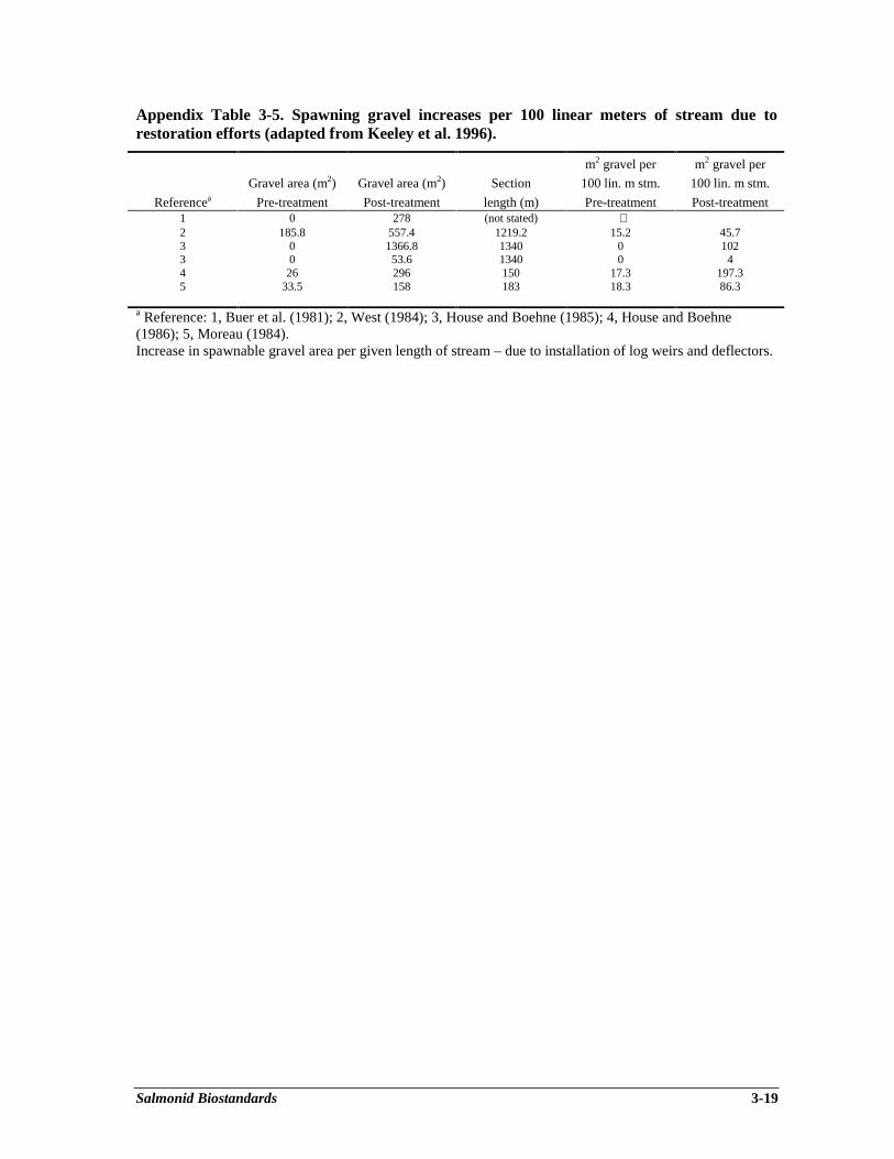
Salmonid Biostandards 3-19
Appendix Table 3-5. Spawning gravel increases per 100 linear meters of stream due torestoration efforts (adapted from Keeley et al. 1996).
Referencea
Gravel area (m2)
Pre-treatment
Gravel area (m2)
Post-treatment
Section
length (m)
m2 gravel per
100 lin. m stm.
Pre-treatment
m2 gravel per
100 lin. m stm.
Post-treatment1 0 278 (not stated) ⋅2 185.8 557.4 1219.2 15.2 45.73 0 1366.8 1340 0 1023 0 53.6 1340 0 44 26 296 150 17.3 197.35 33.5 158 183 18.3 86.3
a Reference: 1, Buer et al. (1981); 2, West (1984); 3, House and Boehne (1985); 4, House and Boehne(1986); 5, Moreau (1984).Increase in spawnable gravel area per given length of stream – due to installation of log weirs and deflectors.
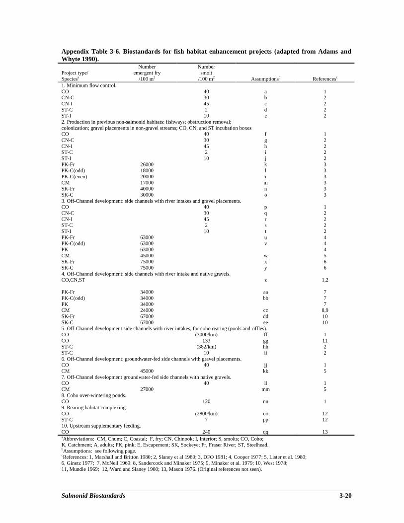
Salmonid Biostandards 3-20
Appendix Table 3-6. Biostandards for fish habitat enhancement projects (adapted from Adams andWhyte 1990).
Project type/Speciesa
Numberemergent fry
/100 m2
Numbersmolt
/100 m2 Assumptionsb Referencesc
1. Minimum flow control.CO 40 a 1CN-C 30 b 2CN-I 45 c 2ST-C 2 d 2ST-I 10 e 22. Production in previous non-salmonid habitats: fishways; obstruction removal;colonization; gravel placements in non-gravel streams; CO, CN, and ST incubation boxesCO 40 f 1CN-C 30 g 2CN-I 45 h 2ST-C 2 i 2ST-I 10 j 2PK-Fr 26000 k 3PK-C(odd) 18000 l 3PK-C(even) 20000 i 3CM 17000 m 3SK-Fr 40000 n 3SK-C 30000 o 33. Off-Channel development: side channels with river intakes and gravel placements.CO 40 p 1CN-C 30 q 2CN-I 45 r 2ST-C 2 s 2ST-I 10 t 2PK-Fr 63000 u 4PK-C(odd) 63000 v 4PK 63000 4CM 45000 w 5SK-Fr 75000 x 6SK-C 75000 y 64. Off-Channel development: side channels with river intake and native gravels.CO,CN,ST z 1,2
PK-Fr 34000 aa 7PK-C(odd) 34000 bb 7PK 34000 7CM 24000 cc 8,9SK-Fr 67000 dd 10SK-C 67000 ee 105. Off-Channel development side channels with river intakes, for coho rearing (pools and riffles).CO (3000/km) ff 1CO 133 gg 11ST-C (382/km) hh 2ST-C 10 ii 26. Off-Channel development: groundwater-fed side channels with gravel placements.CO 40 jj 1CM 45000 kk 57. Off-Channel development groundwater-fed side channels with native gravels.CO 40 ll 1CM 27000 mm 58. Coho over-wintering ponds.CO 120 nn 19. Rearing habitat complexing.CO (2800/km) oo 12ST-C 7 pp 1210. Upstream supplementary feeding.CO 240 qq 13aAbbreviations: CM, Chum; C, Coastal; F, fry; CN, Chinook; I, Interior; S, smolts; CO, Coho;K, Catchment; A, adults; PK, pink; E, Escapement; SK, Sockeye; Fr, Fraser River; ST, Steelhead.bAssumptions: see following page.cReferences: 1, Marshall and Britton 1980; 2, Slaney et al 1980; 3, DFO 1981; 4, Cooper 1977; 5, Lister et al. 1980;6, Ginetz 1977; 7, McNeil 1969; 8, Sandercock and Minaker 1975; 9, Minaker et al. 1979; 10, West 1978;11, Mundie 1969; 12, Ward and Slaney 1980; 13, Mason 1976. (Original references not seen).
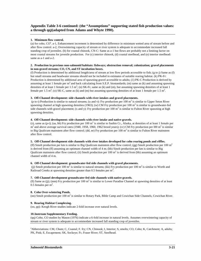
Salmonid Biostandards 3-21
Appendix Table 3-6 continued: (the “Assumptions” supporting stated fish production values:a through qq)(adapted from Adams and Whyte 1990).
1. Minimum flow control.(a) for coho, COa. a-1, Enhancement increment is determined by difference in minimum wetted area of stream before andafter flow control. a-2, Overwintering capacity of stream or river system is adequate to accommodate increased fallstanding crop of juveniles. (b) for coastal chinook, CN-C: Same as a-1 but flows are probably not a limiting factor onmost coastal streams for juvenile production. For (c) interior chinook, (d) coastal steelhead, and (e) interior steelhead:same as a-1 and a-2.
2. Production in previous non-salmonid habitats: fishways; obstruction removal; colonization; gravel placementsin non-gravel streams; CO, CN, and ST incubation boxes.(f) Production is determined by additional length/area of stream at low flow periods accessible to fish; (g to j) Same as (f)but small streams and headwater streams should not be included in estimates of suitable rearing habitat. (k) PK-Fr:Production is determined by additional area of spawning gravel accessible to adults; (1) PK-C Production is derived byassuming at least 1 female per m2 and back calculating from S.E.P. biostandards; (m) same as (k) and assuming spawningdensities of at least 1 female per 1.5 m2; (n) SK-Fr, same as (k) and (m), but assuming spawning densities of at least 1female per 1.5 m2; (o) SK-C, same as (k) and (m) but assuming spawning densities of at least 1 female per 1.5 m2.
3. Off-Channel development: side channels with river intakes and gravel placements. (p to t) Production is similar to natural streams; (u and v): Fry production per 100 m2 is similar to Upper Seton Riverspawning channel at high spawning densities (1963); (w) CM Fry production per 100 m2 is similar to groundwater-fedside channels with gravel placement; (x and y): Fry production per 100 m2 is similar to Fulton River spawning at highspawning densities.
4. Off-Channel development: side channels with river intake and native gravels.(z), same as (p-t); (aa, bb) Fry production per 100 m2 is similar to Sashin Cr., Alaska, at densities of at least 1 female perm2 and above average survival rates (1940, 1958, 1960, 1962 brood years); (cc) CM Fry production per l00 m2 is similarto Big Qualicum mainstem after flow control; (dd, ee) Fry production per 100 m2 is similar to Fulton River mainstemafter flow control.
5. Off-Channel development side channels with river intakes developed for coho rearing ponds and riffles.(ff) Smolt production per km is similar to Big Qualicum mainstem after flow control; (gg) Smolt production per 100 m2
is derived from (ff) assuming an optimum channel width of 4 m; (hh) Sinolt production per km is similar to BigQualicum mainstem after flow control; (ii) Smolt production per 100 m2 is derived from (hh) assuming an optimumchannel width of 4 m.
6. Off-Channel development: groundwater-fed side channels with gravel placements. (jj) Smolt production per 100 m2 is similar to natural streams; (kk) Fry production per 100 m2 is similar to Worth andRailroad Creeks at spawning densities greater than 0.5 females per m2.
7. Off-Channel development groundwater-fed side channels with native gravels.(ll) Same as (jj); (mm) Fry production per 100 m2 is similar to Lower Paradise Channel at spawning densities of at least0.5 females per m2.
8. Coho Over-wintering Ponds.(nn) Smolt production per 100 m2 is similar to Rotary Park, Bible Camp and Cowichan Side Channels, Cowichan River.
9. Rearing Habitat Complexing.(oo, pp): Keogh River studies indicate 2-fold increase over natural levels.
10.Instream Supplementary Feeding.(qq) Coho, CO studies by Mason (1976) indicate a 6-fold increase in natural levels. Assumes overwintering capacity ofstream or river system is adequate to accommodate increased fall standing crop of juveniles.
aAbbreviations: CM, Chum; C, Coastal; F. fry; CN, Chinook; I, Interior; S, smolts; CO, Coho; K, Catchment; A, adults;PK, Pink; E, Escapement; SK, Sockeye; Fr, Fraser River; ST, Steelhead.
Screening Criteria for Restoration Projects 4-1
Chapter 4Screening Criteria for Restoration Projects
Brian L. Scarfe1
PREFACE
Watershed Restoration Program proposals have been evaluated for funding according toseveral criteria, including (prioritized) resource benefits, community stability, employment, andpartnerships. In addition, resource management agencies have ranked watersheds by historicalaquatic resource values and degree of perceived impact from past logging practices, therebyattempting to focus proposals on the more historically important, but degraded, aquatic ecosystems.The primary purpose of the screening criteria described in this chapter is to facilitate rankings ofaquatic restoration projects within a watershed, although the methodology could be applied tocompare the merits of proposal submissions. The menu of potential aquatic restoration projectswithin a moderately-sized watershed are typically numerous (20-50) as an outcome of conditionassessments that identify restoration needs and feasible opportunities with preliminaryprescriptions. Decisions on which of these projects should proceed and in what time sequence canbe made with the assistance of the project screening criteria outlined in this chapter. Cost-benefitanalyses can be arranged and compared on a spreadsheet, then weighted according to urgency inreturning the condition to an acceptable environmental standard, and by estimates of communityemployment benefits. Thus, decisions on implementing annual sets of projects within a watershedcan be more systematic and effective, generating greater resource benefits per expenditure in boththe short and long term.
INTRODUCTION
This chapter outlines a practical methodology for the assessment of environmental restorationprojects from the perspective of their value to society. Essentially, the chapter provides a user-friendly approach to the implementation of a multiple account evaluation framework for screeningwatershed rehabilitation projects. The framework relies upon an environmental standards filter thatis consistent with the rehabilitation goals of Forest Renewal BC’s Watershed Restoration Programto provide the necessary condition for project approval, an economic benefits filter to provide thesufficient condition for project support, and an employment generation and community stabilityfilter to provide the “supporting cast” that resolves judgment calls when the economic benefitsfilter provides uncertain results.
In addition, the chapter outlines the economic values that are relevant to the overall assessmentof the integrated fisheries, forestry, recreation, and other benefits of rehabilitation projects in amanner that allows these benefits to be balanced against the costs of such projects. An appropriate“social rate of discount” is identified for the present value calculations that may be needed toassess restoration projects with multi-faceted, time-dependent and uncertain environmentalbenefits.
________________________1 BriMar Consultants Ltd., 1078 Quailwood Place, Victoria, BC V8X 4P2

Screening Criteria for Restoration Projects 4-2
The chapter has six major sections, relating to:• evaluation criteria for rehabilitation projects,• the environmental standards filter,• the economic benefits filter,• the employment benefits and community stability filter,• improving cost effectiveness through iterative risk assessments and adaptive management
strategies, and• composite guidelines for screening rehabilitation projects.A final section containing a brief summary appears at the end of the chapter.
EVALUATION CRITERIA FOR REHABILITATION PROJECTS
The fundamental rehabilitation goal of the Watershed Restoration Program (WRP) is torestore, protect and maintain fisheries, aquatic and forest resources that have been adverselyimpacted by logging operations and that would otherwise require several decades, if not centuries,to recover naturally. Funding is to be provided by Forest Renewal BC (FRBC) to successfulapplicants in support of rehabilitation proposals that are consistent with this fundamentalFRBC/WRP goal. Proposals are evaluated on the basis of four underlying criteria, each of whichhas a weighting factor attached to it. These four criteria are prioritized as resource benefits,community stability, employment generated and partnership development. Under the fundamentalcriterion of resource benefits, watershed rehabilitation proposals are evaluated on their technicalfeasibility and on their project costs in relationship to their potential benefits, measured from theperspective of fisheries, aquatic and forest resource rehabilitation.
From this criteria, it follows that FRBC/WRP funding should only be made available forprojects that make a positive contribution towards the restoration and improvement of theecological health of a particular watershed. Eligibility for funding, therefore, requires that anappropriate environmental standards filter be met. However, as a necessary condition for projecteligibility, the environmental standards filter will, in most instances, be multi-faceted because ofthe variety of resources that are affected by the ecological health of a watershed.
Before funding is provided to a watershed rehabilitation project that passes the necessaryenvironmental standards filter, it also needs to be demonstrated that there is a reasonableprobability that the project would also pass a cost-benefit filter. Since the economic andenvironmental benefits to society of many restoration projects are likely to be both time-dependentand uncertain, it will often be difficult to assess whether or not these projects pass the sufficientcondition for funding, namely that their net present value from a societal perspective is positive.Nevertheless, in principle, the economic benefits criterion of positive net present value ought to beused to provide the sufficiency test, which permits one to choose those projects to be funded fromamong all projects that satisfy the necessary environmental standards criterion.
When the economic benefits criterion only provides ambiguous results, the balance may betipped in one direction or the other by considering a community stability/employmentgeneration/partnership development filter. The greater these potential social benefits are, the lesslikely will it be that major allocative mistakes will occur when judgment calls are made to providefunding to rehabilitation projects for which the positive net present value or economic benefitscriterion cannot be demonstrated to have been met.

Screening Criteria for Restoration Projects 4-3
In summary, the project screening criteria for watershed rehabilitation projects that are beingarticulated in this chapter are hierarchical in structure. First, a necessary condition for fundingeligibility is that the project pass an environmental standards filter. A necessary and sufficientcondition for funding approval is that the project pass both an environmental standards filter and aneconomic benefits (positive net present value) filter. In cases where the potential economic benefitsare too uncertain for one to be able clearly to demonstrate that the project passes the cost-benefitfilter, additional consideration should be given to the potential social benefits that the rehabilitationproject may provide. The environmental, economic and social benefits of watershed rehabilitationprojects may overlap in various ways. In particular, some of the social benefits may also classify aseconomic benefits. However, as further articulated in the following sections, there is considerablemerit in taking a hierarchical decision-making approach to the evaluation of watershedrehabilitation projects. A logical decision-making process is thereby imposed on the multipleaccount evaluation framework.
THE ENVIRONMENTAL STANDARDS FILTER
Watershed rehabilitation projects should be assessed within an environmental standardsframework that encompasses the complete ecological health of the watershed. The restoration ofaquatic resources involves improvements to the quality of stream flows, fish-rearing habitats,riparian forest lands and associated wetlands. It also involves the reduction in hillslope erosionthrough road-bed restoration, the restoration of forest cover with appropriate species selection and,wherever possible, the re-establishment of natural drainage networks. Improvements to tributarystreams and off-channel habitats as well as to the mainstem will often be involved. Althoughrestoration of forest resources and of aquatic resources are ordinarily interdependent, aquaticrestoration is usually a necessary condition for the restoration of fisheries resources, independent ofwhether the focus of concern is with the commercial, aboriginal or recreational fisheries. Aquaticrestoration and forest restoration are often required together for the restoration of recreationalvalues, including values that relate to the abundance and variety of wildlife and birds.
It will often not be possible (nor always desirable) to restore watersheds that have beenimpacted by logging operations to a pristine, as-it-was, state of nature. Nevertheless, theenvironmental standards filter should ensure that eligible rehabilitation projects satisfy “best-practice” techniques for restoring ecosystem health to the watershed. No resource values should beignored in this process. In particular, the restoration of fish habitat and riparian lands adjacent tothe streambed must be considered along with forestry values, even though their impact on fisheries,wildlife and recreational values is indirect. (Compare Iverson and Alston 1994.)
Several other chapters in this volume identify and illuminate the “best-practice” techniques thatare available for resolving particular situations of fish habitat degradation. Individual rehabilitationprojects should be evaluated in relationship to known “best-practice” techniques by appropriatetechnical assessors. Technical feasibility and project cost, in particular, should be reviewed in thislight. Where appropriate, technical assessors should recommend modifications to project proposalsthat would bring their actual implementation closer in line with known “best-practice” techniques.
It is not the purpose of this chapter to elaborate upon the nature of the “best-practice”techniques that are to be used in the restoration of the various components of degraded watersheds.Nevertheless, project proposals should be evaluated from the perspective of how closely theyimplement “best-practice” techniques. Indeed, such proximity should be a required element of the
Screening Criteria for Restoration Projects 4-4
environmental standards filter, and only projects that pass this proximity test should be eligible forFRBC/WRP funding.
THE ECONOMIC BENEFITS FILTER
The economic and environmental benefits that are associated with watershed rehabilitationprojects are multi-faceted, time-dependent and uncertain. There may be potential benefits tofisheries resources that accrue only gradually over time in response to water quality and fish habitatimprovements. There may be aquatic and recreational resource improvements that also accruegradually. Finally, there may be enhancements to forest resource values, which could take acentury or more to achieve their full maturity. Because all of these potential benefits accrue atvarious times in the future, it is essential to convert all future values into the present so that theycan be compared with current project costs. In addition, it is appropriate to evaluate all costs andbenefits in dollars of constant purchasing power. Project evaluation should be undertaken bybringing all costs and benefits into present values, measured in equivalent dollars of today’spurchasing power. Accordingly, future values should be expressed in constant dollars of today’spurchasing power and then discounted back to the present using an appropriate real (or inflation-adjusted) rate of interest.
The appropriate real rate of interest for discounting the future benefit stream that may beassociated with watershed rehabilitation projects combines additively a basic time-preferenceelement with a specific risk-premium. However, a case can be made for setting at least one of thesetwo elements equal to zero. The reason for this is that, in a general sense, the value to society of asound ecosystem ought to increase gradually over time in a way that offsets the effect ofdiscounting on the present value of the future stream of benefits, which may accrue frominvestments in ecosystem restoration that are made today. In particular, there may be a general gainin the form of a “public good externality” that accrues from these investments through theirpotential to preserve and/or enhance the biodiversity of the environment. Put differently, there is ageneral ecosystem risk to society if watershed restoration investments are not made and theenvironment is allowed to deteriorate. This general risk may be accommodated in present valuecalculations by either dropping the time-preference element or the specific risk-premium.
Nevertheless, specific investments in ecosystem restoration made today all have outcomes thatnot only accrue in the future but also are to some degree uncertain. Accordingly, a real discountrate that reflects their future orientation and their basic uncertainty should be applied to theseinvestments, but one that takes into account the offsetting general riskiness of not undertakinginvestments in ecosystem health or, alternatively, the increasing value of ecosystem health tosociety. Thus, it would be appropriate to apply a real discount rate of perhaps 3% per annum to thepresent value calculations that necessarily underlie the application of a cost-benefit filter to theevaluation of watershed rehabilitation projects. The application of significantly higher real discountrates would not be appropriate in this context. (Compare Pearce and Turner 1990, Chapter 14, andZerbe and Dively 1994, Chapter 13.)
The economic and environmental benefits that enter the determination of net present valueusing the suggested 3% real discount rate are likely to be multi-faceted in the case of watershedrehabilitation projects. There may be a potential gain from the recovery of the fish stocks availableto the commercial, aboriginal and/or recreational fisheries. There may be a potential gain from therenewed availability of clean water, from both instream use and consumptive use perspectives.Recreational values may be enhanced by an increased abundance and variety of the flora and fauna
Screening Criteria for Restoration Projects 4-5
of the particular watershed. Forest values may also be enhanced, if harvestable timber is enabled toregenerate more quickly through watershed restoration activities. For each relevant future timeperiod, each of these potential gains should be aggregated into a single time-specific sum beforethe whole stream of time-specific sums is discounted back into net present value terms. Since thecosts associated with the watershed rehabilitation project may also be incurred in various timeperiods, the net present value (NPV) calculation involves the following discounted sum:
NPV = B0 - C0 + B1 - C1 + B2 - C2 + . . . + BT - CT , 1 + r (1 + r)2 (1 + r)T
where B1 represents the aggregated benefits made available by the project in year 1, 1 = 0...T.C1 represents the costs incurred with respect to the project in the same year, and r is the realdiscount rate, recommended herein to be set at 3% per annum. Projects that pass the economicbenefits filter will have an NPV that is greater than or equal to zero. (An example is presented inAppendix 4-1.)
Fisheries benefits should ordinarily be estimated in the following way. Let S be the kilometriclength of streambed in which habitat improvements are likely to occur; let K be the likely impactper kilometer of upgraded streambed in the particular watershed on the relevant fish stocks(measured in terms of adult fish); and let Y be the average weight in kilograms of an adult memberof the relevant fish species. Then “SKY” is the estimated growth in the biomass of the relevant fishspecies that potentially may result from the watershed improvements, which are undertaken.
The economic value of this potential biomass growth will depend upon the particular fish speciesin question. It is recommended that the following prices be used for various fish species inestimating the economic value of biomass restoration, so that “SKY” should be multiplied by thesesuggested price parameters for each period in which the additional potential biomass is available:
anadromous salmonid fish resources other freshwater fish resources
steelhead $4.50 ⋅ kg-1 kokanee $3.00 ⋅ kg-1
chinook $5.00 ⋅ kg-1 trout $2.50 ⋅ kg-1
sockeye $5.00 ⋅ kg-1 other sport fish $2.00 ⋅ kg-1
coho $4.00 ⋅ kg-1
chum $2.50 ⋅ kg-1
pink $2.00 ⋅ kg-1
The suggested price parameters given above are intended to represent the intrinsic value tosociety of marginal additions to fish biomass, regardless of whether the associated fish become partof the annual catch of a particular fishery. They are therefore intended to represent an amalgam ofcommercial fishery values, recreational fishery values, aboriginal fishery values and spawnervalues. However, it is known that sockeye, chum and pink are mostly of importance to thecommercial fishery; steelhead and the various freshwater fish resources are mostly of importanceto the recreational fishery; and chinook and coho are of importance to both these fisheries. Theaboriginal fishery draws variously upon all of these fish resources in different areas of theprovince. Fish left uncaught and free to spawn are obviously of importance to the survival of anyparticular fish species.
Screening Criteria for Restoration Projects 4-6
Although these price parameters are all intended to represent the intrinsic value of fish, theyare nevertheless based upon estimates of commercial fishery values provided in two recent reportspublished by the ARA Consulting Group Inc. The prices for chinook and coho rest upon thefirmest analytical basis, since they are the 1994 all-B.C. short-term marginal values to thecommercial fishery provided in the 1996 ARA report, rounded to the nearest whole dollar. Theprices suggested for the other salmonids (except steelhead) are based upon all-B.C. estimatesaveraged for 1991-93 that were provided in the earlier 1994 ARA report, appropriately adjusted toreflect the approximate degree of augmentation measured in the commercial values of chinook andcoho between the two ARA Consulting Group Inc. reports. The values placed upon steelhead andresident freshwater fish resources are essentially “best guesses” derived from the commercially-based intrinsic values of the various salmonids, since these fish are essentially not part of the B.C.commercial fishery.
These intrinsic price parameters should be applied in any cost-benefit analysis regardless ofwhether the additional potential biomass is expected to be harvested in a particular fishery or left toregenerate under the constraints of natural attrition. However, in cases where the watershedrehabilitation project also increases the value of a recreational fishery, an additional benefit equalto the estimated increase in angler-days per year multiplied by a pricing factor of $40 per angler-day should be specified, consistent with the 1996 ARA report finding that the marginal values ofchinook and coho resources in the recreational fishery exceed those found for the commercialfishery. More generally, the same $40 per adult-visitor-day could be used in assigning amenityvalues to other recreational benefits that may result from the watershed rehabilitation project. This$40 figure seems consistent with current practice in the Pacific Northwest, and B.C. in particular.(For further discussion, see Fortrends Consulting Inc., et al. 1991.)
Forest resource values may also be enhanced and brought forward towards the present bysuccessful watershed rehabilitation projects. However, if earlier timber harvesting is made feasible,the harvests that are thereby foregone at a later date need to enter the net present value calculationin an offsetting way. What is important to measure is the incremental net value generated fromtimber harvests as they accrue over time, where the incremental net value in any particular year isderived by deducting from the estimated value of the additional timber harvested all associatedharvesting, silviculture and management costs, not including stumpage payments made to theCrown since these payments represent part of the incremental net value.
Species, quality and locational differences are all of considerable importance in assessing theeconomic value of timber harvests. Nevertheless, it is recommended that only species differentialsbe recognized in assessing enhancements to timber values that may incidentally arise fromassociated watershed rehabilitation projects. The following price parameters, all measured indollars per cubic meter ($ ⋅ m-3 ), are suggested for use, where appropriate, in assessing theincremental net value generated from B.C. timber harvests:
Cypress $135 ⋅ m-3 Fir $110 ⋅ m-3
Cedar $100 ⋅ m-3 Spruce $100 ⋅ m-3
Hemlock $ 80 ⋅ m-3 Pine $ 75 ⋅ m-3
Alternatively, a simple average net value of $100 . m-3 could be used. Improvements in waterquality should also be appropriately valued from an instream use and/or consumptive useperspective, as appropriate.
Screening Criteria for Restoration Projects 4-7
Given these basic resource values, it should be possible to form an aggregated estimate of thepotential value of the resource benefits accruing in each future year, and from this stream ofbenefits and associated costs obtain an estimate of the net present value of the rehabilitationproject. Of course, for most watershed rehabilitation projects, one will at best be able to provide agross estimate of the overall resource benefits for comparison with overall project costs.Nevertheless, it is important to attempt this, even if implicitly, in assessing the relative merits ofproposed watershed rehabilitation projects. An example of the use of the net present valueapproach to the assessment of a fictitious, but typical, watershed stream restoration proposalinvolving fish habitat rehabilitation at Trout Creek, B.C., is provided in Appendix 4-1.
THE EMPLOYMENT BENEFITS AND COMMUNITY STABILITY FILTER
The economic benefits filter outlined in the previous section made no mention of possibleemployment benefits or benefits to community stability that might result from the allocation ofFRBC/WRP funding to watershed rehabilitation projects. These indirect spill-over benefits maywell be important from a social perspective, and should be weighted into the complete evaluationprocess whenever the economic benefits filter gives uncertain results. However, they should not beadded together with the direct economic and environmental benefits that enter the net present valuecalculation.
The reason is that similar employment impacts and community stability impacts couldalternatively be obtained by spending the same amount of public money directly in thecommunities adjacent to the proposed watershed rehabilitation project, instead of allocating thisfunding to the project itself. Accordingly, positive impacts on employment generation and/orcommunity stability (and/or, for that matter, partnership development) should not be counted asdirect gains from the expenditure of FRBC/WRP funds on particular watershed rehabilitationprojects. Rather, emphasis should be placed on the question of whether or not funding allocationsfrom FRBC/WRP to the particular project are the best way of achieving these positive impacts, incomparison with other ways of using the same amount of public funding to meet these ends.
Indirect gains to employment generation and/or community stability should only be given a“supporting cast” role in the overall assessment of proposed watershed rehabilitation projects.Their presence or absence should only be used to tip the balance towards funding or away fromfunding when the economic benefits filter fails to indicate a strong probability of either positive ornegative net present value as a result of the uncertainties involved in measuring project benefitsand, in some instances, project costs. This is not to say that employment generation and communitystability (along with partnership development) are unimportant objectives. It is simply that theseobjectives should not be considered to be the primary ones when FRBC/WRP funding is beingcontemplated.
IMPROVING COST EFFECTIVENESS THROUGH ITERATIVE RISKASSESSMENTS AND ADAPTIVE MANAGEMENT STRATEGIES
Many watershed rehabilitation projects will involve an element of “learning-by-doing”. Forthis reason, it will be valuable to approach watershed restoration in the province through thefunding of manageable-sized projects. Pooling the knowledge gained from the effective monitoringof such manageable-sized projects will be helpful in reducing the uncertainties associated withwatershed rehabilitation projects that are to be developed in the future. This is particularlyimportant on the benefits assessment side, but it also relates to the technical effectiveness of project

Screening Criteria for Restoration Projects 4-8
design. The pooling of the knowledge obtained from effective monitoring also provides for theevolution over time of “best-practice” techniques in a manner that responds to up-to-date scientificand practical experience.
Cost effectiveness can be improved by the use of iterative risk assessments and adaptivemanagement strategies. Manageable-sized projects provide the flexibility for frequent reassessmentof the risks associated with the adoption of specific mitigation and rehabilitation measures invarious watersheds. They also provide project and program managers with the opportunity toreconsider their restoration strategies at frequent intervals. “Learning-by-doing” is less likely tooccur as effectively when indivisible large-scale rehabilitation projects are undertaken, since theseprojects may well become locked into the use of yesterday’s “best-practice” techniques. Whereverpossible, therefore, it is useful to approach mitigation and rehabilitation programs in a sequentialmanner, which allows at least the preliminary environmental outcomes from each individualproject to be assessed before the next related project is fully underway. As a result, the costeffectiveness of the whole program is likely to be enhanced.
Training is also an important component in environmental restoration work. Althoughconsiderable knowledge can be imparted through formal training programs, there is no readysubstitute for “on-the-job” training. Cost effectiveness for the whole watershed restoration programwill be well-served if representative rehabilitation projects are selected to provide theapprenticeship training venue for new rehabilitation workers.
COMPOSITE GUIDELINES FOR SCREENING REHABILITATION PROJECTS
The multiple account evaluation framework outlined in this chapter essentially uses theenvironmental standards filter to provide the necessary condition for a proposed watershedrehabilitation project to be eligible for FRBC/WRP funding; it uses the economic benefits filter(the positive net present value criterion) to provide the sufficient condition for funding approval foreach project proposal; and it uses the employment benefits and community stability filter toprovide the “supporting cast” when it is unclear whether or not the economic benefits filter issatisfied. The decision matrix proposed here is, therefore, the simple one illustrated in Fig. 4-1.
Figure 4-1. Proposed decision matrix for screening watershed restorationprojects involving fish habitat rehabilitation.
Screening Criteria for Restoration Projects 4-9
It should be noted that at two points in this diagram the project applicants could be invited toresubmit their proposal after suitable revisions have been made. The first of these occurs ifeligibility is questionable because the necessary environmental standards filter gives uncertainresults. The second of these occurs if the economic benefits filter and the substitute employmentbenefits and community stability filter both give uncertain results. Projects that pass theenvironmental standards filter but fail the economic benefits filter should not be approved forfunding. Moreover, projects that pass the environmental standards filter, but for which theeconomic benefits filter gives uncertain results, should only be approved for funding if they alsopass the substitute employment benefits and community stability filter. This third filter should notbe used as a substitute for the economic benefits filter if this second filter indicates failure bygenerating a negative net present value.
SUMMARY
This chapter has outlined a user-friendly approach to the implementation of a multiple accountevaluation framework for screening watershed rehabilitation projects. This approach has threecomponents. An environmental standards filter provides the necessary condition for projectapproval, while an economic benefits filter involving the usual cost-benefit criterion of positive netpresent value provides the sufficient condition. In cases in which it is unclear whether or not thesufficient condition has been met, an employment benefits and community stability filter may beused to break the uncertainty.
The use of a 3% real discount rate is recommended for the calculation of net present value inthe assessment of the economic and environmental benefits of watershed rehabilitation projects.Also recommended are certain resource values to be used for assessing the fisheries, aquatic,recreational and forest resource benefits that may accrue to watershed rehabilitation projects. Theproject screening criteria outlined should be of considerable value to both the applicants and thereviewers who are involved in the project evaluation process for environmental restoration projectproposals.
Appendix 4-1. An Example of Net Present Value Estimation for a Proposed Fish HabitatRehabilitation Project.
This appendix sets out a numerical example of the net present value calculation on which theeconomic benefits filter outlined earlier in this chapter is based. The numerical example is basedupon the Trout Creek Fish Habitat Rehabilitation proposal, a fictitious proposal which has beenused by the Watershed Restoration Program to illustrate the nature of the applications that theprogram managers expect to receive.
The Trout Creek Fish Habitat Rehabilitation proposal requests two inputs of funding, $30,800in year zero, and $10,000 in year one, with co-funding contributions amounting to $5,000 in eachof these two years. Although the co-funding contributions are in large part volunteer labour, theyshould still be included as part of the real costs of the project. The estimated long-term resourcebenefits from the project involve coho recovery/restoration of 305 adults per year, beginning inyear four, and steelhead recovery/restoration of 35 adults per year, beginning in year five. Thesegains are expected to continue to accrue for twenty years after these adult returns commence. Noother specific resource benefits are identified.
Screening Criteria for Restoration Projects 4-10
Since Trout Creek is in the Harrison Lake watershed adjacent to the lower Fraser Valley, theaverage weights of these incremental adult coho and steelhead are conservatively estimated to be3.2 kg and 5.0 kg, respectively. All of the incremental steelhead are assumed to be counted asavailable to the recreational fishery. Accordingly, an estimated 70 angler-days per year are likely tobe created, at an estimated recreational value of $40 per angler-day, given the basic assumptionthat the existence of one steelhead generates two angler-days. On the other hand, it is also assumedthat all of the incremental coho are counted as being available to the commercial fishery. As aresult, the overall estimate of 70 additional angler-days per year should be considered a reasonablyconservative one, because some of the coho would probably be available to the marine andfreshwater recreational fisheries. Although the actual harvest rate should not exceed 60% ifsufficient fish numbers are to survive for spawning, all fish biomass restoration should be countedon the “fish have intrinsic value” assumption. This assumption renders it unnecessary to estimateharvest rates for the purpose of net present value calculations.
Using the suggested biomass prices cited earlier in this chapter, the costs and benefits related tothe proposed rehabilitation project are as follows:
Year 0 $35,800, basic cost outlayYear 1 $15,000, basic cost outlayYear 2 0Year 3 0Year 4 $ 3,904, annual coho value (305 ⋅ 3.2 kg ⋅ $4.00 ⋅ kg-1)Year 5 $ 3,904
+ $ 787.50, annual steelhead value (35 ⋅ 5.0 kg ⋅ $4.50 ⋅ kg-1) + $ 2,800, annual recreation value (70 ⋅ $40 per angler-day)
Years 6 through 24, inclusive, are the same as Year 5.
At a 3% real discount rate, the value in Year 6 of one dollar received in each of the ensuing 19years is $14.32. (See Appendix 4-2 for alternative number of years other than 19.) Thus, the valuein Year 6 of the future benefit stream of $7,491.50 per annum is $14.32 x $7,491.50 = $107,278.Accordingly, the net present value (NPV) of the Trout Creek Fish Habitat Rehabilitation Project is:
NPV = - $35,800 - $15,000 + $3,904 + $7,491.50 + $107,278 , or (1 +.03)1 (1 +.03)4 (1 +.03)5 (1 +.03)6
NPV = - $35,800 - $14,564 + $3,469 + $6,462 + $89,845, or
NPV = $49,412.
Given the assumptions made, the net present value of the rehabilitation project is greater thanzero. Accordingly, the project would pass the economic benefits filter on these assumptions. Putdifferently, a reasonable margin is available to offset unforeseen costs and/or the possibility thatsomewhat smaller resource benefits might accrue over time. The benefit-cost ratio for therehabilitation project is approximately 2:1.

Screening Criteria for Restoration Projects 4-11
Appendix 4-2. Present Value Calculations: Years 1 to 25
The following numbers give the present value of $1.00 received T years in the future, and thepresent value of $1.00 received in each year for the next T years, given a 3% discount rate.
Year Present Value of $1.00 Present Value of $1.00 Per Year 1 with r = 0.03 1 [ 1 - 1 ] with r = 0.03 (1+r)T r (1 + r) T 1 0.9709 0.97 2 0.9426 1.91 3 0.9151 2.83 4 0.8885 3.72 5 0.8626 4.58 6 0.8375 5.42 7 0.8131 6.23 8 0.7894 7.02 9 0.7664 7.79 10 0.7441 8.53 11 0.7224 9.25 12 0.7014 9.95 13 0.6810 10.63 14 0.6611 11.30 15 0.6419 11.94 16 0.6232 12.56 17 0.6050 13.17 18 0.5874 13.75 19 0.5703 14.32 20 0.5537 14.88 21 0.5376 15.42 22 0.5219 15.94 23 0.5067 16.44 24 0.4919 16.94 25 0.4776 17.41
Given the 3% discount rate, it is possible to ascertain from this table the present value of a streamof payments of $1.00 per year, which start in year N and last for T years, by multiplying theappropriate number for T years from the right hand column by the number for N years from the lefthand column. Thus, the present value of $7,491.50 per year commencing in year six and lastinguntil year 24 (for 19 years in total) is
$7,491.50 x 14.32 x 0.8375 = $89,845.

Restoring Fish Access and Rehabilitation of Spawning Sites 5-1
Part II. Applying RehabilitationTechniques
Chapter 5Restoring Fish Access and Rehabilitation of Spawning Sites
Ian W. Whyte1, Scott Babakaiff2, Mark A. Adams1, Paul A. Giroux3
INTRODUCTION
The Watershed Restoration Program was initiated to address the adverse impacts of pastlogging practices on fish populations and their habitats throughout British Columbia. Among themost detrimental impacts logging practices have had on fisheries resources are the elimination ofmigratory access and degradation of spawning habitats. This chapter describes the nature of thesetwo impacts, criteria for assessing the magnitude of their effect on fisheries resources, andtechniques to offset their effects. Because impacts to spawning areas are largely caused by hillslopedisturbances through mass wasting and erosion, spawning habitat rehabilitation is generallycontingent upon hillslope reclamation. Accessibility and spawning habitat are presented together inthis chapter as these issues are closely related (restoration of access is perhaps the most cost-effective approach to re-establishing spawning production).
SEASONAL HABITAT REQUIREMENTS OF FISH
Small streams, rivers and lakes of British Columbia provide important habitats for anadromousand resident salmonid populations, including salmon, trout, char, grayling and whitefish. A briefdescription of the life history and habitat requirements of each species is presented below. Formore detailed information refer to Bjornn and Reiser (1991).
Anadromous salmon return to their natal freshwater streams to spawn, generally between latesummer and early winter. Chum and pink salmon fry emigrate from their natal streams to the seashortly after hatching. In northern regions of the province, coho salmon rear in natal and non-natalstreams and rivers for up to two years, while chinook salmon may rear in freshwater rivers andstreams for up to one year. Further south, where water temperatures are higher, coho salmontypically rear for only one year and chinook salmon rear for only three to four months prior tomigrating to the sea. Unlike the other Pacific salmon that spawn only in fluvial habitats, sockeyesalmon also spawn in lake littoral areas. Sockeye salmon may also spend up to two years rearing
_______________________1 ECL Envirowest Consultants Limited, Suite 204 - 800 McBride Blvd., New Westminster, BC V3L 2B82 Babakaiff & Associates Geoscience, 569 West 18th Ave., Vancouver, BC V5Z 1V7 [formerly with Hay &Company Consultants Inc ]3 Ministry of Environment, Lands and Parks, Box 5000, 3726 Alfred Ave., Smithers, BC V0J 2N0

Restoring Fish Access and Rehabilitation of Spawning Sites 5-2
in mainly freshwater lakes. Kokanee salmon are the landlocked race of sockeye salmon that residein lakes through most or all of their life history. They spawn in the lower reaches of small laketributaries, or within the lake littoral zones.
In coastal areas, cutthroat trout, rainbow trout and Dolly Varden char may exhibit eitheranadromous or resident life history patterns. Sea-run or coastal cutthroat are widespread in coastalsystems and spawn in small streams between December and June. They typically rear in smallstreams but may also be found in larger rivers staying in freshwater from one to five years beforemigrating to the sea. Resident cutthroat trout spawn between February and May, and may spendtheir entire life cycle in their natal stream or river. Anadromous rainbow trout, or steelhead, spawnin coastal rivers and streams as well as tributaries to major inland river systems in late winter tolate spring. Juveniles rear between one to five years (two and three years are most common) instreams and rivers prior to seaward migration. Resident rainbow trout also spawn in streams andrivers, where they may reside for their entire life cycle. Resident rainbow trout often migrate tolakes as juveniles in favour of greater food availability. They return to their natal streams wherespawning typically occurs in the spring. Dolly Varden char usually migrate to the sea in the springand return between August and September, while residents migrate to lakes at about the same time.They spawn during the fall in streams and rivers with medium to large gravels. Dolly Varden charmay spend three to four years in their natal streams prior to emigrating to a lake or the sea. Bulltrout display two distinct life history strategies, resident and migratory. Resident populations tendto spend their entire life history in small headwater streams, while migratory forms movedownstream to larger rivers or lakes after spending several years in smaller streams. Migratoryforms will return to the smaller streams to spawn after spending several years in the river or lake.Bull trout prefer cold water streams for spawning and rearing and often hybridize with DollyVarden and brook trout. Brook trout are indigenous to northeastern North America, but have beenintroduced to a few streams in B.C. as a result of their appeal as a sport fish, as have brown trout toa few streams on Vancouver Island. Brook trout typically spawn in late summer or fall. Spawningoccurs in the cool water of small headwater streams, although spawning may also occur in gravellyshallows of lakes.
Arctic grayling prefer the clear water of cool rivers, rocky creeks, and lakes. They migratefrom these habitats to spawn in small streams at about the time of ice breakup, generally betweenApril and June. Mountain whitefish are distributed throughout British Columbia, with theexception of coastal areas (except the Fraser Valley) and Vancouver Island. Mountain whitefishutilize a wide range of habitats for spawning. Some populations migrate from large rivers or lakesto spawn in smaller streams. Gravels within lake littoral zones are also utilized. Mountain whitefishgenerally spawn during the fall and the young emerge in early spring.
IMPACTS OF LOGGING PRACTICES ON FISH AND FISH HABITATS
Loss or Restriction of Fish Access
Logging and related practices have caused obstructions to fish passage as a result of roadconstruction, instream activities, slope destabilization and altered hydrology. Perhaps the mostcommon and widespread problem has been the improper culverting of streams during roadconstruction. From a drainage perspective, culverts are hydraulically efficient conduits of waterthat tend to have a much smaller cross-sectional area than the natural stream in which they areinstalled. Consequently, water typically flows at a greater velocity and/or at a shallower depththrough the culvert than in the natural stream, often resulting in conditions that restrict or prevent

Restoring Fish Access and Rehabilitation of Spawning Sites 5-3
the upstream movement of fish. The relatively high velocity of water exiting the downstream endof a culvert can also cause the erosion and downcutting of the stream resulting in the formation of avertical drop that may prevent fish from accessing the lower end of the culvert. Culverts notdesigned to accommodate the passage of debris may become partially blocked at the upstream end,preventing fish from moving out of the culvert. The most underestimated impact is prevention ofaccess for salmonid fry and parr to off-channel overwinter refuges of ponds, wetlands and smallcreeks that are often dry during summer.
Road construction in steep terrain often occurs at valley bottoms, within riparian or streamsideareas. Roads constructed in close proximity to streams may interfere with their natural lateralmovement and lead to erosion of the road fill material. In narrow valleys, roadways may force thestream into a narrower corridor, resulting in a stream reach characterized by a steeper gradient andhigher velocities that may restrict or prevent fish passage. Road fills often isolate seasonally-flooded areas that are important off-channel and overwintering habitats.
Logging activities on hillsides above streams may contribute to slope destabilization andincreased rates of runoff. The destabilization of slopes caused by forest harvesting operations androad building contributes to mass wasting and debris accumulation in streams. Coarse rock anddebris may enter the stream channel and create a migration barrier. While large woody debris(LWD) in streams is generally considered a beneficial component of stream habitat, excessivedebris resulting from past cross-stream or instream falling or yarding, excessive bank erosion ordebris slides may result in impassable barriers. The accumulation of bedload within and/orupstream of a debris/log jam may render the jam impassable. A careful assessment of all debris/logjams is required to determine whether or not a passage problem exists since most log jams arebeneficial in terms of their role in the creation of spawning, rearing and overwintering habitat.
Degradation of Spawning Habitat
The distribution of substrates within a stream is a reflection of various hydraulic, hydrologic,geomorphic and geologic characteristics. The particular combination of conditions that provide forclean, loose, suitably-sized spawning gravels can be disturbed by activities related to logging androad construction practices.
Removal of forest cover increases both the volume of water that is shed from an area and therate at which it runs off. Consequently, peak flows in streams adjacent to or downstream of clearedareas tend to be greater, with impacts that include erosion of channel banks and floodplain areas,sedimentation of downstream habitats, and scouring of gravels. Fine sediments that settle out inspawning habitats cause decreased spawning success by filling the interstitial spaces betweengravels, thereby “cementing” the substrates and impeding redd construction and fry emergence.Interstitial flow of water may be decreased, leading to depressed dissolved oxygen concentrationsfor developing eggs and alevins. Infilling of gravels with finer sediment also displaces the habitatsof aquatic invertebrates, the primary food source for salmonids.
Sedimentation in streams may occur as a result of chronic soil washing from disturbedsurfaces, or more abruptly in mass wasting events such as landslides or debris torrents. Instreamactivities such as operation of equipment within a stream channel or yarding of logs through achannel damage habitats directly. While causing sedimentation and bank erosion, such activitiescan also displace spawning fish, damage spawning redds, and cause egg mortality as a result ofvibration during sensitive developmental stages. Clearing of riparian vegetation typically results in
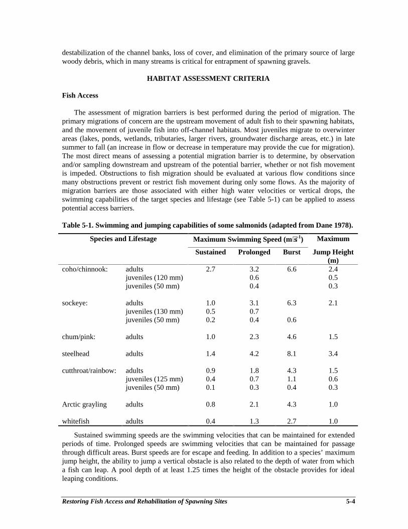
Restoring Fish Access and Rehabilitation of Spawning Sites 5-4
destabilization of the channel banks, loss of cover, and elimination of the primary source of largewoody debris, which in many streams is critical for entrapment of spawning gravels.
HABITAT ASSESSMENT CRITERIA
Fish Access
The assessment of migration barriers is best performed during the period of migration. Theprimary migrations of concern are the upstream movement of adult fish to their spawning habitats,and the movement of juvenile fish into off-channel habitats. Most juveniles migrate to overwinterareas (lakes, ponds, wetlands, tributaries, larger rivers, groundwater discharge areas, etc.) in latesummer to fall (an increase in flow or decrease in temperature may provide the cue for migration).The most direct means of assessing a potential migration barrier is to determine, by observationand/or sampling downstream and upstream of the potential barrier, whether or not fish movementis impeded. Obstructions to fish migration should be evaluated at various flow conditions sincemany obstructions prevent or restrict fish movement during only some flows. As the majority ofmigration barriers are those associated with either high water velocities or vertical drops, theswimming capabilities of the target species and lifestage (see Table 5-1) can be applied to assesspotential access barriers.
Table 5-1. Swimming and jumping capabilities of some salmonids (adapted from Dane 1978).
Species and Lifestage Maximum Swimming Speed (m⋅s-1) Maximum
Sustained Prolonged Burst Jump Height(m)
coho/chinnook: adults 2.7 3.2 6.6 2.4juveniles (120 mm) 0.6 0.5juveniles (50 mm) 0.4 0.3
sockeye: adults 1.0 3.1 6.3 2.1juveniles (130 mm) 0.5 0.7juveniles (50 mm) 0.2 0.4 0.6
chum/pink: adults 1.0 2.3 4.6 1.5
steelhead adults 1.4 4.2 8.1 3.4
cutthroat/rainbow: adults 0.9 1.8 4.3 1.5juveniles (125 mm) 0.4 0.7 1.1 0.6juveniles (50 mm) 0.1 0.3 0.4 0.3
Arctic grayling adults 0.8 2.1 4.3 1.0
whitefish adults 0.4 1.3 2.7 1.0
Sustained swimming speeds are the swimming velocities that can be maintained for extendedperiods of time. Prolonged speeds are swimming velocities that can be maintained for passagethrough difficult areas. Burst speeds are for escape and feeding. In addition to a species’ maximumjump height, the ability to jump a vertical obstacle is also related to the depth of water from whicha fish can leap. A pool depth of at least 1.25 times the height of the obstacle provides for idealleaping conditions.
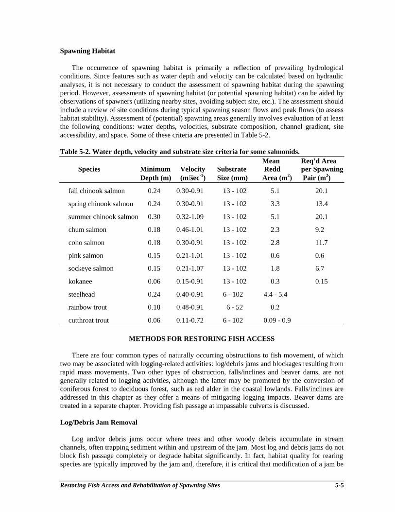
Restoring Fish Access and Rehabilitation of Spawning Sites 5-5
Spawning Habitat
The occurrence of spawning habitat is primarily a reflection of prevailing hydrologicalconditions. Since features such as water depth and velocity can be calculated based on hydraulicanalyses, it is not necessary to conduct the assessment of spawning habitat during the spawningperiod. However, assessments of spawning habitat (or potential spawning habitat) can be aided byobservations of spawners (utilizing nearby sites, avoiding subject site, etc.). The assessment shouldinclude a review of site conditions during typical spawning season flows and peak flows (to assesshabitat stability). Assessment of (potential) spawning areas generally involves evaluation of at leastthe following conditions: water depths, velocities, substrate composition, channel gradient, siteaccessibility, and space. Some of these criteria are presented in Table 5-2.
Table 5-2. Water depth, velocity and substrate size criteria for some salmonids.Mean Req’d Area
Species Minimum Velocity Substrate Redd per SpawningDepth (m) (m⋅sec-1) Size (mm) Area (m2) Pair (m2)
fall chinook salmon 0.24 0.30-0.91 13 - 102 5.1 20.1
spring chinook salmon 0.24 0.30-0.91 13 - 102 3.3 13.4
summer chinook salmon 0.30 0.32-1.09 13 - 102 5.1 20.1
chum salmon 0.18 0.46-1.01 13 - 102 2.3 9.2
coho salmon 0.18 0.30-0.91 13 - 102 2.8 11.7
pink salmon 0.15 0.21-1.01 13 - 102 0.6 0.6
sockeye salmon 0.15 0.21-1.07 13 - 102 1.8 6.7
kokanee 0.06 0.15-0.91 13 - 102 0.3 0.15
steelhead 0.24 0.40-0.91 6 - 102 4.4 - 5.4
rainbow trout 0.18 0.48-0.91 6 - 52 0.2
cutthroat trout 0.06 0.11-0.72 6 - 102 0.09 - 0.9
METHODS FOR RESTORING FISH ACCESS
There are four common types of naturally occurring obstructions to fish movement, of whichtwo may be associated with logging-related activities: log/debris jams and blockages resulting fromrapid mass movements. Two other types of obstruction, falls/inclines and beaver dams, are notgenerally related to logging activities, although the latter may be promoted by the conversion ofconiferous forest to deciduous forest, such as red alder in the coastal lowlands. Falls/inclines areaddressed in this chapter as they offer a means of mitigating logging impacts. Beaver dams aretreated in a separate chapter. Providing fish passage at impassable culverts is discussed.
Log/Debris Jam Removal
Log and/or debris jams occur where trees and other woody debris accumulate in streamchannels, often trapping sediment within and upstream of the jam. Most log and debris jams do notblock fish passage completely or degrade habitat significantly. In fact, habitat quality for rearingspecies are typically improved by the jam and, therefore, it is critical that modification of a jam be
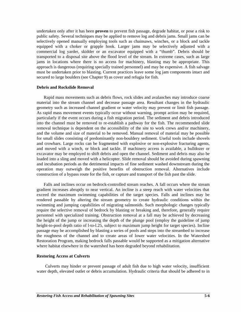
Restoring Fish Access and Rehabilitation of Spawning Sites 5-6
undertaken only after it has been proven to prevent fish passage, degrade habitat, or pose a risk topublic safety. Several techniques may be applied to remove log and debris jams. Small jams can beselectively opened manually employing tools such as chainsaws, winches, or a block and tackleequipped with a choker or grapple hook. Larger jams may be selectively adjusted with acommercial log yarder, skidder or an excavator equipped with a “thumb”. Debris should betransported to a disposal site above the flood level of the stream. In extreme cases, such as largejams in locations where there is no access for machinery, blasting may be appropriate. Thisapproach is dangerous (requiring specially trained personnel) and may be expensive. A fish salvagemust be undertaken prior to blasting. Current practices leave some log jam components intact andsecured to large boulders (see Chapter 9) as cover and refugia for fish.
Debris and Rockslide Removal
Rapid mass movements such as debris flows, rock slides and avalanches may introduce coarsematerial into the stream channel and decrease passage area. Resultant changes in the hydraulicgeometry such as increased channel gradient or water velocity may prevent or limit fish passage.As rapid mass movement events typically occur without warning, prompt action may be required,particularly if the event occurs during a fish migration period. The sediment and debris introducedinto the channel must be removed to re-establish a pathway for the fish. The recommended slideremoval technique is dependent on the accessibility of the site to work crews and/or machinery,and the volume and size of material to be removed. Manual removal of material may be possiblefor small slides consisting of predominantly non-bouldery sediment. Useful tools include shovelsand crowbars. Large rocks can be fragmented with explosive or non-explosive fracturing agents,and moved with a winch, or block and tackle. If machinery access is available, a bulldozer orexcavator may be employed to shift debris and open the channel. Sediment and debris may also beloaded into a sling and moved with a helicopter. Slide removal should be avoided during spawningand incubation periods as the detrimental impacts of fine sediment washed downstream during theoperation may outweigh the positive benefits of obstruction removal. Alternatives includeconstruction of a bypass route for the fish, or capture and transport of the fish past the slide.
Falls and inclines occur on bedrock-controlled stream reaches. A fall occurs where the streamgradient increases abruptly to near vertical. An incline is a steep reach with water velocities thatexceed the maximum swimming capabilities of the target species. Falls and inclines may berendered passable by altering the stream geometry to create hydraulic conditions within theswimming and jumping capabilities of migrating salmonids. Such morphologic changes typicallyrequire the selective removal of bedrock by blasting or breaking and, therefore, generally requirepersonnel with specialized training. Obstruction removal at a fall may be achieved by decreasingthe height of the jump or increasing the depth of the plunge pool (employ the guideline of jumpheight-to-pool depth ratio of l-to-l.25, subject to maximum jump height for target species). Inclinepassage may be accomplished by blasting a series of pools and steps into the streambed to increasethe roughness of the channel and to create areas of lower water velocities. In the WatershedRestoration Program, making bedrock falls passable would be supported as a mitigation alternativewhere habitat elsewhere in the watershed has been degraded beyond rehabilitation.
Restoring Access at Culverts
Culverts may hinder or prevent passage of adult fish due to high water velocity, insufficientwater depth, elevated outlet or debris accumulation. Hydraulic criteria that should be adhered to in
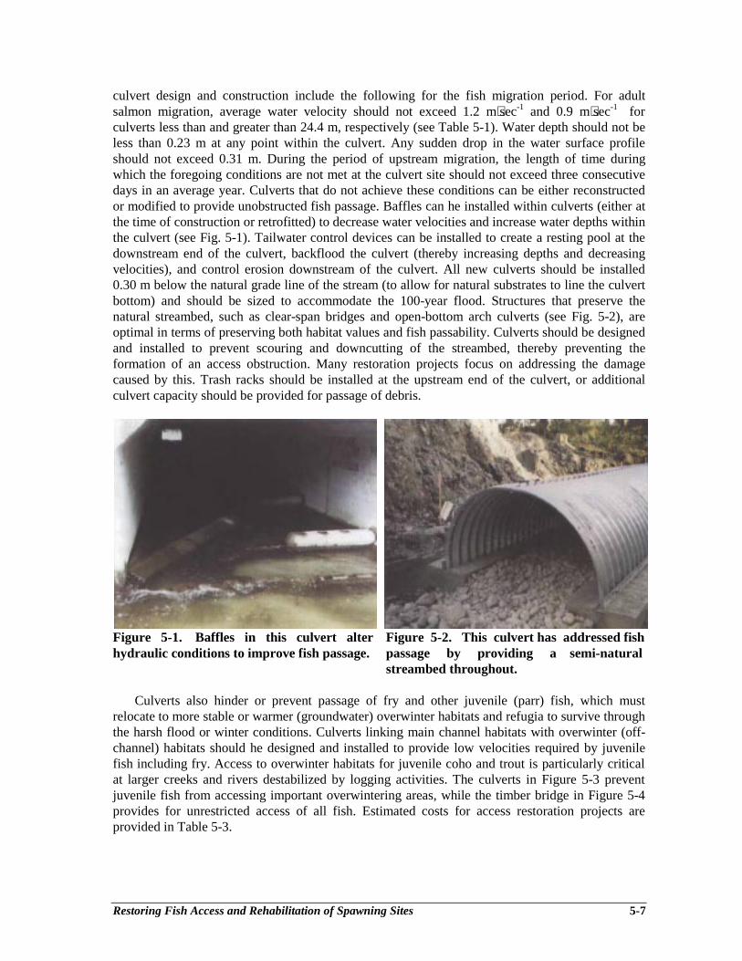
Restoring Fish Access and Rehabilitation of Spawning Sites 5-7
culvert design and construction include the following for the fish migration period. For adultsalmon migration, average water velocity should not exceed 1.2 m⋅sec-1 and 0.9 m⋅sec-1 forculverts less than and greater than 24.4 m, respectively (see Table 5-1). Water depth should not beless than 0.23 m at any point within the culvert. Any sudden drop in the water surface profileshould not exceed 0.31 m. During the period of upstream migration, the length of time duringwhich the foregoing conditions are not met at the culvert site should not exceed three consecutivedays in an average year. Culverts that do not achieve these conditions can be either reconstructedor modified to provide unobstructed fish passage. Baffles can he installed within culverts (either atthe time of construction or retrofitted) to decrease water velocities and increase water depths withinthe culvert (see Fig. 5-1). Tailwater control devices can be installed to create a resting pool at thedownstream end of the culvert, backflood the culvert (thereby increasing depths and decreasingvelocities), and control erosion downstream of the culvert. All new culverts should be installed0.30 m below the natural grade line of the stream (to allow for natural substrates to line the culvertbottom) and should be sized to accommodate the 100-year flood. Structures that preserve thenatural streambed, such as clear-span bridges and open-bottom arch culverts (see Fig. 5-2), areoptimal in terms of preserving both habitat values and fish passability. Culverts should be designedand installed to prevent scouring and downcutting of the streambed, thereby preventing theformation of an access obstruction. Many restoration projects focus on addressing the damagecaused by this. Trash racks should be installed at the upstream end of the culvert, or additionalculvert capacity should be provided for passage of debris.
Figure 5-1. Baffles in this culvert alter Figure 5-2. This culvert has addressed fishhydraulic conditions to improve fish passage. passage by providing a semi-natural
streambed throughout.
Culverts also hinder or prevent passage of fry and other juvenile (parr) fish, which mustrelocate to more stable or warmer (groundwater) overwinter habitats and refugia to survive throughthe harsh flood or winter conditions. Culverts linking main channel habitats with overwinter (off-channel) habitats should he designed and installed to provide low velocities required by juvenilefish including fry. Access to overwinter habitats for juvenile coho and trout is particularly criticalat larger creeks and rivers destabilized by logging activities. The culverts in Figure 5-3 preventjuvenile fish from accessing important overwintering areas, while the timber bridge in Figure 5-4provides for unrestricted access of all fish. Estimated costs for access restoration projects areprovided in Table 5-3.
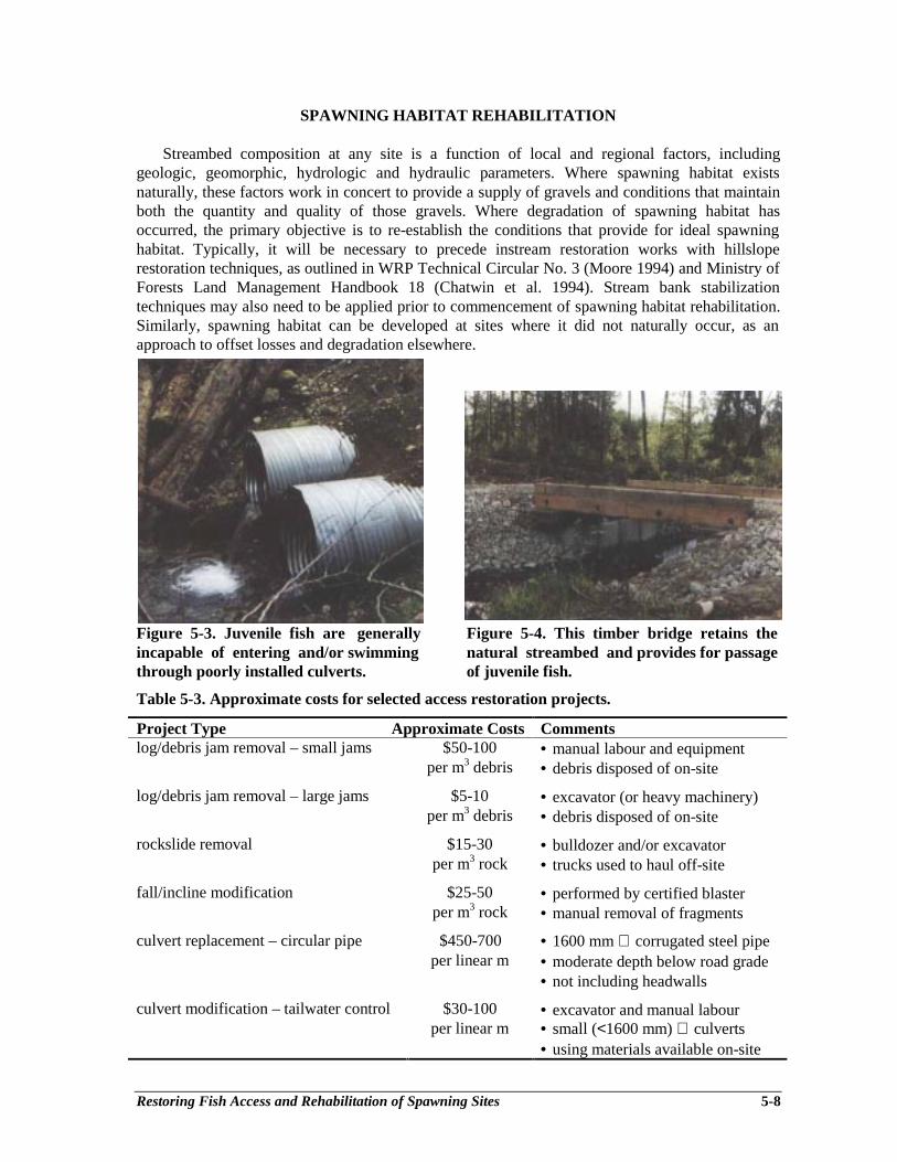
Restoring Fish Access and Rehabilitation of Spawning Sites 5-8
SPAWNING HABITAT REHABILITATION
Streambed composition at any site is a function of local and regional factors, includinggeologic, geomorphic, hydrologic and hydraulic parameters. Where spawning habitat existsnaturally, these factors work in concert to provide a supply of gravels and conditions that maintainboth the quantity and quality of those gravels. Where degradation of spawning habitat hasoccurred, the primary objective is to re-establish the conditions that provide for ideal spawninghabitat. Typically, it will be necessary to precede instream restoration works with hillsloperestoration techniques, as outlined in WRP Technical Circular No. 3 (Moore 1994) and Ministry ofForests Land Management Handbook 18 (Chatwin et al. 1994). Stream bank stabilizationtechniques may also need to be applied prior to commencement of spawning habitat rehabilitation.Similarly, spawning habitat can be developed at sites where it did not naturally occur, as anapproach to offset losses and degradation elsewhere.
Figure 5-3. Juvenile fish are generally Figure 5-4. This timber bridge retains theincapable of entering and/or swimming natural streambed and provides for passagethrough poorly installed culverts. of juvenile fish.
Table 5-3. Approximate costs for selected access restoration projects.
Project Type Approximate Costs Commentslog/debris jam removal – small jams $50-100 • manual labour and equipment
per m3 debris • debris disposed of on-site
log/debris jam removal – large jams $5-10 • excavator (or heavy machinery)per m3 debris • debris disposed of on-site
rockslide removal $15-30 • bulldozer and/or excavatorper m3 rock • trucks used to haul off-site
fall/incline modification $25-50 • performed by certified blasterper m3 rock • manual removal of fragments
culvert replacement – circular pipe $450-700 • 1600 mm ∅ corrugated steel pipeper linear m • moderate depth below road grade
• not including headwalls
culvert modification – tailwater control $30-100 • excavator and manual labourper linear m • small (<1600 mm) ∅ culverts
• using materials available on-site
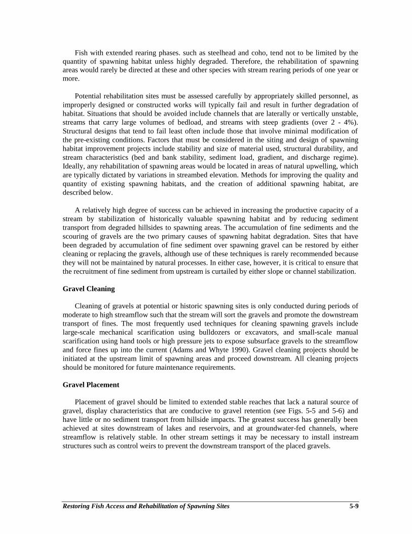
Restoring Fish Access and Rehabilitation of Spawning Sites 5-9
Fish with extended rearing phases. such as steelhead and coho, tend not to be limited by thequantity of spawning habitat unless highly degraded. Therefore, the rehabilitation of spawningareas would rarely be directed at these and other species with stream rearing periods of one year ormore.
Potential rehabilitation sites must be assessed carefully by appropriately skilled personnel, asimproperly designed or constructed works will typically fail and result in further degradation ofhabitat. Situations that should be avoided include channels that are laterally or vertically unstable,streams that carry large volumes of bedload, and streams with steep gradients (over 2 - 4%).Structural designs that tend to fail least often include those that involve minimal modification ofthe pre-existing conditions. Factors that must be considered in the siting and design of spawninghabitat improvement projects include stability and size of material used, structural durability, andstream characteristics (bed and bank stability, sediment load, gradient, and discharge regime).Ideally, any rehabilitation of spawning areas would be located in areas of natural upwelling, whichare typically dictated by variations in streambed elevation. Methods for improving the quality andquantity of existing spawning habitats, and the creation of additional spawning habitat, aredescribed below.
A relatively high degree of success can be achieved in increasing the productive capacity of astream by stabilization of historically valuable spawning habitat and by reducing sedimenttransport from degraded hillsides to spawning areas. The accumulation of fine sediments and thescouring of gravels are the two primary causes of spawning habitat degradation. Sites that havebeen degraded by accumulation of fine sediment over spawning gravel can be restored by eithercleaning or replacing the gravels, although use of these techniques is rarely recommended becausethey will not be maintained by natural processes. In either case, however, it is critical to ensure thatthe recruitment of fine sediment from upstream is curtailed by either slope or channel stabilization.
Gravel Cleaning
Cleaning of gravels at potential or historic spawning sites is only conducted during periods ofmoderate to high streamflow such that the stream will sort the gravels and promote the downstreamtransport of fines. The most frequently used techniques for cleaning spawning gravels includelarge-scale mechanical scarification using bulldozers or excavators, and small-scale manualscarification using hand tools or high pressure jets to expose subsurface gravels to the streamflowand force fines up into the current (Adams and Whyte 1990). Gravel cleaning projects should beinitiated at the upstream limit of spawning areas and proceed downstream. All cleaning projectsshould be monitored for future maintenance requirements.
Gravel Placement
Placement of gravel should be limited to extended stable reaches that lack a natural source ofgravel, display characteristics that are conducive to gravel retention (see Figs. 5-5 and 5-6) andhave little or no sediment transport from hillside impacts. The greatest success has generally beenachieved at sites downstream of lakes and reservoirs, and at groundwater-fed channels, wherestreamflow is relatively stable. In other stream settings it may be necessary to install instreamstructures such as control weirs to prevent the downstream transport of the placed gravels.
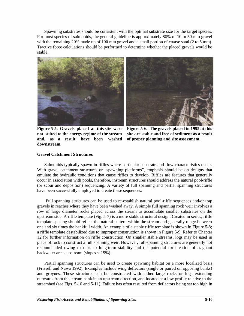
Restoring Fish Access and Rehabilitation of Spawning Sites 5-10
Spawning substrates should be consistent with the optimal substrate size for the target species.For most species of salmonids, the general guideline is approximately 80% of 10 to 50 mm gravelwith the remaining 20% made up of 100 mm gravel and a small portion of coarse sand (2 to 5 mm).Tractive force calculations should be performed to determine whether the placed gravels would bestable.
Figure 5-5. Gravels placed at this site were Figure 5-6. The gravels placed in 1995 at thisnot suited to the energy regime of the stream site are stable and free of sediment as a resultand, as a result, have been washed of proper planning and site assessment.downstream.
Gravel Catchment Structures
Salmonids typically spawn in riffles where particular substrate and flow characteristics occur.With gravel catchment structures or “spawning platforms”, emphasis should be on designs thatemulate the hydraulic conditions that cause riffles to develop. Riffles are features that generallyoccur in association with pools, therefore, instream structures should address the natural pool-riffle(or scour and deposition) sequencing. A variety of full spanning and partial spanning structureshave been successfully employed to create these sequences.
Full spanning structures can be used to re-establish natural pool-riffle sequences and/or trapgravels in reaches where they have been washed away. A simple full spanning rock weir involves arow of large diameter rocks placed across the stream to accumulate smaller substrates on theupstream side. A riffle template (Fig. 5-7) is a more stable structural design. Created in series, riffletemplate spacing should reflect the natural pattern within the stream and generally range betweenone and six times the bankfull width. An example of a stable riffle template is shown in Figure 5-8;a riffle template destabilized due to improper construction is shown in Figure 5-9. Refer to Chapter12 for further information on riffle construction. On smaller stable streams, logs may be used inplace of rock to construct a full spanning weir. However, full-spanning structures are generally notrecommended owing to risks to long-term stability and the potential for creation of stagnantbackwater areas upstream (slopes < 15%).
Partial spanning structures can be used to create spawning habitat on a more localized basis(Frissell and Nawa 1992). Examples include wing deflectors (single or paired on opposing banks)and groynes. These structures can be constructed with either large rocks or logs extendingoutwards from the stream bank in an upstream direction, and located at a low profile relative to thestreambed (see Figs. 5-10 and 5-11). Failure has often resulted from deflectors being set too high in
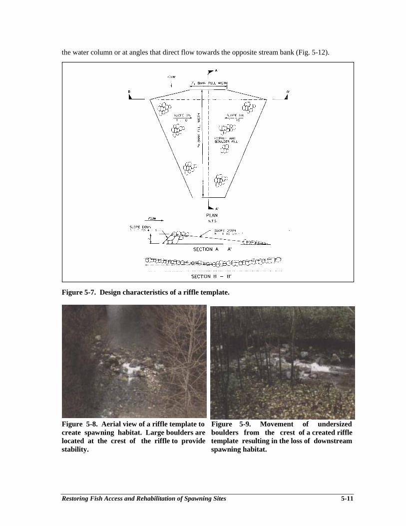
Restoring Fish Access and Rehabilitation of Spawning Sites 5-11
the water column or at angles that direct flow towards the opposite stream bank (Fig. 5-12).
Figure 5-7. Design characteristics of a riffle template.
Figure 5-8. Aerial view of a riffle template to Figure 5-9. Movement of undersizedcreate spawning habitat. Large boulders are boulders from the crest of a created rifflelocated at the crest of the riffle to provide template resulting in the loss of downstreamstability. spawning habitat.

Restoring Fish Access and Rehabilitation of Spawning Sites 5-12
Figure 5-10. Design characteristics of a log deflector.
Figure 5-11. Log deflector extending halfway Figure 5-12. Log weir that has been seriouslyacross channel. A pool has formed undermined as a result of being installeddownstream of the deflector, with gravels perpendicular to the bank and too high in theaccumulating upstream of the deflector and water column.at the tail of the pool.
Creation of Side-channel Spawning Areas
Bank erosion, bed scour and sediment transport often limit the economic feasibility of in-channel structures due to high maintenance costs. In many streams, the most effective habitatrehabilitation projects may be the creation or re-establishment of side-channel and back-channelhabitat. Candidate project sites should have an adequate water supply, provide the opportunity toconstruct a channel with sufficient gradient to allow creation of a diversity of habitat types and belocated in proximity to existing spawning areas. Ideal sites are often located on alluvial fans or nearvalley wall edges where groundwater percolation may be expected. Groundwater studies shouldalways be completed as an initial step to ascertain that a consistent flow would be available duringcritical periods. Additional details on site selection are provided in Chapter 7.

Restoring Fish Access and Rehabilitation of Spawning Sites 5-13
Development of side-channels that are open to the main channel at their upstream end must beplanned and constructed with care in order to minimize maintenance problems. Accumulation ofsediment or debris at the upstream end is a common difficulty. Debris screens and modified waterintakes at the upstream end have proven successful, but site-specific design is critical.
Costs of Spawning Habitat Rehabilitation
Estimated costs for example spawning habitat rehabilitation projects are provided in Table 5-4.To reiterate, hillslope rehabilitation is a requisite to undertaking these measures and theirapplication is site-specific.
Table 5-4. Approximate costs for selected spawning habitat rehabilitation projects.
Project Type Approximate Costs Comments
Gravel cleaning – mechanical $5-20 • bulldozer working instreamscarification per m2 • streams over 10 m wide
Gravel cleaning – manual $20-50 • high pressure hoseper m2 • small, shallow streams
Gravel placement $50-70 • washed/sorted gravel suppliedper m3 gravel • limited delivery distance
• machine placed• not incl. control structures
Riffle template construction $20-50 • natural source of rock availableper m3 rock • rock transported a limited distance
• excavator placed
Log deflector installation $50-100 per • logs available at no costlinear • excavator placed and backfilled
(instream) m
Side-channel development $50-150 • shallow/moderate excavation depthper m2 • excavated material disposed on-site
• water supply not included
APPROVALS
All aspects of instream work require an environmental approval issued by the Ministry ofEnvironment, Lands and Parks. Approvals include a list of conditions that must be adhered to,typically including seasonal restrictions and requirements to perform fish salvages and sitedewatering. Refer to Chapter 1 on habitat protection and approvals for further information.
Rehabilitating Stream Banks 6-1
Chapter 6Rehabilitating Stream Banks
Scott Babakaiff1, Duncan Hay2, Christian Fromuth3
INTRODUCTION
Bank erosion is a natural process that may be considered beneficial or detrimental, dependingupon the associated environmental or socioeconomic concerns. Stream channels respond to inputsof water, sediment and woody debris, forming dynamic links between hillslopes and riparian areasin the watershed. Anthropogenic activities such as forest harvesting may affect channel processesthrough changes in the intensity, timing of delivery and total yield of sediment and water from thehillslopes. Impacts to riparian vegetation from streamside forest harvesting, farming and ranchingpractices have further altered sediment loading and woody debris structure within channels. Bankerosion may lead to a degradation of fish habitat through loss of protective cover, reduced channeldepths, increased stream temperatures, infilled pools and smothered spawning gravels. In someinstances, rehabilitation of stream banks may positively contribute to the rehabilitation of fishhabitat and, in turn, fish populations.
This chapter describes the rehabilitation of stream banks that have been impacted by historicallogging practices. It includes a section on the assessment of a site-specific need to stabilize erodingstream banks, and describes the most suitable stabilization techniques as a function of the fluvialenvironment. Central to the techniques presented is the need for a multiple objective treatmentapproach that simultaneously addresses bank stabilization and fish habitat requirements.
FLUVIAL PROCESSES
Alluvial channels accommodate variability in water and sediment discharge throughadjustments in cross-sectional area and shape, slope, channel pattern, bed structure or bed materialcharacteristics. Non-alluvial channels are not discussed because, as described in the ChannelAssessment Procedures (CAP) (Anon. 1996a,b), “land management practices cannot affect eitherthe bed or the banks of the channel”. In many reaches, bank erosion is discontinuous and short-term erosion rates are based on interdependent processes such as sediment deposition adjacent toeroding banks. Width is typically the most adjustable component of channel geometry, butadjustments in width or planform are highly dependent on the resistance of channel banks toerosion.
Natural bank erosion may be initiated or accelerated by many processes including:
• increased sediment load within a reach,• higher than average floods, particularly extreme discharges which follow several years of
sub-average flows (pioneer vegetation may have provided short-term bank stabilization),
________________________1 Babakaiff & Associates Geoscience, 569 West 18th Avenue, Vancouver, BC V5Z 1V72 Hay & Company Consultants Inc., One West 7th Avenue, Vancouver, BC V5Y 1L53 Agua Tierra Environmental Consulting Inc., Suite 100 - 506 Edison Street S.E., Olympia, WA 98501
Rehabilitating Stream Banks 6-2
• migration of river forms or channel avulsions,• increased woody debris,• bank failures unrelated to fluvial processes (e.g. freeze-thaw),• local flow deflection (e.g., woody debris),• wave action.
Similarly, anthropogenic activities such as logging may initiate or accelerate bank erosion by:
• increasing sediment or water discharge,• increasing magnitude and flashiness of extreme sediment or water discharges,• decreasing bank strength through removal of riparian vegetation or altering
groundwater regimes,• increasing current speeds or turbulence by encroachments or channel realignment,• increasing the angle of thalweg impingement onto banks by channel realignment,• increasing current speeds as a result of increased slope following channel realignment,• reducing present and future sources of large woody debris which stabilize channel
beds.
Although there are numerous causes of bank erosion, the actual failure of bank material istypically a result of hydraulic and/or geotechnical processes. Hydraulic failure occurs if waterflow in a channel exerts a stress that exceeds the critical shear stress for sediment transport. Thisoccurs where current speeds along the bank are high, particularly along the outside bank of a riverbend where secondary flow directs water downward towards the toe of the bank. Geotechnicalfailure occurs if gravitational forces acting on the bank material exceed the strength of the resistingforces. This process commonly occurs during recession of flood waters as saturated banks collapsedue to diminished soil strength.
Most bank failures are associated with a combination of hydraulic and geotechnical factors(e.g., undermining by hydraulic forces leading to slumps or block-type geotechnical failures), butthe type of failure is often related to the characteristics of the bank material. Noncohesive banksare made primarily of sand and gravel, and erosion is controlled by the direction and magnitude offlow velocities at the bank, particle characteristics, gravitational forces and turbulence (i.e.,hydraulic failure). In contrast, cohesive banks contain clay minerals, which produce strongchemical and electrochemical bonds between the particles, and geotechnical failure is morecommon. Interbedded cohesive and noncohesive layers within a stream bank are fairly common,and these heterogeneous banks may be eroded by hydraulic or geotechnical processes. Typically,the erodability of interbedded banks is controlled by the thickness and position of the noncohesivelayers.
Several studies have shown that the average rate of erosion for alluvial streams is roughlyproportional to the drainage basin area. The potential or normal rates of erosion for a particularbank or bend have been related to several factors, such as bank vegetation, the ratio of width toradius of curvature, bank height and material. Unfortunately, no general formulae relating thesefactors to relative erosional resistance exist because of the strong dependence on transientconditions such as antecedent moisture levels or the presence of protective basal accumulations.
Rehabilitating Stream Banks 6-3
GUIDELINES FOR ASSESSING STREAM BANK REHABILITATION NEEDS
The likelihood of formulating a successful4 stream bank rehabilitation prescription will beincreased by carefully considering the geomorphic and hydrologic setting. Several parameters maybe used to help identify the cause of bank erosion and to assess the probability of channel recovery5
following bank stabilization. If rehabilitation of fish habitat is not the prime objective (i.e.,protection of built structures, transportation corridors or human lives), channel recovery may not bean implicit goal. However, assuming that fish habitat rehabilitation is the prime objective,prioritization within a watershed should depend upon the type of channel instability present and thepotential benefits to fish habitat.
An assessment of the geomorphic and hydrologic setting is usually required to:• determine the history and spatial extent of bank erosion,• determine the cause of bank erosion, as related to the state of stability,• predict the likelihood of channel recovery and habitat benefits following bank
stabilization.
Field inspections utilizing channel assessment techniques (Anon. 1996a, b; Hogan et al. 1997)will often indicate the geomorphic setting and recent channel responses. It is necessary to examinethe stream bank in a number of spatial perspectives and place the erosion into a historic context.This should begin by determining the planform changes as documented by air photos, maps andanecdotal information. Visibility of historic channel response from air photos will depend on thechannel size, photo scale and riparian cover. For typical 1:20,000 scale air photos, identification ofriver morphology may be limited to channels exceeding 20 m in width. Prioritization techniquesdescribed in this chapter are typically appropriate for fluvial systems having stream classes ofthird-order or greater, based on 1:50,000 scale maps. The general principles also apply to smallerchannels, but the impacts of forest harvesting relating to changes in sediment and water delivery tosmall6 channels usually manifest as changes in bed morphology, rather than bank stability.Planform changes should be analyzed over at least three reaches upstream and downstream of theerosion site; reach differentiation is described in the CAP. The parameters to be documentedinclude:
• bankfull width: the width of the channel as measured during the bankfull discharge, oftenstatistically defined as the 1.5 year recurrence interval discharge. Field determination ofthe bankfull width is described in the channel assessment.
• channel sinuosity: ratio of stream length to valley length; also described as the ratio ofvalley slope to channel slope.
• bank erosion rates: the migration of a river bank may be determined by comparing therelative locations of the bank line over time, or by comparing the position of the bank lineto a point fixed in space over the period of comparison. If photo coverage allows, theerosion rates should be calculated at approximately 5 to 10-year intervals over the periodof air photo coverage. Short-term migration rates calculated from one or two intervals areoften not representative of long-term averages.
________________________4 The “success” of a fish habitat rehabilitation program should include physical and biological componentsStructures should form the desired stream habitat feature, persist over the intended lifespan and be utilized bythe targeted fish species or age class (Hanman and Miles 1995).5 Channel recovery or restoration to a predisturbed state is discussed in Chapter 2.6 Small channels typically have bankfull widths less than 10 m, with individual clasts constituting significantform elements on the channel bed.
Rehabilitating Stream Banks 6-4
Consideration of these three factors will allow the stream response through time to beclassified as dynamic stability, localized instability or long-term instability. A stream reachdisplays a state of “dynamic stability” if its energy is at a level that allows sediment loadsentering the reach to equal those leaving it, and if there are no long-term net changes in hydraulicgeometry. It should be expected that bank erosion rates, sinuosity and bankfull width will haveremained approximately constant, or have not shown progressive increases or decreases over theinspection period. Dynamic stability may also be examined by assessing the cross-sectional formfactor, or ratio of bankfull width to depth. If the percentage of silt and clay in the banks (B)exceeds 5%, a stable form factor will be less than 10-15. However, if B is less than 5%, stable formfactors will be greater than 10, and will often exceed 40. A bank that maintains a form factor out ofthe expected range indicates a lack of dynamic stability. Examination of channel bar form asdescribed in Hogan et al. (1997) may also elucidate these relations.
Often, accelerated bank erosion or progressive increases in bankfull width or sinuosity occur asa result of increased sediment load or discharge. If the stream response is restricted to specificbanks or reaches, it is termed a localized instability. For example, a slug of coarse sedimentintroduced into a stream channel by a landslide may take decades to be flushed through the fluvialsystem. As it passes through downstream reaches, bank erosion will be atypically high inmagnitude or different in nature than erosion experienced at the site in the recent past. This maylast for several years as the sediment load is redistributed and the cross-sectional parametersrespond to localized slope or velocity changes, but erosion rates should return to “normal” levelsfollowing passage, and re-occupation of the floodplain by pioneer vegetation.
By contrast, if sinuosity, bankfull width or bank erosion rates have been highly variable forseveral decades over an extensive stream length, the stream reaches may display a more generallong-term instability. It is typical of stream reaches that include structural elements such asgradient breaks or highly erodible non-alluvial banks. It may also be expected if a channel has beenimpacted by several significant variations in sediment load or discharge.
In order to prioritize the rehabilitation of stream banks, it is necessary to consider the expectedfuture lateral activity of the channel, the channel recovery following bank rehabilitation and thepotential habitat benefits. These factors are represented by the planform changes, the entrenchmentratio and the bank material, respectively.
The expected channel activity may be ascertained from the planform changes based on theinspection of air photos and maps. Regular lateral activity displays orderly lateral and/ordownvalley meander progression, often combined with neck cutoffs (Fig. 6-1). However, irregularlateral activity displays an apparently chaotic pattern of channel activity dominated by avulsionsand formation of chutes, side-channels and sloughs (Fig. 6-2). Attempts to stabilize banks, whichhave displayed regular lateral activity, are typically not recommended. Manipulation of channelparameters will often produce an undesired response as the channel attempts to attain a new post-manipulation equilibrium. Associated changes in the magnitude and direction of current speeds orthe water surface slope may have adverse impacts on reaches upstream or downstream of therehabilitated site. Stabilization of banks with irregular instability pose a lower risk to inducingmorphologic adjustments elsewhere, but the design should include structures to minimize the riskof flows outflanking the bank rehabilitation (e.g., tiebacks).
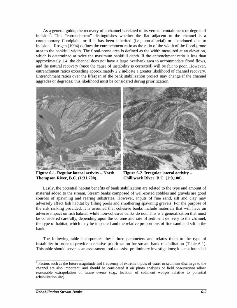
Rehabilitating Stream Banks 6-5
As a general guide, the recovery of a channel is related to its vertical containment or degree ofincision7. This “entrenchment” distinguishes whether the flat adjacent to the channel is acontemporary floodplain, or if it has been inherited (i.e., non-alluvial) or abandoned due toincision. Rosgen (1994) defines the entrenchment ratio as the ratio of the width of the flood-pronearea to the bankfull width. The flood-prone area is defined as the width measured at an elevation,which is determined at twice the maximum bankfull depth. If the entrenchment ratio is less thanapproximately 1.4, the channel does not have a large overbank area to accommodate flood flows,and the natural recovery (once the cause of instability is corrected) will be fair to poor. However,entrenchment ratios exceeding approximately 2.2 indicate a greater likelihood of channel recovery.Entrenchment ratios over the lifespan of the bank stabilization project may change if the channelaggrades or degrades; this likelihood must be considered during prioritization.
Figure 6-1. Regular lateral activity – North Figure 6-2. Irregular lateral activity –Thompson River, B.C. (1:31,700). Chilliwack River, B.C. (1:9,100).
Lastly, the potential habitat benefits of bank stabilization are related to the type and amount ofmaterial added to the stream. Stream banks composed of well-sorted cobbles and gravels are goodsources of spawning and rearing substrates. However, inputs of fine sand, silt and clay mayadversely affect fish habitat by filling pools and smothering spawning gravels. For the purpose ofthe risk ranking provided, it is assumed that cohesive banks include materials that will have anadverse impact on fish habitat, while non-cohesive banks do not. This is a generalization that mustbe considered carefully, depending upon the volume and rate of sediment delivery to the channel,the type of habitat, which may be impacted and the relative proportions of fine sand and silt in thebank.
The following table incorporates these three parameters and relates them to the type ofinstability in order to provide a relative prioritization for stream bank rehabilitation (Table 6-1).This table should serve as an assessment tool to assist preliminary investigations; it is not intended
________________________7 Factors such as the future magnitude and frequency of extreme inputs of water or sediment discharge to thechannel are also important, and should be considered if air photo analyses or field observations allowreasonable extrapolation of future events (e.g., location of sediment wedges relative to potentialrehabilitation site).
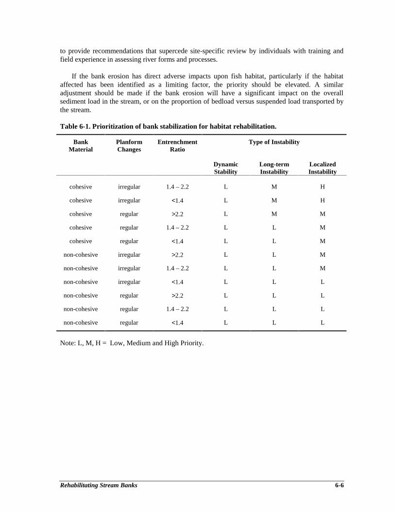
Rehabilitating Stream Banks 6-6
to provide recommendations that supercede site-specific review by individuals with training andfield experience in assessing river forms and processes.
If the bank erosion has direct adverse impacts upon fish habitat, particularly if the habitataffected has been identified as a limiting factor, the priority should be elevated. A similaradjustment should be made if the bank erosion will have a significant impact on the overallsediment load in the stream, or on the proportion of bedload versus suspended load transported bythe stream.
Table 6-1. Prioritization of bank stabilization for habitat rehabilitation.
BankMaterial
PlanformChanges
EntrenchmentRatio
Type of Instability
DynamicStability
Long-termInstability
LocalizedInstability
cohesive irregular 1.4 – 2.2 L M H
cohesive irregular <1.4 L M H
cohesive regular >2.2 L M M
cohesive regular 1.4 – 2.2 L L M
cohesive regular <1.4 L L M
non-cohesive irregular >2.2 L L M
non-cohesive irregular 1.4 – 2.2 L L M
non-cohesive irregular <1.4 L L L
non-cohesive regular >2.2 L L L
non-cohesive regular 1.4 – 2.2 L L L
non-cohesive regular <1.4 L L L
Note: L, M, H = Low, Medium and High Priority.
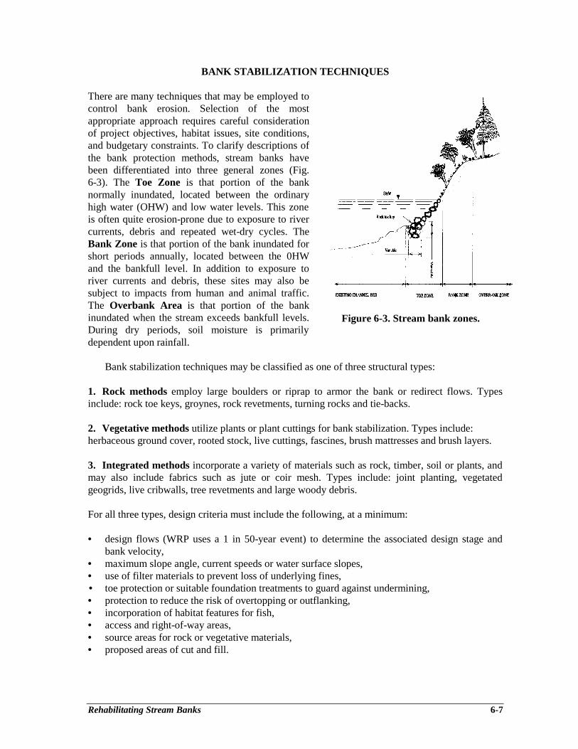
Rehabilitating Stream Banks 6-7
BANK STABILIZATION TECHNIQUES
There are many techniques that may be employed tocontrol bank erosion. Selection of the mostappropriate approach requires careful considerationof project objectives, habitat issues, site conditions,and budgetary constraints. To clarify descriptions ofthe bank protection methods, stream banks havebeen differentiated into three general zones (Fig.6-3). The Toe Zone is that portion of the banknormally inundated, located between the ordinaryhigh water (OHW) and low water levels. This zoneis often quite erosion-prone due to exposure to rivercurrents, debris and repeated wet-dry cycles. TheBank Zone is that portion of the bank inundated forshort periods annually, located between the 0HWand the bankfull level. In addition to exposure toriver currents and debris, these sites may also besubject to impacts from human and animal traffic.The Overbank Area is that portion of the bankinundated when the stream exceeds bankfull levels.During dry periods, soil moisture is primarilydependent upon rainfall.
Figure 6-3. Stream bank zones.
Bank stabilization techniques may be classified as one of three structural types:
1. Rock methods employ large boulders or riprap to armor the bank or redirect flows. Typesinclude: rock toe keys, groynes, rock revetments, turning rocks and tie-backs.
2. Vegetative methods utilize plants or plant cuttings for bank stabilization. Types include:herbaceous ground cover, rooted stock, live cuttings, fascines, brush mattresses and brush layers.
3. Integrated methods incorporate a variety of materials such as rock, timber, soil or plants, andmay also include fabrics such as jute or coir mesh. Types include: joint planting, vegetatedgeogrids, live cribwalls, tree revetments and large woody debris.
For all three types, design criteria must include the following, at a minimum:
• design flows (WRP uses a 1 in 50-year event) to determine the associated design stage andbank velocity,
• maximum slope angle, current speeds or water surface slopes,• use of filter materials to prevent loss of underlying fines,• toe protection or suitable foundation treatments to guard against undermining,• protection to reduce the risk of overtopping or outflanking,• incorporation of habitat features for fish,• access and right-of-way areas,• source areas for rock or vegetative materials,• proposed areas of cut and fill.
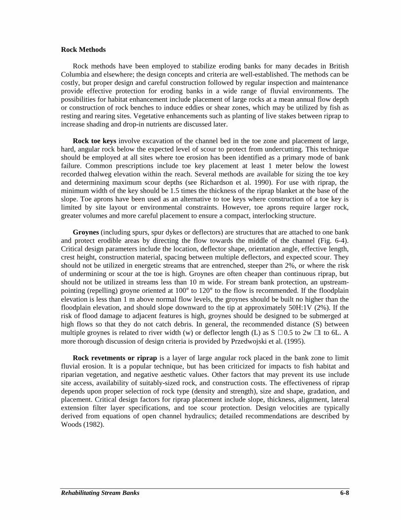
Rehabilitating Stream Banks 6-8
Rock Methods
Rock methods have been employed to stabilize eroding banks for many decades in BritishColumbia and elsewhere; the design concepts and criteria are well-established. The methods can becostly, but proper design and careful construction followed by regular inspection and maintenanceprovide effective protection for eroding banks in a wide range of fluvial environments. Thepossibilities for habitat enhancement include placement of large rocks at a mean annual flow depthor construction of rock benches to induce eddies or shear zones, which may be utilized by fish asresting and rearing sites. Vegetative enhancements such as planting of live stakes between riprap toincrease shading and drop-in nutrients are discussed later.
Rock toe keys involve excavation of the channel bed in the toe zone and placement of large,hard, angular rock below the expected level of scour to protect from undercutting. This techniqueshould be employed at all sites where toe erosion has been identified as a primary mode of bankfailure. Common prescriptions include toe key placement at least 1 meter below the lowestrecorded thalweg elevation within the reach. Several methods are available for sizing the toe keyand determining maximum scour depths (see Richardson et al. 1990). For use with riprap, theminimum width of the key should be 1.5 times the thickness of the riprap blanket at the base of theslope. Toe aprons have been used as an alternative to toe keys where construction of a toe key islimited by site layout or environmental constraints. However, toe aprons require larger rock,greater volumes and more careful placement to ensure a compact, interlocking structure.
Groynes (including spurs, spur dykes or deflectors) are structures that are attached to one bankand protect erodible areas by directing the flow towards the middle of the channel (Fig. 6-4).Critical design parameters include the location, deflector shape, orientation angle, effective length,crest height, construction material, spacing between multiple deflectors, and expected scour. Theyshould not be utilized in energetic streams that are entrenched, steeper than 2%, or where the riskof undermining or scour at the toe is high. Groynes are often cheaper than continuous riprap, butshould not be utilized in streams less than 10 m wide. For stream bank protection, an upstream-pointing (repelling) groyne oriented at 100° to 120° to the flow is recommended. If the floodplainelevation is less than 1 m above normal flow levels, the groynes should be built no higher than thefloodplain elevation, and should slope downward to the tip at approximately 50H:1V (2%). If therisk of flood damage to adjacent features is high, groynes should be designed to be submerged athigh flows so that they do not catch debris. In general, the recommended distance (S) betweenmultiple groynes is related to river width (w) or deflector length (L) as S ≅ 0.5 to 2w ≅1 to 6L. Amore thorough discussion of design criteria is provided by Przedwojski et al. (1995).
Rock revetments or riprap is a layer of large angular rock placed in the bank zone to limitfluvial erosion. It is a popular technique, but has been criticized for impacts to fish habitat andriparian vegetation, and negative aesthetic values. Other factors that may prevent its use includesite access, availability of suitably-sized rock, and construction costs. The effectiveness of riprapdepends upon proper selection of rock type (density and strength), size and shape, gradation, andplacement. Critical design factors for riprap placement include slope, thickness, alignment, lateralextension filter layer specifications, and toe scour protection. Design velocities are typicallyderived from equations of open channel hydraulics; detailed recommendations are described byWoods (1982).
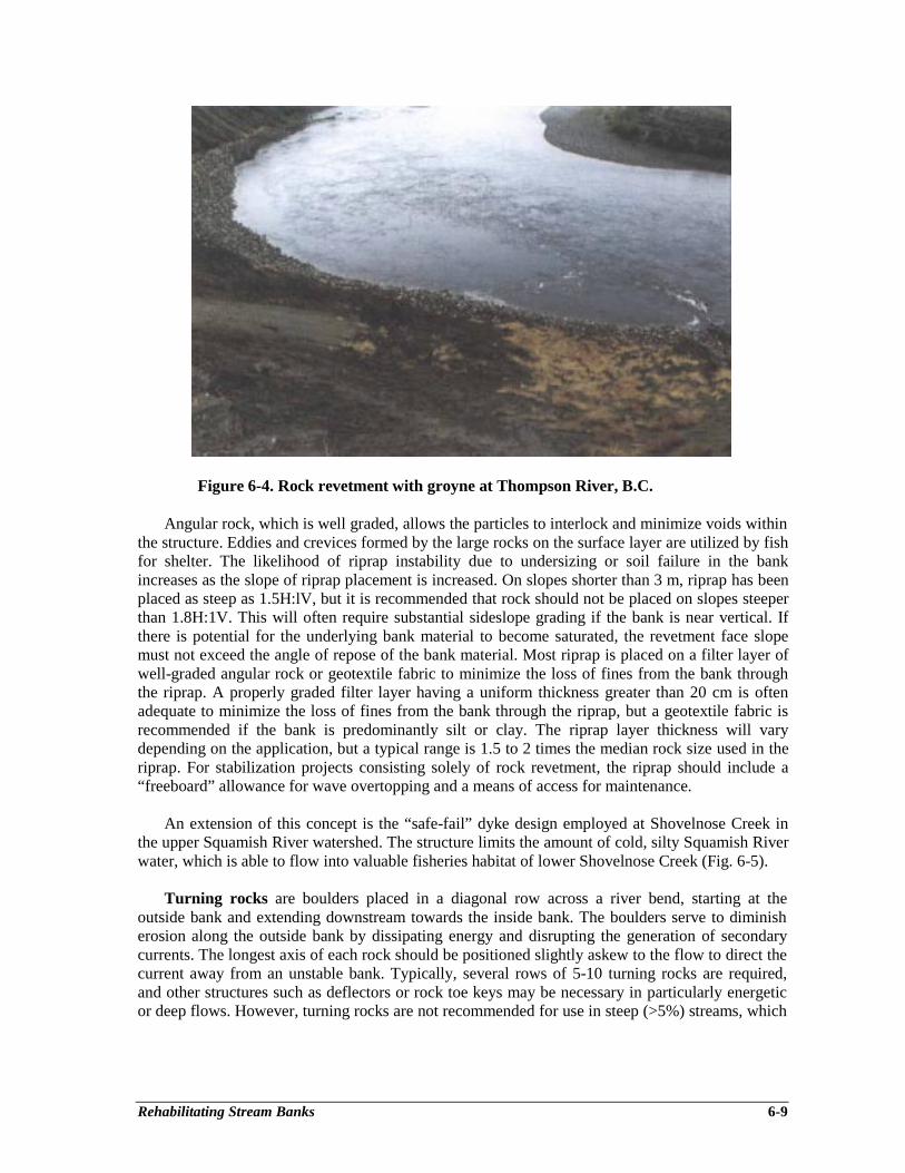
Rehabilitating Stream Banks 6-9
Figure 6-4. Rock revetment with groyne at Thompson River, B.C.
Angular rock, which is well graded, allows the particles to interlock and minimize voids withinthe structure. Eddies and crevices formed by the large rocks on the surface layer are utilized by fishfor shelter. The likelihood of riprap instability due to undersizing or soil failure in the bankincreases as the slope of riprap placement is increased. On slopes shorter than 3 m, riprap has beenplaced as steep as 1.5H:lV, but it is recommended that rock should not be placed on slopes steeperthan 1.8H:1V. This will often require substantial sideslope grading if the bank is near vertical. Ifthere is potential for the underlying bank material to become saturated, the revetment face slopemust not exceed the angle of repose of the bank material. Most riprap is placed on a filter layer ofwell-graded angular rock or geotextile fabric to minimize the loss of fines from the bank throughthe riprap. A properly graded filter layer having a uniform thickness greater than 20 cm is oftenadequate to minimize the loss of fines from the bank through the riprap, but a geotextile fabric isrecommended if the bank is predominantly silt or clay. The riprap layer thickness will varydepending on the application, but a typical range is 1.5 to 2 times the median rock size used in theriprap. For stabilization projects consisting solely of rock revetment, the riprap should include a“freeboard” allowance for wave overtopping and a means of access for maintenance.
An extension of this concept is the “safe-fail” dyke design employed at Shovelnose Creek inthe upper Squamish River watershed. The structure limits the amount of cold, silty Squamish Riverwater, which is able to flow into valuable fisheries habitat of lower Shovelnose Creek (Fig. 6-5).
Turning rocks are boulders placed in a diagonal row across a river bend, starting at theoutside bank and extending downstream towards the inside bank. The boulders serve to diminisherosion along the outside bank by dissipating energy and disrupting the generation of secondarycurrents. The longest axis of each rock should be positioned slightly askew to the flow to direct thecurrent away from an unstable bank. Typically, several rows of 5-10 turning rocks are required,and other structures such as deflectors or rock toe keys may be necessary in particularly energeticor deep flows. However, turning rocks are not recommended for use in steep (>5%) streams, which
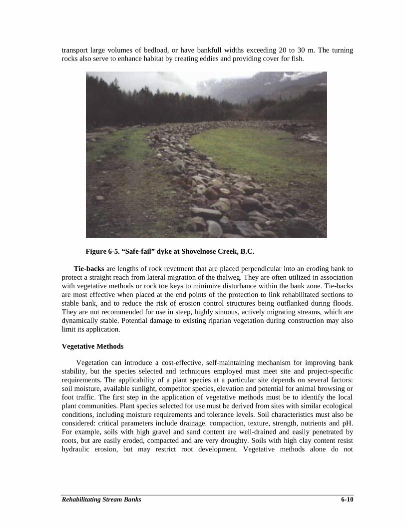
Rehabilitating Stream Banks 6-10
transport large volumes of bedload, or have bankfull widths exceeding 20 to 30 m. The turningrocks also serve to enhance habitat by creating eddies and providing cover for fish.
Figure 6-5. “Safe-fail” dyke at Shovelnose Creek, B.C.
Tie-backs are lengths of rock revetment that are placed perpendicular into an eroding bank toprotect a straight reach from lateral migration of the thalweg. They are often utilized in associationwith vegetative methods or rock toe keys to minimize disturbance within the bank zone. Tie-backsare most effective when placed at the end points of the protection to link rehabilitated sections tostable bank, and to reduce the risk of erosion control structures being outflanked during floods.They are not recommended for use in steep, highly sinuous, actively migrating streams, which aredynamically stable. Potential damage to existing riparian vegetation during construction may alsolimit its application.
Vegetative Methods
Vegetation can introduce a cost-effective, self-maintaining mechanism for improving bankstability, but the species selected and techniques employed must meet site and project-specificrequirements. The applicability of a plant species at a particular site depends on several factors:soil moisture, available sunlight, competitor species, elevation and potential for animal browsing orfoot traffic. The first step in the application of vegetative methods must be to identify the localplant communities. Plant species selected for use must be derived from sites with similar ecologicalconditions, including moisture requirements and tolerance levels. Soil characteristics must also beconsidered: critical parameters include drainage. compaction, texture, strength, nutrients and pH.For example, soils with high gravel and sand content are well-drained and easily penetrated byroots, but are easily eroded, compacted and are very droughty. Soils with high clay content resisthydraulic erosion, but may restrict root development. Vegetative methods alone do not
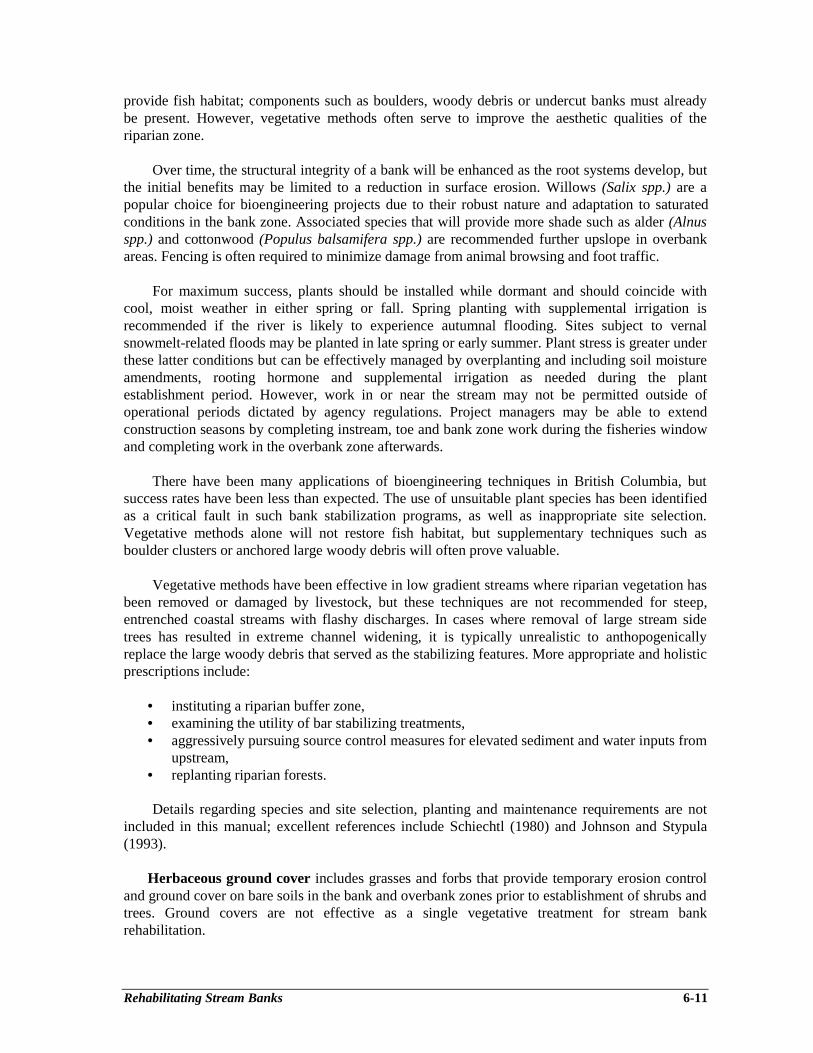
Rehabilitating Stream Banks 6-11
provide fish habitat; components such as boulders, woody debris or undercut banks must alreadybe present. However, vegetative methods often serve to improve the aesthetic qualities of theriparian zone.
Over time, the structural integrity of a bank will be enhanced as the root systems develop, butthe initial benefits may be limited to a reduction in surface erosion. Willows (Salix spp.) are apopular choice for bioengineering projects due to their robust nature and adaptation to saturatedconditions in the bank zone. Associated species that will provide more shade such as alder (Alnusspp.) and cottonwood (Populus balsamifera spp.) are recommended further upslope in overbankareas. Fencing is often required to minimize damage from animal browsing and foot traffic.
For maximum success, plants should be installed while dormant and should coincide withcool, moist weather in either spring or fall. Spring planting with supplemental irrigation isrecommended if the river is likely to experience autumnal flooding. Sites subject to vernalsnowmelt-related floods may be planted in late spring or early summer. Plant stress is greater underthese latter conditions but can be effectively managed by overplanting and including soil moistureamendments, rooting hormone and supplemental irrigation as needed during the plantestablishment period. However, work in or near the stream may not be permitted outside ofoperational periods dictated by agency regulations. Project managers may be able to extendconstruction seasons by completing instream, toe and bank zone work during the fisheries windowand completing work in the overbank zone afterwards.
There have been many applications of bioengineering techniques in British Columbia, butsuccess rates have been less than expected. The use of unsuitable plant species has been identifiedas a critical fault in such bank stabilization programs, as well as inappropriate site selection.Vegetative methods alone will not restore fish habitat, but supplementary techniques such asboulder clusters or anchored large woody debris will often prove valuable.
Vegetative methods have been effective in low gradient streams where riparian vegetation hasbeen removed or damaged by livestock, but these techniques are not recommended for steep,entrenched coastal streams with flashy discharges. In cases where removal of large stream sidetrees has resulted in extreme channel widening, it is typically unrealistic to anthopogenicallyreplace the large woody debris that served as the stabilizing features. More appropriate and holisticprescriptions include:
• instituting a riparian buffer zone,• examining the utility of bar stabilizing treatments,• aggressively pursuing source control measures for elevated sediment and water inputs from
upstream,• replanting riparian forests.
Details regarding species and site selection, planting and maintenance requirements are notincluded in this manual; excellent references include Schiechtl (1980) and Johnson and Stypula(1993).
Herbaceous ground cover includes grasses and forbs that provide temporary erosion controland ground cover on bare soils in the bank and overbank zones prior to establishment of shrubs andtrees. Ground covers are not effective as a single vegetative treatment for stream bankrehabilitation.
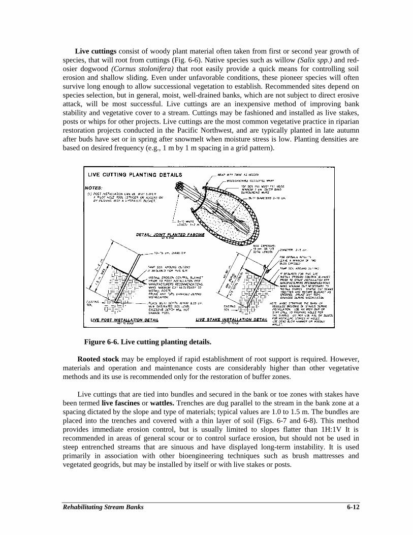
Rehabilitating Stream Banks 6-12
Live cuttings consist of woody plant material often taken from first or second year growth ofspecies, that will root from cuttings (Fig. 6-6). Native species such as willow (Salix spp.) and red-osier dogwood (Cornus stolonifera) that root easily provide a quick means for controlling soilerosion and shallow sliding. Even under unfavorable conditions, these pioneer species will oftensurvive long enough to allow successional vegetation to establish. Recommended sites depend onspecies selection, but in general, moist, well-drained banks, which are not subject to direct erosiveattack, will be most successful. Live cuttings are an inexpensive method of improving bankstability and vegetative cover to a stream. Cuttings may be fashioned and installed as live stakes,posts or whips for other projects. Live cuttings are the most common vegetative practice in riparianrestoration projects conducted in the Pacific Northwest, and are typically planted in late autumnafter buds have set or in spring after snowmelt when moisture stress is low. Planting densities arebased on desired frequency (e.g., 1 m by 1 m spacing in a grid pattern).
Figure 6-6. Live cutting planting details.
Rooted stock may be employed if rapid establishment of root support is required. However,materials and operation and maintenance costs are considerably higher than other vegetativemethods and its use is recommended only for the restoration of buffer zones.
Live cuttings that are tied into bundles and secured in the bank or toe zones with stakes havebeen termed live fascines or wattles. Trenches are dug parallel to the stream in the bank zone at aspacing dictated by the slope and type of materials; typical values are 1.0 to 1.5 m. The bundles areplaced into the trenches and covered with a thin layer of soil (Figs. 6-7 and 6-8). This methodprovides immediate erosion control, but is usually limited to slopes flatter than 1H:1V It isrecommended in areas of general scour or to control surface erosion, but should not be used insteep entrenched streams that are sinuous and have displayed long-term instability. It is usedprimarily in association with other bioengineering techniques such as brush mattresses andvegetated geogrids, but may be installed by itself or with live stakes or posts.
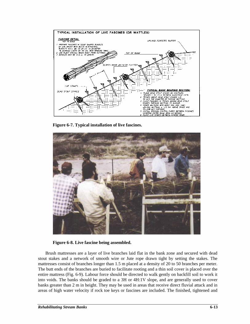
Rehabilitating Stream Banks 6-13
Figure 6-7. Typical installation of live fascines.
Figure 6-8. Live fascine being assembled.
Brush mattresses are a layer of live branches laid flat in the bank zone and secured with deadstout stakes and a network of smooth wire or Jute rope drawn tight by setting the stakes. Themattresses consist of branches longer than 1.5 m placed at a density of 20 to 50 branches per meter.The butt ends of the branches are buried to facilitate rooting and a thin soil cover is placed over theentire mattress (Fig. 6-9). Labour force should be directed to walk gently on backfill soil to work itinto voids. The banks should be graded to a 3H or 4H:1V slope, and are generally used to coverbanks greater than 2 m in height. They may be used in areas that receive direct fluvial attack and inareas of high water velocity if rock toe keys or fascines are included. The finished, tightened and
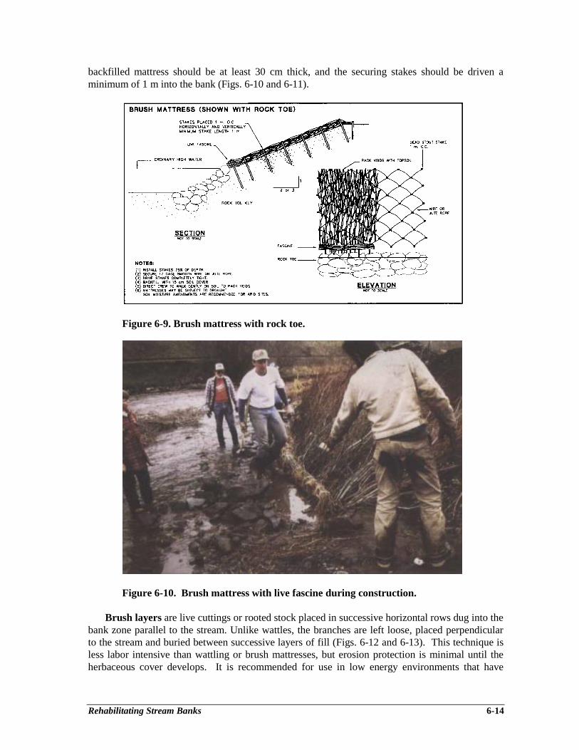
Rehabilitating Stream Banks 6-14
backfilled mattress should be at least 30 cm thick, and the securing stakes should be driven aminimum of 1 m into the bank (Figs. 6-10 and 6-11).
Figure 6-9. Brush mattress with rock toe.
Figure 6-10. Brush mattress with live fascine during construction.
Brush layers are live cuttings or rooted stock placed in successive horizontal rows dug into thebank zone parallel to the stream. Unlike wattles, the branches are left loose, placed perpendicularto the stream and buried between successive layers of fill (Figs. 6-12 and 6-13). This technique isless labor intensive than wattling or brush mattresses, but erosion protection is minimal until theherbaceous cover develops. It is recommended for use in low energy environments that have
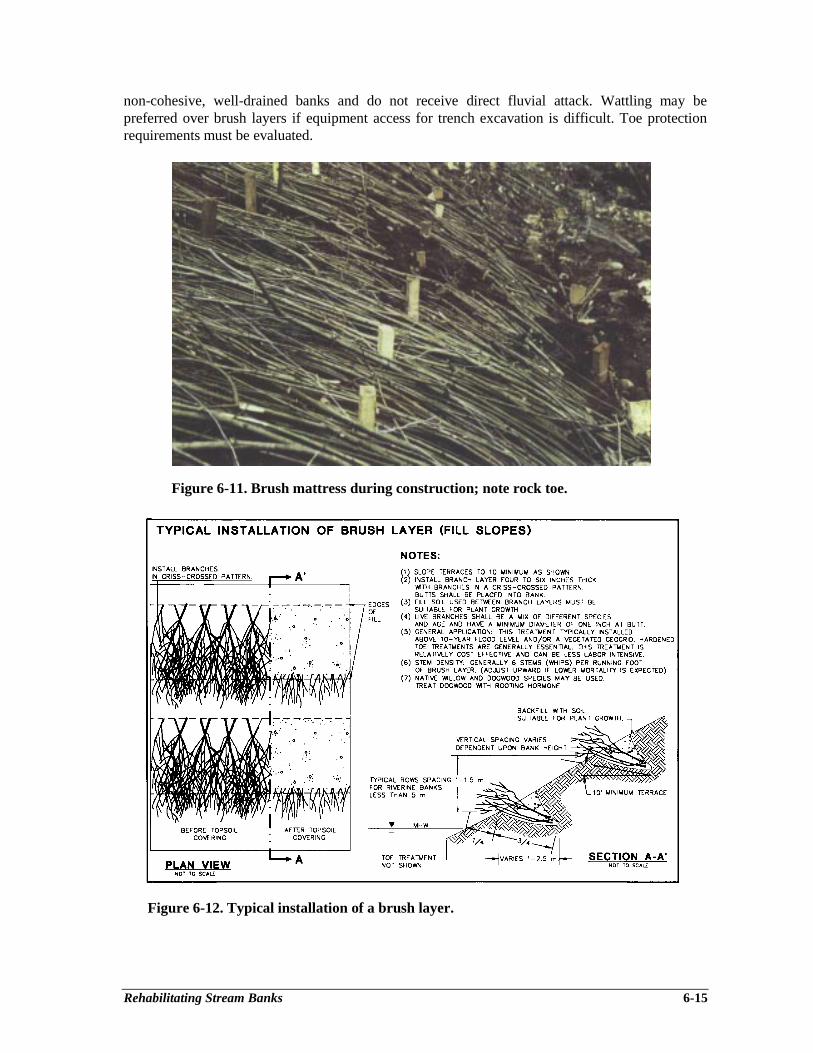
Rehabilitating Stream Banks 6-15
non-cohesive, well-drained banks and do not receive direct fluvial attack. Wattling may bepreferred over brush layers if equipment access for trench excavation is difficult. Toe protectionrequirements must be evaluated.
Figure 6-11. Brush mattress during construction; note rock toe.
Figure 6-12. Typical installation of a brush layer.
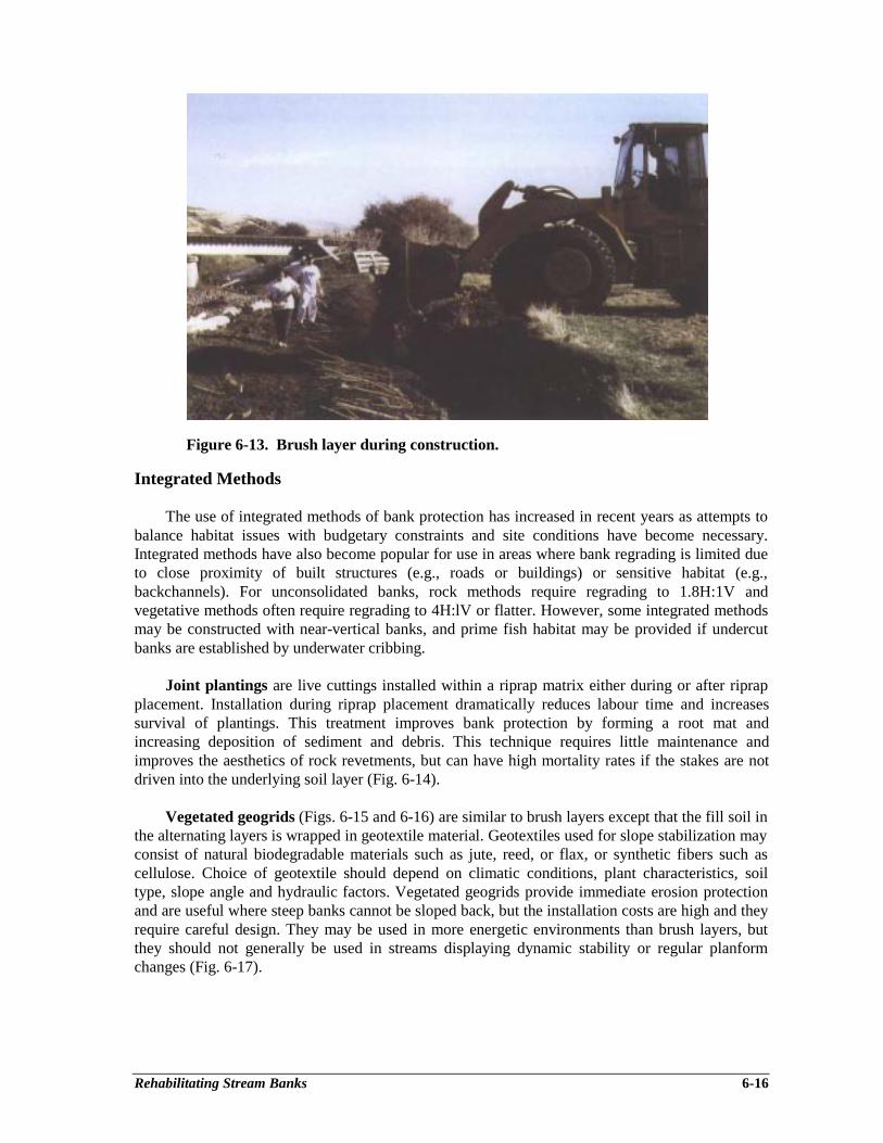
Rehabilitating Stream Banks 6-16
Figure 6-13. Brush layer during construction.
Integrated Methods
The use of integrated methods of bank protection has increased in recent years as attempts tobalance habitat issues with budgetary constraints and site conditions have become necessary.Integrated methods have also become popular for use in areas where bank regrading is limited dueto close proximity of built structures (e.g., roads or buildings) or sensitive habitat (e.g.,backchannels). For unconsolidated banks, rock methods require regrading to 1.8H:1V andvegetative methods often require regrading to 4H:lV or flatter. However, some integrated methodsmay be constructed with near-vertical banks, and prime fish habitat may be provided if undercutbanks are established by underwater cribbing.
Joint plantings are live cuttings installed within a riprap matrix either during or after riprapplacement. Installation during riprap placement dramatically reduces labour time and increasessurvival of plantings. This treatment improves bank protection by forming a root mat andincreasing deposition of sediment and debris. This technique requires little maintenance andimproves the aesthetics of rock revetments, but can have high mortality rates if the stakes are notdriven into the underlying soil layer (Fig. 6-14).
Vegetated geogrids (Figs. 6-15 and 6-16) are similar to brush layers except that the fill soil inthe alternating layers is wrapped in geotextile material. Geotextiles used for slope stabilization mayconsist of natural biodegradable materials such as jute, reed, or flax, or synthetic fibers such ascellulose. Choice of geotextile should depend on climatic conditions, plant characteristics, soiltype, slope angle and hydraulic factors. Vegetated geogrids provide immediate erosion protectionand are useful where steep banks cannot be sloped back, but the installation costs are high and theyrequire careful design. They may be used in more energetic environments than brush layers, butthey should not generally be used in streams displaying dynamic stability or regular planformchanges (Fig. 6-17).
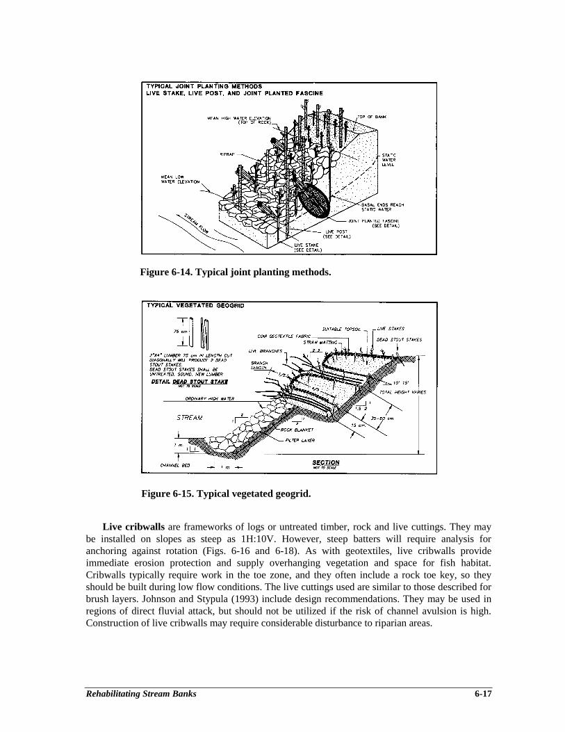
Rehabilitating Stream Banks 6-17
Figure 6-14. Typical joint planting methods.
Figure 6-15. Typical vegetated geogrid.
Live cribwalls are frameworks of logs or untreated timber, rock and live cuttings. They maybe installed on slopes as steep as 1H:10V. However, steep batters will require analysis foranchoring against rotation (Figs. 6-16 and 6-18). As with geotextiles, live cribwalls provideimmediate erosion protection and supply overhanging vegetation and space for fish habitat.Cribwalls typically require work in the toe zone, and they often include a rock toe key, so theyshould be built during low flow conditions. The live cuttings used are similar to those described forbrush layers. Johnson and Stypula (1993) include design recommendations. They may be used inregions of direct fluvial attack, but should not be utilized if the risk of channel avulsion is high.Construction of live cribwalls may require considerable disturbance to riparian areas.
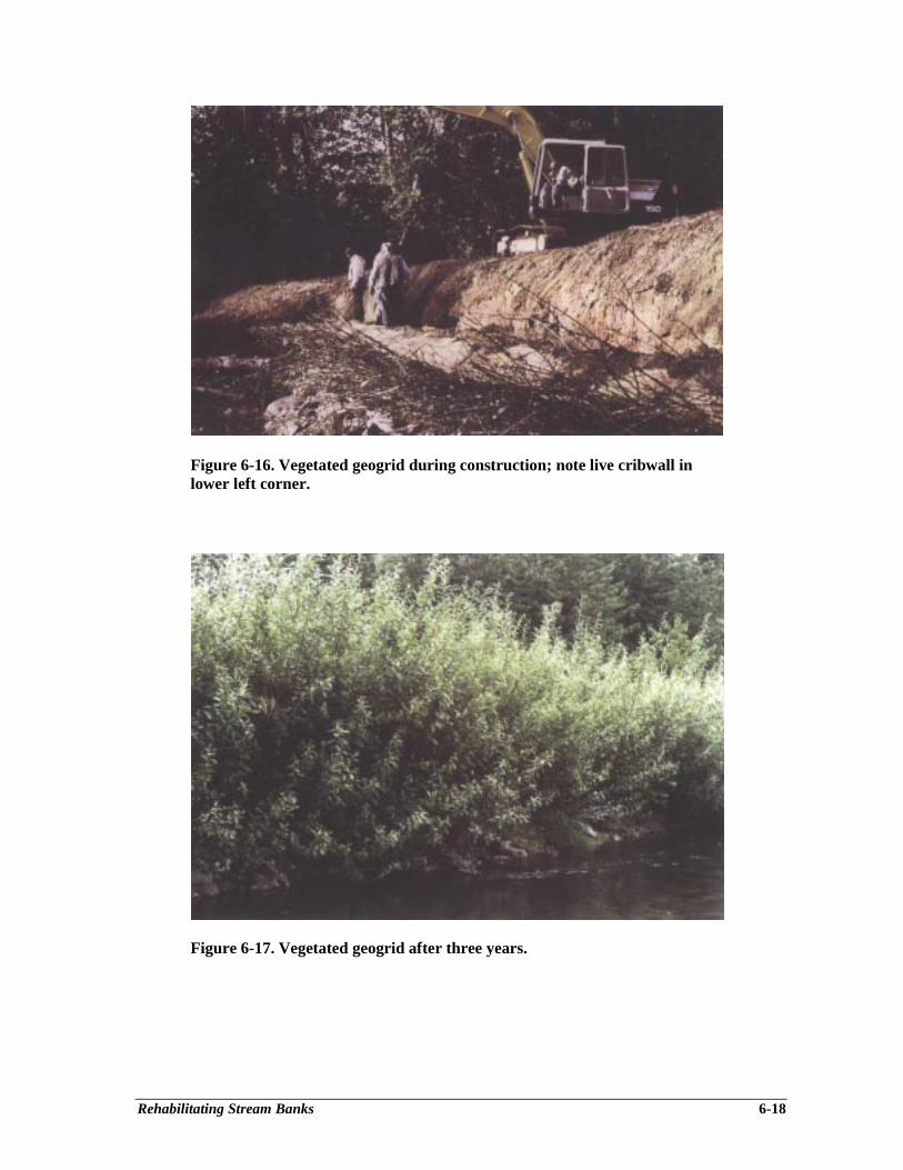
Rehabilitating Stream Banks 6-18
Figure 6-16. Vegetated geogrid during construction; note live cribwall inlower left corner.
Figure 6-17. Vegetated geogrid after three years.
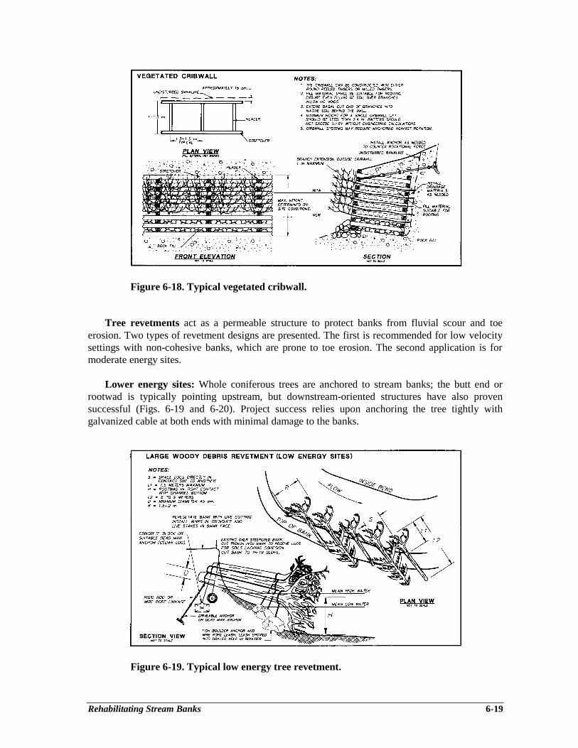
Rehabilitating Stream Banks 6-19
Figure 6-18. Typical vegetated cribwall.
Tree revetments act as a permeable structure to protect banks from fluvial scour and toeerosion. Two types of revetment designs are presented. The first is recommended for low velocitysettings with non-cohesive banks, which are prone to toe erosion. The second application is formoderate energy sites.
Lower energy sites: Whole coniferous trees are anchored to stream banks; the butt end orrootwad is typically pointing upstream, but downstream-oriented structures have also provensuccessful (Figs. 6-19 and 6-20). Project success relies upon anchoring the tree tightly withgalvanized cable at both ends with minimal damage to the banks.
Figure 6-19. Typical low energy tree revetment.
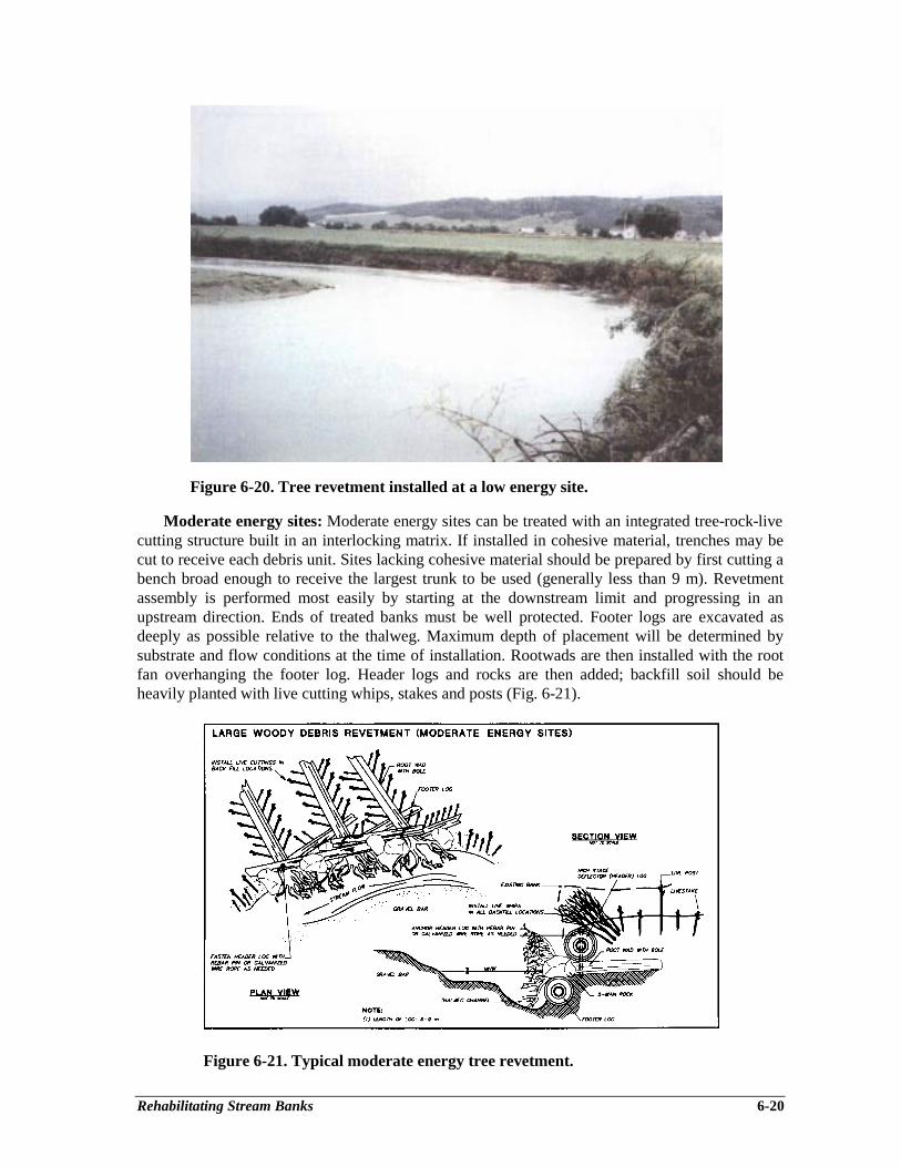
Rehabilitating Stream Banks 6-20
Figure 6-20. Tree revetment installed at a low energy site.
Moderate energy sites: Moderate energy sites can be treated with an integrated tree-rock-livecutting structure built in an interlocking matrix. If installed in cohesive material, trenches may becut to receive each debris unit. Sites lacking cohesive material should be prepared by first cutting abench broad enough to receive the largest trunk to be used (generally less than 9 m). Revetmentassembly is performed most easily by starting at the downstream limit and progressing in anupstream direction. Ends of treated banks must be well protected. Footer logs are excavated asdeeply as possible relative to the thalweg. Maximum depth of placement will be determined bysubstrate and flow conditions at the time of installation. Rootwads are then installed with the rootfan overhanging the footer log. Header logs and rocks are then added; backfill soil should beheavily planted with live cutting whips, stakes and posts (Fig. 6-21).
Figure 6-21. Typical moderate energy tree revetment.

Rehabilitating Stream Banks 6-21
Moderate energy tree revetments should be combined with deflectors or tie-backs to decreasethe risk of outflanking or damage from floating ice. Tree revetments have been successful on B.C.Interior creeks with gradients less than 2% and bankfull widths less than 30 m. Local energydissipation may be achieved by installing riffles downstream of the tree revetment to decrease thewater surface slope. If the water depth at the tree revetment exceeds 1 m or if the gradient exceeds2%, a rock toe key should also be used. Reduction of current speeds will induce sedimentation andaccelerate vegetation establishment (Fig. 6-22). The lifespan of tree revetments is related todamage, deterioration, and the degree of wetting and drying, but should not be expected to exceed7 to 10 years, unless mostly submerged. If available, dense coniferous species such as western redcedar, hemlock or Douglas fir should be utilized.
Figure 6-22. Tree revetment during installation at a moderate energy site.
Large woody debris may be utilized as a component of integrated bank protection to enhancehabitat by providing cover, drop-in nutrients and hydraulic diversity. The morphologic variabilityprovided by woody debris often serves to improve fish habitat by creating hydraulic diversity,resting and rearing areas, such as undercut banks and pools. Functional large woody debrisgenerally measures at least 6-9 m in length and 60 cm in diameter (Fig. 6-23). It has the ability tosignificantly affect local flow velocities, sediment transport, and erosion of bed and banks within astream reach. Placement must be carefully planned to address the specific engineering objectivesand habitat requirements.
The most critical design consideration is the permanence of the wood relative to the challengeof anchoring each element in place. Key factors include the type of woody debris, the size andshape, location and orientation within the reach, exposure to currents and resistance to movement.The longevity of any wood will be enhanced if it remains fully saturated. For maximum longevity,resistant coniferous species such as Douglas-fir or western red cedar are recommended. For bankprotection, woody debris may create a hydraulic effect similar to deflectors; placement at anupstream angle will deflect flow towards the center of the stream. This technique is most effectivewhen used in series of several wood pieces, and in combination with rock toes and vegetative
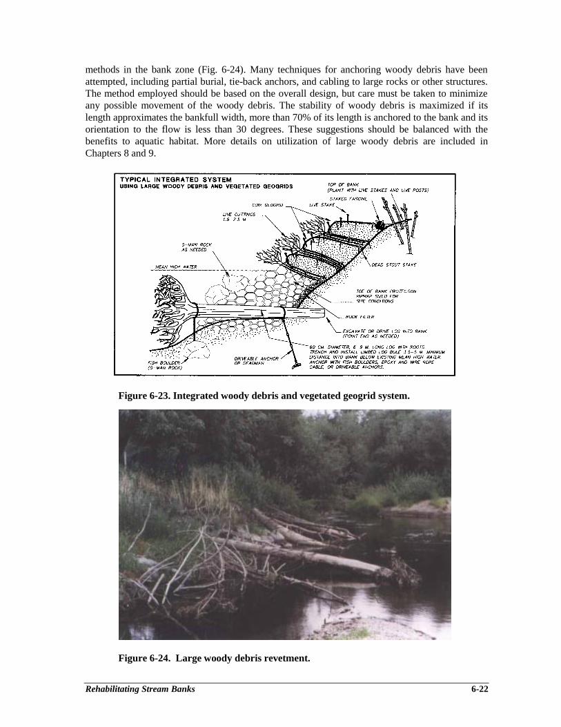
Rehabilitating Stream Banks 6-22
methods in the bank zone (Fig. 6-24). Many techniques for anchoring woody debris have beenattempted, including partial burial, tie-back anchors, and cabling to large rocks or other structures.The method employed should be based on the overall design, but care must be taken to minimizeany possible movement of the woody debris. The stability of woody debris is maximized if itslength approximates the bankfull width, more than 70% of its length is anchored to the bank and itsorientation to the flow is less than 30 degrees. These suggestions should be balanced with thebenefits to aquatic habitat. More details on utilization of large woody debris are included inChapters 8 and 9.
Figure 6-23. Integrated woody debris and vegetated geogrid system.
Figure 6-24. Large woody debris revetment.
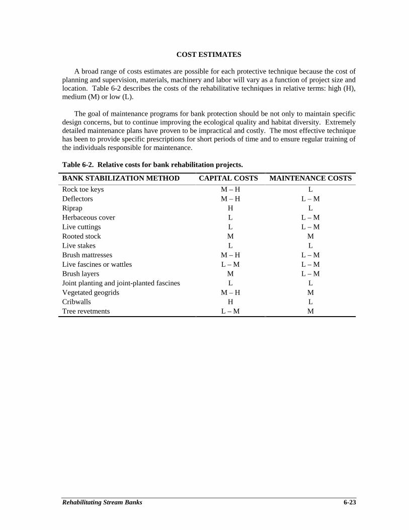
Rehabilitating Stream Banks 6-23
COST ESTIMATES
A broad range of costs estimates are possible for each protective technique because the cost ofplanning and supervision, materials, machinery and labor will vary as a function of project size andlocation. Table 6-2 describes the costs of the rehabilitative techniques in relative terms: high (H),medium (M) or low (L).
The goal of maintenance programs for bank protection should be not only to maintain specificdesign concerns, but to continue improving the ecological quality and habitat diversity. Extremelydetailed maintenance plans have proven to be impractical and costly. The most effective techniquehas been to provide specific prescriptions for short periods of time and to ensure regular training ofthe individuals responsible for maintenance.
Table 6-2. Relative costs for bank rehabilitation projects.
BANK STABILIZATION METHOD CAPITAL COSTS MAINTENANCE COSTS
Rock toe keys M – H LDeflectors M – H L – MRiprap H LHerbaceous cover L L – MLive cuttings L L – MRooted stock M MLive stakes L LBrush mattresses M – H L – MLive fascines or wattles L – M L – MBrush layers M L – MJoint planting and joint-planted fascines L LVegetated geogrids M – H MCribwalls H LTree revetments L – M M
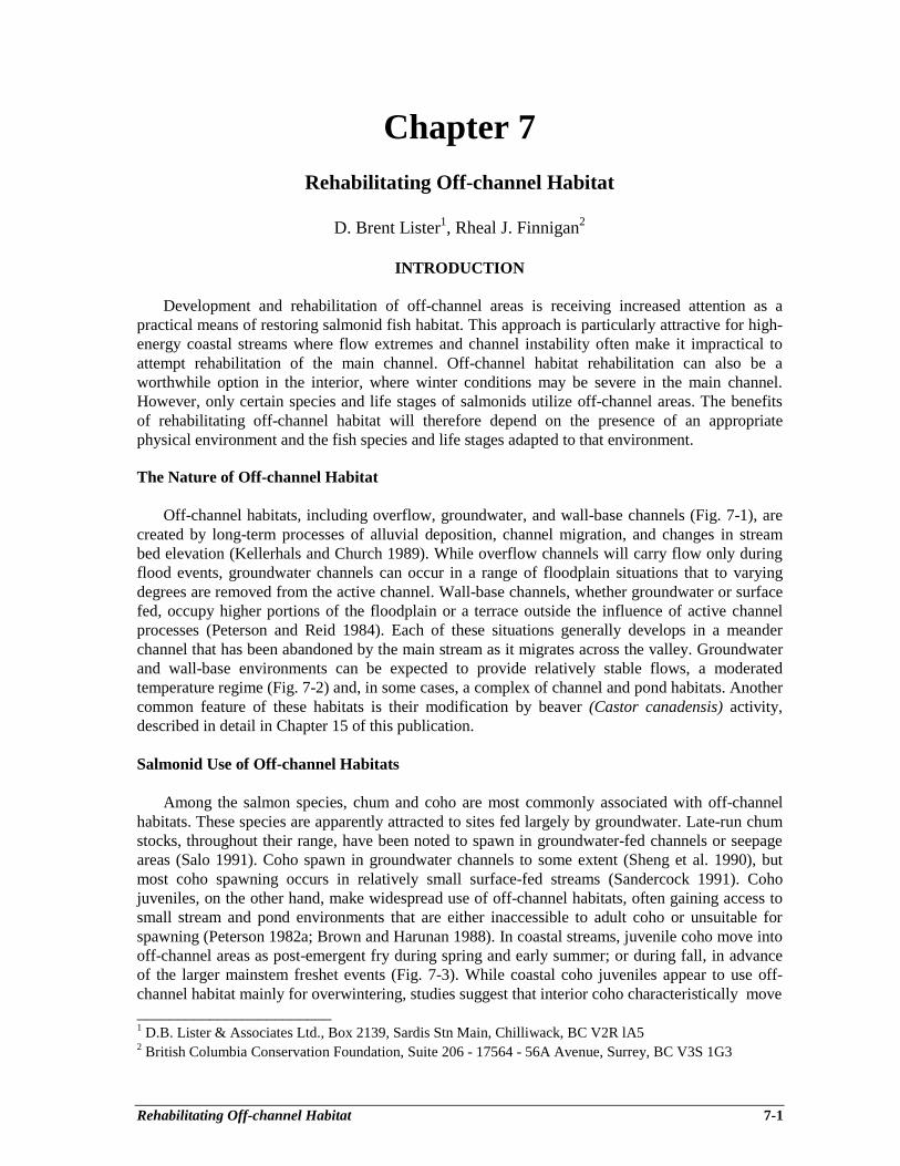
Rehabilitating Off-channel Habitat 7-1
Chapter 7Rehabilitating Off-channel Habitat
D. Brent Lister1, Rheal J. Finnigan2
INTRODUCTION
Development and rehabilitation of off-channel areas is receiving increased attention as apractical means of restoring salmonid fish habitat. This approach is particularly attractive for high-energy coastal streams where flow extremes and channel instability often make it impractical toattempt rehabilitation of the main channel. Off-channel habitat rehabilitation can also be aworthwhile option in the interior, where winter conditions may be severe in the main channel.However, only certain species and life stages of salmonids utilize off-channel areas. The benefitsof rehabilitating off-channel habitat will therefore depend on the presence of an appropriatephysical environment and the fish species and life stages adapted to that environment.
The Nature of Off-channel Habitat
Off-channel habitats, including overflow, groundwater, and wall-base channels (Fig. 7-1), arecreated by long-term processes of alluvial deposition, channel migration, and changes in streambed elevation (Kellerhals and Church 1989). While overflow channels will carry flow only duringflood events, groundwater channels can occur in a range of floodplain situations that to varyingdegrees are removed from the active channel. Wall-base channels, whether groundwater or surfacefed, occupy higher portions of the floodplain or a terrace outside the influence of active channelprocesses (Peterson and Reid 1984). Each of these situations generally develops in a meanderchannel that has been abandoned by the main stream as it migrates across the valley. Groundwaterand wall-base environments can be expected to provide relatively stable flows, a moderatedtemperature regime (Fig. 7-2) and, in some cases, a complex of channel and pond habitats. Anothercommon feature of these habitats is their modification by beaver (Castor canadensis) activity,described in detail in Chapter 15 of this publication.
Salmonid Use of Off-channel Habitats
Among the salmon species, chum and coho are most commonly associated with off-channelhabitats. These species are apparently attracted to sites fed largely by groundwater. Late-run chumstocks, throughout their range, have been noted to spawn in groundwater-fed channels or seepageareas (Salo 1991). Coho spawn in groundwater channels to some extent (Sheng et al. 1990), butmost coho spawning occurs in relatively small surface-fed streams (Sandercock 1991). Cohojuveniles, on the other hand, make widespread use of off-channel habitats, often gaining access tosmall stream and pond environments that are either inaccessible to adult coho or unsuitable forspawning (Peterson 1982a; Brown and Harunan 1988). In coastal streams, juvenile coho move intooff-channel areas as post-emergent fry during spring and early summer; or during fall, in advanceof the larger mainstem freshet events (Fig. 7-3). While coastal coho juveniles appear to use off-channel habitat mainly for overwintering, studies suggest that interior coho characteristically move________________________1 D.B. Lister & Associates Ltd., Box 2139, Sardis Stn Main, Chilliwack, BC V2R lA52 British Columbia Conservation Foundation, Suite 206 - 17564 - 56A Avenue, Surrey, BC V3S 1G3
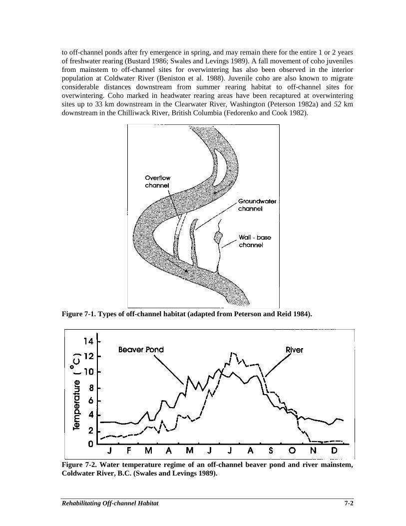
Rehabilitating Off-channel Habitat 7-2
to off-channel ponds after fry emergence in spring, and may remain there for the entire 1 or 2 yearsof freshwater rearing (Bustard 1986; Swales and Levings 1989). A fall movement of coho juvenilesfrom mainstem to off-channel sites for overwintering has also been observed in the interiorpopulation at Coldwater River (Beniston et al. 1988). Juvenile coho are also known to migrateconsiderable distances downstream from summer rearing habitat to off-channel sites foroverwintering. Coho marked in headwater rearing areas have been recaptured at overwinteringsites up to 33 km downstream in the Clearwater River, Washington (Peterson 1982a) and 52 kmdownstream in the Chilliwack River, British Columbia (Fedorenko and Cook 1982).
Figure 7-1. Types of off-channel habitat (adapted from Peterson and Reid 1984).
Figure 7-2. Water temperature regime of an off-channel beaver pond and river mainstem,Coldwater River, B.C. (Swales and Levings 1989).

Rehabilitating Off-channel Habitat 7-3
Figure 7-3. Seasonal pattern of juvenile coho salmon recruitment to off-channel ponds(Peterson and Reid 1984) and relationship of coho recruitment to daily discharge (Peterson1982a) Clearwater River; Washington.
Other salmon species have not been observed to utilize off-channel habitat to a significantextent in British Columbia. Pink salmon are not reported to utilize off-channel areas (Heard 1991).Chinook salmon do not spawn in off-channel habitat, but interior stocks make some use of off-channel ponds and side channels, often associated with tributaries, for juvenile rearing andoverwintering (Anon. 1987; Swales and Levings 1989). Sockeye salmon have been reported tospawn in off-channel spring areas in Kamchatka (Burgner 1991) and Alaska (Mathisen 1962), andon groundwater-fed lake beaches (Burgner 1991). Though off-channel habitat use by sockeye isapparently not common in British Columbia, groundwater channels developed at Adams River andKitsumkalum Lake in the interior have been used extensively by sockeye for spawning and, in theformer case, for juvenile rearing over summer (M. Foy and M. Sheng, Department of Fisheries andOceans, Vancouver, pers. comm.). As the capacity of nursery lakes to rear juveniles frequentlylimits sockeye production (Burgner 1991), off-channel habitat rehabilitation for sockeye will berestricted to situations where spawning habitat is considered the limiting factor.
Rehabilitating Off-channel Habitat 7-4
Of the trout species, coastal cutthroat (0. clarki clarki) are most likely to be found in off-channel environments. Adult and juvenile coastal cutthroat can be expected to cohabit many off-channel sites with juvenile coho (Cederholm and Scarlett 1982; Hartman and Brown 1987).Seasonal movements between main-channel and off-channel sites enable cutthroat to utilize smalltributaries for spawning, juvenile rearing or overwintering. In these situations, cutthroat may bepartially segregated from coho juveniles by their preference for more permanently wettedenvironments with higher flow (Hartman and Brown 1987). Interior stocks of west slope cutthroattrout (0. clarki lewisi) have generally not been documented in off-channel habitat, but in the ElkRiver and its Fording River tributary in southeastern British Columbia, yearling and older cutthroatdo overwinter in groundwater-fed off-channel ponds (G. Oliver, Interior Reforestation, Cranbrook;D.B. Lister & Associates 1980, pers. comm.).
Steelhead trout do not commonly spawn in off-channel streams, and juvenile steelheadapparently use such habitats to a much smaller extent than coastal cutthroat. Steelhead are notabundant in off-channel ponds (Cederholm and Scarlett 1982; Swales and Levings 1989). Incoastal streams steelhead underyearlings and parr prefer small surface-fed tributaries togroundwater environments for rearing and overwintering (Cederholm and Scarlett 1982). Somecoastal groundwater channels do, however, overwinter significant numbers of parr and pre-smoltsteelhead (King and Young 1986) and a groundwater channel at Deadman River, in the BritishColumbia interior, attracted significant numbers of underyearling steelhead for rearing andoverwintering (Sheng et al. 1990). Adequate velocity and habitat diversity were likely requisitesfor juvenile steelhead use of these sites. Though off-channel habitat use by resident rainbow trouthas not been reported, underyearling rainbow are known to rear in seepage-fed ponds and sidechannels when these habitats are available (B. Chan, Ministry of Environment, Lands and Parks,Kamloops, pers. comm.).
The stream-dwelling species of char, Dolly Varden and bull trout, have not been commonlyobserved in off-channel habitats. Studies of coastal streams in southern British Columbia andWashington indicate little use of off-channel areas by Dolly Varden. This species may, however,be more abundant in off-channel habitats of northern streams. In the Skeena River system, juvenileDolly Varden utilize off-channel ponds in the presence of juvenile coho and stickleback(Gasterosteus aculeatus) (David Bustard and Associates 1993). and have been observed tooverwinter in a groundwater channel at Kitwanga River (M. Foy, Department of Fisheries andOceans, Vancouver. pers. comm.). Dolly Varden are also relatively abundant in southeast Alaskastreams, where they make considerable use of beaver ponds (Bryant 1984). Though bull trout aresuspected to spawn to some extent in groundwater-fed areas, studies to date have not revealed theuse of off-channel habitat by this species (Baxter and McPhail 1996).
Use of off-channel habitat by Arctic grayling has not been well documented. Grayling appearlikely to utilize off-channel habitats, as they have been noted to frequent marginal low velocityareas, side channels and backwaters as underyearlings, and to distribute into a variety of habitats,including spring-fed areas, for feeding and overwintering in the juvenile to adult stages (Northcote1993).
Evolution of Off-channel Habitat Rehabilitation
Early development of off-channel habitat for anadromous salmonids on the Pacific coast ofNorth America involved construction of surface-fed side channels, primarily for spawning sockeye,pink and chum salmon, during the 1950’s and 1960’s. The first artificial spawning channel wasconstructed in 1953 at Jones Creek on the lower Fraser River (Hourston and MacKinnon 1956).

Rehabilitating Off-channel Habitat 7-5
Following that project, 14 artificial spawning channels were built in British Columbia, and another7 channels went into operation in the northwest United States. Certain spawning channels producedsignificant numbers of adult salmon to the commercial fishery (Fraser et al. 1983; West and Mason1987), but the relatively high capital and maintenance costs, particularly sediment problems in non-lake-fed situations, tended to make spawning channels generally less attractive than other salmonidenhancement options.
In the mid-1970’s, the Department of Fisheries and Oceans (DFO) began to examine thepotential for increasing chum salmon production in British Columbia by restoring groundwater-fedspawning areas (Marshall 1986). Groundwater spawning channels were relatively inexpensive tobuild and essentially free of the maintenance problems associated with many surface-fed spawningchannels. Also at this time, research on seasonal habitat and movements of juvenile coho wasrevealing the importance of off-channel streams and ponds for rearing and overwintering (Bustardand Narver 1975; Peterson 1982a). Development of off-channel habitat for chum salmon, and to alesser extent for coho, continued in British Columbia, Washington and Alaska during the 1980’s(Bachen 1984; Bonnell 1991; Cowan 1991). Evaluation of the groundwater chum spawningchannels indicated that these sites also provided spawning and juvenile nursery habitat for coho(Sheng et al. 1990). The quarry rock (riprap) used to protect the banks of these channels fromerosion by chum spawners inadvertently provided excellent cover for coho juveniles, which alsobenefited from stable flows and temperatures as well as an abundance of food consisting of aquaticinsects supplemented in winter by chum salmon carcasses, alevins and emergent fry. Recentresearch suggests that salmon carcasses are also a significant source of nutrients to the food chainsupporting stream-rearing species such as coho, cutthroat and steelhead trout (Bilby et al. 1996). Inthe 1990’s, off-channel habitat projects have therefore tended to emphasize a multi-speciesapproach that includes, for example, creation of spawning areas for species such as chum salmonwith little or no stream-rearing requirement, as well as spawning and rearing habitat for coho,cutthroat or steelhead, which have more complex freshwater habitat needs.
ASSESSING THE NEED AND THE OPTIONS
Effective off-channel habitat rehabilitation is best achieved from a thorough assessment ofconditions in the watershed of interest. An overview fish habitat assessment, including review ofexisting information on fish resources and watershed conditions, will normally be required. Itshould examine evidence for declines in fish stocks and the linkage between fish populationchanges and habitat changes. If existing information is not adequate to assess the need for aproject, it may be necessary to obtain detailed site-specific habitat information through fieldassessment. Guidelines for planning watershed restoration work, and fish habitat rehabilitation inparticular, are presented in Watershed Restoration (WR) Technical Circular No. 1 (Johnston andMoore 1995). Procedures for overview and detailed field assessments are described in WRTechnical Circular No. 8 (Johnston and Slaney 1996).
If initial assessment confirms the need for fish habitat rehabilitation measures, project plannersshould decide on the appropriate strategy and whether or not it will involve main channel or off-channel habitat. Off-channel habitat rehabilitation will be favoured on relatively large streams, andin situations where the main channel is too unstable for in-channel habitat rehabilitation measures.Selection of the off-channel option also depends, of course, on the presence of salmonid speciesthat will take advantage of habitat created outside the main channel. A process for selectingbetween main channel and off-channel habitat options is presented by a flow chart in Chapter 8 ofthis publication.

Rehabilitating Off-channel Habitat 7-6
PROJECT PLANNING AND SELECTION
The process for planning, selecting and investigating suitable off-channel habitat projects isdescribed in the following sections and summarized in Figure 7-4.
Target Species and Water Sources
It is important to confirm at the outset the fish species and life stages involved, and the type ofwater source. e.g. surface runoff, lake or groundwater, that will be employed. One shouldunderstand how salmonid populations utilize the drainage for spawning, juvenile rearing, andoverwintering, as well as the role played by main channel, tributary and off-channel habitats. Doany stocks spawn in lake-fed or groundwater-fed situations that offer more benign winterconditions (moderate temperature regime, stable flows, and sediment-free water) than surfacerunoff streams? The answers to these questions will lead to decisions on the species, water sourceand habitats, which will be the focus of the project.
Figure 7-4. Principal elements of project planning, selection and investigation.
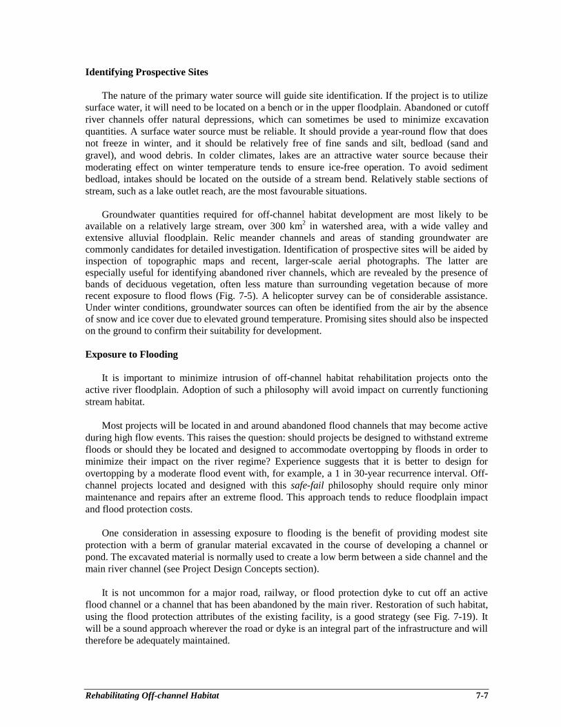
Rehabilitating Off-channel Habitat 7-7
Identifying Prospective Sites
The nature of the primary water source will guide site identification. If the project is to utilizesurface water, it will need to be located on a bench or in the upper floodplain. Abandoned or cutoffriver channels offer natural depressions, which can sometimes be used to minimize excavationquantities. A surface water source must be reliable. It should provide a year-round flow that doesnot freeze in winter, and it should be relatively free of fine sands and silt, bedload (sand andgravel), and wood debris. In colder climates, lakes are an attractive water source because theirmoderating effect on winter temperature tends to ensure ice-free operation. To avoid sedimentbedload, intakes should be located on the outside of a stream bend. Relatively stable sections ofstream, such as a lake outlet reach, are the most favourable situations.
Groundwater quantities required for off-channel habitat development are most likely to beavailable on a relatively large stream, over 300 km2 in watershed area, with a wide valley andextensive alluvial floodplain. Relic meander channels and areas of standing groundwater arecommonly candidates for detailed investigation. Identification of prospective sites will be aided byinspection of topographic maps and recent, larger-scale aerial photographs. The latter areespecially useful for identifying abandoned river channels, which are revealed by the presence ofbands of deciduous vegetation, often less mature than surrounding vegetation because of morerecent exposure to flood flows (Fig. 7-5). A helicopter survey can be of considerable assistance.Under winter conditions, groundwater sources can often be identified from the air by the absenceof snow and ice cover due to elevated ground temperature. Promising sites should also be inspectedon the ground to confirm their suitability for development.
Exposure to Flooding
It is important to minimize intrusion of off-channel habitat rehabilitation projects onto theactive river floodplain. Adoption of such a philosophy will avoid impact on currently functioningstream habitat.
Most projects will be located in and around abandoned flood channels that may become activeduring high flow events. This raises the question: should projects be designed to withstand extremefloods or should they be located and designed to accommodate overtopping by floods in order tominimize their impact on the river regime? Experience suggests that it is better to design forovertopping by a moderate flood event with, for example, a 1 in 30-year recurrence interval. Off-channel projects located and designed with this safe-fail philosophy should require only minormaintenance and repairs after an extreme flood. This approach tends to reduce floodplain impactand flood protection costs.
One consideration in assessing exposure to flooding is the benefit of providing modest siteprotection with a berm of granular material excavated in the course of developing a channel orpond. The excavated material is normally used to create a low berm between a side channel and themain river channel (see Project Design Concepts section).
It is not uncommon for a major road, railway, or flood protection dyke to cut off an activeflood channel or a channel that has been abandoned by the main river. Restoration of such habitat,using the flood protection attributes of the existing facility, is a good strategy (see Fig. 7-19). Itwill be a sound approach wherever the road or dyke is an integral part of the infrastructure and willtherefore be adequately maintained.
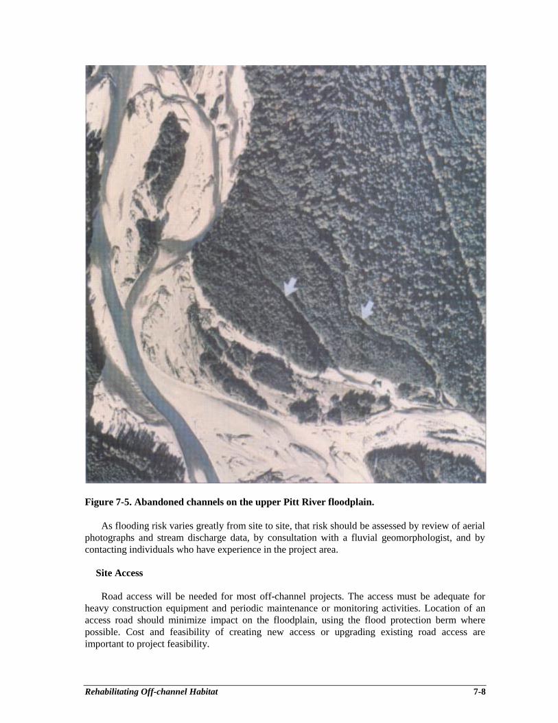
Rehabilitating Off-channel Habitat 7-8
Figure 7-5. Abandoned channels on the upper Pitt River floodplain.
As flooding risk varies greatly from site to site, that risk should be assessed by review of aerialphotographs and stream discharge data, by consultation with a fluvial geomorphologist, and bycontacting individuals who have experience in the project area.
Site Access
Road access will be needed for most off-channel projects. The access must be adequate forheavy construction equipment and periodic maintenance or monitoring activities. Location of anaccess road should minimize impact on the floodplain, using the flood protection berm wherepossible. Cost and feasibility of creating new access or upgrading existing road access areimportant to project feasibility.
Rehabilitating Off-channel Habitat 7-9
Land Tenure
Land tenure and possible restrictions on land use must also be considered. As stream habitatrehabilitation projects will generally involve Crown forest land, it will likely be expedient tocontact the appropriate regional or district office of the Ministry of Forests. The B.C. Lands Branchcan also provide information on status, responsible management agency, and land use restrictionspertaining to a given parcel. Through its six regional offices, the Lands Branch operates thecomputerized Crown Land Registry for the province. In some instances, access to Crown land mayhave to be across private land. Information on private land ownership can be obtained from one ofsix regional land title offices. To initiate a title search requires specific identifying information, i.e.,legal description or parcel identifier number, which must be obtained from the appropriatemunicipal or district office, or the B.C. Assessment Authority. Information on land use restrictionspertaining to private land may be gained from the local district or municipal office.
Construction Equipment and Materials
Availability of suitable construction equipment, particularly excavators, and off-siteconstruction materials are also factors to consider. For stream channel projects, rock bankprotection material, either angular quarry rock (riprap) or natural boulders, is normally employedfor lining banks to prevent erosion. Other common requirements are suitable gravel for an accessroad or large wood debris for instream cover.
Operational Considerations
Some off-channel projects, particularly those with surface intakes, must be regularly inspectedand maintained to ensure reliability of the water supply. The primary task will be to removeaccumulated debris from facilities such as trash racks, water control structures, culverts and fishenumeration fences and traps. Periodic maintenance work, involving heavy machinery, will also berequired. Availability of organizations and personnel to perform these operational functions, suchas stewardship groups or a local contractor, must therefore be taken into account.
Detailed Site Investigation
Sites that hold promise for off-channel habitat development should receive additionalinvestigation to determine (1) the nature and suitability of alluvial materials, (2) the quantity andquality of surface or groundwater sources, (3) excavation quantities, (4) amount and type ofmaterial, if any, to be moved to or away from the site, (5) the best stream channel alignment and/orpond limits, and (6) flood protection requirements. A site topographic survey will be required toprovide the physical information and enable the channel or pond layout to be optimized. Thistopographic survey, including establishment of benchmarks for reference, should provide groundelevations relative to adjacent stream elevations and high water marks. In addition to the survey, anumber of test holes should be excavated to determine the nature and layering of substratematerials in the area to be excavated. Another practical way of testing depth of overburden abovethe gravel layer, an important consideration for a groundwater channel, is to probe the ground witha 6-12 mm diameter steel rod.
For a groundwater channel, standpipes should be installed in the test hole pits to enablemonitoring of water table level as well as groundwater temperature and dissolved oxygen.Excessive levels of chemical constituents such as iron and hydrogen sulfide should also beidentified by analysis of groundwater samples. It is desirable to monitor groundwater levels andquality at about monthly intervals over an extended period, ideally covering one annual cycle.
Rehabilitating Off-channel Habitat 7-10
The topographic survey should identify standpipe locations and should enable the investigator tocompare elevations of the water table and the adjacent stream.
Regulatory Agency Approval
It will be essential to obtain project approval from appropriate government agencies such as theMinistry of Environment, Lands and Parks and the Department of Fisheries and Oceans (Johnstonand Moore 1995). For this purpose, the project proponent will have to prepare at least a conceptualplan, describe the project’s purpose, define its water requirements, and describe how the projectwould affect existing fish and wildlife habitat values. The regulatory agency submission shouldoccur as soon as the proponent has adequate information and has decided that the project is likelyto be technically and economically viable. The regulatory agency approval process is described indetail in Chapter l of this publication.
PROJECT DESIGN CONCEPTS
Site investigations provide the basis for an initial project layout and conceptual design, as wellas information needed to confirm feasibility. From this preliminary stage, the design shouldproceed to development of detailed design drawings. Design drawings for an off-channel habitatproject should include a site plan showing ground elevation contours at 0.5 m intervals andlocations of significant trees to be avoided. The drawing should also include cross-sections thatindicate elevations and the extent of excavation at appropriate intervals along the project site.Plotting of channel or pond cross-sections relative to the existing ground surface will enable theestimation of excavation quantities and development of a plan for disposal of excavated material,which is commonly used for the flood protection dyke and the access road. For spawning andrearing channels, it is also desirable to plot a centerline profile showing the drop in bed elevationover the channel, and the bed elevation in the adjacent river channel. Also needed are drawings ofassociated facilities such as channel intakes, culverts (see Chapter 5) and beaver control features(see Chapter 15). Regulatory agency staff typically require drawings such as a plan view, cross-sections and profile to facilitate project approval.
The following sections describe three principal concepts for off-channel habitat development:(1) the groundwater-fed spawning and rearing/overwintering channel; (2) the surface-fed spawningand rearing/overwintering channel; and (3) the rearing and overwintering pond. A single projectmay incorporate only one or all of these concepts, depending on available water supplies, terrainconditions, and the target fish species. It is desirable, however, to provide some habitat diversitywithin each project to accommodate the requirements of several species and life stages. A multi-species approach is appropriate in light of the fact that all species in a given watershed are likely tohave been affected by habitat impairment, and improvements made for one species may benefitanother.
Groundwater-fed Channels
Suitable groundwater channel sites have a gravel substrate, relatively free of silts and finesands, with the water table near the ground surface. Such sites typically occur on streamsidebenches with an overall gradient of 0.2 - 0.5% parallel to the main stream (Bonnell 1991). Lowergradients tend to be associated with sandy materials and higher gradients with cobble-bouldermaterial in the alluvium. Water table elevation should be quite stable from season to season. Thegroundwater should have a minimum dissolved oxygen concentration of 5 mg⋅L-1 (Sowden andPower 1985), and temperature and other water quality parameters should be within acceptableranges for the species and life stages of interest (Sigma Resource Consultants 1979; Piper et al.
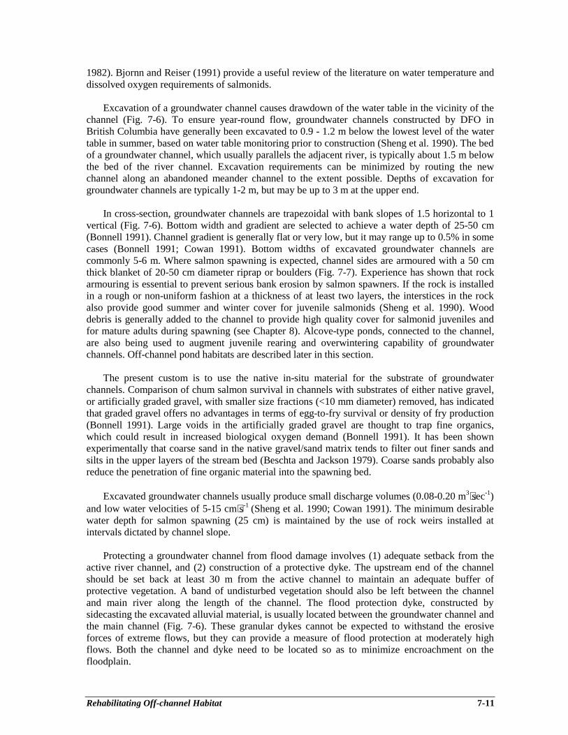
Rehabilitating Off-channel Habitat 7-11
1982). Bjornn and Reiser (1991) provide a useful review of the literature on water temperature anddissolved oxygen requirements of salmonids.
Excavation of a groundwater channel causes drawdown of the water table in the vicinity of thechannel (Fig. 7-6). To ensure year-round flow, groundwater channels constructed by DFO inBritish Columbia have generally been excavated to 0.9 - 1.2 m below the lowest level of the watertable in summer, based on water table monitoring prior to construction (Sheng et al. 1990). The bedof a groundwater channel, which usually parallels the adjacent river, is typically about 1.5 m belowthe bed of the river channel. Excavation requirements can be minimized by routing the newchannel along an abandoned meander channel to the extent possible. Depths of excavation forgroundwater channels are typically 1-2 m, but may be up to 3 m at the upper end.
In cross-section, groundwater channels are trapezoidal with bank slopes of 1.5 horizontal to 1vertical (Fig. 7-6). Bottom width and gradient are selected to achieve a water depth of 25-50 cm(Bonnell 1991). Channel gradient is generally flat or very low, but it may range up to 0.5% in somecases (Bonnell 1991; Cowan 1991). Bottom widths of excavated groundwater channels arecommonly 5-6 m. Where salmon spawning is expected, channel sides are armoured with a 50 cmthick blanket of 20-50 cm diameter riprap or boulders (Fig. 7-7). Experience has shown that rockarmouring is essential to prevent serious bank erosion by salmon spawners. If the rock is installedin a rough or non-uniform fashion at a thickness of at least two layers, the interstices in the rockalso provide good summer and winter cover for juvenile salmonids (Sheng et al. 1990). Wooddebris is generally added to the channel to provide high quality cover for salmonid juveniles andfor mature adults during spawning (see Chapter 8). Alcove-type ponds, connected to the channel,are also being used to augment juvenile rearing and overwintering capability of groundwaterchannels. Off-channel pond habitats are described later in this section.
The present custom is to use the native in-situ material for the substrate of groundwaterchannels. Comparison of chum salmon survival in channels with substrates of either native gravel,or artificially graded gravel, with smaller size fractions (<10 mm diameter) removed, has indicatedthat graded gravel offers no advantages in terms of egg-to-fry survival or density of fry production(Bonnell 1991). Large voids in the artificially graded gravel are thought to trap fine organics,which could result in increased biological oxygen demand (Bonnell 1991). It has been shownexperimentally that coarse sand in the native gravel/sand matrix tends to filter out finer sands andsilts in the upper layers of the stream bed (Beschta and Jackson 1979). Coarse sands probably alsoreduce the penetration of fine organic material into the spawning bed.
Excavated groundwater channels usually produce small discharge volumes (0.08-0.20 m3⋅sec-1)and low water velocities of 5-15 cm⋅s-1 (Sheng et al. 1990; Cowan 1991). The minimum desirablewater depth for salmon spawning (25 cm) is maintained by the use of rock weirs installed atintervals dictated by channel slope.
Protecting a groundwater channel from flood damage involves (1) adequate setback from theactive river channel, and (2) construction of a protective dyke. The upstream end of the channelshould be set back at least 30 m from the active channel to maintain an adequate buffer ofprotective vegetation. A band of undisturbed vegetation should also be left between the channeland main river along the length of the channel. The flood protection dyke, constructed bysidecasting the excavated alluvial material, is usually located between the groundwater channel andthe main channel (Fig. 7-6). These granular dykes cannot be expected to withstand the erosiveforces of extreme flows, but they can provide a measure of flood protection at moderately highflows. Both the channel and dyke need to be located so as to minimize encroachment on thefloodplain.

Rehabilitating Off-channel Habitat 7-12
Figure 7-6. Concept of a groundwater-fed spawning and rearing channel.
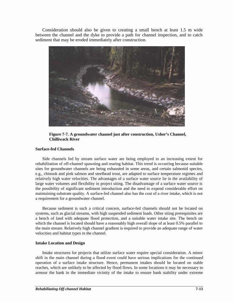
Rehabilitating Off-channel Habitat 7-13
Consideration should also be given to creating a small bench at least 1.5 m widebetween the channel and the dyke to provide a path for channel inspection, and to catchsediment that may be eroded immediately after construction.
Figure 7-7. A groundwater channel just after construction, Usher’s Channel,Chilliwack River
Surface-fed Channels
Side channels fed by stream surface water are being employed to an increasing extent forrehabilitation of off-channel spawning and rearing habitat. This trend is occurring because suitablesites for groundwater channels are being exhausted in some areas, and certain salmonid species,e.g., chinook and pink salmon and steelhead trout, are adapted to surface temperature regimes andrelatively high water velocities. The advantages of a surface water source lie in the availability oflarge water volumes and flexibility in project siting. The disadvantage of a surface water source isthe possibility of significant sediment introduction and the need to expend considerable effort onmaintaining substrate quality. A surface-fed channel also has the cost of a river intake, which is nota requirement for a groundwater channel.
Because sediment is such a critical concern, surface-fed channels should not be located onsystems, such as glacial streams, with high suspended sediment loads. Other siting prerequisites area bench of land with adequate flood protection, and a suitable water intake site. The bench onwhich the channel is located should have a reasonably high overall slope of at least 0.5% parallel tothe main stream. Relatively high channel gradient is required to provide an adequate range of watervelocities and habitat types in the channel.
Intake Location and Design
Intake structures for projects that utilize surface water require special consideration. A minorshift in the main channel during a flood event could have serious implications for the continuedoperation of a surface intake structure. Hence, permanent intakes should be located on stablereaches, which are unlikely to be affected by flood flows. In some locations it may be necessary toarmour the bank in the immediate vicinity of the intake to ensure bank stability under extreme

Rehabilitating Off-channel Habitat 7-14
flows. In addition, fill material around the intake structure must be adequately armoured withheavy riprap or boulders to withstand high local velocities.
The intake for a surface-fed channel should be located on the outside of a bend in the mainstream, along the downstream half of the bend (Fig. 7-8). Secondary or lateral circulation in thatarea tends to be toward the outside bank on the stream surface, and away from the outside bankalong the stream bottom. Such an intake location will minimize amounts of sands and gravelsentering the channel because sediment bedload tends to accumulate on the inside bend. To avoiddebris accumulation, it is also important to locate the intake where there is a positive downstreamflow along the bank. Localized backeddies should be avoided.
Figure 7-8. Suitable channel intake location on outside of river bend.Cross-section shows secondary circulation pattern.
The appropriate type of intake will depend on site conditions. Where the bank is stable on theoutside bend, a log curtain wall can be employed to deflect floating log debris (Figs. 7-9 and 7-10).The flow control valve, with a trash rack for smaller debris, is set back from the stream bank. Asettling pond, between the curtain wall and the trash rack, is an essential feature. The pond can beexpected to settle out fine to coarse sand fractions, but silts and clays are likely to pass through tothe channel. The settling pond should be as large as site conditions permit. A smaller pond willhave to be cleaned out more frequently. It is also important to provide road access for heavymachinery required to clean the pond.
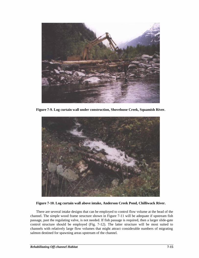
Rehabilitating Off-channel Habitat 7-15
Figure 7-9. Log curtain wall under construction, Shovelnose Creek, Squamish River.
Figure 7-10. Log curtain wall above intake, Anderson Creek Pond, Chilliwack River.
There are several intake designs that can be employed to control flow volume at the head of thechannel. The simple wood frame structure shown in Figure 7-11 will be adequate if upstream fishpassage, past the regulating valve, is not needed. If fish passage is required, then a larger slide-gatecontrol structure should be employed (Fig. 7-12). The latter structure will be most suited tochannels with relatively large flow volumes that might attract considerable numbers of migratingsalmon destined for spawning areas upstream of the channel.
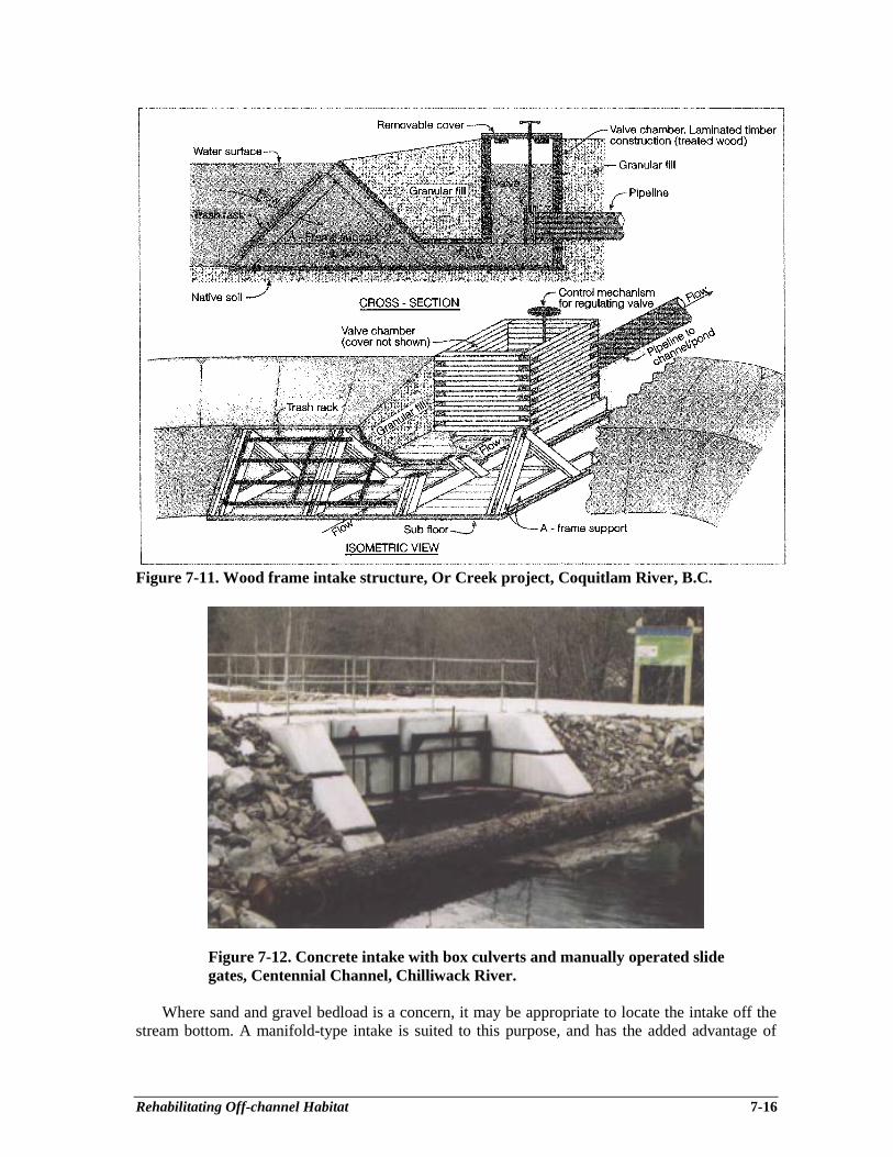
Rehabilitating Off-channel Habitat 7-16
Figure 7-11. Wood frame intake structure, Or Creek project, Coquitlam River, B.C.
Figure 7-12. Concrete intake with box culverts and manually operated slidegates, Centennial Channel, Chilliwack River.
Where sand and gravel bedload is a concern, it may be appropriate to locate the intake off thestream bottom. A manifold-type intake is suited to this purpose, and has the added advantage of
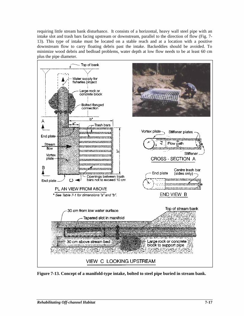
Rehabilitating Off-channel Habitat 7-17
requiring little stream bank disturbance. It consists of a horizontal, heavy wall steel pipe with anintake slot and trash bars facing upstream or downstream, parallel to the direction of flow (Fig. 7-13). This type of intake must be located on a stable reach and at a location with a positivedownstream flow to carry floating debris past the intake. Backeddies should be avoided. Tominimize wood debris and bedload problems, water depth at low flow needs to be at least 60 cmplus the pipe diameter.
Figure 7-13. Concept of a manifold-type intake, bolted to steel pipe buried in stream bank.
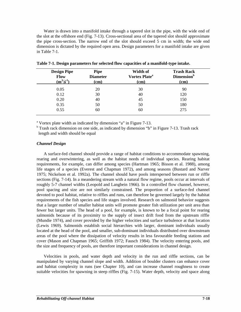
Rehabilitating Off-channel Habitat 7-18
Water is drawn into a manifold intake through a tapered slot in the pipe, with the wide end ofthe slot at the offshore end (Fig. 7-13). Cross-sectional area of the tapered slot should approximatethe pipe cross-section. The narrow end of the slot should exceed 5 cm in width; the wide enddimension is dictated by the required open area. Design parameters for a manifold intake are givenin Table 7-1.
Table 7-1. Design parameters for selected flow capacities of a manifold-type intake.
Design Pipe Pipe Width of Trash RackFlow Diameter Vortex Platea Dimensionb
(m3⋅s-1) (cm) (cm) (cm)
0.05 20 30 900.12 30 40 1200.20 40 45 1500.35 50 50 1800.55 60 60 275
a Vortex plate width as indicated by dimension “a” in Figure 7-13.b Trash rack dimension on one side, as indicated by dimension “b” in Figure 7-13. Trash racklength and width should be equal
Channel Design
A surface-fed channel should provide a range of habitat conditions to accommodate spawning,rearing and overwintering, as well as the habitat needs of individual species. Rearing habitatrequirements, for example, can differ among species (Hartman 1965; Bisson et al. 1988), amonglife stages of a species (Everest and Chapman 1972), and among seasons (Bustard and Narver1975; Nickelson et al. 1992a). The channel should have pools interspersed between run or rifflesections (Fig. 7-14). In a meandering stream with a natural flow regime, pools occur at intervals ofroughly 5-7 channel widths (Leopold and Langbein 1966). In a controlled flow channel, however,pool spacing and size are not similarly constrained. The proportion of a surface-fed channeldevoted to pool habitat, relative to riffles and runs, can therefore be governed largely by the habitatrequirements of the fish species and life stages involved. Research on salmonid behavior suggeststhat a larger number of smaller habitat units will promote greater fish utilization per unit area thanfewer but larger units. The head of a pool, for example, is known to be a focal point for rearingsalmonids because of its proximity to the supply of insect drift food from the upstream riffle(Mundie 1974), and cover provided by the higher velocities and surface turbulence at that location(Lewis 1969). Salmonids establish social hierarchies with larger, dominant individuals usuallylocated at the head of the pool, and smaller, sub-dominant individuals distributed over downstreamareas of the pool where the dissipation of velocity results in less favourable feeding stations andcover (Mason and Chapman 1965; Griffith 1972; Fausch 1984). The velocity entering pools, andthe size and frequency of pools, are therefore important considerations in channel design.
Velocities in pools, and water depth and velocity in the run and riffle sections, can bemanipulated by varying channel slope and width. Addition of boulder clusters can enhance coverand habitat complexity in runs (see Chapter 10), and can increase channel roughness to createsuitable velocities for spawning in steep riffles (Fig. 7-15). Water depth, velocity and space along
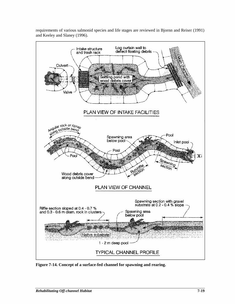
Rehabilitating Off-channel Habitat 7-19
requirements of various salmonid species and life stages are reviewed in Bjornn and Reiser (1991)and Keeley and Slaney (1996).
Figure 7-14. Concept of a surface-fed channel for spawning and rearing.

Rehabilitating Off-channel Habitat 7-20
Figure 7-15. Riffle section of channel with boulders added for habitatcomplexity, Centennial Channel, Chilliwack River.
The cross-section of run and riffle sections in a surface-fed channel should be similar inconcept to a groundwater channel (Fig. 7-6). To prevent bank erosion by spawners, and providestability until riparian vegetation establishes, channel banks should be constructed with a slope nosteeper than 1.5:1 and lined with boulders or riprap (20-50 cm diameter) to a level above the designwater surface. The channel alignment may be adjusted to take advantage of large trees or stumps toprovide cover features such as undercut banks (Fig. 7-16). The bank along the outside bend of apool can be protected from erosion by placement of large boulders, riprap, or cabled wood debris.While both rock and wood debris provide cover and habitat complexity for juvenile salmonids,wood debris is generally preferred for that purpose. Where both materials are available, the bestsolution may be to armour the outside bank with riprap for hydraulic protection, and employ wooddebris along the bank to improve habitat complexity and fish escape cover (Fig. 7-17). If riprap isused for bank armouring in pools, its attractiveness to juvenile salmonids will be enhanced if rocksize is large (>50 cm mean diameter), the bank is steep and irregular, and velocities along the bankare relatively high (Lister et al. 1995).
As discussed for groundwater channels, native gravels should be used for the channel bedwherever possible. If gravel has to be imported for the project, its size composition should becomparable to natural spawning beds, and it should include fines down to 1-2 mm diameter.Guidelines on spawning gravel sizes for various salmonids are summarized in literature reviews(Bjornn and Reiser 1991; Keeley and Slaney 1996). Designers should also check the hydraulicstability of selected gravel and rock sizes with the tractive force equation given in Chapter 12.
Design width of a surface-fed channel should be in keeping with the available water supply,and should take into account the site’s physical constraints and fish production objectives. Channeldesign width and slope can be varied, along with the planned operating discharge, to producedesired water depths and velocities, and to provide variation between channel sections. Oncehabitat requirements are defined, an experienced fluvial geomorphologist or hydraulic engineershould be consulted to determine appropriate channel discharge, slope and width. Designers should
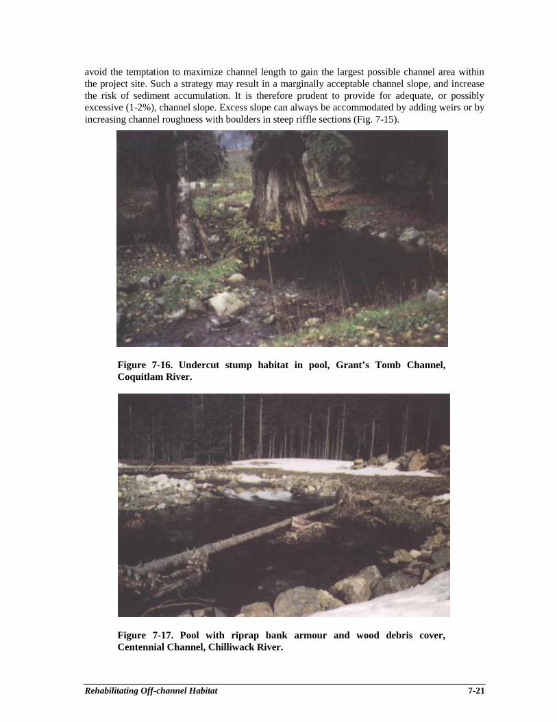
Rehabilitating Off-channel Habitat 7-21
avoid the temptation to maximize channel length to gain the largest possible channel area withinthe project site. Such a strategy may result in a marginally acceptable channel slope, and increasethe risk of sediment accumulation. It is therefore prudent to provide for adequate, or possiblyexcessive (1-2%), channel slope. Excess slope can always be accommodated by adding weirs or byincreasing channel roughness with boulders in steep riffle sections (Fig. 7-15).
Figure 7-16. Undercut stump habitat in pool, Grant’s Tomb Channel,Coquitlam River.
Figure 7-17. Pool with riprap bank armour and wood debris cover,Centennial Channel, Chilliwack River.
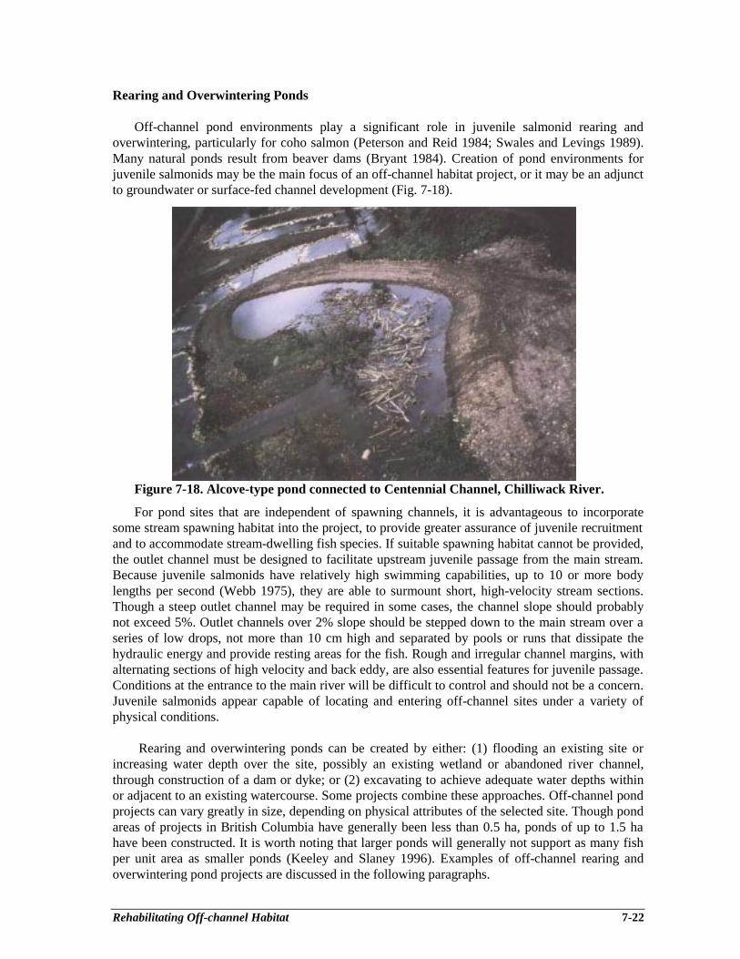
Rehabilitating Off-channel Habitat 7-22
Rearing and Overwintering Ponds
Off-channel pond environments play a significant role in juvenile salmonid rearing andoverwintering, particularly for coho salmon (Peterson and Reid 1984; Swales and Levings 1989).Many natural ponds result from beaver dams (Bryant 1984). Creation of pond environments forjuvenile salmonids may be the main focus of an off-channel habitat project, or it may be an adjunctto groundwater or surface-fed channel development (Fig. 7-18).
Figure 7-18. Alcove-type pond connected to Centennial Channel, Chilliwack River.
For pond sites that are independent of spawning channels, it is advantageous to incorporatesome stream spawning habitat into the project, to provide greater assurance of juvenile recruitmentand to accommodate stream-dwelling fish species. If suitable spawning habitat cannot be provided,the outlet channel must be designed to facilitate upstream juvenile passage from the main stream.Because juvenile salmonids have relatively high swimming capabilities, up to 10 or more bodylengths per second (Webb 1975), they are able to surmount short, high-velocity stream sections.Though a steep outlet channel may be required in some cases, the channel slope should probablynot exceed 5%. Outlet channels over 2% slope should be stepped down to the main stream over aseries of low drops, not more than 10 cm high and separated by pools or runs that dissipate thehydraulic energy and provide resting areas for the fish. Rough and irregular channel margins, withalternating sections of high velocity and back eddy, are also essential features for juvenile passage.Conditions at the entrance to the main river will be difficult to control and should not be a concern.Juvenile salmonids appear capable of locating and entering off-channel sites under a variety ofphysical conditions.
Rearing and overwintering ponds can be created by either: (1) flooding an existing site orincreasing water depth over the site, possibly an existing wetland or abandoned river channel,through construction of a dam or dyke; or (2) excavating to achieve adequate water depths withinor adjacent to an existing watercourse. Some projects combine these approaches. Off-channel pondprojects can vary greatly in size, depending on physical attributes of the selected site. Though pondareas of projects in British Columbia have generally been less than 0.5 ha, ponds of up to 1.5 hahave been constructed. It is worth noting that larger ponds will generally not support as many fishper unit area as smaller ponds (Keeley and Slaney 1996). Examples of off-channel rearing andoverwintering pond projects are discussed in the following paragraphs.

Rehabilitating Off-channel Habitat 7-23
The Anderson Creek project on the Chilliwack River is an example of creative use of sitecharacteristics to restore salmonid spawning and rearing habitat (Fig. 7-19). Since construction ofthe Chilliwack Lake Road, upstream passage of fish into upper Anderson Creek had been blockedat the road culvert, and an old meander channel of the Chilliwack River had been cut off from themain river. The restoration effort involved diverting a portion of the Anderson Creek flow justupstream of the road culvert, and installing a new road culvert 300 m east of Anderson Creek toflood the old meander channel and to provide fish passage under Chilliwack Lake Road. Theproject has created a 1.5 ha pond (Fig. 7-20), 200 m of inlet and outlet spawning and rearingchannels, and has re-established fish access to upper Anderson Creek. A 2 m deep channel wasexcavated along the dyke on the north side of the pond to increase water depth for juvenilesalmonid overwintering, and to make it difficult for beavers to construct a dam at the pond outlet.A beaver-proof intake box (see Chapter 15) prevents blockage of the outlet culvert while allowingadult and juvenile salmonids to move upstream into the pond. The outlet culvert was oversized toprovide low velocities for upstream passage of juveniles. The inlet and outlet streams are nowbeing used for spawning by coho and chum salmon, and the pond supports juvenile coho andsteelhead rearing and overwintering.
Studies of juvenile coho utilization of off-channel ponds for overwintering have indicated thatwhile shallows, less than 0.75 m deep, may be beneficial to coho in terms of benthic insect foodproduction, the presence of deeper areas (to 3.5 m) tends to maximize survival for smolt emigration(Peterson 1982b; Cederholm et al. 1988). Off-channel ponds that have both shallow areas or shoalsfor food production and deep areas for overwinter security (Fig. 7-21) are most likely to producegood numbers of large, viable smolts.
Alcove-type pools or ponds, which are essentially a backwater environment connected to themain stream channel, are also being created to provide off-channel rearing and overwinteringhabitat, primarily for juvenile coho. This type of habitat, similar in concept to Cook Creek pond inFigure 7-21, fosters limited water exchange, low velocity, and development of pond-likeconditions. Alcoves are usually quite accessible to salmonid juveniles and coho utilization ofalcoves is high compared to other habitats in winter (Nickelson et al. 1992b). Alcoves havetherefore been included in several off-channel habitat developments in British Columbia. As a noteof caution however, the point of connection between the alcove and the main stream can beblocked as a result of shifts in the bed of the main channel under high flows (Nickelson et al.1992b). The alcove concept therefore appears best suited to hydraulically stable environments,such as a groundwater channel or a surface-fed side channel with controlled flow.
Addition of wood debris cover to streams can improve salmonid rearing and overwinteringcapability (see Chapter 8). There is limited evidence, however, of similar benefits to salmonidproduction in ponds. Comparison of juvenile coho populations in a series of artificial off-channelponds at Coldwater River, with and without wood debris added, revealed an average of 2.5 timeshigher densities in ponds with debris cover (Beniston et al. 1988). The advantage of added wooddebris appeared to be greatest in winter and smallest in summer.
Experience with performance of constructed off-channel pond environments is not extensive.Research to date would suggest incorporation of the following design principles;• limit the area of individual ponds to 0.1 - 0.3 ha;• provide diverse water depths for fish growth and overwinter security;• limit water exchange rates to foster development of a pond environment, but recognize the
need to maintain suitable water temperatures and dissolved oxygen levels;• incorporate, where feasible, some spawning habitat upstream of the pond, to reduce reliance on
upstream movement of juveniles for recruitment; and• add wood debris cover, to improve rearing and overwintering capability.
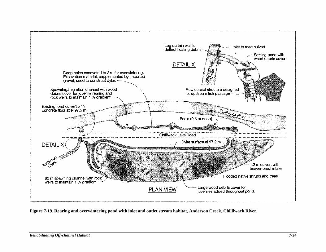
Rehabilitating Off-channel Habitat 7-24
Figure 7-19. Rearing and overwintering pond with inlet and outlet stream habitat, Anderson Creek, Chilliwack River.

Rehabilitating Off-channel Habitat 7-25
Figure 7-20. Rearing and overwintering pond at Anderson Creek, Chilliwack River.
Figure 7-21. Alcove pond at Cook Creek, North Thompson River (Lister andDunford 1989) and beaded channel at Paradise Pond, Clearwater River,Washington (Cederholm et al. 1988).

Rehabilitating Off-channel Habitat 7-26
Project Costs
Costs of off-channel habitat projects vary with scale and type of habitat, as well as theparticular site conditions (Table 7-2). Rearing and overwintering ponds of various sizes can becreated at modest cost ($2.50 - 4.00 per m2) in relation to excavated groundwater-fed channels witharmoured banks ($14.00 - 18.00 per m2).
CONSTRUCTION PROCEDURES
Construction of off-channel habitat, as with any fish habitat project, is largely about dealingwith water. This influences construction timing and procedures, and it also poses challenges incontrolling sediment to avoid impact on downstream fish habitat.
To prepare for construction the limits of clearing and excavation as well as the channelcenterline, should be flagged. Flagging may reveal the potential loss of exceptional trees that couldbe avoided by a modest shift in project alignment or by confining the excavation limits. Clearing ofvegetation should also be undertaken in a manner that avoids unnecessary disturbance and loss oftrees. Conifers that are suitable for providing habitat complexity in the finished project should bestockpiled (Fig. 7-22).
Figure 7-22. Excavation of a surface-fed channel showing stock piles of conifertrees and boulders, Centennial Channel, Chilliwack River.
Excavation and handling of topsoils should be undertaken during the dry summer season. Agroundwater channel should ideally be excavated in late summer when the water table is low.Instream work windows, established by regulatory agencies to avoid fish habitat impacts, are alsoan important constraint on the construction schedule. Projects should be completed early enough toprovide time for germination and growth of grasses to stabilize soils before the fall rains. Seedingof grasses needs to be conducted before temperatures decline in fall.
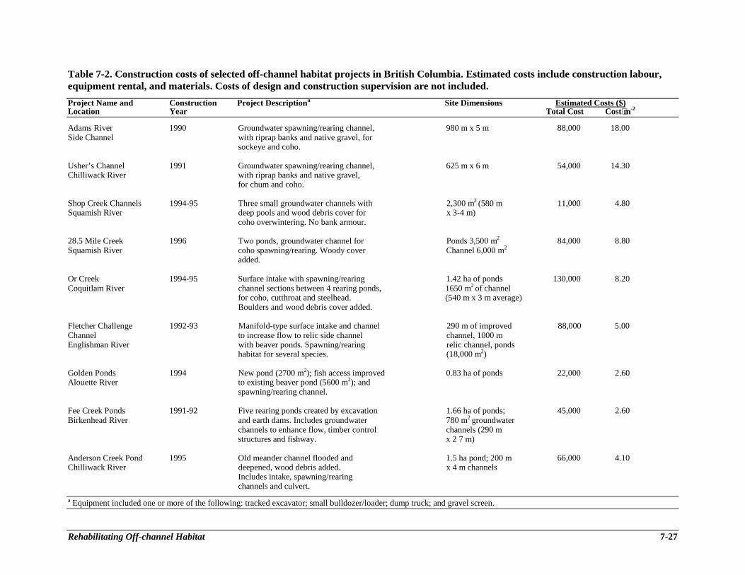
Rehabilitating Off-channel Habitat 7-27
Table 7-2. Construction costs of selected off-channel habitat projects in British Columbia. Estimated costs include construction labour,equipment rental, and materials. Costs of design and construction supervision are not included.
Project Name and Construction Project Descriptiona Site Dimensions Estimated Costs ($)Location Year Total Cost Cost⋅m-2
Adams River 1990 Groundwater spawning/rearing channel, 980 m x 5 m 88,000 18.00Side Channel with riprap banks and native gravel, for
sockeye and coho.
Usher’s Channel 1991 Groundwater spawning/rearing channel, 625 m x 6 m 54,000 14.30Chilliwack River with riprap banks and native gravel,
for chum and coho.
Shop Creek Channels 1994-95 Three small groundwater channels with 2,300 m2 (580 m 11,000 4.80Squamish River deep pools and wood debris cover for x 3-4 m)
coho overwintering. No bank armour.
28.5 Mile Creek 1996 Two ponds, groundwater channel for Ponds 3,500 m2 84,000 8.80Squamish River coho spawning/rearing. Woody cover Channel 6,000 m2
added.
Or Creek 1994-95 Surface intake with spawning/rearing 1.42 ha of ponds 130,000 8.20Coquitlam River channel sections between 4 rearing ponds, 1650 m2 of channel
for coho, cutthroat and steelhead. (540 m x 3 m average)Boulders and wood debris cover added.
Fletcher Challenge 1992-93 Manifold-type surface intake and channel 290 m of improved 88,000 5.00Channel to increase flow to relic side channel channel, 1000 mEnglishman River with beaver ponds. Spawning/rearing relic channel, ponds
habitat for several species. (18,000 m2)
Golden Ponds 1994 New pond (2700 m2); fish access improved 0.83 ha of ponds 22,000 2.60Alouette River to existing beaver pond (5600 m2); and
spawning/rearing channel.
Fee Creek Ponds 1991-92 Five rearing ponds created by excavation 1.66 ha of ponds; 45,000 2.60Birkenhead River and earth dams. Includes groundwater 780 m2 groundwater
channels to enhance flow, timber control channels (290 mstructures and fishway. x 2 7 m)
Anderson Creek Pond 1995 Old meander channel flooded and 1.5 ha pond; 200 m 66,000 4.10Chilliwack River deepened, wood debris added. x 4 m channels
Includes intake, spawning/rearingchannels and culvert.
a Equipment included one or more of the following: tracked excavator; small bulldozer/loader; dump truck; and gravel screen.

Rehabilitating Off-channel Habitat 7-28
In the case of groundwater channels, and some pond habitat projects, site excavation willpenetrate the water table and cause seepage into the excavated area. An earthen plug can be left atthe downstream end to isolate the site from the adjacent stream. Keeping initial excavation abovethe water table, and lowering the bed of the channel or pond in stages, can also assist in dealingwith seepage. A staged excavation strategy could involve removal of overburden, then excavationto the water table, and lastly, commencement of ditching at the lower end of the channel to pulldown the water table. Water that can’t be retained on the site should be pumped or diverted to aconstructed sediment settling basin or natural depression for treatment. Clean water flowing intothe construction area should be diverted or pumped around the site to assist construction andminimize water volumes to be treated for sediment control. It is advisable to develop a sedimentmitigation plan and to obtain agreement from habitat protection staff of the regulatory agencies inadvance of construction.
Excavated overburden and gravels will normally be sidecast to form a flood protection dyke onthe main river side of the project. Where practical, topsoil should be stockpiled so that it can belater used on disturbed areas such as channel and dyke slopes, to improve the growth medium forrevegetation. Rootwads and large boulders that have to be removed should also be stored on-sitefor subsequent placement as instream cover or bank protection. Trees and shrubs, which can besalvaged alive with intact roots, should be covered with soil and stored for site revegetation.
Following site excavation, channel side slopes should be armoured and rock weirs installed.Vegetative techniques for slope stabilization may also be appropriate (see Chapter 6). Wood debrisand/or large rocks should be added to enhance habitat complexity.
A surface intake on a stream should be constructed during the low water period and within theapproved instream construction window. If necessary, the intake can be isolated from the stream byretaining an earth plug or by sand bags, to avoid downstream sedimentation and facilitate theconstruction.
The final stage involves stabilization of banks and other disturbed areas to control surfaceerosion during the fall-winter period. Available top soil should be spread over disturbed soils, andslopes should be lightly scarified to improve conditions for establishing grasses and shrubs. Thesite should be seeded with an appropriate mix of grasses and clover. A light dressing of hay orstraw may then be spread over the seeded areas to provide some erosion protection until grassesgerminate and begin to grow.
OPERATION AND MAINTENANCE
Operation and maintenance requirements of off-channel habitat projects vary considerablydepending on the type and complexity of the project. Projects that utilize a groundwater sourcenormally require little operational effort and also have modest maintenance needs. Surface-fedchannels or ponds, on the other hand, will often require an active operation and maintenanceprogram. In this respect, it is prudent to engage a local entity, such as a fish and game club orsalmonid restoration society, to carry out the routine operation and maintenance.
For a groundwater project, the operational concern is generally related to fish access, whichmay be restricted by a beaver dam or inadequate flows, particularly in the early fall. The gravelsubstrate and rock armour of a groundwater channel will accumulate fine organic material, andmay experience some encroachment by vegetation or rooted aquatic plants. These problems aregenerally addressed by scarifying the gravel and turning over the rock armour. Reconstruction ofrock weirs, regrading of spawning gravel, and addition of bank armouring may also be required
Rehabilitating Off-channel Habitat 7-29
from time to time. Groundwater-fed channel and pond projects should be inspected periodicallyduring the spawning migration period to ensure fish access and at least annually to monitor channelsubstrate quality and other features.
A surface-fed channel or pond will generally require greater operational attention than agroundwater project, because of relatively high flow volume and potential for intake blockage. Theintake and flow control gate will need to be regularly inspected and kept free of debris. Duringhigh flow periods, inspections may be required weekly or more frequently, while at other times theinspection frequency can likely be reduced. Once the best discharge for fish spawning isestablished, the flow control gate or valve should be left at the required setting throughout thespawning period. It may be desirable, however, to reduce channel discharge during the incubationperiod in order to minimize introduction of suspended sediment to the channel.
Surface-fed channels need to be inspected annually to assess the maintenance requirements.Features to be examined include intake condition, sediment deposition in the settling pond,condition of weirs and bank armour, and possible accumulation of fine silts and organics in thegravel substrate. Maintenance could involve sediment excavation from the settling pond, weirrepair or removal, bank armour repairs, and gravel cleaning by either scarification or, in an extremecase, by removal and replacement with new or screened material. The latter activity should be onlyan occasional requirement.
Though a pond environment is unlikely to require maintenance, the stream connecting it to themain stream should be inspected periodically for potential obstructions to fish passage, particularlybeaver dams. It is also prudent to periodically monitor water quality, especially dissolved oxygen,to identify any trend toward deteriorating water quality.
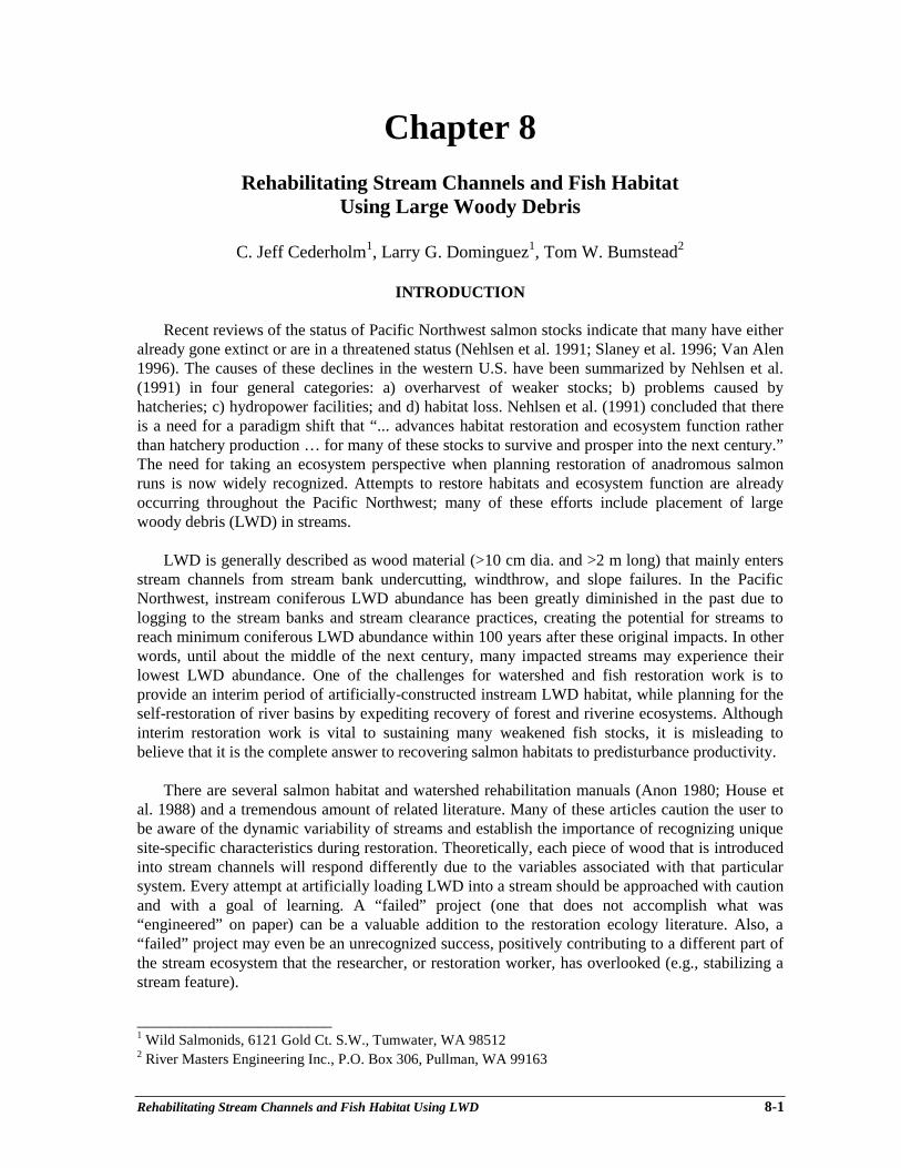
Rehabilitating Stream Channels and Fish Habitat Using LWD 8-1
Chapter 8Rehabilitating Stream Channels and Fish Habitat
Using Large Woody Debris
C. Jeff Cederholm1, Larry G. Dominguez1, Tom W. Bumstead2
INTRODUCTION
Recent reviews of the status of Pacific Northwest salmon stocks indicate that many have eitheralready gone extinct or are in a threatened status (Nehlsen et al. 1991; Slaney et al. 1996; Van Alen1996). The causes of these declines in the western U.S. have been summarized by Nehlsen et al.(1991) in four general categories: a) overharvest of weaker stocks; b) problems caused byhatcheries; c) hydropower facilities; and d) habitat loss. Nehlsen et al. (1991) concluded that thereis a need for a paradigm shift that “... advances habitat restoration and ecosystem function ratherthan hatchery production … for many of these stocks to survive and prosper into the next century.”The need for taking an ecosystem perspective when planning restoration of anadromous salmonruns is now widely recognized. Attempts to restore habitats and ecosystem function are alreadyoccurring throughout the Pacific Northwest; many of these efforts include placement of largewoody debris (LWD) in streams.
LWD is generally described as wood material (>10 cm dia. and >2 m long) that mainly entersstream channels from stream bank undercutting, windthrow, and slope failures. In the PacificNorthwest, instream coniferous LWD abundance has been greatly diminished in the past due tologging to the stream banks and stream clearance practices, creating the potential for streams toreach minimum coniferous LWD abundance within 100 years after these original impacts. In otherwords, until about the middle of the next century, many impacted streams may experience theirlowest LWD abundance. One of the challenges for watershed and fish restoration work is toprovide an interim period of artificially-constructed instream LWD habitat, while planning for theself-restoration of river basins by expediting recovery of forest and riverine ecosystems. Althoughinterim restoration work is vital to sustaining many weakened fish stocks, it is misleading tobelieve that it is the complete answer to recovering salmon habitats to predisturbance productivity.
There are several salmon habitat and watershed rehabilitation manuals (Anon 1980; House etal. 1988) and a tremendous amount of related literature. Many of these articles caution the user tobe aware of the dynamic variability of streams and establish the importance of recognizing uniquesite-specific characteristics during restoration. Theoretically, each piece of wood that is introducedinto stream channels will respond differently due to the variables associated with that particularsystem. Every attempt at artificially loading LWD into a stream should be approached with cautionand with a goal of learning. A “failed” project (one that does not accomplish what was“engineered” on paper) can be a valuable addition to the restoration ecology literature. Also, a“failed” project may even be an unrecognized success, positively contributing to a different part ofthe stream ecosystem that the researcher, or restoration worker, has overlooked (e.g., stabilizing astream feature).
________________________1 Wild Salmonids, 6121 Gold Ct. S.W., Tumwater, WA 985122 River Masters Engineering Inc., P.O. Box 306, Pullman, WA 99163

Rehabilitating Stream Channels and Fish Habitat Using LWD 8-2
Despite significant amounts of research and improved understanding of LWD and itsassociated processes, we are in the early stages of understanding the role of LWD from anecosystem perspective. As a template for understanding the basic physical and biological processesat work in watersheds, we recommend awareness of the river continuum concept put forth byVannote et al. (1980) and modified by Triska et al. (1982). Many abuses of our landscapes haveoccurred because of incomplete understanding of stream ecology, and have left scientists with fewopportunities to confidently describe LWD processes in an undisturbed environment. It isrecognized that the recommendations we provide may be modified as understanding of the forestecosystem increases.
THE PHILOSOPHY OF LARGE WOODY DEBRIS REHABILITATION
Habitat rehabilitation must never be viewed as a substitute for habitat protection.Communication between fishery managers and land managers is an essential element of habitatprotection. We should begin the process of habitat rehabilitation by protecting those watershedsand riparian ecosystems that still remain in relatively good condition. Maintaining natural foresthydrology, building fewer and better roads, and providing riparian buffers of sufficient width toprotect the aquatic corridor will go a long way towards ensuring sufficient LWD loadings into thefuture. For a complete discussion of salmonid habitat protection in forest settings, we refer thereader to Forest Ecosystem Management: An ecological, economic and social assessment (Femat1993).
Many Pacific Northwest watersheds are in a state of early recovery from habitat degradationcaused by past land use practices, and without assistance, it could take centuries to recover lostLWD-associated processes. Stream channel rehabilitation begins at the mountaintop. Mostdegraded watersheds can point back towards altered hydrology due to vegetation removal as thecause of degradation. Consequently, the stream channel manifests the changes in the hydrologiccycle processes that occur on mountaintops, on the ridges, in the upland forest, and in the ripariancorridor. With many of our lands under intensive management for natural resource extraction, theriparian forest remains the last line of defense for preserving stream health. Van Cleef (1885)emphasized the necessity of protecting the structure of stream banks and riparian areas over 100years ago. Today, the message is as fresh as when it was written. During the period of watershedrecovery, there may be some helpful upslope, riparian and in-channel rehabilitative work usingLWD that can speed the recovery of stream channel processes and benefit fish resources. Ourrecommendations will include LWD placement to not only rehabilitate fish habitat, but also torestore the connectivity of the stream to the riparian ecosystem and floodplain. In some cases thisincludes placement of LWD in non-fish bearing waters or even out of sight, under the streambed,to add stability to the channel. Such practices would begin to rehabilitate the habitat-formingprocesses ensuring long-term benefits for the salmonid environment.
THE ECOLOGICAL ROLE OF LARGE WOODY DEBRIS IN STREAMS
Importance For Channel Function
Small to intermediate Streams
LWD provides important physical functions in a wide variety of channel configurations. Insmall first and second order channels, abundant LWD is individually established or bound togetherin continuous networks of mostly conifer pieces. In these channels, LWD traps sediment, causes

Rehabilitating Stream Channels and Fish Habitat Using LWD 8-3
local bed and bank scour, and creates a stepped-channel profile. It has been found that over half thetotal sediment stored in first to third order streams is retained by organic matter. These relativelysmall channels tend to be straight rather than meandering as they are tightly constrained byadjacent slopes. Because of high gradient (>5%), and frequent waterfalls, these streams usuallyhave sparse fish populations.
In small (<10 m bankfull width (BFW)) to intermediate size (10-20 m BFW) streams, LWDcontributes to channel stabilization, energy dissipation, and sediment storage. Small channels arehighly dependent on in-channel woody debris structure for stability. LWD provides importantphysical and biological functions in the wide variety of habitats used by all species of Pacificsalmon. LWD contributes to escape cover from predators and high velocities for adult and juvenilesalmonids. Also, LWD creates storage sites of biological activity, trapping spawned out salmoncarcasses and other organic matter; which contributes to riparian and aquatic productivity(Cederholm et al. 1985,1989; Bilby et al. 1996).
Single or multiple pieces of conifer trees may hold drift jams together in steep headwatertributaries. Complex arrangements or simply individual pieces of LWD may be found scatteredalong the channel, from the very headwaters all the way downstream. Deciduous wooddecomposes quickly, but it also regrows rapidly, while conifer trees may take centuries to reachfull size and decompose very slowly. Important accumulations of LWD are also buried out of sightbelow the gravel surface, providing important structure and nutrient supply to the surface orsubsurface “hyporheic” zone. Scour from floods or channel reconfigurations often expose a legacyof this old buried LWD and this newly exposed material often functions for many more years. Insome stream channels, LWD contributes to major habitat forming processes such as bar stability,side-channel development, island formation, and channel feature formation.
Intermediate stream orders (3rd-5th) have less continuous accumulations of LWD, but mayhave “drift jams” that can block the flow and occasionally redirect the stream course, resulting inevacuated floodplain channel features that can become important overwintering habitat for juvenilesalmonids. The main channels of these streams have gradients of less than 5% and tend to showsigns of meandering. It is common to see full-sized trees laying within and across these streamsand huge chunks of wood protruding out of the gravel. Large wedges of spawnable sized gravelsare held back by logs, and plunge pools and dam pools are a common association. Typically, manyspecies of resident and anadromous salmonids inhabit these streams, as well as a diversity of non-salmonid fishes. These streams have some of the highest salmonid productivity.
Large Streams
The highest order channels (>5th order) are characterized by infrequent, but occasionallymassive accumulations of LWD. Gradients tend to average less than 0.5%. The LWD tends to beof large diameter and often complete trees with rootwads and branches can be seen holdingtogether accumulations of smaller logs and other wood debris. Much of this debris has floateddown from upstream areas during flood events or has entered the channel from bank undercuttingof relatively young stands of trees growing on gravel bars. Large LWD accumulations in the lowerfloodplain of coastal rivers can direct the flow into meander loops and result in formation ofriverine ponds and other off-channel habitat features. These habitats are used heavily by immigrantjuvenile coho and cutthroat seeking to escape the main river discharge and turbidity. There is alsoevidence that main river channels in large interior rivers may serve in a reverse way compared tocoastal rivers, acting as refuge for emigrant juvenile steelhead and chinook leaving tributariesduring winter freeze-up periods. Large rivers function both as fish migration corridors to access
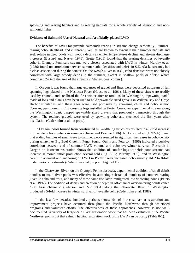
Rehabilitating Stream Channels and Fish Habitat Using LWD 8-4
spawning and rearing habitats and as rearing habitats for a whole variety of salmonid and non-salmonid fishes.
Evidence of Salmonid Use of Natural and Artificially-placed LWD
The benefits of LWD for juvenile salmonids rearing in streams change seasonally. Summer-rearing coho, steelhead, and cutthroat juveniles are known to evacuate their summer habitats andseek refuge in deep pools with woody debris as winter temperatures decline and stream dischargeincreases (Bustard and Narver 1975). Grette (1985) found that the rearing densities of juvenilecoho in Olympic Peninsula streams were closely associated with LWD in winter. Murphy et al.(1986) found no correlation between summer coho densities and debris in S.E. Alaska streams, buta close association during the winter. On the Keogh River in B.C., coho densities were not closelycorrelated with large woody debris in the summer, except in shallow pools or “flats” whichcomprised 24% of the area of the stream (P. Slaney, pers. comm.).
In Oregon it was found that large expanses of gravel and fines were deposited upstream of fullspanning logs placed in the Nestucca River (House et al. 1991). Many of these sites were readilyused by chinook and steelhead the first winter after restoration. In Washington, “spawning pads”made of logs and planks have been used to hold spawnable sized gravels in Willapa Bay and GraysHarbor tributaries, and these sites were used primarily by spawning chum and coho salmon(Cowan, pers. comm.). Full crossing logs installed in Porter Creek, an experimental stream alongthe Washington coast, trapped spawnable sized gravels that previously transported through thesystem. The retained gravels were used by spawning coho and steelhead the first years afterinstallation (Cederholm et al., in prep.).
In Oregon, pools formed from constructed full-width log structures resulted in a 3-fold increasein juvenile coho numbers in summer (House and Boehne 1986). Nickelson et al. (1992a,b) foundthat adding bundles of small trees to dammed pools resulted in significant increases in coho densityduring winter. At Big Beef Creek in Puget Sound, Quinn and Peterson (1996) indicated a positivecorrelation between end of summer LWD volume and coho overwinter survival. Research inOregon on instream restoration shows that addition of conifer logs to debris-poor streams canincrease salmonid smolt production several fold (Fig. 8-lA; Murphy 1995), and in Washingtoncareful placement and anchoring of LWD in Porter Creek increased coho smolt yield 2 to 8-foldunder various treatments (Cederholm et al., in prep; Fig. 8-1 B).
In the Clearwater River, on the Olympic Peninsula coast, experimental addition of small debrisbundles to main river pools was effective in attracting substantial numbers of summer rearingjuvenile coho and trout, and many of these same fish later immigrated into wintering ponds (Peterset al. 1992). The addition of debris and creation of depth in off-channel overwintering ponds called“wall base channels” (Peterson and Reid 1984) along the Clearwater River of Washingtonproduced a 5-fold increase in winter survival of juvenile coho (Cederholm et al. 1988).
In the last few decades, hundreds, perhaps thousands, of low-cost habitat restoration andimprovement projects have occurred throughout the Pacific Northwest through watershedprograms and volunteer efforts. The effectiveness of these approaches, however, is not well-documented. A variety of large-scale LWD restoration work that has been evaluated in the PacificNorthwest points out that salmon habitat restoration work using LWD can be costly (Table 8-1).
Rehabilitating Stream Channels and Fish Habitat Using LWD 8-5
Figure 8-lA. Increases in number of Figure 8-lB. Coho smolt yield increases threeoutmigrant coho salmon smolts after years before and three years after largeexperimental addition of large woody debris woody debris enhancement in Porter Creek,to debris-poor streams in the Alsea River a tributary of he Chehalis River, coastalbasin (A) and Nestucca River basin (B) in Washington (Cederholm et al., in prep).Western Oregon. Treatment occurred insummer 1990 (Murphy 1995).
Long-term Effects on LWD Ecology from Stream Clearance and Logging
Prior to large-scale forest clearcutting, large quantities of naturally-downed LWD dominatedstream channels, and provided important stream bank and riparian forest structure. The riparianlinkage provided by LWD played an essential part in preserving the stream ecosystem. Clearcutlogging to the stream edge was common practice throughout Oregon and Washington until theearly 1980’s and in British Columbia until the late 1980’s. These activities seriously impactedsalmonid habitat. Perhaps its greatest long-term impact was the reduction of instream LWD. Theloss of streamside, large diameter conifers translates into the loss of the benefits that woodcontributes. Cross-stream yarding and widely accepted practices of salvage logging within thestream further depleted LWD (Hicks et al. 1991).
The practice of stream clearance and channelization has also significantly contributed to ageneral lack of LWD in many streams (Cederholm 1972). These practices occurred earlier in thecentury to make rivers more navigable; more recently, they were employed to make streamsaccessible to migrating salmon, and to reduce the threat of flooding.
Reductions of LWD material have been noted soon after streamside clearcut logging (Bilbyand Ward 1991). Lammel (1972) reported that a 50% reduction in volume of coarse debris (LWD)occurred immediately after logging in stream channels that were unprotected by buffer strips inwestern Oregon. Toews and Moore (1982) note that significant but less dramatic reductionsoccurred following log yarding in Carnation Creek, British Columbia. Bryant (1980) found areduction in the number of log jams about 20 to 25 years after logging in Maybeso Creek,southeastern Alaska.
Ralph et al. (1994) analyzed stream channel morphology and LWD abundance in 101 westernWashington streams, and concluded that intensive streamside logging leads to simplification andhomogenization of stream habitat. Lestelle (1978) and Bilby (1984) observed large changes inchannel structure in western Washington after removal of LWD. Sullivan et al. (1987) reported that

Rehabilitating Stream Channels and Fish Habitat Using LWD 8-6
pool area is significantly reduced after stream clearance, declining from 70% to 20% of the poolarea. Generally, there is an initial release of large quantities of sediment immediately followingwoody debris removal. Thus, within a stream reach these adjustments may result in a smoothing ofchannel gradient and filling of the deepest pools.
Analyses of long-term effects caused by logging on LWD availability to streams indicate thatthere is a long-term decline of old growth LWD, and that it can take a century or more for theforest to regrow to the point where it again becomes an important source of LWD. Second growthLWD is often made up of greater proportions of small diameter deciduous and conifer trees thanthe old-growth forest. These materials have far less value as LWD because they degrade moreeasily than the large old-growth conifers.
The Ecological Role of Beaver
Beaver are a very important part of the LWD story in watersheds. In many cases, salmonevolved in ecosystems significantly regulated by beaver populations. Impoundments created bybeavers serve many physical, chemical, and biological functions and need to be considered in mostwatershed restoration projects. Among many natural functions, beaver ponds influence channelstability by regulating the flow of water and by retaining sediment. Beavers modify the riparianzone’s tree species composition, contribute valuable rearing habitat for many freshwater fishspecies, and assist in the stream’s nutrient cycling processes by retaining organics for regulateddispersal. Beavers also ingest wood and contribute to stream fertilization. Managing beaver activityfor ecosystem advantages can be a vital part of restoring watersheds (see Chapter 15).
Large Wood in Upslope Landscape Rehabilitation
In the same way that streams exhibit stepped profiles to provide sediment-storage elements in astream, so does LWD function to hold storage elements on hillslopes. Most watershed restorationefforts should begin in upslope areas where unnatural activities have been the cause of theirinstability. Carrying out instream work, without first addressing unstable slopes, has very short-term benefits and rarely contributes to the cause of restoring watershed processes. A pastrecommendation had been placement of LWD below roads to catch and store sediments. HillslopeLWD faces the same crisis as instream LWD in that future sources are being eliminated due toharvest and management activities.
Although the focus of this paper is on in-channel LWD we feel that upslope areas are the firstplace to look when addressing the needs of a watershed (Figs. 8-2A and 8-2B ).
Riparian Zone Rehabilitation
An important realization is that while we wait for the forests to regrow and upslope areas tostabilize, highly degraded stream channels may take hundreds of years to recover without activemanagement intervention in riparian ecosystems. It is wise to deal with riparian restoration issuesas soon as possible, because it may take decades to centuries for these forests to recover3 (Fig. 8-2A; flowchart). For example, although cedar plantings can be established with deer-browsingprotection, alder-dominated riparian areas are generally susceptible to poor conifer regenerationdue to low light and poor seedbed conditions, and general lack of a conifer seed source.________________________3 There may be exceptions to activity in riparian access sometimes a “tote road” or trails need to beconstructed to undertake fish habitat rehabilitation. Tote road areas and road spurs are areas that can bereplanted after disturbances.

Rehabilitating Stream Channels and Fish Habitat Using LWD 8-7
Table 8-1. Cost of LWD Restoration in several Pacific Northwest streams. Existing site conditions, access, scope of project, and expertise involvedall contribute to the make-up of project costs.
NAME/LOCATION YEAR SCOPE REHABILITATION EQUIPMENT DIST. COST/KM COMMENTSPRESCRIPTION (km) @ time of
project (C$)
Upper Keogh River, BC(Ward and Slaney 1993)
1977 ExperimentalManagement
Various boulder and LWDattachments.
N/A 1 km $30,000 Limited LWD, emphasison boulder clusters.
($1995)
Fish Ck., OR (D. Heller, pers.comm.)
1988 Experimental Attached LWD. N/A 14 km $50,000 N/A
Paradise Pond (Cederholm et al.1988)
1988 Hab. EnhancementExperimental
Flooded wetland with LWDplacement.
Explosives, handtools, import LWD.
0.25 km $56,000 Limited planning, noengineering.
Swamp Creek Beaded Channel(Cederholm and Scarlett 1991)
1991 Hab. EnhancementExperimental
Series of interconnected poolswith LWD placement.
Explosives. 0.2 km $23,000 Limited planning, noengineering, readilyavailable LWD.
Porter Ck., WA(Cederholm et al., in prep)
In prep. Experimental Free-fall, cabled LWDthroughout a stream reach.
Tree-fellingequipment, workcrews
0.5 km $18,000 Limited planning,“loggers choice” reach.
Porter Ck., WA(Cederholm et al., in prep.)
In prep. Experimental Attached LWD using cable andepoxy resins throughout astream reach.
Heavy equipment,extensive loganchoring.
0.5 km $224,000 Extensive planning andengineering with hydraulicand topographic analysis.
Shop Ck., BC(P. Slaney, pers comm.)
1994 ManagementExperimental
Log “V” weirs, boulder clusters,LWD, groundwater side-channels and pond.
Hand work crews andtracked excavators.
1.0 km $60,000 Additional 0.5 km rehab.outside of ck. Excludes20% in-kind money.Readily available LWD.
Hoh River, WA, Lewis Ranch(WDNR)
1994 Management LWD placement ingroundwater-fedspawning/rearing channel.
Hand crews andtracked excavators.
0.5 km $375,000 Extensive hydraulic andconstruction engineering.
Skagit R., WAPark Slough and Extension(Cowan et al. 1995)
1994 ManagementHab. Enhancement
LWD placement ingroundwater-fedspawning/rearing channel.
Heavy equipment,tracked excavators.
1.1 km $230,000 Extensive engineering andplanning.
Coquitlam R., Oxbow Project(P. Slaney, pers. comm.)
1994 Rehabilitation Side-channel/ponddevelopment.
N/A 1.5 km $80,000 1 km., included a relicside channel.
East and Lobster Cks., OR(T. Nickelson, pers.comm.)
Unpub. ExperimentalHab. Enhancement
LWD and “alcoves”. N/A 3.4 km $29,000 Siltation problems duringrecent major flooding.
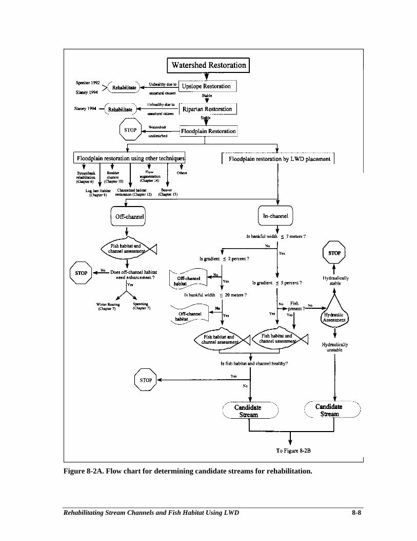
Rehabilitating Stream Channels and Fish Habitat Using LWD 8-8
Figure 8-2A. Flow chart for determining candidate streams for rehabilitation.

Rehabilitating Stream Channels and Fish Habitat Using LWD 8-9
Figure 8-2B. Flow chart for determining candidate streams for rehabilitation (continued)with emphasis on potential applications.
Rehabilitating Stream Channels and Fish Habitat Using LWD 8-10
Silvicultural treatments have potential long-term benefits in restoring habitat functions of riparianareas. Underplanting and thinning of deciduous trees to re-establish native conifers along streamsthat have been logged in the past is being tested in many areas of the Pacific Northwest.Silvicultural thinnings of overly dense stands of conifer to increase diameter growth have beensuccessful in upland forests, and could be readily applied to riparian corridors to increase futureLWD trees.
Regulated girdling of deciduous trees, in combination with conifer planting and instream LWDplacement, is undergoing experimentation in some previously logged Oregon coastal watersheds(Solazzi, pers. comm.). The increased susceptibility to windthrow expedites input of deciduousLWD into the streams which provide short-term LWD functions. Instream LWD rehabilitationprojects provide interim salmonid habitat while the riparian areas restore conifer dominance.
Riparian degradations associated with livestock impacts can be remediated by livestockexclusion. In remote, forested rangelands where fencing of hundreds of miles of riparian corridorsis not feasible, range managers are experimenting with placement of local, downed woody materialin heavily impacted areas to discourage multiple watering/crossing sites in streams, thus restoringbank vegetation.
Stream Channel Rehabilitation
Generally, the most recent research and suggested method of restoring and perhaps enhancingsalmonid fish populations in streams is to improve the overwintering habitat in tributary streamchannels. Increasing the “fish holding ability” of tributary stream channels helps to attain full useof overwintering habitat area high up in drainages and thus overcomes the negative factors thathave contributed to fish declines in downstream large river channels (i.e., poor water quality,increased predation, loss of quality rearing habitat, feeding competition between wild populationsand hatchery-origin populations).
Work to re-establish LWD within stream channels for the benefit of salmonids is still in itsinfancy. Some past efforts at instream placement of LWD structures have been criticized asineffective. Frissell and Nawa (1992) found some widespread damage to LWD structures in 15Oregon and Washington streams with recent watershed disturbance, high sediment loads, andunstable channels. Cross-stream (channel-spanning) structures were the most vulnerable. Aquestionnaire that evaluated enhancement projects, prepared for the British Columbia Ministry ofEnvironment, Lands and Parks, found, on average, only a 50 to 55% success rate with the balancesplit between marginal successes and failures (Hartman and Miles 1995)4. Some well-plannedprojects in Oregon, however, have been successful at rehabilitating in-channel salmonid habitat.House et al. (1991) and Crispin et al. (1993), in coastal Oregon, report a high degree of successwith over 1,000 instream habitat structures evaluated 1-8 years after placement. A preliminaryreport on the instream structural durability of about 3,000 structures on U.S. Federal landsindicated that 75% were functional and 16% were lost after the extreme February 1996 floods(Heller et al. 1996). In Washington, only seven of over 250 pieces of LWD carefully placed andanchored in Porter Creek showed instability (Cederholm et al., in prep.), and this was after severalsignificant flood events during a 6-year period.
________________________4 Many of these projects were conducted as research or pilot projects.
Rehabilitating Stream Channels and Fish Habitat Using LWD 8-11
Many types of instream structures have been used for stream rehabilitation in the PacificNorthwest (Crispin 1988, Fig. 8-3A; Koski 1992, Fig. 8-3B), and Cederholm et al., in prep. (Fig. 8-3 C). Most in-channel structures have been installed in streams of fourth to fifth order with normalpeak flows about 6 to 60 m3⋅sec-1 and channel gradients of 1 to 3%. This doesn’t mean that nothingshould be done in the other stream orders; however, objectives may have to be changed. Forexample, work in hydrologically dynamic rivers may best be carried out along the periphery of thestream or in more stable off-channel habitats located on floodplain terraces above the influence ofthe active river floodplain (Peterson and Reid 1984, Fig. 8-4).
Flow diagrams are useful to guide decisions on when to work with LWD rehabilitation withinthe active channel and when to work off-channel (i.e., wall-base channels) using other techniques(Figs. 8-2A and 8-2B). We generally recommend improvements in off-channel sites when dealingwith large rivers with no natural regulation (i.e., lake-headed systems). The active channels (withinthe high water marks) of large rivers and streams have proven to be a risky site for locatingtraditional LWD habitat enhancement structures. In addition to traditional LWD projects, there areseveral other ways to approach offsetting habitat impacts in large, unstable stream channels,including stream bank rehabilitation (see Chapter 6), off-channel habitat rehabilitation (see Chapter7), placement of boulder clusters (see Chapter 10), flow augmentation (see Chapter 14),encouragement of beaver activity (see Chapter 15), and large-scale log-jam habitat formation (seeChapter 9).
Some off-channels habitats may already be producing salmonids up to their potential, or mayhave other fish and wildlife values that are better left undisturbed. Further direction through theflow charts (Figs. 8-2A and 8-2B) would include a fish habitat and channel assessment, to helpdetermine which particular wall-base channel rehabilitation strategy is appropriate (rearing,spawning, both). We recommend:
off-channel LWD work in fish habitat rehabilitation when the site has either of thefollowing characteristics: a) the channel is greater than 7 m bankfull width5 and has agradient greater than 2%; b) the channel has a bankfull width greater than 20 m.
When working in active channels, bankfull width and gradient will be key decision thresholdsin project selection (Figs. 8-2A and 8-2B). We recommend:
active channel LWD work in fish habitat rehabilitation when the site has either of thefollowing characteristics: a) the channel is less than 7 m bankfull width and the gradient isless than 5%; b) the channel is 7 to 20 m bankfull width and the gradient is less than 2%.
active channel LWD work in headwater channels that are less than 7 m bankfull widthand greater than 5% gradient for the purpose of providing channel hydraulic stability.
There may be exceptions to these criteria when dealing with larger, naturally-regulated, lake-headed streams present on coastal and interior systems. Generally, the channels downstream oflakes, within hydrologically mature watersheds, have hydraulically stable channels. Once thecandidate stream has been selected, consult Fig. 8-2B in order to match candidate stream channelcharacteristics with appropriate enhancement strategies.
________________________5 Bankfull width is practically defined as the distance between two points on the right and left bank of astream channel where perennial vegetation exists (Mean Annual Flood). The transect formed by the twopoints is perpendicular to the stream channel.
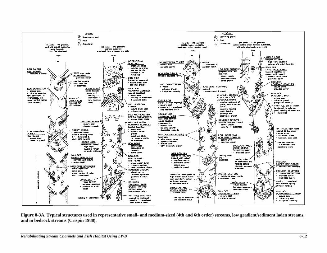
Rehabilitating Stream Channels and Fish Habitat Using LWD 8-12
Figure 8-3A. Typical structures used in representative small- and medium-sized (4th and 6th order) streams, low gradient/sediment laden streams,and in bedrock streams (Crispin 1988).
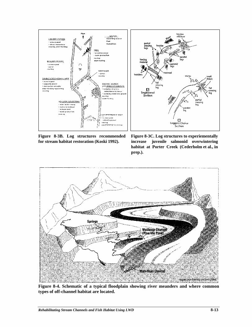
Rehabilitating Stream Channels and Fish Habitat Using LWD 8-13
Figure 8-3B. Log structures recommended Figure 8-3C. Log structures to experiementallyfor stream habitat restoration (Koski 1992). increase juvenile salmonid overwintering
habitat at Porter Creek (Cederholm et al., inprep.).
Figure 8-4. Schematic of a typical floodplain showing river meanders and where commontypes of off-channel habitat are located.
Rehabilitating Stream Channels and Fish Habitat Using LWD 8-14
PLANNING LWD ENHANCEMENT PROJECTS
Watershed and Goal Assessment
The goal of effective fish habitat rehabilitation is to produce greater overall improvements infish productivity, not just to redistribute existing fish numbers within the watershed with isolatedprojects.
Since funding sources for many watershed programs may have short-term sociologic andgeographic objectives, or be directed at land ownership criteria or suppressed fish stocks, there arefew rehabilitation efforts that have occurred in a long-term, systematic matter. In these cases,“targeted” funding can be detrimental to the long-term success of complete watershedrehabilitation programs.
Figures 8-2A and 8-2B (flow charts) were developed to categorize stream sizes and physicaland biological characteristics to identify instream LWD placement candidate streams. Upslope andriparian areas are the priority areas of assessment and restoration, generally in advance of effective,instream restoration. The authors have visited several fish habitat rehabilitation sites throughoutOregon, Western Washington, and British Columbia. A general conclusion is that the majority ofthe work that has occurred in the past has taken place in streams that are too large and unstable,which may be the main reasons instream rehabilitation projects do not reach their expectedbenefits.
Hartman and Miles (1995) conducted a widespread questionnaire survey of many types of fishhabitat improvement projects in British Columbia and made preliminary recommendations on thedevelopment of guidelines for future work. They strongly point out the need to integrate boththe physical and biological considerations when doing stream channel rehabilitation work.They stress the need to incorporate interdisciplinary teams during the design and constructionphase of projects to help insure their success in accomplishing the intended benefits to salmonhabitat. With few exceptions, the identified factors which affected biological success were physicalin nature. They point out several factors that contributed to successful or outstanding projects:
• appropriate physical locations;• small stream size and gentle gradient;• small post-construction floods;• regulated water supply;• successful emulation of natural structures;• experienced design and construction team;• proper installation;• the ability of the structure to collect large volumes of debris and withstand freshets;• provision of adequate cover;• managed by people that have an ongoing interest in the project;• regular monitoring and maintenance.
Large Woody Debris Assessment
LWD assessment is undertaken as part of a fish habitat assessment. This section reviewsLWD-related literature to help develop criteria of expected LWD abundance in streams.
Rehabilitating Stream Channels and Fish Habitat Using LWD 8-15
Several characteristics have been used to describe LWD material in streams, including: piecelength, numbers, width, volume, age, species, decay class, orientation to stream flow, habitat-forming capability, and mapping of spatial distribution in the active channel. In an extensivereview of LWD abundance literature, Peterson et al. (1992) found that the number of pieces ofLWD in streams flowing through unmanaged forests varies between 180 and 610 pieces perkilometer in small streams (<5 m wide), and 30 to 460 pieces per kilometer in large streams(greater than 23 m wide). In research within medium-sized (5-8 m wide) western OlympicPeninsula old growth streams, Grette (1985) documented between 400 and 800 pieces of LWD perkilometer of stream, and between 100 and 510 pieces of old growth LWD per kilometer stillremaining in streams logged up to 62 years prior to his study. Cederholm et al. (in prep.), in theirstudy of Porter Creek, found an average of 60 pieces of old-growth LWD per kilometer stillremaining in a stream that was logged and cleaned over the previous 50 years. At Shop Creek, asimilar stream in B.C., approximately 40 pieces per kilometer were evident prior to LWDrestoration (P. Slaney, pers. comm.).
Bilby and Ward (1991) found that the number of LWD pieces significantly varied with channelwidth, larger streams having fewer pieces than smaller streams. New LWD categories such as “keypieces” and “functional pieces” have been suggested by habitat surveyors to emphasize LWDfunction more than quantity. These categories of wood are described as pieces that areindependently stable in the stream, and perform habitat forming functions or retain other pieces ofLWD. Peterson et al. (1992) emphasizes that logging may not change the number of pieces, butrather the relative size of LWD pieces, and this may be a way of detecting cumulative effects ofclearcut logging. The natural arrangements of LWD in stream channels can be quite complex. In atypical debris jam or accumulation, there may be a few “key” pieces that are responsible for theinitial formation of the LWD complex. It is the quantity of these “key” pieces (usually largerdiameter and/or length than the average) that can give indications of a stream’s stability orpotential stability. Washington State’s watershed analysis process (WDNR 1993) recognizes keyLWD pieces as contributors to watershed stability during floods.
Because simple computation of LWD volume per stream length or area may not adequatelyindex spatial irregularities, Robinson and Beschta (1990a, b) recommend that LWD pieces bedifferentiated by zones of influence. Ungrouped LWD may not benefit fish habitat, per se, in theform of pools or sediment storage, but may have a greater overall effect on channel morphologybecause resistance to flow is spread over a longer distance. Peterson et al. (1992) and theWashington Department of Natural Resources’ revision to Watershed Analysis (WDNR 1993)suggest that LWD surveys should not only be limited to fish bearing waters, and that the type andamount of information collected during LWD surveys should be expanded. The Ministry ofEnvironment, Lands and Park’s Watershed Restoration Program Technical Circular No. 8 (FishHabitat Assessment Procedures) includes an overview of LWD assessment methods.
One of the most comprehensive, management-oriented, mass LWD survey methods availableis the LWD module included in the TFW Ambient Monitoring Manual (Schuett-Hames et al.1994). This procedure, which describes LWD abundance (pieces and volume), distribution, type,size, and potential contribution to channel stability and habitat formation (key piece), is animportant element in LWD restoration project planning and design. This information on existingconditions can be used to determine additional LWD needs for the proposed reach. Some of theseprocedures have been adapted for use in British Columbia as the Fish Habitat AssessmentProcedures (FHAP; Johnston and Slaney 1996) where LWD frequency has been scaled to channelwidth (BFW) and rated as poor (<1 piece/BFW), fair (1-2 pieces/BFW), and good (>2pieces/BFW).
Rehabilitating Stream Channels and Fish Habitat Using LWD 8-16
Channel Assessment
The LWD project must consider more than the biological components. Analysis and evaluationof the physical components of the project must be completed by an engineer with experience inhydrology, natural channel flow, construction methodologies and construction supervision. Thisblend of expertise provides the kind of input that is necessary for successful project completion.Reliance on only one perspective or allowing one perspective to dominate can result in projectdesigns and installed projects that do not achieve the desired results.
The Channel Conditions and Prescriptions Assessment (CCPA) (Hogan et al. 1997), theChannel Assessment Procedure (CAP) Guidebook and Field Guidebook, produced under theauthority of the Forest Practices Code of British Columbia Act (Anon. 1996a, b), are designed toidentify past occurrences of channel changes in a consistent, repeatable process across variouslandscapes. With information acquired from CCPA and the Fish Habitat Assessment Procedures(FHAP), candidate watersheds can be identified for rehabilitation needs and possibilities.Information on channel stability, available habitat, limiting factors, etc., can then be synthesized todetermine what applications of LWD rehabilitation can occur.
Channel assessment procedures may vary in complexity according to professional preferences,experience of project crews, and the need for post-structural monitoring. For example, componentsof a channel evaluation conducted by an engineer at a successful project in a 10-meter wideWashington State coastal stream (Porter Creek, WA), are summarized:
During the site surveys, a benchmark for elevation was established on or near a prominentphysical feature within the project area. A surveyor’s transit was used to complete a siteelevation and position survey. Physical features such as edge of channel, existingtopography, toe and top of banks, gravel bar islands, secondary channels, floodplains,existing LWD habitat features, habitat type boundaries, and water surface elevations werelocated by determining the horizontal angle and distance to each feature from theinstrument.
Upon completion of the site survey, the horizontal angle, vertical angle, and slope distancedata recorded for each point were used to generate a site map of the project area. This mapand the elevation data were then used in the design of the LWD habitat structures. Duringthe site survey, locations of existing physical features were determined with an accuracy of+15 cm horizontally and +3 cm vertically. This level of accuracy was utilized for theengineering evaluation and design of the project.
Hydrologic and Hydraulic Geometry Assessment
Successful LWD habitat designs require an understanding of regional and local hydrologiccharacteristics. Within the project area, the stream channel and habitat features must be designed to1) withstand floods; 2) create the desired low flow channel, and 3) provide the preferred habitatcomponents for appropriate life stages of the target fish species.
Streamflows in the potential project reach must be evaluated to determine the range ofconditions the proposed LWD structures will be exposed to during each season. Characteristicflows to be identified include the 7-day average low flow, average annual flow, and average floodflow. These flows define the anticipated summer conditions, the magnitude of the stream, and thetypical high flow conditions, respectively.
Rehabilitating Stream Channels and Fish Habitat Using LWD 8-17
Determining design flows for a LWD habitat enhancement project will require the use ofstreamflow records for the stream or a regional hydrologic model to determine flood, average andlow flows. Flows to be estimated using the streamflow records or the regional model (such asextrapolation from gauged streams nearby) should include average annual flow, 7-day average lowflow, average flood flow and average daily flood flows with a 20- and 50-year recurrence interval.Average monthly flows to be estimated should include monthly minimum, monthly mean, andmonthly maximum.
Hydraulic geometry is the relationship of channel width, average depth and average velocityto discharge. Once the streamflows within the proposed project area have been identified, then thewidth, depth, and velocity at each flow can be estimated to define the physical conditions withinthe stream at each flow. These relationships are used to identify the estimated flow characteristicsin light of the hydrologic analysis and to evaluate the impact of the proposed LWD placement onthe low flow and flood flow characteristics of the channel. This information is then compared withthe existing channel features determined during the project area survey to identify any majordiscrepancies in the channel shape. Chapters 9 and 12 provide necessary information indetermining appropriate size of materials (boulders and logs) to be used for a channel rehabilitationproject.
Large woody debris installed in the channel will create localized changes in the streamflowpattern. If these changes in streamflow pattern are severe, the water surface profile may changesignificantly and cause bank erosion and/or new channel formation during high flows. With suchadded variability in LWD placement, we generally recommend that designs be targeted towithstand a 50-year flood event (see Chapter 1).
Fish Habitat Assessment
Physical Habitat Requirements of Salmonids
Developing effective LWD habitat rehabilitation designs that maintain stream channelcharacteristics and create fish habitat features requires knowledge of the target fish species andtheir habitat utilization periods within the project area. Each of the target species may utilize theproject area in a different manner. Fish species of primary concern vary regionally: for example,coho and cutthroat are ubiquitous along the coastal areas, while resident trout, arctic grayling, andespecially bull trout may be of greatest concern inland. Knowing the species of fish you are dealingwith is important - as is knowing the age class of a species like steelhead and cutthroat, which havemultiple ages, each with a different critical habitat need. The seasonal movement behavior ofjuvenile fish will also differ regionally, for example, immigration into wall-base channel tributariesin the fall and spring along the coast compared to spring immigrations to tributaries in interiorrivers.
Identification of the physical habitat requirements for the target species within the project areais necessary to develop an effective habitat rehabilitation plan. For each of the target speciesidentified, periods of utilization for each age class must be defined. This information is used toidentify the habitat features required by the target species within the potential project reach.
Methods of Fish Habitat Assessment
An inventory of the existing physical habitat must be completed to quantify the types anddistribution of habitat features within the project area. This inventory is needed to identify the

Rehabilitating Stream Channels and Fish Habitat Using LWD 8-18
existing features that provide good habitat in some locations and/or limit the production of thetarget species in other locations Habitat types can be defined as the relationship between the streamreach and the “microhabitats” of the stream biota. Differentiation of habitat types is due to theirvariability in morphologic and hydraulic properties. Each habitat type exhibits a unique set ofphysical characteristics, which have been related to the composition of the associated biologicalcommunity. Once these features have been identified, comparisons with the physical habitatrequirements of the target species can be completed.
Parameters in these evaluation procedures typically include bank height, bank slope, bankstability, vegetation type, water depth, water velocity, substrate size, substrate embeddedness,overhead canopy cover, instream cover type and undercut banks. After the data has been collected,it is entered, edited and summarized using database software.
The Fish Habitat Assessment Procedures (Johnston and Slaney 1996) provides a systematicapproach towards evaluating fish habitat in which key questions are asked to pinpoint habitatlimitations by which quantitative data are utilized to rate habitat features as either poor, fair, orgood.
Limiting Factor Assessment
Reeves et al. (1991) put forth the idea that a fundamental concept of habitat management isthat fish production is limited by discrete factors, or “bottlenecks”. They point out that whenplanning habitat rehabilitation projects, care must be taken to identify aspects of habitat that limitproduction, and attention should be focused on improving those elements. The timing of lifehistory events is also an important consideration. For example, increasing the quantity or quality ofsome aspect of habitat that limits the abundance of emerging fry will generally be of little use if acritical shortage of cover or some other resource occurs at a later stage in life. Increasing initial fryabundance may benefit chum, pink, and sockeye (or “spawning limited species”), but probably notsteelhead, cutthroat or coho salmon because of rearing limitations. These authors put forth aconcept of the bottleneck effect as a guide to choice of life history stage to focus on, in order toachieve the greatest success in improving ultimate smolt yield.
The overall objective of a rehabilitation plan using LWD is to create a mixture of macro andmicro habitat features that provide the preferred habitat components of the target species or groupof species. Preparation of the plan needs to begin with the identification of the preferred habitatfeatures, i.e., depth, velocity, and cover, for each age class of the target species. Using thisinformation, the macro habitat types and micro habitat characteristics that create these features canthen be defined. Comparison of the existing site features with the preferred features identified forthe target species defines the habitat components that are missing from the project area. Byknowing what habitat components are missing from the stream, a habitat rehabilitation plan can bedeveloped to create the missing or lost habitat components.
Choosing Rehabilitation Applications
Debris torrents, frequent flooding and other major disturbances can damage or completelyremove habitat improvements. In determining where to implement habitat efforts, input fromagencies, local interest groups and industry interests is an important consideration. The results ofthe Fish Habitat and Channel Assessment should indicate the strategies of LWD placement. Theauthors’ intent is to present conceptual applications of LWD placement rather than prescribe aparticular LWD arrangement for a particular reach of stream. Most often, a degraded stream

Rehabilitating Stream Channels and Fish Habitat Using LWD 8-19
channel lacks sinuosity or impoundment capability. The combination of applications such ascreating a dam and step pools, slack water rearing area, gravel retention structures, and lateralchannel inundation is desirable for most stream reaches (Fig. 8-5).
DESIGNING REHABILITATION PROJECTS USING LARGE WOODY DEBRIS
Experienced Personnel
Recent LWD rehabilitation work at Porter Creek (Cederholm et al. in prep.) has shown thatwhen both hydraulic and biological considerations are planned for, through integration ofprinciples of hydraulic engineering and salmon ecology, there is a vastly improved chance ofsuccess. In the past, the placement of LWD was often carried out by biologists alone, who oftendidn’t understand the hydraulic forces involved with placing logs in high-flow channels.Alternatively, an engineer may have designed a sound project that is stable, exhibits an appropriatenumber of meanders, and curtailed an erosion problem, but didn’t match the habitat complexityneeds to the fish species that were present. The consequence of much of this earlier work was thatmany structures failed to function physically as they were intended, or did not assist in increasingthe productivity of a fish population. The Porter Creek study shows that interdisciplinaryapproaches can work well when the disciplines complement each other.
A thorough understanding of the existing physical and biological conditions within the projectarea must be developed to produce accurate design drawings for LWD rehabilitation projects. Thisunderstanding is needed to identify the existing features and/or habitat deficiencies that may belimiting production of the target fish species. Once these features and habitat deficiencies havebeen identified, design features necessary to create the desired habitat components can bedeveloped.
Identification of the engineering and biological design specifications for LWD rehabilitationprojects is imperative prior to preparing conceptual design drawings. These specifications providea detailed list of specific requirements or guidelines that must be incorporated into the designs tomaximize the engineering and biological benefits of the project.
Synthesis of a hydrologist’s and biologist’s expertise is necessary for an effective project.Project managers are responsible for informing work crews of correct procedures. Withgovernment agencies funding projects in cooperation with job-creation programs, many availableworkers possess applicable forest-worker skills such as heavy machinery operation, winching, andtree falling. If these workers have participated in restoration training classes, they may be capableof small project planning, material assemblage, and implementation.
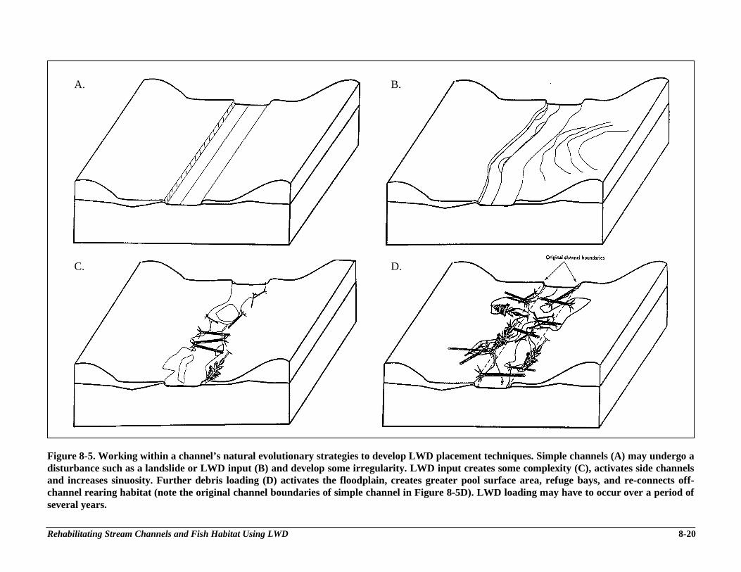
Rehabilitating Stream Channels and Fish Habitat Using LWD 8-20
Figure 8-5. Working within a channel’s natural evolutionary strategies to develop LWD placement techniques. Simple channels (A) may undergo adisturbance such as a landslide or LWD input (B) and develop some irregularity. LWD input creates some complexity (C), activates side channelsand increases sinuosity. Further debris loading (D) activates the floodplain, creates greater pool surface area, refuge bays, and re-connects off-channel rearing habitat (note the original channel boundaries of simple channel in Figure 8-5D). LWD loading may have to occur over a period ofseveral years.
A.
C.
B.
D.
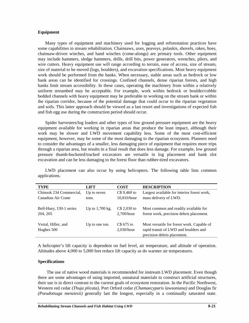
Rehabilitating Stream Channels and Fish Habitat Using LWD 8-21
Equipment
Many types of equipment and machinery used for logging and reforestation practices havesome capabilities in stream rehabilitation. Chainsaws, axes, peaveys, polaskis, shovels, rakes, hoes,chainsaw-driven winches, and hand winches (come-alongs) are primary tools. Other equipmentmay include hammers, sledge hammers, drills, drill bits, power generators, wrenches, pliers, andwire cutters. Heavy equipment use will range according to terrain, ease of access, size of stream,size of material to be moved (logs, boulders), and excavation specifications. Most heavy equipmentwork should be performed from the banks. When necessary, stable areas such as bedrock or lowbank areas can be identified for crossings. Confined channels, dense riparian forests, and highbanks limit stream accessibility. In these cases, operating the machinery from within a relativelyuniform streambed may be acceptable. For example, work within bedrock or boulder/cobblebedded channels with heavy equipment may be preferable to working on the stream bank or withinthe riparian corridor, because of the potential damage that could occur to the riparian vegetationand soils. This latter approach should be viewed as a last resort and investigations of expected fishand fish egg use during the construction period should occur.
Spider harvesters/log loaders and other types of low ground pressure equipment are the heavyequipment available for working in riparian areas that produce the least impact, although theirwork may be slower and LWD movement capability less. Some of the most cost-efficientequipment, however, may be some of the most damaging to the riparian ecosystem. Planners needto consider the advantages of a smaller, less damaging piece of equipment that requires more tripsthrough a riparian area, but results in a final result that does less damage. For example, low groundpressure thumb-bucketed/tracked excavators are versatile in log placement and bank slotexcavation and can be less damaging to the forest floor than rubber-tired excavators.
LWD placement can also occur by using helicopters. The following table lists commonapplications.
TYPE LIFT COST DESCRIPTIONChinook 234 Commercial,Canadian Air Crane
Up to seventons.
C$ 9,460 to10,810/hour
Largest available for interior forest work,mass delivery of LWD.
Bell-Huey, UH-1 series204, 205
Up to 1,700 kg. C$ 2,030 to2,700/hour
Most common and readily available forforest work, precision debris placement.
Vertal, Hiller, andHughes 500
Up to one ton. C$ 675 to2,030/hour
Most versatile for forest work. Capable ofrapid transit of LWD and boulders andprecision debris placement.
A helicopter’s lift capacity is dependent on fuel level, air temperature, and altitude of operation.Altitudes above 4,000 to 5,000 feet reduce lift capacity as do warmer air temperatures.
Specifications
The use of native wood materials is recommended for instream LWD placement. Even thoughthere are some advantages of using imported, unnatural materials to construct artificial structures,their use is in direct contrast to the current goals of ecosystem restoration. In the Pacific Northwest,Western red cedar (Thuja plicata), Port Orford cedar (Chamaecyparis lawsoniana) and Douglas fir(Pseudotsuga menziesii) generally last the longest, especially in a continually saturated state.
Rehabilitating Stream Channels and Fish Habitat Using LWD 8-22
Western hemlock (Tsuga heterophylla), White fir (Abies concolor), Sitka spruce (Picea sitchensis),pine (Pinus spp.), and hardwoods are least durable. Cederholm et al. (in prep.) observed that,within 4-6 years, most alders used in a LWD experiment experienced various degrees ofdecomposition. Most deciduous trees lose all structural integrity within 5 years, in contrast to redcedar, which can be durable for 25 years in artificially-placed applications. However, hardwoodshave some advantages to stream ecosystems such as rapid canopy shading in disturbed areas,increased litterfall and nutrient input, and consequent increased macrobenthic production.
How much wood does a stream need? Table 8-2 is designed to guide a project developer indetermining how much LWD is enough for a given stream reach. Because there exists considerablevariability in channel characteristics and LWD arrangements in streams, the process outlined inTable 8-2 uses LWD volume as a standard. This decision was based on somewhat consistentfindings in the LWD literature concerning LWD volume/stream length and size and the fact thatproject supervisors will be using different LWD piece sizes. The steps are explained in Table 8-2and can be followed accordingly. This method does not intend to portray the idea that we have acomplete understanding of stream LWD needs; it is merely a starting point for general loadingrates. Adjustments can be made for gradients, available channel margin habitat, off-channelhabitat, montane rivers, and experimental loading rates. Generally, as stream size increases, thediameter of effective LWD increases.
IMPLEMENTING REHABILITATION PROJECTS USING LARGE WOODY DEBRIS
Materials
Use of entire trees with rootwads, sections of tree trunks, rootwads with short sections of trunkattached, or other pieces of woody debris that will remain stable in the stream during theanticipated flow regime can be used to create critical micro habitat features. It is important tovisualize the water level and resulting shear and buoyancy forces involved during high flows ineach stream reach, and install micro-habitat features in those parts of the channel that maintain thelowest velocities for fish refuge.
Placement Strategies
In developing LWD placement strategies it is important to consider both the physical andbiological approaches in combination, to achieve channel modifications that will ultimately havelong-term benefits for salmonids. Both considerations must be included, because one without theother is often a prescription for project failure. Initially, physical channel stabilization and energydissipation functions should be addressed before fish habitat is provided. For example, full crossinglogs can provide both energy dissipation and pool formation, and some logs may even need to beburied within the streambed to provide gravel stability. Once a stream gradient is lowered and thechannel is stabilized, then it is time to place debris cover factors for fish. The most used covertypes are stable rootwads, debris clusters, log jams, and full tree accumulations. These structuresshould be located in areas of lowest anticipated stream velocities (channel margins, back eddies,etc.) that exist during the high flow period of winter and spring. The best places for this purposeare usually in side channels and eddies, along shorelines, and in backwater pools.
In a review of several projects (Frissell and Nawa 1992) the highest frequency of structurefailure occurred with full spanning structures, especially as stream size increased, as compared tobank-aligned structures.

Rehabilitating Stream Channels and Fish Habitat Using LWD 8-23
Table 8-2. Process for determining appropriate LWD amounts for enhancement of a streamreach.
Although this question is difficult to answer due to the variability among watersheds, by using some dataprovided by Grette (1985), a target number of pieces based on the average volume of available pieces ofwood can be recommended. Since a wide range of LWD sizes will be used throughout the various regions,this techniques will at least guarantee that streams are attaining consistent LWD volume loading. WhenLWD sources are off-site, measurements of these stockpiled wood pieces can occur to determine LWD pieceneeds for the project before bringing them on-site.
Grette (1985) found an average of ~80 m3 LWD per 100 m stream reach in unlogged tributaries in the PacificNorthwest with <2% gradient in <8 km2 watersheds. The maximum volume of LWD observed was 100 m3
per 100 m stream.
ESTIMATED WOOD VOLUMES (m3) FOR A GIVEN LENGTH AND A DIAMETER
Diameter (m)
0.25 0.3 0.35 0.4 0.45 0.5 0.55 0.6 0.65 0.7 0.75 0.8 0.85 0.9 0.95 1 1.05 1.1 1.15 1.2 1.25 1.3 1.35 1.4 1.45 1.5
3 0.15 0.21 0.29 0.38 0.48 0.59 0.71 0.85 1 1.15 1.33 1.51 1.7 1.91 2.13 2.36 2.6 2.85 3.12 3.39 3.68 3.98 4.29 4.62 4.95 5.3
4 0.2 0.28 0.38 0.5 0.64 0.79 0.95 1.13 1.33 1.54 1.77 2.01 2.27 2.54 2.84 3.14 3.46 3.8 4.15 4.52 4.91 5.31 5.73 6.16 6.61 7.07
5 0.25 0.35 0.48 0.63 0.8 0.98 1.19 1.41 1.66 1.92 2.21 2.51 2.84 3.18 3.54 3.93 4.33 4.75 5.19 5.65 6.14 6.64 7.16 7.7 8.26 8.84
6 0.29 0.42 0.58 0.75 0.95 1.18 1.43 1.7 1.99 2.31 2.65 3.02 3.4 3.82 4.25 4.71 5.2 5.7 6.23 6.79 7.36 7.96 8.59 9.24 9.91 10.6
7 0.34 0.49 0.67 0.88 1.11 1.37 1.66 1.98 2.32 2.69 3.09 3.52 3.97 4.45 4.96 5.5 6.06 6.65 7.27 7.92 8.59 9.29 10.02 10.78 11.56 12.37
8 0.39 0.57 0.77 1.01 1.27 1.57 1.9 2.26 2.65 3.08 3.53 4.02 4.54 5.09 5.67 6.28 6.93 7.6 8.31 9.05 9.82 10.62 11.45 12.32 13.21 14.14
9 0.44 0.64 0.87 1.13 1.43 1.77 2.14 2.54 2.99 3.46 3.98 4.52 5.11 5.73 6.38 7.07 7.79 8.55 9.35 10.18 11.04 11.95 12.88 13.85 14.86 15.9
10 0.49 0.71 0.96 1.26 1.59 1.96 2.38 2.83 3.32 3.85 4.42 5.03 5.67 6.36 7.09 7.85 8.66 9.5 10.39 11.31 12.27 13.27 14.31 15.39 16.51 17.67
11 0.54 0.78 1.06 1.38 1.75 2.16 2.61 3.11 3.65 4.23 4.86 5.53 6.24 7 7.8 8.64 9.52 10.45 11.43 12.44 13.5 14.6 15.75 16.93 18.16 19.44
12 0.59 0.85 1.15 1.51 1.91 2.36 2.85 3.39 3.98 4.62 5.3 6.03 6.81 7.63 8.51 9.42 10.39 11.4 12.46 13.57 14.73 15.93 17.18 18.47 19.82 21.21
13 0.64 0.92 1.25 1.63 2.07 2.55 3.09 3.68 4.31 5 5.74 6.53 7.38 8.27 9.21 10.21 11.26 12.35 13.5 14.7 15.95 17.26 18.61 20.01 21.47 22.97
14 0.69 0.99 1.35 1.76 2.23 2.75 3.33 3.96 4.65 5.39 6.19 7.04 7.94 8.91 9.92 11 12.12 13.3 14.54 15.83 17.18 18.58 20.04 21.55 23.12 24.74
15 0.74 1.06 1.44 1.88 2.39 2.95 3.56 4.24 4.98 5.77 6.63 7.54 8.51 9.54 10.63 11.78 12.99 14.25 15.58 16.96 18.41 19.91 21.47 23.09 24.77 26.51
16 0.79 1.13 1.54 2.01 2.54 3.14 3.8 4.52 5.31 6.16 7.07 8.04 9.08 10.18 11.34 12.57 13.85 15.21 16.62 18.1 19.63 21.24 22.9 24.63 26.42 28.27
17 0.83 1.2 1.64 2.14 2.7 3.34 4.04 4.81 5.64 6.54 7.51 8.55 9.65 10.81 12.05 13.35 14.72 16.16 17.66 19.23 20.86 22.56 24.33 26.17 28.07 30.04
18 0.88 1.27 1.73 2.26 2.86 3.53 4.28 5.09 5.97 6.93 7.95 9.05 10.21 11.45 12.76 14.14 15.59 17.11 18.7 20.36 22.09 23.89 25.76 27.71 2972 31.81
19 0.93 1.34 1.83 2.39 3.02 3.73 4.51 5.37 6.3 7.31 8.39 9.55 10.78 12.09 13.47 14.92 16.45 18.06 19.74 21.49 23.32 25.22 27.2 29.25 31.37 33.58
20 0.98 1.41 1.92 2.51 3.18 3.93 4.75 5.65 6.64 7.7 8.84 10.05 11.35 12.72 14.18 15.71 17.32 19.01 20.77 22.62 24.54 26.55 28.63 30.79 33.03 35.34
21 1.03 1.48 2.02 2.64 3.34 4.12 4.99 5.94 6.97 8.08 9.28 10.56 11.92 13.36 14.89 16.49 18.18 19.96 21.81 23.75 25.77 27.87 30.06 32.33 34.68 37.11
22 1.08 1.56 2.12 2.76 3.5 4.32 5.23 6.22 7.3 8.47 9.72 11.06 12.48 14 15.59 17.28 19.05 20.91 22.85 24.88 27 29.2 31.49 33.87 36.33 38.88
23 1.13 1.63 2.21 2.89 3.66 4.52 5.46 6.5 7.63 8.85 10.16 11.56 13.05 14.63 16.3 18.06 19.92 21.86 23.89 26.01 28.23 30.53 32.92 35.41 37.98 40.64
24 1.18 1.7 2.31 3.02 3.82 4.71 5.7 6.79 7.96 9.24 10.6 12.06 13.62 15.27 17.01 18.85 20.78 22.81 24.93 27.14 29.45 31.86 34.35 36.95 39.63 42.41
25 1.23 1.77 2.41 3.14 3.98 4.91 5.94 7.07 8.3 9.62 11.04 12.57 14.19 15.9 17.72 19.63 21.65 23.76 25.97 28.27 30.68 33.18 35.78 38.48 41.28 44.18
To determine an approximate number of LWD pieces for a rehabilitation project, use the table above andapply the following equation:
N = number of suggested LWD piecesN = 80m3 x _L_ where Va = average volume/piece of available LWD (from table above)
V4 100 L = length of proposed reach (meters)
For example: 1 59m3 is the average LWD volume/piece available for use in rehabilitation (determined fromtable after averaging diameter and lengibs of available LWD). 300 m is the reach length (<2% gradient).
N = 80m3 x 300 = 150 LWD pieces/ 300 m streaml.59m3 100
Therefore, 150 LWD pieces are recommended for this particular 300 m reach when the average availableLWD piece is 1.59 m3 in volume. This information is consistent with findings in old-growth and old second-growth forests (Grette 1985) and with extensive literature review (Peterson et al. 1992) where LWDfrequency ranged between 18-61 pieces/l00 m in small unmanaged streams and 40-80 pieces/l00 m inmedium streams (5-10 meter BFW). Larger streams ranged between 3-46 pieces/ 100 m.
Len
gth
(m)
Rehabilitating Stream Channels and Fish Habitat Using LWD 8-24
Fastening Systems
Several LWD anchoring systems have been developed (Fontaine and Merritt 1988; Flosi andReynolds 1994; Koonce 1990) and individual projects throughout the Northwest have oftendeveloped variations of these fastening techniques. Figure 8-6 exhibits different variations offastening techniques. Commonly used are: fastened to boulders using epoxy resin; rebar typicallydriven 2.8 meters into the substrate with the top 10-12 cm bent and driven into the log and deadman applications. Galvanized chain has also been used in British Columbia for floating log or raftstructures.
Consistent with ecosystem principles, the authors encourage the experimental use andmonitoring of unfastened or delayed fastening. The role of the intragravel wood matrix is not wellunderstood but biologists and geologists assume it provides an important resistance factor in streamstability and gravel migration. By not fastening LWD, we recognize the importance of continualinput and depletion phases in the LWD cycle. In unfastened applications, LWD is positioned in thestream or wedged between standing trees. The sheer mass of the LWD, confined channelcharacteristics, wedged position, low resistance orientation, or some combination of these, arecapable of holding the LWD in place. Project developers can estimate LWD sizes that are morelikely to remain within the system for several years and locate or recommend those particular LWDsizes for placement. In delayed fastening applications, key LWD pieces are anchored after one ortwo storm events, after the piece has been distributed and positioned by flood waters. Thisapplication can occur in plane bed, channelized, or in streams scoured to bedrock where there arelimited channel irregularities or meanders in which LWD accumulations naturally occur. Fasteningis essential in areas with low in-channel LWD and very poor future LWD recruitment. Care shouldalways be taken to avoid direct damage to downstream public structures (i.e., bridges) and adjacentprivate property.
Generally, the use of unnatural materials is discouraged. Geotextile fabric, plastic sheeting, andchain-link fencing have short effective life-spans in streams with altered hydrology. Most channel-spanning structures will seal with sediment and organic material within the first year or two.
MONITORING AND EVALUATING PROJECTS
Documenting fish presence in areas of restored habitat is a common approach to evaluatinghabitat restoration projects. Increased fish presence in a previously little-used area may indicatethat favorable habitat conditions are created as a result of a certain woody debris arrangement.However, this information must be interpreted cautiously, because it can be misleading inevaluating increases in fish productivity. Since many small-scale restoration projects occur on asite-by-site basis, it is very difficult to determine their actual contribution to overall streamproductivity. The matter becomes even more complicated if multiple species are involved and ifthere are artificial influences (hatcheries, fry outplants, artificial flow conditions). The best way toevaluate the effects on anadromous salmonid fish abundance as a result of restoration projects is toquantify basinwide smolt output. Often winter habitat limits fish production (see Fish HabitatAssessment Procedures), and therefore, it can be important to gain knowledge on the smolt yieldbenefits (with a viable control) before concluding what improvements have been achieved.Because of the proven seasonal mobility of juvenile salmonids during the winter, it can bemisleading to evaluate enhancement projects using summer standing crop estimates. Whentreatments begin to improve the survival of fish through the “bottleneck” period of winter, thenrestoration projects are probably making a significant difference. For evaluating resident fish
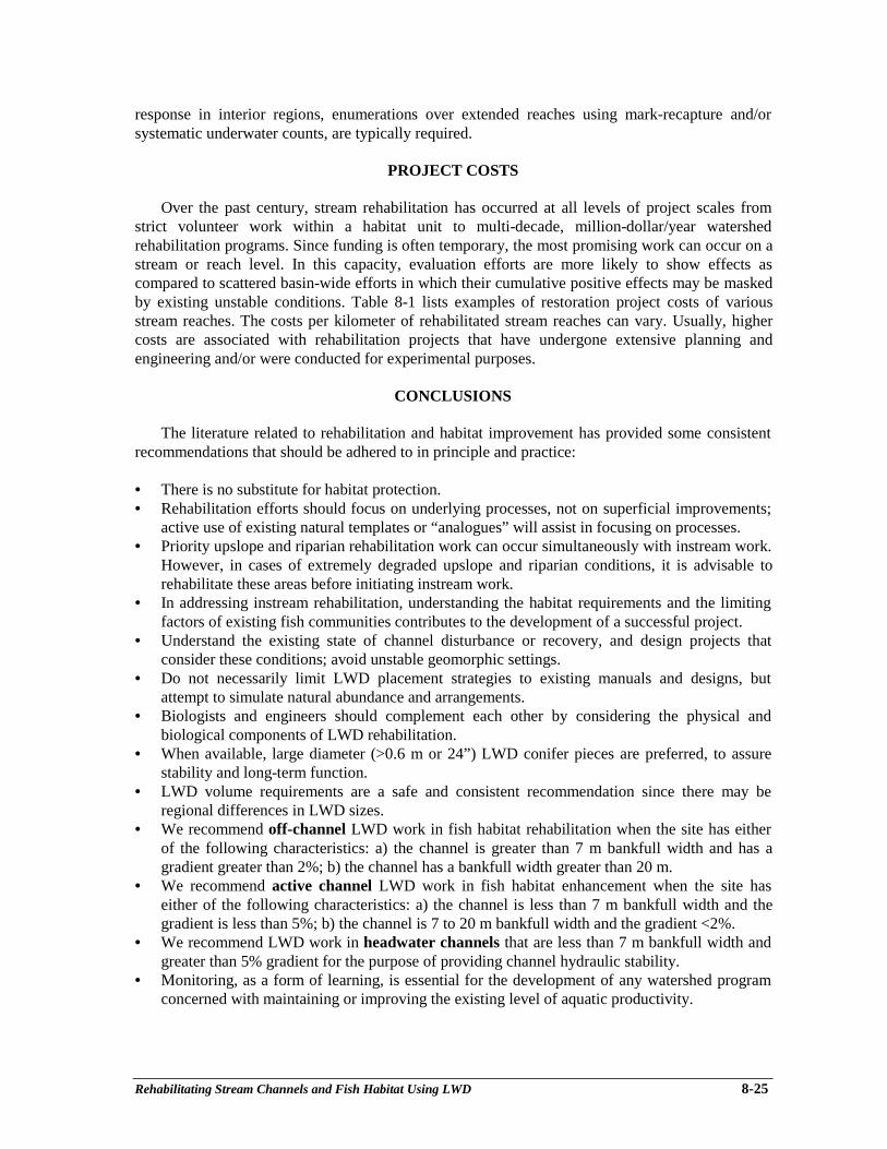
Rehabilitating Stream Channels and Fish Habitat Using LWD 8-25
response in interior regions, enumerations over extended reaches using mark-recapture and/orsystematic underwater counts, are typically required.
PROJECT COSTS
Over the past century, stream rehabilitation has occurred at all levels of project scales fromstrict volunteer work within a habitat unit to multi-decade, million-dollar/year watershedrehabilitation programs. Since funding is often temporary, the most promising work can occur on astream or reach level. In this capacity, evaluation efforts are more likely to show effects ascompared to scattered basin-wide efforts in which their cumulative positive effects may be maskedby existing unstable conditions. Table 8-1 lists examples of restoration project costs of variousstream reaches. The costs per kilometer of rehabilitated stream reaches can vary. Usually, highercosts are associated with rehabilitation projects that have undergone extensive planning andengineering and/or were conducted for experimental purposes.
CONCLUSIONS
The literature related to rehabilitation and habitat improvement has provided some consistentrecommendations that should be adhered to in principle and practice:
• There is no substitute for habitat protection.• Rehabilitation efforts should focus on underlying processes, not on superficial improvements;
active use of existing natural templates or “analogues” will assist in focusing on processes.• Priority upslope and riparian rehabilitation work can occur simultaneously with instream work.
However, in cases of extremely degraded upslope and riparian conditions, it is advisable torehabilitate these areas before initiating instream work.
• In addressing instream rehabilitation, understanding the habitat requirements and the limitingfactors of existing fish communities contributes to the development of a successful project.
• Understand the existing state of channel disturbance or recovery, and design projects thatconsider these conditions; avoid unstable geomorphic settings.
• Do not necessarily limit LWD placement strategies to existing manuals and designs, butattempt to simulate natural abundance and arrangements.
• Biologists and engineers should complement each other by considering the physical andbiological components of LWD rehabilitation.
• When available, large diameter (>0.6 m or 24”) LWD conifer pieces are preferred, to assurestability and long-term function.
• LWD volume requirements are a safe and consistent recommendation since there may beregional differences in LWD sizes.
• We recommend off-channel LWD work in fish habitat rehabilitation when the site has eitherof the following characteristics: a) the channel is greater than 7 m bankfull width and has agradient greater than 2%; b) the channel has a bankfull width greater than 20 m.
• We recommend active channel LWD work in fish habitat enhancement when the site haseither of the following characteristics: a) the channel is less than 7 m bankfull width and thegradient is less than 5%; b) the channel is 7 to 20 m bankfull width and the gradient <2%.
• We recommend LWD work in headwater channels that are less than 7 m bankfull width andgreater than 5% gradient for the purpose of providing channel hydraulic stability.
• Monitoring, as a form of learning, is essential for the development of any watershed programconcerned with maintaining or improving the existing level of aquatic productivity.
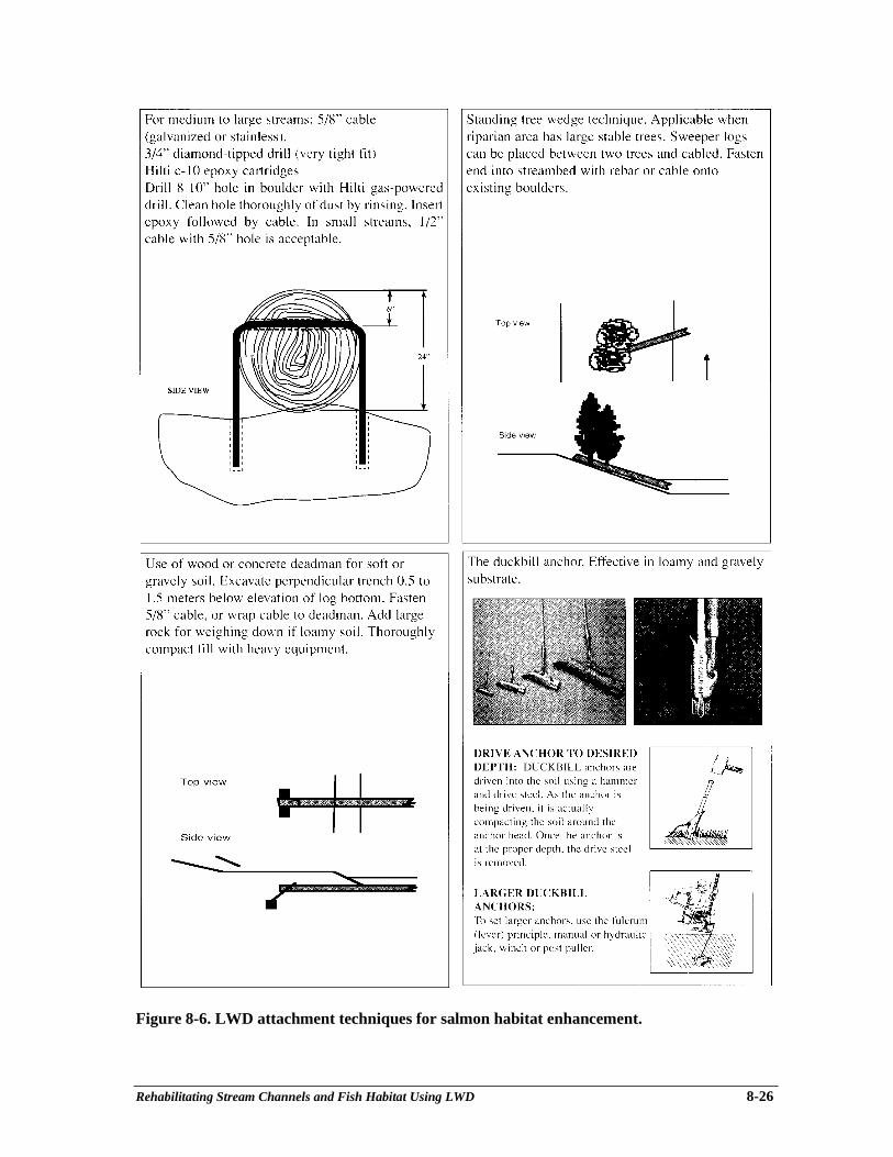
Rehabilitating Stream Channels and Fish Habitat Using LWD 8-26
Figure 8-6. LWD attachment techniques for salmon habitat enhancement.
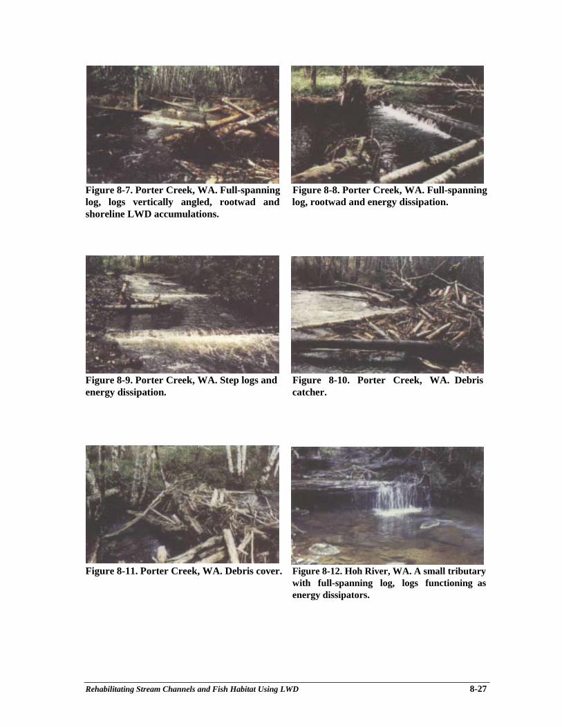
Rehabilitating Stream Channels and Fish Habitat Using LWD 8-27
Figure 8-7. Porter Creek, WA. Full-spanning Figure 8-8. Porter Creek, WA. Full-spanninglog, logs vertically angled, rootwad and log, rootwad and energy dissipation.shoreline LWD accumulations.
Figure 8-9. Porter Creek, WA. Step logs and Figure 8-10. Porter Creek, WA. Debrisenergy dissipation. catcher.
Figure 8-11. Porter Creek, WA. Debris cover. Figure 8-12. Hoh River, WA. A small tributarywith full-spanning log, logs functioning asenergy dissipators.

Rehabilitating Stream Channels and Fish Habitat Using LWD 8-28
Figure 8-13. Stequalaho Creek, WA. Sediment Figure 8-14. An unnamed small high-gradientdam on a small tributary that has sluiced out. tributary where LWD provides energy
dissipation
Figure 8-15. Shop Creek, B.C. A large Figure 8-16. A log deflector with floating bankrootwad that had been left on the bank after cover installed in Shop Creek in the upperlogging was moved to a corner pool to provide Squamish River watershed.prime juvenile rearing (coho, steelhead andchar) and spawner holding habitat. Therootwad is secured by a chain at the upstreamend, where it stays in position to maintain thedeep pool.
Figure 8-17. Attached LWD at USFS project Figure 8-18. Attached woody debris at a USFSon the Mount Baker Snowqualmie National project on the Mount Baker SnoqualmieForest. Logs are secured by boulders and National Forest. Logs are attached to bedrockrebar. (Myron Kozak photo) epoxy-cabled) and the stream bank. (Myron
Kozak photo)
Accelerating the Recovery of Log-jam Habitats 9-1
Chapter 9Accelerating the Recovery of Log-jam Habitats:
Large Woody Debris-boulder Complexes
Pat A. Slaney1, Rheal J. Finnigan2, Robert G. Millar3
INTRODUCTION
In mature to old-growth forests, streams are structured by abundant pieces of large wood thatstore sediments, create pools for fish rearing as well as hydraulic “tailouts” of gravels for spawningof salmonids. Log jams comprise about 10% of LWD in small streams, in contrast to medium-sizedstreams, where log jams constitute 40% of LWD (data on file, Hogan pers. comm.). Jams are vitalfish habitat for summer and winter rearing, adult holding, and prime spawning at pool “tailouts”.
Applications
Chapter 8 (Cederholm et al.) provides guidelines for restoring natural quantities and sizes oflarge wood in streams up to 20 m in width. This chapter focuses specifically on restoring andcreating the more complex habitat structures commonly referred to in streams as “log jams”, butemploying conceptual designs of structures that only moderately impinge on the hydraulics of thechannel. These include full-spanning elevated structures over residual shallow pools in very smallstreams, but primarily lateral log jams, streamside debris catchers, and stream reefs, applicable tostable moderately-sized streams. Lateral log jams (with logs attached on sloping banks in atriangular design) are the preferred and more conventional option for these complex habitatstructures, and templates are most common in nature.
As with other techniques described in other chapters, log jams should not be appliedexclusively. For example, boulder clusters as described in Chapter 10 are most applicable to riffles,and LWD placements, as described in Chapter 8 are most applicable to low gradient riffles andshallow pools as broad restorative treatments. Large composite structures are targeted ongeomorphic settings where there is either historical evidence of log-jam structures (air photo orresidual jams) or where a systematic survey and guidance of an individual with experience in suchprescriptions indicate suitable residual pool sites. Application of these complex structures to breakup steeper gradients (>2%) within extended riffles should be approached with caution because ofexcessive stream power (gradient x mean annual flow). Also, much of the microhabitat velocitiesat these steeper sites will exceed holding or rearing preferences of salmonids (Fig. 9-1), versususable microhabitats in lower gradient hydraulic units such as residual shallow pools, runs, glidesand “flats” (Keeley and Slaney 1996). Of course, any stream reach may receive prescriptions thatare a combination of techniques including composite structures, as described in this chapter and inChapter 8, Fig 8-3A. On a cautionary note, although a survey of 2,000 diverse structures installedin small to medium-sized streams of the Mt. Baker-Snoqualmie National Forest indicated that only
________________________1 Ministry of Environment, Lands and Parks, Watershed Restoration Program, 2204 Main Mall, UBC,Vancouver, BC V6T 1742 British Columbia Conservation Foundation. Suite 206 - 17564 - 56A Avenue, Surrey, BC V3S 1G33 Department of Civil Engineering, UBC, Vancouver, BC V6T 1Z4
Accelerating the Recovery of Log-jam Habitats 9-2
12% were lost after 50 to 75-year floods of 1990 (Doyle 1991), most of those losses were inmedium-sized streams, as was also documented by Heller et al. (1996) for a 100-year flood inOregon and southern Washington in 1996.
Figure 9-1. A natural lateral log jam above a dry flood channel of MashiterCreek, B.C.; the steep gradient at the jam (~2.5%) minimizes the percentageof the scour pool or run that is of a usable velocity range for juvenile fish.
Although natural large wood is frequently a stabilizer of stream channels, its use in diversegeomorphic settings should he approached cautiously. Actively eroding geomorphic settings,destabilized by logging the floodplain to the stream banks, should be deferred in favour of off-channel habitat mitigation. Channel-spanning structures were frequently more vulnerable to flooddamage in a study conducted on 15 Washington and Oregon streams (Frissel and Nawa 1992). Inremote settings, dislodged structural elements are typically caught on LWD located downstream.However, use of these structures in less remote settings needs to be approached with a greatermargin of safety because of stream crossings and adjoining private lands. Because large wood is astabilizer of stream channels, Washington State’s watershed analysis process recognizes “key”pieces of large LWD as contributors to watershed stability during floods (Washington Departmentof Natural Resources, Chapter 8). As emphasized by Beschta (1979), past removal of large woodfrom streams, often with an assumption of improving fish passage, has accelerated downcutting ofpreviously stored sediments, causing an increase in suspended sediments that have downstreamconsequences to both water quality and salmon spawning habitats.
Applications of large LWD-boulder composites or jams, to restore or replace lost salmonidhabitat as complex pools and runs, are four-fold as: (1) full-spanning log jams (small streams only),(2) lateral log-rootwad-boulder composites, (3) woody debris catchers, and (4) woody debrisboulder reefs. Although most of these have been applied for habitat rehabilitation in stable smallerstreams (Chapter 8) by design or by alterations after flood events, there have been only limitedapplications to stable larger streams, albeit at an increasing frequency (e.g., Oliver 1994; Slaney etal. 1994a; Brunfelt 1996).
Accelerating the Recovery of Log-jam Habitats 9-3
LWD AND BOULDER COMPLEXES AS PRIME SALMONID HABITAT
Chapters 1 and 8 focus on the role large wood plays in storing sediments, trapping fishcarcasses (as sources of nutrients and carbon), structuring channels, and providing fish habitat instreams, as well as the long-term LWD recruitment process to stream channels from the riparianzone and upstream sources. Applications of common techniques in restoring large wood in streamchannels are aptly described as a short-term measure until other watershed components, especiallyriparian functions, are restored for the long term. Several studies document a close association ofinstream large wood, such as logs and rootwads, with juvenile salmonid abundance, particularly asoverwintering refuges (also reviewed in Chapter 8). Natural or placed full-spanning logs are alsoeffective in trapping and creating fish spawning areas. Three recent examples are reported ofbefore-and-after controlled evaluations of the effects of placements of LWD on smolt yield fromsmall coho salmon streams in coastal Oregon and Washington. Although a sample size of threestreams is small, experimental results of 3 to 4-fold increases on average (range, 2 to 8-fold) inoutput of coho smolts relative to controls are convincing evidence that abundance of LWD drivescoho salmon production in smaller streams (Chapter 8). As emphasized by Cederholm at al. inChapter 8, large woody debris is most highly utilized as a winter refuge, but experimental additionsof small debris bundles in pools also attracted substantial numbers of juvenile coho and trout insummer.
Large wood and boulder structures installed in northern and interior regions of the PacificNorthwest demonstrate similar responses in fish utilization as on the south coast. Shirvell (1990)found juvenile coho salmon and steelhead trout preferred habitat conditions created by rootwadadditions to Kloiya Creek located in north coastal B.C.; 99% of coho fry and 83% of steelhead parrcolonized “artificial” or natural rootwads during regulated normal, flood and drought streamflows.Similarly, Espinosa and Lee (1991) reported high densities of juvenile trout and chinook salmonwithin structures including rootwads, log weirs and boulder clusters in Lob Creek, Idaho.
There is some experimental as well as descriptive evidence that LWD in jams or lateralaccumulations at stream meanders, or in combination with boulders, provide prime salmonidrearing and holding habitat. Because large boulders entrap large wood causing further scour to acoarse armour layer, boulders are a feature of many jams, except at very low gradients. As streamsize increases, log jams and large boulder features play a key role in the abundance and distributionof both juvenile and adults salmonids. For example, in the Big Qualicum River most (60%)steelhead trout parr were enumerated in log jams, over coarse rocky substrates (Pearlstone 1976).In the large upper Nechako River, a preliminary study indicated rearing chinook salmon werehighly associated with masses of woody cover, including windfalls, debris jams and beaver lodges.Thereafter, two types of pilot shoreline debris structures, “debris bundles” and “debris catchers”were installed and evaluated as potential mitigation for losses of instream cover resulting from aproposed hydroelectric diversion. Salmonids were enumerated by underwater counts using themethod outlined by Slaney and Martin (1987). After the installation of 21 bundles and 9 catchersover three years, chinook fingerlings readily colonized the structures over the 20 km reach; mostwere enumerated at these sites. During the peak rearing and migration month (June), the averagenumber of juvenile chinook was greater in debris catchers, or 500 per debris catcher on average in1991, and density was similar to that in natural instream woody cover such as fallen trees andbeaver lodges (Slaney et al. 1994a). In contrast to the bundles, the debris catchers were much moredurable; they have filled with woody debris and remained in place for the past seven yearsregardless of severe winter ice conditions and major overtopping flows (H. Goldberg, ArcEnvironmental Ltd., pers. comm.). Utilization of catchments of woody debris by rainbow trout parrand adults have also been significant, although most catchers were installed at design velocities and
Accelerating the Recovery of Log-jam Habitats 9-4
depths preferred by young chinook juveniles. High densities of trout have been observed in debriscatchments created elsewhere, such as at the St. Mary River (8 cutthroat trout per structure; Oliver1994) and the West Kettle River in the southern interior of B.C. (data on file).
Similarly, throughout the Keogh River on Northern Vancouver Island, the density and biomassof steelhead parr in summer was a function of boulders in riffles (67% of the variance) plus, to anadded degree, woody cover (10-15%). In contrast, the density of juvenile coho salmon in summerwas only highly correlated with instream woody cover in shallow pools (r = +0.7; data on file).Subsequent experimental placements of several sets of 5-7 boulders clusters with attachments ofsmall LWD in the upper Keogh River resulted in densities and biomasses of rearing salmonidsequal to that of prime natural runs and pools with boulders and LWD. Also, boulder deflectors withlarge wood attached to the revetments were well utilized, but revetments without LWD werepoorly colonized. With some scouring of the substrate around the clusters with wood attachments,coho fingerling densities were 3 per boulder on average and one steelhead parr per boulder. Thebest composite site was inhabited by 17 trout parr and 50 coho fingerlings (Fig. 9-2). However,without scour of cobbles at a mid-river reach, sites were only highly utilized by trout parr (Wardand Slaney 1979).
Figure 9-2. A boulder cluster-log complex located in a low gradient riffle ofthe upper Keogh River, highly utilized in summer by age 1+ and 2+steelhead parr and coho fingerlings. Such structures have been functionalfor 20 years, with only the loss of smaller woody attachments.
The importance of large boulders and woody debris combined with boulders in larger streamsis also evident. The Rio Grande River in Colorado (fourth order; channel width, 55 m; peak flow60 m3⋅s-1 as historically utilized for log drives that simplified the river. From 1978 to 1985, largeboulder habitat structures were installed throughout a 4 km reach to rehabilitate trout habitat.Evaluations from 1981 to 1991 demonstrated that single boulders were not effective, but mid-channel boulder clusters and boulder wing-dams (loose sets of 12-15 boulders angled downstream),as well as natural boulder-woody complexes on the banks, were highly utilized by brown trout.Sixty-five and 69% of adult and juvenile trout, respectively, held positions near structures,avoiding areas with no structures (Shuler et al. 1994). Similarly, a study of habitat use by juvenile
Accelerating the Recovery of Log-jam Habitats 9-5
salmonids in the large South Thompson River and the Coldwater River in B.C. demonstrated thatsteelhead parr and juvenile chinook preferred large boulders placed at the toe of the slope in thetwo rivers, versus small riprap or cobble-boulder banks (Lister et al. 1995).
CONDITION ASSESSMENTS AND PRESCRIPTION TEMPLATES
An assessment of fish habitat (Johnston and Slaney 1996) is needed to determine whetherthere are low quantities of large wood as a result of historical logging to the stream bank and pastgully failures, and therefore a need to restore the frequency of pools. As emphasized in Chapter 8,the quality of LWD is more important than the quantity and the larger “key” and “functional”pieces that form a LWD complex or jam may have been lost after logging to the stream banks. Ifpossible, historical air photos should be examined to determine the nature of the channel, andcompared to an old-growth reach of the same channel type, preferably within the same watershed.Next, a search for templates or analogues of composite debris structures such as log jams should beundertaken (Fig. 9-3 and 9-4), preferably in an unlogged reach. These observations can then beapplied to assist in identifying residual pool templates (or “flats”) in the logged reach inpreparation for detailed prescriptions. Survey of the streambed profile and plan mapping asoutlined in Chapter 12 is a sound practice in advance of prescriptions because it will assist inidentifying flat sections where these composite structures will be most effective at pool formation.As outlined in Chapters 2 and 12 on natural fluvial characteristics, pools typically repeat at 5-7channel widths, but with natural LWD inputs in old growth forests, pool spacing of 3-4 channelwidths are common in coastal B.C., and spacings have been recorded as low as 2 channel widths insoutheast Alaska streams with high LWD loadings (Montgomery et al. 1995). In stablegeomorphic settings a well-experienced habitat biologist can rapidly provide prescriptionsusing conceptual designs from this chapter, which are assigned (flagged with survey ribbon)to the appropriate residual shallow pools, glides as well as “flats”, typically within bends toassure long-term durability (Fig. 9-5). In practice, most reaches will receive a range ofprescriptions ranging from boulder clusters in riffles (Chapter 10), basic LWD prescriptions(Chapter 8) to composite-jam techniques in residual pools, glides and fiats as described in thischapter.
Figure 9-3. A natural template of a large woody debris and boulder complexat a bend of the upper Keogh River.
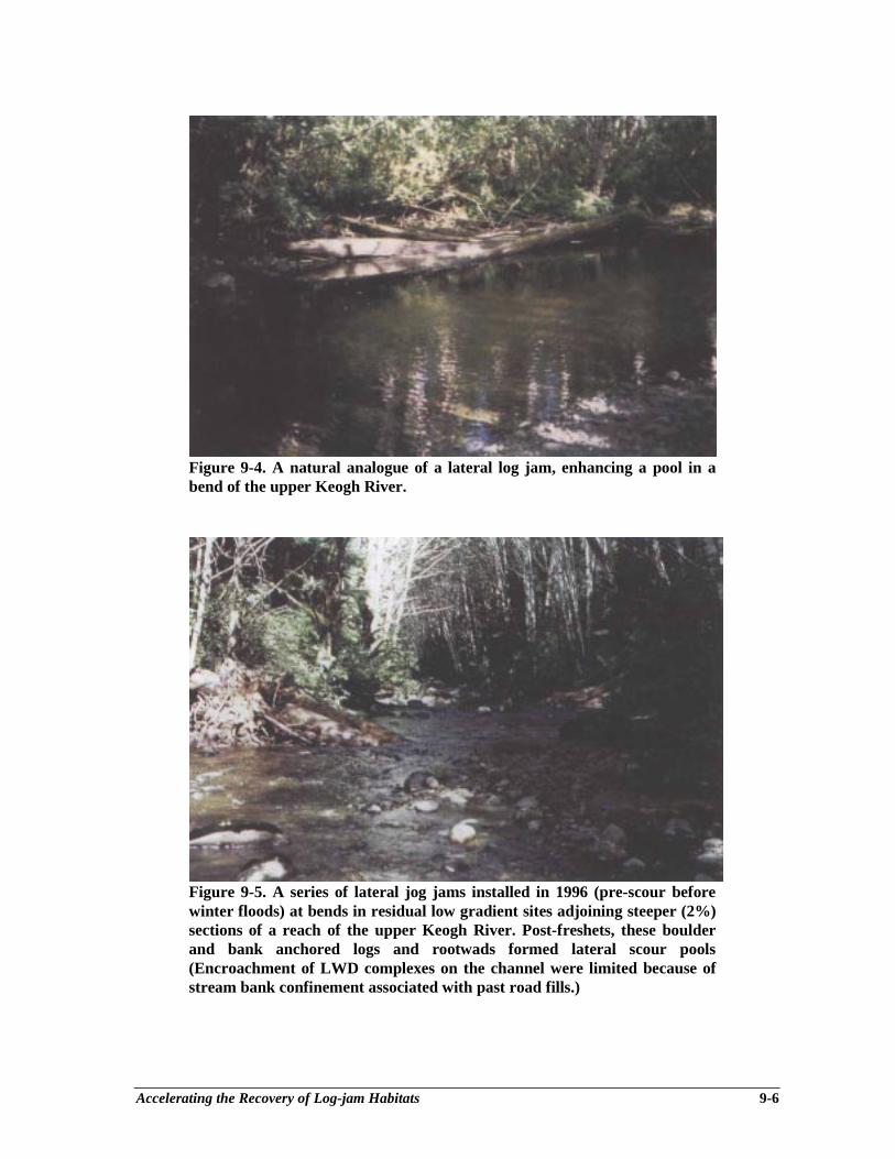
Accelerating the Recovery of Log-jam Habitats 9-6
Figure 9-4. A natural analogue of a lateral log jam, enhancing a pool in abend of the upper Keogh River.
Figure 9-5. A series of lateral jog jams installed in 1996 (pre-scour beforewinter floods) at bends in residual low gradient sites adjoining steeper (2%)sections of a reach of the upper Keogh River. Post-freshets, these boulderand bank anchored logs and rootwads formed lateral scour pools(Encroachment of LWD complexes on the channel were limited because ofstream bank confinement associated with past road fills.)
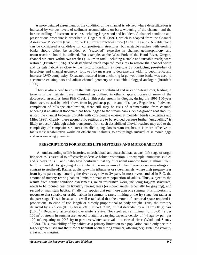
Accelerating the Recovery of Log-jam Habitats 9-7
A more detailed assessment of the condition of the channel is advised where destabilization isindicated by various levels of sediment accumulations on bars, widening of the channel, and theloss or infilling of instream structures including large wood and boulders. A channel condition andprescriptions procedure is described in Hogan et al. (1997), which is adapted from the ChannelAssessment Procedure (CAP) for the B.C. Forest Practices Code (Anon. 1996a, b). A stable reachcan be considered a candidate for composite-jam structures, but unstable reaches with erodingbanks should either be avoided or “seasoned” expertise in channel geomorphology andreconstruction should be enlisted. For example, at the West Fork of the Hood River, Oregon,channel structure within two reaches (1.6 km in total, including a stable and unstable reach) wererestored (Brunfedt 1996). The destabilized reach required measures to restore the channel widthand its fish habitat as close to the historic condition as possible by conducting pre-studies ofhydrology and channel geometry, followed by measures to decrease the width to depth ratio, andincrease LWD complexity. Excavated material from anchoring large wood into banks was used toaccentuate existing bars and adjust channel geometry to a suitable unlogged analogue (Brunfedt1996).
There is also a need to ensure that hillslopes are stabilized and risks of debris flows, leading totorrents in the mainstem, are minimized, as outlined in other chapters. Losses of many of thedecade-old structures from Fish Creek, a fifth order stream in Oregon, during the 1996 100-yearflood were caused by debris flows from logged steep gullies and hillslopes. Regardless of advancecompletion of hillslope stabilization, there still may be risks of sedimentation from channelwidening if an alluvial floodplain has been logged to the stream banks. As old-growth root stabilityis lost, the channel becomes unstable with considerable erosion at meander bends (Kellerhals andMiles 1996). Clearly, these geomorphic settings are to be avoided because further “unravelling” islikely to occur. Although debris transported from such destabilized alluvial reaches may add to thecomplexity of composite structures installed along downstream reaches, it is more effective tofocus most rehabilitative works on off-channel habitats, to ensure high survival of salmonid eggsand overwintering juveniles.
PRESCRIPTIONS FOR SPECIES LIFE HISTORIES AND MICROHABITATS
An understanding of life histories, microhabitats and macrohabitats at each life stage of targetfish species is essential to effectively undertake habitat restoration. For example, numerous studiesand surveys in B.C. and Idaho have confirmed that fry of resident rainbow trout, cutthroat trout,bull trout and Arctic grayling do not inhabit the mainstems of inland rivers as underyearlings (incontrast to steelhead). Rather, adults spawn in tributaries or side-channels, where their progeny rearfrom fry to parr stage, entering the river as age 1+ to 3+ parr. In most rivers studied in B.C. theamount of nursery rearing habitat limits the mainstem population of adults. Thus, subject to theresults from habitat condition assessments, much restorative work, including log-jam structures,needs to be focused first on tributary rearing areas (or side-channels, especially for grayling), andsecond on mainstem habitat. Finally, for species that rear more than one summer, it is important torecognize that suitable or usable habitat in summer is rarely limiting at the fry stage, but rather atthe parr stage. This is because it is well established that the amount of territorial space required isproportional to cube of fish length or directly proportional to body weight. Thus, the territorydefended by a 2.5 cm (0.3 g) fry is 2% (0.015-0.02 m2) of that defended by a 10 cm (10 g) parr(1.0 m2). Because of size-related overwinter survival (for steelhead) a minimum of 20-30 fry per100 m2 of stream in summer are needed to attain a carrying capacity density of 4-6 age 1+ parr per100 m2, equating to 20% fry-to-parr overwinter survival in a coastal river (Ward and Slaney1993a). Thus, availability of fry habitat as a primary limitation to a population could only occur inhigher gradient streams that flow at bankfull width during summer, offering negligible low velocityareas at the margins.
Accelerating the Recovery of Log-jam Habitats 9-8
Microhabitat features (velocity, depth, substrate, cover) preferred by target species must beprovided by ensuring complexity within pools, such as overhanging ledges of large wood at banks.Velocities will frequently be reduced at sites by installation of structures. This factor needs to beaccounted for in advance for species that prefer higher velocities, such as adult and parr stages oftrout and char as well as chinook salmon. In contrast, juvenile coho prefer lower velocities close tostream banks. With some experience, it is possible to design macro- and microhabitats for multiplespecies in the same composite structure. Velocity is the key factor, because if woody cover isavailable, depth is less important. Rearing velocities increase with fish size; ranging from a fewcm⋅s-1 at the fry stage to 20-40 cm⋅s-1 at the parr to adult stages. Bjornn and Reiser (1991) andKeeley and Slaney (1996) provide suitable ranges of target velocities, depths and substrates. As a“rule of thumb”, selection of sites with about twice the design velocity is required to achievepreferred velocities post-construction, at target summer flows (Slaney et al. 1994a).
FULL-SPANNING LOG COMPLEX PLACEMENTS
Restoration of full-spanning log structures has been commonly employed for pool restorationor improvement techniques in small streams, and there have been several smaller, uniformvariations on this theme, including diagonal log weirs, V-log structures and K-log or log-ramp dropstructures, as described in Chapter 8 and Chapter 11 on mainstem techniques. Based on naturalanalogues, full spanning elevated “log complexes” have also been used in small streams. Risks ofloss or failure of full-spanning structures are low in stable small streams with moderate gradients(<2%). Generally, no attachments are required, other than the weight of the mass of LWDmaterials and locking cross-spanning logs into trees on both stream banks (Fig. 9-6, and Fig. 8-11in Chapter 8). In confined channels with coarse substrates, there is little risk of outflanking andbank scour, provided the structure is elevated slightly above where a pool would naturally form, ormore specifically, where the hydraulic energy from the riffle is attempting to form a pool over thelong term. Alternatively, log complexes should be anchored to the bases of trees and stumps.Although there are many natural templates in medium-sized streams (>10 m channel width), theresults of placement are less predictable and restoration of full-spanning jams is not advised excepton an experimental basis (although use at U.S. projects has increased in the past few years). Also,they are unlikely to be approved by regulatory agencies until more experience is gained from eithersmall pilot structures, or larger-scale systematic research applications. There is a trend towardslightly higher frequency of structural failures of cross-spanning structures, especially in unstablesettings as storm frequencies increase, compared to lateral LWD and boulder clusters (Frissel andNawa 1992).
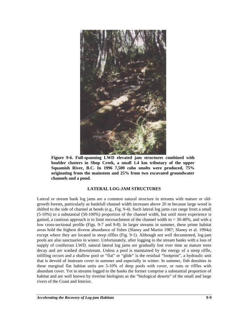
Accelerating the Recovery of Log-jam Habitats 9-9
Figure 9-6. Full-spanning LWD elevated jam structures combined withboulder clusters in Shop Creek, a small 1.4 km tributary of the upperSquamish River, B.C. In 1996 7,500 coho smolts were produced, 75%originating from the mainstem and 25% from two excavated groundwaterchannels and a pond.
LATERAL LOG-JAM STRUCTURES
Lateral or stream bank log jams are a common natural structure in streams with mature or old-growth forests, particularly as bankfull channel width increases above 20 m because large wood isshifted to the side of channel at bends (e.g., Fig. 9-4). Such lateral log jams can range from a small(5-10%) to a substantial (50-100%) proportion of the channel width, but until more experience isgained, a cautious approach is to limit encroachment of the channel width to < 30-40%, and with alow cross-sectional profile (Figs. 9-7 and 9-8). In larger streams in summer, these prime habitatareas hold the highest diverse abundance of fishes (Slaney and Martin 1987; Slaney et al. 1994a)except where they are located in steep riffles (Fig. 9-1). Although not well documented, log-jampools are also sanctuaries in winter. Unfortunately, after logging to the stream banks with a loss ofsupply of coniferous LWD, natural lateral log jams are gradually lost over time as mature treesdecay and are washed downstream. Unless a pool is maintained by the energy of a steep riffle,infilling occurs and a shallow pool or “flat” or “glide” is the residual “footprint”, a hydraulic unitthat is devoid of instream cover in summer and especially in winter. In summer, fish densities inthese marginal flat habitat units are 5-10% of deep pools with cover, or runs or riffles withabundant cover. Yet in streams logged to the banks the former comprise a substantial proportion ofhabitat and are well known by riverine biologists as the “biological deserts” of the small and largerivers of the Coast and Interior.
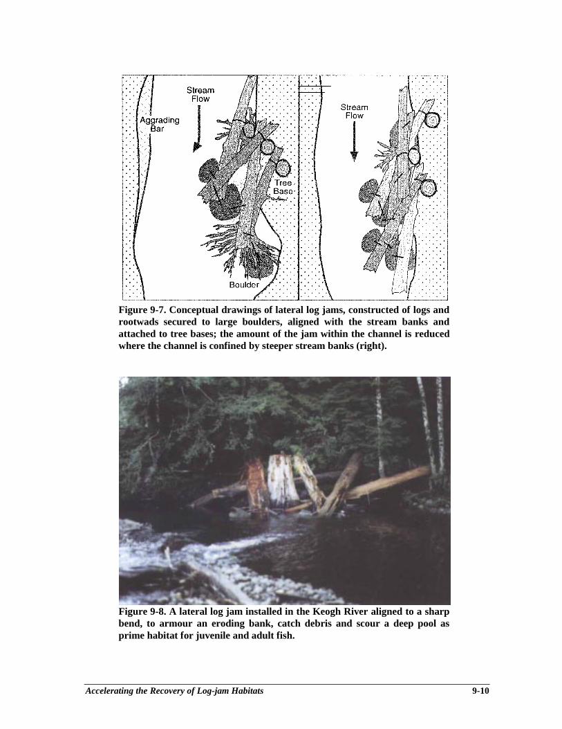
Accelerating the Recovery of Log-jam Habitats 9-10
Figure 9-7. Conceptual drawings of lateral log jams, constructed of logs androotwads secured to large boulders, aligned with the stream banks andattached to tree bases; the amount of the jam within the channel is reducedwhere the channel is confined by steeper stream banks (right).
Figure 9-8. A lateral log jam installed in the Keogh River aligned to a sharpbend, to armour an eroding bank, catch debris and scour a deep pool asprime habitat for juvenile and adult fish.
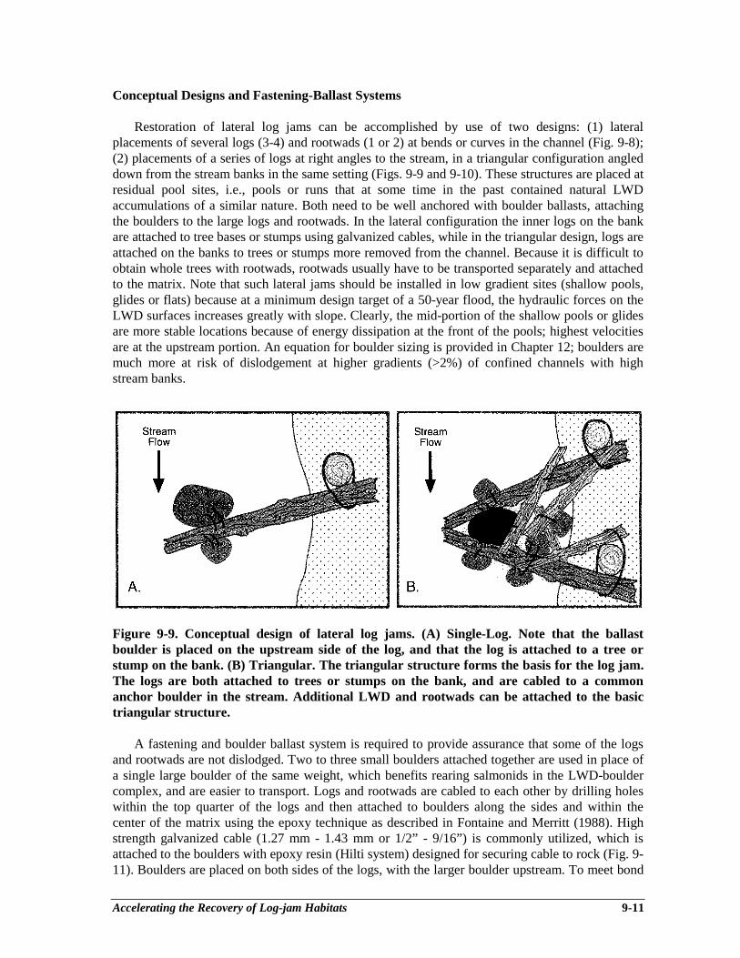
Accelerating the Recovery of Log-jam Habitats 9-11
Conceptual Designs and Fastening-Ballast Systems
Restoration of lateral log jams can be accomplished by use of two designs: (1) lateralplacements of several logs (3-4) and rootwads (1 or 2) at bends or curves in the channel (Fig. 9-8);(2) placements of a series of logs at right angles to the stream, in a triangular configuration angleddown from the stream banks in the same setting (Figs. 9-9 and 9-10). These structures are placed atresidual pool sites, i.e., pools or runs that at some time in the past contained natural LWDaccumulations of a similar nature. Both need to be well anchored with boulder ballasts, attachingthe boulders to the large logs and rootwads. In the lateral configuration the inner logs on the bankare attached to tree bases or stumps using galvanized cables, while in the triangular design, logs areattached on the banks to trees or stumps more removed from the channel. Because it is difficult toobtain whole trees with rootwads, rootwads usually have to be transported separately and attachedto the matrix. Note that such lateral jams should be installed in low gradient sites (shallow pools,glides or flats) because at a minimum design target of a 50-year flood, the hydraulic forces on theLWD surfaces increases greatly with slope. Clearly, the mid-portion of the shallow pools or glidesare more stable locations because of energy dissipation at the front of the pools; highest velocitiesare at the upstream portion. An equation for boulder sizing is provided in Chapter 12; boulders aremuch more at risk of dislodgement at higher gradients (>2%) of confined channels with highstream banks.
Figure 9-9. Conceptual design of lateral log jams. (A) Single-Log. Note that the ballastboulder is placed on the upstream side of the log, and that the log is attached to a tree orstump on the bank. (B) Triangular. The triangular structure forms the basis for the log jam.The logs are both attached to trees or stumps on the bank, and are cabled to a commonanchor boulder in the stream. Additional LWD and rootwads can be attached to the basictriangular structure.
A fastening and boulder ballast system is required to provide assurance that some of the logsand rootwads are not dislodged. Two to three small boulders attached together are used in place ofa single large boulder of the same weight, which benefits rearing salmonids in the LWD-bouldercomplex, and are easier to transport. Logs and rootwads are cabled to each other by drilling holeswithin the top quarter of the logs and then attached to boulders along the sides and within thecenter of the matrix using the epoxy technique as described in Fontaine and Merritt (1988). Highstrength galvanized cable (1.27 mm - 1.43 mm or 1/2” - 9/16”) is commonly utilized, which isattached to the boulders with epoxy resin (Hilti system) designed for securing cable to rock (Fig. 9-11). Boulders are placed on both sides of the logs, with the larger boulder upstream. To meet bond
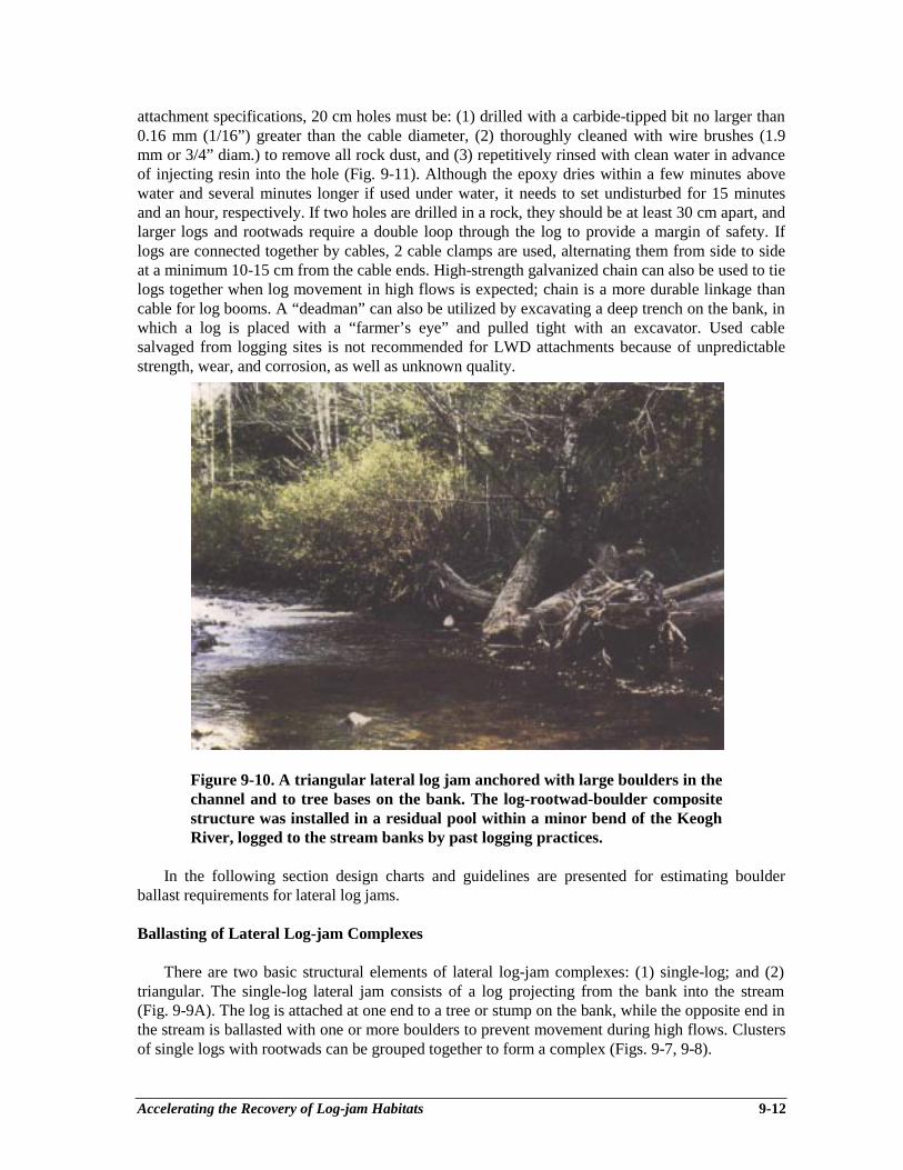
Accelerating the Recovery of Log-jam Habitats 9-12
attachment specifications, 20 cm holes must be: (1) drilled with a carbide-tipped bit no larger than0.16 mm (1/16”) greater than the cable diameter, (2) thoroughly cleaned with wire brushes (1.9mm or 3/4” diam.) to remove all rock dust, and (3) repetitively rinsed with clean water in advanceof injecting resin into the hole (Fig. 9-11). Although the epoxy dries within a few minutes abovewater and several minutes longer if used under water, it needs to set undisturbed for 15 minutesand an hour, respectively. If two holes are drilled in a rock, they should be at least 30 cm apart, andlarger logs and rootwads require a double loop through the log to provide a margin of safety. Iflogs are connected together by cables, 2 cable clamps are used, alternating them from side to sideat a minimum 10-15 cm from the cable ends. High-strength galvanized chain can also be used to tielogs together when log movement in high flows is expected; chain is a more durable linkage thancable for log booms. A “deadman” can also be utilized by excavating a deep trench on the bank, inwhich a log is placed with a “farmer’s eye” and pulled tight with an excavator. Used cablesalvaged from logging sites is not recommended for LWD attachments because of unpredictablestrength, wear, and corrosion, as well as unknown quality.
Figure 9-10. A triangular lateral log jam anchored with large boulders in thechannel and to tree bases on the bank. The log-rootwad-boulder compositestructure was installed in a residual pool within a minor bend of the KeoghRiver, logged to the stream banks by past logging practices.
In the following section design charts and guidelines are presented for estimating boulderballast requirements for lateral log jams.
Ballasting of Lateral Log-jam Complexes
There are two basic structural elements of lateral log-jam complexes: (1) single-log; and (2)triangular. The single-log lateral jam consists of a log projecting from the bank into the stream(Fig. 9-9A). The log is attached at one end to a tree or stump on the bank, while the opposite end inthe stream is ballasted with one or more boulders to prevent movement during high flows. Clustersof single logs with rootwads can be grouped together to form a complex (Figs. 9-7, 9-8).
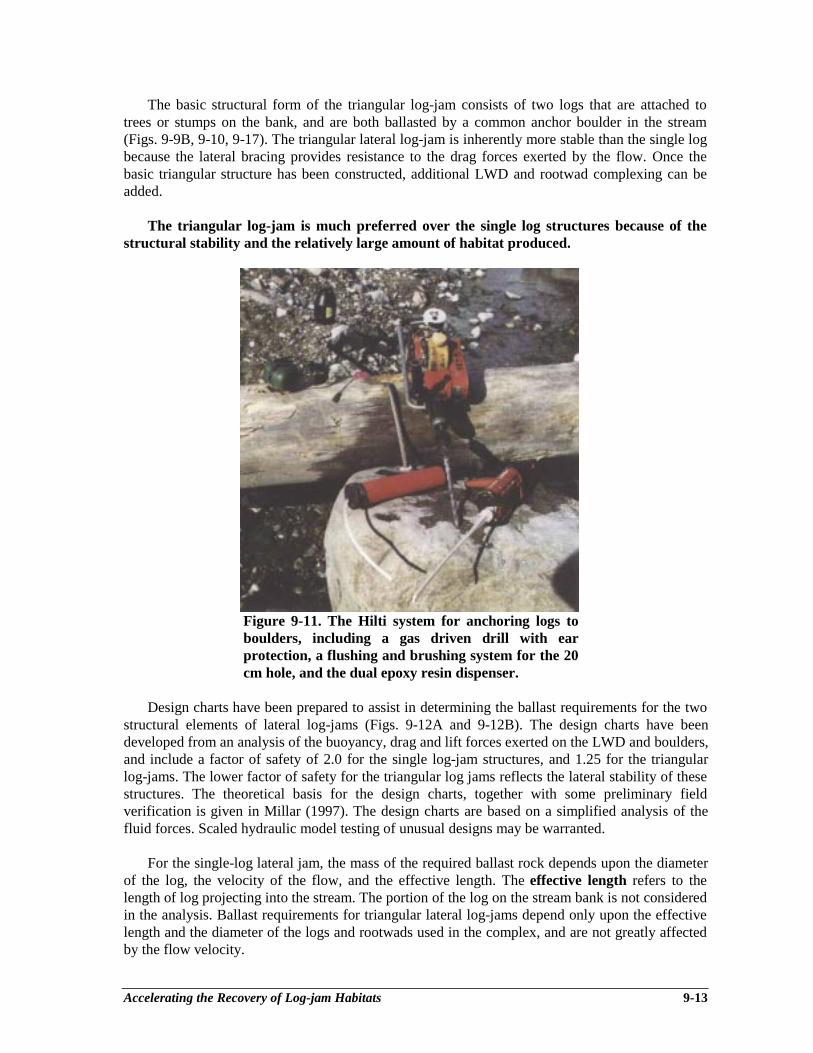
Accelerating the Recovery of Log-jam Habitats 9-13
The basic structural form of the triangular log-jam consists of two logs that are attached totrees or stumps on the bank, and are both ballasted by a common anchor boulder in the stream(Figs. 9-9B, 9-10, 9-17). The triangular lateral log-jam is inherently more stable than the single logbecause the lateral bracing provides resistance to the drag forces exerted by the flow. Once thebasic triangular structure has been constructed, additional LWD and rootwad complexing can beadded.
The triangular log-jam is much preferred over the single log structures because of thestructural stability and the relatively large amount of habitat produced.
Figure 9-11. The Hilti system for anchoring logs toboulders, including a gas driven drill with earprotection, a flushing and brushing system for the 20cm hole, and the dual epoxy resin dispenser.
Design charts have been prepared to assist in determining the ballast requirements for the twostructural elements of lateral log-jams (Figs. 9-12A and 9-12B). The design charts have beendeveloped from an analysis of the buoyancy, drag and lift forces exerted on the LWD and boulders,and include a factor of safety of 2.0 for the single log-jam structures, and 1.25 for the triangularlog-jams. The lower factor of safety for the triangular log jams reflects the lateral stability of thesestructures. The theoretical basis for the design charts, together with some preliminary fieldverification is given in Millar (1997). The design charts are based on a simplified analysis of thefluid forces. Scaled hydraulic model testing of unusual designs may be warranted.
For the single-log lateral jam, the mass of the required ballast rock depends upon the diameterof the log, the velocity of the flow, and the effective length. The effective length refers to thelength of log projecting into the stream. The portion of the log on the stream bank is not consideredin the analysis. Ballast requirements for triangular lateral log-jams depend only upon the effectivelength and the diameter of the logs and rootwads used in the complex, and are not greatly affectedby the flow velocity.

Accelerating the Recovery of Log-jam Habitats 9-14
For the single-log log-jam, the design velocity, V, can be estimated using the Chezy equation: ___
V = 20√HS
where V = design velocity in m⋅s-1, H = height of the floodplain above the channel bed in m; and S= slope of the channel (m⋅m-1).
For a given design velocity, V, the ballast requirements for a single-log lateral jam can bedetermined from Fig. 9-12A. For a particular log diameter and design velocity, the mass of theballast required per meter of effective length is read from the Y-axis. The total ballast required isobtained by multiplying the value obtained from Figure 9-12A, by the effective length of the log.For a composite structure such as that shown in Figure 9-7, the ballast requirement of each logmust be determined individually.
For most streams of interest, the design velocity will generally lie within the range of 2 to 4m⋅s-1. If the design velocity is less than 2 m;s-1, the design curve for V = 2 m⋅s-1 should be used. Itis unlikely that the actual velocity in a stream would exceed 4 m⋅s-1. In the event that the Chezyequation does indicate that V >4 m⋅s-1, caution should be exercised; however, the design curve forV=4 m⋅s-1 can probably be used.
The ballast requirements for triangular lateral log jams can be estimated from Figure 9-12B.Figure 9-12B gives the ballast required per meter of effective length for each log in the complex.As in the case of the single log structure, the total ballast requirement for each log or rootwad in atriangular jam is obtained by multiplying the value obtained from Figure 9-12B by the effectivelength of the log in the stream. To estimate the ballast requirement for a rootwad, the dimensions ofthe rootwad need to be converted into an equivalent diameter and length of a log of equal mass.
Figure 9-12C has been included to assist in the sizing of the ballast rocks. One, two or moreboulders that have a total mass greater than or equal to the calculated requirement can be used. Useof multiple boulders is generally preferred, as this can result in additional habitat. Whenconstructing a single-log jam it is important that the largest boulder be placed on the upstream side(Fig. 9-9A) to prevent the structure from “flipping over” during high flows.
Two example calculations are presented in Appendix 9-1.
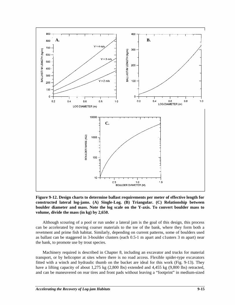
Accelerating the Recovery of Log-jam Habitats 9-15
Figure 9-12. Design charts to determine ballast requirements per meter of effective length forconstructed lateral log-jams. (A) Single-Log. (B) Triangular. (C) Relationship betweenboulder diameter and mass. Note the log scale on the Y-axis. To convert boulder mass tovolume, divide the mass (in kg) by 2,650.
Although scouring of a pool or run under a lateral jam is the goal of this design, this processcan be accelerated by moving coarser materials to the toe of the bank, where they form both arevetment and prime fish habitat. Similarly, depending on current patterns, some of boulders usedas ballast can be staggered in 3-boulder clusters (each 0.5-1 m apart and c1usters 3 m apart) nearthe bank, to promote use by trout species.
Machinery required is described in Chapter 8, including an excavator and trucks for materialtransport, or by helicopter at sites where there is no road access. Flexible spider-type excavatorsfitted with a winch and hydraulic thumb on the bucket are ideal for this work (Fig. 9-13). Theyhave a lifting capacity of about 1,275 kg (2,800 lbs) extended and 4,455 kg (9,800 lbs) retracted,and can be maneuvered on rear tires and front pads without leaving a “footprint” in medium-sized
A. B.
C.
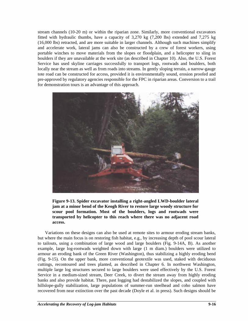
Accelerating the Recovery of Log-jam Habitats 9-16
stream channels (10-20 m) or within the riparian zone. Similarly, more conventional excavatorsfitted with hydraulic thumbs, have a capacity of 3,270 kg (7,200 lbs) extended and 7,275 kg(16,000 lbs) retracted, and are more suitable in larger channels. Although such machines simplifyand accelerate work, lateral jams can also be constructed by a crew of forest workers, usingportable winches to move materials from the slopes or floodplain, and a helicopter to sling inboulders if they are unavailable at the work site (as described in Chapter 10). Also, the U.S. ForestService has used skyline carriages successfully to transport logs, rootwads and boulders, bothlocally near the stream as well as from roads into streams. In gently sloping terrain, a narrow-gaugetote road can be constructed for access, provided it is environmentally sound, erosion proofed andpre-approved by regulatory agencies responsible for the FPC in riparian areas. Conversion to a trailfor demonstration tours is an advantage of this approach.
Figure 9-13. Spider excavator installing a right-angled LWD-boulder lateraljam at a minor bend of the Keogh River to restore large woody structure forscour pool formation. Most of the boulders, logs and rootwads weretransported by helicopter to this reach where there was no adjacent roadaccess.
Variations on these designs can also be used at remote sites to armour eroding stream banks,but where the main focus is on restoring fish habitat, e.g., by increasing depth of pool scour lateralto tailouts, using a combination of large wood and large boulders (Fig. 9-14A, B). As anotherexample, large log-rootwads weighted down with large (1 m diam.) boulders were utilized toarmour an eroding bank of the Green River (Washington), thus stabilizing a highly eroding bend(Fig. 9-15). On the upper bank, more conventional geotextile was used, staked with deciduouscuttings, recontoured and trees planted, as described in Chapter 6. In northwest Washington,multiple large log structures secured to large boulders were used effectively by the U.S. ForestService in a medium-sized stream, Deer Creek, to divert the stream away from highly erodingbanks and also provide habitat. There, past logging had destabilized the slopes, and coupled withhillslope-gully stabilization, large populations of summer-run steelhead and coho salmon haverecovered from near extinction over the past decade (Doyle et al. in press). Such designs should be
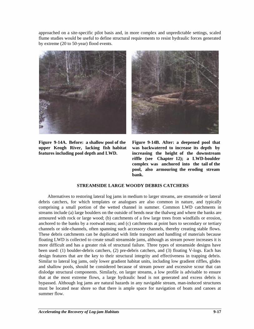
Accelerating the Recovery of Log-jam Habitats 9-17
approached on a site-specific pilot basis and, in more complex and unpredictable settings, scaledflume studies would be useful to define structural requirements to resist hydraulic forces generatedby extreme (20 to 50-year) flood events.
Figure 9-14A. Before: a shallow pool of the Figure 9-14B. After: a deepened pool thatupper Keogh River, lacking fish habitat was backwatered to increase its depth byfeatures including pool depth and LWD. increasing the height of the downstream
riffle (see Chapter 12); a LWD-bouldercomplex was anchored into the tail of thepool, also armouring the eroding streambank.
STREAMSIDE LARGE WOODY DEBRIS CATCHERS
Alternatives to restoring lateral log jams in medium to larger streams, are streamside or lateraldebris catchers, for which templates or analogues are also common in nature, and typicallycomprising a small portion of the wetted channel in summer. Common LWD catchments instreams include (a) large boulders on the outside of bends near the thalweg and where the banks arearmoured with rock or large wood; (b) catchments of a few large trees from windfalls or erosion,anchored to the banks by a rootwad mass; and (c) catchments at point bars to secondary or tertiarychannels or side-channels, often spanning such accessory channels, thereby creating stable flows.These debris catchments can be duplicated with little transport and handling of materials becausefloating LWD is collected to create small streamside jams, although as stream power increases it ismore difficult and has a greater risk of structural failure. Three types of streamside designs havebeen used: (1) boulder-debris catchers, (2) pre-debris catchers, and (3) floating V-logs. Each hasdesign features that are the key to their structural integrity and effectiveness in trapping debris.Similar to lateral log jams, only lower gradient habitat units, including low gradient riffles, glidesand shallow pools, should be considered because of stream power and excessive scour that candislodge structural components. Similarly, on larger streams, a low profile is advisable to ensurethat at the most extreme flows, a large hydraulic head is not generated and excess debris isbypassed. Although log jams are natural hazards in any navigable stream, man-induced structuresmust be located near shore so that there is ample space for navigation of boats and canoes atsummer flow.
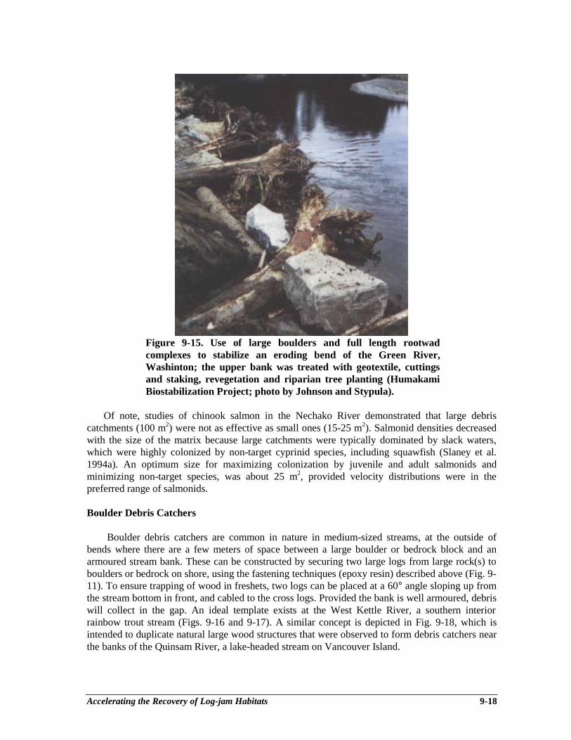
Accelerating the Recovery of Log-jam Habitats 9-18
Figure 9-15. Use of large boulders and full length rootwadcomplexes to stabilize an eroding bend of the Green River,Washinton; the upper bank was treated with geotextile, cuttingsand staking, revegetation and riparian tree planting (HumakamiBiostabilization Project; photo by Johnson and Stypula).
Of note, studies of chinook salmon in the Nechako River demonstrated that large debriscatchments (100 m2) were not as effective as small ones (15-25 m2). Salmonid densities decreasedwith the size of the matrix because large catchments were typically dominated by slack waters,which were highly colonized by non-target cyprinid species, including squawfish (Slaney et al.1994a). An optimum size for maximizing colonization by juvenile and adult salmonids andminimizing non-target species, was about 25 m2, provided velocity distributions were in thepreferred range of salmonids.
Boulder Debris Catchers
Boulder debris catchers are common in nature in medium-sized streams, at the outside ofbends where there are a few meters of space between a large boulder or bedrock block and anarmoured stream bank. These can be constructed by securing two large logs from large rock(s) toboulders or bedrock on shore, using the fastening techniques (epoxy resin) described above (Fig. 9-11). To ensure trapping of wood in freshets, two logs can be placed at a 60° angle sloping up fromthe stream bottom in front, and cabled to the cross logs. Provided the bank is well armoured, debriswill collect in the gap. An ideal template exists at the West Kettle River, a southern interiorrainbow trout stream (Figs. 9-16 and 9-17). A similar concept is depicted in Fig. 9-18, which isintended to duplicate natural large wood structures that were observed to form debris catchers nearthe banks of the Quinsam River, a lake-headed stream on Vancouver Island.
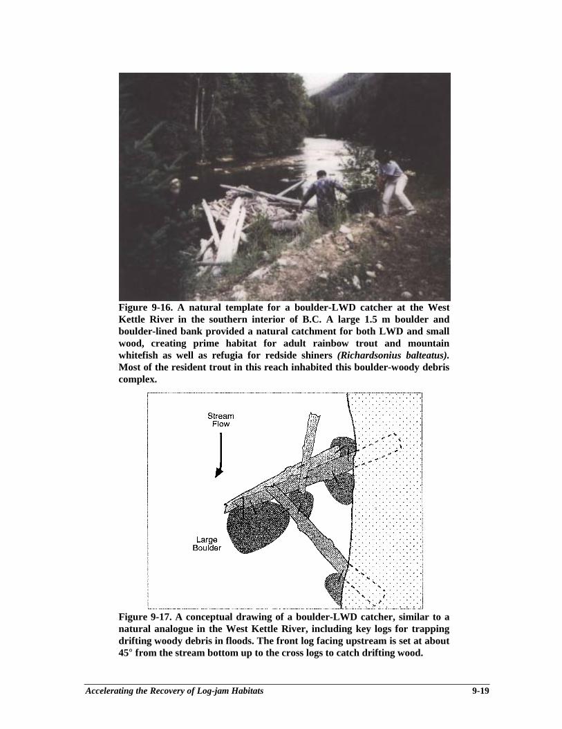
Accelerating the Recovery of Log-jam Habitats 9-19
Figure 9-16. A natural template for a boulder-LWD catcher at the WestKettle River in the southern interior of B.C. A large 1.5 m boulder andboulder-lined bank provided a natural catchment for both LWD and smallwood, creating prime habitat for adult rainbow trout and mountainwhitefish as well as refugia for redside shiners (Richardsonius balteatus).Most of the resident trout in this reach inhabited this boulder-woody debriscomplex.
Figure 9-17. A conceptual drawing of a boulder-LWD catcher, similar to anatural analogue in the West Kettle River, including key logs for trappingdrifting woody debris in floods. The front log facing upstream is set at about45° from the stream bottom up to the cross logs to catch drifting wood.
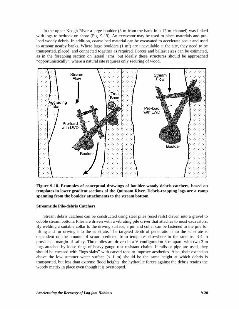
Accelerating the Recovery of Log-jam Habitats 9-20
In the upper Keogh River a large boulder (3 m from the bank in a 12 m channel) was linkedwith logs to bedrock on shore (Fig. 9-19). An excavator may be used to place materials and pre-load woody debris. In addition, coarse bed material can be excavated to accelerate scour and usedto armour nearby banks. Where large boulders (1 m3) are unavailable at the site, they need to betransported, placed, and connected together as required. Forces and ballast sizes can be estimated,as in the foregoing section on lateral jams, but ideally these structures should be approached“opportunistically”, where a natural site requires only securing of wood.
Figure 9-18. Examples of conceptual drawings of boulder-woody debris catchers, based ontemplates in lower gradient sections of the Quinsam River. Debris-trapping logs are a rampspanning from the boulder attachments to the stream bottom.
Streamside Pile-debris Catchers
Stream debris catchers can be constructed using steel piles (used rails) driven into a gravel tocobble stream bottom. Piles are driven with a vibrating pile driver that attaches to most excavators.By welding a suitable collar to the driving surface, a pin and collar can be fastened to the pile forlifting and for driving into the substrate. The targeted depth of penetration into the substrate isdependent on the amount of scour predicted from templates elsewhere in the streams; 3-4 mprovides a margin of safety. Three piles are driven in a V configuration 3 m apart, with two 3-mlogs attached by loose rings of heavy-gauge rust resistant chains. If rails or pipe are used, theyshould be encased with “logs-slabs” with carved tops to improve aesthetics. Also, their extensionabove the low summer water surface (< 1 m) should be the same height at which debris istransported, but less than extreme flood heights; the hydraulic forces against the debris retains thewoody matrix in place even though it is overtopped.
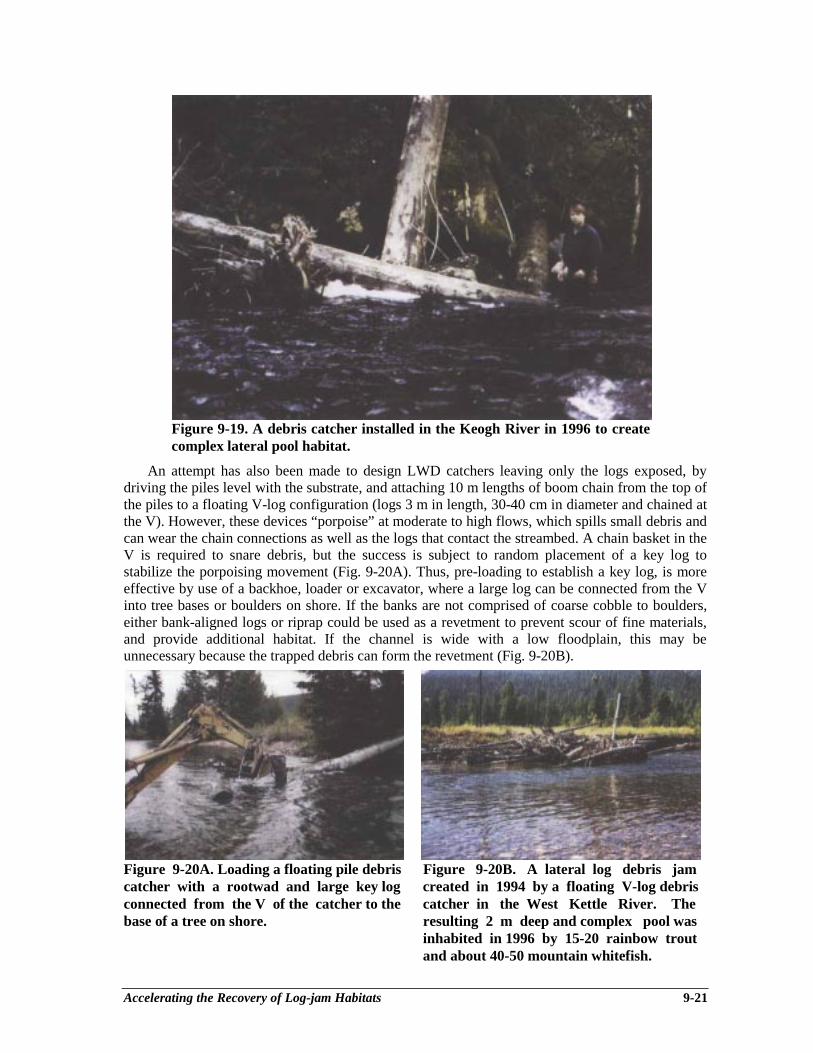
Accelerating the Recovery of Log-jam Habitats 9-21
Figure 9-19. A debris catcher installed in the Keogh River in 1996 to createcomplex lateral pool habitat.
An attempt has also been made to design LWD catchers leaving only the logs exposed, bydriving the piles level with the substrate, and attaching 10 m lengths of boom chain from the top ofthe piles to a floating V-log configuration (logs 3 m in length, 30-40 cm in diameter and chained atthe V). However, these devices “porpoise” at moderate to high flows, which spills small debris andcan wear the chain connections as well as the logs that contact the streambed. A chain basket in theV is required to snare debris, but the success is subject to random placement of a key log tostabilize the porpoising movement (Fig. 9-20A). Thus, pre-loading to establish a key log, is moreeffective by use of a backhoe, loader or excavator, where a large log can be connected from the Vinto tree bases or boulders on shore. If the banks are not comprised of coarse cobble to boulders,either bank-aligned logs or riprap could be used as a revetment to prevent scour of fine materials,and provide additional habitat. If the channel is wide with a low floodplain, this may beunnecessary because the trapped debris can form the revetment (Fig. 9-20B).
Figure 9-20A. Loading a floating pile debris Figure 9-20B. A lateral log debris jamcatcher with a rootwad and large key log created in 1994 by a floating V-log debrisconnected from the V of the catcher to the catcher in the West Kettle River. Thebase of a tree on shore. resulting 2 m deep and complex pool was
inhabited in 1996 by 15-20 rainbow troutand about 40-50 mountain whitefish.
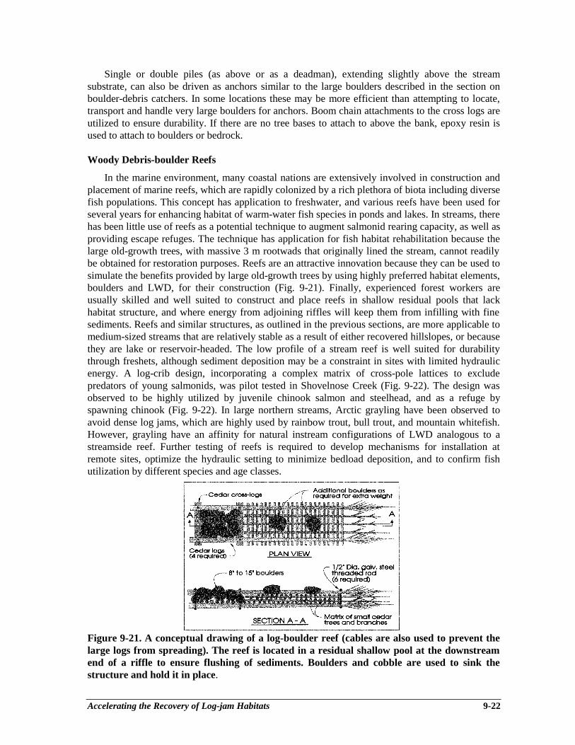
Accelerating the Recovery of Log-jam Habitats 9-22
Single or double piles (as above or as a deadman), extending slightly above the streamsubstrate, can also be driven as anchors similar to the large boulders described in the section onboulder-debris catchers. In some locations these may be more efficient than attempting to locate,transport and handle very large boulders for anchors. Boom chain attachments to the cross logs areutilized to ensure durability. If there are no tree bases to attach to above the bank, epoxy resin isused to attach to boulders or bedrock.
Woody Debris-boulder Reefs
In the marine environment, many coastal nations are extensively involved in construction andplacement of marine reefs, which are rapidly colonized by a rich plethora of biota including diversefish populations. This concept has application to freshwater, and various reefs have been used forseveral years for enhancing habitat of warm-water fish species in ponds and lakes. In streams, therehas been little use of reefs as a potential technique to augment salmonid rearing capacity, as well asproviding escape refuges. The technique has application for fish habitat rehabilitation because thelarge old-growth trees, with massive 3 m rootwads that originally lined the stream, cannot readilybe obtained for restoration purposes. Reefs are an attractive innovation because they can be used tosimulate the benefits provided by large old-growth trees by using highly preferred habitat elements,boulders and LWD, for their construction (Fig. 9-21). Finally, experienced forest workers areusually skilled and well suited to construct and place reefs in shallow residual pools that lackhabitat structure, and where energy from adjoining riffles will keep them from infilling with finesediments. Reefs and similar structures, as outlined in the previous sections, are more applicable tomedium-sized streams that are relatively stable as a result of either recovered hillslopes, or becausethey are lake or reservoir-headed. The low profile of a stream reef is well suited for durabilitythrough freshets, although sediment deposition may be a constraint in sites with limited hydraulicenergy. A log-crib design, incorporating a complex matrix of cross-pole lattices to excludepredators of young salmonids, was pilot tested in Shovelnose Creek (Fig. 9-22). The design wasobserved to be highly utilized by juvenile chinook salmon and steelhead, and as a refuge byspawning chinook (Fig. 9-22). In large northern streams, Arctic grayling have been observed toavoid dense log jams, which are highly used by rainbow trout, bull trout, and mountain whitefish.However, grayling have an affinity for natural instream configurations of LWD analogous to astreamside reef. Further testing of reefs is required to develop mechanisms for installation atremote sites, optimize the hydraulic setting to minimize bedload deposition, and to confirm fishutilization by different species and age classes.
Figure 9-21. A conceptual drawing of a log-boulder reef (cables are also used to prevent thelarge logs from spreading). The reef is located in a residual shallow pool at the downstreamend of a riffle to ensure flushing of sediments. Boulders and cobble are used to sink thestructure and hold it in place.
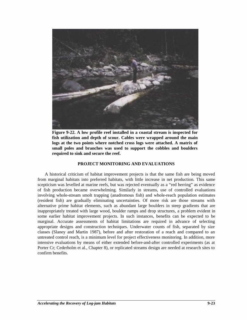
Accelerating the Recovery of Log-jam Habitats 9-23
Figure 9-22. A low profile reef installed in a coastal stream is inspected forfish utilization and depth of scour. Cables were wrapped around the mainlogs at the two points where notched cross logs were attached. A matrix ofsmall poles and branches was used to support the cobbles and bouldersrequired to sink and secure the reef.
PROJECT MONITORING AND EVALUATIONS
A historical criticism of habitat improvement projects is that the same fish are being movedfrom marginal habitats into preferred habitats, with little increase in net production. This samescepticism was levelled at marine reefs, but was rejected eventually as a “red herring” as evidenceof fish production became overwhelming. Similarly in streams, use of controlled evaluationsinvolving whole-stream smolt trapping (anadromous fish) and whole-reach population estimates(resident fish) are gradually eliminating uncertainties. Of more risk are those streams withalternative prime habitat elements, such as abundant large boulders in steep gradients that areinappropriately treated with large wood, boulder ramps and drop structures, a problem evident insome earlier habitat improvement projects. In such instances, benefits can be expected to bemarginal. Accurate assessments of habitat limitations are required in advance of selectingappropriate designs and construction techniques. Underwater counts of fish, separated by sizeclasses (Slaney and Martin 1987), before and after restoration of a reach and compared to anuntreated control reach, is a minimum level for project effectiveness monitoring. In addition, moreintensive evaluations by means of either extended before-and-after controlled experiments (as atPorter Cr; Cederholm et al., Chapter 8), or replicated streams design are needed at research sites toconfirm benefits.
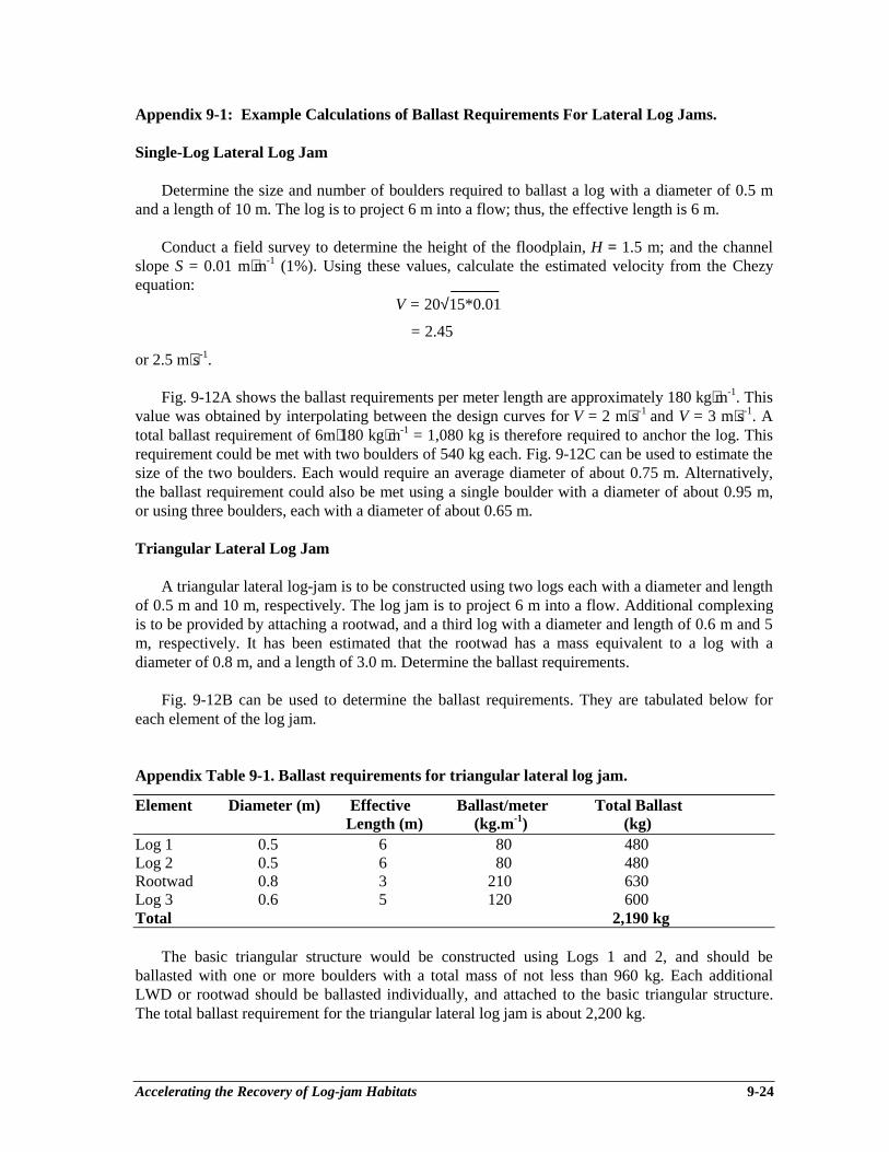
Accelerating the Recovery of Log-jam Habitats 9-24
Appendix 9-1: Example Calculations of Ballast Requirements For Lateral Log Jams.
Single-Log Lateral Log Jam
Determine the size and number of boulders required to ballast a log with a diameter of 0.5 mand a length of 10 m. The log is to project 6 m into a flow; thus, the effective length is 6 m.
Conduct a field survey to determine the height of the floodplain, H = 1.5 m; and the channelslope S = 0.01 m⋅m-1 (1%). Using these values, calculate the estimated velocity from the Chezyequation: ______
V = 20√15*0.01
= 2.45
or 2.5 m⋅s-1.
Fig. 9-12A shows the ballast requirements per meter length are approximately 180 kg⋅m-1. Thisvalue was obtained by interpolating between the design curves for V = 2 m⋅s-1 and V = 3 m⋅s-1. Atotal ballast requirement of 6m⋅180 kg⋅m-1 = 1,080 kg is therefore required to anchor the log. Thisrequirement could be met with two boulders of 540 kg each. Fig. 9-12C can be used to estimate thesize of the two boulders. Each would require an average diameter of about 0.75 m. Alternatively,the ballast requirement could also be met using a single boulder with a diameter of about 0.95 m,or using three boulders, each with a diameter of about 0.65 m.
Triangular Lateral Log Jam
A triangular lateral log-jam is to be constructed using two logs each with a diameter and lengthof 0.5 m and 10 m, respectively. The log jam is to project 6 m into a flow. Additional complexingis to be provided by attaching a rootwad, and a third log with a diameter and length of 0.6 m and 5m, respectively. It has been estimated that the rootwad has a mass equivalent to a log with adiameter of 0.8 m, and a length of 3.0 m. Determine the ballast requirements.
Fig. 9-12B can be used to determine the ballast requirements. They are tabulated below foreach element of the log jam.
Appendix Table 9-1. Ballast requirements for triangular lateral log jam.
Element Diameter (m) Effective Ballast/meter Total BallastLength (m) (kg.m-1) (kg)
Log 1 0.5 6 80 480Log 2 0.5 6 80 480Rootwad 0.8 3 210 630Log 3 0.6 5 120 600Total 2,190 kg
The basic triangular structure would be constructed using Logs 1 and 2, and should beballasted with one or more boulders with a total mass of not less than 960 kg. Each additionalLWD or rootwad should be ballasted individually, and attached to the basic triangular structure.The total ballast requirement for the triangular lateral log jam is about 2,200 kg.
Using Boulder Clusters to Rehabilitate Juvenile Salmonid Habitat 10-1
Chapter 10Using Boulder Clusters to Rehabilitate
Juvenile Salmonid Habitat
Bruce R. Ward1
INTRODUCTION
Boulders, substrate materials greater than 0.3 m diameter in streams, can provide suitablehabitat conditions for salmonids. The casual observer of streams becomes quickly aware that areaswith boulders are not only pleasant in sight and sound, but that they are also structurally complex.They typically contribute variety in stream substrate conditions, water depth and velocity, and, forfish using the stream, cover and rest areas. These beneficial conditions are diminished whereinterstitial spaces are filled in by a continuous delivery of fine sediments. Upslope rehabilitationtechniques can reduce sediment delivery rates; carefully chosen stream sites can be rehabilitatedwith boulder clusters to further accelerate the overall watershed recovery process. This chapterprovides guidelines for the placement of boulder clusters to rehabilitate fish habitat in streams.
Channel morphology, food abundance and salmonid reproductive biology are key variablesthat, together with fish behaviour (foraging and social interaction) and predation, determine thedistribution of fish, their growth, survival, abundance, size composition, and adult recruitment.These features together determine the shape of the relation of the number of fish that reproduce in astream system, or spawners, and the number of reproductively mature adults that contribute to thesucceeding generation, or recruits. For salmonids that spend some part of their developmentalhistory residing in stream environments, the abundance of available summer and winter habitat canbe a limiting factor to their recruitment to the adult stage. Thus, in theory, factors that increase theavailability of preferred habitat characteristics will increase the capability of the system to producefish recruits, where such factors are limiting either productivity or stream carrying capacity, or both(Fig. 10-1, and see Ward and Slaney 1993a, b).
Density dependence in stream-resident fish is closely linked to the amount of preferred orusable habitat. For steelhead, the "bottleneck" to production occurs mainly between the fry and parrlife stages, in relation to density and habitat availability (Bjornn 1978; Ward and Slaney 1993a).Similar conclusions have been derived from the study of Atlantic salmon, Salmo solar (e.g.,Chadwick 1985), and the critical early stages of the life history of brown trout (Elliott 1989). Thus,techniques that improve the quantity and quality of rearing habitat at this life stage should result inincreased returns of adults. Applied techniques that improve conditions favouring high survival andabundance through critical stages, thus increasing the carrying capacity, should benefit theresource, particularly under conditions of exploitation or stress from human or environmentalfactors (Saunders and Smith 1962; Hunt 1969; House and Boehme 1985).
________________________1 Ministry of Environment, Lands and Parks, Fisheries Research and Development Section, 2204 Main Mall,UBC, Vancouver, BC V6T 1Z4
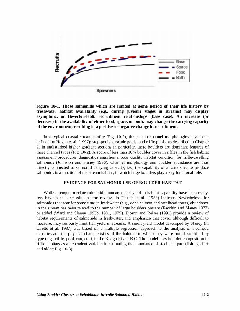
Using Boulder Clusters to Rehabilitate Juvenile Salmonid Habitat 10-2
Figure 10-1. Those salmonids which are limited at some period of their life history byfreshwater habitat availability (e.g., during juvenile stages in streams) may displayasymptotic, or Beverton-Holt, recruitment relationships (base case). An increase (ordecrease) in the availability of either food, space, or both, may change the carrying capacityof the environment, resulting in a positive or negative change in recruitment.
In a typical coastal stream profile (Fig. 10-2), three main channel morphologies have beendefined by Hogan et al. (1997): step-pools, cascade pools, and riffle-pools, as described in Chapter2. In undisturbed higher gradient sections in particular, large boulders are dominant features ofthese channel types (Fig. 10-2). A score of less than 10% boulder cover in riffles in the fish habitatassessment procedures diagnostics signifies a poor quality habitat condition for riffle-dwellingsalmonids (Johnston and Slaney 1996). Channel morphology and boulder abundance are thusdirectly connected to salmonid carrying capacity, i.e., the capability of a watershed to producesalmonids is a function of the stream habitat, in which large boulders play a key functional role.
EVIDENCE FOR SALMONID USE OF BOULDER HABITAT
While attempts to relate salmonid abundance and yield to habitat capability have been many,few have been successful, as the reviews in Fausch et al. (1988) indicate. Nevertheless, forsalmonids that rear for some time in freshwater (e.g., coho salmon and steelhead trout), abundancein the stream has been related to the number of large boulders present (Facchin and Slaney 1977)or added (Ward and Slaney 1993b, 1981, 1979). Bjornn and Reiser (1991) provide a review ofhabitat requirements of salmonids in freshwater, and emphasize that cover, although difficult tomeasure, may seriously limit fish yield in streams. A smolt yield model developed by Slaney (inLirette et al. 1987) was based on a multiple regression approach to the analysis of steelheaddensities and the physical characteristics of the habitats in which they were found, stratified bytype (e.g., riffle, pool, run, etc.), in the Keogh River, B.C. The model uses boulder composition inriffle habitats as a dependent variable in estimating the abundance of steelhead parr (fish aged 1+and older; Fig. 10-3):
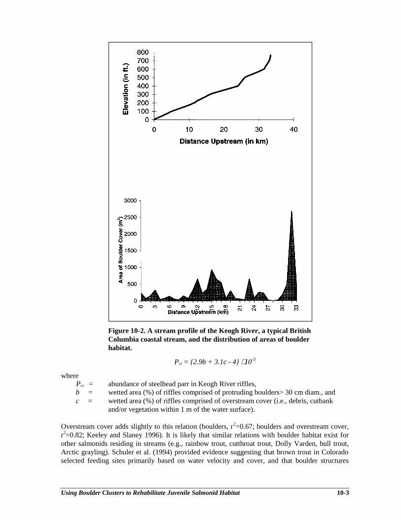
Using Boulder Clusters to Rehabilitate Juvenile Salmonid Habitat 10-3
Figure 10-2. A stream profile of the Keogh River, a typical BritishColumbia coastal stream, and the distribution of areas of boulderhabitat.
Pri = {2.9b + 3.1c - 4} ⋅ 10-3
wherePri = abundance of steelhead parr in Keogh River riffles,b = wetted area (%) of riffles comprised of protruding boulders> 30 cm diam., andc = wetted area (%) of riffles comprised of overstream cover (i.e., debris, cutbank
and/or vegetation within 1 m of the water surface).
Overstream cover adds slightly to this relation (boulders, r2=0.67; boulders and overstream cover,r2=0.82; Keeley and Slaney 1996). It is likely that similar relations with boulder habitat exist forother salmonids residing in streams (e.g., rainbow trout, cutthroat trout, Dolly Varden, bull trout,Arctic grayling). Schuler et al. (1994) provided evidence suggesting that brown trout in Coloradoselected feeding sites primarily based on water velocity and cover, and that boulder structures

Using Boulder Clusters to Rehabilitate Juvenile Salmonid Habitat 10-4
provided more locations that were energetically favourable. Trout used the boulder structures (Ushaped clusters and loose wings from shore) preferentially day and night.
Figure 10-3. The number of steelhead parr in riffle habitat (100 m2) of the Keogh River was afunction of the amount (%) of riffle area with boulders > 30 cm, here expressed as thoughoverstream cover was zero.
INFLUENCES OF PAST FOREST PRACTICES ON BOULDER HABITATS
Past forest practices of logging to stream banks in B.C. has reduced large woody debris (LWD)from the streamside riparian area and within stream channels (Fig. 10-4A, B). Boulder additionscan serve as a surrogate for the complexity of stream habitat where LWD recruitment is unlikelyfor several more decades. Similarly, Bjornn et al. (1977) found significant reductions in thenumbers of juvenile steelhead in stream channels where boulders were embedded in sediment.Aggraded channels and increased sediment delivery as a result of poor road construction andmaintenance in the past have been shown to impact salmonid production (Slaney et al. 1977a, b).Where reductions in depth and velocity occur, the usable area for juvenile salmonids, in theory, isreduced (Hogan and Church 1989).
HABITAT REHABILITATION WITH BOULDERS: A REVIEW
Ward and Slaney (1993b) reviewed the history of stream habitat rehabilitation in B.C. andconcluded that such techniques cannot proceed successfully without consideration of watershedprocesses affected by land use and an overall ecosystem approach. In other words, generic"cookbook" approaches must be avoided. An adaptive, experimental procedure with pilot testingand evaluation based on empirical evidence and site-specific application is required. Furthermore,future practitioners should familiarize themselves with the habitat characteristics and placementprocedures at historical stream rehabilitation sites through inspections, mentorship andparticipation in WRP fish habitat assessment, prescription and rehabilitation courses offered atdemonstration sites (e.g., Squamish and Keogh Rivers).
Efforts towards fish habitat restoration have been numerous on the west coast in recent years(Frissell and Nawa 1992). Earlier habitat rehabilitation experiments were attempted in the centraland western U.S. Many of the recent projects in coastal streams (e.g., House and Boehme 1985)were similar to earlier research in B.C. (Ward and Slaney 1979; 1981) where boulder clusters werefound to be both durable in moderate-sized streams and preferred by steelhead parr and coho fry.
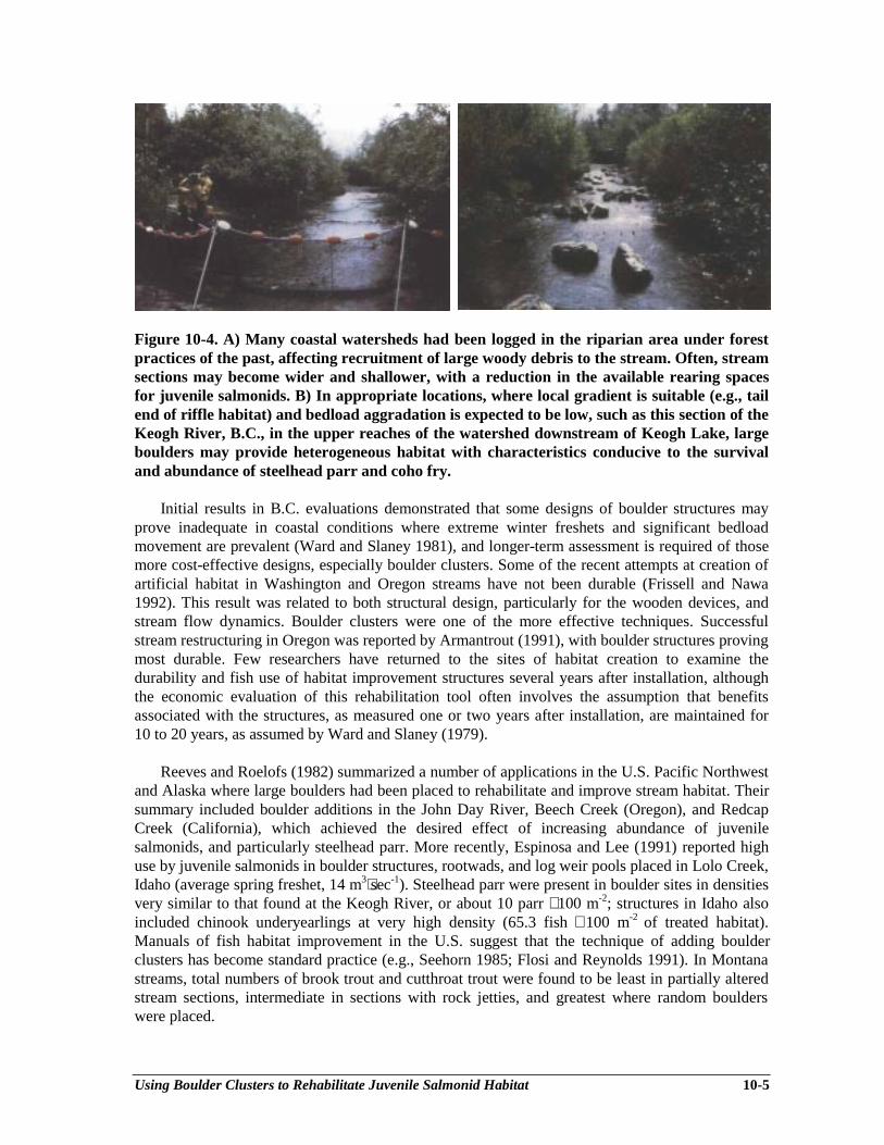
Using Boulder Clusters to Rehabilitate Juvenile Salmonid Habitat 10-5
Figure 10-4. A) Many coastal watersheds had been logged in the riparian area under forestpractices of the past, affecting recruitment of large woody debris to the stream. Often, streamsections may become wider and shallower, with a reduction in the available rearing spacesfor juvenile salmonids. B) In appropriate locations, where local gradient is suitable (e.g., tailend of riffle habitat) and bedload aggradation is expected to be low, such as this section of theKeogh River, B.C., in the upper reaches of the watershed downstream of Keogh Lake, largeboulders may provide heterogeneous habitat with characteristics conducive to the survivaland abundance of steelhead parr and coho fry.
Initial results in B.C. evaluations demonstrated that some designs of boulder structures mayprove inadequate in coastal conditions where extreme winter freshets and significant bedloadmovement are prevalent (Ward and Slaney 1981), and longer-term assessment is required of thosemore cost-effective designs, especially boulder clusters. Some of the recent attempts at creation ofartificial habitat in Washington and Oregon streams have not been durable (Frissell and Nawa1992). This result was related to both structural design, particularly for the wooden devices, andstream flow dynamics. Boulder clusters were one of the more effective techniques. Successfulstream restructuring in Oregon was reported by Armantrout (1991), with boulder structures provingmost durable. Few researchers have returned to the sites of habitat creation to examine thedurability and fish use of habitat improvement structures several years after installation, althoughthe economic evaluation of this rehabilitation tool often involves the assumption that benefitsassociated with the structures, as measured one or two years after installation, are maintained for10 to 20 years, as assumed by Ward and Slaney (1979).
Reeves and Roelofs (1982) summarized a number of applications in the U.S. Pacific Northwestand Alaska where large boulders had been placed to rehabilitate and improve stream habitat. Theirsummary included boulder additions in the John Day River, Beech Creek (Oregon), and RedcapCreek (California), which achieved the desired effect of increasing abundance of juvenilesalmonids, and particularly steelhead parr. More recently, Espinosa and Lee (1991) reported highuse by juvenile salmonids in boulder structures, rootwads, and log weir pools placed in Lolo Creek,Idaho (average spring freshet, 14 m3⋅sec-1). Steelhead parr were present in boulder sites in densitiesvery similar to that found at the Keogh River, or about 10 parr ⋅ 100 m-2; structures in Idaho alsoincluded chinook underyearlings at very high density (65.3 fish ⋅ 100 m-2 of treated habitat).Manuals of fish habitat improvement in the U.S. suggest that the technique of adding boulderclusters has become standard practice (e.g., Seehorn 1985; Flosi and Reynolds 1991). In Montanastreams, total numbers of brook trout and cutthroat trout were found to be least in partially alteredstream sections, intermediate in sections with rock jetties, and greatest where random boulderswere placed.
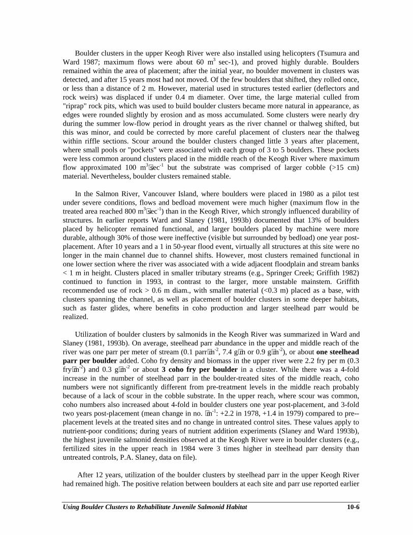
Using Boulder Clusters to Rehabilitate Juvenile Salmonid Habitat 10-6
Boulder clusters in the upper Keogh River were also installed using helicopters (Tsumura andWard 1987; maximum flows were about 60 m3 sec-1), and proved highly durable. Bouldersremained within the area of placement; after the initial year, no boulder movement in clusters wasdetected, and after 15 years most had not moved. Of the few boulders that shifted, they rolled once,or less than a distance of 2 m. However, material used in structures tested earlier (deflectors androck weirs) was displaced if under 0.4 m diameter. Over time, the large material culled from"riprap" rock pits, which was used to build boulder clusters became more natural in appearance, asedges were rounded slightly by erosion and as moss accumulated. Some clusters were nearly dryduring the summer low-flow period in drought years as the river channel or thalweg shifted, butthis was minor, and could be corrected by more careful placement of clusters near the thalwegwithin riffle sections. Scour around the boulder clusters changed little 3 years after placement,where small pools or "pockets" were associated with each group of 3 to 5 boulders. These pocketswere less common around clusters placed in the middle reach of the Keogh River where maximumflow approximated 100 m3⋅sec-1 but the substrate was comprised of larger cobble (>15 cm)material. Nevertheless, boulder clusters remained stable.
In the Salmon River, Vancouver Island, where boulders were placed in 1980 as a pilot testunder severe conditions, flows and bedload movement were much higher (maximum flow in thetreated area reached 800 m3⋅sec-1) than in the Keogh River, which strongly influenced durability ofstructures. In earlier reports Ward and Slaney (1981, 1993b) documented that 13% of bouldersplaced by helicopter remained functional, and larger boulders placed by machine were moredurable, although 30% of those were ineffective (visible but surrounded by bedload) one year post-placement. After 10 years and a 1 in 50-year flood event, virtually all structures at this site were nolonger in the main channel due to channel shifts. However, most clusters remained functional inone lower section where the river was associated with a wide adjacent floodplain and stream banks< 1 m in height. Clusters placed in smaller tributary streams (e.g., Springer Creek; Griffith 1982)continued to function in 1993, in contrast to the larger, more unstable mainstem. Griffithrecommended use of rock > 0.6 m diam., with smaller material (<0.3 m) placed as a base, withclusters spanning the channel, as well as placement of boulder clusters in some deeper habitats,such as faster glides, where benefits in coho production and larger steelhead parr would berealized.
Utilization of boulder clusters by salmonids in the Keogh River was summarized in Ward andSlaney (1981, 1993b). On average, steelhead parr abundance in the upper and middle reach of theriver was one parr per meter of stream (0.1 parr⋅m-2, 7.4 g⋅m or 0.9 g⋅m-2), or about one steelheadparr per boulder added. Coho fry density and biomass in the upper river were 2.2 fry per m (0.3fry⋅m-2) and 0.3 g⋅m-2 or about 3 coho fry per boulder in a cluster. While there was a 4-foldincrease in the number of steelhead parr in the boulder-treated sites of the middle reach, cohonumbers were not significantly different from pre-treatment levels in the middle reach probablybecause of a lack of scour in the cobble substrate. In the upper reach, where scour was common,coho numbers also increased about 4-fold in boulder clusters one year post-placement, and 3-foldtwo years post-placement (mean change in no. ⋅m-1: +2.2 in 1978, +1.4 in 1979) compared to pre--placement levels at the treated sites and no change in untreated control sites. These values apply tonutrient-poor conditions; during years of nutrient addition experiments (Slaney and Ward 1993b),the highest juvenile salmonid densities observed at the Keogh River were in boulder clusters (e.g.,fertilized sites in the upper reach in 1984 were 3 times higher in steelhead parr density thanuntreated controls, P.A. Slaney, data on file).
After 12 years, utilization of the boulder clusters by steelhead parr in the upper Keogh Riverhad remained high. The positive relation between boulders at each site and parr use reported earlier
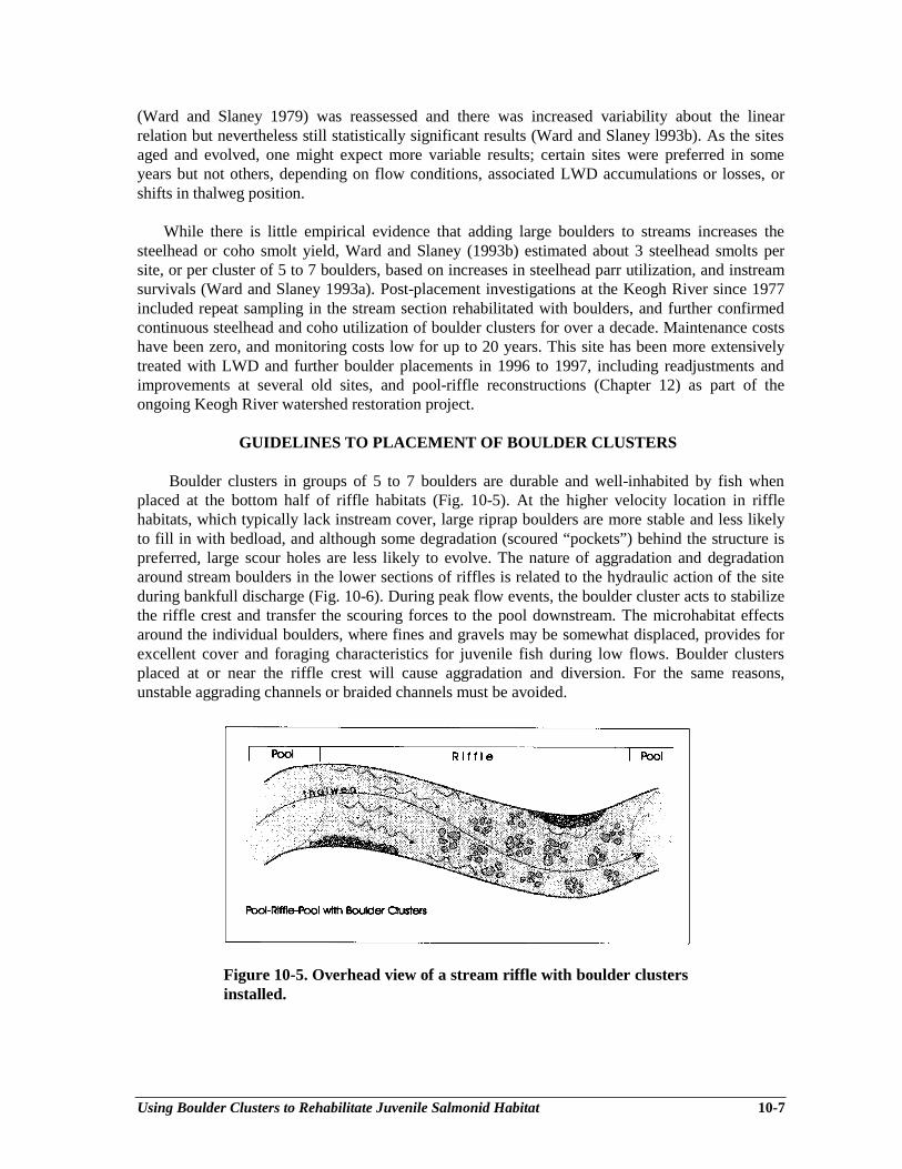
Using Boulder Clusters to Rehabilitate Juvenile Salmonid Habitat 10-7
(Ward and Slaney 1979) was reassessed and there was increased variability about the linearrelation but nevertheless still statistically significant results (Ward and Slaney l993b). As the sitesaged and evolved, one might expect more variable results; certain sites were preferred in someyears but not others, depending on flow conditions, associated LWD accumulations or losses, orshifts in thalweg position.
While there is little empirical evidence that adding large boulders to streams increases thesteelhead or coho smolt yield, Ward and Slaney (1993b) estimated about 3 steelhead smolts persite, or per cluster of 5 to 7 boulders, based on increases in steelhead parr utilization, and instreamsurvivals (Ward and Slaney 1993a). Post-placement investigations at the Keogh River since 1977included repeat sampling in the stream section rehabilitated with boulders, and further confirmedcontinuous steelhead and coho utilization of boulder clusters for over a decade. Maintenance costshave been zero, and monitoring costs low for up to 20 years. This site has been more extensivelytreated with LWD and further boulder placements in 1996 to 1997, including readjustments andimprovements at several old sites, and pool-riffle reconstructions (Chapter 12) as part of theongoing Keogh River watershed restoration project.
GUIDELINES TO PLACEMENT OF BOULDER CLUSTERS
Boulder clusters in groups of 5 to 7 boulders are durable and well-inhabited by fish whenplaced at the bottom half of riffle habitats (Fig. 10-5). At the higher velocity location in rifflehabitats, which typically lack instream cover, large riprap boulders are more stable and less likelyto fill in with bedload, and although some degradation (scoured “pockets”) behind the structure ispreferred, large scour holes are less likely to evolve. The nature of aggradation and degradationaround stream boulders in the lower sections of riffles is related to the hydraulic action of the siteduring bankfull discharge (Fig. 10-6). During peak flow events, the boulder cluster acts to stabilizethe riffle crest and transfer the scouring forces to the pool downstream. The microhabitat effectsaround the individual boulders, where fines and gravels may be somewhat displaced, provides forexcellent cover and foraging characteristics for juvenile fish during low flows. Boulder clustersplaced at or near the riffle crest will cause aggradation and diversion. For the same reasons,unstable aggrading channels or braided channels must be avoided.
Figure 10-5. Overhead view of a stream riffle with boulder clustersinstalled.
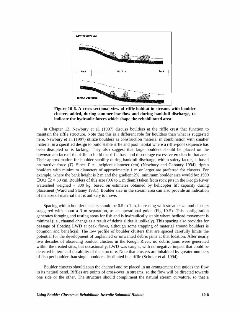
Using Boulder Clusters to Rehabilitate Juvenile Salmonid Habitat 10-8
Figure 10-6. A cross-sectional view of riffle habitat in streams with boulderclusters added, during summer low flow and during bankfull discharge, toindicate the hydraulic forces which shape the rehabilitated area.
In Chapter 12, Newbury et al. (1997) discuss boulders at the riffle crest that function tomaintain the riffle structure. Note that this is a different role for boulders than what is suggestedhere. Newbury et al. (1997) utilize boulders as construction material in combination with smallermaterial in a specified design to build stable riffle and pool habitat where a riffle-pool sequence hasbeen disrupted or is lacking. They also suggest that large boulders should be placed on thedownstream face of the riffle to build the riffle base and discourage excessive erosion in that area.Their approximation for boulder stability during bankfull discharge, with a safety factor, is basedon tractive force (T). Since T ≈ incipient diameter (cm) (Newbury and Gaboury 1994), riprapboulders with minimum diameters of approximately 1 m or larger are preferred for clusters. Forexample, where the bank height is 2 m and the gradient 2%, minimum boulder size would be: 1500⋅ 0.02 ⋅ 2 = 60 cm. Boulders of this size (0.6 to 1 m diam.) taken from rock pits in the Keogh Riverwatershed weighed ~ 800 kg, based on estimates obtained by helicopter lift capacity duringplacement (Ward and Slaney 1981). Boulder size in the stream area can also provide an indicationof the size of material that is unlikely to move.
Spacing within boulder clusters should be 0.5 to 1 m, increasing with stream size, and clustersstaggered with about a 3 m separation, as an operational guide (Fig 10-5). This configurationgenerates foraging and resting areas for fish and is hydraulically stable where bedload movement isminimal (i.e., channel change as a result of debris slides is unlikely). This spacing also provides forpassage of floating LWD at peak flows, although some trapping of material around boulders iscommon and beneficial. The low profile of boulder clusters that are spaced carefully limits thepotential for the development of unplanned or unwanted debris jams at that location. After nearlytwo decades of observing boulder clusters in the Keogh River, no debris jams were generatedwithin the treated sites, but occasionally, LWD was caught, with no negative impact that could bedetected in terms of durability of the structure. Note that clusters are inhabited by greater numbersof fish per boulder than single boulders distributed in a riffle (Scholar et al. 1994).
Boulder clusters should span the channel and be placed in an arrangement that guides the flowin its natural bend. Riffles are points of cross-over in streams, so the flow will be directed towardsone side or the other. The structure should compliment the natural stream curvature, so that a
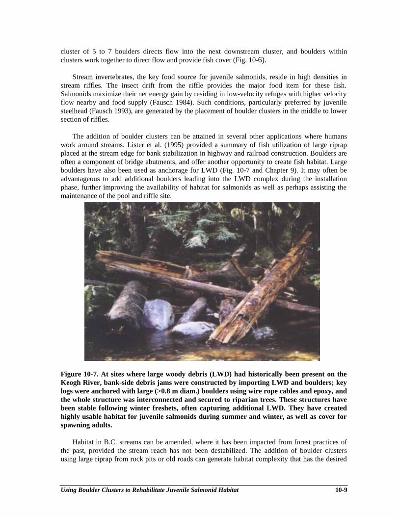
Using Boulder Clusters to Rehabilitate Juvenile Salmonid Habitat 10-9
cluster of 5 to 7 boulders directs flow into the next downstream cluster, and boulders withinclusters work together to direct flow and provide fish cover (Fig. 10-6).
Stream invertebrates, the key food source for juvenile salmonids, reside in high densities instream riffles. The insect drift from the riffle provides the major food item for these fish.Salmonids maximize their net energy gain by residing in low-velocity refuges with higher velocityflow nearby and food supply (Fausch 1984). Such conditions, particularly preferred by juvenilesteelhead (Fausch 1993), are generated by the placement of boulder clusters in the middle to lowersection of riffles.
The addition of boulder clusters can be attained in several other applications where humanswork around streams. Lister et al. (1995) provided a summary of fish utilization of large riprapplaced at the stream edge for bank stabilization in highway and railroad construction. Boulders areoften a component of bridge abutments, and offer another opportunity to create fish habitat. Largeboulders have also been used as anchorage for LWD (Fig. 10-7 and Chapter 9). It may often beadvantageous to add additional boulders leading into the LWD complex during the installationphase, further improving the availability of habitat for salmonids as well as perhaps assisting themaintenance of the pool and riffle site.
Figure 10-7. At sites where large woody debris (LWD) had historically been present on theKeogh River, bank-side debris jams were constructed by importing LWD and boulders; keylogs were anchored with large (>0.8 m diam.) boulders using wire rope cables and epoxy, andthe whole structure was interconnected and secured to riparian trees. These structures havebeen stable following winter freshets, often capturing additional LWD. They have createdhighly usable habitat for juvenile salmonids during summer and winter, as well as cover forspawning adults.
Habitat in B.C. streams can be amended, where it has been impacted from forest practices ofthe past, provided the stream reach has not been destabilized. The addition of boulder clustersusing large riprap from rock pits or old roads can generate habitat complexity that has the desired

Using Boulder Clusters to Rehabilitate Juvenile Salmonid Habitat 10-10
components of depth, velocity and cover crucial to the variety of habitat requirements of salmonidsin their various life stages in fresh water. Done carefully, the work can benefit fish in streams formany years.
Boulder clusters can add lost complexity in streams impacted by past forest practices.Although it may not be feasible to restore LWD to historical levels due to a possible short supply,large boulders offer a rehabilitation alternative in stable channel sections where accumulations offines and bedload movement are both low. As a tool for B.C.’s Watershed Restoration Program,boulder clusters can work in well-planned situations, where the practitioners step up the applicationbased on initial field trials and knowledge gained from other experience, such as that at the KeoghRiver.
Rehabilitating Mainstem Holding And Rearing Habitat 11-1
Chapter 11Rehabilitating Mainstem Holding and Rearing Habitat
Jim H. Allan1, Sheldon Lowe2
INTRODUCTION
Rearing and holding habitat in the mainstems of medium-sized streams is often associated withdeep water habitat types such as runs and pools that are present during periods of critical low flow.Deep pools and runs are formed by local scour. They may be permanent if associated with abedrock control but can also be transient when formed along the outside of a bend or adjacent tolarge woody debris. The loss of these habitat types is not common and is usually a consequence ofexcessive sediment loads and deposition. In destabilized watersheds, excessive bedload from debristorrents and valley wall failures, in combination with higher than normal peak flows, may result inthe filling of deep runs and pools further downstream in the mainstem, particularly where gradientsstart to decrease and stream power is less. Other factors such as channelization and reduction inlarge woody debris recruitment may also reduce the availability of deep pools and runs.
Rehabilitation usually takes the form of encouraging bed scour, thereby creating deep water.This is achieved by local acceleration of velocity using some form of structure to form a hydrauliccontrol. The fluvial geometry involved is described in Chapter 12.
Excessive bedload deposition can be avoided by rehabilitating destabilized watersheds toreduce bedload to normal. Watershed restoration, or at minimum “storm proofing” destabilizedwatersheds, is often a prerequisite to deep water habitat restoration in medium-sized streams.
ASSESSING THE NEED FOR HOLDING/REARING HABITAT RESTORATION
The results of MELP and WRP stream habitat assessments and diagnostic procedures willindicate the need to create mainstem rearing and holding habitat. A lack of deep pools and runsfrom the assessment normally suggests that creation of some deep water habitat would bebeneficial. However, fish species that require and use deep water habitat must also be present.Some streams have hydrological characteristics that preclude the formation of deep water habitateven if they are undisturbed. When assessing stream inventory and diagnostic results, care shouldbe taken to assure that a shortage is caused by a correctable land use. If mainstem holding andrearing habitat is created, the target species of fish must be present to make use of the habitat.
METHODS
Deep water habitat can be created by simply excavating holes in the streambed, but they tendto fill in over time, and often very rapidly. Because deep water habitat occurs naturally as a resultof streambed scour at hydraulic controls where water velocity is increased, it is necessary to
________________________1 Pisces Environmental Consulting Services Ltd., 3233 - 55th Avenue, Red Deer, AB T4N 5L32 River Engineering Branch, Alberta Environmental Protection, 9820 - 106th St., Edmonton, AB T5K 2J6
Rehabilitating Mainstem Holding And Rearing Habitat 11-2
attempt to duplicate the natural process to restore and maintain deep water habitat. Instreamstructures that promote and maintain scour can be created in a variety of shapes and sizes, but allare designed to be as permanent as design and costs will allow. The best are “hard” structures thatare constructed of competent, durable, natural materials that blend with the stream environment.Structural integrity should not be compromised to satisfy visual appearance.
Streambed scour can be encouraged by increasing water velocity downwards, as at a waterfall,or by constricting the channel width, forcing more water through a narrower gap, or both. Weirs(also referred to as dams, plunges or sills) cause water to plunge downward and can also bedesigned to constrict the channel. Deflectors narrow the channel, increasing velocity anddownstream scour.
Low profile weirs or pairs of opposing deflectors constructed of large rock or logs are thepreferred structures for promoting and maintaining scour to create deep water runs and pools.Although other materials such as gabion baskets, precast concrete or other artificial materials havebeen used, they generally lack durability or are unsightly. All structures must be designed andconstructed to be overtopped at average summer flows in order to avoid reducing channel capacityfor flood flows and minimize backflooding effects upstream of the structure. All structures must bewell keyed into the stream banks and the adjacent banks armoured.
The input of an experienced hydraulic specialist is advised at the prescription or site designphase to assess durability in flood events, especially in medium-sized streams. Water and fisheriesagencies will typically require plans and drawings of proposed undertakings to facilitate approvalsand permits for instream works. Success is highly dependent on the quality of constructionsupervision and the experience of supervisors and equipment operators.
Opposing Deflectors
Creation of deep runs or pools using deflectors is best achieved using pairs of opposeddeflectors (also referred to as groynes) (Figs. 11-1, 11-2, 11-3). The same effect can also beachieved by using a deflector and armouring the opposite bank to prevent erosion (Anon. 1980),but results have been mixed (Ward and Slaney 1979; see Chapter 3). The advantage of pairedopposing deflectors is that the main force of the current can be centred in the channel, reducingerosion risk to adjacent banks. Paired deflectors constructed of large rock have been usedsuccessfully in streams up to medium/large-sized rivers 60 m in width, subject to other site criteriasuch as slope and channel stability.
Log deflectors (Fig. 11-4) can and have been used effectively, but are limited to use on smallstreams (generally < 5 m average channel width) with low gradients (< 0.2%). Detailedconstruction notes for log deflectors are given by Lowe (1996).
Normally the pool or run downstream of the deflectors is excavated to a design depth (1.5 to 2m) and scour to create the deep water. Depending on stream flow events, natural scour could takeseveral years to create the desired habitat. Boulder cover is normally placed within the run or pool(Fig. 11-1, Fig. 11-3 and Chapter 10).

Rehabilitating Mainstem Holding And Rearing Habitat 11-3
CONSTRUCTION NOTES1 - All rocks (Class I, II, III, 2 M+) must slope DOWN to the
middle of the stream to the point of the deflector.2 - The upstream face must contain the LARGEST rocks so
that the pressure of the flow may be resisted. Smaller rocksmay be placed on the downstream face. Each rock is to beplaced in the shadow of the previous rock from the point tothe bank. All rock must fit tightly together and jammedtogether by machinery.
3 - Place the upstream rock face in a trench, then place thedownstream rock face in a similar trench, taking care that therocks slope upwards to the side of the stream such that thepoint of the deflector is about 0.3 m above the water leveland the root is at least 1 to 1.5 m above current water level.
4 - Excavate the downstream run, placing much of the spoilmaterial within the confines of the two rock faces. The topsurface of the spoil must be below the level of the adjacentrock faces. All remaining spoil must be deposited 10 moutside the stream banks and preferably 1.5 m above thewater level.
5 - In very large rivers, a double row of rocks will be requiredfor both the upstream and downstream faces of thedeflectors.
6 - The open area in the middle of the stream must be about ¼of the stream width or less, so that a section of rapid flowconditions exists to funnel the water into the downstreamrun. On occasion the opening must be constricted even moreto provide higher flow velocities when necessary.
7 - The instream point of the deflectors shall be 0.6 m above thestream bed. The root of the deflectors shall be 1.0 to 1.5 mabove current water levels and firmly imbedded in the streambank.
8 - All elevations relate to low stream flow in the spring or fall.9 - All individually placed rocks in and around the pool are to be
0.8 – 1.2 m in size or less, depending of the size of the riveror stream.
Figure 11-1. Opposing wing deflectors.
Figure 11-2. Opposing deflectors in the lower Coquitlam River, B.C. Thesestructures have survived several flood events in a low gradient, sand/gravelbed section of the river. Note stable, well-vegetated banks.
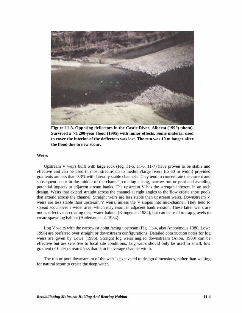
Rehabilitating Mainstem Holding And Rearing Habitat 11-4
Figure 11-3. Opposing deflectors in the Castle River, Alberta (1992) photo).Survived a >1:200-year flood (1995) with minor effects. Some material usedto cover the interior of the deflectors was lost. The run was 10 m longer afterthe flood due to new scour.
Weirs
Upstream V weirs built with large rock (Fig. 11-5, 11-6, 11-7) have proven to be stable andeffective and can be used in most streams up to medium/large rivers (to 60 m width) providedgradients are less than 0.3% with laterally stable channels. They tend to concentrate the current andsubsequent scour in the middle of the channel, creating a long, narrow run or pool and avoidingpotential impacts to adjacent stream banks. The upstream V has the strength inherent in an archdesign. Weirs that extend straight across the channel at right angles to the flow create short poolsthat extend across the channel. Straight weirs are less stable than upstream weirs. Downstream Vweirs are less stable than upstream V weirs, unless the V slopes into mid-channel. They tend tospread scour over a wider area, which may result in adjacent bank erosion. These latter weirs arenot as effective at creating deep-water habitat (Klingeman 1984), but can be used to trap gravels tocreate spawning habitat (Anderson et al. 1984).
Log V weirs with the narrowest point facing upstream (Fig. 11-4, also Anonymous 1980, Lowe1996) are preferred over straight or downstream configurations. Detailed construction notes for logweirs are given by Lowe (1996). Straight log weirs angled downstream (Anon. 1980) can beeffective but are sensitive to local site conditions. Log weirs should only be used in small, lowgradient (< 0.2%) streams less than 5 m in average channel width.
The run or pool downstream of the weir is excavated to design dimensions, rather than waitingfor natural scour to create the deep water.
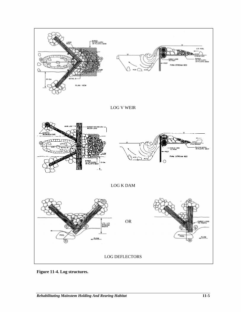
Rehabilitating Mainstem Holding And Rearing Habitat 11-5
LOG V WEIR
LOG K DAM
LOG DEFLECTORS
Figure 11-4. Log structures.

Rehabilitating Mainstem Holding And Rearing Habitat 11-6
CONSTRUCTION NOTES1 - All weir crest rocks MUST SLOPE DOWN from the
banks TO THE UPSTREAM POINT of the weir toconfine the main flow to the middle 1/3 of the stream.
2 - All rock MUST extend upstream from the bank wherethey are buried deeply to the middle point of the weir.
3 - The largest (8-16) rocks (2 M+) must be placed at thepoint of the weir in a double row and set in place withthe longest side pointing down (as shown) in a trenchalready excavated for this purpose. All rock is to bejammed together by machinery to provide tight aspossible fit. Additional stabilizing rock and spoil are to beplaced around these rocks, then the remainder of the weircrest may be built. The weir crest width should be 2.0 m.
4 - The upstream notch on the weir must be within the middlethird of the river, but may be placed at any point within tomove the current from side to side. Bank armouring maybe necessary in such cases where potential bank erosionexists.
5 - The top of the rocks in the notch of the weir shall not bemore than 0.6 m above the stream bed, unless an upstreampool is required. The bank tie-in location shall be 1.5 mabove the stream elevation. The rocks shall tapergradually from the notch to the tie-in point on the bank.
6 - Only a minor amount of spoil material may be used to fillin the voids in the weir crest to prevent water fromflowing through the weir. The spoil is only to ensurerelative water tightness. All remaining spoil material mustbe placed 10 m beyond the stream banks, preferably 1.5 mabove current water level.
7 - Excavated material from the pool to be placed as follows:10% around the weir crest to plug holes between therocks; 90% to be spoiled 10 m minimum outside andabove current channel banks.
8 - All elevation differences shall relate to the low streamflow conditions in the fall, or at time of inspection,whichever is less.
9 - All individual placed rocks to be approximately 0.8 – 1.2m in size.
10- Pool depth to be 1.5 – 2.5 m maximum.
Figure 11-5. V-weir – double crest.
DESIGN CRITERIA AND SPECIFICATIONS
Site Selection
The simplest and most effective criteria for selecting suitable sites for mainstem holding andrearing habitat creation using instream structures are stream gradient or slope (usually expressed aspercent), channel morphology and stream power (slope ⋅ discharge ⋅ constant). Several years ofmonitoring instream structures in southern Alberta and elsewhere after major flood events indicatethese are the critical factors that must be addressed.
Larger streams with average slopes exceeding 0.4% usually have excessively high streampower or energy during floods that results in structural failure, burial of structures by excess bedload or channel shifts that render structures ineffective. The use of instream structures in themainstem of streams or stream sections with gradients in excess of 0.4% is not recommended.There may be sections within a high gradient stream or stream reach that have gradients less than0.35%. If the lower gradient section is 10 or more average channel widths in length, instreamstructures can be used. The structure should be located approximately 3 channel widthsdownstream of the upstream boundary of the low gradient section. Log structures are less durablein high energy streams and should only be used in streams or stream sections with slopes less than0.2% and average channel width less than 5 m.

Rehabilitating Mainstem Holding And Rearing Habitat 11-7
Figure 11-6. Rock V-weir in the Oldman River, Alberta. Note excavatedpool/run and cover rocks downstream of the weir. The left upstream arm ofthe weir extends across the gravel bar to tie in to the bank.
Figure 11-7. Rock V-weir in the Castle River, Alberta. Scour immediatelydownstream of the point of the weir caused the point rocks to slipdownstream during a >1:200-year flood.
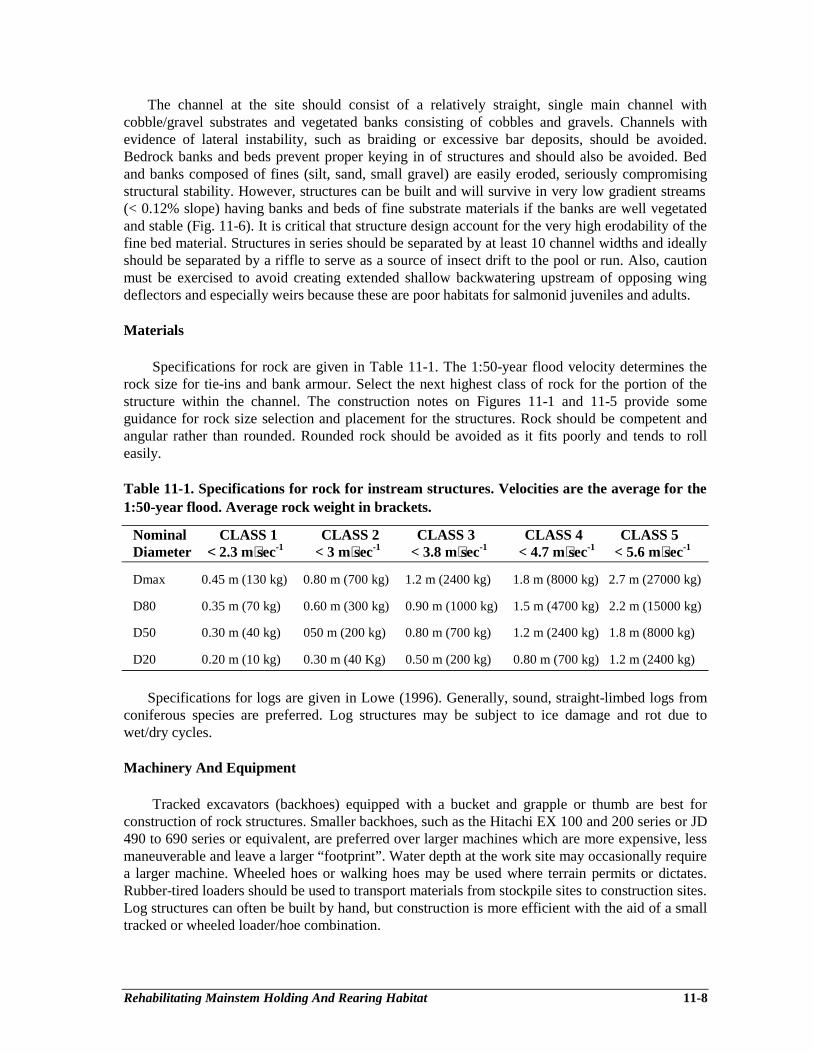
Rehabilitating Mainstem Holding And Rearing Habitat 11-8
The channel at the site should consist of a relatively straight, single main channel withcobble/gravel substrates and vegetated banks consisting of cobbles and gravels. Channels withevidence of lateral instability, such as braiding or excessive bar deposits, should be avoided.Bedrock banks and beds prevent proper keying in of structures and should also be avoided. Bedand banks composed of fines (silt, sand, small gravel) are easily eroded, seriously compromisingstructural stability. However, structures can be built and will survive in very low gradient streams(< 0.12% slope) having banks and beds of fine substrate materials if the banks are well vegetatedand stable (Fig. 11-6). It is critical that structure design account for the very high erodability of thefine bed material. Structures in series should be separated by at least 10 channel widths and ideallyshould be separated by a riffle to serve as a source of insect drift to the pool or run. Also, cautionmust be exercised to avoid creating extended shallow backwatering upstream of opposing wingdeflectors and especially weirs because these are poor habitats for salmonid juveniles and adults.
Materials
Specifications for rock are given in Table 11-1. The 1:50-year flood velocity determines therock size for tie-ins and bank armour. Select the next highest class of rock for the portion of thestructure within the channel. The construction notes on Figures 11-1 and 11-5 provide someguidance for rock size selection and placement for the structures. Rock should be competent andangular rather than rounded. Rounded rock should be avoided as it fits poorly and tends to rolleasily.
Table 11-1. Specifications for rock for instream structures. Velocities are the average for the1:50-year flood. Average rock weight in brackets.
Nominal CLASS 1 CLASS 2 CLASS 3 CLASS 4 CLASS 5Diameter < 2.3 m⋅sec-1 < 3 m⋅sec-1 < 3.8 m⋅sec-1 < 4.7 m⋅sec-1 < 5.6 m⋅sec-1
Dmax 0.45 m (130 kg) 0.80 m (700 kg) 1.2 m (2400 kg) 1.8 m (8000 kg) 2.7 m (27000 kg)
D80 0.35 m (70 kg) 0.60 m (300 kg) 0.90 m (1000 kg) 1.5 m (4700 kg) 2.2 m (15000 kg)
D50 0.30 m (40 kg) 050 m (200 kg) 0.80 m (700 kg) 1.2 m (2400 kg) 1.8 m (8000 kg)
D20 0.20 m (10 kg) 0.30 m (40 Kg) 0.50 m (200 kg) 0.80 m (700 kg) 1.2 m (2400 kg)
Specifications for logs are given in Lowe (1996). Generally, sound, straight-limbed logs fromconiferous species are preferred. Log structures may be subject to ice damage and rot due towet/dry cycles.
Machinery And Equipment
Tracked excavators (backhoes) equipped with a bucket and grapple or thumb are best forconstruction of rock structures. Smaller backhoes, such as the Hitachi EX 100 and 200 series or JD490 to 690 series or equivalent, are preferred over larger machines which are more expensive, lessmaneuverable and leave a larger “footprint”. Water depth at the work site may occasionally requirea larger machine. Wheeled hoes or walking hoes may be used where terrain permits or dictates.Rubber-tired loaders should be used to transport materials from stockpile sites to construction sites.Log structures can often be built by hand, but construction is more efficient with the aid of a smalltracked or wheeled loader/hoe combination.

Rehabilitating Mainstem Holding And Rearing Habitat 11-9
Costs
Costs vary depending on site accessability, materials availability and distance to sources.Borrowing large rock from natural sources such as slides and scree slopes may require a permit,but is generally less expensive than purchasing rock from a quarry. Machinery and labour coststend to be less variable. Table 11-2 gives a range in estimated costs for various components of weirand deflector structures. The cost for a rock V weir or paired wing deflector structure in a medium-sized river (average channel width 20 to 30 m) is about $15,000 to $30,000 and yields about 300 to800 m2 of holding/rearing habitat. The cost for similar structures in smaller streams (10 to 20 maverage channel width) ranges from about $4,000 to $15,000 and yields correspondingly lesshabitat.
Table 11-2. Range of estimated costs for materials and equipment.
Rock Logs Backhoes Loaders$10.00 to > $60.00 $10.00 to $100.00 $70.00 to $140.00 $60.00 to $120.00 per tonne delivered each delivered per hour per hour
MONITORING AND MEASURES OF SUCCESS
Structural integrity and function should be inspected on a regular basis, but can also betriggered by a major discharge event. For example, structures could be monitored after a 1 in 5-year flood event. Performance, structural integrity and maintenance requirements should beassessed. Fish responses to structures can be monitored using methods given by Koning (1994).Maximum fish use usually occurs during extreme low-flow periods, but can he highly variabledepending on season and behavior of species and life cycle phases within the fish community.Table 11-3 gives some results from rock V weir and opposing deflector runs in the moderatelyproductive Castle and Crowsnest Rivers in southern Alberta.
Table 11-3. Mean and range (in brackets) of numbers of rainbow trout and bull trout per100 linear meters in V weir and paired deflector runs in the Crowsnest and Castle Rivers,Alberta. Data from R.L.&L. 1993, 1994.
River Structure/Habitat Rainbow Trout Bull TroutType
Juvenile Adult Juvenile AdultCrowsnest V weir runs 36.4 30.9 not present not present
(17.1 to 68.1) (8.7 to 62.9)Castle V weir runs 11.3 2.6 13.7 6.3
(6.9 to 16.7) (0 to 7.8) (5.2 to 16.7) (2.3 to 13.9)Opposing deflectora 5.2 1.03 2.1 1.03
runs (1.7 to 11.8) (1.7 to 2.4) (1.7 to 2.4) (0 to 2.4)
a The density of fish utilizing runs and pools created by deflectors can be improved substantially byincorporation of LWD, buried or anchored from a wing or revetment (Ward and Slaney 1979).

Restoring Habitats in Channelized or Uniform Streams 12-1
Chapter 12Restoring Habitats in Channelized or Uniform Streams
Using Riffle and Pool Sequences
Robert Newbury1, Marc Gaboury2, Dave Bates3
INTRODUCTION
Forestry-related road construction and industrial site development on floodplains, alluvial fansand deltas are often facilitated by relocating local stream channel reaches and channelizing(uniformly excavating) existing streams (Hogan 1986; Newbury and Gaboury 1993). A typicalexample is at Oulette Creek in Howe Sound in south coastal B.C., where relocation andchannelization of this salmon and sea-run trout stream was undertaken several decades ago toestablish a sawmill on the alluvial fan floodplain (Fig. 12-1). Flood flows in channelized reachesmay rebuild naturally diverse hydraulic conditions but in most cases, the lack of suitable bedmaterials and long periods of recovery can eliminate fish rearing and spawning habitats fordecades.
Natural stream habitats, which include the surrounding riparian zones as well as instreamenvironments, are varied and diverse. Corresponding organisms have evolved to exploit both thespatial and temporal variations found within the stream. For example, Bisson et al. (1981)summarized the relationship between the presence of age-specific species and habitat utilization insummer from streams sampled in western Washington (Table 12-1). Coho fry and trout parr had anaffinity for pools, and trout fry (steelhead and cutthroat) and steelhead parr had a preference forglides and riffles.
Table 12-1. Summary of average habitat utilization coefficients for selected salmonid speciesand year classes. A coefficient of -1 indicates total avoidance; 0 indicates equal use in allhabitats; and increasing positive values indicate increasing preference (after Bisson et al.1981).
Habitat Coho Sthd Sthd Cutt Cutt CuttUnit 0+ 0+ 1+ 0+ 1+ 2+Pools 1.46 -0.19 0.58 -0.28 0.16 0.33Riffles -0.90 0.60 0.29 -0.40 -0.06 -0.64Glides -0.91 0.34 0.86 1.42 -0.77 -0.92
Sthd = steelhead trout; Cutt = cutthroat trout
________________________1 Newbury Hydraulics, Box 1173, Gibsons, BC V0N 1V02 Ministry of Environment, Lands and Parks, Watershed Restoration Program, 2080-A Labieux Rd.,Nanaimo, BC V9T 6J93 FSCI Biological Consultants, RR 1, Box 60, Halfmoon Bay, BC V0N 1Y0
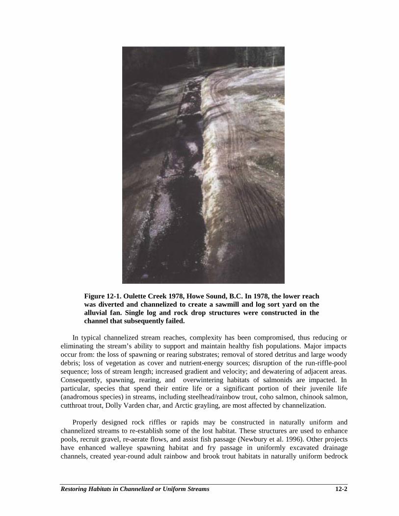
Restoring Habitats in Channelized or Uniform Streams 12-2
Figure 12-1. Oulette Creek 1978, Howe Sound, B.C. In 1978, the lower reachwas diverted and channelized to create a sawmill and log sort yard on thealluvial fan. Single log and rock drop structures were constructed in thechannel that subsequently failed.
In typical channelized stream reaches, complexity has been compromised, thus reducing oreliminating the stream’s ability to support and maintain healthy fish populations. Major impactsoccur from: the loss of spawning or rearing substrates; removal of stored detritus and large woodydebris; loss of vegetation as cover and nutrient-energy sources; disruption of the run-riffle-poolsequence; loss of stream length; increased gradient and velocity; and dewatering of adjacent areas.Consequently, spawning, rearing, and overwintering habitats of salmonids are impacted. Inparticular, species that spend their entire life or a significant portion of their juvenile life(anadromous species) in streams, including steelhead/rainbow trout, coho salmon, chinook salmon,cutthroat trout, Dolly Varden char, and Arctic grayling, are most affected by channelization.
Properly designed rock riffles or rapids may be constructed in naturally uniform andchannelized streams to re-establish some of the lost habitat. These structures are used to enhancepools, recruit gravel, re-aerate flows, and assist fish passage (Newbury et al. 1996). Other projectshave enhanced walleye spawning habitat and fry passage in uniformly excavated drainagechannels, created year-round adult rainbow and brook trout habitats in naturally uniform bedrock
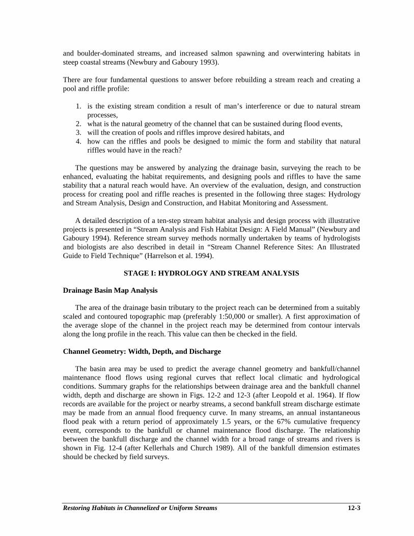
Restoring Habitats in Channelized or Uniform Streams 12-3
and boulder-dominated streams, and increased salmon spawning and overwintering habitats insteep coastal streams (Newbury and Gaboury 1993).
There are four fundamental questions to answer before rebuilding a stream reach and creating apool and riffle profile:
1. is the existing stream condition a result of man’s interference or due to natural streamprocesses,
2. what is the natural geometry of the channel that can be sustained during flood events,3. will the creation of pools and riffles improve desired habitats, and4. how can the riffles and pools be designed to mimic the form and stability that natural
riffles would have in the reach?
The questions may be answered by analyzing the drainage basin, surveying the reach to beenhanced, evaluating the habitat requirements, and designing pools and riffles to have the samestability that a natural reach would have. An overview of the evaluation, design, and constructionprocess for creating pool and riffle reaches is presented in the following three stages: Hydrologyand Stream Analysis, Design and Construction, and Habitat Monitoring and Assessment.
A detailed description of a ten-step stream habitat analysis and design process with illustrativeprojects is presented in “Stream Analysis and Fish Habitat Design: A Field Manual” (Newbury andGaboury 1994). Reference stream survey methods normally undertaken by teams of hydrologistsand biologists are also described in detail in “Stream Channel Reference Sites: An IllustratedGuide to Field Technique” (Harrelson et al. 1994).
STAGE I: HYDROLOGY AND STREAM ANALYSIS
Drainage Basin Map Analysis
The area of the drainage basin tributary to the project reach can be determined from a suitablyscaled and contoured topographic map (preferably 1:50,000 or smaller). A first approximation ofthe average slope of the channel in the project reach may be determined from contour intervalsalong the long profile in the reach. This value can then be checked in the field.
Channel Geometry: Width, Depth, and Discharge
The basin area may be used to predict the average channel geometry and bankfull/channelmaintenance flood flows using regional curves that reflect local climatic and hydrologicalconditions. Summary graphs for the relationships between drainage area and the bankfull channelwidth, depth and discharge are shown in Figs. 12-2 and 12-3 (after Leopold et al. 1964). If flowrecords are available for the project or nearby streams, a second bankfull stream discharge estimatemay be made from an annual flood frequency curve. In many streams, an annual instantaneousflood peak with a return period of approximately 1.5 years, or the 67% cumulative frequencyevent, corresponds to the bankfull or channel maintenance flood discharge. The relationshipbetween the bankfull discharge and the channel width for a broad range of streams and rivers isshown in Fig. 12-4 (after Kellerhals and Church 1989). All of the bankfull dimension estimatesshould be checked by field surveys.

Restoring Habitats in Channelized or Uniform Streams 12-4
Figure 12-2. In regions with similar Figure 12-3. The bankfull channel dischargehydrologic regimes, the average bankfull vs. drainage basin area relationship may bewidth and depth are related to the drainage estimated from channel reference surveysbasin area in fluvial channels. The points using the survey data and a slope-velocityshown were derived from channel reference relationship such as Manning’s equationsurveys in western Canada. (Chow 1959).
Figure 12-4. The relationship between bankfull width and discharge hasbeen compiled for all ranges of river size by Kellerhals and Church (1989).For streams with bankfull discharges between 1 and 1,000 m3 ⋅ sec-1, therelationship was estimated to be width = 4.5 ⋅ bankfull discharge0-5.
The bankfull width of the channel is used as the base unit for other plan and profiledimensions of the river (Fig. 12-5). The bankfull width is defined as the distance between the edgesof the floodplains if they are present. In many channels that are entrenched, the equivalent width isobtained by measuring between the upper limits of the regularly scoured channel banks whererooted perennial vegetation begins.
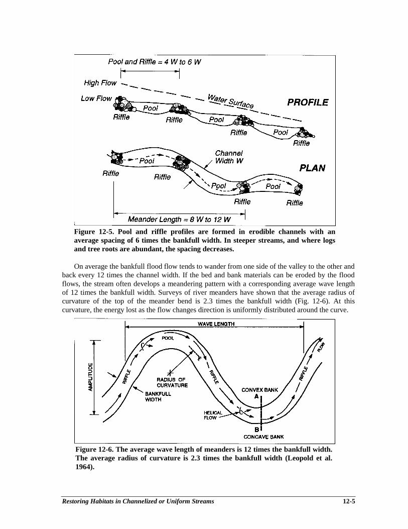
Restoring Habitats in Channelized or Uniform Streams 12-5
Figure 12-5. Pool and riffle profiles are formed in erodible channels with anaverage spacing of 6 times the bankfull width. In steeper streams, and where logsand tree roots are abundant, the spacing decreases.
On average the bankfull flood flow tends to wander from one side of the valley to the other andback every 12 times the channel width. If the bed and bank materials can be eroded by the floodflows, the stream often develops a meandering pattern with a corresponding average wave lengthof 12 times the bankfull width. Surveys of river meanders have shown that the average radius ofcurvature of the top of the meander bend is 2.3 times the bankfull width (Fig. 12-6). At thiscurvature, the energy lost as the flow changes direction is uniformly distributed around the curve.
Figure 12-6. The average wave length of meanders is 12 times the bankfull width.The average radius of curvature is 2.3 times the bankfull width (Leopold et al.1964).

Restoring Habitats in Channelized or Uniform Streams 12-6
The flood flow also forms a vertical wave, creating a pool in each bend and a riffle or shallowbar as the flow changes direction from one side of the valley to the other. Consequently, theaverage pool and riffle spacing is 6 times the bankfull width. After the flood peak has passed, thepattern established by the larger flow is emphasized by near-horizontal pools between the steeperriffle sections. In streams with gradients greater than 5% or where there are large log and boulderobstructions, the pool and riffle spacing may be reduced, forming a step-like channel with riffledrops every 2 or 4 times the channel width (Hogan 1986).
These observations of natural channel patterns provide the background for mapping andinterpreting the forms and processes occurring in the project reach. They are also useful guidelinesfor designing pool and riffle restoration works. As Henderson (1966) advised, “the river engineershould look when planning to simulate natural meanders in river training works”.
Stream Surveys
Stream reach surveys are required to establish the natural channel dimensions for a givendrainage area in a hydrological region. On average, sample reach lengths should be selected thatare at least 12 times the bankfull width of the stream to contain a full set of pool, riffle, andmeander characteristics. The bankfull/channel widths and depths can be plotted on Figs. 12-2, 12-3, and 12-4 to obtain an estimate of the channel geometry, drainage area, and bankfull flowrelationships as they develop along the river with increasing discharge.
In the project reach, in addition to measuring the channel dimensions, a surveyed profile of thereach is required to design riffle and pool restoration structures. An elevation benchmark andreference stations should be left in the reach to locate the restoration works. The channel geometryof the project reach may vary from the regional values if the stream is disturbed by channelization,but the design dimensions for the restoration project should be based on the channel geometry thatis supported by the bankfull channel maintenance flow. Survey procedures used to determinechannel geometry and habitat conditions in a stream reach are summarized in Newbury andGaboury (1994, refer to Chapter 2 and Appendix E for sample reach survey forms).
Salmonids have specific habitat preferences and the recognition and documentation of thesecomponents of the aquatic habitat complex provide a benchmark used in the restoration of suitablehabitats. Habitat units can be noted on the reach plan, and their characteristics and extent measuredin the sample reach. Features identified on the sketch should include: instream, emergent, andoverhanging vegetation; large woody debris; undercut banks; size and distribution of substrate,including emergent boulders; side channels; off-channel ponds and the type and extent of streambank vegetation. The pattern of flow through the reach, including the location of hydraulic jumpsand horizontal eddies, and the depths and velocities of local riffles, chutes, runs and pools shouldalso be noted, as these are important hydraulic features utilized by fish in different life stages.
STAGE II: DESIGN AND CONSTRUCTION
Concept
Data and observations gathered in Stage I can now be applied to designing and constructingpool and riffle sequences as a habitat restoration project. Constructed riffles should mimic naturalrapids in form, materials, and function as closely as possible. Stability of the riffles is not absolute,but can be adjusted to the bankfull flow stage assuming that higher floods will utilize floodplains.
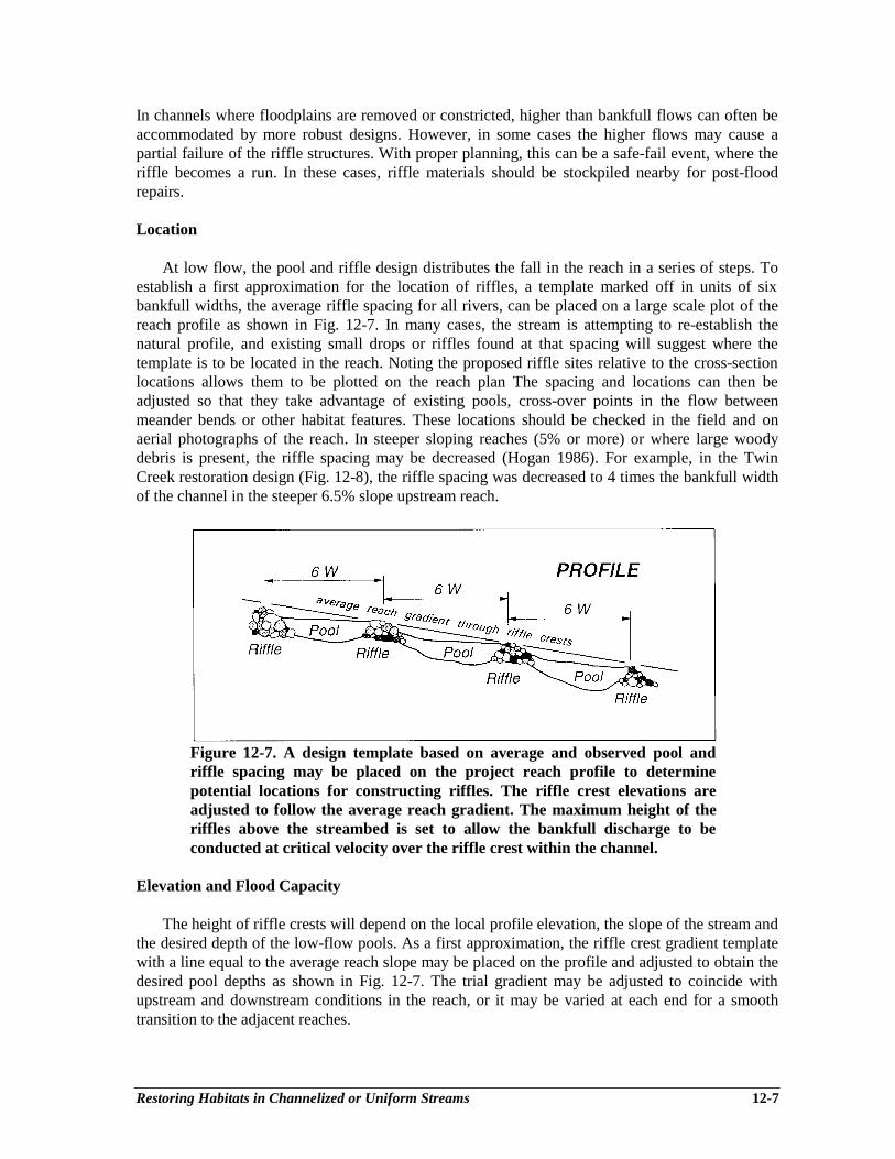
Restoring Habitats in Channelized or Uniform Streams 12-7
In channels where floodplains are removed or constricted, higher than bankfull flows can often beaccommodated by more robust designs. However, in some cases the higher flows may cause apartial failure of the riffle structures. With proper planning, this can be a safe-fail event, where theriffle becomes a run. In these cases, riffle materials should be stockpiled nearby for post-floodrepairs.
Location
At low flow, the pool and riffle design distributes the fall in the reach in a series of steps. Toestablish a first approximation for the location of riffles, a template marked off in units of sixbankfull widths, the average riffle spacing for all rivers, can be placed on a large scale plot of thereach profile as shown in Fig. 12-7. In many cases, the stream is attempting to re-establish thenatural profile, and existing small drops or riffles found at that spacing will suggest where thetemplate is to be located in the reach. Noting the proposed riffle sites relative to the cross-sectionlocations allows them to be plotted on the reach plan The spacing and locations can then beadjusted so that they take advantage of existing pools, cross-over points in the flow betweenmeander bends or other habitat features. These locations should be checked in the field and onaerial photographs of the reach. In steeper sloping reaches (5% or more) or where large woodydebris is present, the riffle spacing may be decreased (Hogan 1986). For example, in the TwinCreek restoration design (Fig. 12-8), the riffle spacing was decreased to 4 times the bankfull widthof the channel in the steeper 6.5% slope upstream reach.
Figure 12-7. A design template based on average and observed pool andriffle spacing may be placed on the project reach profile to determinepotential locations for constructing riffles. The riffle crest elevations areadjusted to follow the average reach gradient. The maximum height of theriffles above the streambed is set to allow the bankfull discharge to beconducted at critical velocity over the riffle crest within the channel.
Elevation and Flood Capacity
The height of riffle crests will depend on the local profile elevation, the slope of the stream andthe desired depth of the low-flow pools. As a first approximation, the riffle crest gradient templatewith a line equal to the average reach slope may be placed on the profile and adjusted to obtain thedesired pool depths as shown in Fig. 12-7. The trial gradient may be adjusted to coincide withupstream and downstream conditions in the reach, or it may be varied at each end for a smoothtransition to the adjacent reaches.

Restoring Habitats in Channelized or Uniform Streams 12-8
Figure 12-8. Twin Creek Restoration Project 1993, Howe Sound, B.C. Seven Rock riffles were constructed on the lower channelized reachadjacent to a log sort yard. The upper riffles in the 6.5% gradient reach were spaced at 4 times the bankfull width. In the lower 2.5%gradient reach, the riffle spacing was increased to 6 times the bankfull width. In the first year, gravel and cobble bars were deposited inthe upstream pools as the streambed stabilized.
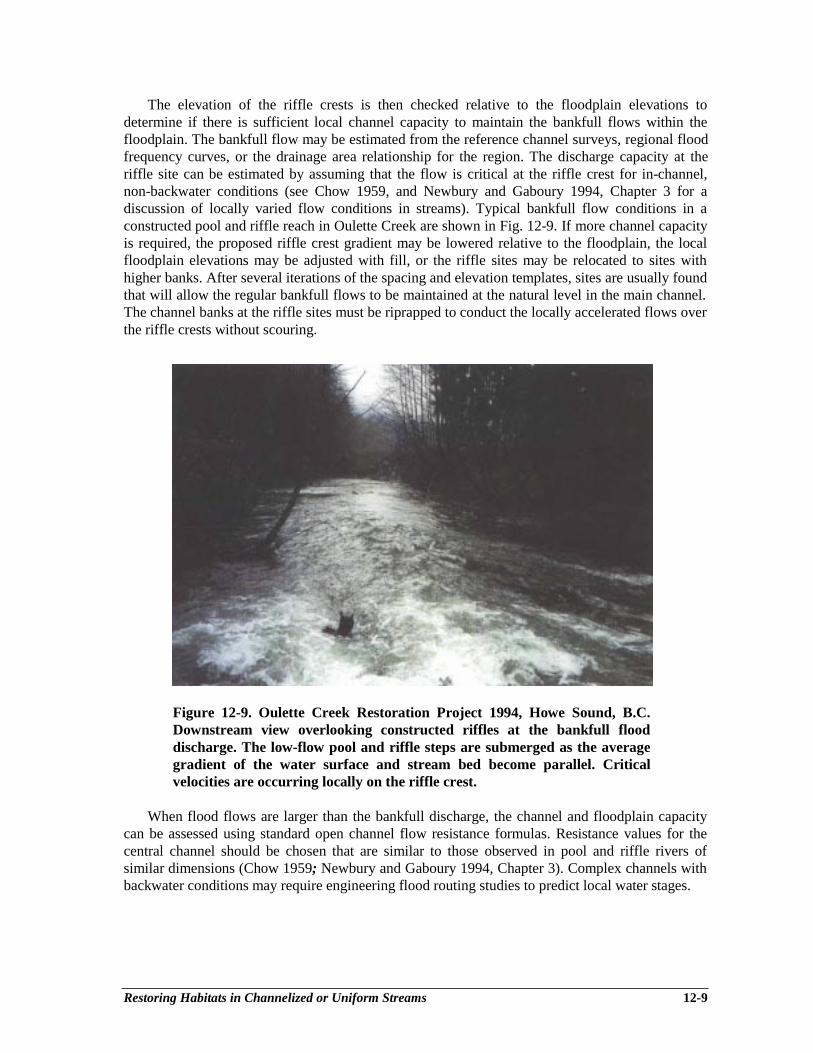
Restoring Habitats in Channelized or Uniform Streams 12-9
The elevation of the riffle crests is then checked relative to the floodplain elevations todetermine if there is sufficient local channel capacity to maintain the bankfull flows within thefloodplain. The bankfull flow may be estimated from the reference channel surveys, regional floodfrequency curves, or the drainage area relationship for the region. The discharge capacity at theriffle site can be estimated by assuming that the flow is critical at the riffle crest for in-channel,non-backwater conditions (see Chow 1959, and Newbury and Gaboury 1994, Chapter 3 for adiscussion of locally varied flow conditions in streams). Typical bankfull flow conditions in aconstructed pool and riffle reach in Oulette Creek are shown in Fig. 12-9. If more channel capacityis required, the proposed riffle crest gradient may be lowered relative to the floodplain, the localfloodplain elevations may be adjusted with fill, or the riffle sites may be relocated to sites withhigher banks. After several iterations of the spacing and elevation templates, sites are usually foundthat will allow the regular bankfull flows to be maintained at the natural level in the main channel.The channel banks at the riffle sites must be riprapped to conduct the locally accelerated flows overthe riffle crests without scouring.
Figure 12-9. Oulette Creek Restoration Project 1994, Howe Sound, B.C.Downstream view overlooking constructed riffles at the bankfull flooddischarge. The low-flow pool and riffle steps are submerged as the averagegradient of the water surface and stream bed become parallel. Criticalvelocities are occurring locally on the riffle crest.
When flood flows are larger than the bankfull discharge, the channel and floodplain capacitycan be assessed using standard open channel flow resistance formulas. Resistance values for thecentral channel should be chosen that are similar to those observed in pool and riffle rivers ofsimilar dimensions (Chow 1959; Newbury and Gaboury 1994, Chapter 3). Complex channels withbackwater conditions may require engineering flood routing studies to predict local water stages.
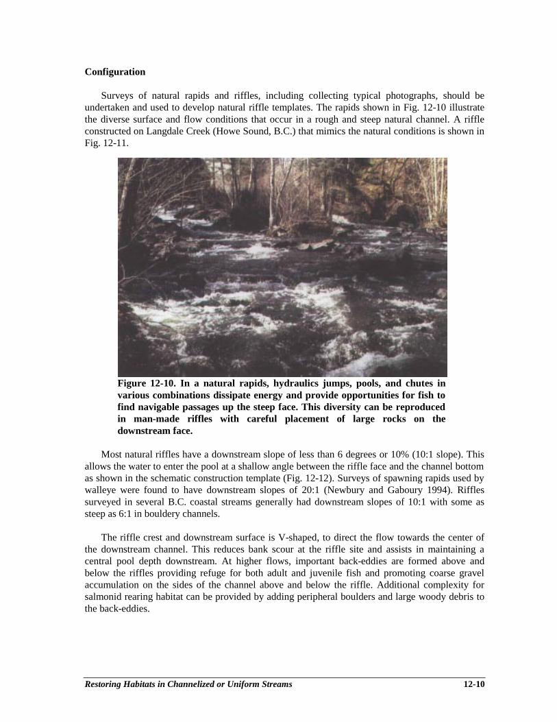
Restoring Habitats in Channelized or Uniform Streams 12-10
Configuration
Surveys of natural rapids and riffles, including collecting typical photographs, should beundertaken and used to develop natural riffle templates. The rapids shown in Fig. 12-10 illustratethe diverse surface and flow conditions that occur in a rough and steep natural channel. A riffleconstructed on Langdale Creek (Howe Sound, B.C.) that mimics the natural conditions is shown inFig. 12-11.
Figure 12-10. In a natural rapids, hydraulics jumps, pools, and chutes invarious combinations dissipate energy and provide opportunities for fish tofind navigable passages up the steep face. This diversity can be reproducedin man-made riffles with careful placement of large rocks on thedownstream face.
Most natural riffles have a downstream slope of less than 6 degrees or 10% (10:1 slope). Thisallows the water to enter the pool at a shallow angle between the riffle face and the channel bottomas shown in the schematic construction template (Fig. 12-12). Surveys of spawning rapids used bywalleye were found to have downstream slopes of 20:1 (Newbury and Gaboury 1994). Rifflessurveyed in several B.C. coastal streams generally had downstream slopes of 10:1 with some assteep as 6:1 in bouldery channels.
The riffle crest and downstream surface is V-shaped, to direct the flow towards the center ofthe downstream channel. This reduces bank scour at the riffle site and assists in maintaining acentral pool depth downstream. At higher flows, important back-eddies are formed above andbelow the riffles providing refuge for both adult and juvenile fish and promoting coarse gravelaccumulation on the sides of the channel above and below the riffle. Additional complexity forsalmonid rearing habitat can be provided by adding peripheral boulders and large woody debris tothe back-eddies.

Restoring Habitats in Channelized or Uniform Streams 12-11
Figure 12-11. Langdale Creek Restoration Project, Howe Sound, B.C.Diverse hydraulic conditions have been created by strategically placing largeboulders on the downstream face of this constructed riffle. Note the wellriprapped banks in the riffle zone adjacent to the reconstructed SunshineCoast Highway.
1. PLAN: build riffle crest across thestream with large diameter boulders;back up with next largest stonedownstream.
2. PROFILE: construct downstream faceof riffle at a shallow re-entry slope thatmimics local natural riffles (5:1 to20:1).
3. SECTION: V-shape the crest and facedownwards to the centre of the riffle(0.3 to 0.6 m).
4. SURFACE: place large rocksrandomly on the downstream face 20to 30cm apart to dissipate energy andcreate low flow fish passage channels.
5. BANKS: rip-rap both banks withembedded boulders and cobbles to thefloodplain level.
Figure 12-12. This schematic pool and riffle construction drawing may beaugmented for machine operators with note on the placement ofconstruction survey stakes and photographs of natural and well constructedriffles (video, Newbury Hydraulics 1996).
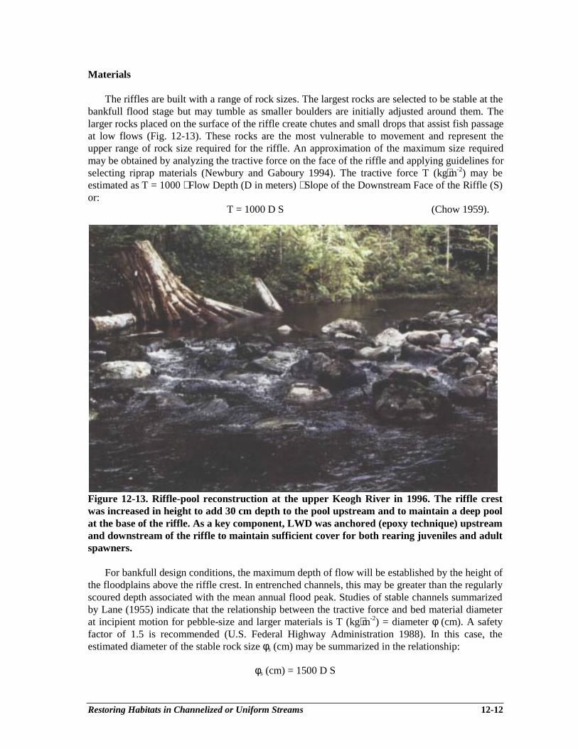
Restoring Habitats in Channelized or Uniform Streams 12-12
Materials
The riffles are built with a range of rock sizes. The largest rocks are selected to be stable at thebankfull flood stage but may tumble as smaller boulders are initially adjusted around them. Thelarger rocks placed on the surface of the riffle create chutes and small drops that assist fish passageat low flows (Fig. 12-13). These rocks are the most vulnerable to movement and represent theupper range of rock size required for the riffle. An approximation of the maximum size requiredmay be obtained by analyzing the tractive force on the face of the riffle and applying guidelines forselecting riprap materials (Newbury and Gaboury 1994). The tractive force T (kg⋅m-2) may beestimated as T = 1000 ⋅ Flow Depth (D in meters) ⋅ Slope of the Downstream Face of the Riffle (S)or:
T = 1000 D S (Chow 1959).
Figure 12-13. Riffle-pool reconstruction at the upper Keogh River in 1996. The riffle crestwas increased in height to add 30 cm depth to the pool upstream and to maintain a deep poolat the base of the riffle. As a key component, LWD was anchored (epoxy technique) upstreamand downstream of the riffle to maintain sufficient cover for both rearing juveniles and adultspawners.
For bankfull design conditions, the maximum depth of flow will be established by the height ofthe floodplains above the riffle crest. In entrenched channels, this may be greater than the regularlyscoured depth associated with the mean annual flood peak. Studies of stable channels summarizedby Lane (1955) indicate that the relationship between the tractive force and bed material diameterat incipient motion for pebble-size and larger materials is T (kg⋅m-2) = diameter φ (cm). A safetyfactor of 1.5 is recommended (U.S. Federal Highway Administration 1988). In this case, theestimated diameter of the stable rock size φs (cm) may be summarized in the relationship:
φs (cm) = 1500 D S
Restoring Habitats in Channelized or Uniform Streams 12-13
The volume of rock required at each riffle site is approximately equal to the riffle height ⋅ theriffle length ⋅ the bankfull channel width. This volume allows for extra rock to riprap the banksadjacent to the riffle site and to roughen the downstream slope of the riffle face. The rock sizesshould cover the entire range observed in natural template riffles, with an adequate number of thelarger rocks to build the riffle crest and armour the downstream slope. Any remaining rock may bestockpiled nearby for adjustments to the riffle and banks following the first few flood events, orused as boulder clusters at the base of the riffle at the entrance to the pool.
Construction
The construction process is summarized in the notes accompanying Fig. 12-12 (also describedin video form, Newbury Hydraulics 1996). This figure should be reproduced and supplementedwith photographs of riffles and rapids as a guide for machine operators. To build a riffle withnatural characteristics, large rock must be sorted and used with skill to create a stable crest and toform a properly roughened surface on the downstream face.
Construction surveys at each riffle site must be referenced to the temporary benchmarkestablished during the project reach profile survey. Construction stakes should be placed on eitherside of the channel at the upstream toe, crest, and downstream toe of the riffle. The crest elevationat the banks and in the center of the channel can be marked on the location stakes. These elevationswill have to be checked as the construction proceeds. This can be done with a hand or surveyor’slevel and a reference elevation. In smaller streams, measurements may be made by the operatorfrom a horizontal string line between points previously established on adjacent floodplains orbanks.
Natural riffle and pool habitat projects are designed to be adjusted by flood flows that willscour pools and deposit gravel bars. The adjustments often take place in the first 4 or 5 bankfull orgreater flood events. After these events, the riffle configuration should be resurveyed and assessedto see if additional rock is required to infill gaps or to improve the configuration of the flow on theriffle face. For example, several experimental riffles with different foundation conditions and rocksizes were built on Chapman Creek, B.C. in 1992 and 1993 (Fig. 12-14). In the first year, thedownstream faces of riffles one, two, four and five were sorted but not altered in elevation bybankfull flood flows of approximately 70 m3⋅sec-1. The central portion of the third riffle slid alongthe hardpan bed at that site and moved downstream to create a run. This could have been avoidedby keying the riffle crest into the bed, but only at a high cost of drilling and blasting. The sixthupstream riffle crest was not altered by flood flows and has caused a large coarse gravel bar toaccumulate upstream that is actively used for spawning. However the downstream face of the rifflehas been partially eroded as there was not a sufficient supply of large boulders to build the rifflebase below the crest. Although the rocky bed of Chapman Creek could withstand the steeplyfalling water from the riffle crest, in more erodible streams a deep scour hole would develop thatwould eventually cause the large crest boulders to tumble downstream and be buried. In order toprevent this scour, boulders from adjacent reaches are added to the riffle face (Fig. 12-14).
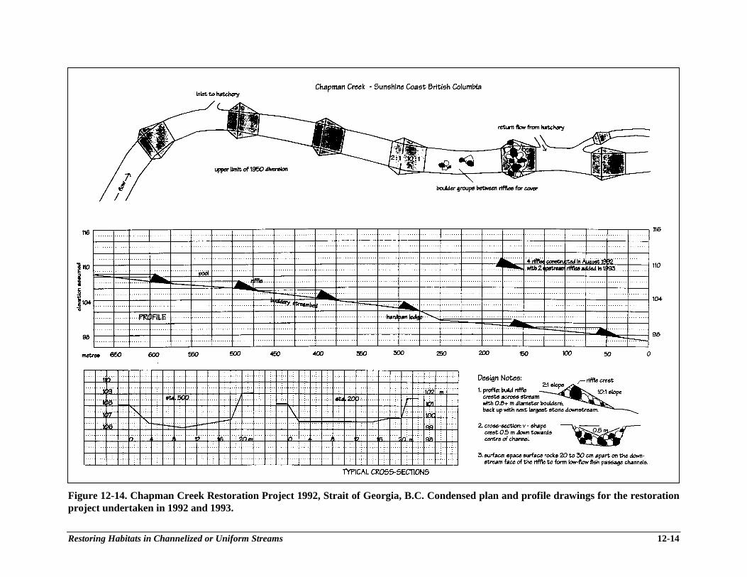
Restoring Habitats in Channelized or Uniform Streams 12-14
Figure 12-14. Chapman Creek Restoration Project 1992, Strait of Georgia, B.C. Condensed plan and profile drawings for the restorationproject undertaken in 1992 and 1993.

Restoring Habitats in Channelized or Uniform Streams 12-15
STAGE III: HABITAT MONITORING OF PROJECTS
Habitat rehabilitation projects should begin with an assessment and inventory of the bioticcommunity prior to instream work. The selected sampling design should include measurable keyvariables that will indicate a physical or biological response to pool and riffle rehabilitation, andallow for data comparisons in future monitoring studies (Keeley and Walters 1994; Newbury andGaboury 1994).
The general steps in a routine monitoring project include:
Pre-project 1. initial survey including quantitative and qualitative evaluation of the existinghabitat,
Post-project 2. evaluation of the biotic community,3. re-evaluation of the aquatic habitat and biotic community following the period
of initial adjustment and recruitment,4. re-evaluation of aquatic habitat following significant flood events.
Monitoring and evaluation procedures for the Watershed Restoration Program are discussedelsewhere but two examples are provided below to demonstrate the results of restoring pool andriffle sequences in two widely different stream types with gradients of 0.3% and 3.0%.
Mink Creek Restoration (sand and gravel bed, 0.3% gradient)
An extensive program of channelization to improve agricultural drainage and reduce springflooding occurred throughout the Dauphin Lake watershed (Manitoba) beginning in the early1900’s. From 1950 to 1984, a typical cycle of downcutting, bank slumping and channel wideningoccurred in the channelized reaches of Mink Creek (drainage area 250 km2). The channel wasoriginally excavated in 1950 with a width-to-depth ratio of 7:1. By 1984, erosion had re-established a more natural width-to-depth ratio of 12.5:1 (Newbury and Gaboury 1993). Theextensive erosion had also lowered the bed by 1 m and created a 1 km2 delta of bed and bankmaterials at the river’s mouth. Channelizing and regrading eliminated many of the pools and rifflesused by walleye as spawning and incubation habitats (Fig. 12-15). The characteristic slope of thenatural spawning sites (Fig. 12-16A) served as a template for the man-made riffles shownschematically in Fig. 12-16B. The riffles were spaced 100 m apart along the channelized reach(Fig. 12-16C) and constructed (Fig. 12-17) as described in Newbury and Gaboury (1994). Thespacing of riffles was 6.5 times the natural bankfull width of the creek. Each riffle was built with100 m3 of donated fieldstone and required approximately $1,000 (1985) of machine time toconstruct.
Large floods (up to 41 m3⋅s-1, a 1 in 40-year event) were recorded in Mink Creek in the firstfive years after the riffles were constructed. A comparison of the 1986 and 1991 profiles indicatedthat the pools and riffles remained stable (Fig. 12-18) with minimal change in the riffle crestelevations. Pool depths immediately upstream of the riffle structures have decreased sinceconstruction as a result of infilling. New pools were maintained at a residual depth of 0.5-0.7 mimmediately downstream from the riffles. By 1991, the bankfull widths and depths of the pools hadreturned to an average ratio of 19:1, re-establishing the historic channel cross-section (R. Janusz,unpubl. data). Increasing the cross-section of the flow in the pools decreased eroding velocities andallowed the stream banks to revegetate and stabilize. Erosion of the streambed and banks upstreamof the rehabilitated reach has continued unabated.
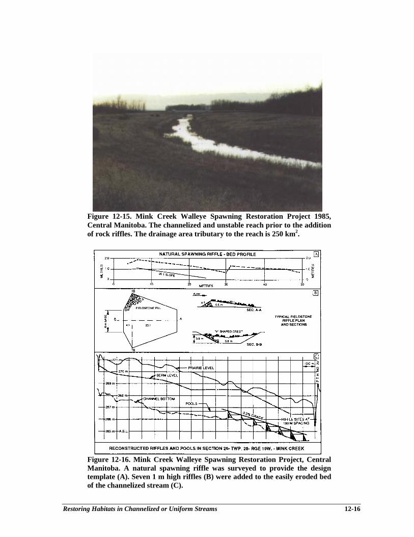
Restoring Habitats in Channelized or Uniform Streams 12-16
Figure 12-15. Mink Creek Walleye Spawning Restoration Project 1985,Central Manitoba. The channelized and unstable reach prior to the additionof rock riffles. The drainage area tributary to the reach is 250 km2.
Figure 12-16. Mink Creek Walleye Spawning Restoration Project, CentralManitoba. A natural spawning riffle was surveyed to provide the designtemplate (A). Seven 1 m high riffles (B) were added to the easily eroded bedof the channelized stream (C).
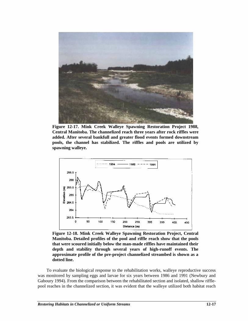
Restoring Habitats in Channelized or Uniform Streams 12-17
Figure 12-17. Mink Creek Walleye Spawning Restoration Project 1988,Central Manitoba. The channelized reach three years after rock riffles wereadded. After several bankfull and greater flood events formed downstreampools, the channel has stabilized. The riffles and pools are utilized byspawning walleye.
Figure 12-18. Mink Creek Walleye Spawning Restoration Project, CentralManitoba. Detailed profiles of the pool and riffle reach show that the poolsthat were scoured initially below the man-made riffles have maintained theirdepth and stability through several years of high-runoff events. Theapproximate profile of the pre-project channelized streambed is shown as adotted line.
To evaluate the biological response to the rehabilitation works, walleye reproductive successwas monitored by sampling eggs and larvae for six years between 1986 and 1991 (Newbury andGaboury 1994). From the comparison between the rehabilitated section and isolated, shallow riffle-pool reaches in the channelized section, it was evident that the walleye utilized both habitat reach
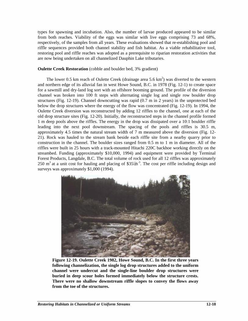
Restoring Habitats in Channelized or Uniform Streams 12-18
types for spawning and incubation. Also, the number of larvae produced appeared to be similarfrom both reaches. Viability of the eggs was similar with live eggs comprising 73 and 68%,respectively, of the samples from all years. These evaluations showed that re-establishing pool andriffle sequences provided both channel stability and fish habitat. As a viable rehabilitative tool,restoring pool and riffle reaches was adopted as a prerequisite to riparian restoration activities thatare now being undertaken on all channelized Dauphin Lake tributaries.
Oulette Creek Restoration (cobble and boulder bed, 3% gradient)
The lower 0.5 km reach of Oulette Creek (drainage area 5.6 km2) was diverted to the westernand northern edge of its alluvial fan in west Howe Sound, B.C. in 1978 (Fig. 12-1) to create spacefor a sawmill and dry-land log sort with an offshore booming ground. The profile of the diversionchannel was broken into 100 ft steps with alternating single log and single row boulder dropstructures (Fig. 12-19). Channel downcutting was rapid (0.7 m in 2 years) in the unprotected bedbelow the drop structures where the energy of the flow was concentrated (Fig. 12-19). In 1994, theOulette Creek diversion was reconstructed by adding 12 riffles to the channel, one at each of theold drop structure sites (Fig. 12-20). Initially, the reconstructed steps in the channel profile formed1 m deep pools above the riffles. The energy in the drop was dissipated over a 10:1 boulder riffleleading into the next pool downstream. The spacing of the pools and riffles is 30.5 m,approximately 4.5 times the natural stream width of 7 m measured above the diversion (Fig. 12-21). Rock was hauled to the stream bank beside each riffle site from a nearby quarry prior toconstruction in the channel. The boulder sizes ranged from 0.5 m to 1 m in diameter. All of theriffles were built in 25 hours with a track-mounted Hitachi 220C backhoe working directly on thestreambed. Funding (approximately $10,000, 1994) and equipment were provided by TerminalForest Products, Langdale, B.C. The total volume of rock used for all 12 riffles was approximately250 m3 at a unit cost for hauling and placing of $35⋅m-3. The cost per riffle including design andsurveys was approximately $1,000 (1994).
Figure 12-19. Oulette Creek 1982, Howe Sound, B.C. In the first three yearsfollowing channelization, the single log drop structures added to the uniformchannel were undercut and the single-line boulder drop structures wereburied in deep scour holes formed immediately below the structure crests.There were no shallow downstream riffle slopes to convey the flows awayfrom the toe of the structures.
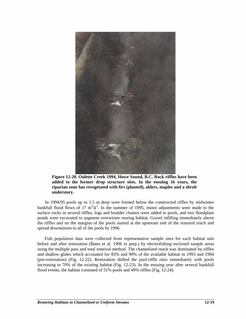
Restoring Habitats in Channelized or Uniform Streams 12-19
Figure 12-20. Oulette Creek 1994, Howe Sound, B.C. Rock riffles have beenadded to the former drop structure sites. In the ensuing 16 years, theriparian zone has revegetated with firs (planted), alders, maples and a shrubunderstory.
In 1994/95 pools up to 1.5 m deep were formed below the constructed riffles by midwinterbankfull flood flows of 17 m3⋅s-1. In the summer of 1995, minor adjustments were made to thesurface rocks in several riffles, logs and boulder clusters were added to pools, and two floodplainponds were excavated to augment overwinter rearing habitat. Gravel infilling immediately abovethe riffles and on the margins of the pools started at the upstream end of the restored reach andspread downstream to all of the pools by 1996.
Fish population data were collected from representative sample sites for each habitat unitbefore and after restoration (Bates et al. 1996 in prep.) by electrofishing enclosed sample areasusing the multiple pass and total removal method. The channelized reach was dominated by rifflesand shallow glides which accounted for 83% and 90% of the available habitat in 1993 and 1994(pre-restoration) (Fig. 12-22). Restoration shifted the pool-riffle ratio immediately with poolsincreasing to 70% of the existing habitat (Fig. 12-23). In the ensuing year after several bankfullflood events, the habitat consisted of 51% pools and 49% riffles (Fig. 12-24).
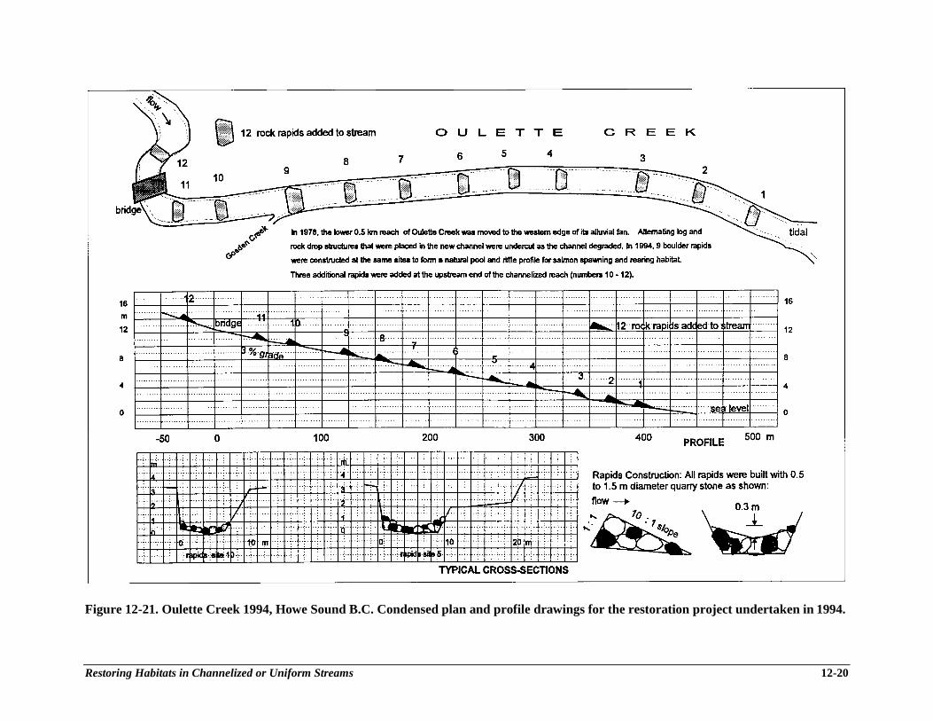
Restoring Habitats in Channelized or Uniform Streams 12-20
Figure 12-21. Oulette Creek 1994, Howe Sound B.C. Condensed plan and profile drawings for the restoration project undertaken in 1994.
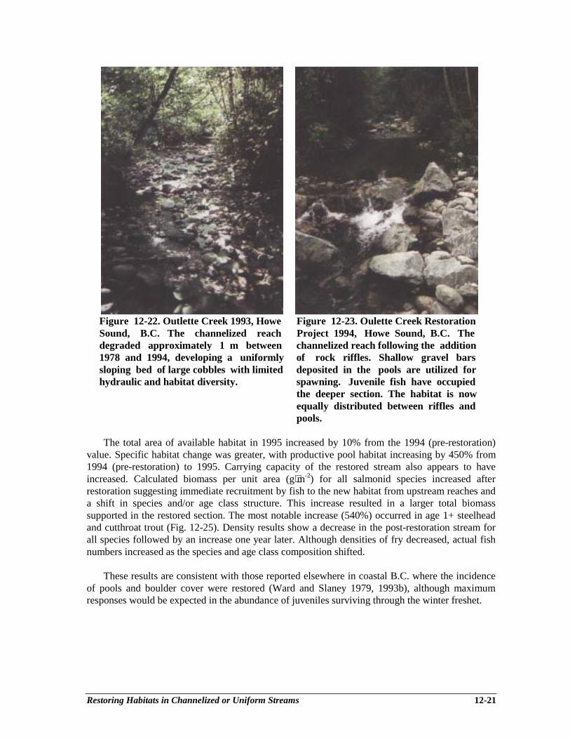
Restoring Habitats in Channelized or Uniform Streams 12-21
Figure 12-22. Outlette Creek 1993, Howe Figure 12-23. Oulette Creek RestorationSound, B.C. The channelized reach Project 1994, Howe Sound, B.C. Thedegraded approximately 1 m between channelized reach following the addition1978 and 1994, developing a uniformly of rock riffles. Shallow gravel barssloping bed of large cobbles with limited deposited in the pools are utilized forhydraulic and habitat diversity. spawning. Juvenile fish have occupied
the deeper section. The habitat is nowequally distributed between riffles andpools.
The total area of available habitat in 1995 increased by 10% from the 1994 (pre-restoration)value. Specific habitat change was greater, with productive pool habitat increasing by 450% from1994 (pre-restoration) to 1995. Carrying capacity of the restored stream also appears to haveincreased. Calculated biomass per unit area (g⋅m-2) for all salmonid species increased afterrestoration suggesting immediate recruitment by fish to the new habitat from upstream reaches anda shift in species and/or age class structure. This increase resulted in a larger total biomasssupported in the restored section. The most notable increase (540%) occurred in age 1+ steelheadand cutthroat trout (Fig. 12-25). Density results show a decrease in the post-restoration stream forall species followed by an increase one year later. Although densities of fry decreased, actual fishnumbers increased as the species and age class composition shifted.
These results are consistent with those reported elsewhere in coastal B.C. where the incidenceof pools and boulder cover were restored (Ward and Slaney 1979, 1993b), although maximumresponses would be expected in the abundance of juveniles surviving through the winter freshet.
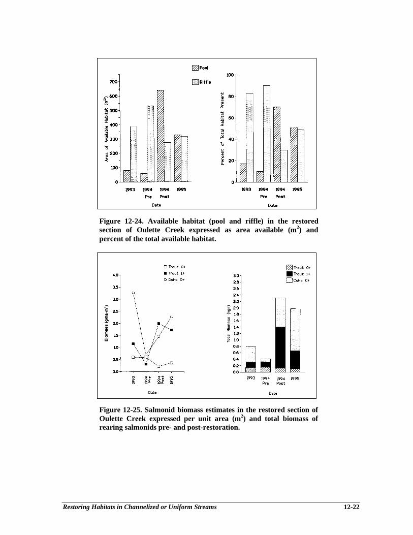
Restoring Habitats in Channelized or Uniform Streams 12-22
Figure 12-24. Available habitat (pool and riffle) in the restoredsection of Oulette Creek expressed as area available (m2) andpercent of the total available habitat.
Figure 12-25. Salmonid biomass estimates in the restored section ofOulette Creek expressed per unit area (m2) and total biomass ofrearing salmonids pre- and post-restoration.
Accelerating Recovery of Stream, River and Pond Productivity 13-1
Chapter 13Accelerating Recovery of Stream, River and Pond Productivity
by Low-level Nutrient Replacement
Ken I. Ash1ey1, Pat A. Slaney2
BACKGROUND
The addition of nutrients to freshwater ecosystems has received a considerable amount ofresearch attention in the Pacific Northwest. Research was initially focused on eutrophicationconcerns (e.g., Lake Washington, WA), then on sockeye enhancement in large lakes (e.g., GreatCentral Lake, B.C.) and most recently on the process of “oligotrophication” in lakes and streamsbecause of management agency interest in the role of marine-derived nutrients in maintaining theproductivity of anadromous salmon stocks in oligotrophic watersheds. Concerns that salmonidstocks in general are on a downward trend due to combined fishing pressure and past forestharvesting practices, as well as impacts of industrial developments such as hydroelectric reservoirsas nutrient “sinks”, has contributed to the strong regional interest in the efficacy of stream and lakefertilization as an ecosystem restoration technique. Although research on limiting nutrients hasbeen conducted in Alaska since the 1950’s, and B.C. since the early 1970’s, the WatershedRestoration Program has accelerated research and development of innovative fertilization-relatedtechnologies including patented slow release fertilizer formulations and state-of-the-art liquidfertilizer application systems to replace nutrients. Results of research studies on fertilized streamsconfirm a strong growth response in fish populations. More recent research on the role of salmoncarcasses as ecologically important sources of marine-derived carbon and nutrients for aquatic andterrestrial biodiversity (Schuldt and Hershey 1995; Willson and Halupka 1995; Bilby et al. 1996)places some urgency in rebuilding spawner escapement to historical levels in the long term (Larkinand Slaney 1996), and in the short term to replace carcass-derived nutrient influxes until stocksrecover. This chapter reviews the ecological linkages between anadromous salmon and theproductivity of freshwater fish habitat in the Pacific Northwest and outlines the applied aspects ofstream, river and pond fertilization as currently practiced in British Columbia.
SCIENTIFIC RATIONALE
Indices of nutrients, including dissolved solids, have often been reported as positivelycorrelated with salmonid standing crop (McFadden and Cooper 1962; Egglishaw 1968). However,inorganic fertilization of oligotrophic streams as a means to increase the invertebrate food supplyin order to increase growth and abundance of salmonids has received only limited attention as apotential habitat restoration or mitigation technique (Hall and Baker 1982). This historical neglectlikely arises from confusion about the role of allochthonous and autochthonous energy flow inforested stream ecosystems (France 1995), and regardless of evidence that primary productionsupports food webs in larger streams (Minshall 1978). Also, perhaps a tarnished history of cultural
________________________1 Ministry of Environment, Lands and Parks, Fisheries Research and Development Section, 2204 Main Mall,UBC, Vancouver. BC V6T 1Z42 Ministry of Environment, Lands and Parks, Watershed Restoration Program, 2204 Main Mall, UBC,Vancouver, BC V6T 1Z4
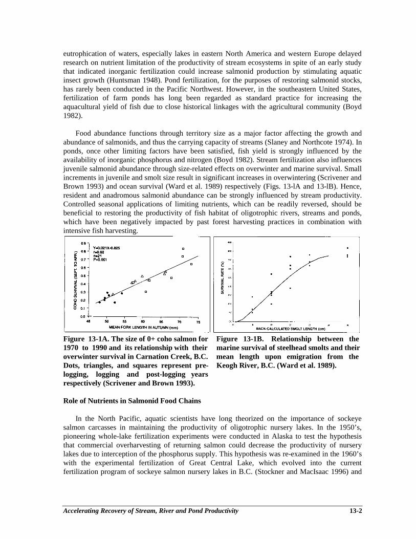
Accelerating Recovery of Stream, River and Pond Productivity 13-2
eutrophication of waters, especially lakes in eastern North America and western Europe delayedresearch on nutrient limitation of the productivity of stream ecosystems in spite of an early studythat indicated inorganic fertilization could increase salmonid production by stimulating aquaticinsect growth (Huntsman 1948). Pond fertilization, for the purposes of restoring salmonid stocks,has rarely been conducted in the Pacific Northwest. However, in the southeastern United States,fertilization of farm ponds has long been regarded as standard practice for increasing theaquacultural yield of fish due to close historical linkages with the agricultural community (Boyd1982).
Food abundance functions through territory size as a major factor affecting the growth andabundance of salmonids, and thus the carrying capacity of streams (Slaney and Northcote 1974). Inponds, once other limiting factors have been satisfied, fish yield is strongly influenced by theavailability of inorganic phosphorus and nitrogen (Boyd 1982). Stream fertilization also influencesjuvenile salmonid abundance through size-related effects on overwinter and marine survival. Smallincrements in juvenile and smolt size result in significant increases in overwintering (Scrivener andBrown 1993) and ocean survival (Ward et al. 1989) respectively (Figs. 13-lA and 13-lB). Hence,resident and anadromous salmonid abundance can be strongly influenced by stream productivity.Controlled seasonal applications of limiting nutrients, which can be readily reversed, should bebeneficial to restoring the productivity of fish habitat of oligotrophic rivers, streams and ponds,which have been negatively impacted by past forest harvesting practices in combination withintensive fish harvesting.
Figure 13-1A. The size of 0+ coho salmon for Figure 13-1B. Relationship between the1970 to 1990 and its relationship with their marine survival of steelhead smolts and theiroverwinter survival in Carnation Creek, B.C. mean length upon emigration from theDots, triangles, and squares represent pre- Keogh River, B.C. (Ward et al. 1989).logging, logging and post-logging yearsrespectively (Scrivener and Brown 1993).
Role of Nutrients in Salmonid Food Chains
In the North Pacific, aquatic scientists have long theorized on the importance of sockeyesalmon carcasses in maintaining the productivity of oligotrophic nursery lakes. In the 1950’s,pioneering whole-lake fertilization experiments were conducted in Alaska to test the hypothesisthat commercial overharvesting of returning salmon could decrease the productivity of nurserylakes due to interception of the phosphorus supply. This hypothesis was re-examined in the 1960’swith the experimental fertilization of Great Central Lake, which evolved into the currentfertilization program of sockeye salmon nursery lakes in B.C. (Stockner and MacIsaac 1996) and

Accelerating Recovery of Stream, River and Pond Productivity 13-3
Alaska. More recently, fertilization has been used to offset the effects of “oligotrophication” inlakes and reservoirs following impoundment (Milbrink and Holmgren 1988) and/or introduction ofMysis relicta and has resulted in significant increases in plankton and fish abundance (Ashley et al.1997). In recent years, convincing evidence obtained from stable isotope (15N and 13C) analysis ofphytoplankton, zooplankton and sockeye (juveniles, adults and spawners) has confirmed thehypotheses of the previous four decades and quantified the importance of marine-derived nitrogenand carbon, and by inference, phosphorus, in lacustrine food webs (Kline et al. 1993).
Given the regional and historical perspective on the importance of nutrients derived fromsalmon carcasses in lacustrine food webs, researchers in Alaska and British Columbiaexperimented with adding inorganic nutrients to oligotrophic streams in an attempt to increaseperiphyton production at the base of the food chain (Stockner and Shortreed 1978; Peterson et al.1985; Perrin et al. 1987), and thereby insect growth and abundance (Peterson et al. 1985; Johnstonet al. 1990; Mundie et al. 1991), and ultimately the growth of steelhead trout, coho salmon (Slaneyet al. 1986; Johnston et al. 1990), and Arctic grayling (Deegan and Peterson 1992). Streamfertilization has been shown to induce migrations of lacustrine fish into embayments to takeadvantage of the increased production of aquatic organisms (Milbrink and Holmgren 1988). Stableisotope (15N and 13C) analysis of stream periphyton, insects and juvenile salmonids has also beenused recently to quantify the importance and pathways of marine-derived nitrogen and carbon, andlogically phosphorus, in riverine food webs. Bilby et al. (1996) found that returning salmonspawners contributed up to 40% of the nitrogen and carbon content of juvenile salmonids in smallstreams, in addition to significant contributions to the N content of riparian vegetation and N and Ccontent of epilithic organic matter and aquatic macroinvertebrates. Similarly, Schuldt and Hershey(1995) also provided evidence that carcasses from a small run of chinook salmon could influencenutrient concentrations and periphyton accrual in stream ecosystems.
Productivity and Nutrient Status of Coastal and Interior Waters
The productivity of British Columbia’s rivers, streams and ponds is primarily a function of thewatershed’s underlying bedrock geology, as modified by the topography and precipitation regime,and varies considerably as B.C. has the greatest physiographic diversity of any Canadian province.Pioneering regional surveys by Northcote and Larkin (1966) demonstrated the linkage betweenunderlying geology, total dissolved solids content of lakes and standing crops of plankton and fish,and identified a minimum of twelve limnological regions in B.C. (Fig. 13-2). As a general rule,productivity and nutrients tend to be lower in coastal waters as the underlying geology is mainlyerosion-resistant granitic rocks. The interior plains, except for the northeast, are comprised mainlyof unmetamorphosed sedimentary and volcanic rocks, hence interior rivers and streams usuallyhave higher productivity and nutrient concentrations, although there are many examples of nutrientdeficient streams in the interior.
For example, many coastal streams (e.g., Adam River, Big Silver Creek, Keogh River) usuallyhave soluble reactive phosphate (i.e., SRP) concentrations < 1 µg⋅L-1 (i.e., parts per billion) andadequate dissolved inorganic nitrogen (i.e., DIN >20 µg⋅L-1), while some interior streams (e.g.,Blackwater River) have 27 µg⋅L-1 P and < 5 µg⋅L-1 nitrate. Rivers which connect two or morephysiographic regions, may exhibit blended nutrient regimes as a ratio of their respectivewatershed areas and water yields. Thus, it is possible to have a productive system on the coast(e.g., Dean River) as the majority of the nutrients are derived from an interior watershed. Similarly,lake-headed systems can significantly modify downstream nutrient regimes owing to the uptake

Accelerating Recovery of Stream, River and Pond Productivity 13-4
and retention of nutrients by the lake, although this is compensated somewhat in the immediateoutlet zone due to washout of lake seston. For example, the Nechako River, which flows across theinterior is both N- and P-limited, due to its large coastal watershed and headwater lake/reservoir,while the Blackwater River is N-limited due to the presence of headwater lakes and high naturalconcentrations of phosphorus.
Figure 13-2. Limnological regions of B.C. and lakes with surface area > 100km2 (Northcote and Larkin 1966).
The underlying nutrient regime of a system can also be significantly modified by the biogenicimportation of marine-derived nutrients by anadromous salmon, and this process likely played arole in the evolution of salmonids. Since oceans are typically more productive than freshwaterenvironments in temperate and polar latitudes, and migratory behaviour can be correlated tolatitudinal gradients in resource availability, anadromy likely evolved to capitalize on thisproductivity differential. The selective advantage gained by migrating to a more productive oceanicenvironment could be expressed in the freshwater environment via increased body size, fecundity,upstream migratory capability nest guarding and ultimately the return of marine-derived nutrientsto the natal system where current and future generations could benefit from the resultant increase infreshwater productivity through direct consumption and remineralization of the carcasses.
Nutrient Cycling and Spiralling
In streams, the unidirectional flow of water downhill displaces nutrients considerable distancesdownstream as nutrients cycle or “spiral” through the biota (Mulholland 1996). Experimentsinvolving radioactive 32PO4 applications to streams have confirmed that spiralling does occur, andthat the distance travelled is dominated by the water component (i.e., water velocity). Spirallingdistance may be reduced by increasing the uptake of nutrients from the water. For example, filterfeeding invertebrates, through capture of seston may impede downstream transport of organicmatter and effectively reduce spiralling distance (Minshall et al. 1985). In addition, some nutrientcycling does take place within the boundary zones created by benthic algae that does not involvedownstream displacement, and hence is an alternative pathway to nutrient spiralling (Mulholland
Accelerating Recovery of Stream, River and Pond Productivity 13-5
1996). Evidence from river fertilization experiments indicates that increased periphyton (andpresumably heterotrophic microbial) biomass can extract sufficient nutrients from the water to shiftP-limited systems to N and P co-limitation, hence spiralling length has likely been reduced byincreasing the biomass and effective nutrient uptake capacity of the biological community (Slaneyet al. 1994a). A practical aspect of spiralling theory involves determining the most efficientplacement of nutrient dispensers on a river. Fertilization experiments conducted on the NechakoRiver observed elevated periphyton accumulations 50 km downstream of the nutrient addition site,hence nutrients can be transported significant distances in larger rivers (Slaney et al. 1994a).
IMPACTS OF ENVIRONMENTAL DISTURBANCES ONNUTRIENTS AND SALMONIDS
Before the arrival of European settlers in British Columbia, salmonid stocks were likely at thenatural carrying capacity of their respective environments, and fluctuations in climate would havelikely been the principle variable influencing their distribution and abundance. Recent studies haveconcluded that climatically driven variations in ocean productivity can exert a significant effect onthe marine survival of salmonids inhabiting the North Pacific (Beamish and Bouillon 1993). Thefirst large-scale human impacts on salmonid stocks began with the onset of industrialized fishingand logging in the mid-l9th century. B.C. commercial salmon catches routinely exceeded 20,000tonnes by 1896 and catch is thought to have peaked during the Fraser River 1899-1902 sockeyecycles, despite a lack of modern electronics and fishing gear. These two industries, acting inconcert, began to influence the historical distribution and abundance of salmonids by intensivefishing and habitat disruption, thus initiating a subtle and little-understood negative feedback loopon freshwater productivity, now over a century in progress, that is likely increasing in significanceas the abundance of most wild stocks, as indicated by escapement records, continues to decline(Larkin and Slaney 1996). Most recently, an independent scientific review of anadromous salmonand trout in B.C. and the Yukon indicated 624 stocks were at high risk, 78 were at moderate risk,230 were of special concern, and 142 stocks had been extirpated in this century (Slaney et al.1996). In addition, 43% (4,172) of the stocks were unable to be classified due to an absence ofreliable data. Habitat degradation associated with logging, hydropower and urbanization wereresponsible for most of the 142 documented stock extinctions (Slaney et al. 1996).
The impacts of forest harvesting activities on stream ecology and salmonid life histories areextremely complex (Hartman et al. 1996), and the resulting impacts on terrestrial and aquaticorganisms dependent on salmonids are equally complex and still being unravelled with potentiallyfar-reaching implications. For example, only in the past decade has the presence of large woodydebris (LWD) been recognized for its importance in establishing stream channel morphology andhabitat complexity. As described in Chapter 8 by Cederholm et al., LWD is now recognized asbeing important in retaining carcasses of spawned salmonids; thus ensuring their presence forterrestrial scavengers, aquatic vertebrates and invertebrates, and eventual decomposition andrecycling of nutrients within the stream and riparian ecosystem (Bilby et al. 1996). Cederholm etal. (1989) compared the retention of coho carcasses in small logged and pristine old-growth foreststreams in the Olympic Peninsula (Washington) and observed that carcasses rarely moved furtherthan 600 m downstream and that large and small organic debris were the most importantdeterminant of instream retention. Cederholm et al. (1989) concluded that the capacity of streamsand rivers to retain salmon carcasses has been greatly reduced by a variety of human activities,including splash dams, channelization, debris removal and deforestation.
Accelerating Recovery of Stream, River and Pond Productivity 13-6
Thus, in the time span of only 100 years, wild salmonid stocks in British Columbia have gonefrom a relatively pristine state to one of numerous extinctions and moderate-to-high risk status forhundreds of stocks, as well as declining trends in escapements in most regions of south coastalB.C. Only enhanced or productive stocks are exceptions, and these are in the minority (Larkin andSlaney 1996). Although a variety of well-documented human impacts are responsible, a poorlyunderstood interactive effect of large-scale forest harvesting in concert with intensive fishing haslikely played a key role via a subtle negative feedback loop of decreased habitat suitability andreduced salmon escapement, thus causing further reductions in the influx of marine nutrients andincremental reductions in freshwater productivity. In unenhanced streams, wild stocks already indecline are likely to decrease further in this negative feedback loop because of lessened biologicalproductivity and the size-dependent survival of stream rearing salmonid species (Larkin and Slaney1996). The cause of the depressed sockeye escapements to Karluk Lake, Alaska (5.6 million annualescapement in the 1890’s to 0.5 million for the past 35 years) may be largely explained by reducednutrient influx and subsequent reductions in lake productivity. Lake fertilization in combinationwith modified harvest strategies has been suggested as the best option for resolving this century-old puzzle (Koenings and Burkett 1987). A detailed time-series, mass balance analysis of marinenutrients suggests the phosphorus content of Karluk Lake could have been reduced over severaldecades due to overfishing and reduced marine nutrient influx. This “oligotrophication” threat,although more subtle than the well-known negative environmental and fisheries impacts caused byexcessive nutrient loading (i.e., cultural eutrophication), is equally threatening to freshwater fishstocks and should be taken seriously (Stockner and MacIsaac 1996).
PRINCIPLES OF FERTILIZATION: NUTRIENT REPLACEMENT
The sound premise behind river, stream and pond fertilization is to provide an interim supplyof nutrients until the ecosystem recovers to its historical, more productive state. Therefore, asuccessful fertilization project is one in which external nutrient additions can eventually be reducedor discontinued as natural nutrient inputs from riparian vegetation and anadromous salmonidsgradually recover. From a watershed perspective, ecosystem recovery requires restoration ofseveral interrelated components: (1) stabilization of upslope erosion and/or reduction in sedimentinputs from hillslopes, gullies and roads; (2) stabilization of river channels; (3) restoration of largewoody debris and other structural elements in the channel in the short term; (4) regrowth of ariparian mix of deciduous and conifers with generation of mature conifers to supply new largewoody debris (1-2 centuries) into the stream/river channel; and (5) rebuilding of wild stockescapements (Slaney and Martin 1997). The degree to which nutrient additions can be reduced isalso dependent on some key external factors, namely variations in ocean productivity andsustainable management of the commercial fishery to allow sufficient escapement of spawners.Therefore, fertilization should be viewed as an interim measure that is most effective if allcomponents of ecosystem recovery and key external factors (e.g., overfishing) are achieved in acoordinated fashion.
In situations where the degradation of the upslope areas or main river channel is too severe andunlikely to recover for several decades, an appropriate rehabilitation strategy is to emphasizesalmonid production from off-channel habitats (Slaney and Martin 1997). Under this scenario.fertilization can be used to improve the resource benefits of recently constructed off-channelrestoration projects (see Chapter 7). For example, reopened side channels, new side channels,overwintering ponds, and side channel-overwintering pond complexes can often benefit from low-level fertilization as these ecosystems have not been the recipients of any marine-derived nutrientsfor many years (in the case of relict side channels) or never had any anadromous nutrient loading
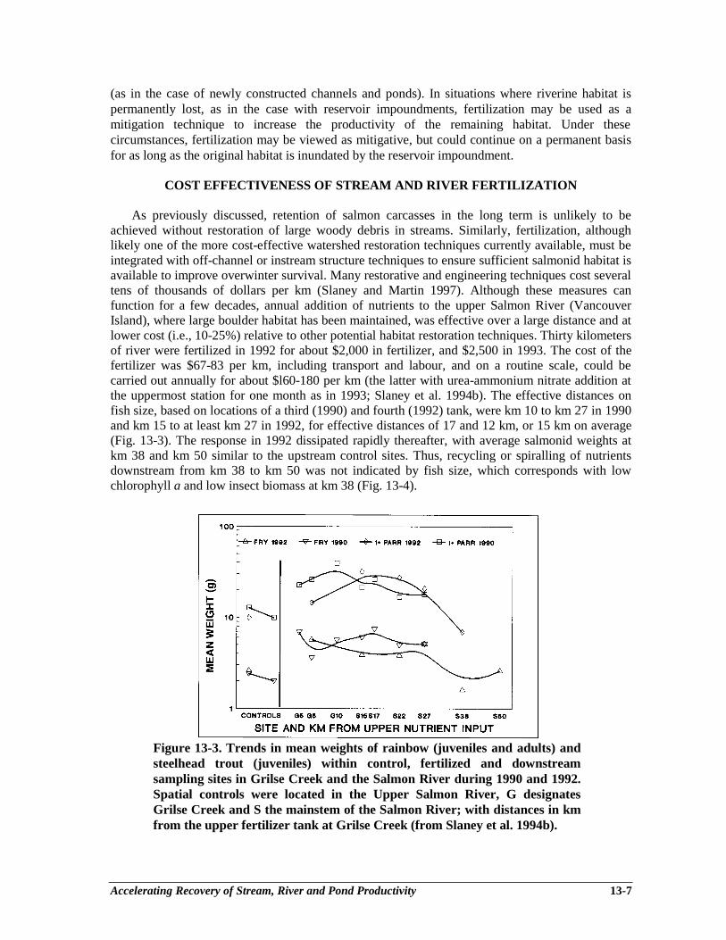
Accelerating Recovery of Stream, River and Pond Productivity 13-7
(as in the case of newly constructed channels and ponds). In situations where riverine habitat ispermanently lost, as in the case with reservoir impoundments, fertilization may be used as amitigation technique to increase the productivity of the remaining habitat. Under thesecircumstances, fertilization may be viewed as mitigative, but could continue on a permanent basisfor as long as the original habitat is inundated by the reservoir impoundment.
COST EFFECTIVENESS OF STREAM AND RIVER FERTILIZATION
As previously discussed, retention of salmon carcasses in the long term is unlikely to beachieved without restoration of large woody debris in streams. Similarly, fertilization, althoughlikely one of the more cost-effective watershed restoration techniques currently available, must beintegrated with off-channel or instream structure techniques to ensure sufficient salmonid habitat isavailable to improve overwinter survival. Many restorative and engineering techniques cost severaltens of thousands of dollars per km (Slaney and Martin 1997). Although these measures canfunction for a few decades, annual addition of nutrients to the upper Salmon River (VancouverIsland), where large boulder habitat has been maintained, was effective over a large distance and atlower cost (i.e., 10-25%) relative to other potential habitat restoration techniques. Thirty kilometersof river were fertilized in 1992 for about $2,000 in fertilizer, and $2,500 in 1993. The cost of thefertilizer was $67-83 per km, including transport and labour, and on a routine scale, could becarried out annually for about $l60-180 per km (the latter with urea-ammonium nitrate addition atthe uppermost station for one month as in 1993; Slaney et al. 1994b). The effective distances onfish size, based on locations of a third (1990) and fourth (1992) tank, were km 10 to km 27 in 1990and km 15 to at least km 27 in 1992, for effective distances of 17 and 12 km, or 15 km on average(Fig. 13-3). The response in 1992 dissipated rapidly thereafter, with average salmonid weights atkm 38 and km 50 similar to the upstream control sites. Thus, recycling or spiralling of nutrientsdownstream from km 38 to km 50 was not indicated by fish size, which corresponds with lowchlorophyll a and low insect biomass at km 38 (Fig. 13-4).
Figure 13-3. Trends in mean weights of rainbow (juveniles and adults) andsteelhead trout (juveniles) within control, fertilized and downstreamsampling sites in Grilse Creek and the Salmon River during 1990 and 1992.Spatial controls were located in the Upper Salmon River, G designatesGrilse Creek and S the mainstem of the Salmon River; with distances in kmfrom the upper fertilizer tank at Grilse Creek (from Slaney et al. 1994b).

Accelerating Recovery of Stream, River and Pond Productivity 13-8
Figure 13-4. Mean peak chlorophyll a and mean benthic insect biomass ingravel colonization baskets placed in two control sections (Upper GrilseCreek and Upper Salmon River) and eight fertilized sections of Grilse Creek(4 sites) and within the Salmon River (4 sites) in 1993. (Vertical bars are 1standard error; n = 6 per site) (from Slaney et al. 1994b).
Larger streams with greater mean summer flows require proportionately more fertilizer perlinear distance to achieve the desired target nutrient loading. For example, on-site fertilizer costsfor Big Silver Creek (mean summer flow of 23.7 m3⋅s-1; Harrison Lake) cost $4,500 in 1995($3,250 for ammonium polyphosphate and $1,250 for delivery; Toth et al. 1996) for an effectivedistance of 13 km and base fertilizer cost of $346 per km. Fertilization of the remote MesilinkaRiver (Williston Reservoir), with a mean summer flow of up to 100 m3⋅s-1 cost about $20,000 peryear ($9,000 for ammonium polyphosphate, $6,000 for urea-ammonium nitrate and $5,000 fordelivery). The effective treatment distance was approximately 35 km, hence base fertilizer costswere approximately $571 per km.
Unfortunately, there are relatively few case studies where fish responses to stream fertilizationhave been adequately documented. Fertilization of 30 km of the Keogh River resulted in anaverage 62% increase in steelhead smolts, and about a 50% increase in adult steelhead or anadditional 15 adults per km (Slaney and Ward 1993) plus about a 21% increase in coho smoltsfrom the mainstem, although most coho reared mainly in untreated tributaries and lakes in theKeogh watershed. Thus, the cost of a wild steelhead is predicted to be $11-12 per adult for a streamwith a flow of 3-4 m3⋅s-1 similar to the Salmon or Keogh Rivers, or $18-20 per adult at a higherflow of 10 m3⋅s-1. In comparison, the cost of producing a hatchery steelhead smolt is $1.50 to$2.00, and with an average survival of 4%, the cost of a hatchery steelhead ranges from $38 to $50per adult. However, with the 50% lower survivals now being observed, the costs would double.Confirmation of the cost effectiveness of fertilization requires a longer-term commitment than thebrief 3 to 4-year treatment at the Keogh River, but provided suitable habitat is present, nutrientaddition in infertile streams is likely capable of producing adult wild steelhead at less than half thecost of hatchery fish, without the potential negative effects of the hatchery environment. Inaddition, fertilization has a number of benefits to non-target animals (e.g., eagles and a variety ofcarnivores/scavengers) as salmonid escapements increase. These benefits do not factor into thecost-effectiveness calculations but they are important for ecosystem restoration. For example,Cederholm et al. (1989) found that at least 22 different species of mammals and birds depended on
Accelerating Recovery of Stream, River and Pond Productivity 13-9
salmon carcasses as a food source in Olympic Peninsula streams. This observation underscores theimportance of this high quality food source during winter months when alternative food sourcesmay be scarce. Wulson and Halupka (1995) emphasize that anadromous salmon function as a“keystone species” for wildlife in the Pacific Northwest and form an ecologically important linkbetween aquatic and terrestrial ecosystems. More recent case studies should provide moredefinitive evaluations of fertilization benefits.
STREAM AND POND FERTILIZATION STRATEGIES
The fundamental premise behind stream and river fertilization is to provide an interim supplyof nutrients until the ecosystem recovers to its historical state. A successful stream or riverfertilization project is one in which external nutrient additions can eventually be reduced ordiscontinued as natural nutrient inputs from riparian vegetation and anadromous salmonidsgradually recover. It is important that an assessment of nutrients and biomass of the various trophiclevels of the system in question be conducted early in the Level 1 phase. Some stream systems arenot nutrient limited and nutrients should not be applied where they are not ecologically warranted.The appropriate provincial agency (i.e., Ministry of Environment, Lands and Parks) must benotified prior to adding nutrients to streams (refer to Chapter 1 for regulatory approvals). Inaddition, special attention should be directed towards not exceeding Ministry of Environmentstandards for algal biomass, as 50 mg⋅m-2chlorophyll a is the maximum concentration permittedunder aesthetic considerations and 100 mg⋅m-2 chlorophyll a is the maximum for aquatic life instreams (Nordin 1985).
Assessment of Nutrients and Periphyton Biomass Status
The first step in stream and river fertilization is to determine the nutrient status of the system inquestion. There are at least four nutrient assessment techniques in order of descending complexity:(1) nutrient bioassays to determine nutrient limitation (i.e., floating or streamside channels inwhich nutrients are applied at known rates); (2) natural or artificial substrates to determineperiphyton and invertebrate biomass relative to a known nutrient-limited standard; (3) “low-level”water chemistry analysis for soluble reactive phosphorus (SRP) and dissolved inorganic nitrogen(i.e., DIN: NO3-N + NO2-N + NH3-N) during the summer growing season; and (4) the “boot test”in which the general “slippery feel” of natural rocks is qualitatively assessed with a non-skidproofrubber boot during spring to summer. This latter technique is very basic. However, whenconducted by an experienced stream ecologist it can be surprisingly informative. Techniques 2 and3 will form the basis of most nutrient assessments for WRP purposes owing to their relatively low-cost and quantitative nature, while technique 4 will likely be used routinely by experiencedindividuals during preliminary reconnaissance surveys.
Stream Fertilization With Slow Release Fertilizer
Slow release inorganic fertilizer will likely be the preferred nutrient delivery strategy for moststreams and smaller rivers (< 10 m3⋅s-1 mean summer flows) due to the simplicity of once annualapplications, no maintenance requirements and low profile vandal-proof design. The key variablesare (1) concentration of applied nutrients; (2) nutrient formulation; (3) seasonal timing of nutrientaddition; (4) frequency of nutrient addition; (5) location of application sites; and (6) N:P ratio ofthe fertilizer blend. However, due to the nature of slow release fertilizer, variables (2), (4) and (6)are fixed for any particular blend.
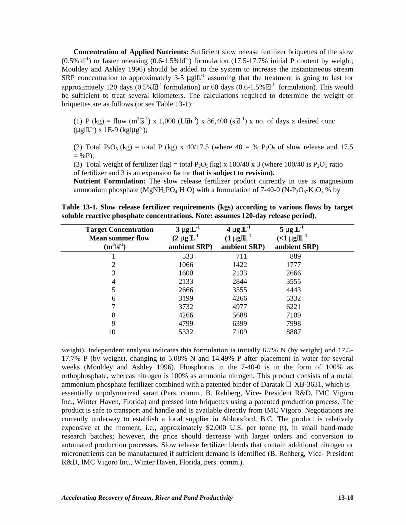
Accelerating Recovery of Stream, River and Pond Productivity 13-10
Concentration of Applied Nutrients: Sufficient slow release fertilizer briquettes of the slow(0.5%⋅d-1) or faster releasing (0.6-1.5%⋅d-1) formulation (17.5-17.7% initial P content by weight;Mouldey and Ashley 1996) should be added to the system to increase the instantaneous streamSRP concentration to approximately 3-5 µg⋅L-1 assuming that the treatment is going to last forapproximately 120 days (0.5%⋅d-1 formulation) or 60 days (0.6-1.5%⋅d-1 formulation). This wouldbe sufficient to treat several kilometers. The calculations required to determine the weight ofbriquettes are as follows (or see Table 13-1):
(1) P (kg) = flow (m3⋅s-1) x 1,000 (L⋅m-3) x 86,400 (s⋅d-1) x no. of days x desired conc.(µg⋅L-1) x 1E-9 (kg⋅µg-1);
(2) Total P2O5 (kg) = total P (kg) x 40/17.5 (where 40 = % P2O5 of slow release and 17.5= %P);(3) Total weight of fertilizer (kg) = total P2O5 (kg) x 100/40 x 3 (where 100/40 is P2O5 ratioof fertilizer and 3 is an expansion factor that is subject to revision).Nutrient Formulation: The slow release fertilizer product currently in use is magnesiumammonium phosphate (MgNH4PO4⋅H2O) with a formulation of 7-40-0 (N-P2O5-K2O; % by
Table 13-1. Slow release fertilizer requirements (kgs) according to various flows by targetsoluble reactive phosphate concentrations. Note: assumes 120-day release period).
Target Concentration 3 µg⋅L-1 4 µg⋅L-1 5 µg⋅L-1
Mean summer flow (2 µg⋅L-1 (1 µg⋅L-1 (<1 µg⋅L-1
(m3⋅s-1) ambient SRP) ambient SRP) ambient SRP)1 533 711 8892 1066 1422 17773 1600 2133 26664 2133 2844 35555 2666 3555 44436 3199 4266 53327 3732 4977 62218 4266 5688 71099 4799 6399 7998
10 5332 7109 8887
weight). Independent analysis indicates this formulation is initially 6.7% N (by weight) and 17.5-17.7% P (by weight), changing to 5.08% N and 14.49% P after placement in water for severalweeks (Mouldey and Ashley 1996). Phosphorus in the 7-40-0 is in the form of 100% asorthophosphate, whereas nitrogen is 100% as ammonia nitrogen. This product consists of a metalammonium phosphate fertilizer combined with a patented binder of Daratak XB-3631, which isessentially unpolymerized saran (Pers. comm., B. Rehberg, Vice- President R&D, IMC VigoroInc., Winter Haven, Florida) and pressed into briquettes using a patented production process. Theproduct is safe to transport and handle and is available directly from IMC Vigoro. Negotiations arecurrently underway to establish a local supplier in Abbotsford, B.C. The product is relativelyexpensive at the moment, i.e., approximately $2,000 U.S. per tonne (t), in small hand-maderesearch batches; however, the price should decrease with larger orders and conversion toautomated production processes. Slow release fertilizer blends that contain additional nitrogen ormicronutrients can be manufactured if sufficient demand is identified (B. Rehberg, Vice- PresidentR&D, IMC Vigoro Inc., Winter Haven, Florida, pers. comm.).

Accelerating Recovery of Stream, River and Pond Productivity 13-11
Seasonal Timing and Frequency of Nutrient Addition: Slow release briquettes are typicallyapplied during the mid-spring (May) to early summer growing season, following the descendinglimb of the hydrograph for the targeted river or stream (Mouldey and Ashley 1996). The goal is toapply the nutrients early enough in the year to increase periphyton (Fig. 13-5) and the growth andsurvival of early instars of aquatic insects for salmonids, but not so early that the product is flusheddownstream or buried by bedload during freshet events. Briquettes are applied once per yearassuming that the treatment is going to last for approximately 120 days (0.5%⋅d-1 formulation) or60 days (0.6-l.5%⋅d-1 formulation) (Fig. 13-6).
Location of Application Sites: The exact number and spacing of application sites has notbeen completely resolved as additional research on nutrient spiralling is still required. However,given the preliminary results observed to date, access and the location of riffle areas will likelydetermine the location and number of application sites. The fertilizer is simply spread in a singlelayer in riffle zones that are far enough upstream of large pools to minimize the probability offreshet events burying the briquettes in pools (Fig. 13-7). The briquettes are currently applied byhand; however, research is underway to develop a suitable spreader bucket for helicopterapplication. The current effective distance is approximately 3-5 km based on preliminary resultsfrom the Salmon River, B.C., but may be less in smaller streams (Mouldey and Ashley 1996). Thefertilizer can be applied at a single site at the upper end of a riffle section, or smaller amounts canbe distributed among several riffle sites. A single application site has been used in most treatments.However, in the Salmon River, two sites 4-6 km apart have recently been used and additional siteswill be added as slow release briquettes replace the remaining liquid fertilizer drip stations.
Figure 13-5. Periphyton accumulation on rocks above and below slowrelease fertilizer treatment site on Clear Creek, B.C.
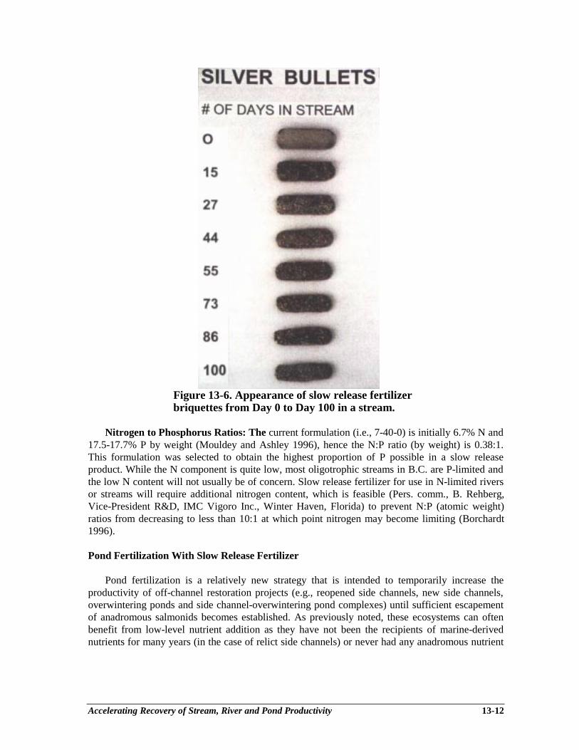
Accelerating Recovery of Stream, River and Pond Productivity 13-12
Figure 13-6. Appearance of slow release fertilizerbriquettes from Day 0 to Day 100 in a stream.
Nitrogen to Phosphorus Ratios: The current formulation (i.e., 7-40-0) is initially 6.7% N and17.5-17.7% P by weight (Mouldey and Ashley 1996), hence the N:P ratio (by weight) is 0.38:1.This formulation was selected to obtain the highest proportion of P possible in a slow releaseproduct. While the N component is quite low, most oligotrophic streams in B.C. are P-limited andthe low N content will not usually be of concern. Slow release fertilizer for use in N-limited riversor streams will require additional nitrogen content, which is feasible (Pers. comm., B. Rehberg,Vice-President R&D, IMC Vigoro Inc., Winter Haven, Florida) to prevent N:P (atomic weight)ratios from decreasing to less than 10:1 at which point nitrogen may become limiting (Borchardt1996).
Pond Fertilization With Slow Release Fertilizer
Pond fertilization is a relatively new strategy that is intended to temporarily increase theproductivity of off-channel restoration projects (e.g., reopened side channels, new side channels,overwintering ponds and side channel-overwintering pond complexes) until sufficient escapementof anadromous salmonids becomes established. As previously noted, these ecosystems can oftenbenefit from low-level nutrient addition as they have not been the recipients of marine-derivednutrients for many years (in the case of relict side channels) or never had any anadromous nutrient
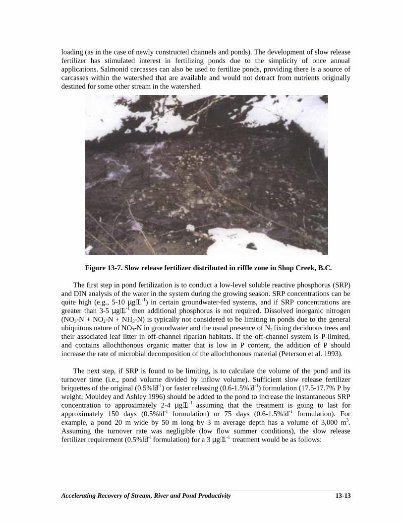
Accelerating Recovery of Stream, River and Pond Productivity 13-13
loading (as in the case of newly constructed channels and ponds). The development of slow releasefertilizer has stimulated interest in fertilizing ponds due to the simplicity of once annualapplications. Salmonid carcasses can also be used to fertilize ponds, providing there is a source ofcarcasses within the watershed that are available and would not detract from nutrients originallydestined for some other stream in the watershed.
Figure 13-7. Slow release fertilizer distributed in riffle zone in Shop Creek, B.C.
The first step in pond fertilization is to conduct a low-level soluble reactive phosphorus (SRP)and DIN analysis of the water in the system during the growing season. SRP concentrations can bequite high (e.g., 5-10 µg⋅L-1) in certain groundwater-fed systems, and if SRP concentrations aregreater than 3-5 µg⋅L-1 then additional phosphorus is not required. Dissolved inorganic nitrogen(NO3-N + NO2-N + NH3-N) is typically not considered to be limiting in ponds due to the generalubiquitous nature of NO3-N in groundwater and the usual presence of N2 fixing deciduous trees andtheir associated leaf litter in off-channel riparian habitats. If the off-channel system is P-limited,and contains allochthonous organic matter that is low in P content, the addition of P shouldincrease the rate of microbial decomposition of the allochthonous material (Peterson et al. 1993).
The next step, if SRP is found to be limiting, is to calculate the volume of the pond and itsturnover time (i.e., pond volume divided by inflow volume). Sufficient slow release fertilizerbriquettes of the original (0.5%⋅d-1) or faster releasing (0.6-1.5%⋅d-1) formulation (17.5-17.7% P byweight; Mouldey and Ashley 1996) should be added to the pond to increase the instantaneous SRPconcentration to approximately 2-4 µg⋅L-1 assuming that the treatment is going to last forapproximately 150 days (0.5%⋅d-1 formulation) or 75 days (0.6-1.5%⋅d-1 formulation). Forexample, a pond 20 m wide by 50 m long by 3 m average depth has a volume of 3,000 m3.Assuming the turnover rate was negligible (low flow summer conditions), the slow releasefertilizer requirement (0.5%⋅d-1 formulation) for a 3 µg⋅L-1 treatment would be as follows:
Accelerating Recovery of Stream, River and Pond Productivity 13-14
(1) Volume (3,000 m3) x 1,000 (L⋅m-3) x desired conc. (3 µg⋅L-1) = 0.009 kg P;
(2) P (0.009 kg) x 40/17.5 (where 40 = %P2O5 of slow release and 17.5 = %P) =0.02 kg totalP2O5;
(3) Total P2O5 (0.02 kg) x 100/40 x 5 (where 100/40 is P2O5 ratio of fertilizer and 5 is anexpansion factor that is subject to revision) = 0.25 kg total weight of slow release fertilizer.
These calculations demonstrate that very small amounts of nutrients are required. Ponds withhigher flushing rates will obviously require more fertilizer per unit volume than slow flushing rateponds. Loading rates may be reduced by 75% in new channels to prevent excessive accumulationof periphyton while invertebrates are colonizing the system.
The slow release fertilizer briquettes should be spread in the inlet stream and around theshoreline zone within 0.25-0.5 m of the water level, but not placed in soft sediments where theywill get buried. If a series of interconnected ponds is being used, then each pond should beindividually treated and the briquettes should be placed in the interconnecting stream riffle areas ifpossible and around the shoreline. The seasonality of the application will depend on the salmonidspecies present. However, most applications will be likely made in mid-spring in order to stimulateprimary and secondary production as long as possible. Care should be taken to not over fertilize, asthis results in inefficient use of the nutrients, and may result in dangerously low dissolved oxygenconcentrations from decaying algae if the ponds freeze over for an extended period of time.
Salmon Carcass Alternatives to Inorganic Nutrient Addition
Salmonid carcasses (e.g., salmon, kokanee) can also be used to fertilize streams and ponds,providing there is a source of carcasses (typically hatchery or spawning channel) within thewatershed that are available and would not detract from nutrients originally destined for some othersystem in the watershed. Due to valid concerns of disease transfer, carcasses cannot be usedoutside of their local drainage basin. However, it should be realized that salmon carcasses areapprox. 0.325% P and 3.0% N (wet weight) (Stansby and Hall 1965), and that considerably morecarcass biomass (54-fold) is required than equivalent P and N loads from inorganic nutrients. Forexample, 500 kg of slow release fertilizer was applied to Shovelnose Creek in 1995 to obtain a Pload of 87.4 kg. The equivalent P load of salmon carcasses would have been approximately 27tonnes. In situations where stream access is by air only, inorganic nutrients are the only cost-effective nutrient replacement option. For example, 3 tonnes of slow release fertilizer was recentlyapplied to the Cruickshank River and tributaries (Vancouver Island) in 3 hours by helicopter toobtain a P load of 524 kg P. The equivalent P load in salmon carcasses would have beenapproximately 162 tonnes, and with a lift capacity of 500 kgs (e.g., A-Star), the treatment wouldhave taken 324 trips and several days and would not have been economically or logisticallyfeasible.
The same procedure as above is utilized to calculate amounts of salmon carcasses to beutilized. The P content of the salmon should be considered to be approximately 0.325% (wetweight) (Stansby and Hall 1965) as compared to 17.5-17.7% P for the slow release fertilizer, henceconsiderably more weight (i.e., 54-fold) of salmon carcasses will be required and carefulconsideration of the logistics of such applications are required. Salmon should decompose atapproximately 1.5%⋅d-1 at a mean water temperature of 4.2°C, and 4.9%⋅d-1 at a mean watertemperature of 8.6°C (Minshall et al. 1991).

Accelerating Recovery of Stream, River and Pond Productivity 13-15
Stream Fertilization With Liquid Agricultural Fertilizers
Liquid inorganic fertilizer will likely be the preferred nutrient delivery strategy for larger rivers(> 10 m3⋅s-1 May to August flows) due to the cost advantage of liquid fertilizer ($230-370 per t)over slow release fertilizer (small research batches are currently $2,000 U.S. per t). A number ofinterrelated factors must be considered when designing an ecologically-based liquid fertilizertreatment. The six key variables are (1) concentration of applied nutrients; (2) nutrient formulation(i.e., SRP or poly P; NO3-N, NH3-N or urea); (3) seasonal timing of nutrient addition; (4)frequency of nutrient addition (i.e., continuous or intermittent); (5) location of application sites;and (6) N:P ratio of the fertilizer blend. All of these factors may be able to exert a significantinfluence on the community composition and biomass of the resultant periphyton community.
Concentration of Applied Nutrients and Limiting Concentrations: Soluble reactivephosphorus (SRP) concentrations will likely be quite low in coastal stream and river systems withgranitic watersheds and high rainfall; however, if SRP concentrations are greater than 3-5 µg⋅L-1
during the growing season then additional phosphorus is likely not required. SRP concentrations of0.3-0.6 µg⋅L-1 have been shown to saturate specific growth rates of unicellular periphytic diatoms(Bothwell 1988). However, relative peak biomass continues to increase with SRP additions from 1to 25-50 µg⋅L-1 as the relationship shifts from cellular to community controlled growth rates(Bothwell 1989). Excessive periphyton biomass is reported to occur when SRP concentrationsexceed 10 µg⋅L-1, therefore, target concentrations of SRP for stream and river fertilization(background plus nutrient additions) are in the 3-5 µg⋅L-1 (or parts per billion) range, orapproximately 1/3 to 1/2 of potential nuisance concentrations but high enough to be effective overseveral kilometers. Uptake of SRP is rapid and concentrations are usually < 1-2 µg⋅L-1 within a fewkilometers. Dissolved inorganic nitrogen (NO3-N + NO2-N + NH3-N) is typically not limiting innon-lake headed systems, however, low-level analysis is still required to determine if seasonal DINlimitation situations exist. DIN concentrations below 20 µg⋅L-1 may become limiting (Bothwell1988), hence minimum target DIN concentrations (background plus nutrient additions) are 20µg⋅L-1. Most of the background DIN will likely be in the form of NO3-N, as NO2-N is usuallyfound under anoxic conditions, and NH3-N is not as mobile as NO3-N in groundwater andgenerally undetectable in coastal riverine ecosystems.
Nutrient Formulation: The liquid fertilizers used most frequently in B.C are ammoniumpolyphosphate (10-34-0: N-P2O5-K2O; % by weight) for phosphorus and urea-ammonium nitrate(28-0-0) as the principle nitrogen source. Phosphorus in 10-34-0 is in the form of 34% asphosphate, and 68% as polyphosphate. Nitrogen in the 28-0-0 (N-P2O5-K2O; % by weight) is in theform of 50% as urea nitrogen, 25% as ammonia nitrogen and 25% as nitrate nitrogen. Due to the10% (by weight) nitrogen content in the 10-34-0, 3.37 µg⋅L-1 of N is obtained for each 5 µg⋅L-1 ofP added using 10-34-0. These fertilizers are standard agricultural grade fertilizer with extremelyminute concentrations of metals when applied to water. They are relatively safe to handle, readilyavailable in B.C. and inexpensive (i.e., approx. $231 per tonne for 28-0-0 and $366 per tonne for10-34-0 in $1996). A more concentrated form of urea-ammonium nitrate is available (i.e., 32-0-0);however, problems have been encountered with this blend due to “salting out” in storage tanks andthis blend is not recommended for use in temperate climates.
Seasonal Timing and Frequency of Nutrient Addition: Nutrients are typically appliedduring mid-spring to summer growing season (i.e., 3-4 months), following the descending limb ofthe hydrograph for the river or stream in question. For example, nutrients are applied on the
Accelerating Recovery of Stream, River and Pond Productivity 13-16
Salmon River from mid-May until early August (Slaney et al. 1994b) and from late June to earlySeptember on the Adam River and Big Silver River depending on the size of the snowpack andrunoff regime (Toth et al 1996). In the Central Interior, nutrient application is typically limited to arelatively short 60-day summer period (i.e., July and August) due to the late spring thaw andextended summer runoff period (Paul et al. 1996). Monitoring at the Salmon River demonstratedthat a periphyton response continues for a least one month after cessation because nutrients arestored and cycled within the substrate. Until further research has been conducted, nutrients shouldeither be applied continuously (manual or flow proportional systems) or intermittently at aminimum of 3 times per hour (i.e., every 20 minutes) (pre-programmed systems). Less frequentapplications result in localized “spiking” of concentrations to relatively high concentrations that areundesirable (e.g. undesirable species of algae were favoured by 30-minute spiking of nutrients atthe Upper Nechako River; Slaney et al. 1994a).
Location of Application Sites: The exact number and spacing of application sites has not beencompletely resolved as additional research on nutrient spiralling is still required. However.logistical reasons will play a key role in the location and number of application sites due to accessrequirements for fertilizer delivery and concerns about potential vandalism. On the Salmon River,four application sites were used, 4-6 km apart. A single tank site was located on the Adam River(10 km from the Eve River confluence) (Toth et al. 1997) and Big Silver Creek (13 km fromHarrison Lake) (Toth et al. 1996). At the Mesilinka River, two tanks (one for 10-34-0 and one for28-0-0) were installed at two drip stations, one about 66 km from Williston Reservoir and a second46 km from the reservoir (Paul et al. 1996). Based on a target concentration of 5 µg⋅L-1, theeffective distance in smaller rivers is a maximum of 15 km, based on that detected at the SalmonRiver in 1992 and Big Silver in 1994 and 1995. However, elevated periphyton accumulations wereobserved 35 km downstream of the lower Mesilinka River fertilizer site and 50 km downstream ofthe Nechako River fertilizer treatment site; hence nutrients can be transported significant distancesin larger rivers (Slaney et al. 1994a). Thus, lower target concentrations (e.g., 3 µg⋅L-1) would beeffective over proportionately less distance.
Nitrogen to Phosphorus Ratios: The “Redfield ratio”, which is the cellular atomic ratio of C,N and P in marine phytoplankton, provides a benchmark for assessing nutrient limitation, mostcommonly between N and P (Borchardt 1996). Ambient N:P atomic ratios greater than 20:1 areconsidered P limiting, less than 10:1 are N limiting, and between 10 and 20:1 the distinction isequivocal (Borchardt 1996). Atomic weight ratios can be converted to weight:weight ratios bymultiplying by the atomic weight of the element in question. For example, a 10:1 N:P atomicweight ratio is equivalent to a 4.5:1 N:P weight:weight ratio (e.g., 10 x 14/1 x 31 = 4.5; where 14= atomic weight of nitrogen and 31 = atomic weight of phosphorus). Minimum target N:P ratios(weight:weight) should range from 5-10:1 (i.e., 20 µg⋅L-1 NO3-N + NO2-N + NH3-N/2-4 µg⋅L-1
SRP). Actual N:P ratios will usually be greater than 5-10:1 (weight:weight) as background DIN inmany coastal and interior streams and rivers in B.C. are typically in the 50-100 µg⋅L-1 range(Mouldey and Ashley 1996; Toth et al. 1996; Paul et al. 1996).
Application: Recent advancements in liquid fertilizer application technology have allowed thecapability to maintain constant loading despite fluctuations in river discharge, thus significantlyincreasing the accuracy, ease and logistical requirements for liquid fertilizer applications (Larkin etal. 1997). Two different engineering designs have been developed for applying liquid fertilizer torivers and streams: (1) a “flow proportional” system that uses a water pressure transducer tomonitor the stage height of the river and an intelligent controller that interfaces with an existingstage-discharge curve to accurately apply the required amount of liquid fertilizer into the river via aprogrammable DC powered peristaltic pump, and (2) a low energy gravity fed system that

Accelerating Recovery of Stream, River and Pond Productivity 13-17
dispenses a pre-programmed amount of fertilizer into the river based on an exponential decaycurve derived from prior analysis of the descending limb of the hydrograph. The pre-programmedsystem has been designed to apply nutrients at 20-minute intervals by opening a valve for asufficient time to allow a pre-calculated amount of fertilizer to drain out of the system and achievean instantaneous low level concentration (e.g., 5 µg⋅L-1 of SRP). Changes in loading rates areobtained by a daily reduction of the period of valve opening according to a pre-determinedexponential decay coefficient for the river.
The flow proportional system is reliable and accurate, but requires routine replacement orrecharging of several deep cycle batteries and is relatively expensive (approx. $20,000). The pre-programmed system is considerably cheaper (approx. $3,000) as it uses gravity rather than aperistaltic pump, and the energy requirements are sufficiently low that a 30 ampere hour batterywill last for two to three months. The pre-programmed design is most applicable to rivers withsnowmelt-dominated watersheds as the descending limb of their hydrographs are quite predictable.Analysis of hydrographs indicated the errors in the flow volume passing monitoring stations ascompared with flow volumes taken from fitted exponential curves were in the range of 12 to 14%for rivers with a significant percentage of their watershed located at high elevations. For lowerelevation rivers, the error in approximating the decay curve were unacceptably large (23-32%) asthe flows in these systems were rain-driven as much as snowmelt-driven during the summermonths, hence the flow proportional systems are better suited to lower elevation watersheds(Larkin et al. 1997).
Logistically, the use of liquid fertilizer is quite simple requiring only a storage tank(s) ofsufficient capacity, spill containment berm and liner, and plumbing associated with the fertilizerapplication system. Polyethylene tanks designed for fertilizer storage are available in a variety ofsizes, and have sufficient strength and chemical resistance to safely contain the fertilizer. Separatetanks are required for the 10-34-0 and 28-0-0 as mixing the two solutions would likely triggerprecipitation of solids in the tanks and distribution lines. Care should be taken during initial sitereconnaissance to select a location that is near the river and an access road so that the tanks can befilled without too much difficulty and the distribution lines are not excessively long. The locationshould also be secure from potential river channel movement. Vandalism is a potential problem,and efforts should be taken to camouflage the tanks and fertilizer injection hardware.
CASE STUDY EXAMPLES OF STREAM FERTILIZATION INBRITISH COLUMBIA
Fertilization experiments are currently being conducted on a series of oligotrophic coastal andinterior rivers in B.C. to determine the effect of inorganic nutrient addition on water chemistry,periphyton and invertebrate community composition and biomass, as well as fish growth andabundance. These systems include the Salmon River and Adam River (northern Vancouver Island),Big Silver Creek (near Harrison Lake) and the Mesilinka River (280 km north of Prince George).The Nation River (near Mackenzie) is being studied as the external control for the Mesilinka River.The Keogh River (northern Vancouver Island), which was the site of the pioneering whole-riverfertilization experiments in B.C. in 1984-86, will be added to this set in 1997 as a streamrestoration evaluation site. These rivers represent a broad spectrum of stream types in differinggeographical areas of B.C. and will allow for the assessment of nutrient additions on several typesof fish populations under different climatic conditions.

Accelerating Recovery of Stream, River and Pond Productivity 13-18
Keogh River Case Study
Pioneering research studies of nutrients and their role in salmonid food chains were examinedat the Keogh River in the 1980’s. The Keogh is a humic-stained salmon and steelhead river locatednear Port Hardy on northeastern Vancouver Island; it is 33.5 km long (to mid-lake) within a 130km2 watershed, has a mean annual discharge of 5.3 m3⋅s-1 5 with a minimum in mid-summer of 0.1m3⋅s-1 and a maximum in winter of 254 m3⋅s-1 (see Johnston et al. 1990 for details). Primaryobjectives of the Keogh River fertilization experiment were to determine the role of nutrients inbenthic productivity and the effect of nutrient additions on the growth and abundance ofanadromous salmonids in an oligotrophic stream.
Inorganic fertilization resulted in striking increases in the weights of steelhead and cohosalmon fry during the main years of treatment (Johnston et al. 1990). In the 1981 pilot experiment,inorganic fertilization increased salmon and trout fry geometric mean weights by 1.6-1.7 and 1.9-2.1 fold greater, respectively, than the control. During the whole-river treatments from 1984 to1986, larger size-at-age steelhead parr were detected. In 1984, mean weight-at-age of parr did notdiffer between one of three treated reaches and the control, but in the two other reaches in 1984 andwithin all three treated reaches in 1985 and 1986, age 1+ parr were 30% and 130% greater ingeometric mean weight than parr in the upstream control section (Fig. 13-8). The older age 2+ parrwere 41-63% larger in the treated reaches than in the control in 1985 and 1986. In 1981, meansalmonid biomass in the treated reach increased 1.8-fold from 35 kg⋅ha-1 to 65 kg⋅ha-1 as comparedto the control reach.
Figure 13-8. Mean weights of age 1+ steelhead parr in theupper river control and three treated reaches of the KeoghRiver during whole-river fertilization in 1984, 1985 and 1986(Slaney and Ward 1993).
There was a suggested 21% increase in coho smolts resulting from fertilization. However, thepresence of 16-19 tributaries and 6 small lakes, all untreated, confounded the treatment effects onmainstem coho production because most (~60%) coho are not produced in the mainstem. Meancoho smolt length (i.e., 104 mm) did not change as a result of the treatment. Steelhead smolts, asmainstem rearers, increased production by brood years by 62% over pre-treatment years.
Accelerating Recovery of Stream, River and Pond Productivity 13-19
Fertilization also shifted the age class structure of the smolts as age 3 smolts dominated the annualpre-fertilization smolt yields, whereas age 2 smolts dominated the annual smolt production duringfertilization, and age 1 smolts appeared for the first time in 1987 as a significant portion (i.e., 12%)of the annual yield (Fig. 13-9) (Slaney and Ward 1993). The smolt response peaked at 2.5 timesthe average smolt yield during the year the project was terminated (1987; Fig. 13-10). Fertilizationhad minimal effect on average smolt size, as mean smolt length in 1985, 1986 and 1987 was 175,160 and 170 mm, respectively, or in two of three years, near the 1977-83 average size of 173 mm,and all three within the historical range of variation. Adult steelhead originating from smoltcohorts of fertilized years returned to the river from 1986 to 1990. Their numbers, and catch in thesport fishery, corresponded with the increased numbers and size-at-age of smolts, yet catch of wildsteelhead at a nearby river showed little change (Fig. 13-11).
Figure 13-9. Age composition and numbers of steelhead smolts before(1977-1983) and during (1987; full effect) whole-river fertilization at theKeogh River (Slaney and Ward 1993).
Figure 13-10. Number of steelhead smolts by brood year migrating fromthe Keogh River from 1975 to 1986. Broods affected completely andpartially by whole-river fertilization are indicated above the x-axis(Slaney and Ward 1993).
Accelerating Recovery of Stream, River and Pond Productivity 13-20
Figure 13-11. Estimated numbers of adult wild steelhead returning to theKeogh River and estimated catch of wild steelhead in the Keogh andCluxewe River (unfertilized, by smolt years of 1977 to 1990). Smolt yearspartially and completely affected by whole-river fertilization are indicatedon the x-axis (Slaney and Ward 1993).
Salmon River Case Study
The headwaters of the Salmon River are located about 30 km west of Campbell River, on theeast coast of Vancouver Island; mean annual flow is about 13 m3⋅s-1, declining in spring to summerfrom 12 to 3 m3⋅s-1 whereas in Grilse Creek, a main tributary, average flow from early May to mid-summer declines from 3 to 0.5 m3⋅s-1. Water temperatures increase from 6-9°C in May, to 9-12°Cin June, to 12-16°C in July to August, and are about 1 degree higher on average in Grilse Creekthan the Salmon. Starting in 1989, Grilse Creek and the upper reaches of the Salmon River onnorthern Vancouver Island have been fertilized from mid-spring to mid-summer with inorganicagricultural dry and liquid fertilizer and more recently with slow release fertilizer to mitigate theimpacts of intensive forest harvesting and hydroelectric diversion in the watershed on a renowned,but depressed, stock of steelhead. Peak algal chlorophyll a biomass in spring to summer initiallyincreased 5 to 10-fold in response to nutrient additions at target concentrations of 5 µg⋅L-1
dissolved inorganic phosphorus and up to 20 µg⋅L-1 dissolved inorganic nitrogen, but since 1992increased only 2 to 3-fold (Fig. 13-4). The mean biomass of benthic insects was on average 2 to7-fold (1992) and 3.7-fold (1993) greater in fertilized sections than unfertilized spacial controls,indicating that grazers, dominated by mayfly nymphs and midge larvae, limited periphyton accrualto nominal biomasses (15-40 mg⋅m-2 as chlorophyll a) (Fig. 13-4). Fertilization resulted in 2 to3-fold greater mean weights and standing crops of steelhead and rainbow trout in treated indexsites than unfertilized index sites in warmer years, although the response was moderated (1.5 to 2-fold) in cool, wet years (e.g., 1993). The effective distance of fertilization downstream from a driptank was at least 15 km (Slaney et al. 1994b). Overall, there has been a marked increase in theestimated total migration of parr and smolts counted at a smolt diversion screen at the SalmonRiver, which has been saturated with stocked fry, and more recently some wild fry, for the lastdecade (Table 13-2, from Hansen 1996).
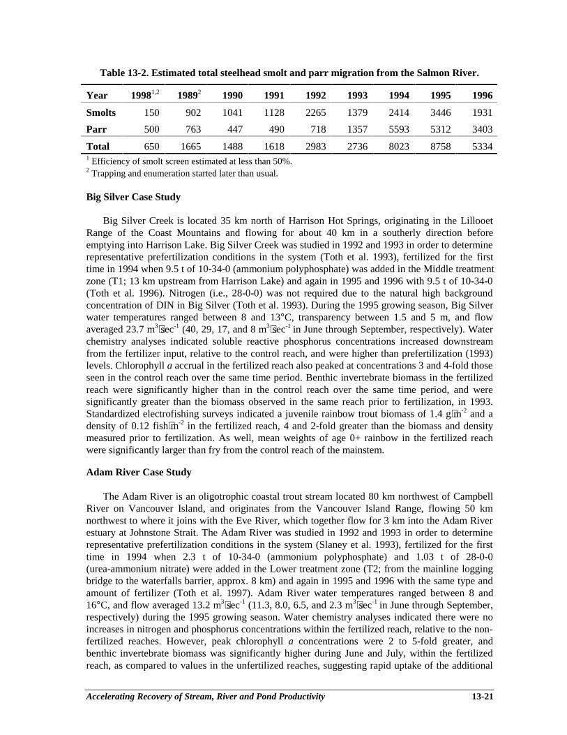
Accelerating Recovery of Stream, River and Pond Productivity 13-21
Table 13-2. Estimated total steelhead smolt and parr migration from the Salmon River.
Year 19981,2 19892 1990 1991 1992 1993 1994 1995 1996
Smolts 150 902 1041 1128 2265 1379 2414 3446 1931
Parr 500 763 447 490 718 1357 5593 5312 3403
Total 650 1665 1488 1618 2983 2736 8023 8758 53341 Efficiency of smolt screen estimated at less than 50%.2 Trapping and enumeration started later than usual.
Big Silver Case Study
Big Silver Creek is located 35 km north of Harrison Hot Springs, originating in the LillooetRange of the Coast Mountains and flowing for about 40 km in a southerly direction beforeemptying into Harrison Lake. Big Silver Creek was studied in 1992 and 1993 in order to determinerepresentative prefertilization conditions in the system (Toth et al. 1993), fertilized for the firsttime in 1994 when 9.5 t of 10-34-0 (ammonium polyphosphate) was added in the Middle treatmentzone (T1; 13 km upstream from Harrison Lake) and again in 1995 and 1996 with 9.5 t of 10-34-0(Toth et al. 1996). Nitrogen (i.e., 28-0-0) was not required due to the natural high backgroundconcentration of DIN in Big Silver (Toth et al. 1993). During the 1995 growing season, Big Silverwater temperatures ranged between 8 and 13°C, transparency between 1.5 and 5 m, and flowaveraged 23.7 m3⋅sec-1 (40, 29, 17, and 8 m3⋅sec-1 in June through September, respectively). Waterchemistry analyses indicated soluble reactive phosphorus concentrations increased downstreamfrom the fertilizer input, relative to the control reach, and were higher than prefertilization (1993)levels. Chlorophyll a accrual in the fertilized reach also peaked at concentrations 3 and 4-fold thoseseen in the control reach over the same time period. Benthic invertebrate biomass in the fertilizedreach were significantly higher than in the control reach over the same time period, and weresignificantly greater than the biomass observed in the same reach prior to fertilization, in 1993.Standardized electrofishing surveys indicated a juvenile rainbow trout biomass of 1.4 g⋅m-2 and adensity of 0.12 fish⋅m-2 in the fertilized reach, 4 and 2-fold greater than the biomass and densitymeasured prior to fertilization. As well, mean weights of age 0+ rainbow in the fertilized reachwere significantly larger than fry from the control reach of the mainstem.
Adam River Case Study
The Adam River is an oligotrophic coastal trout stream located 80 km northwest of CampbellRiver on Vancouver Island, and originates from the Vancouver Island Range, flowing 50 kmnorthwest to where it joins with the Eve River, which together flow for 3 km into the Adam Riverestuary at Johnstone Strait. The Adam River was studied in 1992 and 1993 in order to determinerepresentative prefertilization conditions in the system (Slaney et al. 1993), fertilized for the firsttime in 1994 when 2.3 t of 10-34-0 (ammonium polyphosphate) and 1.03 t of 28-0-0(urea-ammonium nitrate) were added in the Lower treatment zone (T2; from the mainline loggingbridge to the waterfalls barrier, approx. 8 km) and again in 1995 and 1996 with the same type andamount of fertilizer (Toth et al. 1997). Adam River water temperatures ranged between 8 and16°C, and flow averaged 13.2 m3⋅sec-1 (11.3, 8.0, 6.5, and 2.3 m3⋅sec-1 in June through September,respectively) during the 1995 growing season. Water chemistry analyses indicated there were noincreases in nitrogen and phosphorus concentrations within the fertilized reach, relative to the non-fertilized reaches. However, peak chlorophyll a concentrations were 2 to 5-fold greater, andbenthic invertebrate biomass was significantly higher during June and July, within the fertilizedreach, as compared to values in the unfertilized reaches, suggesting rapid uptake of the additional
Accelerating Recovery of Stream, River and Pond Productivity 13-22
nutrients into the food chain. In 1995, fertilizer addition rates were closely matched to river flowusing a new flow proportional injection system which functioned well and ensured target additionrates were achieved. Standardized electrofishing surveys indicated a juvenile salmonid density andbiomass of 0.082 fish⋅m-2 and 0.624 g⋅m-2, respectively, in the fertilized reach during 1995. Bothwere similar to values recorded in the fertilized reach in 1994, and were greater than the 0.011 to0.073 fish⋅m-2 density, and 0.177 to 0.314 g⋅m-2 biomass recorded in the unfertilized reaches during1993-95 sampling.
Mesilinka Case Study
The Mesilinka River is a large northern river (mean summer flow, 112 m⋅sec-1) located 280 kmnorth of Prince George. The headwaters of the Mesilinka originate in the Omineca mountain rangeand flow east for 120 km to B.C.’s largest body of water, Williston Reservoir (1,775 km2), whichempties into the Peace River. It is one of several oligotrophic streams inhabited by migratory andresident salmonids that were affected by construction of the reservoir, thereby flooding thelowermost and most productive stream reaches. Mean spring to summer flows (1982-91) were 74,180, 108, 49 and 35 m3⋅sec-1 during May, June, July, August and September, respectively, andwater temperatures in summer average 10-13°C. Following two years of pre-fertilizationmonitoring (1992 and 1993) in control and treatment reaches (Koning et al. 1995), 14.1 t of10-34-0 and 15 t of 28-0-0 were added in 1994 in the first treatment zone (T1; 66 km upstreamfrom the reservoir) and 14.1 t of 10-34-0 only in the second treatment zone (T2; 46 km upstreamfrom the reservoir) (Paul et al. 1996). The Mesilinka was fertilized in 1995 and 1996 with anadditional 15 t of 28-0-0 being added to the second (i.e., T2) treatment zone due to a fertilizationinduced shift to N limitation in the T2 reach. Target in-river concentrations were 5 µg⋅L-1 dissolvedinorganic phosphorous and 20 µg⋅L-1 dissolved inorganic nitrogen. Preliminary results (1995) from5-8 km index reaches suggest rainbow trout and mountain whitefish numbers have increased 2-foldand 5-fold, respectively. By 1995, weight-at-age of rainbow trout (age 4+ fish only) increased inthe treated reach (T2) compared to the control (34%). The response of the food chain, indicated byperiphyton accrual, was detectible for >15 km below the fertilizer drip stations (Paul et al. 1996).
Summary of Case Studies
The results to date, based on the responses of the Keogh, Salmon, Adam, Big Silver andMesilinka rivers, strongly indicate that low-level addition of limiting nutrients can increase theproductivity of oligotrophic rivers. The periphyton and invertebrate biomass responses are similaracross all systems, and preliminary results (i.e., Adam, Big Silver and Mesilinka) indicate thebiomass of resident juvenile salmonids has increased. The Salmon and Keogh experiments indicateincreased size and weight-at-age of juvenile anadromous trout and salmon, while the Keogh hasshown increased steelhead smolt output with corresponding adult returns in response to inorganicnutrient treatment. Completion of the Adam, Big Silver and Mesilinka experiments in 1997 shouldprovide the additional evidence to evaluate the effect of nutrient treatment on both resident andmigratory populations of salmonids.
RESEARCH NEEDS FOR FUTURE ADVANCES IN FERTILIZATION
A considerable amount of research has been conducted on the effects of low-level nutrientaddition in the Pacific Northwest and other regions; however, several areas require additionalresearch, either independently or in combination with ongoing long-term studies. Aninterdisciplinary approach between fisheries biology, limnology and environmental engineeringshould prove beneficial, and will likely result in significant improvements in our understanding of
Accelerating Recovery of Stream, River and Pond Productivity 13-23
the long-term effects of low-level additions of limiting nutrients and improvements in the cost-effectiveness of this restoration technique.
Effects of Forest Practices on Nutrients: A key research area that requires furtherinvestigation is the impact of various forest harvesting and silviculture practices on the export ofnutrients from the watershed and subsequent effects on stream productivity. Data collected fromthe Carnation Creek experiment indicates clear-cut harvesting caused an initial pulse of nutrientexport which declined after 3-5 years as new vegetation began to sequester the nutrients (Scrivenerand Brown 1993). Periphyton are very effective at sequestering nutrients (particularly solublereactive phosphate) at extremely low concentrations (i.e., < 1 µg⋅L-1 Bothwell 1989), hence subtleshifts in nutrient export could potentially influence algal species composition (Stockner andShortreed 1978). The impact of temporal changes in nutrient export, stream C:N:P ratios and itseffect on stream biota have not been thoroughly researched. In addition, silvicultural practices mayinvolve forest fertilization with urea and phosphorus, which can influence adjacent aquatic nutrientloadings due to watershed runoff, hence there is potential for integration of forest and streamfertilization practices (Perrin et al. 1984).
Trends in Marine Derived Nutrients: A recent review of 42 years of salmonid escapementrecords for Georgia Strait, the west coast of Vancouver Island and the mainland coast of B.C. hasidentified a disturbing trend that indicates past land use practices and commercial salmonharvesting may have reduced the availability of salmonid carcasses to some streams, resulting in adecline in marine-derived nutrients and carbon sources for stream-rearing salmonids, includingcoho and chinook salmon, steelhead and cutthroat trout and char (Larkin and Slaney 1996). Themarine nutrient evidence collected to date, although not definitive, has sufficient merit and hasidentified such a significant risk to wild salmon production, that it should be expanded to acomplete review of all B.C. stocks at medium risk, high risk and special concern. In addition, theanalysis should be conducted over a longer time period as both commercial fishing and habitatdegradation due to forest harvesting practices were well established since the turn of the century(Hilborn and Winton 1993).
Stable Isotope Analysis of Food Web Pathways: Analysis of food webs using natural stableisotope tracers (15N and 13C) has provided convincing evidence of the importance of marinederived nutrients in maintaining the productivity of freshwater environments (Kline et al. 1993).An important research question arising from these studies is the generality of the conclusions. Forexample, Bilby’s observations (Bilby et al. 1996) may only be valid in small, heavily canopiedstreams where autotrophic production is limited by spawner density, low light levels, short daylengths, cold temperatures and frequent streambed scouring. Autotrophic production has beenshown to be a significant energy pathway in experimentally fertilized tundra streams (Peterson etal. 1993) and Vancouver Island rivers (Johnston et al. 1990). Therefore, a synoptic survey of stableisotopes in different salmonid habitats and species complexes is required to determine if theseresults are applicable over a wide range of habitats.
Microbial Ecology and the Hyporheic Zone: One of the least studied aspects of streamecology is the effect nutrients have on the “microbial loop” and meiofaunal community. Meiofaunais defined as organisms in the 50-1,000 µm size range, such as protozoans and nematodes (Bott1996). The relative importance of the microbial loop remains controversial (Bott 1996). However,microbial loops dominate carbon flow and nutrient cycling in oligotrophic lakes (Weisse andStockner 1992) and it is possible that microbial loops exist in oligotrophic stream and river systemsthat introduce additional steps in the flow of energy and nutrients from microbes tomacroinvertebrates and fish (Bott 1996).
Accelerating Recovery of Stream, River and Pond Productivity 13-24
Salmonid Species Complexes: A review of the various salmonid species complexes should beconducted to determine if certain salmonids act as “keystone species” by biogenically influencingthe productivity of the freshwater environment for related or non-salmonid species (Wilison andHalupka 1995). In the Keogh River, a distinct two-year periodicity has been observed in steelheadsmolt size that is likely related to steelhead parr feeding on eggs from the even year spawningmigrations of pink salmon (Ward and Slaney 1988). Therefore, salmonids that return in largenumbers and die after spawning (i.e., semelparous species - sockeye, pink and chum) may improvethe productivity of the habitat for unrelated salmonids that spend extended periods of time rearingin the freshwater environment (e.g., coho, steelhead, cutthroat).
Invertebrate Grazer Response: Invertebrate grazing activity can significantly influence algalbiomass in streams and rivers, and serve as the key link between autotrophic production and fishcommunities. Two important topics requiring further investigation are (1) the effects of low-levelnutrient addition on invertebrate biomass and community composition (in response to changes inperiphyton biomass and community composition), and (2) the presence and duration of temporallags in invertebrate production in response to increased autotrophic production.
Optimizing Fertilizer Applications: The key variable in designing automated applicationequipment is the frequency and volume of nutrient application as this directly translates into energyand cost requirements. Additional research is required to determine if the frequency of nutrientapplication has any impact on periphyton community composition as the injection frequencychanges from continuous to intermittent slug flows. Also, organic micronutrients may improve theresponse and need to be experimentally examined.
Release Rates and New Formulations of Slow Release Fertilizers: A variety of macro andmicronutrients can be added to the slow release formulations to compensate for local variations inlimiting macro and micronutrients. These could be developed into slow release products ifassessment procedures identified a particular nutrient(s) as limiting in a watershed, particularly N-limited watersheds where additional N is required.
Nutrient Synergy with Instream Structures: Several studies have demonstrated that streamrearing salmonids may be limited by the availability of their preferred habitat in summer andwinter (Ward and Slaney 1993; Slaney et al. 1994a), and that placement of instream structures (i.e.,large woody debris and boulders) in hydraulically-suitable structure deficient streams is a valuablerestoration technique (see Chapters 8, 9 and 10). Phosphate mines in northern Idaho can providelarge (i.e., 1 m dia.) raw phosphate ore boulders, and if transportation costs were not excessive, thiswould form the basis of an interesting experiment to determine if the slow nutrient leaching fromthe phosphate boulders would result in an incremental improvement in habitat capability overregular boulder clusters.
Salmon Carcass Application Strategies: In the small nutrient-limited streams described byBilby et al. (1996), addition of inorganic nutrients may not be as effective due to low light levels,short day lengths, cold temperatures and frequent streambed scouring. Hence, direct application ofsalmon carcasses may be a more cost-effective restoration technique for transferring allochthonousmarine nutrients to the ecosystem. This concept requires research to determine its costeffectiveness relative to inorganic nutrient additions, but within watersheds where there areminimal concerns of disease transfer, road access and a readily available supply of carcasses (i.e.,hatcheries).
Augmenting Minimum Streamflows 14-1
Chapter 14Augmenting Minimum Streamflows
in Sediment Deposition Reaches
J. Alex Wood1
INTRODUCTION
Streamflow is a major environmental factor affecting the survival and production of coastalanadromous and resident salmonids. Extended periods of low flows can delay the movement ofadults into streams, draining their limited energy reserves, affecting upstream distribution andspawning success. High winter flows can cause egg mortalities by scouring and/or sedimentationof the spawning beds Low winter flows can result in the freezing of eggs or stranding of fry andimpact on the overwinter survival of juvenile fish from the loss of winter habitat. Prolongedperiods of low flow in the summer reduce available rearing areas for juveniles. Water temperaturescan also rise resulting in mortalities and stress for fish, including juvenile steelhead and coho.
Past forest practices have created hydrological changes in watersheds resulting from clearcutting, removal of vegetation along river banks, construction of logging roads as well asinadequate restoration of disturbed logging areas. The higher runoffs result in debris flows fromlogged hillsides causing erosion and greater sediment load, which infills fish habitat and restrictsthe interchange of oxygenated water into spawning beds.
In some watersheds highly disturbed by historic logging practices, the entire streamflowsubsurfaces at much higher flows in the sediment accumulation zone in comparison to the steepergradients upstream. Summer flows are also lower as a result of hydrological changes in watershedsimpacted by logging. This results in a reduction of rearing area for juvenile salmonids and residentfish populations.
The focus of this chapter is to address the site-specific need for augmenting low summer flowsand to review suitable techniques for increasing minimum streamflows in the summer that havebeen seriously reduced by sediment deposition from past logging practices.
FLOW CONDITION ASSESSMENT
There are many coastal and interior streams and rivers that have been impacted by past loggingpractices. Some of these streams could be candidates for increasing the minimum summer flows.Prior to completing a detailed assessment of a specific watershed, a preliminary review of anumber of streams should be carried out and a short list established for further investigation.Fundamental items that should be investigated prior to “short listing” candidate streams for furtherinvestigation are:
________________________1 Kerr Wood Leidal Associates Ltd., 139 West 16th St., North Vancouver, BC V7M 1T3
Augmenting Minimum Streamflows 14-2
Preliminary Assessment
1. Examine the past present and future logging status of the watershed contributory to the streamor river under investigation of a critical low flow period. If there is no active logging, theMinistry of Forests (MOF) should be contacted to determine the history of the area includingany plans for the future. If the area is being actively logged, also discuss past and currentlogging operations with the forest licensee. Inspect the stream upstream of the alluvialsediment deposition zone and within the zone during summer.
2. Many streams and rivers in British Columbia have been metered by the Water Survey ofCanada. For some rivers and streams continuous records are available and for others theremay only be a few years of records. Obtain copies of these flow records to assess historicflows and current trends associated with critical low summer flows. It should be noted thatinstream flow monitoring techniques are not very accurate to assess very low flows. Visuallycompare minimum summer flows within the sediment depositional reach to an upstream reachabove the zone.
3. Obtain mapping and aerial photographs to assess whether the watershed under preliminarystudy has deteriorating logging roads, obvious erosion and deposition areas, landslides anddormant or active side-channels, a lake or pond in the watershed. Adjacent land use is also animportant factor when assessing a stream for fisheries access.
4. Obtain a history of past and present fish populations, stream utilization and any limitingfactors to fish production from the local and regional offices of the Department of Fisheriesand Oceans (DFO), and regional fisheries biologists of the Provincial Fisheries Branch. Onlarger systems the resource management agencies may also have some information onseasonal water temperatures. Input from local fish and game clubs, or similar organizations isalso a valuable source of local information on flow and channel conditions.
5. Some river systems have water storage facilities already installed in the headwaters for potableor industrial use. Often these systems can be used as a multiple water-use facility where oneof the uses is the summer release of flow to improve downstream conditions for theproduction of fish.
After the preliminary assessment is complete and one or more streams are suggested ascandidates for summer flow augmentation, a more detailed analysis of the basin is required. Thiswill require an on-site inspection of the entire stream channel including headwater ponds or lakesand existing side-channels. The assessment of the latter should emphasize intercepting thegroundwater and/or subsurface component of the flow. In particular, the following should becarried out before proceeding with project approvals under Section 7 (revised to Section 9) ofBritish Columbia’s Water Act.
Detailed Site Assessment
1. Further assess the impacts of logging activity with particular emphasis on the stability ofexisting and abandoned logging roads and associated items such as culverts, bridges, slidesand washouts. This is required to determine if past and present logging practices will continueto impact on the stream. Flow augmentation may have to be deferred until hillslopes are“storm proofed” under the Watershed Restoration Program (WRP).
Augmenting Minimum Streamflows 14-3
2. Assess the portion of stream channel that is accessible to fish for impacts as a result of pastlogging practices. Hydrological changes in the watershed result in higher peak flows causingsedimentation of habitat, and deposition of bedload. Major bedload deposition usually occurswhen there is an abrupt change in stream gradient and often results in the minimum summerflows subsurfacing with no flow on the surface. The areas should be recorded and flagged forsummer flow augmentation as discussed in the following section of this chapter.
3. Record the gravel size and condition of sedimentation throughout the various reaches. Thenormal maximum velocity can be roughly estimated by the size of the gravel substrate. Forexample, if the gravel size in a given reach is in the order of 10 to 20 mm, the maximumvelocities are likely in the range of 1 to 1.2 m ⋅sec-1 (3 to 4 ft ⋅sec-1). Similarly, if the substrateis 100 mm, the velocity likely exceeds 3 m ⋅sec-1 (10 ft ⋅sec-1) sometime during the year (Chow1959). This can be a valuable tool to determine if summer flow augmentation will enhance aspecific reach without any other habitat improvements.
4. Measure minimum low summer flows. Even a single flow measurement during the historiclow flow period is a good indication of what to expect each year and provides a basic flowvalue from which to build on for increasing the summer base flow. An assessment of pool andriffle area should also be carried out as there is direct correlation between the quantity of pool-riffle habitat to the production of such species as coho, steelhead and resident trout. Forexample, an increase in summer base flows of 50% may increase the effective pool and rifflearea (rearing habitat) by 30% with a corresponding increase in fish production. (Methods fordetermining the minimum summer flow augmentation are discussed later in this chapter.)
5. If the selected stream includes a lake or pond in the headwaters, the lake area, depth andpotential storage volumes should be determined. In addition, the environmental impacts ofraising or lowering the water levels over natural lake levels should be assessed and theimpacts addressed. The outlet from the lake must be surveyed and access to the site resolved.Some sites may be accessible by public road or existing logging roads, other sites may only beaccessible by helicopter. Many coastal and interior lakes are controlled at the outlet bybedrock, while others are founded in stable fluvial deposits. The type of control structure willdepend on the outlet conditions, access and the amount of storage required or available.
As outlined under item 4 above, there are a number of methods for determining instream flowneeds (IFN) for fisheries requirements as part of an overall water management plan for a streamenvironment. The first three types have been referred to by previous authors (Annear et al. 1984) asbasically office methods, which do not require field surveys. The three methods for determiningIFN for fisheries are briefly described below:
Size of Watershed Uses basin-wide information such as size of watershed torecommend streamflow requirements.
Average Annual Flow Method This is also referred to as the “Montana Method” (Tennant1976) and identifies a percentage of the average annual flowfor IFN for fisheries.
Flow Characteristics Incorporates a flow duration curve for the stream. IFN arebased on flows that have historically occurred 80 to 90% ofthe time.
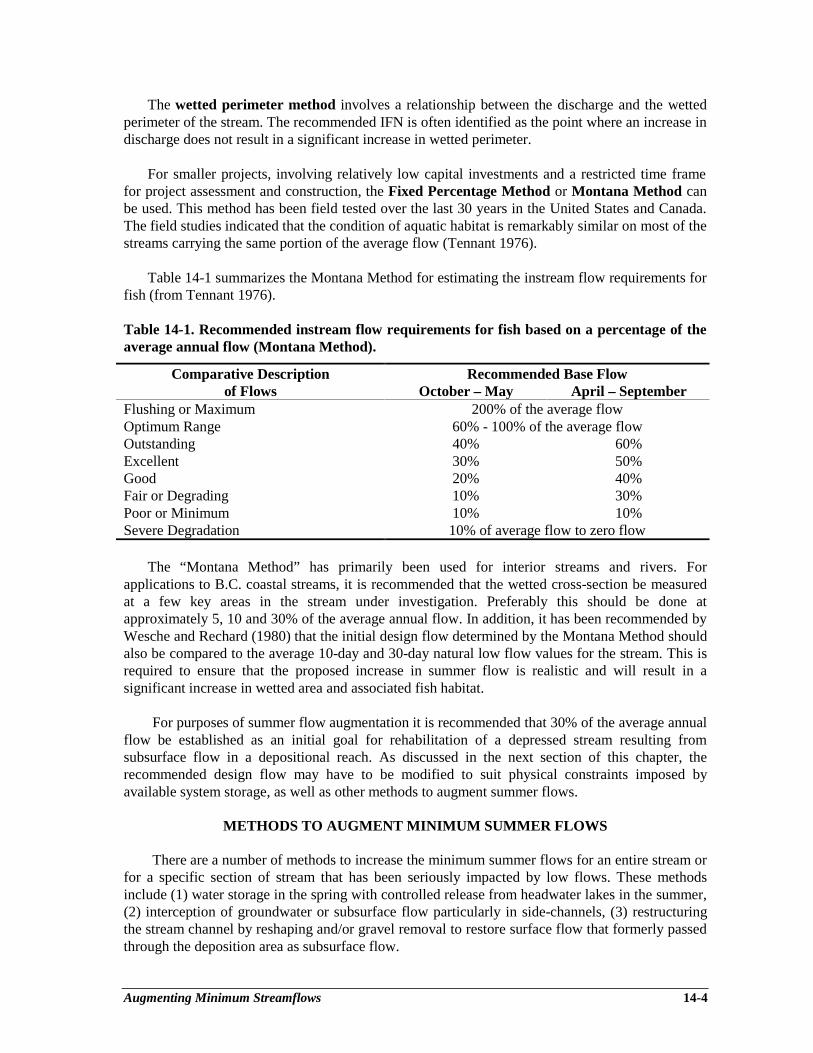
Augmenting Minimum Streamflows 14-4
The wetted perimeter method involves a relationship between the discharge and the wettedperimeter of the stream. The recommended IFN is often identified as the point where an increase indischarge does not result in a significant increase in wetted perimeter.
For smaller projects, involving relatively low capital investments and a restricted time framefor project assessment and construction, the Fixed Percentage Method or Montana Method canbe used. This method has been field tested over the last 30 years in the United States and Canada.The field studies indicated that the condition of aquatic habitat is remarkably similar on most of thestreams carrying the same portion of the average flow (Tennant 1976).
Table 14-1 summarizes the Montana Method for estimating the instream flow requirements forfish (from Tennant 1976).
Table 14-1. Recommended instream flow requirements for fish based on a percentage of theaverage annual flow (Montana Method).
Comparative Description Recommended Base Flowof Flows October – May April – September
Flushing or Maximum 200% of the average flowOptimum Range 60% - 100% of the average flowOutstanding 40% 60%Excellent 30% 50%Good 20% 40%Fair or Degrading 10% 30%Poor or Minimum 10% 10%Severe Degradation 10% of average flow to zero flow
The “Montana Method” has primarily been used for interior streams and rivers. Forapplications to B.C. coastal streams, it is recommended that the wetted cross-section be measuredat a few key areas in the stream under investigation. Preferably this should be done atapproximately 5, 10 and 30% of the average annual flow. In addition, it has been recommended byWesche and Rechard (1980) that the initial design flow determined by the Montana Method shouldalso be compared to the average 10-day and 30-day natural low flow values for the stream. This isrequired to ensure that the proposed increase in summer flow is realistic and will result in asignificant increase in wetted area and associated fish habitat.
For purposes of summer flow augmentation it is recommended that 30% of the average annualflow be established as an initial goal for rehabilitation of a depressed stream resulting fromsubsurface flow in a depositional reach. As discussed in the next section of this chapter, therecommended design flow may have to be modified to suit physical constraints imposed byavailable system storage, as well as other methods to augment summer flows.
METHODS TO AUGMENT MINIMUM SUMMER FLOWS
There are a number of methods to increase the minimum summer flows for an entire stream orfor a specific section of stream that has been seriously impacted by low flows. These methodsinclude (1) water storage in the spring with controlled release from headwater lakes in the summer,(2) interception of groundwater or subsurface flow particularly in side-channels, (3) restructuringthe stream channel by reshaping and/or gravel removal to restore surface flow that formerly passedthrough the deposition area as subsurface flow.
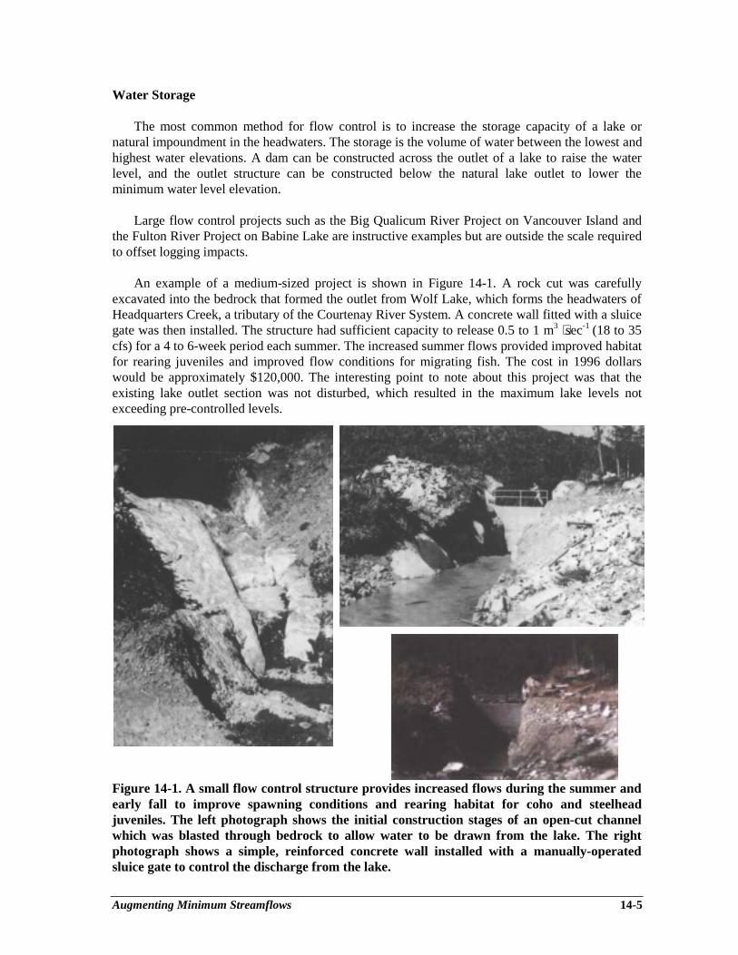
Augmenting Minimum Streamflows 14-5
Water Storage
The most common method for flow control is to increase the storage capacity of a lake ornatural impoundment in the headwaters. The storage is the volume of water between the lowest andhighest water elevations. A dam can be constructed across the outlet of a lake to raise the waterlevel, and the outlet structure can be constructed below the natural lake outlet to lower theminimum water level elevation.
Large flow control projects such as the Big Qualicum River Project on Vancouver Island andthe Fulton River Project on Babine Lake are instructive examples but are outside the scale requiredto offset logging impacts.
An example of a medium-sized project is shown in Figure 14-1. A rock cut was carefullyexcavated into the bedrock that formed the outlet from Wolf Lake, which forms the headwaters ofHeadquarters Creek, a tributary of the Courtenay River System. A concrete wall fitted with a sluicegate was then installed. The structure had sufficient capacity to release 0.5 to 1 m3 ⋅sec-1 (18 to 35cfs) for a 4 to 6-week period each summer. The increased summer flows provided improved habitatfor rearing juveniles and improved flow conditions for migrating fish. The cost in 1996 dollarswould be approximately $120,000. The interesting point to note about this project was that theexisting lake outlet section was not disturbed, which resulted in the maximum lake levels notexceeding pre-controlled levels.
Figure 14-1. A small flow control structure provides increased flows during the summer andearly fall to improve spawning conditions and rearing habitat for coho and steelheadjuveniles. The left photograph shows the initial construction stages of an open-cut channelwhich was blasted through bedrock to allow water to be drawn from the lake. The rightphotograph shows a simple, reinforced concrete wall installed with a manually-operatedsluice gate to control the discharge from the lake.
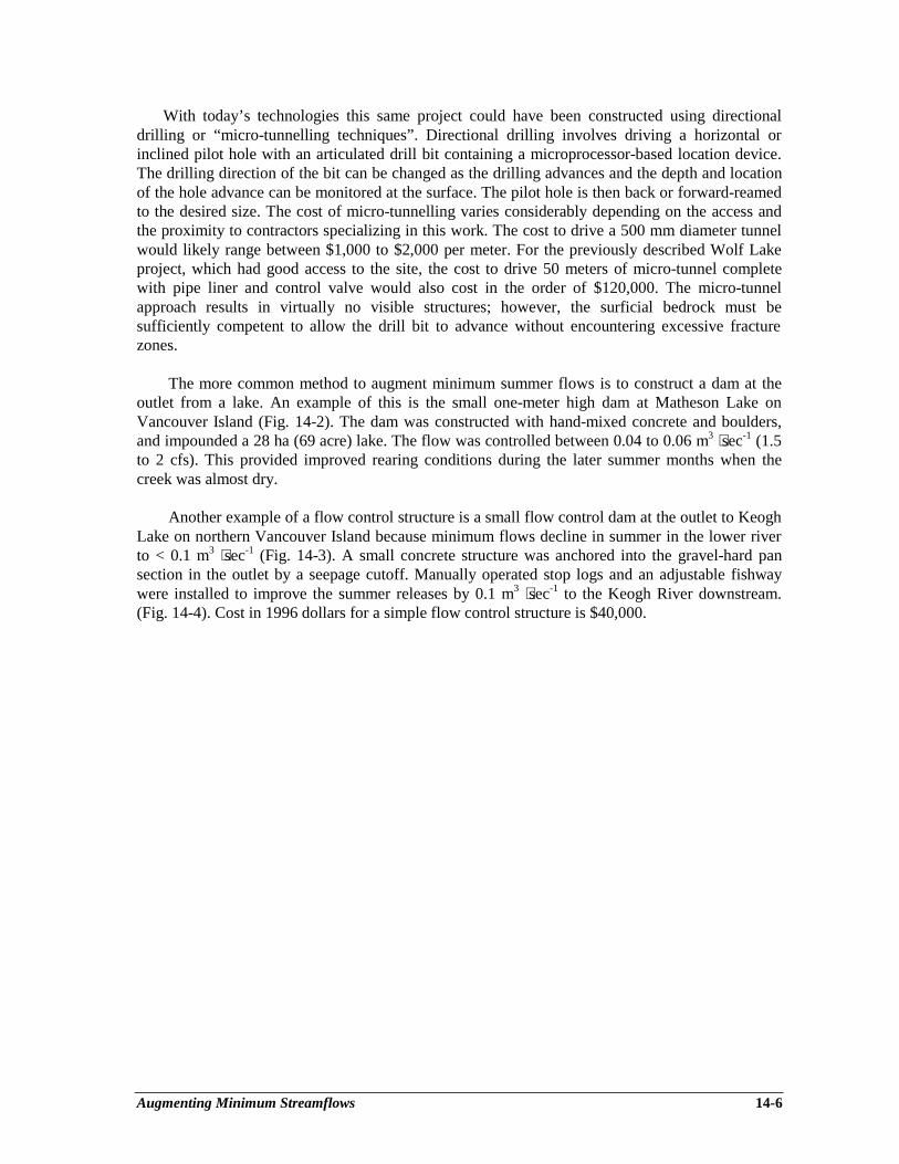
Augmenting Minimum Streamflows 14-6
With today’s technologies this same project could have been constructed using directionaldrilling or “micro-tunnelling techniques”. Directional drilling involves driving a horizontal orinclined pilot hole with an articulated drill bit containing a microprocessor-based location device.The drilling direction of the bit can be changed as the drilling advances and the depth and locationof the hole advance can be monitored at the surface. The pilot hole is then back or forward-reamedto the desired size. The cost of micro-tunnelling varies considerably depending on the access andthe proximity to contractors specializing in this work. The cost to drive a 500 mm diameter tunnelwould likely range between $1,000 to $2,000 per meter. For the previously described Wolf Lakeproject, which had good access to the site, the cost to drive 50 meters of micro-tunnel completewith pipe liner and control valve would also cost in the order of $120,000. The micro-tunnelapproach results in virtually no visible structures; however, the surficial bedrock must besufficiently competent to allow the drill bit to advance without encountering excessive fracturezones.
The more common method to augment minimum summer flows is to construct a dam at theoutlet from a lake. An example of this is the small one-meter high dam at Matheson Lake onVancouver Island (Fig. 14-2). The dam was constructed with hand-mixed concrete and boulders,and impounded a 28 ha (69 acre) lake. The flow was controlled between 0.04 to 0.06 m3 ⋅sec-1 (1.5to 2 cfs). This provided improved rearing conditions during the later summer months when thecreek was almost dry.
Another example of a flow control structure is a small flow control dam at the outlet to KeoghLake on northern Vancouver Island because minimum flows decline in summer in the lower riverto < 0.1 m3 ⋅sec-1 (Fig. 14-3). A small concrete structure was anchored into the gravel-hard pansection in the outlet by a seepage cutoff. Manually operated stop logs and an adjustable fishwaywere installed to improve the summer releases by 0.1 m3 ⋅sec-1 to the Keogh River downstream.(Fig. 14-4). Cost in 1996 dollars for a simple flow control structure is $40,000.
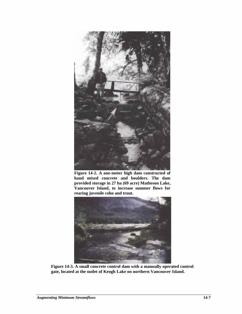
Augmenting Minimum Streamflows 14-7
Figure 14-2. A one-meter high dam constructed ofhand mixed concrete and boulders. The damprovided storage in 27 ha (69 acre) Matheson Lake,Vancouver Island, to increase summer flows forrearing juvenile coho and trout.
Figure 14-3. A small concrete control dam with a manually operated controlgate, located at the outlet of Keogh Lake on northern Vancouver Island.
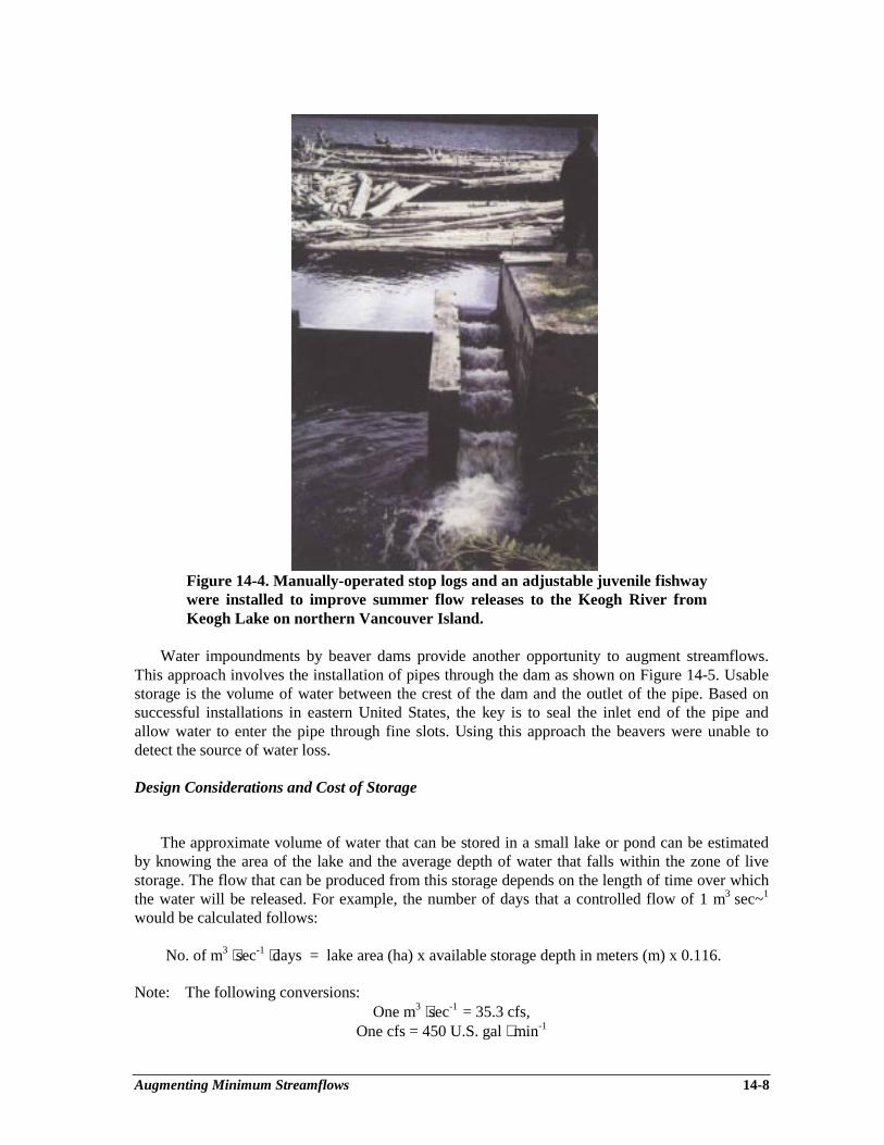
Augmenting Minimum Streamflows 14-8
Figure 14-4. Manually-operated stop logs and an adjustable juvenile fishwaywere installed to improve summer flow releases to the Keogh River fromKeogh Lake on northern Vancouver Island.
Water impoundments by beaver dams provide another opportunity to augment streamflows.This approach involves the installation of pipes through the dam as shown on Figure 14-5. Usablestorage is the volume of water between the crest of the dam and the outlet of the pipe. Based onsuccessful installations in eastern United States, the key is to seal the inlet end of the pipe andallow water to enter the pipe through fine slots. Using this approach the beavers were unable todetect the source of water loss.
Design Considerations and Cost of Storage
The approximate volume of water that can be stored in a small lake or pond can be estimatedby knowing the area of the lake and the average depth of water that falls within the zone of livestorage. The flow that can be produced from this storage depends on the length of time over whichthe water will be released. For example, the number of days that a controlled flow of 1 m3 sec~1
would be calculated follows:
No. of m3 ⋅sec-1 ⋅days = lake area (ha) x available storage depth in meters (m) x 0.116.
Note: The following conversions:One m3 ⋅sec-1 = 35.3 cfs,
One cfs = 450 U.S. gal ⋅ min-1
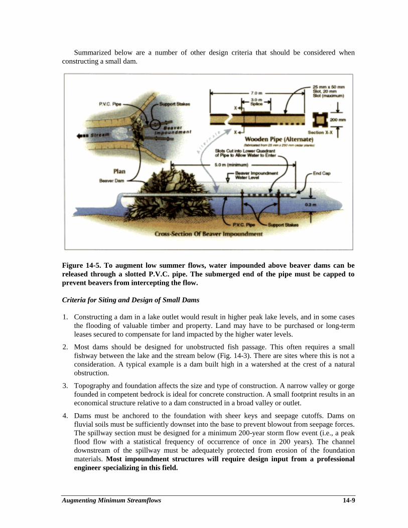
Augmenting Minimum Streamflows 14-9
Summarized below are a number of other design criteria that should be considered whenconstructing a small dam.
Figure 14-5. To augment low summer flows, water impounded above beaver dams can bereleased through a slotted P.V.C. pipe. The submerged end of the pipe must be capped toprevent beavers from intercepting the flow.
Criteria for Siting and Design of Small Dams
1. Constructing a dam in a lake outlet would result in higher peak lake levels, and in some casesthe flooding of valuable timber and property. Land may have to be purchased or long-termleases secured to compensate for land impacted by the higher water levels.
2. Most dams should be designed for unobstructed fish passage. This often requires a smallfishway between the lake and the stream below (Fig. 14-3). There are sites where this is not aconsideration. A typical example is a dam built high in a watershed at the crest of a naturalobstruction.
3. Topography and foundation affects the size and type of construction. A narrow valley or gorgefounded in competent bedrock is ideal for concrete construction. A small footprint results in aneconomical structure relative to a dam constructed in a broad valley or outlet.
4. Dams must be anchored to the foundation with sheer keys and seepage cutoffs. Dams onfluvial soils must be sufficiently downset into the base to prevent blowout from seepage forces.The spillway section must be designed for a minimum 200-year storm flow event (i.e., a peakflood flow with a statistical frequency of occurrence of once in 200 years). The channeldownstream of the spillway must be adequately protected from erosion of the foundationmaterials. Most impoundment structures will require design input from a professionalengineer specializing in this field.
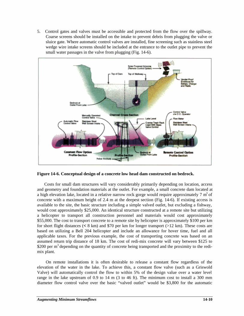
Augmenting Minimum Streamflows 14-10
5. Control gates and valves must be accessible and protected from the flow over the spillway.Coarse screens should be installed on the intake to prevent debris from plugging the valve orsluice gate. Where automatic control valves are installed, fine screening such as stainless steelwedge wire intake screens should be included at the entrance to the outlet pipe to prevent thesmall water passages in the valve from plugging (Fig. 14-6).
Figure 14-6. Conceptual design of a concrete low head dam constructed on bedrock.
Costs for small dam structures will vary considerably primarily depending on location, accessand geometry and foundation materials at the outlet. For example, a small concrete dam located ata high elevation lake, located in a relative narrow rock gorge would require approximately 7 m3 ofconcrete with a maximum height of 2.4 m at the deepest section (Fig. 14-6). If existing access isavailable to the site, the basic structure including a simple valved outlet, but excluding a fishway,would cost approximately $25,000. An identical structure constructed at a remote site but utilizinga helicopter to transport all construction personnel and materials would cost approximately$55,000. The cost to transport concrete to a remote site by helicopter is approximately $100 per kmfor short flight distances (< 8 km) and $70 per km for longer transport (>12 km). These costs arebased on utilizing a Bell 204 helicopter and include an allowance for hover time, fuel and allapplicable taxes. For the previous example, the cost of transporting concrete was based on anassumed return trip distance of 18 km. The cost of redi-mix concrete will vary between $125 to$200 per m3 depending on the quantity of concrete being transported and the proximity to the redi-mix plant.
On remote installations it is often desirable to release a constant flow regardless of theelevation of the water in the lake. To achieve this, a constant flow valve (such as a GriswoldValve) will automatically control the flow to within 5% of the design value over a water levelrange in the lake upstream of 0.9 to 14 m (3 to 46 ft). The minimum cost to install a 300 mmdiameter flow control valve over the basic “valved outlet” would be $3,800 for the automatic
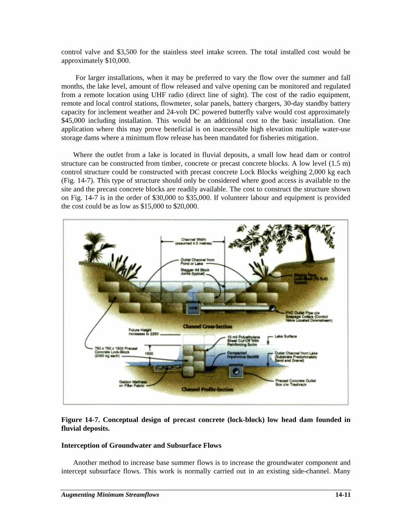
Augmenting Minimum Streamflows 14-11
control valve and $3,500 for the stainless steel intake screen. The total installed cost would beapproximately $10,000.
For larger installations, when it may be preferred to vary the flow over the summer and fallmonths, the lake level, amount of flow released and valve opening can be monitored and regulatedfrom a remote location using UHF radio (direct line of sight). The cost of the radio equipment,remote and local control stations, flowmeter, solar panels, battery chargers, 30-day standby batterycapacity for inclement weather and 24-volt DC powered butterfly valve would cost approximately$45,000 including installation. This would be an additional cost to the basic installation. Oneapplication where this may prove beneficial is on inaccessible high elevation multiple water-usestorage dams where a minimum flow release has been mandated for fisheries mitigation.
Where the outlet from a lake is located in fluvial deposits, a small low head dam or controlstructure can be constructed from timber, concrete or precast concrete blocks. A low level (1.5 m)control structure could be constructed with precast concrete Lock Blocks weighing 2,000 kg each(Fig. 14-7). This type of structure should only be considered where good access is available to thesite and the precast concrete blocks are readily available. The cost to construct the structure shownon Fig. 14-7 is in the order of $30,000 to $35,000. If volunteer labour and equipment is providedthe cost could be as low as $15,000 to $20,000.
Figure 14-7. Conceptual design of precast concrete (lock-block) low head dam founded influvial deposits.
Interception of Groundwater and Subsurface Flows
Another method to increase base summer flows is to increase the groundwater component andintercept subsurface flows. This work is normally carried out in an existing side-channel. Many
Augmenting Minimum Streamflows 14-12
side-channels are connected to the main channel at their upstream and downstream ends.Groundwater-fed channels are connected to the main channel at the downstream end only.Interception of subsurface and groundwater flows provide a stable flow of water of consistentquality. Improved flow conditions when combined with other habitat improvements discussed inthis guide will improve spawning, rearing and overwintering conditions for several species of fish.For a more detailed discussion of side-channel development, including habitat improvements,recommended flow and velocity regimes, flood protection and food sources, see Chapter 7, as thischapter primarily focuses on increasing the base summer flows.
As an example, an existing side-channel was excavated adjacent to the Fording River in theeast Kootenays to offset habitat losses to cutthroat trout (Fig. 14-8). The improvements to thechannel included increasing the base flow by 50%, providing spawning gravel above and belowpocket pools, and improving instream cover including transplanting riparian vegetation along thebanks. The side-channel also included overwintering ponds with floating cover for adult cutthroattrout, which were highly utilized as a refuge from harsh winter (anchor ice) conditions in themainstem.
The base flow in the channel was increased by deepening the headwater pond and installingpocket pools along the channel approximately 6 m long, 4 m wide and 1.5 m deep. Considerationwas given to intercepting subsurface flow by installing polyethylene cutoffs below the channelinvert, but this was not necessary as the installation of the pools and deepening the existing channelprovided the increased flow. A few small groundwater seepage zones were also intercepted anddirected into the side-channel under development.
The intercepted subsurface flow was likely a mixture of groundwater with the majorcomponent of the flow from the main channel upstream, which had subsurfaced as a result ofgravel deposition. In the winter, the average temperature of the water varied between 1 to 2°C. Incomparison to the mainstem which was at 0°C, this was attractive to adult cutthroat (2+), whichoverwintered in the ponds in large numbers. One other advantage to increasing the base flow in theside-channel was that it also provided a modest increase in the baseflow in the main channelimmediately downstream of the entrance to the side-channel.
The side-channel shown on Fig. 14-8 included the following features:
• 600 m of enhanced side-channel complete with transplanted vegetation along each bank, 8pocket pools approximately 24 m2 in area and 1.5 m deep complete with LWD and rockplacements for cover;
• 2 medium-sized instream pools complete with LWD, rock placements and floating cover;• 2 large overwintering ponds varying in depth from 2 to 3 m complete with floating cover;• 130 m2 of spawning gravel located either upstream or downstream of each pool.
The total cost of the project was in the order of $200,000, of which $40,000 was applicable toincreasing the base flow in the side-channel.
In conclusion, base flows can be increased by intercepting subsurface flows by cutoffs,constructing deep pools, lowering the channel invert, and diverting groundwater seepages into thehead of a blind side-channel.
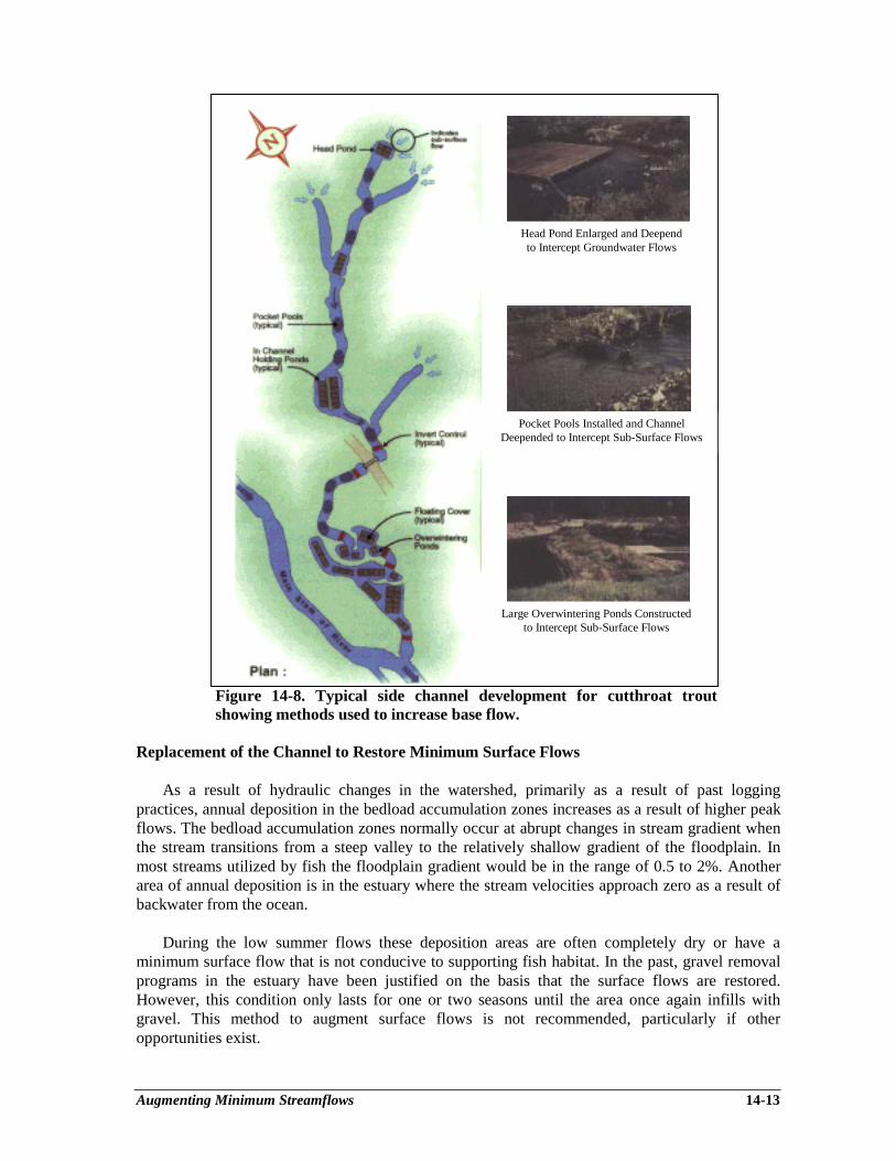
Augmenting Minimum Streamflows 14-13
Figure 14-8. Typical side channel development for cutthroat troutshowing methods used to increase base flow.
Replacement of the Channel to Restore Minimum Surface Flows
As a result of hydraulic changes in the watershed, primarily as a result of past loggingpractices, annual deposition in the bedload accumulation zones increases as a result of higher peakflows. The bedload accumulation zones normally occur at abrupt changes in stream gradient whenthe stream transitions from a steep valley to the relatively shallow gradient of the floodplain. Inmost streams utilized by fish the floodplain gradient would be in the range of 0.5 to 2%. Anotherarea of annual deposition is in the estuary where the stream velocities approach zero as a result ofbackwater from the ocean.
During the low summer flows these deposition areas are often completely dry or have aminimum surface flow that is not conducive to supporting fish habitat. In the past, gravel removalprograms in the estuary have been justified on the basis that the surface flows are restored.However, this condition only lasts for one or two seasons until the area once again infills withgravel. This method to augment surface flows is not recommended, particularly if otheropportunities exist.
Head Pond Enlarged and Deependto Intercept Groundwater Flows
Pocket Pools Installed and ChannelDeepended to Intercept Sub-Surface Flows
Large Overwintering Ponds Constructedto Intercept Sub-Surface Flows

Augmenting Minimum Streamflows 14-14
A better approach would be to work around the deposition area and investigate side-channelopportunities where the minimum summer flows, both surface and subsurface, can be interceptedand collected. Side-channels can be surface-water-fed, deepened to intercept subsurface flows or acombination of both methods. This approach has been proposed for High Falls Creek (upperSquamish River) where hillslope impacts of past logging practices have deposited large volumes ofgravel on the floodplain (R. Finnigan, pers. comm.).
When a surface water intake is proposed for a side-channel adjacent to a major deposition area,the intake must be designed to eliminate high flows and resultant gravel depositions. There are anumber of ways to design a surface-water intake to minimize bedload deposition within a channel.These include flow diversion structures, hollow weir intakes with flushing chambers, settlingponds and simple float-operated gates that minimize the flow entering a side-channel as the waterlevel in the mainstem of a stream rises. These methods are discussed in further detail in Chapter 7.
Another advantage to developing side-channels, in lieu of excavating and channelizing theactual deposition area, is that stable side-channels can also incorporate other habitat features. Theseinclude streamside vegetation for cover, pools and riffles for rearing, and instream LWD or bouldercomplexes for instream cover.
SUMMARY OF FLOW CONTROL PROJECTS IN B.C.
Large Projects
Weaver Lake, B.C. During low flows in the fall, water can be withdrawn from below the lakeoutlet elevation utilizing a siphon. The water is released to Weaver Creek to ensure adequate flowto the Weaver Creek spawning channel A small concrete fishway was incorporated into the outletfrom the lake.
Pinkut Creek, Babine Lake, B.C. A low head control dam was constructed at the outlet fromPinkut Lake to augment low summer flows to the natural creek and a large spawning channelcomplex downstream.
Medium-sized Projects (Summer Flow Augmentation)
Cameron Lake, Vancouver Island, B.C. A low head concrete control dam was installed at theoutlet to the lake to augment the summer flows in the Little Qualicum River and associatedspawning channels downstream.
Wolf Lake, Vancouver Island, B.C. A flow control structure was constructed adjacent to theoutlet from Wolf Lake to increase the base summer flow in Headquarters Creek and the Tsolumand Courtenay Rivers. All storage was below the normal outlet from the lake (Fig. 14-1).
Elk Creek, Chilliwack, B.C. The intake from the Elk Creek reservoir was redesigned by DFO andthe Municipality of Chilliwack to provide a minimum flow for fisheries. The minimum flowrelease is controlled by a V-notched weir set below the normal water intake from the lake.

Augmenting Minimum Streamflows 14-15
Small Projects (Summer Flow Augmentation)
Keogh Lake, Vancouver Island, B.C. A concrete low head dam was constructed at the outletfrom Keogh Lake to increase summer flow in the Keogh River (Fig. 14-3 and Fig. 14-4).
Quatse Lake, Vancouver Island, B.C. As above to augment flow in the Quatse River and theQuatse Hatchery.
Matheson Lake, Vancouver Island, B.C. A small dam approximately 1 m high was constructedat the outlet to the lake by a public involvement group. The dam was constructed of boulders andconcrete and flow releases were controlled by an adjustable plate over the end of the pipe (Fig.14-2).
Demaniel Creek, Vancouver Island, B.C. A seasonal dam was constructed of sand bags at theoutlet from the head pond of Demaniel Creek. Water was released by an adjustable plywood weirto increase the base rearing flow primarily for coho smolts. The dam was replaced each year by adedicated resident in the area.

Managing Beaver Habitat for Salmonids 15-1
Chapter 15Managing Beaver Habitat for Salmonids:
Working with Beavers
Rheal J. Finnigan1, David E. Marshall2
INTRODUCTION
Beavers are just one of several animal species that have increased in numbers as a result oflogging. Like the black-tailed deer (Odocoileus hemionus columbianus) of coastal forests and themule deer (0. h. hemionus) native to drier interior woodlands, beavers have benefited from theremoval of the mature coniferous forest on river bottom lands and its replacement with faster-growing deciduous trees and shrubs. The new vegetation is the preferred food of beavers and, likedeer and other animal populations, their numbers tend to increase with the abundance of their foodsupply. In time the conifers will return as the dominant tree species and beaver populations willreturn to original levels, but in the absence of aggressive beaver population control and/orreforestation practices this will be a very slow process.
Beavers qualify for special recognition as the hardest working of forest animals. By cuttingdown trees and shrubs and using this woody material to construct dams, beavers convert longsections of streams into deep ponds. The ponds provide beavers safety from predators and easyaccess to their woodland food supply. But their efforts inadvertently impact on other plant andanimal species, notably the fish that occupy the same stream. For instance, a dam can sometimes bea barrier to adult and juvenile salmonids: adults passing upstream to spawning grounds, orjuveniles moving upstream or downstream in search of suitable rearing habitat. In addition, sometrout species are vulnerable to beaver encroachment. Resident rainbow and cutthroat trout andjuvenile steelhead frequently rear in faster waters among boulders, large woody debris and at theheads of pools. This type of habitat is readily eliminated by beaver ponds on small streams.Beavers are also a problem to people often a costly one when their persistent dam buildingcauses flooding of roads, timberlands, farms and other public and private property.
On the positive side, however, researchers and resource managers have found that beaverimpoundments, both occupied and abandoned, support a variety of terrestrial and aquatic plant andanimal communities, creating productive ecosystems. The impacts of beaver colonization are nowconsidered an important factor in the health and diversity of riparian ecosystems. It appears then,that beaver activities can be beneficial in some cases and detrimental in others, depending uponwhere a family unit chooses to set up a colony.
The first section of this chapter describes briefly the life history of beavers and how theiractivities, mainly through damming small streams, affect stream hydrology, riparian vegetation, thenutrient cycle and ultimately fish production. The second section describes technologies that havebeen employed to facilitate fish passage at beaver dams without destroying the integrity of theirponds. Techniques are also described that discourage beavers from blocking culverts, a commonproblem that impedes fish access and leads to flooding of adjacent roads and lands.________________________1 British Columbia Conservation Foundation, Suite 206 - 17564 - 56A Avenue, Surrey, BC V3S 1G32 844 Alderside Rd., Port Moody, BC V3H 3A6
Managing Beaver Habitat for Salmonids 15-2
BEAVER BIOLOGY
The basic unit of beaver society is the family group, referred to as a colony, usually consistingof a pair of adults and one or two generations of offspring. In the fall, for example, a colony of ninebeavers might consist of the adult pair, three yearlings and four kits. Five to seven beavers percolony is quite common. Such colonies may build and maintain more than one lodge and severaldams, but will usually stockpile only one cache of winter food (Hatler 1988). The dominant pair ina thriving colony typically produces one litter of three or four kits each year. Generally, two-year-old juvenile beavers leave the colony and set out on their own in late spring, just before birth of thecolony’s next litter. The departure of the two-year-olds eases the pressure on the local food supplyand reduces the risk of in-breeding. This also leads to colonization of new territories, sometimes inadjacent watersheds.
The prime habitats for beavers are along the slower-moving sections of rivers and streams, inexisting ponds and along shores of small lakes not exposed to wave action. Stable streams, such asgroundwater-fed side channels and those draining small lakes, are better suited than those wherewater levels and velocities fluctuate widely. On flowing streams, the foraging area used by acolony will usually extend further upstream from the lodge than downstream, probably because itis more difficult to move food and building material against the flow. A study conducted onbackwater sloughs in Alaska found that the maximum distance between a food cache and thecutting site was 800 m (Boyce 1981). Safe and efficient foraging distance inland from the water’sedge is considered to be about 50 m. In cold climates where ponds freeze over in winter, sufficientdepth must exist beneath the ice cover to provide the beavers access to their cache of woodyvegetation.
Beavers feed on a variety of plants including grasses, the leaves of shrubs and the roots andleaves of pond lilies, but their main food source, especially during the long winter season, istypically the bark and tender twigs of deciduous trees and shrubs, such as aspen, alder, cottonwoodand willow. The most productive food sources include stands of cottonwood and alder thatnaturally regenerate on old sedimentation bars along large rivers and in forest clearings created byfire, blowdown, insect-kill and logging. In areas where aspen is predominant, regrowth maysupport population expansion for beavers as early as eight to 10 years after a burn, although it maytake 20 to 30 years to produce trees of a size that will provide the maximum supply of food (Hatler1988). Willow thrives in the moist and nutrient-rich soil conditions on the banks of beaver ponds,and its growth is often vigorous enough to extend the beaver’s food supply a few more years afterthe aspen has been exhausted.
ECOSYSTEMS CREATED BY BEAVER IMPOUNDMENTS
The most productive fish rearing streams are those that are not frequently subjected to upperand especially lower extremes of flow. Spring-fed and lake-fed streams are examples, as are smallstreams that have been colonized by beavers. In the latter example, beaver impoundments stabilizestream flows in two ways: first, they act as reservoirs, increasing the water-holding capacity of thewatershed, thus slowing the rate of runoff; second, flooding of land in the vicinity of beavercolonies raises the level of the water table and the stored groundwater is slowly released back intothe stream, which helps to maintain flow during long periods of drought. Studies conducted in latesummer and fall in small coastal streams in Oregon revealed that up to 25% of water during lowflow periods may be held in beaver ponds (Bergstrom 1985). Depth of even a few centimeters ofstored water will enable some fish to survive until fall rains replenish the flow.
Managing Beaver Habitat for Salmonids 15-3
Beaver impoundments have been found to improve the quality and diversity of riparianhabitat, which can benefit some species of fish and wildlife and make it more appealing torecreational users. The original riparian vegetation not used by beavers for food or dam buildingsoon dies after flooding and is replaced by plant species better adapted to wetland soil conditions.This invasion of new vegetation is gradual and will continue long after beavers have vacated thesite if dams remain intact. The accumulation of sediments and organic detritus in the still waters ofthe impoundments is part of this process, providing the nutrient-rich soils to sustain the newvegetation. Aquatic plants, such as yellow pond lilies and cattails, may eventually becomeestablished along with water-tolerant shrubs including willow and alder. A diverse aquatic andriparian vegetation community contributes to fish production by providing escape cover, therebyminimizing mortality from predators; by attracting terrestrial insects, some of which fall to thewater surface and are eaten by fish; and, in the case of submerged vegetation, by providing suitablehabitat for aquatic insects and other invertebrates that are the principle source of food for fish.
The activities of beavers are also much involved in nutrient cycling which, in terms of fishproduction, may be as important as the role they play in moderating stream flows. Beaverimpoundments function somewhat like a gardener’s compost heap, acting as a repository for leaflitter and other vegetation that originate from riparian plants adjacent to and upstream ofimpoundments. The vegetation contributes to the food supply of aquatic insects and otherinvertebrates in beaver impoundments. Vegetation not consumed contributes to the food supplyindirectly by decomposing, thus releasing the key elements limited in aquatic ecosystems:phosphorous and nitrogen. These elements are bound-up in the mud at the bottom of the pond andare slowly released back into the water column, providing the essential nutrients for growth andreproduction of algae (periphyton and phytoplankton) at the base of the food chain. The nutrientsbecome fish food a few links farther up the food chain in the form of stoneflies, midges, caddisflies and other aquatic insects and invertebrates. Beaver droppings are another factor in theenrichment of the impoundments. An average-sized beaver may eat up to 1,100 kg of leaves andtwigs a year (Bergstrom 1985), the nutrient-rich end result being deposited in the impoundmentsand surrounding areas.
The productivity of beaver ponds is reflected both by the numbers and growth rates of thejuvenile fish they support. In a controlled study of beaver pond productivity at Fish Creek inOregon, juvenile coho salmon planted in late November were large enough to smolt and migrate tosea by the following March (Bergstrom 1985). In only four months they grew to a size equal to thelargest wild smolts found in other nearby streams. The combination of an abundant food supplyand moderate water temperatures in the pond resulted in a 6-fold increase in weight over thewinter, three times the weight gain of juveniles rearing in the main channel of Fish Creek. Similarfindings have been reported from other studies in southeast Alaska (Bergstrom 1985). Also, areview of salmonid densities in all types of ponds indicated an average number of about one fishper m2 in smaller ponds (1000 m2) although less (0.35 ⋅ m-2) from larger ponds (1 ha) (Keeley et al.1996).
Another analysis of data in the literature on coho smolt yields for 27 streams, ponds and sidechannels in British Columbia, Washington and Oregon indicated that production in ponds wassimilar to small streams on an area basis but much greater on a centerline or perimeter length basis(Marshall and Britton 1990). Based on this analysis, average smolt yield for small streams andponds were calculated to be 0.73 smolts per m2 or 4.6 g ⋅ m2.
Most fish species present in streams colonized by beavers will rear in impoundments ifaccessible. Juvenile fish can sometimes ascend from waters downstream via one or more small
Managing Beaver Habitat for Salmonids 15-4
rivulets flowing overland around the ends of dams, or they may access the impoundments fromwaters upstream. The latter would be possible if resident adult fish of the preceding generationspawned above the dams, or if migratory adult fish of the preceding generation were able to ascendthe dams to reach spawning beds upstream. Rarely are beaver dams a barrier to juveniles migratingdownstream. Fish passage conditions, both upstream and downstream, improve during freshetwhen dams are overtopped. Coho salmon, which typically spawn at the time of fall rains in theupper reaches of small streams, are generally successful in ascending beaver dams, hence juvenilesare often found in abundance in beaver impoundments. Other important fish species that spend partor all of their lives in fresh water in British Columbia and are frequently found in beaverimpoundments include chinook salmon, cutthroat trout, rainbow trout (both sea-going andresident), grayling (in northern regions) and char.
MANAGING BEAVER IMPACTS
While the positive aspects of beaver activities are emphasized in this chapter, these cansometimes be outweighed by the negative impacts; for example, the barrier to fish migration, thebackwatering of spawning beds or trout rearing habitats, and the flooding of roads and lands.Unfortunately, the necessity of opening dams and clearing culverts is laborious, frustrating workand ineffective in the long term because beavers are generally undeterred and respond by repairinga breach almost immediately. Fortunately, there are technologies that can be employed to copewith beaver problems. The technologies are not without some maintenance requirements, but theseare considerably less onerous than the alternative of fighting the beavers “head-on”. Wherepossible, techniques should be employed that accommodate beavers. In the long term mutuallybeneficial coexistence is a sound ecological approach.
BEAVER CONTROL AT ROAD CULVERTS
Beaver Fences
The O-shaped wire-mesh fence configuration (Fig. 15-1) encircles the intake end of the culvertand prevents beavers from approaching the opening. The wire mesh should have 15 cm squareopenings, large enough to allow the passage of adult salmonids but too small for beavers. Thesurface area of the encircling fence should be in proportion to the maximum volume of streamflow. Debris will accumulate on the fence over time, hence the larger the surface area the lessfrequent the maintenance requirement. Since winter freeze-up could damage the fence if there issignificant horizontal or vertical movement of pond ice, repairs may be necessary in spring. Itshould be emphasized that the O-shaped fence concept is appropriate only at sites where a pond(rather than a stream channel) exists immediately above a culvert. Similar designs have been usedin Maine and New Hampshire (e.g.. Laramie 1963).
The U-shaped wire-mesh fence configuration (Fig. 15-2) is appropriate only where a streamchannel (rather than a pond) exists immediately above a culvert. The fencing is erected at thewater’s edge along both banks, beginning at the culvert and extending upstream approximately 40m. The fence is left open at its upstream end and drifting debris floats downstream unimpeded. Thefence prevents beavers from obtaining woody material from sources nearby to block the culvert.Instead, it makes it necessary for beavers to drag the woody material overland from a source nearthe upstream end of the fence, and then through shallow water for a distance equal to the length ofthe fence to reach the culvert. It is not known if the deterring factor is the difficulty of the task or ifthe beavers sense their vulnerability to predators if they are required to work without the safety of anearby pond.

Managing Beaver Habitat for Salmonids 15-5
Figure 15-1. The O-shaped fence prevents access by beavers to theupstream end of the road culvert.
Figure 15-2. The U-shaped fence restricts access by beavers to theupstream end of the road culvert.
Screening Devices
Screening devices of various designs can be attached to the intake end of a culvert to deter beavers.These cage-like structures (Figs. 15-3 to 15-7) allow fish to pass while limiting the beavers’ abilityto block water flow. Some of these conceptual designs are simple applications that may be onlytemporary solutions because they can be eventually sealed by beavers. They are appropriate onlywhere a pond (natural or man-made) exists at the upstream end of the culvert. The culvert, beforeattachment of the screening device, should “gun-barrel” at least one meter into the pond. Thescreen surface on the bottom of the cages should be elevated at least 0.5 m above the pond floor,which makes it difficult for beavers to anchor their dam-building materials and block the flow ofwater. The cages may also deter beavers in another way, by preventing them from getting closeenough to the culvert opening to detect a velocity gradient or hear the sound of moving water.Velocity and sound are considered to be the beavers’ cues that trigger dam building

Managing Beaver Habitat for Salmonids 15-6
responses. For each of the various designs of screening devices, wire mesh with square openings of15 cm will allow fish passage but prevent beavers from entering the cage. It is also necessary tomaintain a minimum desired depth of water in the pond at the lowest levels of flow. This mayrequire construction of a weir or ramp, using rocks, gravel or wood, at a point just below thedownstream end of the culvert. The weir or ramp must be passable to the target fish species (seeChapter 5 on culvert passage criteria).
Of the various screening devices described here, the small tubular wire cage is the easiest toassemble using rolled wire mesh (Fig. 15-3). This design may be appropriate for small streams butbeavers may be able to detect water movement and attempt to block the flow. The cylindrical wirecage (Fig. 15-4) makes it more difficult for beavers to detect water movement. Legs can beattached to the cage for structural support.
Figure 15-3. Tubular wire mesh cage. Figure 15-4. Cylindrical wire mesh cage.
Triangular wire mesh cages (Fig. 15-5) are a variation of the cylindrical and rectangular cages.Flat concrete reinforcing mesh fastened to welded aluminum or steel frames can be used.
Figure 15-5. Triangular wire mesh cage.
Rectangular wire mesh cages (Fig. 15-6) can be assembled using rolled wire mesh or thestronger flat concrete reinforcing mesh. The mesh is attached to aluminum or steel frames. Legswill be required to support the heavy cages above the pond floor.
Rectangular cages with treated plywood sides and wire mesh top and bottom (Fig. 15-7) aredesigned to avoid winter damage to cages in instances where ponds freeze and ice cover is subject
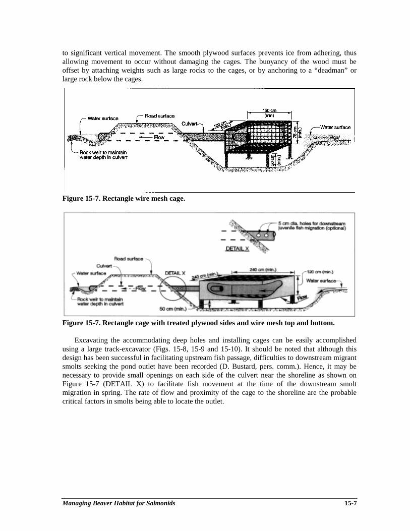
Managing Beaver Habitat for Salmonids 15-7
to significant vertical movement. The smooth plywood surfaces prevents ice from adhering, thusallowing movement to occur without damaging the cages. The buoyancy of the wood must beoffset by attaching weights such as large rocks to the cages, or by anchoring to a “deadman” orlarge rock below the cages.
Figure 15-7. Rectangle wire mesh cage.
Figure 15-7. Rectangle cage with treated plywood sides and wire mesh top and bottom.
Excavating the accommodating deep holes and installing cages can be easily accomplishedusing a large track-excavator (Figs. 15-8, 15-9 and 15-10). It should be noted that although thisdesign has been successful in facilitating upstream fish passage, difficulties to downstream migrantsmolts seeking the pond outlet have been recorded (D. Bustard, pers. comm.). Hence, it may benecessary to provide small openings on each side of the culvert near the shoreline as shown onFigure 15-7 (DETAIL X) to facilitate fish movement at the time of the downstream smoltmigration in spring. The rate of flow and proximity of the cage to the shoreline are the probablecritical factors in smolts being able to locate the outlet.
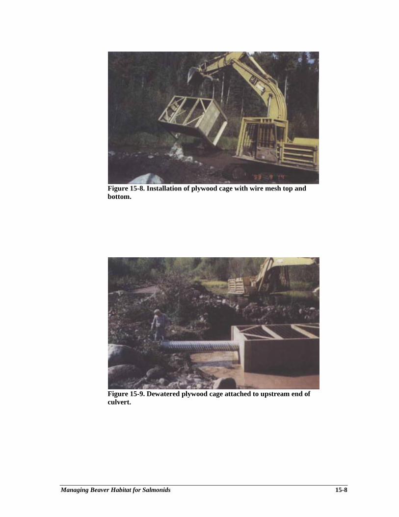
Managing Beaver Habitat for Salmonids 15-8
Figure 15-8. Installation of plywood cage with wire mesh top andbottom.
Figure 15-9. Dewatered plywood cage attached to upstream end ofculvert.
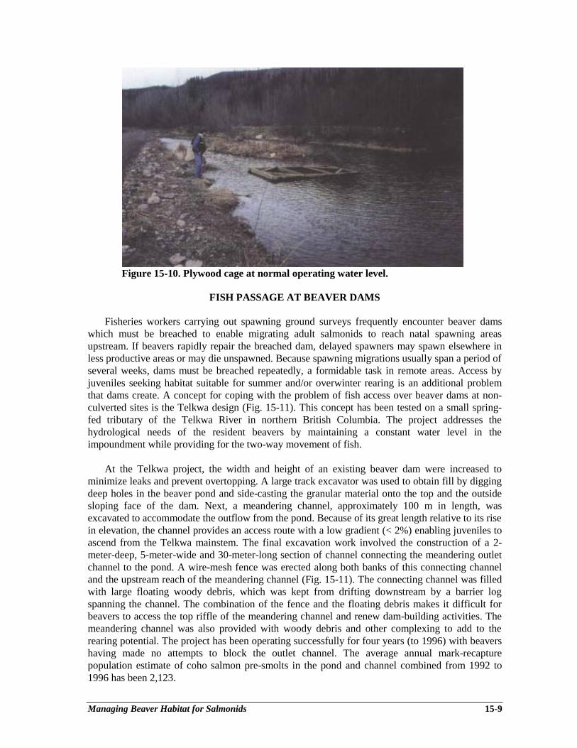
Managing Beaver Habitat for Salmonids 15-9
Figure 15-10. Plywood cage at normal operating water level.
FISH PASSAGE AT BEAVER DAMS
Fisheries workers carrying out spawning ground surveys frequently encounter beaver damswhich must be breached to enable migrating adult salmonids to reach natal spawning areasupstream. If beavers rapidly repair the breached dam, delayed spawners may spawn elsewhere inless productive areas or may die unspawned. Because spawning migrations usually span a period ofseveral weeks, dams must be breached repeatedly, a formidable task in remote areas. Access byjuveniles seeking habitat suitable for summer and/or overwinter rearing is an additional problemthat dams create. A concept for coping with the problem of fish access over beaver dams at non-culverted sites is the Telkwa design (Fig. 15-11). This concept has been tested on a small spring-fed tributary of the Telkwa River in northern British Columbia. The project addresses thehydrological needs of the resident beavers by maintaining a constant water level in theimpoundment while providing for the two-way movement of fish.
At the Telkwa project, the width and height of an existing beaver dam were increased tominimize leaks and prevent overtopping. A large track excavator was used to obtain fill by diggingdeep holes in the beaver pond and side-casting the granular material onto the top and the outsidesloping face of the dam. Next, a meandering channel, approximately 100 m in length, wasexcavated to accommodate the outflow from the pond. Because of its great length relative to its risein elevation, the channel provides an access route with a low gradient (< 2%) enabling juveniles toascend from the Telkwa mainstem. The final excavation work involved the construction of a 2-meter-deep, 5-meter-wide and 30-meter-long section of channel connecting the meandering outletchannel to the pond. A wire-mesh fence was erected along both banks of this connecting channeland the upstream reach of the meandering channel (Fig. 15-11). The connecting channel was filledwith large floating woody debris, which was kept from drifting downstream by a barrier logspanning the channel. The combination of the fence and the floating debris makes it difficult forbeavers to access the top riffle of the meandering channel and renew dam-building activities. Themeandering channel was also provided with woody debris and other complexing to add to therearing potential. The project has been operating successfully for four years (to 1996) with beavershaving made no attempts to block the outlet channel. The average annual mark-recapturepopulation estimate of coho salmon pre-smolts in the pond and channel combined from 1992 to1996 has been 2,123.
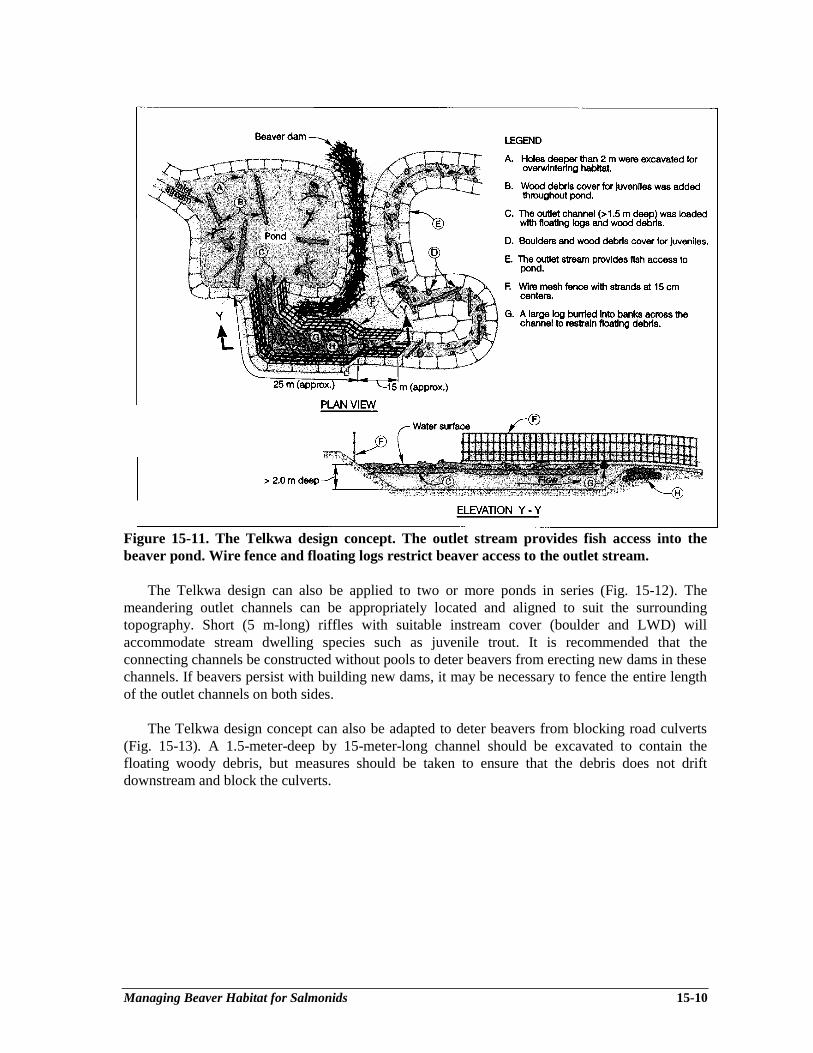
Managing Beaver Habitat for Salmonids 15-10
Figure 15-11. The Telkwa design concept. The outlet stream provides fish access into thebeaver pond. Wire fence and floating logs restrict beaver access to the outlet stream.
The Telkwa design can also be applied to two or more ponds in series (Fig. 15-12). Themeandering outlet channels can be appropriately located and aligned to suit the surroundingtopography. Short (5 m-long) riffles with suitable instream cover (boulder and LWD) willaccommodate stream dwelling species such as juvenile trout. It is recommended that theconnecting channels be constructed without pools to deter beavers from erecting new dams in thesechannels. If beavers persist with building new dams, it may be necessary to fence the entire lengthof the outlet channels on both sides.
The Telkwa design concept can also be adapted to deter beavers from blocking road culverts(Fig. 15-13). A 1.5-meter-deep by 15-meter-long channel should be excavated to contain thefloating woody debris, but measures should be taken to ensure that the debris does not driftdownstream and block the culverts.

Managing Beaver Habitat for Salmonids 15-11
Figure 15-12. The Telkwa design concept adapted to three beaver ponds.
Figure 15-13. The Telkwa design concept adapted to a road culvert.
Glossary G-1
Glossary
Abandoned channel: A surface channel along which water no longer flows, such as on an alluvialfan or on a floodplain.
Aggradation: The geologic process by which streambeds, floodplains and the bottoms of otherwater bodies are raised in elevation by the deposition of material eroded and transported fromother areas. It is the opposite of degradation.
Alluvial deposit: An accumulation of predominantly coarse grained soils, deposited during postglacial time by running water, such as a stream or river, in the bottom of the water course, on afloodplain or delta, or on a fan at the base of a mountain slope. The material is generally wellsorted and stratified. Also referred to as a fluvial deposit.
Alluvial fan: A relatively flat to gently sloping landform composed of predominantly coarsegrained soils, shaped like an open fan or a segment of a cone, deposited by a stream where itflows from a narrow mountain valley onto a plain or broad valley, or wherever the streamgradient suddenly decreases.
Anadromous: Fish that breed in freshwater but live their adult life in the sea. On the Pacific coast,anadromous fish include all the Pacific salmon, steelhead trout, some coastal cutthroat troutand Dolly Varden char, lampreys, and eulachons.
Anchor Ice: Ice formed below the surface of a stream, on the streambed or upon a submergedbody or structure.
Armouring: (a) The formation of an erosion-resistant layer of relatively large particles on thesurface of the streambed that resists degradation by water currents. (b) The application ofvarious materials to protect stream banks from erosion.
Backwater: (a) A pool type formed by an eddy along channel margins downstream fromobstructions, such as bars, rootwads or boulders, or as a result of back flooding upstream froman obstructional blockage. Sometimes separated from the channel by sand/gravel bar. (b) Abody of water, the stage of which is controlled by some feature of the channel downstreamfrom the backwater, or in coves or covering low-lying areas and having access to the mainbody of water.
Bank erosion: A loosening and wearing away of soil and rock by water from the edge of a body ofwater, usually resulting in an enlargement of the body of water.
Bed erosion: A loosening and wearing away of soil and rock by water from the bottom of a bodyof water, usually resulting in a deepening of the body of water.
Glossary G-2
Channel bank erosion: A loosening and wearing away of soil and rock by water from the side ofa channel, usually resulting in lateral shifting of the channel.
Channel bed erosion: A loosening and wearing away of soil and rock by water from the bottom ofa channel, usually resulting in deepening of the channel.
Channel erosion: A loosening and wearing away of soil and rock by water flowing in a well-defined drainage course.
Channelization: Straightening of a stream or the dredging of a new channel to which the stream isdiverted.
Condition assessment: An objective procedure to characterize the present state of a naturalresource in a watershed and to diagnose resource impairment that can be remedied byrestoration activities.
Conifer: Any of a large family of evergreen shrubs and trees, characterized by needle-shapedleaves and cones, such as pines, firs, hemlocks and spruces.
Debris: An accumulation of loose, predominantly coarse grained soil and rock fragments, andsometimes with large organic material such as limbs and trunks of trees, that have becomemixed together in an unsorted fashion. Sometimes the term is used to refer solely to organicmaterial as in “logging debris”.
Debris flow: A type of landslide characterized by water-charged, predominantly coarse grainedsoil and rock fragments, and sometimes large organic material, flowing rapidly down a pre-existing channel. Sometimes referred to as channelized debris flow, debris torrent, or mudflow.
Deciduous tree: Any of a large family of shrubs and trees, such as maple, birch, cottonwood andalder, whose leaves shed annually.
Deflector: An artificial erosion-resistant point bar. The purpose of deflectors is to keep the currentmoving swiftly in a sinuous course. When properly located and constructed, they can keep astream channel moderately deep and allow the current to scour pools at stream bends.
Degradation: The geologic process by which streambeds and floodplains are lowered in elevationby the removal of material. It is the opposite of aggradation.
Discharge: Volume of water flowing in a given stream at a given place and within a given periodof time, usually expressed as m3 ⋅ s-1.
Eddy: A circular current of water, sometimes quite strong, diverging from and initially flowingcontrary to the main current. It is usually formed at a point at which the flow passes someobstruction or on the inside of river bends. Often forms backwater pools or pocket water inriffles.
Energy dissipation: The loss of kinetic energy of moving water due to bottom friction, pools,large rock, debris and similar obstacles that impede flow.
Glossary G-3
Erosion: A process or group of processes whereby surface soil and rock is loosened, dissolved orworn away, and moved from one place to another, by natural processes. Erosion usuallyinvolves relatively small amounts of material at a time, but over a long time can involve verylarge volumes of material.
Fisheries sensitive zones: Side and back channels, ponds, swamps, seasonally floodeddepressions, lake littoral zones and estuaries that are seasonally occupied by overwinteringanadromous fishes (refer to the Forest Practices Code).
Forest resources: The Forest Practices Code of British Columbia Act defines forest resources as“resources and values associated with forests and range including, without limitation, timber,water, wildlife, fisheries, recreation, botanical forest products, forage, and biologicaldiversity”.
Flooding: The covering or inundation of land with a high level of water.
Floodplain: The low-lying, topographically flat area adjacent to a stream channel which isregularly flooded by stream water on a periodic basis and which shows evidence of the actionof flowing water, such as active or inactive flood channels, recent fluvial soils, rafted debris, ortree scarring.
Fluvial: Of or belonging to rivers.
Forest Practices Code of British Columbia: A system of legislation, regulations and guidebooksintended to change the way provincial forests are managed. The Act is the foundation of thisnew forest management system. It makes five main contributions:• a clearer, more legally enforceable management framework• stronger compliance and enforcement powers, including administrative penalties and
offense provisions• a new legislated forest planning framework• powers to regulate managed private forest lands and botanical forest products• new administrative bodies like the Forest Practices Code, the Forest Appeals Commission
and the Forest Practices Advisory Council that help ensure proper forest management.
Freshet: A rapid rise in river discharge and level caused by heavy rains or melting snow.
Gabion: A galvanized wire basket with a removable top. The basket, filled with selected stones, isused to stabilize banks to control erosion in streams and to prevent stream gravel from shifting.
Geomorphology: The branch of geology that deals with the origin and nature of landforms. Theactive forces that shape landforms are water, ice, wind and gravity.
Glide: A slow-moving, relatively shallow type of run. Calm water flowing smoothly and gently,with moderately low velocities (10 to 20 cm/sec), and little or no surface turbulence.
Gradient: (a) The general slope or rate of change in vertical elevation per unit of horizontaldistance of the water surface of a flowing stream. (b) The rate of change of any characteristicper unit of length.
Glossary G-4
Groyne: A barrier built, usually of large boulders, out from the shore to protect against erosion andsand movement.
Gully: A long, linear depression incised into steep hillslopes, where the overall gradient is at least25%, with a channel confined in a V-notch ravine with banks higher than 3 m, sideslopessteeper than 40% and an overall length greater than 100 meters.
Hardwood: The fully mature stem of a deciduous tree or shrub.
Hydraulic jump: An abrupt, turbulent rise in the water level of a flowing stream, normallyoccurring at the transition from shallow, fast flow to deeper and slower flow.
Hydraulics: Refers to water, or other liquids, in motion and their action.
Incised channel: A stream that through degradation has cut its channel into the bed of the valley.
Infilling: A process where humans use a variety of materials to increase the building grade withina floodplain. As the area infilled increases, the potential flood level of future floods alsoincreases.
Large woody debris: Any large piece of relatively stable woody material having a diametergreater than ten centimeters and a length greater than three meters that intrudes into the streamchannel. Synonym: LOD, large organic debris, log. Specific types of large organic debrisinclude:
Affixed logs: Single logs or groups of logs that are firmly embedded, lodged or rooted in astream channel.
Bole: Term referring to the stem or trunk of the tree.Large bole: Ten meters or more in length; often embedded, remains in the stream for
extended periods.Small bole: Less than ten meters, usually sections of bole; seldom stable, usually moves
downstream on high flows.Deadheads: Logs that are not embedded, lodged or rooted in the stream channel but are
submerged and close to the surface.Digger log: Log anchored to the stream banks and/or channel bottom in such a way that a
scour pool is formed.Free logs: Logs or groups of logs that are not embedded, lodged or rooted in the stream
channel.Rootwad: The root mass of the tree. Synonym: butt ends.Snag: (a) A standing dead tree. (b) Sometimes a submerged fallen tree in large streams.
The top of the tree is exposed or only slightly submerged.Sweeper log: Fallen tree whose bole or branches form an obstruction to floating objects.
Types of large organic-debris accumulation:Clumps: Accumulations of debris at irregularly spaced intervals along the channel margin,
not forming major impediments to flow.Jams: Large accumulations of debris partially or completely blocking the stream channel,
creating major obstructions to flow.Scattered: Single pieces of debris at irregularly spaced intervals along the channel.
Glossary G-5
Mass wasting: Landslide processes, including debris falls, debris slides, debris avalanches, debrisflows, debris torrents, rockfalls, rockslides, slumps and earthflows, and the small scaleslumping collapse and raveling of road cuts and fills.
Mean annual precipitation: The total precipitation (rain and the water equivalent of snow)recorded per year and averaged over many years.
Meandering: Characterized by a clearly repeated pattern of curvature as seen from above.
Mitigation: Activities taken to offset for the impairment of natural resources where restoration or,hierarchically, rehabilitation is not feasible. Mitigation, as a last recourse may not replace “likewith like” and may not be undertaken in the same watershed but may reserve species or stocksat risk.
Off-channel pond: A pond, not part of the active channel, but connected to the main stream by ashort channel. Generally occurs in old flood terraces, but also refers to wall-based channelponds when located near the base of a valley wall.
Oxbow: A looping river bend cut off from the main flow by a new channel broken through theneck of its enclosed peninsula.
Point bar: A deposit of sand, gravel or other material on the inside of a stream bend, which causessome obstruction to the flow.
Pool: (a) A portion of a stream with reduced current velocity, often with water deeper than thesurrounding areas, and which is frequently used by fish for resting or cover. (b) A small bodyof standing water, e.g., in a marsh or on the floodplain.
Backwater: see Backwater.Corner: A lateral scour pool resulting from a shift in channel direction.Dammed: Water impounded upstream from a complete or nearly complete channel
blockage, typically caused by a logjam, beaver dam, rock slide or stream habitatimprovement device, such as a boulder berm, gabion, or log sill.
Eddy: see Eddy.Flat: A wide, shallow pool of low turbulence. Sometimes used synonymously with glide.Lateral scour: Formed by the scouring action of the flow as it is directed laterally or
obliquely to one side of the stream by a partial channel obstruction, such as a gravelbar or wing deflector.
Plunge: (Also falls pool, plunge basin.) A pool created by water passing over or through acomplete or nearly complete channel obstruction, and dropping vertically, scouring outa basin in which the flow radiates from the point of water entry.
Pocket water: A series of small pools surrounded by swiftly flowing water, usually causedby eddies behind boulders, rubble or logs, or by potholes in the streambed.
Secondary channel (see Side channel): Relatively small, sometimes isolated pools in asmaller braid of the main stem and usually associated with gravel bars.
Slack water: Pool-like depressions along the stream margin and on the floodplain thatcontain water only during high flow or after floodwaters recede. More transient innature than secondary-channel pools, they may contain water for only a few days orweeks.

Glossary G-6
Trench: A pool characterized by a relatively long, slotlike depression in the streambed,often found in bedrock-dominated channels.
Under scour: Formed by scouring under a stream obstruction, such as a log. Sometimescalled upsurge pool.
Pool-Riffle ratio: The ratio of the surface area or length of pools to the surface area or length ofriffles in a given stream reach, frequently expressed as the relative percentage of each category.
Rain on snow event: A rainfall that occurs when there is already snow on the ground. Dependingon the temperature, the rain melts the snow and the resulting runoff can be substantially greaterthan that from just the rain.
Rehabilitation: Returning to a state of ecological productivity and useful structure, usingtechniques similar or homologous in concept (e.g., boulders replacing root masses): producingconditions more favourable to a group of organisms or species complex, especially thateconomically and aesthetically desired of native flora and fauna, without achieving theundisturbed condition.
Restoration: Bringing back to a former or original condition (e.g., the pre-logging state). In thismanual the term “restoration” is meant to include rehabilitation.
Revetment: A facing of stone or broken rock pieces placed on a stream bank to prevent orminimize erosion from high velocity flow.
Riffle: A shallow rapids where the water flows swiftly over completely or partially submergedobstructions to produce surface agitation, but standing waves are absent.
Riparian area: The land adjacent to the normal high wate line in a stream or lake whose soils andvegetation are influenced by the presence of the ponded or channelized water. Riparianmanagement areas are administratively-defined strips of land adjacent to certain streamchannels; consult the Forest Practices Code and regulations for their definition.
Rootwad: The root mass of the tree. Synonym: butt ends.
Roughness: A measure of the irregularity of streambed materials as they contribute to resistance toflow. Commonly measured in terms of Manning’s roughness coefficient.
Run: An area of swiftly flowing water, without surface agitation or waves, which approximatesuniform flow and in which the slope of the water surface is roughly parallel to the overallgradient of the stream reach.
Salmonid: Refers to a member of the fish family classed as Salmonidae, including the salmons,trouts, chars, whitefishes and grayling.
Scour: The downward or lateral erosion by swiftly moving water or by a debris flow.
Sedimentation: The process of subsidence and deposition of suspended matter carried in water bygravity; usually the result of the reduction of water velocity below the point at which it cantransport the material in suspended form.
Glossary G-7
Side channel: Lateral channel with an axis of flow roughly parallel to the main stem, which is fedby water from the main stem; a braid of a river with flow appreciably lower than the mainchannel. Side-channel habitat may exist either in well-defined secondary (overflow) channelsor in poorly defined watercourses flowing through partially submerged gravel bars and islandsalong the margins of the main stem.
Sinuous: (a) The ratio of channel length between two points on a channel to the straight linedistance between those same points; (b) The ratio of channel length to valley length (1.5 =meandering; close to 1.0 is straight).
Smolt: A seaward migrating juvenile salmonid, which is silvery in color, has become thinner inbody form and is physiologically prepared for the transition from fresh- to saltwater. The termis normally applied to the migrants of species such as coho, sockeye, chinook and steelheadthat rear in freshwater for a period before migrating to sea.
Stream: A natural watercourse containing flowing water at least part of the year, supporting acommunity of plants and animals within the stream channel and the riparian vegetation zone.Streams in natural channels may be classified as follows:
a. Relative to timeEphemeral: One that flows briefly only in direct response to precipitation in the immediate
locality and whose channel is at all times above the water table.Intermittent or seasonal: One in contact with the ground water table that flows only at
certain times of the year as when the water table is high and/or when it receives waterfrom springs or from some surface source, such as melting snow in mountainous areas.It ceases to flow above the streambed when losses from evaporation or seepage exceedthe available stream flow.
Perennial: One that flows continuously through the year. Synonym: permanent stream.b. Relative to spaceContinuous: One that does not have interruptions in space.Interrupted: One that contains alternating reaches that are perennial, intermittent or
ephemeral.c. Relative to groundwaterGaining: A stream or reach of stream that receives water from the zone of saturation.Insulated: A stream or reach of stream that neither contributes to nor receives water from
the zone of saturation. It is separated from the zones of saturation by an impermeablebed.
Losing: A stream or reach of stream that contributes water to the zone of saturation.Perched: Either a losing stream or an insulated stream that is separated from the underlying
groundwater by a zone of aeration.d. OtherIncised: A stream that through degradation has cut its channel into the bed of the valley.
Stream bank: The portion of the channel cross section that restricts lateral movement of water atnormal water levels. The bank often has a gradient steeper than 45 degrees and exhibits adistinct break in slope from the stream bottom. An obvious change in substrate may be areliable delineation of the bank.
Lower bank: The periodically submerged portion of the channel cross section from thenormal high waterline to the water’s edge during the summer low-flow period.
Upper bank: That portion of the topographic cross section from the break in the generalslope of the surrounding land to the normal high waterline.
Glossary G-8
Streambed: The substrate plane, bounded by the stream banks, over which the water columnmoves. Synonym: stream bottom.
Stream order: A scale-dependent property of drainage networks that describes the position andapproximate size of a stream segment in the network. First order streams are headwaterstreams that have no tributaries. A second order stream is formed where two first order streamsjoin, a third order stream is formed where two second order streams join, etc. Note that theconfluence of a second order stream with a first order stream remains a second order stream.
Stream reach: A homogeneous segment of a drainage network, characterized by uniform channelpattern, gradient, substrate, and channel confinement.
Substrate: The mineral and/or organic material that forms the bed of the stream.
Thalweg: The path of maximum depth in a river or stream. This path normally follows ameandering pattern, back and forth across the channel.
Velocity: The time rate of motion; the distance traveled divided by the time required to travel thatdistance.
Watershed: An area of land (the catchment or drainage basin), bounded peripherally by atopographic height of land, that delivers water along a stream channel to a common outlet.Watersheds are the natural landscape units from which hierarchical drainage networks areformed.
Weir: A low dam or fence constructed across a stream or river primarily to control water levels orto divert water into another facility.

References R-1
References
Adams, M.A., and I.W. Whyte. 1990. Fish habitat enhancement: a manual for freshwater, esturarine, andmarine habitats. Department of Fisheries and Oceans Canada. DFO 4474.330 p.
Anderson, J.W., R.A. Ruediger, and W.F. Hudson Jr. 1984. Design, placement and fish use of instreamstructures in sourthwestern Oregon. Pages 165-180 in T.J. Hassler [editor] Proceedings: PacificNorthwest stream habitat management workshop. American Fisheries Society, Western Division,Humboldt Chapter, Arcata, CA.
Annear, T.C., and A.L. Condor. 1984. Relative bias of fisheries instream flow methods. North AmericanJournal of Fisheries Management, Volume 4:531-559.
Anonymous. 1980. Stream enhancement guide. Salmonid Enhancement Program, Government of CanadaDepartment of Fisheries and Oceans, Province of British Columbia, Ministry of Environment, KerrWood Leidal Associates Ltd., and D.B. Lister & Associates Ltd. 82 p.
Anonymous. 1987. Nechako River Project. Study of juvenile chinook salmon in the Nechako River, BritishColumbia – 1985 and 1986. Canadian Manuscript Report Fisheries and Aquatic Sciences 1954: 152 p.
Anonymous. 1993. Coastal Fish-Forestry Guidelines. Revised third edition. British Columbia Ministry ofForests, Ministry of Environment, Lands and Parks, Canadian Department of Fisheries and Oceans andthe Council of Forest Industries. Victoria, B.C. 133 p.
Anonymous. 1995. Lake and stream inventory standards and procedures. Province of British Columbia,Ministry of Environment, Lands and Parks, Fisheries Branch, Inventory Unit, Victoria, B.C. 231p.
Anonymous. 1996a. Channel assessment procedure guidebook. Forest Practices Code of British Columbia.Province of British Columbia, Victoria, B.C. 37 p.
Anonymous. 1996b. Channel assessment procedure field guidebook. Forest Practices Code of BritishColumbia. Province of British Columbia, Victoria, B.C. 95 p.
Anonymous. 1996c. Natural hazards in British Columbia. Prepared by the Geotechnical and MaterialsEngineering Branch, Ministry of Transportation and Highways in association with VanDine GeologicalEngineering Limited. Province of British Columbia, Ministry of Transporation and Highways, Victoria,B.C., 4.10 p. + appendices.
ARA Consulting Group Inc. December, 1994. The Skeena watershed: fish resources and the economy.Vancouver B.C.
ARA Consulting Group Inc. February, 1996. The economic value of salmon: chinook and coho in BritishColumbia, Vancouver, B.C.
Armantrout, N.B. 1991. Restructing streams for anadromous salmonids. American Fisheries SocietySymposium 10: 136-149.
Ashley, K.I., L.C. Thompson, D.C. Lasenby, L. McEachern, K.E. Smokorowski, and D. Sebastian. 1997.Restoration of an interior lake ecosystem: The Kootenay Lake fertilization experiment. Water QualityResearch Journal of Canada 32:295-323.
Bachen, B.A. 1984. Development of salmonid spawning and rearing habitat with groundwater-fed channels.Pages 51-62 in T.J. Hassler [editor] Proceedings of the Pacific Northwest stream habitat workshop.American Fisheries Society, Western Division, Humboldt Chapter, Arcata, CA.
Barrett, H., J. Cagney, R. Clark, J. Fogg, K. Gebhart, P.L. Hansen, B. Mitchell, D. Prichard, and D. Tippy.1995. Riparian area management. Process for assessing proper functioning condition. U.S. Departmentof the Interior. Bureau of Land Management, Service Center, Denver, CO. Technical Reference 1737-9:50 p.
Bates, D.J., G. McBain, and R.W. Newbury. 1996 in prep. Pool and riffle salmonid habitat restoration inOulette Creek, Howe Sound, B.C.
Baxter, J.S., and J.D. McPhail. 1996. Bull trout spawning and rearing habitat requirements: summary of theliterature. Province of British Columbia, Ministry of Environment, Lands and Parks. Fisheries TechnicalCircular No. 98:25 p.
References R-2
Beamish, R.J. and D.R. Bouillon. 1993. Pacific salmon production trends in relation to climate. CanadianJournal of Fisheries and Aquatic Sciences 50: 1002-1016.
Beniston, R.J., W.E. Dunford, and D.B. Lister. 1987. Coldwater River juvenile salmonid monitoring study -Year 1 (l986-87). Prepared for Ministry of Transportation and Highways, Victoria, B.C. 130 p. +appendices.
Beniston, R.J., W.E. Dunford, and D.B. Lister. 1988. Coldwater River juvenile salmonid monitoring study -Year 2 (l987-88). Prepared for Province of British Columbia, Ministry of Transportation and Highways,Victoria, B.C. 269 p.
Bergstrom, D. 1985. Beavers: biologists “rediscover” a natural resource. Forestry Research West, Oct. 1985.U.S. Department of Agriculture, Forest Service. 5 p.
Beschta, R.L. 1979. Debris removal and its effects on sedimentation in an Oregon coast range stream.Northwest Science 53: 71-77.
Beschta, R.L. and W.L. Jackson. 1979. The intrusion of fine sediments into a stable gravel bed. Journal ofthe Fisheries Research Board of Canada 36: 204-210.
Bilby, R E. 1984. Removal of woody debris may affect stream channel stability. Journal of Forestry 82(10):609-613
Bilby R.E., and J.W. Ward. 1991. Characteristics and function of large woody debris in streams drainingold-growth, clear-cut, and second-growth forests in southwestern Washington. Canadian Journal ofFisheries and Aquatic Sciences 48: 2499-2508.
Bilby, R.F., B.R. Fransen, and P.A.. Bisson. 1996. Incorporation of nitrogen and carbon from spawning cohosalmon into the trophic system of small streams: evidence from stable isotopes. Canadian Journal ofFisheries and Aquatic Sciences 53: 164-173.
Binns, N.A. 1994. Long-term responses of trout and macrohabitats to habitat management in a Wyomingheadwater stream. North American Journal of Fisheries Management 14: 87-98.
Binns, N.A. , and R. Remmick. 1994. Response of Bonneville cutthroat trout and their habitat to drainage-wide habitat management at Huff Creek, Wyoming. North American Journal of Fisheries Management14: 669-680.
Bisson, P.A., J.L. Nielsen, R.A Palmason, and L.E. Grove 1981. A system of naming habitat types in smallstreams, with examples of habitat utilization by salmonids during low streamflow. In N.B. Armantrout[editor] On acquisition and utilization of aquatic habitat inventory information. Western DivisionAmerican Fisheries Society (Symposium). 376p.
Bisson, P.A., K. Sullivan, and J.L. Nielsen. 1988. Channel hydraulics, habitat use, and body form of juvenilecoho salmon, steelhead, and cutthroat trout in streams. Transactions of the American Fisheries Society117: 262-273.
Bisson, P.A. , T.P. Quinn, G.H. Reeves, and S.V. Gregory. 1992. Best management practices, cummulativeeffects, and long term trends in fish abundance in the Pacific Northwest river systems. Pages 189-232 inR.J. Naiman [editor] Watershed management: balancing sustainability and environmental change.
Bjornn, T.C., M.A. Brusven, M.P. Molnau, J.H. Milligan, R.A. Klamt, E. Chacho, and C. Schaye. 1977.Transport of granitic sediment in streams and its effects on insects and fish. College of Forestry,Wildlife and Range Sciences, University of Idaho. Bulletin No. 17.
Bjornn, T.C. 1978. Survival, production, and yield of trout and chinook salmon in the Lembi River, Idaho.Idaho Cooperative Fish and Wildlife Research Unit Final Report. Project F-49-R: 57p.
Bjornn, T.C., and D.W. Reiser. 1991. Habitat requirements of salmonids in streams. Pages 83-138 in W.R.Meehan [editor] Influences of forest and range land management of salmonid fishes and their habitats.American Fisheries Society Special Publication 19, Bethesda, MD.
Bonnell, R.G. 1991. Construction, operation, and evaluation of groundwater-fed side channels for chumsalmon in British Columbia. Fisheries Bioengineering Symposium. American Fisheries SocietySymposium 10: 109-124.
Borchardt, MA. 1996. Nutrients. In R.J. Stevenson, M.L. Bothwell, and R.L. Lowe [editors1 Algal ecology -freshwater benthic ecosystems. Academic Press.
Bothwell, M.L. 1988. Growth rate responses of lotic periphyton diatoms to experimental phosphorusenrichment: the influence of temperature and light. Canadian Journal of Fisheries and Aquatic Sciences45:261-270.
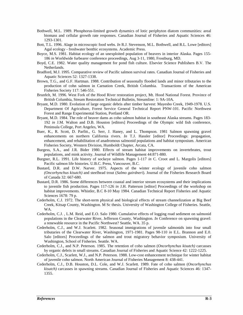
References R-3
Bothwell, M.L. 1989. Phosphorus-limited growth dynamics of lotic periphyton diatom communities: arealbiomass and cellular growth rate responses. Canadian Journal of Fisheries and Aquatic Sciences 46:1293-1301.
Bott, T.L. 1996. Alage in microscopic food webs. In R.J. Stevenson, M.L. Bothwell, and R.L. Lowe [editors]Agal ecology - freshwater benthic ecosystems. Academic Press.
Boyce, M.S. 1981. Habitat ecology of an unexploited population of beavers in interior Alaska. Pages 155-186 in Worldwide furbearer conference proceedings, Aug 3-11, 1980, Frostburg, MD.
Boyd, C.E. 1982. Water quality management for pond fish culture. Elsevier Science Publishers B.V. TheNetherlands.
Bradford, M.J. 1995. Comparative review of Pacific salmon survival rates. Canadian Journal of Fisheries andAquatic Sciences 52: 1327-1338.
Brown, T.G., and G.F. Hartman. 1988. Contribution of seasonally flooded lands and minor tributaries to theproduction of cohn salmon in Carnation Creek, British Columbia. Transactions of the AmericanFisheries Society 117: 546-551.
Brunfelt, M. 1996. West Fork of the Hood River restoration project, Mt. Hood National Forest. Province ofBritish Columbia, Stream Restoration Technical Bulletin, Streamline: 1: 9A-10A.
Bryant, M.D. 1980. Evolution of large organic debris after timber harvest: Mayesbo Creek, 1949-1978. U.S.Department Of Agriculture, Forest Service General Technical Report PNW-101. Pacific NorthwestForest and Range Experimental Station, Portland OR.
Bryant, M.D. 1984. The role of beaver dams as coho salmon habitat in southeast Alaska streams. Pages 183-192 in J.M. Walton and D.B. Houston [editors] Proceedings of the Olympic wild fish conference,Peninsula College, Port Angeles, WA.
Buer, K., R. Scott, D. Parfitt., G. Serr, J. Haney, and L. Thompson. 1981 Salmon spawning gravelenhancements on northern California rivers. In T.J. Hassler [editor] Proceedings: propagation,enhancement, and rehabilitation of anadromous salmonid populations and habitat symposium. AmericanFisheries Society, Western Division, Humboldt Chapter, Arcata, CA.
Burgess, S.A., and J.R. Bider 1980. Effects of stream habitat improvements on invertebrates, troutpopulations, and mink activity. Journal of Wildlife Management 44:871-880.
Burgner, R.L. 1991. Life history of sockeye salmon. Pages 1-117 in C. Croot and L. Margolis [editors]Pacific salmon life histories. U.B.C. Press, Vancouver, B.C.
Bustard, D.R. and D.W. Narver. 1975. Aspects of the winter ecology of juvenile coho salmon(Oncorhynchus kisutch) and steelhead trout (Salmo gairdneri). Journal of the Fisheries Research Boardof Canada 32: 667-680.
Bustard, D.R. 1986. Some differences between coastal and interior stream ecosystems and their implicationsto juvenile fish production. Pages 117-126 in J.H. Patterson [editor] Proceedings of the workshop onhabitat improvements. Whistler, B.C 8-10 May 1984. Canadian Technical Report Fisheries and AquaticSciences 1678: 79 p.
Cederholm, C.J. 1972. The short-term physical and biological effects of stream channelization at Big BeefCreek, Kitsap County, Washington. M Sc thesis. University of Washington College of Fisheries. Seattle,WA.
Cederholm, C.J. , L.M. Reid, and E.O. Salo 1980. Cumulative effects of logging road sediment on salmonidpopulations in the Clearwater River, Jefferson County, Washington. In Conference on spawning gravel:a renewable resource in the Pacific Northwest? Seattle, WA. 35 p.
Cederholm, C.J., and W.J. Scarlett. 1982. Seasonal immigrations of juvenile salmonids into four smalltributaries of the Clearwater River, Washington, 1971-1981. Pages 98-110 in E.L. Brannon and E.0.Salo [editors] Proceedings of the salmon and trout migratory behavior symposium. University ofWashington, School of Fisheries. Seattle. WA.
Cederholm, C.J., and N.P. Peterson. 1985. The retention of coho salmon (Oncorhynchus kisutch) carcassesby organic debris in small streams. Canadian Journal of Fisheries and Aquatic Science 42: 1222-1225.
Cederholm, C.J., Scarlett, W.J., and N.P. Peterson. 1988. Low-cost enhancement technique for winter habitatof juvenile coho salmon. North American Journal of Fisheries Management 8: 438-441.
Cederholm, C.J., D.B. Houston, D.L. Cole, and W.J. Scarlett. 1989. Fate of coho salmon (Oncorhynchuskisutch) carcasses in spawning streams. Canadian Journal of Fisheries and Aquatic Sciences 46: 1347-1355.
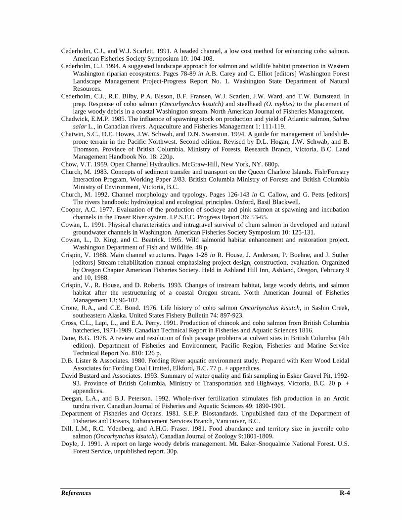
References R-4
Cederholm, C.J., and W.J. Scarlett. 1991. A beaded channel, a low cost method for enhancing coho salmon.American Fisheries Society Symposium 10: 104-108.
Cederholm, C.J. 1994. A suggested landscape approach for salmon and wildlife habitat protection in WesternWashington riparian ecosystems. Pages 78-89 in A.B. Carey and C. Elliot [editors] Washington ForestLandscape Management Project-Progress Report No. 1. Washington State Department of NaturalResources.
Cederholm, C.J., R.E. Bilby, P.A. Bisson, B.F. Fransen, W.J. Scarlett, J.W. Ward, and T.W. Bumstead. Inprep. Response of coho salmon (Oncorhynchus kisutch) and steelhead (O. mykiss) to the placement oflarge woody debris in a coastal Washington stream. North American Journal of Fisheries Management.
Chadwick, E.M.P. 1985. The influence of spawning stock on production and yield of Atlantic salmon, Salmosalar L., in Canadian rivers. Aquaculture and Fisheries Management 1: 111-119.
Chatwin, S.C., D.E. Howes, J.W. Schwab, and D.N. Swanston. 1994. A guide for management of landslide-prone terrain in the Pacific Northwest. Second edition. Revised by D.L. Hogan, J.W. Schwab, and B.Thomson. Province of British Columbia, Ministry of Forests, Research Branch, Victoria, B.C. LandManagement Handbook No. 18: 220p.
Chow, V.T. 1959. Open Channel Hydraulics. McGraw-Hill, New York, NY. 680p.Church, M. 1983. Concepts of sediment transfer and transport on the Queen Charlote Islands. Fish/Forestry
Interaction Program, Working Paper 2/83. British Columbia Ministry of Forests and British ColumbiaMinistry of Environment, Victoria, B.C.
Church, M. 1992. Channel morphology and typology. Pages 126-143 in C. Callow, and G. Petts [editors]The rivers handbook: hydrological and ecological principles. Oxford, Basil Blackwell.
Cooper, A.C. 1977. Evaluation of the production of sockeye and pink salmon at spawning and incubationchannels in the Fraser River system. I.P.S.F.C. Progress Report 36: 53-65.
Cowan, L. 1991. Physical characteristics and intragravel survival of chum salmon in developed and naturalgroundwater channels in Washington. American Fisheries Society Symposium 10: 125-131.
Cowan, L., D. King, and C. Beatrick. 1995. Wild salmonid habitat enhancement and restoration project.Washington Department of Fish and Wildlife. 48 p.
Crispin, V. 1988. Main channel structures. Pages 1-28 in R. House, J. Anderson, P. Boehne, and J. Suther[editors] Stream rehabilitation manual emphasizing project design, construction, evaluation. Organizedby Oregon Chapter American Fisheries Society. Held in Ashland Hill Inn, Ashland, Oregon, February 9and 10, 1988.
Crispin, V., R. House, and D. Roberts. 1993. Changes of instream habitat, large woody debris, and salmonhabitat after the restructuring of a coastal Oregon stream. North American Journal of FisheriesManagement 13: 96-102.
Crone, R.A., and C.E. Bond. 1976. Life history of coho salmon Oncorhynchus kisutch, in Sashin Creek,southeastern Alaska. United States Fishery Bulletin 74: 897-923.
Cross, C.L., Lapi, L., and E.A. Perry. 1991. Production of chinook and coho salmon from British Columbiahatcheries, 1971-1989. Canadian Technical Report in Fisheries and Aquatic Sciences 1816.
Dane, B.G. 1978. A review and resolution of fish passage problems at culvert sites in British Columbia (4thedition). Department of Fisheries and Environment, Pacific Region, Fisheries and Marine ServiceTechnical Report No. 810: 126 p.
D.B. Lister & Associates. 1980. Fording River aquatic environment study. Prepared with Kerr Wood LeidalAssociates for Fording Coal Limited, Elkford, B.C. 77 p. + appendices.
David Bustard and Associates. 1993. Summary of water quality and fish sampling in Esker Gravel Pit, 1992-93. Province of British Columbia, Ministry of Transportation and Highways, Victoria, B.C. 20 p. +appendices.
Deegan, L.A., and B.J. Peterson. 1992. Whole-river fertilization stimulates fish production in an Arctictundra river. Canadian Journal of Fisheries and Aquatic Sciences 49: 1890-1901.
Department of Fisheries and Oceans. 1981. S.E.P. Biostandards. Unpublished data of the Department ofFisheries and Oceans, Enhancement Services Branch, Vancouver, B.C.
Dill, L.M., R.C. Ydenberg, and A.H.G. Fraser. 1981. Food abundance and territory size in juvenile cohosalmon (Oncorhynchus kisutch). Canadian Journal of Zoology 9:1801-1809.
Doyle, J. 1991. A report on large woody debris management. Mt. Baker-Snoqualmie National Forest. U.S.Forest Service, unpublished report. 30p.
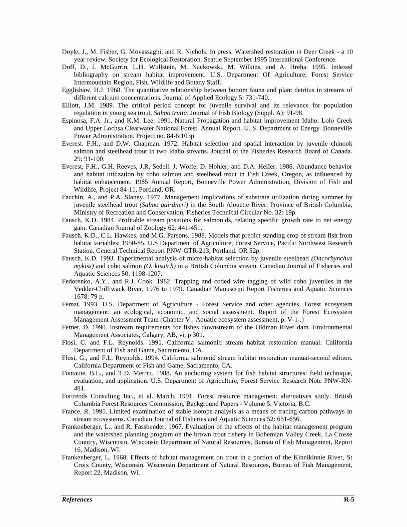
References R-5
Doyle, J., M. Fisher, G. Movassaghi, and R. Nichols. In press. Watershed restoration in Deer Creek - a 10year review. Society for Ecological Restoration. Seattle September 1995 International Conference.
Duff, D., J. McGurrin, L.H. Wullstein, M. Nackowski, M. Wilkins, and A. Hreha. 1995. Indexedbibliography on stream habitat improvement. U.S. Department Of Agriculture, Forest ServiceIntermountain Region, Fish, Wildlife and Botany Staff.
Egglishaw, H.J. 1968. The quantitative relationship between bottom fauna and plant detritus in streams ofdifferent calcium concentrations. Journal of Applied Ecology 5: 731-740.
Elliott, J.M. 1989. The critical period concept for juvenile survival and its relevance for populationregulation in young sea trout, Salmo trutta. Journal of Fish Biology (Suppl. A): 91-98.
Espinosa, F.A. Jr., and K.M. Lee. 1991. Natural Propagation and habitat improvement Idaho: Lolo Creekand Upper Lochsa Clearwater National Forest. Annual Report. U. S. Department of Energy. BonnevillePower Administration. Project no. 84-6:103p.
Everest. F.H., and D.W. Chapman. 1972. Habitat selection and spatial interaction by juvenile chinooksalmon and steelhead trout in two Idaho streams. Journal of the Fisheries Research Board of Canada.29: 91-100.
Everest, F.H., G.H. Reeves, J.R. Sedell. J. Wolfe, D. Hohler, and D.A. HelIer. 1986. Abundance behaviorand habitat utilization by coho salmon and steelhead trout in Fish Creek, Oregon, as influenced byhabitat enhancement. 1985 Annual Report, Bonneville Power Administration, Division of Fish andWildlife, Project 84-11, Portland, OR.
Facchin, A., and P.A. Slaney. 1977. Management implications of substrate utilization during summer byjuvenile steelhead trout (Salmo gairdneri) in the South Alouette River. Province of British Columbia,Ministry of Recreation and Conservation, Fisheries Technical Circular No. 32: 19p.
Fausch, K.D. 1984. Profitable stream positions for salmonids, relating specific growth rate to net energygain. Canadian Journal of Zoology 62: 441-451.
Fausch, K.D., C.L. Hawkes, and M.G. Parsons. 1988. Models that predict standing crop of stream fish fromhabitat variables: 1950-85. U.S Department of Agriculture, Forest Service, Pacific Northwest ResearchStation. General Technical Report PNW-GTR-213, Portland. OR 52p.
Fausch, K.D. 1993. Experimental analysis of micro-habitat selection by juvenile steelhead (Oncorhynchusmykiss) and coho salmon (O. kisutch) in a British Columbia stream. Canadian Journal of Fisheries andAquatic Sciences 50: 1198-1207.
Fedorenko, A.Y., and R.J. Cook. 1982. Trapping and coded wire tagging of wild coho juveniles in theVedder-Chilliwack River, 1976 to 1979. Canadian Manuscript Report Fisheries and Aquatic Sciences1678: 79 p.
Femat. 1993. U.S. Department of Agriculture - Forest Service and other agencies. Forest ecosystemmanagement: an ecological, economic, and social assessment. Report of the Forest EcosystemManagement Assessment Team (Chapter V - Aquatic ecosystem assessment, p. V-1-.)
Fernet, D. 1990. Instream requirements for fishes downstream of the Oldman River dam. EnvironmentalManagement Associates, Calgary, AB, vi, p 301.
Flosi, C. and F.L. Reynolds. 1991. California salmonid stream habitat restoration manual. CaliforniaDepartment of Fish and Game, Sacramento, CA.
Flosi, G., and F.L. Reynolds. 1994. California salmonid stream habitat restoration manual-second edition.California Department of Fish and Game, Sacramento, CA.
Fontaine. B.L., and T.D. Merritt. 1988. An anchoring system for fish habitat structures: field technique,evaluation, and application. U.S. Department of Agriculture, Forest Service Research Note PNW-RN-481.
Fortrends Consulting Inc., et al. March. 1991. Forest resource management alternatives study. BritishColumbia Forest Resources Commission, Background Papers - Volume 5. Victoria, B.C.
France, R. 1995. Limited examination of stable isotope analysis as a means of tracing carbon pathways instream ecosystems. Canadian Journal of Fisheries and Aquatic Sciences 52: 651-656.
Frankenberger, L., and R. Fassbender. 1967. Evaluation of the effects of the habitat management programand the watershed planning program on the brown trout fishery in Bohemian Valley Creek, La CrosseCountry, Wisconsin. Wisconsin Department of Natural Resources, Bureau of Fish Management, Report16, Madison, WI.
Frankenberger, L. 1968. Effects of habitat management on trout in a portion of the Kinnikinnie River, StCroix County, Wisconsin. Wisconsin Department of Natural Resources, Bureau of Fish Management,Report 22, Madison, WI.
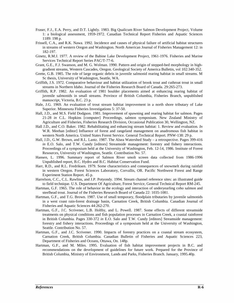
References R-6
Fraser, F.J., E.A. Perry, and D.T. Lightly. 1983. Big Qualicum River Salmon Development Project, Volume1: a biological assessment, 1959-1972. Canadian Technical Report Fisheries and Aquatic Sciences1189: 198 p.
Frissell, C.A., and R.K. Nawa. 1992. Incidence and causes of physical failure of artificial habitat structuresin streams of western Oregon and Washington. North American Journal of Fisheries Management 12: in182-197.
Ginetz, R.M.J. 1977. A review of the Babine Lake Development Project, 1961-1976. Fisheries and MarineServices Technical Report Series PAC/T-77-6.
Grant, G.E., F.J. Swanson, and M. G. Wolman. 1990. Pattern and origin of stepped-bed morphology in high-gradient streams, Western Cascades, Oregon. Geological Society of America Bulletin, vol 102:340-352.
Grette, G.B. 1985. The role of large organic debris in juvenile salmonid rearing habitat in small streams. MSc thesis, University of Washington, Seattle, WA.
Griffith, J.S. 1972. Comparative behaviour and habitat utilization of brook trout and cuthroat trout in smallstreams in Northern Idaho. Journal of the Fisheries Research Board of Canada. 29:265-273.
Griffith, R.P. 1982. An evaluation of 1981 boulder placements aimed at enhancing rearing habitat ofjuvenile salmonids in small streams. Province of British Columbia, Fisheries Branch, unpublishedmanuscript, Victoria, B.C. 23 p.
Hale, J.G. 1969. An evaluation of trout stream habitat improvement in a north shore tributary of LakeSuperior. Minnesota Fisheries Investigations 5: 37-50.
Hall, J.D., and M.S. Field Dodgson. 1981. Improvement of spawning and rearing habitat for salmon. Pages21-28 in C.L. Hopkins [computer] Proceedings, salmon symposium. New Zealand Ministry ofAgriculture and Fisheries, Fisheries Research Division, Occasional Publication 30, Wellington, NZ.
Hall J.D., and C.O. Baker. 1982. Rehabilitating and enhancing stream habitat: 1. Review and evaluation. InW.R. Meehan [editor] Influence of forest and rangeland management on anadromous fish habitat inwestern North America. United States Forest Service. General Technical Report. PNW-138: 29 p.
Hall, J.D., G.W. Brown, and R.L. Lantz. 1987. The Alsea Watershed Study – a retrospective. Pages 399-416in E.O. Salo, and T.W. Cundy [editors] Streamside management: forestry and fishery interactions.Proceedings of a symposium held at the University of Washington, Feb. 12-14, 1986. Institute of ForestResources, University of Washington, Seattle. Contribution No. 57.
Hansen, L. 1996. Summary report of Salmon River smolt screen data collected from 1986-1996Unpublished report, B.C. Hydro and B.C. Habitat Conservation Fund.
Harr, R.D., and R.L. Fredriksen. 1979. Some characteristics and consequences of snowmelt during rainfallin western Oregon. Forest Sciences Laboratory, Corvallis, OR. Pacific Northwest Forest and RangeExperiment Station Report. 45 p.
Harrelson, C.C., C.L. Rawlins, and J.P. Potyondy. 1994. Stream channel reference sites: an illustrated guideto field technique. U.S. Department Of Agriculture, Forest Service, General Technical Report RM-245.
Hartman, G.F. 1965. The role of behavior in the ecology and interaction of underyearling coho salmon andsteelhead trout. Journal of the Fisheries Research Board of Canada 22: 1035-1081.
Hartman, G.F., and T.G. Brown. 1987. Use of small temporary, floodplain tributaries by juvenile salmonidsin a west coast rain-forest drainage basin, Carnation Creek, British Columbia. Canadian Journal ofFisheries and Aquatic Sciences 44:262-270.
Hartman, G.F., J.C. Scrivener, L.B. Holtby, and L. Powell. 1987. Some effects of different streamsidetreatments on physical conditions and fish population processes in Carnation Creek, a coastal rainforestin British Columbia. Pages 330-372 in E.O. Salo and T.W. Cundy [editors] Streamside management:forestry and fishery interactions. Proceedings of a symposium held at the University of Washington,Seattle. Contribution No. 57.
Hartman, G.F., and J.C. Scrivener. 1990. Impacts of forestry practices on a coastal stream ecosystem,Carnation Creek, British Columbia. Canadian Bulletin of Fisheries and Aquatic Sciences 223,Department of Fisheries and Oceans, Ottawa, On. 148p.
Hartman, G.F., and M. Miles. 1995. Evaluation of fish habitat improvement projects in B.C. andrecommendations on the development of guidelines for future work. Prepared for the Province ofBritish Columbia, Ministry of Environment, Lands and Parks, Fisheries Branch. January, 1995.40p.
References R-7
Hartman, G.F., J.C. Scrivener, and M.J. Miles. 1996. Impacts of logging in carnation Creek, a high-energycoastal stream in British Columbia, and their implication for restoring fish habitat. Canadian Journal ofFisheries and Aquatic Sciences 53 (Suppl. 1): 237-251.
Hatler, D. July 1988. Beaver management guidelines in British Columbia. Province of British Columbia,Ministry of Environment, Wildlife Branch. 6 p.
Heard, W.R. 1991. Life history of pink salmon. Pages 120-230 in C. Groot and L. Margolis [editors] Pacificsalmon life histories. U.B.C. Press, Vancouver, B.C.
Heller, D., K. Wieman, and D. Konnoff. 1996. A preliminary report on instream structure durabilityfollowing 1996 floods. Province of British Columbia, Stream Restoration Bulletin, Streamline 1: 10.
Henderson, F.M. 1966. Open channel flow. Macmillan, New York, NY. 522 p.Hicks, B.J., J.D. Hall, P.A. Bisson, and J.R. Sedell. 1991. Response of salmonids to habitat change. Pages
483-517 in W.R. Meehan [editor] Influences of forest and rangeland management on salmonid fishesand their habitats. American Fisheries Society Special Publication No. 19. Bethesda, Maryland.
Hillborn, R., and J. Winton. 1993. Learning to enhance salmon production: lessons from the SalmonidEnhancement Program. Canadian Journal of Fisheries and Aquatic Sciences 50: 2043-2056.
Hogan, D.L. 1986. Channel morphology of unlogged, logged, and debris torrented streams in the QueenCharlotte Islands. British Columbia Ministry of Forests Land Management Report No. 49: 94p.
Hogan, D.L. 1987. The influence of large organic debris on channel recovery in the Queen Charlotte Islands,British Columbia, Canada. Pages 343-354 in R.L. Beschta, T. Blinn, G.E. Grant, G.G. Ice, and F.J.Swanson [editors] Erosion and sedimentation in the Pacific Rim. International Association ofHydrological Sciences, IAHS Publication No. 165.
Hogan, D.L. 1989. Channel response to mass wasting in the Queen Charlotte Islands, British Columbia:temporal and spatial changes in stream morphology. Pages 125-144 in Proceedings of watersheds ’89.A conference on the stewardship of soil, air and water resources, Juneau, Alaska, March 21-23, 1989,U.S. Department of Agriculture, Forest Service, Alaska Region, R1-MB-77.
Hogan, D.L., and M. Church. 1989. Hydraulic geometry in small, coastal streams: progress towardquantification of salmonid habitat. Canadian Journal of Fisheries and Aquatic Sciences 46: 844-852.
Hogan D.L., S.A. Bird, and D.J. Wildford. 1997. Channel conditions and prescriptions assessment. Provinceof British Columbia, Ministry of Environment, Lands and Parks, and Ministry of Forests. WatershedRestoration Technical Circular No. 7: 42 p.
Hogan, D.L. S.A. Bird, and M.A. Hassan. In press. Spatial and temporal evolution of small coastal gravel-bed streams: The influence of forest management on channel morphology and fish habitats. In Gravel-bed rivers IV workshop proceedings, August 20-26, 1995, Gold Bar, WA.
Hourston, W.R., and D. MacKinnon. 1956. Use of an artificial spawning channel by salmon. Transactions ofthe American Fisheries Society 86: 220-230.
House, R.A., and P.L. Boehne. 1985. Evaluation of instream enhancement structures for salmonid spawningand rearing in a coastal Oregon stream. North American Journal of Fisheries Management 5: 283-295.
House, R.A., and P.L. Boehne. 1986. Effects of instream structures on salmonid habitat and populations inTobe Creek, Oregon. North American Journal of Fisheries management 6: 283-295.
House, R., J. Anderson, P. Boehne, and J. Suther [editors]. 1988. Stream rehabilitation manual emphasizingproject design-construction-evaluation. Training held Feb. 9 and 10, 1988. Organized by OregonChapter American Fisheries Society.
Hourse, R.A., V.A. Crispin, and J.M. Suther. 1991. Habitat and changes after rehabilitation of two coastalstreams in Oregon. American Fisheries Symposium 10: 150-159.
Hunt, R.L. 1969. Effects of habitat alteration on production, standing crop and yield of brook trout inLawrence Creek, Wisconsin. Pages 281-312 in T.G. Northcote [editor] Salmon and trout in streams.H.R. MacMillan Lectures in Fisheries, University of British Columbia, Vancouver, B.C.
Hunt, R.L. 1971. Responses of a brook trout population to habitat development in Lawrence Creek.Wisconsin Department of Natural Resources Technical Bulletin 48.
Hunt, R.L. 1976. A long term evaluation of trout habitat development and its relation to improvingmanagement-related research. Transactions of the American Fisheries Society 195:361-364.
Hunt, R.L. 1988. A compendium of 45 trout stream habitat development evaluations in Wisconsin during1953-1985. Wisconsin Department of Natural Resources Technical Bulletin No. 162: 80 p.
Hunter, C.J. 1991. Better trout habitat. A guide to stream restoration and management. T. Palmer [editor]Montana Land Reliance. Island Press. Washington, D.C.
References R-8
Huntsman, A.G. 1948. Fertility and fertilization of streams. Journal of the Fisheries Research Board ofCanada 7: 248-353.
Iverson, D.C., and R.M. Alston. 1994. A new role for economics in integrated environmental management.Pages 27-40 in John Cairns Jr., Todd V. Crawford, and Hal Salwasser [editors] Implementing integratedenvironmental management. Virginia Polytechnic Institute and State University, Blacksburg, VA.
Johnson, A.W., and J.M. Stypula [editors]. 1993. Guidelines for bank stabilization projects in the riverineenvironments of King County. King County Department of Public Works, Surface Water managementDivision, Seattle, WA.
Johnstong, N.T., C.J. Perrin, P.A. Slaney, and B.R. Ward. 1990. Increased Juvenile salmonid growth bywhole-river fertilization. Canadian Journal of fisheries and Aquatic Sciences 47: 862-872.
Johnston, N.T., and G.D. Moore. 1995. Guidelines for planning watershed restoration projects. Province ofBritish Columbia, Ministry of Environment, Lands and Parks, and Ministry of Forests. WatershedRestoration Technical Circular No 1: 52p.
Johnston, N.T., and P.A. Slaney. 1996. Fish Habitat Assessment Procedures. Province of British Columbia,Ministry of Environment, Lands and Parks, and Ministry of Forests. Watershed Restoration TechnicalCircular No. 8: 97 p.
Jones, J.A., and G.E. Grant. 1996. Peak flow responses to clearcutting and roads, Western Cascades,Oregon. Water Resource Research, vol. 32, No. 4: 959-974.
Kauffman, J.B., R.L. Beschta, N. Otting, and D. Lytjen. 1997. An ecological perspective on riparian andstream restoration in the western United States. Fisheries 22(5): 12-24.
Keeley, E.R., and C.J. Walters. 1994. The British Columbia Watershed Restoration Program: summary ofthe experimental design, monitoring and restoration techniques workshop. Province of BritishColumbia, Ministry of Environment, Lands and Parks, and Ministry of Forests. Watershed RestorationProject Report No. 1: 34 p.
Keeley, E.R., P.A. Slaney. 1996. Quantitative measures of rearing and spawning habitat characteristics forstream dwelling salmonids: guidelines for habitat restoration. Province of British Columbia, Ministry ofEnvironment, Lands and Parks and Ministry of Forests. Watershed Restoration Project Report No. 4: 34p.
Keeley, E.R., P.A. Slaney, and D. Zaldokas. 1996. Estimates of production benefits for salmonid fishes fromstream restoration initiatives. Province of British Columbia, Ministry of Environment, Lands and Parksand Ministry of Forests. Watershed Restoration Management Report No. 4: 22p.
Kellerhals, R., M. Church, and D.I. Bray. 1976. Classification and analysis of river processes. Journal of theHydraulics Division, American Society of Civil Engineers, v. 17: 711-722.
Kellerhals, R., and M. Church. 1989. The morphology of large rivers: characterization and management.Pages 31-48 in D.P. Dodge [editor] Proceedings of the international large river symposium. CanadianSpecial Publication Fisheries and Aquatic Sciences 106.
Kellerhals, R., and M. J. Miles. 1996. Fluvial geomorphology and fish habitat: implications for riverrestoration. Pages A261-A279 in M. Leclerc et al. [editors] Proceedings of the second IAHRSymposium on habitat hydraulics 2000.
King, D., and R. Young. 1986. An evaluation of our groundwater-fed side channels of the east fork of theSatsop River – spring 1985 outmigrants. State of Washington, Department of Fisheries. TechnicalReport 90: 73 p.
Kline, T.C. Jr., J.J. Goering, O.A. Mathisen, P.H. Poe, P.L. Parker, and R.S. Scalan. 1993. Recycling ofelements transported upstream by runs of Pacific salmon: II. 15N and 13C evidence in the Kvichak Riverwatershed, Bristol Bay, southwestern Alaska. Canadian Journal of Fisheries and Aquatic Sciences 50:2350-2365.
Klingeman, P.C. 1984. Evaluating hydrologic needs for design of stream habitat modification structures.Pages 191-213 in T.J. Hassler [editor] Proceedings: Pacific Northwest stream habitat managementworkshop. American Fisheries Society, Western Division, Humboldt Chapter, Arcata, CA.
Koenings, J.P., and R.D. Burkett. 1987. An aquatic Rubic’s Cube: restoration of the Karluk lake sockeyesalmon (Oncorhynchus nerka). Pages 419-434 in H.D. Smith, L. Margolis, and C.C. Wood [editors}.Sockeye salmon (Oncorhynchus nerka) population biology and future management. Canadian SpecialPublication Fisheries and Aquatic Sciences 96.

References R-9
Kondolf, G.M., and E.R. Micheli. 1995. Evaluating stream restoration projects. Environmental Management19: 1-15
Koning, W. 1994. Stream inventory manual. Government of Canada, Department of Fisheries and Oceansand Province of British Columbia, Ministry of Environment, Lands and Parks, Victoria, B.C.
Koning, C.W., K.I. Ashley, P.A. Slaney, R.W. Land, and P.W. Davidson. 1995. Development of a premiernorthern river fishery: Mesilinka River pre-fertilization progress 1992-93. Province of British ColumbiaMinistry of Environment, Lands and Parks Fisheries Progress Report No. RD 46: 37p.
Koning, C.W., K.I. Ashley, P.A. Slaney, and A.J. Paul. 1996. Stream fertilization as a fisheries mitigationtechnique for perturbated oligotrophic trout streams in British Columbia. In Proceedings of the TroutUnlimited Canada conference on forest-fish interactions, May 1-4, 1996, Calgary, AB.
Koning, C.W., M.N. Gaboury, M.D. Feduk, and P.A. Slaney. 1997. Techniques to evaluate the effectivenessof fish habitat restoration works in streams impacted by logging activities. In Proceedings of the 50thannual conference of the Canadian Water Resources Association (CWRA), “Footprints of Humanity”June 3-6, 1997, Lethbridge, AB. 13p.
Koonce, G.P. 1990. Two-pin method for the layout of stream habitat enhancement designs. Proceedings ofthe seventh California salmon, steelhead, and trout restoration conference. Eureka, CA.
Koski, K.Y. 1992. Restoring stream habitats affected by logging activities. Pages 344-397 in G.W. Thayer[editor] Restoring the nation’s marine environment. Maryland Sea Grant Book, College park, MD.
Lammel, R.F. 1972. Natural debris and logging residue within the stream environments. MSc thesis, OregonState University, Corvallis, OR.
Lane, E.W. 1955. Design of stable channels. ASCE Transactions 120: 1234-1279.Lanka, R.P., W.A. Hubert, and W.A. Wesche. 1987. Relations of geomorphology to stream habitats and
trout standing stock in small rocky mountain streams. Transactions of the American Fisheries Society116: 21-28.
Laramie, H.A., Jr. 1963. Device for control of problem beavers. Journal of Wildlife Management 27(3):471-476.
Larkin, P.A. 1975. A commentary on environmental impact assessment for large projects affecting lakes andstreams. Canadian Journal of Fisheries and Aquatic Sciences 41: 1121-1127.
Larkin, G.A., and P.A. Slaney. 1996. Trends in marine-derived nutrient sources to south coastal BritishColumbian streams: impending implications to salmonid production. Province of British Columbia,Ministry of Environment, Lands and Parks and Ministry of Forests. Watershed RestorationManagement Report No. 3: 56p.
Larkin, G.A., P.R.B. Ward, K.I. Ashley, P.A. Slaney, C.W. Koning, and S.E. Mouldey. 1997. Recentadvances in liquid fertilizer injection technology for stream and river restoration. Province of BritishColumbia. Ministry of Environment, Lands and Parks, and Ministry of Forests. Watershed RestorationProject Report No. 5: 28 p.
Latta, W.C. 1972. The effects of stream improvement upon the angler’s catch and standing crop of trout inthe Pigeon River, Otsego County, Michigan. Michigan Department of Natural Resources, Research andDevelopment Report 265, Lansing, MI.
Leopold, L.B., M.G. Wolman, and J.P. Miller. 1964. Fluvial processes in geomorphology. Freeman, SanFrancisco, CA. 522p.
Leopold, L.B., and W.B. Langbein. 1966. River meanders. Scientific American 214(6): 60-70.Lere, M.E. 1982. The long term effectiveness of three types of stream improvement structures installed in
Montana streams. M Sc thesis, Montana State University, Bozeman, MT. 99p.Lestelle, L.C. 1978. The effects of debris removal on cutthroat trout. MSc thesis. University of Washington,
Seattle, WA.Lewis, S.L. 1969. Factors influencing fish populations in pools of a trout stream. Transactions of the
American Fisheries Society 98: 14-19.Lirette, M.G., R.S. Hooton, and V.A. Lewynsky. 1987. Preliminary steelhead production capability
estimates for selected Vancouver Island streams. Province of British Columbia, Fisheries TechnicalCircular No. 74: 23p.
Lister, D.B., Marshall, D.E., and D.G. Hickey. 1980. Chum salmon survival and production at sevenimproved groundwater-fed spawning areas. Canadian Manuscript Report of Fisheries and AquaticSciences 1595: 58 p.
References R-10
Lister, D.B., and W.E. Dunford. 1989. Post-construction monitoring of compensatory fish habitat at CookCreek (1987-88). Prepared for CN Rail Engineering Services, Edmonton, AB. 53 p.
Lister, D.B., R.J. Beniston, R. Kellerhals, and M. Miles. 1995. Rock size affects juvenile salmonid use ofstreambank riprap. Pages 621-632 in C.R. Thorne, S.R. Abt, F.B.J. Barends, S.T. Maynord, and K.W.Pilarczyk [editors] River, coastal and shoreline protection using riprap and armourstone. John Wiley &Sons Ltd., Chichester, England.
Lowe, S. 1996. Fish habitat enhancement designs: typical structures. Alberta Environmental Protection,Water Resource Management Services, River Engineering Branch, Edmonton, AB. 36 p.
Lowry, G.R. 1971. Effect of habitat alteration on brown trout in McKenzie Creek, Wisconsin. WisconsinDepartment of Natural Resources, Research Report 70, Madison, WI.
Lucchetti, G.L., and R.L. White, 1995 draft. Cedar River fish habitat restoration opportunities:identification, conceptual design, salmonid production, and economic value. A technical supplement tothe Cedar River Basin Plan. King County Surface Water Management Division, Seattle, WA.
Marshall, D.E., and E.W. Britton. 1980 Carrying capacity of coho streams. Unpublished manuscript.Department of Fisheries and Oceans, Enhancement Services Branch, Vancouver, B.C. 32p.
Marshall, D.E. 1986. Development and assessment of groundwater-fed side channels. Pages 106-109 in J.H.Patterson [editor] Proceedings of the workshop on habitat improvements, Whistler, B.C. 8-10 May1984. Canadian Technical Report Fisheries and Aquatic Sciences 1483.
Marshall, D.E., and E.W. Britton. 1990. Carrying capacity of coho salmon streams. Canadian ManuscriptReport of Fisheries and Aquatic Sciences No. 2058.
Maser, C., and J.R. Sedell. 1994. From the forest to the sea: the ecology of wood in streams, rivers,estuaries, and oceans. St. Lucie Press, Delray Beach, CA.
Mason, J.C., and D.W. Chapman. 1965. Significance of early emergence, environmental rearing capacity,and behavioral ecology of juvenile coho salmon in stream channels. Journal of the Fisheries ResearchBoard of Canada 22: 173-190.
Mason, J.C. 1976. Response of underyearling coho salmon to supplemental feeding in a natural stream.Journal of Wildlife Management 40: 775-788.
Mathisen, O.A. 1962. The effect of altered sex ratios on the spawning of red salmon. Pages 141-222 inT.S.Y. Koo [editor] Studies of Alaska red salmon. University of Washington Press, Seattle, WA.
McFadden, J.T., and E.L. Cooper. 1962. An ecological comparison of six populations of brown trout (Salmotrutta). Transactions of the American Fisheries Society 91: 53-62.
McGurk, M.D. 1996. Allometry of marine mortality of Pacific salmon. Fisheries Bulletin 94: 77-88.McLennan, D.S., and T. Johnson. 1996. Riparian assessment and prescription procedures. Draft #3A.
Province of British Columbia, Ministry of Environment, Lands and Parks and Ministry of ForestsWatershed Restoration Technical Circular No. 6: 40p + appendices.
McNeil, W.J. 1969. Survival of pink salmon eggs and alevins. In T.G. Northcote [editor] Symposium onsalmon and trout in streams. H.R. MacMillan Lectures in Fisheries. University of British Columbia,Vancouver, B.C.
Milbrink, G., and S. Holmgren. 1988. Nutrient enrichment and increase in fish growth. Verhandlungen DerInternationalen Vereinigung Fur Theoretische und Angewandte Limnologie 23: 1730-1736.
Millar, R.G. 1997. Ballast Requirements for lateral log jams. Technical Memorandum for the Province ofBritish Columbia, Watershed Restoration Program. 18 p.
Minaker, B.A., F.K. Sandercock, and L.I. Balmer. 1979. Big Qualicum River Project, 1974-1975. Fisheriesand Marine Services Manuscript Report 1528: 131p.
Minns, C.K., R.G. Randall, E. Michael, P. Chadwick, J.E. Moore, and R. Green. 1995. Potential impact ofclimate change on the habitat and population dynamics of juvenile Atlantic salmon (Salmo salar) inEastern Canada. Pages 699-708 in R.J. Beamish [editor] Climate change an northern fish populations.Canadian Special Publication Fisheries and Aquatic Sciences 121.
Minshall, G. W. 1978. Autotrophy in stream ecosystems. Bioscience 28: 767-771.Minshall, G.W., K.W. Cummins, R.C. Petersen, C.E. Cushing, D.A. Bruns, J.R. Sedell, and R.L. Vannote.
1985. Developments in stream ecosystem theory. Canadian Journal of Fisheries and Aquatic Sciences42: 1045-1055.
Minshall, G.W., E. Hitchcock, and J.R. Barnes. 1991. Decomposition of rainbow trout (Oncorhynhusmykiss) carcasses in a forest stream ecosystem inhabited only by nonanadromous fish populations.Canadain Journal of Fisheries and Aquatic Sciences 48: 191-195.
References R-11
Mollard, J.D. 1973. Airphoto interpretation of fluvial features. Pages 339-380 in Fluvial processes andsedimentation. Proceedings of hydrology symposium, University of Alberta, Edmonton. May 8-9, 1973.Published by National Research Council Association Committee on Geodesy and Geophysics,Subcommittee on Hydrology.
Montgomery, D.R., and J.M. Buffington. 1993. Channel classification, prediction of channel response, andassessment of channel condition. Report TFW-SH10-93-002, prepared for the SHAMW Committee ofthe Washington State Timber/Fish/Wildlife Agreement. 84 p.
Montgomery, D.R., J.M. Buffington, R.D. Smith, K.M. Schmidt, and G. Press. 1995. Pool spacing in forestchannels. Water Resources Research 31: 1097-1105.
Moore, G.D. 1994. Resource road rehabilitation handbook: planning and implementation guidelines (interimmethods). Province of British Columbia, Ministry of Environment, Lands and Parks, and Ministry ofForests. Watershed Restoration Technical Circular No. 3: 115p.
Moreau, J.K. 1984. Anadromous salmonid habitat enhancement by boulder placement in Hurdygurdy Creek,California. In T.J. Hassler [editor] Proceedings: Pacific Northwest stream habitat managementworkshop. American Fisheries Society, Western Division, Humboldt Chapter, Arcata, CA.
Mouldey, S., and K. Ashley. 1996 Development and testing of slow release fertilizer for restoring salmonhabitat. Province of British Columbia, Ministry of Environment, Lands and Parks, Fisheries ProjectReport No. RD 54.
Mulholland, P.J. 1996. Role in nutrient cycling in streams. In R.J. Stevenson, M.L. Bothwell, and R.L. Lowe[editors] Algal ecology – freshwater benthic ecosystems. Academic Press.
Mundie, J.J. 1969. Ecological implications of the diet of juvenile coho salmon in streams. In T.G. Northcote[editor] Symposium on salmon and trout in streams. H.R. MacMillan Lectures in Fisheries, Universityof British Columbia, Vancouver, B.C.
Mundie, J.H. 1974. Optimization of the salmonid nursery stream. Journal of the Fisheries Research Board ofCanada 31: 1827-1837.
Mundie, J.H., K.S. Simpson, and C.J. Perrin. 1991. Responses of stream periphyton and benthic insects toincreases in dissolved inorganic phosphorus in a mesocosm. Canadian Journal of Fisheries and AquaticSciences 48: 2061-2072.
Murphy, M.L., J. Heifitz, S.W. Johnson. K.V. Koski, and J.F. Thedingda. 1986. Effects of clearcut loggingwith and without buffer strips on juvenile salmonids in Alaskan streams. Canadian Journal of Fisheriesand Aquatic Science 43: 1521-1533.
Murphy, M.L. 1995. Forestry impacts on freshwater habitat of anadromous salmonids in the PacificNorthwest and Alaska – requirements for protection and restoration. U.S. Department of Commerce(NOAA) Coastal Ocean Program. Decision Analysis Series No. 7: 156p.
Narver, D.W. 1978. Ecology of juvenile coho salmon – can we use present knowledge for streamenhancement? Canadian Fisheries and Marine Service Technical Report 759: 38-43.
Nehlsen, W., J.E. Williams, and J.A. Lichatowich. 1991. Pacific salmon at the crossroads: stocks at riskfrom California, Oregon, Idaho, and Washington. Fisheries 16: 4-21.
Newbury Hydraulics. 1996. Constructing pools and riffles for stream rehabilitation. WHS video 9m40s.Newbury Hydraulics, Gibsons, B.C.
Newbury R.W. and M.N. Gaboury. 1993. Exploration and rehabilitation of hydraulic habitats in streamsusing principles of fluvial behaviour. Freshwater Biology 29: 195-210.
Newbury, R.W., and M.N. Gaboury. 1994. Stream analysis and fish habitat design: a field manual. Secondedition. Newbury Hydraulics, Gibsons, B.C. 262p.
Newbury, R.W., M. Gaboury, and D.,J. Bates. 1996. Constructing riffles and pools in channelized streams.European Center for River Restoration 96, Silkeborg, Denmark.
Nickelson, T.E., J.D. Rodgers, S.L. Johnson, and M.F. Solazzi. 1992a. Seasonal changes in habitat use byjuvenile coho salmon (Oncorhynchus kisutch) in Oregon coastal streams. Canadian Journal of Fisheriesand Aquatic Sciences 49: 783-789.
Nickelson, T.E., M.F. Solazzi, S.L. Johnson, and J.D. Rodgers. 1992b. Effectiveness of selected streamimprovements techniques to create suitable summer and winter rearing habitat for juvenile coho salmon(Oncorhynchus kisutch) in Oregon coastal streams. Canadian Journal of Fisheries and Aquatic Sciences49: 790-794.
References R-12
Nordin, R.L. 1985. Water quality criteria for nutrients and algae. Province of British Columbia, Ministry ofEnvironment, Lands and Parks, Water Quality Unit, Resource Quality Section, Water ManagementBranch.
Northcote, T.G., and P.A. Larkin. 1966. Western Canada. Pages 451-485 in D.G. Frey [editor] Limnology inNorth America. University of Wisconsin Press, Madison, WI.
Northcote, T.G. 1992. Prediction and assessment of potential effects of global environmental change onfreshwater sport fish habitat in British Columbia. GeoJournal 28.1:39-49.
Northcote, T.G. 1993. Review of management and enhancement options for the Arctic grayling with specialreference to the Willston Reservoir watershed in British Columbia. Province of British Columbia,Ministry of Environment, Lands and Parks, Fisheries Management Report No. 101: 69 p.
Oliver, G.G. 1994. Woody debris collectors improve salmonid rearing habitat in a large inland riversoutheastern British Columbia. In the Proceedings of the 9th international trout stream habitatimprovement workshop. Sept 6-9, 1994. Calgary, Alberta. Trout Unlimited Canada. 21p.
Olson, B., and J. Doyle, 1996. Preliminary in-channel flood damage assessment: Upper White River Basin(W.F. White, Huckleberry and Greenwater Watersheds). Mt. Baker Snoqualmie National Forest –White River Ranger District. U.S. Forest Service, unpublished report, 40 p.
Oregon Department of Fish and Wildlife. 1995. A guide to placing large wood in streams. HabitatConservation Division, Portland, OR.
Paul, A.J., C.W. Koning, K.I. Ashley, P.A. Slaney, P.W. Davidson, and R.W. Land. 1996. Development of apremier northern river fishery: Mesilinka River, the first year of fertilization (1994). Province of BritishColumbia, Ministry of Environment, Lands and Parks, Fisheries Progress Report No. RD50: 74 p.
Pearce, D.W., and R.K. Turner. 1990. Economics of natural resources and the environment. Johns HopkinsUniversity Press, Baltimore, MD.
Pearlstone, P.S.M. 1976. Management implications of summer habitat characteristics of juvenile steelheadtrout (Salmo gairdneri) in the Big Qualicum River. Province of British Columbia, Ministry ofEnvironment, Fisheries Management Report No. 67: 13p.
Perrin, C.J., K.S. Shortreed, and J.G. Stockner. 1984. An integration of forest and lake fertilization: thetransport and transformation of fertilizer elements. Canadian Journal of Fisheries and Aquatic Sciences41: 253-262.
Perrin, C.J., M.L. Bothwell, and P.A. Slaney. 1987. Experimental enrichment of a coastal stream in BritishColumbia: effects of organic and inorganic additions on autotrophic periphyton production. CanadianJournal of Fisheries and Aquatic Sciences 44: 1247-1256.
Peters, R.J., E.E. Knudsen, C.J. Cederholm, W.J. Scarlett, and G.B. Pauley. 1992. Preliminary results ofwoody debris use by summer-rearing juvenile coho salmon (Oncorhynchus kisutch) in the ClearwaterRiver, Washington. Pages 323-339 in L. Berg and P.W. Delaney [editors] Proceedings of the cohoworkshop, Nanaimo, B.C., May 26-38, 1992.
Peterson, B.J., J.E. Hobbie, A.E. Hershey, M.A. Lock, T.E. Ford, J.R. Vestal, V.L. McKinley, M.C. Miller,R.M. Ventullo, and G.S. Volk. 1985. Transformation of a tundra stream from heterotrophy toautotrophy by addition of phosphorus. Science (Washington, D.C.) 229: 1383-1386.
Peterson, B.J., L. Deegan, J. Helfrich, J.E. Hobbie, M. Hullar, B. Moller, T.E. Ford, A. Hershey, A. Hiltner,G. Kipphut, M.A. Lock, D.M. Fiebig, V. Mckinley, M.C. Miller, J.R. Vestal, R. Ventullo, and G. Volk.1993. Biological responses of a tundra river to fertilization. Ecology 74(3): 653-672.
Peterson, N.P. 1982a. Population characteristics of juvenile coho salmon (Oncorhynchus kisutch)overwintering in riverine ponds. Canadian Journal of Fisheries and Aquatic Sciences 39: 1303-1307.
Peterson, N.P. 1982b. Immigration of juvenile coho salmon (Oncorhynchus kisutch) into riverine ponds.Canadian Journal of Fisheries and Aquatic Sciences 39: 1308-1310.
Peterson, N.P., and L.M. Reid. 1984. Wall-base channels: their evolution, distribution, and use by juvenilecoho salmon in the Clearwater River, Washington. Pages 215-225 in J.M. Walton, and D.B. Houston[editors] Olympic wild fish conference, Peninsula College, Port Angeles, WA.
Peterson, N.P., A. Hendry, and T. Quinn. 1992. Assessment of cumulative effects on salmonid habitat: somesuggested parameters and threshold values. Center for Streamside Studies. University of Washington,Seattle, WA.
Piper, R.G., I.B. McElwain, L.E. Orme, J.P. McCraven, L.G. Fowler, and J.R. Leonard. 1982. Fish hatcherymanagement. U.S. Fish and Wildlife Service, Washington, D.C. 517 p.
References R-13
Poulin, V.A., and Associates. 1991. Stream rehabilitation using LOD placements and off-channel pooldevelopment. Province of British Columbia, Ministry of Forests. Land Management Report 61: 99 p.
Poulin, V.A., and H.W. Argent. 1997 (Draft) Stream crossing guidebook for fish streams, Vancouver, B.C.91p.
Przedwojski, B., R. Blazejewski, and K.W. Pilarczyk. 1995. River training techniques: fundamentals, designand applications. A.A. Balkema Publishers, Rotterdam. 625p.
Quinn, T.P., and N.P. Peterson. 1994. The effects of forest practice on fish populations. Timber-Fish-Wildlife Report F4-94-001 to Washington Department of Natural Resources. 157 p.
R.L.&L. Environmental Services Ltd. 1993. Oldman River Dam Project, Fisheries Evaluation Program,1992 Annual Report, Castle and Oldman Rivers. Prepared for Alberta Public Works, Supply andServices, Edmonton, AB.
R.L.&L. Environmental Services Ltd. 1994. Oldman River Dam Project, Fisheries Evaluation Program,1992 Annual Report, Crowsnest River. Prepared for Alberta Public Works, Supply and Services,Edmonton, AB.
Ralph, S.C., G.C. Poole, L.L. Conquest, and R.J. Naiman. 1994 Stream channel morphology and woodydebris in logged and unlogged basins of western Washington. Canadian Journal of Fisheries andAquatic Sciences 51: 37-51.
Reeves, G.H., and T.D. Roelofs. 1982. Influence of forest and rangeland management on anadromous fishhabitat in western North America. 1. Rehabilitating and enhancing stream habitat; 2. Field applications.U.S. Department of Agriculture, Forest Service General Technical Report PNW-140: 36p.
Reeves, G.J., J.D. Hall, T.D. Roehlofs, T.L. Hickman, and C.O. Baker. 1991. Rehabilitating and modifyingstream habitats. Pages 519-557 in W.R. Meehan [editor] Influences of forest and rangelandmanagement on salmomid fishes and their habitats. American Fisheries Society Special Publication 19,Bethesda, MD.
Richardson, E.V., D.B. Simons, and P.Y. Julien. 1990. Highways in the river environment. Report No.FHWA-HI-90-016, Federal Highway Administration, U.S. Department of Transportation, Washington,D.C.
Riley, S.C., ad K.D. Fausch. 1995. Trout populations response to habitat enhancement in six northernColorado streams. Canadian Journal of Fisheries and Aquatic Sciences 52: 34-53.
Roberts, R.G., and M. Church. 1986. The sediment budget in severely disturbed watersheds, QueenCharlotte Ranges, British Columbia. Canadian Journal of Forest Research, 16: 1092-1106.
Robison, G.E., and R.L. Bestcha. 1990a. Characteristics of coarse woody debris for several coastal streamsof southeast Alaska, U.S.A. Canadian Journal of Fisheries and Aquatic Sciences 47: 1684-1693.
Robison, G.E., and R.L. Bestcha. 1990b. Coarse woody debris and channel morphology interactions forundisturbed streams in southeast Alaska, U.S.A. Earth Surface Processes 15: 149-156.
Rood, K.M. 1984. An aerial photograph inventory of the frequency and yield of mass wasting on the QueenCharlotte Islands, British Columbia. British Columbia Ministry of Forests, Lands Management ReportNo. 34, Victoria, B.C. 55p.
Roper, B.B., J.J. Dose, and J.E. Williams. 1997. Stream restoration: Is fisheries biology enough? Fisheries22(5): 6-11.
Rosgen, D.L. 1994. A classification of natural rivers. Catena 22: 169-199.Rubin, S.P., T.C. Bjornn, and B.Dennis. 1991. Habitat suitability curves for juvenile chinook salmon and
steelhead development using a habitat-orientated sampling approach. Rivers 2(1): 12-29.Salo, E.O., and T.W. Cundy [editors]. 1987. Streamside management: forestry and fisheries interactions.
College of Forest Resources, University of Washington, Seattle, WA. Institute of Forest ResourcesContribution No. 57: 467p.
Salo, E.O. 1991. Life history of chum salmon. Pages 231-309 in C. Groot and L. Margolis [editors] Pacificsalmon life histories. U.B.C. Press, Vancouver, B.C.
Sandercock, F.K., and B.A. Minaker. 1975. Big Qualicum River Project, 1973 – 1974. Fisheries and MarineServices Technical Report PAC/T-75-16: 120p.
Sandercock, F.K. 1991. Life history of coho salmon. Pages 395-445. In C. Groot and L. Margolis [editors]Pacific salmon life histories. U.B.C. Press, Vancouver, B.C.
SAS Institute Inc. 1985. SAS user’s guide: statistics, 5th edition. SAS Institute Inc. Cary, NC.
References R-14
Saunders, J.W., and M.W. Smith. 1962. Physical alteration of stream habitat to improve brook troutproduction. Transactions of the American Fisheries Society 91: 185-188.
Schiechtl, H. 1980. Bioengineering for land reclamation and conservation. University of Alberta Press,Edmonton, AB.
Schuett-Hames, D., A. Pleuss, L. Bullchild, and S. Hall. 1994. Ambient monitoring program manual.Timber-Fish-Wildlife, Northwest Indian Fisheries Commission, TFW-AM9-94-001.
Schuldt, J.A., and A.E. Hershey. 1995. Effect of salmon carcass decomposition on Lake Superior tributarystreams. Journal of the North American Benthological Society 14(2): 259-268.
Schuler, S.W., R.B. Nehring, and K.D. Fausch. 1994. Diel habitat selection by brown trout in the RioGrande River, Colorado, after placement of boulder structures. North American Journal of FisheriesManagement 14: 99-111.
Schumm, S.A. 1977. The fluvial system. John Wiley and Sons, New York, NY. 309p.Schwab, J.W. In press. Landslides on the Queen Charlotte Islands: Processes, rates and climatic events. In S.
Chatwin, D.L. Hogan, and P. Tschaplinski [editors] Proceedings from the Carnation Creek and QueenCharlotte Islands Fish Forestry Interactions Programs workshop. May 10-12, 1994, Queen CharlotteCity, British Columbia. Land Management Handbook No. 33, Province of British Columbia, Ministryof Forests, Research Branch, Victoria, B.C.
Scrivener, J.C., and T.G. Brown. 1993. Impact and complexity from forest practices on streams and theirsalmonid fishes in British Columbia. Pages 41-49 in G. Shooner et S. Asselin [ed.] Le developpementdu Saumon atlantique au Quebec: connaitre les regles due jeu pour reussir. Colloque international de laFederation quebecoise pour le saumon atlantique. Quebec, decembre 1992. Collection Salmo salar no1:201p.
Seehorn, M.E. 1985. Fish habitat improvement handbook. U.S. Department of Agriculture Forest ServiceTechnical Publication R8-TP 7: 21p.
Sheng, M.D., M. Foy, and A.Y. Fedorenko. 1990. Coho salmon enhancement in British Columbia usingimproved groundwater-fed side channels. Canadian Manuscript Report Fisheries and Aquatic Sciences2071: 81p.
Shetter, D.S., O.H. Clark, and A.S. Hazzard. 1949. The effects of deflectors in a section of a Michiganstream. Transactions of the American Fisheries Society 91: 185-188.
Shirvell, C.S. 1990. Role of instream rootwads as juvenile coho salmon (Oncorhynchus kisutch) andsteelhead trout (O. mykiss) cover habitat under varying streamflows. Canadian Journal of Fisheries andAquatic Sciences: 47: 852-861.
Shively, D., and T. Hickman. 1996. The Fish Creek watershed analysis: did it survive a 100-year stormevent? Province of British Columbia, Stream Restoration Bulletin, Streamline 1:6-9.
Sigma Resource Consultants. 1979. Summary of water quality criteria for salmonid hatcheries. Prepared forDepartment of Fisheries and Oceans, Vancouver, B.C.
Slaney, P.A., and T.G. Northcote. 1974. Effects of prey abundance on density and territorial behaviour ofyoung rainbow trout (Salmo gairdneri) in laboratory stream channels. Journal of the Fisheries ResearchBoard of Canada 31: 1201-1209.
Slaney, P.A., T.G. Halsey, and H.A. Smith. 1977a. Some effects of forest harvesting on salmonid rearinghabitat in two streams in the central interior of British Columbia. Province of British Columbia,Ministry of Environment, Fish and Wildlife Branch, Fisheries Management Report No. 71: 26p.
Slaney, P.A., T.G. Halsey, and A.F. Tautz. 1977b. Effects of forest harvesting on spawning habitat of streamsalmonids in the Centennial Creek watershed, British Columbia. Province of British Columbia, Ministryof Environment, Fish and Wildlife Branch, Fisheries Management Report No. 73: 45 p.
Slaney, P.A., H.A. Smith, and T.G. Halsey. 1977c. Physical alterations to small stream channels associatedwith streamside logging practices in the central interior of British Columbia. Province of BritishColumbia, Ministry of Recreation and Conservation, Fisheries Technical Circular No. 31: 22p.
Slaney, P., D.E. Marshall, H. Mundie, and G. Taylor. 1980. Preliminary review of the predictability of smoltyield for wild stocks of chinook salmon, steelhead trout and coho salmon. Unpublished manuscript.Stream Enhancement Research Committee, Salmonid Enhancement Program, Department of Fisheriesand Oceans, Vancouver, B.C.
Slaney, P.A., C.J. Perrin, and B.R. Ward. 1986. Nutrient concentration as a limitation to steelhead smoltproduction in the Keogh River. Proceedings of the annual conference of Western Association Fish andWildlife Agency 66: 146-157.
References R-15
Slaney, P.A., and A.D. Martin. 1987. Accuracy of underwater census of trout populations in a large streamin British Columbia. North America Journal of Fisheries Management 7: 117-122.
Slaney, P.A., and B.R. Ward. 1993. Experimental fertilization of nutrient deficient streams in BritishColumbia. Pages 128-141 in G. Shooner et S. Asselin [ed.] Le developpement du Saumon atlantique auQuebec: connaitre les regles du jeu pour reussir. Colloque international de la Federation quebecoisepour le saumon Atlantique. Quebec, decembre 1992. Collection Salmo salar no 1: 201p.
Slaney, P.A., D. Zaldokas, K.I. Ashley, and D. Rimmer. 1993. Development of a trophy fishery on theAdam River by enhancing habitat productivity: pre-fertilization progress 1992-93. Province of BritishColumbia, Ministry of Environment, Lands and Parks, Fisheries Project Report No. RD 36: 20p.
Slaney, P.A. 1994. The Watershed Restoration Program of British Columbia: An opportunity and achallenge. Pages 117-133 in W.T. Dushenko, H.E. Poll, and K. Johnston [editors] Environmentalimpact assessment and remediation: towards 2000, proceedings of the 34th annual meeting of theCanadian Society of Environmental Biologists, Royal Roads Military College, Victoria, B.C. June 1-4,1994.
Slaney, P.A., W.O. Rublee, C.J. Perrin, and H. Goldberg. 1994a. Debris structure placements and whole-river fertilization for salmonids in a large regulated stream in British Columbia. Bulletin of MarineScience 55(2-3): 1160-1180.
Slaney, P.A., K. Ashley, C. Wightman, R. Ptolemy, and D. Zaldokas. 1994b. Low-level fertilization as ahabitat management option for nutrient deficient trout streams in British Columbia. In the Proceedingsof the 9th International Trout Stream Habitat Improvement Workshop, Sept. 6-9, 1994, Calgary, AB.Trout Unlimited Canada. 23p.
Slaney T.L., K.D. Hyatt, T.G. Northcote, and R.J. Fielden. 1996. Status of anadromous salmon and trout inBritish Columbia and Yukon. Fisheries 21: 20-35.
Slaney, P.A., and A.D. Martin. 1997. The Watershed Restoration program of British Columbia: acceleratingnatural recovery processes. Water Quality Research Journal of Canada 32: 325-346.
Sokal, R.R., and F.J. Rolhf. 1981. Biometry. 2nd edition. W.H. Freeman, San Franscisco, CA.Solazzi, M.F., and S.L. Johnson. 1994. Development and evaluation of techniques to rehabilitate Oregon’s
wild coho salmon. Fish Research Project F-125-R. Annual Progress Report. Oregon Department of Fishand Wildlife, Portland, OR.
Sowden, T.K., and G. Power. 1985. Prediction of rainbow trout embryo survival in relation to groundwaterseepage and particle size of spawning substrates. Transactions of the American Fisheries Society 114:804-812.
Spreiter, T. 1992. Redwood National Park watershed restoration manual. Redwood National Park, Orick,CA.
Stansby, M.E., and A.S. Hall. 1965. Chemical composition of commercially important fish of the UnitedStates. Fishery Industrial Research 3: 29-46.
Stockner, J.G., and K.R.S. Shortreed. 1978. Enhancement of autotrophic production by nutrient addition in acoastal rainforest stream on Vancouver Island. Journal of the Fisheries Research Board of Canada 35:28-34.
Stockner, J.G., and E.A. MacIsaac. 1996. British Columbia lake enrichment programme; two decades ofhabitat enhancement for sockeye salmon. Regulated Rivers: Research and Management: 12: 547-561.
Sullivan, K. 1986. Hydraulics and fish habitat in relation to channel morphology. PhD thesis, Johns HopkinsUniversity, Baltimore, MD. 430 p.
Sullivan, K., T.E. Lisle, A.A. Dolloff, G.E. Grant, and L. Reid. 1997. Stream channels: the link betweenforests and fishes. Pages 39-97 in E.O. Salo, and T.W. Cundy [editors] Streamside management:forestry and fisheries interactions. College of Forest Resources, University of Washington, Seattle, WA,Institute of Forest Resources Contribution No. 57.
Swales, S., Lauzier, R.B., and C.D. Levings. 1986. Winter habitat preferences of juvenile salmonids in twointerior rivers in British Columbia. Canadian Journal of Zoology 64: 1506-1514.
Swales, S., F. Caron, Irvine, J.R., and C.D. Levings. 1988. Overwintering habitats of coho salmon(Oncorhynchus kisutch) and other juvenile salmonids in the Keogh River system, British Columbia.Canadian Journal of Zoology 66: 254-261.
Swales, S., and C.D. Levings. 1989. Role of off-channel ponds in the life cycle of coho salmon and otherjuvenile salmonids in the Coldwater River, British Columbia. Canadian Journal of Fisheries andAquatic Sciences 46: 232-242.
References R-16
Tenant, D.L. 1976. Instream flow regimens for fish, wildlife, recreation and related envrionmental services.Pages 359 – 373 in J.F. Orsborn, and C.H. Allman [editors] Instream flow needs, Volume II. AmericanFisheries Society, Western Division, Bethesda, MD.
Toews, D.A.A., and M.J. Brownlee. 1981. A handbook for fish habitat protection on forest lands in BritishColumbia. Editorial contributions by H. Paish and Associated Ltd. Land Use Unit, Habitat ProtectionDivision, Field Services Branch, Department of Fisheries and Oceans Canada, 165 p.
Toews, D.A.A., and M.K. Moore. 1982. The effects of streamside logging on large organic debris inCarnation Creek. Publication R 28-81071. Province of British Columbia, Ministry of Forests, Victoria,B.C. 29 p.
Toth, B.M., P.A. Slaney, T.I. Godin, and K.I. Ashley. 1993. Development of a premier river fishery: BigSilver pre-fertilization progress. Province of British Columbia, Ministry of Environment, Lands andParks, Fisheries Progress Report No. RD 37: 16p.
Toth, B.M., K. I. Ashley, G.A. Wilson, C.W. Koning, P.A. Slaney, and R.W. Lands. 1996. Development ofpremier river fishery: Big Silver Creek fertilization experiment, year two (1995) of low-level inorganicnutrient addition. Province of British Columbia, Ministry of Environment, Lands and Parks, FisheriesProject Report No. RD 56: 47 p.
Toth, B., K. Ashley, G. Wilson, C.W. Koning, P. Slaney, D. Rimmer, and R. Land. 1997. Development of aresident trout fishery on the Adam River through increased habitat productivity: year two (1995) of low-level inorganic nutrient addition. Province of British Columbia, Ministry of Environment, Lands andParks, Fisheries Project Report No. RD 57: 50 p.
Tripp, D.B., and V.A. Poulin. 1986. The effects of mass wasting on juvenile fish habitats in streams on theQueen Charlotte Islands. British Columbia Ministry of Forests and Lands, Land Management Report45: 48 p.
Tripp, D. 1994. The use and effectiveness of the Coastal Fisheries Forestry Guidelines in selected ForestDistricts of coastal British Columbia. British Columbia Ministry of Forests, Integrated ResourcesBranch Report, Victoria, B.C. 86p.
Triska, F.J., J.R. Sedell, and S.V. Gregory. 1982. Coniferous forest streams. US-IBP (InternationalBiological Program) Synthesis Series 14: 292-332.
Tsumura, K., and B.R. Ward. 1987. A sling used for boulder placement in instream enhancement projects.North American Journal of Fisheries Management 7: 456-457.
U.S. Federal Highway Administration. 1988. Use of riprap for bank protection. Highway EngineeringCircular No. 11, Washington, D.C.
Van Alen, B.W. 1996. Status of salmon populations in Southeast Alaska. Towards sustainable fisheries:Balancing conservation and the use of salmon and steelhead in the Pacific International Chapter of theAmerican Fisheries Society.
Van Cleef, J.S. 1885. How to restore our trout streams. Pages 51-55, American Fisheries Society, 14thAnnual Meeting.
Vannote, R.L., G.W. Minshall, K.W. Cummins, J.R. Sedell, and C.E. Cushing. 1980. The river continuumconcept. Canadian Journal of Fisheries and Aquatic Sciences 37: 130-137.
Ward, B.R., and P.A. Slaney. 1979. Evaluation of in-stream enhancement structures for the production ofjuvenile steelhead trout and coho salmon in the Keogh River: progress 1977 and 1978. Province ofBritish Columbia, Fisheries Technical Circular No. 45: 47p.
Ward, B.R., and P.A. Slaney. 1980. Evaluation of instream enhancement structures for the production ofjuvenile steelhead trout and coho salmon in the Keogh River. Unpublished manuscript. Fisheriesmanagement Report, Fish and Wildlife Branch, B.C. Ministry of Environment.
Ward, B.R., and P.A. Slaney. 1981. Further evaluations of structures for the improvement of salmonidrearing habitat in coastal stream in British Columbia. In T.J. Hassler [editor] Proceedings: propagation,enhancement, and rehabilitation of anadromous salmonid populations and habitat symposium.American Fisheries Society, Western Division, Humboldt Chapter, Arcata, CA.
Ward, B.R., and P.A. Slaney. 1988. Life history and smolt-to-adult survival of Keogh River steelhead trout(Salmo gairdneri) and the relationship to smolt size. Canadian Journal of Fisheries and AquaticSciences 45: 1110-1122.
References R-17
Ward, B.R., P.A. Slaney, A.R. Facchin, and R.W. Land. 1989. Size-biased survival in steelhead trout: backcalculated lengths from adults’ scales compared to migrating smolts at the Keogh River, B.C. CanadianJournal of Fisheries and Aquatic Sciences 46: 1853-1858.
Ward, B.R. and P.A. Slaney. 1990. Returns of pen-reared steelhead from riverine, estuarine and marinereleases. Transactions of the American Fisheries Society 119: 492-499.
Ward, B.R. , and P.A. Slaney. 1993a. Egg-to-smolt survival and fry-to-smolt density dependence of KeoghRiver steelhead. Pages 209-217 in R.J. Gibson and R.E. Cutting [editors] Production of juvenileAtlantic salmon, Salmo salar, in natural waters. Canadian Special Publication Fisheries and AquaticSciences 118.
Ward, B.R., and P.A. Slaney. 1993b. Habitat manipulations for the rearing of fish in British Columbia.Pages 142-148 141 in G. Shooner et S. Asselin [ed.] Le developpement du saumon Atlantique auQuebec: connaitre les regles du jeu pour reussir. Colloque international de la Federation quebecoisepour le saumon atlantique. Quebec, decembre 1992. Collection Salmo salar no 1: 201p.
Ward, B.R. 1996. Population dynamics of steelhead in a coastal stream, the Keogh River, British ColumbiaPages 308-323 in I. Cowx [editor] Stock assessment in inland fisheries. Fishing News Books, BlackwellScientific Publications, Oxford.
WDNR (Washington Department of Natural Resources). 1993. Forest Practice Board Manual: Standardmethodology for conducting watershed analysis. Version 2.1.
Webb, P.W. 1975. Hydrodynamics and energetics of fish propulsion. Bulletin of Fisheries Research Boardof Canada 190: 159 p.
Weisse, T., and J.G. Stockner. 1992. Eutrophication: the role of microbial food webs. Memorie dell’IstitutoItaliano di Idrobiologia 52: 133-150.
Welch, D.W., A.I. Chigirinsky, and Y. Ishida. 1995. Upper thermal limits on the oceanic distribution ofPacific salmon (Oncorhynchus spp.) in the spring. Canadian Journal of Fisheries and Aquatic Sciences52: 489-503.
Weshce, T.A., and P.A. Richard. 1980. A summary of instream flow methods for fisheries and relatedresearch needs. Eisenhower Consortium Bulletin No. 9.
West, C.J. 1978. A review of the Babine Lake development project 1961-1977. Fisheries and MarineServices Technical Report 812: 105p.
West, J.P. 1984. Enhancement of salmon and steelhead spawning and rearing conditions in the Scott andSalmon Rivers, California. Pages 177-127 in T.J. Hassler [editor] Proceedings: Pacific Northweststream habitat management workshop. American Fisheries Society, Western Division, HumboldtChapter, Arcata, CA.
West, C.J., and J.C. Mason. 1987. Evaluation of sockeye salmon production from Babine Lake developmentproject. Pages 176-190 in H.D. Smith, L. Margolis, and C.C. Wood [editors] Sockeye salmonpopulation biology and future management. Canadian Special Publication Fisheries and AquaticSciences 96.
White, R.J. 1972. Responses of trout populations to habitat change in Big Roch-a-Cri Creek, Wisconsin.Doctoral dissertation University of Wisconsin, Madison, WI.
White R.J. 1975a. Instream management for wild trout. Pages 48-58 in W. King [editor] Proceedings, wildtrout management symposium. Trout Unlimited, Vienna, V.A.
White, R.J. 1975b. Trout population responses to streamflow fluctuation and habitat management in BigRoch-a-Cri Creek, Wisconsin. Internationle Vereinigung fuer theoretische und angewandte LimnologieVerhandulungen 19: 2469-2477.
Willson, M.F., and K.C. Halupka. 1995. Anadromous fish as keystone species in vertebrate communities.Conservation Biology 9: 489-497.
Woods, P.J. 1982. Design and construction of rock riprap bank protection. Province of British Columbia,Ministry of Environment, Water Management Branch.
Zerbe, R.O., Jr., and D.D. Dively. 1994. Benefit-cost analysis in theory and practice. Harper Collins CollegePublishers, New York, NY.