GIS approach to evaluate the Socio-economic Risk in Soil Erosion
120
SOCIO-ECONOMIC RISK ASSESSMENT OF SOIL EROSION IN THE NILLAMBE CATCHMENT, KANDY USING GIS BASED UNIVERSAL SOIL LOSS EQUATION, MULTI CRITERIA ANALYSIS AND DISASTER RISK EQUATION Master of Science in Geoinformatics Institute of Human Resource Advancement University of Colombo K.D.P.L Indrawimala MGis/12/1021 2014, September
Transcript of GIS approach to evaluate the Socio-economic Risk in Soil Erosion
SOCIO-ECONOMIC RISK ASSESSMENT OF SOIL EROSION
IN THE NILLAMBE CATCHMENT, KANDY USING GIS
BASED UNIVERSAL SOIL LOSS EQUATION, MULTI
CRITERIA ANALYSIS AND DISASTER RISK EQUATION
Master of Science in Geoinformatics
Institute of Human Resource Advancement
University of Colombo
K.D.P.L Indrawimala
MGis/12/1021
2014, September

Copyright
By
Kankanamalage Dona Prasadi Lakmali Indrawimala
2014
The thesis supervisor for
Kankanamalage Dona Prasadi Lakmali Indrawimala
certifies that this is the approved version of the following thesis.
SOCIO-ECONOMIC RISK ASSESSMENT OF SOIL EROSION IN THE NILLAMBE
CATCHMENT, KANDY USING GIS BASED UNIVERSAL SOIL LOSS EQUATION,
MULTI CRITERIA ANALYSIS AND DISASTER RISK EQUATION
APPROVED BY:
Name of the supervisor: Chinthaka Perera
Signature:………………………………
Date:
SOCIO-ECONOMIC RISK ASSESSMENT OF SOIL EROSION IN THE NILLAMBE
CATCHMENT, KANDY USING GIS BASED UNIVERSAL SOIL LOSS EQUATION,
MULTI CRITERIA ANALYSIS AND DISASTER RISK EQUATION
By
Kankanamalage Dona Prasadi Lakmali Indrawimala
(Dip., HND)
Presented to the Institute of Human Resource Advancement
of the University of Colombo
in Partial Fulfillment of the Requirement for the award of the degree of
MASTER OF SCIENCE IN GEOINFORMATICS
Institute of Human Resource Advancement
University of Colombo
DEDICATION
I dedicate this thesis
to those who guided, supported and inspired me
in the field of Geoinformatics
v
ACKNOWLEDGEMENTS
I would like to express my sincere gratitude to my supervisor, Mr Chinthaka Perera,
Course Coordinator of MSc in Disaster Management and lecturer of Institute of Human
Resource Advancement (IHRA), University of Colombo for his understanding,
encouragement and personal guidance throughout my research process.
I am deeply grateful to Professor Lasantha Manawadu, Senior lecturer of Department of
Geography, University of Colombo and also sincerely thankful to Geo Center staff of
IHRA for their support in numerous ways to complete this thesis.
I am extremely grateful to Ms.Sumudu Senanayake, Research Officer, Natural Resources
Management Centre (NRMC), Department of Agriculture, Peradeniya and Ms.Geethani
Ahangama, Research Officer, Hector Kobbekaduwa, Agrarian Research and Training
Institute (HARTI), Colombo for their enormous support with relevant information and
guidance.
I wish to extend my sincere appreciation to Major Gen. Gamini Hettiarachchi, former
Director General, Disaster Management Center (DMC), Col. Sanjay Perera,
Communications Coordinator (DMC), Mr.Rajapaksha, duty officer/EOC (DMC) for
supporting me with data collection.
Additionally, I would like to thank Mr.Wasantha Senadheera, Project Manager-Disaster
Management, Coordination Secretariat for Science, technology, and innovation (COSTI),
Ms.Anoja Seneviratne, Director- Mitigation, Research and Development division and
Mr.Priyanga Premarathne, Assistant Project Coordinator, Oriental Consultants Co., Ltd.
for their numerous support.
I further, extend my greatest appreciation to my family for their understanding and
support, it would have been impossible for me to complete this academic work without
their support. Finally I wish to extend my gratitude to all those who helped me in
numerous ways.
vi
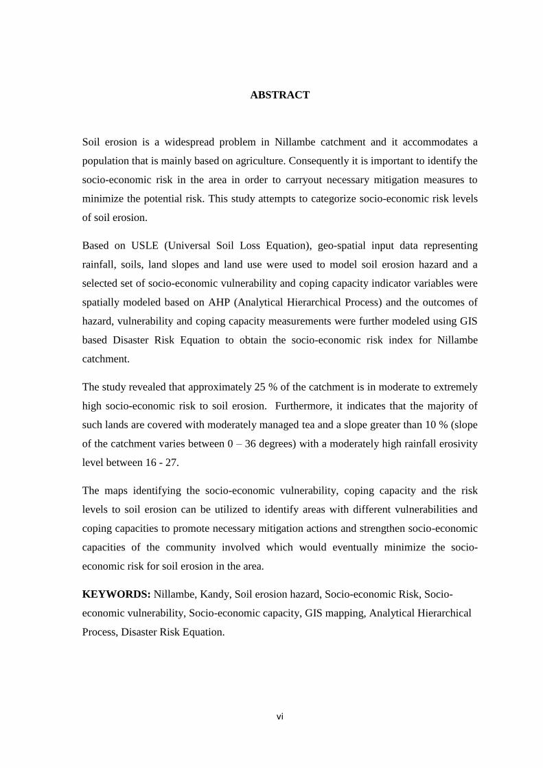
ABSTRACT
Soil erosion is a widespread problem in Nillambe catchment and it accommodates a
population that is mainly based on agriculture. Consequently it is important to identify the
socio-economic risk in the area in order to carryout necessary mitigation measures to
minimize the potential risk. This study attempts to categorize socio-economic risk levels
of soil erosion.
Based on USLE (Universal Soil Loss Equation), geo-spatial input data representing
rainfall, soils, land slopes and land use were used to model soil erosion hazard and a
selected set of socio-economic vulnerability and coping capacity indicator variables were
spatially modeled based on AHP (Analytical Hierarchical Process) and the outcomes of
hazard, vulnerability and coping capacity measurements were further modeled using GIS
based Disaster Risk Equation to obtain the socio-economic risk index for Nillambe
catchment.
The study revealed that approximately 25 % of the catchment is in moderate to extremely
high socio-economic risk to soil erosion. Furthermore, it indicates that the majority of
such lands are covered with moderately managed tea and a slope greater than 10 % (slope
of the catchment varies between 0 – 36 degrees) with a moderately high rainfall erosivity
level between 16 - 27.
The maps identifying the socio-economic vulnerability, coping capacity and the risk
levels to soil erosion can be utilized to identify areas with different vulnerabilities and
coping capacities to promote necessary mitigation actions and strengthen socio-economic
capacities of the community involved which would eventually minimize the socio-
economic risk for soil erosion in the area.
KEYWORDS: Nillambe, Kandy, Soil erosion hazard, Socio-economic Risk, Socio-
economic vulnerability, Socio-economic capacity, GIS mapping, Analytical Hierarchical
Process, Disaster Risk Equation.
vii
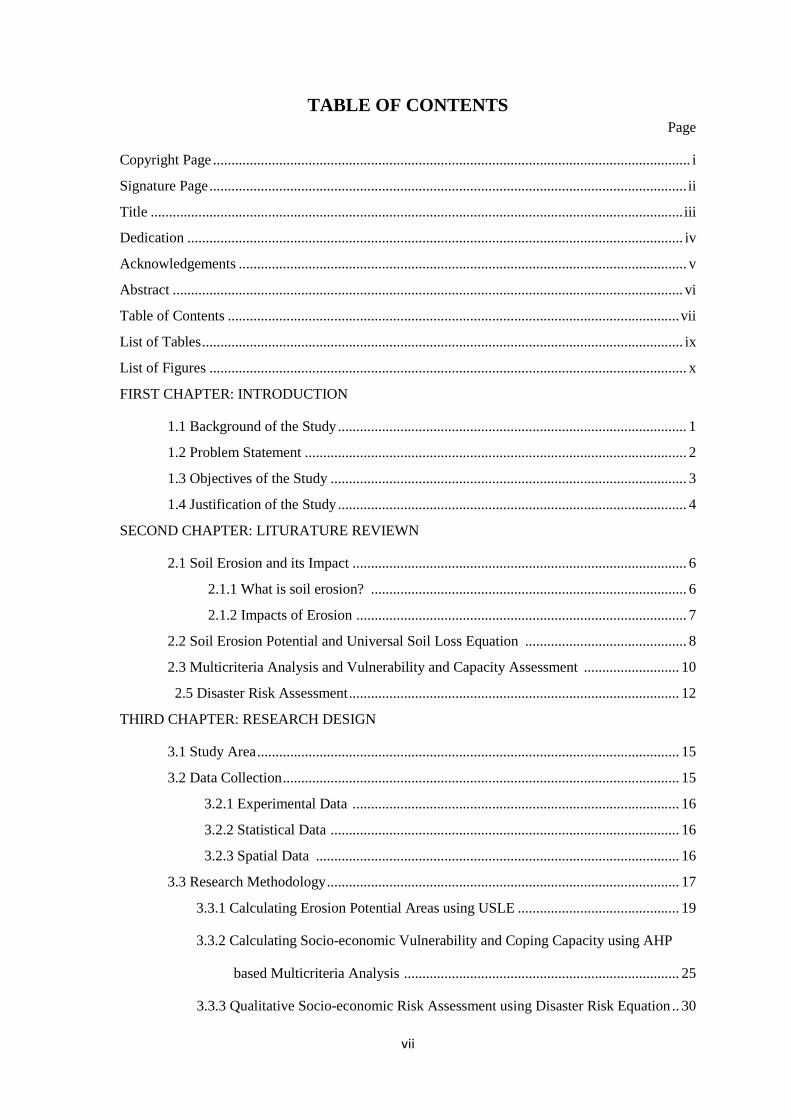
TABLE OF CONTENTS Page
Copyright Page .................................................................................................................................. i
Signature Page .................................................................................................................................. ii
Title ................................................................................................................................................. iii
Dedication ....................................................................................................................................... iv
Acknowledgements .......................................................................................................................... v
Abstract ........................................................................................................................................... vi
Table of Contents ........................................................................................................................... vii
List of Tables ................................................................................................................................... ix
List of Figures .................................................................................................................................. x
FIRST CHAPTER: INTRODUCTION
1.1 Background of the Study ............................................................................................... 1
1.2 Problem Statement ........................................................................................................ 2
1.3 Objectives of the Study ................................................................................................. 3
1.4 Justification of the Study ............................................................................................... 4
SECOND CHAPTER: LITURATURE REVIEWN
2.1 Soil Erosion and its Impact ........................................................................................... 6
2.1.1 What is soil erosion? ...................................................................................... 6
2.1.2 Impacts of Erosion .......................................................................................... 7
2.2 Soil Erosion Potential and Universal Soil Loss Equation ............................................ 8
2.3 Multicriteria Analysis and Vulnerability and Capacity Assessment .......................... 10
2.5 Disaster Risk Assessment .......................................................................................... 12
THIRD CHAPTER: RESEARCH DESIGN
3.1 Study Area ................................................................................................................... 15
3.2 Data Collection ............................................................................................................ 15
3.2.1 Experimental Data ......................................................................................... 16
3.2.2 Statistical Data ............................................................................................... 16
3.2.3 Spatial Data ................................................................................................... 16
3.3 Research Methodology ................................................................................................ 17
3.3.1 Calculating Erosion Potential Areas using USLE ............................................ 19
3.3.2 Calculating Socio-economic Vulnerability and Coping Capacity using AHP
based Multicriteria Analysis ........................................................................... 25
3.3.3 Qualitative Socio-economic Risk Assessment using Disaster Risk Equation .. 30
viii
FOURTH CHAPTER: RESULTS AND DISCUSSION
4.1 Soil Erosion Hazard Assessment ................................................................................ 31
4.1.1 Sedimentation due to Soil Erosion .................................................................. 38
4.2 Assessment of Socio-economic Vulnerability and Coping Capacity for Soil Erosion
........................................................................................................................................... 40
4.2.1 Assessment of Socio-economic Vulnerability for Soil Erosion in the
Nillambe Catchment ...................................................................................... 41
4.2.2 Assessment of Socio-economic Coping capacity for Soil Erosion in the
Nillambe Catchment ...................................................................................... 53
4.3 Assessment Soil Erosion Risk Assessment ............................................................... 61
FIFTH CHAPTER: CONCLUSION AND RECOMMENDATION
5.1 Conclusion .................................................................................................................. 65
5.2 Recommendation ........................................................................................................ 66
5.3 Limitations .................................................................................................................. 66
APPENDIX
Appendix 01: C Factor Map ............................................................................................. 68
Appendix 02: K Factor Map ............................................................................................. 69
Appendix 03: Slope Percentage Map ............................................................................... 70
Appendix 04: R Factor Map ............................................................................................. 71
Appendix 05: Data used to calculate the Crop Production Investment Ratio .................. 72
Appendix 06: Vegetables produced in Kandy and their Production Cost ........................ 77
Appendix 07: Data used to calculate the Poverty Ratio ................................................... 79
Appendix 08: Data used to calculate the Land Ownership Ratio ..................................... 80
Appendix 09: Data used to calculate the Dependency Ratio ............................................ 82
Appendix 10: Data used to calculate the % of Fertilizer Subsidy Distribution ................ 83
Appendix 11: Data used to calculate the % of related Training and Awareness
Programs received ...................................................................................... 84
Appendix 12: Socio-economic data sheets collected from Agrarian Service Centers of the
Nillambe Catchment .......................................................................................................... 85
Appendix 13: Census Data used to calculate Crop Production Investment Ratio ............ 96
Appendix 14: Census Data used to calculate Land Ownership Ratio .............................. 97
References ...................................................................................................................................... 98
ix
LIST OF TABLES
Page
Table 3.3.1a: C factors for Land uses, Sri Lanka ............................................................. 22
Table 3.3.1b: K factors for soil types, Sri Lanka ............................................................... 23
Table 3.3.1c: P factors for land use / land cover, Sri Lanka ............................................. 25
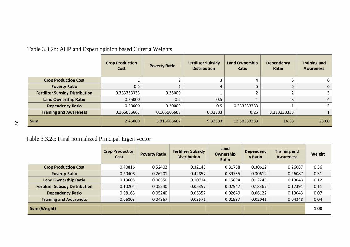
Table 3.3.2a: Semantic scale of Saaty ............................................................................... 26
Table 3.3.2b: AHP and Expert opinion based Criteria Weights ....................................... 27
Table 3.3.2c: Final normalized Principal Eigen vector .................................................... 27
Table 4.1b: Percentage of land area within GN under high to extreme hazard ................ 34
Table 4.2a: Land area of land use and land cover of Nillambe Catchment ...................... 37
Table 4.2.1a: Percentage of high to very high vulnerable land area within GN ............... 43
Table 4.2.2a: Percentage of land area with a high to very high coping capacity
within GN .................................................................................................... 55
Table 4.3a: Percentage of land area within GN under moderate to
extremely high risk ....................................................................................... 63

x
LIST OF FIGURES
Page
Figure 3.2.1a: Isoerodent Map, Sri Lanka – 1988 ............................................................. 20
Figure 3.3.1a: Rainfall erosivity distribution in Nillambe Catchment, Kandy .................. 21
Figure 3.3.2a: Methodology of composite vulnerability and capacity indexing ............... 28
Figure 3.3.2b: Equations used in calculating Vulnerability Indicators ............................. 29
Figure 4.1a: Slope Map of Nillambe Catchment ............................................................... 35
Figure 4.2b: Land use and Land cover of Nillambe Catchment ....................................... 36
Figure 4.1.1a: Moderate to Extremely High Soil Erosion Hazard along upstream of
Nillambe Reservoir ..................................................................................... 39
Figure 4.1.1b: Evidence of Reservoir Sedimentation (Google Earth, 2014) .................... 39
Figure 4.2.1a Distribution and extents of five socio-economic vulnerability levels in
Nillambe catchment ..................................................................................... 41
Figure 4.2.1b: Crop production cost per GN ..................................................................... 45
Figure 4.2.1c: Poverty Ratio based on Samurdhi beneficiary families by GN .................. 47
Figure 4.2.1d: Number of famers with ownership to agricultural land by GN ................. 49
Figure 4.2.1e: Dependency ratio based on employable age by GN .................................. 51
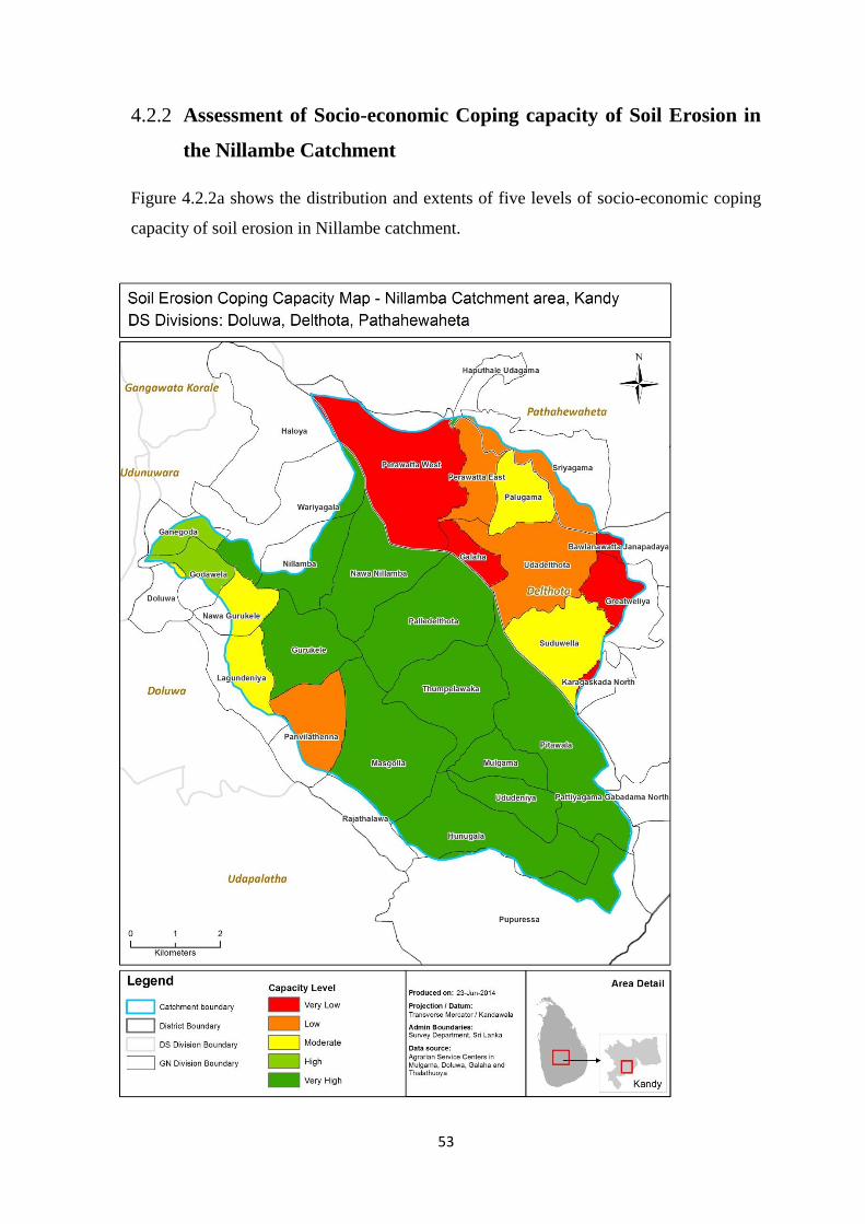
Figure 4.2.2: Distribution and extents of five levels of socio-economic coping capacity of
soil erosion in Nillambe catchment ............................................................. 53
Figure 4.2.2b: Fertilizer Subsidy Distribution by GN ....................................................... 57
Figure 4.2.2c: Soil conservation related trainings and awareness programs received
by GN ........................................................................................................ 59
Figure 4.3a Dispersal and extents of five socio-economic risk levels in
Nillambe catchment ....................................................................................... 62
FIRST CHAPTER
INTRODUCTION
1
FIRST CHAPTER
INTRODUCTION
This chapter gives a descriptive introduction of the research background, problem
statement and its objectives while indicating the justification of the study.
1.1 Background of the Study
Soil erosion is the detachment of soil deposits from the surface due to raindrop affect,
flowing water or wind. Erosion by water can be natural and human-induced. However,
unlike many other hazards, soil erosion can be prevented by taking necessary soil
conservation measures.
This condition can be controlled through qualitative or quantitative assessment of
potential soil erosion based on a set of factors which affects it such as rainfall, runoff, soil
type or texture, slope and its length, vegetation cover and the presence or absence of
conservation measures.
Soil erosion and its impacts on agriculture has initiated in the 1930s. During 1940 and
1956, research scientists began to develop a quantitative procedure for estimating soil loss
in the “Corn Belt” of the United States. (“RUSLE,” 2014)
Apart from natural causes, soil erosion also occurs due to human activities such as land
formation for agricultural activities and construction of buildings or roads. However,
these types of activities have a short term impact. (Pimentel and Burgess, 2013)
USLE is a scientific based tool which is used for site evaluation and planning; it estimates
the severity of erosion, supports the decision process of selecting an appropriate erosion
control measure and validate any measures taken or planned. It has been improved over
the last few years.
A risk assessment is a popular methodology used in many different aspects; it helps focus
on risks with potential harm so that necessary actions could be taken to minimize them.
2
There are different approaches to it such as expert-based and model-based and this study
follows an expert based approach.
Soil erosion has a major impact on the socio economic aspects of a population,
specifically when the population depends on agriculture as their main source of income.
Therefore, social and economic risks of soil erosion could be reduced by proper
identification with the use of tools such as GIS based risk assessment and USLE.
1.2 Problem Statement
Soil erosion is one of the severe environmental conditions in the world today and may
lead to considerably high economic, social and environmental impacts. Since 1960 one-
third of the world’s cultivable land have been found to be lost due to soil erosion and
other degradation; with a reported soil loss rate of around 10 million hectares per year
(“RUSLE,” 2014)
Soil fertility reduction, land degradation and sedimentation are some its unfavorable
results. Additionally sedimentation causes damage to surface water through eroded soil,
pesticides and fertilizers transported through rainwater damaging many habitats both in
water and land.
Currently 99.7% of human food (calories) is gained from the land but less than 0.3% from
marine and aquatic ecosystems and it is found that 66% of today’s world population is
malnourished and with the existing growth rate it estimates to be 9.3 billion in 2050;
which creates a higher demand for food. (Pimentel and Burgess, 2013)
With the increasing risk, in present agricultural management practices in the world, soil
erosion risk assessment has been a popular tool together with appropriate soil
conservation techniques.
As per The Global Assessment of Degradation (GLASOD) and International Soil
Research and Information Center (ISRIC) erosion by water is the most common cause for
erosion in South Asia. (“National Action Programme for Combating Land Degradation in
Sri Lanka ,” 2002)
3
The soil erosion process in Sri Lanka started in the 19th century during British
administration with the affect of natural vegetation being transformed into tea and coffee
plantation and the expansion of human settlements. In 1989, FAO estimated 10.8% of
degraded cultivable land and 10% of tea and 25% of rubber land was abandoned due to
reduced productivity caused by erosion. (“National Action Programme for Combating
Land Degradation in Sri Lanka ,” 2002)
As per a survey carried out by Hector Kobbekaduwa Agrarian Research and Training
Institute (HARTI) in 1998, a direct link between poverty and soil erosion extent was
observed and the group whose annual income was less than Rs.18,000 was related with
the highest erosion area. (“National Action Programme for Combating Land Degradation
in Sri Lanka ,” 2002)
There is a continuous process of soil erosion found in the mid country intermediate zone,
especially in arable cropping land due to land fragmentation due to population growth,
large scale plantation, encroachment of sensitive land and existence of immature brown
loam soils vulnerable to erosion. (“National Action Programme for Combating Land
Degradation in Sri Lanka ,” 2002)
In order to preserve a high level of socio economic status a continuous food supply has to
be achieved which mainly depends on maintaining a high productivity and quality in the
agricultural soils. Although, soil erosion has been a barrier; an accurate assessment of
potential soil erosion areas and the socio economic vulnerabilities and coping or adapting
capacities in those areas would assist in carrying out appropriate conservation plans in
order to take necessary preparedness and mitigation measures to reduce probable risks.
1.3 Objectives of the Study
The main purpose of this study is to assess the socio-economic risk of Soil Erosion in
Nillambe Catchment area, Kandy; this is achieved through the specific objectives listed
below.
Identify soil erosion potential areas in Nillambe catchment in Kandy using USLE.

4
Assess the socio-economic vulnerability levels in the soil erosion hazard area using
Multi criteria analysis.
Assess the soil erosion risk in the hazard area using GIS based Disaster Risk
Equation.
1.4 Justification of the Study
According to previous research, it is found that the rate of soil loss is 10 to 40 times
greater than the soil formation rate and it estimates that the reduction of food production
due to agricultural land degradation alone would be 30% in the next 50 years. (Pimentel
and Burgess, 2013) Additionally, 41% of land area in Kandy is prone to soil erosion
which is the 7th
largest extent out of all districts in the country. (Nayakekorala, 1998) and
the soil loss rate in the mid country region is 1,026(t / ha / year) when hill country reports
a rate of 412 and low country 147. (Swaify, 1983)
As per the Soil Conservation Act No. 25 of 1951; amended by Act No. 24 of 1996, the
National Physical Planning Department (NPPD) has designated an environmentally
fragile area in the central hills which is demarcated based on many factors such as
vulnerability to soil erosion and landslides, presence of forest rich in biodiversity and
invaluable for watershed protection, containing the Upper water sheds of the major rivers
in Sri Lanka and Presence of lands with steep slopes. (“Central Fragile Area,” 2014) The
area consists of Kandy and Nuwara Eliya districts, Eheliyagoda, Kuruwita and Ratnapura
DS divisions in Ratnapura district and Wilgamuwa, Laggala and Rattota in DS divisions
Matale District (“Central Fragile Area,” 2014); out of all related districts, the majority of
the population is in Kandy which have been 1,276,202 in 2001 (Census 2001) and
1,368,216 in 2011 (Census 2012). Moreover, the district of Kandy contains the highest
extent prone to high hazard of soil erosion in the Central province. (Munasinghe,
Pushpakumara, Bandara and Herath, 2001)
The NPPD has proposed many conservation strategies in the fragile area in order to
achieve a good balance between protection and production in the area; out of which it
mainly highlights the importance of classify areas for conservation and development.
(“Central Fragile Area,” 2014)
5
Nillambe area in Kandy receives a high annual rainfall of 2133.02mm and is affected by
the Southwest monsoon and the two inter-monsoons (Met Department, Sri Lanka) and
70.5% of the area covers a hilly and rolling terrain which makes it highly prone to soil
erosion. Additionally, there is a Mini hydro power plant in the area which generates a
capacity of 3.2MW; currently about half of the Nillambe reservoir is under sedimentation
(GoogleEarth) which shows a clear evidence of historical soil erosion in the area. The
area accommodates a population of 48,734 (Census 2011) which is mainly based on
agriculture with a high rate of poverty (DS level Samurdhi beneficiary data) which makes
the area economically vulnerable to soil erosion and in the recent years, there are no
studies carried out to assess the soil erosion risk in the area of Nillambe.
Hence, above stated information clearly emphasize the need to identify the probable risk
zones and their vulnerabilities and strengths in Nillambe, Kandy and this study would
support necessary decision making in minimizing potential risks to soil erosion.

SECOND CHAPTER
LITERATUR REVIEW
6
SECOND CHAPTER
LITERATURE REVIEW
This chapter provides detailed literature related to the topic of socio economic risk
assessment of soil erosion in Nillambe catchment, Kandy.
2.1 Soil Erosion and its Impact
2.1.1 What is Soil Erosion?
‘Background’ soil erosion has been a natural process since the first land plants formed
the first soil which has been occurring for over 450 million years; this process removes
soil at roughly the same rate as soil is formed. However, 'accelerated' soil erosion loses
soil at a much faster rate than it is formed and is a far more recent problem which is due
to human activity such as overgrazing or unsuitable cultivation practices which leaves the
land unprotected and vulnerable. During times of erosive rainfall or windstorms, soil may
be detached, transported, and deposited. (“Soil Erosion Site,” 2014) The process removes
the topsoil first and once this nutrient-rich layer is gone, few plants will grow in the soil
again. Without soil and plants the land becomes desert like and unable to support life.
(“Land use and Soil Management,” 2014)
Accelerated soil erosion by water or wind may affect both agricultural areas and the
natural environment, and is one of the most widespread of today's environmental
problems. It has impacts which are both on-site (at the place where the soil is detached)
and off-site (wherever the eroded soil ends up). (“Soil Erosion Site,” 2014)
There are different types of soil erosion.
a. Sheet Erosion
It is categorized by the down slope removal of soil particles
within a thin sheet of water. It occurs when the entire surface of a
field is gradually eroded in a more or less uniform way. This is a
7
gradual process and is not immediately obvious that soil is being lost. (“Land use and
Soil Management,” 2014)
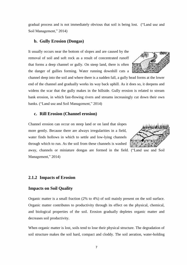
b. Gully Erosion (Dongas)
It usually occurs near the bottom of slopes and are caused by the
removal of soil and soft rock as a result of concentrated runoff
that forms a deep channel or gully. On steep land, there is often
the danger of gullies forming. Water running downhill cuts a
channel deep into the soil and where there is a sudden fall, a gully head forms at the lower
end of the channel and gradually works its way back uphill. As it does so, it deepens and
widens the scar that the gully makes in the hillside. Gully erosion is related to stream
bank erosion, in which fast-flowing rivers and streams increasingly cut down their own
banks. (“Land use and Soil Management,” 2014)
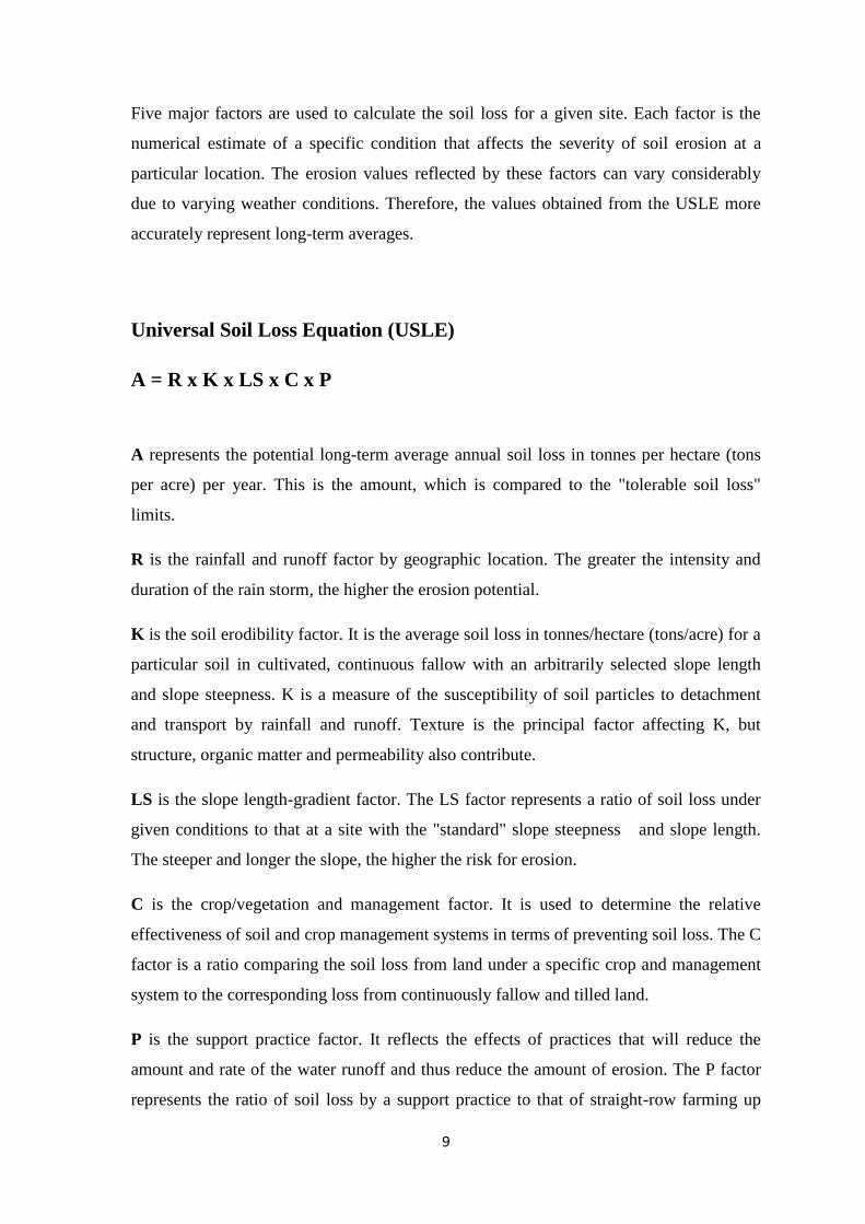
c. Rill Erosion (Channel erosion)
Channel erosion can occur on steep land or on land that slopes
more gently. Because there are always irregularities in a field,
water finds hollows in which to settle and low-lying channels
through which to run. As the soil from these channels is washed
away, channels or miniature dongas are formed in the field. (“Land use and Soil
Management,” 2014)
2.1.2 Impacts of Erosion
Impacts on Soil Quality
Organic matter is a small fraction (2% to 4%) of soil mainly present on the soil surface.
Organic matter contributes to productivity through its effect on the physical, chemical,
and biological properties of the soil. Erosion gradually depletes organic matter and
decreases soil productivity.
When organic matter is lost, soils tend to lose their physical structure. The degradation of
soil structure makes the soil hard, compact and cloddy. The soil aeration, water-holding

8
capacity and permeability are also decreased. Decreased aeration means less oxygen
available for plant roots to grow. Decreased water availability also means less water
available for healthy plant growth. When soil permeability decreases, less water will soak
into the soil and more will run-off.
Beneficial organisms that suppress disease and break down organic residues will not
function well due to reduced oxygen and water in soil. This in turn will reduce nutrient
storage and supply abilities of the soil.
Impacts on Water Quality
Sediment deposition in lakes and rivers increases water turbidity making it difficult for
light to penetrate the water. This causes problems for aquatic plants that need sunlight for
photosynthesis. Sediments are also rich in nutrients such as phosphorus and nitrogen.
These nutrients promote the excessive growth of algae. This process is called
eutrophication. Areas of excessive algae growth, called algae blooms, deplete oxygen in
the water resulting in the death of aquatic animals from lack of oxygen. (“Impacts of
Erosion on Soil, Air, and Water Quality,” 2014)
2.2 Soil Erosion Potential and Universal Soil Loss Equation
The Universal Soil Loss Equation (USLE) predicts the long-term average annual rate of
erosion on a field slope based on rainfall pattern, soil type, topography, crop system and
management practices. USLE only predicts the amount of soil loss that results from sheet
or rill erosion on a single slope and does not account for additional soil losses that might
occur from gully, wind or tillage erosion. This erosion model was created for use in
selected cropping and management systems, but is also applicable to non-agricultural
conditions such as construction sites. The USLE can be used to compare soil losses from
a particular field with a specific crop and management system to "tolerable soil loss"
rates. Alternative management and crop systems may also be evaluated to determine the
adequacy of conservation measures in farm planning.
9
Five major factors are used to calculate the soil loss for a given site. Each factor is the
numerical estimate of a specific condition that affects the severity of soil erosion at a
particular location. The erosion values reflected by these factors can vary considerably
due to varying weather conditions. Therefore, the values obtained from the USLE more
accurately represent long-term averages.
Universal Soil Loss Equation (USLE)
A = R x K x LS x C x P
A represents the potential long-term average annual soil loss in tonnes per hectare (tons
per acre) per year. This is the amount, which is compared to the "tolerable soil loss"
limits.
R is the rainfall and runoff factor by geographic location. The greater the intensity and
duration of the rain storm, the higher the erosion potential.
K is the soil erodibility factor. It is the average soil loss in tonnes/hectare (tons/acre) for a
particular soil in cultivated, continuous fallow with an arbitrarily selected slope length
and slope steepness. K is a measure of the susceptibility of soil particles to detachment
and transport by rainfall and runoff. Texture is the principal factor affecting K, but
structure, organic matter and permeability also contribute.
LS is the slope length-gradient factor. The LS factor represents a ratio of soil loss under
given conditions to that at a site with the "standard" slope steepness and slope length.
The steeper and longer the slope, the higher the risk for erosion.
C is the crop/vegetation and management factor. It is used to determine the relative
effectiveness of soil and crop management systems in terms of preventing soil loss. The C
factor is a ratio comparing the soil loss from land under a specific crop and management
system to the corresponding loss from continuously fallow and tilled land.
P is the support practice factor. It reflects the effects of practices that will reduce the
amount and rate of the water runoff and thus reduce the amount of erosion. The P factor
represents the ratio of soil loss by a support practice to that of straight-row farming up
10
and down the slope. The most commonly used supporting cropland practices are cross-
slope cultivation, contour farming and strip cropping.
Additional research, experiments and data have led to the development of the Revised
Universal Soil Loss Equation (RUSLE), which is a computerized version of USLE.
RUSLE has the same formula as USLE, with improvements in many of the factor
estimates. RUSLE can handle more complex combinations of tillage and cropping
practices and a greater variety of slope shapes. A further-enhanced version of the
software, known as RUSLE2, can do event-based erosion prediction. RUSLE2 requires a
comprehensive set of input information, which may not be available in all jurisdictions.
(“Universal Soil Loss Equation (USLE),” 2014)
2.3 Multicriteria Analysis and Vulnerability and Capacity Assessment
Multicriteria Analysis
Multi criteria decision analysis (MCDA) has been recognized as an important tool in
environmental decision making for formalizing and addressing the problem of competing
decision objectives. MCDA methods vary with respect to the core decision rules that they
implement in evaluating options in terms of the criteria. Weighted linear average is a
popular cardinal multicriteria method and is usually specified in terms of normalized
weightings for each criterion, as well as normalized scores for all options relative to each
of the criteria. (Steele, Carmel, Cross and Wilcox, 2009)
Analytical Hierarchical Process (AHP)
One very popular method, Saaty’s (1980) analytic hierarchy process (AHP), determines
the criteria weights indirectly based on scores of relative importance for each in pair-wise
comparisons. The comparison ratings are on a scale of one to nine, resulting in a ratio of
importance for each pair with the maximum difference that one criterion is nine times
more important than another.
11
In the AHP, the final weightings for the criteria are the normalized values of the
eigenvector that is associated with the maximum eigen value for this matrix. Saaty (1980)
suggests that this procedure is the best way to minimize the impact of inconsistencies in
the ratios. There will be many different procedures for determining a set of positive
weights that add to one. For instance, with reference to the above procedure, we might
allow ratio comparisons of the importance of criteria to range between one and, maybe,
100, rather than one and nine or else, we might disagree with the weights being
determined by a normalized eigenvector. An alternative is to simply add the scores for
each row in the matrix (i.e., add the scores for each criterion) and then normalize these
sums in the same way that the eigenvector entries are normalized. Indeed, one might
depart from the AHP altogether; the decision maker could, for example, directly assign
numerical weights to criteria, as opposed to entertaining a series of pair-wise
comparisons. Angelidis and Kamizoulis (2005) and Redpath et al. (2004) assign weights
directly like this in their respective environmental decision-making applications. In
general, we simply want the criteria weights to be meaningful in the sense that they
properly reflect the decision maker’s attitudes or choice dispositions.
There is a general agreement that, if final utilities for options are to be calculated as a
weighted linear average, then for each criterion, options are best scored on a 0–1 scale,
where zero is the worst-case outcome and one is the best-case outcome.
Vulnerability and Capacity Assessment
Vulnerability and Capacity Assessment (VCA) uses various participatory tools to gauge
people’s exposure to and capacity to resist natural hazards. It is an integral part of disaster
preparedness and contributes to the creation of community-based disaster preparedness
programmes at the rural and urban grass-roots level. VCA enables local priorities to be
identified and appropriate action taken to reduce disaster risk and assists in the design and
development of programmes that are mutually supportive and responsive to the needs of
the people most closely concerned.
The aims of VCA are to:
12
Assess risks and hazards facing communities and the capacities they have for dealing
with them;
Involve communities, local authorities and humanitarian and development
organizations in the assessment from the outset;
Draw up action plans to prepare for and respond to the identified risks;
Identify risk-reduction activities to prevent or lessen the effects of expected hazards,
risks and vulnerabilities.
VCA is complementary to national and sub-national risk, hazard, vulnerability and
capacity mapping exercises that identify communities most at risk. A VCA is then
undertaken in these communities to diagnose the specific areas of risk and vulnerability
and determine what action can be taken to address them. To complete the circle, what a
VCA unearths at the local level can provide a valuable indication of national and sub-
national vulnerabilities and capacities. (IFRC, 2006)
2.4 Disaster Risk Assessment
In order to make decisions on how to identify and then address disaster risks, decision
makers would need to understand the actual harm of past disasters and the potential
threats posed by imminent hazards. This is done through risk assessment.
Disaster risk assessment is the process of collecting and analyzing information about the
nature, likelihood and severity of disaster risks. The process includes making decisions on
the need to prevent or reduce disaster risks, what risks to address, and the optimal
approach to tackling those risks found to be unacceptable to the target groups and
communities.
Disaster risk assessment emphasizes proactive management of disaster risks through
reduction of both prospective and accumulated risks. Hence, it covers assessment of risks
from future hazards as well as those that have already occurred. It is important to note
that risk assessment is the first step in effective disaster risk management. Hence, it is
best undertaken as part of a comprehensive risk management strategy. (“Guidelines for
mainstreaming Disaster Risk Assessment in Development,” 2004)
13
Adapting available Risk Assessment Approaches for Disaster Risk
Assessment
Risk assessment can be done as a rapid appraisal for simple risk concerns or as a complex
process for major risk issues. Thus, the objectives of risk management determine the type,
orientation, scope and approach to risk assessment. Depending on the circumstances, risk
assessors can choose from many methods of risk assessment. However, most available
approaches are not directly applicable to assessing disaster risks or are limited due to
several reasons. These include narrow scope of disaster losses covered, non-coverage of
cumulative vulnerability, inadequate incorporation of subjective risk perception and
limited attention to the decision-making phase of risk assessment. (“Guidelines for
mainstreaming Disaster Risk Assessment in Development,” 2004)
Phases in Risk Assessment
Risk assessment is a management activity that involves problem definition, analysis and
decision-making. Problem definition is the process of determining what is to be assessed
and planning to undertake that assessment. Research and analysis involve generating
information on aspects of risk, such as occurrence, probabilities and effects. Decision-
making is the process of ranking risks or outcomes on the basis of specific criteria and
then assessing options that can address chosen risks. (“Guidelines for mainstreaming
Disaster Risk Assessment in Development,” 2004)
Advantages of Disaster Risk Assessment
Institutionalizing disaster risk assessment has many advantages and benefits because the
efforts involved are important development management tools on its own. Disaster risk
assessment is useful for several purposes, including:
(a) Making risk-responsive physical and economic policy,
(b) Regulatory framework for development,
14
(c) Promoting participatory development through public education and awareness,
(d) Private sector and business decision-making,
(e) Risk sharing and transfer interventions.
(“Guidelines for mainstreaming Disaster Risk Assessment in Development,” 2004)
Limitations of Risk Assessment
Risk assessment does not always result in a conclusive or compelling outcome regarding
the importance of risks and appropriate corrective measures acceptable to all
stakeholders. These difficulties could be due to poor identification of the risk problem or
target population, why the problem is a concern and how stakeholders perceive the
problem. Other constraints could arise because of insufficient data or resources for
adequate assessment, or the difficulty in attributing responsibility for disaster risks
emanating from different locations and sources. The assessment outcomes may also not
be politically acceptable since risk management is essentially a political process. These
difficulties underscore the fact that risk assessment is only one of many decision tools that
should be applied to any given disaster risk situation and that the process must be part of
a broader risk management strategy. However, it is essential to minimize these pitfalls in
the risk assessment process itself, partly by adopting suitable methods.
(“Guidelines for mainstreaming Disaster Risk Assessment in Development,” 2004)

THIRD CHAPTER
RESEARCH DESIGN
15
THIRD CHAPTER
RESEARCH DESIGN
This chapter describes the area of interest, provides details on the data used in the study,
describes the research methodology and explains the mathematical models and spatial
operations applied to analyze the data.
3.1 Study Area
The Area of interest, Nillambe Catchment in Kandy, Sri Lanka is located between
7°13'47.12" to 7° 7'21.77" north latitude and 80°35'26.29" to 80°42'18.84" east
longitude; covering an aerial extent of 67.5km2. It is situated within the wet and
intermediate climatic zones of the country and comprises a population of 48,734 (Census
2012). The area annually receives an average rainfall of 2133.02mm (Met Department,
Sri lanka, 2014) which is controlled by the wind regimes; Southwest monsoon (May to
September) and the two inter-monsoons (March to April and October to November
respectively). 58% of the total land area is used for cultivation including 32% of Tea,
23.5% of Homesteads or other crop land and 2.5% of Paddy; and 70.5% of the area
covers a hilly and rolling terrain.
3.2 Data Collection
This research is mainly based on secondary data which can be categorized as
experimental data, statistical data and spatial data.

16
3.2.1 Experimental Data
To carry out a socio-economic risk assessment, hazard, vulnerability and coping capacity
aspects need to be calculated. To identify the soil erosion hazard areas in the catchment,
Universal Soil Loss Equation (USLE) was used which requires a set of standard factors
on ‘rainfall - runoff erosivity’, ‘vegetation cover and management’, ‘soil erodibility’,
‘slope length and gradient’ and ‘conservation practices’ which were taken from past
literature and the Natural Resource Management Center (NRMC), Department of
Agriculture.
3.2.2 Statistical Data
The vulnerability and capacity aspects are calculated based on Muticriteria Analysis of a
selected set of criteria; ‘Poverty Ratio’, ‘Crop Production Investment’, ‘Land Ownership
Ratio’, ‘Dependency Ratio of Farmer Families’, ‘Related Training and Awareness
Programs conducted’ and ‘Fertilizer Subsidy Distribution’. While the latest statistics
(2013/2014) of farmers, subsidy distribution and awareness programmes were collected
from Agrarian Service Centers in Doluwa, Galaha, Mulgama and Thalathuoya, Samurdhi
beneficiary figures obtained by Agrarian Service district office in Kandy. Sources of
remaining data are Census department, Sri Lanka, www.agridept.gov.lk, Tea Research
Institute of Sri Lanka and CIC Institute of Agribusinesses. Further, disaster expert opinion
data was collected through a focus group discussion which was used in adding weights to
vulnerability and capacity criteria used in the study.
3.2.3 Spatial Data
Additionally, spatial data on soil types, landuse / landcover, contours and Google Earth
imagery are used in this study. Moreover the rainfall erosivity index map was generated
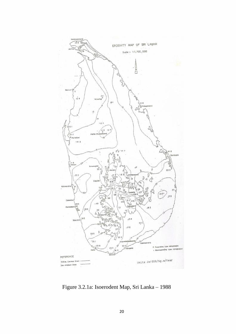
using Rainfall Erosivity Map of Sri lanka by Wickramasinghe, and Premalal (1988).
(Figure 3.2.1a)
17
This research involves a high level of Geo Processing and Analysis. Hence ArcGIS 10.0
and Google Earth Platform have been used in various steps of the risk assessment process
for analyzing and processing of statistical and experimental data; and calculating hazard,
capacity and vulnerability components. They are further used for overlay analysis of risk
zones with different spatial characteristics in order to identify possible causes and
evaluate results.
Additionally, MS Excel 2007 was used for statistical data analysis of vulnerability
parameter calculation and result evaluation.
3.3 Research Methodology
The methodology of this research can be divided into 3 categories throughout the process;
analysis of hazard, vulnerability and risk of soil erosion. Figure 3.3 provides the
Framework of the Research Methodology followed by a detailed description of each
process followed in achieving the objectives of this study.

Disaster Risk Equation
Soil Erosion Risk Index
Hazard Mapp
USLE
C Factor
Erosion Hazard Index
Hazard Mapp
R Factor
K Factor
Rainfall Erosivity Index
Land use / land cover Map
Soil Map
Contour Map
Slope Map
Equation A
LS Factor
Dependency Ratio
Multi Criteria Analysis
based on AHP and Expert Opinion
Land Ownership Ratio
Poverty Ratio
Crop Production Investment
Training and Awareness
Programs
Fertilizer Subsidy Distribution
Composite Capacity Index
Hazard Mapp
Weighted Maps
P Factor
Land use / land cover Map
Composite Vulnerability Index
Hazard Mapp
Figure 3.3: Research Methodology Flow Chart
18
19
3.3.1 Calculating Erosion Potential Areas using USLE
USLE (A = RKLSCP) was used to calculate soil erosion potential in the area; where
R = Rainfall - Runoff erosivity, K = Soil Erodibility, L = Slope length, S = Slope
gradient, C = Cover and management and P = Conservation Support Practices.
Rainfall - Runoff Erosivity Factor (R)
R quantifies the raindrop energy effect and provides relative amount and rate of
runoff associated with the rain. Rainfall erosion index (EI30 Index) derived by
Wischmeier is found to be the best method to estimate erosivity caused by R
(“Predicting Rainfall Erosion Losses,” 1978). Past researches show that there’s a
linear relationship between soil loss with EI parameter alone. EI is a compound
parameter of total kinetic energy of rainfall (E) and maximum intensity of rain within
30 minutes (I30). The relationship of rainfall energy and rain intensity is given by,
E = 916 + 331 log10 I
Where E is given in MJ*ha–1
*mm–1
and I in mm*h–1
.
Local rainfall erosion index values can be directly obtained using isoerodent maps
developed using long term rainfall records. The erosivity isohyets and point data of
the Isoerodent map shown in figure 3.2.1a taken from Wickramasinghe and Premalal
(1988) has been interpolated based on krigging technique using ArcGIS 10.0 and
converted into a 50m grid to derive the R factor map. This was then clipped into the
Nillambe catchment area. Figure 3.3.1b illustrates the distribution of rainfall erosivity
in the area.
20
Figure 3.2.1a: Isoerodent Map, Sri Lanka – 1988

21
Figure 3.3.1a: Rainfall erosivity distribution in Nillambe Catchment, Kandy
22
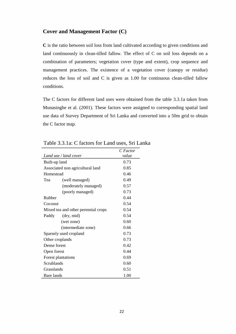
Cover and Management Factor (C)
C is the ratio between soil loss from land cultivated according to given conditions and
land continuously in clean-tilled fallow. The effect of C on soil loss depends on a
combination of parameters; vegetation cover (type and extent), crop sequence and
management practices. The existence of a vegetation cover (canopy or residue)
reduces the loss of soil and C is given as 1.00 for continuous clean-tilled fallow
conditions.
The C factors for different land uses were obtained from the table 3.3.1a taken from
Munasinghe et al. (2001). These factors were assigned to corresponding spatial land
use data of Survey Department of Sri Lanka and converted into a 50m grid to obtain
the C factor map.
Land use / land cover
C Factor
value
Built-up land 0.73
Associated non agricultural land 0.85
Homestead 0.46
Tea (well managed) 0.49
(moderately managed) 0.57
(poorly managed) 0.73
Rubber 0.44
Coconut 0.54
Mixed tea and other perennial crops 0.54
Paddy (dry, mid) 0.54
(wet zone) 0.60
(intermediate zone) 0.66
Sparsely used cropland 0.73
Other croplands 0.73
Dense forest 0.42
Open forest 0.44
Forest plantations 0.69
Scrublands 0.60
Grasslands 0.51
Bare lands 1.00
Table 3.3.1a: C factors for Land uses, Sri Lanka
23
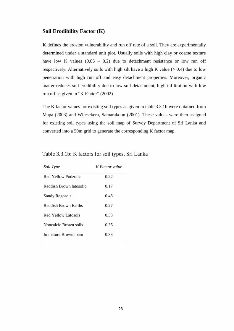
Soil Erodibility Factor (K)
K defines the erosion vulnerability and run off rate of a soil. They are experimentally
determined under a standard unit plot. Usually soils with high clay or coarse texture
have low K values (0.05 – 0.2) due to detachment resistance or low run off
respectively. Alternatively soils with high silt have a high K value (> 0.4) due to low
penetration with high run off and easy detachment properties. Moreover, organic
matter reduces soil erodibility due to low soil detachment, high infiltration with low
run off as given in “K Factor” (2002)
The K factor values for existing soil types as given in table 3.3.1b were obtained from
Mapa (2003) and Wijesekera, Samarakoon (2001). These values were then assigned
for existing soil types using the soil map of Survey Department of Sri Lanka and
converted into a 50m grid to generate the corresponding K factor map.
Soil Type K Factor value
Red Yellow Podzolic 0.22
Reddish Brown latosolic 0.17
Sandy Regosols 0.48
Reddish Brown Earths 0.27
Red Yellow Latosols 0.33
Noncalcic Brown soils 0.35
Immature Brown loam 0.33
Table 3.3.1b: K factors for soil types, Sri Lanka
24
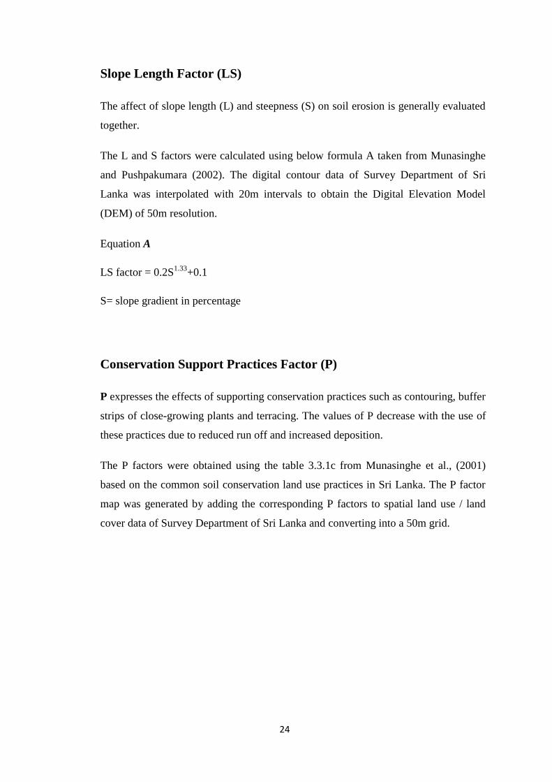
Slope Length Factor (LS)
The affect of slope length (L) and steepness (S) on soil erosion is generally evaluated
together.
The L and S factors were calculated using below formula A taken from Munasinghe
and Pushpakumara (2002). The digital contour data of Survey Department of Sri
Lanka was interpolated with 20m intervals to obtain the Digital Elevation Model
(DEM) of 50m resolution.
Equation A
LS factor = 0.2S1.33
+0.1
S= slope gradient in percentage
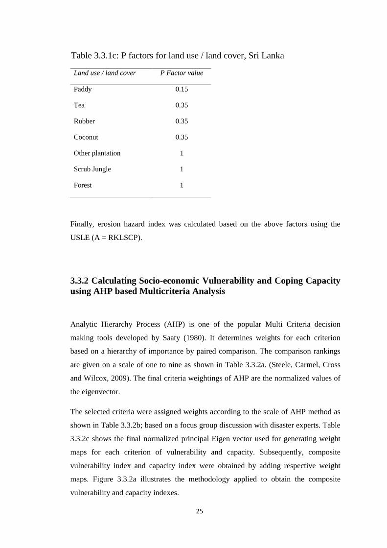
Conservation Support Practices Factor (P)
P expresses the effects of supporting conservation practices such as contouring, buffer
strips of close-growing plants and terracing. The values of P decrease with the use of
these practices due to reduced run off and increased deposition.
The P factors were obtained using the table 3.3.1c from Munasinghe et al., (2001)
based on the common soil conservation land use practices in Sri Lanka. The P factor
map was generated by adding the corresponding P factors to spatial land use / land
cover data of Survey Department of Sri Lanka and converting into a 50m grid.
25
Land use / land cover P Factor value
Paddy 0.15
Tea 0.35
Rubber 0.35
Coconut 0.35
Other plantation 1
Scrub Jungle 1
Forest 1
Finally, erosion hazard index was calculated based on the above factors using the
USLE (A = RKLSCP).
3.3.2 Calculating Socio-economic Vulnerability and Coping Capacity
using AHP based Multicriteria Analysis
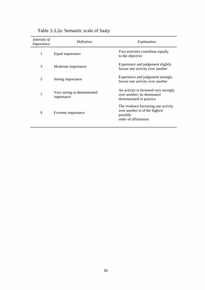
Analytic Hierarchy Process (AHP) is one of the popular Multi Criteria decision
making tools developed by Saaty (1980). It determines weights for each criterion
based on a hierarchy of importance by paired comparison. The comparison rankings
are given on a scale of one to nine as shown in Table 3.3.2a. (Steele, Carmel, Cross
and Wilcox, 2009). The final criteria weightings of AHP are the normalized values of
the eigenvector.
The selected criteria were assigned weights according to the scale of AHP method as
shown in Table 3.3.2b; based on a focus group discussion with disaster experts. Table
3.3.2c shows the final normalized principal Eigen vector used for generating weight
maps for each criterion of vulnerability and capacity. Subsequently, composite
vulnerability index and capacity index were obtained by adding respective weight
maps. Figure 3.3.2a illustrates the methodology applied to obtain the composite
vulnerability and capacity indexes.
Table 3.3.1c: P factors for land use / land cover, Sri Lanka
26
Intensity of
Importance Definition Explanation
1 Equal importance Two activities contribute equally
to the objective
3 Moderate importance Experience and judgement slightly
favour one activity over another
5 Strong importance Experience and judgement strongly
favour one activity over another
7 Very strong or demonstrated
importance
An activity is favoured very strongly
over another; its dominance
demonstrated in practice
9 Extreme importance
The evidence favouring one activity
over another is of the highest
possible
order of affirmation
Table 3.3.2a: Semantic scale of Saaty
Crop Production Cost
Poverty Ratio Fertilizer Subsidy
Distribution
Land Ownership
Ratio
Dependency Ratio
Training and Awareness
Weight
Crop Production Cost 0.40816 0.52402 0.32143 0.31788 0.30612 0.26087 0.36
Poverty Ratio 0.20408 0.26201 0.42857 0.39735 0.30612 0.26087 0.31
Land Ownership Ratio 0.13605 0.06550 0.10714 0.15894 0.12245 0.13043 0.12
Fertilizer Subsidy Distribution 0.10204 0.05240 0.05357 0.07947 0.18367 0.17391 0.11
Dependency Ratio 0.08163 0.05240 0.05357 0.02649 0.06122 0.13043 0.07
Training and Awareness 0.06803 0.04367 0.03571 0.01987 0.02041 0.04348 0.04
Sum (Weight) 1.00
Crop Production Cost
Poverty Ratio Fertilizer Subsidy
Distribution Land Ownership
Ratio Dependency
Ratio Training and Awareness
Crop Production Cost 1 2 3 4 5 6
Poverty Ratio 0.5 1 4 5 5 6
Fertilizer Subsidy Distribution 0.333333333 0.25000 1 2 2 3
Land Ownership Ratio 0.25000 0.2 0.5 1 3 4
Dependency Ratio 0.20000 0.20000 0.5 0.333333333 1 3
Training and Awareness 0.166666667 0.166666667 0.33333 0.25 0.333333333 1
Sum 2.45000 3.816666667 9.33333 12.58333333 16.33 23.00
Table 3.3.2c: Final normalized Principal Eigen vector
Table 3.3.2b: AHP and Expert opinion based Criteria Weights
27
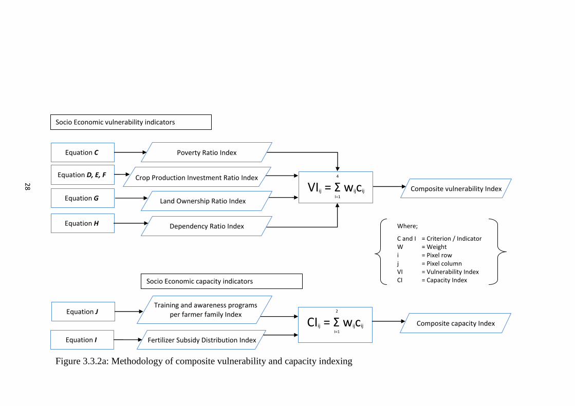
Figure 3.3.2a: Methodology of composite vulnerability and capacity indexing
Where;
C and I = Criterion / Indicator W = Weight i = Pixel row j = Pixel column VI = Vulnerability Index CI = Capacity Index
Training and awareness programs per farmer family Index
Fertilizer Subsidy Distribution Index
Socio Economic vulnerability indicators
Socio Economic capacity indicators
2
CIij = Σ wijcij
I=1
Composite vulnerability Index
Composite capacity Index
4
VIij = Σ wijcij
I=1
Dependency Ratio Index
Land Ownership Ratio Index
Poverty Ratio Index
Crop Production Investment Ratio Index
Equation C
Equation D, E, F
Equation G
Equation H
Equation I
Equation J
28
Production investment per crop type (per GN)
Production investment per crop type (per all GNs)
Figure 3.3.2b: Equations used in calculating Vulnerability Indicators
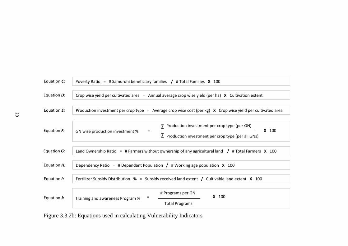
Equation C:
Equation E:
Equation F:
Equation G:
Equation H:
Equation I:
Equation D:
Fertilizer Subsidy Distribution % = Subsidy received land extent / Cultivable land extent X 100
Dependency Ratio = # Dependant Population / # Working age population X 100
Land Ownership Ratio = # Farmers without ownership of any agricultural land / # Total Farmers X 100
Poverty Ratio = # Samurdhi beneficiary families / # Total Families X 100
Production investment per crop type = Average crop wise cost (per kg) X Crop wise yield per cultivated area
cultivated area
Crop wise yield per cultivated area = Annual average crop wise yield (per ha) X Cultivation extent
=
1
0
0
Equation J:
X 100 GN wise production investment %
# Programs per GN
Total Programs
X 100 Training and awareness Program % =
Σ
Σ
29
30
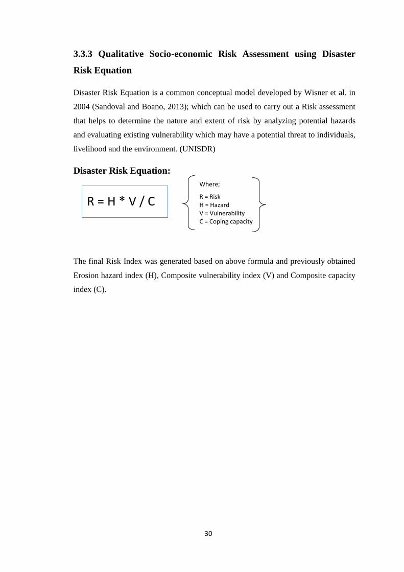
3.3.3 Qualitative Socio-economic Risk Assessment using Disaster
Risk Equation
Disaster Risk Equation is a common conceptual model developed by Wisner et al. in
2004 (Sandoval and Boano, 2013); which can be used to carry out a Risk assessment
that helps to determine the nature and extent of risk by analyzing potential hazards
and evaluating existing vulnerability which may have a potential threat to individuals,
livelihood and the environment. (UNISDR)
Disaster Risk Equation:
The final Risk Index was generated based on above formula and previously obtained
Erosion hazard index (H), Composite vulnerability index (V) and Composite capacity
index (C).
Where;
R = Risk H = Hazard V = Vulnerability C = Coping capacity
R = H * V / C
FOURTH CHAPTER
RESULTS AND DISCUSSION

31
FOURTH CHAPTER
RESULTS AND DISCUSSION
This chapter provides an elaboration of final and intermediate results of the study; in the
process of assessing the socio-economic risk of soil erosion in Nillambe catchment,
Kandy.
4.1 Soil Erosion Hazard Assessment
The main objective of this research was to calculate the socio-economic risk of soil
erosion in the Nillambe catchment area. As the initial step of this process the soil erosion
hazard potential was calculated using USLE as discussed in the previous chapter. Table
4.1a shows the high and low values for each USLE factor, together with the average in
the Nillambe catchment.
32
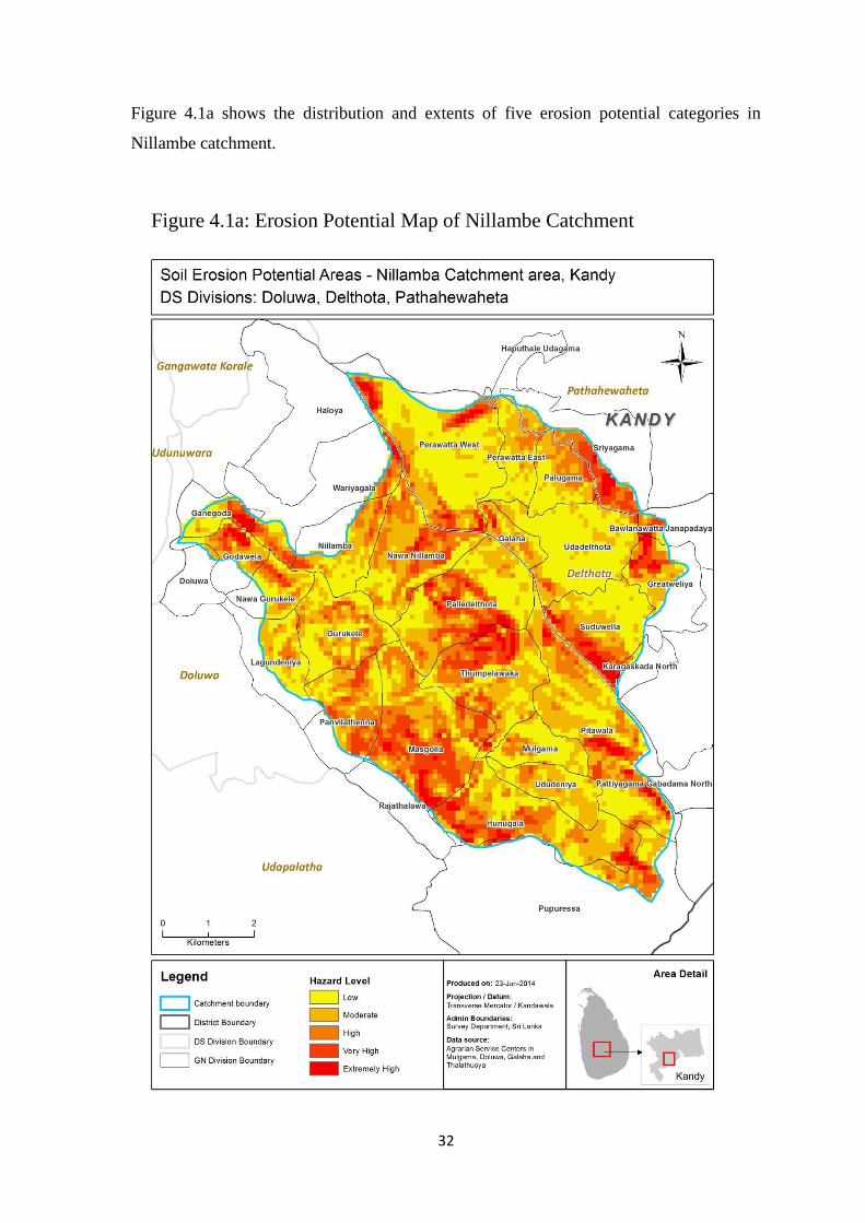
Figure 4.1a shows the distribution and extents of five erosion potential categories in
Nillambe catchment.
Figure 4.1a: Erosion Potential Map of Nillambe Catchment
33
The Hazard levels shown in figure 4.1a vary from extremely high to low; the classes
‘Extremely High’, ‘Very High’, ‘High’, ‘Moderate’ and ‘Low’ account for approximately
3 %, 12 %, 20 %, 28 % and 37 % of the total catchment area, respectively. It discloses
that 34 % of the total land area is under high to extremely high hazard. In terms of soil
form, the area with high to extremely high hazard mostly consists of Red-Yellow
Podzolic soils & Mountain Regosols and displays a mountainous, steeply dissected, hilly
and rolling terrain.
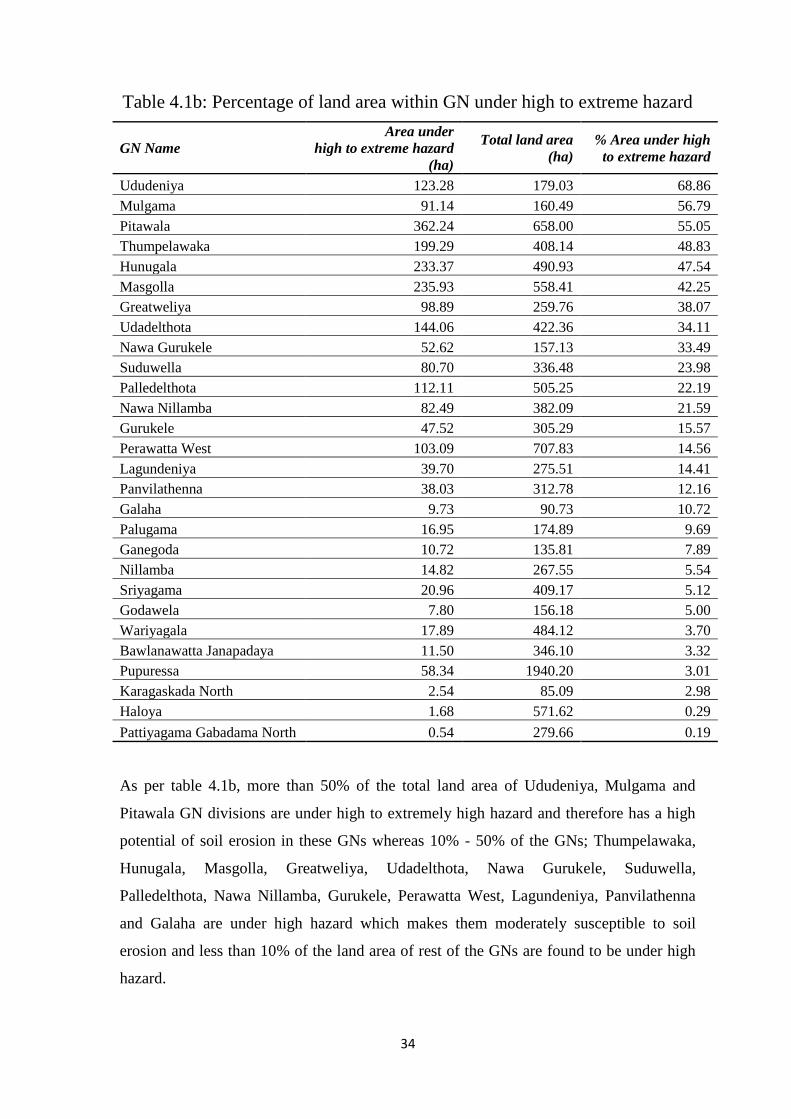
Table 4.1b lists the soil erosion hazard extents of each GN (Grama Niladhari) division
overlaying the Nillambe catchment.
34
As per table 4.1b, more than 50% of the total land area of Ududeniya, Mulgama and
Pitawala GN divisions are under high to extremely high hazard and therefore has a high
potential of soil erosion in these GNs whereas 10% - 50% of the GNs; Thumpelawaka,
Hunugala, Masgolla, Greatweliya, Udadelthota, Nawa Gurukele, Suduwella,
Palledelthota, Nawa Nillamba, Gurukele, Perawatta West, Lagundeniya, Panvilathenna
and Galaha are under high hazard which makes them moderately susceptible to soil
erosion and less than 10% of the land area of rest of the GNs are found to be under high
hazard.
GN Name
Area under
high to extreme hazard
(ha)
Total land area
(ha)
% Area under high
to extreme hazard
Ududeniya 123.28 179.03 68.86
Mulgama 91.14 160.49 56.79
Pitawala 362.24 658.00 55.05
Thumpelawaka 199.29 408.14 48.83
Hunugala 233.37 490.93 47.54
Masgolla 235.93 558.41 42.25
Greatweliya 98.89 259.76 38.07
Udadelthota 144.06 422.36 34.11
Nawa Gurukele 52.62 157.13 33.49
Suduwella 80.70 336.48 23.98
Palledelthota 112.11 505.25 22.19
Nawa Nillamba 82.49 382.09 21.59
Gurukele 47.52 305.29 15.57
Perawatta West 103.09 707.83 14.56
Lagundeniya 39.70 275.51 14.41
Panvilathenna 38.03 312.78 12.16
Galaha 9.73 90.73 10.72
Palugama 16.95 174.89 9.69
Ganegoda 10.72 135.81 7.89
Nillamba 14.82 267.55 5.54
Sriyagama 20.96 409.17 5.12
Godawela 7.80 156.18 5.00
Wariyagala 17.89 484.12 3.70
Bawlanawatta Janapadaya 11.50 346.10 3.32
Pupuressa 58.34 1940.20 3.01
Karagaskada North 2.54 85.09 2.98
Haloya 1.68 571.62 0.29
Pattiyagama Gabadama North 0.54 279.66 0.19
Table 4.1b: Percentage of land area within GN under high to extreme hazard
35
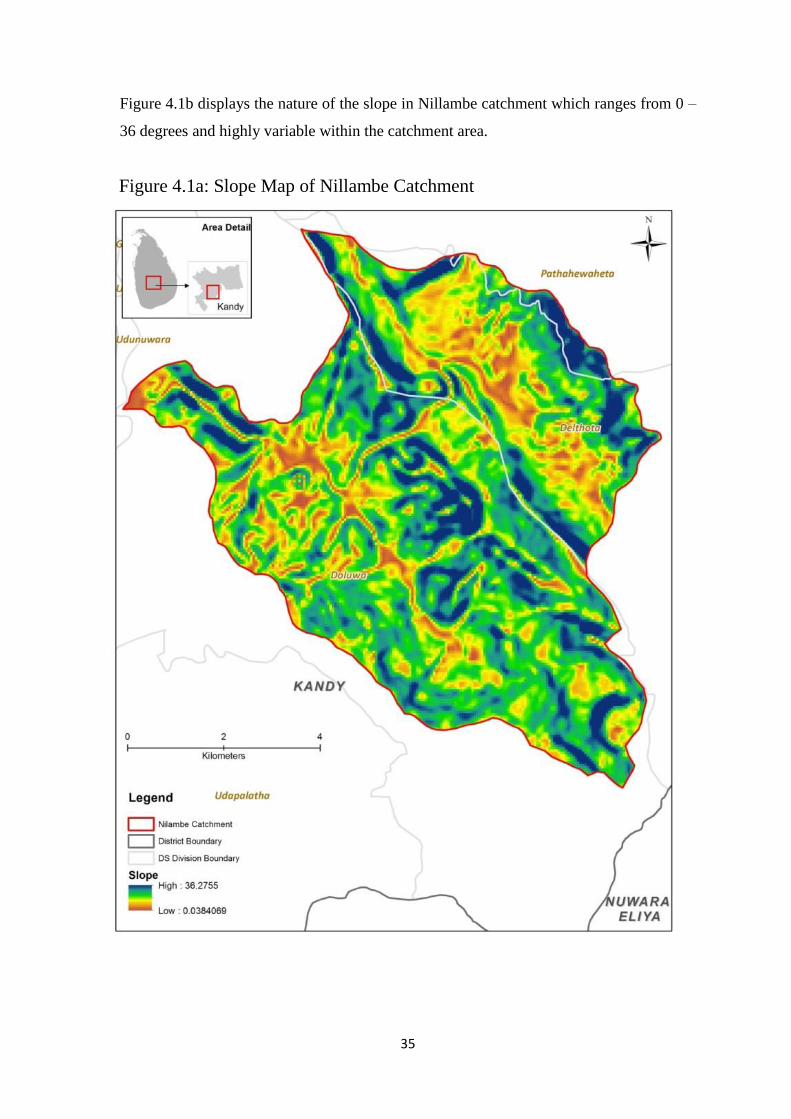
Figure 4.1b displays the nature of the slope in Nillambe catchment which ranges from 0 –
36 degrees and highly variable within the catchment area.
Figure 4.1a: Slope Map of Nillambe Catchment

36
As per above figure 4.1b, it is observed that the hazard level, high to extreme is in areas
where the slope is 7 – 36 degrees.
In comparison with land use; it is observed that GNs with a high potential of soil erosion
namely; Ududeniya, Mulgama and Pitawala GN divisions consist more than 50 % of
moderately managed tea. (Figure 4.1c)
Figure 4.2b: Land use and Land cover of Nillambe Catchment
37
Land use / land cover Area (ha) %
Area
Tea (Moderately Managed) 1180.60 53.33
Forest plantation 346.10 15.63
Homesteads 253.78 11.46
Sparsely used cropland 121.54 5.49
Grassland 75.37 3.40
Scrubland 68.38 3.09
Tea (Poorly Managed) 68.08 3.08
Barren land 29.92 1.35
Dense forest 20.03 0.90
Paddy (Wet Zone) 18.10 0.82
Open forest 13.97 0.63
Other crop land 8.74 0.39
Streams 4.39 0.20
Tea (Well Managed) 2.91 0.13
Built Up Land 1.42 0.06
River 0.34 0.02
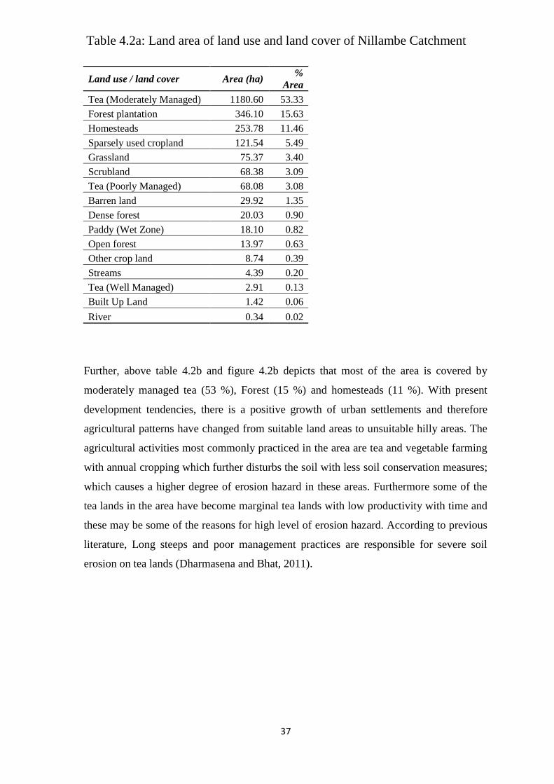
Further, above table 4.2b and figure 4.2b depicts that most of the area is covered by
moderately managed tea (53 %), Forest (15 %) and homesteads (11 %). With present
development tendencies, there is a positive growth of urban settlements and therefore
agricultural patterns have changed from suitable land areas to unsuitable hilly areas. The
agricultural activities most commonly practiced in the area are tea and vegetable farming
with annual cropping which further disturbs the soil with less soil conservation measures;
which causes a higher degree of erosion hazard in these areas. Furthermore some of the
tea lands in the area have become marginal tea lands with low productivity with time and
these may be some of the reasons for high level of erosion hazard. According to previous
literature, Long steeps and poor management practices are responsible for severe soil
erosion on tea lands (Dharmasena and Bhat, 2011).
Table 4.2a: Land area of land use and land cover of Nillambe Catchment
38
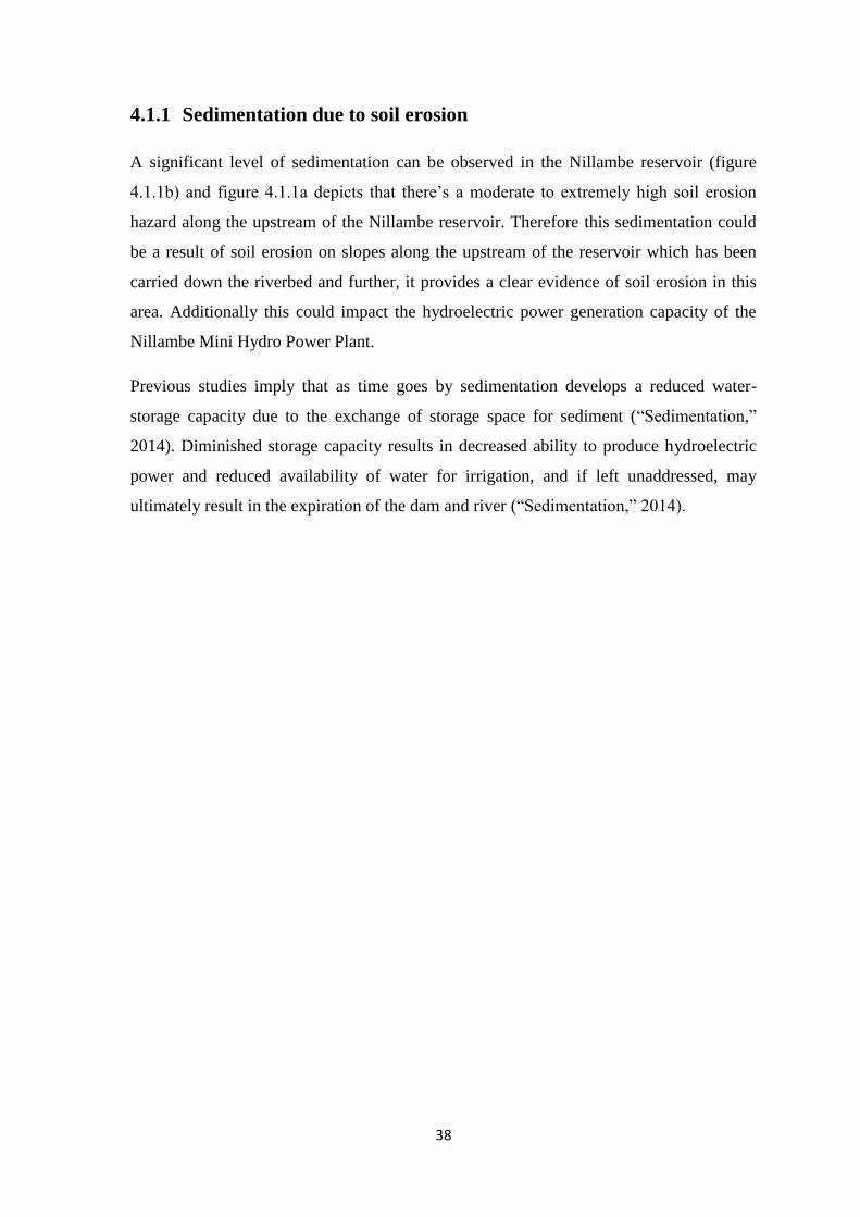
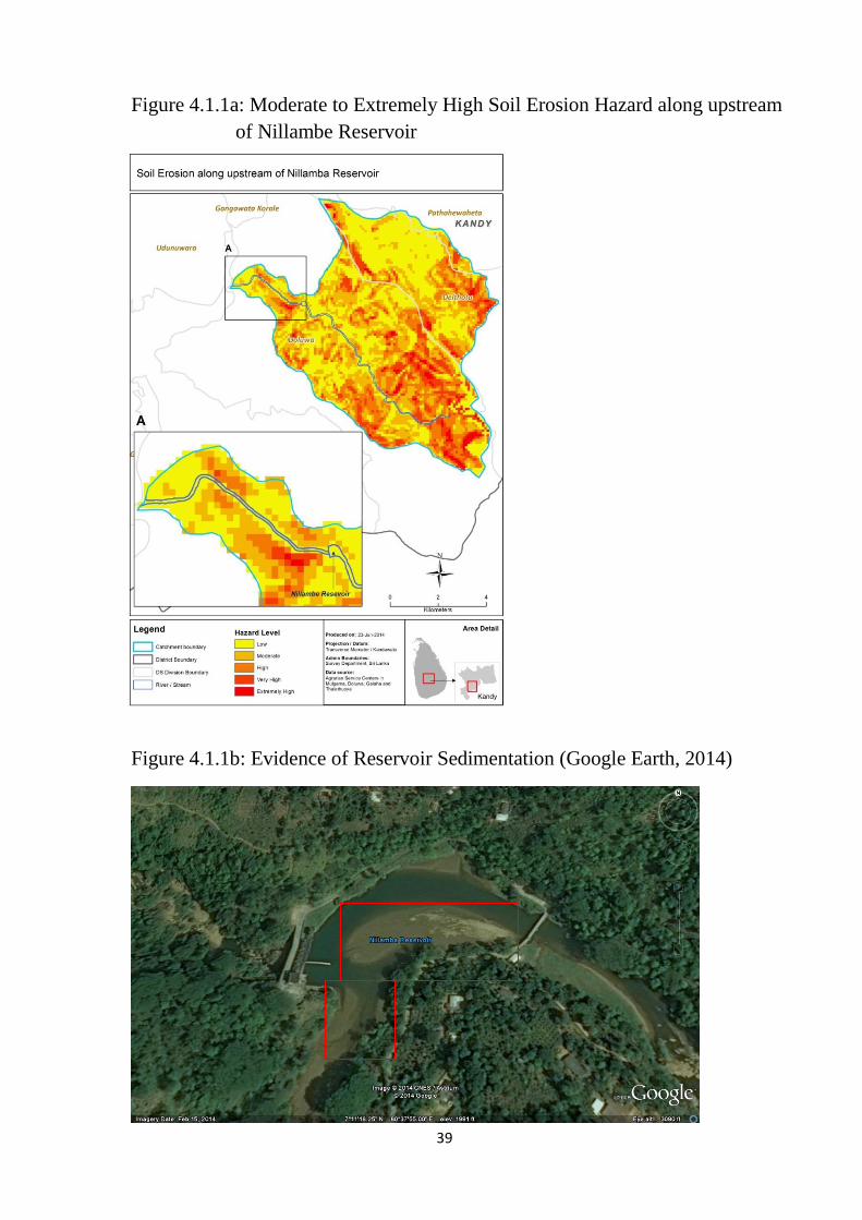
4.1.1 Sedimentation due to soil erosion
A significant level of sedimentation can be observed in the Nillambe reservoir (figure
4.1.1b) and figure 4.1.1a depicts that there’s a moderate to extremely high soil erosion
hazard along the upstream of the Nillambe reservoir. Therefore this sedimentation could
be a result of soil erosion on slopes along the upstream of the reservoir which has been
carried down the riverbed and further, it provides a clear evidence of soil erosion in this
area. Additionally this could impact the hydroelectric power generation capacity of the
Nillambe Mini Hydro Power Plant.
Previous studies imply that as time goes by sedimentation develops a reduced water-
storage capacity due to the exchange of storage space for sediment (“Sedimentation,”
2014). Diminished storage capacity results in decreased ability to produce hydroelectric
power and reduced availability of water for irrigation, and if left unaddressed, may
ultimately result in the expiration of the dam and river (“Sedimentation,” 2014).
39
Figure 4.2c: Sedimentation in Nillambe Reservoir
Figure 4.1.1a: Moderate to Extremely High Soil Erosion Hazard along upstream
of Nillambe Reservoir
Figure 4.1.1b: Evidence of Reservoir Sedimentation (Google Earth, 2014)
40
4.2 Assessment of Socio-economic Vulnerability and Coping Capacity
for Soil Erosion
As the second step of this study, socio-economic vulnerability and coping capacity of the
population under soil erosion hazard was calculated using GIS based Analytical
Hierarchical Process (AHP) as elaborated in the preceding chapter.
Following intermediate results were found in generating the composite vulnerability and
composite capacity indices.
41
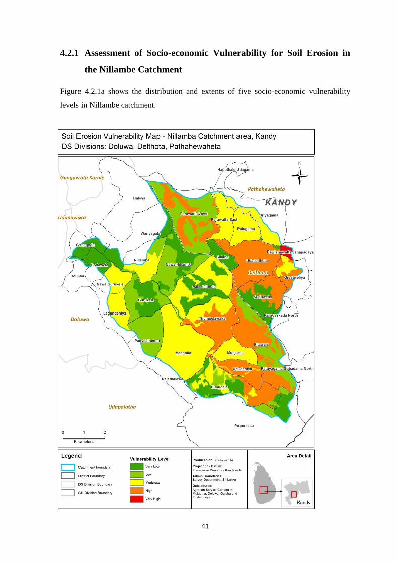
4.2.1 Assessment of Socio-economic Vulnerability for Soil Erosion in
the Nillambe Catchment
Figure 4.2.1a shows the distribution and extents of five socio-economic vulnerability
levels in Nillambe catchment.
42
The level of vulnerability shown in figure 4.2.1a ranges from very high to very low. The
overall assessment results in a significant share of vulnerable areas. In particular, the
classes ‘Very High’, ‘High’, ‘Moderate’, ‘Low’ and ‘Very Low’ records nearly 16 %, 14
%, 24 %, 25 % and 21 % of the total catchment area, respectively.
It is found that 30 % of the total land area has a high to very high vulnerability. This area
has the highest crop production investment ration among the catchment and agricultural
land ownership is significantly low with the highest dependency rate of over 73 %.
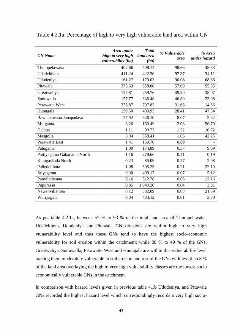
Table 4.2.1a lists the extent of susceptibility to soil erosion of each GN (Grama Niladhari)
division overlaying the Nillambe catchment.
43
GN Name
Area under
high to very high
vulnerability (ha)
Total
land area
(ha)
% Vulnerable
area
% Area
under hazard
Thumpelawaka 402.66 408.14 98.66 48.83
Udadelthota 411.24 422.36 97.37 34.11
Ududeniya 161.27 179.03 90.08 68.86
Pitawala 375.63 658.00 57.09 55.05
Greatweliya 127.81 259.76 49.20 38.07
Suduwella 157.77 336.48 46.89 23.98
Perawatta West 223.87 707.83 31.63 14.56
Hunugala 139.50 490.93 28.41 47.54
Bawlanawatta Janapadaya 27.92 346.10 8.07 3.32
Mulgama 3.26 160.49 2.03 56.79
Galaha 1.11 90.73 1.22 10.72
Masgolla 5.94 558.41 1.06 42.25
Perawatta East 1.41 159.70 0.89 -
Palugama 1.00 174.89 0.57 9.69
Pattiyagama Gabadama North 1.16 279.66 0.41 0.19
Karagaskada North 0.23 85.09 0.27 2.98
Palledelthota 1.08 505.25 0.21 22.19
Sriyagama 0.30 409.17 0.07 5.12
Panvilathenna 0.16 312.78 0.05 12.16
Pupuressa 0.85 1,940.20 0.04 3.01
Nawa Nillamba 0.12 382.09 0.03 21.59
Wariyagala 0.04 484.12 0.01 3.70
As per table 4.2.1a, between 57 % to 93 % of the total land area of Thumpelawaka,
Udadelthota, Ududeniya and Pitawala GN divisions are within high to very high
vulnerability level and thus these GNs tend to have the highest socio-economic
vulnerability for soil erosion within the catchment; while 28 % to 49 % of the GNs;
Greatweliya, Suduwella, Perawatte West and Hunugala are within this vulnerability level
making them moderately vulnerable to soil erosion and rest of the GNs with less than 8 %
of the land area overlaying the high to very high vulnerability classes are the lowest socio
economically vulnerable GNs in the catchment.
In comparison with hazard levels given in previous table 4.1b Ududeniya, and Pitawala
GNs recorded the highest hazard level which correspondingly records a very high socio-
Table 4.2.1a: Percentage of high to very high vulnerable land area within GN
44
economic vulnerability as per table 4.2.1a. However, although Thumpelawaka and
Udadelthota have a moderate hazard level, the vulnerability assessment has identified
them as very highly vulnerable GNs due to its high poverty ratio, high crop production
investment ratio, high dependency ratio and low arable land ownership of farmers in the
area.
45
Figure 4.2.1b: Crop production cost per GN
46
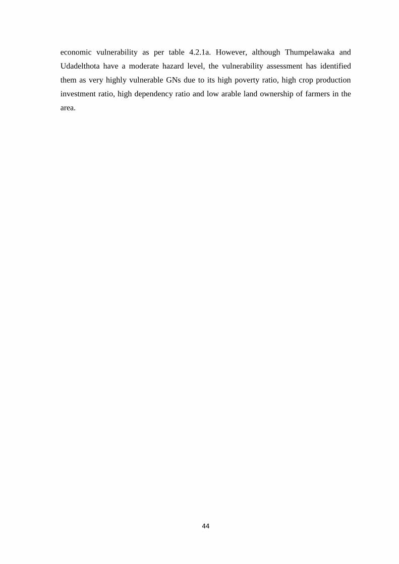
As per above figure 4.2.1b, it can be noted that the areas with high to very high socio-
economic vulnerability exist in areas with comparatively the high crop production
investment ratio which is approximately recorded as 5 % – 16 %.
The area with highest crop production investment ratio consists of ‘Moderately Managed
Tea’, ‘Other Crops’, ‘Grassland / Forest Plantation / Paddy’ which are approximated to
69 %, 15 % and 11 % respectively. The crop production investment ratio was determined
by finding the product of average cost per 1 kg of yield (per each crop type) and the total
arable area.
In this study ‘Other Crops’ are areas of home gardens; average production investment for
this category was calculated based on a selected major cultivations in Kandy home
gardens as per previous literature and ground level knowledge which consists of Cloves
(“Clove,” 2012), Pepper (“Pepper Production Guide for Asia and The Pacific,” 2005),
King Coconut, Coconut (Department of Census and Statistics, 2002), Oranges, Limes,
Mangos, Banana, Avocado (“Fruits,” 2006), Papaw, Pineapple, Passion fruit, Leeks,
Capsicum, Luffa, Okra, Brinjals, Bitter gourd, Snake gourd, Cucumber, Ash Pumpkin,
Red pumpkin and Ash plantain (“Sector Brief,” 2011).
As per previous literature average production cost per kg of other crops was
approximately Rs. 310/kg of the yield (“Hand book on Cost of Production of Selected
Vegetables, Grains and Pulses,” 2010) whereas paddy was Rs.41/kg of the yield (“Rice,”
2014 and Gamawelagedara, Wickramasinghe and Dissanayake, 2011)
47
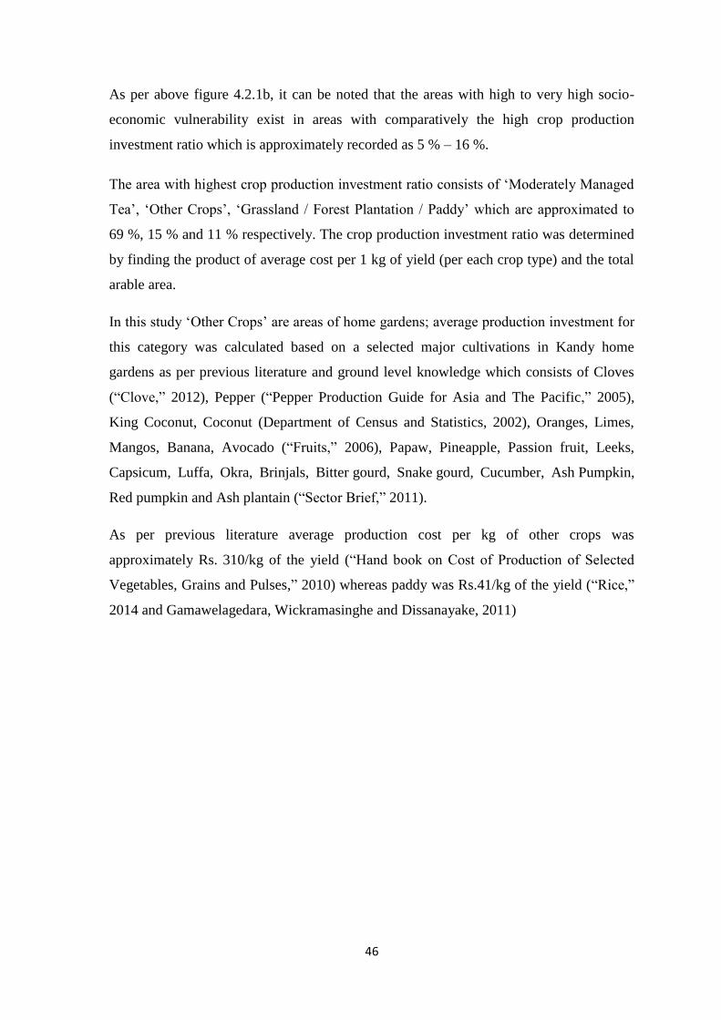
Figure 4.2.1c: Poverty Ratio based on Samurdhi beneficiary families by GN

48
Figure 4.2.1c denotes that highest socio –economic vulnerability areas are where poverty
ratio is approximately 5 % - 12 % which is comparatively moderate within the related
GNs of the Nillambe catchment. The poverty ratio was determined based on the Samurdhi
beneficiary rate of GNs. People who are below poverty line is eligible for Samurdhi
stamps hence Samurdhi beneficiary rate is an acceptable poverty indicator. (“Obtain birth,
marriage, hospitalized and death allowance,” 2010)
49
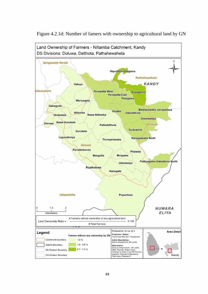
Figure 4.2.1d: Number of famers with ownership to agricultural land by GN
Figure 4.2.1d: Number of famers with ownership to agricultural land by GN
50
As represented in figure 4.2.1d, the farmer percentage without any ownership of
agricultural land is reasonably low in the Nillambe catchment and this ratio is
approximately between 2 % - 7 % within areas of highest socio –economic vulnerability
of the Nillambe catchment. These data was interpolated based on DS divisional level
figures of Census of Agriculture - Sri Lanka, 2002.
51
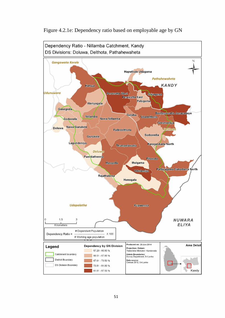
Figure 4.2.1e: Dependency ratio based on employable age by GN
52
Figure 4.2.1e indicates that highest socio–economic vulnerability areas are where
dependency ratio is approximately 73 % - 87 % which is comparatively high within the
related GNs of the Nillambe catchment.
The dependency ratio is the proportion between non-working age population to working
age population and the non-working age population in Sri lanka is defined by the age
groups below 14 and over 60 years (Census 2012). However, as per local knowledge, a
comparatively less weightage was assigned to dependency ratio by experts as most of
this population officially labelled as ‘non-working’ are practically employed in the
country; especially in the field of agriculture.
53
4.2.2 Assessment of Socio-economic Coping capacity of Soil Erosion in
the Nillambe Catchment
Figure 4.2.2a shows the distribution and extents of five levels of socio-economic coping
capacity of soil erosion in Nillambe catchment.
54
The coping capacity levels given in figure 4.2.2a fluctuate from very high to very low
categories. The assessment indicates a substantial portion of areas with coping capacity
levels; ‘Very High’, ‘High’, ‘Moderate’, ‘Low’ and ‘Very Low’ which approximately
accounts to 59 %, 3 %, 17 %, 8 % and 13 % of the total catchment area, respectively.
It discloses that 38 % of the total land area is with a very low to moderate coping capacity
whereas 62 % is with a high to very high capacity. While very low to moderate capacity
areas indicates a less number of training and awareness programs related to soil
conservation conducted and a high percentage of fertilizer subsidy distribution; areas with
high coping capacity indicates a very high percentage of subsidy distribution although the
number of awareness programs are still minimal.
Table 4.2.2a lists the extent of GNs with socio-economic coping capacity to soil erosion
overlaying the Nillambe catchment.
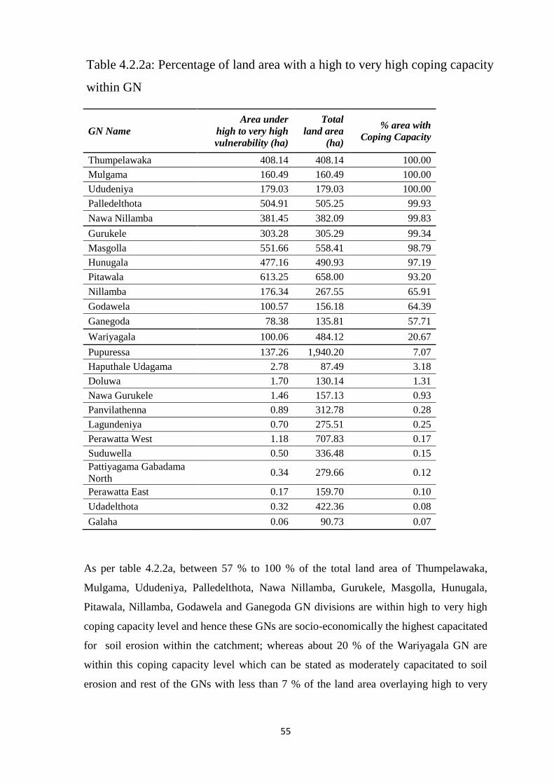
55
GN Name
Area under
high to very high
vulnerability (ha)
Total
land area
(ha)
% area with
Coping Capacity
Thumpelawaka 408.14 408.14 100.00
Mulgama 160.49 160.49 100.00
Ududeniya 179.03 179.03 100.00
Palledelthota 504.91 505.25 99.93
Nawa Nillamba 381.45 382.09 99.83
Gurukele 303.28 305.29 99.34
Masgolla 551.66 558.41 98.79
Hunugala 477.16 490.93 97.19
Pitawala 613.25 658.00 93.20
Nillamba 176.34 267.55 65.91
Godawela 100.57 156.18 64.39
Ganegoda 78.38 135.81 57.71
Wariyagala 100.06 484.12 20.67
Pupuressa 137.26 1,940.20 7.07
Haputhale Udagama 2.78 87.49 3.18
Doluwa 1.70 130.14 1.31
Nawa Gurukele 1.46 157.13 0.93
Panvilathenna 0.89 312.78 0.28
Lagundeniya 0.70 275.51 0.25
Perawatta West 1.18 707.83 0.17
Suduwella 0.50 336.48 0.15
Pattiyagama Gabadama
North 0.34 279.66 0.12
Perawatta East 0.17 159.70 0.10
Udadelthota 0.32 422.36 0.08
Galaha 0.06 90.73 0.07
As per table 4.2.2a, between 57 % to 100 % of the total land area of Thumpelawaka,
Mulgama, Ududeniya, Palledelthota, Nawa Nillamba, Gurukele, Masgolla, Hunugala,
Pitawala, Nillamba, Godawela and Ganegoda GN divisions are within high to very high
coping capacity level and hence these GNs are socio-economically the highest capacitated
for soil erosion within the catchment; whereas about 20 % of the Wariyagala GN are
within this coping capacity level which can be stated as moderately capacitated to soil
erosion and rest of the GNs with less than 7 % of the land area overlaying high to very
Table 4.2.2a: Percentage of land area with a high to very high coping capacity
within GN
56
high coping capacity level are with the lowest socio economic coping capacity in the
catchment.
In contrast with hazard and vulnerability, both Ududeniya and Pitawala GNs with high
hazard and vulnerability level is represented as an area with very high coping capacity
while Thumpelawaka and Udadelthota GNs which recorded a moderate hazard and a very
high vulnerability is represented with a very high and very low percentage of high coping
capacity respectively.
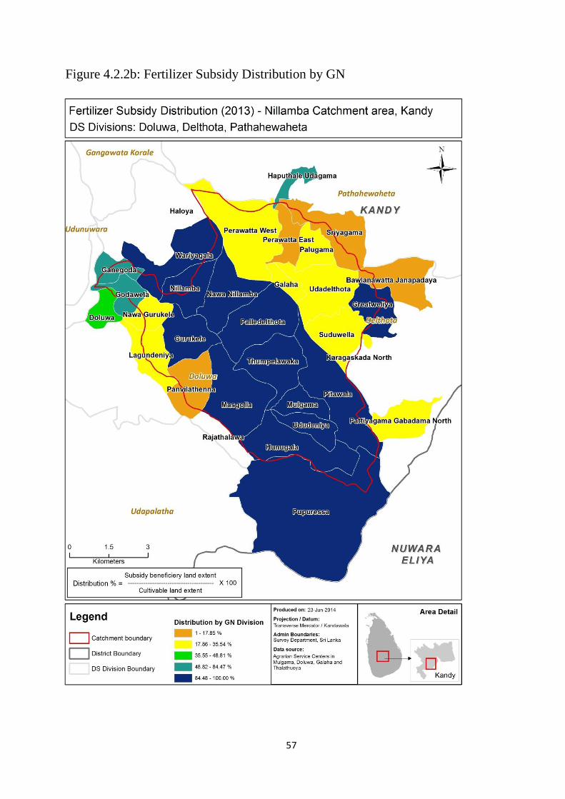
57
Figure 4.2.2b: Fertilizer Subsidy Distribution by GN
G
58
Figure 4.2.2b denotes that areas with highest socio –economic coping capacity are where
fertilizer subsidy distribution ratio is approximately 48 % - 100 % which is comparatively
high within the related GNs of the Nillambe catchment and a significant proportion of this
area approximates to more than 84 %.
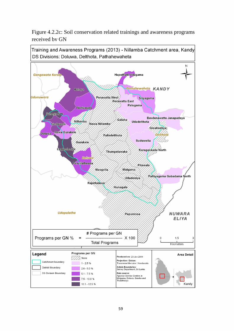
59
Figure 4.2.2c: Soil conservation related trainings and awareness programs
received by GN
G
60
Figure 4.2.2c indicates that areas with highest socio –economic coping capacity are where
7 % - 12 % of awareness programs conducted on soil erosion and conservation. However,
it also consists of areas where there are no programs have been conducted but with a high
level of fertilizer distribution. This may be due to the fact that training and awareness
criterion has been assigned the lowest score in comparison with other criteria.
61
4.3 Soil Erosion Risk Assessment
The ultimate objective of this research was to assess the socio-economic risk of soil
erosion in the Nillambe catchment area. This was done with the use of GIS based Disaster
Risk Equation as explained in the previous chapter.
Figure 4.3a shows the dispersal and extents of five socio-economic risk levels in
Nillambe catchment.
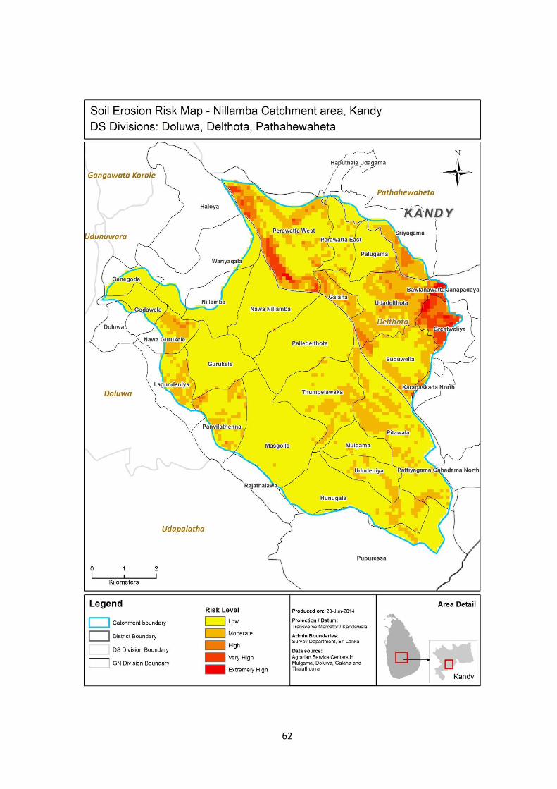
62
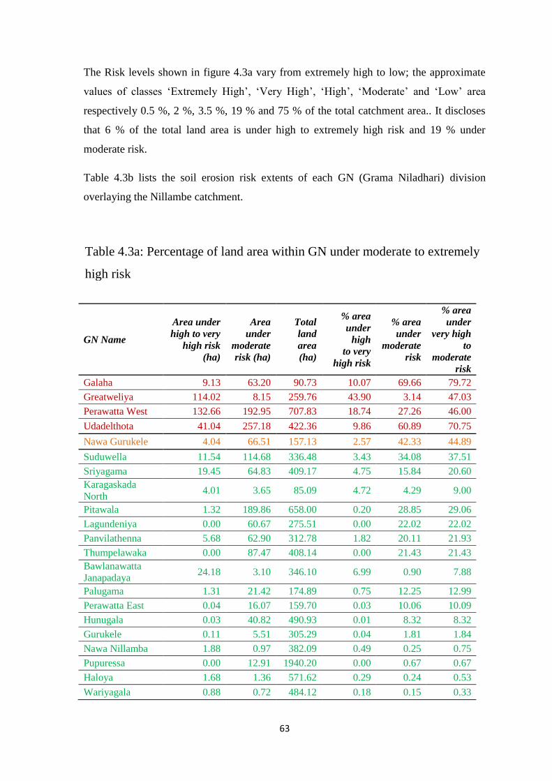
63
The Risk levels shown in figure 4.3a vary from extremely high to low; the approximate
values of classes ‘Extremely High’, ‘Very High’, ‘High’, ‘Moderate’ and ‘Low’ area
respectively 0.5 %, 2 %, 3.5 %, 19 % and 75 % of the total catchment area.. It discloses
that 6 % of the total land area is under high to extremely high risk and 19 % under
moderate risk.
Table 4.3b lists the soil erosion risk extents of each GN (Grama Niladhari) division
overlaying the Nillambe catchment.
GN Name
Area under
high to very
high risk
(ha)
Area
under
moderate
risk (ha)
Total
land
area
(ha)
% area
under
high
to very
high risk
% area
under
moderate
risk
% area
under
very high
to
moderate
risk
Galaha 9.13 63.20 90.73 10.07 69.66 79.72
Greatweliya 114.02 8.15 259.76 43.90 3.14 47.03
Perawatta West 132.66 192.95 707.83 18.74 27.26 46.00
Udadelthota 41.04 257.18 422.36 9.86 60.89 70.75
Nawa Gurukele 4.04 66.51 157.13 2.57 42.33 44.89
Suduwella 11.54 114.68 336.48 3.43 34.08 37.51
Sriyagama 19.45 64.83 409.17 4.75 15.84 20.60
Karagaskada
North 4.01 3.65 85.09 4.72 4.29 9.00
Pitawala 1.32 189.86 658.00 0.20 28.85 29.06
Lagundeniya 0.00 60.67 275.51 0.00 22.02 22.02
Panvilathenna 5.68 62.90 312.78 1.82 20.11 21.93
Thumpelawaka 0.00 87.47 408.14 0.00 21.43 21.43
Bawlanawatta
Janapadaya 24.18 3.10 346.10 6.99 0.90 7.88
Palugama 1.31 21.42 174.89 0.75 12.25 12.99
Perawatta East 0.04 16.07 159.70 0.03 10.06 10.09
Hunugala 0.03 40.82 490.93 0.01 8.32 8.32
Gurukele 0.11 5.51 305.29 0.04 1.81 1.84
Nawa Nillamba 1.88 0.97 382.09 0.49 0.25 0.75
Pupuressa 0.00 12.91 1940.20 0.00 0.67 0.67
Haloya 1.68 1.36 571.62 0.29 0.24 0.53
Wariyagala 0.88 0.72 484.12 0.18 0.15 0.33
Table 4.3a: Percentage of land area within GN under moderate to extremely
high risk
64
As per above table, in considering the total % of land area under both ‘moderate’ and
‘high to very high risk’, Galaha, Greatweliya, Perawatte West and Udadelthota GNs are
comparatively higher than rest of the GN divisions; which are recorded approximately as
80 %, 47 %, 46 % and 71 %, out of which Greatweliya and Perawatte West has the
highest % under ‘high to extremely high risk’ alone which is close to 44 % and 19 %
respectively and although only about 10 % of Galaha and Udadelthota are under ‘high to
extremely high risk’, a land area of close to 70 % and 61 % are respectively under
‘moderate risk’.
It is observed that areas with a higher % of land under ‘high to extremely high risk’
specifically in Greatweliya and Perawatte West GN divisions, the soil erosion hazard is
mostly at a high to extremely high level while the socio-economic vulnerability is mostly
moderate specifically due to high crop investment ratio in tea cultivation areas whereas
the coping capacity is at a very low level. On the other hand, areas with a higher % of
land under ‘moderate risk’ particularly in Galaha and Udadelthota GN divisions, the soil
erosion hazard is mostly at a moderate to high level while the socio-economic
vulnerability is mostly high and the coping capacity is at a low to very low level.
FIFTH CHAPTER
CONCLUSIONS AND RECOMMENDATIONS
65
FIFTH CHAPTER
CONCLUSION AND RECOMMENDATIONS
This chapter discusses about conclusions drawn from this research, converses limitations
and proposes recommendations to minimize the socio-economic risk of soil erosion in
Nillambe catchment in Kandy.
5.1 Conclusion
The status of Socio-economic risk for soil erosion in Nillambe Catchment clearly shows
that the socio-economic coping capacity of the population is insufficient to address the
vulnerability to the level of soil erosion hazard which exist in the area. The final results
concludes that the socio-economic risk of soil erosion in the area of interest can be mainly
categorized into 5 classes from low to extremely high and approximately 25 % of the
catchment is in moderate to extremely high risk levels. The study validated further that
the rainfall, slope, vegetative cover and erosion control measures are the critical factors in
assessing the soil erosion hazard.
The results further interpreted that areas with a moderate risk level are those that cover a
majority of moderately managed tea and some homestead with a slope greater than 10 %
(slope of the catchment varies between 0 – 36 degrees) and moderately high rainfall
erosivity level of over 19 (overall rainfall erosivity level of the catchment ranges from 12
– 32). In considering the vulnerability factors of these areas, a majority has a
comparatively high crop investment ratio between 0.5 % - 16 % (overall investment ratio
ranges from 0.02 % – 16 %), the level of poverty stands between about 4 % - 84 % with a
majority of 5 % - 7 %, the ownership ratio to an agricultural land is considerably high
between 93 % - 98 % and the dependency ratio varies between 57 % - 87 % with a
majority of over 73 %. On the other hand, with regard to coping capacity aspects, no
related training and awareness programs have been conducted in most of the areas (the
percentage of training and awareness programs received at GN level varies averagely
between 0 % - 12 %) whereas the percentage of fertilizer subsidy distribution ranges from
1 % - 100 % with a comparatively low majority of 18 % - 35 %.

66
Moreover, the outcomes show that areas with a high to extremely high risk level is
covered with a majority of moderately managed tea and some open forest and a few areas
of barren land and grassland with a slope between 10˚ – 36˚ with a majority greater than
18˚ of slope and moderately high rainfall erosivity level between 16 - 27. In considering
the vulnerability and coping capacity factors of these areas, the variables indicate values
similar to above stated moderate risk level.
5.2 Recommendations
As most of the risk areas are covered with moderately managed tea, necessary action
should be taken to improve management of tea plantations such as bio-remediation which
has been identified as a lifeline for the survival of the tea industry (“Using biochar to
improve soil health and leaf production at tea plantations in sri lanka,” 2014), additionally
constructing proper draining with Silt-pits, suitable terracing and careful selective
weeding are some of the tasks which must be undertaken. (“Tea Gardens,” 2011)
Further, mitigation measures at other land use should also be taken as appropriate, for
instance homestead conservation could be improved by the use of small scale sunken
beds near homesteads, intercropping and large application of manure; and open forest
areas could be improved by controlled harvesting and prevention of trespassing and
restricted grazing. (Kaihura, Stocking and Kahembe, 2001). Riparian restoration has
found to be a cost effective way to minimize stream bank soil erosion. (Reynaldo, 2010)
5.3 Limitations
This approach offers a qualitative assessment of vulnerability to erosion rather than a
quantitative calculation of erosion rates and the study assumes constant landuse /
landcover over time and doesn’t reflect the recent land cover changes. Additionally, the
accuracy of interpolated rainfall runoff erosivity factor map could be improved by using
more sufficient number of isoerodent points with a better distribution.
67
In conclusion, GIS has proved to be an important tool to assess the socio-economic risk of
soil erosion in this study. Therefore it is a significant finding that GIS based analysis
using models such as USLE (Universal Soil Loss Equation), AHP (Analytical
Hierarchical Process) and Disaster Risk Equation is an applicable approach in Soil
erosion risk assessment. This study provides crucial spatially resolved information that
can provide the scientific basis to the development of effective management strategies to
mitigate the socio-economic risk of soil erosion.
APPENDIX

68
Appendix 01: C Factor Map
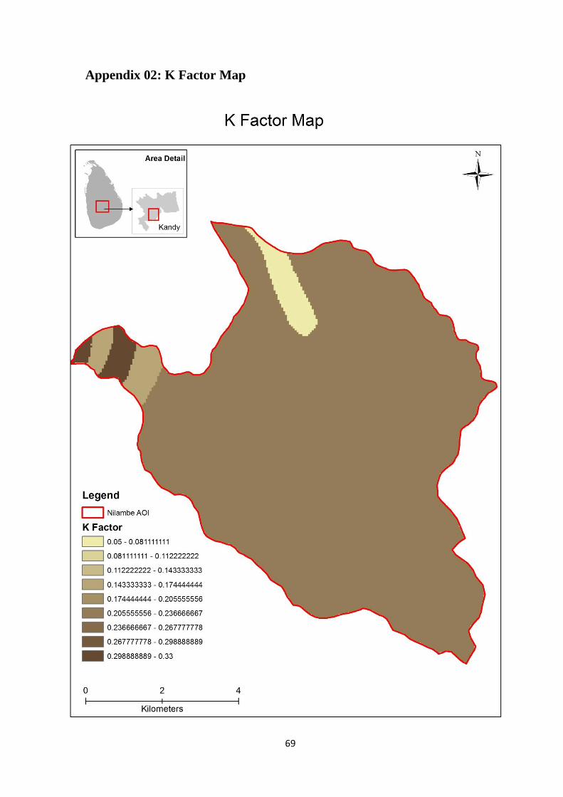
69
Appendix 02: K Factor Map
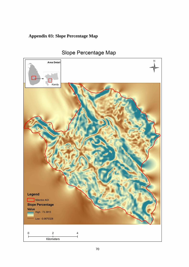
70
Appendix 03: Slope Percentage Map

Appendix 04: R Factor Map
71
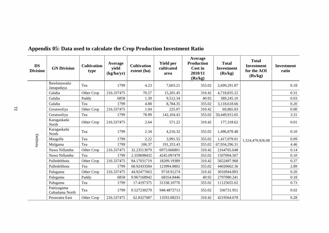
Appendix 05: Data used to calculate the Crop Production Investment Ratio
DS
Division GN Division
Cultivation
type
Average
yield
(kg/ha/yr)
Cultivation
extent (ha)
Yield per
cultivated
area
Average
Production
Cost in
2010/11
(Rs/kg)
Total
Investment
(Rs/kg)
Total
Investment
for the AOI
(Rs/kg)
Investment
ratio
Delth
ota
Bawlanawatta
Janapadaya Tea 1799 4.23 7,603.21 355.02 2,699,291.87
1,524,479,926.08
0.18
Galaha Other Crop 216.337475 70.27 15,201.45 310.42 4,718,835.22 0.31
Galaha Paddy 6858 1.39 9,512.34 40.92 389,245.10 0.03
Galaha Tea 1799 4.88 8,784.35 355.02 3,118,618.66 0.20
Greatweliya Other Crop 216.337475 1.04 225.07 310.42 69,865.83 0.00
Greatweliya Tea 1799 78.99 142,104.43 355.02 50,449,915.65 3.31
Karagaskada
North Other Crop 216.337475 2.64 571.22 310.42 177,318.62 0.01
Karagaskada
North Tea 1799 2.34 4,216.32 355.02 1,496,878.48 0.10
Masgolla Tea 1799 2.22 3,991.55 355.02 1,417,079.01 0.09
Mulgama Tea 1799 106.37 191,353.43 355.02 67,934,296.31 4.46
Nawa Nillamba Other Crop 216.337475 32.23513079 6973.666801 310.42 2164765.648 0.14
Nawa Nillamba Tea 1799 2.359698432 4245.097479 355.02 1507094.507 0.10
Palledelthota Other Crop 216.337475 84.17031719 18209.19389 310.42 5652497.968 0.37
Palledelthota Tea 1799 68.92433584 123994.8802 355.02 44020662.36 2.89
Palugama Other Crop 216.337475 44.92477663 9718.91274 310.42 3016944.893 0.20
Palugama Paddy 6858 9.967168942 68354.8446 40.92 2797080.241 0.18
Palugama Tea 1799 17.4197375 31338.10776 355.02 11125655.02 0.73
Pattiyagama
Gabadama North Tea 1799 0.527230279 948.4872713 355.02 336731.951 0.02
Perawatta East Other Crop 216.337475 62.8327687 13593.08253 310.42 4219564.678 0.28
72

73
DS
Division GN Division
Cultivation
type
Average
yield
(kg/ha/yr)
Cultivation
extent (ha)
Yield per
cultivated
area
Average
Production
Cost in
2010/11
(Rs/kg)
Total
Investment
(Rs/kg)
Total
Investment
for the AOI
(Rs/kg)
Investment
ratio
Delth
ota
Perawatta East Paddy 6858 3.057891901 20971.02265 40.92 858134.247
1,524,479,926.08
0.06
Perawatta East Tea 1799 3.373083745 6068.177657 355.02 2154324.432 0.14
Perawatta East Tea 1799 0.930793191 1674.49695 355.02 594479.9073 0.04
Perawatta West Other Crop 216.337475 44.54588302 9636.943854 310.42 2991500.111 0.20
Perawatta West Other Crop 216.337475 8.965783801 1939.635029 310.42 602101.5056 0.04
Perawatta West Tea 1799 175.2504652 315275.587 355.02 111929138.9 7.34
Pitawala Tea 1799 347.3886002 624952.0918 355.02 221870491.6 14.55
Pupuressa Tea 1799 47.14184631 84808.18151 355.02 30108600.6 1.98
Sriyagama Tea 1799 1.863032055 3351.594667 355.02 1189883.139 0.08
Suduwella Other Crop 216.337475 42.60328141 9216.686326 310.42 2861043.769 0.19
Suduwella Tea 1799 252.4788715 454209.4899 355.02 161253453.1 10.58
Thumpelawaka Tea 1799 129.023304 232112.9239 355.02 82404730.23 5.41
Udadelthota Other Crop 216.337475 78.14719074 16906.16592 310.42 5248012.026 0.34
Udadelthota Paddy 6858 17.41242052 119414.3799 40.92 4886436.426 0.32
Udadelthota Tea 1799 318.3865232 572777.3552 355.02 203347416.6 13.34
Udadelthota Tea 1799 0.441113795 793.5637176 355.02 281730.991 0.02
Ududeniya Tea 1799 120.694944 217130.2042 355.02 77085565.1 5.06
Wariyagala Tea 1799 3.038146013 5465.624677 355.02 1940406.073 0.13
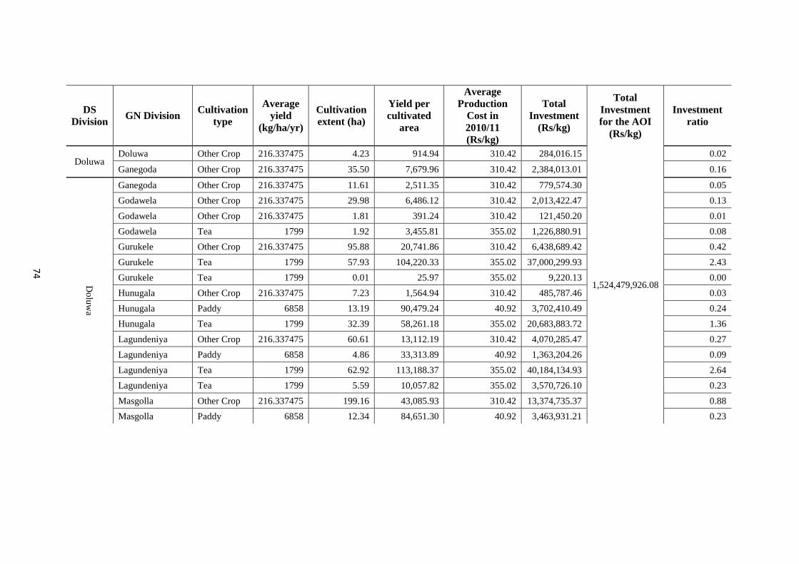
74
DS
Division GN Division
Cultivation
type
Average
yield
(kg/ha/yr)
Cultivation
extent (ha)
Yield per
cultivated
area
Average
Production
Cost in
2010/11
(Rs/kg)
Total
Investment
(Rs/kg)
Total
Investment
for the AOI
(Rs/kg)
Investment
ratio
Doluwa Doluwa Other Crop 216.337475 4.23 914.94 310.42 284,016.15
1,524,479,926.08
0.02
Ganegoda Other Crop 216.337475 35.50 7,679.96 310.42 2,384,013.01 0.16
Do
luw
a
Ganegoda Other Crop 216.337475 11.61 2,511.35 310.42 779,574.30 0.05
Godawela Other Crop 216.337475 29.98 6,486.12 310.42 2,013,422.47 0.13
Godawela Other Crop 216.337475 1.81 391.24 310.42 121,450.20 0.01
Godawela Tea 1799 1.92 3,455.81 355.02 1,226,880.91 0.08
Gurukele Other Crop 216.337475 95.88 20,741.86 310.42 6,438,689.42 0.42
Gurukele Tea 1799 57.93 104,220.33 355.02 37,000,299.93 2.43
Gurukele Tea 1799 0.01 25.97 355.02 9,220.13 0.00
Hunugala Other Crop 216.337475 7.23 1,564.94 310.42 485,787.46 0.03
Hunugala Paddy 6858 13.19 90,479.24 40.92 3,702,410.49 0.24
Hunugala Tea 1799 32.39 58,261.18 355.02 20,683,883.72 1.36
Lagundeniya Other Crop 216.337475 60.61 13,112.19 310.42 4,070,285.47 0.27
Lagundeniya Paddy 6858 4.86 33,313.89 40.92 1,363,204.26 0.09
Lagundeniya Tea 1799 62.92 113,188.37 355.02 40,184,134.93 2.64
Lagundeniya Tea 1799 5.59 10,057.82 355.02 3,570,726.10 0.23
Masgolla Other Crop 216.337475 199.16 43,085.93 310.42 13,374,735.37 0.88
Masgolla Paddy 6858 12.34 84,651.30 40.92 3,463,931.21 0.23
75
DS
Division GN Division
Cultivation
type
Average
yield
(kg/ha/yr)
Cultivation
extent (ha)
Yield per
cultivated
area
Average
Production
Cost in
2010/11
(Rs/kg)
Total
Investment
(Rs/kg)
Total
Investment
for the AOI
(Rs/kg)
Investment
ratio
Do
luw
a
Masgolla Tea 1799 24.30 43,713.54 355.02 15,519,182.48
1,524,479,926.08
1.02
Mulgama Other Crop 216.337475 31.18 6,744.68 310.42 2,093,683.66 0.14
Mulgama Paddy 6858 22.90 157,046.19 40.92 6,426,329.95 0.42
Nawa Gurukele Other Crop 216.337475 47.47 10,268.71 310.42 3,187,613.86 0.21
Nawa Gurukele Tea 1799 63.94658894 115039.9135 355.02 40841470.09 2.68
Nawa Nillamba Other Crop 216.337475 104.9778691 22710.64713 310.42 7049839.081 0.46
Nawa Nillamba Paddy 6858 9.154523453 62781.72184 40.92 2569028.058 0.17
Nawa Nillamba Tea 1799 20.48622841 36854.72491 355.02 13084164.44 0.86
Nawa Nillamba Tea 1799 54.96069179 98874.28452 355.02 35102348.49 2.30
Nillamba Other Crop 216.337475 94.25775574 20391.48488 310.42 6329924.735 0.42
Nillamba Tea 1799 9.397346547 16905.82644 355.02 6001906.502 0.39
Nillamba Tea 1799 20.26027861 36448.24122 355.02 12939854.6 0.85
Palledelthota Other Crop 216.337475 91.72768654 19844.13609 310.42 6160016.726 0.40
Palledelthota Paddy 6858 20.78640412 142553.1595 40.92 5833275.286 0.38
Palledelthota Tea 1799 23.91598839 43024.86312 355.02 15274686.9 1.00
Panvilathenna Other Crop 216.337475 33.64929956 7279.604501 310.42 2259734.829 0.15
Panvilathenna Paddy 6858 3.063220838 21007.56851 40.92 859629.7033 0.06
Panvilathenna Tea 1799 29.99915049 53968.47173 355.02 19159886.83 1.26
76
DS
Division GN Division
Cultivation
type
Average
yield
(kg/ha/yr)
Cultivation
extent (ha)
Yield per
cultivated
area
Average
Production
Cost in
2010/11
(Rs/kg)
Total
Investment
(Rs/kg)
Total
Investment
for the AOI
(Rs/kg)
Investment
ratio
Do
luw
a
Pitawala Other Crop 216.337475 1.418006152 306.7678704 310.42 95226.88233
1,524,479,926.08
0.01
Pitawala Tea 1799 23.49980799 42276.15458 355.02 15008880.4 0.98
Pitawala Tea 1799 6.99977091 12592.58787 355.02 4470620.545 0.29
Pupuressa Other Crop 216.337475 2.616668372 566.0834285 310.42 175723.6179 0.01
Pupuressa Other Crop 216.337475 1.941294904 419.9748378 310.42 130368.5892 0.01
Pupuressa Tea 1799 1.03151833 1855.701475 355.02 658811.1378 0.04
Rajathalawa Tea 1799 8.675711245 15607.60453 355.02 5541011.76 0.36
Thumpelawaka Other Crop 216.337475 102.5419684 22183.67053 310.42 6886255.005 0.45
Thumpelawaka Paddy 6858 24.45481761 167711.1392 40.92 6862739.815 0.45
Thumpelawaka Tea 1799 6.013240361 10817.81941 355.02 3840542.247 0.25
Ududeniya Other Crop 216.337475 142.6087018 30851.60647 310.42 9576955.68 0.63
Ududeniya Paddy 6858 22.45435652 153991.977 40.92 6301351.699 0.41
Wariyagala Other Crop 216.337475 3.538178283 765.4405559 310.42 237608.0574 0.02
Wariyagala Tea 1799 6.145161996 11055.14643 355.02 3924798.086 0.26
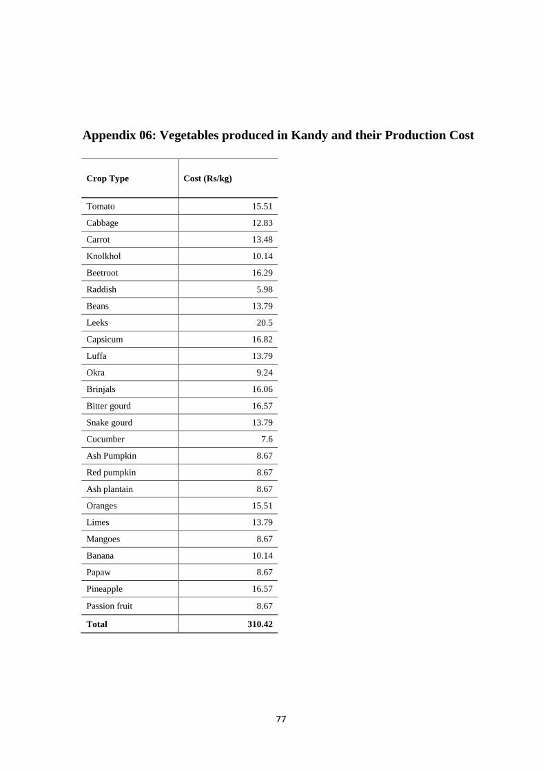
77
Appendix 06: Vegetables produced in Kandy and their Production Cost
Crop Type Cost (Rs/kg)
Tomato 15.51
Cabbage 12.83
Carrot 13.48
Knolkhol 10.14
Beetroot 16.29
Raddish 5.98
Beans 13.79
Leeks 20.5
Capsicum 16.82
Luffa 13.79
Okra 9.24
Brinjals 16.06
Bitter gourd 16.57
Snake gourd 13.79
Cucumber 7.6
Ash Pumpkin 8.67
Red pumpkin 8.67
Ash plantain 8.67
Oranges 15.51
Limes 13.79
Mangoes 8.67
Banana 10.14
Papaw 8.67
Pineapple 16.57
Passion fruit 8.67
Total 310.42
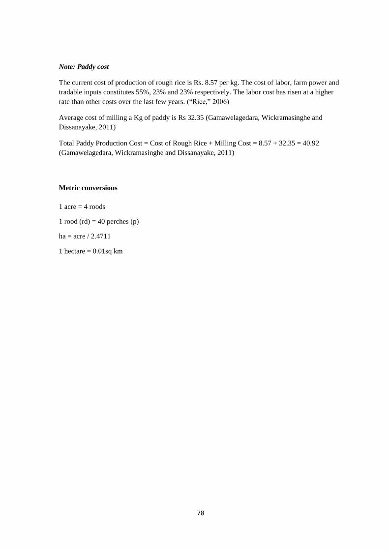
78
Note: Paddy cost
The current cost of production of rough rice is Rs. 8.57 per kg. The cost of labor, farm power and
tradable inputs constitutes 55%, 23% and 23% respectively. The labor cost has risen at a higher
rate than other costs over the last few years. (“Rice,” 2006)
Average cost of milling a Kg of paddy is Rs 32.35 (Gamawelagedara, Wickramasinghe and
Dissanayake, 2011)
Total Paddy Production Cost = Cost of Rough Rice + Milling Cost = 8.57 + 32.35 = 40.92
(Gamawelagedara, Wickramasinghe and Dissanayake, 2011)
Metric conversions
1 acre = 4 roods
1 rood (rd) = 40 perches (p)
ha = acre / 2.4711
1 hectare = 0.01sq km
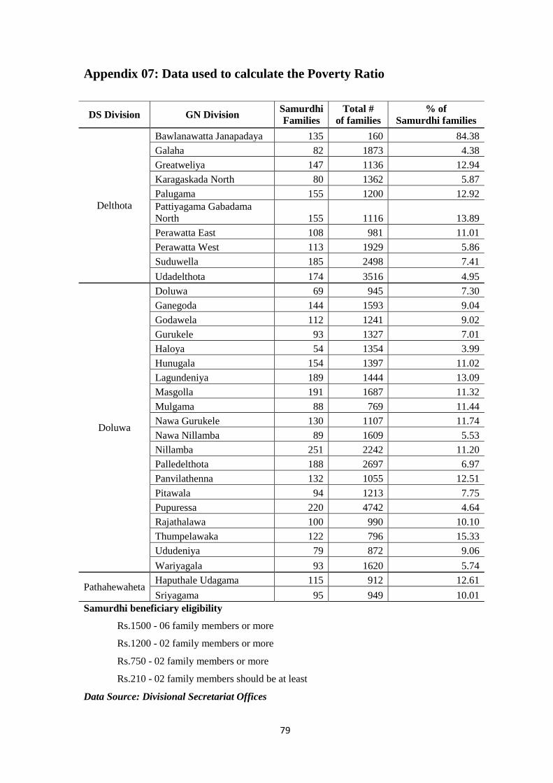
79
Appendix 07: Data used to calculate the Poverty Ratio
Samurdhi beneficiary eligibility
Rs.1500 - 06 family members or more
Rs.1200 - 02 family members or more
Rs.750 - 02 family members or more
Rs.210 - 02 family members should be at least
Data Source: Divisional Secretariat Offices
DS Division GN Division Samurdhi
Families
Total #
of families
% of
Samurdhi families
Delthota
Bawlanawatta Janapadaya 135 160 84.38
Galaha 82 1873 4.38
Greatweliya 147 1136 12.94
Karagaskada North 80 1362 5.87
Palugama 155 1200 12.92
Pattiyagama Gabadama
North 155 1116 13.89
Perawatta East 108 981 11.01
Perawatta West 113 1929 5.86
Suduwella 185 2498 7.41
Udadelthota 174 3516 4.95
Doluwa
Doluwa 69 945 7.30
Ganegoda 144 1593 9.04
Godawela 112 1241 9.02
Gurukele 93 1327 7.01
Haloya 54 1354 3.99
Hunugala 154 1397 11.02
Lagundeniya 189 1444 13.09
Masgolla 191 1687 11.32
Mulgama 88 769 11.44
Nawa Gurukele 130 1107 11.74
Nawa Nillamba 89 1609 5.53
Nillamba 251 2242 11.20
Palledelthota 188 2697 6.97
Panvilathenna 132 1055 12.51
Pitawala 94 1213 7.75
Pupuressa 220 4742 4.64
Rajathalawa 100 990 10.10
Thumpelawaka 122 796 15.33
Ududeniya 79 872 9.06
Wariyagala 93 1620 5.74
Pathahewaheta Haputhale Udagama 115 912 12.61
Sriyagama 95 949 10.01
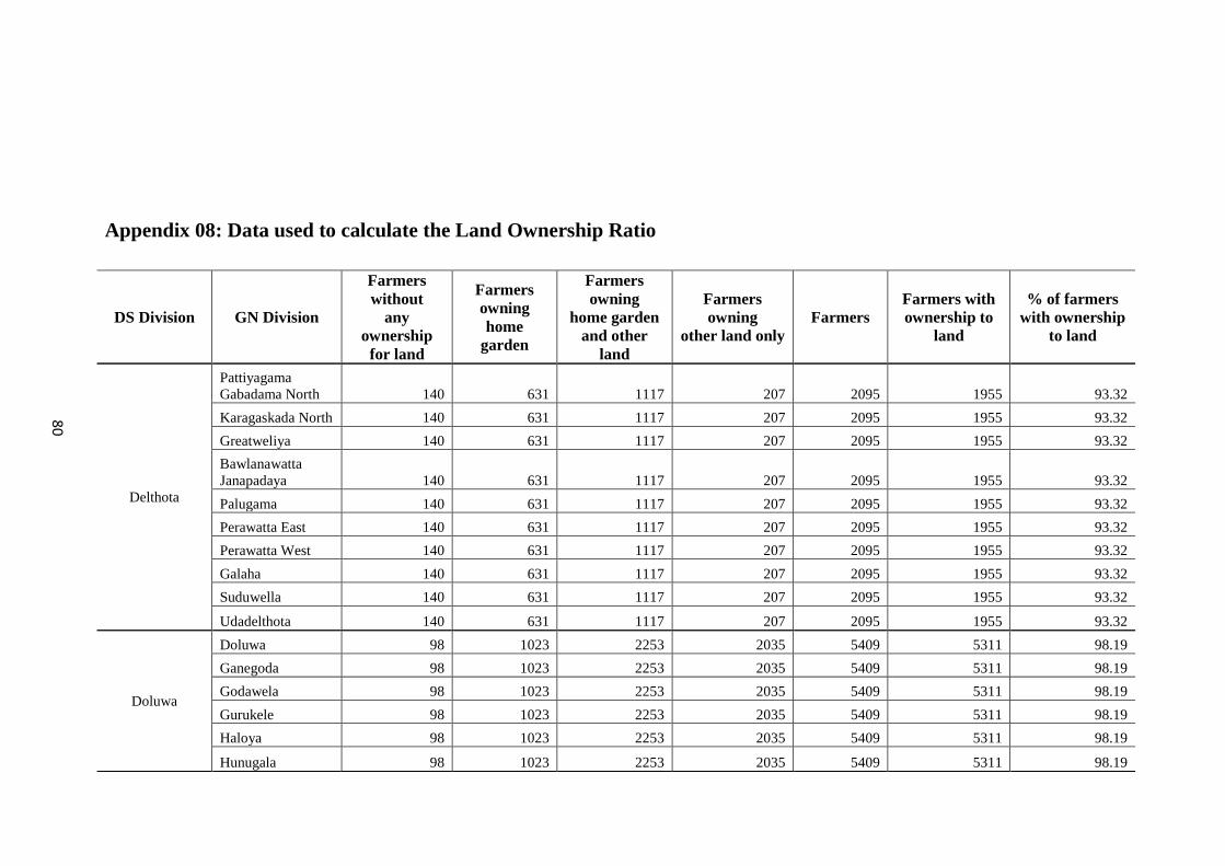
80
Appendix 08: Data used to calculate the Land Ownership Ratio
DS Division GN Division
Farmers
without
any
ownership
for land
Farmers
owning
home
garden
Farmers
owning
home garden
and other
land
Farmers
owning
other land only
Farmers
Farmers with
ownership to
land
% of farmers
with ownership
to land
Delthota
Pattiyagama
Gabadama North 140 631 1117 207 2095 1955 93.32
Karagaskada North 140 631 1117 207 2095 1955 93.32
Greatweliya 140 631 1117 207 2095 1955 93.32
Bawlanawatta
Janapadaya 140 631 1117 207 2095 1955 93.32
Palugama 140 631 1117 207 2095 1955 93.32
Perawatta East 140 631 1117 207 2095 1955 93.32
Perawatta West 140 631 1117 207 2095 1955 93.32
Galaha 140 631 1117 207 2095 1955 93.32
Suduwella 140 631 1117 207 2095 1955 93.32
Udadelthota 140 631 1117 207 2095 1955 93.32
Doluwa
Doluwa 98 1023 2253 2035 5409 5311 98.19
Ganegoda 98 1023 2253 2035 5409 5311 98.19
Godawela 98 1023 2253 2035 5409 5311 98.19
Gurukele 98 1023 2253 2035 5409 5311 98.19
Haloya 98 1023 2253 2035 5409 5311 98.19
Hunugala 98 1023 2253 2035 5409 5311 98.19
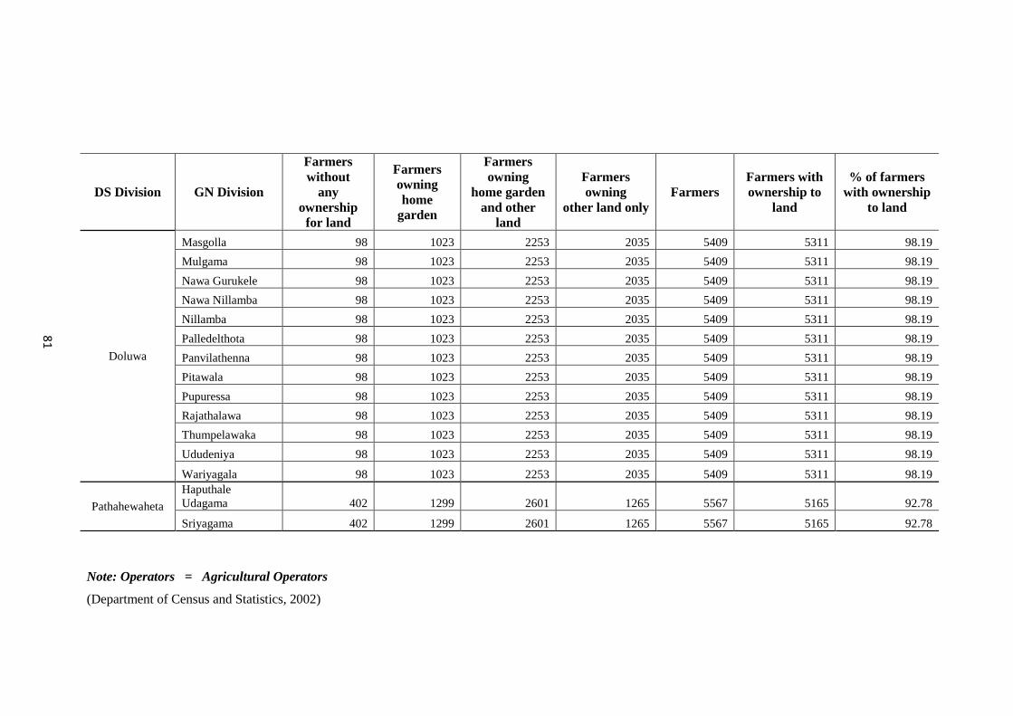
81
Note: Operators = Agricultural Operators
(Department of Census and Statistics, 2002)
DS Division GN Division
Farmers
without
any
ownership
for land
Farmers
owning
home
garden
Farmers
owning
home garden
and other
land
Farmers
owning
other land only
Farmers
Farmers with
ownership to
land
% of farmers
with ownership
to land
Doluwa
Masgolla 98 1023 2253 2035 5409 5311 98.19
Mulgama 98 1023 2253 2035 5409 5311 98.19
Nawa Gurukele 98 1023 2253 2035 5409 5311 98.19
Nawa Nillamba 98 1023 2253 2035 5409 5311 98.19
Nillamba 98 1023 2253 2035 5409 5311 98.19
Palledelthota 98 1023 2253 2035 5409 5311 98.19
Panvilathenna 98 1023 2253 2035 5409 5311 98.19
Pitawala 98 1023 2253 2035 5409 5311 98.19
Pupuressa 98 1023 2253 2035 5409 5311 98.19
Rajathalawa 98 1023 2253 2035 5409 5311 98.19
Thumpelawaka 98 1023 2253 2035 5409 5311 98.19
Ududeniya 98 1023 2253 2035 5409 5311 98.19
Wariyagala 98 1023 2253 2035 5409 5311 98.19
Pathahewaheta
Haputhale
Udagama 402 1299 2601 1265 5567 5165 92.78
Sriyagama 402 1299 2601 1265 5567 5165 92.78
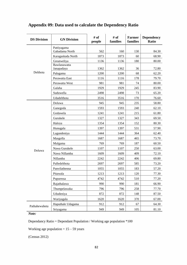
82
Appendix 09: Data used to calculate the Dependency Ratio
Note:
Dependancy Ratio = Dependant Population / Working age population *100
Working age population = 15 – 59 years
(Census 2012)
DS Division GN Division # of
people
# of
families
Farmer
families
Dependency
Ratio
Delthota
Pattiyagama
Gabadama North 562 160 130 84.30
Karagaskada North 1873 1873 60 68.90
Greatweliya 1136 1136 180 80.00
Bawlanawatta
Janapadaya 1362 1362 36 72.80
Palugama 1200 1200 68 62.20
Perawatta East 1116 1116 178 79.70
Perawatta West 981 981 74 80.00
Galaha 1929 1929 245 83.90
Suduwella 2498 2498 73 65.20
Udadelthota 3516 3516 170 76.60
Doluwa
Doluwa 945 945 235 58.80
Ganegoda 1593 1593 240 62.10
Godawela 1241 1241 215 61.80
Gurukele 1327 1327 343 69.50
Haloya 1354 1354 152 80.30
Hunugala 1397 1397 531 57.90
Lagundeniya 1444 1444 364 62.40
Masgolla 1687 1687 465 73.70
Mulgama 769 769 187 60.50
Nawa Gurukele 1107 1107 250 63.00
Nawa Nillamba 1609 1609 409 72.10
Nillamba 2242 2242 406 69.80
Palledelthota 2697 2697 585 73.20
Panvilathenna 1055 1055 183 57.20
Pitawala 1213 1213 120 77.30
Pupuressa 4742 4742 510 77.20
Rajathalawa 990 990 181 66.90
Thumpelawaka 796 796 258 77.70
Ududeniya 872 872 148 87.50
Wariyagala 1620 1620 370 67.00
Pathahewaheta Haputhale Udagama 912 912 67 64.30
Sriyagama 949 949 105 81.10
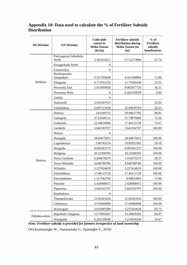
83
Appendix 10: Data used to calculate the % of Fertilizer Subsidy
Distribution
Note: Fertiliser subsidy is provided for farmers irrespective of land ownership
(Wickramasinghe W., Samarasinha G., Epasinghe S., 2010)
DS Division GN Division
Cultivable
extent in
Maha Season
(In ha)
Fertilizer subsidy
distribution during
Maha Season (in
ha)
% of
Fertilizer
subsidy
beneficiaries
Delthota
Pattiyagama Gabadama
North 2.301419221 9.712273886 23.70
Karagaskada North 0
Greatweliya 0
Bawlanawatta
Janapadaya 0.527205608 4.451458864 11.84
Palugama 4.171931229 11.73566428 35.55
Perawatta East 1.451969958 8.902917729 16.31
Perawatta West 0 0.202339039 0.00
Galaha 0
Suduwella 2.592187915 32.03
Udadelthota 6.897513028 25.89939703 26.63
Doluwa
Doluwa 14.6169722 29.94617782 48.81
Ganegoda 37.63506131 51.79879406 72.66
Godawela 12.64618996 17.40115738 72.67
Gurukele 3.642102707 3.642102707 100.00
Haloya 0
Hunugala 38.64675651 38.64675651 100.00
Lagundeniya 5.86783214 19.82922585 29.59
Masgolla 8.093561572 8.093561572 100.00
Mulgama 20.23390393 20.23390393 100.00
Nawa Gurukele 0.404678079 1.416373275 28.57
Nawa Nillamba 4.046780786 4.046780786 100.00
Nillamba 3.237424629 3.237424629 100.00
Palledelthota 17.40115738 17.40115738 100.00
Panvilathenna 1.517542795 8.49823965 17.86
Pitawala 2.428068472 2.428068472 100.00
Pupuressa 3.642102707 3.642102707 100.00
Rajathalawa 0
Thumpelawaka 21.85261624 21.85261624 100.00
Ududeniya 57.05960908 57.05960908 100.00
Wariyagala 3.035085589 3.237424629 93.75
Pathahewaheta Haputhale Udagama 13.75905467 16.28829266 84.47
Sriyagama 0.202339039 1.214034236 16.67
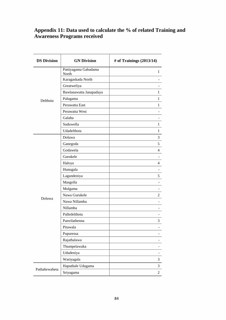
84
Appendix 11: Data used to calculate the % of related Training and
Awareness Programs received
DS Division GN Division # of Trainings (2013/14)
Delthota
Pattiyagama Gabadama
North 1
Karagaskada North -
Greatweliya -
Bawlanawatta Janapadaya 1
Palugama 1
Perawatta East 1
Perawatta West -
Galaha -
Suduwella 1
Udadelthota 1
Doluwa
Doluwa 3
Ganegoda 5
Godawela 4
Gurukele -
Haloya 4
Hunugala -
Lagundeniya 5
Masgolla -
Mulgama -
Nawa Gurukele 2
Nawa Nillamba -
Nillamba -
Palledelthota -
Panvilathenna 3
Pitawala -
Pupuressa -
Rajathalawa -
Thumpelawaka -
Ududeniya -
Wariyagala 3
Pathahewaheta Haputhale Udagama 3
Sriyagama 2

85
Appendix 12: Socio-economic data sheets collected from Agrarian
Service Centers of the Nillambe Catchment
86

87
88
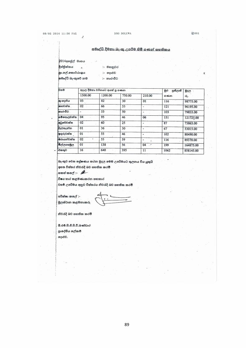
89
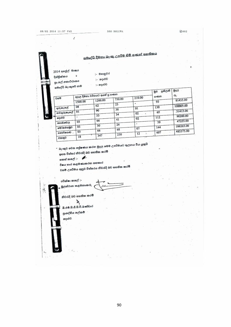
90
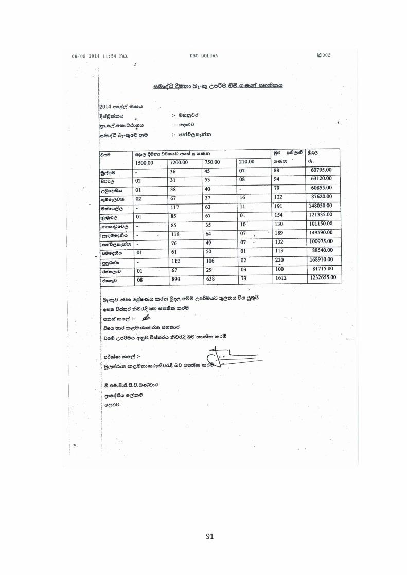
91
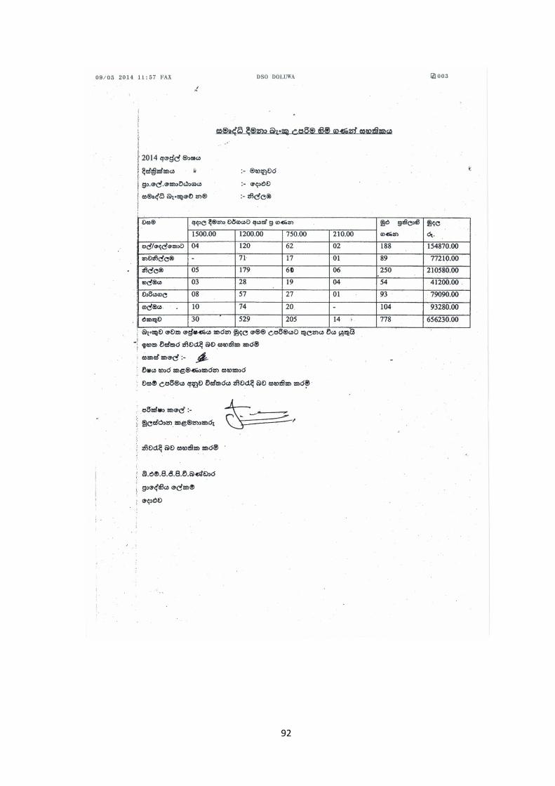
92
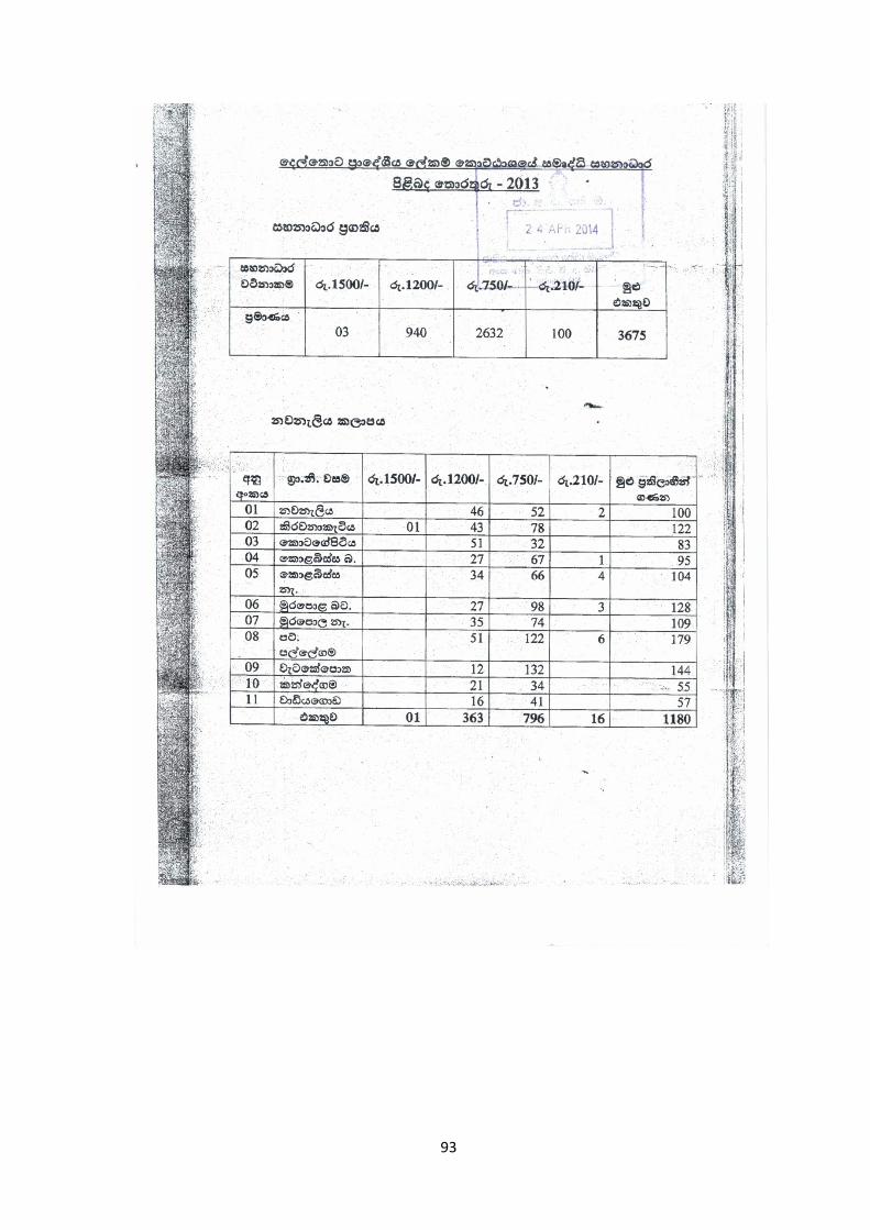
93
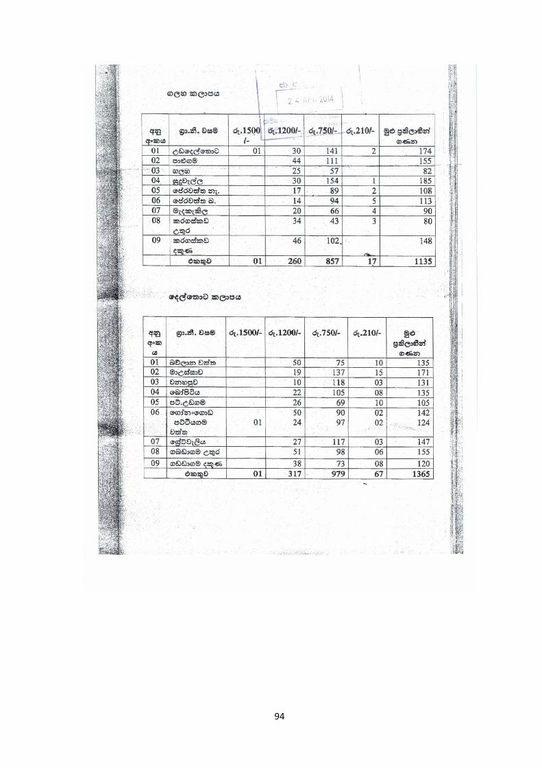
94
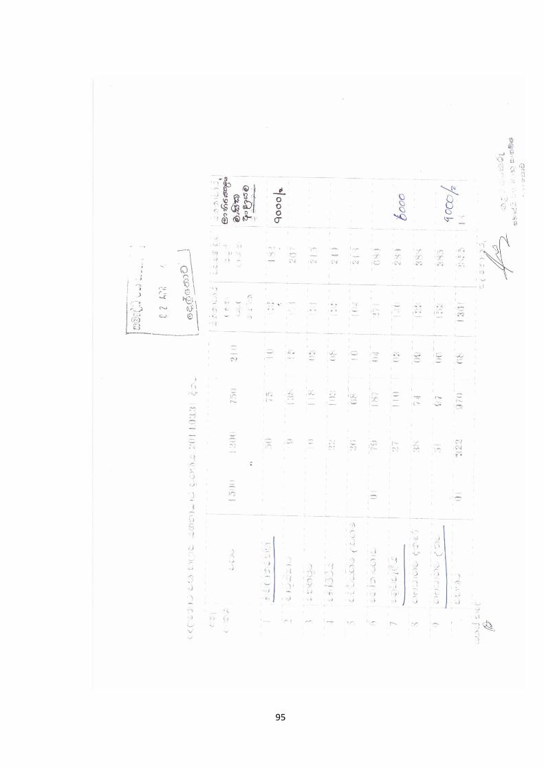
95

96
Appendix 13: Census Data used to calculate Crop Production
Investment Ratio
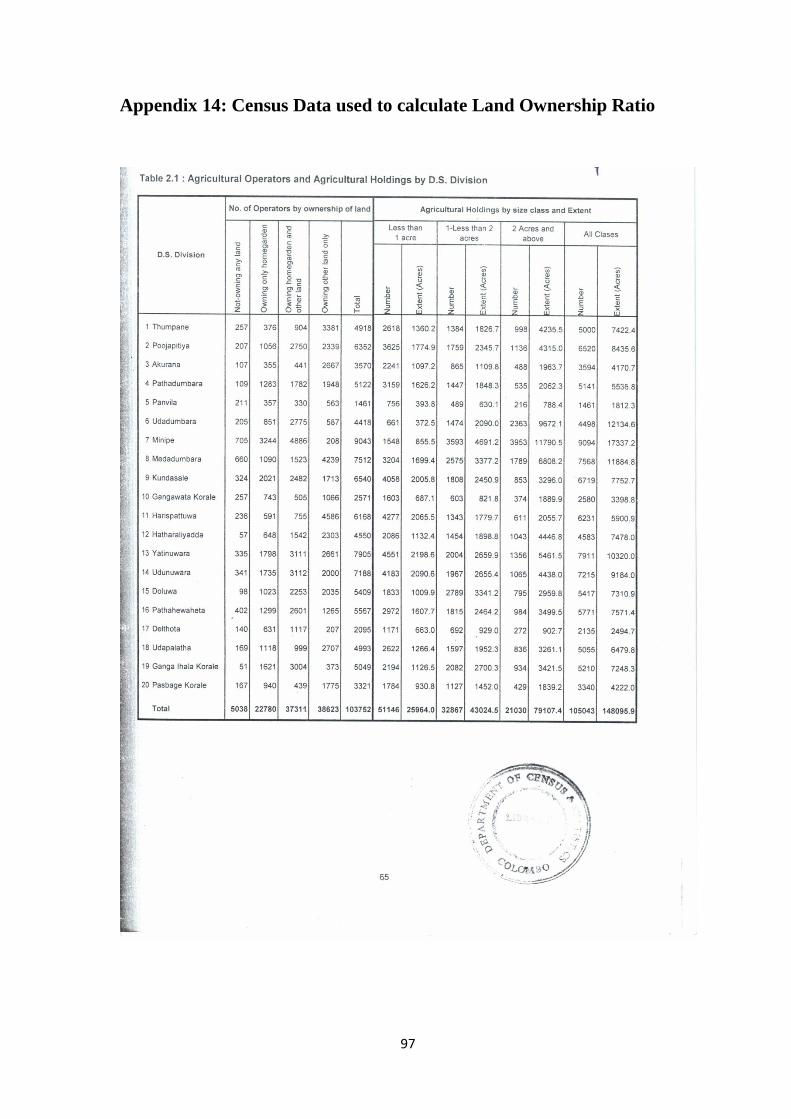
97
Appendix 14: Census Data used to calculate Land Ownership Ratio

REFERENCES
98
RUSLE (2001). Retrieved January 21, 2014, from http://35.8.121.139/rusle/index.html.
Pimentel D. and Burgess M. (2013). Soil Erosion Threatens Food Production, Agriculture 3(3),
443-463.
National Action Programme for Combating Land Degradation in Sri Lanka (2002) Retrieved
January 21, 2014 from
ttp://www.environmentmin.gov.lk/web/index.php?option=com_content&view=article&id=175&
Itemid=291&lang=en
Nayakekorale H.B. (1998) Human Induced Soil Degradation Status in Sri Lanka, NRMC,
Department of Agriculture Peradeniya, Journal of Soil Science, Sri Lanka.
Swaify E. (1983). Natural Systems for Development, Macmillan Publication, New York
National Physical Planning Department (NPPD) (2005). Central Fragile Area. Retrieved January
21, 2014 from
http://www.nppd.gov.lk/attachments/article/72/CENTRAL_FRAGLE_AREA_doc.pdf.
Munasinghe M.A.K., Pushpakumara V., Bandara T.M.J. and Herath H.M.B. (2001). Use of
Information Systems for Soil Erosion Hazard Assessment of the Central Province of Sri Lanka.
Annals of the Department of Agriculture, 3, 152.
Soil Erosion Site (2001). Retrieved January 21, 2014, from http://35.8.121.139/rusle/index.html.
Land use and Soil Management (2013). Retrieved January 23, 2014, from
http://www.daff.gov.za/daffweb3/Branches/Forestry-Natural-Resources-Management/Land-Use-
and-Soil-Management
99
Impacts of Erosion on Soil, Air, and Water Quality (2014). Retrieved January 25, 2014, from
http://passel.unl.edu/pages/informationmodule.php?idinformationmodule=1086025423&topicord
er=4&maxto=7
Universal Soil Loss Equation (USLE) (2012). Retrieved January 28, 2014, from
http://www.omafra.gov.on.ca/english/engineer/facts/12-051.htm
Steele K., Carmel Y., Cross J. and Wilcox C. (2009). Uses and misuses of Multicriteria Decision
Analysis (MCDA) in environmental decision making. Risk Analysis 29(1), 26–33.
Saaty T.L. (1980). The Analytic Hierarchy Process, Planning, Piority Setting, Resource
Allocation. McGraw-Hill, New York
Angelidis M. O. and Kamizoulis, G. (2005). A rapid decision making method for the evaluation
of pollution-sensitive coastal areas in the Mediterranean sea. Environmental Management 35(6),
811–820.
IFRC (2006). What is VCA? An introduction to vulnerability and capacity assessment
Guidelines for mainstreaming Disaster Risk Assessment in Development. (2004) Retrieved
January 30, 2014, from
http://www.preventionweb.net/files/4040_africaguidelinesmainstreamingdrassessmentdevelopme
nt1.pdf
Wickramasinghe L. A. and Premalal R. (1988). Development of rainstorm erosivity map for Sri
lanka. Proc. of the 5th International soil conservation conference, Eds. Sanam Rimwanich.
Bankok, Thiland. 441- 450

100
Predicting Rainfall Erosion Losses. A Guide to Conservation Planning. Agriculture Handbook
537, US Department of Agriculture (1978) Retrieved February 7, 2014, from
http://naldc.nal.usda.gov/download/CAT79706928/PDF
Steele K., Carmel Y., Cross J. and Wilcox C. (2009). Uses and misuses of Multicriteria Decision
Analysis (MCDA) in environmental decision making. Risk Analysis 29(1), 26–33.
Munasinghe M.A.K., Pushpakumara S.M.V, Bandara T.M.J. and Herath H.M.B (2001). Use of
Geographical Information Systems for Soil Erosion Hazard Assessment of the Central Province
of Sri Lanka. Annals of the Sri Lanka Department of Agriculture. 3, 149-158.
K Factor (2002). Retrieved February 8, 2014, from http://35.8.121.139/rusle/kfactor.htm.
Mapa R.B. (2003) Sustainable Soil Management in the 21st Century.
Wijesekera S., Samarakoon L. (2001) Extraction of parameters modelling soil erosion using GIS
in a grid environment.
Munasinhe M.A.R. and Pushpakumara S.M.V. (2002) Re-Demarcation of Conservation Areas in
SriLanka based on Soil Erosion Potential. Journal of the Soil Science Society, Sri Lanka.
Sandoval H.V. and Boano C. (2013) The progression of vulnerability. A multi-scalar perspective
on disasters, the case of Chaitén in Chile'.
Dharmasena P., Bhat M.S. (2011) Assessment of Replacement Cost of Soil Erosion in Uva, High
Lands Tea Plantations of Sri Lanka. Current World Environment. 6(2), 241-246.
Sedimentation (2014) Retrieved February 11, 2014, from
http://en.wikipedia.org/wiki/Sedimentation
101
Clove (2012) Retrieved February 11, 2014, from
http://www.exportagridept.gov.lk/web/index.php?option=com_content&view=article&id=130%
3Aclove&catid=113%3Acrops&Itemid=1&lang=en
Pepper production Guide for Asia and the Pacific (2005) Retrieved February 11, 2014, from
http://www.ipcnet.org/pg/welcome.html
Department of Census and Statistics, Sri Lanka (2002) Census of Agriculture - Sri Lanka,
Preliminary Release 01.
Fruits (2006) Retrieved February 11, 2014, from
http://www.agridept.gov.lk/index.php/en/component/content/article/189-fruits/
Sector Brief, Fruits and Vegetables (2011) Retrieved February 11, 2014, from
http://regionalblog.chamber.lk/wp-
content/uploads/2011/02/Sector_brief_Fruits_Vegetables_2011.pdf
Hand book on Cost of Production of Selected Vegetables, Grains and Pulses (2010) Retrieved
February 11, 2014, from http://www.cicagri.com/userfiles/file/Vegetables.pdf
Rice (2006) Retrieved February 11, 2014, from http://www.agridept.gov.lk/index.php/en/crop-
recommendations/808
W.C Gamawelagedara W.C., Wickramasinghe Y.M. and Dissanayake C.A.K. (2011) Impact of
rice processing villages on house hold income of rural farmers in Anuradhapura district. The
Journal of Agricultural Sciences. 6, 2
102
Obtain birth, marriage, hospitalized and death allowance (2010) Retrieved February 17, 2014,
from
https://www.google.lk/url?sa=t&rct=j&q=&esrc=s&source=web&cd=4&cad=rja&uact=8&ved=
0CC4QFjAD&url=http%3A%2F%2Fwww.gic.gov.lk%2Fgic%2Findex.php%3Foption%3Dcom
_info%26id%3D488%26task%3Dinfo%26lang%3Den&ei=J6EuVIzWGMLauQSB7oDIDA&us
g=AFQjCNHpeG949YaSUTNmwcRr_YNxvjU8_w&bvm=bv.76802529,d.c2E
Using biochar to improve soil health and leaf production at tea plantations in sri lanka (2014)
Retrieved July 2014, from http://www.biochar-international.org/profiles/Sri_Lanka
Tea Gardens (2011) Retrieved February 17, 2014, from http://ceylonteainfo.com/tea-gardens
Kaihura F.B.S., Stocking M. and Kahembe E. (2001) Soil management and agrodiversity: a case
study from Arumeru, Arusha, Tanzania. Retrieved February 17, 2014, from
http://www.fao.org/nr/kagera/information-resource/details/en/c/42051/
Reynaldo L.L. (2010) Soil Erosion and Landslide Vulnerability of Mananga Watershed, Cebu,
Philippines Asia and the Pacific Symposium, Vulnerability Assessments to Natural and
Anthropogenic Hazards.
Strategic Cost Management for Profitability of Tea Plantations (2012) Retrieved February 18,
2014, from
http://www.tri.lk/userfiles/file/225_E&E/02%20225%20E&E%2027Jul2012%20Paper%20I%20
Shyamalie.pdf
Tea Research Institute of Sri Lanka (2013) Increasing Tea Yields Through Consolidation of
Fields by Infilling.
Wickramasinghe W., Samarasinha G., Epasinghe S. (2010) Fertiliser policy on paddy farming:
an evaluation of 2005 subsidy programme 26.