Giraud J., 2009, « The evolution of settlement patterns in the eastern Oman from the Neolithic to...
11
Surface geosciences (Palaeoenvironment) The evolution of settlement patterns in the eastern Oman from the Neolithic to the Early Bronze Age (6000–2000 BC) Jessica Giraud CNRS, UMR 7041, équipe « du village à l’État au Proche et Moyen-Orient », maison de l’archéologie et de l’ethnologie, boîte 14, 21, allée de l’Université, 92023 Nanterre, France Received 18 October 2008; accepted after revision 17 March 2009 Available online 7 June 2009 Written on invitation of the Editorial Board Abstract The region of eastern Oman (called Ja’alan) is often compared to the Arabian deserts, which are typically arid and depopulated areas. Today, this geographical definition is correct: the geographic and climatic conditions (low precipitation, pronounced dryness, high evaporation) indicate an arid region, and the area is sparsely populated. Between the Neolithic and the Early Bronze Age, the geographic and climatic conditions did not change much, and were slightly more humid than at present. Although the term ‘‘green Ja’alan’’ does not describe this area, we observe that the region was occupied by a quite substantial population. Since 1985, surveys and excavations have been carried out and more than 4000 archeological structures are now listed. The spatial distribution of these sites differs for each period, from Neolithic seasonal camps to oasian settlements of the Early Bronze Age. To cite this article: J. Giraud, C. R. Geoscience 341 (2009). # 2009 Académie des sciences. Published by Elsevier Masson SAS. All rights reserved. Résumé L’évolution des modèles d’implantation humaine dans la région orientale d’Oman du Néolithique à l’âge du Bronze ancien (6000–2000 av. J.-C.). La région occidentale de l’Oman (province du Ja’alan) est souvent comparée aux déserts de l’Arabie, une zone aride et dépeuplée. Actuellement, cette définition géographique est exacte. Les conditions climatiques et géographiques (faibles précipitations, sécheresse prononcée et haute évaporation) indiquent une région aride. La zone est peu peuplée. Entre le Néolithique et l’âge du Bronze ancien, les conditions climatiques et géographiques restent presque similaires ; il semblerait que l’humidité ait été plus importante qu’aujourd’hui. Bien que le terme de « désert vert » ne puisse définir cette zone, nous savons aujourd’hui qu’elle fut occupée par une population assez conséquente. Depuis 1985, des prospections et des fouilles ont été effectuées et plus de 4000 structures archéologiques sont désormais listées. La distribution spatiale de ces sites montre des modèles variés selon la période : des camps saisonniers néolithiques aux oasis de l’âge du Bronze. Pour citer cet article : J. Giraud, C. R. Geoscience 341 (2009). # 2009 Académie des sciences. Publié par Elsevier Masson SAS. Tous droits réservés. Keywords: Sultanate of Oman; Neolithic; Early Bronze Age; Desert; Palaeogeography; Settlement patterns; Oasis Mots clés : Sultanat d’Oman ; Néolithique ; Âge du Bronze ancien ; Désert ; Paléogéographie ; Modèle d’habitat ; Oasis C. R. Geoscience 341 (2009) 739–749 E-mail address: [email protected]. 1631-0713/$ – see front matter # 2009 Académie des sciences. Published by Elsevier Masson SAS. All rights reserved. doi:10.1016/j.crte.2009.03.005
Transcript of Giraud J., 2009, « The evolution of settlement patterns in the eastern Oman from the Neolithic to...

Surface geosciences (Palaeoenvironment)
The evolution of settlement patterns in the eastern Oman fromthe Neolithic to the Early Bronze Age (6000–2000 BC)
Jessica GiraudCNRS, UMR 7041, équipe « du village à l’État au Proche et Moyen-Orient », maison de l’archéologie et de l’ethnologie, boîte 14, 21,
allée de l’Université, 92023 Nanterre, France
Received 18 October 2008; accepted after revision 17 March 2009
Available online 7 June 2009
Written on invitation of the Editorial Board
Abstract
The region of eastern Oman (called Ja’alan) is often compared to the Arabian deserts, which are typically arid and depopulatedareas. Today, this geographical definition is correct: the geographic and climatic conditions (low precipitation, pronounced dryness,high evaporation) indicate an arid region, and the area is sparsely populated. Between the Neolithic and the Early Bronze Age, thegeographic and climatic conditions did not change much, and were slightly more humid than at present. Although the term ‘‘greenJa’alan’’ does not describe this area, we observe that the region was occupied by a quite substantial population. Since 1985, surveysand excavations have been carried out and more than 4000 archeological structures are now listed. The spatial distribution of thesesites differs for each period, from Neolithic seasonal camps to oasian settlements of the Early Bronze Age. To cite this article: J.Giraud, C. R. Geoscience 341 (2009).# 2009 Académie des sciences. Published by Elsevier Masson SAS. All rights reserved.
Résumé
L’évolution des modèles d’implantation humaine dans la région orientale d’Oman du Néolithique à l’âge du Bronzeancien (6000–2000 av. J.-C.). La région occidentale de l’Oman (province du Ja’alan) est souvent comparée aux déserts de l’Arabie,une zone aride et dépeuplée. Actuellement, cette définition géographique est exacte. Les conditions climatiques et géographiques(faibles précipitations, sécheresse prononcée et haute évaporation) indiquent une région aride. La zone est peu peuplée. Entre leNéolithique et l’âge du Bronze ancien, les conditions climatiques et géographiques restent presque similaires ; il semblerait quel’humidité ait été plus importante qu’aujourd’hui. Bien que le terme de « désert vert » ne puisse définir cette zone, nous savonsaujourd’hui qu’elle fut occupée par une population assez conséquente. Depuis 1985, des prospections et des fouilles ont étéeffectuées et plus de 4000 structures archéologiques sont désormais listées. La distribution spatiale de ces sites montre des modèlesvariés selon la période : des camps saisonniers néolithiques aux oasis de l’âge du Bronze. Pour citer cet article : J. Giraud, C. R.Geoscience 341 (2009).# 2009 Académie des sciences. Publié par Elsevier Masson SAS. Tous droits réservés.
Keywords: Sultanate of Oman; Neolithic; Early Bronze Age; Desert; Palaeogeography; Settlement patterns; Oasis
Mots clés : Sultanat d’Oman ; Néolithique ; Âge du Bronze ancien ; Désert ; Paléogéographie ; Modèle d’habitat ; Oasis
C. R. Geoscience 341 (2009) 739–749
E-mail address: [email protected].
1631-0713/$ – see front matter # 2009 Académie des sciences. Published by Elsevier Masson SAS. All rights reserved.
doi:10.1016/j.crte.2009.03.005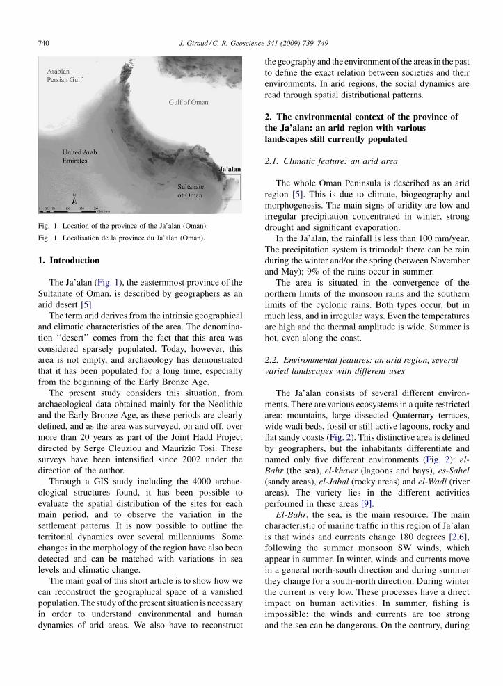
J. Giraud / C. R. Geoscience 341 (2009) 739–749740
Fig. 1. Location of the province of the Ja’alan (Oman).
Fig. 1. Localisation de la province du Ja’alan (Oman).
1. Introduction
The Ja’alan (Fig. 1), the easternmost province of theSultanate of Oman, is described by geographers as anarid desert [5].
The term arid derives from the intrinsic geographicaland climatic characteristics of the area. The denomina-tion ‘‘desert’’ comes from the fact that this area wasconsidered sparsely populated. Today, however, thisarea is not empty, and archaeology has demonstratedthat it has been populated for a long time, especiallyfrom the beginning of the Early Bronze Age.
The present study considers this situation, fromarchaeological data obtained mainly for the Neolithicand the Early Bronze Age, as these periods are clearlydefined, and as the area was surveyed, on and off, overmore than 20 years as part of the Joint Hadd Projectdirected by Serge Cleuziou and Maurizio Tosi. Thesesurveys have been intensified since 2002 under thedirection of the author.
Through a GIS study including the 4000 archae-ological structures found, it has been possible toevaluate the spatial distribution of the sites for eachmain period, and to observe the variation in thesettlement patterns. It is now possible to outline theterritorial dynamics over several millenniums. Somechanges in the morphology of the region have also beendetected and can be matched with variations in sealevels and climatic change.
The main goal of this short article is to show how wecan reconstruct the geographical space of a vanishedpopulation. The study of the present situation is necessaryin order to understand environmental and humandynamics of arid areas. We also have to reconstruct
the geography and the environment of the areas in the pastto define the exact relation between societies and theirenvironments. In arid regions, the social dynamics areread through spatial distributional patterns.
2. The environmental context of the province ofthe Ja’alan: an arid region with variouslandscapes still currently populated
2.1. Climatic feature: an arid area
The whole Oman Peninsula is described as an aridregion [5]. This is due to climate, biogeography andmorphogenesis. The main signs of aridity are low andirregular precipitation concentrated in winter, strongdrought and significant evaporation.
In the Ja’alan, the rainfall is less than 100 mm/year.The precipitation system is trimodal: there can be rainduring the winter and/or the spring (between Novemberand May); 9% of the rains occur in summer.
The area is situated in the convergence of thenorthern limits of the monsoon rains and the southernlimits of the cyclonic rains. Both types occur, but inmuch less, and in irregular ways. Even the temperaturesare high and the thermal amplitude is wide. Summer ishot, even along the coast.
2.2. Environmental features: an arid region, severalvaried landscapes with different uses
The Ja’alan consists of several different environ-ments. There are various ecosystems in a quite restrictedarea: mountains, large dissected Quaternary terraces,wide wadi beds, fossil or still active lagoons, rocky andflat sandy coasts (Fig. 2). This distinctive area is definedby geographers, but the inhabitants differentiate andnamed only five different environments (Fig. 2): el-Bahr (the sea), el-khawr (lagoons and bays), es-Sahel(sandy areas), el-Jabal (rocky areas) and el-Wadi (riverareas). The variety lies in the different activitiesperformed in these areas [9].
El-Bahr, the sea, is the main resource. The maincharacteristic of marine traffic in this region of Ja’alanis that winds and currents change 180 degrees [2,6],following the summer monsoon SW winds, whichappear in summer. In winter, winds and currents movein a general north-south direction and during summerthey change for a south-north direction. During winterthe current is very low. These processes have a directimpact on human activities. In summer, fishing isimpossible: the winds and currents are too strongand the sea can be dangerous. On the contrary, during

J. Giraud / C. R. Geoscience 341 (2009) 739–749 741
Fig. 2. The different environments exploited by Bedouins. Legends: el-Bahr: currents and winds, white arrows: summer current, grey arrows:winter currents, white pointed line: upwelling fact // el-Jabal: Djebel Khamis, Small Djebel, Rocky Coast, Terrace and regs // es-Sahel: Sandy coast,Sebkhas, Dune area // el-Khawr: Lagons, Bays // el-wadi)
Fig. 2. Les différents milieux exploités par les bédouins (Légende : el-Bahr : courants et vents, flèches blanches : courant d’été, flèches grises :courants d’hiver, ligne pointillée blanche : zone de l’effet d’upwelling // el-Jabal : Djebel Khamis, petits Djebel, côte rocheuse, terrasses et regs //es-Sahel : côte sableuse, sebkhas, zone dunaire // el-Khawr : lagunes, baies // el-wadi).
winter, the sea is navigable and halieutic resourcesare very important due to the upwelling phenomenlinked to the monsoon (rise in cold deep waters thathave the characteristic of being rich in phyto- andzooplankton).
El-Khawr combines lagoons and bays along thecoast. In the Ja’alan this concept concerns the northernarea that includes a number of coves and baysembedded in high rocky terraces and two coastallagoons: Khawr Jarama and Khawr al-Hajjar. All of

J. Giraud / C. R. Geoscience 341 (2009) 739–749742
these bays are used for traditional fishing. Vegetationconsists only of the mangroves that surround thelagoons; Avicennia marina relict is still visible on thelagoon Khawr Jarama.
Es-Sahel is defined by all the sandy areas. It can besandy coasts, sebkhas and dune areas. In the Ja’alan,this environment is organized into three north-southbands. Long coastal strips develop in the east. This areawas previously occupied by arrows of ancient lagoons,and retained a system of inland lagoons [1,6]. Theselakes have disappeared, so the arrows have transformedinto dune cordons. To the west of the dune system, onecan note a parallel system of sebkhas in development.They were old lagoons that have slowly dried up afterthe silting of their channels [1]. After an important rain,a closed ‘‘lagoon’’ can be formed and lasts for severalweeks or months. In those cases, some vegetationgrows, making ephemeral grazing possible. Parallel tothese sebkhas, a dune area stretches for severalkilometers.
El-Jabal includes all stony and rocky areas. Theseare the coastal terraces north of Jebel Khamis in thewest, alluvial terraces, terraces, pediments and maze ofcentral and southern foothills, and also the Hawasinahills and inner small hills that are also locatedthroughout the area. The vegetation consists mainlyof Acacia sp. xerophytic and shrubs. The main activityis pastoralism. Some gardens of date palms near thewadis are also presently exploited.
El-wadi refers not only to the wadis themselves, butcombines the wadi beds and their major and minorvalleys and alluvial plains. In the Ja’alan, thisenvironment is structured from east to west from fivemajor wadis. Other wadis are shorter and only structurethe nearest environment. The wadis of Ja’alan areendoreic. The plain is mainly a steppe, with a fewAcacia sp., and wadi beds are characterized by a littlemore concentrated vegetation consisting mainly ofAcacia sp. and Prosopis sp. often located in very sandyareas, which can be places for pasture.
2.3. The actual settlement pattern
Despite the fact that we are in a very arid area, theregion is still quite populated. We can define severaltypes of settlements associated with different activities:the big oasis on south (Bani Bu Ali, Bani Bu Hassan)fishermen villages on the coast (es-Sahel, el-Bahr),inland village, and sporadic village created to settleBedouins in el-Jabal with small oasian gardens in el-Jabal and el-Wadi, and nomadic village of the Bedouinin el-Jabal and in el-Wadi where pastoralism is possible.
3. The historical context: 8000 years of theevolution of societies and their environment
3.1. A brief history of 8000 years of humansettlement in Oman Peninsula
Although it was probably an important background,late Early Holocene remains are poorly known. Thesites are characterized by concentrations of lithicpieces. The concentrations discovered attest to a ratherintensive occupation near ancient lakes or ancientcoasts. The economy was based on hunting, fishing andgathering.
The late sixth to fourth millennia BC are much betterknown [4,5], mainly through the study of coastal zoneswhere dozens of settlements have been identified andseveral partly excavated or tested: Dama 11, Umm al-Qaiwain 2, Ra’s al-Hamra 5, Suwayh 1, 2 and 11 andRa’s al-Kabbah. One inland site has been identified: al-Buhais 18. This ‘‘Neolithic’’ society does not reallydiffer from the previous one. People were specialized infishing or hunting marine mammals. However, animaldomestication is present. The main difference with mostof other Neolithic societies is the absence of agriculture.The pottery is imported from Mesopotamia (Obeidculture). All excavated settlements are composed ofseveral circular structures as tents. Often associatedwith the dwellings, the graves are simple pits dug intothe substrate. The tombs are mostly single but can alsobe collective (Ra’s al-Hamra 5 and al-Buhais 18).
Most aspects of the society changed at the end of thefourth millennium BC [4] (beginning of the EarlyBronze Age period). This has been observed through thecomplete change in funerary practices. Many tower-likecollective burials were built upon the rocky ridges andare highly visible in the landscape [4,6]. Severalthousand graves are known in Oman but only twosettlements of this period have been found. Both aresituated on the coast of the Ja’alan (HD-6, near Ra’s al-Hadd and ALA-2) [5,6]. HD-6 is a complex andorganized dwelling of mud-bricks buildings, and it isthe more ancient village of the Early Bronze Age.Pottery and some evidence for agriculture have beendiscovered, suggesting the appearance of an oasiangardens system. However, only the association of datestones, palm-tree wood, cereals, and fruits can actuallyprove an existence of oasian gardens [14]. The date-palm tree constitutes the basis of the oasian culture,firstly because of its own characteristics and nutritionaladvantages, and secondly because its height and itsfoliage provide a habitat for cultures that need somehumidity and shadow, such as cereals, legumes and

J. Giraud / C. R. Geoscience 341 (2009) 739–749 743
fruit-trees [14]. This system can be settled even wherewater is very limited, with a good yield. During thisperiod, this system is only well attested at Bat, and it isdeveloped mainly during the second part of the thirdmillennium BC [14].
In the middle of the third millennium BC someburials with increasingly complex rituals appear [4].These graves are no longer situated in the highest partsof landscape, but are mainly located closer to thesettlements, often in the plain [6]. These settlements arebetter known and several have been excavated, Umman-Nar, Ra’s al-Jinz, Hili, Tell Abraq, for example.During this period the oasian system is very probable.The association of stores, grains and wood has beenfound in Hili, Tell Abraq and Ra’s al-Jinz. After thisperiod, settlements, graves and society change from thebeginning of the Middle Bronze Age ca. 2000 BC (WadiSuq Period).
The province of Ja’alan follows this general OmanPeninsula evolution, with coastal Neolithic sites, cairnsand tower-like burials of the first part of Early BronzeAge, and larger burials and settlements of the secondpart of Early Bronze Age.
3.2. The Ja’alan, an arid or green desert?
Palaeoclimatic studies (analysis of speleothems, ofisotopes; lake and marines cores) conducted over 20 yearsallow us to reconstruct the climate and the landscape ofthe Oman Peninsula and more specifically the region ofJa’alan [1–3,10,11,13,15]. The regional data and theJa’alan data outlined here have been already developedby A.-M. Lézine and S. Cleuziou (this volume) [3,11]. Sowe restrict the presentation to the evolution of climateand biogeography in the Ja’alan.
The Middle and Late Holocene corresponds to aclimatic optimum sometimes called the « périodehumide arabique » [13]. From the beginning, whenhumidity was not really high, the climate is becomingmore and more arid until today. This climatic optimumdid not have the same impact that it had in the Sahara,and it would be wrong to evoke a ‘‘green Arabia’’.Because of the fluctuations of evaporation andprecipitations, this area remains a semi-arid sector.The slow and progressive dryness is due to thesouthwards movement of the intertropical convergencearea [11].
Regional studies about the evolution of the sea levelindicate an important change. They show a 5 m-higherlevel than nowadays [1,2,11] in the Oman Gulf and theIndian Ocean. The geography of shoreline wasnecessarily disrupted. The coast was very different in
the fourth and the third millennium BC. It was cut, andlarge lagoons grew up behind lagoonal arrow, andfinally formed the sandy coastline. During the Neolithicperiod, the lagoons were well developed. But theensuing drought triggered their regression and theformation of present-day coastal sebkhas. During theBronze Age, lagoons were present but decreasing in size[1,11].
In parallel, palynological and anthracological studies[11,15] show that the environment was made of asteppic landscape of Acacia sp. and Rhizophora sp.,with a little bit more humidity and rainfall than today.The pollen analyses show the appearance of Prosopissp. at the end of the third millennium BC, whichindicates that the zone was becoming drier [11].
4. The methodology to determine settlementpatterns
The analysis of settlement patterns that are extinctnowadays demands a long multidisciplinary work. Weneed cross-data from several fields such as: archae-ology, geography, climatology, sedimentology, archae-obotany, ethnography, remote sensing, geomatics, etc.
For this study we developed a specific researchprotocol [6]. This plan of article follows the differentsteps of this protocole. In the first step, we study actuallandscape and settlement dynamics (see section 2). Thisstudy gives us an example of a pattern of dynamicsocieties living in an arid area. Then we have to studythe history of societies (see sections 3.2 and 5.1) and thevanished landscape in order to understand the dynamicsof the ancient settlements patterns in some region andtheir differences (see sections 5.2, 6 and 7). All thoseelements can only be reconstituted thanks to the cross-referencing of data obtained during surveys andexcavations (see section 5.2). Finally, this cross-referencing is done throughout spatial analysis, thusenabling us to try to model the interaction that existedbetween society and nature in a desert environment8000 years ago (see sections 6 and 7).
5. New data in palaeogeography andarchaeological map of the Ja’alan
The data collected and study results have helped toestablish a preliminary picture of Ja’alan: a semi-aridlandscape which dried up, populated by a Neolithicnomadic society that seems to have settled down in thirdmillennium BC.
Combining old and new data (surveys, recentexcavations and researches by the Joint Hadd Project

J. Giraud / C. R. Geoscience 341 (2009) 739–749744
teams), it is now possible to present the palaeogeo-graphy of the coastal and inland regions, as well as aprecise archaeological map of the whole area.
5.1. The palaeogeography of the Ja’alan: someimportant lagoons
The reconstruction of the coastal geography isnecessary to analyze the settlement choices.
The regional rise of 5 m is locally confirmed by themicromorphological data from the sebkha of as-Suwayhs [1]. With GIS software it is possible toreconstruct a hypothetical shoreline by cross-referen-cing all data (Fig. 3). The large lagoons occupied theactual sebkhas [6].
Fig. 3. Map of the reconstruction of lagoons around the beginning of the th
Fig. 3. Carte de la restitution des lagunes autour du troisième millénaire avmarin actuel.
5.2. From the archaeological map to the spatialstudy of history
Since 1985, surveys and excavations discoveredabout 1000 structures in the Ja’alan. After intensivesurveys conducted by the author between 2002 and2007, more than 4000 archeological structures are nowlisted on an area of 3000 km2.
Surveys were undertaken throughout the entire area[8]. In the less accessible places, testing and transectshave been made, especially into the sebkhras and thesand dunes, a part of the high mountains in the west andseveral wadis near the mountains.
The density of this archaeological map shows quitean important general settlement. It appears to have
ird millennium BC, with a 5 m-higher sea level than the current level.
ant J.-C., avec un niveau marin supérieur de 5 m par rapport au niveau

J. Giraud / C. R. Geoscience 341 (2009) 739–749 745
started at the very end of Paleolithic times and continuesuntil today.
6. Discussion: evolution of settlements from theNeolithic to the Bronze Age
After having explored the ancient dynamics ofthe environment, the second phase concerns the study ofthe well-dated archaeological structures and their
Fig. 4. Map of the Neolithic sites. (Black circles: Neolithic sites excavateterrace, Terrace, Lower terrace, Red Hawasina hills, Black Hawasina hills
Fig. 4. Carte des sites néolithiques (Cercles noirs : sites néolithiques fouillTerrasse côtière, Terrasse, Basse terrasse, Collines d’Hawasina rouge, Coll
localisation. The thematic maps, all made using GIS,show obvious differences between the ways peoplesettled during different time periods.
6.1. Neolithic settlement patterns
The Neolithic period is only represented by onehundred ill-defined structures; they are mainly con-centrations of lithic artefacts.
d/Other legends are: Coast, External djebel, Internal djebel, Coastaland Sandy Beach).
és/Les autres légendes sont : Côte, Djebel extérieur, Djebel intérieur,ins d’Hawasina noire et Plage sableuse).

J. Giraud / C. R. Geoscience 341 (2009) 739–749746
The dating could not be precise due to the lack ofgood and typical artefacts (except for the excavatedsites). Consequently, we choose here to show in the maponly the excavated settlements (Fig. 4).
All are located around the ancient lagoons and on thecoast. The exploitation of coastal resources andresources from mangrove swamps and lagoons wasapparent, and one can observe a growing importance ofdeep-sea fishing.
Fig. 5. Map of the first half third millennium sites. (Black circles: Graves ofdjebel, Internal djebel, Coastal terrace, Terrace, Lower terrace, Red Hawas
Fig. 5. Carte des sites de la première moitié du troisième millénaire avant J.-avant J.-C./Les autres légendes sont Côte, Djebel extérieur, Djebel intérieurCollins d’Hawasina noire et Plage sableuse).
6.2. The first part of the third millennium BCsettlement patterns
During the early third millennium, the sites are morenumerous and our map can be considered as almostexhaustive (Fig. 5).
Three thousands structures, largely graves, arelocated in most areas. However, can graves be describedas settlements? And how can we study settlement
the first part of third millennium BC/Other legends are: Coast, Externalina hills, Black Hawasina hills and Sandy Beach).
C. (Cercles noirs : tombes de la première moitié du troisième millénaire, Terrasse côtière, Terrasse, Basse terrasse, Colline d’Hawasina rouge,

J. Giraud / C. R. Geoscience 341 (2009) 739–749 747
patterns using only graves? Our spatial work allows usto find the localisation of the habitat linked to thesegraves. The graves are rarely isolated: they rather formnecropolises of varying size. With a spatial model, it ispossible to determine that the settlements should be atthe centre of the necropolis defined by these thousandtower graves [7,8]. For that matter, this model allowedus to find the second settlement known for this period,ALA-2 (Fig. 5).
Fig. 6. Map of the sites during the second half of the third millennium BC Blacare: Coast, External djebel, Internal djebel, Coastal terrace, Terrace, Lower t
Fig. 6. Carte des sites de la deuxième moitié du troisième millénaire avamillénaire avant J.-C./Les autres légendes sont : Côte, Djebel extérieur,d’Hawasina rouge, Collins d’Hawasina noire et Plage sableuse).
Consequently, it is possible to study precisesettlement patterns.
All of these settlements are situated in places wherethere are actual small gardens with date-palm, in el-Wadi and el-Jabal [6]. It is possible to create acartographic model about the implantation of date-palm. We know that the date-palm tree constitutes thebasis of the oasian culture [14]. The date-palm needsvery particular geographic condition to grow: good
k circles: Graves of the second part of third millennium BC/Other legendserrace, Red Hawasina hills, Black Hawasina hills and Sandy Beach).
nt J.-C. (Cercles noirs : tombes de la deuxième moitié du troisièmeDjebel intérieur, Terrasse côtière, Terrasse, Basse terrasse, Collines

J. Giraud / C. R. Geoscience 341 (2009) 739–749748
exposition to sun, to be sheltered from the winds, thepresence of fresh water, a light slope, and a sandy soil.The cartographic analysis allows the identification ofareas where it is possible to implant date-palm, and so asmall oasian garden. To test the model obtained, weverify if modern gardens can also be situated with thismethod. The location of the sites corresponds to thehighest-potential small garden places [7,8]. We need toconduct excavations in order to test and confirm thishypothesis.
In summary, the space during this period was mainlycomposed of several necropolises (including largeones), each one surrounding a dwelling certainlyassociated with one or several small gardens. The sitescan be located in the places where it was possible toimplant an oasis (el-Jabal, es-Sahel, el-Khawr and el-Wadi).
6.3. The second part of the third millennium BCsettlement patterns
From the second half of the third millennium BC,only one hundred graves have been discovered. Theyare situated in the plains, within the main necropolisespreviously constituted, especially on the piedmonts.That shows continuity in the occupation of the largestsites. The archaeological map (Fig. 6) shows that thereare less important sites, but they would be more denselypopulated, even if their number is lower.
These new type of burials, with increasinglycomplex rituals, abandoned the highest sectors of thelandscape to be located closer to the settlements,probably filling new functions in social ideology.Earlier monuments appear preserved and continue theirrole as territorial markers [6].
The settlement is focused on a system that includesthe dwelling, the necropolis and the oasis.
7. Conclusion: evolution of settlement patternsin accordance with social and economic change
The study of the links between settlements couldonly be made for the final two periods, as we do not haveenough data for the Neolithic period. We used a gravityanalysis. This permits us to evaluate the pull of the sitesdepending upon their mass and their position in space[6,12]. The reciprocal pull can also be determined. Themass has been calculated from the size of the necropolislinked to the settlement, i.e. the number of graves [6,7].
The unity of funeral, living space and oasis place isorganised in a dense network of complex sites withinwhich a regional hierarchy is clearly expressed [6,7]. So
a sustained relationship existed between the coast, thelagoons and the piedmonts. These relations are moresignificant for the second half of the Early Bronze Age.
Indeed, during the first period, the sites around thelagoons guide the flow, whereas later it is the opposite:piedmont sites become important and lagoonal sitestend to disappear as the lagoons dry up.
If we reconsider the environments defined by localBedouins, the change of places in the dynamic ofsettlement combines with changes in the use ofenvironment and economic activities. During the firstperiod of the Early Bronze Age, the occupied areas donot completely differ from those of Neolithic. Preferredecosystems are el-Bahr and el-Khawr: aquatic environ-ments. This means that the economy would have beenpartly oriented in fishing and shells gathering in marine/lagoon area, but at the same time they occupy el-Jabaland el-Wadi showing a possible agricultural andpastoral occupation in association with this fishingeconomy. It should not be forgotten that for part of theyear the area el-Bahr is impossible or very difficult toinhabit, and that inland traces could mean a winteroccupation of those places. These inland sites may havebeen annual occupations. In the second period, therocky areas become prevalent: el-Jabal and el-Wadiseem more attractive than coastal and lagoon sites,which are abandoned, with the important exception ofRJ-2. This change in the spatial dynamics of the sitesmay have followed economic developments visible inthe Oman Peninsula where oases are in full develop-ment. The development of the agricultural system, inparallel with the drainage of the lagoons, would be anexplanation for the change of spatial settlementpatterns.
The 8000 years of human history in the Ja’alan showa certain density of settlement. At first this occupationwas linked to the resources from the sea. Then, withhuman actions on their environment, the settlementswere linked to the small oases, which brought adiversification of resources as well as a tighterappropriation of space. This finally resulted in a ratherdense occupation based on a more sedentary life in thisarid environment.
References
[1] J.F. Berger, S. Cleuziou, G. Davtian, M. Cremashi, M. Cattani, F.Cavulli, et al., Évolution paléogéographique du Ja’alan (Oman) àl’Holocène moyen: impact sur l’évolution des paléomilieuxlittoraux et les stratégies d’adaptation des communautés humai-nes, Paléorient 31 (2005) 46–63.
[2] S. Cleuziou, Evolution towards complexity in a coastal desertenvironment: Early Bronze Age in the Ja’alan. Sultanate of

J. Giraud / C. R. Geoscience 341 (2009) 739–749 749
Oman, in : T.A. Kohler, S.E. Van Der Leeuw (Eds.), The model-based archaeology of socionatural systems, School of AmericanResearch Press, Santa Fe, 2007, pp. 213–231.
[3] S. Cleuziou, Extracting wealth from a land of starvation bycreating social complexity: a dialogue between archaeology andclimate? C. R. Geoscience 341 (2009) 726–738.
[4] S. Cleuziou, M. Tosi, In the Shadow of the Ancestors, thePrehistoric foundations of the Early Arabian Civilization inOman, Ministry of Heritage and Culture, Muscat, 2007, 334 p.
[5] J. Demangeot, E. Bernus, Les milieux désertiques, A. Colin,Paris, 2001, 295 p.
[6] J. Giraud, Restitution d’un espace géographique ancient : laprovince du Ja’alan à l’Âge du Bronze (Sultanat d’Oman), Thèsede doctorat d’archéologie de l’Université de Paris 1 Panthéon-Sorbonne, inédite, 2007, 500 p.
[7] J. Giraud, S. Cleuziou, Funerary landscape as part of the sociallandscape and its perceptions: three thousand early Bronze Ageburials in the eastern Ja’alan (Sultanate of Oman), Proceedingsof Seminar Arabian Studies 39. (2009) 107–124.
[8] J. Giraud, G. Gernez, Les prospections dans la province duJa’alan (Sultanat d’Oman) : d’un terrain désertique à l’analysedu système d’habitat au IIIe millénaire av. J.-C., table ronde :prospection archéologique en milieux désertiques et tropicaux,Cahier des thèmes transversaux de la Maison de l’archéologie etde l’ethnologie, 7, 2006, pp. 38–46.
[9] W. Lancaster, F. Lancaster, Tribe, community and the concept ofaccess to resources: territorial behavior in South-East Ja’alan, in :M.J. Casimir, A. Rao (Eds.), Mobility and Territoriality. Social andSpatial Boundaries among Foragers, Fishers, Pastoralists andPeripatetics, Sont Martin’s Press, New York, 1992, pp. 343–363.
[10] A.M. Lézine, Timing of vegetation changes at the end of theHolocene Humid Period in the Atlantic and Indian monsoonsystems, C.R. Geoscience, 341 (2009) this issue; DOI:10.1016/j.crte.2009.01.001.
[11] A.M. Lézine, J.F. Saliège, R. Mathieu, T.L. Tagliatella, S. Méry,V. Charpentier, et al., Mangroves of Oman during the LateHolocene: climatic implications and impact on human settle-ments, Vegetation History and Archaeobotany 11 (2002) 221–
232.[12] D. Pumain, T. Saint-Julien, Les interactions spatiales, Armand
Colin, Paris, 2001, pp. 19–31.[13] P. Sanlaville, R. Dalongeville, L’évolution des espaces littoraux
du Golfe Persique et du Golfe d’Oman depuis la phase finale dela transgression postglaciaire, Paléorient 31 (2005) 9–26.
[14] M. Tengberg, Research into the origins of date domestication,The Date palm: from traditional resource to green wealth, AbuDhabi, 2003, pp. 51–62.
[15] M. Tengberg, Les forêts de la mer. Exploitation et évolution desmangroves en Arabie orientale du Néolithique à l’époque Isla-mique, Paléorient 31 (2005) 39–45.