4100–2700 B.C.: Monuments and Ideologies in the Neolithic Landscape
34
181 Chapter Nine 4100–2700 B.C. Monuments and Ideologies in the Neolithic Landscape Johannes Müller Abstract In northern central Europe and southern Scandinavia thousands of megalithic monuments were constructed ca. 3600–3200 B.C. Which societies erected them, and why? Were different ideologies responsible for different patterns of social space, reflected in monumental constructions? Beside different types of megalithic burial sites, causewayed enclosures were very important for the earliest agriculturalists of northern Europe. ey were placed in a landscape that went through dramatic environmental changes. Within European society collective and cooperative behavior changed through time into a pronunciation of individual differences. Different architecture was used for the display of different social roles, and in this sense megalithic constructions are a reflection of the need to express stability in the relation between individuals and society, humans and nature. As a consequence, the Neolithic mobility of ideas led to the formation of reorganized space during the Funnel Beaker, or “TRB” (Trichterbecher), age, a reorganized space that—as a social space—utilized the position of the ancestors for the posi- tioning of the living. Introduction O ne of the main questions of social anthropology concerns how social relations with‑ in societies are created and confirmed. Within nonliterate societies these processes were linked to other means than in literate societies: the creation and reconstruction of memories, social memories, was related to a variety of mechanisms in which material culture played an important role as a medium of knowledge transformation. Within many 1 2 3 4 5 6 7 8 9 10 11 12 13 14 15 16 17 18 19 20 21 22 23 24 25 26 27 28 29 30 31 32 33 34 35 36 37 38 39 40 41 42 43 44 SP_OSB_CH09_181-214.indd 181 5/6/14 12:37 PM
Transcript of 4100–2700 B.C.: Monuments and Ideologies in the Neolithic Landscape
181
Chapter Nine
4100–2700 B.C.
Monuments and Ideologies in the Neolithic Landscape
Johannes Müller
Abstract In northern central Europe and southern Scandinavia thousands of megalithic monuments were constructed ca. 3600–3200 B.C. Which societies erected them, and why? Were different ideologies responsible for different patterns of social space, reflected in monumental constructions? Beside different types of megalithic burial sites, causewayed enclosures were very important for the earliest agriculturalists of northern Europe. They were placed in a landscape that went through dramatic environmental changes. Within European society collective and cooperative behavior changed through time into a pronunciation of individual differences. Different architecture was used for the display of different social roles, and in this sense megalithic constructions are a reflection of the need to express stability in the relation between individuals and society, humans and nature. As a consequence, the Neolithic mobility of ideas led to the formation of reorganized space during the Funnel Beaker, or “TRB” (Trichterbecher), age, a reorganized space that—as a social space—utilized the position of the ancestors for the posi-tioning of the living.
Introduction
One of the main questions of social anthropology concerns how social relations with‑in societies are created and confirmed. Within nonliterate societies these processes
were linked to other means than in literate societies: the creation and reconstruction of memories, social memories, was related to a variety of mechanisms in which material culture played an important role as a medium of knowledge transformation. Within many
1234567891011121314151617181920212223242526272829303132333435363738394041424344
SP_OSB_CH09_181-214.indd 181 5/6/14 12:37 PM

182 Johannes Müller
123456789
1011121314151617181920212223242526272829303132333435363738394041424344
European Neolithic societies such constitutions are linked to the construction of visible monuments, which function for ancestor worship or as gathering places. Within the social space created by such monuments, the reconfirmation of rules of individual behavior and group activities could have taken place, as well as the introduction of new ideas.
A monument of this type found in numerous regions in western, central, and northern Europe is the so‑called megalith, in most cases megalithic tombs consisting of uprights and capstones. It can be extrapolated from the current state of documentation that in southern Scandinavia and northern central Europe approximately 15,000 more or less well‑preserved megalithic tombs are in existence, although originally almost a half‑million megalithic tombs probably were erected.
Apart from the distribution of megalithic tombs along the western Mediterranean they can also be principally found along the so‑called Atlantic Facade as well as in north‑ern central Europe and southern Scandinavia (Fischer 1979). Their distribution (Figures 9.1 and 9.2) stretches from Portugal to Galicia and from the Basque region to northwest
figure 9.1 The distribution of megaliths in western, central, and northern Europe (after Müller 2006; graphic: Holger Dieterich).
SP_OSB_CH09_181-214.indd 182 5/6/14 12:37 PM

4100–2700 B.C. 183
1234567891011121314151617181920212223242526272829303132333435363738394041424344
France, from southern England and Ireland to the North Atlantic Shetland Islands, and from Drenthe in the Netherlands to Pomerania and central Sweden. Even though they are difficult to date, the oldest are to be found in the Vendée and on the Armorican Peninsula. Radiometric dating and Chasséen pottery from the earliest grave chambers indicate a construction phase beginning ca. 4700 B.C. (Cassen et al. 2009; Laporte 2005; Müller 1997). The Breton development appears to be a reaction to different influences.
figure 9.2 The distribution of megaliths in northern central Europe and southern Scandinavia. Important sites mentioned in the article are marked. 1 Barkaer, 2 Vroue Heide, 3 Bygholm, 4 Dragsholm, 5 Sarup, 6 Frälsegården, 7 Saxtorp, 8 Dagstorp, 9 Almhov, 10 Trolasten, 11 Tinnum, 12 Schwesing, 13 Büdelsdorf‑Borgstedt, 14 Ras‑torf, 15 Flintbek, 16 Albersdorf‑Dieksknöll, 17 Albersdorf‑Brutkamp, 18 Oldenburg, 19 Wangels, 20 Bad Oldesloe‑Wolkenwehe, 21 Triwalk, 22 Ostorf, 23 Parchim‑Löd‑digsee, 24 Flögeln, 25 Himmelpforten, 26 Hunte 1, 27 Kassel‑Calden, 28 Lüdelsen, 29 Haldensleben, 30 Hundisburg‑Olbetal, 31 Halle‑Dölauer Heide.
SP_OSB_CH09_181-214.indd 183 5/6/14 12:37 PM

184 Johannes Müller
123456789
1011121314151617181920212223242526272829303132333435363738394041424344
We know that at approximately the same time nonmegalithic long barrows of the Passy type in the Blique/Epi‑Rössen tradition were erected in the Paris Basin and the concept of trapezoidal‑rectangular long barrows coming from the east reached the area on the northwest coast of France (Chambon and Thomas 2010). At the same time stone cists and early passage graves, whose polygonal form appears similar to Epi‑Cardial and Cerny grave traditions farther to the south, are to be found in these and other mounds. From a mixture of a variety of influences—surely based on an indigenous substratum and in connection with the development of agriculture—the oldest preserved monuments in Europe emerged. These monuments leave their imprint on the landscape and, for exam‑ple, in the Gulf of Morbihan they cluster to ritual centers of transregional significance. In cists within nonmegalithic long barrows interred humans were richly furnished with alpine jadeite axes (Cassen et al. 2010), while menhirs as tall as 21 m were ceremoniously broken and used as capstones, for example at the famous facility Table des Marchand (Cassen 2009). In Brittany and Normandy, a centuries‑long tradition of the construction of megalithic tombs develops until ca. 3200 B.C., during which dolmen, passage graves, gallery graves, and menhirs were built (Boujot and Cassen 1993).
Not all megalithic facilities in Europe are as old as those in northwestern France. In the Mediterranean region, for example on Corsica and Sardinia (see Kolb, this volume), simple dolmen appear first as of 4200 B.C., whereas on the British Isles they first emerge as of approximately 4000 B.C. and in the north central Europe and southern Scandinavia regions, which are to be the center of attention here, they exist only as early as 3650 B.C. (Leandri et al. 2007; Müller 2009; A. Whittle et al. 2011). In fact, according to the current state of research we cannot state with certainty how much the high mobility of Neolithic society promoted a diffusion of the idea of laying large stones while using them for collective graves, or whether we must assume convergent architectural developments in different regions from the outset. Although it is relatively clear that the allées couvertes and gallery graves both developed as of 3600 B.C. in inland settings from Brittany over the Paris Basin to central Germany, the northern central European‑Scandinavian area appears to have undergone a spatially and culturally autonomous development separate from the west, though naturally accompanied by the reception of outside innovations.
These preliminary considerations lead us to the primary questions of the present chapter: (1) Why, and from which date, were megalithic graves built in the northern central European lowlands and in southern Scandinavia? (2) How can the different phases of monumental development be explained for the area under investigation? and (3) Why did this tradition cease after its 500‑year existence?
Funnel Beakers and Monuments
When speaking of megalithic graves in northern central Europe and southern Scandi‑navia one is simultaneously taking Funnel Beaker societies into account as well (Figure 9.3). Since the early nineteenth century we have known that megalithic graves in the Netherlands and northern Germany as well as in Denmark and Sweden are associated with a specific form of ceramics, the so‑called Funnel Beaker pottery. Defined recurring features of material culture characterize Funnel Beaker societies (TRB or Trichterbecher)
SP_OSB_CH09_181-214.indd 184 5/6/14 12:37 PM

4100–2700 B.C. 185
1234567891011121314151617181920212223242526272829303132333435363738394041424344
and set them apart from other Neolithic societies to the south and to the west (see, e.g., Bakker 1979; M. Midgley 1992). Precisely this autonomy of the material culture of TRB societies will occupy us in the following investigation. The development of monumen‑tality is closely related to other aspects of TRB societies and the key to understanding the phenomenon of megalithic tombs lies in deciphering the social conditions and ritual practices of these societies.
It is clear that the area under discussion here possesses a different dynamic than that in Britain and northwestern France since neolithization in the latter regions was
figure 9.3 Regional groups of the TRB culture (after Bakker 1979, Figure 1; graphic: Andrzej Link). W = West Group, N = North Group, E = East Group, S = South Group, SE = Southeast Group, Ah = Altheim Group or Culture, Pf = Pfyn Group, A and horizontally hatched = Altmark Group, vertically hatched = Walternienburg‑Ber‑nburg Group. The broken line indicates the occurrence of the Luboń decoration of three‑strand cord impressions. Diagonal hatching indicates the related Michelsberg culture. SOM = the Seine‑Oise‑Marne Culture.
SP_OSB_CH09_181-214.indd 185 5/6/14 12:37 PM

186 Johannes Müller
123456789
1011121314151617181920212223242526272829303132333435363738394041424344
simultaneously connected with the dispersion of megalithic tombs, while in the northern German–Scandinavian area they first appeared about 500 years after neolithization com‑menced (which, however, was connected with the occurrence of early Funnel Beakers). Compiling old and new evidence provides an impression of the dynamics of the centuries in question. First of all, it is necessary to identify the three main types of monuments.
Monument Type 1: Causewayed Enclosures
Ditch systems, or the so‑called causewayed enclosures (Andersen 1997), are among the most impressive monumental constructions of Neolithic Europe. Scattered all over Europe, they are also found in TRB regions. On the basis of typo‑chronological and radiometric dating we know by now that the typical enclosures with earthen bridges, namely, the causewayed enclosures, developed first in the Paris Basin and can be viewed there in connection with the late Chaséen and the early Michelsberg cultures. In general, Michelsberg can be described as a society in which the construction of grave fields (as in southeastern Europe) or megalithic tombs (as in western Europe and later in northern Europe) played no role (Jeunesse 2010). Instead, Michelsberg is associated with ditch systems, which appear in very divergent sizes. These ditch systems originate evidently first in the west of the Michelsberg distribution and then spread to the eastern distribution areas of the Michelsberg societies. Figure 9.4 shows
figure 9.4 Distribution and dating of causewayed enclosures (after Müller 2010; graphic: Holger Dieterich).
SP_OSB_CH09_181-214.indd 186 5/6/14 12:37 PM

4100–2700 B.C. 187
1234567891011121314151617181920212223242526272829303132333435363738394041424344
this chronological trend. The central German region (Baalberg) also acquired the idea of building ditch systems around 3800 B.C. at the latest. Consequently, we observe a large territory during the entire fourth millennium in which such ditch systems appear in quite different forms after the idea of building them was adopted in a west to east movement like a weather front.
The emergence of causewayed enclosures represents societal transformations. Investi‑gations of most ditch systems have shown that causewayed enclosures are comprised of a succession of elongated single pits that were possibly dug collectively by individual small groups such as families (Figure 9.5). While no causewayed enclosures have been found in the western, southeastern, and eastern TRB groups, enclosures are known in the Middle
figure 9.5 The causewayed enclosure Albersdorf‑Dieksknöll and the profile of a ditch with signs of re‑cuttings and in‑fillings (after Hauke Dibbern and Franziska Hage).
SP_OSB_CH09_181-214.indd 187 5/6/14 12:37 PM

188 Johannes Müller
123456789
1011121314151617181920212223242526272829303132333435363738394041424344
Elbe‑Saale region as well as in eastern Lower Saxony in connection with Michelsberg or Baalberg pottery. They are then attested in the TRB North group, though with a certain temporal and spatial gap: in 3600 B.C. at the earliest, 16 enclosures are located here (Klatt 2009). Büdelsdorf in Schleswig‑Holstein and Sarup on Fune are among the earliest excavated enclosures here (Andersen 1997). For the latter site Niels Andersen was not only able to work out two different phases with a larger and a downscaled enclosure at the end of the development, he also clarified the function of the construction. Again, we are dealing with elongated pits, which, in connection with a complex palisade system and depositions of artifacts, served ritual purposes. Burying and renewed digging in the ditches, which could be followed across a number of phases, played an important role in this context and was also attested in the pits within the interior of the enclosure.
The site Albersdorf‑Dieksknöll (Figure 9.5) is a newly excavated ditch system which reveals a similar picture (Dibbern and Hage 2010). On a spur‑like setting protruding into a wetland area, pit ditches were dug that had earthen bridges connecting a supposed entranceway through a further deep, crosswise‑placed pit. The inside of the causewayed enclosure was virtually free of findings and architectural features, which pedological anal‑ysis indicates can in no way be attributed to erosion. A palisade, which is continuous even in the area of the openings, can be found within the enclosure. It either became a victim of a fire or was purposefully set on fire around 3500 B.C. According to radio‑metric datings and the few archeological finds, the actual ditches can be placed within the time span of ca. 3650 and 3300 B.C. Eight burying and renewed digging phases can be reconstructed for this period. Accordingly, approximately every second generation such processes were carried out on the ditch system. In light of the assumed settlement pattern in single farmyard compounds or at the most small hamlets (see below) we assume that at intervals farmyard inhabitants convened in order to reassure their cooperation at particular celebrations.
These celebrations were associated with the destruction of vessels (perhaps used for libation) and their placement in pits. One such vessel, for example, was broken and deposited in both parts of the northern and southern ends of the ditch. Due to its heavy wood posts it was obviously covered up in a tent‑like fashion and was reserved for oth‑er special purposes, still connected to re‑cuttings and in‑fillings. The activities that we attribute to the ditch system correspond surely to temporary gatherings. The quantity of archeological finds is meager and is completely different from contemporary domestic sites. The deposition of clay dishes and Funnel Beakers verifies from my point of view that only temporary activities such as feasts took place there. The archaeobotanical results show that gathered and not cultivated plants played a role in these rituals (Kirleis and Klooß in press). Furthermore, it is interesting that the pits were repeatedly dug out perhaps until around 3300 B.C. However, afterward a phase began in which the ritual was no longer maintained. The renewed pit diggings around 2800 B.C. verify however, that knowledge of the assumed activities was still present over the centuries, and that at the end of the TRB societies and the beginning of Single Grave societies it was briefly practiced once again.
Taking the causewayed enclosure Albersdorf‑Dieksknöll as an example of ritual gatherings that primarily took place among neighboring communities, including “strange”
SP_OSB_CH09_181-214.indd 188 5/6/14 12:37 PM
4100–2700 B.C. 189
1234567891011121314151617181920212223242526272829303132333435363738394041424344
activities within the palisade and pit ditch area in the phase between 3600 and 3300 B.C., we can compare it to other causewayed enclosures where productive activities took place in connection with the ditch systems. The production of adzes directly on‑site next to the pits at Sarup, Büdelsdorf, and also in Rastorf can be mentioned here (Andersen 1997; Hassmann 2000; Steffens 2009). In Rastorf, for example, the production led to the development of a 40 cm thick “occupation layer.” The production of flint adzes within the enclosures was conceivably integrated into distribution mechanisms of flint planks that were traded as valuable goods across the entire territory and were distributed from the west to the east coast. At different ditch systems ritual activities were likely interconnected with processes of specialized craft production.
In the area of the TRB Northern Group causewayed enclosures are always accompa‑nied by other monuments: the megalithic tombs. It is therefore intensively documented for Sarup that in the area of the fjord‑like bay approximately 110 megalithic tombs can be found near to the enclosure (Andersen 2008). In Albersdorf‑Dieksknöll, groups of megalithic tombs can also be found near the enclosure and in Büdelsdorf a group of megalithic tombs is closely connected to the enclosure. In fact, the analyses in Albersdorf and in Büdelsdorf have shown that the construction of the first megalithic tombs took place simultaneously with the construction of the ditch system. The extended dolmen in Albersdorf‑Brutkamp was constructed around 3650 B.C. as well, which exhibits in turn an occupancy history that suggests the use of the landmark over many centuries. Also in the case of Borgstedt near Büdelsdorf it is clear that the facility of the megalithic tombs which proceed in a radial form toward the ditch system was used at the same time as the ditch system. Rastorf is one of the few cases in which a causewayed enclosure as well as a settlement and megalithic tombs are found. The megalithic tombs are situated near the settlement, not near the causewayed enclosure. In principle, the population of these separate hamlets, which are associated not only with their houses, but also single mega‑liths, needed places to gather communally. Therefore, the role of causewayed enclosures in the northern area of TRB appears quite clear: they constituted ritual foci in spatial planning, which embraces local entities of the area at temporary gatherings.
Causewayed enclosures did not all have the same function. A glance at the Bruns‑wick Land suggests that the frequency of ditch systems plays a very different role in this area located in the northwestern edge of the densely populated central German region (Geschwinde and Raetzel‑Fabian 2009). New excavations on the southern edge of the TRB domain also show how ditch systems can function differently (Fritsch et al. 2010). At the enclosure of Hundisburg‑Olbetal the depth of the V‑shaped ditches increases as one proceeds from inside to outside. This is likely playing a defensive role in order to delimit the internal area. In contrast to Dieksknöll, this causewayed enclosure is filled inside with numerous concurrent pits so that they do not feature any re‑cuttings or in‑fillings and are quite clearly settlement remnants. Respectively, we are dealing here with a fortified settlement of the southern TRB group. This causewayed enclosure also is connected to megalithic tombs, the graveyard of Haldensleben with probably 90 megalithic tombs. The division of the Loess Zone of the south and the northern moraine landscape occurs here, as well as the division of Tiefstich and Bernburg styles and most likely also different
SP_OSB_CH09_181-214.indd 189 5/6/14 12:37 PM

190 Johannes Müller
123456789
1011121314151617181920212223242526272829303132333435363738394041424344
modes of spatial planning. A contrast is surely evident in a southern direction in that, for example, in Halle‑Dölauer Heide massed V‑shaped ditches appear there in the enclosure where the terrain is rather flat (Behrens and Schröter 1980).
Monument Type 2: Megaliths
The construction of causewayed enclosures within the TRB North group is accompanied by the construction of megaliths. As has already been stated, a very high number of megalithic tombs must have been built in northern Europe and southern Scandinavia. It is a rather simple concept to collect matching boulders to form a corridor covered with a capstone and—in contrast to the earlier stone cists—to leave an access open and thus form a chamber that may be reentered recurrently. In the northern European and southern Scandinavian area we find dolmen and passage graves: simple (“Ur-”)dolmen with closely arranged upright slabstones and a flat capstone, extended dolmen with two or three case bays of opposing orthostats and an axial, sometimes slanting marked access (Figure 9.6),
figure 9.6 The elongated dolmen of Lüdelsen 3 (Denis Demnick; graphic: Denis Demnick).
SP_OSB_CH09_181-214.indd 190 5/6/14 12:37 PM

4100–2700 B.C. 191
1234567891011121314151617181920212223242526272829303132333435363738394041424344
and finally passage graves featuring passages of different lengths and an entrance that is placed either along one side of a polygonal chamber or—when dealing with an oval or rectangular chamber—aligned laterally. Since corbelling remains unknown in the north, the span of the chambers is limited due to the technical obstacles and the static qualities of the stone material. In order to gain space, it is necessary to either create a more oblong shape from the start or to later add lateral cubicles to the chamber. Thus, the typological sequence of the northern central European‑southern Scandinavian megaliths might be explained in the following way: small dolmen gave way to extended dolmen and to those with a marked access, and finally we find passage graves with passages of varying lengths and large chambers. Within the west group of the TRB phenomenon the elongation of the chamber is most impressively documented by the Wechte chamber type, whereas the Limfjord region and northwestern Zealand possess other techniques to enlarge the cham‑bers, such as two graves in one mound or lateral cubicles.
The construction of a megalith, which relies solely on slabstones and dry masonry walls, needs a supportive mound which may also serve as a ramp during the building process. Megaliths might be found in rectangular, oblong, or trapezoidal barrows, in round barrows, sometimes even in square barrows. They often comprise different con‑struction phases or further mounds.
Apart from the burial rite, which is connected to other related transitory/transitional rites, we find a multitude of constructional changes at megalithic graves. The recently excavated and rather simple large dolmen of Lüdelsen 3, situated in the Altmark, serves as a good example (Demnick et al. 2008). The excavation revealed that around 3650 B.C. a clearing was created in which the megalithic tomb was built. The surrounding area revealed a few extraction pits and the slabstones were arranged to form a chamber with three bays and an axial side entrance. Even at that time, a flat entrance pit, which contained several sherds of smashed funnel beakers, was placed directly in front of the entrance and the grave itself already held the first burials together with three funnel beakers ornamented with cannelures. Meanwhile, the pits from which the mound soil was taken were filled with fluvial sediments carried from at least as far away as 250 m from the nearby valley of the Hartau. The entrance pit was partially covered by the external stone kerb (with a diameter of 9.6 m) that also delineates the outer boundary of the mound. The existence of pottery from the phase Haldensleben 2 found in the chamber itself, around the entrance, and in the excavation trenches of the outer stone kerb reveals that further actions and burials had to have taken place. We see these finds as ritual depositions and manipulations at the mound, at which time the capstone and entrance were the only visible parts of the stone construction.
The pottery of the Globular Amphora must have been deposited around 3000 B.C. in the upper part of the chamber and around the menhir, which had been erected near the entrance to the chamber. These finds point to a particularly high intensity of activ‑ities near the grave. All this took place when the grave had already been largely covered by trees, a process that must have already started shortly after the construction of the megalith. Thus, the grave had been intentionally kept from any economic activity what‑soever, a characteristic that can also be ascribed to the four other graves near Lüdelsen.
SP_OSB_CH09_181-214.indd 191 5/6/14 12:37 PM

192 Johannes Müller
123456789
1011121314151617181920212223242526272829303132333435363738394041424344
We find the nearest settlements at the above mentioned Hartau and near the forest mire of Betzendorf, where the settlement of Tangeln has left but little trace of any settlement activity. A palynological analysis reveals deforestation in the surroundings of the TRB settlements and an increase in the founding of settlements during the phase of the Single Grave culture. At Lüdelsen 3, which remained largely untouched after 3000 B.C., the Single Grave culture left its mark around 2400 B.C., when an individual lying in the right crouched position was buried there. This process might be connected to a second aggradation of the mound. Above layers that still contained TRB sherds that could be refitted to those of the chamber, and which must have been cleared out of the grave, a mound with a diameter of 30 m was built, thus camouflaging the megalithic tomb as a plain Single Grave mound. Apart from the use of the mound as a landmark in Late Bronze Age we cannot account for any further manipulations around the megalithic tomb of Lüdelsen 3.
However, other monuments were manipulated in a similar way: At Rastorf, for example, one megalith features a secondary grave chamber and a mound with a diameter of around 10 m, which had been built above a few flat graves, and by adding a partial extension created an oval mound already at the end of the Early Neolithic (Steffens 2009). This process took place as several other flat graves appeared around the megalithic tomb, until finally the whole mound had been turned into a long barrow with a façade made up of a dry stone wall. As before, we can make out two construction phases. In Rastorf, a fairly average‑sized megalithic tomb had thus been turned into a far larger monument. A certain significance may be ascribed to the integration of single graves into the mound.
The megalithic site of Flintbek shows a similar development (Mischka 2010). Espe‑cially the long barrow LA3 consists of a line of several nonmegalithic grave mounds turned into a long barrow with dolmens inside. Similar to the development in Barkaer, northeast Jutland (Liversage 1992), we seem to observe a change from simple wooden constructions to simple dolmen. According to the very accurate radiometric dating meth‑od this transition took place at around 3500 B.C.
The appearance of the megalithic tombs takes on various forms, and so we find that at Lüdelsen 6, situated very near Lüdelsen 3, at least one nonmegalithic grave has been transformed into a megalithic construction featuring a rectangular long barrow front and a passage grave. The excavation of the long barrow could not yet confirm that the interpretation as a grave is correct, but the construction itself dates back to around 3700 B.C. according to radiometric dating, whereas the passage grave was built around 3300 B.C. We know for certain that at least two nonmegalithic mound phases had existed before the first changes took place and before the megalithic component was ultimately integrated. In contrast to the fairly small amount of ceramic finds uncovered at the entrance of the dolmen of Lüdelsen 3, a large quantity of sherds and other finds were found at Lüdelsen 6, pointing to an intentional smashing of the items at the side of the entrance. These actions can be interpreted as ritual offerings accompanying the worship of ancestors. There seems to be a striking difference between megaliths that were frequently revisited and formed central places with a high amount of vessel finds in front of or near the entrance and those with only few such finds. At Lüdelsen 6 we
SP_OSB_CH09_181-214.indd 192 5/6/14 12:37 PM

4100–2700 B.C. 193
1234567891011121314151617181920212223242526272829303132333435363738394041424344
see the end of these activities, when the dry stone wall filling between the slab stones was literally ripped out, maybe in connection with the appearance of pottery from the Globular Amphora culture found here.
Related activities at the end of the TRB culture and in the following Neolithic stages might be found at other grave sites as well. The extended dolmen of Albersdorf‑Brutkamp, around 3 km away from the ditch system described above, is a good example (Dibbern/Hage 2010): excavations near the entrance revealed that the monument was built around the same time as the causewayed enclosure was constructed. The grave was used until approximately 3100 B.C. and destroyed around 2300 B.C. during the phase of the Late Neolithic 1: a cup‑marked stone which originally formed the lid of the entrance was taken down and the whole chamber was cleared out.
I would like to emphasize that only by looking at the architecture are we able to trace different regions in the western Baltic that might be considered core regions of the TRB development. Besides the obvious demographic hotspots, such as the Olden‑burg Graben, eastern Holstein or southwestern Fune, there are densely populated areas in which wealth and power are expressed by a special type of architecture. The above mentioned double chambers of passage graves or passage graves with lateral cubicles seem to be limited to the region of the Limfjord and northwestern Zealand (Midgley 1992). The exploitation of flint might be seen as a material base for this area. It seems conspicuous that the following periods during the Younger and Late Neolithic are also set apart by an architectural specialty, which might be interpreted as a similar indicator of might or power.
Until now, we have mainly focused on the architecture of megaliths. As for the finds, there is no case where it is possible to ascribe a grave good to an individual, par‑tially because of the bad preservation conditions due to acidic soils, among other things. We see different forms of depositions in or in front of the grave chamber as part of the burial rite. Some megaliths display a rather sparse spectrum of finds, whereas other megaliths hold an immense number of vessels deposited near the entrance. Lüdelsen 3, with few finds, held no more than six vessels and three flint blades, whereas in Lüdelsen 6 a count of around 50 partially deposited vessels has been reached to date, and that only at the entrance. There are other southern Scandinavian examples for this tradition such as Trollasten dolmen in Scania (Malmer 2002) and graves in northwestern central Europe, but there the sherds were not found primarily at the entrance but in the grave chamber. Apart from this phenomenon, we also encounter the whole inventory of the TRB development that has survived in the ground, namely flint artifacts, adzes, and amber finds. There is evidence of artifacts that were produced with the sole intention of giving them to the dead. The thick‑butted flint axes in northern Frisian graves are always longer than 18 cm in contrast to the actual tools that show traces of edging or use wear (Hinrichsen 2006).
Therefore, we are able to discern between graves that have obviously had a long tradition of being a focal point for deposition rites, maybe even for the duration of several generations, and those which had a rather low significance after the actual burial had taken place. Ritual foci emerge that are often placed in the center of a regional cluster of
SP_OSB_CH09_181-214.indd 193 5/6/14 12:37 PM

194 Johannes Müller
123456789
1011121314151617181920212223242526272829303132333435363738394041424344
megalithic graves. They emphasize the high effort that has been invested within a small region or even at a single place, setting them apart from places where only few megaliths were found, even though the preservation conditions were the same.
The acidic soils and the poorly preserved bone remains do not allow for the exact reconstruction of the burial rites at megalithic sites. In many cases, the better preserved bones belong not to the TRB culture, but to the Late Neolithic (compare, e.g., Andersen 2008). Therefore, considerations of probable ritual scenarios often depended on analogies taken from southern realms. Boulders are mainly limited to the southernmost spread of the last ice age glaciers and for lack of other construction materials the people living to the south of this boundary followed the idea of a collective burial rite by building chambered graves made of stone or wood. Furthermore, we know gallery graves from the northern part of the Central Lower Mountain Range which might also be considered a parallel to the megaliths of northern Europe, even though their conception is based on a totally different approach (Günther 1997; Hinz 2007; D. Raetzel‑Fabian 2000). These graves hold up to 300 individuals, some of them disarticulated at random whereas later ones are often more “in order.” The anthropological analysis of the skeletal remains of Odagsen suggests that the way the bones are found is consistent with “normal” decom‑position processes (Grupe 1989), so we may also assume a deposition and clearing away of skeletal remains. The collective burials were therefore not depositions of disarticulated bones or only partial burials. Instead, the skeletons were usually deposited as a whole. As long as we do not have similar analyses in a megalithic grave, we must be careful with the assumption that only partial burials were placed in the chamber. This is also the case for the northeastern German megalithic tombs. Some are characterized by a compartmentalization of the chamber (Schuldt 1972). The accumulation of bones in these separations has often led to the conclusion that the individuals were only partially buried there. The trait of dividing the chambers links the northeast of Germany to Scania.
In contrast to the northern central European and Danish areas, the preservation of bones of TRB origin in some sites of southern and central Sweden is considerably better and therefore enables us to reconstruct the burial rite of the passage graves. The best example is the passage grave at Frälsegården in Falbygden (Sjögren 2010). Like others, the grave evidences the burying of individuals as a whole. Isotope analyses in Falbygden lead to the discovery that the buried individuals came from the surrounding region. The animal bones, however, show that the different animals came from areas farther away. On the whole, we might state that the graves of the TRB North group either hold full‑body burials that were kept untouched if they lay in a less frequented tomb, or gave way to later burials and were put to the side if they lay in one of the greater, central tombs.
Monument Type 3: Nonmegaliths
Describing the TRB burial rite as full‑body collective burial does not account for the multifarious burial ceremonies attested in the TRB area. Throughout the TRB age, people were buried in flat graves which were either situated alone or clustered in small groups or even small grave fields (Kossian 2005).
SP_OSB_CH09_181-214.indd 194 5/6/14 12:37 PM
4100–2700 B.C. 195
1234567891011121314151617181920212223242526272829303132333435363738394041424344
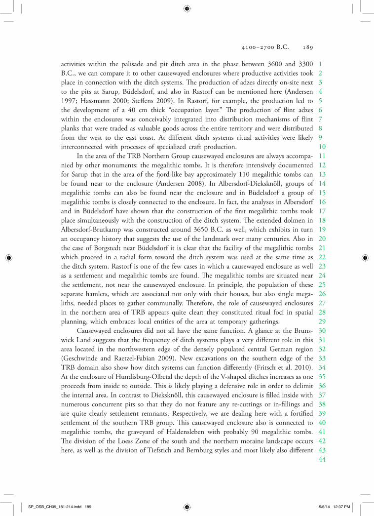
TRB flat graves outside the settlements are rare during the start of the Early Neo‑lithic (4100–3800 calB.C., partially until 3500 calB.C.). The whole TRB North group features fewer than 10 burials that date to the Early Neolithic, for example, the burial of Dragsholm of a 20‑year‑old male interred with a very early ceramic vessel, lying in a straight position on his back (Figure 9.7). The number of single burials then increases during the Early Neolithic II. They are often placed in grave groups with the usual
figure 9.7 Dragsholm, grave II.—Scale 1:10 (after Brinch Petersen and Egeberg 2009, Figure 3). One of the earliest TRB single burials recorded from Zealand.
SP_OSB_CH09_181-214.indd 195 5/6/14 12:37 PM

196 Johannes Müller
123456789
1011121314151617181920212223242526272829303132333435363738394041424344
furnishing of grave goods, such as, for example, one vessel and a flint axe or the like. Rastorf and also Vroue Heide are excellent examples for flat graves connected to mega‑lithic tombs: they prove that single burials may have been placed outside the chambers (Jörgensen 1977; Steffens 2009). The inventory of a flat grave could be as rich as the effort of construction could be high. The grave at Konsens Høj features two thick oak beams and an oblong stone packing between them, suggesting that trouble had been taken to create this burial. The finds of a golden ring in Schwesing, Holstein, and Him‑melpforten also prove the relevance of single flat graves within the TRB development.
Ostorf is another fine example of a typical TRB cemetery, this time on an island in the lake of Schwerin. The cemetery was used during the phases MN II/III–IV which has been evidenced by 14C‑dates from animal bones (mostly dating to 3100 until 2900 B.C.). Men in this grave field are distinctly marked as “hunter” or “warrior,” as is also known in a more gradual form from other cemeteries between Elbe and Oder (Lübke et al. 2009; Meyer 2009).
The description has thus far dealt with the TRB North and West groups but applies in a similar way to the South group of central Germany and the eastern group in Poland. We frequently see flat graves, in central Germany often single graves, beneath round barrows, which are also characteristic for the remaining TRB regions. Besides the common flat graves and the megalithic tombs, another category of graves can therefore be identified: nonmegalithic round or long barrows.
Nonmegalithic long barrows are a phenomenon closely connected to the heartland of the TRB as well as to the wider sphere (Madsen 1979; Midgley 1985; Midgley 2005). They are often earlier than the megalithic phenomenon throughout northern central Europe and southern Scandinavia and may have been used for a very long period of time. The long barrows often are single burials furnished with flint axes and TRB vessels. We know different categories, and the most famous examples are the Kujavian graves of the Sarnowo type: they are trapezoidal to triangular barrows whose longitudinal axis radially points to some important landmark. They usually hold the burial of an older male. Aerial photography and recent excavations have extended the geographic distribution of long barrows: they did not only exist in southern Scandinavia, but may also be found in northern central Europe and central Germany. Some are even known from southwest Germany and on the British Isles. Thus, the distribution of TRB long barrows ranges from southern England to southern Scandinavia, from northeastern Germany to eastern Germany, and Great and Little Poland.
It is important to state that the construction of long barrows dates back to as early as 3800 B.C. and that neither the megalithic tombs nor the causewayed enclosures are the oldest relics of the TRB development.
These nonmegalithic long barrows appear to have been multiphase structures where a variety of ritual sequences took place. In Bygholm, for example, a palisade was erected on the short side with various pits containing bone depositions. We also observe wooden mound kerbs, the burial itself, and finally the whole structure was covered by earth. In later times the long barrows seem to serve as burial sites with a richer inventory, as we see in Sylt‑Tinnum (Hinrichsen 2006). There are also several cases where single mounds were
SP_OSB_CH09_181-214.indd 196 5/6/14 12:37 PM

4100–2700 B.C. 197
1234567891011121314151617181920212223242526272829303132333435363738394041424344
integrated into one long barrow as in Flintbek (Mischka 2010). Nonmegalithic round barrows may be explained in a similar way: they mark individual burials in the landscape.
The similarity between the long barrows of Britain and those of southern Scan‑dinavia, both of which appeared around 3800 B.C., was always very obvious (Madsen 1979). The extreme resemblance of these structures will not be part of our discussion, but it is all the same very surprising that there should be only sparse evidence of any exchange of material culture whatsoever. The flint adzes from the TRB age identified within the realm of the definite British long barrows might be an exception to this (Walker 2010). The confirmation of this conformity could evidence relations surpassing the ritual similarities. The actual exchange could only have taken place along the coastal lines, namely, the coast of the North Sea crossing the Thames corridor, but surprisingly just there—between Calais and Hamburg—not one nonmegalithic long barrow has been discovered so far.
Many researchers argue that long barrows derived from the long houses of the Linear Pottery culture and their successors. This might be an option when considering the long barrow of Passy, but for the long barrows of the Sarnowo type or the very early barrow of Bygholm, not to mention the late Tinnum, the chronological gap is far too wide.
But there is another possible explanation: the use of late Mesolithic shell middens remains common during the Early Neolithic but then ceases at the time the long bar‑rows appear, marking the societal turn to TRB monuments. Since shell middens had served as burial sites all along, the step of constructing a long barrow seems like a logical development.
In conclusion, we demonstrated that the TRB societies not only featured rich ceramic inventories, they also displayed a great variety of monumental ensembles and burial sites, all of which lay outside the settlements. In the following, we will see that burials may also be found within a settlement.
Domestic Sites, Depositions, and the Organization of Space
For a long time, the absence of information about TRB settlements in northern central Europe and southern Scandinavia was one of the most prominent problems in European archaeology. During the last two decades, however, great linear construction projects as well as large excavations have provided us with knowledge about a number of TRB set‑tlements. Today, we are aware of at least around 200 ground plans of houses, allowing us to paint a fairly accurate picture of what life was like. Local studies of the distribu‑tion of sites give us an idea on which behavioral principles TRB societies enacted when organizing their environment and social space.
With regard to houses and huts, distinct patterns through time and space of the TRB phenomenon can be identified (Artursson/Linderoth/Nilsson/Svensson 2003): Not taking into account local or functional variations, the master plan of the TRB house shows a two‑naved rectangular (Limesgard/ Dagstorp 2 type) or slightly rounded ground plan (Mossby type), the latter of which seems to belong to the Early and beginning Middle Neolithic. The Dagstorp type is predominant during the Younger Early Neolithic and the
SP_OSB_CH09_181-214.indd 197 5/6/14 12:37 PM

198 Johannes Müller
123456789
1011121314151617181920212223242526272829303132333435363738394041424344
Middle Neolithic. The houses are usually between 4 and 7 m wide and range from 8 to 20 m in length. The outer walls are made up of closely spaced planks or wattle‑and‑daub walls. The interior did not have separate rooms. All TRB stages also feature round huts.
A particularly well‑excavated site is Dagstorp in Scania (Figure 9.8) where various forms of houses and huts were documented (Andersson 2004). We observe large houses in the Early Neolithic 1 and smaller houses and huts from the Early Neolithic 2 until the Middle Neolithic II, which are partially aligned. Occupational debris layers were, not unlike on sites of the Linear pottery, uncovered in front of the houses outlining the former courtyard of the farm. The ceramic remains make it possible to determine that in
figure 9.8 The settlement of Dagstorp 19, Scania (after Andersson 2004). Beside houses a cultural layer exists.
SP_OSB_CH09_181-214.indd 198 5/6/14 12:37 PM

4100–2700 B.C. 199
1234567891011121314
Dagstorp 19 two houses coexisted at any given time, so the settlement must have been a single farmyard. The entrances to the house were most probably placed on one or both long sides and usually there were no separate rooms, whereas the house of Flögeln gives evidence that separations did exist, since it features a division into two rooms. At the site of Saxtorp 23 burials were discovered approximately 100 m away from the houses and huts. Very often the floor of a TRB house was pitted, a property described by the term “sunken floors.” These pits could have been used as work station fire pits, thus providing the inhabitants with a certain functional division inside the house.
Crucial discoveries about TRB housing mainly came from Sweden during the last decade, but most recently this information is supplemented by research in the more southern areas. In Wolkenwehe, situated in the Trave valley in East Holstein, several small rectangular houses with rounded corners could be reconstructed (Brozio 2010, 2011) (Figure 9.9). The overlapping of some of the post‑holes suggests that no more than three houses existed simultaneously. The reexamination of the Hunte village of Hunte 1 by Kos‑sian (Kossian 2007) shows further examples of equally sized houses which date from the Middle to Younger Neolithic transition. Furthermore the site of Rastorf in East Holstein
figure 9.9 The reconstruction of houses in Bad Oldesloe‑Wolkenwehe (after Brozio 2011). Probably 2–3 houses existed contemporaneously.
SP_OSB_CH09_181-214.indd 199 5/6/14 12:37 PM

200 Johannes Müller
123456789
1011121314151617181920212223242526272829303132333435363738394041424344
features a house of the Dagstorp type in front of which lay pits, a burial, and plough marks: a classical example of a single farmstead with associated fields (Steffens 2009).
The general setting of TRB settlements during the fourth millennium therefore seems to comprise single farmsteads or small hamlets. The occasional two or three neigh‑boring farms seem to always have kept a certain distance from one another.
If we look more closely at two of the settlements, however, the interpretation of the uncovered features becomes more complex and we have to concede that the only explanation lies in the reconstruction of spatial concepts on a local scale.
Looking at Bad Oldesloe‑Wolkenwehe, we observe an insular situation within a wetland area (Mischka et al. 2003/2004 [2007]). The settlement is placed more or less directly in the former Middle Trave lowland. The palynological and sedimentological analyses show that the settlement must have been deserted during the winter and spring floods. The activities of the settlement seem to have evolved around the production of flint tools, including adzes. There is no trace of any agricultural activity, whereas the slaughter of domestic and wild mammals is accounted for in various areas of the settlement. A patchy ditch system and high charcoal quantities cannot be explained but may reflect some special local production. Maybe these finds are associated with the exploitation of the nearby saline springs and thereby with a form of salt production, although there is no archaeological evidence for this. Overall, Wolkenwehe seemed to be a very special kind of settlement in the wetland, closely linked to permanent settlements in the vicin‑ity. The distribution of sites in the Middle Trave Valley reveals a specific pattern: we see megalithic tombs in the hinterland, permanent settlements on the middle river bench, and temporary specialized insular settlements in the lowland.
Almhov in southwest Scania near Malmö is another example of a temporary set‑tlement (Rudebeck 2009). The excavation uncovered Early Neolithic I circular structures with a diameter of 200 m made up of pairs of thick posts with double pits in front of each pair. It must have been a circular cluster of tents, perhaps used for a feast of some kind. Food waste was discovered in the pits. Later, the place featured a long barrow and two regular long houses. Other temporary situations are known, such as Alvastra, where a wooden platform with planked pathways in a wetland might be interpreted as a temporary pasture of some kind (Malmer 2002).
The treatment of death within the settlement is most clearly revealed at the site of Oldenburg, a permanent TRB settlement located on a former island of the Olden‑burg Fjord and mainly dating to the Middle Neolithic II (Brozio 2011). The mineral soil of the site preserved the remains of several houses, some of which featured sunken floors. Evidence of tool production, grinding stones, ceramic inventories, and bone tools accounts for the various everyday activities dominating the life of the few families that must have lived there.
A part of the settlement lay at the edge of the fjord bank, which today marks the beginning of bog land and must have once demarcated a zone of brackish water. Vari‑ous wooden posts could have belonged to the fortification of the embankment, behind which waste and other depositions were found under waterlogged conditions. The settle‑ment was used between 3400 and 2900/2800 B.C. according to radiometric dating. The
SP_OSB_CH09_181-214.indd 200 5/6/14 12:37 PM

4100–2700 B.C. 201
1234567891011121314151617181920212223242526272829303132333435363738394041424344
area of the fjord bank held human remains—several bones and a cranium—which were deposited together with some broken objects on the border between dry and wetland. At first glance there seems to be no difference between the treatment of these bones and the treatment of animal bones.
In the center of the settlement, a pit also revealed how death could be dealt with: The pit held skeletal remains of an approximately 40‑year‑old female who had been arranged in a straight position on her back, with the neck and upper body apparently following the curve of the pit’s upper profile (Figure 9.10). The skeleton lacked the left femur, and traces of another pit indicated a secondary, intentional manipulation of the burial. Taking the bone (or maybe trying to get to the object placed on the upper limb) out of the joint capsule resulted in a slight elevation of the skeleton. Later the remaining disturbance was filled with soil again. Two m away, a well, 2.3 m deep and 1.3 m wide, confirms that the brackish water was not drinkable. The fill within the well revealed several funnel beakers, depositions of grinding and whetstones, as well as a high quantity of settlement waste and, last but not least, the missing femur from the nearby burial (Figure 9.11). The latter may either be seen as an intentional, perhaps ritual deposition or as a profane disposal.
Apart from these more obscure details the general pattern of the distribution of TRB settlements in the Oldenburg Graben is relatively clear. Botanic and geological analyses allow for the reconstruction of the ancient coastline, so the fjord also provided maritime resources for subsistence. Around 3200 B.C., an alignment of several settlements along the fjord bank, on islands, and in the lowland can be made out (Hoika 1986). Similar to the situation in the Trave valley, the megalithic sites are limited to the hinterland, thus narrowing the land used as pasture or cropland by the TRB societies in the area.
figure 9.10 A burial from the domestic site Oldenburg. The 40‑year‑old woman was placed in a pit, and later—during a secondary manipulation—the left femur was removed.
SP_OSB_CH09_181-214.indd 201 5/6/14 12:37 PM

202 Johannes Müller
123456789
1011121314151617181920212223242526272829303132333435363738394041424344
The settlement on the island in the Oldenburg Fjord must have had farmland in the dry areas cultivated by the families belonging to the site. Such insular sites already existed during the earliest TRB phase: the site of Wangels represents such an early set‑tlement (Grohmann 2010), with Oldenburg coming later.
The ritual deposition of objects is another very important find category that charac‑terizes the TRB world, apart from burials, enclosures, and settlements. Besides depositions within settlements (Oldenburg) and around or in front of megalithic tombs, a number of sacrifices were made in dry and wetland areas (e.g., Rech 1975). The TRB North group leaves most of these obviously ritual depositions during the Early Neolithic II and Middle Neolithic Ia, between 3600 and 3300 B.C. The abundant depositions of amber chains and pendants or the like, the laying down of vessels, hammer axes, and various adzes take place at the same time as enclosures and megaliths are built, and the pottery is richly ornamented. In the Swedish region of Falbygden a visibility analysis between megaliths, settlements, and lowlands with a history of depositions has led to the discovery that the deposition sites usually lie in areas that are clearly set apart by environmental conditions and constitute their own entity within the landscape (Sjögren 2003).
The idea of landscape in TRB times can nearly be felt here, but we have to deal with a multitude of different approaches to understand it. However, we now know for a fact that the TRB people did pay attention to demarcations in the Neolithic land‑scape. We see this in the above described settlement patterns of the Oldenburg Fjord or the Trave valley, as well as through the visibility analyses of the Altmark that show that settlements and burial sites were clearly set apart. The economic and demographic developments behind these concepts have yet to be brought to light.
figure 9.11 The well from the domestic site Oldenburg (after Brozio 2011). Besides many archaeological objects, the femur from the nearby burial was also found.
SP_OSB_CH09_181-214.indd 202 5/6/14 12:37 PM

4100–2700 B.C. 203
1234567891011121314151617181920212223242526272829303132333435363738394041424344
Ecology and Subsistence Economy
Within the northern central European and southern Scandinavian area the TRB develop‑ment is closely related to the introduction of a new subsistence strategy: the cultivation of cereals and livestock farming.
New economies result in marked changes of ideological attitudes that also have an impact on the lifestyle and outward expressions of human habits. A survey of the overall pattern that accompanied the spread of these new economies accentuates strong similarities between the neolithization of the British Isles and Ireland on the one hand and southern Scandinavia and the northern European plains on the other, but also of the circum‑Alpine regions. Around the same time (after 4100 B.C.), large parts of the non‑loess areas were subjected to the spread of farming and breeding. But if we compare TRB regions with the British Isles, we discern clear differences: the latter is characterized by cereal cultivation, pottery, and the custom of building megalithic tombs before non‑megalithic long barrows and finally enclosures “infiltrate” the landscape of the British isles around 3750 B.C. (Whittle et al. 2011). In northern central Europe and southern Scandinavia, on the other hand, the development followed another schedule: causewayed enclosures and megalithic tombs appeared around 3600 B.C., long after nonmegalithic long barrows were known. A structural comparison allows for a careful explanation: At the outset, Western Baltic areas were inhabited by Endmesolithic Ertebölle groups. They largely relied on hunting and gathering and the exploitation of aquatic resources, thus enabling them to, at least to a certain extent, live a sedentary life and use pottery as early as 4800 B.C. On the British Isles, Mesolithic groups never produced ceramics or reached such a degree of sedenterism.
The “hard” evidence of a Neolithic lifestyle is represented by low proportions of domestic animals at the beginning of the Early Neolithic (Steffens 2005). Between 4100 and 3800 B.C. the shares of domestic bones within zoological inventories range from 14.5 percent in Danish Svaleklint, to 22.6 percent in Basedow/Mecklenburg, only 6 percent in Scanic Lödelsborg and 25.8 percent in Bebensee, whereas Wangels displays a percentage of 64 percent of domestic animals. The following Early Neolithic Ib is characterized by values of more than 60 percent, for example Siggeneben‑Süd features 67 percent. With the EN II and MN the values typically level off at over 90 percent. We have to concede, therefore, that the adoption of a Neolithic lifestyle took place gradually, beginning in the Early Neolithic and ended a few centuries later.
The evidence of cereals or cereal‑related weeds paints a similar picture (Kirleis et al. 2012, 2011; Sjögren 2006). Between 4100 and 3800 B.C. we do not have a single grain of cereal from a settlement (though cereal impressions on pottery do exist). Not until the Early Neolithic IB, after 3800 B.C., do we get cereal samples from multiple different sites. The Early Neolithic I must be seen as a transitional phase during which foraging was gradually substituted by relying on livestock and farming. Other indicators of the new economic foundation such as grinding stones and sickle glance were not common before 3600 B.C., when the intensive agricultural production process had finally set in.
SP_OSB_CH09_181-214.indd 203 5/6/14 12:37 PM

204 Johannes Müller
123456789
1011121314151617181920212223242526272829303132333435363738394041424344
Palynology supports these results in principal (e.g., Nelle and Dörfler 2008). The decrease of tree pollen in pollen profiles confirms the opening of the landscape in the southern part of the Cimbric peninsula around 3600/3500 B.C. in the Early Neolithic II. There are no earlier significant changes recorded. After 3800 B.C., a continuous per‑centage of Plantago Lanceolata marks the beginning of an intensive livestock feeding in the forests, related to the appearance of the Hude forest. The opening of the landscape commences later on the Jutland Peninsula, the Danish isles and southern Sweden. This chronological offset is also reflected in average percentages of bones from domestic ani‑mals, which decrease from south to north and therefore document the loss of significance of stock herding in the north.
The development of agricultural techniques has to be considered as well. The open‑ing of the landscape was likely connected to the introduction of the crooked plough, marks of which are found under and near megalithic graves and houses since the Early Neolithic II in northern central Europe and southern Scandinavia. (Hübner 2005; Stef‑fens 2009).
Wheat and barley are seconded by related weeds, and poppy and other garden plants such as fennel also appear. The cultivation of gardens augments the opening of the landscape and the increase of shrubs in pollen profiles suggests the existence of hedges. Grinding stones and sickles become common finds within most settlement types. The appearance of sickle glance serves as another indicator for a chronological offset from south to north: the percentages of sickle glance are higher in southern settlements. In Sarup, the deforestation is evidenced as late as 3300 B.C., accompanied by a simultaneous rise of sickle evidence within the settlement (Jensen 1994).
Stable agriculture has surely existed since 3600/3500 B.C. but what about the time before? Certain palynological evidence, for example from the Belau Lake, reports an increase of ashes and coal between 4100 and 3700 B.C. (Kirleis et al. 2011). The first half of the fourth millennium is characterized by a distinct increase of colluvial depositions in Schleswig‑Holstein, followed by a decrease (Dreibrodt et al. 2010). Both discoveries may be seen as indicators of the slash‑and‑burn farming method in which small forest areas were burned down and the ground was then fertilized by wood (“Brandfeldbau”; Schier 2009). This method led to very good harvesting results and may have opened up the non‑loess areas and the northern central European and south Scandinavian region to cereal cultiva‑tion long before the invention of the crooked plough could consolidate the new economy.
The significance of hunting and gathering remained stable. Throughout the different societal spheres herbal products were used and deposited in various, sometimes markedly different ways which are reflected in the variety of find scenarios.
Cereals, namely einkorn and barley, predominate in the settlement of Oldenburg, whereas the site of the megalithic tomb of Albersdorf‑Brutkamp is mainly characterized by noncultivated gathering fruits such as, among others, hazel (Kirleis and Klooß in press). The same applies to the causewayed enclosure of Albersdorf‑Dieksknöll, where the proportion of cereals remains even lower. It cannot be said with certainty whether shrubs such as hazel or species of fruit trees were promoted by a special kind of forest management.
SP_OSB_CH09_181-214.indd 204 5/6/14 12:37 PM

4100–2700 B.C. 205
1234567891011121314151617181920212223242526272829303132333435363738394041424344
Temporary TRB settlements or camps were built for different purposes but some of them were clearly engaged in hunting activities, as we have already stated for Bad Oldesloe‑Wolkenwehe, with a high percentage of game in the Early as well as the Mid‑dle Neolithic. A straightforward example of a hunting camp is the temporary station in Parchim‑Löddigsee from which no domestic animal remains are known (Becker and Benecke 2002). There is evidence that the settlement was used to carry out a specialized hunting of wild horses at the end of the Middle Neolithic.
As for animals in this context, the cart tracks of Flintbek were recently dated to 3400 B.C. and confirm the use of cattle as a working animal (Mischka 2010). The appearance of double burials of animals, especially of cattle, in wide areas of Europe is a very powerful indicator for the increasing significance of animals. For example, we find antipodic double burials of cattle that were placed by analogy with human burials in a crouched position alongside common grave goods.
A recent study revealed that cattle teeth were the sole remains found in the double burials aligned in front of the megalithic tomb of Vroue Heide (Johannsen and Laursen 2010). The position of the finds suggests that the burials could well have been double burials of cattle that had been buried together with a cart or carts. This is another strong indication for the importance of animals.
We have as yet not mentioned fishing and the exploit of maritime resources, which remained common during the whole time, as many finds of seal and fish bones, fishing hooks, and weights from fishing nets confirm. In Bad Oldesloe‑Wolkenwehe, seal bones were found and indicate that these animals were an important resource even inland.
Some areas were reforested after 3100 B.C., while in other areas we observe an increase of pasture land. The transition to an Early Neolithic economy with a strong bias toward animal husbandry also characterizes the end of the TRB development, which seems as diverse as the beginning.
Beyond Subsistence
There seems to be no monocausal approach to explain the neolithization of northern Europe, and it is necessary to concede that other factors apart from subsistence economy helped form the TRB society. The use and production of amber which has been traded far to the south is one such factor, but flint and flint production is significantly more important. Flint was produced by coastal and surface mining, processed, and finally exchanged (Midgley 1992). Large flint mines existed in the Limfjord region, with a highly specialized production, and especially on the south Cimbric coast of the North Sea we have flint‑related workplaces that demonstrate the sheer mass of available material. The resulting distribution maps allow us to identify the network of exchange relations.
Another characteristic trait is the use of copper. Since around 3500 B.C. the TRB North group conducted its own copper technology, using not only local but also foreign copper which had originally come to the north as an import (Klassen 2004). The copper daggers in the deposition of Bygholm and from the single grave of Aspenstedt indicate a new social evaluation of societal roles.
SP_OSB_CH09_181-214.indd 205 5/6/14 12:37 PM

206 Johannes Müller
123456789
1011121314151617181920212223242526272829303132333435363738394041424344
A highly specialized stone mining industry (“Montanindustrie”) and new construc‑tion methods supported the building of aboveground monuments. The manipulation of large capstones requires a high amount of planning and skill. Not only manual skills are needed, but also the ability to mobilize a certain number of fellow people at a certain time is essential. It is a process highly reliant on demographic and social relations—rela‑tions we would like to reconstruct for the TRB age.
Demography and Social Formations
Social reconstructions first require knowledge about the size of social groups. Demography is a limiting factor to the size of a social group, as is economic ability. A simple model analysis therefore helps to emphasize that demography and economy are imperative for the reconstruction of social formations and social reorganization.
The demographic problem might be solved by extrapolating from certain kinds of excavated data. We could use palynological evidence of human impact as a proxy for a general evaluation of demographic development. The amount of 14C‑dates reflects the amount of archaeological features left behind, and by carefully discussing and evaluating the circumstances under which a deposition took place we might even be able to add to our knowledge of demographic development (Müller 2010).
Both methods result in the discovery that there was a marked increase of population in the southern TRB area, mainly during the Early Neolithic II and at the beginning of the Middle Neolithic. The late TRB development was most likely characterized by a decrease of population.
To get a more accurate picture of these tendencies, a test region was defined in which we tried to summarize all relevant archaeological data in order to gain more solid knowl‑edge about what the demographic and social development looked like (Müller 2010).
The nearly complete survey of megalithic tombs and other archaeological finds and features on the North Friesian islands provided us with the ideal sample region and could be used as basis for further observations. There are 94 megalithic tombs densely packed around a small area, at least in comparison to other areas.
The reconstruction of the minimum population size draws upon simple calculations: The average area of a TRB single grave (of around 1 m²) represents one individual. Sum‑ming up all areas of the recorded grave sites (megalithic tombs, flat graves, and other grave types) that are known to have been in use at the same time on the islands would result in a minimum individual count, assuming that all the chambers contained burials. The calculation is more difficult than it seems at first because some corrections have to be made, as, for example, the loss rate of megalithic tombs. This rate has to be derived from similar calculations for other regions where old maps and thorough excavation and survey techniques in small areas provide a fairly good idea of how many megaliths must have disappeared over the centuries.
In flat grave cemeteries the proportion between burials with and without burial items should give us another correction value, as flat graves without any such items might never be detected. We also have to consider how long the grave structures were used,
SP_OSB_CH09_181-214.indd 206 5/6/14 12:37 PM

4100–2700 B.C. 207
1234567891011121314151617181920212223242526272829303132333435363738394041424344
but in the case of the North Friesian islands we may only draw upon typo‑chronological considerations to reconstruct probable periods of utilization.
If we take all of the above factors into account, the North Frisian islands, today encompassing ca. 202 km2, were inhabited by 200–400 people at the beginning of the Early Neolithic II, 500–1,500 during the Middle Neolithic I and 350–550 people in the Middle Neolithic IV.
If a TRB farmstead was inhabited by the average of 10 people, between 20 and 150 farms would have existed simultaneously during any of the above mentioned stag‑es. More or less 100 megalithic tombs are known to us today and the assumption that there is a 1:1 proportion between farmstead and megalithic tomb might well be correct.
We could then conclude that the density of population must have amounted to between one and seven person(s)/km2 which reflects a considerable increase of the island population during the Early Neolithic II. Calculations based on other, quite different data sets in southwest Fune rendered similar numbers.
Our model calculation also indicated a decrease of population during the Late Neolithic, but this could also be due to a miscalculation based on unreliable data. Still, the pollen analyses of southern Jutland and the compilation of the relevant 14C‑dates indeed show a similar dropoff.
Such models give us a rough idea of the population density and of the number of people having been buried in the archaeologically confirmed graves of at least the TRB North group.
The Single Grave culture is known for its quantity of possibly 50,000 southern Scandinavian grave mounds. Still, only about 100 burials per year could have been placed inside them (summary in Hübner 2005). In contrast, 50,000 megalithic tombs would have had a capacity to house 10,000 burials per year within the same area. If we consider the average life expectancy and death rate of Neolithic times, the area of study could have been the home of around 500,000 TRB people.
All in all, the Early and Middle Neolithic was characterized by single farmsteads and hamlets, likely associated with exogamic procreation strategies and therefore making people reliant on a cooperative way of life.
Social Organization and Ideologies
The outline of demographic development described above, notwithstanding distinct regional differences, is not only reflected in relation to technological improvements regarding, for example, the subsistence economy, but also in a change of character in material culture.
There are four principal phases featuring different material assemblages that might be linked to social differences: A (4100–3800 B.C.): farms and single graves, continuous use of shell middens in the
north;B (3800–3500 B.C.): farms and single graves, nonmegalithic long barrows;
SP_OSB_CH09_181-214.indd 207 5/6/14 12:37 PM

208 Johannes Müller
123456789
1011121314151617181920212223242526272829303132333435363738394041424344
C (3600–3100 B.C.): farms and causewayed enclosures; single graves, dolmen, non‑megalithic long barrows, and as of 3400 B.C., passage graves; depositions;
D (3100–2800 B.C.): farms, single graves, continued use of causewayed enclosures and passage graves, and, as of 2900 B.C., palisade structures in southern Scandinavia.
An attempt to interpret this leads to the conclusion that step by step the early centuries of the northern TRB development must have undergone ideological changes without giving any indication of a marked social differentiation.
The multifaceted ornamentation of the early stages of some of the TRB groups outlined above can be seen as indicating distinct social demarcations of neighboring groups that catalyzed the formation of dense communication areas that covered the size of approximately one day’s walk.
Around 3800 B.C., nonmegalithic long barrows mark these areas and are also connected to ritual activities and the burials of socially outstanding individuals. After 3600 B.C. the societal change becomes more noticeable: the landscape is opened and new production technologies are introduced. Furthermore, there are burials of obviously very special individuals in nonmegalithic structures and in dolmen, and last but not least we witness the construction of large cooperative monuments—the causewayed enclosures.
These only temporarily used and visited “areas of festivities, distribution, and par‑tially also of production” represent the heart of a cooperative enterprise. The construction of enclosures and the act of depositing and thereby destroying goods in isolated parts of the landscape dominates the cooperative ideology of the late Early and beginning Middle Neolithic. The conformity of the Fuchsberg‑style pottery, which is spread across a wide area, could also symbolize the concept of a cooperative life style.
These general changes are related to a marked growth of population, which—after several generations—leads to an increase of internal conflicts. After 3200 B.C., existing enclosures remain in use but there is no evidence that the construction of new ones has been carried out. Burials in passage graves now predominate, and consume a high amount of energy. The idea of collective burials prevails in most areas of northern cen‑tral Europe and southern Scandinavia. The term collectivity contradicts all other visible social tendencies: The proportion of items that might have been used as weapons rises, a tendency also observable in other areas, for example in central Germany (Figure 9.12). Pottery ornamentation lessens and there is a renewed regionalization of ornamentation and vessel forms.
It is impossible to grasp the reasons for this social diversification within the TRB groups but we are able to identify special, socially relevant components: animals, especially cattle, are associated with wealth, and the significance of the male individual is empha‑sized in single grave burials. A social separation evolves, and new symbols predominate material culture, pointing to the position of a new group of distinct individuals within the social network.
SP_OSB_CH09_181-214.indd 208 5/6/14 12:37 PM

4100–2700 B.C. 209
1234567891011121314151617181920212223242526272829303132333435363738394041424344
After 2800 B.C., a new society develops in all TRB areas, which has not yet been sufficiently explained: the Single Grave culture with its selective burial tradition of indi‑viduals and an apparently strong focus on livestock husbandry.
Outlook
Generally speaking, all TRB groups remain quite heterogeneous despite their strong similarities regarding material culture. These differences might be seen as a reaction of the indigenous hunter groups to influences coming to them from various directions, which were then translated into inner‑societal changes. The partial substitution of the hunter‑gatherer concept by a subsistence based on agriculture is associated with the construction of the first graves above ground. The prevalence of the new economy does not further the “clearing” of the landscape and of social relations before 3600 B.C.: only from then on are the areas covered with numerous boulders cleared and the largest stones used to build grave structures above ground. The idea is simple and might stem from northwestern France, an area to which social groups had a certain inclination at that
figure 9.12 The distribution of goods in graves on the North Frisian Islands accord‑ing to time period. Represented are the total number of grave items in three phases and the proportion of artifacts, which could be used as weapons, and ceramics, which are interpreted as consumptive commodities (Müller 2010, Figure 6).
SP_OSB_CH09_181-214.indd 209 5/6/14 12:37 PM

210 Johannes Müller
123456789
1011121314151617181920212223242526272829303132333435363738394041424344
time. Ritual changes and economic changes go hand in hand: landscapes are formed, which represent both the agricultural impact as well as the new social order.
The Neolithic mobility of ideas led to the formation of reorganized space during the TRB age, a reorganized space that—as a social space—utilizes the position of the ancestors for the positioning of the living. Therefore, the long‑lasting offerings of TRB in or in front of passage graves have to be seen as starting point for the creation of societal traditions still valid long after the end of the TRB development. But that is a different story.
References Cited
Andersen, N. H. 1997 The Sarup Enclosures. The Funnel Beaker Culture of the Sarup Site Including Two Causewayed Camps Compared to the Contemporary Settlements in the Area and Other European Enclosures. Jutland Archaeological Society Publications XXXIII, 1, Aarhus Uni‑versity Press, Aarhus.
Andersen, N. H. 2008 Die Region um Sarup im Südwesten der Insel Fünen (Dänemark) im 3. Jahrtausend v. Chr. In Umwelt—Wirtschaft—Siedlungen im dritten vorchristlichen Jahrtau-send Mitteleuropas und Südskandinaviens, edited by W. Dörfler and J. Müller, pp. 35–48. Offa‑Beihefte 84, Wachholtz Verlag, Kiel.
Andersson, M. 2004 Making Place in the Landscape: Early and Middle Neolithic Societies in Two West Scanian Valleys. National Heritage Board, Skånska spår, Lund.
Artursson, M., T. Linderoth, M.‑L. Nilsson, M. Svensson 2003 Byggnadskultur i södra & mellersta Skandinavien. In I det Neolitiska rummet, edited by M. Svensson, pp. 40–171. Riksantik‑varieämbetet, Skånska spår, Lund.
Bakker, J. A. 1979 The TRB West Group: Studies in the Chronology and Geography of the Makers of Hunebeds and Tiefstich Pottery. Cingula 5. Albert Egges van Giffen Instituut voor Prae‑ en Protohistorie, Amsterdam.
Becker, D., and N. Benecke 2002 Die neolithische Inselsiedlung am Löddigsee bei Parchim. Archäol-ogische und archäozoologische Untersuchungen. Beiträge zur Ur‑ und Frühgeschichte Mecklen‑burg‑Vorpommerns 40. Archäologisches Landesmuseum Mecklenburg‑Vorpommern, Lübsdorf.
Behrens, H., and E. Schröter 1980 Siedlungen und Gräber der Trichterbecherkultur und Schnur-keramik bei Halle. VEB Deutscher Verlag der Wissenschaften, Berlin.
Bollongino, R. 2006 Die Herkunft der Hausrinder in Europa. Eine aDNA-Studie an neolithischen Knochenfunden. Universitätsforschungen zur Prähistorischen Archäologie 130. R. Habelt, Bonn.
Boujot, C., and S.Cassen 1993 A Pattern of Evolution for the Neolithic Funerary Structures of the West of France. Antiquity 67:477–491.
Brinch Petersen, E., and T. Egeberg 2009 Between Dragshom I and II. Bericht der Römisch-Ger-manischen Kommission 88 (2007):447–467.
Brozio, J. P. 2010 Neue Untersuchungen zu trichterbecherzeitlichen Organisationsformen in Ostholstein. Archäologischen Nachrichten aus Schleswig-Holstein 16:30–33.
Brozio, J. P. 2011 Von Siedlungen und Grabenwerken der Trichterbecher‑Gemeinschaften. Archäol-ogie in Deutschland 2:24–25.
Cassen, S., ed. 2009 Autour de Table. Explorations archéologiques et discours savants sur des architectures néolithiques á Lochmariaquer, Morbihan (Table des Marchands et Grand Menhirs). Actes du colloque international, Vannes (Morbihan), 5–7 octobre 2007. Université de Nantes, Nantes.
SP_OSB_CH09_181-214.indd 210 5/6/14 12:37 PM

4100–2700 B.C. 211
1234567891011121314151617181920212223242526272829303132333435363738394041424344
Cassen, S., P. Lanos, P. Dufresne, C. Oberlin, E. Delqué‑Kolic, and M. Le Goffic 2009 Datations sur site (Table des Marchands, alignement du Grand Menhir, Er Grah) et modélisation chonologique du Néolithique morbihannais. In Autour de Table. Explorations archéologiques et discours savants sur des architectures néolithiques á Lochmariaquer, Morbihan (Table des Marchands et Grand Menhirs), edited by S. Cassen, pp. 737–768. Actes du colloque inter‑national, Vannes (Morbihan), 5–7 octobre 2007. Université de Nantes, Nantes.
Cassen, S., P. Pétrequin, C. Boujot, S. Domínguez‑Bella, M. Guiavarc’h, and G. Querré 2010 Measuring Distinction in the Megalithic Architecture of the Carnac Region: From Sign to Material. In Megaliths and Identities: Early Monuments and Neolithic Societies from the Atlantic to the Baltic, edited by Martin Furholt, Friedrich Lüth, and Johannes Müller, pp. 225–248. Dr. Rudolf Habelt GmbH, Bonn.
Chambon, P., and A. Thomas 2010 The First Monumental Cemeteries of Western Europe: The “Passy type” Necropolis in the Paris Basin around 4500 BC. www.jungsteinsite.de 2010, version 19.0.2010.
Demnick, D., S. Diers, H.‑R. Bork, B. Fritsch, J. Müller 2008 Der Großdolmen Lüdelsen 3 in der westlichen Altmark (Sachsen‑Anhalt)— Baugeschichte, Rituale und Landschaftsrekon‑struktion. Mit Beiträgen von Arno Beyer, Jan‑Piet Brozio, Ercan Erkul, Helmut Kroll. und Edeltraud Tafel. www.jungsteinzeit.de 92, 2008.
Dibbern, H., and F. Hage 2010 Erdwerk und Megalithgräber in der Region Albersdorf‑Vorbericht zu den Grabungskampagnen am Dieksknöll und Brutkamp. Archäologischen Nachrichten aus Schleswig-Holstein:34–37.
Dreibrodt, S., C. Lubos, B. Terhorst, B. Damm, H.‑R. Bork 2010 Historical Soil Erosion by Water in Germany: Scales and Archives, Chronology, Research Perspectives. Quaternary International 222:80–95.
Fritsch, B., M. Lindemann, J. Müller, C. Rinne 2010 Entstehung, Funktion und Landschaftsbezug von Großsteingräbern, Erdwerken und Siedlungen der Trichterbecherkulturen in der Region Haldensleben‑Hundisburg. Vorarbeiten und erste Ergebnisse. Archäologie in Sachsen-Anhalt Sonderband 13:39–46.
Geschwinde, M., and D. Raetzel‑Fabian 2009 Eine Fallstudie zu den jungneolithischen Erdwerken am Nordrand der Mittelgebirge. Verlag Marie Leidorf, Rahden.
Grohmann, I. M. 2010 Die Ertebölle‑ und frühtrichterbecherzeitliche Keramik aus Wangels, Kr. Ostholstein. In Die Neolithisierung Mitteleuropas, edited by D. Gronenborn and J. Petrasch, pp. 407–422. Verlag des Römisch‑Germanischen Zentralmuseums, Mainz.
Grupe, G. 1989 Die Skelettreste aus dem neolithischen Kollektivgrab von Odagsen, ldkr. North‑eim. In Paläanthropologie im Mittelelbe-Saale-Werra-Gebiet. Beiträge zur Rekonstruktion der biologischen Situation ur- und frühgeschichtlicher Bevölkerungen. Weimarer Monographien zur Ur- und Frühgeschichte 23, edited by H. Bach and A. Bach, pp 80–93. Museum für Ur‑ und Frühgeschichte Thüringens, Weimar.
Günther, K. 1997 Die Kollektivgräber-Nekropole Warburg I–V. Bodenaltertümer Westfalens 34. von Zabern, Mainz.
Hassmann, H. 2000 Die Steinartefakte der befestigten neolithischen Siedlung von Büdelsdorf, Kreis Rendsburg-Eckernförde. Universitätsforschungen zur Prähistorischen Archäologie 62. In Kommission bei R. Habelt, Bonn.
Hinrichsen, C. 2006 Das Neolithikum auf den Nordfriesischen Inseln. Universitätsforschungen zur Prähistorischen Archäologie 133. Verlag Dr. Rudolf Habelt, Bonn.
Hinz, M. 2007 Territoriale und soziale Strukturen. Modelle zur Kollektivgrabsitte der Wart‑berg‑Gruppe. www.jungsteinsite.de article 15/12/2007.
SP_OSB_CH09_181-214.indd 211 5/6/14 12:37 PM

212 Johannes Müller
123456789
1011121314151617181920212223242526272829303132333435363738394041424344
Hoika, J. 1986 Die Bedeutung des Oldenburger Grabens für Besiedlung und Verkehr im Neolithikum. Offa 43:185–208.
Hübner, E. 2005 Jungneolithische Gräber auf der Jütischen Halbinsel. Typologische und chronologische Studien zur Einzelgrabkultur. Nordiske Fortidsminder B24. Der Kongelige Nordiske oldskirftselskab, København.
Jensen, H. J. 1994 Flint Tools and Plant Working: Hidden Traces of Stone Age Technology; A Use Wear Study of some Danish Mesolithic and TRB Implements. Aarhus University Press, Aarhus.
Jeunesse, C. 2010 Die Michelsberger Kultur. In Jungsteinzeit im Umbruch. Die “Michelsberger Kultur” und Mitteleuropa im Umbruch vor 6000 Jahren, edited by: C. Lichter, pp. 46–55. Badisches Landesmuseum, Karlsruhe.
Johannsen, N., and S. Laursen 2010 Routes and Wheeled Transport in Late 4th–Early 3rd Millennium Funerary Customs of the Jutland Peninsula: Regional Evidence and European Context. Prähistorische Zeitschrift 85:15–58.
Jörgensen, E. 1977 Hagebrogard—Vroue—Koldkur. Neolithische Gräberfelder aus Nordwestjütland. Akademisk Forlag, Kopenhagen.
Kirleis, W., I. Feeser, and S. Klooß 2011 Umwelt und Ökonomie. Archäologie in Deutschland 2:34–37. In Press Food Production and Beyond: Social Context of Plant Use in the Northern German Neolithic. In Plants and People. Choices and Diversity through Time, edited by A. Chevalier, M. Elena, and P. Leonor.
Kirleis, W., S. Klooß, H. Kroll, and J. Müller 2012 Crop Growing and Gathering in the Northern German Neolithic: A Review Supplemented by New Results. Vegetation History and Archaeobotany 21:221–242.
Klassen, L. 2004 Klassen, Jade und Kupfer. Untersuchungen zum Neolithisierungsprozess im westlichen Ostseeraum unter besonderer Berücksichtigung der Kulturentwicklung Europas 5500–3500 BC. Jutland Archaeological Society, Moesgård.
Klatt, S. 2009 Die neolithischen Einhegungen im westlichen Ostseeraum. Forschungsstand und Forschungsperspektiven. In Neue Forschungen zum Neolithikum im Ostseeraum, edited by T. Terberger, pp. 7–134. Verlag Marie Leidorf, Rahden/Westf.
Kossian, R. 2005 Nichtmegalithische Grabanlagen der Trichterbecherkultur in Deutschland und den Niederlanden. Veröffentlichungen des Landesamtes für Denkmalpflege und Archäologie Sachsen‑Anhalt–Landesmuseum für Vorgeschichte 58. Landesmuseum für Vorgeschichte, Halle.
Kossian, R. 2007 Hunte 1: Ein mittel- bis spätneolithischer und frühbronzezeitlicher Siedlungsplatz am Dümmer, Ldkr. Diepholz (Niedersachsen). Die Ergebnisse der Ausgrabungen des Reichsamtes für Vorgeschichte in den Jahren 1938 bis 1940. Veröffentlichungen der archäologischen Sammlungen des Landesmuseums Hannover 52. Niedersächsisches Landesmuseum, Hannover.
Laporte, L. 2005 Néolithisation de la façade atlantique du Centre‑Ouest de la France. Actes des journées SPF de Nantes. In Unité et diversité des processus de néolithisation. Actes du colloque de Nantes, Mémoire XXXVI de la Société Préhistorique Française, pp. 99–125. Société Préhistorique Française, Paris.
Leandri, F., C. Gilabert, and F. Demouche 2007 Les chambers funéraires des Ve et IV millénaires av. J‑C.: le cas de las Corsica. In Les cistes de Chamblandes et la place des coffres dans les pratiques funéraires du Néolithique moyen occidental. Actes du colloque de Lausanne, 12 et 13 mai 2006, edited by P. Moinat and P. Chambon, pp. 41–61. Société Préhistorique Française, Paris.
Liversage, D. 1992 Barkær. Long Barrows and Settlements. Akademisk forlag, Kopenhagen.
SP_OSB_CH09_181-214.indd 212 5/6/14 12:37 PM

4100–2700 B.C. 213
1234567891011121314151617181920212223242526272829303132333435363738394041424344
Lübke, H., F. Lüth, and T. Terberger 2009 Fishers or Farmers? The Archaeology of the Ostorf Cemetery and Related Neolithic Finds in the Light of New Data. Bericht der Römisch-Germanischen Kommission 88 (2007):307–338.
Madsen, T. 1979 Earthen Long Barrows and Timber Structures: Aspects of the Early Neolithic Mortuary Practice in Denmark. Proc. Prehist. Soc. 45:301–320.
Malmer, M. P. 2002 The Neolithic of South Sweden: TRB, GRK. and STR. Royal Swedish Academy of Letters, History and Antiquities, Stockholm.
Meyer, M. 2009 Neolithische Flachgräberfelder zwischen Elbe und Oder. Bericht der Römisch-Germanischen Kommission 88 (2007):429–446.
Midgley, M. 1992 TRB Culture: The First Farmers of the North European Plain. Edinburgh University Press, Edinburgh.
Midgley, M. 2005 The Monumental Cemeteries of Prehistoric Europe. Tempus, Gloucestershire.Midgley, M. 2009 Antiquarians at the Megaliths. Archaeopress, Oxford.Mischka, D. 2010 Flintbek LA 3, Biography of a Monument. www.jungsteinsite.de article from
20/12/2010.Mischka, D., W. Dörfler, P. Grootes, D. Heinrich, J. Müller, and O. Nelle 2007 Die neolithische
Feuchtbodensiedlung Bad Oldesloe‑Wolkenwehe: Vorbericht zu den Untersuchungen 2006. Offa 59/60(2003/2004):25–64.
Müller, J. 1997 Zur absolutchronologischen Datierung der europäischen Megalithik. In Tradition und Innovation. Prähistorische Archäologie als historische Wissenschaft. Festschrift für Christian Strahm, edited by B. Fritsch, M. Maute, I. Matuschik, J. Müller, and C. Wolf, pp. 63–105. Verlaf Marie Leidorf, Rahden.
Müller, J. 2006 Die altmärkischen Großsteingräber im europäischen Kontext. In Großsteingräber der Altmark, edited by H. Bock, B. Fritsch, and L. Mittag, pp. 17–45. Theiss‑Verlag, Stuttgart.
Müller, J. 2009a, Neolithische Monumente und neolithische Gesellschaften. In Neolithische Monumnete und neolithische Gesellschaften, Varia neolithica 6, edited by H.‑J. Beier, E. Claßen, T. Doppler, and B. Ramminger, pp. 7–16. Verlag Beier & Beran, Langenweissbach.
Müller, J. 2009b Monumente und Gesellschaft. Archäologische Nachrichten aus Schleswig-Holstein:30–33.Müller, J. 2010a Dorfanlagen, Siedlungssysteme—Die europäische Perspektive: Südosteuropa und
Mitteleuropa. In Aufbruch in eine neue Zeit: Europas Mitte um 4000 v. Chr., edited by C. Lichter, pp. 250–257. Ausstellungskatalog. Primus Verlag Karlsruhe, Karlsruhe.
Müller, J. 2010b Ritual Cooperation and Ritual Collectivity: The Social Structure of the Middle and Younger Funnel Beaker North Group (3500–2800 B.C.). www.jungsteinsite.de (Artikel vom 29.10.2010).
Nelle, O., and W. Dörfler 2008 A Summary of the Late‑ and Post‑Glacial Vegetation History of Schleswig‑Holstein. In Flora, Vegetation, and Nature Conservation from Schleswig-Holstein to South America—Festschrift for Klaus Dierßen on Occasion of his 60th Birthday, edited by: J. Dengler, C. Dolnik, and M. Trepel, pp. 45–68. Arbeitsgemeinschaft Geobotanik in Schleswig‑Holstein und Hamburg, Kiel.
Raetzel‑Fabian, D. 2000 Calden. Erdwerk und Bestattungsplatz des Jungneolithikums. Universitätsforschungen zur prähistorischen Archäologie 70. Habelt, Bonn.
Rech, M. 1975 Stein- und bronzezeitliche Depotfunde im westlichen Norddeutschland. S.I., Schleswig.Rudebeck, E. 2009 I trästodernas skugga—monumentala möten i neolitiseringens tid. In
Arkeologiska och förhistoriska världar, edited by B. Nilsson and E. Rudebeck, pp. 83–252. Malmö museer, Malmö.
SP_OSB_CH09_181-214.indd 213 5/6/14 12:37 PM
214 Johannes Müller
123456789
1011121314151617181920212223242526272829303132333435363738394041424344
Schier, W. 2009 Extensiver Brandfeldbau und die Ausbreitung der neolithischen Wirtschaftsweise in Mitteleuropa und Südskandinavien am Ende des 5. Jahrtausends v. Chr. Prähistorische Zeitschrift 84:15–43.
Schuldt, E. 1972 Die mecklenburgischen Megalithgräber. Beitr. Ur‑ Frühgesch. Bezirke Rostock, Schwerin u. Neubrandenburg 6. Deutscher Verl. d. Wissenschaften, Berlin.
Sjögren, K.‑G. 2003 Mêangfalldige uhrminnes grafvar: megalitgravar och samhèalle i Vèastsverige. GOTARC. Series B, Gothenburg Archaeological Theses 27. Coast‑to‑Coast Books, Göteborg.
Sjögren, K.‑G. 2006 Ecology and Economy in Stone Age and Bronze Age Scania. National Heritage Board, Lund. 2010 Megaliths, Landscapes, and Identities: the case of Falbygden, Sweden. www.jungsteinsite.de article from 29/10/2010.
Steffens, J. 2005 Die Bedeutung der Jagd in der Trichterbecherkultur. www.jungsteinsite.de 2005, article 15/2/2005.
Steffens, J. 2009 Die neolithischen Fundplätze von Rastorf, Kreis Plön. Eine Fallstudie zur Trichterbecherkultur im nördlichen Mitteleuropa am Beispiel eines Siedlungsraumes. Universitätsforschungen zur prähistorischen Archäologie. R. Habelt, Bonn.
Walker, K. 2010 Landscapes, Seascapes, and Sandbanks: Neolithic Exchange and a North Sea Network. In Landscapes and Human Development: The Contribution of European Archaeology, edited by Kiel Graduate School “Human Development in Landscapes,” pp. 159–169. In Kommission bei Dr. Rudolf Habelt GmbH, Bonn.
Whittle, A., F. Healy, and A. Bayliss 2011 Gathering Time: Dating the Early Neolithic Enclosures of Southern Britain and Ireland. Oxbow Books, Oxford.
SP_OSB_CH09_181-214.indd 214 5/6/14 12:37 PM