Geotechnical investigation of sewage wastewater disposal sites and use of GIS land use maps to...
15
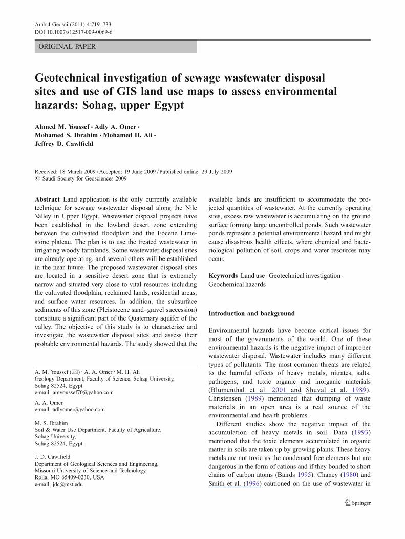
ORIGINAL PAPER Geotechnical investigation of sewage wastewater disposal sites and use of GIS land use maps to assess environmental hazards: Sohag, upper Egypt Ahmed M. Youssef & Adly A. Omer & Mohamed S. Ibrahim & Mohamed H. Ali & Jeffrey D. Cawlfield Received: 18 March 2009 / Accepted: 19 June 2009 / Published online: 29 July 2009 # Saudi Society for Geosciences 2009 Abstract Land application is the only currently available technique for sewage wastewater disposal along the Nile Valley in Upper Egypt. Wastewater disposal projects have been established in the lowland desert zone extending between the cultivated floodplain and the Eocene Lime- stone plateau. The plan is to use the treated wastewater in irrigating woody farmlands. Some wastewater disposal sites are already operating, and several others will be established in the near future. The proposed wastewater disposal sites are located in a sensitive desert zone that is extremely narrow and situated very close to vital resources including the cultivated floodplain, reclaimed lands, residential areas, and surface water resources. In addition, the subsurface sediments of this zone (Pleistocene sand–gravel succession) constitute a significant part of the Quaternary aquifer of the valley. The objective of this study is to characterize and investigate the wastewater disposal sites and assess their probable environmental hazards. The study showed that the available lands are insufficient to accommodate the pro- jected quantities of wastewater. At the currently operating sites, excess raw wastewater is accumulating on the ground surface forming large uncontrolled ponds. Such wastewater ponds represent a potential environmental hazard and might cause disastrous health effects, where chemical and bacte- riological pollution of soil, crops and water resources may occur. Keywords Land use . Geotechnical investigation . Geochemical hazards Introduction and background Environmental hazards have become critical issues for most of the governments of the world. One of these environmental hazards is the negative impact of improper wastewater disposal. Wastewater includes many different types of pollutants: The most common threats are related to the harmful effects of heavy metals, nitrates, salts, pathogens, and toxic organic and inorganic materials (Blumenthal et al. 2001 and Shuval et al. 1989). Christensen (1989) mentioned that dumping of waste materials in an open area is a real source of the environmental and health problems. Different studies show the negative impact of the accumulation of heavy metals in soil. Dara (1993) mentioned that the toxic elements accumulated in organic matter in soils are taken up by growing plants. These heavy metals are not toxic as the condensed free elements but are dangerous in the form of cations and if they bonded to short chains of carbon atoms (Bairds 1995). Chaney (1980) and Smith et al. (1996) cautioned on the use of wastewater in A. M. Youssef(*) : A. A. Omer : M. H. Ali Geology Department, Faculty of Science, Sohag University, Sohag 82524, Egypt e-mail: [email protected] A. A. Omer e-mail: [email protected] M. S. Ibrahim Soil & Water Use Department, Faculty of Agriculture, Sohag University, Sohag 82524, Egypt J. D. Cawlfield Department of Geological Sciences and Engineering, Missouri University of Science and Technology, Rolla, MO 65409-0230, USA e-mail: [email protected] Arab J Geosci (2011) 4:719–733 DOI 10.1007/s12517-009-0069-6
-
Upload
independent -
Category
Documents
-
view
1 -
download
0
Transcript of Geotechnical investigation of sewage wastewater disposal sites and use of GIS land use maps to...
ORIGINAL PAPER
Geotechnical investigation of sewage wastewater disposalsites and use of GIS land use maps to assess environmentalhazards: Sohag, upper Egypt
Ahmed M. Youssef & Adly A. Omer &
Mohamed S. Ibrahim & Mohamed H. Ali &Jeffrey D. Cawlfield
Received: 18 March 2009 /Accepted: 19 June 2009 /Published online: 29 July 2009# Saudi Society for Geosciences 2009
Abstract Land application is the only currently availabletechnique for sewage wastewater disposal along the NileValley in Upper Egypt. Wastewater disposal projects havebeen established in the lowland desert zone extendingbetween the cultivated floodplain and the Eocene Lime-stone plateau. The plan is to use the treated wastewater inirrigating woody farmlands. Some wastewater disposal sitesare already operating, and several others will be establishedin the near future. The proposed wastewater disposal sitesare located in a sensitive desert zone that is extremelynarrow and situated very close to vital resources includingthe cultivated floodplain, reclaimed lands, residential areas,and surface water resources. In addition, the subsurfacesediments of this zone (Pleistocene sand–gravel succession)constitute a significant part of the Quaternary aquifer of thevalley. The objective of this study is to characterize andinvestigate the wastewater disposal sites and assess theirprobable environmental hazards. The study showed that the
available lands are insufficient to accommodate the pro-jected quantities of wastewater. At the currently operatingsites, excess raw wastewater is accumulating on the groundsurface forming large uncontrolled ponds. Such wastewaterponds represent a potential environmental hazard and mightcause disastrous health effects, where chemical and bacte-riological pollution of soil, crops and water resources mayoccur.
Keywords Land use . Geotechnical investigation .
Geochemical hazards
Introduction and background
Environmental hazards have become critical issues formost of the governments of the world. One of theseenvironmental hazards is the negative impact of improperwastewater disposal. Wastewater includes many differenttypes of pollutants: The most common threats are relatedto the harmful effects of heavy metals, nitrates, salts,pathogens, and toxic organic and inorganic materials(Blumenthal et al. 2001 and Shuval et al. 1989).Christensen (1989) mentioned that dumping of wastematerials in an open area is a real source of theenvironmental and health problems.
Different studies show the negative impact of theaccumulation of heavy metals in soil. Dara (1993)mentioned that the toxic elements accumulated in organicmatter in soils are taken up by growing plants. These heavymetals are not toxic as the condensed free elements but aredangerous in the form of cations and if they bonded to shortchains of carbon atoms (Bairds 1995). Chaney (1980) andSmith et al. (1996) cautioned on the use of wastewater in
A. M. Youssef (*) :A. A. Omer :M. H. AliGeology Department, Faculty of Science, Sohag University,Sohag 82524, Egypte-mail: [email protected]
A. A. Omere-mail: [email protected]
M. S. IbrahimSoil & Water Use Department, Faculty of Agriculture,Sohag University,Sohag 82524, Egypt
J. D. CawlfieldDepartment of Geological Sciences and Engineering,Missouri University of Science and Technology,Rolla, MO 65409-0230, USAe-mail: [email protected]
Arab J Geosci (2011) 4:719–733DOI 10.1007/s12517-009-0069-6

crop production since it may be possible for heavy metalfrom the wastewater to accumulate in soils and therebyenter the food chain, contaminate surface and undergroundwater, and thus cause environmental and health problems.Lead contamination of biota is well documented (Boon andSoltanpour 1992; Odukoya and Ajayi 1987). Lead is verytoxic and has very chronic health implications even at verylow concentration (Bryan 1976). Ingestion of Pb couldcause mental retardation in children (Huges et al. 1980),colic anemia, and renal diseases (Fischbein 1992). Millerand Miller (2000) noted that Zn and Cu are toxic to plantsbefore they accumulate in sufficient concentrations to affectanimals or human.
The area of the Sohag Governorate is one of the highlypopulated areas in Egypt. In the populated areas of thisGovernorate, the traditional wastewater disposal methodutilizes inappropriate household cesspools and has causedwidespread environmental and health problems in both therural and urban communities. It is thus very urgent toestablish public sewage systems and treatment plants tosafely dispose of such problematic wastewater. Landapplication is the only technique currently available forwastewater disposal along the Nile Valley in Upper Egypt.Consequently, the plan is to use the treated wastewater inirrigating woody farmlands in the lowland desert zoneextending between the cultivated floodplain and the higherrelief Eocene limestone plateau. Eight sites have beenchosen for this purpose; seven sites are located along thewestern side of the valley, whereas only one is situated inthe eastern side. Out of eight sites, two sites (El Dair and ElKola) are presently operating, and wastewater is beingdisposed, while the others will be in use in the very nearfuture.
The desert district in this area is narrow and located veryclose to fundamental infrastructure such as the cultivatedfloodplain, reclaimed lands, residential areas, and surfacewater resources (River Nile and associated canals). More-over, the subsurface water-bearing sediments (mainly sandsand gravels) represent an important fraction of theQuaternary aquifer of the valley. Various developmentprojects including reclamation, urbanization, and industri-alization are being implemented in this desert zone;importantly, the Quaternary aquifer is the main waterresource for these projects. Therefore, the establishment ofwastewater disposal areas in this zone must be carried outwith great caution.
It also appears that improper land application of sewagewastewater is already occurring at the two currentlyoperating sites (El Dair and El Kola), and there have beenserious environmental consequences where chemical andbacteriological pollution of soil and groundwater will takeplace. Since additional wastewater disposal sites areproposed, it is critical that the current problems be
addressed such that the entire valley is not adverselyaffected. The situation is extremely critical because reme-diation of such widespread devastating pollution of theenvironment would be very costly and difficult to achievein future. The negative consequences which might impactdifferent environmental components must be appraised.Therefore, the present study focuses on an investigation ofthe wastewater disposal sites in Sohag Governorate anduses geographic information system (GIS) land use maps toevaluate their potential environmental hazards. The ultimateobjective is to provide the government authorities with theappropriate recommendations for wastewater disposalbased on the best scientific analysis.
Geology of the area
The study area represents a part of the Nile Valleyextending between latitude 26°5′58″ to 27°00′00″ N andlongitude 31°10′38″ to 32°15′00″ E (Fig. 1).
The geology of the Nile Valley has been comprehen-sively studied by numerous authors (e.g., Wendorf and Said1967; Wendorf and Schild 1976, Said 1975, 1981, 1983,1990; Issawi et al. 1978; Paulissen and Vermeersch 1987;
Fig. 1 Location map of the study area
720 Arab J Geosci (2011) 4:719–733

Issawi and McCauley 1992; Omer 1996; Omer and Issawi1998). Said (1981) mentioned that the Egyptian segment ofthe Nile Valley is occupied by a buried canyon that hasbeen carved during the Late Miocene desiccation of theMediterranean and subsequently filled with sediments.These sediments are represented principally by differentvarieties of clastics accumulated during the successivestages of the Nile evolution since its initiation. Thesedeposits have different source provenances and accumulat-ed under various depositional and climatological condi-tions. Consequently, the sequence of events for thegeological history of the Nile basin could be establishedfrom the lithological and compositional characteristics ofthese sediments (Omer 1996). The lithostratigraphic settingof these sediments has been studied in details by manyauthors (e.g., Chumakov 1967; Said 1975, 1990; Issawi andMcCauley 1992; Omer 1996; Omer and Issawi 1998). Thevarious rock units distributed in Sohag area are whollycomposed of sedimentary succession ranging in age from
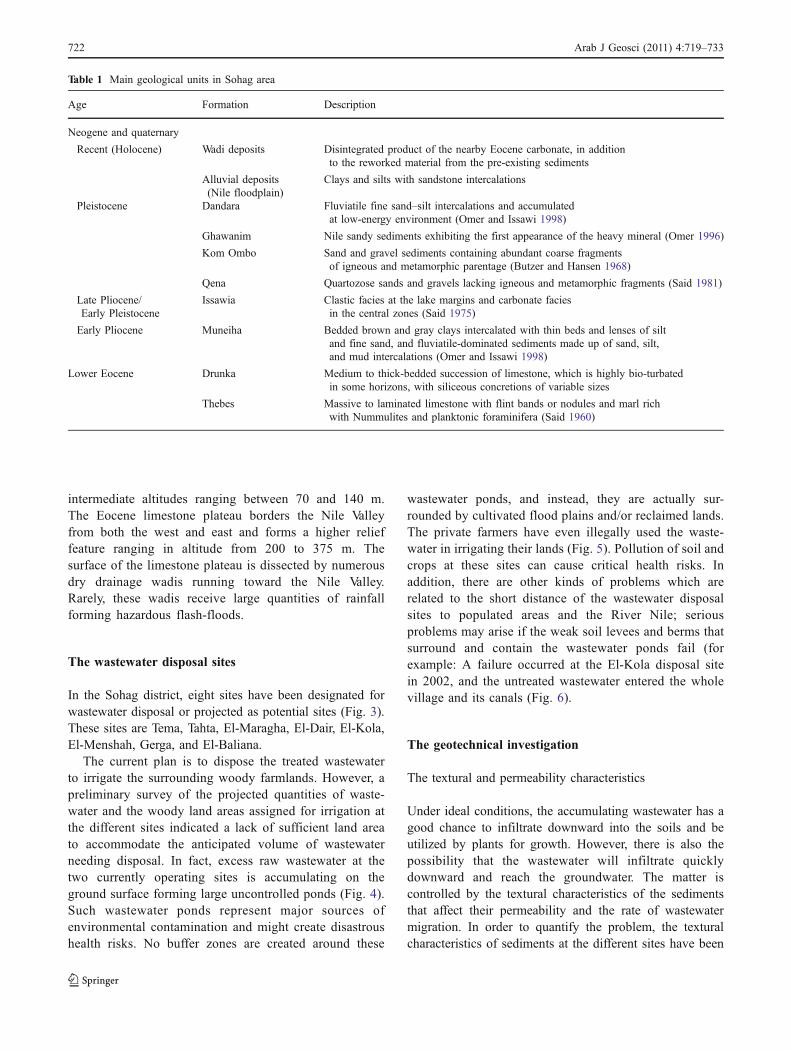
Lower Eocene to Recent (Fig. 2); the main units aresummarized in Table 1.
Geomorphology of the area
The Sohag area is characterized by three main geomorpho-logic features: the Nile floodplain, the lowland desert area,and the Eocene limestone plateau. The Nile floodplainincludes the nearby and leveled cultivated lands distributedalong both the eastern and western sides of the River Nile.They are formed of fertile clay and silt sediments used forfarming activities. The Nile floodplain is almost flat andslopes gently northward; its altitude in Sohag provinceranges between 55 and 65 m. The lowland desert areasextend along both sides of the Nile Valley between thecultivated flood plain and the Eocene limestone plateau.These areas form the old alluvial plains, and they arerepresented by a series of successive terraces with
Fig. 2 Geological map of thestudy area
Arab J Geosci (2011) 4:719–733 721
intermediate altitudes ranging between 70 and 140 m.The Eocene limestone plateau borders the Nile Valleyfrom both the west and east and forms a higher relieffeature ranging in altitude from 200 to 375 m. Thesurface of the limestone plateau is dissected by numerousdry drainage wadis running toward the Nile Valley.Rarely, these wadis receive large quantities of rainfallforming hazardous flash-floods.
The wastewater disposal sites
In the Sohag district, eight sites have been designated forwastewater disposal or projected as potential sites (Fig. 3).These sites are Tema, Tahta, El-Maragha, El-Dair, El-Kola,El-Menshah, Gerga, and El-Baliana.
The current plan is to dispose the treated wastewaterto irrigate the surrounding woody farmlands. However, apreliminary survey of the projected quantities of waste-water and the woody land areas assigned for irrigation atthe different sites indicated a lack of sufficient land areato accommodate the anticipated volume of wastewaterneeding disposal. In fact, excess raw wastewater at thetwo currently operating sites is accumulating on theground surface forming large uncontrolled ponds (Fig. 4).Such wastewater ponds represent major sources ofenvironmental contamination and might create disastroushealth risks. No buffer zones are created around these
wastewater ponds, and instead, they are actually sur-rounded by cultivated flood plains and/or reclaimed lands.The private farmers have even illegally used the waste-water in irrigating their lands (Fig. 5). Pollution of soil andcrops at these sites can cause critical health risks. Inaddition, there are other kinds of problems which arerelated to the short distance of the wastewater disposalsites to populated areas and the River Nile; seriousproblems may arise if the weak soil levees and berms thatsurround and contain the wastewater ponds fail (forexample: A failure occurred at the El-Kola disposal sitein 2002, and the untreated wastewater entered the wholevillage and its canals (Fig. 6).
The geotechnical investigation
The textural and permeability characteristics
Under ideal conditions, the accumulating wastewater has agood chance to infiltrate downward into the soils and beutilized by plants for growth. However, there is also thepossibility that the wastewater will infiltrate quicklydownward and reach the groundwater. The matter iscontrolled by the textural characteristics of the sedimentsthat affect their permeability and the rate of wastewatermigration. In order to quantify the problem, the texturalcharacteristics of sediments at the different sites have been
Table 1 Main geological units in Sohag area
Age Formation Description
Neogene and quaternary
Recent (Holocene) Wadi deposits Disintegrated product of the nearby Eocene carbonate, in additionto the reworked material from the pre-existing sediments
Alluvial deposits(Nile floodplain)
Clays and silts with sandstone intercalations
Pleistocene Dandara Fluviatile fine sand–silt intercalations and accumulatedat low-energy environment (Omer and Issawi 1998)
Ghawanim Nile sandy sediments exhibiting the first appearance of the heavy mineral (Omer 1996)
Kom Ombo Sand and gravel sediments containing abundant coarse fragmentsof igneous and metamorphic parentage (Butzer and Hansen 1968)
Qena Quartozose sands and gravels lacking igneous and metamorphic fragments (Said 1981)
Late Pliocene/Early Pleistocene
Issawia Clastic facies at the lake margins and carbonate faciesin the central zones (Said 1975)
Early Pliocene Muneiha Bedded brown and gray clays intercalated with thin beds and lenses of siltand fine sand, and fluviatile-dominated sediments made up of sand, silt,and mud intercalations (Omer and Issawi 1998)
Lower Eocene Drunka Medium to thick-bedded succession of limestone, which is highly bio-turbatedin some horizons, with siliceous concretions of variable sizes
Thebes Massive to laminated limestone with flint bands or nodules and marl richwith Nummulites and planktonic foraminifera (Said 1960)
722 Arab J Geosci (2011) 4:719–733

measured, and the hydraulic conductivity, which is ameasure of the sediment ability to transmit water, wascalculated (Table 2 and Fig. 7).
The hydraulic conductivity depends chiefly on thecompaction and textural characteristics of sediments.Table 3 shows the standard classification of the hydraulicconductivity (Reynolds 1993).
It is observed that the majority of the sedimentsamples in this study are classified as sand, silty sand,or muddy sand. The hydraulic conductivity ranges from1.13 to 21.4 cm/h (Table 2), reflecting moderate to highpermeability for these sediments. The sediments are soconductive that we would expect the wastewater tomigrate quickly downward and reach the groundwater.It is to be expected that an identical scenario will occurat the various proposed wastewater disposal sites alongthe Nile Valley, probably resulting in terrible environmentaland health problems for those using the groundwaterresources.
Cross-section model for the study area
Exploratory field observations were carried out to gainfamiliarity with the general conditions in the area, and across-section from west to east was chosen according tothe wastewater disposal sites location (Fig. 8). Thedetailed cross-section model is presented in Fig. 9 whichwill help in visualizing the degree of the aquifer pollution.The cross-section is oriented as much as possible to gothrough the middle of each wastewater site (Fig. 8). Thecross-section indicates a nearly flat surface especially forthe floodplain zone and a gentle-to-moderate slope fromwest and east toward the floodplain. The limited well logdata was used from recent wells drilled very close to thesites to understand the thickness model for the ground-water aquifer in the area. To make the situation simple soas to make the problem clear for the policy makers, ithas been assumed that the aquifer is a homogeneousmaterial.
Fig. 3 Wastewater disposallocations with the simplifiedgeomorphological map for thestudy area
Arab J Geosci (2011) 4:719–733 723

Fig. 6 Crisis occurs in 2002 (El Kola Site), the wastewater dam failed, and all the wastewater flowed into the city and created the biggestenvironmental threat in the area. a Wastewater floods the nearby village, b government camp for the homeless people
Fig. 5 Risks of presence of reclaimed and agricultural lands close to wastewater disposal sites. a Private farmers irrigate their farms withwastewater (El-Dair). b Farmers collect their products that were irrigated with untreated wastewater (El-Dair)
Fig. 4 a Wastewater ponds with islands of bio-solids (El-Dair) and b Wastewater ponds look like a huge lake (El Kola)
724 Arab J Geosci (2011) 4:719–733

The data obtained from the cross-section made itobvious that the east side of El-Kola site may have aunique geologic feature in the area as the thick Plioceneclay, which is very close to the surface. This may causelittle infiltration of wastewater causing dangerous pond ofthe wastewater at the surface. On the other hand, the westcross-section indicates that the groundwater aquifer may beat risk of rapid infiltration because most of the materials inthe area are permeable sands and gravels.
Land use maps
The proper assessment of the suitability of an area forwastewater disposal must consider not just the surfacesediment properties, groundwater aquifer conditions, andgeological setting but must also consider potential andcurrent land use. Most of the land characteristics weredetermined directly during the field survey. Consequently,
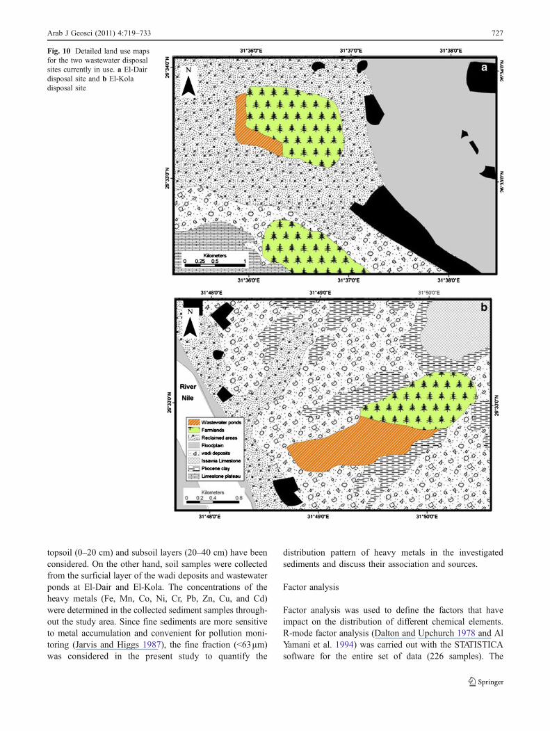
general and detailed land use maps have been prepared(Figs. 10 and 11). Land use maps were established for thewhole area from west to east and include three main units(reclaimed zone, floodplain zone, and wadi deposits) asdisplayed in Fig. 10. Additionally, comprehensive land usemaps were prepared for the currently operating sites(El-Dier and El Kola). The two sites include eight landuse units that differ in their details (Fig. 11).
Analysis and interpretation of geochemical data
Sampling and chemical analyses
Protecting the groundwater from contamination is a primaryconcern in any land application of wastewater. Leakage ofthe wastewater downwards to the groundwater aquiferrepresents a very real threat at these sites. There are twotypes of groundwater contamination which are fromwastewater leaking: (a) bacterial and viral contaminationand (b) chemical contamination by both organic andinorganic constituents. To initiate an investigation of thisproblem, a systematic method was used to collect field dataand examine the geochemical characteristics of the soil.
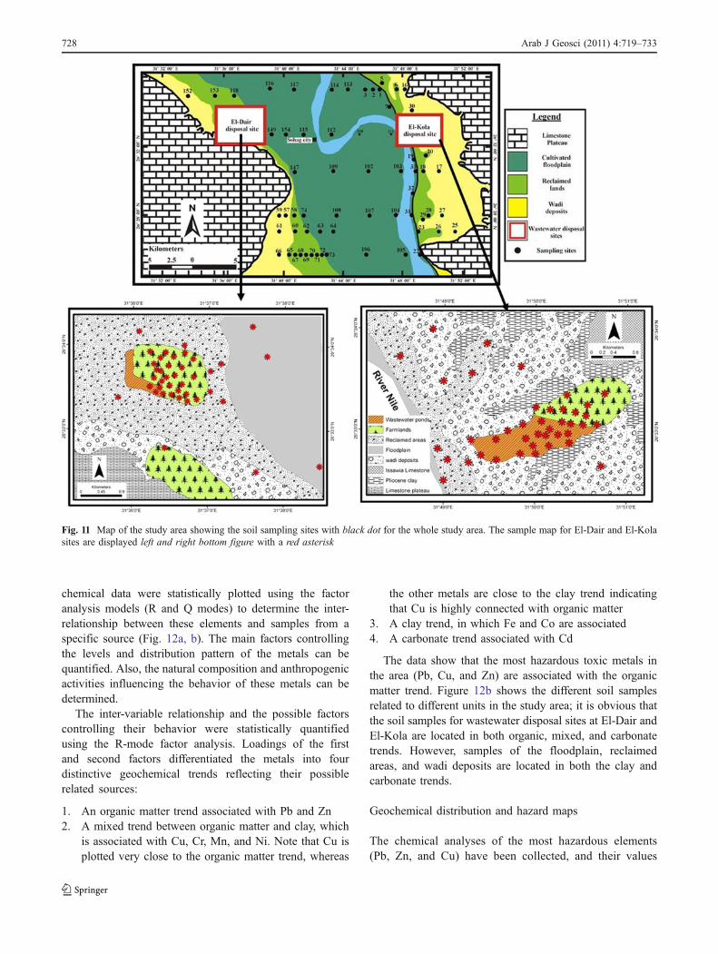
Accordingly, 226 samples distributed through 144locations were collected from the concerned land uses(Fig. 11). The sampling procedure described by USDA(1996) was followed in the present study. The samplingcovers the cultivated floodplain, the reclaimed lands, andthe wastewater farmlands at El-Dair and El Kola; both the
Table 3 Classification of the hydraulic conductivity values
Classnumber
Hydraulic conductivity(cm/h)
Description
1 0.125 to 0.5 Low conductivity
2 0.5 to 12.5 Moderate conductivity
3 12.5 to more than 25 High conductivityFig. 7 The texture characteristics for the wastewater disposal sites
Site Texture Hydraulic conductivity (cm/h) Porosity (%)
Tema Silty Sand–Sand 2.81–16.5 26.4–41.1
Tahta Silty Sand–Sand 6.84–21.4 24.9–35.8
El-Maraga Silty Sand–Sand 6.3–20.9 22.6–36.3
El-Kola Silty Sand 1.5–5.22 36.2–44.2
Gerga Silty Sand 2.97–3.88 27.2–41.5
El-Dir Muddy Sand–Silty Sand–Sand 1.13–15.3 30.9–46.8
El-Menshah Silty Sand–Sand 1.83–18.7 27.5–43.8
El–Baliana Muddy Sand–Silty Sand–Sand 4.02–17.2 17.4–39.2
Table 2 Texture, hydraulic con-ductivity, and porosity ranges ofthe different wastewater sites
Arab J Geosci (2011) 4:719–733 725

Fig. 9 The detailed cross-section from west to east along the in-use sites
Fig. 8 General land use map for the Sohag city area (two black rectangles represent the El-Dair on left and El-Kola on the right wastewater sites;c–c′ is the cross-section; drawing by ARCGIS)
726 Arab J Geosci (2011) 4:719–733
topsoil (0–20 cm) and subsoil layers (20–40 cm) have beenconsidered. On the other hand, soil samples were collectedfrom the surficial layer of the wadi deposits and wastewaterponds at El-Dair and El-Kola. The concentrations of theheavy metals (Fe, Mn, Co, Ni, Cr, Pb, Zn, Cu, and Cd)were determined in the collected sediment samples through-out the study area. Since fine sediments are more sensitiveto metal accumulation and convenient for pollution moni-toring (Jarvis and Higgs 1987), the fine fraction (<63µm)was considered in the present study to quantify the
distribution pattern of heavy metals in the investigatedsediments and discuss their association and sources.
Factor analysis
Factor analysis was used to define the factors that haveimpact on the distribution of different chemical elements.R-mode factor analysis (Dalton and Upchurch 1978 and AlYamani et al. 1994) was carried out with the STATISTICAsoftware for the entire set of data (226 samples). The
Fig. 10 Detailed land use mapsfor the two wastewater disposalsites currently in use. a El-Dairdisposal site and b El-Koladisposal site
Arab J Geosci (2011) 4:719–733 727
chemical data were statistically plotted using the factoranalysis models (R and Q modes) to determine the inter-relationship between these elements and samples from aspecific source (Fig. 12a, b). The main factors controllingthe levels and distribution pattern of the metals can bequantified. Also, the natural composition and anthropogenicactivities influencing the behavior of these metals can bedetermined.
The inter-variable relationship and the possible factorscontrolling their behavior were statistically quantifiedusing the R-mode factor analysis. Loadings of the firstand second factors differentiated the metals into fourdistinctive geochemical trends reflecting their possiblerelated sources:
1. An organic matter trend associated with Pb and Zn2. A mixed trend between organic matter and clay, which
is associated with Cu, Cr, Mn, and Ni. Note that Cu isplotted very close to the organic matter trend, whereas
the other metals are close to the clay trend indicatingthat Cu is highly connected with organic matter
3. A clay trend, in which Fe and Co are associated4. A carbonate trend associated with Cd
The data show that the most hazardous toxic metals inthe area (Pb, Cu, and Zn) are associated with the organicmatter trend. Figure 12b shows the different soil samplesrelated to different units in the study area; it is obvious thatthe soil samples for wastewater disposal sites at El-Dair andEl-Kola are located in both organic, mixed, and carbonatetrends. However, samples of the floodplain, reclaimedareas, and wadi deposits are located in both the clay andcarbonate trends.
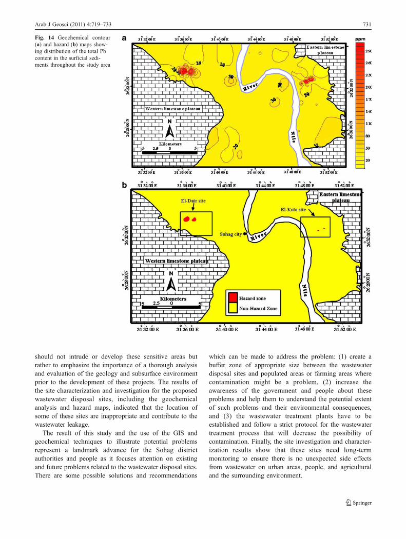
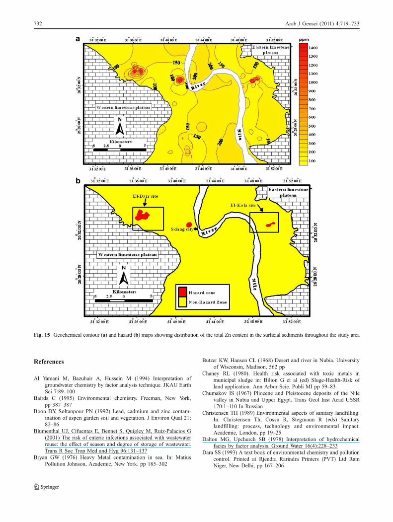
Geochemical distribution and hazard maps
The chemical analyses of the most hazardous elements(Pb, Zn, and Cu) have been collected, and their values
Fig. 11 Map of the study area showing the soil sampling sites with black dot for the whole study area. The sample map for El-Dair and El-Kolasites are displayed left and right bottom figure with a red asterisk
728 Arab J Geosci (2011) 4:719–733

were used to draw a contour distribution map for eachelement using the interpolation function in spatialanalyst tool in GIS. For the creation of the hazardmap, the values of the distribution maps that wereprepared previously for each element were classifiedaccording to the allowable element level (Kabata-Pendias and Pendias 1992; Kabata Pendias 1995;Kabata-Pendias 2000) using the classification tool inspecial analyst (Figs. 13, 14, and 15). Both the contourdistribution maps and the hazard maps are preparedusing ArcGIS 9.0 and Surfer 8. Among all the analyzed
heavy metals, the soil at waste disposal sites was foundto be highly contaminated with lead (Pb), copper (Cu),and zinc (Zn).
In general, the principal source of lead (Pb) is thecombustion of leaded gasoline used in automobiles.Besides this, lead (Pb) is also being used in a numberof industries as an essential manufacturing element.Paint, pipes, dye-making, and battery manufacturingindustries are examples of those which might besources of lead. Cu and Zn are also related toindustrial wastes and vehicle emission (Prokop et al.
Fig. 12 Plots of the first andsecond principle components(factor analysis). a R-mode andb Q-mode
Arab J Geosci (2011) 4:719–733 729

2003). Copper and zinc are also very harmful and toxicmetals.
Geographic information systems enabled us to isolatethe most hazardous areas and look into the cause-and-effect relationships with a readily understandable visualpresentation. Developed figures clearly show that thesoil surrounding the wastewater sites are already pollut-ed with toxic metals that are coming from the industrialand day-to-day activities of the population; there doesappear to be a relationship between these toxic sub-stances and the wastewater and organic matter. However,there are other locations where Zn and Cu occur in areasfar away from the waste disposal sites. The pollution inareas far from the waste disposal sites is related to dense
traffic locations, choking nodes, and major industrialzones.
Conclusion
The work presented in this manuscript has focused on theinvestigation and characterization of wastewater disposalsites using geotechnical, geochemical, and GIS land usetechniques. Although somewhat limited in scope, our workshows that the use of GIS and its rather straightforwardpresentation of complicated data can assist in presentingsuch complicated information to the public and policymakers. It is not our intention to conclude that humans
Fig. 13 Geochemical contour(a) and hazard (b) maps show-ing distribution of the total Cucontent in the surficial sedi-ments throughout the study area
730 Arab J Geosci (2011) 4:719–733
should not intrude or develop these sensitive areas butrather to emphasize the importance of a thorough analysisand evaluation of the geology and subsurface environmentprior to the development of these projects. The results ofthe site characterization and investigation for the proposedwastewater disposal sites, including the geochemicalanalysis and hazard maps, indicated that the location ofsome of these sites are inappropriate and contribute to thewastewater leakage.
The result of this study and the use of the GIS andgeochemical techniques to illustrate potential problemsrepresent a landmark advance for the Sohag districtauthorities and people as it focuses attention on existingand future problems related to the wastewater disposal sites.There are some possible solutions and recommendations
which can be made to address the problem: (1) create abuffer zone of appropriate size between the wastewaterdisposal sites and populated areas or farming areas wherecontamination might be a problem, (2) increase theawareness of the government and people about theseproblems and help them to understand the potential extentof such problems and their environmental consequences,and (3) the wastewater treatment plants have to beestablished and follow a strict protocol for the wastewatertreatment process that will decrease the possibility ofcontamination. Finally, the site investigation and character-ization results show that these sites need long-termmonitoring to ensure there is no unexpected side effectsfrom wastewater on urban areas, people, and agriculturaland the surrounding environment.
Fig. 14 Geochemical contour(a) and hazard (b) maps show-ing distribution of the total Pbcontent in the surficial sedi-ments throughout the study area
Arab J Geosci (2011) 4:719–733 731
References
Al Yamani M, Bazuhair A, Hussein M (1994) Interpretation ofgroundwater chemistry by factor analysis technique. JKAU EarthSci 7:89–100
Bairds C (1995) Environmental chemistry. Freeman, New York,pp 387–387
Boon DY, Soltanpour PN (1992) Lead, cadmium and zinc contam-ination of aspen garden soil and vegetation. J Environ Qual 21:82–86
Blumenthal UJ, Cifuentes E, Bennet S, Quigley M, Ruiz-Palacios G(2001) The risk of enteric infections associated with wastewaterreuse: the effect of season and degree of storage of wastewater.Trans R Soc Trop Med and Hyg 96:131–137
Bryan GW (1976) Heavy Metal contamination in sea. In: MatiusPollution Johnson, Academic, New York. pp 185–302
Butzer KW, Hansen CL (1968) Desert and river in Nubia. Universityof Wisconsin, Madison, 562 pp
Chaney RL (1980). Health risk associated with toxic metals inmunicipal sludge in: Bilton G et al (ed) Sluge-Health-Risk ofland application. Ann Arbor Scie. Publi MI pp 59–83
Chumakov IS (1967) Pliocene and Pleistocene deposits of the Nilevalley in Nubia and Upper Egypt. Trans Geol Inst Acad USSR170:1–110 In Russian
Christensen TH (1989) Environmental aspects of sanitary landfilling.In: Christensen Th, Cossu R, Stegmann R (eds) Sanitarylandfilling: process, technology and environmental impact.Academic, London, pp 19–25
Dalton MG, Upchurch SB (1978) Interpretation of hydrochemicalfacies by factor analysis. Ground Water 16(4):228–233
Dara SS (1993) A text book of environmental chemistry and pollutioncontrol. Printed at Rjendra Rarindra Printers (PVT) Ltd RamNiger, New Delhi, pp 167–206
Fig. 15 Geochemical contour (a) and hazard (b) maps showing distribution of the total Zn content in the surficial sediments throughout the study area
732 Arab J Geosci (2011) 4:719–733
Fischbein A (1992) Occupational and environmental lead exposure.In: Ron WN (ed) Environment and occupational medicine. LittleBrown, Boston, pp 735–736
Issawi B, McCauley JF (1992) The Cenozoic rivers of Egypt: the Nileproblem. In: Freidman R, Adams B (eds) The Followers ofHorus, Egypt: Studies Assoc. Public., no.2, Oxbow Monog. 20.Park End Place, Oxford, pp 121–138
Issawi B, Hassan MW, Osman R (1978) Geological studies in the areaof Kom Ombo, Eastern Desert, Egypt. Ann Geol Survey Egypt.VIII:187–235
Jarvis I, Higgs N (1987) Trace-element mobility during earlydiagenesis in distal turbidites: late Quaternary of the MadeiraAbyssal Plain, N Atlantic. Geological Society, London, SpecialPublications 31:179–214
Kabata Pendias A (1995) In: Salomons W, Förstner U, Mader P (eds)Agricultural problems related to excessive trace metal contents ofsoil, in “Heavy Metals (Problems and Solutions)”. Springer,Berlin, pp 3–18 Heidelberg, New York, London, Tokyo
Kabata-Pendias A (2000) Trace elements in soils and plants, 3rd edn.CRC, Boca Raton
Kabata-Pendias A, Pendias H (1992) Trace elements in soils andplants, 2nd edn. CRC, Boca Raton
Huges Mk, Lepp Nw, Phipps DA (1980) Arial heavy metal pollutionand terrestrial ecosystem. Advance Ecol Research 11:217–227
Miller DM, Miller WP (2000) Land application of wastes. In: SummerME (ed) Handbook of soil science. CRC, New York
Odukoya OO, Ajayi SO (1987) Trace metals in Nigeria fish. Niger JNutr Sci 3(2):105–113
Omer AA (1996) Geological, mineralogical and geochemical studieson the Neogene and Quaternary Nile basin deposits, Qena-Assiutstretch, Egypt. Ph.D. thesis, Geology Dept. Faculty of Science,Sohag, South Valley University, p 320
Omer AA, Issawi B (1998) Lithostratigraphical, mineralogical andgeochemical studies on the Neogene and Quaternary Nile basindeposits, Qena-Assiut stretch, Egypt. The 4th Internationalconference on Geology of the Arab World, Cairo. (Abstract)
Paulissen M, Vermeersch PM (1987) Earth, man and climate in theEgyptian Nile Valley during the Pleistocene. In: Close A (ed)Prehistory of North Africa. Southern Methodist University Press,Dallas, pp 29–67
Prokop Z, Cupr P, Zlevorova-Zlamalikova V, Komarek J, Dusek L,Holoubek I (2003) Mobility, bioavailability, and toxic effects ofcadmium in soil samples. Environ Res 91(2):119–126
Reynolds WD (1993) Saturated hydraulic conductivity laboratorymeasurement. In: Carter MR (ed) Soil sampling and methodsanalysis. Canadian Society of Soil Sci., Lewis, Boca Raton,pp 589–598
Said R (1960) Planktonic foraminifera from Thebes Formation, Luxor.Micropaleont 6:277–286
Said R (1975) The Geological evolution of the River Nile. In: WendorfF, Maks AF (eds) Problems in prehistory of Northern Africa andthe Levant. Southern Methodist University Press, Dallas, pp 1–44
Said R (1981) The geological evaluation of the River Nile. Springer,New York, p 151
Said R (1983) Proposed classification of the Quaternary of Egypt.J Afr Earth Sci 1:41–45
Said R (1990) The Geology of Egypt. Egyptian General PetroleumCorporation, Conoco, Hurghada Inc. and Repsol Exploration,S.A., Balkema, Rotterdam, Brookfield, pp 731
Shuval HI, Wax Y, Yekutiel P, Fattal B (1989) Transmission ofenteric disease associated with wastewater irrigation: a pro-spective epidemiological study. Am J Public Health 79(7):850–852
Smith CJ, Hopmans P, Cook FJ (1996) Accumulation of Cr, Pb, Cu,Ni Zn and Cd in soil following irrigation with untreated urbaneffluents in Australia. Environ Pollut 94(3):317–323
USDA (1996) Soil survey laboratory methods manual. Soil surveyinvestigations. Report No.42, V.3, Washington, D. C.
Wendorf F, Said R (1967) Paleolithic remains in Upper Egypt. Nature215:244–247
Wendorf F, Schild R (1976) Prehistory of the Nile Valley. Academic,New York, p 404
Arab J Geosci (2011) 4:719–733 733