Geospatial Information Broker. A new role of national mapping agencies
10
No.4, Year 2015 www.geo-see.org ISSN: 1857-9000 (printed version), 1857-9019 (electronic version) 1 1 GEOSPATIAL INFORMATION BROKER. A NEW ROLE OF NATIONAL MAPPING AGENCIES Joep CROMPVOETS 1 and Bruno BROUCKER 2 ABSTRACT The purpose of this paper is this paper is to better understand the meaning of the role of geospatial information broker for national mapping agencies and to stimulate discussion about the changing role of the national mapping agencies. The concept of geospatial information broker is introduced, defined and explained followed by a compilation of existing geospatial information broker examples and applications facilitating the broker role. The paper ends with a shortlist of issues for discussion on the way to move forward. Key words: Geospatial information broker, National Mapping Agency INTRODUCTION National mapping agencies around the world have a key role in the provision of geospatial information and be substantial users of geospatial data; however, their role may well change in the coming years. Nevertheless they will continue to be vital. Building bridges between other public organisations, collaborating with other areas of the geospatial information community and, most importantly, providing complete geospatial frameworks with trusted, authoritative and maintained geospatial information, will be crucial to ensuring that users have access to reliable and trusted geospatial information and have confidence when using it (United Nations Committee of Experts on Global Geospatial Information Management, 2013). This information is vital to inform decision‑making, from long‑term planning to emergency response, and to ensure that the 1 Prof. Dr. Joep CROMPVOETS, [email protected] KU Leuven Public Governance Institute http://www.publicgov.eu Tel. +32 16323134 Address: Parkstraat 45, Bus 3609, 3000, B-3000, Leuven, Belgium 2 Dr. Bruno BROUCKER, [email protected] KU Leuven Public Governance Institute http://www.publicgov.eu Tel. +32 16373526 Address: Parkstraat 45, Bus 3609, 3000, B-3000, Leuven, Belgium
Transcript of Geospatial Information Broker. A new role of national mapping agencies
No.4, Year 2015
www.geo-see.org ISSN: 1857-9000 (printed version), 1857-9019 (electronic version)
1 1
GEOSPATIAL INFORMATION BROKER.
A NEW ROLE OF NATIONAL MAPPING AGENCIES
Joep CROMPVOETS1 and Bruno BROUCKER
2
ABSTRACT
The purpose of this paper is this paper is to better understand the meaning of the
role of geospatial information broker for national mapping agencies and to
stimulate discussion about the changing role of the national mapping agencies. The
concept of geospatial information broker is introduced, defined and explained
followed by a compilation of existing geospatial information broker
examples and applications facilitating the broker role. The paper ends with a
shortlist of issues for discussion on the way to move forward.
Key words: Geospatial information broker, National Mapping Agency
INTRODUCTION
National mapping agencies around the world have a key role in the provision
of geospatial information and be substantial users of geospatial data;
however, their role may well change in the coming years. Nevertheless they
will continue to be vital. Building bridges between other public
organisations, collaborating with other areas of the geospatial information
community and, most importantly, providing complete geospatial
frameworks with trusted, authoritative and maintained geospatial
information, will be crucial to ensuring that users have access to reliable and
trusted geospatial information and have confidence when using it (United
Nations Committee of Experts on Global Geospatial Information
Management, 2013). This information is vital to inform decision‑making,
from long‑term planning to emergency response, and to ensure that the
1 Prof. Dr. Joep CROMPVOETS, [email protected]
KU Leuven Public Governance Institute
http://www.publicgov.eu Tel. +32 16323134
Address: Parkstraat 45, Bus 3609, 3000, B-3000, Leuven, Belgium 2 Dr. Bruno BROUCKER, [email protected]
KU Leuven Public Governance Institute
http://www.publicgov.eu Tel. +32 16373526
Address: Parkstraat 45, Bus 3609, 3000, B-3000, Leuven, Belgium
Nr.4, Viti 2015
UDC: 528.4 Geo-SEE Institute
2 2
potential benefits of a fully spatially‑enabled society are realised (Rajabifard
et al., 2010).
As such, national mapping agencies remain in a unique position to consider
the requirements for geospatial information for society as a whole and
continue to play a key role in providing a reliable, trusted and maintained
geospatial base. Additional data from multiple sources offer a significant opportunity to enrich existing and future databases. As such, and combined
with pressures to reduce costs, it will be increasingly important in the years
to come to facilitate collaboration between all sources of information. This
may include actively encouraging the collection of additional information
and providing frameworks to incorporate the data in a structured way
(Crompvoets and Kruk, 2014; Vanden Berghe, 2014; Masser and
Crompvoets, 2015).
As more organisations are involved in the collection and distribution of
geospatial information, the geospatial marketplace also likely witnesses
change. As well as having a vital role in ensuring the availability of a trusted
geospatial information base, public geospatial bodies may need to grow their
awareness and understanding of the geospatial marketplace to ensure that
competition and practices continue to remain fair (United Nations
Committee of Experts on Global Geospatial Information Management,
2013).
Given the proliferation of additional sources of data and potential
competition between stakeholders, however, we may see national mapping
agencies taking on a role that shifts towards a broker role. In a trend that has
already started to emerge, mapping agencies may increasingly no longer see
it necessary to collect all geospatial information required themselves, but
may instead commission the data from the most appropriate and suitable
source, be that local government, the private sector or, potentially, a citizen.
(Lovell and Crompvoets, 2014). Moreover, national mapping agencies are
taking on a role that shifts more towards a policy, advisory and procurement
role (United Nations Committee of Experts on Global Geospatial
Information Management, 2013).
National mapping that have previously primarily played the role of data
collector are moving towards a role of commissioning and managing the
delivery of a complete geospatial framework. In this role, national mapping
agencies are likely to continue to be relied on to ensure that data is captured
and integrated from multiple sources, and to provide a trusted geospatial

No.4, Year 2015
www.geo-see.org ISSN: 1857-9000 (printed version), 1857-9019 (electronic version)
3 3
framework that can be relied on by users in their decision-making processes
(Lovel and Crompvoets, 2014; Vanden Berghe, 2014).
The increasing use of authoritative, trusted geospatial information drives the
adoption of geospatial information and ensures that it reaches ubiquity in the
government and business decision-making process, as well as in the
consumer sphere. Increasing recognition of the value inherent in the data
means that national mapping agencies are likely to become more closely
aligned with other „official‟ bodies in government who look after, for
example, statistics, the economy or land. National mapping agencies as part
of governments will have a vital role in ensuring that frameworks are in
place that enable the effective cooperation and collaboration between the
plurality of actors that will increasingly be involved in the provision,
management and/or use of geospatial information, and in ensuring that the
benefits that a spatially-enabled society has the potential to offer, are realised
(United Nations Committee of Experts on Global Geospatial Information
Management, 2013; Crompvoets and Kruk, 2014).
This all challenges the role of the national mapping agencies as the sole
supplier of, and authority on national geospatial information. Considerable
public funds are currently channeled into the collection by public authorities
of data that may already exist in the private sector or other parts of
government, or may be better collected by means other than the traditional
methods of national mapping agencies.
In the face of this challenge, the national mapping agencies must
acknowledge the changing marketplace and view the proliferation of data,
not as direct competition, but as an opportunity to improve the overall
quality, coverage and richness of geospatial datasets. They must: relinquish
their self-image as the sole and natural collector and distributor of geospatial
data; give up the insistence on the centralised collection of all data in their
territory where cheaper, more efficient, higher quality alternatives exist; and
seek new opportunities to capitalise on their uniquely strong position as
trusted arbiters in the geospatial field. The improved visibility and quality of
geospatial information will in turn drive greater adoption of Geographic
Information Systems (GIS). The national mapping agencies‟ opportunity to
remain a vital part of society depends on their willingness for mutually
beneficial collaboration with the broader geospatial society and to align
more closely with other government organisations to promote and coordinate
the wider use and perceived value of geospatial data. One response to the
change in market dynamic might be to take on the role of geospatial
information broker.

Nr.4, Viti 2015
UDC: 528.4 Geo-SEE Institute
4 4
This paper aims to better understand the meaning of the role of geospatial
information broker for national mapping agencies and to stimulate
discussion about the changing role of the national mapping agencies.
In the next section the role of geospatial information broker will be defined
followed by a compilation of existing geospatial broker examples and
applications facilitating the broker role. The paper ends with a shortlist of
issues for discussion on the way to move forward.
GEOSPATIAL INFORMATION BROKER
A broker provides a service that brings buyers and sellers together and
facilitates a transaction, either on behalf of a buyer or of a seller (Lovell and
Crompvoets, 2014). In general a broker is an independent agent. A broker‟s
prime responsibility is to bring sellers and buyers together and thus a broker
is the third-person facilitator between a buyer and a seller. An example
would be a real estate broker who facilitates the sale of a property.
Brokers also can furnish market information regarding prices, products, and
market conditions. Brokers may represent either the seller or buyer but not
both at the same time. An example would be a stockbroker who makes the
sale or purchase of securities on behalf of his client (Spiro et al., 2003).
There are advantages to using a broker. First, they know their market and
have already established relations with prospective accounts. Brokers have
the tools and resources to reach the largest possible base of buyers. They
then screen these potential buyers for revenue that would support the
potential acquisition. An individual producer, on the other hand, especially
one new in the market, probably will not have the same access to customers
as a broker. Another benefit of using a broker is cost – they might be cheaper
in smaller markets, with smaller accounts, or with a limited line of products
(Wikipedia, 2015).
The word „broker‟ derives likely from the Old French brocheor, from
brochier meaning to broach, tap, pierce (a keg), or broche meaning pointed
tool giving original sense of wine dealer, hence retailer, middleman, agent
(Harper, 2015).
In the geospatial field, a broker would bring owners of data and services
providers together with end-users as an intermediary and facilitate a
No.4, Year 2015
www.geo-see.org ISSN: 1857-9000 (printed version), 1857-9019 (electronic version)
5 5
transaction between the two (including the arrangements of relevant
contracts and user conditions). The geospatial information broker might
undertake more than simply carrying out a transaction. This broker could
also facilitate the user access to the necessary geospatial data and enhances
the re-use and dissemination of existing geospatial data and services
supplied by the providers. Moreover, the geospatial information broker is
entrusted with the responsibility of researching the market to provide
appropriate recommendations and in so doing they direct the actions of
geospatial data and service managers (Crompvoets and Kruk, 2014; Lovell
and Crompvoets, 2014). In addition, they could also do additional services
such as geospatial data analyses and/or product(s) value adding, on demand.
The following terms are applied alternatives for the term „Geospatial
information broker‟: Geobroker, Spatial Data Broker, and Spatial Data
Intermediary. Although the terms are different, their roles are the same.
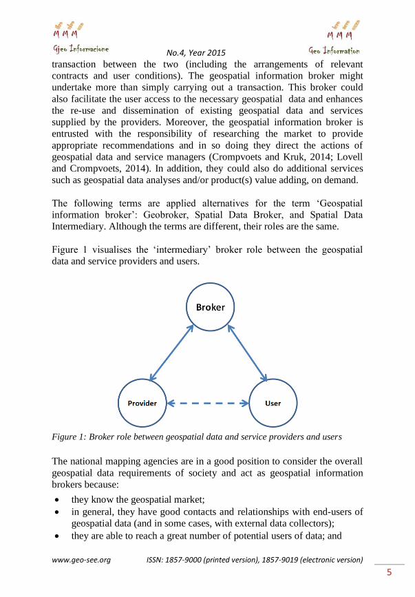
Figure 1 visualises the „intermediary‟ broker role between the geospatial
data and service providers and users.
Figure 1: Broker role between geospatial data and service providers and users
The national mapping agencies are in a good position to consider the overall
geospatial data requirements of society and act as geospatial information
brokers because:
they know the geospatial market;
in general, they have good contacts and relationships with end-users of
geospatial data (and in some cases, with external data collectors);
they are able to reach a great number of potential users of data; and

Nr.4, Viti 2015
UDC: 528.4 Geo-SEE Institute
6 6
they are trusted sources of data and respected authorities in the field.
It might be good if the national mapping agencies continue to work to
maximise their abilities in these areas.
In addition to a brokerage role, the national mapping agencies can also
provide services such as verification, data analysis and value-added products
and services, amongst others.
The role involves both an Inside-Out and an Outside-In transfer of data (and
services). The Inside-Out model refers to the obtaining of geospatial data
from across the (relevant) public sector and sold or distributed externally.
The Outside-In model procured from external sources and distributed across
different (relevant) levels and agencies of government. The resultant Inside-
In (in which geospatial data is centralised by the national mapping agencies
from across government and redistributed) and Outside-Out (externally
procured geospatial data that is integrated and subsequently redistributed
externally) models must be explored form the perspectives of governance,
finance, legality and implementation.
EXAMPLES
A number of national mapping agencies and other institutions at different
administrative levels have taken initiatives to move towards a geospatial
brokerage role:
The Geodatenportal Niedersachsen (www.geodaten.niedersachsen.de) of
the mapping agency of Lower Saxony (Landesamt für Geoinformation
und Landentwicklung Niedersachsen, Germany) - a portal providing
central access to the integrated use of geospatial data distributed by state
administration, local authorities and other sources;
Geobroker Brandenburg (http://geobroker.geobasis-bb.de) of the mapping
agency of Brandenburg (Landesvermessung und Geobasisinformation
Brandenburg, Germany) - an online shop bringing geospatial products
from a variety of providers to users/buyers;
FIS-Broker Geodata Management of the Berlin Senate Department for
Urban Development and Environment (http://www.stadtentwicklung.
berlin.de/geoinformation/fis-broker). The FIS-Broker provides online
access to maps, plans and other data. Central components are the
metadata information system and a viewer;
No.4, Year 2015
www.geo-see.org ISSN: 1857-9000 (printed version), 1857-9019 (electronic version)
7 7
Torino Geospatial Data Service Centre - an intermediary between
geospatial data users and providers of Turin (Italy);
The National Land Survey of Iceland have begun to explore the
brokerage model by:
- distributing information from external partners (including satellite
imagery from the Environment Agency);
- integrating data from partners into their own data sets (including from
transport authorities);
- buying data from external sources;
- collectively purchasing imagery in cooperation with other partners;
- collaborating with the Icelandic Institute of Natural History to provide
a geospatial website back-end;
- consulting in the field of an Icelandic spatial data infrastructure; and
- crowd-sourcing place names;
Through the Norway Digital project of Statens Kartverk, public sector
bodies pay an annual subscription to receive geographic information from
across government;
Through the Geovekst project, the Norwegian government subcontracts,
quality-checks, interprets and standardises data collection for new
infrastructure projects, as well as creating derivative services and
disseminating the data;
Currently in the European context, the website of EuroGeoInfo
(http://www.eurogeoinfo.eu/) performs half of the brokerage service by
aggregating the products of the national mapping and cadastral agencies of
Europe, and providing a means for end-users to quickly locate the products
they require. EuroGeoInfo does not, however, facilitate a transaction
(instead, simply directing the user to the seller). In the future, the
http://www.locationframework.eu website (developed by the European
Location Framework project (ELF)(Jakobsson et al, 2013)), performs the
brokerage service by aggregating the products of the national mapping and
cadastral authorities of Europe, and providing a means for end-users to
quickly locate the products they require, license and use them.
On the basis of the experiences of the brokerage role existing within national
mapping agencies, seven recurring activities can „preliminarily‟ be
identified: 1) Consulting on national spatial data infrastructures; 2)
Procurement of data; 3) Integration of data into own products; 4) Sale and
distribution of integrated products; 5) Sale and delivery of derivative
services; 6) Provision of back-end services to third-parties; and 7) Provision
Nr.4, Viti 2015
UDC: 528.4 Geo-SEE Institute
8 8
of services on behalf of external partners (Crompvoets and Kruk, 2014).
These identified activities need to be further investigated in the (near) future.
Other examples are: the Geospatial Portal of Abu Dhabi Spatial Information
Centre (http://geoportal. abudhabi.ae/geoportal/), GeoBase of the Canadian
Council on Geomatics (www.geobase.ca), MetroGIS Geospatial Services
Broker of the Land Management Information Centre of Minnesota
Department of Administration (USA), and NTLIS Spatial Data Broker of the
Northern Territory Government (Australia) (http://www.ntlis.nt.gov.au/).
APPLICATIONS FACILITATING THE GEOSPATIAL
INFORMATION BROKER ROLE
Several applications have recently been developed in order to facilitate the
implementation of the broker role. In this context, a broker application can
be considered as an service component that might include the following
modules (Nativi et al., 2011):
- User's request distribution (e.g. searches and composition of services)
in an asynchronous way (providing consistent feedbacks to users);
- Mediation (e.g. translation from the many provider and users service
models to the broker internal model, and vice-versa);
- Adaptation (e.g. between the many provider service protocols and the
users' ones, and vice-versa);
- Specific added-value functionalities to enrich the basic brokering
functionalities.
Examples of developed applications are:
- EUROGEOSS Broker (http://www.eurogeoss.eu/broker) - a multi-
disciplinary interoperability brokering framework on three levels (Nativi
et al., 2011; Gammon, 2012):
Discovery Broker - able to read and mediate among the many
standards and specifications used by different scientific
communities;
Access Broker - facilitating multi-disciplinary data access; and
Semantic Discovery Broker - translates concepts across different
disciplines;
- Web 2.0 Broker11 of the Universitat Jaume (Spain)
(http://www.geotec.uji.es/ web-2-0-browker/) - a development-stage
service for searching crowd-sourced (user/citizen generated) geospatial
information (Diaz et al., 2012);

No.4, Year 2015
www.geo-see.org ISSN: 1857-9000 (printed version), 1857-9019 (electronic version)
9 9
- The ESRI Geoportal Server (http://www.esri.com/software/arcgis/
geoportal - a free, open source server for connecting geospatial users with
resources from multiple organisations (ESRI, 2012); and
- Geobroker ® of ESG Elektroniksystem- und Logistik – GmbH (ESG,
2013) – A geospatial data management service.
MOVING FORWARD – ISSUES FOR DISCUSSION
This final section briefly presents issues for the way to move forward.
The brokerage model involves a substantial cultural and paradigm shift
within individual national mapping agencies and the geospatial community
at large. More further work is required to implement this shift while
maintaining the role of the national mapping agencies as the focal point of
the geospatial community, to:
develop business models under which the brokerage model can be made
financially viable and competition kept fair;
prepare institutions and the workforce for the changing role and new
dynamic;
move toward procuring data from external sources and integrating this
data with existing frameworks;
build technical and relational bridges between government agencies to
promote and implement the exchange of geospatial information and
explore the position of national mapping agencies as coordinator;
take steps to encourage collaboration between government mapping
agencies and the wider geospatial community;
develop the technical means of integrating the proliferation of data
sources and new procurement possibilities while ensuring the authority,
quality and integrity of the spatial data infrastructure;
promote the possible role of national mapping agencies as coordinators
of and advisors on geospatial community collaboration and use of
geospatial data within government; and
explore the legal ramifications of the change in market dynamic.
This all is in line with the continuing adaptation of national mapping
agencies to the needs of society, as they have done for many years. The
geospatial information broker role is just one opportunity worthy of
consideration.
Nr.4, Viti 2015
UDC: 528.4 Geo-SEE Institute
10 10
REFERENCES
1. Crompvoets, J., and Kruk, R: Introduction to “Geobroker”. Report of
project “Development of a Masterplan for NGI as Geobroker”. National
Geographic Institute – Belgium, 23 pages, 2014.
2. Díaz, L., Granell, C., Huerta, J., and Gould, M.: Web 2.0 Broker: A
standards-based service for spatio-temporal search of crowd-sourced
information. Applied Geography, 35(1-2): pp. 448-459, 2012.
3. ESG, 2013. Geobroker® - Intelligent geospatial data management.
4. ESRI, 2012. Geoportal as a Broker.
5. Gammon, K.: EuroGEOSS, Finding Common Ground for Earth Sciences.
Articles, Earth Observation GEOSS/ICEO News, Technology, 2012.
6. Harper, D.: Broker. OnlineEtymology Dictionary.
[http://www.etymonline.com/index.php?term=broker, Last access, 17
April 2015].
7. Jakobsson, A., Ostensen, O., Lovell, D., Hopfstock, A., Mellum, R.,
Kruse, D., Portele, C., Urbanas, S., Hartnor, J., Bray, A., and Aslesen, L.:
European Location Framework – One Reference Geo-Information
Service for Europe. Proceedings of the 26th International Cartographic
Conference, Dresden, Germany, August 25-30, 13 pages, 2013.
8. Lovell, D. and Crompvoets, J.: Brokers of geospatial information? Taking
advantage of the changing role of the national mapping agency.
EuroGeographics General Assembly, Chisinau, Moldova, September 29 –
October 1, 6 pages, 2014.
9. Masser, I., and Crompvoets: Building European Spatial Data
Infrastructures. ESRI Press, Redlands, CA, USA, 100 pages, 2015.
10. Nativi, S., Khalsa, S., Domenico, B., Craglia, M., Pearlman, J, Mazetti, P,
and Rew, R.: The Brokering Approach for Earth Science
Cyberinfrastructure. EarthCube White Paper, 2011.
11. Rajabifard, A., Crompvoets, J., Kalantari, M. and Kok, B., (Eds.):
Spatially Enabling Society, Research, Emerging Trends and Critical
Assessment. Leuven University Press, Leuven, Belgium, 248 pgs, 2010.
12. Spiro, R.L., Stanton, W.J., and Rich, G.A.: Management of a Sales Force.
12th edition, McGraw-Hill/Irwin, Boston, 2003.
13. United Nations Committee of Experts on Global Geospatial Information
Management: Future trends in geospatial information management: the
five to ten year vision. 2013, Third edition.
14. Vanden Berghe, I.: The changing role of national mapping authorities.
EuroGeographics General Assembly, Chisinau, Moldova, September 29 –
October 1, PPT, 2014.
15. Wikipedia: Broker. [http://en.wikipedia.org/wiki/Broker, Last access: 17
April 2015].