GEOMGNREGA Standard Operating Manual. - National ...
72
-
Upload
khangminh22 -
Category
Documents
-
view
0 -
download
0
Transcript of GEOMGNREGA Standard Operating Manual. - National ...

Contents
PARt-1: standard operating Procedure for GIs Implementation in Mahatma Gandhi nReGA
1. Executive Summary
2. Scope of Work
3. Audience & Stakeholders
4. Strategy
1. GIS Solution Phases
2. Roles and Responsibilities
3. NRSC, ISRO
4. Ministry of Rural Development
5. NIC- DoRD
6. C-GARD NIRD
5. Roll out
1. Roll out phases for software development
2. Phase-I
3. Data Flow Diagram
4. Phase-II
5. Phase-III
6. Scheduling
7. Rollout Waves for GIS implementation
8. Roll out stages of training and capacity building
9. Training Calendar
10. Training Modules
6. Organisation & Team
1. Central Level
2. State Level
7. Mobile Hardware
1. SOP for Mobile Device

PARt-2: Creation and Deletion of Assets in Mahatma Gandhi nReGA
1. Add New Asset/Existing Asset
2. Add asset id for the work completed in Previous Year
3. Delete secondary work from asset id
PARt-3: Bhuvan Geo-Portal & Mobile Application for Mahatma Gandhi nReGA Assets
I. Authorising MGnReGA Users
1. Introduction
2. MGNREGA user account activation process for District/Block/Panchayat Authority
3. Steps to authorize District Level authority and Block Level authority by State Level authority
4. Steps to authorize Panchayat Level authority by Block Level authority
5. Creating Bhuvan User Account
I. Location based services to geo-tag Assets
1. Introduction
2. Data connectivity
3. Download and Installation of Mobile app
4. Mobile GPS
5. Open Bhuvan MGNREGA mobile app
6. UserProfile/Registration
7. Data collection overview points
8. Data collection and Upload
8.1 Selection of work detail
8.2 Location data capture
8.3 Photograph capture and preview
8.4 Attributefilling
9. Save data for Sending Later
10. Managing your data
10.1 Send Data from Send later
1.1 Editing of Attributes in Send later option
1.2 Deletion of observation in Send later option
1.3 Data in Sent Failed option:
1.4 View Sent observation
1. How to know your device UUID?
2. Software maintenance activity
3. Help in the mobile
II. Bhuvan-MGnReGA Geoportal
Appendix-1:Acronyms&Definitions

Geo-MGNREGA Standard Operating Manual
1Ministry of Rural Development, Govt. of India
standard operating ProcedureFor GIs Implementation in Mahatma Gandhi nReGA
executive summary
Mahatma Gandhi National Rural Employment Guarantee Act (MGNREGA) aims at livelihood securityofpeopleinruralareasbyguaranteeinghundreddaysofwage-employmentinafinancialyearto a rural household whose adult members volunteer to do unskilled labour work. The Mahatma Gandhi NREGA sponsors various schemes for helping rural people below the poverty-line for creation of wage employment and productive assets. As per the information available with NREGASoft, around 30 lakh assetsare createdannuallyduringafinancial yearunderMahatmaGandhiNREGA.MinistryofRuralDevelopment proposes to use GIS solutions to visualize, analyse and explore such asset related data and alsomanagethemmoreeffectivelyalongwithbetterunderstandingoftheirimpact/outcome.
Government agencies like Department of Land Revenue, PMKSY, etc., have taken advantage of information technology and widely used it to store and maintain asset information.
RemoteSensing(RS)andGeographicalInformationSystem(GIS)canbeeffectivelyusedtocollect,store and analyse Mahatma Gandhi NREGA assets (Watershed locations, farm ponds, percolation tanks, check dams, road layer, irrigation channels, etc.). With the use of GIS in the area of asset management, it ispossibletovisualiseandunderstandthegeographicalcontextofanassetandimprovetheefficiencyofasset management. Spatial location is a major common aspect of all the asset data and GIS can map all the assets along with information for visualisation and proper decision making.
The Mahatma Gandhi NREGA GIS Solution intends to provide a single and integrated view of asset information system pan rural India. GIS enabled portal (e-Governance) will act as a gateway to facilitate and coordinate the exchange and sharing of geospatial data between stakeholders from various jurisdictional levels in the spatial data community. This will facilitate to search, locate and publish geospatial data wherein end users can access, share and publish (with appropriate log-in authenticity) in response to the needs of diverse user groups. The GIS enabled portal will maintain, process, store, distribute and improve the utilisation of geospatial data for planners, decision makers and public.
scope of Work
An interactive web GIS-based management System will maintain entire information of MGNREGA assets. The system will allow users to create new data, update existing data related to assets, generate queries,spatialquerysuchasbuffer,reports,maps,etc.ThiswillhelptheDepartment inpossessingavaluabledigitaldatabase(bothspatialandnon-spatial)fortheentirecountry.Properlydefinedcustomisedqueries will also be made available for day-to-day planning and management of the MGNREGA assets.
The broad scope of work for Mahatma Gandhi NREGA Geographical information system is
• Geo-referencing of satellite images and scanned images (assigning real world coordinates)
• GIs Mapping-CreationofDigitaldata(Assets)forpanruralIndiaforspecifiedworksasspecifiedin schedule I of MGNREGA Act.
• Design and Development of Centralised GIs Data Model (Spatial and Non-Spatial Layers) to store spatial and attribute information.
• Facilitate periodic capturing / updation / maintenance of existing asset information using Mobile GIs platform
• Geotagging of images and integrating with respective assets
Geo-MGNREGA Standard Operating Manual
2 Ministry of Rural Development, Govt. of India
• Publishing of the asset information using Web Mapping service (WMS) for citizens to visualise and give feedback in a crowd-sourcing architecture.
Audience & stakeholders
1. Mahatma Gandhi nReGA workers: They will be able to get information about work availability in the near locations, work site location information, real time transparent attendance, and payment information.
2. Citizens: By enabling Geo Portal for MGNREGA assets, the solution will generate demands, suggestions, critiques and data for both citizen and agency involved. This will enhance concurrent social audit by citizen and facilitate feedback information on work, quality validation, etc. to the DPC/ State Government who are implementing the program.
3. Central Government/state Government/PRIs/other PIAs/District Programme Coordinators/Programme Officers: Incorporation of geo-fencing of assets will allow setting upoftriggersforthesesetofstakeholders.WhentheGovernmentOfficerwithappropriateGPSenabled simple device enters (or exits) the boundaries defined by theMGNREGA asset, a textmessage or email alert is sent. All stakeholders can see the geographical location of assets on a map in the web management system. The Geo-NOC will enable audit and easy management assets.
With an integrated real time Geospatial database of the rural assets a composite map of the village can be seen with data from Census, Land Records, IWMP, Schools and all other Ministries. This will help in integratedplanning forworks (labourbudgets),optimisedconvergenceplansand facilitateeffectivemonitoring of implementation of works and creation of assets.
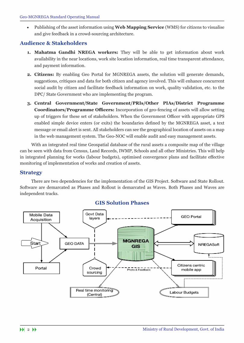
strategy
There are two dependencies for the implementation of the GIS Project. Software and State Rollout. Software are demarcated as Phases and Rollout is demarcated as Waves. Both Phases and Waves are independent tracks.
GIs solution Phases
Geo-MGNREGA Standard Operating Manual
3Ministry of Rural Development, Govt. of India
Roles and Responsibilities
nRsC, IsRo
1. An exclusive Bhuvan–MGNREGA Geo-portal for DoRD will be developed and deployed, with geotagged assets data and report generating tools.
2. A customised Android Mobile App for geo-tagging of completed assets will be developed and providedforfieldlevelusage.
3. Standard Operating Procedure (SOP) will be provided by Bhuvan, in consultation with NIC-DoRD and DoRD for Moderation/ Validation of Geotagged content on the Bhuvan platform
4. Work towards realisation of an operational interface for exchange of data/ services with NIC-DoRD with regard to the MGNREGA and 14th Finance Commission’s requirements.
5. Preparation of User Manuals and imparting training for ToT participants.
Ministry of Rural Development
1. DoRDwillprovidespecificrequirementsoftheprojecttorealiseBhuvan-MGNREGAGeo-portal
2. FacilitatetheintegrationofNREGASoftdatawithBhuvangeoportal,includingsustainedflowtoBhuvan
3. Coordination with State Agencies for required Data Flow including moderation and capacity building
4. Resolve issues with regard to Data Quality, with stakeholders, from time to time.
5. Jointly review/monitor the implementation/roll out of GIS under MGNREGA with NRSC.
nIC- DoRD
DoRD is the nodal organisation/focal point for interaction with nIC for the following activities:
1. Provide initial data dump of all work-ids and corresponding names
2. Ensure Data Push from NREGASoft to Bhuvan-MGNREGA on a regular basis, as required by the project
3. Enable smooth data services between NIC-DoRD and Bhuvan including data logging for completeness and trigger for incomplete transaction
4. Provide necessary requirements for formulation of Mobile App, as required by MORD
5. Provide services of the administrative units (State, district, block, panchayat, village) year-wise, for mapping the assets
6. Provide service covering location codes including Unicode representation of local place names
7. Provide list of work categories, sub categories, work type and asset details
8. Provide asset IDs in NREGASoft for all completed assets.
9. Share the user database comprising of role (spatial enumerator or moderator), credentials, user ID, area of responsibility, mobile number, IMEI number of device, for mapping the assets.
10. Share the domain and subdomain relations
Geo-MGNREGA Standard Operating Manual
4 Ministry of Rural Development, Govt. of India
C-GARD nIRD&PR
1. C-GARD, NIRD&PR will provide short term and long term opportunities in skills development in the form of regular Academic Programmes, seminars, workshops and open house presentations and Exhibitions for GIS implementation of Mahatma Gandhi NREGA.
2. C-GARD, NIRD will also undertake user interaction and stakeholders symposia at regular (annual/biannual) intervals for promotion of openness and transparency in implementation and operations.
3. Training and capacity building upto GRS, Technical Assistant and PO level through SIRDs and Development of Citizen Centric Mobile Application to be integrated with the GIS solution of MGNREGA. NRSC will provide easy to and fro data exchange for implementation of CAMA.
4. The C-GARD will setup the PMU for GIS implementation, initially for two years. This PMU will be mannedbysufficientnumberofconsultantsandexecutives.TheC-GARDwillalsosetupthehelpdesk.
Roll out
There are three simultaneous streams of roll outs viz.
1. Roll out phases for software development
2. Roll out waves for GIS implementation
3. Roll out stages for training and capacity building
Roll out phases for software development
Phase-I
Mobile based Geo-tagging of approximately 30 lakhs assets, annually, along with photographs, created under Mahatma Gandhi NREGA w.e.f 1st April 2016.
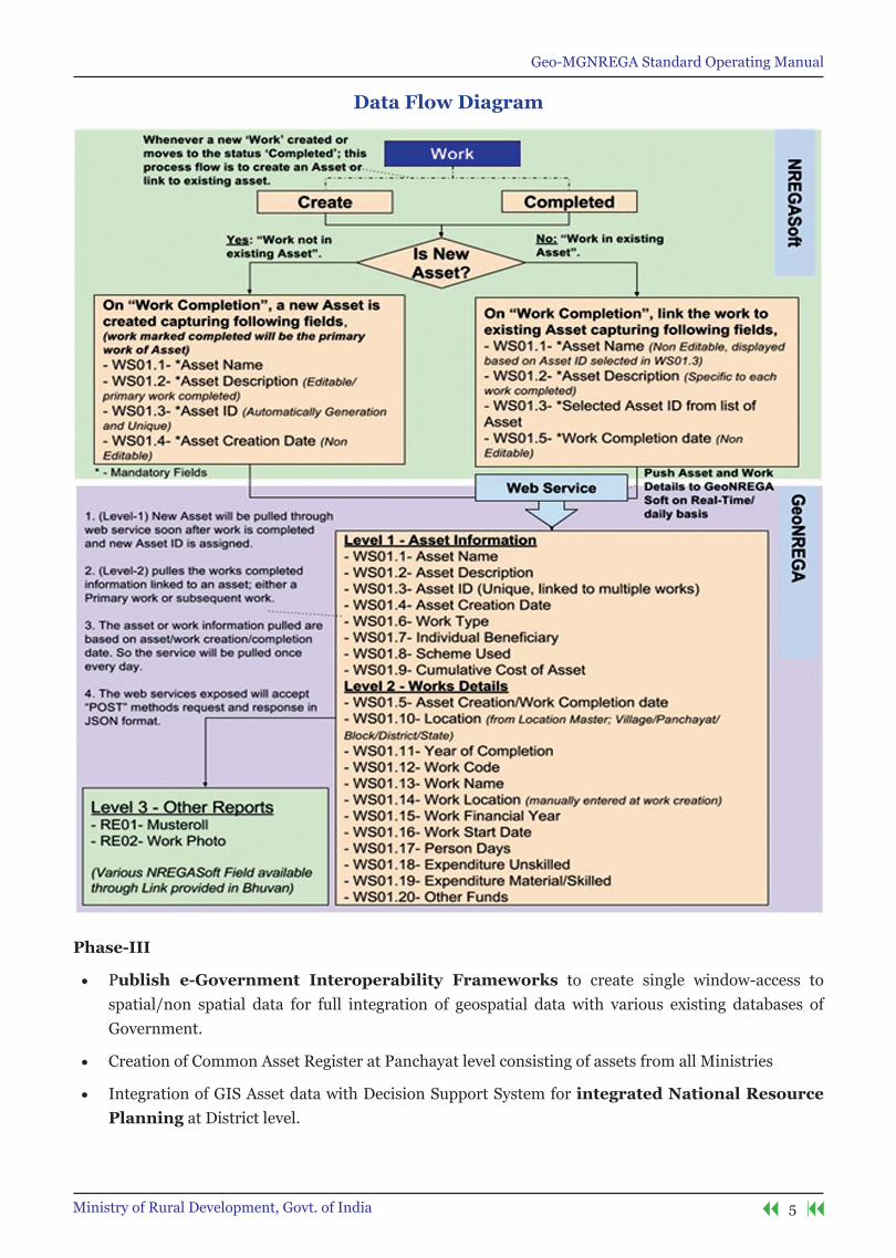
1. InformationonAssetsthatareidentifiedascompletedbytherespectiveStateauthority,willbepushed to Bhuvan platform along with work details from the NREGASoft on regular basis as part of operational mechanism.
2. Through Bhuvan Mobile Platform, completed assets will be Geo-tagged along with photograph by Gram Rozgar Sahayak/Technical Assistant/Junior Engineer.
3. Aftermoderation/validationbyProgrammeOfficerattheBlocklevel,theassetswillbedisplayedon Bhuvan Web Platform in public domain. Towards this a moderation interface will be provided
on Bhuvan Platform for respective level of functionaries.
Phase-II
• Citizen centric Mobile Application for crowd-sourcing of information to create visibility and feedback mechanism to strengthen social audit mechanism.
• This phase will expand the GIS Application with comprehensive Geoprocessing of MGNREGA works by covering all stages of MGnReGA from initiation of work, muster roll, measurement of work to closure of work for better monitoring of MGNREGA functionaries performance and creation of assets, better tracking and better reporting of location-specific events through time and locationstamping to improve the bottom line. This will integrate textual and spatial records and help in easy verificationsofcontoursandboundariesofMGNREGAassettoperformvariousspatialcorrelation
and MIS functions.
Geo-MGNREGA Standard Operating Manual
5Ministry of Rural Development, Govt. of India
Data Flow Diagram
Phase-III
• Publish e-Government Interoperability Frameworks to create single window-access to spatial/non spatial data for full integration of geospatial data with various existing databases of Government.
• Creation of Common Asset Register at Panchayat level consisting of assets from all Ministries
• Integration of GIS Asset data with Decision Support System for integrated national Resource Planning at District level.

Geo-MGNREGA Standard Operating Manual
6 Ministry of Rural Development, Govt. of India
Rollout Waves for GIs implementation
Rollout Phases summary
1. The rollout is spread into two Waves, i.e. Wave I and Wave II. Wave I are the selected Districts of the State which are geared and predisposed towards GIS implementation at the early stage. Hence these GIS Districts are called as GIS Pioneering Districts (GPD). A total of 100 Districts have been selected across all States as GPDs. These GPDs will be nominated by State Government based on the site readiness both in terms of resources, connectivity and manpower preparedness. No mobile hardware will be supplied to the District and States will have to manage locally. The preferable method is Bring your own device (BYOD) concept. However, the mobile device so used, should match the hardware specificationsprescribedinthisdocument.
2. These GPDs are further divided into Districts where Pilots will be conducted. These Pilot GPDs are called as GIS Pioneering Testing Site District (GPTSD). Each of GPTSD will in turn choose one Gram Panchayat from their District which will become testing sites for the GIS Implementation. These Gram Panchayat will be called as GIS Pioneering Testing Site Gram Panchayats (GPTSG) and its corresponding block will be called as GIS Pioneering Testing Site Block (GPTSB). Thus there will be 34 GPTSDs with 34 Gram Panchayat Testing Sites.
3. The Wave I be launched in 100 GPDs (all Gram Panchayats) after successful completion of pilots in 34 testing sites. Wave I will thus include all Gram Panchayats one that is chosen as Testing sites (GPD 1) and also those chosen under GPD 2. This stage will mark the Project as ‘Go-LIVe’. The GIS Project will be inaugurated and launched on this day.
4. After successful implementation in Wave-I in each of the GPD, implementation of Wave- II will be done in all GPs of the remaining 561 districts as per the timelines prescribed by the Ministry.

Geo-MGNREGA Standard Operating Manual
7Ministry of Rural Development, Govt. of India
state Wave Rollout strategy
s no. states / Uts no of
Districtsno of
Panchayats
Pilots Wave IWave
IIGPD GPD GPD II total
1 2 3 4 5 6 7 8 9
1 ANDHRA PRADESH 13 13084 1 1 1 2 11
2 ARUNACHAL PRADESH 20 1827 1 1 2 3 17
3 ASSAM 27 2644 1 1 2 3 24
4 BIHAR 38 8529 1 1 3 4 34
5 CHHATTISGARH 27 10971 1 1 2 3 24
6 GOA 2 190 1 1 1 2 0
7 GUJARAT 33 14330 1 1 4 5 28
8 HARYANA 21 6314 1 1 2 3 18
9 HIMACHAL PRADESH 12 3251 1 1 1 2 10
10 JAMMU & KASHMIR 22 4206 1 1 2 3 19
11 JHARKHAND 24 4422 1 1 2 3 21
12 KARNATAKA 30 6019 1 1 3 4 26
13 KERALA 14 941 1 1 2 3 11
14 MADHYA PRADESH 51 22827 1 1 4 5 46
15 MAHARASHTRA 34 28670 1 1 5 6 28
16 MANIPUR 9 3133 1 1 1 2 7
17 MEGHALAYA 11 6206 1 1 1 2 9
18 MIZORAM 8 876 1 1 1 2 6
19 NAGALAND 11 1200 1 1 1 2 9
20 ODISHA 30 6211 1 1 3 4 26
21 PUNJAB 22 13110 1 1 2 3 19
22 RAJASTHAN 33 9896 1 1 3 4 29
23 SIKKIM 4 176 1 1 1 2 2
24 TAMIL NADU 31 12524 1 1 3 4 27
25 TELANGANA 9 8831 1 1 1 2 7
26 TRIPURA 8 1178 1 1 1 2 6
27 UTTAR PRADESH 75 59177 1 1 6 7 68
28 UTTARAKHAND 13 7997 1 1 1 2 11
29 WEST BENGAL 20 3347 1 1 2 3 17
30 ANDAMAN AND NICOBAR 3 83 1 1 1 2 1
31 DADRA & NAGAR HAVELI 1 11 1 1 0 1 0
32 DAMAN & DIU 2 10 1 1 1 2 0
33 LAKSHADWEEP 1 10 1 1 0 1 0
34 PUDUCHERRY 2 10 1 1 1 2 0
total Count 661 262211 3434 66 100
561
Geo-MGNREGA Standard Operating Manual
8 Ministry of Rural Development, Govt. of India
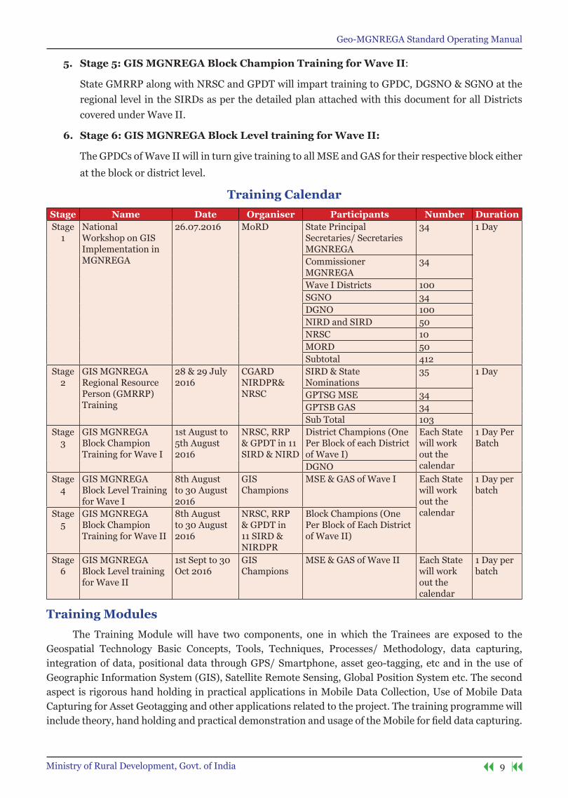
Roll out stages of training and capacity building
Training and capacity building are an integral part of the GIS implementation primarily because of the IT based dependence. Therefore, change management for creating and updating Assets through GISbasedmobileapplicationrequiresdetailedtrainingmanualandhandholdingsupport.Tothiseffecta complete training and capacity building plan has been prepared. Once the GIS Solution is developed, as per the MoU between MoRD and NRSC, NRSC will develop the detailed training manual for the usage of the mobile application, validation of the data and then usage of the web GIS portal. CGARD NIRD will be the apex organisation which has the capability of both GIS technology and operations, will coordinate and eventually execute the training to all the relevant functionaries. MoRD will provide necessary operational guidelines,fundsandsupporttoNIRDforeffectingthecompletetraining.ThetrainingprogramunderGISImplementationhasbeensimplifiedandstructuredinto6stagestoensurethatallthefunctionariesgivensufficienttrainingaremadeawareabouttheoperationsofthesoftwareanditsusage.
1. stage 1: national Workshop on GIs Implementation in MGnReGA:
A one day National Level GIS Workshop will be held inviting all respective Principal Secretaries/Secretaries(inchargeofMGNREGA),MGNREGACommissioners,StateGISNodalOfficer(SGNO)andDistrictCollectors,DistrictGISNodalOfficers(DGNO)ofdistrictsselectedunderWave-Ii.eGPD 1 and GPD 2. This workshop will orient all the State Government about the various facets of Assets creation and Geo-tagging. This will be jointly conducted by MoRD, NIRD and NRSC. The detailed operating Manual will also be released which will be prepared by NRSC.
2. stage 2: GIs MGnReGA Regional Resource Person (GMRRP) training:
One day Training of Trainers programme will be organised by NIRD & NRSC for training the GIS MGNREGA Regional Resource Persons (GMRRP). These RRPs will be selected by SIRD. These RRP will inturn give training at the State Levels for MSE / GAS.
Secondly, as detailed in the Roll Out plan, before the GO-LIVE Stage, the solution will be tested and Pilots conducted in the 34 Gram Panchayats of GPDs called as GIS Pioneering Testing Sites Gram Panchayats (GPTSG). Each of the GPTSG have a corresponding GIS Pioneering Testing Site Block (GPTSD). These MSE (GRS / Technical Assistants/ Others) and GAS (PO at Block level) functionaries from GPTSG and GPTSD are called as GIS Pioneering District Testers (GPDT). These GPDTs will also be trained in the same workshop at NIRD. They will be required to bring their own mobile phone under Bring Your Own Device (BYOD) plan during the training session organised at NIRD Hyderabad. NRSC will prepare a Training Manual for the users.
3. stage 3: GIs MGnReGA Block Champion training for Wave I:
GPD 1 and GPD 2 will nominate one resource person from each of the Block who will be designated as GPDC (GIS Pioneering District Champions). GMRRP along with NRSC and GPDT will impart training to GPDC, DGSNO & SGNO at the regional level in the SIRDs as per the detailed plan
attached with this document.
4. stage 4: GIs MGnReGA Block Level training for Wave I:
GIS Pioneering District Champions (GPDC) will in-turn train all the MGNREGA Spatial Emulators (MSE) i.e. GRS/ Technical Assistants & GIS Asset Supervisor (GAS) i.e. PO at block level of their
respective District either at the District or at the block level.
Geo-MGNREGA Standard Operating Manual
9Ministry of Rural Development, Govt. of India
5. stage 5: GIs MGnReGA Block Champion training for Wave II:
State GMRRP along with NRSC and GPDT will impart training to GPDC, DGSNO & SGNO at the regional level in the SIRDs as per the detailed plan attached with this document for all Districts covered under Wave II.
6. stage 6: GIs MGnReGA Block Level training for Wave II:
The GPDCs of Wave II will in turn give training to all MSE and GAS for their respective block either
at the block or district level.
training Calendarstage name Date organiser Participants number DurationStage
1National Workshop on GIS Implementation in MGNREGA
26.07.2016 MoRD State Principal Secretaries/ Secretaries MGNREGA
34 1 Day
Commissioner MGNREGA
34
Wave I Districts 100SGNO 34DGNO 100NIRD and SIRD 50NRSC 10MORD 50Subtotal 412
Stage 2
GIS MGNREGA Regional Resource Person (GMRRP) Training
28 & 29 July 2016
CGARD NIRDPR& NRSC
SIRD & State Nominations
35 1 Day
GPTSG MSE 34GPTSB GAS 34Sub Total 103
Stage 3
GIS MGNREGA Block Champion Training for Wave I
1st August to 5th August 2016
NRSC, RRP & GPDT in 11 SIRD & NIRD
District Champions (One Per Block of each District of Wave I)
Each State will work out the calendar
1 Day Per Batch
DGNOStage
4GIS MGNREGA Block Level Training for Wave I
8th August to 30 August 2016
GIS Champions
MSE & GAS of Wave I Each State will work out the calendar
1 Day per batch
Stage 5
GIS MGNREGA Block Champion Training for Wave II
8th August to 30 August 2016
NRSC, RRP & GPDT in 11 SIRD & NIRDPR
Block Champions (One Per Block of Each District of Wave II)
Stage 6
GIS MGNREGA Block Level training for Wave II
1st Sept to 30 Oct 2016
GIS Champions
MSE & GAS of Wave II Each State will work out the calendar
1 Day per batch
training Modules
The Training Module will have two components, one in which the Trainees are exposed to the Geospatial Technology Basic Concepts, Tools, Techniques, Processes/ Methodology, data capturing, integration of data, positional data through GPS/ Smartphone, asset geo-tagging, etc and in the use of Geographic Information System (GIS), Satellite Remote Sensing, Global Position System etc. The second aspect is rigorous hand holding in practical applications in Mobile Data Collection, Use of Mobile Data Capturing for Asset Geotagging and other applications related to the project. The training programme will includetheory,handholdingandpracticaldemonstrationandusageoftheMobileforfielddatacapturing.

Geo-MGNREGA Standard Operating Manual
10 Ministry of Rural Development, Govt. of India
• Basics about GIS and GEO Tagging, handling geo information over web
• Asset Creation on NREGASoft
• Use of Bhuvan Mobile Application
• Use of Bhuvan Mahatma Gandhi NREGA geoportal
• Moderation/Validation of the uploaded photographs on Bhuvan platform
• Use of satellite images & handling geo information over web
organisation & team
The implementation of the GIS will be governed at the Central and the State level.
Central Level
The Programme Division Mahatma Gandhi NREGA will steer the complete implementation of the GISSolutionforMahatmaGandhiNREGA.ToensureeffectiveandtimelyrolloutoftheMahatmaGandhiNREGA GIS Solution following monitoring mechanism will be set up:
Diagrammatic Representation of Governance structure
1. national Level steering Committee:
Headed by Secretary Rural Development and co-chaired by Secretary Space. This committee will:
1. Keep oversight of the project
2. Suggest and decide changes and mid-course corrections
3. Resolvemutualdifferencesbetweenvariousimplementingagenciesandstakeholders
This committee will meet one in every quarter or as per the requirements of the project. Program Division PMU will provide necessary secretarial support.
2. GIs solution Cell:
This will be headed by Joint Secretary MGNREGA. The committee members will consist of Deputy Director NRSC, STD NIC DoRD, and Director General, NIRD&PR. The committee will:
Geo-MGNREGA Standard Operating Manual
11Ministry of Rural Development, Govt. of India
a. See the progress of the solution implementation
b. Review of the timelines and implementation issues
c. Resolve all the issues pertaining to development and deployment of the solution
This committee will meet on a fortnightly basis or as decided by the chairman. The Program Division PMU will provide necessary Secretarial Support.
3. national Working Group:
This committee will be headed by Joint Secretary MGNREGA. The members will consist of CommissionerMGNREGAfromeachState,andStateGISNodalOfficers.
a. This committee will take stalk of the implementation at the State level
b. Feedback from the States requiring solution changes
c. Monitoring and directions to the state for implementation
The committee will meet on a monthly basis over Video Conferencing or as decided by the Chairman of the Committee. Program Division PMU will provide necessary secretarial support.
4. Monitoring of Implementation of GIs:
To execute the same, MoRD will augment the Section handing the GeoMGNREGA Project with requisite technical outsourced manpower who are specialised in GIS. A total of Senior Consultant with 10 re more years of experience in GIS will be the technical resource person and will be assisted by a GIS Project Executivewith3 to5 yearsofoffhandexperienceofGIS implementation in theGovernmentProjects.These will be hired on the contractual basis.
As the implementation of the GIS Solution is of phenomenal scale but the timelines are very short, it entails coordinated activities among NRSC, ISRO, NIRD&PR, NIC and State Governments. Therefore, appropriate manpower support for coordination and implementation is vital. In this regard, NIRD&PR C-GARD was requested to examine the requirements. NIRD&PR has submitted the proposal. Accordingly, CGARD, NIRD&PR will augment GeoMGNREGA Project with Program Management Unit with 14 outsourcedtechnicalstaffwithvariedspecialisedandprogramManagementskills.Followingwillbetherole of the PMU:
a. These initial work will be very vital in the faster rollout of the programme. Each of the GPD will then undergorolloutunderWave-ItobefollowedwithWave-II.PMUwillensureeffectivemonitoringofthe implementation with strict adherence to timelines.
b. Preparation of PERT and GANTT Chart for each of the District
c. A team of 2 or 3 persons from PMU will be associated with group of states. (Six State groups can be formed i.e., Northern, Southern, Western, Eastern, Middle, North-East States).
d. TheTechnicalmanpower at PMUwould be used to verify the data uploaded from the field andcoordinate with state level implementing agency in resolving any inaccuracies.
e. Software & Hardware Deployment:
Each of the executive will be entrusted with the job of:
1. IdentificationanddocumentationofGPDfromeachoftheState
2. Deployment and activation of mobile devices in the Gram Panchayats

Geo-MGNREGA Standard Operating Manual
12 Ministry of Rural Development, Govt. of India
3. Deployment and initiation of mobile application up to the Gram Panchayat-level.
4. Installation of the Software in the Mobile devices
5. Troubleshooting of any problems in the installation, upgradation and maintenance.
6. All operative issues relating to the Mobile hardware like anti-virus, Operating system upgrade, installation of third party applications will be handled by the PMU.
7. All exception reports from the GP will be compiled and presented to the respective decision making authority.
8. Alltrainingandorientationmaterialwillbemanagedandeffectivelydistributedinatimelymanner to each of the GPD.
9. Training & handholding Support:
PMU will organise periodic training on GIS application to the functionaries in centre and state governments. The support desk will be setup and manned by PMU resource persons.
state Level
state Level GIs Working Group:
Each State will setup GIS Working Group headed by Principal Secretary/Secretary looking after Mahatma Gandhi NREGA as the chairman. The committee will:
1. Decide the rollout strategy
2. ConductmeetingwithDistrictCollectors/DMDGNOandotherofficialsoftheState
3. Monitor the progress of the implementation
4. Resolveissuesarisingoutinthefieldlevel
5. Keep an oversight of the quality of the photographs
6. Setup and review the asset creation, correct Geo-tagging issues and publishing details on the portal
7. Submit the report to the Program Division MGNREGA of the proceedings of the meeting and provide details as and when required by the MoRD
8. Review the training schedule and suggest improvement
The committee will meet every month or as frequently as decided by the chairman. SGNO will provide the secretarial Support for the committee.
Following will be implementing agencies and their designations at the State Level:
i. Level 1:
There will be designated MGNREGA Spatial Enumerator (MSE) for each Gram Panchayat who will capture the asset photographs with GPS location of completed assets. The Gram Rozgar Sahayak (GRS)/ Technical Assistant (TA) will be designated by the respective State Government considering the local conditions and requirements. There can be multiple MSEs under one GP.
ii. Level 2:
StateshalldesignateofficersaboveGRS/TAasGISAssetSupervisor(GAS)whowillvalidateandapprovetheassetphotograph.TheProgrammeOfficer(PO)oranyotherconcernedofficerattheBlocklevelwill be designated by the respective State Government considering the local conditions and requirements.
Geo-MGNREGA Standard Operating Manual
13Ministry of Rural Development, Govt. of India
iii. training & Hand Holding:
Each of the GPDs will nominate one suitable person from each of the block to be trained as GPD Champions (GPDC) which in-turn will train all the GRS/Technical Assistants working as MSE (MGNREGA Spatial Enumerators) and GAS (GIS Asset Supervisor). These GPDCs will be given training at the level of SIRD. As they are from the block level, not only they would be able to provide the training, but they will also provide handholding support, validation of GIS data & Asset photographs, user account management, etc.
iv. Coordination level 1:
StatewilldesignateDistrictGISNodalOfficer(DGNO)foreachdistrict.DGNOwillberesponsiblefor coordination of issues relating to the district.
v. Coordination Level 2:
Each State will immediately nominate State GIS Nodal Officer (SGNO) under CommissionerMahatma Gandhi NREGA, who will be responsible for coordination and rollout. All issues pertaining to geocoordinates,assetsmappingandphotographvalidationinaStatewillberectifiedatthislevel.
Mobile Hardware
Based upon the experience of various State Governments during the implementation of GIS solutionintheirstatethefollowingminimummobiledevicehardwarespecificationsissuggested.Thesespecifications shouldbe subjected to the requirements ofmobile application to bedeployed to ensurematchingofspecificationtothatofrequirement.
* No device or grant will be provided for the mobile devices by the Central Government. Each MSE need to use their own mobile device as per ‘Bring Your Own Device’ (BYOD) concept. The device should have
minimum specifications as specified.
CPU 1.3 GHz
OS Android 4.4
Display TFT capacitive touch screen 3.5”
Connectivity GPRS, GPS and A-GPS, Wi-Fi
3G enabled Yes
Rear Camera 5 MP
RAM 2 GB RAM
Internal memory 8 GB
External Storage compatibility 16 GB

Geo-MGNREGA Standard Operating Manual
14 Ministry of Rural Development, Govt. of India
GIs Pioneer Districts test sites
state District Block Panchayat DGnoWest Bengal North 24parganas Rautara Habra-I Arunabha Das
Kerala Wayanad SulthanBathery Meenangadi P G Vijayakumar
Maharashtra Nagpur Nagpur Rural Dawlameti Smt. Manisha Jaybhaye
Jharkhand Ranchi Namkum Rampur RavikarShhyam
Chhattisgarh Balod Gurur Bhulandabari OmprakashSahu
Gujarat Patan Sami Mandavi Sanket Joshi
Telangana Ranga Reddy Ibrahimpatnam Cherlaptelguda Haritha
Uttarakhand Haridwar Laksar AkbarpurUd AmritRathi
Punjab Mansa Mansa Moosa Mandeep Singh
Odisha Keonjhar KeonjharSadar Bauripada SibanandaTripathy
Assam Goalpara Balijana Block BalijanaGp NavidAnjumulHoque
Sikkim South Sikkim Namchi Kitam-ManpurGp Manoj Pradhan
Mizoram Champhai Khawzawl Khawzawl Iv Cc Lalchhuangkima
Tamil Nadu Kancheepuram Lathur Nerkunapattu S.Thanikachalam
Himachal Pradesh Sirmour Sangarh Redli VivekDhiman
Meghalaya RiBhoi Umsning Mawrong Shri D Hynniewta
Nagaland Kohima Jakhama Viswema Arensosang Jamir
Arunachal Pradesh West Kameng Dirang Yewang Tasso Gambo
Bihar Nalanda Noor Sarai JagdishpurTiyari Ravindra Ram
Madhya Pradesh Sehore Ashta Jatakheri HiralalVerma
Haryana Yamunanagar Radaur Khurdban Hakam Singh Rana
Rajasthan Jhalawar Jhalara-Patan Durgpura IndrajeetNimesh
Andhra Pradesh Chittoor Kuppam Mandal Kuppam M. Venugopal Reddy
Tripura West Tripura Bamutia Bhagalpur PijushDebbarma
Karnataka Chitradurga Hosdurga Baguru Basavaraj .Y
Manipur Imphal East Imphal East Ii Top Dusara N.Moonildro Singh
Uttar Pradesh SantKabeer Nagar Khalilabad Meerganj Vinay Kumar Srivastava
Andaman & Nicobar South Andaman CD Block Prothrapur Beodnabad Shri Shashi Babu
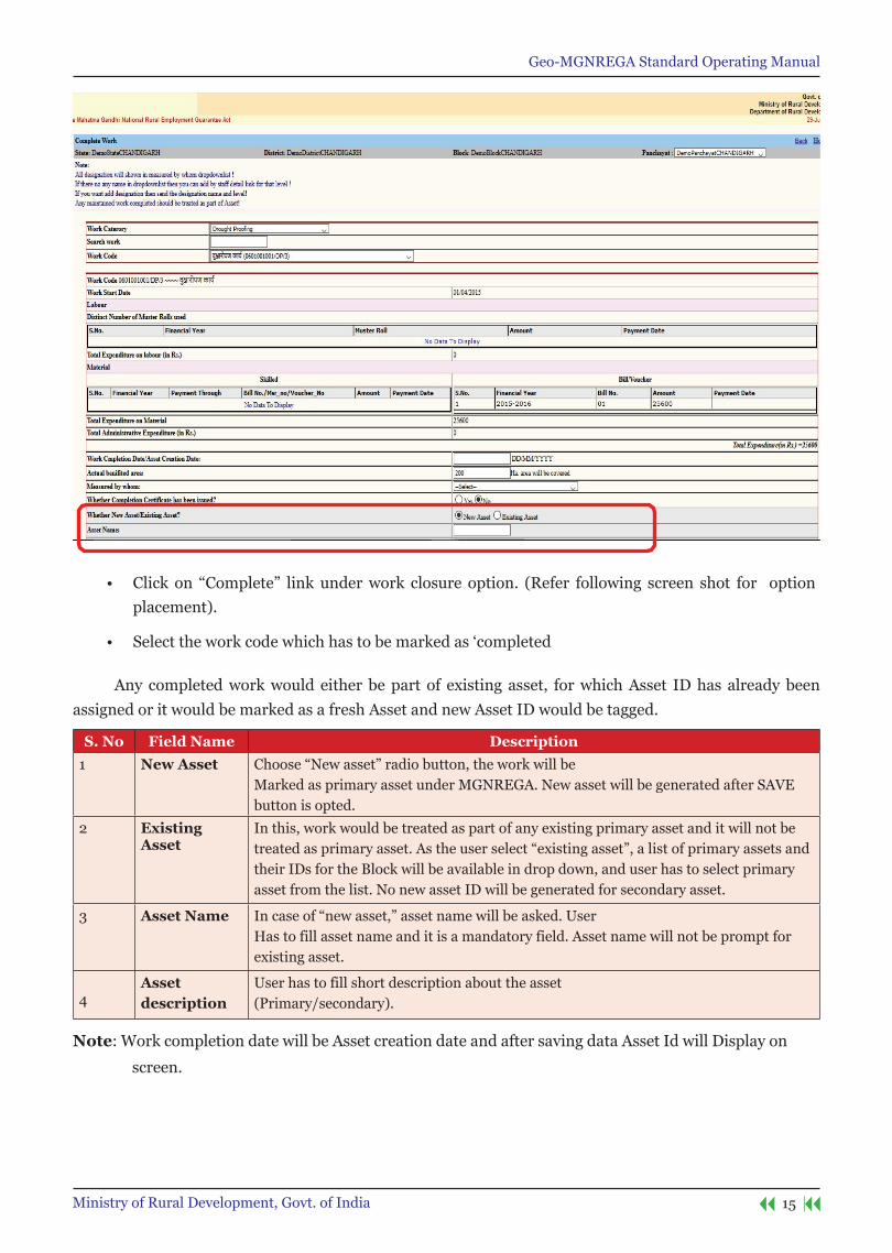
Add new Asset/existing Asset
• UsercanloginfromGP,PO,BP,ZPandotherimplementingagencyloginforworkcompletionand asset marking.
Geo-MGNREGA Standard Operating Manual
15Ministry of Rural Development, Govt. of India
• Click on “Complete” linkunderwork closure option. (Refer following screen shot for optionplacement).
• Selecttheworkcodewhichhastobemarkedas‘completed
Any completed work would either be part of existing asset, for which Asset ID has already been assigned or it would be marked as a fresh Asset and new Asset ID would be tagged.
s. no Field name Description1 new Asset Choose“Newasset”radiobutton,theworkwillbe
Marked as primary asset under MGNREGA. New asset will be generated after SAVE button is opted.
2 existingAsset
In this, work would be treated as part of any existing primary asset and it will not be treatedasprimaryasset.Astheuserselect“existingasset”,alistofprimaryassetsandtheir IDs for the Block will be available in drop down, and user has to select primary asset from the list. No new asset ID will be generated for secondary asset.
3 Asset name Incaseof“newasset,”assetnamewillbeasked.UserHas to fill asset name and it is a mandatory field. Asset name will not be prompt for existing asset.
4Asset description
User has to fill short description about the asset(Primary/secondary).
note: Work completion date will be Asset creation date and after saving data Asset Id will Display on
screen.
Geo-MGNREGA Standard Operating Manual
16 Ministry of Rural Development, Govt. of India
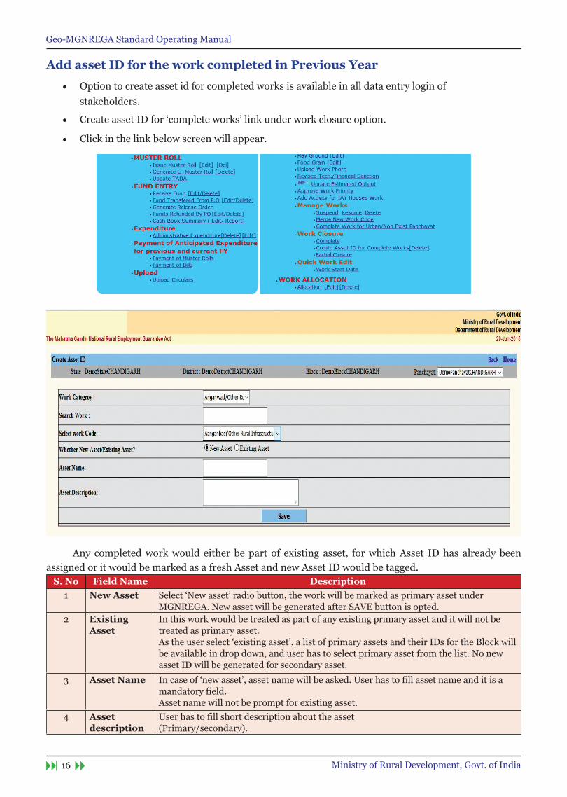
Add asset ID for the work completed in Previous Year
• Option to create asset id for completed works is available in all data entry login of stakeholders.
• Create asset ID for ‘complete works’ link under work closure option.
• Click in the link below screen will appear.
Any completed work would either be part of existing asset, for which Asset ID has already been assigned or it would be marked as a fresh Asset and new Asset ID would be tagged.
s. no Field name Description1 new Asset Select ‘New asset’ radio button, the work will be marked as primary asset under
MGNREGA. New asset will be generated after SAVE button is opted.2 existing
AssetIn this work would be treated as part of any existing primary asset and it will not be treated as primary asset. As the user select ‘existing asset’, a list of primary assets and their IDs for the Block will be available in drop down, and user has to select primary asset from the list. No new asset ID will be generated for secondary asset.
3 Asset name In case of ‘new asset’, asset name will be asked. User has to fill asset name and it is a mandatory field.Asset name will not be prompt for existing asset.
4 Asset description
User has to fill short description about the asset(Primary/secondary).

Geo-MGNREGA Standard Operating Manual
17Ministry of Rural Development, Govt. of India
Delete secondary work from asset ID
Delete option of works under asset ID is provided to handle any wrong association of work under an asset ID. User can delete any secondary work ID and allocate new asset ID from the option as mentioned above.
Click ‘Delete’ link under work closure option.
Click on the link, below screen will appear
s. no Field name Description1 Asset ID User has to select the asset ID from the list. Asset ID can search by asset ID or
work code.2 Do you want
Delete Primary asset ID?(Yes/no):
By default ‘No’ is selected. If ‘YES’ will be selected, asset ID from primary work and secondary work will be removed as soon as ‘Delete’ button will be clicked. If user selects ‘Yes’ to delete primary asset ID then all secondary work code will be selected to remove asset ID. As of now it is disabled.
3 Primary work code Asset ID of primary work code cannot be deleted until all the secondary assets get deleted.User can select the option to delete the asset ID from primary asset work, but it will first remove the asset ID of the secondary work of the asset and then primary work’s asset will be removed.
4 secondary work code
User can select the secondary work code to delete the asset ID.

Geo-MGNREGA Standard Operating Manual
19Ministry of Rural Development, Govt. of India
Authorizing MGnReGA users

Geo-MGNREGA Standard Operating Manual
21Ministry of Rural Development, Govt. of India
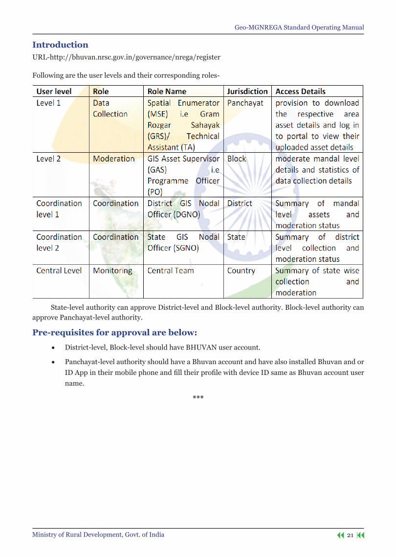
IntroductionURL-http://bhuvan.nrsc.gov.in/governance/nrega/register
Following are the user levels and their corresponding roles-
State-level authority can approve District-level and Block-level authority. Block-level authority can approve Panchayat-level authority.
Pre-requisites for approval are below:
• District-level, Block-level should have BHUVAN user account.
• Panchayat-level authority should have a Bhuvan account and have also installed Bhuvan and or IDAppintheirmobilephoneandfilltheirprofilewithdeviceIDsameasBhuvanaccountusername.
***

Geo-MGNREGA Standard Operating Manual
22 Ministry of Rural Development, Govt. of India
MGnReGA user account activation process for District/Block/Panchayat authority
1. Login to http://bhuvan.nrsc.gov.in/governance/nrega/register
2. Login with BHUVAN user name and password.
3. You will see the following screen with a message ‘You are not authorised. Should you like to be NREGA user? Please download this form and send it to your NREGA administrator.’
Geo-MGNREGA Standard Operating Manual
23Ministry of Rural Development, Govt. of India
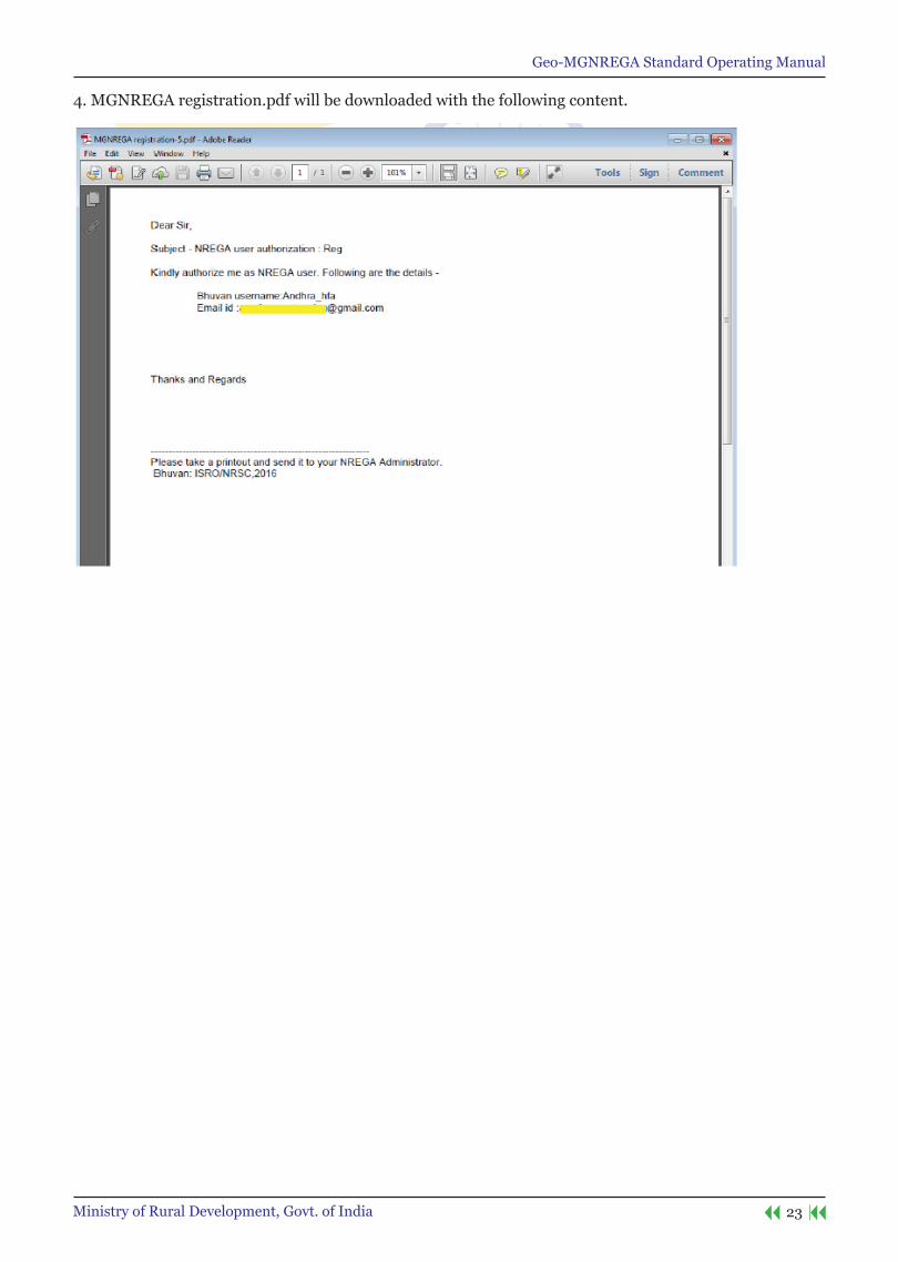
4. MGNREGA registration.pdf will be downloaded with the following content.
Geo-MGNREGA Standard Operating Manual
24 Ministry of Rural Development, Govt. of India
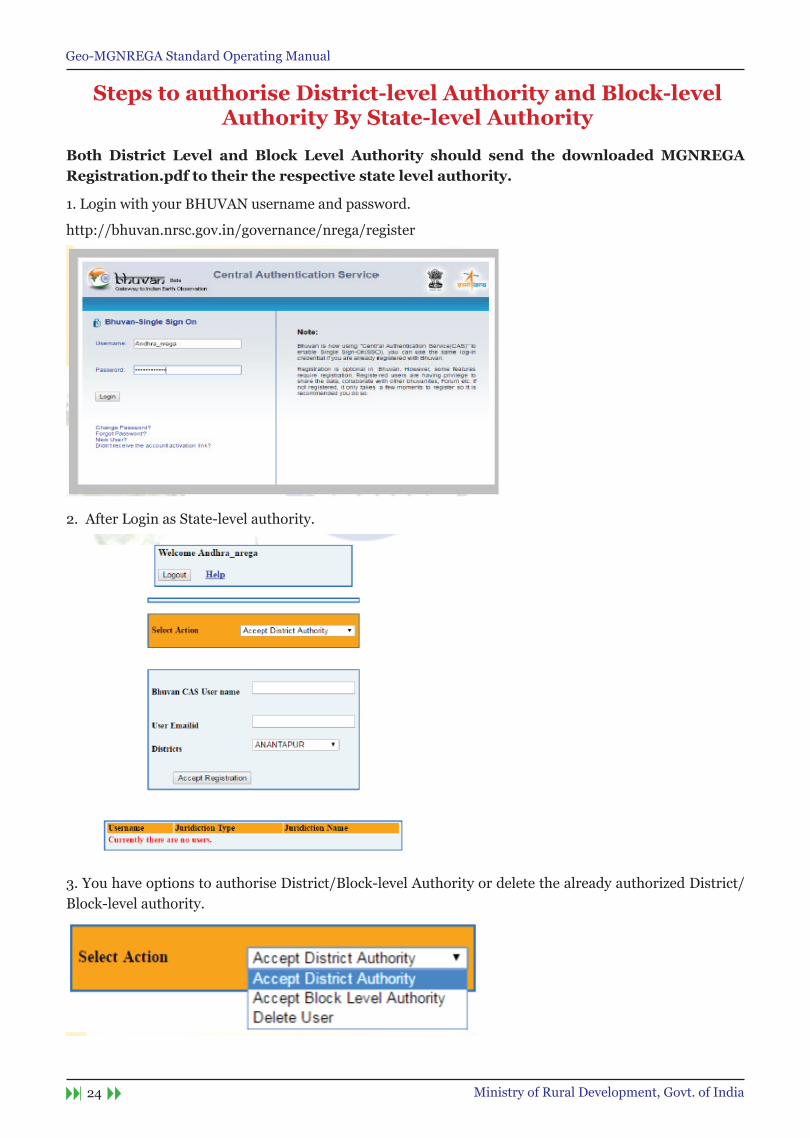
steps to authorise District-level Authority and Block-level Authority By state-level Authority
Both District Level and Block Level Authority should send the downloaded MGnReGA Registration.pdf to their the respective state level authority.
1. Login with your BHUVAN username and password.
http://bhuvan.nrsc.gov.in/governance/nrega/register
2. After Login as State-level authority.
3. You have options to authorise District/Block-level Authority or delete the already authorized District/Block-level authority.
Geo-MGNREGA Standard Operating Manual
25Ministry of Rural Development, Govt. of India
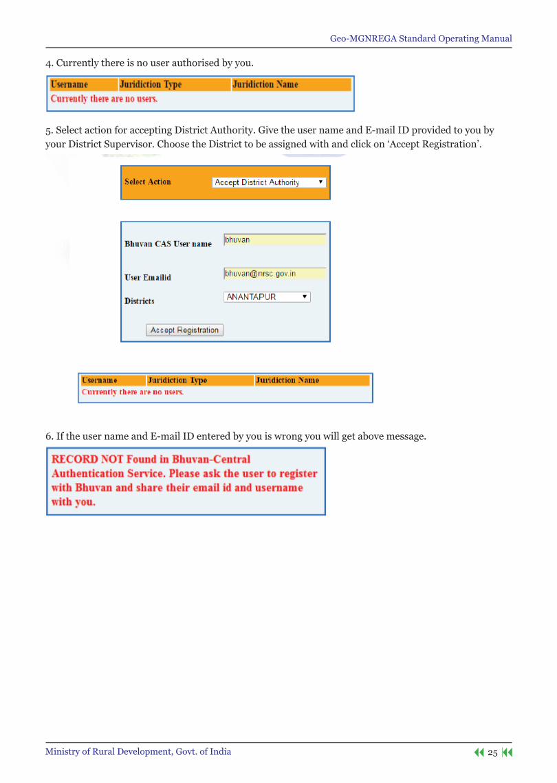
4. Currently there is no user authorised by you.
5. Select action for accepting District Authority. Give the user name and E-mail ID provided to you by your District Supervisor. Choose the District to be assigned with and click on ‘Accept Registration’.
6. If the user name and E-mail ID entered by you is wrong you will get above message.
Geo-MGNREGA Standard Operating Manual
26 Ministry of Rural Development, Govt. of India
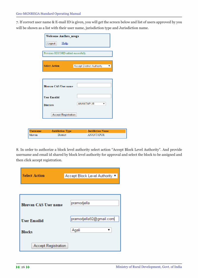
7. If correct user name & E-mail ID is given, you will get the screen below and list of users approved by you
will be shown as a list with their user name, jurisdiction type and Jurisdiction name.
8.Inordertoauthorizeablocklevelauthorityselectaction“AcceptBlockLevelAuthority”.Andprovideusername and email id shared by block level authority for approval and select the block to be assigned and then click accept registration.
Geo-MGNREGA Standard Operating Manual
27Ministry of Rural Development, Govt. of India
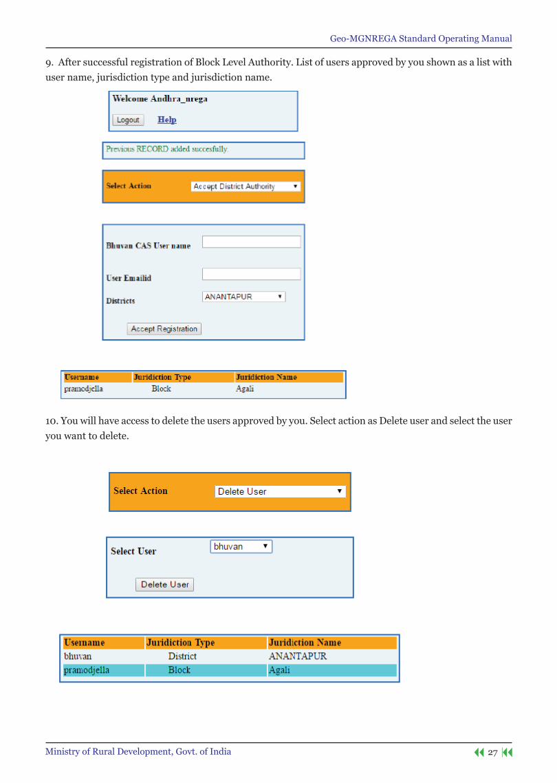
9. After successful registration of Block Level Authority. List of users approved by you shown as a list with user name, jurisdiction type and jurisdiction name.
10. You will have access to delete the users approved by you. Select action as Delete user and select the user you want to delete.
Geo-MGNREGA Standard Operating Manual
28 Ministry of Rural Development, Govt. of India
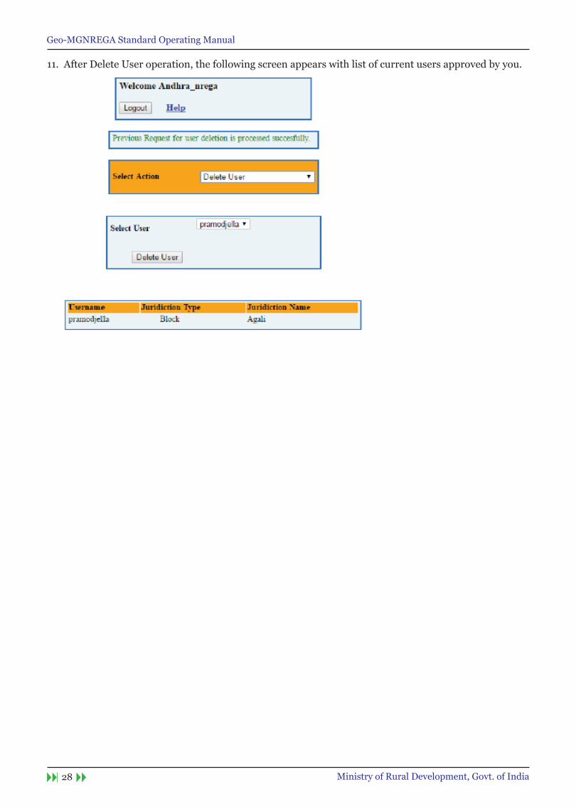
11. After Delete User operation, the following screen appears with list of current users approved by you.

Geo-MGNREGA Standard Operating Manual
29Ministry of Rural Development, Govt. of India
steps to authorize Panchayat Level Authority By Block Level Authority
Block Level Authority should have BHUVAn user account and account and should be approved by respective state level authority as MGnReGA user.
Prerequisites are below:
• Panchayat Level Authority – should have a Bhuvan account. And have also installed Bhuvan Andorid App in thei rmobile phone and fill their profile with device id same as Bhuvan account username.
1. Block Level Authority can login with their Bhuvan username and password and the following view will be shown.
2. Provide the username and email id of the panchayat level authority. The moment you enter the Username automatically“uniqueMobileId”drop-downwillappeariftheofficialhasinstalledBhuvanandroidAppintheirmobilephoneandfilltheirprofilewithdeviceidsameasBhuvanaccountusername.Ifnotlistwill
be empty.
Finally assign the respective panchayat from drop down list to the corresponding authority and then click on accept registration.

Geo-MGNREGA Standard Operating Manual
30 Ministry of Rural Development, Govt. of India
3. As seen above user ‘sonal’ has a registered profile through mobile App, thus unique Mobile Id is visible. Click on Accept registration.

Geo-MGNREGA Standard Operating Manual
31Ministry of Rural Development, Govt. of India
4. To delete any user, please select action as delete user. Select the user any you wish to delete from the list of authorised users by you.
5. After clicking on delete user button, the following screen will be shown with message Previous request for user deletion is processed successfully and the list of all currently authorised users by you are shown.
Geo-MGNREGA Standard Operating Manual
32 Ministry of Rural Development, Govt. of India
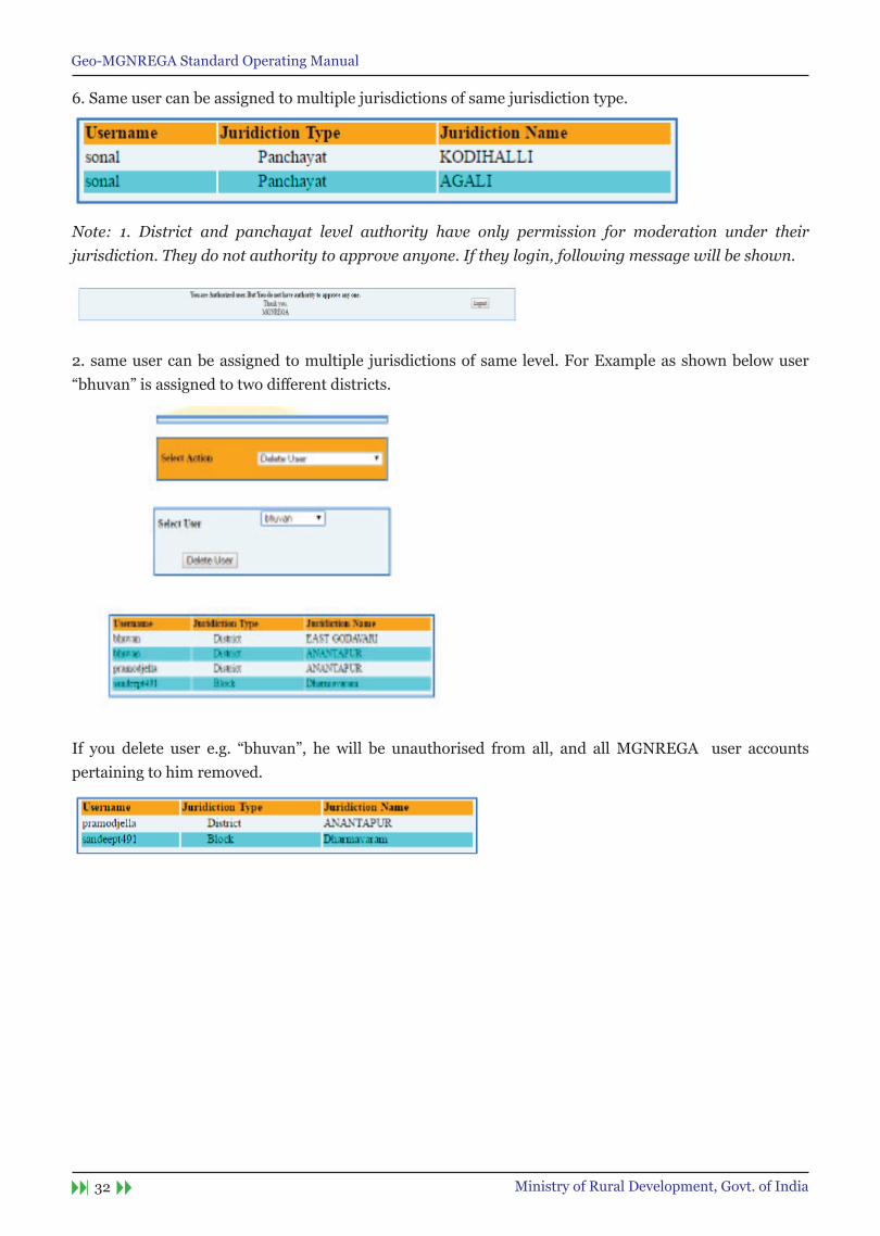
6. Same user can be assigned to multiple jurisdictions of same jurisdiction type.
Note: 1. District and panchayat level authority have only permission for moderation under their jurisdiction. They do not authority to approve anyone. If they login, following message will be shown.
2. same user can be assigned to multiple jurisdictions of same level. For Example as shown below user “bhuvan”isassignedtotwodifferentdistricts.
If you delete user e.g. “bhuvan”, he will be unauthorised from all, and allMGNREGA user accountspertaining to him removed.

Geo-MGNREGA Standard Operating Manual
33Ministry of Rural Development, Govt. of India
Creating Bhuvan user Account1. User can register by clicking on the new user link of the Login screen. This Login screen is common to all Bhuvan applications.
2. On click of new user following screen appears where user has to give his user name, Email id, Country and organization details. Filling other details is optional.
Note: For user name only alphabets, numbers, period (.), and underscore (_) are allowed.
Geo-MGNREGA Standard Operating Manual
34 Ministry of Rural Development, Govt. of India
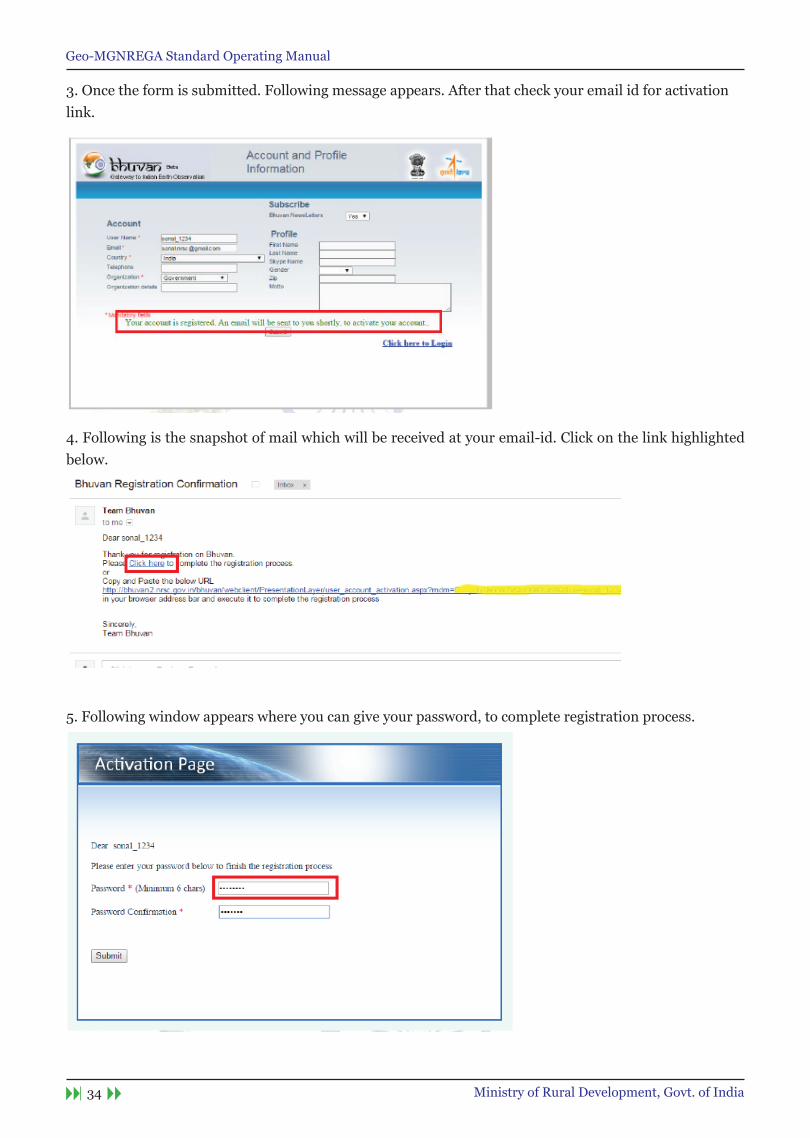
3. Once the form is submitted. Following message appears. After that check your email id for activation link.
4. Following is the snapshot of mail which will be received at your email-id. Click on the link highlighted below.
5. Following window appears where you can give your password, to complete registration process.

Geo-MGNREGA Standard Operating Manual
35Ministry of Rural Development, Govt. of India
6. After successfully submitting the form the following screen appears.Now you can use your user name and password for Sign-into any Bhuvan application.
Other Steps-Account Reactivation
7. Incaseyoudonot receiveactivation link-It is likely thatyouhaveenteredwrong/differentemail idduring registration. Please verify the same by clicking on-’Didn’t receive the account activation link ?’ of the login screen.

Geo-MGNREGA Standard Operating Manual
36 Ministry of Rural Development, Govt. of India
8. On clicking of the link mentioned in step7. Following screen appears, enter your email id and submit. It will give the status of your registered email id. In case account not-activated It will re-send the activation link.
Geo-MGNREGA Standard Operating Manual
37Ministry of Rural Development, Govt. of India
other steps-Forgot Password
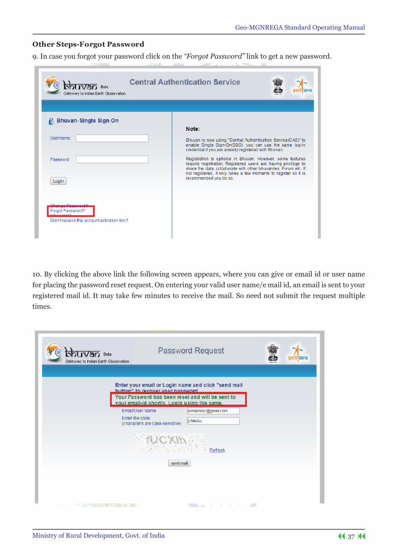
9. In case you forgot your password click on the “Forgot Password” link to get a new password.
10. By clicking the above link the following screen appears, where you can give or email id or user name for placing the password reset request. On entering your valid user name/e mail id, an email is sent to your registered mail id. It may take few minutes to receive the mail. So need not submit the request multiple times.
Geo-MGNREGA Standard Operating Manual
38 Ministry of Rural Development, Govt. of India
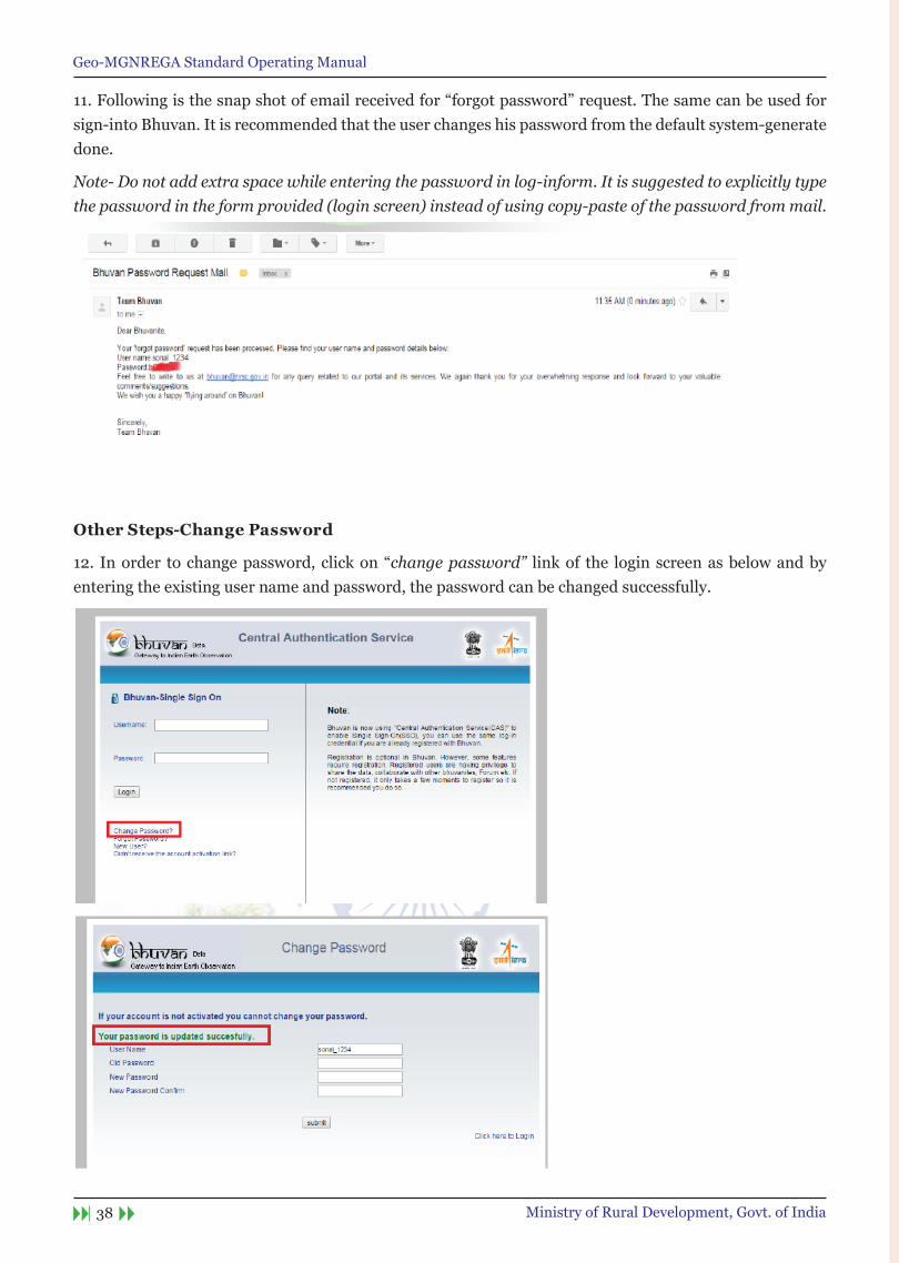
11.Followingisthesnapshotofemailreceivedfor“forgotpassword”request.Thesamecanbeusedforsign-into Bhuvan. It is recommended that the user changes his password from the default system-generate done.
Note- Do not add extra space while entering the password in log-inform. It is suggested to explicitly type the password in the form provided (login screen) instead of using copy-paste of the password from mail.
other steps-Change Password
12. Inorder tochangepassword,clickon“change password” link of the login screen as below and by entering the existing user name and password, the password can be changed successfully.

Geo-MGNREGA Standard Operating Manual
39Ministry of Rural Development, Govt. of India
Location based services to geo-tag Assets
Geo-MGNREGA Standard Operating Manual
40 Ministry of Rural Development, Govt. of India
Geo-MGNREGA Standard Operating Manual
41Ministry of Rural Development, Govt. of India
1 Introduction
The Mahatma Gandhi National Rural Employment Guarantee Act aims at enhancing the livelihood security of the people in rural areas by guaranteeing hundred days of wage-employment in a financial year to a rural household, whose adult members volunteer to do unskilled manual work. Towards this, an location based service mobile app is developed by National Remote Sensing Centre of India Space Research Organisation, Government of India.
Bhuvan’s Geo-MGNREGA App is a user-friendly mobile and server based solution which enables data collect or to systematically record generated assets with spatial position (Longitude, Latitude and Attribute the status) ,Time stamped with geo-tagged photograph. This mobile app will provide a platform to control crowd sourcing to build spatial database on Bhuvan Geo-platform.
2 Data connectivity
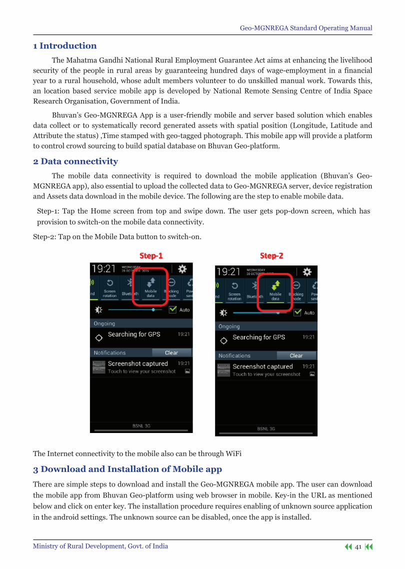
The mobile data connectivity is required to download the mobile application (Bhuvan’s Geo-MGNREGA app), also essential to upload the collected data to Geo-MGNREGA server, device registration and Assets data download in the mobile device. The following are the step to enable mobile data.
Step-1: Tap the Home screen from top and swipe down. The user gets pop-down screen, which has provision to switch-on the mobile data connectivity.
Step-2: Tap on the Mobile Data button to switch-on.
The Internet connectivity to the mobile also can be through WiFi
3 Download and Installation of Mobile app
There are simple steps to download and install the Geo-MGNREGA mobile app. The user can download the mobile app from Bhuvan Geo-platform using web browser in mobile. Key-in the URL as mentioned below and click on enter key. The installation procedure requires enabling of unknown source application in the android settings. The unknown source can be disabled, once the app is installed.
Geo-MGNREGA Standard Operating Manual
42 Ministry of Rural Development, Govt. of India
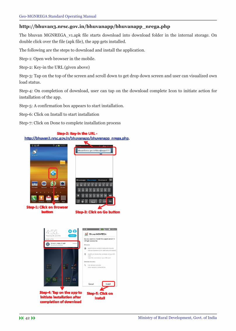
http://bhuvan3.nrsc.gov.in/bhuvanapp/bhuvanapp_nrega.php
The bhuvan MGNREGA_v1.apk file starts download into download folder in the internal storage. On double click over the file (apk file), the app gets installed.
The following are the steps to download and install the application.
Step-1: Open web browser in the mobile.
Step-2: Key-in the URL (given above)
Step-3: Tap on the top of the screen and scroll down to get drop down screen and user can visualized own load status.
Step-4: On completion of download, user can tap on the download complete Icon to initiate action for installation of the app.
Step-5: A confirmation box appears to start installation.
Step-6: Click on Install to start installation
Step-7: Click on Done to complete installation process

Geo-MGNREGA Standard Operating Manual
43Ministry of Rural Development, Govt. of India
4 Mobile GPs
The Mobile GPS is used to automatically acquire location information in the form of longitude and latitude, the GPS receiver in the mobile must be switched-on before open the mobile app. The following are the step to enable GPS receiver receive data.
Step-1: Tap the Home screen from top and swipe down. The user gets pop
down screen, which has provision to switch-on the mobile GPS receiver
Step-2: Tap on the GPS button to switch-on.
5 open Bhuvan MGnReGA
The Bhuvan MGNREGA mobile application can be seen in the list of apps can be brought to home screen by tap on the icon for 2 seconds. The user needs to tap on the icon to open the app in the mobile device.
Geo-MGNREGA Standard Operating Manual
44 Ministry of Rural Development, Govt. of India
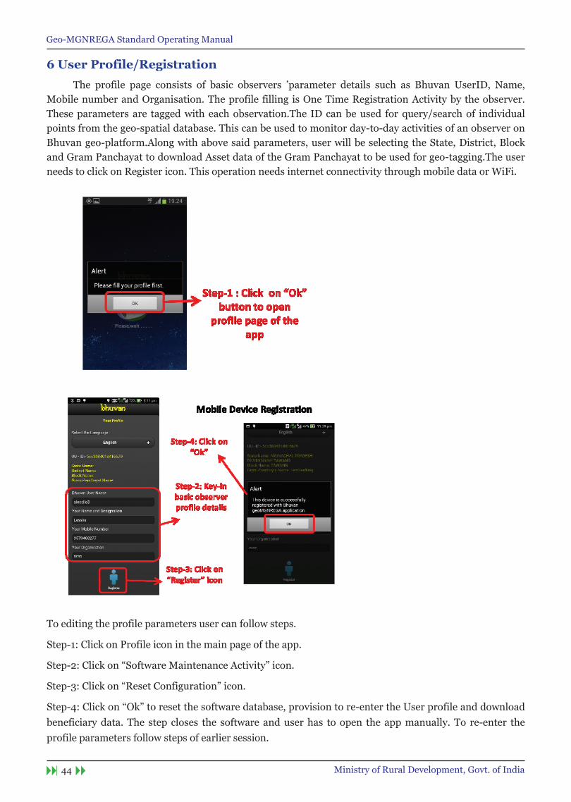
6 User Profile/Registration
The profile page consists of basic observers ’parameter details such as Bhuvan UserID, Name, Mobile number and Organisation. The profile filling is One Time Registration Activity by the observer.These parameters are tagged with each observation.The ID can be used for query/search of individual points from the geo-spatial database. This can be used to monitor day-to-day activities of an observer on Bhuvan geo-platform.Along with above said parameters, user will be selecting the State, District, Block and Gram Panchayat to download Asset data of the Gram Panchayat to be used for geo-tagging.The user needs to click on Register icon. This operation needs internet connectivity through mobile data or WiFi.
To editing the profile parameters user can follow steps.
Step-1: Click on Profile icon in the main page of the app.
Step-2:Clickon“SoftwareMaintenanceActivity”icon.
Step-3:Clickon“ResetConfiguration”icon.
Step-4:Clickon“Ok”toresetthesoftwaredatabase,provisiontore-entertheUserprofileanddownloadbeneficiary data. The step closes the software and user has to open the app manually. To re-enter the profile parameters follow steps of earlier session.
Geo-MGNREGA Standard Operating Manual
45Ministry of Rural Development, Govt. of India
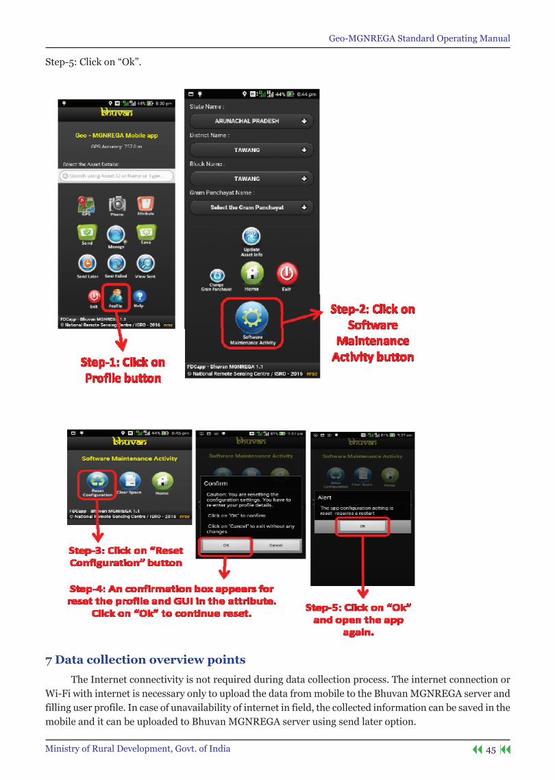
Step-5:Clickon“Ok”.
7 Data collection overview points
The Internet connectivity is not required during data collection process. The internet connection or Wi-Fi with internet is necessary only to upload the data from mobile to the Bhuvan MGNREGA server and filling user profile. In case of unavailability of internet in field, the collected information can be saved in the mobile and it can be uploaded to Bhuvan MGNREGA server using send later option.
Geo-MGNREGA Standard Operating Manual
46 Ministry of Rural Development, Govt. of India
For operational convenience the users can collect data, save and view for any corrections in attributes using send later of manage option. The uploaded data will be systematically stored in the Bhuvan MGNREGA server at NRSC.
the user is advised to ensure GPs is switched-on with high accuracy mode before opening the App.
The step by step procedure for using the app is given below. There are four main tasks in this app are 1) GPS capture, 2) Taking photograph of the building (two photographs of the club), 3) Adding information about the house construction and 4) Sending the collected information to Bhuvan MGNREGA server, either immediately or later.
8 Data collection and Upload
The step by step procedure for using the app is given below. There are four main tasks in this app are 1) Select appropriate asset, 2) GPS capture, 3) Taking photograph of the work (two photographs), 4) Adding information if any about the work and 5) Sending the collected information to Bhuvan MGNREGA server, either immediately or later.
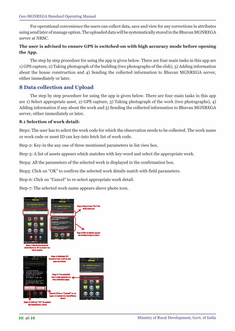
8.1 selection of work detail:
Step1: The user has to select the work code for which the observation needs to be collected. The work name or work code or asset ID can key-into fetch list of work code.
Step-2: Key-in the any one of three mentioned parameters in list view box.
Step-3: A list of assets appears which matches with key-word and select the appropriate work.
Step4: All the parameters of the selected work is displayed in the confirmation box.
Step5:Clickon“OK”toconfirmtheselectedworkdetailsmatchwithfieldparameters.
Step-6:Clickon“Cancel”tore-selectappropriateworkdetail.
Step-7: The selected work name appears above photo icon.
Geo-MGNREGA Standard Operating Manual
47Ministry of Rural Development, Govt. of India
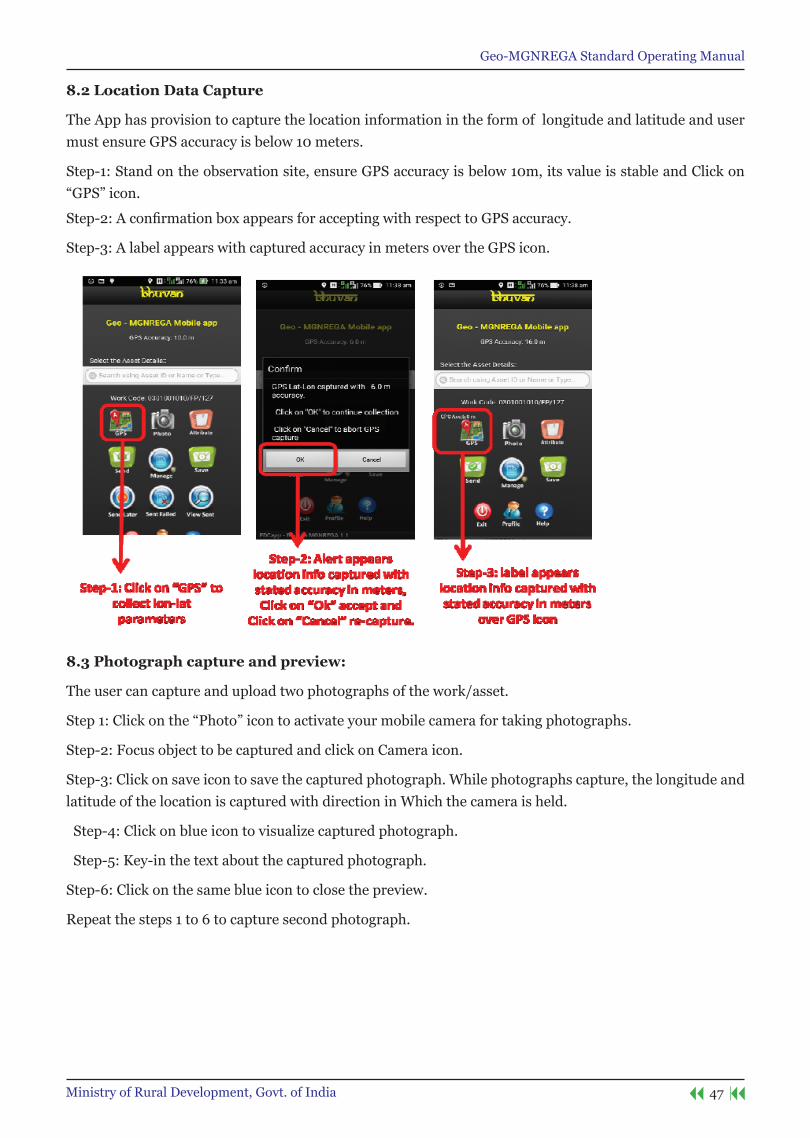
8.2 Location Data Capture
The App has provision to capture the location information in the form of longitude and latitude and user must ensure GPS accuracy is below 10 meters.
Step-1: Stand on the observation site, ensure GPS accuracy is below 10m, its value is stable and Click on “GPS”icon.
Step-2:AconfirmationboxappearsforacceptingwithrespecttoGPSaccuracy.
Step-3: A label appears with captured accuracy in meters over the GPS icon.
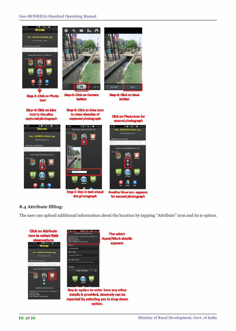
8.3 Photograph capture and preview:
The user can capture and upload two photographs of the work/asset.
Step1:Clickonthe“Photo”icontoactivateyourmobilecamerafortakingphotographs.
Step-2: Focus object to be captured and click on Camera icon.
Step-3: Click on save icon to save the captured photograph. While photographs capture, the longitude and latitude of the location is captured with direction in Which the camera is held.
Step-4: Click on blue icon to visualize captured photograph.
Step-5: Key-in the text about the captured photograph.
Step-6: Click on the same blue icon to close the preview.
Repeat the steps 1 to 6 to capture second photograph.
Geo-MGNREGA Standard Operating Manual
48 Ministry of Rural Development, Govt. of India
8.4 Attribute filling:
Theusercanuploadadditionalinformationaboutthelocationbytapping“Attribute”iconanditsisoption.

Geo-MGNREGA Standard Operating Manual
49Ministry of Rural Development, Govt. of India
Step3.OncetheuserissatisfiedwiththeinformationcollectedandreadyforuploadingtheinformationtoBhuvanMGNREGAserver,usermaytapthe“Send”icon.Thiswilluploadalltheinformationcollected.Userisadvisedtoensurethatmobiledataisswitched-onbeforetappingthe“Send”icon.TheUserhastowaitforconfirmationmessage“Datasentsuccessfully”onsuccessfulupload.Foranycommunicationfailure, a failure message appears and aurtomatically the data is organised in Send Failed option.
9. save data for sending Later
In case of unavailability of Internet connectivity in the collection site, the user is advised to tap “Save”icon.Thiswillstorethecollecteddatainthemobile.OncetheInternetconnectivityisavailable,usermay follow the steps to upload The data to Bhuvan MGNREGA server using Send Later option. The Wi-Fi facilityoftheinternetmodem(likeBroadbandathomeoroffice)canalsobeusedtoconnectforinternetfacility in the mobile and upload the data.

Geo-MGNREGA Standard Operating Manual
50 Ministry of Rural Development, Govt. of India
10. Managing your data
In order to upload the saved data to Bhuvan MGNREGA server, user can also edit (before sending) or delete the attribute values in send later or sent failed, and visualize the sent observations click on Manage icon.

Geo-MGNREGA Standard Operating Manual
51Ministry of Rural Development, Govt. of India
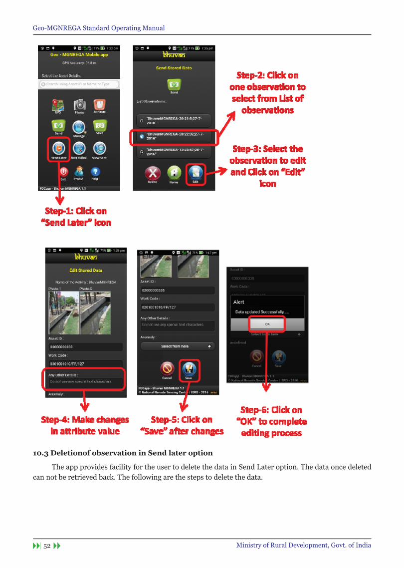
10.1 send Data from send later
Tap“SendLater”icon.Thiswilllistallthedatacollectedandstoredinthemobile.Selectthedatathatneeds tobeuploadedand then tap “Send” icon toUpload thedata toBhuvanMGNREGAserver.Waitforconfirmationmessage.The“Datasentsuccessfully”messageappearsoncethedataisuploadedsuccessfully.
10.2 editing of Attributes in send later option
The app provides facility for the user to edit the data in Send Later option. The Editing is possible only for attribute values. The user cannot editing GPS value, change photographs and change the time stamp of the observation captured.
Geo-MGNREGA Standard Operating Manual
52 Ministry of Rural Development, Govt. of India
10.3 Deletionof observation in send later option
The app provides facility for the user to delete the data in Send Later option. The data once deleted can not be retrieved back. The following are the steps to delete the data.

Geo-MGNREGA Standard Operating Manual
53Ministry of Rural Development, Govt. of India
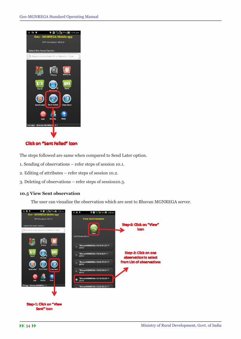
10.4 Data in sent Failed option:
The Sent Failed option also has all the facilities in send later option. There are provision to edit, delete and send the observation to Bhuvan MGNREGA server.
Geo-MGNREGA Standard Operating Manual
54 Ministry of Rural Development, Govt. of India
The steps followed are same when compared to Send Later option.
1. Sending of observations – refer steps of session 10.1.
2. Editing of attributes – refer steps of session 10.2.
3. Deleting of observations – refer steps of session10.3.
10.5 View sent observation
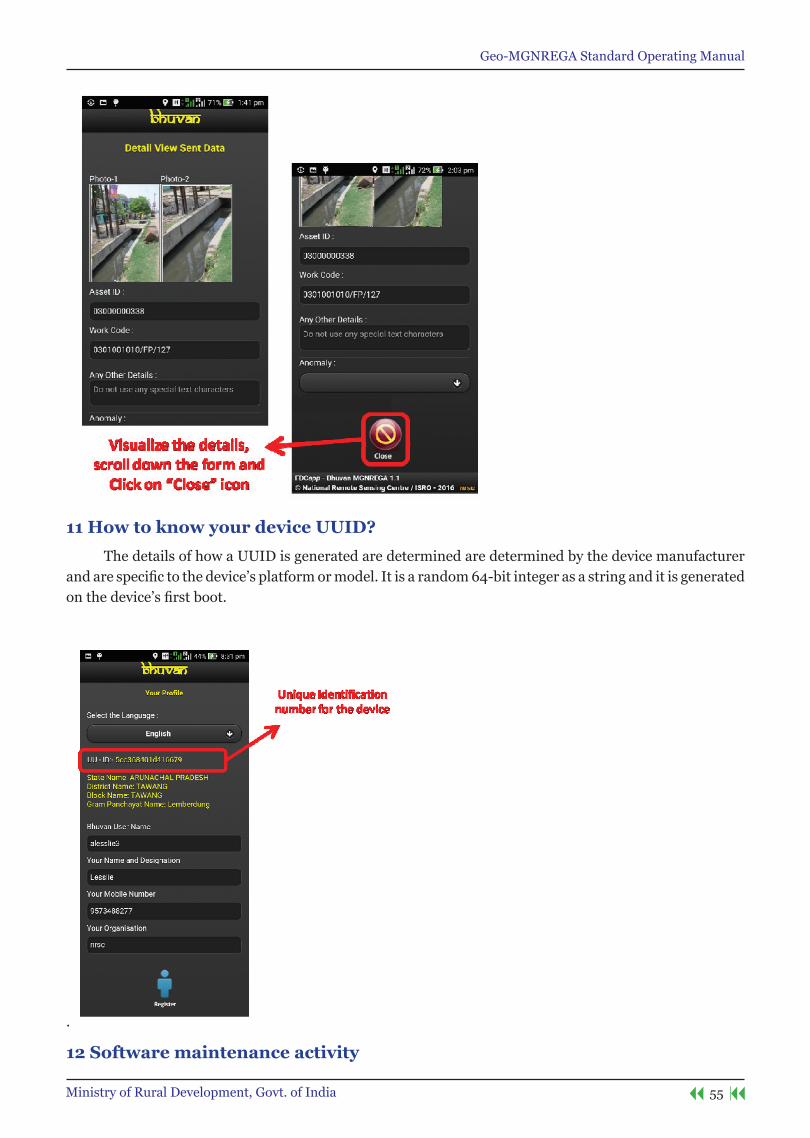
The user can visualize the observation which are sent to Bhuvan MGNREGA server.
Geo-MGNREGA Standard Operating Manual
55Ministry of Rural Development, Govt. of India
11 How to know your device UUID?
The details of how a UUID is generated are determined are determined by the device manufacturer andarespecifictothedevice’splatformormodel.Itisarandom64-bitintegerasastringanditisgeneratedonthedevice’sfirstboot.
.
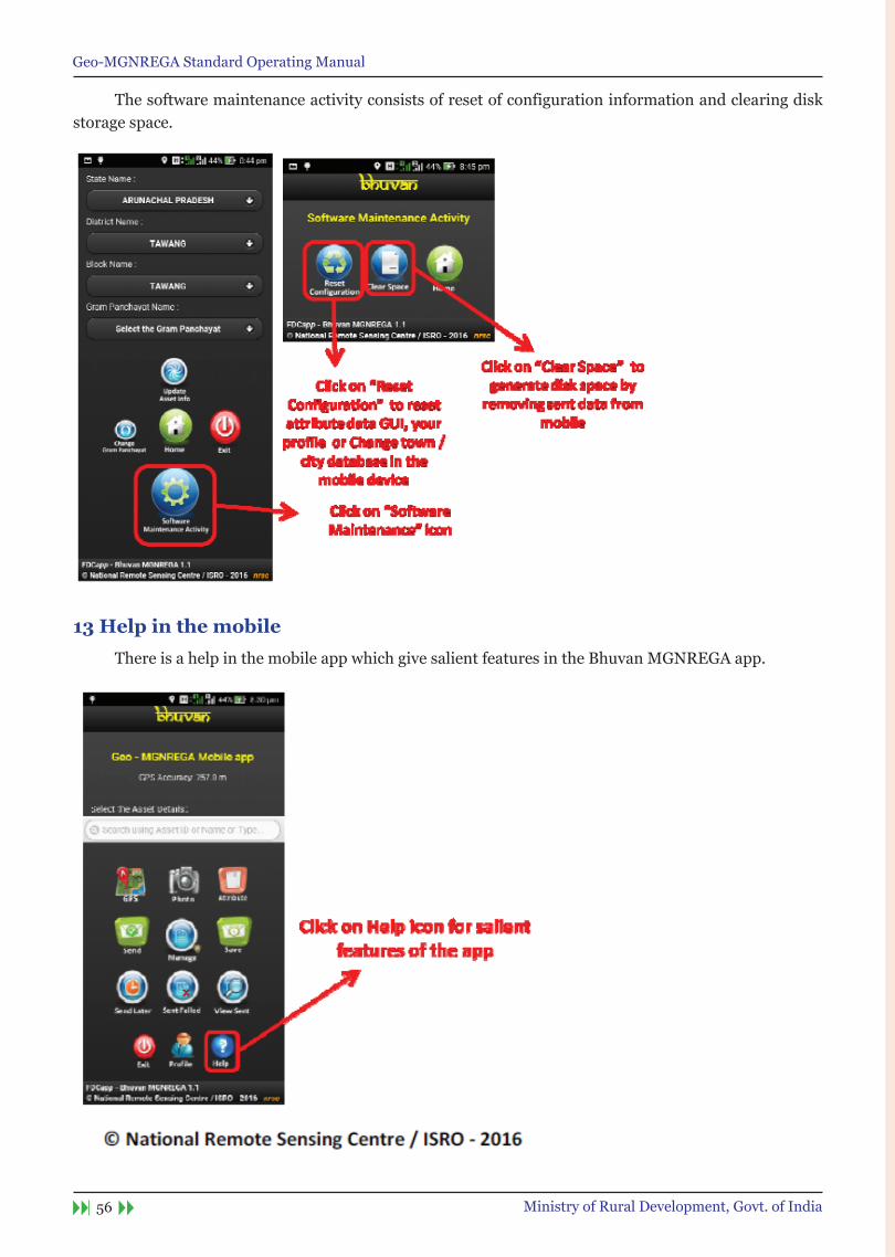
12 software maintenance activity
Geo-MGNREGA Standard Operating Manual
56 Ministry of Rural Development, Govt. of India
The software maintenance activity consists of reset of configuration information and clearing disk storage space.
13 Help in the mobile
There is a help in the mobile app which give salient features in the Bhuvan MGNREGA app.
Geo-MGNREGA Standard Operating Manual
57Ministry of Rural Development, Govt. of India
Bhuvan-MGnReGA Geoportal

Geo-MGNREGA Standard Operating Manual
58 Ministry of Rural Development, Govt. of India
Geo-MGNREGA Standard Operating Manual
59Ministry of Rural Development, Govt. of India
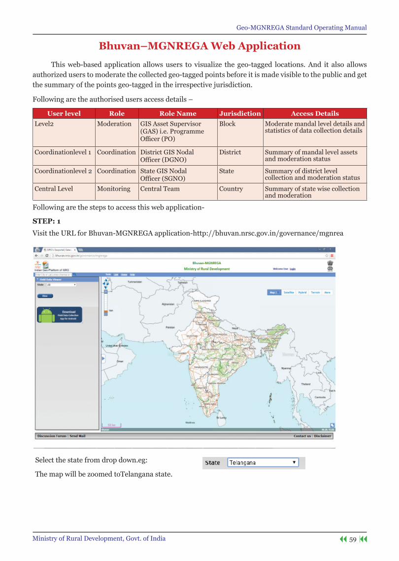
Bhuvan–MGnReGA Web Application
This web-based application allows users to visualize the geo-tagged locations. And it also allows authorized users to moderate the collected geo-tagged points before it is made visible to the public and get the summary of the points geo-tagged in the irrespective jurisdiction.
Following are the authorised users access details –
User level Role Role name Jurisdiction Access DetailsLevel2 Moderation GIS Asset Supervisor
(GAS) i.e. Programme Officer(PO)
Block Moderate mandal level details and statistics of data collection details
Coordinationlevel 1 Coordination District GIS NodalOfficer (DGNO)
District Summary of mandal level assets and moderation status
Coordinationlevel 2 Coordination State GIS NodalOfficer (SGNO)
State Summary of district level collection and moderation status
Central Level Monitoring Central Team Country Summary of state wise collection and moderation
Following are the steps to access this web application-
steP: 1
Visit the URL for Bhuvan-MGNREGA application-http://bhuvan.nrsc.gov.in/governance/mgnrea
Select the state from drop down.eg:
The map will be zoomed toTelangana state.
Geo-MGNREGA Standard Operating Manual
60 Ministry of Rural Development, Govt. of India
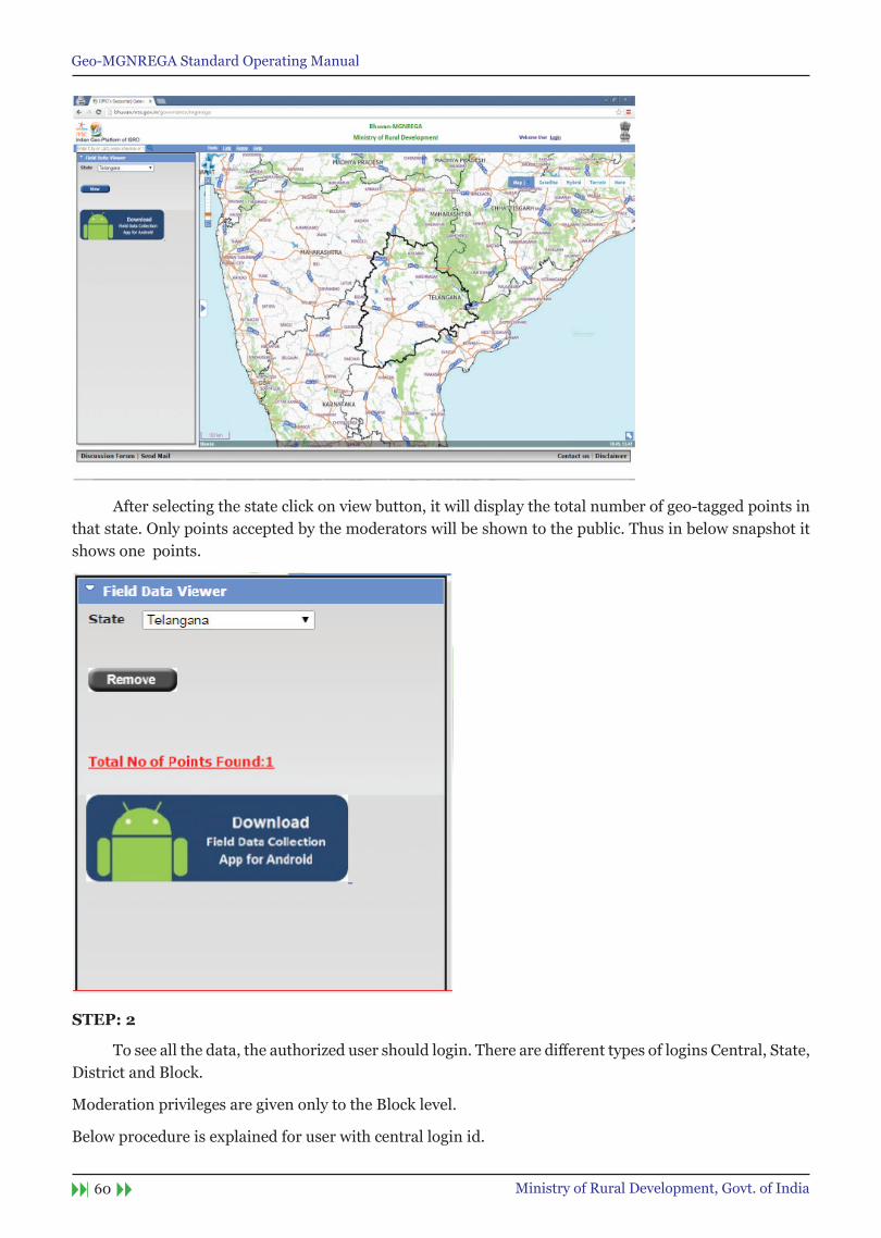
After selecting the state click on view button, it will display the total number of geo-tagged points in that state. Only points accepted by the moderators will be shown to the public. Thus in below snapshot it shows one points.
steP: 2
Toseeallthedata,theauthorizedusershouldlogin.Therearedifferenttypesof logins Central, State, District and Block.
Moderation privileges are given only to the Block level.
Below procedure is explained for user with central login id.
Geo-MGNREGA Standard Operating Manual
61Ministry of Rural Development, Govt. of India
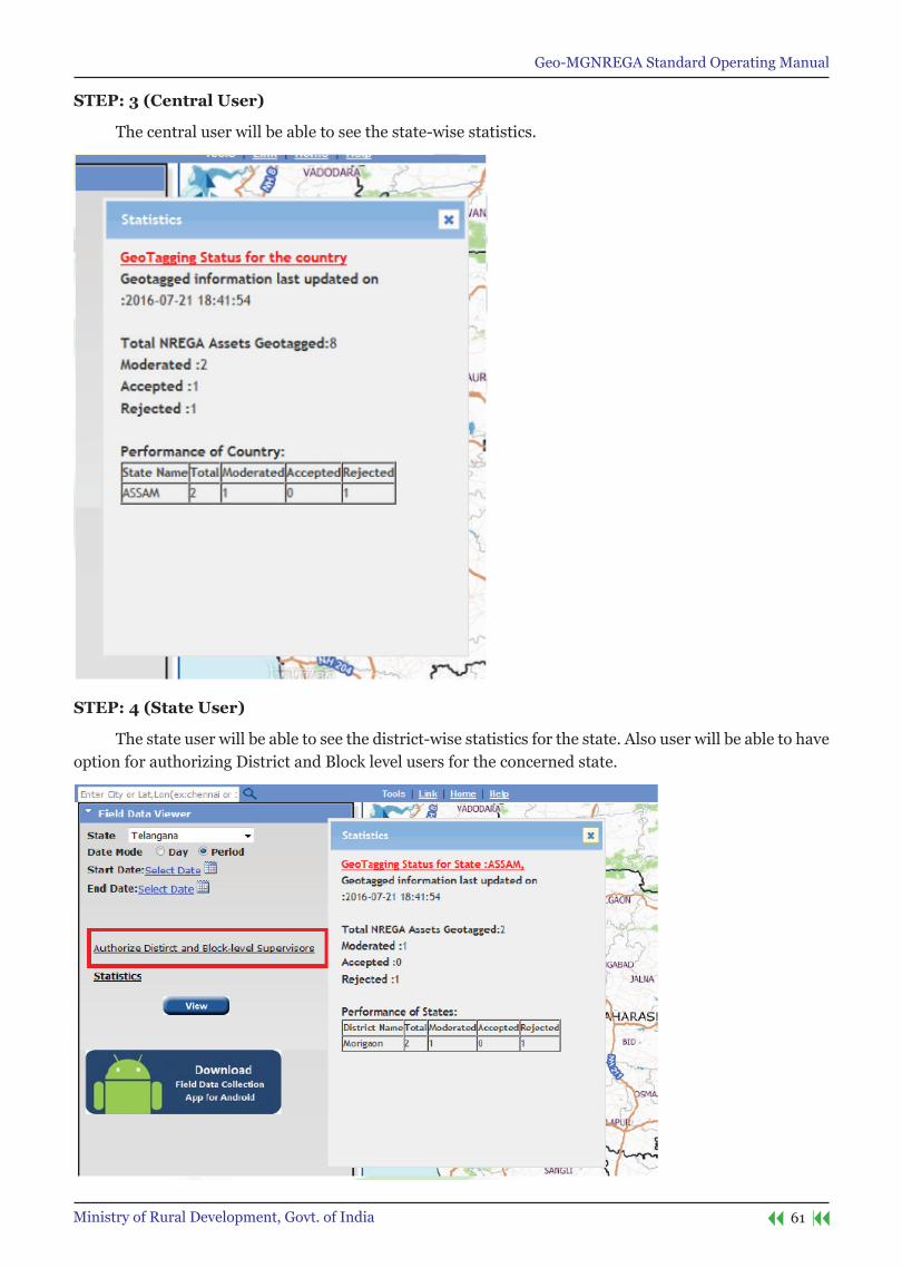
steP: 3 (Central User)
The central user will be able to see the state-wise statistics.
steP: 4 (state User)
The state user will be able to see the district-wise statistics for the state. Also user will be able to have option for authorizing District and Block level users for the concerned state.

Geo-MGNREGA Standard Operating Manual
62 Ministry of Rural Development, Govt. of India
steP: 5 (District User)
The district user will be able to see the block-wise statistics for the district.
steP: 6 (Block User)
The block user will be able to see the block-wise statistics for the state. Also user will be able to have option for authorizing Panchayat level users for the concerned block. Moderation privileges are also given to this user.
After login to the page we will get a new button named ‘Enable Moderation’.

Geo-MGNREGA Standard Operating Manual
63Ministry of Rural Development, Govt. of India
Statistics will be seen as below
steP: 7 (Block User: Moderation)
To perform moderation operation click on ‘Enable Moderation’ icon to moderate the points.

Geo-MGNREGA Standard Operating Manual
64 Ministry of Rural Development, Govt. of India
Select any point by clicking on it. After selecting the point a popup will display the information of house along with the photos.
User has an option to accept, edit o reject any point.
1. To reject the geo-tagged asset, click on reject button on bottom of popup. After clicking on reject button a new box will open i.e. ‘Reason for reject’. Enter the reason for rejection and select the reject button. Point will be rejected successfully.
2. To accept the geo-tagged asset, click on accept button on bottom of popup. Another popup will open. Click ok button to accept the point. Click cancel button if not. If user clicks on ok button the point is accepted. Another popup will open and gives the message like accepted successfully. And the point will disappear from the map for further moderation.
3. To Edit the point, user can click on Edit button and then click on ‘save’.

Geo-MGNREGA Standard Operating Manual
65Ministry of Rural Development, Govt. of India
Appendix
Acronyms & Definitions
Acronym Full DescriptionGIS Geographic Information
SystemDatabase for spatial and non spatial data
MoRD Ministry of Rural Development
A branch of the Government of India, is entrusted with the task of accelerating the socio-economic development of rural India
NRSC National Remote Sensing Centre
Monitoring using satellite data, Spatial and thematic maps, part of Indian Space Research Organisation
CGARD Centre for Geo-informatic Applications in Rural Development
Design and develop Geomatics Applications for Rural Development Sector and develop the skill and knowledge levels in Geomatics technology and tools among the development functionaries from the Government
NIRD National Institute for Rural Development
Indian institute for research in rural development
ISRO Indian Space Research Organisation
The space agency of the Indian government
GPD GIS Pioneer Districts First District where GIS will be implemented GPDTS GIS Pioneer District
Testing Site First Gram Panchayat selected within GPD for PILOT execution of GIS application
GPDT GIS Pioneer District Tester
Gram Panchayats functionaries working MSE and GAS in GPDTS
GPDC GIS Pioneer District Champion
Nominate by GPD, one resource person from each Block, he/she will in-turn train all the GRS/ Technical Assistants/ PO of their respective District
GPSTD GIS Pioneer Testing Site District
GPTSB GIS Pioneering Testing Site Block
GPTSG GIS Pioneering Testing Site Gram Panchayat
RRP Regional Resource Persons
SelectedbySIRD/NIRD,tobefirsttrainedinMGNREGAGISunderTraining of Trainers(ToT) in Stage-2.
PMU Programme Management Unit
PMUisagrouptoensureeffectiveimplementationandmonitoring
MSE MGNREGA Spatial Emulator
At Gram Panchayat level, who will capture the asset photographs with GPS location
GAS GIS Asset Supervisor At Block level, who will validate and approve the asset photographDGNO District GIS Nodal
OfficerAt District Level, coordinate and monitor the implementation
SGNO StateGISNodalOfficer At State Level, Coordinate and monitor the implementationNREGASoft MIS for MGNREGANIC National Informatics
CentreSIRD State Institute of Rural
DevelopmentAutonomous Institute under State Government for Training & Research in Rural Development
GRS Gram RojgarSevak AtGramPanchayatlevel,officialmanagestheMGNREGAworkPO ProgramOfficer AtBlocklevel,officialmanagestheMGNREGAwork.PERT Program Evaluation
Review TechniqueTofindthecriticalpathforprojectmanagement.
GANTT Horizontal chart bar chart to monitor the progress of program.

Geo-MGNREGA Standard Operating Manual
66 Ministry of Rural Development, Govt. of India
TA Technical AssistantPILOT GIS Implementation in small group of people from selected pioneer districts.WAVE -I GIS Implementation in one district selected in each state, comprising a total of 34 districtsWAVE-II GIS Implementation of all other Districts after Wave-IPHASE-I Rollout phase, development of Bhuvan mobile and web applications, and integrating with
NREGASoftPHASE-II Rollout phase, Development of Citizen centric Mobile Application PHASE-III Rollout phase, Publish e-Government Interoperability Frameworks to create single window-
access to spatial / non spatial data for full integrationStage-1 Training for National Level GIS Orientation Workshop Stage-2 Training for Regional Resource PersonsStage-3 Training for GIS MGNREGA Block Champion Training for Wave Istage-4 Training for GIS MGNREGA Block Level Training for Wave IStage-5 Training for GIS MGNREGA Block Champion Training for Wave II.State-6 Training for GIS MGNREGA Block Level training for Wave II
.