Geological settings of the protected Selisoo mire (northeastern Estonia) threatened by oil shale...
11
Estonian Journal of Earth Sciences, 2014, 63, 2, 97107 doi: 10.3176/earth.2014.09 97 Geological settings of the protected Selisoo mire (northeastern Estonia) threatened by oil shale mining Helen Hiiemaa, Mario Mustasaar, Marko Kohv, Tiit Hang, Argo Jıeleht, Katrin Lasberg and Volli Kalm Institute of Ecology and Earth Sciences, University of Tartu, Ravila 14A, 50411 Tartu, Estonia; [email protected] Received 10 February 2014, accepted 22 April 2014 Abstract. The protected Selisoo mire in northeastern Estonia is located above valuable oil shale resources, partly in the permitted mining area. We describe in detail the geomorphology and geological setting of the mire to understand the natural preconditions for its formation, development and preservation. We used the LiDAR-based digital elevation model for relief analysis, mapped the peat thickness with ground-penetrating radar and described the Quaternary cover through corings. Ridges, oriented perpendicular to the generally southward-sloping terrain, and shallow depressions at the surface of mineral soil have influenced mire formation and its spatio-temporal dynamics. The Quaternary cover under the mire is thin and highly variable. Therefore the mire is hydro- geologically insufficiently isolated from the limestone bedrock that is drained by the nearby oil shale mine and consequently the mining activities approaching the mire may have a negative influence on the wetland and proposed Natura 2000 site. Natura 2000 type wetlands, both protected or currently outside the nature reserves, cover a significant portion of the prospective oil shale mining areas. The distribution and resilience of those sites may significantly influence further utilization of oil shale resources. Key words: mire initiation, mire development, hydrology, drainage, human impact, ground penetrating radar, lidar. INTRODUCTION Flat terrain and humid climate of Estonia have favoured the formation of wetlands, which constitute a dominating element of the local landscape. Peatlands are distributed all over the country, taking up 22.3% of Estonias territory (1 009 101 ha). This figure has often been transferred to mires, however, according to the inventory of Estonian mires (Paal & Leibak 2011), the area of mires is nowadays 233 000 ha or 5.2% of Estonias territory. The inventory concludes that the total area of Estonian mires has decreased by nearly 2.8 times as compared to the 1950s. The decrease is mostly caused by the drainage of mires for forestry, agriculture and peat extraction. Excavation of oil shale is also one of the threats to peatlands in Estonia. About 2000 ha of mires are already lost because of oil shale quarries in northeastern Estonia and the annual loss is predicted to be around 100 ha as the activity continues (Paal et al. 1998). Oil shale is extracted also in mines south of the quarries, because the productive layer dips southwards and accompanying groundwater extraction is threatening wetlands outside the actual area covered by mining permits. As both the largest protected mire massifs and underground mines are situated in the northeast of the country, conflicts between nature protection and mining are escalating gradually. This is potentially the case with the Selisoo mire, a Natura 2000 site that lies above valuable oil shale resources and partly (250 ha) within the permitted mining area. The existing underground oil shale mine is 6070 m below the ground surface and is approaching the Selisoo mire from the east. In 2013 the underground mine was at a distance of 30 m from the nature protection area and mining activities continue along its border. The EU court cases suggest that restrictions associated with the protection of Natura sites have no fixed boundaries (Marandi et al. 2014). The monitoring of the groundwater level in the surroundings of the underground mine and Selisoo mire shows lowering of the water table in bedrock aquifers and thus, indeed, the effect of the mine is not limited to its borders. The direct impact of the mine on the ecology of the nearby mire depends largely on local geological conditions and requires hydrogeological modelling. Two hydro- geological studies have recently considered the impact of the underground mine Estonia on the Selisoo mire and have reached somewhat opposing conclusions. Orru et al. (2013) used 1-D calculations to estimate the minimum rainfall that would compensate drainage by the mine. Using published values for the hydraulic conductivity of bedrock and overburden, they concluded that the mining does not influence the Selisoo water regime because the hydraulic conductivity of the Oandu aquitard and
-
Upload
independent -
Category
Documents
-
view
3 -
download
0
Transcript of Geological settings of the protected Selisoo mire (northeastern Estonia) threatened by oil shale...
Estonian Journal of Earth Sciences, 2014, 63, 2, 97�107 doi: 10.3176/earth.2014.09
97
Geological settings of the protected Selisoo mire (northeastern Estonia) threatened by oil shale mining
Helen Hiiemaa, Mario Mustasaar, Marko Kohv, Tiit Hang, Argo Jõeleht,
Katrin Lasberg and Volli Kalm
Institute of Ecology and Earth Sciences, University of Tartu, Ravila 14A, 50411 Tartu, Estonia; [email protected] Received 10 February 2014, accepted 22 April 2014 Abstract. The protected Selisoo mire in northeastern Estonia is located above valuable oil shale resources, partly in the permitted mining area. We describe in detail the geomorphology and geological setting of the mire to understand the natural preconditions for its formation, development and preservation. We used the LiDAR-based digital elevation model for relief analysis, mapped the peat thickness with ground-penetrating radar and described the Quaternary cover through corings. Ridges, oriented perpendicular to the generally southward-sloping terrain, and shallow depressions at the surface of mineral soil have influenced mire formation and its spatio-temporal dynamics. The Quaternary cover under the mire is thin and highly variable. Therefore the mire is hydro-geologically insufficiently isolated from the limestone bedrock that is drained by the nearby oil shale mine and consequently the mining activities approaching the mire may have a negative influence on the wetland and proposed Natura 2000 site. Natura 2000 type wetlands, both protected or currently outside the nature reserves, cover a significant portion of the prospective oil shale mining areas. The distribution and resilience of those sites may significantly influence further utilization of oil shale resources. Key words: mire initiation, mire development, hydrology, drainage, human impact, ground penetrating radar, lidar.
INTRODUCTION Flat terrain and humid climate of Estonia have favoured the formation of wetlands, which constitute a dominating element of the local landscape. Peatlands are distributed all over the country, taking up 22.3% of Estonia�s territory (1 009 101 ha). This figure has often been transferred to mires, however, according to the inventory of Estonian mires (Paal & Leibak 2011), the area of mires is nowadays 233 000 ha or 5.2% of Estonia�s territory. The inventory concludes that the total area of Estonian mires has decreased by nearly 2.8 times as compared to the 1950s. The decrease is mostly caused by the drainage of mires for forestry, agriculture and peat extraction. Excavation of oil shale is also one of the threats to peatlands in Estonia. About 2000 ha of mires are already lost because of oil shale quarries in northeastern Estonia and the annual loss is predicted to be around 100 ha as the activity continues (Paal et al. 1998). Oil shale is extracted also in mines south of the quarries, because the productive layer dips southwards and accompanying groundwater extraction is threatening wetlands outside the actual area covered by mining permits. As both the largest protected mire massifs and underground mines are situated in the northeast of the country, conflicts between nature protection and mining are escalating gradually.
This is potentially the case with the Selisoo mire, a Natura 2000 site that lies above valuable oil shale resources and partly (250 ha) within the permitted mining area. The existing underground oil shale mine is 60�70 m below the ground surface and is approaching the Selisoo mire from the east. In 2013 the underground mine was at a distance of 30 m from the nature protection area and mining activities continue along its border. The EU court cases suggest that restrictions associated with the protection of Natura sites have no fixed boundaries (Marandi et al. 2014). The monitoring of the groundwater level in the surroundings of the underground mine and Selisoo mire shows lowering of the water table in bedrock aquifers and thus, indeed, the effect of the mine is not limited to its borders.
The direct impact of the mine on the ecology of the nearby mire depends largely on local geological conditions and requires hydrogeological modelling. Two hydro-geological studies have recently considered the impact of the underground mine Estonia on the Selisoo mire and have reached somewhat opposing conclusions. Orru et al. (2013) used 1-D calculations to estimate the minimum rainfall that would compensate drainage by the mine. Using published values for the hydraulic conductivity of bedrock and overburden, they concluded that the mining does not influence the Selisoo water regime because the hydraulic conductivity of the Oandu aquitard and
Estonian Journal of Earth Sciences, 2014, 63, 2, 97�107
98
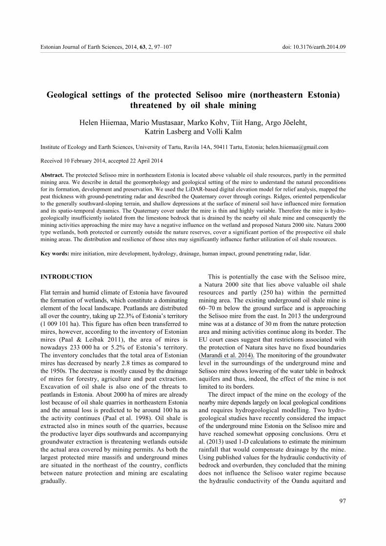
oligotrophic peat layer is low and usually the annual rainfall is larger than 540 mm yr�1 that is sufficient to keep mire water balance positive. Marandi et al. (2013) used a 3-D hydrogeological model that was calibrated according to the extent of the mine, groundwater level observations and water-abstraction rates at two regimes in 2000 and 2010. They concluded that bedrock aquitard does not confine sufficiently and considerable lowering of groundwater takes place below the mire. Both studies suggest that the preservation of the mire depends on hydraulic properties of peat and near-surface sediments, although different threshold values are kept in mind. In case of suspicion of threat to the protection area, an appropriate Natura assessment with up-to-date scientific knowledge must be initiated (Marandi et al. 2014). The aim of the current study was to provide detailed information on geological settings of the Selisoo mire and adjoining area. We define the extent and thickness of peat and Quaternary sediments with geomorphology of the sub-peat surface to understand what were/are the natural preconditions for onset of paludification, further development, present situation and future preservation of the Selisoo mire. THE STUDY AREA AND GEOLOGICAL SETTING The Selisoo mire is located in northeastern Estonia, where topography is rather flat, gently sloping towards the Lake Peipsi depression in the south and the Narva River valley in the east (Fig. 1). Higher areas (up to 75 m a.s.l.) can be found at the Jõhvi elevation, where the topography is slightly undulating. The Jõhvi elevation extends to the northern limit of the Selisoo mire, where the altitude of mineral terrain is 55�65 m a.s.l. and it inclines down to 51�46 m at the southern limit of the mire. The Mäetaguse esker in the west and a NE�SW oriented sandy ridge in the southeast determine a fixed boundary of the mire while elsewhere it is delineated based on the soil maps.
The bedrock surface of Ordovician limestone and dolomites at an altitude of 50�70 m is inclined towards the south and southeast. Kerogenous kukersite-bearing deposits of Late Ordovician age with a 1�2 m thick commercial oil-shale seam are located at a depth of 50�60 m in our study area. The thickness of Quaternary sediments covering the bedrock is about 5�10 m, reaching up to 15 m in the Mäetaguse esker (Hang & Miidel 1999). North of the Selisoo mire grey loamy till is cropping out. In the southern part of the study area it is covered by fine-grained glaciolacustrine sand or laminated silt and clay. Flat topography and fine-grained sediments have favoured the paludification of the area and formation
Fig. 1. (A) Large mires in Estonia (Allikvee & Ilomets 1995) and the location of the Selisoo mire. (B) The Jõhvi elevation extends to the northern limit of the mire. The underground oil shale mine is approaching the Selisoo mire from the east. The area covered by mining permit, marked with a rectangular grid, extends below the mire.
of raised bogs with a 5�7 m thick peat cover. Bogs in the area belong to the �eastern� type according to the classification by Masing (1982), having a convex surface and lacking distinct marginal slopes. The Selisoo mire, with an area of 2051 ha, is mainly northern, Sphagnum-dominated bog with sparse pine cover and many bog pools, hummocks and hollows. Only in some places at the border of the bog transitional mire has survived from the drainage. The Selisoo mire was a part of the Muraka mire complex but is now separated from the main wetland system by the local road and drained fields (Fig. 1). The Muraka mire complex (12 783 ha) is one of the largest wetlands in Estonia, consisting of seven larger bogs and transitional lags and fens in between (Orru 1995).
H. Hiiemaa et al.: Geological settings of the Selisoo mire
99
MATERIAL AND METHODS Relief analysis was performed with the digital elevation model (DEM), using LiDAR datapoints from the Estonian Land Board (survey flight in 2009) for DEM calculation. The average point density is 0.45 points per metre, with a maximum distance of 2.6 m between the points. The vertical accuracy of the laser data points is between 7 and 12 cm. The raw data was in ASCII text files, with one file covering 1 km2. One file contains up to 1.4 million points, which are classified as follows: 1, unclassified; 2, terrain; 6, buildings (applicable only to major towns); 7, noise; 14, sea (ELB 2012). The points, classified as terrain data, were used for DEM generation. We used Mapinfo 9.0 for creating the DEM and kriging as the interpolation method, with the grid cell size set to 10 m × 10 m.
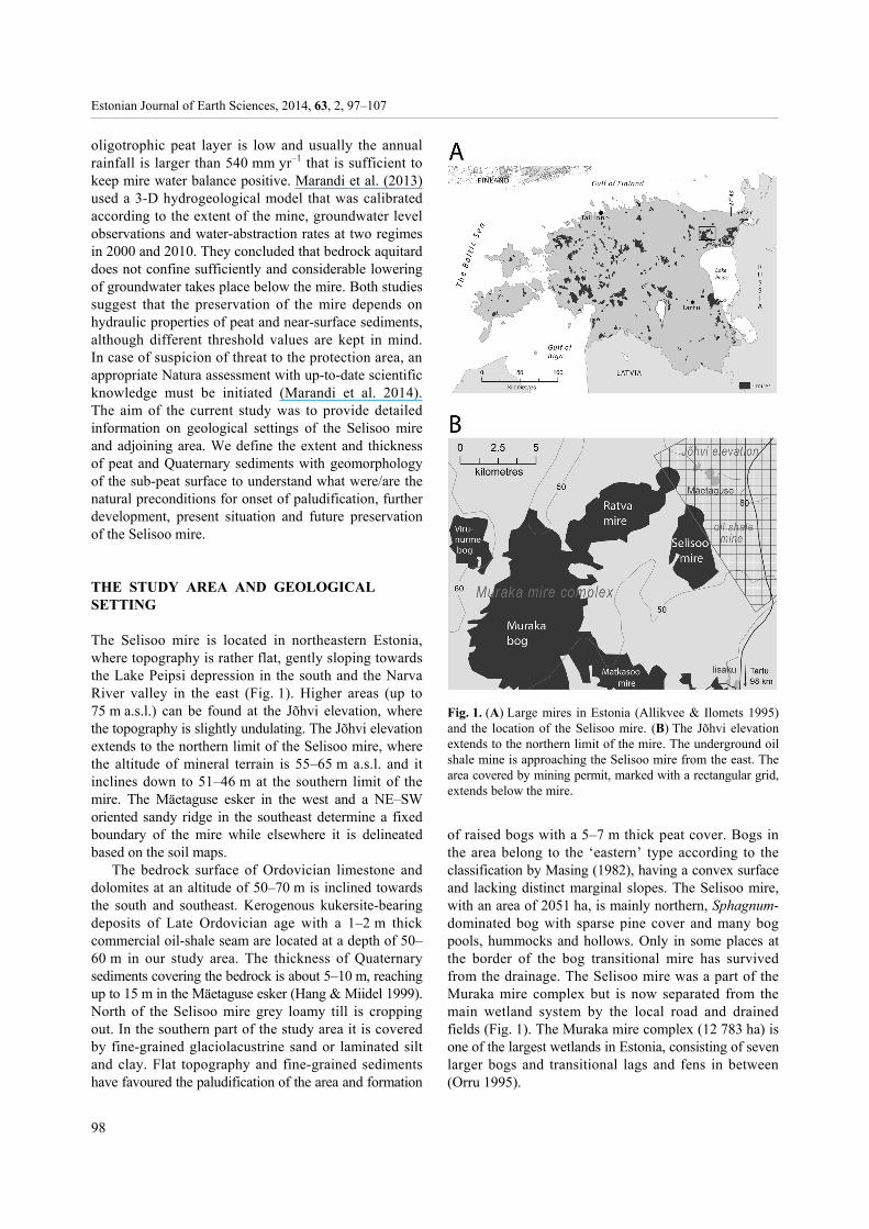
Peat thickness was mapped with ground penetrating radar (GPR) supported by corings. The GPR surveys were performed with Zond 12-e system by Radar System Inc., using common offset measurements with 300 MHz shielded antenna oriented perpendicular to the profile. About 45 km of profiles (Fig. 2) were obtained by pulling
Fig. 2. Factual data obtained from the Selisoo mire, including GPR profiles, 14C sampling and coring sites.
the antenna at walking speed and tracks were recorded with handheld GPS. To amplify the reflections and reduce the noise level, we applied the stacking of four measurements. The electromagnetic wave velocities were estimated using a depth-to-target method, which consists of calculating the velocity required for the best fit between a GPR peat thickness estimate and actual peat thickness observed at coring locations. The best fit for the peat deposits in the Selisoo mire was electromagnetic wave velocity of 3.54 cm ns�1, which corresponds to relative dielectric permittivity value of 72.
Lightweight drilling rig or manually operated Russian type peat corer were used to describe the peat thickness and stratigraphy in 47 sites (Fig. 2) and to calibrate the GPR data. We took six peat samples for conventional 14C dating (Fig. 2) to date the onset of peat formation and the beginning of ombrotrophication as well as for calculation of expansion rates from the current bog dome centres eastwards to the former, now drained, fen. Bulk 14C samples were dated at the Radiocarbon Laboratory, University of Tartu, and calibrated with online software OxCal using the IntCal09 calibration curve. Loss of peat thickness due to drainage-induced compaction and mineralization was calculated according to empirical formulas presented by Tomberg (1992).
The digital peat thickness distribution model (grid size 10 m × 10 m) was generated with the natural neighbour method within Vertical Mapper (v 3.5) add-on module of the Mapinfo (v 9.0) software. The mineral soil surface model was calculated by subtracting the peat thickness model from the DEM.
The mineral Quaternary sediments under the Selisoo mire and in its surroundings were described and sampled using a drop weight drilling rig �Dando Terrier 2002� with a window sampler of 10 cm diameter.
The term �margin of the mire� used in this work re-presents the 30-cm-thickness isoline of the peat. Borders of the eutrophic, mesotrophic and ombrotrophic complexes of the Selisoo mire (Fig. 1) are based on the digital soil map of Estonia and are presented here according to Lode et al. (2012).
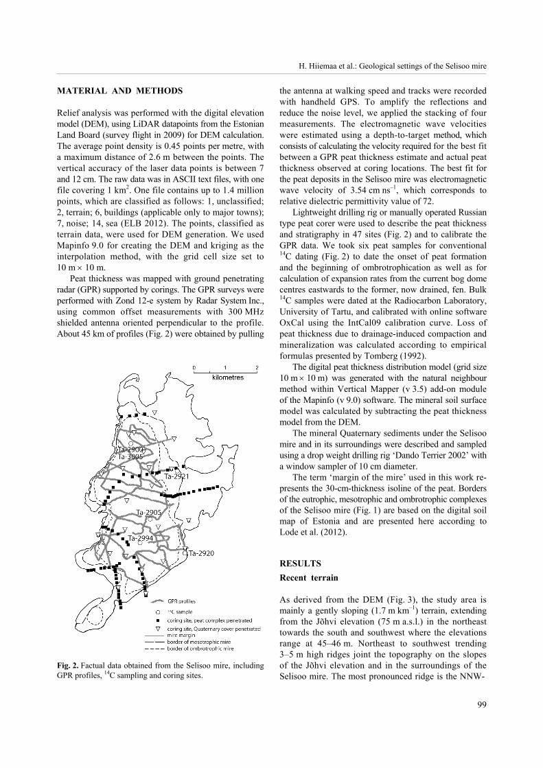
RESULTS Recent terrain As derived from the DEM (Fig. 3), the study area is mainly a gently sloping (1.7 m km�1) terrain, extending from the Jõhvi elevation (75 m a.s.l.) in the northeast towards the south and southwest where the elevations range at 45�46 m. Northeast to southwest trending 3�5 m high ridges joint the topography on the slopes of the Jõhvi elevation and in the surroundings of the Selisoo mire. The most pronounced ridge is the NNW-
Estonian Journal of Earth Sciences, 2014, 63, 2, 97�107
100
Fig. 3. Lidar-based digital elevation model (DEM) of the Selisoo mire area. The terrain is gently sloping southwards. The former coastline of Lake Seli is distinguishable in the southern part of the mire.
directional 7 km long and up to 10 m high Mäetaguse esker composed of gravel and sand, which clearly marks the western limit of the Selisoo mire (Fig. 3). The altitude of the crest of the esker is at 57�62 m, thus ca 5 m above the surface of the Selisoo mire. The plateau-like widening of the Mäetaguse esker is composed of glacio-lacustrine sand and silt and, together with a slight change in esker direction, points to the changing sedimentary environment during the formation of the esker. A set of 2�3 parallel sandy ridges with a relative height up to 4 m marks the southeastern limit of the mire (Fig. 3). These parallel ridges are discontinuous and the mire has grown over them during expansion (the crest of the ridge is locally covered by up to 2 m of peat). However, due to their combined effect, the ridges have effectively stopped the southward expansion of the mire and instead have directed paludification parallel to them, i.e. towards the southwest. The Mäetaguse esker and ridges in the west and south, and generally southward-sloping terrain explain the elongated shape of the Selisoo mire.
The surface topography of the Selisoo mire displays two bog domes, the smaller one in the north and a more extensive one in the south (Fig. 3). The altitude of the northern dome reaches 59 m and of the southern dome up to 57.5 m. The bog surface between the domes lies at the same altitude as the southern dome, forming an SSE-trending water divide. On the southern dome there is a 3 m deep depression which holds the largest water body in the area, Lake Seli.
The surface of the Selisoo mire is slightly tilted towards the east as the mire margin in the west is at an altitude of 57 m and in the eastern part at 55.5 m. The drop of surface altitude is greater close to the bog margins and a distinctive marginal slope can be followed in the eastern side as the surface lowers by 2.5 m at 50 m distance. A clear marginal slope is missing at the western side. Although the surface of the Selisoo mire is also slightly sloping southwards, just as the surrounding mineral soil, the relative height of the mire increases from 1 m in the north to 4�6 m in its southern part. Numerous bog pools form classic concentric zones around the dome centres, whereas the largest pools are located in the northwestern part of the mire. Lake Seli at the southern dome has approximately one third of its former size; its water level was lowered at the end of the 19th century. The former coastline is still clearly distinguishable in the orthophotos and DEM (Fig. 3). Water level lowering has changed mire topography over a distance of 50�150 m from the lake and its outflow channel.
Peat and its thickness Peat thickness across the Selisoo mire was mapped by GPR profiling (ca 45 km), supported by 47 corings (Fig. 2). As seen from the radar images (Fig. 4), the most prominent reflector originates from the boundary between peat and the underlying mineral sediments. It is also possible to distinguish locally different peat layers from the radar images: Sphagnum-dominated relatively poorly decomposed bog peat is marked by numerous horizontally oriented and undulating reflectors, while the underlying strongly decomposed fen peat is lacking inner reflectors (Fig. 4A). The boundary between the two types of peat in the Selisoo mire is transitional rather than fixed (Fig. 4). In places this transitional interval is characterized by numerous densely packed sub-horizontal reflections with decreasing amplitude towards the depth (Fig. 4B). Based on corings, such a strong reflection pattern is due to a significant amount of buried tree stumps in this interval. Thus the cross section of the peat body in the Selisoo mire consists mainly of ombrotrophic Sphagnum peat with varying degree of decomposition. Relatively well humidified fen peat, composed mainly

H. Hiiemaa et al.: Geological settings of the Selisoo mire
101
of wood, sedge and reed remains, is present in the topographic lows and is up to 1.5 m thick (Fig. 4).
The maximum peat thickness in the Selisoo mire is associated with the centres of the southern and northern domes (Fig. 5). The central part of the southern dome has the greatest peat thickness up to 7.2 m, which decreases towards the edges of the dome. The situation is different in the northern part of the mire, where the greatest peat thickness (6.2 m) does not coincide with the present centre of the dome but is shifted about 500 m in the SE direction. Peat between the domes is around 5 m thick and is mainly formed in hollows (dominated by Scheuchzeria palustris). Peat thickness is decreasing unevenly towards the mire margin, roughly following the underlying topography. For example, at the northern dome with varying sub-peat topography, elongated areas of peat thicknesses of 5.7�6 m alternate with the areas with 4.5�5 m thick peat. Peat thickness decreases most distinctly at the marginal slope of the mire but increases very rapidly from zero to 4 m in the western side where the mire is bordered by a steep-sloped esker (Fig. 3).
We took four samples for radiocarbon dating from the basal peat layer to pinpoint the start of peat formation at the current dome centres and at the border of the transitional mire (Fig. 2). We assumed that this set-up would reveal the start of mire formation and the rate of consequent paludification around the sub-peat depres-sions. Two additional samples (Ta-3005; Ta-2994) were collected from the first bog peat layer (no fen plants included) in order to reveal the beginning of the ombro-trophic phase in the mire development. Radiocarbon dates are presented in Table 1.
The distance between the bog centres and dated eastward border of the transitional mire is 1150 m in the northern part and 830 m in the southern part. This gives us lateral paludification rates of 0.61 to 0.59 m per year, respectively, if we assume linear widening of peat formation from the current dome centres towards the mire border. Although rather similar values were obtained from different parts of the mire, we believe that the rate of lateral mire increment may vary in different directions from the paludification centres. The
Fig. 4. Radar images of profiles AB and CD (for profile locations see Fig. 6). Bog peat is characterized by horizontally orientedand undulating reflectors while fen peat is lacking inner reflectors (A). Locally an interval of densely packed numerous sub-horizontal reflections with amplitude decreasing downwards marks the transitional zone between the two main types of peat (B).Note the different scales of the profiles.

Estonian Journal of Earth Sciences, 2014, 63, 2, 97�107
102
Fig. 5. Peat thicknesses in the Selisoo mire. The peat layer is thickest in the southern part of the mire. The dark grey line marks the border of the former mire before establishment of forest drainage systems.
vertical peat increment rate is 2�3 times lower at the mire border where fen peat is prevalent than in the mire centres where bog peat dominates. Peat thickness at the border of transitional mire is influenced by man-made drainage that causes subsidence of the peat body because of compaction and mineralization (Minkkinen & Laine 1998; Joosten & Clarke 2002). Therefore, the measured peat thickness was adjusted according to empirical formulas presented by Tomberg (1992). The calculated loss of thickness due to compaction and mineralization is 1.3 m in the northern part and 1.2 m in the southern part. This loss was added to the measured peat thickness in order to calculate the true vertical increment rate. The radiocarbon ages (4954 and 5587 cal 14C BP), obtained from the border of fen and bog peat at the centres of the northern and the southern dome, respectively, indicate that the ombrotrophic phase in mire development started more than 5000 years ago.
Underlying topography and Quaternary deposits The mineral surface under the Selisoo mire is concave and slopes gently to the south, but the base of the depres-sion is not evenly tilted (Fig. 6). Two depressions occur under the peat deposits on the north to south oriented profile (Fig. 6, profile 1). The bottom of the 2 km wide northern basin drops to an altitude of 53 m, which is
Table 1. Bulk radiocarbon dates and calculated increment rate of peat in the Selisoo mire. For sampling locations see Fig. 2
Lab No. Sample ID
Coordinates N/E
Depth, m
14C age 14C cal BPmedian
Peat increment
rate, mm yr�1
Material dated and stratigraphical
position
Ta-2900 7-07 59°11′59.7″ 27°16′00.7″
5.05�5.15 8790 ± 120 9849 0.52 Northern dome; fen peat at the mineral soil�peat interface
Ta-3005 N-4 59°11′50.4″ 27°15′54.7″
4.32�4.39 4390 ± 30 4954 ** Centre of the northern dome; basal layer of bog peat
Ta-2905 1-08A 59°10′53.4″ 27°16′28″
6.36�6.41 7670 ± 150 8490 0.76 Southern dome; fen peat at the mineral soil�peat interface
Ta-2994 S-4 59°10′49.6″ 27°16′35.4″
4.75�4.79 4840 ± 40 5587 ** Centre of the southern dome; basal layer of bog peat
Ta-2920 100-08 59°10′14.6″ 27°17′40.6″
0.82�0.92 6200 ± 150 7087 0.41* SE boundary of the mire; fen peat at the mineral soil�peat interface
Ta-2921 104-08 59°11′37.6″ 27°17′21.4″
1.90�1.95 7220 ± 200 8052 0.31* NE boundary of the mire; fen peat at the mineral soil�peat interface
���������� * Peat thickness is corrected according to Tomberg (1992); ** basal date not available.

H. Hiiemaa et al.: Geological settings of the Selisoo mire
103
2�2.5 m lower than the surface of the surrounding glacio-lacustrine plain. The bottom of the 3 km wide southern basin lies at an altitude of 51 m, 1�2 m below the adjoining mineral terrain. Ridges at the western and southeastern borders of the Selisoo mire emphasize the above basins even more. Thus, the western part of the Selisoo mire �leans� against the Mäetaguse esker, especially in the northern and central part where a steep buried slope of the esker is clearly seen on GPR profiles (Fig. 6).
Partly buried sandy ridges with a relative height of 2.5�3 m mark the southeastern boundary of the mire (Fig. 6, profile 4). In addition to a well-pronounced mire-bounding esker in the west and ridges in the southeast, the base of the mire is diversified by several smaller ridges. They can be 0.5�1 m high, 100�150 m wide and have northeast�southwest orientation that is typical of the elongated landforms in the adjoining terrain. Despite their low topography and limited length, the ridges have hindered southward water flow from the northern depression during the early stages of mire formation as well as the southeastward expansion of the northern dome at later times.
The thickness of the Quaternary sediments below the Selisoo mire varies from 1 to 7 m. The sediments are thickest in the western part where the Mäetaguse esker is situated and thinnest in the northern part of the mire (Fig. 7). In general, the thickness of mineral deposits (< 3�4 m) under the mire is smaller than in the sur-rounding plains where the mineral Quaternary cover is more than 3 m thick. Fine-grained glaciolacustrine sand with silty interlayers and sandy silt are the most widespread sediments under the peat (Fig. 7). Loamy
Fig. 7. Thickness and lithology of the Quaternary sediments below the Selisoo mire. Sand and till layers are overlapping in the NW side of the mire area.
Late Weichselian till is cropping out or covered by a thin sand layer under the northern part of the mire where its thickness reaches up to 2.45 m, being also widely spread north of the mire. The till layer is rather thin or entirely missing in other areas below the Selisoo mire, in some places sandy-silt or even sand is resting right on top of limestone. The ridge at the southeastern border of
Fig. 6. The digital elevation model of the mineral surface under the Selisoo mire and location of the profiles displayed at the rightside. AB, CD and EF refer to the location of GPR profiles in Fig. 4. The black line marks the mire boundary.
Estonian Journal of Earth Sciences, 2014, 63, 2, 97�107
104
the mire consists entirely of fine-grained sand. Clayey sediments are associated with the surroundings of the Mäetaguse esker, especially in its southern part, but a rather thin layer of clay is also locally present under the southern and eastern parts of the mire (Fig. 7). DISCUSSION The topography has been an important precondition for the formation and growth of the Selisoo mire. The surrounding terrain at the southern slope of the Jõhvi bedrock elevation, which is a major recharge area for local surface- as well as groundwater, is sloping south-wards. A relatively flat glaciolacustrine plain is dissected by northeast to southwest oriented ridges few of which are up to 10 m high (Fig. 3). The GPR survey revealed similar ridges with a relative height of 0.5�3 m under the Selisoo mire peat body (Fig. 4) and at the south-eastern boundary of the mire. In combination with two smaller depressions with their bottoms 1�2.5 m below the adjoining mineral terrain, the above landforms definitely slowed down the southward drainage of surface water at the time of initial mire formation. The mentioned ridges and southward-sloping terrain also explain the elongated shape of the Selisoo mire. At the same time it is obvious that solely favourable topographic conditions for the onset of paludification and peatland development are not sufficient to preserve the bog water balance in case of groundwater removal due to expansion of the underground mine to the vicinity of the Selisoo mire.
Fine-grained sediments of low hydraulic conductivity would also shield wetlands from the underground drainage by mines. The presence of such sediments enhances mire initiation and therefore it was assumed that they exist under the mires in NE Estonia. Our current study shows that it is not necessarily the case as high groundwater levels are sufficient for mire initiation even without such sediments. Numerous corings that penetrate the entire Quaternary sequence under the Selisoo mire show generally thinner mineral sediment layers below the mire than in the surroundings and the texture of those sediments varies between clay and sand.
Common geological literature (Coduto 1998) states that fine-grained loamy till and glaciolacustrine laminated clay and silt, which prevail under the Selisoo mire in its N and W parts, have significantly lower hydraulic conductivities than laminated silt and fine-grained sand which are dominating in the E and S part of the mire (Fig. 7). Till is only locally present under silt and sand. Generally sandy sediments rest right on top of Ordovician limestone that is known to have very high hydraulic conductivity (up to 100 m day�1) in its uppermost part and
also contains hydraulically conductive tectonic faults and karst zones (Perens & Vallner 1997).
Besides geomorphological reasons, sediment dis-tribution also explains the differences between the expansion of the mire in the north and in the south. The eastward expansion of paludification has been more intensive in the northern mire area where clayey till deposits prevail, whereas in the southern area expansion has been rather limited because of the presence of relatively water-conductive sands and silts. However, mineral Quaternary sediments do not form a sufficient aquitard between the mire and the limestone in order to preserve the Selisoo mire in case of groundwater lowering within carbonate rocks. Further studies are needed to estimate the hydraulic conductivity of peat at different humifi-cation levels in order to model potential impact of ground-water lowering on water levels on the bog surface. Two contrasting opinions have been published and further plans for oil shale mining in mire-rich NE Estonia require a clear answer to that question (Marandi et al. 2013, 2014; Orru et al. 2013).
Paludification is the main process of initial peatland formation in Estonia as ca 70% of mires have formed due to paludification and only one third of mires through infilling (Allikvee & Ilomets 1995). Our study shows that both processes were involved during the initial formation and development of the Selisoo mire. Two depressions in the surface of mineral soil and ridges oriented perpendicular to the general gradient of sloping favoured the formation of two shallow lakes where the infilling started.
Finds of gyttja below the peat are concentrated to the northern part of the mire, indicating a large, shallow, overgrown lake that existed there before peat formation. Gyttja finds are rare and scattered under the southern dome, indicating the presence of only very small and short-lived lakes or ponds before peat formation. Therefore most of the northern part of the current mire has been initialized by the infilling of the lake and the southern part by the paludification of the mineral surface. The oldest peat deposits accumulated at the shores of the northern lake approximately 1400 years earlier than at the southern depression.
In both the northern and the southern part of the Selisoo mire, sedge�reed plant communities changed rather quickly to tree�reed communities reflected in different types of fen peat. Growing thickness of peat hampered the discharge of surface water from the slope of the Jõhvi elevation and caused the paludification process to expand. As it was stressed above, the clayey subsoil in the north caused more extensive expansion compared to that in the south (Fig. 7) but in both areas the rate of mire expansion was rather similar (around 0.6 m yr�1). Pajula (2000) considers it as �rapid expansion�
H. Hiiemaa et al.: Geological settings of the Selisoo mire
105
in a similar study dealing with four bog complexes in central Estonia. The southern centre of peat formation was located between the Mäetaguse esker in the west and a NE�SW-trending ridge in the east that limited the expansion of paludification there. The second reason besides topographical constraints, which inhibited the expansion of paludification in the southern part of the mire, was the underlying sandy soil, which favoured infiltration of water from the current bog area to lower, southeastern plains. As peat thickness increased, the low mineral threshold between the two paludification centres was eventually buried and two wetlands merged. The former watershed turned into an outflow path between the two domes and is currently the most impenetrable part of the Selisoo mire system. This is a common develop-ment of the northern bog complexes (Ivanov 1981). Vertical peat increment rates (0.3�0.4 mm yr�1 for fen and 0.5�0.7 mm yr�1 for bog) are at the lower end of ranges (0.11�1.9 (average 0.7) mm yr�1 for fen and 0.45�2.7 (1.3) mm yr�1 for bog) reported by Allikvee & Ilomets (1995), who calculated peat increment rates for 68 Estonian mires.
The first stage of ombrotrophication in Estonian mires was 7000�6500 yr BP (Allikvee & Ilomets 1995). Although it could have been related to the relatively dry Atlantic climatic period, many mires which reached the ombrotrophication phase later in different times show that the ombrotrophication is a result of mire develop-ment rather than a climatic signal (Almquist-Jacobson & Foster 1995). Two conventional 14C dates from the northern and southern domes of the Selisoo mire demon-strate that the ombrotrophic phase at Selisoo started at approximately 5600 and 5000 yr BP, respectively, showing that local conditions and mire development within a single paludification centre determine the start of the ombrotrophic phase.
The thickness and surface altitude of the fen peat in two centres of paludification show that the two initial wetlands emerged after the ombrotrophication had started and Sphagnum peat grew over the threshold between the two centres. Further expansion and thickening of Sphagnum peat has been dependent on local topography and water regime. Thus the expansion of the mire was limited towards the west by the Mäetaguse esker but the thickness of the peat there is greater than in the eastern part of the mire (Fig. 5) where, on the other hand, a clear marginal slope appeared. The position of the marginal slope is clearly controlled by the underlying mineral topography, especially by sandy elongated landforms that are now buried under the peat. This shows the importance of local hydrogeological conditions, namely the infiltration rate, which may control the formation of marginal slopes at the northern bogs besides climatic factors (Valk 1988) and hydrologic thresholds (Pajula 2000).
In the southern part of the Selisoo mire our GPR studies detected strong sub-horizontal reflections within the peat. Usually these are traceable for several hundred metres. In places this reflection may mark an interface between slightly decomposed bog peat and fen peat, but in many locations this reflector appears within bog peat and may denote the former topmost surface of the mire. It is not excluded that in some parts of the mire these sharp reflections mark also charcoal layers inside the peat body, as charcoal layers were present within the peat, especially near bog borders. Further studies and dating of the corresponding peat intervals would reveal the synchronous or asynchronous origin as well as genesis of these intervals and may also contribute to the methodological aspects of using the GPR technique in wetland studies. Ground penetrating radar profiles may give valuable insights into the wetland development if those reflectors mark, indeed, synchronous growth phases that can be tracked in 3-D with GPR. CONCLUSIONS The most important conclusions of this study are as follows: 1. Southward-sloping terrain, ridges oriented per-
pendicular to the general gradient of sloping and shallow depressions at the surface of mineral soil are the topographic factors which have initiated and strongly influenced the development of the Selisoo mire and its spatio-temporal dynamics.
2. Loamy or clayey Quaternary sediments, charac-teristic of the northern part of the mire, have favoured intensive expansion of the mire there, while sandy deposits and ridges inhibited the mire expansion in its southern part.
3. Peat formation in the Selisoo mire started 9849�8490 cal 14C yr BP and expanded laterally at an average rate of 0.6 m yr�1. Ombrotrophication started 5587�4954 cal 14C yr BP and is a result of the local mire development rather than a climatic signal.
4. The current surface of the Selisoo mire displays two domes: the southern dome with a maximum peat thickness of 7.2 m and the northern one with the 6.2 m thick peat cover, although the basal peat is older in the northern part. This is explained by local topography and geology which have favoured vertical growth in the southern part and lateral expansion in the northern part of the mire.
5. Ground penetrating radar was found to be an effective method for mapping peat thickness and locating buried landforms. It may also reveal the inner structure of the peat body but the origins of the acquired reflector surfaces are still open for interpretation.
Estonian Journal of Earth Sciences, 2014, 63, 2, 97�107
106
6. Due to modest thickness and highly variable texture of the Quaternary cover under the Selisoo mire, the mire is hydrogeologically insufficiently protected from drying and thus its preservation is questionable in case of groundwater lowering related to the approaching oil-shale mine.
Acknowledgements. Financial support for this investigation was received from the Estonian Research Council (project SF0180048s08 and from the Estonian Environmental Investment Centre (projects 15 and 127). LiDAR data were received from the Estonian Land Board. The critical comments of anonymous reviewers are greatly appreciated. We thank the mining company Eesti Energia Kaevandused for comprehensive support and help with data.
REFERENCES Allikvee, H. & Ilomets, M. 1995. Sood. In Eesti Loodus [Estonian
Nature] (Raukas, A., ed.), pp. 326�362. Estonian Academy Publishers, Tallinn [in Estonian].
Almquist-Jacobson, H. & Foster, D. R. 1995. Toward an integrated model for raised-bog development: theory and field evidence. Ecology, 76, 2503�2516.
Coduto, D. P. 1998. Geotechnical Engineering: Principles and Practices. Prentice Hall, Upper Saddle River, NJ, 759 pp.
[ELB] Estonian Land Board. 2012. Available at http://geoportaal.maaamet.ee/est/Andmed-ja-kaardid/Topo-graafilised-andmed/Korgusandmed-p114.html [last viewed 22 January 2012].
Hang, T. & Miidel, A. 1999. Quaternary cover. Thickness. In Lake Peipsi (Haberman, J., Timm, T. & Raukas, A., eds), pp. 29�32. Eesti Loodusfoto, Tartu.
Ivanov, K. E. 1981. Water Movement in Mirelands. Academic Press, London, 276 pp.
Joosten, H. & Clarke, D. 2002. Wise Use of Mires and Peatlands � Background and Principles Including a Framework for Decision-Making. International Mire Conservation Group/International Peat Society, Finland, 304 pp.
Lode, E., Terasmaa, J., Vainu, M. & Leivits, M. 2012. Basin delineation of small wetlands of Estonia: a LiDAR-based case study for the Selisoo mire and lakes of the Kurtna kame field. In Estonia. Geographical Studies, 11 (Raukas, A.,
Kukk, K. & Vaasma, T., eds), pp. 142�167. Estonian Academy Publishers, Tallinn.
Marandi, A., Karro, E., Polikarpus, M., Jõeleht, A., Kohv, M., Hang, T. & Hiiemaa, H. 2013. Simulation of the hydro-geologic effects of oil-shale mining on the neighbouring wetland water balance: case study in north-eastern Estonia. Hydrogeology Journal, 21, 1581�1591.
Marandi, A., Veinla, H. & Karro, E. 2014. Legal aspects related to the effect of underground mining close to the site entered into the list of potential Natura 2000 network areas. Environmental Science and Policy, 38, 217�224.
Masing, V. 1982. The plant cover of Estonian bogs: a structural analysis. In Peatland Ecosystems (Masing, V., ed.), pp. 50�92. Valgus, Tallinn.
Minkkinen, K. & Laine, J. 1998. Long-term effect of forest drainage on the peat carbon stores of pine mires in Finland. Canadian Journal of Forest Research, 28, 1267�1275.
Orru, M. 1995. Eesti Turbasood. Teatmik [Estonian Mires. Handbook]. Eesti Geoloogiakeskus, Tallinn, 240 pp. [in Estonian].
Orru, M., Väizene, V., Pastarus, J. R., Sõstra, Y. & Valgma, I. 2013. Possibilities of oil shale mining under the Selisoo mire of the Estonia oil shale deposit. Environmental Earth Sciences, 70, 3311�3321.
Paal, J. & Leibak, E. 2011. Estonian Mires: Inventory of Habitats. Publication of the Project �Estonian Mires Inventory Completion for Maintaining Biodiversity�. Eestimaa Looduse Fond, Tartu, 225 pp.
Paal, J., Ilomets, M., Fremstad, E., Moen, A., Børset, E., Kuuse-mets, V., Truus, L. & Leibak, E. 1998. Estonian Wetlands Inventory 1997. Publication of the Project �Estonian Wetlands Conservation and Management�. Eesti Loodus-foto, Tartu, 166 pp.
Pajula, R. 2000. Spatio-temporal development of the Soomaa mire system in SW Estonia. Proceedings of the Estonian Academy of Sciences, Biology and Ecology, 49, 194�208.
Perens, R. & Vallner, L. 1997. Water-bearing formation. In Geology and Mineral Resources of Estonia (Raukas, A. & Teedumäe, A., eds), pp. 137�145. Estonian Academy Publishers, Tallinn.
Tomberg, U. 1992. Turba vajumine soode kuivendamisel [Peat Subsidence due to Drainage of Bogs]. Eesti Maa-viljeluse ja Maaparanduse Teadusliku Uurimise Instituut, Saku, 30 pp. [in Estonian].
Valk, U. 1988. Rabad [Mires]. In Eesti sood [Estonian Bogs] (Valk, U., comp.), pp. 128�187. Valgus. Tallinn.
Põlevkivikaevanduse ohustatud kaitsealuse Selisoo raba geoloogia
Helen Hiiemaa, Mario Mustasaar, Marko Kohv, Tiit Hang, Argo Jõeleht, Katrin Lasberg ja Volli Kalm
Selisoo on planeeritav Natura 2000 kaitseala, mis paikneb Kirde-Eestis põlevkivi levikualal. Kaitsealuse soo kirdeosa alla ulatub Estonia põlevkivikaevanduse kaeveloa piir ja aktiivne kaevandamine on sellele lähenemas. Küsimusele, kas ja kui palju võiks kaevandamisega seotud põhjavee taseme alandamine mõjutada kaitsealuse soo ökosüsteemi, vastamiseks on vajalik ümbruskonna geoloogia ning hüdrogeoloogia võimalikult täpne ja mitmekülgne tundmine. Käesolevas artiklis on analüüsitud Selisoo kujunemise ja arengu geoloogilis-geomorfoloogilisi eeldusi, mis on vajalikuks
H. Hiiemaa et al.: Geological settings of the Selisoo mire
107
sisendiks hüdrogeoloogilisele modelleerimisele. Selisoo ja ümbruse reljeefianalüüsil kasutasime LiDAR-andmete põhist kõrgusmudelit, turba paksuse kaardistasime georadariga ning pinnakatte puurimisega. Soosetete kujunemise ja rabastumise alguse dateerisime konventsionaalse radiosüsiniku meetodil. Selisoo ümbruse mineraalpinna reljeef on oluline soo kujunemiseks, arenguks ja püsimiseks vajalike hüdroloogiliste tingimuste loomisel, milleks on maapinna üldine kallakus Jõhvi kõrgendilt Selisoo suunas, allapoole ümbritsevat jääjärvetasandikku paiknev soo nõgus põhi ning lõunasuunalist äravoolu takistavad vallseljakud. Lisaks on alusreljeef takistanud soo laienemist ida ja kagu suunas. Selisoo-aluse pinnakatte paksus on väga ebaühtlane, ulatudes 1�7 m. Samuti on ebaühtlased setete omadused. Vettpidavamad moreen ja jääjärvelised liivaleuriidid esinevad soo põhja- ning lääneosas ja vett paremini juhtivad kihilised liivad ning aleuriit Estonia kaevanduse poolses soo ida- ja kaguosas. Turba paksus on ebaühtlane, ulatudes põhjalaamal 6,2 m ja lõunalaama keskosas 7,2 m. Soostumine algas umbes 9849�8490 kalibreeritud 14C aastat tagasi ja reljeefist ning pinnakatte iseloomust sõltuvalt on soo laienemine toimunud ebaühtlaselt. Rabastumine Selisoos algas umbes 5587�4954 kalibreeritud 14C aastat tagasi ja selle põhjuseks võib pidada kohalikke tingimusi, mitte kliimat. Uuring näitas, et Selisoo all puudub piisava paksuse ja madala filtratsiooniga või vettpidav pinnakatte kiht, mis vaieldamatult kindlustaks soo püsimiseks vajalike hüdroloogiliste tingimuste säilimise ka juhul, kui aluspõhja veetaset oluliselt alandada.