Geography for Today's World - Internet Archive
208
si y; * .irFifW*. :
-
Upload
khangminh22 -
Category
Documents
-
view
0 -
download
0
Transcript of Geography for Today's World - Internet Archive

si y;
* .irFifW*. :

For your examination—with the compliments of
W. J. GAGE LIMITEDBox 550, 1500 Birchmount Road
Scarborough, Ontario.
The price of this book is
Date
J. Kenneth Payne

0X MBB1S

Digitized by the Internet Archive
in 2017 with funding from
University of Alberta Libraries
https://archive.org/details/geographyfortodaOObarr

OUR BIG WORLD
front: Looking toward the
Matterhorn in Switzerland
( Photo Researchers, Inc.
)
back upper: Boats in Egypt onthe great highway of the Nile
(D. Forbert from Shostal)
back lower: Cutting grain in
southeastern Norway(Ewing Krainin)
2704028

HARLAN H. BARROWSLate, Department of Geography, University of Chicago
EDITH PUTNAM PARKERFormerly, Department of Geography, University of Chicago
CLARENCE W. SORENSENDepartment of Geography, Illinois State Normal University
W. J. GAGE LIMITED • TORONTO

GEOGRAPHY
FOR
TODAY’S
WORLD
BIG WORLD

© 1 962 V/. J. GAGE LIMITED
Toronto, Canada
All Rights Reserved
PRINTED AND BOUND IN CANADA
LIBRARY
UNIVERSITY OF AlBERTA

Preface
Our Big World is part of a unified course
in elementary geography. The books of this
series provide a closely organized program of
work. They stress essentials. They build
consistently on what has gone before. Theyuse facts to develop ideas, and they showthe relationship of one fact or idea to an-
other. They stimulate clear and independent
thinking and create useful understandings.
Elementary geography should deal with
the world only as the home of man. In OurBig World, people— their work in getting
food, clothing, and shelter, their relations to
their own land and to other lands—enliven
every story. Our Big World is attractive andinteresting to children. But fact, not fiction,
permeates the book.
Our Big World tells stories of people in
selected lands throughout the world. Someof the lands are far from the equator, somenear it; some are mountainous, some low;
some have seacoasts, some lie inland fromthe sea. The pupil inevitably acquires geo-
graphic understandings of the world as hemoves from one part of the world to another.
From his homeland, the pupil movesnorthward and eastward to Iceland and the
Arctic Ocean. He then moves southwardthrough Norway, the Netherlands, andSwitzerland to lands along the Mediter-
ranean. A great southward journey along
the Nile takes him to the equator. Movingever southward, he sees explorers at workin the frozen continent of Antarctica.
A northward journey takes him through
Australia and India and on to Hong Kongand Japan. In Alaska, he begins a north-
south journey along the west coast of the
Americas to Cape Horn. Finally, he comesback to his starting point in our own country.
One of the great geographic truths is
brought out again and again. This is the
theme of change, that man lives in an ever-
changing world. Another great geographic
truth—that people everywhere are interde-
pendent—is emphasized time and again.
An outstanding characteristic of this ge-
ography series is the simplicity of the text.
The language is precise; the vocabulary,
simple; and the sentence structure, direct.
The maps and the program of map reading
are unique. Maps related to kodachromes, a
map in a drawing, and globes with blown-up
details of specific lands are original teaching
inventions that develop real understandings
of maps and map symbols. The globes andmaps were specifically created to serve the
educational purposes of this book.
Most of the kodachromes in this series,
and many of the black and white photo-
graphs, were specially taken by a geographer-
photographer who was sent around the world
on specific assignment to get pictures neededto illustrate these texts. Colored and black
and white drawings were used for specific
purposes and to heighten interest. Authen-
ticity, teaching quality, and beauty of design
were standards constantly applied to the
selection or creation of the illustrations.
To Miss Beatrice Collins and Miss Alys
Conkling, who helped in many ways, special
thanks are tendered.
For valuable assistance in assembling data
on recent changes in the parts of the world
treated in this book, the authors are deeply
grateful to Dr. John H. Kemler, Professor andChairman, Department of Geography, Beloit
College; Dr. Edna E. Eisen, Professor, De-
partment of Geography, Kent State Univer-
sity; Miss Laura Oftedal, Teacher, TheLaboratory Schools, The University of Chi-
cago; Dr. Edwin S. Munger, Research Asso-
ciate (Associate Professor), Department of
Geography, The University of Chicago; Miss
Agnes Whitmarsh, Librarian, Map Library,
The University of Chicago; Dr. Norton S.
Ginsburg, Associate Professor, Department of
Geography, The University of Chicago.
Harlan H. BarrowsEdith Putnam Parker
Clarence Woodrow Sorensen
v

Contents
1 GETTING READY FOR OUR WORLD JOURNEY . 1
We Visit a Famous City and an Airport
We Learn More about Map Signs
We Use a Map of North America
We Meet Our Globe Guide
Exploring for Yourselves
2 IN ICELAND AND THE ARCTIC OCEAN .... 21
An Island Country
In the Arctic
Exploring for Yourselves
3 FROM NORTH TO SOUTH IN NORWAY .... 29
In the Far North
South along the Coast
From Sea to Sea
Exploring for Yourselves
4 IN THE NETHERLANDS 45
Below Sea Level
Farm Scenes and Farm Life
How Ships and Planes Help the Netherlands
Exploring for Yourselves
5 IN SWITZERLAND 61
Mountain Farmers
Summer and Winter in the Village
Travelers in Switzeiland
Swiss City Workers
Exploring for Yourselves
6 A MEDITERRANEAN TRIP 75
A Farm Village in Southern Spain
Along the Coast of Southern Italy
In Southern Greece
Exploring for Yourselves
vi

7
SOUTH ALONG THE NILE 91
In the Greatest Desert in the World
In the Long Oasis of the Nile
South from the Great DamExploring for Yourselves
8
IN THE LAND OF THE CONGO 111
A Congo Village
Forest Work and Travel
Congo Boats and a River Journey
Exploring for Yourselves
9
FROM THE EQUATOR TO THE SOUTH POLE . . 125
South to Capetown
On to Antarctica
Exploring for Yourselves
10
IN AUSTRALIA AND INDIA 133
Here and There in the Smallest Continent
In the Peninsula of India
Exploring for Yourselves
11
ON TO HONG KONG AND JAPAN 151
In Hong Kong
From South to North in Japan
Exploring for Yourselves
12 FROM THE FAR NORTH TO CAPE HORN ... 163
Along the Coast of Alaska and Canada
Warm Lands and Hot Lands
Far South of the Equator
Exploring for Yourselves
13 LOOKING AT THE WORLD WITH “NEW EYES” . 176
Back in Our Own Country
We Live in a Changing World
Exploring for Yourselves
Index 184
i
m
List ofMaps and Globes
GLOBE MAPS
Our Country on the Globe .... 16
What We See as We Turn a
Globe Around 16-17
Finding Directions on the Globe . . 18
Discovering from the Globe
:
Iceland and the Arctic Ocean . . 20
Norway 28
The Netherlands 44
Switzerland 60
Lands near the Mediterranean Sea . 74
The Sahara and the Nile .... 90
The Land of the Congo . . . . 110
Antarctica 124
Australia and India 132
Hong Kong and Japan . . . . 150
North America and South America 162
MAPS
A Map-Drawing of Part of Ottawa . . 3
Map of Montreal International Airport 5
A Map of the Twins’ Trip 7
A Map in a Drawing 9
We Use a Map of North America . . 10
Map of San Francisco Bay .... 12
Jane’s Map 14
Map of Iceland in Relation to the Globe 20
Map of Norway in Relation to the Globe 28
Map of Norway on a Big Peninsula . 30
Map of the Netherlands in Relation
to the Globe 44
A “Storm Story” Map of the
Netherlands 47
Map of the Rhine River 56
Map of Switzerland in Relation to
the Globe 60
Map of Lands near the
Mediterranean Sea 86
Map of the Nile River 105
Map of the Congo River 118
Guide Map for the Trip from
Sydney to Perth 141
Map of the Peninsula of India . . . 145
viii

ACKNOWLEDGMENTS
The drawings in this book are by H. B.
Vestal and John Holmgren. The globe
maps are by Christie McFall.
The Publishers express appreciation to the
sources listed below for helpful co-opera-
tion, and for permission to reproduce these
photographs. The Publishers also gratefully
acknowledge Frances L. Orkin’s help in col-
lecting some of the photographs.
Allen, J. C. & Son: page 7
Alpha Photo Associates, Inc.: page 101 (top)
Arabian American Oil Company: page 182
Australian News & Information Bureau: pages 133,
138 — Cliff Bottomley, pages 140, 141 (bottom)
Bailey, Bernadine: page 72
Black Star: Billedsentralen, Oslo, Norway, pages 31,
38, 43
Camera Clix: pages 134, 136
Caterpillar Tractor Company: page 125 (bottom)
Cushing, Charles Phelps: Sawders, pages 42, 84 —
Alice Chauncey, page 56 — Ruth Block, page 57
European Picture Service: H. B. Gottesman, page 27
( bottom
)
Fairchild Aerial Surveys, Inc.: page 180
Free Lance Photographers Guild, Inc.: Fred Rags-
dale, page 11 — Dorothy I. Crossley, page 39 — John
Tedford, page 49 (top)— Ruth Gray, page 54 —Siudzinski, page 70 — Duncan Edwards, page 82 —Herbert Lanks, page 103 ( top )
— Dick Hanley, page
137 (top)— Bob and Ira Spring, page 163
Gamma Agency, Inc.: page 24 (top)
Gazette Photo Service, page 176
Gendreau, Philip: pages 47 (top), 81, 84, 99, 102
German Tourist Information Office: Frits J. Rotgans,
page 58
Globe Photos, Inc. : Paul Huf, page 45
India Information Service: page 148
International News Photos: page 179 (top)
Italian State Tourist Office: page 85
Krainin, Ewing: pages 151 (right), 152, 154 (top)
Magnum Photos, Inc.: David Seymour, page 88
Malak: frontispiece, page 3 (top), 177 (top)
Miller Services Ltd.: pages 3 (top right), 14, 19, 181
Monkmeyer Press Photo Service: Hilty, page 79 (top)
Muench, Josef: page 168
National Film Board: page 2 (left and right)
Netherlands Information Service: Aero-Photo, “Ned-
erland,” page 46 — Friesch Rundveestamboek, page 51
( bottom
)
Norwegian National Travel Office: page 34
Paul’s Photos: pages 35, 41, 135, 139, 142
Pavel, Eric: page 170
Photo-Representatives: Horace Bristol, pages 155 (bot-
tom), 160
Photo Researchers, Inc.: pages 27 (top), 63 (top) —Paul Rickenback, page 61 — Helen Joy Lee, pages 100
(top), 125 (top) — Bill Brindle, page 137 (bottom) —Ed Drews, page 154 ( bottom
)
Pix, InC.: E. Kammerman, page 59 — Duggan, page 143
(top) — Ingeborg de Beausacq, page 183 (bottom)
Port of New York Authority, The: page 178
Prazak Vladimar: page 177 (bottom)
Rapho-Guillumette Pictures: Davis Pratt, page 33
(top) — Sullivan, page 129
RCAF Photograph: page 179 (bottom)
Roberts, H. Armstrong: pages 62, 155 (top)
Rotkin, Charles E.—PFI: page 165
Shostal: August Upitis, page 15 — Neil Douglas, page
40 — Don Bradley, pages 78 (top), 151 (left)— Joe
Barnell, page 83 ( top )— Herbert Mendelsohn, page
101 (bottom)— Baldev Kapoor, page 146 — Dave
Forbert, pages 158, 159 — Jim Balog, page 166 — DonKnight, page 183 (top)
Sorensen, Clarence Woodrow: pages 144, 145, 147
(bottom), 149
Sorensen-Harris : pages 21, 22, 23, 25, 29 (bottom), 33
(bottom), 36, 37, 48 (top), 49 (bottom), 51 (top),
52, 53, 63 (bottom), 64, 66, 67, 71, 75, 76, 77, 78
(middle; bottom left and right), 79 (bottom), 83
(bottom), 86, 87, 91, 92, 94, 96, 97, 98, 100 (bottom),
103 (bottom), 104, 106, 107, 108, 109, 111, 112,
113, 114, 115, 116, 117, 119, 120, 121, 123,
161, 167, 171
Sunderland, Clyde—Oakland: page 13
Swiss National Tourist Office: pages 65, 68, 69, 73
Three Lions, Inc.: pages 24 (bottom), 156, 157, 174—
Omnia, page 143 ( bottom )— Harrington, pages 147
(top), 164 — Evans, pages 172, 173
U.S. Navy—Official Photograph: pages 126, 127,
130, 131
ix

GETTING READY FOR OUR WORLD JOURNEY
We Visit a Famous City and an Airport
Our visit begins.
Ottawa is the capital of our country.
People come from all parts of Canada
and from many other countries to visit
it. Some of them come from lands wewill visit on our world journey.
Queen Victoria chose Ottawa as the
capital city of Canada more than a
hundred years ago. It was called
Ottawa after a tribe of Indians, the
Ottawas, who lived in that area long be-
fore there was a city.
You see the Peace Tower in the pic-
ture. It is part of the Parliament Build-
ings at Ottawa. Each province has its
own capital city and its own govern-
ment buildings, but the Parliament
Buildings at Ottawa belong to the whole
country. This is where the government
of Canada is carried on. You can see
all of the Parliament Buildings in the
picture on the next page.
Do you see the clock at the top of
the tower? It looks small from the
street because it is so high up. The
Peace Tower stands on high ground.
It is about as tall as a twenty-story
building. Would you like to climb the
stairs that lead to the top of it? If not,
you can ride up in the elevator.
We look down from on high.
Inside the top of the Peace Tower wesee how the huge clock works. A guide
shows us the famous set of bells, called
a carillon. The largest bell weighs over
ten tons.
There are platforms all around the
top of the Peace Tower. From these welook over the whole city of Ottawa. Wetalk about the things we see.
We see many well-known buildings.
Our guide tells us the names of the
ones we don’t know. Somebody points
to the railway station. Near it we see
the War Memorial in the centre of
Confederation Square.
It seems strange to be looking downon the roofs of the buildings and on the
tops of trees. It is like looking downfrom an airplane.
The streets look like long ribbons on
the ground.
Someone says, “How small every-
thing seems!”
Things always appear small when welook at them from any high place. But
we can see many things at one time.
In one direction, we see a wide,
beautiful river. “That is the Ottawa
River,” a guide says.
1

An air-view of the Parliament Buildings
We see a bridge across the river. Onthe other side, we can see Hull, a city
in Quebec. The river forms part of the
boundary between the provinces of
Ontario and Quebec.
A map helps us.
The picture above was taken from an
airplane. It looks something like the
map on the next page. A map is a
special kind of air-view drawing.
On the map, the lines stand for
streets. Such lines are called map signs
for streets. Real streets look much like
these lines when we see the streets
from the air.
The green on this map stands for
open spaces in which we see grass andtrees. The blue stands for part of the
Ottawa River. The arrow at the top
points north. This map shows only a
small part of Ottawa. From left to right
1. Locks on the Rideau Canal
that part is about three and a half miles
wide.
There are signs for several well-
known buildings on this map. These
signs look much as the real buildings
appear, when we look straight down on
them. Find the map signs for the Parlia-
ment Buildings. A part of one building
is marked PT. This is the map sign for
the Peace Tower.
There are signs for the canal and
for the buildings shown on the next
page, too. Each picture is numbered.
On the map, these signs are numbered
and colored red.
Picture 1 shows the locks on the
Rideau Canal. At the top of the picture
you see a bridge over the Ottawa River.
The map sign for the canal is numbered
1. Near it is the sign for a bridge.
Picture 2 shows the Prime Minister’s
home. It is not shown on the map, but
2

3. The Chateau Laurier 4. The Union Station2. The Prime Minister’s Residence
a small arrow numbered 2 tells you
what direction you would go to get
there. The Prime Minister is the most
important person in Parliament.
Map sign 3 stands for the Chateau
Laurier. This hotel was named after a
famous Prime Minister. You see it in
the picture. In the bottom comer of the
picture is part of Confederation Square.
It is colored green on the map.
Union Station is numbered 4 on the
other side of the same picture. The mapsign for the railway station is numbered
4, too.
We take a train to Montreal.
At Union Station we take the train
to Montreal. Our trip takes us past
many farms. In a few hours we reach
the city, but we do not stop here. A bus
takes us from the railway station to the
airport.
A map of part of Ottawa3

At the Montreal International Airport
The huge, level field where planes
land and take off is west of the city.
Near one side of the field is a building
much like a railroad station. But it
has a tower called a control tower .
Pilots who are ready to land or take
off get messages by radio from men in
the control tower. To hear the mes-
sages, pilots wear head phones.
Before a pilot lands his plane, he is
told which runway to use. After a
plane lands, it rolls along the runway
on its wheels. A runway is like a street
or road. From the air, the runways in
an airport look much like streets in a
little city. But of course there are no
homes or trees along the runways.
A plane takes off.
An announcer called out, “Flight 210
for New York now loading at Gate
Four.”
The passengers walked through the
gate to the plane. In the picture you see
some of the passengers.
Soon the passengers were in the
plane. The engines began to roar.
Of course, before the plane moved,
the pilot was told which runway to use.
When the plane reached that runway,
it went faster and faster.
“Look!” someone shouted. “It is off
the ground.”
The airplane climbed higher and
higher. It soared off into the sky.
How maps help travelers
A good traveler knows that most
map signs stand for real things we can
go to see. He knows, too, that a mapis an air-view drawing in which wesee how things are arranged on the
ground. A map helps us find our wayfrom one real building or street to
another one we want to see.
The travelers are going on board an airplane.
fgrffHj
j pPj (
m\ \
.IrEiH

Using things you have learned
1 . Read carefully what is told at the
bottom of the map on this page. Canyou find on that map the signs that
stand for runways? If you need help,
read again the story called “At the
Montreal International Airport.”
2. Notice the arrow in the airport
map. Does the control tower face north
or northeast?
3. The airport is much newer than
the railroad station shown in the pic-
ture on page 3. Are airplanes newer
inventions than trains, or older inven-
tions? Why are no airports in the world
very old?
4. Mailbags as well as people are car-
ried in planes like the one in the pic-
ture on page 4. What do you put on a
letter or post card to show that you
want an airplane to carry it?
Finding directions
1. In the little picture, Mary and
John are facing north. In what di-
rection is John pointing? In what direc-
tion is Mary pointing?
2. Face north in your classroom.
Point with your right hand, as Mary is
doing. In what direction are you
pointing?
Point with your left hand, as John
is doing. In what direction are you
pointing?
3. You walk north along a street.
You turn around. You walk back along
that street. As you walk back, in what
direction are you walking?
Map of the new Montreal International Air-
port at Dorval.
The building marked C stands for the one with
the control tower.
The black line stands for auto roads leading to
the airport.
X shows where the plane in the picture is
loading.
John and Mary are facing north.
5

We Learn More about Map Signs
The twins get twin surprises.
Ruth and Bob are twins. They live
on the farm you see on the next page.
And today is their birthday.
“Surprise!” their father said at
breakfast. “Tomorrow we are going
on a sightseeing trip. That is your big
birthday present.”
Of course, the twins were excited.
“Where are we going?” they asked.
“That is a secret,” said their father.
“We are going to a kind of place you
have never seen before.”
“And here are two little birthday
presents,” said their mother. “You can
take them along on the trip.”
The two little presents were exactly
alike. They looked like this.
The presents were compasses. Thetwins couldn’t wait to try them out.
Bob knew how compasses work.
He said, “See what happens whenI hold my compass flat in my hand.”
The needle moved. It was swingingback and forth. Then it was still.
“Now it’s pointing straight north,”
said Bob.
“Lets try mine,” said Ruth.
Sure enough, the needle on Ruth’s
compass did the same thing. When it
stopped, it pointed straight north.
“That’s not all,” said Bob. “Watch
this!”
He turned the compass around slowly
until the N on the compass face reached
the point of the needle. The compass
turned, but the needle did not. It still
pointed north.
As Ruth and Bob were finding out,
a compass helps us find directions. Theletters on their compasses were like
the letters you see on the picture of the
compass.
In the picture, N stands for north.
S stands for south. E stands for east,
and W stands for west.
You can see that NE is the direction
halfway between north and east. NE
stands for northeast. SW is halfway
between south and west. SW stands
for southwest.
The twins were good travelers.
The next morning, the twins and
their father left on their trip. Soon the
farm was far behind them.
Each time they stopped, the twins
used their compasses to find the direc-
tion of the road ahead. They watched
the numbers in front of the driver, too.
These numbers told them how manymiles they had traveled. They looked
to see what kind of country was around
them.
6

The farm where the twins live
They crossed a bridge over the
Ottawa River. Bob noticed a field of
grain. But many of the farms they
passed on the way were dairy farms
like their own.
“We’ve crossed the boundary from
Quebec into Ontario,” announced their
father, a short while later.
“We know we are southwest of
home,” said Bob, looking at his com-
pass. “We’ve come about thirty miles.”
Part of their trip was along the St.
Lawrence River. There were manyships. Ruth pointed to a canal.
At Cornwall, their father took them
to see a paper mill. The twins found
out how the paper they used every day
at school was made from trees.
The St. Lawrence Seaway
Then came the big surprise. Their
father took Ruth and Bob to see the
Seaway. They visited the powerhouse
on the dam between the mainland and
an island in the St. Lawrence River.
The powerhouse provides much useful
electricity. On the other side of the
island, the twins saw the huge Long
Sault Dam.
The dams on this part of the river
make a large lake, almost two miles
7

wide and over thirty miles long. There
are many islands in this lake. A canal
takes ships around the dam and the
powerhouse.
The St. Lawrence Seaway is the
world’s largest inland waterway. It is
owned by both Canada and the United
States. Ocean-going steamers can
travel on it, all the way from the Great
Lakes to the Atlantic Ocean. They
carry oil, wheat, and paper to manylands. Part of the way, the ships travel
through deep canals with locks to raise
and lower the water. Sometimes they
travel on the river.
The twins compare a map and a picture.
When Ruth and Bob came back
home, they told their friends at school
about the trip. Bob had some pictures
of the Seaway. His father took some
with a camera. Their guide at the
powerhouse gave them a picture taken
from the air. He gave them a map, too.
The picture on the next page shows
the twins comparing the map and the
air-view picture. Bob has spread out
the map on a desk. He is pointing to a
sign on the map for a dam. Ruth points
to the dam in the picture.
“That’s the Long Sault Dam,” says
Bob. “And below it is Barnhart Island.”
We Use a Map of
How the map can help us
The map on page 10 will help us
get ready for our world journey. Ofcourse, signs for rivers and signs for
Ruth points to the island just below
the dam in the picture.
“How do you know it’s that one?”
asks someone.
Ruth answers, “It is larger than any
of the others, and that is the largest
sign for an island on the map.”
“And 'its shape is like the shape of
the island in the picture,” adds Bob.
The twins discovered other things,
too. From the power dam on the river
they had seen only part of some of the
islands. But in the picture they could
see nearly all of each island. And they
could see all of the islands at once. The
shoreline and the islands they could see
on the map looked like the picture.
“This is what they would look like
from an airplane,” said Bob.
“From now on,” said Ruth, “a mapwill always make me think of looking
down on things from very high.”
Using things you have learned
On the twins’ map in the picture find
the small island sign nearest the bottom
of the map. Then find in the picture the
real island that sign stands for.
Find the power house in the picture.
Then find it on the map.
North America
islands now make us think of real
rivers and real islands.
Our country takes up almost all of
the top half of the map. It is part of
8 The twins study a map of the Seaway.

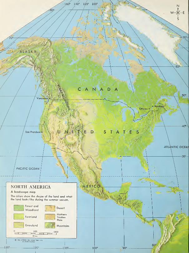
ALASKA /
Vancouver'*
Ottawa •
San Francisco
ATLANTIC OCEAh
PACIFIC OCEAN
x'HS AMEXIC
100"
NORTH AMERICAA landscape mapThe colors show the shape of the land and whatthe land looks like during the summer
Forest and
Woodland
Farmland
Grassland
Desert
Northern
Treeless
Plain
Mountains
-130- -120 °-
I
-110?

a huge land called a continent. There
are two other countries on the map.
They are part of the same continent.
This continent is called North America.
Notice the drawing in the top right-
hand corner. It looks a little like a
compass. It shows us that on this mapNorth is toward the top of the map.
East is toward the right. West is toward
the left. And South is toward the
bottom of the map.
Notice, also, the line marked “1000
miles.” It shows us at a glance that
North America is very wide. It is over
3000 miles across the widest part.
We find map signs for boundaries
between countries.
Near the middle of the map we find
a sign that looks like this:
It shows us the boundary line between
Canada and the United States. Farther
up on the left there is another sign like
this. It shows the boundary between
Canada and another part of the United
States.
Near the bottom of the map, we find
another sign like this: ^\
South of this boundary is the country
of Mexico. Part of this boundary follows
a river.
Boundaries between countries are
not really marked by lines on the
ground. The map signs show us only
where the boundaries are.
We look at some mountains.
The beautiful Rocky Mountains in
the picture are in the western part of
our country. On the map, signs for
mountains show that most of the moun-
tains in North America are in the
western part of it.
Trees do not grow near the tops of
very high mountains. Their tops maybe covered with snow and ice. But trees
do grow to the tops of many mountains
which are not as high as the Rockies.
1
1
High mountains in the western part of our continent

The signs for mountains on the mapshow us where the mountains are. But
they do not show us how high the
mountains are.
Map signs for four cities
We have already visited Ottawa and
Montreal. The signs for these cities are
named on the map on page 10. They
are in the eastern part of our country.
Now we are going to see two other
cities named on the map. They are
Vancouver and San Francisco. Van-
couver is on our western coast. South
of it, on the Pacific coast of the United
States, is San Francisco.
There are more than a hundred large
cities and many smaller ones in North
America. But if all the signs and nameshad been put on the map, it would be
hard to see the other map signs clearly.
No two cities are just alike. But the
dot for any city should make us think
at once of many streets, houses, stores,
and thousands of people.
Of course, after we visit any city, the
map sign for it makes us think of manyspecial things in that city, too.
The "City of the Golden Gate "
First, we will visit a city in the
United States, on a large bay called San
Francisco Bay. In the bay, the water
is calm. Ships can find shelter there
from the winds and waves of the open
ocean.
As this map shows, ships which sail
in and out of San Francisco Bay must
sail through a narrow waterway, or
“gateway.” Many years ago, men found
gold not far inland from San Francisco
Bay. Ships sailed from the ocean into
the bay with men who came to hunt for
gold. So men thought of the gateway
into the bay as a gateway to gold, and
called it the Golden Gate.
The city of San Francisco has been
built along the southern coast of the
Golden Gate. As the map shows, the
city stretches from the coast of the bay
to the coast of the open ocean. So the
city is bordered on the west by the
ocean, on the north by the narrow gate-
way, and on the east by the bay.
50 Miles
12

Looking across San Francisco to the Pacific Ocean
The picture was taken from the air.
We see part of the bay at the bottom of
the picture. We see long piers which
men have built along the coast of the
bay. Ocean ships which come through
the Golden Gate are unloaded at these
piers and loaded again for their next
long voyage.
Near the top of the picture is the
Golden Gate. The bridge across the
narrow stretch of water is the Golden
Gate Bridge.
If we stood on the long point of land
beyond the bridge and looked west, wewould see the Pacific Ocean stretching
on and on and on.
13

San Francisco has a mild climate all
year round. Snow is very unusual
around the bay. But not far from the
city are high mountains where there is
much snow.
Jane begins a map andpost card record.
Jane was visiting for a week in Van-
couver. That city is on Canada’s Pacific
coast, in the province of British Colum-bia. Jane had never been anywhere in
the western part of Canada before. It
was exciting to be so far from her home
in Montreal. She had traveled right
across a continent.
Vancouver is built along the coast of
Burrard Inlet. An inlet is a narrow strip
of water running into the land. It is
very like a bay. Burrard Inlet is a good
harbor for ships.
The main part of the city is on the
south side of Burrard Inlet. The smaller
part is on the north side. The Lion’s
Gate Bridge connects the two parts of
the city.
A wider strip of water separates Van-
couver from Vancouver Island. Ferries
14
and boats go back and forth between
the city and the island, carrying freight
and passengers.
Many things about Vancouver re-
minded Jane of Montreal. It is a large
city, and there are many tall buildings.
One side of the city faces the water.
Like Montreal and San Francisco, Van-
couver is a very busy seaport. It is
sometimes called the “Gateway to the
Orient.” Every day ships leave Van-
couver for Tokyo, Japan, and other far
eastern ports.
Jane found some things very dif-
ferent, too. Only a few miles from the
city stretches the open ocean. Burrard
Inlet is an arm of the Pacific Ocean.
On the north shore of the inlet, high
mountains rise into the sky. All along
the west coast of Canada are forests of
very tall trees.
It was January when Jane visited
Vancouver. But there was very little
snow in the city. The air was cool and
wet. Because of warm currents from
the ocean, Vancouver has a milder
climate than Montreal. Of course, it
is not as mild as San Francisco, which
is much farther south.
Jane bought picture post cards of
many things she saw. She wanted to
send post cards to her family and
friends at home. She also wanted to
keep some to paste in her scrapbook.
Jane made a map and post card
record of her visit to Vancouver. Onthe first page of her scrapbook, she drew
a little map. Near it she pasted her
favorite post card. On page 14, we see
Jane’s map and the post card she chose.
Using things you have learned.
1. The picture on this page was
taken in January. Jane would feel more
at home in this place than she would
in San Francisco. What do you see in
the picture that helps you tell why?2. On the map on page 10, find the
dot for Vancouver. Can you find Van-
couver Island west of the city?
3. What do you think you would like
to show if you made a map and post
card record of San Francisco?
4. You might like to make a map and
post card record of the place where you
live. Discuss with your classmates
some of the things your map should
show.
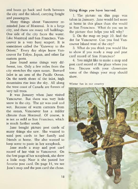
Winter fun in our country
15

The six small pictures show what we see as we turn a globe around.
16

We Meet Our Globe Guide
A ball map will guide us.
Long ago, men discovered that our
world is shaped like a ball. Brave
explorers sailed around it. Airplanes
fly around it today. We will go around
it on our world journey.
On our journey we will need a guide
to help us on our way. Our guide will
be a globe. A globe is a map of the
whole world drawn on a ball. Theglobe ball looks much as our real
world would look, if we could see it
from the moon.
Of course, a globe cannot be put
into a book. And no one can see all
parts of a globe ball without turning it
around. But several pictures of our
globe are shown here. They show what
we see as we turn the globe around.
In the big globe picture, we see howour country looks on the globe. Ourcountry is part of North America, a
huge continent in the northern half of
the globe.
This picture of the globe makes the
countries in the far northern part and
in the far southern part look smaller
than they look on a real globe. This is
because the surface of the globe is
curved, like the surface of the earth.
The surface of a picture is flat.
You see on the globe pictures that
the areas of water are much bigger
than the areas of land. There is more
water on the earth’s surface than there
is dry land.
Canada lies between the Atlantic
Ocean and the Pacific Ocean. Thesecond small globe is turned to showalmost all of the Atlantic. An ocean
liner crossing the Atlantic between
North America and Great Britain must
travel nearly 3000 miles. The shortest
time that a ship has ever traveled this
distance is almost three and a half
days.
Which small globe is turned to show
most of the Pacific Ocean? Compare its
width with the width of the Atlantic
Ocean. You can see that it is about twice
as wide. The Pacific is the largest ocean
in the world.
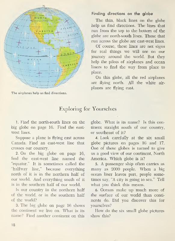
N
Finding directions on the globe
The thin, black lines on the globe
help us find directions. The lines that
run from the top to the bottom of the
globe are north-south lines. Those that
run across the globe are east-west lines.
Of course, these lines are not signs
for real things we will see on our
journey around the world. But they
help the pilots of airplanes and ocean
liners to find the way from place to
place.
On this globe, all the red airplanes
are flying north. All the white air-
planes are flying east.
Exploring for Yourselves
1. Find the north-south lines on the
big globe on page 16. Find the east-
west lines.
Suppose a plane is flying east across
Canada. Find an east-west line that
crosses our country.
2. On the big globe on page 16,
find the east-west line named the
“equator.” It is sometimes called the
“halfway line,” because everything
north of it is in the northern half of
our world. And everything south of it
is in the southern half of our world.
Is our country in the northern half
of the world, or in the southern half
of the world?
3. The big globe on page 16 showsthe continent we live on. What is its
name? Find another continent on this
globe. What is its name? Is this con-
tinent straight south of our country,
or southeast of it?
4. Look carefully at the six small
globe pictures on pages 16 and 17.
One of these globes is turned to give
us a good view of our continent, North
America. Which globe is it?
5. A passenger ship often carries as
many as 2000 people. When a big
ocean liner leaves port, people some-
times say, “A city is going to sea.” Tell
what you think this means.
6. Oceans make up much more of
the surface of our world than conti-
nents do. Did you discover this for
yourselves?
How do the six small globe pictures
show this?
18

The new international airport at Dorval
Our starting place is Montreal.
As the map on page 10 shows, Mont-
real is in the southeastern part of our
country. It is the largest city in Canada.
Like any other city, Montreal has manyhouses close together, hundreds of
stores, giant office buildings, and thou-
sands of people.
Although it is 1000 miles from the
Atlantic Ocean, Montreal is one of the
world’s most important seaports. Ships
sail down the wide, deep St. Lawrence
River and through the Gulf of St. Law-
rence to every part of the world. In the
harbor there are miles of piers where
the ships are loaded and unloaded.
Most people coming to Canada from
other countries land first in Montreal.
Airplanes carry people and freight,
too. The picture on this page shows
part of the new Montreal International
Airport, thirteen miles outside Montreal.
Inside the building are huge waiting
rooms and baggage rooms. At the back
of the building, you see the control
tower. On the map on page 5, you saw
the sign for this tower.
We will now begin our long journey.
On that journey, we will go to places in
every continent. We will also visit sev-
eral islands. Of course, no one can
make such a journey without crossing
oceans.
We go first to Iceland. The globe
picture on the next page will show
where Iceland is on the globe.
19

Discovering from the globe
Iceland is an island in the Atlantic
Ocean. In the globe picture above, the
small white spot in that ocean shows
us just where Iceland is.
The map of Iceland to the left of
the globe shows some things we can
see in Iceland.
1.
Find on the globe the white spot
that shows just where Iceland is. Find
the dot for Montreal.
Is Iceland straight north of Montreal,
or northeast of it?
2. Why couldn’t we go from Montreal
to Iceland by train or automobile?
3. Find the equator. Which one of
these is farther north of the equator
—
Montreal or Iceland?
4. What ocean is north of Iceland?
5. Find on the map of Iceland a sign
for a city. Is the city on the coast, or
is it near the center of the island?
20

-
Mi,,-;
w'
-*.
m.\ h"*
Looking across the city and harbor of Reykjavik
IN ICELAND AND THE ARCTIC OCEAN
An Island Country
In the capital of Iceland
The city we see in the picture is
Reykjavik. It is the capital of Iceland.
We could go from Montreal to Rey-
kjavik by boat or airplane.
The boys in the small picture are
having fun on a country road near
Reykjavik. The older boy is namedPall. His father has an office at the
Reykjavik airport. Already, Pall has
made five airplane trips.
The younger boy is Helgi. His father
helps with government work that goes
on in the capital city.
Things that remind us of home
There are many things about Rey-
kjavik that remind a Canadian of
home. The houses look much like
ours. There are autos and buses on the
21

On a fishing boat, home from the sea
streets. The Icelanders dress much as
we do. A few of them can speak our
language.
The schools also remind us of home.
So do the book stores. Iceland boys
and girls read many books. They learn
stories of days of long ago in Iceland.
They are proud of their country and
capital city.
Things that seem new and different
But some things about Iceland seem
different to us. There is no railroad
station in Reykjavik. We can fly over
Iceland or sail around the island. Wecan travel to many places by bus. But
there are no railroads anywhere in
Iceland.
The streets of Reykjavik look bare
to us. This is because we see no tall
trees. We may see a small tree here
and there, but most of Iceland is
without tall trees.
It is June. We are not surprised to
find cool weather. We know Iceland is
farther north than our country. But
we are surprised to find summer days
so long. It is light long after bedtime.
A story of long ago and today
The first settler who came to Iceland
landed near the place where Reykjavik
now stands. He saw clouds of steam
rising like smoke from land not far
from the shore. He called the place
Reykjavik. Part of that word means“smoking.” The steam came from hot
springs.
Today, many hot springs still flow
from cracks in rocky ground near
Reykjavik. Hot water from the springs
is used to heat homes and other build-
ings in the city. It flows all the time
through pipes from the hot springs.
Men of the sea
Thousands of homes in Iceland are
the homes of fishermen. In all the
towns along the coast, many men are
men of the sea.
The fisherman we see in the picture
above is unloading a big catch of
herring. He has not seen his home and
his son Jon for more than a week. Andvery soon he will be away again on
another fishing trip.
The fish he is unloading will go to
sea again, too. But they will not go in
a fishing boat. They will be taken first
to a freezing plant. Then most of the
frozen fish will be loaded on ships that
take them to be sold in other countries.
Codfish, too, are sold to people in
other lands. In the picture at the top
of the next page, you see codfish hang-
ing on racks to dry.
The ships that carry fish to other
lands bring back many things that
Icelanders cannot find or grow on their
22

The sun dries fish hung on these racks.
island. The Icelanders who work on
those ships are men of the sea, too.
Thousands of Iceland boys expect to
spend much of their lives on the sea.
Pall and Helgi like to watch the
fishing boats and the other things they
can see in the harbor at Reykjavik. The
picture below shows fishing boats used
by men who fish for herring.
In some ports, there still are no
freezing plants. There is much excite-
ment when a herring boat comes in.
Men, women, and children hurry to
the pier to help care for the fish. Mendrag baskets of fish to tubs and empty
the baskets into the tubs. Children roll
empty barrels to the tubs. Womenclean the fish and toss them into the
barrels. Soon the whole shipload of
fish is cleaned.
A great highland of "ice and fire"
No one in Iceland lives very far from
the sea. As we fly over Iceland, we see
that a very large part of the island is
high, barren land. On that highland,
we see no homes. No one lives there.
Some parts of the highland are
covered with great fields of ice and
snow all year round. The icefields are
called glaciers. One of the glaciers is
only sixty miles from Reykjavik.
As we fly over other parts of the
great highland, we look down for manymiles on bare rock. Here and there
mountain peaks rise above the high,
rocky land. Some of those mountains
are volcanoes. From time to time, hot
liquid rock called lava has flowed from
the volcanoes.
A fleet
of fishing boats
near Reykjavik
1
] U 1 1 s1
-iff
ib ^ ....
23

A very old farmhouse
Grass is one of Iceland's riches.
Between that great highland and the
sea, there are many lower places where
grass grows. Grass grows well in the
cool, rainy summers. And the long
winters are not cold enough to kill the
grass.
Settlers who came to Iceland very
long ago found that the grass here
and there was good pasture land. Onit they built farm homes. Today, as
long ago, nearly all the farms in
Iceland are grassland farms.
A farmhouse built long ago
The very old farmhouse in the pic-
ture above is not far from Reykjavik.
Iceland ponies are small and sturdy.
Many visitors to Iceland go to see it.
They now can go by bus or auto-
mobile. They like the beautiful view of
mountains and steep slopes not far
from the farm. On the way home, they
can see hot springs.
Stina's home on a big farm
Stina’s home is near the eastern
coast of Iceland. It looks like the
farmhouse in the picture above. Her
older brother can remember whenthere was only a pony trail between
the farm and a fishing village on the
coast.
At first sight, the farmhouse looks
like three houses in a row. There are
three rooms in it. They are joined
together by short hallways. The family
lives in the large, middle room. In it,
there is a big fireplace. In one of the
end rooms, fuel is stored. Stina’s father
keeps farm tools in the other room and
uses it for a work room.
The farmhouse is built of stones
gathered from the fields. Sod for the
roof was cut from grassland near the
house.
24

A new farm home
Most of the big farm is used for
pasture. Stina’s father raises sheep,
cattle, and ponies. He does not plant
wheat or corn. Iceland summers are
too rainy for wheat. They are too short
and cool for corn. Hay is raised on the
farm to feed the animals in winter. In
summer, the sheep, cattle, and ponies
live in the pastures.
The best hayfield on the farm is a
small fenced field near the house. It is
called the “tun.”
Stina often rides a pony to and from
the village. Her pony looks like the
white one in the picture on page 24.
Winter days in Iceland are shorter
than winter days in southern Canada.
It is dark long before supper time.
For supper, Stina’s mother often
cooks fish or mutton. She may cook
potatoes or turnips, too. Almost every
evening there is “skyr.” It is madefrom curdled milk and is served with
cream and sugar.
New farm homes
In the pictures on this page are newfarm homes. After good roads were
built, materials needed for new houses
could be brought in from other places.
On some farms, machines are now used
in cutting the hay.
Using things you have learned
When you see Iceland on a globe, it
now will make you think of things you
can see in the real Iceland.
1. Make a list of words which namefive things you can see there. For ex-
ample, “hot springs” might be on your
list.
2. Put a star (*) after each thing
in your list which you can find in any
picture on pages 22 to 25.
The pony is pulling a load of hay.
25
In the Arctic
An ocean in the Far North
The Arctic Ocean is north of Iceland.
On the globe, this ocean is colored
blue, just as the other oceans are. But
most of the Arctic Ocean would not
look blue if we could see it from a
plane. It would look white, instead.
Much of the Arctic Ocean is covered
with ice the year round.
The North Pole
One place is farther north than any
other place on the earth. That place is
the North Pole. It is in the middle of
the Arctic Ocean.
For a long time, people had knownthat the North Pole was in the Arctic
Ocean. But no one had ever been there
until an American explorer reached it.
This was Robert E. Peary, who reached
the North Pole in 1909.
Peary's trip to the North Pole
Peary started his trip on July 6, 1908,
in a ship named the “Roosevelt.” Hesailed to an island far to the north and
made a camp there. He knew he would
have to wait till March to go on. If he
did not, he would have to travel most
of the time in darkness. For at the
North Pole, the sun does not show its
face from September to March. It then
shines all the time from March to
September.
On the first day of March, Peary andhis men started across the Arctic Oceanto the North Pole. They carried their
food and fuel on sleds. Eskimo dogs
pulled the sleds.
The trip was hard. There were manystorms, and the ice was very rough.
The men built snow houses to sleep in.
As soon as the supplies on a sled
were used up, the driver went back to
camp with his sled and his dogs.
Peary reached the North Pole with
six men and thirty-eight dogs. There
was no marker of any kind to tell him
he had reached the Pole. He had to
find out he was there by looking at the
sun and making measurements. The
ice there was like the ice for hundreds
of miles around. At the Pole, Peary
planted the American flag.
The Arctic today
People were excited when news camethat Peary had reached the North Pole.
But not many people thought that the
Far North was a very important part
of the world. Now we know that it is.
Many planes now fly across the
Arctic Ocean. Scientists go to the Arctic
to find places where planes could land.
Scientists also go there to study the
weather. The weather over the Arctic
Ocean helps them understand the
weather in other parts of the world.
Scientists at work
The picture at the top of the next
page was taken about a hundred miles
from the North Pole. An airplane has
just brought supplies to a camp there.
26
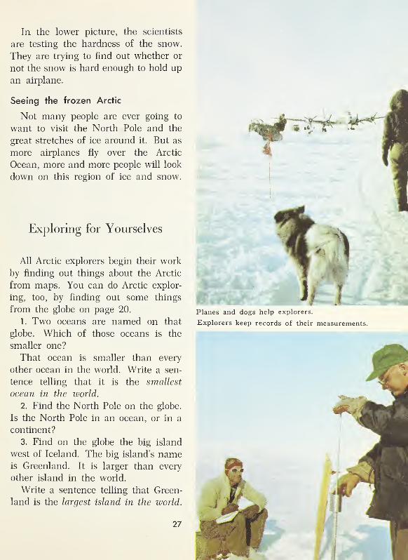
In the lower picture, the scientists
are testing the hardness of the snow.
They are trying to find out whether or
not the snow is hard enough to hold up
an airplane.
Seeing the frozen Arctic
Not many people are ever going to
want to visit the North Pole and the
great stretches of ice around it. But as
more airplanes fly over the Arctic
Ocean, more and more people will look
down on this region of ice and snow.
Exploring for Yourselves
All Arctic explorers begin their work
by finding out things about the Arctic
from maps. You can do Arctic explor-
ing, too, by finding out some things
from the globe on page 20.
1. Two oceans are named on that
globe. Which of those oceans is the
smaller one?
That ocean is smaller than every
other ocean in the world. Write a sen-
tence telling that it is the smallest
ocean in the world.
2. Find the North Pole on the globe.
Is the North Pole in an ocean, or in a
continent?
3. Find on the globe the big island
west of Iceland. The big island’s nameis Greenland. It is larger than every
other island in the world.
Write a sentence telling that Green-
land is the largest island in the world.
ffeSM
Planes and dogs help explorers.
Explorers keep records of their measurements.
27

Discovering from the globe
The continent of Europe is east of
the Atlantic Ocean. It is named on
this globe. The country we will visit
next is Norway. It is in Europe.
On the globe, the white spot in Eu-
rope shows just where Norway is. Themap to the left of the globe shows
some things we can see in Norway.
1.
Find the white spot on the globe
that shows just where Norway is. Find
Iceland. Why could we go from Iceland
to Norway by boat, but not by train?
2. Find the equator on the globe. Is
Norway north of the equator, or south
of it?
3. Look at the map of Norway. Is
most of the land in Norway flat land, or
are there many mountains in Norway?
4. Norway is a long, narrow coun-
try. Find its northern end on the globe.
What ocean is north of Norway?
28

FROM NORTH TO SOUTH IN NORWAY
In the Far North
Seeing the sun at midnight
The people in the picture are on
board a ship that is sailing near the
northern coast of Norway. These pas-
sengers are looking at something in the
sky. They have traveled a long way to
see it. They are looking at the sun at
midnight.
Many of the passengers are from
Canada and the United States. Some are
from southern Norway. One of the boys
on board is Olaf, a Norwegian boy. Wesee him in the small picture, which
was taken near his home.
•The passengers began watching the
sky about nine o’clock in the evening.
The sun was then shining brightly in
the northwest. And now it is midnight.
But it is night only by the clock. Straight
to the north, the sun is still shining in
the sky.
Cameras are clicking. Almost every-
one on board the ship wants a picture
of the midnight sun.
Olaf likes to use maps.
Olaf is proud of his beautiful coun-
try. He likes to use a map in telling
29
about it. On the map, he points out a
very large peninsula. He shows that
Norway is on this peninsula. Olaf’s
word for peninsula is “halv0y.” It has
a letter in it that we do not know. In
his language, “halv” means half and
“cry” means island. Do you see that a
peninsula is halfway like an island ?
As the map shows, Norway is a long,
narrow country of many mountains.
The shape of Norway makes us think
of a spoon. Hammerfest, in northern
Norway, is near the end of the spoon
“handle.”
Olaf lives in Bergen. It is a city on
the coast of the “bowl” of the spoon.
The southern end of Norway is about a
thousand miles from Hammerfest.
Most people live near the coast.
The map shows that many long, nar-
row arms of the sea reach far into the
land. These arms of the sea are called
fiords.
Long before there were railroads and
modern highways in Norway, manytowns and villages were built on the
coast. Without trains and automobiles,
travel by land was hard. But people
who lived on the coast could go by boat
from place to place.
Guards along the coast
Along the coast of Norway, there are
many islands. When there are storms,
the waves in the open sea are often
high and dangerous. But between the
islands and the mainland, the waves
are not so high.
Captains of ships that sail along the
coast call the islands “guards.” The
water between the islands and the main-
land is a “guarded water highway.”
Fast steamers and "fiord buses"
Today, fast steamers sail back and
forth between Bergen and towns on
Norway’s coast. They stop at all the
larger towns. The ships carry passen-
gers, mail, and freight.
At the larger towns, the ships are
met by smaller boats. These boats take
passengers, mail, and freight to the
smaller towns. The small boats are
often called “fiord buses.”
The ships make their trips all year
round. Even along the northern coast,
the sea is not covered with ice in win-
ter time.
30

New homes in a city in the Far North
Two stories of the Far North
The big picture shows a part of the
little city of Hammerfest. This city
has a special story.
The second story is about “Reindeer
Land” and the people called Lapps.
The Lapp boy and girl in the picture
live in “Reindeer Land.”
The story of Hammerfest
Fishermen from southern Norwaysettled in Hammerfest long ago. As
time went on, it became a famous lit-
tle fishing port of the Far North.
During World War II, Hammerfest
was burned to the ground. Not a sin-
gle building was left in it. The peo-
ple had left before their homes were
burned.
When the war ended, the Norwe-
gians planned at once to build a new
Hammerfest. And the people of Ham-merfest wanted to go back to live in
it. In the picture, we see some of the
new houses there.
The new city does not look muchlike the old one. After the war, fac-
tories for the quick-freezing of fish
Matti and his sister Lajla are Lapp children.
They like to go out on their skis to play.
31
Lapps can travel from place to place on sleds pulled by reindeer.
were needed in Norway, A big factory
of this kind now stands beside Ham-merfest harbor. A few hundred peo-
ple of the city work in it.
Some of the men who go out in boats
from Hammerfest go to catch seals.
But most of the men are fishermen.
Hammerfest is once more a famous
fishing port of the Far North.
Although many things in Hammer-fest are new, one thing has not changed.
For about two months in summer, the
sun does not set at all. Each day dur-
ing that time, the sun seems to movein a circle around the sky. At noon
each day, it is in the southern sky.
Each midnight it is low in the northern
sky.
Sometimes people say that summerin Hammerfest is only one “day” long.
But that “day” lasts about two months.
For almost two months in winter,
the people of Hammerfest do not see
the sun at all. Christmas comes al-
most in the middle of this long winter
“night.”
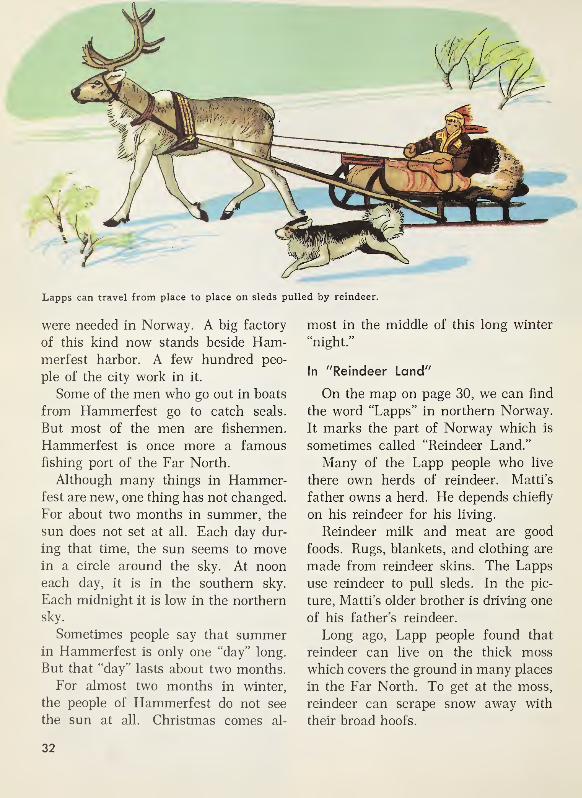
In "Reindeer Land"
On the map on page 30, we can find
the word “Lapps” in northern Norway.
It marks the part of Norway which is
sometimes called “Reindeer Land.”
Many of the Lapp people who live
there own herds of reindeer. Matti’s
father owns a herd. He depends chiefly
on his reindeer for his living.
Reindeer milk and meat are good
foods. Rugs, blankets, and clothing are
made from reindeer skins. The Lapps
use reindeer to pull sleds. In the pic-
ture, Matti’s older brother is driving one
of his father’s reindeer.
Long ago, Lapp people found that
reindeer can live on the thick moss
which covers the ground in many places
in the Far North. To get at the moss,
reindeer can scrape snow away with
their broad hoofs.
32

For about three months every year,
Matti and Lajla and their father and
mother live in their winter home. If
they stayed there much longer, their
reindeer would eat all the moss and
have nothing more to eat. So they
move from place to place during the
rest of the year to find new pastures of
moss for their reindeer. They take with
them materials for a tent home. But
they like best the home they come
back to every winter.
New things in "Reindeer Land"
There is a new school not very far
from Matti’s winter home. He and
Lajla now go to school there. There is
a new road, too, not far away.
Some day Matti may travel to vil-
lages where Lapp fishermen live. ManyLapps are fishermen who live in vil-
lages along the coast.
The Lapps in the picture above are
getting ready to go to a village where
there is a store. Perhaps the men will
bring back a sled load of new things
for their winter houses.
Laplanders loading a sled for a short trip
Using things you have learned
1. Ships like the one in the picture
below sometimes sail to Hammerfest.
If you were in Hammerfest on Christ-
mas day, tell which of these things you
would see there at noon:
The sun shining brightly
Lights twinkling in the dark
2. Find on page 32 a short paragraph
that helps you check your answer.
Sailing in
a fiord
Large ships like
this one stop at
the larger towns.

Fishing boats near the coast of the Lofoten Islands
South along the Coast
Thousands of fishermen
Many thousands of fishermen live in
the villages, towns, and cities on the
long west coast of Norway. Some vil-
lages depend on fishing so much that
we call them fishing villages. But there
are thousands of fishermen in other
towns and villages, too.
The fishermen do not have to go far
out to sea in their fishing boats. Mil-
lions and millions of fish can be caught
near the coast.
Many codfish are caught there. EachJanuary, millions of cod come to the
water near the Lofoten Islands. Theseislands are named on the map of Nor-
way on page 30. Thousands of fishing
boats gather near the coast of these
islands. Some of the boats sail hun-
dreds of miles to reach the islands.
And on every boat there are at least
five fishermen.
Cod-fishing time
The busiest cod-fishing time is from
January to April. During January and
February, days are very short in the
Lofoten Islands. Lights glimmer from
the piers as the boats go out from the
island villages each morning. Lights
shine from the piers as the boats comeback each evening.
34

The fishing boats are unloaded at the
piers, and the cod are soon cleaned and
salted. Women and girls help with the
work. After the fish are salted, they
are hung up to dry like clothes on a
line. The picture at the bottom of this
page shows thousands of cod hanging
from racks to dry.
Winter is the busiest time for the
fishermen of Norway. But fishing is
done there at other seasons, too. Andother fish besides cod are caught. Fish-
ermen catch many herring, too.
Norway has great herring fisheries.
The canned Norwegian sardines webuy in our grocery stores are made from
one kind of herring. These herring are
caught in July, August, and September
along the coast not far from Bergen.
Many fishermen do other kinds of
work for part of the year. Some maywork in factories where fish is canned.
Others find work in other kinds of fac-
tories, too. Some of the men are part-
time fishermen and part-time farmers.
They go back to their farms when the
winter fishing season is over.
Farmers by the fiords
Almost everywhere along the fiords,
the land is steep. On board a boat
which is sailing in a fiord, we often feel
we are between two mountain walls.
But along many fiords we see here and
Codfish hung on racks to dry near a harbor in the Lofoten Islands

Farm near a fiord
there little patches of almost level land.
Some of those little patches are big
enough to use for farming.
In the picture above, we are looking
across a fiord. On the slope beyond it
is a small village. Near the bottom of
the picture, we see a white farmhouse.
It is in a little patch of level land. That
farmhouse is the home of the Johansen
family.
Mr. Johansen makes most of the
money he earns from the farm by sell-
ing butter and cheese. He owns a horse,
two pigs, five cows, eight sheep, and
several goats. His horse is a “fiord
horse” like the one in the small picture
on the next page.
Lars Johansen is twelve years old.
He helps his father with some of the
farm work. He has two older sisters
who help, too. His older brother Sven
works on boats to earn extra money
for the family.
The Johansen farm
In the picture above, we see only the
part of the farm which is near the
house. That part of the farm is level
enough to be plowed. It is very small.
All the rest of the farm is on the moun-
tain slope. Most of the land which Mr.
Johansen can plow is used for raising
oats. But he also grows potatoes and
a few other vegetables.
On the mountain slope, Mr. Johan-
sen cuts grass for hay. He keeps the
hay to feed to his animals during the
winter. Lars helps to pile the hay on
36

racks to dry. Rain would spoil it if it
were left on the ground.
In May, Lars goes with his father to
drive their cattle, sheep, and goats up
the mountain slope to pasture land high
above the farmhouse. In that high
pasture land, the animals are herded
all through the summer.
At the "saeter"
A high mountain pasture in Norwayis called a “saeter.” Mr. Johansen has
built a little house at the saeter. TheJohansen girls live in the little house
during the summer. The girls makebutter and cheese from the milk of the
cows. They make cheese from the
goats’ milk, too. The milk is cooled in
tall pails in a tank of cold water. Thewater is piped into the tank from anice cold mountain spring.
A ferry boat crossing a fiord
A sturdy little “fiord horse”
Making extra money
The Johansen farm is so small that
each member of the family is eager
to find extra work. Sven works on a
fishing boat in winter and on a ferry
boat in summer.
We see a ferry boat in the big picture
below. The passengers, an automobile,
and a bus are being ferried across the
fiord.

On a high, rocky, mountain slope
Mrs. Johansen earns a little extra
money by working now and then in a
hotel. In summer, hotels need extra
helpers because of the many visitors.
Mrs. Johansen and the girls also find
time to knit mittens and sweaters to sell.
In winter, Mr. Johansen sometimes
works in the forest near the saeter.
He cuts down trees and trims off the
branches. Then he hauls the logs to
the nearest stream. In the spring, the
logs will be floated downstream to a
sawmill. In the mill, the logs will be
sawed into lumber.
A pleasant home by the fiord
The Johansens have a good living
from their work on the farm, on the
sea, on the fiord, in the forest, and in
the hotel. From the farm they get veg-
etables, milk, cheese, meat, and wool.
They have no automobile. But they do
have a motor boat and a rowboat. They
have electric lights and hope to have
a radio soon. Their farm home by the
fiord is a pleasant one.
Roads have now been built up to the
saeters on some of the farms. During
the summer, fresh milk can now be
brought down every day by truck from
some of the high pastures. Some of it
is taken to village dairies where butter
and cheese are made.
High up a mountainside
The steep, rocky place we see in the
picture is not a grassy pasture. Cattle
could not find enough grass to live on
here. But goats can live on the scat-
tered patches of plants. Steep, high
land of this kind is a part of many Nor-
wegian farms. How sensible it is for
these farmers to keep goats.
Cheese made from goats’ milk is one
of the things many people in Norwaylike to eat for breakfast. And it is good
food. Like milk, it helps boys and girls
to be strong and healthy.
Much of the play as well as the work
of people along the fiords is done out-
doors. In winter, Norwegian boys and
girls like to play with sleds and skis.
38

Buying fish fresh from the sea
This open-air market is in Bergen.
Of course, they have plenty of good
slopes for sliding and skiing without
climbing high up the mountainsides.
But in summer, they like to go on hikes
to places as high as the one we see in
the picture of the goats on page 38.
We meet Olaf again.
In some places in Norway, people
even do some of their daily shopping
out-of-doors. The picture on this page
shows an open-air market in Bergen.
And there is Olaf! He has come with
his older sister Karen to buy fish fresh
out of the sea.
Using things you have learned
1. What islands named on the mapon page 30 now make you think of
many Norwegian fishing boats and fish-
ermen? Which picture in this chapter
shows many fishing boats near those
islands?
2. Read the title of the picture at
the bottom of page 33. Make another
title that tells about the kind of land
we see along the fiords of Norway.
3. Roads have been built to some
places on fiord coasts. Two things in
the big picture on page 37 came to the
fiord by road. Name those two things.
39

I I I • lit I I < >
im u f in
ike
1 «w7i ii
Ur jJL *• pj ,
ijjrf* ,-Jm
The harbor of Bergen on the west coast of Norway
From Sea to Sea
Two great meeting places
Ships of many kinds and sizes comeinto the harbor of Bergen. There are
fishing boats, fast coastal steamers, and
big ocean ships. Trains, automobiles,
and airplanes also go to and from Ber-
gen. It is a great meeting place.
We can travel from Bergen to Oslo
by steamer, automobile, train, or air-
plane. Oslo is Norway’s capital. It also
is the largest city of Norway. It is a
great meeting place, too.
The map on page 30 shows that Ber-
gen is on the west coast of Norway and
that Oslo is on the east coast of Norway.
The map also shows that there are
mountains between Bergen and Oslo.
We notice, too, the rivers that flow from
the mountains to the eastern coast.
"Downstairs" and "upstairs" in Bergen
In the picture above, we are looking
at the “downstairs” part of Bergen. It
is near the harbor. Bergen has grown
so large that all this low land near the
harbor is needed for business and ship-
ping.
Most of the people of Bergen live in
the mountains overlooking the lower
part of the city. They say that they live
40

“upstairs” in Bergen. Olaf lives in an
apartment building in the “upstairs”
part of the city. But he likes to come
to the “downstairs” part because there
is so much going on there.
Olaf often needs his raincoat. In
Bergen, it rains on more than half of
all the days in the year.
Summer days in Bergen are long. But
the sun never shines all night there, as
it does at Hammerfest.
"Fish and wheat meet at Bergen."
Millions of fish are brought to Bergen
by small boats and coastal steamers
from places along the coast of Norway.
Millions of bushels of wheat come to
Bergen in ocean ships from faraway
lands. People say that fish and wheat
meet at Bergen.
The people in the fishing villages
alt>ng the coast of Norway buy food
made from some of this wheat. People
in distant lands buy fish which are sent
from Bergen.
Many of the people of Bergen makea living working in warehouses where
grain is stored. Others work along the
waterfront or on the ships or in “fish
factories.” Of course, fish are not madein these factories. But fish are canned
there. In some of the factories, fish oil
and fertilizers are made from fish.
"White coal"
A name often used for water poweris “white coal.” Coal is often burnedto run engines that make electricity.
Falling water, too, can be used to
turn big machines for making electric
power. Near many falls in Norway,
there are electric power plants. Fromthese power plants, electricity is carried
through wires to nearly every part of
Norway.
There is electricity for almost every
home in the country. Many of the
farmers by the fiords have electric
lights, just as the Johansens do.
Hundreds of little factories are scat-
tered through the country close to the
waterfalls.
But not all of Norway’s factories are
small. The picture shows a large one
in which chemicals are made. Thewires for the electric power showclearly in the picture.
A great many Norwegians make their
living by working in these factories
which use electricity. Norway is a
much richer land than it would be with-
out its waterfalls. It is famous for its
factories as well as for its farms and
fisheries.
A big factory that uses “white coal”
!fSp$

Going by train from Bergen to Oslo
If we flew from Bergen to Oslo, we
would fly over high mountains. On a
train trip, we would see mountains and
villages through the car window most
of the way. Part of the time, however,
we would not be seeing any scenery.
We would be going through a tunnel
about one mile out of every four miles.
For many miles, the railroad runs along
a river that flows toward Oslo.
The farm lands in the picture are
in one of the wide valleys of south-
eastern Norway. In this wide valley,
there is plenty of room for big hay fields
and fields of grain.
Farmers of southeastern Norway
Many of the farmers in southeastern
Norway grow wheat. This part of Nor-
way is dry enough and sunny enough
for wheat to ripen.
Most of the farmers here use modernmachines for plowing and threshing
and other field work. It would not be
easy to use such large machines in the
small fields beside the fiords along the
western coast.
These farmers have many ways of
making a living from their land. Most
of them do not need to find part-time
work away from their farms.
A busy, beautiful capital
Logs like those in the picture on the
next page are cut in the valleys of east-
ern Norway. The logs are floated downthe rivers. Perhaps the logs in the pic-
ture will be made into paper in Oslo.
A list of all the factories in Oslo
would be a long one. In them, hundreds
of different kinds of things are made.
Fine parks and churches help to makeOslo a beautiful city. The palace of
the king of Norway is in Oslo.
These stories have not told us all
about Norway. But they help us see
why Olaf is proud of his country.
Hay drying on long racks on a farm in southeastern Norway

These men are breaking up a “log jam” in a river.
Exploring for Yourselves
1. Explorers need to think about
what they see. These are four of the
many kinds of things we see in Nor-
way:
fiord ferry boats
fiord farms
“fiord buses
”
“fiord horses”
Two of these things are seen on slop-
ing land along the fiords. The other
two are seen on the fiords.
Which two are seen on land? Whichtwo can we see on the fiords?
2. The bus on the ferry boat in the
big picture on page 37 is not a “fiord
bus.” Write a sentence telling what a
“fiord bus” is.
3. Notice that part of the top of the
bus on the fiord ferry boat is made of
glass. What high, beautiful things in
Norway can passengers see through
the glass in the bus top?
4. Three of these sentences are cor-
rect. Tell which three are correct.
(a) Logs like those in the picture
above are cut in Norway’s for-
ests and used in factories.
( b ) Winters in Lapland are longer
and colder than winters in
Oslo.
(c) We see many volcanoes in Nor-
way.
(d) Sturdy little fiord horses help
fiord farmers with their work.
43

Discovering from the globe
The country we will visit next is
often called Holland. But its name is
the Netherlands. People of this coun-
try are called Dutch people.
On this globe, the white spot in Eu-
rope shows just where the Netherlands
is. To the left of the globe, there is
a little map of the Netherlands.
1.
Find the white spot that shows
just where the Netherlands is. Then
find Norway. Is the Netherlands north
of Norway, or south of it?
2. Find the North Pole. Which of
these is nearer to the North Pole
—
Norway or the Netherlands?
3. Which of these is nearer to the
equator—Norway or the Netherlands?
4. Look at the little map of the Neth-
erlands. Are there signs of mountains
in the Netherlands, or is most of the
land flat land ?
44

This big ship is on a canal which you cannot see in the picture.
IN THE NETHERLANDS
Below Sea Level
Sailing through low land
The big ship in the picture is several
miles from the ocean. It seems to be
sailing on land. But it is really sailing
in a deep ditch called a canal. Along
the edge of this canal, there are long,
low walls of earth called dikes.
The automobile in the picture is on
top of one of the dikes. Several peo-
ple are standing on the dike, too. This
dike hides from view the lower part of
the ship. It also hides the water in the
canal.
The canal is in the Netherlands. Thename Netherlands means “lowlands.”
All the land in the Netherlands is low.
The land we see at the bottom of the
picture is even lower than the level of
the sea. Water from the sea would
cover much of the country if the Dutch
people had not learned ways of keep-
ing it out.
Keeping back the sea
At many places along the coast of
the Netherlands, there are small hills of
sand. These hills are called sand dunes.
Sand dunes help to keep back the sea.
But there are stretches of coast where
there are no sand dunes. There the
people of the Netherlands have built
many miles of dikes. The sea dikes are
somewhat like those along the canal in
the picture.
45

first dike. Behind the Sleeper is the
Dreamer. Only the worst storms dash
water against the Dreamer. But it also
lies in wait.
Lifting water to empty it into the sea
Long ago, the Dutch worked out ways
of getting water from their land into
the sea. Even if the sea never flooded
the land, they would still need to drain
water away from it. The land is so low
that water from rain often stands on it.
Canals have helped solve the prob-
lem. The Dutch have dug canals into
which water can run from the fields.
They have built other canals that are
higher than the land round about.
From these higher canals, water can
flow into the sea.
Of course, the Dutch had to find a
way of lifting the water from the low
canals to the high canals. They found
they could use pumps.
For a long, long time, the pumpswere worked by windmills. Wind turns
the arms of a windmill. The turning
arms drive the pump. Windmills used
to be a very common sight in the Neth-
erlands.
There are still some windmills. But
today most of the pumps are driven by
electric motors or by Diesel engines.
These modern pumps can pump water
much faster than those driven by wind-
mills.
The sea strikes twice.
Hundreds of years ago, there was a
great storm in the North Sea. Big waves
swept into the Netherlands through a
Looking across a broken dike to flooded homes
The Watcher, the Sleeper, and
the Dreamer
At some low places between the
dunes, the Dutch have built three big
dikes, one behind another. They often
call the first of these dikes the Watcher.
It is the front line against the angry
storm waves that at times beat against
the coast. The Watcher is paved with
great blocks of stone.
Behind the Watcher is the Sleeper.
This second dike lies in wait for hugewaves that sometimes sweep over the
46

Homes along a dike road Boys and girls often ride their bicycles on this roadway.
low place between dunes. Those big
waves destroyed seventy villages. Thou-
sands of persons lost their lives. Whenthe storm was over, there was a big newsea where there had been land. TheDutch named that new sea the Zuider
Zee.
On the night of February 1, 1953,
the sea struck another heavy blow. Astorm tore great gaps in the sea dikes
in the southwest part of the Nether-
lands. The picture on page 46 shows
one of the breaks in the dikes. It is
hard to imagine that this broken dike
once looked as solid and strong as the
one in the picture above. There were
sixty-seven big gaps in the sea dikes.
The sea rushed in as far as the line
marked x-x-x on the map.
More than a hundred villages were
badly damaged. About fifteen hundred
people lost their lives, and about forty
thousand people were made homeless.
About fifty thousand farm animals were
drowned. In thousands of acres of crop
land and pasture, the soil was badly
harmed by the salt water. It was truly
a great disaster.
The Dutch do not waste time crying
about a great disaster. Instead, they
A “storm story” map of the Netherlands
47

A new polder
A few cattle already
are grazing on this
newly made pasture
land.
look ahead. They work hard and wisely
to do the best they can with what they
have. It took them hundreds of years to
get over the first disaster. In a few years,
they have repaired most of the dam-
age done when the sea struck again.
Making a new lake
You may have looked for the Zuider
Zee on the map. It is not there. There
is no Zuider Zee now. About forty -years
ago, Dutch engineers had a daring idea.
They decided to change the Zuider Zee
into a fresh-water lake. They suc-
ceeded. The lake is Yssel Lake. Thedike in the picture on page 47 is on
that lake.
To change the sea to a lake, the en-
gineers built a great dike across the
northern end of the Zuider Zee. This
dike shows on the map on page 47.
Heavy rains year after year made the
water south of the dike less and less
salty. Now it has almost no salt in it.
Making new land
The Dutch people have also madenew land. They have made some of it
from the sea and some of it from Yssel
Lake. Each new piece of land is called
a polder. Five polders are marked P
on the map. Three are completed. The
two dotted ones are planned but not
yet finished.
Dikes, canals, and pumps are all
important in the making of polders.
First, a dike is built around a piece of
land covered with shallow water. Ca-
nals are built. Pumps are then set to
work to lift water from the land and
send it to the sea. The picture above
shows a new polder being built. In
time, almost all of Yssel Lake may be
good farm land.
ASchool Crossing
0 ANo Left Turn Pedestrian Crossing Bicycles Forbidden Construction Ahead
48

The city of Amsterdam
The big city of Amsterdam is very
near Yssel Lake. The ship you saw on
page 45 is on its way to Amsterdam.
The canal it is on leads from Amster-
dam to the North Sea. The whole city
is below the level of the sea.
Underneath the city, there is an “up-
side-down forest.” The wet, soft ground
had to be made firm to hold up build-
ings. To make it firm, the trunks of thou-
sands of trees were pounded top downinto the mud. The buildings of Amster-
dam rest on this “upside-down forest.”
Streets and canals of Amsterdam
Amsterdam has streets much like
those of other cities. It also has hun-
dreds of canals. Flat-bottomed boats
called barges travel along the canals.
Some carry coal or lumber. Others are
piled high with vegetables or cheese or
fish or fresh flowers.
There are some houseboats on the
canals of Amsterdam. Many are gay
with bright curtains and flowers. Fam-ilies live in the houseboats the year
round. The boat you see best in the
picture takes visitors sight-seeing.
In winter the canals are sometimes
frozen over. The streets may be covered
with snow, as the lower picture shows.
The traffic sign in the lower picture
means traffic keep right. You can
see other Dutch traffic signs at the bot-
tom of page 48.
Working together
Through their battles with the sea,
the Dutch have learned to work well
Homes along a “canal street” in Amsterdam
Winter scene on another street in Amsterdam
49

together. A whole book of stories could
be written about their brave deeds in
times of storm and flood. They know
they must work together even more as
the fight with the sea goes on.
Now, engineers are working hard to
protect the southwestern part of the
country. They are building big, newsea dikes. These dikes will be a great
help in the old, old battle of the Dutch
against the sea.
Using things you have learned
1. Name these four things which you
have seen in the Netherlands. List
them in alphabetical order.
A. A city below the level of the sea
B. Flat-bottomed boats
C. Big ditches
D. Long, low walls of earth
2. What are sand dunes ? How are
the dunes along the coast of the Neth-
erlands helpful to the Dutch people?
Farm Scenes and Farm Life
Green meadows and spotted cows
When we fly over the Netherlands,
we look down on mile after mile of
meadow land. We see from the air-
plane that this meadow land is cut up
into squares by long lines that look
like silver.
Almost all the squares are green. In
one green square after another, wemight see cows grazing. We can tell
that most of them are spotted cows.
The long “silver lines” beneath us are
canals. Barges and other boats are
moving along them. The village “street”
in the picture at the top of the next
page is part of a canal.
From the plane, we see here andthere in the green squares the red roofs
or blue roofs of farmhouses. Most of
the farmhouses are one-story houses
with steeply sloping roofs. They are
not far apart, for most of the farms
are small.
A "head-neck-body" farmhouse
The lower picture on page 51 shows
one of the larger farmhouses we might
visit. The Dutch call a house built in
this way a “head-neck-body” house. The
“body” of the house is the big part to
the right in the picture. It is the barn.
In it there are stalls for the cows.
The “neck” is the one-story middle
part of the house. The big room in it
is a kitchen and dining room. The rest
of the house is the “head.” The big
parlor in it has several windows.
In winter, the cattle are kept in the
barn, or “body.” Hay to feed them is
stored in the upper part of the barn.
Winters in the Netherlands are not as
long and cold as in Norway. But in the
colder months, the cows need shelter.
"Clean-making-day"
As the pictures on this page and on
pages 52 and 53 show, both small and
50

A village in the Netherlands Notice how comfortable and neat the houses look.
A home on a large farm in the Netherlands

Cows graze on
a grass-covered
dike.
The Van Hoorns live here.
large Dutch homes and farms look neat
and clean. The cows look as well cared
for as those you see grazing on the dike.
You can see some cows wearing blan-
kets. Their owner wants to protect them
from the cold, rainy weather. When it
is very cold, farmers keep their cows in
the barn where it is warm.
In all parts of the Netherlands, Sat-
urday is often called “clean-making-
day.” In the Dutch language, this is
called schoonmaakdag
.
schoon maak dag
clean make day
The word schoon means “beautiful,”
also. Cleaning helps to make homesbeautiful. Window panes are madeshiny. Floors are scrubbed. Furniture
is cleaned. No wonder homes look well
kept.
The Van Hoorn farm
The middle picture shows much of
the meadow land in the Van Hoorn
farm and part of their farmhouse.
Village homes along a canal The traffic sign
says: “No Parking. Bus Stop.”
/I mmVi
52

In cold weather, some Dutch farmers put blankets on their cows.
Margriet and Dirk Van Hoorn live in
that house. They go to school in the
village near by. Margriet is nine years
old. Dirk is almost twelve.
During all the year, the biggest task
on the Van Hoorn farm is taking care
of the cows. Every morning and eve-
ning, the cows are milked in the barn
back of the house. The foaming milk
is poured into freshly scrubbed milk
cans. Margriet and Dirk help with the
work as much as they can.
Some farmers make cheese in their
homes and sell it to customers whocome to buy it. But most of the milk
from the Van Hoorn farm and neigh-
boring farms is sold to a cheese fac-
tory in a nearby town. The factory
sends a truck to collect the milk.
Weather and work
From early spring to late autumn,
the cows find fresh grass in the mead-
ows. But in the colder part of the
winter, the cattle are kept in the barn
and fed on hay.
Winds blow from the Atlantic Ocean
across the Netherlands. Winter there
would be colder and less rainy if it were
not for these west winds.
Fun and flowers
Everyone in the Van Hoorn family
rides a bicycle. Sometimes the barge
canal freezes over, and Margriet and
Dirk go skating.
They hope to take a trip some Mayto see the tulip fields near the dunes
along the coast. Years ago, the Dutch
53
TBfajr


found that tulip bulbs grow well in the
sandy soil there. In May, millions of
tulips and other flowers there are in
bloom. Flower farmers there sell manybulbs to people in other lands.
Other farmers and crops
About one third of the Netherlands
is covered with meadow. Grass grows
well on low, wet land.
On land not quite so low, the Dutch
raise rye and other grains. They makebread from rye flour. Back of the sand
dunes, next to the flower gardens, they
grow many vegetables. The big picture
shows a vegetable market in that part
of the country.
In spite of everything the Dutch have
done, they cannot raise some kinds of
food. They cannot raise enough of
many other kinds for all the people.
They have to buy some food from other
countries. In return, they sell cheese,
butter, and canned milk from their
farms. They sell vegetables, flowers,
and bulbs from their gardens.
Using things you have learned
1. What are the Dutch people doing
to make more farm land? The mapon page 47 and the picture on page 48
will help you answer this question.
2. Suppose you were to fly over the
Netherlands in December, January, or
February. Would you expect to see
many cattle in the pastures then? Tell
why, or why not.
3. What is made with much milk
sold by farmers in the Netherlands?
How Ships and Planes Help the Netherlands
Famous traders
The Dutch people are famous as
traders. Many years ago, they sent bar-
rels filled with salted herring to other
parts of the world.
In those days, salted herring were
called “Dutch gold.” When the Dutch
bought things they wanted from other
countries, they usually paid for themwith herring instead of money.
In time, the Dutch looked around
for some other kind of “gold.” Theyfound it in their golden cheese. Since
then, millions of cheeses have been
shipped to other countries. They help
pay for things which the Dutch want
from other parts of the world.
Many Dutch people make a living
sailing the ships that carry goods to
and from their country. Others work
in markets where the trading is done.
Factories and ships
The Dutch have learned to makemany things to sell besides cheese.
Their factories make thousands of dif-
ferent things for use in the Nether-
lands and in many other countries, too.
There are factories making cloth or
chocolate or electric light bulbs. In
Barge loads of vegetables for sale 55

One of the famousgreenhouses near
Amsterdam
Map of the Rhine River
NORTH SEA
X\'\
Co j
Q /
Amsterdam* v}
Rotterdam#.. c'
yav
'
rr-*\o ^
; <J
c.
e>
V%
SWITZERLAND
Amsterdam, diamond "pebbles” are cut
and polished until they sparkle like
stars.
Dutch factories depend a great deal
upon the ships which come to the ocean
ports of the Netherlands. The ships not
only bring materials for the factories.
They take factory goods to other lands.
Goods from Dutch factories go to al-
most every part of the world.
Airplanes help the Netherlands.
The flowers in the greenhouse in the
picture are ready to be cut and sent
to the big airport in Amsterdam. There,
millions of flowers from Dutch green-
houses are loaded on planes to be taken
to nearby countries. Every year, people
in those countries buy from the Dutch
people many millions of cut tulips,
roses, carnations, and other beautiful
flowers. Airplanes travel so fast that
the flowers are still fresh when they
arrive.
56
100 MILESi

A famous market
where golden Dutchcheeses are sold
Before cheeses are
shipped abroad, they
will be covered with
red wax and wrappedin cellophane.
Airplanes bring many visitors to the
Netherlands, too. Many Dutch people
make their living by helping visitors see
things for which the Netherlands is fa-
mous. And visitors buy things to take
home with them. By carrying people,
flowers, and other things between the
Netherlands and other lands, airplanes
are a great help to the Dutch people.
On the map on page 56, we see signs
in the Netherlands for Amsterdam and
Rotterdam. Like Bergen and Oslo,
those cities are great meeting places.
Markets that visitors like to see
Near the greenhouse in the picture
on page 56, there are many other green-
houses and a big market hall where cut
flowers are sold. Visitors like to go
through the greenhouses. They also like
to watch as carts full of flowers from
the greenhouses are sold to buyers in
the big modern market hall. In this
hall, flowers are sold only by the cart-
load. The buyer will sell them in smaller
amounts in markets in other places.
Visitors also like to see the open-air
cheese markets in different towns. Wesee one of them in the picture above.
In some markets, the men who sell
the cheese dress in costumes such as
Dutch people wore in earlier days. But
at home they wear modern clothes.
A busy river
The map shows us that the long
Rhine River flows north from the coun-
try of Switzerland to the Netherlands.
Then it flows westward through the
Netherlands into the North Sea. The
57
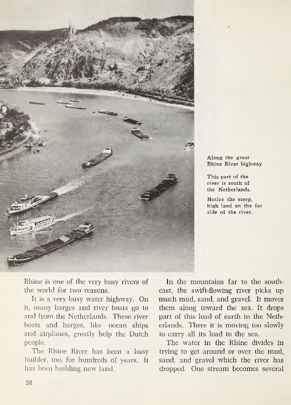
Along the great
Rhine River highway
This part of the
river is south of
the Netherlands.
Notice the steep,
high land on the far
side of the river.
Rhine is one of the very busy rivers of
the world for two reasons.
It is a very busy water highway. Onit, many barges and river boats go to
and from the Netherlands. These river
boats and barges, like ocean ships
and airplanes, greatly help the Dutch
people.
The Rhine River has been a busy
builder, too, for hundreds of years. It
has been building new land.
In the mountains far to the south-
east, the swift-flowing river picks up
much mud, sand, and gravel. It moves
them along toward the sea. It drops
part of this load of earth in the Neth-
erlands. There it is moving too slowly
to carry all its load to the sea.
The water in the Rhine divides in
trying to get around or over the mud,
sand, and gravel which the river has
dropped. One stream becomes several
58
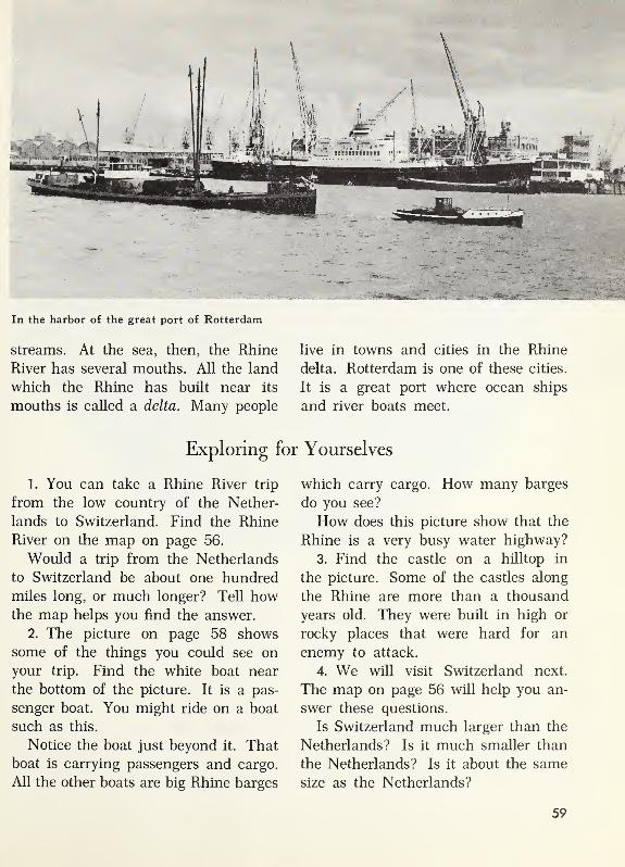
- : /
' iti-WM: l \
. 4
In the harbor of the great port of Rotterdam
streams. At the sea, then, the Rhine
River has several mouths. All the land
which the Rhine has built near its
mouths is called a delta. Many people
live in towns and cities in the Rhine
delta. Rotterdam is one of these cities.
It is a great port where ocean ships
and river boats meet.
Exploring for Yourselves
1. You can take a Rhine River trip
from the low country of the Nether-
lands to Switzerland. Find the Rhine
River on the map on page 56.
Would a trip from the Netherlands
to Switzerland be about one hundred
miles long, or much longer? Tell howthe map helps you find the answer.
2. The picture on page 58 shows
some of the things you could see on
your trip. Find the white boat near
the bottom of the picture. It is a pas-
senger boat. You might ride on a boat
such as this.
Notice the boat just beyond it. That
boat is carrying passengers and cargo.
All the other boats are big Rhine barges
which carry cargo. How many barges
do you see?
How does this picture show that the
Rhine is a very busy water highway?
3. Find the castle on a hilltop in
the picture. Some of the castles along
the Rhine are more than a thousand
years old. They were built in high or
rocky places that were hard for an
enemy to attack.
4. We will visit Switzerland next.
The map on page 56 will help you an-
swer these questions.
Is Switzerland much larger than the
Netherlands? Is it much smaller than
the Netherlands? Is it about the same
size as the Netherlands?
59

Discovering from the globe
Switzerland is the homeland of the
Swiss people. On this globe, the white
spot in Europe shows just where Swit-
zerland is. To the left of the globe,
there is a little map of Switzerland.
1.
Find on the globe the white spot
that shows just where Switzerland is.
On this globe, the letter N shows where
the Netherlands is. Find the N on the
globe.
Is Switzerland north of the Nether-
lands, or south of it?
2. Do you find from this globe that
Switzerland has a sea coast, or is it
a country without a sea coast?
It will not surprise you, then, that
Switzerland has no seaports.
3. On the little map, find the signs
for mountains. Are most of the high
mountains in the northern part of Swit-
zerland, or in the southern part?
60

In a high mountain pasture
IN SWITZERLAND
Mountain Farmers
High pastures in famous mountains
The Alps Mountains in southern
Switzerland are famous for their beau-
tiful peaks and valleys. In the picture,
we see some of the mountain peaks.
The pasture in the picture is high
up on a mountainside. In Switzerland,
high mountain pastures are called
alps. The Alps Mountains were namedfor those pastures.
In spring, after the snow has melted,
Peter Marquart helps drive his father’s
cows to their high summer pasture.
During the summer, Peter helps to herd
the cows there.
The summer home of the herders is
a hut in the high pasture. From this
pasture, Peter can look down into the
valley and see the village where he
lives. His home in the valley is in a
farm village.
Peter’s father is a farmer. Manyother men in the village are farmers,
too. All the farmers in the village owncows. Mr. Marquart has five cows and
a few goats.
If the farmers pastured their cows
in their valley farms, the grass there
would soon be gone. Instead, they cut
that grass for hay to feed to the cows
61

The cart in the picture with the pots and
kettles for cheese making is last in line.
At last everything is ready. The “cow
parade” starts. The man who leads the
parade is the master herder. Behind him
walks a fine cow that was chosen to be
the “queen cow.”
The cows are dressed up for the pa-
rade. Bells and flowers are tied to their
necks. The bell on the queen cow mayhave been used in cow parades for a
hundred years. As the parade moves,
the sound of the cow bells can be heard
for a long way.
Peter is dressed up, too. His clothes
look like those that herd boys wore
in earlier times. Clothes that show
earlier ways of dressing are often
worn by the village people on holidays.
Many of the people who come to watch
the cow parade wear their holiday
clothes.
The parade starts in the morning.
By late afternoon, the men and boys
have finished the trip up the steep slopes
to the high pastures. Before dark, they
are settled in their summer home.
Summer home of the herders
Peter’s father helped to build the
summer hut for the herders. Logs for
the walls were cut in the forest near
the pasture. Big, flat shingles for the
sloping roof were sawed from some of
the logs.
Peter enjoys living in the hut with
the other herders. He does not get lone-
some. Once in a while, his mother and
his sister Gerda climb up the mountain-
side to see him. You can see them in
On the way to the “cow parade”
in winter. This is why the cows are
kept in the high mountain pastures in
summer. In winter, Mr. Marquart keeps
his cows in a barn very near his house.
The "cow parade"
Every April, the cows from the vil-
lage farms are brought together to makethe trip up the mountainside. Peter will
help to take his father’s cattle to join
the other herders. He will soon be in a
long line of cows, goats, and herders.
62

the picture at the top of this page. They
have stopped to rest and enjoy the beau-
tiful view.
From time to time, Peter’s father
comes up to cut hay in another high
pasture. The picture at the bottom of
this page shows Peter’s father cutting
hay in that pasture.
The pasture in this picture is not as
high as the one on page 61,where the
herders’ hut is. The hay Peter’s father
is cutting will be stored for a while in
the little buildings scattered over the
pasture.
A summer day with Peter
Each day during the summer, the
men and boys in the high pasture are
up at sunrise. After a quick breakfast,
Peter helps milk the cows. Then he
drives eight or ten of the cows to pas-
tures on the mountain slopes. The other
boys herd cows on slopes not far away.
One summer day, Peter drove his little
herd much farther up the mountain
than usual. Grass can grow far up
where it is too cold for trees to grow.
He climbed so high that he came to the
edge of a patch of snow. There are
patches of snow in the mountains even
in midsummer.
After his climb, Peter was hungry.
He was glad when the sun told himit was about noon and time for his lunch
of bread and cheese. His clothes were
warm. He did not mind the cold. Hewatched the cows carefully as they
grazed.
But at last the sun sank behind a
far-off mountain peak. Then Peter
Looking down into a mountain valley
Cutting hay on a mountain slope
The hay will be fed to the cows in winter.
63

The master herder is making cheese, which will be carried down to the village.
quickly counted the cows and started
them back to the summer hut. The menin the hayfields heard the cow bells
half an hour before Peter reached the
hut. The bells told them that their
days work was over.
Peter's evening at the summer hut
Peter is always glad when supper is
ready. He takes his place with two other
herd boys on a wooden bench beside the
table. Part of the evening meal is al-
ways a big bowl of thick, sweet cream.
The Swiss call this “Alpine tea.”
After supper, Peter is so sleepy he
can hardly keep his eyes open. Soon
he spreads a bundle of straw on a wide
wooden bench. He rolls out his blanket
on the straw and quickly goes to sleep.
Making the big cheeses
The master herder is also a master
cheese maker. While Peter is herding
some of the cows, the master herder is
busy making cheese. We see him in the
picture. Other men often help him.
Many buckets of milk are used in each
cheese they make.
64
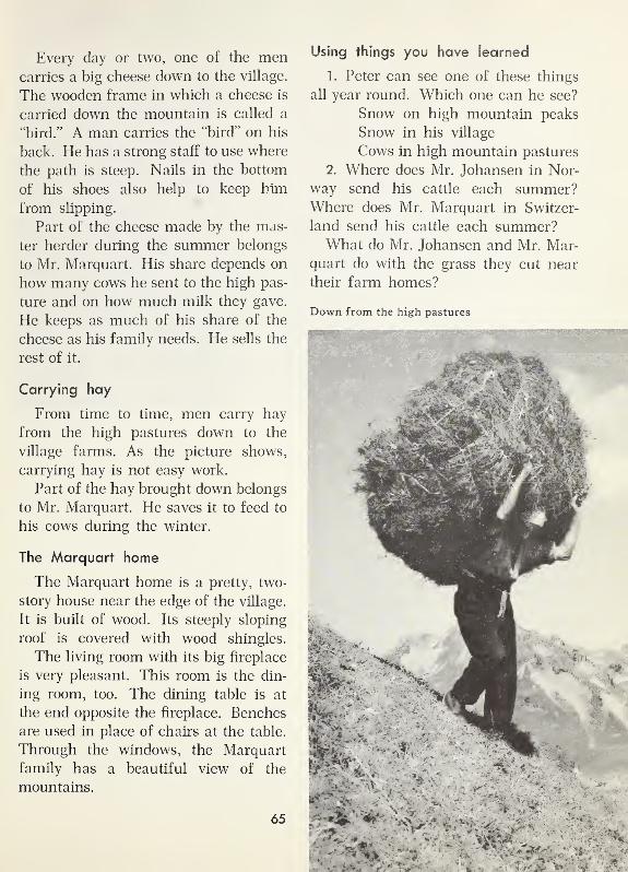
Every day or two, one of the mencarries a big cheese down to the village.
The wooden frame in which a cheese is
carried down the mountain is called a
"bird.” A man carries the "bird” on his
back. He has a strong staff to use where
the path is steep. Nails in the bottom
of his shoes also help to keep him
from slipping.
Part of the cheese made by the mas-
ter herder during the summer belongs
to Mr. Marquart. His share depends on
how many cows he sent to the high pas-
ture and on how much milk they gave.
He keeps as much of his share of the
cheese as his family needs. He sells the
rest of it.
Carrying hay
From time to time, men carry hay
from the high pastures down to the
village farms. As the picture shows,
carrying hay is not easy work.
Part of the hay brought down belongs
to Mr. Marquart. He saves it to feed to
his cows during the winter.
The Marquart home
The Marquart home is a pretty, two-
story house near the edge of the village.
It is built of wood. Its steeply sloping
roof is covered with wood shingles.
The living room with its big fireplace
is very pleasant. This room is the din-
ing room, too. The dining table is at
the end opposite the fireplace. Benches
are used in place of chairs at the table.
Through the windows, the Marquart
family has a beautiful view of the
mountains.
65
Using things you have learned
1. Peter can see one of these things
all year round. Which one can he see?
Snow on high mountain peaks
Snow in his village
Cows in high mountain pastures
2. Where does Mr. Johansen in Nor-
way send his cattle each summer?Where does Mr. Marquart in Switzer-
land send his cattle each summer?What do Mr. Johansen and Mr. Mar-
quart do with the grass they cut near
their farm homes?
Down from the high pastures

Summer in the village
Summer and Winter in the Village
On the Marquart farm
The Marquart farm is near the edge
of the village you see in the picture.
While Peter is away in the summer, the
rest of the family is busy getting ready
for the winter. The Marquarts grow
potatoes and other vegetables in little
fields near the house. They grow a little
wheat and some barley, too. Mr. Mar-
quart cuts his wheat and barley by hand.
Gerda helps her mother gather the
ripe vegetables and store them for the
winter. She helps her pick the cherries
from their two cherry trees.
The herders come home with the cowsbefore snow falls in the village. Peter
is glad to see the village again. Thenone morning he wakes up to find a
thick blanket of snow on the roads and
fields and housetops. The picture on
the next page shows how the village
looks then.
Peter and Gerda like to go skiing.
They learned to ski when they were
about the age of the little girl in the
small picture. What fun it is to live
where there are steep slopes and muchsnow!
In winter, Peter and Gerda go to
school in the village. They also help at
home. Peter carries in wood for the
fireplace and helps his father feed the
66

Winter in the village
cows. The cows must be milked, and
the bam must be kept clean.
Many visitors come to the village.
Long ago, people who visited the vil-
lage told others about the beautiful
scenery there. More and more visitors
came each year. Hotels were built.
You can see a hotel sign in the picture
above. New shops were opened. In
some shops, the visitors could buy woodcarvings and other things made by the
people of the village.
At first, more visitors came in sum-
mer than in winter. Now winter brings
just as many. We see several visitors
in the pictures. In the summer picture,
the bright Swiss flags make the street
look gay.
Using things you have learned
1. At what time of year would you
like most to visit this village? Give
your reasons for choosing that time.
2. An excellent ski slide has nowbeen built near the village. That helps
to explain something told in the first
column on this page. Tell what it
helps to explain.
3. What do peoples clothes in the
summer picture tell about the weather?
67

The tourists are looking at a famous glacier.
Travelers in Switzerland
Thousands of tourists
The Swiss people say that Switzer-
land is a “mountain playground.” Of
course, the tourists who come especially
to ski and skate come in winter. But
many people who come for sight-seeing
want to be there in summer.
Summer is a good time for sight-
seeing in Switzerland. It rains on manydays, but there is enough sunshine to
make the summer pleasant.
A list of all the trips for tourists
would be very long. There are trips by
train, automobile, bus, and airplane.
A bus trip to a famous glacier
One bright summer day, we go by bus
to see the famous Rhone Glacier. This
glacier is high in the Alps Mountains.
The bus climbs slowly up a steep and
winding road. As the picture shows, it
can take us very close to the glacier.
The Rhone Glacier looks perfectly
still. But it really is moving down the
valley just a few feet each year. Theglacier does not move along quickly as
a river does. It moves so slowly that wecannot see it move. The lower edge of
the glacier melts away in summer. The
68
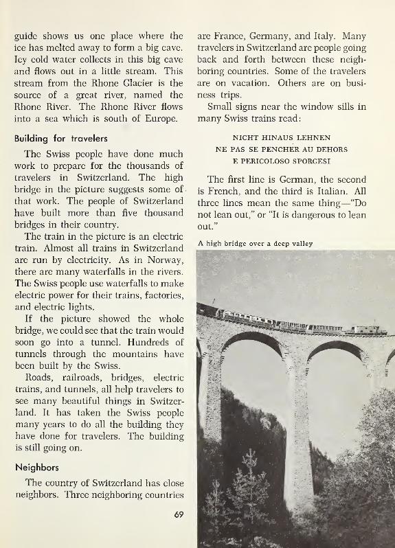
guide shows us one place where the
ice has melted away to form a big cave.
Icy cold water collects in this big cave
and flows out in a little stream. This
stream from the Rhone Glacier is the
source of a great river, named the
Rhone River. The Rhone River flows
into a sea which is south of Europe.
Building for travelers
The Swiss people have done muchwork to prepare for the thousands of
travelers in Switzerland. The high
bridge in the picture suggests some of
that work. The people of Switzerland
have built more than five thousand
bridges in their country.
The train in the picture is an electric
train. Almost all trains in Switzerland
are run by electricity. As in Norway,
there are many waterfalls in the rivers.
The Swiss people use waterfalls to makeelectric power for their trains, factories,
and electric lights.
If the picture showed the whole
bridge, we could see that the train would
soon go into a tunnel. Hundreds of
tunnels through the mountains have
been built by the Swiss.
Roads, railroads, bridges, electric
trains, and tunnels, all help travelers to
see many beautiful things in Switzer-
land. It has taken the Swiss people
many years to do all the building they
have done for travelers. The building
is still going on.
Neighbors
The country of Switzerland has close
neighbors. Three neighboring countries
are France, Germany, and Italy. Manytravelers in Switzerland are people going
back and forth between these neigh-
boring countries. Some of the travelers
are on vacation. Others are on busi-
ness trips.
Small signs near the window sills in
many Swiss trains read:
NICHT HINAUS LEHNENNE PAS SE PENCHER AU DEHORS
E PERICOLOSO SPORGESI
The first line is German, the second
is French, and the third is Italian. All
three lines mean the same thing—“Do
not lean out,” or “It is dangerous to lean
out.”
A high bridge over a deep valley
69

This sign not only helps travelers
from Germany, France, and Italy. It
also helps the Swiss people themselves.
Many Swiss who live near France speak
French. Many who live near Italy speak
Italian. Many near Germany speak Ger-
man. More Swiss speak German than
any other language.
Between the Rhine River and the Alps
We can see from the map on page 56
that most of the high mountains in
Switzerland are in the southern and
eastern parts of the country. Most of
the Swiss people live in the part of their
country where there are not so manymountains. In that part of the country,
we find most of the large cities.
The city in the picture is near the
center of Switzerland. It is on the shore
of a lake. The city is Lucerne. The lake
is Lake Lucerne. It is one of the manybeautiful lakes in Switzerland.
In Lucerne, we go to one of the manypleasant hotels for travelers which the
Swiss have built in their cities. Youcan see some of these hotels near LakeLucerne in the picture. At the little
boat dock, visitors can rent rowboats
and go rowing on the lake.
Using things you have learned
1. The Swiss have done much build-
ing to help travelers see many beauti-
ful things in their country. Make a list
of four things they have built.
2. Tell why the Swiss want manypeople to visit their country.
3. Would you like to be a passenger
in the bus on page 68? Tell why.
Tourists from many countries come to stay in the hotels on the shore of Lake Lucerne.

Working in a Swiss chocolate factory
Swiss City Workers
Hotels need helpers.
Many Swiss people work in the hotels
in Lucerne and in other cities in Swit-
zerland. Every large hotel needs manyworkers. Of course, the people of Swit-
zerland are glad that thousands of
visitors come to these hotels. The tour-
ists help thousands of Swiss people to
earn their living.
Strangers need Swiss guides on someof their travels. They also need help in
planning their trips. Some people in
every Swiss city make their living by
guiding tourists. Others work on the
buses, airplanes, and trains.
Candy and cows
Chocolate made in Swiss factories is
as good as it looks in the picture. The
man in the picture works in a Swiss
chocolate factory.
Much of the chocolate made in Swit-
zerland is milk chocolate. The Swiss
buy the chocolate from other lands. But
the milk comes from cows that feed on
the grass in Swiss pastures.
Swiss farmers sell milk to the choco-
late factories. This helps the farmers
earn a living. The factories are helped,
too, because they can buy all the milk
they need.
71

In the capital of Switzerland
Making things to sell
People in many lands want to ownwatches or clocks that are made in
Switzerland. In Swiss cities and vil-
lages, we see many stores in which Swiss
watches and clocks are sold. Many peo-
ple work in these stores. Hundreds of
other Swiss people earn their living in
the factories in which the watches and
clocks are made. Many Swiss watches
and clocks are sold in other lands.
The clock tower in the picture is in
Bern, the capital city of Switzerland.
This famous clock tower will help us
remember that the Swiss are famous for
their skillful work.
Instruments which doctors use are
made in some Swiss factories. The menwho make these instruments must be
as skillful as watch makers.
Some Swiss cheese is made in the
high pastures and on the farms. Even
more cheese is made in Swiss factories.
Visitors buy some of it. They buy some
of the Swiss chocolate, too. But most of
the Swiss cheese and Swiss chocolate
is shipped to other lands and sold in
stores there.
Other Swiss factories make machines
to be used in embroidering cloth. Onekind of cloth made by these machines
is called “swiss.” Some of the girls you
know may have summer dresses madeof “dotted swiss.”
Power from falling water
Many Swiss factories look like fac-
tories in Norway. They do not have big,
smoking chimneys. Instead of burning
coal, they use electricity for power. Theelectricity comes from power stations in
the mountains near by. Nearly every
village and city in Switzerland has
electric light and power.
It is fortunate for the Swiss that their
country has so many waterfalls. Swit-
zerland has almost no coal. More than
half of the Swiss people make a living
from city work. And much of that work
depends on electric power from moun-
tain waterfalls.
72

Exploring for Yourselves
1. Read the title of the picture on
this page. Are the slopes of the peak
of the Matterhorn bare, or covered with
trees? Why do you think, then, that
the peak may be very high? The Mat-
terhorn is 14,701 feet above sea level.
Where in the picture can you see
best that the snow is deep?
2. The steep little railroad in the pic-
ture leads up to beautiful snow fields
where tourists like to ski. This electric
“sports train” takes people up to the
snow fields. Think of ways in which
this railroad helps Swiss people earn
a living. What ways can you name?3. You have noticed many ways in
which Switzerland is different from the
Netherlands and Norway. But there
are also many ways in which these
three countries are alike.
Read the following sentences. Six
of these sentences are true of all three
countries. Decide which sentences are
true of all three countries.
(a) Many of the farmers own cows.
(b) Cows are kept in barns in the
wintertime.
(c) The sun sometimes shines even
at midnight.
(d) Many tourists visit the coun-
try.
(e) There are many waterfalls in
the country.
(f) Much cheese is made to sell.
(g) Many people live in cities.
(h) Many people make their living
in factories.
4. Notice the red sign near the right-
hand edge of the picture on page 66. In
what other country have you seen a
sign like this? Signs like this are used
in many countries in Europe.
5. The Swiss people make manythings to sell to people in other lands.
Make a list of some of these things.
Write “Making Things to Sell” at the
top of your list.
6. Write a title for the small picture
on page 67. Do you live in a place
where there is much snow in the win-
ter time? If so, tell what you like to do.
A famous mountain named the Matterhorn
73

Discovering from the globe
1. Switzerland and the Netherlands
are little countries with long names.
On this globe, the letter S shows where
Switzerland is, and the letter N shows
where, the Netherlands is.
Find the S and N on the globe.
2. Switzerland and the Netherlands
are in Europe. Find on the globe a
large sea just south of Europe. Whatis its name?
Which country is nearer to that sea
—Switzerland or the Netherlands?
3.
On our Mediterranean trip, we will
see places on or very near the south-
ern coast of Europe. Find a big penin-
sula at the western end of the Mediter-
ranean Sea. Our trip begins in that
peninsula in a country named Spain.
Notice that this peninsula is nearer
the equator than any of the countries
we have visited.
74

The village where Paco and Maria live
A MEDITERRANEAN TRIP
A Farm Village in Southern Spain
Homes in a mountain valley
Paco and his sister Maria live in the
village shown in these pictures. Their
father’s name is Francisco Prado. Paco’s
real name is Francisco, too. "Paco” is
only a nickname.
The white tower of the church stands
up high above the houses. The homeof the Prado family is near the church.
All the houses in the village are muchalike. They have tile roofs, thick white-
washed walls of stone and plaster, and
tile floors. The tile roofs and thick
walls help to keep the houses cool dur-
ing the long, hot, dry summers.
In winter, cold winds blow through
the valley, and rain falls for days at a
time. Then, pans of hot coals help to
keep the houses warm. On the moun-
tains near by, there may be snow. But
there is never any snow in the village.
The street where Paco and Maria live
754

Paco and
his motheron the road
to the village
Farmers live in most of
the village homes.
Mr. Prado is a farmer. Most of the
other men of the village are farmers,
too. Some of their fields and pastures
are just outside the village. Some are
on sloping land on the sides of the
valley.
The farmers raise wheat in many of
their fields. Sheep graze in their pas-
tures. Some of the farm land is used
for vegetable gardens, vineyards, andgroves of olive trees.
All the farm families have donkeys
for riding and for carrying loads. Paco’s
favorite donkey is named Chico. Wesee Chico in the picture.
Paco tends the sheep.
Paco is ten years old. His sister Maria
is nine. Paco helps with the farm work
when he is not in school. Maria and her
mother help with the farm work, too,
especially at olive-picking time.
In the picture on page 77, Paco is
tending sheep. As you can guess from
his wide-brimmed hat, the sunshine is
bright and hot. It is early in the sum-
mer, but the weather is already very
hot.
Paco and his flock are in a field from
which wheat has just been cut. Later
in the summer, we might find them
higher up the side of the valley in a
steep, grassy pasture.
76

Paco tending his flock of sheep in early summer
Wheat and weather Olive trees and weather
Wheat-planting time comes with the
first showers of the winter. The wheat
grows all through the winter, helped by
the rains. By Christmas time, the young
wheat is as green as grass. By early
summer, it is ready for harvest. At that
time the fields of ripe wheat look like
gold.
Olive trees can stand hot, dry weather.
All through the summer, they keep on
growing. But the grass on the hillsides
turns brown under the hot sun. Olive
trees have long roots and small, thick
leaves. Even when there is no rain, the
roots of the olive trees reach moisture
far down in the ground. The small,
77

thick leaves do not lose moisture so fast
as large, thin leaves. In the top pic-
ture, you see a grove of olive trees near
the Mediterranean Sea.
Harvesting the olives
Olives are picked in late summer and
autumn. Green olives for pickling are
picked several weeks before it is time to
pick the ripe olives.
Paco is looking forward to the olive
harvest this year. His father has told
him that he is now big enough to help
with the olive harvest. Maria will help
pick up the olives that fall to the ground.
Some of the olives will be saved to
be eaten whole. Both ripe olives and
green olives are good to eat. But most
of the olives will go to the oil press
to be made into olive oil. The Prados
use olive oil much as we use butter.
Paco and Maria think that bread spread
with olive oil is very good.
At wheat-harvest time
At wheat-harvest time near Paco’s village
These olive trees may live to be more than a
hundred years old. There is a saying: “If youwould plant wealth for your great-
grandchildren, plant the olive.”
f' -5,4 '
1 ..
*
The picture at the left and the two
pictures below were taken in early sum-
mer at wheat-harvest time. The menare working in a wheat field that be-
longs to Mr. Prado. They cut the wheat

At grape-harvest time
in southern Spain
by hand. Donkeys carry big loads of
wheat into the village. The girl in the
small picture at the bottom of the other
page is Paco’s sister Maria. She is pick-
ing flowers at the edge of her father’s
wheat field.
Picking grapes
Like olives, the grapes in southern
Spain ripen during the long, hot, dry
summer. The picture above shows a
vineyard at grape-harvest time.
The workers in the ’picture are
dressed in their holiday clothes. They
are proud of the big bunches of ripe,
juicy grapes.
Stripping bark from trees
Oak trees of a special kind grow wild
in some places not far from Paco’s vil-
lage. They are cork oaks. Cork oaks
stand hot, dry summers well, just as
olive trees do. And they, too, live to be
very old.
Cork oaks get their name from the
cork made from their bark. The men in
the picture at the bottom of this page
are stripping off the bark from a cork
oak. It will be about ten years before
this tree will again have bark thick
enough to be stripped off.
Bark from these trees has many uses.
79

These oaks help in another way.
Acorns fall from them in autumn. Pigs
can feed on the acorns and grow fat. Fat
pigs mean delicious meat for dinner in
the village homes.
bigger wheat fields and bigger houses
and bigger market places than those at
home. But he has always been glad to
get back to his small village in a moun-
tain valley.
More about the village
In a small factory in the village, cloth
is woven out of the wool sheared from
the sheep. In a little mill, wheat is
ground into flour. There are several
shops near the small open square that
the church faces.
On summer evenings, the Prado
family spends many happy hours in the
open square, talking with their friends
and neighbors. It is pleasant in the
square when the sun has gone down and
the heat of the summer day has begun
to fade.
The bus that comes to the village
loads and unloads in the square.
You can see the bus in the picture
below. Paco has made a few trips on
the bus with his father. They were all
exciting adventures. He saw towns
much larger than his village. He saw
Using things you have learned
1. Name three ways in which Paco’s
village in Spain is different from Peter’s
village in Switzerland.
2. In telling about Paco’s village,
you would be sure to use some of these
words. Which words would you use?
Which ones would not help you?
vineyards
hot
dry
glaciers
olives
sleds
reindeer
wheat
3.
On the globe on page 74, find a
long peninsula shaped like a boot. This
is the peninsula of Italy. Is it east or
west of Spain?
If we go from southern Spain to Italy
by the shortest way, will most of our
journey be on land or on water?

A sight
tourists come to see
Along the Coast of Southern Italy
A famous mountain
Every year, thousands of tourists visit
southern Italy. The steaming volcano
in the picture is one of the sights they
come to see. The mountain is Vesuvius.
Mount Vesuvius is a volcano. It is one of
the famous volcanoes in the world.
Angelo Marino lives in a village sev-
eral miles away from Mount Vesuvius.
But he can see it clearly from his home.
Angelo is nine years old. He has never
seen anything but steam and smoke
come from the volcano. But his father
tells him that ashes and red-hot liquid
rock, called lava, sometimes come from
Mount Vesuvius. They have ruined
fields and orchards and vineyards. They
have buried towns and small cities.
And they have killed many people.
But Angelo knows that Vesuvius has
also been a friend. Lava breaks up into
rich soil. This rich soil is wonderful
for olive groves and vineyards. Angelo
would like to see the mountain look
as if it were on fire. But he does not
want it to “wake up” and do harm.
Many villages, many farmers
Within a few miles of the village
where Angelo lives, there are a dozen
other villages or towns much like his.
His village and the others are all on flat
land, or a plain. Some of them are less
than two miles apart.
Angelo’s father and most of the other
men in the villages are farmers. Most
of their fields are in the plain. But some
of them are on the slopes of hills that
border the plain in places.
A beautiful sight
Angelo enjoys going to the top of a
nearby hill and looking out over the
fields. They look like one huge garden
81

1w:
Looking across the harbor of Naples In the distance is Mount Vesuvius.
surrounding all the villages. On the
lower slopes of some of the hills menhave cut steps, or terraces, so that the
slope looks like this.
Angelo’s home in the village is in
a three-story apartment building. His
father has showed him that the terraces
are somewhat like the different floors
in their building.
In most of the fields on the “first
floor,” the farmers plant wheat or vege-
tables. They use the “second floor” for
orchards. Vineyards do well higher up
on the slopes. And animals are taken
to graze in pastures higher than the
vineyards.
There is plenty of rain for the wheat
in the wintertime. Summers are long
and hot and dry. But vegetables grow
well in summer, because they can be
irrigated with water from mountain
streams.
In a neighboring village
During the summer, Angelo likes to
go with his father to take a big wagon-
load of tomatoes to a neighboring vil-
lage. In a small factory there, he can
see tomatoes being canned or made into
tomato paste.
Next door, he can watch men makemacaroni out of wheat flour. He likes
to see the macaroni come out of a ma-
chine, ready to be hung on racks to dry.
82

The big city on the coast
Once Angelo went with his father to
the big city in the picture on page 82 .
The big city is Naples. Angelo thought
that the crowded streets were exciting.
But most of all he liked the big harbor.
Many tourists come to Naples.
Near the Mediterranean coast are
beautiful orchards like the orange grove
in this picture. At the bottom of this
page, you see terraces cut in a hill slope
not very far from Naples.
Tourists come from all over the world
to see these beautiful sights. Some of
the people of Naples make their living
guiding tourists.
Going to the top of Mount Vesuvius
is a trip tourists like. Many people who
Along the coast of southern ItalyPicking oranges

Many tourists
drive on this famousroad along the
coast south of
Naples.
visit Vesuvius want to see Pompeii, too.
About 19 centuries ago, a little Romancity called Pompeii was buried by cin-
ders and ashes from Vesuvius. Thelittle city lay buried for hundreds of
years. Then men began to uncover it.
Now visitors can walk along its streets
and see the walls of buildings. They
can see ruts made in the pavements by
Roman chariots 2000 years ago.
There are boat rides and auto rides
to take along the coast near Naples.
The road in the picture is about
thirty miles south of Naples. For mile
84

A temple built long ago in southern Italy by people from Greece
after mile, the views are beautiful. Onone side is the steep, rocky coast. Onthe other side is the Mediterranean Sea.
Not far from this road is the build-
ing you see in the picture above. It is
an ancient temple built by Greek peo-
ple who had moved into Italy from
their homeland. The temple was once a
part of a city, but most of the ancient
city fell into ruin centuries ago.
In ancient times, just as today, the
homeland of the Greek people was in a
peninsula east of Italy. In their country,
we would see today many ruins of beau-
tiful ancient buildings. We shall go
next to Greece.
Using things you have learned
1. Which of these words would you
use in telling about Angelo’s village?
dry skating
vegetables irrigation
volcano fiords
terrace apartment
2. If you were a tourist in Naples,
what things would you like to see
most? Tell why you would like to see
these things.
3. Tell about Angelo’s home. Thentell about your home. Do you think
you might feel at home where Angelo
lives? Tell why, or why not.
85

In Southern Greece
Far east of southern Spain
On the map at the top of this page,
we can see that Greece is the southern
part of a big peninsula. We can see,
too, that it is east of Italy. Of course,
it is even farther east of Spain.
On the map, the mountains of Greece
show clearly. In many places, they are
close to the coast.
The pictures on these two pages were
all taken in Greece. They show that
On a road in southern Greece
there are a number of ways in which
Greece is like Spain and Italy.
Learning about Greece
from the pictures
Donkeys bring big loads of grain from
the farms to the villages, just as they
do in Spain. Of course, there are goats
in Italy and in Spain, but there are
many more in Greece. Goats can find
enough to eat on rocky mountain pas-
tures that are too poor for sheep.
Greek farmers have sheep, too. Theflock in the picture at the top of the
next page is like the flock that Paco
tends in Spain. The picture of the
wheat field looks much like Mr. Prado’s
wheat field. In the cool winters, there
is enough rain for wheat, just as there
is in Spain and Italy.
The fishing boats in the picture at
the bottom of the next page are in the
ELI86

We see flocks of sheep and fields of wheat that remind us of those in southern Spain.
Mediterranean Sea near Greece. Thefishermen are Greek fishermen. Angelo
would feel at home here, because the
sea coast of Greece is much like the
sea coast near Naples.
The farmer’s wife in the next picture
is getting a meal ready. Her two daugh-
ters are helping her. You may be sure
that they are using olive oil in their
cooking. Olive oil is as important to the
Greeks as it is to the people of Spain
and Italy. We would see many olive
trees in Greece.
Perhaps the farmer’s wife is using
raisins, too. Many raisins are madefrom the grapes that the Greek farmers
raise in their vineyards. In Greece,
many raisins are made by drying grapes
in the hot summer sunshine. Almost
every summer day is hot and sunny.
Famous seamen
Greece is sometimes called a “penin-
sula of peninsulas,” for along its coast
there are many small peninsulas. Close
to the coast there are many islands.
Some of them show on the map.
The peninsulas and the islands helped
the Greeks learn to sail ships. Frommany places on the mainland, the peo-
ple could see islands. They wanted to
visit them. In each place they visited,
they saw other shores. Little by little,
they became famous seamen.
Making good things to eatMany Greeks are men of the sea.


Many Greeks today are seamen.
Some of the boats that come and go
carry freight and passengers. Someare fishing boats.
The big picture shows a harbor on
an island near Greece. The small boat
is carrying passengers from the island
to the ship.
In the waters near Greece, boats are
seldom out of sight of land. Even small
fishing boats are not often in danger.
If a sudden storm comes up, there is
almost sure to be a harbor not far away.
Getting a living from the sea is not as
dangerous here as it is in some parts of
the world.
Exploring for Yourselves
1. On the map on page 86, find a
narrow water gateway between the
Mediterranean Sea and the Atlantic
Ocean. What is the name of this gate-
way?
Find this narrow gateway on the
globe on page 74. It is not named on
the globe.
2. Big ocean liners can sail through
the Strait of Gibraltar. Use the globe
on page 74 to help you answer these
questions.
Can an ocean liner sail all the wayfrom Norway to Italy, or only part of
the way?
Can an ocean liner sail all the wayfrom the Netherlands to Greece, or
only part of the way?
3. Make a list of the six countries
we have visited since we left the North
Pole. A class list may be written on
the blackboard, or each member of the
class may make his own list.
In what continent are all of these
countries? Write the name of that
continent after each country in your
list.
Print P in front of Spain to show
that Spain is in a peninsula. Then,
print P in front of the names of the
other three countries that are in pen-
insulas.
To check your answer, look at the
map on page 86 and the globe on
page 74.
4. Only one country in your list has
no mountains. Which country is it? If
you need help, look again at the mapon page 56.
5. Only one country in your list has
no sea coast. Which country is it? Theglobe on page 74 will help you.
6. Three countries in your list should
make you think of long, hot, dry sum-
mers and cool, rainy winters.
Which three countries are they? Tocheck your answer, look at the map on
page 86. All three countries are namedon this map.
7. The map on page 86 shows that
Africa is south of the Mediterranean
Sea. The next part of our journey will
be a southward journey in the continent
of Africa.
The rocky coast of an island near Greece
89

Discovering from the globe
1. Find on this globe the continent
of Africa. In what direction is it from
the continent of Europe?
2. What ocean is west of Africa?
3. What sea is north of Africa?
4. What ocean is east of Africa?
5. On this globe, find the sign for the
very long Nile River. The Nile flows
northward into a large sea. What is
the name of that sea?
6. On our next trip, we will go south
along the Nile River into the heart of
Africa.
Find the equator on this globe. Onour trip, will we be getting nearer and
nearer to the equator, or farther and
farther away from it?
7. Our trip begins near the northern
end of the Nile River. Find the nameSahara on the globe. The story will tell
what this name means.
90

Shepherds in the Sahara
SOUTH ALONG THE NILE
In the Greatest Desert in the World
Homes in the desert
On the first part of our trip along the
Nile River, we will be in the greatest
desert in the world. That desert is
called the Sahara. The word “Sahara”
means desert. A desert is very dry
land.
The great Sahara stretches all the
way across northern Africa. It is
almost as large as our whole country.
In many parts of that huge desert,
no one lives. But along the Nile, there
are millions of homes. The people take
water from that great river to put on
the thirsty land near the river banks.
For hundreds of miles, the Nile River
is in a narrow “ribbon” of land which
is green with crops.
That ribbon is bordered on both
sides by land as bare and brown as the
land we see in the picture. The menin the picture are desert shepherds.
Clothes and weather
The three shepherds in the picture
are wearing scarfs and long, loose
robes. These are useful to desert people
both in the summer and in the winter.
91

“People of the tent”
Summer days in the desert are very
hot. The shepherds say, "The sun
wants to burn us up.” People need
to keep their heads covered to protect
them from the hot rays of the sun.
At times, they need to cover their
faces very quickly. For winds may sud-
denly raise choking dust from dry
ground or blow stinging sand into their
faces.
In loose robes, the people do not feel
as hot as they would in fitted clothes
like ours. And scarfs and loose robes
can be put on or taken off quickly.
In the desert, summer nights are
cold. Shepherds sometimes say, “After
the hot sun goes down, the nights
try to make us shiver.” On summernights, they need blankets or extra
robes and scarfs.
In the winter time, the weather is
pleasant. The days are cool but not
cold. In winter, as well as in summer,
robes and scarfs are comfortable. Most
people of the Sahara are glad whenwinter comes.
Rain and "people of the tent"
Even in the desert, there are showers
now and then. They may fall at any
time of year. But in a whole year, no
place has more than a few showers.
In many places, grass springs up
soon after a little rain has fallen.
Sheep can be pastured on that grass
for a few days or weeks. But shep-
herds have to move often to find newpastures for their sheep and goats and
camels. They need tent homes which
they can move from place to place.
92

In the picture on page 92, we see a
few “people of the tent.” Some of the
men in the picture below are selling
two of their camels. As the next story
shows, camels are useful to desert peo-
ple. The story was told by an Ameri-
can who visited a camp on moving day.
A story of moving day
“On moving day, work begins as
soon as it is light. A camel is brought
to each tent. The women loosen the
long strips of coarse cloth that have
been stretched across poles to makethe tent. These strips are rolled into
long bundles and put beside the few
household goods. The tent poles and
stakes are pulled from the ground. Not
a stick is wasted or lost.
“Now each camel is down on his
knees. First, a big leather and wooden
saddle is put on his back. Next, a rack
to hold things is fastened to the saddle.
“The women do most of the work
of moving. On the racks, they pile the
rolls of tent cloth and the tent poles
and stakes. Then they pile on coffee
pots, big pans for cooking, sacks of
wheat and barley, and leather bags
filled with water. On top of all, the
small children are placed.
“Someone speaks to his kneeling
camel. It staggers to its feet. Then, one
after another, the other camels get up.
“The leader of the camp rides ahead.
Some of the people walk. Others ride
camels. Boys and men drive herds of
camels and flocks of sheep and goats.
“Toward evening the people come to
a place where there is fresh pasture.
As the loaded camels arrive, they are
quickly unloaded. Soon the tents are
set up. Within an hour, the people are
settled in their new camp.”
Hidden water and tent homes
Of course, the people of the tent and
their animals need water to drink.
Camels can go several days without it.
But even camels must have drinking
water in order to stay alive.
Long ago, people found water manyfeet below the dry ground in some
places in the desert. By digging a well,
they could get to that hidden water
underground. People of the tent set up
each new camp in a place near such a
well. The people in the picture on page
92 can get water from a well not far
from their tents. They can pull it up in
goatskin bags tied to a rope.
Oasis homes in the desert
In some places in the desert, mencan get more water than they need
Camels for sale
!
93

Homes and date palms in an oasis village
This bus carries passengers from one oasis town to another.

just for drinking water. They can get
enough to put some of it on the thirsty
ground. They then can raise crops on
the land on which they can put water.
Land in the desert where there is a
good supply of water is called an oasis.
There must be enough water so some
of it can be used to help crops grow.
Oasis people live in houses. Theyneed to be near the land on which
they raise crops.
Houses in oasis villages
In any oasis village, we see houses
much like those in the upper picture
on page 94. The houses are made of
sun-dried mud bricks. As we nowknow, there is plenty of hot sunshine
to make mud bricks dry quickly.
In the thick walls of a house, there
are a few narrow windows. There is
no glass in them. Inside the house, it
is cool and almost dark even on the
hottest, brightest days.
The rooms in the house open on a
small courtyard. In that little court-
yard, there may be flowers and trees.
The roofs of the houses are flat.
After sunset, people sometimes sit on
the flat roofs to enjoy a cool breeze.
Growing dates and other crops
The trees in the upper picture on page
94 are date palms. Date palm trees can
be seen in almost every oasis village in
the Sahara. The oasis people irrigate the
palms with water from a little river or
from wells. Oasis people say, “The
date palm likes its head in fire and its
feet in water.” It grows best with its
leaves in the sun and its roots in wet
ground.
Date palms have long leaves that
look much like branches. The long
leaves and the bunches of dates are at
the tops of the trees. It is not hard to
climb up to get the fruit because the
tall trunks of the trees are rough. Dates
are a daily food of people of the Sahara.
Other fruits grown in many oases are
grapes, peaches, plums, and lemons.
Wheat, barley, and clover are raised in
many small fields. The houses and the
irrigated crop land are close together.
Some changes are taking place.
In some oasis towns, we could see
buses today. We see one in the lower
picture. There are a few roads in some
parts of the Sahara. And some trade
goes on in the little market places of
the oasis villages. But we see donkeys
or camels instead of horses in manyoasis towns and villages.
Using things you have learned
1. We might fly many miles over
the Sahara without seeing any homes.
Why is there much empty land in the
Sahara? What does the word “Sahara”
mean?2. At some places, we would see
oasis villages. What kinds of houses,
trees, and crops would we see in those
villages? What is an oasis?
3. In some other places, we would
see tent homes. Tell why the people of
the tent move from place to place.
95

Getting water from the Nile today in an old, old way
In the Long Oasis of the Nile
A very famous oasis
In the long, narrow oasis of the Nile,
people use water from that river for
their crops. The oasis is hundreds of
miles long. It is a part of the country
of Egypt. People of that country are
called Egyptians.
The oasis of the Nile is very famous.
It is famous partly because the Nile
River is famous. The Nile is the longest
river in the world. The oasis is famous
partly because millions of people live
in it. And it is famous partly because
people have lived there for thousands
of years.
The Egyptians were civilized long,
long before there were any civilized
people in Europe. As we travel along
the Nile, we shall not be surprised to
find some things that are very old.
Two farmers
The farmer in the picture above is
a farmer of today. But he is using a
very old way of lifting water from
the river. He is using a shaduf.
At one end of the long pole of the
shaduf, there is a bucket. At the other
end, there is a big ball of dried mud.
The mud ball is heavy enough to help
the farmer lift the bucket full of water.
The farmer will pour the water into a
ditch. In that ditch, it will flow to his
land.
96

This farmer lives in the delta of the
Nile. The Nile River has built a great
delta, just as the Rhine River has.
The farmer in the picture below
lives several hundred miles south of
the delta. He is using an old, old wayof threshing the grain he has raised.
Along the Nile
Between the places where these two
pictures were taken, we would pass
hundreds of villages along the Nile.
The villages all look much like the oasis
village you saw in the picture on page
94. The flat-roofed houses have walls
of sun-dried brick.
We would see many date palms. But
dates are not the most important crop
of the long Nile oasis. Corn, cotton,
and wheat are more important. In this
warm land, the farmers can raise crops
the year round. Corn and cotton are
summer crops. The farmers raise
wheat in the winter.
We would see farmers working in
their fields. Some men would be lifting
water from the river with shadufs like
those used there many hundreds of years
ago. Here and there, men might be
working with modern machinery. But
much farm work is still done by hand.
Our trip would take us past Cairo.
It is the largest city in Africa. This big
city stretches for miles along the river.
In places near the river, there are
monuments built by the Egyptians of
long ago. On some monuments, the
builders carved words and sentences
in an interesting kind of picture writ-
ing. We can still see this writing.
Ali lives near the Nile.
Ali is a ten-year-old boy who lives in
one of the villages along the Nile. He
Threshing wheat with a simple “threshing machine” pulled by oxen

Ali, Sulim, and Azir like to read.
is at the left in the picture above. Ali
and his friends Sulim and Azir go to
the school in the village. Not very long
ago, only the boys of wealthy Egyptian
families could go to school. But nowschools are free.
Ali s father is a farmer. He has a
very small farm. He also has a vege-
table garden. Like most farmers near
the Nile, he raises some corn every
year on his farm. He and his family
eat all the corn he raises. The corn
stalks make good fuel. Ali’s father
raises wheat every year, too. Sweet po-
tatoes, beans, and onions are three of
the vegetables he grows in his garden.
The family owns two goats. The
goats furnish milk and cheese. Ali
does not often have meat to eat. But
sometimes there is mutton for supper.
Every day Ali and his friends see
sailboats on the Nile. Now and then a
steamboat goes by.
Many airplanes on their way to and
from the big city of Cairo fly above the
village. The planes are fun to watch as
98

they skim across the sky. Ali often
wonders if the people on the planes
can see a boy on the ground far below
them.
Sometimes the boys walk to another
village a few miles away. The road to
this village is along the tops of low,
mud walls. The walls were built to
hold water on the fields behind them.
In some places the road is only a wide
path. On the narrow road the boys are
likely to meet a farmer riding on a
donkey.
The village they visit is on a railroad.
So Ali and his friends have seen trains.
The boys wonder how one engine can
pull so many cars. They know that
trains come from Cairo in the north,
and they wonder how far south they go.
The trains do not stop at the village.
The cars of the train are white, and
the glass in the car windows is blue.
White cars do not get so much heat
from the rays of the sun as dark ones
would. And the blue glass helps to
shut out the glare of the bright sun-
light.
A paved road runs along the edge of
the village. On that road, the boys see
buses and automobiles hurrying by.
They see people riding donkeys and
bicycles. There are also men leading
camels with heavy loads.
Ali and his friends have never been
more than a few miles away from
home. But they have seen the modern
ways in which people travel in the long
oasis of the Nile. They have seen the
older ways, too.
At work in a wheat field
In the picture below, a farm helper
is working in a wheat field. This mandoes not own a farm of his own. The
water for the field is first lifted from
the Nile into a canal. It flows from
the canal into this field through a
ditch. Of course, the water will not
stand in the field. It will soon sink
into the thirsty ground.
A village is near by. The farm worker
lives in that village. A tall spire rises
above the houses there. It is a minaret.
A minaret is the slender, high tower of
a mosque, or place of worship. Every
village along the Nile has at least one
mosque. From the tops of the minarets
the people of the villages hear a call to
prayer at certain times every day.
Harvesting a crop of wheat
99

Egyptian guides with
their camels are
waiting to take
tourists to see
the pyramidsnear by.
Ancient Egyptian monuments
—
a pyramid and the famous Sphinx The pyramids and the Sphinx
The camels in the picture at the top
of the page are ready to take visitors
to the pyramids. The pyramids are
ancient monuments near Cairo. They
were built thousands of years ago as
tombs for the rulers of Egypt.
In the lower picture, you can see a
pyramid in the background. Each
pyramid is built of big blocks of solid
stone. Just one block weighs several
thousand pounds. The blocks of stone
were cut from the rocky banks of the
Nile far to the south. They were floated
down the Nile on barges. Then the
blocks were dragged from the river
across the land by hundreds of men,
all pulling at once on a single block.
The big head in the picture is the
head of a sphinx carved in stone. AnEgyptian sphinx was supposed to have
the body of a lion and the head of a
man. Of course, there never was any
such animal. But long, long ago, the
100

These boats with
their tall sails carry
goods and passengers
on the busy Nile
highway.
Notice the house-
boats along the river
banks, also.
Egyptians made sphinxes to guard
the tombs of their rulers.
The pyramids are in the desert. Therulers who had them built did not use
precious crop lands for them.
Visitors do not have to ride camels
to see the pyramids. But many people
think that riding on camelback is
exciting.
Boats on the Nile
In the days when the pyramids were
being built, the Egyptians traveled
along the Nile by boat. There are many,
many boats on the Nile today. Somecarry passengers. Others carry freight.
Most of the boats you see in the
picture above are sailboats. These boats
with their tall sails make a pretty sight
as the wind drives them along.
At the edges of the river, there are
some houseboats. Families live on
these boats. Floating houses are a
help in a crowded land.
Nile boats tied up Notice the tall masts.
101

A busy, modern street in Cairo
The city of Cairo
Nowhere in Egypt is there more of
a mixture of the old and the new than
in the big city of Cairo. The picture on
this page was taken in the new part
of the city. Here the streets are wide.
They are crowded with buses and taxis
and automobiles. Walking along the
streets, we pass big hotels, stores,
banks, and government buildings. Wecan visit fine museums. There we can
find out much about how the ancient
Egyptians lived.
There are beautiful homes and
gardens in the newer part of the city.
Many houses are built of concrete.
Visitors from other parts of the
world may be seen on the streets and
in the shops. Some have come to the
city by air. Cairo has a good airport.
Of course, many of the people on the
streets of Cairo are Egyptians. Differ-
ences in clothing may tell us that one
man is from the desert, that another
is a farmer, and that still another is
a shopkeeper. Many Egyptians wear
102
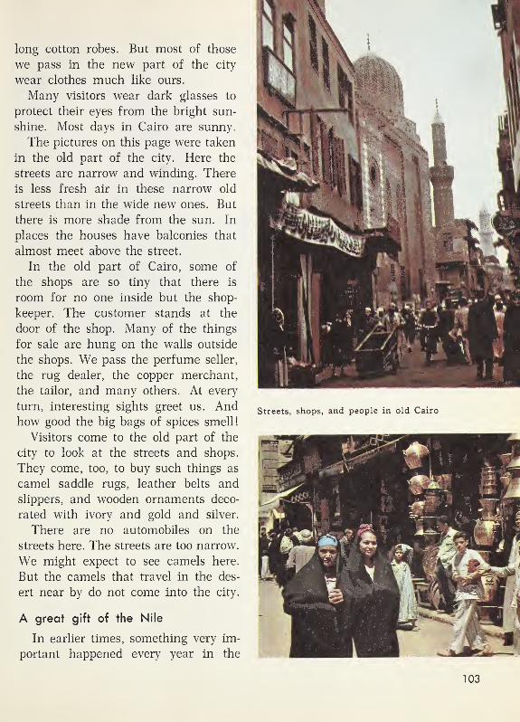
long cotton robes. But most of those
we pass in the new part of the city
wear clothes much like ours.
Many visitors wear dark glasses to
protect their eyes from the bright sun-
shine. Most days in Cairo are sunny.
The pictures on this page were taken
in the old part of the city. Here the
streets are narrow and winding. There
is less fresh air in these narrow old
streets than in the wide new ones. But
there is more shade from the sun. In
places the houses have balconies that
almost meet above the street.
In the old part of Cairo, some of
the shops are so tiny that there is
room for no one inside but the shop-
keeper. The customer stands at the
door of the shop. Many of the things
for sale are hung on the walls outside
the shops. We pass the perfume seller,
the rug dealer, the copper merchant,
the tailor, and many others. At every
turn, interesting sights greet us. Andhow good the big bags of spices smell!
Visitors come to the old part of the
city to look at the streets and shops.
They come, too, to buy such things as
camel saddle rugs, leather belts and
slippers, and wooden ornaments deco-
rated with ivory and gold and silver.
There are no automobiles on the
streets here. The streets are too narrow.
We might expect to see camels here.
But the camels that travel in the des-
ert near by do not come into the city.
A great gift of the Nile
In earlier times, something very im-
portant happened every year in the
Streets, shops, and people in old Cairo
103

The great Aswan Dam across the Nile
oasis of the Nile. Late every summeror early every autumn, the Nile over-
flowed its banks. Today people in the
oasis have a holiday late in August to
celebrate those Nile floods.
That flood each year was a big
help to people along the Nile. Watersoaked into the land which was flooded.
People could then grow winter crops
in fields which the river itself had
watered. The people thought of the
flood water as a gift the Nile gave
them each year.
A great dam
In recent times, men have built a
great dam across the Nile. The picture
shows part of that dam—the Aswan
Dam. The map shows that it is sev-
eral hundred miles south of Cairo.
This huge dam was built to hold
back part of the flood water of the
Nile. In earlier times, the fields which
the Nile flooded in the autumn were
very dry by spring. And by spring the
water in the river was very low. In
spring and summer, people needed
much more water than they could get
from the river.
There are many gates in the big
dam. In the picture, only a few of them
are open. More gates can be opened
when the farmers need more water.
Since the dam was built, manyfarmers in the Nile oasis can grow two
or three crops a year on their land.
104

MEDITERRANEANSEA
Cataracts
And more fields than before can be
irrigated. Now, more farmers than ever
before can make a living in the long
Nile oasis.
Using things you have learned
1 . What two words would you use in
telling about the shape of the oasis of
the Nile? Why does the oasis of the
Nile have that shape?
The first sentence on page 96 will
help you check your answers to these
questions.
2. Name four very old things, or old
ways of doing things, which you see
in the pictures on pages 94-104.
Name four modern things which you
see in these pictures. You may wantto write the names of these things in
two lists on the blackboard.
South from the Great Dam
A mystery for thousands of years
The Egyptians of long ago discovered
many things about the Nile River. But
for thousands of years, people wondered
where the water in it came from.
Finally, explorers found the answer.
The map above shows what they found.
Much of the water in the Nile flows
from Lake Victoria. That large lake is
far to the south of Aswan Dam.The southern part of the Nile River
is called the White Nile. Many smaller
streams flow into the White Nile. Theybring much water to it.
Cataracts and more desert
As the map shows, there are four
cataracts in the Nile between the
dam and the White Nile. Cataracts
are somewhat like very low waterfalls.
Because of the cataracts, big boats
cannot be used on the river from the
dam southward to the White Nile. But
we can make the journey by plane.
From the plane we see that we are
flying over desert all the way. In some
places, we see steep slopes of reddish
rock along the river banks. We see
here and there villages much like Ali’s
105

Wild animals roam in the great grassland.
village. But villages are fewer than
they are near Ali’s home. And bare
desert is in sight all the way.
When we reach the White Nile, weare about a thousand miles south of
Cairo. But we are only about half waybetween Cairo and Lake Victoria!
The great grassland south of
the Sahara
South of the huge Sahara, there is a
great grassland. On the grassland near
the Sahara, only a little grass grows.
But farther south, as the picture above
shows, there is not only tall grass but
a few trees. The trees are not tall. Thelong-necked giraffes can feed on seed
pods and leaves on the trees.
The great grassland stretches all the
way across Africa. In some parts of
the grassland, there are wild animals
that live on grass. Other animals there
live on the animals that eat grass or
get food from trees.
Along the White Nile
On the White Nile, we could travel
south by boat for a few hundred miles.
We should expect some rainy weather
if we made the trip in July. There
might be a hard shower almost every
afternoon. We are no longer in the
desert.
Along the banks of the river, wecould see small villages. Much of the
land is covered with long, coarse grass.
106

The grass roofs of the houses are cone
shaped.
Women work in little fields of corn
and beans near the villages. Some of
the men herd cattle. Some of them are
hunters.
On southward by plane
The grass we see in the picture below
is on the bank of the Nile. The part of
the Nile in which the boys are fishing
is near the southern end of that great
river. Land there is much higher than
the land near Cairo.
We leave the steamer to fly on south
to Lake Victoria. Soon we see large
swamps beside the river. Farther on,
we catch glimpses of big herds of
cattle. We see many wild animals.
Among them are elephants, zebras, and
other animals that make us think of
a zoo.
At last, we see ahead a big, newdam across the river. Beyond the damstretches a huge lake on high land. This
is Lake Victoria. Water flowing from
Lake Victoria, through gates in this
dam, feeds the great Nile River. Wethink of the thousands of miles the
water must travel to get from Lake
Victoria to the Aswan Dam and on to
Cairo and the Mediterranean Sea.
Grassland weather and the Nile
If we made the trip to Lake Victoria
in January, the weather along the waywould be almost as warm as in July.
It would not seem to us at all like
winter.
But at that time of year, we would
have no rainy weather. People of the
hot grasslands think of what we call
winter as the “dry season.” What wecall summer they often speak of as
their “rainy season.”
Just south of the Sahara, the rainy
season is very short, and the dry sea-
son is long. But farther south, the
rainy season is much longer.
During the rainy season, grassland
streams carry much water to the Nile.
In that season, the Nile gets water both
Boys everywherelike to go fishing.
These boys are
fishing along the
banks of the Nile
near its southern end.
107

A mother makes manioc bread in front of her grass-roofed home.
from Lake Victoria and from those
streams. So the Nile floods in late
summer and autumn were not as
mysterious as they seemed to be.
A home in the hot grasslands
The home in the picture above is not
very far from Lake Victoria. Like
homes along the White Nile, it has a
roof made of long, coarse grass.
The mother is making bread. First,
she pounded the roots of a manioc
plant into flour. Probably you have
never eaten manioc bread, but you mayhave eaten something made from the
manioc plant—tapioca!
Manioc plants are as useful to the
people in this hot grassland as wheat
is to the people in the great oasis of
the Nile.
108

Exploring for Yourselves
1 . What two things do you see in the
picture below which you would not see
in the oasis of the Nile?
How can you tell that there is morerain in the place shown in this picture
than there is along the northern part
of the Nile?
2. Suppose you lived in the grass-
land shown in the picture below. If you
owned cattle, why might you wish that
there were no lions here?
3. Compare this picture with the one
on page 106. What do you see growing
in the picture on page 106 that you do
not see in the picture below?
4. As you go south from the Sahara,
you see more and more trees growing
in the grasslands. Which picture do
you think was taken farther south
—
the one with the lion cub, or the one
with the giraffes?
Do trees grow in the drier parts of
the great grassland, or in the rainier
parts of it?
5. Find signs for cataracts on the
map on page 105. What is a cataract?
Why can’t river steamers sail all the
way from Cairo to the White Nile?
6. On this map, find the sign for
something men have built across the
Nile. The map sign for this great damshould make you think of the real dam.
You see it in the picture on page 104.
Tell how the Aswan Dam has helped
people in the oasis of the Nile.
7. For thousands of years, people
who lived along the Nile wondered
109
where the water in it came from. Use
the map on page 105 to explain where
the water came from.
How does this map show that all the
water did not come from just one
place?
8. A member of your class may write
this sentence on the blackboard: Thegreat Sahara stretches all the wayacross northern Africa .
Another member of the class maywrite: The great grassland stretches
all the way across Africa.
Find the Sahara on the globe on
page 90. Find the equator. Which is
nearer the equator—the great desert, or
the great grassland?
9. The great desert and the great
grassland are in the very wide part of
Africa. Is this wide part of Africa
north of the equator, or south of it?
We will visit next the narrower part
of Africa, which is crossed by the equa-
tor.

Discovering from the globe
1. Two oceans are named on this
globe. What ocean is west of Africa?
What ocean is east of Africa?
2. Find on the globe the narrow
part of Africa. Find where the equator
crosses this part of Africa.
In this part of Africa, there is a great
river with many branches.
Find this river. It is named on the
globe. What is its name? Does this
great river flow into the Atlantic
Ocean, or into the Indian Ocean?
3.
Suppose you were in an airplane
flying eastward from the Congo River
along the equator. Some of the things
you would see are shown on this globe.
Name two things you would see. You
would be flying toward what ocean?
On our next visit, we will see some
of the people who live along the great
Congo River and its branches.
110
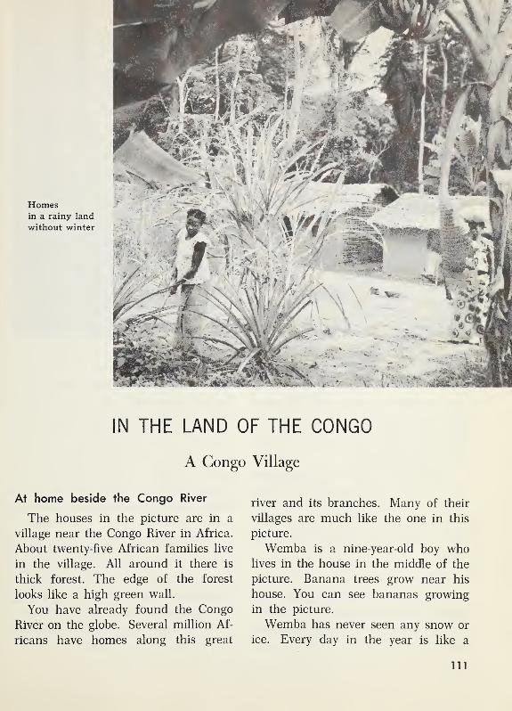
Homesin a rainy land
without winter
IN THE LAND OF THE CONGO
A Congo Village
At home beside the Congo River
The houses in the picture are in a
village near the Congo River in Africa.
About twenty-five African families live
in the village. All around it there is
thick forest. The edge of the forest
looks like a high green wall.
You have already found the Congo
River on the globe. Several million Af-
ricans have homes along this great
river and its branches. Many of their
villages are much like the one in this
picture.
Wemba is a nine-year-old boy wholives in the house in the middle of the
picture. Banana trees grow near his
house. You can see bananas growing
in the picture.
Wemba has never seen any snow or
ice. Every day in the year is like a
111

The houses in Wemba’s village are built along this wide street.
summer day. No one ever needs any
heavy clothes to keep warm. Trees and
grass and flowers grow all through the
year. On many days of the year, It
rains. The land of the Congo is a rainy
land without winter.
The warmth and the rain make plants
grow quickly. Sweet potatoes, peanuts,
and corn grow well in the gardens. So
do manioc and other plants used for
food. Manioc bread is eaten at manymeals.
Gardens in the forest
The houses in the village are built
along a wide street. You can see it in
the picture above. The gardens are in
clearings in the forest. In these clear-
ings, the trees and vines of the forest
have been cut away.
The women and girls of the village
do nearly all the garden work. Soon
after sunrise every morning, Wemba’s
mother and sister go to work in the
family garden. They walk down the
village street and then along a forest
path. Finally they reach the clearing
where their garden is.
Gardening is hard work. Weeds grow
fast in the hot, rainy weather. They are
pulled by hand. The soil around the
garden plants is loosened with a hoe.
Young trees start growing at the edge
of the clearing and have to be cut down.
And the vegetables must be gathered
and carried home in baskets.
112

Wemba goes to this school in the village. He and the other boys play on the playground.
It often happens that a womanharvests one crop and plants seeds for
a new crop all on the same day. Since
summer lasts all year, a crop can be
planted at any time.
Food spoils quickly in this land of
hot, rainy weather. Luckily for the
Congo people, they can plant crops so
that some will ripen in every month of
the year.
Work and play for Wemba
Wemba and the other boys of the
village often play in the village street.
But they spend part of their time in
school. The picture on this page shows
the new school in Wemba’s village.
Next to the school, there is a play-
ground. And close by is the thick,
green forest.
Wemba is glad to be able to go to
school. When his father was nine,
there was no school in the village.
Sometimes Wemba helps his father
with whatever work he is doing.
Work for Wemba's father
On some days, Wemba’s father goes
hunting or fishing. On those days, his
family has meat or fish to eat with
their manioc bread and vegetables and
bananas.
Wemba’s father also gathers fruit
from oil palm trees that grow in the
forest. Oil palm trees have very long
leaves at the tops of tall trunks. The
113

fiFffT
Building a homemade house
Wemba’s family built their house. It is much like this one.
oily red and yellow fruit grows in great
bunches. The women boil the fruit in
big, iron kettles. Then they pound it to
get the oil. This oil is called palm oil.
It is used at almost every meal. Thewomen use it in cooking.
Evening in the village
When the sun goes down in the
evening, fires are built in front of
many of the houses. The fires are not
needed to give warmth. But they are
used for cooking, and they help light
up the village street.
After supper, the people gather
around their fires and tell stories.
Wemba’s father is one of the best
storytellers in the village. Many of his
stories are about elephant hunts. Hecan make an elephant hunt sound so
real and exciting that the shadows
back of the houses seem to be filled
with elephants.
Homemade houses
Each family builds its own house.
The family builds it just as the house
is being built in these pictures.
114
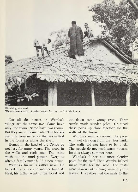
Finishing the roof
Wemba made mats of palm leaves for the roof of his house.
Not all the houses in Wemba’svillage are the same size. Some have
only one room. Some have two rooms.
But they are all homemade. The houses
are built from materials the people find
in the forest or along the river.
Homes in the land of the Congo do
not last for many years. The wood in
the walls and roofs rots. The rains
wash out the mud plaster. Every so
often a family must build a new house.
Wemba’s house is rather new. Hehelped his father and mother build it.
First, his father went to the forest and
cut down some young trees. Their
trunks made slender poles. He stood
these poles up close together for the
walls of the house.
Wemba’s mother covered the poles
with wet clay dug from the river bank.
The walls did not have to be thick.
The people do not need warm houses,
for it is always summer here.
Wemba’s father cut more slender
poles for the roof. Then Wemba helped
make mats for the roof. The mats
were woven out of long, narrow palm
leaves. His father tied the mats to the
115

On a Congo road
roof poles with vines. He made the
roof slope so that the rain would run
off easily. A flat roof of palm mats
would not be suited to this land.
Inside the houses
Even in the middle of the day, it is
almost dark inside the houses. Thewindows are small. The doorways are
narrow. But no one minds the dark-
ness, for the people are out-of-doors
most of the day. They eat many of
their meals outdoors.
Modern ways of travel
There is almost no furniture in the
houses. The beds are logs covered
with mats woven from the tough fibers
from palm trees. Hunting spears and
bows and arrows stand in the corners.
Baskets hang from sticks driven into
the walls. Wooden bowls and cooking
pots are piled on the floor.
Using things you have learned
1. Tell what you see in both pictures
on this page which shows that muchrain falls in both places.
2. Both pictures could have been
taken either in December or in June.
Tell why.
3. These pictures show two ways of
carrying heavy loads on Congo roads.
What two ways do they show?
Do you think it would take skill to
learn how to carry a heavy load on your
head? Tell why.
116

A clearing
in the forest
Forest Work and Travel
Dense forests
Most of the land of the Congo is
thickly covered with trees. The people
find much work to do in the forest.
Trees crowd close to the edges of the
paths and roads. The pictures on these
pages give us glimpses of work andtravel in this forested land.
New clearings
A garden clearing in the Congo
forest is used for only a few years.
The soil is rich when a new clearing
is made. But in only three or four
years, the soil is almost worn out.
Every year there are more weeds
than there were the year before. Andevery year less food can be raised.
Finally, it seems better to make a newclearing than to go on fighting the
weeds and working the worn-out soil.
In making a clearing, the men chop
down the trees and vines. Some of the
fallen trees are burned. Some are left
to rot. The first crops are planted
among these fallen trees.
When all the good forest land near
a village is used up, the people of the
village move on to another place in the
forest. There, new clearings must be
made, and new houses must be built.
Palm kernels to sell
You have found out that the people
of the Congo get oil from the soft part
of the fruit of the oil palm. There is
oil in the hard palm kernel, too. Thepeople sell the palm kernels to traders.
Oil from the palm kernels is used for
making soap.
The date palms that grow along the
Nile and the oil palms of the Congo
117

are alike in one way. The people get
something to eat and something to sell
from both kinds of trees.
Most of the oil palm trees grow wild
in the forest. But in some places, the
men take care of the trees. They cut
down some of the other trees around
the oil palms to give them more sun-
shine and more room to grow.
In some places, oil palm trees are
planted in large clearings. Many of the
men of Wemba’s village work for the
owners of these large groves of oil
palm trees.
Hunting in the forest
The men of Wemba’s village some-
times go hunting, as you have already
learned. The men hunt with spears
and big bows and arrows. A few menhave guns.
The boys often go along on hunting
trips. They have bows and arrows, too.
But theirs are smaller than those the
men carry.
Once in a while, the men of the
village are able to trap an elephant
and kill it with their spears. Then there
is a feast for everyone. The people of
Map of the Congo River
the Congo have no way of keeping
meat from spoiling. So they eat all
they can while it is fresh.
Travel in the forest
During the past few years, manygood roads have been built in the land
of the Congo. Trucks and automobiles
can travel along them.
But, of course, it is not easy to build
good roads where the ground is soft
and forest trees are close together.
Many bridges are needed, too. Evenwhere there are good roads, the people
of the villages do not have moneyenough to buy automobiles.
A few of the people buy bicycles,
but most of them still must walk whenthey travel on land. They learn to
balance heavy loads on their heads.
There is still much travel along the
forest paths. These forest paths are
narrow and dark. Often they are
flooded. It is hard work to carry a
heavy load along one of these forest
paths.
Using things you have learned
1. This map shows highways that
men did not build. What are those high-
ways? How can people travel on them?
2. Look at the line marked “500
miles.” Use this line to help you an-
swer these questions.
Are there more than 500 miles of
water highways in the land of the
Congo? Are there more than 1000
miles of water highways there?
118
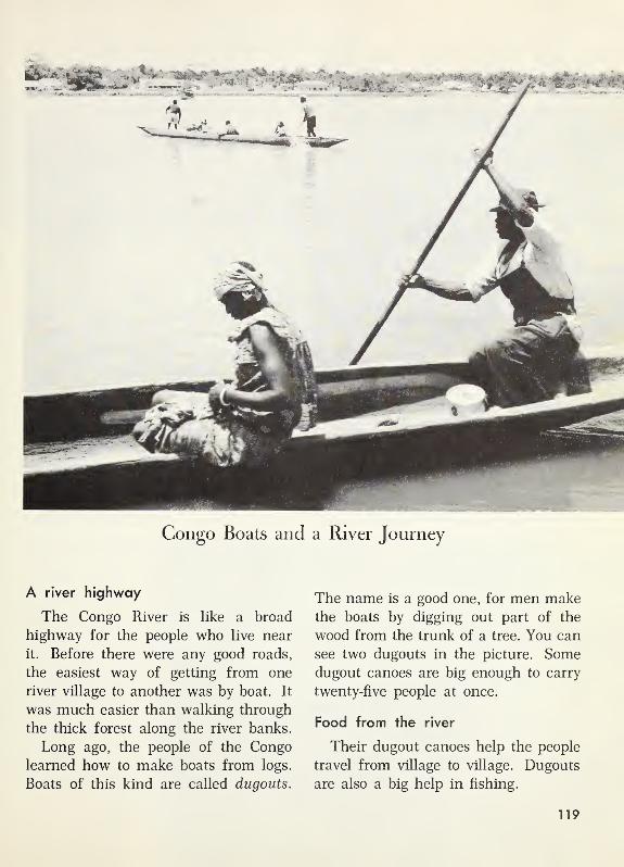
Congo Boats and a River Journey
A river highway
The Congo River is like a broad
highway for the people who live near
it. Before there were any good roads,
the easiest way of getting from one
river village to another was by boat. It
was much easier than walking through
the thick forest along the river banks.
Long ago, the people of the Congo
learned how to make boats from logs.
Boats of this kind are called cLugouts.
The name is a good one, for men makethe boats by digging out part of the
wood from the trunk of a tree. You can
see two dugouts in the picture. Somedugout canoes are big enough to carry
twenty-five people at once.
Food from the river
Their dugout canoes help the people
travel from village to village. Dugouts
are also a big help in fishing.
119

Some Congo fishermen spear fish.
Some catch fish with nets they drag
through the water. Others build fish
traps out of reeds that grow along the
banks of the river. Still others use
hooks and lines. In whatever way they
fish, they are helping to get food.
Cities on the Congo
There are some cities along the
Congo. The picture below was taken
at Stanleyville, not far from Wemba’s
village.
The first picture on the next page
shows the Congo River at Stanleyville.
The boys and their bicycles have
crossed the river by dugout.
The lower picture on the next page
shows the main street of Leopoldville.
Leopoldville is a thousand miles downthe river from Stanleyville. You can
find both these cities on the map on
page 118 .
Many boats travel between these two
cities. Some of them are big boats like
the one in the picture below. A boat
of this kind can carry hundreds of peo-
ple and many tons of freight.
We can be sure that this boat will
soon be on its way to Leopoldville. It
could not go in the other direction
from Stanleyville because of falls in
the river. You can find signs for these
falls on the map on page 118 .
We can be sure, too, that the boat
will not go past Leopoldville. For
there, too, there are falls which boats
cannot pass.
Big boats on the Congo
The first big boats on the Congo
were wood-burning steamboats. There
are still some wood-burning steam-
boats. But now, many of the big boats
on the Congo are run by diesel en-
gines, that burn oil. These boats are
faster than the steamboats. But even
on these boats, it takes several days
to travel the thousand miles between
Leopoldville and Stanleyville.
One reason the trip takes so long is
that the boats stop at night. Curves
Unloading cargo
from a river boat
at Stanleyville
120

The main street in Leopoldville
in the Republic of the Congo
A dugout ferry boat
in the river, small islands, and shallow
spots make it dangerous to sail in the
dark. The boats also stop at trading
stations along the way. There the boats
unload freight and stop to pick up newloads.
Sights to see
On a trip down the Congo River, it is
smooth sailing day after day. In some
places, the river is wide, and the banks
seem far away. In other places, we sail
close to a solid green wall of forest
trees.
Here and there, we see little villages.
Dugout canoes dart out from them as
we pass. Near some of the villages, wesee men working to make a new clear-
ing. At several places, we see men cut-
ting wood for fuel.
Someone shouts “Hippo,” and a
big hippopotamus swims by. Parrots
squawk in the forests. On the river
banks, crocodiles sun themselves. Peo-
ple who have traveled on the river
before call them “crocs.” We do not
stand in the sun long to look at the
sights. The sun beats down too fiercely.
The forests along the banks look cool,
but we know that even in the thick
shade the air is hot. Even the nights
are hot.
In Leopoldville
Leopoldville is the largest city in
the country called the Republic of the
Congo. Thousands of people live there.
Leopoldville is a modern city in manyways. There are broad, paved streets
lined with tall business buildings and
apartment houses. One “skyscraper” is
14 stories high. We can eat dinner in
a restaurant on the top floor of this
skyscraper.
Electric lamps light the streets and
many of the buildings. But not all the
buildings are large and modern. Someof the houses are much like Wemba’shouse.
People go to the movies just as they
do in our cities. They listen to the
121
radio. There is a broadcasting station
in Leopoldville. In the evenings, wemight hear music from the radios and
the sound of African drums.
Football is played in a big stadium
that holds several thousand people.
Track meets are held there, too.
Leopoldville is so hot that swimming
is one of the chief sports there. But
the people swim in swimming pools,
not in the Congo River. No one likes
the idea of sharing a swimming place
with crocodiles.
One of the busiest places in Leopold-
ville is the big airport. Jet airplanes
come to Leopoldville from cities in other
parts of the world. Passengers who are
going to the city ride on a modern super-
highway.
Smaller planes take people from
Leopoldville to other cities in the
Congo. Now, many people in a hurry
fly to Stanleyville instead of going by
boat. It takes only a few hours to makethe trip by plane, but the boat takes
several days. People who are not in a
hurry enjoy the trip by river.
Trains and boats meet.
Automobiles, sewing machines, steel
tools, radios, and many other things
come to Leopoldville from lands far
away. But ocean ships cannot reach
Leopoldville. The ships must be un-
loaded at a city much nearer the mouthof the Congo.
The map on page 118 shows whyships cannot sail from the ocean to
Leopoldville. There are falls in the river
between Leopoldville and the sea. Thegoods brought by the ships are loaded
on freight trains. Then the trains carry
the goods around the falls to Leopold-
ville.
Exploring for Yourselves
1
.
The Congo River on a globe should
now make you think of the real things
you have seen on or near the Congo.
This list will help you think of four
of those things. Name the four things.
(a) Places in the forest where the
women plant their gardens
(b) Something made from a log
and used in traveling on the
river
(c) A useful kind of palm tree
(d) A city on the Congo River that
has a name beginning with S
2. Where do the people in a Congo
village get materials to build their
houses? Why do they build houses
with sloping roofs?
3. From time to time, all the people
in a Congo village move away from it.
Why do they move away?
In another part of Africa, you saw
people who move from place to place.
Who are these people? Why do they
move?
The picture on page 91 will help you
check your answer.
122

The woman is pounding manioc roots to make flour. Her homemade house is near Stanleyville.
4. What will the woman in the pic-
ture bake with the flour she is making?
Where did she get the manioc roots?
5. Find the equator on the globe on
page 110. We did not see the equator
on our Congo visit. Tell why. There
is a sentence near the top of page 18
that will help you answer this question.
6. We know that summer weather
lasts all year round in the land of the
Congo. But on the peaks of very high
mountains near the equator in Africa,
we could see snow.
Find on the globe on page 110 the
mountains between the Congo and the
Indian Ocean. In what direction would
we go from the Congo to see high
mountains with snowy peaks?
7.
Find on the globe on page 110 the
southern tip of Africa. Is it in the south-
ern half of our world, or in the northern
half?
123
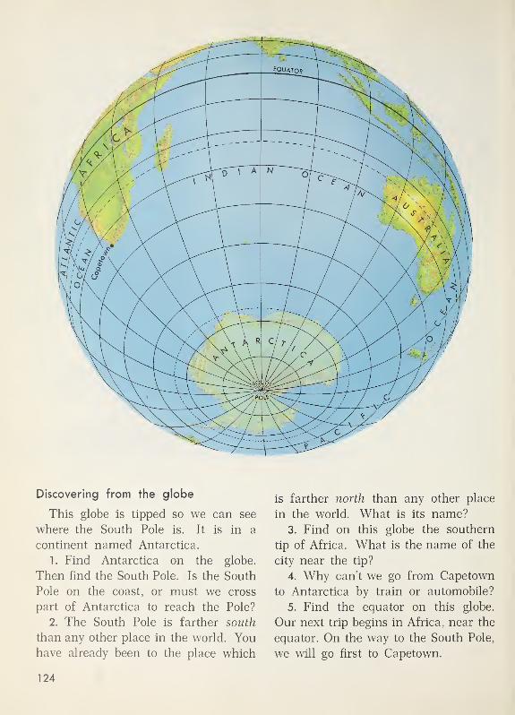
Discovering from the globe
This globe is tipped so we can see
where the South Pole is. It is in a
continent named Antarctica.
1. Find Antarctica on the globe.
Then find the South Pole. Is the South
Pole on the coast, or must we cross
part of Antarctica to reach the Pole?
2. The South Pole is farther south
than any other place in the world. Youhave already been to the place which
is farther north than any other place
in the world. What is its name?
3. Find on this globe the southern
tip of Africa. What is the name of the
city near the tip?
4. Why can’t we go from Capetown
to Antarctica by train or automobile?
5. Find the equator on this globe.
Our next trip begins in Africa, near the
equator. On the way to the South Pole,
we will go first to Capetown.
124

Near the southern tip of Africa
FROM THE EQUATOR TO THE SOUTH POLE
South to Capetown
To a city far south of the equator
It is a day in November. We are
ready to fly from the land of the Congo
to a city near the southern tip of Africa.
Our long trip southward begins at the
airport in Leopoldville, close to the
equator.
For hundreds of miles, we fly over
grasslands. Trees and patches of for-
est are scattered here and there.
Then we look down for a long time
on a desert. But the desert ends, too.
Now our plane is not flying so high.
We have a glimpse of orchards. They
make us think of orchards near the
shores of the Mediterranean Sea.
At last we land at Capetown, a city
near the southern tip of Africa. Wehave flown about 2000 miles south from
the equator. But the trip has taken us
only a few hours.
Capetown is a famous big city.
Capetown’s harbor is on the coast of
the Atlantic Ocean. If we look across
the city from the harbor, we see the
famous Table Mountain. When white
clouds are just above its flat top, they
are often called its “tablecloth.”
Capetown and its suburbs border the
coast for several miles. The homes in
the picture above are near one of the
beaches for which the city is famous.
In the picture below, you see one of
the large vineyards near Capetown.
At work in a large vineyard
125
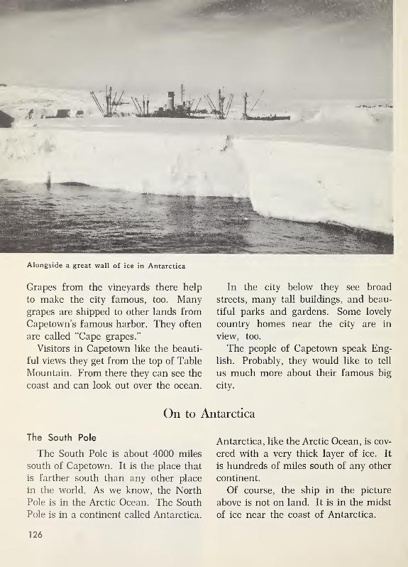
Alongside a great wall of ice in Antarctica
Grapes from the vineyards there help
to make the city famous, too. Manygrapes are shipped to other lands from
Capetown’s famous harbor. They often
are called “Cape grapes.”
Visitors in Capetown like the beauti-
ful views they get from the top of Table
Mountain. From there they can see the
coast and can look out over the ocean.
In the city below they see broad
streets, many tall buildings, and beau-
tiful parks and gardens. Some lovely
country homes near the city are in
view, too.
The people of Capetown speak Eng-
lish. Probably, they would like to tell
us much more about their famous big
city.
On to Antarctica
The South Pole
The South Pole is about 4000 miles
south of Capetown. It is the place that
is farther south than any other place
in the world. As we know, the North
Pole is in the Arctic Ocean. The South
Pole is in a continent called Antarctica.
Antarctica, like the Arctic Ocean, is cov-
ered with a very thick layer of ice. It
is hundreds of miles south of any other
continent.
Of course, the ship in the picture
above is not on land. It is in the midst
of ice near the coast of Antarctica.
126

To get to the South Pole, men first
have to reach Antarctica. They can fly
or go by ship. Then they have to cross
hundreds of miles of ice-covered land.
Only a few men have reached the South
Pole.
The first person to reach the South
Pole was Roald Amundsen. His homewas in Norway. He went all the wayfrom Norway to Antarctica by ship.
Amundsen begins his long voyage.
On August 9, 1910, Amundsen and
his party set sail from Norway in a ship
named the “Fram.” They took ninety-
seven Eskimo dogs with them.
The “Fram” sailed southward in the
Atlantic Ocean. Early in October, it
crossed the equator. The weather there
was hot. The men on board were wear-
ing hot-weather clothes. The dogs, of
course, could not change their coats.
Awnings were put up to shade them.
But the dogs still were very uncom-
fortable.
The “Fram” kept on sailing south-
ward. It sailed on past Capetown and
the southern tip of Africa.
Amundsen reaches Antarctica.
At last, on New Year’s Day, the mensaw in the distance a great floating
mass of ice. It was a huge iceberg. It
looked like a giant, fairy castle glitter-
ing in the sunshine.
On January 11, 1911, Amundsen and
his party saw ahead of them a wall of
ice a hundred feet tall. The ice, like
the ice in the picture on page 126, was
in the sea near the coast.
The “Fram” sailed along the edge of
the wall of ice till Amundsen saw a
place where he could land. As he and
his men set up a camp there, they saw
penguins like those in the picture be-
low. These birds look as though they
had on black caps and capes.
At camp in Antarctica
All of Antarctica has a long, very
cold winter. Near the South Pole, the
sun does not shine for several months.
Summer in Antarctica is very cold,
too. But the sun shines all the time for
several months near the South Pole.
In Antarctica, winter comes when it
is summer in the Arctic Ocean. Andsummer time in Antarctica is winter
time in the Arctic.
It was January when Amundsen set
up his camp in Antarctica. And Janu-
ary there is in the middle of summer.
The penguins waddle on the snow and like to
swim in the icy water near by.
127

lf
—a
] )
jMJo'
* ^ 1
A “dog camp” on the way to the South Pole
Amundsen knew the journey from his
camp to the South Pole would be
long and hard. So he decided to stay
in camp until the next summer.
All during the long, dark winter,
Amundsen and his men lived in their
snow-covered camp house. They had
built it with lumber they had brought
all the way from Norway.
Amundsen reaches the South Pole.
In October, Amundsen and four of
his men set out for the South Pole. It
was early in the summer. The mentraveled on skis. They had four sleds,
fifty-two dogs, and food for four months.
The picture above shows them at one
of their “dog camps” on their way to
the Pole.
Along the way they built piles of
snow blocks to help them find the wayback. The hardest thing they had to do
was to cross some high, snow-covered
mountains. But they crossed them.
On December 14, 1911, Amundsenand his men reached the South Pole.
With great joy they planted the flag of
Norway there. About six weeks later,
they were back in their main camp.
Soon they set sail for Norway.
Another great Antarctic explorer
In 1929, a party of Americans reached
Antarctica. They were led by Admiral
Richard E. Byrd. They set up a campthat was called Little America. Byrd,
with two other men, flew over the South
Pole.
Byrd made several later trips to Ant-
arctica. He spent one whole long win-
ter all by himself in a camp there. In
1956, he flew over the South Pole for
the third time. What he learned about
Antarctica has been a big help to other
128

explorers in that very cold, far-off
continent.
Some discoveries men have
made in Antarctica
Men have found that winters in Ant-
arctica are the coldest winters on earth.
The temperature may go down to more
than 100 degrees below zero. Andwinds are strong.
Some of the mountains in Antarctica
are volcanoes. Smoke drifts out all the
time from one of these volcanoes.
Men have found that at the South
Pole the surface of the ice is almost flat.
They have found, too, that this ice
is more than 8000 feet thick. They be-
lieve it rests on rocky land that is more
than 900 feet above sea level. So at the
South Pole, the surface of the ice is
almost two miles above the level of the
sea. There are many deep cracks in the
ice that covers the land. They help to
make exploring dangerous.
Supplies for Antarctic explorers
In recent years, many explorers have
worked in Antarctica. Groups of ex-
plorers have been sent there by sev-
eral countries.
Camps for the men have been built
at many different places. Ships have
brought to Antarctica most of the ma-
terials used in building the camps. Oneof the American camps was built right
on the South Pole.
The ship in the picture has brought
supplies for explorers. Perhaps it has
brought special tools explorers need.
There may be new kinds of building
Unloading a big ship in Antarctica It has brought to explorers things they need.
129.
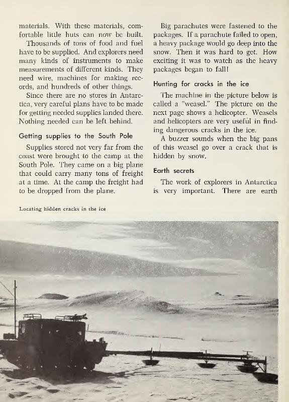
materials. With these materials, com-
fortable little huts can now be built.
Thousands of tons of food and fuel
have to be supplied. And explorers need
many kinds of instruments to makemeasurements of different kinds. They
need wire, machines for making rec-
ords, and hundreds of other things.
Since there are no stores in Antarc-
tica, very careful plans have to be madefor getting needed supplies landed there.
Nothing needed can be left behind.
Getting supplies to the South Pole
Supplies stored not very far from the
coast were brought to the camp at the
South Pole. They came on a big plane
that could carry many tons of freight
at a time. At the camp the freight had
to be dropped from the plane.
Big parachutes were fastened to the
packages. If a parachute failed to open,
a heavy package would go deep into the
snow. Then it was hard to get. Howexciting it was to watch as the heavy
packages began to fall!
Hunting for cracks in the ice
The machine in the picture below is
called a “weasel.” The picture on the
next page shows a helicopter. Weasels
and helicopters are very useful in find-
ing dangerous cracks in the ice.
A buzzer sounds when the big pans
of this weasel go over a crack that is
hidden by snow.
Earth secrets
The work of explorers in Antarctica
is very important. There are earth
Locating hidden cracks in the ice

Helicopters help
Antarctic explorers
in many ways.
secrets about rocks, weather, ice, water,
light, and many other things. What ex-
plorers learn will help men to solve
many of those secrets.
But what explorers discover does not
change Antarctica. Few men besides
explorers will see it. It will keep on
being the coldest land in the world.
Exploring for Yourselves
1. Look at the large picture on page
79 and the small picture on page 125.
What do both pictures show?
The places we see in these two pic-
tures are about the same distance from
the equator. But only one of these
places is south of the equator. Theother place is north of the equator.
Which picture was taken south of the
equator?
2. Print the name of the continent
in which explorers found the South
Pole. Cross out the first three letters
in the name you printed. Then cross
out the last letter.
Six letters are left. They spell the
name of the ocean in which explorers
found the North Pole. What is the
name of that ocean?
What covers that ocean and the
continent of Antarctica all year long?
3.
Why is December a better monththan June for explorers to work near
the South Pole? Why is June a better
month than December for explorers to
work near the North Pole?
131

Discovering from the globe
This globe has been turned so wesee a continent named Australia. It is
the smallest continent in the world.
1 . The first part of the name Austra-
lia means “south.” Find Australia on
this globe. Find the equator. Is Aus-
tralia north of the equator, or south
of it?
2. This globe also shows part of the
continent of Asia. This is the largest
continent in the world. A big penin-
sula named India is in Asia. Find In-
dia on this globe. Is India north of the
equator, or south of it?
3.
On this part of our world jour-
ney, we will visit Australia. Then wewill visit India.
Find a dot for a city on the east coast
of Australia. What is this city’s name?Our visit to Australia begins in this
city.
132

'
Looking across the harbor of Sydney
IN AUSTRALIA AND INDIA
Here and There in the Smallest Continent
A big doorway to Australia
The buildings, piers, and big bridge
you see in the picture above are in Syd-
ney. Sydney is a big city on a big har-
bor. Ships sail into the harbor from the
Pacific Ocean. Ocean ships can sail
under the high bridge. Many ships sail
to and from the big piers.
The first people who sailed into this
harbor to make their homes in Australia
did not find piers or buildings. Not even
a village was there then. The shore
now lined with piers was only a sandy
beach.
Ever since those first settlers came,
the harbor has been the main doorway
to Australia. Thousands of other set-
tlers have come through it. Today, peo-
ple and goods from near and far pass
through the big doorway.
In Sydney, January is a summer month.
In this big city south of the equator,
summer comes when it is winter in our
country. July is a winter month there.
In January, we would see people
wearing their summer clothes. The air
is warm and “sticky.”
It would seem strange to us for Christ-
mas to come in the summer time, but
it does in Sydney!
Storms called "bursters"
Some summer days in Sydney are
cooled off by “bursters.” The sun beats
down fiercely. A hot wind blows from
the north. The north wind is hot be-
cause it blows from places near the
equator.
Suddenly clouds appear. The wind
shifts to the south. The south wind is
133

A busy street in Sydney
cool. In Australia, south winds blow
from the cold sea between Australia
and Antarctica.
Soon rain pours from the clouds.
People in Sydney call the storm a
“southerly burster.”
Many sidewalks on business streets
in Sydney are shaded by big awnings
made of iron, as the picture shows. Theawnings help to keep people on the
street dry when it rains.
Canadians feel at home in Sydney.
Many things we see in the picture
above make us think of things we see
along city streets in our country. Andthe people we meet in Sydney make us
feel much at home, too.
The Australian people speak English.
But they use some words we do not use.
Over one shop there may be a sign
that says: lollies. The shop is an
Australian candy store. Not only lolli-
pops but all kinds of candy are sold.
In Australia, street cars or trolley
cars are called “trams.” You can see
many trams in the picture.
We hear someone say “Good-o” and
learn that this is the Australian wayof saying “O.K.”
It is not surprising that Australians
have some words that are not like ours.
Their country and our country are thou-
sands of miles apart.
A home in Sydney
The Lawrence family has a house on
a hillside at the edge of the city. Fromtheir house they can look out over the
harbor. The house is made of brick.
Around it, and around all the houses
near it, there are well-kept gardens. In
the gardens there are trees, grass, and
lovely flowers.
The red tile roof comes down low
over a wide porch on the north side of
the house. In Sydney, the sun is al-
ways in the northern sky at noon. Thelow roof and wide porch help to shade
the sunny side of the house.
There is another porch across the
south side of the house. This side of
the house is always shady in the mid-
dle of the day. In summer, the family
often has lunch on this porch.
At the end of the street, there is a
little sandy beach. The Lawrence chil-
dren often go swimming there.
134

Loading wool onto
a freighter whichwill take it to
lands far away
Fun for Saturdays
On many Saturdays, the Lawrences
drive to Bondi Beach. They always try
to get there in time to see the parade
of the lifeguards. That long, sandy
beach is on the ocean. In spring, sum-
mer, and autumn, thousands of Sydney
people go there on holidays.
A few times, Mr. Lawrence has taken
the children to watch planes come and
go from the big Sydney airport. Andon some Saturdays, he takes them to
the freight piers in Sydney harbor.
There they see many big ships like the
one in the picture above.
The big bales which are being hoisted
into that ship are bales of wool. Thechildren like to see wool being loaded.
And sometimes they can watch wheat
being poured into a big ship. They like
best of all to watch refrigerator ships.
Those ships carry great loads of but-
ter and meat from Australia to lands
thousands of miles away.
135

A lookout in the beautiful Blue Mountains
West of the Blue Mountains
A short ride west from Sydney would
bring us to the mountains you see in
the picture. They are named the Blue
Mountains because from a distance
they look blue. Winds from the ocean
bring enough rain so that forests grow
on some of the mountain slopes.
Early settlers landed where Sydney
now is. They soon found a way through
those mountains. Beyond the moun-tains, they found that grassland dotted
with trees stretched on and on to the
west. Farther on to the west, there were
fewer trees. And still farther west, there
was less and less grass.
The land west of the mountains gets
less rain than Sydney does. And on
westward, there is even less rain. Someof it falls in the hot summers. In win-
ter, there is no really cold weather.
Near the mountains, the grassland
gets enough rain for crops such as
wheat. It is good pasture land for cat-
tle and sheep. And sheep can be pas-
tured farther west, also, where only
scattered grass and low bushes grow.
Both pictures on the next page show
pasture land west of the mountains.
The sheep pasture is farther west than
the cattle pasture.
Eucalyptus trees like the big one in
the sheep picture grow here and there
in some of the grassland. They makebig pastures look somewhat like parks.
A home on a big sheep station
Australians call big sheep ranches
sheep “stations.” The sheep picture on
the next page shows a part of the sheep
station on which Tom and Marjorie
Marshall live. Mr. Marshall is manager
of the station.
Their home is more than fifty miles
from the nearest town. But the Marsh-
alls have a radio. Mr. Marshall has a
small car. And everyone on the big sta-
tion rides horseback.
The house has a red roof of sheet
iron. Rain water which runs off the
136

The Marshalls live on this sheep station. Notice the sheepherder on horseback and his dog.
roof is stored in an iron tank. Water
is very precious. It is not wasted.
The men who work for Mr. Marshall
live in a house near by. The sheep and
horses do not need sheds to protect
them from weather. They live outdoors
all year round. But there are long sheds
in which the sheep are sheared.
The sheep in the picture are Merinos.
Merinos have fine, soft wool. Only a
few of the thousands of sheep on the
station are shown in the picture.
Down by the "billabong"
The horseback ride that Marjorie and
Tom like best is one to a “billabong”
five miles from their house. A billa-
bong is a pool of water left in a river
bed as the river dries up. In winter,
rains furnish a good supply of water
to the river. But in summer, part of
the water soaks into the thirsty ground.
And part of it is taken up by the dry
air.
On a cattle station
137

Harvesting wheat on one of the great wheat fields
Going to school
The nearest public school is so far
away that Tom and Marjorie cannot go
to it. Their lessons come to them by
mail. A radio program for children also
helps them with some of their studies
at home.
Some day they hope to see a huge
farm machine they have heard about
on that program. You see it in the pic-
ture above. It is cutting, threshing, and
sacking wheat in one of the very large
Australian wheat fields.
Before long, Tom and Marjorie plan
to go to live with an aunt in Sydney.
Then they will go to a city school. Tomwill miss sheep-shearing time when he
is in Sydney.
Sheep-shearing time
The sheep shearers come every spring
and spend several days at the station.
Tom helps the men drive the sheep to a
shearing shed. A very skillful shep-
herd dog helps, too.
Mr. Marshall counts the sheep as
they go inside the shed. Inside, a
shearer clips off the soft wool coat of
each sheep. He uses clippers somewhatlike a barber’s clippers.
The wool is then pressed into bales.
The bales are loaded on trucks which
take them to the nearest railroad sta-
tion. Trains carry the wool to Sydney.
At Sydney, most of the bales are put
on ships that take them to far-away
lands.
138

A trainload of sugar cane on its way to the sugar mill
"Banana-landers" live north of Sydney.
Some Australians live near the coast
about six hundred miles north of Syd-
ney. They are often called “Banana-
landers” by other Australians. Of
course, that is just a friendly nickname.
The part of Australia where Banana-
landers live is nearer the equator than
Sydney is. It is a very warm, rainy
part of Australia. Sometimes it is called
the “warm north.” Some fruits and
crops that grow in hot, wet lands grow
there.
Among the fruits are bananas and
pineapples. And between the ocean and
the nearby hills, there are a great manyfields of sugar cane. That part of the
country is sometimes called Australia’s
“sugar bowl.” West of the “sugar bowl,”
there are some cattle stations. Cattle
can stand much hot, wet weather. But
most of the people of the warm north
live near the eastern coast.
Work in the "sugar bowl"
The picture above was taken in Aus-
tralia’s “sugar bowl.” The sugar cane
stalks on the cars in the picture were
cut from some of the big sugar cane
fields. The little engine is carrying them
to the sugar mill—the big building in
the picture. In the mill, juice is pressed
from the stalks and made into sugar.
On other railroads, sugar made in the
mill is carried south to Sydney and to
many other places in Australia.
139

Looking ahead along the transcontinental railroad that crosses the “Dead Heart of Australia”
A famous Australian railroad
The big picture shows part of a
famous railroad. This part has been
built in desert land. In the flat, dry
land, you can see far and wide. But
low desert bushes are the only living
things in sight. The straight railroad
goes on and on as far as you can see.
The diesel-electric engine in the small
picture pulls some of the trains that
run on the famous railroad. The two
This diesel engine has a top speed of 90 miles
an hour.
houses are homes of railroad workers.
They are many miles from any other
homes. The people who live in them
must be glad to see the people in the
trains that go by.
Why the railroad is famous
The railroad is famous, partly be-
cause it crosses a great desert. That
almost empty desert sometimes is called
the “Dead Heart of Australia.”
The railroad is famous, too, because
there is no curve in its track for more
than three hundred miles. It is thought
that no other railroad in the world has
so long a stretch of straight track. Part
of this stretch is shown in the picture
above.
When the Australians were building
this part of the railroad, they did not
have to build it across rivers or around
140

hills. There are no rivers. There are
no hills.
The map helps us.
The map shows a railroad that runs
all the way across Australia. It runs be-
tween Sydney on the east coast and
Perth on the west coast. It is called a
“transcontinental” railroad because it
crosses a continent. The railroad across
the desert is part of that much longer
railroad.
On the first half of a train trip from
Sydney to Perth, we would see the big
cities of Melbourne and Adelaide. Andwe would see dairy farms, grain farms,
and pastures. In the pastures would
be herds of cattle and flocks of sheep.
Some of the farms and pastures are
beyond Adelaide.
Then we would come to the desert
—
the empty “Dead Heart of Australia.”
And we would ride on westward across
it for hundreds of miles.
The “Golden Mile"
We would reach the town of Kal-
goorlie. It is named on the map. Near
this town there are many hills. But
they are not real hills. They are great
piles of earth taken out of gold mines.
We see some of the mines in the pic-
ture. These mines are in the “Golden
Mile.” It is called that because so muchgold has been taken from the mines.
On to Perth
West of Kalgoorlie, the railroad is
built through a gate in a wire fence.
This fence stretches north and south
for more than a thousand miles. It is
a rabbit fence. It was built to keep
rabbits from getting into the farms and
pastures farther west. Rabbits eat grass
and ruin pastures and crops.
The land around Perth is good farm-
ing country. Wheat fields, pastures,
towns, and wooded hills are like those
in southeastern Australia. There is
enough rain for crops and trees.
A great country
For a large country, Australia has
few people. Only in the East and the
Southwest have people found good land
for farming and grazing and good
places for cities. But Australians have
been able to make their country a great
country.
Gold mines in the “Golden Mile”
141

I
Using things you have learned
1. There is no title under the pic-
ture on this page. But this picture
will remind you of the one at the top
of page 137.
Name four things which you see in
both pictures.
2. Make a title which you think is
a good one for this picture.
3. Both pictures now make you think
of things such as these:
Sheep-shearing time
Sending wool away to be sold
The Australian name for big sheep
ranches
Write a sentence about one of these
things. If you like, you may tell about
Tom or Marjorie Marshall in your sen-
tence.
In the Peninsula of India
Homes far apart
The homes in both of the pictures on
the next page are in the big V-shaped
peninsula of India. That peninsula is
half as large as the whole continent of
Australia. It is in the continent of Asia,
the largest continent in the world.
Of course, some places in a very big
peninsula are far apart. Homes in the
town in the top picture are more than
a thousand miles northeast of the homein the other picture. In the top pic-
ture, the snowy mountains in the dis-
tance are some of the Himalaya Moun-tains in northern India. They are the
highest mountains in the world.
The highest peak in the Himalaya
Mountains is about five and a half
miles high. Its name is Mount Everest.
In any place which is very high, it is
very cold. And the air is so thin that
men get out of breath. So, for manyyears, no one succeeded in climbing to
the top of Mount Everest. But in 1953,
two explorers climbed to its top. They
stood in the highest place in the world
!
The town in the top picture is on
land which is about a mile high. So
summers in this town are not so hot as
they are in low land in India. Somepeople have built modern homes here
to get away from India’s hot summer
142
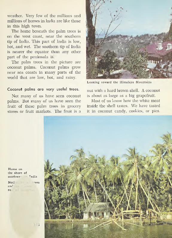
weather. Very few of the millions and
millions of homes in India are like those
in this high town.
The home beneath the palm trees is
on the west coast, near the southern
tip of India. This part of India is low,
hot, and wet. The southern tip of India
is nearer the equator than any other
part of the peninsula is.
The palm trees in the picture are
coconut palms. Coconut palms grow
near sea coasts in many parts of the
world that are low, hot, and rainy.
Coconut palms are very useful trees.
Not many of us have seen coconut
palms. But many of us have seen the
fruit of these palm trees in grocery
stores or fruit markets. The fruit is a
Looking toward the Himalaya Mountains
nut with a hard brown shell. A coconut
is about as large as a big grapefruit.
Most of us know how the white meat
inside the shell tastes. We have tasted
it in coconut candy, cookies, or pies.

A farmer in Pakistan plowing his field
People in many places where coconut
palms do not grow buy coconuts. Somepeople who live where coconut palms
grow well can make a living by selling
the nuts. And they use coconut meat
and coconut oil for food. The milk
inside the coconut is good to drink.
Another way people can earn a living
from coconuts is by selling dried coco-
nut meat. That dried meat is called
copra. People in many countries buy
copra to use in making soap and other
products. And in the big husks that
grow around the nuts, there are strong
fibers. They are useful for making
ropes, baskets, coarse cloth, and manyother things that can be sold.
The trunks of the trees can be used
in building houses and boats. Steep
roofs covered with palm leaves are good
roofs in a hot, rainy land. A coconut
palm is one of the most useful trees in
the world.
In a thirsty land near a great river
The farmer in the picture is plowing
a little field near the Indus River. As
the map on the next page shows, the
Indus River is in the northwestern part
of the peninsula of India. A trip from
the southern tip of India to the farm in
this picture would be more than a thou-
sand miles long.
The map shows, too, that the country
of India and the country of Pakistan
are both in the peninsula of India.
The long Indus River flows through
Pakistan. The farm in the picture is in
Pakistan.
The farmer and his oxen are work-
ing in a land where little rain falls.
Water has to be put on the thirsty lit-
tle field before crops will grow in it.
Much dry land is irrigated with water
from the Indus River. A great moderndam has been built across the river.
The farmer lives in a little village
of flat-roofed houses. His home is muchlike those we have seen in oasis towns.
Most of the many, many millions of
people in Pakistan and India are farm-
ers. And in both countries, most of the
farms are very small. Most of the farm-
ers live in small villages. There are a
great many thousands of farm villages
in the peninsula of India.
Chota Lai lives in a farm village.
The older boy in the picture on the
next page is Chota Lai. He lives in
India. His home is almost straight
north from the southern tip of India.
It is near another great river called the
Ganges River.
144

The sign for the Ganges River is on
the map. With the help of the map, wecan tell that Chota Lai lives in the
northern part of India. As the picture
shows, the land is almost level. It
stretches on mile after mile after mile.
In the picture, Chota Lai looks happy.
Perhaps he was pleased because he was
having his picture taken. But harvest
time always makes him happy, unless
his fathers crops have not grown well.
He knows that when there is not muchto be harvested, the family may not
have enough to eat. Chota Lai remem-
bers one year when that happened.
Map of the peninsula of India
Boys in India like to help with the harvest.
Rivet
CEYLON

Farmers in India separating grain from the
husks
There was not enough rain that year.
He and his sister Dulari were hungry
day after day.
In the fields
Chota Lai’s father harvests crops
from his little fields twice each year.
In the spring, he harvests his winter
crops and then plants crops that grow
during the summer. In autumn, he har-
vests the summer crops and plants
crops that will grow during the winter.
In spring, he usually plants corn.
Corn needs much hot sunshine and
much rain. There is not enough rain
for corn in the winter. But it grows
well during the hot, rainy summers.
And corn is good food.
In autumn, after the corn is har-
vested, Chota Lai’s father usually plants
wheat or barley. Winter months are
cool there, and not much rain falls. But
wheat and barley do not need much
moisture, and they grow well during
cool months. Flour for bread is ground
from these grains.
Simple tools
On most farms in India, both plant-
ing and harvesting are done by hand.
The farmers in this picture are separat-
ing the good grain from the husks. Thewind blows off the light husks, leaving
the grain in the baskets.
In the picture at the top of the next
page, the woman is cutting grain with
a sickle. Chota Lai’s father has only
simple tools such as this sickle. Hehas a wooden plow and two oxen to
pull it.
In Chota Lai's village
Level fields stretch on and on in
every direction from Chota Lai’s vil-
lage. The next village is so near that
he and his sister Dulari can walk to it.
The walls of the houses are built of
sun-dried brick. Then they are plas-
tered with mud. In most of the houses,
there are two rooms and a courtyard.
In the courtyard, there is a fireplace
where cooking can be done.
Farmers are not the only people wholive in the village. The potter lives in
one of the houses. You see him at work
in the picture at the bottom of the
next page. In each village home, wewould see one or more bowls like those
piled near him. The things he makesare useful. And they are pretty, too.
Chota Lai and Dulari like to watch himas he shapes the bowls on his potter’s
wheel and puts them aside to dry.
146

A weaver and leather worker live in
the village, too. They make things the
farmers need in their homes or in their
farm work. Sometimes these workers
help farmers with some of the farmwork at harvest time.
Food and chores
Chota Lai’s father owns a buffalo
cow. Bread, vegetables, and milk from
the cow provide the family with enoughto eat most of the time. But there is
nothing to spare. And meals are muchthe same day after day.
Dulari helps to clean the grains of
wheat and barley before her mother
grinds them to make flour. With the
flour, her mother bakes big, flat bread
cakes. It takes much work each day to
clean and grind the grain and makethe bread cakes.
Chota Lai gathers stubble and the
husks of grain from the fields to help
feed the cow. It takes a long time
to find enough feed, but his chore is
important.
There now is a teacher in the village.
Both Chota Lai and Dulari are learning
to read and write. They like to learn.
They are glad they can go to school.
Women in India help cut the grain.
"The heart of India"
India sometimes is called “a land of
many lands,” because crops and weather
and other things are different in dif-
ferent parts of it. The broad lowland
where Chota Lai and Dulari live is
sometimes called “the heart of India.”
If we flew over it, we would see the
Ganges River. We would also see almost
countless farm villages. “The heart of
India” is a land of many crops and
millions of homes much like Chota Lai’s
home.
Looking ahead
The farmers in the village need bet-
ter tools. To keep their fields rich, they
need fertilizers. They cannot afford
to buy them. The government is work-
ing out ways of helping them. By the
time Chota Lai is a man, he may be
able to make a better living than his
father can make now.
The village potter
147

H
One o£ the main streets in Calcutta
On to Calcutta
On the map on page 145, there is a
sign for the very large city of Calcutta.
It is near one of the mouths of the long
Ganges River. That river, like the
Rhine, has built a big delta. Ocean
ships sail to and from Calcutta.
If we flew over Chota Lai’s village
and on to Calcutta, we would see that
the Ganges is a great river highway.
Near it we would see modern railroads.
We would also see cities built long ago,
for India is a very old country.
But we would keep on seeing fields
and fields and more fields green with
crops. Like “the heart of India,” the
lowland along the eastern part of the
river is a land of farmers. In it, mil-
lions of farmers raise crops that need
much rain.
A great gateway
The picture above shows a street in
Calcutta. On its main streets, we see
visitors from many lands. In its shops,
we find things made in India and things
made in other countries, too.
There are modern business buildings
and factories. But we could also see an
ancient temple and an ancient banyan
tree. Several hundred people could sit
at one time under the spreading
branches of that huge tree.
Many ships from near and far visit
the harbor. Calcutta is a great gateway
between India and the rest of the world.
148

Exploring for Yourselves
1 . The girl in the picture below looks
much like Dulari. What is she doing
on the white board on her lap?
She is learning to do two things that
Dulari and Chota Lai are learning to
do. A sentence on page 147 told you
what those two things are. What are
all three children learning to do?
When Dulari’s mother and father
were children, there were no schools
in their village. Now, about 18 million
children go to elementary schools in
India.
2. In what way is the “Dead Heart
of Australia” like the Sahara?
Men have built something across the
“Dead Heart of Australia” which they
have not built across the Sahara. Tell
what they have built.
3. A member of your class may write
on the blackboard the names of these
three trees:
Coconut palms
Date palms
Oil palms
Tell why each kind of palm tree is
a very useful tree.
Where did you find people using
coconut palms?
Where were people using date palms?
Where did you find people using oil
palms?
Sentences on pages 144, 95, 113, 114,
and 115 will help you answer these
questions.
4. Write a new title for the picture
on page 145.
Schoolgirls
everywhere
have homeworkto do!
This girl in India
is glad she can
go to school.
149

Discovering from the globe
This globe is turned so we can see
more of the great Pacific Ocean than
we saw on the last globe.
1. This globe is tipped so we can
see the ocean which is farthest north
in the world. What is the name of
that ocean?
2. Hong Kong is a small island very
near the coast of Asia. Find its nameon the globe. We go next to Hong
Kong. Will we be north of the equator,
or south of the equator?
3.
From Hong Kong, we go on to Ja-
pan. Japan is an island country in the
Pacific Ocean. Find on the globe the
islands named Japan.
Notice that the northern part of Ja-
pan is much farther from the equator
than the southern part is.
Which is nearer the equator—HongKong or Japan?
150

In Hong Kong harbor
ON TO HONG KONG AND JAPAN
In Hong Kong
A great meeting place
The hilly island of Hong Kong is
very near the coast of Asia. There is
a big city on the coast of the island.
Its name is Victoria. But often it is
called the “city of Hong Kong,” or just
“Hong Kong.”
The narrow part of the sea between
the piers of Hong Kong and the coast
of Asia is a famous harbor. It is a big,
roomy harbor. But a trip across it by
ferry boat takes only a few minutes.
You can see parts of the harbor in the
two pictures above.
Big ocean freighters like the one in
the first picture bring cargoes from
many lands. They take away manythings which have been brought there
by other ships.
We see a sampan in the first picture.
It has a big sail. Some sampans carry
cargo from one big ship to another.
The boat in the other picture is loaded
with vegetables. It has not come far. It
is bringing food to be used in the city.
The tall masts in the distance are the
masts of sailing ships called “junks.”
Junks are of many sizes. Few of them
go very far out to sea. Some junks are
fishing vessels. But most of them sail
along parts of the coast of Asia, and
carry cargo from place to place.
151

One of the busy, crowded “ladder streets” in Hong Kong
Many Chinese people
The lovely brown sails of hundreds
of junks and sampans make the harbor
look different from harbors you have
seen at Bergen, Rotterdam, Sydney, and
other places. At the piers, you could
see that most of the people on those
sailing ships are Chinese people.
You could see, too, that many Chinese
families make their homes on junks.
There might be a family washing hung
up to dry. Or a little Chinese child
might be coming down the plank from
a junk to the shore.
Many of the names on the piers and
streets are English names such as “Star
Ferry Pier” and “First Street.” The big
stores, banks, office buildings, and ho-
tels in the main business part of HongKong are much like those in our big
152

cities. And you see many English peo-
ple. Thousands of English people live
in the city.
But there are many Chinese names,
too, and hundreds of Chinese people on
the streets. Most of the people living
in the city are Chinese.
A hilly city
There is little room between the har-
bor and the high hills of Hong Kong.
A few of the streets along the coast are
long. Many of the cross streets run upthe hillsides. Some of these streets look
like hillside streets in other hilly cities.
But some of them are like the one in
the picture on page 152. We would
climb up that street much as we climb
stairs. Sometimes these streets are
called “ladder streets.”
Shops and shoppers
Nearly all of the big signs in the
picture are in the Chinese language.
But they tell what signs on stores in
many lands tell. Some of the words on
them are names of the owners of the
stores. Other words name things that
can be bought in the shops such as tea,
foods, clothes, and jewelry.
Many things that are for sale in the
little shops or market stands have been
made by Chinese people. Some of them
are made in the shops. But in one shop
we could see Chinese drinking soft
drinks like those made in our country.
Many of the shoppers are Chinese
women who shop almost every day.
They want the food they buy for their
families to be fresh. Some of them can
afford to buy only a chicken leg or a
little bit of fish or vegetable to have with
their rice. And they want to buy it onthe day they use it. Many families do
not have ice boxes or refrigerators in
their homes. And in that warm climate,
food would spoil quickly.
Homes and workers
The shopkeepers and most of the
shoppers live in small apartments above
the shops. That means going up and
down many steps.
The winter weather is pleasantly
warm. But the summers are long and
hot. Then it is not pleasant in crowded
homes.
Many people who live on the street
are not among the daytime shoppers.
Some of them may be away working at
piers or in warehouses or in offices of
big trading companies. Some of them
may be motormen on the big green
street cars or red buses that help to
make the main streets crowded. Others
may be traffic policemen or may work
in hotels or factories. There is work for
thousands of people in Hong Kong.
Looking from "the Peak"
Visitors in Hong Kong like the view
they get from the top of a high hill
often called “the Peak.” They can look
down on the main part of the city and
the harbor.
The island of Hong Kong is only part
of what is called the “colony of HongKong.” From the Peak, visitors can see
some land on the mainland of Asia.
That land is part of the colony, also.
153

Chu’s farm home on the mainland of Hong Kong
Where Chu lives
We see Chu’s home in the picture
above. It is in the part of Hong Kongon the mainland. It is at the edge of
a little farm village only a few miles
from the harbor. All the farmers in
the village grow rice. Their tiny rice
fields are called “paddy fields.”
"A rice farmer's feet are never dry."
That saying is very old. Rice needs
much water and hot weather. While
One way of watering vegetables
In the fields
The paddy fields in the picture are
near Chu’s house. Young rice plants
are growing in one field. The flooded
field Chu’s father is plowing will soon
be ready to be planted.
When the rice is ripe, the fields will
be drained. Then Chu will help cut the
rice with a sickle. After it is threshed,
he likes to carry the rice and straw back
to the house. The kernels of rice will
be used for food. The rice straw will
be used for fuel for cooking.
Chu likes, too, to take care of the
water buffalo. Sometimes he rides it.
He also takes care of some chickens and
four pigs.
The field of vegetables in the lower
picture is not far from Chu’s home.
Some vegetables from it may go to food
shops in the big city on the island.
rice is growing in the paddy fields, those
fields are kept flooded most of the time.
Even winters in Hong Kong are warm.Chu’s father raises two crops of rice
each year. Chu helps to weed the rice.
So he gets his feet wet very often.
Using things you have learned
1. If Chu goes to the city of Victo-
ria, he has to go part of the way by
boat. Tell why.
2. Which of these words would you
use in telling about Hong Kong?
harbor Chinese sheep
flooded junks hillsides
rice English shops
desert cargo hot
154
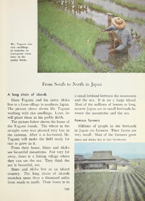
Mr. Tagami ties
rice seedlings
in bunches to
transplant themlater in his
paddy fields.
From South to North in Japan
A long chain of islands
Shiro Tagami and his sister Akiko
live in a farm village in southern Japan.
The picture above shows Mr. Tagami
working with rice seedlings. Later, he
will plant them in his paddy fields.
The picture below shows the home of
the Tagami family. The wheat in the
straight rows was planted very late in
the autumn. After it is harvested, Mr.
Tagami will make the field ready for
rice to grow in it.
From their home, Shiro and Akiko
see beautiful mountains. Not very far
away, there is a fishing village where
they can see the sea. They think the
sea is beautiful, too.
Shiro and Akiko live in an island
country. The long chain of islands
stretches more than a thousand miles
from south to north. Their home is in
a small lowland between the mountains
and the sea. It is on a large island.
Most of the millions of homes in long,
narrow Japan are in small lowlands be-
tween the mountains and the sea.
Famous farmers
Millions of people in the lowlands
in Japan are farmers. Their farms are
very small. Most of the farmers grow
Shiro and Akiko live in this farmhouse.
155

Rice fields on terraces in a narrow valley
rice. And Japanese rice farmers have
become very skillful. With much hard
work, they can get more rice from an
acre of land than farmers get in any
other part of the world.
The fields in the picture above are
paddy fields. To make a paddy field
from sloping land, terraces are built.
It took much hard, skillful work to
build the terraces you see in the picture.
Tea is grown on some slopes.
The rows of tea plants in the picture
on the next page look like carefully
trimmed hedges. The tea plants are
growing on land that slopes more than
the land does in the paddy fields.
Picking tea means picking young
leaves from tea plants. The women in
the picture are skillful pickers. They
know just which leaves to pick.
Farms in Shiro's village
All the farmers in the village where
Shiro lives are rice farmers. Their
homes and little farms are in the village.
Winters are not so warm as the winters
in Hong Kong. Shiro’s village is far-
ther north of the equator than HongKong is. Many days are rainy.
The farmers cannot grow two crops
of rice a year as Chu’s father can in
Hong Kong. Rice is their summer crop.
It is their most important one. Rice and
156

The big hats of these tea pickers skade them from the sun.
fish are the chief foods of the Japanese.
From an acre of rice, the farmers get
more food than they get from an acre
of wheat or barley. But they can grow
wheat and barley in the winter. So they
keep their little fields busy all year round.
Shiro’s father owns fifteen tiny paddy
fields. They are scattered among tiny
fields owned by other farmers. But all
his little fields cover only about three
acres of land. The other farmers ownonly about three acres apiece.
Shiro wants to be a skillful farmer.
Mr. Tagami works hard. Before he
floods his paddy fields, he hoes them
with a “kuwa.” A kuwa is a hoe with
a short handle and a long blade. Dig-
ging with a kuwa is hard work.
Shiro is willing to work hard. But
he is not strong enough yet to use a
kuwa well.
Mr. Tagami owns an ox. The ox pulls
the plow. But most work on the farm
has to be done by hand.
Shiro helps weed the paddy fields.
And he is learning fast the things he
needs to know to be a skillful farmer.
Rice plants need much care, and Shiro
says this about using fertilizer:
“We must feed growing rice plants.
I dip out just a little fertilizer at a time
and pour it close to the stems of the
plants. That way I do not waste it.”
157

In one of the many factories in Tokyo
The Tagami house
The house in which Shiro and Akiko
live is built of wood and clay. It is not
painted. The window panes are madeof paper. Part of the roof is tile and
part of it is thatch. The storehouse
near the house has a tile roof.
The house is really one big room.
But it can be made into smaller rooms.
This is done by using large screens
made of wood and paper.
The outside doors are sliding doors.
In summer, they are often left open. In
winter, everyone is very glad that there
are electric lights in the house.
The floor is covered with mats wovenout of straw or plant fibers. Long pads
are spread on the floor to sleep on.
And cushions on the floor are used in-
stead of chairs. To help keep the mats
clean, everyone takes off his shoes
before he steps into the house.
Akiko tells about food.
“Mother cooks over a charcoal fire.
The charcoal is burned in a clay pot.
She uses fish and rice to make manygood things to eat. We all like soup
and tea. And we like the pickles Mother
makes from radishes, too.
“We put our food on trays. Some-
times we put them on a low table in
front of us as we sit on the floor to eat.”
Silk is a big help in several ways.
In many farm homes in Japan, the
family earns some money by taking care
of silkworms. Akiko hopes her father
will buy some silkworm eggs. She would
like to help her mother take care of
the worms. Silkworms eat mulberry
leaves. And Shiro knows that there are
mulberry trees near by. He would help
pick the leaves to feed the worms.
The worms are kept in the house in
shallow trays. For about a month, they
eat all the time. And they have to be
fed day and night.
When they are grown, silkworms spin
cocoons. In the cocoons, there are fibers
that can be spun into silk thread. That
thread is used in weaving cloth. Andsilk cloth is used in making many kinds
of useful and lovely things.
Taking care of silkworms helps the
women and girls who do it. It also
helps all the people who work in the
factories where silk cloth is made.
158

In Tokyo
In the pictures on these pages, wesee young Japanese people using their
nimble fingers. The girls in the clock
factory are working with skill and care.
Japanese people in farm homes, in
fishing villages, in city homes, and in
factories make part or all of their liv-
ing by making things of many different
kinds. Shiro makes baskets from bam-boo. His mother makes pickles to sell.
Both pictures were taken in the hugecity of Tokyo, which is the capital of
Japan. The Emperor of Japan lives in
the palace there. Japan’s congress meets
in the city.
In Tokyo, we see people from all parts
of Japan. We see visitors from other
lands, too. In the shops, we can see
the many kinds of things that the
Japanese make in their factories and
in their homes.
We can learn much about Japan by
visiting Tokyo. There are many fine
buildings. On the busy streets, you
would see automobiles and buses. In
the modern factories there, clocks, china
dishes, toys, cameras, and many other
things are made. Yet, some of the outer
parts of the city are much like farm
villages.
The Japanese love flowers. Manypeople grow flowers in their little gar-
dens. In Tokyo parks, we can see azal-
eas in bloom in May and chrysanthe-
mums in bloom in November.
Going to school in Japan
Doesn’t the picture above make you
think you would enjoy going to school
A modern classroom in Tokyo
in Japan? If you could speak the Japa-
nese language, you would feel muchat home in an elementary school there.
The kinds of things you would learn
are much like those you learn about
in your school.
It would be fun to go on field trips
there. You would find out about someplants and birds you could not see on
field trips in our country.
One thing you would be sure to like
is the playground. And you would like
the baseball games and the other gamesthe boys and girls play on it.
Wherever children live in Japan,
there is a school not far away. Shiro
and Akiko are happy at school.
159
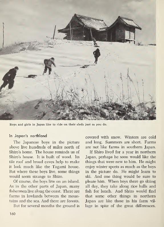
Boys and girls in Japan like to ride on their sleds just as you do.
In Japan's northland
The Japanese boys in the picture
above live hundreds of miles north of
Shiro’s home. The house reminds us of
Shiro’s house. It is built of wood. Its
tile roof and broad eaves help to makeit look much like the Tagami house.
But where these boys live, some things
would seem strange to Shiro.
Of course, the boys live on an island.
As in the other parts of Japan, manyfishermen live along the coast. There are
farms in lowlands between the moun-tains and the sea. And there are forests.
But for several months the ground is
covered with snow. Winters are cold
and long. Summers are short. Farms
are not like farms in southern Japan.
If Shiro lived for a year in northern
Japan, perhaps he soon would like the
things that were new to him. He might
enjoy winter sports as much as the boys
in the picture do. He might learn to
ski. And one thing would be sure to
please him. When boys there go skiing
all day, they take along rice balls and
fish for lunch. And Shiro would find
that some other things in northern
Japan are like those in his farm vil-
lage in spite of the great differences.
160

Exploring for Yourselves
1. In the picture below, you see a
school playground in Japan. Is it muchlike your school playground, or dif-
ferent from yours?
Notice the play clothes the girls
are wearing. What kinds of play
clothes do girls in your school wear?
What kinds do boys wear?
2. In the other picture on this page,
you see tuna fish. They have been
brought to Tokyo by a deep-sea fishing
boat. Deep-sea boats are much larger
than the fishing boats that are used
near the coast.
Make another title for this picture.
Your title may tell about the kind
of fish you see in this picture.
Your title may tell where the pic-
ture was taken.
3. Many things made in Japanese
homes and factories are sold in stores
in our country. Many of these things
Girls in Japan play baseball, too.
have this label on them: Made in
Japan. If you have seen any of these
things, tell about them.
4. Much work is needed to take care
of silkworms. Tell about some of the
things that need to be done.
5. The most important foods of the
Japanese people are rice and fish.
Use the top picture on page 155 and
the picture on page 156 to show that
growing rice takes much work.
6. One of these sentences is correct.
Tell which sentence is correct.
(a) Going from south to north in
Japan is going from a colder
land to a warmer land.
(b) Going from south to north in
Japan is going from a warmerland to a colder land.
If we sail from Japan across the Pa-
cific Ocean, we come to North America.
Fresh food from the sea

Discovering from the globe
1. This globe has been turned so wesee all of the continent in which welive. What is its name? What other
continent do we see on this globe?
2. Find Alaska on this globe. In
what continent is it? Alaska is part of
the United States. It is the 49th state.
In what continent is Cape Horn?
3. Find the equator. Is Alaska north
of the equator, or south of it?
Is Cape Horn north of the equator,
or south of it?
4. What ocean borders the coast all
the way from Alaska to Cape Horn?
5. Our next journey will be from
Alaska to Cape Horn. The places wewill visit are marked with letters on
this globe.
Find the place marked A. It is in
the northwestern part of Alaska. The
first story is about that place.
162

An Eskimo village in the Far North
FROM THE FAR NORTH TO CAPE HORN
Along the Coast of Alaska and Canada
In Eskimo land
The Eskimo village in the picture is
on the northwestern coast of Alaska.
This village is at the place marked A
on the globe.
The Eskimo children are gathering
ice. The ice was carried here by a
nearby river that flows into the Arctic
Ocean.
The water in the Arctic Ocean is salty,
but the river water is good to drink.
The families in the village melt the river
ice to make fresh drinking water.
In places near the Arctic coast, sum-
mers are short. On most summer days,
there are strong winds and heavy rain
or thick fog.
Winters are very long. In winter,
nights are long, and days are short.
Winter brings snow storms and bitter
cold.
The picture shows the winter houses
of the Eskimo families. When summercomes, many of the families move into
canvas tents. The tents can be movedfrom place to place as the Eskimo
163

This Eskimo takes his son with him on a short hunting trip.
families hunt, fish, and gather wild
berries.
In winter, almost all travel is by dog
sled, over snow and ice. But travel in
summer is mostly by boat, along the
coast and in the rivers. In the picture,
you see a kayak, or a hunting canoe.
The frame of the kayak is made of
driftwood found along the beach. Thepieces of the frame are laced together
with rawhide.
All the boat is covered with seal skin
except a round opening in the center,
big enough for a man. in the picture, an
Eskimo hunter is sitting in the kayak.
He is using a double paddle, dipping
one end and then the other into the
water. His son is stretched out behind
him, holding tight to his father’s jacket.
These Eskimos live chiefly by hunt-
ing and fishing. In summer, they fish
for salmon. In August, they round up
their reindeer, which have been grazing
in the hills back from the coast. The
reindeer that are to be used for food and
clothing are killed. In autumn and win-
ter, the Eskimos hunt seal and walrus
on the sea ice. They lay in supplies of

Capital of
the state of
Alaska, betweenthe mountains
and the sea
blubber fat, meat, and skins. In every
season, these Eskimos get with skill the
things they need for food, clothing,
and shelter.
In southeastern Alaska
The city in the picture above is far
south of the cold Arctic Ocean. This
city is on the southeastern coast of
Alaska, near the letter B on the globe.
The city is named Juneau. It is the
capital of the state of Alaska.
Along the coast, there is very little
room between the mountains and the
sea. Dark forests of tall evergreen trees
cover the lower slopes of the mountains.
Many homes in Juneau are perched on
a mountain side, as you can see in the
small picture.
From the higher part of the city, you
could look down upon the tall business
buildings in the big picture. You could
also look out across the harbor.
In the mountain back of Juneau,
there is rock that contains gold. Therock is mined and brought to a huge
gold mill in the city. There it is crushed,
and the tiny bits of gold are taken
from it.
But Juneau is not only a mining city.
It is also a city of the forest and the sea.
Some of the people work in saw mills.
Homes perched on a mountain side
165

Forests of tall trees in southeastern Alaska
Many shops and homes are built of
wood and painted white. In front of
one shop, there is a row of brightly
painted poles. They were carved from
tree trunks by Indians. Ima nearby vil-
lage, Indians carve some of the woodengifts sold in shops in Juneau.
Many people who live along the coast
of southeastern Alaska work in the for-
ests there. The tall trees in the picture
above are in a forest near Juneau. In
the distance, you can see snow-capped
mountain peaks. Alaska is famous for
its great forests and mountain scenery.
Some of the canned salmon we buy
may have been caught by Juneau fisher-
men and canned in the canning fac-
tories there. Millions of fish live in the
cool waters along this coast. Canning
fish is an important business.
In the forests of western Canada
The men in the picture on the next
page are working in a forest hundreds
166
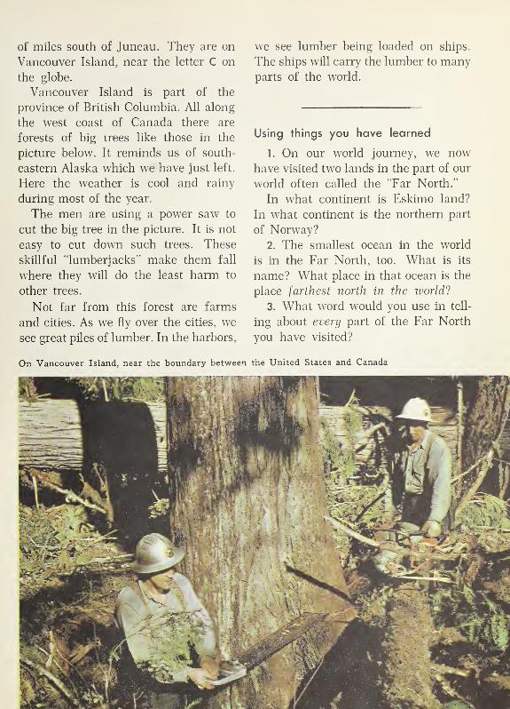
of miles south of Juneau. They are on
Vancouver Island, near the letter C on
the globe.
Vancouver Island is part of the
province of British Columbia. All along
the west coast of Canada there are
forests of big trees like those in the
picture below. It reminds us of south-
eastern Alaska which we have just left.
Here the weather is cool and rainy
during most of the year.
The men are using a power saw to
cut the big tree in the picture. It is not
easy to cut down such trees. These
skillful “lumberjacks” make them fall
where they will do the least harm to
other trees.
Not far from this forest are farms
and cities. As we fly over the cities, we
see great piles of lumber. In the harbors,
we see lumber being loaded on ships.
The ships will carry the lumber to manyparts of the world.
Using things you have learned
1. On our world journey, we nowhave visited two lands in the part of our
world often called the “Far North.”
In what continent is Eskimo land?
In what continent is the northern part
of Norway?
2. The smallest ocean in the world
is in the Far North, too. What is its
name? What place in that ocean is the
place farthest north in the world ?
3. What word would you use in tell-
ing about every part of the Far North
you have visited?
On Vancouver Island, near the boundary between the United States and Canada

Warm Lands and Hot Lands
In southern California
We now fly south along the west
coast of the United States. The giant
trees are left behind. Mountains are
still with us. We look down on the or-
ange grove in the picture. It is in south-
ern California, near the letter D on the
globe.
The picture was taken in winter.
Snow has fallen on the mountains. But
in this valley, winters are mild. Winter
brings rain to the valley but no heavy
snow.
In summer, there is almost no rain.
The hills are brown and dry. But the
farmers irrigate their land with water
from high mountain slopes.
We look down on groves of lemon
trees and English walnuts. We see
miles and miles of vineyards. We are
reminded of things we saw in Mediter-
ranean lands, where the climate is
much like that of southern California.
In both places, summers are hot and
dry, and winters are mild and rainy.
In a desert in Mexico
We fly on southward and leave Cali-
fornia behind us. Soon we are flying
over Mexico. The mountains look much
In southern California, summers and winters are much like those in Mediterranean lands.

South of California, we see miles and miles of desert land in western Mexico.
like those in California. We can see
a lowland between the mountains and
the coast. Most of this lowland is a
desert. Here and there, little rivers flow
across it from the mountains.
The family in the picture live in this
desert, near the letter E on the globe.
Their home is near a little stream. All
around is desert. They use water from
the stream to irrigate a patch of corn
and beans and other vegetables. Their
house is made of mud bricks dried in
the sun.
The family keep a herd of goats that
find some pasture in the .desert. Man-uel, who is ten years old, helps herd
the goats. They eat small bushes and
scattered bunches of grass. Cattle
could not find enough to eat on such
land, but goats can.
The family make a poor living from
their garden patch and goats. From the
goats, they get milk and meat. Once or
twice a year, they sell a few goats in
a village market that is several miles
away.
169

gr .
- **§22M ,, .W-
f;
fit*'*’--’/
In the country of Ecuador, at the equator
On to the equator
We leave the desert behind us as wefly on southward toward the equator.
Our plane follows the coast and moun-
tains. The land becomes so narrow that
we can see both the Atlantic Ocean and
the Pacific Ocean from the plane. Weare over the narrow Isthmus of Pan-
ama, which joins North America and
South America.
As we fly on southward, we follow the
coast of South America. Forests cover
the lowland between high mountains
and the ocean. This is a land of muchrain.
An Indian family live in the little
house in the picture above. They live
almost exactly on the equator, near the
letter F on the globe. All around them
is thick forest. They live in a country
named Ecuador. This is the Spanish
word for equator.
Like the people of the Congo, this
Indian family built their house from
materials close at hand. They put wide
leaves and grass on the steep roof to
shed the heavy rains that fall. They
do not need a warm house, since there
is no winter where they live.
These Indians make a living from a
garden patch and from the forest. In a
little clearing, they raise corn, bananas,
and vegetables.
In a desert south of the equator
Flying south from the equator, wesoon leave the forest and its rainy
weather. We come to a desert between
170

South of the equator, in the country of Peru
high mountains and the ocean. Thedesert is in a country named Peru, near
the letter G on the globe.
Several years may go by without any
rain along the coast of Peru. But rivers
flow down from the snowy peaks of the
high mountains. The rivers flow across
the desert to the ocean. Narrow rib-
bons of green irrigated fields follow
each river.
The picture above was taken in one
of these green strips of irrigated land.
The water in the picture is flowing in
an irrigation ditch. The irrigation ditch
carries the water from the river to the
fields.
The green crop you see is sugar
cane. Many farmers in Peru grow sugar
cane or rice. Such crops cannot be
grown in cool lands with short sum-
mers. Other farmers grow a kind of
cotton which keeps on growing for
several years. The cotton keeps on
growing, because the winters there are
not cold.
The green strips of irrigated land in
this desert south of the equator remind
us of the great oasis made by the Nile
River in Africa.
Vineyards and orchards south
of the equator
We fly on southward, following the
coast of South America. At last weleave the desert behind us. We look
down on a fertile valley in the country
of Chile. We see orchards, vineyards,
and fields of wheat.
171

In the great valley of Chile, south of the equator
The vineyard in the picture is in this
fertile valley, near the letter H on the
globe. Big bunches of grapes hang from
the vines. The woman has just picked
a tray full of grapes. She is carrying
the tray to the end of the row. There,
the grapes will be dumped into a huge
bucket. The bucket will be loaded on a
wagon and carried to the village.
The picture was taken in January.
January is a summer month in lands
south of the equator. People in Chile
have summer when we have winter.
In the great valley of Chile, summerweather and winter weather are muchlike summer and winter in southern
California. Both places are about the
same distance from the equator.
172

Far South of the Equator
In southern Chile
Flying on southward, we come to a
land of mountains, glaciers, and for-
ests. The glacier in the picture is in
southern Chile, near the letter I on the
globe. The stones have been pushed
here by the glacier, which is slowly
melting away. The little stream carries
the drip from the glacier into a beauti-
ful lake.
The water in this little stream is al-
ways cold, of course. In this land
far south of the equator, winters are
long and cold and stormy. Summers
173


are cool and rainy. Few people live
here, because it is hard to make a living.
The big picture shows forests of big
trees that grow on the mountain slopes.
In the distance, you see snowy mountainpeaks. These forests of big trees far
south of the equator make us think of
the big trees on Vancouver Island, in
Canada. They remind us, too, of the
thick forests and snowy mountains near
Juneau, in Alaska.
The southern tip of South America
South America stretches much farther
south than any other continent in which
people live. Explorers and scientists
make trips to Antarctica, but they do
not make their homes there. The peo-
ple who live near the southern tip of
South America live farther south than
any other people in the world.
The southern tip of South America is
called Cape Horn. The coast near Cape
Exploring for
1. Near Cape Horn, ships can sail
from the Pacific Ocean to the Atlantic
Ocean. They can also sail from the
Pacific to the Atlantic through the Pan-
ama Canal. Find the Panama Canal
on the globe on page 162.
2. The Panama Canal was dug
through a narrow strip of land that
joins North America and South Amer-
ica. Find this strip of land on the globe.
What is its name?3. Near Cape Horn we can see a ship
which will take us back to Montreal.
Horn is not a pleasant place in whichto live. Most days there are cloudy andraw, and many days are rainy andstormy.
North America and South America
North America reaches farther from
the equator than South America does.
The northern coast of North America
is so far north of the equator that trees
do not grow there. Eskimo land, which
you visited, is almost treeless.
But trees grow to the southern tip of
South America. The people who live
near Cape Horn are far from the equa-
tor. But they are not as far from it as
the Eskimos are in Eskimo land.
From Alaska to Cape Horn, we have
had glimpses of many lands. Each land
reminds us of some other land, some-
where else in the world. The lands
which are alike in many ways are about
the same distance from the equator.
Yourselves
Show on the globe the route our ship
will follow if it sails all the way in the
Atlantic Ocean.
Find on the globe a much shorter
route our ship can follow from Cape
Horn to Montreal. In what oceans will
it sail?
4. We leave Cape Horn in January.
Is this a winter month, or a summermonth, in lands south of the equator?
5 . Find Montreal on the globe on
page 162. Is January a winter month,
or a summer month, in Montreal?
Forests far south of the equator 175

Looking at Montreal from the top of Mount Royal
LOOKING AT THE WORLD WITH “NEW EYES”
Back in Our Own Country
Many things we see remind us
of other lands.
We are back in Montreal again.
Many things we see in our country nowmake us think of things we have seen
on our world journey. We find our-
selves looking at everything with “new
eyes.”
The picture on this page was taken
from the top of Mount Royal, a high
hill in the heart of the city. Montreal
is built on a large island, where the
Ottawa River and the St. Lawrence
River meet. The bridge you see, is one
of the bridges connecting Montreal
Island with the mainland.
The picture at the top of the next
page may remind you of Switzerland.
But this picture was taken in our owncountry. These people are skiing on the
snowy slopes of the Laurentians. The
picture at the bottom shows the same
area in the summer.
The Laurentians in Quebec are
rounded hills, with many woods, lakes,
and rivers. The cold winters and warmsummers remind you of the other
northern countries you have visited.
176

Wintertime and summertime in the Laurentians

A helicopter lands at a heliport.
We Live in a Changing World
New ways of travelling.
The pictures on these pages remind
us of the ways in which the world is
changing every day.
In the picture above, a helicopter is
landing at a heliport in New York. As
you can see, there are no long runways
as there are for planes at an airport.
Helicopters can land on flat roofs of
buildings and on tiny landing places
like this heliport.
The helicopter is bringing passengers
and mail from one of the three big air-
ports that serve New York. A mail
truck will carry the mail to the post
office.
Space is scarce in crowded cities. As
the picture shows, this heliport was
built partly on land and partly over
water.
On land, the helicopter runs on little
wheels. But it also has big pontoons for
landing in the water. You can see the
178

A weather plane
pontoons in the picture. They let the
helicopter float safely, when it makes a
water landing.
New discoveries
Men are making new discoveries
about the earth we live on, and about
the air surrounding the earth.
At weather stations in northern Can-
ada, people observe changes in the air
that may be moving down to other parts
of the country. Often, weather planes
are sent out for information.
The plane above is returning from a
weather flight. It is equipped with in-
struments that tell about conditions in
the air. One of these instruments is a
radar screen. The radar “picks up”
movements of air many miles away.
Charts of weather information are
made up at the station. The trained ob-
server can then forecast changes in the
weather. His information is sent to radio
stations all over Canada. In this waywe know about sudden changes and
storms so that we can protect ourselves
Reading a weather chart
179

Modern highways like these help to speed up travel on the ground.
against them. Everywhere in the world,
“work and weather go together.” With
the help of airplanes, men are making
new discoveries about weather.
Modern highways
Modern highways help to bind the
different parts of our country together.
There are highways like the one in
the picture near all the busy centres in
Canada. You can see where one high-
way crosses over the other.
Find the narrow, curving roads in the
picture. Cars and trucks use these
roads to get from one highway to the
other. This kind of meeting place of
two great highways is called a “clover
leaf.” From the air, the curving roads
look somewhat like a huge four-leaf
clover.
The world is getting smaller.
In one way, our big world is getting
smaller and smaller. Of course, it is
not getting smaller in miles. But places
are now closer together in hours of
travel.
The airplane in the picture is a fast
freight plane. It is loading freight at
Montreal, in the eastern part of Canada.
180
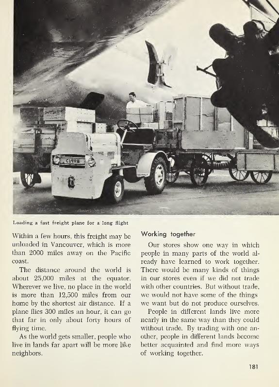
Loading a fast freight plane for a long flight
Within a few hours, this freight may be
unloaded in Vancouver, which is morethan 2000 miles away on the Pacific
coast.
The distance around the world is
about 25,000 miles at the equator.
Wherever we live, no place in the world
is more than 12,500 miles from our
home by the shortest air distance. If a
plane flies 300 miles an hour, it can go
that far in only about forty hours of
flying time.
As the world gets smaller, people wholive in lands far apart will be more like
neighbors.
Working together
Our stores show one way in which
people in many parts of the world al-
ready have learned to work together.
There would be many kinds of things
in our stores even if we did not trade
with other countries. But without trade,
we would not have some of the things
we want but do not produce ourselves.
People in different lands live more
nearly in the same way than they could
without trade. By trading with one an-
other, people in different lands become
better acquainted and find more ways
of working together.
181

A word having six letters tells what kind of place this is. What word is it?
Use that word to make a title for this picture.
Exploring for Yourselves
The pictures on these two pages show
places we did not visit on our world
journey. Things you now know about
our world will help you look at these
pictures with ‘new eyes.”
1. Do you think any of these pic-
tures could have been taken in the con-
tinent where men found the South
Pole? Give reasons for your answer.
2. One of these pictures was taken
in a place very near the equator. Tell
which picture you think this is. Tell
why you think so.
In this picture, you see the home of
an Indian family in South America.
3. The other two pictures were taken
in places where July is a summermonth. Are these two places north of
the equator, or south of it?
4. One picture was taken in a place
where very little rain falls. Which pic-
ture shows that place? How can you
tell that this place gets very little rain?
This picture was taken in a land
called Arabia in the continent of Asia.
5. Scenes like that in the top pic-
ture on the next page are commonin our country. Tell from this picture
one way in which people make a living
in Canada.
182

The thick forests in these two pictures are more than 3000 miles apart,

Index
KEY TO PRONUNCIATIONThe letters in the lists below are marked to show their sounds. These marks will help you to pronounce correctly
the words in this Index.
a as in able
a as in add
a as in care
a as in arm
a as in ask
a as in vacation
a as in sofa
a as in giant
e as in eve
e as in end
e as in maker
e as in event
q as in h^re
e as in nickel
l as in Ice
l as in 111
I as in animal
5 as in old
5 as in odd
6 as in or
6 as in obey
6 as in soft
d as in connect
do as in food
do as in foot
oi as in oil
u as in cube
u as in upu as in burn
u as in unite
u as in circus
ch as in chair
g as in go
th as in then
th as in thin
y as in yonder
The Key to Pronunciation and the respellings for pronunciation of words in this Index are based on material in
Webster’s New International Dictionary, Second Edition, Copyright 1934, 1939, and 1945 by G. & C. Merriam
Company, and are used by permission.
A
Adelaide (Sd' ’lad),
Australia, 141
on the map, 141
Africa (Sf'ri ka), 90-126
Cairo, 97, 98, 99, 102
Capetown, 125-126
on the globe, 74, 86, 90,
105, 110
Land of the Congo.
110-122
Leopoldville, 120, 122
The Sahara and the
Nile, 90-108
Stanleyville, 120, 122
Airplanes and airports, 4
in Cairo, 102
in Leopoldville, 122, 125
in the Netherlands, 56
along the Nile, 98-99
in Norway, 40, 42
in Reykjavik, 21
in Sydney, 135
in Montreal, 4-5, 19
flying over the Arctic
Ocean, 26-27
flying along the Nile,
105, 106
flying over North Amer-ica, 4-5, 167, 168-170,
179, 180-181
flying over the South
Pole, 128
Akiko (a'ke'kd), 155-160
1 Alaska (a l&s'kd), 163-166,
175
on the globe, 162
Juneau, 165-166
Ali (a'le), 97
Alps (Sips), the, 61-64,
68, 70
defined, 61
on the globe, 60
Amsterdam (Sm'sterdSm),
Netherlands, 49, 56on the globe, 44on the map, 47
Amundsen, Roald(a 'moon sen, ro'al),
127-128
Angelo (an'jelo), 81-83
Antarctica (ant ark'ti ka),
126-131
on the globe, 124
Arctic Ocean (ark' tik),
26-27, 126, 127, 162,
163, 165
on the globe, 20, 162
on the map, 28
Asia (a'zha), 142-161
Calcutta, 148
on the globe, 150
Hong Kong, 150-154
India, 142-148
Japan, 155-160
Pakistan, 144
Tokyo, 15, 159
Aswan Dam (SswSn'),
Egypt, 104
on the map, 105
Atlantic Ocean (dtl&n'
tik), 8, 17, 20, 125,
170
on the globe, 16, 20, 28,
90, 162
Australia (os tral' yd),
132-141
Adelaide, 141
on the globe, 132
Kalgoorlie, 141
map of, 141
Melbourne, 141
Perth, 141
Sydney, 133-135, 141
Automobiles, 6-7, 180.
See also Busesin Australia, 136
in Canada, 6-7, 180
in Cairo, 102
in Iceland, 21
in Italy, 84
in Japan, 159
in Leopoldville, 122
in the Netherlands, 45along the Nile, 99
in Norway, 40in Switzerland, 68
Azir (a'zer), 98
B
Bananas and banana trees
in Australia, 139
in the Congo, 111
in Ecuador, 170
Banyan tree, 148
Barges, defined, 49in the Netherlands, 49along the Nile, 100
BaySan Francisco, 12
Bergen (bur 'gen),
Norway, 30, 40-42
on the globe, 28
on the map, 30
Bicycles, 21, 29, 53, 99,
118, 120
“Billabong” (bil'dbong),
137
Blue Mountains,Australia, 136
Boats and ships
in Australia, 133, 138
in Canada, 7, 8, 19, 167
on the Congo, 119,
120-121, 122
Eskimo, 164
in Greece, 86-87, 88in Hong Kong, 151, 152
in Iceland, 22-23
in Italy, 84
in the Netherlands, 45,
49, 55, 58
on the Nile, 98, 101, 106
in Norway, 30, 34, 38, 40
Bondi Beach (bon' de),
Australia, 135
Bridges, 2, 176
Golden Gate Bridge,
12-13
Lion’s Gate Bridge,
14-15
184

Bridges
—
Continued
in Ottawa, 2
in Switzerland, 69
in Sydney, 133
British Columbia, 14-15,
166-167
Buffalo cow, 147
Burrard Inlet, 14-15
“Bursters,” 133
Buses. See also
Automobilesin Cairo, 102
in Iceland, 22
in Japan, 159
in the Nile delta, 99in Norway, 30in the Sahara, 95
in Spain, 80in Switzerland, 68-69
Butter, 36, 37, 38, 135
Byrd, Admiral Richard E.,
128
C
Cairo (ki'ro), Egypt, 97,
102-103
on the globe, 90
on the map, 105
Calcutta (kal kut'd),
India, 148
on the map, 147
California (kal'Horn'yd),
12-14, 168, 172
on the globe, 162
Camels, 92, 93, 95, 99
CanadaBritish Columbia,
14-15, 166-167
Getting Ready for OurWorld Journey, 1-19
on the globe, 16, 162
Looking at the Worldwith “New Eyes,”
176-182
map of, 10
Montreal, 3-5, 12,
19, 176
Ontario, 2, 7
Ottawa, 1-3, 12
Quebec, 2, 6-7, 176
St. Lawrence Seaway,7-8
Canals
defined, 45
in the Netherlands, 45,
46, 49, 50
along the Nile, 99
in Ottawa, 2
Panama Canal, 175
in the St. Lawrence, 7-8
Cape Horn, 175
on the globe, 162
Capetown, in southern
Africa, 125-126
Cataracts (kat'« rhkts)
defined, 105
on the Nile, 105
Cattle. See also Cowsin Australia, 136
in Iceland, 25
along the Nile, 107
in Norway, 36-37
Changing ways of living,
178-181
in Cairo, 102-103
along the Congo, 113,
118, 121, 122
in Iceland, 22, 23,
24, 25
in India, 147
in the Netherlands,
46, 48
along the Nile, 97, 99in Norway, 31-32, 33
in the Sahara, 95
Cheese and cheese
makingin the Netherlands, 53,
55, 57
in Norway, 36, 37, 38
in Switzerland, 65
Chico (che'ko), 76
Chile (chil'e), 171-172,
173, 175
Chinese people, in HongKong, 152, 153
Chocolate, 71
Chota Lai (cho' ta lal),
144, 145, 146, 147
Chu (choo), 154
Cities and city life
Capetown, 125-126
Hong Kong, 151-153
in Alaska, 165-166
in Australia, 133-135,
141
on the Congo, 120-122
in Egypt, 102-103
in Iceland, 21-22
in India, 148
in Italy, 83, 84
in Japan, 159
in the Netherlands,
49, 59
in North America, 1-5,
12-15, 19, 167,
176, 178
in Norway, 30, 40-42
in Switzerland, 70
Clothing
in Australia, 133
in the Congo, 112
in Egypt, 102-103
of the Eskimos, 164
in Iceland, 21-22
of the Lapps, 32in the Netherlands, 57in the Sahara, 91-92
in Spain, 76, 79in Switzerland, 62
Coconuts and coconut
palms, 143-144
Codfish, 22, 34-35
Community living.
See also Cities andcity life
in Alaska, 163
in Australia, 136-138
along the Congo,111-116
in Hong Kong, 154
in India, 144-147
in Italy, 81-83
in Japan, 155-158
in the Netherlands,
50-55
along the Nile, 97-99
in Norway, 32-33, 36-39
in the Sahara, 95
in Spain, 75-80
in Switzerland, 61-67
Compass, defined, 6
Congo River (kong' gb),
111-122
on the globe, 110
Land of the Congo,111-116
map of, 118
Continent, defined, 11, 17
Africa, 86, 89, 90-126
Antarctica, 126-131, 175
Asia, 142-160
Australia, 132-141
Europe, 20-89
North America, 1-15,
17, 18, 19, 162-169,
175
South America, 170-175
Copra (kop' ra), 144
Cork, 79-80
Cornin the Congo, 112
in Ecuador, 170
in India, 146
in Mexico, 169
in the Nile delta, 97, 98
Cornwall, 7
Cotton
in the Nile delta, 97in Peru, 171
“Cow parade,” 62Cows. See also Cattle
in the Netherlands, 50,
52, 53in Norway, 36in Switzerland,
61-64, 71
D
Dairy Farming. See also
Cows and Cattle
in Australia, 136
in Canada, 6-7
in the Netherlands, 50,
52-53
in Norway, 36-37, 38in Switzerland,
61-66, 71
Dates and date palms,
95, 97
Day, length of
in Alaska, 163
in Antarctica, 127
in Iceland, 22, 25
at North Pole, 26
in Norway, 32,
34-35, 41
in Switzerland, 63
Delta (del'td), defined, 59
of the Ganges River,
148
of the Nile River, 97
of the Rhine River, 59
Desert (dez' ert)
in Australia, 140-141
defined, 91
in Mexico, 169
in Peru, 171
the Sahara, 91-95
Diesel engines (de'zel)
in Africa, 120
in Australia, 140
in the Netherlands, 46
Dikes, defined, 45
in the Netherlands, 45,
46, 47, 50Directions
discovering how to tell,
5-6
east-west lines, 18
north-south lines, 18
Dogsin Alaska, 164
in the Arctic, 26
in Australia, 138
in Antarctica, 127, 128
Donkeys, 86, 95, 99
185

Dugouts, 119, 120, 121
defined, 119
Dulari (du la 're),
146, 147
Dunes, defined, 45
Dutch, the,
in the Netherlands,
44-59
“Dutch gold,” 55
E
Ecuador (ek' wa dor), 170
Education. See Schools
Egypt and Egyptians,
96-105
Electricity and electric
power plants
along the Congo, 121
in Japan, 158
in the Netherlands, 46
in Norway, 38, 41
on the St. Lawrence, 7-8
in Switzerland, 69, 72
Elephants, 107, 114,
118, 121
Equator (e kwa'ter)
defined, 18
distance from, 175, 181
Ecuador, 170
From Equator to South
Pole, 124-131
on the globe, 16, 18, 90,
110, 132, 162
in Land of the Congo,110-123
south of the, 133, 170-
171, 173-175
Eskimos (es'ki moz),
163-165, 175
Eucalyptus trees
(u'ka lip'
t
us), 136
Europe, 20-89
on the globe, 20, 28, 44,
60, 74
Greece, 86-89
Iceland, 20-25
Italy, 81-85
lands on the Mediter-
ranean, 74-89
the Netherlands, 44-59
Norway, 28-42
Spain, 75-80
Switzerland, 60-72
Explorers
in Antarctica,
127-131, 175
at North Pole, 26-27
F
Factories andmanufacturing
in Alaska, 166
in India, 148
in Italy, 82
in Japan, 159
in the Netherlands,
55-56
in Norway, 41, 42
in Spain, 80in Switzerland, 71-72
Farms and farming
in Alaska, 167
in Australia, 141
in Canada, 3, 6-7, 167
in the Congo,112-113, 117
in Ecuador, 170
in Egypt, 96-97, 98, 99,
104-105
in Greece, 87
in Iceland, 24-25
in India, 144, 146,
147, 148
in Italy, 81, 82
in Japan, 155-157, 160
in Mexico, 169
in the Netherlands, 50,
52-55
in Norway, 36, 42
in Pakistan, 144
in Peru, 171
in Spain, 76-79
in Switzerland, 61, 66
in the United States, 168
Fiords (fyordz), 30
defined, 30
Fishing and fishermen
in Alaska, 164
codfish, 22, 34-35
in the Congo, 113,
119-120
freezing of catch, 22, 23,
31-32
in Greece, 86-87, 88
herring, 22, 35, 55
in Hong Kong, 151
in Iceland, 22-23
in Japan, 155, 160
in the Netherlands, 55
in Norway, 31, 32,
34-35, 41
salmon, 164, 166
Floods
in the Netherlands,
46-48
Floods
—
Continued
in the Nile valley,
103-104, 107-108
Flowers
in Australia, 134
along the Congo, 112
in Japan, 159
in the Netherlands, 49,
53, 55, 56, 57
in the Sahara, 95
in Spain, 79
in Switzerland, 62
Foodin Alaska, 164
in the land of the Congo,113-114
in Egypt, 98
of the Eskimos, 164-165
in Greece, 87
in Hong Kong, 153, 154
in Iceland, 25
in India, 144, 147
in Italy, 82
in Japan, 156, 158, 160
of the Lapps, 32
in Mexico, 169
in the upper Nile valley,
108
in Norway, 32
in the Sahara, 95
in Spain, 78
in Switzerland, 63-66,
71, 72
Forests and forest work.
See also Logging andlumbering
in Alaska, 165, 166
in Australia, 136
in Canada, 15, 167
in southern Chile,
173, 175
along the Congo, 111,
117, 118
in Ecuador, 170
lack of, in Eskimo land,
175
lack of, in Iceland, 22
in Japan, 160
in Norway, 38
in South America, 170
in Switzerland, 62
Fruits, 95. See also Dates,
Oranges, etc.
Fuel
in the Congo, 121
in Egypt, 98
in Hong Kong, 154
G
Ganges River, 144, 145
147, 148
delta of, 148
on the map, 145
Gardens. See also Flowers
in Australia, 134
in Cairo, 102
along the Congo,112-113, 117
in Iceland, 25
in Japan, 159
in the Netherlands, 55
Glacier (gla'sher)
defined, 23
in Chile, 173
in Iceland, 23
in Switzerland, 68-69
Globe. See also List of
Maps and Globes, viii
Africa on, 90
Antarctica on, 124
around the world on, 16
Arctic Ocean on, 26, 162
Asia on, 132, 150
Australia on, 132
Canada on, 16, 162
Congo River on, 110
defined, 17
directions on, 18
equator on, 18, 90, 110,
132, 162
Europe on, 28
Hong Kong on, 150
Iceland on, 20
India on, 132
Japan on, 150
Mediterranean lands on,
74
Netherlands on, 44
Nile River on, 90
North America on, 16
North Pole on, 20, 26, 28
Norway on, 28
the Sahara on, 90
South America on, 162
South Pole on, 124
Switzerland on, 60
United States on,
16, 162
Goatsin Greece, 86
in Mexico, 169
in Nile delta, 98
in Norway, 36, 38
in the Sahara, 92
186

Gold mining
in Alaska, 165
in California, 12
“Golden Mile,” in
Australia, 141
Grains. See also Corn,
Rice, Wheatbarley, 66, 95, 146, 147
in India, 146, 147
oats, 36rye, 55
Grapes and grapevines.
See also Vineyardsin California, 168
near Capetown, 125-126
in Chile, 172
in Greece, 87in Italy, 82
in the Sahara, 95
Grass and grasslands
in Africa, 106-108
in Australia, 136
in Iceland, 24, 25
in the Netherlands, 55
in Norway, 36in the Sahara, 92in Switzerland, 61-63
Greece and the Greeks,
85, 86-89
on the globe, 74
on the map, 86
H
Hammerfest, Norway,(ham' er fest'), 30-31
Halv^y (hal'a), 30
HarborsCalcutta, 148
Capetown, 125
in Greece, 87-88
Hong Kong, 151, 152
in Iceland, 23
in Italy, 83
Montreal, 19
in Norway, 30-31, 40-41
Rotterdam, 59
San Francisco, 12-13
Sydney, 133, 135
Vancouver, 14-15
Hayin Iceland, 25
in the Netherlands,
50, 53
in Norway, 36
in Switzerland, 63, 65
Helgi (hel'ga), 21, 23
Helicopter (hel' l kop'ter)
and heliport, 130, 178
Herdingin Alaska, 164
in Australia, 138, 141
in Greece, 86in Italy, 82
in Mexico, 169
in Norway, 36, 38in the Sahara, 92-93
in Spain, 76
in Switzerland, 61-65
along the White Nile,
107
Herring
in Iceland, 22
in the Netherlands, 55in Norway, 35
Highways. See Roads andstreets
Himalaya (hi ma'la yd or
him' a la 'a)
Mountains, 142
Hippopotamus, 121
Homes and housesin Alaska, 163-165
in Australia, 134, 136in Cairo, 102, 103
along the Congo, 111,
114-116
in Ecuador, 170
of the Eskimos, 163-164
in Hong Kong, 152,
153, 154
in Iceland, 21, 24in India, 142-143,
144, 146
in Italy, 82
in Japan, 155, 158, 160
of the Lapps, 33in Mexico, 169
in the Netherlands, 49,
50, 52along the Nile, 97, 101,
107, 108
in Norway, 33, 36in Pakistan, 144
in the Sahara, 92-93, 95in South America, 170
in Spain, 75
in Switzerland, 62, 65
Hong Kong, colony of,
151-154
on the globe, 150
Horses and ponies
in Australia, 136, 137
in Iceland, 25
in Norway, 36
Hotels
in Cairo, 102
in Hong Kong, 102
in Norway, 38in Switzerland, 67,
70, 71
Hot springs, in Iceland, 22
Hull, 2
Huntingin Alaska, 164
along the Congo,
113, 118
I
Iceland, 21-25
on the globe, 20
India, 142-148
Calcutta, 148
on the globe, 132
map of, 145
Indian Oceanon the globe, 124, 132
Indians, North Americanin Alaska, 166
in South America, 170
Indus River, 144
on the map, 145
Inlet, defined, 14
Burrard, 14-15
Interdependence
in Hong Kong, 151, 153
in Iceland, 22-23
in India, 148
in Italy, 83-84
in the Netherlands, 55,
56, 57
in Norway, 35, 37-38, 41
in Switzerland, 68-72
Irrigation (ir' l ga' shwn)
in India, 144
in Italy, 82
in Mexico, 169
along the Nile, 91, 95,
96, 97, 99, 104-105
in Pakistan, 144
in Peru, 171
in the Sahara, 95in the United States, 168
Islands
near Greece, 87Hong Kong, 151, 153
Iceland, 21-25
Japan, 155, 160
map signs for, 8
near Norway, 30Vancouver, 166-167
Isthmus (is' mws) of Pan-
ama (pan' a mo), 170
Italy, 81-85
on the globe, 74
A Mediterranean Trip,
74-89
Mount Vesuvius, 81, 83Naples, 83Pompeii, 84
J
Japan and the Japanese
(ja pan'), 155-160
on the globe, 150
Johansen (yo han'scn)
family, 36
Juneau (joo'no), 165-166
Junks, in Hong Kong, 151
K
Kalgoorlie (kal goor' li),
Australia, 141
on the map, 141
Kayak (ki' hk), 164
Kuwa (koo' wa'), 157
L
Lajla (II 'la), 33
Lake Lucerne (lu surn'),
70
Lake Victoria, 105, 107
on the globe, 90
on the map, 105
Languagein Australia, 134
in Capetown, 126
Chinese, 153
in Hong Kong, 152
Japanese, 159
in Norway, 30in Switzerland, 69-70
Lapps, the, 31, 32-33
Lars (lahrs), 36
Laurentians, 176, 178
Lava, 23, 81
Lemons, 168
Leopoldville
(le' o p51d vil), Africa,
120-122
on the map, 118
Little America, 128
Lofoten Islands
(15' fo t’n), 34
Logging and lumbering.
See also Forests andforest work
in Alaska, 165, 166
in Canada, 15, 167
187

Logging and Lumbering
—
Continued
in Chile, 175
in Norway, 38, 42
Lowlands. See also Plains
in India, 143, 147, 148
in Japan, 155, 160
in Mexico, 169
in the Netherlands, 45in Norway, 35-36
in South America, 170
MMachines. See also
Factories
in Australia, 138
near Capetown, 126
in Iceland, 25
in Italy, 82
in the Nile delta, 97in Norway, 42at the South Pole, 130
in Switzerland, 72
Manioc (m&n'i ok), 108,
112, 113, 123
Manuel (man wel'), 169
Maps. See also List of
Maps and Globes, viii
defined, 2, 4
use of, 2-3, 5, 8, 10-15
Margriet (mar kret'), 53
Maria (ma re 'a), 75-80
Marino (ma re 'no)
family, 81
Marketsin Cairo, 103
in Hong Kong, 153
in Mexico, 169
in the Netherlands, 57in Norway, 39in the Sahara, 95
Matti (ma'te), 32, 33
Meadows, in the
Netherlands, 50, 55
Mediterranean(med' t te ra'ne an),
lands on the, 74-108
on the globe, 74
Greece, 86-89
Italy, 81-85
map of, 86Spain, 75-80
Melbourne (mel' bern),
Australia, 141
Merinos (m2 re'noz), 137
Mexico, 11, 15, 168-169
Midnight sun,
in Norway, 29
Mines and mining
in Alaska, 165
in Australia, 141
in California, 12
Montreal, 3-4, 12, 15, 19,
20, 21, 176, 180
on the globe, 20, 162
Montreal International
Airport, 4-5, 19
Mount Everest, 142
Mount Vesuvius, 81, 83
Mountains, 11-12
in Africa, 125
in Alaska, 165
in Antarctica, 128, 129
in Australia, 136
in Canada, 11-12, 15
in Greece, 86in Iceland, 23in India, 142
in Italy, 81
in Japan, 155, 160
in Mexico, 168-169
in Norway, 40, 42
in South America,
170, 173
in Switzerland, 61-63,
68, 70, 75
in the United States, 168
N
Natural Resourcesfarm land. See Farmsand farming
fish. See Fishing andfishermen
forests. See Forests andforest workers
grassland. See Grass
and grasslands
minerals. See Miningand miners
water resources. See
Electricity andelectric power plants;
and also Irrigation
wild animal life
crocodiles, 121
elephants, 107, 118
giraffes, 106
hippopotamus, 121
lions, 109
parrots, 121
penguins, 127
rabbits, 141
seals, 32, 164
walrus, 164
zebras, 107
Netherlands, The, 45-59
on the map, 44, 47, 56
New York City, 178
Nile River, (nil), 96-108
delta of, 97on the globe, 90map of, 105
North America, 9, 11, 17,
163-181
Alaska, 163-166
Canada, 1-19, 166-167,
176, 180-181
map of, 10
on the globe, 16, 162
Mexico, 168-169
United States, 12-13,
168, 178
North Pole, 26on the globe, 20
North Sea, 46, 49
Norway, 29-42
on the globe, 28
map of, 30
O
Oasis (6 a' sis), defined, 95
of the Nile River, 96-105
in Peru, 171
Oceans, 17
Arctic, 26-27, 126, 127,
162, 163, 165
on the globe, 20, 162
Atlantic, 8, 17, 20, 125,
170
on the globe, 16, 20,
28, 90, 124, 162
Indian
on the globe, 124, 132
Pacific, 13, 15, 17,
162-175
on the globe, 17, 124
132, 150, 162
Oil palm trees, 113-114,
117-118
Olives
in Greece, 87
in Italy, 81
in Spain, 76, 77-78
Olaf (5'laf), 29
Orangesin California, 168
in the Mediterranean,
83
Orchardsin Chile, 171
in Italy, 82, 83in the United States,
168
Oslo (oz'15), Norway,40, 42
Ottawa, 1-3, 12
Ottawa River, 2, 7, 176
Oxen, 144, 157
P
Pacific Ocean (pa sif'ik),
13, 15, 17, 162-175
on the globe, 17, 124,
132, 150, 162
Paco (pa' ko), 75-80
Pakistan (p&k'i stan'), 144
on the map, 145
Pall (pa' el), 21, 23
Palm oil and kernels. See
Oil palm trees
Palm trees
coconut, 143, 144
date, 95, 97oil, 113-114, 117-118
Panama, Isthmus of,
(pSn' a mo; ls'mws),
170
Panama Canal, 175
on the globe, 162
Parliament Buildings, 1-2
Pastures. See Grass andgrasslands
Peace Tower, 1, 2
Peary, Robert E., 26
Penguins, 127
Peninsula, defined, 30Greece, 86-89
India, 142, 145
Italy, 80-85
Norway, 30Spain, 74, 86
Perth (purth), Australia,
141
Peru (pe roo'), 171
Plains. See also Lowlandsdefined, 81
in Italy, 81
Polder (pdl'der),
defined, 48on the map, 47
Ponies, in Iceland, 25
Potatoes
in Iceland, 25in Norway, 36
Pottery, in India, 146
Power. See also Diesel en-
gines and Electricity
and electric powerplants
water, 7-8, 41, 69
wind, 46Prado (pra' do) family,
75-80
188

Pumps and pumpingstations, in the
Netherlands, 46
Pyramids, 100-101
R
Rabbits, in Australia, 141
Radio, 38, 122, 136, 138
Railroads and trains
in Australia, 138, 139,
140-141
in Canada, 3along the Congo, 122
lack of, in Iceland, 22
in India, 148
along the Nile, 99in Norway, 40, 42in Switzerland, 69
Rain
in Alaska, 163
in Australia, 133-134,
136, 139, 141
in California, 168
in Canada, 167
at Cape Horn, 175
in Chile, 174
along the Congo, 112
in Greece, 86in Iceland, 24, 25in India, 146, 148
in Italy, 82in Japan, 156
in the Netherlands,
52, 53
along the Nile, 106, 107
in Norway, 41
in Peru, 171
in the Sahara, 92in Spain, 75, 77
in Switzerland, 68in the United States, 168
Raisins, 87
Reindeerin Alaska, 164
in Norway, 32-33
Resources. See Naturalresources
Reykjavik (ra' kya vek'),
Iceland, 21-22
Rhine River (rin), 57-59
delta of, 59
map of, 56
Rhone Glacier (ron),
Switzerland, 68-69
Rice
in Hong Kong, 154
in Japan, 155,
156-157, 158
in Peru, 171
Rio Grande (re '6 grand'),
11
Rivers
Congo, 111-122
Ganges, 144, 145, 147
Indus, 144
Nile, 96-108
Ottawa, 2, 7, 176
Rio Grande, 11
Rhine, 57-59
St. Lawrence, 6-8, 19
176
Roads and streets
as viewed from air, 1, 8
in Australia, 134
in Canada, 1, 6-8, 180along the Congo, 112,
113, 118, 121
in Hong Kong, 152, 153in Iceland, 21
in India, 148
in Japan, 159
in the Netherlands, 49along the Nile, 95, 99,
102, 103
in Norway, 32, 38in Switzerland, 69
Rocky Mountains, 11-12
Rotterdam (rot' er dSm'),Netherlands, 57, 59
on the map, 47
S
Saeter (se'ter), 37
Sahara (sa har '«), 91-95
on the globe, 90
Salmon, 164, 166
Sampans (s&m'p<mz), 151
San Francisco, 12-14, 15
on the map, 10, 12
San Francisco Bay, 12, 13
map of, 12
Sardines, 35
Scale of miles, 10
Schools
in Australia, 138
in the Land of the
Congo, 113
in Egypt, 98in Iceland, 22
in India, 147
in Japan, 159
in Lapland, 33
Sea coasts
of Alaska, 163, 164
of Australia, 139
of Canada, 14-15, 19
of Greece, 86
Sea coasts—Continued
of Hong Kong, 151, 153of Iceland, 23
of India, 143
of Italy, 85of Norway, 30, 33, 34of the United States, 12
Seasonsin Alaska, 163
in Antartica, 127,
128, 129
in the Arctic, 26
in Australia, 133-134
in Canada, 14-15, 176
near Cape Horn, 175
along the Congo, 112
in Hong Kong, 153
in Iceland, 22, 24, 25
in India, 142-143, 146
in Japan, 156-157, 160
in Mediterranean lands,
75-80, 82, 86in the Netherlands,
50, 53along the Nile, 92,
97, 107
in Norway, 32, 33, 35in the Sahara, 92
in South America,170-175
in Switzerland, 67, 68in the United States, 168
Shaduf (sha do5f'), 96, 97
Sheep and sheep raising
in Australia,
136-137, 138
in Greece, 86in Iceland, 25
in Norway, 36in the Sahara, 91, 92
in Spain, 76
Shipping. See
Transportation
Shiro (she' r5), 155-160
Silkworms, 158
Skating, 53, 68
Skis and skiing, 38-39, 66,
68, 128, 160, 176
“Skyr” (shur), 25
Sleds, 26, 33, 38, 128,
160, 164
Snow and ice
in Alaska, 163, 164
in Canada, 15
in Iceland, 23
in Japan, 160
in the Netherlands, 49at the North Pole, 26
Snow and ice—Continued
in Norway, 32, 38-39
at the South Pole, 126,
127, 128, 129, 130in Spain, 75in Switzerland, 66in the United States,
14, 168
Soil
in Australia, 136, 141
in the Congo, 112, 116
in Greece, 86in Iceland, 23in Italy, 81
in the Netherlands, 55
South America, 170-175
at Cape Horn, 175
Chile, 171-172, 173, 175
Ecuador, 170
on the globe, 162
Peru, 171
South Pole, 126-128,
129, 130
on the globe, 124
Spain, 75-80
on the globe, 74
Sphinxes (sfingk' sez),
100-101
Sports and gamesbaseball, in Japan, 159
hiking, in Norway, 39skating, in the
Netherlands, 53; in
Switzerland, 68skiing, in Canada, 176;
in Japan, 160;
in Norway, 38;
in Switzerland, 68swimming, in Australia,
134, 135; in Leopold-
ville, 122
St. Lawrence Seaway, 6-8
Stanleyville (st&n' livil),
Africa, 120, 122
on the map, 118
Stina (ste' na), 24-25
Sugar cane
in Australia, 139
in Peru, 171
Sulim (sob lem'), 98
Sunin Antarctica, 127
in Australia, 133, 134
in Cairo, 103
along the Congo, 121
in Greece, 87
at the North Pole, 26
in Norway, 29
in Switzerland, 63, 68
189

Sven (s'vSn'), 36
Sweet potatoes, 98, 112
Switzerland (swit'zer
land), and the Swiss
people, 61-72
Bern, 72
on the globe, 60
Lucerne, 70
on the map, 56
Sydney (sid'ni), Australia,
133-135, 138, 139, 141
on the globe, 132
on the map, 141
T
Tagami (ta ga'me) family,
155-158
Tea, 156
Tents, 33, 92-93, 163
Terraces
defined, 82.
in Italy, 82, 83
in Japan, 156
Threshing
in Australia, 138
in Hong Kong, 154
along the Nile, 97
in Norway, 42
in Spain, 79
Tokyo (to'ki 6),
Japan, 159
on the globe, 150
Tourist business
near Capetown, 126
in Egypt, 100-101,
102, 103
in Hong Kong, 153
in Iceland, 24
in India, 148
in Italy, 83, 84
in Japan, 159
in the Netherlands,
49, 57
in Norway, 29
in Switzerland, 67-71
Trade and traders, 181
in Australia, 135,
138, 139
along the Congo, 118,
120-122
in Greece, 87
Trade and traders
—
Coni.
in Hong Kong, 151,
153, 154
in Iceland, 22-23
in India, 144, 148
in the Netherlands, 55,
56, 57
along the Nile, 95,
101, 103
in Norway, 41
in Switzerland, 72
Transportation. See also
Automobiles, Boats,
Buses, Railroads, etc.
in Alaska, 164
in Antarctica, 126, 129
in Australia, 133, 134,
135, 136, 138, 139,
140, 141
along the Congo,119-122
in Greece, 86, 87, 89in Hong Kong, 151,
152, 153
in Iceland, 21-25
in India, 148
in Italy, 84-85
in Japan, 159
in the Netherlands, 45,
49, 50, 53, 55-59
along the Nile, 95, 99
in North America, 3, 4,
6-8, 13, 14-15, 20,
176-181
in Norway, 29, 30, 35,
38, 40in Switzerland, 68,
69, 71
Tulip-farming, in the
Netherlands, 53, 55
Tun (tun), 25
Tunnelsin Norway, 42
in Switzerland, 69
U
United States
Alaska, 163-166
California, 168, 176
on the globe, 16, 162
map of, 10
New York, 178
San Francisco, 12-14
V
Valleys
in Norway, 42
in Chile, 171
in Spain, 75
in Switzerland, 61, 63
Vancouver, 12, 14-15
Vancouver Island, 14, 167
Van Hoorn (van horn')
family, 52-53
Vegetables
in Ecuador, 170
in Hong Kong, 154
in Iceland, 25
in India, 147
in Italy, 82in Mexico, 169
in the Netherlands, 55
along the Nile, 98
in Norway, 36in Spain, 76
Village life. See
Community living
Vineyards (vm' yerdz)
See also Grapesin California, 168
near Capetown, 125-126
in Chile, 171-172
in Greece, 87in Italy, 81, 82in Spain, 76, 79
Volcanoes (vSl ka'noz)
in Antarctica, 129
in Iceland, 23
in Italy, 81, 84
WWalnuts, 168
Water buffalo, 154
Waterfalls
in the Congo, 120, 122
in the Nile, 105, 107
in Norway, 41
in Switzerland, 69, 72
Weatherin Alaska, 163
in Antarctica, 127, 129
in Australia, 133,
136, 139
in California, 168
Weather—Continued
in Canada, 14-15, 167,
176, 179-180
at Cape Horn, 174
in Chile, 172-173
along the Congo,111-112
in Ecuador, 170
in Greece, 86in Hong Kong, 153, 154
in Iceland, 22, 24, 25
in India, 142-143, 146
in Italy, 82
in Japan, 156, 160
in the Netherlands,
52, 53
along the Nile, 92, 95,
97, 106, 107
at the North Pole, 26
in Norway, 41
in Peru, 171
at the South Pole, 127
in Spain, 75-80
in Switzerland, 66, 68
in the United States,
14, 168
Wemba (wem' ba),
111-118
Wheatin Australia, 135,
138, 141
in Chile, 171
in Greece, 86
in India, 146, 147
in Italy, 82
along the Nile, 95, 97-99
in Spain, 76, 77
Windmills, 46
Wood. See Forests andforest work
Wool, in Australia, 135,
137, 138
Y
Yssel Lake (i's21),
Netherlands, 48
on the map, 47
Z
Zebras, 107
Zuider Zee, (zi'derza'),
Netherlands, 47, 48
190
2345678910
11
12
13
14
15
JCP
70
69
68
67
66
65
64
63
62

DATE DUE SLIP


University of Alberta Library
W.J. Gage Limited