Géodynamique andine Andean geodynamics Geodinámica ...
597
Géodynamique andine Andean geodynamics Geodinámica andina 7th International Symposium on Andean Geodynamics Université de Nice Sophia Antipolis 2-4 septembre 2008 résumés étendus extended abstracts resúmenes ampliados organisateurs / organisers / organizadores Institut de recherche pour le développement Université de Nice Sophia Antipolis ____________________________________ IRD Éditions INSTITUT DE RECHERCHE POUR LE DÉVELOPPEMENT Paris, 2008 ISAG
-
Upload
khangminh22 -
Category
Documents
-
view
0 -
download
0
Transcript of Géodynamique andine Andean geodynamics Geodinámica ...

Géodynamique andine
Andean geodynamics
Geodinámica andina
7th International Symposium on Andean Geodynamics
Université de Nice Sophia Antipolis
2-4 septembre 2008
résumés étendus
extended abstracts
resúmenes ampliados
organisateurs / organisers / organizadores
Institut de recherche pour le développement Université de Nice Sophia Antipolis
____________________________________
IRD Éditions INSTITUT DE RECHERCHE POUR LE DÉVELOPPEMENT
Paris, 2008
ISAG

comité d’organisation organising committee comité organizador
J.-Y. Collot (IRD - Géosciences Azur), T. Monfret (IRD - Géosciences Azur),
T. Sempere (IRD - LMTG - U. Toulouse) B. Delouis (U. Nice - Géosciences Azur), E. Tric (U. Nice - Géosciences Azur),
G. Hérail (IRD, Lima)
comité scientifique et représentants nationaux scientific advisory board and national representatives
comité científico y representantes nacionales
V. Acocella (U. Roma), R. W. Allmendinger (Cornell U., Ithaca), P. Alvarado (U. San Juan), F. Audemard (FUNVISIS, Caracas),
J.-P. Avouac (Caltech, Pasadena), S. Beck (U. Arizona at Tucson), P. Charvis (IRD - Géosciences Azur), E. Flueh (GEOMAR, Kiel), Ll. Fontboté (U. Geneva), R. García (U. San Andrés, La Paz), Y. Gaudemer (IPGP, Paris), G. González (UCN, Antofagasta), A. J. Hartley (U. Aberdeen), E. Jaillard (IRD - U. Grenoble),
A. Kammer (U. Bogotá), J.-L. Le Pennec (IRD, Clermont-Ferrand), J. Martinod (U. Toulouse), O. Oncken (GFZ, Potsdam), L. Ortlieb (IRD, Bondy),
M. Pardo (U. de Chile), V. Ramos (U. Buenos Aires), C. Ranero (ICREA, Barcelona), R. Rodríguez (IGME, Madrid), S. Rosas (PUCP & SGP, Lima), F. Sàbat (U. Barcelona),
U. Schaltegger (U. Geneva), P. Soler (IRD, Marseille), H. J. Tavera (IGP, Lima), C. Vigny (ENS, Paris), W. Winkler (ETH, Zürich), H. Yepes (EPN, Quito)
aides financières / fundings / ayudas económicas
Institut de recherche pour le développement Université de Nice Sophia Antipolis
Institut national des sciences de l’univers (INSU) Région Provence-Alpes-Côte d’Azur
Laboratoire Géosciences Azur Conseil général des Alpes-Maritimes
© IRD, 2008 ISBN : 978-2-7009-1643-1
ISAG
3
Sommaire / Contents / Contenido Seismic risk associated with the Magallanes-Fagnano continental transform fault, Tierra del
Fuego, Southern Argentina 13-16 L. ABASCAL & G. GONZÁLEZ-BONORINO Cambrian paleogeography at the western Gondwana margin: U-Pb ages and provenance areas
of detrital zircons of the Mesón Group (Upper Cambrian), Northwest Argentina 17-20 C. J. ADAMS, H. MILLER, G. F. ACEÑOLAZA, & A. J. TOSELLI Assessment of erosion rate modifications during the Neogene incision in the Semiarid Andes
(Northern Chile) using the Black Top Hat function applied to a Digital Elevation Model 21-24 G. AGUILAR, J. DARROZES, E. MAIRE, & R. RIQUELME Preliminary results of a geochemical survey at Lastarria volcano (Northern Chile): Magmatic
vs. hydrothermal contributions 25-28 F. AGUILERA, F. TASSI, O. VASELLI, E. MEDINA, & T. DARRAH Towards a geodynamical model for the “middle” Cretaceous very low-grade metamorphism
in Central Chile: The geochronological approach 29-32 L. AGUIRRE, V. OLIVEROS, D. MORATA, M. VERGARA, M. BELMAR, & S. CALDERÓN The Pichaihue Limestones (Late Cretaceous) in the Agrio fold and thrust belt, Neuquén Basin,
Argentina 33-36 B. AGUIRRE-URRETA, P. J. PAZOS, V. A. RAMOS, E. G. OTTONE, C. LAPRIDA, & D. G. LAZO Paleoseismic investigation on the Boconó fault between Las González and Estanques, Mérida
Andes, Venezuela 37-40 M. J. ALVARADO, F. A. AUDEMARD, J. LAFFAILLE, R. J. OLLARVES, & L. M. RODRÍGUEZ Seismic source study and tectonic implications of the historic 1958 Las Melosas, Central Chile,
crustal earthquake 41-43 P. ALVARADO, S. BARRIENTOS, M. SAEZ, M. ASTROZA, & S. BECK Dendrochronology of the Central Andes of Bolivia 44-47 J. ARGOLLO, C. SOLÍS, & R. VILLALBA An Andean mega-thrust synthetic to subduction?: The San Ramón Fault and associated seismic
hazard for Santiago (Chile) 48-51 R. ARMIJO, R. RAULD, R. THIELE, G. VARGAS, J. CAMPOS, R. LACASSIN, & E. KAUSEL Architecture and style of compressive Neogene deformation in the eastern-southeastern
border of the Salar de Atacama Basin (22°30’-24°15’S): A structural setting for the active volcanic arc of the Central Andes 52-55
F. ARON, G. GONZÁLEZ, E. VELOSO, & J. CEMBRANO Block rotations in the Puna plateau 56-59 C. ARRIAGADA, P. ROPERCH, & C. MPODOZIS Continental growth through protracted subduction and accretionary processes along Western
Gondwana: The case of the Ocloyic Orogeny in southern South America 60-63 R. A. ASTINI, G. COLLO, & F. MARTINA The 2007 Pisco earthquake (Mw=8.0), Central Peru: Preliminary field investigations and
seismotectonic context 64-66 L. AUDIN, H. PERFETTINI, D. FARBER, H. TAVERA, F. BONDOUX, & J.-P. AVOUAC The 2006 eruptions of the Tungurahua volcano (Ecuador) and the importance of volcano
hazard maps and their diffusion 67-70 D. BARBA, P. SAMANIEGO, J.-L. LE PENNEC, M. HALL, C. ROBIN, P. MOTHES, H. YEPES, P. RAMÓN,
S. ARELLANO, & G. RUIZ
patrice
Text Box
F
patrice
Text Box
F
patrice
Text Box
F
patrice
Text Box
F
patrice
Text Box
F
patrice
Text Box
F
patrice
Text Box
F
patrice
Text Box
F
patrice
Text Box
F
patrice
Text Box
F
patrice
Text Box
F
patrice
Text Box
F
patrice
Text Box
F
patrice
Text Box
F
patrice
Text Box
F
4
Control of Mesozoic extensional structures on the Andean deformation in the northern Malargüe fold and thrust belt, Mendoza, Argentina 71-74
F. BECHIS, L. GIAMBIAGI, D. YAGUPSKY, E. CRISTALLINI, V. GARCÍA, & J. MESCUA Flat-slab subduction beneath the Sierras Pampeanas in Argentina 75-76 S. BECK, P. ALVARADO, L. WAGNER, M. ANDERSON, H. GILBERT, & G. ZANDT The November 14, 2007, Mw=7.7 Tocopilla (Chile) earthquake: Preliminary results from InSAR and GPS 77-80 M. BÉJAR-PIZARRO, D. CARRIZO, A. SOCQUET, R. ARMIJO, J.-C. RUEGG, J.-B. de CHABALIER,
A. NERCESSIAN, O. CHARADE, & S. BONVALOT Spatial and temporal patterns of exhumation across the Venezuelan Andes from apatite
fission-track analysis: Implications for Cenozoic Caribbean geodynamics 81-83 M. BERMÚDEZ-CELLA, P. VAN DER BEEK, & M. BERNET Seismicity study of the Ecuadorian margin, using combined inshore-offshore seismological
network 84-87 N. BÉTHOUX, B. PONTOISE, V. ALVAREZ, Y. FONT, M. SEGOVIA, J.-Y. COLLOT, P. CHARVIS,
Y. HELLO, K. MANCHUEL, M. RÉGNIER, Y. FONT, J. DÍAZ, A. VILLASEÑOR, & A. GAILLER Geology of the Río Seco region, Deseado massif (48°35´S), Santa Cruz province, Argentina 88-89 P. P. BISCAYART, D. J. PÉREZ, L. E. ECHAVARRÍA, & M. J. CORREA Electrical conductivity beneath the Payún Matrú volcanic field in the Andean back-arc of
Argentina near 36.5°S: Insights into the magma source 90-93 A. BURD, J. R. BOOKER, M. C. POMPOSIELLO, A. FAVETTO, J. LARSEN, G. GIORDANENGO,
& L. OROZCO-BERNAL Crustal structure and tectonic deformation of the northern Chilean margin, 21-23.5ºS 94-96 A. CALAHORRANO, C. R. RANERO, U. BARCKHAUSEN, C. REICHERT, & I. GREVEMEYER Preliminary stratigraphic study of the San Francisco River volcanic sequence, northwestern
Purace volcano, Cauca, Colombia 97-100 E. CAÑOLA, S. M. LÓPEZ, G. E. TORO, & B. PULGARÍN Geochemical characterization of Volatile Organic Compounds (VOCs) in fluid discharges at
Copahue volcano (Argentina) 101-104 F. CAPECCHIACCI, F. TASSI, O. VASELLI, A. CASELLI, & M. AGUSTO The lithosphere of Southern Peru: A result of the accretion of allochthonous blocks during
the Mesoproterozoic 105-108 V. CARLOTTO, J. CÁRDENAS, & G. CARLIER Igneous rocks with adakitic-like signature in South America 109-112 S. I. CARRASQUERO Long-lived constrictional strain field of the inner part of the Andean Orocline: An example
of buttressing effect in oblique subduction curved margin 113-115 D. CARRIZO, G. GONZÁLEZ, & T. DUNAI The interplay between crustal tectonics and volcanism in the Central and Southern volcanic
zones of the Chilean Andes 116-119 J. CEMBRANO, G. GONZÁLEZ, L. LARA, E. VELOSO, E. MEDINA, F. ARON, M. BASSO, V. ORTEGA,
P. PÉREZ, & G. SIELFELD U-Pb geochronologic evidence for the Neoproterozoic-Palaeozoic evolution of the Gondwanan
margin of the North-Central Andes 120-123 D. CHEW, U. SCHALTEGGER, J. KO LER, T. MAGNA, M. J. WHITEHOUSE, C. L. KIRKLAND,
A. MI KOVI , A. CARDONA, & R. SPIKINGS Adakitic rocks and their geodynamic significance: Examples from the Andes of Ecuador and Peru 124-127 M. CHIARADIA, D. MERINO, & B. BEATE Seismotectonic analysis of the Bucaramanga Seismic Nest, Colombia 128-131 G. CHICANGANA & C. A. VARGAS
patrice
Text Box
F
patrice
Text Box
F
patrice
Text Box
F
patrice
Text Box
F
patrice
Text Box
F
patrice
Text Box
F
patrice
Text Box
F
patrice
Text Box
F
patrice
Text Box
F
patrice
Text Box
F
patrice
Text Box
F
patrice
Text Box
F
patrice
Text Box
F
patrice
Text Box
F
patrice
Text Box
F
patrice
Text Box
F
patrice
Text Box
F

5
Seismotectonic behavior of the Eastern Frontal Fault System: Seismic hazard for the Villavicencio region, Central Colombia 132-135
G. CHICANGANA, C. A. VARGAS, & A. KAMMER The Mw 7.7 Tocopilla earthquake of November 2007: Characteristics of a subduction
earthquake that occurred in the brittle-ductile transition zone of the northern Chile seismic gap 136-139
M. CHLIEH, D. RÉMY, B. DELOUIS, S. BONVALOT, G. GABALDA, T. MONFRET, & M. PARDO Progressive avulsion of the Río Pastaza as a response to topographic uplift and backtilt
of the Ecuadorian Subandean Zone 140-143 F. CHRISTOPHOUL, C. BERNAL, J. DARROZES, J.-C. SOULA, & J. D. BURGOS Superimposed deformational episodes along the migmatitic belt, central portion of the
Sierras Pampeanas Septentrionales, Central Andes, Argentina: An example from the Las Cañas Complex 144-147
C. E. CISTERNA, R. MON, & R. MENA Where is the evidence for Oligocene rifting in the Andes? Is it in the Loncopué Basin of
Argentina? 148-151 P. R. COBBOLD, E. A. ROSSELLO, & F. O. MARQUES Burial history and estimation of ancient thermal gradients in deep synorogenic foreland
sequences: The Neogene Vinchina Basin, south-Central Andes 152-155 G. COLLO & F. M. DÁVILA Coeval subduction erosion and underplating associated with a crustal splay fault at the
Ecuador-Colombia convergent margin 156-159 J.-Y. COLLOT, A. RIBODETTI, B. MARCAILLOU, & W. AGUDELO Active tectonics in the Central Chilean Andes: 3D tomography based on the aftershock
sequence of the 28 August 2004 shallow crustal earthquake 160-163 D. COMTE, M. FARÍAS, R. CHARRIER, & A. GONZÁLEZ Seismic structure of the continental margin offshore the southern Arauco Peninsula,
Chile, at ~38°S 164-167 E. CONTRERAS-REYES, I. GREVEMEYER, E. R. FLUEH, C. REICHERT, & M. SCHERWATH Fractures in the Mejillones Peninsula triggered by the Tocopilla Mw=7.7 earthquake 168-171 J. CORTÉS, D. RÉMY, G. GONZÁLEZ, J. MARTINOD, & G. GABALDA Analyse of the Tarapaca paleolandslide (North Chile) using generalized Newmark approach
and implications on paleosismicity, and on paleoclimate changes 172-175 J. DARROZES, J.-C. SOULA, J. INGLES, R. RIQUELME, & G. HÉRAIL Dynamic topography during flat-slab subduction: A first approach in the south-Central Andes 176-179 F. M. DÁVILA & C. LITHGOW-BERTELLONI Dynamics of the November 3, 2002 eruption of El Reventador volcano, Ecuador: Insights
from the morphology of ash particles 180-183 S. DELPIT, J.-L. LE PENNEC, P. SAMANIEGO, S. HIDALGO, & C. ROBIN Three-dimensional P- and S-wave seismic attenuation models in central Chile - western
Argentina (30°-34°S) from local recorded earthquakes 184-187 P. DESHAYES, T. MONFRET, M. PARDO, & E. VERA Magnetotelluric study of the Parinacota and Lascar volcanoes 188-190 D. DÍAZ, D. BRÄNDLEIN, & H. BRASSE Volcán Llaima (38.7ºS, Chilean Southern Volcanic Zone): Insights into a dominantly
mafic and ‘hyperactive’ subduction-related magmatic system 191-194 M. A. DUNGAN, C. BOUVET de MAISONNEUVE, D. SELLÉS, J. A. NARANJO, H. MORENO,
C. LANGMUIR, O. REUBI, S. GOLDSTEIN, J. JWEDA, S. ESCRIG, O. BACHMANN, & B. BOURDON
patrice
Text Box
F
patrice
Text Box
F
patrice
Text Box
F
patrice
Text Box
F
patrice
Text Box
F
patrice
Text Box
F
patrice
Text Box
F
patrice
Text Box
F
patrice
Text Box
F
patrice
Text Box
F
patrice
Text Box
F
patrice
Text Box
F
patrice
Text Box
F
patrice
Text Box
F
patrice
Text Box
F
patrice
Text Box
F

6
Sedimentologic, paleontologic, and ichnologic evidence for deep-marine Miocene deposition in the present Intermediate Depression of south-central Chile (38°30’-41°30’S) 195-198
A. ENCINAS, K. L. FINGER, & L. BUATOIS Kinematics evolution of the Camisea Subandean thrust belt from apatite fission-track
thermochronology, Peru 199-202 N. ESPURT, J. BARBARAND, S. BRUSSET, P. BABY, M. RODDAZ, & W. HERMOZA Tectonic and glacial forcing of motion along an active detachment fault 203-205 D. L. FARBER & G. S. HANCOCK No subsidence in the development of the Central Depression along the Chilean margin 206-209 M. FARÍAS, S. CARRETIER, R. CHARRIER, J. MARTINOD, A. TASSARA, A. ENCINAS, & D. COMTE Southern Andean (34º-46ºS) tectonic evolution through the inception of Cretaceous to
Neogene shallow subduction zones: A south to north trend? 210-213 A. FOLGUERA & V. A. RAMOS Hypocentral determinations of earthquakes in a 3D heterogeneous velocity model, Ecuador
and Northern Peru: Preliminary results 214-215 Y. FONT, M. SEGOVIA, & H. TAVERA Determination of effective elastic thickness of the Colombian Andes using satellite-derived
gravity data with admittance technique 216-218 R. A. GALÁN & I. F. CASALLAS Numerical modeling of interplay between growth folds and fluvial-alluvial erosion-sedimentation
processes: Application to the Mendoza Precordillera orogenic front (32º30’S) 219-222 V. H. GARCÍA & E. O. CRISTALLINI 3D structure of the subduction zone at the Colombia–Ecuador border 223-226 L. C. GARCÍA-CANO, A. GALVE, P. CHARVIS, A. GAILLER, J.-X. DESSA, B. PONTOISE, Y. HELLO,
A. ANGLADE, & B. A. YATES Block uplift and intermontane basin development in the northern Patagonian Andes (38º-40ºS) 227-230 E. GARCÍA-MORABITO & V. A. RAMOS Pre-Andean deformation in the southern Central Andes (32°-33°S) 231-234 L. GIAMBIAGI, J. MESCUA, A. FOLGUERA, & A. MARTÍNEZ Origin of flat subduction zones: Numerical application to central Chile – western Argentina
between 29°S and 34°S 235-237 G. GIBERT, R. HASSANI, E. TRIC, & T. MONFRET The active upper plate deformation of the Central Andes forearc, northern Chile 238-241 G. GONZÁLEZ, R. ALLMENDINGER, T. DUNAI, J. CEMBRANO, J. MARTINOD, D. RÉMY, D. CARRIZO,
J. LOVELESS, E. VELOSO, F. ARON, & J. CORTÉS Modern geodata management — A tool for interdisciplinary interpretation and visualization 242-244 H.-J. GÖTZE, T. DAMM, & S. SCHMIDT Reflection seismic imaging of the Chilean subduction zone around the 1960 Valdivia
earthquake hypocenter 245-248 K. GROSS, S. BUSKE, S. A. SHAPIRO, P. WIGGER, & the TIPTEQ group Chile Triple Junction migration, mantle dynamics and Neogene uplift of Patagonia 249-252 B. GUILLAUME, J. MARTINOD, & L. HUSSON The dynamic forearc of southern Peru 253-256 S. R. HALL, D. L. FARBER, L. AUDIN, & R. C. FINKEL Oxygen isotopes evidence for crustal contamination and mantle metasomatism in the
genesis of the Atacazo-Ninahuilca magmatic suites, Ecuador 257-260 S. HIDALGO, M.-C. GERBE, H. MARTIN, G. CHAZOT, & J. COTTEN
patrice
Text Box
F
patrice
Text Box
F
patrice
Text Box
F
patrice
Text Box
F
patrice
Text Box
F
patrice
Text Box
F
patrice
Text Box
F
patrice
Text Box
F
patrice
Text Box
F
patrice
Text Box
F
patrice
Text Box
F
patrice
Text Box
F
patrice
Text Box
F
patrice
Text Box
F
patrice
Text Box
F
patrice
Text Box
F
patrice
Text Box
F
patrice
Text Box
F
7
Incipient tectonic inversion in a segmented foreland basin: From extensional to piggyback settings 261-264
D. N. IAFFA, F. SÁBAT, O. FERRER, R. MON, & A. A. GUTIÉRREZ Mesozoic backarc basins in western Peru: A brief summary 265-268 J. JACAY, V. ALEJANDRO, A. PINO, & T. SEMPERE Geometric reconstruction of fault-propagation folding: A case study in the western
Cordillera Principal at 34º15’S-34º30’S 269-272 P. JARA, R. CHARRIER, M. FARÍAS, & C. ARRIAGADA Organization and evolution of a segmented deformation front: Llanos foothills, Eastern
Cordillera of Colombia 273-276 A. KAMMER, A. VELÁSQUEZ, A. BELTRAN, A. PIRAQUIVE, & W. A. ROBLES The PUNA passive seismic array in the southern Puna: Tests of lithospheric delamination
in the region of the Cerro Galán ignimbrite 277-280 S. MAHLBURG KAY, B. S. HEIT, B. L. COIRA, E. SANDVOL, X. YUAN, N. A. MCGLASHAN, D. COMTE,
L. D. BROWN, R. KIND, & D. ROBINSON Incision and erosion of the deepest Andean canyons in southern Peru, based on ignimbrites,
remote sensing, and DEM 281-284 A. de LA RUPELLE, J.-C. THOURET, F. ALBINO, T. SOURIOT, T. SEMPERE, & Y. GUNNELL Holocene submarine volcanoes in the Aysén fjord, Patagonian Andes (44ºS): Relations with
the Liquiñe-Ofqui Fault Zone 285-288 L. E. LARA Determination of an arc-related signature in Late Miocene volcanics over the San Rafael block,
Southern Central Andes (34º30´-37ºS), Argentina: The Payenia shallow subduction zone 289-291 V. D. LITVAK, A. FOLGUERA, & V. A. RAMOS Sedimentary constraints on the tectonic evolution of the paired Tumaco–Borbón and Manglares
forearc basins (southern Colombia - northern Ecuador) during the Late Cenozoic 292-294 E. LÓPEZ, J.-Y. COLLOT, & M. SOSSON Compressive active fault systems along the Central Andean piedmont 295-297 J. MACHARÉ, L. AUDIN, C. BENAVENTE, M. SAILLARD, V. REGARD, & S. CARRETIER Tracing a major crustal domain boundary based on the geochemistry of minor volcanic centres
in southern Peru 298-301 M. MAMANI, G. WÖRNER, & J.-C. THOURET Seismicity and structural implications in northern Ecuador from the Esmeraldas experiment 302-305 K. MANCHUEL, B. PONTOISE, N. BÉTHOUX, M. RÉGNIER, & the ESMERALDAS team Influence of trench sedimentation rate on heat flow and location of the thermally-defined
seismogenic zone in the North Ecuador – South Colombia margin 306-309 B. MARCAILLOU, G. SPENCE, K. WANG, J.-Y. COLLOT, & A. RIBODETTI Andesite magma generation at the Quaternary volcanic arc of southwest Colombia 310-314 M. I. MARÍN-CERÓN, T. MORIGUTI, & E. NAKAMURA Estimating building and infrastructure vulnerability in the city of Arequipa, Peru, from
volcanic mass flows: A challenge 315-318 K. MARTELLI, J.-C. THOURET, C. VAN WESTEN, D. FABRE, M. SHERIDAN, & R. VARGAS Metamorphic P-T constraints for the low-temperature assemblages overimposed on
metamorphic and igneous rocks nearby Ñorquinco Lake, Aluminé, North-Patagonian Andes 319-321 C. I. MARTÍNEZ-DOPICO Dynamic topography into the Amazonian basin: Insights from 3-D analogue modelling 322-325 J. MARTINOD, N. ESPURT, S. BRUSSET, F. FUNICIELLO, C. FACCENNA, & P. BABY
patrice
Text Box
F
patrice
Text Box
F
patrice
Text Box
F
patrice
Text Box
F
patrice
Text Box
F
patrice
Text Box
F
patrice
Text Box
F
patrice
Text Box
F
patrice
Text Box
F
patrice
Text Box
F
patrice
Text Box
F
patrice
Text Box
F
patrice
Text Box
F
patrice
Text Box
F
patrice
Text Box
F
patrice
Text Box
F
patrice
Text Box
F

8
Tectonic control on the 1960 Chile earthquake rupture segment 326-329 D. MELNICK, M. MORENO, D. LANGE, M. R. STRECKER, & H. P. ECHTLER Late Jurassic extensional tectonics in the southwestern Mendoza province, Argentina 330-333 J. F. MESCUA, L. GIAMBIAGI, & F. BECHIS
Moment-tensor inversion of explosion events recorded on the Ubinas volcano, Peru 334-336 J.-P. MÉTAXIAN, V. MONTEILLER, O. MACEDO, G. S. O’BRIEN, E. TAIPE, & C. J. BEAN
Tectono-magmatic evolution and crustal growth along west-central Amazonia since the late
Mesoproterozoic: Evidence from the Eastern Cordillera of Peru 337-338 A. MI KOVI & U. SCHALTEGGER Seismic tomography of the Cotopaxi volcano, Ecuador 339-340 V. MONTEILLER, J.-P. MÉTAXIAN, B. VALETTE, & S. ARAUJO
Analysis of the January 23, 2007 Aysén swarm using joint hypocenter determination 341-343 C. MORA, D. COMTE, R. RUSSO, & A. GALLEGO
Further evidences of Quaternary activity of the Maradona faulting, Precordillera Central,
Argentina 344-347 S. M. MOREIRAS & A. L. BANCHIG Contemporary forearc deformation in south-central Chile from GPS observations (36-39°S) 348-350 M. MORENO, J. KLOTZ, D. MELNICK, H. P. ECHTLER, & K. BATAILLE Regional tephro-stratigraphic correlation in the Ecuadorian coastal region 351-353 P. A. MOTHES, S. VALLEJO, & M. L. HALL Interactions between block rotations and basement tectonics in the Copiapó-Vallenar region,
northern Chile: Preliminary results 354-356 C. MPODOZIS, C. ARRIAGADA, P. ROPERCH, & E. SALAZAR Tracing petrogenetic crustal and mantle processes in zircon crystals from rocks associated with
the El Teniente porphyry Cu-Mo deposit in the high Andes of central Chile: Preliminary results 357-360 Marcia MUÑOZ, R. CHARRIER, V. MAKSAEV, & M. FANNING The brittle/ductile transition in the lithosphere of the Andes region and its relationship with
seismogenesis 361-364 Miguel MUÑOZ Nature of a topographic height in the Tarapacá pediplain, Northern Chile 365-368 V. MUÑOZ, G. HÉRAIL, & M. FARÍAS Stratigraphy of the synorogenic Cenozoic volcanic rocks of Cajamarca and Santiago de Chuco,
northern Peru 369-372 P. NAVARRO, C. CERECEDA, & M. RIVERA Characterization of the Sierras de Córdoba eastern boundary from gravimetry, magnetotelluric
and DEM (Argentina) 373-376 L. A. OROZCO, E. A. ROSSELLO, C. POMPOSIELLO, A. FAVETTO, & C. P. BORDARAMPÉ Crustal seismicity and 3D seismic wave velocity models in the Andes cordillera of Central Chile
(33°-34.5°S) from local earthquakes 377-380 M. PARDO, E. VERA, T. MONFRET, & G. YAÑEZ Why is the passive margin of Argentinean Patagonia uplifting?: An insight by marine terrace
and tidal notches sequences 381-383 K. PEDOJA, V. REGARD, L. HUSSON, J. MARTINOD, & M. IGLESIAS Neotectonics and mass wasting phenomena in the eastern slope of the southern Central Andes
(37º-37º30’S) 384-386 I. M. PENNA, R. L. HERMANNS, & A. FOLGUERA
patrice
Text Box
F
patrice
Text Box
F
patrice
Text Box
F
patrice
Text Box
F
patrice
Text Box
F
patrice
Text Box
F
patrice
Text Box
F
patrice
Text Box
F
patrice
Text Box
F
patrice
Text Box
F
patrice
Text Box
F
patrice
Text Box
F
patrice
Text Box
F
patrice
Text Box
F
patrice
Text Box
F
patrice
Text Box
F
patrice
Text Box
F
patrice
Text Box
F

9
Current erosion rates in the Northern and Central Andes: Evaluation of tectonic and climatic controls 387-390
E. PÉPIN, S. CARRETIER, J.-L. GUYOT, E. ARMIJOS, H. BAZAN, P. FRAIZY, L. NORIEGA, J. ORDÓÑEZ, R. POMBOSA, & P. VAUCHEL
The volcanic rocks of the Mondaca river, Cordillera Principal (31°45'S), San Juan province,
Argentina 391-392 D. J. PÉREZ & J. M. SÁNCHEZ-MAGARIÑOS Geophysical modeling of intrusive bodies: A case study in the Fuegian Batholith. Argentina 393-396 J. I. PERONI, A. TASSONE, M. CERREDO, H. LIPPAI, M. MENICHETTI, E. LODOLO, & J. F. VILAS Influence of tectonic and magmatic parameters in the deformation of the Andean subduction
margin in Central Chile based on analogue models 397-400 L. PINTO, F. ALBERT, & R. CHARRIER Structural styles in the Eastern Cordillera, Subandean Ranges - Santa Barbara System transition,
and Lomas de Olmedo Trough (northern Argentine Andes) 401-404 J. POBLET, M. BULNES, R. E. SEGGIARO, N. G. AGUILERA, L. R. RODRÍGUEZ-FERNÁNDEZ,
N. HEREDIA, & J. L. ALONSO Paleomagnetic results from the Antarctic Peninsula and its relation with the Patagonian Andes 405-408 F. POBLETE & C. ARRIAGADA Altiplano-Puna elevation budget and thermal isostasy 409-412 C. PREZZI, H.-J. GÖTZE, & S. SCHMIDT Subduction partitioning evidenced by crustal earthquakes along the Chilean Andes 413-416 J. QUEZADA & K. BATAILLE Constraints on delamination from numerical models 417-420 J. QUINTEROS, V. A. RAMOS, & P. M. JACOVKIS Magmatic history of the Fitz Roy Plutonic Complex, Southern Patagonia (Argentina) 421-422 C. RAMÍREZ de ARELLANO, B. PUTLITZ, & O. MÜNTENER Late Cretaceous synorogenic deposits of the Neuquén Basin (36-39°S): Age constraints from
U-Pb dating in detrital zircons 423-426 V. A. RAMOS, M. PIMENTEL, & M. TUNIK Revisiting accretionary history and magma sources in the Southern Andes: Time variation of
“typical Andean granites” 427-430 C.W. RAPELA, R.J. PANKHURST, J.A. DAHLQUIST, E.G. BALDO, C. CASQUET, & C. GALINDO Recent debris-flows and megaturbidite in a confined basin of the North Ecuador subduction
trench 431-434 G. RATZOV, J.-Y. COLLOT, M. SOSSON, & S. MIGEON Geomorphology of the Fitzcarrald Arch, Peru, and its relationships with the Nazca plate
subduction 435-438 V. REGARD, R. LAGNOUS, N. ESPURT, J. DARROZES, P. BABY, M. RODDAZ, Y. CALDERON,
& W. HERMOZA Orientation of current crustal stresses in the South America plate between 30° and 55°S 439-441 C.-D. REUTHER & E. MOSER New field studies in the Gonzanamá, Catamayo and Malacatos-Vilcabamba basins, Ecuador:
Preliminary results 442-445 P. REYES, F. MICHAUD, P. CARBONEL, & M. FORNARI Petrology of the 2006-2007 tephras from Ubinas volcano, southern Peru 446-449 M. RIVERA, M.-C. GERBE, A. GOURGAUD, J.-C. THOURET, H. MARTIN, J.-L. LE PENNEC, & J. MARIÑO Comparative methodological considerations for estimating fracture parameters 450-453 W. ROBLES, A. KAMMER, M. MARENTES, & W. ESPITIA
patrice
Text Box
F
patrice
Text Box
F
patrice
Text Box
F
patrice
Text Box
F
patrice
Text Box
F
patrice
Text Box
F
patrice
Text Box
F
patrice
Text Box
F
patrice
Text Box
F
patrice
Text Box
F
patrice
Text Box
F
patrice
Text Box
F
patrice
Text Box
F
patrice
Text Box
F
patrice
Text Box
F
patrice
Text Box
F
patrice
Text Box
F
patrice
Text Box
F

10
Subduction control on chemical composition of Oligocene to Quaternary sediments of the Ecuadorian Amazonian foreland basin from major and trace elements and Nd-Sr isotopes 454-457
M. RODDAZ, F. CHRISTOPHOUL, J.-C. SOULA, J. D. BURGOS-ZAMBRANO, P. BABY, & J. DÉRAMOND Neogene erosion and relief evolution in the Central Chile forearc (33°-34ºS) as determined
by detrital heavy mineral analysis 458-460 M. P. RODRÍGUEZ, L. PINTO, & G. HÉRAIL The Loncopué Trough: A major orogenic collapse in the western Agrio fold-and-thrust belt
(Andes of Neuquén, 36º40´-38º40´S) 461-464 E. ROJAS-VERA, A. FOLGUERA, G. ZAMORA-VALCARCE, & V. A. RAMOS The Cordillera Blanca fault system as structural control of the Jurassic-Cretaceous basin
in central-northern Peru 465-468 D. ROMERO Block rotations within the northern Peruvian Altiplano 469-472 P. ROPERCH, V. CARLOTTO, & A. CHAUVIN From steady state to climate-driven denudation across the Central Andes in SE Peru 473 G. M. H. RUIZ & V. CARLOTTO Pleistocene uplift rates variability along the Andean active margin inferred from marine
terraces 474-476 M. SAILLARD, L. AUDIN, G. HÉRAIL, S. HALL, D. FARBER, J. MARTINOD, & V. REGARD 3D structure of the Tres Cruces synclinorium from seismic data and serial balanced
cross-sections, Eastern Cordillera, Argentina 477-480 L. SALAZAR, J. KLEY, E. ROSSELLO, R. MONALDI, & M. WIEGAND Analysis of microseismicity in the Precordilleran Fault System at 21°S in Northern Chile 481-484 P. SALAZAR, J. KUMMEROW, G. ASCH, D. MOSER, & P. WIGGER Relations between plutonism in the back-arc region in southern Patagonia and Chile Rise
subduction: A geochronological review 485-488 A. SÁNCHEZ, F. HERVÉ, & M. de SAINT-BLANQUAT Gravity field analysis and preliminary 3D density modeling of the lithosphere at the
Caribbean-South American plate boundary 489-492 J. SÁNCHEZ, H.-J. GÖTZE, M. SCHMITZ, & C. IZARRA Upper lithospheric structure of the subduction zone in south-central Chile: Comparison for
differently aged incoming plate 493-495 M. SCHERWATH, E. CONTRERAS-REYES, E. R. FLUEH, & I. GREVEMEYER Are the Falkland Plateau and the Deseado Massif part of the same Mesoproterozoic
lithospheric block? 496-499 M. SCHILLING & A. TASSARA Principal results of the Caracas, Venezuela, Seismic Microzoning Project 500-503 M. SCHMITZ, J. J. HERNÁNDEZ, C. MORALES, D. MOLINA, M. VALLEÉ, J. DOMÍNGUEZ,
E. DELAVAUD, A. SINGER, M. GONZÁLEZ, V. LEAL, & the Caracas Seismic Microzoning Project working group
Anatomy of the Central Andes: Distinguishing between western, magmatic Andes and
eastern, tectonic Andes 504-507 T. SEMPERE & J. JACAY Direct versus indirect thermochronology: What do we truly trace? An example from SE Peru
and its implication for the geodynamic development of the Andes 508 D. SEWARD, G. M. H. RUIZ, & J. BABAULT Major mid-Cretaceous plate reorganization as the trigger of the Andean orogeny 509-512 R. SOMOZA
patrice
Text Box
F
patrice
Text Box
F
patrice
Text Box
F
patrice
Text Box
F
patrice
Text Box
F
patrice
Text Box
F
patrice
Text Box
F
patrice
Text Box
F
patrice
Text Box
F
patrice
Text Box
F
patrice
Text Box
F
patrice
Text Box
F
patrice
Text Box
F
patrice
Text Box
F
patrice
Text Box
F
patrice
Text Box
F
patrice
Text Box
F

11
Linkage between Neogene arc expansion and contractional reactivation of a Cretaceous fold-and-thrust belt (southern Central Andes, 36º-37ºS) 513-516
M. G. SPAGNUOLO, A. FOLGUERA, & V. A. RAMOS Tectonic response of the central Chilean margin (35°-38°S) to the collision and subduction
of heterogeneous oceanic crust: A thermochronological study 517-520 R. SPIKINGS, M. DUNGAN, J. FOEKEN, A. CARTER, L. PAGE Fluvial responses to regional tectonic and local tectonic evolution of Oxaya anticline in
hyper-arid area, Arica (North Chile) 521-523 M. STRUB, J. DARROZES, L. AUDIN, E. MAIRE, G. HÉRAIL, J.-C. SOULA, & J. DÉRAMOND Tithonian to Aptian volcanism in the central Patagonian Cordillera, Aysén, Chile (45°-46°30’S):
U-Pb shrimp new data 524-525 M. SUÁREZ, R. DE LA CRUZ, & M. FANNING Anatomy of the Andean forearc controlling short-term interplate seismogenesis and
long-term Cordilleran orogenesis 526-529 A. TASSARA, R. HACKNEY, & D. LEGRAND A geochemical survey of geothermal resources in the Tarapacá and Antofagasta regions
(northern Chile) 530-533 F. TASSI, F. AGUILERA, O. VASELLI, & E. MEDINA The June 23, 2001, southern Peru earthquake 534-537 H. TAVERA & I. BERNAL Preliminary petrological, geochemical and stratigraphical characterization of the Sotará
volcano, SW Colombia 538-541 L. TÉLLEZ, M. I. MARÍN-CERÓN, G. TORO, & B. PULGARÍN Quaternary soft-linked fault systems highlighted through drainage anomalies in the
northwestern Precordillera Sur (32ºS), Central Andes of Argentina 542-544 C. M. TERRIZZANO & J. M. CORTÉS Neogene ignimbrites and volcanic edifices in southern Peru: Stratigraphy and
time-volume-composition relationships 545-548 J.-C. THOURET, M. MAMANI, G. WÖRNER, P. PAQUEREAU-LEBTI, M.-C. GERBE, A. DELACOUR,
M. RIVERA, L. CACYA, J. MARIÑO, & B. SINGER The Proterozoic basement of the Arequipa massif, southern Peru: Lithologic domains
and tectonics 549-552 P. TORRES, A. ALVÁN, & H. ACOSTA Trachydacitic domes in the caldera of Pino Hachado, province of Neuquén, Argentina 553-554 C. TUNSTALL, J. E. CLAVERO, & V. A. RAMOS Controls on erosion and clastic sediment flux in the Central Andes during the Late Cenozoic 555-557 C. E. UBA, G. ZEILINGER, & M. STRECKER Diente Verde and Mario, Cañada Honda, San Luis, Argentina: Porphyry-type deposits in the
South Pampean flat-slab region of the Central Andes 558-561 N. E. URBINA & P. SRUOGA Relationship between topography and seismicity in the Peruvian Andes: Influence of
topography on stress field 562-565 V. M. URIBE, L. AUDIN, H. PERFETTINI, & H. TAVERA The Peruvian Pataz, Parcoy and Huachón districts: Evidence for a coherent, 400 km-long,
Carboniferous orogenic gold belt along the Eastern Andean Cordillera? 566-568 E. VÁGÓ & R. MORITZ Chemical and mineralogical characterization of the River Huasco (Norte Chico, Chile) 569-570 A. VALDÉS, M. POLVÉ, & D. MORATA
patrice
Text Box
F
patrice
Text Box
F
patrice
Text Box
F
patrice
Text Box
F
patrice
Text Box
F
patrice
Text Box
F
patrice
Text Box
F
patrice
Text Box
F
patrice
Text Box
F
patrice
Text Box
F
patrice
Text Box
F
patrice
Text Box
F
patrice
Text Box
F
patrice
Text Box
F
patrice
Text Box
F
patrice
Text Box
F
patrice
Text Box
F

12
Climatic impact on the erosive dynamics of the Pacific Central Andes revealed by cosmogenic and hydrological records of river sediments 571-572
R. VASSALLO, E. PÉPIN, V. REGARD, J.-L. GUYOT, S. CARRETIER, E. GAYER, L. AUDIN, F. CHRISTOPHOUL, R. RIQUELME, J. J. ORDÓÑEZ, & F. ESCÓBAR-CÁCERES
Thermotectonic history of the Northern Andes 573-576 D. VILLAGÓMEZ, R. SPIKINGS, D. SEWARD, T. MAGNA, W. WINKLER, & A. KAMMER Cenozoic high-strontium andesites in the Eastern Cordillera of Northwestern Argentina,
Central Andes 577-579 J. M. VIRAMONTE, N. SUZAÑO, C. PRESCOTT, R. BECCHIO, J. G. VIRAMONTE, M. ARNOSIO,
& M. M. PIMENTEL Heterogeneous thermal overprint of a Late Palaeozoic fore-arc system in north-central Chile
(32°–31°S) discernible by small scale equilibration and age domains (Ar-Ar; fission track) 580-582 A. P. WILLNER, H.-J. MASSONNE, M. SUDO, & S. THOMSON Upper Pleistocene deglaciation as a conditioning factor for catastrophic mass redistribution
in Las Cuevas basin, Mendoza, Argentina 583-586 C. G. J. WILSON, R. HERMANNS, L. FAUQUÉ, M. ROSAS, V. BAUMANN, & K. HEWITT Timing and causes of the growth of the Ecuadorian cordilleras, as inferred from their
detrital record 587-591 W. WINKLER, C. VALLEJO, L. LUZIEUX, R. SPIKINGS, & N. MARTIN-GOMBOJAV Damage zone and the occurrence of world-class porphyry copper deposits in the active
margin of Chile: Geophysical signatures and tectonomagmatic inferences 592-593 G. YÁÑEZ, O. RIVERA, D. COMTE, M. PARDO, L. BAEZA, & E. VERA AUTHOR INDEX 594-597
The Organizing Committee makes clear that the authors are responsible for the quality of the text of their communication, the relevance and exactness of the references they have cited, and the accuracy of their affiliation and address.
Only abstracts submitted in English have been accepted.
patrice
Text Box
F
patrice
Text Box
F
patrice
Text Box
F
patrice
Text Box
F
patrice
Text Box
F
patrice
Text Box
F
patrice
Text Box
F
patrice
Text Box
F

7th International Symposium on Andean Geodynamics (ISAG 2008, Nice), Extended Abstracts: 13-16
13
Seismic risk associated with the Magallanes-Fagnano continental transform fault, Tierra del Fuego, Southern Argentina
L. del V. Abascal1 & G. González-Bonorino
2
1
UTN-FRRG, Islas Malvinas 1650, 9420 Río Grande, Tierra del Fuego, Argentina ([email protected]) 2
CADIC-CONICET, B. Houssay 200, 9410 Ushuaia, Tierra del Fuego, Argentina ([email protected])
KEYWORDS : seismic hazard, Tierra del Fuego, Argentina, Magallanes-Fagnano Fault, Andes
Introduction
The Magallanes-Fagnano (MF) and the North Scotia Ridge fault systems constitute the remnant of a transform
fault extending from the Sandwich Islands mid-ocean ridge to the Chilean subduction trench, along the boundary
between the South American and the Scotia lithospheric plates (British Antarctic Survey, 1985; Pelayo and
Wiens, 1989). The MF fault represents the continental segment of this transform fault in the island of Tierra del
Fuego, in southernmost South America, where it delimits two structural domains: a thin-skinned domain north of
the fault, and a thick-skinned domain south of the fault (Winslow, 1982). The MF fault trace measures about
200 km in length; it strikes EW in eastern Tierra del Fuego, and curves smoothly to the NW in western parts of
the island, in Chilean territory. This fault system comprises distinct tectonic lineaments arranged in an “en
échelon” geometry. The master segments are near-vertical faults (Lodolo et al., 2003). A left-lateral dominant
direction of movement along this fault at a rate of 6.6 mm/yr was documented by Smalley et al. (2003).
From the IRIS database (http:// www.iris.washington.edu/ SeismiQuery/ events.htm) were taken 3993 seismic
events recorded between 1/I/1970 and 25/VIII/2007, within the area between 48ºS and 70ºS, and 20ºW and
76ºW, encompassing the Scotia Arc and southernmost Patagonia; magnitudes ranged from 3.1 to 7.8; aftershocks
were filtered out. Several supplementary seismic events from other sourced were also included. On the basis of
fault geometry and mechanics, and clustering of epicenters, seven seismogenic zones were defined: North Scotia
Ridge zone, South Scotia Ridge zone, Sandwich Islands subduction zone, Schackleton Fault Zone, Chilean
subduction zone, and the MF zone. Only the latter two seismogenic zones lie sufficiently close to urban centers
in Tierra del Fuego to represent a hazard. We wish to state that the possibility of tsunami generation from
seismic activity in the Scotia Arc fault systems was not evaluated in this work.
On December 1949 two earthquakes with similar Richter magnitudes of 7.8 shook the island of Tierra del
Fuego with a 9-hour interval. Secondary effects were large wave setup in Lake Fagnano and downdrop of a
southeastern sector of Lake Fagnano and the adjacent Turbio River deltaic plain, giving rise to a coastal lagoon.
On the basis of personal accounts of damage distribution, it has been assumed that the first event had epicenter to
the east of the second event (Costa et al., 2006). Recent relocation of the 1949 epicenters, as well as that for the
June 1970 earthquake (M=7.0), shows all three clearly aligned with the trace of the MF fault (P. Alvarado, pers.
comm., 2007).
This paper presents the first quantified assessment of seismic hazard for the province of Tierra del Fuego. This
assessment is largely based on local data and takes into account the amplifying effect of the Quaternary deposits.
Two previous studies are of a regional scope. In 1985, the Argentine Institute for Seismic Prevention (INPRES)
7th International Symposium on Andean Geodynamics (ISAG 2008, Nice), Extended Abstracts: 13-16
14
divided Argentina into 5 seismic zones. Data for Tierra del Fuego relied on information from accelerographs
located outside the island. Major flaws in the zonation were that the MF fault lay at the boundary between two
seismic zones and that highest hazard was located well away from the MF fault. A more recent assessment of
seismic hazard in Tierra del Fuego is due to the Global Seismic Hazard Assessment Program (GSHAP), which
assigns the island Peak Ground Accelerations (PGA) between 0.8 and 1.6 m/sec2, with an exceedance probability
of 10% in 50 years.
In addition to the regional-scale seismic hazard evaluation, the seismic risk for Tolhuin associated with the MF
fault is considered. Tolhuin, with a population of about 3,000, sits on the eastern end of Lake Fagnano, less than
one kilometer from the trace of the MF fault. Evaluation of the seismic risk for Tolhuin followed the procedures
outlined by the United Nations in Risk Assessment tools for Diagnosis of Urban areas against Seismic disasters
(RADIUS). The RADIUS methodology comprises 5 major steps: 1 – Definition of the seismic scenario, setting
likely epicenter locations and earthquake magnitudes; 2 – Designing, or selecting from preexisting formulas, the
seismic attenuation law to be applied; 3 – Calculating the amplifying effect of substrate layers on the basis of
their geotechnical properties; 4 – Converting Peak Ground Acceleration values to Modified Mercalli Intensity
scale values; and 5 –Applying vulnerability functions according to construction type.
Results
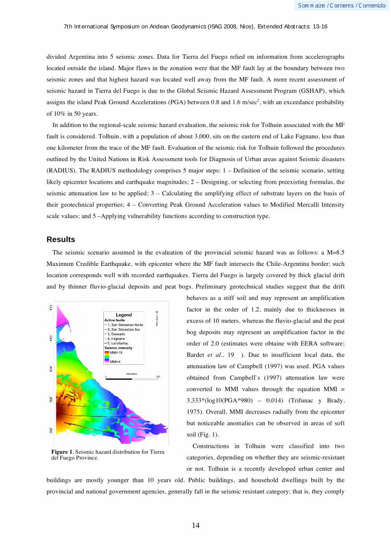
The seismic scenario assumed in the evaluation of the provincial seismic hazard was as follows: a M=8.5
Maximum Credible Earthquake, with epicenter where the MF fault intersects the Chile-Argentina border; such
location corresponds well with recorded earthquakes. Tierra del Fuego is largely covered by thick glacial drift
and by thinner fluvio-glacial deposits and peat bogs. Preliminary geotechnical studies suggest that the drift
behaves as a stiff soil and may represent an amplification
factor in the order of 1.2, mainly due to thicknesses in
excess of 10 meters, whereas the fluvio-glacial and the peat
bog deposits may represent an amplification factor in the
order of 2.0 (estimates were obtaine with EERA software;
Bardet et al., 19 ). Due to insufficient local data, the
attenuation law of Campbell (1997) was used. PGA values
obtained from Campbell`s (1997) attenuation law were
converted to MMI values through the equation MMI =
3,333*(log10(PGA*980) – 0,014) (Trifunac y Brady,
1975). Overall, MMI decreases radially from the epicenter
but noticeable anomalies can be observed in areas of soft
soil (Fig. 1).
Constructions in Tolhuin were classified into two
categories, depending on whether they are seismic-resistant
or not. Tolhuin is a recently developed urban center and
buildings are mostly younger than 10 years old. Public buildings, and household dwellings built by the
provincial and national government agencies, generally fall in the seismic resistant category; that is, they comply
Figure 1. Seismic hazard distribution for Tierra del Fuego Province.

7th International Symposium on Andean Geodynamics (ISAG 2008, Nice), Extended Abstracts: 13-16
15
with the CIRSOC-103 regulations issued by the INPRES. The majority of the households do not, however,
having been built on the rush by small local constructors. Tolhuin is built on terraced ground generally sloping
toward Lake Fagnano, the SW. The town center, and the majority of the public buildings are in high ground,
approximately 100 m above lake level. The thicker Quaternary section (>150 m in thickness) underlies the town
center. In this area, however, stiff glacial drift and gravelly glacifluvial deposits dominate the upper levels,
resulting in an amplification factor of about 1.2. Lower parts of the town rest on thinner but more clay-rich
substrate, and resulted in an amplification factor of about 2. Two seismic scenarios were evaluated for Tolhuin,
both for M=8.5 earthquakes located on the MF fault, one with epicenter on the Chilean border, approximately
80 km away, the other distant only 20 km from Tolhuin`s urban center. The results are shown in Figure 3.
Seismic resistant buildings would resist and MMI=8.5 with little damage but precarious construction would
suffer considerable damage, especially those located on the lower slopes.
Acknowledgments
We wish to acknowledge the financial support obtained from Consejo Federal de Ciencia y Tecnología
(COFECYT) through the PFIP 2005-Convenio Nº 063. We also wish to thank the Municipal authorities of
Tolhuin and the private and public organisms that provided useful base information for this study.
A B
Figure 2. Seismic scenarios for Tolhuin. A) Epicenter 20 km from city center. B) Epicenter 80 km from Tolhuin.

7th International Symposium on Andean Geodynamics (ISAG 2008, Nice), Extended Abstracts: 13-16
16
References Bardet, J.P., Ichii, K., & Lin, C.H., 2000. EERA, A computer program for equivalent-linear earthquake site response analysis
of layered soil deposits. University of Southern California, Los Angeles. British Antarctic Survey 1985. Tectonic map of the Scotia Arc. British Antarctic Survey, Miscellaneous 3, Cambridge. Campbell, K.W. 1997. Empirical near-source attenuation relationships for horizontal and vertical components of peak ground
acceleration, peak ground velocity, and pseudo-absolute acceleration response spectra. Seismological Research Letters 68(1):154-179.
Costa, C.H., Smalley, R., Schwartz, D., Stenner, H., Ellis, M., Ahumada, E., Velasco, M-S. 2006. Paleoseismic observations of an onshore transform boudary: The Magallanes-Fagnano fault, Tierra del Fuego, Argentina. Revista de la Asociación Geológica Argentina 61 (4):647-657.
Klepeis, K. 1994. The Magallanes and Deseado fault zones: Major segments of the South American-Scotia transform plate boundary in southernmost South America, Tierra del Fuego. Journal Geophysical Research 99:22,001-22,014.
Kraemer, P. 2003. Orogenic shortening and the origin of the Patagonian Orocline (56ºSLat.). Journal of South American Earth Sciences 15: 731-748.
Lodolo, E., Menichetti, M., Bartole, R., Ben-Avraham, Z., Tassone, A., Lippai, H. 2003. Magallanes-Fagnano continental transform fault (Tierra del Fuego, southernmost South America). Tectonics, 22(6), doi 10.1029/2003TC001500
Pelayo, A., Wiens, D., 1989. Seismotectonics and relative plate motions in the Scotia Sea region. Journal of Geophysical Research 94: 7293-7320.
Smalley, R., Jr., Kendrick, E., Bevis, M., Dalziel, I., Taylor, F., Lauría, E., Barriga, R., Casassa, G., Olivero, E., Piana,. E. 2003. Geodetic determination of relative plate motion and crustal deformation across the Scotia-South America plate boudary in eastern Tierra del Fuego. Geochemistry Geophysics Geosystems 4(9) 1070, doi:10.1029/2002GC000446
Trifunac, M.D., Brady, A.G. 1975. On the correlation of seismic intensity scales with the peaks of the recorded ground motion. Bulletin, Seismological Society of America 65:103-145.
Winslow, M. 1982. The structural evolution of the Magallanes Basin and neotectonics of the southernmost Andes. In Craddock, C. (ed.) Antarctic Geoscience, University of Wisconsin: 143-154.

7th International Symposium on Andean Geodynamics (ISAG 2008, Nice), Extended Abstracts: 17-20
17
Cambrian paleogeography at the western Gondwana margin: U-Pb ages and provenance areas of detrital zircons of the Mesón Group (Upper Cambrian), Northwest Argentina
Christopher J. Adams1, Hubert Miller
2, Guillermo F. Aceñolaza
3, & Alejandro J. Toselli
3
1 GNS Science, PO Box, Lower Hutt , New Zealand ([email protected])
2 LMU, Department für Geo- und Umweltwissenschaften, Luisenstr. 37, 80333 München, Germany
([email protected]) 3 Universidad de Tucumán, Facultad de Ciencias, Miguel Lillo 205, 4000 S. M. de Tucumán, Argentina
KEYWORDS : Argentina, Cambrian, Mesón Group, U-Pb, zircons
Introduction
In northwest Argentina, sedimentation of the Puncoviscana Formation (uppermost Neoproterozoic-Early
Cambrian) finished with folding, metamorphism, and granitoid magmatism of the Pampean Orogeny in mid-
Cambrian times. Above a pronounced angular unconformity, the turbidites of the Puncoviscana Fm. are overlain
by siliciclastic sedimentary rocks of mostly sandstone, partly conglomerate, siltstone and mudstone grain size,
the Mesón Group that is divided into 3 formations: Lizoite, Campanario, and Chalhualmayoc. The Mesón Group
is the basal unit for the sedimentation of the Famatinian (Ordovician-Devonian) orogenic cycle in northwest
Argentina. The siliciclastic rocks of the Mesón Group were deposited in shallow, coast-near tide-dominated
environments in the form of sand bars (Sánchez & Salfity, 1999, Aceñolaza, 2003, 2005).
Generally, the age of the Mesón Group has been considered Cambrian. On paleontological evidence, Sánchez
& Salfity (1999) and Aceñolaza (2003, 2005) restricted the age to “Middle to Upper Cambrian”. The presence of
late Early Cambrian zircons in part of the underlying Puncoviscana Formation (Adams et al., 2008), and the
early to mid Cambrian zircon ages of the Santa Rosa de Tastil and Cañaní granitoids intruding the Puncoviscana
Formation (513 Ma: Adams, oral com.; 514 - 519 - 536 Ma: Bachmann et al., 1991), indicate that sedimentation
of the Mesón Group did not begin before the Middle Cambrian. The Mesón Group as a lithological unit termi-
nates before the Ordovician, whereas quite similar siliciclastic facies continues through the
Cambrian/Ordovician boundary into the lowermost part of the Tremadocian Santa Rosita Fm. (Aceñolaza,
2005).
In order to define the geotectonic position of the Mesón Group within the Gondwana Pacific margin, its
relation to the underlying Puncoviscana Formation and the Pampean and Famatinian orogeny (Pankhurst &
Rapela, 1998), and to recognize the relation of the provenance area of its sediments to those of the Puncoviscana
Formation, samples have been taken from outcrops close to the Puncoviscana Formation. The aim of this work
was to know,
• if the provenance areas of sediments of the Gondwana margin have changed since deposition of the
Puncoviscana Formation and the Pampean orogeny,
• if erosion of the Puncoviscana Formation and its metamorphic equivalents has much contributed to the
sediments of the Mesón Group, or

7th International Symposium on Andean Geodynamics (ISAG 2008, Nice), Extended Abstracts: 17-20
18
• if there was an important new input from the Brazilian shield, similar to that of the time of deposition of
the Puncoviscana Formation, or from anywhere else.
Figure 1. Left: Occurrence of the Mesón Group (Upper Cambrian) in northwest Argentina. A = Sample N° JJ2A, B = Sample N° SAL1, C = Sample N° PMXX3. Right: Frequency diagrams of U-Pb ages of detrital zircons. For discussion see text. Note the numerous grains from 2200 to 2000 Ma, nearly absent in the underlying Puncoviscana Formation.

7th International Symposium on Andean Geodynamics (ISAG 2008, Nice), Extended Abstracts: 17-20
19
Results
JJ2A is an angular clast from local rock debris slopes of the Mesón Group, close to sample N° JJ-2 of the
Puncoviscana Formation on the old road from Jujuy to Salta (Adams et al., 2008) (Fig. 1, A). It shows a
youngest peak at 538 to 519, close to the youngest peak of the close lying sample of the Puncoviscana sample
JJ-2 (555 to 530 Ma). Other minor peaks are around 700 to 600 Ma and from 1000 to 900 Ma. The provenance
of 6 zircon grains between 2200 and 1980 Ma will be particularly considered later.
PMXX3 is a sample from outcrop in the upper part of the Lizoite Fm., in the Quebrada de Humahuaca, north
of Tumbaya, Jujuy province (Fig. 1, C). A pronounced peak from 700 to 560 Ma is noticeable. From 2200 to
1980 Ma eight grains are present.
SAL 1 (La Pedrera) is from the road from Salta to La Quesera, south of the city of Salta (Fig. 1, B) immedi-
ately above the angular unconformity of the Pampean Orogeny. It shows a sharply pronounced peak at 502 Ma,
a broad peak at 640 to 580 Ma, and 6 grains from 2200 to 2000 Ma.
Discussion
The maximum age of the Mesón Group is defined by the age of the youngest parts of the underlying Punco-
viscana Formation (523 Ma: Adams et al., 2008), and the age of the youngest granitoids beneath (Bachmann et
al., 1991: 514 Ma, and Adams, oral comm.: 513 Ma). The upper limit is defined by fossil evidence of uppermost
Cambrian age within the lowermost sector of the overlying Santa Rosita Fm. The youngest peak of detrital zir-
con grains in the Mesón Group at 502 Ma (Fig. 1) corresponds to the Middle/Late Cambrian boundary. We think
that these young zircons are the product of volcanic activity at the beginning of the Famatinian magmatic
activity in the neighborhood (Loewy et al., 2004, Sims et al., 1998, Saavedra et al., 1998). An older peak of 538
to 519 Ma is recognized in sample JJ2A (Fig. 1, A). The ages resemble very much the youngest ages from the
Puncoviscana Fm. In all three samples a peak around c. 600 Ma is prominent, similar to most of the
Puncoviscana Fm. samples (Adams et al., 2008). In two of the samples, a peak between 1000 and 900 Ma is also
present. It is nearly identical with a common peak of the Puncoviscana Fm. that appears mostly between about
1100 and 1000 Ma (Adams et al., 2008). Other, Mesoproterozic, ages occurring sometimes in the Puncoviscana
Fm., are not present in the Mesón Group samples. On the contrary, within all Mesón Group samples, distinctive
ages of 2200 to 2000 Ma occur.
Now the question is: Are the sediments of the Mesón Group mostly composed of recycled material of the
underlying Puncoviscana Formation, or, are both lithological units composed of material proceeding from the
same areas? For the Early Cambrian grains of sample JJ2A the youngest parts of the Puncoviscana Fm. are the
most suitable provenance areas. For the late mid to late Cambrian zircons of sample SAL 1, a provenance from
an early Famatinian volcanism is probable. For the few late and early Neoproterozoic grains, recycling of rocks
of the Puncoviscana Fm. is just as possible as an original provenance from the Neoproterozoic Brasiliano
orogen and from the neighboring Sunsás orogen, respectively.
The explicit occurrence of early Paleoproterozoic zircons sharply limited to the time span of 2200 to 2000 Ma
is unexpected, but significant for all samples. Rapela el al. (2007) recently found such ages in boreholes east of
the Sierra de Córdoba within part of the Río de la Plata craton that also presents such ages in Uruguay and
southeast Brazil. Rapela et al. (2007) suggest a former more northern position of the Río de la Plata craton, with

7th International Symposium on Andean Geodynamics (ISAG 2008, Nice), Extended Abstracts: 17-20
20
translation to its present site by large-scale dextral strike-slip movement. There are no younger Paleoproterozoic
and early Mesoproterozoic rocks in between the Río de la Plata craton and the “Pampean Cycle” orogen of
central and northwest Argentina. This explains the absence of such zircons, except Early Neoproterozoic ones.
These may have been derived from the Puncoviscana Formation by recycling, or from a prolongation of the
West Brazilian Sunsás Orogen beneath the Chaco plain in north Argentina intervening between the Río de la
Plata orogen and the Mesón Group deposition site. Although Sánchez & Salfity (1999) record a sediment
transport to the Mesón Group from mostly western sources, this is not documented by the zircon grain ages.
Loewy et al., 2004) have shown that early Proterozoic magmatic and metamorphic rocks of the Arequipa-
Antofalla terrane in the west of the Mesón Group deposition centres are defined by ages from 2.0 to 1.8 Ga,
whilst the characteristic Paleoproterozoic ages of the Mesón Group detrital zircons are older: 2.2 to 2.0 Ga).
Conclusions
At the Pacific Gondwana margin, after the prominent Pampean orogeny in Middle Cambrian, a shallow water
through developed in NW Argentina. Material came partly from the underlying Puncoviscana Formation and/or
its metamorphic equivalents, but continuous provenance from the Brazilian Shield cannot be excluded. In any
case, frequent grains restricted to 2200 to 2000 Ma are considered to have derived from the Río de la Plata
craton of southeast Brazil and Uruguay, and its extension to the area east of the Sierra de Córdoba (Rapela et al.,
2007).
References Aceñolaza, G.F., 2003 — The Cambrian System in Northwestern Argentina: stratigraphical and palaeontological framework.
Geologica Acta, 1: 23-39. Aceñolaza, G.F., 2005 — The Cambrian System in Northwestern Argentina: stratigraphical and palaeontological framework.
Reply. Geologica Acta, 3 (1): 73-77. Adams, Ch., Miller, H., Toselli, A.J., 2008 — The Puncoviscana Formation of northwest Argentina: U-Pb geochronology of
detrital zircons and Rb-Sr metamorphic ages and their bearing on its stratigraphic age, sediment provenance and tectonic setting. Neues Jahrbuch für Geologie und Paläontologie, in press.
Bachmann, G., Grauert, B., Kramm, U., Lork, A., Miller, H., 1991 — El magmatismo del Cámbrico Medio/Cámbrico Superior en el basamento del Noroeste Argentino: Intrusivos de Santa Rosa de Tastil y Cañaní. Actas X. Congreso Geológico Argentino, Tucumán, 4: 125-127.
Loewy, S.L., Connelly, J.N., Dalziel, I.W.D., 2004 — An orphaned basement block: The Arequipa-Antofalla Basement of the central Andean margin of South America. Geological Society of America Bulletin, 116: 171-187; doi: 10.1130/B25226.1.
Pankhurst, R.J., Rapela, C.W., 1998 — The proto-Andean margin of Gondwana: an introduction. In: Pankhurst, R.J., Rapela, C.W. (eds): The Proto-Andean Margin of Gondwana. Geological Society of London, Special Publications 142: 1-9.
Rapela, C.W., Pankhurst, R.J., Casquet, C., Fanning, C.M., Baldo, E.G., González-Casado, J.M., Galindo, C., Dahlquist, J., 2007 — The Río de la Plata craton and the assembly of SW Gondwana. Earth-Science Reviews, 83: 49-82.
Saavedra, J., Toselli, A., Rossi, J., Pellitero, E., Durand, F., 1998 — The early Paleozoic magmatic record of the Famatina System: a review. In: Pankhurst, R.J., Rapela, C.W. (eds): The Proto-Andean Margin of Gondwana. Geological Society of London, Special Publications, 142: 283-295.
Sánchez, M.C., Salfity, J.A., 1999 — La cuenca cámbrica del Grupo Mesón en el Noroeste Argentino: desarrollo estratigráfico y paleogeográfico. Acta Geológica Hispánica, 34: 123-139.
Sims, J.P., Ireland, T.R., Camacho, A., Lyons, P., Pieters, P.E., Skirrow, R.G., Stuart-Smith, P.G., Miró, R., 1998 — U-Pb, Th-Pb, and Ar-Ar geochronology from the southern Sierras Pampeanas, Argentina: implications for the Palaeozoic tectonic evolution of the western Gondwana margin. In: Pankhurst, R.J., Rapela, C.W. (eds): The Proto-Andean Margin of Gondwana. Geological Society of London, Special Publications, 142: 259-281.
7th International Symposium on Andean Geodynamics (ISAG 2008, Nice), Extended Abstracts: 21-24
21
Assessment of erosion rate modifications during the Neogene incision in the Semiarid Andes (Northern Chile) using the Black Top Hat function applied to a Digital Elevation Model
Germán Aguilar1, José Darrozes
2, Eric Maire
2, & Rodrigo Riquelme
1
1 Departamento de Ciencias Geológicas, Fac. de Ingenieria y Ciencias Geológicas, Universidad Católica del
Norte, Avenida Angamos 0610, Antofagasta, Chile ([email protected], [email protected]) 2 Laboratoire desMécanismes de Transfert en Géologie, Universite Paul Sabatier, 14 avenue Eduard Belin,
31400 Toulouse, France ([email protected], [email protected])
KEYWORDS : semiarid Andes, erosion rates, glacial valley, Black Top Hat (BTH) function
Introduction and geomorphologic settings
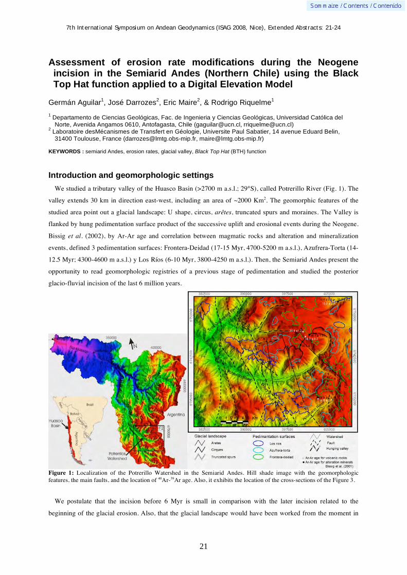
We studied a tributary valley of the Huasco Basin (>2700 m a.s.l.; 29°S), called Potrerillo River (Fig. 1). The
valley extends 30 km in direction east-west, including an area of ~2000 Km2. The geomorphic features of the
studied area point out a glacial landscape: U shape, circus, arêtes, truncated spurs and moraines. The Valley is
flanked by hung pedimentation surface product of the successive uplift and erosional events during the Neogene.
Bissig et al. (2002), by Ar-Ar age and correlation between magmatic rocks and alteration and mineralization
events, defined 3 pedimentation surfaces: Frontera-Deidad (17-15 Myr, 4700-5200 m a.s.l.), Azufrera-Torta (14-
12.5 Myr; 4300-4600 m a.s.l.) y Los Ríos (6-10 Myr, 3800-4250 m a.s.l.). Then, the Semiarid Andes present the
opportunity to read geomorphologic registries of a previous stage of pedimentation and studied the posterior
glacio-fluvial incision of the last 6 million years.
Figure 1: Localization of the Potrerillo Watershed in the Semiarid Andes. Hill shade image with the geomorphologic features, the main faults, and the location of 40Ar-39Ar age. Also, it exhibits the location of the cross-sections of the Figure 3.
We postulate that the incision before 6 Myr is small in comparison with the later incision related to the
beginning of the glacial erosion. Also, that the glacial landscape would have been worked from the moment in

7th International Symposium on Andean Geodynamics (ISAG 2008, Nice), Extended Abstracts: 21-24
22
that the mountain chain raise up to the necessary height/elevation to prevent the flow of the humid fronts from
the pacific ocean (Westerly). This elevation would have been reached ~6 Myr B.P., which initiated the beginning
of the ice accumulation linked to the glacial process in the Semiarid Central Andes. The orographical control of
the rainfalls is an important factor to understand the fluvial dynamics in the Semiarid Andes and the landscape
evolution during the last 6 Myr. Also, the semiarid condition and the differential erosional processes between
valleys and surface have favored the preservation of pediment during the last 6 Myr.
This work synthesizes some of the preliminary results of a study, which identified and quantified the erosion
rates of different temporal scales in the Semiarid Central Andes. The aim tries to understand the impact of the
glacial activity in the long-term and short-term denudation of the mountain. To check our hypothesis, we
quantifie the incised volume of the valleys before and after the 6 Myr. In this goal, we applie the Black Top Hat
(BTH) function to a digital elevation model (DEM) to charactize change in the erosion rates during different
neogene incision stages in different valleys. Finally, we discuss the impact of the orographical control of the
rainfalls and glacial erosion in the landscape evolution and the denudation of the Semiarid Central Andes.
Methodology and results
The Black Top Hat Transform function is a grey level mathematical morphological function which allows
valley extraction in a 1D signal and 2D image. Efficiency of the Top Hat Transform was demonstrated in the
first time by Meyer (1979) for Cytology applications. In geomorphology, this function was applied to a high-
precision DEM as a relevant tool for estimating incision and the amount of material removed by recent fluvial
erosion like in a Pyrenean watershed (Rodriguez et al., 2002) and long-term neogene denudation rates from the
Central Andes (Riquelme et al., 2008). The mathematical formulation is based on a set of mathematical
morphology concepts (for details see Rodriguez et al., 2002 or Riquelme et al., 2008). This formulation is
provided by specialized image processing software.
The application of the BTH function is based on the selection of the width of valley incised (L, Table 1),
which corresponds to the greatest separation between pedimentation surfaces. We map the pedimentation surface
and the glacial morphology over a Landsat TM+ image. The surfaces were correlated by three surfaces defined
and dated by Bissig et al. (2002). We considered an error of ±100 m due to the loss of precision in the limit of
pedimentation surface (Fig. 2). These errors were affecting the exactitude of the incision volume and erosion
rate, representing an interval between 0.7 to 1 Km3 and 0.1 to 0.3 m/Myr respectively. For the calculation of the
erosion rates we considerate the age of pedimentation surfaces calculated by Bissig et al. (2002),
The first results (Table 1) of the BTH measurement have been obtained in the Potrerillo Valley. During the
pedimentation period, between 17 and 6 Myr BP, third pediment surfaces have been identified. The first one
which corresponds to the period 17 to 15 My have an incision volume close to 12 Km3 for an incision period of 1
My. This incision period began at the end of the pedimentation phase i.e. 15 my ago and the associated erosion
rate is 5.9 ± 0.3 m/Myr. The second pediment which correspond to the period 14 to 12.5 My have a very weak
incision volume of 2.9 ± 0.7 km3. The incision period began 12.5 My ago and lasted 2.5 My. The associated
incision rate was calculated to 0.6 ± 0.2 m/Myr. In contrast, for the last pediment (10-6 My) and the last 6 My of
incision, the incision volume increase drastically and correspond to approximately 130 Km3 and the associated
erosion rates is 10.6 ± 0.1 m/Myr. This rate represent the double that the maximum rate during the previous

7th International Symposium on Andean Geodynamics (ISAG 2008, Nice), Extended Abstracts: 21-24
23
pedimentation period. This contrast is point out in the incised valley cross-section (Fig. 2), where during the last
6 Myr the incision exceeds the 1000 m, while the incision among during 17 to 6 Myr BP is minor than 200 m.
These first results will enable us to discuss the variations of the rate of incision and to seek its significance as
well in morphoclimatic and tectonic terms.
Incision stage L: Incision width (m) Incised volume (km3) Erosion rate (m/Myr) Incision 3 (6 Myr - pte.) 8152.66 ± 100 127.3 ± 1 10.6 ± 0.1
Pedimentation stage (10-6 Myr) Incision 2 (12,5-10 Myr) 9167.71 ± 100 2.9 ± 0.7 0.6 ± 0.2
Pedimentation stage (14-12.5 Myr) Incision 1 (15-14 Myr) 10228.99 ± 100 11.7 ± 0.7 5.9 ± 0.3
Pedimentation stage (17-15 Myr) Table 1: Quantitative results of the application of BTH function in the Potrerillo Valley. The BTH function considering the width of valley incised (L). The resulting is the volume incised during and the erosion rates during three incision stage. The erosion rates estimation consider the age of pedimentation surface (Bissig et al., 2002).
Figure 2: Cross-section of the Potrerillo Valley generated of combination of DEM and incised volume digital models (BTH function). Topographic cross-sections show the principal geomorphologic structuring element of the Potrerillo Valley. Also, showing the width of valley incised. The incised volume cross-section are showing the contrast between incision stage 3 and the incision stage 1 and 2. For the located of the cross section see figure 1.
Discussion and conclusion
The erosion rates calculated (<11 m/Myr) are near to the calculated ones for other publications in the Arid
Central Andes (eg. Scholl et al., 1970; Alpers and Brimhall, 1988; Riquelme et al., 2008). We calculated erosion
rates of ~6 m/Myr and ~0.6 m/Myr between pedimentation periods (17-6 Myr). The first erosion rate calculated
(15 Myr to 14 Myr BP) is around of the erosion rates published for valleys in the Arid Central Andes (Riquelme
et al., 2008) and can be correlated to the beginning of the first period of rapid exhumation defined in the zone by
Cembrano et al. (2003) with apatite fission track (300 m/Myr; 15-10 Myr BP). The second erosion rate between
14 to 12.5 Myr BP implicate a minimal valley incision, more consistent with the erosion rates calculated into
Miocene alluvial fans (Gravas de Atacama) and bedrock surface of the Atacama Desert (<0.1 m/Myr by
cosmogenic nuclides 10Be, 26Al and 21Ne; Nishiizumi et al., 2005) and explain the great preservation of
Azufrera-Torta surface (Bissig et al., 2002).
For the last 6 Myr we calculated an erosion rate of ~11m/Myr. This erosion rate is the double of the more great
calculated between anterior incision periods. Also, the volume of valley incised of 130 Km3 during the last 6

7th International Symposium on Andean Geodynamics (ISAG 2008, Nice), Extended Abstracts: 21-24
24
Myr contrast with the scantly 15 Km3 between 6 to 10 Myr BP. The beginning of this main incision stage is
correlated to the last rapid exhumation determined by Cembrano et al. (2003) to the 5 Myr BP (200 m/Myr). We
postulate that uplift episode around 6 Myr BP permitted a drastic increase of orographical control of the rainfalls
and the beginning of glacial activity. More precisely, for the numerous mountains which exceed the critic
elevation between 3900-4250 m a.s.l. (Amman et al., 2001) the phenomena of condensation and retention of
pacific wet flows (Westerly) are activated and implicated a major change in the erosive mode.
But which is the impact of the glacial erosion in the incision of the valleys and which is the speed of this
phenomenon? In Sierra Nevada, California, the glacial erosion during the Quaternary glaciations, in basins with
glacial coverage of close to a quarter of his area, is between 1250 and 200 m/Myr (Brocklehurst and Whipple,
2002). Considering these erosion rates, with only in a couple of glaciations of 5000 years it might have
excavated the volume of incision of the last 6 Ma of the Potrerillo Valley. Furthermore, only two glacial cycles
would be enough to shape the morphology of the valleys in the high mountain chain of the semiarid Andean. So,
is possible that during the beginning of glacial activity (6-5 Myr BP) the incised valleys is similar to the present
day incision and only the glacial erosion can explain the rapid exhumation calculated by Cembrano et al. (2003).
We presume that the incision of the valleys in The Semiarid Central Andes is product of the intensification of
the orographical control of the rainfalls and the beginning of the glacial and paraglacial erosion to ~6 Myr ago.
Also, the beginning of glacial and paraglacial erosion is an important factors in the exhumation of The Semiarid
Central Andes. To validate these hypotheses it will be necessary to quantify the erosion rates during the last 6
Myr in others glacial and non glacial valleys of the Central Andes and to confront the erosion rates calculated
from the volume measurement of the glacial and paraglacial deposits.
Acknowledgments. We thank the ECOS-CONICYT and the INNOVA-CORFO scientific programs, and Dr. J. Martinod, Dr. G. Gonzalez, Dr. M. Mardonez, Dr. J. Cembrano and Dr. T. Bissig for the many valuable discussions. References Alpers, C.N., Brimhall, G.H., 1988. Middle Miocene climatic change in the Atacama Desert, northern Chile: Evidence from
supergene mineralization at La Escondida. Geological Society of America Bulletin, 100, 1640-1656. Amman, C.; Jenny, B.; Kammer, K.; Messerli, B. 2001. Late Quaternary response to humidity changes in the arid Andes of
Chile (18-29ºS). Palae. Palae. Palae. 172: 313-326. Bissig, T.; Clark, A.H.; Lee, J.K.W.; Hodgson, C.J. 2002. Miocene landscape evolution in the Chilean flat-slab transect:
uplift history and geomorphologic controls on epithermal processes in the El Indio-Pascua Au (–Ag, Cu) belt. Econ Geol 97:971–996.
Brocklehurst and Whipple, 2002. Glacial erosion and relief production in the Eastern Sierra Nevada, California. Geomorphology 42, 1-24.
Cembrano, J., Zentilli, M., Grist, A., Yañez, G. 2003. Nuevas edades de trazas de fisión para Chile Central (30°-34°S): Implicancias en el alzamiento y exhumación de los Andes desde el Cretácico. 10° Congreso Geológico Chileno, Universidad de Concepción-Chile.
Meyer, F. (1979). Cytologie quantitative et morphologie mathématique, Thèse de docteur ingénieur thesis, Ecole des Mines, Paris, (unpublished).
Nishiizumi, K., M.W., Caffe, R.C., Finkell, G., Brimhall, T., Mote, 2005. Remnants of a fossil alluvial fan landscape of Miocene age in the Atacama Desert of northern Chile using cosmogenic nuclide exposure age dating. Earth and Planetary Science Letters, 237, 3-4, 499-507.
Riquelme, R., Darrozes, J., Maire, E., Hérail, G., Soula, J.C. 2008. Long-term denudation rates from the Central Andes (Chile) estimated from a Digital Elevation Model using the Black Top Hat function and Inverse Distance Weighting: implications for the Neogene climate of the Atacama Desert. Rev. geol. Chilena.
Rodríguez, F., Maire, E., Courjault-Radé, P., Darrozes, J. 2002. The Black Top Hat Function applied to a DEM: A tool estimate recent incision in a mountain watershed (Estiber Watershed, Central Pyrenees). Geophysical Research Letters, vol. 29, No. 0.
Scholl, D. W., Christensen M. N., Von Huene R., Marlow M. S., 1970. Peru-Chile trench sediments and sea floor spreading. Geological Society of America Bulletin, 81, 1339-1360.
7th International Symposium on Andean Geodynamics (ISAG 2008, Nice), Extended Abstracts: 25-28
25
Preliminary results of a geochemical survey at Lastarria volcano (Northern Chile): Magmatic vs. hydrothermal contributions
F. Aguilera1, F. Tassi
2, O. Vaselli
2,3, E. Medina
4, & T. Darrah
5
1 Programa de Doctorado en Ciencias mención Geología, Universidad Católica del Norte, Avenida Angamos
0610, Antofagasta, Chile ([email protected]) 2 Department of Earth Sciences, University of Florence, Via La Pira 4, 50121, Florence, Italy ([email protected])
3 CNR-IGG Institute of Geosciences and Earth Resources, Via La Pira 4, 50121, Florence, Italy
([email protected]) 4 Departamento de Ciencias Geológicas, Universidad Católica del Norte, Avenida Angamos 0610, Antofagasta,
Chile ([email protected]) 5 Environmental and Earth Sciences Department, Rochester University, Rochester, USA ([email protected])
KEYWORDS : Lastarria volcano, fumarolic gases, fluid geochemistry, isotope geochemistry, crustal process
Introduction
InSAR images time series (1992-2006) and GPS measurements (Pritchard and Simons, 2002; 2004; Froger et
al. 2007) have shown that the Lastarria-Cordón del Azufre volcanic complex (northern Chile) was interested by
severe ground deformation, probably initiated in early 1998. It has to be noted that this zone was not previously
recognized as active, with the exception of Lastarria volcano that has been characterized by a permanent
fumarolic activity since the beginning of the twentieth century (Casertano, 1963, González-Ferrán, 1995). To
explain the origin of this phenomenon several processes were suggested: i) injection of magma from depth,
possibly causing melting of crustal rocks, ii) uprising of hydrothermal fluid, and iii) rock volume variations
caused by phase changes related to the evolution of the pre-caldera silicic system (Pritchard and Simons, 2002;
2004; Froger et al. 2007; Ruch et al., 2008). In this study, we present the chemical and isotopic features of fluids
discharged from the fumaroles of Lastarria volcano collected during a geochemical survey carried out in May
2006. The main aim is to investigate the origin of the fumarolic fluids and their relation with the tectonic setting
of the system.
Geological and tectonic setting
Lastarria volcano, located in the southern part of the Central Andean Volcanic Zone (CAVZ), is an andesitic-
to-dacitic stratovolcano that forms part of a complex polygenetic structure. According to Naranjo (1986; 1992),
the volcanic complex is formed by: 1) the Negriales lava field (or Big Joe), situated SW of the main volcanic
structure, composed by andesitic-to-dacitic lava flow successions that represent the oldest structure of the
complex (K-Ar dating between 0.6±0.3 and <0.3 Ma; Naranjo, 1988; Naranjo and Cornejo, 1992); 2) the
southern Spur volcanic edifice, located NE of Negriales; 3) the presently active Lastarria volcano sensu stricto,
constituting the main and youngest structure of the system and formed by 5 NW-SE aligned nested craters
(Fig. 1). The permanent fumarolic activity at Lastarria is mainly from i) the north-westernmost craters (from
crater rim and crater bottom) and ii) the NW-SE trending fracture system along the NW external flank of the
Lastarria edifice (Fig. 1). The most prominent regional structure of the CAVZ correspond to NW-SE alignments
(e.g. Calama-Olacapato-El Toro), where several Miocene magmatic centers are aligned (Matteini et al., 2002a,b;
Acocella et al., 2007). The S and SE zones of the complex, hosting large caldera structures (e.g. Cerro Galán,

7th International Symposium on Andean Geodynamics (ISAG 2008, Nice), Extended Abstracts: 25-28
26
Wheelwright) (Ruch et al., 2008) are instead dominated by NNE-SSW tectonic lineaments.
Results
Thermal fluid discharges of Lastarria volcano can be distinguished in two groups: i) low-temperature (LT)
fumaroles (outlet temperature between 80.1 and 96.1 °C) and ii) high-temperature (HT) fumaroles (outlet
temperature between 217 and 278 °C). The LT group is characterized by higher vapor/gas ratios (between 9 and
12.7) with respect to those of HT (<5.5). The chemical composition of the dry gas fraction of the two groups,
dominated by the presence of CO2 (928,800-990,000 μmol/mol), is also distinct: the LT fumaroles show
relatively low concentrations of N2, HCl, H2 and HF (up to 8,140, 665, 440 and 85 μmol/mol, respectively) and
particularly high H2S concentrations (up to 31,450 μmol/mol). Differently, the HT fumaroles have H2S
concentrations <370 μmol/mol and N2, H2, HCl and HF concentrations up to 30,280, 9,140, 4,200 and
580 μmol/mol. A strong difference is also shown by the concentration of the temperature-dependent CO that is
two orders of magnitude higher in the HT fumaroles (up to 29 μmol/mol). Sulfur dioxide is present in variable
amounts (from 1,400 to 26,000 μmol/mol), while CH4 is comprised between 39 and 69 μmol/mol. The
composition of light hydrocarbons, dominated by compounds pertaining to the alkanes group and characterized
by significant amounts of alkenes, is marked by a very low speciation. The isotopic composition of carbon in the
CO2 (13C) varies between -0.42 and -4.13 ‰ V-PDB, while helium isotopes, expressed as R/Rair values, range
between 4.55 and 5.15.
Figure 1. Map of the Lastarria volcanic complex (northern Chile) and location of the sampled fumaroles.

7th International Symposium on Andean Geodynamics (ISAG 2008, Nice), Extended Abstracts: 25-28
27
Discussion and conclusions
The presence of highly acidic compounds clearly indicates that Lastarria fumarolic fluids are affected by
conspicuous contribution from a high-temperature source. Accordingly, as shown in the SO2-10*Ar-H2S ternary
diagram (Fig. 2a), the fumarolic discharges can be considered as the result of a mixing process between two
possible end-members related to 1) a magmatic source and 2) a hydrothermal component. On this basis, a clear
distinction seems to exist between the HT and the LT fumaroles, being the former characterized by significantly
higher contribution from the magmatic end-member. Similar indications can be obtained from the N2/50-CH4*5-
Ne*1000 ternary diagram (Fig. 2b), considering that N2-enrichments are to be related to the addition of fluids
from a magmatic (andesitic) source. In fact, the relative abundances of the non-reactive gas species, i.e. N2, Ar
and He (Fig. 2c), are typical of gas discharges associated with subduction-related andesitic magmatism
(“andesite” field; Giggenbach 1992). It is worthy of noting that the LT fumaroles, especially those in the crater
rim and in the highest portion of the flank fracture (Fig. 1) and characterized by the highest contribution from
hydrothermal fluids, show a clear He enrichment. This could be related to strong fluid-rock interactions
involving granite-type rocks that typically constitute the upper crust of the CAVZ (Lucassen et al., 2001). These
evidences are in agreement with i) the R/Rair values, significantly lower than those measured in other volcanoes
of this sector of the Andean Volcanic Chain (e.g. Lascar volcano) (Tassi et al., 2008), and ii) the 13C-CO2
values, likely produced by the mixing of magmatic and limestone sources, the latter likely constituting at least
part of the sedimentary material involved in the subduction process.
Figure 2.a) SO2-10*Ar-H2S ternary diagram; b) N2/50-5*CH4-1000*Ne ternary diagram, air and ASW (Air Saturated Water) are reported; c) Ar-N2/100-10*He ternary diagram, air and ASW compositions and convergent plate boundaries (“andesite” field) (Giggenbach, 1996) are also reported. Symbols: HT fumaroles (open squares), LT fumaroles in the crater rim (filled circle), LT fumaroles in the NE side of flank fracture (filled diamond), LT fumaroles in the highest portion of flank fracture (open triangles).
On the basis of these results, fluid contribution from a crustal source due to melting processes related to the
evolution of the pre-caldera silicic system, one of the possible mechanisms invoked to explain the observed
ground deformation of this system, may be considered not negligible.

7th International Symposium on Andean Geodynamics (ISAG 2008, Nice), Extended Abstracts: 25-28
28
References Acocella, V. Vezzoli, L., Omarini, R., Matteini, M., & Mazzuoli, R., 2007. Kinematic variations across Eastern Cordillera at
24°S (Central Andes): Tectonic and magmatic implications. Tectonophysics, 434: 81-92 Casertano, L., 1963. General characteristics of active Andean volcanoes and a summary of their activities during recent
centurias. Bull. Seismol. Soc. Am. 53: 1415-1433. Froger, J.L., Remy, D., Bonvalot, S., & Legrand, D., 2006. Dynamic of long term multi-scale inflations at Lastarria- Cordon
del Azufre volcanic complex, central Andes, revealed from ASAR-ENVISAT interferometric data. Earth Planet. Sci. Lett. 255: 148-163.
Giggenbach, W., 1992. Isotopic shifts in waters from geothermal and volcanic systems along margins, and their origin. Earth Planet. Sci. Lett. 113: 495-510.
Giggenbach, W., 1996. Chemical composition of volcanic gases. In Scarpa, R., Tilling, R., (eds): Monitoring and mitigation of Volcano Hazards, Springer – Verlag, Berlin: 222-256.
Gonzalez–Ferrán, O., 1995. Volcanes de Chile. Instituto Geográfico Militar, santiago, 639 p. Lucassen, F., Becchio, R., Harmon, R., Kasemann, S., Franz, G., Trumbull, R., Wilke, H., Romer, R., & Dulski, P., 2001.
Composition and density model of the continental crust at an active continental margin the Central Andes between 21º and 27ºS. Tectonophysics 341: 195-223.
Matteini, M., Mazzuoli, R., Omarini, R., Cas, R., & Maas, R., 2002a. The geochemical variations of the upper Cenozoic volcanism along the Calama-Olocapato-El Toro transversal fault system in central Andes (24°S): petrogenetic and geodynamic implications. Tectonophysics 345: 211-227.
Matteini, M., Mazzuoli, R., Omarini, R., Cas, R., & Maas, R., 2002b. Geodynamical evolution of the central Andes at 24°S as inferred by magma composition along the Calama-Olocapato-El Toro transversal volcanic belt. J. Volcanol. Geotherm. Res. 118: 225-228.
Naranjo, J., 1986. Geology and evolution of the Lastarria volcanic complex, north Chilean Andes. MPh Thesis (Unpublished), The Open University, Milton Keynes, 162 p.
Naranjo, J., 1988. Coladas de azufre en los volcanes Lastarria y Bayo en el norte de Chile: Reología, génesis e importancia en geología planetaria. Rev. Geol. Chile 15: 3-12.
Naranjo, J., 1992. Chemistry and petrological evolution of the Lastarria volcanic complex in north Chilean Andes. Geol. Mag. 129, 723-740.
Naranjo, J., & Cornejo, P., 1992. Hoja Salar de la Isla, escala 1:250.000. Servicio Nacional de Geología y Minería, Nº 72 Pritchard, M., & Simons, M., 2002. A satellite geodetic survey of large-scale deformation of volcanic centres in the central
Andes. Nature 418(6894): 167-171. Pritchard, M., & Simons, M., 2004. An InSAR-based survey of volcanic deformation in the southern Andes. Geophys.
Geochem. Geosys. 5(2): 1-42. Ruch, J., Anderssohn, J., Walter, T., & Motagh, M., 2008. Caldera-scale inflation of the Lazufre volcanic area, South
America: evidence from InSAR. J. Volcanol. Geotherm. Res. Submitted Tassi, F., Aguilera, F., Vaselli, O., Medina, E., Tedesco, D., Delgado Huertas, A., Poreda, R., & Kojima, S., 2008. The
magmatic- and hydrothermal-dominated fumarolic system at the Active Crater of Lascar volcano, northern Chile. Bull. Volcanol. in press.

7th International Symposium on Andean Geodynamics (ISAG 2008, Nice), Extended Abstracts: 29-32
29
Towards a geodynamical model for the “middle” Cretaceous very low-grade metamorphism in Central Chile: The geochronological approach
L. Aguirre1, V. Oliveros
2, D. Morata
1, M. Vergara
1, M. Belmar
1, & S. Calderón
1
1 Departamento de Geología, Universidad de Chile, Casilla 13518, Correo 21, Santiago, Chile
2 Departamento Ciencias de la Tierra, Universidad de Concepción, Casilla 160-C, Concepción, Chile
KEYWORDS : isotopes, very low-grade metamorphism, Mesozoic, Andes, Chile
Introduction
During the Late Jurassic - Early Cretaceous large volumes of volcanic and volcaniclastic rocks were deposited
in central Chile between 25° and 36°S in a 1200 km long ensialic basin characterized by alternating marine and
terrestrial conditions along the pre-Andean continental margin of South America. The Upper Jurassic - Lower
Cretaceous sequences display as two parallel belts in the western and eastern flanks of a Mesozoic synclinorium
(Fig. 1); the western belt conforming the present day Coastal Cordillera and the eastern one along the Andean
Cordillera. The model of a coeval existence of an intra-arc/back-arc pair has been proposed in order to explain
the existence of these two different belts in central Chile (Vergara et al. 1995).
The use of multiple geochronological methods applied to different minerals has proved to be a useful tool in
trying to unravel the evolution and origin of the very low-grade metamorphism affecting the Upper Jurassic -
Lower Cretaceous volcano-sedimentary successions in this region, and consequently to reconstruct the
geodynamical setting of the entire arc/intra-arc/back-arc evolution.
Geological setting
The flanks of the Mesozoic synclinorium consist of two belts of homoclinal sequences dipping towards each
other (Fig. 1). Major differences between the two belts are: cumulative thickness (7-14 km in the west vs.
3-7 km in the east), proportion of volcanic rocks relative to sedimentary rocks (around 80% in the west vs. 15%
to 50% in the east), and abundance of silicic magmatic rocks, i.e. ignimbrites and epizonal granitoids (common
in the west but virtually absent in the east). In both flanks the volcano-sedimentary sequences have been affected
by very low-grade metamorphic events akin to prehnite-pumpeyllite facies and responsible for the local
formation of actinolite-epidote metabasites. Typical mineral assemblages include epidote, chlorite, prehnite,
pumpellyite, celadonite, titanite, quartz, K-feldspar and calcite, with minor actinolite. Lower Cretaceous plutonic
rocks intrude the volcano-sedimentary sequences to the west, whereas in the east only Miocene plutons are
present (Fig. 1).
In the Coastal Cordillera the Veta Negra and Lo Prado formations contain the majority of Lower Cretaceous
volcanic rocks outcropping in this area –partly metamorphosed andesitic to basaltic-andesite lava flows, tuffs
and breccias- whereas the Las Chilcas Formation is mainly sedimentary. In the Andean Cordillera,
metamorphosed basic flows are present at the lower middle part of the marine Upper Jurassic-Lower Cretaceous
Lo Valdés Formation which concordantly overlies the Río Damas Formation (Kimmeridgian) (Hallam et al

7th International Symposium on Andean Geodynamics (ISAG 2008, Nice), Extended Abstracts: 29-32
30
1986), this last being predominantly volcanic with numerous lava flows of andesitic composition. The Colimapu
Formation (upper Lower Cretaceous) is in turn mainly sedimentary with minor volcaniclastic rocks intercalated
in a series of coarse to fine grained red beds (Fig. 1). The Oligocene-Miocene volcanic activity that took place
in the present Andean Cordillera is represented by the Abanico, Coya-Machali and Farellones formations
(Fig. 1). These units have been also affected by very low-grade metamorphism at the zeolite and prehnite-
pumpeyllite facies.
Figure 1. Idealized, schematic geological profile of central Chile between 33ºS and 35º (modified after Levi et al. 1989) versus ages of igneous and metamorphic minerals from the Coastal and Andean cordilleras. Ages are from: Boric & Munizaga 1994, Aguirre et al. 1999, Fuentes et al. 2005, Morata et al. 2006a,b, Oliveros et al. 2008a,b; Belmar et al. submitted, and this work. VLJ: late Jurassic volcanism; VEK: early Cretaceous volcanism; VOM: Oligocene-Miocene volcanism. MLK: late Cretaceous metamorphic event; M?P: Paleocene metamorphic event? MEM: early Miocene metamorphic event; MLM: late Miocene local metamorphic event (after Oliveros et al. 2008a and Belmar et al. submitted).
Age of volcanism and metamorphism
Coastal Cordillera
Fresh plagioclase crystals have been dated from volcanic rocks of the Veta Negra Formation in the Coastal
Cordillera, yielding Ar-Ar ages between 120 to 114.7 Ma and 104 ± 2 Ma (Fig. 1). K-feldspar from amygdales
and sericite replacing plagioclase phenocrysts in those same rocks were also dated by the Ar-Ar method yielding

7th International Symposium on Andean Geodynamics (ISAG 2008, Nice), Extended Abstracts: 29-32
31
ages between 103.9 ± 2.1 and 93.1 ± 0.3 Ma (Fig. 1; Aguirre et al. 1999, Fuentes et al. 2005, Morata et al.
2006b). K-Ar on celadonite filling amygdules from a lava flow in Las Chilcas Formation gave an age of
98 ± 3 Ma (Morata et al., 2006a). Wilson et al. (2003) reported two generations of K-feldspar, hosted in
amygdales and veins from metamorphosed and hydrothermally altered lava flows of the Lo Prado Fm, with
average Ar-Ar ages of 110.3 ±1.7 Ma and 103.3 ± 1.2 Ma (ages not shown in Fig. 1).
Andean Cordillera
So far, no isotopic geochronological data for the Upper Jurassic- Lower Cretaceous volcanic rocks in the main
Cordillera of central Chile are available; this is mainly due to the pervasive alteration in those rocks that
precludes the posibility of obtaining reliable Ar-Ar ages. The paleontological record indicates a reliable time
interval between the Kimmeridigian and Tithonian for the volcanism (Hallam et al. 1986). In contrast, several K-
Ar, Ar-Ar and U-Pb ages have been obtained for metamorphic minerals present in amygdales, veins,
groundmass and replacing phenocrysts of lava flows, tuff and breccias (Fig. 1). Three groups of radiometric data
have been interpreted as follows: 1) a late Cretaceous metamorphic event recorded by ages ranging between
108 ± 4 and 82 ± 3 Ma (Belmar et al. submitted, Oliveros et al. 2008a); 2) an early Miocene metamorphic event
at c. 22-15 Ma (Belmar et al. submitted), and 3) a late Miocene local metamorphic event at c. 8 Ma (Oliveros et
al. 2008a). A fourth group of ages ranging between 61.3 ± 8.5 and 47.3 ± 7.9 has been obtained by the U-Pb
method applied to metamorphic titanite; it could be interpreted as a Paleocene metamorphic event (Fig, 1) but it
remains to determine the validity of the radiometric data (Oliveros et al. 2008b).
Geodynamical model of the metamorphism
In spite of the apparent diachronism between the volcanic activity represented by the de Veta Negra (Aptian-
Albian?) and the Lo Valdés-Río Damas (Kimmeridgian-Tithonian) formations, in both flanks of the Mesozoic
synclinorium these units underwent regional non-deformative very low-grade metamorphism during the early
late Cretaceous, from ca. 110 to 83 Ma. This metamorphic process cannot be undoubtedly linked to the plutonic
activity in the arc/back-arc pair, since intrusions of this age have been reported only in the western side (Fig. 1).
A more likely process that could account for the increasing P-T conditions is the burial of the volcanic pile.
Moreover, it is possible that the basin subsidence, astenospheric upwelling and crustal attenuation that
characterized the tectonic setting during that time (Aguirre et al. 1999, Morata et al. 2005) reached their peak
during the late Cretaceous, at least in central Chile, leading to the isotopic closure of the dated metamorphic
minerals. The scatter of the radiometric data between c. 110 and c. 83 Ma implies two possibilities for the
development of the metamorphic process. One is the continuous but not homogeneous burial processes that
originated appropriate P-T conditions for the formation of the metamorphic minerals; and the second is the
occurrence of two different metamorphic events, the first during the late Albian-Cenomanian and the second
(probably only in the eastern part) during the Coniacian. The fact that the range of ages includes U-Pb, Ar-Ar
and K-Ar data suggest they represent the closure of the isotopic systems after the crystallization of the
metamorphic minerals rather than resetting of these during the subsequent Cenozoic metamorphic events.
While in the Coastal Cordillera the volcano-sedimentary sequences do not seem to be affected by any other
significant metamorphic event after the Cretaceous, in the east at least two more processes triggered the

7th International Symposium on Andean Geodynamics (ISAG 2008, Nice), Extended Abstracts: 29-32
32
transformation of the volcanic rocks, not only Mesozoic but Oligocene-Miocene as well. Thus, very low-grade
metamorphism also linked to burial occurred at c. 15 to 22 Ma (Belmar et al. submitted).
Finally, the Miocene plutonic intrusions seen in the Andean Cordillera could be responsible for local thermal
peaks that affected the hosting volcanic rocks.
References Aguirre L., Féraud G., Morata D., Vergara M. & Robinson, D. 1999. Time interval between volcanism and burial
metamorphism and rate of basin subsidence in a Cretaceous Andean extensional setting. Tectonophysics 313: 433-447. Belmar, M., Morata, D., Schmidt, S.Th., Mullis, J., Aguirre, L., Vergara, M., Oliveros, V. & Waite, K. Submitted. Mineral
Chemistry and P-T-t conditions of Very Low-Grade Metamorphism in Meso-Cenozoic volcanic and volcaniclastic successions in the Andean Cordillera of Central Chile. Mineralogical Magazine.
Boris, R. & Munizaga, F. 1994. Geocronología Ar-Ar y b-Sr del depósito estratoligado de cobre El Soldado (Chile central). Comunicaciones 45: 135-148. Levi, B., Aguirre, L., Nyström, J.O., Padilla, H., Vergara, M. 1989. Low-grade regional metamorphism in the Mesozoic–
Cenozoic volcanic sequences of the Central Andes. Journal of Metamorphic Geology 7: 487–495. Fuentes F., Féraud G., Aguirre, L. & Morata D. 2005 40Ar/39Ar dating of volcanism and subsequent very low-grade
metamorphism in a subsiding basin: example of the Cretaceous lava series from central Chile. Chemical Geology 214: 157-177.
Hallam, A., Biró-Bagóczky, L. & Perez, E. 1986. Facies analysis of the Lo Valdés Formation (Titonian-Hauterivian) of the high Cordillera of central Chile, and the palaeogeographic evolution of the Andean Basin. Geological Magazine 123: 425-435.
Morata, D.; Aguirre, L.; Féraud, G. and Belmar, M. 2005. Geodynamic implications of the regional very low-grade metamorphism in the Lower Cretaceous of the Coastal Range in central Chile. 6th International Symposium on Andean Geodynamics. ISAG 2005. Barcelona (España), Septiembre 200, 531-534.
Morata, D., Féraud, G., Schärer, U., Aguirre, L., Belmar, M & Cosca, M. 2006a. A new geochronological framework for lower Cretaceous magmatism in the Coastal Range of central Chile. Actes XIth Chilean Geological Congress, Antofagasta, Chile: 509-512.
Morata, D., Belmar, M., Pérez de Arce, C., Arancibia, G., Morales, S., Carrillo-Rosúa, F.J. 2006b. Dating K-rich fine-grained phyllosilicates from mafic lithologies. An approach to the constraining of low-temperature processes in central Andes. 5th South American Symposium on Isotopic Geochemistry. V SSAGI 2006. Punta del Este, Uruguay, Abril 24-27, 25-27.
Oliveros. V., Aguirre, L., Morata, D., Simonetti, A., Vergara, M., Belmar, M. & Calderón, S. 2008a. Geochronology of very low-grade mesozoic andean metabasites. An approach through the K-Ar, 40Ar/39Ar and U-Pb LA-MC-ICP-MS methods. Journal of the Geological Society 165: 579-584.
Oliveros V., Simonetti, A., Morata, D., Aguirre, L., Vergara, M., Belmar, M. & Calderón, S. 2008b. In-situ U-Pb dating of very low-grade metamorphic titanite in Upper Jurassic-Lower Cretaceous volcanic rocks of central Chile, using Laser Ablation-MC-ICP-MS. In: Acts VI South American Isotope Geology Symposium, Bariloche, Argentina.
Vergara, M., Levi, B., Nyström, J. & Cancino, A. 1995. Jurassic and Early Cretaceous island arc volcanism, extension, and subsidence in the Coast Range of central Chile. Geological Society of America Bulletin 107: 1427–1440.
Wilson, N.F.S., Zentilli, M., Reynolds, P.H. & Boric, R. 2003 Age of mineralization by basinal fluids at the El Soldado manto-type copper deposit, Chile: 40Ar/39Ar geochronology of K-feldspar. Chemical Geology 197: 161-173.

7th International Symposium on Andean Geodynamics (ISAG 2008, Nice), Extended Abstracts: 33-36
33
The Pichaihue Limestones (Late Cretaceous) in the Agrio fold and thrust belt, Neuquén Basin, Argentina
Beatriz Aguirre-Urreta, Pablo J. Pazos, Victor A. Ramos, Eduardo G. Ottone, Cecilia Laprida,
& Dario G. Lazo
Departamento de Ciencias Geológicas, Universidad de Buenos Aires, Ciudad Universitaria, 1428 Buenos Aires,
Argentina ([email protected], [email protected], [email protected], [email protected],
[email protected], [email protected])
KEYWORDS : Patagonia, Andes, Maastrichtian, Atlantic transgression, foreland basin
Introduction
The Andean system along the western margin of Gondwana records the development of a complex series of
forearc, intraarc, and retroarc basins of distinctive evolution (Ramos 1999). One of these basins, the Neuquén
Basin, is located at the foothills of the Andes (32°-40°SL). The outcrops form a narrow belt along the Andes in
the north, covering part of the Chilean and Argentine Principal Cordillera, while south of 36°SL, the basin
expands towards the eastern foreland forming a large embayment. It is a retroarc basin with a complex history
mainly controlled by the changing tectonic setting of western Gondwana. It encompasses a Late Triassic-Early
Cenozoic succession of several thousand meters of sediments accumulated in quite a variety of conditions
(Legarreta & Gulisano 1989, Legarreta & Uliana 1991). It is bounded to the NE by the Sierra Pintada Massif and
to the SE by the Somuncurá Massif while its western margin was the volcanic arc.
Towards the end of the Early Cretaceous, the Neuquén Basin became a foreland basin due to the incipient
uplift of the Andes associated with the formation of the Agrio fold and thrust belt. This process produced the
final withdraw of the Pacific Ocean from the basin, and allowed the first marine Atlantic transgression during
Campanian-Maastrichtian times (Ramos 1999, Ramos & Folguera 2005). The foreland basin was filled with the
synorogenic deposits of the Neuquén Group. A second phase of deformation is related to the Malargüe Group,
which had a depositional system controlled by the flexural subsidence as a result of tectonic loading of the
Principal Cordillera (Tunik 2001, 2003).
We report here the first evidence of the Late Cretaceous transgression, represented by the Pichaihue
Limestones, located to the west of the Andean thrust front which is the boundary of the presently known
outcrops of the Malargüe Group. The observations were made near Pichaihue, a locality situated some 55 km
southwest of Chos Malal, near the village of Colipilli (figure 1).
The first Atlantic transgression
The Upper Cretaceous rocks in the Neuquén Basin are mostly represented by the synorogenic deposits of the
widespread Neuquén Group (Cenomanian-Campanian) which are separated by a stratigraphic discontinuity from
the overlying continental to shallow marine Malargüe Group (Campanian-Paleocene) (Legarreta et al. 1989).
The Malargüe Group corresponds to the first Atlantic transgression into the basin (Weaver 1927, Uliana &
Dellapé 1981). It represents a regional change in the foreland slope associated with an eustatic sea level rise
(Barrio 1990). The sediments of this group are extensively located between the mountain front and the foreland
(fig. 1) and can reach 450 m in thickness, while are very rarely preserved within the fold and thrust belt

7th International Symposium on Andean Geodynamics (ISAG 2008, Nice), Extended Abstracts: 33-36
34
(Legarreta et al. 1989). In the study locality, the informally named Pichaihue Limestones, which are in part
equivalent to the Malargüe Group, overlie and interfinger with the volcanic rocks of the Colipilli Group, dated in
the area as Late Campanian by Zamora Valcarce et al. (2006).
Figure 1. The Neuquén Basin of western Argentina, showing the extension of the Malargüe Group, the present exposures, and the studied Pichaihue Limestones, near Colipilli.
The Pichaihue section
In spite of numerous studies performed in the volcanic and pyroclastic rocks of the area (see Llambías &
Rapela 1989 and Leanza et al. 2006, and references therein) the occurrence of intercalated limestones remained
unknown. The succession exposed in the area is shown in figure 2, and corresponds to a section surveyed
northwest of Cerro León, a Paleogene subvolcanic body emplaced in the volcanic sequence. The limestones
form an extended cap in the eastern flank of the Colipilli syncline.
The mixed sedimentary pyroclastic section indicates a deposition close to a volcanic centre and freshwater to
brackish and shallow marine water incursions, probably partially interconnected, that were finally desiccated and
consequently brecciated. The fossil plant assemblage, including palms but also pycnoxilic wood and cycads, is
similar to the rich Campanian-Maastrichtian fossil assemblage from the Allen Formation of Bajo de Santa Rosa,
Río Negro province, which includes podocarpaceous conifers, cycads and palms together with vertebrate
remains (Ottone 2007). There are aggregates of serpulid tubes and the bivalves are represented by small
burrowing heterodonts. Although serpulids tolerate salinity fluctuations, they are indicative of marine deposits.
The ostracods are environmentally similar (non marine) but taxonomically different to those described by
Bertels (1972) from the Early Maastrichtian of Huantraico.
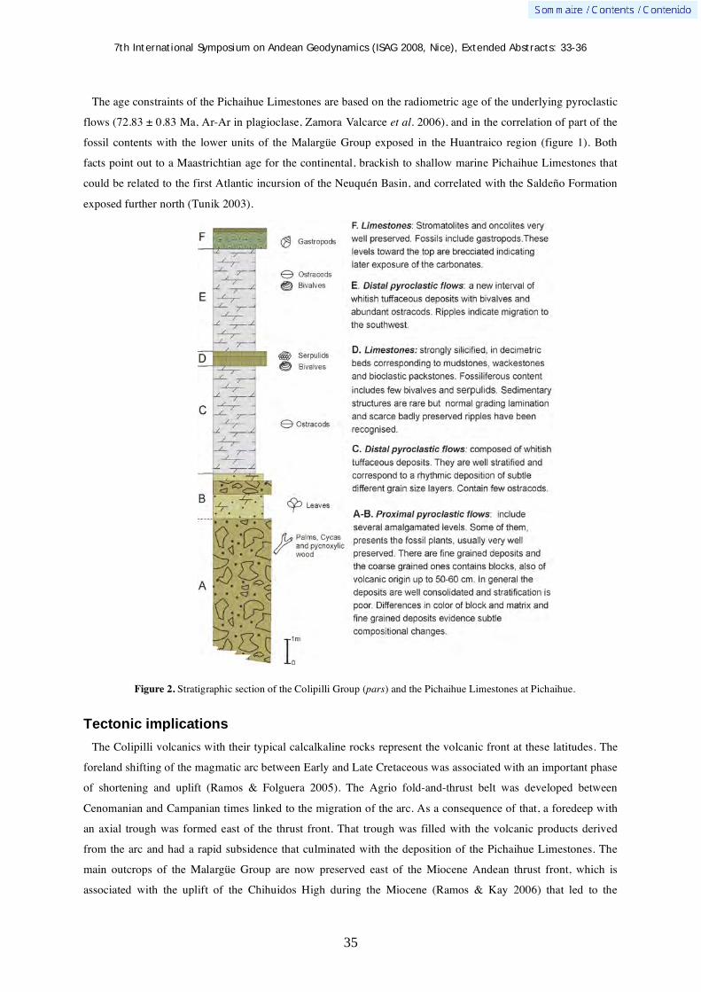
7th International Symposium on Andean Geodynamics (ISAG 2008, Nice), Extended Abstracts: 33-36
35
The age constraints of the Pichaihue Limestones are based on the radiometric age of the underlying pyroclastic
flows (72.83 ± 0.83 Ma, Ar-Ar in plagioclase, Zamora Valcarce et al. 2006), and in the correlation of part of the
fossil contents with the lower units of the Malargüe Group exposed in the Huantraico region (figure 1). Both
facts point out to a Maastrichtian age for the continental, brackish to shallow marine Pichaihue Limestones that
could be related to the first Atlantic incursion of the Neuquén Basin, and correlated with the Saldeño Formation
exposed further north (Tunik 2003).
Figure 2. Stratigraphic section of the Colipilli Group (pars) and the Pichaihue Limestones at Pichaihue.
Tectonic implications
The Colipilli volcanics with their typical calcalkaline rocks represent the volcanic front at these latitudes. The
foreland shifting of the magmatic arc between Early and Late Cretaceous was associated with an important phase
of shortening and uplift (Ramos & Folguera 2005). The Agrio fold-and-thrust belt was developed between
Cenomanian and Campanian times linked to the migration of the arc. As a consequence of that, a foredeep with
an axial trough was formed east of the thrust front. That trough was filled with the volcanic products derived
from the arc and had a rapid subsidence that culminated with the deposition of the Pichaihue Limestones. The
main outcrops of the Malargüe Group are now preserved east of the Miocene Andean thrust front, which is
associated with the uplift of the Chihuidos High during the Miocene (Ramos & Kay 2006) that led to the
7th International Symposium on Andean Geodynamics (ISAG 2008, Nice), Extended Abstracts: 33-36
36
probable erosion of the marine deposits in the western central part of the basin as depicted in figure 1. The rapid
subsidence of the axial trough linked to a high sea-level in Maastrichtian times allowed the sedimentation of the
limestones in the upper part of the trough. Subsequent deformation shifted the thrust front to the present location.
Concluding remarks
The finding of continental and brackish to marine Pichaihue Limestones in the Agrio fold-and-thrust belt
indicates that the first marine transgression derived from the Atlantic ocean had a much wider distribution in the
central part of Neuquén, and probably covered a large part of the basin. This change from Pacific transgression
to Atlantic ones that has been traditionally related to a regional tilting of the basin is clearly a consequence of the
thrust loading of the Principal Cordillera during Campanian to Maastrichtian times.
References Barrio, C.A., 1990 Paleogeographic control of the Upper Cretaceous tidal deposits, Neuquén Basin, Argentina. Journal of
South American Earth Sciences 3: 31-49. Bertels, A., 1972. Ostrácodos de agua dulce del miembro inferior de la Formación Huantrai-Co (Maastrichtiano Inferior),
Provincia del Neuquén, República Argentina. Ameghiniana 9: 173-182. Legarreta, L. & Gulisano, C., 1989. Análisis estratigráfico secuencial de la Cuenca Neuquina (Triásico superior-Terciario
inferior). In G. Chebli & L. Spalletti (eds.) Cuencas Sedimentarias Argentinas. Facultad de Ciencias Naturales, Universidad Nacional de Tucumán, Correlación Geológica Serie 6: 221-243.
Legarreta, L. & Uliana, M.A., 1991. Jurassic-Cretaceous marine oscillations and geometry of back-arc basin fill, central Argentine Andes. International Association of Sedimentology, Special Publication 12: 429-450.
Legarreta, L., Kokogian, D.A. & Boggetti, D.A., 1989. Depositional sequences of the Malargüe Group (Upper Cretaceous-lower Tertiary), Neuquén Basin, Argentina. Cretaceous Research 10: 337-356.
Llambias, E.J. & Rapela, C.W., 1989. Las vulcanitas de Colipilli, Neuquén (37ºS) y su relación con otras unidades paleóge-nas de la Cordillera. Revista de la Asociación Geológica Argentina 44: 224-236. Leanza, H.A., Repol, D. Hugo, C.A. & Sruoga, P., 2006. Hoja Geológica 3769-31 Chorriaca, provincia del Neuquén.
Servicio Nacional Geológico Minero, Boletín 354: 1-93. Ottone, E.G., 2007. A new palm trunk from the Upper Cretaceous of Argentina. Ameghiniana 44: 719-725. Ramos, V.A., 1999. Plate tectonic setting of the Andean Cordillera Episodes 22(3): 183-190. Ramos, V.A. & Folguera, A., 2005. Tectonic evolution of the Andes of Neuquén: Constraints derived from the magmatic arc
and foreland deformation In G. Veiga, L. Spalletti, D. Howell & E. Schwarz (eds.) The Neuquén Basin: A case study in sequence stratigraphy and basin dynamics. The Geological Society, Special Publication 252: 15-35.
Ramos, V.A. & Kay, S.M., 2006. Ramos, V.A. y S.M. Kay, 2006. Overview of the Tectonic Evolution of the Southern Central Andes of Mendoza and Neuquén (35°- 39°S Latitude). In S.M. Kay & V.A. Ramos (eds.) Evolution of an Andean margin: A tectonic and magmatic view from the Andes to the Neuquén Basin (35°–39°S latitude). Geological Society of America, Special Paper 407: 1-18.
Tunik, M., 2001. La primera ingresión atlántica de la Alta Cordillera de Mendoza. Ph. D. Thesis, Universidad de Buenos Aires (unpublished) 258 pp.
Tunik, M., 2003. Interpretación paleoambiental de los depósitos de la Formación Saldeño (cretácico superior), en la alta Cordillera de Mendoza, Argentina. Revista de la Asociación Geológica Argentina 58: 417-433.
Uliana, M.A. & Dellapé, D.A., 1981. Estratigrafía y evolución paleoambiental de la sucesión Maastrichtiana-eoterciaria del engolfamiento Neuquino (Patagonia Septentrional). 8° Congreso Geológico Argentino (San Luis), Actas 3: 673-711.
Weaver, C., 1927.The Roca Formation in Argentina. American Journal of Science 13(5): 417-434. Zamora Balcarce, G., Zapata, T., Del Pino, D. & Ansa, A. 2006. Strucutral evolution and magmatic characteristics of the
Agrio fold-and-thrust belt. In S.M. Kay & V.A. Ramos (eds.) Evolution of an Andean margin: A tectonic and magmatic view from the Andes to the Neuquén Basin (35°–39°S latitude). Geological Society of America, Special Paper 407: 125-145.

7th International Symposium on Andean Geodynamics (ISAG 2008, Nice), Extended Abstracts: 37-40
37
Paleoseismic investigation on the Boconó fault between Las González and Estanques, Mérida Andes, Venezuela
Miguel J. Alvarado1, Franck A. Audemard
2,*, Jaime Laffaille
3, Reinaldo J. Ollarves
2, & Luz M.
Rodríguez2
1 Universidad de Los Andes, Grupo de Investigación Ciencia de la Tierra TERRA, Mérida, Venezuela
([email protected]) 2 Fundación Venezolana de Investigaciones sismológicas FUNVISIS, Caracas, Venezuela
([email protected]) 3 Universidad de Los Andes, Fundación para la Prevención del Riesgo Sísmico FUNDAPRIS, Mérida, Venezuela
* presenting author
Introduction
The Boconó fault is the largest active structural feature in the Venezuelan Andes, to which most of the main
historical earthquakes in the region have been assigned. This fault runs in a NE-SW direction, roughly along the
Andean chain backbone for about 500 km. Several crustal depressions related to the right-lateral fault activity
have been identified and described as “pull-apart basins”. Las González pull-apart basin (LGPAB) is the major
of these features (Schubert 1982). It is located in the southwest of the Mérida Andes range, between Las
Gonzalez and Estanques towns in Mérida State, Venezuela. A detailed morpho-structural mapping of this zone
was made by Alvarado et al. (2006). They concluded that only the north trace of this pull-apart basin is active.
Furthermore, they identified a small pull-apart basin along this trace that named the “Lagunillas Pull-part basin”
(LGPB). The objective of this work is to understand the seismogenic behavior of the Boconó fault in this area
through the analysis of paleo-earthquakes, based on two trenches named Pantaleta and Quinanoque, excavated
across the north and south trace of LGPB respectively (figure 1).
Figure 1. Sketch that shows the location of the Pantaleta and Quinanoque trenches across the active trace of Boconó fault between La Gonzalez and Estanques.
Paleoseismic Investigation
Trench sites were chosen taking into account the factors and conditions presented by Audemard (2003).
Technical issues on trench development used in this work are widely discussed in McCalpin (1996).
GRAFIC SCALE
Quinanoque trench
Pantaleta trench

7th International Symposium on Andean Geodynamics (ISAG 2008, Nice), Extended Abstracts: 37-40
38
Pantaleta trench
Located across the north trace of LGPB (figure 1), north of Lagunillas town, where a little sagpond generated
by a shutter ridge marks the active trace of the Boconó fault at this specific location. The sedimentary deposits
exposed in this trench comprise from bottom to top: a poor sorted basal conglomerate with clast diameter
between 4cm and 33cm contained within a red-sandy matrix, overlain by a black 30-cm-thick organic-rich sandy
silt that corresponds to the sag-pond.
Sedimentary features found in this stratigraphic sequence denote the presence of an active trace and the
occurrence of several earthquakes. Figure 2 displays a detailed log of the trench walls, on which sampling points
for 14C dating are also reported. Each point is accompanied with its respective 14C radiometric age, that was
calibrated to calendar year (dendrochronologic method) with a 95% accuracy.
Figure 2. Detailed logs of both walls of the Pantaleta Trench, across the northern strand of the Boconó fault, at the Lagunillas pull-apart basin.

7th International Symposium on Andean Geodynamics (ISAG 2008, Nice), Extended Abstracts: 37-40
39
Analysis made in this trench shows the presence of several pre-historical seismic events, and particularly of 3
earthquakes that were reported in historical seismic catalogs (Centeno-Graü, 1940, Grases et al., 1999). The
1610 and 1894 earthquakes were reported by Soulas et al. (1987, in Audemard et al., 1999), for which they built
an isoseismal map that shows its macroseismic hypocenter over the Boconó fault, close to the trench. Audemard
(1997) corroborated through trenching investigations carried out farther southwest in the Andes that both events
happened on the Boconó fault, specifically on the strand that extends from the north of the Lagunillas pull-apart
basin to the southwest. In addition, the 1674 earthquake studied by Palme y Altez (2002), which had never been
previously associated with the Boconó fault, also appears to be present on this trench.
Two seismic recurrence patterns have been identified: the first one is roughly 850-650 years (for pre-historical
earthquakes); and the second pattern seems to be about 280 years (for historical earthquakes).
Quinanoque trench
It was excavated on the southern splay of the Boconó fault at the LGPB, slightly to the west of the Lagunillas
town (figure 1). The fault trace in this place is marked by pressure ridges, spring (tree) lines and a big sag pond
(like the actual lake placed in the Lagunillas town). The Urao lake has also been dammed by a shutter ridge that
has been progressively displaced by dextral slip along the southern active fault splay.
The stratigraphic sequence as described from the trench’s wall, from bottom to top comprises a poorly sorted
basal conglomerate with clast diameter between 1 and 25 cm contained into a sandy matrix. There is a moderate
sorted conglomerate above, which represents a colluvial bed, in turn overlain by an organic-rich sandy silt bed
(figure 3).
Figure 3. Logging of the east and west walls of the Quinanoque Trench, cut across the southern strand of the Boconó fault, at the Lagunillas pull-apart basin..

7th International Symposium on Andean Geodynamics (ISAG 2008, Nice), Extended Abstracts: 37-40
40
More evidences of seismic activity are exposed in this trench than in the La Pantaleta one. Several paleo-
earthquakes including the 1674 historical earthquake were interpreted (figure 3). Some sample points have been
labeled as “recent”, meaning that some levels in the sedimentary sequence have been rejuvenated by present-day
14C. These levels are interpreted as either free-sliding surface on which the lagoon sediments moved during
earthquake shaking or open crack or piping that allowed ventilation of buried paleo-soils. The estimated
earthquake recurrence interval for the south strand of the Boconó fault at the LGPB is 400-450 years
approximately.
Acknowledgements
We would like to thanks all those that in one way or another contributed with this investigation. Special thanks go to Prof. Carlos Ferrer, Geol. Reina Aranguren and the students from the School of Geophysics of Universidad de Los Andes (ULA) who helped to prepare trench walls. We are very grateful to the land owners who gave permits to work in their property. We are very thankful to Prof. Raúl Estevez and Christl Palme who honoured us by visiting the trench sites. This research is a contribution to project FONACIT 2001002492, FONACIT-ECOS Nord 2003000090 and FONACIT-2002000478 (Geodinos). Funding was provided by FONACIT 2001002492, FUNVISIS and logistics by FUNVISIS and ULA.
References Alvarado M., Audemard F. A., Laffaille J., Ferrer C. 2006. Cartografía neotectónica de la falla de Boconó entre las
poblaciones de La González y Estanques, Estado Mérida, para fines de identificación de sitios propicios para excavaciones paleosísmicas. Informe Interno de FUNVISIS, 36 pp.
Audemard, F. A., 1997. Holocene and Historical Earthquakes on the Boconó Fault System, Southern Venezuelan Andes: Trench Confirmation. In: Hancock, P. & Michetti, A. (eds.), Paleoseimology: understanding the past earthquakes using Quaternary Geology. Symposium on Paleoseimicity at the XIV INQUA Congress, Berlin, August 1995. Journal of Geodynamics. 24 (1-4): 155-167.
Audemard F. 1999. Trench investigation along Mérida section of the Boconó Fault (central Venezuela Andes),
Venezuela. Tectonophysics 308, 1-21
Audemard, F. 2003. Estudios paleosísmicos por trincheras en Venezuela: métodos, alcances, aplicaciones, limitaciones y perspectivas. Revista Geográfica Venezolana 44(1), 11-46
Centeno Graü, M. (1940) Estudios Sismológicos. Litografía del Comercio, Caracas Grases, J., Altez, R., Lugo, M. 1999. Catálogo de sismos sentidos o destructores. Venezuela. 1530–1998, Academia de
Ciencias Físicas, Matemáticas y Naturales/Facultad de Ingeniería Universidad Central de Venezuela, Editorial Innovación Tecnológica
McCalpin, J.P. (Ed.), 1996. Paleoseismology. Academic Press, London (583 pp.). Palme C., Altez R. 2002. Los terremotos de 1673 y 1674 en los Andes venezolanos. Interciencias 27, 5. Schubert, C., 1982. Cuencas de tracción en los Andes merideños y en las montañas del Caribe, Venezuela. Acata Científica
Venezolana 33, 389-395.
7th International Symposium on Andean Geodynamics (ISAG 2008, Nice), Extended Abstracts: 41-43
41
Seismic source study and tectonic implications of the historic 1958 Las Melosas, Central Chile, crustal earthquake
Patricia Alvarado1,2
, Sergio Barrientos3, Mauro Saez
2, Maximiliano Astroza
4, & Susan Beck
5
1 CONICET (e-mail: [email protected])
2 Departamento de Geofísica y Astronomía, Facultad de Ciencias Exactas, Fisicas y Naturales, Universidad
Nacional de San Juan, Meglioli 1160 (S) Rivadavia, San Juan, Argentina 3 Servicio Sismológico Nacional, Universidad de Chile, Blanco Encalada 2002, Santiago, Chile
4 Departamento de Ingeniería Civil, Universidad de Chile, Blanco Encalada 2002, Santiago, Chile
5 Department of Geosciences, Univ. of Arizona, Gould Simpson Bldg., 1040 E 4th st. (85721) Tucson, AZ, USA
KEYWORDS : crustal seismicity, Andean Cordillera, neotectonics, seismic hazard
Although Chile is recognized as the site of the largest megathrust earthquakes related to the coupling between
the subducting Nazca plate and the overriding South American plate like the 1960 Valdivia earthquake,
infrequent crustal earthquakes within the continental plate can be very damaging. The earthquake on
4 September 1958 that occurred in Las Melosas, Central Chile (-33.826°S and -70.140°W; Engdalh et al., 1998)
represents one of the large damaging intraplate events located in the Andean cordillera crust at about 60 km
away from Santiago. In this study, new estimates of fault orientation, depth and size using teleseismic body-
wave modeling of the 1958 Las Melosas earthquake are presented (Fig. 1). Although global seismic catalogues
(BSSA, 1959) include only one earthquake on 4 September 1958, Lomnitz (1960), Piderit (1961) and Pardo and
Acevedo (1984) have reported the occurrence of more than one seismic event (at least three) separated by a few
minutes and of similar sized-magnitudes. In fact, these authors assigned a 6.9 magnitude for the three sub-
events, but Flores et al. (1960) reported 6.9, 6.7 and 6.8, respectively. These estimations of the seismic
magnitudes are mainly based on historical intensity reports (Lomnitz, 1970).
Our results for the first event in the sequence of earthquakes on 4 September 1958 that occurred in Las
Melosas indicate a focal mechanism solution with fault planes of right-lateral displacement on an east-west fault
and left-lateral displacement on a north-south fault and a focal depth of 8 km produce the best fit to teleseismic
long period P-waveforms (Fig. 1). A seismic moment M0 of 0.227 x 10¹⁹ N-m associated with a moment-
magnitude Mw of 6.3 has been estimated, which is 0.4 to 0.7 units larger than the surface-wave magnitude Ms
earlier reported. Although no surface rupture was reported, the displacement along east-west structures like that
one suggested for one of the fault plane in our focal mechanism solution of the 1958 event seems to be an
efficient mechanism to accommodate differences in shortening from north to south along the high Andean
Cordillera (Alvarado et al., 2008). New findings on the 1958 Las Melosas earthquake intensities by Sepúlveda et
al. (2008) allow us to compare them with our study about the seismic source of this crustal event in order to put
more constraints on the seismic hazard to which this zone, and others along the western foothills of the Andes, is
exposed.

7th International Symposium on Andean Geodynamics (ISAG 2008, Nice), Extended Abstracts: 41-43
42
Figure 1. Best results for the seismic source study of the 1958 Las Melosas earthquake modified from Alvarado et al. (2008). (a) Example of a vertical component seismogram recorded at 76° epicentral distance by the station TUC (Tucson, U.S.A.) for the sequence of earthquakes on 4 September 1958. Three different seismic events (E1, E2 and E3) are observed in a time window of 4 to 5 minutes. Event E1 with a clear arrival is the only one modeled in this study. (b) Distribution of seismic stations used in this study with respect to the 1958 earthquake epicentral location.(c) Our preferred focal mechanism solution (fault plane_1: strike N20°E, dip 70°to the southeast and rake 30°; fault plane_2: strike N80°W, dip 62°to the north and rake 157°) plotted as a lower-hemisphere projection with dark compressional quadrants and P-wave seismic records. (d) Synthetic and observed amplitude misfit errors as a function of focal depth for the best combination of strike, dip and rake and variable focal depth (from 0 to 20 km). (e) Relocated seismicity between 1995 and 2005 from Barrientos et al. (2004). (f) Map of the MSK seismic intensities recalculated by Sepúlveda et al. (2008).

7th International Symposium on Andean Geodynamics (ISAG 2008, Nice), Extended Abstracts: 41-43
43
References Alvarado, P., Barrientos, S., Saez, M., Astroza, M., and Beck, S., 2008, Source study and tectonic implications of the historic
1958 Las Melosas crustal earthquake, Chile, compared to earthquake damage, Physics of the Earth and Planetary Interiors, Special Issue “Earthquakes in subduction zones: a multidisciplinary approach” (in press).
Barrientos, S., Vera, E., Alvarado, P. and Monfret, T., 2004, Crustal seismicity in Central Chile, J. South Am. Earth Sci., 16, 759-768.
BSSA, 1959, Seismological notes, Bulletin of the Seismological Society of America, 49(1): 115-118. Engdahl, E.R., van der Hilst, R.D. and Buland, R., 1998, Global teleseismic earthquake relocation with improved travel times
and procedures. Bull. Seism. Soc. Amer., 88, 722-743. Flores, R., Arias, S., Jenshke, V. and Rosenberg, L.A., 1960, Engineering aspect of the earthquakes in the Maipo Valley,
Chile, in 1958, Proceedings of 2nd World Conference in earthquake Engineering, Japan, Vol. 1, pp 409-431. Lomnitz, C., 1960, A study of the Maipo Valley earthquakes of September 4, 1958, Proc. 2nd World Conf. Earthq. Eng.,
Tokyo-Kyoto, Japan, 1, 501-520. Lomnitz, C., 1970, Casualties and behavior of populations during earthquakes, Bull. Seism. Soc. Amer., 60(4): 1309-1313. Pardo, M. and Acevedo, P., 1984, Mecanismos de foco en la zona de Chile Central, Tralka 2 (3), 279-293. Piderit, E., 1961, Estudios de los sismos del Cajón del Maipo en el año 1958, Memoria para optar al Título de Ingeniero
Civil, Facultad de Ciencias Físicas y Matemáticas, Universidad de Chile, Santiago, Chile. Sepúlveda, S., Astroza, M., Kausel, E., Campos, J., Casas, E., Rebolledo, S. and Verdugo, R., 2008, New findings on the
1958 Las Melosas earthquake sequence, Central Chile: implications for seismic hazard related to shallow crustal earthquake in subduction zones, Journal of Earthquake Engineering, 12: 432 – 455. DOI: 10.1080/13632460701512951

7th International Symposium on Andean Geodynamics (ISAG 2008, Nice), Extended Abstracts: 44-47
44
Dendrochronology of the Central Andes of Bolivia
Jaime Argollo1, Claudia Solís
1, & Ricardo Villalba
2
1 Laboratorio de Dendrocronologia, Instituto de Investigaciones Geológicas y del Medio Ambiente, Universidad
Mayor de San Andrés, La Paz, Bolivia 2 Departamento de Dendrocronología e Historia Ambiental, IANIGLA, Mendoza, Argentina
Resumen En este trabajo se analiza la historia dendroclimatológica de Polylepis tarapacana (queñoa), pequeño arbolito que habita el
Altiplano Boliviano y zonas adyacentes de Perú, Chile y Argentina (16-22°S) entre los 4000 y 5200 m de altura. Muestras dendrocronológicas fueron colectadas sobre las laderas de los volcanes: Sajama y Caquella. Hasta el presente, las cronologías varían entre 98 y 705 años de extensión y constituyen los registros dendrocronológicos más altos del mundo.
Con el objeto de establecer los parámetros climáticos que controlan el crecimiento de P. tarapacana, las variaciones interanuales en el crecimiento de los árboles fueron comparadas con registros regionales de precipitación y temperatura. Las funciones de correlación indican que el crecimiento radial de P. tarapacana está regulado por la precipitación durante el verano previo al ciclo de formación del anillo de crecimiento. En los sitios muestreados la precipitación explica aproximadamente el 50% de las variaciones interanuales en el crecimiento. Las temperaturas más elevadas del verano, que aumentan la evapotranspiración y reducen el agua en el suelo, están negativamente correlacionas con el crecimiento. La longevidad que alcanzan estos registros y su fuerte relación con el clima permitirán reconstruir las variaciones de la precipitación en el Altiplano durante los últimos 5-7 siglos.
Abstract
In this paper we analized the dendroclimatological history of Polylepis tarapacana (queñoa), an small tree growing in the Bolivian Altiplano and adjacent areas of Peru, Chile and Argentina (16-22°S) between 4000 and 5200 m elevation. Dendrocronological samples were collected on the slopes of the volcanoes: Sajama and Caquella. Presently, the chronologies range between 98 and 705 years in length, and represent the highest tree-ring records worldwide. In order to determine the climatic variables controlling P. tarapacana growth, interannual variations in tree growth were compared with regional records of precipitation and temperature. Correlation functions indicate that the radial growth of P. tarapacana is influenced by precipitation during the summer previous to the ring formation. In the sampling sites, precipitation explains around 50% of the total variance in growth. Summer temperatures, which increase evapo-transpiration and reduce soil water supply, are negatively correlated with tree growth. These records offer the unique opportunity for reconstructing precipitation variations across the Altiplano during the past 5-7 centuries.
Introduction
At the biogeographical Andean region in Bolivia, Polylepis is distributed in the sub region yungueña and sub
region puneña above 3000 m and up to 5000 m. Nine species and 8 subspecies are distributed in the Bolivian
Andes (Kessler, 1995).
In this study, we evaluate the dendrochronological potentiality of Polylepis tarapacana Philippi, that is widely
distributed in the Cordillera Occidental de Bolivia. This study set down the presence of growth rings in P.
tarapacana and its annual feature. The similitude between annual variations in the width of the rings from trees
from the same site has allowed us the development of two chronologies at the Bolivian Altiplano. Finally, to
establish the climatic variations that control the radial growing, we determinated the relations between monthly
climate variations and the growing of Polylepis tarapacana at the Bolivian Puna using correlation functions.
Polylepis tarapacana forests in Bolivia
Polylepis tarapacana appears as a little 1 to 3 m high tree or bush that grows between 4000 and 5200 m of
elevation on the biogeographical floor of the Puna in Peru, Bolivia, Chile and Argentina (Kessler 1995, Fjeldsa y

7th International Symposium on Andean Geodynamics (ISAG 2008, Nice), Extended Abstracts: 44-47
45
Kessler, 1996, Braun 1997). This bioclimatic floor extends trough the Altiplano and is delimited for the
Cordillera Oriental and Cordillera Occidental. The superior bound of distribution that reaches this specie
represents the maximum altitude in the world to an arborescent shape. This species grows in arid environments
with a range of annual precipitation between 250 and 500 mm, where frost is common the whole year (Fjeldså y
Kessler, 1996)
P. tarapacana forests are located at the hillsides of extinguished volcanoes. They develop next to the common
vegetation of the dry Puna. This forests contribute to the increasing of the soil water retention, decrease erosion
by regulating the water runoffs and help to the storage of sediments and nutrients. Besides, they are refuge and
food source to many animal species, and facilitate the growing of several plants (Fjeldsa y Kessler 1996). These
forests have been an important resource to the Altiplano population since they provide wood for house
constructions and firewood for peasants’ works tames.
At present time, Polylepis forests are fragmented in small surfaces as a result of the degradation and alteration
processes as a result of product of many centuries of human intervention. In this way, these forests´s animal and
vegetation biodiversity are seriously threatened by the negative effects of human activity.
Methods and materials
Sites of study.
The studied Polylepis tarapacana forests are located at the Western and South region of the Bolivian
Altiplano. The northest site is at 4750 m near to the Sajama Volcano (18°09’S, 69°00’W) and Caquella
(21°30’S, 67°52’W) at 4560 m of altitude. These two sites are inactive volcanic complex of Superior Mioceno to
Pelistoceno age, consisting of lava flows rocks and pyroclastic. These volcanic mass have been affected by the
Superior Pleistocene Age glacier activity (Clapperton et al. 1997). Small P.tarapacana vegetation units develop
on poor soils product of rocks physical weathering, mainly cryogenic, which form talus debris where vegetation
grows. In the same way these trees develop on volcanic rock fracture, as much as on glacier deposits. These
forests portions are established on slopes that vary from 20 to 40 grades sloping
Establishment of chronologies
After the co-dating phase, the width of the rings had been measured with 0.001mm precision, generating
temporal series for each tree. Measurement and co-date quality had been controlled with the support of the
program COFECHA (Holmes 1983). This program used correlation analysis to compare each series with a
master series compound by the rest of the dated samples from a site.
In this way, it is possible to detect missing or false rings in a particular sample. After the dating control, the
chronologies were constructed for each site using the program ARSTAN that eliminates the biologic growing
trends, and minimizes the uncommon growing variations (Cook y Holmes 1986). The biologic trends in the
width of ring series were modelated using lineal regressions or negative exponential graphs. These standardized
series were finally averaged to obtain the media chronology for each site. Therefore, the chronologies constitute
a temporal series representing the radial growing annual variations of Polylepis tarapacana on each sampled
sites.
7th International Symposium on Andean Geodynamics (ISAG 2008, Nice), Extended Abstracts: 44-47
46
Results
Chronologies
The two chronologies developed from the Polylepis tarapacana extend between 98 and 705 years, being the
Sajama and Caquella chronologies the shorter and more extended respectively. The number of trees in each
chronology varies between 19 and 25. Values of medium sensibility (a statistical used to evaluate the interannual
variability in the rings width) are similar to those described to other subtropical species in South America
(Villalba et al.,1987, 1992) and relatively greater than those of tempered and cold zones species (Bonisegna
1992).
There is a clear common sign between both chronologies. A correlation’s matrix between the two records for
the common period 1902-1999, shows that all of them are correlated significantly.
Climate – radial growth relation
Exist great similitude in correlation functions between the radial growth of Polylepis tarapacana and the
interannual variations of precipitation and temperature in different studied sites of the Bolivian Altiplano
(Argollo et, al. 2004).
Discussion and conclusions
Dendrochronological records of South America are principally from template and cold regions of Argentina
and Chile (Boninsegna and Villalba 1996, Villalba 2000). Sub tropical records are fewer. In northeast of
Argentina, chronologies were developed from forest species between 22 and 28ºS (Villalba et al. 1992, 1998). In
contrast with the high latitudes records, sub tropical chronologies are shorter, rarely overcoming 300 years of
extension. Polylepis tarapacana, a characteristic species from the Bolivian Altiplano, give us new regional
perspectives in the tropical dendrochronology field work. Our researches show that some trees can reach more
than 500 years and that it’s possible to co-date death wood, it’s been allowed until now to elaborate chronologies
of more than 7 centuries of extension. P. tarapacana grows in altitudes higher than 4000 m, in some areas it can
reach 5200 m. For this reason, chronologies developed from this specie represent the more elevated
dendrochronological records of the world. The statistics used traditionally to measure the quality of the
dendrochronologic series show that P. tarapacana chronologies are adequate to reconstruct the past climatic and
environmental variations. Because of the similitude in the growth standard between chronologies along the
Altiplano, these records can also be used as reference chronologies to date archeological material.
P. tarapacana presents marked growth rings. However, it’s very important to consider attributes like quality of
polishing, illumination and perpendicularity of the woody plan in relation with the examined area to achieve a
better growth rings definition. The coincidence in the chronologic sequence of wide and tight rings between
woods of the same place and between places along the Altiplano shows us that the P. tarapacana rings are
bounded to an annual growing seasonal cycle. Another confirmation of the annual nature of the rings in P.
tarapacana is the relation of themselves with the annual climate variations. The yearly precipitations in
Altiplano show an extensive wintry period where there is little rain or there isn’t any. This dry period coincide to
the period of lower temperatures in the year and the period of more daily thermical amplitude

7th International Symposium on Andean Geodynamics (ISAG 2008, Nice), Extended Abstracts: 44-47
47
In general, in the resulting functions the number of months significantly correlated with rings width is bigger
for temperature than for precipitation, even when we should wait more influence from precipitation than from
temperature in the P. tarapacana growth considering the arid conditions.
It’s possible to see that P. tarapacana that grows in the Altiplano is strongly controlled by variability of
summer rains. Centennial dendrochronologic records, with strong climatic indication offer the opportunity to use
themselves to rebuild the past variations of precipitation in the Bolivian Altiplano during the last 500-700 years.
Acknowledgements To the economic support provided by the Interamerican Institute for the Study of Global Change Project (IAI), CRN03
“The Assessment of Present, Past and Future Climate Variability in the Americas from Treeline Environments” and to the IRD for their logistic support.
References Argollo, J., Soliz, C., Villalba, R. 2004. Potencialidad dendrocronologica de Polylepis tarapacana en los Andes Centrales de
Bolivia. Ecologia de Bolivia pg. 4-22 Boninsegna, J.A., y R. Villalba. 1996. Dendroclimatology in the Southern Hemisphere: Review and Prospect. Tree Rings,
Environment and Humanity, editado por J.S. Dean, D.M. Meko, and T.W. Swetnam. Radiocarbon, pp. 127-141 Boninsegna JA (1992) South American dendroclimatological records. In Bradley RS, Jones PD (eds) Climate since A.D.
1500. Routledge, London pp 446-462. Braun, G. 1997. Métodos digitales para monitorear patrones boscosos en un ambiente andino: El ejemplo Olylepis. In
desarrollo sostenible de Ecosistemas de Montaña: manejo de areas frágiles en los Andes (eds M. Liberman-Cruz & Baied), pp 285-294. The United Nations University press, La Paz
Clapperton M. C., Clayton D. J., Benn I. D., Marden J. C., Argollo, J. 1997. Late Quaternary glacier advances and Palaeolake highstands in the Bolivian Altiplano. Quaternary International, 38/39: 49-59.
Cook,E.R.& R.L Holmes 1986.Users manual for program ARSTAN. Chronology Series VI, University of Arizona. Fjedsa, J. y M. Kessler. 1996. Conserving the biological diversity of Polylepis woodlands of the Highland of Peru and
Bolivia. NORDECO. Copenhagen, Dinamarca. Holmes, R:L. 1983. Computer-assisted quality control in tree-ring dating and measurement. Tree-Ring Bulletin 43, 69-78 Kessler, M. 1995. The genus Polylepis (Rosaceae) in Bolivia. Candollea 50. Conservatore et Jardin Botaniques de Geneve.
172 pp. Villalba, R. 2000. Dendroclimatology: a Southern Hemisphere Perspective. En: Paleo- and Neoclimates of the Southern
Hemisphere: the state of the arts. P. Smolka y W. Volkheimer (editores). Springer. Pag. 28-57. Villalba, R., Holmes, R.L., y Boninsegna, J.A. 1992. Spatial patterns of climate and tree-growth anomalies in subtropical
Northwestern Argentina. Journal of Biogeography, 19: 631-649. Villalba, R., Grau, H.R., Bonisegna, J.A., Jacoby, G.C. y Ripalta, A. 1998. Climatic variations in subtropical South America
inferred from upper-elevation tree-ring records. International Journal of Climatology, 18: 1463-1478. Villalba, R.; Boninsegna, J.A. and Ripalta, A. 1987. Climate, site conditions and tree-growth in subtropical northwestern
Argentina. Canadian Journal of Forest Research, 17 (12): 1527-1544.

7th International Symposium on Andean Geodynamics (ISAG 2008, Nice), Extended Abstracts: 48-51
48
An Andean mega-thrust synthetic to subduction?: The San Ramón Fault and associated seismic hazard for Santiago (Chile)
R. Armijo1, R. Rauld
2, R. Thiele
3, G. Vargas
3, J. Campos
2, R. Lacassin
1, & E. Kausel
2
1 IPGP- 4, Place Jussieu, 75252 Paris Cedex 05, France ([email protected], [email protected])
2 Departamento de Geofísica, Facultad de Ciencias Físicas y Matemáticas, Universidad de Chile, Blanco
Encalada 2002, Santiago, Chile ([email protected], [email protected], [email protected]) 3 Departamento de Geología, Facultad de Ciencias Físicas y Matemáticas, Universidad de Chile, Plaza Ercilla
803, Santiago, Chile ([email protected], [email protected])
KEYWORDS : subduction margin, Andean orogeny, synthetic thrust, seismic hazard
The Andean orogeny is considered the paradigm for mountain belts associated with subduction plate
boundaries (e.g., James, 1971). Yet, no mechanical model can explain satisfactorily the Andean mountain
building process as a result of forces applied at its nearby Subduction Margin, along the western flank of the
South America continent (e.g., Lamb, 2006). Part of the problem arises from a geometric ambiguity that is
readily defined by the large-scale topography (Fig. 1): the Andes mountain belt is a doubly vergent orogen that
has developed a large Back-Thrust Margin at its eastern flank, with opposite (antithetic) vergence to the
Subduction Margin. The tectonic concept of Subduction Margin used here is equivalent to the pro-flank (or pro-
wedge) concept used for collisional belts (e.g., Willett et al., 1993) and is preferred to the magmatic concept of
fore-arc, which has nearly coincident horizontal extent (Fig. 1). Similarly, the notion of Back-Thrust Margin is
used as an equivalent to that of retro-flank (or retro-wedge) in collisional belts.
The doubly vergent structure of the Andes mountain belt is defined by distinct orogenic thrust boundaries at
the East and West Andean Fronts (Fig. 1). While the East Andean Front coincides with the basal thrust of the
Back-Thrust Margin, the orogenic West Andean Front is located at significant distance from the basal mega-
thrust of the Subduction Margin. The western foreland (~200 km wide horizontally) separating the orogenic
West Andean Front from the subduction zone is designated here as the Marginal (or Coastal) Block.
Consequently a fundamental mechanical partitioning occurs across the Subduction Margin and the Marginal
Block, between the subduction interface, a mega-thrust that is responsible of significant short-term strains and
the occurrence of repeated large earthquakes, and the West Andean Front thrust that appears important in regard
to the long-term cumulative deformation and other processes associated with the Andean orogeny. However,
very few specific observations are available at present to describe and to model this fundamental partitioning.
It is generally admitted that the high elevation of the Andes and of the Altiplano Plateau result from crustal
thickening (up to ~70 km thickness), which is associated with significant tectonic shortening (up to ~150-300 km
shortening) and large-scale thrusting of the Andes over the South-American craton, at the Back-Thrust Margin
(e.g., Kley et al., 1999). On the other hand, the role of the Subduction Margin and of the West Andean Front in
the thickening processes is often considered negligible (Isacks, 1988). Yet the Andean Subduction Margin stands
as one of the largest topographic contrasts on Earth (up to ~12 km), substantially larger than its Back-Thrust
counterpart (Fig. 1). The present study is aimed at revising our knowledge of the large-scale tectonics of the
Andes and its interaction with subduction processes. So we specifically deal with the overlooked West Andean

7th International Symposium on Andean Geodynamics (ISAG 2008, Nice), Extended Abstracts: 48-51
49
Front associated with the Subduction Margin and we attempt to reassess its relative importance during the
Andean orogeny.
Figure 1. Topography and very rough geology of the Central Andes. Red box locates Fig. 2. Square marked with S locates Santiago. The main tectonic features are identified on two selected profiles (A and B, traces marked in red at 20°S and 33.5°S). Vertical black arrows indicate the present-day Volcanic Arc. The Subduction Margin (synthetic to subduction) coincides with fore-arc extent. The Sub Andean Belt in profile B is part of the Back-Thrust Margin, (antithetic to subduction). The Principal Cordillera (PC) includes the Aconcagua Fold Thrust Belt (AFTB), both made of volcanic/sedimentary rocks of the Andean Basin (AB) overlying basement of the Frontal Cordillera (FC). The relatively shallow Cuyo Basin (CB) overlies the basement of the Proto-Precordillera (PP). The Marginal Block is formed of Central Depression (CD), Coastal Cordillera (CC) and Continental Margin (CM). Profile B depicts in light colours major crustal features deduced from the geology: Triassic and pre-Triassic continental basement (brown), post-Triassic basins (yellow) and oceanic crust (blue). The deep basin represented in the two profiles (A and B) is the Andean Basin (AB) that is crossed by the trace of the West Andean Front. VP is Valparaíso Basin. Vertical exaggeration in profiles is 10. Map and profiles based on

7th International Symposium on Andean Geodynamics (ISAG 2008, Nice), Extended Abstracts: 48-51
50
topographic data from the NASA Shuttle Radar Topography mission (SRTM) and a global grid bathymetry available at http://topex.ucsd.edu/WWW_html/srtm30_plus.html.
Figure 2. Morphology and structure of the West Andean Front at Santiago. 3D view of DEM with Landsat 7 imagery overlaid. Oblique view to NE. The most frontal San Ramón Fault reaches the surface at the foot of Cerro San Ramón, across the eastern districts of Santiago. Rectangle shows approximate area mapped in Fig. 3, which gives details of the fault trace. To the East of Cerro San Ramón, Farellones Plateau is incised ~2 km by Ríos Molina-Mapocho and Colorado-Maipo, which grade to the Central Depression (Santiago basin). Red line marks trace of our E-W section (at ~33°30’S).
Figure 3. Map, satellite SPOT image and sections describing the San Ramón Fault and its piedmont scarp in the eastern districts of Santiago. Map and SPOT image cover same area, as shown in Fig. 2. Sections tentatively interpreted across the fault (labelled A and B) are located in the map. The San Ramón Fault trace is at the foot of a continuous scarp east of which the piedmont is uplifted and incised by streams. The more incised Cerros Calán, Apoquindo and Los Rulos (to the N) expose an anticline made of Early Quaternary sediments, cored by bedrock of the Abanico formation (section A). The gently sloping piedmont that is uplifted in the central part of the segment (section B) is covered with Midlle-Late Pleistocene alluvium containing lenses of volcanic ash correlated with Pudahuel ignimbrites. The map has been compiled and georeferenced at 1:25.000 scale, from original mapping on a DEM at 1:5.000 scale.

7th International Symposium on Andean Geodynamics (ISAG 2008, Nice), Extended Abstracts: 48-51
51
We analysed and revised critically the Geomorphology and the Geology of the Andes covering the region near
Santiago between ~32.5°S and ~34.5°S (Fig. 1) and focusing on morphologically active tectonic features to
assess the seismic hazard associated with the West Andean Front. Santiago nestles in the Central Depression,
which for long has been described as an extensional graben, bounded to the east and west by normal faults
(Brüggen, 1950). In our work, we show that the San Ramón Fault, crossing the eastern outskirts of Santiago, is a
major active fault with many kilometres of thrust slip (Rauld, 2002; Armijo et al., 2006). The West Andean Front
as defined by the San Ramón Fault is precisely where the Quaternary and older sediments of the Central
Depression are overthrusted by the deformed rocks of the Principal Andes Cordillera.
Our study of the San Ramón Fault aims at describing fault scarps at a range of scales (metres to kilometres)
along with uplift of datable morphological surfaces to determine slip rates over a range of ages (103 yrs to
107 yrs). We combine high-resolution air photographs and digital topographic data with a detailed field survey to
describe the morphology of the piedmont and fault scarps across it (Figs. 2 and 3). Large cumulative scarps and
single event scarps can be identified and mapped with good accuracy. Fault parameters (length of segments, fault
dip, and possible fault slip rate) can be discussed with a view to assess seismic hazard. The multi-kilometric-
scale folding of the San Ramón structure during the past tens of Myr can be used to constrain the thrust geometry
to depths down to ~10 km and more.
At the large scale, key tectonic observations were gathered and analysed critically throughout the study region,
to incorporate our observations of the San Ramón Fault into a complete tectonic section of the Andes, from the
Chile Trench to the South-American craton (see location in Figs. 1 and 2). This unifying approach allows us to
set together, strictly to scale, the most prominent Andean tectonic features, specifically the West Andean Front,
crossing the Andean Basin between the Marginal Block and the Principal Andes Cordillera. We discuss the main
results emerging from this study, particularly the true geometry and possible tectonic evolution of this segment
of the Andes, which allow us to reassess the role of the Subduction Margin and to suggest a broad range of
implications that challenge the Andean orogeny paradigm.
References Armijo, R., R. Rauld, R. Thiele, G. Vargas, J. Campos, R. Lacassin, and E. Kausel 2006. Tectonics of the western front of the
Andes and its relation with subduction processes: The San Ramón Fault and associated seismic hazard for Santiago (Chile), in International Conference Montessus de Ballore, 1906 Valparaíso Earthquake Centennial, Santiago, Chile.
Brüggen, J. 1950. Fundamentos de la Geología de Chile, Instituto Geográfico Militar, Santiago. Isacks, B.L. 1988. Uplift of the central Andean plateau and bending of the Bolivian orocline, J. Geophys. Res., 93 (B4),
3211–3231. James, D.E. 1971. Plate tectonic model for the evolution of the Central Andes, Geol. Soc. Am. Bull., 82, 3325-3346. Kley, J., C. Monaldi, and J. Salfity 1999. Along-strike segmentation of the Andean foreland: causes and consequences,
Tectonophysics, 301 (1-2), 75-94. Lamb, S. 2006. Shear stresses on megathrusts: Implications for mountain building behind subduction zones, J. Geophys.
Res., 111, B07401, doi:10.1029/2005JB003916. Rauld, R.A. 2002. Análisis morfoestructural del frente cordillerano: Santiago oriente entre el río Mapocho y Quebrada de
Macul, Memoria para optar al título de Geólogo. Departamento de Geología thesis, Universidad de Chile, Santiago. Willett, S., C. Beaumont, and P. Fullsack 1993. Mechanical model for the tectonics of doubly vergent compressional
orogens, Geology, 21 (4), 371–374.

7th International Symposium on Andean Geodynamics (ISAG 2008, Nice), Extended Abstracts: 52-55
52
Architecture and style of compressive Neogene deformation in the eastern-southeastern border of the Salar de Atacama Basin (22°30’-24°15’S): A structural setting for the active volcanic arc of the Central Andes
Felipe Aron1, Gabriel González
1, Eugenio Veloso
1, & José Cembrano
1,2
1 Universidad Católica del Norte, Av. Angamos #0610, Antofagasta, Chile ([email protected], [email protected],
[email protected]) 2 Central Andes Resources, Callao #3785, Santiago, Chile ([email protected])
KEYWORDS : Neogene tectonics, fold and thrust belt, volcanic arc, Salar de Atacama Basin, Central Andes
Introduction
Detailed field and structural mapping integrated with digital elevation models (DEM), analyses of satellite
images and previous works carried in and around the Salar de Atacama basin are used here to assess the nature
of intra-arc and inner forearc deformation of the Central Andes (between 23° and 24°S, Northern Chile), during
the development of the Andean orogen. Special emphasis was given to the Neogene tectonic evolution between
the Precordillera and the Western Cordillera (Figure 1) at the time of arc formation.
The deformation of the inner-forearc and arc of the Central Andes
The main structural style of the study area is given by first-order kilometric scale ~NS and east-vergent thrust
faults. These faults have a listric section, with detachments levels located approximately 8 km below the surface
(Muñoz et al., 2002; Arriagada et al., 2006 and own work). Subsidiary to these main faults, there is a second-
order thin-skinned system (Kuhn, 2002) with similar orientation to the first-order structures. This system has
detachments levels located approximately 2-3 km below the surface (Figure 2).
Field observations and previous published works (Ramírez & Gardeweg, 1982; Charrier & Reutter, 1994;
Wilkes & Görler, 1994) indicate that the structures deform the Oligocene-Miocene San Pedro Formation,
Tambores Formation and Quepe beds, and the 3.2 My Tucúcaro-Patao Ignimbrite
The topographic expression of both first- and second-order faults corresponds to a set of subparallel fault-
propagation-folds and fault-bend-folds, which can be seen in the field as prominent NS trending ridges with
heights between 50 and 400 m. The fold and thrust belt architecture controls the landscape of the Precordillera
and the Salar de Atacama Basin. Furthermore, we found evidence of an 80 km long structure along the active
magmatic arc (Figure 1, 2), so-called Miscanti Fault. This fault represents the easternmost expression of the fold-
and-thrust belt. The ca. 400 meters high structural relief of the Miscanti Fault controls the development of intra-
arc lakes (Miscanti and Miñiques lakes) and the local and spatial extension of andesitic-basaltic lavas erupted
from nearby volcanic centers. The geometry and evolution of the folding due to this structure, was modeled with
the TRISHEAR 4.5TM software which is based on algorithms presented in Allmendinger (1998). Such modeling
indicates that the Miscanti Fault belongs to the first-order system, having a detachment level buried ca. 8 km
below the surface.

7th International Symposium on Andean Geodynamics (ISAG 2008, Nice), Extended Abstracts: 52-55
53
The pattern of deformation exhibits an eastward migration during the last 28 My, but a nearly steady EW
orientation of the maximum compressional axis for the same time window (Jolley et al., 1990; Charrier &
Reutter, 1994; Wilkes & Görler, 1994; Jordan et al., 2002; Reutter et al., 2006 and our own work).
Evidence of active tectonics (Niemeyer et al., 1984, Jordan et al., 2002; Reutter et al., 2006, and González et
al., this symposium) indicates a similar deformation regime at least from the Pleistocene to the Holocene.
Figure 1: Simplified structural map of the study area compiled after Niemeyer (1984), Jolley et al. (1990), Charrier & Reutter (1994), Wilkes & Görler (1994), Jordan et al. ( 2002), Muñoz et al. (2002), Arriagada et al. (2006), Reutter et al. (2006), and our own work. Yellow lines are boundaries of main morpho-structural units. Topographic base: SRTM GTOPO90.
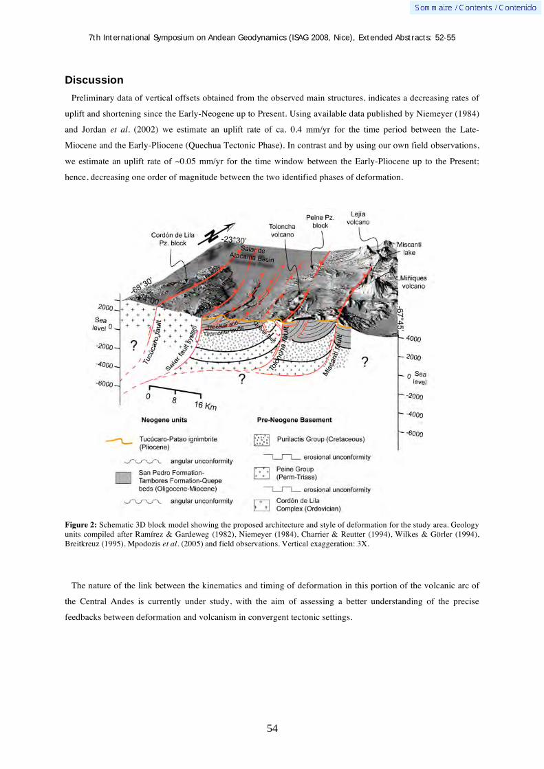
7th International Symposium on Andean Geodynamics (ISAG 2008, Nice), Extended Abstracts: 52-55
54
Discussion
Preliminary data of vertical offsets obtained from the observed main structures, indicates a decreasing rates of
uplift and shortening since the Early-Neogene up to Present. Using available data published by Niemeyer (1984)
and Jordan et al. (2002) we estimate an uplift rate of ca. 0.4 mm/yr for the time period between the Late-
Miocene and the Early-Pliocene (Quechua Tectonic Phase). In contrast and by using our own field observations,
we estimate an uplift rate of ~0.05 mm/yr for the time window between the Early-Pliocene up to the Present;
hence, decreasing one order of magnitude between the two identified phases of deformation.
Figure 2: Schematic 3D block model showing the proposed architecture and style of deformation for the study area. Geology units compiled after Ramírez & Gardeweg (1982), Niemeyer (1984), Charrier & Reutter (1994), Wilkes & Görler (1994), Breitkreuz (1995), Mpodozis et al. (2005) and field observations. Vertical exaggeration: 3X.
The nature of the link between the kinematics and timing of deformation in this portion of the volcanic arc of
the Central Andes is currently under study, with the aim of assessing a better understanding of the precise
feedbacks between deformation and volcanism in convergent tectonic settings.

7th International Symposium on Andean Geodynamics (ISAG 2008, Nice), Extended Abstracts: 52-55
55
Acknowledgments The authors thank the funding for researching to Fondecyt: National Research Funding Competition-1060187, 2006. We
also thank to Richard Allmendinger for making TRISHEAR 4.5TM software available, Erik Jensen for valuable commenting of previous drafts, Pia Avalos for exhausting help in the field and Alejandro Álvarez for technical support in the field. Finally, we acknowledge the capabilities for working to Universidad Católica del Norte (UCN).
References Allmendinger, R. W. 1998. Inverse and forward numerical modeling of fault-propagation folds. Tectonics 17 (4): 640-656. Arriagada, C., Cobbold, P. & Roperch, P. 2006. Salar de Atacama basin: A record of compressional tectonics in the central
Andes since the mid-Cretaceous. Tectonics 25 (TC1008), doi:10.1029/2004TC001770. Breitkreuz, C. 1995. The Late Permian Peine and Cas Formations at the eastern margin of the Salar de Atacama, Northern
Chile: stratigraphy, volcanic facies, and tectonics. Revista Geológica de Chile 22 (1): 3-23. Charrier, R., & Reutter, K-J. 1994. The Purilactis group of Northern Chile: boundary between arc and backarc from Late
Cretaceous to Eocene. In Reutter, K-J., Scheuber, E., & Wigger P. (eds): Tectonics of the Southern Central Andes: Structure and Evolution of an Active Continental Margin. New York, Springer-Verlag: 189-201
Jolley, E. J., Turner, P., Williams, G. D., Hartley, A. J., & Flint, S. 1990. Sedimentological response of an alluvial system to Neogene thrust tectonics, Atacama Desert, northern Chile. Journal of the Geological Society, London 147: 769-784.
Jordan, T., Muñoz, N., Hein, M., Lowestein, T., Godfrey, L. & Yu, J. 2002. Active faulting and folding without topographic expression in an evaporite basin, Chile. Geological Society of America Bulletin 114 (11): 1406-1421.
Kuhn, D. 2002. Fold and thrust belt structures and strike-slip faulting at the SE margin of the Salar de Atacama basin, Chilean Andes. Tectonics 21 (4), 10.1029/2001TC901042.
Mpodozis, C., Arriagada, C., Basso, M., Roperch, P., Cobbold, P., & Reich, M. 2005. Late Mesozoic to Paleogene stratigraphy of the Salar de Atacama Basin, Antofagasta, Northern Chile: Implications for the tectonic evolution of the Central Andes. Tectonophysics 399: 125-154.
Muñoz, M., Charrier, R., Jordan, T. 2002. Interactions between basement and cover during the evolution of the Salar de Atacama basin, northern Chile. Revista Geológica de Chile. V. 29, n° 1: 55-80.
Niemeyer, H. 1984. La megafalla Tucúcaro en el extremo Sur del Salar de Atacama: una Antigua zona de cizalle reactivada en el Cenozoico. Departamento de Geología, Universidad de Chile, Santiago. Comunicaciones 34: 37-45.
Ramírez, C. F., & Gardeweg, M. 1984. Hoja Toconao, Región de Antofagasta, 1:250.000. Carta Geológica de Chile, Servicio Nacional de Geología y Minería. 54: 122 pp.
Reutter, K-J., Charrier, R., Götze, H-J., Schurr, B., Wigger, P., Scheuber, E., Giese, P., Reuther, C-D., Schmidt, S., Rietbrock, A., Chong, G., & Belmonte-Pool, A. 2006. The Salar de Atacama Basin: a Subsiding Block within the Western Edge of the Altiplano-Puna Plateau. In Oncken, O., Chong, G., Franz, G., Giese, P., Götze, H-J., Ramos, V., Strecker, M., Wigger, P. (eds): The Andes Active Subduction Orogeny. Berlin-Heidelberg, Springer-Verlag. 14: 303-325.
Wilkes, E. & Görler, K. 1994. Sedimentary and structural evolution of the Salar de Atacama depression. In Reutter, K-J., Scheuber, E., & Wigger P. (eds): Tectonics of the Southern Central Andes: Structure and Evolution of an Active Continental Margin. New York, Springer-Verlag: 171-187.

7th International Symposium on Andean Geodynamics (ISAG 2008, Nice), Extended Abstracts: 56-59
56
Block rotations in the Puna plateau
César Arriagada1, Pierrick Roperch
2, & Constantino Mpodozis
3
1 Departamento de Geologia, Universidad de Chile, Casilla 13518, Correo 21, Santiago, Chile
([email protected]) 2 IRD, LMTG & Géosciences Rennes, campus de Beaulieu, 35042 Rennes, France ([email protected])
3 Antofagasta Minerals, Ahumada 11, Oficina 602, Santiago, Chile ([email protected])
KEYWORDS : Central Andes, Puna, block rotations, paleomagnetism
Introduction
Paleomagnetic studies along the Chilean forearc show systematic clockwise rotation along the forearc south of
22°S (Taylor et al., 2005; Arriagada et al., 2006). Arriagada et al. (2006) suggested that the rotations within the
forearc are partly driven by ongoing deformation to the east in the Puna plateau. However, rotations within the
forearc appear to occur mainly during the
Paleogene in Chile while the deformation
within the Sierras Pampeanas and the Puna is
mainly Neogene. Here we report
paleomagnetic results at 31 sites from 10
localities (Figure 1) in Tertiary sediments and
in Permian to Triassic red beds of the
Paganzo Group. Many previous
paleomagnetic studies have been carried out
in these red beds to define the Apparent polar
wander path of South America but few
studies indicate that these paleomagnetic
results may record a component of local
tectonic rotations (Geuna and Escosteguy,
2004 ).
Previous works in the Sierras Pampeanas
(Aubry et al., 1996), in the Puna (Coutand et
al., 1999) and in the Altiplano (Roperch et
al., 2000), demonstrated that the sediments
record a low anisotropy of magnetic
susceptibility (AMS) associated with Andean
compression. The orientation of AMS
lineations are always N-NE oriented in NW
Argentina while they are NW oriented in northern Bolivia. Here we report new AMS results that confirm the
previous observations (Figure 1).
Figure 1. Paleomagnetic sampling.in the Puna and Sierras Pampeanas. A to J are sampling localities (green circles). The arrows correspond to the orientation of the AMS lineations. Colour coding corresponds to results in Tertiary rocks (orange); Cretaceous (violet) and Permian to Triassic (magenta). Red circles are results reported by Coutand et al., (1999).

7th International Symposium on Andean Geodynamics (ISAG 2008, Nice), Extended Abstracts: 56-59
57
Paleomagnetic results
One specimen per core was progressively thermally demagnetized. Anisotropy of magnetic susceptibility
(AMS) measurements were made on one or two specimens per core.
Oligocene sediments were sampled in the Upper Eocene to Oligocene Quiñoas Formation to the west of the
Salar de Antofalla (Locality A). The upper part of the sequence is dated at 28.9±0.8 Ma (Kraemer et al., 1999).
A characteristic direction of reverse polarity was observed. Although the sampling is not sufficient enough for
magnetostratigraphic purpose, the dominant reverse polarity is in agreement with deposition during the late
Eocene – Early Oligocene period during which the earth magnetic field is mainly of reverse polarity.
Figure 2. Paleomagnetic results near the Salar de Antofalla. a) Equal-area projection of characteristic directions with angle of confidence in in situ and after tilt correction. b) Directions of the principal axes of Anisotropy of magnetic susceptibility. Ellipsoids are mainly oblate (c) and the magnetic foliation (kmin pole of magnetic foliation) is mainly horizontal and controlled by bedding. Magnetic lineations correspond to kmax directions.
The mean direction after tilt correction is (D=187.4; I=41.0 95=6.1). Assuming an early Oligocene age, the
rotation for this site is only 13.3±8.1°. Although these sites are only slightly tilted without evidence of internal
deformation a magnetic fabric is recorded (Figure 2). The magnetic lineation is NS oriented in agreement with
bedding strike for the area and the orientation of the tectonic structures. Thus, the magnetic lineation is likely
associated with compression.
Figure 3. Characteristic directions (green circles) and AMS measurements for (a) locality J and (b) locality F. Equal-area projection of mean-site characteristic directions with angle of confidence after tilt correction and directions of the principal axes of Anisotropy of magnetic susceptibility.

7th International Symposium on Andean Geodynamics (ISAG 2008, Nice), Extended Abstracts: 56-59
58
Near Valle Ancho (Locality J), 4 sites were drilled in the Astaburuaga Formation. All sites have a characteristic
magnetization with reverse polarity carried by magnetite (Figure 3a). The mean direction is (D=207.3; I=45.5;
95=5.8 indicating a clockwise rotation of nearly 30°. AMS measurements indicate prolate ellipsoids with well-
defined magnetic lineations (Figure 3a).
To the west of Vinchina (Locality F), 18 samples were drilled in a Tertiary sedimentary section. The thick
sedimentary section is folded and bedding strikes are NE-E oriented. AMS lineations are also NE-E oriented and
the characteristic mean direction for the section is also clockwise rotated (Figure 3b). These results confirm
previous observations (Aubry et al., 1993, Coutand et al., 1999, 2001) of significant clockwise rotations of
structures at various scales.
To the south-west of Antofagasta de la Sierra, 3 sites were drilled in Tertiary red beds (Locality B, Figure 1). It
was not possible to determine a characteristic direction. These sediments record a well-defined magnetic fabric
with a NE magnetic lineation (Figure 1).
Several sites were drilled in Permian to Triassic red beds sediments. Reverse polarity is found in sites drilled in
La Cuesta Formation (Locality H) probably deposited during the long reverse Kiaman interval while normal and
reverse polarities are found in the Talampaya Formation and these sediments are younger than the upper
boundary of the Kiaman (~260Ma)(Localities D & E).
Sites with normal polarity have N-NE magnetic declinations while reverse polarity sites have SE-S magnetic
declinations. Part of this variation is due both to the Permian to Triassic drift of the South American plate and to
the uncertainties in the precise age of the red beds. Uncertainties in different configurations of Pangea with the
possible existence of a large strike slip displacement between Gondwana and Laurasia (Pangea B to Pangea A)
during the Permian impede also the determination of a global apparent polar wander path for Gondwana using
the more numerous paleomagnetic data from Laurasia.
Geuna and Ecosteguy (2004) provide well-defined paleomagnetic results (Figure 4) from Upper Carboniferous
– lower Permian rocks sampled near Locality G where we also sampled one site in Triassic red beds. When
Figure 4. Paleomagnetic results from sites in Permian La Cuesta – Patquia formations and Triassic Talampaya red beds. Blue circles correspond to results from Geuna and Ecosteguy (2004) while the red circle is the expected direction calculated from the Permian pole from Tomezoli et al. (2006)

7th International Symposium on Andean Geodynamics (ISAG 2008, Nice), Extended Abstracts: 56-59
59
compared with the result reported by Tomezzoli et al. (2006) from a locality in La Pampa region, a region not
affected by Andean tectonics, a clockwise rotation of nearly 30° is expected at locality G. During the Permian-
Triassic, the South American plate exhibit a shift in paleolatitude toward a position similar to the present-day
position and this explain mainly the dispersion in inclination. Local tectonic rotations contribute significantly to
the dispersion in declination.
The Permian to Triassic red beds of the Paganzo Group record also an AMS lineation which is NE oriented at
localities D and E (Figure 1). Although AMS ellipsoids are coherent with the pattern observed in Tertiary rocks,
the AMS fabric in the Permian rocks may have been acquired prior to the Andean Tertiary deformation.
Our results from NW Argentina confirm clockwise rotations within the Puna plateau but further work is needed
to better define the timing and the spatial distribution of the rotations.
References Arriagada, C., Roperch, P., Mpodozis C., & Fernández, R. 2006. Paleomagnetism and tectonics of the southern Atacama
Desert region (25-28ºS) Northern Chile. Tectonics, 25: TC4001, doi:10.1029/2005TC001923. Aubry, L., P. Roperch, M. Urreiztieta, E. Rossello, and A. Chauvin, 1996. Paleomagnetic study along the southeastern edge
of the Altiplano-Puna Plateau: Neogene tectonic rotations., Journal of Geophysical Research, 101, 17.883-17.899. Coutand, I., P. Roperch, A. Chauvin, P. Cobbold, And P. Gautier, 1999. Vertical-Axis Rotations Across The Puna Plateau
(Northwestern Argentina) From Paleomagnetic Analysis Of Cretaceous And Cenozoic Rocks, J. Geophys. Res., 104, B10, 22965-22984.
Coutand, I., P.R. Cobbold, M. De Urreiztieta, P. Gautier, A. Chauvin, D. Gapais, E.A. Rossello, and O. Lopez-Gamundi, 2001. Style and history of Andean deformation, Puna plateau, northwestern Argentina, Tectonics, 20, 210-234.
Geuna, S., and L. Ecosteguy, 2004. Paleomagnetism of the Upper Carboniferous Lower Permian transition from Paganzo basin, Argentina, Geophys. J. Int., 157, 1071-1089.
Kraemer, B., D. Adelmann, M. Alten, W. Schnurr, K. Erpenstein, E. Kiefer, P. Van den Bogaard, and K. Gorler, 1999. Incorporation of the Paleogene foreland into the Neogene Puna plateau: The Salar de Antofalla area, NW Argentina, Journal of South American Earth Sciences, 12, 157-182.
Muttoni, G., D. V. Kent, E. Garzanti, P. Brack, N. Abrahamsen and M. Gaetan , 2003, Early Permian Pangea ‘B’ to Late Permian Pangea ‘A’ Earth and Planetary Science Letters, 215, 379-394
Roperch, P., M. Fornari, G. Hérail, and G. Parraguez, 2000. Tectonic rotations within the Bolivian Altiplano: Implications for the geodynamic evolution of the central Andes during the late Tertiary, Journal of Geophysical Research, 105, 795-820.
Roperch, P., Sempere, T., Macedo, O., Arriagada, C., Fornari, M., Tapia, C., García, M. & C. Laj, 2006. Counterclockwise rotation of late Eocene – Oligocene fore-arc deposits in southern Peru and its significance for oroclinal bending in the central Andes, Tectonics, 25: TC3010, doi:10.1029/2005TC001882.
Taylor, G.K., Dashwood, B., and Grocott, J., 2005, Central Andean rotation pattern: Evidence from paleomagnetic rotations of an anomalous domain in the forearc of northern Chile: Geology, v. 33, p. 777-780.
Tomezzoli, R.N., R.N. Melchor and W.D. MacDonald, 2006. Tectonic implications of post-folding magnetizations in the Carapacha basin, La Pampa province, Argentina, Earth, Planets Space, 58, 1235-1246.
7th International Symposium on Andean Geodynamics (ISAG 2008, Nice), Extended Abstracts: 60-63
60
Continental growth through protracted subduction and accretionary processes along Western Gondwana: The case of the Ocloyic Orogeny in southern South America
Ricardo A. Astini, Gilda Collo, & Federico Martina
Laboratorio de Análisis de Cuencas, CICTERRA-Universidad Nacional de Córdoba, Av. Vélez Sársfield 1611, 2º
piso, Of. 7, X5016GCA Córdoba, Argentina ([email protected], [email protected],
KEYWORDS : accretionary orogen, Ocloyic orogen, composite orogeny, South America, Ordovician
Introduction
Since the Middle Cambrian and after the consolidation of Gondwana through mayor collisional orogens, the
Proto-Andean region of South America faced an open ocean, resulting in quasi-permanent subduction and
development of a protracted exterior-orogen during the Paleozoic (the Terra Australis orogen, Cawood, 2005).
Within such expanded time interval (~300 m.y.) discrete orogenic features imply development of recurrent
processes related to a variety of transient coupling mechanisms. However, Cenozoic structural complexities and
spatial superposition of different age mountain-building processes along the Andean margin has prevented
finding a simple and universal model to explain the architectural and continuity relationships between temporally
constrained orogenies within the Central Andes. Recent stratigraphically and regionally constrained
geochronological work has allowed great improvement in our understanding and discrimination of distinct
orogenic episodes. Nevertheless, understanding of the across and along-strike variations of any particular
orogeny is still unclear. Focussing within the more well-known southern segment of the Central Andes in
Argentina during the Ordovician may help understanding the complexities within an orogenic cycle.
Probably the most compelling and distinct tectonothermal event including metamorphism, deformation,
magmatism and basins development within the Terra Australis orogen occurred during the Ordovician and is
known as the Ocloyic Orogeny (see Ramos, 1986). This is a composite orogenic episode that in South America
can now be traced from Patagonia into Perú (>4000 km) and that has been defined, half a way, in northwestern
Argentina, on the basis of stratigraphic relationships. In the Central Andean basin (Northewest Agentina, Bolivia
and Perú), the erosive effects of the Late Ordovician glaciation amalgamate with the tectonic effects in the
Ocloyic unconformity, implying ~50 m.y. of Proto-Andean history (approximately ranging from 490 to 440 Ma).
Various names have been used to embrace the crustal processes occurring within this interval, probably the more
commonly used being that of Famatinian Orogeny (Aceñolaza & Toselli, 1973). However, in the light of more
recent geochronological research this last term has become broad.
The complex and composite Ocloyic Orogeny
Within the long-lasting feature of the terra Australis Orogen the Ocloyic Orogeny is defined as complex and
composite. Complex because it embraces different crustal processes across different segments of the western
Gondwana margin as a result of varying geometry and plate tectonic situations (e.g., ocean-continent versus
continent-continent convergence) and composite because it has become clearer that separate building stages

7th International Symposium on Andean Geodynamics (ISAG 2008, Nice), Extended Abstracts: 60-63
61
associated to crustal addition or recycling have happened. What is not clear is how different configurations along
a same active margin influence for the development of metamorphism, magmatism and sedimentary basins, and
how these processes operate when arrival of an exotic terrane, or when other alternative features (e.g., aseismic
ridges or any other buoyant fragment or process) change the coupling relationships along a convergent setting.
Why is there a regional signature with a strong Ordovician imprint along the entire South American plate if
different mechanisms operated and how do they really correlate between each other, even across adjacent
segments? Along-strike segmentation within the Ocloyic Orogen seems to relate to various accretionary
mechanisms. The accretion of Precordillera must have locally increased coupling for at least some time, helping
to modify existing stratigraphies and generating its own signatures. North and south of the Jagüé slip zone ~28°S
(Astini & Dávila, 2004) the retroarc foreland basins have very different configurations and this major across-
strike tectonic boundary related to indentation seems influential on much of the following Proto-Andean and
later Andean history. Similar assertion can be made to its more obscure southern extent (mostly in subsurface)
close to the northern boundary of Patagonia. Some of these questions are trying to be focused by comparing the
segments aligned with the Precordillera and immediately north, where superb stratigraphic and igneous records
are available.
The Famatina-Precordillera segment
Development of an asymmetric long wave-length retroforeland in the Central Andean Basin contrasts with the
narrow retroforeland that existed in the segment aligned with Famatina (Astini & Dávila, 2004). But this
segment do not only differs in the accommodation of very different sedimentary systems or on the rates of
subsidence, but in the igneous, metamorphic and deformational trajectories. Recent improvement in
geochronology and geological mapping at Famatina and adjacent regions of the Sierras Pampeanas allows
suggesting a cyclic crustal behaviour within this segment. Two stages of extension with pervasive volcanic
activity alternate with two major stages of plutonism and crustal thickening, indicated from both igneous and
detrital ages. Plutonism bracketed at ca. 490-480 Ma and at ca. 470-465 Ma. Both the western Cerro Toro and
the eastern Ñuñorco complexes in Famatina (Aceñolaza et al., 1996) seem to record the two age peaks, whereas
the volcano-sedimentary stages are respectively known as the Cerro Tocino (ca. 480-475 Ma) and the Cerro
Morado/Las Planchadas volcanics (ca. 468-460 Ma). The fact that both volcano-sedimentary stages interact with
sea-level indicates important accommodation space, compatible with extension within the upper-plate arc
setting, a major difference with the present Andean style. Extension is in agreement with the complex array of
volcanic and volcaniclastic facies, which locally describe large variations in recorded thickness. Volcanic stages
are largely acidic and bimodal, but locally, like in northern Famatina (e.g., north of Cazadero Grande), more than
50% of the volcanic volume corresponds to basic lavas. This is largely difficult to reconciliate with crustal
recycling and differentiation processes and might need a mantle component. Some juvenile addition is at least
clear in the 2nd volcanic stage and might have also occurred in the 1st stage. By contrast, most geochemistry and
isotopic work in the granite suites indicates crustal recycling as a major source for plutons, compatible with
stages of important crustal thickening (Pankhurst et al., 2000). Maximum crustal thickening seems to have been
acquired in Famatina after the second plutonic stage. This may relate to the tectonic shortening and angular
unconformity recorded between the Famatina and the Cerro Morado Groups (Astini & Dávila, 2004). Following,

7th International Symposium on Andean Geodynamics (ISAG 2008, Nice), Extended Abstracts: 60-63
62
Late Ordovician arkoses (represented in the La Aguadita Formation), recorded east of the former volcanic stages,
yield two peaks within the detrital zircon population, indicating that granites from both plutonic stages where
being exposed to erosion. Recent work by Dahlquist et al. (in press) shows that detrital zircons in Middle
Ordovician sedimentary units in western Famatina also yield some provenance from the former granite suites.
Unroofing and recycling of the early Ocloyic granites, likely accounted through extension, may have helped
triggering rapid exhumation of plutonic suites and their Cambrian hosts (Collo & Astini, in press). This is
consistent with recent dating of low-grade filonites associated to normal shear zones in Famatina that may relate
to orogenic collapse during termination of the Ocloyic Orogeny (Collo et al, in press). This suggestion allows
understanding provenance as a product of limited detrital dispersal into a narrow retroforeland within this
segment.
An opposite polarity peripheral foreland developed atop of the lower-plate Precordillera terrane (Astini et al.,
1995). Such westward foreland series is unique to the Precordillera and has no other counterparts to the north or
south, hence pointing to a strong difference with the rest of the segments implying absence of symmetry in terms
of convergent basin development.
Discussion
Accretionary orogens are basically protracted subduction orogens (Cawood & Buchan, 2007) wherein due to
the time involved and their areal extent they encompass various sedimentary and igneous addition processes.
These processes seem to have occurred in the case of the Ocloyic segment aligned with the Precordillera and
Famatina. Along-strike segmentation is a natural feature within any orogen influencing igneous activity and
basin development. As it is true in the present day Andes along the South American plate, it has apparently also
been true during the Paleozoic, although related to different triggering mechanisms.
Much debate can be generated on weather or not the Precordillera terrane accretion generated a real collisional
orogen or if, on the other hand, given its relatively small size it contributed as a strong transient coupling
mechanism in the light of the protracted history of the Paleozoic accretionary margin. There is strong geologic
evidence to separate the Precordillera and the Gondwana margin previous to Early Ordovician and also strong
evidence to support their continuity after the Late Ordovician. In fact Late Ordovician glaciation overlaps both.
Basin development and stratigraphy to both sides of this major boundary and also magmatism and
metamorphism is, however, largely different showing dissimilar crustal behaviours related to the complex
tectonothermal Ocloyic orogeny. Our studies, particularly those on the upper plate along Famatina, suggest that
during the Ordovician tectonic switching operated along South America, in a similar manner and in a
comparable time framework than what has been interpreted for Australia (Collins, 2002). Changes in the
convergence mode and tectonic switching processes from dominantly advancing (contractile) to dominantly
retreating (extensional) behaviours can be suggested for the upper plate within the segment of Famatina.
Indirectly, some of the effects (e.g., volcanism), have been recorded within the approaching Precordillera terrane
(Astini et al., 2007). According to that interpretation, some time after subduction initiation (during the Late
Cambrian) tectonic switching to extension may lead to recurrent inboard continental growth; that is both,
magmatic and sedimentary additions in the upper plate. These can take the form of intraarc or backarc extension,
like that apparently recorded in both volcano-sedimentary intervals in Famatina. On the other hand, dominantly

7th International Symposium on Andean Geodynamics (ISAG 2008, Nice), Extended Abstracts: 60-63
63
contractile modes may have lead to crustal thickening, batholite intrusions and recycling. According to Collins
(2002), this switching process may occur at relatively short time intervals (~10 Ma), a resolution we are just
starting to approach. Moreover, this mechanism would have contributed to upper–plate effective growth and
recycling, rather than periods of rifting, separation, and reaccretion like suggested by Ramos (2008).
Because such a cyclic behaviour is not strongly recorded along the northern segment, aligned with the Central
Andean Basin, a different driving mechanism may have operated. However, differences in the convergence
mode responsible for the Ocloyic Orogeny would not be enough to prevent the broad correlation between
segments. Deformed metamorphic terranes like, for example, the pre-Ocloyic Puncoviscana Complex in
northwest Argentina or the Ocloyic Negro Peinado complex along Famatina have seldom been considered
“mobile belts”. This pre-plate tectonic concept, regardless its origin, portrays an unusual inboard situation for
location of deformation, metamorphism and magmatism, where polarity predicted by continental growth related
to accretion does not work. Such a relationship has been observed in ancient crust elsewhere, and although not
fully apparent in the upper crustal levels along the Andean modern analogue for subduction orogens, it is well
preserved in the pre-Andean geology. This means that either uplifting/exhumation processes operating in the
Andes are largely different from those in the past and hence, it is not a good analogue for ancient pre-Andean
cases. An alternative is to consider that the present configuration for the type-subduction orogen is still “too
young” to show effects of the various coupling mechanisms operating and triggering mountain building
processes. However, isotopic evidence showing a clear asthenospheric contribution in the present Andean orogen
is unlikely comparable with the signature during the early Ocloyic Orogeny (Cordani, 2006).
References Aceñolaza, F.G. & Toselli, A.J. 1973. Consideraciones estratigráficas y tectónicas sobre el Paleozoico Inferior del Noroeste
Argentino. 2º Congreso Latinoamericano de Geología, 2: 755-783. Aceñolaza, F.G., Miller, H. & Toselli, A.J. 1996. Geología del Sistema de Famatina. In Aceñolaza, F.G., Miller, H., Toselli,
A.J. (Eds.), Geología del Sistema de Famatina. Münchner Geologische Hefte, Reihe A, 19(6): 412p. Astini, R.A. & Dávila, F.M. 2004. Ordovician back arc foreland and Ocloyic thrust belt development on the western
Gondwana margin as a response to Precordillera terrane accretion. Tectonics, 23: TC4008, doi:10.1029/2003TC001620. Astini, R.A., Benedetto, J.L. & Vaccari, N.E.. 1995. The early Paleozoic evolution of the Argentine Precordillera as a
Laurentian rifted, drifted and collided terrane: a geodynamic model. Geological Society of America Bulletin 107: 253–27 Astini, R.A., Collo, G. & Martina, F. 2007. Ordovician K-bentonites in the upper-plate active margin of Western Gondwana,
(Famatina Ranges): stratigraphic and palaeogeographic significance”. Gondwana Research, 11: 311-325. Cawood, P.A. 2005. Terra Australis Orogen: Rodinia breakup and development of the Pacific and Iapetus margins of
Gondwana during the Neoproterozoic and Paleozoic. Earth Sci. Rev. 69: 249– 279. Cawood P.A. & Buchan C. 2007. Linking accretionary orogenesis with supercontinent assembly. Earth Sci. Rev. 82:217-56. Collins, W.J. 2002. Hot orogens, tectonic switching, and creation of continental crust. Geology, 30: 535–538. Collo, G; & Astini, R.A. (in press). La Formación Achavil: una unidad diferenciable dentro del basamento metamórfico de
bajo grado del Famatina en la región pampeana de los Andes Centrales. Revista Asociación Geológica Argentina. Collo, G.; Astini, R. A.; Cardona, A.; Do Campo, M. D. & Cordani, U. (in press). “Edad del metamorfismo de las unidades
con bajo grado de la región central del Famatina: La impronta del ciclo orogénico oclóyico”. Revista Geológica de Chile. Cordani, U.G., 2006. Neodymium isotopes, accretionary belts, and their bearing on the crustal evolution of South America. V
South American Symposium on Isotope Geology, 211-214. Dahlquist, J.A., Pankhurst, R.J., Rapela, C.W., Galindo, C. Alasino, P., Fanning, C.M., Saavedra, J. & Baldo, E. (in press).
New shrimp U-Pb data from the Fmatina complex: constraining Early–Mid Ordovician Famatinian magmatism in the Sierras Pampeanas, Argentina. Geologica Acta
Pankhurst, R.J., Rapela, C.W. & Fanning, C.M. 2000. Age and origin of coeval TTG, I- and S-type granites in the Famatinian belt of NW Argentina. Transactions of the Royal Society of Edinburgh: Earth Sciences, 91: 151-168.
Ramos, VA. 1986. El diastrofismo oclóyico: un ejemplo de tectónica de colisión durante el Eopaleozoico en el noroeste Argentino. Rev. Inst. Cienc. Geol. 6: 13-28.
Ramos, V.A. 2008. The Basement of the Central Andes: The Arequipa and related Terranes. Annual Review of Earth and Planetary Sciences, 36.
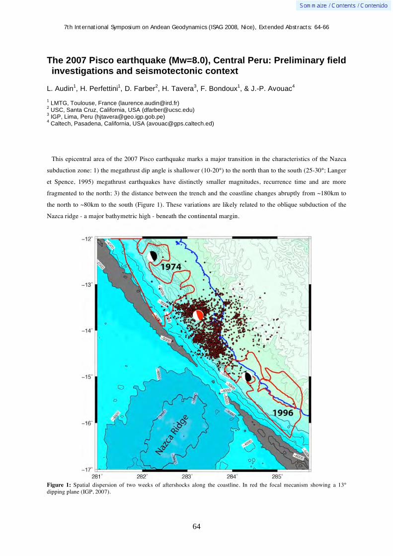
7th International Symposium on Andean Geodynamics (ISAG 2008, Nice), Extended Abstracts: 64-66
64
The 2007 Pisco earthquake (Mw=8.0), Central Peru: Preliminary field investigations and seismotectonic context
L. Audin1, H. Perfettini
1, D. Farber
2, H. Tavera
3, F. Bondoux
1, & J.-P. Avouac
4
1 LMTG, Toulouse, France ([email protected])
2 USC, Santa Cruz, California, USA ([email protected])
3 IGP, Lima, Peru ([email protected])
4 Caltech, Pasadena, California, USA ([email protected])
This epicentral area of the 2007 Pisco earthquake marks a major transition in the characteristics of the Nazca
subduction zone: 1) the megathrust dip angle is shallower (10-20°) to the north than to the south (25-30°; Langer
et Spence, 1995) megathrust earthquakes have distinctly smaller magnitudes, recurrence time and are more
fragmented to the north; 3) the distance between the trench and the coastline changes abruptly from ~180km to
the north to ~80km to the south (Figure 1). These variations are likely related to the oblique subduction of the
Nazca ridge - a major bathymetric high - beneath the continental margin.
Figure 1: Spatial dispersion of two weeks of aftershocks along the coastline. In red the focal mecanism showing a 13° dipping plane (IGP, 2007).

7th International Symposium on Andean Geodynamics (ISAG 2008, Nice), Extended Abstracts: 64-66
65
The effect of the subduction of the ridge is anyway obvious in the morphology – river changing course on
Figure 2 - and tectonics of the forearc, in particular, around the Paracas Peninsula where Miocene and Pliocene
marine formations are uplifted and the forearc tectonic regime changes from compression to extension (Figure 2,
Machare et al., 1992; Audin et al., 2008).
Figure 2: Topography and fault systems in Pisco and Paracas Peninsula region.
The geometry of the coastline reflects the sweeping of ridge beneath the margin. The coastline geometry also
seems to mirrors the variation of the downdip edge of the LFZ and some coupling. Just after the earthquake, our
preliminary field survey investigated evidence for uplift or subsidence along the coast and found that the
coastline didn’t experience any significant vertical displacement compared to the tide range (~40cm). The
coastline approximately correspond in general from north to south in Peru to a pivot line marking the transition
from coastal uplift in the south to subsidence in the north, as the distance from the trench increases or decreases.
This model is consistent with the co-seismic slip distribution inferred from waveform modeling (Pritchard and
Fielding., 2008), and with the distribution of aftershocks which suggests that the subduction interface ruptured
mainly updip of the coastline (Figure 1). To place further constraints on the coseismic slip distribution, we have
collected data on the spatial extent of Tsunami waves which hit the coast both south and north of the Paracas
peninsula.
Finally, our field surveys have also revealed evidence for active faulting of the forearc. In particular, the
production of coseismic pressure ridges, with up to 50cm of vertical throw suggests that the east dipping Puente
Huamani thrust fault system was reactivated over a distance of about 20km during this event. This event also
triggered very localized but widely outspread soil liquefaction that lined up with pre existing structures along the
coast in a NS direction. However, we didn’t find evidence for reactivation of any of the normal faults on the
Paracas Peninsula, although some had been reactivated by the 2006 Pisco earthquake (Mw6.4). The main effects
of the tsunami are observed south of the Paracas Peninsula although the main shock occurred north of it. Thus,

7th International Symposium on Andean Geodynamics (ISAG 2008, Nice), Extended Abstracts: 64-66
66
the structure and deformation of the Peruvian forearc and coastline seems to contain important information on
lateral variations of seismic and geodetic coupling along the subduction zone.
Figure 3: Damages in Lagunillas Bay ( South of Paracas Peninsula ) after the Tsunami; in Pisco , Plaza de Armas , after the earthquake; in Paracas after the tsunami that lift up the pontoon. Liquefaction evidences, trending NS and lined up with the Huamani Quaternary flexure.
References Audin L., Lacan P. , Tavera H., Bondoux F., Upperplate deformation and seismic barrier in front of Nazca subduction zone:
The Chololo Fault System and active tectonics along the Coastal Cordillera, southern Peru. Tectonophysics. In press. Langer C. J., W. Spence, The 1974 Peru earthquake series. Bulletin of the Seismological Society of America; June 1995; v.
85; no. 3; p. 665-687 Macharé , J., Ortlieb, L., 1992. Plio-Quaternary vertical motions and the subduction of the Nazca Ridge, central coast of
Peru. Tectonophysics 205, 97 ± 108. Pritchard and Fielding, in press. A study of the 2006 and 2007 earthquake sequence of Pisco , Peru, with InSAR and
teleseismic data. GRL.

7th International Symposium on Andean Geodynamics (ISAG 2008, Nice), Extended Abstracts: 67-70
67
The 2006 eruptions of the Tungurahua volcano (Ecuador) and the importance of volcano hazard maps and their diffusion
D. Barba1, P. Samaniego
1, J.-L. Le Pennec
2, M. Hall
1, C. Robin
2, P. Mothes
1, H. Yepes
1, P.
Ramón1, S. Arellano
1, & G. Ruiz
1 Instituto Geofísico, Escuela Politécnica Nacional (IG-EPN), Ap. 17-01-2759, Quito, Ecuador
2 Institut de Recherche pour le Développement, LMV, 5 rue Kessler, 63038 Clermont-Ferrand, France
KEYWORDS : volcanic hazard map, 2006 eruptions, Tungurahua volcano, Ecuador
Introduction
The Tungurahua volcano (5023 m asl) is a steep-sided, andesitic stratovolcano, located in central Ecuador,
ranking as one of the most active volcanoes of the Northern Andes. During historical times Tungurahua
experienced important (VEI 3) pyroclastic flow-forming eruptions in AD 1640, 1773, 1886, and 1918 (e.g.
Hall et al., 1999; Le Pennec et al., 2008).
In October 1999, after about 75 years of quiescence, the Instituto Geofísico of the Escuela Politécnica Nacional
(IG-EPN) registered a renewal of the eruptive activity. During the next six years, this activity was cyclical, with
small to moderate explosions responsible for important ash emissions, the most voluminous of which occurred
on November-December 1999, August 2001, September 2002 and October-November 2003. In 2006, seismic
activity increased dramatically and culminated with the 14-16th July (VEI 2) and 16-17th August 2006 (VEI 3)
explosive eruptions. For the first time since the beginning of this eruptive cycle, Tungurahua volcano produced
pyroclastic flows, which swept over the western half of the cone, as well as giving rise to eruption columns
greater than 15 km in height.
Hazards mitigation during an eruption depends on a continuous monitoring, as well as a reliable hazard map.
The latter is the starting point for develops risk maps, territorial planning and emergencies management. In fact,
the early warning provided by the IG-EPN to the local authorities allowed the evacuation of thousands of people
living in the high-hazard zone. As a result, human loss was limited to 6 fatalities. In this abstract, we will
describe the 2006 eruptions, and the importance of the volcano hazard maps and their diffusion for hazard
assessment and emergency planning.
14-16th July eruption
The seismic activity rapidly increased since 14h30 local time (= GMT-5). At first time, a train-like sound and a
continuous shake were feel around the volcano. The eruption started at 17h33, with strong cannon-like periodical
explosions, which were followed by continuous roars (bramidos), related with a 3-4 km-high eruption column.
An almost continuous lava fountain, reaching up to 300 m-high, produced the first pyroclastic flows at 18h00
(Fig. 1). These flows descended toward the Cusúa and Juive Grande villages. The paroxysmal phase occurred
between 19h40 and 01h00 giving rise to eruption columns greater than 20 km in height. During the paroxysm, at
least 11 pyroclastic flows were generated, which descended on the north-western flank and the Vazcun valley
(Fig. 2).
The activity decreased progressively at 15th July, registered only a few explosions. At least 6 small to moderate
pyroclastic flows were produced at 16th July; all them were associated with vulcanian explosions.

7th International Symposium on Andean Geodynamics (ISAG 2008, Nice), Extended Abstracts: 67-70
68
Fig. 1 A photo of Tungurahua’s vulcanian eruption, with accompanying pyroclastic flows, that occurred
on July 14, 2006. Credits: BBC
Fig. 2 Thermal image (FLIR) obtained from TVO. A pyroclastic flow descending to Cusúa town
during the climatic phase.
16-17th August eruption
Eruptive activity increased from the morning of August 16th. At 14h30, eruptive activity was characterized by a
continuous ash and steam emission, reaching 2-3 km above the crater. First small pyroclastic flows occurred
around 17h00 and descended down the western flank, following the Cusúa and Chontapamba gullies (Fig. 3). An
almost 300 m-high continuous lava fountain, associated with a 3-4 km-high eruption column produced several
small pyroclastic flows, those descended toward Cusúa, Juive Grande and Vascún valleys. Other sporadic, but
probably bigger, pyroclastic flows were generated between 21h00 and 24h00, mostly related to explosions
and/or an increase of the lava fountain, the flows affected the northern and western flanks. The flow most
extensive in the Vascún valley, stopped 1.5 km before Baños city.
Fig. 3 Tungurahua volcano in eruption during August 16, 2006.
Fig. 4 FLIR image showing the lava flow, which marked the end of the eruptive cycle of July-August,
2006.
The paroxysmal phase initiated at 00h15 (August 17) and ended around 40 minutes after. Eruptive activity was
characterized by a powerful lava fountain up to 1000 m above the crater, a 15 km-high eruption column, and the
contemporaneous generation of the most important pyroclastic flows, which descended by 17 ravines on the
north, north-west, west and south-west flanks. The flows reached up to 8.5 km until get the base of the volcano
after a descent of 2600-3000m from the summit crater. The pyroclastic flows of the Rea, Romero and

7th International Symposium on Andean Geodynamics (ISAG 2008, Nice), Extended Abstracts: 67-70
69
Chontapamba ravines formed important deltas in the Rio Chambo valley; this was dammed for several hours
after the eruption. The pyroclastic flows that followed in Mapayacu and Juive Grande ravines also dammed the
Puela and Pastaza rivers, respectively.
No pyroclastic flow was witnessed on the eastern flank of the cone and no deposits were observed over this
region during the helicopter observation done by the staff of IG-EPN. After the paroxysmal phase both the
seismic and the volcanic activity rapidly decreased. On the afternoon of August 17th, IG thermal images of the
NW flank confirmed the effusion of an important blocky lava flow which was emitted some hours after the
paroxysmal phase and stopped at 2700 m asl (Fig. 4).
Use of Tungurahua hazard map
The first Tungurahua volcano hazard map was published by IG-EPN in 1988 (Hall et al., 1988). Based on an
extensive study of the volcano by scientific of IG-EPN and IRD, an improved version was published 14 years
later (Hall et al., 2002). Local authorities used these maps for emergency planning during the unrest of the
volcano and during the 2006 crisis, respectively.
Fig. 5 The distribution of pyroclastic flow and surge deposits shows a good agreement with the high-
hazard zone depicted in the 2002 map. The July 14th PF deposits (yellow) are showed on the August 16th
PF (brown) and surges (beige) for a better visualization.
Fig. 6 Third edition of Tungurahua hazard map. Samaniego et al., in press.
Figure 5 shows the distribution of pyroclastic flows and surges for the 14thJuly and August 16th eruptions. A
good agreement exists between these deposits and the high-hazard zone defined by the 2002 map. This
comparison highlights the relevance and validity of this hazard map. The experience obtained during the current
eruption, allow us to incorporate different eruptive scenarios (Fig. 6). This fact is extremely important for
emergency management. Moreover, the well-constrained information from the 2006 eruptions is also being used
to calibrate numerical simulations for pyroclastic flows. This constitutes a first step towards a new generation of

7th International Symposium on Andean Geodynamics (ISAG 2008, Nice), Extended Abstracts: 67-70
70
dynamic volcano hazard maps for Ecuadorian volcanoes.
Conclusion
The deployment of a monitoring system by the IG-EPN since 1988, and the installation of the Tungurahua
Volcano Observatory in 1999 at a location close to the volcano, allowed IG scientists to communicate to the
authorities the course of the volcanic events during the seven years process, and finally to successfully issue
early warnings to national and local authorities and to the people before the July and August, 2006 explosive
eruptions.
The relevant use of the hazard map of Tungurahua during the 2006 emergency period is undeniably due to
constant scientific improvement of the hazard map. In parallel, the volcanological information has been
popularized by the publication of a booklet authored by IG-EPN and IRD scientists, and the work with the
community in the framework of an European-funded DIPECHO project.
References Barba D., Arellano S., Ramón P., Mothes P., Alvarado A., Ruiz G., Troncoso L., 2006 Cronología de los eventos erptivos de
Julio y agosto del 2006 del volcán Tungurahua. Resumen extendido de las 6tas. Jornadas en Ciencias de la Tierra. Ecuador, DG-EPN, 177-180.
Samaniego P., J.-L. Le Pennec., Barba D., Hall M. L., Robin C., Mothes P., Yepes H., Troncoso L & Jaya D. (in press). Mapa de los peligros potenciales del volcán Tungurahua. Escala 1:50 000. 3ra Edición. Instituto Geofísico, Escuela Politécnica Nacional. Quito – Ecuador.
Hall M.L., Robin C., Samaniego P., Monzier M., Eissen J.-P., Mothes P., Yepes H., von Hillebrandt C. & Beate B., 2002. Mapa de los peligros potenciales del volcán Tungurahua. Escala 1:50 000. Quito, 2da Edición. Instituto Geofísico, Escuela Politécnica Nacional.
Hall, M.L., Robin, C., Beate, B., Mothes, P., Monzier, M., 1999. Tungurahua volcano, Ecuador: structure, eruptive history and hazard. J. Volcanol. Geotherm. Res. 91, 1-21.
Hall M.L., Beate B. & von Hillebrandt C., 1988. Mapa de los peligros volcánicos potenciales asociados al volcán Tungurahua. Escala 1:50 000. Quito, 1ra Edición. Instituto Geofísico, Escuela Politécnica Nacional.
Le Pennec J.-L., Jaya D., Samaniego P., Ramón P., Moreno Yánez S., Egred J., Submitted manuscript, Journal of Volcanology and Geothermal Research, 2008. Eruptions of Tungurahua volcano, Ecuador from Late Integration to Early Colonial times: evidence from historical narratives, stratigraphy and radiocarbon age determinations.
Le Peneec J.-L., Samaniego P., Eissen J.-P., Hall M.L., Molina I., Robin C., Mothes P., Yepes H., Ramón P., Monzier M. & Egred J., 2005. Los peligros volcánicos asociados con el volcán Tungurahua. Quito, 2da edición. Corporación Editoria Nacional. 113 p.
Samaniego P., Eissen J.-P., Le Pennec J.-L., Hall M.L., Monzier M., Mothes P., Ramón P., Robin C., Egred J., Molina I. & Yepes H., 2003. Los peligros volcánicos asociados con el volcán Tungurahua. Quito, 1ra edición. Corporación Editoria Nacional. 108 p.
Yepes H., Ramón P., Barba D., Arellano S., Samaniego P., Hall M.L., Mothes P., Alvarado A., Le Pennec J.-L., Kumagai H., Rivero D. (2007) Tungurahua Volcano’s 2006 Eruptions, Monitoring and Alert Notifications. Abstract of the Cities on volcano 5; November 19 – 23; Shimabara – Japón.

7th International Symposium on Andean Geodynamics (ISAG 2008, Nice), Extended Abstracts: 71-74
71
Control of Mesozoic extensional structures on the Andean deformation in the northern Malargüe fold and thrust belt, Mendoza, Argentina
Florencia Bechis1,2
, Laura Giambiagi1, Daniel Yagupsky
2, Ernesto Cristallini
2, Víctor
García2, & José Mescua
1
1 CONICET - IANIGLA (CRICYT), CC 330 (5500), Mendoza, Argentina ([email protected],
[email protected], [email protected]) 2 CONICET - Laboratorio de Modelado Geológico, Universidad de Buenos Aires, Pabellón 2, Ciudad Universitaria
(1428), Buenos Aires, Argentina ([email protected], [email protected], [email protected])
KEYWORDS : Neuquén basin, Atuel depocentre, inversion, reactivation, sandbox analogue modelling
Introduction
The study area is located in the northern sector of the Malargüe fold and thrust belt, in the Central Andes of
central-western Argentina (fig. 1). In this sector of the belt, Andean deformation inverted a Late Triassic to Early
Jurassic extensional depocentre of the Neuquén basin (Kozlowski et al., 1993; Manceda and Figueroa, 1995;
Giambiagi et al., in press). The main goal of this contribution is to identify the principal controls exerted by the
extensional structures over the Andean deformation in the northern sector of the Malargüe fold and thrust belt.
Our study is based on data obtained from detailed structural and geological field mapping, integrated with
subsurface information. The orientation, timing and structural style of the Andean structures were compared
with the extensional architecture of the Atuel depocentre, previously addressed by Manceda and Figueroa
(1995), Lanés (2002, 2005) and Giambiagi et al. (2005). In addition, the mapped structures were compared with
the results obtained from scaled sandbox analogue models simulating the deformation of a half-graben oblique to
the shortening direction during the evolution of a fold and thrust belt.
The Atuel depocentre
The extensional structure of the Atuel depocentre is characterized by the presence of two NNW-trending major
faults, the La Manga and Alumbre faults (fig. 2), marked by the distribution of the synrift deposits in outcrops
and from subsurface data (Giambiagi et al., 2005, in press). These faults limited two major half-grabens,
controlling the main subsidence of the sub-basin and the distribution of sedimentary environments and drainage
systems during the synrift phase (Lanés 2002, 2005). Inside the half-grabens, we identified a bimodal
distribution of normal faults with NNW and WNW trends (fig. 2).
Andean structures
The structure of the northern sector of the Malargüe fold and thrust belt was previously studied by Kozlowski
et al. (1993), Manceda and Figueroa (1995), Fortunatti et al. (2004), Turienzo et al. (2004) and Giambiagi et al.
(in press), among others. This belt is characterized by a western thick-skinned sector and an eastern thin-skinned
one (fig. 1). In the western sector the Triassic-Jurassic synrift infill of the Atuel depocentre is involved in the
deformation, whereas in the eastern sector low-angle thrust faults affect Cretaceous to Neogene strata. The limit

7th International Symposium on Andean Geodynamics (ISAG 2008, Nice), Extended Abstracts: 71-74
72
between these two contrasting structural styles coincides with the eastern border of the Atuel depocentre, which
is controlled by the NNW-trending La Manga normal fault (fig. 2). This fault was strongly inverted during the
Andean deformation, transferring displacement to shallow thrusts located eastwards. Ar-Ar dating of pre-, syn-
and post-tectonic volcanic and subvolcanic rocks showed that the La Manga fault was reactivated early on the
evolution of the fold and thrust belt, localizing great part of the deformation (Giambiagi et al., in press).
Figure 1. Geological and structural map of the study area, modified from Giambiagi et al. (in press).
The thin-skinned structures of the eastern sector have a general N to NNW trend, probably related to a transfer
of slip from the basement-involved inverse faults of the La Manga fault system (fig. 1). On the other hand, in the
western sector most folds and reverse faults show NNE orientation (fig. 1). These NNE compressive structures
are segmented by WNW transfer zones, which were controlled by the presence of Mesozoic second-order
normal faults (e.g. in the Río Atuel and the upper section of the Arroyo Blanco, figs. 1 and 2). NNW orientations
are locally observed, and they are interpreted as being controlled by previous NNW-oriented normal faults (e.g.
the Alumbre fault, fig. 2).

7th International Symposium on Andean Geodynamics (ISAG 2008, Nice), Extended Abstracts: 71-74
73
Figure 2. A) Interpreted extensional architecture of the Atuel depocentre of the Neuquén basin, modified from Giambiagi et al. (2005, in press). See figure 1 for location. B) Results from the analogue modeling of inversion of an oblique half-graben (obliquity angle ~15º). The fault pattern interpretation is shown at each step of progressive shortening (S).
Analogue modelling
A sandbox analogue model was built in order to test the influence of a preexisting obliquely oriented half-
graben over the style of shortening deformation (a complete description of the experimental methodology can be
consulted in Yagupsky et al., in press). The model materials were quartz sand and glass microbeads. In a first
extensional stage a NNW-trending half-graben was created. Later, the model was shortened by displacing a
moving wall oriented at 15º from the half-graben.
The map view evolution of the experiment was registered and interpreted (fig. 2). During the early stage of
contraction the oblique half-graben acted as a nucleation site for thrust faulting, producing the inversion of its
bounding normal fault. This reactivation progressed from NNW to SSE during further shortening. In the next
stage, thrusts branched from the previously developed oblique one, creating a new active deformation front in
the inner side of the system with NNE strikes, cutting through the underlying half-graben. The resulting
structural architecture shows a NNW-trending thrust fault controlled by the underlying structure and two NNE-
trending thrusts affecting the inner sector of the model.
Discussion
We evaluated possible structural explanations for the NNE orientation of most of the compressive structures
that characterize the thick-skinned sector of the fold and thrust belt:
1) Due to the basement involvement in the deformation of the western sector, this orientation could be
reflecting the basement structural grain. Upper Paleozoic structures with a NNE trend have been reported to the

7th International Symposium on Andean Geodynamics (ISAG 2008, Nice), Extended Abstracts: 71-74
74
north of the study area, corresponding to compressive structures related to the San Rafael orogenic phase (Azcuy
and Caminos, 1987; Giambiagi et al., 2008).
2) At these latitudes, in the Chilean side of the Andes, structures with similar orientations to the ones
observed in the Atuel area have been described: WNW and NW faults and lineaments, and NNE thrust faults
(Rivera and Yáñez, 2007). In this case, NNE faults were interpreted as probable Oligocene to Miocene structures
reactivated during Miocene inversion of Tertiary basins. However, there is no record of development of mid-
Tertiary basins in the Argentinean side.
3) The analogue models of inversion of obliquely oriented half-grabens suggest that the observed
structural pattern could be related to a progressive inversion of the Atuel depocentre, assuming a rift trend
oblique to the Andean shortening direction. In the analogue models, an early inverse reactivation of the normal
master fault is followed by the formation of slightly oblique thrusts affecting the synrift infill of the graben (fig.
2). The inversion of the Atuel depocentre had a similar evolution, with an initial reactivation of the NNW-
trending La Manga fault, and a later deformation of the sub-basin interior with development of NNE-oriented
structures.
The close similarity between the results of the analogue models and the mapped area suggest that the third
interpretation is a reliable possibility, taking into account that this similarity does not necessarily imply similar
deformation mechanisms. This option explains the orientation of the structures as a result of inversion of the
Atuel depocentre during the formation of the northern sector of the Malargüe fold and thrust belt. However, the
first possibility has to be taken into account. To test if this option had a role in the Andean deformation, a future
approach considering regional data is needed.
References Azcuy, C.L., & Caminos, R., 1987. Diastrofismo. In S. Archangelsky (ed.): El sistema carbonífero en la República
Argentina, Academia Nacional de ciencias, Córdoba, Argentina: 239-252. Fortunatti, N., Turienzo, M., & Dimieri, L., 2004. Retrocorrimientos asociados al frente de avance orogénico, arroyo Blanco,
Mendoza. Asociación Geológica Argentina, Publicación Especial, Serie D 7: 34-30. Giambiagi, L., Bechis, F., García, V., & Clark, A., in press. Temporal and spatial relationships of thick- and thin-skinned
deformation: a case study from the Malargüe fold and thrust belt, southern Central Andes. Tectonophysics. Giambiagi, L., Bechis, F., Lanés, S., & García, V., 2005. Evolución cinemática del depocentro Atuel, Triásico Tardío –
Jurásico Temprano. 16º Congreso Geológico Argentino, La Plata. Proceedings in CD. Giambiagi, L., Mescua, J., Folguera, A., & Martinez, A., 2008. Pre-andean deformation in the southern Central Andes (32°-
33°S). 7th International Symposium on Andean Geodynamics (ISAG 2008, Nice), Extended Abstracts. Kozlowski, E., Manceda, R., & Ramos, V. A., 1993. Estructura. In: V. Ramos (Editor), Geología y recursos naturales de
Mendoza. 12º Congreso Geológico Argentino y 2º Congreso de Exploración de Hidrocarburos, Relatorio: 235-256. Lanés, S. 2002. Paleoambientes y Paleogeografia de la primera transgresion en Cuenca Nequina, Sur de Mendoza.
Universidad de Buenos Aires, PhD Thesis (unpublished), 259 pp. Lanés, S., 2005. Late Triassic to Early Jurassic sedimentation in northern Neuquén Basin, Argentina: Tectonosedimentary
evolution of the first transgression. Geologica Acta 3(2): 81-106. Manceda, R., & Figueroa, D., 1995. Inversion of the Mesozoic Neuquén rift in the Malargüe fold-thrust belt, Mendoza,
Argentina. In: A. J. Tankard, R. Suárez and H.J. Welsink (Editors): Petroleum Basins of South America. American Association of Petroleoum Geologists, Memoir 62: 369-382.
Rivera, O., & Yáñez, G., 2007. Geotectonic evolution of the Central Chile Oligocene-Miocene volcanic arc, 33-34ºS: towards a multidisciplinary re-interpretation of inherited lithospheric structures. Geosur, Santiago de Chile, Abstracts: 138.
Turienzo, M., Fortunatti, N., & Dimieri, L, 2004. Configuración estructural del basamento en la confluencia del arroyo Blanco y el río Atuel, Mendoza. Asociación Geológica Argentina, Publicación Especial, Serie D 7: 27-33.
Yagupsky, D.L, Cristallini, E.O., Fantín, J., Zamora Valcarce, G., Bottesi, G., & Varadé, R., in press. Oblique half-graben inversion of the Mesozoic Neuquén Rift in the Malargüe Fold and Thrust Belt, Mendoza, Argentina: New insights from analogue models. Journal of Structural Geology.
7th International Symposium on Andean Geodynamics (ISAG 2008, Nice), Extended Abstracts: 75-76
75
Flat-slab subduction beneath the Sierras Pampeanas in Argentina
Susan Beck1, Patricia Alvarado
2, Lara Wagner
3, Megan Anderson
4, Hersh Gilbert
5, & George
Zandt1
1 Department of Geosciences, University of Arizona, Gould-Simpson Building, 1040 E. 4
th St., Tucson, Arizona,
85721 USA 2 Department of Geophysics and Astronomy, National University of San Juan, San Juan, Argentina
3 Department of Geological Sciences, University of North Carolina at Chapel Hill, 104 South Road, Chapel Hill,
NC 27599, USA 4 Department of Geology, Colorado College, 14 E. Cache La Poudre St., Colorado Springs, CO 80903 USA
5 Department of Earth and Atmospheric Sciences, Purdue University, 550 Stadium Mall Dr., West Lafayette, IN
47907, USA
KEYWORDS : flat slab, Sierras Pampeanas, Juan Fernandez Ridge, broadband seismology
Introduction
One of the intriguing aspects of the subduction of the Nazca plate beneath western South America is the along
strike segmentation of the dip of the descending plate as defined by the slab earthquake distribution. In the south
central Andes, the subducting Nazca slab has a subhorizontal geometry and extends inland over 300 km beneath
the Sierras Pampeanas (SP) near 30°-31°S but returns to a normal dip further south at 33°S. The tectonic
evolution of this region is the result of the interaction between the South American plate and the segment of the
Nazca Plate that contains the Juan Fernandez Ridge. The flat slab region is characterized by an absence of
modern arc volcanism, the Precordillera fold and thrust belt and the presence of the inland basement cored
uplifts of the Sierras Pampeanas. Understanding what causes the flat slab geometry, and its influence on the
overlying lithosphere remains a fundamental goal. In order to study the flat slab region of Argentina we have
done two passive broadband seismic deployments in the region in order to characterize the lithospheric structure.
We combine the results from a range of seismic studies, which used data collected during the Chile Argentina
Geophysical Experiment (CHARGE) to present an up-to-date model of the crustal and upper mantle structure in
central Chile and Argentina. These studies include receiver functions (both regional and teleseismic), earthquake
hypocenter relocations and focal mechanisms, Pn diffraction studies, isostasy studies, regional waveform
modeling, and regional P, S and Vp/Vs tomographic inversions. We are currently collecting additional seismic
data in the SIEMBRA project (40 stations above the flat slab) to do higher resolution imaging of the flat slab
region of Argentina.
Results
We have refined the location of the earthquakes in the slab using a grid-search multiple event location method
to relocate over a 1000 events in the subducted slab (Anderson et al., 2007). The earthquake locations and
resultant Wadati-Benioff zone contours show that the shallowest portion of the flat slab is associated with the
subducting Juan Fernandez Ridge at 31°S. Most of the earthquake focal mechanisms in the slab show
subhorizontal T-axis solutions consistent with slab pull (Anderson et al., 2007). Alvarado et al. (2005) find that
most of the region above the flat slab is in compression with thrust earthquakes in the depth range of 5-25 km.
We have analyzed the crustal thickness across the arc and backarc using several different seismic techniques.
We determined a 2D crustal model beneath Chile and western Argentina along an east west transect at
approximately 30° using both apparent Pn velocities and receiver functions (Fromm et al., 2004; Gilbert et al.,
7th International Symposium on Andean Geodynamics (ISAG 2008, Nice), Extended Abstracts: 75-76
76
2006). This model consists of a thick crustal root beneath the High Cordillera (65 km), a 60 km thick crust under
the Precordillera, thinning to 55 km beneath the western Sierras Pampeanas, and 35-40 km thick crust beneath
the eastern Sierras Pampeanas. Receiver functions and regional waveform modeling indicate that the eastern
Sierras Pampeanas has a crustal thickness of 35 km and a Vp/Vs ratio of less than 1.75 while the western Sierras
Pampeanas crustal thickness increases to 55 km with a Vp/Vs ratio greater than 1.8. The change in crustal
character (both thickness and seismic velocity structure) corresponds to sutures between accreted Precambrian
terrains (Gilbert et al., 2006; Alvarado et al., 2007). The western Sierras Pampeanas has a high velocity lower
crust that may be a higher density material that is partially ecologitized but has not yet been removed (Gilbert et
al., 2006; Calkins et al., 2006). Our seismic results are consistent with the observed composition of the basement
associated with the terrains in the Sierras Pampeanas. The contrasting terrains may be responsible for the
different crustal composition and seismic structure of the eastern and western terranes. The predominant felsic
quartz-rich character of the Eastern Sierras Pampeanas is linked to the collision of a microcontinent, the Pampia
terranes (Alvarado et al., 2005; Rapela et al. 1998), whereas the dominant mafic-ultramafic composition in the
west is associated with oceanic fragments of a crust arc/backarc setting for the western Sierras Pampeanas
(Alvarado et al., 2005; Vujovich & Kay 1998; Ramos et al. 2000).
Regional seismic tomography shows the mantle lithosphere is also very heterogeneous, with low seismic
velocities beneath the volcanic arc region, high velocities directly below the Moho in the backarc, and
anomalous mantle (low Vp/Vs ratio, high Vs) directly above the flat slab (Wagner et al., 2005; 2006). The low
Vp/Vs ratio and high S-wave velocities directly above the flat slab are not consistent with hydrated mantle but
rather with dry conditions and a high percentage of orthopyroxene in the mantle layer above the flat slab
(Wagner et al., 2005; 2006). Taken together the CHARGE results suggest that the lithospheric structure still
reflects Precambrian terrane boundaries and that the present day mantle under the Sierras Pampeanas is dry,
strong and probably able to transmit basal shear from the underlying flat slab.
References Alvarado, P., Beck S. L., Zandt G., 2007, Crustal Structure of the South-Central Andes Cordillera and Backarc Region from
Regional Waveform Modeling, Geophys. J. Int., doi:10.1111/j.1365-246X.2007.03452.x 2007. Alvarado, P., Beck S., Zandt G., Araujo M., and Triep E., 2005, Crustal deformation in the south-central Andes back-arc as
viewed from regional broad-band seismic waveform modeling, Geophys. J. Intl., doi: 10.1111/j.1365-246X.2005.02759. Alvarado, P., Castro de Machuca, B. and Beck, S., 2005, Comparative crustal seismic study of the Western and Eastern
Sierras Pampeanas region, Argentina, (31ºS). Revista de la Asociación Geológica Argentina, Vol. 60 (4), 787-796. Anderson, M., P. Alvarado, G. Zandt, S.L. Beck, 2007, Geometry and brittle deformation of the subducting Nazca plate,
central Chile and Argentina, Geophys. J. Int., doi:10.1111/j.1365-246X.2007.03483.x, 2007. Calkins, J.A., G. Zandt, H.J. Gilbert, and S.L. Beck, 2006, Crustal images from San Juan, Argentina, obtained using high
frequency local event receiver functions. Geophys. Res. Lett., L07309, doi:10.1029/2005GL025516. Fromm, R., P. Alvarado, S. L. Beck, G. Zandt, 2006, The April 9, 2001 Juan Fernandez Ridge outer-rise earthquake (Mw
6.7) and its aftershock sequence, J. of Seismology, 10.1007/s10950-006-9013-3. Gilbert, H., S. Beck, G. Zandt, 2006, Lithospheric and upper mantle structure of central Chile and Argentina; influences of a
flat slab, Geophys. J. Int., 165, 383–398. Ramos, V.A., Escayola, M., Mutti, D.I. & Vujovich, G.I., 2000, Proterozoicearly Paleozoic ophiolites of the Andean
basement of southern South America, in Ophiolites and Oceanic Crust: New Insights from Field Studies and the Ocean Drilling Program, pp. 181–217, eds Dilek, Y., Moores, E.M., Elthon, D. & Nicolas, A., Geol. Soc. Sp. Publ. 142.
Vujovich, G.I. & Kay, S.M., 1998. A Laurentian? Grenville-age oceanic arc/back-arc terrane in the Sierra Pie de Palo,Western Sierras Pampeanas, Argentina, in The Proto-Andean Margin of Gondwana, eds Pankhurst, R.J. & Rapela, C.W., pp. 159–179, Geological Society, London, Special Publications 142.
Wagner, L. S. Beck, G. Zandt, M. Ducea, 2006, Depleted lithosphere, cold, trapped asthenosphere, and frozen melt puddles above the flat slab in central Chile and Argentina, Earth and Planetary Science Letters, 245 289–301.
Wagner, L., S. L. Beck, G. Zandt, 2005, Upper mantle structure in the South Central Chilean subduction zone, J. Geophys. Res., 110, B01308, doi:10.1029/2004JB003238.

7th International Symposium on Andean Geodynamics (ISAG 2008, Nice), Extended Abstracts: 77-80
77
The November 14, 2007, Mw=7.7 Tocopilla (Chile) earthquake: Preliminary results from InSAR and GPS
M. Béjar-Pizarro1,2
, D. Carrizo2, A. Socquet
2, R. Armijo
2, J.-C. Ruegg
2, J.-B. de Chabalier
2, A.
Nercessian3, O. Charade
3, & S. Bonvalot
4
1 Dpto. Geodinámica, Facultad de Ciencias Geológicas, Universidad Complutense de Madrid, c/José Antonio
Novais s/n, 28940 Madrid, Spain ([email protected]) 2 Laboratoire de Tectonique et et Mécanique de la Lithosphère, Institut de Physique du Globe de Paris, 4 place
Jussieu, 75252 Paris cedex 05, France 3 Laboratoire de Sismologie, Institut de Physique du Globe de Paris, 4 place Jussieu, 75252 Paris, France
4 Laboratoire des Mécanismes et Transferts Géologique, UMR 5563, IRD, UR154, CNRS, Toulouse, France
KEYWORDS : subduction earthquake, Northern Chile, seismic gap, seismic cycle, InSAR, GPS, elastic models
Introduction
A Mw 7.7 subduction earthquake occurred on November 14, 2007 in Tocopilla (northern Chile). This region
(between 16.5ºS and 23.5ºS) had been identified as major seismic gap (~1000 km length) that had not ruptured
since the occurrence of the South Peru (Mw = 9.1, 16 August 1868) and the Iquique (Mw = 9.0, 10 May 1877)
megathrust earthquakes. This gap was reduced to a length of ~500 km after the occurrence of the Arequipa (Mw
= 8.3, 23 June 2001) and the Antofagasta (Mw = 8.1, 30 July 1995) earthquakes (Figure 1).
Most of the aftershocks following the 2007 event were concentrated in the north of the Mejillones Peninsula
(Figure 1), an inter-segment zone that appears to act both as a barrier arresting rupture of large earthquakes (e.g.
Figure 1. Reference map of our study area. Large subduction earthquakes along the Peru-Chile trench are represented by green rectangles and ellipses. Grey ellipses represent the approximate extent of 1877 and 1868 rupture zones. The Harvard CMT solution for the mainshock and the 3 biggest aftershocks are indicated. Aftershocks are indicated by yellow dots (NEIC catalog). Dashed squares outline the tracks of Envisat data used in this study. Blue points with capital letters represent the location of the GPS permanent stations used here. Red rectangle represents the approximate extent of the 2007 Tocopilla earthquake.

7th International Symposium on Andean Geodynamics (ISAG 2008, Nice), Extended Abstracts: 77-80
78
M 8.8 1877 Iquique earhquake) and as an asperity where large earthquakes nucleates (e.g. Mw 8.1 1995
Antofagasta earthquake, Ruegg et al., 1996).
Important questions arise after this earthquake in relation with the seismic gap and the subduction interface
here: Which part of the subduction interface has ruptured (geometry and location of the rupture plane)? Which
are the slip distribution and the geodetic moment? The end of the rupture, barriers arresting rupture? (Mejillones
Peninsula) Which is the slip deficit after this earthquake? Relations with other events and the seismic gap in the
north?. We address these questions by using data from space geodesy. The Tocopilla earthquake occurred
within a network of continuous GPS stations operated by IPGP, Caltech, DGF and IRD. An array of 21
benchmarks, installed and previously measured periodically by IPGP/DGF, was resurveyed during a postseismic
intervention. Here we combine GPS data from three of these permanent GPS stations and InSAR data from two
descending tracks to determine the geometry and kinematics of the rupture on the subduction interface.
InSAR measurements
We use 4 Envisat ASAR images from two descending tracks (track 96 and track 368, Figure 1) to form two
independent coseismic interferograms. Both interferograms span the date of the earthquake and they include
some days after the mainshock: 10 days in the case of the track 368 interferogram and 26 days in the case of the
track 96 interferogram. It is therefore probable that they include some postseismic deformation together with the
coseismic deformation. Data were processed using the Caltech/JPL repeat-orbit interferometry package, ROI
PAC (http://www-radar.jpl.nasa.gov/roi pac/). The topographic phase contribution was removed using a
3-arc-sec (90-m) digital elevation model from the Shuttle Radar Topography Mission (SRTM). The orbital
information used in the processing was provided by the ESA (DORIS orbits). After processing, the
interferograms presented a linear ramp, probably due to uncertainties in the orbital ephemeris. A plane was
adjusted to this ramp and removed from each interferogram. Figures 2a and 2b show both interferograms with
the observed displacement along the line of sight direction (LOS). Surface deformation pattern is characterized
by two lobes: the western one shows a LOS displacement towards the satellite, with a maximum value of ~30 cm
and the eastern one represents a LOS displacement away from the satellite, with a maximun value of ~15 cm.
GPS measurements
We use 8 continuous GPS stations data from IPG-DGF and IRD-DGF northern Chilean network for calculate
the co-seismic displacement. The GPS-data analysis was done using GAMIT (King and Bock, 1998) and
GLOBK (Herring, 1998) software packages. Daily solutions over 7 days span prior and after the earthquake
were calculated including 13 IGS stations located in South America and 2 local stations from ENS-DGF central
Chili continuous network. Final orbits and antenna phase center corrections from IGS and IERS earth rotation
parameters were used. To estimate the station position every daily GAMIT solutions were combined using
GLOBK referencing the local network to ITRF05 (Altamimi et al., 2007). Our preliminary approximation to co-
seismic displacements was defined here as a difference between the resulting mean coordinates prior and after
the earthquake. We constrain the earthquake zone using 3 stations UAPE, QUIL and PMEJ (figs. 1, 2). The
PMEJ station, located in Mejillones Peninsula, shows displacements of 21 cm to the west, 13 cm to south and
~ 35 cm of uplift. The QUIL station, located ~60 km to inland shows displacement 5 cm to the south, 6 cm to the

7th International Symposium on Andean Geodynamics (ISAG 2008, Nice), Extended Abstracts: 77-80
79
west and 3 cm of subsidence. The UAPF station, located in the coast ~168 km to the north of QUIL, does not
show displacement.
Modelling
We have modelled InSAR data and compare our models with GPS observations. Observed surface
displacements are modeled using Okada’s formulation of a dislocation buried in an infinite elastic half-space
(Okada, 1985). We performed a series of forward models to assess the dislocation parameters that are best fitting
the deformation pattern. The extension of the deformation in the north-south direction constrains the length of
the plane to ~ 150 km (black rectangle in Figures 2a, 2b, 2c, 2f). The plane width (~ 40-43 km) is mostly
constrained by the sharpness of the deformation lobes. Using this fault geometry we test different possible
locations of the plane at depth. As we only have one displacement component (in the LOS direction) the dip of
the fault plane is poorly resolved, so we started by using the CMT Harvard value of 20º. A trade-off between
depth and slip is observed: the deeper the plane is, the more slip is allowed to fit the surface deformation, and the
higher is the equivalent magnitude of the model. he best compromise between seismic moment and depth is
found for a plane that lies between 30-35 and 48-53km depth (Figure 2d), with a total slip of ~1.30 m and a
geodetic moment of ~ 2.75 x10²⁰ N.m. Figure 2c shows the resulting model. It accounts for first order co-seismic
deformation associated with the 2007 Tocopilla earthquake. However the model does not fit very good the
Figure 2. Coseismic surface displacements from a) Interferogram 1 (track 368) b) Interferogram 2 (track 96). c) Synthtetic model, f) Continuos GPS: red and black vectors represent observed and modelled horizontal displacement respectively. Modelled vertical displacements are represented by color contours in figure 2f. Fault plane has been represent in a E-W profile at latitude 22.50º in figure 2d (red line). Dashed line represents the subduction interface deduced by the Ancorp experiment. Global seismicity has been represented by blue dots. 2e) E-W profile to -22.3 latitude with the InSAR LOS displacement for the two co-seismic interferograms and the model.

7th International Symposium on Andean Geodynamics (ISAG 2008, Nice), Extended Abstracts: 77-80
80
observations in the southern part of the rupture (north of the Mejillones Peninsula) , due to the irregular spatial
distribution of slip. This can be seen in both interferograms, since more deformation is present in the south than
in the north. Horizontal GPS displacements also show a misfit with this model (Figure 2f) that is increasingly
bigger southward (PMEJ station). This probably means that two distinct patches of slip are needed to fit both
GPS and InSAR data, which is consistent with the first results from seismology (Campos et al., 2008; Peyrat et
al., 2008).
Results and Discussion
Our preliminary results indicate that the Tocopilla rupture extended between 23.30° - 22° S with ~150 km of
longitude. The rupture zone was located between 48-53 and 30-35 km of depth and did not propagate up to the
surface. Our best fit plane is consistent with the subduction plane defined by published seismological data,
indicating that was activated the deeper part of the seismogenic interface, well into the transition zone that was
identified earlier (Chlieh et al., 2004). The southern end of the rupture is clearly defined by the GPS and InSAR
observations to the north of the Mejillones Peninsula confirming this zone as a relevant subduction intersegment
barrier. The misfit of our GPS and InsAR observations in the southern end of the rupture may indicate that the
geometry and the kinematics of the rupture is complex change here and hence cannot be reproduced with a
single dislocation model. Currently we explore the hypothesis of two different dislocation using non linear
inversion models
According to the mean displacement inferred by our models (~1.30 m) the Tocopilla earthquake released a
very small portion of the slip deficit accumulated in the seismic gap during the past 130 years (~ 10m) and may
be regarded as a possible precursor of a much larger subduction earthquake rupturing the 500 km long gap.
Acknowledgments M.B.P acknowledges support of Universidad Complutense de Madrid grant. This work was supported by the ANR-05-CATT-01402 project of the French National Research Agency. We acknowledge the support of the European Agency (ESA) for programming Envisat satellite (research project AO-720). ROI_PAC software was provided by the JPL/Caltech. The GMT program was used to create the figures. References Altamimi, Z., Collilieux, X., Legrand, J., Garayt, B. & Boucher, C. 2007. ITRF2005: A new release of the International
Terrestrial Reference Frame based on time series of station positions and Earth Orientation Parameters , J. Geophys. Res., 112, B09401, doi:10.1029/2007JB004949.
Campos, J., Peyrat, S., Bejar, M.,Socquet, A., Meneses, G., Perez, A., Madariaga, R., Favreau, P, Bernard, P., Barrientos, S., Armijo, R., Ash, G., Sobiesiak, M. & Vilotte, J.P. 2008. The Mw 7.7 Tocopilla, Chile, Earthquake of 14 November 2007: A Comprehensive Study Using Teleseismic, Local and InSAR data, AGU 2008 Joint Assembly Abstract, unpublished material
Chlieh, M., Chabalier, J.B., Ruegg, J.C., Armijo, R., Dmowska, R., Campos, J. & Feigl, K. 2004. Crustal deformation and fault slip during the seismic cycle in the north Chile subduction zone, from GPS and InSAR observations, Geophys. J. Int., 158: 695-711.
Herring, T. A., 1997. GLOBK: Global Kalman Filter VLBI and GPS analysis program, v.4.1, Mass. Inst. of Technol., Cambridge.
King, R. & Bock, Y. 2001. Documentation for the GAMIT GPS software analysis, Tech. rep., Scripps Institution of Oceanography, University of California, San Diego, release 10.33.
Okada, Y. 1985. Surface deformation to shear and tensile faults in a half space, Bull. seism. Soc. Am., 75, 1135–1154. Peyrat et al. 2008. Detailed source process of the 2007 Tocopilla earthquake, AGU 2008 Joint Assembly Abstract,
unpublished material Ruegg, J.C., Campos, J., Armijo, R., Barrientos, S., Briole, P., Thiele, R., Arancibia, M., Cañuta, J., Duquesnoy, T., Chang,
M., Lazo, D., Lyon-Caen, H., Ortlieb, L., Rossignol, J.C. & Serrurier, L. 1996. The Mw =8.1 Antofagasta (North Chile) earthquake July 30, 1995: first results from teleseismic and geodetic data, Geophys. Res. Lett., 23: 917–920.
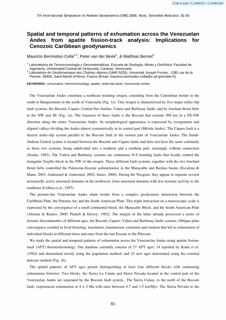
7th International Symposium on Andean Geodynamics (ISAG 2008, Nice), Extended Abstracts: 81-83
81
Spatial and temporal patterns of exhumation across the Venezuelan Andes from apatite fission-track analysis: Implications for Cenozoic Caribbean geodynamics
Mauricio Bermúdez-Cella1,2
, Peter van der Beek2, & Matthias Bernet
2
1 Laboratorios de Termocronología y Geomatemáticas, Escuela de Geología, Minas y Geofísica. Facultad de
Ingeniería, Universidad Central de Venezuela, Caracas, Venezuela 2 Laboratoire de Géodynamique des Chaînes Alpines (UMR 5025), Université Joseph Fourier, 1381 rue de la
Piscine, 38400, Saint-Martin d'Hères, France (Email: [email protected])
KEYWORDS : exhumation, thermochronology, apatite, strike-slip faults, Venezuelan Andes
The Venezuelan Andes constitute a northeast trending orogen, extending from the Colombian border in the
south to Barquisimeto in the north of Venezuela (Fig. 1a). This orogen is characterized by five major strike-slip
fault systems, the Boconó, Caparo, Central-Sur Andino, Valera and Burbusay faults, and by foreland thrust belts
to the NW and SE (Fig. 1a). The foremost of these faults is the Boconó that extends 500 km in a NE-SW
direction along the entire Venezuelan Andes. Its morphological appearance is expressed by escarpments and
aligned valleys dividing the Andes almost symmetrically in its central part (Mérida Andes). The Caparo fault is a
dextral strike-slip system parallel to the Boconó fault in the eastern part of Venezuelan Andes. The South-
Andean Central system is located between the Boconó and Caparo faults and does not have the same continuity
as these two systems, being subdivided into a southern and a northern part, seemingly without connection
(Soulas, 1983). The Valera and Burbusay systems are continuous N-S trending faults that locally control the
triangular Trujillo block in the NW of the orogen. These different fault systems, together with the two foreland
thrust belts controlled the Paleocene-Eocene sedimentation in the Maracaibo and Barinas basins (Escalona &
Mann, 2003; Audemard & Audemard, 2002; James, 2000). During the Neogene, they appear to separate several
tectonically active structural domains in the northwest, from structural domains with less tectonic activity to the
southeast (Colleta et al., 1997).
The present-day Venezuelan Andes chain results from a complex geodynamic interaction between the
Caribbean Plate, the Panama Arc and the South American Plate. This triple interaction on a macroscopic scale is
expressed by the convergence of a small continental block, the Maracaibo Block, and the South American Plate
(Aleman & Ramos, 2000; Pindell & Dewey, 1982). The margin of the latter already possessed a series of
tectonic discontinuities of different ages, the Boconó, Caparo, Valera and Burbusay faults systems. Oblique plate
convergence resulted in local thrusting, translation, transtension, extension and rotation that led to exhumation of
individual blocks at different times and rates from the late Eocene to the Pliocene.
We study the spatial and temporal patterns of exhumation across the Venezuelan Andes using apatite fission-
track (AFT) thermochronology. Our database currently consists of 37 AFT ages: 14 reported by Kohn et al.
(1984) and determined mostly using the population method; and 23 new ages determined using the external
detector method (Fig. 1b).
The spatial patterns of AFT ages permit distinguishing at least four different blocks with contrasting
exhumation histories. Two blocks, the Sierra La Culata and Sierra Nevada located in the central part of the
Venezuelan Andes are separated by the Boconó fault system,. The Sierra Culata, to the north of the Boconó
fault, experienced exhumation at 4 ± 2 Ma with rates between 0.7 and 1.5 km/Myr. The Sierra Nevada to the
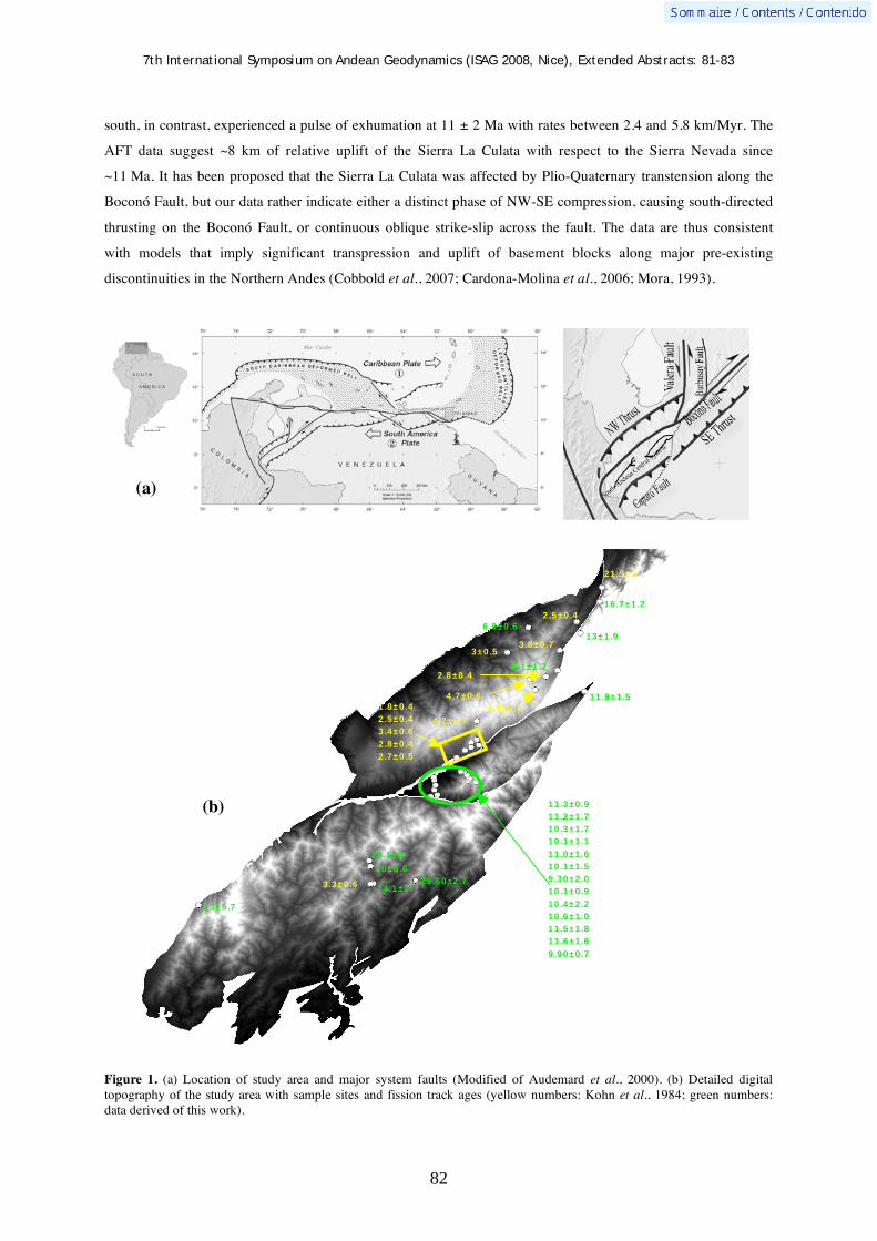
7th International Symposium on Andean Geodynamics (ISAG 2008, Nice), Extended Abstracts: 81-83
82
south, in contrast, experienced a pulse of exhumation at 11 ± 2 Ma with rates between 2.4 and 5.8 km/Myr. The
AFT data suggest ~8 km of relative uplift of the Sierra La Culata with respect to the Sierra Nevada since
~11 Ma. It has been proposed that the Sierra La Culata was affected by Plio-Quaternary transtension along the
Boconó Fault, but our data rather indicate either a distinct phase of NW-SE compression, causing south-directed
thrusting on the Boconó Fault, or continuous oblique strike-slip across the fault. The data are thus consistent
with models that imply significant transpression and uplift of basement blocks along major pre-existing
discontinuities in the Northern Andes (Cobbold et al., 2007; Cardona-Molina et al., 2006; Mora, 1993).
Figure 1. (a) Location of study area and major system faults (Modified of Audemard et al., 2000). (b) Detailed digital topography of the study area with sample sites and fission track ages (yellow numbers: Kohn et al., 1984; green numbers: data derived of this work).
29.60±2.7 3.3±0.6 24.1±3
20±5.6
22.1±3
23±5.7
11.9±1.5
13±1.9
16.7±1.2
21.5±2.1
6.9±0.6
2.5±0.4
6.1±1.2
2.8±0.4
3±0.5
4.9±0.7
4.7±0.6
3.8±0.7
4.2±0.7
1.8±0.4
2.5±0.4
3.4±0.6
2.8±0.4
2.7±0.5
11.3±0.9
11.2±1.7
10.3±1.7
10.1±1.1
11.0±1.6
10.1±1.5
9.30±2.0
10.1±0.9
10.4±2.2
10.6±1.0
11.5±1.8
11.6±1.6
9.90±0.7
(b)
(a)

7th International Symposium on Andean Geodynamics (ISAG 2008, Nice), Extended Abstracts: 81-83
83
A third block, located to the west is the Caparo Block, characterized by AFT ages ranging from 30 to 17 Ma.
These ages appear to have been influenced by prolonged residence in the partial annealing zone. The fourth
block, to the east, is the Trujillo Block limited by the Valera and Burbusay faults. Within this block, three AFT
ages range from 13 to 21 Ma.
These four blocks are key to a better understanding of the control of Caribbean geodynamics on the collisional
Andean orogen. In this context, our data suggest that intraplate deformation caused by the triple collision of
Panama Arc-Caribbean Plate-South American Plate was active at approximately 30 Ma. This fact is corroborated
by independent AFT data from the Perijá region (Shagam et al., 1984) to the NW of the Andes. From the
beginning of the triple collision up to ~17 Ma the Valera-Burbusay and Caparo-Boconó fault systems apparently
did not yet have their current configuration. As a result of the convergence with the Maracaibo Block, they must
have rotated clockwise around poles located very near the Sierra Nevada block and Santa Marta-Bucaramanga
fault system respectively (Chicangana, 2005).
The coeval timing of exhumation of the Caparo and Trujillo blocks, as recorded by comparable AFT ages,
suggests that they were exhumed together in a context of orthogonal thrusting, before being displaced by sinistral
strike-slip along the Boconó fault. The strong pulse of exhumation recorded at 11 Ma in the Sierra Nevada block
was likely related to major uplift, which may have been the cause for Late Miocene deflection of the Orinoco
River, as inferred from the Neogene sedimentary record (Díaz de Gamero, 1996; Hoorn et al., 1995).
References Aleman, A. & V. Ramos. 2000. Northern Andes. In: Cordani, U.G., Milani, E.J., Thomaz, A., Campos, D.A. (Eds.), Tectonic
Evolution of South America. 31st International Geological Congress, Rio de Janeiro, Brazil, pp. 453-480. Audemard, F.A., M. N. Machette, J.W. Cox, R.L Dart, and K.M. Haller. (2000) Map and Database of Quaternary Faults in
Venezuela and its Offshore Regions. U.S Geological Survey. Open-File Report 00-018 (paper edition) Audemard, F.E. & F.A., Audemard. 2002. Structure of the Mérida Andes, Venezuela: relations with the South America-
Caribbean geodynamic interaction. Tectonophysics 345. 299-327. Cardona-Molina, A., U.G Cordani and W.D MacDonald, 2006. Tectonic correlations of pre-Mesozoic crust from the northern
termination of the Colombian Andes, Caribbean region, Journal of South American Earth Sciences Volume 21, Issue 4, Tectonic evolution of the Colombian Andes, Pages 337-354.
Cobbold, P.R., E. A. Rossello, P. Roperch, C. Arriagada, L.A Gómez & C. Lima (2007). Distribution, timing, and causes of Andean deformation across South America. Geological Society, London, Special Publications; v. 272; p. 321-343.
Chicangana, E. 2005. The Romeral Fault System: A Shear and Deformed Extinct Subduction Zone Between Oceanic And Continental Lithospheres in Northwestern South America. Earth Sci. Res. J. Vol 9, No. 1: 51 -66.
Colletta, B., F. Roure, B. De Toni, D. Loureiro, H. Passalacqua and Y. Gou. 1997. Tectonic inheritance, crustal architecture, and contrasting structural styles in the Venezuelan Andes, Tectonics 16 (5), pp. 777–794.
Díaz de Gamero, M.L. 1996. The changing course of the Orinoco River during the Neogene: a review. Palaeogeography, Palaeoclimatology, Palaeoecology, Volume 123, Issues 1-4, Pages 385-402.
Escalona, A. & P. Mann. 2006. Tectonic controls of the right-lateral Burro Negro tear fault on Paleogene structure and stratigraphy, northeastern Maracaibo Basin. AAPG Bulletin 90: 479-504.
Hoorn,C., J. Guerrero, G.A. Sarmiento, and M.A Lorente. 1995. Andean tectonics as a cause for changing drainage patterns in Miocene northern South America. Geology, 23 (3): 237-240.
James, K.H. 2000. The Venezuelan Hydrocarbon Habitat, Part 1: Tectonics, Structure, Palaeogeography and Source Rocks. Journal of Petroleum Geology, 23 (1), pp 5-53.
Kohn, B., Shagam, R., Banks, P., Burkley, L., 1984. Mesozoic–Pleistocene fission track ages on rocks of the Venezuelan Andes and their tectonic implications. Geological Society of America. Memoir 162, 365– 384.
Mora, J., D. Loureiro and M. Ostos, 1993. Pre-Mesozoic Rectangular Network of Crustal Discontinuities: One of the Main Controlling Factors of the Tectonic Evolution of Northern South America. AAPG/SVG International Congress and Exhibition, Caracas, Abstracts, 58.
Pindell, J. L. & Dewey, J.F., 1982, Permo Triassic reconstruction of western Pangea and the evolution of the Gulf of Mexico/Caribbean region: Tectonics, v. 1, p.179-211.
Shagam, R., Kohn, B., Banks, P., Dasch, L., Vargas, R., Rodrıíguez, G., Pimentel, N., 1984. Tectonic implications of cretaceous–pliocene fission track ages from rocks of the circum-Maracaibo Basin region of western Venezuela and eastern Colombia. Geological Society of America. Memoir 162, 385– 412.
Soulas, J. P., 1983. Tectónica cuaternaria de la mitad Sur de los Andes Venezolanos - Grandes rasgos. XXXIII Convención AsoVAC. Caracas. XXXIV. Acta Científica Venezolana, (1): 525. Resumen.

7th International Symposium on Andean Geodynamics (ISAG 2008, Nice), Extended Abstracts: 84-87
84
Seismicity study of the Ecuadorian margin, using combined inshore-offshore seismological network
Nicole Béthoux1, Bernard Pontoise
1, Viviana Alvarez
2, Mónica Segovia
2, Jean-Yves Collot
1,
Philippe Charvis1, Yann Hello
1, Kevin Manchuel
1, Marc Régnier
1, Yvonne Font
1, Jordi Díaz
3,
Antonio Villaseñor3, & Audrey Gailler
1
1
Géosciences Azur, Université Nice-Sophia Antipolis, IRD, Observatoire Côte d’Azur, Quai de la Darse, 06235
Villefranche-sur-Mer, France ([email protected]) 2
IG, EPN, Ladron de Guevara E11-2534, Quito, Ecuador ([email protected]) 3
Institut Jaume Almeira, Barcelone, Spain ([email protected])
Introduction
Accurate study of offshore earthquakes is a long-time challenge in the scientific community and this problem
is particularly important in subduction regions (Husen et al, 1999). So far, location of offshore events suffers the
lack of seismological marine stations deployed during a long time on the seafloor. Therefore, earthquakes are
only located using land seismological network, often installed far away from the epicentral area. On another part,
OBS (Ocean Bottom Seismometers) are generally used for wide-angle seismic experiment and installed during a
short time, along 2D profiles. These OBS record not only the marine active shots but also the natural seismicity.
We present here results obtained combining active and passive seismology data and/or passive data recorded
both by OBS and land stations
The region under study is the Ecuadorian margin. There, three surveys were already performed. The first one,
was the campaign “SUBLIME”, in 1998. 15 OBSs and 10 land stations were deployed during a three week
period in the region of Esmeraldas. The seismic campaign SISTEUR (August - September 2000) took place
offshore Ecuadorian and south Colombian coasts. In the frame of this experiment, a network of 24 OBS was
deployed on the southern flank of the Carnegie ridge (Fig. 1), distributed in a principal axe perpendicular to the
trench and in two branches parallel to the latter. This marine network was complemented with a land network of
20 stations distributed in two lines: one parallel to the margin and the other perpendicular to it. This land-sea
network recorded the wide-angle shots produced by an air gun and the seismicity of the zone during three weeks.
The third one, the project “ESMERALDAS” was carried on in 2005 from 10 March to 14 June 2005. 26 OBSs
and 33 land stations were deployed during this period.
The scientific objectives of these experiments are included in a international research program, on the
characterization of seismic and gravity hazards of the active subduction margin of Ecuador- Colombia (Collot et
al., 2002). One first aim was to resolve the detailed structure of this convergent margin and to characterize the
interplate contact geometry, mainly by seismic study (Collot et al, 2005; Sage et al., 2007). The objective of the
passive experiment “SUBLIME” was a first trial to better locate the seismic events of the margin. Thanks to the
data of “ESMERALDAS” experiment the active deformation of the margin is going to be characterized by a 3D
tomography both active (Garcia et al, this issue) and passive (Manchuel et al., this issue). Complementary
seismological studies can be lead using the waveform of recorded seismic events in order to obtain information
on seismic sources. Use of broad-band seismometers in OBS stations allows innovant study of marine records.
In this paper, we first focus on the results obtained with data from “SISTEUR” experiment, then we present
some results about “ESMERALDAS” project. Location of events recorded during SUBLIME and

7th International Symposium on Andean Geodynamics (ISAG 2008, Nice), Extended Abstracts: 84-87
85
“ESMERALDAS” experiments are presented in another study (Manchuel et al., this issue). We present here the
first results about waveform analysis of some seismograms recorded in 2005 by this combined land and marine
network.
“SISTEUR” results
The high quality of shot data allowed to build constrained velocity models perpendicular to the margin on 200
km length and models parallel to the margin along 130 km length. Details of this work are given in two previous
papers (Graindorge et al., 2003, Gailler et al, 2007). One structural characteristics of this area is the presence of a
low-velocity zone at the bottom of the upperplate corner. The main features of velocity structure are known.
oceanic crust velocity on the upper plate, evidence of the sedimentary Manabi basin and slope of the interplate
channel. In order to better locate the seismic events which occurred near the network, we built a 3D grid
obtained with the projection of the 2D velocity models in perpendicular directions extrapolated onshore from one
part to the other of the main perpendicular profile. However, we took into account the small lateral variations
evidenced thanks to the profiles parallel to the margin
Despite realistic velocity models, the configuration of the network forgives reliable location outside the short
range area defined previously. So, we studied the waveform of available records in order to better constrain the
location of some events. Indeed, at regional distances, the waveform is mainly linked with the hypocentral
parameters, and in a second order to the focal mechanism (Bertil et al., 1988). We built synthetic waveform
using the discrete wave-number method implemented by Bouchon and Aki (1977). We used the code modified
by Coutant (1994) who replaced the computation of wave propagation at the interface obtained with Thompson-
Haskell methodology, by a matrix computation of reflection and transmission coefficient at each interface of the
1D velocity model. The so-called AXITRA code computes in the frequency domain the Green solutions,
depending of the hypocentral coordinates, the position of the station respect to this hypocentre, and crustal model
(velocity, density, Q factors and thickness of each layer). These Green solutions are then convolued with the
source function, depending of the focal mechanism and seismic moment M0. Afterwards, The seismogram is
compared with the observed record in the time domain.
In our case study the model is strongly 2D depending of the position in a west-east azimuth. So, in order to
validate a condition of ~1D model between the source and the receptors we limit the computation to ray path
between source and stations, which are roughly parallel to the margin. The crustal model used for this modelling
depends of the position of the ray path respect to the margin.
Even if the period of recorded was very short, some observations can be deduced from these results. The
seismicity is located both in the upperlying plate and in the downgoing margin, with depth increasing from the
trench up to the eastern direction.
Some events are located just at the intraplate boundary, as deduced from the wide-angle modelling. The
minimum depth of these events are ~10km , which can be the upper limit of the ISZ around the latitude of 1.4°S .
Then the hypocenters get deeper up to 35 km at a distance of ~100 km of the trench. However the main result is
the presence of a swarm clearly separated in two parts one in the upperlying plate, the second in the downgoing
crust. This swarm location corresponds to the trace of the Jipijapa fault (Daly, 1989, Deniaud 2000). This major
fault is described in all the geological studies of the Ecuadorian margin. It limits the Manabi basin to the west. It
is described in the litterature as a system of faults defined as a srtike-slip duplex, due to the regional

7th International Symposium on Andean Geodynamics (ISAG 2008, Nice), Extended Abstracts: 84-87
86
transpressive stress field. We could perform three focal solutions compatible, showing a nodal plane compatible
with a dextral fault oriented N20 up to N30. This study shows that this fault is seismically active, and suggests
that this fault is deeply rooted in the crust and reach the interplate boundary. The swarm located beneath the
fault could be the expression of an asperity due to the decoupling of the upper plate by this fault.
13 focal solutions are proposed. A compressive stress field is evidenced in the downgoing plate with a
compressive axis P orientated E-W. In the upperlying plate, normal solutions correspond to rupture planes
orientated NW-SE. Among them, the two largest magnitude recorded during the experiment are located near
the Bahia fault. The other are located in the Manabi basin. The coexistence of these two types of mechanisms
is coherent with a transtensive stress-field due to the convergence of Nazca and South American plates and
escape of the North-Andin block towards the NNE.
Figure 1. a- Location of the three temporary networks deployed in the Ecuadorian margin. b- Some focal solutions deduced from polarity readings and waveform analysis for seismic events between Bahia de Caraquez and Manta region. c- Zoom on the coastal region and other focal solutions for this region.

7th International Symposium on Andean Geodynamics (ISAG 2008, Nice), Extended Abstracts: 84-87
87
“ESMERALDAS” results
The same methodology was used for waveform modeling of some seismograms recorded during
“ESMERALDAS” experiment, both by broad-band OBS and by land seismological stations. We present here the
study of events located on the margin.
The discrepancy of waveforms recorded in different azimuthal directions allows to constrain the focal
mechanism and source parameters . We also show the influence on the waveform of the different crustal model
around the receivers.

7th International Symposium on Andean Geodynamics (ISAG 2008, Nice), Extended Abstracts: 88-89
88
Geology of the Río Seco region, Deseado massif (48°35´S), Santa Cruz province, Argentina
Pedro P. Biscayart1, Daniel J. Pérez
1, Leandro E. Echavarría
2, & Maria José Correa
2
1 Laboratorio de Tectónica Andina, Departamento de Ciencias Geológicas, Universidad de Buenos Aires, Ciudad
Universitaria 1428, Buenos Aires, Argentina ([email protected]) 2 MHA SA. Emilio Civit 355, Mendoza CP5500, Argentina
KEYWORDS : Chon Aike, Jurassic, Deseado Massif, Santa Cruz, Argentina
Introduction
This work’s purpose is to learn about the structure and tectonic evolution of the Río Seco region, based on the
mapping of the area. The Río Seco region is located southeast of Cerro Vanguardia, in the geological province
known as Deseado Massif ( 48°35´ S and 65°10´ W), belonging to Santa Cruz province, Argentina. The
stratigraphy of this part of the Massif is principally Jurassic volcanic rocks, associated to the evolution of the
meso-atlantic ridge, followed by a series of Mesozoic continental sequences and Cenozoic marine ones.
Stratigraphy and structure
The stratigraphic sequence of the area begins with the continental deposits of El Tranquilo Formation. They
consist mainly of sand and shells, which were referred to the middle-upper Triassic based on their fosiliferous
contents (Panza, 1994). The Triassic sequences are followed by basalts of the Bajo Pobre Formation which
belong to the middle Jurassic. These are intermediate to basic rocks of andesitic composition and calc-alkaline
affinities (Guido et al., 2006).
Acid volcanic rocks from the middle to upper Jurassic age, represented by the Bahía Laura Group, are found
overlaying the previous units (Guido, 2004). These are basically rocks of rhyolitic composition rich in
potassium, which belong to the calc-alkaline trends and are of peraluminous type (Pankhurst y Rapela, 1995).
The Chon Aike and La Matilde formations, which interdigitate laterally, are part of this Group (Panza, 1994).
The Chon Aike Formation is made principally of ignimbrites and tuffs. Due to its extension and importance, it
has been divided into three members: lower, middle and upper Chon Aike. La Matilde Formation consists of
tuffs and tuffites which present planar tabular bedding in some areas. The Jurassic volcanism contains
epithermal mineralization of low sulfuration of Au-Ag that lodges in veins with preferential directions WNW
and NNW (Schamaluk et al., 1999, Echavarría et al., 2005). Over the Bahía Laura Group lay, in angular
unconformity, the tuffs, sand, silt and conglomerates that form the Baqueró Formation. These lower Cretaceous
continental deposits (Panza, 1994) lay horizontally over the Jurassic volcanic units, previously described. The
Cenozoic sequences begin with coquina, sand and silt shells from the Monte León Formation. These sedimentary
rocks known as “Patagoniano”, are the result of an Atlantic marine transgression in both, the San Jorge Gulf and
Austral basins, that covered most of Deseado Massif (Panza, 1994). This extended unit overlays, in erosive
unconformity, the Chon Aike, La Matilde and Baqueró formations. An upper Oligocene age is accepted for this
Formation, based on mega and microfauna studies (Panza, 1994). Over the previous sequences and in erosive
unconformity, gravels and sands accumulated. This accumulation is known as La Avenida Formation, assigned
to the upper Pliocene – lower Pleistocene (Panza, 1994). In some areas, this Formation is covered by La Angelita

7th International Symposium on Andean Geodynamics (ISAG 2008, Nice), Extended Abstracts: 88-89
89
olivinic basalts, aged middle to upper Pleistocene (Panza, 1995). Finally, the quaternary units are widely
distributed. Fluvial terrace deposits, eolic and alluvial deposits and thin sediments from lowlands and lagoons,
have been identified.
The structure of the region is intimately related with the deformation and block faulting, indicating a thick skin
structural style. This is the result of extensional movements during the Mesozoic era. The high angle normal
faults with strike-slip movement might correspond to Permo-Triassic rift reactivations. During Jurassic, the
extensional movements were simultaneous with the eruption of volcanic rocks, suggesting the development of
ENE-WSW grabens (Echavarría et al., 2005).
In the Río Seco valley, a series of fault blocks with NNW orientation can be distinguished. Several evidences
indicate that during lower Cretaceous the passage from an extensional regime to a transtensional-compresional
one, could have occurred (Reimer et al., 1996). However, an extensional reactivation is registered during the
Aptian, based on the eruption of volcanic rocks of the Baqueró Formation (Ramos, 2002).
Several zones with quartz and silicification veins where recognized. Veins show different textures and have
NNW-SSE orientation, controlled by normal faults. Also, different cinematic indicators are found in the veins
with direction N 100° to N 120°, which show that during the upper Jurassic, the extension could have been
accompanied by dextral strike-slip movements. In the area under study, some small folded structures are found.
Generally they present very low inclinations of their sides.
Acknowledgments Thanks to MHA SA for supporting this work, and to UBACYT-X160 for financiation. References Echavarría, L.E., Schalamuk, I.B., Etcheverry, R.O., 2005. Geologic and tectonic setting of Deseado Massif epithermal
deposits, Argentina, based on El Dorado-Monserrat. Journal of South American Earth Sciences 19: 415 – 432. Guido, D.M., 2004. Subdivisión litofacial e interpretación del volcanismo jurásico (Grupo Bahía Laura) en el este del Macizo
del Deseado, provincia de Santa Cruz. Revista de la Asociación Geológica Argentina, 59 (4): 727 – 742. Guido, D., Escayola, M., De Barrio, R., Schalamuk, I., Franz, G., 2006. La Formación Bajo Pobre (Jurásico) en el este del
Macizo del Deseado, Patagonia: vinculación con el Grupo Bahía Laura. Revista de la Asociación Geológica Argentina 61 (2): 187 – 196.
Panza, J.L., 1995. Descripción geológica de la Hoja 4969-II, Tres Cerros, provincia de Santa Cruz, Secretaría de Minería de La Nación. Boletín n° 213, Buenos Aires, Argentina 1995 p. 103.
Pankhurst, R.J., Rapela, C.R., 1995. Production of Jurassic rhyolite by anatexis of the lower crust of Patagonia. Earth and Planetary Science Letters 134: 23 -36.
Ramos, V.A., 2002. Evolución tectonica de la plataforma continental. XIII° Congreso Geológico Argentino y III° Congreso de Exploración de Hidrocarburos (Buenos Aires, 1996). Geología y Recursos Naturales de la Plataforma Continental Argentina, V. A. Ramos y M. A. Turic (Eds.), Velatorio 21: 385 – 404.
Reimer, W., Millar, H., Mehl, H., 1996. Mesozoic and Cenozoic palaeostress fields of the southern Patagonian Massif deduced from structural and remote sensing data. En: Storey, B.C., King, E.C., Livermore, R.A., (Eds.), Weddell Sea tectonics and Gondwana break-up, vol. 108 Geological Society Special Publication, pp. 201 – 263.
Schalamuk, I. B., de Barrio, R. E., Zubia, M., Genini, A. y Echeveste, H., 1999. Provincia auroarentifera del Deseado, Santa Cruz. En: Zappettini, E. (Ed.): Recursos Minerales de la República Argentina, SEGEMAR, Anales 35: 1177-1188. Buenos Aires.
7th International Symposium on Andean Geodynamics (ISAG 2008, Nice), Extended Abstracts: 90-93
90
Electrical conductivity beneath the Payún Matrú Volcanic Field in the Andean back-arc of Argentina near 36.5°S: Insights into the magma source
Aurora Burd1, John R. Booker
1, M. Cristina Pomposiello
2, Alicia Favetto
2, Jimmy Larsen
1,
Gabriel Giordanengo2, & Luz Orozco Bernal
2
1 University of Washington, Box 351310, Department of Earth and Space Sciences, Seattle, Washington 98195,
USA ([email protected]) 2 Instituto de Geocronología y Geología Isotopíca, Pabellon INGEIS, Universidad de Buenos Aires, Ciudad
Universitaria, C1428EHA, Buenos Aires, Argentina ([email protected])
KEYWORDS : Payún Matrú, electrical conductivity, upper mantle, Andean back-arc, Neuquén Basin
Introduction
Southern Mendoza and northern Neuquen Provinces, south of the Nazca flat slab in western Argentina, have
widespread, geologically young basaltic volcanism, but no historic activity. The youngest basalts, erupted in the
vicinity of the large Payún Matrú volcanic center have essentially no arc signature (Bermudez, et al., 1993).
Kay, et al. (2006) and Folguera, et al. (2006) argue that this back-arc igneous province is the result of extension
due to trench roll-back following steepening of a flat slab that existed in the middle to late Miocene.
Magnetotelluric (MT) data collected in 2005 along an east-west profile have been used to probe the source of the
Payún Matrú basalts. These data imply significantly 3D structure. However, preliminary analysis of an arguably
2D region at the center of the profile allows tentative identification of a conductive mantle plume surfacing at
Payún Matrú that rises from below 200 km depth.
Additional MT data are being collected as this abstract is being written. This new work extends the earlier
profile to a spatial array extending from Laguna Llancanelo north of Payún Matrú to beyond the Cortaderas
Lineament that bounds the basaltic province to south. This will add at least 15 new sites with significantly
higher-quality data. The new array will permit 3D interpretation. Data processing in the field suggests that the
deep crust or upper mantle has northwest-southeast striking structure increases in conductivity to the southwest
of Payún Matrú and perhaps also to the northeast. This underlies shallow structure with north-south strike
between Payún Matrú and the Colorado River (the boundary between Mendoza and Neuquen). This complexity
explains our initial difficulty with 2D interpretation.
Geological Background
The Payunia (often called Payenia) volcanic field in the northern Neuquen Basin is located in the back-arc of
the Andes, south of the Chile-Argentina Nazca flat-slab subduction zone. Wadati-Benioff zone earthquakes and
seismic “receiver function” images (Yuan, et al., 2006 and references therein) reveal that the average dip of the
Nazca slab is about 25° from 50 to 100 km depth and about 40° from 100 to 200 km. Its projected depth under
Payún Matrú is thus 300 km or more (Figure 1 below). Volcanism in Payunia, with extension over a steeply-
dipping slab, has been active for roughly the last 5 MA. During this time, the percentage of mantle melting
appears to have increased and the slab influence on the geochemistry has declined (Kay, et al., 2006). For about
15 MA prior, the stress regime was compressional and volcanism showed significant slab influence, suggesting
that the slab was much shallower (same paper). Kay & Copeland (2006) have drawn an analogy between the

7th International Symposium on Andean Geodynamics (ISAG 2008, Nice), Extended Abstracts: 90-93
91
Payunia situation in the middle Miocene (of order 15 MA before the present) and the volcanism at Pocho and in
the Sierras de San Luis over the Nazca flat-slab of about 5 MA age. For at least 5 MA prior to 20 MA, the
Payunia situation was similar to the most recent 5 MA (Kay, et al., 2006). This picture of flat-slab subduction
lasting for about 15 MA preceded and succeeded by steep subduction is compelling.
The Caldera Payún Matrú is responsible for one of the largest flows in the area, creating 5200 km2 of alkaline
basaltic lava at some point in the Pliocene or Quaternary (Ramos and Folguera, 2005). There are approximately
300 volcanic vents in the surrounding field, with no human-recorded eruptions, although a significant portion of
this activity has been designated Late Pleistocene to Holocene (Inbar and Risso, 2000). Measurements of the
degradation of the shapes of cinder cones (ibid.) suggests that the most recent eruption may have been only
about 1,000 years ago. Thus, although the magma production rate is low, it almost certainly continues today.
Intraplate volcanism such as Payún Matrú is geochemically similar to Ocean Island Basalts (OIB) which are
commonly thought to arise from the deep mantle. Berkovici and Karato (2003), however, argue that OIB need
only come from beneath 400 km, the depth at which upper mantle minerals such as olivine transform to higher
pressure phases that are capable of containing a great deal more dissolved hydrogen (i.e. water). Mid-Ocean
Ridge Basalts (MORB), which are clearly the result of partially melting shallow mantle are chemically distinct
from OIB and Payún Matrú basalts (Bermudez, et al., 1993). It is thus reasonable to conclude that the Payún
Matrú source is relatively deep. This is underscored by oil fields producing from Mesozoic sedimentary rocks
very close to Payún Matrú eruptive centers. These eruptions and, in fact, the entire Cenozoic history of
volcanism in this area, has clearly had no influence on the thermal state of the upper crust.
The Magnetotelluric Method
The magnetotelluric (MT) method uses passively recorded electric and magnetic field data at Earth’s surface to
probe electrical resistivity (or its inverse, conductivity) below the surface. Time-series collected at multiple
locations are Fourier transformed and frequency-domain transfer functions between horizontal electric and
magnetic fields are determined. The transfer function between vertical and horizontal magnetic components is
usually also determined at the same time. Inversion of the transfer functions for structure is typically made
unique by minimizing the structure (roughness) of the model, perhaps with constraints from other data.
Measurement of electrical conductivity is useful because it is strongly sensitive to transport properties.
Silicates are mostly very resistive (>10,000 Ohm-m) at the temperatures and pressures of the upper mantle and
crust. Low electrical resistivity (elevated conductivity) is due to minor conductive phases, such as hydrous
fluids, partial melt and less commonly graphite and metals or sulfides. The degree of interconnectivity of the
conducting phase profoundly affects resistivity and bulk resistivity can change by orders of magnitude.
Sediments with saline pore water can be 1 Ohm-m (sea water is 0.3 Ohm-m); sedimentary rocks are usually 3-30
Ohm-m; silicate melts are about 1 Ohm-m, so partial melts will be more resistive (10-100 Ohm-m), but still very
conductive relative to solid silicate rock.
The shallow crust of Payunia should be resistive (resistivity >100 Ohm-m) in the east where crystalline and
metamorphic basement is at or near the surface and less resistive (3-100 Ohm-m) in the west where the basalts
overlie Mesozoic and early Cenozoic sedimentary units of the Neuquen Basin and Rio Grande foreland basin.
Otherwise, the basement and mantle above 400 km should be very resistive (>1,000 Ohm). Active structures
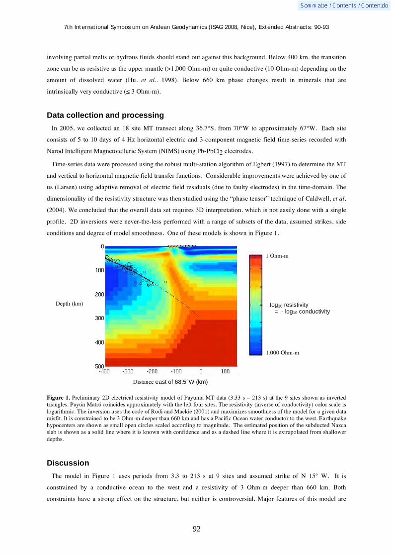
7th International Symposium on Andean Geodynamics (ISAG 2008, Nice), Extended Abstracts: 90-93
92
involving partial melts or hydrous fluids should stand out against this background. Below 400 km, the transition
zone can be as resistive as the upper mantle (>1,000 Ohm-m) or quite conductive (10 Ohm-m) depending on the
amount of dissolved water (Hu, et al., 1998). Below 660 km phase changes result in minerals that are
intrinsically very conductive ( 3 Ohm-m).
Data collection and processing In 2005, we collected an 18 site MT transect along 36.7°S, from 70°W to approximately 67°W. Each site
consists of 5 to 10 days of 4 Hz horizontal electric and 3-component magnetic field time-series recorded with
Narod Intelligent Magnetotelluric System (NIMS) using Pb-PbCl2 electrodes.
Time-series data were processed using the robust multi-station algorithm of Egbert (1997) to determine the MT
and vertical to horizontal magnetic field transfer functions. Considerable improvements were achieved by one of
us (Larsen) using adaptive removal of electric field residuals (due to faulty electrodes) in the time-domain. The
dimensionality of the resistivity structure was then studied using the “phase tensor” technique of Caldwell, et al.
(2004). We concluded that the overall data set requires 3D interpretation, which is not easily done with a single
profile. 2D inversions were never-the-less performed with a range of subsets of the data, assumed strikes, side
conditions and degree of model smoothness. One of these models is shown in Figure 1.
Figure 1. Preliminary 2D electrical resistivity model of Payunia MT data (3.33 s – 213 s) at the 9 sites shown as inverted triangles. Payún Matrú coincides approximately with the left four sites. The resistivity (inverse of conductivity) color scale is logarithmic. The inversion uses the code of Rodi and Mackie (2001) and maximizes smoothness of the model for a given data misfit. It is constrained to be 3 Ohm-m deeper than 660 km and has a Pacific Ocean water conductor to the west. Earthquake hypocenters are shown as small open circles scaled according to magnitude. The estimated position of the subducted Nazca slab is shown as a solid line where it is known with confidence and as a dashed line where it is extrapolated from shallower depths.
Discussion The model in Figure 1 uses periods from 3.3 to 213 s at 9 sites and assumed strike of N 15° W. It is
constrained by a conductive ocean to the west and a resistivity of 3 Ohm-m deeper than 660 km. Both
constraints have a strong effect on the structure, but neither is controversial. Major features of this model are
1 Ohm-m
1,000 Ohm-m
Depth (km)
Distance east of 68.5°W (km)
log10 resistivity
= - log10 conductivity

7th International Symposium on Andean Geodynamics (ISAG 2008, Nice), Extended Abstracts: 90-93
93
only weakly dependent on our choice of data subset or strike and are thus considered “robust”. The most
interesting is the steeply-dipping conductive feature that rises benath the Payún Matrú Volcanic Field (PMVF).
This “plume” is rooted deeper than 200 km and is just above the projected Nazca Slab. One should not trust the
details of this structure at this time. What is known with considerable confidence is that a narrow, near vertical
conductive structure must connect the shallow to deep mantle. It is similar to the conductor associated with the
plunging Nazca flat-slab reported by Booker, Favetto and Pomposiello (2004). This suggests that Payún Matrú
Volcanic Field is sampling mantle deeper than 200 km, perhaps just above the subducted Nazca slab or perhaps
from the mantle transition near where the Nazca slab penetrates into it at 400 km. If transition zone melt is
involved it may explain why the chemistry is like OIB. The deeper part of rising conductive mantle appears to
extend eastward. Its exact relationship to both the Nazca slab and transition zone remains unresolved and is a
major focus of our on-going field work. We hope to be able a preliminary 3D interpretation of these new data at
the meeting.
Acknowledgements This project is supported by the U.S. National Science Foundation (NSF) Grants EAR0310113 and EAR0739116. MT
equipment is from the EMSOC Facility supported by NSF Grant EAR026538. This project also received support from the Agencia de Promocion Cientitica y Tecnologia and CONICET. The first author received support from the Seattle Chapter of the ARCS Foundation, and from Graduate Reseach support and a Anthony Qamar Fellowship provided by the Dept. of Earth and Space Sciences, University of Washington.
References Bercovici, D., & Karato, S. 2003. Whole mantle convection and the transition-zone water filter. Nature 425: 39-44. Bermúdez, A., Delpino, D., Frey, F., Saal, A. 1993. “Los basaltos de retroarco extrandinos”, in: Ramos, V. (ed.) Geologia y
recursos naturals de Mendoza, Relatorio, XII Congreso Gelologico Argentino y II Congreso Exploration de Hydrocarburos, Assoc. Geol Argentina y Inst, Argentino del Petroleo: 161-172.
Booker, J., Favetto, A., & Pomposiello, M.C. 2004. Low Electrical Resistivity associated with plunging of the Nazca flat slab beneath Argentina. Nature, 429: 399 – 403.
Caldwell, G. C., Bibby, H. M. & Brown, C. 2004. The Magnetotelluric Phase Tensor. Geoph. J. Int. 158: 457-469. Egbert, G. 1997. Robust multiple-station magnetotelluric data processing. Geoph. J. Int. 130: 475-496. Folguera, A., Zapata, T. & Ramos, V. 2006. “Late Cenozoic extension and the evolution of the Neuquen Andes”, in: Kay, S.
& Ramos, V. (eds.) Evolution of the Andean Margin: A tectonic and magmatic view from the Andes to the Neuquen Basin (35- 39S lat), Geol. Soc. Am. Special Paper 407: 267-286.
Inbar, M., & Risso, C. 2001. Holocene Yardangs in Volcanic Terrains in the Southern Andes, Argentina. Earth Surf. Process. Landforms 26, 657-666.
Kay, S., Burns, W., Copeland, P. & Mancilla, O. 2006. “Upper Cretaceaous to Holocene magmatism and evidence fro transient Miocene shallowing of the Andean subduction zone under the northern Neuquen Basin”, in: Kay, S. & Ramos, V. (eds.): 19-60.
Kay, S. & Copeland, P. 2006. “Early to middle Miocene backarc magmas of the Neuquen Basin: Geochemical consequences of slab shallowing and the westward drift of South America”, in: Kay, S. & Ramos, V. (eds.): 185-214.
Ramos, V. & Folguera, A. 2005. “Structural and magmatic responses to steepening of a flat subduction, southern Mendoza, Argentina” in: 6th International Symposium on Andean Geodynamics (ISAG 2005 Barcelona), Extended Abstracts: 59-595.
Rodi, W., & Mackie, R. 2001. Nonlinear Conjugate Gradients Algorithm for 2-D Magnetotelluric Inversion. Geophysics 66: 174-187.
Yuan, X., Asch, G., Bataille, K., Bock, G., Bohm, M., Echtler, H., Kind, R., Oncken, O. & Wölber, I. 2006. “Deep seismic images of the Southern Andes”, in: Kay, S. & Ramos, V. (eds.): 61-72.
Xu, Y., Brent, T., Poe, T. Shankland, T., Rubie, D. 1998. Electrical conductivity of olivine, wadsleyite and ringwoodite under upper-mantle conditions, Science 280, 1415-1418.

7th International Symposium on Andean Geodynamics (ISAG 2008, Nice), Extended Abstracts: 94-96
94
Crustal structure and tectonic deformation of the northern Chilean margin, 21-23.5ºS
A. Calahorrano B.1, C. R. Ranero
2, U. Barckhausen
3, C. Reichert
3, & I. Grevemeyer
4
1 Institut de Ciencies del Mar-CMIMA–CSIC, Pg. Maritim de la Barceloneta 37-49, 08003, Barcelona, Spain
([email protected]) 2 Institució Catalana de Recerca i Estudis Avançats (ICREA), CMIMA, Passeig Maritim de la Barceloneta 37-49,
08003, Barcelona, Spain 3 BGR, Bundesanstalt für Geowissenschaften and Rohstoffe, Stilleweg 2, 30655 Hannover, Germany
4 IFM-GEOMAR and SFB574, Wischhofstrasse 1-3, 24148, Kiel, Germany
KEYWORDS : multichannel seismic data, subduction, mass-wasting erosion, outer rise deformation
This work studies the crustal structure and tectonics of the convergent margin of north Chile, between
Tacopilla and Antofagasta, where the oceanic Nazca Plate (50 Ma) subducts sub-orthogonally below the South
American Plate at ~80-90 mm/yr (DeMets et al., 1990; Clift and Vannucchi, 2004). Here we focus on three
reprocessed multichannel seismic (MCS) reflection lines (SO104-7, SO104-9 and SO104-13) that were acquired
during the CINCA'95 experiment (Figure 1). These lines, acquired using a 3-km-long streamer with 120
channels and a 3,124 cc tuned air gun source, run perpendicular to the coast along ~450 km, imaging the
upper/middle slope of the overriding plate, the trench and some ~300 km of the oceanic downgoing plate (Figure
2A).
Figure 1. Study area and bathymetric map of the northern Chile. White lines correspond to location of multichannel seismic lines SO104-7, SO104-9 and SO104-13. White points represent the location of Antofagasta (A) and Tocopilla (T) cities.
In the oceanic domain, the mcs lines show a seafloor practically deprived of sedimentary coverage. In contrast,
the seafloor is characterised by a strong and continuous reflection that we associate to the top of the oceanic
crust (Figure 2B). This reflection changes from smooth to irregular depending on the mcs line and the distance to

7th International Symposium on Andean Geodynamics (ISAG 2008, Nice), Extended Abstracts: 94-96
95
the trench. Lines SO104-9 and SO104-13 show an irregular reflection that traduces the roughness of the seafloor
resulting from the presence of the NE trending Iquique ridge.
Figure 2. A. CINCA SO104-7 seismic images. A) Time-migrated section of a portion of Line SO104-7. This image shows part of the oceanic Nazca Plate which is subducting below the South American Plate (SAP). In the outer rise is concentrated most of the extensive deformation of the downgoing plate resulting from plate bending prior to subduction. B) Enlarged segment of Line SO104-7. The strong and continuous reflection imaging the seafloor correspond to the top of the oceanic crust. Sediment deposits are practically absent. This image shows landward dipping reflections below the crust-mantle boundary (Moho). Note small normal failure affecting the seafloor in the smoother segments of the ocenic crust. C) Enlargement of the segment corresponding to the margin front. Triangles follow the main reflection associated to the inter-plate contact.

7th International Symposium on Andean Geodynamics (ISAG 2008, Nice), Extended Abstracts: 94-96
96
In contrast, line SO1047 is smooth far form the trench, and the influence of the Iquique ridge seems to be
minor. Near the trench, the three lines show irregular bottom morphology, due to a high deformation mainly
resulting from: (1) NW-oriented fabric inherited of spreading during plate generation and (2) the NS horst-and-
graben pattern and normal faulting associated to plate bending nearby the trench (Figures 2A and C).
A second strong reflection, identified around 2s two-way-travel time (stwt) below the seafloor, is associated to
the crust-mantle boundary (Moho). It is quite continuous and clear below soft seafloor reliefs as in Line
SO1047). In line SO104-9, this reflector is locally ~1s deeper twt below the seafloor, at the location of the
Iquique ridge, where an over-thickened crust is expected. Considering a crustal velocity range of 6.5-7 km/s, the
crust would be ~6.5-7 km thick at the segments of normal oceanic crust, and ~10 km at the thickened crustal
segments.
Another feature, which is particularly clear in Line SO104-7, is the presence of landward dipping reflections
pattern below the Moho (Figure 2B). These reflections, which are strong and clear near the trench and disappear
seawards, may be associated to discontinuities, probably compositional, of the asthenosphere.
At a greater scale, it is possible to observe the flexure of the oceanic plate near the trench, produced by bending
prior to subduction. This flexure characterise the outer rise where most of the bending deformation is located.
The top of the oceanic crust reflection preserves the horst-and-graben undulation below the margin, and the
inter-plate contact is observed until ~50 km landward from the trench (Figure 2C). As irregular topography
subducts, basal tectonic erosion is likely to occur below the margin, damaging the bottom of the overriding-plate
basement and removing upper plate material that feeds the subduction channel.
The trench region consists on subducting grabens or half-grabens with some turbiditic desposits (Figure 2C).
The overriding plate shows two slope breaks constraining the upper, middle and low slopes. In the upper slope
the sedimentary coverage is imaged as a finely stratified layer that truncates in the upper/middle slope break. The
top of the overriding-plate basement is interpreted to be a strong reflection that separates the sediment package
and a low-frequency seismic facies body displaying a coarser stratification.
In the upper slope, line SO104-9 images landward dipping normal faults perturbing the basement, sediments
and the seafloor. In the middle and lower slopes sediment are scarce, and normal faulting changes its dip
direction from landward to seaward (lines SO104-9 and SO104-13). These faults indicate that the frontal margin
shoud be dominated by active extension tectonics. Normal faulting and loss of sediment coverage suggest mass
wasting erosion of the frontal margin following the tectonic structure proposed by von Huene and Ranero 2003.
The eroded debris may accumulate at the margin’s toe explaining the presence of an incipient <10 km-wide
sediment prism at the deformation front, but they may also fill the oceanic plate grabens and feed the subduction
channel. The sedimentary prism may eventually be also eroded and be involved into subduction.
References Clift, P. D. and P. Vannucchi. 2004. Controls on tectonic accretion versus erosion in subduction zones: Implications for the
origin and recycling of the continental crust. Reviews of Geophysics 42: 1-31. DeMets, C., R. G. Gordon, D.F. Argus and S. Stein. 1990. Current plate motions. Geophysical Journal International 101:
425-478. von Huene, R. and C. R. Ranero. 2003. Subduction erosion and basal friction along the sediment-starved convergent margin
off Antofagasta, Chile. Journal of Geophysical Research 108(B2): 3-1 3-16.

7th International Symposium on Andean Geodynamics (ISAG 2008, Nice), Extended Abstracts: 97-100
97
Preliminary stratigraphic study of the San Francisco River volcanic sequence, northwestern Purace volcano, Cauca, Colombia
E. Cañola1, S.M. López
1, G. E. Toro
1, & B. Pulgarín
2
1 Universidad EAFIT, Carrera 49 N° 7 Sur -50 Medellin, Colombia ([email protected];
[email protected]; [email protected]) 2 INGEOMINAS, Popayán, Colombia ([email protected])
KEYWORDS : stratigraphy, Cenozoic volcanism, Purace volcano, magmatic evolution
Introduction
The Purace volcano is part of recent volcanism in the Colombian Andes with 20 actives volcanoes, at the
Northern Volcanic Zone (Hanke and Parodi, 1966; Mendez, 1989). Subduction of the Nazca oceanic plate
beneath the Suramerican plate, generates the magmas that formed the volcanism Cenozoic. The geometric
features at this volcanic zone are: dip of Waddati- Benioff zone is about 25° (e.g. Pennington, 1981, Pilger,
1983), young subducted oceanic plate (10 – 14 Ma, Hardy, 1991) and continental crust with 35- 40 km thick
(e.g. Case et al., 1971; Meissner et al., 1976). According to Aspden et al. (1987), the current activity is probably
a continuation of the magmatic event that generated the Miocene-Pliocene volcanism recorded in the Colombian
Andes.
We have chosen to study the area located in the northwestern flank of the Purace volcano, where several
pyroclastics flows deposit interbedded with lava flows outcrops along the San Francisco River located close to
the Purace town in the Cauca department (Colombia). Our data will contribute to the knowledge of the spatial
and temporal volcanic distribution that originated the volcanism of the Coconucos volcanic chain (CVLC). It is
important to see the change in the volcanic behavior, where explosive events are interbedded with effusive
events.
Geological and tectonic setting
The basement under this volcanic suite is mainly Paleozoic metamorphic rocks, composed by schist grouped in
Cajamarca Complex (Maya y González, 1995). To the western part outcrops the Quebradagrande Complex, this
consists of volcanic and Albian–Aptian sedimentary rocks. The current volcanic activity at this area, is related
with the Coconucos volcanic chain (CVLC), which is formed by 15 eruptive centers aligned NW-SE. (Monsalve
y Pulgarín, 1995). The CVLC is located between two large faults systems: Algeciras and Chusma Faults at east
and Romeral Fault at west (Fig. 1). There are others structures located oblique to the main fault systems
(Velandia et al, 2005). Some authors (e.g. Bohórquez et al., 2003) proposed that the oblique structures had
allowed the emplacement of the Neocene-Quaternary volcanism.
Several volcanic structures have been identified: Paletara caldera (Torres et al, 1999), Chagartón caldera and
Pre-Puracé volcano (Monsalve, 1991; Monsalve, 2000). Paletara caldera is by far the largest caldera structure
with more than 35 km of diameter (Fig. 1). It is believed that the formation of such structure could be associated
to the generation of the ignimbrite deposits of the Popayan and Guacacallo Formations (Torres et al, 1999 and

7th International Symposium on Andean Geodynamics (ISAG 2008, Nice), Extended Abstracts: 97-100
98
Torres in prepared) located to the west and east of the study area. The geological map (fig 1) was realized with
field work and other information (Monsalve y Pulgartín, 1995; Monsalve, 2000).
Figure1. Geological map at northwestern Purace volcano, around San Francisco River. Modified from (Monsalve y Pulgarín, 1995; Monsalve, 2000).
Stratigraphy
The study of a volcanic sequence that outcrops along the San Francisco river, shows different volcanic events
that forms these deposits (fig 2). There is a change in the volcanic behavior where explosive events are
interbedded with effusive events, related with lava flows. At the moment, we have been concentrated in the
description of the pyroclastics flow deposits which are mainly ignimbrites and blast directed pyroclastic flows
deposit (fig 2). The main events are: (1) Coconucos´s ignimbrite: Are located in the bottom of the sequence with
150 m thick. This unit has a high percentage of biotite (25%) which may indicate a hydrous-rich magma source
and represent an intracalderic facies associated to Paletara´s caldera, which is correlated with the huge ignimbrite
found in other places at Cauca department (Torres in prepared) . (2) Unsorted deposits with massive texture,
with 20 m thick, composed by large non-vesicular lithic blocks. It is a block and ash flow deposit and may
represent a dome-collapse associated to the Chagartón´s caldera. (3) Pumice and ash flow deposit, with 60 m
thick and high modal abundance of hornblende (20%). (4) The final event registered is scoria and ash flow
deposits, with 60 m thick and matrix with high percentage of pyroxene crystals (30%). The special composition
of this last event indicates a water-poor magma source which may be different source to the water-rich ones at
the bottom of the sequence. This deposit has been associated with the final stage of Pre-Purace structure
(Monsalve et al, 1991) and a 14C age of 30.000 years BP was obtained for this deposit (Monsalve et al, 1991).
At the moment, the stratigraphic sequence presented here has been determined by field work correlations. A
detailed age dating determination is carrying out using fission track method in zircon grains for the most

7th International Symposium on Andean Geodynamics (ISAG 2008, Nice), Extended Abstracts: 97-100
99
representative volcanic events (López in prepared).
Figure 2. Generalized stratigraphic at the San Francisco river, northwestern Purace volcano.
Conclusions
The stratigraphic sequence along the San Francisco River, had allowed to identify large explosive volcanic
periods interbedded with effusive-type events, which could indicated that the volcanic behavior has been
variable on the time. Variations in the modal composition, the modal abundances of biotite, amphiboles and
pyroxenes from the bottom to the top of the sequence, could be an important evidence for the changing
conditions at the magma chambers which may result in different volcanic styles pyroclastic flow deposits. The
current results are indicating a complex magma process in the formation of this type of highly explosive
intermediate to silicic magmas, where the interaction of fluid-rich mantle-derived magmas assimilates the lower
continental crust (e.g. Marín-Cerón, 2007; Marín-Cerón et al., 2008) in different proportions, producing magmas
highly water saturated, following small or advanced differentiation processes. The complex structural conditions
at this volcanic region may play an important role in the variations in the volcanic behavior. There is a potent
pyroclastic flow deposit (60 m thick) at the top of the sequence with a 14C age of 30.000 year showing a
important hazard volcanic in the area.
Acknowledgments
This work has been realized thanks to the research project Ingeominas and EAFIT University. We thank M. I. Marín-Cerón for suggestions to improve the manuscript and M. L. Monsalve for suggestions in the field’s works.
7th International Symposium on Andean Geodynamics (ISAG 2008, Nice), Extended Abstracts: 97-100
100
References Aspden, J.A., McCourt, W.J., Brook, M., 1987. Geometrical control on subduction-related magmatism: the Mesozoic and
Cenozoic plutonic history of Western Colombia. Journal of the Geological Society, London 144: 893–905. Bohórquez, O.P., Monsalve, M.L., Velandia, F., Gil-Cruz, F. 2003. Determinación del marco tectónico regional para la
cadena volcánica más septentrional de la cordillera central de Colombia. Memorias IX Congreso colombiano de geología. Case, J.E., Duran, S.L.G., López, R.A., Moore, W.R., 1971. Tectonic investigations in western Colombia and eastern
Panamá. Geological Society of America Bulletin 82 (10): 2685–2712. Hanke G., Parodi I., 1966. Catalogue of the active volcanoes of the worl including solfatara fields. Part XIX. International
Association of Volcanology, 73 pp. Hardy, N.C., 1991, Tectonic evolution of the easternmost Panama Basin: some new data and interferences, Journal of South
America Earth Science, 4(3): 261-269. Marin-Cerón, M.I., 2007. Major, trace element and multi-isotopic systematics of SW Colombian volcanic arc, northern
Andes: Implication for the stability of carbonate-rich sediment at subduction zone and the genesis of andesite magma. Doctor’s thesis. Graduate School of Natural Science and Technology Okayama University, Japan, 123 p.
Marin-Cerón, M.I, Moriguti, T., Nakamura, E., 2008. Andesite magma generation at the Plio-Quaternary SW Colombian volcanic arc. In this symposium: 7th International Symposium on Andean Geodinamics.
Méndez, R.A., 1989. Catálogo de los volcanes activos de Colombia. Bol. Geol. 30(3), Ingeominas, Bogotá, 75 p. Meissner, R.O., Flueh, E.R., Stibane, F., Berg, E. 1976. Dynamics of the active plate boundary in southwest Colombia
according to recent geophysical measurements. Tectonophysics 35: 115- 136 Maya, M., González, H. 1995. Unidades litodémicas en la Cordillera Central de Colombia. Boletín geológico Ingeominas. 35
(2- 3): 43- 53. Monsalve, M. L., 1991. Geoquímica y episodios de episodios tipo San Vicente en el volcán Puracé. Boletín geológico
Ingeominas 33: 3-16 Monsalve, M.L., Pulgarín, B. 1995. Cadena volcánica de los Coconucos (Colombia) centros eruptivos y productos recientes.
Boletín geológico Ingeominas. (37) 17- 51. Monsalve, M.L, 2000. Catalogo de las vulcanitas Neógenas de Colombia, Fascículo Formación Coconuco. Informe interno
Ingeominas. Murcia, A., Pichler, H. 1981. Geoquímica y dataciones radiométricas de las ignimbritas cenozoicas del Sur de
Colombia.Revita CIAF 6(1-3): 343- 363. Pennington, W.D., 1981. Subduction of the eastern Panama basin and seismotectonics of northwestern South America.
Journal of Geophysical Research 86 10: 753– 770. Torres, M. P., Monsalve, M.L., Pulgarín, B., Cepeda, H., 1999. Caldera de Paletará: Aproximación a la fuente de las
ignimbritas del Cauca y Huila. Boletín geológico Ingeominas. (37) 1- 15. Torres, M.P., Ibañez, D.G., Vasquez, E.J., 1992. Geología y estratigrafía de la Formación Popayán. Informe interno
Ingeominas Popayán. Pilger, R.H. 1983. Kinematics of the South American subduction zone from global plate restructions. Geodynamics of the
plate restructions. Geodynamics of the Eastern Pacific Region, Caribeean and Scotia Arcs. American Geophysical Union Geodynamics Series. 9: 113- 126.
Velandia, F., Acosta, J., Terraza, R., Villegas, H. 2005. The current tectonic motion of the Northern Andes along the Algeciras Fault System in SW Colombia Tectonophysics 399: 313– 329

7th International Symposium on Andean Geodynamics (ISAG 2008, Nice), Extended Abstracts: 101-104
101
Geochemical characterization of Volatile Organic Compounds (VOCs) in fluid discharges at Copahue volcano (Argentina)
F. Capecchiacci1, F. Tassi
1, O. Vaselli
1,3, A. Caselli2, & M. Agusto
2
1 Department of Earth Sciences, Univ. of Florence, Via G. La Pira, 4, 50121 Florence, Italy
([email protected]; [email protected]) 2 Departamento Ciencias Geológicas, Facultad de Ciencias Exactas y Naturales, Universidad de Buenos Aires,
Ciudad Universitaria, Pabellón 2, 1428EHA, Buenos Aires, Argentina ([email protected];
[email protected]) 3 CNR-IGG, Institute of Geosciences and Georesources, Via G. La Pira, 4, 50121 Florence, Italy
KEYWORDS : VOCs, Copahue volcano, hydrothermal system, fumarolic discharge, fluid chemistry
Introduction
Thermal fluid discharges from geothermal and volcanic systems are characterized by the presence of volatile
organic compounds (VOCs) at relatively low concentrations (up to few tens of μmol/mol) (Capaccioni et al.,
1993; Darling 1998; Tassi, 2004). In these environments hydrocarbon compounds are generally produced by i)
degradation of organic material, mainly buried in sedimentary formations, through bacteria-driven (biogenic)
reactions at low temperature (<150 °C) and ii) thermogenic processes (at 150-350 °C), such as thermal cracking
and catalytic reforming involving both pre-formed organic compounds and inorganic gas species, i.e. CO, CO2
and H2 (e.g. Des Marais et al., 1981; Mango, 2000; Taran and Giggenbach, 2003). Several authors (Capaccioni
and Mangani, 2001; Tassi et al., 2005a) have studied the behavior of reactions regulating the relative
concentrations of the light (C2-C3) alkenes-alkanes pairs at hydrothermal conditions demonstrating their possible
use as geoindicators for geothermal prospection and volcanic sourveillance (Capaccioni et al., 2005; Tassi et al,
2005b; 2007). However, few data are presently available for studies aimed to the understanding of the fate of
more complex organic compounds (>C5) in naturally discharged fluids. In this work, the compositional features
of the organic gas fraction from the fumarolic fluids discharged at the foothill of Copahue volcano (Argentina),
an active system pertaining to the Andean Southern Volcanic Zone (ASVZ), are presented and compared with
those from 1) low-temperature sedimentary environment, 2) geothermal areas and 3) active volcanic systems in
order to investigate the degradation processes of organic matter at different thermodynamic conditions.
Geological setting
The volcanic activity at Copahue (37º45’S-71º10.2’W, 2977 m a.s.l.), nested in the Caviahue-Copahue
Volcanic Complex (CCVC; Argentina-Chile) (Fig.1), started in the Pliocene. In the last 250 years 12 low-
magnitude phreatic and phreato-magmatic eruptions (Naranjo and Polanco, 2004) have marked its volcanic
history. During the last eruptive cycle, opened in July 1992, two major phreato-magmatic eruptions (September
1995 and July-October 2000) have occurred. Presently, the volcano summit consists of nine NE-oriented craters
and the active one hosting a hot (up to 42 °C) hyperacidic lake (Copahue Lake; Varekamp et al., 2001; Caselli et
al., 2005). Several thermal discharges are located in the northern flank of the volcanic edifice, where a thermal
health spa is placed.

7th International Symposium on Andean Geodynamics (ISAG 2008, Nice), Extended Abstracts: 101-104
102
Sampling and analytical method
The Copahue fluid discharges include hot mud-, boiling- and bubbling-pools, thermal springs, fumaroles and
areas of diffuse degassing. The gas samples, collected in November 2006 and February 2007, consist of 6
fumaroles, 3 bubbling pools and a 1,241 m deep well of the local (dismissed) geothermal plant, and analyzed for
the determination of the chemical composition of the main constituents using the procedure described in
Montegrossi et al. (2001). Gas samples for the determination of VOC composition were collected into pre-
evacuated 12 mL glass vials equipped with pierceable rubber septum (Labco ExetainerR) after vapor
condensation. The organic volatiles were analyzed by gas-chromatography (Thermo Trace GC Ultra) coupled
with mass spectrometry (Thermo DSQ) for analytical separation and detection of VOCs in the mass range of
40-400 m/z. The pre-concentration and the introduction of the sample were carried out by using a manual SPME
(solid-phase micro-extraction) device (Supelco; Bellefonte, PA, USA), whereas the different compounds were
identified by comparing the mass spectra with those of the NIST-05 library.
Figura 1. Map of the Chaviahue-Copahue volcanic complex (Argentina) (Melnick et al., 2005)
Main gas composition
The Copahue fumarolic discharges and the geothermal well, whose outlet temperatures range between 86 and
135 °C, are mainly composed by water vapour (96-98 % by vol.) and CO2 (2-4 % by vol.), while the bubbling
pools (outlet temperatures comprised between 74 and 83 °C), being affected by water condensation at ground
surface, have relatively low concentrations of water vapour (<34 % by vol.) and dominating CO2 (up to 80 % by
vol.). As far as the dry gas phase is concerned, all the gas discharges are characterized by relatively high
concentrations of H2S, CH4 and N2 (up to 6.7, 2.6 and 2.5 % by vol., respectively) and acidic species, such as
HCl and HF (up to 0.55 and 0.02 % by vol.). Minor but significant concentrations of atmospheric-related
compounds are also present. In the N2excess-CH4-Ne ternary diagram (Fig. 2), where N2excess is non-atmospheric N2
calculated on the basis of Ar concentrations, the chemistry of the Copahue thermal fluids seems to be referred to
a hydrothermal reservoir, with significant contribution from i) the magmatic system (andesitic) and ii) air.

7th International Symposium on Andean Geodynamics (ISAG 2008, Nice), Extended Abstracts: 101-104
103
CH4
N2 excess/5Ne *10000
hydroth
erm
al
andesiticair (asw)
VOC chemical composition
On the whole, 56 different species were identified in almost all the gas discharges, showing concentrations that
vary in a wide range (from 0.1 to 48,743 ppb by vol.). As shown in Fig. 3a, VOCs are composed by comparable
amounts of aromatics (mainly benzene) and alkanes, and relatively low concentrations of alkenes (>C4), cyclics
and S-, Cl- and O-bearing compounds. The total abundances of VOCs are about three orders of magnitude less
than those of methane. This compositional feature seems to suggest that the organic gas fraction has a biogenic
origin (e.g. Whiticar and Suess, 1990) and consequently is produced at shallower depth than that of the
hydrothermal reservoir feeding the gas discharges. This evidence conflicts with the high speciation of the >C2
compounds, commonly characterizing fluids of medium-to-high temperature environments (e.g. Tassi, 2004).
d)c)
b)
0.291%0.131%0.141%0.804%1.1%
58.8%
38.7%
COPAHUE
59%
aromatics
alkanes
39%
alkenes
1%
cyclics
0.8%
S-substituted
0.3% 0.1%
0.1%O-substituted
Cl-substituted
a) HIGH TEMPERATURE
2.82%4.58%
13%
1.41%0.47%8.34%
69.3%
alkanes
aromaticsalkenes cyclics
O-substituted
Cl-substitutedS-substituted
69%
8.3%
13%
4.6%
2.8%
0.5%1.4%
LOW TEMPERATURE
29.3%
0.499%3.87%0%O-substituted
0.5%
Cl-substituted
S-substitutedaromatics
26.9%
alkenes
26.9%
16.9%
22.6%
27%
17%alkanes
22.5%
29%
3.9%
0.874%0.127%2.09%0.0313%
3.47%
49.5%
43.9%
aromatics
49.5%
alkanes44%
HYDROTHERMAL
alkenes3.5%
cyclics
2.1%
0.13%
Cl-substituted0.87%
0.03%
S-substituted
O-substituted
For comparison the compositions of the organic gas fraction of i) high-temperature fluids (Fig. 3b) from
Turrialba volcano (Costa Rica), which are strongly related to magmatic contribution (Tassi et al., 2004), ii)
typical hydrothermal fluids (Fig. 3c) from Yellowstone (USA) (Fournier, 1989), Afar (Ethiopia) (D’Amore et
al., 1997) and Tatun (Taiwan, Cina) (Lee et al., 2005) geothermal areas, and iii) CO2-rich cold gases (Fig. 3d)
from low-enthalpy systems in Tuscany (Italy) (Minissale et al., 1997), are also reported. The relative abundances
of the main groups of organics in Copahue fluids seem to be consistent with those of worldwide hydrothermal
systems (Fig. 3c), whereas significant differences are shown when compared with the composition of the
Turrialba fluids (Fig. 3b), characterized by relatively high concentrations of compounds stable at high-
temperature (i.e. S-substituted species and alkenes; Capaccioni et al., 1995), and low-temperature gases (Fig.
Figure 3a-d. Pie diagram of VOC composition in fluid discharges from a) Copahue volcano (Argentina), b) high-temperature system (Turrialba volcano, Costa Rica), c) hydrothermal systems (Yellowstone, USA; Afar, Ethiopia; Tatun, Taiwan) and d) low-enthalpy systems (Tuscany, Italy).
Figure 2. N2excess-CH4-Ne ternary diagram for gas discharges from Copahue volcano (Argentina).

7th International Symposium on Andean Geodynamics (ISAG 2008, Nice), Extended Abstracts: 101-104
104
3d), the latter being enriched in hydrocarbons commonly produced by bacterial activity in shallow environment
(i.e. alkanes and O-substituted species).
Concluding remarks
The organic gas species of the thermal fluids discharged from the Cophaue volcanic system are likely produced
by thermogenic processes occurring in the main hydrothermal reservoir. However, the origin of CH4 seems to be
decoupled from that of the non-methane VOCs, being the former likely related to biogenic processes typical of
low temperature conditions. This means that the uprising fluids from the hydrothermal system feeding the
discharges surrounding Copahue volcano are affected, at some degree, by mixing with shallow aquifers, as also
testified by the presence of atmospheric compounds. On the contrary, the influence on organic gas chemistry of
contributions from the magmatic source can be regarded as negligible. The compositional features of the organic
gas fraction may also be used for geochemical monitoring purposes since they appear to be indicative of deep-
vs. shallow-originated gas compounds, whose ratios could be modified in the case of uprising magmatic masses.
References Capaccioni B., Mangani F., 2001. Monitoring of active but quiescent volcanoes using light hydrocarbon distribution in
volcanic gases: The results of 4 years of discontinuous monitoring in the Campi Flegrei (Italy). Earth Planet. Sci. Lett. 188: 543-555.
Capaccioni B., Martini M., Mangani F., Giannini L., Nappi G., Prati F., 1993. Light hydrocarbons in gas-emissions from volcanic areas and geothermal fields. Geochem. J. 27: 7-17.
Caselli A.T., Agusto M.R., Fazio A., 2005. “Cambios térmicos y geoquímicos del lago cratérico del volcán Copahue (Neuquén): posibles variaciones cíclicas del sistema volcánico”. In XVI° Congreso Geológico Argentino, La Plata, Argentina, 1: 751-756.
D’amore F., D. Giusti And B. Gizaw, 1997. “Tendaho, Ethiopia. Geothermal Project: a Geochemical Assessment”. In 22nd Workshop Geothermal Reservoir Engineering, Stanford, January: 27-29, pp. 435-445.
Des Marais D. J., Donchin J.H., Truesdell A.H., Nehring N.L., 1981. Molecular carbon isotopic evidence for the origin of geothermal hydrocarbons. Nature 292: 826-828.
Fournier R.O., 1989. “Geochemistry and dynamics of the Yellowstone National Park hydrothermal system”. Annu. Rev. Earth Planet. Sci.: 17, 13-53.
Lee H.F., T.F. Yang, T.F. Lan, S.R. Song And S. Tsao, 2005. Fumarolic gas composition of the Tatun Volcano Group, northern Taiwan. Terrestrial, Atmospheric and Oceanic Sciences 16: 843-864.
Mango F.D., 2000. The origin of light hydrocarbons. Geochim. Cosmochim. Acta 64: 1265-1277. Melnick D., Folguera A., Ramos V.A., 2006: Structural control on arc volcanism: The Caviahue–Copahue complex, Central
to Patagonian Andes transition (38°S) Journal of South American Earth Sciences 22: (2006) 66–88. Minissale A., Evans W.C., Magro G., Vaselli O., 1997. Multiple source components in gas manifestations from north-central
Italy. Chem. Geol. 142: 175-192. Montegrossi G., Tassi F., Vaselli O. Buccianti A., Garofano K., 2001. Sulfur species in volcanic gases. Anal. Chem 73: 3709-
3715. Naranjo J.A. & Polanco E., 2004. The 2000 AD eruption of Copahue Volcano, Southern Andes. Revista Geológica Chile 31
(2): 279-292. Taran Y.A., Giggenbach W.F., 2003. “Geochemistry of light hydrocarbons in subduction-related volcanic and hydrothermal
fluids”. In Simmons and I. J. Graham (Eds.):Volcanic, Geothermal, and Ore-Forming Fluids. I - Rulers and Witnesses of Processes Within the Earth. Spec. Publ., 10, S. F. Soc. of Econ. Geol., Littleton, Colorado: 61–74.
Tassi, F., 2004. Fluidi in ambiente vulcanico: Evoluzione temporale dei parametri composizionali e distribuzione degli idrocarburi leggeri in fase gassosa. Ph.D. thesis, Univ. of Florence, Florence, Italy, pp. 292 (in Italian).
Tassi F., Martinez C., Vaselli O., Capaccioni B. And Viramonte J., 2005a. The light hydrocarbons as new geoindicators of equilibrium temperatures and redox conditions of geothermal fields: Evidence from El Tatio (northern Chile). Appl. Geochem. 20: 2049-2062.
Tassi F., Vaselli O., Capaccioni B., Giolito C., Duarte E. Fernandez E., Minissale A., Magro G., 2005b. The hydrothermal-volcanic system of Rincon de la Vieja volcano (Costa Rica): A combined (inorganic and organic) geochemical approach to understanding the origin of the fluid discharges and its possible application to volcanic surveillance. J. Volcanol. Geotherm. Res. 148: 315-333.
Varekamp J., Ouimette A., Hermán S., Bermúdez A., Delpino D., 2001. Hydrothermal element fluxes from Copahue, Argentina: A "beehive" volcano in turmoil. Geology 29 (11): 1059-1062.
Whiticar MJ, & Suess E (1990). Hydrothermal hydrocarbon gases in the sediments of the King-George Basin, Bransfield Strait, Antarctica. Appl. Geochem. 5:135-147.

7th International Symposium on Andean Geodynamics (ISAG 2008, Nice), Extended Abstracts: 105-108
105
The lithosphere of Southern Peru: A result of the accretion of allochthonous blocks during the Mesoproterozoic
Víctor Carlotto1,2
, José Cárdenas2, & Gabriel Carlier
3
1 INGEMMET, Avenida Canada 1470, San Borja, Lima 41, Peru ([email protected])
2 Universidad Nacional San Antonio Abad del Cusco (UNSAAC), Peru
3 Muséum National d'Histoire Naturelle, Département "Histoire de la Terre", USM 201-CNRS UMR 7160, 61, rue
Buffon, 75005 Paris, France
KEYWORDS : Southern Peru, Altiplano, lithosphere, accretion, Mesoproterozoic
Introduction
Southern Peru exhibits different juxtaposed structural blocks. These blocks have a distinct sedimentary,
tectonic and magmatic evolution. They are bounded by complex, mainly NW-SE fault systems, locally marked
by Cenozoic and Mesozoic magmatic units. The specific Mesozoic and Cenozoic geologic evolution of each
structural block is ascribed to the high heterogeneity of the southern Peruvian depth lithosphere. This lithosphere
results from the accretion of different lithospheric blocks during Laurentia-Amazonia collision at around
1000 Ma.
Structural domains
Southern Peru is characterized by the following morpho-structural domains (Figure 1):
- The Western Cordillera, which exposes siliciclastic and carbonate marine and non-marine formations
correspondining to the filling of a Mesozoic though (the Western Peruvian Mesozoic Basin);
- The Western Altiplano, which acted as a structural high (the Cusco-Puno structural high) during the
Mesozoic times and received more than 10 km of continental red beds during the Cenozoic;
- The Eastern Altiplano and the Eastern Cordillera, which show the Mesozoic sedimentary cover and the
pre-Mesozoic basement of a second mainly marine basin (the Eastern Peruvian Mesozoic Basin),
respectively.
The boundary between these domains is clearly marked by large fault systems that show evidence of activity at
least since the Paleozoic. The boundary between the Western Cordillera and the Western Altiplano is marked by
the NW-trending Cusco-Lagunillas-Mañazo (C-L-M) fault system (Figures 1 and 2, Carlotto, 1998). During the
Mesozoic, SW-dipping faults of this system had normal movements and separate the Western Peruvian Basin
from the Cusco-Puno structural high. They control the marine and continental depositions, which are thicker in
the basin and thinner at the high, respectively (Figure 2). During the Cenozoic, these normal faults acted firstly
as strike-slip faults and then, as reverse faults. Such activity resulted in the uplift of the NE margin of the
Western Peruvian Basin and converted the Cusco-Puno structural high to continental synorogenic foreland basin.
At this time, the strongest deformation and maximum shortening were concentrated along the C-L-M fault
system that represented a NE-verging foreland front (Carlotto, 1998). Further to the north, the C-L-M fault
system joins to a west-trending complex fault system, called Abancay-Andahuaylas (Fig. 1) that coincides with
the boundary between the Arequipa and Paracas blocks (Ramos, 2008).

7th International Symposium on Andean Geodynamics (ISAG 2008, Nice), Extended Abstracts: 105-108
106
Figure 1: Morphostructural domains of Southern Peru showing the main fault system. C-L-M: Cusco-Lagunillas Mañazo Fault System, U-S-A: Urcos-Sicuani-Ayaviri Fault System
The boundary between the Western Altiplano and the Eastern Altiplano and the Eastern Cordillera corresponds
to the Urcos-Sicuani-Ayaviri (U-S-A) or Cusco-Vilcanota fault system (Carlotto, 1998; Carlier et al., 2005).
This system behaves similarly to the C-L-M fault system. It separates the Cusco-Puno structural high and the
Eastern Peruvian Mesozoic Basin (Figure 2). During the Mesozoic, it consists of normal, NE-dipping faults.
During the Cenozoic, the system behaved as strike-slip or reverse, but SW-verging structures (Carlotto, 1998).
Figure 2: Mesozoic paleogeographic section viewing the bassin’s boundary and the substrate.

7th International Symposium on Andean Geodynamics (ISAG 2008, Nice), Extended Abstracts: 105-108
107
Substrate
The Arequipa Massif
The Arequipa Massif is well exposed along the southern Peruvian coast. It locally preserves semi-grabens that
show a Mesozoic cover unconformably deposited above Precambrian formations indicating that Arequipa
Massif constitutes the basement of the Western Peruvian Mesozoic Basin. Along the Cincha-Lluta Thrust
(Figure 1), this basement overlies the Mesozoic series of the Western Peruvian Mesozoic Basin. Arequipa
Massif had a complex magmatic and metamorphic polycyclic evolution from early Proterozoic to Paleozoic. It
includes 1) rocks displaying protolith ages of 1.9 Ga, affected by metamorphism between 1.9 and 1.8 Ga
(Dalmayrac et al. 1977; Cobbing et al., 1977) and 2) rocks showing Mesoproterozoic protolith and
metamorphism ages (1.2-1.0 Ga; Wasteneys et al., 1995; Loewy et al., 2004). The age of metamorphism
(Martignole & Martelat, 2003), from 1064±45 Ma to 956±50 Ma, confirms that an old protolith of 1900 Ma
underwent rejuvenation around 1000 Ma during a regional high-grade tectonic and metamorphic event related
with the Sunsas or Grenville orogeny. Hence, the geologic history of the Arequipa Massif began with the
collision between Laurentia and Amazonia, when a Paleoproterozoic terrain was trapped during the
Mesoproterozoic times between these two cratonic blocks. The consequence of the collision between the two
cratons is the formation of a mosaic of microblocks along the collisional suture. We suggest that this microblock
mosaic later formed the substrate for the Western Altiplano and Eastern Altiplano.
Western Altiplano - Eastern Altiplano substrates
Recent mineralogical, petrological, geochemical and geochronological studies of Cenozoic magmatism in the
southern Peruvian Altiplano (Carlier et al., 2005) reveal a variety of shoshonitic, calc-alkaline, acid,
peraluminous and metaluminous rocks associated to alkaline potassic (P) and ultrapotassic (UP) rocks. This
variety, together with the spatial distribution of this magmatism, implies that the deep lithosphere beneath the
Andes of southern Peru consists of a mosaic of lithospheric blocks with different origins. In fact, P-UP rocks
mostly derive from partial fusion of lithospheric mantle rocks. Mineralogical, geochemical, isotopic and
geochronological data allow to distinguish three P-UP rock associations (Carlier et al., 2005). The first group,
mostly composed of Oligocene phlogopite lamproites in the Eastern Altiplano (Figure 1), demonstrates the
presence of a Paleoproterozoic to Archaic (TDM = 1130-2485 Ma; Nd = -5.0 to -11.4; 87Sr/86Sri = 0.7100-
0.7159) metasomatized harzburgite mantle beneath this domain. Beneath the Western Altiplano (Figure 1), the
deep lithosphere corresponds to a younger (TDM = 837-1259 Ma; Nd = +0.6 a –6.3; 87Sr/86Sri = 0.7048-
0.7069) metasomatized lherzolithic mantle, as indicated by a second group of Oligocene and Miocene, P-UP,
diopside-rich lavas (leucitites, tephrites with leucite, traquibasalt with olivine and diopside). A more recent
(< 2 Ma) third group crops out at the boundary between both Altiplano domains and is composed of diopside
phlogopite lamproites, kersantites, minettes and augite trachybasalts, showing a mantle source which probably
includes an astenospheric component, apart from material derived from the two lithospheric mantles previously
described (TDM = 612-864 Ma; Nd = -1.1 a -3.5; 87Sr/86Sri = 0.7051-0.7062). This third group, present as
volcanic edifices, dikes, stocks, domes, etc., is located over the fault system, still active fault system of the U-S-
A or Cusco-Vilcanota, and marks the boundary between both parts of the Altiplano.

7th International Symposium on Andean Geodynamics (ISAG 2008, Nice), Extended Abstracts: 105-108
108
Conclusions
The three large morphostructural domains (lithospheric blocs) previously defined evidently exhibits different
kinds of substrate. The first one, beneath the Western Cordillera (Western Peruvian Mesozoic Basin), most
probably corresponds to Arequipa Massif-like material, with ages between 1900 and 600 Ma. It probably reaches
the C-L-M fault system zone. The second one, beneath the Western Altiplano, has a deep lithosphere
corresponding to a metasomatized lherzolithic mantle. It is separated from the Western Cordillera by the C-L-M
fault system and from the Eastern Altiplano by the U-S-A fault system. The third one, beneath the Eastern
Altiplano, corresponds to a depth lithosphere with a Paleoproterozoic to Archaic metasomatized harzburgite
mantle.
Thus, the lithosphere of the western margin of the South American Plate has to be considered as a mosaic of
amalgamated lithospheric blocks (terranes) accreted to Amazonia during the Sunsas orogeny (at 1000 Ma). This
orogeny resulted from the complex collision implicating, in addition of large cratons, several smaller
lithospheric blocks such as the Arequipa Massif. The resulting heterogeneous lithosphere later formed the
basement of the Western Altiplano and Eastern Altiplano. The boundaries of the lithospheric blocks still
constitute weakness zones along which more recent deformations (lateral displacement, overthrusts…) are
concentrated. Thus, during the Cenozoic times, lithospheric microblocks composing the Southern Peru are
apparently displaced by NE-trending and E-trending transform fault systems (Patacancha-Tamburco and
Puyentimari-Rancahua faults and E-W segment of the C-L-M fault system, Figure 1). Some of these structures
like the Abancay-Andahuaylas Fault System extends towards the coast and separate the Arequipa and Paracas
massifs.
References Carlier, G., Lorand, J. P., Liégeois, J. P., Fornari, M., Soler, P., Carlotto, V., Cardenas, J., 2005. Potassicultrapotassic mafic
rocks delineate two lithospheric mantle blocks beneath the southern Peruvian Altiplano. Geology, 33, 601-604. Carlotto, V., 1998. Evolution andine et raccourcissement au niveau de Cusco (13°-16°S, Pérou). Thèse doct., univ. Grenoble,
France, 159 p. Cobbing, E.J., Ozard, J.M., Snelling, N.J. 1977. Reconnaissance geochronoiogy of the crystalline basement rocks of the
Coastal Cordillera of southern Peru. Geol. Soc. Am. Bull. 88:241--46 Dalmayrac, B., Lancelot, J.R., Leyreloup, A. 1977. Two-billion-year granulites in the late Precambrian metamorphic
basement along the southern Peruvian coast. Science 198:49--51 Loewy, S.L., Connelly, J.N., Dalziel, I.W.D. 2004. An orphaned basement block: the Arequipa-Antofalla Basement of the
central Andean margin of South America. Geol. Soc. Am. Bull. 116:171--87 Martignole, J., Martelat, J.E. 2003. Regional-scale Grenvillian-age UHT metamorphism in the Mollendo--Camana block
(basement of the Peruvian Andes). J. Metamor. Geol. 21:99-120 Ramos, V. 2008. The Basement of the Central Andes: The Arequipa and related Terranes, Annual Review of Earth and
Planetary Sciences, Volume 36 (2008): In press Wasteneys, A.H., Clark, A.H., Farrar, E., Langridge, R.J. 1995. Grenvillian granulite-facies metamorphism in the Arequipa
massif, Peru: a Laurentia-Gondwana link. Earth Planet. Sci. Lett. 132:63-73

7th International Symposium on Andean Geodynamics (ISAG 2008, Nice), Extended Abstracts: 109-112
109
Igneous rocks with adakitic-like signature in South America
Silvia I. Carrasquero
Facultad de Ciencias Naturales y Museo-Universidad Nacional de La Plata (UNLP), Paseo del Bosque S/Nª,
(1900) La Plata, Argentina ([email protected])
KEYWORDS: adakite, Patagonian, Andes, geochemistry.
Introduction
The geological researches in South American indicate the presence of igneous rocks with adakitic-like
signature. The rocks form two groups: Andean and Patagonic adakites; the Andean adakites are linked with
metallogenic processes (Thiéblemont et al. 1997; Cassard 1999); the patagonian adakites are emplaced in thin
continental crust and no show relation with metallogenic processes.
The aim of this paper is to present the differences and the similarity between the two adakitic-types and if so, to
constrain their origins.
Adakitic magmatism
Adakites are volcanic and intrusive igneous rocks with SiO2 56 wt%, Al2O3 15 wt%, K2O/Na2O typically <
0.6, high La/Yb and Sr/Y ratios coupled with strong depletion in Y and HREE, and typically found in island and
continental arc settings (Defant and Drummond 1990; Peacock et al. 1994; Drummond et al. 1995; Maury et al.
1996).
The presence of adakites are located in the circum-Pacific region: Cascadas, USA (Defant and Drummond,
1993); Ecuador (Monzier et al. 1997, Bourdon et al. 2003; Chiaradia et al. 2004); Philippines and New Guinea
(Richards 1990; Sajona and Maury, 1998; Yumul Jr. et al. 2000); Perú (Coldwell et al. 2005); Bolivia (Bray du
et al. 1995); in porphyry ore deposits “El Abra” and “El Salvador” from Chile (Oyarzún et al. 2001); in Chilean
Central Andean (Sellés and Godoy 2000); in Austral Volcanic Zone -47-54º LS- (Kay et al. 1993; Stern and
Kilian 1996; Hattori et al. 2005), and Argentine Central Andean (Carrasquero, 1998; Carrasquero, 1999).
According to Defant and Drummond (1990), Maury et al. (1996) and Castillo (2006), adakite derive from the
high pressure ( 1-1.2 GPa) partial melting of subducting oceanic crust or underplated basic material. Peacock et
al. (1994) explain the geological conditions under which partial melting of subducting oceanic crust occurs:
subduction zones of young oceanic plate (10 Ma), the adakitic magma derive from the partial melting of young
oceanic plate; active margins thickened and zones of arc/continent collision. In two last cases the adakites would
derive from the partial of a deep crust and basic fusion, with minimum depths of 35 km.
Petrological and chemical characteristics of adakites
The adakites are phenocrysts bearing volcanic rocks. They show intermediate to felsic suites; adakites contain
more Si2O (>56 %), high-Al2O3 (> 15%) and high-Na2O (absence of plagioclase in the restite). Trace elements
allow a better distinction between adakitic and typical arc calc-alkaline magmas: high Sr contents (>400 ppm);
the (La/Yb)N > 20 and the LaN between 40 to 150; the Y content is low (< 19 ppm); the HREE are very low
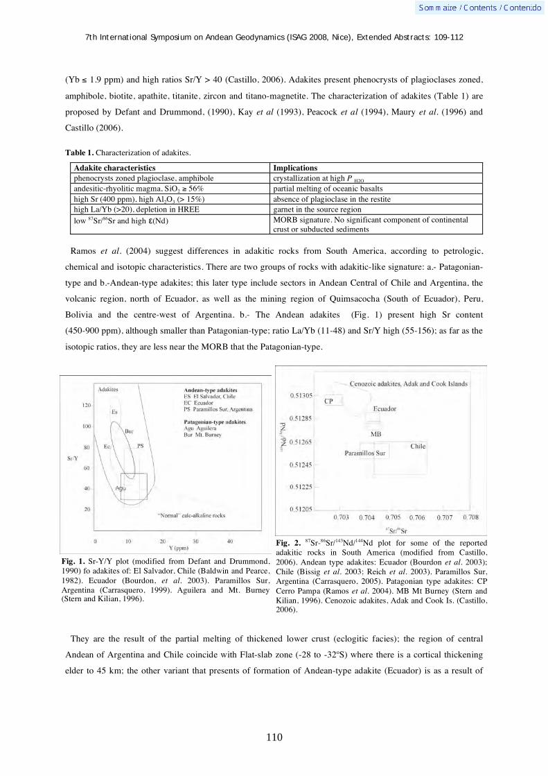
7th International Symposium on Andean Geodynamics (ISAG 2008, Nice), Extended Abstracts: 109-112
110
(Yb 1.9 ppm) and high ratios Sr/Y > 40 (Castillo, 2006). Adakites present phenocrysts of plagioclases zoned,
amphibole, biotite, apathite, titanite, zircon and titano-magnetite. The characterization of adakites (Table 1) are
proposed by Defant and Drummond, (1990), Kay et al (1993), Peacock et al (1994), Maury et al. (1996) and
Castillo (2006).
Table 1. Characterization of adakites.
Adakite characteristics Implications
phenocrysts zoned plagioclase, amphibole crystallization at high P H2O
andesitic-rhyolitic magma, SiO2 56% partial melting of oceanic basalts
high Sr (400 ppm), high Al2O3 (> 15%) absence of plagioclase in the restite
high La/Yb (>20), depletion in HREE garnet in the source region
low 87Sr/86Sr and high (Nd) MORB signature. No significant component of continental crust or subducted sediments
Ramos et al. (2004) suggest differences in adakitic rocks from South America, according to petrologic,
chemical and isotopic characteristics. There are two groups of rocks with adakitic-like signature: a.- Patagonian-
type and b.-Andean-type adakites; this later type include sectors in Andean Central of Chile and Argentina, the
volcanic region, north of Ecuador, as well as the mining region of Quimsacocha (South of Ecuador), Peru,
Bolivia and the centre-west of Argentina. b.- The Andean adakites (Fig. 1) present high Sr content
(450-900 ppm), although smaller than Patagonian-type; ratio La/Yb (11-48) and Sr/Y high (55-156); as far as the
isotopic ratios, they are less near the MORB that the Patagonian-type.
They are the result of the partial melting of thickened lower crust (eclogitic facies); the region of central
Andean of Argentina and Chile coincide with Flat-slab zone (-28 to -32ºS) where there is a cortical thickening
elder to 45 km; the other variant that presents of formation of Andean-type adakite (Ecuador) is as a result of
Fig. 1. Sr-Y/Y plot (modified from Defant and Drummond, 1990) fo adakites of: El Salvador, Chile (Baldwin and Pearce, 1982). Ecuador (Bourdon, et al. 2003). Paramillos Sur, Argentina (Carrasquero, 1999). Aguilera and Mt. Burney (Stern and Kilian, 1996).
Fig. 2. 87Sr-86Sr/143Nd/144Nd plot for some of the reported adakitic rocks in South America (modified from Castillo, 2006). Andean type adakites: Ecuador (Bourdon et al. 2003); Chile (Bissig et al. 2003; Reich et al. 2003). Paramillos Sur, Argentina (Carrasquero, 2005). Patagonian type adakites: CP Cerro Pampa (Ramos et al. 2004). MB Mt Burney (Stern and Kilian, 1996). Cenozoic adakites, Adak and Cook Is. (Castillo, 2006).

7th International Symposium on Andean Geodynamics (ISAG 2008, Nice), Extended Abstracts: 109-112
111
which the subduction caused cortical erosion; the pieces of oceanic crust were taken and introduced in the
astenospheric wedge, where, to high pressures, they underwent partial melting.
Patagonian-type adakites placed in Cerro Pampa, Puesto Nuevo, Chalten and Cook Is. (Volcanic Zone Austral)
are the result of the partial melting of a young and hot oceanic crust in continental crust. These rocks show
chemical characteristics related at partial melting of subducted oceanic crust. The Sr content is high (1300 ppm)
compared with the Andean-type (Table 2); the Y content is minor to 16 ppm; the Patagonian-type rocks have
MORB-like Sr- and Nd- isotopic ratios and more losses than Andean-type adakites (Fig 2); the initial relation 87Sr/86Sr is 0.7028 to 0.7033 whereas the 143Nd/144Nd is 0.51289 (Table 3). Analyses of Hf isotopes (Hattori et al.
2005) from Patagonian-type adakites are correlated with Nd- and Sr- isotopic ratios show compositional and
isotopic variation; the isotopic data suggest the source region contamination.
Finally, this discrimination is interesting since the Andean-type adakites are related with metallogenic
processes, which does not happen to the Patagonian-type. This quality of the Andean-type adakitic magmatism
can be used like an interesting tool in the mining exploration.
Adakites SiO2
%
Sr (ppm) 87Sr/86Sr 143Nd/144Nd La/Yb References
C° Pampa 63 - 68 1330 - 2300 0.7028 to 0.7031
(1)
> 0.5129 30 - 37 Ramos et al. 2004
Puesto Nuevo 65 - 66 1370 - 1440 0.7032 to 0.7033
(1)
0.51289 28 – 30 Ramos et al. 2004
Patagonian type
Cook Islands 59 - 61 1900 - 2000 0.7028 (2)
0.51314 30 - 35 Stern and Kilian, 1996
Ecuadorian margin
61 - 65 450 -500 0.704055 to 0.704065
(1)
0.512882 to 0.512894
13.2 - 16.8 Bourdon et al. 2003
Miocene to Quaternary volcanism,
Ecuador
56 - 69 600 - 1100 0.7040 to 0.7047
(1)
-- 11 - 48.5 Chiaradia et al. 2004
El Indio (Formation
Vacas Heladas) Chile
62 - 71 400 - 650 0.706106 to 0.707159
(2)
0.512369 23 - 33 Bissig et al. 2003
Paramillos Sur Uspallata, Argentina
59 - 64 550 - 900 0.703982 to 0.705614
(1)
0.512523 to 0.512549
34 - 58 Carrasquero 1999, 2005
Andean type
Los Pelambres, Chile
62 - 72 408 - 750 0.70439 to 0.70465
(1)
0.512619 to 0.512635
26 - 113 Reich et al. 2003
Table 2. Essential characteristics of Patagonian-type and Andean-type adakites. (1) The data are corrected with the age. (2) The data are no corrected. References Baldwin, J. A., Pearce, J. A. (1982): Discrimination of productive and nonproductive porphyritic intrusions in the Chilean
Andes. Economic Geology, 77: 664-674. Bissig, T., Clark, A., Lee, K. W., Von Quadt, A. 2003: Petrogenetic and metallogenetic responses to Miocene slab flattening:
new constraints from the El Indio-Pascua Au-Ag-Cu belt, Chile/Argentina. Mineralium Deposita, 38: 844-862.

7th International Symposium on Andean Geodynamics (ISAG 2008, Nice), Extended Abstracts: 109-112
112
Bourdon, E., Eissen, J-P., Gutscher, M-A., Monzier, M., Hall M., Cotton, M. 2003. Magmatic response to early aseismic ridge subduction: the Ecuadorian margin case (South American). Earth and Planetary Sciences Letters, 205: 123-138.
Bray du, E. A., Ludlington, S., Brooks, W., Gamble, B. M., Rathe, J. C., Richter, D., Soria Escalante, E. 1995. Compositional characteristics of Middle to Upper Tertiary volcanic rocks of the Bolivian Altiplano. U. S. Geological Survey Bulletin, 219: 1-41.
Carrasquero, S. I. 1998. Volcanismo de arco en el área del pórfido cuprífero Paramillos Sur, Uspallata, Mendoza, Argentina. X Congreso Latinoamericano de Geología y VI Congreso Nacional de Geología Económica. Buenos Aires. I: 95-100.
Carrasquero, S. I. 1999. Porphyry-type and epithermal ore deposits in the Paramillos de Uspallata district, Mendoza, Argentina. Proceedings of the fifth biennal SGA meeting and the tenth Quadrennial IAGOD Symposium, London. In: Mineral deposits: processes to processing. Stanley et al. (Eds.) 1999. Balkema Rotterdam. Actes I: 487-490.
Carrasquero, S. I. 2005. Petrology and geochemistry data of Miocene volcanism of Paramillos de Uspallata, Argentina. Geophysical Research Abstracts 7: 851.
Cassard, D. 1999. GIS Andes: A metallogenic GIS of the Andes Cordillera. Proceedings of the Fourth ISAG, Goettingen, (Germany): 147-150
Castillo, P. R. 2006. An overview of adakite petrogenesis. Chinese Science Bulletin, 51(3): 257-268. Chiarada, M., Fontboté, L., Beate, B. 2004. Cenozoic continental arc magmatism and associated mineralization in Ecuador.
Mineralium Deposita, 39:204-222. Coldwell, B., Petford, N., Murphy, P., Smith, M. 2005. “Adakitic” rocks of the Yungay Formation, Peru: problems with
tectonic setting and origin. Geophysical Research Abstracts 7: 2656. Defant, M. J., Drummond, M. S. 1990. Derivation of some modern arc magmas by melting of young subducted oceanic
lithosphere. Nature, 347: 662-665. Defant, M. J., Drummond, M. S. 1993. Mt. St. Helens: potential example of the partial melting of the subducted lithosphere
in a volcanic arc. Geology, 21: 547-550. Drummond M. S, Defant M. J., Kepezhinskas, P. K. 1995. The petrogenesis of slab derived trondhjemite-tonalite-
dacite/adakite magmas. In “The origin of granites and related rocks” Third Hutton Symposium, University of Maryland (EEUU). Ed. Brown, M.; Candela P. A.; Peck D. L.; Stephens W. E.; Walker R. J. & Zen E. Trans. Royal Soc. Edinburgh: Earth Sci. 87: 205-215
Hattori, K., Hanyu, T., Stern, C., Tatsumi, Y., Nakai, S. 2005. Hafnium isotope data suggesting the contribution of crustal material at the source in the Andean Austral Volcanic Zone. Geophysical Research Abstracts 7: 5935.
Kay, S. M., Ramos, V., Márquez, M. 1993. Dominant slab-melt component in Cerro Pampa adakitic lavas erupted prior to the collision of the Chile rise in Southern Patagonia. Journal of Geology, 101: 703-714
Maury, R., Sajona, F. G., Pubellier, M., Bellon, H., Defant, M. 1996. Fusion de la croûte océanique dans les zones de subduction/collision récentes: l’exemple de Mindanao (Philippines). Bulletin Société Géologique de France, 167 (5): 579-595.
Monzier, M., Robin, C., Hall, M.L., Cotten, J., Mothes, P., Eissen, J.-P.,,samaniego, P. 1997. Les adakites d’Equateur: Modèle preliminaire: Paris, Academie des Sciences Comptes Rendus, 324: 545–552.
Oyarzún, R., Márquez, A., Lilo, J., López, L., Rivera, S. 2001. Giant versus small porphyry copper deposits of Cenozoic age in northern Chile: adakitic versus normal calc-alkaline magmatism. Mineralium Deposita, 36: 794-798.
Peacock, S., Rushmer, T., Thompson, A. B. 1994. Partial melting of subducting oceanic crust. Earth and Planetary Sciences Letters, 121: 227-244.
Ramos, V., Kay, S. M., Singer, B. 2004. Las adakitas de la Cordillera Patagónica: Nuevas evidencias geoquímicas y geocronológicas. Revista de la Asociación Geológica Argentina, 59 (4): 693-706.
Reich, M., Parada, M. A., Palacios, C., Dietrich, A.; Schultz, F., Lehmann, B. 2003. Adakite-like signature of Late Miocene intrusions at the Los Pelambres giant porphyry copper deposit in the Andes of central Chile: metallogenic implications. Mineralium Deposita, 38: 876-885.
Richards, J. P. 1990. Petrology and geochemistry of alkalic intrusives at the Porgera gold deposit, Papua New Guinea. J. Geochem. Exploration. 35: 141-199.
Sajona, F., Maury, R. 1998 Association of adakites with gold and copper mineralization in the Philippines. C. R. Académie Sciences de Paris, Sciences de la Tèrre et des Planètes, Série II a, 326: 27-34.
Sellés, D., Godoy, E. 2000. Residual garnet signatura in Early Miocene subvolcanic stocks from the Andean foothills of central Chile. IX° Congreso Geológico Chileno (Puerto Varas), Actas 1(4): 697-699.
Stern, C. R., Kilian, R. 1996. Role of the subducted slab, mantle wedge and continental crustin the generation of adakites from the Andean Austral Volcanic Zone. Contrib. Mineral. Petrol. 123: 263-281.
Thiéblemont, D., Stein G., Lescuyer J-L. 1997. Giséments épithermaux et porphyriques: la connexion adakite. C. R. Académie Sciences de Paris, Sciences de la Tèrre et des Planètes, Série II a, 325: 103-109.
Yumul Jr. G; Dimalanta C; Bellon H; Faustino D; De Jesus J; Tamayo Jr. R. & Jumawan F. 2000. Adakitic lavas in the Central Luzon back-arc region, Philippines: lower crust partial melting products? The Island Arc, 9: 499-512.

7th International Symposium on Andean Geodynamics (ISAG 2008, Nice), Extended Abstracts: 113-115
113
Long-lived constrictional strain field of the inner part of the Andean Orocline: An example of buttressing effect in oblique subduction curved margin
D. Carrizo1, G. González
2, & T. Dunai
3
1 Laboratoire de Tectonique et Mécanique de la Lithosphere, Institut de Physique du Globe de Paris (IPGP), 4
place Jussieu, 75252 Paris, France ([email protected]) 2 Departamento de Cs. Geológicas, Universidad Católica del Norte, Av. Angamos 0610, Antofagasta, Chile
3 School of Geosciences, University of Edinburgh, Drummond Street, EH9 2DZ Edinburgh, United Kingdom
KEYWORDS : Subduction, curved margin, constriction, buttress
Introduction
Oblique convergence frequently produces arc-parallel migration of the forearc sliver (Fitch, 1972; Beck, 1983).
In some cases the resistance to displacement of forearc sliver arises from a space problem (Beck et al.,1993).
This resistance is called “buttress effect” and came from three major situations: a) margin abrupt geometrical
changes, b) changes in the margin kinematics conditions or/and c) changes in the upper plate reology. Although,
the consequence of buttressing process on the upper plate strain patterns of active continental margins steel
remain poorly characterized. The oblique subduction of the Nazca Plate northeastward beneath South America
has occurred, during the last 25 Ma, along a curve margin. The Coastal Cordillera of northern Chile form part of
the only part of the South American continental crust that is in contact with the Nazca plate, containing the most
relevant geological record of the plates coupling process. These geological record is extraordinarily preserved in
the Atacama Desert, the most hyper arid desert of the Earth.
Despite of relative continuous oblique converge during the Neogene no relevant forearc sliver translation
occurred in the Central Andes (Victor et al., ; Farías et al.,2005). Based on detailed neotectonics study of the
Coastal Cordillera of northern Chile (~20ºS), we document a horizontal constrictional long-term strain field
located to the inner part of the Andean Orocline (Fig.1).
Neotectonics signatures
The fault activity is expressed as a group of fault scarps and fault-bend fold scarps whose orientation defines
three main domains: WNW-ESE-strike reverse faults, N-S-strike reverse faults and NNW-SSE-strike dextral-
reverse faults. The faults kinematics indicates trench-parallel and trench-orthogonal shortening. The faults show
evidences of coexistence activity and strong structural control related to preexistent (Mesozoic) faults system.
Exposure ages using cosmogenics 21Ne shows that the faults disrupt an Oligocene–Miocene and Pliocene (after 4
and 2 Ma) landscape preserved at the Coastal Cordillera. In addition 40Ar/39Ar chronology of displaced volcanic
tuffs and the deformations of Late Pleistocene marine terraces and Coastal Cliff colluvial sediments indicate that
fault activity remain still active during the Quaternary. Recently an Mw 5.7 shallow intraplate earthquake
located in the Coastal Cordillera (~70.15º S) evidence trench parallel shortening indicating that intraplate
deformation processes are still active (Carrizo et al., 2008).

7th International Symposium on Andean Geodynamics (ISAG 2008, Nice), Extended Abstracts: 113-115
114
Figure 1. Geodynamic context of the Andean orocline and this study (Salar Grande area). Is represented the convergence vector and its component at both side of the margin curvature. The grey P-T axes plots represents the long-term strain fault kinematics in the Coastal Cordillera block. In red color is represented the focal mechanism of intraplate earthquakes (http://www.seismology.hardvard.edu/project/CMT/). Also is represented the Atacama Fault System (SFA) and the Precordillera Fault System (PFS).
Discussion
We explain the studied margin deformation signatures as a result of a buttress effect related principally to the
curvature of margin, concave to the ocean (the convergence change from dextral to sinistral sense that prevents
the northward sliver translation). We observe that the Coastal Cordillera block resolve the space problem by
vertical extrusion of blocks along the pre-existent faults describing a constriccional strain field. The scale and
nature of this studied strain field suggest a diffuse internal deformation behavior in the Coastal Cordillera block.
This could be explained considering that the Precordillera Fault System PFS, eastern limit of the called “outer
forearc” or as well the Andean external block can not accommodate efficiently the trench-parallel component of
the convergence as a consequence of both curvature of margin and the orogene geometry that prevents the sliver

7th International Symposium on Andean Geodynamics (ISAG 2008, Nice), Extended Abstracts: 113-115
115
translation (Fig.1). This deformation process is consistent with a behavior of a rigid and cold external continental
block thats not absorb relavant deformation and could transmit the effort efficiently. This characteristics suggest
that the Andean external block could plays a key role in the Andean orogen building, transmitting efficiently the
efforts from the plate coupling zone to the inland. We propose that this particular tectonics is active al least from
the Later Miocene to the present.
References Beck, M.E. 1983. On the mechanism of tectonics transport in zones of oblique subduction. Tectonophysics, Vol. 93, p. 1-11. Beck, M.E.; Rojas. C.; Cembrano, J. 1993. On the nature of buttressing in margin parallel strike-slip fault systems. Geology,
Vol. 21, p. 755-758. Carrizo, D.; González, G.; Dunai, T. 2008. Constricción neógena en la Cordillera de la Costa, norte de Chile: neotectónica y
datación de superficies con 21cosmogénico Revista Geológica de Chile 35 (1): 1-38. Farías, M.; Charrier, R.; Comte, D.; Martinod, J.; Herail, G. 2005. Late Cenozoic deformation and uplift of the western flank
of the Altiplano: Evidence from the depositional, tectonic, and geomorphologic evolution and shallow seismic activity (northern Chile at 19°S). Tectonics, Vol. 24, TC4001, doi:10.1029/2004TC001667.
Fitch, T.J. 1972. Plate convergence, transcurrent faults and internal deformation adjacent to the southeast Asia and western Pacific. Journal of Geophysical Research, Vol.77, p. 4.432-4.460.
Victor, P.; Onken, O.; Glodny, J. 2004. Uplift of the western Altiplano plateau: Evidence from the Precordillera between 20º and 21ºS (northern Chile). Tectonics, Vol 23, Tc4004, doi: 10.1029/2003TC001519.

7th International Symposium on Andean Geodynamics (ISAG 2008, Nice), Extended Abstracts: 116-119
116
The interplay between crustal tectonics and volcanism in the Central and Southern volcanic zones of the Chilean Andes
J. Cembrano1,5
, G. González
1, L.
Lara
2, E. Veloso
1, E.
Medina
1, F. Aron
1, M.
Basso
1,3,
V. Ortega1, P. Pérez
1, & G. Sielfeld
4
1 Depto. de Cs. Geológicas, Univ. Cat. del Norte, Avda.Angamos 0610, Antofagasta, Chile ([email protected])
2 Servicio Nacional de Geología y Minería, Avda. Santa María 0104, Santiago, Chile ([email protected])
3 Instituto GEA, Univ. de Concepcion, Casilla 160-C Concepción 3, Chile ([email protected])
4 Departamento de Ciencias de la Tierra, Univ. de Concepcion, Chile ([email protected])
5 Central Andes Resources, Callao 3785, Santiago, Chile
KEYWORDS : tectonics, volcanism, strike-slip fault, fold-and-thrust-belt
Introduction
One fundamental problem in continental margin tectonics is the nature of the interplay between deformation
processes and magma transport through the lithosphere (e.g. Hutton, 1988, Petford et al. 2000). Fault-fracture
networks have been regarded as efficient pathways through which magma can be transported, stored and
eventually erupted to the earth surface (e.g. Hill, 1977; Shaw, 1980; Clemens and Mawer, 1992). Thus, the state
of stress of the lithosphere at the time of magmatism should somehow control the first and second-order spatial
distribution of plutons, dikes swarms and volcanic centers (e.g. Nakamura, 1977; Takada, 1994, Glazner et al.
1999; Acocella et al., 2007). However, crustal deformation not only plays a significant role in magma migration;
it may also exert a fundamental control on magma differentiation processes that, in turn, can determine the
nature and composition of volcanism along and across continental margins (e.g. Cembrano and Moreno, 1994;
McNulty et al. 1998; Ferrari et al. 2000). The Chilean Andes provides a natural laboratory to assess the link
between tectonics and volcanism. Apart from its well- constrained plate kinematic history, there is a marked
latitudinal segmentation in crustal thickness, upper plate deformation and basement nature upon which the
volcanic arc has developed. Thus, the relative importance of present-day kinematics and inherited crustal
composition and structure in the mechanisms of magma transport and in the nature and composition of
volcanism can be successfully examined along the same orogenic belt. In this contribution, we examine the link
between tectonics and volcanism for two contrasting regions of the Central and Southern Volcanic zones. We
hypothesize that one fundamental, usually overlooked factor controlling the wide variety of volcanic forms and
rock compositions present along a single continental magmatic arc, is the contrasting kinematics of the fault-
fracture networks under which they are transported within the same magmatic arc.
Intra-arc tectonics of the Central and Southern Volcanic zones
New field and structural observations in combination with published seismic data allows a complete
reassessment of the complex relationship between intra-arc long-term/short-term tectonics and the
nature/composition of present day volcanism along the Chilean Andes. A thicker crust and prevailing Pliocene-
Pleistocene east-west shortening within the volcanic arc of northern Chile (22-24°S) are spatially and genetically
associated with several major composite andesitic volcanoes and only a few monogenetic basaltic eruptive
centers. Stratovolcanoes do not exhibit flank vents and clusters of minor eruptive centers are uncommon.

7th International Symposium on Andean Geodynamics (ISAG 2008, Nice), Extended Abstracts: 116-119
117
Composite volcanoes and minor eruptive centers, such as Lascar and Tilocalar respectively, are spatially and
temporally linked to the development of a Pliocene-Recent north-south-striking system of blind reverse faults
and fault-propagation folds (see Aron et al, this symposium). Evidence for long-term strike-slip deformation is
weak or absent in this part of the Central Andes Volcanic Zone (CVZ), although arc-parallel, dextral strike-slip
crustal seismicity has been documented to the north, between 18 and 21ºS (e.g. David, 2007). In contrast, the
southern Chilean Andes between 38 and 46°S are built on a much thinner crust (30-40km) that has undergone
intra-arc dextral transpressional tectonics for the last 4 Ma (e.g. Cembrano et al. 2002; Rosenau et al. 2006).
Available data of crustal seismicity consistently shows dextral strike-slip focal mechanisms from ~34º to 46ºS
(e.g. Farías, 2007; Lange et al. 2008). In the Southern Volcanic Zone (SVZ), a wide variety of volcanic forms
and compositions coexist along and across the same volcanic arc. Volcanic forms range from single
monogenetic cones lying on top of master faults to major composite volcanoes organized into either NE- or NW-
trending chains, oblique to the continental margin. Flank vents are common within individual stratovolcanoes
and as elongated clusters of minor eruptive centers. Compositions range from very primitive basalts, particularly
at minor eruptive centers, to highly evolved magmas, found at both mature stratovolcanoes and only at few
minor eruptive centers.
Discussion
Feedbacks between tectonics and volcanism in the CVZ and SVZ of the Chilean Andes can be understood as a
complex set of interactions operating at different space and time scales, ranging from long-term regional to
short-term local. Crustal thickness, nature and structure of the lithosphere, presence of compressive/transcurrent
intra-arc fault systems and magma source largely influence first-order, long-term controls. Second-order controls
include the presence of a faulted volcano-sedimentary cover versus a relatively isotropic plutonic basement, the
existence of deep-seated, seismically active or inactive faults cutting through the lithosphere and the balance
between local tectonic rates and magma input rates.
As a first approximation, a thicker crust favors magma differentiation processes whereas a thinner crust tends
to prevent it. Likewise, whereas bulk intra-arc compression (vertical 3) would tend to enhance longer residence
times of magma stored under the volcanic arc of northern Chile (22-24°S), strike-slip deformation (horizontal
3) in central and southern Chile would provide subvertical pathways for magma ascent and shorter residence
times, which in turn prevents advanced magma differentiation (Figure 1). However, looking more closely within
the strike-slip deformation zone encompassing the whole magmatic arc in southern Chile, transtensional and
transpressional domains can coexist in space and time. On one end of the spectrum, a plumbing system
dominated by NNE-striking subvertical strike-slip faults and ENE-striking tension cracks will favor a rapid
ascent of magmas from the asthenospheric wedge with little crustal contamination. On the contrary, a plumbing
system dominated by NW-striking interconnected, second-order reverse faults and subhorizontal cracks will
favor longer residence times and episodic magma fractionation, which in turn allow eruption of evolved
magmas, similar to what is observed in northern Chile. Whereas the transtensional fault-fracture network does
not require magma/fluid overpressures to operate, the compressional/transpressional does. This is consistent with
the abundant presence of volatiles that accompanies magma fractionation and differentiation as documented in
the more felsic rocks from northern Chile volcanoes and the NW-trending volcanic chains of southern Chile.

7th International Symposium on Andean Geodynamics (ISAG 2008, Nice), Extended Abstracts: 116-119
118
W E
LOFZ
?
W E
On the other hand, pre-existing subvertical structures, especially those that cut through the lithosphere, may
serve as channel ways for magma transport regardless of the bulk kinematic regime of the volcanic arc. In
particular, the Liquiñe-Ofqui fault zone (LOFZ) master faults are likely capable to connect the MASH zone or
even the asthenospheric wedge with the surface, by seismic pumping and concomitant magma production by
decompression (Figure 1). The fact that most, if not all volcanic systems that sit on top of the LOFZ are
monogenetic strongly suggests that they resulted from single, geologically instantaneous events. It is then likely
that the architecture of the overall plumbing system is primarily controlled by the nature of the fault-fracture
mesh as formed from different stress regimes and by the inherited basement structure, but more importantly,
these different architectures exert a first-order control in magma differentiation processes, which in turn account
for different volcanic morphologies and rock types along and across the same magmatic arc. Another second-
order factor controlling along-strike differences in the three dimensional architecture of the plumbing system in
the volcanic arc of central and southern Chile is the presence of a thick pre-Quaternary volcano-sedimentary
cover, especially when this cover is folded and faulted. Where such cover is present, between 33º and 37ºS, NE-
striking tension cracks formed under upper crustal dextral strike-slip deformation, may not reach the surface but
merge upwards with high angle presently inactive reverse faults marking major regional contacts between
Mesozoic and Cenozoic sequences as suggested by Diamante-Maipo and Planchón-Peteroa volcanic complexes.
In contrast, south of 38ºS, where volcanic systems are built directly on top of plutonic rocks, NE-trending
tension cracks may reach the surface and then build either a stratovolcano or an elongated cluster of minor
eruptive centers, depending on other factors such as the balance between magma input and strain rate.
A B
Figure 1. Schematic sections showing the possible geometry and kinematics of upper crustal magma plumbing system for the Central Volcanic zone at 23ºS (A) and the Southern Volcanic Zone at 40ºS (B). For the CVZ, interconnected arrays of subhorizontal, sill-like tension fractures and north-south-striking reverse faults may provide channel-ways for magma ascent and emplacement in the upper crust, favoring longer residence times and magma differentiation. In contrast, for the SVZ, magma may ascent directly from the asthenosphere along deep-seated structures such as master faults of the LOFZ, giving rise to primitive monogenetic centers. More commonly, stratovolcanoes and cluster of minor eruptive centers are probably fed by NE-striking subvertical dikes oriented subparallel to the principal stress axis.

7th International Symposium on Andean Geodynamics (ISAG 2008, Nice), Extended Abstracts: 116-119
119
References Acocella, V. Vezzoli, L., Omarini, R., Matteini, M. Mazzuoli, R. 2007 Kinematic variations across Eastern Cordillera at 24°S
(Central Andes): Tectonic and magmatic implications. Tectonophysics 434, 81-92 Cembrano, J.; Moreno, H. 1994. Geometría y naturaleza contrastante del volcanismo Cuaternario entre los 38° S y 46° S:
¿Dominios compresionales y tensionales en un régimen transcurrente? In Congreso Geológico Chileno, No. 7, Actas, Vol. 1, p. 240-244. Concepción, Chile.
Cembrano, J., Lavenu, A., Reynolds, P., Arancibia, G.; López, G., Sanhueza, A. 2002. Late Cenozoic transpressional ductile deformation north of the Nazca–South America–Antarctica triple junction. Tectonophysics 354, 289– 314.
Clemens, J.C., Mawer, C.K., 1992. Granitic magma transport by fracture propagation. Tectonophysics 204, 339–360. David, C. 2007. ”Comportement actuel de l’avant-arc et de l’arc du Coude de Arica dans l’orogenese des Andes Centrales”.
Thèse doct., Univ. Paul Sabatier, Toulouse, France. 284 p. Farías, M. , Comte, D, Charrier, R. 2006. Sismicidad superficial en Chile Central: implicancias para el estado cortical y
crecimiento de los Andes centrales australes. Actas XI Congreso Geológico Chileno, vol. 1, 403- 406. Ferrari, L., Conticelli, S., Vaggelli, Chiara M. Petrone and Manetti, P. 2000. Late Miocene volcanism and intra-arc tectonics
during the early development of the Trans-Mexican Volcanic Belt. Tectonophysics 318, 161-185 Glazner, A.F., Bartley, J.M. and Carl, B., 1999. Oblique opening and noncoaxial emplacement of the Jurassic Independence
dike swarm, California. Journal of Structural Geology 21, 1275-1283. Hill, D.P. 1977. A model for earthquake swarms. Journal of Geophysical Research 82, 347-352. Hutton, D.H.W., 1988. Granite emplacement mechanisms and tectonic controls:inferences from deformation studies. Trans.
R. Soc. Edinburgh, Earth Sci. 79, 245–255. Lange, D., Cembrano, J., Rietbrock, A. Haberland, C. Bataille, K., and Hofmann, S.D. First seismic record for intra-arc
strike-slip tectonics along the Liquiñe-Ofqui fault zone at the obliquely convergent plate margin of the southern Andes. To be published in Tectonophysics.
McNulty B.A. , Farber D.L., Wallace G.S., Lopez R.and Palacios, O., 1998. Role of plate kinematics and plate-slip-vector partitioning in continental magmatic arcs; evidence from the Cordillera Blanca, Peru. Geology 26, 827-830.
Nakamura, K. 1977. Volcanoes as possible indicators of tectonic stress orientation: principle and proposal. J Volcanol Geotherm Res 2, 1-16.
Paterson, S. R., and K. L. Schmidt (1999) Is there a close spatial relationship between plutons and faults?, J. Struct. Geol., 21, 1131 – 1142.
Petford N., Cruden A. R. , McCaffrey K. J. W. & Vigneresse J.L. 2000. Granite magma formation, transport and emplacement in the Earth's crust. Nature 408, 669-673.
Rosenau, M., Melnick, D., and Echtler, H., 2006, Kinematic constraints on intraarc shear and strain partitioning in the Southern Andes between 38°S and 42°S latitude: Tectonics 25, TC4013.
Shaw, H.R. 1980. Fracture mechanisms of magma transport from the mantle to the surface. In Hardgraves, R.B. (editor). Physics of magmatic processes, 201-264. Princeton. Princeton University Press.
7th International Symposium on Andean Geodynamics (ISAG 2008, Nice), Extended Abstracts: 120-123
120
U-Pb geochronologic evidence for the Neoproterozoic – Palaeozoic evolution of the Gondwanan margin of the North-Central Andes
David Chew1, Urs Schaltegger
2, Jan Ko ler
3, Tomas Magna
4, Martin J. Whitehouse
5,
Christopher L. Kirkland5, Aleksandar Mi kovi
2, Agustín Cardona
6, & Richard Spikings
2
1 Department of Geology, Trinity College Dublin, Dublin 2, Ireland
2 Department of Earth Sciences, University of Geneva, Rue des Maraîchers 13, 1205 Geneva, Switzerland
3 Department of Earth Science, University of Bergen, Allegaten 41, N-5007 Bergen, Norway
4 Institute of Mineralogy and Geochemistry, University of Lausanne, CH-1015 Lausanne, Switzerland
5 Laboratory for Isotope Geology, Swedish Museum of Natural History, S-10405 Stockholm, Sweden
6 Smithsonian Tropical Research Institute, Apartado Postal 0843-03092, Balboa, Ancon, Panama City, Republic
of Panama
KEYWORDS : U-Pb, zircon, proto-Andes, Gondwana, Neoproterozoic glaciation
Introduction
The Neoproterozoic – Early Paleozoic evolution of the Gondwanan margin of the north-central Andes has been
investigated by a U-Pb zircon geochronology study. The investigated samples comprise Palaeozoic rocks of the
Eastern Cordilleras of Peru and Ecuador (Fig. 1) and Neoproterozoic glacial sequences which overlie
Precambrian basement gneisses of the Arequipa massif in southern Peru (Fig. 2). LA-ICPMS and ion
microprobe analysis of detrital zircon has been integrated with dating of syn- and post-tectonic Palaeozoic
intrusives by TIMS and ion microprobe.
Neoproterozoic sequences - detrital zircon data
Detrital zircon populations in cover sequences overlying the Arequipa massif basement (an exotic crustal block
to Amazonia) are likely derived from the proto-Andean margin. These cover sequences (the Chiquerío and San
Juan formations in southern Peru) record the only documented Neoproterozoic glacial episode in the Andean
belt. The Chiquerío Formation yields U-Pb detrital zircon ion microprobe data with a restricted age distribution
of 950-1300 Ma. Turbiditic dolomitic sandstones in the overlying San Juan Formation yield a similar
950-1300 Ma peak, but also contain grains dated as 1600-2000 Ma and 700-820 Ma (Chew et al., 2007a). Based
on the presence of a cap carbonate and two negative C isotope excursions the Chiquerío and San Juan formations
probably represent a Sturtian–Marinoan couplet (c. 750 – 635 Ma). The strong link between the Arequipa massif
cover sequences and the proto-Andean margin during the Late Neoproterozoic rules out accretion of the
Arequipa massif during the early Paleozoic Pampean and Famatinian orogenies, and strongly implies accretion
to Amazonia during the 1000–1300 Ma Grenville–Sunsas orogeny (Chew et al., 2007a; cf Loewy et al., 2004).
Palaeozoic sequences – detrital zircon data
In the Palaeozoic metamorphic belts of the Eastern Cordilleras of Peru and Ecuador, the majority of detrital
zircon samples exhibit prominent peaks in the ranges 0.45 - 0.65 Ga and 0.9 - 1.3 Ga, with minimal older
detritus from the Amazonian craton. The detrital zircon data demonstrate that the basement to the western
Gondwanan margin was likely composed of a metamorphic belt of Grenvillian (0.9 – 1.3 Ga) age, upon which
an Early Paleozoic magmatic belt (0.45 – 0.5 Ga) developed in a similar way to the Sierra Pampeanas and
Famatina in northern Argentina (Chew et al., 2007b). These two orogenic belts are interpreted to be either
7th International Symposium on Andean Geodynamics (ISAG 2008, Nice), Extended Abstracts: 120-123
121
buried underneath the present-day Andean chain or adjacent foreland sediments. However the source for detritus
in the 0.55 – 0.65 Ga age range, broadly age-equivalent to the Brasiliano/Pan-African Orogeny in eastern
Amazonia, remains puzzling.
Evidence for a Neoproterozoic active margin in the detrital zircon data?
No obvious source for 0.55 – 0.65 Ga detritus is known in the northern and central Andes. Derivation from
eastern Amazonia is considered unlikely due to the stark paucity of detritus derived from the core of the
Amazonian craton. Instead, we propose that a Late Neoproterozoic magmatic belt is buried beneath the present-
day Andean belt or Amazon Basin, and was probably covered during the Eocene – Oligocene. If this inferred
Neoproterozoic belt was an active margin, it would record the initiation of Proto-Andean subduction and imply
at least partial separation of West Gondwana from its conjugate rift margin of eastern Laurentia prior to
ca. 650 Ma. This separation may be linked to the ca. 770 – 680 Ma A-type magmatism found on eastern
Laurentia in the southern Appalachians (e.g. Tollo et al., 2004) and on the Proto-Andean margin in the Sierra
Pampeanas (Baldo et al., 2006) and in the Eastern Cordillera of Peru.
U-Pb dating of syn- and post-tectonic Palaeozoic intrusives and discussion
Plutons associated with the Early Paleozoic subduction-related magmatic belt have been identified in the
Eastern Cordillera of Peru, and have been dated by U-Pb zircon TIMS and ion microprobe to 474 – 442 Ma
(Chew et al., 2007b). This is in close agreement with the ages of subduction-related magmatism in the Arequipa
– Antofalla Basement (e.g. Loewy et al., 2004). This Early Paleozoic arc is clearly not linear as it jumps from a
coastal location in the Arequipa – Antofalla Basement to several hundred kilometers inland in the Eastern
Cordillera further to the north. This is interpreted as an embayment on the Proto-Andean margin at the time the
arc was initiated; if this is the case the northern termination of the Arequipa-Antofalla Basement in the vicinity
of Lima is an Ordovician or older feature.
The arc magmatism pre- and post dates phases of regional metamorphism in the Eastern Cordillera of Peru.
U-Pb zircon ion microprobe dating of zircon overgrowths in high-grade leucosomes demonstrates the presence
of a metamorphic event at c. 478 Ma, and refutes the previously-assumed Neoproterozoic age for orogeny in the
Peruvian Eastern Cordillera (Chew et al., 2007b; Cardona 2006). The presence of an Early – Middle Ordovician
age magmatic and metamorphic belt in the north-central Andes demonstrates that Famatinian metamorphism and
subduction-related magmatism was continuous from Patagonia (Pankhurst et al., 2006) through northern
Argentina and Chile to as far north as Colombia and Venezuela, a distance of nearly seven thousand kilometres.
The presence of an extremely long Early – Middle Ordovician active margin on western Gondwana invites
comparison with the Taconic – Grampian orogenic cycle of the eastern Laurentia margin (which is of similar age
and strike length) and supports models which have these two active margins facing each other during the
Ordovician.
U-Pb zircon ion microprobe dating of zircon overgrowths in migmatites yields ages of c. 312 Ma, and
represent a previously unreported high-grade Gondwanide event which has affected the Peruvian segment of the
Proto-Andean margin. The original relationship between the Carboniferous and Ordovician metamorphic belts
is uncertain as it has been affected by later Andean (Eocene – Oligocene) thrusting, but overall the pattern of

7th International Symposium on Andean Geodynamics (ISAG 2008, Nice), Extended Abstracts: 120-123
122
crustal growth in the north-central Andes implies that it was dominated by a series of progressive crustal
accretion events, which results in a series of age domains that young away from an old Amazonian core (Chew
et al., 2007b).
Figure 1. Geological map of Peru and Ecuador from Chew et al. (2007b) illustrating the major Palaeozoic metamorphic and magmatic belts along with the Proterozoic gneisses of the Arequipa massif. Inset figures a-f illustrate zircon probability density distribution diagrams for both metasedimentary and magmatic (inherited cores) samples.
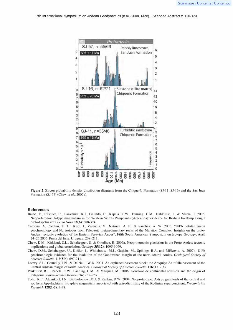
7th International Symposium on Andean Geodynamics (ISAG 2008, Nice), Extended Abstracts: 120-123
123
Figure 2. Zircon probability density distribution diagrams from the Chiquerío Formation (SJ-11, SJ-16) and the San Juan Formation (SJ-57) (Chew et al., 2007a).
References
Baldo, E., Casquet, C., Pankhurst, R.J., Galindo, C., Rapela, C.W., Fanning, C.M., Dahlquist, J., & Murra, J. 2006. Neoproterozoic A-type magmatism in the Western Sierras Pampeanas (Argentina): evidence for Rodinia break-up along a proto-Iapetus rift? Terra Nova 18(6): 388-394.
Cardona, A. Cordani, U. G., Ruiz, J., Valencia, V., Nutman, A. P., & Sanchez, A. W. 2006. “U/Pb detrital zircon geochronology and Nd isotopes from Paleozoic metasedimentary rocks of the Marañon Complex: Insights on the proto-Andean tectonic evolution of the Eastern Peruvian Andes”, Fifth South American Symposium on Isotope Geology, April 24–25 2006, Punta del Este, Uruguay: 208–211.
Chew, D.M., Kirkland, C.L., Schaltegger, U. & Goodhue, R. 2007a. Neoproterozoic glaciation in the Proto-Andes: tectonic implications and global correlation. Geology 35(12): 1095-1099.
Chew, D.M., Schaltegger, U., Ko ler, J., Whitehouse, M.J., Gutjahr, M., Spikings R.A. and Mi kovic, A. 2007b. U-Pb geochronologic evidence for the evolution of the Gondwanan margin of the north-central Andes. Geological Society of America Bulletin 119(5/6): 697-711.
Loewy, S.L., Connelly, J.N., & Dalziel, I.W.D. 2004. An orphaned basement block; the Arequipa-Antofalla basement of the Central Andean margin of South America. Geological Society of America Bulletin 116: 171-187.
Pankhurst, R.J., Rapela, C.W., Fanning, C.M., & Márquez, M., 2006. Gondwanide continental collision and the origin of Patagonia. Earth-Science Reviews 76: 235–257.
Tollo, R.P., Aleinikoff, J.N., Bartholomew, M.J. & Rankin, D.W. 2004. Neoproterozoic A-type granitoids of the central and southern Appalachians: intraplate magmatism associated with episodic rifting of the Rodinian supercontinent. Precambrian Research 128(1-2): 3-38.

7th International Symposium on Andean Geodynamics (ISAG 2008, Nice), Extended Abstracts: 124-127
124
Adakitic rocks and their geodynamic significance: Examples from the Andes of Ecuador and Peru
Massimo Chiaradia1, Daniel Merino
1, & Bernardo Beate
2
1 Department of Mineralogy, Rue des Maraîchers 13, 1205 Geneva, Switzerland
Escuela Politecnica Nacional, Quito, Ecuador ([email protected])
KEYWORDS: Ecuador, Peru, adakitic, magma, isotopes
Introduction
The commonly accepted mechanism that generates subduction-related magmas is the lowering of mantle
wedge solidus by slab-released fluids (flux melting) accompanied or not by decompression melting. On the other
hand, the finding in several modern arc settings of calc-alkaline rocks with peculiar geochemical signatures (e.g.,
Sr/Y>40, high La/Yb>15) has been interpreted as the result of the partial melting of subducted oceanic crust
rather than of the mantle wedge and these rocks have been named adakites (Defant and Drummond, 1990).
Recently there has been an increased scientific interest in the petrogenesis of rocks with adakitic signatures
because of their implications in ancient and modern crustal growth processes and their potential association with
porphyry-related Cu-Au deposits. In the last few years rocks with adakitic signatures have been interpreted
either as the result of slab melting or of evolution of mantle-derived melts at lower crustal levels through
MASH-type processes, involving partial melting of the lower crust, magma mixing, and high-pressure fractional
crystallization.
Figure 1. Geotectonic map of northern South America showing the location of the three investigated areas with adakitic magmatism.
This study presents petrographic, geochemical and isotopic data (Pb, Sr, Nd) from adakitic subduction-related
magmatism of three different areas of the Andes of Ecuador and Peru (Figure 1): (i) the Paleocene(?)-Eocene

7th International Symposium on Andean Geodynamics (ISAG 2008, Nice), Extended Abstracts: 124-127
125
Macuchi island arc (Western Cordillera of Ecuador); (ii) the Miocene world-class Au-district of Yanacocha
(northern Peru); (iii) the frontal volcanic arc of Ecuador (exemplified by the Pululagua volcanic center). The data
presented suggest that in all three cases adakitic signatures result from a deep-seated evolution of “normal”
mantle-derived calc-alkaline melts through high-pressure fractional crystallization accompanied by assimilation
of lower crustal material and/or mixing with its partial melting products.
Geological and geotectonic settings
The Macuchi Unit is an island arc volcanic and volcaniclastic sequence cropping out in the Western Cordillera
of Ecuador (Figure 1) considered Paleocene (?) to Eocene in age, based on fossil associations and sparse
radiometric dating. Chiaradia and Fontboté (2001) have subdivided the Macuchi Unit into a lower (Basal) and an
upper (Main) sequence, based on chemostratigraphic differences. The two sequences would reflect a growing
submarine island arc edifice erupted through a thickened oceanic plateau basement. The marked geochemical
and isotopic differences between the two sequences (Figures 2 and 3) would result from a major geodynamic
rearrangement, such as a subduction jump or reversal (Chiaradia and Fontboté, 2001).
Subduction-related magmatism in the Yanacocha gold district (Figure 1) spans a time interval between 14.5
and 8.4 Ma (Longo 2005) and consists of both eruptive and intrusive rocks evolving from andesite to rhyolite
through time. U-Pb zircon ages of porphyritic rocks investigated in the present study range between 12.6 and
10 Ma. Rosenbaum et al. (2005) suggest that the Yanacocha magmatism and associated mineralization was
broadly coeval with the arrival at the subduction zone of the buoyant (now subducted) Inca plateau (Figure 1).
Quaternary volcanism in Ecuador results from the eastward oblique subduction of the 12-20 My old Nazca
plate beneath the assembled Ecuadorian crust at a regular dip of 25-30° (Guillier et al., 2001). The stress regime
on the overriding plate in Ecuador has been significantly influenced by the Carnegie ridge subduction (Figure 1),
which is causing an increased coupling between the subducted and overriding plate (e.g., Sage et al., 2006).
Figure 2. Correlations between SiO2 and adakitic indices for magmatic rocks of the three investigated areas.
Pululagua is an active volcanic center of the frontal arc of Ecuador (Figure 1). Situated 15 km NNE of Quito, it
contains a 3-km-wide summit caldera narrowly breached to the west and partially filled by a group of dacitic
lava domes. Large explosive eruptions producing pyroclastic flows took place during the late Pleistocene and
Holocene. The latest dated eruption occurred about 2400 years ago and resulted in caldera formation.
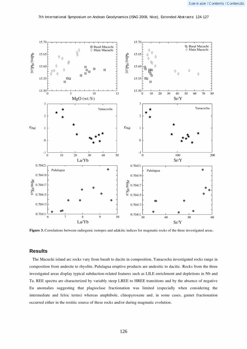
7th International Symposium on Andean Geodynamics (ISAG 2008, Nice), Extended Abstracts: 124-127
126
Figure 3. Correlations between radiogenic isotopes and adakitic indices for magmatic rocks of the three investigated areas.
Results
The Macuchi island arc rocks vary from basalt to dacite in composition, Yanacocha investigated rocks range in
composition from andesite to rhyolite, Pululagua eruptive products are andesitic to dacitic. Rocks from the three
investigated areas display typical subduction-related features such as LILE enrichment and depletions in Nb and
Ta. REE spectra are characterized by variably steep LREE to HREE transitions and by the absence of negative
Eu anomalies suggesting that plagioclase fractionation was limited (especially when considering the
intermediate and felsic terms) whereas amphibole, clinopyroxene and, in some cases, garnet fractionation
occurred either in the restitic source of these rocks and/or during magmatic evolution.

7th International Symposium on Andean Geodynamics (ISAG 2008, Nice), Extended Abstracts: 124-127
127
In the Sr/Y versus Y plot the investigated rocks of each area define trends starting in the non-adakitic and
ending in the adakitic field. Adakitic indices (Sr/Y, La/Yb) show strong correlations with both evolution indices
(e.g., SiO2: Figure 2) and various radiogenic isotopes (Figure 3).
Discussion and conclusions
The correlations of adakitic indices (Sr/Y, La/Yb) with magmatic evolution indices and radiogenic isotopes
(Figures 2 and 3) suggest that in the three areas of the Andes here investigated adakitic signatures were acquired
through magmatic evolution processes involving fractional crystallization at depth (outside the plagioclase
stability field but within that of amphibole, clinopyroxene ± garnet) accompanied by assimilation of mid- to
lower crustal rocks and/or mixing with their partial melting products. Such interpretation is in agreement with
the occurrence of disaggregated and rounded lower crustal xenoliths and xenocrysts in the investigated magmatic
rocks and with pressure of crystallization of minerals such as amphibole and clinopyroxene indicating mid- to
lower crustal depths. In all three cases rocks with adakitic signatures follow temporally more or less prolonged
periods of “normal” calc-alkaline magmatism. The switch to the adakitic signature can be broadly correlated
with major geodynamic changes at the subduction zone such as the inception of an aseismic buoyant ridge (e.g.,
Carnegie ridge for Pululagua) or oceanic plateau (Inca plateau for Yanacocha) or subduction jump or reversal
(Macuchi). These geodynamic changes are likely to have caused an increased coupling between overriding and
subducting plates thus provoking a stalling of mantle-derived magmas at depth where they evolved through the
above described processes (see also Chiaradia et al., 2004). Under this point of view rocks with adakitic
signatures may be important indicators of geodynamic changes at subduction zones (essentially increased
compression and thickening), which may also be favorable to the formation of economic mineralization (e.g.,
Macuchi, Yanacocha). Although it is not yet clear whether the slab component is transferred to the mantle wedge
as an aqueous fluid or a hydrous melt, it seems evident that the adakitic signatures in the investigated areas and
probably in many other cases are not the result of slab melting but of magmatic evolution at depth of “normal”
mantle-derived melts.
References Chiaradia, M., & Fontboté, L. 2001. Radiogenic lead signatures in Au-rich VHMS ores and associated volcanic rocks of the
Early Tertiary Macuchi island arc (Western Cordillera of Ecuador). Economic Geology 96: 1361-1378. Chiaradia, M., Fontboté, L. & Beate, B. (2004) Cenozoic continental arc magmatism and associated mineralization in
Ecuador. Mineralium Deposita 39: 204–222. Defant, M.J., & Drummond, M.S. 1990. Derivation of some modern arc magmas by melting of young subducted lithosphere.
Nature 347: 662–665. Guillier, B., Chatelain, J. L., Jaillard, E., Yepes, H., Poupinet, G. & Fels, J. F. 2001. Seismological evidence on the geometry
of the orogenic system in central–northern Ecuador (South America). Geophysical Research Letters 28: 3749–3752. Longo, A. 2005. Evolution of Volcanism and Hydrothermal Activity in the Yanacocha Mining District, Northern Perú. Ph.D
Thesis, Oregon State University, 469 p. Rosenbaum, G., Giles, D., Saxon, M., Betts, P. G., Weinberg, R. F., Duboz, C. 2005. Subduction of the Nazca Ridge and the
Inca Plateau: Insights into the formation of ore deposits in Peru. Earth and Planetary Science Letters 239: 18-32. Sage, F., Collot, J.-Y., & Ranero, C.R. 2006. Interplate patchiness and subduction-erosion mechanisms: evidence from depth-
migrated seismic images at the central Ecuador convergent margin. Geology 34: 997-1000.

7th International Symposium on Andean Geodynamics (ISAG 2008, Nice), Extended Abstracts: 128-131
128
Seismotectonic analysis of the Bucaramanga Seismic Nest, Colombia
Germán Chicangana1, 2
& Carlos A. Vargas2
1 Escuela de Ingenierías, Corporación Universitaria del Meta, Barrio San Fernando, Villavicencio, Colombia
2 Grupo de Geofísica, Universidad Nacional de Colombia, Edificio Manuel Ancizar, Ciudad Universitaria, Bogotá,
D.C., Colombia ([email protected], [email protected])
KEYWORDS : intermediate seismicity, geodynamics, seismotectonics, lithospheric delamination, Colombia
Introduction
The Bucaramanga Seismic Nest (BSN) is located beneath Central Colombia (Figure 1), between the Central
Cordillera and the Eastern plains or “Llanos orientales” (4° - 8° N, 73° W - 76° W). It represents about 60% of
seismicity recorded annually by the National Seismological Network of Colombia (NSNC).The seismicity of
BSN has intermediate depths (60 < h < 160 km) with magnitudes M 6.0. In this work, we are going to explain
a possible hypothesis about its origin using seismic moment tensors reported by the NSNC and NEIC.
Methodology
In order to visualize the lithospheric and sublithospheric environment beneath central Colombia we use a focal
earthquakes profile from data of seismicity recorded by the NSNC for the period 1993 – 2001. The database
includes 7819 events with 1> ML> 6,8, and 0 < h <200 Km. (Fig. 1 A), then earthquakes solutions were located
using the program HYPOCENTER (Chicangana and Vargas, 2007). Tomographic Vp images (Vargas, 2004)
were used to show the distribution of seismic anomalies in the region framed in 0,7° N to 8,3° N, and 73° W and
78° W (Fig. 1D). These images give us an approach to visualize the lithospheric environment where the BSN is
located.
Results & Conclusions
The BSN sublithospheric environment is a strong intermediate seismicity where the VP distribution allows
observing (figures 2 and 3) important contrast of the % VP indicates a fragile environment around 80 km to
160km depth. In the earthquakes focal profiles is possible to check the increased of seismic activity for this
range of depths suggesting a lithospheric collision zone. The %VP increments between 100 and 120 km
suggesting the presence of a sublithospheric rigid body located beneath Bucaramanga and Los Santos plateau. It
is possible that phenomenon responds to a lithospheric removed fragment that corresponded to the previously
subducted Farallon Plate. This old slab at Present is in destruction process due to their collision with the Nazca
Plate when taking place the lithospheric delamination (Chicangana et al., 2007). Between the 120 and 160 km
gradual %VP increase is observed (Figures 3 & 4).

7th International Symposium on Andean Geodynamics (ISAG 2008, Nice), Extended Abstracts: 128-131
129
Figure 1. Localization of the region of this work. A, Seismicity record of the National Seismological Network of Colombia for the period 1993 - 2001. A - A´ as the profile of the figure 3. B, Seismicity used to obtain the local tomographic of Colombia from inversion of the Model Minimum 1D and the later inversion of the 3D model. After Vargas (2004).
Figure 2. Percentage of velocity of the P wave (VP) relative to the initial 1D model result of the 3D inversion with the sections to different depths of the study area.
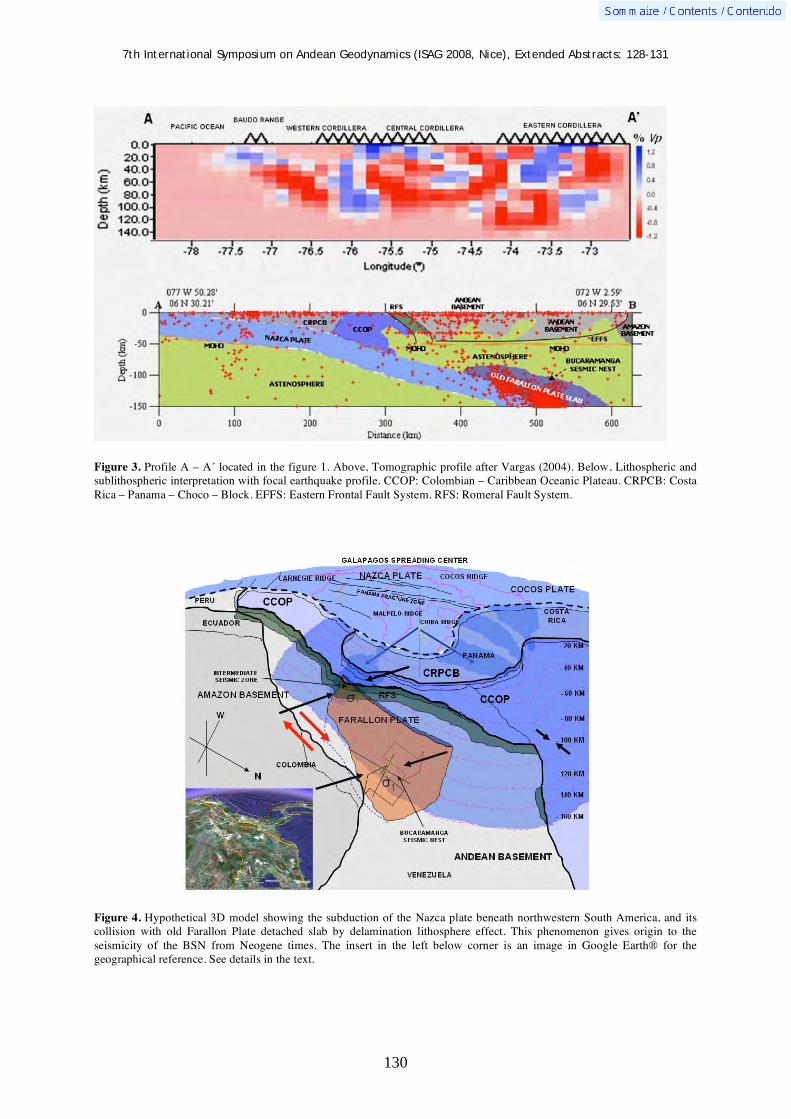
7th International Symposium on Andean Geodynamics (ISAG 2008, Nice), Extended Abstracts: 128-131
130
Figure 3. Profile A – A´ located in the figure 1. Above, Tomographic profile after Vargas (2004). Below, Lithospheric and sublithospheric interpretation with focal earthquake profile. CCOP: Colombian – Caribbean Oceanic Plateau. CRPCB: Costa Rica – Panama – Choco – Block. EFFS: Eastern Frontal Fault System. RFS: Romeral Fault System.
Figure 4. Hypothetical 3D model showing the subduction of the Nazca plate beneath northwestern South America, and its collision with old Farallon Plate detached slab by delamination lithosphere effect. This phenomenon gives origin to the seismicity of the BSN from Neogene times. The insert in the left below corner is an image in Google Earth® for the geographical reference. See details in the text.

7th International Symposium on Andean Geodynamics (ISAG 2008, Nice), Extended Abstracts: 128-131
131
A preliminary interpretation of the diverse fault types of the BSN´s seismic moment tensors report by NSNC and
NEIC is indicating a compressional stress field due to the old Farallon Plate slab holding a positive buoyance
because its add to the continental lithosphere when cease the subduction during the Paleogene, when Caribbean
Plate colliding with the northwestern South America margin (Chicangana, 2005). The slab fragment spreads
upward again by this effect but the collision with the Nazca Plate slab impedes it and producing inverse and
normal seismic moment tensors. Probably it is destroying by gravitational effect of the downward Nazca plate
in the superior mantle. As Nazca Plate take an age < 20 Ma it presents negative bouyance producing normal
seismic tensors. In synthesis (Figure 4) the accumulation of tectonic effects as the downward Nazca Plate, the
resistance to the descent of the old removed Farallon Plate slab toward mantle, and the compression for the
effect of the collision is the result of the diverse seismic moment tensors that take place in the BSN.
References Chicangana, G., 2005. Estudio del Sistema de Fallas Romeral (0,5 – 11,5 ° N), a partir de una caracterización
sismotectónica regional. Tesis de Maestría en Ciencias – Geología, Departamento de Geociencias, Facultad de Ciencias, Universidad Nacional de Colombia, Bogotá D.C. 191p.
Chicangana, G., & Vargas, C. A., 2004. Desarrollo y Geometría actual de la litosfera en la Esquina Noroccidental de Suramérica. Memorias del 1er. Congreso Latinoamericano de Sismología, http://olimpia.uan.edu.co/sls/1cls/resumenes/poster/NACIONALES/desarrollo_geometria.pdf
Chicangana, G. & Vargas, C. A.. 2005. Two regions with intermediate seismicity rate increase under Colombian Andes visualizated and interpretated with the Combination of Local Seismic Tomography and Hypocentral Profiles: Regions of Eje Cafetero and the Seismic Nest of Bucaramanga. 6th International Symposium Andean Geodynamics – ISAG. Volume of extended abstracts. 170 – 173.
Chicangana, G., & Vargas, C. A., 2007. Aproximación a la geometría litosférica y sublitosférica bajo los Andes del centro de Colombia, in Memorias del XI Congreso Colombiano de Geología, CD – Room.
Chicangana, G., Vargas, C. A., & Kammer, A., 2006. La Evolución del Centro de Expansión de Galápagos y su Papel en la sismicidad intermedia del occidente colombiano. Memorias del II Congreso Latinoamericano de Sismología, CD – Room.
Kissling, E., Solarino, S., & Cattaneo, M., 1995. Velest Users Guide. Internal report, Institute of Geophysics, ETH Zurich. Lienert, B.R.E. & Havskov, J., 1995. A computer program for locating earthquakes both locally and globally, Seismological
Research Letters, 66, 26-36. Vargas, C. A., 2004. Propagación de Ondas sísmicas y atenuación de ondas Coda en el Territorio Colombiano. Rev. Acad.
Col. Cien. Fis. Exact y Nat. Colección Jorge Álvarez Lleras No. 23, 235p.

7th International Symposium on Andean Geodynamics (ISAG 2008, Nice), Extended Abstracts: 132-135
132
Seismotectonic behavior of the Eastern Frontal Fault System: Seismic hazard for the Villavicencio region, Central Colombia
Germán Chicangana1, 2
, Carlos A. Vargas2, & Andreas Kammer
3
1 Escuela de Ingenierías, Corporación Universitaria del Meta, Barrio San Fernando, Villavicencio, Colombia
2 Grupo de Geofísica, Universidad Nacional de Colombia, Edificio Manuel Ancizar, Ciudad Universitaria, Bogotá,
Colombia ([email protected], [email protected]) 3 Departamento de Geociencias, Universidad Nacional de Colombia, Edificio Manuel Ancizar, Ciudad
Universitaria, Bogotá, Colombia ([email protected])
KEYWORDS : Eastern Colombian Foothills, seismic hazard, seismotectonic, eastern Frontal Fault System, seismic hazard
Introduction and methodology
The Villavicencio city (500,000 inhabitants), is located on the eastern foothills of the Eastern Colombian
Range, about 60 km toward SE from Bogotá D.C. (8,000,000 inhabitants) (Figure 1). In this area active tectonic
evidences have been previously observed in several faults related to Eastern Frontal Fault System (Paris et al.
2000; Chicangana et al., 2007). At August 31, 1917, a M 6,5 earthquake affected the Villavicencio city and the
region around it with economic and human lives losses (Cifuentes et al., 2006).
Recognition of the main tectonic features of the Eastern Frontal Fault System - EFFS (3º N - 5º N) using
remote sensing, geological maps and field work, allowed us to elaborate a 3D geotectonic model that helps to
understand the potential M 6,0 regional earthquakes and their relationship with the main fault planes. This
model is also optimized with historical and instrumental seismological records. The results of this work
contribute to improve the knowledge about the seismic hazard near to Bogota D.C and Villavicencio cities.
Active tectonics
Active tectonics evidences have been verified near to Villavicencio urban area and as far as 25 km to the north
of this city. These evidences are active front thrust with high load mass in bar - braided drainages, constant big
groundmass slides, and permanent cleaning along strike of main fault scarp in a regional scale. The active
tectonics is product of working of thrust faults due to sliding updip or downdip fault plane, also but less by strike
– slip component (Figures 2 & 3). In this region the Eastern Frontal Fault System is composed by severed
foreland SE vergent thrust faults like Algeciras, Guaicaramo, Guayuriba, Mirador and Servita Faults. Toward
surface high angle ( 90°) predominated in these fault planes, but toward depth ( 10 – 30 km) dip angle
decreases to 20° or less (Figure 2). These tectonic features derived of tectonic positive inversion by Neogene
reactivation of large Mesozoic normal faults; some of these faults were previously affected by a Neoproterozoic
continental collision. The Guaicaramo Fault is a fundamental lithospheric limit between these ancient continents
(Laurentia and Gondwana).
The stress field from microtectonics data for NNE fault planes of the Eastern Colombian range between 3° N
and 4° N indicates a 1 W- E, while at the north (4° N) has a 1 NW – SE (Chicangana et al., 2007). This
stress field was produced by the Pliocene - Pleistocene geodynamic evolution of NW South America, Costa Rica
- Panama – Choco Block and Caribbean plate (Chicangana & Vargas, 2006). The frictional mechanism over
fault thrust planes produced a rupture area toward updip or downdip (Figure 3).

7th International Symposium on Andean Geodynamics (ISAG 2008, Nice), Extended Abstracts: 132-135
133
Figure 1. Localization of the study region and some faults of the Eastern Frontal Fault System.
Figure 2. Left, 3D sketch showing regional tectonic – stratigraphic framework using a DTM. Right, Profiles A - A´, B - B´, and C - C´ of left sketch. GCF: Guaicaramo Fault. FGY: Guayuriba Fault. FM: Mirador Fault. MAF: Manzanares Fault. RChF:Rio Chiquito Fault. GF: Gallo Fault. SF: Servitá Fault. FSJ: San Juanito Fault. AMProtB: Andean Mesoproterozoic Basement.

7th International Symposium on Andean Geodynamics (ISAG 2008, Nice), Extended Abstracts: 132-135
134
Figure 3. DEM showing the stress fields for the central sector Eastern Colombian Range (P: Pressure, T: Tension), with the main kinematics of main thrust faults due to tectonic effect in three different sectors of the Eastern Frontal Fault System exhibited in the cubes that they show the rupture area that would generate the earthquake.
Figure 4. Seismotectonic maps for the study region from historical seismicity data after Chicangana et al. (2007) (left), and seismicity record of National Seismological Network of Colombia (INGEOMINAS, 2001) during the period 1993-2001 (right).

7th International Symposium on Andean Geodynamics (ISAG 2008, Nice), Extended Abstracts: 132-135
135
Historical seismicity and regional seismic hazard
Historical and instrumental seismological records (Figure 4) showing a lower shallow seismicity activity (an
earthquake M 4.0 in a period 10 years) between 4º N - 5º N, and moderate shallow seismicity activity (an
earthquake M 4.0 in a period 10 years) between 3° N and 4° N. The thrust faults extend toward the rigid
Proterozoic basement with lower dip angles, being composed of shortcut planes and potential earthquake
M 6,0. This work proposes that Guaicaramo and Servita thrust faults toward north of 4° N can produce a big
earthquake but equally Guayuriba or Mirador thrust fault toward south or near of 4° N. Also a great seismic
hazard is the Algeciras Thrust Fault due to that is responsible for big historical earthquakes how February of
1967 M = 6.7 earthquake (Ramirez, 1975; Velandia et al., 2005), when Bogota, Neiva and Villavicencio were
strongly affected. The knowledge of seismic cycle for to value the parameters of seismic hazards of these thrust
faults is even poor because the lack of paleosismological studies and the small record of the seismological
network. We conclude that only the realization of future studies with the support of a local seismological
network would contribute to reduce the effects of seismic hazard in Bogota, Villavicencio, and Central
Colombia.
References Chicangana, G., & Vargas, C. A. 2006. Evolución del estilo orogénico actual de los Andes del norte: Resultado de la acreción
del Bloque Costa Rica – Panamá – Chocó (BCRPC) durante el Plioceno Superior. Memorias del II Congreso Latinoamericano de Sismología, En CD – Room.
Chicangana, G., Vargas, C. A., Kammer, A., Hernández Hernández, T. A., & Ochoa Gutiérrez, L.H. 2007. Caracterización Sismotectónica Regional Preliminar de un sector del Piedemonte Llanero colombiano: Corredor San Juan de Arama – Cumaral, Meta: Boletín de Geología – UIS, 29, 61 – 74.
Cifuentes, H. G., Sarabia, A. M., Robertson, K. G., & Dimaté, A. C. 2006. Parámetros Macrosísmicos del Sismo de 1917 en Colombia. Memorias del II Congreso Latinoamericano de Sismología, En CD – Room.
INGEOMINAS. 2001. Boletín de Sismos 1993 –2001. INGEOMINAS - RSNC. París, G., Machette, R., Dart, R. L., & Haller, K. M. 2000. Database and Map of Quaternary faults and folds of Colombia and
its offshore regions, Open – File Report 00 – 0284: http//www.pubs.usgs.gov/of/2003/opf-00-0284. Ramirez, J. E. 1975. Historia de los Terremotos en Colombia, IGAC, 250p. Velandia, F., Acosta, J., Terraza, R., & Villegas, H. 2001. The current tectonic motion of the Northern Andes along the
Algeciras Fault System in SW Colombia: Tectonophysics, 399, 313 – 329.

7th International Symposium on Andean Geodynamics (ISAG 2008, Nice), Extended Abstracts: 136-139
136
The Mw 7.7 Tocopilla earthquake of November 2007: Characteristics of a subduction earthquake that occurred in the brittle-ductile transition zone of the northern Chile seismic gap
Mohamed Chlieh1, Dominique Rémy
2, Bertrand Delouis
1, Sylvain Bonvalot
2, Germinal
Gabalda2, Tony Monfret
1, & Mario Pardo
3
1 Géosciences Azur, Université de Nice, IRD, 250 rue A. Einstein, 06560 Valbonne, France
([email protected]) 2 LMTG, Université de Toulouse, CNRS, IRD, OMP, 14 av. E. Belin, 31400 Toulouse, France
3 Departamento de Geofísica, Universidad de Chile, Blanco Encalada 2002, Santiago, Chile
KEYWORDS : subduction earthquake, GPS, InSAR, slip inversion, coseismic, afterslip
Abstract
The Mw 7.7 Tocopilla earthquake of November 14, 2007 is categorized as a subduction underthrusting event
that occurred at the contact of the Nazca and South America plates. This earthquake ruptured the southern-east
tip of the well identified ~500 km-long seismic gap of northern Chile. We determine coseismic and the first-
month postseismic slip distribution associated with this earthquake and its aftershocks from near-field permanent
Global Positioning System (GPS) surveys and InSAR data acquired on two adjacent tracks. The coseismic
model shows that the Nazca subduction megathrust ruptured over a distance of about 150 km and a width of less
than 50 km. Maximum slip of about 1.5-2.5 m occurred around two major asperities between 35 km and 55 km
depth. It releases a total moment of 4.5 1020 Nm, equivalent to a magnitude Mw=7.7. Slip inversion of the InSAR
data that included up to 45 days of postseismic deformation in addition to the coseismic deformation requires
that slip must have continued on the plate interface after the 45s seismic rupture. The postseismic moment
released could have been more than 30% of the coseismic moment release, with significant afterslip between the
two coseismic asperities and off-shore the Mejillones Peninsula.
Introduction
The Mw 7.7 Tocopilla earthquake of November 2007 occurred along the Northern Chile subduction zone,
which absorbs about 60 mm/yr of northeastward motion of the Nazca plate relative to the South American craton
(Figure 1). This event was identified as a subduction underthusting earthquake and occurred in the deep portion
of the seismogenic zone.
Characteristics of the Tocopilla earthquake derived from seismology
A comprehensive view of the slip history and distribution was obtained by combining information from strong-
motion records obtained from a local seismic network and teleseismic data. Delouis et al. [2008] relocated the
mainshock hypocenter with an uncertainty of +/- 4 km at 22.33ºS, 70.16ºW with an hypocentral depth of 45 km
+/- 6km. That study indicates that the rupture took about 45 s to propagate about 150 km southward from the
epicentral area to the northern Mejillones Peninsula with an average rupture velocity of about 2.8 km/s. The slip
distribution inverted in this analysis shows that slip is located in the deeper part of the seismogenic zone,

7th International Symposium on Andean Geodynamics (ISAG 2008, Nice), Extended Abstracts: 136-139
137
between 35 km and 50 km depth (Figure 2a). The slip is mainly concentrated around two asperities, one south of
the epicentral area and one north-east of the Mejillones Peninsula. The seismic moment associated with this
event is Mo=4.5 1020 N.m which corresponds to an earthquake of magnitude Mw=7.7.
Characteristics of the Tocopilla earthquake derived from geodesy
The geodetic data used to derive the slip models come from continuous GPS stations, where the signal is above
the noise level on daily solutions. Five Continuous GPS stations installed in that area through the collaboration
between the Institut de Recherche pour le Developpement (IRD), Institut de Physique du Globe de Paris (IPGP)
and the Departamento de Geofísica of Universidad de Chile (DGF) were operating during the event. Since the
two northern station show nearly no displacement associated with that event, the three southern stations, one
located in the longitudinal valley at the city of Quillagua (QUIL), and two at the costaline Tocopilla (TCPL) and
Mejillones (PMEJ) indicate significant trenchward horizontal displacements. About 22 cm of horizontal
displacements was observed at PMEJ station located about 100 km south from the epicenter and 5 cm at TCPL
and QUIL stations located respectively at about 25 km and 75 km north of the epicenter (Figure 1). PMEJ and
TCPL stations were uplifted respectively by 35 cm and 10 cm, since QUIL station subsided by 4 cm. GPS time
series of Mejillones and Iquique indicated a decreasing trenchward motion in the 45 days that followed the
event. During that period, the GPS station of Mejillones continues moving horizontally trenchward of about 5
cm, but no significant vertical displacements is observed in the time series.
Figure 1. GPS and InSAR measurements associated with of the Mw 7.7 Tocopilla earthquake. The horizontal GPS measurements (in black) and the vertical (shown in grey) have the same scale. InSAR data are unwrapped and presented in the line of sight (LOS) of the ERS-satellite. LOS positive indicate subsidence.
In addition to GPS measurements, InSAR interferograms were constructed using ASAR/ENVISAT images on
two adjacent satellite tracks and covering the epicentral area of Tocopilla to the city of Antofagatsa. The

7th International Symposium on Andean Geodynamics (ISAG 2008, Nice), Extended Abstracts: 136-139
138
displacement in the line of sight of satellite shows that the coastline area moved toward the satellite with a
maximum of 30 cm, since the longitudinal valley moved away from the satellite of 15 cm (Figure 1). The InSAR
data covered as well the coseismic displacements associated with the Tocopilla earthquake but include also the
early postseismic displacements that occurred in the first 45 days after the earthquake. Because the small altitude
of ambiguity between the image pairs used and the precise SRTM DEM, we do not expect much noise
associated to the topography.
Results
The Joint inversion of InSAR data and GPS including postseismic deformation in about the first month
indicates that the seismic moment might be higher than 6.0 x 10²⁰ Nm to fit the geodetic data relatively well. The
discrepancy with the seismic moment deduced from seismological observations may come from the fact that the
geodetic data may contain postseismic deformation up to 45 days after the earthquake. The slip distribution
indicates that coseismic slip may have occurred around two major asperities of ~50-70 km wide (Figure 2). One
asperity appears just north of the epicenter and slips about 1.5 m and the other is northeast of the Mejillones
Peninsula slipping about 2.5 m. Some significant postseismic afterslip may have occurred in between the two
seismic asperities but also off-shore the Mejillones Peninsula where significant aftershocks (with Mw>5.5)
occurred in the days that follow the earthquake (figure 1).
Figure 2. Slip distributions associated to the Mw 7.7 Tocopilla earthquake deduced from a) joint inversion of teleseismic and strong-motion data, b) coseismic GPS data, c) coseismic and postseismic GPS and InSAR data. The difference between b) and c) is presented in d) and may reflects the cumulative afterslip that occurred in the month that follow the Tocopilla earthquake.
From previous study of interseismic strain accumulation in that region, the deep section of the slab interface
located between 35 km and 55 km depth was defined as the brittle-ductile transition of the northern Chile
seismic gap (Chlieh et al. 2004). In the years before and after the 1995 Mw 8.1 Antofagasta earthquake that
ruptured a surface of about 200x100 km of the superficial portion of the subduction interface, < 35km depth
(Ruegg et al. 1996, Delouis et al. 1997), three earthquakes of Mw>7.0 occurred in the brittle-ductile transition
7th International Symposium on Andean Geodynamics (ISAG 2008, Nice), Extended Abstracts: 136-139
139
zone (Pritchard et al. 2002). Then, the occurrence of the Mw 7.7 Tocopilla earthquake in that brittle ductile
transition zone could be suspected as a precursor to the failure of the northern Chile seismic gap.
Even thought its high magnitude, the Tocopilla earthquake did not released much of the seismic energy that is
accumulating along the northern Chile seismic gap. At the scale of that stretch of about 500 km-long by 150 km-
wide, the moment rate deficit estimated from interseismic deformation analysis is about 2.5 1020 N.m/yr. This
indicated that in less than 3-years of plate convergence rate, the seismic moment accumulated over the locked
fault zone of northern Chile seismic gap would be the equivalent of what was released during co- and
postseismic relaxation of the Mw 7.7 Tocopilla earthquake. Since the northern Chile segment did not produce any
great earthquake in 130 years, the moment deficit accumulated there would be enough to produce an event of
Mw 8.7 or higher if only half or more of that moment deficit is released.
References Chlieh, M., de Chabalier, J. B., Ruegg, J. C., Armijo, R., Dmowska, R., Campos, J., and Feigl, K. L., 2004. Crustal
deformation and fault slip during the seismic cycle in the North Chile subduction zone, from GPS and InSAR observations. Geophys. J Int., 158, p. 695-711.
Delouis, B. et al., 1997. The Mw = 8.0 Antofagasta (Northern Chile) earthquake of 30 July 1995: a precursor to the end of the large 1877 gap, Bull. seism. Soc. Am., 87, 427–445.
Delouis, B., Pardo, M., Legrand, D., Monfret, T. 2008. The Mw 7.7 Tocopilla earthquake 0f 14 November 2007 at the southern edge of the northern Chile seismic Gap: Rupture in the deep part of the coupled plate interface. Submitted to BSSA.
Pritchard, M. E., Simons, M., Rosen, P. A., Hensley, S., Webb, F. H. 2002. Co-seismic slip from the 1995 July 30 Mw= 8.1 Antofagasta, Chile, earthquake as constrained by InSAR and GPS observations. Geophys. J Int., 150 (2) , p. 362–376 doi:10.1046/j.1365-246X.2002.01661.x
Ruegg, J.C. et al., 1996. The Mw =8.1 Antofagasta (North Chile) earthquake of July 30, 1995: first results from teleseismic and geodetic data, Geophys. Res. Lett., 23(9), 917–920.

7th International Symposium on Andean Geodynamics (ISAG 2008, Nice), Extended Abstracts: 140-143
140
Progressive avulsion of the Río Pastaza as a response to topographic uplift and backtilt of the Ecuadorian Subandean Zone
F. Christophoul1, C. Bernal
1, J. Darrozes
1, J.-C. Soula
1, & J. D. Burgos
2
1 UMR LMTG Universités de Toulouse-CNRS-IRD-OMP, 14 Avenue Edouard Belin 31 400 Toulouse, France
[email protected] 2 Petroecuador, Ecuador
KEYWORDS : Ecuador, Subandean, avulsion, thrust related fold, backtilt
Introduction
Rivers are known to be very sensitive to local slope change (Jones and Schumm, 1999; Schumm et al., 2000;
Schumm, 1977). Response of alluvial rivers to slope change includes changes in fluvial morphology (Schumm et
al., 1987) and avulsions in the case of a downstream slope change (Jones and Schumm, 1999), (Stouthamer and
Berendsen, 2000) or lateral shift (Alexander et al., 1994) (Schumm et al., 2000) and avulsion (Alexander et al.,
1994) in the case of a lateral tilt. In Ecuador, the Rio Pastaza, while it crosses the structures of the Subandean
zone exhibits several sharp curves associated with traces of abandoned channels. This area is known to have
been recently uplifted in response to the growth of the Subandean Front (Bes de Berc et al., 2005).
This article is aimed illustrating a type of fluvial response to tectonics involved in the development of drainage
network on an active orogenic foothill. This study is based on field data, structural cross sections, remote
sensing, GIS and DEM. Data based on historic chronicles and testimonies of the inhabitants of the area were also
included.
Structure of the Ecuadorian Subandean Zone
The Ecuadorian Subandean Zone is bounded by the Western Cordillera to the west and the Amazonian
foredeep to the east (Fig. 1A, 1B), which is filled with deposits ranging from the upper Cretaceous to the
Holocene (Christophoul et al., 2002). The Subandean Zone consists in the Napo and Cutucu antiforms which
deform Jurassic volcanic and sedimentary formations and Cretaceous through Oligocene sedimentary formations
((Baldock, 1982); (Balkwill et al., 1995); (Baby et al., 1999); (Kley et al., 1999); (Bes de Berc et al., 2005)).
These antiforms developed on top of the west dipping Subandean Front. Between these antiforms, the Pastaza
Depression is topped by the Puyo Plateau which consists in a flat surface developed on top of the plio-
pleistocene fluvial sediments (Bes de Berc et al., 2005). A balanced cross-section traversing the front of the
Western Cordillera, the Interandean Depression, the Eastern Cordillera and the Subandean Zone along a line
Latacunga – Arajuno (Fig. 1) shows that the structure of the range in this area results from a complex sequence
of fold and thrusts. The Puyo plateau is known to have been recently uplifted in response to the growth of the
Subandean Front (Bes de Berc et al., 2005). Topographic profiles issued from a DEM derived from an Aster
image reveals that the Puyo Plateau exhibits a 0.4° westward tilt.

7th International Symposium on Andean Geodynamics (ISAG 2008, Nice), Extended Abstracts: 140-143
141
Figure 1. Simplified structural map of Ecuador (W.C.: Western Cordillera, IAD: Interandean Depression, EC: Eastern Cordillera, SZ: Subandean Zone) and structural cross section through the Interandean Depression, the Eastern Cordillera and the Subandean Zone (Burgos, 2006). The white square corresponds to the area represented on Fig.2.
Stream changes
Changes of the courses of the Rio Pastaza downstream from Puyo were reconstructed thanks to the synthesis of
cartographic documents (1906, 1976) aerial photography (1976), Landsat (1987, 1992, 2000) satellite images.
The occurrence of the last floods in the area (2007) is documented by testimonies. Put together, these documents
allow us to trace the evolution of the location and the morphology of the Rio Pastaza over a century. The
topography of the area consist in a plateau (Puyo Plateau), bounded eastward by the steep slopes of the Western
Cordillera and eastward by the scarp of the subandean front (incised by the Rio Pastaza) affected by landslides to
the north. In the center of the Puyo Plateau a rounded shaped hill corresponding to Pliocene volcanics (Burgos,
2006).
1906: The first reliable document concerning the Rio Pastaza in the studied area consists in a map
published in 1906. By these times the Rio Pastaza went round the Pliocene volcanics northward and eastward.
1976: A mission of Aerial photography was led in 1976. It shows the Rio Pastaza as a braided river
made of 2 braid plains, one flowing southward along the western cordillera, the other going round the pliocene
volcanics southarward and eastward. The 1906 path is abandoned.
1987: The Río Pastaza shows the 2 same braid plains. It exhibits 2 bifurcations (X and Y). To the
north, bifurcation X parts the Río Pastaza in two channels. The western one (x') exhibits a braided channel
characterized by a low braiding parameter (BI=1.8). The morphology of the eastern one (x'') varies from single
channel to braiding (with a very low braiding parameter, BI=0.5). To the south, bifurcation Y divides the main
channel in a channels series. The main channel flowing southward (y') presents the same characteristic than
upstream from the bifurcation, (BI=1.6). While the channel series (y'') start exhibiting a single meandering
stream, flowing to the south east.
1992: Figure 2 (14/07/1992) reveals some changes concerning bifurcation X, since the divergence
point is displaced toward the south, ~1.8 Km, and implicates the virtually abandonment of x'' reach, which is
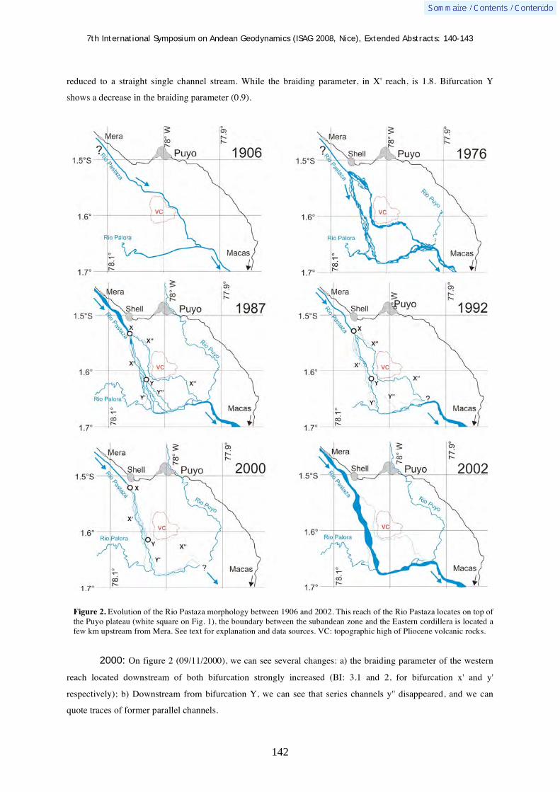
7th International Symposium on Andean Geodynamics (ISAG 2008, Nice), Extended Abstracts: 140-143
142
reduced to a straight single channel stream. While the braiding parameter, in X' reach, is 1.8. Bifurcation Y
shows a decrease in the braiding parameter (0.9).
Figure 2. Evolution of the Rio Pastaza morphology between 1906 and 2002. This reach of the Rio Pastaza locates on top of the Puyo plateau (white square on Fig. 1), the boundary between the subandean zone and the Eastern cordillera is located a few km upstream from Mera. See text for explanation and data sources. VC: topographic high of Pliocene volcanic rocks.
2000: On figure 2 (09/11/2000), we can see several changes: a) the braiding parameter of the western
reach located downstream of both bifurcation strongly increased (BI: 3.1 and 2, for bifurcation x' and y'
respectively); b) Downstream from bifurcation Y, we can see that series channels y'' disappeared, and we can
quote traces of former parallel channels.

7th International Symposium on Andean Geodynamics (ISAG 2008, Nice), Extended Abstracts: 140-143
143
2002: Figure 2 (12/09/2002) reveals few differences compared to figure 5.c. Channel x'' keep reducing
its width. While, as a consequence of the disappearance of channel y'', the main channel (x'+y') reaches high
braiding parameter (BI:3 and 2 respectively).
2007: a flood of the Rio Pastaza reactivated the eastward channel of the Rio Pastaza. It shows that this
channel, though partially abandoned is still used as a chute channel by the Rio Pastaza.
Discussion and Conclusion
The evolution of the successive paths of the Rio Pastaza over the last century exhibits the characteristics of a
progressive avulsion. This progressive avulsion led the Rio Pastaza to describe a 90° curve by these times. This
avulsion consists in the initiation of an anabranch channel which progressively grows in size. By this time, the
original channel regularly decreases in size an keeps occupied by an underfitted stream. This underfitted stream
remains active in case of flood were it as reactivated as chute channel. This progressive avulsion seems to be the
consequence of the tilt of the Rio Pastaza substratum in response to the growth of the eastward merging
subandean front which tectonic activity is known in the last 20 Ka (Bes de Berc et al., 2005) and in the last years
(Legrand et al., 2005). Such a kind of progressive avulsion has been identified in other modern and ancient
rivers (Bristow, 1999) where was in channel processes triggered avulsions. In the case of the Rio Pastaza,
progressive avulsion is controlled by tectonics.
References Alexander, J., Bridge, J.S., Leeder, M.R., Collier, R.E.L. and Gawthorpe, R.L., 1994. Holocene meander-belt evolution in an
active extensional basin, southwestern Montana. Journal of Sedimentary Research, B64: 542-559. Baby, P., Rivadeneira, M., Christophoul, F. and Barragán, R., 1999. Style and timing of deformation in the Oriente of
Ecuador. In: Orstom (Editor), 4th International Symposium of Andean Geodynamics. ORSTOM, Göttingen, pp. 68-72. Baldock, J.W., 1982. Boletín de Explicación del Mapa Geológico del Ecuador. DGGM, Quito, Ecuador, pp. 80. Balkwill, H.R., Rodrigue, G., Paredes, F.I. and J.P., A., 1995. Northern part of Oriente Basin, Ecuador: reflection seismic
expression of structures. In: A.J. Tankard, R. Suarez Soruco and H.J. Welsink (Editors), Petroleum basins of south America, pp. 559-571.
Bes de Berc, S. et al., 2005. Geomorphic evidence of active deformation and uplift in a modern continental wedge-top - foredeep transition: example of the eastern Ecuadorian Andes. Tectonophysics, 399(1-4): 351-380.
Bristow, C.S., 1999. Gradual avulsion, river metamorphosis and reworking by underfitd streams: a modern example from the Brahmaputra river in Bangladesh and a possible ancient example in the Spanish Pyrenees. In: N.D. Smith and J. Rogers (Editors), Fluvial Sedimentology VI. Special Publication of the International Association of Sedimentologists. Blackwell Science, pp. 221-230.
Burgos, J.D., 2006. Mise en place et progradation d'un cône alluvial au front d'une chaîne active: exemple des Andes équatoriennes au néogène. Phd Thesis, Université Paul Sabatier, Toulouse 3, Toulouse, 373 pp.
Christophoul, F., Baby, P., Soula, J.-C., Rosero, M. and Burgos, J.D., 2002. Les ensembles fluviatiles néogènes du bassin subandin d'Equateur et implications dynamiques. Compte Rendus Géosciences, 334: 1029-1037.
Jones, L.S. and Schumm, S.A., 1999. Causes of avulsion: an overview. In: N.D. Smith and J. Rogers (Editors), Fluvial Sedimentology VI. Special Publication of the International Association of Sedimentologists. Blackwell Science, pp. 171-178.
Kley, J., Monaldi, C.R. and Salfity, J.A., 1999. Along-strike segmentation of the Andean foreland: causes and consequences. Tectonophysics, 301(1): 75-94.
Legrand, D. et al., 2005. The 1999-2000 seismic experiment of Macas swarm (Ecuador) in relation with rift inversion in subandean foothills. Tectonophysics, 395: 67-80.
Schumm, S.A., Dumont, J.F. and Holbrook, J.M., 2000. Active tectonics and alluvial Rivers. Cambridge University Press, Cambridge, 401 pp.
Schumm, S.A., Mosley, M.P. and Weaver, W.E., 1987. Experimental Fluvial Geomorphology. Wiley Interscience, New York, 411 pp.
Schumm, S.A., 1977. The Fluvial System. Wiley & sons, New York. Stouthamer, E. and Berendsen, H.J.A., 2000. Factors Controlling the Holocene Avulsion History of the Rhine-Meuse Delta
(The Netherlands). Journal of Sedimentary Research, 70(5): 1051-1064.

7th International Symposium on Andean Geodynamics (ISAG 2008, Nice), Extended Abstracts: 144-147
144
Superimposed deformational episodes along the migmatitic belt, central portion of the Sierras Pampeanas Septentrionales, Central Andes, Argentina: An example from the Las Cañas Complex
Clara E. Cisterna1,2
, Ricardo Mon1,2
, & Rodolfo Mena2
1 Consejo Nacional de Investigaciones Científicas y Técnicas (CONICET), Miguel Lillo 205, 4000 Tucumán,
Argentina ([email protected], [email protected]) 2 Facultad de Ciencias Naturales e Instituto Miguel Lillo, Universidad Nacional de Tucumán (UNT), Miguel Lillo
205, 4000 Tucumán, Argentina ([email protected])
KEYWORDS : migmatites, syntectonic fold, shear, Central Andes, Argentina
Introduction
The northern Argentina Proterozoic - early Paleozoic
basement is composed of an assembly of multiply folded
orogenic belts with different structural characteristics,
amalgamated at about 600 Ma (Mon and Hongn 1996).
Preliminary studies allowed to recognize, at the central
portion of the Pampean belt, (río Las Cañas, cuesta de La
Chilca, La Majada, and others) a crystalline core
composed by gneisses and migmatites, marginated
eastward and westward by low grade schists separated by
west-dipping thrusts (Mon y Hongn 1996) (Fig. 1). This
migmatitic belt is the main object of this study. It
represents a deep magmatic arc, where the relative
synchronicity and/or feedback relations between heat,
deformation, partial melting and regional metamorphism
generated an igneous – metamorphic complex highly
deformed by multiple deformational episodes during a
contractional regime.
The Las Cañas Complex (LCC) represents a portion of
the metamorphic mid-crustal basement migmatitic belt in
the sierra de Aconquija (Sierras Pampeanas
Septentrionales, NW Argentina). A complete range from
folded metatexite to diatexite migmatites has been
produced during a high-grade metamorphic and
deformational events. The structural study reveals a shear
episode at the end of the migmatization. New field, fabric
and mineralogical observations allow constrain pre-, syn-
and post-migmatitic deformational phases and offers a
new insight into the tectonic evolution of the Central Andes crystalline basement in northwestern of Argentina.
Figure 1. Regional geological map (modified after Mon and Hongn 1996).

7th International Symposium on Andean Geodynamics (ISAG 2008, Nice), Extended Abstracts: 144-147
145
Geological setting
The Sierra de Aconquija (NW Tucumán – SE Catamarca) belongs to the Sierras Pampeanas Septentrionales.
This range is mostly composed by Neoproterozoic – early Paleozoic basement rocks and whilst the general
characteristics of the metamorphism and the structure in this area are similar to elsewhere in these ranges
(González Bonorino 1951). Some of the salient features of the local geology will be briefly described here.
The layered schists that crop out along the studied area are formed predominantly of centimeters- to
decimeters- scale layers of fine to medium grained quartz - feldspatic, with intercalations of thin pelitic layers.
They were compared with the Ancasti Formation exposed at the south part of the Sierra de Ancasti. The regional
metamorphisms related to the low- to medium- grade metamorphic rocks are the result of an Early Cambrian
(Rapela et al., 1998, Sims et al., 1998) tectono-thermal event called the Pampean Orogeny. Other one, from
Ordovician to Devonian age (~ 490 - 390 Ma), produced during the Famatinian Orogeny is coincident with the
metamorphism peak in different areas of the Sierras Pampeanas (eg. Sierra de Ancasti). Deformation episodes
along this portion of Sierra de Aconquija were studied by Mon and Hongn (1996) and others. The first one
generated a D1 poorly preserved structure, characterized by the layered schists foliation. Other structural features
throughout most of the area correspond to a D2 deformation phase, which is represented by a crenulation
cleavage (or: the S2 penetrative fabric) oblique to S1 and characterized by mineral segregation and folding.
Migmatites were studied by different authors (Rassmuss 1918) and were defined as the “Complejo de Inyección”
(González Bonorino 1951) along the Aconquija – Ambato -Ancasti mountains.
Las Cañas Complex: field relations, structure and lithotypes
Most of the basement outcrops of this area are represented by migmatites and layered schists. The migmatites
represent the bulk of these outcrops; schists are represented only as resisters bodies included in the migmatitites.
Layered schists. Fine grained schists are the lowest-grade metamorphic rock, showing an S1 foliation,
characterized by the alternation of millimeter - thick grey platy minerals layers with quartz-rich microlithons
and composed by Qtz + Pl + Bt ± Ms and Qtz + Pl + Grt + Ms mineral assemblage (mineral symbols after
Kretz, 1983). The most abundant schists are grey, foliated and/or banded rocks. They show an S2 structures,
characterized by a crenulation cleavage and folds. Banded
fabric is given by quartz - feldespathic rich and biotite rich
layers alternations and are composed by Bt + Qtz + Pl +
Sil ± Ms + Ap + Zrn ± Ilm mineral assemblage. These
schists generally are present as resisters bodies nearly 1m
enclosed in migmatites and show the pre-migmatitic
deformation (Fig.2). Resisters schists commonly enclose
concordant quartzo-feldspathic veins, (10-20 cm thick),
folded and boudinated (Fig. 3).
Migmatites. These rocks display a wide variety of
morphologies. Stromatitic metatexites are the most common ones, characterized by the alternation of layers with
textural and mineralogical features well-developed.
Figure 2. Schists resisters in diatexite, showing the crenulation cleavage (pre-migmatitic structure)

7th International Symposium on Andean Geodynamics (ISAG 2008, Nice), Extended Abstracts: 144-147
146
They appear dark grey and have mainly biotitic composition, fine- grained mesosomes with Bt + Qtz ± Pl ± Sil ±
Grt mineralogical assemblages; and white to pink Qtz + Pl + Kfs ± Bt leucosomes. Diatexites have gradational
and sharp contacts with metatexites and are characterized by schlieren enriched in mafic minerals (mainly biotite
and granate). Resisters are common and represented by the schist protolith. Many diatexites outcrops show a
preference for platy minerals and plagioclase orientation. The transition from metatexite to diatexite migmatites
occurs at local scale over a few meters. Diatexite migmatites have coarse - grained equigranular fabric and a Qtz
+ Pl + Kfs ± Bt mineral assemblage characteristic. Migmatites develops flow foliation (S1) and parallel
intrafoliated folding (F1) (Fig. 3, 4). Most leucosomes are concordant or slight discordant to the dominant
structure (S1) and nearly 1 to 5 cm thick. Folds range between a few centimetres to more than one meter wave
length, and they also can be seen at the microscope. The resisters may be folded concordant to (F1) (Fig. 3). A
second folding episode (F2), showing N-S axial plane orientation and perpendicular to (F1) affect these rocks
(Fig. 4). The F2 structures are dipping to the east and folds, varying between one meter or a few centimetres, are
accompanied by an axial cleavage (S2). Refolding structures are common and generate interferences patterns,
examples of them are the partial or complete closures (“eye folds”) indicatives of the effects of the cross-folding.
Finally, over the most outcrops are recognized ductile shear zones (Fig. 5), associated with rotated and rounded
layered blocks and megablasts (eg. garnet).
Figure 3. Outcrop of stromatitic migmatite enclosing a foliated schists as resister. F1 and F2 folds overprinting.
Figure 4. Early fold (F1 ) with axial planar traces curved and F2 folds. Partial or complete clossures (“eye folds”) indicative of the effects of cross-folding.

7th International Symposium on Andean Geodynamics (ISAG 2008, Nice), Extended Abstracts: 144-147
147
Discussion and Conclusions
It is argued that migmatitic rocks were developed during more of one ductile folding episode and shear
structures are related to later phases. A late post-migmatitic ductile-brittle deformation is evidenced by the
development of a NNW-SSE striking vertical spaced crenulation cleavage. The relationships between a large
diversity of migmatitic structures and the progressive production of melt suggest that feedback relations
prevailed as a time-marker during a contractional regime. Deformation, metamorphism and plutonism of the Las
Cañas Complex show that this terrane evolved as a east-verging thrust system with synkinematic metamorphism
and partial melting during the Late Proterozoic – Early Paleozoic. The tectonic history and lithologies of LCC
are compared to the sierra de Ancasti (La Majada Complex, southern to the studied area), showing that they
belong to a same regional belt within the Catamarca portion of the Pampean Ranges, Central Andes (Argentina).
References González Bonorino, F., 1951. Descripción geológica de la Hoja 12 g, Aconquija, Catamarca – Tucumán. Buenos Aires,
Dirección Nacional de Minería, 75, 50 p. Kretz, R., 1983 .. Symbols for rock-forming minerals. American Mineralogist, 68:277-279. Mon, R., Hongn, F. D., 1996 . Estructura del basamento proterozoico y paleozoico inferior del norte argentino. Revista de la
Asociación Geológica Argentina, 51 (1): 3-14. Rapela, C. W., Pankhurst, R. J., Casquet, C., Baldo, E., Saavedra, J., Galindo, C. & Fanning, C. M., 1998.” The Pampean
Orogeny of the southern Proto-Andes: cambrian continental collision in the Sierras de Córdoba”. In Pankhurst, R. J. & Rapela, C. W. (éd.): The Proto-Andean Margin of Gondwana, Geological Society, London, Special Publications 142: 181-217.
Rassmuss, J., 1918. “La sierra de Aconquija”. In: Primera Reunión Nacional de la Sociedad Argentina de Ciencias Naturales, Phycis, 47-69.
Sims, J. P., Ireland, T. R., Camacho, A., Lyons, P., Pieters, P. E., Skirrow, R. G., Stuart-Smith, P. G. & Miró, R., 1998. “U-Pb, Th-U and Ar-Ar geochronology from the southern Sierras Pampeanas, Argentina: implications for the Palaeozoic tectonic evolution of the western Gondwana margin”. In Pankhurst, R. J. & Rapela, C. W. (éd.): The Proto-Andean Margin of Gondwana, Geological Society, London, Special Publications 142: 259-281.
Figure 5. Folds associated with a ductile shear deformation.

7th International Symposium on Andean Geodynamics (ISAG 2008, Nice), Extended Abstracts: 148-151
148
Where is the evidence for Oligocene rifting in the Andes? Is it in the Loncopué Basin of Argentina?
Peter R. Cobbold1, Eduardo A. Rossello
2, & Fernando O. Marques
3
1 Geosciences (UMR6118, Université de Rennes 1 et CNRS), 35042 Rennes, France
([email protected]) 2 CONICET y Universidad de Buenos Aires, 1428 Buenos Aires, Argentina ([email protected])
3 Dep. Geologia e CGUL, Univ. Lisboa, Edifício C6, Piso 2, 1749-016 Lisboa, Portugal ([email protected])
KEYWORDS : Andes, Oligocene, extension, Loncopué Basin, Argentina
Introduction
According to several authors, the Andes went through a phase of rifting in the Oligocene. Jordan et al. (2001)
described evidence for this from the Loncopué Basin of Argentina. This is between the volcanic arc of the main
Andean Cordillera and the uplifted western edge of the Neuquén Basin (Figure 1). The latter formed as a
composite rift basin during the early Mesozoic. Then Andean compression inverted it, in various stages, from the
middle Cretaceous onwards (Ramos, 1998; Cobbold and Rossello, 2003). The Loncopué Basin contains
Oligocene to Miocene continental strata. However, we have found in it little or no evidence for coeval extension.
Instead, we have found growth strata around folds and reverse faults. This makes us question the idea of
Oligocene extension. Our doubts extend to other parts of the Andes as well.
Figure 1. Left: simplified geological map of Neuquén Basin (modified after Cobbold and Rossello, 2003). Large rectangle indicates northern Loncopué Basin. Right: simplified geological map of northern Loncopué basin.

7th International Symposium on Andean Geodynamics (ISAG 2008, Nice), Extended Abstracts: 148-151
149
Loncopué Basin
The Loncopué basin (37° - 38° S) is a topographic and structural depression, lying between the main volcanic
cordillera in the W and the Cordillera del Viento in the E (Figure 1). Some authors have claimed that this
depression is a rift basin (Ramos, 1988), whereas others have argued that it is a compressional foreland basin
(Lesta et al., 1985; Cobbold and Rossello, 2003). Neogene volcanic rocks and alluvial sediment cover much of
the depression, except where four river valleys cut through a buried N-S-trending fold-and-thrust belt. At the
eastern edge of this belt, Pliocene lava flows have been sharply folded into an eastward verging monocline. The
lavas are in strong angular unconformity upon intensely deformed strata of the Lileo Fm (Leanza et al., 2002;
Rovere, 2004), which is equivalent to the Cura-Mallín Fm in Chile. The Lileo Fm consists of mudstone,
limestone, sandstone and tuff, which accumulated in lacustrine and fluvial environments, during the late
Oligocene to early Miocene. The age range (28 Ma to 22 Ma) is well constrained by 39Ar-40Ar and fission-track
dating of volcanic rocks (Jordan et al., 2001; Burns et al., 2006), fossil spores (Leanza et al., 2002), and fresh-
water mussels (Diplodon sp.; Uliana, 1979; Burns et al., 2006). According to various authors, the Lileo Fm
accumulated in a rift basin, during a phase of Oligo-Miocene extension, and this was later inverted in
compression (Folguera and Ramos, 2000; Jordan et al., 2001; Burns et al., 2006; Folguera et al., 2006).
However, the evidence for extension in the Loncopué basin is poor. Structural data are lacking, stratigraphic
arguments are inconclusive, seismic data are of bad quality, and there are no well data to constrain them at depth.
In the Lileo valley, outcrops of the Lileo Fm are continuous and of good quality (Figure 2). The entire sequence,
some 3000 m thick, has been folded. Burns et al. (2006, their figure 9) and Folguera et al. (2006, their figure 4)
have drawn sections, in which the strata are of equal thickness around folds. The authors conclude that the folds
are post-sedimentary and due to a Miocene phase of rift inversion. However, a panoramic view (Figure 2) shows
that in fact the bed thicknesses vary significantly around the folds, and the dips vary through 35°, 45° and 55° on
the limbs. Because many of the beds are lacustrine, we exclude the possibility of large initial dips. Thus the folds
are due to syn-sedimentary deformation. We infer that the Lileo Fm accumulated, not during extension, but
during horizontal shortening and vertical thickening. This begs two questions. Was the shortening thin-skinned
or did it involve the basement? Was the shortening of local or regional significance? Unfortunately, existing
seismic data (Jordan et al., 2001, their figure 7) are of poor quality. Neighbouring outcrops provide better clues.
The Cordillera del Viento (Figure 1), nearly 3000 m high, has a carapace of Permo-Triassic volcanic rocks
(Choiyoi Fm). Its deeply eroded western scarp provides a window into an underlying Palaeozoic sequence of
Lower Carboniferous tuffs, Upper Carboniferous marine shale, and early Permian tuffs (Zöllner and Amos,
1973). This sequence repeats above a flat-lying westward-verging thrust, which has been cut by Permian granite.
The thrust and the deep-seated intrusion are relicts of Palaeozoic orogenesis. The Choiyoi Fm lies in strong
angular unconformity upon the deformed and eroded Palaeozoic rocks. Above the Choiyoi Fm is a more
conformable sequence of mainly marine strata, which are typical of the Neuquén basin and go from early
Jurassic to middle Cretaceous. At some moment between the Hauterivian and the Eocene, the Mesozoic
sequence was further folded and back-thrust to the west, probably by reactivation of the underlying Palaeozoic
thrust system. Thus the Cordillera del Viento is a large eroded antiformal culmination, above a back-thrust
(dashed trace, Figure 1). Next to this fault, andesitic rocks of the Cayanta Fm are unconformable upon tilted

7th International Symposium on Andean Geodynamics (ISAG 2008, Nice), Extended Abstracts: 148-151
150
strata of various ages (from early Carboniferous, through Permian, Triassic and Jurassic, to middle Cretaceous).
The Cayanta Fm has been dated as Eocene by the 39Ar-40Ar method (Jordan et al., 2001).
Figure 2. Panoramic view of growth strata in Lileo Fm, along middle reaches of Lileo river valley. View is to south. Field of view is about 4 km, angle of view is about 60°, relief is about 500 m. Bedding traces (enhanced by white or black lines) are continuous over large areas. On limbs of syncline and anticline, true dips vary through angles of 35°, 45° and 55° (sectors between dashed lines).

7th International Symposium on Andean Geodynamics (ISAG 2008, Nice), Extended Abstracts: 148-151
151
Eocene andesites erupted through a series of vents that lie mainly along the back-thrust or close to it. To the W
of Andacollo, the Eocene andesites have been folded and uplifted by another back-thrust, which is active today
(full black trace, Figure 1). Probably it was active also during deposition of the Lileo Fm. In outcrops near the
confluence of the rivers Lileo and Neuquén, the Lileo Fm onlaps tilted Eocene andesites. On this basis, we
suspect that the Lileo Fm accumulated in a compressional or transpressional foreland basin. At one quarry in the
lower Lileo valley (Leanza et al., 2002, their figure 3), we found one syn-sedimentary strike-slip fault, left-
lateral and trending NW-SE, within mudstones of the Lileo Fm. Otherwise, we found no evidence for strike-slip
deformation in the area.
Conclusions
In the northern Loncopué basin, there are compressional growth strata within late Oligocene to early Miocene
continental strata of the Lileo Fm. Although there is no guarantee that the shortening involved basement,
neighbouring outcrops point to episodes of basement-involved shortening in the Palaeozoic, late Cretaceous to
Eocene, late Oligocene to early Miocene, and Quaternary.
Nowhere in this area (nor anywhere in the Neuquén Basin) have we found firm evidence for a phase of thick-
skinned extension in the late Oligocene to early Miocene, as claimed by Jordan et al. (2001) and Burns et al.
(2006). The only well-substantiated rifts are those that formed in the early Mesozoic. We cannot rule out
Tertiary rifting, nor do we exclude strike-slip motions (for which we have little evidence). However, we urge
prudence in inferring phases of rifting in the Andes, especially if the arguments are purely stratigraphic or the
structural evidence is incomplete.
References Burns, W.M., Jordan, T.E., Copeland, P. & Kelley, S.A. 2006. “The case for extensional tectonics in the Oligocene-Miocene
Southern Andes as recorded in the Cura Mallín basin (36°-38°S)”. In Kay S.M., Ramos V.A. (eds): Evolution of an Andean margin: A tectonic and magmatic view from the Andes to the Neuquén Basin (35°- 39°S lat), Geological Society of America Special Paper 207: 163-184.
Cobbold, P.R. & Rossello, E.A. 2003. Aptian to recent compressional deformation, foothills of the Neuquén Basin, Argentina. Marine and Petroleum Geology 20: 429-443.
Folguera, A. & Ramos, V.A. 2000. Control estructural del volcán Copahue (38°S-71°O): implicancias tectónicas para el arco volcánico cuaternario (36-39°S). Asociación Geológica Argentina Revista 55: 229-244.
Folguera, A., Ramos, V.A., González Díaz, E.F. & Hermanns, R. 2006. “Miocene to Quaternary deformation of the Guañacos fold-and-thrust belt in the Neuquén Andes between 37° and 37° 30’S”. In Kay S.M., Ramos V.A. (eds): Evolution of an Andean margin: A tectonic and magmatic view from the Andes to the Neuquén Basin (35°- 39°S lat), Geological Society of America Special Paper 207: 247-266.
Jordan, T.E., Burns, W.M., Veiga, R., Pángaro, F., Copeland, P., Kelley, S. & Mpodozis, C. 2001. Extension and basin formation in the southern Andes caused by increased convergence rate: A mid-Cenozoic trigger for the Andes. Tectonics 20: 308-324.
Leanza, H.A., Volkheimer, W., Hugo, C.A., Melendi, D.L. & Rovere, E. 2002. Lutitas negras lacustres cercanas al limite Paleógeno-Neógeno en la region noroccidental de la provincia del Neuquén: Evidencias palinológicas. Asociación Geológica Argentina Revista 57: 280-288.
Lesta, P.J., Digregorio, J. & Mozetic, M.A. 1985. Presente y futuro de la exploración de petróleo en las cuencas subandinas, Argentina. II Simposio Bolivariano, Exploración Petrolera en las Cuencas Subandinas, Bogotá, Publicaciones 3: 1-35.
Ramos, V.A. 1998. Estructura del sector occidental de la faja plegada y corrida del Agrio, Cuenca Neuquina, Argentina. X Congreso Latinoamericano de Geología y VI Congreso Nacional de Geología Económica, Buenos Aires, Actas 2: 105-110.
Rovere, E.I. 2004. Hoja Geológica 3772-IV, Andacollo, Provincia del Neuquén. SEGEMAR, Programa Nacional de Cartas Geológicas de la República Argentina, 1:250.000, Boletín 298: 1-104.
Uliana, M.A. 1979. Geología de la region comprendida entre los ríos Colorado y Negro, Provincias de Neuquén y Rio Negro. Doctoral thesis, Universidad Nacional de La Plata, Argentina.
Zöllner, W. & Amos, A.J. 1973. Descripción geológica de la Hoja 32b, Chos Malal (Provincia del Neuquén). Servicio Nacional Minero Geológico, Buenos Aires, Boletín 143: 1-91.

7th International Symposium on Andean Geodynamics (ISAG 2008, Nice), Extended Abstracts: 152-155
152
Burial history and estimation of ancient thermal gradients in deep synorogenic foreland sequences: The Neogene Vinchina Basin, south-Central Andes
Gilda Collo & Federico M. Dávila
Laboratorio de Análisis de Cuencas, CICTERRA-Universidad Nacional de Córdoba, Av. Vélez Sársfield 1611,
2º piso, of. 7, X5016GCA Córdoba, Argentina ([email protected], [email protected])
KEYWORDS : Neogene Andean foreland, Vinchina basin, burial history, illitization progress, paleogeothermal gradients
Introduction
The Miocene to Pliocene Vinchina basin (Vinchina and Toro Negro formations) constitutes one of the thickest
foredeep sequences of the Central Andes, between the High Cordillera and the Sierras Pampeanas province
(~ 28° SL). In spite of its great thickness, locally >10 km, strata lacks of diagenetic signatures, even in the basal
section of the stratigraphic column, where it is expected to be identified (assuming middle geothermal gradients
of 20-30ºC/km) rocks with evidences of low-grade metamorphism.
In order to unravel the burial history of the Vinchina basin, and to estimate a Mio-Pliocene paleogeothermal
gradient for the Central Andean region, we evaluated the progression of the illitization processes on fine-grained
rocks that affected this sandy-silty dominated alluvial succession. Relations between interstratified clay mineral
distribution and temperature (eg., Arostegui et al., 2006; Srodon, 2007) allowed to estimate the diagenetic
history and the maximun burial conditions. Clay mineral associations were identified by X-ray analysis in <2μm
fractions of 5 samples from bottom to top in the Quebrada de los Colorados section (28°41'S, 68°16'W; La Rioja
Province). Relative proportions of interstratified illite/semectite (I/S) within the neoformed phases were
established from decomposition of the XRD diagrams (cf. Lanson, 1997).
Progression of illitization process
In the analyzed samples of the Vinchina basin, the dominant neoformed clay mineral phases are illite and
interstratified illite/smectite (I/S), with lesser amounts of chlorite. Detailed analysis of expandable I/S allowed
establishing the coexistence of interstratified with R0, R1 and R3 orderings. In the shallowest sample (uppermost
section of the Toro Negro Formation, Figure 1) the clay mineral assemblage is dominated by R0 (~70%), R1 and
illite phases, with absence of R3 ordering. The appearance of R3 takes place at ~5 Km depth within the Vinchina
Formation and, likewise R1 and illite, shows an increment towards the base of the unit. Although randomly,
mixed-layered R0 clearly decreases to the deeper levels, significant proportions (~30%) in the I/S phases are still
present in the lowermost analyzed sample (depth of ~7 Km).
Burial history and paleo-geothermal gradient estimation
Distribution of I/S interstratified phases through the succession allow establishing a progressive smectite-
illitization process (R0 R1 R3 I) related to the sedimentary burial history of the Tertiary sequence, as
shown by the increment in the I/S ordering and illite content from top to base of the units and a strong

7th International Symposium on Andean Geodynamics (ISAG 2008, Nice), Extended Abstracts: 152-155
153
correlation between the degree of illitization and the stratigraphic age of the rocks. The presence of R0 randomly
mixed-layered I/S even in the deepest levels (~7 Km) evidences that the base of the basin fill did not exceed the
diagenetic field (cf. Frey and Robinson, 1999). Given that R0 becomes unstable over temperatures of 120ºC a
maximum paleogeothermal gradient of 17ºC/Km can be estimated. This value is coherent with
thermochronological studies that suggested the sequences would not have exceeded temperatures of ~90ºC
(Coughlin, 2000; Carrapa et al. 2006). Our values are also consistent with the coldest geothermal records
reported in the modern Andean foreland (see Hamza et al., 2005).
An Early Miocene-Pliocene age (between 19 - 3.4 Ma) for the Vinchina stratigraphy is interpreted from new
geochronological data, (Re y Barredo, 1993, Dávila et al., this congress) and is coincident with the onset of the
flat subduction at these latitude (Kay et al., 1988; Dávila et al., 2004). Within this context, crustal refrigeration
could associate to modifications in the thermal structure by reduction of the astenospheric wedge. Supporting
this hypothesis, similar geothermal gradients (18-20ºC/Km) were calculated for 5-km depth oil boreholes in the
Bermejo Valley (Precordillera de San Juan), which also above the modern flat-slab segment. Exhumation ages
for the Tertiary package are, however, not well constrained. The presence of subhorizontal Pleistocene(?)
conglomerates (Santa Florentina Fm) unconformably lying above the Vinchina and Toro Negro Formation on
the same thrust sheet allows interpreting that exhumation would have occurred between the youngest age of
Toro Negro Fm (3.4 Ma) and the deposition of this coarse conglomeratic succession. Given that the age of
deposition of the Santa Florentina Fm is unknown, but considered Pleistocene sensu lato, the maximum
residence interval for the Tertiary under extreme burial conditions would be 3.4 my.
Although the estimated maximum paleogeothermal gradient (~17ºC/Km) is consistent with those from other
coldest foreland basins, with the available thermocronologic data we cannot discard the influence of other factors
in the persistence of R0 I/S over the 7 km depth. “Effective K+ concentration” (Cuadros, 2006) and “residence
time” of the sequences at maximum burial conditions may have interfered in the evolution of clay mineralogy,
retarding the progression in the I/S ordering. Modeling of smectite-illitization process and comparisons between
correlative exhumed and buried successions will allow further evaluation of the influence of these factors.

7th International Symposium on Andean Geodynamics (ISAG 2008, Nice), Extended Abstracts: 152-155
154
Figure 1: I/S Interstratified distribution through the estratigraphic column of the Vinchina Basin (Modified from Ramos, 1970). To the right the decomposition of XRD Diagrams of each sample show the clear diminishing, but without desapearing, of R0 I/S from top to bottom of the sequence.

7th International Symposium on Andean Geodynamics (ISAG 2008, Nice), Extended Abstracts: 152-155
155
References Arostegui, J., Sangüsa, F.J., Nieto, F. and Uriarte, J.A. 2006. Thermal models and clay diagenesis in the
Tertiary-Cretaceous sediments of the Alava block (Basque-Cantabrian basin, Spain). Clay Minerals 41: 791-809.
Coughlin, T.J., 2000. Linked origen-oblique fault zones in the Central Argentine Andes: The basis of a new model for Andean orogenesis and metallogenesis. PhD Theses, University of Queensland, Dep. Earth Sciences.
Cuadros, J. 2006. Modeling of smectite illitization in burial diagenesis environments. Geochimica et Cosmochimica Acta 70: 4181-4195.
Dávila, F.M., Astini, R.A., Jordan, T.E., and Kay, S.M., 2004. Early Miocene andesite conglomerates in the Sierra de Famatina, broken foreland region of western Argentina, and documentation of magmatic broadening in the south-central Andes. Journal of South American Earth Sciences, 17: 89-101.
Dávila, F.M., Collo, G., Astini, R.A., and Gehrels, G., 2008. U-Pb detrital ages on a tuffaceous sandstone sheet in the Vinchina Formation, La Rioja, Argentina: Deposition and exhumation implications. XIII Congreso Geológico Argentino.
Frey, M. y Robinson, D., 1999. Low grade metamorphism. Blackwell Science. Cambridge. 313 p. Hamza V.M., Silva Dias, F.J.S., Gomes, A.J.L., and Delgadilho Terceros, Z.G. 2005. Numerical and functional
representations of regional heat flow in South America. Physics of the Earth and Planetary Interiors 152: 223–256.
Kay, S.M., Maksaev, V., Moscoso, R., Mpodozis, C., Nasi, C., and Gordillo. C.E., 1988. Tertiary Andean magmatism in Chile and Argentina between 28ºS and 32ºS: correlation of magmatic chemistry with a changing Benioff zone. Journal of South American Earth Sciences, 1: 21-38.
Lanson, B., 1997. Decomposition of experimental X-Ray diffraction patterns (Profile fitting) a convenient way to study clay minerals. Clays and Clay Minerals, 45 (2): 132-146.
Ramos, V.A., 1970. Estratigrafía y estructura del Terciario en la sierra de los Colorados (Provincia de La Rioja), República Argentina. Revista de la Asociación Geológica Argentina, 25 (3): 359-382.
Re, G.H. and Barredo, S.P., 1993. Esquema de correlaciones de las formaciones terciarias aflorantes en el entorno de las Sierras Pampeanas y la Precordillera Argentina. XII Congreso Geológico Argentino y II Congreso de Exploración de Hidrocarburos. 2: 172-179.
Srodon, J. 2007. Illitization of smectite and history of sedimentary basins. Euroclay. 74-82

7th International Symposium on Andean Geodynamics (ISAG 2008, Nice), Extended Abstracts: 156-159
156
Coeval subduction erosion and underplating associated with a crustal splay fault at the Ecuador-Colombia convergent margin
Jean-Yves Collot1, Alessandra Ribodetti
1, Boris Marcaillou
2, & William Agudelo
3
1
Géosciences Azur, Université de Nice Sophia-Antipolis, IRD, CNRS, Université Pierre et Marie Curie,
Observatoire de la Côte d’Azur, BP 48, 06235 Villefranche-sur-mer, France ([email protected]) 2 IFREE/JAMSTEC, 2.15 Natsushima-cho, Yokosuka, Kanagawa, 237-0061, Japan
3 ECOPETROL ICP.Km 7 Via Piedecuesta, Piedecuesta, Santander, Colombia
KEYWORDS : subduction zone, seismic reflection, subduction channel, erosion, underplating
Introduction
Subduction erosion and underplating are major processes governing the structural evolution of convergent
margins. Subduction erosion is required at many margins by large-scale, long-term margin subsidence and is
likely to be driven by over pressured fluids that disaggregate the underside of the margin basement (von Huene
et al., 2004). In contrast, underplating has been invoked to thicken accretionary margins by duplex formation at
the base of the accretionary complex (Park et al., 2002; Bangs et al., 2004). Based on seismic reflection,
refraction and swath bathymetric data, we show that both subduction erosion and underplating occur
simultaneously at an erosive segment of the North-Ecuador-South Colombia margin. The margin consists of an
accreted oceanic terrane overlain by thick fore-arc basin deposits (Jaillard et al., 1995), and underthrust eastward
at 5.4 cm/yr by. the Neogene Nazca plate (Trenkamp et al., 2002)(Fig. 1).
Data
In 2000, the SISTEUR cruise onboard the French R.V. Nadir acquired deep marine multichannel seismic
reflection (MCS) and wide angle seismic data using Ocean Bottom Seismometer across the Ecuador and south
Colombia margin to investigate its yet poorly-known deep structures (Collot et al., 2002). In 2001, the Salieri
cruise onboard the German R.V. Sonne acquired complementary wide-angle seismic data and multibeam
bathymetric data to explore crustal and seafloor structures in the same region (Flueh et al., 2001). In 2005, the
AMADEUS cruise onboard the French R.V. L’Atalante collected 55000 km2 of contiguous swath bathymetry
coverage and underway geophysics, sedimentary cores, dredged rocks, and heat flow data at 12 core- and heat
probe-sites between 0° and 3°30N (Collot et al., 2005).
Results and Interpretation
These data have allowed discovering the seafloor trace of the trench-parallel, ~ 90 km-long, Ancon fault
system, which extends across and north of the Esmeraldas canyon along the north Ecuador-south Colombia
margin (Fig. 2). The fault system separates a shallow outer basement high from the Manglares fore-arc basin,
and is segmented along strike. The N57°-trending, southern fault segment deforms the seafloor by extensional
faulting associated with an anticline. The N25°-trending northern fault segment is characterized by a high-angle
crustal reverse fault that fans out northward into a horsetail pattern.
Reprocessing multichannel seismic reflection (MCS) line SIS-44 (Fig. 2) through Prestack Depth Migration,
using vertical reflection and wide-angle data to construct a refined velocity model (Agudelo, 2005), shows the
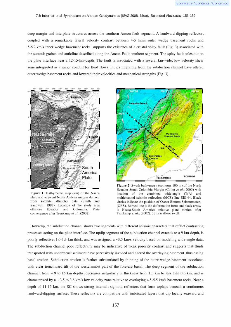
7th International Symposium on Andean Geodynamics (ISAG 2008, Nice), Extended Abstracts: 156-159
157
deep margin and interplate structures across the southern Ancon fault segment. A landward dipping reflector,
coupled with a remarkable lateral velocity contrast between 4-5 km/s outer wedge basement rocks and
5-6.2 km/s inner wedge basement rocks, supports the existence of a crustal splay fault (Fig. 3) associated with
the summit graben and anticline described along the Ancon Fault southern segment. The splay fault soles out on
the plate interface near a 12-15-km-depth. The fault is associated with a several km-wide, low velocity shear
zone interpreted as a major conduit for fluid flows. Fluids migrating from the subduction channel have altered
outer wedge basement rocks and lowered their velocities and mechanical strengths (Fig. 3).
Downdip, the subduction channel shows two segments with different seismic characters that reflect contrasting
processes acting on the plate interface. The updip segment of the subduction channel extends to a 9 km-depth, is
poorly reflective, 1.0-1.3 km thick, and was assigned a ~3.5 km/s velocity based on modeling wide-angle data.
The subduction channel poor reflectivity may be indicative of weak porosity contrast and suggests that fluids
transported with underthrust sediment have pervasively invaded and altered the overlaying basement, thus easing
basal erosion. Subduction erosion is further substantiated by thinning of the outer wedge basement associated
with clear trenchward tilt of the westernmost part of the fore-arc basin. The deep segment of the subduction
channel, from ~ 9 to 15 km depths, decreases irregularly in thickness from 1.3 km to less than 0.6 km, and is
characterized by a ~ 3.5 to 3.8 km/s low velocity zone relative to overlaying 4.5-5.5 km/s basement rocks. Near a
depth of 11-15 km, the SC shows strong internal, sigmoid reflectors that form toplaps beneath a continuous
landward-dipping surface. These reflectors are compatible with imbricated layers that dip locally seaward and
Figure 1: Bathymetric map (km) of the Nazca plate and adjacent North Andean margin derived from satellite altimetry data (Smith and Sandwell, 1997). Location of the study area offshore Ecuador and Colombia. Plate convergence after Trenkamp et al., (2002).
Figure 2: Swath bathymetry (contours 100 m) of the North Ecuador-South Colombia Margin (Collot et al., 2005) with location of the combined wide-angle (WA) and multichannel seismic reflection (MCS) line SIS-44. Black circles indicate the position of Ocean Bottom Seismometers (OBS). Barbed line is the deformation front and black arrow is Nazca-South America relative plate motion after Trenkamp et al., (2002). SS is seafloor swell.
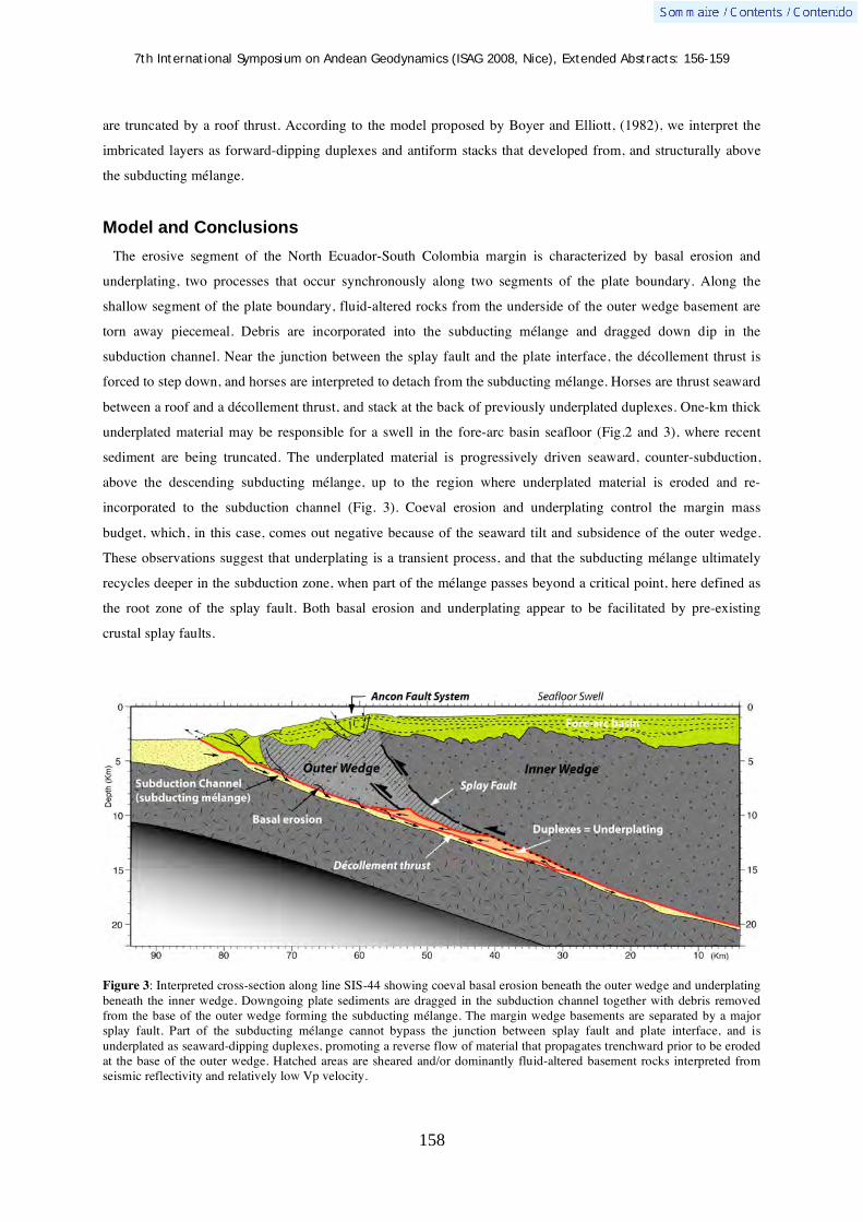
7th International Symposium on Andean Geodynamics (ISAG 2008, Nice), Extended Abstracts: 156-159
158
are truncated by a roof thrust. According to the model proposed by Boyer and Elliott, (1982), we interpret the
imbricated layers as forward-dipping duplexes and antiform stacks that developed from, and structurally above
the subducting mélange.
Model and Conclusions
The erosive segment of the North Ecuador-South Colombia margin is characterized by basal erosion and
underplating, two processes that occur synchronously along two segments of the plate boundary. Along the
shallow segment of the plate boundary, fluid-altered rocks from the underside of the outer wedge basement are
torn away piecemeal. Debris are incorporated into the subducting mélange and dragged down dip in the
subduction channel. Near the junction between the splay fault and the plate interface, the décollement thrust is
forced to step down, and horses are interpreted to detach from the subducting mélange. Horses are thrust seaward
between a roof and a décollement thrust, and stack at the back of previously underplated duplexes. One-km thick
underplated material may be responsible for a swell in the fore-arc basin seafloor (Fig.2 and 3), where recent
sediment are being truncated. The underplated material is progressively driven seaward, counter-subduction,
above the descending subducting mélange, up to the region where underplated material is eroded and re-
incorporated to the subduction channel (Fig. 3). Coeval erosion and underplating control the margin mass
budget, which, in this case, comes out negative because of the seaward tilt and subsidence of the outer wedge.
These observations suggest that underplating is a transient process, and that the subducting mélange ultimately
recycles deeper in the subduction zone, when part of the mélange passes beyond a critical point, here defined as
the root zone of the splay fault. Both basal erosion and underplating appear to be facilitated by pre-existing
crustal splay faults.
Figure 3: Interpreted cross-section along line SIS-44 showing coeval basal erosion beneath the outer wedge and underplating beneath the inner wedge. Downgoing plate sediments are dragged in the subduction channel together with debris removed from the base of the outer wedge forming the subducting mélange. The margin wedge basements are separated by a major splay fault. Part of the subducting mélange cannot bypass the junction between splay fault and plate interface, and is underplated as seaward-dipping duplexes, promoting a reverse flow of material that propagates trenchward prior to be eroded at the base of the outer wedge. Hatched areas are sheared and/or dominantly fluid-altered basement rocks interpreted from seismic reflectivity and relatively low Vp velocity.

7th International Symposium on Andean Geodynamics (ISAG 2008, Nice), Extended Abstracts: 156-159
159
References Agudelo, W., Imagerie sismique quantitative de la marge convergente d'Equateur-Colombie, 2005. PhD thesis, Université
Pierre et Marie Curie, Paris, 203 p. Bangs, N., T.H. Shipley, S.P.S. Gulick, G.F. Moore, S. Kuromoto, and Y. Nakamura, 2004. Evolution of the Nankai trough
décollement from the trench into the seismogenic zone : inferences from three-dimensional seismic reflection imaging, Geology, 32 (4), 273-276.
Boyer, S.E. and D. Elliott, 1982. Thrust systems, The American Association of Petroleum Geologists Bulletin, 66 (9), 1196-1230.
Collot, J.-Y., P. Charvis, M.A. Gutscher, and S. Operto, 2002. Exploring the Ecuador-Colombia active margin and inter-plate seismogenic zone, EOS Transactions, American Geophysical Union, 83 (17), 189-190.
Collot, J.-Y., S. Migeon, G. Spence, Y. Legonidec, B. Marcaillou, J.-L. Schneider, F. Michaud, A. Alvarado, J.-F. Lebrun, M. Sosson, and A. Pazmiño, 2005. Seafloor margin map helps in understanding subduction earthquakes, EOS Transactions, American Geophysical Union, 86 (46), 464-466.
Flueh, E.R., J. Bialas, P. Charvis, and Salieri scientific party, 2001. Cruise report SO159 SALIERI, in Report 101, pp. 256, Geomar Research center, Kiel, Germany.
Jaillard, E., M. Ordoñez, S. Benitez, G. Berrones, N. Jimenez, G. Montenegro, and I. Zambrano, Basin development, 1995. In an accretionary, oceanic-floored fore-arc setting: southern coastal Ecuador during late cretaceous-late eocene time, in Petroleum basins of South America, edited by A.J. Tankard, R. Suarez, and H.J. Welsink, pp. 615-631.
Park, J.-O., T. Tsuru, S. Kodaira, P.R. Cummins, and Y. Kaneda, 2002. Splay fault branching along the Nankai subduction zone, Science, 297, 1157-1160.
Smith, W.H.F., and D. T. Sandwell, 1997. Global seafloor topography from satellite altimetry and ship depth soundings, Science, 277, 1957-1962.
Trenkamp, R., J.N. Kellogg, J.T. Freymueller, and P. Mora, H. 2002. Wide plate margin deformation, southern Central America and northwestern South America, CASA GPS observations, Journal of South American Earth Sciences, 15, 157-171.
von Huene, R., C.R. Ranero, and P. Vannucchi, 2004. Generic model of subduction erosion, Geology, 32 (10), 913-916.
7th International Symposium on Andean Geodynamics (ISAG 2008, Nice), Extended Abstracts: 160-163
160
Active tectonics in the Central Chilean Andes: 3D tomography based on the aftershock sequence of the 28 August 2004 shallow crustal earthquake
Diana Comte1, Marcelo Farías
1,2, Reynaldo Charrier
2, & Andrea González
2
1 Dept. Geofísica, Universidad de Chile, Santiago, Chile ([email protected])
2 Dept. Geología, Universidad de Chile, Santiago, Chile ([email protected])
KEYWORDS : crustal seismicity, tectonics, Central Andes, 3D tomography
Introduction
Most of the seismological research in the Andes has been mainly oriented to the detection and understanding
of the seismicity associated with the large thrust-fault earthquakes that characterize the subduction environment
that governs tectonics in this region. However, the growing number of stations in the permanent seismological
network and the deployment in the last years of temporary networks in different regions of the country have
allowed the detection of intense crustal seismicity beneath the Chilean forearc-arc region.
For instance, the temporary seismic network deployed along the Las Leñas and Pangal river valleys (34°25'S),
between January and May 2004, permitted to better constrain the abundant shallow intra-continental seismicity
previously detected in that region. Although most of the seismicity is randomly distributed in the region, several
microearthquakes occur along the trace of the major El Diablo - El Fierro fault-system. This fault, recognized
between 33°30' and 35°15’S, is located at or close to the eastern contact between Mesozoic and Cenozoic
deposits in the Principal Cordillera and, locally, below active volcanoes , and is considered to have participated
in the development (extension) and tectonic inversion of a widely extended (>600 km long) Cenozoic
extensional basin along the Principal Cordillera. The associated seismic activity implies that this structure is still
active and participates in the present-day adjustments of the Andean crust. Further south, at 35°S, a Mw=6.5
strike-slip shallow (<10 km) earthquake occurred on August 28, 2004, generating moderate damage in the
region, reaching a maximum intensity VI MM.
The Seismological Service of the University of Chile deployed a local network to monitoring the aftershock
sequence. A 3D detailed Vp and Vs velocities determination was obtained along the aftershock area of the 2004
earthquake; results show an essentially NS distribution reaching depths lower than 15 km. This behaviour is in
agreement with that observed further north, in the Las Leñas - Pangal region. The 2004 shallow earthquake is the
second one recorded by local networks in Chile, the previous one occurred in the northern Chile forearc in 2001
(Mw=6.2) (Farías et al., 2005). The 2004 shallow earthquake is similar to the major intraplate Las Melosas
earthquake (Mw=6.9) occurred on September 4, 1958, possibly associated with the El Diablo - El Fierro fault-
system. The occurrence of the 2004 earthquake offers the possibility to analyze this seismicity from a
seismotectonic point of view, in order to understand the present-day crustal adjustments.

7th International Symposium on Andean Geodynamics (ISAG 2008, Nice), Extended Abstracts: 160-163
161
Geological setting
Figure 1. Simplified structural map of the Central Andean region between 32º30'S and 36ºS. Epicentral location and focal mechanisms of the 28 August, 2004 (Mw=6.7) and the 12 September, 2004 (Mw=5.3) earthquakes.
Four main morpho-structural units compose the continental region of the southern Central Andes between 33ºS
and 36ºS (Figure 1): The Coastal Cordillera, the Central Depression, the Principal Cordillera, and the Frontal
Cordillera. The Coastal Cordillera is a smooth relief constituted mainly by Paleozoic and Jurassic plutonics
rocks in the western part, and east dipping Cretaceous volcanics and sediments. The Central Depression is an
erosional feature partially filled with late Neogene clastics and ashy deposits. The Principal Cordillera is mainly
composed by volcanic and sedimentary rocks deposited in an extensional basin during Late Eocene to Late
Oligocene times, inverted during the Early Miocene that forms the bulk of the west versant of the cordillera
(Charrier et al., 2002, 2005). West-vergent and east-vergent thrusts delimitate the western and eastern border of
the former basin, respectively. The eastern border corresponds to the westernmost structures of the Aconcagua
(north of 33º45'S) and the Malarguüe (south of 33º45'S) fold-and-thrust belts that accommodated accommodated
most of the shortening in this part of the Andes (Giambiagi et al., 2003).
The 3D tomography
Farías et al. (2008) analyzed the crustal-scale structural architecture of the Central Andes and its implications
in the mountain building in subduction zones. He used the seismologic data recorded by the Seismological
Service of the University of Chile between 1980 and 2004, and the data obtained by the temporary network
deployed from January to April 2004. The permanent network has 24 seismologic stations in the study region
and the temporary network consisted of 7 short period 3-component stations, their final database includes 23,444
events, with 212 shallow (<20 km depth) crustal events recorded by the temporary network. In this work we add
about 500 shallow aftershocks recorded by 8 short period seismological stations deployed by the Seismological
Service to monitor the aftershock sequence of the 2004 curstal earthquake.

7th International Symposium on Andean Geodynamics (ISAG 2008, Nice), Extended Abstracts: 160-163
162
The hypocenters were first estimated using the HYPOINVERSE program (Klein, 1978) with a 1D P-wave
velocity model based on Thierer et al. (2005). Each earthquake was located with different trial depths in order to
minimize the effect of the initial conditions on the final hypocentral determination. Trial depths were varied
between 0 and 100 km with an increment of 5 km. The location with the lowest root mean square misfit and with
the maximum number of body-waves first-arrivals was selected for each event.
Figure 2. Epicentral distribution of the aftershocks of the 28 August 2004 (Mw=6.7)
earthquake, white circles represent earthquakes with depths between 0 and 15 km, and yellow circles represent earthquakes with depths between 15 and 30 km. The red square shows the study area for the tomography.
From the preliminary hypocenters and seismic wave arrival times, a 3D velocity structure was calculated (see
details in Roecker et al. (1993)). Inversion was made on a region divided into 6 7 blocks with a grid spacing of
10 10 km2 and 12 layers of 5 km thick for the shallower layers (depth < 20 km) and each 10 km for the deeper
ones (Figure 2). Because P-wave and S-wave velocities were inverted independently, this procedure ended with
815 final blocks with 609 blocks considered as reliable (those having >20 rays hits, however most of block are
hit by >1000 rays); 48,856 and 40,010 P and S arrivals, respectively were used for this inversion. The resulting
velocity models were used to relocate the hypocenters, which were classified and filtered. Filtered hypocenters
were used for a new inversion. This procedure was repeated iteratively until the changes in velocities became
very small (2%), being five iterations required.
The August 28, 2004 (Mw = 6.7) earthquake occurred near of the river Teno, close to the Planchón volcano.
The aftershocks are distributed along a trace of NNE-SSW direction with depths lower than 15 km, which is
consistent with one of the focal mechanism solutions given by the Harvard CMT (Figure 1). This mechanism has
a solution oriented NNE-SSW dextral strike-slip. Likewise, the hypocentral distribution suggests that the rupture
occurred along one branch of the El Fierro fault system, located westward of the main fault of this system.
According with Farías (2007) the current state of the Main Cordillera would have a kinematic predominantly
dextral course with a forearc toward advancing to the north, although there determinations of focal mechanisms
showing other solutions (both normal and reverse) for earthquakes much lower magnitude (Barrientos et al.,
2004; Pardo et al., 2002). Considering that strike-slip earthquakes have magnitudes Mw between 5.2 and 6.5,
the energy related with them should exceed by several orders of magnitude the energy accumulated by the

7th International Symposium on Andean Geodynamics (ISAG 2008, Nice), Extended Abstracts: 160-163
163
microseismicity that could have other focal mechanism solutions. Therefore, it seems to be valid to say that the
kinematics in the Principal Cordillera responds predominantly to transform movements, while other mechanisms
are likely to represent post- and inter-seismic accommodations. Indeed, this agrees well with geological
observations. According to Giambiagi and Ramos (2002) and Giambiagi et al. (2003), shortening in the chain
migrated westward since approximately four million years ago. Moreover, according with morphological
evidence, the range ceased to rise at about the same time after a fast and massive uprising event, which raised the
Cordillera over 2 km in 2 to 4 million years (Farías et al., 2008).
Acknowledgements
This work was funded by FONDECYT grant Nº 1030965 and Nº1070279, Bicentennial Program in Science and Technology grant ANILLO ACT Nº 18. The authors particularly recognize the labor made by the Seismologic Service at the University of Chile. We acknowledge Steven Roecker for providing the SPHREL90/SPHYPIT programs. References Barrientos, S., Vera, E., Alvarado, P., Monfret, T., 2004. Cristal seismicity in central Chile. J. South Amer. Earth
Sci. 16, 759-768. Charrier, R., Baeza, O., Elgueta, S., Flynn, J.J., Gans, P., Kay, S.M., Muñoz, N., Wyss, A.R., Zurita, E., 2002.
Evidence for Cenozoic extensional basin development and tectonic inversion south of the flat-slab segment, southern Central Andes, Chile (33º-36ºS.L.). J. S. Am. Earth Sci. 15, 117-139, doi:10.1016/S0895-9811(02)00009-3.
Charrier, R., Bustamante, M., Comte, D., Elgueta, S., Flynn, J.J., Iturra, N., Muñoz, N., Pardo, M., Thiele, R., Wyss, A.R., 2005. The Abanico Extensional Basin: Regional extension, chronology of tectonic inversion, and relation to shallow seismic activity and Andean uplift. Neues Jahrb. Geol. P-A. 236, 43-47.
Farías, M., Charrier, R., Comte, D., Martinod, J., Hérail G., 2005, Late Cenozoic deformation and uplift of the western flank of the Altiplano: Evidence from the depositional- tectonic- and geomorphologic evolution and shallow seismic activity (northern Chile At 19° 30’ S), Tectonics, 24, 0278-7407
Farías M., Comte, D., Charrier, R., Martinod, J.,Tassara, A., Fock, A., Crustal-scale structural architecture of the Central Chile Andes based on 3D seismic tomography, seismicity, and surface geology: Implications for mountain building in subduction zones, submitted to Earth and Planetary Science Letters, 2008
Giambiagi, L.B., Ramos, V.A., Godoy, E., Alvarez, P.P., Orts, S., 2003. Cenozoic deformation and tectonic style of the Andes, between 33° and 34° south latitude. Tectonics, 22, 1041, doi:10.1029/2001TC001354.
Giambiagi, L. B., Ramos, V. A., 2002. Structural evolution of the Andes between 33°30 and 33°45 S, above the transition zone between the flat and normal subduction segment, Argentina and Chile. J. S. Am. Earth Sci. 15, 99–114, doi:10.1016/S0895-9811(02)00008-1.
Giambiagi, L.B., Ramos, V.A., Godoy, E., Alvarez, P.P., Orts, S., 2003. Cenozoic deformation and tectonic style of the Andes, between 33° and 34° south latitude. Tectonics 22, 1041, doi:10.1029/2001TC001354.
Klein, F.W., 1978. Hypocenter location program HYPOINVERSE. U.S. Geol. Surv., Open-File Rep. 78-694. Pardo, M., Comte, D., Monfret, T., 2002. Seismotectonic and stress distribution in the central Chile subduction
zone. J. S. Am. Earth Sci. 15, 11-22, doi:10.1016/S0895-9811(02)00003-2. Roecker, S.W., Sabitova, T.M., Vinnik, L.P., Burmakov, Y.A., Golvanov, M.I., Mamatkanova, R., Munirova, L.,
1993. Three-dimensional elastic wave velocity structure of the western and central Tien Shan. J. Geophys. Res. 98, 15779-15795.
Thierer, P.O., Flüh, E.R., Kopp, H., Tilmann, F., Comte, D., Contreras, S., 2005. Local earthquake monitoring offshore Valparaiso, Chile. Neues Jahrb. Geol. P-A., 236, 173-183.

7th International Symposium on Andean Geodynamics (ISAG 2008, Nice), Extended Abstracts: 164-167
164
Seismic structure of the continental margin offshore the southern Arauco Peninsula, Chile, at ~38°S
Eduardo Contreras-Reyes1, Ingo Grevemeyer
1, Ernst R. Flueh
1, Christian Reichert
2, & Martin
Scherwath1
1 Leibniz-Institute of Marine Sciences (IFM-GEOMAR), Wisschofstr.1-3, Kiel, Germany
([email protected], [email protected], [email protected],
[email protected]) 2 Federal Institute for Geosciences and Natural Resources, BGR, Stilleweg 2, Hannover, Germany
KEYWORDS : subduction, accretionary wedge, continental slope, backstop region and seismic tomography
Introduction
The formation of accretionary wedges is mainly controlled by two factors: (1) slow convergence rate and (ii)
thick trench fill sediments (von Huene and Scoll, 1991; Clift and Vannuchi, 2004). Convergent margins such as
Cascadia (Hyndman et al., 1990), Nankai (Moore et al., 1990), and Makran (Kopp et al., 2000) are characterized
by a convergence rate slower than 6.5 cm/yr and a sequence of trench-fill sediments thicker than 1 km (Clift and
Vannuchi, 2004, and references therein). All these convergent margins carry large accretionary wedges >50 km
wide, and are usually classified as typical accretionary margins (e.g., von Huene and Scoll, 1991). The southern
central Chile margin (34°-45.5°S) is characterized by a filled trench confined between two main oceanic
features: the Juan Fernandez Ridge and the Chile Rise (Figure 1). Here, large volumes of terrigeneous sediments
sourced from the Andes have been transported via diverse canyon systems deposited in the trench during
Cenozoic times (e.g., Thornburg et al., 1990). Currently, the oceanic Nazca plate approaches the continent with a
covergence rate of 6.6 cm/a (Angermann et al., 1999), carrying a thin blanket of pelagic/hemipleagic sediments
(0-400 m) to the plate boundary (e.g., Contreras-Reyes et al, 2007). The total thickness of the sedimentary
sequence (pelagic and terrigeneous sediments) at the trench axis ranges between 1.5 and 2.5 km between 34° and
45°S (e.g., Grevemeyer et al 2003). In this manner, the southern central Chilean margin displays the typical
features characteristic of an accretion-dominated subduction zone. Nevertheless, marine seismic images (Bangs
and Cande; 1997) have shown that this margin exhibits only a small accretionary prism <30 km wide, which
abuts the truncated paleo accretionary complex that extends seaward from beneath the shelf. The small amount
of sediments accumulated here is not compatible with a continuous history of accretion, which implies episodic
history of accretion, nonaccretion and erosion of the southern central Chilean margin (Bangs and Cande; 1997).
Furthermore, Melnick and Echtler (2006) argued that the Glacial age trench fill and the steady decrease in plate
convergence rate had shifted the margin from erosive to accretionary during the Pliocene. The small size of the
accretionary wedge, the subduction rate history, and the deformational style along the margin suggest that the
current rapid rate of accretion cannot have lasted more than 1-2 Ma (Bangs and Cande, 1997).
The main aim of this study is to investigate the seismic structure of this young and active accretionary wedge
offshore southern Arauco Peninsula, in particular the seismic character of the transition zone between the
accretionary wedge and paleo accretionary complex. The paleo accretionary complex is made of sequences of
deformed sedimentary rock much older than, and not tectonically part of a presently growing accretionary mass
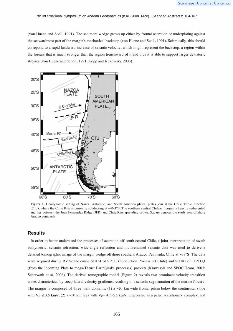
7th International Symposium on Andean Geodynamics (ISAG 2008, Nice), Extended Abstracts: 164-167
165
(von Huene and Scoll, 1991). The sediment wedge grows up either by frontal accretion or underplating against
the seawardmost part of the margin's mechanical backstop (von Huene and Scoll, 1991). Seismically, this should
correpond to a rapid landward increase of seismic velocity, which might represent the backstop, a region within
the forearc that is much stronger than the region trenchward of it and thus it is able to support larger deviatoric
stresses (von Huene and Scholl, 1991; Kopp and Kukowski, 2003).
Figure 1. Geodynamic setting of Nazca, Antarctic, and South America plates; plates join at the Chile Triple Junction (CTJ), where the Chile Rise is currently subducting at ~46.4°S. The southern central Chilean margin is heavily sedimented and lies between the Juan Fernandez Ridge (JFR) and Chile Rise spreading center. Square denotes the study area offshore Arauco peninsula.
Results
In order to better understand the processes of accretion off south central Chile, a joint interpretation of swath
bathymetric, seismic refraction, wide-angle reflection and multi-channel seismic data was used to derive a
detailed tomographic image of the margin wedge offshore southern Arauco Peninsula, Chile at ~38°S. The data
were acquired during RV Sonne cruise SO161 of SPOC (Subduction Process off Chile) and SO181 of TIPTEQ
(from the Incoming Plate to mega-Thrust EarthQuake processes) projects (Krawczyk and SPOC Team, 2003;
Scherwath et al, 2006). The derived tomographic model (Figure 2) reveals two prominent velocity transition
zones characterized by steep lateral velocity gradients, resulting in a seismic segmentation of the marine forearc.
The margin is composed of three main domains; (1) a ~20 km wide frontal prism below the continental slope
with Vp 3.5 km/s, (2) a ~50 km area with Vp= 4.5-5.5 km/s, interpreted as a paleo accretionary complex, and

7th International Symposium on Andean Geodynamics (ISAG 2008, Nice), Extended Abstracts: 164-167
166
(3) the seaward edge of the Paleozoic continental framework with Vp 6.0 km/s (Contreras-Reyes et al., 2008).
Frontal prism velocities are noticeably lower than those found in the northern erosional Chile margin (Sallares
and Ranero, 2005), confirming recent accretionary processes in south central Chile.
Figure 2. (a) Detailed tomographic image of the marine forearc complex, showing the seismic segmentation of the accretionary margin wedge. (b) Extracted velocities along the thick black line shown in (a), which landward of the lowermost slope corresponds to the uppermost basement velocities below the slope and shelf sediments. Note the strong horizontal velocity gradients at the slope break and seaward edge of the Paleozoic continental framework, which may suggest a change in rock type. References Angermann, D., Klotz, J., & Reigber, C. 1999. Space-geodetic estimation of the Nazca-South America Euler vector, Earth
Planet. Sci. Lett. 171, 3, 329-334. Bangs, N.L., & Cande, S.-C. 1997. Episodic development of a convergent margin inferred from structures and processes
along the southern Chile margin, Tectonics 16(3), 489–503. Clift, P., & Vannucchi, P. 2004. Controls on tectonic accretion versus erosion in subduction zones: Implications for the origin
and recycling of the continental crust. Rev. Geophys 42: RG2001, doi:10.1029/2003RG000127. Contreras-Reyes, E., Grevemeyer, I., Flueh, E.-R., Scherwath, M., & Heesemann, M. 2007. Alteration of the subducting
oceanic lithosphere at the southern central Chile trench–outer rise, Geochem. Geophys. Geosyst. 8, Q07003, doi:10.1029/2007GC001632.
Contreras-Reyes, E., Grevemeyer, I., Flueh, E.-R., & Heesemann, C. 2008. Upper lithospheric structure of the subduction
7th International Symposium on Andean Geodynamics (ISAG 2008, Nice), Extended Abstracts: 164-167
167
zone of southern Arauco Peninsula, Chile at ~38°S, J. Geophys. Res. (in press). Grevemeyer, I., Diaz-Naveas, J.-L., Ranero, C.-R., Villinger, H., & Ocean Drilling Program Leg 202 Scientific Party. 2003.
Heat flow over the descending Nazca plate in Central Chile, 32°S to 41°S: evidence from ODP Leg 202 and the occurrence of natural gas hydrates, Earth Planet. Sci. Lett. 213, 285–298.
Hyndman, R. D., Yorath, C. J., Clowes, R.-M., & Davis, E.E. 1990, The northern Cascadia subduction zone at Vancouver Island: Seismic structure and tectonic history, Can. J. Earth Sci. 27(3), 313–329.
Kopp, C., Fruehn, J., Flueh, E.-R., Reichert, C., Kukowski, N., Bialas, J., & Klaeschen, D. 2000. Structure of the Makran subduction zone from wide-angle and reflection seismic data, Tectonophysics 329, 171-191.
Kopp, H., & Kukowski, N. 2003. Backstop geometry and accretionary mechanics of the Sunda margin, Tectonics 22(6), 1072, doi:10.1029/2002TC001420.
Krawczyk C.-M, SPOC Team .2003. Amphibious seismic survey images plate interface at 1960 Chile earthquake. Eos Trans. AGU 84(32):301, 304-305.
Melnick, D., & Echtler, H. 2006. Inversion of forearc basins in south-central Chile caused by rapid glacial age trench fill, Geology 34 (9), 709–712.
Moore, G..-F., Schipley, T.-H., Stoffa, P.-L., & Karig, D.-E.1990. Structure of the Nankai Through Accretionary Zone from Multichannel Seismic Reflection Data, J. Geophys Res. 95(B6), 8753-8765.
Sallares, V., & Ranero, C.-R. 2005. Structure and tectonics of the erosional convergent margin off Antofagasta, north Chile (23°30'S), J. Geophys. Res. 110, B06101, doi:10.1029/2004JB003418.
Scherwath, M., Flueh, E.-R., Grevemeyer, I., Tilmann, F., Contreras-Reyes, E., & Weinrebe, W. 2006. Investigating Subduction Zone Processes in Chile, Eos Trans. AGU 87(27), 265.
Thornburg, T.-M., Kulm, D.-M., & Hussong, D.-M .1990. Submarine-fan development in the southern Chile trench: a dynamic interplay of tectonics and sedimentation, Geol. Soc. Am. Bull 102, 1658-1680.
von Huene, R., & Scholl, D.-W. 1991. Observations at convergent margins concerning sediment subduction, subduction erosion, and the growth of continental crust, Rev. Geophys 29(3), 279-316, doi:10.1029/90JB00230, 1990.

7th International Symposium on Andean Geodynamics (ISAG 2008, Nice), Extended Abstracts: 168-171
168
Fractures in the Mejillones Peninsula triggered by the Tocopilla Mw=7.7 earthquake
J. Cortés1, D. Rémy
2, G. González
3, J. Martinod
2, & G. Gabalda
2
1 Programa de Doctorado en Ciencias Mención Geología, Universidad Católica del Norte, Avenida Angamos
0610, Antofagasta, Chile ([email protected]) 2
Laboratoire des Mécanismes et Transferts en Géologie (LMTG), 14, Avenue Edouard Belin, 31400 Toulouse,
France ([email protected], [email protected], [email protected]) 3 Departamento de Ciencias Geológicas, Universidad Católica del Norte, Avenida Angamos 0610, Antofagasta,
Chile ([email protected])
KEYWORDS : Tocopilla earthquake, fracture development, intraplate deformation, seismic cycle, Mejillones Peninsula
Introduction
The coastal margin of northern Chile and Southern Peru is characterized by the convergence between Nazca
and South American plates, at a velocity of 6.5 cm/yr (Angermann et al., 1999). This process is responsible for
large subduction earthquakes that historically have affected this margin, such as the 1877 Iquique Mw=8.8, the
1995 Antofagasta Mw=8.1, the 2001 Arequipa Mw=8.2-8.4 and recently the 2007 Tocopilla Mw=7.7
Earthquake. A key problem in northern Chilean forearc is to establish the relationship between these large
subduction earthquakes and the intraplate deformation observed at the topographic surface. Several authors have
postulated that subduction earthquakes trigger normal faulting in different parts of the forearc (e.g. Delouis et
al., 1998; González and Carrizo, 2003). As a matter of fact, seismological data did not report any active
superficial deformation in the early nineties in the Mejillones area, the period during which the subduction zone
of that region was in pre-seismic state (Delouis et al., 1996). On the other hand, fracture formation has been
postulated as secondary superficial process related to coseismic extension produced by this type of earthquake.
By using high resolution satellite images, Loveless et al. (2005) and González et al. (In Press) mapped mesh of
fractures in different parts of the Coastal Cordillera. These authors distinguished fractures orientated both
parallel (Loveless et al. 2005) and normal to the trench (González et al. In Press). By using numerical models,
Loveless (2008) postulated that fracture parallel to the trench can be formed by successive subduction
earthquakes, whereas Gonzalez et al. (In Press), based on numerical modeling, demonstrated that fractures
orientated normal to the trench would be produced by intraplate faulting.
On November 14th 2007 a Mw=7.7 earthquake occurred along the Coastal Region of Northern Chile. The
seismic rupture propagated over 200 km from north to the south ending below the Mejillones Peninsula. In this
place, we documented the formation of open fractures a few days later the earthquake. In order to understand the
origin of these fractures we performed numerical modeling (Elastic Dislocation Model) and InSAR analyses of
the coseismic displacements.
Long term deformation of the Mejillones Peninsula
The Mejillones Peninsula is characterized by the occurrence of normal faults which affect Miocene to
Pleistocene marine sediments (Armijo and Thiele, 1990; Niemeyer et al. 1996; Marquardt 2005). Normal faults
are spectacularly expressed by prominent fault scarps that control the morphology of this peninsula. Fractures
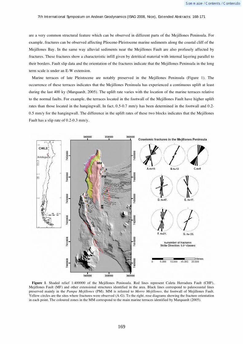
7th International Symposium on Andean Geodynamics (ISAG 2008, Nice), Extended Abstracts: 168-171
169
are a very common structural feature which can be observed in different parts of the Mejillones Peninsula. For
example, fractures can be observed affecting Pliocene-Pleistocene marine sediments along the coastal cliff of the
Mejillones Bay. In the same way alluvial sediments near the Mejillones Fault are also profusely affected by
fractures. These fractures show a characteristic infill given by detritical material with internal layering parallel to
their borders. Fault slip data and the orientation of the fractures indicate that the Mejillones Peninsula in the long
term scale is under an E-W extension.
Marine terraces of late Pleistocene are notably preserved in the Mejillones Peninsula (Figure 1). The
occurrence of these terraces indicates that the Mejillones Peninsula has experienced a continuous uplift at least
during the last 400 ky (Marquardt, 2005). The uplift rate varies with the location of the marine terraces relative
to the normal faults. For example, the terraces located in the footwall of the Mejillones Fault have higher uplift
rates than those located in the hangingwall. In fact, 0.5-0.7 mm/y has been determined in the footwall and 0.2-
0.5 mm/y for the hangingwall. The difference in the uplift rates of these two blocks indicates that the Mejillones
Fault has a slip rate of 0.2-0.3 mm/y.
Figure 1. Shaded relief 1:400000 of the Mejillones Peninsula. Red lines represent Caleta Herradura Fault (CHF), Mejillones Fault (MF) and other extensional structures identified in the area. Black lines correspond to paleocoastal lines preserved mainly in the Pampa Mejillones (PM). MM is referred to Morro Mejillones, the footwall of Mejillones Fault. Yellow circles are the sites where fractures were observed (A-G). To the right, rose diagrams showing the fracture orientation in each point. The coloured zones in the MM correspond to the main marine terraces identified by Marquardt (2005).
7th International Symposium on Andean Geodynamics (ISAG 2008, Nice), Extended Abstracts: 168-171
170
The Tocopilla Mw=7.7 Earthquake
According to the USGS, the Tocopilla Earthquake occurred at 40 km depth, and the epicenter was located at
22°19’S-69°84’W, 40 km east-southeast of Tocopilla. The rupture plane has an orientation N5W and the dip is
of 16NE. The surface rupture is 180 km along strike, and 120 km downdip. The aftershocks registered occurred
mainly in the northern part of the Mejillones Peninsula.
Fracture documentation
A few days later the Tocopilla Earthquake, we visited the epicenter area defined by USGS and the Mejillones
Peninsula. In the epicenter area we found several open fractures affecting alluvial deposits. Because in this area
we did not find recent anthropogenic features cut by the fractures, we could not estimate whether if the fractures
were produced during this event. On the contrary, in the Mejillones Peninsula we found fresh fractures affecting
alluvial fan deposits. Because we are currently working on the Mejillones Peninsula, our own vehicle tracks of
previous field campaigns were profusely cut by fractures. This observation clearly shows that these fractures
formed during the Tocopilla Earthquake. In general, the fractures are disposed close to the main traces of Caleta
Herradura and Mejillones Faults. In the case of Caleta Herradura Fault, we found a significant number of cracks
affecting alluvial fans disposed east of the main scarp of this fault (Figure 1).The length of the fractures varies
between 3-46 meters, with apertures of 5-10 mm. The orientation of these fractures is closely parallel to the
strike of the main scarp of Caleta Herradura Fault. Local variation in fracture orientation is controlled by the
local strike of Caleta Herradura Fault. In this area, some fractures constitute reopened cracks; it is inferred by
occurrence of an open central portion affecting the infill of pre-existing fractures. Close to the Mejillones Fault
we identified similar fractures affecting alluvial and eolian deposits. These fractures are less abundant than those
close to the Caleta Herradura Fault. The length of these fractures varies between 1.3 to 26 m and the aperture is
close to 0.5-10 mm. In this case, fractures are nearly parallel to the main scarp of Mejillones Fault (site A Figure
1) and parallel to a secondary fault eastward of the Mejillones Fault (sites B and C, Figure 1). The strain related
to the fracture aperture is extremely low (~0.01%), indicating that extension is diffuse at the kilometric scale.
InSAR and Coulomb Stress Change Analysis
We used ASAR radar images acquired between August 2007 and December 2007, from the satellite
descending track numbers 368 and 96, covering the eastern and western part of the study area, respectively.
Calculated interferograms show long-wavelength deformation related to the main shock, with a maximum 19 cm
of range increase (i.e. ~ subsidence) located in the eastern part of the study area South Maria Elena, and up to 26
cm of range decrease (i.e.~ uplift) located in the north of the Mejillones Peninsula. Interferograms also show a
small wavelength signal located SW Mejillones that cannot be explained by slip occurring on the main rupture
plane. This small-wavelength anomaly is situated on a narrow (<10 km-wide), N-S oriented area located on the
hangingwall of to the Mejillones Fault. It is precisely in this zone, eastward of the main scarp of the Mejillones
Fault, where we observe fractures (sites A to C in figure 1).
We use the radar data to calculate the slip that occurred on the main fault during the Tocopilla Mw=7.7
Earthquake. We check that the long-wavelength ground deformation results from thrust motion on a N-S deep

7th International Symposium on Andean Geodynamics (ISAG 2008, Nice), Extended Abstracts: 168-171
171
fault. The calculated seismic moment is 5.8 x 10 20 N.m equivalent to Mw = 7.7 (assuming μ=3.1 x 10¹⁰ Pa),
slightly higher than the one deduced by Harvard CMT (4.9 x 10 20 N.m). We calculate the Coulomb Stress
Change (CSC) induced at the surface by the main shock, for normal fault planes striking NS and dipping 55°
towards the east, i.e. similar to the major normal faults of the Mejillones Peninsula. In Caleta Herradura and
Mejillones Faults, positive values of CSC were found, indicating potentially for triggering fault reactivation. In
these sites where the presence of cracks was observed, CSC values vary between +1.5 and +2 bars.
Conclusions
The formation of fractures in the Mejillones Peninsula during or shortly after the Mw= 7.7 Tocopilla
Earthquake shows that superficial extension is partly related to subduction earthquakes. In particular, the
documented fractures are disposed directly above the southern termination of the seismogenic rupture related to
the Tocopilla Earthquake. The Mejillones Peninsula was the focus of several aftershocks which indicate that
stress release was concentrated in this southern termination. Our fracture documentation shows that the
Mejillones Peninsula was under diffuse superficial extension during the Mw= 7.7 Tocopilla Earthquake. CSC
analysis indicates that the Mw= 7.7 Tocopilla Earthquake resulted in tensional stress field on N-S faults. The
short term deformation following the Tocopilla Earthquake correlates with the long term extensional
deformation observed in the Mejillones Peninsula. It suggests that the long term deformation of the Mejillones
Peninsula is related to subduction earthquakes.
References Angermann, D.; Klotz, J. & Reigber, C. 1999. Space-geodetic estimation of the Nazca-South America Euler vector. Earth
Planet Sci Lett, 171: 329-334. Armijo, R. & Thiele, R. 1990. Active faulting in northern Chile: ramp stacking and lateral decoupling along a subduction
plate boundary? Earth Planet Sci Lett, 98: 40-61. Delouis, B., Cisternas, A., Dorbath, L., Rivera, L. & Kausel, E. 1996. The Andean subduction zone between 22 and 25°S
(northern Chile) : precise geometry and state of stress. Tectonophysics, 259, 81-100. Delouis, B., H. Philip, L. Dorbath & Cisternas, A. 1998. Recent crustal deformation in the Antofagasta region (northern
Chile) and the subduction process. Geophys. J. Int., 132: 302 – 338. González, G., Gerbault, M., Martinod, J., Cembrano, J., Carrizo, D., Allmendinger, R. & Espina, J. In press. Crack formation
on top of propagating reverse faults of the Chuculay Fault System northern Chile: Insights from field data and numerical modelling. Journal of Structural Geology.
González, G. & Carrizo, D. 2003. Segmentación, cinemática y cronología relativa de la deformación tardía de la Falla Salar del Carmen, Sistema de Fallas de Atacama, Cordillera de la Costa de Antofagasta. Revista Geológica de Chile, 30 (2): 223-244.
Loveless, J. 2008. Extensional tectonics in a convergent margin setting: Deformation of the northern Chilean forearc. Ph.D Thesis, Cornell University, 311 p.
Loveless, J., Hoke, G., Allmendinger, R., González, G., Isacks, B. & Carrizo, D. 2005. Pervasive cracking of the northern Chilean Coastal Cordillera: New evidence for forearc extension. Geology, 33: 973-976.
Marquardt, C. 2005. Déformations Néogènes le long de la cotê nord du Chili (23°-27°S), avant-arc des Andes Centrales. Thèse doct., univ. Toulouse-III, 212 p.
Niemeyer, H., González, G. & Martinez-de Los Rios E. 1996. Evolución tectónica cenozoica del margen continental activo de Antofagasta, norte de Chile. Revista Geológica de Chile, 23 (2): 165–186.

7th International Symposium on Andean Geodynamics (ISAG 2008, Nice), Extended Abstracts: 172-175
172
Analyse of the Tarapaca paleolandslide (North Chile) using generalized Newmark approach and implications on paleoseismicity, and on paleoclimate changes
J. Darrozes1, J.-C. Soula
1, J. Ingles
2, R. Rilqueme
3 , & G. Herail
4
1 LMTG, OMP, CNRS, University Paul Sabatier, 14 avenue Edouard Belin, 31400 Toulouse, France
(corresponding author: [email protected]) 2 Department of Civil Engineering, University Paul Sabatier, 118 route de Narbonne, 31400 Toulouse, France
3 Departamento de Ciencias Geológicas, Universidad Católica del Norte, Avenida Angamos 0610, Antofagasta,
Chile 4 IRD UR 154 - LMTG, Lima, Peru
KEYWORDS : paleolandslide, sismicity, thrust fault-propagation fold, generalized Newmark analysis, Tarapaca
(northern Chile)
Introduction
Landslides much larger than today’s are not uncommon in the geological record, and are observed in arid or
hyperarid areas where a good preservation allow detailed analyses of their geometrical and mechanical
characteristics. Should such large-scale landslides be possible today, much larger devastations than caused by
the present-day’s greatest registered events could be expected.
Figure 1. Tectonic sketch map modified after Hérail (1996), red box identified the studied Tarapaca landslide.
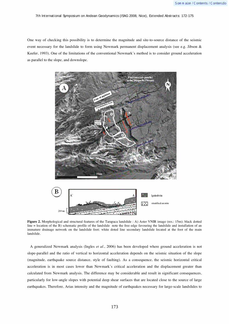
7th International Symposium on Andean Geodynamics (ISAG 2008, Nice), Extended Abstracts: 172-175
173
One way of checking this possibility is to determine the magnitude and site-to-source distance of the seismic
event necessary for the landslide to form using Newmark permanent displacement analysis (see e.g. Jibson &
Keefer, 1993). One of the limitations of the conventional Newmark’s method is to consider ground acceleration
as parallel to the slope, and downslope.
Figure 2. Morphological and structural features of the Tarapaca landslide : A) Aster VNIR image (res.: 15m); black dotted line = location of the B) schematic profile of the landslide note the free edge favouring the landslide and installation of an immature drainage network on the landslide foot; white doted line secondary landslide located at the foot of the main landslide.
A generalized Newmark analysis (Ingles et al., 2006) has been developed where ground acceleration is not
slope-parallel and the ratio of vertical to horizontal acceleration depends on the seismic situation of the slope
(magnitude, earthquake source distance, style of faulting). As a consequence, the seismic horizontal critical
acceleration is in most cases lower than Newmark’s critical acceleration and the displacement greater than
calculated from Newmark analysis. The difference may be considerable and result in significant consequences,
particularly for low-angle slopes with potential deep shear surfaces that are located close to the source of large
earthquakes. Therefore, Arias intensity and the magnitude of earthquakes necessary for large-scale landslides to

7th International Symposium on Andean Geodynamics (ISAG 2008, Nice), Extended Abstracts: 172-175
174
occur may be lower than expected from the traditional Newmark approach. This approach has been applied to a
large-scale paleo-landslide, the Tarapaca landslide, observed in the Atacama Desert, northern Chile.
Morphological, geological and geotechnical characteristics of Tarapaca paleo-
landslide
The Tarapaca landslide (Fig. 2) is one of a series of large-scale landslides formed on the forelimb of a ~400 km
long west-vergent thrust fault-propagation fold known as the Moquella flexure (Darrozes et al., 2002). The
landslides postdate the initiation of a well-preserved drainage network dated of 4.5 Ma (Naranjo et Paskoff,
1985). Its dimensions are ~9 km wide by ~4 km wide, with a total volume close to 7 km3. The triggering
mechanism of the Tarapaca paleo-landslide was studied by constraining characteristics of rocks, slope value,
climatic changes and paleoseismic activity. The clay cohesion, which constitute the slip surface, varying from 90
kPa to 30 kPa under unsaturated to saturated conditions (Pinto et al., 2007). The friction angle is very stable and
close to 40° and the rock mass unit weight varying from 20 for strongly weathered rocks to 25 kN/m3 not
weathered rocks The static safety factor (eq. 1) show all the classical parameters which trigger landslide like
load, weathering, slope and ground water pressure are not sufficient to initiated the paleo-landslide.
eq. 1
The aseismic safety factor predicting slope stability even for the most severe possible conditions, earthquake
shaking is now to be considered. The characteristics of the Tarapaca landslide: large volume, low-angle and
deep-seated basal shear surface, materials having a relatively high strength strongly suggest that the landslide
was triggered by strong and probably long duration earthquake shaking (high magnitude and large Arias
intensity). Arias intensities and moment magnitudes have been calculated for the Tarapaca landslides using
Inglès et al.'s (2006) model, the characteristics of the materials being those defined in the calculations of the
aseismic safety factor. The critical displacement was assumed to be 10 cm. These calculations indicate Arias
intensity of 16.84 m/s and moment magnitudes of Mw= 6.98 at 15 km to the landslide, Mw= 8.26 at 50 km to
the landslide and Mw= 9.2 at 120 km to the landslide. As a comparison, the conventional Newmark analysis
(1965) would have given moment magnitudes of Mw= 7.65; Mw= 9.23 (exceptional) and Mw= 10.38
(unrealistic) and unrealistically high Arias intensities of 32.49 m/s (Fig. 3).
Discussion and conclusions
If ones looks only the Tarapaca landslide two scenarii are possible either a seism of Mw~7 of subsurface (at a
distance close to 15km from the landslide) or a very strong one, Mw upper than 9, within the subduction plane
(distance close to 110 km). If ones look, now, the whole area we can observe the presence of many landslides of
comparable size. We can note that they take again the same characteristics as Tarapaca i.e. the landslides are
located on the forelimb of Moquella flexure, the slided mass is formed by the same ignimbritic layer and the
slope is lesser than 10°. But for these two assumptions it is necessary to add a climatic aspect which allows
existence of an important underground water table (m>0.5). These important water tables may result from the
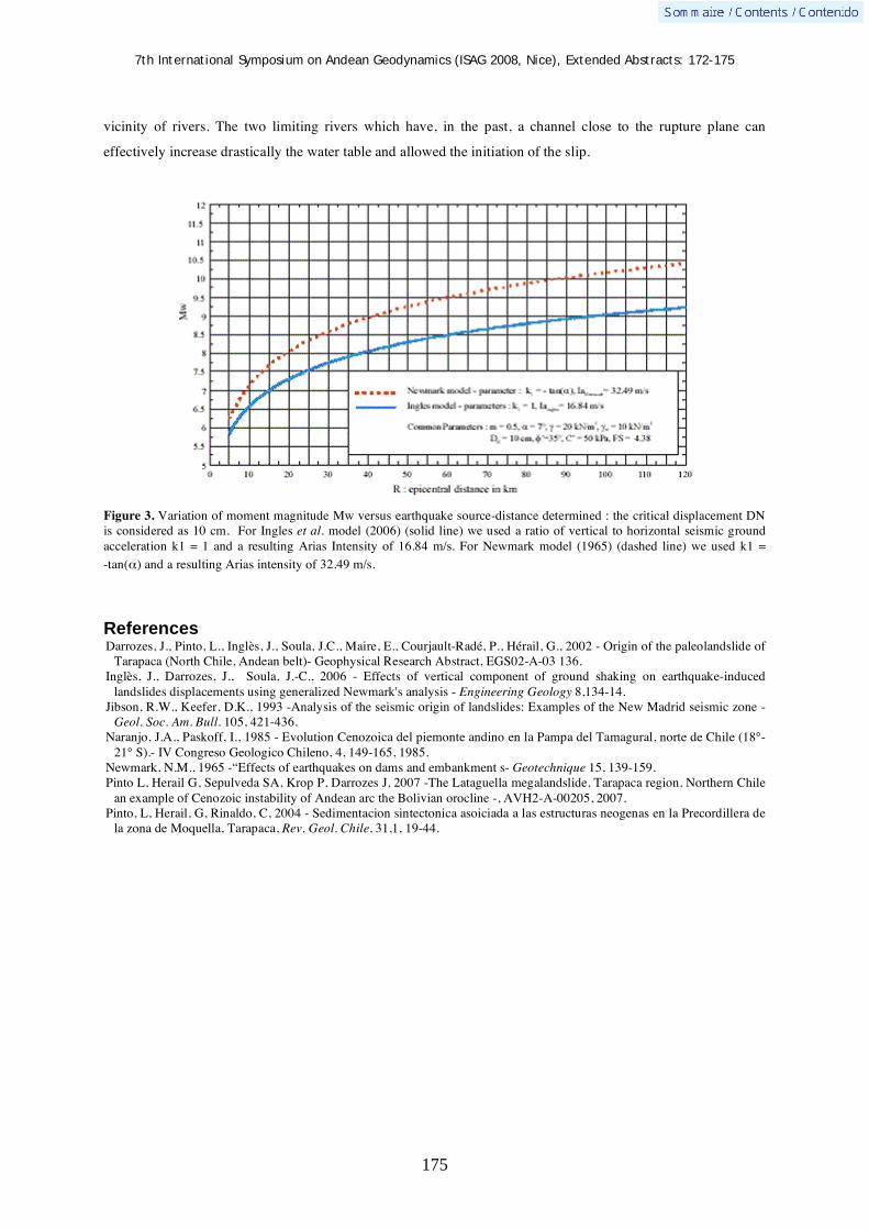
7th International Symposium on Andean Geodynamics (ISAG 2008, Nice), Extended Abstracts: 172-175
175
vicinity of rivers. The two limiting rivers which have, in the past, a channel close to the rupture plane can
effectively increase drastically the water table and allowed the initiation of the slip.
Figure 3. Variation of moment magnitude Mw versus earthquake source-distance determined : the critical displacement DN is considered as 10 cm. For Ingles et al. model (2006) (solid line) we used a ratio of vertical to horizontal seismic ground acceleration k1 = 1 and a resulting Arias Intensity of 16.84 m/s. For Newmark model (1965) (dashed line) we used k1 =
-tan( ) and a resulting Arias intensity of 32.49 m/s.
References Darrozes, J., Pinto, L., Inglès, J., Soula, J.C., Maire, E., Courjault-Radé, P., Hérail, G., 2002 - Origin of the paleolandslide of
Tarapaca (North Chile, Andean belt)- Geophysical Research Abstract, EGS02-A-03 136. Inglès, J., Darrozes, J., Soula, J.-C., 2006 - Effects of vertical component of ground shaking on earthquake-induced
landslides displacements using generalized Newmark's analysis - Engineering Geology 8,134-14. Jibson, R.W., Keefer, D.K., 1993 -Analysis of the seismic origin of landslides: Examples of the New Madrid seismic zone -
Geol. Soc. Am. Bull. 105, 421-436. Naranjo, J.A., Paskoff, I., 1985 - Evolution Cenozoica del piemonte andino en la Pampa del Tamagural, norte de Chile (18°-
21° S).- IV Congreso Geologico Chileno, 4, 149-165, 1985. Newmark, N.M., 1965 -“Effects of earthquakes on dams and embankment s- Geotechnique 15, 139-159. Pinto L, Herail G, Sepulveda SA, Krop P, Darrozes J, 2007 -The Lataguella megalandslide, Tarapaca region, Northern Chile
an example of Cenozoic instability of Andean arc the Bolivian orocline -, AVH2-A-00205, 2007. Pinto, L, Herail, G, Rinaldo, C, 2004 - Sedimentacion sintectonica asoiciada a las estructuras neogenas en la Precordillera de
la zona de Moquella, Tarapaca, Rev. Geol. Chile, 31,1, 19-44.

7th International Symposium on Andean Geodynamics (ISAG 2008, Nice), Extended Abstracts: 176-179
176
Dynamic topography during flat-slab subduction: A first approach in the south-Central Andes
Federico M. Dávila1 & Carolina Lithgow-Bertelloni
2
1 Laboratorio de Análisis de Cuencas, CICTERRA-Universidad Nacional de Córdoba, Av. Vélez Sársfield 1611,
2º piso, of.7, X5016GCA Córdoba, Argentina ([email protected]) 2 Department of Earth Sciences, University College London, Gower St., London WC1E 6BT, United Kingdom
KEYWORDS : dynamic topography, flat subduction, basin analysis, Sierras Pampeanas, Pampean plain
Introduction
In the flat-slab segment of the south-Central Andes, recent stratigraphic reconstructions have proposed that
long-wavelength and high-amplitude accommodation spaces have controlled the alluvial sedimentation in the
foreland during Miocene to Present (Dávila et al., 2005, 2007). Given that the tectonic and sedimentary loads do
not yield the large magnitude of these spaces by conventional flexural models (Dávila et al., 2005), alternative
explanations are needed. Eastward of the Andean foreland system, within the pericratonic Pampean Plains (to
>700 km from the Chilean trench, where the slab descends again at high angles; Booker et al., 2005), Cenozoic
subsurface sequences show thicknesses of >0.5 km. But this region is even more distant from the High Andes
loads. The closest topography is the modest Sierras de Cordoba range (easternmost range of the Sierras
Pampeanas), which only records a shortening <5%, i.e. ~5 km within the ~100-km orogen wide. This undersized
tectonic load can explain <<50% of the accommodation spaces in the Plains (see Dávila, 2008).
Dávila et al. (2005, 2007) suggested “hidden sub-lithospheric loads” (like dynamic topography, lithospheric
mantle densification or eclogitization of the lower crust) might overlap the tectonic and sedimentary loads and
also explain the recorded load deficits. These mechanisms, likewise, would provide reconciliation with other
geophysical and geomorphological features of the foreland (see Dávila et al., 2005). But a question arises: which
of these controls occur in the Andes and what triggered it? With the onset of subduction, Earth’s surface deforms
by vertical stresses induced by mantle flow. This deformation is called “dynamic topography” because the
buoyancy forces driving the surface deflections are actively moving. Thus, whenever subduction occurs,
dynamic topography will be present in a foreland. However, at >700 km from the trench, a second question
arises: what is the magnitude and importance of the dynamic topography?
We test and quantify the degree to which dynamic topography explains how much of the total subsidence
(negative vertical deflection) in the south-Central Andean foreland is controlled by non-isostatic loads originated
in the astenospheric mantle during flat subduction. We specifically focus on dynamic topography during flat
subduction, as it seems clear that the synorogenic accommodations began in the Pampean regions in the last
10-7 my, coevally with the arrival of the Juan Fernandez Ridge to these latitudes, coincident with the initiation
of slab flattening and basement thrusting in the Sierras Pampeanas (or broken foreland). We compare predicted
values of dynamic topography with maximum deflections and maximum accommodation spaces estimated by
flexural analysis and stratigraphic approaches, respectively.

7th International Symposium on Andean Geodynamics (ISAG 2008, Nice), Extended Abstracts: 176-179
177
Methodology
We calculated dynamic topography based on mantle flow models that assume a three-dimensional density
distribution inside the Earth and solve the viscous flow induced by such density heterogeneity. The model is
based on the history of 120 m.y. of subduction (Ricard et al., 1993) and assumes that cold subducted slabs are
the main source of thermal buoyancy in the mantle, and therefore of mantle density heterogeneity. This is a
reasonable approximation for a mantle largely heated internally, although it neglects the role of active
upwellings. The model calculates predicted geoids, which can be compared with observed geoids. Both geoid
and dynamic topography are sensitive to the mantle’s convective pattern and therefore to the mantle’s viscosity
structure. But, the model assumes subvertical subduction from the trenches. Therefore, we had to modify the
slab geometry in our region to simulate flat subduction from the trench to ~64° WL, where the slab submerges
again vertically (Booker et al. 2005).
Results
As expected, the wavelength of dynamic topography is long and smooth at low (10-30) spherical harmonic
degrees (Fig. 1a). However, to analyze a 1000 - 500 km length region, higher degrees (>30) were required.
Dynamic topography in these cases is more complex and tends to adjust to the geometry of the subducting slab
(Fig. 1b). According to previous calculations (see Lithgow-Bertelloni and Richards, 1998 and references
therein), a lithosphere that is 10 times more viscous than the upper mantle and a lower mantle that is 50 times
more viscous than the upper mantle can account for >80% of the present-day geoid. Testing different viscosity
contrasts (lithospheric mantle / upper mantle / transitional zone / lower mantle), good correlations between
predicted geoids and observed geoids (coefficient correlations of 0.65-0.90) were obtained. For a lithospheric
mantle more viscous than the lower mantle (1000 / 1 / 1 / 150) dynamic topography above the subducting cells is
-731.2 m. Keeping similar viscosity constrasts for the lithosphere and lower mantle (50 / 1 / 1 / 50), dynamic
topography above the subducting cells is -1135.9 m. When lower mantle is much more viscous than lithosphere
(1 / 1 / 1 / 50), dynamic topographic is -580.2 m. During flat subduction and with variations in viscosity in the
mantle wedge, dynamic topography increases and varies on much shorter wavelengths (Burgess et al., 1997,
Billen et al. 2001)
(a) (b)
-400
-300
-200
-100
0
100
200
300
400
500
600
-120 -100 -80 -60 -40 -20 0
-700
-600
-500
-400
-300
-200
-100
0
100
200
300
400
-120 -100 -80 -60 -40 -20 0
Figure 1. Profiles at 31° SL depicting the dynamic topography variation above the flat subduction of the south-Central Andes depicting results of experiments with: (a) low spherical harmonic degrees (10), using a lithosphere that is 10 times more viscous than the upper mantle and a lower mantle that is 50 times more viscous than the upper mantle; and (b) high spherical harmonic degrees (50), in the latter case using a viscosity contrast simulating a rigid lithosphere with a viscous lower mantle (50 times more). X-axis is longitude (coordinates) and Y-axis is meters respect to sea level.
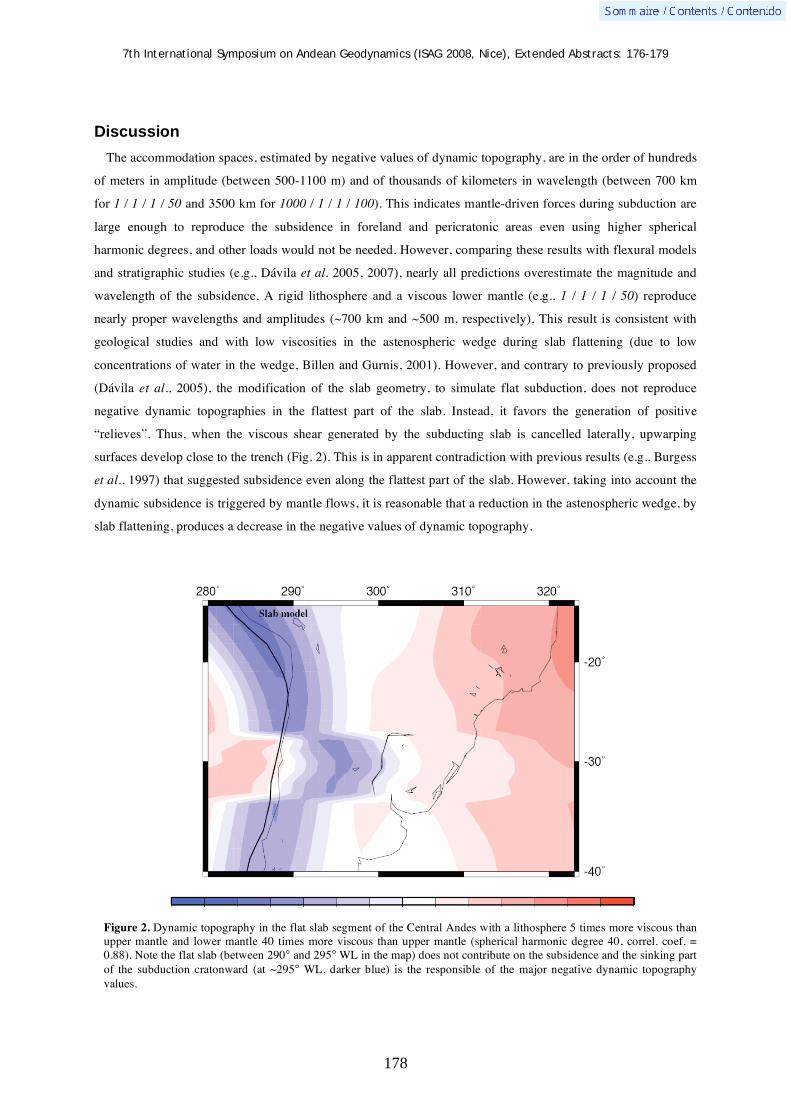
7th International Symposium on Andean Geodynamics (ISAG 2008, Nice), Extended Abstracts: 176-179
178
Discussion
The accommodation spaces, estimated by negative values of dynamic topography, are in the order of hundreds
of meters in amplitude (between 500-1100 m) and of thousands of kilometers in wavelength (between 700 km
for 1 / 1 / 1 / 50 and 3500 km for 1000 / 1 / 1 / 100). This indicates mantle-driven forces during subduction are
large enough to reproduce the subsidence in foreland and pericratonic areas even using higher spherical
harmonic degrees, and other loads would not be needed. However, comparing these results with flexural models
and stratigraphic studies (e.g., Dávila et al. 2005, 2007), nearly all predictions overestimate the magnitude and
wavelength of the subsidence. A rigid lithosphere and a viscous lower mantle (e.g., 1 / 1 / 1 / 50) reproduce
nearly proper wavelengths and amplitudes (~700 km and ~500 m, respectively). This result is consistent with
geological studies and with low viscosities in the astenospheric wedge during slab flattening (due to low
concentrations of water in the wedge, Billen and Gurnis, 2001). However, and contrary to previously proposed
(Dávila et al., 2005), the modification of the slab geometry, to simulate flat subduction, does not reproduce
negative dynamic topographies in the flattest part of the slab. Instead, it favors the generation of positive
“relieves”. Thus, when the viscous shear generated by the subducting slab is cancelled laterally, upwarping
surfaces develop close to the trench (Fig. 2). This is in apparent contradiction with previous results (e.g., Burgess
et al., 1997) that suggested subsidence even along the flattest part of the slab. However, taking into account the
dynamic subsidence is triggered by mantle flows, it is reasonable that a reduction in the astenospheric wedge, by
slab flattening, produces a decrease in the negative values of dynamic topography.
Figure 2. Dynamic topography in the flat slab segment of the Central Andes with a lithosphere 5 times more viscous than upper mantle and lower mantle 40 times more viscous than upper mantle (spherical harmonic degree 40, correl. coef. = 0.88). Note the flat slab (between 290° and 295° WL in the map) does not contribute on the subsidence and the sinking part of the subduction cratonward (at ~295° WL, darker blue) is the responsible of the major negative dynamic topography values.
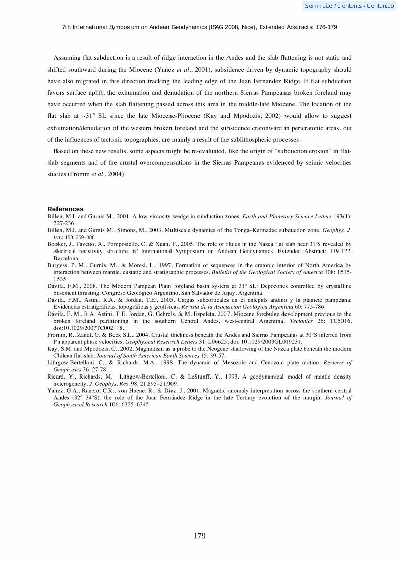
7th International Symposium on Andean Geodynamics (ISAG 2008, Nice), Extended Abstracts: 176-179
179
Assuming flat subduction is a result of ridge interaction in the Andes and the slab flattening is not static and
shifted southward during the Miocene (Yañez et al., 2001), subsidence driven by dynamic topography should
have also migrated in this direction tracking the leading edge of the Juan Fernandez Ridge. If flat subduction
favors surface uplift, the exhumation and denudation of the northern Sierras Pampeanas broken foreland may
have occurred when the slab flattening passed across this area in the middle-late Miocene. The location of the
flat slab at ~31° SL since the late Miocene-Pliocene (Kay and Mpodozis, 2002) would allow to suggest
exhumation/denudation of the western broken foreland and the subsidence cratonward in pericratonic areas, out
of the influences of tectonic topographies, are mainly a result of the sublithospheric processes.
Based on these new results, some aspects might be re-evaluated, like the origin of “subduction erosion” in flat-
slab segments and of the crustal overcompensations in the Sierras Pampeanas evidenced by seimic velocities
studies (Fromm et al., 2004).
References Billen, M.I. and Gurnis M., 2001. A low viscosity wedge in subduction zones. Earth and Planetary Science Letters 193(1):
227-236. Billen, M.I. and Gurnis M., Simons, M., 2003. Multiscale dynamics of the Tonga–Kermadec subduction zone. Geophys. J.
Int.: 153: 359–388 Booker, J., Favetto, A., Pomposiello, C. & Xuan, F., 2005. The role of fluids in the Nazca flat slab near 31ºS revealed by
electrical resistivity structure. 6º International Symposium on Andean Geodynamics, Extended Abstract: 119-122. Barcelona.
Burgess, P. M., Gurnis, M., & Moresi, L., 1997. Formation of sequences in the cratonic interior of North America by interaction between mantle, eustatic and stratigraphic processes, Bulletin of the Geological Society of America 108: 1515-1535.
Dávila, F.M., 2008. The Modern Pampean Plain foreland basin system at 31º SL: Depozones controlled by crystalline basement thrusting. Congreso Geológico Argentino, San Salvador de Jujuy, Argentina.
Dávila, F.M., Astini, R.A. & Jordan, T.E., 2005. Cargas subcorticales en el antepaís andino y la planicie pampeana: Evidencias estratigráficas, topográficas y geofísicas. Revista de la Asociación Geológica Argentina 60: 775-786.
Dávila, F. M., R.A. Astini, T E. Jordan, G. Gehrels, & M. Ezpeleta, 2007. Miocene forebulge development previous to the broken foreland partitioning in the southern Central Andes, west-central Argentina. Tectonics 26: TC5016, doi:10.1029/2007TC002118.
Fromm, R., Zandt, G. & Beck S.L., 2004. Crustal thickness beneath the Andes and Sierras Pampeanas at 30°S inferred from Pn apparent phase velocities. Geophysical Research Letters 31: L06625, doi: 10.1029/2003GL019231.
Kay, S.M. and Mpodozis, C., 2002. Magmatism as a probe to the Neogene shallowing of the Nazca plate beneath the modern Chilean flat-slab. Journal of South American Earth Sciences 15: 39-57.
Lithgow-Bertelloni, C., & Richards, M.A., 1998. The dynamic of Mesozoic and Cenozoic plate motion. Reviews of Geophysics 36: 27-78.
Ricard, Y., Richards, M. Lithgow-Bertelloni, C. & LeStunff, Y., 1993. A geodynamical model of mantle density heterogeneity. J. Geophys. Res. 98: 21,895–21,909.
Yañez, G.A., Ranero, C.R., von Huene, R., & Diaz, J., 2001. Magnetic anomaly interpretation across the southern central Andes (32°–34°S): the role of the Juan Fernández Ridge in the late Tertiary evolution of the margin. Journal of Geophysical Research 106: 6325–6345.

7th International Symposium on Andean Geodynamics (ISAG 2008, Nice), Extended Abstracts: 180-183
180
Dynamics of the November 3, 2002 eruption of El Reventador volcano, Ecuador: Insights from the morphology of ash particles
S. Delpit1, J.-L. Le Pennec
1, P. Samaniego
2, S. Hidalgo
2, & C. Robin
1,2
1 IRD, UMR 163, Laboratoire Magmas et Volcans, 5 rue Kessler 63038 Clermont-Ferrand, France
([email protected], [email protected]) 2 Instituto Geofisico, Escuela Politécnica Nacional, Ap. 17-01-2759, Quito, Ecuador
KEYWORDS : Reventador, Ecuador, tephra, VEI, magmatic fragmentation
Introduction
The Ecuadorian Volcanic Arc occurs in the Northern
Volcanic Zone of the Andes and results from the
subduction of the Nazca plate, which supports the
Carnegie Ridge, beneath the South American plate
(fig.1). The andesitic El Reventador stratovolcano,
about 100 km east of Quito city, belongs to the Back
Arc lineament. It is composed of an old edifice that
suffered two collapse events, and a young frequently
active stratocone whose summit rises about 3500 m
above sea level (Aguilera et al., 1998). On November
3, 2002, after 26 years of quiescence and little
precursory warning, El Reventador volcano erupted suddenly and violently, becoming the most important
eruption in Ecuador since the 1886 eruption of Tungurahua (the volcanic explosivity index, VEI, ranks at 4). The
paroxysmal phase of the eruption, started at 9:12 AM (local time), was a short event (around 48 minutes) during
which a 13 km-high eruptive column rose above the crater. The mainly westward wind drifted the volcanic cloud
above populated areas of the Interandean Valley and deposited a fine grained tephra fall layer (Hall. et al., 2004).
Many pyroclastic flows were also emplaced during the event, which was followed by the emplacement of
andesitic lava flows (Hall. et al., 2004; Ridolfi et al., 2008; Samaniego et al., 2008). Based on preliminary data,
Le Pennec et al. (2003) estimated the uncompacted tephra fall layer volume to ~0.28 km3 while new estimates
obtained in this work using the method of Fierstein and Nathenson (1992) is about 0.15 km3. The eruption style
has been described as subplinian with a VEI of 4. As this eruption style remains poorly known from the
literature, we present in this note new constraints on the eruption style by studying the typology and morphology
of tephra particles especially volcanic ash to infer eruption parameters such as the nature of the magmatic
fragmentation mechanism and the nature of the transport process (e.g. Heiken et al., 1985, Riley et al., 2003;
Ersoy et al., 2007).
Methods and results
After the eruption 19 tephra samples were collected at distances of 55-95 km downwind from the volcano.
These were sieved at the “Laboratoire Magmas et Volcans” in Clermont-Ferrand, France and ~600 particles for
Figure 1. Geodynamic map of the Ecuadorian Volcanic arc showing the location of the Reventador volcano.
Reventador
volcano

7th International Symposium on Andean Geodynamics (ISAG 2008, Nice), Extended Abstracts: 180-183
181
a c d e
j i h g f
b
Figure 3. Binocular images. a,b,f,g: juvenile (moderate to highly) vesicular grain; c,d,h,i: non-vesicular juvenile glass; e,j: lithic grains.
each three fractions (90 to 125μm, 125 to 180μm and 180 to 250μm) of each sample have been identified under
a binocular. To acheive this study some samples were selected for Scanning Electron Microscopy (SEM)
allowing to characterize the surface texture of particles. Below we summarize some results obtained for three
samples (fig. 2) at different distances (proximal part ~55 km, intermediate part ~75 km and distal part ~85 km)
from the vent.
Observations of these particles under the binocular reveals 3 textural classes (Fig. 3): (1) juvenile glass (with
mainly whitish grains and dark grains in lesser quantity) divided into 3 subclasses (1a) dense (1b) moderately
vesicular (1c) highly vesicular (2) free crystal (principally plagioclase crystals and few pyroxenes) (3) lithic
grains (fragments of the basement, old lavas from the volcano, etc) divided into 2 subclasses (2a) altered grains
with a characteristic reddish color (2b) other xenolithic grains.
Figure 4 shows some selected SEM images. Two types of vesicular grains were identified (Fig 4. a,b,c). The
first type (Fig 4. a,b) comprises highly vesicular grains with elongated shapes, sharp and irregular contours, and
the vesicles form tubular to capillary structures with narrow diameter (few μm). The second type (Fig 4. c) are
moderate to highly vesicular grains with an equant shape, a low irregular contour and mainly subspherical
vesicles with a variable diameter (few μm to tens of μm). Many juvenile glass particles are non-vesicular and
Figure 2. Evolution of the grain’s proportion for 3 samples from proximal, intermediate and distal parts; A: highly (black and white) juvenile glass; B: moderate (black and white) juvenile glass; C: non-vesicular juvenile glass; D: crystal (plagioclase and pyroxene); E: lithic grains (altered grain and others).
> 180 m
distal part
> 180 m
> 90 m
%
> 125 m > 125 m
Proximal part
> 180 m
> 90 m
% Intermediate part
> 125 m
> 90 m
%

7th International Symposium on Andean Geodynamics (ISAG 2008, Nice), Extended Abstracts: 180-183
182
show blocky to platy morphologies with local curviplanar and peculiar stepped fractures (Fig. 4, d,e) but no
quenching cracks features were observed. Free crystals are commonly observed (Fig. 4, e) and many of these
exhibit a glass coating. Some altered lithic grains with a subrounded to subangular shape are also recognized (not
shown in Fig. 4).
Discussion and conclusion
The proportion of each class of grains in the selected samples (Fig. 3) shows that the deposit is heterogeneous
in terms of component concentration. The abundance of juvenile glasses, especially the moderately to highly
vesicular particles, is high in relatively coarse-grained fractions (180 to 250 μm). Free crystals are more
abundant in tephra samples collected closer to the source (~10% at about 55 km from the vent, Fig. 2) and tend
to concentrate in the fine-grained fractions (~20%). The lithic particles represent from 2% to 10% of the samples
and, as for crystals, their concentration increases toward the source, especially in the fine-grained fractions of the
samples. On the whole, our component analyses indicate that ample density fractionation took place in the plume
during transport to the west: highly vesicular grains were concentrated in distal areas and in large grain-size
fractions whereas dense particles as non-vesicular glass shards and free crystals accumulated in the proximity of
the source. The wide range morphology of the juvenile particles suggests complex fragmentation processes at the
vent. On one hand, the highly vesicular grains with frothy to tubular textures support a dominant magmatic
fragmentation mode. On the other hand, the abundance of dense vitric glass shards, as well as the surface
textures (Wohletz, 1983), and also xenolithic grain point to some magma-water interactions, probably in the
conduit. These preliminary results lead us to portray the Reventador eruption of the November 3, 2002 as a
powerful VEI 4 event characterized by bimodal magmatic/phreatomagmatic fragmentation processes at the vent.
Work in progress aims to investigate the tephra fall deposits in more details to better characterize the eruption
dynamics.
Figure 4. SEM images. a, b : vesicular grain with tubular structure and elongated shape ; c : vesicular grain with an equant shape and an irregular contour; d: glass with peculiar stepped surface; e: platy glass with no quenching cracks features; f: crystal of plagioclase.
a b c
d e f
7th International Symposium on Andean Geodynamics (ISAG 2008, Nice), Extended Abstracts: 180-183
183
References Aguilera, E., Almeida, E., Balseca, W., 1988. El Reventador: an active volcano in the sub-Andean zone of Ecuador.
Rendiconti della Società Italiana di Mineralogia e Petrologia, 43: 853-875. Ersoy, O., Gourgaud, A., Aydar, E., Chinga, G., Thouret, J.-C., 2007. Quantitative scanning-electron microscope analysis of
volcanic ash surfaces: Application to the 1982-1983 Galunggung eruption (Indonesia), Bull. Geol. Soc. of Amer., 119: 743-752.
Fierstein, J., Nathenson, M., 1992. Another look at the calculation of fallout tephra volumes. Bull. Volcanol., 54: 156-167. Heiken, G., Wohletz, K., 1985. Volcanic ash, 246 pp., Univ. of Calif. Press, Berkeley. Hall, M., Ramón, P., Mothes, P., Le Pennec, J-L., García, A., Samaniego, P., Yepes, H., 2004. Volcanic eruptions with little
warning: the case of volcán Reventador’s surprise November 3, 2002 eruption, Ecuador. Revista Geológica de Chile, 31: 349-358.
Le Pennec, J-L., Hidalgo, S., Samaniego, P., Ramos, P., Yepes, H., Eissen., J-P., 2003. Magnitud de la Erupcion del 3 de Noviembre del 2002 del Volcán Reventador, Ecuador. Escuela Politécnica Nacional, Terceras Jornadas en Ciencias de la Tierra, Abstract, 94-96.
Samaniego, P., Eissen, J-P., Le Pennec, J-L., Robin, C., Hall, M.-L, Mothes, P., Chavrit, D., Cotten, J., 2008, in Press. Pre-eruptive physical conditions of El Reventador volcano (Ecuador) inferred from the petrology of the 2002 and 2004-05 eruptions. J. Volcanol. Geotherm. Res.
Ridolfi, P, PhD., Puerini, M., Renzulli, A., Menna, M., Toulkeridis, T, 2008, in press. The magmatic feeding system of El Reventador volcano (Sub-Andean zone, Ecuador) constrained by texture, mineralogy and thermobarometry of the 2002 erupted products. J. Volcanol. Geotherm. Res.
Riley, C. M., Rose, W. I., Bluth, G. J. S., 2003. Quantitative shape measurements of distal volcanic ash. J. Geophy. Res., 108, B10.
Wohletz, K.H., Mechanisms of hydrovolcanic pyroclast formation: grain-size, scanning electron microscopy, and experimental studies. J. Volcanol. Geotherm. Res., 17: 31-63.

7th International Symposium on Andean Geodynamics (ISAG 2008, Nice), Extended Abstracts: 184-187
184
Three-dimensional P- and S-wave seismic attenuation models in central Chile - western Argentina (30°-34°S) from local recorded earthquakes
P. Deshayes1, T. Monfret
1, M. Pardo
2, & E. Vera
2
1 Géosciences Azur, Université de Nice, IRD, Sophia-Antipolis, Valbonne, France
2 Departamento de Geofísica, Universidad de Chile, Santiago, Chile
KEYWORDS : flat slab, tomography, velocity, attenuation, mineralogy
Introduction
Beneath the Chilean coast, the Nazca plate subducts at a constant convergence velocity of 6.4cm/year
(Angermann et al, 1999). One of the first subduction zone segments to be identified as a low-angle subduction
zone, or flat slab, has been observed between 28°S and 33°S (Figure 1A). This region has coincided with an
absence of Quaternary active volcanoes since 9-10 Ma. To the north and south of that region, the subduction
zone dips “normally” with an angle of 30° (Figure 1B) (Barazangi and Isacks, 1976). Pardo et al (2004) and
Anderson et al. (2007) performed in the Central Chile and Western Argentina precise hypocenter location of
microearthquakes locally recorded by temporary seismic networks deployed within the zone for several months
and also by the Chilean permanent seismic network. They found out that the distribution of the seismicity, apart
to confirm that the flat geometry of the slab occurs at around 100 km depth with a slight western dipping of 5°,
forms at that depth a clear cluster, limited by a 30-km thick, 30-km wide and 160-km long “finger” shape, along
the expected Juan Fernandez Ridge (JFR) track (Yañez et al, 2002).
In a normal-angle subduction zone, volcanism is commonly generated by partial melting into the mantle if
temperature and water content conditions are fulfilled, and then by migration of the melting through the
continental crust till the surface. However, temperature variations, partial melting or water content may produce
similar seismic velocity signature, and therefore it is often difficult to associate observed velocity anomaly with
one of these causes (Wiens and Smith, 2003). Seismic attenuation responses to partial melting and temperature
may differ, which helps to discriminate between these causes and hence, to better characterize the medium.
In this study, we determine three dimensional attenuation models for P- and S-wave in Central Chile-Western
Argentina (30-34°S), based on frequency analysis of seismic displacement of local earthquakes, initial layered
attenuation models and the three-dimensional velocity models proposed by Pardo et al (2004).
Hypocenter location and velocity models
The three-dimensional velocity structures and precise hypocenter location of Pardo et al (2004) were jointly
obtained by tomography of P and S arrival times of earthquakes of magnitude between 1 and 6, locally recorded
during the OVA99 and CHARSME experiments. In the flat slab segment, Pardo and al (2004) put in evidence a
clear double seismic zone till 90 km depth while the oceanic crust is mainly characterized by positive P- and S-
wave velocity anomalies (Figure 2). In these velocity models, JFR track coincides with low Vp/Vs ratios (Pardo
et al, 2004). Moreover, at 33.5°S where the subduction zone is “normal”, a strong negative P- and S-wave
velocity anomaly is discerned in the continental crust, underneath the volcanoes: this anomaly might be

7th International Symposium on Andean Geodynamics (ISAG 2008, Nice), Extended Abstracts: 184-187
185
correlated either with partial melt or high temperatures (Figure 2).
In the zone, using CHARGE data, Wagner et al (2005) determined a three-dimensional velocity models of P
and S waves, mainly of the upper continental mantle while Alvarado et al (2007) proposed a continental crustal
model of the flat slab region, based on forward modelling of crustal parameters.
Figure 1. Local seismicity (black dots) recorded at temporary seismic stations (gray squares), during the OVA99 (November 1999-January 1999) and CHARSME (November 2002-March 2003) experiments (Pardo et al., 2004). Quaternary active volcanoes are represented by gray triangles. Isodepths of the slab are from Pardo et al (2004) and spacing between two isodepths is 20 km. East-West cross sections showing the local seismicity (black dots) along two transects at 31°S (A) and 33.5°S (B). Topography is shown on top of the cross-sections with an exaggerated vertical scale. A black reverse triangle indicates the location of the Peru-Chile Trench.
Attenuation models
The three-dimensional attenuation structures (Figure 3), represented by the Q quality factor anomalies for P-
( Qp) and S-wave ( Qs), were determined by inverting t* parameter through an adapted version of the TLR3
algorithm commonly used in velocity tomography (Latorre et al , 2004; Monteiller et al, 2005). t* (=t/Q) is
achieved by fitting the spectral displacement amplitude of P and S waves (Abercrombie, 1995) and t, the
estimated seismic wave travel-time between the source and the seismic station, is calculated in the three
dimensional velocity models of Pardo et al (2004). In this study, around 10700 t*-values were available to carry
out the attenuation tomography, however azimuthal coverage and number of ray paths were not as spatially well
distributed as for the velocity tomography of Pardo et al (2004).
While in velocity tomography the initial velocity models for P and S waves are generally well constrained
(multilayered models), for seismic attenuation tomography studies, the initial model is commonly a half-space
homogeneous constant Q-model, badly constrained. So, in order to have a more realistic initial Q-model, we
establish well-constrained one-dimensional Qp and Qs layered models through the probabilistic Metropolis-
Hastings method (Metropolis et al, 1953). The best one-dimensional Q models for P and S waves increase with
depth till 140 km where a low Q-value zone is found before augmenting with depth.
In the flat slab region (31.5°S) and at depths shallower than 20 km, the seismic attenuation (1/Q) is highly
laterally heterogeneous, showing Qp and Qs anomalies of opposite signs for the same positions (Figure 3),
may be indicating complexity in fluid content and/or fluid flow circulation. Moreover, these anomalies do not
seem directly correlated with specific velocity perturbations. On the other hand, the lower parts of continental
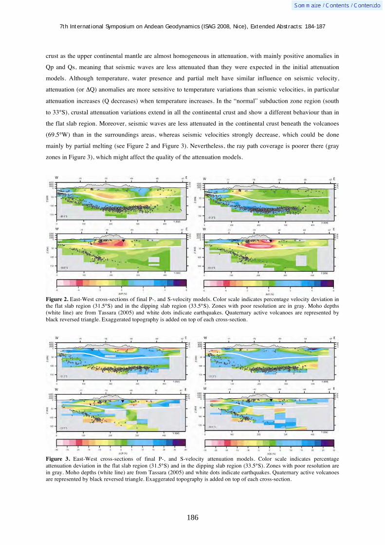
7th International Symposium on Andean Geodynamics (ISAG 2008, Nice), Extended Abstracts: 184-187
186
crust as the upper continental mantle are almost homogeneous in attenuation, with mainly positive anomalies in
Qp and Qs, meaning that seismic waves are less attenuated than they were expected in the initial attenuation
models. Although temperature, water presence and partial melt have similar influence on seismic velocity,
attenuation (or Q) anomalies are more sensitive to temperature variations than seismic velocities, in particular
attenuation increases (Q decreases) when temperature increases. In the “normal” subduction zone region (south
to 33°S), crustal attenuation variations extend in all the continental crust and show a different behaviour than in
the flat slab region. Moreover, seismic waves are less attenuated in the continental crust beneath the volcanoes
(69.5°W) than in the surroundings areas, whereas seismic velocities strongly decrease, which could be done
mainly by partial melting (see Figure 2 and Figure 3). Nevertheless, the ray path coverage is poorer there (gray
zones in Figure 3), which might affect the quality of the attenuation models.
Figure 2. East-West cross-sections of final P-, and S-velocity models. Color scale indicates percentage velocity deviation in the flat slab region (31.5°S) and in the dipping slab region (33.5°S). Zones with poor resolution are in gray. Moho depths (white line) are from Tassara (2005) and white dots indicate earthquakes. Quaternary active volcanoes are represented by black reversed triangle. Exaggerated topography is added on top of each cross-section.
Figure 3. East-West cross-sections of final P-, and S-velocity attenuation models. Color scale indicates percentage attenuation deviation in the flat slab region (31.5°S) and in the dipping slab region (33.5°S). Zones with poor resolution are in gray. Moho depths (white line) are from Tassara (2005) and white dots indicate earthquakes. Quaternary active volcanoes are represented by black reversed triangle. Exaggerated topography is added on top of each cross-section.

7th International Symposium on Andean Geodynamics (ISAG 2008, Nice), Extended Abstracts: 184-187
187
Conclusions
Attenuation tomography is complementary to velocity tomography to characterize the medium. The
simultaneous study of the attenuation and velocity perturbations in the medium, allow to differenciate the
temperature and melting origin of the anomalies, while the velocity tomography models, single-handed, can not
do it.
In order to improve the coverage of Qp and Qs attenuation models south to 33°S (Figure 3), we should use in a
future work, additional station-source ray paths from CHARGE data and/or the permanent Chilean seismic
network for example.
References
Abercrombie, R. E., 1995a, Earthquake source scaling relationships from -1 to 5 ML, using seismograms recorded at 2.5 km depth, J. Geophys. Res., 100: 24015-24036.
Alvarado, P., Beck, S., and Zandt, G., 2007. Crustal structure of the south-central Andes Cordillera and backarc region from regional waveform modelling, Geophys. J. Int., 170: 858-875.
Anderson, M., Alvarado, P., Zandt, G., and Beck, S., 2007. Geometry and brittle deformation of the subducting Nazca Plate, Central Chile and Argentina, Geophys. J. Int., 171: 419-434.
Angermann, D., Klotz, J. and Reigber, C., 1999. Space-geodetic estimation of the Nazca-South America Euler vector, Earth Planet. Sci. Lett., 171: 329-334.
Barazangi, M., and Isacks, B., 1976. Spatial distribution of earthquakes and subduction of the Nazca Plate beneath South America. Geology, 4: 686-692.
Latorre, D., Virieux, J., Monfret, T., Monteillet, V., Vanorio, T., Got, J.-L., and Lyon-Caen, H., 2004. A new seismic tomography of Aigion area (Gulf of Corinth, Greece) from the 1991 data set, Geophys. J. Int., 159: 1013-1031.
Metropolis, N., Rosenbluth, A. W., Rosenbluth, M. N., Teller, A. H., and Teller, E., 1953. Equation of State Calculations by Fast Computing Machines, Journal of Chemical Physics, 21: 1087-1092.
Monteillet,V., Got,J. L., Virieux,J. and Okubo,P., 2005. An efficient algorithm for double-difference tomography and location in heterogeneous media, with an application to the Kilauea volcano, J. Geophys. Res., 110: doi:10.1029/2004JB003466.
Pardo, M., Monfret, T., Vera, E., Yanez, G., and Eisenberg, A., 2004. Flat-Slab to Steep Subduction Transition Zone in Central Chile-Western Argentina: Body Waves Tomography and State of Stress. AGU Fall Meeting Abstracts, B164.
Tassara, A., 2005. Structure of the Andean continental margin and causes of its segmentation, PhD thesis, Freie Universität Berlin Institut für Geologische Wissenschaften, 165p.
Wagner, L. S., Beck, S., and Zandt, G., 2005. Upper mantle structure in the south central Chilean subduction zone 30°S to 36°S. J. Geophys. Res., 110, doi :10.1029/2004JB003238.
Wiens, D.A., and Smith, G.P., 2003, Seismological constraints on structure and flow patterns within the mantle wedge: in Eiler, J., ed., Inside the subduction factory: American Geophysical Union Geophysical Monograph 138: 59–81 doi: 10.1029/138GM05.
Yáñez, G., Cembrano, J., Pardo, M., Ranero, C. and Selles, D., 2002. The Challenger-Juan Fernandez-Maipo major tectonic transition of the Nazca-Andean subduction system at 33-34°S: geodynamic evidence and implications, J. of South Am. Earth Sc., 15: doi:10.1016/S0895-9811(02)00004-4.
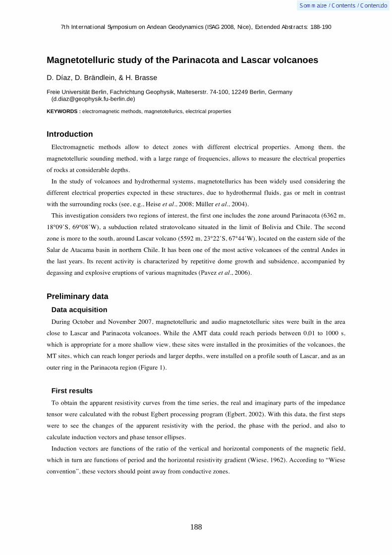
7th International Symposium on Andean Geodynamics (ISAG 2008, Nice), Extended Abstracts: 188-190
188
Magnetotelluric study of the Parinacota and Lascar volcanoes
D. Díaz, D. Brändlein, & H. Brasse
Freie Universität Berlin, Fachrichtung Geophysik, Malteserstr. 74-100, 12249 Berlin, Germany
KEYWORDS : electromagnetic methods, magnetotellurics, electrical properties
Introduction
Electromagnetic methods allow to detect zones with different electrical properties. Among them, the
magnetotelluric sounding method, with a large range of frequencies, allows to measure the electrical properties
of rocks at considerable depths.
In the study of volcanoes and hydrothermal systems, magnetotellurics has been widely used considering the
different electrical properties expected in these structures, due to hydrothermal fluids, gas or melt in contrast
with the surrounding rocks (see, e.g., Heise et al., 2008; Müller et al., 2004).
This investigation considers two regions of interest, the first one includes the zone around Parinacota (6362 m,
18°09’S, 69°08’W), a subduction related stratovolcano situated in the limit of Bolivia and Chile. The second
zone is more to the south, around Lascar volcano (5592 m, 23°22’S, 67°44’W), located on the eastern side of the
Salar de Atacama basin in northern Chile. It has been one of the most active volcanoes of the central Andes in
the last years. Its recent activity is characterized by repetitive dome growth and subsidence, accompanied by
degassing and explosive eruptions of various magnitudes (Pavez et al., 2006).
Preliminary data
Data acquisition
During October and November 2007, magnetotelluric and audio magnetotelluric sites were built in the area
close to Lascar and Parinacota volcanoes. While the AMT data could reach periods between 0,01 to 1000 s,
which is appropriate for a more shallow view, these sites were installed in the proximities of the volcanoes, the
MT sites, which can reach longer periods and larger depths, were installed on a profile south of Lascar, and as an
outer ring in the Parinacota region (Figure 1).
First results
To obtain the apparent resistivity curves from the time series, the real and imaginary parts of the impedance
tensor were calculated with the robust Egbert processing program (Egbert, 2002). With this data, the first steps
were to see the changes of the apparent resistivity with the period, the phase with the period, and also to
calculate induction vectors and phase tensor ellipses.
Induction vectors are functions of the ratio of the vertical and horizontal components of the magnetic field,
which in turn are functions of period and the horizontal resistivity gradient (Wiese, 1962). According to “Wiese
convention”, these vectors should point away from conductive zones.

7th International Symposium on Andean Geodynamics (ISAG 2008, Nice), Extended Abstracts: 188-190
189
The phase ellipse is a graphical representation of the phase tensor, which expresses how the phase relationships
change with polarization, independent of the galvanic distortion produced by heterogeneities in the near surface
(Caldwell et al. 2004).
Figure 1. Study zone and measurement sites, upper near Parinacota and lower near Lascar.
Induction vectors and phase ellipses have been calculated for every measured period of the AMT sites, from
0.00391 s, as the lowest period, until 1024 s.
7th International Symposium on Andean Geodynamics (ISAG 2008, Nice), Extended Abstracts: 188-190
190
From a first analysis of the apparent resistivity curves for the different sites, deep large conductive bodies seem
to be absent in these zones.
Besides this, topographic corrections have been developed for these zones, so the next step will be inversion of
the data, and constructing 2D and 3D models which could fit with these results.
First results of conductivity models will be presented.
References Brasse, H., Lezaeta, P., Rath, V., Schwalenberg, K., Soyer, W. & Haak, V. 2002. The Bolivian Altiplano conductivity
anomaly. Journal of Geophysical Research, 107 (B5), doi:10.1029/2001JB000391. Caldwell, T.G., Bibby, H.M. & Brown, C. 2004. The magnetotelluric phase tensor. Geophysics Journal International, 158:
457-469. Echternacht, F., Tauber, S., Eisel, M., Brasse, H., Schwarz, G. & Haak, V. 1997. Electromagnetic study of the active
continental margin in northern Chile. Physics of the Earth Interiors, 102: 69-87. Egbert G.D. 2002. Processing and Interpretation of Electromagnetic Induction Array Data. Surveys in Geophysics, 23: 207-
249. Heise, W., Caldwell, T.G., Bibby, H.M. & Bannister S.C. 2008. Three-dimensional modeling of magnetotelluric data from
the Rotokawa geothermal field, Taupo Volcanic Zone, New Zeland. Geophysical Journal International, doi:10.1111/j.1365-246X.2008.03737.x
Mackie, R., Smith, J.T. & Madden, T.R. 1994. Three-dimensional electromagnetic modeling using finite difference equations: The magnetotelluric example. Radio Science, Vol. 29, n.4, 923-935.
Müller, A., Haak, V. 2004. 3-D modeling of the deep electrical conductivity of Merapi volcano (Central Java): integrating magnetotellurics, induction vectors and the effect of steep topography. Journal of Volcanology and Geothermal Research, 138: 205-222.
Pavez, A., Remy, D., Bonvalot, S., Diament, M., Gabalda, G., Froger, J-L., Julien, P., Legrand, D. & Moisset, D. 2006. Insight into ground deformations at Lascar volcano (Chile) from SAR interferometry, photogrammetry and GPS data: Implications on volcano dynamics and future space monitoring. Remote Sensing of Environment, Volume 100, Issue 3: 307-320.
Wiese, H. 1962. Geomagnetische Tiefentellurik Teil II: Die Streichrichtung der Untergrundstrukturen des Elektrischen Widerstandes, Erschlossen aus Geomagnetischen Variationen. Pure and Applied Geophysics, 52: 83-103.

7th International Symposium on Andean Geodynamics (ISAG 2008, Nice), Extended Abstracts: 191-194
191
Volcán Llaima (38.7ºS, Chilean Southern Volcanic Zone): Insights into a dominantly mafic and ‘hyperactive’ subduction-related magmatic system
M. A. Dungan1, C. Bouvet de Maisonneuve
1, D. Sellés
2, J. A. Naranjo
3, H. Moreno
4,
C. Langmuir2, O. Reubi
5, S. Goldstein
6, J. Jweda
6, S. Escrig
2, O. Bachmann
7, &
B. Bourdon5
1 Section des Sciences de la Terre, Université de Genève, 13 rue des Maraîchers, 1205 Genève, Switzerland
([email protected]; [email protected]) 2 Department of Earth and Planetary Sciences, Harvard University, 20 Oxford Street, Cambridge MA 02139, USA
([email protected]; [email protected]; [email protected]) 3 SERNAGEOMIN, Avenida Santa Maria 0104, Providencia, Santiago, Chile ([email protected])
4 OVDAS-SERNAGEOMIN, Cerro Nielol, Sector antennas, Casilla 641, Temuco, Chile
([email protected]) 5 Institute of Isotope Geology and Mineral Resources, ETH-Zentrum, 8092 Zürich, Switzerland
([email protected]; [email protected]) 6 Lamont-Doherty Earth Observatory, Columbia University, Palisades NY 10964, USA
([email protected]; [email protected]) 7 Department of Earth and Space Sciences, University of Washington, Seattle WA 98195, USA
KEYWORDS : Andean arc magmatism, Chilean Southern Volcanic Zone, Llaima, conduits and chambers, magma
replenishment
Introduction
Holocene Volcán Llaima, one of Chile’s historically most active volcanoes, is broadly typical of Holocene
frontal arc centers of the Andean Southern Volcanic Zone (SVZ) that lie between the latitudes of 38.4° S
(Lonquimay) and 41° S (Osorno). It is located in proximity to the northern Liquiñe-Ofqui Fault Zone, it is
dominated volumetrically by evolved basaltic and basaltic andesitic magmas (<6.5 wt% MgO; 51-54 wt% SiO2),
and magma evolution is primarily by fractional crystallization without large contributions from assimilated upper
crust. Holocene volcanism began with eruption of the Curacautin Ignimbrite (13.5 ka; >10 km3; 52-58 wt%
SiO2), and early Holocene activity featured several large explosive eruptions (52-69 wt% SiO2) separated by
relatively long intervals (>1500 years?). During the last ~4000 years, repose times have shortened, eruptive
products with >60 wt% SiO2 are absent or extremely rare, and eruptive centers have alternated between main-
cone vents that define a N–S orientation and transverse fissural vents located on the lower NE, NW, and SW
flanks. Our understanding of the late Pleistocene eruptive products of the Llaima magmatic system is limited by
edifice destruction related to caldera collapse and glacial erosion, plus extensive burial by Holocene eruptive
products, but pre-Holocene Llaima magmas were primarily mafic andesite, rather than basalt.
Ongoing studies of historic and prehistoric eruptive products, plus observations during eruptive activity in
2008, suggest that late Holocene activity of Volcán Llaima has been characterized primarily by: (1) strombolian
eruptions of spatter and lava from summit craters or centers on the upper flanks of the edifice that were triggered
by magma replenishment, which in part remobilized crystal-rich residual products of previous eruptions by gas
sparging (degassing of impeded magma leading to gas-streaming through and mobilization of resident mush),
and (2) the generation of large and far-traveled lahars by larger eruptions due to interactions with voluminous
glacial ice on the steep upper slopes of the edifice. Lahars are the primary volcanic hazard at Llaima, and their

7th International Symposium on Andean Geodynamics (ISAG 2008, Nice), Extended Abstracts: 191-194
192
ability to deeply erode canyons on the lower slopes of the volcano has led to extensive and rapid ‘resurfacing’ of
the edifice.
The goals of our investigation are to: (1) characterize Llaima in sufficient geological and geochemical detail to
place constraints on the relationships among magma evolution, conduit geometry and location, and eruptive
behavior, (2) use these data and insights to address questions about the nature of the asthenospheric mantle and
magma generation processes beneath Llaima, and (3) enhance the value of regional-scale, along-arc assessments
of magma genesis and evolution by creating a ‘reference volcano’ data-set for calibration of trends that are
defined in large part by reconnaissance sampling. This contribution is based on geologic mapping and 14C
chronology (Naranjo and Moreno, 2005), plus preliminary interpretations of results obtained in 2007-2008 (150
major and trace element XRF analyses in hand, and ~400 analyses in progress). First-order characterization of
whole-rock samples will be followed by mineral and melt inclusion chemistry, trace element determinations by
ICP-MS, and isotopic measurements (Sr, Pb, Nd, Os, Hf, O, U-series disequilibrium, and 10Be) on a select suite
of samples.
Structural control of conduit and vent geometry
Volcán Llaima lies in a half-graben, wherein the main cone is offset ~9 km to the west from a N10°E-trending
segment of the northern Liquiñe-Ofqui Fault Zone (LOFZ). Llaima’s deeply eroded early Pleistocene
predecessor, Sierra Nevada, lies directly on the LOFZ to the NNE of Llaima. The alignment of Llaima main-
cone vents parallel to the LOFZ implies that there is a buried, secondary splay that plays an important role in
magma ascent. The localization of frontal arc volcanoes along or near the LOFZ in the Lonquimay to Osorno
portion of the SVZ may be one factor in minimizing crustal contamination in this part of the SVZ; i.e. ease of
passage through the crust. Fissural flank vents of volumetrically secondary importance (<4000 ka) are present on
the lower NE, NW, and SW flanks of Llaima. The NE fissural system, which is the most long-lived of the three,
has an E-W orientation (normal to LOFZ) and it lies directly to the south of a major E-W dike swarm in Sierra
Nevada’s western flank. This implies a transtensional stress component along this part of the LOFZ and a
regional rather than an edifice-related control on these structures. The NW and SW Llaima fissures have an
intermediate orientation (~N40°E). Preliminary results suggest that young main-cone lavas tend to be less
evolved and less diverse (~51-55 wt% SiO2, dominantly <53.5% SiO2) than broadly contemporaneous products
of three episodes of fissural eruptions (~51-59 wt% SiO2); this inference will be tested rigorously on the basis of
the chemistry of samples collected in 2008.
First-order chemical signature of mafic Llaima magmas
Mafic magma compositions at Llaima are not significantly different from those at Villarrica or Puyehue, in that
they have low abundances of Rb, K, Th, U, and Cs in combination with low La/Yb (2.5-3.7), Zr/Y (2.5-4.9) and
Nb/Y (0.10-0.16). These narrow ranges in ratios contrast with the much greater diversity at the Tatara-San Pedro
complex (36° S: La/Yb = 4.5-20, Zr/Y = 3.5-9.5; Nb/Y = 0.1-0.6), which apparently is a manifestation of mantle
heterogeneity at a volcano located at a greater distance from the trench and on thicker lithosphere. The apparent
lack of significant heterogeneity in mantle magma sources at Llaima suggests that source region parameters may

7th International Symposium on Andean Geodynamics (ISAG 2008, Nice), Extended Abstracts: 191-194
193
be reduced to variable partial melt fraction, contributions from diverse slab-derived components, and the
relationships between these two.
Importance and role of mafic magma replenishment
The long-term temporal evolution of the Holocene Llaima edifice appears to converge on a higher eruption-
frequency and a tendency for the eruption of compositionally similar evolved basalts (5.8-6.3 wt% MgO). A
corollary is that the ‘hyperactivity’ of the last four, or more, centuries is driven by a high frequency of mafic
magma replenishment into the upper crustal conduit system. Llaima has erupted 50 times since 1640. Although
only a few of these produced sufficient volumes of lava and tephra to render their products currently accessible
for study (many very short and volumetrically minor strombolian events within summit craters), the average
repose period during this period is 7.4 years and the only repose lasting longer than 35 years is the interval
between the 1640 and 1751 eruptions (Table 2 in Naranjo and Moreno, 2005). The latter two are among the four
large historic events (including 1780-90 & 1955-57). The historic alternation between mafic basaltic andesite
(e.g., 1640, 1927, 1994) and evolved basalt (e.g., 1780-90, 1751, 1945, 1955-57, 2008) is evidence that large
eruptions at Llaima are immediate responses to the quantity of new mafic input. The sudden onset of the January
1-2, 2008 eruption of Llaima, without significant seismic precursors during preceding days, suggests that such
inputs ascend rapidly to shallow depths. The 2008 eruption terminated in late February with voluminous
degassing, following six weeks of intermittent and weak strombolian activity.
Information derived from lavas is consistent with these observations: (1) Llaima mafic magmas are crystal-rich
(20-35 vol%) and the phenocryst populations are dominated by plagioclase (>80%). (2) Almost every large
plagioclase crystal in almost all main-cone lavas is characterized by sieve-textured resorption, and (3) The onset
of the large 1780-90 eruption, 30 years after the large 1751 eruption, was characterized by crystal-rich pahoehoe
followed by aa flows. The high effective viscosity of dry, crystal-rich, evolved basaltic magma is impossible to
reconcile with the fluidity of pahoehoe. We infer that the effective viscosity of a melt-solid-gas mixture may be
sufficiently lowered by a sudden injection of hot, water-rich gas into a ‘rheologically stiff’ crystal mush. This
scenario could be created by voluminous gas release from recharged mafic magma that stalled against partially
solidified, residual magma which previously had undergone low-P decompression crystallization. Some or all of
the magma erupted during such events would be the inflated and remobilized products of immediately preceding
episodes rather than new input, hence the crystal cargoes of resorbed plagioclase. This eruptive mechanism is
likely to be a factor in highly active systems subject to frequent replenishment by water-rich mafic magmas
which have not substantially degassed during ascent through the crust.
Volcán Llaima: an unusually laharogenic volcano
Lahars have been observed during only a small fraction of historic Llaima eruptions, but geologic evidence
suggests that most significant eruptions during the last ~4000 years from main-cone vents have generated large
lahars. The distal deposits of the vast majority of these lahars are buried or eroded, but they have left a record on
the lower flanks of the main cone. The short and modest strombolian eruption of January 1-2, 2008 triggered
glacier melting and a lahar that eroded deeply into the flank, exposing older canyon-filling lavas and clastic
deposits that reflect repeated incision and infilling of precursor canyons that followed similar courses. Such
7th International Symposium on Andean Geodynamics (ISAG 2008, Nice), Extended Abstracts: 191-194
194
canyons and scoured lavas are widespread on the flanks of the main cone, and such lahars have interacted in
vastly different ways with the flank fissural units as a function of the proximity of the fissural cones to the
summit: i.e., those which are located high on the steep north flank of Llaima have been extensively eroded,
whereas the distal chains of cones on the west flank have served as barriers and formed a basin in which lahar
accumulation has dominated (local escape through erosional gaps in the fissural ridge). The factors favoring
lahar generation are: (1) A high Holocene edifice (~3100 m) built on pre-Holocene edifice remnants. (2)
Dominantly mafic strombolian eruptions of spatter and lava fed by summit craters. (3) Climatic and topographic
conditions which lead to rapid accumulation of glacial ice on steep flanks.
Implications
Volcán Llaima provides an opportunity to assess magma generation and evolution, eruption dynamics, and
edifice modification. As all these phenomena are linked, and bear on the assessment of volcanic risks, it is
crucial to approach volcanoes as integrated systems from the magma source to the surface.
Reference Naranjo, J.A., Moreno, H., 2005 – Geología del Volcan Llaima, Región de la Araucanía. Carta Geológica de Chile, Serie
Geología Basica, No. 88, Servicio Nacional de Geología y Minería – Chile, Subdirección Nacional de Geología.

7th International Symposium on Andean Geodynamics (ISAG 2008, Nice), Extended Abstracts: 195-198
195
Sedimentologic, paleontologic, and ichnologic evidence for deep-marine Miocene deposition in the present Intermediate Depression of south-central Chile (38°30’-41°30’S)
Alfonso Encinas1, Kenneth L. Finger
2, & Luis Buatois
3
1 Departamento de Ciencias de la Tierra, Universidad de Concepción, Barrio Universitario s/n, Concepción, Chile
([email protected]) 2 University of California Museum of Paleontology, 1101 Valley Life Sciences Building, Berkeley, CA 94720-4780,
USA ([email protected]) 3 Department of Geological Sciences, University of Saskatchewan, 114 Science Place, Saskatoon, SK S7N 5E2,
Canada ([email protected])
KEYWORDS : Miocene, south-central Chile, deep-marine, subsidence
Introduction
Neogene marine strata occur at different localities along the Chilean coastline (Cecioni, 1980). Previous
sedimentological studies generally refer to these deposits as shallow marine (e.g., Cecioni, 1978). However,
more recent sedimentological, ichnological and paleontological studies indicate that they are deep-marine,
deposited at bathyal depths (~500-2000 m) during an interval of major Miocene subsidence that took place along
the Chilean forearc (Encinas et al., 2008 and references therein).
Although most exposures of these deposits are along the coast, outcrops also occur inland in the region located
between Temuco and Puerto Montt (38°30’-41°30’S) (Figure 1), where they also crop out in the eastern Coastal
Cordillera and the Intermediate.
Former studies have shown significant differences in the sedimentology and paleobathymetry of these deposits.
In the Temuco area (Figure 1), Osorio and Elgueta (1991) determined that sedimentation took place in at lower-
bathyal depths (~2000 m) during the middle-early to late Miocene, based on their study of foraminifera
recovered from ENAP’s Labranza 1 and Cunco 1 boreholes. In contrast, Le Roux and Elgueta (2000) interpreted
that sedimentation in the Valdivia and Osorno-Llanquihue area (Figure 1) occurred in a much shallower
environment. According to them, estuarine sedimentation during the late Oligocene-early Miocene was followed
by deposition in deeper coastal embayments during the middle Miocene. However, listed foraminiferal
assemblages from Neogene deposits from this area (i.e., Martínez-Pardo and Pino, 1979; Marchant and Pineda,
1988; Marchant, 1990) include lower bathyal species. Deep-water deposition is also suggested by the presence
of the trace fossil Chondrites isp. (Covacevich et al., 1992), and turbiditic facies (Le Roux and Elgueta, 2000)
that, although do not occur exclusively in these environments, are common in deep-marine settings. These data
suggest that Miocene deposition in the Valdivia and Osorno-Llanquihue basins took also place in a deep-marine
environment.
To try to unravel the sedimentary environment of Neogene deposits and the tectonic history of the area located
in the present Coastal Cordillera an Longitudinal Depression between Temuco and Puerto Montt (38°30’-
41°30’S) during that period we carried out a thorough sedimentological, ichnological and micropaleontological
study of both outcrops and ENAP well sections.

7th International Symposium on Andean Geodynamics (ISAG 2008, Nice), Extended Abstracts: 195-198
196
Figure 1. Map of the study area showing locations of outcrops of the Neogene marine successions (gray color) and the most important boreholes drilled by ENAP in the Intermediate Depression (open circles).

7th International Symposium on Andean Geodynamics (ISAG 2008, Nice), Extended Abstracts: 195-198
197
Results
The Neogene succession in our study area discordantly overlies the metamorphic basement and coal-bearing
deposits of the Pupunahue-Catamutun Formation. It includes a basal breccia overlain by gray sandy siltstone and
minor medium to coarse-grained sandstone and breccia. Sedimentary features typical of gravity flows are
present, such as convolute lamination and rhythmic alternating sandstones and siltstones. Fine siltstones show
the presence of abundant Chondrites isp. and minor Zoophycos isp.
Foraminiferal analyses of ENAP well samples reveal the presence of two very different units. The upper unit,
which is the focus of this study, consists of sedimentary rock bearing the rich foraminiferal fauna characteristic
of the regional Miocene. In stark contrast, the lower unit known as the Pupunahue-Catamutún Formation
includes only internal molds of Globigerinatheka sp., a planktic genus restricted to the late early to late Eocene
(Pearson et al., 2007).
The upper Miocene unit yielded mixed associations of littoral, neritic, and bathyal species of benthic
foraminifera. The deepest-dwelling taxa in the majority of samples indicate minimum depths of deposition in the
lower-bathyal (2000–4000 m) zone. Among the lower-middle and lower-bathyal indicators in the Chilean
Miocene are species of Bathysiphon, Melonis, Osangularia, Pleurostomella, and Siphonodosaria that are similar
or identical to those Van Morkhoven et al. (1986) classified as cosmopolitan deep-water taxa.
A refined age span of the studied succession remains somewhat elusive, as it contains few planktic
foraminifers and index species are very scarce. Of the samples studied in this work, only three localities yielded
planktic forams with concurrent ranges that confine the age to the middle to late Miocene interval. In all other
respects, the foraminifer fauna is very similar to that we recovered from late Miocene-early Pliocene outcrops in
the coastal area of south-central Chile (Finger et al., 2007).
Discussion
Sedimentological studies show the occurrence of a basal, shallow marine breccia, overlain by a succession of
sandstone and siltstone with sedimentary facies characteristic of gravity flows that are typical of deep marine
settings. Ichnological studies indicate the presence of abundant Chondrites isp. and Zoophycos isp., which are
characteristic of slope and apron settings (Frey and Pemberton, 1984). Paleontological studies reveal bathymetric
mixing of littoral, neritic, and bathyal species of foraminifers indicating downslope transport and deposition at
minimum water depths of approximately 2000 m.
These findings indicate that the area corresponding to the present Coastal Cordillera and Intermediate
Depression between Temuco and Puerto Montt was subjected to major subsidence and marine transgression
during the Miocene, followed by uplift and emergence, probably during the Pliocene. This matches the results
we attained from our work on the coastal region at the same latitudes (Finger et al., 2007; Encinas et al., 2008),
and thereby expands the paleogeography of the region known to have been affected by the Neogene events
previously described. Major subsidence is attributed to an important event of tectonic erosion that took place
along the Chilean margin during the Neogene (Encinas et al., 2008).
Acknowledgments. This research was supported by Proyecto Fondecyt No. 3060051 of Conicyt and the IRD (Institut de Recherche pour le Développment) to which gratefully thank their financial help. LB was supported by a NSERC Discovery

7th International Symposium on Andean Geodynamics (ISAG 2008, Nice), Extended Abstracts: 195-198
198
Grant 311726-05. We also thank ENAP (The National Petroleum Chilean Company) for kindly allowing us to study their borehole microfossils. References Cecioni, G. 1978. Petroleum possibilities of the Darwin's Navidad Formation near Santiago, Chile. Publicación Ocasional
del Museo Nacional de Historia Natural de Chile 25, 3-28. Cecioni, G. 1980. Darwin´s Navidad embayment, Santiago region, Chile, as a model of the southeastern Pacific shelf.
Journal of Petroleum Geology 2-3, 309-321. Covacevich, V., Frassinetti, D., & Alfaro, G. 1992. Paleontología y condiciones de depositación del Mioceno marino en las
nacientes del río Futa, Valdivia, Chile. Boletín del Museo Nacional de Historia Natural de Chile 43, 143-154. Encinas, A., Finger, K., Nielsen, S., Lavenu, A., Buatois, L., Peterson, D & Le Roux, J.P. 2008. Rapid and major coastal
subsidence during the late Miocene in south-central Chile. Journal of South American Earth Sciences 25, 157-175. Finger, K.L., Nielsen, S.N., DeVries, T.J., Encinas, A. & Peterson, D.E. 2007. Paleontologic evidence for sedimentary
displacement in Neogene forearc basins of central Chile. Palaios 22, 3-16. Frey, R.W. & Pemberton, S. 1984, “Trace fossils Facies Models”. In Walker, R.G., (ed.): Facies Models. Geoscience Canada
Reprint Series: 189-207. Le Roux, J.P. & Elgueta, S. 2000. Sedimentologic development of a late Oligocene-Miocene forearc embayment, Valdivia
complex, southern Chile. Sedimentary Geology 130, 27-44. Marchant, M. & Pineda, V. 1988. Determinación de la edad del miembro superior marino de los estratos de Pupunahue,
mediante foraminíferos. V Congreso Geológico Chileno (Actas), Tomo 2, p. C311-C325, Santiago de Chile. Marchant, M. 1990. Foraminíferos Miocénicos de los Estratos de Pupunahue (Provincia de Valdivia: X Región):
Determinación de la edad probable y paleoambiente. Segundo Simposio sobre el Terciario de Chile, p. 177-188, Concepción, Chile.
Martínez-Pardo, R. & Pino, M. 1979. Edad, paleoecología y sedimentología del Mioceno marino de la Cuesta Santo Domingo, Provincia de Valdivia, X Región. II Congreso Geológico Chileno (Actas), p. H 103-H 124, Arica, Chile.
Morkhoven, F.P.C.M. van, Berggren, W.A. & Edwards, A.S. 1986. Cenozoic cosmopolitan deep-water benthic foraminifera. Bulletin des Centres de Recherches Exploration-Production Elf-Aquitaine, Memoire 11, 421 p.
Osorio, R. & Elgueta, S. 1990. Evolución paleobatimétrica de la Cuenca Labranza documentada por Foraminíferos. II Simposio sobre el Terciario de Chile, p. 225-233, Concepción, Chile.

7th International Symposium on Andean Geodynamics (ISAG 2008, Nice), Extended Abstracts: 199-202
199
Kinematics evolution of the Camisea Subandean thrust belt from apatite fission-track thermochronology, Peru
N. Espurt1, J. Barbarand
2, S. Brusset
3, P. Baby
3, M. Roddaz
3, & W. Hermoza
4
1 IFP, 1 et 4 Av. de Bois-Préau, 92852 Rueil-Malmaison cedex, France ([email protected])
2 Univ Paris Sud, UMR CNRS 8148 IDES, Bâtiment 504, Orsay cedex, F-91405, France
3 LMTG, Université de Toulouse, CNRS, IRD, OMP, 14 av. E. Belin, F-31400 Toulouse, France
4 REPSOL-YPF, Paseo de la Castellana 280, 1ª Pl., 28046 Madrid, Spain
KEYWORDS : apatite fission-track thermochronology, balanced cross section, thrust tectonic, Camisea basin, Peru
Introduction
The propagation of the deformation into a foreland basin system is controlled by the advance of the adjacent
thrust wedge (DeCelles and Giles, 1996). The Peruvian Subandean zone is considered as a foreland thrust belt
which started to develop since the Middle Miocene (Hermoza et al., 2005) and is still active today (Dorbath,
1996). The Camisea basin (Fig. 1a) belongs to the southern edge of the Ucayali basin and includes the giant
Camisea gas/condensate province (Chung et al., 2006). The structural architecture of the Camisea basin has been
the site of several studies (Bellido, 1969; Dumont et al., 1991; Mathalone and Montoya, 1995; Shaw et al., 1999;
Espurt et al., 2008) but the temporal evolution of the deformation remains poorly constrained. In this study, we
have used apatite fission-track data to constrain the exhumation and the structural evolution of the Camisea
Subandean zone.
Figure 1 : (a) Geological map of the Camisea basin and location of the Pongo de Mainique. (b) Balanced cross section of the Camisea basin and (b) restoration (modified from Gil, 2002). The restoration shows a shortening of 56 km. PMBT: Pongo de Mainique back-thrust.
Structural setting, strategy sampling and results
The frontal structural architecture of the Camisea basin (Fig. 1b) corresponds to thrust related long wavelength
anticlines (Espurt et al., 2008) which branch to the décollement developed at the base of the Devonian shales
(Gil, 2002). The Pongo de Mainique back-thrust and frontal structures accommodate the shortening of an

7th International Symposium on Andean Geodynamics (ISAG 2008, Nice), Extended Abstracts: 199-202
200
internal triangle zone. The floor thrust of this duplex is located at the Ordovician–basement interface while its
roof thrust corresponds to the shales of the base of the Devonian. Behind the duplex, syn-tectonic Pliocene
sediments progressively sealed the recent deformation of the Shihuayro syncline. The restoration of the balanced
cross section shows a total shortening of 56 km (Fig. 1c).
Apatite fission-track thermochronology is commonly used to determine the timing of rock uplift and
magnitude of the cooling from shallow crustal levels (Fitzgerald et al., 1995). We collected 8 fine- to coarse-
grained sandstone samples for apatite fission-track analyses (Fig. 2) along vertical in different stratigraphic
levels of pre-foreland strata of the Pongo de Mainique canyon at the water level of the Urubamba River.
Considering that the strata were horizontal at deposition, apatite fission-track samples cover a thickness of
~2940 m from the Late Carboniferous to Paleogene rocks. The sample profile covers the largest paleo-depth
range of the hanging wall of the Pongo de Mainique back-thrust and gives information in terms of exhumation of
the southern limb of the Shihuayro syncline.
Apparent cooling ages of the 8 apatite fission-track samples spread between 128±12 Ma and 5.4+2.0/-1.5 Ma (Fig.
2). The confined track lengths range between 13.05 and 10.65 μm with standard deviations between 1.05 and
2.59 μm. The three stratigraphically deepest samples have been reset. They have recorded an apparent tectonic
cooling at ~6 Ma in response to the Pongo de Mainique back-thrust activity. In contrast, the four shallowest
samples have been partially reset in the fossil partial annealing zone as confirmed by the dispersion of the
component ages of these samples (between 128 and 11.6 Ma) (Fig. 2). Thrust stacking of the internal triangle
zone generated topography and induced tectonic burial. The restoration of the southern flank of the Shihuayro
syncline (Fig. 2a) shows that the paleo-temperatures of the Paleozoic to Miocene sedimentary series of the
Pongo de Mainique have been maximal during the Neogene burial. The Neogene burial history is related to the
reset of the apatite fission-tracks ages of the three deepest samples of the profile (Fig. 2a).
Kinematics evolution of the Pongo de Mainique back-thrust
The restoration of the Pongo de Mainique back-thrust, from initial and final states, coupled with apatite
fission-track data allows us to reconstruct the two dimensional thermal history of the southern limb of the
Shihuayro syncline. Isochronous apatite fission-track ages of the three deepest samples indicate that these
samples have simultaneously crossed the 110°C closure isotherm while the upper samples were maintained in
the fossil partial annealing zone. Subsequently, we propose a geometrical model where a south-verging fault
thrust with an angle value of ~50° northwards induced rotation and flattening of the deepest samples (Fig. 2b).
The high dip angle of the thrust fault is probably related to the development of the internal triangle zone. In this
structural model, we supposed that the isotherms have not been deformed during thrusting, which implies that
the erosion rate is the same as the one the thrusting rate. Therefore, a northward minimum horizontal
displacement of ~3 km would be essentially accommodated by the Pongo de Mainique back-thrust to allow the
three deeper samples to cross the 110°C closure isotherm. This shortening has plausibly archived by the first
Miocene conglomeratic sequences of the Shihuayro syncline (Fig. 2b). However, the initiation of the growth
strata deposits of the Timpia formation in the axis of the Shihuayro syncline (Fig. 2c) attests of strong
morphological modifications of the depositional architecture related to thrust imbricate growth of the triangle
zone.

7th International Symposium on Andean Geodynamics (ISAG 2008, Nice), Extended Abstracts: 199-202
201
Figure 2 : Sequential restoration of the Pongo de Mainique back-thrust. Apatite fission-track samples are located by red squares and ages in Ma are shown. PAZ: Partial annealing zone.

7th International Symposium on Andean Geodynamics (ISAG 2008, Nice), Extended Abstracts: 199-202
202
Shortening rate and consequences for growth of the northern Altiplano Plateau
The ~3 km of shortening necessary to produce the exhumation of the Pongo de Mainique back-thrust is greatly
inferior to the total shortening of 56 km calculated on the whole of the Camisea basin cross section. If we
consider that (1) this displacement can be neglected vis-à-vis of the total shortening and (2) the deformation in
the Camisea basin began with the initiation of the Pongo de Mainique back-thrust at ~6 Ma, we obtain a mean
shortening rate of about 8.8 mm/an for the Camisea Subandean zone. This shortening rate is close to the present-
day shortening rate (9 mm/an) from the southern Peruvian zone calculated by Bevis et al. (2001) from GPS data.
In addition, the recent work of Garzione et al. (2006) shows that the growth and the eastward propagation of the
Subandean zone would be related to the exhumation of the Altiplano Plateau between 10.3 and 6.8±0.4 Ma.
Consequently, our results from the Camisea Subandean zone located on the northern edge of the Altiplano
Plateau may permit to constrain its exhumation at ~6 Ma.
References Bellido, B.E. 1969. Sinopsis de la geología del Perú. Servicio de Geología y Minería Boletín 22: 54 p. Bevis, M., Kendrick, E., Samlley Jr, R., Brooks, B., Allmendigger, R., & Isacks, B. 2001. On the strength of interplate
coupling and the rate of back arc convergence in the central Andes: An analysis of the interseismic velocity field, Geochemistry, Geophysics, Geosystems: 2.
Chung, J., Arteaga, M., Davis, S. & Seminario, F. 2006. Impacto de la sismica 3D en el desarrollo de los yacimientos de Camisea. Bloque 88 – Cuenca Ucayali – Peru. Bol. Soc. Geol.. Peru 101: 73-89.
DeCelles, P. G. & Giles, K. A. 1996. Foreland basin systems. Basin Research 8: 105-123. Dumont, J.F., Deza, E. & Garcia, F. 1991. Morphostructural provinces and neotectonics in the Amazonian lowlands of Peru.
J. South Am. Earth Sci. 4: 373-381. Dorbath, C. 1996. Velocity structure of the Andes of central Peru from locally recorded earthquakes. Geophys. Res. Lett. 23:
205-208. Espurt, N., Brusset S., Baby P., Hermoza W., Roddaz M., Bolaños R., Uyen D., & Déramond J. 2008. Paleozoic structural
controls on transfer of Subandean shortening in a foreland thrust system, Ene and southern Ucayali basins, Peru. Tectonics: doi:10.1029/2007TC002238, in press.
Fitzgerald, P.G., Sorkhabi, R.B., Redfield, T.F., & Stump, E. 1995. Uplift and denudation of the central Alaska Range: A case study in the use of apatite fission-track thermochronology to determine absolute uplift parameters, Journal of Geophysical Research 100: 20175-20191.
Garzione, C.N., Molnar, P., Libarkin J.C., & MacFadden B.J. 2006. Rapid late Miocene rise of the Bolivian Altiplano: Evidence for removal of mantle lithosphere. Earth and Planetary Science Letters 241: 543-556.
Gil, R.W. 2002. Evolución lateral de la deformación de un frente orogénico: ejemplo de las cuencas subandinas entre 0° y 16° S. Sociedad Geológica del Perú, Publicación especial 4, 146 p.
Mathalone, J.M.P., & Montoya R.M. 1995. Petroleum geology of sub-Andean basins of Peru, in Tankard, A., Soruco, R. S., and Welsink, eds., Petroleum basins of South America, AAPG Memoir 62: 423-444.
Hermoza, W., Brusset, S., Baby, P., Gil, W., Roddaz, M., Guerrero, N. & Bolaños, R. 2005. The Huallaga foreland basin evolution: Thrust propagation in a deltaic environment, northern Peruvian Andes. J. South Am. Earth Sci. 19: 21-34.
Shaw, J.H., Bilotti, F. & Brennan P.A. 1999. Patterns of imbricate thrusting, Geological Society of American Bulletin 111: 1140-1154.

7th International Symposium on Andean Geodynamics (ISAG 2008, Nice), Extended Abstracts: 203-205
203
Tectonic and glacial forcing of motion along an active detachment fault
Daniel L. Farber1,2
& Gregory S. Hancock3
1 Atmospheric and Earth Sciences Division, University of California, Lawrence Livermore National Laboratory,
Livermore, California, U.S.A. ([email protected]) 2 Earth Sciences Department, University of California, Santa Cruz, Santa Cruz, California, U.S.A.
([email protected]) 3 Department of Geology, College of William and Mary, Williamsburg, VA 23187, U.S.A. ([email protected])
KEYWORDS : cosmogenic, uplift, detachment faulting, climate, isostasy
The Cordillera Blanca of central Peru form the highest topography of Peru and contain the tallest Andean peak
north of 32° S. The range is bounded on the west by the spectacular ~200 km long Cordillera Blanca
Detachment Fault (CBDF) and widespread tectonic indicators for extension in this portion of the Andes have
lead a number of authors to cite the CBDF as a type example of gravitational collapse of high
topography(Dalmayrac and Molnar, 1981; Richardson and Coblentz, 1994). Exposures of 5-8 Ma granodiorite
with ~4 Ma apatite fission track ages at ~7000 m in the footwall of the CBDF, document extremely rapid
exhumation of the range (McNulty and Farber, 2002; Perry and Garver, 2004). This exhumation has been
interpreted as rapid Miocene – Pliocene surface uplift, leading to the apparent paradox of extensional lowering
of the topography with significant topographic uplift. In order to understand the nature of the CBDF we have
determined the rates of Quaternary motion along the fault and modeled the isostatic effects of the dissection of
the footwall.
The broad regions of accordant summits at 4200 to 4300 m.a.s.l. extending for ~100 km east of the northern
Cordillera Blanca are the remnants of the now partially dissected Puna plateau(Cobbing et al., 1981; Wilson et
al., 1995). To the west across the Callejon de Huaylas, the crest of the Cordillera Negra is a partly-dissected
northward extension of the Puna plateau(McLaughlin, 1924) (at ~4400 to 5000 m.a.s.) that truncates Tertiary
volcanic and folded Mesozoic sedimentary rocks. Along ~150 km of north-south transects, the topography of the
Cordillera Negra summits and the high elevations of the plateau east of the Cordillera Blanca are nearly identical
(Fig. 2) suggesting that the present topography represents a formerly continuous northward extension of the
Puna plateau.
To calculate slip rates along the CBDF, we have measured topographic profiles and the ages of offset
moraines and tectonically-generated fluvial terraces(Bierman et al., 1995; Van der Woerd et al., 2000) at four
locations along the CBDF, from north to south: Huaytapallana, Cojup, Queroccocha and Tuco. The vertical slip
rates decrease monotonically from north to south, and are 5.1±0.8 mm/yr at Huaytapallana, 2.9±0.3 mm/yr
Cojup, 0.77±0.1 mm/yr at Queroccocha, and 0.59±0.2 mm/yr at Tuco. Both the maximum elevation and the
relief of the Cordillera Blanca are strongly correlated with offset rates along the CBDF. Maximum elevations
decrease from ~6700 m (Huaytapallana) to ~6200 m (Cojup) and ~5600 m (Queroccocha), and maximum relief
decreases from ~2900 m to ~1000 m, reflecting the diminishing depth of glacial erosion in the south. Assuming
the initial topography of the Puna surface was at an elevation of ~4500 m prior to onset of the CBDF motion,

7th International Symposium on Andean Geodynamics (ISAG 2008, Nice), Extended Abstracts: 203-205
204
these maximum elevations provide minimum estimates of footwall uplift of ~2000 m, ~1600 m, and ~1000 m at
Huaytapallana, Cojup, and Queroccocha. This is however, a lower bound, as an unknown amount of material
may have been exhumed from on top of the present peaks since the initiation of fault motion.
In the northern and central part of the Callejon de Huaylas, a distinct, gently rolling paleovalley floor incised
by the Rio Santa is preserved on the hanging wall of the CBDF. The modern slope of this paleovalley parallels
that of the Rio Santa (Fig. 2) suggesting little downward to the north tilting of the paleovalley deposits and,
therefore, of the hanging wall of the CBDF. Thus, the concordance of the thermochronologic data taken from the
footwall block together with our Quaternary offset rates and the correlation between the uplift rates and range
geomorphology, suggests that relative to sea level, motion along the CBDF is largely confined to the footwall.
To quantify the relative contributions of tectonics and erosional unloading to generation of the topography, we
have calculated the isostatic component of the uplift by estimating the mass removed and the resulting flexural-
isostatic response since onset of motion along CBDF. To do so, we have used the continuity of the Puna plateau
across the region now occupied by the Cordillera Blanca as an initial condition of the topography prior to onset
of motion along the CBDF. The calculated flexurally-driven uplift patterns predict the present elevation of much
of the plateau remnants, with the exception being the crest of the Cordillera Blanca. There, peaks extend to
elevations well in excess of that predicted by the model thus requiring a significant additional tectonic forcing.
The localization of the excess topography along the CBDF, together with the correlation of the excess
topography with the relief and slip rates along the CBDF suggests that much of this uplift is accommodated
through tectonically driven footwall motion. Our calculations imply that tectonically driven extensional footwall
uplift along the CBDF is substantial, generating 60% to 70% of the total uplift since fault initiation. However, at
least a portion of the more rapid fault motion in the north is plausibly generated by extensive glacial erosion
allowed by the higher topography. Indeed, this growing topography likely facilitated the growth of larger and
more erosive glaciers, accelerating the rate of footwall uplift in the north by isostatically-driven footwall uplift
superposed on the tectonically-driven fault motion.
The style of deformation we document along the CBDF has important tectonic implications. The increase in
mean elevation (relative to the initial plateau topography) requires a mechanism other than erosional unloading
or extension and crustal thinning accommodated by the CBDF, both of which would produce an overall lowering
of the mean topography. Thus, the previously proposed(Dalmayrac and Molnar, 1981; Richardson and Coblentz,
1994) models calling on gravitational collapse of high topography to account for the presence of extension in
this portion of the high Andes cannot explain our observations. We consider the most likely explanation to be
additions of material at the base of the lithospheric section. The location of the Cordillera Blanca directly above
the Peruvian flat slab section suggests that this may indeed be the case. In central Peru, the onset of flat slab
subduction since ~5 Ma likely accommodated replacement of dense lithospheric material beneath the Cordillera
Blanca with the buoyant oceanic slab, increasing the thickness of the crustal section below central Peru(Gutscher
et al., 2000). In contrast to the Altiplano section studied by Ghosh et al. (Ghosh et al., 2006) where uplift was
largely complete by 5 Ma, in this portion of the Andes, topography has not yet reached steady state and is likely
still increasing today.

7th International Symposium on Andean Geodynamics (ISAG 2008, Nice), Extended Abstracts: 203-205
205
References Bierman, P.R., Gillespie, A.R., and Caffee, M.W., 1995, Cosmogenic Ages For Earthquake Recurrence Intervals And Debris
Flow Fan Deposition, Owens-Valley, California: Science, v. 270, p. 447-450. Cobbing, E., Pitcher, W., Wilson, J., Baldock, J., Taylor, W., McCourt, W., and Snelling, N., 1981, The geology of the
Western Cordillera of northern Peru: London. Dalmayrac, B., and Molnar, P., 1981, Parallel Thrust And Normal Faulting In Peru And Constraints On The State Of Stress:
Earth And Planetary Science Letters, v. 55, p. 473-481. Ghosh, P., Garzione, C.N., and Eiler, J.M., 2006, Rapid uplift of the Altiplano revealed through C-13-O-18 bonds in paleosol
carbonates: Science, v. 311, p. 511-515. Gutscher, M.A., Spakman, W., Bijwaard, H., and Engdahl, E.R., 2000, Geodynamics of flat subduction: Seismicity and
tomographic constraints from the Andean margin: Tectonics, v. 19, p. 814-833. McLaughlin, D.H., 1924, Geology and physiography of the Peruvian Cordillera, Departments of Junin and Lima: Bulletin of
the Geological Society of America, v. 35, p. 591-632. McNulty, B., and Farber, D., 2002, Active detachment faulting above the Peruvian flat slab: Geology, v. 30, p. 567-570. Perry, S.E., and Garver, J.I., 2004, Onset of tectonic exhumation of the Cordillera Blanca, northern Peru based on fission-
track and U+Th/He dating of zircon: Abstracts with Programs - Geological Society of America, v. 36. Richardson, R.M., and Coblentz, D.D., 1994, Stress Modeling In The Andes - Constraints On The South-American Intraplate
Stress Magnitudes: Journal Of Geophysical Research-Solid Earth, v. 99, p. 22015-22025. Van der Woerd, J., Ryerson, F.J., Tapponnier, P., Meriaux, A.S., Gaudemer, Y., Meyer, B., Finkel, R.C., Caffee, M.W.,
Zhao, G.G., and Xu, Z.Q., 2000, Uniform Slip-Rate along the Kunlun Fault: Implications for seismic behaviour and large-scale tectonics: Geophysical Research Letters, v. 27, p. 2353-2356.
Wilson, J., Reyes, L., and Garayar, J., 1995, Geologia de quadrangulos de Pallasca, Tayabamba, Corongo, Pomabamba, Carhuaz, and Huari: Lima, Insituto Geologico and Minero y Metalurgico.

7th International Symposium on Andean Geodynamics (ISAG 2008, Nice), Extended Abstracts: 206-209
206
No subsidence in the development of the Central Depression along the Chilean margin
Marcelo Farías
1,2, Sébastien Carretier
3, Reynaldo Charrier
1, Joseph Martinod
3, Andrés
Tassara2, Alfonso Encinas
4, & Diana Comte
2
1 Departamento de Geología, Univ. de Chile, Plaza Ercilla # 803, Santiago, Chile ([email protected],
[email protected]) 2 Departamento de Geofísica, Univ. de Chile, Blanco Encalada #2002, Santiago, Chile ([email protected])
3 LMTG. IRD, CNRS, Univ. Toulouse, 14, av. Edouard Belin, Toulouse, France ([email protected],
[email protected]). 4 Departamento de Ciencias de la Tierra, Univ. de Concepción, Barrio Universitario s/n, Concepción, Chile
KEYWORDS : Central Depression, subsidence, forearc tectonics, subduction effects, Chile
Introduction
Longitudinal valleys enclosed by a coastal range and a fold-and-thrust belt are common features in convergent
margin. Particularly, the Chilean forearc is characterized by the Central Depression located between the main
belt and the Coastal Cordillera. Pioneer works on the Chilean geology (e.g., Brüggen, 1950; Carter & Aguirre,
1965) proposed that this valley would be a graben, i.e., the result of subsidence; this is consistent with physical
modeling on subduction zones, which suggests that forearc subsidence is a consequence of slab pull effects (e.g.,
Hassani et al., 1997; Gerbault et al., 2005).
In this contribution, we examine different aspects on the late Cenozoic evolution of the Chilean forearc. As we
will put forward, there is no evidence for a subsidence origin of the Central Depression. On the contrary, we will
show that either differential erosion because of surface uplift (central-south Chile) or stationary topography
(north Chile) occurs.
Northern Chile
The northern Chile forearc consists of 4 morphostructural units: Coastal Cordillera, Central Depression,
Precordillera and Western Cordillera. In spite of pioneer geological works that suggested a “Basin and Range”-
like model for this region, the E-flank of the Central Depression is bounded by the West-vergent Thrust System
(WTS), which has accommodated 2-3 km of surface uplift since 30 Ma (Victor et al., 2004; Farías et al., 2005a).
This uplift is well recorded by the pre-30 Ma Choja Pediplain (Galli, 1967), which appears beneath most of the
Oligoce-Neogene cover and whose relicts can be observed on the summits of the Coastal Cordillera (Tosdal et
al., 1984; Dunai et al., 2005) and beneath the Altos de Pica Formation along the Precordillera (Farías et al.,
2005a; Muñoz et al., this symposium) and beneath the Central Depression in seismic images (see images in
Victor et al., 2004). These images, as well as drill core data (Mordojovich, 1965), show that this buried pediplain
is very flat (excepting for some inselbergs) and located at 100-300 m a.s.l.
The development of flat and extended erosive surfaces requires a minimal slope to inhibit incision. Therefore,
the present-day elevation of the Choja Pediplain beneath the Central Depression proves that no subsidence has
been accumulated since the Oligocene in the zone, and that its development is related to differential uplift of the
Coastal and the Western Cordillera. Hence, the Central Depression has remained tectonically stationary.
7th International Symposium on Andean Geodynamics (ISAG 2008, Nice), Extended Abstracts: 206-209
207
Central Chile
Similarly as in northern Chile, most of the works have considered the Central Depression as a graben in which
the Coastal Cordillera and the Principal Cordillera are its footwalls (e.g., Brüggen, 1950). However, neither flank
is a normal fault. The W-flank of the Principal Cordillera corresponds to the San Ramon-Pocuro thrust and there
is no significant faulting in the limit between the Coastal Cordillera and Central Depression. On the other hand,
the disposition of the Mesozoic sequences in the Coastal Cordillera (E-dipping) suggests a priori that tilting of
the Coastal Cordillera could have produced the subsidence necessary to from the Central Depression (Farías et
al., 2005b). However, junctions between the Coastal and Principal Cordillera, and inselberg on the Central
Depression do not support this model. In fact, the presence of Miocene peneplains on the summits of the Coastal
Cordillera extending to the Principal Cordillera (but being about 1 km offset by the San Ramon-Pocuro fault,
Fig. 1) shows that this zone underwent a major surface uplift of about 2 km during the late Miocene (Farías et
al., 2008). Therefore, the only mechanism capable to decrease the elevation of the Central Depression is the
erosion. That implies (1) differential erosion and (2) the development of a longitudinal drainage. Differential
erosion would be the result of: (1) knickpoint migration was retained by hard lithologies (Late Cretaceous
granitic bodies), and (2) fast knickpoint retreat in zones in which these rocks are absent, which allowed the
capture of the headwaters of the retained rivers (Farías et al., 2008). It is widely recognized that granitic rocks
can resist several orders of magnitude more the erosion that other rocks (e.g., Stock and Montgomery, 1999).
The morphologic correlation between both cordilleras shows a decrease in elevation along the axis of the
Central Depression (Fig. 1). That could be the sole evidence of subsidence. Anyway, the maximum relative
subsidence would only reach ~400 at 33º30’S and <200 m at 34º20’S, and the rock uplift would be more than 1
km and 0.5 km, respectively. This probable relative subsidence would have favored the development of a
longitudinal drainage, which has been the most important process during Central Depression development in this
region.
Southern Chile
According to Encinas et al. (this symposium), between Temuco and Puerto Montt, several outcrops containing
Neogene marine sediments related to bathyal facies evidence that uplift occurred in the Pliocene in both Central
Depression and Coastal Cordillera after a major Miocene subsidence. Near Temuco, these deposits are hundred
of meter above the sea level, thus eustatic variation cannot explain their present elevation. Moreover, at ~38ºS,
the Coastal Cordillera joins the Principal Cordillera through some hill belts having flat summits as high as 700 m
a.s.l. (relict uplifted peneplains). Although it is likely local uplift occurring there, the bedrock corresponds to a
Paleozoic granitic belt; as previously mentioned, this rocks can resist more than 1-2 orders of magnitude the
erosion, thus they are relicts of the decrease in elevation given by differential erosion in response to uplift.
The “Norte Chico”
Between Vallenar (28º30’S) and Santiago (33ºS), coinciding with the flat-slab region, the literature shows that
there is no Central Depression. However, immediately W of the cordilleran front, main rivers joins with
longitudinal drainages, which diminish the maximum elevation in WE transects (Fig. 1). The morphology
resulted of these longitudinal valleys can be considered as “proto-Central Depression” in the sense of what is

7th International Symposium on Andean Geodynamics (ISAG 2008, Nice), Extended Abstracts: 206-209
208
observed further south. On the other hand, some rivers abandoned their sea outlet because of Plio-Pleistocene
coastal uplift (as occurs further north). Both situations suggest that this region is a transitional between the North
and South types of Central Depression. Here, uplift has been larger than S-ward as shown by the decrease in
peneplain elevations. Likewise, this zone present two standing out features: (1) north of 33ºS precipitation rates
largely decreases and (2) the bedrock is predominantly granitic, thus erosion has been largely resisted by these
rocks and by climate than that observed southward. Therefore, climate, lithology and tectonics would have
favored the preservation of high peneplains and resisted the development of an erosive Central Depression.
Discussion
We exposed evidence for a no-subsidence
origin of the Central Depression along the
Chilean forearc, at least since the Pliocene. It is
likely that in southern Chile subsidence would
have occurred in the Miocene (Encinas et al.,
this symposium). However, subsidence has been
the major cause invoked to explain the Central
Depression until now. Moreover, subsidence is
predicted by numerical and analogical modeling.
How is this possible in one of the most long and
continuous subduction region on the world?
Among others possibilities, two reasons can
explain the lack of continental forearc
subsidence in the late Cenozoic. The first one
consists in the very high rigidity of the forearc
lithosphere (Tassara, 2005). Thus subsidence
due to slab-pull effects should have a very great
wavelength (>100 km) and a low amplitude.
According to Billen & Gurnis (2001), slab pull
would be favored by a low viscosity mantle
wedge, which only occurs beneath the main
mountain belt (Tassara, 2005). Thus, rheology
does not allow the development of forearc
subsidence as mentioned by modeling. The
second possibility consists in the particularities
of plate convergence. According to Heuret &
Lallemand (2005), slab pull is minor in young slabs (as the Nazca plate) and in fast continents (Nazca and South
American plates have had similar velocities in the late Cenozoic). Gripp & Gordon (2002) proposed that E-ward
motion of slabs would favor minor subduction angle (as actually occurs), thus slab pull would be minor (because
of slab anchoring; Heuret & Lallemand, 2005).
Fig. 1. Swath profiles showing maximum, minimum, and mean elevations along each transect. (a, b): “Norte Chico” transects. (c, d): Central Chile transects. (e): Southern Chile transect.

7th International Symposium on Andean Geodynamics (ISAG 2008, Nice), Extended Abstracts: 206-209
209
To sum up, geological and morphological data evidence no-subsidence in the development of the Central
Depression along the Chilean forearc, in contradiction with numerical and analogical modeling. This would be a
consequence of the particularities of the Chilean subduction margin given by (1) the high rigidity of the forearc
lithosphere and (2) fast trenchward velocity of the continent, young slab, and low subduction angle that inhibit
the slab pull effects. We propose that our conclusions could contribute to constrain better subduction modeling.
Acknowledgements This work has been financed by the Anillo ACT-18 Project, the Institut de Recherche pour le Développement (IRD), and INSU GRANT “Reliefs de la Terre. Impact du climat sur la dynamique du relief des Andes: quantification et modélisation”.
References Carter, W. & Aguirre, L., 1965. Structural geology of Aconcagua Province and its relationship to the Central Valley graben.
Geol. Soc. Am. Bull., 76: 651-664. Billen, M.I., & Gurnis, M., 2001. A low viscosity wedge in subduction zones. EPSL, 193: 227-236. Dunai, T.J., Lopez, G.A.G. & Juez-Larre, J., 2005. Oligocene-Miocene age of aridity in the Atacama Desert revealed by
exposure dating of erosion-sensitive landforms. Geology, 33: 321-324. Encinas, A., Finger, K.L., & Buatos, L., this symposium. Sedimentologic, paleontologic, and ichnologic evidence for deep-
marine Miocene deposition in the present Intermediate Depression of south-central Chile (38º30’-41º30’S). Tectonic implications.
Farías, M., Charrier, R., Comte, D., Martinod, J. & Hérail, G., 2005a. Late Cenozoic deformation and uplift of the western flank of the Altiplano: Evidence from the depositional, tectonic, and geomorphologic evolution and shallow seismic activity (northern Chile at 19º30'S). Tectonics, 24: TC4001.
Farías, M., Charrier, R., Fock, A., Campbell, D., Martinod, J., & Comte, D., 2005b. Rapid late Cenozoic surface uplift of the central Chile Andes (33º-35ºS), 6th ISAG. IRD, Barcelona.
Farías, M., Charrier, R., Carretier, S., Martinod, J., Fock, A., Campbell, D., Cáceres, J., & Comte, D., 2008. Late Miocene high and rapid surface uplift and its erosional response in the Andes of Central Chile (33º-35ºS). Tectonics, 27: TC1005.
Galli, C., 1967. Pediplain in northern Chile and the Andean uplift. Science, 158: 653-655. Gerbault, M., 2005. Normal faulting in a forearc submitted to slab pull: Numerical models and insight on the structure of the
Chilean forearc, 5th ISAG. IRD, Barcelona. Gripp, A.E. & Gordon, R.G., 2002. Young tracks of hotspots and current plate velocities. Geophys. J. Int., 150: 321-361. Hassani, R., Jongmans, D. & Chéry, J., 1997. Study of plate deformation and stress in subduction processes using two-
dimensional numerical models. J. Geophys. Res., 102: 17952-17964. Heuret, A. & Lallemand, S., 2005. Plate motions, slab dynamics and back-arc deformation. Physics of the Earth and
Planetary Interiors, 149: 31-51. Mordojovich, C., 1965. Reseña sobre las exploraciones de la ENAP en la zona norte, años1956 a 1962. Minerales, 20: 30pp. Muñoz, V., Hérail, G., & Farías, M., this symposium. Origin and age of a topographic highs into the Tarapacá Pediplain. Stock, J.D. & Montgomery, D.R., 1999. Geologic constraints on bedrock river incision using the stream power law. J.
Geophys. Res., 104: 4983-4993. Tassara, A., 2005. Interaction between the Nazca and South American plates and formation of the Altiplano-Puna plateau:
Review of a flexural analysis along the Andean margin (15º-34ºS). Tectonophysics, 399: 39-57. Tosdal, R.M., Clark, A.H. & Farrar, E., 1984. Cenozoic polyphase landscape and tectonic evolution of the Cordillera
Occidental, southernmost Peru. Geol. Soc. Am. Bull., 95: 1318-133 Victor, P., Oncken, O. & Glodny, J., 2004. Uplift of the western Altiplano plateau: Evidence from the Precordillera between
20° and 21°S (northern Chile). Tectonics, 23: TC4004, doi:10.1029/2003TC001519.

7th International Symposium on Andean Geodynamics (ISAG 2008, Nice), Extended Abstracts: 210-213
210
Southern Andean (34º-46ºS) tectonic evolution through the inception of Cretaceous to Neogene shallow subduction zones: A south to north trend?
Andrés Folguera1 & Víctor A. Ramos
1
1 Laboratorio de Tectónica Andina, Universidad de Buenos Aires, and CONICET, Buenos Aires, Argentina
([email protected], [email protected])
KEYWORDS : shallow subduction, Southern Andes, orogenesis, orogenic collapse
Introduction
Andean topography has been constructed by stacking of crustal sheets and was as well as destroyed by cycles
of orogenic collapses several times through its evolution. Both processes are relevant in understanding final
structure of the Andean edifice. Shallow subduction processes through the Andes have acquired an important
relevance during the last years in explaining sudden phases of orogenic construction temporally related to arc
expansions, followed by crustal collapse and eruption of intraplate volcanic provinces during arc retreat periods
(James and Sacks, 1999; Kay et al., 2006). In intervals no longer than 10 to 20 million years, the Andean crust
absorbs critical amounts of shortening that pushes low density materials to depth in the search of isostatic
compensation, becoming eventually eclogitized and therefore unstable. Increase in sublithospheric thermal
gradient, derived from broadening of the asthenospheric wedge after slab steepening, produces orogenic collapse
coupled with lower crustal looses. Modern examples have allowed to document the effects of ongoing subducted
slab shallowing and to understand the relation between shifting of the arc front and development of brittle-
ductile transitions associated with crustal stacking and therefore shortening (Ramos et al., 2002). The study of
ancient shallow subduction settings have complimented the model showing that redefinition of the arc front
nearer the trench is a fast phenomena, almost instantaneous in the geological record, and that crustal weakening
develops synchronously producing extension behind the arc (Ramos and Folguera, 2007).
Most of the past flat and shallow subduction proposals along western Gondwana have been made for Andean
orogenic times and particularly for the last 50 Ma (James and Sacks, 1999; Kay et al., 2006), with a few
exceptions for Late Paleozoic-Early Mesozoic times (Dalziel et al. 2000; Ramos and Folguera, 2007).
This study proposes that main orogenic phases in northern Patagonia and southern Central Andes were linked
to shallow subduction processes of the Farallón plate and then of the Nazca plate beneath the South American
margin, probably describing a south to north trend during the last 110 millions of years.
Past shallow subduction zones
Bernárdides shallow subduction zone (late Early Cretaceous to Late Cretaceous)
The expansion of arc-related sequences since 130 to 110 Ma between 42º and 48ºS representins an eastward
migration of more than 300 km from arc-related plutons (140-120 Ma) located at the Pacific coast to the present
eastern slope of the Andes (Pankhurst et al., 1999). Those mesosilicic sequences are separated from upper
ignimbritic packages dated at 110 Ma by an angular unconformity (Folguera and Iannizzotto, 2004). Next to the
Present Pacific coast, areas uplifted during Cretaceous times corresponding to the western part of the orogen

7th International Symposium on Andean Geodynamics (ISAG 2008, Nice), Extended Abstracts: 210-213
211
(44º-47ºS), suffered a phase of tectonic collapse ending in the formation of the Paleogene Traiguén basin (Figure
1; Hervé et al., 1995). At the far retroarc area, 80 Ma basaltic flows with tholeiitic affinities as well as Paleogene
intraplate mafic rocks are unconformably covering Cretaceous uplifts (Pezzutti and Villar, 1979; Baker et al.,
1981).
Figure 1. Proposed shallow subduction episodes since Late Cretaceous to Neogene times affecting the Southerrn Central and Northern Patagonian Andes. These are based on arc expansions followed by arc retractions contemporaneous to orogenic collapse and intraplate magmatic emplacement. The Payenia shallow subduction segment is based on Kay et al. (2006).
These orogenic systems involve inverted Permian-Early Cretaceous extensional faults (47º-48ºS), located more
than 600 km from the trench (Homovc and Constantini, 2001); and Early to Middle Jurassic depocenters (43º-
46ºS), more than 500 km from the trench (Peroni et al., 1995). Then Early-Late Cretaceous expansion of arc-
related series was coetaneous with thick-skinned deformation at the retroarc, and then eruption of crustal melts

7th International Symposium on Andean Geodynamics (ISAG 2008, Nice), Extended Abstracts: 210-213
212
and mantle derived materials and orogenic collapse occurred during Latest Cretaceous to Paleogene, presumably
linked to a slab retreat stage.
Somuncura and Palaoco shallow subduction zones (Late Cretaceous to Paleocene)
Eastward expansion of Late Cretaceous to Paleocene (75-50 Ma) arc-related sequences (36º-43º30´S) (Ramos
and Folguera, 2005) describes two separate areas centered at 36º-39ºS and 40º-43º30´S respectively, where arc
migration was maximum up to 400 km. Both zones correlate with Late Oligocene to Early Miocene intraplate
volcanic plateaus at the retroarc area (De Ignacio, 2001), and with the latitudinal extent of the Cura Mallín and
Ñirihuao extensional basins developed at the western part of the orogen (Figure 1). Basement uplifts, located
more than 600 km from the trench, were emplaced since 100 Ma in coincidence with the area of arc expansion.
This scenario points to a shallow episode of subduction between Latest Cretaceous and Eocene, followed by the
emplacement of Late Oligocene to Early Miocene intraplate series, and orogenic collapse, previously to
reestablishment of normal subduction in the area.
Payenia shallow subduction zone (Middle to Late Miocene)
Arc related rocks were emplaced more than 550 kilometers away from the trench in the eastern slope of the
Andes, during Late Miocene times (13-4 Ma) from 34º30´to 37º45´S (Kay et al. 2006). At the retroarc zone
basement blocks cannibalized the foreland basin in Late Miocene times associated with the Malargüe fold and
thrust belt to the west (Desanti 1956; Soria 1984; Yrigoyen 1994), whose main phase of contraction has been
constrained in 13-10 Ma (Giambiagi et al. 2007). This indicates a genetic relationship between the arc
expansion, uplift of the Andes, sedimentation in the foreland basin, and the breaking of the foreland area. This
stage changed to an extensional regime since Latest Miocene-Early Pliocene times. Extensional troughs were
developed in the area that previously recorded arc expansion until late Quaternary (Bermúdez et al. 1993;
Hildreth et al., 1999), controlling the emplacement of crustal melts and poorly differentiated mantle products
(Rossello et al. 2002; Kay et al. 2006).). Presently this area is associated with crustal attenuation as well as
anomalous sublithospheric heating inferred by teleseismic, tomographic and gravimetric analysis (Gilbert et al.
2006; Yuan et al. 2006; Folguera et al. 2007). This scenario during the last 15 Ma between 34º30´to 37º45´S
points out to a scenario in which shallow subduction (15-5 Ma) was followed by subducted slab steepening, and
related orogenic collapse.
Conclusion
Three discrete areas from 34º to 46ºS have experimented eastward expansion of arc-related rocks
diachronically since Late Cretaceous to Neogene time, describing an apparent south to north trend of episodes of
shallow subduction, where Present flat subduction zone (Pampean subduction zone) develops at their northern
end. Those areas explain fairly well main stages of orogenic development, time and setting of intraplate volcanic
associations, main pulses of orogenic collapse, erosional stage, and Present tensional regime.

7th International Symposium on Andean Geodynamics (ISAG 2008, Nice), Extended Abstracts: 210-213
213
References
Baker, P.E., Rea, W.J., Skarmeta, J., Caminos, R., Rex, D.C., 1981 – “Igneous history of the Andean Cordillera and patagonian Plateau around latitude 46°S”. Phil. Trans. R. Soc. Lond. A 303, 105-149. Gran Bretaña, Boulder, Colorado, Geological Society of America, Special Paper 265: 1-12.
Bermúdez, A., Delpino, D., Frey, F., Saal, A., 1993 – “Los basaltos de retroarco extraandinos”. In Ramos, V.A. (ed.). Geología y Recursos Naturales de Mendoza. Actas del XII° Congreso Geológico Argentino y II° Congreso de Exploración de Hidrocarburos, Relatorio I-13, Buenos Aires: 161-172,.
Dalziel, I., Lawver, L., Murphy, J., 2000 - Plumes, orogenesis, and supercontinental fragmentation. Earth and Planetary Science Letters, 178 (2000): 1-11.
Desanti, R., 1956 - Hoja Cerro Diamante.1 sheet 1: 250,000. Provincia de Mendoza. Servicio Nacional Minero Geológico, Boletín.
De Ignacio, C., López, I., Oyarzun, R., Márquez, A., 2001 - The northern Patagonia Somuncura plateau basalts: a product of slab-induced, shallow asthenospheric upwelling? Terra Nova, 13: 117-121.
Folguera, A., Iannizzotto, N., 2004 - The Lagos La Plata and Fontana fold and thrust belt. Long lived orogenesis at the edge of western Patagonia. Journal of South American Earth Sciences, 16 (7): 541-566.
Folguera, A., Introcaso, A., Giménez, M., Ruiz, F., Martínez, P., Tunstall, C., García Morabito, E., Ramos V.A., 2007 - Crustal attenuation in the Southern Andean retroarc determined from gravimetric studies (38º-39º30´S): The Lonco-Luán astenospheric anomaly. Tectonophysics, Doi: 10.1016/j.tecto.2007.04.001
Gilbert, H., Beck, S., Zandt, G., 2006 - Lithospheric and upper mantle structure of central Chile and Argentina. Geophysical Journal International, 165 (1), 383. doi: 10.1111/j.1365-246X.2006.02867.x.
Giambiagi L., Bechis, F., García, V., Clark, A., 2007 – “Temporal and spatial relationships of thick- and thin-skinned deformation: a case study from the Malargüe fold and thrust belt, Southern Central Andes”. In Sempere, T., Folguera, A., Gerbault, M. (ed.): Tectonophysics Special Issue-New insights into Andean evolution ISAG 2005. In Press.
Hervé, F., Pankhurst, R.J., Drake, R., Beck, M.E., 1995 - Pillow basalts in a mid-tertiary extensional basin adjacent to the Liquiñe Ofqui fault zone: The Isla Magdalena area, Aysén, Chile. Journal of South American Earth Science, 8 (1): 33-46.
Hildreth, W., Fierstein, J., Godoy, E., Drake, R., Singer, B., 1999 - The Puelche volcanic field: extensive Pleistocene rhyolite lava flows in the Andes of Central Chile. Revista Geológica de Chile, 26 (2): 275-309.
Homovc, J.F., Constantini, L.A., 2001 - Hydrocarbon exploration potential within intraplate shear-related depocenters, Deseado and San Julián basins, southern Argentina. American Association of Petroleum Geologists, Bulletin, 85 (10): 1795-1816.
James, D.E., Sacks, S., 1999 – “Cenozoic formation of the Central Andes: A geophysical perspective”. In Skinner B. et al. (eds.): Geology and Mineral Deposits of Central Andes-Society of Economic Geology, Special Publication, 7: 1-25.
Kay, S.M., Burns, M., Copeland, P., 2006 – “Upper Cretaceous to Holocene Magmatism over the Neuquén basin: Evidence for transient shallowing of the subduction zone under the Neuquén Andes (36°S to 38°S latitude)”. In Kay, S.M. and Ramos, V.A. (eds.). Evolution of an Andean margin: A tectonic and magmatic view from the Andes to the Neuquén basin (35º-39ºS)-Geological Society of America, Special Paper, 407: 19-60.
Pankhurst, R., Weaver, S., Hervé, F., Larrondo, P., 1999 - Mesozoic-Cenozoic evolution of the North Patagonian Batholith in Aysén, southern Chile. Journal of the Geological Society of London, 156: 673-694.
Peroni, G.O., Hegedus, A.G., Cerdan, J., Legarreta, L., Uliana, M.A. Laffitte, G., 1995 – “Hydrocarbon accumulation in an inverted segment of the Andean Foreland: San Bernardo belt, Central Patagonia”. In Tankard, A.J., Suárez, R., Welsink, H.J. (eds.). Petroleum Basins of South America-AAPG Memoir, 62: 403-419.
Pezzutti, N., Villar, L.M., 1979 – “Los complejos alcalinos en la zona de Sarmiento, provincia de Chubut”. Actas del VIIº Congreso Geológico Argentino. Neuquén, 2: 511-520. Buenos Aires.
Ramos, V., Folguera, A., 2005 – “Tectonic evolution of the Andes of Neuquén: Constraints derived from the magmatic arc and foreland deformation”. In Veiga, G., Spalletti, L., Howell J. and Schwarz E. (eds.). The Neuquén Basin: A case study in sequence stratigraphy and basin dynamics-Geological Society of London, Special Publication, 252: 15-35.
Ramos, V.A., Folguera, A., 2007 – “Andean flat subduction through time”. In Murphy B. (ed.). Ancient orogens and moder analogues-Geological Society of London, Special Publication. In Press.
Ramos, V.A., Cristallini, E., Pérez, D.J., 2002 - The Pampean flat-slab of the Central Andes. Journal of South American Earth Sciences, 15 (1): 59-78.
Rossello, E., Cobbold, P., Diraison, M. & Arnaud, N., 2002 - Auca Mahuida (Neuquén Basin, Argentina): a Quaternary shield volcano on a hydrocarbon-producing substrate. Vº International Symposium on Andean Geodynamics, Extended Abstracts, 549-552.
Soria, M., 1984 - Vertebrados fósiles y edad de la Formación Aisol, provincia de Mendoza. Revista de la Asociación Geológica Argentina, 38: 299-306.
Yrigoyen, M., 1994 - Revisión estratigráfica del Neógeno de las Huayquerías de Mendoza septentrional, Argentina. Ameghiniana, 31 (2): 125-138.
Yuan, X., Asch, G., Bataile, K., Bohm, M., Echtler, H., Kind, R., Onchen, O., Wölbern, I., 2006 – “Deep seismic images of the Southern Andes”. In Kay, S.M. and Ramos, V.A. (eds.). Evolution of an Andean margin: A tectonic and magmatic view from the Andes to the Neuquén basin (35º-39ºS)-Geological Society of America, Special Paper, 407: 61-72.

7th International Symposium on Andean Geodynamics (ISAG 2008, Nice), Extended Abstracts: 214-215
214
Hypocentral determinations of earthquakes in a 3D heterogeneous velocity model, Ecuador and Northern Peru: Preliminary results
Yvonne Font1, Mónica Segovia
2, & Hernando Tavera
3
1 Géosciences Azur, Université Nice-Sophia Antipolis, IRD, Observatoire Côte d’Azur, Quai de la Darse, 06235
Villefranche-sur-Mer, France ([email protected]) 2 IG, EPN, Ladron de Guevara E11-2534, Quito, Ecuador ([email protected])
3 IGP, 169 Calle Badajoz, Lima, Peru ([email protected])
Introduction
Great earthquakes mostly generate on plate interface of subduction zones. In Ecuador, the subduction of the
Nazca plate, that carries the 200km long Carnegie Ridge, beneath the North Andean Block triggered during the
last century, 4 major earthquakes of magnitude greater than 7.7. However, in the offshore area where these major
earthquakes occurred, hypocentral determinations based on local seismological observation are usually poorly
resolved. Consequently, the subduction thrust fault zone – producer of the most destructive earthquakes and
tsunamis - is badly imaged and seismic hazard inefficiently evaluated.
Hypocentral determination uncertainties depend mainly on 3 parameters: (1) poor azimuthal coverage, (2) the
use of a 1D-velocity model in a region that is highly heterogeneous, (3) the choice of the location technique. In
Ecuador, seismic stations are densely distributed on the volcanic chain and sparsely on the coastal area.
Furthermore their performance in time also presents disparities. Consequently, the azimuthal coverage is not
constant in time and azimuthal gap is poor for subduction earthquakes. In these conditions, it is difficult to
process seismic tomography in order to obtain a coherent regional velocity model. Earthquake locations are thus
classically determined in a 1D velocity by minimizing residual rms (Hypo71 technique).
This study aims to improve the absolute earthquake hypocenter locations by performing the location process
within a 3D velocity model and using the 3D MAXI technique.
3D velocity model
The first step of this study consists in the construction of a 3D velocity model in the Ecuadorian-North Peru
region. Even though seismic tomography cannot provide satisfactory Vp model, many local crustal studies have
been conducted in the area given sparse information on the different geological structures. We thus combined
that information to construct the first 3D model of the area.
In this construction, we consider:
1. The oceanic Nazca plate and sedimentary covertures. The subducting plate dip is constrained with local
geophysical studies near the surface (multichannel seismic reflection and wide-angle data) and in depth, using
local and teleseismic seismological information.
2. The North Andean Block margin composed of accreted oceanic plateaus. The Moho depth is approximated
using gravity modeling.
3. The metamorphic volcanic chain (oceanic for the occidental chain and the inter-andean valley, continental
for the oriental one). The velocity structure is constrained from local refraction studies.
4. The continental Guyana shield and sedimentary basins.
7th International Symposium on Andean Geodynamics (ISAG 2008, Nice), Extended Abstracts: 214-215
215
The resulting 3D velocity model covers an area from 2°N to 6.5°S and 283°E to 277°E and reaches a depth of
200km. It is discretized in constant velocity block of 12 x 12 x 3 km in x, y and z, respectively.
Data
Ecuadorian seismic network is mainly installed on the Andean chain (5 stations on the coastal area versus 30
on the Andes). This network recorded, since 1994, more than 40000 earthquakes. Until now, the total P-arrivals
set was used to locate subduction earthquakes. However, the disequilibrium of the station density between
coastal and volcanic region, associated to the travel time propagation errors, contribute to the bad performance of
the earthquake location procedure. In this preliminary work, we first selected a sub-set of seismic station
regarding their geographic location and performance in time. In a second step, we define 5 sub-geographic area
(or volume) in function of the azimuthal coverage. These geographical areas are: 1. The coast and marine
earthquakes. 2. The North-Andean margin. 3. The volcanic region (all of three are north of 2°S), 4. The Northern
Peru-Southern Ecuador region (where Ecuadorian and Peruan networks are combined), and 5. a “deep” region
(deeper than 50km).
In each sub-region, we sort the earthquake quality regarding the number of phases from each sub-set network.
We thus provide consistent set of earthquake location in terms of quality (azimuthal gap).
Method
In this study, we use the 3D MAXI technique to improve earthquake location because the technique is well
adapted to velocity model presenting strong lateral Vp heterogeneities.
The MAXI method determines, within a 3D velocity model, the absolute location of each earthquake
independently based on measurements of arrival times. The algorithm used for this study is fundamentally
different from classical determination method because it is based on the concept of Equal Difference Time
surfaces (EDT surfaces - Zhou, 1994) that are established from P-wave measurement differences at pairs of
stations. Basically, the method can be summarized into 3 steps. First, the algorithm seeks for the spatial node of
the velocity model that is crossed by the maximum number of EDT surfaces, i.e., the spatial node that better
satisfies the arrival time differences computed at all station pairs. This node is called PRED, standing for
predetermination solution. The great advantage of this search mode is that it depends neither on the origin time
estimate nor on any residual minimization. Second, thanks to the PRED characteristics, residual outliers can be
objectively detected and are cleaned out from the original dataset, without any iterative process or weighting.
Then, in a third step, a statistical minimization is conducted in a small domain around the PRED node, which
results in a unique FINAL solution.

7th International Symposium on Andean Geodynamics (ISAG 2008, Nice), Extended Abstracts: 216-218
216
Determination of effective elastic thickness of the Colombian Andes using satellite-derived gravity data with admittance technique
Remy A. Galán & Iván F. Casallas
1 Universidad Distrital Francisco José de Caldas, Cr 8 No 40 – 62, Bogotá, Colombia
([email protected], [email protected])
KEYWORDS : elastic thickness, isostasy, Colombian Andes, satellite gravity, admittance
Abstract. Gravity anomaly values derived from Global Gravity Models (calculated from the CHAMP and
GRACE satellite missions), are compared with free air terrestrial gravity data to find the best representation of the surface data. Using these values and values of topographic heights, applies the isostatic response function (admittance) to a collection of profiles, to find an average of elastic thickness for the Colombian Andes.
Gravity Data
The global models of gravity offer a uniform coverage of the study area, so it is possible to obtain the required
term in the field of gravity for a particular study. Data from terrestrial gravity not have a uniform distribution,
despite the generation of maps of gravity anomaly is possible thanks to the different spatial methods exist.
The selection of the final model that best represents the field of terrestrial gravity, takes place through the
analysis of the parameters of correlation between the map of terrestrial gravity and each of the different maps
resulting from the models. The following table shows the correlations obtained final:
According to Table concluded that the model that best represents the field of terrestrial gravity in Colombian
territory is the EIGEN-CG03C, following figure shows the map obtained with this data.
--- GGM02C TEG4 EIGEN-CG03C
Terrestrial 0.57244 0.58255 0.58921
Table 1. Correlation between terrestrial gravity and GGM gravity maps.
Figure 1. EIGEN-CG03C Free air gravity map. The Models EIGEN (from 01 to 04) are derived from the observations CHAMP and GRACE and presented two versions, accompanied by a S only has the satellite component (n = 120) and the accompanying a C has two components (Satellite and Terrestrial), the latter includes the same terrestrial data contained in the model EGM96 and presents until n = 360; these models are maintained and updated by the GFZ (GeoForschungsZentrum).

7th International Symposium on Andean Geodynamics (ISAG 2008, Nice), Extended Abstracts: 216-218
217
Isostatic Response Function
In large time scales Earth's lithosphere exhibits a behavior regional therefore tends to experiment flexure,
because of the load that supports them. Can assume that the lithosphere presents the behaviour of a filter which
removes long amplitudes, ie, short wavelengths that are associated with local isostasy models and allows the
pass of small amplitude, or long wavelengths that are associated with flexural models. (Watts, 2001).
In the internal structure of the Earth, the part in which deflection occurs is called Efective Elastic Thickness
(EET), which is defined as the thickness of the crust that behaves elastic and support some or all of the
topographic load. (Burov and Diament, 1995). To calculate the Efective Elastic Thickness, there are various
methods which mostly are based on spectral and spatial relations between the topography and gravity, which are
obtained through the use of maps or profiles. Gravitational Admittance, is the wavenumber parameter that
modifies the topography so as so produce the gravity anomaly. (Watts, 2001).
The admitance function Z(k) is defined as:
)(
)()(
kH
kGkZ =
Where k is wavenumber, and G(k) and H(k), are Fourier transforms of gravity and topography respectively.
Figure 2. Profiles used in the Admittance Analisys. These seven (7) profiles crossing perpendicularly the Colombian Andes, and each one of them have a longitude among 400 and 700 km. These was drawed for gravity anomaly an topography heights data.

7th International Symposium on Andean Geodynamics (ISAG 2008, Nice), Extended Abstracts: 216-218
218
The value obtained for the average of Admittance observed curve is compared to a set of Theoretical
Admittance curves for different values of Effective Elastic Thickness. By obtaining an root mean square
between observed curve and the overall theoretical curves, get the final value of EET.
In the present case the observed admittance fits best for the curve with EET = 20 km (Figure 3).
Conclusions
We demonstrate that the model EIGEN-CG03 it best represents surface gravity data for the Colombian Andes,
which was consistent with the result obtained by Tassara et al (2007), who used the same model for all South
America.
The obtained result here, compared with studies that employ other methods, eg, Coherence is a bit low, however
this within the expected values when using the admittance technique.
Acknowledgements We are very grateful to M.Sc. Laura Sánchez Rodríguez (Deutsches Geodätisches Forschungsinstitut) who with its concepts and suggestions enriched and allowed the work to take the right direction.
References Watts, A. B. 2001. Isostasy and Flexure of the Listhosphere, First Edition, Cambridge University Press, Cambridge, 458 pag. Tassara, A., Swain, C., Hacknet, R., & Kirby, J. 2007. Elastic Thickness structure of South America estimated using
wavelets and satelite-derived gravity data. Earth and Planetary Science letters. 253, 17 – 36. Burove, B., & Diament, M. 1995. The Effective Elastic (Te) of the continental lithosphere: What does it really mean?.
Journal of Geophysical Research. Vol. 100. No. B3. 3895-3904.
Figure 3. Admittance analysis plot showing relationship between theoretical and observed admittance with error bars.

7th International Symposium on Andean Geodynamics (ISAG 2008, Nice), Extended Abstracts: 219-222
219
Numerical modeling of interplay between growth folds and fluvial-alluvial erosion-sedimentation processes: Application to the Mendoza Precordillera orogenic front (32º30’S)
Víctor Hugo García1,2
& Ernesto Osvaldo Cristallini1,2
1 Laboratorio de Modelado Geológico, Departamento de Ciencias Geológicas, Facultad de Ciencias Exactas y
Naturales, Universidad de Buenos Aires. Pabellón II, Ciudad Universitaria, C1428EGA, Ciudad Autónoma de
Buenos Aires, Argentina ([email protected]) 2 Consejo Nacional de Investigaciones Científicas y Técnicas
KEYWORDS : numerical modeling, tectonic geomorphology, growth folds, fluvial-alluvial processes, mountain front
Introduction
The numerical modeling of fluvial erosion-transport-sedimentation processes has been object of strong
research in the last years. The stream power models have demonstrated to be the most efficient for simulating
fluvial processes in mountainous environments (see Whipple (2004) for a synthesis). Bedrock-rivers are the
dominant ones in these regions (Howard, 1980). These rivers are characterized by bedrock exposures along
almost all the river path, with some sectors covered by transient sediments.
Once the rivers reach the piedmont its erosion and transport capacity is rapidly reduced by the slope decrease.
The construction of alluvial fans in the mountain front is controlled by discharge events repeated along time
(Harvey et al., 2005).
In the piedmont of the active mountainous chains is frequent to find neotectonic features (fault scarps, growth
folds, etc.) as direct evidence of deformation propagation and recent tectonic activity. The geomorphic
characteristics of those features are used to establish the level of activity of the system (i.e. Burbank and
Anderson, 2001). The growth strata deriving from the interaction between the growing structures and alluvial
processes represents an important tool to analyze the temporal evolution of the structures and the deformation
rates (i.e. Burbank and Vergés, 1994).
A hypothetical fold growing in the piedmont of the Andean orogenic front was analyzed for a 10000 years
forward evolution. The results show that the presented numerical modeling platform, named ERSEDE, (García,
to be published) is a useful tool to analyze the interactions between neotectonic and surface processes.
Study area
The study area is located close to the orogenic front of the Andes at the eastern flank of the Precordillera
Mendocina between 68º 51’ and 69º 09’ LW and 32º 30’ and 32º 41’ LS (Figure 1). The hypothetical growth
anticline has been located in the Rodeo Grande pampa, this pampa is the present bajada of the mountain range.
The Canota and del Toro rivers are the main rivers draining the mountainous area and cross the Rodeo Grande
pampa up to the Las Higueras river. The Silurian-Devonian greenish sandstones and mudstones of the
Villavicencio Group (Cuerda et al., 1988) are the dominant lithology of this sector of the Precordillera
Mendocina. These rocks are deformed and can have low-grade metamorphism.
The climate of the region is arid with annual precipitations lower than 350-400 mm. The rivers are ephemerals
being actives only during the rain epoch. These rivers can transport great amount of materials during floods. The

7th International Symposium on Andean Geodynamics (ISAG 2008, Nice), Extended Abstracts: 219-222
220
intense seismic activity (INPRES, 1995) and the presence of neotectonic structures as the La Cal range fault
scarp (Mingorance, 2006) and the Borbollón-Capdeville growth folds (Costa et al., 2000) are markers of
Quaternary tectonic activity in the area.
Figure 1: Location map of the study area. The approximate location of the growth fold is indicated by the anticline symbol.
Methodology
Modeling of fluvial-alluvial processes
The numerical models that simulate the landscape evolution are designed with empirical relationships and
simplifications derived from engineering transport laws (Whipple, 2004). The erosion capacity (E) of a river at
one point of its path can be determined from the follow algorithm
E = (Sm Qn Ke) – (Qs + T) (1)
where, S is the local slope, Q is the water discharge, Ke is the rock erodibility, Qs is the sediment charge in
transport and T is a threshold for fluvial erosion. The exponents m and n have been obtained from previous
works (Whipple and Tucker, 1999, Clevis et al., 2004) and have values of 0,66 y 0,33 respectively.
The water discharge (Q) is obtained from the next formulae:
Q = A P0.65 (2)
where, A is the upstream drainage area, and P is the precipitation. A straight corollary from the equation (1) is
that erosion will take place only when the result being positive.
The erodibilities (Ke) for different litologies have been calibrated using denudation rates at short temporal
scales in the Bolivian Andes (Aalto et al., 2006).
When the transport capacity is surpassed by the sediment charge the river has to reduce it and release some
material. The quantity of material to release is function of the space available. This material added to the old
topography can not exceed the actualized topography of the immediately previous point in the river path. The
limit will be controlled by the slope of the point of interest with respect of the next point in the river path. The
sedimentation can not generate depressions or increase slopes. This process continues up to the recovery of the
transport-erosion capacity, or up to the end of the river path.
Modeling of growth folds
The program ERSEDE includes a module to simulate the growth of an anticline structure on a previous
topography, real (DEM’s) or artificial. The growing of the fold is controlled by the fault-parallel flow model.

7th International Symposium on Andean Geodynamics (ISAG 2008, Nice), Extended Abstracts: 219-222
221
The input data requested includes the fault geometry (dip, depth of detachment, vergence), the shortening rate
and the recurrence interval.
Model parameters
A model of 100 steps has been executed. An erodibility of 3000 x 10-7 m2/a has been assigned for all the pre-
deformation topography not taking into account the presence of Quaternary cover. This value is an average of
the erodibilities determined for metasedimentary and weak sedimentary rocks (Aalto et al., 2006).
The geometry of the fault is in agreement with others folds in the orogenic front (García et al., 2005). To
obtain a double vergent anticline the displacement over the fault plane has been distributed from 2 mm/a in the
center of the fault up to 0 mm/a at both ends of the fault. The shortening rate is coherent with rates obtained for
similar structures in the region (Vergés et al., in press).
Results and discussion
The progressive growing of the anticline can be observed in the topographic evolution of the region. Two N-S
scarps are cutting the piedmont. The western scarp represents the backlimb of the anticline and the eastern scarp
the forelimb. The area between both scarps is the hinge of the fold (Figure 2a). The presence of straight scarps
related to fold kinks is not very common in the field, which could reflect the limitation of the deformation model
applied.
In the hinge zone the pre-deformation surface is partially preserved and progressively degraded (Figure 2d).
This kind of surfaces (or pediments) is a common feature in the piedmont of the Andes at these latitudes (i.e.
García et al., 2005).
Figure 2: Temporal evolution of the study area showing: a) growing of the fold, b) variability in drainage network, c) denudation patterns, d) progressive degradation of pre-deformation surfaces (pediments) and e) profiles growth strata in the scarp zones. The location of the growth strata profiles is marked with black bars in the topographic scenes.

7th International Symposium on Andean Geodynamics (ISAG 2008, Nice), Extended Abstracts: 219-222
222
The path of the rivers changes in the piedmont along the model evolution, but without abrupt bends (Figure
2b). The path changes could be controlled by alluvial autocyclic avulsion processes. The uplift rate could be too
low to establish barriers to the rivers.
The erosion concentrates in the mountainous areas with high slopes. The sedimentation in the mountain
bedrock channels is transient. There are not great accumulations in these rivers (Figure 2c). The sedimentation
dominates in the piedmont showing distributary character along the model evolution (Figure 2c). This character
can be correlated with the processes responsible for the construction of alluvial fans (Harvey et al., 2005)
In the anticline zone the sedimentation occurs on both flanks of the structure. Erosion and no deposition
dominate in the hinge (Figure 2e). The growth strata geometry obtained is different of those modeled for longer
time spans and can be useful to analyze growth patterns in Quaternary deposits.
Conclusions
The interaction between the growth anticline and the fluvial-alluvial processes has been successfully modeled.
Geomorphic markers of neotectonic activity (pediments and scarps) have been obtained along the model
evolution. The alluvial sedimentation in the piedmont is controlled by avulsion and abandon of individual
channels. The construction of alluvial fans can be simulated with ERSEDE.
The shortening rate and the recurrence interval applied are not enough to modify the general design of the
drainage network, at least for the time span analyzed in this paper. The interaction between deformation and the
alluvial processes in the scarp zones produces growth strata geometries. The program ERSEDE is a valid tool to
simulate the interplay between neotectonic and fluvial-alluvial erosion-sedimentation processes.
References Aalto, R., Dunne T. and Guyot, J.L. 2006. Geomorphic controls on Andean denudation rate. J. Geol., 114: 85-99. Burbank, D.W. and Anderson, R.S. 2001. Tectonic geomorphology. Blackwell Science, Malden. 274 p. Burbank, D.W. and Vergés, J. 1994. Reconstruction of topography and related depositional systems during active thrusting.
J. Geophys. Res., 90: 20281-20297. Clevis, Q., de Boer, P. and Wachter, M. 2003. Numerical modelling of drainage basin evolution and three-dimensional
alluvial fan stratigraphy. Sediment. Geol., 163: 85-110. Costa, C., Gardini, C., Diederix, H. and Cortes, J. 2000. The Andean thrust fromt at Sierra de las Peñas, Mendoza, Argentina.
J. S. Am. Earth Sci., 13: 287-292. Cuerda, A.J., Lavandaio, E., Arrondo, O. and Morel, E. 1988. Investigaciones estratigráficas en el Grupo Villavicencio,
Canota, prov. de Mendoza. Rev. Asoc. Geol. Argentina, 43 (3): 356–365. García, V.H. (to be published). Modelado numérico y análogo de procesos de erosión y sedimentación fluvial y su
interacción con estructuras neotectónicas. PhD Thesis, Universidad de Buenos Aires (in preparation). García, V.H., Cristallini, E.O., Cortés, J.M. and Rodríguez, C. 2005. Structure and neotectonics of Jaboncillo and del Peral
anticlines. New evidences of Pleistocene to Holocene? Deformation in the Andean piedmont. 6º International Symposium on Andean Geodynamics, Extended Abstracts: 301-304, Barcelona.
Harvey, A.M., Mather, A.E. and Stokes, M. 2005. Alluvial Fans: Geomorphology, Sedimentology, Dynamics. Geological Society, London, Special Publications, 251.
Howard, A.D. 1980. Thresholds in river regimes. In: Coates, D.R. and Vitek, J.D. (Eds.): Thresholds in Geomorphology, 227–258. Boston.
INPRES. (1995). Microzonificacion sismica del gran Mendoza: Executive abstract, Technical publication, 19. Mingorance, F. (2006). Morfometría de la escarpa de falla histórica identificada al norte del cerro La Cal, zona de falla La
Cal, Mendoza. Rev. Asoc. Geol. Argentina, 61 (4): 620-638. Vergés, J., Ramos, V. A., Meigs, A., Cristallini, E. O., and Cortes, J. M. (in press). Crustal wedging triggering recent
deformation in the andean thrust front between 31ºS and 33ºS: Sierras Pampeanas-Precordillera interaction: J. Geophys. Res.
Whipple, K. (2004). Bedrock rivers and the geomorphology of active orogens. Annu. Rev. Earth Pl. Sc., 32:151-185. Whipple, K. and Tucker, G. (1999). Dynamics of the stream-power river incision model: implications for height limits of
mountain ranges, landscape response, and research needs. J. Geophys. Res., 104: 17661-17674.

7th International Symposium on Andean Geodynamics (ISAG 2008, Nice), Extended Abstracts: 223-226
223
3D structure of the subduction zone at the Colombia – Ecuador border
Lina Constanza García-Cano1, Audrey Galve
1, Philippe Charvis
1, Audrey Gailler
1,2,
Jean-Xavier Dessa1, Bernard Pontoise
1, Yann Hello
1, Alain Anglade
1, & Ben A. Yates
1
1 Géosciences Azur, University of Nice Sophia Antipolis, IRD, CNRS, University Pierre and Marie Curie, BP 48,
Villefranche-sur-mer, 06235, France ([email protected]) 2 Now at IFREMER, Marine Geosciences Department, BP 70, 29280 Plouzané, France
KEYWORDS : subduction zone, 3D tomography, earthquakes, rupture zone
Introduction
At the Ecuador-Colombia border, the 500 km long rupture zone of the 1906 event (Mw= 8.8) was partially
reactivated, from south to north, by a sequence of 3 thrust events in 1942 (Mw = 7.8), 1958 (Mw = 7.7) and 1979
(Mw = 8.2), as consequence of the subduction of Nazca plate below South America plate. The rupture zones of
these seismic events abuts betweeen them (Kelleher, 1972) Fig.1. Bathymetric, passive and active seismic data,
collected off Ecuador and southwestern Colombia suggest that the interplate earthquake and the extension of
their rupture zone are at least partly controlled by structures on the downgoing and upper plates. Collot et al.
(2002) suggest that the coseismic slip zones are limited by crustal transverse faults that segment the margin in
this area, then the limit between the 1942 and 1958 rupture zones could be the Esmeraldas Fault, and the
Farallon Fault could be the boundary between ruptures zones of 1958 and 1979 seismic events.
The Esmeraldas experiment was designed to obtain a 3D lithospheric image of the Ecuador-Colombia margin
to constrain lateral variations of structures observed previously in 2D studies, and discuss their possible role in
the regional seismic cycle.
The Esmeraldas experiment
The wide-angle seismic survey was conducted from R/V Atalante (IFREMER, France) and R/V Providencia
(DIMAR, Colombia) in March-April 2005. It comprised 25 crossing seismic lines, a total of 19,300 shots
triggered at a 150 m interval using seismic source composed of 8 16-liter airguns. Thirty-one 3-component
portable stations on land and twenty-five 4-component Ocean Bottom Seismometers (OBS) offshore were
deployed to record nearly 2,890 km of seismic lines (Fig.2c).
For OBS record-sections, the good quality of the data leads us to identify P-waves arrivals up to offsets of
146 km applying only a butterworth filter which bandpass is 5 to 15 Hz. For on-land stations, we apply a
frequency-dependent phase coherence filter (Schimmel and Gallart, 2007) to enhance signal coherency at far
offsets and attenuate incoherent noise. Therefore, we were able to pick arrivals up to 195 km. To perform our 3D
tomography, we picked the first arrivals on both OBS and land-stations close to the shoreline. For each pick an
uncertainty ranging from 0.02 s to 0.10 s was assigned based on the signal to noise ratio.

7th International Symposium on Andean Geodynamics (ISAG 2008, Nice), Extended Abstracts: 223-226
224
Figure 1. Geodynamic context of the South Colombia-North Ecuador. Rupture zones of the 1906, 1942, 1958 and 1979 earthquakes (yellow star are epicenters) are outlined respectively in violet, dark blue, red and light green contours (Beck and Ruff, 1984). In dark green, the 1958 earthquake aftershocks (mb > 4.8) relocated by Mendoza and Dewey (1984), in light blue by Engdahl and Villaseñor (2002). The arrow shows Nazca plate motion vector relatively to South America plate (Trenkamp et al., 2002). The black rectangle represents our tomographic inversion box.
3D Tomographic calculations
For our tomographic inversion we delimited a tomographic box delimited by the region covered by the
seismometer network. Therefore the box dimension is 332 km x 254 km x 30 km. The bathymetry was slightly
smoothed and the coordinate system transformed to UTM and rotated 50° from 1.40°N/84.4°W to have a
tomographic box in distance and parallel to the seismic lines.
The FAST code (Zelt and Barton, 1998) was used to obtain the 3D velocity model. This tomographic approch
requires a starting model to solve the direct problem. We tested two kinds of models: one model associated with
the oceanic crust and the other one with the continental crust. These models were a 3D extrapolation of 1D
models determined by trial-and-error forward modeling of an average traveltime curve calculated from several
OBS, using the least squares inverse method of Zelt and Smith (1992) and taking account the arrival times of
rays that travel in each type of crust. In order to solve the direct problem, we used a grid of equidimensional
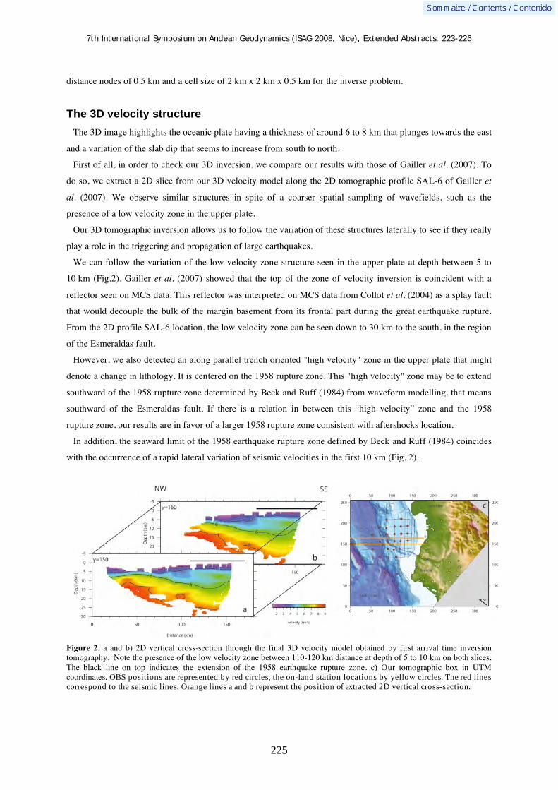
7th International Symposium on Andean Geodynamics (ISAG 2008, Nice), Extended Abstracts: 223-226
225
distance nodes of 0.5 km and a cell size of 2 km x 2 km x 0.5 km for the inverse problem.
The 3D velocity structure
The 3D image highlights the oceanic plate having a thickness of around 6 to 8 km that plunges towards the east
and a variation of the slab dip that seems to increase from south to north.
First of all, in order to check our 3D inversion, we compare our results with those of Gailler et al. (2007). To
do so, we extract a 2D slice from our 3D velocity model along the 2D tomographic profile SAL-6 of Gailler et
al. (2007). We observe similar structures in spite of a coarser spatial sampling of wavefields, such as the
presence of a low velocity zone in the upper plate.
Our 3D tomographic inversion allows us to follow the variation of these structures laterally to see if they really
play a role in the triggering and propagation of large earthquakes.
We can follow the variation of the low velocity zone structure seen in the upper plate at depth between 5 to
10 km (Fig.2). Gailler et al. (2007) showed that the top of the zone of velocity inversion is coincident with a
reflector seen on MCS data. This reflector was interpreted on MCS data from Collot et al. (2004) as a splay fault
that would decouple the bulk of the margin basement from its frontal part during the great earthquake rupture.
From the 2D profile SAL-6 location, the low velocity zone can be seen down to 30 km to the south, in the region
of the Esmeraldas fault.
However, we also detected an along parallel trench oriented "high velocity" zone in the upper plate that might
denote a change in lithology. It is centered on the 1958 rupture zone. This "high velocity" zone may be to extend
southward of the 1958 rupture zone determined by Beck and Ruff (1984) from waveform modelling, that means
southward of the Esmeraldas fault. If there is a relation in between this “high velocity” zone and the 1958
rupture zone, our results are in favor of a larger 1958 rupture zone consistent with aftershocks location.
In addition, the seaward limit of the 1958 earthquake rupture zone defined by Beck and Ruff (1984) coincides
with the occurrence of a rapid lateral variation of seismic velocities in the first 10 km (Fig. 2).
Figure 2. a and b) 2D vertical cross-section through the final 3D velocity model obtained by first arrival time inversion tomography. Note the presence of the low velocity zone between 110-120 km distance at depth of 5 to 10 km on both slices. The black line on top indicates the extension of the 1958 earthquake rupture zone. c) Our tomographic box in UTM coordinates. OBS positions are represented by red circles, the on-land station locations by yellow circles. The red lines
correspond to the seismic lines. Orange lines a and b represent the position of extracted 2D vertical cross-section.

7th International Symposium on Andean Geodynamics (ISAG 2008, Nice), Extended Abstracts: 223-226
226
References Beck, S.L., Ruff, L.J., 1984 — The rupture process of the great 1979 Colombia earthquake: Evidence for the asperity
model. J. Geophys. Res., Vol. 89, B11: 9281-9291. Collot, J.-Y., Marcaillou, B., Sage, F., Michaud, F., Agudelo, W., Charvis, P., Graindorge, D., Gutscher, M.-A., Spence, G.,
2004 — Are rupture zone limits of great subduction earthquakes controlled by upper plate structures? Evidence from multichannel seismic reflection data acquired across the northern Ecuador–southwest Colombia margin, J. Geophys. Res., 109, B11103, doi:10.1029/2004JB003060.
Engdahl, E.R., Villaseñor, A., 2002 — “Global seismicity 1990-1999” . In Lee, W., Kanamori, H., Jennings, P., Kisslinger, C. (éd.): International handbook of earthquakes and engineering seismology (part A), Hardbound, Academic Press: 665-690.
Gailler, A., Charvis, P., Flueh, E.R., 2007 — Segmentation of the Nazca and South American plates along the Ecuador subduction zone from wide-angle seismic profiles, EPSL, 260, doi: 10.1016/j.epsl.2007.05.045.
Kelleher, J.A., 1972 — Rupture zone of large South American earthquakes and some predictions. J. Geophys. Res., 77: 2087-2103.
Mendoza, C., Dewey, J.W., 1984 — Seismicity associated with the great Colombia-Ecuador earthquakes of 1942, 1958, and 1979: Implications for barrier models of earthquake rupture. Bull. Seismol. Soc. Am., Vol.74, (2): 577-593.
Schimmel, M., Gallart, J., 2007 — Frenquency-dependent phase coherence for noise suppression in seismic array data. J. Geophys. Res., 112, B04303, doi: 10.1029/2006JB004680.
Trenkamp, R., Kellogg, J.N., Freymueller, J.T., Mora, H., 2002 — Wide plate margin deformation, southern Central America and northwestern South America, CASA GPS observations, Journal of South American Earth Sciences 15: 157-170.
Zelt, C.A., Smith, R.B., 1992 — Seismic traveltime inversion for 2-D crustal velocity structure. Geophys. J. Int., 108: 16-34.
Zelt, C.A., Barton, P.J., 1998 — Three-dimensional seismic refraction tomography: A comparison of two methods applied to data from the Faeroe Basin. J. Geophys. Res., 103, B4: 7187-7210.

7th International Symposium on Andean Geodynamics (ISAG 2008, Nice), Extended Abstracts: 227-230
227
Block uplift and intermontane basin development in the northern Patagonian Andes (38º-40ºS)
Ezequiel García-Morabito1,2
& Víctor A. Ramos1,2
1 Laboratorio de Tectónica Andina, Departamento de Cs. Geológicas, Facultad de Ciencias Exactas y Naturales,
Universidad de Buenos Aires, Argentina ([email protected]) 2 CONICET (Consejo Nacional de Investigaciones Científicas y Técnicas)
KEYWORDS : Northern Patagonian Andes, intermontane basins, block uplift, Miocene compression, syntectonic sequences
Introduction
The northern Patagonian Andes are a relatively low relief mountain chain with an attenuated crustal thickness
(~ 30 Km) (Yuan et al., 2006) as the result of crustal collapse related to the steepening of the subducted Nazca
Plate after a period of shallow subduction during the Late Miocene (Kay, 2002). Superimposed structural styles
associated with alternating tectonic regimes derived from this process can be recognized in a segment between
the 38ºS and 39º30’S (García Morabito & Folguera, 2005). Most of the compressive structures recognized in this
segment in the inner retro-arc area were active during Middle – Upper Miocene times. The Quechua orogeny
(Miocene to Recent) produced N and NW trending folds and thrusts, reactivation of Triassic and Cretaceous
structures and the conditions for the development of several Miocene depocenters related to basement block
uplift and west-verging thrusts. The recognition and interpretation of the main structures and spatial and
temporal distribution of Tertiary sequences allowed us to establish a tectonic model in which the uplift of a N-
NW-trending block during Miocene times, originated a series of small intermontane depocenters in the inner
retro-arc area of the Northern Patagonian Andes. As a result of that syntectonic and synorogenic deposits in
some cases represented by 500 meters of volcaniclastic and clastic sequences (Mitrauquen, Chimehuin, Collon
Cura Formations) accumulated in a compressive regime. These depocenters can be integrated in a narrow basin
developed in association with the western margin of a structural high called Copahue - Catan Lil High. This
block has a good expression between the 38º and 39º30’S. It extends for over 180 km from North to South and
constitutes the drainage divide at these latitudes. It also presents along-strike differences in style, magnitude and
distribution of the deformation, controlled by pre-existing variations in the rift geometry, in the basement
structures, as well as in the position of the depocenters of a Oligocene – Lower Miocene extensional basin (Cura
Mallín Basin). We differentiate three domains in the base of these differences, separated by transverse features;
each domain is associated with an intermontane depocenter (Lonquimay, Kilca and Catan Lil (Rossello et. al,
2007) Depocenters).
Segmentation of the Copahue – Catan Lil block
Northern Segment (Lonquimay depocenter)
The western margin of this block is controlled here by the N-S-trending Pino Seco thrust (Suárez & Emparán
1997) which overlaps the Late Miocene Mitrauquén Formation with Jurassic turbidites that can be assigned to
the Cuyo Group. The Mitrauquén Formation is formed by ignimbrites, andesitic and basaltic lavas and
conglomeradic sequences interpreted as deposited in a braided river system (Suárez & Emparán, 1997). This
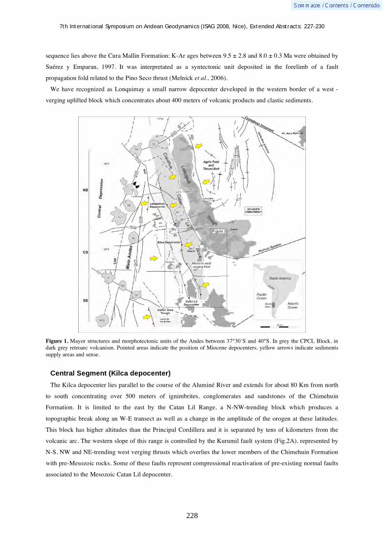
7th International Symposium on Andean Geodynamics (ISAG 2008, Nice), Extended Abstracts: 227-230
228
sequence lies above the Cura Mallin Formation; K-Ar ages between 9.5 ± 2.8 and 8.0 ± 0.3 Ma were obtained by
Suérez y Emparan, 1997. It was interpretated as a syntectonic unit deposited in the forelimb of a fault
propagation fold related to the Pino Seco thrust (Melnick et al., 2006).
We have recognized as Lonquimay a small narrow depocenter developed in the western border of a west -
verging uplifted block which concentrates about 400 meters of volcanic products and clastic sediments.
Figure 1. Mayor structures and morphotectonic units of the Andes between 37°30’S and 40°S. In grey the CPCL Block, in dark grey retroarc volcanism. Pointed areas indicate the position of Miocene depocenters, yellow arrows indicate sediments supply areas and sense.
Central Segment (Kilca depocenter)
The Kilca depocenter lies parallel to the course of the Aluminé River and extends for about 80 Km from north
to south concentrating over 500 meters of ignimbrites, conglomerates and sandstones of the Chimehuin
Formation. It is limited to the east by the Catan Lil Range, a N-NW-trending block which produces a
topographic break along an W-E transect as well as a change in the amplitude of the orogen at these latitudes.
This block has higher altitudes than the Principal Cordillera and it is separated by tens of kilometers from the
volcanic arc. The western slope of this range is controlled by the Kurumil fault system (Fig.2A), represented by
N-S, NW and NE-trending west verging thrusts which overlies the lower members of the Chimehuin Formation
with pre-Mesozoic rocks. Some of these faults represent compressional reactivation of pre-existing normal faults
associated to the Mesozoic Catan Lil depocenter.

7th International Symposium on Andean Geodynamics (ISAG 2008, Nice), Extended Abstracts: 227-230
229
Figure 2. A : Simplified geological map of the inner retro-arc area between 38°45’-40°S showing the principal structures and the position of the Kilca and Catan Lil depocenters. B : Interpretation of a seismic line (lbv 94-152) located north of Las Coloradas town showing the deep strutures at the eastern margin of the Catan lil depocenter.
We can correlate this unit with the Mitrauquen Formation based on similar lithological characteristics and
times of deposition. Ages between 13.8 ± 0.9 and 6.2 ± 0.3 Ma were obtained from volcanic rocks intercalated in
the sequence by Vattuone y Latorre (1998) and Re et al., 2000. Progressive intraformational unconformities and
internal unconformities were also observed along the eastern margin of the basin, suggesting a syntectonic
sedimentation, with the coarse grained conglomerates of this unit representing the synorogenic deposits related
to the uplift of the Catan Lil Range during middle?-upper Miocene times.

7th International Symposium on Andean Geodynamics (ISAG 2008, Nice), Extended Abstracts: 227-230
230
Southern Segment – Catan Lil Depocenter
The genesis of this narrow basin is related to the inversion of a Triassic N-NW trending half graben system. An
asymmetric fault propagation fold was formed as the result of a west verging thrust developed by compressional
reactivation of a preexisting normal fault of the Mesozoic rift phase (Fig. 2B). The basement was involved in
the deformation as well as the Mesozoic strata which were strongly folded to the west as we can observe in a
seismic line located north of Las Coloradas town, generating the conditions for the deposition of volcanic and
sedimentary strata of the Chimehuin Formation in onlap relation with the frontal limb of the anticline. Next to
the contact, at the eastern margin of the Tertiary depocenter, this unit contents growth strata (Leanza et al.,
2003), which indicates that the deposition of the lower member of the Chimehuin Formation was simultaneous
with the last inversion phase. Farther to the west of this contact, the dip of the Chimehuin Formation increases
from sub horizontal up to 30°E, conforming a wide syncline associated to a westward propagation of the
deformation. This depocenter was passively carried by the fold belt after the deposition of the lower members of
the Chimehuin Formation when the fault system propagated to the west.
Concluding remarks
Thrust and belt loading produced several internal depocenters by fault reactivation and flexural subsidence.
The volcanic, volcaniclastic and fluvial sequences that constitutes the infill of this depocenters represents
syntectonic and synorogenic deposits associated to the uplift of the Copahue – Catan Lil Block during middle? -
upper Miocene times, and can be integrated in a NW-trending basin associated with its western margin.
References Garcia Morabito, E., Folguera, A., 2005. El alto de Copahue – Pino Hachado y la fosa de Loncopue: un comportamiento
tectónico episódico, Andes Neuquinos (37°-39°S). Revista de la Asociación Geológica Argentina, 60 (4): 742-761. Kay, S.M., 2002. Tertiary to Recent transient shaloww subduction zones in the Central and Southern Andes. XV Congreso
Geologico Argentino (El Calafate). 3: 282-283. Leanza, H.A., Repol, D., Escosteguy, L., Salvarredy Aranguren, M., 2003. Estratigrafia del Mesozoico en la comarca de
Fortin 1 de Mayo, cuenca Neuquina sudoccidental, Argentina. – Geologia, 1: 1-22. SEGEMAR (Servicio Geológico Minero Argentino), Serie de Contribuciones Técnicas.
Melnick, D., Rosenau, M., Folguera, A., Echtler, H. 2006. Late Cenozoic tectonic evolution, western flank of the Neuquén Andes between 37º and 39º south latitude: in S.M. Kay and V.A. Ramos (eds.), Late Cretaceous to Recent Magmatism and Tectonism of the Southern Andean Margin at the Latitude of the Neuquen Basin (36°-39°S). Geological Society of America, Special Paper, 407: 73-95.
Rossello, E.A., Cobbold, P.R., Marques, F.O., 2007. Late Oligocene to Miocene growth strata in two Andean intermontane basins of Neuquen province, Argentina (37º-40ºS). 20th Colloquium on Latin American Earth Sciences, Kiel. Actas: 55.
Suárez, M. y Emparán, C., 1997. Hoja Curacautín. Regiones de la Araucanía y del Bio-Bio. Carta Geológica de Chile, 1:250.000, Servicio Nacional de Geología y Minería de Chile. 71: 1-105.
Yuan, X., Asch, G., Bataile, K., Bohm, M., Echtler, H., Kind, R., Oncken, O., Wölnbern, I., 2006. Deep seismic image of the Southern Andes: in S.M Kay and V.A Ramos (eds.), Late Cretaceous to Recent Magmatism and Tectonism of the Southern Andean Margin at the Latitude of the Neuquen Basin (36°-39°S). Geological Society of America, Special Paper, 407: 61-72.
Vattuone, M.E., Latorre, C.E., 1998. Caracterización geoquímica y edad K/Ar de basaltos del Terciario superior de Aluminé. Neuquén. 10° Congreso Latinoamericano de Geologia y 6° Congreso Nacional de Geología Económica, Buenos Aires. 2: 184-190.
Re, G.H., Geuna, S.E., Lopez Martinez, M., 2000. Geoquímica y geocronología de los basaltos neógenos de la región de Aluminé (Neuquén – Argentina). 9° Congreso Geológico Chileno, Puerto Varas. 2: 62-66.
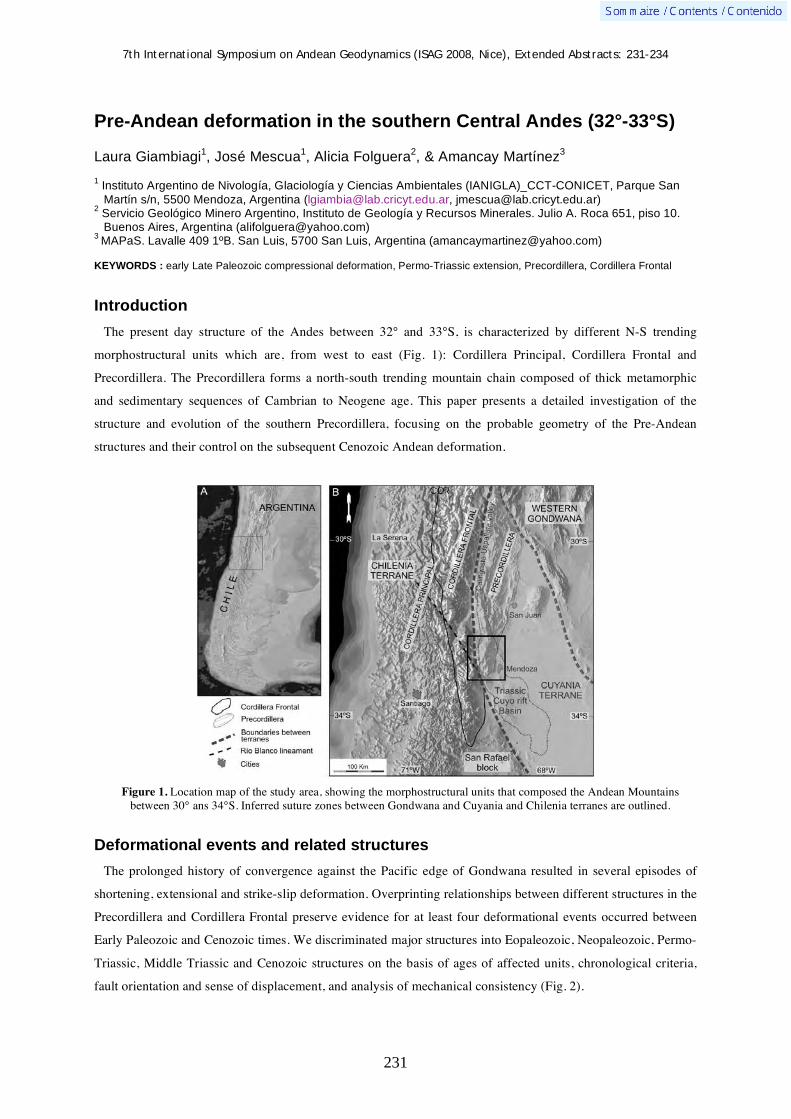
7th International Symposium on Andean Geodynamics (ISAG 2008, Nice), Extended Abstracts: 231-234
231
Pre-Andean deformation in the southern Central Andes (32°-33°S)
Laura Giambiagi1, José Mescua
1, Alicia Folguera
2, & Amancay Martínez
3
1 Instituto Argentino de Nivología, Glaciología y Ciencias Ambientales (IANIGLA)_CCT-CONICET, Parque San
Martín s/n, 5500 Mendoza, Argentina ([email protected], [email protected]) 2 Servicio Geológico Minero Argentino, Instituto de Geología y Recursos Minerales. Julio A. Roca 651, piso 10.
Buenos Aires, Argentina ([email protected]) 3
MAPaS. Lavalle 409 1ºB. San Luis, 5700 San Luis, Argentina ([email protected])
KEYWORDS : early Late Paleozoic compressional deformation, Permo-Triassic extension, Precordillera, Cordillera Frontal
Introduction
The present day structure of the Andes between 32° and 33°S, is characterized by different N-S trending
morphostructural units which are, from west to east (Fig. 1): Cordillera Principal, Cordillera Frontal and
Precordillera. The Precordillera forms a north-south trending mountain chain composed of thick metamorphic
and sedimentary sequences of Cambrian to Neogene age. This paper presents a detailed investigation of the
structure and evolution of the southern Precordillera, focusing on the probable geometry of the Pre-Andean
structures and their control on the subsequent Cenozoic Andean deformation.
Figure 1. Location map of the study area, showing the morphostructural units that composed the Andean Mountains between 30° ans 34°S. Inferred suture zones between Gondwana and Cuyania and Chilenia terranes are outlined.
Deformational events and related structures
The prolonged history of convergence against the Pacific edge of Gondwana resulted in several episodes of
shortening, extensional and strike-slip deformation. Overprinting relationships between different structures in the
Precordillera and Cordillera Frontal preserve evidence for at least four deformational events occurred between
Early Paleozoic and Cenozoic times. We discriminated major structures into Eopaleozoic, Neopaleozoic, Permo-
Triassic, Middle Triassic and Cenozoic structures on the basis of ages of affected units, chronological criteria,
fault orientation and sense of displacement, and analysis of mechanical consistency (Fig. 2).

7th International Symposium on Andean Geodynamics (ISAG 2008, Nice), Extended Abstracts: 231-234
232
The Early Paleozoic tectonic history was mainly controlled by a subduction process below the western margin
of Gondwana. During this time, the western Gondwana continental edge was located east of the Andes at the
western border of the Precordillera. Folding, faulting and accompanying metamorphism, are the result of a W-E
to NW-SE crustal compressional process in Silurian to Devonian times, known as Precordilleran and Chanic
tectonic phases. These tectonic phases are thought to be related to the collision between Cuyania and Chilenia
terranes (Ramos et al., 1984; Astini, 1996). Faults identified as Early Paleozoic, affecting the Cambro-
Ordovician rocks, present N-S to NNE trends and westward vergence (von Gosen, 1995; Cortés et al., 1997;
Folguera et al., 2001). The Neopaleozoic deformation generated a broad NNE-trending belt which structures
consist of concentric folds and low- and high-angle reverse faults with NNE to N-S trends and double vergence.
In the eastern part of the Precordillera a foreland thin-skinned thrust belt developed, where sheets composed of
Silurian to Carboniferous strata were thrust eastward by low-angle NE- to NNE-trending faults. In the western
part of the belt, thick-skinned faults with westward vergence affected the Cambro-Ordovician to Carboniferous
rocks. The inconsistency between regional NNW-trending and local NNE- to NE-trending Late Paleozoic
structures can be explained by clockwise block rotations inferred to have taken place between 280 and 265 Ma,
before the extrusion of Late Permian volcanics (Rapalini and Vilas, 1991). These crustal block rotations have
been attributed by Rapalini and Vilas (1991) to dextral strike slip movement parallel or subparallel to the
continental margin.
Figure 2. Geological map of the southern Precordillera and eastern sector of the Cordillera Frontal.
7th International Symposium on Andean Geodynamics (ISAG 2008, Nice), Extended Abstracts: 231-234
233
The Permo-Triassic evolution of southwestern South America was characterized by the development of a great
amount of volcanism under extensional conditions. This extensional regime continued during Triassic times and
led to the formation of a series of rift depocentres, with an overall NNW trend. Permo-triassic volcanic rocks are
affected by normal and oblique-slip normal faults with WNW to NW trends (Fig. 2). Middle Triassic
sedimentary rocks were deposited during the formation of NW to NNW normal faults which controlled the
formation of several hemigrabens. The Cenozoic Andean chain was formed through interaction of the Nazca and
South American plates. The pre-existing structures were oriented oblique to the direction of plate convergence
during the Neogene, and some of them were reactivated and subjected to oblique compression.
Kinematic analysis of the deformational events
Detailed outcrop-scale field analysis was conducted at 56 sites throughout the Southern Precordillera and
eastern sector of the Cordillera Frontal. At each outcrop, we measured fault orientation, slip direction, average
displacement or fault width and sense of displacement of the structures. We also measured and studied fold
attitudes, the angular relationship between bedding and tectonic foliations and asymmetric folds in shear zones
to obtain the vergence of Paleozoic structures. Fault-slip data were acquired by measurements on minor faults
and were considered in terms of incremental strain (Cladouhos and Allmendinger, 1993). We used the kinematic
hypothesis proposed by Marrett and Allmendinger (1990) and Twiss and Unruh (1998) to determine constraints
on the orientation and magnitudes of the principal strain rates from a large set of fault-slip data. Principal strain
axes have been computed using the moment tensor summation method (both unweighted and weighted by
measured displacement) as implemented in FaultKin 2.1.1 stereonet program of Almendinger et al. (2001).
Early Paleozoic rocks are affected by folds and faults which kinematic analysis indicates an E-W
compressional direction and vergence toward the west. Late Paleozoic faults indicate a NW-SE to NNW-SSE
compressional direction. We rotated both Early and Late Paleozoic structures 80° counterclockwise in order to
reconstruct their orientation previous to Late Permian vertical rotation, and obtained a N-S compressional
direction with southward vergence during the Early Paleozoic and a SW-NE compressional direction with
double vergence for the Late Paleozoic. The kinematic axes of the Permo-Triassic faults indicate that this
deformational phase was characterized by NNE-SSW oriented extension (N23ºE stretching direction).
Cenozoic structures appear to be due to two interfering processes: a regional E-W shortening direction and
sinistral strike-slip movements along preexisting NW trending crustal weakness zones. These Cenozoic strike-
slip faults are affecting only the western sector of the Precordillera and the eastern sector of the Cordillera
Frontal. Crosscutting relationships of Cenozoic structures in the western part of the Precordillera indicate that
the E-W shortening event occurred first and thrusts and reverse faults were afterward cut by strike-slip faults.
The shortening event is interpreted to be related to a compressional tectonic regime which evolved into a strike-
slip regime at the time the compressional process migrated progressively further to the east, towards eastern
Precordillera. This change from a compressional stress regime to a strike slip one in western Precordillera could
have been due to a change in the vertical stress axes from 3 to 2.
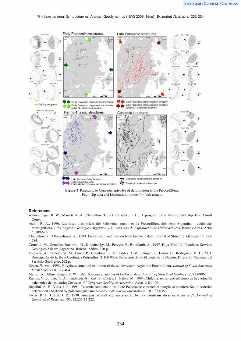
7th International Symposium on Andean Geodynamics (ISAG 2008, Nice), Extended Abstracts: 231-234
234
Figure 3. Paleozoic to Cenozoic episodes of deformation in the Precordillera. Fault-slip data and kinematic solutions for fault arrays.
References Allmendinger, R. W., Marrett, R. A., Cladouhos, T., 2001. Faultkin 2.1.1. A program for analyzing fault slip data. Absoft
Corp-. Astini, R. A., 1996. Las fases diastróficas del Paleozoico medio en la Precordillera del oeste Argentina – evidencias
estratigráficas. 13° Congreso Geológico Argentino y 3° Congreso de Exploración de Hidrocarburos, Buenos Aires, Actas 5: 509-526.
Cladouhos, T., Allmendinger, R., 1993. Finite strain and rotation from fault-slip data. Journal of Structural Geology 15: 771-784.
Cortés, J. M., González Bonorino, G., Koukharsky, M., Pereyra, F., Brodtkorb, A., 1997. Hoja 3369-09, Uspallata. Servicio Geológico Minero Argentino. Boletín inédito, 210 p.
Folguera, A., Etcheverria, M., Pazos, P., Giambiagi, L. B., Cortés, J. M., Fauqué, L., Fusari, C., Rodríguez, M. F., 2001. Descripción de la Hoja Geológica Potrerillos (1:100.000). Subsecretaría de Minería de la Nación, Dirección Nacional del Servicio Geológico, 262 p.
Gosen, W. von, 1995. Polyphase structural evolution of the southwestern Argentine Precordillera. Journal of South American Earth Sciences 8, 377-404.
Marrett, R., Allmendinger, R. W., 1990. Kinematic análisis of fault-slip data. Journal of Structural Geology 12, 973-986. Ramos, V., Jordan, T., Allmendinger, R., Kay, S., Cortés, J., Palma, M., 1984. Chilenia: un terreno alóctono en la evolución
paleozoica de los Andes Centrales. 9° Congreso Geológico Argentino. Actas 1: 84-106. Rapalini, A. E., Vilas, J. F., 1991. Tectonic rotations in the Late Palaeozoic continental margin of southern South America
determined and dated by palaeomegnetism. Geophysical Journal International 107, 333-351. Twiss, R. J., Unruh, J. R., 1998. Analysis of fault slip inversions: Do they constrain stress or strain rate?. Journal of
Geophysical Research 103, 12,205-12,222.

7th International Symposium on Andean Geodynamics (ISAG 2008, Nice), Extended Abstracts : 235-237
235
Origin of flat subduction zones: Numerical application to central Chile – western Argentina between 29°S and 34°S
Gaelle Gibert1, Riad Hassani
2, Emmanuel Tric
1, & Tony Monfret
1
1 Laboratoire Géosciences Azur, 250 rue A. Einstein, 06560 Valbonne, France ([email protected],
[email protected], [email protected]) 2 Laboratoire de Géophysique Interne et de Tectonophysique, Campus scientifique Université de Savoie, 73376
Le Bourget-du-Lac, France ([email protected])
KEYWORDS : subduction, thermomechanical 3D numerical modelisation, Nazca and South American plates, Juan Fernandez
Ridge, equivalent elastic thickness, finite element
Adeli is a 2 or 3-dimentional finite element mechanical software (Hassani, 1994). We added a thermal module
to the initial mechanical 3-dimensioned approach. Temperature of the mantle is applied to the envelope of the
slab which heat up by thermal transfer. Thermal contact between two bodies is resolved by a double
interpolation point by point. Possibilities of adding thermal (initial or imposed along the simulation) flux,
internal heating or initial or imposed temperature are now provided in Adeli. Several tests have been performed
to valid this new thermal module. Using this new tool, an application to South America have been attempted, as
thermal conditions might be very important in the special context of central Andes (Gutscher, 2002).
Central Chile and Argentina Andes are an almost linear orogenic belt formed at the convergent plate margin
where Nazca plate plunge under South America. Between 29°S and 34°S, a flat subduction is underplating the
continental plate of South America (figure 1). Previous studies aiming to understand this phenomenon are
numerous. Literature in this domain is various, and lecturer can find paper about seismicity in the crust
(Barrientos et al, 2004) and in the slab (Cahill and Isacks, 1992), tectonism in the orogen (Smalley et al, 1993;
Ramos, 1999), geometry of the slab (Araujo and Suarez, 1993) and so on.
Figure 1: Synthetic map of South America and eastern part of Nazca plate between 26°S and 37°S. Solid lines on the map represent isodepth contours of the slab, depth in km. Dotted line symbolized south separation between north flat slab and south 30° dipping slab. Profile on the left show general trend of the slab north and south (ie. flat and not flat slab) of the dotted line. After Cahill and Isacks (1992).
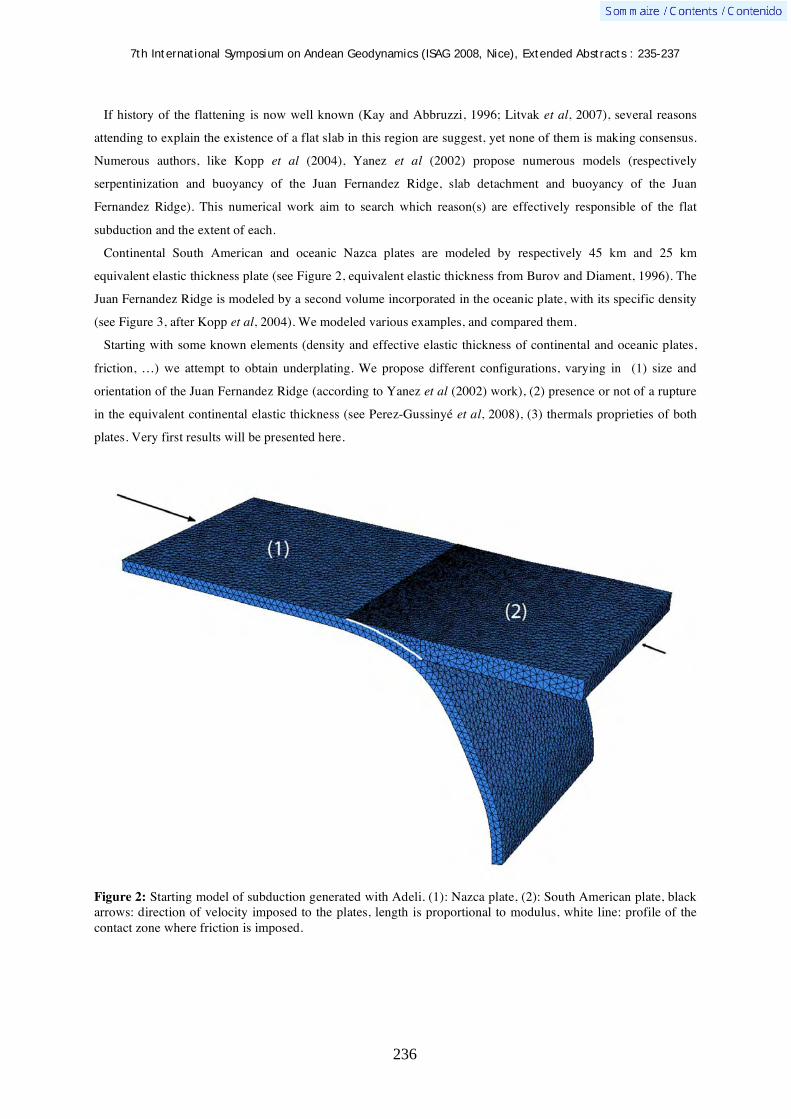
7th International Symposium on Andean Geodynamics (ISAG 2008, Nice), Extended Abstracts : 235-237
236
If history of the flattening is now well known (Kay and Abbruzzi, 1996; Litvak et al, 2007), several reasons
attending to explain the existence of a flat slab in this region are suggest, yet none of them is making consensus.
Numerous authors, like Kopp et al (2004), Yanez et al (2002) propose numerous models (respectively
serpentinization and buoyancy of the Juan Fernandez Ridge, slab detachment and buoyancy of the Juan
Fernandez Ridge). This numerical work aim to search which reason(s) are effectively responsible of the flat
subduction and the extent of each.
Continental South American and oceanic Nazca plates are modeled by respectively 45 km and 25 km
equivalent elastic thickness plate (see Figure 2, equivalent elastic thickness from Burov and Diament, 1996). The
Juan Fernandez Ridge is modeled by a second volume incorporated in the oceanic plate, with its specific density
(see Figure 3, after Kopp et al, 2004). We modeled various examples, and compared them.
Starting with some known elements (density and effective elastic thickness of continental and oceanic plates,
friction, …) we attempt to obtain underplating. We propose different configurations, varying in (1) size and
orientation of the Juan Fernandez Ridge (according to Yanez et al (2002) work), (2) presence or not of a rupture
in the equivalent continental elastic thickness (see Perez-Gussinyé et al, 2008), (3) thermals proprieties of both
plates. Very first results will be presented here.
Figure 2: Starting model of subduction generated with Adeli. (1): Nazca plate, (2): South American plate, black arrows: direction of velocity imposed to the plates, length is proportional to modulus, white line: profile of the contact zone where friction is imposed.

7th International Symposium on Andean Geodynamics (ISAG 2008, Nice), Extended Abstracts : 235-237
237
Figure 3: (a): starting model, (b): model with a perpendicular volcanic chain.
References Araujo, M., & Suarez, G. 1993. Geometry and state of stress of the subducted Nazca plate beneathh central Chile
and Argenitna: evidence from teleseismic data. Geophysical Journal International. 116: 283-303. Barriento, S., Vera, E., Avarado, P., & Monfret, T. 2004. Crustal seismicity in central Chile. South America
Earth Sciences. 16: 759-768. Burov, E. 1996, Isostasy, equivalent elastic thickness, and inelastic rheology of continents and oceans. Geology.
24: 419-422. Cahill, T., & Isacks, B. 1992. Seismicity and shape of the subducted Nazca plate. Journal of Geophysical
Research. 97: 17,503-17,529. Gutscher, M. 2002. Andean subduction styles and their effect on thermal structure and interplate coupling. South
American Earth Sciences. 15: 3-10. Hassani, R. 1994. Modélisation numérique de déformation des systèmes géologiques. PhD Thesis document. 139
pages Kay, S., & Abbruzzi, J. 1994. Magmatic evidence for Neogene lithospheric evolution of the centreal Andean
« flat-slab » between 30°S and 32°S. Tectonophysics. 259: 15-28. Kopp, H., Flueh, E., Papenberg, C., & Klaeschen, D. 2004. Seismic investigations of the O’Higgins Seamount
Group and Juan Fernandez Ridge : aseismic rige emplacement and lithosphere hydration. Tectonics. 23. Litvak, V., Poma, S., & Kay, S. 2007. Paleogene and Neogene magmatism in the Valle del Cura region : new
perspectives on the evolution of the Pampean flat slab, San Juan province, Argentina. South American Earth Sciences. 24: 117-137.
Perez-Gussinyé, M., Lowry, A., Phipps Morgan, J., & Tassara, A. 2008. Effective elastic thickness variations along the Andean margin and their relationship to subduction geometry. Geochemistry Geophysics Geosystems. 9: 2.
Ramos, V. 1999. Plate tectonic setting of the Andean cordillera. Episodes. 22: 3. Smalley, R., Pujol, J., Regnier, M., Chiu, JM., Chatelain J.-L., Isacks, B., Araujo, M., & Puebla, N. 1993.
Basement seismicity beneath the Andean precordillera thin-skinned thrust belt and implications for crustal and lithospheric behavior. Tectonics. 12: 63-76.

7th International Symposium on Andean Geodynamics (ISAG 2008, Nice), Extended Abstracts: 238-241
238
The active upper plate deformation of the Central Andes forearc, northern Chile
G. González1, R. Allmendinger
2, T. Dunai
3, J. Cembrano
1, J. Martinod
4, D. Rémy
4,
D. Carrizo5, J. Loveless
6, E. Veloso
1, F. Aron
1, & J. Cortés
1
1 Departamento de Ciencias Geológicas, Universidad Católica del Norte, Chile ([email protected])
2 Department of Earth and Atmospheric Sciences, Cornell University, USA ([email protected])
3 School of Geosciences, University of Edinburgh, United Kingdom ([email protected])
4 Laboratoire des Mécanismes de Transfert en Géologie (LMTG), Université de Toulouse, France
([email protected]). 5
Geodesy Laboratory, Institut de Physique du Globe de Paris, Paris, France ([email protected]) 6 Department of Earth and Planetary Sciences, Harvard University, USA ([email protected])
KEYWORDS : active deformation, Central Andes, forearc, northern Chile
Introduction
Along the Central Andes, subduction of oceanic crust beneath the South American Plate corresponds to a first
order process that controls the accumulation of bulk strain in the overriding plate. Despite this general statement,
the precise understanding of the present day strain accumulation in the forearc is still matter of debate. Several
questions related to this topic – such as strain distribution, compatibility between long- (5 Ma to Present) and
short-term deformation (decennial scale), and fraction of convergence velocity accumulated as permanent
deformation in the overriding plate – are still not solved issues. During the last years, we have performed
detailed field studies aimed to unravel these main issues. Main goals were determination of the kinematics, the
age and the slip rate of upper-plate faults at four key localities: 1) the Peninsula de Mejillones, 2) Coastal
Cordillera near Antofagasta (23°30’S), 3) Coastal Cordillera close to the Salar Grande area (21°30’S), and 4) the
south-eastern part of the Salar the Atacama Basin (21°30’S-68°20’W). Methodology considered fault
characterization (Allmendinger et al., 2005), Ar40-Ar39 age determinations and exposures ages based on
cosmogenic nuclide dating (González et al., 2005; Carrizo et al., 2008). Also, we performed numerical
modelling to understand the deformation processes that operate at the scale of a single structure (Loveless 2007;
González et al., 2008) and at the scale of the convergent margin (Loveless, 2007; Cortés et al., this issue).
In this contribution we would like to present a large-scale overview of the superficial distribution of the strain
field in the Central Andes forearc of Northern Chile, particularly focusing on the main factors that control this
distribution. By using the slip rate of the faults we estimate the velocity of deformation of the whole forearc
system.
The long-term strain accumulation in the Central Andes Forearc
The entire portion of the Coastal Cordillera close to Antofagasta, including the Mejillones Peninsula, is
characterized by NS-trending (parallel to the margin) normal faulting. The most conspicuous normal faults are
the Caleta Herradura, Mejillones and Salar del Carmen faults. The first two structures – exposed in the
Mejillones Peninsula – affect Mio-Pleistocene marine sediments, which represent an emerged portion of the
marine shelf (Niemeyer et al., 1996; Delouis et al., 1998). Radiometric data and micropaleontological dating of
the graben infill show that these faults are active, at least, since 24 Ma to Present. Recent normal faulting is

7th International Symposium on Andean Geodynamics (ISAG 2008, Nice), Extended Abstracts: 238-241
239
expressed by deformation of Late Pleistocene-Holocene alluvial fan sediments as well as near-shore marine
sediments. By using the vertical offsets and the maximal age of the sedimentary infill of the graben structures it
is possible to estimate a long-term slip-rate of 0.03 mm/yr. On the contrary, a faster slip-rate of about 0.2 mm/yr
was determined by Marquardt (2005) by using the numerical age of Late Pleistocene alluvial fan sediments cut
by the Mejillones Fault. This discrepancy between long-term constrained slip-rate and short-term slip-rate can be
explained by the occurrence of quiescence periods of fault activity. These periods can be identified when
considering a time window of million years. In the Salar del Carmen area, the main branch of the Atacama Fault
System forms spectacularly well preserved fault scarps which deform several alluvial fans (Armijo and Thiele,
1990; González et al. 2003). At this locality 21Ne exposures ages – obtained from the surface of the alluvial fans
– indicate that fans became inactivate ca. 400 ka before Present. By using these exposure ages it is possible to
obtain a minimal slip-rate of 0.01 mm/yr (González et al., 2005). Fault-slip data show that the Mejillones
Peninsula and the Coastal Cordillera close to Antofagasta is affected by E-W extension.
At the Mejillones Peninsula the occurrence of Late Pleistocene marine terraces evidences a long-term uplift
that started, at least, 400 ka before Present. According to Marquardt (2005), marine terraces formed during
maximal interglacial stages. Uplift rates in the northern part of the Mejillones Peninsula are strongly controlled
by the activity of the normal faults (Marquardt, 2005); for example, marine terraces located in the footwall of the
Mejillones Fault show uplift rates of 0.5-0.7 mm/yr whereas those located in the hangingwall exhibit uplift rates
of 0.2-0.5 mm/yr.
Particulary, on November 14th, 2007, a strong earthquake occurred along the coupling zone between the Nazca
and the South American plates. The seismogenic fracture propagated nearly 200 km from north to the south
stopping at the Mejillones Peninsula. The southern ending of this rupture coincided with the northern terminus of
the Mw=8.1 June 1995 Antofagasta earthquake (Neic catalogue USGS). Coseismic deformation, registered by
InSar Data, shows that during the November earthquake the Mejillones Peninsula experienced an uplift of 25 cm
(see details in Cortes et al., this issue). In addition to the co-seismic uplift, interferograms show a small
subsidence of 1.5 cm at the eastern part of the Mejillones Fault. The coseismic displacement of the Mejillones
area is compatible with the long term uplift registered in the marine terraces whereas the small subsidence close
to the Mejillones Fault is compatible with reactivation of this structure.
The Coastal Cordillera near the Salar Grande shows several structures that have clear topographic expressions.
These structures are: 1) NW-SE trending dextral faults, 2) E-W reverse faults, and 3) N-S reverse faults
(Allmendinger et al., 2005; Carrizo et al., 2008). All of these structures deform Miocene alluvial surfaces and
several younger drainages incised within the alluvial surfaces. Ar40-Ar39 dating of tuff layers deformed by the E-
W trending reverse faults indicates that fault activity is younger than 300 ka; which implies that slip-rate for
these faults is close to 0.01 mm/yr. Because the other sets of structures (NW-SE and N-S trending faults)
displaced very old alluvial surfaces we cannot calculate an accurate slip rate for them. Exposures ages for these
old surfaces (determined by 21Ne) indicate that these latest faults have minimal slip-rates of ca. 1x10⁻³ mm/yr
(Carrizo, 2007). Kinematic analyses based on fault-slip data indicate that this part of the Coastal Cordillera is
affected by subhorizontal constriction, in where N-S shortening is dominant. During the last years, three crustal
earthquakes, with P axes oriented N-S (Neic catalogue of USGS), affected the coast of southern Peru and
northern Chile, indicating that N-S contraction in the forearc is an active process.
7th International Symposium on Andean Geodynamics (ISAG 2008, Nice), Extended Abstracts: 238-241
240
On the contrary, the inner part of the forearc – the Salar the Atacama Basin – shows a more regular strain
pattern characterized by E-W shortening affecting several Pliocene ignimbrites and the sedimentary infill of the
Salar de Atacama Basin. Deformation here is represented by several subparallel N-S trending anticlinal ridges
which are the superficial expressions of blind reverse faults. We have calculated that the long-term slip-rates in
this area vary between 1 x10⁻³ to 1 x 10⁻⁴ mm/yr. Faster slip rate of 1.7 mm/yr was obtained for the Holocene
activity of reverse fault beneath the Salar de Atacama Basin (Jordan et al. 2002). Henceforth, we suggest that
folding mechanism of the ignimbrite layers should be a slow process mainly controlled by creeping of the layers
above the underlying reverse fault. Kinematic data show pure E-W contraction. We did not find evidences of
trench parallel strike-slip deformation in this part of the forearc. This contrasts with reports of dextral faults in
the magmatic arc close to the Salar de Atacama Basin affecting several valleys incised in Mio-Pliocene
ignimbrites.
Discussion
The above described structures show that the present day active strain in the forearc of Northern Chile has been
and it is heterogeneously accumulated. Upper plate extension is restricted to the western border of the forearc
whereas shortening is concentrated in the internal eastern portion of the forearc. Both types of strain regimes
started during the Miocene and have remained active until Present. Constrictional deformation is a local process
restricted to the inner part of the curved portion of the Central Andes forearc. Upper plate extension is related to
the coseismic phase of the subduction earthquake cycle whereas shortening is related to the interseismic phase.
Slip rates documented in the forearc range between 2x10⁻¹ mm/yr and 1x10⁻⁴ mm/yr. When using younger
stratigraphic markers faster-slip rates are obtained. This indicates that at the long-term scale (millions of years)
upper plate faults experience quiescence periods which reduce the calculated slip-rates, in contrast to those based
on a short-term scale. The presently available slip-rates show that a minor fraction (<< 10%) of the present day
convergence is absorbed by distributed faulting on the upper plate. In contrast, a larger portion of the
convergence velocity (>40%) is taken by the seismic coupling zone during large subduction earthquakes.
The absence of active trench-parallel strike-slip faults in the forearc indicates that this part of the Central
Andes is rheologically homogeneous at the million and millennium time scales. Interseismic GPS velocities
measured in the forearc are lightly oblique to the N-S trending margin and subparallel to the convergence
velocity (Bevis et al., 1999). The decrease in the interseismic velocity field from the Coastal Cordillera to the
magmatic arc suggests that a fraction of this velocity is accumulated in the forearc, which is consistent with our
observation. In order to produce the observed local N-S contraction, the forearc needs to move northward. GPS
velocities show that the forearc -during interseismic periods of the subduction earthquake cycle – tries to move
obliquely with respect to the margin. However, the curved geometry of this margin does not allow it. In
consequence the curved portion of the forearc acts as a buttress structure, allowing that the stress-loading on
trench orthogonal reverse faults to be effective. Similarly, the slightly oblique movement of the forearc should
result in minor strike-slip displacements in the magmatic arc.
References Allmendinger, R., Gonzalez, G., Yu, J., Hoke, G., Isacks, B., 2005. Trench-parallel shortening in the northern Chilean
forearc: Tectonic and climatic implications: Geological Society of America Bulletin 117, 89–104.

7th International Symposium on Andean Geodynamics (ISAG 2008, Nice), Extended Abstracts: 238-241
241
Armijo, R., Thiele, R. 1990. Active faulting in northern Chile: ramp stacking and lateral decoupling along a subduction plate boundary? Earth Planet Sci Lett, 98: 40-61.
Bevis, M., Kendrick, E., Jr., Smalley, R., Brooks, B.A.,Allmendinger, R.W., and Isacks, B.L., 2001, On the strength of interplate coupling and the rate of back arc convergence in the Central Andes; An analysis of the interseismic velocity field: Geochemistry, Geophysics,Geosystems, G3, v. 2, doi:10.129/2001GC000198.
Carrizo, D. 2007. Procesos de deformación neogena en el antearco externo del norte de Chile (20,5-21°S): La subducción oblicua en un margen curvo. Tesis de doctorado, Universidad Católica del Norte, 261 p.
Carrizo, D., González, G, Dunai, T. 2008, Constricción neógena en la Cordillera de la Costa, norte de Chile: neotectónica y datación de superficies con 21Ne cosmogénico Revista Geológica de Chile 35 (1): 1-38.
Delouis, B., H. Philip, L. Dorbath & Cisternas, A. 1998. Recent crustal deformation in the Antofagasta region (northern Chile) and the subduction process. Geophys. J. Int., 132: 302 – 338.
González, G. Dunai, T, Carrizo, D. and Allmendinger, R. 2006. Young displacements on the Atacama Fault System, northern Chile from field observations and cosmogenic 21Ne concentrations. Tectonics. Vol.25,No.3,TC3006.
González, G., Cembrano, J., Carrizo, D., Macci, A. & Schneider, H. 2003. The link between forearc tectonics and Pliocene-Quaternary deformation of the Coastal Cordillera, northern Chile. Journal of South American Earth Sciences, 16: 321-342.
González, G., Gerbault, M., Martinod, J., Cembrano, J., Carrizo, D., Allmendinger, R., Espina, J. 2008. Crack formation on top of propagating reverse faults of the Chuculay Fault System northern Chile: Insights from field data and numerical modelling. Journal of Structural Geology.
Jordan, T. N. Muñoz, N., Hein, M., Lowenstein, T., Godfrey, L., Yu J. 2002. Active faulting and folding without topographic expression in an evaporite basin, Chile GSA Bulletin; November 2002; v. 114; no. 11; p. 1406–1421;
Loveless, J. 2008. Extensional tectonics in a convergent margin setting: Deformation of the northern Chilean forearc. Ph.D Thesis, Cornell University, 311 p.
Loveless, J., Hoke, G., Allmendinger, R., González, G., Isacks, B., Carrizo, D. 2005. Pervasive cracking of the northern Chilean Coastal Cordillera: New evidence for forearc extension. Geology, 33: 973-976.
MARQUARDT, C. 2005. Déformations Néogènes le long de la cotê nord du Chili (23°-27°S), avant-arc des Andes Centrales. Thèse doct., univ. Toulouse-III, 212 p.
Niemeyer, H., González, G., Martinez-de Los Rios E. 1996. Evolución tectónica cenozoica del margen continental activo de Antofagasta, norte de Chile. Revista Geológica de Chile, 23 (2): 165–186.
7th International Symposium on Andean Geodynamics (ISAG 2008, Nice), Extended Abstracts: 242-244
242
Modern geodata management — A tool for interdisciplinary interpretation and visualization
H.-J. Götze, T. Damm, & S. Schmidt
Institut für Geowissenschaften, Abtl. Geophysik, Otto-Hahn-Platz 1, 24118 Kiel, Germany
KEYWORDS : geophysics, geoinformatics, 3D visualization, Central America, 3D modeling
Introduction
In the last years new methods of data acquisition and processing in geosciences have increased the amount of
data, inspired by the growing computational power available. In this paper we present the conception and
technical realization of a Web Portal of a big interdisciplinary research group. The combination of geodata
management as a metadata catalogue together with web mapping technology is presented. Furthermore future
aims like implementing common standards to simplify data exchange will be pointed out, their impact on
geoscientific work and the benefit for other collaborative research centers in particular will be discussed.
The Kiel Collaborative Research Centre “SFB 574 - Volatiles and Fluids in Subduction Zones: Climate
Feedback and Trigger Mechanisms for Natural Disasters” is an interdisciplinary geoscientific research project.
As over fifty researchers are working on different geoscientific aspects of subduction processes, data
management and presentation using internet technologies like web mapping is crucial for interdisciplinary
cooperation. Also efforts are made to strengthen the intensive collaboration and data exchange with partners
from the participating countries of Central America and colleagues from the US Margins program.
Technical aspects
The data bank consists of geophysical data (seismic reflection, receiver function and earthquake data and
surface, areo- and satellite potential field data sets), high resolution topography, geochemical and tectonic data,
and geological maps in digitized formats. Data sets cover the territories of Costa Rica and Nicaragua, the
offshore Pacific and Caribbean. Coupled to the catalog is a web mapping solution based on the “UMN
MapServer”2 project of the Minnesota University, which dynamically plots datasets from the catalog. These two
parts interact with the content management system “Conpresso”3 for the static pages of the website and a
seamlessly integrated web portal has been formed. We like to mention that no commercial software was used.
The “Conpresso Content Management System” (CMS) was improved by integrating “phpDBrelations”5, a
system, which was developed by one of authors (T. Damm). Essentially it is a web based tool for creating and
modifying database tables and relations. Generalized export routines for web content have been programmed, for
example, the queried content can be simply listed, put into tables or send as XML; refer also to Fig 1.
In the last years Geosciences have developed - guided by advanced in computer technology - from 2D map
production on paper towards 3D and 4D modeling of the reality. We use the data of our data bank for case
studies and present here the possibilities of stereoscopic projection. Clearly related with the storage and retrieval
of the different datasets is the need of visualization. Nowadays more and more geoscientific disciplines have to
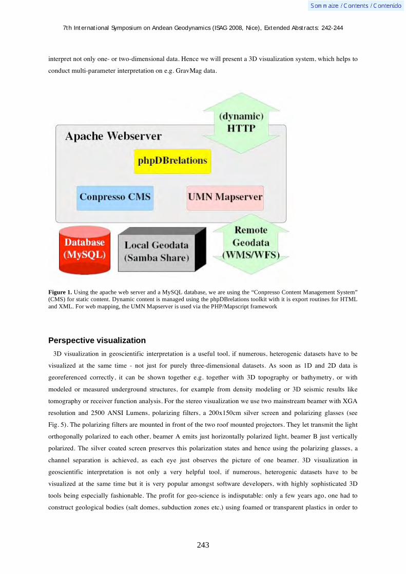
7th International Symposium on Andean Geodynamics (ISAG 2008, Nice), Extended Abstracts: 242-244
243
interpret not only one- or two-dimensional data. Hence we will present a 3D visualization system, which helps to
conduct multi-parameter interpretation on e.g. GravMag data.
Figure 1. Using the apache web server and a MySQL database, we are using the “Conpresso Content Management System”
(CMS) for static content. Dynamic content is managed using the phpDBrelations toolkit with it is export routines for HTML
and XML. For web mapping, the UMN Mapserver is used via the PHP/Mapscript framework
Perspective visualization
3D visualization in geoscientific interpretation is a useful tool, if numerous, heterogenic datasets have to be
visualized at the same time - not just for purely three-dimensional datasets. As soon as 1D and 2D data is
georeferenced correctly, it can be shown together e.g. together with 3D topography or bathymetry, or with
modeled or measured underground structures, for example from density modeling or 3D seismic results like
tomography or receiver function analysis. For the stereo visualization we use two mainstream beamer with XGA
resolution and 2500 ANSI Lumens, polarizing filters, a 200x150cm silver screen and polarizing glasses (see
Fig. 5). The polarizing filters are mounted in front of the two roof mounted projectors. They let transmit the light
orthogonally polarized to each other, beamer A emits just horizontally polarized light, beamer B just vertically
polarized. The silver coated screen preserves this polarization states and hence using the polarizing glasses, a
channel separation is achieved, as each eye just observes the picture of one beamer. 3D visualization in
geoscientific interpretation is not only a very helpful tool, if numerous, heterogenic datasets have to be
visualized at the same time but it is very popular amongst software developers, with highly sophisticated 3D
tools being especially fashionable. The profit for geo-science is indisputable: only a few years ago, one had to
construct geological bodies (salt domes, subduction zones etc.) using foamed or transparent plastics in order to

7th International Symposium on Andean Geodynamics (ISAG 2008, Nice), Extended Abstracts: 242-244
244
model ideas. Today, software tools allow visualization of complicated geometries on the screen, and enable the
interpreter/observer to interact with the model through rotation, change of viewpoint and/or illumination.
Figure 2. Bouguer Anomaly onshore and Free-Air Anomaly offshore is visualized for the area of Costa Rica and Nicaragua.
Most prominent is the positive anomaly in the area of the Nicoya Peninsula and the negative gravity west of the Talamanca
belt.

7th International Symposium on Andean Geodynamics (ISAG 2008, Nice), Extended Abstracts: 245-248
245
Reflection seismic imaging of the Chilean subduction zone around the 1960 Valdivia earthquake hypocenter
Kolja Groß, Stefan Buske, Serge A. Shapiro, Peter Wigger, & the TIPTEQ Research Group,
Seismics Team*
Free University Berlin, Department of Geophysics, Malteserstr. 74-100, 12249 Berlin, Germany
* TIPTEQ Research Group, Seismics Team: Groß, K., FU Berlin, Germany (a); Micksch, U., GFZ Potsdam,
Germany (b); Araneda, M., SEGMI, Santiago, Chile (c); Bataille, K., Universidad de Concepción, Chile (d);
Bribach, J. (b); Buske, S. (a); Krawczyk, C.M. (b); Lüth, S. (a,b); Mechie, J. (b); Schulze, A. (b); Shapiro, S.A. (a);
Stiller, M. (b); Wigger, P. (a); Ziegenhagen, T. (b).
KEYWORDS : reflection seismics, subduction zone processes, subduction channel, convergent margins, South America
Introduction
With a quarter of the worldwide seismic energy in the last century having been released in the Chilean region
alone (Scholz 2002), the Andean subduction zone is a natural laboratory for our seismogenic zone studies. The
overarching purpose of project TIPTEQ (from The Incoming Plate to mega-Thrust EarthQuake processes),
which comprises 13 subprojects, is to investigate processes active at all scales in the seismogenic coupling zone
in south central Chile (Fig. 1), which hosted the rupture plane of the 1960 Valdivia earthquake (Mw =9.5)
(Cifuentes 1989; Barrientos & Ward 1990).
In this paper we present a structural image and a interpretation of the reflection seismic data set across the
Chilean subduction zone at 38.2° S. Figure 1 shows the location of the approx. 100 km long reflection seismic
profile running from west to east across the Chilean subduction zone. For details on the experiment design and
acquisition parameters see Groß et al. (2008).
Figure 1. Location map of the active-source seismological experiment of project TIPTEQ . Black line – receiver line, black ticks – shot locations, blue line – CDP line, red star – hypocentral area of the 1960 earthquake (Krawczyk & the SPOC Team 2003). The yellow and magenta lines mark the CDP line of the SPOC onshore seismic reflection profile and the SPOC wide-angle refraction profile, respectively (Krawczyk et al. 2006). The green line marks the eastern end of the marine seismic reflection profile SO161-038/42 (Reichert & Schreckenberger 2002). The red line maps the surface trace of the Lanalhue fault zone (LFZ; after Melnick & Echtler 2006). NAZCA and SAM in the inset label the Nazca and South American plates, respectively.

7th International Symposium on Andean Geodynamics (ISAG 2008, Nice), Extended Abstracts: 245-248
246
Data processing
The SPOC wide-angle refraction experiment provided us with a P-wave velocity model (Krawczyk & the
SPOC Team 2003) along the same latitude (Fig. 1). This velocity information was used to produce a prestack
depth migrated section of the vertical component of the Near Vertical Reflection (NVR) data set. Kirchhoff pre-
stack depth migration (KPSDM) was performed in a 3-D volume using the true source and receiver coordinates,
thereby taking into account the actual crooked line geometry and the topography along the profile using the
method of Buske (1999). The single shot gathers were migrated separately using the true phase information.
Then trace envelopes of all migrated single shots were calculated and stacked to form a 3-D image. An analysis
of the 3-D migration volume showed almost no structural dip perpendicular to the survey line. That allowed us
to further increase the signal-to-noise ratio up to a factor of 2 by summing of the W–E oriented depth slices. The
resulting 2-D depth section is shown in Figure 2.
Figure 2. Kirchhoff prestack depth migration of the NVR data set. The figure shows a stack of the envelopes of migrated single shots. Intensity increases from blue to red. The two triangles on the horizontal axis mark the beginning of the profile (at the coast x 0km) and the end of the profile (in the Central Valley at x 95 km).
The migration of all three components considering P- and S-wave traveltimes (PP, SS), as well as converted
waves (PS, SP) shows S-wave energy from the plate interface down to a depth of approx. 35 km. There is almost
no converted energy observed. We characterized the subduction zone further using two innovative imaging
techniques based on KPSDM: Reflection Image Spectroscopy (RIS) and Fresnel Volume Migration (FVM).
Results and discussion
The seismic section (Fig. 2) clearly shows the subducted oceanic Nazca plate below the segmented forearc and
a highly reflective overriding South American plate. We associate the high reflectivity at the plate interface with
the existence of a subduction channel with a varying thickness of 2-5 km down to a depth of at least 38 km. It

7th International Symposium on Andean Geodynamics (ISAG 2008, Nice), Extended Abstracts: 245-248
247
Figure 3. Sections through the Chilean subduction zone at 38.2° S. The coast is at x = 0 km for all sections. Above: P-wave velocity model from local earthquake tomography (Haberland et al. 2008). Center: Distribution of electrical resistivity (Brasse et al. 2008). Below: preliminary interpretation. In all three figures the Kirchhoff prestack depth migration (Fig. 2) is superimposed.
7th International Symposium on Andean Geodynamics (ISAG 2008, Nice), Extended Abstracts: 245-248
248
might continue towards depth. The continental Moho is not clearly imaged. The reflectivity east of the
hypocenter shows horizontal structures at various depths, which give rise to different eastward continuations of
the continental Moho. The position and extent of the continental mantle wedge changes accordingly. Major
forearc features such as the crustal Lanalhue fault zone and a strong west-dipping reflector perpendicular to the
plate interface, can be observed.
Figure 3 shows the reflectivity together with the interpretation and superimposed on other geophysical results
obtained within project TIPTEQ. The comparison with the P-wave velocity model from local earthquake
tomography (Haberland et al. 2008) shows good correlation between high velocities and high reflectivity in the
continental crust (and vice versa) and the comparison to the distribution of electrical resistivity (Brasse et al.
2008) shows a correlation of low resistivity and high reflectivity (and vice versa).
The area around the 1960 Valdivia earthquake hypocenter is characterized by high electrical resistivity and low
reflectivity. Migration of lowpass filtered seismic data (RIS), however, images the plate interface as a
continuous linear feature, that shows no reduced reflectivity around the hypocenter.
For a more detailed discussion of the seismic section see Groß et al. (2008).
Acknowledgements
This work was part of the R&D-Program GEOTECHNOLOGIEN funded by the German Ministry of Education and Research (BMBF) (Grant 03G0594) and the German Research Foundation (DFG). The project benefited from grants of the Freie Universität Berlin and the GFZ Potsdam; seismic stations were provided by the Geophysical Instrument Pool Potsdam and the Freie Universität Berlin. We thank all participants in the field and the Chilean inhabitants for having made this survey possible.
References Barrientos, S. & Ward, S. 1990. The 1960 Chile earthquake: inversion for slip distribution from surface deformation.
Geophys. J. Int., 103, 589–598. Brasse, H., Kapinos, G., Li, Y., Mütschard, L., Soyer, W. & Eydam, D. 2008. Structural electrical anisotropy in the crust at
the South-Central Chilean continental margin as inferred from geomagnetic transfer functions. PEPI, submitted. Buske, S. 1999. Three-dimensional pre-stack Kirchhoff migration of deep seismic reflection data. Geophys. J. Int., 137, 243–
260. Cifuentes, I. 1989. The 1960 Chilean earthquake. J. geophys. Res., 94(B1), 665–680. Groß, K., Micksch, U. & TIPTEQ Research Group, Seismics Team 2008. The reflection seismic survey of project TIPTEQ -
the inventory of the Chilean subduction zone at 38.2° S. Geophysical Journal International 172 (2) , 565-571 doi:10.1111/j.1365-246X.2007.03680.x
Haberland, C 2008. Structure of the seismogenic zone of the South-Central Chilean margin revealed by local earthquake travel time tomography. JGR, in preparation.
Krawczyk, C. & the SPOC Team 2003. Amphibious seismic survey images plate interface at 1960 Chile earthquake. EOS Trans. Am. geophys. Union, 84(32), 301, 304–305.
Krawczyk, C., Mechie, J., Lüth, S., Ta árová, Z., Wigger, P., Stiller, M., Brasse, H., Echtler, H.P., Araneda, M. & Bataille, K. 2006. “Geophysical Signatures and Active Tectonics at the South-Central Chilean Margin”. In The Andes—Active Subduction Orogeny. Frontiers in Earth Sciences, Vol. 1, pp. 171–192, eds Oncken, O., Chong, G., Franz, G., Giese, P., Götze, H., Ramos, V., Strecker, M. & Wigger, P., Springer Verlag, Berlin.
Melnick, D. & Echtler, H., 2006. “Morphotectonic and geologic digital map compilations of the south-central Andes (36–43° S)”. In The Andes—Active Subduction Orogeny. Frontiers in Earth Sciences, Vol. 1, pp. 565–568, eds Oncken, O., Chong, G., Franz, G., Giese, P., Götze, H., Ramos, V., Strecker, M. & Wigger, P., Springer Verlag, Berlin.
Reichert, C. & Schreckenberger, B., 2002. Cruise report SO-161 leg 2 & 3, SPOC (Subduction Processes Off Chile). Tech. rep., BGR Hannover, pp. 142.
Scholz, C., 2002. The Mechanics of Earthquakes and Faulting. Cambridge University Press, Cambridge, UK, 471 pp.
7th International Symposium on Andean Geodynamics (ISAG 2008, Nice), Extended Abstracts: 249-252
249
Chile Triple Junction migration, mantle dynamics and Neogene uplift of Patagonia
B. Guillaume1, J. Martinod
1, & L. Husson
2
1 LMTG, Université de Toulouse-CNRS-IRD-OMP, 14, Avenue Édouard Belin 31400 Toulouse, France
([email protected], [email protected]) 2 Géosciences Rennes, UMR CNRS 6118 - Université Rennes-1, Campus de Beaulieu, 35042 Rennes cedex,
France ([email protected])
KEYWORDS : subduction, Patagonia, dynamic topography, uplift, geomorphology
Introduction
Geologists often consider that the topography of the earth essentially results from isostasy, topographic highs
being balanced by crustal roots and/or hot lithospheric mantle. Mantle dynamics, however, also induce forces
that deflect the earth topography, with vertical motions that can reach several hundreds of meters (Hager and
Clayton, 1989; Le Stunff and Ricard, 1997; adek and Fleitout, 2003). Dynamic topography reaches its
maximum amplitude above subduction zones (Husson, 2006). In continental domain, the dynamic component of
topography is difficult to discriminate, because the altitude is largely controlled by lithospheric mass and
temperature heterogeneities. Continental margins are nevertheless affected by long-wavelength surface
deflections that can be recorded by the geological imprint.
During the last 14 Myr, the Chile Triple Junction (CTJ) has migrated from 54°S to its present-day position at
about 46°30’S, as different segments of the Chile spreading ridge successively entered the subduction zone. In
order to investigate the impact of the associated mantle flow on the vertical surface motion, we analyze the
evolution of sedimentation, erosion, and tectonic features during the Neogene. We focus our study on the mild-
deformed central Patagonian basin, between 44°S and 48°S, from the thrust front of the Cordillera to the Atlantic
coast, because this area is poorly affected by Neogene tectonics and also remained ice-free during glaciations,
therefore showing a pristine morphology, preserved from the erasure of the glaciers.
Upper Oligocene to Holocene geological evolution of eastern Patagonia
From upper Oligocene to early Miocene, a widespread transgression occurred in the Patagonian basin. This
transgression is marked by the deposition of near-shore marine strata. These marine series are replaced by fluvial
deposits of the Santa Cruz Formation and its lateral equivalents (Ramos, 1989; Suárez et al., 2000), which have
been dated, south of the CTJ, between 22 and 14 Ma (Blisniuk et al., 2005). These deposits display syn-
contractional structures (Flint et al., 1994; Suárez and de la Cruz, 2000). The Patagonian transgression and the
deposition of the overlying continental series coincide with the break-up of the Farallon plate at ~24 Ma
(Lonsdale, 2005). This period is also marked by a more trench-perpendicular and faster convergence between the
oceanic and South America plates (Pardo-Casas and Molnar; 1987; Somoza, 1998; Lonsdale, 2005). The
development of the basin and deposition of the Santa Cruz Formation would result from the overfilling of a
subsiding basin responding to the uplift of the Cordillera and to the rapid subduction of the newly formed Nazca
plate beneath the continent.
In the middle Miocene, subsidence stopped and poorly consolidated conglomerates, known as “Rodados
Patagonicos” deposited, forming widespread terraces from the Andean foothills to the Atlantic coast. Two

7th International Symposium on Andean Geodynamics (ISAG 2008, Nice), Extended Abstracts: 249-252
250
generations of surfaces have been mapped: (1) surfaces associated to different pulses of piedmont aggradation,
and (2) surfaces corresponding to major fluvial terraces (Río Senguerr, Río Deseado, Cañadon Salado-Cañadon
del Carril) (Figure 1).
Figure 1. Miocene to Holocene geologic map of the Patagonian basin.
A long-wavelength uplift can be detected looking at the present-day slope of terraces. If the initial downstream
slope of terraces is difficult to constrain, it is reasonable to consider that the terraces displayed horizontal
profiles in the direction perpendicular to paleovalleys. Figure 2 shows that the older levels of the Río Deseado
terraces system are tilted southward, with slopes that range between 0.05% and 0.11%. Levels T8De to T12De
are not tilted. The evolution of the slope for each terrace shows that a gentle southward tilting occurred between
the deposition of T3De and T8De, following a northward regional tilting that developed between the deposition
of T1De and T2De. North of the CTJ, the topography of the aggradation deposit levels along with the
longitudinal profiles of the Río Senguerr terraces and the captures of Cañadon Salado and Río Senguerr suggest
that this area has continuously been tilted northward, until recent times.
Figure 2. Valley-perpendicular topographic profile of Río Deseado terraces (see Fig. 1 for location) and values of tilting for each terrace. 5.28 : age in Ma from Gorring et al. (1997).

7th International Symposium on Andean Geodynamics (ISAG 2008, Nice), Extended Abstracts: 249-252
251
Causes of the post-middle Miocene uplift of eastern Patagonia
The growth of southern Andes in the Oligo-Miocene resulted from crustal shortening, which, in turn,
controlled subsidence in the foreland and deposition of the Santa Cruz molasse. Using standard elastic
parameters and an elastic thickness for the Patagonia continental lithosphere between 20 and 30 km (Tassara et
al., 2007), the distance between the chain and the forebulge would range between 150 and 210 km. The posterior
flexural uplift of the foreland resulting from the diminution of the Andean load should be restricted to the same
area close to the chain. It cannot explain the regional continental-scale uplift registered from the Andes to the
Atlantic coast. In contrast, dynamic topography over subduction zones result in long-wavelength downward
deflections of the overriding topographic surface as far as 1000 km away from the trench.
Figure 3. (A) Map of the uplift of the overriding plate resulting from the episodic subduction of 4 ridge segments (SCR) below South America accompanying the northward migration of the CTJ. Light and dark gray dots mark the position of the CTJ before and after the subduction of each ridge segment, respectively. (B) Trench-parallel uplift profiles at 300 km, 500 km, and 700 km from the trench for each triple junction migration increment. The boundary between regions of northward and southward tilting for each longitudinal profile shifts northward, delineating sectors with different tilting histories.
The peculiar geodynamic evolution of Patagonia during the last 14 Myr can be responsible for the regional-
scale uplift and tiltings recorded by the post middle-Miocene terraces. South of the CTJ, the Antarctic plate is
slowly subducting below the continent whereas north of the CTJ, the Nazca plate subducts rapidly, inducing the
downward deflection of the continental plate. We propose that this downward deflection has been progressively
cancelled in southern Patagonia as the CTJ was migrating northward, resulting in the uplift of that part of the
continent. We computed the dynamic deflection induced by the Nazca slab, using a simple model based on the
Stokeslet approximation (Husson, 2006). Vertical deflections appear as far as 1600 km from the trench and reach
a maximum value close to 1000 meters at a distance of ~325 km from the trench. Figure 3 reproduces more
specifically the vertical motions resulting from mantle dynamics as a consequence of the episodic northern

7th International Symposium on Andean Geodynamics (ISAG 2008, Nice), Extended Abstracts: 249-252
252
migration of the CTJ. The tilting values obtained in our models correspond to those observed in central
Patagonia.
Conclusions
Middle Miocene is marked by a switch from subsidence to uplift of eastern central Patagonia. We propose that
this change results from the episodic northward migration of the CTJ, inducing the opening of a slab window
below southern Patagonia that cancels the dynamic downward deflection of the continental plate above the
subduction zone and, in turn, causes the observed uplift and associated N-S trending tilting.
References
Blisniuk, P.M, Stern, L.B., Chamberlain, C.P., Idleman, B., & Zeitler, P.K. 2005. Climatic and ecologic changes during Miocene surface uplift in the Southern Patagonian Andes. Earth and Planetary Science Letters 230: 125-142. adek, O., & Fleitout, L. 2003. Effect of lateral viscosity variations in the top 300 km on the geoid and dynamic topography. Geophys. J. Int. 152: 566-580.
Flint, S.S, Prior, D.J., Agar, S.M., & Turner, P. 1994. Stratigraphic and structural evolution of the Tertiary Cosmelli Basin and its relationship to the Chile triple junction. Journal of the Geological Society, London 151: 251-268.
Gorring, M.L., Kay, S.M., Zeitler, P.K., Ramos, V.A., Rubiolo, D., Fernandez, M.I., & Panza, J.L. 1997. Neogene Patagonian plateau lavas: Continental magmas associated with ridge collision at the Chile Triple Junction. Tectonics 16(1): 1-17.
Hager, B.H., & Clayton, R.W. 1989. Constraints on the structure of mantle convection using seismic observations, flow models and the geoid. In Peltier, W.R. (ed.): Mantle Convection, New-York, Gordon and Breach: 657-763.
Husson, L. 2006. Dynamic topography above retreating subduction zones. Geology 34(9): 741-744. Le Stunff, Y., & Ricard, Y. 1997. Partial advection of equidensity surfaces: A solution for the dynamic topography problem?
Journal of Geophysical Research 102: 24,655-24,667. Lonsdale, P. 2005. Creation of the Cocos and Nazca plates by the fission of the Farallon plate. Tectonophysics 404: 237-264. Pardo-Casas, F., & Molnar, P. 1987. Relative motion of the Nazca (Farallon) and South American plates since Late
Cretaceous time. Tectonics 6: 233-248. Ramos, V.A. 1989. Andean Foothills Structures in Northern Magallanes Basin, Argentina. AAPG Bulletin 73(7): 887-903. Somoza, R. 1998. Updated Nazca (Farallon)-South America relative motions during the last 40 Ma. Implications for
mountain building in the central Andean region. Journal of South American Earth Sciences 11: 211-215. Suárez, M., & De La Cruz, R. 2000. Tectonics in the eastern central Patagonian Cordillera plutons, Chile (45°30’-47°30’S).
Journal of the Geological Society, London 157: 995-1001. Suárez, M., De La Cruz, R., & Bell, C.M. 2000. Timing and origin of deformation along the Patagonian fold and thrust belt.
Geological Magazine 137: 345-353. Tassara, A., Swain, C., Hackney, R., & Kirby, J. 2007. Elastic thickness structure of South America estimated using wavelets
and satellite-derived gravity data. Earth and Planetary Science Letters 253: 17-36.

7th International Symposium on Andean Geodynamics (ISAG 2008, Nice), Extended Abstracts: 253-256
253
The dynamic forearc of southern Peru
Sarah R. Hall1, Daniel L. Farber
2, Laurence Audin
3, & Robert C. Finkel
4
1 University of California, Santa Cruz, 1156 High St., Santa Cruz, CA 95060, USA ([email protected])
2 Lawrence Livermore National Laboratory, LLNL, Livermore, CA 94550, USA ([email protected])
3 Institut de Recherche pour le Développement, LMTG – UMR 5563, Observatoire Midi-Pyrénées, Toulouse,
31400 France ([email protected]) 4 Lawrence Livermore National Laboratory, LLNL, Livermore, CA 94550, USA ([email protected])
KEYWORDS : cosmogenic, neotectonic, erosion, incision, pediment
Recently, there has been a renewed interest in models of active tectonic and climatologic processes along the
Andean margin. While many new studies in the forearc regions of southern Peru and northern Chile have
presented data constraining morphotectonic chronologies as well as the rates of surface process, there has yet to
be a complete synthesis of these new data. As recently as ~5 years ago, the preferred working model was that
most of the low-relief surfaces within the Atacama Desert were ancient relict surfaces abandoned >7Ma due to
incision caused by periods of intense surface uplift (Tosdal et al., 1984), and that the western limb of the
Altiplano is a passive monocline with no significant Neogene structures accommodating deformation (Isacks,
1988). Until recently, documented active deformation was limited to major strike-slip and normal faults in the
Precordillera, respectively that are related to oblique subduction and gravitational collapse of the western margin
of the Altiplano (Wörner et al., 2002). Extensional features, oriented both perpendicular and normal to the coast,
were also mapped (Hartley et al., 2000), however very little was known about the slip history, kinematics or
rates of motion along these structures.
Using the combination of remote sensing with high-resolution data, in situ cosmogenic isotope concentrations
and thermochronology, in recent years the community has made important advances in addressing the rates,
timings, styles, and locations of active deformation within the forearc of the Andean margin. Specifically, we
see 1) ancient surfaces reflecting erosion rates as low as <0.1m/Ma (Kober et al., 2005; Nishiizumi et al., 2005;
Hall et al., to be published) are well preserved in the forearcs of both Peru and Chile, 2) the existence of young
(30ka-1Ma) low-relief pediment surfaces due to recent landscape modifications (Hall et al., in press), 3) active
structures accommodating compressional, tensional, and shearing stresses in numerous localities within the
forearc (Allmendinger et al., 2005a; Gonzalez et al., 2006; Hall et al., in press; Audin, et al., in press), 4) a
consistent rate of river incision of ~0.3mm/yr along exoreic rivers (Hall et al., to be published), 5) uplift rates
that been variable in time and space with pulses throughout the last 10Ma (Schildgen et al., 2007; Saillard et al.,
to be published) and 6) instantaneous modern forearc rotation rates are similar to time integrated rates over the
past 10Ma (Allmendinger et al., 2005b).
To first order, we find that the Andean forearc during the last 10Ma has been quite a dynamic region, both in
terms of tectonics and climate. The coastal Atacama Desert is situated in a zone that has been hyperarid for at
least the last 3My and this has contributed to the high degree of geomorphic surface preservation in this region
(Hartley, 2003). Indeed, in an area spanning of over 11 degrees of latitude, erosion rates based on cosmogenic
isotope concentrations are consistently less than 0.1m/Ma (Kober et al., 2005; Nishiizumi et al., 2005; Hall et
al., to be published). On shorter timescales, changes in precipitation may enhance or dampen incision rates (i.e.

7th International Symposium on Andean Geodynamics (ISAG 2008, Nice), Extended Abstracts: 253-256
254
during a glacial-interglacial transition the increased discharge and tools may enhance valley incision), however
ultimately the amount of potential base-level change is set by surface uplift or sea level change. Thus, the exact
timing of periods of more intense incision may correspond with climate events, but the total amount of incision
over time is useful for tectonic interpretations. Based on zircon and apatite (U-Th)/He ages, Schildgen et al.
(2007) interpreted periods of more intense canyon incision along the Rio Majes in southern Peru (16˚S).
Specifically, from the period 5.1-2.3 Ma, 1.4 km of incision occurred yielding an incision rate of ~0.5mm/yr and
an additional older period of 1 km of incision from 9-5.1 Ma yielding a rate of ~0.25mm/yr. Thouret et al.
(2007) suggest incision rates of ~0.2mm/yr since 9Ma in a similar area of southern Peru. Our recent work
suggests that these incision rates are very similar to measured time integrated rates since the Pleistocene on the
major exoreic rivers (Hall et al., in press; Hall et al., to be published). Along the Rio Sama, Rio Locumba, and
the Rio Osmore of southern Peru, we have mapped sequences of well-preserved strath terraces and dated (along
the Rio Sama and Rio Locumba) these using cosmogenic 10Be. Our work yields a consistent set of incision rates
of ~0.3 ± 0.1mm/yr (Figure 1). Further, where these rivers are cut by active structures, the local incision rate
determined near the knick-point reaches 0.8 mm/yr.
Figure 1. The forearc of southern Peru. Structures active during the Pleistocene include the Purgatorio Fault, the Incapuquio Fault System, and the Calientes Fault, in addition to some of the normal faults along the coast including the Chololo Fault (Audin, et al., in press) near the town of Ilo. Incision rates based on cosmogenic 10Be concentrations are 0.2-0.4 mm/yr in major drainages and up to 0.8mm/yr near active structures (Calientes Fault). The vast incised late Pliocene and Pleistocene pediment surfaces north of the Purgatorio Fault suggest surface uplift has driven incision and abandonment of these surfaces during the past ~2Ma.
Along the three major drainages of southernmost Peru, we have mapped multiple flexures trending sub-parallel

7th International Symposium on Andean Geodynamics (ISAG 2008, Nice), Extended Abstracts: 253-256
255
to the coast and the Western Cordillera. In many cases, these flexures correspond to abrupt changes in river
incision and topography. Along the Rio Sama, the largest of these flexures is produced by a propagating
hanging-wall anticline above a blind thrust (Figure 1). The youthfulness of this feature is suggested by the
deflection of active channels around the propagating tip of the anticline and by young (~30-500ka) surface
exposure ages on terraces along those active channels (Hall et al., to be published).
Schildgen et al. (2007) conclude that the pattern of apatite and zircon U-Th/He ages along the Rio Majes
(16˚S) either supports the Isacks (1988) monocline hypothesis assisted mechanistically by lower crustal ductile
flow or reflects distributed forearc deformation along multiple non-surface breaking, or un-mapped faults. While
our work highlights role of contractile deformation in the southern Peruvian forearc, contractile structures
trending sub-parallel to the range front have also previously been observed in Northern Chile (Oxaya anticline;
Victor et al., 2004; Garcia and Hérail, 2005; Kober et al., 2005). While based on our mapping and chronologic
data we cannot rule out a role for lower-crustal ductile flow in the forearc of southern Peru and northern Chile
(Husson and Sempere, 2003; Hoke et al., 2007; Schildgen et al., 2007), our observations of surface breaking and
blind reverse faults as well as active footwall anticlines shows that a significant amount of uplift is
accommodated in contractile structures in the Precordillera of southernmost Peru. In this light, any additional as
of yet unmapped active contractile structures reduce the need to call on lower-crustal ductile flow to
accommodate surface uplift in this area. Given the limited number of field sites that have been studied in detail,
it is not unreasonable to suggest there is a high likelihood that more active contractile structures exist in this
region of the Peruvian forearc.
In summary, the geomorphic and structural features in this region of southern Peru provide strong evidence of
distributed crustal deformation along range-sub-parallel contractile and strike-slip structures. The observation
that Pleistocene incision rates are comparable with Late Miocene and Pliocene rates suggests to us that the rates
and style of surface uplift within the forearc of southern Peru has been ongoing and consistent (on the timescale
of 1 Myr) during the past 10Ma.
References
Allmendinger, R.W., Gonzalez, G., Yu, J., Hoke, G. and Isacks, B., 2005a — Trench-parallel shortening in the Northern Chilean Forearc: Tectonic and climatic implications. Geological Society of America Bulletin., 117(1-2): 89-104.
Allmendinger, R.W., Smalley, R., Bevis, M., Caprio, H. and Brooks, B., 2005b — Bending the Bolivian orocline in real time. Geology., 33(11): 905-908.
Audin, L., David, C., Hall, S.R., Farber, D.L., Hérail, G., in press — Geomorphic evidences of recent tectonic activity in the forearc, southern Peru., RAGA, 61, 545-554.
Garcia, M., and Hérail, G., 2005 — Fault-related folding, drainage network evolution and valley incision during the Neogene in the Andean Precordillera of Northern Chile. Geomorphology., 65: 279-300.
Gonzalez, G., Dunai, T., Carrizo, D. and Allmendinger, R., 2006 — Young displacements on the Atacama Fault System, northern Chile from field observations and cosmogenic Ne-21 concentrations. Tectonics., 25(3).
Hall, S.R., Farber, D.L., Audin, L., Finkel, R.C., and Mériaux, A.-S., in press — Geochronology of pediment surfaces in southern Peru: Implications for Quaternary deformation of the Andean forearc. Tectonophysics.
Hall, S.R., Farber, D.L., Audin, L., Finkel, R.C., to be published — Contractile deformation in the forearc of southern Peru Hartley, A.J., May, G., Chon, G., Turner, P., Kape, S.J., and Jolley, E.J., 2000 — Development of a continental forearc: A
Cenozoic example from the Central Andes, northern Chile. Geology., 28(4): 331-334. Hartley, A.J., 2003 — Andean uplift and climate change. Journal of the Geological Society., London, 160: 7-10. Hoke, G.D., Isacks, B.L., Jordan, T.E., Blanco, N., Tomlinson, A.J., and Ramenzani, J., 2007 — Geomorphic evidence for
post-10 Ma uplift of the western flank of the central Andes 18˚30’-22˚S. Tectonics., 26, TC5021, doi: 10.1029/2006TC002082.
Husson, L. and Sempere, T., 2003 — Thickening the Altiplano crust by gravity-driven crustal channel flow. Geophysical Research Letters., 30(5).
Isacks, B.L., 1988 — Uplift of the Central Andean plateau and bending of the Bolivian Orocline. Journal Of Geophysical

7th International Symposium on Andean Geodynamics (ISAG 2008, Nice), Extended Abstracts: 253-256
256
Research-Solid Earth And Planets., 93(B4): 3211-3231. Kober, F., 2005 — Quantitative analysis of the topographic evolution o the Andes of Northern Chile using cosmogenic
nuclides, Ph.D. Thesis, ETH, Zürich, 131 pp. Nishiizumi, K., Caffee, M.W., Finkel, R.C., Brimhall, G. and Mote, T., 2005 — Remnants of a fossil alluvial fan landscape
of Miocene age in the Atacama Desert of Northern Chile using cosmogenic nuclide exposure age dating. Earth Planetary Science Letters. 237(3-4): 499-507.
Saillard, M., Hall S.R., Audin, L., Hérail, G., Farber D.L., Finkel, R.C., Martinod, J., Bondoux, F., and Regard, V., to be published — Pleistocene marine terrace development and non-steady long-term uplift rates along the Andean margin of Chile (31°S).
Schildgen, T.F., Hodges, K.V., Whipple, K.X., Reiners, P.W., Pringle, M.S., 2007 — Uplift of the western margin of the Andean plateau revealed from canyon incision history, southern Peru. Geology., 35(6), 523-526.
Thouret, J.C., Wörner, G., Gunnell, Y., Singer, B., Zhang, X., and Souriot, T., 2007 — Geochronologic and stratigraphic constraints on canyon incision and Miocene uplift of the Central Andes in Peru. Earth and Planetary Science Letters., 263: 151-166.
Tosdal, R.M., Clark, A.H. and Farrar, E., 1984 — Cenozoic polyphase landscape and tectonic evolution of the Cordillera Occidental, southernmost Peru. Geological Society of America Bulletin., 95(11): 1318-1332.
Victor, P., Oncken, O., and Glodny, J., 2004 — Uplift of the western Altiplano plateau: Evidence from the Precordillera between 20˚ and 21˚S (northern Chile). Tectonics., 23, TC4004.
Wörner, G., Uhlig, D., Kohler, I. and Seyfried, H., 2002 — Evolution of the West Andean Escarpment at 18 degrees S (N. Chile) during the last 25 Ma: uplift, erosion and collapse through time. Tectonophysics., 345(1-4): 183-198.
7th International Symposium on Andean Geodynamics (ISAG 2008, Nice), Extended Abstracts: 257-260
257
Oxygen isotopes evidence for crustal contamination and mantle metasomatism in the genesis of the Atacazo-Ninahuilca magmatic suites, Ecuador
Silvana Hidalgo1,2
, Marie-Christine Gerbe2,3
, Hervé Martin2, Gilles Chazot
4, & Jo Cotten
4
1 Instituto Geofisico, Escuela Politécnica Nacional, Ap. 17-01-2759, Quito, Ecuador
2 Laboratoire Magmas et Volcans, UMR 6524, Université Blaise Pascal, Clermont-Ferrand, France
3 Université Jean Monnet, UMR 6524 "Magmas et Volcans", Saint Etienne, France
4 Université de Bretagne Occidentale, BP 809, 29285 Brest, France
KEYWORDS : crustal contamination, mantle metasomatism, oxygen isotopes, Atacazo-Ninahuilca, Ecuador Introduction
Two main geochemical signatures characterize the magmas from the Quaternary Ecuadorian volcanic arc: a
“classic” calc-alkaline signature and an adakitic one (Bourdon et al., 2002; Samaniego et al., 2002; Samaniego
et al., 2005; Hidalgo et al., 2007). Even though the temporal transition from calc-alkaline to adakitic features
seems well established, geochemical processes that lead to adakite suites in this region are still debated. Based
on major and trace element geochemistry, the discussion is particularly focused on the relative roles of slab-
melts, mantle metasomatism (by fluids and silicic melts) and crustal contamination.
In this paper, oxygen isotopes are used to constrain the participation of these processes at different levels: in
the mantle on the magma sources and within the continental crust during magma evolution. Interaction of
magmas with the arc crust on ascent is considered to play a limited role to produce the andesites and dacites in
Ecuador, whereas it as been considered as a major process in other continental margin settings where a thick
crust is present (e.g. central Andean volcanic zone, (James and Murcia, 1984). Furthermore, the role of source
contamination involving subducted sedimentary components has not been evaluated for Ecuadorian lavas,
whereas it was demonstrated to participate to the mantle-wedge metasomatism in island arc settings (Shimoda et
al., 1998; Bindeman et al., 2005). This study is focused on the Atacazo-Ninahuilca volcanic complex (ANVC),
located in the Western Cordillera of Ecuador, 10 Km South of Quito (Fig. 1a). This complex consists of three
Pleistocene andesitic edifices, 1 Ma to 80 Ka old (Carcacha, Atacazo and Arenal I), and several younger dacitic
domes {Hidalgo, in press. #1448}. Two of these pre-Holocene extrusions, La Viudita and Gallo Cantana, are
located outside the caldera, whereas the other Holocene five domes were emplaced within this depression
(Arenal II, La Cocha I and II, and Ninahuilca Chico I and II) (Fig. 1b).
Geochemical data
One hundred thirty-three samples from lava flows, domes and pyroclastic deposits were analysed for major and
trace elements at the Université de Bretagne Occidentale. Analytical procedure is described in detail in Cotten et
al., (1995). Oxygen isotope analyses of 23 whole rock samples and 16 mineral separates (plagioclase,
clinopyroxene and amphibole) were determined in the “Laboratoire Transferts Lithosphériques” at the Université
JeanMonnet in Saint Etienne (France) following analytical protocol by Clayton and Mayeda, (1963). O-isotope
ratios of mineral pairs (plag-cpx or plag-amph) were used to assess the equilibrium at magma temperature and to
verify that the lavas did not suffer sub-sequent O-isotopes re-equilibration, so that the whole-rock 18O can be
approximated to approach the magma 18O.

7th International Symposium on Andean Geodynamics (ISAG 2008, Nice), Extended Abstracts: 257-260
258
Sr- and Nd-isotope analyses of 17 samples from ANVC were performed at the “Laboratoire Magmas et
Volcans”, Université Blaise Pascal in Clermont Ferrand (France) following the procedures described in Pin et al.
(1994) and Pin and Santos Zaldegui (1997).
Figure 1a. Geodynamic framework of Ecuador and location of ANVC in the volcanic arc. b. Sketch map of ANVC showing main volcanic units.
Characteristics of magmatic suites
Two different magmatic suites have been identified in the ANVC. The first calc-alkaline suite corresponds to
andesites of the Carcacha, Atacazo and Arenal I (CAA) edifices, while the second one is clearly an adakitic
series represented by the dacitic domes, which mostly developed during the last 12 ky (Hidalgo et al., in press.).
The older part of the complex (CAA) consists of two pyroxenes andesites, with subordinated amphibole. The
SiO2 contents (57-62 wt.%) show a positive correlation with Na2O and K2O and are negatively correlated with
MgO, CaO, TiO2 and FeO (Fig. 2a, b). All data plot on a single differentiation trend. Oxygen isotopic ratios for
these lavas (8.0 to 8.9‰; Fig. 2c) are very high compared to typical arc magmas which commonly range
between 5.7 and 6.9 ‰ (Harmon and Hoefs, 1995). Sr and Nd isotopic ratios show mantle-like homogeneous
values (0.704096-0.704372; 0.512822-0.512887). Both ratios are negatively correlated: 87Sr/86Sr increases while 143Nd/144Nd decreases (Fig. 2d).
Figure 2. a. SiO2 vs. MgO. b. SiO2 vs. K2O : note the different evolution trends for CAA lavas and the younger domes ones. c. SiO2 vs. 18O‰ wr VSMOW. d. 87Sr/86Sr vs. 143Nd/144Nd for ANVC products. e. 87Sr/86Sr vs. 18O‰ wr VSMOW.

7th International Symposium on Andean Geodynamics (ISAG 2008, Nice), Extended Abstracts: 257-260
259
The Holocene domes, bearing pl+amph+opx+mag, determine a narrow compositional trend (62 to 67 SiO2
wt.%). 18O values display a larger range than that from the CAA andesites, varying 6.1 to 9.0‰, with most
values above 7.7‰ (Fig. 2c). 87Sr/86Sr and 143Nd/144Nd are quite homogenous (0.704155-0.704318; 0.512840-
0.512894) and contrary to the former CAA magmatic suite, only weak 87Sr/86Sr variations are observed and 143Nd/144Nd is almost constant (Fig. 2d).
Discussion
Low-pressure crustal contamination
Given the mafic composition of the local basement (basalts of oceanic origin with intercalated granodioritic
intrusions), Sr and Nd isotopic systems became useless to reveal crustal contamination because there is no
isotopic contrast between the accreted basement basalts and the Quaternary lavas (Fig. 2e). Nevertheless, the
exceptionally high 18O values and the large variation ranges in the CAA lavas (8.0 to 8.9‰) suggest a
contamination process. Indeed, the strong increase in 18O (more than 0.9‰) for Carcacha-Atacazo andesites,
compared to weak SiO2 increase in the composition (7 wt%) suggests assimilation of 18O-rich materials from the
crust, in addition to a fractional crystallization process. Modelling of such an AFC process is show in Figure. 3a.
Contaminant composition is the average of those of the Miocene intrusions which display high 18O values (7.9
– 13.7 ‰). On the other hand, the dacitic domes display a large range of 18O values which cannot be related to
the previous lavas by an AFC process (Fig. 2c). Interestingly, no mafic compositions forming a clear suite with
the domes analyses have been encountered.
Mantle metasomatism
AFC models partly explain the high 18O values of CAA lavas. Nevertheless, an important enrichment in 18O
(>8.0‰) characterizes the less evolved magmas from this series (Mg#>50 and SiO2 ~ 57 wt%), compared with
mantle-derived primitive basaltic magmas of continental subduction zones (average 18O values of 6.2±0.7‰
(Harmon and Hoefs, 1995). This suggests that 18O-rich materials have contributed to the magma source.
Michaud et al. (2005) have shown that a 400-500 m-thick pile of carbonated sediments overlies the subducting
oceanic crust under the Ecuadorian margin. Such sediments have high 18O values (25-32‰, Eiler, 2001).
Futhermore hydrothermally altered oceanic basalts have highly variable 18O values, from 5 to 25 ‰ (Eiler et
al., 1998; Eiler, 2001; Schulze et al., 2003).
Based on these data the petrogenesis of the ANVC rocks seems controlled by different processes:
1) The adakitic geochemical characteristics of ANVC rocks require the addition of melts or supercritical fluids
from the subducting slab to the mantle and/or an early garnet fractionation.
2) The high O-ratios of mafic lavas of the CAA series suggest a contamination of the mantle source by 18O-rich
materials. These materials are certainly issue of partial melting or dehydration of the subducting carbonated
sediments or the altered oceanic crust.
3) The younger domes show an important variability in 18O and homogenous major elements compositions.
These characteristics indicate that these lavas could not be related to the CCA series by simple CF or AFC
processes. Thus, the high and variable 18O values may also account for source processes, or early garnet
fractionation from more primitive terms which have not been encountered during this study.
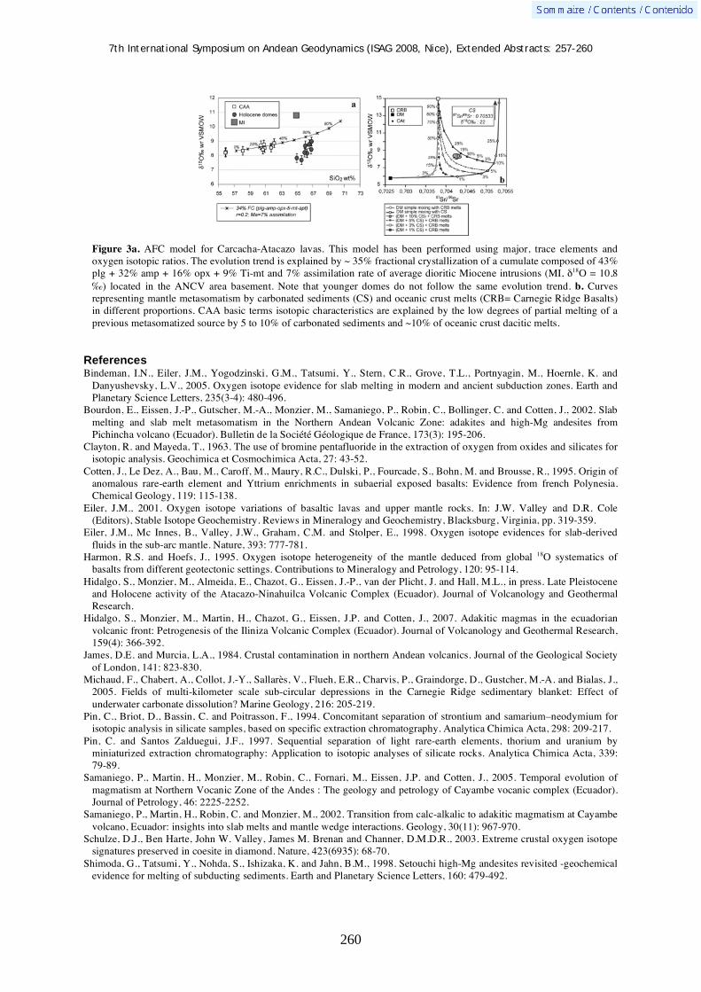
7th International Symposium on Andean Geodynamics (ISAG 2008, Nice), Extended Abstracts: 257-260
260
Figure 3a. AFC model for Carcacha-Atacazo lavas. This model has been performed using major, trace elements and oxygen isotopic ratios. The evolution trend is explained by ~ 35% fractional crystallization of a cumulate composed of 43% plg + 32% amp + 16% opx + 9% Ti-mt and 7% assimilation rate of average dioritic Miocene intrusions (MI, 18O = 10,8 ‰) located in the ANCV area basement. Note that younger domes do not follow the same evolution trend. b. Curves representing mantle metasomatism by carbonated sediments (CS) and oceanic crust melts (CRB= Carnegie Ridge Basalts) in different proportions. CAA basic terms isotopic characteristics are explained by the low degrees of partial melting of a previous metasomatized source by 5 to 10% of carbonated sediments and ~10% of oceanic crust dacitic melts.
References Bindeman, I.N., Eiler, J.M., Yogodzinski, G.M., Tatsumi, Y., Stern, C.R., Grove, T.L., Portnyagin, M., Hoernle, K. and
Danyushevsky, L.V., 2005. Oxygen isotope evidence for slab melting in modern and ancient subduction zones. Earth and Planetary Science Letters, 235(3-4): 480-496.
Bourdon, E., Eissen, J.-P., Gutscher, M.-A., Monzier, M., Samaniego, P., Robin, C., Bollinger, C. and Cotten, J., 2002. Slab melting and slab melt metasomatism in the Northern Andean Volcanic Zone: adakites and high-Mg andesites from Pichincha volcano (Ecuador). Bulletin de la Société Géologique de France, 173(3): 195-206.
Clayton, R. and Mayeda, T., 1963. The use of bromine pentafluoride in the extraction of oxygen from oxides and silicates for isotopic analysis. Geochimica et Cosmochimica Acta, 27: 43-52.
Cotten, J., Le Dez, A., Bau, M., Caroff, M., Maury, R.C., Dulski, P., Fourcade, S., Bohn, M. and Brousse, R., 1995. Origin of anomalous rare-earth element and Yttrium enrichments in subaerial exposed basalts: Evidence from french Polynesia. Chemical Geology, 119: 115-138.
Eiler, J.M., 2001. Oxygen isotope variations of basaltic lavas and upper mantle rocks. In: J.W. Valley and D.R. Cole (Editors), Stable Isotope Geochemistry. Reviews in Mineralogy and Geochemistry, Blacksburg, Virginia, pp. 319-359.
Eiler, J.M., Mc Innes, B., Valley, J.W., Graham, C.M. and Stolper, E., 1998. Oxygen isotope evidences for slab-derived fluids in the sub-arc mantle. Nature, 393: 777-781.
Harmon, R.S. and Hoefs, J., 1995. Oxygen isotope heterogeneity of the mantle deduced from global 18O systematics of basalts from different geotectonic settings. Contributions to Mineralogy and Petrology, 120: 95-114.
Hidalgo, S., Monzier, M., Almeida, E., Chazot, G., Eissen, J.-P., van der Plicht, J. and Hall, M.L., in press. Late Pleistocene and Holocene activity of the Atacazo-Ninahuilca Volcanic Complex (Ecuador). Journal of Volcanology and Geothermal Research.
Hidalgo, S., Monzier, M., Martin, H., Chazot, G., Eissen, J.P. and Cotten, J., 2007. Adakitic magmas in the ecuadorian volcanic front: Petrogenesis of the Iliniza Volcanic Complex (Ecuador). Journal of Volcanology and Geothermal Research, 159(4): 366-392.
James, D.E. and Murcia, L.A., 1984. Crustal contamination in northern Andean volcanics. Journal of the Geological Society of London, 141: 823-830.
Michaud, F., Chabert, A., Collot, J.-Y., Sallarès, V., Flueh, E.R., Charvis, P., Graindorge, D., Gustcher, M.-A. and Bialas, J., 2005. Fields of multi-kilometer scale sub-circular depressions in the Carnegie Ridge sedimentary blanket: Effect of underwater carbonate dissolution? Marine Geology, 216: 205-219.
Pin, C., Briot, D., Bassin, C. and Poitrasson, F., 1994. Concomitant separation of strontium and samarium–neodymium for isotopic analysis in silicate samples, based on specific extraction chromatography. Analytica Chimica Acta, 298: 209-217.
Pin, C. and Santos Zalduegui, J.F., 1997. Sequential separation of light rare-earth elements, thorium and uranium by miniaturized extraction chromatography: Application to isotopic analyses of silicate rocks. Analytica Chimica Acta, 339: 79-89.
Samaniego, P., Martin, H., Monzier, M., Robin, C., Fornari, M., Eissen, J.P. and Cotten, J., 2005. Temporal evolution of magmatism at Northern Vocanic Zone of the Andes : The geology and petrology of Cayambe vocanic complex (Ecuador). Journal of Petrology, 46: 2225-2252.
Samaniego, P., Martin, H., Robin, C. and Monzier, M., 2002. Transition from calc-alkalic to adakitic magmatism at Cayambe volcano, Ecuador: insights into slab melts and mantle wedge interactions. Geology, 30(11): 967-970.
Schulze, D.J., Ben Harte, John W. Valley, James M. Brenan and Channer, D.M.D.R., 2003. Extreme crustal oxygen isotope signatures preserved in coesite in diamond. Nature, 423(6935): 68-70.
Shimoda, G., Tatsumi, Y., Nohda, S., Ishizaka, K. and Jahn, B.M., 1998. Setouchi high-Mg andesites revisited -geochemical evidence for melting of subducting sediments. Earth and Planetary Science Letters, 160: 479-492.

7th International Symposium on Andean Geodynamics (ISAG 2008, Nice), Extended Abstracts: 261-264
261
Incipient tectonic inversion in a segmented foreland basin: From extensional to piggyback settings
Diego Nicolas Iaffa1, F. Sábat
1, O. Ferrer
1, R. Mon
2, & A. A. Gutiérrez
2
1 Dpt. de Geodinàmica i Geofísica, Facultat de Geologia UB, Martí i Franqués s/n, 08028 Barcelona, Spain
([email protected]) 2 Dpt. de Geología, Facultad de Ciencias Naturales e Instituto Miguel Lillo, Universidad Nacional de Tucumán,
Miguel Lillo 205 4000 Tucumán, Argentina
KEYWORDS : Argentina, Tucumán, Cretaceous rift, foreland, tectonic inversion
Introduction
The Tucumán Basin is located in the foothills of the Andes, to the East of the northern end of the Pampean
Ranges and South of the Eastern Cordillera and Santa Bárbara System (Ramos, 1999). All of them basement
uplifts bounded by high angle reverse faults (González Bonorino, 1950). The Subandean thin skinned fold and
thrust belt is located farther North where detached thick cover Paleozoic series are present (Allmendinger et al.,
1983). Several factors influenced the present structure of the foothills of the central Andes in NW Argentina.
Among these factors: 1) the regime and intensity of several tectonic events, 2) the geometry of the Wadati –
Benioff zone, 3) structural discontinuities in the basement and 4) the architecture of the sedimentary cover
(Allmendinger et al., 1983; Jordan and Alonso, 1987).
A foreland stage evolved from a distal to a proximal position when Sierra de Aconquija and Ambato block
started to uplift 5 Ma ago (Sobel and Strecker, 2003). At the present is becoming a piggy back basin on top of
the active thrust fault that elevates the Guasayán Range.
In this communication we aim to identify the different deposits form Cretaceous rift to foreland and show
evidences of tectonic inversion.
Depositional history
Basement is represented by low to medium grade metamorphic rocks with strong foliation and by intrusive
granitoids (Battaglia, 1982; Mon and Hongn, 1996). This basement shows major structural discontinuities
produced during the accretion of terranes up to Early Paleozoic (Ramos, 1988). Eastwards of the Rosario Fault
there are thick series of Paleozoic rocks, absent in the Tucumán underground (Cristallini et al., 2004). These
Paleozoic rocks correspond to Silurian and Devonian detritic rocks deposited in a foreland basin during the
Ocloyic Orogeny (Ramos, 1988).
The Salta rift Basin developed during Cretaceous times, had three major arms and several sub-basins (Turner,
1959; Salfity and Marquillas, 1999). Continental red beds syn-rift deposits were overlied by onlapping lacustrine
and shallow marine post-rift deposits that infill a thermal sag basin (Bianucci et al., 1981). Post-rift deposits are
in turn overlied by Andean foreland deposits. During Middle Miocene the Atlantic Parana marine transgression
covered the area and deposited a gypsum rich sandstones (Battaglia, 1982). These deposits are outcroping along
the periphery of the Tucumán Basin (at the southern part of the Medina Range, in the western slope of Guasayán
Range and in the eastern foothills of the Aconquija Range). Are also present in the western side of the Aconquija
Range (in the El Cajón and Santa Maria Valleys, fig. 1) suggesting that uplift of the Aconquija Range postdated

7th International Symposium on Andean Geodynamics (ISAG 2008, Nice), Extended Abstracts: 261-264
262
the Parana transgression (Sobel and Strecker, 2003). The stratigraphic record is completed by Pliocene to
Quaternary clastic taphrogenic sequences which are coeval to the uplift of the Pampean Ranges.
Figure 1. A) Topographic relief shape of South America, with Gansser classifaction (1973) and study area remarked. B)
Salta Rift syn-extensional deposits, with the location of the Tucumán Basin (modified from Salfity and Marquillas, 1999). C) Geological map of the study area over a Landsat Tm and Srtm topography, with the main structural features. The main isotime lines of the basement have been distinguished.
Tucumán Basin structure
The basin has a triangular shape (Fig. 1), bounded to the East by the N-S trending Guasayán Range. To the
northwest is limited by the Aconquija Range and Cumbres Calchaquíes with a NE-SW trending and to the
southwestern by the Ambato block with NNW-SSE trending. The basin is asymmetric with a more steeped
western border and a gentle eastern slope (Porto et al., 1982).
We present four seismic sections. They shown some features related to tectonic inversion of Cretaceous rift
structures that involve foreland deposits (Fig. 2).
Seismic section 2527 (Fig. 2A) display foreland deposits gentle dipping to the East and folded by a syncline –
anticline pair. Syn-rift strata are affected by a tree-like fault arrangement. When flattened to the bed interpreted
as the top of sag basin the geometry of the syn-rift deposits, the extensional faults and the semigraben rift
depocenter can be clearly distinguished.

7th International Symposium on Andean Geodynamics (ISAG 2008, Nice), Extended Abstracts: 261-264
263
Seismic section 2542 (Fig. 2B) is a cross-section parallel to the longest axis of the basin and shows the deepest
part of the basin in the center of the section. In the right side of the image a gentle anticline is visible, located in
the hangingwall of a high angle thrust fault that during rift episode was an extensional fault and generated
subsidence.
Seismic section 1559 (Fig. 2C) is located East of Tucumán city and close to the South end of Ramada Range
(Fig. 1). The syn-rift deposits are thinner and the width of the basin is smaller than in the other sections
suggesting that this area corresponds to the North margin of the Tucumán Basin.
Seismic section 2481 (Fig. 2D) shooted on the eastern margin of the basin where foreland deposits are gently
dipping to the West and post-rift deposits are onlapping to the East (Cristallini et al., 2004). Syn-rift deposits
shows strong lateral thickness variations related to an extensional fault system and to a semigraben
configuration. Tectonic inversion slightly affected the two most eastern extensional faults but is almost null on
the main extensional faults.
Figure 2. Four seismic lines, with structural and depositional interpretation.
Evolution of the Tucumán Basin and conclusions
The Tucumán Basin experienced several stages of development. The absence of Paleozoic deposits suggests
that at this time the area has been an structural high. During Cretaceous times extension affected the area related
to the the Salta rifting event (Porto et al., 1982, Salfity and Marquillas, 1999). During Paleogene post-rift related
thermal subsidence generated a sag basin. Later on, the area became a foreland related to Andes uplift. This
foreland basin was segmented when surrounding rangers began to uplift, becoming a piggy-back basin.
Shortening produced inversion of previous extensional faults and folding of the sedimentary cover.

7th International Symposium on Andean Geodynamics (ISAG 2008, Nice), Extended Abstracts: 261-264
264
Basement, syn-rift, post-rift and foreland strata can be differentiated in the seismic sections by its structural
architecture. Extensional and compressional features are clearly visible, evidences of slight reactivation of older
extensional faults during posterior compression can be observed in the four examples (Fig. 2). Andean orogeny
partially inverted Cretaceous rift extensional faults which are recognized by high angle geometries and more
thickness of the syn-rift deposits in the hangingwall. Incipient tectonic inversion is documented from seismic
section and constitutes a relevant feature of the Tucumán Basin. Moreover, inversion structures are also clearly
noticed in surface, as in the Medina Range (Fig. 1) where syn-rift deposits are thrusting over post-rift and
foreland deposits.
Acknowledgements
This research is supported by the following projects: 2005-00397SGR de la Generalitat de Catalunya and Consolider-Ingenio 2010 programme (CSD2006-004 “Topo-Iberia”) and CGL2007-66431-C02-01/BTE (Modelización Estructural 4D) del Ministerio de Educación y Ciencia. The AlBan scholarships program, for funding the first author. Yanina Basile, Tomás Zapata from Repsol-YPF and Ernesto Cristallini of Universidad de Buenos Aires for facilitate the seismic information. References Allmendinger, R. W., Ramos, V. A., Jordan, T. E., Palma, M., and Isacks, B. L., 1983, Paleogeography and Andean
structural geometry, northwest Argentina: Tectonics 2, 1-16. Battaglia, A. C. (1982), Descripción geológica de las Hojas 13f, Río Hondo, 13g, Santiago del Estero, 14g, El Alto, 14h,
Villa San Martín, 15g, Frías. Provincias de Santiago del Estero, Catamarca y Tucumán. Serv. Geol. Nac., Buenos Aires, Argentina. 569 186, 80.
Bianucci, H. A., O. M. Acevedo, and J. J. Cerdán, 1981, Evolución tectosedimentaria del Grupo Salta en la subcuenca Lomas de Olmedo (Provincias de Salta y Formosa): VIII Congreso Geológico Argentino (San Luis) Actas 3, 159– 172.
Cristallini, E.O., Comínguez, A., Ramos, V., Mercerat, E.D. (2004). Basement Double-wedge Thrusting in the Northern Sierras Pampeanas of Argentina (27ºS) - Constraints from Deep Seismic Reflection. In: K.R. McClay, (ed.): Thrust tectonics and hydrocarbon systems. AAPG Memoir 82: 1-26.
Gansser, A. (1973), Facts and theories on the Andes, Journal of the Geological Society London 129, 93– 131. González Bonorino, F., 1950. Algunos problemas geológicos de las Sierras Pampeanas. Revista de la Asociación Geológica
Argentina 5(3), 81-110. Jordan, T.E.; Alonso, R.N. (1987). Cenozoic Stratigraphy and Basin Tectonics of the Andes Mountains, 20º-28º South
Latitude. The American Association of Petroleum Geologists Bulletin .71: 49-64. Porto, J., C. Danieli, and O. Ruíz Huidobro, 1982, El grupo Salta en la provincia de Tucumán, Argentina: 58 Congreso
Latinoamericano de Geología (Buenos Aires) 4: 253–264. Ramos, V. A., 1988, Tectonics of the Late Proterozoic– Early Paleozoic: a collisional history of Southern South America:
Episodes 11: 168–174. Ramos, V. A., 1999, Las provincias geológicas del territorio argentino, In R. Caminos, (ed.): Geología Argentina: Instituto
de Geología y Recursos Minerales, Anales 29(3): 41–96. Salfity, J.A. and Marquillas, R.M., 1994. Tectonic and sedimentary evolution of the Cretaceous–Eocene Salta Group Basin,
Argentina. In: Salfity, J.A. (ed.), Cretaceous Tectonics of the Andes. Braunschweig/Wiesbaden, Earth Evolution Sciences, Friedr. Vieweg and Sohn, 266–315.
Sobel, E., and Strecker, M.R., 2003, Uplift, exhumation and precipitation: Tectonic and climatic control of late Cenozoic landscape evolution in the northern Sierras Pampeanas, Argentina: Basin Research 15 (4): 431–451.
Turner, J.C.M., 1959. Estratigrafía del cordón de Escaya y de la sierra de Rinconada (Jujuy). Revista de la Asociación Geológica Argentina, 13: 15-39.

7th International Symposium on Andean Geodynamics (ISAG 2008, Nice), Extended Abstracts: 265-268
265
Mesozoic backarc basins in western Peru: A brief summary
Javier Jacay1, Verónica Alejandro
1, Adán Pino
2, & Thierry Sempere
3
1 Universidad Nacional Mayor de San Marcos, EAP Ingeniería Geológica, Av. Venezuela Cd. 34 s/n., apartado
3973, Lima 100, Peru ([email protected]; [email protected]) 2 Universidad Nacional Jorge Basadre Grohmann, EAP Ingeniería Geológica-Geotecnia, Tacna, Peru
3 LMTG, Université de Toulouse, CNRS, IRD, OMP, 14 avenue Edouard Belin, 31400 Toulouse, France
KEYWORDS : Mesozoic, backarc basin, sedimentology, paleogeography, volcanic arc.
Introduction
The history of the western edge of the Andean margin during Mesozoic times is recorded by stratigraphic
successions that were deposited in extensional backarc basins (Fig.1), such as the Arequipa basin (~11-18°S,
Early Jurassic to Early Cretaceous), Chicama basin (~7-12°S, latest Jurassic to Early Cretaceous) and Casma
basin (~8-15°, Albian-Turonian). Within these basins, the record is dominantly volcanic and volcanodetritic in
the west, due to the proximity of the volcanic arc, whereas in the east it mainly consists of clastic, carbonate, or
mixed deposits; this eastern part of the backarc behaved as a somewhat stable shelf.
Arequipa Basin
The oldest unit recorded in this basin is the dominantly volcanic Chocolate Formation (Jenks, 1948) and is best
known in the Arequipa area. The unit consists of an accumulation of andesitic, basaltic, and trachytic flows, tuffs
and agglomerates, and includes interbedded shales, sandstones, conglomerates, and carbonate rocks. Total
thickness can be over 1500 m. The uppermost part of the Chocolate Formation is intercalated by Sinemurian
limestones and is sharply overlain by Toarcian-Bajocian shelf limestones (Socosani Formation) (Vicente, 1981).
On the coast south of Arequipa, the same name is assigned to a succession consisting of flows, agglomerates
and breccias of andesitic and dacitic composition, which unconformably overlies older strata or Precambrian
gneisses (Bellido & Guevara, 1963). This succession is correlated with the Chocolate Formation of the Arequipa
area due to its stratigraphic position and lithology, and its paleontologic and isotopic ages (Roperch & Carlier,
Figure 1. Location of the Arequipa, Chicama, and Casma basins in Peru. Geographic distribution and timing of the Arequipa and Chicama basins suggest that the latter may represent a late northern extension of the former, likely to have been created through northward propagation of extensional tectonics.
7th International Symposium on Andean Geodynamics (ISAG 2008, Nice), Extended Abstracts: 265-268
266
1992; Romeuf et al., 1993 and 1995). The fact that it is intruded by Hettangian to Toarcian plutons (Clark et al.,
1990; Romeuf et al., 1993) suggests that it possibly includes Triassic or older deposits (Pino et al., 2004).
The upper part of the Socosani Formation commonly displays evidence of synsedimentary extensional
tectonics in the Arequipa region (Vicente et al., 1982; Salinas, 1986). Aalenian and early Bajocian strata display
progressively deeper carbonate facies. These are sharply overlain by turbidite and other resedimented deposits
(Puente Formation, late Bajocian to Bathonian; Cachíos Formation, Callovian); large turbiditic fans accumulated
in a trough parallel to the margin, with a source in the NW and paleocurrents towards the SE (Vicente et al.,
1982). Submarine fan facies are characteristically siliciclastic. Turbidites are thicker in the lower part of the
Puente Formation. In southernmost Peru (Tacna area), deep facies are recorded as early as the Toarcian and
include radiolarites and bedded chert (Salinas, 1985) with extremely low depositional rates (Pino et al., 2004).
Facies grade upwards into distal lobe facies and in turn into proximal distributary channels (basal part of the
Cachíos Formation) (Vicente et al., 1982). The shallowing-upward Cachíos Formation exhibits a higher
proportion of shales, includes slides and olistolites, and was deposited on a continental slope. Facies include
black shales and progressively grade into prodelta or distal platform facies. The Cachíos Formation grades into
the also shallowing-upward Labra Formation (Oxfordian-Kimmeridgian), which consists of prograding
quartzitic sandstones with subordinate shale intercalations that were deposited in a variety of deltaic sub-
environments. The unit is thick and grades upwards into the Murco Formation, which was deposited in a deltaic
plain environment in the Early Cretaceous.
Chicama Basin
No stratigraphic record older than Tithonian can be observed in the Chicama basin. The basin deepened
markedly in the Tithonian, as recorded by black shales and associated conglomeratic beds in the uppermost
Simbal Formation (the oldest outcropping unit) (Jacay, 1992). The overlying Chicama Group includes
submarine-fan facies of late Tithonian age (Geyer, 1983, Enay et al., 1996), which consist essentially of
volcaniclastic turbidites (Punta Moreno Formation) that reworked the nearby Colán magmatic arc. Paleocurrents
are toward the SE or SW, with turbiditic lobes prograding southwards, in a longitudinal trough deepening to the
SSE.
In the north (Cascas-Ascope-Compatición), thick conglomerates and volcaniclastic sediments were deposited
in proximal submarine fan systems. In the south (Simbal, Tanguche, Santa river) facies are typical of middle fan
- suprafan lobes, grading to distal turbidites. Slope facies occur in the uppermost Punta Moreno Formation and
are characterized by alternations of black shales and volcaniclastic sandstones containing plurimetric limestone,
sandstone and gabbro olistoliths, in association with submarine slides, channels and contourites; facies are
overall suggestive of sedimentation on an unstable slope maintained by tectonic activity. The overlying Sapotal
Formation consists of black shales interbedded with fine-grained, thinly-bedded sandstones that were deposited
in prodelta or confined environments. The overlying latest Tithonian-Berriasian Tinajones Formation consists of
shales and shallow-marine to fluvial sandstones, and records the progradation of deltaic and coastal facies fed by
continental erosion to the east.
Coeval activity of the volcanic arc is documented by the Puente Piedra Group, which includes the Ancón,
Piedras Gordas, Puente Inga and Ventanilla formations, and mainly consists of agglomerates, lava flows, tuffs

7th International Symposium on Andean Geodynamics (ISAG 2008, Nice), Extended Abstracts: 265-268
267
and pyroclastic breccias. The products of erosion of the corresponding volcanic arc were deposited near the arc,
prograding into the basin: the Puente Inga and Ventanilla formations consist of volcaniclastic sandstones and
tuffaceous shales that form turbiditic sequences, as well as limestones and intercalated andesitic flows. Fossils
reported throughout this sequence are more abundant within the tuffaceous shales of the Puente Inga Formation
and are assigned a Tithonian age (Bulot & Jacay, in press); however a Berriasian age cannot be ruled out for the
upper levels of the Puente Piedra Group.
Casma Basin
The western margin of Peru underwent major subsidence starting in the early Albian (e.g., Atherton & Webb,
1989). The resulting Casma Basin is characterized by volcanic rocks in the west and platform deposits in the
east. Relatively abundant fossils occur throughout the stratigraphic succession in both regions, indicating that the
basin was active from the early Albian to the Turonian. It is interesting that initiation of the Casma basin
coincided or closely followed the basal Albian sedimentary discontinuity (Bulot & Ferry, 2007).
The Casma Group forms a dominantly volcanic succession, which best crops out west of the Coastal Batholith
(e.g., Guevara, 1980; Atherton et al., 1985; Atherton & Webb, 1989; Aguirre et al., 1989; Soler, 1991). Volcanic
facies include pillow-lavas and volcanic breccias with few sedimentary interbeds. The middle part of the unit,
however, includes finely-bedded shales, that are intercalated with volcaniclastic sandstones in turbiditic
sequences; laterally these facies are associated with thick chert beds which suggest that the basin reached
significant depths. Features such as volcanidetritic and/or carbonate resedimentation, as well as progressive
unconformities, suggest high unstability, possibly due to recurrent extensional tectonics.
To the east, platform and slope facies can be recognized and are widely distributed among 7°S to 15°S. The
former include the Chulec, Pariatambo and Jumasha formations (but stratigraphic nomenclature varies as it
depends on the area). The Arahuay Formation was deposited on the slope of this carbonate platform. The early
Albian Chulec Formation consists of a monotonous marl and marly-limestone succession that is very
homogeneous in the north and center of the Peruvian Andes and has yielded a wealth of open-sea fauna; it is rich
in organic matter and some levels have a strong hydrocarbon odour. The middle Albian Pariatambo Formation
represents an Albian anoxic event: facies consist of black, ammonite-rich, laminated, bituminous limestones that
were deposited in an euxinic platform environment of regular depth (Jaillard, 1990). The mid-Albian to late
Turonian Jumasha Formation (Benavides, 1956; Jaillard, 1990) conformably but sharply overlies the Pariatambo
Formation, marking a change in lithology and sedimentary environment; this thick gray carbonate succession
can be divided into three sequences: the Lower Jumasha consists of 0.5 to 1 m-thick limestone beds that are
interbedded with thin black marl levels associated with chert; the Middle Jumasha consists of a thick limestone
unit which locally includes mass-wasting bodies; the Upper Jumasha consists of thin limestone beds interbedded
with grey marl.
Summary
Observation of the current distribution and timing of the Arequipa and Chicama basins (Fig. 1) suggests that
they probably formed one same backarc basin, the difference in age being only apparent due to the fact that no
strata older than Tithonian crop out in the latter. The initiation of the Arequipa Basin involved voluminous

7th International Symposium on Andean Geodynamics (ISAG 2008, Nice), Extended Abstracts: 265-268
268
volcanism (Jenks, 1948; Sempere et al., 2002; Pino et al., 2004), and it evolved over 70 Myr. Maximum
depths were reached at about 180 Ma (Tacna) to about 170 Ma (Arequipa), and at about 148 Ma (Chicama),
suggesting that extension along the margin was markedly diachronous and progressed from south to north.
Similarly, the basin was invaded by siliciclastic material from the east from about 160 Ma in the Arequipa
region, but only from about 145 Ma in the Chicama region.
Development of the Casma Basin represented the most considerable episode of lithospheric thinning recorded
along the Peru margin (e.g., Atherton & Webb, 1989; Sempere et al., 2002). It was accompanied by voluminous
volcanism (Soler, 1991) but lasted only about 20 Myr.
References Aguirre L., Levi B. & Nystrom J. O. (1989) The Link Between Metamorphism, Volcanism and Geotectonic Setting During
the Evolution of the Andes. In Evolution of metamorphic Belts, J. S. Daly et al eds., Geological Society Special Publication, n° 43, p. 223- 232.
Atherton M. P., Warden V. & Sanderson (1985) The Mesozoic marginal basin of central Perú: A geochemical study of within-plate –edge volcanism. In: Magmatism at a Plate Edge: The Peruvian Andes. W. S. Pitcher et al. (Eds.), Blackie, 1985, p. 47-58.
Atherton M. P. & Webb S. (1989) Volcanic facies, structure and geochemistry of the marginal basin rocks of central Peru, J. South Amer. Earth Sci., v. 2, p. 241-261.
Bellido, E. y Guevara, C. (1963) Geología de los Cuadrángulos de Punta Bombón y Clemesi. Carta Geológica Nacional, Lima, p. 92.
Bulot L.G. & Ferry S. (2007). La discontinuité albienne à l’echelle globale et ses implications paléobiogéographiques et biostratigraphiques. In: Bulot L.G., Ferry S. & Grosheny D. (eds), Relations entre les marges septentrionale et méridionale de la Téthys au Crétacé. Carnets de Géologie, Brest, mémoire 2007/2, résumé 11, p. 56-59.
Clark, A.H., Farrar, E., Kontak, D.J., Langridge, R.J., Arenas, M.J., France, L.J., McBride, S.L., Woodman, P.L., Wasteneys, H.A., Sandeman, H.A. & Douglas, D.A. (1990) Geologic and geochronologic constraints on the metallogenic evolution of the Andes of southeastern Perú. Economic Geology, v. 85, p. 1520-1583.
Enay R., Barale G., Jacay J., Jaillard E. (1996) Upper Tithonian ammonites and floras from the Chicama basin, northern Peruvian Andes. GeoResearch Forum, v. 1-2, 221-234, Transtec Publ., Switzerland.
Guevara C. (1980) El Grupo Casma del Perú Central Entre Trujillo y Mala. Bol. Soc. Geol. Perú, v. 67, 73-83. Geyer O. (1983) Obertithonische Ammoniten-fauna von Peru. Zblatt Geol. Palaeont., v. 1, 335-350. Jacay J. (1992) "Estratigrafía y sedimentología del Jurásico Curso medio del Valle del Chicama y esbozo Paleogeográfico de
Jurásico-Cretáceo del Nor Perú (6 30'-8 Latitud Sur)". Tesis Ing. Geol. UNMSM, 180p. Jaillard, E. (1990) Evolución de la margen andina en el norte del Perú desde el Aptiano superior hasta el Senoniano. Bol. Soc.
Geol. Perú, v. 81, 3 - 13. Jenks, W. (1948) Geología de la hoja de Arequipa, al 1/200.000. Boletín del Instituto Geológico del Perú, v. 9, p. 104. Pino, A., Sempere, T., Jacay, J. Fornari, M. (2004) Estratigrafía, paleogeografía y paleotectónica del intervalo Paleozoico
superior-Cretáceo inferior en el área de Mal Paso-Palca (Tacna). In: J. Jacay & T. Sempere (eds.), Nuevas contribuciones del IRD y sus contrapartes al conocimiento geológico del sur del Perú, Sociedad Geológica del Perú, Publicación Especial 5, 15-44.
Romeuf N., Aguirre L., Carlier G., Soler P., Bonhomme M., Elmi S. & Salas G. (1993) Present knowledge of the Jurassic volcanogenic formations of southern coastal Perú. II International Symposium on Andean Geodynamics, Oxford, p. 437-440.
Romeuf N., Aguirre L., Soler P., Féraud G., Jaillard E. & Ruffet G. (1995) Middle Jurassic volcanism in the Northern and Central Andes. Revista Geológica de Chile, v. 22, p. 245-259.
Roperch P. & Carlier G. (1992) Paleomagnetism of Mesozoic rocks from the Central Andes of southern Perú: Importance of rotations in the development of the Bolivian Orocline. Journal of Geophysical Research, v. 97, B12, p. 17233-17249.
Salinas, E. (1985) Evolución paleogeográfica del sur del Perú a la luz de los métodos de análisis sedimentológicos de las series del departamento de Tacna. Universidad Nacional San Agustín de Arequipa, Tesis de grado, 205 p.
Sempere T, Carlier G, Soler P, Fornari M, Carlotto V, Jacay J, Arispe O, Néraudeau, Cárdenas J, Rosas S, Jimenez N (2002) Late Permien-Middle Jurassic lithospheric thinning in Peru and Bolivia, its beraing on Andean-age tectonics. Tectonophysics, v. 345, p. 153-181.
Soler P. (1991) El volcanismo Casma del Perú Central: cuenca marginal abortada o simple arco volcánico? Volumen de resúmenes del VII Congreso Peruano de Geología, p. 659- 663.
Vicente J.-C., Beaudoin B., Chávez A., León I. (1982) La cuenca de Arequipa (Sur Perú) durante el Jurásico-Cretácico inferior. 5th Cong. Latinoamer. Geol., Buenos-Aires 1981, v. 1, 121-153.
Vicente J.-C. (1981) Elementos de la Estratigrafía Mesozoica Sur-Perúana. In: W. Volkheimer & E.A. Musacchio (eds.), Cuencas sedimentarias del Jurásico y Cretácico de América del Sur. Comité Sudamericano del Jurásico y Cretácico, Buenos Aires, v. 1, p. 319-351.

7th International Symposium on Andean Geodynamics (ISAG 2008, Nice), Extended Abstracts: 269-272
269
Geometric reconstruction of fault-propagation folding: A case study in the western Cordillera Principal at 34º15’S-34º30’S
Pamela Jara1,*, Reynaldo Charrier
1, Marcelo Farías
1,2, & César Arriagada
1
1 Departamento de Geología, FCFM, Univ. de Chile, Plaza Ercilla 803, Santiago, Chile
2 Departamento de Geofísica, FCFM, Univ. de Chile, Blanco Encalada 2002, Santiago, Chile
* presenting author ([email protected])
KEYWORDS : Central Chile Andes, structural reconstruction, volcanic rocks, Trishear models, Cenozoic evolution
Introduction
The Central Chile Principal Andes is formed by Cenozoic and Mesozoic sequences intruded by several
Miocene-Pliocene plutonic bodies. The Cenozoic series mainly corresponds to volcanic and volcano-clastic
deposits with some sedimentary intercalations grouped in the Abanico Fm. (late Eocene to late Oligocene/Early
Miocene) and the Miocene Farellones Fm. The Mesozoic sequences mainly correspond to marine and
continental sedimentary deposits (Fig. 1). The structural features observed in the Cenozoic units have been
attributed to thick-skinned deformation controlled by the inversion of normal faults associated with the
development of the late Eocene to late Oligocene extensional Abanico Basin (Charrier et al., 2002, 2005).
Fig. 1: Simplified geological map of Central Chile and Western-Central Argentina. Compiled by Farias et al. (2008).
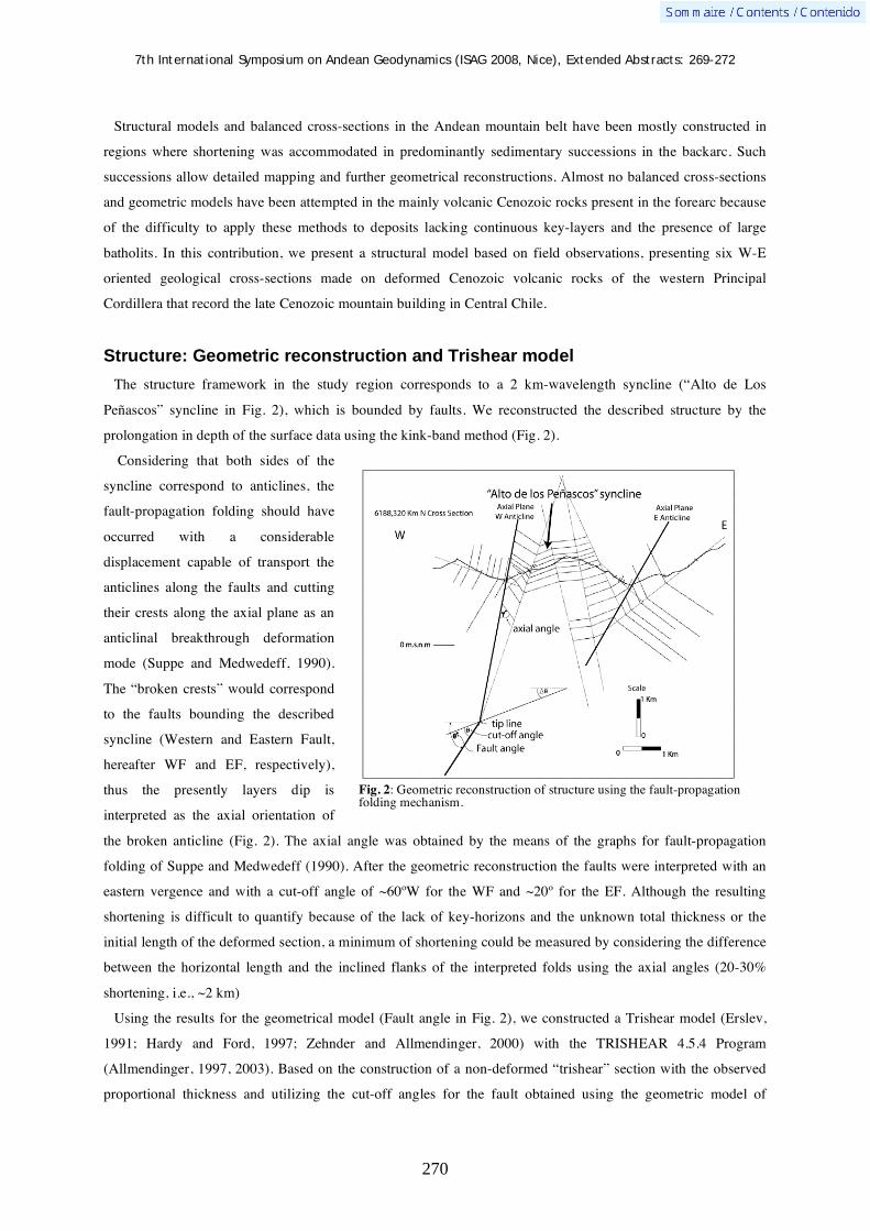
7th International Symposium on Andean Geodynamics (ISAG 2008, Nice), Extended Abstracts: 269-272
270
Structural models and balanced cross-sections in the Andean mountain belt have been mostly constructed in
regions where shortening was accommodated in predominantly sedimentary successions in the backarc. Such
successions allow detailed mapping and further geometrical reconstructions. Almost no balanced cross-sections
and geometric models have been attempted in the mainly volcanic Cenozoic rocks present in the forearc because
of the difficulty to apply these methods to deposits lacking continuous key-layers and the presence of large
batholits. In this contribution, we present a structural model based on field observations, presenting six W-E
oriented geological cross-sections made on deformed Cenozoic volcanic rocks of the western Principal
Cordillera that record the late Cenozoic mountain building in Central Chile.
Structure: Geometric reconstruction and Trishear model
The structure framework in the study region corresponds to a 2 km-wavelength syncline (“Alto de Los
Peñascos” syncline in Fig. 2), which is bounded by faults. We reconstructed the described structure by the
prolongation in depth of the surface data using the kink-band method (Fig. 2).
Considering that both sides of the
syncline correspond to anticlines, the
fault-propagation folding should have
occurred with a considerable
displacement capable of transport the
anticlines along the faults and cutting
their crests along the axial plane as an
anticlinal breakthrough deformation
mode (Suppe and Medwedeff, 1990).
The “broken crests” would correspond
to the faults bounding the described
syncline (Western and Eastern Fault,
hereafter WF and EF, respectively),
thus the presently layers dip is
interpreted as the axial orientation of
the broken anticline (Fig. 2). The axial angle was obtained by the means of the graphs for fault-propagation
folding of Suppe and Medwedeff (1990). After the geometric reconstruction the faults were interpreted with an
eastern vergence and with a cut-off angle of ~60ºW for the WF and ~20º for the EF. Although the resulting
shortening is difficult to quantify because of the lack of key-horizons and the unknown total thickness or the
initial length of the deformed section, a minimum of shortening could be measured by considering the difference
between the horizontal length and the inclined flanks of the interpreted folds using the axial angles (20-30%
shortening, i.e., ~2 km)
Using the results for the geometrical model (Fault angle in Fig. 2), we constructed a Trishear model (Erslev,
1991; Hardy and Ford, 1997; Zehnder and Allmendinger, 2000) with the TRISHEAR 4.5.4 Program
(Allmendinger, 1997, 2003). Based on the construction of a non-deformed “trishear” section with the observed
proportional thickness and utilizing the cut-off angles for the fault obtained using the geometric model of
Fig. 2: Geometric reconstruction of structure using the fault-propagation folding mechanism.

7th International Symposium on Andean Geodynamics (ISAG 2008, Nice), Extended Abstracts: 269-272
271
deformation (WF = 60º and EF = 20º), we developed a forward model varying the propagation, slip, and
Trishear angle in order to arrive to the best-fit parameters explaining the deformation caused by the WF. After a
comparative analysis between the resulting trishear models and the observed deformation, we choose a cut of
angle of 60º, a Trishear angle of 30º, a slip of 150 pixels (that corresponds to 1.5 km) and a P/S of 1 as the best-
fitting parameters. Using the resulting geometry of the model with these parameters, we superimpose the activity
of the EF; the better resulting geometry corresponds to a P/S of 0.5, a Trishear angle of 60º and a slip of 200
pixels (2 km). The resulting geometry was superimposed to the faults geometric model reconstruction in order to
compare them (Fig. 3). The total shortening of the deformed trishear section correspond to 30% (~3 km), which
is consistent with the shortening obtained using the geometric reconstruction.
Fig. 3: Superimposed faults geometric model reconstruction and Trishear model results.
Discussion and conclusions
The results for the geometrical and Trishear models suggest that folding in the study region would be at least
controlled by two E-vergent faults (WF and EF). The most important one, the WF, has a higher dip angle
(~60ºW) than the EF, being mechanically compatible with the inclination expected for inverted normal faults.
Moreover, this is also consistent with the regional geology interpreted for the faults affecting the Cenozoic units
in the western Principal Cordillera (Charrier et al., 2002). Based on the resulting geometric model, we interpret
the EF (with a dip angle near 20ºW) as a neo-formed short-cut, which would have facilitated shortening
accommodation.
The estimated shortening using these models is about 30% (2-3 km for the study region) which would have
been accommodated during the basin inversion stage (22 and 16 Ma) because the upper levels of the Farellones
Formation remain regionally non-deformed. In the northernmost part of the study region, the axial plane of the
WF develops as an anticline. This fold extends further north, thus the WF would represent a major structure of
the western flank of the Principal Cordillera. Indeed, this anticline is the western boundary of the Farellones
Formation (FW in Fig. 4) in which its lower portion develops growth strata (Fock et al., 2006; Farías et al.
2007). According to Farías et al. (2007), this east-vergent fault has a deep origin associated with a regional
ramp-flat structure connecting the subduction zone with the tectonic front of the Andes in Argentine territory
(Fig. 4). In this structural context, the WF would be pass-by thrust of the ramp segment in the zone where this

7th International Symposium on Andean Geodynamics (ISAG 2008, Nice), Extended Abstracts: 269-272
272
crustal-scale structure evolved to a detachment fault eastward at a depth close to 20 km beneath the western
Principal Cordillera.
Finally, the use of geometrical and numerical models has allowed proposing a structural kinematic model for
the deformation affecting volcanic rocks in the forearc with a very-well correlation with geophysical and
regional structural data of this Andean segment.
Fig. 4: Structural cross section at 34ºS. Modified after Farías et al. (2008).
Aknowledgements This work was supported by the FONDECYT Project Nº1030965 and the Bicentennial Program in Science and Technology Grant ANILLO ACT-18. References Allmendinger, R., 1998. Inverse and forward numerical modeling of trishear fault-propagation folds. Tectonics, Vol. 17, Nº
4, p. 640-656. Allmendinger, R. 1997-2003. FaultFold 4.5.4 (formerly TRISHEAR, Windows version). Charrier, R., Baeza, O., Elgueta, S., Flynn, J.J., Gans, P., Kay, S.M., Muñoz, N., Wyss, A.R., Zurita, E., 2002. Evidence for
Cenozoic extensional basin development and tectonic inversion south of the flat-slab segment, southern Central Andes, Chile (33º-36ºS.L.). Journal of South American Earth Sciences, Vol. 15, p. 117-139.
Charrier, R., Bustamante, M., Comte, D., Elgueta, S., Flynn, J.J., Iturra, N., Muñoz, N., Pardo, M., Thiele, R. and Wyss, A.R., 2005. The Abanico Extensional Basin: Regional extension, chronology of tectonic inversion, and relation to shallow seismic activity and Andean uplift. Neues Jahrbuch für Geologie und Paläontologie Abh. 236, (1-2), p. 43-47.
Erslev, E., 1991. Trishear fault-propagation folding. Geology, v 19, p.617-620. Farías, M., Comte, D., Charrier, R., Martinod, J., Tassara, A., and Fock, A. (2007). Ramp-flat crustal-scale structure as the
first order feature of the Andean margin: Seismologic, surface structural and rheological evidence for Central Chile. GEOSUR 2007, Libro de Resúmenes, Santiago de Chile, p. 59.
Farías, M., R. Charrier, S. Carretier, J. Martinod, A. Fock, D. Campbell, J. Cáceres, and D. Comte (2008), Late Miocene high and rapid surface uplift and its erosional response in the Andes of central Chile (33°–35°S), Tectonics, 27, 17 January 2008.
Fock, A., Charrier, R., Farías, M., Muñoz, M. (2006). Fallas de Vergencia Oeste en la Cordillera Principal de Chile Central (33º S- 34º S). Asociación Geológica Argentina, Serie: Publicación especial, 6, 48-55.Hardy, S. y Ford, M., 1997. Numerical modeling of trishear fault propagation folding. Tectonics, Vol. 16, Nº 5, p. 841-854.
Suppe, J and Medwedeff, D., 1990. Geometry and kinematics of fault-propagation folding. Eclogae geol. Helv. 83/3:409-454.
Zehnder, A.T. and Allmendinger, R.W., 2000. Velocity field for the trishear model. Journal of Structural Geology 22.1009±1014

7th International Symposium on Andean Geodynamics (ISAG 2008, Nice), Extended Abstracts: 273-276
273
Organization and evolution of a segmented deformation front: Llanos foothills, Eastern Cordillera of Colombia
Andreas Kammer, Antonio Velásquez, Alejandro Beltran, Alejandro Piraquive, & Wilmer
Angel Robles
Universidad Nacional de Colombia, 14490 Bogota, Colombia ([email protected])
Introduction
The Eastern Cordillera of Colombia evolved since the Upper Eocene within the Cretaceous to Paleocene
retroarc basin of the Early Mesozoic Northandean plate margin and designates, by its isolated position, an
intracontinental chain. Its initial folding closely correlates to the onset of convergence between Caribbean and
Southamerican plates and its still ongoing evolution marks a long lasting collisional event. On its western side
this mountain chain is embraced by the gently tilted western flank of the Central Cordillera, while on its eastern
side it abuts against the rigid lithosphere of the Guayana shield. By its clear-cut deformation fronts it defines a
weak crustal welt between converging rigid blocks as conceptualized in the experimental vice model (Ellis et al.,
1998). This same belt was previously the site of various rift events, among which an Upper Paleozoic and an
Early Cretaceous one bear a particular importance on the evolution of its deformation fronts. Its attenuated crust
was therefore predestined to accrue much of the Tertiary contraction by the reactivation of inherited faults that
originated at its boundaries and a pure-shear deformation of its inner parts. On its eastern border the Tertiary,
especially Neogene contraction and exhumation produced uplift in excess of 10’000 m with pre-Cretaceous
basement units reaching altitudes of 3000 to 4000 m. Uplift in the central high plain of Bogotá, on the other
hand, is constrained to less than 2500 m. These contrasting structural reliefs pose the question about deformation
mechanisms intervening in the formation of the Eastern Cordillera. In his contribution we focus on the evolution
of the deformation front east of the High plain of Bogotá comprised between latitudes of 4oN and 4.5oN.
Deformation front east of the High Plain of Bogotá
The oblique view on the study area (Fig. 1) depicts a synthetic view on the Guavio and Tauramena segments of
the Llanos foothills and illustrates the composite nature of its deformation front. The folded and principal
deformation front is represented by the Farallones Anticline that is breached by a normal fault in its hinge. This
giant anticlinal structure is tightly coupled to the blind Servitá fault that limits to its W a rift basin of Late-
Paleozoic red beds. East to the Farallones Anticline Late Cretaceous platform and Tertiary foreland sediments
are transported in a piggy-back manner to the E, as attested by the emergent Guaicaramo fault, which limits
folded foothills against undeformed shield area. The Guavio segment lacks a seismic activity and, considering
the high activity of adjacent segments, an aseismic creep may be anticipated for the slip on the Guaicaramo
thrust. At the southern border of the Tauramena segment the folded deformation front steps E to the thrust front
of the Guaicaramo fault. The Guacaramo fault is here constrained to a dip angle of 50o by an aftershock
distribution of the 1995 Tauramena earthquake (Dimaté et al., 2003). How can this uncommon situation of the

7th International Symposium on Andean Geodynamics (ISAG 2008, Nice), Extended Abstracts: 273-276
274
merging of a high-angle and a thrust fault be explained? To this end we analyze the structural evolution of the
two segments by means of serial cross-sections (Fig. 2).
Figure 1. Synthetic map and DEM of the study area with main structural elements and traces of vertical sections of Fig. 2.
Figure 2. Serial cross sections.
Structures of the Guavio segment
The generation of about 6 km of displacement on the Guavio thrust has been accounted for by various
scenarios, among which a thin-skinned solution (1) explains the excess length of the cover as a consequence of a
strain-partitioning between highly deformed basement and little deformed cover. In solutions focusing on an in-
850
1080
1400
Aguacalara – La Mesa Bridge
– San Agustinera Creek
Guavio Anticline
Pescana Creek
Chameza
Guavio Segment
Tauramena
Segment
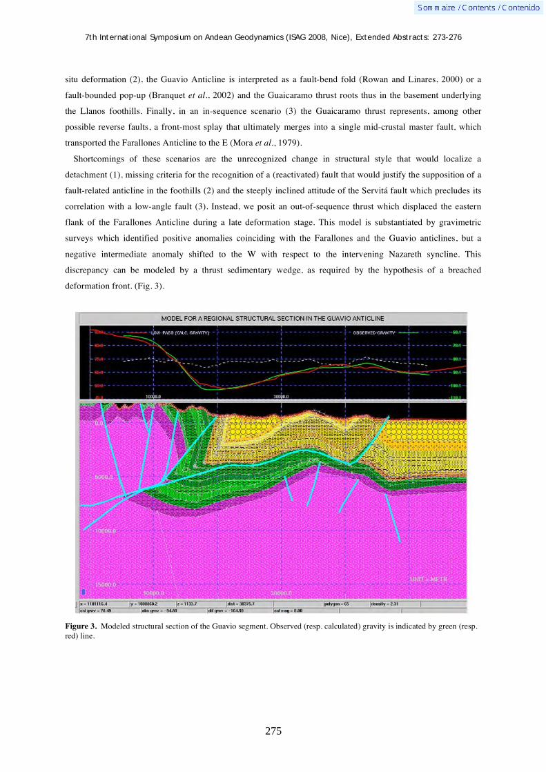
7th International Symposium on Andean Geodynamics (ISAG 2008, Nice), Extended Abstracts: 273-276
275
situ deformation (2), the Guavio Anticline is interpreted as a fault-bend fold (Rowan and Linares, 2000) or a
fault-bounded pop-up (Branquet et al., 2002) and the Guaicaramo thrust roots thus in the basement underlying
the Llanos foothills. Finally, in an in-sequence scenario (3) the Guaicaramo thrust represents, among other
possible reverse faults, a front-most splay that ultimately merges into a single mid-crustal master fault, which
transported the Farallones Anticline to the E (Mora et al., 1979).
Shortcomings of these scenarios are the unrecognized change in structural style that would localize a
detachment (1), missing criteria for the recognition of a (reactivated) fault that would justify the supposition of a
fault-related anticline in the foothills (2) and the steeply inclined attitude of the Servitá fault which precludes its
correlation with a low-angle fault (3). Instead, we posit an out-of-sequence thrust which displaced the eastern
flank of the Farallones Anticline during a late deformation stage. This model is substantiated by gravimetric
surveys which identified positive anomalies coinciding with the Farallones and the Guavio anticlines, but a
negative intermediate anomaly shifted to the W with respect to the intervening Nazareth syncline. This
discrepancy can be modeled by a thrust sedimentary wedge, as required by the hypothesis of a breached
deformation front. (Fig. 3).
Figure 3. Modeled structural section of the Guavio segment. Observed (resp. calculated) gravity is indicated by green (resp. red) line.
7th International Symposium on Andean Geodynamics (ISAG 2008, Nice), Extended Abstracts: 273-276
276
Structures of the Tauramena segment
The right-stepped relay from the Guavio to the Tauramena segment is smooth and manifests itself in the
hangingwall block by a loss of structural relief of the Farallones Anticline and an amplification of the easterly
Tierra Negra Anticline which supersedes the Guavio Anticline to the N. Most important, however, is the tightly
folded tip of the hangingwall block at the fault intersection. These small-scale buckle folds may be fault-
bounded along their synclinal axial planes. They designate deformation zones that predate the final throw on the
Guaicaramo fault, as they are partially delaminated from the hangingwall block array by its frictional interaction
with the footwall block.
Discussion
The Pliocene Andean paroxysmal deformation phase is characterized by an accelerated uplift and an
exhumation rate estimated at 1mm/year (Mora2007) that focused particularly on the eastern deformation front. In
the Guavio segment amplification and outward growth of the folded deformation front are antagonistic
processes. Fold growth guided by the steeply inclined Servitá fault requires material to be added along steep
flow paths, perhaps linking the marginal high to a mid-crustal flow channel. Fold growth implied a steepening of
the eastern flank which evolved toward a critical angle, before it was breached by the Guavio fault. This
Pliocene (?) out-of-sequence thrust fossilized this folded deformation front by a displacement transfer to an
easterly more position. Contrary to this big-scale folding the deformation front of the Tauramena segment did
not become arrested at the Servitá fault and affected progressively (?) more foreland oriented areas, until it
became blocked at the deformation zone at the Guaicaramo fault.
The Guavio Anticline marks a transitional behavior between arrested and outward migrating deformation
front. It did not attain the stage of a faulted forelimb, as further north in the Tierra Negra Anticline. Collapse of
the folded deformation front attenuated the compressional regime.
References Branquet Y., Cheilletz A., Cobbold P. R., Baby P., Laumonier B., and Giuliani G., 2002, — Andean deformation and rift
inversion, eastern edge of Cordillera Oriental (Guateque-Medina area), (Colombia). Journal of South American Earth Sciences., v. 15, no. 4, p. 391-407.
Dimaté, C., Rivera, L. A., Taboada, A., Delouis, B., Osorio, A., Jiménez, E., Fuenzalida, A., Cisternas, A., and Gómez, I., 2003 — The 19 January 1995 Tauramena (Colombia) earthquake: geometry and stress regime: Tectonophysics., 363, no. 3-4, 159-180.
Ellis, S., Beaumont, C., Jamieson, R.A., Quinlan, G., 1998 — Continental collision including a weak zone; The vice model and its application to the Newfoundland Appalachians. Canadian Journal of Earth Sciences, 35, 1323-1346.
Mora, A., 2007 — Inversion tectonics and exhumation processes in the Eastern Cordillera of Colombia. Doctoral thesis, University of Potsdam, 133 p, Potsdam.
Rowan, M., and Linares, R., 2000 — Fold evolution matrices and axial-surface analysis of fault-bend folds: Application to the Medina Anticline, Eastern Cordillera, Colombia: American Association of Petroleum Geologists Bulletin, v. 84, no. 6, p. 741-764.

7th International Symposium on Andean Geodynamics (ISAG 2008, Nice), Extended Abstracts: 277-280
277
The PUNA passive seismic array in the southern Puna: Tests of lithospheric delamination in the region of the Cerro Galán ignimbrite
S. Mahlburg Kay1, B. S. Heit
2, B. L. Coira
3, E. Sandvol
4, X. Yuan
2, N. A. McGlashan
1,
D. Comte5, L. D. Brown
1, R. Kind
2, & D. Robinson
4
1 Dept. Earth. Atm. Sci., INSTOC, Cornell Univ. Ithaca, NY, 14853, USA ([email protected])
2 GeoForschungsZentrum Potsdam, Telegrafenberg, 14473 Potsdam, Germany ([email protected])
3 Inst. Geología y Minería, Univ. Nac. de Jujuy, 4600 S.S. de Jujuy, Argentina ([email protected])
4 Dept. Geoi. Sci., Univ. of Missouri, Columbia, MO, 65211-1380, USA ([email protected])
5 Dept. Geofísica, Universidad de Chile, Santiago, Chile ([email protected])
KEYWORDS : southern Puna, delamination, Central Andes, Cerro Galán, seismic data
Introduction
A passive seismic array is deployed at present in the southern Puna of the Central Andean plateau between
25°S to 28°S latitude in Argentina and Chile to address fundamental questions on the processes that form,
modify and destroy continental lithosphere and control lithospheric dynamics along Andean-type continental
margins (Fig. 1). The southern Puna is important in this regard as this is the region where the delamination
hypothesis for removal of thickened eclogitic continental crust and mantle lithosphere was initially suggested
(Kay and Kay, 1993). The case for young delamination of the lithosphere in the southern Puna was built on
magmatic patterns, geochemical signatures and evolutionary models for mafic lavas and silicic ignimbrites
(particularly Cerro Galán), changing and mixed deformational styles, high topography accompanied by
insufficient crustal shortening, an underlying slab with a gap in intermediate depth seismicity and evidence for
Sn attenuation (e.g., Kay et al. 1994; 1999; Whitman et al. 1996). Since then, the crustal delamination process
has gained popularity as it can explain features like formation of giant ignimbrites and the near absence of a
mafic crustal root in many orogenic regions (e.g., Beck and Zandt, 2002; Yuan et al., 2002). On another level,
the delamination model provides a way to explain the bulk andesitic composition of the continental crust (e.g.,
Kay and Kay, 1993). The southern Puna, which overlies a down-going slab with a transitional dip between a
steeper dipping segment to the north and a flat-slab to the south, is a benchmark for comparative studies with
orogenic systems like those in the western US and Tibet where changing subduction angles, lithospheric
delamination and crustal shortening have been used to explain lithospheric evolution and plateau formation.
The seismic experiment
The seismological data being acquired in the southern Puna are designed to test if the current lithospheric and
mantle structure is compatible with latest Miocene and younger crustal and mantle lithospheric delamination and
to fill a critical gap in along strike geophysical coverage in the central Andes. The seismological data
complement those of Yuan et al. (2002), Heit (2005), Schurr et al (2006) and others. They should provide the
first detailed constraints on crustal thicknesses, slab dip and mantle heterogeneity from receiver function and
tomographic images under the southernmost Puna. The region being studied underlies the latest Miocene to
Quaternary southern Puna mafic volcanic centers, the 6 to 2 Ma Cerro Galán ignimbrites, and < 1 Ma Cerro
Blanco caldera and associated ignimbrites (e.g., Sparks et al., 1985; Kay et al., 1994; 1999; Siebel et al., 2001).

7th International Symposium on Andean Geodynamics (ISAG 2008, Nice), Extended Abstracts: 277-280
278
The project involves 73 three-component broad and intermediate band seismic stations deployed in arrays
designed to image the seismic velocity structure of the crust and mantle as well as local seismicity patterns. The
instruments are from NSF IRIS PASSCAL and the Universities of Missouri and St. Louis in the USA, and the
GeoForschungZentrum in Potsdam, Germany. The deployment, which took place in late 2007 and early 2008, is
for approximately 18 months. The first major data recovery from the array will take place in the middle of 2008.
The location of the seismic array is shown in Figure 1.The short period stations are deployed along the north-
south (25°30’S, 67°15’W to 27°55’S, 67°38’W) and east-west (26°55’ S, 68°53’W to 27°S, 65°15’W) oriented
lines with a spacing of 10 to 15 km to optimize the imaging of crustal and upper mantle properties. The broad
band stations are deployed across the region in a 2-D array with an approximate spacing of 50 km to optimize
determination of mantle properties in three dimensions. Mantle dynamics and mantle flow associated with slab
lithosphere and geometry are to be interpreted through a combination of surface wave, body wave, and
attenuation tomographic methods in combination with existing geologic and geochemical studies.
Fundamental questions regarding Nazca-South American plate dynamics and the origin of the central Andean
Puna plateau to be addressed include: (1) What are the geometry, extent and fate of thinned or removed
lithosphere beneath the Puna plateau? (2) What controls crustal thickness beneath different parts of the Puna
plateau and surrounding regions? (3) What is the rheology of the mantle wedge and subducting slab in a region
of changing slab dip over a seismically quiet Benioff zone? (4) What is the history of deformation and
magmatism within the mantle wedge? and (5) What are the factors controlling along strike similarities and
differences in continental plateaus along Andean type margins?
The Cerro Galán ignimbrite and mantle/crustal magma generation models
being tested from seismic studies in the southern Puna
A number of the characteristic features of the Central Andean Puna plateau have been proposed to reflect
delamination and other deep crustal and mantle processes that are being investigated through the seismic
experiments. Among these features are the voluminous dacitic ignimbrites that are now commonly linked with
delamination processes as was suggested for the Cerro Galán ignimbrites by Kay et al. (1994). The volumes and
chemistry of the ignimbrites reflect the crustal and mantle conditions required to generate large magma systems.
Geochemical models based on 87Sr/86Sr ratios, 18O/16O and trace element contents show that the Cerro Galán
ignimbrites are best modeled as approximately 50:50 mixtures of mantle-wedge derived basaltic composition
magmas and crustal melts. Erupted mafic magmas and geochemical modeling studies in the Cerro Galán region
show that the mantle-derived magmas are isotopically enriched (87Sr/86Sr ~ 0.7055; Nd ~ -2) most likely though
lithospheric recycling due to forearc subduction erosion and delamination. Bulk crustal contaminants in the
Cerro Galán ignimbrites need to have 87Sr/86Sr ratios ranging from 0.720 to 0.735 at 300 to 125 ppm Sr and 18O/16O values of 11.5 to 12. Trace element evidence for residual garnet and Sr systematics in crustal
contaminants indicate that crustal melting and contamination occurred in the deep crust and that the
contaminated melts accumulated in magma chambers like those seen near 20 to 30 km depth on seismic images
further north (e.g., Beck and Zandt, 2002; Yuan et al. 2002: ANCORP, 2003) and at the northern limit of the
current array (Heit, 2005). Negative Eu anomalies superimposed on high pressure REE patterns and calculated
bulk distribution coefficients are best explained by feldspar fractionation in mid-crustal magma chambers at

7th International Symposium on Andean Geodynamics (ISAG 2008, Nice), Extended Abstracts: 277-280
279
these levels. Trends from higher to lower La/Yb and Sm/Yb ratios in the 6 to 2 Ma Cerro Galán ignimbrites
indicate a changing role for garnet as a controlling residual phase as the Cerro Galán system evolved. Single
crystal 40Ar/39Ar sanidine and biotite ages for pumice and whole rock samples from three flows show that the
terminal eruptions of the giant Cerro Galán ignimbrite consisted of a series of flows that had begun erupting by
at least 2.13 Ma and continued to erupt until at least 2.06 Ma (Kay and Coira, 2008). The volume of the
ignimbrites and their compositions require major heat input from mantle-derived magmas generated in the
mantle wedge above the slab. The estimated volumes for the Puna ignimbrites coupled with a 90 km3/km/Ma
arc magma production rate suggest a plutonic/volcanic ratio of about 4:1 and up to 5 kilometers of thickness of
new crust spread under the plateau.
The tomographic images of Heit (2005) from the northern region of the current seismic deployment near
25.5°S show significantly more negative P and S wave velocity anomalies at mantle depths below 100 km than
for seismic images from beneath the northern Puna. The anomalies in the southern Puna are consistent with the
younger age of the Cerro Galán ignimbrites compared to the northern Puna ignimbrites and with recent
delamination processes in the southern Puna. The seismic results from the current seismic array will allow the
seismic character of the mantle to be traced to the south and aid in correlations of the generation of the
distinctive young southern Puna ignimbrites from Cerro Galán and Cerro Blanco and the young mafic flows with
mantle and slab processes.
Figure 1. Satellite Radar Topography Mission (SRTM) image of the southern Puna showing the location of the broadband array (in the boxed region) and the north-south and east-west seismic lines (dashed white lines). Also shown are the locations of the large northern Puna ignimbrite field near 22°S and the southern Puna Cerro Galán and Cerro Blanco ignimbrites.

7th International Symposium on Andean Geodynamics (ISAG 2008, Nice), Extended Abstracts: 277-280
280
References ANCORP Working Group 2003. Seismic imaging of a convergent continental margin and plateau in the central Andes
(Andean Continental Research Project 1996 ANCORP’96). Journal of Geophysical Research 108: 2328, doi:10.1029/2002JB001771.
Beck, S. & Zandt, G. 2002. The nature of orogenic crust in the central Andes. Journal of Geophysical Research 107: 2230, doi:10.1029/2000JB000124.
Heit, B.S., 2005. Teleseismic tomographic images of the Central Andes at 21 °S and 25.5 °S: an inside look at the Altiplano and Puna plateaus. GeoForschungsZentrum Potsdam, Scientific Technical Report STR06/05 139 (Potsdam).
Kay, R. W. & Kay, S.M. 1993. Delamination and delamination magmatism. Tectonophysics 219: 177– 189. Kay, S. Mahlburg, Coira, B. & Singer, B. 2008. “Single crystal sanidine and biotite 40Ar/39Ar ages for the Cerro Galán
intracaldera and extracaldera ignimbrite flows.” In: VI South American Symposium on Isotope Geology, San Carlos de Bariloche, Argentina, 14-16 April 2008.
Kay, S. Mahlburg, Coira, B. & Viramonte, J. 1994. Young mafic back-arc volcanic rocks as indicators of continental lithospheric delamination beneath the Argentine Puna plateau, Central Andes. Journal of Geophysical Research 99: 24323-24339.
Kay, S. Mahlburg, Mpodozis, C. & Coira, B. 1999. Magmatism, tectonism and mineral deposits of the Central Andes (22°-33°S latitude). In Skinner, B. J. (ed) : Geology and ore deposits of the central Andes, Society of Economic Geology Special Publication 7: 27-59.
Schurr, B., Rietbrock, A., Asch, G. Kind, R. & Oncken, O. 2006. Evidence for lithospheric detachment in the central Andes from local earthquake tomography. Tectonophysics 415: 203-223.
Siebel, W., Schnurr, W., Hahne K, Kraemer, B, Trumbull, R.B., van den Bogaard, P & Emmermann, R. 2001. Geochemistry and isotope systematics of small- to medium-volume Neogene-Quaternary ignimbrites in the southern central Andes: evidence for derivation from andesitic magma sources. Chemical Geology 171: 213-237.
Sparks, R. S. J., Francis, P. W., Hamer, R. D., Pankhurst, R.J., O'Callaghan, L.L., Thorpe, R. S. & Page, R. S. 1985. Ignimbrites of the Cerro Galán Caldera, NW Argentina. Journal of Volcanology and Geothermal Research 24: 205-248.
Whitman, D., Isacks, B. L. & Kay, S. Mahlburg 1996. Lithospheric structure and along-strike segmentation of the central Andean Plateau. Tectonophysics 259: 29-40.
Yuan, X., Sobolev, S.V. & Kind, R. 2002. Moho topography in the central Andes and its geodynamic implications. Earth and Planetary Science Letters 199: 349-402.
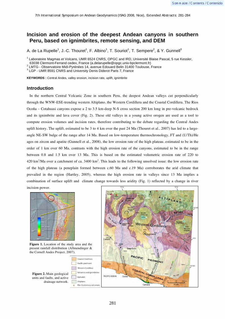
7th International Symposium on Andean Geodynamics (ISAG 2008, Nice), Extended Abstracts: 281-284
281
Incision and erosion of the deepest Andean canyons in southern Peru, based on ignimbrites, remote sensing, and DEM
A. de La Rupelle1, J.-C. Thouret
1, F. Albino
1, T. Souriot
1, T. Sempere
2, & Y. Gunnell
3
1 Laboratoire Magmas et Volcans, UMR 6524 CNRS, OPGC and IRD, Université Blaise Pascal, 5 rue Kessler,
63038 Clermont-Ferrand cedex, France ([email protected]) 2 LMTG - Observatoire Midi-Pyrénées 14, avenue Edouard Belin 31400 Toulouse, France
3 LGP - UMR 8591 CNRS and University Denis Diderot Paris 7, France
KEYWORDS : Central Andes, valley erosion, incision rate, uplift, ignimbrite
Introduction
In the northern Central Volcanic Zone in southern Peru, the deepest Andean valleys cut perpendicularly
through the WNW-ESE-trending western Altiplano, the Western Cordillera and the Coastal Cordillera. The Rios
Ocoña – Cotahuasi canyons expose a 2 to 3.5 km-deep N-S cross section 200 km long in pre-volcanic bedrock
and its ignimbrite and lava cover (Fig. 2). These old valleys in a young active orogen are used as a tool to
compute erosion volumes and incision rates, therefore contributing to the debate regarding the Central Andes
uplift history. The uplift, estimated to be 3 to 4 km over the past 24 Ma (Thouret et al., 2007) has led to a large-
angle NE-SW bulge of the range after 14 Ma. Based on low-temperature thermochronology, FT and (U/Th)/He
ages on zircon and apatite (Gunnell et al., 2008), the low erosion rate of the high plateau, estimated to be in the
order of 1 km over 60 Ma, contrasts with the high erosion rate of the canyons, estimated to be in the range
between 0.8 and 1.5 km over 13 Ma. This is based on the estimated volumetric erosion rate of 220 to
420 km3/Ma over a catchment of ca. 3400 km2. This leads to the following unsolved issue: the low erosion rate
of the high plateau (a peneplain formed between c.60 Ma and c.19 Ma) corroborates the arid climate that
prevailed in the region (Hartley, 2005), whereas the high erosion rate in valleys since 13 Ma implies a
combination of surface uplift and climate change towards less aridity (Fig. 1) reflected by a change in river
incision power.
Figure 1. Location of the study area and the present rainfall distribution (Allmendinger & the Cornell Andes Project, 2007).
Figure 2. Main geological units and faults, and active
drainage network.

7th International Symposium on Andean Geodynamics (ISAG 2008, Nice), Extended Abstracts: 281-284
282
Ignimbrites as tools for estimating erosion and incision
Pre- and post-incision ignimbrites
Among the five sheets of ignimbrites that erupted in the region since ca. 20 Ma, three are used here as
stratigraphic markers of the canyon incision. The pre-incision 19.4–18 Ma-old Alpabamba ignimbrites (Thouret
et al., 2007) and the 14.3 –12.7 Ma-old Huaylillas ignimbrites overlay the paleosurface of, and form, the high
plateaus at 4000-4500 m asl. The ca 9 Ma-old Caraveli ignimbrites mantle shallow wide valleys cut in these high
plateaus, pointing therefore to the initiation of downcutting some time before 9 Ma. Two post-incision lower and
upper Sencca ignimbrites (4.9 – 3.6 Ma and 2.3 – 1.4 Ma) crop out near the valley bottom or cover terraces 400
to 600 m above the river. Based on this chronostratigraphy and on the fact that lower Sencca ignimbrites
3.76 Ma are exposed near the bottom of the valley of the Río Cotahuasi, the valley erosion started some time
before 9 Ma but the deep canyon downcutting occurred well after 9 Ma and before 3.76 Ma.
Erosion volumes and incision rates based on DEM and remote sensing
To compute the volume of eroded material during the valley formation, we use the Huaylillas ignimbrites,
which predate the valley formation, and the Sencca ignimbrites, which post-date the major phase of valley
incision. The contour base of each ignimbrite sheet has been drawn on a Landsat image (Fig. 3) and mapped on a
DEM, and is used as a paleo-surface, accounting for the paleo-topography of the valley at each given time span
of the stepwise incision.
Figure 3. Contours of bases of each ignimbrites and volcanic rocks, drawn on Landsat image of study area.
N
10 km
Figure 4. DEM (20 m- resolution), with shaded relief, from SPOT images.

7th International Symposium on Andean Geodynamics (ISAG 2008, Nice), Extended Abstracts: 281-284
283
Using ENVI, the contours of volcanic units (Fig. 3) and a DEM (Fig. 4), the paleosurfaces at each ignimbrite-
marker are compared with the present valley bottom (Fig.5), and we compute two data sets: the volume of
eroded material and the vertical erosion rate (Table 1).
Figure 5. Slice of removed rock since 13 Ma from the Ocoña - Cotahuasi confluence to the Pacific Ocean (Albino, 2006). The volume of eroded material from the canyon watershed is shown as inverted relief. Maximum eroded material (= maximum depth of the canyon) is color coded as dark red. Minimum eroded material (paleosurface prior to the c. 40 Ma – 14 Ma peneplain) is color coded as black.
Also, using ignimbrites 40Ar/39Ar ages and the difference in altitude between two dated markers, we estimate
incision rates at which the canyon was cut down (Table 1): the incision rate increased from 140 m/Ma between
14 and 9 Ma to 450 m/Ma between 9 and 4 Ma, reflecting therefore the major incision phase during Late
Miocene-Earliest Pliocene.
Dated ignimbrite taken as stratigraphic marker
Volume of eroded material for each time slice
Erosion volumetric rate as volume / time slice considered
Incision rate from height difference between 2 levels
Huaylillas ign., base = 13 Ma 3300 km3 820 km3 / Ma over 4 Ma 140 m/Ma
Caraveli ign., base = ~9 Ma 880 km3 200 km3 / Ma over 5 Ma 450 m/Ma
Sencca ign., base = ~4 Ma 1320 km3 340 km3 / Ma between 4 Ma and
present bottom
500 m/Ma
TOTAL 5500 km3 420 km3 / Ma over 13 Ma 170 m/Ma
Table 1. Results of computed eroded volumes and calculated erosion and incision rates for three time slices.
These results display spatial and time variations in incision rate. First, spatial variations are observed between
the Cotahuasi canyon, cut after 3.76 Ma at a rate of 750 m/Ma, and the Ocoña canyon where rocks have been
removed since 4 Ma at a rate of 250 m/Ma. Second, incision rates have also fluctuated through time: the 3.76-1.6
Ma valley fill of the Cotahuasi canyon was cut again after 1.6 Ma at a faster incision rate of 1300 m/Ma (Fig. 6).
The vertical incision is responsible of almost 80% of the overall valley downcutting between 9 and 4 Ma. This
is related to the work expenditure of the river, reflecting either change in channel gradient or in stream power
linked to the rainfall amount and distribution. The estimated incision rate (170 m/My) averaged on 13 Ma has
been compared with incision rates computed in similar catchments, i.e. cut in Mid-Late Cenozoic volcanic rocks,
under arid climate and in a convergent plate setting. As an example, the incision rate of the Rio Cotahuasi-Ocoña
Figure 6. Diagram comparing incision rates in the Rio Cotahuasi, northern part of the canyon system with the Rio Ocoña in the southern canyon system. The temporal evolution of incision rates is shown in both canyons. The two canyons join in a confluence site shown in Fig 3.

7th International Symposium on Andean Geodynamics (ISAG 2008, Nice), Extended Abstracts: 281-284
284
system lies in the upper range of the incision rate (10 – 200 m/My) computed by Montgomery and Lopez-Blanco
(2003) in the Sierra Madre Occidental, Mexico. This demonstrates that either a change in water discharge and
stream power or a change in slope gradient may have occurred in the canyon area.
Hypotheses on the causes of the major incision phase
The ultra-deep valleys under study show two geomorphic sections across transverse profiles: a wide (10-30
km), shallow (<12 km) valley above a narrow (1-2 km), ultra-deep (2-3.5 km) canyon. The wide valley was
shaped between 13 and 9 Ma (Middle-Late Miocene), whereas the deep canyon was cut well after 9 Ma (Late
Miocene-Early Pliocene). This geomorphic contrast is attributed to a change in erosion processes, i.e lateral
“pediment” erosion (driven by rill and sheet wash) vs. linear fluvial downcutting (driven by river water discharge
and stream expenditure in hard bedrock). Both categories of erosion processes are governed by rainfall intensity
and seasonal distribution. The climate must have changed from hyperarid to semi-arid conditions if we assume
that the erosion style has probably changed between Late Miocene and Early Pliocene. This leads us to
investigate what critical parameters can sustain high incision rates under arid conditions, and what processes are
responsible for initiating the vertical incision.
Physical properties, (facies and welding grading of the ignimbrites may be called upon to explain the distinct
rates of incision and erosion between the initial wide valley formation (13-9 Ma) and the subsequent canyon
downcutting (<9-4 Ma). Most of non-welded, loose Sencca ignimbrites sheets have favoured high-rate vertical
incision due to their ‘soft’ lithology as opposed to the ‘hard’ welded Huaylillas ignimbrites. In contrast, the Late
Cretaceous diorite batholiths of the Western Cordillera underwent weathering and lateral erosion that formed
pediments and enlarged the valley (e.g. Río Ocoña segment between Iquipi and the confluence with Río
Cotahuasi). Thus, bedrock lithologies display distinct responses to slope erosion processes and river incision.
Also, incision rate can increase if water discharge is rapidly added to the drainage network, hereby increasing the
river flow and stream power. A capture of the drainage network from catchments located in the western
Altiplano may have occurred t Late Miocene time. This could have been induced by tectonic vertical movements
related to the uplift of western Altiplano and to the flexure of the Western Cordillera from NE to SW.
Another process contributing to increase incision may be linked to landsliding and debris avalanches. Unstable
cliffs cut in overhanging non-ignimbrites (Rio Cotahuasi river) or in hydrothermally altered cores of eroded
volcanoes (e.g. Nevado Solimana) have failed and triggered huge landslides. Debris-avalanche deposits
repeatedly dammed the river channel (e.g. Cotahuasi village). Subsequent dam breakouts trigger debris flows
and floods downvalley, which increase stream power and eventually accelerate the incision process downvalley
over a short period.
References Albino F., 2006. Contribution au problème d’érosion dans les Andes centrales à l’aide de modèles numériques : exemple des
canyons péruviens. Travail d’Etude et de Recherche, L.M.V. Université Blaise Pascal., Unpublished 20p. Gunnell Y., J.-C. Thouret, S. Brichau and A. Carter, 2008. A low-temperature thermochronology of denudation, crustal uplift
and canyon incision in the Western Cordillera of southern Peru. Geoph. Res. Abs., vol.10, EGU2008. Hartley A.J.,2005. What caused Andean uplift? Extended Abstract, 6th ISAG, Barcelona 2005: 824-827. Montgomery D. R. and J. Lopez-Blanco, 2003. Post-Oligocene river incision, southern Sierra Madre Occidental, Mexico.
Geomorphology, 55: 235-247. Thouret J.-C., G. Wörner, Y. Gunnell, B. Singer, X. Zhang and T. Souriot, 2007. Geochronologic and stratigraphic
constraints on canyon incision and Miocene uplift of the Central Andes in Peru. Earth Plan. Sci .Letters, 263: 151-166.

7th International Symposium on Andean Geodynamics (ISAG 2008, Nice), Extended Abstracts: 285-288
285
Holocene submarine volcanoes in the Aysén fjord, Patagonian Andes (44ºS): Relations with the Liquiñe-Ofqui Fault Zone
Luis E. Lara
Servicio Nacional de Geología y Minería, Chile. Av. Santa María 0104. Santiago. Chile ([email protected])
KEYWORDS : submarine volcano, Liquiñe-Ofqui Fault Zone, 2007 Aysén seismic swarm, Patagonian Andes
Introduction
During the CIMAR 13 cruise to the Aysén fjord (45ºS), basaltic rocks were recovered from a submarine
volcanic cone located few kilometers west of an active intra-arc seismic zone. Since the middle of January 2007
an unusual intraplate seismic swarm has been taking place in the Aysén region. At the time of writing, minor yet
perceptible shakes are still being felt in the area nearby. The epicentral region was initially centered in the
middle of the Aysén fjord (Barrientos et al., 2007), coinciding with the master fault of the Liquiñe-Ofqui Fault
Zone (LOFZ; e.g., Hervé, 1994; Cembrano et al., 2007). The latter is a margin-parallel ca. 1200 km long
structural system, active at least since the Miocene (Cembrano et al., 1996; 2000; Thomson, 2002; Rosenau et
al., 2006). The overall stress regime along the arc domain is a bulk dextral transpression which determines
mostly strike-slip displacement along the NS-striking faults with some local vertical movements. The short-term
kinematic history is poorly constrained but growing evidence is in agreement with the long-term picture
provided by the tectonic analysis of fault populations at mesoscale from 38º-46ºS (Lavenu and Cembrano, 1999).
A damaging Mw: 6.3 shallow earthquake occurred on April 21st causing huge landslides and debris flows (ca.
23 km3) along the high slope walls of the fjord. Rock masses fell into the water and triggered tsunami waves that
shattered the coast killing 10 peoples. Although the tectonic scenario was favorable to shallow earthquakes and
the consequent slope failure, the near real-time hazard assessment of the ongoing crisis was at the beginning
focused on a possible submarine eruption above the epicentral area. Because several pyroclastic cones are
present along the LOFZ in the surrounding area, this hypothesis seemed to be plausible although did not account
for the entire geological process which would be, at a regional scale, tectonic in origin (e.g., Cembrano et al.,
2007). The presence of a bathymetric high across the Aysén fjord, few kilometers west of the epicentral area,
supported the idea of submarine volcanism in the recent past and thus the exploration of that place became a
target for the scientific assessment strategy. This article gives the first news of the finding of submarine volcanic
rocks in the Aysén fjord and briefly discusses their implications.
Quaternary tectonics and volcanism in Southern Andes
The most significant Neogene regional structure in the Patagonian Andes is the LOFZ. In the Aysén region, the
LOFZ consist of two overstepping NNE-striking master faults joined by a series of en échelon NE-striking
subsidiary faults forming a strike-slip duplex structure. Tectonic analysis combined with thermochronology
document a dextral transpression ductile deformation at ca. 4 Ma, followed by brittle compressional to strike-slip
deformation after 3.8 Ma and 1.6 Ma, respectively (Hervé, 1994; Cembrano et al., 1996; 2000; 2002; Lavenu
and Cembrano, 1999; Thomson, 2002). Quaternary volcanoes are spatially related to the strike-slip structural
7th International Symposium on Andean Geodynamics (ISAG 2008, Nice), Extended Abstracts: 285-288
286
system and a probable causative relation has been proposed for the entire Southern Andean Volcanic Zone
(Cembrano and Moreno, 1994; López et al., 1995a; Lara et al., 2006a; Rosenau et al., 2006). Some clusters of
monogenetic volcanoes as Caburgua (39ºS), Anticura (40ºS), Ralún-Cayutue (41ºS) and Puyuhuapi (44ºS) are
exactly on top of the master faults and seem to show a contrasting magmatic evolution with respect to the main
arc volcanoes (López et al., 1995a; 1995b; Hickey-Vargas et al., 2002). In the Aysén fjord, a NNE-striking
alignment of pyroclastic cones extends along the Pescado River whereas another NS-striking cluster is located
near the Cuervo River, both along the main trace of the LOFZ. In the middle of them, and just above an
inflection of the fault trace, the epicentral area of the ongoing seismic swarm is located. A few kilometers west,
the sampled submarine volcano emerges from the flat bottom of the fjord.
Volcanoes of the Aysén fjord
A bathymetric positive anomaly across the Aysén fjord was already detected on the nautical 1:50,000 scale
chart No. 8106 by the Hydrographic and Oceanographic Survey of the Chilean Navy (SHOA) where a NNE-
trending ridge shows minimum depths of ca. 60 m.b.s.l above a flat floor that averaged 200 m.b.s.l to the east
and 330 m.b.s.l. to the west, respectively (Fig. 1). This ridge is also located above a vertical disruption of the
fjord floor which could be tectonic in origin. Given the regional geologic setting, the presence of a submarine
volcano was considered as a possibility during the hazard assessment of the seismic crisis. However, other
options as basement highs or glacial morphologies cannot be precluded. In fact, Araya-Vergara et al. (2007)
described such submarine elevations as frontal moraines in the Reloncaví fjord (42ºS) and that seem to be
common in other similar environments, as for example in the Norwegian fjords (Laberg et al., 2007).
As a complement to the hazard evaluation, a multibeam batimetric survey was done in April 2007 by the PSH
Cabrales vessel from SHOA institution (Fig. 1). This survey did not detected significant bathymetric changes on
the epicentral area but improved the morphological knowledge of the western ridge. Considering the already
scheduled CIMAR 13 cruise to the Aysén region, a dredging procedure was conducted on board of the R/V Agor
Vidal Gormaz. The third sampling attempt allowed to collect several fragments of massive dark vesicular basalts
embedded in fine-grained gray sediments. Scarce biological remnants were recovered and they mostly consist of
annelids, sea urchins or some adhered cirripedial crustaceous. Neither hydrothermaly altered samples nor
pyroclastic material were recovered. The fine sediments seem to have formed a thin layer above the basalts. In
fact, the low-frequency echosounder control showed a sharp acoustic response on the volcano flank that permits
to image mostly lava flows.
What impact placed this finding to the 2007 Aysén seismic crisis?. Maybe directly none because no thermal
anomalies were measured along the fjord even above the epicentral area where gas outputs would have been
detected. The sampled volcano is, of course, inactive at present. However, the steep slope, the absence of
alteration or vesicles infilling and the thin sediment cover suggest its young, probably late Holocene age. A few
kilometers further south, the base of a pyroclastic sequence related to an emerged and partially eroded
pyroclastic cone of the Pescado River yield an age of ca. 6 ka. Thus, although the 2007 seismic swarm did not
show clear evidence of an ongoing magma ascent, the presence of this young volcano enhances the hypothesis of
volcanism in the fjord but taking part of a more regional process controlled by the fault kinematics and the
regional stress regime (Cembrano et al., 2007).

7th International Symposium on Andean Geodynamics (ISAG 2008, Nice), Extended Abstracts: 285-288
287
Several lines of research derive from this finding. For instance, geochemistry of these lava flows will allow a
comparison with other LOFZ-related monogenetic volcanoes. As already mentioned, small eruptive centers on
top of the LOFZ show key features that could be interpreted as isolated magma batches perhaps not related with
the dominant flux melting process that imprint the arc signature to the magmas erupted from the stratovolcanoes.
The precise role of the LOFZ in both the magma genesis and the subsequent ascent should be investigated in
detail. This finding along with additional data could improve our knowledge of these coupled processes and thus
become a real contribution to the hazard assessment in the Southern Andes.
Figure 1. (a) Nautical chart No. 816 by SHOA. (b) Shaded relief image based on a multibeam survey by R/V Agor Vidal Gormaz vessel of SHOA institution (unpublished). Blue ellipse shows the approximate 2007 (pre-April 21th) epicentral area.
References Araya-Vergara, J.; Vieira, R.; Suárez, M. 2007. El sistema submarino Relocaví (Norpatagonia): análisis morfoacústico,
batimétrico y fundamentos sedimentológicos. Revista Ciencia y Tecnología del Mar. (en prensa). Barrientos, S.; Bataille, K.; Aranda, C.; Legrand, D.; Báez, J.C.; Agurto, H.; Pavez, A.; Genrich, J.; Vigny, C.; Bondoux, F.
Complex sequence of earthquakes in Fjordland, Southern Chile. In Geosur 2007, Libro de Resúmenes, p. 21. Cembrano, J.; Moreno, H. 1994. Geometría y naturaleza contrastante del volcanismo Cuaternario entre los 38ºS y 46ºS:
¿dominios compresionales y extensionales en un régimen transcurrente? In Congreso Geológico Chileno, N° 7, Actas 1: 240-244, Concepción.
Cembrano, J.; Lara, L.; Lvenu, A.; Hervé, F. 2007. Long-term and short-term kinematic history of the Liquiñe-Ofqui fault zone: a review and implications for geologic hazards assessment. In Geosur 2007, Libro de Resúmenes, p. 30.
Cembrano, J.; Hervé, F.; Lavenu, A. 1996. The Liquiñe-Ofqui fault zone: a long-lived intra-arc fault Zone in southern Chile. Tectonophysics 259: 55-66.
Cembrano, J.; Shermer, E. ; Lavenu, A. ; Sanhueza, A. 2000. Contrasting nature of deformation along an intra-arc shear zone, the Liquiñe-Ofqui fault zone, southern Chilean Andes. Tectonophysics 319: 129-149.
Cembrano, J.; Lavenu, A.; Reynolds, P.; Arancibia, G.; López, G.; Sanhueza, A. 2002. Late Cenozoic transpressional ductile

7th International Symposium on Andean Geodynamics (ISAG 2008, Nice), Extended Abstracts: 285-288
288
deformation north of the Nazca–South America–Antarctica triple junction. Tectonophysics 354: 289– 314. Hervé, F., 1994. The southern Andes between 39° and 44°S latitude: the geological signature of a transpressive tectonic
regime related to a magmatic arc. In Tectonics of the Southern Central Andes (Reutter, K.J.; Scheuber, E.; Wigger, P.J.; editors). Springer, Berlin, pp. 243-248.
Hickey-Vargas, R.; Sun, M.; López-Escobar, L.; Moreno-Roa, H.; Reagan, M.; Morris, J.; Ryan, J. 2002. Multiple subduction components in the mantle wedge: Evidence from eruptive centres in the Central Southern Volcanic Zone, Chile. Geology 30: 199-202.
Laberg, J.S.; Eilertsen, R.S.; Salomonsen, G.R.; Vorren, T.O. 2007. Submarine push moraine formation during the early Fennoscandian Ice Sheet deglaciation. Quaternary Research 67: 453-462.
Lara. L.E., Lavenu, A., Cembrano, J.; Rodríguez, C. 2006. Structural controls of volcanism in transversal chains: resheared faults and neotectonics in the Cordón Caulle-Puyehue area (40.5ºS), Southern Andes. Journal of Volcanology and Geothermal Research 158: 70-86.
Lara, L.E.; Moreno, H.; Naranjo, J.A.; Matthews, S.; Pérez de Arce, C. 2006b. Magmatic evolution of the Puyehue-Cordón Caulle Volcanic Complex (40º S), Southern Andean Volcanic Zone: from shield to unusual rhyolitic fissure volcanism. Journal of Volcanology and Geothermal Research 157: 343-366.
Lavenu, A.; Cembrano, J. 1999. Compressional and traspressional-stress pattern for Pliocene and Quaternary brittle deformation in fore arc and intra-arc zones (Andes of Central and Southern Chile). Journal of Structural Geology 21: 1669-1691.
López-Escobar, L.; Cembrano, J.; Moreno, H. 1995a. Geochemistry and tectonics of the Chilean Southern Andes basaltic quaternary volcanism (37-46ºS). Revista Geológica de Chile 22 (2): 219-234.
López-Escobar, L.; Kempton, P.D.; Moreno, H.; Parada, M.A.; Hickey-Vargas, R.; Frey, F.A. 1995b. Calbuco volcano and minor eruptive centers distributed along the Liquiñe-Ofqui fault zone, Chile (41°-42°S): contrasting origin of andesitic and basaltic magma in the Southern Volcanic Zone of the Andes. Contributions to Mineralogy and Petrology 119: 345-361.
Rosenau, M.R.; Melnick, D. ; Echtler, H. 2006. Kinematic constraints on intra-arc shear and strain partitioning in the Southern Andes between 38°S and 42°S latitude. Tectonics 25: TC4013, doi:10.1029/2005TC001943.
Thomson, S.N. 2002. Late Cenozoic geomorphic and tectonic evolution of the Patagonian Andes between latitudes 42° and 46°S: An appraisal based on fission-track results from the transpressional intra-arc Liquiñe-Ofqui fault zone. Geological Society of America Bulletin 114: 1159-1173.

7th International Symposium on Andean Geodynamics (ISAG 2008, Nice), Extended Abstracts: 289-291
289
Determination of an arc-related signature in Late Miocene volcanics over the San Rafael block, Southern Central Andes (34º30´-37ºS), Argentina: The Payenia shallow subduction zone
Vanesa D. Litvak, Andrés Folguera, & Víctor A. Ramos
Laboratorio de Tectónica Andina, FCEyN, Universidad de Buenos Aires, Argentina ([email protected])
KEYWORDS : volcanic arc, shallow subduction, geochemistry, Payenia
Introduction
New dates and geochemical studies in Chachahuén volcanic complex (Kay 2001; Kay et al. 2006a, 2006b),
emplaced far away from the actual volcanic arc (Figure 1), evidence the development of a shallow subduction
zone during the Late Miocene at these latitudes. The development of this zone was restricted to the time interval
of the Chachahuén volcanic complex corresponding to 7.3-4.9 Ma. The uplift of San Rafael block would have
been one of the consequences of this shallow subduction, as a result of the inversion of previous –Late Triassic–
structures in the foreland zone (Figure 1) (Ramos and Folguera, 2005) in a similar way to the Sierras Pampeanas
to the north directly related to the Present flat subduction Pampean zone. The main objective of this work is to
evaluate the chemical signature of San Rafael Block mesosilicic volcanism in order to document Late Miocene
eastward expansion in the area.
Middle to Late Miocene volcanic sequences
A series of isolated volcanic centers can be located over the San Rafael block 300 km away of the Present arc
front and approximately 550-600 km from the trench (Figure 1). They correspond to highly eroded
stratrovolcanoes of Late Miocene age. Two groups of volcanic events with particular spatial distributions and
age can be defined: a) The oldest sequences (15-10 Ma) are located in the central and western area of the San
Rafael Block while b) The youngest sequences (8-3.5 Ma) are located in an eastern position relative to the
previous group and even to the north and south of it (Figure 1).
Both groups are constituted by porphiritic andesites with felty groundmass. The main phenocryst phase is
plagioclase. Hornblende is the common mafic mineral for both groups, while pyroxene is much common in
andesites of the first one. Tridimite is present in the more differentiated varieties of both groups of volcanic
rocks. Petrographical features characterize typical calk-alkaline volcanic andesites. Major elements were
analyzed by fusion-ICP while REE and trace elements were analyzed by fusion- ICP MS, according to the
Activation Laboratories standards and methodology. Geochemical classifications correlate with the petrographic
one being the first group formed by andesites with 60-62 % of SiO2, while the second group has a wider range of
differentiation (54 to 67 % of SiO2), being basandesites to dacites. All of them correspond to high-K lavas and to
a calk-alkaline signature in the SiO2 vs. FeO/MgO diagram. Trace elements ratios, such as Ba/La > 20 and La/Ta
> 25 evidence an arc-like signature for their magma sources (Kay, 1977; Gill, 1981). The same chemical
signature is shown by their trace elements mantle normalized diagrams, which show depletion of HFSE relative
to LILE –regardless their silica content– as a result of subducted slab component contributions (Hildreth and

7th International Symposium on Andean Geodynamics (ISAG 2008, Nice), Extended Abstracts: 289-291
290
Moorbath, 1988). Rare earth chondrite normalized diagrams are essentially concave-up, showing that pyroxene
and amphibole were the residual mineral phases in the source; this is reflected in their La/Yb, La/Sm and Sm/Yb
ratios. One particular difference between samples from younger and older volcanic centers is that the first ones
have smaller Sm/Yb ratios (2.4-2.5) than the second ones (2.7-3.2), which presumes an increase of residual
mineral phases that retains heavy rare earth elements –such as amphibole– for younger lavas. This difference is
consistent with the mafic mineral assemblage present of both groups of lavas; while older andesites have mainly
pyroxene, younger ones have higher amounts of amphibole. Negative Eu anomalies are not present in both
groups of rare earth diagrams, which imply that plagioclase was not an important residual mineral phase in
equilibrium with the magmas at their sources.
Figure 1. Location of San Rafael Block and distribution of mesosilicic Late Miocene volcanic centers. Dashed line separates two groups of studied volcanic stages: Older San Rafael Block volcanics and younger San Rafael Block volcanics. Isopachs indicate thickness of related Neogene sinorogenic sequences.

7th International Symposium on Andean Geodynamics (ISAG 2008, Nice), Extended Abstracts: 289-291
291
Discussion and concluding remarks
The San Rafael andesitic to dacitic stratovolcanoes represent Late Miocene volcanic arc activity. Evidence for
their arc-like pattern comes from their petrographical characteristics and from their major and trace element
chemical signatures. The recognition of these volcanic sequences, and their affinity with an arc-like signature,
allow understanding real dimensions of arc-expansion at that time over the San Rafael block.
The Chachahuén Volcanic Complex is located further south (Figure 1) and includes three main volcanic events
with an age range from 7.3 to 4.9 Ma (Kay et al. 2006b). Andesitic volcanism of Chachahuén shows similar
chemical behavior than other San Rafael Block volcanics: all of them are high-k calk-alkaline rocks with arc-like
affinities. Main differences are seen in REE behavior between younger San Rafael Block volcanics and
Early/Late Chachahuén volcanic rocks. While the latest share similar Sm/Yb ratios with older San Rafael Block
volcanics, they differ from younger in having smaller Sm/Yb ratios. The increase of Sm/Yb ratios in the first
volcanic stage of San Rafael Block and Chachahuén Volcanic Complex towards the youngest San Rafael Block
volcanics shows an increase in pressure conditions at the melt generation site. The absence of plagioclase
fractionation in younger San Rafael volcanics also evidences a relatively deeper site of magma generation.
Higher pressure conditions are consistent with tectonic shortening and crustal thickening as a result of subducted
slab flattening during the development of the Payenia shallow subduction zone.
References Gill, J.B., 1981 - Orogenic Andesites and Plate Tectonics. Springer-Verlag, Berlin Heidelberg New York, 392 p. Hildreth W., Moorbath, S., 1988 - Crustal contributions to arc magmatism in the Andes of Central Chile. Contributions to
Mineralogy and Petrology. 98: 455-489. Kay, R.W, 1977 - Geochemical constrains on the origin of Aleutian magmas. In Talwani, M., Pitman W.C.III (eds.). Islands
arcs, deep sea trenches and back-arcs basins. AGU Ewing Ser. 1: 229-242. Kay, S., 2001 - Tertiary to recent magmatism and tectonics of the Neuquén basin between 36°05´ and 38°S latitude: Repsol-
YPF Buenos Aires. Unpublished Report, 77 p. Kay, S.M., Burns, M., Copeland, P., 2006a – “Upper Cretaceous to Holocene Magmatism over the Neuquén basin: Evidence
for transient shallowing of the subduction zone under the Neuquén Andes (36°S to 38°S latitude)”. In Kay, S.M. and Ramos, V.A. (eds.). Evolution of an Andean margin: A tectonic and magmatic view from the Andes to the Neuquén basin (35º-39ºS)-Geological Society of America, Special Paper, 407: 19-60.
Kay, S.M., Mancilla, O., Copeland, P. 2006b – “Evolution of the Backarc Chachahuén volcanic complex at 37°S latitude over a transient Miocene shallow subduction zone under the Neuquén Basin”. In Kay, S.M. and Ramos, V.A. (eds.). Evolution of an Andean margin: A tectonic and magmatic view from the Andes to the Neuquén basin (35º-39ºS)-Geological Society of America, Special Paper, 407: 215-246.
Ramos, V., Folguera, A., 2005 – “Tectonic evolution of the Andes of Neuquén: Constraints derived from the magmatic arc and foreland deformation”. In Veiga, G., Spalletti, L., Howell J. and Schwarz E. (eds.). The Neuquén Basin: A case study in sequence stratigraphy and basin dynamics-Geological Society of London, Special Publication, 252: 15-35.
7th International Symposium on Andean Geodynamics (ISAG 2008, Nice), Extended Abstracts: 292-294
292
Sedimentary constraints on the tectonic evolution of the paired Tumaco–Borbón and Manglares forearc basins (southern Colombia - northern Ecuador) during the Late Cenozoic
Eduardo López1, Jean-Yves Collot
1, & Marc Sosson
1
1
Université de Nice Sophia-Antipolis, IRD, Université Pierre et Marie Curie, CNRS, Observatoire de la Côte
d’Azur, Geosciences Azur, BP 48, Port de la Darse, 06235, Villefranche s/mer, France
([email protected], [email protected], [email protected])
KEYWORDS : duplex, forearc, basin, interplate
Abstract Based on seismic reflection and drilling data we analyze the temporal evolution of theTumaco – Borbon and Manglares forearc basins that lay on the North Ecuador-South Colombia margin. This evolutionconstrains the uplift of the Remolino high and the development of a distinctive double fore-arc basin setting to the Early to Late Miocene. The development of the Remolino high is compatible with lower crust thickening by duplexing during a period of increased plate convergence.
Introduction
The Tumaco – Borbon and Manglares forearc basins are located respectively in the coastal range and
submarine part of the South Colombia - Northern Ecuador margin (Figure 1a). These basins, which are separated
by the Remolino High and contain thick siliciclastic sediment sequences, are underlain by oceanic terranes
Figure 1. a) Location and tectonic setting of Tumaco – Borbon basin. b) Geological sketch of the South western Colombia and Northern Ecuador region showing the location of structural and seismic sections, well data (Remolino Grande 1 – RG1, Majagua 1 – MJ1, Chagüi 1 CH1, Camarones 1 – CM1) and places mentioned in this work.
accreted against the western border of the South American plate, during the Late Cenozoic to Early Paleogene
(Kerr et al, 2002), (Marcaillou, 2003; Escovar et al, 1992; Evans and Whittaker, 1982). Despite the extensive

7th International Symposium on Andean Geodynamics (ISAG 2008, Nice), Extended Abstracts: 292-294
293
land and marine geophysical data, regional geological cartography (Evans and Whittaker, 1982; IGAC –
INGEOMINAS, 2006), and sparse well log data, the two connected fore arc basins have been studied separately,
and their sedimentary and tectonic evolution has remained poorly i known. A detailed sedimentary study of
their stratigraphic records based on seismic stratigraphy and electrofacial analysis of well logs (Figure 1b),
allows constraining the age, of the basins separation, and analyzing their deformation in relation with the
subduction processes during the last 30 My.
Data set and methods
Based on electrosequential analysis of more of 3 km of well logs at the Remolino Grande 1 well, we
reconstructed the temporal variations of sedimentary environments in the Remolino high. Their abrupt changes
are correlated with seismic surfaces on both onshore and offshore seismic reflection profiles (isochronous
surfaces), to constrain the ages of the seismic units in both the Tumaco – Borbon and Manglares forearc basins.
Regional faults and the deep crustal geometry of the margin were constructed by kink band methods (ref) and
seismic refraction data (Suppe and Chang, 1983).
Figure 2. a) Structural cross section through Southern Colombia - Northern Ecuador arc – trench system (subduction dip plate based on Agudelo 2003). b) Depth-converted seismic line across the Tumaco – Borbon basin (see Figure 1b for location), showing Growth unconformities (GU), Onlaps (Ol), Down laps (Dl), Clinoforms (Cf). c) seismic line through the Manglares off shore basin, showing the shale diapir deformation.

7th International Symposium on Andean Geodynamics (ISAG 2008, Nice), Extended Abstracts: 292-294
294
Analysis and results
Well log electrosequential analysis, and seismic stratigraphy interpretation reveal five seismic units in both
basins (Figure 2b): From bottom to top, these units are dated: 1) Late Oligocene, 2) Early Miocene, 3) Middle
Miocene, 4) Late Miocene, 5) Pliocene to Pleistocene. The complete sedimentary sequence is characterized by 1)
a gradual up ward coarsening grain size, and 2) an upward shallowing of the paleodepth sediment environments.
This shallowing sedimentation is characterized by the following successive environments : basin floor fan, slope
fan with high volcanic supply, outer shelf, inner shelf and continental fans with high volcanic supply. The
SONIC well log data reveal that the seismic unit dated Late Oligocene is a geologic layer including
overpressured shales, thus producing diapir structures interpreted in both basins (Figure 2c). Middle Miocene to
Pleistocene sedimentary sequences are thicker in the Tumaco – Borbon basin than in the Manglares basin. A
synthetic cross section reveals that the Remolino high is the expression of a partial overlap ramp anticline,
possibly produced by a lower crust duplex system, with 45 km of shortening. The duplex rests directly over the
interplate zone, (Figure 2a), and may be associated with the Eastern extension of the high velocity basement
zone defined offshore by Agudelo (2005). These structures separate the landward Tumaco-Borbon forearc basin
from the seaward Manglares forearc basin.
Discussion and conclusion
The Tumaco – Borbon and Manglares forearc basins were separated from each other by the development of the
Remolino high during the late Cenozoic time. Regional basin floor fan sedimentation occured in a single initial
basin during the Early Paleocene to Late Oligocene times. During the Late to Middle Miocene, slope fan
sediments developed concurrently with the uplift of the Remolino high, thus separating the Tumaco – Borbon
basin from the Manglares basin. During the Late Miocene to Quaternary, shale diapirs rose into both basins.
References Agudelo, W., (2005). Imagerie sismique quantitative de la marge convergente d’Equateur-Colombie : Application des
méthodes tomographiques aux données de sismique réflexion multitrace et réfraction-réflexion grand-angle des campagnes SISTEUR et SALIERI. Thèse de doctorat de l’Université Paris 6. 203 p.
Escovar, R., Gomez, L. A., and Ramirez, J. R., 1992. Interpretacion de la Sismica Tumaco 90 y evaluacion preliminar del area. Informe final proyecto Tumaco 90 Empresa Colombiana de Petroleos, Gerencia de Exploracion. 58 p.
Evans, C. D. R., and Whittaker, J. E., 1982. The geology of the Borbon Basin, Nortwest Ecuaador, in Trench-forearc geology, edited by J. K. Legget, Geological Society of London Special Publication, pp. 191 – 198.
IGAC – INGEOMINAS, 2006. Investigacion integral del Anden Pacifico Colombiano. Tomo 1 Geologia. 165 p. Kerr, A. C., Aspden, J. A., Tarney, J., and Pilatasig L., F., 2002. The nature and provenence of accreted oceanic terranes in
Western Ecuador: geochemical and tectonic constrains. Journal of the Geological Society, London, v. 159, p. 577 – 594. Marcaillou, B., 2003. Régimes tectoninques et thermiques de la marge Nord Equateur – Sud Colombie (0° - 3,5°N° -
Implications sur la sismogènese. Phd thesis, Université Pierre et Marie Curie, Paris. 197 p., 10 anexes. Suppe, J. and Chang, Y. L., 1983. Kink method applied to structural interpretation of seismic sections, western Taiwan:
Petroleum Geology of Taiwan, n° 19, pp. 29 – 47.
7th International Symposium on Andean Geodynamics (ISAG 2008, Nice), Extended Abstracts: 295-297
295
Compressive active fault systems along the Central Andean piedmont
J. Macharé1, L.
Audin
2, C. Benavente
1, M.
Saillard
2, V. Regard
2, & S. Carretier
2
1 INGEMMET, Lima, Peru ([email protected])
2 LMTG-IRD, Toulouse, France ([email protected])
KEYWORDS : Central Andes, active tectonics, forearc deformation, geomorphology
Introduction
It’s now established that Andean forearc is not concentrating as much tectonic shortening as the foreland since
Middle Miocene. GPS measurements are neither available to inform on the long-term deformation across the
Andes in Peru and anyway rather describe the elastic response of the Andean forearc to the Nasca-South
American Plate convergence. Few neotectonic studies focuses on the Western side of the Andes and little is
known about the active deformation in the Central Andes Pacific lowlands (Sébrier et al., 1988). Recent
publications mainly improved the description of geomorphic surfaces (Thouret et al. 2007) and cosmogenic
dating of the latter show much younger ones than expected (Hall et al., 2008). The topographic gradient on the
western side of the Peruvian Andes is quite high as the trench (-7000m) lies only 200km away from the highest
point (6000m). Moreover, authors still question the fact that the Andes build through a giant focused monocline
or normal fault and demonstrate doing so the need of further mapping of the fault systems on the western side of
the Central Andes (Schildgen et al., 2007).
Geomorphic evidences of recent tectonic activity are observed from the Coastal Cordillera to the piedmont of
the Western Cordillera (Audin et al., 2008). We present here evidences of newly mapped compressional fault
system, together with evidences of their activity since at least the Pliocene in the southern Peruvian forearc, near
Tacna. Examination of aerial photographs , satellite data, and focused field work not only confirms that there is
recent tectonic activity but also revealed the presence of additional active structures that should be taken into
account in the description of Andean deformation. In response to active tectonics, these fault systems affected
very young terraces and Quaternary pediments along the piedmont of the Central Andes (Figure 1). We present
Figure 1: Google earth 3D image on the Calientes Fault system from South to North.
Figure 2: Zoom on white dot, figure 1; with details of the recent scarplets on the main fault.

7th International Symposium on Andean Geodynamics (ISAG 2008, Nice), Extended Abstracts: 295-297
296
some of the geomorphic signatures, such as active fault traces, scarplets (Figure 2), sag ponds, river terraces and
some major and minor landslides, which are demonstrative of active tectonics in this area. Mapping of fault trace
geometry and identifying recent surface offsets are used to determine the kinematics of the Calientes active
thrust fault.
Figure 3: Topographic profile for the offset of the Pachia Fm ( 2,8Ma; Flores et al., 2002 and 2005).
Discussion and Conclusion
The purpose of this work is to show the existence of previously undescribed crustal fault systems in the forearc
of the Central Andes in Southern Peru (Figure 1). Some of these markers are robust enough to allow us to
characterize the kinematics of Quaternary active faults (Figure 2). The main active faults identified along the
Central Andean Piedmont in Peru are trending parallel to the trench and aare part of compressional or
transpressional fault systems (see the Incapuquio Fault System). At the scale of a single structure, even being
part of a segmented fault system, the deformation is comparatively small with respect to the Andean uplift that
accomodates the building of the mountain range, but at a larger scale the fault system could be responsible of
quicker uplift rates (than those proposed here on Figure 3 on one segment). We propose that despite the large
degree of segmentation that is observed along those fault systems, some crustal seismic events can occur in this
area of the Andean forearc, on the Calientes Fault system (Figure 2). Many of these faults we have identified are
capable of generating earthquakes, some small and local ( as the October 2005 one, Ml 5.7), others major and
capable of impacting human activities. Even if today we do not calculate a recurrence interval, we can at least
place bounds on this and we argue, that it should be less than historical times (~1000 yr). Moreover, both the
piedmont of the Western Cordillera in its lower parts and the central basin experienced extremely low
denudation rates (Kober et al., 2005), much of which is likely accommodated by mass movements triggered by
active tectonics or subduction earthquakes (Figure 1).
Our morphological data suggests an interpretation that differs from the GPS measurements and models which
report that no active deformation is observed in the forearc of southern Peru (Khazaradze and Klotz, 2003).
Some major tectonic structures ( that belongs to the Incapuquio Fault system for exemple) shows Quaternary
activity, mainly compresionnal or transpressional. Although there is only one permanent GPS station;
segmentation of the faults, small displacements and long recurrence times are probably the cause of the
uncomplete mapping of active faults in Southern Peru.

7th International Symposium on Andean Geodynamics (ISAG 2008, Nice), Extended Abstracts: 295-297
297
References Audin L., P. Lacan, H. Tavera and F. Bondoux. Upperplate deformation and seismic barrier in front of Nazca subduction
zone: The Chololo Fault System and active tectonics along the Coastal Cordillera, southern Peru. Tectonophysics. In Press. Available online 4 April 2008.
Flores, A., Jacay, P., Roperch, P., Sempere, P. (2002). Un evento volcánico de edad Plioceno superior en la región de Tacna: la ignimbrita Pachía. XI Congreso de Geología del Perú. Lima, pp.199-205.
Flores, A., Jacay, P., Roperch, P., Sempere, P. (2005). Oligocene-Neogene tectonics and sedimentation in the forearc of southern Peru, Tacna area (17.5º-18.5ºS). 6éme ISAG. Barcelona. pp.269-272.
Hall S.R., D.L. Farber, L. Audin, R.C. Finkel and A-S. Mériaux. Geochronology of pediment surfaces in southern Peru: Implications for Quaternary deformation of the Andean forearc Tectonophysics. In Press. Available online 4 April 2008.
Khazaradge, G., and Klotz, J. (2003). Short and long-term effects of GPS measured crustal deformation rates along the South-Central Andes. Journal of geophysical research, vol. 108. pp. 1-13.
Kober F., S. Ivy-Ochs, F. Schlunegger, H. Baur, P.W. Kubik and R. Wieler 2007. Denudation rates and a topography-driven rainfall threshold in northern Chile: Multiple cosmogenic nuclide data and sediment yield budgets. Geomorphology, Volume 83, Issues 1-2: 97-120.
Schildgen, TF, Whipple, KX, Hodges, KV, Reiners, PW, Pringle MS, 2007, Uplift of the western Altiplano from canyon incision history, southern Peru, Geology, v. 35, no. 6., p. 523-526; doi: 10.1130/g23532A.1.
Sébrier, M., Lavenu, A., Fornari, M., & Soulas, J.-P. 1988. Tectonics and uplift in the Central Andes (Peru, Bolivia and Northern Chile) from Eocene to Present. Géodynamique 3: 85-106.
Thouret J.-C., G. Wörner, Y. Gunnell, B. Singer, X. Zhang and T. Souriot 2007. Geochronologic and stratigraphic constraints on canyon incision and Miocene uplift of the Central Andes in Peru, Earth and Planetary Science Letters, Volume 263, Issues 3-4: 151-166.

7th International Symposium on Andean Geodynamics (ISAG 2008, Nice), Extended Abstracts: 298-301
298
Tracing a major crustal domain boundary based on the geochemistry of minor volcanic centres in southern Peru
Mirian Mamani1, Gerhard Wörner
2, & Jean-Claude Thouret
3
1 Georg-August University, Goldschmidstr. 1, 37077 Göttingen, Germany ([email protected],
[email protected]) 2 Université Blaise Pascal, Clermont Ferrand, France ([email protected])
KEYWORDS : minor volcanic centres, crust, tectonic erosion, Central Andes, isotopes
Introduction
Geochemical studies of Tertiary to Recent magmatism in the Central Volcanic Zone have mainly focused on
large stratovolcanoes. This is because mafic minor volcanic centres and related flows that formed during a single
eruption are relatively rare and occur in locally clusters (e.g. Andagua/Humbo fields in S. Peru, Delacour et al.,
2007; Negrillar field in N. Chile, Deruelle 1982) or in the back arc region (Davidson and de Silva, 1992). These
studies showed that the "monogenetic" lavas are high-K calc-alkaline and their major, trace, and rare elements,
as well as Sr-, Nd- and Pb- isotopes data display a range comparable to those of the Central Volcanic Zone
composite volcanoes (Delacour et al., 2007). It has been argued that the eruptive products of these minor centers
bypass the large magma chamber systems below Andean stratovolcanoes and thus may represent magmas that
were derived from a deeper level in the crust (Davidson and de Silva, 1992; Ruprecht and Wörner, 2007). This
study represents a continuation of our work to understand the regional variation in erupted magma composition
in the Central Andes (Mamani et al., 2008; Wörner et al., 1992). Here we concentrate on the northern boundary
of the Arequipa Pb-domain (Mamani et al., 2008) in the Colca and Cotahuasi valley regions.
Distribution of minor volcanic centres
Minor centres of late Pleistocene to Historical age (< 1 Ma, Delacour et al., 2007) are found in southern Peru
in the Andahua, Huambo, Llauce, Caylloma fields and outcrops in Auquihuato, Iquipi and Yura area (Fig. 1).
We also include lavas of Llauce valley in the Ocoña Cañon, which have Pliocene ages (2.27 ± 0.05 Ma, Thouret
et al., 2007; 2.261 ± 0.046 Ma, Schildgen et al., 2007). Cinder and scoria cones of the younger fields are all well
preserved and cones have a typical height of 200-300 m and are 500-650 m across. Apparently most of the cones
lie on valley floors. However, this may be an artifact and result from preferential accumulation into the valleys
and enhanced erosion by glaciers at high altitudes. Some lava flow associated with the cones extents as far as 4
to 8 km and thick lavas cover the floor of Andahua and Llauce valleys and act as natural dams. Within the
Llauce valley lava dams are associated to large outburst-floods. Thinner lava dams cover the Huambo valley,
Auquihuato and Sibayo area (Fig. 1a). Petrographic types are basaltic andesites, andesites and dacites (Fig. 2a).
The most mafic sample is from Nicholson centre with SiO2 52.3%. Plagioclase is the prominent mineral phase
and clinopyroxene and Fe-Ti oxides are present in all lavas. Where Plagioclase is less abundant, olivine and
clinopyroxene occur higher but in equal proportion. Hornblende and orthopyroxene appear in andesites and
biotite phenocrysts are found only in dacites (Delacour et al., 2007). According to the Pb-isotope domain map of
Mamani et al. (2008), the Iquipi, Huambo and Yura centres occur within the Arequipa domain whereas the
Llauce lavas, Auquihuato, Andahua and Caylloma centres occur within the northern Cordillera domain.

7th International Symposium on Andean Geodynamics (ISAG 2008, Nice), Extended Abstracts: 298-301
299
Isotopic composition
A striking characteristic of the minor centres in this region is their systematic variation Sr-, Nd-, Pb- isotopic
data with an abrupt change (within 60 km) in isotopic compositions between Arequipa and northern Cordillera
domain (Fig. 1). The eNd values (-2.5 to -4.5), 87Sr/86Sr ratios (0.7055 to 0.7065) and 206Pb/204Pb ratios (18.56 to
18.78) of minor volcanic centres within the northern Cordillera domain encompass the entire range recorded
from the large stratovolcaneos in this domain (e.g. Sara Sara, Coropuna, Solimana and Antapuna volcanoes).
Only dacite sample from Puca Mauras centre have 206Pb/204Pb ratios (18.53 to 18.57) like lavas from Arequipa
domain and eNd values around -5 that plot between both domains (Fig. 2b). Equally, eNd values (-5 to -6.3), 87Sr/86Sr ratios (0.7065 to 0.707) and 206Pb/204Pb ratios (18.23 to 18.58) of minor volcanic centres in the Arequipa
domain cover most of the same range observed in stratovolcanoes to the S of the domain boundary in southern
Peru (e.g. Sabancaya, Chachani, Misti, Ubinas, Huaynaputina, Yucamane, Tutupaca, Ticsani volcanoes). An
andesite sample from Marbas Chico has 206Pb/204Pb ratios of 18.58 like lavas from the northern Cordillera
domain (i.e. basaltic andesite of Llauce valley). This implies that the isotopic signatures are really different
between minor centers and large stratovolcanoes within a given region, but both change their geochemical
character when crossing the boundary between crustal domains.
Fig. 1. a) Present-day 206Pb/204Pb ratios map and location of the minor volcanic centres and related lava flows. Thick black lines are the main faults in the study area. Gray arrows are the directions of plate convergence vector according to Norabuena et al. (1998). b) Fig. 3. Schematic cross section showing interpretation of the northern boundary of Arequipa domain. Red line is the Ichupampa fault. 4-Puca Mauras, 5-Angahua, 8-Tischo, 9-Ninamama, 10-Chilcayoc, 17-Marbas Chico, 18 Huambo, 20-Nicholson.
Crustal contamination of minor volcanic centres
The amount of crustal contamination in typical andesite is 16% according to EC-AFC modeling (Chang,
2007). However, the composition of the assimilated crustal component is variable in the two domains (Fig. 1, see
Mamani et al., 2008 for a full discussion). TDM ages for lavas in the Cordillera domain vary between 0.8 and 1.1
Ga., and contaminated magmas in the Arequipa domain have TDM ages from 1.3 to 1.5 Ga.

7th International Symposium on Andean Geodynamics (ISAG 2008, Nice), Extended Abstracts: 298-301
300
Loewy et al. (2004) published TDM ages from 1.9 to 2.3 Ga. of the Arequipa basement. Interestingly, the Nd
model ages correlate nicely with the Pb-isotopic composition of contaminated magmas (Fig. 2d) and this
suggests that minor volcanic centres derive their assimilated component from crust of different age and
composition (Fig. 1b). The fact that we highlighted above, i.e. that minor centres and large stratovolcanoes are
not distinct in their isotopic character, allows to define the boundary between the domains of different
assimilated crust with much better local spatial constraint because these minor centers happen to be particularly
abundant in this region (Fig. 1). Therefore, we demonstrate that the domain boundary is surprisingly abrupt
(within 60 km laterally for a crust that is > 60 km thick), which suggest that the boundary most likely is
relatively steep. If so, the boundary probably represents a major, crustal suture between distinct crustal blocks.
As the isotopic difference is very large, this implies that these blocks must have had a long (> 1Ga) distinct
geochemical history. It is therefore surprising to find that this region shows a system that runs along the crustal
domain boundary (Iquipi fault, Roperch et al., 2006). It has been argued also that the eruptions of minor centers
were controlled by regional scale faults (Huanca and Uchupampa faults, Antayhua et al., 2001). If so, then these
eruptions indeed are fed from deeper level magma storage areas, which implies that both, minor centers and
large stratovolcanoes receive their crustal imprint equally at depth and that shallow crustal assimilation is not a
major process in determining the isotopic composition of Central Andean magmas.
Lower crustal assimilation or mantle source contamination?
Lower crustal assimilation may occur in MASH or "Hot Zones" (Hildreth and Morbath, 1988; Annen et al.,
2006) and there is no doubt to us that a major portion of the crustal signature in Central Andean Arc magmas
derives from crustal assimilation. As the Peru-Chile trench is almost free of sediments and no accretionary prism
is observed (von Huene et al., 1999) the subduction of sediments into the mantle wegde source region for
Central Andean magmas is not expected. However, tectonic erosion of the forearc region in northern Chile and
southern Peru is a well-established process (von Huene et al., 1999; Stern, 1991a) and has more recently been
emphasized again for affecting magma genesis in the Central Andes (Kay et al., 2005) and was quantified in
more detail by Clift and Hartley (2007). However, the question remains whether such tectonically eroded forearc
Fig. 2. a) Classification of calc-alkaline series. b) Plot of eNd values versus 87Sr/86Sr ratios showing the isotope range for the minor volcanic centres of the Cordillera (CD) and Arequipa (AD) domains. c) Pb isotope composition of the minor volcanic centres. The upper crust (U), orogen (O) and mantle (M) evolution curves are from Zartman and Doe (1981). d) Diagram of TDM ages versus Pb-isotopes of minor and mayor volcanic centres of the CD and AD. Figs. (a) and (b) are compared to the North Volcanic Zone (NVZ, Bourdon et al., 2002), South Volcanic Zone (SVZ, Kay et al., 2005) and Austral Volcanic Zone (AVZ, Stern and Killian 1996). Minor volcanic centres (MiVC), Major volcanic centres (MaVC),

7th International Symposium on Andean Geodynamics (ISAG 2008, Nice), Extended Abstracts: 298-301
301
material is actually subducted to >100 km depth into the magma generation, or whether the eroded material is
quantitatively underplated below the forearc region (Clift and Hartley, 2007). New studies of O isotopes and U-
Th isotopes now show that limited source contamination of 1-2% for lavas of El Misti and possibly other Central
Andean volcanoes (Chang, 2007; Kiebala, 2008) in addition to lower crustal assimilation. Our study has
significant implication for this discussion. If subduction of tectonically eroded material from the forearc would
be the main process controlling the isotopic composition of the erupted magmas (i.e. no or limited crustal
assimilation, Stern 1991a), then the isotopic composition of forearc rocks would directly project downward
parallel to the plate convergence vector. In this case, Pb-isotope domain boundaries in the erupted magmas
should all be parallel to the plate vector motion. This is in fact what we observe (Fig. 1). However, plate vectors
have changed through time and domain boundaries have remained constant through time. This is shown by the
fact that young and old (>30 Ma) rocks all show he same domain distribution. Thus we conclude that
assimilation in the deep crust still is the main process that determines the isotopic composition of Central
Andean magmas and that defines the domain boundaries. The effect of limited tectonic erosion, however, cannot
be excluded.
References Annen, C., Blundy, J.D. & Sparks, R.S.J., 2006. The Genesis of calcalkaline intermediate and silicic magmas in deep crustal
hot zones. J. Petrol., 47, 505-539. Antayhua, Y., Tavera, H., & Bernal, I., 2001. Analisis de la actividad sismica en la region del volcán Sabancaya (Arequipa).
Bol. Soc. Geol. Perú, 92, 78–79. Bourdon, E., Eissen, J., Monzier, M., Robin, C., Martin, H., & Hall, M.L., 2002. Adakite-like lavas from Antisana Volcano
(Ecuador); evidence for slab melt metasomatism beneath the Northern Andean Zone. J. Petrol, 43-2, 199-217. Chang, Y. 2007, O-isotopes as Tracer for Assimilation Processes in Different Magmatic Regimes (El Misti, S.Peru and
Taapaca, N. Chile). Master Thesis, Göttingen University. Clift, D., & Hartley, A.J., 2007. Slow rates of subduction erosion and coastal underplating along the Andean margin of Chile
and Peru. Geology, 35, 503–506, doi: 10.1130/G23584A.1. Davidson J P, & de Silva S L, 1992. Volcanic rocks from the Bolivian Altiplano: insights into crustal structure,
contamination, and magma genesis in the central Andes. Geology 20: 1127-1130. Delacour, A., Gerbe,M.C., Thouret, J. C., Wörner, G., & Paquereau-Lebti, , 2007. Magma evolution of Quaternary minor
volcanic centres in Southern Peru, Central Andes. Bull. Volcanol. 69: 581–606. Deruelle B (1982) Petrology of Plio-Quaternary volcanism of the south central and meridional Andes. J. Vol. Geo. Res. 14:
77–124. Hildreth, W., & Moorbath S., 1988. Crustal contributions to arc magmatism in the Andes of central Chile. Contr. Min. Petrol. 98: 455-489.
Kay, S.M., Godoy, E., & Kurtz, A., 2005. Episodic arc migration, crustal thickening, subduction erosion, and magmatismo in the south-central Andes. Geol. Soc. Am. 117: 67-88.
Kiebala, A., 2008. Magmatic Processes by U-Th disequilibria comparison of two Andean magmatic systems: El Misti (S. Peru) and Taapaca (N. Chile). PhD thesis, Göttingen University.
Loewy, S.L., Connelly, J.N., & Dalziel, I.W.D., 2004, An Orphaned Basement Block: The Arequipa-Antofalla Basement of the Central Andean margin of South America: Geol. Soc. Am. Bull. 116: 171-187.
Mamani, M., Tassara, A., & Wörner G., 2008. Composition and structural control of crustal domains in the central Andes, Geochem. Geophys. Geosyst. 9, doi:10.1029/2007GC001925.
Norabuena, E., Leffler-Griffin, L., Mao, A., Dixon, T., Stein, S., Sacks, I., Ocala, L., & Ellis, M., 1998. Space geodetic observation of Nazca–South America convergence across the Central Andes. Science 279: 358–362.
Roperch, , Sempere, T., Macedo, O., Arriagada, C., Fornari, M., Tapia, C., & Laj, C., 2006. Counterclockwise rotation of late Eocene–Oligocene fore-arc deposits in southern Peru and ist significance for oroclinal bending in the central Andes. Tectonics 25: TC3010.
Ruprecht, & Wörner, G., 2007. Variable regimes in magma systems documented in plagioclase zoning patterns: El Misti stratovolcano and Andahua monogenetic cones. J. Vol. Geo. Res. 165 (3): 142-162.
Stern, C.R., 1991a. Role of subduction erosion in the generation of Andean magmas. Geology 19: 78-81 Stern, C.R., & Kilian R., 1996. Role of the subducted slab, mantle wedge and continental crust in the generation of adakites
from the Andean Austral Volcanic Zone. Contrib. Mineral. Petrol. 123: 263-281. Wörner, G., Moorbath, S., & Harmon, R.S. 1992. Andean cenozoic volcanics reflect basement isotopic domains. Geology, 20: 1103-1106.

7th International Symposium on Andean Geodynamics (ISAG 2008, Nice), Extended Abstracts: 302-305
302
Seismicity and structural implications in northern Ecuador from the Esmeraldas experiment
K. Manchuel1, B. Pontoise
2, N. Béthoux
1, M. Régnier
3, & the ESMERALDAS team
1 UMR Géosciences Azur, Port de la Darse, BP48, 06235 Villefranche sur Mer, France
2 UMR Géosciences Azur / IRD, IRD-LGTE Case 119, Université Pierre et Marie Curie, 4, place Jussieu, 75252
Paris, France 3 UMR Géosciences Azur / IRD, 250 rue Albert Einstein, Sophia-Antipolis, 06560 Valbonne, France
The North-Andean margin is being deformed by the subduction of the Nazca plate (5-7 cm/y) along a N80°
direction. The Nazca plate carries the Carnegie ridge, a 200 km-wide buoyant ridge (figure 1), which subducts
under the Ecuadorian central margin involving major crustal deformation. The northern flank of the Carnegie
ridge divides the Ecuador-Colombian margin in two seismically and tectonically contrasted segments [Collot, et
al., 2002; Gutscher, et al., 1999; Pontoise and Monfret, 2004]:
a) the northern segment (north of 0.5°N) which is subsident and where 4 megathrust earthquakes occurred in
the couple zone during the 20th century. The 500km long rupture zone of the 1906 event (Mw=8.8) was
partially reactivated by 3 thrust events occurring in 1942 (Mw=7.8), 1958 (Mw=7.7) and 1979 (Mw=8.2).
Almost, all centroïd moment tensor solutions from Harvard catalog, during the 1976-2001 period are of
thrust-type mechanisms.
b) the southern segment (south of 0.5°N) which is undergoing a general uprising and had no registered large
earthquake during the last century, but presents a seismicity organized in earthquake swarms.
Figure 1: Geodynamic sketch of the Ecuadorian active margin and networks location on the field. Dashed areas represent the surface rupture of the four great subduction earthquakes that occurred during the 20th century. Large black arrow is the Nazca plate motion vector [Trenkamp, et al., 2002]. DGM= Dolores-Guayaquil-Megashear. The North Andean Block is being displaced to the northeast along the DGM. Yellow triangles are for ESMERALDAS stations (OBSs and land stations).

7th International Symposium on Andean Geodynamics (ISAG 2008, Nice), Extended Abstracts: 302-305
303
Some marine seismic experiments conducted during the last decade along the Ecuador-Colombia active
margin and yeldied a detailed knowledge of the margin structure [Calahorrano, 2005; Collot, et al., 2002;
Gailler, et al., 2007; Graindorge, et al., 2004]. Inland, the IG-EPN (Instituto Geofisico de la Escuela Politecnica
Nacional) seismological network (rensig network), mainly located on the cordillera in order to survey the
volcanic activity, allows to constrain the cordillera seismicity but gives poor determination of the fore-arc
seismic activity. So far, global catalogs provide a diffuse image of the coastal seismicity, and only few
seismological studies were conducted in the Esmeraldas region [Guillier, et al., 2001; Pontoise and Monfret,
2004]. The scarcity of seismicity data between the coast and the cordillera led authors to propose different slab
geometries in northern Ecuador. Some of them postulate a slab dipping eastward with an angle of 25° to 40°
[Guillier, et al., 2001; Pontoise and Monfret, 2004; Taboada, et al., 2000] and others suggest a 100km deep flat
slab [Gutscher, et al., 1999; Gutscher, et al., 2000].
Figure 2: a) Map of epicenters. Red dots present ESMERALDAS experiment locations. Black line show trace of the projection plane on the surface and the brackets show width of the projection. b) Cross section along the north-Ecuadorian margin.

7th International Symposium on Andean Geodynamics (ISAG 2008, Nice), Extended Abstracts: 302-305
304
Using data of a local temporary network, deployed during the ESMERALDAS experiment our aim is to
obtain a better definition of the seismic zones in the Esmeraldas region, between the margin and the Andes. This
experiment was carried out from 10 march to 14 june 2005. We used land and marine seismological networks
allowing a good azimuthal coverage (figure 1). 26 OBS (Ocean Bottom Seismometer) and 31 land stations were
deployed simultaneously.
We use the SEISAN [Havskov and Ottemöller, 2000] tool to create a data base, read seismograms and locate
events, with the Hypocenter code used routinely in SEISAN and which allow the use of one single 1D velocity
model. Then, in order to perform locations we locate again events with the Hypoellipse code. This location
technique allows the use of several 1D velocity models, assigned to the stations located in different seismogenic
regions. two velocity models were used. One for the OBS, derived from wide-angle seismic profile across the
margin of Esmeraldas [Agudelo, 2005; Gailler, et al., 2007]. The second one, deduced from CRUST2.0 (a global
earth velocity model specified from 2*2 degree [Bassin, et al., 2000]), is for the land stations. 1091 events were
studied, only 363 could be located and 282 of them exhibit rms better than 1 second. These 282 events are
presented in the figure 2.
From the trench, up to ~40km east of it, no seismicity is detected. At this distance of the trench, the shallowest
seismicity observed is located at a ~10km depth. This observation shows that, east of the trench, there is very
low seismic activity in the shallowest few kilometres of the interplate zone. We interpret this shallow
earthquakes distribution as an indication of the depth of the Updip Limit (UdL) of the seismogenic zone. This is
in agreement with previous results in the same area [Pontoise et Monfret, 2004], and with seismic events
distribution in Manta area, constrain by an active seismic image [Bethoux et al., submitted].
Concerning the slab geometry, we propose a slab dipping at ~35° from the trench up to, at least, 110 km depth.
This dip was already proposed by Taboada et al. [2000] and Guiller and Chatelain [2001]. The hypothesis of a
100 km deep flat slab [Gutscher, et al., 1999; Gutscher, et al., 2000] seems to be unproved by the presence of
earthquakes deeper than 150 km located in the continuity of the slab geometry defined under the coastal block.
Due to scarce onland data, some authors did not observed crustal upper plate seismicity in the Esmeraldas
region [Guillier, et al., 2001; Pontoise and Monfret, 2004]. So they propose that the coastal block of Ecuador,
composed of several accreted oceanic blocks [Cediel, et al., 2003], acts as an undeforming body. Now, the dense
ESMERALDAS network allows evidencing of crustal seismicity beneath the coastal block and the western slope
of the Andes, organised along structures dipping eastward and westward and reaching a 40km depth. The
geometry of structures and focal mechanisms implie a compressional stress regime across the coastal block of
North Ecuador, up to the western slope of the Andes.
We note the presence of earthquakes immediately west of the trench. This seismicity might be due to the
bending of the slab. Because this seismicity is deep (down to 50 km) we rather suggest that it also correspond to
the compressional stress regime observed in the coastal block which is extended west of the trench. We therefore
interpret the organisation of this seismicity as the presence of a new thrust zone west of the trench, suggesting
the accretion of a new oceanic block. The use of focal mechanisms and a local earthquake tomography will allow
us to constrain this interpretation.
7th International Symposium on Andean Geodynamics (ISAG 2008, Nice), Extended Abstracts: 302-305
305
References Agudelo, W. (2005), Imagerie sismique quantitative de la marge convergente d'Equateur-Colombie: Application des
méthodes tomographiques aux données de sismique réflexion multitrace et réfraction-réflexion grand-angle des campagnes SISTEUR et SALIERI, Thèse de doctorat thesis, 203 pp, Pierre et Marie Curie, Villefranche sur mer.
Bassin, C., et al. (2000), The Current Limits of Resolution for Surface Wave Tomography in North America, Eos Transactions American Geophysical Union, 81, 897.
Calahorrano, A. (2005), Structure de la marge du Golfe de Guayaquil (Equateur) et propriétés physiques du chenal de subduction, à partir de données de sismique marine réflexion et réfraction., PhD Thesis, Université P. et M. Curie, Paris VI, 221 p.
Cediel, F., et al. (2003), Tectonic assembly of the Northern Andean Block, The Circum-Gulf of Mexico and the Caribbean: Hydrocarbon habitats, basin formation, and plate tectonics: AAPG, 815-848.
Collot, J. Y., et al. (2002), Exploring the Ecuador-Colombia Active Margin and Interplate Seismogenic Zone, Eos Transactions American Geophysical Union, 83, 185.
Gailler, A., et al. (2007), Segmentation of the Nazca and South American plates along the Ecuador subduction zone from wide angle seismic profiles, Earth and Planetary Sciences Letters, 260, 444-464.
Graindorge, D., et al. (2004), Deep structures of the Ecuador convergent margin and the Carnegie Ridge, possible consequence on great earthquakes recurrence interval, Geophysical Research Letters, 31.
Guillier, B., et al. (2001), Seismological evidence on the geometry of the orogenic system in central-northern Ecuador (South America), Geophysical Research Letters, 28, 3749-3752.
Gutscher, M.-A., et al. (1999), Tectonic segmentation of the North Andean margin: impact of the Carnegie Ridge collision, Earth and Planetary Sciences Letters, 168, 255-270.
Gutscher, M.-A., et al. (2000), Geodynamics of flat subduction: Seismicity and tomographic constraints from the Andean margin, Tectonics, 19, 814-833.
Havskov, J., and L. Ottemöller (2000), SEISAN earthquake analysis software, Seismological Research Letters, 70, 532-534. Pontoise, B., and T. Monfret (2004), Shallow seismogenic zone detected from an offshore-onshore temporary seismic
network in the Esmeraldas area (northern Ecuador), Geochemistry, Geophysics, Geosystems, 5, 22. Taboada, A., et al. (2000), Geodynamics of the northern Andes: Subductions and intracontinental deformation (Colombia),
Tectonics, 19, 787-813. Trenkamp, R., et al. (2002), Wide plate margin deformation, southern Central America and northwestern South America,
CASA GPS observations, Journal of South American Earth Sciences, 15, 157-171.

7th International Symposium on Andean Geodynamics (ISAG 2008, Nice), Extended Abstracts: 306-309
306
Influence of trench sedimentation rate on heat flow and location of the thermally-defined seismogenic zone in the North Ecuador – South Colombia margin
B. Marcaillou1, G. Spence
2, K. Wang
3, J.-Y. Collot
4, & A. Ribodetti
4
1 IFREE/JAMSTEC, Japan ([email protected])
2 School of Earth and Ocean Sciences, University of Victoria, Canada
3 Pacific Geoscience center, Geological Survey of Canada, Canada
4 Géosciences Azur, Université de Nice Sophia Antipolis, IRD, Université Pierre et Marie Curie, CNRS,
Observatoire de la Côte d’Azur, France
Introduction
The limited region of interplate contact that can generate thrust earthquakes, known as the seismogenic zone,
is at least partially temperature-dependant [Hyndman et al., 1997]. The updip and downdip limits of this
seismogenic zone are commonly relate to 60-150°C and 350-450°C, respectively [Hyndman and Wang, 1993;
Saffer and Marone, 2003]. Thermal modelling in convergent margin aims at estimating the temperature
distribution along interplate contact in order to propose a location for these temperatures ranges and thus for the
seismogenic zone.
The amount of trench sediments supplied to the subduction system is widely known to impact the tectono-
structural, mechanical and seismological framework of convergent margins. Numerous authors claimed the
influence of trench sediments on the tectonic regime at the deformation front [Clift and Vannucchi, 2004;
Lallemand et al., 1994], on the mechanical interplate friction [Calahorrano et al., 2008] and the onset of the
stick-slip behaviour along mega-thrust faults [Cloos and Shreve, 1996]. However thermal modelling usually
neglect the sediment loading in the trench by considering that the trench fill thickness have homogeneously
deposited over the incoming plate through times since the oceanic crust formation.
In Ecuador – Colombia, depth-migrated multichannel seismic reflection (MCS) data allows to assess the
evolution of the sedimentation rate over the oceanic crust as it approaches the trench. By performing at various
latitude along the margin, thermal models that include the sediment loading and compaction in the trench we
investigate the impact of trench sedimentation variation on the temperature distribution along the interplate
contact and thus on the seismogenic zone location.
Structural settings: sedimentation rate in the trench
The North Ecuador – South Colombia (NESC) Margin (1-4°N) divides into three segments, named Patía,
Tumaco and Manglares (Fig. 1), with different structure and tectonic regime [Marcaillou, 2003]. Among other
features, the trench-fill thickness varies along-strike with sediments accumulation three-time thicker in the
central Tumaco segment than in the northern Patía segment. In contrast, 30 km to the west, in the abyssal plain
the hemipelagic sedimentary layer is homogeneous along-strike as substantiated by seismic lines parallel to the
trench. This implies along-strike variations in sedimentation rate in the vicinity of the trench estimated to be
~height-time higher in the Tumaco segment than in the Patia segment.
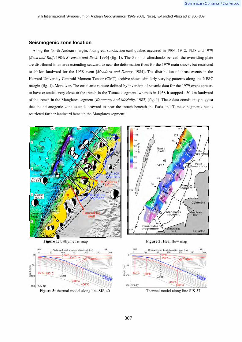
7th International Symposium on Andean Geodynamics (ISAG 2008, Nice), Extended Abstracts: 306-309
307
Seismogenic zone location
Along the North Andean margin, four great subduction earthquakes occurred in 1906, 1942, 1958 and 1979
[Beck and Ruff, 1984; Swenson and Beck, 1996] (fig. 1). The 3-month aftershocks beneath the overriding plate
are distributed in an area extending seaward to near the deformation front for the 1979 main shock, but restricted
to 40 km landward for the 1958 event [Mendoza and Dewey, 1984]. The distribution of thrust events in the
Harvard University Centroid Moment Tensor (CMT) archive shows similarly varying patterns along the NESC
margin (fig. 1). Moreover, The coseismic rupture defined by inversion of seismic data for the 1979 event appears
to have extended very close to the trench in the Tumaco segment, whereas in 1958 it stopped ~30 km landward
of the trench in the Manglares segment [Kanamori and McNally, 1982] (fig. 1). These data consistently suggest
that the seismogenic zone extends seaward to near the trench beneath the Patia and Tumaco segments but is
restricted farther landward beneath the Manglares segment.
Figure 1: bathymetric map Figure 2: Heat flow map
Figure 3: thermal model along line SIS-40 Thermal model along line SIS-37

7th International Symposium on Andean Geodynamics (ISAG 2008, Nice), Extended Abstracts: 306-309
308
Data and Method
On the margin and in the trench, the heat flow at the surface was measured during the AMADEUS experiment
(2005) and derived, using a classical calculation [Yamano et al., 1982], from Bottom Simulating Reflectors
(BSRs) in MCS lines recorded during the AMADEUS and SISTEUR (2000) experiments. Both data-set are
consistent within a 10% estimated uncertainty in calculation. These data results in a heat flow map highlighting
along-strike thermal variations with a heat flow in the Tumaco segment (55-65 mW m-2) 50% lower than in the
Patía segment (100-110 mW m-2) (fig. 2).
We investigate the thermal structure of every margin segment with a 2-D steady-state finite element method
[Wang et al., 1995] that takes into account for plate ages, convergence rate, margin structure, sedimentation and
compaction rates in the trench and isoviscous corner flow in the continental mantle.
Results
These models suggest that:
1/ The temperature range from 60-150°C to 350-450°C, commonly associated with the updip and downdip
limits of the seismogenic zone, extends along the plate interface over a distance of 160 to 190 ± 20 km (fig. 3).
2/ The updip limit of the seismogenic zone for the great subduction earthquakes during the 20th century is
associated with low-temperature (60-80°C) processes.
3/ 60-70% of the two-fold decrease in measured heat flow from the Patia to the Tumaco segment is related to
the abrupt southward increase in sedimentation rate in the trench. Such a change may induce a landward shift of
the 60-150°C isotherms, and thus the updip limit of the seismogenic zone, by 10-20 km. As a result, the
sedimentation history of the oceanic plate prior to subduction is a key-parameter of the thermal structure for
convergent margins and should not be neglected in thermal modelling.
References Beck, S. L., and L. J. Ruff (1984) The rupture process of the great 1979 Colombia earthquake: evidence for the asperity
model, J. Geophys. Res., 89, 9281-9291. Calahorrano, A., et al. (2008) Nonlinear variations of the physical properties along the southern Ecuador subduction channel:
results from depth-migrated seimic data, Earth Planet. Sci. Lett., 267 (3-4), 453-467. Clift, P. D., and P. Vannucchi (2004) Controls on tectonic accretion versus erosion in subduction zones: Implications for the
origin and recycling of the continental crust, Rev. Geophys., 42, RG2001, doi:2010.1029/2003RG000127. Cloos, M., and R. L. Shreve (1996) Shear-zone thickness and seismicity of Chilean- and Marianas-type subduction zones,
Geology, 24 (2), 107-110. Hyndman, R. D., and K. Wang (1993) Thermal constraints on the zone of the major thrust earthquakes failure: the Cascadia
subduction zone, J. Geophys. Res., 98 (2039-2060). Hyndman, R. D., et al. (1997) The seismogenic zone of subduction thrust faults, Island Arc, 6 (3), 244-260. Kanamori, H., and K. C. McNally (1982) Variable rupture mode of the subduction zone along the Ecuador-Colombia coast,
Bull. Seis. Soc. Am., 72 (4), 1241-1253. Lallemand, S. E., et al. (1994) Coulomb theory applied to accretionary and non accretionary wedges: Possible causes for
tectonic erosion and/or frontal accretion, J. Geophys. Res., 99, 12,033-012,055. Marcaillou, B. (2003) Régimes tectoniques et thermiques de la marge Nord Équateur- Sud Colombie (0°- 3,5°N) -
Implications sur la sismogenèse, Phd thesis, 220 pp, Université de Pierre et Marie Curie, Paris. Mendoza, C., and J. W. Dewey (1984) Seismicity associated with the great Colombia-Ecuador earthquakes of 1942, 1958
and 1979: implications for barrier models of earthquake rupture, Bull. Seis. Soc. Am., 74 (2), 577-593. Saffer, D. M., and C. Marone (2003) Comparison of smectite- and illite-rich gouge frictional properties: application to the
updip limit of the seismogenic zone along subduction megathrusts, Earth Planet. Sci. Lett., 215, 219-235.

7th International Symposium on Andean Geodynamics (ISAG 2008, Nice), Extended Abstracts: 306-309
309
Swenson, J. L., and S. L. Beck (1996) Historical 1942 Ecuador and 1942 Peru subduction earthquakes, and earthquake cycles along Colombia-Ecuador and Peru subduction segments, Pageoph, 146 (1), 67-101.
Wang, K., et al. (1995) Thermal regime of the southwest Japan subduction zone: effects of age history of the subducting plate, Tectonophysics, 248, 53-69.
Yamano, M., et al. (1982) Estimates of heat flow derived from gas hydrates, Geology, 10, 339-343.

7th International Symposium on Andean Geodynamics (ISAG 2008, Nice), Extended Abstracts: 310-314
310
Andesite magma generation at the Quaternary volcanic arc of southwest Colombia
M. I. Marín-Cerón1,2
, T. Moriguti1, & E. Nakamura
1
1 Pheasant Memorial Laboratory (PML), Institute for Study of the Earth’s Interior (ISEI), Okayama University at
Misasa, Yamada 827, Misasa Tottori, Japan 2 Present adress: EAFIT University, Department of Geology, Medellin, Colombia ([email protected])
KEYWORDS : NVZ, Andes, lower crust, mantle-derived magmas, andesites
Introduction
There is a general consensus about the formation of arc magmas by the addition of slab-derived fluids,
triggering the partial melting of the mantle wedge (e.g. Hawkesworth et al., 1993a; Pearce & Parkinson, 1993;
Poli & Schmidt, 1995; Tatsumi & Eggins, 1995; Davidson, 1996). Once primary magmas are formed in the
mantle wedge, an open question appears: which processes control the intermediate and silicic arc magma
generation? Two main processes have been identified: (1) differentiation of primary magmas by crystallization
within the crust or uppermost mantle (e.g. Gill, 1981; Grove & Kinzler, 1986; Musselwhite et al., 1989) and (2)
partial melting of older crustal rocks (e.g. Smith & Leeman, 1987; Petford & Atherton, 1996; Chappell & White,
2001). A combination of the above mentioned processes is also possible in which the interaction of mantle-
derived magmas can trigger the crustal melting and enhance the assimilation fractional crystallization of crustal
rocks (AFC) proposed by DePaolo (1981) or mixing, assimilation, storage and hybridization (MASH) proposed
by Hildreth & Moorbath (1988).
Andean volcanic zones are among the most important regions to study in order to better understand andesite
magma generation at convergent margins because the volcanic activity is extended along more than 4000 km of
Andes Cordillera. The volcanism in the Andes can be subdivided into four zones (Fig. 1a): the Southern
Volcanic Zone (SVZ), Central Volcanic Zone (CVZ) and Northern Volcanic Zone (NVZ) result from subduction
of Nazca plate beneath the Andean block, and the Austral Volcanic Zone (AVZ), which is related to the
subduction of the Antartic plate (e.g. Thorpe et al., 1982; Simking and Siebert, 1994).
Several studies have been undertaken at the Andes, mainly at the SVZ and the CVZ. However, the NVZ,
especially in Colombia, is poorly studied, and the available data is insufficient to understand the magmatic
processes and the relation of geochemical variations of those volcanoes with the spatial distribution. In order to
understand the Andes volcanic zones from a global perspective, a systematic study of Colombian arc volcanism
in the NVZ is indispensable. In this study we have chosen to study the Southwestern Colombian arc (Fig. 1b),
which is an arc with a simple geophysical structure characterized by relatively constant Moho depth (35-40 km)
across the arc and small differences in the dip of the seismic zone (25°- 30°), with volcanoes lying at 120 to 200
km above the Wadati-Benioff Zone (WBZ). In this region, Marín-Cerón (2007) has proposed on the basis of
multi-isotopic systematics that due to the higher biogenic activity at this region of the Pacific Ocean, fluids from
carbonate-rich sediments have been introduced into the mantle wedge beneath the study area affecting mainly
the volcanic front primary magmas.
In this study we propose a model for andesite magma generation in the SW Colombian volcanic arc on the
basis of petrography, major and trace element, and Sr, Nd, Pb, Hf isotopic systematics. Available data from

7th International Symposium on Andean Geodynamics (ISAG 2008, Nice), Extended Abstracts: 310-314
311
lower crustal xenoliths erupted by volcanic tuffs during the Tertiary (Weber et al., 2002) provide additional
constraints.
Figure 1. (a) Volcanic zones distribution in the Andes Cordillera. (b) Tectonic map of the SW Colombian volcanic arc. Tectonic setting of the NVZ in the Andes showing the distribution of active and inactive ridges, min fault systems and the distribution of active volcanoes. Waddati-Benioff Zone (WBZ) contours represent the isobaths for the top of the deep seismic caused by the subduction of Nazca plate beneath the North Andean block. (Modified from Gustcher et al. (1999); Droux and Delaloye (1996) and reference there in).
Samples
Samples were collected from four southwestern Plio-Quaternary volcanoes: Azufral, Galeras, Dona Juana and
Purace-Coconucos; they are located 140 km, 160 km, 170 km and 190 km to the depth of Wadati-Benioff zone
respectively. The calc-alkaline andesites and dacites of southwestern Colombian volcanoes are generally
porphyritic (modal phenocryst up to 50%). Andesites at this region can be divided petrographically and
geochemically into two groups: (1) volcanic front (VF) formed by andesites from Azufral and Galeras volcanoes
and (2) rear arc (RA) andesites from Doña Juana and Purace-Coconucos volcanic complexes. The main
mineralogical differences in both groups are related to the modal abundances of Ca-rich pyroxenes, small
amounts of amphibole (~1%) and the absence of olivine and quartz at the VF compared to the RA.
Geochemically, all analyzed sixty samples are quite evolved, with silica contents > 53%. The lavas belong to
medium-K in the volcanic front area to high-K in the back-arc, with enrichment in total alkalis across-arc. In
primitive normalized pattern diagram, positive anomalies are observed in fluid mobile elements such as B, Pb, Sr
and Li. On the other hand, high field strength elements show negative anomaly. These features and the clear
across-arc variation in the Ba/Nb ratio may indicate that studied samples were generated by fluid related
processes. The primary magmas at this arc are defined as mantle-derived magmas metazomatized by the
subduction component which were decreasingly added to the mantle wedge with the depth of the Waddati-
Benioff zone (Marín-Cerón, 2007; Marin-Cerón et al., 2008). The generated magmas are fluid-rich basalts
isotopically and geochemically different at the VF compared to the RA related with the amount of fluids derived
from the slab dehydration and decarbonation (Marín-Cerón, 2007; Marín-Cerón et al., 2008).
7th International Symposium on Andean Geodynamics (ISAG 2008, Nice), Extended Abstracts: 310-314
312
Petrological constraints for andesites formation
Our available petrographical and geochemical data indicates that the andesites at the study area cannot be
derived only by fractional crystallization of fluid rich mantle-derived basalts. The several disequilibrium features
above mentioned, the lack of basalts in the study area and the clear binary mixing trends in Pb-isotopic
systematics between primary magmas and lower continental crust (LCC) which is Pb-radiogenic, suggest the
importance of assimilation of LCC materials by mantle-derived arc-magmas.
Experimental data for the formation of intermediate to silicic magmas (Annen et al., 2006 and reference
therein), is supportive to assume that the main mineral phases (pl+amp+cpx+opx) of the andesites in the SW
Colombian arc were coexisting the LCC. Moreover, it is necessary to invoke assimilation and/or mixing with the
surrounding radiogenic-Pb-bearing lower crust rocks (Weber et al., 2002), to explain the isotopic and
geochemical signature of these rocks compared to other andesites in the Andes.
The main petrological constraints are: (1) Clinopyroxene under high-H2O conditions in the lower-crustal
environment, and at lower pressure conditions, indicates that when the temperature of the melts drops,
clinopyroxene becomes unstable, and reacts with the melt to form amphibole, resulting in the evolved melt being
more siliceous (Foden & Green, 1992). (2) Amphibole is stable only for H2O contents 4 wt% (Eggler, 1972)
and temperatures below ~1050°C (e.g. Muntener et al., 2001). (3) Orthopyroxene is confined to relatively low
pressures and temperatures over 920°C whereas garnet appears only above ~1.1GPa. (4) Plagioclase stability
decreases and An content increases with increasing H2O. Based on the experimental data of Kawamoto (1996)
and Pichavant et al. (2002b) it is possible to infer that the maximum H2O content of andesite melt in equilibrium
with plagioclase (An>80) is ~ 10 wt% H2O.
After the main mineral phases started to crystallize at the lower crust, the intermediate to silicic magma is
developed depending of the gradients of P, T and H2O content. The produced magmas at this region may get the
geochemical flavour of the lower crust which is rich in Pb-radiogenic due to the interaction of primary mantle
derived magmas and lower crust materials. In the way to the surface the rising magmas may be stored in shallow
magma reservoirs where mainly crystallization occurs. In such a case, the disequilibrium features observed in the
SW Colombian arc, such as resorbed and/or pseudomorphed amphibole by anhydrous reaction products,
generally replaced by oxides, may indicate that the amphiboles crystallized in the lower crust become unstable at
pressures less than ~0.1 GPa (Rutherford & Hill, 1993). Similarly, the complex zoning in the mineral phases
may be a response of the magma supply from the lower crust, which creates P-T changes in the magma that are
recorded during the complex growth of the plagioclase and pyroxenes. To clarify the above mentioned hypotesis
a detailed multi-isotope analysis in minerals phases following the zoning patterns is much needed.
Conclusion
In a global perspective of the understanding of the volcanic zones at the Andes cordillera, we can conclude that
assimilation of lower crust is a common process in this mature continental arc, and it is not only related to the
thickness of the crust but primarily related to the gradients of temperature, pressure, H2O content and melt
fraction developed at the upper-mantle and lower-crust region. Thus, assimilation of different crust domains in
terms of Pb isotopic composition beneath the Andes cordillera (Figure 2, e.g. Cretaceous domain at the NVZ;

7th International Symposium on Andean Geodynamics (ISAG 2008, Nice), Extended Abstracts: 310-314
313
Proterozoic domain at the north portion of CVZ; Paleozoic to early Mesozoic domain at the south portion of the
CVZ, SVZ and AVZ), may explain the along-arc variation in the Andean volcanic suites. However, the different
subduction components, together with the various thermal regimes at each zone, may explain the variability of
primary magmas across the Andean arc.
Figure 2. Plots of 207Pb/204Pb vs 206Pb/204Pb for the Andean volcanic zones and the pre-andean basement. Arequipa and Barroso volcanics and basement gneisses of South Peru from Tilton & Barreiro (1980). Pacific sediments (Dasch, 1981; White et al., 1985); Precambrian basement (Worner et al., 1992b); Paleozoic basement (Chiaradia et al., 2002); Metalliferous sediments from DSDP leg 92 (Barret et al., 1987); Cretaceous Domain (Keer, 2002); Lower crust xenoliths (Weber, 2002); ACC from Hole 504 (Pedersen and Furnes, 2001).
References Annen, C., Blundy, J. D. & Sparks, R.S, The genesis of intermediate and silicic magmas in deep crustal hot zones. Journal of Petrology
47, 3, p. 505-539, (2006). Barret T. J., Taylor P. N. and Lugowski J., Metalliferous sediments from DSDP leg 92: the East Pacific Rise transects. Geochim.
Cosmochim. Acta 46, pp. 651-666 (1987). Chappell, B. W. & White, J. R., Two contrasting granite types: 25 years later: Australian Journal of Earth Sciences 48, 489–499, (2001). Chiaradia M. & Fontbote L., 2002. Lead isotope systematics of Late Cretaceous – Tertiary Andean arc magmas and associated ores
between 8°N and 40°S: evidence for latitudinal mantle heterogeneity beneath the Andes. Terra Nova, 14 (5), p.337–342 Dasch, E.J, Lead isotopic composition of metalliferous sediments from the Nazca plate. Geol Soc Am Mem 154: 199-200, (1981). Davidson, J. P., Deciphering mantle and crustal signatures in subduction zone magmatism In: Bebout, G. E., Scholl, D. W., Kibry, S. H.,
& Platt, J. P. (eds). Subduction: Top to Bottom. American Geophysical Union 96, p. 251–262, (1996). DePaolo, D. J., Trace-element and isotopic effects of combined wallrock assimilation and fractional crystallisation. Earth and Planetary
Science Letters 53, 189–202, (1981). Droux, A. & Delaloye, M. Petrography and Geochemistry of Plio-Quaternary Calc-AlkalineVolcanoes of Southwestern Colombia.
Journal of South America Earth Sciences. 9, No. 1-2, p. 27-41 (1996). Eggler, D. H., Amphibole stability in H2O-undersaturated calc alkaline melts. Earth and Planetary Science Letters 15, 38–44, (1972). Foden, J. D. & Green, D. H., Possible role of amphibole in the origin of andesite: some experimental and natural evidence.
Contributions to Mineralogy and Petrology 109, 479–493, (1992). Gill, J. B., Orogenic Andesites and Plate Tectonics, Heidelberg: Springer, (1981). Grove, T. L & Kinzler, R. J. Petrogenesis of andesites. 14, 417-454, (1986). Hawkesworth, C. J., Gallagher, K., Hergt, J. M. & McDermott, F., Mantle and slab contributions in arc magmas. Annual Review of
Earth and Planetary Sciences 21, p. 175–204, (1993a). Hildreth W. & Moorbath S., Crustal contamination to arc magmatism in the Andes of Central Chile. Contributions to Mineralogy and
Petrology (1988) 98: p. 455-489, (1988). Kawamoto, T. Experimental constraints on differentiation and H2O abundance of calc-alkaline magmas. Earth and Planetary
Science Letters 144, 577–589, (1996). Kerr, A. C. 2003. Oceanic Plateaus. Treatise On Geochemistry, ISBN (set): 0-08-043751-6 Volume 3; (ISBN: 0-08-044338-9); pp.
537–565.
7th International Symposium on Andean Geodynamics (ISAG 2008, Nice), Extended Abstracts: 310-314
314
Marin-Ceron, M.I. Major, Trace element and multi-isotopic systematics of SW Colombian volcanic arc, northern Andes: Implication for the stability of carbonate-rich sediment at subduction zone and the genesis of andesite magma. Unpublished PhD thesis, Okayama Universtiy, Japan. (2007).
Marín-Cerón, M.I, Moriguti, T. and Nakamura, E. Slab decarbonation and CO2 recycling in the Southwestern Colombian arc, The Misasa 3rd COE-21 International symposium, (2008).
Müntener, O., Kelemen, P. B. & Grove, T. L., The role of H2O during crystallisation of primitive arc magmas under upper most mantle conditions and genesis of igneous pyroxenites: an experimental study. Contributions to Mineralogy and Petrology141, 643–658, (2001).
Musselwhite, D. S., De Paolo, D. J. & McCurry, M. The evolution of a silicic magma system—isotopic and chemical evidence from the Woods Mountains Volcanic Center, Eastern California. Contributions to Mineralogy and Petrology 101, p. 19–29, (1989).
Pearce, J. A. & Parkinson, I. J., Trace element models for mantle melting: application to volcanic arc petrogenesis. In: Prichard, H. M., Alabaster, T., Harris, N. B. W. & Neary, C. R. (eds) Magmatic Processes and Plate Tectonics. Geological Society, London, Special Publications, 76, p. 373–403, (1993).
Pedersen R. & Furnes, H., Nd- and Pb-isotopic variations through the upper oceanic crust in DSDP/ODP Hole 504B, Costa Rica Rift. Earth and Planetary Sc. Lett. 189, p. 221-235, (2001).
Petford, N. & Atherton, M., Na-rich partial melts from newly underplated basaltic crust: the Cordillera Blanca Batholith, Peru. Journal of Petrology 37, 1491–1521, (1996).
Pichavant, M., Martel, C., Bourdier, J. L. & Scaillet, B., Physical conditions, structure, and dynamics of a zoned magma chamber: Mount Peleé (Martinique, Lesser Antilles Arc). Journal of Geophysical Research 107, article number 2093, (2002b).
Poli, S. & Schmidt, M. W., H2O transport and release in subduction zones: experimental constraints on basaltic and andesitic systems. Journal of Geophysical Research 100B, p. 22299–22314, (1995).
Rutherford, M. J. & Hill, P. M., Magma ascent rates from amphibole breakdown—an experimental study applied to the 1980–1986 Mount St. Helens eruptions. Journal of Geophysical Research 98,19667–19685, (1993).
Simking T. & Siebert L., Volcanoes of the world. Geosciences Press, Tuscon, p. 1-349, (1994). Smith, D. R. & Leeman, W. P., Petrogenesis of Mount St. Helens dacitic magmas. Journal of Geophysical Research 92, 10313–10334.
Smith, R. L. (1979). Tatsumi, Y. & Eggins, S., Subduction Zone Magmatism. Oxford: Blackwell Scientific, (1995). Tilton, G.R., and Barreiro, B.A., Origin of lead in Andean calc-alkaline lavas, southern Peru: Science, v. 210, p. 1245-1247. (1980) Thorpe, R. S., Francis, P. W, Hammill M. & Baker M.C.W., The Andes. Andesites. Ed Thorpe, R.S., pp. 187-205, (1982). Weber, M.B.I., Tarney, J., Kempton, P.D. & Kent, R. W., Crustal make-up of the northern Andes: evidence based on deep crustal
xenolith suites, Mercaderes, SW Colombia. Tectonophysics 345, p. 49–82 (2002). White, W. M.; Hofmann, A. W.; and Puchelt, H., Isotope geochemistry of Pacific mid-ocean ridge basalts. J. Geophys. Res. 92:4881–
4893 (1987). Wörner, G.; Moorbath, S.; Harmon, R.S. 1992b. Andean Cenozoic volcanic centers reflect basement isotopic domains. Geology, Vol.
20, p. 1103-1106.

7th International Symposium on Andean Geodynamics (ISAG 2008, Nice), Extended Abstracts: 315-318
315
Estimating building and infrastructure vulnerability in the city of Arequipa, Peru, from volcanic mass flows: A challenge
Kim Martelli1, Jean-Claude Thouret
1, Cees van Westen
2, Denis Fabre
3, Michael Sheridan
4, &
Rubén Vargas2
1 Laboratoire Magmas et Volcans, Université Blaise Pascal, 5, rue Kessler, 63000 Clermont-Ferrand, France
([email protected]) 2 International Institute for Geoinformation Science and Earth Observation, P.O. Box 6, 7500AA Enschede, The
Netherlands 3 Conservatoire National des Arts et Métiers (CNAM), 2 rue Conté, 75003 Paris, France
4 Department of Geology, Unviersity of Buffalo, SUNY, Buffalo, NY 14260, USA
KEYWORDS : Arequipa, El Misti, Peru, volcanic mass flow, vulnerability, hazard
Introduction
Rapid population growth and urban expansion has led to an increase in the vulnerability of communities living
within close proximity to an active volcano. Arequipa, the second largest city in Peru with a population
exceeding 860,000 is no exception, and is much like the city of Naples in Italy is exposed to Vesuvius. Arequipa
has experienced rapid population growth since the 1940s, and from 1970 onwards the urban area grew
substantially due to social unrest and related migration from rural areas, mainly in the form of poorly designed
suburbs and illegal settlements. Settlements have now expanded onto the southwest flank of the volcano, the R o
Chili River terraces and adjacent to tributaries within 9 km of El Misti summit. Studies of the type, extent, and
volume of Holocene pyroclastic and lahar deposits have concluded that future eruptions of El Misti, even if
moderate in magnitude, will pose a serious threat to Arequipa (Thouret et al., 1999; Delaite et al., 2005). Here
we discuss computer simulation of mass flows, classification of buildings and infrastructure and the challenges
we are faced with while assessing building and infrastructure vulnerability within Arequipa.
Geologic setting and volcanic mass flow hazards
El Misti is one of the seven active volcanoes within the Central Volcanic Andean Zone (CVZ) of southern
Peru. Arequipa is located 17 km SW of and 3 km below the summit of El Misti. The city is situated upon
volcaniclastic fans of pyroclastic-flow and lahar deposits from El Misti that are less than 10,000 years old.
Three possible hazard scenarios have been proposed for El Misti volcano (Thouret et al. 1999; Delaite et al.
2005). Scenario 1 is described as the most probable type of future activity with a VEI2 and a recurrence interval
of 300 to 1000 years; Scenario 2 is a moderate magnitude (VEI3) / frequency (1600 to 5000 years) eruption; and
Scenario 3 is the maximum expected pyroclastic eruption with a VEI>3 and a recurrence interval of 10,000 to
20,000 years. All eruption scenarios result in the formation of volcanic mass flows. These could include; dam-
break floods, pyroclastic flows, block-and-ash flows; lahars; and pumice flows, surges and high energy directed
blasts. In addition, lahars and flash floods can occur in the R o Chili River and Quebradas without an eruption
(occurring on average once every ten years from El Misti) from rainfall, snow meltwater, and a dam break flood.
The challenge of modelling
Stinton et al. (2004), Delaite et al. (2005) and Vargas et al. (2007) have attempted the delineation of lahar

7th International Symposium on Andean Geodynamics (ISAG 2008, Nice), Extended Abstracts: 315-318
316
prone areas on El Misti flanks, ring plain, and in the city of Arequipa using LaharZ and Titan2D (single and two-
phase models). The “single” phase model is used to model dry flows, and the “two phase” model allows the
definition of a solid and a liquid fraction for the simulated flow. Lahars ranging from 0.01x10⁶ m3 to 11x106 m3
in volume were simulated down the R o Chili valley, and the Quebradas San Lazaro and Huarangal. Solid
fractions of 0.3 to 0.5 were incorporated into the simulated flows.
The sensitivity of the DEM in Titan2D was analysed using changes in the simulation parameters and the
impact of flow features such as starting point, internal and bed friction angles, solid fraction, runout, super-
elevation, ponding,, flow divergence and convergence were examined. Previous simulations performed on a
30 m DEM, based upon digitising 1:25,000-scale topographic maps and on radar interferometry, compared
Titan2D with LaharZ and highlighted discrepancies between the two models. The largest flow volume simulated
by Titan2D (11.0 x 10⁶ m3) did not reach further than the smallest volume of a flow (1.5 x 10⁶ m3) modelled for
LaharZ (Delaite et al., 2005), refer to figure 1. Discrepancies may be explained by the differing models; LaharZ
is a statistically based method for delineating lahar-prone zones (Schilling, 1998), while Titan2D is a depth-
averaged, thin-layer Computational Fluid Dynamics program (Pitman et al., 2003).
To investigate the effect of the DEM on simulated results a 10 m DEM was computed using DGPS data, aerial
photographs and stereophotogrammetry. Detailed topographical data was acquired from a DGPS survey
undertaken on the four main terraces of the R o Chili River, an area of approximately 5km2, from the Military
Camp (approximately 15 km from the summit) downstream to the Bolognesi Bridge (city centre). Characteristics
such as overbanking, uphill flow, lateral spreading and flow divergence and convergence were identified in
Titan2D simulation outputs, and the results are more realistic than flow features identifies from LaharZ
simulations. At abrupt changes in channel direction, particularly where the R o Chili canyon opens out from a
steep sided gorge to a wide river valley (near the Chacani hydro-electric dam) the flows form temporary ponds
or even cease moving altogether. The DEM will be further refined with additional DGPS data to be collected this
year, and compared with previous DEMs. Lahar-prone areas and eruption scenarios will be now used to establish
the impact of mass flows on buildings and infrastructure within the city of Arequipa.
Figure 1. A– Map showing the difference between Titan2D runout and LaharZ runouts. B – example of flow divergence and convergence with Titan2D modelling on Qda. San Lazaro. This closely resembles reality as the flow moves around an obstacle in the channel. The dark black outline is the LaharZ simulated flow outline (Stinton et al., 2004).
A

7th International Symposium on Andean Geodynamics (ISAG 2008, Nice), Extended Abstracts: 315-318
317
Assessing the physical vulnerability of buildings and infrastructure:
Classification of construction and landuse
Damage caused by volcanic mass flows has been observed during historic eruptions such as Vesuvius in
AD 79 and 1631, Nevado del Ruiz in 1985, and Soufrière Hills Volcano in 1997 (Spence et al., 2004). Damage
resulting from lahars and floods can include burial, foundation failure, debris impact with forces as high as 104-
106 kgm-2, transportation, excessive wall or roof loads, collapse, undermining and corrosion. A survey was
carried out on the characteristics of buildings and infrastructure that may be vulnerable to flow impact, with the
aim to define the probability of a building being in a particular damage state, given the intensity level of the
particular hazard concerned. The descriptive survey using a method adapted from Chevillot (2000) and Spence et
al. (2004) was conducted at street and city block level and where permitted, within the boundaries of the land-
owners property. Building types were defined according to the dominant building material; number of floors;
building reinforcement; roof type and style; opening type and quantity; and overall building structural integrity.
Figure 2. Top left – location map of the study area in Arequipa city centre in relation to El Misit. Bottom left – examples of two Types of buildings surveyed. Right – Classification map of the landuse and building construction classification in a section of the city centre.
Nineteen land-use patterns and ten construction types were identified (Figure 2). Most new construction
comprised un-reinforced masonry panels (perforated red brick and mortar) with cast-in-situ reinforced concrete
frames (horizontal and vertical), and flat or pitched reinforced concrete slab roofs. Large glass windows are
present throughout with aluminium or wood framing and often secured with steel bars. Doors are solid and
wooden with steel security screen/bars. Type A buildings represented 30% of those surveyed. Conversely, Type
I construction comprised old stone/ignimbrite base with unreinforced masonry panels (ignimbrite, brick or
adobe, with poor quality mortar). The walls were not confined by either reinforced horizontal or vertical cast-in-
situ concrete, and in most cases appear unstable. Wooden rafters support corrugated iron roofs which are secured

7th International Symposium on Andean Geodynamics (ISAG 2008, Nice), Extended Abstracts: 315-318
318
by rocks and wood. These buildings represented 5% of those surveyed, and were more commonly situated on the
lower terraces of the Rio Chili and associated with agricultural lifestyle blocks. Less than 50% of the population
surveyed reside in dwellings less than Type C. Housing of poorer quality was often situated in the most
vulnerable areas upstream of the city and within the river channels (apart from type A housing located on the
confluence of the Río Chili and Qda. San Lázaro).
Bridges located within the Río Chili River are susceptible to debris accumulation due to their low height.
During the floods of February 1992 and 1997 debris accumulated behind the bridges, subsequently overtopping
and flooding nearby homes and businesses. If bridges are destroyed, access from one side of the city to the other
will be severely limited. Water pipes and power lines are often located at bridges, and are thus equally
susceptible to damage. Services such as the Egasa power station and the hydro-electric dams are vulnerable to
inundation from even small volume lahars, possibly resulting in the severe disruption of power supply to the
city, and having a flow-on effect for lifeline services such as hospitals and other emergency services.
Discussion
At El Misti challenges have arisen due to the considerably different results of two codes, Titan2D and LaharZ.
While Titan2D models the behaviour of debris flows adequately, the runout of LaharZ simulations is more
comparable to mapped deposits. Even on our enhanced DEM, these discrepancies arise; thus the need for
additional DEM refinement and research into the input parameters for geophysical flow modelling. Our results
highlight that simulations must only be used as a tool alongside geological mapping to aid the delineation of
inundation zones. The results of the building and infrastructure survey identified a range of construction types,
and often within the same city block. The poorest quality houses (and not structurally sound) are often located
closest to the river channels and in many cases could provide additional debris for the flow. Bridges, which link
two sides of the city, are vulnerable due to their low height and narrow spans, acting as a dam for flow debris.
Further modelling would aid the characterisation of building and infrastructure vulnerabilities by redefining
likely lahar prone zones, and therefore expected deposit thicknesses and flow velocities; all of which are of
importance when defining the likely damage states of buildings inundated by volcanic mass flows.
References Chevillot B. 2000. Rapport de mission a Arequipa (sud Pérou) 26 julliet – 15 août 2000. Objet: mise en œuvre d’un S.I.G.
appliqué aux risques hydrologiques et volcaniques. Rapport., Lab. De traitement de données géographiques ENITA de Clermont-Ferrand, 44 p.
Delaite, G., Thouret, J.-C., Sheridan, M. F., Stinton, A., Labazuy, P., Souriot, T., and van Westen, C., 2005. Assessment of volcanic hazards of El Misti and in the city of Arequipa, Peru, based on GIS and simulations, with emphasis on lahars: Zeitschrift für Geomorphology N.F., suppl.- vol. 140, p 209-231.
Pitman, E.B., Patra, A., Bauer, A., Nichita, C., Sheridan, M. and Bursik, M. 2003. Computing debris flows. Physics of Fluids 15: 3638-3646
Schilling, S.P., 1998. LAHARZ: GIS program for automated mapping of lahar inundation hazard zones: U.S. Geological Survey Open-File Report 98, 638. p.
Spence R.S.J., Baxter P.J., Zuccaro, G. 2004. The resistance of buildings to pyroclastic flows: analytical and experimental studies and their application to Vesuvius. Journal of Volcanology and Geothermal Research 133: 321-343.
Stinton, A., Delaite, G., Burkett, B., Sheridan, M., Thouret, J.-C., and Patra, A., 2004. Titan2D simulated debris flow hazards: Arequipa, Peru: Abstracts, International Symposium on Environmental Software Systems (ISESS), U.S.A.
Thouret, J.-C., Finizola, A., Fornari, M., Legueley-Padovani, A., Suni, J., Frechen, M. 2001. Geology of El Misti volcano near the city of Arequipa, Peru, Bull. Geol. Soc. Amer., 113: 1593-1610.
Vargas F.R, Thouret J.-C., Delaite G., Van Westen C., Sheridan M.F., Siebe C., Mariño J., Souriot T., and Stinton A. 2007. Mapping and assessing volcanic and flood hazards and risks, with emphasis on lahars, in the city of Arequipa, Peru. Geol. Soc. Amer. Spec. publ. (accepted).

7th International Symposium on Andean Geodynamics (ISAG 2008, Nice), Extended Abstracts: 319-321
319
Metamorphic P-T constraints for the low-temperature assemblages overimposed on metamorphic and igneous rocks nearby Ñorquinco Lake, Aluminé, North-Patagonian Andes
C. I. Martínez-Dopico
Cátedra de Mineralogía, Departamento de Ciencias Geológicas, Universidad de Buenos Aires, Ciudad
Universitaria, C1428EHA, Buenos Aires, Argentina ([email protected])
KEYWORDS : subgreenschists facies, geothermobarometry, polymetamorphism, Aluminé, northern Patagonian Andes
Introduction
The area of the Ñorquinco-Pulmarí valley, 50 km west Aluminé city, North-Patagonian Cordillera (Fig. 1) is
distinguished by the presence of isolated outcrops of medium to high metamorphic grade rocks accredited by
amphibolites and gneises. These rocks compone the Upper Paleozoic Colohuincul igneous-metamorphic
Complex (Dalla Salda et al., 1991; Varela et al., 2005). This basament is intruded by the Paso de Icalma
Granodiorite (Cucchi et al., 2005; Latorre et al., 2001), a local Jurassic to Upper Cretacic igneous episode of a
mayor Jurassic to Miocene event known as North-Patagonian Batolith. These rocks are covered by a Tertiary to
Quaternary Andean thick andesitic to basaltic pile (Auca Pan Formation, Rancahue Basalt, Hueyeltué Basalt and
Lanín Basalt). Vattuone et al. (2005), among other authors, have characterized a low to very low grade
metamorphism in the Eastern Andean volcanic pile. Through the fieldwork, the petrographical study, EDAX on
amphibols, pumpellyite and zeolites crystals (Martínez Dopico, 2007; Gallegos, 2007), and the use of an
internally consistent thermodynamic data as the one proposed by Berman (1988, 2007), the mineral assemblages
and metamorphic facies are diagnosed to characterize and establish a sequence of paragenesis from the medium
to very low grade metamorphism overimposed on the andean southern basement and volcanic cover.
Figure 1: a) Geodynamic framework for Patagonia and location of the concern area within the North Patagonian Cordillera b) Studied localities in the Ñorquinco-Pulmary valley.

7th International Symposium on Andean Geodynamics (ISAG 2008, Nice), Extended Abstracts: 319-321
320
Metamorphic mineralogy and P-T constraints
Four assemblages are found for the amphibolites of the Colohuincul Complex. The higher grade ones in
amphibolite- greenschists facies are developed by the associations: opx + cpx + pl+ tsc (equilibrated at 550°C
and 4,7 kbar) and ed + act + ab + chl + ep. Subsequently, there are two overimposed re-equilibrated facies, the
first under greenschist P-T conditions set up as act + ep + chl ± ab (450°C and 2,3 kbar) and the latter, under a
prehnite-pumpellyite facies conditions defined by prh + pmp + chl ± ab + ep (300°C and 2,4 kbar). The proposed
protolith for these amphibolites has a mafic to ultramafic affinity.
Two paragenesis are recognised in the paragneises, the higher grade one in sillimanite facies is composed of kfs
+ sil + and+ crd + bt, its equilibrium point was found at 1,8 kbar and 630°C, the other association, steady at
temperatures below 250 °C, in the biotite zone is detected from chl + ms ± bt ± ab ± cb ± kln.
The tonalites compiled under the Granodiorita Paso de Icalma have a slight secondary overprint evidenced by
chl/ smectites + act + prh in quartz veins. These features indicate non-coaxial deformation operating under
prenhite-actinolite facies conditions of metamorphism, probably at temperatures between 300 and 200°C. This T
interval is compatible with the observed mineral assemblages in the other protoliths.
The metamorphic assemblage in metadacites of the paleocene Auca Pan Formation consist of ab+ ep + chl +
phl, formed under zeolite facies PT conditions (underneath 250°C), evidenced by the presence of phillipsite. In
the Upper Miocene Rancahue Basalt the secondary assemblage observed in amygdales consists of thomsonite-
Ca, faujasite-Ca and smectites, in the matrix phillipsite, scolecite and epidote were found (Gallegos, 2007).
These associations reach their equilibrium under 250°C. Slightly secondaries processes are represented in minor
veins and fractures by cb + act in the Middle Pleistocene Hueyeltué olivinic basalt.
Discussion
These data allow us to relate these metamorphic events to three historical pulses barothermically different. The
higher grade metamorphism (>550°C) in amphibolite- greenschists facies and its local reversions, are assigned to
an Upper-Paleozoic to Jurassic pulse, associated with the emplacement at different crustal levels of plutonic
episodes. South of the studied area, in San Martín de los Andes, this igneous activity could be represented by the
igneous fraction of the Colohuincul Complex and, in the concern area, by the intrusion of the Paso de Icalma
Granodiorite The lower grade event in prehnite-pumpellyite facies (300-350°C). could play as an overimposed
metamorphism linked to the early upper Cretaceous metamorphic ages associated with an extensional regime,
crustal attenuation and subsidence developed within the Andes as proposed by Aguirre et al.(1999). The very
low grade event (<250°C), in zeolite facies is able to be subdivided in two stages, Paleogene- Miocene
represented in the volcanic rocks of the Auca Pan Formation and Rancahue Basalt and an upper Miocene to
Pleistocene stage associated with the secondary formation of actinolite in the Hueyeltué Basalt and Granodiorite
Paso de Icalma. This last event in prehnite- actinolite facies was associated with the proximal Andean Miocene
granitoids and dated by Ar40/Ar39 in actinolite crystals in 8 Ma of the Rio Damas metabasites in the western
Andean margin by Oliveros et al., (2008). Regarding the tectonic enviroment of the Neuquén Andes it is
considered that these changes in the steady mineralogy are consistent with a polymetamorphic evolution
according to the variation in the angle of steepening of the Wadati- Benioff zone that generates the progressive
stages of compression and extension at this latitude of the Andes as discussed by Folguera et al. (2007).

7th International Symposium on Andean Geodynamics (ISAG 2008, Nice), Extended Abstracts: 319-321
321
Acknowledgements This work was supported by the grants UBACyT X238. We would like to thank Dr. Leal and Dr Vattuone at University of Buenos Aires for their constructives reviews in the degree thesis “Geología y Geotermobarometría de las rocas metamórficas e ígneas de los lagos Ñorquinco y Nompehuén. Cordillera Patagónica Septentrional, Provincia del Neuquén”.
References
Aguirre, L., Feraud, G., Morata, D., Vergara, M. & Robinson, D. 1999. Time interval between volcanism and burial metamorphism and rate of basin subsidence in a Cretaceous Andean extensional setting. Tectonophysics, 313:433-447.
Berman, R.G., 1988. Internally consistent thermodynamic data for stoichiometric minerals in the system Na2O K2O CaO MgO FeO Fe2O3 Al2O3 SiO2 TiO2 H2O CO2. Journal of Petrology, 29:515-522.
Berman, R.G., 2007. WinTWQ (version 2.3): A software package for performing internally-consistent thermobarometric calculations. Geological Survey of Canada, Open File 5462.
Cucchi, R., Leanza, H.A., Repol, D., Escosteguy, I., González, R. y Danieli, J.C., 2005. Hoja geológica 3972-IV, Junín de los Andes. Provincia de Neuquén. Instituto de Geología y Recursos Minerales, Servicio Geológico Minero Argentino. Boletín 357, 102 pp., Buenos Aires.
Dalla Salda, L.H., Cingolani, C. y Varela, R., 1991. El Basamento Pre- andino ígneo- metamórfico de San Martín de los Andes, Neuquén. Revista de la Asociación Geológica Argentina, 46:223-234, Buenos Aires.
Folguera, A., Introcaso, A., Gimenéz, M., Ruiz, F., Martínez, P., Tunstall, C., García Morabito, E. & Ramos, V.A., 2007. Crustal attenuation in the Southern Andean retroarc (38°-39°30´S) determined from tectonic and gravimetric studies: The Lonco-Luán asthenospheric anomaly. Tectonophysics, 439: 129-147.
Gallegos, E., 2007. Geología del basamento del Valle del río Pulmarí. Trabajo Final de Licenciatura, Universidad de Buenos Aires, inédito, 121pp.
Latorre, C.O., Vattuone, M.E., Linares, E. & Leal, P.R. 2001. K-Ar ages of the rocks from the Lago Aluminé, Rucachoroi and Quillén, North Patagonian Andes, Neuquen, República Argentina. III° Simposio Sudamericano de Geología Isotópica: 577-580, Pucón.
Martínez Dopico, C.I., 2007. Geología y Geotermobarometría de las rocas metamórficas e ígneas de los lagos Ñorquinco y Nompehuén. Cordillera Patagónica Septentrional, Provincia del Neuquén. Trabajo Final de Licenciatura, Universidad de Buenos Aires, (inédito), 149 p., Buenos Aires.
Oliveros, V., Aguirre, L., Morata, D., Simonetti A., Vergara, M., Belmar, M. & Calderon, S., 2008. Geochronology of very low-grade Mesozoic Andean metabasites; an approach through the K-Ar, 40 Ar/ 39 Ar and U-Pb LA-MC-ICP-MS methods. Journal of the Geological Society of London, 165(2):579-584
Varela, R., Basei, M.A.S., Cingolani, C.A., Siga, O.Jr y Passarelli, C.R., 2005. El basamento cristalino de los Andes Norpatagónicos en Argentina: geocronología e interpretación tectónica. Revista Geológica de Chile, 32(2): 167-187.
Vattuone, M.E., Latorre, C.O. and Leal, P.R., 2005. Polimetamorfi smo de muy bajo a bajo grado en rocas volcánicas jurásico – cretácicas al sur de Cholila, Chubut, Patagonia Argentina. Revista Mexicana de Ciencias Geológicas, 22 (3):315-328.
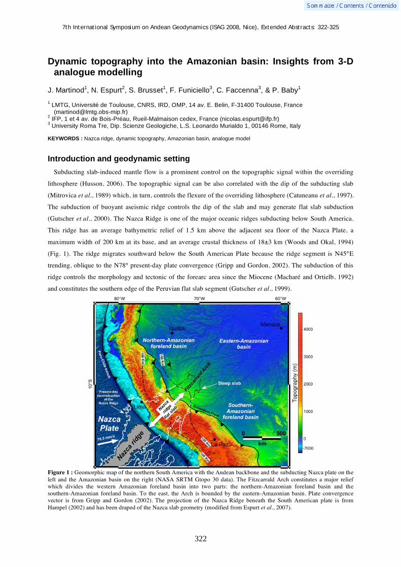
7th International Symposium on Andean Geodynamics (ISAG 2008, Nice), Extended Abstracts: 322-325
322
Dynamic topography into the Amazonian basin: Insights from 3-D analogue modelling
J. Martinod1, N. Espurt
2, S. Brusset
1, F. Funiciello
3, C. Faccenna
3, & P. Baby
1
1 LMTG, Université de Toulouse, CNRS, IRD, OMP, 14 av. E. Belin, F-31400 Toulouse, France
([email protected]) 2 IFP, 1 et 4 av. de Bois-Préau, Rueil-Malmaison cedex, France ([email protected])
3 University Roma Tre, Dip. Scienze Geologiche, L.S. Leonardo Murialdo 1, 00146 Rome, Italy
KEYWORDS : Nazca ridge, dynamic topography, Amazonian basin, analogue model
Introduction and geodynamic setting
Subducting slab-induced mantle flow is a prominent control on the topographic signal within the overriding
lithosphere (Husson, 2006). The topographic signal can be also correlated with the dip of the subducting slab
(Mitrovica et al., 1989) which, in turn, controls the flexure of the overriding lithosphere (Catuneanu et al., 1997).
The subduction of buoyant aseismic ridge controls the dip of the slab and may generate flat slab subduction
(Gutscher et al., 2000). The Nazca Ridge is one of the major oceanic ridges subducting below South America.
This ridge has an average bathymetric relief of 1.5 km above the adjacent sea floor of the Nazca Plate, a
maximum width of 200 km at its base, and an average crustal thickness of 18±3 km (Woods and Okal, 1994)
(Fig. 1). The ridge migrates southward below the South American Plate because the ridge segment is N45°E
trending, oblique to the N78° present-day plate convergence (Gripp and Gordon, 2002). The subduction of this
ridge controls the morphology and tectonic of the forearc area since the Miocene (Macharé and Ortielb, 1992)
and constitutes the southern edge of the Peruvian flat slab segment (Gutscher et al., 1999).
Figure 1 : Geomorphic map of the northern South America with the Andean backbone and the subducting Nazca plate on the left and the Amazonian basin on the right (NASA SRTM Gtopo 30 data). The Fitzcarrald Arch constitutes a major relief which divides the western Amazonian foreland basin into two parts: the northern-Amazonian foreland basin and the southern-Amazonian foreland basin. To the east, the Arch is bounded by the eastern-Amazonian basin. Plate convergence vector is from Gripp and Gordon (2002). The projection of the Nazca Ridge beneath the South American plate is from Hampel (2002) and has been draped of the Nazca slab geometry (modified from Espurt et al., 2007).
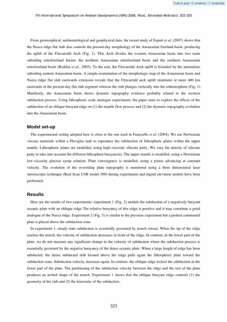
7th International Symposium on Andean Geodynamics (ISAG 2008, Nice), Extended Abstracts: 322-325
323
From geomorphical, sedimentological and geophysical data, the recent study of Espurt et al. (2007) shows that
the Nazca ridge flat slab also controls the present-day morphology of the Amazonian foreland basin, producing
the uplift of the Fitzcarrald Arch (Fig. 1). This Arch divides the western Amazonian basin into two main
subsiding retroforeland basins: the northern Amazonian retroforeland basin and the southern Amazonian
retroforeland basin (Roddaz et al., 2005). To the east, the Fitzcarrald Arch uplift is bounded by the anomalous
subsiding eastern-Amazonian basin. A simple examination of the morphologic map of the Amazonian basin and
Nazca ridge flat slab eastwards extension reveals that the Fitzcarrald arch uplift maintains at more 400 km
eastwards of the present-day flat slab segment whereas the slab plunges vertically into the asthenosphere (Fig. 1).
Manifestly, the Amazonian basin shows dynamic topography evidence probably related to the western
subduction process. Using lithospheric scale analogue experiments, the paper aims to explore the effects of the
subduction of an oblique buoyant ridge on (1) the mantle flow process and (2) the dynamic topography evolution
into the Amazonian basin.
Model set-up
The experimental setting adopted here is close to the one used in Funiciello et al. (2004). We use Newtonian
viscous materials within a Plexiglas tank to reproduce the subduction of lithospheric plates within the upper
mantle. Lithospheric plates are modelled, using high-viscosity silicone putty. We vary the density of silicone
putty to take into account the different lithosphere buoyancies. The upper mantle is modelled, using a Newtonian
low-viscosity glucose syrup solution. Plate convergence is modelled, using a piston advancing at constant
velocity. The evolution of the overriding plate topography is monitored using a three dimensional laser
stereoscopic technique (Real Scan USB model 300) during experiments and digital elevation models have been
performed.
Results
Here are the results of two experiments: experiment 1 (Fig. 2) models the subduction of a negatively buoyant
oceanic plate with an oblique ridge The relative buoyancy of this ridge is positive and it may constitute a good
analogue of the Nazca ridge. Experiment 2 (Fig. 3) is similar to the previous experiment but a pushed continental
plate is placed above the subduction zone.
In experiment 1, steady-state subduction is essentially governed by trench retreat. When the tip of the ridge
reaches the trench, the velocity of subduction decreases in front of the ridge. In contrast, in the lower part of the
plate, we do not measure any significant change in the velocity of subduction where the subduction process is
essentially governed by the negative buoyancy of the dense oceanic plate. When a large length of ridge has been
subducted, the dense subducted slab located above the ridge pulls again the lithospheric plate toward the
subduction zone. Subduction velocity increases again. In contrast, the oblique ridge locked the subduction in the
lower part of the plate. The partitioning of the subduction velocity between the ridge and the rest of the plate
produces an arched shape of the trench. Experiment 1 shows that the oblique buoyant ridge controls (1) the
geometry of the slab and (2) the kinematic of the subduction.
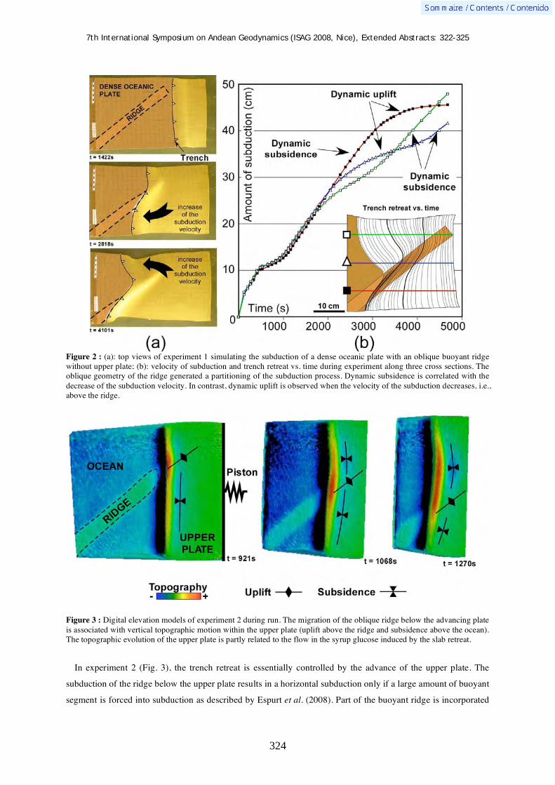
7th International Symposium on Andean Geodynamics (ISAG 2008, Nice), Extended Abstracts: 322-325
324
Figure 2 : (a): top views of experiment 1 simulating the subduction of a dense oceanic plate with an oblique buoyant ridge without upper plate; (b): velocity of subduction and trench retreat vs. time during experiment along three cross sections. The oblique geometry of the ridge generated a partitioning of the subduction process. Dynamic subsidence is correlated with the decrease of the subduction velocity. In contrast, dynamic uplift is observed when the velocity of the subduction decreases, i.e., above the ridge.
Figure 3 : Digital elevation models of experiment 2 during run. The migration of the oblique ridge below the advancing plate is associated with vertical topographic motion within the upper plate (uplift above the ridge and subsidence above the ocean). The topographic evolution of the upper plate is partly related to the flow in the syrup glucose induced by the slab retreat.
In experiment 2 (Fig. 3), the trench retreat is essentially controlled by the advance of the upper plate. The
subduction of the ridge below the upper plate results in a horizontal subduction only if a large amount of buoyant
segment is forced into subduction as described by Espurt et al. (2008). Part of the buoyant ridge is incorporated
7th International Symposium on Andean Geodynamics (ISAG 2008, Nice), Extended Abstracts: 322-325
325
in the steep part of the slab to balance the negative buoyancy of the dense oceanic lithosphere. The analysis of
the upper plate topography during the experiment from the digital elevation models shows that (1) the sweeping
of the oblique ridge induces vertical motions on the chain and in the backarc basin. It results an uplift above the
flat slab segment, followed by accelerated subsidence, inducing an asymmetrical shape of the backarc basin with
two pronounced and asymmetrical subsiding basins.
Discussion: dynamic topography in the Amazonian basin
The Amazonian basin is an unconventional foreland basin system because in this central part the flexure is
overcompensated by the Nazca ridge flat slab segment (Espurt et al., 2007). However, the only flat slab segment
cannot explain the observed wide Fitzcarrald Arch uplift which develops more than 400 000 km2. Analogue
experiments show that the subduction of a buoyant segment may perturb the mantle flow and, in turn, may
control the dynamic topographic signal in the continental lithosphere (Mitrovica et al., 1989; Pysklywec and
Mitrovica, 2000). The dynamic subsidence can be correlated with the high subduction velocity on the both sides
of the ridge. In contrast, the ridge subduction cancels the vertical component of the slab velocity and dynamic
uplift is observed. Consequently, the subduction of the Nazca ridge may cancel the subduction process below the
western Amazonian basin and the broad Fitzcarrald Arch uplift could be dynamically maintained by the stop of
the mantle flow eastwards of the present-day flat slab segment.
References Catuneanu, O., Beaumont, C., & Waschbusch, P. 1997. Interplay of static loads and subduction dynamics in foreland basins:
Reciprocal stratigraphies and « missing » peripheral bulge. Geology 25: 1087-1090. Espurt, N., Funiciello, F., Martinod, J., Guillaume, B., Regard, V., Faccenna, C., & Brusset, S. 2008. Flat subduction
dynamics and deformation of the South American plate. Insights from analogue modelling. Tectonics doi:10.1029/2007TC002175, in press.
Espurt, N., Baby, P., Brusset, S., Roddaz, M., Hermoza, W., Regard, V., Antoine, P.-O., Salas-Gismondi, R., & Bolaños, R. 2007. How does the Nazca Ridge subduction influence the modern Amazonian foreland basin? Geology 35: 515-518.
Funiciello, F., Faccenna, C., & Giardini, D. 2004. Role of lateral mantle flow in the evolution of subduction systems: Insights from laboratory experiments. Geophys. J. Int. 157: 1393-1406.
Gripp, A.E., & Gordon, R.G. 2002. Young tracks of hotspots and current plate velocities. Geophys. J. Int. 150: 321-361. Gutscher, M.A., Olivet, J.L., Aslanian, D., Eissen, J.P., & Maury, R. 1999. The “lost Inca Plateau”: Cause of flat subduction
beneath Peru? Earth and Planetary Science Letters 171: 335-341. Hampel, A. 2002. The migration history of the Nazca Ridge along the Peruvian active margin: a re-evaluation. Earth and
Planetary Science Letters 203: 665–679. Husson, L. 2006. Dynamic topography above retreating subduction zones. Geology 34: 741-744. Macharé, J., & Ortlieb, L. 1992. Plio-Quaternary vertical motions and the subduction of the Nazca Ridge, central coast of
Peru. Tectonophysics 205: 97-108. Mitrovica, J.X., Beaumont, C., & Jarvis, G.T. 1989. Tilting of continental interiors by the dynamical effects of subduction.
Tectonics 8: 1078-1094. Pysklywec, R.N., & Mitrovica, J.X. 2000. Mantle flow mechanisms of epeirogeny and their possible role in the evolution of
the Western Canada Sedimentary Basin. Canadian Journal of Earth Sciences 37: 1535-1548. Roddaz, M., Viers, J., Brusset, S., Baby, P., Brusset, S., & Hérail, G. 2005. Sediment provenances and drainage evolution of
the Neogene Amazonian foreland basin. Earth and Planetary Science Letters 239: 57–78. Woods, M.T., & Okal, E.A. 1994. The structure of the Nazca Ridge and Sala y Gomez seamount chain from dispersion of
Rayleigh waves Geophys. J. Int. 117: 205–222.

7th International Symposium on Andean Geodynamics (ISAG 2008, Nice), Extended Abstracts: 326-329
326
Tectonic control on the 1960 Chile earthquake rupture segment
Daniel Melnick1, Marcos Moreno
2, Dietrich Lange
1,3, Manfred R. Strecker
1, & Helmut P.
Echtler2
1 Institut für Geowissenschaften, Universität Potsdam, 14415 Potsdam, Germany ([email protected])
2 GeoForschungsZentrum Potsdam, Telegrafenberg, 14473 Potsdam, Germany
3 Present address: Bullard Laboratory, University Cambridge, UK
KEYWORDS : subduction earthquakes, seismotectonic segmentation, forearc microplates, crustal faults
Introduction
Understanding the principles that govern triggering of great subduction earthquakes and finite rupture length
and consequently magnitude is an utmost important challenge (e.g., Satake and Atwater, 2007). In principle, two
major conditions are required to generate a giant-magnitude subduction earthquake (M>8.5): (1) the forearc of
the upper plate has to accumulate enough elastic strain to burst rupture and fault slip, and (2) rupture has to
propagate unstalled for hundreds of kilometers (e.g., Kanamori, 1977). The great 1960 Chile earthquake (Mw of
9.5) was such a megathrust event that ruptured ~1000 km of the Nazca-South America plate boundary, involving
up to 40 m of fault slip resulting in up to 5.7 m of vertical coastal uplift (Barrientos and Ward, 1990, Plafker and
Savage, 1970). This event was the largest earthquake instrumentally recorded by modern seismology (Engdahl
and Villaseñor, 2002). The 1960 earthquake started at 38.2°S (Engdahl and Villaseñor, 2002) and propagated
southward until the Nazca-Antarctic-South America Triple Plate Junction at 46°S (Barrientos and Ward, 1990,
Plafker and Savage, 1970). An historical earthquake of similar magnitude (M~9.5) and rupture length (38-46°S)
occurred in 1575, and paleoseismic records document similar events with a recurrence of ~300 years (Cisternas
et al., 2005). Here we present geologic, geodetic, and seismologic data to address the tectonic processes that
control strain accumulation and rupture propagation for the 1960 earthquake segment.
Regional tectonic setting & glacial-age sedimentation in the South Chile trench
The Chile margin is formed by oblique subduction of the Nazca plate below the South American continent at
~80 mm/a. Between the Juan Fernández Ridge (33°S) and the Chile Triple Junction, the trench has been filled
with over 2 km of sediments eroded from the high Andes by Patagonian glaciations since Pliocene time leading
to an accretionary margin (Bangs and Cande, 1997), whereas north of 33°S the trench is virtually depleted of
sediments and the margin has been erosive over the entire Cenozoic (e.g., Clift and Vannucchi, 2004).
Subduction of a coherent sedimentary sequence deposited in the trench smoothes the seismic strength of the
plate interface allowing larger earthquake-rupture propagation (Ruff, 1989), and explains differences in the long-
term evolution of the central and southern Andes (Lamb and Davis, 2003).
Decoupling of the Chiloé microplate by the Liquiñe-Ofqui fault zone
The 1960 rupture segment (38-45°S) is coincident with the extent of the Liquiñe-Ofqui fault zone (LOFZ), a
major strike-slip system that straddles the volcanic arc accommodating oblique plate convergence (e.g., Lavenu
and Cembrano, 1999, Rosenau et al., 2006). The LOFZ decouples a forearc sliver the Chiloé block from
stable South America as evidenced by Pliocene-Recent fault kinematics and paleomagnetic rotation patterns

7th International Symposium on Andean Geodynamics (ISAG 2008, Nice), Extended Abstracts: 326-329
327
(Rosenau et al., 2006), clusters of shallow seismicity and focal mechanisms (NEIC, 2007, Lange et al., 2007,
Lange et al., 2008), and space geodetic data (Wang et al., 2007, Moreno et al., 2008). In April 2007, the LOFZ
generated a shallow Mw 6.2 earthquake near Aysén with a dextral focal mechanism (NEIC, 2007).
Figure 1. Plate-tectonic setting of the south-central Andes. Black lines denote major Quaternary faults (Melnick and Echtler, 2006), triangles active volcanoes. Trench-fill thicknesses from Bangs and Cande (1997). Historical earthquake ruptures from Lomnitz (2004) and Cisternas et al. (2005). Stars denote epicenters. Note the spatial correlation between the Chiloé microplate and the 1960 earthquake segment.
Collision of the Chiloé microplate, uplift of the Arauco Peninsula and
segmentation of the 1960 rupture segment
The northern boundary of the Chiloé sliver is the Arauco Peninsula, a major anomaly of South America’s
Pacific shore. At Arauco the entire Andean margin including the volcanic arc bends ~10° eastward. The bending
axis is coincident with the Nahuelbuta Mountains, an abnormally-high segment of the Coastal Ranges, and with
a major transition in fault kinematics and structural styles along the forearc, intra-arc, and foreland regions
(Melnick et al., 2006), which defines the Arauco Orocline (Melnick et al., 2008). The major structure of the
Arauco-Nahuelbuta region is the Lanalhue fault, which includes a Permian milonitic shear zone (Hervé, 1988,
Glodny et al., 2006), subsequently reactivated cutting Pliocene-Quaternary deposits. Clusters of crustal
seismicity have been registered below the surface expression of the Lanalhue fault (Haberland et al., 2006).
7th International Symposium on Andean Geodynamics (ISAG 2008, Nice), Extended Abstracts: 326-329
328
Focal mechanisms and distribution of hypocenters are consistent with a steeply-dipping fault, as imaged by a
deep seismic-reflection profile (Groß et al., 2008), and expected from linear fault traces (Melnick and Echtler,
2006). GPS data show shortening across the Lanalhue fault and counterclockwise rotation of its western, coastal
block, consistent with collision of the Chiloé microplate (Moreno et al., 2008). The 1960 earthquake sequence
started the 21 of May with an Mw 8.2 foreshock followed 25 hours later by the Mw 9.5 mainshock and during the
next months and years by several Mw 6 to 7.9 aftershocks (Engdahl and Villaseñor, 2002). All these events
occurred adjacent to the Lanalhue fault zone, independent of relative relocation uncertainties (Engdahl and
Villaseñor, 2002). The cumulative seismic moment released here during the 60s and 70s suggests that
abnormally-high magnitudes of elastic strain had accumulated in this region prior to 1960.
Conclusions
We find that a combination of microplate behavior of the forearc and a ~2-km-thick pile of trench sediments
entering the subduction zone provides mechanical homogeneity to the upper plate and plate interface,
respectively, smoothing the seismic strength and allowing ruptures to propagate over 1000 km. Upper plate
contraction in the 1960 earthquake segment is enhanced at the northern sector of its rupture segment by collision
of the Chiloé microplate against the Arauco-Nahuelbuta buttress. The northern, leading edge of the Chiloé
microplate is marked by the Lanalhue fault. Enhanced strain in this region might have facilitated nucleation of
the 1960 seismic sequence, which included several high-magnitude (M 7-9.5) events that nucleated in a
relatively small, localized area. Collision of the Chiloé microplate has been ongoing over the past ~6 m.y.,
resulting in uplift of the Arauco Peninsula and Nahuelbuta Coastal ranges as well as bending of the entire
Andean orogen across the Arauco Orocline. This spatial correlation between tectonic segmentation at the million
year time scale and the transient, but recurring earthquake ruptures suggests that the 1960 earthquake segment
might be stable in space and time. However, the processes that control the temporal recurrence of high-
magnitude events that achieve rupture of the entire segment (Cisternas et al., 2005) still remains to be fully
understood (Satake and Atwater, 2007).
References Bangs, N.L. & Cande, S.C., 1997. Episodic development of a convergent margin inferred from structures and processes
along the southern Chile margin, Tectonics, 16: 489-503. Barrientos, S.E. & Ward, S.N., 1990. The 1960 Chile earthquake: inversion for slip distribution from surface deformation,
Geophysical Journal International, 103: 589-598. Cisternas, M., Atwater, B.F., Torrejón, F., Sawai, Y., Machuca, G., Lagos, M., Eipert, A., Youlton, C., Salgado, I., Kamataki,
T., Shishikura, M., Rajendran, C.P., Malik, J.K., Rizal, Y. & Husni, M., 2005. Predecessors of the giant 1960 Chile earthquake, Nature, 437: 404-407.
Clift, P. & Vannucchi, P., 2004. Controls on tectonic accretion versus erosion in subduction zones: Implications for the origin and recycling of the continental crust, Reviews of Geophysics, 42: RG2001.
Engdahl, E.R. & Villaseñor, A., 2002. Global Seismicity: 1900–1999. in International Handbook of Earthquake and Engineering Seismology, pp. 665-690, eds. Lee, W. H., Kanamori, H., Jennings, P. C. & Kisslinger, C. Academic Press.
Glodny, J., Echtler, H., Figueroa, O., Franz, G., Gräfe, K., Kemnitz, H., Kramer, W., Krawczyk, C., Lohrmann, J., Lucassen, F., Melnick, D., Rosenau, M. & Seifert, W., 2006. Long-term geological evolution and mass-flow balance of the South-Central Andes. in The Andes - Active Subduction Orogeny, pp. 401-428, eds. Oncken, O., Chong, G., Franz, G., Giese, P., Götze, H.-J., Ramos, V. A., Strecker, M. & Wigger, P. Springer-Verlag, Berlin, Heidelberg, New York.
Groß, K., Micksch, U., Araneda, M., Bataille, K., Bribach, J., Buske, S., Krawczyk, C.M., Lüth, S., Mechie, J., Schulze, A., Shapiro, S.A., Stiller, M., Wigger, P. & Ziegenhagen, T., 2008. The reflection seismic survey of project TIPTEQ-the inventory of the Chilean subduction zone at 38.2° S, Geophysical Journal International, 172: 565-571.
Haberland, C., Rietbrock, A., Lange, D., Bataille, K. & Hofmann, S., 2006. Interaction between forearc and oceanic plate at the south-central Chilean margin as seen in local seismic data, Geophysical Research Letters, 33: L23302.
7th International Symposium on Andean Geodynamics (ISAG 2008, Nice), Extended Abstracts: 326-329
329
Hervé, F., 1988. Late Paleozoic subduction and accretion in southern Chile, Episodes, 11: 183-188. Kanamori, H., 1977. The energy release in great earthquakes, Journal of Geophysical Research, 82: 2981-2987. Lamb, S. & Davis, P., 2003. Cenozoic climate change as a possible cause for the rise of the Andes, Nature, 425: 792-797. Lange, D., Cembrano, J., Rietbrock, A., Haberland, C., Dahm, T. & Bataille, K., 2008. Seismic activity of the intra-arc
Liquiñe-Ofqui shear zone constraining current strain partitioning in southern Chile, Tectonophysics, under review. Lange, D., Rietbrock, A., Haberland, C., Bataille, K., Dahm, T., Tilmann, F. & Flueh, E.R., 2007. Seismicity and geometry
of the south Chilean subduction zone (41.5°S-43.5°S): Implications for controlling parameters, Geophysical Research Letters, 34.
Lavenu, A. & Cembrano, J., 1999. Compressional- and transpressional-stress pattern for Pliocene and Quaternary brittle deformation in fore arc and intra-arc zones (Andes of Central and Southern Chile), Journal of Structural Geology, 21: 1669-1691.
Melnick, D., Bookhagen, B., Strecker, M. & Echtler, H., 2008. Segmentation of subduction earthquakes from forearc deformation patterns over hundreds to millions of years, Arauco Peninsula, Chile, Journal of Geophysical Research, in review.
Melnick, D., Charlet, F., Echtler, H.P. & De Batist, M., 2006. Incipient axial collapse of the Main Cordillera and strain partitioning gradient between the Central and Patagonian Andes, Lago Laja, Chile, Tectonics, 25: TC5004.
Melnick, D. & Echtler, H.P., 2006. Morphotectonic and geologic digital map compilations of the south-central Andes (36°-42°S). in The Andes - Active Subduction Orogeny, pp. 565-568, eds. Oncken, O., Chong, G., Franz, G., Giese, P., Götze, H.-J., Ramos, V. A., Strecker, M. & Wigger, P. Springer-Verlag, Berlin Heidelberg New York.
Moreno, M.S., Klotz, J., Melnick, D., Grund, V., Echtler, H. & Bataille, K., 2008. Active faulting and forerarc block rotation in the south Chile from GPS-derived deformation, Geochemistry, Geophysics, Geosystems, under review.
NEIC, 2007. National Earthquake Information Center. www.neic.usgs.gov Plafker, G. & Savage, J.C., 1970. Mechanism of the Chilean earthquake of May 21 and 22, 1960, Geological Society of
America Bulletin, 81: 1001-1030. Rosenau, M., Melnick, D. & Echtler, H., 2006. Kinematic constraints on intra-arc shear and strain partitioning in the
Southern Andes between 38°S and 42°S latitude, Tectonics, 25: TC4013. Ruff, L.J., 1989. Do trench sediments affect great earthquake occurrence in subduction zones?, Pure and Applied
Geophysics, 129: 263-282. Satake, K. & Atwater, B.F., 2007. Long-term perspectives on giant earthquakes and tsunamis at subduction zones, Annual
Review of Earth and Planetary Sciences, 35: 349-374. Wang, K., Hu, Y., Bevis, M., Kendrick, E., Smalley Jr., R., Barriga-Vargas, R. & Lauría, E., 2007. Crustal motion in the
zone of the 1960 Chile earthquake: Detangling earthquake-cycle deformation and forearc-sliver translation, Geochemistry, Geophysics, Geosystems, 8: Q10010.

7th International Symposium on Andean Geodynamics (ISAG 2008, Nice), Extended Abstracts: 330-333
330
Late Jurassic extensional tectonics in the southwestern Mendoza province, Argentina
José F. Mescua, Laura Giambiagi, & Florencia Bechis
Instituto Argentino de Nivología, Glaciología y Ciencias Ambientales (IANIGLA), CCT-CONICET, Parque San
Martín s/n, 5500 Mendoza, Argentina ([email protected], [email protected],
KEYWORDS : Kimmeridgian, extension, Neuquén basin, reactivation, Cordillera Principal
Introduction
We present a study of the Kimmeridgian tectonic setting of the Andean region of south-western Mendoza
province, Argentina. The study area is located between 34º and 35º S (fig. 1). At these latitudes the Mesozoic
Neuquen embayment, developed south of 37º S, turns into a narrow longitudinal basin (90 km wide) that
continues to the north into the San Juan province. The Kimmeridgian fill of the Neuquen basin corresponds to
the continental deposits of the Tordillo Formation. This unit is one of the most conspicuous of the basin fill,
consisting of sediments deposited in different fluvial systems with associated playa lakes and eolian fields
(Legarreta and Uliana, 1999). Towards the west, these sedimentary deposits interfinger with ocoitic lavas and
andesitic breccias of the Río Damas Formation. This unit, developed mainly in Chilean territory, corresponds to
Kimmeridgian retroarc volcanic activity in an extensional basin (Charrier, 2007).
Different methodologies were used to study the Kimmeridgian tectonic setting in the study area. A
reconstruction of the thickness variations of the Tordillo Formation was obtained from outcrop and subsurface
data. A provenance analisys is being carried out on sandstones of this unit, the first results of which are
presented here. These lines of evidence suggested that the deposition of the sediments of the Tordillo Formation
was contemporaneous with extensional tectonics. The recognition of syn-sedimentary normal faults in some
localities supports this interpretation
Data analysis and interpretation
A thickness reconstruction of the Tordillo Formation is presented in figure 1. Although in some places the
isopachic contours had to be interpreted, given the sparse outcrops of the Tordillo Formation in the High Andes,
abrupt thickness changes are observed. A thickness increase from 150-300 m to 700 m is found superposed to
structures recognized as the main normal faults of the Lower Jurassic extensional event in the Río Atuel area (La
Manga fault, Giambiagi et al., 2005). In this area, the WNW-trending Río Atuel lineament seems to have
controlled the deposition of the Tordillo Formation as well. Thickness increase is even larger west of the
“Tordillo basement high” in the Las Leñas/Valle Hermoso area, where the Kimmeridgian deposits reach more
than 5000 m. This high element was already recognized by Legarreta and Gulisano (1989) as a tectonically
active zone in Kimmerdigian times in which the basement uplift controlled the facies and geometry of
sedimentary deposits. In the eastern piedmont, drilling data of YPF oil company boreholes show the presence of
isolated depocenters filled with sediments of the Tordillo Formation. These depocenters have the same
orientation of the Lower Jurassic structures and thicknesses up to 110 m. These data suggest that reactivation of
the Lower Jurassic normal faults could have taken place during the Kimmeridgian, controlling the deposition of

7th International Symposium on Andean Geodynamics (ISAG 2008, Nice), Extended Abstracts: 330-333
331
the Tordillo Formation. This reactivation is also suggested by Charrier (2007) for the contemporaneous Río
Damas Formation westward of the study area.
Figure 1. Study area and localities mentioned in the text, with outcrops of the Tordillo and Río Damas Formations, partial isopaquic map for these units and inferred major extensional faults which controlled its deposition.
Furthermore, syn-sedimentary normal faults were observed in some of the studied localities of the Tordillo
Formation. One of these localities is Arroyo Colorado, where normal faults affecting the Tordillo fluvial facies
are associated with a fanning geometry in the strata. In another locality, Arroyo Pincheira (35º30’S), south of the
study area, normal faults with displacements of tens of meters lose slip upward within the Tordillo Formation
and are unconformably covered by beds of the same unit. In other areas such as Paso de las Damas, small-scale
normal faults with a NNE to ENE trend (Az=20º to Az=65º, n=6) are observed, with displacements in the order
of tens of centimeters to one meter and related thickness variations in the beds. In this locality, ocoitic lavas are
interbedded with red sandstones and shales. Ocoites are porphyritic basaltic andesites, which in this locality
present large tabular phenocrists of plagioclase of up to 5 cm. They could be related to an extensional setting, as

7th International Symposium on Andean Geodynamics (ISAG 2008, Nice), Extended Abstracts: 330-333
332
proposed for the ocoites of the Lower Cretaceous in the Coastal Range of Chile (Morata and Aguirre, 2003). No
geochemical analyses of the Kimmeridgian volcanics are available to test this hypothesis.
The first results of a provenance study undertaken in sandstones and conglomerates of the Tordillo Formation
have revealed that rhyolites and granites of the Permian-Triassic Choiyoi Group are the main components of the
deposits in the localities of Río Borbollón, Cerro Amarillo, and Arroyo La Manga, showing that a large amount
of sediments from this source was fed to the basin in Kimmeridgian times. This implies the existence of large
exposure areas of the basement to the east of the basin, with a high relief margin to account for large clast sizes
in the conglomerates of the eastern outcrops of the Tordillo Formation. On the other hand, in exposures in the
western sector of the basin, in the localities of Paso de las Damas and Río del Cobre, where the Tordillo
Formation is interfingered with the andesites of the Río Damas Formation, conglomerates are composed almost
exclusively of andesite clasts from this last unit. Therefore, both margins of the basin provided sediments from
high relief areas during the Kimmeridgian. Taking into account the extensional tectonic setting described in
northern Mendoza and in Chile (Sanguinetti and Ramos, 1993; Cegarra and Ramos, 1996; Giambiagi et al.,
2003; Vergara et al., 1995; Charrier, 2007; see below), we interpret this fact as further proof of extensional
activity during this period.
Discussion and concluding remarks
Several studies have addressed the control of pre-existing structures in the Andean deformation in south
western Mendoza (e.g. Manceda and Figueroa, 1995; Giambiagi et al., 2003). They have shown that knowledge
of the pre-Cenozoic geologic history is needed to understand the processes involved in the formation of the
Andes.
Based on the existence of an unconformity between the Oxfordian Auquilco Formation and the Kimmeridgian
Tordillo Formation in some localities, early studies of the Neuquen Basin suggested an orogenic phase
(Stipanicic and Rodrigo, 1970; Davidson and Vicente, 1973). Later studies in northern Mendoza (Sanguinetti
and Ramos, 1993; Cegarra and Ramos, 1996; Giambiagi et al., 2003) proposed an extensional setting for this
period, whereas in Chile regional extension is well documented (Vergara et al., 1995; Charrier, 2007).
Nevertheless, it is generally assumed that extension in southern Mendoza was over by the late Early Jurassic
(Legarreta and Gulisano, 1989; Gulisano and Gutiérrez Pleimling, 1995; Vergani et al., 1995; Ramos, 1999;
Legarreta and Uliana, 1999).
As shown above, observations in southern Mendoza support the existence of an extensional tectonic setting for
the Kimmeridgian in this region. The region affected by Kimmeridgian extensional processes in Argentina
would extend, at least, from 32º30’ S (Aconcagua region) to 36º S. The unconformities observed between
Oxfordian and Kimmeridgian deposits in some localities of southwest Mendoza (e.g. Río Salado, Dajczgewand,
2002) could be related to tilting and erosion associated with this extension.
Vergani et al. (1995) interpreted that extensional fault-controlled subsidence was restricted to the Late
Triassic- Early Jurassic in the Neuquén Basin. Based on data collected south of 36ºS, they suggest that the high
rates of subsidence in Late Jurassic and Early Cretaceous times are due to relaxation of in-plane stresses with a
NW-directed 3. On the other hand, in south-western Mendoza, activity of normal faults would have taken place
at least during the Kimmeridgian. Available data from limited measurements of minor faults coeval with the
7th International Symposium on Andean Geodynamics (ISAG 2008, Nice), Extended Abstracts: 330-333
333
deposition of the Tordillo Formation suggest that this extension had a NW direction. Major Early Jurassic NNW-
trending normal faults are interpreted to be reactivated with an oblique normal sense.
References Cegarra, M. I., Ramos, V. A., 1996. “La faja plegada y corrida del Aconcagua”. In V. A. Ramos (ed.), Geología de la región
del Aconcagua, provincias de San Juan y Mendoza. Dirección Nacional del Servicio Geológico, Subsecretaría de Minería de la Nación, Anales 24: 387-422, Buenos Aires.
Charrier, R., 2007. “Kimmeridgian backarc extensional reactivation and magmatism in the Northern and Central Chilean Andes (21º-36º LS)”. Geosur 2007, Libro de Resúmenes: 32, Santiago de Chile.
Dajczgewand, D. M., 2002. Faja Plegada y corrida de Malargüe: estilo de deformación en la región de Mallín Largo, departamento de Malargüe, provincia de Mendoza. Trabajo Final de Licenciatura, Universidad de Buenos Aires.
Davidson, J., Vicente, J. C., 1973. “Características paleogeográficas y estructurales del área fronteriza de las nacientes del Teno (Chile) y Santa Elena (Argentina), Cordillera Principal (35º a 35º15’ de Latitud Sur)”. V Congreso Geológico Argentino, Actas 5: 11-55, Buenos Aires.
Giambiagi, L. B., Alvarez, P., Godoy, E., Ramos, V. A., 2003. The control of pre-existing extensional structures on the evolution of the southern sector of the Aconcagua fold and thrust belt, southern Andes. Tectonophysics, 369: 1-19.
Giambiagi, L. B., Bechis, F., Lanés, S., García, V., 2005. “Evolución cinemática del depocentro Atuel, Triásico tardío- Jurásico temprano”. XVI Congreso Geológico Argentino, Actas CD-ROM, Artículo n° 169, 6 pp., La Plata.
Gulisano, C. A., Gutiérrez-Pleimling, A.R., 1995. Guía de campo: El Jurásico de la Cuenca Neuquina, b) Provincia de Mendoza. Asociación Geológica Argentina, Serie E nº 3, Buenos Aires.
Legarreta, L., Gulisano, C. A., 1989. “Análisis estratigráfico secuencial de la Cuenca Neuquina” (Triásico superior-Terciario). In Chebli, G. y Spalletti, L. (eds.), Cuencas Sedimentarias Argentinas. Facultad de Ciencias Naturales, Universidad Nacional de Tucumán, Correlación Geológica Serie 6: 221-243, Tucumán.
Legarreta, L., Uliana, M. A., 1999. “El Jurásico y Cretácico de la Cordillera Principal y la Cuenca Neuquina”. In Caminos, R. (Ed.), Geología Argentina, Servicio Geológico Minero Argentino, Anales 29: 399-416, Buenos Aires.
Manceda, R., Figueroa, D., 1995. “Inversion of the Mesozoic Neuquén rift in the Malargüe fold and thrust belt, Mendoza, Argentina.” In A. J. Tankard, R. Suárez, H. J. Welsink, Petroleum basins of South America. AAPG Memoir 62: 369-382.
Morata, D., Aguirre, L., 2003. Extensional Lower Cretaceous volcanism in the Coastal Range (29º20’- 30ºS), Chile: geochemistry and petrogenesis. Journal of South American Earth Sciences, 16: 459-476.
Ramos, V. A., 1999. “Evolución tectónica de la Argentina”. In Caminos, R. (Ed.), Geología Argentina, Servicio Geológico Minero Argentino, Anales 29: 715-759, Buenos Aires.
Sanguinetti, A. S., Ramos, V. A., 1993. “El volcanismo de arco mesozoico”. In V. A. Ramos (ed.), Geología y Recursos Naturales de Mendoza. XII Congreso Geológico Argentino y II Congreso de Exploración de Hidrocarburos, Relatorio: 115-122, Buenos Aires.
Stipanicic, P. N., Rodrigo, F., 1970. “El diastrofismo jurásico en Argentina y Chile”. IV Jornadas Geológicas Argentinas, Actas 2: 353-368, Buenos Aires.
Vergani, G. D., Tankard, A. J., Bellotti, H. J., Welsink, H. J., 1995. “Tectonic evolution and paleogeography of the Neuquén Basin, Argentina”. In A. J. Tankard, R. Suárez, H. J. Welsink, Petroleum basins of South America. AAPG Memoir 62: 383-402.
Vergara, M., Levi B., Nyström, J. O., Cancino, A., 1995. Jurassic and Early Cretaceous island arc volcanism, extension, and subsidence in the Coast Range of central Chile. GSA Bulletin, 107 (12), 1427–1440.

7th International Symposium on Andean Geodynamics (ISAG 2008, Nice), Extended Abstracts: 334-336
334
Moment-tensor inversion of explosion events recorded on the Ubinas volcano, Peru
J.-P. Métaxian1, V. Monteiller
1, O. Macedo
2, G. S. O’Brien
3, E. Taipe
2, & C. J. Bean
3
1 LGIT, Université de Savoie, 73376 Le Bourget du lac cedex, France ([email protected])
2 Instituto Geofisico del Peru, Arequipa, Peru ([email protected])
3 UCD School of Geological Sciences, University College Dublin, Ireland ([email protected])
KEYWORDS : volcano, Ubinas, seismology, broadband, moment-tensor
Volcanic settings
The Ubinas (Peru) stratovolcano (5672 m), located 60 km east from Arequipa city, forms part of the range
resulting from the subduction of the Nazca plate under the South American plate. It is located 200-250 km east
of the trench and 120-150 km above the Benioff-Wadati zone defining the slab. This is historically the most
active volcano in Peru. Ubinas volcano begun erupting once more on March 25th 2006. The Geophysical
Institute of Peru (IGP) with the cooperation of the Institut de Recherche pour le Developpement (IRD-France)
has carried out the monitoring of seismic activity associated to this eruptive process. Seven broadband stations
equipped with CMG-40T seismometers were setup around the volcano during several weeks (Figure 3). About
30 explosions were recorded during this period with more than 4 stations. An example of explosion is shown in
Figure 1. These explosions correspond to the destruction of a magmatic dome formed at the bottom of a crater
situated in the south part of the sommital caldera. The dome is contiguous with the southern wall of the crater.
Some explosions are preceded by the occurrence of a LP swarm (Figure 2). The LP events are monochromatic
with a dominant frequency between 2 and 4 Hz. They have a similar shape and identical frequency content,
suggesting a unique source area. These swarms can last several minutes to more than one hour. The frequency of
the LP events is increasing with time while approaching the explosion. A few tens of minutes before the
explosion, the events are close enough in time to constitute a tremor (Figure 2).
Figure 1. Example of explosion (Energy, waveform, LP events).
Figure 2. Zoom of several successive LP events.
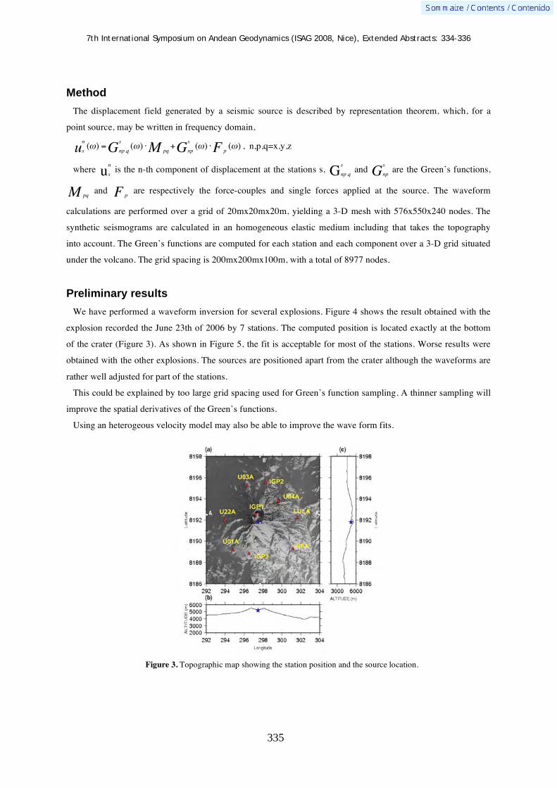
7th International Symposium on Andean Geodynamics (ISAG 2008, Nice), Extended Abstracts: 334-336
335
Method
The displacement field generated by a seismic source is described by representation theorem, which, for a
point source, may be written in frequency domain,
s
n
u ( ) =np ,q
s
G ( )pqM +
np
s
G ( )pF ( ) , n,p,q=x,y,z
where s
n
u is the n-th component of displacement at the stations s, np ,q
s
G and np
s
G are the Green’s functions,
pqM and pF are respectively the force-couples and single forces applied at the source. The waveform
calculations are performed over a grid of 20mx20mx20m, yielding a 3-D mesh with 576x550x240 nodes. The
synthetic seismograms are calculated in an homogeneous elastic medium including that takes the topography
into account. The Green’s functions are computed for each station and each component over a 3-D grid situated
under the volcano. The grid spacing is 200mx200mx100m, with a total of 8977 nodes.
Preliminary results
We have performed a waveform inversion for several explosions. Figure 4 shows the result obtained with the
explosion recorded the June 23th of 2006 by 7 stations. The computed position is located exactly at the bottom
of the crater (Figure 3). As shown in Figure 5, the fit is acceptable for most of the stations. Worse results were
obtained with the other explosions. The sources are positioned apart from the crater although the waveforms are
rather well adjusted for part of the stations.
This could be explained by too large grid spacing used for Green’s function sampling. A thinner sampling will
improve the spatial derivatives of the Green’s functions.
Using an heterogeous velocity model may also be able to improve the wave form fits.
Figure 3. Topographic map showing the station position and the source location.

7th International Symposium on Andean Geodynamics (ISAG 2008, Nice), Extended Abstracts: 334-336
336
Figure 4. Waveform fits. Blue and red lines denote respectively real data and synthetics. The three components are plotted for each station (E,N,Z). The relative error between data and synthetics is 15%.

7th International Symposium on Andean Geodynamics (ISAG 2008, Nice), Extended Abstracts: 337-338
337
Tectono-magmatic evolution and crustal growth along west-central Amazonia since the late Mesoproterozoic: Evidence from the Eastern Cordillera of Peru
Aleksandar Mi kovi & Urs Schaltegger
Earth Sciences Section, University of Geneva, 13 rue des Maraîchers, CH 1205 Geneva, Switzerland
Whereas the Cretaceous to recent orogenic cycle is well characterised (Ramos and Aleman; 2000), the
knowledge of the early Phanerozoic and Proterozoic evolution of the Andes is increasingly fragmentary with age
due to paucity of exposed lithologies. The problem is less pronounced along the Peruvian segment of the orogen
where a lacuna in the ubiquitous Cenozoic volcanic cover is interpreted to have resulted from the flat slab
subduction of the Nazca ridge (Jaillard et al., 2000). Batholiths of the Eastern Cordillera of Peru which straddle
the tectonic boundary between the allochthonous western Amazonian tectonic provinces of San Ignacio (1.57-
1.24 Ga) and Sunsás (1.19-0.92 Ga) on one side and comparatively few parautochthonous to allochthonous
crustal domains (1.9-1.8 Ga Arequipa-Antofalla; 150 Ma Olmos-Amotape terrane) on the other, thus provide an
optimal record of the nature and rate of crustal growth at a long lived, non-accretionary cratonic margin. Despite
its fortuitous setting however, the timing of magmatism in the central Andes is relatively poorly understood with
most of the geochronological work so far relying heavily upon whole rock Rb-Sr and K-Ar techniques, both of
which are known to yield ambiguous dates thanks to low retention temperatures and a possibility of isotopic
disturbance by subsequent tectono-thermal episodes. This is a particularly acute problem in Peru considering
~150 Ma of uninterrupted compressive tectonism of the last Andean cycle (Benavides, 1999).
We use a combination of in situ U-Pb geochronology and Lu-Hf isotopic tracing of plutonic zircons along the
strike of the Eastern Cordillera of Peru to construct a detailed geochronological framework and identify sources
of consecutive magma pulses in order to define cratonic domains and track crustal evolution of the proto-Andean
margin of Amazonia. By relating the secular changes in magma sources to the tectono-magmatic cycles of
continental assembly and breakup over the last 1.1 Ga, we can test both the current geodynamic scenarios for the
evolution of the western Amazonian shield with particular focus on the poorly understood break up of Rodinia
(Meert and Torsvik, 2003; Loewy et al., 2003; Cordani et al., 2003; Fuck et al., 2008; Li et al., 2008) and the
models constraining the relative contributions of Phanerozoic and Neoproterozoic arc magmatism in the
formation of the continental crust (Condie, 2001; Davidson and Arculus, 2005).
The results of a laser ablation ICPMS U-Pb isotopic study on zircons from 60 Eastern Cordilleran intrusives of
Peru reveal 1.15 Ga of magmatic activity along the central western Amazonian margin that is largely dominated
by mid-Phanerozoic plutonism related to the assembly and break up of Pangea. A Carboniferous-Permian (340-
285 Ma) continental arc is identified along the orogenic trend from Ecuadorian border (6oS) to the inferred
inboard extension of the Arequipa –Antofalla terrane in the southern Peru (14oS). The widespread crustal
extension and thinning which affected the western Gondwana throughout Permian and Triassic resulted in the
central late to post orogenic La Merced-San Ramón-type anatectites dated between 275 and 220 Ma while the
emplacement of the southern Cordillera de Carabaya peraluminous granitoids in the late Triassic to early
Jurassic (220-190 Ma) represents, temporally and regionally, a separate tectono-magmatic event likely related to
re-suturing of the Arequipa-Antofalla block. Alkaline volcano-plutonic complexes and stocks associated with the

7th International Symposium on Andean Geodynamics (ISAG 2008, Nice), Extended Abstracts: 337-338
338
onset of the modern Andean cycle in southeastern Peruvian Andes cluster between 170-180 Ma. A
volumetrically minor intrusive pulse of Oligocene age (~30 Ma) is detected near the SW Cordilleran border with
Altiplano, and only one remnant of the late Ordovician intrusive belt is recognised in the Cuzco batholith (446.5
± 9.7 Ma) indicating that the Famatinian arc system previously identified in Peru only along the north-central
Cordillera Oriental and the coastal Arequipa terrane had also developed inboard of this para-autochthonous
crustal fragment. Both post-Gonwanide and Precambrian plutonism are restricted to isolated occurrences
spatially comprising less than 15% of the Eastern Cordillera intrusives. Hitherto unknown occurrences of the late
Mesoproterozoic and middle Neoproterozoic granitoids from the south central cordilleran segment define
magmatic events at 691 ± 13, 751 ± 8, 985 ± 14, and 1071 to 1123 ± 23 Ma that are broadly coeval with the
Braziliano and Grenville-Sunsás orogenies. Our data suggest the existence of a contiguous orogeny > 3800 km
along western Amazonia during the formation of Rodinia and its “early” fragmentation prior to 690 Ma.
In addition to dating the emplacement of plutonic rocks, we performed an in situ the LA MC-ICPMS survey of
the Hf isotope systematics on magmatic zircons from the Eastern Cordillera batholiths. These are invariably
characterised by a range in the initial 176Hf/177Hf compositions for a given intrusive event suggesting mixing of
material derived from the Paleoproterozoic crustal substrate and variable Neoproterozoic to recent juvenile
sources. The periods of well documented compressive tectonics correspond to negative mean eHfi values of -
6.73, -2.43, -1.57 for the Ordovician Famatinian, Carboniferous-Permian and late Triassic respectively,
suggesting the minimum crustal contribution between 74% and 44% by mass. The average initial Hf systematics
from granitoids associated with intervals of regional extension such as the middle Neoproterozoic, Permian-
Triassic and Cenozoic Andean back arc plutonism are consistently shifted toward the positive values (mean eHfi
= -0.7 to +8.0) indicating systematically larger inputs of juvenile magma (22% to 49%). In the absence of
evidence for lateral accretion of exotic crust, the time integrated Hf record from the central proto-Andean margin
of western Amazonia suggests crustal reworking as the dominant process during episodes of arc magmatism and
implies that most of continental growth took place vertically via crustal underplating of isotopically juvenile,
mantle derived magma during intervals of crustal attenuation.
References Benavides, V., 1999. Orogenic evolution of the Peruvian Andes: The Andean Cycle. Geology and ore deposits of the Central
Andes, SEG Spec. Pub., 7, 61-107 Condie, K. C., 2001. Rodinia and continental growth. Gondwana Research, 4, 154-155. Cordani, U. G., Brito-Neves, B. B., D’Agrella-Filho, M, S., 2003. From Rodinia to Gondwana: a review of the available
evidence from South America. Gondwana Research, 6, 275-283. Davidson, J. P., Arculus, R. J., 2005. The significance of Phanerozoic arc magmatism in generating continental crust. In:
Evolution and differentiation of the continental crust (eds.) M. Brown & T. Rushmer, Cambridge Univ. Press, 135-172. Fuck, R. A., Brito, B. B., Schobbenhaus, C., 2008; Rodinia descendants in South America. Prec. Research, 160, 108-126. Jaillard E., Hérail, G., Monfret, T., Díaz-Martínez, E., Baby, P., Lavenu, A., Dumont, J.F., 2000. Tectonic evolution of the
Andes of Ecuador, Peru, Bolivia and northernmost Chile. In: Tectonic Evolution of South America. (Eds.) U. Cordani, E.J. Milani, A. Thomaz Filho, & M.C. Campos Neto, Rio de Janeiro, 635-685.
Li, Z. X., Bogdanova, S.V., Collins, A.S., Davidson, A., de Waele, B., Ernst, E.E., Fitzsimons, I.C.W., Fuck, R.A., Gladkochub, D.P., Jacobs, J., Karlstrom, K.E., Lu, S., Natapov, L.M., Pease, V., Pisarevsky, S.A., Thrane, K., Vernikovsky, V., 2008. Assembly, configuration and break-up history of Rodinia: a synthesis. Precambrian Research, 160, 179-210.
Loewy, S. L., Connelly, J. N., Dalziel, I. W. D., Gower, C. F., 2003. Eastern Laurentia in Rodinia: constraints from whole-rock Pb and U/Pb geochronology. Tectonophysics, 375, 169-197.
Meert, J.G., Torsvik, T.H., 2003. The making and unmaking of a supercontinent: Rodinia revisited. Tectonophysics, 375, 261-288.
Ramos, V. A., Aleman, A., 2000. Tectonic Evolution of the Andes. In: Tectonic Evolution of South America. (Eds.) U. Cordani, E.J. Milani, A. Thomaz Filho, M.C. Campos Neto, Rio de Janeiro, 635-685.

7th International Symposium on Andean Geodynamics (ISAG 2008, Nice), Extended Abstracts: 339-340
339
Seismic tomography of the Cotopaxi volcano, Ecuador
V. Monteiller, J.-P. Métaxian, B. Valette, & S. Araujo
LGIT, Université de Savoie, 73376 Le Bourget du lac cedex, France ([email protected])
KEYWORDS : volcano, Cotopaxi, seismology, tomography
Volcanic settings
The Cotopaxi volcano (5897m) is situated in the Cordillera Real of Ecuador, 60km south of Quito. This active
andesitic volcano, with a base diameter of 25 km and almost 3000m of relief is covered by an icecap on the
uppermost 1000m of the cone. The seismic monitoring is performed by the Instituto Geofisico of the Escuela
Politécnica National since 1989 using a network of short-period seismic stations set up on the volcanic shield.
The local set of data comes from an experiment performed in 1996-97 on Cotopaxi volcano. The array was
composed of 4 classical short period stations employing L4-3D or L4C seismometers and 8 telemetered stations
divided in two groups of four stations comprising sub-arrays which had separate reception and acquisitions units.
The experiment was carried out in two phases. First some stations were installed on the volcanic cone warying
azimuths and distances from the crater and other stations in a wide area around the volcano, up to 20 km from
the summit. In a second phase, part of the equipment was moved closer to the crater in order to record in greater
detail the volcanic activity concentrated below the summit area. One station was set up along the edge of the
crater on a rock base at the elevation of 5820m with the aim to better constraint the structure and the localization
on the uppermost 1000m of the cone occupied by the glacier. In total, 16 different sites were occupied during
this experiment, additionally to the 4 permanent sites of the IGEPN array.
The tomographic inversion was performed using 6425 P arrivals times from 1147 earthquakes.
Results
We used the tomographic algorithm of Monteiller et al. (2005). Travels times are computed by solving the
Eikonal equation using a finite-difference approach (Podvin and Lecomte 1991). The inverse problem is solved
by using a probabilistic approach (Tarantola Valette 1982). Figure 2 display the 3-D P-wave velocity model. We
Figure 1. Seismic network. Red triangles indicate the position of the seismic stations.

7th International Symposium on Andean Geodynamics (ISAG 2008, Nice), Extended Abstracts: 339-340
340
show horizontal and vertical slices at different depth, latitude and longitude. The viewpoint position is South-
West.
The result clearly show the presence of high velocity anomaly surrounded by low velocity ring interpreted as
effusive products associated to the construction of the Cotopaxi. The high velocity anomaly is interpreted as a
solidified intrusive magma body.
Figure 3 display slices of 3-D structure velocity model. The yellow patch delimit the iso-velocity surface
corresponding to 3350 m/s. The gray patch delimit the topography of Cotopaxi. The viewpoint position is South-
East.
Figure 2. P-wave velocity model cross sections.
References Monteiller, V., Got J.-L., J. Virieux and P. Okubo, An efficient algorithm for double-difference tomography and location in
heterogeneous media, with an application to Kilauea volcano, J. Geophys. Res., 110, B12306, doi:10.1029/2004JB003466 Podvin, P., & Lecomte, I., 1991. Finite difference computation of traveltimes in very contrasted velocity models: a massively
parallel approach and its associated tools., Geophys. J. Int., 105, 271-284. Tarantola, A. and Valette, B., 1982, Inverse problems = quest for information., J. Geophys., 50, 159-170.
Figure 3. 3-D P-wave velocity model.
7th International Symposium on Andean Geodynamics (ISAG 2008, Nice), Extended Abstracts: 341-343
341
Analysis of the January 23, 2007 Aysén swarm using joint hypocenter determination
Cindy Mora1, Diana Comte
1, Ray Russo
2, & Alejandro Gallego
2
1 Dept. Geofísica, Universidad de Chile, Santiago, Chile ([email protected]).
2 Department of Geological Sciences, University of Florida, Gainesville, FL, USA ([email protected]).
KEYWORDS : Aysen swarm, crustal seismicity, Southern Andes, Liquiñe-Ofqui fault
Introduction
It is well known that the Chile margin triple junction is one of the few good examples of where an active
spreading oceanic ridge is colliding with an active continental margin. In this location the Chile Rise intersects
the sediment-filled Peru-Chile Trench (Figure 1). North of the Triple Junction, the Nazca plate is subducting
below the South American plate at 7 cm/yr, whereas to the south, the Antarctic plate is subducting below the
South American plate at about 2 cm/yr. For the last 15 m.y. the directions of plate motions between the South
American, Nazca, and Antarctic plates have remained relatively constant (Cande, 1983). As a result, three
segments of the Chile Rise spreading center, separated by transform fault offsets, have converged and collided
with the southern margin of Chile. A fourth ridge segment, separated by the Taitao and Darwin fracture zones,
has recently been buried under the sedimentary fill of the Peru-Chile Trench. As collision progressed, the Triple
Junction has migrated northward to its present position at 46°S. The Golfo de Penas and Taitao Peninsula, just
south of the present position of the Triple Junction, are parts of the western margin of the South American plate
which have overridden short segments of the Chile Rise about 5-6 and 2.5-4 Ma, respectively.
Successive Chile Rise segment collision generated changes in surface geology of South American plate such
as volcanic gaps and younger plateau lavas in Southernmost Chile, due to magma ascending through slabs
windows formed as the subducting ridge continue the spreading, and acts as well as an indent and main force in
the regional tectonism (Thompson, 2002). Such forces and the difference in subduction velocities cause stress
partition along the trench between 38° and 42°S, the detachment of the sliver west to the Liquiñe-Ofqui fault and
clockwise and counter clockwise rotations east and west of the fault (Rosenau et al, 2006).
Geological Setting
The Liquiñe –Ofqui Fault Zone (Figure 1) is located between 38°S -48°S in the Austral Andes, presenting two
~1000 km long main parallel to the trench lineaments, between 39°-44°S and 44°-47°S, connected by N-E
trending echelon lineaments and concave to the ocean lineaments of tens of kilometers (Cembrano et al, 1996).
The volcanoes from the Austral Andes Volcanic Zone are distributed along the main N-S faults and on the
duplex centers, 250 - 300 km east from coast, also North Patagonian Batholit (NPB), the old volcanic arc,
contains the main fault at its central part. Field studies of the fault zone reveal both ductile and brittle
deformation in rocks from the NPB (Cembrano et al, 1996) that are consistent with actual dextral movement,
although older mylonitic deformation associated with the fault may indicate that the original sense was left-
lateral and took places at deeper levels in the crust.
The paleomagnetic data of blocks in the Liquiñe-Ofqui fault are consistent with vertical axis rotation in a

7th International Symposium on Andean Geodynamics (ISAG 2008, Nice), Extended Abstracts: 341-343
342
buttressed fault system (Cembrano et al, 2002; Beck et al, 1993), showing rotations up to 31±4° and 9±1°
respectively. The fault zone is believed to have formed together with the volcanic arc during the Eocene-
Miocene due to partitioning of deformation in the forearc in South American plate, in a transpresional process
owning to oblique subduction of Nazca plate (Pardo-Casas and Molnar, 1987) and changes in the sense of
motion and angle (Cembrano et al, 1996).
Seismicity along the Liquiñe-Ofqui fault has been poorly studied, mainly because teleseismic events have been
few (Cifuentes, 1989), and almost no local or regional seismicity associated with the fault has been recorded
because of a lack of local seismic networks in the proximity of the fault.
Through a joint project between Universidad de Chile and University of Florida a temporary network (Fig. 1)
was deployed during two years, between 43°-49°S and 71°-76°W, comprising island and inland, with 60
seismometers and 4 fat stations consisting in broadband STS-2 Streckeisen stations accompanied by closely
spaced short period seismometers. At the end of this period, on January 23, a seismic swarm began in the Aysen
region, near Puerto Chacabuco with a mainshock Mw=5.2, presenting a dextral strike slip focal mechanism. This
swarm had its major activity during January until April of the same year, recording more than 1000
microearthquakes per month, decreasing the activity towards December, 2007 (Chilean Seismological Service).
The Joint Hypocentral Determination
During the January 1-27, 2007 period the temporary network recorded more than 300 events in the Aysen
fjord, where the majority of them occurred between January 23 and 27, 2007. Data was read and located with
SEISAN program and relocated with the Joint Hypocentral Determination (JHD, Dewey, 1972, Douglas, 1967)
in five different groups corresponding to the events of each day in the swarm period, using the mainshock as
master event. Dewey’s method assumes that travel times anomalies of P waves are identical to all common
Figure 1. Distribution of temporary network near Liquiñe-Ofqui Fault Zone (thick black line). Inverted red triangles correspond to seismic stations and red squares correspond to fat stations. Fracture Zones are represented by thinner white lines; ridge segments in thin white lines. The Antartic and Nazca plate vector movement are shown with red arrows. The red lined square denotes the study zone.

7th International Symposium on Andean Geodynamics (ISAG 2008, Nice), Extended Abstracts: 341-343
343
station in a group of events, then the difference in arrival times is due to differences in the hypocenter only.
Relative to the master event location, latitude, longitude, depth and origin time differences on each after- and
fore-shocks are iterated until solution converge (Marshall and Russo, 2005).
After relocating the events, changes in depth are significant, showing that the events are finally constrained to
depths between 0 to 7 km (before the JHD procedure, this distribution in depth was between 0 to 15 km depth)
(Figure 2.). The results show an area confined in about 11 km in latitude and 33 km in longitude. The new
locations suggest that this segment of the Liquiñe-Ofqui fault is deeping towards west and trending south, which
is in agreement with the main trending of the Liquiñe-Ofqui fault.
The evidence of seismicity associated with the Liquiñe-Ofqui fault system clearly indicates that seismic
hazard estimations in this region must be re-estimated.
Acknowledgement This work was funded by National Science Foundation-USA N°0126244 and CONICYT-CHILE grant Nº1050367 . The authors particularly acknowledge to Universidad de Chile for the scholarship “Becas de Estadias cortas de Investigación Destinadas a Estudiantes Tesistas de Doctorado y Magíster de la Universidad de Chile” to work on this investigation.
References Beck, M.E., C. Rojas, J. Cembrano, 1993. On the nature of buttressing in margin-parallel strike-fault systems, Geology, 21,
755-758. Cande, S.C., 1983. Nazca-South America Plate Interactions 80 my BP to present. EOS. Cembrano, J., Hervé, F., Lavenu, A., 1996. The Liquine–Ofqui fault zone: a long-lived intra-arc fault system in southern
Chile. Tectonophysics 259, 55– 66. Cembrano, J., Lavenu, A., Reynolds, P., Arancibia, G., Lopez, G., Sanhueza, A., 2002. Late Cenozoic transpressional ductile
deformation north of the Nazca-South America-Antarctica triple junction. Tectonophysics, 354, 289-314. Cifuentes, I.L., 1989. The 1960 Chilean earthquakes. Journal of Geophysical Research 94 B1, pp. 665–680. Dewey, J.W., 1972. Seismicity and tectonics of western Venezuela. Bull. Seismol. Soc. Am. 62, 1711 –1751. Douglas, A. Joint Epicentre Determination. Nature,vl. 215, is 5096, p. 47, July 1967 Marshall, J.L., Russo, R.M.,2005. Relocated aftershocks of the March 10, 1988 Trinidad earthquake: Normal faulting, slab
detachment and extension at upper mantle depths. Tectonophysics, 398, 2005, 101-114. Pardo-Casas, F. and Molnar, P., 1987. Relative motion of the Nazca (Farallón) and South American Plates since Late
Cretaceous time. Tectonics 6, 233–248. Rosenau, M., Melnick, D. and Echtler, H., 2006. Kinematic constraints on intra-arc shear and strain partitioning in the
southern Andes between 38ºS and 42ºS latitude. Tectonics, 25, TC4013, doi:10.1029/2005TC001943. Thomson, S., 2002. Late Cenozoic geomorphic and tectonic evolution of the Patagonian Andes between latitudes 42 degrees
S and 46 degrees S; an appraisal based on fission-track results from the transpressional intra-arc Liquiñe-Ofqui fault zone. Geological Society of America Bulletin, v.114; no.9; p.1159–1173.
Figure 2. Latitude and longitude versus depth profile for the relocated January 23-27 Aysen swarm data. Colours denote depth.

7th International Symposium on Andean Geodynamics (ISAG 2008, Nice), Extended Abstracts: 344-347
344
Further evidences of Quaternary activity of the Maradona faulting, Precordillera Central, Argentina
S. M. Moreiras & A. L. Banchig
CONICET – IANIGLA (CCT), Av Ruiz Leal s/n, Parque Gral. San Martín, CP 5500, Mendoza, Argentina
([email protected], [email protected], [email protected])
KEYWORDS : morphotectonic features, active fault, landslides, Quaternary, Precordillera
Introduction
The Maradona faulting is located in the Pampa of Maradona (San Juan province), an NS elongated valley that
runs parallel to the Eastern Precordillera and the Central Precordillera (31º 46´ LS - 68º 51´) (Figure 1)
continuing towards the south as the Pampa of Bachongo. This faulting, with a total extension of 32 km, was
initially identified by photo-interpretation and was considered as a Lower-Middle Pleistocene age fault (Bastías
et al., 1984). Further research deduced that this faulting is an expression of the “Matagusanos-Maradona-
Acequión” tectonic belt (Perucca, 1990; Perucca et al., 1990) located between the Eastern Precordillera and the
Central Precordillera. Both, geological provinces has a completely different structural behaviour. Whereas, the
former is characterised by a skinned fold - thrust belt with occidental vergence where mainly Cambric-
Ordovician carbonatic rocks outcrop, the latter corresponds to overthrustings with eastern vergence and its
outcroppings are Palaeozoic rocks of talus or outer marine platform.
Even through, the Maradona faulting is reported as active during Quaternary (Amos, 1981) detailed
geomorphological studies have not been carried out in this area. Hence, this research is focussed to amend this
lacking analysing preserved geomorphological expressions of this faulting that may be engaged to evaluate the
regional seismic hazard.
Morpho-tectonic features of Maradona faulting
The Maradona faulting is easily identified by remote sensing due to the undoubtedly alignment generated by
the fault scarpe on the eastern edge of the valley. However, detailed field examinations let to identify another
eastern fault (F2) associated with this compressive system.
The fault (F1), indirectly identified by previous authors, was recognised in the field southern of the Maradona
farm, where Tertiary outcrops of Mogotes formation (173º, 53º E) overlap Quaternary alluvial deposits. This
reverse fault has a plane with N-S trend (12º) dipping 44º to the West and a a vertical offset of 5 m was
measured. Moreover, this faulting also exposes Tertiary rocks over alluvial fans in Bachongo place, where
direction measured on the fault plane is 335º and it dip of 32º to 42º to the West.
Whereas, the second faulting (F2) was recognised in the surroundings of the Papagallos farm, where this
reverse fault affects a 20 m-thick sequence of alluvial fans. There, Quaternary deposits are deformed dipping 20º
to the West and they are covered by a sequence of barreal-lake deposits generated as a consequence of dam of
the Papagallos River resulting from the western block up-lift.

7th International Symposium on Andean Geodynamics (ISAG 2008, Nice), Extended Abstracts: 344-347
345
Figure 1: Map of the study area showing Maradona faulting (F1 and F2) and landslides distribution.
Geomorphic markers of Quaternary activity
The F1 is evidenced by a 9 km-long scarpe extending from the Papagallos River to Bachongo locality. This
morphology exposes its free face towards the east as a result of western block lift. It generated elongated hills
with N-S trending in the Eastern edge of the Pampa of Maradona (Figure 1). Likewise, the F1 offsets distal
piedmont sediments of alluvial-fan northward the Papagallos River where ephemeral streams are interrupted or
displaced 300 to 500 m towards the north.

7th International Symposium on Andean Geodynamics (ISAG 2008, Nice), Extended Abstracts: 344-347
346
In Bachongo place, Tertiary levels and alluvial fans are folded just on the fault plane of F1 (335º, 32º to 42º
W). The latter show an asymmetrical anticline (335º, 30º W and 82º E); while alluvial fans are forming an
anticline with a vertical western flank and an eastern flank dipping 25º E.
Then, the presence of the 5 to 8 m-thick lake sequence indicate the existence of a pond related to the F2
faulting, being a clear marker of strike slip component of this faulting. The extension of this paleo-lake is
uncertain. Similar disconnected fine deposits were observed up-stream of the Papagallos River, reason why they
could not be properly correlated. Even though, the lake sequence is thinner in the Maradona farm, as it is
expecting in lake borders, the maximum elevation of these fine deposits are higher than in the Papagallos farm.
The Maradona faulting has favoured water springs; hence numerous of them are markedly aligned to N-S fault
traces. The trace of the F1 coincides with the springs of Maradona, Agua Raja, Bachongo and Pampa Amarilla
farms; while the F2 runs over those existing at Papagallos and La Ciénaga farms.
These places located in this arid region used to be important farms since the beginning of XVIIIth century due
to their water resource.
Landslide occurrence
At the latitude of study area, nine slumps are recognised in the eastern slope of the Sierras de las Osamentas
(Fig. 1). The total debris volume mobilised by these rotational slides reaches 1,2x10⁹ m3.
These landslides are spatially distributed close to traces of Maradona faulting, approximately 8.5 km and
16 km far from the F1 and the F2, respectively. Likewise, they are located in an area of 12 km2, reason why a
seismic shaking of magnitude >5 is proposed. The earthquake recorded on January 24th 1978 (Ms 5,7) was
related to the Maradona faulting (Inpres, 1982) and at least four epicentres of Ms=4.2 earthquakes are located in
this region.
Moreover, recurrence of paleo-earthquakes is assumed because at least three of these slumps correspond to
multiple events. In these cases, ancient relit deposits are overlaid by younger deposits. Still numerical dating of
these events is missing.
These triggering earthquakes activating previous landslide scarps could be more recently. The M1 landslide
located close to the Agua Pinto farm have been reactivated in the last century affecting the route connecting the
Pampa of Maradona valley with Barreal valley that was also used in the past by indigenous (Huarpes).
Conclusion
The present geomorphological study reveals that Maradona faulting system has more than one fault trace what
is fundamental for future seismic hazard evaluation as a partial earthquake record could be obtained studying
only the F1. According to morpho-tectonic features observed in the field, this faulting shows two dextral oblique
reverse faults. Moreover, many evidences about recent tectonic activity of this faulting could be found. The
offset of Quaternary alluvial surfaces (Gaudemer et al. 1989; Audin et al, 2003, 2006) and gathered distribution
of landslides triggered by earthquakes (Keefer, 1984, 1987) have been successfully used to identifying active
faults systems.
In Argentina seismic hazard lacks on paleo-seismic assessment (Costa et al., 2000), hence our work let
advance in this problem, still numerical dating is missing.

7th International Symposium on Andean Geodynamics (ISAG 2008, Nice), Extended Abstracts: 344-347
347
Referencias Amos, A.J., 1981. Fallas activas en la Republica Argentina Actas VIII Congreso Argentinote Geología. Audin L., Herail G., Riquelme R., Darrozes J., Martinod J., Font E., 2003. Geomorphological markers of faulting and
neotectonic activity along the western Andean margin, northern Chile. Journal of Quaternary Science, 18 (8), pp. 681-694. Audin L., David C., Hall S., Ferber D., Hérail G., 2006. Geomorphic evidence of recent tectonic activity in the forearc of
Perú. RAGA 61(4): 545-554. Bastias, H., Weidmann, N., y Perez, M., 1984, Dos zonas de fallamiento Plio-Cuaternario en la Precordillera de San Juan.
Actas IX Congreso Geologico Argentino, Bariloche. Vol. II: 329-341. Costa C., Machette M.N., Dart R.L., Bastias H.E., Paredes J.D., Perucca L.P, Tello G.E:, Haller K.M., 2000. Map and
database of Quaternary faults and folds in Argentina. A project of the International Lithosphere Program Task Group II-2, Major Active Faults of the World. United States Geological Service open file 00-0108.
Gaudemer, Y., Tapponnier, P., Turcotte, D.L. 1989. River offsets across active strike-slip faults. Ann. Tecton, 3 (2), pp. 55-76.
INPRES, 1982, Microzonificacion sismica del valle de Tulum, Provincia de San Juan: Resumen Ejecutivo, San Juan,120 p. Keefer, D.F., 1984. Landslides caused by earthquakes. Geol. Soc. America Bulletin, 95: 406-21. Keefer, D.F., 1987. Landslides as indicators of prehistoric earthquakes. Directions in paleosismology. U.S. Geol. Survey
Open File report 87-673, pp: 178-180. A. Crone and E. Modal (editors). Perucca, L., 1990. Sistema de fallamiento La Dehesa-Maradona-Acequión, San Juan, Argentina. Actas XI Congreso
Geológico Argentino, San Juan. Vol. II: 431-434. Perucca, L., Sanches, A., and Uliarte, E., 1990, Morfoneotectónica en la zona norte del corredor tectónico Matagusanos-
Maradona-Acequión, San Juan, Argentina. Actas XI Congreso Geológico Argentino, San Juan. Vol. II: 435- 438. Ramos V., 1999. Las provincias geológicas del territorio Argentino. En: Geología Argentina (Ed. R Caminos). Instituto de
geología y recursos minerales. Anales 29 (12): 41-96.

7th International Symposium on Andean Geodynamics (ISAG 2008, Nice), Extended Abstracts: 348-350
348
Contemporary forearc deformation in south-central Chile from GPS observations (36-39°S)
Marcos Moreno1, Jürgen Klotz
1, Daniel Melnick
2, Helmut P. Echtler
1-2, & Klaus Bataille
3
1
GeoForschungsZentrum Potsdam, Telegrafenberg, 14473 Potsdam, Germany 2 Institut für Geowissenschaften, Universität Potsdam, Potsdam, Germany
3 Departamento de Ciencias de la Tierra, Universidad de Concepción, Chile
Introduction
Present-day surface deformation along active forearc regions primarily responds to the earthquake cycle phases
[e.g., Savage, 1983; Thatcher, 1984] and locally to upper plate structures [e.g., McCaffrey and Goldfinger,
1995]. Mega-earthquake cyclic deformation is a transient process and is conditioned by the mechanical coupling
between both plates. Local upper plate structures like active forearc crustal-scale faults may accommodate and
partly release the elastic strain accumulation during the earthquake cycle [e.g., Park, et al., 2002]. Similarities
between syntectonic sediments and differential coastal uplift and tilting by repeated slip on crustal faults suggest
that some of these structures have controlled the surface deformation in some forearc regions over 106 years
[e.g., Melnick, et al., 2006]. Active crustal faults can delimit forearc slivers, which may rotate or translate with
respect to a stable continental frame, producing different patterns of surface deformation [e.g., Fitch, 1972;
Jarrard, 1986].
Regional GPS survey over the last 4 years analyses the present-day deformation in the forearc of the south-
central Chile margin, especially on the Arauco-Nahuelbuta forearc block [Hackney et al., 2006]. The Arauco-
Nahuelbuta block defines the overlapping area of two mega-thrust earthquake rupture zones: the Valdivia 1960
and Concepción 1835. There, active crustal faults have been identified and mapped based on deformed coastal
geomorphic features, seismic-reflection profiles, and micro-seismicity [Melnick and Echtler, 2006]. GPS data
and finite-element models are presented to gain insight into forearc kinematics and particularly to address the
role of crustal faults in the seismotectonic segmentation.
Results and discussions
Forearc deformation varies markedly from north to south in the Arauco-Nahuelbuta block. Present-day
deformation in the forearc segment defined by the rupture zone of the 1835 earthquake clearly represents strain
accumulation due to the ongoing interseismic phase. Whereas, surface deformation in the adjacent southern
forearc segment, which in turn is part of the 1960 earthquake rupture zone, manifests the effects of protracted
and still ongoing postseismic mantle rebound in addition to locking of the seismogenic zone.
GPS observation and modeling results suggest that the coupling zone narrows southward. The change in
downdip depths between the 1835 and 1960 earthquake-rupture segments may be a result of: (a) differential age
gradient of the incoming oceanic plate parallel to the trench; (b) or the effect of the lower plate Mocha fracture
zone, which in its projection below the active margin corresponds to our limits between the northern and
southern domains (Fig.1).
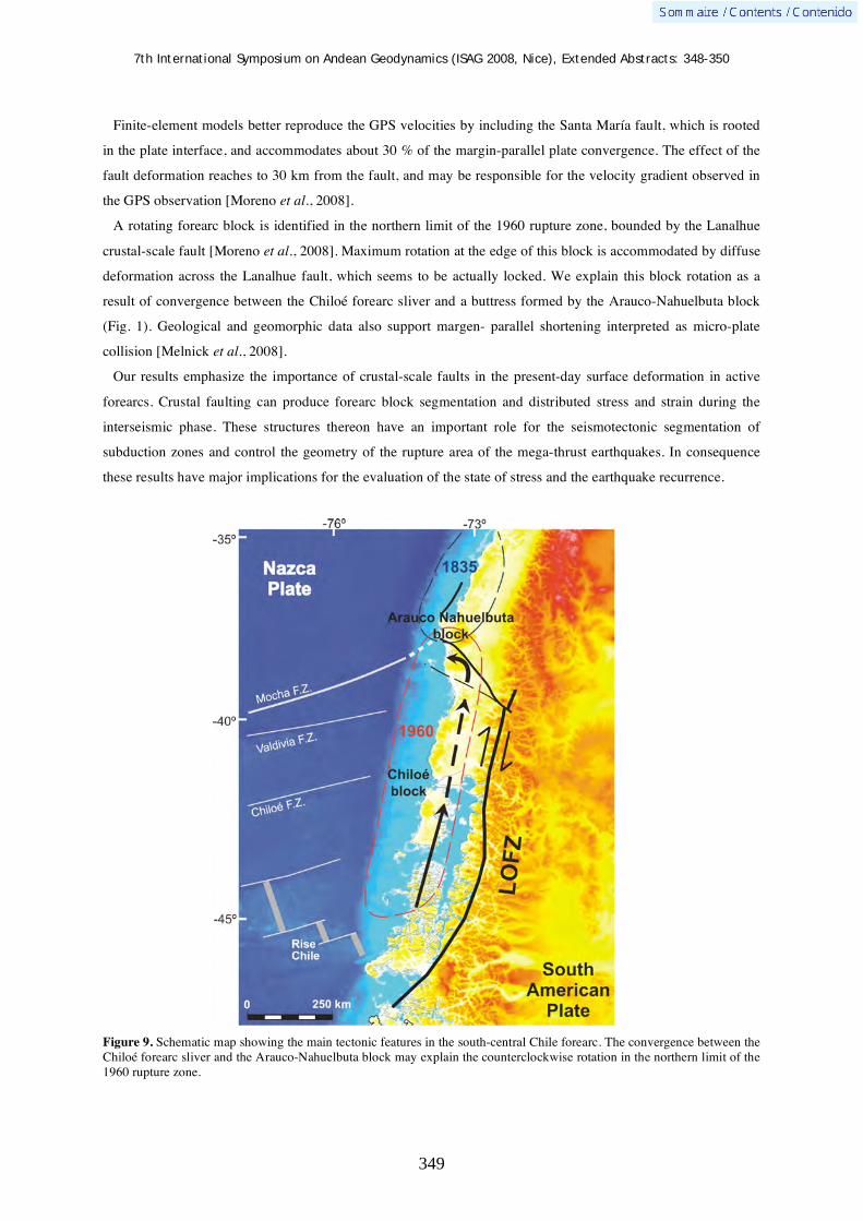
7th International Symposium on Andean Geodynamics (ISAG 2008, Nice), Extended Abstracts: 348-350
349
Finite-element models better reproduce the GPS velocities by including the Santa María fault, which is rooted
in the plate interface, and accommodates about 30 % of the margin-parallel plate convergence. The effect of the
fault deformation reaches to 30 km from the fault, and may be responsible for the velocity gradient observed in
the GPS observation [Moreno et al., 2008].
A rotating forearc block is identified in the northern limit of the 1960 rupture zone, bounded by the Lanalhue
crustal-scale fault [Moreno et al., 2008]. Maximum rotation at the edge of this block is accommodated by diffuse
deformation across the Lanalhue fault, which seems to be actually locked. We explain this block rotation as a
result of convergence between the Chiloé forearc sliver and a buttress formed by the Arauco-Nahuelbuta block
(Fig. 1). Geological and geomorphic data also support margen- parallel shortening interpreted as micro-plate
collision [Melnick et al., 2008].
Our results emphasize the importance of crustal-scale faults in the present-day surface deformation in active
forearcs. Crustal faulting can produce forearc block segmentation and distributed stress and strain during the
interseismic phase. These structures thereon have an important role for the seismotectonic segmentation of
subduction zones and control the geometry of the rupture area of the mega-thrust earthquakes. In consequence
these results have major implications for the evaluation of the state of stress and the earthquake recurrence.
Figure 9. Schematic map showing the main tectonic features in the south-central Chile forearc. The convergence between the Chiloé forearc sliver and the Arauco-Nahuelbuta block may explain the counterclockwise rotation in the northern limit of the 1960 rupture zone.

7th International Symposium on Andean Geodynamics (ISAG 2008, Nice), Extended Abstracts: 348-350
350
References Fitch, T.J. (1972), Plate convergence, transcurrent faults, and internal deformation adjacent to southeast Asia and the western
Pacific, J. Geophys. Res., 77, 4432-4460. Hackney, R., H. Echtler, G. Franz, H. Götze, F. Lucassen, D. Marchenko, D. Melnick, U. Meyer, S. Schmidt, Z. Ta árová, A.
Tassara, and S. Wienecke (2006), The Segmented Overriding Plate and Coupling at the South-Central Chilean Margin (36-42°S), The Andes - Active Subduction Orogeny, Frontiers in Earth Sciences, vol.1, edited by Oncken, O., G. Chong, G. Franz, P. Giese, H. Götze, V. Ramos, M. Strecker, and P. Wigger, pp. 355-374, Springer-Verlag, Berlin.
Jarrard, R.D. (1986), Terrane motion by strike-slip faulting of forearc slivers, Geology, 14, 780-783. McCaffrey, R., and C. Goldfinger (1995), Forearc deformation and great subduction earthquakes: Implications for Cascadia
offshore earthquake potential, Science, 267, 856-859. Melnick, D., B. Bookhagen, M. Strecker, and H. Echtler (2008), Segmentation of subduction earthquakes from forearc
deformation patterns over hundreds to millions of years, Arauco Peninsula, Chile, J. Geophys, Res., under review. Melnick, D., B. Bookhagen, H. Echtler, and M. Strecker (2006), Coastal deformation and great subduction earthquakes, Isla
Santa María, Chile (37°S), Geol. Soc. Am. Bull., 118(11), 1463–1480, doi:10.1130/B25865.1. Melnick, D., and H. Echtler (2006), Inversion of forearc basins in southcentral Chile caused by rapid glacial age trench fill,
Geology, 34, 709–712. Moreno, M.S., J. Klotz, D. Melnick, V. Grund, H. Echtler, and K. Bataille (2008), Active faulting and forerarc block rotation
in the south Chile from GPS-derived deformation, Geochem., Geophys., Geosys., under review. Park, J.-O., T. Tsuru, S. Kodaira, P.R. Cummins, and Y. Kaneda (2002), Splay fault branching along the Nankai subduction
zone, Science, 297, 1157-1160. Savage, J.C. (1983), A Dislocation Model of Strain Accumulation and Release at a Subduction Zone, J. Geophys. Res., 88,
4984-4996. Thatcher, W. (1984), The earthquake deformation cycle, recurrence, and the time- predictable model, J. Geophys. Res., 89,
5674-5680.

7th International Symposium on Andean Geodynamics (ISAG 2008, Nice), Extended Abstracts: 351-353
351
Regional tephro-stratigraphic correlation in the Ecuadorian coastal region
Patricia A. Mothes, Silvia Vallejo, & Minard L. Hall
Instituto Geofísico, Escuela Politécnica Nacional, casilla 1701-2759, Quito, Ecuador ([email protected])
KEYWORDS : volcanic tephra, regional correlations, Holocene uplift, Ecuadorian coast
In continental Ecuador about 30 volcanoes are considered potentially active (Barberi et al., 1991; Hall and
Beate, 1991). Most of them have produced eruptions during the Holocene, some in the range of VEI = 4 to 6.
Plinian and co-plinian ash sequences related to these eruptions are found in abundance in sedimentary layers in
the litoral zone, the product of direct aerial fall and via minimal water transport in local streams.
This study is creating a regional correlation of the ash sequences that we have collected from distinct sites
between northern Esmeraldas to southern Manabí. Ash and mineralological characteristics of each layer are
being determined by examination under binolcular microscope. Granulometric, chemical and radiocarbon
analises are in progress. Based on the results, and by comparing these distal ash samples with the character of
known eruptive products in the Sierra, parent volcanoes will be assigned.
The presence of tephra layers along the Ecuadorian litoral have been noted by various researchers, particularly
archaeologists, (Zeidler and Pearsall, 1994) and (Valdez, 2006), and geomorphologists (Dumont et al., (2006)
and (Usselmann, 2006) however until now no regional correlations exists between the various ash layers found
in the litoral zone.
Fig. 1: Map showing location of some sampling sites, coastal Ecuador, in province of Manabí.

7th International Symposium on Andean Geodynamics (ISAG 2008, Nice), Extended Abstracts: 351-353
352
Fig. 2: Stratigraphic column in the Rio Muchacho drainage, near Canoa, coastal Ecuador
Application of the regional tephra correlation may contribute to constraining rates of recent coastal uplift from
active subduction processes, be used in determining rates of coastal subsidence and within an archaeological
context, possibly infer societal disruptions by heavy ashfalls onto early inhabitation sites.
Fig. 3: Cut in the Rio Muchacho channel (UTM 05662/99553). Observe the 5 layers of volcanic ash.
7th International Symposium on Andean Geodynamics (ISAG 2008, Nice), Extended Abstracts: 351-353
353
Fig. 4: Stratigraphic column from near San Isidro, west of Canoa.
References Barberi, F., Coltelli, M. Ferrara, G., Innocente, F., Navarro J.M. and Santacroce, R., 1988. Plio-Quaternary Volcanism in
Ecuador. Geol. Mag., 125 (1) 1-14. Dumont, J. F., Santana, E., Valdez, F., Tihay, J.P., Usselmann, P., Ituralde, D., and Navarette, E., 2006. Fan beheading and
drainage diversion as evidence of a 3200-2800 BP earthquake event in the Esmeraldas-Tumaco seismic zone: A case study for the effects of great subduction earthquakes. Geomorphology. Vol. 74 (1), p. 100-123.
Hall, M. L. and Beate, B. 1991. Pliio-Quaternary Volcanism in the Ecuadorian Andes. In: Mothes, P. (ed) The Volcanic Landscape of the Ecuadorian Sierra. Studies in Geography. Vol. 4, p. 5-18. Coorperación Editora Nacional, Quito (In Spanish).
Usselmann, P., 2006. Dinámica geomorfológica y medio ambiente en los sitios arqueológicos Chirije y San Jacinto/Japoto (costa del Manabí central, Ecuador) in: Boletín del Institute Francés de Estudio Andinos, Vol. 35 (No. 3) p. 257-264.
Valdez, F., (Editor), 2006. Agricultura ancestral, camellones y albarradas: Contexto social, usos y retos del pasado y del presente. Colección "Actas & Memorias" del IFEA. Quito, Ecuador p. 361.
Zeidler, J. A. and Pearsall, D. M. (Editors), 1994. Regional Archaeology In Northern Manabí, Ecuador: Environment, Cultural Chronology, and Prehistoric Subsistence In the Jama River Valley. University of Pittsburgh, USA. p. 224.

7th International Symposium on Andean Geodynamics (ISAG 2008, Nice), Extended Abstracts: 354-356
354
Interactions between block rotations and basement tectonics in the Copiapó-Vallenar region, northern Chile: Preliminary results
Constantino Mpodozis1, César Arriagada
2, Pierrick Roperch
3, & Esteban Salazar
2
1 Antofagasta Minerals, Ahumada 11, Oficina 602, Santiago, Chile ([email protected])
2 Departamento de Geologia, Universidad de Chile, Casilla 13518, Correo 21, Santiago, Chile
([email protected]) 3 IRD, LMTG & Géosciences Rennes, campus de Beaulieu, 35042 Rennes, France ([email protected])
KEYWORDS : Central Andes rotation pattern, forearc, block rotations, paleomagnetism
Introduction
One of the most prominent tectonic features of the Andes is the Central Andean Rotation Pattern (CARP,
Taylor et al., 2005) which is characterized by, paleomagnetically determined, clockwise rotations in northern
Chile and counterclockwise rotations in southern Peru (Arriagada et al., 2006; Roperch et al., 2006; Taylor et
al., 2007). Recent studies by Somoza et al. (1999), Arriagada et al. (2006) and Roperch et al. (2006) suggest that
most of the CARP rotations were probably acquired during the Paleogene. A remaining problem, however, is the
still poor knowledge of the distribution and magnitude of the tectonic rotations in north-central Chile (Copiapó-
Vallenar region, 28º-31ºS, Figure 1) and its relation with the structural evolution of the Andean range at this
latitude. Along this region, placed over the modern “Pampean” flat-slab segment of the Andes, the Coastal
Region is formed by Jurassic- Cretaceous volcano-sedimentary sequences deformed by long wavelength folds
and intruded by a series of east-younging Mesozoic-Early Cenozoic plutonic complexes. By contrast, the Main
Andean Range (Frontal Cordillera) to the east, is formed by a series of large crystalline (Late Paleozoic) thick-
skinned basement blocks, including basement-cored anticlines bounded by east and west verging reverse faults
(Moscoso and Mpodozis, 1988). In plan view, a 30 km eastwards displacement of the basement front occurs
between ~28º45’-29ºS (“Vallenar Discontinuity”, VD. Figures 1 & 2). South of the VD the main basement-
bounding faults are NS oriented while to the north they trend to the NNE.
New paleomagnetic and structural data
We have recently obtained new structural and sampled more than 60 new paleomagnetic sites from this region.
Preliminary results from some of these sites added to already published paleomagnetic data, are shown in the
structural map of Figure 1. These data demonstrate that clockwise tectonic rotations are, consistently large (30º-
45º) north of the VD (Taylor et al., 2005; Arriagada et al., 2006; Taylor et al., 2007), but south of the VD
rotations seems to be much smaller and almost negligible south of 30ºS (Figure 1). At a regional scale, rotation
vectors are parallels to the orientation of the major faults bounding the basement blocks showing that the VD
seems to represent a regional “kink” both in the orientation of the paleomagnetic vectors and the trend of the
regional basement faults (Figure 2). Several anomalous tectonic features occur along the VD with the most
conspicuous being the termination of the NS and NNE basement faults along an EW structural corridor hosting
along its western edge an elliptical, NE oriented, Paleocene intrusive complex (Los Morteros Pluton, c.a 64 Ma,
Figure 2). An anomalous large rotation value (50º) was obtained from a paleomagnetic site sampled in Jurassic
red beds outcropping at the VD (Figure 1). Rapid facies changes in Mesozoic sedimentary and volcanic
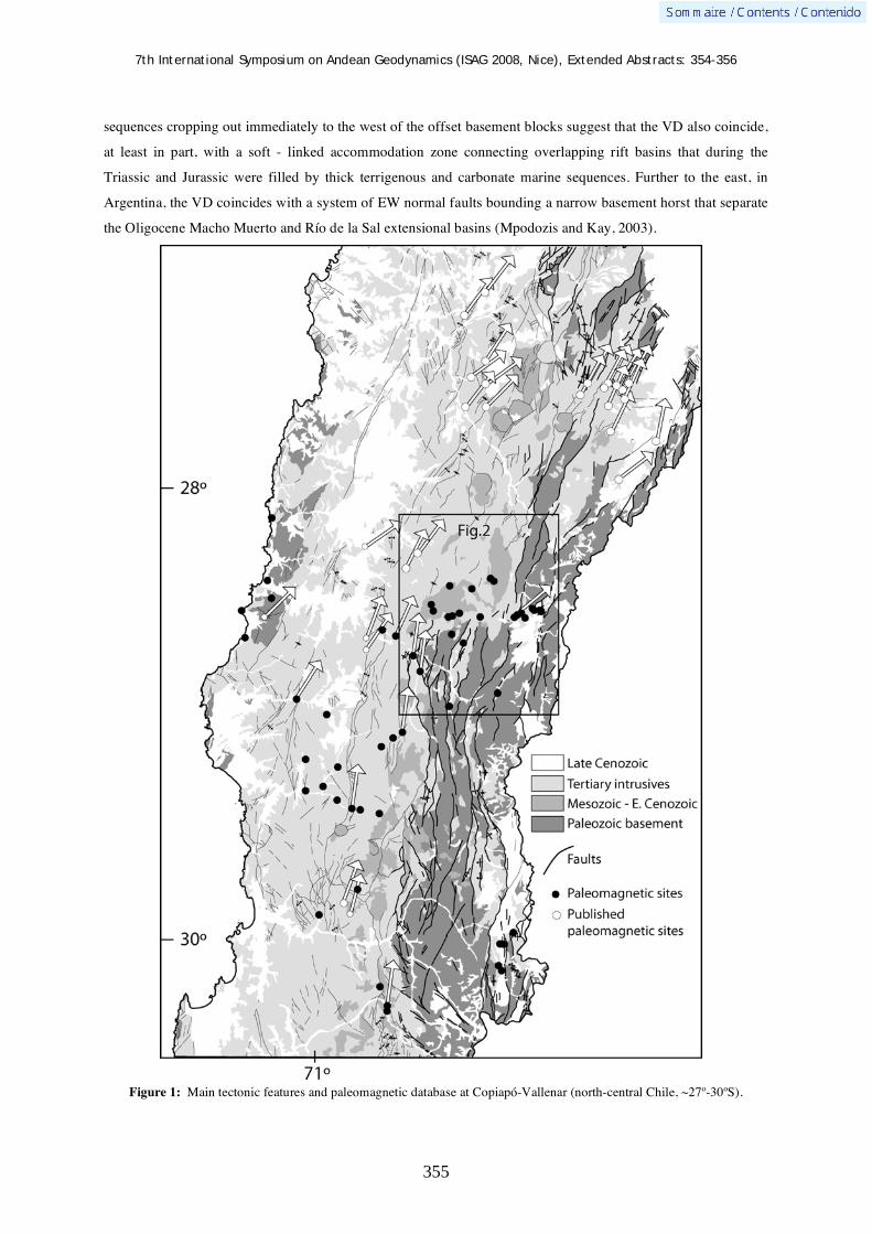
7th International Symposium on Andean Geodynamics (ISAG 2008, Nice), Extended Abstracts: 354-356
355
sequences cropping out immediately to the west of the offset basement blocks suggest that the VD also coincide,
at least in part, with a soft - linked accommodation zone connecting overlapping rift basins that during the
Triassic and Jurassic were filled by thick terrigenous and carbonate marine sequences. Further to the east, in
Argentina, the VD coincides with a system of EW normal faults bounding a narrow basement horst that separate
the Oligocene Macho Muerto and Río de la Sal extensional basins (Mpodozis and Kay, 2003).
Figure 1: Main tectonic features and paleomagnetic database at Copiapó-Vallenar (north-central Chile, ~27º-30ºS).

7th International Symposium on Andean Geodynamics (ISAG 2008, Nice), Extended Abstracts: 354-356
356
Discussion
The Vallenar Discontinuity, that behaves as a complex EW “accommodation” zone during diverse periods of
Mesozoic and Cenozoic extension, probably corresponds to an inherited Paleozoic feature. The analysis of the
new structural and paleomagnetic data collected in the Copiapó-Vallenar region show that the VD separates two
tectonic domains North of the VD, the faults bounding the basement cored blocks of the Andean Range trend to
the NNE, while to the south the faults trend NS. Paleomagnetic vector parallels the trend of the major faults,
NNE to the north, NS-N10ºE to the south. Overall, the VD seems to act a ”hinge” or pivot zone between two
mayor rotation domains. Further studies are needed to understand the significance of this until now
underestimated tectonic feature.
References
Arriagada, C., Roperch, P., Mpodozis C. and Fernández, R. 2006. Paleomagnetism and tectonics of the southern Atacama Desert region (25-28ºS) Northern Chile. Tectonics, 25: TC4001, doi:10.1029/2005TC001923.
Moscoso, R. and Mpodozis, C., 1988. Estilos estructurales en el Norte Chico de Chile (28-31ºS), regions de Atacama y
Coquimbo, Revista Geológica de Chile, 15/2, 151-166.
Mpodozis, C. and Kay, S. M, 2004. (Abs) Neogene tectonics, ages and mineralization along the transition zone between the
El Indio and Maricunga mineral belts (Argentina and Chile 28°-29°S) X Congreso Geológico Chileno Actas (CD ROM),
Concepción
Roperch, P., Sempere, T., Macedo, O., Arriagada, C., Fornari, M., Tapia, C., García, M., and Laj, C., 2006.
Counterclockwise rotation of late Eocene – Oligocene fore-arc deposits in southern Peru and its significance for oroclinal
bending in the central Andes, Tectonics, 25: TC3010, doi:10.1029/2005TC001882.
Somoza, R., Singer, S., and Tomlinson, A, 1999, Paleomagnetic study of upper Miocene rocks from northern Chile: Implications for the origin of late Miocene-Recent tectonic rotations in the southern Central Andes: Journal of Geophysical Research, v. 104, p. 22923-22936.
Taylor, G.K., Dashwood, B., Grocott, J., 2005, Central Andean rotation pattern: Evidence from paleomagnetic rotations of an anomalous domain in the forearc of northern Chile: Geology, v. 33, p. 777-780.
Taylor, G.K., Grocott, J., Daswood, B, Gipson, M., Arévalo, C., 2007, Implications for crustal rotation and tectonic evolution in the Central Andes forearc: New paleomagnetic results from the Copiapó region of northern Chile, 26º to 28ºS: Journal of Geophysical Research, v. 112, B01102, doi:10.1029/2005JB003950.
Figure 2: Simplified geological map of the Vallenar Discontinuity region, drapped over a Landsat image of the Main Andean Range. Location in Figure 1.

7th International Symposium on Andean Geodynamics (ISAG 2008, Nice), Extended Abstracts: 357-360
357
Tracing petrogenetic crustal and mantle processes in zircon crystals from rocks associated with the El Teniente porphyry Cu-Mo deposit in the high Andes of central Chile: Preliminary results
Marcia Muñoz1, Reynaldo Charrier
1, Víctor Maksaev
1, & Mark Fanning
2
1 Departamento de Geología, Universidad de Chile, Casilla 13518, Correo 21, Santiago, Chile
([email protected]) 2 Research School of Earth Sciences, Australian National University, Canberra ACT 0200, Australia
KEYWORDS : El Teniente, porphyry Cu-Mo deposit, zircon, in-situ analyses, Hf-isotopes
Introduction
The origin of the igneous rocks associated with porphyry copper mineralization is a controversial issue. The
critical components of a mineralizing intrusive pulse (e.g., metals, water and sulphur contents) may be features
acquired either from the source of the magma or from its subsequent evolution during ascent throughout the
crust. Therefore, an accurate petrogenetic framework is essential
for understanding the evolution of mineralizing porphyry
magmas. The enormous porphyry Cu-Mo deposits of the high
Andes of Central Chile are not an exception. They are
characterized by multiple, superposed mineralization,
hydrothermal alteration and brecciation events, which have
greatly contributed to their extraordinary metallic concentrations,
but also obscured most of the primary textural, mineralogical,
and chemical characteristics of the ore-bearing intrusive rocks.
This fact complicates the application of traditional analytical
methods for the petrological study of these igneous rocks. We
have applied penetrative micro-analytical techniques on intrusive
rocks from El Teniente Cu-Mo deposit for getting insight into
their primary chemical characteristics, despite the consequences
of pervasive hydrothermal alteration that characterizes these
rocks. Preliminary results are presented here, which are part of
the Ph.D. thesis project of the first author developed under the
research framework of the Anillo ACT-18 project.
Geological background
The El Teniente porphyry Cu-Mo deposit is located in the high Andes of Central Chile (34°23’S-71°35’W) 70
km southeast of Santiago city (Fig. 1). It occurs within late Miocene extrusive and intrusive igneous rocks,
which are part of the Farellones Formation (e.g.: Skewes et al., 2005) and is the southernmost economic
porphyry deposit of the extensive Miocene to early Pliocene Cu belt of the Andes. The resources plus production
totals 94.35 Mt Cu, which makes El Teniente the largest copper deposit in the world (Camus, 2003).
Fig. 1: Main tectonic features of the Chilean continental margin. The location of Juan Fernandez Ridge, the volcanic gap separating the Central Volcanic Zone (CVZ) and the Southern Volcanic Zone (SVZ) are shown. Additionally, the location of the Los Pelambres, Río Blanco-Los Bronces and Teniente porphyry Cu-Mo deposits which are part of the Miocene to early Pliocene Cu belt of the Andes are indicated with black squares.

7th International Symposium on Andean Geodynamics (ISAG 2008, Nice), Extended Abstracts: 357-360
358
This supergiant Cu-Mo deposit is genetically related to
late Miocene-early Pliocene magmatic-hydrothermal
processes (e.g.: Howell & Molloy, 1960; Cuadra, 1986;
Skewes et al., 2005; Maksaev et al., 2004). Most of the
ore-bearing rocks correspond to altered basaltic and
andesitic host rocks and gabbroic sills that are currently
referred as El Teniente Mafic Complex, and a number of
felsic stocks and dikes (e.g.: Skewes et al., 2005;
Maksaev et al., 2004; Fig. 2). The whole lifespan of
igneous activity at El Teniente area can be roughly
traced from at least 12.0 ± 0.7 Ma, which is the oldest
K-Ar age obtained for the Farellones Formation (Kay et
al., 2005) and up to 3.85 ± 0.18 Ma which is the
hornblende 40Ar/39Ar age for a postore andesite dike
(Maksaev et al., 2004; Fig. 2); whereas, hydrothermal
mineralization developed from 6.4 to 4.3 Ma according
to combined U-Pb, 40Ar/39Ar, Re-Os and fission-track data (Maksaev et al., 2004).
Analytical techniques
In-situ geochronological, isotopic and chemical analyses on single zircon crystals
Zircon is a common accessory mineral phase of felsic igneous rocks
which concentrates significant amounts of trace elements, including
radiogenic elements, and is chemically and physically highly resistant
(e.g.: Watson, 1996). Its remarkable resistance to high temperature
diffusive re-equilibration allows it to preserve unaltered its primary
chemical signature and isotopic systems (e.g.: Watson, 1996; Watson
& Cherniak, 1997). These characteristics make of zircon crystals
sensitive tools for tracing petrogenetic crustal and mantle processes of
their host igneous rocks and are particularly well suited for rocks that
were subjected to one or more superposed hydrothermal alteration
events that modified other primary igneous characteristics of the
rocks.
We have applied a combination of SHRIMP (sensitive high resolution ion microprobe), and LA-ICP-MS (laser
ablation – inductively coupled plasma – mass spectrometry) analytical techniques for in-situ determination of
trace element (REE, Y, and Hf) and Ti contents, along with Hf and O isotopic signatures for individual zircon
crystals from igneous rocks of El Teniente Cu-Mo deposit (Fig. 3). These same zircon crystals have been
previously analyzed by back scattered electron–cathode luminescence (BSE-CL) and their U-Pb ages were
determined by SHRIMP analyses (Maksaev et al., 2004; Fig. 3). The samples correspond to five mineralized
intrusive bodies: the A porphyry, the Sewell stock, the northern and central quartz-diorite tonalite bodies, the
Fig. 2: Distribution of main lithologic units within the El Teniente Cu-Mo deposit at 4 LHD level (2,354 m). Location of samples analyzed in this study, which were previously dated by U-Pb SHRIMP (Maksaev et al., 2004), are indicated with white diamonds.
Fig. 3: Cathode luminescence (CL) and reflected light (RL) images for analyzed zircon crystals from the Dacite ring dike.

7th International Symposium on Andean Geodynamics (ISAG 2008, Nice), Extended Abstracts: 357-360
359
Teniente Dacite Porphyry and a dacite ring dike (Fig. 2).
Preliminary results
All the analyzed zircons from the five studied intrusive bodies
show normalized REE concentration patterns typical of igneous
zircon. These are characterized by an enrichment of HREE
relative to LREE, with a steeply rise from LaN to LuN, and a
strong positive Ce-anomaly and a slight negative Eu-anomaly
(Fig. 4). The Eu-anomaly values are above 0.4 for zircons from
all felsic intrusive units, similar to the values reported for zircons
from intrusions associated with porphyry copper mineralization in
northern Chile (Ballard et al., 2002; Fig. 5). Additionally, the Ce-
anomaly appears to evolve towards higher values from the oldest
to the youngest intrusive unit of El Teniente (Fig. 5). This pattern could be associated with an increase of the
oxygen fugacity with time of the overall magmatic system; but a more detailed approach is still required to
further evaluate this hypothesis, similar to that applied by Ballard et al. (2002) taking in consideration the actual
valence state of Ce.
Fig. 5: Average Ce and Eu anomalies, and Tº per unit sampled. Numbers inside error ellipses correspond to: (1) A porphyry, (2) Central quartz-diorite tonalite, (3) Sewell stock, (4) Northern quartz-diorite tonalite, (5) Teniente Dacite Porphyry, (6) Dacite ring dike. Error ellipses are constructed over 1 error level from the mean in the y-axis and 2 error level from the U-Pb age obtained for each unit. Ce* = (LaN*PrN)1/2; Eu* = (SmN*GdN)1/2.
Geothermometry based on Ti concentration in zircon crystals (Watson et al., 2006) indicates a temperature of
the igneous solidus between 770º-580ºC (Fig. 5). The data scattering within individual units produces some
overlap in the temperatures obtained for each intrusion. However, there is a global decrease in this parameter
from the oldest unit represented by the A porphyry to the youngest ore-bearing dacite ring dike (Fig. 5),
consistent with progressive waning of igneous activity within the orebody.
All samples have high initial 176Hf/177Hf ratio and positive a Hf(i) whose values range from 6.2 to 8.5 and fall
between the silicate earth and depleted mantle (Fig. 6). There are no distinct differences among the analyzed
igneous units (Fig. 6). These characteristics, along with the almost null presence of inherited zircon or zircon
cores, are consistent with a common magmatic system originating the different intrusive pulses for which the
high Hf(i) values indicate a strong mantle signature with little or no interaction of the magmas with upper crustal
evolved rocks. Crustal residence time estimated through Hf isotopic compositions have a minimum limit of
Fig. 4: Chondrite normalized REE
concentration diagram for all analysis. Colored
area shows the field covered by all the
analyses, and the individual patterns obtained
from zircon crystals of the Teniente Porphyry
are shown in individual black lines as an
example.

7th International Symposium on Andean Geodynamics (ISAG 2008, Nice), Extended Abstracts: 357-360
360
around 300 my (TDM) and a crustal model age of around 550 my (TDMc; average felsic continental crust
176Lu/177Hf = 0.015; Fig. 6). These characteristics of the Hf isotopic system point to the subcontinental
lithospheric mantle or the lower crust as the source of the intrusive pulses of the El Teniente deposit.
References Ballard, J., Palin, M., & Campbell, I., 2002. Relative oxidation states of magmas inferred from Ce(IV)/Ce(III) in zircon:
application to porphyry copper deposits of northern Chile. Contributions to Mineralogy and Petrology 144: 347-364. Camus, F., 2003. Geología de los Sistemas Porfíricos en los Andes de Chile. Servicio Nacional de Geología y Minería, 267 p. Cuadra, P., 1986. Geocronología K-Ar del yacimiento El teniente y áreas adyacentes. Revista Geológica de Chile 27: 22-54. Howell, F.H., & Molloy, J.S., 1960. Geology of the Braden orebody, Chile, South America. Economic Geology 55: 863-905. Kay, S.M., Godoy, E., & Kurtz, A., 2005. Episodic arc migration, crustal thickening, subduction erosion, and magmatism in
the south-central Andes. Geological Society of America Bulletin 117: 67-88. Maksaev, V., Munizaga, F., McWilliams, M., Fanning, M., Mathur, R., Ruíz, J., & Zentilli, M., 2004. New Chronology for
El Teniente, Chilean Andes, from U-Pb, 40Ar/39Ar, Re-Os, and Fission-Track Dating: Implications for the Evolution of a Supergiant Porphyry Cu-Mo Deposit. In Sillitoe, R.H., Perelló, J., Vidal, C.E. (eds): Andean Metallogeny: New Discoveries, Concepts and Updates, Society of Economic Geologists, SEG Special Publication 11: 15-54.
Skewes, A., Arévalo, A., Floody, R., Zuñiga, P., & Stern, Ch., 2005. The El Teniente Megabreccia Deposit, the world´s largest cooper deposit. In Porter, T.M. (ed): Super Porphyry Copper & Gold Deposits: A Global Perspective, PGC Publishing, Adelaide 1: 83-113.
Watson, E.B., 1996. Dissolution, growth and survival of zircons during crustal fusion: kinetic principles, geological models and implications for isotopic inheritance. In Transactions of Royal Society of Edinburgh: Earth Sciences 87: 43-56.
Watson, E.B., & Cherniak, D.J., 1997. Oxygen diffusion in zircon. Earth and Planetary Science Letters 148: 527-544. Watson, E.B., Wark, D.A., Thomas, J.B., 2006. Cristallization thermometers for zircon and rutile. Contributions to
Mineralogy and Petrology 148: 471-488.
Fig. 6: Left image shows the mean Hf(i) obtained for each unit versus age. Error ellipses and symbols as in Fig. 5. Right
image shows as a green circle the field defined by all initial 176
Hf/177
Hf ratios obtained in the analyzed samples versus
age and the models for the evolution of the CHUR (blue) and the depleted mantle (red).

7th International Symposium on Andean Geodynamics (ISAG 2008, Nice), Extended Abstracts: 361-364
361
The brittle/ductile transition in the lithosphere of the Andes region and its relationship with seismogenesis
Miguel Muñoz
Jorge Matte 2005, Santiago, Chile ([email protected])
KEYWORDS : heat flow, rheology, earthquakes, Wadati-Benioff zones, oceanic ridges
Introduction
Thermal and gravity data, together with rheological properties of rocks, are used to determine the brittle/ductile
(B/D) transition in the lithosphere along the Andes region by comparing a linear frictional fracture criterion
describing a brittle regime and a nonlinear flow stress corresponding to a ductile rheology (Ranalli, 1991). This
is an approach that involves basic physics and microphysics of the Earth’s interior, and hence it should be taken
as a sound understanding of a major geophysical process – the genesis of earthquakes in the continental
lithosphere. In this contribution the estimates of the B/D transitions in the lithosphere are compared with
seismological observations in terranes having very different heat flow.
Northern Andes
A background heat flow (Q) could be set between 60 and 80 mWm-2 for northeastern Venezuela (Hamza and
Muñoz, 1996). The southern area has values as low as 40 mWm-2, increasing to the northwest to about
50-60 mWm-2. In the area of the Oca-Ancon fault system in northern Venezuela, temperature in the crust/mantle
boundary (CMB) ranges between about 500 °C and 720 °C. In this area the thickness of the brittle crust should
not be larger than 14-18 km; for a dry olivine mantle there is indication of a thin brittle layer in the uppermost
mantle -from the CMB at 27 km to about 32 km depth. Maximum and minimum depths of seismicity associated
to this area according to seismological studies are of about 23 km and 11 km, respectively (Audemard & Singer,
1996), which means that in some zones the lower crust should be in the brittle regime. For acceptable thermal
and rheological model parametrizations, it is not possible to obtain a brittle layer of 23 km thickness. A seismic
event located close to this area at the northern termination of the Bocono fault system and at a depth of about
42 km (Dewey, 1972) with depth solution according to the International Seismological Center (ISC) was
relocated by Kafka & Weidner (1981) at 6 km depth.
For the southern termination of the Bocono fault system, where Q is of about 50 mWm-2, the temperature at the
CMB ranges from about 570 °C to about 600 °C and the crustal seismogenic layer is not larger than 20 km.
Some models describe a brittle layer beneath the CMB down to about 55-60 km depth, in accordance with the
analysis of seismic events of Kafka & Weidner (1981) that gives a depth solution of 55 km, and where the events
were interpreted to be within the continental lithosphere in a zone of brittle deformation. This seismic activity
does not appear to be related to the subducted ancient Farallon plate as proposed by Pennington (1981).
In the Central Cordillera of Colombia, and in the central northernmost area of Ecuador, an estimate of heat flow
is at least 70 mWm-2. The temperature at the CMB is close to 1000 °C. Only tectonic seismic activity of low
magnitude can be expected to be generated in the upper 13 km of the crust. High heat flow in Ecuador seems to
7th International Symposium on Andean Geodynamics (ISAG 2008, Nice), Extended Abstracts: 361-364
362
be characteristic only in small areas; low heat flow –between 40 and 60 mWm-2– can be expected in most of the
region (Hamza & Muñoz, 1996). In the sub-Andes of Ecuador, in the eastern slopes of the Cordillera, for a heat
flow of 50 mWm-2 and surface radiogenic heat generation Ao of 2.0 μWm-3, temperature at the CMB is about
450 °C. The seismogenic layer in the upper crust is of about 20 km thickness, and a thin brittle layer is also
described in the upper mantle. In northeastern Ecuador, in the eastern slopes of the Andes, where a relatively
higher heat flow density could be expected, Kawakatsu & Cadena (1991) adopting focal depths for several
earthquakes suggest a seismogenic zone of 15 km thickness. Suárez et al. (1983) reexamined the focal depth of
an earthquake in the high Andes of Ecuador relocating it at 16 km (the ISC determination was 33 km) –the
epicentre is close to the epicentres of shocks studied by Kawakatsu & Cadena (1992); other two earthquakes in
the sub-Andes were relocated at 16 km and 10 km depth.
For Ecuador –with Q = 40 - 45 mWm-2 and Ao = 1.0 - 1.2 μWm-3– the maximum thickness of the crustal
seismogenic layer ranges from about 20 to 35 km, and the mantle is seismogenic down to 50-86 km for multiple
thermal and rheological parameters. Studying the seismicity of northern central Ecuador, Guillier et al. (2001)
have used the global relocation of hypocentres carried out by Engdahl et al. (1998) on the ISC database and data
from a temporary network within the Ecuadorian network of telemetred stations. Earthquakes foci in the
continental mantle reaching depths of about 55-75 km were determined for both classes of data throughout the
analyzed sections, whereas dipping Wadati-Benioff zones could only be determined with foci located with the
temporary network. Beneath the broad volcanic region in northern Ecuador, Gutscher et al. (2000) inferred a flat
Wadati-Benioff zone (WBZ) at 80-100 km depth and related it to the subduction of the Carnegie ridge; Guillier
et al. (2001) show that the continuity of the WBZ –reaching a depth of at least 150 km in northern Ecuador and
200 km at 1-2 °S latitude– shows up only when using the locations of the temporary network.
Northern Central Andes
Seismogenic thickness has been calculated beneath different areas between latitudes 7 °S and 17 °S of the
Peruvian Andes with different crustal thickness (Muñoz, 2005). The brittle crustal seismogenic layer ranges
from about 20 km to 32 km; for some models with thick crust (60-65 km) the brittle regime reinitiates in the
lower crust after the transition into the ductile domain. The uppermost mantle, excepting zones with thin crust,
for most models is in the brittle regime from the CMB to about 70-110 km depth in the continental lithosphere.
Temperatures at the CMB range from about 300 °C to 620 °C, where lower values generally correspond to areas
with 30-50 km of crustal thickness. In northern central Peru, for explaining time residuals observed in
seismological stations, a velocity model for a flat subducting slab at 80-100 km depth was obtained using a
‘festooning’ ray with several reflections inside the slab (Norabuena et al., 1994); the model resulted in velocities
in excess for the flat structure that could not be explained by any effects, and that were found to be inconsistent
with studies of the thermal structure in subduction zones and with the mineralogy of slabs.
Southern Central Andes
In western central Argentina (Precordillera and Sierras Pampeanas) at about 32 ºS rheological modelling
indicates that the crust is in the brittle regime down to 33-45 km depth, in accordance with seismological
observations by Smalley & Isacks (1990) and Smalley et al. (1993), and in contrast with maximum focal depths
7th International Symposium on Andean Geodynamics (ISAG 2008, Nice), Extended Abstracts: 361-364
363
of 25 km encountered by Alvarado et al. (2005) in the western Sierras Pampeanas. Rheological results show that
maximum depths of seismogenic zones in the mantle could lie between 70 and 100 km (Muñoz 2005);
nonetheless, seismologists argue that foci at ~100 km depth represent a flattening of the subducting Nazca plate
linked to the subduction of the Juan Fernandez ridge (e.g., Smalley et al., 1993; Wagner et al., 2005; Anderson
et al., 2007). A comparison between ISC earthquake locations (with reporting stations located between about
30 ºS and 34ºS in Chile and western Argentina) and locations obtained by using the grid-search multiple-event
(GMEL) relocation algorithm for data of a more appropriate seismic network deployed in the area is presented
by Anderson et al. (2007). Whilst the ISC locations show two main branches of seismicity, one as a nearly flat
structure at ~100 km depth, and a second one as a WBZ dipping at an angle of ~30º, the GMEL locations show
only the branch at ~100 km depth for the same events (use Acrobat Reader to see the ISC locations at ~100 km
depth covered by the stars of the GMEL locations in Fig. 2B of Anderson et al., 2007).
In the main Cordillera of central Chile (33 ºS-35 ºS), the rheological zonation describes a brittle domain down to
about 17-22 km, in accordance with crustal seismic activity (Campos et al., 2002). In southern Chile, in the
south volcanic zone, only shallow tectonic seismic activity could be generated; most of the crust is ductile, and
the temperature at the CMB is of about 880-1100 ºC.
Discussion and conclusions
A large correspondence has been found between the rheological zonation of the crust and maximum depths of
seismic events there produced. The more brittle behaviour of the crust in western central Argentina at about 32ºS
is due to a colder crust impoverished of radiogenic elements, and this cannot be precluded by arguing that crustal
seismicity extends into the active arc south of this area where heat flow could be as high as 100 mWm-2
(Alvarado et al., 2007) –the thickness of the brittle layer at 33-35 ºS is half the thickness at 32 ºS, and when
geochemical estimates of heat flow in geothermal areas are not taken into account there is not such a high heat
flow (~100 mWm-2) in the southern central Andes. For regions of low heat flow in Ecuador, Peru and Argentina
the rheological zonation describes a brittle continental mantle down to 70-100 km depth. Nevertheless, the
activity at these depths has been taken as representing flat segments of the Wadati-Benioff zone, and the
flattening has been related to the cessation of volcanism in the advanced stages of flat-slab subduction. Thermal
modelling of subduction zones (English et al., 2003) shows that for flat-slab subduction magma generation at
distances > 600 km inboard from the trench is not predicted for warm subduction zones and is difficult at best
for cold subduction zones, and that most of the slab dehydration will take place within about 200 km of the
trench when the flat-slab segment occurs at a depth of 90 km or at larger depths. It is noted that late Miocene
Pocho lavas in western Argentina –where a flat-slab segment is believed to be of about 300 km length at 100 km
depth– erupted at a distance of about 750 km from the trench, in conflict with the thermal modelling. Also, in
these regions there is no obvious correlation between the subduction of oceanic ridges –a main subject for the
flat-slab hypothesis– and deformation processes and structural styles of the orogenic phases (Michaud et al.,
2006; Aleman, 2006; Creixell et al., 2006). Finally, the differences between ISC locations of events and GMEL
locations (Anderson et al., 2007) are outstanding at ~32 ºS: a structure that could be a dipping WBZ in the ISC
location disappears in the GMEL location, and less differences between both classes of locations are found just
below the easternmost area –where ISC locations should be more inaccurate– and used to argue about the

7th International Symposium on Andean Geodynamics (ISAG 2008, Nice), Extended Abstracts: 361-364
364
bending and plunging of the ‘flat-slab’. Also, it is not clear why the GMEL locations do accord with classical
ISC locations determining the dipping WBZ at 34-36 ºS where the ISC locations should be at least as inaccurate
as to the north.
It is concluded that the depth of the brittle/ductile transition in the crust along the Andes region is highly
variable and depends largely on regional heat flow, and that brittle behaviour can be expected at ~70-100 km
depth in the continental lithosphere, above dipping Wadati-Benioff zones that could show in some segments an
annihilation of activity.
References Aleman, A.M., 2006. The Peruvian flat-slab. Backbone of the Americas—Patagonia to Alaska, 3–7 April 2006, Mendoza. Alvarado., P., Beck, S. & Zandt, G., 2007. Crustal structure of the south-central Andes Cordillera and backarc region from
regional waveform modelling. Geophys. J. Int. 170: 858-875. Anderson, M., Alvarado, P., Zandt, G. & Beck, S., 2007. Geometry and brittle deformation of the subducting Nazca Plate,
central Chile and Argentina. Geophys. J. Int. 171: 419-434. Audemard, F.A. & Singer, A., 1996. Active fault recognition in northwestern Venezuela and its seismogenic
characterization: Neotectonic and paleoseismic approach. Geof. Int. Méx. 35 (3) (Suppl.): 245–255. Campos, J., Hatzfeld, D., Madariaga, R., López, G., Kausel, E., Zollo, A., Iannacone, G., Fromm, R., Barrientos, S. & Lyon-
Caen, H., 2002. A seismological study of the 1835 seismic gap in south-central Chile. Phys. Earth Planet. Inter. 132: 177-195.
Creixell, C.E., Arriagada, C., Morata, D., Parada, M.A., 2006 — The role of the Juan Fernandez ridge in the tectonic evolution of the central Chilean Andes. Backbone of the Americas—Patagonia to Alaska, 3–7 April 2006, Mendoza.
Dewey, J.W., 1972. Seismicity and tectonics of western Venezuela. Bull. Seism. Soc. Am. 62: 1711-1751. Engdahl, E.R., van der Hilst, R. & Buland, R., 1998. Global teleseismic earthquake relocation with improved travel times and
procedures for depth determination. Bull. Seism. Soc. Am. 88: 722-743. English, J.M., Johnston, S.T. & Wang, K., 2003. Thermal modelling of the Laramide orogeny: testing the flat-slab
subduction hypothesis. Earth Planet. Sci. Lett. 214: 619-632. Guillier, B., Chatelain, J.-L., Jaillard, E., Yepes, H., Poupinet, G. & Fels, J.-F., 2001. Seismological evidence on the
geometry of the orogenic system in central-northern Ecuador (South America).Geophys. Res. Lett. 28: 3749-3752. Gutscher, M.-A., Spakman, W., Bijwaard, H. & Engdahl, E.R., 2000. Geodynamics of flat subduction: seismicity and
tomographic constraints from the Andean margin. Tectonics 19: 814-833. Hamza, V.M. & Muñoz, M. 1996. Heat flow map of South America. Geothermics 25: 599-646. Kafka, A.L. & Weidner, D.J., 1981. Earthquake focal mechanisms and tectonic processes along the southern boundary of the
Caribbean plate. J. Geophys. Res. 86: 2877-2888. Kawakatsu, H. & Proaño-Cadena, G., 1991. Focal mechanisms of the march 6, 1987 Ecuador earthquakes – CMT inversion
with a first motion constraint. J. Phys. Earth 39: 589-597. Michaud, F., Witt, C., Bourgois, J., Bustillos, J., Peñafiel, L., 2006 — Influence of the subduction of the Carnegie ridge on
Ecuadorian geology: reality or fiction? Backbone of the Americas—Patagonia to Alaska, 3–7 April 2006, Mendoza. Muñoz, M., 2005. No flat Wadati-Benioff zone in the central and southern central Andes. Tectonophysics 395: 41-65. Norabuena, E.O., Snoke, J.A. & James, D.E., 1994. Structure of the subducting Nazca plate beneath Peru. J. Geophys. Res. 99: 9215-9226.
Pennington, W. D., 1981. Subduction of the Eastern Panama basin and seismotectonics of Northwestern South America. J. Geophys. Res. 86: 10753-10770.
Ranalli, G., 1991 — "Regional variations in lithosphere rheology from heat flow observations". In Cermak, V., Rybach, L. (eds.): Terrestrial Heat Flow and the Lithosphere Structure, Berlin, Springer: 1-22.
Smalley, R., Jr. & Isacks, B.L., 1990. Seismotectonics of thin- and thick-skinned deformation in the Andean foreland from local network data: Evidence for a seismogenic lower crust. J. Geophys. Res. 95: 12487-12498.
Smalley, R., Jr., Pujol, R., Regnier, M., Chiu, J.-M., Chatelain, J.-L., Isacks, B.L., Araujo, M. & Puebla, N., 1993. Basement seismicity beneath the Andean Precordillera thin-skinned thrust belt and implications for crustal and lithospheric behavior. Tectonics 12: 63-76.
Suárez, G., Molnar, P. & Burchfiel, B.C., 1983. Seismicity, fault plane solutions, depth of faulting, and active tectonics of the Andes of Peru, Ecuador and southern Colombia. J. Geophys. Res. 88: 10403-10428.
Wagner, L.S., Beck, S. & Zandt, G., 2005. Upper mantle structure in the south central Chilean subduction zone (30º to 36ºS), J. Geophys. Res. 110: B01308, doi:10.1029/2004JB003238, 2005.
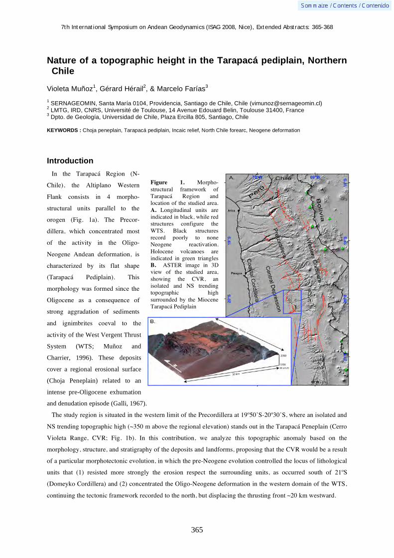
7th International Symposium on Andean Geodynamics (ISAG 2008, Nice), Extended Abstracts: 365-368
365
Nature of a topographic height in the Tarapacá pediplain, Northern Chile
Violeta Muñoz1, Gérard Hérail
2, & Marcelo Farías
3
1 SERNAGEOMIN, Santa María 0104, Providencia, Santiago de Chile, Chile ([email protected])
2 LMTG, IRD, CNRS, Université de Toulouse, 14 Avenue Edouard Belin, Toulouse 31400, France
3 Dpto. de Geología, Universidad de Chile, Plaza Ercilla 805, Santiago, Chile
KEYWORDS : Choja peneplain, Tarapacá pediplain, Incaic relief, North Chile forearc, Neogene deformation
Introduction
In the Tarapacá Region (N-
Chile), the Altiplano Western
Flank consists in 4 morpho-
structural units parallel to the
orogen (Fig. 1a). The Precor-
dillera, which concentrated most
of the activity in the Oligo-
Neogene Andean deformation, is
characterized by its flat shape
(Tarapacá Pediplain). This
morphology was formed since the
Oligocene as a consequence of
strong aggradation of sediments
and ignimbrites coeval to the
activity of the West Vergent Thrust
System (WTS; Muñoz and
Charrier, 1996). These deposits
cover a regional erosional surface
(Choja Peneplain) related to an
intense pre-Oligocene exhumation
and denudation episode (Galli, 1967).
The study region is situated in the western limit of the Precordillera at 19º50’S-20º30’S, where an isolated and
NS trending topographic high (~350 m above the regional elevation) stands out in the Tarapacá Peneplain (Cerro
Violeta Range, CVR; Fig. 1b). In this contribution, we analyze this topographic anomaly based on the
morphology, structure, and stratigraphy of the deposits and landforms, proposing that the CVR would be a result
of a particular morphotectonic evolution, in which the pre-Neogene evolution controlled the locus of lithological
units that (1) resisted more strongly the erosion respect the surrounding units, as occurred south of 21ºS
(Domeyko Cordillera) and (2) concentrated the Oligo-Neogene deformation in the western domain of the WTS,
continuing the tectonic framework recorded to the north, but displacing the thrusting front ~20 km westward.
Figure 1. Morpho-structural framework of Tarapacá Region and location of the studied area. A. Longitudinal units are indicated in black, while red structures configure the WTS. Black structures record poorly to none Neogene reactivation. Holocene volcanoes are indicated in green triangles B. ASTER image in 3D view of the studied area, showing the CVR, an isolated and NS trending topographic high surrounded by the Miocene Tarapacá Pediplain

7th International Symposium on Andean Geodynamics (ISAG 2008, Nice), Extended Abstracts: 365-368
366
Geological particularities of pre-Oligocene substratum
In the study region, the pre-Oligocene substratum consists of Paleozoic and Mesozoic stratified sequence
intruded by late Cretaceous-Eocene plutons submitted to an intense and polyphasic deformation, accommodating
20-30 km of shortening before the Oligocene [Harambour, 1990]. Two major features stand out in the study
region respect to the regional pre-Oligocene geological framework: (1) an unusual concentration of intrusive
outcrops and (2) the lithology of Paleozoic and Mesozoic pelitic units (the Permian Juan de Morales Fm. and the
Jurassic El Tranque Fm.).
The Mesozoic-Late Cenozoic unconformity: The Choja peneplain
The Mesozoic-late Cenozoic contact is a regional erosive flat unconformity (Choja Peneplain; Galli, 1967).
The origin of this pediplain correlates to the latest Eocene-earliest Oligocene exhumation recorded by supergene
enrichment at the Cerro Colorado porphyry copper deposit [Bouzari and Clark, 2002] and fission-track data in
the Antofagasta region [Maksaev and Zentilli, 1999]; exhumation has been interpreted as a result of shortening
and uplift related to the Incaic phase [Harambour, 1990; Haschke and Günther; 2003; Tomlinson et al., 1999].
However, in the study region, the pediplain is disrupted by isolated hills and belts. Moreover, east of the CVR,
the presence of paleovalleys and paleochannels (as deep as 300 m) characterizes the Mesozoic-Cenozoic
unconformity. There is no data about the age of this relief growth in this region. However, the age of the main
supergene enrichment at the Cerro Colorado porphyry copper deposits (lowest Oligocene) probably mark the
beginning of local incision, which is older than the Oligo-Neogene deformation. Therefore, it is likely that this
incision was related to the erosion post-Incaic deformation (similar to pedimentation), which in this region was
not capable to produce pedimentation as occurs to the north and to the south.
The topographic anomalies are related to intrusive bodies, mostly in their western flank (Fig. 2). Therefore, this
suggests that during the Choja pedimentation, this lithology inhibited and delayed upward propagation of
Figure 2. Geological map of the studied region. Red lines indicate position of sections in fig. 4

7th International Symposium on Andean Geodynamics (ISAG 2008, Nice), Extended Abstracts: 365-368
367
erosion. In fact, intrusive bodies can resist >1 order of
magnitude the erosion than other rocks (e.g., Stock and
Montgomery, 1999). Hence, previous geologic evolution
determined the locus of inselbergs and anomalous heights in
the Choja Peneplain as also occurs in the Domeyko
Cordillera (Fig. 3).
The Oligo-Miocene synorogenic sequence
The Cenozoic cover consists of clastic deposits interbedded
with 22.71-19.25 Ma ignimbrites (Altos de Pica Fm) overlaid
by middle to upper Miocene conglomerates (El Diablo Fm.)
(Fig. 2). East of CVR, its thickness is <500 m, much minor
than that observed to the north and south (>1 km; Pinto et al.,
2004; Victor et al., 2004). In addition, intraformational unconformities within this sequence (paleovalleys, that
in some cases contact the lower 22.71 Ma ignimbrite with El Diablo Formation, Fig. 4B) evidence minor
aggradation and more erosion in this region, thus suggesting a major relative uplift in the study region.
The sequence presents syntectonic deposition before 13.7 Ma immediately west of the CVR (Fig. 4); It is
related to a W-vergent thrust with <500 m throw and 30-8ºE tilting of the hanging wall. To the east, there is no
significant deformation affecting these deposits, thus this fault accommodated a similar relative uplift that north
and south of this region (~2 km; Victor et al., 2004; Farías et al., 2005; however, there was accommodated by
several structures). In turn, deformation in the study region differs from that observed along the Precordillera
because the main fault is located ~20 km westward.
Figure 4. Synsedymentary deformation in the Oligo-Miocene sequence. A.
Progressive unconformities in the Pachica and Tarapacá localities (see
position in fig.2). B. View of Altos de Pica Fm. tilted to the east forming
growing strata (30-8ºE).
A.
B.
Figure 3. Late
Cretaceous to
Eocene outcrop of north Chile. Note
the absent of plutonic outcrop in
most part of the
Tarapacá Region
and there
concentration in
the studied area
(square), as well as
in the Domeyko
Cordillera

7th International Symposium on Andean Geodynamics (ISAG 2008, Nice), Extended Abstracts: 365-368
368
Discussion
Structural and morphological data show that the study region presents a late Cenozoic uplift similar to that
observed along the Precordillera between 18-21ºS, even though the CVR would be in part a remain of the Incaic
orogen.
The fact that deformation is concentrated in only one fault located 20 km westward the main faults presented
elsewhere suggests that not only the substratum resisted more the erosion than in others place, but also there are
particularities on the faults prolongation at depths. We suspect that the pelitic constitution in the substratum
would produce detachment layers capable of accommodate major shortening (and thus uplift) during and before
the Oligocene-Miocene tectonic event: exhumation of intrusive bodies during the Incaic phase and concentration
of deformation in only one fault.
Alternatively, there are two more features in this zone within the regional context (Fig 1): (1) a change in the
general trend in WTS structures (NNW to the north and NS to the south) and (2) its position in the north extreme
of Volcanic Pica Gap (Wörner et al., 2000). This suggests that this zone also represents a major scale tectonic
transition zone. Therefore, the study region would correspond to a local tectonic, lithological, and morphological
anomaly within the Northern Chile forearc evolution since the Eocene, which would be ultimately determined by
a long-term regional tectonic transition zone.
References Bouzari, F. and Clark, A. 2002. Anatomy, evolution, and metallogenic significance of the supergene orebody of the Cerro
Colorado porphyry copper deposit, I Región, Northern Chile. Economic Geology 97: 1701-1740.
Farías, M., R. Charrier, D. Comte, J. Martinod y G. Hérail. 2005. Late Cenozoic deformation and uplift of the western flank
of the Altiplano: Evidence from the depositional, tectonic, and geomorphologic evolution and shallow seismic activity
(northern Chile at 19º30’S). Tectonics 24 (4): TC4001.
Galli, C. 1967. Pediplain in northern Chile and the Andean uplift. Science 158: 653 – 655.
Harambour, S. 1990. Geología pre-cenozoica de la Cordillera de los Andes entre las quebradas Aroma y Juan de Morales, I
Región. Memoria de Título. Departamento de Geología, Universidad de Chile, Santiago. 228 p.
Haschke, M. and Günther. 2003. Balancing Crustal Thickening in arcs by tectonic vs magmatic means. Geology 31: 933-936
Maksaev, V. and M. Zentilli. 1999. Fission track thermochronology of the Domeyko Cordillera, northern Chile: Implications
for Andean tectonics and porphyry copper metallogenesis. Explor. Min. Geol. 8: 65 – 89.
Muñoz, N. and R. Charrier. 1996. Uplift of the western border of the Altiplano on a west-vergent thrust system, northern
Chile. J. S. Am. Earth Sci. 9: 171 – 181.
Pinto, L., G. Hérail, R. Charrier. 2004. Sedimentación sintectónica asociada a las estructuras neógenas en el borde occidental
del plateau andino en la zona de Moquella (19º15’S, Norte de Chile). Revista Geológica de Chile.31 (1), 19-44.
Riquelme, R., G. Hérail, J. Martinod, R. Charrier and J. Darrozes (2007). "Late Cenozoic geomorphologic signal of Andean
forearc and tilting associated with the uplift and climate changes of the Southern Atacama Desert." Geomorphology 86(3-
4): 283-306.
Stock, J. D. and D. R. Montgomery (1999). "Geologic constraints on bedrock river incision using the stream power law."
Journal of Geophysical Research-Solid Earth 104(B3): 4983-4993
Tomlinson, A., Cornejo, P. and Mpodozis, C. 1999. Hoja Potrerillos, Región de Atacama. Servicio Nacional de Geología y
Minería. Mapas geológicos 14. 1 Map, Santiago
Victor, P., Oncken, O. y Glodny, J. 2004. Uplift of the western Altiplano plateau: Evidence from the Precordillera between
20º and 21ºS (northern Chile). Tectonics 23: TC4004
Wörner, G., Hammerschmidt, K., Henjes-Kunst, F., Lezaun, J. y Wilke, H. 2000. Geochronology (40 Ar/ 39AR, K-Ar and
He-exposure ages) of Cenozoic magmatic rocks from Northern Chile (18°-22°S): implications for magmatism and tectonic
evolution of central Andes. Revista Geológica de Chile, 27, 2: 205-240.
7th International Symposium on Andean Geodynamics (ISAG 2008, Nice), Extended Abstracts: 369-372
369
Stratigraphy of the synorogenic Cenozoic volcanic rocks of Cajamarca and Santiago de Chuco, northern Peru
Pedro Navarro, Cristina Cereceda, & Marco Rivera
Instituto Geológico Minero Metalúrgico (INGEMMET), Av. Canada 1470, Lima 41, Peru
([email protected], [email protected], [email protected])
KEYWORDS: volcanism, stratigraphy, volcanic zones, migration, Cenozoic
Introduction
Cenozoic volcanic deposits that cap the Western Cordillera of Northern Peru originally were mapped as one
unit called “Volcánicos Calipuy” by Cossío (1964). Later studies (Reyes, 1980; Cobbing, 1981; Wilson, 1984)
used the name Calipuy Group including within it several volcanic sequences with local informal names as
“Volcánicos Llama, Porculla, Huambos, Chilete and Tembladera”. Nevertheless, Hollister & Sirvas (1978) were
the first in establish an association between those volcanic deposits and processes like volcanoes growth and
explosive activity.
Facies interpretation, updated mapping and volcanic stratigraphy allow the recognition of three segments
(Figure 1) constituted by volcanic rocks of Cenozoic age in northern Peru: Huancabamba (4º - 6º S), Cajamarca
(6º - 7º 30’ S) and Santiago de Chuco (7º 30’ – 9º S), all them emplaced between Eocene and upper Miocene
from 54.8 ± 1.8 to 8.2 ± 0.2 Ma (Noble et al., 1990; Turner, 1997; Davies, 2002; Noble & Loayza, 2004; Noble
et al., 2004; Longo, 2005; Rivera et al., 2005). So that, these volcanic rocks overlies unconformably carbonated
and clastic sequences from Mesozoic time.
The volcanic activity was characterized by intense and continuous explosive and effusive phases that emplaced
thick pyroclastic and lava flow deposits corresponding to five volcanic stages from early Eocene, upper Eocene,
Oligocene, early Miocene to upper Miocene, suggesting a continuity in the emplacement and eastward migration
of the magmatic arc during approximately 46 Ma.
Mainly the volcanic centres show a trend NW-SE, similar with regional faults and trending fractures.
This paper shows geological cartography, regional structural setting and stratigraphy results carried out only in
Santiago de Chuco and Cajamarca segments.
Regional geology
Early Paleozoic polydeformed rocks consist in shales, schists and volcanic deposits; and crop out east of the
Cenozoic volcanic rocks. They are overlain a volcanic and sedimentary sequence of Late Paleozoic age
represented by lava, conglomerate and sediments, related to a Permian-Triassic rift. A subsidence during Late
Triassic-Jurassic, with the development of a carbonate basin is documented by the deposition of limestones,
marls and shales; interbedded some with volcanic sills. Early Cretaceous time is marked by a fill of the basin
with sandstone, shales and minor limestones. Late Cretaceous is characterized by a new subsidence and
establishment of a carbonated shelf. The Cenozoic volcanic rocks lies upon a Paleozoic-Mesozoic basement,
finally structured by 40 Ma.
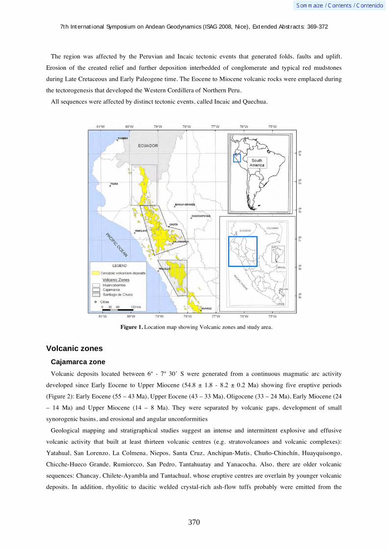
7th International Symposium on Andean Geodynamics (ISAG 2008, Nice), Extended Abstracts: 369-372
370
The region was affected by the Peruvian and Incaic tectonic events that generated folds, faults and uplift.
Erosion of the created relief and further deposition interbedded of conglomerate and typical red mudstones
during Late Cretaceous and Early Paleogene time. The Eocene to Miocene volcanic rocks were emplaced during
the tectorogenesis that developed the Western Cordillera of Northern Peru.
All sequences were affected by distinct tectonic events, called Incaic and Quechua.
Figure 1. Location map showing Volcanic zones and study area.
Volcanic zones
Cajamarca zone
Volcanic deposits located between 6º - 7º 30’ S were generated from a continuous magmatic arc activity
developed since Early Eocene to Upper Miocene (54.8 ± 1.8 - 8.2 ± 0.2 Ma) showing five eruptive periods
(Figure 2): Early Eocene (55 – 43 Ma), Upper Eocene (43 – 33 Ma), Oligocene (33 – 24 Ma), Early Miocene (24
– 14 Ma) and Upper Miocene (14 – 8 Ma). They were separated by volcanic gaps, development of small
synorogenic basins, and erosional and angular unconformities
Geological mapping and stratigraphical studies suggest an intense and intermittent explosive and effusive
volcanic activity that built at least thirteen volcanic centres (e.g. stratovolcanoes and volcanic complexes):
Yatahual, San Lorenzo, La Colmena, Niepos, Santa Cruz, Anchipan-Mutis, Chuño-Chinchín, Huayquisongo,
Chicche-Hueco Grande, Rumiorcco, San Pedro, Tantahuatay and Yanacocha. Also, there are older volcanic
sequences: Chancay, Chilete-Ayambla and Tantachual, whose eruptive centres are overlain by younger volcanic
deposits. In addition, rhyolitic to dacitic welded crystal-rich ash-flow tuffs probably were emitted from the

7th International Symposium on Andean Geodynamics (ISAG 2008, Nice), Extended Abstracts: 369-372
371
recently described Catan Caldera (Navarro et al, 2007).
Stratigraphy puts in evidence the eastward episodic migration of magmatic arc during Cenozoic time in
northern Peru.
Figure 2. Spatial and temporal evolution of the Cenozoic volcanism in Cajamarca zone.
Santiago de Chuco zone
Between 7º 30’ - 8º 30’ S, a thick volcanic sequence is recognized overlying Cretaceous and Paleocene
sedimentary rocks. These rocks are thought to be erupted during four volcanic periods. The first period began
probably in the Eocene, because volcanic deposits were intruded by subvolcanic bodies that yielded an age of
35 Ma. Next event ocurred in Oligocene time, ages from 34 to 24 Ma and angular unconformity point out this
eruptive activity. The volcanism continued until the Miocene, lava and pyroclastic flows aged from 18 to 16 Ma
characterize stages three and four (i.e. Upper Oligocene-Early Miocene and Early Miocene). Each event is
separated by erosional and angular unconformities and volcanic gaps. Stratigraphy and chronology put in
evidence the migration of continuous magmatic arc during Cenozoic time from West to East (Figure 3).
These periods generated at least thirteen volcanic centres (stratovolcanoes): Ultocruz-Ticas, Macón, Matala,
Alto Dorado, San Pedro, Cururupa, Quiruvilca, Paccha-Uromalqui, Totora, Quesquenda, Payhual, Urpillao-
Rushos and Piedra Grande. Besides, an older volcanic sequence called Tablachaca whose source vent is
unrecognized, crops out along the northern flank of the Tablachaca river. Also there are andesitic to rhyolitic
thick ash-flow tuffs erupted from two calderas: Carabamba and Calamarca.

7th International Symposium on Andean Geodynamics (ISAG 2008, Nice), Extended Abstracts: 369-372
372
Figure 3. Spatial and temporal evolution of the Cenozoic volcanism in Santiago de Chuco zone.
References Cossío, A. 1964. Geología de los Cuadrángulos de Santiago de Chuco y Santa Rosa. Lima, INGEMMET, 8 (A), 69 p. Cobbing, E. 1981. Estudio geológico de la Cordillera Occidental del norte del Perú. Lima, INGEMMET, 10 (D), 260 p. Davies, C. 2002. Tectonic, magmatic and metallogenic evolution of the Cajamarca mining district, Northern Peru. Ph. D.
Thesis, James Cook University, Australia, 323 p. Hollister, V., Sirvas, E. 1978. The Calipuy Formation of northern Peru and its relation to volcanism in the northern Andes.
Journal of Volcanology and Geothermal Research 4: 89-98. Longo, A. 2005. Evolution of volcanism and hydrothermal activity in the Yanacocha mining district, Northern Perú. Ph.D.
Thesis, Oregon State University, U.S.A., 469 p. Navarro, P., Monge, R., Flores, A. 2007. “Informe Geocientífico: Avances del Año 2006 - Proyecto de Investigación GR4:
Volcanismo Cenozoico (Grupo Calipuy) y su asociación con los yacimientos epitermales, Norte del Perú”. INGEMMET, Reporte interno, 50 p.
Noble, D., Loayza, C. 2004. “Field trip: Volcanic rocks and paleogene geological history in the vicinity of Chilete. Guía de campo”. In: XII Congreso Peruano de Geologia, Lima, 12 p.
Noble, D., McKee, E., Mourier, T., & Mégard, F. 1990. Cenozoic stratigraphy, magmatic activity compressive deformation, and uplift in Northern Peru. Geological Society of America Bulletin 102: 1105-1113.
Noble, D., Vidal, C., Perelló, J., & Rodríguez, O. 2004. Space-time relationships of some porphyry Cu-Au, epithermal Au, and other magmatic-related mineral deposits in northern Perú. Society of Economic Geologists Special Publication 11: 313-318.
Reyes, L. 1980. Geología de los cuadrángulos de Cajamarca, San Marcos y Cajabamba. Lima, INGEMMET, 31 (A), 67 p. Rivera, M., Monge, R., & Navarro, P. 2005. Nuevos datos sobre el Volcanismo Cenozoico (Grupo Calipuy) en el Norte del
Perú: Departamentos de La Libertad y Ancash. Boletín Sociedad Geologica del Perú 99: 7-21. Turner, S. 1997. The Yanacocha epithermal gold deposits, northern Peru: high sulfidation mineralization in a flow–dome
setting. Ph.D. thesis, Colorado School of Mines, U.S.A., 341 p. Wilson, J. 1984. Geología de los cuadrángulos de Jayanca, Incahuasi, Cutervo, Chongoyape, Chota, Celendín, Pacasmayo y
Chepén. Lima, INGEMMET, 38 (A), 104 p.

7th International Symposium on Andean Geodynamics (ISAG 2008, Nice), Extended Abstracts: 373-376
373
Characterization of the Sierras de Córdoba eastern boundary from gravimetry, magnetotelluric and DEM (Argentina)
Luz A. Orozco1, Eduardo A. Rossello
2, Cristina Pomposiello
1, Alicia Favetto
1, & Cristóbal P.
Bordarampé
1 Instituto de Geocronología y Geología Isotópica, Pabellón INGEIS, Universidad de Buenos Aires, Ciudad
Universitaria, C1428EHA, Buenos Aires, Argentina 2
Departamento de Ciencias Geológicas, Universidad de Buenos Aires, CONICET. Ciudad Universitaria,
C1428EHA, Buenos Aires, Argentina
KEYWORDS : Sierras Pampeanas, gravimetry, magnetotelluric, morphostructural
Introduction
The Sierras de Cordoba constitutes a part of the faulted, rotated, tilted and peneplained blocks of the Sierras
Pampeanas located between 29°S and 33° 30´S and between 64°W and 66°W, and represents the easternmost
expresion of the Andean deformation on its foreland. The Andean deformation inverted by compresion the pre-
existing tectonic discontinuities particularly the listric growth extentional faulting bounding the Cretaceous rifts
towards the west (Cobbold et al., 1996).
The Sierras de Córdoba is the easternmost orographic feature of the Sierras Pampeanas. It is constituted by
several NS trending belts extending being the most important ones the Sierra Norte, the Sierra Chica and the
Sierra Grande. The studied area includes part of the Sierra Chica and the westernmost portion of the Llanura
Chacopampeana (Figure 1a).
In the Sierra Chica, the exposed basement is composed by a metamorphic-migmatitic complex, where the
prevailing rocks are tonalitic – biotitic gneisses, locally alternating with micaceous schists and migmatites. The
pleneplained top of the range plunges towards the east underneath the adjacent plain (Llanura Chacopampeana),
which was reached at the Santiago Temple well (Figure 1b). Here an olivinic metagabbro was found at a depth
of 997 meters deep, with a reported K/Ar data of 787+/-150 Ma (Russo et al., 1987).
The Chacopampean plain (covering more than 1,000,000 km2 of central Argentina) lacking any surficial
feature representing the tectonic activity in such huge extension, has on the other side a rich story of
underground tectonic events. These events, even when they took place at different geological times and are
partially recognized by only a few oil wells and seismic records in diverse places having similar geometries,
corresponding to other major geological structures of the Argentine geology (Chebli et al., 1999).
In this paper we present morphostructural results obtained from both gravimetric and magnetotelluric surveys
associated to digital elevation model (DEM) allowing to establish relationships between the Sierras de Córdoba
and its eastern sedimentary cover.
Gravimetric results
The Bouguer gravimetric map (Figure 1a and 1b) including six surveyed lines shows the top of the crystalline
basement and its onlaping sedimentary cover dipping gentle to the east. In the northern part, the isolines show a
regular interface surface that dips to the east and it corresponds to the discordance between the basement and the
sedimentary cover. Near Córdoba city the gravimetric contours suffer a deflection indicating a change in the
7th International Symposium on Andean Geodynamics (ISAG 2008, Nice), Extended Abstracts: 373-376
374
basement top geometry. To the south, this change is more significant showing the presence of the gravimetric
high anomaly that corresponds to an uplifted basement.
Magnetotelluric results
In Figure 1c the MT section across the eastern boundary of the Sierras de Córdoba and the Chacoparanense
sedimentary basin model is presented. It shows a huge area with resistivities greater than 200 ohm m, which is
associated to the crystalline basement that outcrops at the Sierras de Córdoba and plunges under the Llanura
Chacopampeana to the east. The sedimentary sequences show layers with resistivities between 1 and 100 ohm
m, where are recognized different lithologic units by comparison to the information provided from wells drilled
by oil companies (Favetto et al., 2004).
From 755 sp up to 780 sp the 2D MT model exhibits a thin tertiary sedimentary records (Sierra Chica Basin,
from Ramos, 1999) on the uplifted and peneplained surfuce worked on the top of the basement. The Sierra Chica
basin is bounded by two vergence towards west reverse faults which control the foothill morphology (among
other the La Calera fault), which extends approximately N-S along all the studied area.
The MT model (with a 4 times vertically increased scale), shows the top of the crystalline basement with a
major plunging gentle to the east. Nevertheless, between the 755 sp and 790 sp this regional trend is modified by
an uplifted basement block. Also, the thickness of the sedimets overlying this block is around 500 meters, while
a few kilometers to the east, the basement was found at a depth of 997 meters deep (Santiago Temple well). It
indicates that the basement – sedimentary sequence discontinuity has been tilted increasing its angle due to the
rotation of the block (Figure 1c) .
DEM results
From Córdoba city to the south we observed that the alluvial quaternary deposit levels are more deformed. The
Córdoba province geological map (Figure 2a), shows two NS trending structures that converge toward the south.
Between these structures it is possible to observe a great doming of the quaternary deposits expresed by surficial
irregular texture, the antecedent dranaige pattern of the Primero and Segundo rivers, and the confining of the
modern sediments west of the present depositation line (Figure 2b).
Vertically exaggerated topographic sections across these deformed deposits show a major doming limited by
faults with decreasing of its displacements toward the north (Figure 2c).
Discussion
Geophysical results together with morphotectonic observations from DEM show a unconformity surface which
overlaps independently reactivated basement blocks. Early Paleozoic basement blocks that were peneplained
during the late Paleozoic were uplifted and differentially rotated to the east during the Neogene through the
reactivation of still active Cretaceous extensional faults.

7th International Symposium on Andean Geodynamics (ISAG 2008, Nice), Extended Abstracts: 373-376
375
Figure 1. (a) Bouguer gravimetric anomalies Map, MT sites ( ), gravimetric lines (+), Santiago Temple well (STW), Sierra Grande (SG), Sierra Chica (SC); (b). Gravimetric model corresponding to Line 5 and (c) 2D MT model.

7th International Symposium on Andean Geodynamics (ISAG 2008, Nice), Extended Abstracts: 373-376
376
Figure 2. (a) Geological map of Córdoba Province; (b) Digital elevation model, Antecedent Drainage (AD), Deformed Quaternary (DQ) and (c) Quaternary topographic sections (vertically exaggerated). Acknowledgements This project is supported by the UBACYT (Projet N° Ex-272), the ANPCYT (PICT 2005 Nº 38253) and the NSF (Grants EAR0310113 and EAR0739116). MT equipment is from the EMSOC Facility supported by NSF Grant EAR026538. This project also received support from References Chebli, G.A., Mozetic, M.E., Rossello, E.A., & Buhler, M., 1999. Cuencas sedimentarias de la llanura Chacopampeana. In:
Caminos, R. (Ed): Geología Argentina. Instituto de Geología y Recursos Minerales, Buenos Aires, Anales 29 (20): 627-644.
Cobbold, P.R., Szatmari, P., Lima, C., & Rossello, E.A., 1996. Cenozoic Deformation Across South America: Continent-wide data and Analogue Models. III° International Symposium on Andean Geodynamics, Orstom-Géosciences Rennes (Saint Maló, Francia), 21-24.
Favetto A., Pomposiello, M.C., Benedit, T., & Booker, J., 2004 -“Magnetotelluric model of the Chacoparanense sedimentary basin at 31.5 S Argentina”. Proceedings of the 17th Workshop Electromagetic Induction in the Earth, Available at (http://www.emindia2004.org).
Michaut, L., & Gamkosián, A. 1995, Mapa Geológico de la Provincia de Córdoba. Escala 1:500.000. Servicio Geológico Argentina.
Ramos, V.A., 1999. Rasgos estructurales del territorio argentino. 1. Evolución tectónica de la Argentina. In: Caminos, R. (Ed): Geología Argentina. Instituto de Geología y Recursos Minerales, Buenos Aires, Anales 29 (24): 715-784.

7th International Symposium on Andean Geodynamics (ISAG 2008, Nice), Extended Abstracts: 377-380
377
Crustal seismicity and 3D seismic wave velocity models in the Andes cordillera of Central Chile (33°-34.5°S) from local earthquakes
M. Pardo1, E. Vera
1, T. Monfret
2 , & G. Yañez
3
1 Departamento de Geofísica, Universidad de Chile, Santiago, Chile
2 Géosciences Azur, Université de Nice, IRD, Sophia-Antipolis, Valbonne, France
3 Codelco, Teatinos 258, piso 8, Santiago, Chile
KEYWORDS : crustal seismicity, tomography, seismic hazard
Introduction
Central Chile is located in a transition zone where Nazca plate changes from a flat slab subduction north of
33°S to a “normal” subduction south of this latitude, with dip angle of about 30°E. The seismogenic zones
related with these two segments are well known along the downgoing slab: great and large shallow thrust
interplate events along the coast (0-50 km depth), and large deeper (60-200 km) tensional as well compressive
events in the subducted Nazca plate. However, the crustal shallow seismicity within the continental plate is
poorly understood, both in genesis and rates of activity.
The crustal seismicity in central Chile occurs mainly at the Andes cordillera and foothills, and it is related to
the actual Andes deformation and uplift, generated by the Nazca and Southamerican plate interaction. The
different subduction styles control the crustal seismicity; this seismicity is low in the fore-arc and high at the
back-arc at the flat slab zone, while abundant seismicity is observed at the fore-arc and low at the back-arc at the
southern steep subduction zone.
In our studied Andean region (33°-34.5°S), the crustal seismicity is concentrated mainly along the western
foothills and in the Chilean side of the Principal Cordillera. The largest earthquakes reported in the region took
place in September 4, 1958 (M=6.9, Lomnitz, 1961), and September 13, 1987 (M=5.9, Barrientos and Eisenberg,
1988). The 1958 event damaged structures in Santiago, capital city of Chile, and a maximum Mercalli Intensity
of X was reported at Las Melosas. The focal mechanisms of these crustal earthquakes show northwest-southeast
to east-west maximum compressive stress (Barrientos et al., 2004). At least two major faults have been
described in the region: the San Ramon fault (Rauld, 2002) and the Chacayes-Yesillo or El Fierro fault (Charrier
et al., 2002 and 2004). The former is probably one fault branch of a major system separating the Principal
Cordillera from the Central Depression, and associated to Andes uplift. The last one represents the eastern
contact of the Cenozoic deposits of the Abanico formation with the uplifted Mesozoic units on the east-side
block of the fault.
This Andean region is close to Santiago city which concentrates more than 30% of the Chilean population. It
includes two giant porphyry copper deposits (El Teniente and Río Blanco-Los Bronces), several medium and
small size hydroelectric power plants, and a gas pipeline coming from Argentina. It also represents the water
supply region for Santiago. In the region reappears the active volcanism that continues to the south, which is
absent in the flat slab zone to the north since 9-10 Ma (Jordan et al., 1983; Kay et al., 1988). The Principal
Cordillera is narrow, with average elevation of 4000 m and peaks over 5000 m shifted about 30 km to the East
relative to the main Andean summits north and south of this segment.

7th International Symposium on Andean Geodynamics (ISAG 2008, Nice), Extended Abstracts: 377-380
378
Crustal seismicity
From November, 2005 until March, 2006, we deployed a temporary broadband and short period seismological
network, which was complemented by the permanent stations of the University of Chile in the region. All the
stations recorded in continuous mode, and were able to detect earthquakes with magnitude over than 1.5 (Fig. 1).
Figure 1. Local seismicity recorded by the temporary seismological stations (grey diamonds), and located with a 1D velocity model. Solid line indicates the Chile-Argentina border line, related with the highest peaks of the Andes. Crustal events (green) and intraslab events (red) are also shown in E-W (bottom left) and N-S projection (top right). Number of located events v/s depth is shown at the bottom right.
The crustal seismicity, in the depth range 0-30 km, is well correlated with known geological faults and gives
new data to improve the assessment of the local seismic hazard. It also clusters around and beneath the giant
porphyry copper deposits in the region (Fig. 1), down to 25 km depth. Discounting the mine-blasts and possible
induced events by the mining activity, this clusters show considerable more earthquakes than the surrounding
area, suggesting that the deposits are emplaced in weaker and more fractured zones of the crust. As in previous
seismological deployments in the zone (Pardo et al., 2006), shallow seismicity is observed beneath Santiago city
that can be correlated with an almost vertical hidden fault capable to generate an M~5 earthquake.
The average stress tensor, derived from focal mechanisms of the crustal events, indicates that the Andean zone
is under compression in the plate convergence direction.
P and S waves velocity models
The three-dimensional body wave velocity models were determined using the TLR3 algorithm (Latorre et al.,
2004), with an initial 1D velocity model obtained using mine-blasts in the zone (Vera et al., 2006). Travel times
and hypocenters from the temporary network, improved with selected data of the best recorded an accurate
located events of the University of Chile network, were the database to perform the inversion (14901 P and
14596 S travel times from 1190 events).
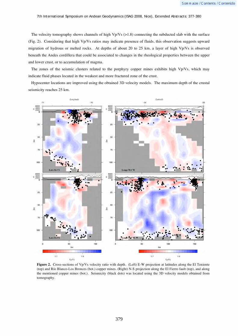
7th International Symposium on Andean Geodynamics (ISAG 2008, Nice), Extended Abstracts: 377-380
379
The velocity tomography shows channels of high Vp/Vs (>1.8) connecting the subducted slab with the surface
(Fig. 2). Considering that high Vp/Vs ratios may indicate presence of fluids, this observation suggests upward
migration of hydrous or melted rocks. At depths of about 20 to 25 km, a layer of high Vp/Vs is observed
beneath the Andes cordillera that could be associated to changes in the rheological properties between the upper
and lower crust, or to accumulation of magma.
The zones of the seismic clusters related to the porphyry copper mines exhibits high Vp/Vs, which may
indicate fluid phases located in the weakest and more fractured zone of the crust.
Hypocenter locations are improved using the obtained 3D velocity models. The maximum depth of the crustal
seismicity reaches 25 km.
Figure 2. Cross-sections of Vp/Vs velocity ratio with depth. (Left) E-W projection at latitudes along the El Teniente (top) and Río Blanco-Los Bronces (bot.) copper mines. (Right) N-S projection along the El Fierro fault (top), and along the mentioned copper mines (bot.). Seismicity (black dots) was located using the 3D velocity models obtained from tomography.

7th International Symposium on Andean Geodynamics (ISAG 2008, Nice), Extended Abstracts: 377-380
380
Conclusions
Continuous mode recording of the temporary network permits to locate low magnitude crustal earthquakes that
in general are well correlated with known faults, but also with hidden faults of presumably high damage
potential. Future seismic hazard evaluations in this highly populated region must then consider low magnitude
seismicity.
The giant copper mines in the zone are located above areas of high Vp/Vs ratios, which are consistent with
partially saturated and fractured crustal zones that exhibits high seismicity.
Seismic velocity tomography improve our models of the geodynamic processes that are taking place in the
region, from the subducted slab to the surface.
Acknowledgements We thanks to the Seismological Service of the University of Chile for providing instruments and their database. This work was partially funded by projects FONDECYT 1050758, ACT-18, and IRD-France.
References
Barrientos, S., Eisenberg, A., 1998. Secuencia sísmica en la zona cordillerana al interior de Rancagua. V Congreso Geológico Chileno, Santiago, F121-132.
Barrientos, S., Vera, E., Alvarado, P., Monfret, T., 2004. Crustal seismicity in Central Chile. J. South Am. Earth Sci., 16, 759–768.
Charrier, R., Baeza, O., Elgueta, S., Flynn, J., Gans, O., Kay, S., Muñoz, N., Wyss, A., Zurita, E., 2002. Evidence of Cenozoic extensional basin development and tectonic inversion south of the flat-slab segment, southern Central Andes, Chile (33°-36°S). J. South Am. Earth Sci., 15, 117-139.
Charrier, R., Bustamante, M., Comte, D., Elgueta, S., Flynn, N., Iturra, N., Muñoz, N., Pardo, M., Thiele, R., Wys, A., 2004. The Abanico extensional basin: Regional extension, chronology of tectonic inversion and relation to shallow seismic activity and Andean uplift. N. Jb. Geol. Paläont. Abh., 236, 43-77.
Jordan, T., Isacks, B., Allmendinger, R., Brewer, J., Ramos, V., Ando, C., 1983. Andean tectonics related to geometry of subducted Nazca plate. Geol. Soc. Am. Bull., 94, 341-361.
Kay, S.M., Maksaev, V., Moscoso, R., Mpodozis, C., Nasi, C., Gordillo, C., 1988. Tertiary magmatism in Chile and Argentina between 28 and 33: correlation of magmatic chemistry with changing Benioff zone. J. South Am. Earth Sci., 1, 21-38.
Lomnitz, C., 1961. Los terremotos del 4 de Septiembre de 1958 en el cajón del Maipo. Anales de la Facultad de Ciencias Físicas y Matemáticas, 18, 279-306.
Pardo, M., Vera, E., Monfret, T., Yañez, G., Eisenberg, A., 2006. Sismicidad cortical superficial bajo Santiago: Implicaciones en la tectónica Andina y evaluación del peligro sísmico. XI Congreso Geológico Chileno 2006, Antofagasta-Chile, 7-11 Agosto, 2006. Actas, Vol.1, Geodinámica Andina, 443-446.
Latorre, D., Virieux, J., Monfret, T., Monteillet, V., Vanorio, T., Got, J.-L., and Lyon-Caen, H., 2004. A new seismic tomography of Aigion area (Gulf of Corinth, Greece) from the 1991 data set, Geophys. J. Int., 159: 1013-1031.
Rauld, R.A., 2002. Análisis morfoestructural del frente cordillerano de Santiago oriente, entre el río Mapocho y la quebrada de Macul. Thesis, Departamento de Geología, Universidad de Chile.
Vera, E., Pardo, M., Monfret, T., Eisenberg, A., Yañez, G., Triep, E., 2006. Eventos Sísmicos Corticales en los Andes Centrales de Chile y Argentina. XI Congreso Geológico Chileno 2006, Antofagasta-Chile, 7-11 Agosto, 2006. Actas, Vol.1, Geodinámica Andina, 469-472.

7th International Symposium on Andean Geodynamics (ISAG 2008, Nice), Extended Abstracts: 381-383
381
Why is the passive margin of Argentinean Patagonia uplifting?: An insight by marine terrace and tidal notches sequences
K. Pedoja1, V. Regard
2, L. Husson
3, J. Martinod
2, & M. Iglesias
4
1 UMR M2C, Université de Caen, 2-4 Rue de Tilleuls 14000 Caen, France, [email protected]
2 LMTG - UMR 5563 UR 154 CNRS Université Paul-Sabatier IRD Observatoire Midi-Pyrénées Observatoire Midi-
Pyrénées - 14, avenue Edouard Belin – 31400 [email protected], [email protected] 3 Géosciences Rennes (UMR CNRS 6118), Université de Rennes1, Bâtiment 15, Campus de Beaulieu, CS
74205, F-35042 Rennes Cedex, France [email protected] 4 Departamento de Geologia, Universidad Nacional de la Patagonia San Juan Bosco Ciudad Universitaria -
Comodoro Rivadavia - Km 4 - Chubut - CP (9005), Argentina, [email protected]
KEYWORDS : marine terraces, marines notches, uplift, passive margin, mantle convection
The Quaternary coastal deposits and morphologies found along the Patagonian coast have been known since
the middle of the last century. The most complete descriptions of the chronostratigraphy, lithology and
paleontology of the Quaternary marine terraces of Patagonia derive from the work of Ferruglio (1933, 1950). In
terms of age control for the Patagonian raised terraces, the first radiocarbon ages of mollusc shells were reported
by Codignotto (1983). Rutter et al. (1989, 1990) and Schellmann and Radtke (2000) provided aminostratigraphy
and ESR dating from various locations. Their ESR results yielded Last Interglacial ages (MISS 5e) for some
locations whereas ages obtained on the basis of aminostratigraphy suggest penultimate interglacial (MIS 7) or
older deposits. ESR and Th/U dating by Radtke (1989) showed that Holocene beaches are at higher elevation in
the south of Patagonia than in the north. Theses dating works concentrated mostly on Holocene (data on zone 2,
3, 4, 5, 6, 8) and MISS 5e (last interglacial, data on zone 2,3,4,5,6, on Figure 1)… Older terraces have been dated
and tentatively correlated to MIS 7, 9 & 11 in zone 3,5,6.
Previous works concentrate on dating (see above) and palaeontology (for example Aguirre et al., 2003) but,
with one noticeable exception (Rostami et al., 2000), no effort was made to use theses features as tectonics tools.
In particular it appears that no extensive and precise mapping and altimetry has been achieved and therefore no
morpho-stratigrpahic correlation or comparison was not possible from one site to another.
Therefore our work concentrate on 3D repartition of the marine terraces sequences and accurate altitudes of
their shoreline angles. We divided the area in 8 zones (see Figure 1). Our mapping was done combining field
observation with interpretation on Landsat image (google earth) and on Shuttle Radar DEM (Geomapapp).
Altitude were taken using precise altimeter and telemeter. We took about 100 altitude of shoreline angle and
therefore we have been able to calculate mean uplift rates since ~ 440 ka (MISS 11) with the method proposed
by Pedoja et al., (2006a, b, c ; in press). Then we focused on Last Interglacial Maximum terrace (MISS 5e), the
better constrained marine terraces (both in term of age and altitude) and we used it as a tectonical benchmark to
reveal positive vertical deformation (i.e. uplift) on the Argentinean passive margin. This approach allow us to
scrutinize the relationship between glacio-isostatic rebond versus “long” term tectonic for the Holocene sequence
and long term (ie Quaternary) tectonic. For the latter one, we discuss its geodynamical origin. More particularly
we reject the possibility of uplift due to the vicinity of the Chilean subduction zone (as proposed by rostami et
al., 2000) and we propose that mantle convection anomaly are responsible for the deformation.

7th International Symposium on Andean Geodynamics (ISAG 2008, Nice), Extended Abstracts: 381-383
382
Figure 1 : Main localisation of Quaternary coastal deposits and morphologies along the Argentinean Patagonia coast
References Aguirre, M.L., 2003. Late Pleistocene and Holocene palaeoenvironments in Golfo San Jorge, Patagonia: molluscan evidence.
Marine Geology 194, 3 –30. Codignotto, J.O., 1983. Depo sitos elevados y/o de Acrecion Pleistoceno– Holoceno en la costa Fueguino–Patagonica.
Simposio Oscilaciones del nivel del mar durante el ultimo hemiciclo deglacial en la Argentina. (IGCP200). Universidad Nacional de Mar del Plata Actas, 12– 26.
Feruglio, E., 1933. I terrazi marini della Patagonia. Giornale di Geologia. Annali Reale Museo geologico di Bologna, 1– 288. Feruglio, E., 1950. Descripcion geologica de la Patagonia. Direccion General de Y.P.F., T 3, 431 pp. Buenos Aires. Pedoja, K., Ortlieb, L., Dumont, J-F., Lamothe, J-F., Ghaleb, B., Auclair, M., Labrousse, B. 2006 Quaternary coastal uplift
along the Talara Arc (Ecuador, Northern Peru) from new marine terrace data. Marine Geology, 228 : 73-91. Pedoja, K., Dumont, J-F., Lamothe, M., Ortlieb, L., Collot, J-Y., Ghaleb, B., Auclair, M., Alvarez, V., Labrousse, B., 2006.
Quaternary uplift of the Manta Peninsula and La Plata Island and the subduction of the Carnegie Ridge, central coast of Ecuador. South American Journal of Earth Sciences, 22: 1-21.
Pedoja, K., Bourgeois, J., Pinegina, T. and Higman, B., 2006. Does Kamchatka belong to North America? An extruding Okhotsk block suggested by coastal neotectonics of the Ozernoi Peninsula, Kamchatka, Russia. Geology, 34, (5) : 353-356.

7th International Symposium on Andean Geodynamics (ISAG 2008, Nice), Extended Abstracts: 381-383
383
Pedoja, K., Kershaw, S., Shen, J-W., Tang, C. Coastal Quaternary morphologies on the northern coast of the South China Sea, China, and their implications for current tectonic models: A review and preliminary study, Marine Geology in press (2008)
Radtke, U., 1989. Marine Terrassen und Korallenriffe— Das Problem der quartaren Meeresspiegelschwankungen erlautert an Fallstudien aus Chile, Argentinien und Barbados. Duseldorfer Geographische Schriften, vol. 27. Geograph. Inst. D. Heinrich Heine Universitat p. 246.
Rostami, K., Peltier, W.R., Mangini, A., 2000. Quaternary marine terraces, sea-level changes and uplift history of Patagonia, Argentina: comparisons with predictions of the ICE-4G (VM2) model of the global process of glacial isostatic adjustment. Quaternary Science Reviews 19, 1495–1525
Rutter, N., Schnack, E., Del Rio, L., Fasano, J., Isla, F., Radtke, U., 1989. Correlation and dating of Quaternary littoral zones along the Patagonian coast, Argentina. Quaternary Science Reviews 8, 213–234.
Rutter, N., Radtke, U., Schnack, E., 1990. Comparison of ESR and amino acid data in correlating and dating Quaternary shorelines along the Patagonian coast, Argentina. Journal of Coastal Research 6 (2), 391–411.
Schellmann, G., Radtke, U., 2000. ESR dating of stratigraphically well-constrained marine terraces along the Patagonian Atlantic coast (Argentina). Quaternary International 68–71, 261– 273.

7th International Symposium on Andean Geodynamics (ISAG 2008, Nice), Extended Abstracts: 384-386
384
Neotectonics and mass wasting phenomena in the eastern slope of the southern Central Andes (37º-37º30’S)
Ivanna M. Penna1, Reginald L. Hermanns
2, & Andrés Folguera
1
1 Laboratorio de Tectónica Andina y Consejo Nacional de Investigaciones Científicas y Técnicas, Departamento
de Geología, Facultad de Ciencias Exactas y Naturales (Pabellón II), Ciudad Universitaria, Buenos Aires,
Argentina ([email protected]) 2 Norges Geologiske Undersøkelse, Norway ([email protected])
KEYWORDS : neotectonic activity, rock avalanches, Southern Central Andes
Introduction
The transitional area between the Central and Patagonian Andes (37º-39ºS) was recognized as an area of
neotectonic activity both in the forearc and western retroarc (Melnick et al., 2006; Folguera et al., 2004). In the
study area the neotectonic activity manifests itself as the N-S striking Antiñir-Copahue fault zone, which is
20-40 km wide. Crustal seismicity is mainly constrained in the forearc area, but some crustal events are
recognized in the retroarc zone where neotectonics evidences were identified. This area of young deformation is
associated with more than 40 rock avalanche deposits (González Díaz et al., 2006; Hermanns et al., 2006).
Further to the north, huge mass wasting phenomena are related to neotectonics features and hence with the
Pampean flat slab zone (Costa et al., 2005). Here, seismicity is associated with high-angle basement reverse
faults, located in a broken Laramide-like foreland area, that produce slope instability.
Ta árová (2004), by gravimetrics models based on seismic data, proposed that this part of the Andes
experiments a decrease of about 10º in the angle of Wadatti-Benioff zone, in contrast with the adjacent segments
where the subduction angle is near 30º.
The aim of this paper is to present new geological evidence of neotectonic activity and deformation mechanism
and their relationship with the spatial distribution of rock avalanches in the Southern Central Andes.
Neotectonics and rock avalanches
The morphologic expression of neotectonic activity corresponds to a series of rectilineous scarps and drainage
anomalies in the Quaternary coverage.
In the fault-valley intersection, it is possible to recognize a direct association between N-S trending scarps and
faults with transpresive dextral mechanism. Those faults are parallel to the strike of Oligocene-Miocene strata of
Cura Mallín basin, which suggests a flexural deformation mechanism (Figure 1).
The Chacayco and Cerro Guañacos faults (Figure 1) are N-S continuous scarp with 200 and 30 meters of
vertical displacement respectively. The intersection between the first one and Reñileuvú valley is linked to a
huge rock avalanche named Chacayco (0.81 km3, Figure 1). Another important feature is related to the Cerro
Guañacos fault. Here, radiometric determinations in highly deformed glacifluvial sequences have allowed us to
constraint neotectonic activity along the Reñileuvú valley up to at least 26,540+510/-480years BP; what
evidence an ongoing tectonic activity in the foothills of the southernmost Central Andes, despite the absence of
several events of shallow seismicity (Bohm et al., 2002). Additionally, morphological evidence show drainage
disturbances in relation to this structure such as abandoned courses, deflected and beheaded courses, young

7th International Symposium on Andean Geodynamics (ISAG 2008, Nice), Extended Abstracts: 384-386
385
drainage systems developed in the hangingwalls of growing structures, and springs associated with fault scarps
that flooded the footwall faults.
In the Reñileuvu, Ñireco and Guañacos valleys the main evidence of the linkage between neotectonic activity
and slope instability is the occurrence of several avalanches among which six are the most important ones. The
source area of these deposits is located along the strike of the thrusts, in the intersection with deeply incised
glacial valleys (with slopes around 40-30º).
Three of these landslides have yielded around ~3,000 Ka (Hermanns et al., 2006), which allows us to ascribe
these deposits to postglacial times. One would be synglacial based on the finding of a fluvio/glacial coverage
meanwhile another, based on morphologic criteria such as erosional degrees of break away zones and
hummocky topography, and connectional degree of drainage networks over the landslide surface, allow us to
assign its to postglacial times.
Figure 1. Main neotectonics faults and evidences of the young deformation. Block diagram reflect the flexural deformation mechanism, proposed for the area. Note that the Chacayco rock avalanche is located in the fault-valley intersection.
Conclusions
Tectonic activity could be preparatory mechanisms of slopes collapses in two different ways: a) “internal
causes” referring to the spatial coincidence of rock avalanches with the fronts of important thrust faults and b) as
trigger mechanisms by seismic activity.

7th International Symposium on Andean Geodynamics (ISAG 2008, Nice), Extended Abstracts: 384-386
386
The spatial relationship between the rock avalanches and the neotectonic faults that cut orthogonally the
eastern Reñileuvú creek, suggests that the last one plays an important role as a slope instability trigger factor.
This strong linkage between young deformation and landsliding, points to seismic shaking as a trigger factor for
slope failure. Rock avalanche dimensions could contribute to reinforce this hypothesis.
Clustering ages of around 3,000 yr indicates multiple landslide occurrences at the same time. Those are likely
produced by earthquakes which would have also been responsible for local deformation. The necessary
earthquake magnitude to generate a slope collapse of a rock avalanche type would be in the order of 6.0M
according to the statistical approach of Keefer (1984).
The instrumental seismicity recorded in the western retroarc zone at these latitudes is poor (Bohm et al., 2002),
and reflects crustal and interplate events of around 4-5M.
During the last times no significant landslides were produced in this area in spite of this is located only 300 km
to the trench, where megathrust earthquakes such as the Chile 1960 M9.5 event took place. This indicates that
the energy source has to be related to local events.
References Bohm, M., Lüth, S., Helmut E., Asch, G., Bataille, K., Bruhn, C., Rietbrock, A. & Wigger, P., 2002 —The Southern Andes
between 36º and 40ºS latitude: seismicity and average seismic velocities. Tectonophysics, 356(4): 275-289. Costa C. H., 2005 — Large Holocene earthquakes in the Sierras Pampeanas and sorrounding plains: more likely than once
thought. ICSU-IGCP 480, Holocene environmental catastrophes in South America: From the lowlands to the Andes. Laguna Mar Chiquita, Córdoba.
Folguera A, Ramos V, Hermanns R.L, Naranjo J., 2004 — Neotectonics in the foothills of the Southernmost Central Andes (37º-38ºS). Evidence of the strike-slip displacement along the Antiñir-Copahue fault zone. Tectonics. Vol 23, TC5008.
González Díaz, E. F., Folguera, A., Costa, C., Wright, E. & Elisondo, M., 2006 — Los grandes deslizamientos de la región septentrional neuquina entre los 36º y los 38ºS: una propuesta de su inducción por un mecanismo sísmico. Revista de la Asociación Geológica Argentina. 61 (2): 197-217.
Hermanns, R. L., Folguera, A., Penna, I., Naumann, R. & Niedermann, S., 2006 — Morphologic characterization of giant flood deposits downriver landslide dams in the northern Patagonian Andes. Geophysical Research Abstracts. Vol 8.
Keefer, D.K., 1984 — Rock-avalanches caused by earthquakes: source characteristics. Science, Vol 223: 1288- 1290. Melnick. D., Charlet F., Echtler H. P., & De Batist. M., 2006 — Incipient axial collapse of the Main Cordillera and strain
partitioning gradient between the central and Patagonian Andes, Lago Laja, Chile. Tectonics. v. 25, TC5004. Tasarova, Z., 2004 — Gravity data analysis and interdisciplinary 3D modelling of a convergent plate margin (Chile, 36–
42°S). PhD thesis, Freie Universität Berlin, http://www.diss.fu-berlin.de/2005/ 19/indexe.html
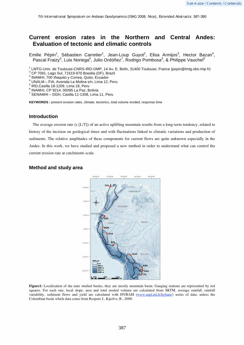
7th International Symposium on Andean Geodynamics (ISAG 2008, Nice), Extended Abstracts: 387-390
387
Current erosion rates in the Northern and Central Andes: Evaluation of tectonic and climatic controls
Emilie Pépin1, Sébastien Carretier
1, Jean-Loup Guyot
2, Elisa Armijos
3, Hector Bazan
4,
Pascal Fraizy5, Luis Noriega
6, Julio Ordóñez
7, Rodrigo Pombosa
3, & Philippe Vauchel
5
1 LMTG-Univ. de Toulouse-CNRS-IRD-OMP, 14 Av. E. Belin, 31400 Toulouse, France ([email protected])
2 CP 7091, Lago Sul, 71619-970 Brasilia (DF), Brazil
3 INAMHI, 700 Iñaquito y Correa, Quito, Ecuador
4 UNALM – FIA, Avenida La Molina s/n, Lima 12, Peru
5 IRD,Casilla 18-1209, Lima 18, Peru
6 INAMHI, CP 9214, 00095 La Paz, Bolivia
7 SENAMHI – DGH, Casilla 11-1308, Lima 11, Peru
KEYWORDS : present erosion rates, climate, tectonics, total volume eroded, response time
Introduction
The average erosion rate ( [L/T]) of an active uplifting mountain results from a long-term tendency, related to
history of the incision on geological times and with fluctuations linked to climatic variations and production of
sediments. The relative amplitudes of these components for current flows are quite unknown especially in the
Andes. In this work, we have studied and proposed a new method in order to understand what can control the
current erosion rate at catchments scale.
Method and study area
Figure1: Localization of the nine studied basins, they are mostly mountain basin. Gauging stations are represented by red squares. For each one, local slope, area and total eroded volume are calculated from SRTM, average rainfall, rainfall variability, sediment flows and yield are calculated with HYBAM (www.mpl.ird.fr/hybam/) series of data, unless the Colombian basin which data come from Respeto J., Kjerfve, B., 2000.
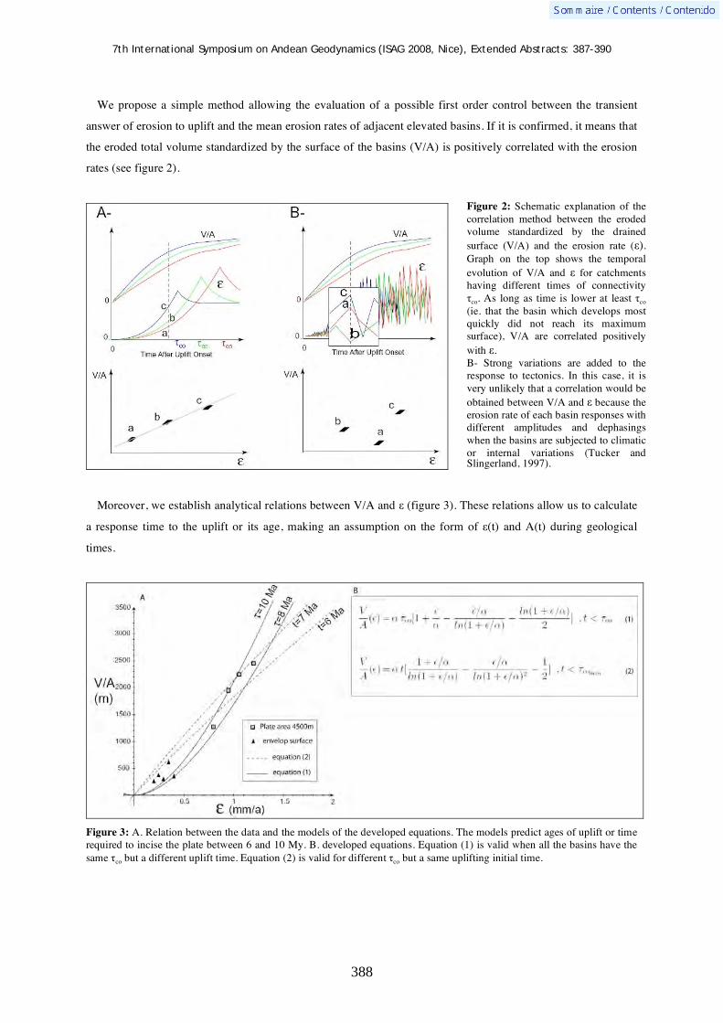
7th International Symposium on Andean Geodynamics (ISAG 2008, Nice), Extended Abstracts: 387-390
388
We propose a simple method allowing the evaluation of a possible first order control between the transient
answer of erosion to uplift and the mean erosion rates of adjacent elevated basins. If it is confirmed, it means that
the eroded total volume standardized by the surface of the basins (V/A) is positively correlated with the erosion
rates (see figure 2).
Moreover, we establish analytical relations between V/A and (figure 3). These relations allow us to calculate
a response time to the uplift or its age, making an assumption on the form of (t) and A(t) during geological
times.
Figure 3: A. Relation between the data and the models of the developed equations. The models predict ages of uplift or time required to incise the plate between 6 and 10 My. B. developed equations. Equation (1) is valid when all the basins have the same co but a different uplift time. Equation (2) is valid for different co but a same uplifting initial time.
Figure 2: Schematic explanation of the correlation method between the eroded volume standardized by the drained surface (V/A) and the erosion rate ( ). Graph on the top shows the temporal evolution of V/A and for catchments having different times of connectivity
co. As long as time is lower at least co (ie. that the basin which develops most quickly did not reach its maximum surface), V/A are correlated positively with . B- Strong variations are added to the response to tectonics. In this case, it is very unlikely that a correlation would be obtained between V/A and because the erosion rate of each basin responses with different amplitudes and dephasings when the basins are subjected to climatic or internal variations (Tucker and Slingerland, 1997).
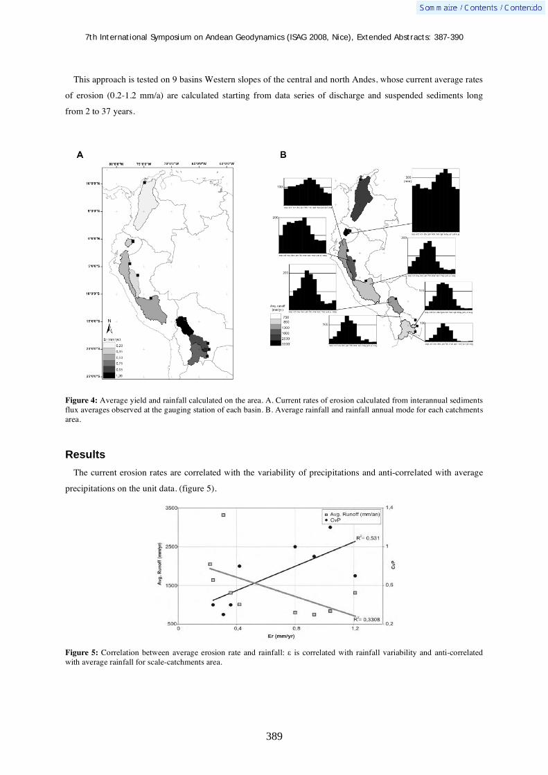
7th International Symposium on Andean Geodynamics (ISAG 2008, Nice), Extended Abstracts: 387-390
389
This approach is tested on 9 basins Western slopes of the central and north Andes, whose current average rates
of erosion (0.2-1.2 mm/a) are calculated starting from data series of discharge and suspended sediments long
from 2 to 37 years.
Figure 4: Average yield and rainfall calculated on the area. A. Current rates of erosion calculated from interannual sediments flux averages observed at the gauging station of each basin. B. Average rainfall and rainfall annual mode for each catchments area.
Results
The current erosion rates are correlated with the variability of precipitations and anti-correlated with average
precipitations on the unit data. (figure 5).
Figure 5: Correlation between average erosion rate and rainfall: is correlated with rainfall variability and anti-correlated with average rainfall for scale-catchments area.
7th International Symposium on Andean Geodynamics (ISAG 2008, Nice), Extended Abstracts: 387-390
390
After developing two kinds of initial surface (envelop surface and initial plate) to calculate the total eroded
volume, we did not find a clear relationship between the current erosion rates and the total eroded volumes of the
nine basins. So, it seems that for our studied area, there is no first order control of the transient answer of erosion
to uplift on the mean erosion rates. Considering only the four bolivian basins, a linear relationship between and
V/A can be found for any initial surface choosen. This result permits us to think about the possible control of the
mean erosion rate, only on the bolivian basins, by the transient answer of erosion to uplift controls. This thought
confirms Safran et al. 2005 and Aalto et al. 2006 results.
Discussion and conclusion
The interpretation of the relative role of average rainfall and rainfall variability depends on the real role of the
long-scale component; first possibility, the response time of erosion to uplift controls effectively the rates of
erosion, in which case it is the average rainfall which plays a main role by controlling these response times.
Second possibility, on the contrary it is the variability of the climate which explains the space variations, the
erosion rates being stronger as variability is high.
The respective roles of the variability and the average of the climate on the current average rates of erosion
cannot be evaluated without taking in account of the state of the erosive answer on very a long-term scale. There
is not clear first order control of the transient answer of erosion to uplift on the mean erosion rates on this area
unless on the bolivian basins. Moreover, it could be useful to investigate the way to calculate more precisely the
total eroded volume.
References Aalto, R., Dunne, T., Guyot, J., 2006 — Geomorphic Controls on Andean Denudation Rates. The Journal of Geology 114,
85-99. Restrepo, J., Kjerfve, B., 2000 — Magdalena River: interannual variability (1975-1995) and revised water discharge and
sediment load estimates. Journal of Hydrology 235, 137-149. Safran, E., Bierman, P., Aalto, R., Dunne, T., Whipple, K., Caffee, M., 2005. Erosion rates driven by channel network
incision in the bolivian andes. Earth Surf. Proc. Land. 30, 1007–1024. Tucker, G. E., Slingerland, R., 1997 — Drainage basin responses to climate change. Water Resources Research. 33, 2031-
2047.

7th International Symposium on Andean Geodynamics (ISAG 2008, Nice), Extended Abstracts: 391-392
391
The volcanic rocks of the Mondaca river, Cordillera Principal (31°45'S), San Juan province, Argentina
Daniel J. Pérez & Juan Manuel Sánchez-Magariños
Laboratorio de Tectónica Andina, Departamento de Ciencias Geológicas, Universidad de Buenos Aires, Ciudad
Universitaria 1428, Buenos Aires, Argentina ([email protected])
KEYWORDS : Pelambres, Abanico, Miocene, Principal Cordillera, Mondaca River, San Juan, Argentina
Introduction
The objective of the present contribution is to analyze the volcanic rocks and their relationship within
Mesozoic sedimentary deposits in the Mondaca river region, to the west of Cerro Mercedario. New field
structure data from these region, indicate that these volcanic deposits are Oligocene and Miocene in age. The
study region is located in the Frontal and Principal Cordillera at 31º45'S and 70°15'W, to the west of the
Mercedario Mountain and east of the Paso del Mondaca, in San Juan province, Argentina. This region is in the
southern part of the modern non-volcanic “flat-slab” (Cahill e Isacks, 1992) region betwen 28° and 33°S, under
which the Nazca plate forms a broad sub-horizontal bench between about 100 and 150 km. The first studies in
the region were done by Groeber (1951), Polanski (1964), Olivares Morales (1985), Rivano and Sepulveda
(1991); and more recent studies by Alvarez (1996), Pérez (2001), Ramos et al. (1998).
Stratigraphy and structure
The stratigraphic sequences of the area begin with Permo-Triassic rhyolitic and rhyodacitic rocks of the
Choiyoi Group. The continue with Permo-Triassic and Triassic rocks of the Rancho de Lata Formation and
Jurassic sequences of the Los Patillos, La Manga and Tordillo Formations. Without stratigraphic relationships
continued the Auquilco formation whit gypsum and diapirs.
It follows a sequence of volcanic rocks defined in the Chile region as Los Pelambres Formation by Rivano and
Sepúlveda (1991) and that to the Alitre and Mondaca Pass enter to Argentina region. These same rocks in the
The La Ramada located immediately to the south of the study area, they were assigned to the Juncal Formation
(Ramos et al. 1990), by the way, these same volcanic rocks immediately to the north of the study region, they
would have thrown upper Oligocene lowe Mioceno in ages, being assigned to the Abanico Formation (Bertens,
2006). Unconformable above these rocks continued the volcanic rocks of Farellones Formations with Miocene
age. Above all these mentioned units, they are quaternary deposits broadly distributed inside which deposits
were recognized glaciers, alluvial fun, etc.
The study region presents two structural styles, one of thin skinned and another of thick skinned; which
affected to different rocks and in different periods of times. The first style can see in the Mondaca and
Carnicerias river, by Los Pelambres thrust of low angle, which would be uplifting the volcanic sequences of
upper Oligocene and lower Mioceno in age, over Los Patillos Formation of Jurassic age. Toward the west and in
Chilean territory another landslide of low angle would be the responsible of uplifting the Cretaceous deposits of
the homonymous formation on the tertiary volcanic rocks. These are attributed to the different deformation
phases of out of sequences thrust and in Miocene times. Similar structure they would already have been
7th International Symposium on Andean Geodynamics (ISAG 2008, Nice), Extended Abstracts: 391-392
392
describes to the south of the study region and affecting to cretaceous volcanic rocks of Los Pelambres formation
(Cristallini et al., 1996).
Discussion
With relation to the volcanic rocks located between the Alitre and Mondaca pass, and these continue for the
Mondaca river, and then toward the north for the Carnicerias river, they would correspond to the Farellones
formation according to Olivares Morales (1985). On the other hands the volcanic rocks to the north of the
Mondaca pass would be Cretaceous in age and corresponding to the Río Totoral or Los Pelambres formations
(Rivano and Sepúlveda, 1991). In this work and over above discusses, we are assigned to the volcanic rocks
located on, Alitre and Mondaca pass, high Mondaca river, continued along the chilen boundary toward the north
of Pachón river, continues for the Carniceria river, reaching the Yeso and Pantanosa rivers, a upper Oligocene
lower Miocene age; and decides denominate to these volcanic rocks as Mondaca Formation.
The volcanism rocks of Mondaca river, represent the initial volcanic sequences in this region, for oligocene
miocene times, before Farellones formations, and represents the initial of volcanism for tertiary times. These
data require reconsideration of paleogeogarphic reconstructions for this time.
References Alvarez, P.P., 1996. Los depósitos triásicos y jurásicos de la Alta cordillera de San Juan. En V.A. Ramos (ed). Geología de la
región del Aconcagua, provincias de San Juan y Mendoza. Subsecretaría de Minería de la Nación. Dirección Nacional del Servicio Geológico. Anales 24 (5): 59-137, Buenos Aires.
Bertens, A., Clark, A.H., Barra, F. y Deckart, K., 2006. Evolution of the Los Pelambres-El Pachón porphyry copper-molybdenum district, Chile-Argentina. XI Congreso Geológico Chileno, Actas, Vol.2, Geología Económica, Antofagasta.
Cahill, T. y Isacks, B.L., 1992. Seismicity and shape of the subducted Nazca plate. Journal of Geophysical Research . Nº97, p. 17503-17529.
Cristallini, E.O. y Ramos, V.A., 1996. Los depósitos continentales cretásicos y volcanitas asociadas. En V.A. Ramos (ed). Geología de la región del Aconcagua, provincias de San Juan y Mendoza. Subsecretaría de Minería de la nación, Dirección Nacional del Servicio Geológico. Anales 24 (8): 231-273, Buenos Aires.
Groeber, P., 1951. La Alta Cordillera entre las latitudes 34° y 29°30'. Instituto Investigaciones de las Ciencias Naturales. Museo Argentino de Ciencias Naturales B. Rivadavia, Revista (Ciencias Geológicas) I(5): 1-352, láminas I-XXI, Buenos Aires.
Olivares Morales América Patricia, 1985. Geología de la Alta Cordillera de Illapel entre los 31°30 y 32° Latitud Sur. Tesis de Grado, Universidad de Chile, Facultad de Ciencias Físicas y Matematicas Departamento de Geología y Geofísica.
Pérez, D.J., 2001. El volcanismo neógeno de la cordillera de las Yaretas, Cordillera Frontal (34°S) Mendoza. Revista de la Asociación Geológica Argentina, 56 (2):221-23, Buenos Aires.
Polanski, J., 1964. Descripción geológica de la hoja 25a Volcán San José, provincia de Mendoza, Dirección Nacional de Geología y Minería, Boletín 98: 1- 94, Buenos Aires.
Ramos, V.A., Rivano, S., Aguirre-Urreta M.B., Godoy, E. y Lo Forte, G.L., 1990. El Mesozoico del Corcón del Límite entre Portezuelo Navarro y Monos de Agua (Chile-Argentina). XI Congreso Geológico Argentino, Actas II: 43-46, San Juan.
Rivano, G. y Sepulveda, H.,1991. Hoja Illapel Región de Coquimbo, Servicio Nacional de Geología y Minería, Carta Geológica de Chile. Nº69. 132pp..
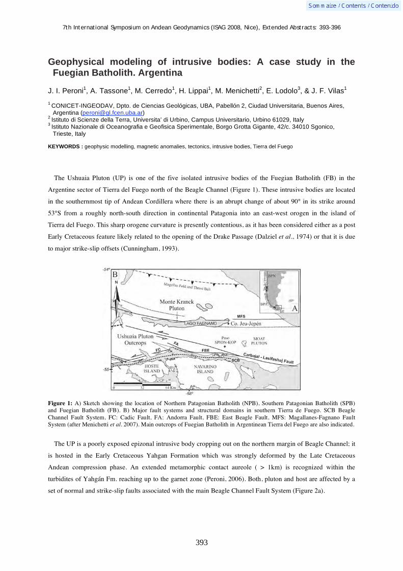
7th International Symposium on Andean Geodynamics (ISAG 2008, Nice), Extended Abstracts: 393-396
393
Geophysical modeling of intrusive bodies: A case study in the Fuegian Batholith. Argentina
J. I. Peroni1, A. Tassone
1, M. Cerredo
1, H. Lippai
1, M. Menichetti
2, E. Lodolo
3, & J. F. Vilas
1
1
CONICET-INGEODAV, Dpto. de Ciencias Geológicas, UBA, Pabellón 2, Ciudad Universitaria, Buenos Aires,
Argentina ([email protected]) 2
Istituto di Scienze della Terra, Universita’ di Urbino, Campus Universitario, Urbino 61029, Italy 3
Istituto Nazionale di Oceanografia e Geofisica Sperimentale, Borgo Grotta Gigante, 42/c. 34010 Sgonico,
Trieste, Italy
KEYWORDS : geophysic modelling, magnetic anomalies, tectonics, intrusive bodies, Tierra del Fuego
The Ushuaia Pluton (UP) is one of the five isolated intrusive bodies of the Fuegian Batholith (FB) in the
Argentine sector of Tierra del Fuego north of the Beagle Channel (Figure 1). These intrusive bodies are located
in the southernmost tip of Andean Cordillera where there is an abrupt change of about 90° in its strike around
53°S from a roughly north-south direction in continental Patagonia into an east-west orogen in the island of
Tierra del Fuego. This sharp orogene curvature is presently contentious, as it has been considered either as a post
Early Cretaceous feature likely related to the opening of the Drake Passage (Dalziel et al., 1974) or that it is due
to major strike-slip offsets (Cunningham, 1993).
Figure 1: A) Sketch showing the location of Northern Patagonian Batholith (NPB), Southern Patagonian Batholith (SPB) and Fuegian Batholith (FB). B) Major fault systems and structural domains in southern Tierra de Fuego. SCB Beagle Channel Fault System, FC: Cadic Fault, FA: Andorra Fault, FBE: East Beagle Fault, MFS: Magallanes-Fagnano Fault System (after Menichetti et al. 2007). Main outcrops of Fuegian Batholith in Argentinean Tierra del Fuego are also indicated.
The UP is a poorly exposed epizonal intrusive body cropping out on the northern margin of Beagle Channel; it
is hosted in the Early Cretaceous Yahgan Formation which was strongly deformed by the Late Cretaceous
Andean compression phase. An extended metamorphic contact aureole ( > 1km) is recognized within the
turbidites of Yahgán Fm. reaching up to the garnet zone (Peroni, 2006). Both, pluton and host are affected by a
set of normal and strike-slip faults associated with the main Beagle Channel Fault System (Figure 2a).

7th International Symposium on Andean Geodynamics (ISAG 2008, Nice), Extended Abstracts: 393-396
394
The UP is compositional varied and includes several facies: a basic to ultrabasic facies, a heterogenous facies
where magma mixing processes are evident and marginal roof facies of volcanic/hypabyssal character (Cerredo
et al., 2007). Along the northern shoreline of Ushuaia bay two main facies were recognized (Figure 2b): the
easternmost areas are dominated by ultrabasic-basic rocks (hornblendite facies), whereas the western sector is
more heterogeneous with widespread syenite-monzonite rocks and lesser amounts of ultrabasic-basic rocks
(syenite-hornblendite facies).
Figure 2: A) Geological sketch depicting the main units and structures in northern Beagle Channel (after Menichetti et al, 2007). B) Detail of petrographic facies in the UP along Ushuaia bay shoreline (after Peroni, 2006).
The 5569-II aeromagnetic chart (not reduced to the pole, SEGEMAR, 1998) was employed to model the UP
(Fig. 3a); this 1:250.000 chart was produced from high level survey (120 meters), with N-S flight lines each
500 m and E-W control flights each 5000 m. This high level, tightly constrained aeromagnetic grid is appropriate
for mapping regional, subsurface geology
Within the Ushuaia bay area the aeromagnetic map shows maximum with bell form (Fig. 3A) to the N and an
elliptic minimum to the south. The former displays asymmetric distribution of contour lines, with the steepest
gradients to the S and associated highest values of 350 nT. The minimum in turn, with an E-W oriented axis
attains the lowest values of around -320 nT.

7th International Symposium on Andean Geodynamics (ISAG 2008, Nice), Extended Abstracts: 393-396
395
The 3D modeling of the UP was performed with the Encom ModelVision Pro 7.0 software (Encom
Technology, 2002), which employs the Won and Bevis (1987) algorithm to calculate the magnetic anomalies by
means of a polygon of n sides within a bidimensional space. Software computing requires entering the
International Geomagnetic Reference Field (IGRF) of the studied area, as well as the magnetic susceptibility
and the remanent magnetization of intervening rock units.
The obtained 3D model of UP displays a laccolithic profile with a central thickest area (around 4000 m) and
thinner borders (around 500 meters). Modeled pluton is slightly oval on plant view with N-S major axis (around
12 km), E-W minor axis (10 km) and total volume of 140 km3.
Figure 3: A) Map of aeromagnetic anomalies -not reduced to the pole- 5569-II (SEGEMAR, 1998) (total magnetic field). Contour lines each 5 nT. B) Magnetic profile 1-2, location indicated in A; C) Interpreted schematic cross- N-S section built from the numeric modeling combined with available geological data (after Menichetti et al, 2004).
The modeled UP was integrated with a regional cross-section (Fig.3c), which was built on combined surface
geology and seismic reflection seismic profiles (Menichetti et al, 2004; Menichetti et al., 2008). Topography
was obtained from a digital elevation model.
The modeled body overprints the thrust complex, which includes two south-dipping duplexes, and is affected
by extensional features. The normal faults are splay of the Beagle channel strike-slip fault that shows a structure

7th International Symposium on Andean Geodynamics (ISAG 2008, Nice), Extended Abstracts: 393-396
396
with double vergence in both side of the Beagle Channel. The faults offset are mainly extensional of few km
respect to the strike-slip. In the northern part of the section the positive structure of the Valle Carbajal is shown.
Since the Late Cretaceous, strike-slip tectonics, would have dominated the Tierra del Fuego area both on-
shore and the Atlantic off-shore (Cunningham, 1993; Menichetti et al., 2008; Tassone et al., 2008). The above
presented structural framework (Figs. 1, 2), combined with regional geology (Fig.3) and magnetic modeling of
UP support a transtensive regime as a likely scenario for pluton emplacement.
References Cerredo, M. E., Remesal, M.B., Tassone, A., Menichetti, M., Peroni, J. I. 2007, 2007 Ushuaia Pluton: petrographic facies and
geochemical signature. Tierra del Fuego Andes. Geosur 2007, pp 31, Santiago de ChileCunningham, W. D. 1993 Strike-slip faults in the southernmost Andes and the development the Patagonian orocline. Tectonics, v. 12 (1) : 169-186.
Dalziel, I.W.D., de Wit, M.J., Palmer, F.K., 1974. Fossil marginal basin in the southern Andes. Nature 250, 291–294. Encom Technology, 2002. ModelVision Pro v.7.0. Encom Technology, Sydney, Australia. Menichetti M., Acevedo R. D., Bujalesky G. G., Cenni M., Cerredo M. E., Coronato A., Hormachea J. L., Lippai H., Lodolo
E., Olivero E. B., Rabassa J. & Tassone A.2004. Field Trip guide of the Tierra del Fuego. Geosur meeting Buenos Aires 2004, 39 p.
Menichetti, M., Tassone, A., Peroni, J. I., Gonzàlez Guillot, M., Cerredo M.E. 2007 Assetto strutturale, petrografia e geofisica della Bahía Ushuaia – Argentina. Rend. Soc. Geol. It., 4 (2007), Nuova Serie, 259-262, 3 ff.
Menichetti M., Lodolo, E., Tassone A., 2008. Structural geology of the Fuegian Andes and Magallanes fold-and-thrust belt – Tierra del Fuego Island. Geologica Acta, 6 (1) : 19-42.
Peroni J.I. 2006. Anomalía magnética en Bahía Ushuaia (Tierra del Fuego). Estudio Geofísico de la continuidad de las unidades geológicas en subsuelo. Trabajo final de Licenciatura. Dpto. de Geología. Facultad de Ciencias Exactas y Naturales. Universidad de Buenos Aires, 90 p.
Servicio Geológico Minero Argentino (SEGEMAR). 1988. Levantamiento geofísico aéreo magnetometría aérea de Tierra del Fuego. Proyecto PASMA. Hoja Ushuaia 5569 II Escala 1:250.000
Tassone, A., Lodolo, E., Menichetti, E., Yagupsky, D., Caffau, M. and Vilas. J. F. 2008. Seismostratigraphic and structural setting of the Malvinas Basin and its southern margin (Tierra del Fuego Atlantic offshore). Geologica Acta, 6 (1) : 1-13
Won, I. J. y Bevis, M. G. 1987. Computing the Gravitational and Magnetic Anomalies due to a Polygon: Algorithms and Fortran subroutines. Geophysics, 52 (2) : 232-238.

7th International Symposium on Andean Geodynamics (ISAG 2008, Nice), Extended Abstracts: 397-400
397
Influence of tectonic and magmatic parameters in the deformation of the Andean subduction margin in Central Chile based on analogue models
L. Pinto, F. Albert, & R. Charrier
Departamento de Geología, Universidad de Chile, Plaza Ercilla 803, Casilla 13518, Correo 21, Santiago, Chile
([email protected], [email protected], [email protected])
KEYWORDS : analogue modelling, tectonic parameters, flat-slab, magmatic chambers, Central Andes
Introduction
Tectonic segmentation in the Central Andes is a primary feature related to the geometry of the Nazca Plate
(Baranzangi and Isacks, 1976; Cahill and Isacks, 1992; Jordan et al., 1983a,b). Zones of low dipping (<10º)
subduction planes (flat-slab subduction zones or segments), like the region located between ca. 28° and 33°S,
generally correspond to zones of strong coupling (Gutscher, 2002; Scheuber et al., 1994). North and south, of
this zone the dip of the subduction plane increases to ~25º-30º and coupling decreases (Scheuber et al., 1994).
Moreover, in Central Chile, between the flat-slab zone and the normal subduction zone located to the south
(33°S-33°45'S) there is a transitional zone with particular morphostructural characteristics (Rivera and
Cembrano, 2000). It has been postulated that the flat-slab zone evolved over time (eg. Yañez et al., 2001; Kay
and Mpodozis, 2002). Throughout this evolution eastward shift of magmatism has been a direct function of the
decrease of the subduction angle, such that today in the flat-slab zone along the prolongation of the present-day
volcanic axis, north and south of this zone, there is a complete absence of volcanic activity since 5 myr ago
(Jordan et al., 1983b; Kay et al., 1999; Ramos et al., 2002). It has been postulated (eg. Hervé, 1994; Cembrano
et al., 1996) that in the southern Central Andes (south of ~39ºS) the presence of the magmatic arc has been an
important factor that influenced the partition of deformation. There are several studies that attempted to explain
the factors that have influenced the geometry of deformation along the different subduction segments (eg. Yañez
et al., 2001). However, no modelling studies have been performed to evaluate the influence and interaction of
tectonic and magmatic parameters in the morphostructural configuration of the Central Andes. This prompted a
series of analogue modelling experiments with which we analyzed the influence on deformation of: pre-existent
morphostructural features, the presence of magmatic zones, the degree of coupling, and the angle of convergence
for a region with a tectonic regime like the one predominating in Central Chile in Cenozoic times. In this
contribution we analyse the effects on deformation caused by the zone of magmatic chambers (MCZ) and the
degree of coupling along the continental margin. Analyses on the effects caused by the angle of convergence
have been presented by Albert et al. (2008).
Experimental setup
From Late Eocene to Miocene times the magmatic arc developed in a fault bounded extensional basin
(Abanico Basin) located between the present-day Coastal Cordillera and the easternmost Principal Cordillera in
Central Chile. Based on the aforementioned tectonic setting, the experimental models developed took primarily

7th International Symposium on Andean Geodynamics (ISAG 2008, Nice), Extended Abstracts: 397-400
398
into account the presence of (Fig. 1): a) A rigid wedge at the W border of the experiment (CC), b) an area
consisting of an upper brittle layer and a lower ductile layer between the wedge and the mobile piston (CD and
PC), and c) a silicone trapeze to simulate the ductile area corresponding to the MCZ. All elements are N-S
oriented and parallel to each other. The brittle behavior was represented by quartz sand (diameter <500 μm,
density 1,400 kg/m3), ductile behavior by silicone (density 1,400 kg/m3, viscosity 4x10⁴ Pa/s), and the rigid
wedge by wood (Fig. 1). The rate used was 3 cm/hr for 2 hr. The dimensions of the various morphostructural and
magmatic units are shown in Fig. 1b. To analyze the effects of the degree of coupling two different models were
performed, the first, with a 0.5 mm thick galvanized sheet fixed to the mobile piston (E side) and situated below
the silicone (Fig. 2c). This sheet distributes the movement at the experimental base simulating a high degree of
coupling. The second model was prepared without sheet simulating a weak coupling (Fig. 2a).
a) .W mobile piston .E b)
Figure 1. a) A W-E profile of the experimental device. The dotted lines in P and Q show the areas where faulting associated with the MCZ. The morphostructural zones are given only for reference. b) Dimensions of the device. The middle column contains the values observed in nature and the column to the right contains the values at the model.
Results
The analogue models showed that the MCZ ductile zone (arc) controls significantly the development of crustal
structures. The models also showed that the angle of obliquity is a parameter of second order that only modifies
the resulting geometry and magnitude of displacement of the structures formed in the MCZ region (Albert et al.,
2008). We observed that a low angle of obliquity together with a high degree of coupling causes greater uplift in
the MCZ than in experiments with higher angle of obliquity (Albert et al., 2008).
The degree of coupling resulted to be a significant parameter in the configuration of the structural system. In
experiments with weak coupling (Fig. 2a, b) a slight east-vergent thrusting occurred in the MCZ (Q in Fig. 1a,
F2 in Fig. 2b). Intense deformation was concentrated in the mobile piston area, where two thrust-faults with
opposite vergencies were formed; the western fault presented a greater displacement than the other one and
developed a fold in its front (F1, Fig. 2b). In the case of high coupling (Fig. 2c,d), the deformation was
concentrated on the MCZ with the development of a pop-up structure (F1 and F2, Fig. 2d), where the edges of
the MCZ define the position of main structural systems (P and Q in Fig. 1a). This concentration of deformation
led to a greater uplift of the MCZ and also a greater displacement of the structures than in the experiments
developed with weak coupling (Fig. 2d).
[km] [cm]
a 20 5,9
b 20 5,9
c 150 44,1
d 40 11,8
e 4,3 1,3
f 6,6 2
g 33 10
h 66 20
i 9,2 2,7
P Q

7th International Symposium on Andean Geodynamics (ISAG 2008, Nice), Extended Abstracts: 397-400
399
N N
Therefore, a preliminary analysis of the results shows that tectonic factors, the presence of morphostructural
units, and the existence of a ductile zone (MCZ) have a strong influence on the style of deformation. The degree
of coupling defines the area where the greater deformation will occur; for example, in a strong coupling system,
the MCZ will concentrate the deformation and in this case the angle of obliquity will define the geometry and
amount of displacement along the structures next to it (see Albert et al., 2008).
a) CA = 6 cm; %A = 100% c) CA = 6 cm; %A = 100% A ------------------------------------------------ A’ B --------------------------------------------------- B’
compression
compression
A F2 F1 A’ B F1 F2 B’
b) d) Figure 2. Experiments with different coupling degrees: a) Weak coupling: View from above of the last state of the experiment. b) A-A’ section showed in a. c) Strong coupling: View from above of the last state of the experiment. A galvanized sheet was fixed to the mobile piston (right side), below the silicone. d) B-B’ section showed in c. In this case, the model developed two thrust faults with opposite vergencies (F1 and F2) defining a pop-up. The scale showed is 5 cm. Colors of fault traces represent the time at which they appeared: the yellow fault trace appeared before the red one. CA represents the value of shortening in centimeters. %A represents percentage of shortening respect to the initial length.
Application to regional problems
In other regions of Chile, south of the transitional zone, it has been shown that the presence of a magmatic arc
has a direct influence on the distribution of deformation, which, according to Cembrano et al. (1996) is
concentrated along the transpressive Liquiñe-Ofqui Fault Zone (40º-46ºS). This situation results in the almost
complete lack of deformation in the foreland area (eg. Hervé, 1994). In the flat-slab zone, Maksaev et al. (1984)
described a system of faults that forms a large pop-up structure bounded by north-south oriented thrust-faults
(the Vicuña-San Félix Fault, to the west, and the Baños del Toro Fault, to the east). The main stage of faulting in
this case would have occurred at some moment in the upper Tertiary (Mpodozis and Davidson, 1980), causing
inversion of the northern prolongation of the Abanico Basin that hosted the Late Eocene to Late Oligocene/early
Miocene magmatic arc/intra-arc (Charrier et al., 2005). However, in this region the deposits accumulated in the
basin are scarcely exposed. Further south, in the transition zone, the basin deposits are well exposed. Here, a
system of thrust-faults with opposite vergencies (the San Ramón-Pocuro Fault, to the west, and the El Diablo-El
Fierro Fault, to the east) caused uplift of these deposits (the Abanico Formation) coevally with volcanic activity
associated with the Farellones Formation (Charrier et al., 2002). In this case, both faults were most probably
located over the MCZ, similarly as shown in Fig. 1a, and are responsible for the inversion of the Abanico Basin
(Charrier et al., 2005; Fock et al., 2006).
In the examples given for the flat-slab and transitional zones, deformation was probably controlled, apart from
the existence of a ductile zone corresponding to the arc/intra-arc, by pre-existent weakness zones defined by the
7th International Symposium on Andean Geodynamics (ISAG 2008, Nice), Extended Abstracts: 397-400
400
normal faults that participated in the extensional stage of the basin. In relation with the example given for further
south, deformation was controlled by the Liquiñe-Ofqui Fault Zone and concentrated along the fault-zone and
magmatic arc. Considering the geometry of the main thrust-faults with opposite vergencies developed in the flat-
slab and transition zones, we propose that a high degree of coupling was fundamental for the development of the
thrust-fault systems.
Acknowledgements We acknowledge funding by the Departamento de Investigación y Desarrollo, Universidad de Chile (Project DI 2004, I2 04/02-2) and Proyecto Anillo ACT Nº 18.
References Albert, F., Pinto, L., Charrier, R. 2008. Influencia del ángulo de oblicuidad en la deformación del margen de subducción
andino en Chile Central basada en modelos análogos. Submitted to the 17th. Congreso Geológico Argentino, San Salvador de Jujuy, October 7-10, 2008.
Barazangi, M., Isacks, B. 1976. Spatial distribution of earthquakes and subduction of the Nazca plate beneath South America. Geology 4: 686-692.
Cahill, T., Isacks, B.L. 1992. Seismicity and shape of the subducted Nazca plate. J. Geophys. Res. 97: 17503-17529. Cembrano, J., Hervé, F., Lavenu, a. 1996. The Liquiñe–Ofqui fault zone: a long-lived intra-arc fault system in southern
Chile. Tectonophysics 259: 55– 66. Charrier, R., Baeza, O., Elgueta, S., Flynn, J.J., Gans, P., Kay, S.M., Muñoz, N., Wyss, A.R., Zurita, E. 2002. Evidence for
Cenozoic extensional basin development and tectonic inversion south of the flat-slab segment, southern Central Andes, Chile (33°-36°S.L.). J. S. Am. Earth Sci. 15: 117-139.
Charrier, R., Bustamante, M., Comte, D., Elgueta, S., Flynn, J.J., Iturra, N., Muñoz, N., Pardo, M., Thiele, R., Wyss, A.R. 2005. The Abanico Extensional Basin: Regional extension, chronology of tectonic inversion, and relation to shallow seismic activity and Andean uplift. Neues Jahrbuch für Geologie und Paläontologie Abh. 236 (1-2): 43-77.
Fock, A., Charrier, R., Farías, M., Muñoz, M. 2006. Fallas de vergencia Oeste en la Cordillera Principal de Chile Central: Inversión de la cuenca de Abanico (33º-34ºS). Rev. Asoc. Geol. Argent., Serie D, Publicación Especial No. 10, 48-55.
Gutscher, M.-A. 2002. Andean subduction styles and their effect on thermal structure and interplate coupling. J. S. Am. Earth Sci. 15: 3-10.
Hervé, F. 1994. The southern Andes between 39º and 44ºS latitude: the geological signature of a transpressive tectonic regime related to a magmatic arc. In: Reutter, K.-J., Scheuber, E., Wigger, P.J. (eds). Tectonics of the Southern Central Andes, Springer, Berlin, pp. 243– 248.
Jordan, T.E., Isacks, B., Ramos, V.A., Allmendinger, R. 1983a. Mountain building in the Central Andes. Episodes 3: 20-26. Jordan, T.E., Isacks, B., Allmendinger, R., Brewer, J., Ramos, V., Ando, C., 1983b. Andean tectonics related to geometry of
subducted Nazca Plate. Geol. Soc. Am. Bull. 94 (3): 341-361. Kay, S.M., Mpodozis, C., Coira, B. 1999. Neogene Mamatism, tectonism, and Mineral Deposits of the Central Andes 22° to
33°S latitude. In: Skinner, B.J. (ed.). Geology and Ore Deposits of the Central Andes. Society of Economic Geology, Special Publication 7: 27-59.
Kay, S.M., Mpodozis, C. 2002. Magmatism as a probe to the Neogene shallowing of the Nazca plate beneath the modern Chilean flat-slab. J. S. Am. Earth Sci. 15: 39–57.
Maksaev, J., Moscoso, M., Mpodozis, C., Nasi, C. 1984. Las unidades volcánicas y plutónicas del Cenozoico Superior en la alta cordillera del norte chico (29°-31°S): geología, alteración hidrotermal y mineralización. Rev. Geol. Chile 21: 11-51.
Mpodozis, C., Davidson, J. 1980. Estructuras gravitacionales en los Andes del Norte Chico de Chile. Rev. Geol. Chile 10: 17-31.
Ramos, V.A., Cristallini, E., Pérez, D.J. 2002. The Pampean flat-slab of the Central Andes. J. S. Am. Earth Sci. 15: 59-78. Rivera, O., Cembrano, J. 2000. Modelo de formación de cuencas volcano-tectónicas en zonas de transferencia oblicuas a la
cadena andina: el caso de las cuencas oligo-miocénicas de Chile Central y su relación con estructuras NWW-NW (33°00’–34°30’S). In: Proceedings of 9th Congreso Geológico Chileno, Puerto Varas, vol. 2, pp. 631–636.
Scheuber, E., Bogdanic, T., Jensen, A., Reutter, K-J., 1994. Tectonic development of the North Chilean Andes in relation to plate convergence and magmatism since the Jurassic. In: Reutter, K-J., et al. (eds). Tectonics of Southern Central Andes, Springer, Berlin, pp. 121-137.
Yañez, G.A., Ranero, C.R., von Huene, R., Díaz, J. 2001. Magnetic anomaly interpretation across a segment of the Southern Central Andes (32-34°S): implications on the role of the Juan Fernández Ridge in the tectonic evolucion of the margin during the upper Tertiary. J. Geophys. Res. 106 (B4): 6325-6345.

7th International Symposium on Andean Geodynamics (ISAG 2008, Nice), Extended Abstracts: 401-404
401
Structural styles in the Eastern Cordillera, Subandean Ranges - Santa Barbara System transition, and Lomas de Olmedo Trough (northern Argentine Andes)
Josep Poblet1,2
, Mayte Bulnes1,2
, Raul E. Seggiaro3,4
, Néstor G. Aguilera3, L. Roberto
Rodríguez-Fernández2,5
, Nemesio Heredia2,6
, & Juan Luis Alonso1,2
1 Departamento de Geología, Universidad de Oviedo, C/Jesús Arias de Velasco s/n, 33005 Oviedo, Spain
([email protected], [email protected], [email protected]) 2 Consolider Team “Topo-Iberia”
3 Universidad Nacional de Salta, Buenos Aires 177, 4400 Salta, Argentina ([email protected])
4 Servicio Geológico y Minero Argentino, Avda. de Bolivia 4750, 4400 Salta, Argentina ([email protected])
5 Instituto Geológico y Minero de España, C/Ríos Rosas 23, 28003 Madrid, Spain ([email protected])
6 Instituto Geológico y Minero de España, C/Matemático Pedrayes 25, 33005 Oviedo, Spain ([email protected])
KEYWORDS : inversion tectonics, structural style, Eastern Cordillera, Subandean Ranges, Santa Barbara System
Introduction
The Andean Cordillera, that resulted from convergence between the Nazca subducted plate and the South
American plate, underwent a complex tectonic history and exhibits a notable along-strike segmentation in terms
of structural style, lithospheric thickness and geometry of the subducted plate. This caused the definition of
different geological segments. A critical region to understand the transition between geological provinces with
different features was studied. This area is located between parallels 23°S and 24°S in the northwest corner of
Argentina, close to the Bolivian border, in the Jujuy province (Fig. 1). Several interesting geological features
occur in this region: transitions from thick to thin lithosphere and from thin- to thick-skinned belts, termination
of a Cretaceous rift, a large Cretaceous thermal dome, the nature of the main Andean thrust, and important
economic geological resources.
Near the study area, two large-scale sections across the Eastern Cordillera and Subandean Ranges-Santa
Barbara System (Mon & Salfity, 1995; Drozdzewski & Mon, 1999), a section across the Santa Barbara System
(Cahill et al., 1992), a section across the Subandean Ranges-Santa Barbara System transition (Mingramm et al.,
1979) and a section across the Eastern Cordillera (Rodríguez-Fernández et al., 1999) are available, however,
many unknowns still remain. This work seeks to gain insight into the structural styles of the Eastern Cordillera
and of the transition between the thin-skinned Subandean Ranges and the thick-skinned Santa Barbara System
interfered by the Lomas de Olmedo rift. To achieve these goals we constructed a geological map and three
sections across the study area, merged into a single transect (Fig. 2), using both geological interpretation of
satellite images and field mapping.
Comparison of structural styles
Several evidences support the hypothesis that the Eastern Cordillera remained uplifted in relation to the
Subandean Ranges-Santa Barbara System during large periods of time. The topographic relief is generally higher
in the Eastern Cordillera than in the Subandean Ranges-Santa Barbara System. The Eastern Cordillera moved up
during Andean times along the main Andean thrust that separates it from the Subandean Ranges-Santa Barbara
System located in the dowthrown fault block. The Precambrian top is shallower in the Eastern Cordillera than in
the Subandean Ranges-Santa Barbara System, so that large outcrops of Precambrian and Cambrian rocks

7th International Symposium on Andean Geodynamics (ISAG 2008, Nice), Extended Abstracts: 401-404
402
predominate in the Eastern Cordillera, whereas Paleozoic, Mesozoic and Cenozoic rocks crop out in the
Subandean Ranges-Santa Barbara System (occasionally, a large mass of Ordovician rocks, cored by Cambrian
and Precambrian rocks, crops out in the Subandean Ranges-Santa Barbara System -between the Valle Grande
and Cianzo synclines- interpreted as the crest of a Cretaceous rollover anticline linked to the Lomas de Olmedo
rift). The upper part of the Paleozoic succession is missing in the Eastern Cordillera due to non deposition,
denudation or both, so that Mesozoic rocks lay on top of a sequence made up of Precambrian, Cambrian and
Ordovician rocks, whereas Mesozoic rocks overlay an almost complete Paleozoic sequence from Precambrian to
Carboniferous-Permian in the Subandean Ranges-Santa Barbara System. This resulted from the uplifted position
of the Eastern Cordillera in the footwall of a normal fault linked to the Cretaceous Lomas de Olmedo rift.
Figure 1. Structural sketch of the north Argentina Andes (after Uliana et al., 1995 modified) with location of the study area and the geological transect. The fault including double triangles corresponds to the main Andean thrust which is the boundary between the Subandean Ranges-Santa Barbara System to the east and the Eastern Cordillera to the west.
The Caimancito anticline and the adjacent inverted structure (Callilegua anticline) both located in the
Subandean Ranges-Santa Barbara System (Fig. 2) suggest the occurrence of a sole thrust. Assuming that the
thrust responsible for these structures is parallel to the west limb (backlimb) of the Callilegua anticline, a
minimum depth to detachment of about 20 km depth is achieved for this portion of the cross section. The large
wavelength folds in the Subandean Ranges-Santa Barbara System is in accordance with the deep detachment
obtained, however, the smaller dimension of the structures in the Eastern Cordillera suggests that another
shallower detachment level may occur in this portion of the Andes. The Cianzo syncline and the adjacent
anticline permits estimating the depth to detachment for this part of the section. Assuming that the main Andean
thrust responsible for these structures is parallel to the west limb (backlimb) of the anticline, a minimum depth to
detachment between 10 and 15 km depth is obtained. The detachment proposed in most published geological
cross sections close to the study area is too shallow to be compatible with the depth obtained here or the
Subandean Ranges-Santa Barbara (except for the Cahill et al., 1992 section based on earthquake data) but agrees

7th International Symposium on Andean Geodynamics (ISAG 2008, Nice), Extended Abstracts: 401-404
403
with the depth proposed for the Eastern Cordillera. Thus, in three cross sections south of our transect, the
detachment is located at a depth: 1) around 25 km in the Santa Barbara System (Cahill et al., 1992), 2) around
10 km in the Santa Barbara System and below 10 km in the Eastern Cordillera (Mon & Salfity, 1995), and 3)
around 15 km in the Eastern Cordillera (Rodríguez-Fernández et al., 1999). In two cross sections north of our
transect, the detachment is located at a depth: 1) around 5 km in the external part of the Subandean Ranges-Santa
Barbara System and around 15 km in the internal part (Mingramm et al., 1979), and 2) slightly more than 5 km
in the Subandean Ranges and slightly less than 10 km in the Eastern Cordillera (Drozdzewski & Mon, 1999).
According to a geological interpretation of 3D seismic survey of an oil field slightly north of our transect,
Masaferro et al. (2003) suggested that faults must detach at a minimum depth of 10 km in the Subandean
Ranges-Santa Barbara System transition. Alternatively, Cahill et al. (1992) propose a solution in which no
detachment occurs beneath the Santa Barbara System. The depths at which earthquakes took place agree in
outline with the detachment depth estimated here for the Subandean Ranges-Santa Barbara System. Thus, some
earthquakes recorded in the studied portion of the Subandean Ranges-Santa Barbara System were estimated to
occur at depths of 20-25 km indicating a nodal plane with a shallow dip to the west that could correspond to a
detachment (e.g., Cahill et al., 1992). According to the USGS earthquake database, a number of earthquakes
occurred along the geological transect took place at a depth of around 30 km both beneath the Subandean
Ranges-Santa Barbara System and the Eastern Cordillera.
Figure 2. Geological transect across the Eastern Cordillera, Subandean Ranges-Santa Barbara System and Lomas de Olmedo Through obtained from merging three cross sections. See Fig. 1 for location.
In the literature, the Subandean Ranges are supposed to have the classical features of a thin-skinned belt,
whereas the Santa Barbara System and the Eastern Cordillera are supposed to be typical thick-skinned belts (e.g.,
Mon, 1976; Mingramm et al., 1979; Allmendinger et al., 1983; Kley et al., 1999). The structural style of these
tectonic units in the study area is more complex than simple thin- and thick-skinned belts because they resulted

7th International Symposium on Andean Geodynamics (ISAG 2008, Nice), Extended Abstracts: 401-404
404
from various tectonic events. Thus, some Andean reverse faults correspond to reactivated previous extensional
structures of both Cretaceous and/or Ordovician age, and some Cretaceous features resulted from reactivation of
previous Ordovician faults. The influence exerted by inherited structures in the development of the Subandean
Ranges-Santa Barbara System and of the Eastern Cordillera is crucial because basin inversion varies from
inexistent in some places to strong so that old basins were totally inverted and synrift beds were put into
contraction. The main features of the tectonic units studied here are shown in Table 1.
FOLDS Frequency Wavelength Interlimb
angle
Asymmetry Type
Subandean - Santa Barbara
high
> 10 km
gentle-open
symmetrical east-vergent
fault-bend, fault-propagation folds and others?
Eastern
high
< 5 km
gentle
symmetrical east-vergent west-vergent
fault-bend, fault-propagation folds and others?
FAULTS Frequency Dip Type Age Reactivation Non
reactivated Maximum displacement
Subandean - Santa Barbara
medium
sub-horizontal to steep
reverse normal
Andean Cretaceous
strong (Andean)
no
4 km
Eastern
high
sub-horizontal to steep
reverse normal
Andean Cretaceous Ordovician
mild-strong (Andean Cretaceous)
yes (some Ordovician)
10 km
Table 1. Summary of main structural features of the Subandean Ranges-Santa Barbara System transition and of the Eastern Cordillera. Acknowledgements We acknowledge financial support by projects CGL2006-12415-C03-02/BTE, CSD2006-0041 and CGL2005-02233/BTE funded by the Spanish Ministry for Education and Science.
References Allmendinger, R. W., Ramos, V. A.. Jordan, T. E.. Palma, M. & Isacks, B. L. 1983. Paleogeography and Andean structural
geometry, northwest Argentina. Tectonics 2: 1-16. Cahill, T., Isacks, B. L., Whitman, D., Chatelain, J.-L., Pérez, A. & Chiu, J. M. 1992. Seismicity and tectonics in Jujuy
province, northwestern Argentina. Tectonics 11: 944-959. Drozdzewski, G. & Mon, R. 1999. Oppositely-verging thrusting structures in the North Argentine Andes compared with the
German Variscides. Acta Geológica Hispánica 34: 185-196. Kley, J., Monaldi, C. R. & Salfity, J. A. 1999. Along-strike segmentation of the Andean foreland: causes and consequences.
Tectonophysics 301: 75-94. Masaferro, J.L., Bulnes, M., Poblet, J. & Casson, N. 2003. Kinematic evolution and fracture prediction of the Valle Morado
anticline inferred from 3-D seismic data, Salta province, NW Argentina. AAPG Bulletin 87: 1083-1104. Mingramm, A., Russo, A., Pozzo, A. & Cazau, L. 1979. Sierras Subandinas. In: II Simposio de Geología Regional
Argentina, Córdoba (Argentina), 1979, 1: 95-138. Mon, R. 1976. The structure of the eastern border of the Andes in northwestern Argentin. Geologische Rundschau 75: 211-
222. Mon, R. & Salfity, J. 1995. Tectonic evolution of the Andes of Northern Argentina. In Tankard, A. J., Suárez Soruco, R.,
Welsink, H. J. (ed): Petroleum basins of South America. AAPG Memoir 62: 269-283. Rodríguez Fernández, L., Heredia, N., Seggiaro, R. E. & González, M. A. 1999. Estructura andina de la cordillera oriental en
el área de la Quebrada de Humahuaca, provincia de Jujuy, de Argentina: Trabajos de Geología 21: 321-332. Uliana, M. A., Arteaga, M. E., Legarreta, L., Cerdán, J. J. & Peroni, G. O. 1995. Inversion structures and hydrocarbon
occurrence in Argentina. In Buchanan, J. G., Buchanan, P. G. (ed): Basin inversion. Geological Society Special Publication 88: 211-233.

7th International Symposium on Andean Geodynamics (ISAG 2008, Nice), Extended Abstracts: 405-408
405
Paleomagnetic results from the Antarctic Peninsula and its relation with the Patagonian Andes
Fernando Poblete & César Arriagada
Department of Geology, University of Chile, Santiago, Chile
KEYWORDS : Gondwana, Antarctic Peninsula, South Shetland Island, Patagonia, Permian-Triassic to Cretaceous
Introduction
In the Paleozoic, South America, South Africa and Antarctica were part of Gondwana. By the mid-Cretaceous
South Atlantic opening was under way, and East Antarctica and the Antarctic Peninsula acted as a single plate
(König et al., 2006). The Weddell Sea began to form at about 146 Ma, after rifting between the Antarctic
Peninsula and southernmost South America (Ghidella et al., 2002). Much uncertainty still exists about the
geometrical fit and subsequent drift history between Patagonia and Antarctica. Geophysical and geological data
which describe the tectonic history are sparsely distributed and often of poor quality. During the last two years
we have collected more than 1000 samples (70 sites) for paleomagnetic studies. Here we present the preliminary
results obtained in seven localities (King George Island, Robert Island, Yankee Bay, Half Moon Island, Byers
Peninsula and Snow Island) from the South Shetland Islands and Anderson Island in the northern tip of Antarctic
Peninsula (Fig. 1&2). Our main objective is to provide first-order constraints on latitudinal displacements and
the amount of tectonic rotations as an essential test of published tectonic models.
Fig. 1: Main structural features of the region.

7th International Symposium on Andean Geodynamics (ISAG 2008, Nice), Extended Abstracts: 405-408
406
Paleomagnetic sampling
Within Anderson Island four sites were drilled in Neogene volcanic rocks (Fig. 2). In King George Island
samples are from andesitic dikes and andesitic-basaltic lava flows from the Paleocene-Eocene Fildes Formation
(Smellie et al., 1984) and Upper Cretaceous-Lower Paleocene Martel Inlet Group (Birkenmajer, 2001). Within
Robert Island we sampled several andesitic-basaltic lava flows from Late Cretaceous Coppermine Formation
(Smellie et al., 1984). In Yankee Bay and Snow Island Localities samples were drilled from Late Cretaceous-
Early Tertiary basaltic to andesitic rocks. In Half Moon Island Locality samples were drilled from the Jurassic
Antarctic Peninsula Volcanic Group and from a Late Cretaceous gabbro while in Byers Peninsula samples are
from Anchorage Formation (163 ±16 Ma) and Cerro Negro formation (~119 Ma) (Smellie et al., 1984; Hathway
1997; Hathway and Lomas, 1998). Usually, magnetite is the main magnetic carrier of the magnetization. During
thermal demagnetization, most samples showed univectorial magnetizations going through the origin with
characteristic vectors defined in the range of unblocking temperatures between 310–610º C. A large dispersion
of the paleomagnetic directions is observed in the volcanic rocks of the King George Island locality, however,
both polarities are observed. In all cases, volcanic rocks from the Robert Island locality have a well-defined
normal polarity magnetization. In the Anderson Island locality we observed a well-defined reverse polarity
magnetization. Samples collected in Byers Peninsula shows univectorial magnetizations with inclination smaller
than the observed in the other localities (67°). In Half Moon Island almost samples are well-grouped in in situ
coordinates. In Yankee Bay and Snow Island most samples showed univectorial magnetizations very similar to
that observed in Robert Island locality.
Fig. 2: Paleomagnetic sampling in the South Sheetland Islands.
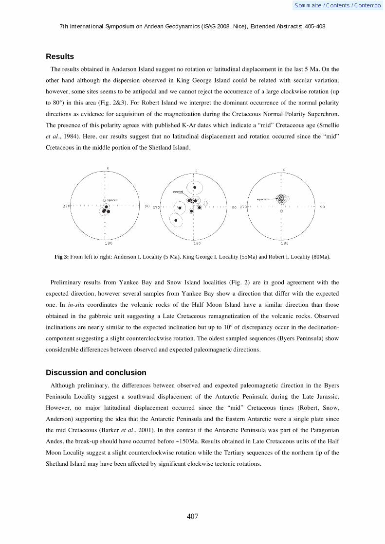
7th International Symposium on Andean Geodynamics (ISAG 2008, Nice), Extended Abstracts: 405-408
407
Results
The results obtained in Anderson Island suggest no rotation or latitudinal displacement in the last 5 Ma. On the
other hand although the dispersion observed in King George Island could be related with secular variation,
however, some sites seems to be antipodal and we cannot reject the occurrence of a large clockwise rotation (up
to 80°) in this area (Fig. 2&3). For Robert Island we interpret the dominant occurrence of the normal polarity
directions as evidence for acquisition of the magnetization during the Cretaceous Normal Polarity Superchron.
The presence of this polarity agrees with published K-Ar dates which indicate a “mid” Cretaceous age (Smellie
et al., 1984). Here, our results suggest that no latitudinal displacement and rotation occurred since the “mid”
Cretaceous in the middle portion of the Shetland Island.
Fig 3: From left to right: Anderson I. Locality (5 Ma), King George I. Locality (55Ma) and Robert I. Locality (80Ma).
Preliminary results from Yankee Bay and Snow Island localities (Fig. 2) are in good agreement with the
expected direction, however several samples from Yankee Bay show a direction that differ with the expected
one. In in-situ coordinates the volcanic rocks of the Half Moon Island have a similar direction than those
obtained in the gabbroic unit suggesting a Late Cretaceous remagnetization of the volcanic rocks. Observed
inclinations are nearly similar to the expected inclination but up to 10º of discrepancy occur in the declination-
component suggesting a slight counterclockwise rotation. The oldest sampled sequences (Byers Peninsula) show
considerable differences between observed and expected paleomagnetic directions.
Discussion and conclusion
Although preliminary, the differences between observed and expected paleomagnetic direction in the Byers
Peninsula Locality suggest a southward displacement of the Antarctic Peninsula during the Late Jurassic.
However, no major latitudinal displacement occurred since the “mid” Cretaceous times (Robert, Snow,
Anderson) supporting the idea that the Antarctic Peninsula and the Eastern Antarctic were a single plate since
the mid Cretaceous (Barker et al., 2001). In this context if the Antarctic Peninsula was part of the Patagonian
Andes, the break-up should have occurred before ~150Ma. Results obtained in Late Cretaceous units of the Half
Moon Locality suggest a slight counterclockwise rotation while the Tertiary sequences of the northern tip of the
Shetland Island may have been affected by significant clockwise tectonic rotations.

7th International Symposium on Andean Geodynamics (ISAG 2008, Nice), Extended Abstracts: 405-408
408
References Barker, P., 2001. Scotia Sea regional tectonic evolution: implications for mantle flow and palaeocirculation. Earth-Science
Reviews 55 1-39. Birkenmajer, K., 2001. Mesozoic and Cenozoic stratigraphic units in parts of the South Shetland Islands and Northern
Antarctic Peninsula. Studia Geologica Polonica, Vol. 118. Ghidella ME, Yáñez G, LaBrecque JL (2002) Revised tectonic implications for the magnetic anomalies of the Western
Weddell sea, Tectonophysics 347: 65-86. Hathway, B., 1997. Nonmarine sedimentation in an Early Cretaceous extensional continental-margin arc, Byers Peninsula,
Linvingston Island, South Shetland Islands. Journal of Sedimentary Research vol. 67, 686-697 Hathway, B. and Lomas, SA. (1998), The Upper Jurassic-Lower Cretaceous Byers Group, South Shetland Islands,
Antarctica: revised stratigraphy and regional correlations. Cretaceous Research 19, 43-67. König, M., and W. Jokat (2006), The Mesozoic breakup of the Weddell Sea, J. Geophys. Res., 111, B12102,
doi:10.1029/2005JB004035. Smellie J.L., Pankhurst R. J., Thomson M. R. A. and Davies R. E. S., (1984), The Geology of the South Shetland Islands:
VI. Stratigraphy, Geochemistry and Evolution. Britsh Antarctic Survey Scientific Report vol. 87.

7th International Symposium on Andean Geodynamics (ISAG 2008, Nice), Extended Abstracts: 409-412
409
Altiplano-Puna elevation budget and thermal isostasy
Claudia Prezzi1, Hans-Jürgen Götze
2, & Sabine Schmidt
2
1 CONICET - Universidad de Buenos Aires, INGEODAV, Dpto. de Ciencias Geológicas, FCEyN, Universidad de
Buenos Aires, Pabellón 2, Ciudad Universitaria, Buenos Aires 1428, Argentina ([email protected]) 2 Institut für Geowissenschaften, Christian Albrechts Universität zu Kiel, Otto-Hahn Platz 1, 24118, Kiel, Germany
KEYWORDS : Central Andes, Altiplano-Puna, elevation, crustal structure, thermal isostasy
Introduction
The most remarkable feature of the Central Andes is the Altiplano-Puna plateau (Fig. 1). This plateau is
300 km wide, 2000 km long, has an average elevation of 3.5 km and a crustal thickness of approximately 70 km.
Very high heat flow values characterize this portion of the Andean chain (e.g. Springer and Foster 1998).
Furthermore, below the Altiplano-Puna the existence of a partial melting zone at mid-crustal depth (Altiplano-
Puna Magma Body) has been established by a number of independent observations (e.g. Yuan et al. 2000). This
interpretation is strongly supported by the presence of a huge concentration of Neogene ignimbrites: the
Altiplano-Puna Volcanic Complex (De Silva 1989). These features suggest that thermal isostasy could play a
role in the compensation of the Altiplano-Puna. Thermal isostasy is the geodynamic process whereby regional
variations in the lithospheric thermal regime cause changes in elevation. Elevation changes result from variations
in rock density in response to thermal expansion (Hasterok 2005). However the thermal input to continental
elevation is difficult to asses, because variations in crustal density and thickness can mask it. The objective of
this study is to reveal the thermal and/or geodynamic contributions to the elevation of the Altiplano-Puna.
Methodology
The effects on elevation of compositional variations (involving both crustal thickness and density) are removed
through an isostatic adjustment. This adjustment normalizes any crustal column to a crustal standard (Hasterok
2005). We considered a standard crustal thickness of 40 km, a standard crustal density of 2.8 Mg/m3, and a
mantle density of 3.3 Mg/m3. Three parameters must be estimated for each studied point to carry out the
normalization: actual topography, actual crustal thickness and actual crustal density. Actual topography is
obtained from the digital elevation model GTOPO30. Actual crustal densities and actual crustal thicknesses are
derived from the 3D crustal density structure developed for the Central Andes between 19°S and 30°S from 3D
forward gravity modeling (Prezzi et al. 2005). To construct the 3D model we considered 6500 gravity
measurements and used the 3D modelling software IGMAS (Götze et al. 1990). The geometry of our gravity
model is very well constrained by a large amount of geophysical and geological data: seismic reflection and
refraction profiles, receiver function analysis, hypocenter locations, magnetotelluric data, different tomographic
studies, thermal models and numerous structural balanced cross sections (e.g. Yuan et al. 2000). The density
values assigned to the different bodies forming the model were computed based on documented chemical and/or
mineralogical composition (e.g. Lucassen et al. 1999) and information and assumptions about pressure-
temperature conditions expected for each body. We included a partial melting zone at midcrustal depths under
the Altiplano-Puna and took into account the presence of a rheologically strong block beneath the Salar de

7th International Symposium on Andean Geodynamics (ISAG 2008, Nice), Extended Abstracts: 409-412
410
Atacama basin. We considered the existence of upper, middle and lower crust. In our model the crust is divided
from west to east in different units which represent the Coastal Cordillera, Precordillera, Western Cordillera,
Altiplano-Puna, Eastern Cordillera, Subandean Ranges and Chaco (Prezzi et al. 2005).
Once the elevation was adjusted for compositional buoyancy, a thermal isostatic relationship was estimated in
order to predict the elevation changes expected for different lithospheric thermal states (Hasterok 2005). We
constructed a family of geotherms assuming 1D steady-state temperature conditions, considering exponential
decrease of heat production with depth and constant thermal conductivity. Using as reference the geotherm that
corresponds to a surface heat flow of 40 mW/m2 and assigning a lithosphere having this thermal state an
elevation of 0 km, we can predict the thermal contribution to the actual elevation for different surface heat flow
data. We compiled surface heat flow data for the Altiplano-Puna, including new values recently published (e.g.
Springer and Foster 1998, Hamza et al. 2005) (Fig. 2).
Figure 1. Location map and morphotectonic units. Figure 2. Heat flow data (mW/m2) and depth to the top of the asthenosphere (km) superimposed on shaded relief map.
Results and conclusions
No correlation exists between heat flow values and the corresponding actual topography (Fig. 3). In contrast,
the compositionally adjusted elevation shows direct correlation with heat flow (Fig. 3), and shows a very good
fit with the predicted thermal elevation. While the RMS misfit between compositionally normalized elevation
and predicted thermal elevation is of 0.76 km, the RMS misfit between actual topography and predicted thermal
elevation is of 3.58 km. Our results suggest that while the thermal contribution to the actual topography of the
Altiplano (north of 21.3°S) and the southern extreme of the Puna (27.3-28.7°S) would be of ~ 0.5 km, the
thermal contribution to the actual topography of the southern Puna (24-27°S) would be of ~ 1.3 km. Previous
works highlighted the fact that the Puna has higher elevation than the Altiplano in spite of showing lower
amount of structural shortening and thinner crust (e.g. Allmendinger et al. 1997, Gerbault et al. 2005).
Shortening values are sufficient to account for crustal cross sectional area in the Altiplano north of 22°S, but are

7th International Symposium on Andean Geodynamics (ISAG 2008, Nice), Extended Abstracts: 409-412
411
less than that needed in the Puna south of 22°S (McQuarrie 2006). Our estimates of the thermal contribution to
the Altiplano and Puna elevation could explain these features. Moreover, our 3D gravity model shows the
presence of deeper asthenosphere below the Altiplano than below the Puna (Fig. 2) (Prezzi et al. 2005).
Particularly, the shallowest asthenosphere is found below the southern Puna (24-27°S), suggesting a possible
relationship between the depth to the top of the asthenosphere and the higher heat flow and the greater thermal
contribution to the elevation. The existence of thinner lithosphere below the southern Puna than below the
northern Puna was previously suggested by other authors (e.g. Whitman et al. 1996). Kay et al. (1994)
documented the eruption of Plio-Quaternary intraplate mafic lavas concentrated around 26°S over thin
continental lithosphere above the central part of a seismic gap in the modern seismic zone. They proposed that
mechanical delamination of a block (or blocks) of continental lithosphere took place during the late Pliocene
below this part of the sourthern Puna. Kay et al. (1994) pointed out that the loss of such lithosphere resulted in
an influx of asthenosphere. These facts coincide with and support our results for the southern Puna.
Unfortunately, there are no surface heat flow data available for the northern Puna (22-24°S), preventing the
evaluation of possible correlations between thermal elevation, asthenospheric depth, the existence of the
Altiplano-Puna Magma Body and of the Altiplano-Puna Volcanic Complex.
Figure 3. Actual topography and compositionally adjusted elevation vs. surface heat flow for the southern Puna (24-27°S), the southern extreme of the Puna (27.3-28.7°S) and the Altiplano (north of 21.3°S). The thermal contribution to elevation predicted for each heat flow value by the thermal isostatic relationship is also shown (Thermal elevation predicted).
With the aim of further validating our results, we compared the estimated thermal contribution to elevation
(normalized elevation) with the residual topography. To calculate the residual topography we assumed that the
Altiplano-Puna is under local isostatic compensation. We used the moho geometry and the densities predicted by
our 3D gravity model (Prezzi et al. 2005) to compute the expected topography considering Airy isostasy (Airy
topography). Then, we obtained the residual elevation by subtracting Airy topography from actual topography.
When we compared the residual topography with the thermal component of the elevation (thermal elevation) a
very good fit is observed (correlation coefficient of 0.98) (Fig. 4) supporting our results. However, the linear
regression parameters (particularly the slope value of 0.80) showed that a portion of the actual topography
(~20%) cannot be explained considering only compositional and thermal effects, suggesting additional
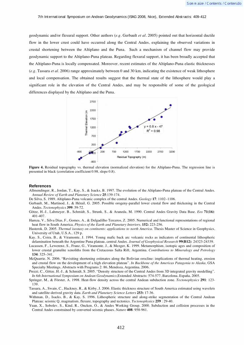
7th International Symposium on Andean Geodynamics (ISAG 2008, Nice), Extended Abstracts: 409-412
412
geodynamic and/or flexural support. Other authors (e.g. Gerbault et al. 2005) pointed out that horizontal ductile
flow in the lower crust could have occurred along the Central Andes, explaining the observed variations in
crustal shortening between the Altiplano and the Puna. Such a mechanism of channel flow may provide
geodynamic support to the Altiplano-Puna plateau. Regarding flexural support, it has been broadly accepted that
the Altiplano-Puna is locally compensated. Moreover, recent estimates of the Altiplano-Puna elastic thicknesses
(e.g. Tassara et al. 2006) range approximately between 0 and 30 km, indicating the existence of weak lithosphere
and local compensation. The obtained results suggest that the thermal state of the lithosphere would play a
significant role in the elevation of the Central Andes, and may be responsible of some of the geological
differences displayed by the Altiplano and the Puna.
Figure 4. Residual topography vs. thermal elevation (normalized elevation) for the Altiplano-Puna. The regression line is presented in black (correlation coefficient 0.98, slope 0.8).
References Allmendinger, R., Jordan, T., Kay, S., & Isacks, B. 1997. The evolution of the Altiplano-Puna plateau of the Central Andes.
Annual Review of Earth and Planetary Science 25:139-174. De Silva, S. 1989. Altiplano-Puna volcanic complex of the central Andes. Geology 17: 1102–1106. Gerbault, M., Martinod, J., & Hérail, G. 2005. Possible orogeny-parallel lower crustal flow and thickening in the Central
Andes. Tectonophysics 399: 59-72. Götze, H.-J., Lahmeyer, B., Schmidt, S., Strunk, S., & Araneda, M. 1990. Central Andes Gravity Data Base. Eos 71(16):
401-407. Hamza, V., Silva Dias, F., Gomes, A., & Delgadilho Terceros, Z. 2005. Numerical and functional representations of regional
heat flow in South America. Physics of the Earth and Planetary Interiors, 152: 223-256. Hasterok, D. 2005. Thermal isostasy on continents: applications to north America. Thesis Master of Science in Geophysics,
University of Utah, U.S.A., 129 p. Kay, S., Coira, B., & Viramonte, J. 1994. Young mafic back arc volcanic rocks as indicators of continental lithospheric
delamination beneath the Argentine Puna plateau, central Andes. Journal of Geophysical Research 99(B12): 24323-24339. Lucassen, F., Lewerenz, S., Franz, G., Viramonte, J., & Mezger, K. 1999. Metamorphism, isotopic ages and composition of
lower crustal granulite xenoliths from the Cretaceous Salta Rift, Argentina. Contributions to Mineralogy and Petrology 134: 325–341.
McQuarrie, N. 2006. “Revisiting shortening estimates along the Bolivian orocline: implications of thermal heating, erosion and crustal flow on the development of a high elevation plateau”. In Backbone of the Americas Patagonia to Alaska, GSA Specialty Meetings, Abstracts with Programs 2: 86, Mendoza, Argentina, 2006.
Prezzi, C., Götze, H.-J., & Schmidt, S. 2005. “Density structure of the Central Andes from 3D integrated gravity modelling”. In 6th International Symposium on Andean Geodynamics,Extended Abstracts: 574-577, Barcelona, España, 2005.
Springer, M., & Förster, A. 1998. Heat-flow density across the central Andean subduction zone. Tectonophysics 291: 123-139.
Tassara, A., Swain, C., Hackney, R., & Kirby, J. 2006. Elastic thickness structure of South America estimated using wavelets and satellite-derived gravity data. Earth and Planetary Science Letters 253: 17-36.
Withman, D., Isacks, B., & Kay, S. 1996. Lithospheric structure and along-strike segmentation of the Central Andean Plateau: seismic Q, magmatism, flexure, topography and tectonics. Tectonophysics 259 : 29-40.
Yuan, X., Sobolev, S., Kind, R., Oncken, O., & Andes Working Group, 2000. Subduction and collision processes in the Central Andes constrained by converted seismic phases. Nature 408: 958-961.

7th International Symposium on Andean Geodynamics (ISAG 2008, Nice), Extended Abstracts: 413-416
413
Subduction partitioning evidenced by crustal earthquakes along the Chilean Andes
Jorge Quezada & Klaus Bataille
Universidad de Concepción, Casilla 160-C, Concepción, Chile ([email protected], [email protected])
KEYWORDS : oblique, subduction, partitioning, crustal, earthquakes
Oblique subduction could produce partitioning or not. In the last case, the deformation is distributed decreasing
from trench to arc (Bevis & Martel, 2001). In the first case there are crustal (upper plate) strike slip faults arc
parallel located in the arc zone that generated a sliver in the forearc (Bevis & Martel, 2001). A good example of
this situation is the Sumatran fault in Indonesia (Fitch, 1972, McCaffrey et al., 2000). In the chilean segment of
central and southern Andes (18,5-46ºS) occurs the subduction of Nazca Plate beneath South American one at
average direction of N77ºE with a convergence velocity between 6,1-7,9 cm/y (DeMets et al., 1994; Tamaki,
1999; Bevis et al., 2001) increasing the magnitude of this velocity southward. The arc has a trend of ~N10ºW
north 22ºS and ~N10ºE south 23ºS (except 31-33ºS, N10ºW), so the subduction is oblique to margin. Along the
chilean Andes, there are two main fault zones that evidences subduction partitioning, the Precordilleran Fault
Zone, PFZ (~20-25ºS) and the Liquiñe-Ofqui Fault Zone, LOFZ (~39-47ºS). Both fault zones had dextral strike
slip activity during the Neogene and Quaternary (Cembrano et al., 2002, Victor et al., 2004, Hoffmann-Rothe et
al., 2006). So a forearc sliver was moved northward. Recent GPS studies (Wang et al., 2007) evidence a
northward sliver movement west of Liquiñe-Ofqui Fault Zone between 42-44ºS.
AFZ
PFZ
LO
FZ
N
Chile Argentina
Bolivia
Peru
0 500 km
V~7 cm/y
2001
1995
1960
2001
2002
1987
2004
2006
1989
2007
1965
2007
Chusmiza
Aroma
Cipreses
Curicó
Ralco
Lonquimay
Ays én
Hudson
Pacific
Oce
an
1985
JFR
1958
Figure 1. Focal mechanisms of crustal earthquakes considered in this study (Hudson are approximate, taken from Lavenu & Cembrano, 1999 and Hoffmann-Rothe et al., 2006). The main faults are indicated. Ellipses shows rupture areas of subduction earthquakes.

7th International Symposium on Andean Geodynamics (ISAG 2008, Nice), Extended Abstracts: 413-416
414
The occurrence of subduction partitioning along chilean Andes is evidenced also by crustal earthquakes in the
arc zone with strike-slip focal mechanism. Table 1 summarizes the main crustal earthquakes of strike slip focal
mechanism that occurred in the arc zone in the last half century. Fig. 1 shows the focal mechanisms and location
of these events. All earthquakes are shallow and have focal mechanism indicating high angle ~N/S faults, right
lateral movements. Another earthquake occurred in 1958 (Cajón del Maipo / Las Melosas Earthquake) at
33,83ºS/70,16ºW with a magnitude close to 7. Lomnitz (1958) established for this earthquake right lateral
movement for a N10ºW fault using teleseismic analysis but Pardo & Acevedo (1984) established left lateral
movement for a ~NS fault. Because this contradiction, both papers exhibits strong arguments for their results,
and the fact that this earthquake occurred in the area of the Juan Fernandez Ridge subduction (JFR, Fig. 1) that
can produced local stress changes, so the west-east fault could be the real, we eliminated this earthquake in our
analysis. The Aroma, Chusmiza, Curicó, Ralco and Aysén earthquakes occurred recently. In the case of Aroma
and Chusmiza earthquakes, the aftershocks are aligned N-S (Comte et al., 2003) indicating that this is the
orientation of the fault. Bulletins from Servicio Sismológico of the Departamento de Geofísica of the
Universidad de Chile (www.dgf.uchile.cl) indicate that the aftershocks of Curicó and Aysén earthquakes are
aligned N-S, so this is the orientation of the fault that generated these earthquakes. Hudson, Aysén, Lonquimay
and Ralco earthquakes could be associated to Liquiñe-Ofqui Fault Zone branches. Aroma and Chusmiza
earthquakes are located north of the northern end of the Precordilleran Fault Zone. Farias et al. (2005) related
both earthquakes with strike changes of flexures (associated to west vergent reverse faults) in the Precordillera
(forearc) area. Curicó and Cipreses earthquakes are located north of the Liquiñe-Ofqui Fault Zone. The northern
end of the Liquiñe-Ofqui fault Zone is diffuse but there are some N-S lineaments in the chilean Andes (more
clear in Digital Elevation Models rather Satellite Images) between 35-38ºS that suggest a northward
prolongation of this fault zone or similar structures. Liquiñe-Ofqui Fault Zone evidences subduction partitioning
between 38 to 47ºS; the Ralco, Lonquimay, Aysén and Hudson earthquakes and the GPS studies of Wang et al.
(2007) indicates at least recent movement in segments of Liquiñe-Ofqui-Fault Zone. The Curicó and Cipreses
earthquakes located north of this fault zone, suggests that the subduction partitioning continues northward
Liquiñe-Ofqui Fault Zone at least by 300 km considering also that there are not many geometric, tectonic and
geologic differences along chilean Andes between 34-47ºS. Similar case occurs with Aroma and Chusmiza
earthquakes that could be indicators that subduction partitioning continues north of Precordilleran Fault Zone. A
great number of faults and folds along chilean Andes (forearc and arc zone) suggests the presence of high angle
west vergent reverse faults (Muñoz & Charrier, 1996; Cembrano et al., 2002; Victor et al., 2004; Farias et al.,
2005). These are consequence of normal arc component of the subduction. In the back arc zone in bolivian and
argentinian Andes, the main faults are thrust (low angle east vergent) also due to normal component of the
subduction. The arc parallel component of the subduction is lesser than the normal component. Lavenu &
Cembrano (1999) estimated 2,8 cm/y of arc parallel component of the 7,9 cm/y convergence velocity in the
Liquiñe-ofqui Fault Zone. The small along strike component is enough to generate a forearc sliver. The
Precordilleran and Liquiñe-Ofqui fault zones, the majority of the crustal earthquakes shown in Table 1 and the
GPS studies (Wang et al., 2007) indicates the presence of a sliver, but the distributed deformation (Bevis &
Martel, 2001) in the forearc can not be neglected due to the lack of a dense GPS network that could constrain

7th International Symposium on Andean Geodynamics (ISAG 2008, Nice), Extended Abstracts: 413-416
415
better the deformation and the relatively few amount of crustal earthquakes with focal mechanism known in the
arc and forearc zone of chilean Andes. Both cases of subduction partitioning (Bevis & Martel, 2001) are shown
in Hoffmann-Rothe et al. (2006) and occurs along the arc zone of chilean Andes. Rosenau et al. (2006)
concluded that there is complete partitioning in the south end of Liquiñe-Ofqui Fault, decreasing northward. It
can be considered that there is a continue subduction partitioning along all chilean Andes between 18,5-47ºS but
the magnitude of the earthquakes considered indicates ruptures of segments between 5-20 km, very small in the
context of 3200 km length of chilean Andes considered in this study and there are no clear faults as
Precordilleran and Liquiñe Ofqui Fault Zone in the arc zone of chilean Andes between both. The along strike
heterogeneities, like reological propierties, seismic interplate coupling, age of plates, Juan Fernandez Ridge/flat
subduction (29-34ºS), local buttressing effects, changes in the orientation of the arc (north and south 23ºS, and
Wadatti-Benioff zone, ie. Ghepart symmetry zone ~21ºS) and stress changes due to the occurrence of subduction
interplate thrust earthquakes may influence the degree of partitioning. So this partitioning must be non uniform
along all chilean Andes.
Table 1. Main earthquakes of NS strike, right lateral movement faults along chilean Andes. 1 Chinn & Isacks, 1983.
2
Barrientos & Eisenberg, 1988. 3 Harvard University Centroid Moment Tensors.
The P axis orientation of the earthquakes considered in this study (Table 1) is similar to the convergence
velocity direction between Nazca and South American plates. P axis is the principal shortening axis in a fault so
these similar values indicates that the earthquakes considered in Table 1, are consequence of the subduction
process indicating partitioning.
If we consider the context of these earthquakes in the subduction seismic cycle, one possibility to classify these
events is during the interseismic stage because they are interplate and both plates remains coupled during the
rupture. Coseismic reactivation of strike slip faults during a subduction earthquake must be left lateral like
Atacama Fault Zone (AFZ) and faults located in the Mejillones Peninsula (23,2ºS) during the 1995 Antofagasta
Earthquake (Delouis, et al., 1998) because the extension of the South American Plate during the decoupling
process is in the same direction but opposite sense of convergence (towards SW). Other possibility is that some
of these events are posteismic. In the case of the southern Chile 1960 Mw 9,5 megathrust earthquake, most slip
occurred in the central part of the rupture than in the borders (Barrientos & Ward, 1990), so the Hudson 1965
earthquake located in the southern border of the 1960 may be influenced by the 1960 rupture or change in stress
regime. Similar explanation was done for the Aroma 2001 earthquake (Comte et al., 2003) that followed by few
months the 2001 southern Peru Mw=8,4 subduction earthquake (Fig. 1). Also the Cipreses earthquake is located
Earthquake Date Epicenter
(Lat/Long)
Depth
(km)
Magn.
NP 1
Stk./Dip/Slip
NP 2
Stk./Dip/Slip
P axis
Azm/Plg
T Axis
Azm/Plg
Hudson1 28/11/65 -45,77/-72,9 33 6 Ms
Cipreses2,3
13/9/87 -34,2/-70,15 6,7 5,7 Ms 27/58/176 110/87/32 249/20 348,24
Lonquimay3 24/2/89 -39,2 / -71,83 15 5,3 Mw 9/70/150 110/62/23 61/5 327/35
Aroma3 24/7/01 -19,44/ -69,18 15 6,3 Mw 14/46/-169 276/82/-44 225/36 333/23
Chusmiza3 14/1/02 -19,22/-68,6 38,4 5,6 Mw 13/53/-157 275/80/-37 228/33 329/17
Curicó3 28/8/04 -35,21/-70,36 16 6,5 Mw 21/61/-178 290/88/-29 241/21 339/19
Ralco3 31/12/06 -38,04/-71,4 17,7 5,6 Mw 31/86/178 121/88/4 256/1 346/4
Aysén3 23/1/07 -45,46/-73,07 12,8 5,4 Mw 354/89/-179 264/89/-1 219/2 129/0
Aysén3 3/2/07 -45,51/-73,03 12 5,4 Mw 182/84/-174 91/84/-6 47/8 316/0
Aysén3 23/02/07 -45,51/-73,08 16,6 5,7 Mw 181/79/-160 87/70/-12 46/22 313/6
Aysén3 21/04/07 -45,48/-72,95 12 6,3 Mw 354/88/176 84/86/2 39/1 309/5

7th International Symposium on Andean Geodynamics (ISAG 2008, Nice), Extended Abstracts: 413-416
416
in the southern border of the 1985 Mw 8 central Chile subduction earthquake and occurred two years after this
event in a similar situation of the former cases.
In summary, the arc parallel component of subduction are lesser than normal one in central and southern
Andes, the energy cumulated in this process is enough to generates earthquakes of dextral strike slip focal
mechanism of Mw=6,5 (like Curicó earthquake) along the arc zone of chilean Andes but the existence of
Liquiñe-Ofqui Fault Zone or the Precordilleran Fault Zone indicates the possibility of bigger ruptures and may
be considered in seismic risk analysis.
References Barrientos, S., Eisenberg, A., 1988. Secuencia sismica en la zona cordillerana al interior de Rancagua. In: V Congreso
Geologico Chileno, Santiago, Vol. II: F121-F132. Barrientos, S., Ward, S. 1990. The 1960 Chile earthquake: Inversion for slip distribution from surface deformation.
Geophysical Journal International 103: 589-598. Bevis, M., Martel, S. 2001. Oblique plate convergence and interseismic strain accumulation. Geochem Geophys Geosyst 2:
doi 2000GC000125 Cembrano, J., Lavenu, A., Reynolds, P., Arancibia, G., Lopez, G., Sanhueza, A. 2002. Late Cenozoic transpressional ductile
deformation north of the Nazca–South America– Antarctica triple junction, Tectonophysics 354: 289–314. Chinn, D, Isacks, B. 1983. Accurate source depths and focal mechanisms of shallow earthquakes in western South America
and in the New Hebrides island arc. Tectonics 2(6):529–563. Comte, D., Dorbath, C., Dorbath, L., Farías, M., David, C., Haessler, H., Glass, B., Correa, E., Balmaceda, I., Cruz, A., Ruz,
L. 2003. Distribución temporal y en profundidad de las réplicas del sismo superficial de Aroma, norte de Chile del 24 de Julio de (2001). In: X Congreso Geológico Chileno 2003, Universidad de Concepción, Chile: CD.
Delouis, B., Philip, H., Dorbath, L., Cisternas, A. 1998. Recent crustal deformation in the Antofagasta region (northern Chile) and the subduction process. Geophysical Journal Internacional 132: 302-338.
Demets, C., Gordon, R., Argus, D., Stein, S., 1994. Effect of recent revisions to the geomagnetic reversal time scale on estimates of current plate motions. Geophysical Research Letters 21: 2191-2194.
Farias, M., Charrier, R., Comte, D., Martinod, J., Hérail, G. 2005. Late Cenozoic deformation and uplift of the western flank of the Altiplano: Evidence from the depositional, tectonic, and geomorphologic evolution and shallow seismic activity (northern Chile at 19º30’S). Tectonics 24: TC4001, doi:10.1029/2004TC001667, 2005.
Fitch, T 1972. Plate convergence, transcurrent faults and internal deformation adjacent to southeast Asia and the western Pacific. J. Geophys. Res. 77: 4432–4460.
Hoffmann-Rothe, A., N. Kukowski, N. Dresen, G. Echtler, H., Oncken, O., Klotz, J., Scheuber, E., Kellner, A. 2006. Oblique convergence along the Chilean margin: Partitioning, margin-parallel faulting and force interaction at the plate interface. In Oncken, O. (Springer) Eds: The Andes: Active Subduction Orogeny: 125-146.
Lavenu, A., Cembrano, J., 1999. Compressional and transpressional stress pattern for the Pliocene and Quarternary (Andes of central and southern Chile). Journal of Structural Geology 21:1669– 1691.
Lomnitz, C. 1958. Actividad Sísmica en el Cajón del Maipo. Anuario 1959. Boletín Sismológico para 1958. Universidad de Chile: 31-32.
McCaffrey, R., P. Zwick, Y. Bock, L. Prawirodirdjo, J. Genrich, C. Stevens, S. Puntodewo, C. Subarya. 2000. Strain partitioning during oblique plate convergence in northern Sumatra: Geodetic observations and numerical modelling. J. Geophys. Res. 105: 28363–28375.
Muñoz, N., Charrier, R.,1996. A west vergent fault system at the westem border of the Altiplano in Northem Chile: implications for the uplift of the Altiplano-Puna plateau. Jour. of South American Earth Sciences 9: 171-181.
Pardo, M., Acevedo, A. 1984. Mecanismos de foco en la zona de Chile Central. Tralka 2 (3): 279-293. Rosenau, M., D. Melnick, H. Echtler. 2006. Kinematic constraints on intra-arc shear and strain partitioning in the southern
Andes between 38°S and 42°S latitude. Tectonics 25: TC4013, doi:10.1029/2005TC001943. Tamaki, K., 1999. Nuvel-1A calculation results. Ocean Research Institute, University of Tokyo. http://manbow.ori.u-
tokyo.ac.jp/tamaki-bin/post-nuvella. Victor, P., Oncken, O., Glodny, J. 2004., Uplift of the western Altiplano plateau: Evidence from the Precordillera between
20° and 21°S (northern Chile). Tectonics, 23: TC4004, doi:10.1029/2003TC001519. Wang, K., Hu, Y., Bevis, M., Kendrick, E., Smalley, R, Barriga, R, Lauria, E. 2007. Crustal motion in the zone of the 1960
Chile earthquake: Detangling earthquake-cycle deformation and forearc-sliver translation, Geochem. Geophys. Geosyst. 8: Q10010, doi:10.1029/2007GC001721.

7th International Symposium on Andean Geodynamics (ISAG 2008, Nice), Extended Abstracts: 417-420
417
Constraints on delamination from numerical models
Javier Quinteros1, Víctor A. Ramos
1, & Pablo M. Jacovkis
2
1 Lab. de Tectónica Andina – Univ. de Buenos Aires – Pabellón 2, Ciudad Universitaria, 1428 Buenos Aires,
Argentina ([email protected], [email protected]) 2 Instituto de Cálculo and Depto. de Computación – Univ. de Buenos Aires – Pabellón 2, Ciudad Universitaria,
1428 Buenos Aires, Argentina ([email protected])
KEYWORDS : Puna, delamination, numerical models, orogenic collapse, isostatic rebound
The main objective for this experiment was to model the effects of eclogitization on the base of an orogen
whose vertical section is similar to the ones near central Andes (southern Puna/northern Argentina), (Oncken et
al., 2006). To study the phenomenon in a proper way, it was isolated from other types of forces that modify the
dynamics of lithosphere, namely compression, extension or thermal anomalies.
Delamination is one of the explanations for the absence of mantle beneath high plateaus and a particular type
of magmatism in the last stage of the orogenic process (Kay and Kay, 1993). Details about delamination
(England et al., 1988) are known from a conceptual point of view, but some of its aspects are quite difficult to
quantify.
The domain studied consists of the lithosphere and asthenosphere up to 150 km depth and 300 km width. The
orogen is considered to be located in the middle of the domain. Crust is 36 km deep far from the orogen and
60 km deep in its axis, similar to the present Puna (Beck et al., 1996). The crust is divided into upper and lower
crust. The underlying mantle is divided into lithosphere and asthenosphere, bounded by the 1250ºC isotherm.
The boundary conditions for the thermal model are: 20ºC over the surface and 1350ºC over the bottom
boundary. On the lateral boundaries free-slip vertical conditions are imposed and horizontal displacements are
not allowed. Vertical displacements over the bottom boundary are also forbidden.
The orogen is about 3 km height after the stabilization time steps, at the moment when the eclogitized root
appears, as it was proposed in the Puna (Oncken et al., 2006).
All the material that suffers the pressure of more than 55 km of crust is considered to transform into an eclogite
during the first 3.5 My, due to the presence of fluids in the system.
The transformation of the crustal root to eclogite causes orogen collapse due to the increment of weight. In the
base of the crust, due to the density difference between the eclogite and the asthenospheric mantle, the former
tries to go down but this is difficult during the first My because it is stuck to the rigid lower crust. It should be
pointed out that the crustal roots are usually distributed in a horizontal direction that can sometimes prevent the
vertical column from having the necessary mass difference to start the detachment process.
One can see in figure 1 how the crustal root evolves during the simulation. This is pushed from the sides by the
acting convective cells, mainly composed of hot asthenosphere.
Laboratory experiments performed by Leech (2001) show that eclogite is much more ductile than the original
rock and thus would suffer a greater deformation as soon as the system turns unstable and the stress increases.
This ductility will be one of the weak points of the domain from a mechanical point of view. The other will be
the contact between eclogite and the lower crust. The downward pressure that the eclogite exerts and the crustal
rigidity turns the contact between them into a low pressure region, and thus unstable. One can see the

7th International Symposium on Andean Geodynamics (ISAG 2008, Nice), Extended Abstracts: 417-420
418
distribution of density and viscosity for the crustal root of the orogen in figure 2. The contact will receive from
the sides a hot incoming mantle flow, due to its low viscosity.
Figure 1. Evolution of the crustal root during the transformation into eclogite and later detachment. The images belong to the evolution at 0.5 My, 3.4 My, 5 My, 6.2 My, 6.7 My and 8.2 My.
The lateral force exerted by the incoming mantle is not only deforming the eclogite, but also introduced into
the contact between the latter and the crust. The exposure of the contact to higher temperatures and the intense
deformation in the zone that increases the strain rate, results in a decreasing viscosity.

7th International Symposium on Andean Geodynamics (ISAG 2008, Nice), Extended Abstracts: 417-420
419
Figure 2. Detail of the contact between the eclogite and lower crust.
After 3.5 My, the income of fluids ends and the transformation from lower crust to eclogite stops. However,
the delamination process evolves until 7/8 My, when the eclogite detaches from the lower crust and sinks into
the asthenosphere.
Figure 3. Evolution of the maximum orogen elevation during the entire process (0-9 My).

7th International Symposium on Andean Geodynamics (ISAG 2008, Nice), Extended Abstracts: 417-420
420
Other process that is tightly associated with delamination is the isostatic rebound. This effect happens after the
detachment of the eclogite from the lower crust. Then, the crust should elevate in order to compensate the losing
of the heavy crustal root. The evolution of topography associated with the different stages of the delamination
process can be seen in figure 3.
It is shown that the maximum orogen elevation reduces continuously since the first eclogite appears. As the
orogen collapses to compensate the extra weight, lower crust is converted to eclogite, due to the tectonic
stacking and the presence of fluids. Once the system is completely out of fluids, it starts to stabilize slowly.
However, the system gets unstable again as soon as the root detaches from the lower crust. At that moment, the
descendant force that was applied at the base of the crust diminishes and the orogen elevates until a new
stabilization equilibrium is reached.
The evolution of the delamination process in this work is in very good agreement with the results from
tomographic inversion performed by Schurr et al. (2006) further to the north. The presence of a high Qp body at
the base of the easternmost Puna crust is interpreted as a detached part of the roots completely delaminated and
resting on top of the Nazca slab.
Also, the possibility to quantify the orogenic collapse and the isostatic rebound for the andean orogen by
means of numerical models can be a powerful tool in order to establish the time span expected at each stage of
the process.
References Beck, S. L., Zandt, G., Myers, S. C., Wallace, T. C., Silver, P. G., & Drake, L. 1996. Crustal-thickness variations in the
central Andes. Geology 24(5): 407-410. England, P. C., Houseman, G. A., Osmaston, M. F., & Ghosh, S. 1988. The mechanics of tibetan plateau. Philosophical
Transactions of the Royal Society of London 326(1589): 301-320. Kay, R. W., & Kay., S. M. 1993. Delamination and delamination magmatism. Tectonophysics 219: 177-189. Leech, M. L. 2001. Arrested orogenic development: eclogitization, delamination, and tectonic collapse. Earth and Planetary
Science Letters 185: 149-159. Oncken, O., Hindle, D., Kley, J., Elger, K., Victor, P., & Schemmann, K. 2006. “Deformation of the central andean plate
system - Facts, fiction, and constraints for plateau models”. In Oncken, O., Chong, G., Franz, G., Giese, P., Götze, H. J., Ramos, V. A., Strecker, M. R., & Wigger, P. (eds.): The Andes - Active subduction orogeny, Berlin-Heidelberg, Springer: 3-27.
Schurr, B., Rietbrock, A., Asch, G., Kind, R., & Oncken, O. 2006. Evidence for lithospheric detachment in the central Andes from local earthquake tomography. Tectonophysics 415: 203-223.

7th International Symposium on Andean Geodynamics (ISAG 2008, Nice), Extended Abstracts: 421-422
421
Magmatic history of the Fitz Roy Plutonic Complex, Southern Patagonia (Argentina)
C. Ramírez de Arellano, B. Putlitz, & O. Müntener
Institut de Minéralogie et Géochimie, Université de Lausanne, Batiment Anthropole CH-1015 Lausanne,
Switzerland ([email protected])
KEYWORDS : Patagonia, Fitz Roy, Miocene, magmatism, deformation
The Fitz Roy Plutonic Complex (FRPC) belongs to a chain of isolated Miocene plutons in Southern Patagonia,
which are located in an exotic position between the volcanic arc and the Patagonian plateau basalts It has been
suggested that the intrusion of these plutons is related to the subduction of the Chile ridge (e.g. Michael. 1991).
However, the FRPC is not well studied (Kosmal 1997). Here, we present first results based on field observations
and petrography and speculate about the magmatic evolution of the FRCP.
The FRPC is formed by at least four different magmatic units (phase I to IV): a main central granitoid body
(granitic to tonalitic), which is partially surrounded by a syn-magmatically deformed tonalite. We further
distinguish a mafic series with variably deformed diorites, gabbros and gabbro breccias, and an ultramafic series
with pyroxenites and olivine gabbros. The host rocks are composed of Paleozoic – Mesozoic sedimentary and
volcano-sedimentary sequences.
Contact-metamorphism is characterized by the formation of calc-silicates and by the development of cordierite
and andalusite in pelitic host rock composition. The contact between diorites/gabbros and meta-volcanic host
rocks (rhyolitic to dacitic compositions) is typically formed by garnet-bearing mylonites. Preliminary field
observations suggest that these garnets most probably formed due to partial melting of semi-pelitic host rocks.
The central biotite-hornblende granite displays abundant schlieren structures and is locally rich in miarolitic
cavities. Its contacts with the host rock and other plutonic bodies are steep, sharp and everywhere intrusive. The
tonalite shows beautiful synm-agmatic deformation features and variable microstructures (grain size, flow
textures) related to the distance to the gabbro unit. Gabbro xenoliths within the tonalite demonstrate that the
gabbro complex is relatively older with respect to the tonalite. The ultramafic unit shows a wide variety of
mafic-ultramafic rocks and magmatic textures from more continuous domains (100m size) of layered gabbros
and massive pyroxenite to domains rich in magmatic breccias. At the contact to the diorite the ultamafic unit is
characterized by a wide brecciated zone, with meter-sized angular hornblende gabbros, hornblendite and
gabbroic blocks in a tonalitic matrix. Ductile deformation at the macro and microscopic scale are widespread in
the gabbro unit. Locally, a penetrative foliation with a metamorphic mineralogy developed along shear bands
(amph, bt, fsp, qz) was found, indicating deformation under upper greenschist-lower amphibolite facies
conditions.
Based on our field observations and petrographic criteria we propose that the FRPC was formed by several
magmatic cycles. The oldest magmatic phase is probably represented by the mafic to ultramafic intrusions,
which are brecciated along their margins by intruding gabbroic rocks, which forms the second magmatic pulse
(phase II) dominated by olivine-bearing gabbros. These rocks display little evidence of synmagmatic

7th International Symposium on Andean Geodynamics (ISAG 2008, Nice), Extended Abstracts: 421-422
422
deformation. This third intrusive cycle (phase III) is characterized by gabbros (ol-poor or absent) and diorites,
which are heavily deformed under upper greenschist – lower amphibolite facies conditions. The youngest
granitoid-tonalite phase (phase IV) is largely unaffected by post-intrusive deformation. The granitoid textures
and its intrusive contacts with host tonalite and gabbros demonstrate that the granites postdate the older
ultramafic-mafic tonalite suite. The brecciated nature of the tonalite-gabbro contact suggests a brittle - ductile
environment that is probably defined by the different solidus temperatures of gabbroic and tonalitic rocks. We
speculate that there is a time gap between the ultamafic-mafic and the granitoid-tonalite magmatic cycles.
However, at present the age of the FRPC is determined only by a single K-Ar whole rock (granite) age of 18 ± 3
Ma (Nullo et al., 1978). New age determinations are in progress to test whether our field observations are
resolvable on absolute time scales. Preliminary Ar-Ar- ages on amphibole and biotite separates suggest that the
gabbros and diorites are older than the granites.
References Kosmal A., 1997 — Nuevos aportes a la geología de la zona del Cerro Fitz Roy Departamento Lago Argentino, Provincia de
Santa Cruz. Trabajo final de licenciatura. Departamento de Geología de la Universidad de Buenos Aires, Argentina, 111 p. Michael P.J., 1991 — Intrusion of basaltic magma into a crystallizing granitic magma chamber: The Cordillera Paine pluton
in southern Chile, by in situ fractional crystallization. Contributions to Mineralogy and Petrology, 108: 396-418. Nullo F., Proserpio C., Ramos V. & Rabassa J., 1978 — “Estratigrafía y Tectónica de la vertiente este del hielo Continental
Patagónico, Argentina-Chile” Actas del VII Congreso Geológico Argentino, Neuquén, 1978. Tomo I: 455-470.

7th International Symposium on Andean Geodynamics (ISAG 2008, Nice), Extended Abstracts: 423-426
423
Late Cretaceous synorogenic deposits of the Neuquén Basin (36-39°S): Age constraints from U-Pb dating in detrital zircons
Victor A. Ramos1, Marcio Pimentel
2, & Maisa Tunik
3
1 CONICET & Lab. de Tectónica Andina, Universidad de Buenos Aires, Argentina ([email protected])
2 Geochronology Laboratory, Universidade de Brasilia, Brazil ([email protected])
3 CONICET & Universidad Nacional del Comahue, Neuquén, Argentina ([email protected])
KEYWORDS : Central Andes, uplift, detrital zircons, synorogenic deposits, Cretaceous
Introduction
The inception of orogenic uplift in the Neuquén Basin was subject of intense debate in the last decades. Some
authors favour the initiation of the orogenic shortening and development of the foreland basin stage in the latest
Cretaceous associated with the deposition of the Malargüe Group during Maastrichtian-Paleocene times (Uliana
& Dellapé 1981, Legarreta &Uliana 1991), with the major orogenic uplift during the Miocene time. However,
since the early proposals of Keildel (1921) of the Patagónides orogeny, which was associated by Groeber (1951)
with the intersenonian movements, some authors favour the Late Cretaceous as the main orogenic episode that
developed the Agrio fold-and-thrust belt in the Neuquén Basin (Fig. 1) (Ramos & Folguera 2005). Although a
Late Cretaceous age was generally accepted for the Neuquén Group continental deposits (see Fig. 2), some
authors support depositional systems derived from the eastern foreland. In order to elucidate the provenance of
the Neuquén Group and add some constraints to its age a detrital zircon analysis has been made.
Regional geology and tectonic setting
The Neuquén Basin is a typical multistage retroarc basin developed in the eastern slope of the Andes during
Jurassic to Cenozoic times (Ramos & Folguera 2005). The early sedimentation was controlled by the
paleogeography of the rift systems developed during the Triassic and Early Jurassic (Franzese & Spalleti 2001,
Vergani et al. 1995). It was followed by thermal subsidence associated with the initiation of the subduction
along the Pacific margin, and influenced by changes in the direction and intensity of the convergence vector
(Mosquera & Ramos 2006). As a consequence of these variations several cycles of sedimentation and no-
deposition associated with sea-level changes were recorded in a thermal subsiding retroarc basin, with minor and
local interruptions. A drastic change occurred in the Late Cretaceous when the first continental molasses were
deposited in the basin represented by the Neuquén Group deposits. The ages of these sequences were poorly
constrained by abundant dinosaurs, charophytes, ostracods, and plant remains (Legarreta & Uliana 1999). Figure
2 shows the main units and their accepted ages.
Methodology
Sampling was conducted beneath and above the angular unconformity that separates the Rayoso Formation
from the Neuquén Group. All the samples in the Neuquén Group were taken from the basal units corresponding
to the Candeleros Formation. Sampled stratigraphic horizons are indicated in figure 2.
Zircon separation was carried out at the Geochronology Laboratory of the Universidade de Brasilia. Heavy
mineral concentrates were obtained using conventional gravimetric and magnetic techniques. Final purification

7th International Symposium on Andean Geodynamics (ISAG 2008, Nice), Extended Abstracts: 423-426
424
was achieved by hand picking using a binocular microscope and selected zircons grains were mounted on an
epoxy mount. The mount was polished to obtain an even surface exposing the interior of zircons grains. Prior to
LA-ICPMS analysis, the mounts were cleaned by carefully rinsing with dilute (2%) HNO3. Once fully dry, the
samples were mounted in a laser cell especially adapted for thick sections, and loaded into an UP 213 Nd:YAG
laser ( = 213 mm), linked to a multi-collector, high-resolution Neptune ICPMS.
Helium was used as the carrier gas and mixed with Argon before entering the ICPMS. Normalization was
carried out using GJ-1 standard zircon (608.5 ± 1.5 My; Jackson et al. 2004) and age calculation were performed
using an in-house developed Excel worksheet, based on ISOPLOT V3 formulas. Correction for common Pb
was carried out in samples with 206Pb/204Pb lower the 1000, using Stacey and Kramers model for the age of
crystallization. U-Pb data were plotted using ISOPLOT V3. Errors for isotopic ratios are presented at the 2
level. More than 50 zircon crystals were analyzed from each sample.
Results
Figure 3 shows the probability density of detrital zircons from representative samples indicated in figure 1. As
a general characteristic, it can be seen that there is a striking difference between detrital zircon distributions
above and beneath the unconformity. The zircons from Rayoso Formation (Fig. 3a) show a dominant provenance
of different basement provinces, and are not derived from the magmatic arc. The youngest zircon in this sample
is 188 million years old, and the main peaks are 272 Ma (Choiyoi province); 482 Ma (Famatinian arc), 523-560
Ma (Pampean arc), and 1070 Ma (Grenville ages), and some older ones. On the other hand, samples derived
from the base of Neuquén Group are dominated by a magmatic arc provenance (Figs. 3b, 3c, 3d).
Figure 1. General location of the Neuquén Basin in the provinces of Mendoza, Neuquén and Río Negro, with indication of the thrust front of the Late Cretaceous deformation. There are indicated the sample localities used in this study.

7th International Symposium on Andean Geodynamics (ISAG 2008, Nice), Extended Abstracts: 423-426
425
a) b)
c) d)
Figure 3. Relative probability ages from detrital zircons from representative samples of the Rayoso Formation and the Neuquén Group of the Neuquén Basin. See location in the figure 1.
It is worth to note that in all the zircons of the Neuquén Group the main peak is representing ages that vary
from 98.6 to 130 Ma (Fig. 4), which clearly demonstrate that they are derived from the magmatic arc. There are
no Early Cretaceous rocks exposed east of the orogenic front. This striking change in the provenance rules out
the possibility that the sediments of the base of the Neuquén Group could be derived from the foreland. Besides,
in these samples only very few recycled zircons are from the Choiyoi province or the Famatinian belt.
Figure 2. Stratigraphic location of the sampled units above and beneath of the Late Cretaceous unconformity.

7th International Symposium on Andean Geodynamics (ISAG 2008, Nice), Extended Abstracts: 423-426
426
Figure 3. Relative probability ages from detrital zircons from the Neuquén Group showing the Cretaceous and Jurassic peaks, both derived from the magmatic arc. Plot of all GN-samples shown in the figure 1.
Concluding remarks
The age patterns of the detrital zircons analyzed by ICPMS show contrasting features indicating different
sources in their provenances. One population is very similar to the standard pattern of the Early Cretaceous
deposits, where the detrital zircons are mainly derived from the foreland region and therefore matching the age
distribution of the basement provinces. In these sequences only some isolated and rare tuffs are derived from the
magmatic arc (see Aguirre-Urreta et al. 2008). On the other hand, the detrital zircons from the synorogenic
deposits have a conspicuous pattern of Early Cretaceous ages associated with a minor frequency of Jurassic age.
Both Early Cretaceous and Jurassic ages indicate that the main arc was uplifted and under erosion at the time of
deposition of the Neuquén Group. The youngest ages of the Neuquén Group between 98 and 100 Ma constrain
the maximum age of deposition to the base of the Cenomanian as it has been postulated by its fossil content.
Once more the detrital zircons from sedimentary rocks are contributing to date fossils of poor stratigraphic value.
References Aguirre-Urreta, M.B., Pazos, P.J., Lazo, D.G., Fanning C.M., Litvak, V.D., 2008. First U-Pb SHRIMP age of the Hauterivian
stage, Neuquén Basin, Argentina. Journal of South American Earth Sciences (in press, on line). Franzese, J.R., Spalletti, L.A., 2001. Late Triassic continental extension in southwestern Gondwana: tectonic segmentation
and pre-break-up rifting. Journal of South American Earth Sciences, 14: 257-270. Groeber, P., 1951. La Alta Cordillera entre las latitudes 34° y 29°30'. Instituto Investigaciones de las Ciencias Naturales.
Revista Museo Argentino de Ciencias Naturales Bernardino Rivadavia, (Ciencias Geológicas) 1(5): 1-352. Jackson, S.E., Pearson, N.J., Griffin, W.L., Belousova, E.A., 2004. The application of laser ablation inductively coupled
plasma mass spectrometry to in situ U-Pb zircon geochronology. Chemical Geology 211: 47-69. Keidel, J., 1921. Sobre la distribución de los depósitos glaciares del Pérmico conocidos en la Argentina y su significa¬ción
para la estratigrafía de la serie del Gondwana y la paleogeografía del Hemisferio Austral. Academia Nacional de Ciencias, Boletín 25: 239 368.
Legarreta L., Uliana, M.A., 1991. Jurassic-Cretaceous marine oscillations and geometry of back-arc basin fill, central Argentine Andes. International Association of Sedimentology, Special Publication 12: 429-450.
Legarreta, L., Uliana, M.A., 1999. El Jurásico y Cretácico de la Cordillera Principal y la Cuenca Neuquina. In R. Caminos (ed.) Geología Argentina, Instituto de Geología y Recursos Minerales, Anales 29(3): 399-416.
Mosquera, A., Ramos, V.A., 2006. Intraplate deformation in the Neuquén Basin. In Kay, S.M., Ramos, V.A. (eds.) Evolution of an Andean margin: A tectonic and magmatic view from the Andes to the Neuquén Basin (35°–39°S latitude). Geological Society of America, Special Paper 407: 97-124.
Ramos V.A., Folguera, A. 2005. Tectonic evolution of the Andes of Neuquén: Constraints derived from the magmatic arc and foreland deformation In G. Veiga et al. (eds.) The Neuquén Basin: A case study in sequence stratigraphy and basin dynamics. The Geological Society, Special Publication 252: 15-35.
Uliana, M.A, Dellapé, D.A., 1981. Estratigrafía y evolución paleoambiental de la sucesión Maastrichtiana-eoterciaria del engolfamiento Neuquino (Patagonia Septentrional). 8° Congreso Geológico Argentino (San Luis), Actas 3: 673-711.
Vergani, G., Tankard, A.J. Belotti H.J., Welsnik, H.J. 1995. Tectonic Evolution and Paleogeography of the Neuquén basin. In Tankard, A.J., Suárez Sorucco, R., Welsnik, H.J. (eds.) Petroleum Basins of South America. AAPG Memoir 62: 383-402.

7th International Symposium on Andean Geodynamics (ISAG 2008, Nice), Extended Abstracts: 427-430
427
Revisiting accretionary history and magma sources in the Southern Andes: Time variation of “typical Andean granites”
C.W. Rapela1, R.J. Pankhurst
2, J.A. Dahlquist
3, E.G. Baldo
3, C. Casquet
4, & C. Galindo
4
1
CIG-CONICET-UNLP, Calle 1 Nº 644, 1900, La Plata, Argentina ([email protected]) 2
British Geological Survey, Keyworth, Nottingham NG12 5GG, UK ([email protected]) 3 CICTERRA-CONICET-UNC, Av. Vélez Sarsfield 1611, X5016CGA-Córdoba, Argentina
([email protected]). 4
Dep. Petrol. y Geoquím., Universidad Complutense, 28040 Madrid, Spain ([email protected])
KEYWORDS : Southern Andes, Andean granites, subduction, continental accretion
Southern Andes: accretionary history of the basement blocks
The composition and distribution of Andean magmas are strongly influenced by the age and extent of the
different basement blocks beneath the modern Andes. In particular, radical revision of southwestern Gonwana
assembly models depicted in recent studies has to be taken into account when considering the variation with time
of the early pre-Andean and Andean subduction-related granitic magmas (Fig. 1): (i) Palaeomagnetic studies
indicate that one of the most important assembly episodes occurred during the Pampean-Araguaia collisional
orogeny (540-520 Ma), between an Amazonia craton group and the West Africa, Congo-São Francisco, Paraná
and Río de la Plata cratons (Trindade et al., 2006 and references therein); (ii) The Amazonia craton group
included the Arequipa-Antofalla and Western Sierras Pampeanas basement blocks (Rapela et al., 2007), for
which a common metamorphic and magmatic history has been established (Casquet et al., 2006; 2008); (iii)
Further evidence shows that the large Neoproterozoic turbiditic sequence of the Eastern Sierras Pampeanas
(Pampean belt), now bounded to the east by the Palaeoproterozoic Rio de la Plata craton, is a transcurrent terrane
resulting from right-lateral movements along the SW Gondwana margin (Rapela et al., 2007). This dextral
displacement was associated with the oblique collision of the Western Sierras Pampeanas during the Pampean–
Araguaia orogeny, following closure of the intervening Clymene ocean (Fig. 2); (iv) South
Figure 1. Group of cratons and minor blocks amalgamated in the Pampean-Araguaia orogeny (540-515 Ma) (modified from Trindade et al., 2006 and Rapela et al., 2007). TB = Transbrasiliano shear zone.

7th International Symposium on Andean Geodynamics (ISAG 2008, Nice), Extended Abstracts: 427-430
428
of 36ºS, the last recognised accretion to the already assembled Gondwana took place during mid-Carboniferous
time, when Early Carboniferous I-type granites representing a subduction-related magmatic arc was followed by
a collision between continental areas typified by the Deseado and North Patagonian massifs (Pankhurst et al.,
2006).
Figure 2. Precambrian and Early Palaeozoic terrains in the Southern Andes, disclosed by back-thrusting above Miocene “flat-slab” subduction (28º - 33ºS).
Subduction associated with pre-Andean episodes was related to Wilson cycles of ocean opening and closing,
where the final event is either a continent-continent collision or large-scale back-arc closure. At 30º-34ºS, three
main episodes of pre-Andean plate convergence are well established: (1) Pampean: 540-528 Ma subduction,
followed by oblique continent-continent collision at 528-515 Ma. The supercontinent grew westwards by lateral
accretion of the Western Sierras Pampeanas Grenvillian block (Rapela et al., 2007), including the Precordillera
(Fig.2). (2) Famatinian: 484-463 Ma convergent episode associated with the opening and closing of a large back-
arc basin in Early to Mid Ordovician times (Pankhurst et al., 2000; Dahlquist et al., 2008) (Fig.2). (3)
Gondwanan: 320-190 Ma. After the intrusion of Devonian and Early Carboniferous (c. 380 and 340 Ma) intra-
plate A-type granites in the Sierras Pampeanas, a new subduction regime started along the palaeo-Pacific margin
in Late Carboniferous times (c. 320 Ma), which included younger pulses (Parada et al., 1999). At 33ºS the Late
Palaeozoic batholiths occur both in the coast range of Chile and in the Frontal Cordillera, suggesting that no
major continental accretion took place after the collision of the Western Sierras Pampeanas and associated
Grenvillian blocks.

7th International Symposium on Andean Geodynamics (ISAG 2008, Nice), Extended Abstracts: 427-430
429
Isotopic and chemical variations of the subduction-related granites
The isotopic and chemical characteristics of the granites emplaced in the different pre-Andean episodes
described above are compared with the typical Andean I-type granites emplaced near the continental margin
after the break-up of Gondwana. The latter are mostly Cretaceous in age at 30º-34ºS, but a complete record from
185 Ma to Tertiary is exposed in the Patagonian batholith and subcordilleran belts (Rapela et al., 2005, Hervé et
al., 2007). The Pampean and Famatinian rocks have chemical and isotopic characteristics that contrast with the
younger Andean bodies. The older pre-Andean rocks show a wide silica range and, although metaluminous I-
type varieties from gabbro to granodiorites are abundant, cordierite-bearing S-type granites are also conspicuous.
S-type granites are rare in the Carboniferous and Andean granites, indicating that melting of sedimentary
material was not common in these episodes. The Ndt values decreases with time, suggesting derivation from
progressively more primitive and depleted sources. Only the younger Gondwanan and the majority of the
Andean granites plot in the “mantle array” of the (87Sr/86Sr)0 – Ndt isotopic diagram, in contrast to the
Palaeozoic granites, most of which lie outside the mantle field, with Ndt < -2 (Fig. 3). This is a remarkably
consistent feature of the Pampean and Famatinian events, as they include abundant amphibole-bearing and
noritic gabbros with less than 50% SiO2 that share the same crustal signature as the intermediate rocks. As there
is no evidence for massive in situ contamination during emplacement in the upper crust, this signature must
reflect the composition of the middle or lower crust (Pankhurst et al. 1998). Depleted mantle model ages (TDM)
for most of the Cambrian and Ordovician rocks, both I- and S-types, are in the interval 1400–1700 Ma indicating
involvement of Palaeo- to Mesoproterozoic sources. Altogether the chemical and isotopic evidence suggests that
the Pampean and Famatinian episodes did not involve significant recycling of young underplated material.
Rather, it indicates melting of an old crustal section, including the underlying subcontinental mantle, to produce
the basic rocks with enriched isotopic signatures. Although isotopically less evolved than the Cambrian–
Ordovician granites, the Carboniferous coastal batholiths of Chile also plot off the “mantle array”, but with
younger (mostly Neoproterozoic) model ages. Recycling of the immature 1000–1200 Ma juvenile Grenvillian
lithosphere in which they are emplaced seems to fit the source isotopic constraints. Only the Andean and
younger Gondwanan granites show depleted signatures (Parada et al. 1999): this is not only a characteristic of
central Chile but also in the Patagonian Andes (Pankhurst et al. 1999, Rapela et al. 2005, Hervé et al., 2007).
Figure 3. Variation of Ndt versus initial 87Sr/86Sr for the granitic rocks emplaced during the main convergence episodes in the Andean sector at 28º- 33ºS (a) and Patagonia (b). Data sources are Pankhurst et al., 1999; 2000, Parada et al., 1999, Rapela et al., 2005, Hervé et al., 2007 and references therein.
7th International Symposium on Andean Geodynamics (ISAG 2008, Nice), Extended Abstracts: 427-430
430
Remarkably, the Andean granites also show a change in isotopic composition with time. For example the Sm–
Nd relationships of granitoids from the Patagonian batholith at 44º–46ºS indicate source compositions that
change from slightly LIL-enriched for the Jurassic and Early Cretaceous rocks, to significantly depleted for the
Late Cretaceous to Early Miocene plutons ( Ndt values between +4 and +6), the latter in turn very similar to
those of the Tertiary to Recent mafic strato-volcanoes of the Southern Volcanic Zones (Pankhurst et al. 1999)
(Fig. 3). This cannot be explained by upper or lower crustal contamination and it has been suggested that melting
occurs in progressively more LIL-depleted mantle sources underlying the Patagonian batholith (Rapela et al.,
2005). The obvious conclusion is that under the label of “typical I-type Andean granite” there is a wide range of
isotopic compositions that shows a general variation towards more depleted mantle sources with time. Isotopic
equivalents of modern Andean granites are uncommon or absent in the extensive Early Paleozoic metaluminous
suites.
References Casquet, C., Pankhurst, R.J., Fanning, C.M., Baldo, E., Galindo, C., Rapela, C.W., González-Casado, J.M. & Dahlquist, J.A.,
2006. U–Pb SHRIMP zircon dating of Grenvillian metamorphism in Western Sierras Pampeanas (Argentina): correlation with the Arequipa Antofalla craton and constraints on the extent of the Precordillera Terrane. Gondwana Research 9: 524-529.
Casquet, C., Pankhurst, R.J., Rapela, C.W., Galindo, C., Fanning, C.M. , Chiaradia, M., Baldo, E., González-Casado, J.M. & Dahlquist, J. A., 2008. The Mesoproterozoic Maz terrane in the Western Sierras Pampeanas, Argentina, equivalent to the Arequipa–Antofalla block of southern Peru? Implications for West Gondwana margin evolution. Gondwana Research 13: 163-175.
Cordani, U.G., D’Agrella-Filho, M.S., Brito-Neves, B.B. & Trindade, R.I.F., 2003. Tearing up Rodinia: the Neoproterozoic palaeogeography of South American cratonic fragments. Terra Nova 15: 350-359.
Dahlquist, J. A., Pankhurst, R. J. , Rapela, C. W., Galindo, C., Alasino, P., Fanning, C. M., Saavedra, J. & Baldo, E. , 2008. New SHRIMP U-Pb data from the Famatina Complex: constraining Early–mid Ordovician famatinian magmatism in the Sierras Pampeanas, Argentina. Geologica Acta (in press).
Hervé, F., Pankhurst, R.J., Fanning, C.M., Calderón, M. & Yaxley, G.M. 2007. The South Patagonian batholith: 150 my of granite magmatism on a static plate margin. Lithos 97: 373-394.
Pankhurst, R.J., Rapela, C.W.& Fanning, C.M., 2000. Age and origin of coeval TTG, I- and S-type granites in the Famatinian belt of NW Argentina. Transactions of the Royal Society of Edinburgh: Earth Sciences 91: 151-168.
Pankhurst, R. J., Rapela, C. W., Saavedra, J., Baldo, E., Dahlquist, J., Pascua, I. & Fanning, C. M. 1998. “The Famatinian magmatic arc in the central Sierras Pampeanas”. In Pankhurst, R. J. & Rapela, C. W. (eds.): The Proto-Andean margin of South America. Geological Society (London) Special Publication 142: 343-367.
Pankhurst, R.J., Weaver, S.D., Hervé, F. & Larrondo, P., 1999. Mesozoic–Cenozoic evolution of the North Patagonian Batholith in Aysén, southern Chile. Journal of the Geological Society, London 156: 673-694.
Pankhurst, R.J., Rapela, C.W., Fanning, C.M. & Márquez, M., 2006. Gondwanide continental collision and the origin of Patagonia. Earth Science Reviews 76: 235-257.
Parada, M.A., Nyström, J.O. & Levi, B., 1999. Multiple sources for the Coastal Batholith of central Chile (31-34º): geochemical and Sr-Nd isotopic evidence and tectonic implications. Lithos 46: 505-521.
Rapela, C.W., 2000. “Accretionary history and magma sources in the Southern Andes”. 31st. t International Geological Congress, Rio 2000, Special Simposia F-2 "Andean Tectonics and Magmatism" -(LP). Abstract Volume (CD-ROM), 4p. 2figs.
Rapela, C.W., Pankhurst, R.J., Fanning, C.M. & Hervé, F., 2005. “Pacific subduction coeval with the Karoo mantle plume: the Early Jurassic Subcordilleran Belt of northwestern Patagonia”. In Vaughan, A. P. M., Leat, P. T. & Pankhurst, R. J. (eds.): Terrane Accretion Processes at the Pacific Margin of Gondwana. Geological Society (London) Special Publication 246: 217-239.
Rapela, C.W. , Pankhurst, R.J., Casquet, C., Fanning, C.M., Baldo, E.G., González-Casado, J.M., Galindo, C. & Dahlquist, J., 2007. The Río de la Plata craton and the assembly of SW Gondwana. Earth Science Reviews 83: 49-82.
Trindade, R.I.F., D´Agrella-Filho, M.S., Epof, I. & Brito Neves, B.B., 2006. Paleomagnetism of Early Cambrian Itabaiana mafia dikes (NE Brazil) and the final assembly of Gondwana. Earth and Planetary Science Letters 244: 361-377.

7th International Symposium on Andean Geodynamics (ISAG 2008, Nice), Extended Abstracts: 431-434
431
Recent debris-flows and megaturbidite in a confined basin of the North Ecuador subduction trench
G. Ratzov, J.-Y. Collot, M. Sosson, & S. Migeon
Geosciences Azur: UNSA – CNRS – IRD – UPMC. BP 48 port de la Darse, 06230 Villefranche-sur-Mer, France
([email protected], [email protected], [email protected], [email protected])
KEYWORDS : trench, debris flow, megaturbdite, Ecuador
Introduction
Mass wasting plays a major role on sediment transport and distribution, and is largely responsible for shaping
the seafloor of both deep sea and coastal environments. Multiple processes have been proposed for slope failures
and associated deposits, ranging from rock falls to turbidity currents [Mulder and Cochonat, 1996]. Factors
promoting submarine landslides include rapid sediment accumulation, slope increase, excess pore pressure,
eustatic sea-level variations, and tectonics and earthquakes [Hampton, et al., 1996].
Tectonics and earthquakes are of particular importance along active margins where slope failures deposits can
be used as a marker for tectonic activity [Goldfinger et al., 2003]. At subduction zones, the nature and physical
properties of sediment dragged into the subduction play a major role on inter plate frictional conditions
[Calahorrano, et al., 2008] and thus on upper plate erosion, accretion, and earthquake rupture propagation. The
objectives of this study are 1) to discriminate mass wasting and turbidite deposits into the trench, 2) constrain
their extent, 3) estimate their time recurrence and 4) determine their origin, in order to better constrain the nature
of sediments entering subduction.
To achieve these objective, the Amadeus cruise conducted onboard of the R/V L’Atalante in 2005 acquired
new multibeam bathymetry data (150m resolution), 3-5kHz Chirp high resolution lines, 6 channels multichannel
seismic data, as well as gravity core. Only bathymetric and Chirp data will be presented here.
Geological setting
The north Ecuador / south Colombia active margin is located along Northwestern South America, where the
Nazca plate underthrusts eastward the South America plate (Fig.1) with a 58mm/year convergence rate
[Trenkamp, et al., 2002]. Between the Carnegie Ridge at latitude 0° and the Galera Seamounts at latitude
1°30’N, the trench is poorly sedimented and shows numerous topographic asperities such as fault scarps and
seamounts. In this region, the margin undergoes tectonic erosion [Collot, et al., 2002] and shows a small frontal
wedge. The area is seismically active and has been submitted to major subduction earthquakes in 1906
(Mw=8.8) and 1942 (Mw=7.7)[Beck and Ruff, 1984]. Onshore, the Coastal cordillera undergoes active uplift
probably since 1.1 Ma [Pedoja, et al., 2006]. Coastal cordillera’s uplift has caused migration of the Andean
drainage system northward to Esmeraldas, and southward to the Gulf of Guayaquil so that, in the study area
sediment supply to the trench is limited.

7th International Symposium on Andean Geodynamics (ISAG 2008, Nice), Extended Abstracts: 431-434
432
Results and interpretations
Trench Morphology
Two series of structural lineations control the trench in the study area (Fig 2). NNE – SSW-trending, linear
scarps parallel to the trench are interpreted as normal faults related to bending of the plate, and WSW- ENE
trending lineaments reflect the structural grain of the oceanic plate. The later lineaments form a series of small
relief, structural ridges (SR), which delineate sub-basins in the trench. The most spectacular is the rectangular
Galera Basin, bounded northward by the 1200-m-high Galera Seamount, and by SR1, southward. Numerous
arcuate scarps affect both the toe of the continental slope and the basement highs in the trench. These scarps may
be scars related to slope instabilities.
Sedimentary units
The trench sedimentary fill reveals six main seismic units in the Galera basin (Fig.3)
- H1 and H2 have a well-layered continuous and horizontal medium to high amplitude reflection facies.
- U1df and U2df are both characterised by a semi transparent low amplitude chaotic facies with a hummocky
top surface. U2df exhibits irregular upper and lower surfaces, the lower being clearly erosive on unit H2.
- U2mt exhibits transparent facies with regular and sharp upper and lower boundaries. The base of U2mt is
outlined by a high amplitude reflection.
- U3 shows transparent facies and seems concordant with both underlying and overlaying stratas.
Core data collected in the southern part of the study area (KAMA03) reveal that seismic facies of unit H1 and
H2 are associated with hemipelagic stratified deposits with few turbidites. No sedimentological data is available
on units U1df to U3. Units U1df and U2df are interpreted as debris flows according to their chaotic semi
transparent facies, irregular boundaries, and erosional base similar to examples described offshore the Iberian
Peninsula by [Lastras, et al., 2004]. U2mt slightly differ from Units U1df and U2df, but has the same
transparent facies, regular boundaries, and high amplitude basal reflection as megaturbidites identified in the
eastern Mediterranean sea [Rebesco, et al., 2000].
Spatial organisation
The debris flows and the megaturbidite are trapped in trench structural basins controlled by the ENE-trending
ridges and NNE-trending faults (Fig4): U1df deposited exclusively within Galera Basin, with thickness ranging
from 2.5 meters in the center of the basin to 7.5 meters along its southern boundary. SR1 acts as a boundary for
U2df and U2mt: U2df is only 7 meters thick southward of SR1, compared to its maximum 45-m thickness in the
Galera basin. U2mt is only present southward from SR1, and the thickness of U2mt decreases abruptly across
each SR (15 m along SR1, 8m and 2m respectively northward and southward of SR2). U2mt is also bounded
westward by the NNE-trending normal faults.
Age of units
In absence of absolute dating we estimated the ages of the mass wasting events based on the geometry of the
trench fill and convergence rate [Mountney and Westbrook, 1997]. Unit H1 mean sedimentation rate was
estimated to be 4 mm/yr. U1df outcrops at the seafloor, and is consequently considered the most recent event.

7th International Symposium on Andean Geodynamics (ISAG 2008, Nice), Extended Abstracts: 431-434
433
No hemipelagic deposits were identified between U2df and U2mt suggesting that U2 megaturbidite is part of the
same event as the U2 debris flow. A 3m-thick H1 layer overlies U2mt. According to the above sedimentation
rate, U2df and U2mt would have deposited ~750 years ago, and U3 ~7000 years ago.
Discussion and conclusions
The structural segmentation of the trench basins and the thickness distribution of the debris flows allow to
discriminating the geographic origin of the flows. U1df’s greatest thickness in the Galera basin is along the

7th International Symposium on Andean Geodynamics (ISAG 2008, Nice), Extended Abstracts: 431-434
434
northern flank of the SR1 suggesting U1df derived from SR1. A small package of U1df deposited on the NW
flank of the Galera basin suggests a contribution of the Galera seamount sedimentary cover to U1df. The
geometry of scours at the base of U2df supports a westward transport, indicating that U2df, and likely U2mt,
derived from the margin toe. However, differences in seismic facies indicate that the U2 debris flow deposited
dominantly in the Galera basin, whilst the more volatile component of the flow have overflown SR1 and
deposited further south in the form of the U2 megaturbidite (Fig4). Alternatively multiple sources located along
the toe of the margin may also account for the observations: the debris flow would have originated from a
northern source, whereas a southern source would be responsible for the contemporaneous megaturbidite. The
origin of U3 is not constrained.
A trigger factor cannot be doubtlessly established. Sediment overloading is unlike to be of importance as
sediment supply is limited. Slope oversteepening and fracturation of underlying rocks may be considered as
facilitating factors because the coast undergoes active uplift and seamount subduction promotes margin basal
erosion. Earthquake is certainly the main trigger factor along such a seismically active margin. The hypothesis of
multiple contemporary sources along the margin for units U2df and U2mt acts in favour of an earthquake
trigger. The time recurrence of the described events is not regular (750 and 6250 years time intervals). If they are
seismically triggered, the slope failures may be related to exceptional earthquakes.
The total thickness of mass wasting deposits identified in our chirp profiles represents ~40% of the total
deposit in the trench and ~65% in the Galera basin indicating a relatively large component of mass wasting
deposits entering subduction. Physical properties of mass wasting deposits (porosity, fluid overpressure…) are
considered different from those of the hemipelagic / turbiditic trench fill. Such differences may be of particular
importance for tectonic accretion, basal erosion, and variations of the interplate coupling.
References Beck, S. L., & L. J. Ruff (1984), The rupture process of the great 1979 Colombia earthquake: evidence for the asperity
model, Journal of Geophysical Research, 89, 9281-9291. Calahorrano, A. B., et al. (2008), Nonlinear variations of the physical properties along the southern Ecuador subduction
channel: Results from depth-migrated seismic data, Earth Planet Sc Lett, 267, 453-467. Collot, J.-Y., et al. (2002), Exploring the Ecuador-Colombia active margin and interplate seismogenic zone, EOS
Transactions, American Geophysical Union, 83, 189-190. Collot, J.-Y., et al. (2006), Mapas del margen continental del Norte de Ecuador y del Suroeste de Colombia : Batimetría,
Releive, Reflectividad Acústica e Interpretación Geológica, publicación IOA-CVM-03-Post. Goldfinger, C., et al. (2003), Holocene earthquake records from the Cascadia subduction zone and northern San Andreas
Fault based on precise dating of offshore turbidites, Annu Rev Earth Pl Sc, 31, 555-577. Hampton, M. A., et al. (1996), Submarine Landslides, Review of Geophysics, 34, 33-59. Lastras, G., et al. (2004), Characterisation of the recent BIG'95 debris flow deposit on the Ebro margin, Western
Mediterranean Sea, after a variety of seismic reflection data, Marine Geology, 213, 235-255. Mountney, N. P., and G. K. Westbrook (1997), Quantitative analysis of Miocene to Recent forearc basin evolution along the
Colombian convergent margin, Basin Research, 9, 177-196. Mulder, T., & P. Cochonat (1996), Classification of offshore mass movements, Journal of Sedimentary Research, 66, 43-57. Pedoja, K., et al. (2006), Plio-Quaternary uplift of the Manta Peninsula and La Plata Island and the subduction of the
Carnegie Ridge, central coast of Ecuador, J S Am Earth Sci, 22, 1-21. Rebesco, M., et al. (2000), Acoustic facies of Holocene megaturbidites in the Eastern Mediterranean, Sediment Geol, 135,
65-74. Trenkamp, R., et al. (2002), Wide plate margin deformation, southern Central America and northwestern South America,
CASA GPS observations, J S Am Earth Sci, 15, 157-171.

7th International Symposium on Andean Geodynamics (ISAG 2008, Nice), Extended Abstracts: 435-438
435
Geomorphology of the Fitzcarrald Arch, Peru, and its relationships with the Nazca plate subduction
V. Regard1, R. Lagnous
1, N. Espurt
1,*, J. Darrozes
1, P. Baby
1,2, M. Roddaz
1, Y. Calderon
2, &
W. Hermoza2,$
1 LMTG, Université de Toulouse-CNRS-IRD-OMP, 14 av. E. Belin 31400 Toulouse, France ([email protected]
mip.fr, [email protected], [email protected], [email protected], [email protected],
[email protected]) 2 PerùPetro SA, Lima, Peru ([email protected], [email protected])
* Now at IFP, Rueil-Malmaison, France $ Now at Repsol, Madrid, Spain
KEYWORDS : geomorphology, hypsometry, ridge subduction, Nazca Ridge, Peru
Figure 1. Geodynamic setting of the Peruvian Andes and its associated Amazonian foreland basin (taken from Espurt, Baby et al. 2007). The flat slab segment is illustrated by isodepth contours of Wadati-Benioff zone (Gutscher, Olivet et al. 1999), and plate convergence vector is from NUVEL1A plate kinematics model (DeMets, Gordon et al. 1990). The western part of the Amazon basin consists of two main subsiding basins —the northern Amazonian foreland basin (NAFB or Marañon-Ucayali basin) and the southern Amazonian foreland basin (SAFB or Beni-Mamore basin) — separated by the antiformal Fitzcarrald Arch. This arch is superimposed on the present-day reconstruction of the subducted part of the Nazca Ridge (black line, Hampel 2002). The ridge reconstruction at 11.2 Ma is shown (white line, Hampel 2002). The easternmost edge of the Nazca Ridge is not involved in the flat slab; it is brought by the sinking slab: its projection at surface may differ from the reconstruction represented by the dotted line. The empty rectangle indicates the study area covered by next figures. The forebulge is located after the works of Aalto et al. (2003) in the SAFB and Roddaz et al. (2005) as the Iquitos Arch in the NAFB.
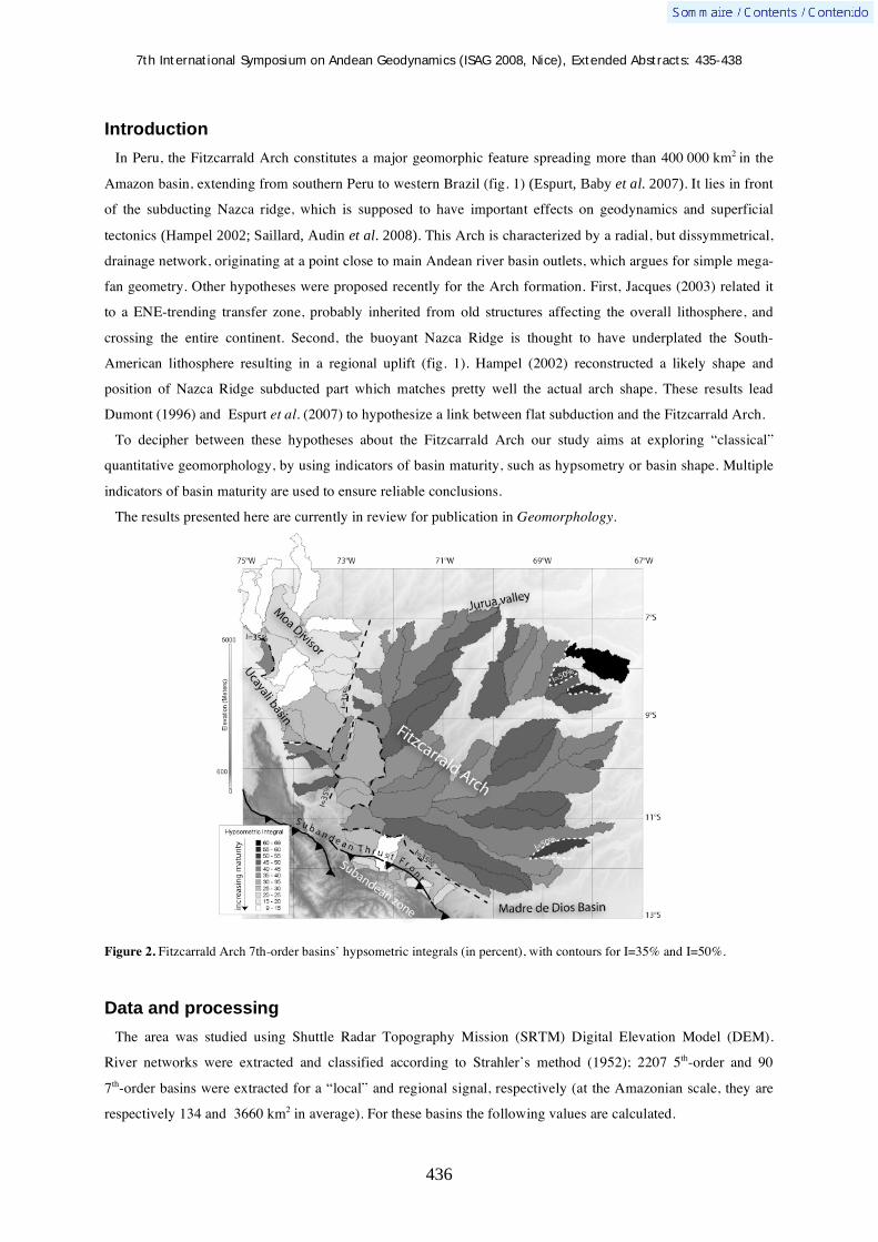
7th International Symposium on Andean Geodynamics (ISAG 2008, Nice), Extended Abstracts: 435-438
436
Introduction
In Peru, the Fitzcarrald Arch constitutes a major geomorphic feature spreading more than 400 000 km2 in the
Amazon basin, extending from southern Peru to western Brazil (fig. 1) (Espurt, Baby et al. 2007). It lies in front
of the subducting Nazca ridge, which is supposed to have important effects on geodynamics and superficial
tectonics (Hampel 2002; Saillard, Audin et al. 2008). This Arch is characterized by a radial, but dissymmetrical,
drainage network, originating at a point close to main Andean river basin outlets, which argues for simple mega-
fan geometry. Other hypotheses were proposed recently for the Arch formation. First, Jacques (2003) related it
to a ENE-trending transfer zone, probably inherited from old structures affecting the overall lithosphere, and
crossing the entire continent. Second, the buoyant Nazca Ridge is thought to have underplated the South-
American lithosphere resulting in a regional uplift (fig. 1). Hampel (2002) reconstructed a likely shape and
position of Nazca Ridge subducted part which matches pretty well the actual arch shape. These results lead
Dumont (1996) and Espurt et al. (2007) to hypothesize a link between flat subduction and the Fitzcarrald Arch.
To decipher between these hypotheses about the Fitzcarrald Arch our study aims at exploring “classical”
quantitative geomorphology, by using indicators of basin maturity, such as hypsometry or basin shape. Multiple
indicators of basin maturity are used to ensure reliable conclusions.
The results presented here are currently in review for publication in Geomorphology.
Figure 2. Fitzcarrald Arch 7th-order basins’ hypsometric integrals (in percent), with contours for I=35% and I=50%.
Data and processing
The area was studied using Shuttle Radar Topography Mission (SRTM) Digital Elevation Model (DEM).
River networks were extracted and classified according to Strahler’s method (1952); 2207 5th-order and 90
7th-order basins were extracted for a “local” and regional signal, respectively (at the Amazonian scale, they are
respectively 134 and 3660 km2 in average). For these basins the following values are calculated.

7th International Symposium on Andean Geodynamics (ISAG 2008, Nice), Extended Abstracts: 435-438
437
- Hypsometry and hypsometric normalized integral (H), given in percent (Strahler 1952);
- Elongation LSE /)/(2= where S is the basin area and L the basin length (Schumm 1956). For
circular, mature basins, E~1, for highly elongated, immature, basins E<<1.
- Local average azimuth (Al) is the average 5th-order basin azimuth over 80 km x 80 km square cells.
Figure 3. Fitzcarrald Arch 5th-order basins’ locally averaged azimuths. Big star represents the approximate location for Fitzcarrald Arch divergent drainage centre. Small stars represent local centres for diverging drainages that disturb the Fitzcarrald drainage shape. The forebulge axis is shown; to the Southeast, after Aalto et al. (2003), to the Northeast after Roddaz et al. (2005).
Results
The main part of the Fitzcarrald Arch is characterized by relatively intermediate to high hypsometric integrals
(between 40 and 50%), and higher values at its north-eastern and eastern boundaries (more than 50%, up to 65%,
fig. 2). Low hypsometric interval values (values between 10 and 25%) are found to the northwest, around the
Moa Divisor range and low to intermediate values (15%-35%) are also present to the southwest, at the boundary
between the Fitzcarrald Arch and the Subandean zone, where some basins cross the Subandean thrust front.
7th-order basins elongation E-values range from 0.33 to 0.88. High E-values are found in the north-western part
(0.42 to 0.78) and in the south-western part of the Arch, near the subandean zone (0.50 to 0.85). Low E-values
are found to the south-east (from 0.33 to 0.66). Intermediate E-values are near the Arch centre and to the north-
east (0.42-0.88; very high E-values being in low-elevation areas).
Local average azimuths for 5th-order basins (fig. 3) show that Arch can be described by one major and a couple
of minor centers for radial drainage systems. The major centre is situated at 10.5°S and 72.5°W (star in fig. 3)
and may explain the first-order drainage pattern of the Arch. It corresponds to the centre of the radial drainage
organization. Superimposed to this large scheme whose wavelength is about 500 km, three second-order
7th International Symposium on Andean Geodynamics (ISAG 2008, Nice), Extended Abstracts: 435-438
438
drainage centers (wavelength ~100 km) cause local divergences (see fig. 3)
Discussion/Conclusion
Both elongations and hypsometric integrals for 5th order and 7th-order basins show a relief maturity decrease
from north-west at Moa Divisor to south-east near the Madre de Dios basin and to the north-east (Altos de Acre);
the most mature basins are found to the south-east. A small part, to the south-west near by the Subandean zone,
displays mature basins. Drainage azimuth helps understanding this scheme. It indicates that there is a first-order
relief, which can be called the Fitzcarrald Arch sensu stricto, whose centre is situated ~100 km north-east from
the Subandean thrust front at 10.5°S and 72.5°W, and which covers the entire study area at the exception of the
Moa Divisor and the Subandean zone. According to the maturity gradient, from mature to the North-West to
immature to the South-East, this relief seems to have formed recently with a north-west to south-east
progression. The Subandean zone is separated from the Amazonian basin by the Subandean thrust front which is
the main tectonic feature observed in the area. Contrary to what expected, it does not affect significantly the
drainage organization, indicating this structure has no or little activity in recent times since it does not disturb
significantly the Fitzcarrald Ach drainage organization.
In sum, there is a clear progress from old basins to young basins from north-west to south-east, fully
compatible with Hampel (2002)’s reconstruction which imply a sliding from NW to SE (cf. fig. 1). Conversely,
our observations do support neither the hypothesis of alluvial fan, since its centre is not located near major basin
outlet, or the Pisco–Abancay–Fitzcarrald lineament which would imply a geanticline structure, different from
our radial structure.
References Aalto, R., L. Maurice-Bourgoin, et al. (2003). "Episodic sediment accumulation on Amazonian flood plains influenced by El
Nino/Southern Oscillation." Nature 425(6957): 493-497. DeMets, C., R. G. Gordon, et al. (1990). "Current Plate Motions." Geoph. J. Int. 101: 425-478. Dumont, J. F. (1996). "Neotectonics of the Subandes-Brazilian craton boundary using geomorphological data: the Maranon
and Beni basins." Tectonophysics 259(1-3): 137. Espurt, N., P. Baby, et al. (2007). "How does the Nazca Ridge subduction influence the modern Amazonian foreland basin?"
Geology 35(6): 515-518. Gutscher, M. A., J. L. Olivet, et al. (1999). "The "lost Inca Plateau": cause of flat subduction beneath Peru?" Earth And
Planetary Science Letters 171(3): 335-341. Hampel, A. (2002). "The migration history of the Nazca Ridge along the Peruvian active margin: a re-evaluation." Earth And
Planetary Science Letters 203(2): 665-679. Jacques, J. (2003). "A tectonostratigraphic synthesis of the Sub-Andean basins: implications for the geotectonic segmentation
of the Andean Belt." Journal of the Geological Society 160: 687. Roddaz, M., P. Baby, et al. (2005). "Forebulge dynamics and environmental control in Western Amazonia: The case study of
the Arch of Iquitos (Peru)." Tectonophysics 399(1-4): 87. Saillard, M., L. Audin, et al. (2008). Pleistocene uplift rates variability along the Andean active margin inferred from marine
terraces. 7th International Symposium on Andean Geodynamics (ISAG), Nice. Schumm, S. A. (1956). "Evolution of drainage systems and slopes in badlands at Perth Amboy, New Jersey." Bull Geol. Soc.
Am. 67: 597-646. Strahler, A. N. (1952). "Dynamic basis of geomorphology." Geological Society of America Bulletin 63: 923-938.

7th International Symposium on Andean Geodynamics (ISAG 2008, Nice), Extended Abstracts: 439-441
439
Orientation of current crustal stresses in the South America plate between 30° and 55° S
Claus-Dieter Reuther & Elmar Moser
Department of Geosciences, University of Hamburg, Bundesstr. 55, 20146 Hamburg, Germany
KEYWORDS : active stress directions, southern South America plate
Introduction
Recent crustal stresses control the current structural deformation style of a region. Information about principal
stress directions (stress tensors) provide hints about the acting forces and allow conclusions regarding their
tectonic and / or gravitational origin. The orientation of the principal stresses governs fault and fold development
and determines potential movements along pre-existing faults.
Crustal stresses are generally due to plate tectonic forces and / or gravitational forces. Current stress
accumulation and stress release induce a form of permanent “crackling” within the earth crust. On a molecular
scale this mechanical disturbance is reflected by the breaking of atomic bonds leading to the creation of electric
dipoles. The resulting electromagnetic waves propagate normal to the dipole and therefore parallel to the crack.
The orientation of the opening microcracks depends on the state of stress, the principal stress directions and the
mode of deformation. Measuring pulsed electromagnetic geogenic signals in a specific frequency range leads to
the determination of the direction of the emitted electromagnetic waves. Based on certain physical and rock-
mechanical requirements these measurements allow statements about the maximum stress orientation in the
uppermost crust.
With in-situ measurements of electromagnetic emissions from rocks we determined the maximum horizontal
stress orientation in the southern part of the South America Plate between 30° S and 55° S. From the onshore
active margin along the Chilean Pacific coast across the Andes into the Argentinean foreland and in Patagonia as
far as to the passive Atlantic margin we took more then 500 readings and identified directions of the current
maximum horizontal stress (fig. 1).
Active horizontal tectonic stresses affecting the earth crust are acting inside a structural unit from the surface
into depth with the same magnitude. Thus in the uppermost crust at plate margins and in intraplate settings the
maximum prevailing stress direction is primarily horizontal and exceeds the gravitational stresses. Long before
failure and faulting of the rock the initial and prevailing structures are microcracks reflecting micro longitudinal
splitting. The maximum of the emitted electromagnetic waves corresponds to the maximum active stress
direction. During increasing confining pressure with depth hybrid cracks will form. The opening of tensional
cracks before fracturing still parallels the maximum stress direction and is again the source of directed
electromagnetic emissions. If the confining pressure increases more and one horizontal stress is still the
maximum stress, secondary order structures, pre-running rock failure will develop. The emitted electromagnetic
magnetic waves range within a dispersion cone still allowing the identification of a maximum stress direction
(Reuther & Moser 2007).

7th International Symposium on Andean Geodynamics (ISAG 2008, Nice), Extended Abstracts: 439-441
440
Fig.1: Active stress directions in the southern South America Plate
7th International Symposium on Andean Geodynamics (ISAG 2008, Nice), Extended Abstracts: 439-441
441
Active maximum horizontal stress directions
Between South of the Talinay Peninsula and Valparaiso we observed a consistent W-E direction of the stresses
from the Chilean Pacific coast to the Western border of the Andes. From Valparaiso to Concepción, the coastal
area is characterized by mainly WNW-ESE directed stresses. Inland between Talca and Temuco, this area
corresponds to the Longitudinal Valley, the stress directions switch into a NNW-SSE orientation. On the Talinay
and Arauco peninsulas the maximum horizontal stress directions differ remarkably from the adjacent areas and
trend more or less parallel to the coast (NNE-SSW respectively N-S).
Along the Argentinean margin of the Andes and in the Andean foreland between San Juan down to the latitude
of Neuquén (linear distance about 800 km) the stress direction is quite uniform and trends WNW-ESE. Chiloé
Island (Chile) is characterized by a uniform stress-field with NE-SW orientations of SHmax differing from
mainland Chile. A significant stress anomaly occurs in the area of Lago Buenos Aires / Lago General Carrera.
West of the lake the stresses are varying between 80° and 100°. North and South of the lake that exhibits a
length of ca. 160 km and a width to about 25 km, the active stresses are trending between 170° and 10°. Towards
the region adjoining the lake to the east, SHmax switches in a 100° direction.
Across the Patagonian plains the stress directions change from WNW-ESE in the North into a NW-SE
direction towards the South. From Rio Gallegos and along the Magellanes the stresses vary between NNE and
NW. In the Puerto Natales – Torres del Paine region SHmax turns into a WNW-ESE direction.
Stress directions obtained from analysis of neotectonic / subrecent tectonic structures observed at several
measurement-locations along the Pacific coast and along the Southern and Patagonian Andes correspond to the
stress directions deduced from electromagnetic measurements. Results from paleostress analysis in the Lago
General Carreras / Buenos Aires area carried out by Lagabrielle et al. (2004) show stress data comparable to the
obtained stress directions of our study.
This study allows the identification of different active stress regions on the southern South America Plate and
supports the modelling of tectonic processes along the active plate margin from the onshore forearc area across
the magmatic arc into the backarc region and in Patagonia until the passive continental margin. In areas with
relative poor outcrop conditions, the determination of electromagnetic emissions is an useful tool to identify
current stress fields.
Acknowledgements We thank Dr. H. Obermeyer, GE&O, Karlsruhe (Germany) who provided us with two CERESKOP-Instruments for detecting natural electromagnetic emissions. The field trip to Patagonia was financed within the TIPTEQ Project by the German Bundesministerium für Bildung und Forschung (BMBF). We thank our Chilean friends and colleagues Prof. Dr. Arturo Quinzio, Prof. Ramiro Bonilla and Gian Carlo D’Ottone (Universidad de Concepción, Chile) for the logistic support of the field-campaigns.
References Reuther, C.-D., Moser, E. 2007 - Orientation and nature of active crustal stresses determined by electromagnetic
measurements in the Patagonian segment of the South America Plate. Int. J. Earth. Sci. (Geol. Rundsch.) (preprint online version Dec. 2007, DOI 10.1007/s00531-007-0273-0)
Lagabrielle, Y., Suarez, M., Rosello, E.A., Hérail, G., Martinod, J., Regnier, M., de la Cruz, R. 2004 - Neogene to Quaternary tectonic evoluion of the Patagonian Andes at the latitude of the Chile Triple Junction. Tectonophysics, 385: 211-241.

7th International Symposium on Andean Geodynamics (ISAG 2008, Nice), Extended Abstracts: 442-445
442
New field studies in the Gonzanamá, Catamayo and Malacatos-Vilcabamba basins, Ecuador: Preliminary results
Pedro Reyes1,2
, François Michaud1,2
, Pierre Carbonel3, & Michel Fornari
2
1 Escuela Politécnica Nacional, Departamento de Geología, Andalucía n/s, C.P. 17-01-2755, Quito, Ecuador
([email protected]) 2 Geosciences-Azur (IRD-UPMC) BP 48, 06235, Villefranche/Mer, France ([email protected])
3 EPOC CNRS, Université Bordeaux 1, Bordeaux, France ([email protected])
The North Andean Block northward drifting has been related to lateral (opening of the Guayaquil Gulf) and
vertical motions (tectonic inversion of the Loja, Catamayo, Gonzanamá and Malacatos - Vilcabamba basins,
Fig.1). Hungerbühler et al. (2002) propose that the sedimentary infill evolution of these basins took place during
two stages. The first “Pacific coastal” stage took place between 15-10 Ma, with deltaic to brackish marine
environment deposits. At 10-9 Ma occurred the deformation of the sedimentary infill of the basins. The second
stage took place between 9 and 5 Ma with continental intermountain series. Two aspects of this model have
important implications: 1) development of marine embayments (15-10 Ma) throughout the basins (Steimann et
al., 1999; Hungerbühler et al., 2002) gives a reference point for the quantification of lateral as well as vertical
motions (Fig. 1) and 2) deformation period, between 10-9 Ma, involves surface uplift and thrusts.
We have realized the geological map (1:50 000 scale) between the towns of Catamayo, Gonzanamá and
Malacatos (approximately 700 km2, Fig 1.and 2A). We propose a new geological model for the Gonzanamá,
Catamayo and Malacatos - Vilcabamba basins evolution.
Ostracods fauna revisited
All Ostracod sample locations of Hungerbühler et al. (2002) were revisited. The samples yielded a rich fauna
of ostracods. The ostracofauna is present in most of the samples, sometimes, very abundant (more than 10000
individuals). It appears two characteristics:
- the diversity is poor (less than 5 species. That indicates instability of the physico-chemical conditions at the
water-substratum interface.
- all the genera of these ostracodes live at the present day in fresh or brackwaters. The dominance of Cyprideis
confirms the indication of instability of the waters. This instability is due to 2 main factors: the climate
(evaporation, seasonality) and/or the hydrothermalism marked also by intensive dissolution in several samples
Evidence for a regional intrusive episode affecting the Gonzanamá Basin
The sedimentary sequence of the Gonzanamá basin (MiGz, Fig. 2B) extends from the north of Nambacola to
the south of Gonzanamá (1500 m.s.n.m.) and reaches to the west the town of Purunuma (2400 m.) (Fig 2A). The
sediments have a regional eastward inclination between Nambacola and Gonzanamá and westward near
Purunuma. Nevertheless, in several places there are local changes of the inclination of the sediments which are
strongly deformed (kink fold, cf. see Figure 5.10.F in Hungerbühler, 1997). Towards the south of Nambacola
town (Fig. 2B) the sediments are intruded by andesitic intrusions (Ingaurcu and Yaramina hills, MiPor, Fig
2B). No metamorphism evidences near the contact of the sediments with the intrusion are present. Nevertheless,

7th International Symposium on Andean Geodynamics (ISAG 2008, Nice), Extended Abstracts: 442-445
443
the strongest deformation observed in the sediments is located in the vicinity of these intrusions. Towards the top
of the sedimentary sequence the inter-bedded volcanic layers are more numerous. In some places sediment clasts
(which size ranges from few centimeters to several meters) are observed mixed with intrusive rocks. All these
observations allow concluding the existence of a magmatic intrusion and peperite-like phreatic eruption
(Skillling et al., 2002). The local deformation that was interpreted as slump (Kennerley, 1973, 1975; Jaillard et
al., 1996) or related to regional thrusting (Hungerbühler et al., 2002), results of the intrusion of magmatic bodies
within the soft sediments containing an important amount of water. Three zircon fission-track datings
(Hungerbühler et al., 2002) were made. Taking into account our observations and the sample locations of
Hungerbühler et al., (2002) (Fig. 2B), it seems that two of them are in the intrusive rocks (15.7 +/- 2.0 Ma and
14.4 +/- 1.8) whereas the last one is in volcanic levels to the top with sediments of Gonzanamá (14.0 +/-3 Ma)
(Fig 2.B). It is hoped to confirm these hypotheses with the results of analysis (petrologic, geochemistry, Ar/Ar
ages at the moment, in process) of the intrusive complex samples. Towards the east, between Gonzanamá and
Purunuma towns, several consecutive inselberg bodies (Colambo hill, Fig. 2A) ) can be observed (similar to the
well-known Cariamanga inselberg bodie located about 20 km southwest of Gonzanamá town), which display a
breccia crown that is indicative of a phreatic environment. Between Las Lagunas and Sasaco (NE of Purunuma
town, Fig 2A) the sediments are also affected by intrusions (hill of Colca, Fig 2A).
Evidence for a regional volcanic episode between the deposits in the
Catamayo Basin and those in the Malacatos - Vilcabamba Basin
The sediments of the Catamayo basin extend from the Catamayo town towards the south to the Santa Rita town
(Fig 2.A and 2C). The series includes conglomerates at the base followed by coarse yellow sands, fine
multicolored sandstone interbedded with limolites; finally to the top there is discontinuous limestone levels
interbedded with brown shales (MiCm, Fig.2C) Regionally, the layers plunge towards the east. At the top of the
sediments (between Catamayo and Boqueron) white and gray pyroclastic levels can be observed that vary from
tuffs to breccias with a total thickness between 20 to 80 meters (MiQuTa, Fig. 2C). These series outcrop in
discontinuous form, drawing channels within the top of the sediments. Above thick levels (up to 50 m) of grey
Figure 1. Left: Location of the marine embayments of Steinmann et al. (1999) and Hungerbühler et al. (2002), which 15-10 Ma ago extended throughout the Nambacola-Gonzanamá and Catamayo-Malacatos basins and was connected to the Progresso basin (yellow = basin locations). This would imply >100 km of lateral motion since 15 Ma. Red rectangle: mapped area. Above: Miocene marine basin (yellow) and its position today (after Steinmann et al., 1999), implying an uplift of >6000 m since 10 Ma.

7th International Symposium on Andean Geodynamics (ISAG 2008, Nice), Extended Abstracts: 442-445
444
volcanic breccias (MiQuB, Fig. 2C) underlay volcanic agglomerate levels interbedded with very well welded
green breccias (MiQu, Fig. 2C).
This volcanism extends towards the south until the La Era town (Fig 2A). Near Tambo town, in the sector of
San Antonio and along the highway Catamayo - Loja, this volcanism is in contact by fault with Paleozoic
metamorphic rocks. Between the La Era and La Merced towns (Fig 2A), the Malacatos - Vilcabamba basin
Figure 2. (A) Area mapped at scale 1:50000. (B) Map near Nambacola; the Gonzanamá basin (MiGz-MiGzc) are intruded by sub-volcanic rocks (hills Ingaurcu and Yaramina, MiPor). (C) Map between Catamayito and Matalá; strata of the Catamayo basin (MiCm-MiCmc) are conformably underlain by the Quinara Formation (white tuffs at the base (MiQuTa), followed by breccias and megabreccias levels (MiQuB), and finally sequences of agglomerates (MiQu)). To the south the Suche fault has possibly controlled uplift of the Loma Blanca formation (OlLB-OlLBP). The volcanic levels (MiGzCG-MiGzV) represent events that occurred before and after filling of the Gonzanamá basin. PcSa = Sacapalca Formation.
7th International Symposium on Andean Geodynamics (ISAG 2008, Nice), Extended Abstracts: 442-445
445
sediments (Marocco et al., 1995), rests directly on the volcanic agglomerate levels and breccias, previously
mentioned. This volcanism is lithologically different as well as structurally from the Loma Blanca Formation
described by Kennerley et al. (1973). No evidence of thrusting (as it was proposed by Hungerbühler et al., 2002)
of these volcanic series on sediments of the Catamayo basin has been found in the area, according to Kennerley
et al. (1976) and Jaillard et al. (1996). This volcanism which is intercalated between the Catamayo basin
sediments and Malacatos-Vilcabamba basin sediments is lithologically equivalent to the volcanic Quinara
Formation described by Hungerbühler et al. (2002) south of Vilcabamba town (dated 15 Ma). This age is
coherently older than the ages from 12 to 13,5 Ma, proposed by Hungerbühler et al. (2002) for the sediments of
the Malacatos-Vilcabamba basin.
Along the Catamayo-Nambacola highway outcrop pyroclastics levels whose age is 29 Ma (Hungerbühler, et
al., 2002). Faults as the Suche fault (Fig. 2C) possibly control the vertical position of this volcanic set which
could explain the relative altitude between Catamayo basin (1200 m) and Gonzanamá basin (1600-2400 m).
Conclusions
Based on the geological mapping (1:50000 scale) among the Catamayo - Gonzanamá - Malacatos towns, we
propose a new interpretation of this area. The presence of peperites related to magmatic intrusion and associated
phreatic eruption into the sediments of the Gonzanamá basin is reported for the first time. The local deformation
in sediments is related to this magmatic episode and not to thrusting (10-9 Ma). Moreover the ostracofauna do
not agree with to the marine embayments model proposed (Steinmann et al., 1999; Hungerbühler et al. (2002).
The Gonzanamá basin sediments are affected by an intrusive event before deposition of the Catamayo basin
sediments. The Catamayo basin deposits are separated from the Malacatos - Vilcabamba basin deposits by an
interbedded volcanic event.
Acknowledgments. This work was supported by IRD (France) and by the Departamento de Geologia de EPN (Ecuador).
References Hungerbühler, D., 1997. Tertiary basins in the Andes of southern Ecuador (3º00’ – 4º20’): sedimentary evolution,
deformation and regional tectonic implications. PhD Thesis, Institute of Geology ETH Zurich, Switzerland, 182 pp. Hungerbühler D., Steinmann, M., Winkler W., Seward D., Egüez A., Peterson D.E., Helg U., and Hammer C., 2002,
Neogene stratigraphy and Andean geodynamics of southern Ecuador, Earth Science Reviews, 57, p. 75-124. Jaillard, E., Odóñez M., Berrones G., Bengtson P., Bonhomme M., Jimenez N., y Zambrano I., 1996, Sedimentary and
tectonic evolution of the arc zone of Southwestern Ecuador during the Late Cretaceous and Early Tertiary times, Journal of South American Earth Sciences, 12, p. 51-68.
Kennerley, J.B., 1973. Geology of Loja Province, southern Ecuador. Institute of Geological Sciences Overseas Division, London. Unpublished Report 23, 34 pp.
Kennerley, J.B., Almeida, L., 1975. Mapa geológico del Ecuador, hoja de Cariamanga (39), escala 1:100.000. Instituto Geográfico Militar IGM, Ministerio de Recursos Naturales y Energéticos MRNE, Dirección General de Geología y Minas, DGGM, Institute of Geological Sciences London IGS .
Kennerley, J.B., Almeida, L., 1975. Mapa geológico del Ecuador, hoja de Loja (57), escala 1:100.000. Instituto Geográfico Militar IGM, Ministerio de Recursos Naturales y Energéticos MRNE, Dirección General de Geología y Minas, DGGM, Institute of Geological Sciences London IGS.
Marocco, R., Lavenu, A., Baudino, R., 1995. Intermontane Late Paleogene–Neogene basins of the Andes of Ecuador and Peru: sedimentologic and tectonic characteristics. In: Tankard, A.J., . Suarez, R., Welsink, H.J. Eds., Petroleum Basins of South America. American Association of Petroleum Geologists Memoir, vol. 62, pp. 597–613.
Skilling I.P., White J.D.L., y McPhie J., 2002, Peperite : a review of magma-sediment mingling, Journal of volcanology and geothermal research, 114, p.1-17.
Steinmann, M., Hungerbuhler, D., Seward, D., Winkler, W., 1999, Neogene tectonic evolution and exhumation of the southern Ecuadorian Andes: a combined stratigraphy and fission-track approach. Tectonophysics 307, 25.

7th International Symposium on Andean Geodynamics (ISAG 2008, Nice), Extended Abstracts: 446-449
446
71º 30’ 71º 00’ 70º 30’ W
16º00'S
16º30’
Petrology of the 2006-2007 tephras from Ubinas volcano, southern Peru
Marco Rivera1,2
, Marie-Chistine Gerbe3, Alain Gourgaud
1, Jean-Claude Thouret
1, Hervé
Martin1, Jean-Luc Le Pennec
1, & Jersy Mariño
2
1 IRD and Laboratoire Magmas et Volcans, Université Blaise-Pascal, 5 rue Kessler, 63038 Clermont-Ferrand,
France ([email protected]) 2 INGEMMET, Dirección de Geología Ambiental. Av. Canadá 1470, San Borja, Lima, Peru
3 Université Jean Monnet, UMR 6524 CNRS, 22 rue Paul Michelon, 42023 Saint Etienne, France
KEYWORDS : Ubinas, vulcanian eruption, lava, tephra, petrography, mineralogy, geochemistry
Introduction
The Ubinas volcano (16º 22' S, 70º 54' W) is located in the Quaternary volcanic range in southern Peru,
~60 km east of Arequipa city (Fig. 1). Ubinas is historically the most active volcano in southern Peru with 24
volcanic events (VEI 1-3) recorded since 1550 AD (Hantke and Parodi, 1966; Simkin and Siebert 1994; Rivera
et al. 1998). These events are largely intense degassing episodes, with some ashfall and ballistic blocks
(<10.106m3) produced by vulcanian and phreatomagmatic explosive activity (Thouret et al. 2005; Rivera et al.
1998). The events caused damage to crops and cattle and affected approximately 3,500 people living in six
villages within 12 km from the volcano (Fig. 1).
The most recent explosive activity began on 27 March 2006 and lasted two years with intermittent eruptive
events, while degassing is still ongoing at present. Based on the characteristics of activity and the erupted
products the eruptive episode has progressed in four stages: 1) initial phreatic and phreatomagmatic activity
(27 March to ~19 April 2006), including high eruption columns that dispersed ashfall as far as 7 km from the
summit; 2) vulcanian explosions (~20 April to 11 June 2006) formed 3 to 4 km-high columns that ejected blocks
Fig. 2 Fig. 1
Fig. 1. Location map of the Ubinas volcano. Inset shows its location with respect to the volcanic range in southern Peru.
Fig. 2. Ballistic blocks were ejected from the volcano on 24 May 2006. This photograph shows an impact crater created where a 2-m-diameter bomb struck the caldera floor ~200 m from the crater.
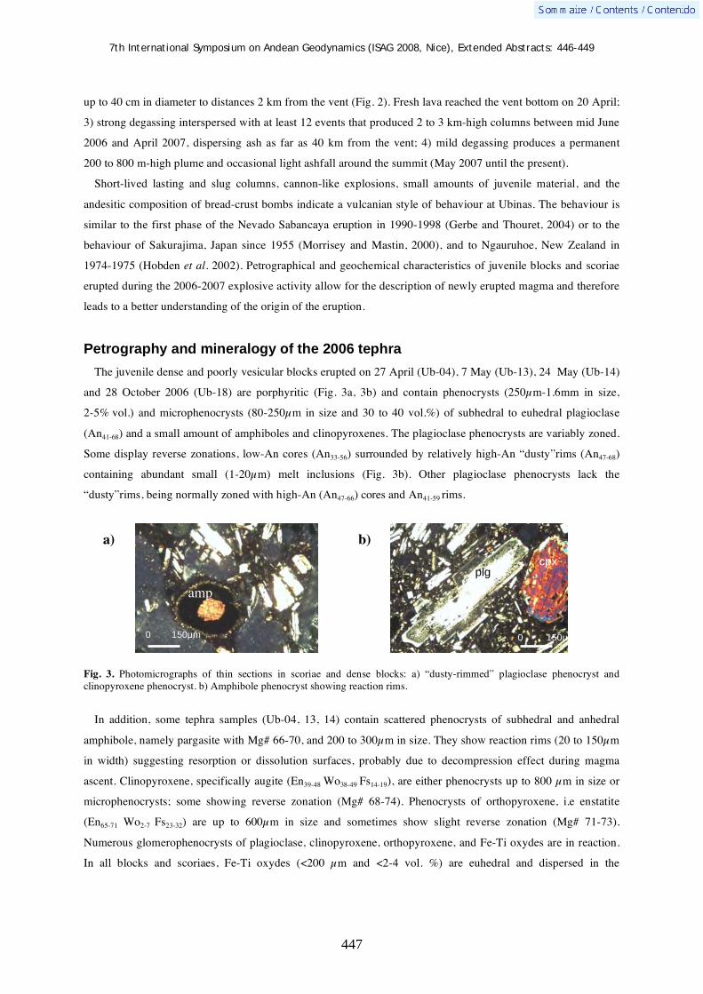
7th International Symposium on Andean Geodynamics (ISAG 2008, Nice), Extended Abstracts: 446-449
447
up to 40 cm in diameter to distances 2 km from the vent (Fig. 2). Fresh lava reached the vent bottom on 20 April;
3) strong degassing interspersed with at least 12 events that produced 2 to 3 km-high columns between mid June
2006 and April 2007, dispersing ash as far as 40 km from the vent; 4) mild degassing produces a permanent
200 to 800 m-high plume and occasional light ashfall around the summit (May 2007 until the present).
Short-lived lasting and slug columns, cannon-like explosions, small amounts of juvenile material, and the
andesitic composition of bread-crust bombs indicate a vulcanian style of behaviour at Ubinas. The behaviour is
similar to the first phase of the Nevado Sabancaya eruption in 1990-1998 (Gerbe and Thouret, 2004) or to the
behaviour of Sakurajima, Japan since 1955 (Morrisey and Mastin, 2000), and to Ngauruhoe, New Zealand in
1974-1975 (Hobden et al. 2002). Petrographical and geochemical characteristics of juvenile blocks and scoriae
erupted during the 2006-2007 explosive activity allow for the description of newly erupted magma and therefore
leads to a better understanding of the origin of the eruption.
Petrography and mineralogy of the 2006 tephra
The juvenile dense and poorly vesicular blocks erupted on 27 April (Ub-04), 7 May (Ub-13), 24 May (Ub-14)
and 28 October 2006 (Ub-18) are porphyritic (Fig. 3a, 3b) and contain phenocrysts (250μm-1.6mm in size,
2-5% vol.) and microphenocrysts (80-250μm in size and 30 to 40 vol.%) of subhedral to euhedral plagioclase
(An41-68) and a small amount of amphiboles and clinopyroxenes. The plagioclase phenocrysts are variably zoned.
Some display reverse zonations, low-An cores (An33-56) surrounded by relatively high-An “dusty”rims (An47-68)
containing abundant small (1-20μm) melt inclusions (Fig. 3b). Other plagioclase phenocrysts lack the
“dusty”rims, being normally zoned with high-An (An47-66) cores and An41-59 rims.
Fig. 3. Photomicrographs of thin sections in scoriae and dense blocks: a) “dusty-rimmed” plagioclase phenocryst and clinopyroxene phenocryst. b) Amphibole phenocryst showing reaction rims.
In addition, some tephra samples (Ub-04, 13, 14) contain scattered phenocrysts of subhedral and anhedral
amphibole, namely pargasite with Mg# 66-70, and 200 to 300μm in size. They show reaction rims (20 to 150μm
in width) suggesting resorption or dissolution surfaces, probably due to decompression effect during magma
ascent. Clinopyroxene, specifically augite (En39-48 Wo38-49 Fs14-19), are either phenocrysts up to 800 μm in size or
microphenocrysts; some showing reverse zonation (Mg# 68-74). Phenocrysts of orthopyroxene, i.e enstatite
(En65-71 Wo2-7 Fs23-32) are up to 600μm in size and sometimes show slight reverse zonation (Mg# 71-73).
Numerous glomerophenocrysts of plagioclase, clinopyroxene, orthopyroxene, and Fe-Ti oxydes are in reaction.
In all blocks and scoriaes, Fe-Ti oxydes (<200 μm and <2-4 vol. %) are euhedral and dispersed in the
cpx
plg
amp
0 150 m 0 150 m
a) b)

7th International Symposium on Andean Geodynamics (ISAG 2008, Nice), Extended Abstracts: 446-449
448
0.0
0.5
1.0
1.5
2.0
2.5
3.0
3.5
4.0
4.5
50 55 60 65 70 75
SiO2 wt%
K2O
wt%
April
07-May
24-May
Historical times
Basaltic
Andesite
Andesite Dacite Rhyolite
High-K
Calco-Alkaline
groundmass, and also appear as inclusions in the phenocrysts (orthopyroxene, clinopyroxene, amphibole, and
olivine).
Blocks that were sampled in April and May 2006 include scattered, subhedral and anhedral olivine
phenocrysts (<200 μm and 1-2 vol. %), which display normal zonation (Fo72-76 cores and Fo63-71 rims). They are
usually surrounded by a fine microlite aggregate, while resorbed shapes suggest that they may be xenocrysts.
The groundmass (<80 μm) consists of plagioclase, ortho- and clinopyroxene, and dacitic glass (67-68 wt%
SiO2). Both olivine and amphibole are missing in lavas erupted in October 2006, and contrast to lavas erupted
earlier in April and May 2006. However, the mineral assemblage does not display any significant variation in
mineral composition throughout the eruptive episode. On the other hand, pre-eruption temperatures have been
estimated using different calibrations of the two pyroxenes (Wood and Banno 1973; Wells 1977). Pre-eruption
temperature is estimated to range between 1000 and 1090 ºC.
Geochemistry of juvenile 2006 lavas
The juvenile magma, represented by lava blocks and scoriae, comprise high-K calc-alkaline andesite showing
a restricted range of composition (56.7-57.6% SiO2; 2.0-2.3% K2O: Fig. 4) compared to historical lavas. In
addition, trace element compositions are characterised by a high LILE (K, Rb, Ba, Th) and LREE contents with
respect to HREE (Fig. 5). The trace element composition of the juvenile tephra is similar to the average
composition of the erupted andesites over the last 1500 years (Thouret et al. 2005; Fig. 5). Depleted Y and
HREE is attributed to mixing and assimilation processes of magmas near the base of the >60-km-thick
continental crust (Thouret et al. 2005).
Discussion and conclusion
Over the past 1500 years Ubinas has erupted magma ranging from basaltic andesites to dacites, with andesites
being most common. Chemical characteristics of the magmas mainly result from fractional crystallisation
processes in a shallow magma chamber and assimilation at various crustal levels (Thouret et al. 2005). In
0.1
1
10
100
1000
RbBa Th U Nb K La CePb Pr Sr P Nd ZrSmEu Ti Dy Y Yb
Ro
ck/N
MO
RB
Sun/McDon. 1989-NMorb
Scoria of 1662
Lava flows of stratoconebetween 370,000 - 142,000 yr B.P.
Bombs of may and october 2006
Fig. 5
Fig. 4
Fig. 4. Alkali-silica diagram showing that the composition of erupted lavas in 2006 at Ubinas.
Fig. 5. Spiderdiagram of the 2006 - 2007 tephras for the purpose of comparison with Ubinas lavas prior to 2006 (Thouret et al. 2005). Both figures show that the composition of the 2006 erupted lavas is similar to the average composition of historically erupted lavas

7th International Symposium on Andean Geodynamics (ISAG 2008, Nice), Extended Abstracts: 446-449
449
addition few erupted pyroclastic products show evidence of magma mixing as mineralogical disequilibrium, in
combination with shallow aquifers of the hydrothermal system, which may have contributed to the triggering of
eruptions (e.g., the AD 1677 scoria and ash flow deposits of basaltic andesite composition. On the other hand,
the 980 yr BP-old plinian event produced a voluminous dacitic pumice fall deposit that does not contain
evidence for magma mixing. Thus, recent Ubinas magma has displayed a large range in compositions and the
magma chamber may have been periodically and partially emptied during the historical eruptions.
The geochemical composition of the juvenile magma erupted at Ubinas between April and October 2006 is
similar to that erupted during the last 1500 years, suggesting that all magmas have the same mantle source.
However, some petrographic textures and chemical zoning pattern of phenocrysts suggest that part of the mineral
assemblage was not in equilibrium with the melt prior to, or during the eruptive activity. The juvenile tephra
erupted at Ubinas between April and October 2006 exhibit plagioclase phenocrysts (some “dusty-rimmed”, with
reverse zonation), orthopyroxene, clinopyroxene with reverse zonation, amphibole with disequilibrium features
as reaction rims, and olivine xenocrysts. Based on the types of textures and mineral geochemistry two
hypotheses can be considered for the triggering mechanism of the most recent eruptive activity: 1) re-supply of
mafic magma into the conduit or a shallow magma chamber containing cooler andesitic magma, which has
triggered the eruption through the addition of heat and/or volatiles to the resident magma; or 2) repeated and
continuous ascent of small batches of new magma, which incorporated xenocrysts of magma erupted previously.
Both processes may have led to over pressurisation of the magma chamber and probably triggered the mild
eruptive episode.
References Gerbe M.-C., Thouret J.-C., 2004. Role of magma mixing in the petrogenesis of lavas erupted through the 1990-98 explosive
activity of Nevado Sabancaya in south Peru. Bulletin of Volcanology, 66, 541-561. Hantke G., Parodi I., 1966. The active volcanoes of Peru. Catalogue of the active volcanoes of the world including sofatara
fields, part. XIX, Colombia, Ecuador and Peru, International Association of Volcanology, Roma;65-73. Hobden B.J., Houghton B.F., Nairn I.A., 2002. Growth of a young, frequently active composite cone: Ngauruhoe volcano,
New Zealand. Bulletin of Volcanology, 64, 392-409. Morrisey M.M., Mastin L.G., 2000. Vulcanian eruptions. In; Sigurdsson H (ed) Encyclopedia of volcanoes. Academic Press,
San Diego, p 463-475. Simkim T., Siebert L., 1994. Volcanoes of the World - A Regional Directory, Gazeteer and chronology of volcanism during
the last 10,000 years. Global Volcanism Program, Smithsonian Institution, Washington DC. pp. 348. Rivera M., Thouret J.C., Gourgaud A. 1998. Ubinas, el volcán más activo del sur del Perú desde 1550: Geología y
Evaluación de las amenazas volcánicas. Bol. Soc. Geol. Perú 88 ; 53-71. Thouret J.C., Rivera M., Worner G., Gerbe M.C., Finizola A., Fornari M., Gonzales K., 2005. Ubinas: the evolution of the
historically most active volcano in southern Peru. Bulletin of Volcanology; 67: 557 - 589. Wells P.R.A. 1977. Pyroxene thermometry in simple and complex systems. Cont. Mineral. Petrol. 62; 129-140. Wood B.J., Banno S. 1973. Garnet-orthopyroxene and orthopyroxene-clinopyroxene relationship in simple and complex
systems. Cont. Mineral. Petrol. 42; 109-124.

7th International Symposium on Andean Geodynamics (ISAG 2008, Nice), Extended Abstracts: 450-453
450
Comparative methodological considerations for estimating fracture parameters
Wilmer Robles, Andreas Kammer, Mauricio Marentes, & Wilmer Espitia
Universidad Nacional de Colombia, Cra 30 Calle 45, Edif. Manuel Ancízar of. 310, Bogotá, Colombia
KEYWORDS : Methodology, fracture parameters, synthetic and natural pavements, Arcabuco anticline
Introduction
Studies of natural fractures bear a great importance on the evaluation of geological structures, transport
mechanisms of fluids, the stability of rock units and paleostresses and urge a neat methodological approach for
characterizing them. Quantitative outcrop studies are based on the evaluation of different parameters that include
intensity, density and medium lengths. Intensity is defined as averaged length of fracture traces per unit area,
density as numbers of center points per unit area and mean length as an averaged length of a fracture population
(Rohbaugh, 2002). In general terms, methods applying for the quantification of these fracture parameters include
the sampling of fractures along scan lines or in areas. Problems related to these sampling methods principally
pertain to their variable orientations and censoring bias. Further problems refer to the heterogeneity of fracture
distributions, i.e. to spatial changes in the fracture pattern and to the observational resolution. Thus, long fracture
traces are more easily sampled than shorter ones. In order to obviate these problems different methods have been
proposed (Mauldon et al., 2001). In this paper we implement various recently published methods designed to
estimate fracture parameters (Mauldon et al., 1998; Mauldon, 2001; Nieto et al., 2003; Wu & Pollard, 1995 ) and
confront their results, in order to identify possible limitations in their calculations and to compare their results in
an objective way. We perform this evaluation utilizing synthetic models and natural fracture populations of the
Arcabuco Anticline, located near the town of Villa de Leyva, Department of Boyacá, Colombia.
Methodological implementation
Figure 1. Quantities involved in the calculation of fracture parameters. Circles designate the n intersections between fractures and scan lines (both circular and rectangular), while triangles indicate the m terminations of fracture traces within a window.
7th International Symposium on Andean Geodynamics (ISAG 2008, Nice), Extended Abstracts: 450-453
451
A first step in obtaining the fracture parameters consists in digitizing observed or synthetic fracture patterns. In
a subsequent step for which we designed different programs we superposed scan lines and windows (circular and
rectangular), in order to obtain some numerical quantities that allow for an estimation of the fracture parameters
(Figure 1). These fracture parameters were assessed using both single fracture sets (like the ones differentiated
by means of various colors in Figure 1) as well as indiscriminate fracture populations.
Circular windows
In this method scan lines represent the circumferences and sample areas the inside of a circular window.
Parameters can be assessed by counting the number of fracture traces (n), which intercepts the circumferences,
and the number of fractures the terminations (m) which are completely contained within a circular window
(Mauldon et al. 2001). In this procedure fracture parameters are defined as follows:
Density
22
ˆr
mcircir = (1)
Intensity
r
nI cir
cir4
ˆ = (2)
Mean trace lengh
=cir
circir
m
nr
2μ̂ (3)
where r represents the radius of the circular window.
Rectangular windows
In addition to the aforementioned parameters m and n the methodological approach for rectangular windows
requires the determination of an orientation angle between fracture plane and the long side of the rectangle. In
order to establish a direct comparison between rectangular and circular windows we applied squares of length r
that circumscribe previously defined circumferences (Figure 2). Considering these special conditions fracture
parameters were defined in the following way (Mauldon, 1998):
Density
24
ˆr
mrectrect = (4)
Intensity
]cossin[
4ˆ
+=
E
nrI rect
rect (5)

7th International Symposium on Andean Geodynamics (ISAG 2008, Nice), Extended Abstracts: 450-453
452
Mean trace lengh
rect
rectrect
m
n
E
rI
]cossin[
ˆ
+= (6)
Figure 2. Sampling of the fracture parameters utilizing multiple scan lines and windows (both circular and retangular)
Direct estimation of intensity
Taking the definition of Mauldon (2001), it is possible to estimate the fracture intensity parameter summing all
traces enclosed completely within a window and dividing it by the area of the window, as is indicated by Nieto et
al. (2003).
Intensity
=A
lI i
dir
) (7)
Estimation of a fracture spacing
Wu & Pollard (1994) determined a fracture spacing parameter, which is interpreted as being the reverse of the
spacing, obtaining a similar results that the direct calculation.
=
+
=n
i
io ll
AS
1
) (8)
where lo is the length of a square and A = lo x lo represents a window’s area.
Using the appropriate expressions for each case and utilizing especially designed computing programs we
automated the estimation of the fracture parameters. These routines allow considering multiple windows and
varying their size, introducing, therefore, much versatility in the evaluation of the fracture parameters. In Figure
2 fracture parameters are assigned to specific sizes of windows which have been spawn in a random manner over
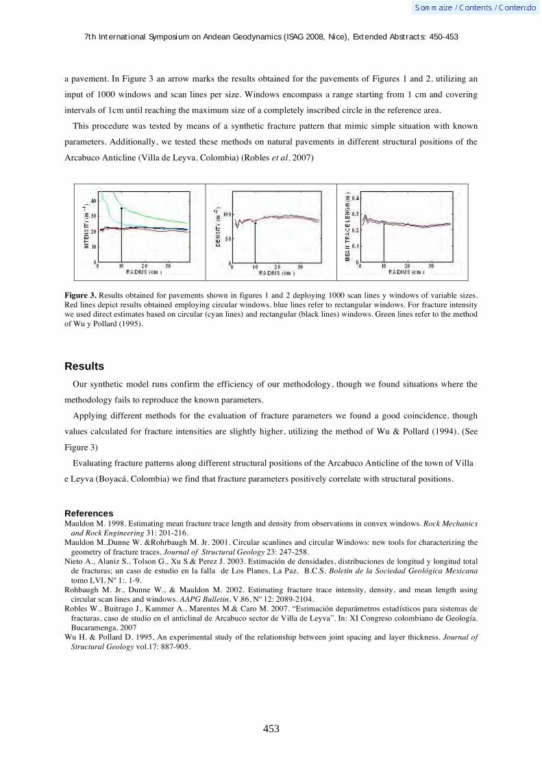
7th International Symposium on Andean Geodynamics (ISAG 2008, Nice), Extended Abstracts: 450-453
453
a pavement. In Figure 3 an arrow marks the results obtained for the pavements of Figures 1 and 2, utilizing an
input of 1000 windows and scan lines per size. Windows encompass a range starting from 1 cm and covering
intervals of 1cm until reaching the maximum size of a completely inscribed circle in the reference area.
This procedure was tested by means of a synthetic fracture pattern that mimic simple situation with known
parameters. Additionally, we tested these methods on natural pavements in different structural positions of the
Arcabuco Anticline (Villa de Leyva, Colombia) (Robles et al, 2007)
Figure 3. Results obtained for pavements shown in figures 1 and 2 deploying 1000 scan lines y windows of variable sizes. Red lines depict results obtained employing circular windows, blue lines refer to rectangular windows. For fracture intensity we used direct estimates based on circular (cyan lines) and rectangular (black lines) windows. Green lines refer to the method of Wu y Pollard (1995).
Results
Our synthetic model runs confirm the efficiency of our methodology, though we found situations where the
methodology fails to reproduce the known parameters.
Applying different methods for the evaluation of fracture parameters we found a good coincidence, though
values calculated for fracture intensities are slightly higher, utilizing the method of Wu & Pollard (1994). (See
Figure 3)
Evaluating fracture patterns along different structural positions of the Arcabuco Anticline of the town of Villa
e Leyva (Boyacá, Colombia) we find that fracture parameters positively correlate with structural positions.
References Mauldon M. 1998. Estimating mean fracture trace length and density from observations in convex windows. Rock Mechanics
and Rock Engineering 31: 201-216. Mauldon M.,Dunne W. &Rohrbaugh M. Jr. 2001. Circular scanlines and circular Windows: new tools for characterizing the
geometry of fracture traces. Journal of Structural Geology 23: 247-258. Nieto A., Alaniz S., Tolson G., Xu S.& Perez J. 2003. Estimación de densidades, distribuciones de longitud y longitud total
de fracturas; un caso de estudio en la falla de Los Planes, La Paz, B.C.S. Boletín de la Sociedad Geológica Mexicana tomo LVI, Nº 1:. 1-9.
Rohbaugh M. Jr., Dunne W., & Mauldon M. 2002. Estimating fracture trace intensity, density, and mean length using circular scan lines and windows. AAPG Bulletin, V.86, Nº 12: 2089-2104.
Robles W., Buitrago J., Kammer A., Marentes M.& Caro M. 2007. “Esrimación deparámetros estadísticos para sistemas de fracturas, caso de studio en el anticlinal de Arcabuco sector de Villa de Leyva”. In: XI Congreso colombiano de Geología. Bucaramenga, 2007
Wu H. & Pollard D. 1995, An experimental study of the relationship between joint spacing and layer thickness. Journal of Structural Geology vol.17: 887-905.

7th International Symposium on Andean Geodynamics (ISAG 2008, Nice), Extended Abstracts: 454-457
454
Subduction control on chemical composition of Oligocene to Quaternary sediments of the Ecuadorian Amazonian foreland basin from major and trace elements and Nd-Sr isotopes
Martin Roddaz*, Frédéric Christophoul, Jean-Claude Soula, José David Burgos-Zambrano,
Patrice Baby, & Joachim Déramond
LMTG, Université de Toulouse, CNRS, IRD, OMP, 14 avenue Edouard Belin, 31400 Toulouse, France
* corresponding author ([email protected])
KEYWORDS : foreland basin, major and trace elements, Nd-Sr isotopes, provenance, Andes, alluvial fan sediments, Ecuador
Introduction
The Ecuadorian Andes are characterized by frequent earthquakes with magnitudes greater than M=5 (Legrand
et al., 2005) and numerous active volcanoes with compositions ranging from calk-alkaline to shoshonitic which
can be related to a subduction context perturbed by the subduction of the Carnegie ridge (Bourdon et al., 2003).
The Ecuadorian Andes have been shown to have risen during the Neogene (Spikings et al., 2000), with
elevations and uplift rates similar to the nearby Peruvian and Bolivian Andes to the south and Colombian Andes
to the north. In contrast with other Andean foreland basins where progressive shortening lead to forward
(cratonward) migration of the thrust wedge and adjacent foredeep (DeCelles and Horton, 2003; Hermoza et al.,
2005), the Ecuadorian Amazonian foreland basin (Oriente foreland basin) experienced little shortening and
depocentre migration since the Oligocene which make its foredeep the widest of the Amazonian foreland basin
system. The most spectacular characteristic of the Ecuadorian foreland is the presence in front of the thrust and
fold belt, of a large-scale (60,000 km2) humid tropical alluvial fan, the Pastaza megafan (Räsänen et al., 1992).
This modern megafan partly overlaps the Miocene and Pliocene–Pleistocene fans (Christophoul et al., 2002).
Figure 1: a) Location map and geologic map of the studied area. 1A: Geologic map of the studied area; Ab.G: Abitagua Granitoid, Nap.D: Napo Dome, Cu.D: Cutucu Dome, ST: Subandean Thrust, SF: Subandean Frontal thrust. Dur to industrial confidentiality, location of oil wells is approximate. 1B: Simplified structural map of Ecuador. Co.B: Coastal Block, W.C.:

7th International Symposium on Andean Geodynamics (ISAG 2008, Nice), Extended Abstracts: 454-457
455
Western Cordillera; I.A.D: Interandean Depression; E.C.: Eastern Cordillera; S.Z.: Subandean Zone. White stars represent sampled outcrops (modified from Burgos Z et al., submitted)
Geochemical studies (major and trace elements and Nd-Sr isotopic compositions) of Neogene Amazonian
foreland basin sediments have been used successfully to investigate the control of the foreland basin dynamics
on the geochemistry (Roddaz et al., 2006) and unravel the drainage evolution of the Amazonian foreland basin
(Roddaz et al., 2005).
Results and conclusions
46 sediment samples were collected along river and road cuts in Ecuador. All samples were analyzed by ICP-
MS for trace elements at the LMTG (University of Toulouse, France). Forty one samples were selected for
determination of Sc concentrations (Chemex Labs, Canada). Thirty two samples were selected for major element
analysis by ICP-AES at the CRPG (Nancy, France). Sr and Nd isotopic compositions of ten representative
samples were measured by thermal ionization mass spectrometer at the University of Toulouse (France).
Based on major and trace elements and Nd-Sr isotopic compositions of Oligocene to Quaternary sediments of
the Ecuadorian foreland basin, we suggest that:
1) Sedimentary sorting played a minor role in the chemical differentiation of Oriente foreland basin
sediments;
2) Most of the analyzed sediments have CIA values close to that of the PAAS indicating that they are
moderately weathered. In addition, they have lower CIA values than those of the other Neogene Amazonian
foreland deposits (Roddaz et al., 2006) indicating that weathering was less intense in the Ecuadorian Amazonian
foreland basin;
3) The Ecuadorian foreland basin has been continuously fed by poorly to moderately weathered sediments
issued from andesitic protoliths since the Oligocene in non steady-state weathering conditions as indicated in the
A-CN-K diagram (Fig. 2a);
4) When compared with the other Amazonian foreland sediments (Roddaz et al., 2005; Roddaz et al.,
2006), the analyzed sediments have contributions of volcanic arc rock sources as indicated by their high Cr/Th
ratios and Nd(0) values and low Th/Sc ratios and Eu anomalies. The Quaternary sediments are derived from
more “basic” sources (Fig. 2b). As the Ecuadorian foreland basin is continuously alimented by volcanic arc
detritus since the Oligocene, we suggest that the chemical change observed in the Quaternary sediments is due to
a change in the nature of the volcanism in the Quaternary.
5) The peculiar chemical characteristics of the Ecuadorian foreland basin sediments can be best explained
in regard to the particular characteristics of the foreland basin geodynamics. The exhumation of the Eastern
Cordillera occurring in the Pleistocene causes the Western Cordillera to have been the main source of the
foreland basin deposits from Oligocene till Quaternary allowing export of andesitic detritus to the Amazonian
lowland. The Late Pliocene-Pleistocene subduction of the Carnegie ridge triggered main and back arc volcanism
inducing export of more fresh and basic sediments into the Amazonian foreland basin.

7th International Symposium on Andean Geodynamics (ISAG 2008, Nice), Extended Abstracts: 454-457
456
Figure 2 : a) Ternary A-CN-K diagrams (Nesbitt and Young, 1984; Nesbitt and Young, 1989) for analyzed sediments. Pl:
Plagioclase; Ks: K-feldspar; Ad: Andesite (from (Fedo et al., 1995); b) 87Sr/86Sr- Nd(0) diagram for Western Amazonian sediments. Data sources: A: Quaternary Ecuadorian lavas (Barragan et al., 1998); B: Type I sand field (Basu et al., 1990); C: Type II sand field (Basu et al., 1990). Mesozoic and Neogene volcanic rocks from (Rogers and Hawkesworth, 1989) and from (Kay et al., 1994). Data for Central Depression, Altiplano, Oriental Cordillera, Subandean Zone fields are available in (Pinto, 2003)

7th International Symposium on Andean Geodynamics (ISAG 2008, Nice), Extended Abstracts: 454-457
457
References Barragan, R., Geist, D., Hall, M., Larson, P. and Kurz, M., 1998. Subduction controls on the compositions of lavas from the
Ecuadorian Andes. Earth Planet. Sci. Lett., 154: 153-166. Basu, A.R., Sharma, M. and DeCelles, P.G., 1990. Nd, Sr-isotopic provenance and trace element geochemistry of Amazonian
foreland basin fluvial sands, Bolivia and Peru: implications for ensialic Andean orogeny. Earth Planet. Sc. Lett., 100: 1-17. Bourdon, E., Eissen, J.-P., Gutscher, M.-A., Monzier, M., Hall, M.L. and Cotten, J., 2003. Magmatic response to early
aseismic ridge subduction: the Ecuadorian margin case (South America). Earth and Planetary Science Letters, 205(3-4): 123-138.
Christophoul, F., Baby, P., Soula, J.-C., Rosero, M. and Burgos, J., 2002. Les ensembles fluviatiles neogenes du bassin subandin d'Equateur et implications dynamiques: The Neogene fluvial systems of the Ecuadorian foreland basin and dynamic inferences. Comptes Rendus Geosciences, 334(14): 1029-1037.
DeCelles, P. and Horton, B.K., 2003. Early to middle Tertiary basin development and the history of Andean crustal shortening in Bolivia. Geological Society of America Bulletin, 115: 58-77.
Fedo, C.M., Nesbitt, H.W. and Young, G.M., 1995. Unraveling the effects of potassium metasomatism in sedimentary rocks and paleosols, with implications for paleoweathering conditions and provenance. Geology, 23(10): 921-924.
Hermoza, W., Brusset, S., Baby, P., Gil, W., Roddaz, M., Guerrero, N. and Bolanos, R., 2005. The Huallaga foreland basin evolution: Thrust propagation in a deltaic environment, northern Peruvian Andes. Journal of South American Earth Sciences, 19(1): 21-34.
Kay, S., Coira, B. and Viramonte, J., 1994. Young mafic back arc volcanic rocks as indicators of continental lithospheric delamination beneath the Argentina Puna plateau, central Andes. J. Geophys. Res., 99: 24323-24339.
Legrand, D., Baby, P., Bondoux, F., Dorbath, C., Bes de Berc, S. and Rivadeneira, M., 2005. The 1999-2000 seismic experiment of Macas swarm (Ecuador) in relation with rift inversion in Subandean foothills. Tectonophysics, 395(1-2): 67-80.
Nesbitt, H.W. and Young, G.M., 1984. Prediction of some weathering trends of plutonic and volcanic rocks based on thermodynamic and kinetic considerations. Geochim.Cosmochim.Acta, 48: 1523-1534.
Nesbitt, H.W. and Young, G.M., 1989. Formation and diagenesis of weathering profiles. J.Geol., 97: 129-147. Pinto, L., 2003. Traçage de l'érosion Cénozoïque des Andes Centrales à l'aide dela minéralogie et de la géochmie des
sédiements (Nord du Chili et Nord-Ouest de la Bolivie). PhD Thesis, University Paul Sabatier, Toulouse, 196 pp. Räsänen, M.E., Neller, R., Salo, J. and Jungner, H., 1992. Recent and ancient fluvial deposition systems in the Amazonian
foreland basin, Peru. Geol. Mag., 129: 293-306. Roddaz, M., Viers, J., Brusset, S., Baby, P., Boucayrand, C. and Herail, G., 2006. Controls on weathering and provenance in
the Amazonian foreland basin: Insights from major and trace element geochemistry of Neogene Amazonian sediments. Chemical Geology, 226(1-2): 31-65.
Roddaz, M., Viers, J., Brusset, S., Baby, P. and Herail, G., 2005. Sediment provenances and drainage evolution of the Neogene Amazonian foreland basin. Earth Planet. Sc. Lett., 239(1-2): 57-78.
Rogers, G. and Hawkesworth, C.J., 1989. A geochemical traverse across the North Chilean Andes: evidence for crust generation from the mantle wedge. Earth Planet. Sci. Lett., 91: 271-275.
Spikings, R.A., Seward, D., Winkler, W. and Ruiz, G.M., 2000. Low-temperature thermochronology of the northern Cordillera Real, Ecuador: Tectonic insights from zircon and apatite fission track analysis. Tectonics, 19(4): 649-668.

7th International Symposium on Andean Geodynamics (ISAG 2008, Nice), Extended Abstracts: 458-460
458
Neogene erosion and relief evolution in the Central Chile forearc (33°-34ºS) as determined by detrital heavy mineral analysis
María P. Rodríguez1, Luisa Pinto
1, & Gérard Hérail
2
1 Departamento de Geología Universidad de Chile, Plaza Ercilla 803, 13518 Santiago, Chile
([email protected], [email protected]) 2 IRD, LMTG, 14 Avenue Edouard Belin, 31400, Toulouse, France ([email protected])
KEYWORDS : Central Chile, morphostructural unit, peneplain, heavy mineral analysis, Leterrier diagrams
Introduction
At the forearc of Central Chile (33-34ºS) three morphostructural units are recognizable from west to east: the
Costal Cordillera (CC), the Central Depression (CD) and the Principal Cordillera (PC) (Fig 1). Flat-shaped
erosional surfaces forming the highest summits of the eastern CC (ECC) and similar surfaces at the western PC
(WPC) have been interpreted as relicts of ancient peneplains and indicated that the CC and the PC once formed
part of a single relief (Brüggen, 1950; Borde, 1966; Farías et al., 2006).
Figure 1 Geological map of Central Chile forearc (33-34ºS)

7th International Symposium on Andean Geodynamics (ISAG 2008, Nice), Extended Abstracts: 458-460
459
As peneplains formed near to absolute base level (Phillips, 2002) and at present the flat-shaped surfaces are
located at high elevations, they represent uplift markers and indicate > 2 km of regional uplift of the entire
forearc during Late Neogene (Farías et al., 2006, 2008). The outcrops of Late Neogene sediments at Central
Chile that could represent the erosion material related to the regional uplift event are the Navidad, Lincancheo,
Rapel y La Cueva marine formations (Encinas, 2006) (Fig 1). Standard detrital heavy mineral (HM) analysis and
single grain microprobe analysis of detrital heavy minerals were carried out to recognize the lithological units
subjected to erosion during the deposition of each marine formation, allowing us to reach a better understanding
of the paleogeographic evolution of Central Chile forearc during Late Neogene times.
Results and conclusions
The principal differences in the sources areas of Late Neogene marine formations are indicated by the detrital
volcanic and metamorphic HM suite and are reflected in the composition of pyroxene-amphibole and garnet
respectively. For sandstones deposited between 12.8 and 4.6 Ma (deposition of lower levels of Navidad
Formation), the geochemical characteristics of pyroxenes (Fig 2) indicate a source formed mainly by tholeittic
and calcoalkaline volcanic rocks, like rocks from Abanico West Formation at eastern CD (ECD) south of 35ºS
(López-Escobar y Vergara, 1997), while the composition of garnet is typical of garnet of metamorphic rocks
from the west part of the CC (WCC). These features show that during the indicated 12.8 - 4.6 Ma period two
main reliefs formed the Central Chile forearc: one located at the actual WCC and the other at the actual ECD.
Figure 2. Leterrier et al. (1982) diagrams for clinopyroxene from a) lower levels (orange symbols) and upper levels (red symbols) of Navidad Formation and b) Lincancheo (yellow and dark green symbols), Rapel (pale green symbols) and La Cueva (purple, cyan and blue symbols) formations.
By 4.6 Ma (deposition of upper levels of Navidad Formation), the provenance of sandstones is determined by
the alkalis and AlIV contents of detritical volcanic amphibole (Fig 3), which mimics the contents of these
elements in amphibole from the hypabyssal volcanic basement rocks of the ECD (Manquehue type rocks). The

7th International Symposium on Andean Geodynamics (ISAG 2008, Nice), Extended Abstracts: 458-460
460
absence of the Abanico West Formation source and the erosion of the ECD basement indicates that by this time
the Central Depression was being formed.
Figure 3 Alkalis and AlIV contents on amphibole from upper levels of Navidad Formation (red symbols), Lincancheo Formation (yellow symbols), Rapel Formation (pale green symbols) and La Cueva Formation (purple and blue symbols). The pale grey field represent the composition of amphibole from Manquehue type hypabissal rocks (unpublished data from Daniel Sellés) and the dark grey field represent the composition of amphibole from Farellones Formation (Fuentes, 2004).
The detrital volcanic HM associations of sandstones deposited between 4.6 and 2.7 Ma (deposition of
Lincancheo, Rapel and La Cueva Navidad formations) are characterized by the geochemical characteristics of
both pyroxene and amphibole. A main source represented by calcoalkaline intermediate to basic rocks, like
outcrops of Farellones Formation from western CC (WCC) is indicated by Leterrier diagrams in pyroxene (Fig
2) and alkalis and AlIV contents of amphibole (Fig 3). A secondary source represented by volcanic and contact
metamorphic rocks from the eastern CC (ECC) is also recognized by Leterrier diagrams in pyroxene and the
presence of garnet from the andradite-grosular series respectively. The rock sources identified show that between
4.6 and 2.7 Ma the reliefs subjected to erosion at the forearc of Central Chile were the WCP and the ECC.
Acknowledgments We acknowledge funding by the FCFM (Proyecto de inserción), Departamento de Investigación y Desarrollo (DI), Universidad de Chile (Project DI 2004, I2 04/02-2), IRD, Bourse Amerique Latine (UPS) and Proyecto Anillo ACT Nº 18.
References Borde, J., 1966. Les Andes de Santiago et leur avant-pays: étude de géomorphologie. Bordeaux, France. Union Française
d’Impression, 559 p. Brüggen, H., 1950. Fundamentos de la Geología de Chile. Santiago, Chile. Instituto Geográfico Militar, 510 p. Encinas, A., 2006. Estratigrafi a y sedimentologi a de los depo sitos marinos miopliocenos del área de Navidad (33ºS-
34º30´S), Chile Central: implicaciones con respecto a la tecto nica del antearco. Tesis, Doctor en Ciencias, mencio n Geologi a. Universidad de Chile.
Farías, M., Charrier, R., Carretier, S., Martinod, J., Comte, D., 2006. “Erosión versus tectónica en el origen de la Depresión Central de Chile Central” In Actas XI Congreso Geológico Chileno. 7-11 Agosto, Antofagasta, Chile.
Farías, M., Charrier, R., Carretier, S., Martinod, J., Fock, A., Campbell, D., Cáceres, J., Comte, D., 2008. Late Miocene high and rapad surface uplift and its erosional response in the Andes of Central Cehile (33-35ºS), Tectonics, 27, TC 1005, doi: 10.1029/2006TC002046
Fuentes, F., 2004. Petrologi a y metamorfismo de muy bajo grado de unidades volca nicas oligoceno-miocenas en la ladera occidental de Los Andes de Chile Central (33ºS). Tesis, Doctor en Ciencias, mencio n Geologi a. Universidad de Chile.
Leterrier J., Maury, R., Thonon, P., Girard, D., Marchal, M., 1982. Clinopyroxene composition as a method of identification of the magmatic affinities of paleo-volcanic series. Earth and Planetary Sciences Letters, 59, 139-154.
López-Escobar, L., Vergara, M., 1997. Eocene-Miocene Longitudinal Depression and Quaternary volcanism in the Southern Andes, Chile (33-42.5°S): a geochemical comparision. Revista Geológica de Chile, 24 (2) 227-244.
Phillips, J.D., 2002. Erosion, isostatic response, and the missing peneplains, Geomorphology, 45 (3-4), 225-241.

7th International Symposium on Andean Geodynamics (ISAG 2008, Nice), Extended Abstracts: 461-464
461
The Loncopué Trough: A major orogenic collapse in the western Agrio fold-and-thrust belt (Andes of Neuquén, 36º40´-38º40´S)
Emilio Rojas-Vera1, Andrés Folguera
1, Gonzalo Zamora-Valcarce
2, & Victor A. Ramos
1
1 Laboratorio de tectónica andina, CONICET-UBA, 2º Pabellón, Ciudad Universitaria, Buenos Aires, Argentina
([email protected]) 2 Repsol-YPF, Exploración Neuquén, Argentina
KEYWORDS : neotectonics, extensional retroarc basin, strike-slip faults, orogenic collapse, basament-controlled structure
Introduction
The Pliocene to Quaternary Loncopué trough is located in the Andean retroarc zone between 38º 40’ and 36º
40’S approximately, east of the main Andes and the Present volcanic arc west of and the Agrio fold and thrust
belt (Figure 1). Neotectonic activity has been proposed in the area by several authors (Ramos and Folguera 2005,
García Morabito et al. 2005, Foguera et al. 2006) who based on morphotectonic features have interpreted as
controlled by normal faults located between the Agrio fold and thrust belt and the Loncopué trough (Figure 1).
However, scarce to none evidence of faulted Quaternary materials has been described. More recently, Yuan et al.
(2006) determined a crustal attenuated area beneath the Loncopué trough using receiver function techniques.
Zapata et al. (1999), Zamora Valcarce et al. (2006) and Jordan et al. (2001) based on limited seismic reflection
and field data, proposed a basement west-dipping normal fault controlling a Late Oligocene depocenter to the
west beneath the Loncopué trough, in coincidence with that area of reported young tectonic activity. However,
Cobbold and Rossello (2003) interpreted this limit as produced by a major backthrust that overrides the
Mesozoic sequences over Tertiary strata. In this stuy we present field evidence on the transtensional nature of the
limit between the Agrio fold and thrust belt and the Loncopué trough, as well as the complex structure of the
axial part of the trough that was formed by a series of ten-of- kilometers wide pull-apart depocenters that
evolved during Quaternary times.
Agrio fold and thrust belt
This deformational belt has been divided in two sectors with contrasting geology and structural styles. The
western sector near the Loncopué trough (Figure 1) is characterized by the strong inversion of Late Triassic to
Early Jurassic normal faults uplifting synrift sequences of the Neuquén basin. Compressional deformation begun
in the Late Cretaceous times (Zapata et al. 1999, Zamora Valcarce et al., 2006). Thin-skinned deformation
becomes more important at the eastern sector where post Late Jurassic sequences are detached from
Kimmeridgian evaporites which form the main decollment in the area. Late Miocene contraction has modified
Late Cretaceous uplifts as revealed by the development of synorogenic depocenters (Zapata et al 2002, Zamora
Valcarce et al. 2006).
Loncopué trough
Extensional tectonics associated with the Loncopué trough is superimposed to the western Agrio Fold and

7th International Symposium on Andean Geodynamics (ISAG 2008, Nice), Extended Abstracts: 461-464
462
thrust belt to the east (eastern Loncopué fault system), where mainly Jurassic sequences and Quaternary volcanic
products are extensionally deformed and is expanded up to the eastern Present volcanic arc to the west (western
Loncopué fault system). To the north, this trough is limited by the NE Mandolegüe arch, a basement cored uplift
composed of Eocene rocks, partially covered by Quaternary retroarc volcanic products (Figure 1). Kinematic
indicators at the eastern Loncopué fault system show left lateral displacements associated with extensional
components at NS fault planes. Transtensional deformation has affected the axial part of a series of basement
cored uplifts such as Agua Fría and Moncol anticlines, producing asymmetric grabens (Figure 2) that controlled
the emplacement of monogenetic field basalts. These rocks were lately affected by transtensional deformation
that produced 5-10 meter scarps superimposed to faults affecting Mesozoic strata with normal displacements.
Alluvial deposits are locally faulted indicating ongoing orogenic collapse at the western Agrio fold and thrust
belt.
Figure 1. Argentine Andes between 37º45´and 38º30´S, where the main Andes are separated from the Agrio fold and thrust belt by the Loncopué trough. The eastern sector is modified from Ramos (1998).
Western Loncopué fault system is formed by a rectilineous NS east-dipping set of normal faults that deform
Pliocene to Quaternary volcanic sequences. These faults are associated with ignimbritic eruptions, dome and

7th International Symposium on Andean Geodynamics (ISAG 2008, Nice), Extended Abstracts: 461-464
463
caldera complexes located immediately to the east of the Present volcanic arc (Figure 1). Geometry of pull-apart
basins associated with those structures (Codihue depocenter) indicates left lateral components along the edges of
the trough.
The central part of the trough is formed by a series of rhomboedric depocenters that are filled by basaltic
eruptions interfingered with lacustrine deposits. These depocenters are limited by two fault systems, one NE-
trending another perpendicular to it. Geometry and the association to long NNW fault systems that diverge from
the western Loncopué trough, suggest that they could be a response to right-lateral displacements, which
segmented the axial trough (Figure 1). The northernmost of these features is the Huecú depocenter (Figure 1)
that has controlled the eruption of postglacial products all along the retroarc basin (Rojas Vera, 2007). There are
associated with liquefaction phenomena, in youngest lacustrine deposits interfingered with the youngest lavas in
the area, which indicates strong paleoseismic events in the region.
Structural cross-section at 38º10´S
The structural cross-section has been built with limited seismic information mainly restricted to the Agrio fold-
and-thrust belt and to the axial central part of the Loncopué trough. Field data and gravimetric and
magnetometric information is available for the entire trough. Gravimetric analyses show that the western
Loncopué trough controls a nearly 8 km deep depocenter, which implies that at least 3 km of the sedimentary
column can not be explained by Tertiary to Quaternary strata. Therefore a Mesozoic depocenter is expected
beneath the thickest part of the Loncopué basin (western Loncopué fault system), next to the main Andes (Figure
2), this depocenter has no relation to the morphologically more prominent East Loncopué fault system, where
most previous studies considered the thickest section of the basin.
Figure 2. Cross section at 38º10´S, based at the Loncopué trough on surface data, gravimetric and magnetometric surveys and limited coverage of seismic lines. The structural style of the Cerro Mocho area is controlled by seismic data (Zamora Valcarce et al. 2006).

7th International Symposium on Andean Geodynamics (ISAG 2008, Nice), Extended Abstracts: 461-464
464
Contrastingly, field data, and gravity and limited seismic information show that the axial part of the trough
would controls a smaller depocenter associated with both east and west dipping extensional fault systems. To the
eastern extensional structure is localized by the westernmost basement uplifts of the Agrio fold and thrust belt
and do not expand over the Cerro Mocho basement uplift (Figure 2). This could indicate that the structure of the
Agua Fría and Moncol anticlines has locally relaxed in order to produce extensional morphologies at surface.
Concluding remarks
The Loncopué structure is intimately linked to the Late Triassic rift architecture slightly modified during Late
Cretaceous compressional stage. Most of the rhomboedric features which are aligned at the axial part of the
trough coincide with gravimetric lows determined between basement highes which are exposed immediately to
the west in the Agrio fold and thrust belt. However, Mesozoic depocenters do not necessarily coincide with
Tertiary to Quaternary areas of maximum thickness. Silicic to mafic volcanism in the area is controlled by
transtensional structures both in right and left lateral pull apart basins. Last deformation can be considered as
Holocene based on faulted alluvial fans at the eastern sector of the trough. On the other hand western
deformation seems to be fossilized by Pleistocene caldera complexes. Further work is necessary in order to
refine kinematics of the main fault systems.
References Cobbold, P.R., Rossello, E.A., 2003. Aptian to Recent compressional deformation, foothills of the Neuquén Basin,
Argentina. Marine and Petroleum Geology, v. 20, no 5, p. 429-443. Folguera, A., Zapata, T., Ramos, V.A., 2006. Late cenozoic extension and the evolution of the Neuquén Andes, in Kay, S.M.,
and Ramos, V.A., (eds): Evolution of an Andean margin: A tectonic and magmatic view from the Andes to the Neuquén Basin (35º-39º lat): Geological Society of America Special Paper 407:267-285.
García-Morabito, E., Folguera, A. 2005. El alto de Copahue – Pino Hachado y la fosa de Loncopué: un comportamiento tectónico episódico, andes neuquinos (37°-39°S). Revista de la Asociación Geológica Argentina 60 (4): 742-761, Buenos Aires.
Jordan, T., Burns, W., Veiga, R., Pangaro, F., Copeland, P., Kelley, S., Mpodozis, C., 2001. Extention and basin formation in the southern Andes caused by increased convergence rate: A mid-Cenozoic trigger for the Andes. Tectonics 20 (3): 308-324.
Ramos, V.A..1998. Estructura del sector occidental de la faja plegada y corrida del Agrio, cuenca Neuquina, in X Congreso Latinomericano de Geología (Buenos Aires): Actas, v. II, p. 105-110.
Ramos, V., Folguera, A. 2005. Tectonic evolution of the Andes of Neuquén: constraints derived from the magmatic arc and foreland deformation, en Spalletti, L., Veiga,G., Schwarz, E. y Howell, A. (eds). The Neuquén Basin: A case study in sequence stratugraphy and basin dynamics: Geological Society of London Special Publications, 252: 15-35.
Rojas-Vera, E. 2007. Estudio tectónico del sistema de fallas de Mandolegüe: La cuenca cuaternaria del Huecú (37°43’S, 70°41’O) Provincia de Neuquén. Tesis de licenciatura, Universidad de Buenos Aires, 89 p.
Yuan, X., Asch, G., Bataille K., Bock, G., Bohm, M., Echtler, H., Kind, R., Oncken, O., Wólbern, I., 2006. Deep seimic images of the Southern Andes, in Kay, S.M., & Ramos, V.A. (eds): Evolution of an Andean margin: A tectonic and magmatic view from the Andes to the Neuquén Basin (35º-39ºS): Geological Society of America Special Paper 407: 61-72.
Zamora-Valcarce, G., Zapata, T., Del Pino, D., Ansa, A., 2006. Structural evolution and magmatic characteristics of the Agrio Fol.-and-thrust belt in Kay, S.M., and Ramos, V.A. (eds): Evolution of an Andean margin: A tectonic and magmatic view from the Andes to the Neuquén Basin (35º-39º lat): Geological Society of America Special Paper 407:125-145.
Zapata, T., Brissón, I., Dzelalija, F., 1999. The role of basement in the Andean fold and thrust belt of the Neuquén Basin, en K. McClay, (ed.): Thrust Tectonics, 122 – 124, Chapman and Hall, New York.
Zapata, T. R., Corsico, S., Dzelalija, F., Zamora-Valcarce, G., 2002. La faja plegada y corrida del Agrio: Análisis estructural y su relación con los estratos Terciarios de la Cuenca Nequina, in 5° Congreso de exploración y desarrollo de Hidrocarburos. Actas electronicas. Mar del Plata.

7th International Symposium on Andean Geodynamics (ISAG 2008, Nice), Extended Abstracts: 465-468
465
The Cordillera Blanca fault system as structural control of the Jurassic-Cretaceous basin in central-northern Peru
Darwin Romero
INGEMMET, Av. Canadá 1470, San Borja, Lima, Peru ([email protected])
KEYWORDS : Cordillera Blanca fault system, Jurassic-Cretaceous basin, central-northern Peru
Introduction
Many works related to the Cordillera Blanca fault system exist (e.g. Bonnot, 1984; McNulty and Farber,
2002). These studies were mainly in the central part of the Cordillera Blanca fault, between northern Yungay and
southern Recuay, without taking account the northern outcrops in the Pallasca zone and to the south the
Cajatambo zone. The present study presents a new interpretation of the Cordillera Blanca fault system, based on
stratigraphic and structural observations of the Jurassic-Cretaceous Chicama-Goyllarisquizga basin in central-
northern Peru between Pallasca-Huaraz-Cajatambo, which form part the Cordillera Blanca fault system (CBFS).
Structure and stratigraphy of the Chicama-Goyllarisquizga basin
The termed deposits Chicama Group (Middle-Upper Jurassic) and Goyllarisquizga Group (Berriasian-Aptian),
define the termed Jurassic-Cretaceous Chicama-Goyllarisquizga basin in central and southern Peru. This basin is
part of the Western Cordillera and to be more precise corresponds to the Cordillera Negra and Blanca. In the
north the basin surrounds the Pallasca, Corongo and Huaylas areas, central the Huaraz, Recuay and Aija areas,
and south the Cajatambo, Oyon and Churin areas. The basin basement has not been possible determinate.
However, in the Aija and Churín area, along the anticline core has been observed ignimbrites intercalated with
volcanic breccias, probably corresponding to the Oyotun Formation of Lower Jurassic age.
In the central-northern Peru (8° 30’ a 10° 30’), we divided the zone in three stratigraphic basins (Figure 1):
The Cretaceous volcano-sedimentary Casma basin (KVSCB), the Jurassic-Cretaceous Chicama-Goyllarisquizga
basin, and the Permian-Triassic Mitu-Pucara basin.
The Jurassic-Cretaceous Chicama-Goyllarisquizga basin to the west is limited with the volcano-sedimentay
basin by the Tapacocha fault system and to the east is limited with the Permian-Triassic Mitu-Pucara basin by
the Chonta fault systems.
The Jurassic-Cretaceous Chicama-Goyllarisquizga basin is characterized by ignimbrites and volcanic breccias
of the Oyotun Formation (Lower Jurassic), sandstone sequences intercalated with mudstone to the top and
bottom of the Chicama Formation (Middle Upper Jurassic). Those follow by the deposits of the Goyllarisquizga
Group (Berriasian-Aptian) characterized by sandstones intercalated with mudstones and limestones, changing to
quartz rich sandstones of the Chimú Formation, limestones with mudstones of the Santa Formation, developing
to quartz rich sandstones, grauwacas intercalated with gray-red-green mudstones of the Carhuaz Formation,
ending in white quarzt rich sanstones of the Farrat Formation. Finally, we observe the carbonate sequence
(Albian-Campanian) characterize by the Parihuanca, Chúlec, Pariatambo, Jumasha and Celendín units.
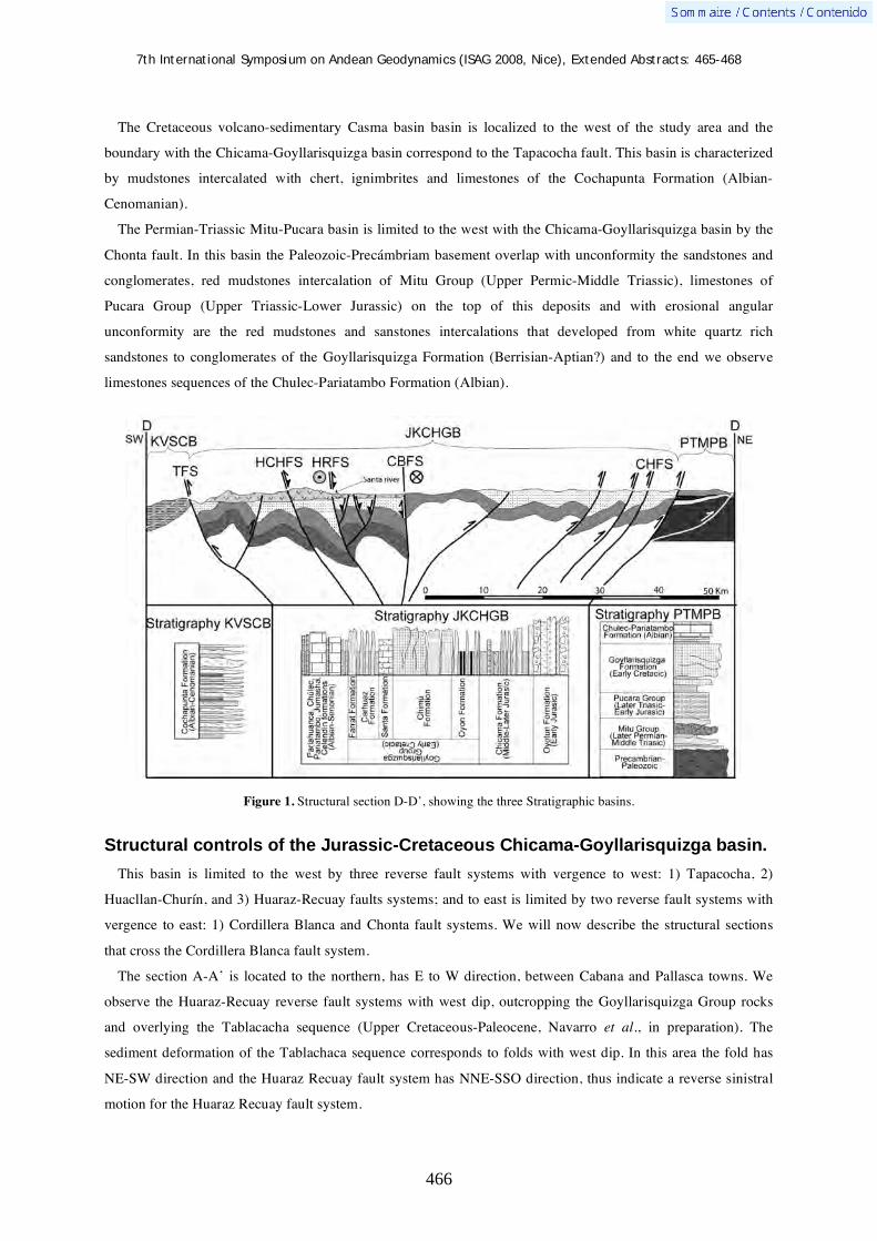
7th International Symposium on Andean Geodynamics (ISAG 2008, Nice), Extended Abstracts: 465-468
466
The Cretaceous volcano-sedimentary Casma basin basin is localized to the west of the study area and the
boundary with the Chicama-Goyllarisquizga basin correspond to the Tapacocha fault. This basin is characterized
by mudstones intercalated with chert, ignimbrites and limestones of the Cochapunta Formation (Albian-
Cenomanian).
The Permian-Triassic Mitu-Pucara basin is limited to the west with the Chicama-Goyllarisquizga basin by the
Chonta fault. In this basin the Paleozoic-Precámbriam basement overlap with unconformity the sandstones and
conglomerates, red mudstones intercalation of Mitu Group (Upper Permic-Middle Triassic), limestones of
Pucara Group (Upper Triassic-Lower Jurassic) on the top of this deposits and with erosional angular
unconformity are the red mudstones and sanstones intercalations that developed from white quartz rich
sandstones to conglomerates of the Goyllarisquizga Formation (Berrisian-Aptian?) and to the end we observe
limestones sequences of the Chulec-Pariatambo Formation (Albian).
Figure 1. Structural section D-D’, showing the three Stratigraphic basins.
Structural controls of the Jurassic-Cretaceous Chicama-Goyllarisquizga basin.
This basin is limited to the west by three reverse fault systems with vergence to west: 1) Tapacocha, 2)
Huacllan-Churín, and 3) Huaraz-Recuay faults systems; and to east is limited by two reverse fault systems with
vergence to east: 1) Cordillera Blanca and Chonta fault systems. We will now describe the structural sections
that cross the Cordillera Blanca fault system.
The section A-A’ is located to the northern, has E to W direction, between Cabana and Pallasca towns. We
observe the Huaraz-Recuay reverse fault systems with west dip, outcropping the Goyllarisquizga Group rocks
and overlying the Tablacacha sequence (Upper Cretaceous-Paleocene, Navarro et al., in preparation). The
sediment deformation of the Tablachaca sequence corresponds to folds with west dip. In this area the fold has
NE-SW direction and the Huaraz Recuay fault system has NNE-SSO direction, thus indicate a reverse sinistral
motion for the Huaraz Recuay fault system.
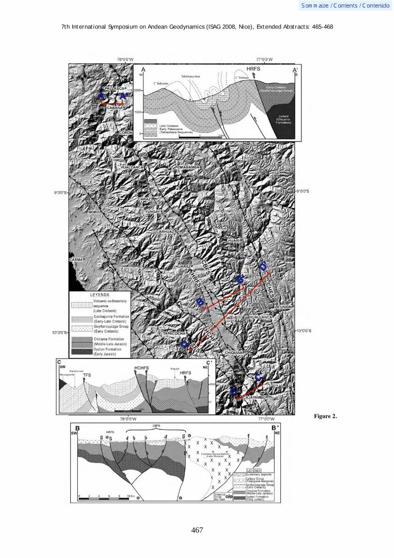
7th International Symposium on Andean Geodynamics (ISAG 2008, Nice), Extended Abstracts: 465-468
467
Figure 2.

7th International Symposium on Andean Geodynamics (ISAG 2008, Nice), Extended Abstracts: 465-468
468
The structural section B-B’ is located in the central southern part of Cordillera Blanca fault system near
Recuay town, from NE to SO direction, here we observe the Huaraz Recuay fault system as reverse with west
dip and the Cordillera Blanca fault system as reverse with east dip, which due tectonic inversion actually show
sinistral motion with normal component and generating a Plio-Qauternary basin with horst and graben showing
NW to SE direction.
The section C-C’ is located to the south, has NE to SW direction, near to Cajatambo town. Here we can
observe the three western fault systems of the JKCHGB, corresponding reverse faults with west dip, affecting
Jurassic rocks and the volcano-sedimentary sequence of Upper Cretaceous. This section is very important
because we can observe in the HCH fault system a positive flower structure by tectonic inversion.
The section D-D’, located in the central-southern part of Jurassic-Cretaceous Chicama-Goyllarisquizga basin,
has a NE to SO direction, between Chiquian and Recuay towns. This section is more regional, cross the three
stratigraphic basins and all fault systems that controlled the JKChGB. To the southwest we observe the
Cochapunta Formation (Albian-Cenomanian) of the KVSCB basin and limited by the TFS. In the central part we
observe the Jurassic-Cretaceous sediments controlled to the west by the Tapacocha, Huacllan-Churin, Huaraz
Recuay fault systems, and to the east controlled by the Chonta fault system. These fault systems show clear
distensive tectonic inversion to compressive. However, between the Huaraz-Recuay and Cordillera Blanca fault
systems we observe sinistral motion with normal component that affect Plio-Quaternary deposits. Toward NE
the Goyllarisquizga Formation is overlying with angular unconformity the Mitu-Pucara Group and the
Paleozoic-Precambrian basement in the Mitu-Pucara basin. Therefore, this basin corresponds to a horst during
the Cretaceous.
Conclusions
From the stratigraphic and structural analyses, we interpret that the Jurassic-Cretaceous Chicama-
Goyllarisquizga basin was originated and controlled by the Tapacocha, Huacllan-Churín, and Huaraz-Recuay
fault systems in the western boundary and by the Cordillera Blanca and Chonta fault systems in the eastern
boundary of the basin. These faults at the beginning have presented normal motion, later due to compressive
tectonic inversion change to reverse fault with west and east dip. Along the Chicama-Goyllarisquizga basin axes,
limited by Cordillera Blanca and Huaraz-Recuay faults systems, we observe sinistral slip with normal
component affecting Plio-Quaternary deposits. This last tectonic style indicates sinistral transtensive motion for
the Cordillera Blanca zone.
References Bonnot D., 1984 — Neotectonique et Tectonique active de la Cordillere Blanche et du callejon de Huaylas, Andes nord-
péruviennes. (Ph.D.), Orsay, Universite de Paris 115p. McNulty & Farber, 2002 — Active detachment faulting above the peruvian flat slab. Geology, v.30, p.567-570. Navarro P., Rivera M., Monge R., (in preparation) — Estratigrafía del Volcanismo Cenozoico (Grupo Calipuy), Cordillera
Occidental del norte del Perú, departamentos La Libertad y Ancash 7º 30’ – 9º 00’ latitud sur. Boletín INGEMMET.

7th International Symposium on Andean Geodynamics (ISAG 2008, Nice), Extended Abstracts: 469-472
469
Block rotations within the northern Peruvian Altiplano
Pierrick Roperch1, Víctor Carlotto
2, & Annick Chauvin
3
1 IRD, LMTG & Géosciences Rennes, campus de Beaulieu, 35042 Rennes, France ([email protected])
2 INGEMMET, Av. Canada 1470, San Borja, Lima 41 & UNSAAC, Cusco, Peru ([email protected])
3 Géosciences Rennes, campus de Beaulieu, 35042 Rennes, France ([email protected])
KEYWORDS : central andes, tectonics, paleomagnetism, rotation
Introduction
Counterclockwise tectonic rotations in the northern central Andes and clockwise rotations in the southern
Central Andes have been systematically reported (see Roperch et al. 2006 and Arriagada et al., 2006 for a recent
summary) and interpreted to be mostly driven by oroclinal bending associated with shortening in the Eastern
Cordillera and in the subandean belt. Large counterclockwise rotations have been found in the Eastern Cordillera
of Southern Peru (Gilder et al. 2003). While these rotations were initially attributed to a Cretaceous event of
deformation, Gilder et al. (2003) interpreted these rotations to be coeval with the rotations found along the
forearc (Roperch et al., 2006). Rotations along the forearc from Arequipa to Caravelli are larger than 40° and
occurred mainly during the late Eocene - Oligocene. However, the lack of data within the Peruvian Altiplano
precludes a good description of the spatial and temporal evolution as well as a clear understanding of the
different tectonic processes leading to rotations. Here we report results from a paleomagnetic study from Nazca
to Cusco (Figure 1). This transect corresponds to the location of the northern end of the Altiplano and a
transition with the central Peruvian Andes. Near Cusco, the Eastern Cordillera is also strongly deflected toward
the east with a complex deformation as shown by the curved fold and thrust system associated with the Manu
Indenter.
Paleomagnetic results
Paleomagnetic sampling
Fifty one paleomagnetic sites have been sampled from Nazca to Cusco. Six sites were drilled in lower Miocene
Nazca ignimbrites that cover the forearc between Nazca and Puquio. Near Puquio, 5 sites were drilled in undated
tertiary volcanics that are overlain by the Lower Miocene Nazca tuffs. Four sites were also sampled in upper
Miocene ignimbrites and two sites corresponds to a Semca Ignimbrite within the Altiplano. Six sites were drilled
in Paleocene to Eocene red bed sediments intruded by dykes north of Chalhuanta. Near Cusco, 9 sites were
sampled in Oligocene red beds from the Sonco Formation of the San Jeronimo group. While a late Cretaceous
age was initially attributed to the thick red beds sequences that outcrop in the southern Peruvian Altiplano, a mid
Oligocene 40Ar-39Ar age at the top of the sequence provides an upper age limit for the red bed sequence
(Carlotto, 1998). Several sites were also drilled in red beds either contemporenaeous or slightly older than the
San Jeronimo group (3 sites west of Sicuani) or in the Anta Formation.

7th International Symposium on Andean Geodynamics (ISAG 2008, Nice), Extended Abstracts: 469-472
470
Figure 1. Simplified geological map from Peru (modified from the 1/1000000 Peruvian map from Ingemmet ; see also Roperch et al. 2006) The paleomagnetic sampling was carried from Nazca to Cusco. a) sites drilled in the Sonco Formation (results reported in Figure 2); b) sites drilled in Paleocene- Eocene red beds and dyke near Chalhuanca (Figure 4); c) sites drilled in other Paleogene red beds near Cusco (Figure 3) ; d) sites drilled in Oligocene – Miocene volcanics near Puquio (Figure 5) ; c) sites (results not discussed). The dashed line is the northern boundary of the Arequipa domain identified by geochemical data (Mamani et al., 2008). Angles between the arrows and the north direction correspond to tectonic rotations. New results shown with white confidence interval. The colour (yellow, orange, magenta, cyan) correspond to age of rock unit (Miocene, Oligocene, Paleogene, Mesozoic).
Characteristic directions
All the samples in red beds were progressively thermally demagnetized. Except at a few sites where it was
possible to isolate a secondary magnetization, pre-tectonic components of magnetization were determined at
most sites. Near Cusco, all the samples drilled in 9 sites from the Sonco Formation have a reverse polarity
(Figure 2). The magnetic characteristic upon demagnetization and the better grouping after tilt correction
demonstrates that the magnetization is a primary component. Although the sampling is not stratigraphically
continuous enough for magnetostratigraphic dating, the lack of samples with normal polarity suggests high
deposition rate during a time interval dominated by reverse polarity, possibly during the late Eocene – early
Oligocene (35-31Ma).
Figure 2. Paleomagnetic results in red beds in the type section of the San Jeronimo group located to the south of Cusco. Equal areal projection of site-mean directions with the 95 angle of confidence. Filled circles are projection in the lower hemisphere. Filled red square is the expected late Eocene-early Oligocene direction for stable south America. The filled red circle and associated angle of confidence correspond to the mean direction.

7th International Symposium on Andean Geodynamics (ISAG 2008, Nice), Extended Abstracts: 469-472
471
Normal and reverse polarity magnetizations were found in other red bed units at different localities (Figure 3).
After bedding correction the observed inclinations is in good agreement with the expected inclination but large
counterclockwise deviations of the declinations are observed.
The dykes sampled north of Chalhuanca do not record a primary component of magnetization but a well-
defined primary magnetization was observed in the sediments baked contacts. Away from the dyke contacts,
characteristic directions were also determined in the red bed sediments (Figure 4).
Sites in volcanic rocks near Puquio have a well-defined primary characteristic magnetization of normal or
reverse polarity (Figure 5). Sampling in mid Miocene to Pliocene rocks is not sufficient to enable an accurate
averaging of secular variation. The average direction calculated for sites in the lower Miocene ignimbrites and
Figure 3. Paleomagnetic results in red beds at other sites near Cusco. Equal areal projection of site-mean directions with the 95 angle of confidence. Filled (open) symbols are projection in the lower (upper) hemisphere. The squares correspond to the late Eocene-early Oligocene expected directions.
Figure 4. Paleomagnetic results in red beds and dykes from the Paleocene-Eocene basin located to the north of Chalhuanca. Equal areal projection of site-mean directions with the 95 angle of confidence. The grey circle correspond to a remagnetization of unknown age recorded by pyrrothite in a site of Jurassic limestone south of Chalhuanca.
Figure 5. Paleomagnetic results in the lower Miocene Nazca ignimbrites and the underlying volcanics sampled near of Puquio. The red circle with angle of confidence is the mean direction calculated for these sites. Results highlighted in orange colour corresponds to younger Miocene or Pliocene volcanics and are not included in the mean calculation. The red square is the expected direction. for the late Oligocene Early Miocene.

7th International Symposium on Andean Geodynamics (ISAG 2008, Nice), Extended Abstracts: 469-472
472
underlying volcanics has an inclination similar to the expected direction.
Tectonic rotations
Near Cusco, large counterclockwise rotations are observed at some Paleogene sites while only 10° rotation is
determined in the Sonco Formation. Large rotations were also reported for the Permian to lower Jurassic
sediments (Gilder et al., 2002) in the Eastern Cordillera at a distance of about 15km to the east of the sites
sampled in the Sonco section. Taking into account that the upper part of the Sonco section is of mid-Oligocene
age, the result in the Sonco formation may provide an upper bound in the age of the rotation. Further work is
however needed to understand the cause of the large variation in the magnitude of the rotations.
North of Chalhuanca, the preliminary results from the late Paleocene- Eocene red bed basin indicate that this
area is affected by large counterclockwise rotation (~60°). In the Chalhuanca region to the west of the Eocene
basin, fold axes and faults in Mesozoic units have an anomalous WSW-ENE orientation. These structures can be
traced for more than 50km. Despite the fact that the Eocene basin presents little folding, the sediments record a
low magnitude anisotropy of magnetic susceptibility whose lineations are also oriented WSW-ENE. We
speculate that the ~60° counterclockwise rotation recorded in the Eocene basin corresponds to the block rotation
of a larger block postdating or associated with the main event of folding in the region. The Nazca ignimbrites
and underlying volcanics record a <5° counterclockwise rotation in agreement with the result previously
published by Roperch et al. (2006) indicating almost no block rotation within the forearc during the Neogene
even in front of the Nazca ridge.
The new available results confirm the widespread occurence of large (>40°) counterclockwise tectonic
rotations in southern Peru during a major phase of deformation in the time interval late Eocene- early Oligocene.
Geochemical data (Carlier et al., 2005; Mamani et al., 2008) show significant crustal and lithosperic
heterogeneities in the Central Andes and especially in Southern Peru. Mamani et al. (2008) argue that the
different rheologies are an important factor in controlling the deformation pattern of the central Andes and the
localization of the Andean plateau. They suggest that most of the rotations are the results of intense shearing
along the border of the Arequipa block. While the geochemical data suggest a sharp boundary between the
Arequipa block and the Central Peruvian Andes, large rotations are however observed in a much wider area
north and south of the geochemical boundary (Figure 1).
References Arriagada, C., Roperch, P., Mpodozis C., & Fernández, R. 2006. Paleomagnetism and tectonics of the southern Atacama
Desert region (25-28ºS) Northern Chile. Tectonics, 25: TC4001, doi:10.1029/2005TC001923. Carlier, G., Lorand, J.P., Liegeois, J.P., Fornari, M., Soler, P., Carlotto, V. & Cardenas, J. 2005. Potassic-ultrapotassic mafic
rocks delineate two lithospheric mantle blocks beneath the southern Peruvian Altiplano, Geology, 33: 601–604 doi: 10.1130/G21643.1
Carlotto, V. 1998. Evolution andine et raccourcissement au niveau de Cusco (13°-16°S, Pérou), Thèse Doctorat, Univ. Grenoble, 159p.
Mamani, M., Tassara, A. & G. Woerner, 2008. Composition and structural control of crustal domains in the central Andes, Geochem. Geophys. Geosys., doi:10.1029/2007GC001925.
Gilder, S., Rousse, S., Farber, D., Sempere, T., Torres, V., & O. Palacios 2003. Post-Middle Oligocene origin of paleomagnetic rotations in Upper Permian to Lower Jurassic rocks from northern and southern Peru, Earth and Planetary Science Letters, 210: 233-248.
Roperch, P., Sempere, T., Macedo, O., Arriagada, C., Fornari, M., Tapia, C., García, M. & C. Laj, 2006. Counterclockwise rotation of late Eocene – Oligocene fore-arc deposits in southern Peru and its significance for oroclinal bending in the central Andes, Tectonics, 25: TC3010, doi:10.1029/2005TC001882.
7th International Symposium on Andean Geodynamics (ISAG 2008, Nice), Extended Abstracts: 473
473
From steady state to climate-driven denudation across the Central Andes in SE Peru
Geoffrey M.H. Ruiz1,2
& Víctor Carlotto3
1 University of Neuchatel, Switzerland ([email protected])
2 ETH Zurich, Switzerland
3 INGEMMET, Lima, Peru
To better constrain the orogenic growth of the Andean chain, we investigated the time-Temperature paths of
bedrocks from the two morpho-structural highs of the Central Andes that are separated by the vanishing
Altiplano, i.e. the Eastern and Western Cordilleras of SE Peru.
The Western Cordillera is a volcanic to volcano-detrital chain that developed ~40-35 Ma ago and is
characterized by a 4000m high mean altitude whose origin is poorly constrained. Fission-Track data on apatite
and zircon crystals extracted from an Eocene pluton yield ages comprised between 24 and 14 Ma, and 38 and 30
Ma respectively. One of the noteworthy aspects of the data is that analyses reveal a steady-state phase of
exhumation from the late Eocene to at least the middle Miocene (38-14 Ma) with no disruption of the
exhumation path since 38 Ma either by sedimentary burial and/or rapid exhumation. The uplift of the Western
Cordillera was thus probably steady since, avoiding the deposition of foreland basin sequences as in the
Altiplano region. Further east, Apatite Fission-Track ages are much younger and range between 7.6 and 2.5 Ma
for the Eastern Cordillera and between 11.2 and 1.5 Ma for the Sub-Andean Zone. Age-altitude relationships
suggest that denudation increased from a more quiescent Late Miocene period to a high rate of 0.9 km/my for the
Pliocene. Such abrupt change is supported by a net in sediment accumulation rates in the Andean Amazon Basin
but as far as offshore the Amazon fan. A global climate change is usually invoked for high Pliocene rates;
however it post-dated a documented period of surface uplift in the Eastern Andes.
Denudation patterns are thus much contrasted across the Andes of SE Peru. The western Cordillera, despite
significant topography and deep river valleys in the studied area, still yield information that suggest a steady and
slow uplift from the late Eocene until at least the middle Miocene. We thus propose a coupled scenario: first the
Andean orographic barrier developed from the Eocene by tectonism as more recently in the eastern Cordillera
(Late Miocene), later focusing the Amazon moisture (5m/y of annual precipitation today) and as a result
denudation since the Pliocene along the eastern flank of the Andes. The localization of erosion modified in turn
the structure of the belt, limiting the deformation in the narrow Sub-Andean Thrust Belt.

7th International Symposium on Andean Geodynamics (ISAG 2008, Nice), Extended Abstracts: 474-476
474
Pleistocene uplift rates variability along the Andean active margin inferred from marine terraces
M. Saillard1, L. Audin
1, G. Hérail
1, S. Hall
2, D. Farber
2,3, J. Martinod
1 , & V. Regard
1
1 LMTG, Université de Toulouse, CNRS, IRD, OMP, 14 Av. E. Belin, F-31400 Toulouse, France
2 University of California, Santa Cruz, Dept. of Earth Sciences, Santa Cruz, CA 95060, USA
3 Lawrence Livermore National Laboratory, LLNL, Livermore, CA 94550, USA
KEYWORDS : Beryllium-10, marine terrace, Pleistocene, uplift rate, Central Andes
Introduction
The southern Pacific coast morphology and especially the presence of marine terraces give information on the
dynamics of Andean forearc evolution from the Pleistocene. Marine terraces preserve a record of eustatic sea
level changes together with the uplift history of the coastal area in the Andean forearc. Along most of the
Southern Peru and Northern Chilean coasts, discontinuous uplifts are recorded by wave-built terraces and wave-
cut platforms. To investigate these processes, we studied sequences of marine terraces in various coastal sections
either in southern Peru or in Chile: at Chala (15°50'S) and Ilo (17°32'S-17°48'S), situated above a steep
subduction segment and at San Juan de Marcona (15°20'S), situated above the southern part of the Nazca ridge,
and along the coastal part of the Altos de Talinay area, from Tongoy (30°15'S) to ~31°20'S, situated above a flat
subduction segment (Figures 1, 2 and 3).
We chose various sites in order to sample possibly different response of the continental plate to the subduction
process. Various studies were already undertaken on such problems either in Peru or Chile but mainly leaded to
the datation of the 5th isotopic stage. In this study, differential GPS and cosmogenic datations are pursued in
order to propose robust and absolute ages on these sites and subtract the effects of eustatic sea-level changes
from local curves, identifying tectonic uplifts. We dated ~15 levels of marine terraces either in Peru or Chile.
Results
In Chile, we show that, since 700 ka, Pleistocene uplift rates have been highly variable along the Andean
margin near 31°S (Saillard et al., submitted). The uplift of the Chilean forearc has been recorded by a sequence
of five wave-cut platforms that have been dated using in situ produced 10Be. These platforms formed during
interglacial periods corresponding to marine isotopic stages (MIS) or substages (MISS) 1, 5e, 7e, 9c and 17. Our
mapping in conjunction with the new chronology we present shows that the surface uplift rate varied from
103 ± 69 mm/ka between 122 and 6 ka, to 1158 ± 416 mm/ka between 321 and 232 ka. The absence of preserved
marine terraces related to the MIS 11, 13 and 15 highstands likely reflects slow uplift rates during these times.
Consequently, we propose that this area essentially uplifted during 2 short periods following MIS 17 and
MISS 9c with a contemporaneous superficial normal faulting. This episodic uplift of the Chilean coast in the
Pleistocene may result from subduction related processes, such as pulses of tectonic accretion at the base of the
forearc wedge. To our knowledge, this is the first time that 10Be exposure ages of a succession of wave-cut
platforms, has revealed non-steady long-term uplift rates on the Andean margin.
In Peru, the same type of studies is in progress. New ages on marine terraces are now available and provide
different uplift rates along the coast and higher uplift rates in the San Juan de Marcona area, above the Nazca

7th International Symposium on Andean Geodynamics (ISAG 2008, Nice), Extended Abstracts: 474-476
475
Ridge. In Peru, the chosen areas belong to the transition zone where the megathrust dip angle changes from flat
(~15°) to normal (~30°) and extend further south towards Arica region, where the distance from the coast to the
trench increases. The coastal morphologies could be related to those major geodynamic changes that affect the
Peruvian coast from Paracas to Arica.
Figure 1: DEM SRTM 90 m mosaic of Central Andes. Location of study areas (orange rectangles): the southern coast of Peru, between San Juan de Marcona and Ilo, and the area between Tongoy and Los Vilos, in the Norte Chico of Chile. Ridge outlines correspond to the -3700 m bathymetric curve, obtained from GMT. FS: Flat subduction.
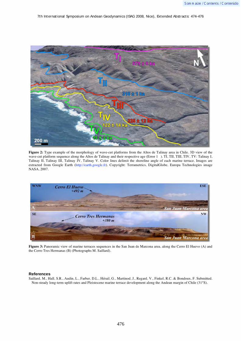
7th International Symposium on Andean Geodynamics (ISAG 2008, Nice), Extended Abstracts: 474-476
476
Figure 2: Type example of the morphology of wave-cut platforms from the Altos de Talinay area in Chile. 3D view of the wave-cut platform sequence along the Altos de Talinay and their respective age (Error 1 ). TI, TII, TIII, TIV, TV: Talinay I, Talinay II, Talinay III, Talinay IV, Talinay V. Color lines delimit the shoreline angle of each marine terrace. Images are extracted from Google Earth (http://earth.google.fr). Copyright: Terrametrics, DigitalGlobe, Europa Technologies image NASA, 2007.
Figure 3: Panoramic view of marine terraces sequences in the San Juan de Marcona area, along the Cerro El Huevo (A) and the Cerro Tres Hermanas (B) (Photographs M. Saillard).
References Saillard, M., Hall, S.R., Audin, L., Farber, D.L., Hérail, G., Martinod, J., Regard, V., Finkel, R.C. & Bondoux, F. Submitted.
Non-steady long-term uplift rates and Pleistocene marine terrace development along the Andean margin of Chile (31°S).

7th International Symposium on Andean Geodynamics (ISAG 2008, Nice), Extended Abstracts: 477-480
477
3D structure of the Tres Cruces synclinorium from seismic data and serial balanced cross-sections, Eastern Cordillera, Argentina
Luiraima Salazar1, Jonas Kley
1, Eduardo Rossello
2, Ruben Monaldi
3, & Miriam Wiegand
1
1 Institut für Geowissenschaften, Friedrich-Schiller Universität Jena, Burgweg 11, D- 07749 Jena, Germany
2 Universidad de Buenos Aires-CONICET –Depto. de Ciencias Geológicas, 1428 Buenos Aires, Argentina
3 Universidad de Salta-CONICET-Depto. de Ciencias Geológicas, La Rioja 698, 4400 Salta, Argentina
KEYWORDS : fault-propagation fold, Cretaceous rift, tectonic inversion, shortening, Northwestern Argentina
Introduction
The geologic structures in
orogenic belts often show
complex kinematics on different
scales. These changes of local
movement direction have
frequently been interpreted as a
direct effect of plate kinematics.
However, local processes could
obviously play an important role
here. Only an active orogen with
a relatively simple geologic
history offers good possibilities
to examine these relationships. The Central Andes developed during the last 30 Ma in a constant tectonic setting
and are the product of crustal thickening and magmatism, in response to subduction of the oceanic Nazca plate
beneath continental South America, with a convergence vector of almost constant orientation. The structural
grain of the Central Andes reflects imbricated fold and thrust systems that in general agree well with continuous,
roughly E-directed shortening throughout the history of the active plate margin. However, there are geologic
structures indicating a perpendicular, approximately N-S shortening direction. The magnitude of N-S shortening
is relatively small, but the structures occur over a large area. The Tres Cruces synclinorium, located in Northwest
Argentina (Fig. 1) offers ideal conditions to study this type of perpendicular structures and their kinematic and
genetic relationship with the regional setting. The aim of this study is to understand and explain the tectonic
mechanisms that have created these complex and local structures inside a regional tectonic environment through
a three-dimensional model of this region. We have analysed field and subsurface data in an area of c. 180 Km2,
integrating seismic profiles, four exploratory wells with appearances of hydrocarbons and gas, satellite images
and previous geologic maps, in an attempt to clarify the spatial and temporal relationships between N-S- and E-
W-trending structures.
Figure 1. Simplified structural map (modified from Kley et al., 2005) of the Tres Cruces basin with location of Cerro Colorado. Right: Satellite image of the Cerro Colorado structure.
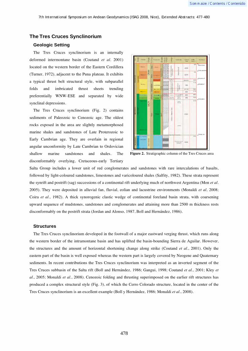
7th International Symposium on Andean Geodynamics (ISAG 2008, Nice), Extended Abstracts: 477-480
478
The Tres Cruces Synclinorium
Geologic Setting
The Tres Cruces synclinorium is an internally
deformed intermontane basin (Coutand et al. 2001)
located on the western border of the Eastern Cordillera
(Turner, 1972), adjacent to the Puna plateau. It exhibits
a typical thrust belt structural style, with subparallel
folds and imbricated thrust sheets trending
preferentially WNW-ESE and separated by wide
synclinal depressions.
The Tres Cruces synclinorium (Fig. 2) contains
sediments of Paleozoic to Cenozoic age. The oldest
rocks exposed in the area are slightly metamorphosed
marine shales and sandstones of Late Proterozoic to
Early Cambrian age. They are overlain in regional
angular unconformity by Late Cambrian to Ordovician
shallow marine sandstones and shales. The
disconformably overlying, Cretaceous-early Tertiary
Salta Group includes a lower unit of red conglomerates and sandstones with rare intercalations of basalts,
followed by light-coloured sandstones, limestones and varicoloured shales (Salfity, 1982). These strata represent
the synrift and postrift (sag) successions of a continental rift underlying much of northwest Argentina (Mon et al.
2005). They were deposited in alluvial fan, fluvial, eolian and lacustrine environments (Monaldi et al, 2008;
Coira et al., 1982). A thick synorogenic clastic wedge of continental foreland basin strata, with coarsening
upward sequence of mudstones, sandstones and conglomerates and attaining more than 2500 m thickness rests
disconformably on the postrift strata (Jordan and Alonso, 1987, Boll and Hernández, 1986).
Structures
The Tres Cruces synclinorium developed in the footwall of a major eastward verging thrust, which runs along
the western border of the intramontane basin and has uplifted the basin-bounding Sierra de Aguilar. However,
the structures and the amount of horizontal shortening change along strike (Coutand et al., 2001). Only the
eastern part of the basin is well exposed whereas the western part is largely covered by Neogene and Quaternary
sediments. In recent contributions the Tres Cruces synclinorium was interpreted as an inverted segment of the
Tres Cruces subbasin of the Salta rift (Boll and Hernández, 1986; Gangui, 1998; Coutand et al., 2001; Kley et
al., 2005; Monaldi et al., 2008). Cenozoic folding and thrusting superimposed on the earlier rift structures has
produced a complex structural style (Fig. 3), of which the Cerro Colorado structure, located in the center of the
Tres Cruces synclinorium is an excellent example (Boll y Hernández, 1986; Monaldi et al., 2008).
Figure 2. Stratigraphic column of the Tres Cruces area

7th International Symposium on Andean Geodynamics (ISAG 2008, Nice), Extended Abstracts: 477-480
479
The Cerro Colorado anticline
The Cerro Colorado structure is an
approximately 15 km long and up to 6 km
wide asymmetrical anticline with a sigmoidal
main fold axis that trends NNE-SSW. The
anticline involves more than 5 km of
sedimentary strata including the Paleozoic
basement, Salta Group and Cenozoic foreland
basin sequences.
The integration of field data, seismic
interpretation, satellite-foto analysis,
geological profile construction and cross
section balancing with quantification of
shortening across and near the Cerro Colorado
indicate that it is a fault-propagation fold
above an eastward verging thrust (Vizcarra
Fault) with a listric and asymptotic geometry
merging into a detachment surface within
Ordovician strata (Fig. 4). In the central part it
is cut by a transverse fault which is expressed
as a topographic depression. Its origin is
probably associated with Cretaceous rifting
and it was reactivated as transverse reverse
fault during the Neogene orogeny. This fault
subdivides the anticline into two different
structural domains: in the northern part the
structure is a relatively simple east-directed
thrust sheet with a frontal anticline (Kley et al.
2005, Monaldi et al., 2008). The irregular
geometry of the Cerro Colorado anticline
reflects the close control on structure and topography by the amount of internal deformation, resulting from the
combined effects of two perpendicular shortening phases in N-S (10% shortening) and W-E (30-40% shortening)
direction.
Figure 3. Structural map of the central part of the Tres Cruces synclinorium.
Figure 4. Structural cross-section along the seismic line 90-47. It shows the internal structure of the Cerro Colorado anticline and other structures nearby.

7th International Symposium on Andean Geodynamics (ISAG 2008, Nice), Extended Abstracts: 477-480
480
The Sierra de Cajas anticline
The Sierra de Cajas anticline (Fig. 5) is located
south of Cerro Colorado and was uplifted on the
Cajas thrust, which has emplaced Ordovician
rocks over Tertiary sequences. The anticline
trends north, is doubly-plunging and asymmetric,
with the steep to overturned western flank
dissected by the steeply dipping, westward
verging thrust (Monaldi et al., 2008). The
horizontal shortening associated with these
structures is ~46 %.
Conclusions
The structures of the Cerro Colorado and Sierra de Cajas fault propagation anticlines demonstrate the effects
of Neogene contraction with and without added complexity by preexisting transverse faults. The transverse
contraction structures appear to be genetically associated with the reactivation of transverse faults that originated
during the rift period, since all documented examples of N-S shortening occur within the Salta rift. Overfolding
relationships indicate that N-S shortening mostly postdates the main E-W shortening phase. However, the
strongly curved fault trace of the N-directed thrust in the central part of Cerro Colorado may indicate folding of
the fault and a temporal overlap of both shortening events. The reason for along-strike contraction in an
essentially straight segment of the Andean thrust belt is still not clear. Kinematically, it could be explained as an
effect of strain partitioning; dynamically it would require the E-W trending faults to be extremely weak.
References Boll, A., and Hernández, R., 1986 - Interpretación estructural del área Tres Cruces. Boletin de Informaciones Petroleras,
Tercera Epoca III ( 7): 2-14. Coira, B., Davidson, J., Mopodozis, C, and Ramos, V., 1982 - Tectonic and magmatic evolution of the Andes of northern
Argentina and Chile. Earth Science Reviews, 18: 303-332. Coutand, I., Gautier, P., Cobbold, P., De Urreiztieta, M., Chauvin, A., Gapais, D., Rossello, E., Lopéz Gamundi, O., 2001-
Style and history of Andean deformation, Puna Plateau, northwestern Argentina. Tectonics, 20: 210-234. Gangui, A. H., 1998 - A combined structural interpretation based on seismic data and 3D gravity modelling in the northern
Puna/Eastern Cordillera, Argentina. Berl. Geowiss. Abh. Reihe C, 27: 176 pp. Jordan, T., and Alonso, R., 1987 - Cenozoic stratigraphy and basin tectonics of the Andes Montain, 20°-28° south latitude.
AAPG Bulletin, 71: 49-64. Kley, J., Rossello, E., Monaldi, C., and Habighorst, B., 2005 - Seismic and field evidence for selective inversion of
Cretaceous normal faults, Salta rift, Northwest Argentina. Tectonophysics, 399: 155-172. Mon, R., Monaldi, C y Salfity, J.A., 2005 - Curved structures and interference fold patterns associated with lateral ramps in
the Eastern Cordillera, Central Andes Argentina. Tectonophysics: 173-179. Monaldi, C.R., Salfity, J.A., y Kley, J., 2008 - Preserved extensional structures in an inverted Cretaceous rift basin,
northwestern Argentina: Outcrop examples and implications for fault reactivation. Tectonics 27: TC1011, 21p. Salfity, J.A., 1982 - Evolución paleogeográfica del grupo Salta (Cretácico-Eogénico), Argentina. Quinto Congreso
Latinoamericano de Geología, Buenos Aires, Argentina: 11-26. Suppe, J and Medwedeff, D., 1990 - Geometry and kinematics of fault-propagation folding, Eclogae Geologicae Helvetiae,
83: 409-453. Turner, J. 1972 - Cordillera Oriental. In: Leanza, A. F. (Ed), Geología regional de Argentina, vol. 1. Academia Nacional
de Ciencias: 117-142.
Figure 5. Structural cross-section along the seismic line 90-49. It shows the westward verging Cajas thrust and the associated fold with an overturned front limb.

7th International Symposium on Andean Geodynamics (ISAG 2008, Nice), Extended Abstracts: 481-484
481
Analysis of microseismicity in the Precordilleran Fault System at 21°S in Northern Chile
Pablo Salazar1,2
, Jörn Kummerow1, Günter Asch
1,3, Dorothee Moser
1, & Peter Wigger
1
1 Freie Universität Berlin, FR Geophysik, Malteserstrasse 74, D12249 Berlin, Germany
([email protected] 2 Universidad Catolica del Norte, Av. Angamos 0610, Antofagasta, Chile
3 GeoForschungsZentrum Potsdam, Telegrafenberg, D14473 Potsdam, Germany
KEYWORDS : microseismicity, earthquake location, earthquake cluster, Precordilleran Fault system, Northern Chile
Introduction
The Precordilleran Fault system (PFS) is one of the most important features of the Andean forearc in Northern
Chile. The PFS has a length of more than 1000 km [Camus, 2003], with a predominant N-S orientation and
associated strike-slip movements. The fault system has influenced the emplacement and mineralization of a
number of the largest porphyry-copper-related intrusion around the world. These faults are composed of various
regional segments, each having undergone a distinct series of deformation events [Lindsay et al., 1995]. In the
northern part the regional branch of the PFS is known as West Fissure Fault Zone (WFFZ). The WFFZ is partly
well exposed at the surface. In spite of its geological, tectonic and economic importance very little is known
about its seismic activity and the continuation to greater depth. Recent studies of the area focus on the seismicity
associated with the subduction of the Nazca Plate beneath the South American Plate e.g., [Haberland and
Rietbrock, 2001], [Heit, 2005], the Tarapacá earthquake on 13 June, 2005 [Peyrat et al., 2006], the Aroma
earthquake on 24 July, 2001 [Legrand et al., 2007], intracontinental seismicity associated to Central Andes
Orocline [David, 2007] and tectonics evidences of the western Altiplano plateau e.g., [Janssen, 2002], [Victor,
2004], [Farías, 2005]. The present work focuses on the following aspects: Does the WFFZ have related
seismicity? Down to which depth crustal seismicity can be observed? Does seismicity give a hint to the width of
the WFFZ? How are the focal mechanisms and what do they tell us about the stress field on WFFZ? Our
analysis is placed on the area at ~21°S due to a series of geophysical observations at this latitude [ANCORP
Working Group, 1999, 2003; Wigger et al., 1994, Yuan et al., 2000].
Tectonic setting
The WFFZ has been active since the Late Eocene/Early Oligocene [Janssen, 2002], [Reutter et al., 1996]. Most
authors assume that an older dextral strike-slip motion caused by subduction-related magmatic arc tectonics of
the Incaic tectonic phase was followed by sinistral shear corresponding to a time of reduced convergence rate
[Reutter et al., 1996]. The youngest event is the reactivation of dextral slip under the same kinematic conditions
as described for the older phase. Deformation structures, which include folds, foliations, brittle faults and thrusts,
trend obliquely to the main fault trace [Carrasco et al., 1999]. The tectonic shows that west side the WFFZ is
subject to a compressional behaviour where thrust and reverse faults are observed. On the other hand, at the
eastern side a tensional behaviour with normal faults and basin development is described [Victor et al., 2004].

7th International Symposium on Andean Geodynamics (ISAG 2008, Nice), Extended Abstracts: 481-484
482
Experiment set-up
In order to monitor the seismicity at the WFFS, we installed a temporary seismic network in November 2005
(Fig. 1). The net has been recording continuously since that time and the operation will be maintained at least
throughout the year 2008. The seismic monitoring system covers an area of approx. 50 times 50 km at elevations
between 3000 m and 5000 m a.s.l. and consists of 14 surface stations with 3-component short period
seismometers (Mark L4-1Hz). The data recording is continuous at a sample rate of 200Hz. The seismic stations
are stand-alone and each seismic station is serviced every 3-6 months. So far, the observations until February
2007 have been processed and the first results are presented here.
Data Analysis and Results
Seismicity
For the recording period November 2005 to February 2007 about 700 local seismic events with magnitudes -
0.5 < ML<4.2 and focal depths between 2km and 50km have been located (earthquakes from the subduction
zone are not incorporated). The seismic event locations were determined using a grid-search algorithm in a
regional 2-D Vp model [Lueth 2000] and automatically corrected arrival times. We observe upper crustal
microseismicity (Fig. 1), which is only partly associated with the known branches of the WFFS. Focal depths
north of 21°S are smaller than 20 km whereas south of 21°S depths down to 50 km can be observed. In the W-E
section a distinct lower boundary of the seismicity is obvious, dipping to the West.
Swarm Events
Among the seismic activity, two seismic clusters were detected, one at 35-40 km depth in the SW of the
monitoring area (~110 events, between September and November 2006), and one in the central part at 9-10 km
depth beneath sea level (~120 events between March 31, and April 28, 2006, and ~40 events between January 8-
10, 2007).
The event cluster at 9-10 km depth exhibit characteristics of an earthquake swarm (Wigger et al. 2007). The
majority of events have very high cross correlation coefficients (greater than 0.8), indicating that the events
locate in a small volume (the maximum inter event distance is in the order of 1 km). To resolve the finer scale
structure, we applied a master event location approach. The results show that the earthquakes cluster on a ~600
m times ~500 m patch along a near-vertical west-east orientated fracture plane (perpendicular to the main
orientation of the WFFS).
Focal Mechanism stress tensor inversion
Focal mechanisms for ~200 events were determined based on the polarity of P wave arrivals and amplitude
ratios (SV/P, SH/P and SH/SV) [Snoke, 2003]. From the focal mechanisms we inverted the stress field in the
study area. We applied two approaches in the stress tensor calculations. First way we considered a single stress
tensor solution that explains all focal mechanisms in the area. In a second step we divided the study area
considering the tectonics frame and calculated the tensors respectively. For both calculations we have selected
events with more than 6 P polarity measurements. The results show that on the west side of WFFZ the

7th International Symposium on Andean Geodynamics (ISAG 2008, Nice), Extended Abstracts: 481-484
483
predominant regime is transpressional whereas on the east side of WFFZ is transtensional. For the single
solution we have calculated a transtensional regime for the area. These results are consistent with WFFZ fault
motion derived from geological studies.
Fig 1: Local seismicity around the West Fissure Fault Zone (WFFZ) at about 21°S detected during the first 15 months of monitoring (11/2005-2/2007). Seismicity at the Wadati-Benioff zone is not shown. Short period 3-D station locations are plotted by red squares, WFFZ (black lines) after Reutter et al. (1994) Camus (2003), SERNAGEOMIN (2003) and Victor et al. (2004). The black W-E crooked line indicates the ANCORP profile with shot points (white stars). Earthquake locations (blue triangles) are plotted in map view (top left) and two depth sections (N-S: right and W-E: bottom), depth=0km corresponds to sea level.
References ANCORP Working Group (1999), Seismic reflection image revealing offset of Andean subduction-zone earthquake locations
into oceanic mantle, Nature, 397, 341 - 344. ANCORP Working Group (2003) Seismic imaging of an active continental margin and plateau in the central Andes (Andean
Continental Research Project 1996 (ANCORP '96)), J. Geophys. Res., 108 (B7), doi:10.1029/2002JB001771.
7th International Symposium on Andean Geodynamics (ISAG 2008, Nice), Extended Abstracts: 481-484
484
Camus 2003. Geología de los sistemas porfídicos de los Andes de Chile. Servicio Nacional de Geología y Minería, 267pp. Santiago, Chile.
Carrasco, P., H. Wilke, H. Schneider (1999). Post-Eocene deformational events in the North segment of the Precordilleran Fault system, Copaquiri (21°S). Fourth ISAG, Göttingen (Germany), 04-06/10/99.
David, C. (2007). Comportamiento actual del ante-arco y del arco del codo de Arica en la orogénesis de los Andes centrales. PhD. Thesis, Universidad de Chile, Chile, 290 pp.
Farías, M., R. Charrier, D. Comte, J. Martinod, and G. Hérail (2005), Late Cenozoic deformation and uplift of the western flank of the Altiplano: Evidence from the depositional, tectonic, and geomorpholic evolution and shallow seismic activity (northern Chile at 19°30'S), Tectonics, 24, TC4001, doi: 10.1029/2004TC001667.
Haberland C, Rietbrock A (2001) Attenuation Tomography in the Western Central Andes: A detailed insight into the structure of a magmatic arc. JGR 106 (B6): 11151-11167.
Heit, B. (2005) Teleseismic Tomographic Images of the Central Andes at 21°S and 25.5°S: An inside look at the Altiplano and Puna plateaus, Scientific Technical Report, STR06/05GeoForschungsZentrum Potsdam, 139pp.
Janssen, C., A. Hoffmann-Rothe, S. Tauber, H. Wilke (2002). Internal strucutre of the Precordillera fault system (Chile) – insights from structural and geophysical observations. Journal of Structural Geology, 24, pp. 123 – 143.
Legrand, D, B. Delouis, L. Dorbath, C. David, J. Campos, L. Marquéz, J. Thompson, D. Comte (2007). Source parameters of the Mw=6.3 Aroma Crustal earthquake of July 24, 2001 (northern Chile), and its aftershock sequence. Journal of South American Earth Sciences, 24, pp. 58 – 68.
Lindsay, D. D., M. Zentilli, A. J. Rivera (1995). Evolution of an active ductile to brittle shear system controlling mineralization at Chuquicamata porphyry copper deposit, Northern Chile. International Geology Review, 37, pp. 945 – 958.
Lüth, S. (2000), Results of wide-angle investigations and crustal structure along a traverse across the central Andes at 21 degrees south. PhD thesis (in german), Institute of Geology, Geophysics and Geoinformatics, Free University of Berlin, Berliner Geowissenschaftliche Abhandlungen, Band 37, Reihe B.
Peyrat S., J. Campos, J. B. Chabalier, A. Perez, S. Bonvalot, M.-P. Bouin, D. Legrand, A. Nercessian, O. Charade, G. Patau, E. Clévédé, E. Kausel, P. Bernard and J.-P. Vilotte (2006). Tarapacá intermediate-depth earthquake (Mw 7.7, 2005, northern Chile): A slab-pull event with horizontal fault plane constrained from seismologic and geodetic observations. Geophysical Research Letters, 33, L22308.
Reutter, K.-J., E. Scheuber, G. Chong (1996). The precordilleran fault system of Chuquicamata, Northern Chile: evidence for reversals along arc-parallel strike-slip faults. Tectonophysics, 259, pp. 213 – 228.
Snoke, J. A. (2003). FOCMEC: FOCal MEChanism determinations, International Handbook of Earthquake and Engineering Seismology (W. H. K. Lee, H. Kanamori, P. C. Jennings, and C. Kisslinger, Eds.), Academic Press, San Diego, Chapter 85.12.
Victor, P., O. Oncken, and J. Glodny (2004), Uplift of the western Altiplano plateau: Evidence from the Precordillera between 20° and 21° (northern Chile), Tectonics, 23, TC4004, doi:10.1029/2003TC001519.
Wigger, P., Schmitz, M., Araneda, M., Asch, G., Baldzuhn, S., Giese, P., Heinsohn, W.-D., Martìnez, E., Ricaldi, E., Röwer, P., and Viramonte, J. ((1994), Variation of the crustal structure of the Southern Central Andes deduced from seismic refraction investigations. In: Tectonics of the Southern Central Andes, Reutter, Scheuber & Wigger (eds.), Springer Verlag, Berlin Heidelberg, p 23-48.
Wigger, P., Kummerow, J., Salazar, P., Asch, G., Moser, D. (2007), Microseismicity in the West Fissure fault system, Northern Chile. Geophysical Research Abstracts, Vol. 9, 07136.
Yuan, X., S. V. Sobolev, R. Kind, O. Oncken, and Andes Seismology Group (2000), New constraints on subduction and collision processes in the central Andes from P-to-S converted seismic phases, Nature, 408, 958 – 961.

7th International Symposium on Andean Geodynamics (ISAG 2008, Nice), Extended Abstracts: 485-488
485
Relations between plutonism in the back-arc region in southern Patagonia and Chile Rise subduction: A geochronological review
Alejandro Sánchez1, Francisco Hervé
1, & Michel de Saint-Blanquat
2
1
Departamento de Geología, Universidad de Chile, casilla 13518 correo 21, Santiago, Chile
CNRS-LMTG/Observatoire Midi-Pyrénées, Université de Toulouse, 14 av. Edouard-Belin, 31400 Toulouse,
France ([email protected])
KEYWORDS : plutonism, geochronology, Patagonia
Introduction
Southern Patagonia is constituted by 3 main tectono-stratigraphic units, from west to east: the Permo-Triassic
deformed basement, the Late Jurassic – Early Cretaceous extensional basins, and the Late Cretaceous to
Cenozoic compressional Magallanes foreland basin (MFB). There are also two intrusive and two extrusive
magmatic belts: the Southern Patagonian Batholith (SPB) (Mesozoic-Cenozoic), which intrudes the basement,
and the back-arc region plutons (Neogene) which intrude the MFB and the extensional basins, specially in the
northern area. The extrusive units are the Miocene-Pleistocene basaltic plateau lavas, mainly in Argentina, and
lastly the active volcanic arc located at the western
margin of South America.
The back-arc region plutons (figure 1), are mainly
miocene isolated granites to diorites bodies. Michel
(1983) had been the first in considerate it as a north-
south magmatic lineament in the back-arc region, and
furthermore he linked this magmatic lineament with
the Chile Rise (CR) subduction, which started 15-14
Ma at 55º lat.S and since that time the triple joint has
migrated to the north until their actual position
(~46º30' lat. S) (Cande and Leslie, 1986).
Nevertheless, there is not a good correlation between
Triple Joint migration and magmatism occurrence.
The latter is widespread in Neogene times (figure 1),
including several 15-25 Ma plutons in the SPB
(Hervé et al., 2007); the basaltic plateau lavas, which
are Pliocene to mid-Miocene (~14 Ma) (Guivel et al.,
2006); also there is several adakite type intrusives
miocene in age in the back-arc region (Ramos et al.,
2004).
The aim of this contribution, is to help to solve the following questions: Is this north to south miocene
lineament a real lineament? And: are this igneous bodies related to CR subduction?
Figure 1: Magmatic map of southern Patagonia. After Michel,
1983.

7th International Symposium on Andean Geodynamics (ISAG 2008, Nice), Extended Abstracts: 485-488
486
In this way we present a geochronologic compilation of cenozoic intrusive bodies in the back-arc region of
Patagonia together with preliminary new age data of plutons that have been include in this “lineament” (Sánchez
et al., in prep.). The main goal of this contribution is that age data of the back-arc plutons reveals that most of
them are older than the CR subduction and a direct relation between plutonism and slab windows is still unclear.
Geochronology
A compilation of available geochronologic data of intrusives rocks in southern Patagonia is presented in Table
1 and illustrated in Fig. 2. Its include the different type of rocks mentioned above, together with the age and
location of Chile rise segments collision (accord to Cande & Leslie, 1986). This compilation is only of
radiometric dating methods. Even K/Ar method may reflect younger ages than plutons crystallization ages, is
include because many plutons are only dated by this methodology. Even the database includes diverse
radiometric methods, some general observations can be made:
In all the region, the age data for the back-arc plutons
is mainly concentrated between 9 and 18 Ma
(exceptions are Las Nieves granite and San Lorenzo
granite). In most cases these age are older than Chile
Rise collision age. Only few temporal coincidence
between magmatism and Chile rise subduction exist.
The most remarkable are Cerro Pampa adakite, San
Lorenzo granite and Torres del Paine granite.
In the arc region (SPB), there are plutons which range
in age between 15 and 25 Ma (Hervé et al., 2007).
There is only one Pliocene pluton of 4 Ma and this is
the only dated pluton of the SPB in this area, younger
than CR collision.
In Fig. 2, also can be noted that the original plutons
in the lineament (enclosed by circles), do not show a
pattern of been younger northward as the CR collision
age.
Discussion
The geochronology used should be more representative of crystallization ages for allow good comparison of
emplacement times of the plutons. So U/Pb zircon dating is being carried out by the authors to avoid bad
interpretations, as can occur here comparing pluton ages obtained by differents radiometric methods.
Nevertheless, it seems to be clear that most plutonism in both, arc and back-arc regions, is previous to CR
collision. This underestimate astenospheric windows source for these plutons. And it can be related to previous
buoyancy of the subducted slab related magmatism as is suggest by Espinoza (2007).
Among the back-arc plutons, there are several complex which includes Miocene, Oligocene and/or Cretaceous
plutons (e.g. San Lorenzo and Puesto Nuevo) the coincidence in the back-arc region location of these, may
Figure 2. Southern Patagonian back-arc plutons ages
diagram. Crosses represents ages of plutons of SPB (Hervé
et al., 2007). horizontal bars represent location and age of
collision of CR segments (from Cande & Leslie).LL: Las
Llaves, LN: Las Nieves, CN: Cerro Negro del Ghío, CI:
Cerro Indio, SL: San Lorenzo, CP: Cerro Pampa, PN: Puesto
Nuevo, FR: Fitz-Roy, Ch: Chalten, CM: Cerro Moyano, TP:
Torres del Paine, CD: Cerro Donoso, CB: Cerro Balmaceda

7th International Symposium on Andean Geodynamics (ISAG 2008, Nice), Extended Abstracts: 485-488
487
reflect ancient discontinuities in the patagonian continental crust This mechanism should allow magmas to reach
upper levels of the crust in high magmatic periods, as may be miocene times.
Table 1. Localities and dating methods of the plutons ages plotted in Fig.2. 1: Pankhurst et al. (1999); 2: Petford & Turner
(1996); 3: Suarez & de la Cruz (2001); 4: Morata et al. (2002); 5: Ramos (2002); 6: Welkner (1999); 7: Welkner (2000); 8:
Fanning, pers.com.; 9: Pino (1976); 10 Ramos & Palma (1981); 11: Pankhurst, com.pers to Giacosa Franchi; 12: Ramos et al. (1991); 13: Ramos et al. (2004); 14: Motoki et al. (2003); 15: Nullo et al. (1978); 16: Linares & Gonzales (1990); 17:
Halpern, 1973; 18: Sánchez et al. (2006); 19: Altenberger et al. (2003); 20: Sánchez et al., in prep.; 21: in Skarmeta &
Castelli (1997)
Pluton Lat.S Lon.W Dating method Age (Ma) Error (Ma) Material
Paso de las llaves1
46°40' 72°15' Rb/Sr 10.3 0.4 WR-KFd Bt (isochron)
Paso de las llaves2
46°40' 72°15' Ar-Ar isochron 9.6 0.5 Biotite
Paso de las llaves2
46°40' 72°15' Ar-Ar 9.6 0.4 Biotite
Paso de las llaves3
46°40' 72°15' K/Ar 10 1.1 Biotite
Aviles3
46°45' 72°15' K/Ar 9.6 0.6 Biotite
Rio de las Nieves4
46°41' 72°06' K/Ar 3.2 0.4 Biotite
Cerro Indio5
47º6 71º53' K/Ar 13.2 0.9 WR
Cerro Negro del Ghío5
47º7' 71º52' K/Ar 18.1 1.2 WR
Cerro Negro del Ghío5
47º7' 71º52' K/Ar 15.8 0.7 WR
Cerro Negro del Ghío5
47º7' 71º52' K/Ar 15.8 0.6 Hornblende
Co Sn Lorenzo3
47°35’ 72°20’ K/Ar 6.6 0.5 Biotite
Co Sn Lorenzo6
47°35’ 72°20’ K/Ar 6.4 0.4 Biotite
Co Sn Lorenzo7
47°35’ 72°20’ WMPA Ar/Ar 5.76 0.18 K-feld
Co Sn Lorenzo7
47°35’ 72°20’ WMPA Ar/Ar 6.2 0.12 Biotite
Co Sn Lorenzo8
47°35’ 72°20’ SHRIMP U/Pb 6.44 0.28 circon
Co Sn Lorenzo9
47°35’ 72°20’ K/Ar 8.8 6.1 Not published
Co Sn Lorenzo10
47°35’ 72°20’ K/Ar 8 1 Not published
Co Sn Lorenzo11
~47º40' ~72º15 Rb/Sr 9.2 1.6 Not published
Cerro Pampa12
47º54' 71º20' K/Ar 12.1 0.7 Not published
Cerro Pampa12
47º54' 71º20' K/Ar 12 0.7 Not published
Cerro Pampa13
47º54' 71º20' WMPA Ar/Ar 11.39 0.61 Hornblende
Cerro Pampa13
47º54' 71º20' WMPA Ar/Ar 12.87 0.24 WR
Puesto Nuevo13
48º56' 72º12,5' WMPA Ar/Ar 13.12 0.55 Hb
Puesto Nuevo13
48º56' 72º12,5' WMPA Ar/Ar 13.29 3.97 WR
Puesto Nuevo14
48º56' 72º12,5' U/Pb 14.1 3.6
Fitz Roy15
49°15' 73° K/Ar 18 3 WR
Chalten13
49°25,5' 72º59,5' WMPA Ar/Ar 14.5 0.29 Amphibole
Cerro Moyano16
50º27,2 72º23,7' K/Ar 16 1 WR
Paine17
51° 73° Rb/Sr 12 2 Bt
Paine17
51° 73° K/Ar 13 1 Bt
Paine18
51° 73° SHRIMP U/Pb 12.65 0.13 circon
Paine (external gabro)19
51° 73° K/Ar 29.4 0.8 Biotite
Co Donoso20
51º13,3 73º9.5' SHRIMP U/Pb ~26 Circon
Co Balmaceda21
51°25' 73°11' K/Ar ? 28 Not published
Co Balmaceda20
51°25' 73°11' SHRIMP U/Pb ~15 Circon
References Altenberger, U., Oberhaensli, R., Putlitz, B. & Wemmer, K. 2003. Tectonic controls of the Cenozoic magmatism at the
Torres del Paine, southern Andes (Chile, 51°10'S). Revista Geologica de Chile 30: 65-81 Cande, S.C., & Leslie, R.B., 1986. Late Cenozoic tectonics of the Southern Chile Trench. J. Geophys. Res., 3: 471-496. Espinoza, F. 2007. Evolución Magmática de la región de trasarco de la patagonia central (47ºS) durante el Mio-Plioceno.
Tesis U.Chile (inedito).

7th International Symposium on Andean Geodynamics (ISAG 2008, Nice), Extended Abstracts: 485-488
488
Guivel, C., Morata, D., Pelleter, E., Espinoza, F., Maury, R., Lagabrielle, Y., Polve, M., Bellon, H., Cotten, J., Benoit, M., Suárez, M. & de la Cruz, R. 2006. Miocene to Late Quaternary Patagonian basalts (46–478S): Geochronometric and geochemical evidence for slab tearing due to active spreading ridge subduction. Journal of Volcanology and Geothermal Research 149: 346-370
Halpern, M., 1973. Regional Geochronology of Chile south of 50° S latitude. Geol. Soc. Am Bull 84: 2407-2422. Hervé, F., Pankhurst, R.J., Fanning, C.M., Calderón, M. & Yaxley, G.M. 2007. The South Patagonian batholith: 150 my of
granite magmatism on a plate margin. Lithos 97: 373-394 Linares, E. & González, R.R. 1990. Catálogo de edades radimétricas de la República Argentina 1957-1987. Asociación
Geológica Argentina, Publicaciones Especiales Serie B, Didáctica y Complementaria 19: 1-628, Buenos Aires. Michael, P.J. 1983. Emplacement and differentiation of Miocene plutons in the foothills of the southernmost Andes. Ph.D.
Thesis (Unpublished), Columbia University, 367 p. Morata et al. 2002. Early Pliocene magmatism and high exhumation rates in the patagonian cordillera (46°40'S): K-Ar, and
fission track data. V ISAG Motoki, A., Orihashi, Y., Cario, F.D., Hirata, D., Haller, M.J., Ramos, V., Kawano, H., Watanabe, Y., Schilling, M., Iwano,
H. & Anma, R. 2003. U-Pb dating for single grain zircon using Laser Ablation ICP Mass Spectrometer and fission track ages for zircon grains of back-arc adakitic bodies, Argentine Patagonia. IV International Symposium of Isotope Geology Abstracts: 219-220, Salvador.
Nullo, F.E., Proserpio, C. & Ramos, V.A. 1978. Estratigrafía y tectónica de la vertiente este del hielo continental patagónico, Argentina-Chile, VII Congreso Geológico Argentino Actas I: 455-470.
Pankhurst, R., Weaver, S., Hervé, F. & Larrondo, P. 1999. Mesozoic–Cenozoic evolution of the North Patagonian Batholith in Aysén, southern Chile. Journal of the Geological Society 156: 673-694
Petford, N. & Turner, P. 1996. Reconnaissance 40Ar-39Ar age age and palaeomagnetic study of igneous rocks around Coyhaique, S. Chile (45º30'-47ºS). III ISAG 17: 625-628
Pino, M. 1976. Reconocimiento geolo gico de los departamentos de Cochrane y Baker, Unde cima Regio n, Ayse n. Tesis Universidad de Chile, 155 p, (inedito)
Ramos, V., Kay, S. & Singer, B. 2004. Las adakitas de la Cordillera Patagónica: Nuevas evidencias geoquímicas y geocronológicas. RAGA 59: 693-706
Ramos,V. & Palma, 1981. El batolito granitico del monte san Lorenzo, cordillera Patagonica, provincia de Santa Cruz. VIII Congreso Geologico Argentino Actas 3: 257-280
Ramos, V.A., Kay, S.M. y Márquez, M. 1991. La Dacita Cerro Pampa (Mioceno - provincia de Santa Cruz): evidencias de la colision de una dorsal oceánica. VI Congreso Geológico Chileno Actas I: 747-751.
Ramos, V.A. 2002. El magmatismo neógeno de la Cordillera Patagónica. In M.J. Haller (ed.) Geología y recursos naturales de Santa Cruz. XV Congreso Geológico Argentino (El Calafate) Relatorio I(13): 187-200, Buenos Aires.
Sánchez, A., de Saint Banquat, M., Hervé, F., Pankhurst, R.J. & Fanning, C.M. 2006. A SHRIMP U-Pb zircon late Miocene crystallization age for the Torres del Paine pluton, Chile. V SSAGI : 196-199
Sánchez, A., de Saint Banquat, M., Hervé, F., & Fanning, C.M. In prep. SHRIMP U-Pb geochronology and geochemical signatures of cenozoic back-arc region plutons in southern Patagonia:insights for genesis and emplacement of magmas.
Skarmeta, J. & Castelli, J.C. 1997. Intrusión sintectónica del Granito de Las Torres del Paine, Andes Patagónicos de Chile. Revista Geológica de Chile 24:.55-74.
Suarez, M. & de la Cruz, R. 2001. Jurassic to Miocene K-Ar dates from eastern central Patagonian Cordillera plutons, Chile (45°-48° S). Geol Mag, 138: 53-66.
Welkner, D., 1999. Geología del área del cerro San Lorenzo: Cordillera Patagónica Oriental, XI Región de Aysén, Chile (47°25'-47°50'S). Tésis Universidad de Chile, 151 p.( Inédito)
Welkner, D. 2000. Geocronología de los plutones del área del cerro San Lorenzo, XI Región Aysén. IX Congreso Geológico Chileno Actas v.2: 269-273.

7th International Symposium on Andean Geodynamics (ISAG 2008, Nice), Extended Abstracts: 489-492
489
Gravity field analysis and preliminary 3D density modeling of the lithosphere at the Caribbean-South American plate boundary
Javier Sánchez1, Hans-Jürgen Götze
1, Michael Schmitz
2, & Carlos Izarra
3
1
Christian-Albrechts-Universität zu Kiel, Kiel 24118, Germany ([email protected]) 2 FUNVISIS, Caracas, Venezuela ([email protected])
3 Universidad Simón Bolívar, Dpto. Ciencias de la Tierra, Caracas, Venezuela ([email protected])
KEYWORDS : gravity, 3D modeling, Euler deconvolution, curvature, Caribbean, subduction zone
Introduction
The present Caribbean-South American configuration of subduction and geodynamics results from a
transpressive evolution that started in the Tertiary and continued in the Quaternary (Pindell, 1994; Meschede and
Frisch, 1998). In fact, western Venezuela shows a very complex geodynamic setting where the South America,
Nazca and Caribbean plates and several smaller crustal blocks are interacting (Audemard, 1993; 1998). The
Caribbean plate moves eastward with about 2 cm/yr (Mann, et al., 1990, Pérez et al., 2001) relatively to the
South American continent in compressive, extensional and strike-slip tectonic regimes. Those regimes are
associated with significant E-W-trending topographic reliefs (Mérida Andes, the Coast and Interior ranges) and
are still active. Atlantic/South America oceanic lithosphere subducts obliquely under the Caribbean plate with
about 4 cm/yr (DeMets et al., 1994) in the last 5 Myr (Audemard, 2000).
In recent times different projects have been conducted to collect geophysical, geological and geodetic data
which help us to understand this plate boundary. Some projects are e.g. BOLIVAR (Broadband Ocean-Land
Investigations of Venezuela and the Antilles arc Region) and GEODINOS (Recent Geodynamics of the Northern
Limit of the South American Plate) (Levander et al., 2006).
Gravity database and data analysis
In total more than 100,000 stations have been compiled and homogenized. The data stem from archives of the
Simon Bolivar University (Izarra, 2005), the National Geophysical Data Center (NGDC) and the Venezuelan
Foundation for Seismological Research (FUNVISIS) and comprises about 80,000 observations onshore and
more than 20,000 stations offshore. Taking into account all different sources of errors in the databases the
accuracy of the computed Bouguer anomaly map is in the range of ± 5–10 10-5m/s2. The calculated anomaly
map consists of Bouguer anomalies onshore (correction density of 2.67 t/m3) and Free Air anomaly offshore
(Figure 1). The magnitude of the anomaly map ranges from –250 to 250 x 10 m/s2 (mGal) with a prominent
anomaly low observed in eastern Venezuela and two gravity lows in both flanks of Merida Andes. Offshore
gravity anomalies are observed along the east-west trending subduction zone in northern Venezuela, and in the
oblique subduction in eastern Venezuela. The anomaly map does not really show a significant trend or pattern
which is related to diverse sources along the deformation zone on the Caribbean-South-American plate
boundary.
Curvature techniques were applied to analyze directional pattern of the observed anomaly and highlight the
main feature within study area. Various curvature attributes have been calculated and compared to detect faults
and other features in the potential field data that were not visible in the Bouguer gravity anomaly field directly.

7th International Symposium on Andean Geodynamics (ISAG 2008, Nice), Extended Abstracts: 489-492
490
In general, curvature attributes shows main features observable in the analyzed data. Best results were taken
from dip curvature, minimum curvature and most positive curvature. In dip curvature maps (e.g. Figure 2) thrust
systems in central and eastern Venezuela were highlighted by minimum values. High values characterize
lineaments which trends from north Trinidad until Eastern Venezuela basin.
Toward this end the most important implications are related with the detached oceanic slab beneath continental
crust (VanDecar et al , 2003; Russo et al, 1996); the lineaments analyzed in the gravity map seems to be related
more with shallow structures and the attached material in the Easter Cordillera and not from the slab itself. This
behavior it is also observed in depth of anomalies sources from Euler deconvolution method which shows a
gather of solutions situated within the upper crust and mantle below eastern basin which can be a result of a
decrease of density contrast (Figure 3) associated with sinkinning of the basin. Many other source solutions seen
to be relate with Moho. In figure 4 many depth solutions located beneath Maracaibo block shows a clear
correlation with de Caribbean slab underneath South America.
Figure 1. Gravity anomaly map of Northern Venezuela and the Southern Caribbean Sea. EVB: Eastern Venezuela Basin, MA: Merida Andes, FB: Falcon Basin, BAB: Barinas Apure Basin, MB: Maracaibo Block, CCTB: Coastal Cordillera Thrust Belt, SCTB: Serranía del Interior Thrust Belt, GS: Guayana Shield.
3D density model
The presented model was calculated by the inhouse IGMAS software (Götze and Lahmeyer, 1988 Schmidt and
Götze, 2002) and represent an interpretation of many possibilities which in constraining by published and
unpublished studies. Here two parallel sections are presented to illustrate the main characteristics of the 3D
model. This preliminary 3D model is constrained by wide-angle seismic refraction sections (Schmitz et al.,
2005), Moho depth estimations from receiver functions (Niu et al., 2007), and hypocenters. Additionally we
used depths estimations from Euler deconvolution, a Venig-Meinesz isostasy map, and mapped surface geology
and other geodynamic information for model constrains. Model densities have been taken from previous models
of the region and were calculated by the method of Sobolev and Babeyko (1994). Their vp-density conversion
takes into count in situ temperature and pressure conditions of the lithosphere in the investigated region.

7th International Symposium on Andean Geodynamics (ISAG 2008, Nice), Extended Abstracts: 489-492
491
The density model consists of ~30 bodies which represent the main geological units,: oceanic crust and
lithospheric mantle of the subducting slab, continental crust, the asthenospheric mantle and the oceanic water
cover. Up to now it is built by 20 vertical planes. In Figures 3 and 4 we present the planes located at the same
location of the velocity models of Schmitz et al. (2005) at 70 W and 65W respectively. The cross section along
the 70°W meridian (Fig. 3) shows the sinking slab of the Caribbean plate under the Maracaibo block and
significant crustal thinning in the area of the Falcón basin where Moho depths are reduced to approximately
10 km (Bezada, 2007). The cross section located at 65°W (Fig. 4) shows the sedimentary thickness of the
Eastern Venezuela Basin where the crustal thickness reaches up to 50 km (Schmitz et al, 2005); it varies
significantly between the area of the Guayana shield and the Venezuela Basin.
Figure 2. Map of dip curvature superimposed by the coastline (light grey lines) and fault Zones (black teeth lines). Box A shows lineaments in the South Caribbean deformation belt; box B: contains of lineaments of the Serranía del Interior Thrust Belt; Box C the lineaments of the Merida Andes are visualized.
Figure 3. The cross-section of the density model along 70° W. It represents the segments which were identified in the analysis and modeling of the gravity field and in geologic mapping. The upper part shows three lines : the measured gravity curve in red, the gravity of the 3D density model (black dotted line) and the modeled gravity of a 2D approach (black dashed line). The lower part represents the modeled structures of the lithospheric densities. Also included are the locations of the Euler source points (black dots) and local seismicity (circles).

7th International Symposium on Andean Geodynamics (ISAG 2008, Nice), Extended Abstracts: 489-492
492
Figure 4. For comparison this cross-section of the density model along 64° W is shown. It represents the segments which were identified in the analysis and modeling of the gravity field and in geologic mapping. The upper part shows three lines: the measured gravity curve in red, the gravity of the 3D density model (black dotted line) and the modeled gravity of a 2D approach (black dashed line). The lower part represents the modeled structures of the lithospheric densities. Also included are the locations of the Euler source points (black dots) and local seismicity (circles). Blue lines indicate the findings of the wide-angle seismic experiment.
References Audemard, F.A., 1993. Néotectonique, sismotectonique et aléa sismique du nord-ouest du Vénézuela (système de failles
d’Oca-Ancón). Thesis doctoral, University of Montpellier II. 369 p. Audemard, F.A., Machette, M., Cox, J., Dart, R., Haller, K., 2000, Map and Database of Quaternary Faults and Folds in
Venezuela and its Offshore Regions: USGS Open-File report 00-0018. Audemard, F.A., 1998. Evolution géodynamique de la facade nord Sud-américaine: nouveaux apports de l'histoire
geéologique du Bassin de Falcón, Vénézuéla. Proceedings XIV Caribbean Geological Conference Trinidad: 327-340. Bezada et al. 2007. Crustal structure in the Falc´on Basin area, northwestern Venezuela, from seismic and gravimetric
evidence. Journal of Geodinamics. Accepted 16 November 2007 DeMets, C., Gordon, R.G., Argus, D.F. and Stein, S., 1994, Effects of recent revisions to the geomagnetic time scale on
estimates of current plate motions. Geophysical Research Letters 21: 2191-2194. Götze, H.-J. and Lahmeyer, B., 1988. Application of three-dimensional interactive modeling in gravity and magnetics.
Geophysics Vol. 53, No. 8: 1096-1108. Levander, A., M. Schmitz, H.G. Avé Lallemant, C.A. Zelt, D.S. Sawyer, M.B. Magnani, P. Mann, G. Christeson, J. Wright,
D. Pavlis y J. Pindell, 2006. Evolution of the Southern Caribbean Plate Boundary. EOS: 87, nr. 9: 97-100. Meschede, M. and Frisch, W., 1998, A plate-tectonic model for the Mesozoic and Early Cenozoic history of the Caribbean
plate, Tectonophysics 296: 269-291. Mann, P., Schubert, C. and Burke, K., 1990, Review of Caribbean neotectonics, in Dengo G., Case J.E. (eds.): The Caribbean
Region. Geological Society of America, Boulder, Colorado, v. H: 307-338. Niu, F., Baldwin,T., Pavlis, G., Vernon, F.,Rendón, H. y Levander, A., 2007. Receiver function study of the crustal structure
in the south eastern Caribbean plate boundary and Venezuela. Earth and Planetary Science Letters, submitted. Perez, O.J., Bilham, R., Bendick, R., Velandia, J.R., Hernandez, N., Moncayo, C., Hoyer, M. and Kozuch, M., 2001,
Velocity field across the Southern Caribbean plate boundary and estimates of Caribbean-South-American plate motion using GPS geodesy 1994-2000, GRL 28: 2987-2990.
Pindell, J., 1994, Evolution of the Gulf of Mexico and the Caribbean, in Donovan, S.k., Jackson, T.A., (eds): Caribbean Geology, and Introduction: 13-39.
Russo, R.M., Silver, P.G., Franke, M., Ambeh, W.B., James, D.E., 1996. Shear-wave splitting in northeast Venezuela, Trinidad, and the eastern Caribbean. Phys. Earth Planet. Inter. 95, 251– 275.
Schmitz, M., Martins, A., Izarra, C., Jácome, M.I., Sánchez, J. y Rocabado, V., 2005. The major features of the crustal structure in north-eastern Venezuela from deep wide-angle seismic observations and gravity modelling. Tectonophysics, doi:10.1016/j.tecto.2004.12.018.
Schmidt, S., and Götze, H.-J., 1998: Interactive visualization and modification of 3D-models using GIS-functions. Physics and Chemistry of the Earth 23-3: 289-295.
VanDecar, J.C., Russo, R.M., James, D.E., Ambeh, W.B., Franke, M., 2003. Aseismic continuation of the Lesser Antilles slab beneath northeastern Venezuela. J. Geophys. Res. 108, doi:10.1029/2001JB000884.

7th International Symposium on Andean Geodynamics (ISAG 2008, Nice), Extended Abstracts: 493-495
493
Upper lithospheric structure of the subduction zone in south-central Chile: Comparison for differently aged incoming plate
Martin Scherwath, Eduardo Contreras-Reyes, Ernst R. Flueh, & Ingo Grevemeyer
Leibniz Institute of Marine Sciences, IFM-GEOMAR, Wischhofstr. 1-3, 24116 Kiel, Germany
KEYWORDS : subduction zone processes, forearc deformation, lithospheric structures, ray-tracing
Crustal and upper mantle structures of the subduction zone in south central Chile, between 42°S and 46°S, are
determined from seismic wide-angle reflection and refraction data as part of the TIPTEQ (from The Incoming
Plate to mega-Thrust EarthQuake processes) project (Scherwath et al., 2006). Three profiles along differently
aged segments of the subducting Nazca plate are analysed here in order to study dependencies of subduction
zone structures on age, i.e. thermal state, of the incoming plate. The age of the oceanic crust at the trench ranges
from 3 Ma on the southernmost profile, immediately north of the Chile triple junction, to 6.5 Ma old about
100 km to the north, and to 14.5 Ma old another 200 km further north, off the Island of Chiloe (Figure 1).
Figure 1. Basemap of TIPTEQ working area: (a) Relative to South America. (b) All five TIPTEQ profiles and the 2001 SPOC profile (Krawcyzk et al., 2003). (c) Central TIPTEQ profiles; high resolution bathymetry from R/V Sonne cruise 181 (Flueh and Grevemeyer, 2005) and from Bourgois et al. (2000).

7th International Symposium on Andean Geodynamics (ISAG 2008, Nice), Extended Abstracts: 493-495
494
Figure 2. Velocity models of TIPTEQ Corridors 2-4, obtained by a combination of ray-tracing (Zelt and Smith, 1992) and tomorgraphy (Korenaga et al., 2000).
Remarkable similarities appear on the structures of both the incoming as well as the overriding plate (Figure
2). The oceanic Nazca plate is around 5 km thick, with a slightly increasing thickness northward, possibly due to
temperature changes along the actively spreading Chile Ridge. The trench basin is about 2 km thick except in the
south where the Chile Ridge is close to the deformation front and only a small, 800 m thick trench could

7th International Symposium on Andean Geodynamics (ISAG 2008, Nice), Extended Abstracts: 493-495
495
develop. Roughly half the trench fill subducts and half of it accretes above the decollement (Bangs and Cande,
1997). Similarities in the overriding plate are the width of the active accretionary prism, 35-50 km, and a strong
lateral crustal velocity gradient zone about 75-80 km off the deformation front, where upper crustal velocities
decrease seaward from over 5.0-5.4 km/s to around 4.5 km/s within about 10 km, which possibly represents a
paleo-backstop. This zone is also accompanied by strong intraplate seismicity.
Differences in the subduction zone structures exist in the outer rise region, where the northern profile exhibits a
clear bulge of uplifted oceanic lithosphere prior to being subducted whereas the younger structures have a less
developed outer rise. This plate bending is accompanied by strongly reduced rock velocities on the northern
profile due to fracturing and possible hydration of the crust and upper mantle (Contreras-Reyes et al., 2007,
2008). The southern profiles do not exhibit such a strong alteration of the lithosphere, although this effect may
be counteracted by plate cooling effects, which are reflected in increasing rock velocities away from the
spreading centre. Overall there appears little influence of incoming plate age on the subduction zone structure
which may explain why the Mw=9.5 great Chile earthquake from 1960 ruptured through all these differing age
segments (Cifuentes et al., 1989).
References Bangs, N.L., and Cande, S.C. 1997. Episodic development of a convergent margin inferred from structures and processes
along the southern Chile margin. Tectonics, 16(3): 489-503. Bourgois, J., Guivel, C., Lagabrielle, Y., Calmus, T., Boulegue, J., and Daux, V. 2000. Glacial-interglacial trench supply
variation, spreading-ridge subduction, and feedback controls on the Andean margin development at the Chile triple junction area (45-48°S). J. Geophys. Res., 105(B4): 8355-8386.
Cifuentes, I.L. 1989. The 1960 Chilean Earthquake. J. Geophys. Res., 94(B1): 665-680. Contreras-Reyes, E., Grevemeyer, I., Flueh, E.R., Scherwath, M. and Heesemann, M. 2007. Alteration of the subducting
oceanic lithosphere at the southern central Chile trench-outer rise. Geochem. Geophys. Geosyst. 8(7), Q07003, doi:10.1029/2007GC001632.
Contreras-Reyes, E., Grevemeyer, I., Flueh, E.R. and Scherwath, M. 2008. Seismic structure of the incoming Nazca plate at the Southern Central Chile outer-rise. Geophys. J. Int., 173(1): 142-156, doi:10.1111/j.1365-246X.2008.03716.
Flueh, E.R. and Grevemeyer, I. 2005. FS Sonne Fahrtbericht / Cruise Report SO181 TIPTEQ. IFM-GEOMAR Report 2, pp. 539.
Korenaga, J., Holbrook, W.S., Kent, G.M., Kelemen, P.B., Detrick, R.S., Larsen, H.-C., Hopper, J.R., Dahl-Jensen, T. 2000. Crustal structure of the southeast Greenland margin from joint refraction and reflection seismic tomography. J. Geophys. Res., 105, 21,591-21,614.
Krawcyzk, C., and the SPOC Team. 2003. Amphibious seismic survey images plate interface at 1960 Chile Earthquake. Eos Trans. AGU, 84(32).
Scherwath, M., Flueh, E.R., Grevemeyer, I., Tilmann, F., Contreras-Reyes, E. and Weinrebe, W. 2006. Investigating Subduction Zone Processes in Chile. Eos Trans. AGU, 87(27): 265-269.
Zelt, C.A., and Smith, R.B. 1992. Seismic traveltime inversion for 2-D crustal velocity structure. Geophys. J. Int., 108: 16-34.

7th International Symposium on Andean Geodynamics (ISAG 2008, Nice), Extended Abstracts: 496-499
496
Are the Falkland Plateau and the Deseado Massif part of the same Mesoproterozoic lithospheric block?
Manuel Schilling1,2
& Andrés Tassara3,*
1 Departamento de Geología Regional, Servicio Nacional de Geología y Minería, Av. Santa María 0104,
Providencia, Santiago, Chile ([email protected]) 2 Departamento de Geología, Facultad de Ciencias Físicas y Matemáticas, Universidad de Chile. Plaza Ercilla
803, Santiago, Chile. ([email protected]) 3 Departamento de Geofísica, Facultad de Ciencias Físicas y Matemáticas, Universidad de Chile. Blanco
Encalada 2002, Santiago, Chile ([email protected])
* now at Departamento de Ciencias de la Tierra, Facultad de Química, Universidad de Concepción, Casilla 160-
C, Concepción, Chile
KEYWORDS : southern South America, Falkland/Malvinas Islands, Deseado Massif, lithospheric block
Introduction
The reconstruction of Rodinia and Gondwana supercontinents has been the target of several studies during the
last decades. The Falkland Islands represent a key element for this purpose (e.g. Marshall, 1994). This is in part
because its ancient geological history started in Mesoproterozoic times, as is evidenced by rocks from the Cape
Meredith Complex with ages from 1140 to 1000 Ma, that are related to the Namaqua-Natal Mesoproterozoic
orogenic belt (e.g. Thomas et al., 1994). During the Neoproterozoic – early Paleozoic occurred the collision
between East Africa and East Antarctica that produced the final amalgamation of Gondwana. This phenomenon
generates the lateral escape of several microplates, including the Falkland, the Ellsworth-Haag and the Filcher
blocks, in the southern part of the orogen (Jacobs and Thomas, 2004). Approximately during mid Carboniferous
to early Permian is recognized a Gondwanide Fold Belt at Sierra de la Ventana (Argentina), Cape Fold Belt
(Africa), Ellsworth Mountains (Antarctica) and the Falkland Islands (e.g. Pankhurst et al., 2006). Finally, during
the break-up of Gondwana from Jurassic to the present, the continental plate reconstructions are characterized by
major changes, including the rotation and translation of fragments such as the Falkland Plateau (Taylor and
Shaw, 1989) and southern Patagonia (Vizán et al., 2005).
The geological evolution of southern South America is characterized by the accretion of several continental
terranes to the southwestern proto-margin of Gondwana since late Proterozoic times (Ramos, 1984, 1988).
Recently, Pankhurst et al. (2006) presented a review of the post-Cambrian igneous, structural and metamorphic
history of Patagonia. In their new collision model, they propose that the southern continental block represented
by the Deseado Massif together with the southern part of the continent, was separated from SW Gondwana from
Cambrian until Carboniferous times. The final amalgamation was consequence of a northeasterly (present
coordinates) subduction beneath the north Patagonian Massif, and produced intense metamorphism and granite
emplacement in the upper plate that continued until the Early Permian. Predrift restoration shows that Patagonia
was positioned closer to both Africa and Antarctica (Marshall, 1994) and more recent models, e.g., Ghindella et
al. (2002), concur with respect to placing the Deseado Massif much closer to the southern tip of South Africa
and the northern tip of the Antarctic Peninsula outboard of southernmost Patagonia.
In this contribution, we combine novel geochronological and geophysical evidences to suggest that the
Falkland Plateau and the Deseado Massif could be part of the same ancient continental block, which is now
partially hidden under the Atlantic Ocean and the sedimentary cover. If this is the case, the geological evolution
7th International Symposium on Andean Geodynamics (ISAG 2008, Nice), Extended Abstracts: 496-499
497
of southern Patagonia should be considerably older then currently thought, and the models for the tectonic
evolution of this region should be significantly modified.
Geochronological evidences
The Mesoproterozoic history of the Falkland Islands is well known since the first geochronological works
carried on its basement metamorphic rocks from the Cabo Belgrano (Cingolani and Varela, 1976; Rex and
Tanner, 1982). Contrary, most published geochronological data of the few basement rocks of the Deseado
Massif indicate a history of Neoproterozoic sedimentation and metamorphism followed by Silurian and
Devonian granite magmatism (Pankhurst et al., 2003). Nevertheless, the weathered and altered granitoids and
their metasedimentary host rocks analyzed by Pankhurst et al. (2003) using the U-Pb zircon method by
SHRIMP, evidenced prominent components at 1000-1100 Ma. Similarly old zircons were found at the low grade
metamorphic complexes of the Patagonian Andes, located west and southwest of the Deseado Massif, at the
western edge of South America plate (Hervé et al., 2003). Also, neodymium model ages of 1200 Ma were
obtained for Jurassic volcanic rocks from the Deseado Massif by Pankhurst et al. (1994).
Recently, Schilling et al. (2008) presented a Re-Os isotopic study for widely dispersed mantle xenoliths carried
to the surface of southern South America (36º - 52ºS) by Eocene to recent alkaline magmatism. This isotopic
system gives unique chronological information about the time of mantle depletion that is associated with
lithosphere formation. The presented results indicate Mesoproterozoic ages for lithospheric mantle formations on
the Cuyania terrane, which is accepted to be a continental block formed during the Mesoproterozoic, and the
Deseado Massif. Contrary, the lithospheric mantle of the rest of the South America continent is similar to the
present suboceanic mantle, suggesting a relatively recent lithospheric mantle formation from the convecting
mantle. Based on these results and considering the geochronological, geographical and geomorphological
characteristics of the Falkland Islands and the adjoining areas (Fig. 1), Schilling et al. (2008) propose that the
Deseado Massif and the Falkland Plateau can be derived from the same tectonic microplate.
Geophysical evidences
The subsurface extension of the Deseado Massif to the southeast is suggested by geophysical data showing the
presence of an offshore basement high, the Rio Chico-Dungeness Arch (Biddle et al., 1986). More recently,
Tassara et al. (2007) estimated the elastic thickness (Te) over South America and its surrounding plates using a
wavelet formulation of the classical spectral isostatic analysis inverting satellite-derived gravity and
topography/bathymetry. Te is a proxy for lithospheric thickness and lateral variations of this parameter over
continents have been interpreted as reflecting spatial changes in the age-dependent thermal structure of the
continental lithosphere (e.g. Tassara et al., 2007; Pérez-Gussinyé and Watts, 2005). In Figure 1 we present the Te
estimates of southern South America and the surrounding plates, together with a map of the bathymetry and
topography of the area modified from the work of Tassara et al. (2007). The maximum Te values for this region
reach 30 to 40 km just between the Deseado Massif and the Falkland Islands with an apparent extension to the
southwest. These high Te values apparently reflect the presence of a thicker, colder, more rigid and presumably
older lithospheric block compared to surrounding regions. The presence of this block is probably related to the
Proterozoic and relatively depleted lithospheric mantle of the Deseado Massif identified by Schilling et al.

7th International Symposium on Andean Geodynamics (ISAG 2008, Nice), Extended Abstracts: 496-499
498
(2008). Consequently, the Río de la Plata craton also exhibits high Te values (Fig. 1). These results are coherent
with the idea that the Falkland Island and Plateau, and the Deseado Massif belong to the same continental block.
Other striking feature of the Te map is a E-W low Te zone, which coincides relatively well with the NW-SE
collision zone inferred by Pankhurst et al. (2006) between the Deseado Massif and the North Patagonian Massif
(Fig. 1). This low Te region is possibly a consequence of the thermomechanical weakening imposed by the
tectonomagmatic activity occurred in this zone during Carboniferous times, when the intervening oceanic crust
was subducted to the northeast under the North Patagonian Massif, and after the collision that produced
significant crustal anatexis until Early Permian times (Pankhurst et al., 2006).
Our interpretation of Te variations over the southern tip of South America are further supported by global- and
continental-scale seismic tomography results (Ritsema et al., 2004; Vdovin et al., 1999) that show a coherent
high-velocity anomaly at upper mantle depth coinciding with our proposed Falkland-Deseado lithospheric block.
Figure 1. Topography and bathymetry of southern South America (left) and the computed elastic thickness map (right). The main tectonic elements and continental terranes are shown. Abbreviations: ChT: Chilenia Terrane; CT: Cuyania Terrane; PT: Pampia Terrane; RPC: Río de la Plata craton; NPM: North Patagonian Massif; ICZ: Inferred collision zone of Pankhurst et al. (2006); DM: Deseado Massif; FI: Falkland Islands; FDLB: Falkland-Deseado lithospheric block.
Geological implications
If the hypothesis that the Deseado Massif and the Falkland Plateau belong to the same ancient and rigid
continental block is correct, it is possible that they have been together since relatively long time
(Mesoproterozoic?), and suffered considerably less stretching then the surrounding areas. Considering the
generally accepted model where the Falkland Islands need to be rotated some 180º counterclockwise to fit with
eastern front of the Cape Fold Belt, at the southeast cost of Africa, the Deseado Massif should be displaced
considerably southeastward in reconstructions to times before the Atlantic opening. It is also possible that the

7th International Symposium on Andean Geodynamics (ISAG 2008, Nice), Extended Abstracts: 496-499
499
relative motion northward of this rigid microplate against the southern tip of Gondwana, correspondent to the
present southern border of the North Patagonian Massif and southern Africa, was the responsible for the genesis
of the Cape Fold Belt orogen during Carboniferous times. Apparently, the Deseado-Falkland lithospheric block
was amalgamated to southern Gondwana margin, and during its fragmentation and the Atlanctic Ocean opening,
the Deseado-Falkland continental block kept together with the South America continent. This resolves the
problem of the driving force by which the Falkland Islands achieve its position. It seems that a continental region
of this block that suffered considerably more stretching is the Maurice Ewing Massif to the east.
If the Deseado Massif was located considerably eastward previous to the Gondwana fragmentation, it is
possible to think that the Neoproterozoic-early Paleozoic granites outcropped at the NE of the massif are related
to the East Africa-Antarctica orogen that occurred during that time (Jacobs and Thomas, 2004).
Finally, the significant differences of the Deseado Massif and the North Patagonian Massif continental
lithospheres, seems to have important economic implications. In the Deseado Massif, the Jurassic bimodal
volcanism related to the break-up of Gondwana is related with gold mineralization, contrary to the situation
observed in the North Patagonian Massif, where the same volcanism is not associated with gold deposits.
References Biddle, K.T., Uliana, M.A., Mitchum Jr., R.M., Fitzgerald, M.G., Wright, R.C., 1986. “The stratigraphical and structural
evolution of the central and eastern Magallanes Basin, southern South America”. In: Allen, P.A., Homewood, P. (eds), Foreland Basins. International Association of Sedimentology, Special Publications, vol. 8, pp. 41–61.
Cingolani, C.A., Varela, R., 1976. Investigaciones geológicas y geocronológicas en el extremo sur de la Isla Gran Malvina, sector cabo Belgrano (Cabo Meredith), Islas Malvinas. 6° Cong. Geol. Argentino, Actas 1, 457–474.
Ghidella, M.E., Yañez, G., LeBreque, J.L., 2002. Revised tectonic implications for the magnetic anomalies of the western Weddell Sea. Tectonophysics 347, 65–86.
Hervé, F., Fanning, C.M., Pankhurst, R.J., 2003. Detrital zircon age patterns and provenance of the metamorphic complexes of southern Chile. J. South Am. Earth Sci. 16, 107–123.
Jacobs, J., Thomas, R.J., 2004. Himalayan-type indenter-escape tectonics model for the southern part of the late Neoproterozoic–early Paleozoic East African–Antarctic region. Geology 32, 721– 724.
Marshall, J.E.A., 1994. The Falkland Islands: A key element in Gondwana paleography. Tectonics 13 (2), 499–514. Pankhurst, R.J., Hervé, F., Rapela, C.W., 1994. Sm–Nd evidence for the Grenvillian provenance of the metasedimentary
basement of Southern Chile and West Antartica. 7° Cong. Geol. Chileno, Concepción, Actas 2, 1414–1418. Pankhurst, R.J., Rapela, C.W., Loske,W.P., Márquez, M., Fanning, C.M., 2003. Chronological study of the pre-Permian
basement rocks of southern Patagonia. J. South Am. Earth Sci. 16, 27–44. Pankhurst, R.J., Rapela, C.W., Fanning, C.M., Márquez, M., 2006. Gondwanide continental collision and the origin of
Patagonia. Earth-Sci. Reviews 76, 235–257. Pérez-Gussinye, M. and Watts, A.B. 2005. The long-term strength of Europe and its implications for plate-forming processes,
Nature 436 (2005), pp. 381–384. Ramos, V.A., 1984. Patagonia, Un continente a la deriva? 10° Cong. Geol. Argentino, Actas 2, 311–325. Ramos, V.A., 1988. Tectonics of the late Proterozoic–early Paleozoic: a collisional history of Southern South America.
Episodes 11, 168–174. Rex, D.C., Tanner, P.W.G., 1982. “Precambrian age for the gneisses at Cape Meredith in the Malvinas/Falkland islands”. In:
Antartic Geoscience, Campbell Craddock (eds), Symposium on Antarctic geology and geophysics. The University of Wisconsin press, pp. 107–108.
Ritsema, J. and Hendrik, J.V.H. 2004. Global transition zone tomography. J. Geophy. Res., 109, B02302. Schilling, M.E., Carlson, R.W., Conceição, R.V., Dantas, C., Bertotto, G.W. and Koester, E. 2008. Re–Os isotope constraints
on subcontinental lithospheric mantle evolution of southern South America, Earth Planet. Sci. Lett. 268, 89-101. Taylor, G.K., Shaw, J., 1989. The Falkland Islands: new palaeomagnetic data and their origin as a displaced terrane from
southern Africa. American Geophysical Union, Geophysical Monograph 50, 59–72. Thomas, R.J., Cornell, D.H., Moore, J.M., Jacobs, J.J., 1994. Crustal evolution of the Namaqua-Natal metamorphic province,
southern Africa. South African Journal of Geology 97, 8–14. Vizán, H., Somoza, R., Taylor, G., 2005. Paleomagnetic testing the behaviour of Patagonia during Gondwana break-up. In:
Pankhurst, R.J., Veiga, G.D. (Eds.), Gondwana 12: Geological and Biological Heritage of Gondwana, Abstracts. Academia Nacional de Ciencias, Córdoba, Argentina, p. 368.
Oleg, V., Rial, J.A., Levshin, A.L. and Ritzwoller, M.H. 1994. Group velocity tomography of South America and the surrounding oceans. Geophys. J. International 136, 324-340.

7th International Symposium on Andean Geodynamics (ISAG 2008, Nice), Extended Abstracts: 500-503
500
Principal results of the Caracas, Venezuela, Seismic Microzoning Project
Michael Schmitz1, Julio J. Hernández
2, Cecilio Morales
1, Danna Molina
1, Maxlimer Valleé
1,
Jean Domínguez1, Elise Delavaud
3, André Singer
4, Moralis González
1, Victoria Leal
1, & the
Caracas Seismic Microzoning Project Working Group
1
FUNVISIS, Final calle Mara, Urb. El Llanito, Caracas, Venezuela ([email protected]) 2
Consultant in Earthquake Engineering, Caracas, Venezuela ([email protected]) 3
IPGP Paris; now at Univ. Potsdam, Germany 4
Consultant to FUNVISIS, Caracas, Venezuela
KEYWORDS : microzoning, seismic hazard, site effects, response spectra, landslide hazard
Abstract We present the principal results of the Caracas Seismic Microzoning Project realized in the years 2005 to 2007
in the Venezuelan capital. Its location close to the plate boundary between the South America and the Caribbean plates, the emplacement within a sediment filled half graben and the extensions on steep hills are responsible for the moderate to high seismic hazard of Caracas. During the execution of the project, extensive geological and geophysical investigations were done in order to determine the distribution of the different units within the valley. For the hillside areas, the landslide hazard was estimated based on available geotechnical information. A detailed analysis of the seismic hazard at the outcropping rock was derived, deconvolved to bedrock and used as input for the determination of response spectra at different subsoil conditions within the sedimentary valley, and later calibrated with actual earthquake spectra.
Introduction
During its history, Caracas has suffered several destructive earthquakes. The most recent one, the July 1967
Caracas earthquake, a magnitude 6.6 earthquake which occurred some 25 km northwest of Caracas as a multi-
event earthquake (Suárez & Náb lek, 1990), caused damage to numerous buildings, and the collapse of 4
multistory buildings, with more than 300 people killed. Damage investigations of buildings were performed in
detail, including soil and building dynamical characteristics, and the earthquake engineering characteristics of
the deposits, seen as the fundamental factor for earthquake damage (FUNVISIS, 1978; Seed et al., 1970). The
particular behavior of the thick soil deposits in the east of Caracas valley had attracted attention during the past
decades, leading to detailed studies of seismic response and ground shaking characteristics (e.g. Papageorgiou
and Kim, 1991; Abeki et al., 1998; Semblat et al., 2002; Rocabado et al., 2006). In the years 2003 to 2005, the
Japan International Cooperation Agency JICA developed a “Basic Study on Disaster Prevention”, studying
various scenarios for earthquake disaster (Yamazaki et al., 2005). Nevertheless, basin effects as observed during
the Caracas 1967 earthquake could not be modeled thoroughly. A fast growing part of the city with 3.5 million
inhabitants comprises informal housing at steep hillsides surrounding the valley. Earthquake or rainfall triggered
landslide is the principal hazard in these areas. Despite all the previous studies, local conditions have not been
taken into account so far for building regulations in Caracas, which is located in the seismic zone 5 with
horizontal accelerations at rock sites of 0.3 g for 475 years mean return period (COVENIN, 2001). In order to
prepare a concise base for local urban planning and regulations, a seismic microzonation study was developed
from 2005 to 2007. Zones of distinctive seismic response within the sedimentary valley, as well as areas of
seismic landslide hazard, have been determined by the project.

7th International Symposium on Andean Geodynamics (ISAG 2008, Nice), Extended Abstracts: 500-503
501
Methodology
The estimation of the soil movement in different areas of a city is an efficient tool for mitigation of seismic
risk, being site amplifications crucial for local behavior (Bard, 1999). A resume of the methodology applied in
this study is presented in Hernández et al. (2006). The principal elements used are: 1) Probabilistic assessment of
seismic hazard at rock sites, 2) Identification of soil and basin site effects, 3) Definition of microzones of similar
seismic response. For the latter one, information from various sources was use, as geomorphologic, geological
and geophysical analysis of the sediment in the valley, geotechnical analysis of the rocks exposed at the hillsides
and analysis of the detailed damage information from the 1967 Caracas earthquake. We developed generic
models of dynamic response using equivalent linear analysis (Schnabel et al., 1972), considering variations in
sediment thickness (between 10 and 350 m) and shear wave velocity of the upper 30 m (Vs30 between 150 and
650 m/s), which were grouped into 12 classes (Table 1) according to their typical behavior. As an important
feature, the dynamic results are calibrated and corrected by comparing them with actual earthquake spectra
(PEER, 2005).
Table 1. Groups of generic soil profiles used for dynamic response of sedimentary sites.
Outside the sedimentary areas, the earthquake triggered landslide hazard is evaluated using information
regarding geology, geomorphology, slope, weathering and anthropic modifications. Thus, priority areas for
intervention may be identified. Additionally, topographic effects are taken into account for seismic response at
hillside areas. Part of the study comprises the evaluation of buildings regarding their typified structural behavior,
which will point out the priorities for retrofitting of existing buildings regarding their location within the
different microzones. All the information generated within the project is introduced in a Geographic Information
System (GIS), which will enable the interaction with local institutions and urban planners for fast
implementation of the recommendations. Interaction with local communities is organized by the “Aula Sísmica
Madeleilis Guzmán” at FUNVISIS, a unit that works in disaster prevention education.
Principal results
The seismic hazard in the area of Caracas, which is determined to 0.3 g following the seismic building code
(COVENIN, 2001) was detailed with values ranging from 0.3 g in the north and 0.21 g in the south (Figure 1).
The microzones of similar seismic behavior within the sedimentary valley were assigned following the above
described parameters. The resulting spectra, which will include basin effects derived from 3-D modeling of the
seismic response (Delavaud, 2007), are compared to the building codes COVENIN (2001), NEHRP (BSSC,
2003) and EUROCODE 8 (CEN, 2003); they are closer to the last one. As an example, the spectra for group
GP03 and weathered bedrock and for group GP12 are displayed (Figure 2). The distribution of microzones was
VS,30 (m/s) H, deposit (m)
185 185 to 325 > 325
< 60 GP-01 GP-02 GP-03
60 to 120 GP-04 GP-05 GP-06
120 to 220 GP-07 GP-08 GP-09
> 220 GP-10 GP-11 GP-12

7th International Symposium on Andean Geodynamics (ISAG 2008, Nice), Extended Abstracts: 500-503
502
calibrated by different means, as there are “realistic” soil profiles from deep boreholes, predominant periods
from H/V, and by experimental transfer functions. Data from three deep (110 to 280 m depth) accelerographic
stations will help to constrain the results in the future.
Figure 1. Zoning of seismic hazard at outcropping rock and microzones of similar seismic behavior for the Caracas valley.
Figure 2. Adjusted spectra for group GP-03 and weathered bedrock (left) and sedimentary thickness of more than 220 m (right) are displayed; both examples for Vs30 > 325 m/s.
Conclusions
During the 1967 Caracas earthquake, the damage distribution evidenced strong site effects within the
sedimentary valley. Nevertheless, the principal parameters which control the seismic response, as sediment
thickness of more than 50 m and basin geometry, are not considered in the Venezuelan building code
(COVENIN, 2001). The results of the project presented here allow assign modified response spectra for the
different parts of Caracas. An evaluation of earthquake triggered landslide is also included in the project. An
efficient elaboration of recommendations and local building codes will be crucial for the implementation of the
project results.

7th International Symposium on Andean Geodynamics (ISAG 2008, Nice), Extended Abstracts: 500-503
503
Acknowledgments Funding was provided by the “Proyecto de Microzonificación Sísmica en las Ciudades Caracas y Barquisimeto” (FONACIT–BID II 2004000738). Further members of the Caracas Seismic Microzoning Project Working Group are: A. Aguilar, I. Aguilar, L. Alvarado, E. Amarís, M. Andrade, F. Anzola, J. Araque, F. Audemard, J. Azuaje, P.Y. Bard, H. Cadet, V. Cano, E. Caraballo, A. Castillo, C. Cornou, J. Delgado, P. Feliziani, Y. Flores, K. García, J. Guzmán, A. Hernández, A. Justiniano, R. López, W. Marín, G. Malavé, J. Moncada, R. Ollarves, J. Oropeza, M. Palma, A. Petitjean, B. Quintero, H.Rendón, V. Rocabado, J. Rodríguez, L. Rodríguez, G. Romero, S. Safina, J. Sánchez, M. Tagliaferro, F. Urbani, R. Vásquez, M. Villar, J.P. Vilotte, A. Zambrano, H. Zambrano, J. Zamora.
References
Abeki N., Seo K., Matsuda I., Enomoto T., Watanabe D., Schmitz M., Rendón H., Sánchez A., 1998. “Microtremor observations in Caracas city, Venezuela.” In: Irikura et al., (ed.). The Effects of Surface Geology on Seismic Motion, Rotterdam, AA Balkema, 619-624.
Bard, P.Y., 1999. “Microtremor measurements: a tool for site effect estimation?” In: Irikura, K., Kudo, K., Okada, H. & Sasatani, T. (eds.), The Effects of Surface Geology on Seismic Motion - Recent progress and new Horizon on ESG Study, vol. 3, Balkema, Rotterdam, 1251-1279.
BSSC, 2003. NEHRP recommended provisions for seismic regulations for new buildings and other structures (FEMA 450). Building Seismic Safety Council (BSSC), NIBS, Washington.
CEN, 2003. Eurocode 8: Design of structures for earthquake resistance. European Standard, English version, Comité Européen de Normalisation (CEN), Brussels.
COVENIN, 2001. Edificaciones sismorresistentes, COVENIN 1756:2001. Comisión Venezolana de Normas Industriales (COVENIN), FONDONORMA, MCT, MINFRA, FUNVISIS, Caracas.
Delavaud, E., 2007. Simulation numérique de la propagation d'ondes en milieux géologiques complexes : application à l'évaluation de la réponse sismique du bassin de Caracas. PhD thesis, IPGP, France, pp. 155.
FUNVISIS, 1978. Segunda Fase del Estudio del Sismo ocurrido en Caracas el 29 de Julio de 1967. Ministerio de Obras Públicas, Comisión Presidencial para el Estudio del Sismo, FUNVISIS, Caracas, Venezuela, Vol. A, pp. 517.
Hernández, J.J., Schmitz, M., Audemard, F., Malavé, G., 2006. “Marco conceptual del proyecto de microzonificación de Caracas y Barquisimeto”. VIII Congreso Venezolano de Sismología e Ingeniería Sísmica, Valencia, Venezuela, 2006, Memorias en CD.
Papageorgiou A.S., Kim J., 1991. Study of the propagation and amplification of seismic waves in Caracas valley with reference to the 29 July 1967 earthquake: SH waves. Bull. Seis. Soc. Am., 81, 2214-2233.
PEER, 2005. PEER NGA Database. Pacific Earthquake Engineering Research Center (PEER), California. Rocabado, V., Schmitz, M., Rendón, H., Vilotte, J.-P., Audemard, F., Sobiesiak, M., Ampuero, J.-P., Alvarado, L., 2006.
Modelado numérico de la respuesta sísmica 2D del valle de Caracas. Revista de la Facultad de Ingeniería de la U.C.V., vol. 21 (4), 81-93.
Schnabel, P., Lysmer, J., Seed, H., 1972. SHAKE - A computer program for earthquake response analysis of horizontally layered sites. Earthquake Engineering Research Center, Report No. UCB/EERC-72/12. University of California, Berkeley.
Seed HB, Idriss IM, Dezfulian H., 1970. Relationships between soil conditions and building damage in the Caracas earthquake of July 29, 1967. EERC-Report 70-2, Berkeley, California, 40 pp.
Semblat, J.F., Duval, A.M., Dangla, P., 2002. Seismic site effects in a deep alluvial basin: numerical analysis by the boundary element method. Computers and Geotechnics, 29, 573-585.
Suárez G, Náb lek J., 1990. The 1967 Caracas earthquake: Fault geometry, direction of rupture propagation, and seismotectonic implications. J. Geophys. Res., 95, 17459-17474.
Yamazaki, Y., Audemard, F., Altez, R., Hernández, J., Orihuela, N., Safina, S., Schmitz, M., Tanaka, I., Kagawa H., and JICA Study Team-Earthquake Disaster Group, 2005. Estimation of the seismic intensity in Caracas during the 1812 earthquake using seismic microzonation methodology. Revista Geográfica Venezolana, Número Especial 2005, 199-216.

7th International Symposium on Andean Geodynamics (ISAG 2008, Nice), Extended Abstracts: 504-507
504
Anatomy of the Central Andes: Distinguishing between western, magmatic Andes and eastern, tectonic Andes
Thierry Sempere1 & Javier Jacay
2
1 LMTG, Université de Toulouse, CNRS, IRD, OMP, 14 avenue Edouard Belin, F-31400 Toulouse, France
([email protected]) 2 EAP Ingeniería Geológica, Universidad Nacional Mayor de San Marcos, Lima, Peru ([email protected])
KEYWORDS : Andes, crustal thickening, magmatism, tectonic shortening, southern Peru
Introduction: The Andes under the weight of a paradigm
Scientific activity and production take place under the light of paradigms (Kuhn, 1962) and the geosciences
make no exception. Plate tectonics is the paradigm that currently governs our large-scale understanding of the
Earth. Paradigms orient research at all scales, a phenomenon which geoscientists are rarely aware of. In the case
of the Central Andes, most studies conducted since the late 1980s have admitted, explicitly or not, that crustal
thickening has been primarily achieved through tectonic shortening of the South American margin, and thus that
magmatic additions to the crust represented only a minor contribution to crustal thickening. Because this idea
was particulary well developed in Isacks’s (1988) landmark paper, this paradigm may be referred to as “the
Isacksian paradigm”. Since then, many researchers in the Central Andes have concentrated on tectonic
shortening; however, crustal thickness cannot be accounted for by the available shortening estimates, especially
in the arc and forearc (e.g., Schmitz, 1994; Sempere et al., 2008, and references therein).
Yet, aside from the tectonic, i.e. mechanical, interaction of the converging plates, the other first-order
characteristic feature of subduction zones is the production of arc magmatism. Simple logics implies that
tectonic and magmatic processes should therefore be viewed as two related aspects of one same system. The idea
that arc orogens are formed through magmatic accretion forced by subduction is widely admitted in island arc
contexts (e.g., Tatsumi and Stern, 2006), but has only received minor attention in the case of the Central Andes
— albeit with noteworthy exceptions (e.g., James, 1971b; Thorpe et al., 1981; Kono et al., 1989; James & Sacks,
1999; Haschke and Günther, 2003) —, a situation largely due to the dominance of the Isacksian paradigm.
The belief that the Central Andes originated by shortening has commonly biased cartography, for instance by
forcing high-angle or poorly-exposed faults to be mapped as reverse faults and thrusts. Some areas were mapped
in dramatically different ways by geologists who favored distinct models (e.g., Sempere, 2000; Wörner &
Seyfried, 2001), and extensional structures were often overlooked. Moreover, observations and models from a
variety of undoubtedly extensional settings in Europe and Africa now teach that some structural geometries
previously thought to be typical of contractional processes, as in the Central Andes, in fact also occur in
extensional contexts, in particular where normal faults were initiated as flexure-forming blind faults (e.g., Finch
et al., 2004). We have thus undertaken the revision of traditional mapping in southern and central Peru in order
to better understand the detailed anatomy of this portion of the Central Andes.
“Western Andes” and “eastern Andes” in southern Peru
Southern Peru provides a convenient observatory for a detailed anatomy of the Central Andean Orocline
(CAO). Identification and correction of mapping biases result in major revisions: the forearc, arc, and SW

7th International Symposium on Andean Geodynamics (ISAG 2008, Nice), Extended Abstracts: 504-507
505
Altiplano (henceforth “western Andes”) appear to have been dominated by transcurrence (including
transpressional deformation) and extension since ~30 Ma (Sempere & Jacay, 2006, 2007), in contrast with the
NE Altiplano, Eastern Cordillera (EC), and sub-Andean belt (henceforth “eastern Andes”), where shortening has
been indeed significant. Separating these two contrasting orogenic domains, seismic tomography detected a
subvertical lithospheric-scale boundary in the northern Altiplano of Bolivia (Dorbath et al., 1993) and in its
prolongation, i.e. along the SW edge of the EC of southern Peru, the distribution of magmatic rocks (Sempere et
al., 2004) and the isotopic geochemistry of mantle-derived rocks (Carlier et al., 2005) also mapped a subvertical
lithospheric boundary, which coincides at the surface with the SFUACC major fault system (Fig. 1).
Figure 1. Approximate partition between the western, magmatic Andes and the eastern, tectonic Andes in the Central Andean Orocline. The magmatic Andes (forearc, Western Cordillera [WC], SW Altiplano) are characterized by little or no shortening and a crust thickest across the arc, whereas the tectonic Andes (NE Altiplano, Eastern Cordillera [EC], sub-Andean belt) display evident, substantial shortening. This implies that crustal thickening was achieved by magmatic accretion in the former, and by tectonic shortening in the latter. In southern Peru, the boundary between the magmatic and tectonic Andes is marked by the lithospheric-scale Urcos-Ayaviri-Copacabana-Coniri fault system (SFUACC in Spanish abbreviation), but may be transitional elsewhere. Hatched pattern: areas affected by Cenozoic shortening older than ~25 Ma.
In the western Andes, i.e. SW of the SFUACC, synorogenic basins formed in extension and along transcurrent
faults. At least one low-angle extensional detachment, placing near-vertical Miocene conglomerates over a
Cretaceous unit, occurs just west of Lake Titicaca (Sempere & Jacay, 2006). Significant transcurrent faulting,
including transpressional deformation, developed along specific structures over southern Peru, including the
western Andes. However, transpressional structures in the forearc and arc, such as the Cordillera de Domeyko in
Northern Chile, can only account for relatively minor shortening and crustal thickening. The Pacific Andean
escarpment is the locus of oceanward reverse faulting, suggesting incipient gravitational collapse of the WC
(Wörner & Seyfried, 2001; Wörner et al., 2002; Sempere & Jacay, 2006, 2007) instead of tectonic shortening.
WC EC

7th International Symposium on Andean Geodynamics (ISAG 2008, Nice), Extended Abstracts: 504-507
506
A magmatic origin for the western Andes
Although the lack of surface evidence for significant shortening in the western Andes was accomodated in
some graphic constructions by supposing blind crustal duplexes or insertion, at the base of the crust, of crustal
slices tectonically displaced from the margin, no evidence has been obtained yet for any of such hypotheses,
which appear to be largely paradigm-driven. The combined facts that in the western Andes the orogeny was
accompanied by extensional and transcurrent tectonics, and that transpressional deformation cannot account for
significant crustal thickening (as it produces only localized shortening), imply that the Isacksian paradigm, i.e.
the assumption that the Central Andean orogenic build-up was mostly driven by tectonic shortening, has to be
questioned in the western Andes.
A key insight into this issue is provided by the fact that in southern Peru the crust is thickest across the arc
(Fig. 2), as demonstrated by seismic and gravity studies (James, 1971a; Kono et al., 1989). Association of
maximum crustal thickness with the arc region simply points to magmatism as the cause of crustal thickening in
the western Andes, reinforcing previous similar interpretations (e.g., James, 1971b; Thorpe et al., 1981; Kono et
al., 1989; Schmitz, 1994; James & Sacks, 1999), which unfortunately have been largely disregarded.
The idea that the arc crust was primarily thickened by magmatic mass transfer from the mantle is supported by
the fact that the isotopic characteristics of most Andean magmas indicate that they largely consist of material
extracted from the mantle (e.g., Pitcher et al.,
1985). Furthermore, I-type magmatism, a
typical feature of Andean arc batholiths
(Pitcher et al., 1985), is now understood to
result from the reworking of crustal materials
by mantle-derived magmas, and is even
viewed to drive the coupled growth and
differentiation of continental crust (Kemp et
al., 2007). Crustal growth rates at arcs are now
known to be at least 40-95 km3/km.Myr (e.g.,
Tatsumi & Stern, 2006), i.e. at least twice the
rates estimated by Reymer and Schubert
(1984), who nevertheless mentioned a few
cases with arc crustal growth rates as high as
~300 km3/km.Myr. Volumes of volcanic rocks
erupted at the surface were invoked to discard
magmatic addition as a significant cause of
crustal thickening, but updated estimates are
much higher (de Silva and Gosnold, 2007);
besides, no secure constraints are available on
the ratio of volcanic volumes to total
magmatic volumes, and this ratio might well
be anomalously low in the case of thick crusts.
magm
ati
c c
ord
ill.
= a
rc =
WC
SW NE
A
B
C
tecto
nic
cord
ille
ra =
EC
Figure 2. Topography (A), Bouguer anomaly (B), and distribution of crustal densities and thicknesses (C) in southern Peru, after Kono et al. (1989). Crustal thickness is clearly maximum across the magmatic cordillera (the volcanic arc, or Western Cordillera [WC]) and decreases toward the Eastern Cordillera (EC) across the Altiplano. The NE edge of the Eastern Cordillera, which is undisputably of tectonic origin, corresponds to a marked subvertical stair-step in the crustal structure (red arrows).
7th International Symposium on Andean Geodynamics (ISAG 2008, Nice), Extended Abstracts: 504-507
507
Conclusion
Updated geological mapping in southern Peru is confirming that tectonic shortening has been insignificant
southwest of the SFUACC fault system, and certainly cannot explain the outstanding crustal thickening in the
western Andes. The western Andes, which include the arc region, must therefore have formed by magmatic
accretion, as already suggested by the abundant geochemical database. In contrast with the eastern Andes, which
are indeed of tectonic origin, the western Andes have been built by magmatic processes, confirming previous but
disregarded conclusions (e.g., James, 1971a,b; Kono et al., 1989; Schmitz, 1994; James and Sacks, 1999). After
all, crustal growth and orogenic build-up by subduction-related magmatism are known elsewhere to be common
processes in island arcs as well as continental arcs (e.g., Tatsumi and Stern, 2006; Lee et al., 2007).
References Carlier, G., Lorand, J.P., Liégeois, J.P., Fornari, M., Soler, P., Carlotto, V., Cárdenas, J., 2005. Potassic-ultrapotassic mafic
rocks delineate two lithospheric mantle blocks beneath the southern Peruvian Altiplano. Geology 33, 601-604. de Silva, S.L., Gosnold, W.D., 2007. Episodic construction of batholiths: Insights from the spatiotemporal development of an
ignimbrite flare-up. Journal of Volcanology and Geothermal Research 167, 320–335. Dorbath, C., Granet, M., Poupinet, G., Martinez, C., 1993. A teleseismic study of the Altiplano and the Eastern Cordillera in
northern Bolivia: New constraints on a lithospheric model. Journal of Geophysical Research 98: 9825–9844. Finch, E., Hardy, S., Gawthorpe, R., 2004. Discrete-element modelling of extensional fault propagation folding above rigid
basement fault blocks. Basin Research 16, 489–506. Haschke, M., Günther, A., 2003. Balancing crustal thickening in arcs by tectonic vs. magmatic means. Geology 31, 933-936. Isacks, B.L., 1988. Uplift of the central Andean plateau and bending of the Bolivian orocline. Journal of Geophysical
Research 93, 3211–3231. James, D. E. 1971a. Andean crust and upper mantle structure. Journal of Geophysical Research 76: 3246-3271. James, D. E. 1971b. Plate tectonic model for the evolution of the Central Andes. Geological Society of America Bulletin 82:
3325-3346. James, D. E. & Sacks, I. S. 1999. Cenozoic formation of the Central Andes: A geophysical perspective. In Geology and Ore
Deposits of the Central Andes (ed. Skinner, B. J.), Society of Economic Geologists, Special Publication 7: 1-25. Kemp, A.I.S., Hawkesworth, C.J., Foster, G.L., Paterson, B.A., Woodhead, J.D., Hergt, J.M., Gray, C.M., Whitehouse, M.J.,
2007. Magmatic and crustal differentiation history of granitic rocks from Hf-O isotopes in zircon. Science 315, 980–983. Kono, M., Fukao, Y., & Yamamoto, A. 1989. Mountain building in the Central Andes. Journal of Geophysical Research 94:
3891-3905. Kuhn, T.S., 1962. The Structure of Scientific Revolutions. The University of Chicago Press, 172 p. (and later editions). Lee, C.-T.A., Morton, D.M., Kistler, R.W., Baird, A.K., 2007. Petrology and tectonics of Phanerozoic continent formation:
From island arcs to accretion and continental arc magmatism. Earth and Planetary Science Letters 263, 370–387. Pitcher, W.S., Atherton, M.P., Cobbing, E.J., Beckinsale, R.D. (Eds), 1985. Magmatism at a Plate Edge: The Peruvian
Andes. Glasgow: Blackie / New York: Halsted Press, 323 p. Reymer, A., Schubert, G., 1984. Phanerozoic addition rates to the continental crust and crustal growth. Tectonics 3, 63–77. Schmitz, M., 1994. A balanced model of the southern Central Andes. Tectonics 13, 484–492. Sempere, T., 2000. Discussion of “Sediment accumulation on top of the Andean orogenic wedge: Oligocene to late Miocene
basins of the eastern Cordillera, southern Bolivia” (Horton, 1998). Geol. Society of America Bulletin 112, 1752–1755. Sempere, T., & Jacay, J. 2006. Estructura tectónica del sur del Perú (antearco, arco, y Altiplano suroccidental). Extended
abstract, XIII Congreso Peruano de Geología, Lima, 324-327. Sempere, T., & Jacay, J. 2007. Synorogenic extensional tectonics in the forearc, arc and southwest Altiplano of southern
Peru, Eos Trans. AGU 88(23), Joint Assembly Suppl., Abstract U51B-04. Sempere, T., Jacay, J., Carlotto, V., Martínez, W., Bedoya, C., Fornari, M., Roperch, P., Acosta, H., Acosta, J., Cerpa, L.,
Flores, A., Ibarra, I., Latorre, O., Mamani, M., Meza, P., Odonne, F., Orós, Y., Pino, A., Rodríguez R., 2004. Sistemas transcurrentes de escala litosférica en el sur del Perú. In: J. Jacay, T. Sempere (Eds.), Nuevas contribuciones del IRD y sus contrapartes al conocimiento geológico del sur del Perú. Sociedad Geológica del Perú, Publicación Especial 5, 105-110.
Sempere, T., Folguera, A., & Gerbault, M. (eds.). 2008. New insights into the Andean evolution: An introduction to contributions from the 6th ISAG symposium (Barcelona, 2005). Tectonophysics, in the press.
Tatsumi, Y., Stern, R.J., 2006. Manufacturing continental crust in the subduction factory. Oceanography 19, 104–112. Thorpe, R. S., Francis, P. W., & Harmon, R. S. 1981. Andean andesites and crustal growth. Philosophical Transactions of the
Royal Society of London A 301: 305–320. Wörner, G., Seyfried, H., 2001. Reply to the comment by M. García and G. Hérail on “Geochronology (Ar–Ar, K–Ar and
He-exposure ages) of Cenozoic magmatic rocks from northern Chile (18–22°S): Implications for magmatism and tectonic evolution of the central Andes” by Wörner et al. (2000). Revista Geológica de Chile 28, 131–137.
Wörner, G., Uhlig, D., Kohler, I., Seyfried, H., 2002. Evolution of the west Andean scarpment at 18°S (N. Chile) during the last 25 Ma: Uplift, erosion and collapse through time. Tectonophysics 345, 183–198.

7th International Symposium on Andean Geodynamics (ISAG 2008, Nice), Extended Abstracts: 508
508
Direct versus indirect thermochronology: What do we truly trace? An example from SE Peru and its implication for the geodynamic development of the Andes
Diane Seward1, Geoffrey M.H. Ruiz
2,1, & Julien Babault
3
1 ETH Zurich, Switzerland
2 University of Neuchatel, Switzerland ([email protected])
3 Universitat Autónoma de Barcelona, Spain
To quantify long-term denudation rates, research groups commonly applied low-temperature
thermochronometric methods to rock now exposed at the surface. This approach on bedrocks from the hinterland
is sometimes limited since erosion has often removed the record of earlier stages of orogenic growth. To
overcome this shortcoming, researchers have increasingly studied since 20 years orogenic sedimentary records
combining detrital thermochronological analyses with sedimentary petrography but also modelled detrital age
populations from true bedrock catchments.
We propose here to study the denudation history of a region located in the Eastern Cordillera of SE Peru. Our
approach consists on analysing present-day erosional products along five different river catchments for the
Apatite Fission-Track (AFT) thermochronometer. Up to four age populations were extracted from the analyses
of 100 grains per sample. Age populations range between 80 and 0.5 Ma with a majority of age populations
younger than 10 Ma. These AFT analyses from the ‘true’ present-day erosion product of the chain are compared
with ones from an 'artificial' one we generated and this to investigate the recent evolution of the eastern Andes.
The artificial detrital record was engendered by the combination of 197 individual grain ages we recently
produced from a bedrock profile in the region (Ruiz and Andriessen, in press.). Interestingly, the 'artificial' sand
express a clear homogeneous AFT signal with a single and pooled AFT age of 4.1 ± 0.1 Ma. This age is identical
to the youngest age population (P1) we extracted from the 'true' sand within the same catchment (4.4 ± 0.4 Ma)
and suggest that the ‘true’ dated grains of the P1 population were derived from, if not this one, a region with
similar thermal record. Our results are of main importance because they indicate for the first time that a detrital
age population, once statistically individualized and limitations of the method perfectly excluded, most likely
reflects the erosion in a single part of a catchment. In the eastern Andes of Peru, the older age populations we
extracted are probably derived from upper levels within the catchment that reflect by their presence, but not
directly quantify, former denudation. Reversely, the youngest age populations for all present-day river sands are
younger than 6.8 Ma. These data point towards lower levels of the eastern Andes that undergo rapid denudation
and this since recent time (Ruiz and Andriessen, in press.) because of the preservation of older thermal record.
The approach we developed is innovative and aims to reduce the amount of necessary analysis to constrain
long-term denudation rates in different orogenic settings. It also hosts a methodological aspect by comparing
results from direct (bedrock) and indirect (present-day river sands) thermochronological analyses within the
same catchment.
7th International Symposium on Andean Geodynamics (ISAG 2008, Nice), Extended Abstracts: 509-512
509
Major mid-Cretaceous plate reorganization as the trigger of the Andean orogeny
Rubén Somoza
CONICET - Departamento de Ciencias Geológicas, FCEyN, Universidad de Buenos Aires. Pabellón 2, Ciudad
Universitaria, C1428EHA Buenos Aires, Argentina ([email protected])
KEYWORDS : mid-Cretaceous, plate tectonics, Andes, Alps, Himalayas
Introduction
Global plate reorganizations are inescapable events in plate tectonics and must episodically occur. A major
mid-Cretaceous plate reorganization marked the final dismembering of Gondwana leading to consolidation of
the major present-day continents and oceanic basins. In those times occurred the physical disconnection between
South America and Africa as well as the separation of Australia from Antarctica and India from Madagascar.
Precise dating of this widespread event is precluded by the lack of seafloor magnetic anomalies from earliest
Aptian to the end of Santonian. However extrapolated ages of 95 ± 5 Ma have been assigned to changes in
relative plate motion in the South Atlantic Ocean, southwest and southeast Indian Ocean, and Weddell Sea. It is
worth noting that the pole of opening for the Central Atlantic does not change for the Aptian-Santonian time
interval, suggesting that the mid-Cretaceous plate reorganization mainly affected the former Gondwana region.
The hotspot (HS) fixity axiom was intensively used for many years for tectonics and geodynamics analyses, in
particular to determine plate motions with respect to the mantle. However recent findings point to failure of the
fixed-HS hypothesis, indicating that the emerging, more realistic scenario where sub-lithospheric melting
anomalies move and deform in concert with flow in the surrounding mantle need to be allowed for assaying
tectonic and geodynamic models. In this report, a moving-HS model (O´Neill et al., 2005) and paleomagnetism
are applied in the analysis of the mid-Cretaceous plate reorganization and its implications for the development of
major present-day orogenic systems in general, and the Andean Cordillera in particular.
Cretaceous to Recent evolution of the Andean margin
The Andean magmatic arc that parallels the western margin of South America was almost permanently active
since at least the Early Jurassic, pointing out a long-lived subduction history. The coeval evolution of the
continental margin may be divided into two periods. During Jurassic to Early Cretaceous times most of the
margin was very close to sea level, with backarc shallow seas and extensional basins. In contrast, the Late
Cretaceous to Recent interval is characterized by rising of arc massifs and increasing predominance of horizontal
shortening, leading to progressive crustal thickening, uplift, development of thrust belts and associated foreland
basins.
Figure 1 shows the 120 Ma reconstruction to the moving-HS framework of O´Neill et al. (2005). The synthetic
flowlines describing the motion of Africa with respect to the moving-HS suggest that slab pull force in the
eastern Tethys subduction zone was an important factor in controlling the motion of that continent during the
120-100 Ma time interval. By those times South America was physically connected to northwest Africa
throughout an incipient extensional region in the present day equatorial Atlantic. This way, South America must

7th International Symposium on Andean Geodynamics (ISAG 2008, Nice), Extended Abstracts: 509-512
510
have felt both the slab pull force at the Tethys trench and the competing force derived from suction at the
Andean subduction zone (Fig. 1). The moving-HS model predicts that about 75% of the 120-100 Ma full
spreading in the South Atlantic Ocean is associated with African “absolute” motion, implying eastward motion
of the young mid-ocean ridge and, by inference, little (~1.5 cm/yr average in the model) westward motion of
South America. This scenario, with South America experiencing little motion with respect to the mantle, allows
considering episodes in which oceanward motion of the Andean trench due to slab rollback was faster than
westward continental motion, yielding a mechanism to account for the extensional conditions in the western
continental margin during the considered time interval. Although no moving-HS reconstructions older than
120 Ma are available, paleomagnetism indicates that South America experienced counterclockwise rotation
about a northern pole between 135-125 Ma, suggesting that the continent moved away from its western
subduction zone in those times, also consistent with development of extensional conditions at the Andean
margin. Hence, paleomagnetic and moving-HS kinematics allow interpreting the development of extensional
tectonics in the early Andean margin as the product of episodic divergence between the trench and the
continental interior.
Extensional conditions dominated in Peru and central-northern Chile until the Cenomanian (Cobbing et al.,
1981; Atherton and Webb, 1989; Mpodozis and Allmendinger, 1993). On the other hand, the first widespread
contractional events in the Andean Cycle seem to have occurred in Santonian-Campanian times (Mégard, 1987;
Ladino et al., 1999; Tomlinson et al., 2001), suggesting that they began a little later than the final disconnection
between Africa and South America in the present day Equatorial Atlantic.
Rifting in the sheared Equatorial Atlantic margins (Fig. 1) started in Aptian times and complete continental
disconnection occurred some time during the Cenomanian-Turonian (Basile et al., 1998), although it seems that
deepwater connection between central and south Atlantic was not established until Turonian-Coniacian or even
Santonian times. The moving-HS model predicts that the westward motion of South America substantially
increased (Central Andean average ~4.5 cm/yr between 90-60 Ma) after the final continental disconnection in
the Equatorial Atlantic region (inset “a” in Figure 1). This faster westward drift likely led to episodes in which
the continent effectively overrode the Andean trench, in agreement with the development of compressive events
at its leading edge. This tectonic behavior dominated the Late Cretaceous to Recent evolution of the margin,
resulting in an important (predominant?) factor for mountain building in the Andean region.
The moving-HS framework further implies that increasing westward motion of South America was associated
with a desacceleration of African drift at about 90 Ma (inset “b” in Figure 1). This African motion slowdown
and the continued expansion in the South Atlantic imply that the spreading ridge must have began to move
westward with respect to the mantle, substantially increasing the westward drift of South America. In particular,
a velocity increment of ~200 % is predicted between 90 and 80 Ma (inset “a” in Figure 1), a time interval that
includes the beginning of contractional deformation in the Andes.
The Alps and the Himalayas
The moving-HS model allows envisaging a kinematic scenario where, prior to 90 Ma, northeastern Africa and
northern India (or Greater India) constituted the leading edges of these independently drifting landmasses
towards the eastern Tethys trench (Fig. 1). The ~90-88 Ma separation of India from Madagascar (Storey et al.,

7th International Symposium on Andean Geodynamics (ISAG 2008, Nice), Extended Abstracts: 509-512
511
1995; Torsvik et al., 2000; Raval and Veeraswamy, 2003) and the associated development of the Central Indian
oceanic ridge (inset “b” in Figure 1) led to Africa to be almost surrounded by plate-border-parallel spreading
ridges. The latter configuration greatly inhibited African motion excepting towards the Mediterranean region, the
only remaining “free face” of Africa in the Late Cretaceous. Thus, African motion slowdown at 90 Ma may be
related to the establishment of an almost complete girdle of spreading systems around this continent.
Tethys
120
908060
a
b
120
90
60
90
AfricaSAm.
South Atlantic fullspreading 120-100 Ma
W E
SB
MB
Figure 1. Earliest Aptian reconstruction to the moving-HS framework. Oceanic spreading systems (mainly based on identifications of the M0 magnetic anomaly) are shown in red. SB and MB depict Somali and Mozambique basins, respectively. Northern (grey) star is the 120-100 Ma stage pole for Africa-South America relative motion. Southern (black) star is the pole describing the motion of Africa with respect to the moving-HS between 120 and 100 Ma (dashed small circle sectors being the associated synthetic flowlines). Box in the lower part of the draw show the Africa-South America divergence (at the “X” site) decomposed into motion of each one of these continents relative to the moving-HS framework. Inset “a” depicts the westward motion of the Andean region between 120 and 60 Ma. Note acceleration between 90 and 80 Ma, coincident with the beginning of compressive tectonics in the Andes. Inset “b” shows the motion of Africa with respect to the moving-HS between 120 and 60 Ma, note the motion slowdown after 90 Ma. Dashed lines represent the 90-60 Ma synthetic flowlines of the motion of Africa and India with respect to the moving-HS. India and Madagascar are reconstructed at 90 Ma in order to show the paleogeography at the beginning of spreading in the Central Indian Ocean.

7th International Symposium on Andean Geodynamics (ISAG 2008, Nice), Extended Abstracts: 509-512
512
In this context, the beginning of Africa-Europe convergence at ~90 Ma triggered the Alpine orogeny, leading
to the development of magmatic arcs and the build-up of regional compressional stresses and associated
metamorphic events (Ziegler, 1988; Dewey et al., 1989; Okay et al., 2001; Carrapa and Wijbrans, 2003; Ziegler,
2005; Stampfli and Kozur, 2006). On the other hand, the coeval, almost E-W standstill of Africa together with
the continued accretion of oceanic lithosphere at its eastern and western margins resulted in fast motion of both
India and South America because the South Atlantic and Central Indian spreading ridges also moved apart from
the then leisurely drifting Africa. In particular, this kinematics led to fast northward drift of India, accounting for
almost the whole oceanic expansion in the early Central Indian ridge, which culminated with its collision with
Asia and the associated formation of the Himalayas.
Thus, it is suggested that the above described mid-Cretaceous plate reorganization triggered the Andean and
Alpine orogenies as well as the beginning of the plate tectonic conditions that led to the formation of the
Himalayas.
References Atherton, M.P. & Webb, S., 1989. Volcanic facies, structure and geochemistry of the marginal basin rocks of central Perú,
Journal of South American Earth Sciences 2: 241-261. Basile, C., Mascle, J., Benkhelil, J., & Boullin, J.P., 1998. Geodynamic evolution of the Côte d´Ivore-Ghana transform
margin: an overview of Leg 159 results. In Mascle, J., Lohmann, G.P., Moullade, M. (ed.): Proceeding Ocean Drilling Program Scientific Results 159: 101-110.
Carrapa, B. & Wijbrans, J., 2003. Cretaceous 40Ar/39Ar detrital mica ages in Tertiary sediments shed a new light on the Eo-Alpine evolution. In Forster, M., Wijbrams, J. (ed.): Geochronology and Structural Geology, Journal of Virtual Explorer 13: paper 2
Cobbing, E.J., Pitcher, W.S., Wilson, J.J., Baldock, J.W., Taylor, W.P., McCourt, W. & Snelling, N.J., 1981. The geology of the western cordillera of northern Perú, London Institute of Geological Sciences, Overseas Memoir 5: 1-143
Dewey, J.F., Helman, M.L., Knott, S.D., Turco, E. & Hutton, D.H.W., 1989. Kinematics of the western Mediterranean. In Coward, M.P., Dietrich, D., Park, R.G. (ed.) Alpine tectonics, Geological Society Special Publication 45: 265-283
Ladino, M., Tomlinson, A.J. & Blanco, N., 1999. New constraints for the age of Cretaceous compressional deformation in the Andes of northern Chile (Sierra de Moreno, 21°-22° 10´S). Fourth International Symposium on Andean Geodynamics, IRD: 407-410
Mégard, F., 1987. Cordilleran Andes and marginal Andes: a review of Andean geology of the Arica elbow (18oS), In Monger J.W.H., Francheteau, J. (ed.) Circum-Pacific orogenic belts and evolution of the Pacific basin, American Geophysical Union Geodynamic Series 18: 71-95
Mpodozis, C. & Allmendinger, R.W., 1993. Extensional tectonics, Cretaceous Andes, northern Chile (27oS), Geological Society of America Bulletin 105: 1462-1477
Okay, A.I., Tansel, I. & Tüysüz, O., 2001. Obduction, subduction and collision as reflected in the Upper Cretaceous-Lower Eocene sedimentary record of western Turkey, Geological Magazine 138: 117-142
O´Neill, C., Müller, R.D. & Steinberger, B., 2005. On the uncertainties in hot spot reconstructions and the significance of moving hot spot reference frames, Geochemistry Geophysics Geosystems 6 (4): Q04003, doi: 10.1029/2004GC000784.
Raval, U. & Veeraswamy, K., 2003. India-Madagascar separation: breakup along a pre-existing mobile belt and chipping of the craton, Gondwana Research 3: 467-485.
Stampfli, G.M. & Kozur, H.W., 2006. Europe from Variscan to the Alpine cycles, In Gee. D.G., Stephenson, R.A., (ed.) European Lithosphere Dynamics, Geological Society of London Memoir 32: 57-82
Tomlinson, A.J.; Martin, M.W.; Blanco, N. & Pérez de Arce, C. 2001. U-Pb and K-Ar geochronology from the Cerro Empexa Formation, 1st and 2nd Regions, Precordillera, Northern Chile. In Proceedings of South American Symposium on Isotope Geology, 3: 632-635
Storey, M., Mahoney, J.J, Saunders, A.D., Duncan, R.A., Kelley, S.P. & Coffin, M.F., 1995. Timing of hot spot-related volcanism and the breakup of Madagascar and India, Science 267: 852-855.
Torsvik, T.H., Tucker, R.D., Ashwal, L.D., Jamtveit, B., Vidyadharan, K.T. & Venkataramana, P., 2000. Late Cretaceous India-Madagascar fit and timing of break-up related magmatism, Terra Nova 12: 220-224.
Ziegler, P.A., 1988. Evolution of the Artic–North Atlantic and the Western Tethys, American Association Petroleum Geologist Memoir 43: 1-198
Ziegler, P.A., 2005. Europe/Permian to Recent evolution, In Selley. R.C., Cocks, L.R., Plimer, I.R. (ed.), Encyclopedia of Geology 5th. 2: 102-124

7th International Symposium on Andean Geodynamics (ISAG 2008, Nice), Extended Abstracts: 513-516
513
Linkage between Neogene arc expansion and contractional reactivation of a Cretaceous fold-and-thrust belt (southern Central Andes, 36º-37ºS)
Mauro G. Spagnuolo, Andrés Folguera, & Victor A. Ramos
Laboratorio de Tectónica Andina, Universidad de Buenos Aires and CONICET, Buenos Aires, Argentina
([email protected], [email protected], [email protected])
KEYWORDS : magmatism, arc expansion, orogenic front
Introduction
The Andean margin between 34º and 37º south latitude is considered a key area in order to constrain plate
motion dynamics and especially the geometrical relation between the overriding and the subducting plate
through time. Variations in the Wadatti-Benioff zone during the last 20 My strongly affected and controlled
foreland deformation and emplacement of anomalously thick accumulations of arc-related rocks far away from
the trench. Here, we analyze Miocene arc expansion, which may be related to shallowing of the subduction zone
and related to a maximun in uplift and deformation during that time.
The region was affected by intense compression since Late Cretaceous times. Magmatic activity is generally
explained by a progressively intense subduction coupling at the western plate margin and alternations between
normal and flat subduction stages.
Variations in the Wadatti-Benioff zone during the last 20 My at these latitudes strongly affected and controlled
foreland deformation and emplacement of anomalously thick accumulations of arc-related rocks far away from
the trench (Kay et al., 2006). The Late Miocene orogenic front at 36ºS extended as much as 430 km from the
Pacific trench and was associated with arc-related products with mean ages around 11 Ma (Ramos and Folguera,
2005). All this magmatic activity was superimposed to the Cretaceous fault-and-thrust belt that partially
controlled the emplacement of the volcanic products during the Miocene contractional phase. Slab flattening
have produced migration of volcanic arc and the reactivation of the basement structures that deformed the
Miocene deposits.
Pre-Cenozoic history
Since Early-Jurassic to Early Cretaceous, deep marine sediments interfingered with basaltic rocks accumulated
along extensional depocenters associated with negative trench roll-back velocities of the overridden plate
(Ramos, 1999). Eventually, important changes in magmatism and deformation occurred near the end of the
Early Cretaceous due to increase in absolute westward motion of South American plate that started a positive
roll back regime. There are several evidences of contractional deformation from Late Cretaceous to Paleogene
times, such as the distribution of Late Cretaceous synorogenic deposits and magmatic cross cutting relationships
with previous deformed rocks all along the Northern Patagonia and Neuquén Andes (Llambías et al. 1979, Kay
2001, Burns 2002; Orts and Ramos 2006; ZamoraValcarce et al., 2006).

7th International Symposium on Andean Geodynamics (ISAG 2008, Nice), Extended Abstracts: 513-516
514
Cenozoic history
Contractional setting lasted until Oligocene times, when the arc remained nearly stationary north of Cortaderas
Lineament. Later on, during Oligocene to Early Miocene times, the Neuquén Andes were characterized by
generalized extension caused by a negative trench roll back regime (Somoza 1998; Folguera et al. 2003).
Following this period or regional extension dramatic changes occurred during Middle to Late Miocene with the
development of Malargüe fold-and-thrust belt. This time was characterized by contractional deformation and an
eastward expansion of the arc magmatism. This eastward expansion of magmatism occurred at the time of
important crustal shortening and uplift in the Malargüe fold-and-trhust belt between 15 and 8 Ma with a peak
deformation between 10.5 and 8 Ma (Giambiagi et al. 2007).
The Cerro Domuyo and Cerro Mayán case study
In order to study Middle to Late Miocene arc migration and contractional deformation, two areas were studied:
Cerro Domuyo and Cordillera de Mayán. Both are prominent structures cored by Miocene granitoids that were
emplaced in Mesozoic sequences unconformably underlying volcanic products.
Cerro Domuyo
Cerro Domuyo is a high structural dome that exhumes Choiyoi Group around its core. It has been proposed
that it was uplifted in two different phases (Lisjak 2007). The first phase occurred during Cretaceous times by
analogy with Cordillera del Viento, located immediately to the south, which has been uplifted between 80 and
70 Ma. That first uplift was followed by an intense deformation during Late Miocene-Pliocene times. This fact
was confirmed by the tilting between the Charilehue volcanic sequences and the Mesozoic deposits. Palinspastic
restoration of the two sequences shows that major contraction took place in the Miocene times.
It was also found nearby Domuyo center, several structures with high obliquity respect to the active margin.
The Cerro Domuyo shows a quadrangular shape due to basement control and a series of oblique anticlines and
synclines that affected the Charilehue sequences west of the Barrancas river (Fig. 1b).
Cerro Mayán
Cerro Mayán is also a volcanic center found northeast of Cerro Domuyo (Fig. 1b). Its core shows Late
Miocene granites and Mesozoic deposits indicating a high degree of exhumation, similarly to the Domuyo case.
In Cerro Mayán, we have measured 30º dips for Miocene volcanic sequences and 50º dips in the Cretaceous
deposits. This fact indicates that the main phase of deformation was again produced during Miocene times. The
main structure is basically a wide anticline with an east-vergence and it is surrounded by oblique structures
(Fig. 1).

7th International Symposium on Andean Geodynamics (ISAG 2008, Nice), Extended Abstracts: 513-516
515
Figure 1. a) Relation between Oligocene and the Miocene arcs. b) Distribution of the Miocene arc rocks and main oblique basement structures.
Conclusions
These facts imply that major deformation occurred during Miocene times in the foreland, similarly to the
deformation observed in the Main Cordillera at these latitudes by Giambiagi et al. (2007). Moreover, highly
oblique structures, with east-northeast to west-northwest trends, have been observed and interpreted as a series
of major uplift structures affecting the Miocene volcanic rocks. That oblique deformation must be controlled by
basement structures, which are also linked to tectonic inversion of normal faults in the area. The arc migration
may explain many geological features such as the irregular broken foreland basement uplifts and the consequent
orogenic collapse as a function of the arc-retreat to the trench.
The arc may have migrated in a series of discrete branches of the order of a few tens of kilometres that
controlled the emplacement of basement-cored structures such as the Cerro Domuyo and Cerro Mayán in the
foreland area, as a result of development of fragil-ductil discontinuities. Those transtensionally-reactivated
structures were the conduits by which arc melts reached the surface. Subsequent intraplate volcanism with OIB
characteristics were extensionaly extruded, process that continued until historical times.
7th International Symposium on Andean Geodynamics (ISAG 2008, Nice), Extended Abstracts: 513-516
516
References
Burns, W. M., 2002. —Tectonic and depositional evolution of the Tertiary Cura Mallín Basin in the southern Andes ( 36.5º to 38ºS lat.) Ph. D Thesis. Cornell University, Ithaca, New York, 218 p.
Folguera, A., Ramos, V. A., Melnick, D., 2003. Recurrencia en el desarrollo de cuencas de intraarco. Colapso de estructuras orogénicas. Cordillera Neuquina (37º30’). Revista de la Asociación Geológica Argentina, 58: 3-19.
Giambiagi L., Bechis, F., García, V., Clark, A., 2007 – “Temporal and spatial relationships of thick- and thin-skinned deformation: a case study from the Malargüe fold and thrust belt, Southern Central Andes”. In Sempere, T., Folguera, A., Gerbault, M. (ed.): Tectonophysics Special Issue-New insights into Andean evolution ISAG 2005. In Press.
Kay, S.M. 2001. —Tertiary to Recent magmatism and tectonics of the Neuquén Basin between 36º05’ and 38ºS latitude. Buenos Aires, Internal report to repsol YPF, 125p.
Kay, S.M., Burns, M., Copeland, P., 2006 – “Upper Cretaceous to Holocene Magmatism over the Neuquén basin: Evidence for transient shallowing of the subduction zone under the Neuquén Andes (36°S to 38°S latitude)”. In Kay, S.M. and Ramos, V.A. (eds.). Evolution of an Andean margin: A tectonic and magmatic view from the Andes to the Neuquén basin (35º-39ºS)-Geological Society of America, Special Paper, 407: 19-60.
Lisjak, M., 2007— Geología, estratigrafía y estructura de las nacientes del arroyo Manchana Cobunco. Area del cerro Domuyo, Neuquén. Trabajo final de licenciatura . Buenos Aires.100 p.
Llambias, E., Danderfer, J., Palacios, M., Broggioni, N., 1979. Las rocas ígneas Cenozoicas del volcán Domuyo y áreas adyacentes: 7th Congreso Geológico Argentino (Neuquén, 1978) Actas 2:569-584.
Orts and Ramos, V. A. 2006. Evidence of Middle to Late Cretaceous compressive deformation in the high Andes of Mendoza. Backbone of the Americas abstract. Argentina 5-35.
Ramos, V. A., 1999. Plate tectonic setting of the Andean Cordillera: Episodes 22: 183-190 Ramos, V., Folguera, A., 2005 – “Tectonic evolution of the Andes of Neuquén: Constraints derived from the magmatic arc
and foreland deformation”. In Veiga, G., Spalletti, L., Howell J. and Schwarz E. (eds.). The Neuquén Basin: A case study in sequence stratigraphy and basin dynamics-Geological Society of London, Special Publication, 252: 15-35.
Somoza, R. 1998. Updated Nazca (Farallón) –South America relative motion during the last 49 m.y.; implications for mountain building in the Central Andean region. Journal of South American Earth Sciences, 11: 211-215.
Zamora-Valcarce, G., Zapata, T., Del Pino, D., Ansa, A., 2006 – “Structural evolution of the Agrio fold and thrust belt“. In Kay, S.M., Ramos, V.A. (eds.). Evolution of an Andean margin: a tectonic and magmatic view from the Andes to the Neuquén basin (35°- 39°s lat.). Geological Society of America, Special Paper, 407: 125-145.

7th International Symposium on Andean Geodynamics (ISAG 2008, Nice), Extended Abstracts: 517-520
517
Tectonic response of the central Chilean margin (35°-38°S) to the collision and subduction of heterogeneous oceanic crust: A thermochronological study
R. Spikings1, M. Dungan
1, J. Foeken
2, A. Carter
3, & L. Page
4
1 Department of Mineralogy, University of Geneva, 13 Rue des Maraîchers, Geneva 1205, Switzerland
([email protected], [email protected]) 2 Scottish Universities Environmental Research Centre, Rankine Avenue, Scottish Enterprise Technology Park,
East Kilbride, G75 0QF, Scotland ([email protected]) 3 School of Earth Sciences, Birkbeck College, Malet Street, London WC1E 7HX, England ([email protected])
4 Dept of Geology, GeoBiosphere Science Centre, Lund University, Sölvegatan 12, 223 62 Lund, Sweden
KEYWORDS : thermochronology, tectonics, exhumation, Chile, Miocene
Hotspot activity and ocean plate rearrangements since at least 25 Ma have formed structural, thickness and
density heterogeneities in the approaching and subducting oceanic crust offshore central Chile. Numerous
studies relate spatial and temporal variations in slab-dip, structure and thickness of the upper plate, seismicity,
and arc geochemistry to the location of heterogeneities in the subducting oceanic crust, and the distribution of
relict continental rift structures. However, there is a paucity of studies which attempt to quantify the timing,
spatial extent and amount of Neogene vertical displacement experienced by the crust in the flat-slab region of
central Chile, which currently hosts the Juan Fernandez Ridge at ~33°S.
We present the results of 40Ar-39Ar (hornblende; biotite), fission-track (FT; apatite), and (U-Th)/He (zircon;
apatite) analyses of Miocene granitoids, which crop-out along a north-south oriented traverse along the western
slope of the Principal Andean Cordillera of Chile, between 35-38°S. Each of the minerals studied provides
thermal history information over a specific temperature range, and when the results are integrated they yield
temperature-time paths. These thermal histories permit an assessment of the timing, magnitude and duration of
thermal events, which are subsequently used to quantify the Neogene exhumation history of the Principal
Andean Cordillera in central Chile.
Driving forces for cooling and exhumation
18-15 Ma
High cooling rates during 18-15 Ma (Figure 1) within the Principal Cordillera between 35–38°S were partly
driven by exhumation, although we can not resolve the amount of cooling caused by sub-solidus, thermal
relaxation. As along-strike variations in exhumation depth during 18–15 Ma can not be approximated accurately,
the potential for identification of responsible driving forces is limited. The along-strike extent of exhumation
during 18–15 was at least 400km, and may even extend continuously to the Puna and Altiplano plateaux where
crustal shortening during the Early and Middle Miocene is evident (Victor et al. 2004), giving rise to an along-
strike distance of ~1500km.
Kay et al. (2005) report a geochemical change in central Chile from low-K tholeiites to calc-alkaline dacites
with more evolved isotopic compositions. This is consistent with crustal thickening during inversion tectonics
(Charrier et al. 2002) in the late Early Miocene. Therefore, exhumation along the central Chilean margin during

7th International Symposium on Andean Geodynamics (ISAG 2008, Nice), Extended Abstracts: 517-520
518
18-15 Ma was synchronous with crustal thickening, suggesting they are the result of a common driving force.
The thickness of the crust increases abruptly northwards at 36°S, and the thickened crust persists towards the
Puna and Altiplano plateaux (Tassara et al. 2006). Therefore, assuming that i) exhumation was driven by periods
of crustal thickening, and ii) large-scale thickening of the crust over an along-strike distance of >1500 km was
occurring in the Early and Middle Miocene, we suggest that rock uplift of the Principal Cordillera in central
Chile during 18-15 Ma was driven by a large-scale process, and not by the subduction of local heterogeneities,
such as the Juan Fernandez Ridge, which was subducting beneath the South American Plate at ~20°S, 18 million
years ago (Yáñez et al., 2002).
10-0 Ma
The onset of rapid exhumation during the Late Miocene follows a younging trend from ~10 Ma in the Sierras
Pampeanas (~30°S; Coughlin et al. 1998), ~8.4 Ma at 34.5°S in the Principal Cordillera (Kurtz et al. 1997), to
~7.5 Ma south of 35°S. Furthermore, the depths of exhumation since ~7.5 Ma increase from 1km at 38°S to
~5km at 35°S, with the greatest increase in rates occurring to the north of ~36°S, assuming a constant
geothermal gradient of 40°C/km. Periods of elevated exhumation between 38°S and 36.2°S terminated at ~5 Ma,
at which time the current surface was at temperatures 50°C, implying depths of <1km. However, the Rio Teno
valley (35°S) continued to exhume rapidly until 1–0 Ma.
The spatial coincidence of the younging trend of the onset of Late Miocene exhumation with the Juan-
Fernandez Ridge and flat-slab (Yáñez et al. 2002) strongly suggests a cause and effect relationship (Figure 1).
The flat-slab is located ~200 km north of the study region, and hosts the Juan Fernandez Ridge. Yáñez et al.
(2002) predict that the zone of subduction of the ridge migrated rapidly southwards from ~20°S to ~30°S until
~10 Ma, since when it has migrated more slowly to its current location at 33°S. We suggest that elevated
exhumation rates at 10 Ma in the Sierras Pampeanas, and after 7.5 Ma within the study region, were driven by i)
progressive southward flattening of the slab due to ridge subduction, resulting in increased coupling between the
subducting and upper plates, ii) increased compressive stress caused by collision of the topographically
prominent, and thick volcanic ridge with the upper plate. The study region does not lie directly above the region
of the ridge and the flattened slab, although it is feasible to suggest that the upper plate response to increased
coupling and horizontal stress attenuates beyond the region of flattening, as shown by the latitudinal dispersion
of recorded seismicity (Barientos et al. 2004), and numerical modelling (Yáñez et al. 2002).
Kay et al. (2006) present a model for transient shallowing and steepening of the Nazca Plate between 36-38°S
during 8–5 Ma. This period was synchronous with elevated exhumation rates north of 38°S, in the Principal
Cordillera of Chile. Therefore, it is sensible to suggest that elevated, Late Miocene exhumation rates in the
Principal Cordillera may also be a consequence of Late Miocene flattening of the slab by a mechanism that is
unrelated to the subduction of the Juan Fernandez Ridge, although this does not solely account for the along-
strike exhumation trend in the cordillera between 35-38°S.
Volcanic ridge subduction, rock-uplift, surface uplift and exhumation
Spikings et al. (2001) utilised the FT method to show that the Carnegie Ridge collided with the northern
Andean margin at 15 Ma, resulting in a sudden increase in exhumation rates in the upper plate during

7th International Symposium on Andean Geodynamics (ISAG 2008, Nice), Extended Abstracts: 517-520
519
~15-14 Ma, and the erosion of ~6 km of crust. Gullier et al. (2001) showed that the Carnegie Ridge is currently
not associated with a flat-slab, which contrasts with the flattened slab that hosts the Juan Fernandez ridge.
Therefore, the tectonic response of the upper plate is not solely a simple function of slab-dip.
Wipf (2006) obtained apatite FT data from Cretaceous and older granitoids along coastal Peru, and were
unable to detect distinct periods of elevated exhumation rates since the Late Miocene, which may have been
driven by subduction of the Nazca Ridge, as it migrated southwards from ~11.5°S to its current location at
~15°S, since its collision at ~11.2 Ma (Hampel et al. 2002). However, Pleistocene marine terraces crop-out at a
maximum elevation of ~800m along coastal Arequipa (Hsu, 1992). Current annual rainfall along the region of
coastal Peru is less than 5cm/yr, and arid conditions persisted along the coast throughout the Cenozoic (Dunai et
al. 2005). We suggest that low exhumation depths along coastal Peru, compared with the upper plate above the

7th International Symposium on Andean Geodynamics (ISAG 2008, Nice), Extended Abstracts: 517-520
520
Juan-Fernandez and Carnegie ridges, corroborates the combined effects of the lower erosive power of the
climate in coastal Peru, and the short life-span of the dynamically supported land-surface (~3.5 my; Hsu 1992)
during the SE directed displacement of the Nazca Ridge, relative to the South American Plate.
A comparison of thermochronological and geophysical data from rocks that have been subducted by volcanic
ridges along the western margin of the South American Plate suggests that i) the collision and subduction of
topographically prominent, and thick volcanic ridges with continental plates drives rock uplift in the continental
plate, ii) the amount and spatial extent of exhumation that occurs is strongly dependant on climate induced
erosion, and the life-span of the dynamically supported, topographically prominent crust, and iii) slab-flattening
and plate coupling may play a less important role than horizontal compressive stress originating at the trench
during ridge collision.
References Barrientos, S., Vera, E., Alvarado, P., & Monfret, T. 2004. Crustal seismicity in central Chile. Journal of South American
Earth Sciences 16: 759-768. Charrier, R., Baeza, O., Elgueta, S., Flynn, J.J., Gans, P., Kay, S.M., Muñoz, N., Wyss, A.R., & Zurita, E. 2002. Evidence for
Cenozoic extensional basin development and tectonic inversion south of the flat-slab segment, southern Central Andes, Chile (33°-36° S.L.). Journal of South American Earth Sciences 15: 117-139.
Coughlin, T.J., O’Sullivan, P.B., Kohn, B.P., & Holcombe, R.J. 1998. Apatite fission-track thermochronology of the Sierras Pampeanas, central western Argentina: Implications for the mechanism of plateau uplift in the Andes. Geology 26: 999-1002.
Dunai, J.T., Gabriel, A.G.L., & Juez-Larre, J. 2005. Oligocene-Miocene age of aridity in the Atacama Desert revealed by exposure dating of erosion-sensitive landforms. Geology 33: 321-324.
Gullier, B., Chatelain, J.L., Jaillard, E., Yepes, H., Poupinet, & G., Fels, J.-F. 2001. Seismological evidence on the geometry of the orogenic system in central-northern Ecuador (South America). Geophysical Research Letters 28: 3749–3752.
Hampel, A. 2002. The migration history of the Nazca Ridge along the Peruvian active margin: a re-evaluation. Earth and Planetary Science Letters 203: 665-679.
Hsu, J.T. 1992. Quaternary uplift of the Peruvian coast related to the subduction of the Nazca Ridge: 13.5 to 15.6 degrees south latitude. Quaternary International 15/16: 87-97.
Kay, S.M., & Kurtz, A. 1995. Magmatic and tectonic characterization of the El Teniente region. CODELCO (unpublished report), 180 pp.
Kay, S.M., Godoy, E., & Kurtz, A. 2005. Episodic arc migration, crustal thickening, subduction erosion, and magmatism in the south-central Andes. Geological Society of America Bulletin 117: 67-88.
Kay, S.M., Burns, W.M., Copeland, P., & Mancilla, O. 2006. Upper Cretaceous to Holocene magmatism and evidence for transient Miocene shallowing of the Andean subduction zone under the northern Neuquén Basin. In: Kay, S.M. & Ramos, V.A. (eds) Evolution of an Andean Margin: A tectonic and magmatic view from the Andes to the Neuquén Basin (35°-39°S lat). Geological Society of America Special Paper 407: 19-59.
Kurtz, A., Kay, S.M., Charrier, R., Farrar, E. 1997. Geochronology of Miocene plutons and exhumation history of the El Teniente region, Central Chile (34°-35°S). Revista Geológica de Chile 24: 75-90.
Spikings, R.A., Winkler, W., Seward, D., & Handler, R. 2001. Along-strike variations in the thermal and tectonic response of the continental Ecuadorian Andes to the collision with heterogeneous oceanic crust. Earth and Planetary Science Letters 186: 57-73.
Somoza, R. 1998. Updated Nazca (Farallón)-South America relative motions during the last 40 my: Implications for mountain building in the central Andean region. Journal of South American Earth Sciences, 8: 17-31.
Tassara, A., Götze, H-J., Schmidt, S., & Hackney, R. 2006. Three-dimensional density model of the Nazca plate and the Andean continental margin. Journal of Geophysical Research 111: doi:10.1029/2005JB003976.
Victor, P., Oncken, O., & Glodny, J. 2004. Uplift of the western Altiplano: Evidence from the Precordillera between 20° and 21°S (northern Chile). Tectonics 23: TC4004, doi:10.1029/2003TC001519.
Wipf, M. 2006. Evolution of the Western Cordillera and Coastal margin of Peru: Evidence from low-temperature Thermochronology and Geomorphology. PhD Thesis, ETH Zürich, Switzerland.
Yáñez, G., Cembrano, J., Pardo, M., Ranero, C., & Selles, D. 2002. The Challenger-Juan Fernández-Maipo major tectonic transition of the Nazca-Andean subduction system at 33-34°S: geodynamic evidence and implications. Journal of South American Earth Sciences 15: 23-38.

7th International Symposium on Andean Geodynamics (ISAG 2008, Nice), Extended Abstracts: 521-523
521
Fluvial responses to regional tectonic and local tectonic evolution of Oxaya anticline in hyper-arid area, Arica (North Chile)
M. Strub1, J. Darrozes
1,*, L. Audin
1,3, E. Maire
1, G. Hérail
1,2, J.-C. Soula
1 , & J. Deramond
1
1 UMR 5563 UPS, Toulouse, France (* corresponding author : [email protected])
2 IRD UR 154, Santiago, Chili
3 IRD UR 154, Lima, Peru
KEYWORDS : tectonic, fluvial network, erosion rate, Chilean forearc
Introduction
The purpose of this study is to analyse the relief and to point out the development of the fluvial network as
result of the combined effects of tectonics, orographic rainfall variation and erosion.
The studied area (yellow dot on world map, Fig. 1) is located in a hyper arid region of the northern Chile, the
Northermost Atacama desert. The Atacama Desert is situated in the South-Western part of the Bolivian Orocline,
which is characterized by a thrust-slated deformation in the Fore Arc region (Garcia et al. 2002).
Figure 1: Structural map of Arica area and location of Oxaya Anticline and AB topographic profile.
Results and discussion
The morphological evolution of fluvial network is analyzed with respect to the development of the tectonic
structures. The study is focused on the growth of the Oxaya fault-propagation anticline in the Arica area. The

7th International Symposium on Andean Geodynamics (ISAG 2008, Nice), Extended Abstracts: 521-523
522
relief initiates in the forelimb of the fold and progresses backward. As a result, the transverse trunk river was
gradually diverted and then captured (see AA’, BB’ and CC’ on fig.2) by a fold-parallel river formed in the
backlimb.
Figure 2: Fluvial network evolution correlated to Oxaya anticline growing, note the southward capture of upper streams due to the backward development of the fold.
Figure 3: Map of Incised Volume performs by the BTH method

7th International Symposium on Andean Geodynamics (ISAG 2008, Nice), Extended Abstracts: 521-523
523
In order to correlate incision rates with regional tectonic, the incised volumes (Fig. 3) in the deep valley was
computed by subtraction of a valley filled DEM and the initial DEM (spatial resolution 50 m, vertical
resolution 15 m) using the Black Top Hat (BTH) method developed by Rodriguez et al. (2002).
Although somewhat higher the long-term maximum average incision rates are in good agreement with those
estimated in similar arid conditions (Riquelme, 2003; Alpers and Brimhall, 1988 and Riquelme et al. 2008). In
addition to the structural growth, the profile of the trunk rivers emphasizes the role of orographic rainfall effect
in their upstream reach. The higher incision rate values we obtained may be explained by the greater discharge of
strongly uplifted area of the Bolivian Orocline. These main summits, which exceeds the 4000 m asl, collect
humid tropical fluxes and store important water reserve in the form of snow or of ice for highest summits. These
reserves make it possible to have important water discharge, throughout the year, for the rivers which take their
source in the main summit reserves.
References Alpers, C.N.; Brimhall, G.H. 1988 - Middle Miocene climatic change in the Atacama Desert, northern Chile: Evidence from
supergene mineralization at La Escondida. - G.S.A.B., 100: 1640-1656. Garcia M.; Hérail G. (2002) -Evolution oligo-néogène de l’altiplano occidental- ; Thèse 3ème cycle, Université J. Fourier,
Grenoble. Riquelme R. (2003), - Evolution géomorphologique néogène des Andes Centrales -; Thèse 3ème cycle, Université Paul
Sabatier, Toulouse. Riquelme R., Darrozes J., Maire E., Hérail G., J. C. Soula, (2008), - Long-term denudation rates from the Central Andes
(Chile) estimated from a Digital Elevation Model using the Black Top Hat function and Inverse Distance Weighting: implications for the Neogene climate of the Atacama Desert -, Rev. Geol. . Chil., 35 (1): 105-121.
Rodriguez F., Maire E., Courjault-Rade P. (2002) - The Black Top Hat function applied to a DEM: a tool to estimate recent incision in a mountainous watershed -; G.R.L., 29, 0, 10.1029.

7th International Symposium on Andean Geodynamics (ISAG 2008, Nice), Extended Abstracts: 524-525
524
Tithonian to Aptian volcanism in the central Patagonian Cordillera, Aysén, Chile (45°-46°30’S): U-Pb shrimp new data
Manuel Suárez1, Rita De La Cruz
1, & Marc Fanning
2
1 Servicio Nacional de Geología y Minería, Av. Sta. María 0104, Santiago, Chile ([email protected],
RISE, ANU, Canberra, ACT 0200, Australia ([email protected])
Ten new U-Pb SHRIMP dates, ranging between 150 and 118 Ma, obtained from volcanic rocks from the Aysén
Region of Chile, in central Patagonian Cordillera (45-46ºS) are reported herein. Five are from the subduction-
related Ibáñez Formation, 3 from overlying dinosaur-bearing beds interpreted as a deltaic association of the
Toqui Formation and two from the Divisadero Formation (Time Scale of Gradstein et al., 2004). The Ibáñez
Formation is the youngest association that has been included in the felsic large igneous province known as the
Chon Aike Province emplaced during rifting that preceded the dismembering of Gondwana. It is mainly formed
by rhyolitic and dacitic ignimbrites, with subordinate andesitic and basaltic lava flows and sedimentary rocks,
including volcaniclastic sandstones, black shales, matrix-supported volcanic breccias and calcareous silicified
laminites. Marine beds of the overlying Toqui Formation, exposed north of the studied area, include Tithonian
ammonites and, in turn, marine intercalations in the Ibáñez Formation with Berriasian ammonites implied the
continuation of volcanism during the earliest Cretaceous (Covacevich et al., 1994; De La Cruz et al., 1996;
Suárez et al., 2007). Seven earlier zircon U-Pb SHRIMP analyses from the Ibáñez Formation rendered ages of
ca. 150 and 136 Ma indicative of a Tithonian and early Hauterivian ages (Pankhurst et al., 2000, 2003; Suárez et
al., in press), supporting earlier paleontologic and K-Ar information. Previous Early Berriasian ammonite
bearing beds are overlain by a 137 Ma ignimbrite (late Valanginian), which suggests the presence of a hiatus (or
condensed section).
Three new concordant SHRIMP ages of ca. 147 Ma were obtained from volcanic rocks intercalated in the
dinosaur-bearing beds of the Toqui Formation (De La Cruz et al., in press). Our new data corroborates that
volcanism was active between the Tithonian and early Hauterivian coeval with marine sedimentation of the
Aysén Basin. Volcanism reappeared in the region at approximately 120 Ma, in the Aptian, with the eruption of
surtseyan tuff cones of the Baño Nuevo Volcanic Complex, during the waning stages of the Aysén Basin
(Demant et al., 2007; Suárez et al., 2007, in prep.).
Two new Aptian SHRIMP ages from ignimbrites of the Divisadero Formation, one of 118,5±0,8 Ma from an
exposure approximately 25 km S of Chile Chico, and the other of 116,7±0,7 Ma (Aptian), from an area near the
city of Coyhaique, north of the studied area, are reported herein. They are concordant with SHRIMP ages of
ca. 118 and 116 Ma from ignimbrites of the same formation (Pankhurst et al., 2003).
Twenty two biotite K-Ar dates from the Ibáñez Formation, some of which have been published in abstracts of
geologic congresses or in geologic sheets, range between 159 and 132 Ma (Suárez and De La Cruz, 1997a,b;
Suárez et al., 1997; De La Cruz et al., 2003, 2004; De La Cruz and Suárez, 2006). Where SHRIMP and K-Ar
ages were obtained from the same bed, in general a discrepancy exists, indicative of loss or excess Ar. Recently,
De La Cruz and Suárez (in prep.) obtained latest Jurassic and earliest Cretaceous K-Ar and Ar/Ar alteration ages
in rocks of the Ibáñez Formation exposed in a mining district west of Chile Chico.
7th International Symposium on Andean Geodynamics (ISAG 2008, Nice), Extended Abstracts: 524-525
525
Acknowledgements We thank Leonardo Zuñiga for collaboration in the field. The work was financed by project FONDECYT 1030160 and the Servicio Nacional de Geología y Minería. References Covacevich, V.; De La Cruz, R.; Suárez, M. 1994. Primer Hallazgo de fauna del Berriasiano Inferior Neocomiano en la Formación Ibáñez,
XI Región, Aisén. In Congreso Geológico Chileno, No. 7, 1: 425-429. Concepción. De La Cruz, R.; Suárez, M.; Covacevich, V.; Quiroz, D. 1996. Estratigrafía de la zona de Palena y Futaleufú (43º15'-43º45' Latitude S), X
Región, Chile. In Congreso Geológico Argentino, No. 13 y Congreso de Exploración de Hidrocarburos, No. 3, Actas 1: 417-424. De La Cruz, R.; Suárez, M.; Belmar, M.; Quiroz, D.; Bell, M. 2003. Geología del área Coihaique-Balmaceda, Región de Aisén del General
Carlos Ibáñez del Campo. Servicio Nacional de Geología y Minería, Serie Geología Básica, Carta Geológica de Chile, No. 80, escala 1:100.000.
De La Cruz, R.; Welkner, D.; Suárez, M.; Quiroz, D. 2004. Geología del área oriental de las hojas Cochrane y Villa O’Higgins, Región Aisén del General Carlos Ibáñez del Campo. Servicio Nacional de Geología y Minería. Carta Geológica de Chile, Serie Geología Básica, No. 85, escala 1:250.000.
De La Cruz, R.; Suárez, M. 2006. Geología del área Puerto Guadal-Puerto Sánchez, Región Aisén del General Carlos Ibáñez del Campo. Servicio Nacional de Geología y Minería. Carta Geológica de Chile, Serie Geología Básica, No. 95, escala 1:100.000.
De La Cruz, R.; Salgado, L.; Suárez, M.; Fernández, M.; Gasparini, Z.; Palma-Heldt, S. In press. First Late Jurassic Dinosaur Bones from Chile. Journal of vertebrate Paleontology.
Demant, A.; Suárez, M.; De La Cruz, R. 2007 Lower Cretaceous surtseyan volcanoes in the eastern central Patagonian Cordillera (45°15’-45º40’S): the Baño Nuevo volcanic complex. Geosur 2007: 51 p.
Gradstein, F.M.; Ogg, J.G.; Smith, A.G.; Cooper, R.A.; Sadler, P.M.; Hinnov, L.A.; Villeneuve, M; McArthur, Howarth, R.J.; Agterberg, F.P.; Robb, L.J.; Knoll, A.H.; Plumb, K.A.; Shields, G.A.; Strauss, H.; Veizer, J.; Bleeker, W; Shergold, J.H.; Melchin, M.J.; House, M.R.; Davydov, V.; Wardlaw, B.R.; Luterbacher, H.P.; Brinkhuis, H.; Hooker, J.J.; Monechi, S.; Powell, J.; Röhl, U.; Sanfilippo, A.; Schmitz, B.; Lourens, L.; Hilgen, F.; Shackleton, N.J.; Laskar, J.; Wilson, D.; Gibbard, P.; van Kolfschoten, T. 2004. A geologic time scale 2004. Cambridge University Press:500 p.
Pankhurst, R.J.; Riley, T.R.; Fanning, C.M.; Kelley, S.P. 2000. Episodic silicic volcanism in Patagonia and the Antarctic Peninsula: chronology of magmatism associated with the break-up of Gondwana. Journal of Petrology, 41: 605-625.
Pankhurst, R.J.; Hervé, F.; Fanning, M.; Suárez, M. 2003. Coeval plutonic and volcanic activity in the Patagonian Andes: the Patagonian Batholith and the Ibáñez and Divisadero Formations, Aisén, southern Chile. In Congreso Geológico Chileno No. 10. Concepción.
Suárez, M.; De La Cruz, R. 1997a. Edades del Grupo Ibáñez en la parte oriental del Lago General Carrera (46º-47º LS), Aysén, Chile. In Congreso Geológico Chileno No. 8, Actas 2: 1548-1551. Antofagasta, Chile.
Suárez, M; De La Cruz, R. 1997b. Cronología magmática de Aysén Sur, Chile (45º-48º30’ Latitud Sur) In Congreso Geológico Chileno No. 8, Actas 2: 1543-1547. Antofagasta, Chile.
Suárez, M.; De La Cruz, R.; Bell, M. 2007. Geología del Área Ñireguao-Baño Nuevo. Servicio Nacional de Geología y Minería. Carta geológica de Chile, Serie Geología Básica, No. 108, escala 1:100.000. Santiago, Chile.
Suárez, M.; De La Cruz, R. 1997a. Cronología magmática de Aysén Sur, Chile (45º-48º30' Latitud Sur). In Congreso Geológico Chileno, No. 8, Actas 2:1543-1547.
Suárez, M.; De La Cruz, R. 1997b. Edades K-Ar del Grupo Ibáñez en la parte oriental del Lake General Carrera (46º-47º LS). Aysén, Chile. In Congreso Geológico Chileno No. 8, Actas 2: 1548-1551.
Suárez, M.; Márquez, M.; De La Cruz, R. 1997. Nuevas edades K-Ar del Complejo El Quemado a los 47º13'-47º22' Latitud Sur. In Congreso Geológico Chileno No. 8, Actas 2: 1552-1555.
Suárez, M.; De La Cruz, R.; Aguirre-Urreta, B.; Fanning, C.M. In press. Relationship between volcanism and marine sedimentation in northern Austral (Aysén) Basin, central Patagonia: Stratigraphic, U-Pb SHRIMP and paleontologic evidence. Journal of South American Earth Sciences.

7th International Symposium on Andean Geodynamics (ISAG 2008, Nice), Extended Abstracts: 526-529
526
Anatomy of the Andean forearc controlling short-term interplate seismogenesis and long-term Cordilleran orogenesis
Andrés Tassara1, Ron Hackney
2, & Denis Legrand
3
1 Departamento de Ciencias de la Tierra, Universidad de Concepción, Casilla 160-C, Concepción, Chile
([email protected]) 2 Petroleum and Marine Division, Geosciences Australia, Canberra ACT 2601, Australia
3 Departamento de Geofísica, Universidad de Chile, Blanco Encalada 2002, Santiago, Chile
KEYWORDS : Andean margin, forearc structure, seismogenesis, orogenesis
Introduction
The convergent Andean margin of western South America is characterized by two levels of along-strike
segmentation (fig. 1). These levels are manifested at different time-scales and related to apparently different
geodynamic processes: a short-term (102-103 yr), regional-scale (102-103 km) segmentation of the seismically
coupled interplate contact, which is defined by segments rupturing the megathrust fault during “characteristic”
earthquakes of large magnitude (M>7.5); and a long-term (106-107 yr), continental-scale (103-104 km)
morphostructural segmentation of the entire margin, which is expressed in along-strike variations of the
morphology and topographic volume of the Andes. Some authors have recognized that the processes resulting in
these two levels of segmentation should be related to a common phenomenon; the mechanical coupling between
the subducted slab and the overriding forearc (e.g. Lamb and Davis, 2003; Iaffaldano and Bunge, 2008). Plate
coupling makes convergence to be translated into a main component of elastic strain that is stored in the strong
forearc and suddenly released during megathrust earthquakes, and another comparatively minor component of
permanent plastic strain that is slowly accumulated along the weak orogenic region to form the Cordillera. Here
we suggest that a key control on plate coupling, and hence on short- and long-term processes acting along the
margin, is the 3D anatomy of the upper plate inherited from the geological configuration of the margin and
producing significant along-strike variations of stress and strength along the plate interface.
Our approach considers the computation of two parameters characterizing the mechanical coupling along the
interplate contact. By one side, we use the digital results of a 3D density model of the Andean margin (Tassara et
al., 2006) to calculate the vertical stress produced by the weight of the forearc column on the subducting slab.
This vertical stress is the main component of the normal stress on the slab, which along with friction, controls
the shear stress to be surpassed in order to generate an earthquake. By the other side, we applied a wavelet
formulation (Kirby and Swain, 2008) of the classical spectral isostatic analysis to invert topography/bathymetry
and satellite gravity data into flexural rigidity. This parameter is a measure of the integrated mechanical strength
of the lithosphere, which in the context of the slab-forearc system likely depends on the strength along the plate
interface and hence on frictional properties of the megathrust (Hackney and Tassara, 2008).
Vertical stress anomaly on the megathrust
The 3D density model of Tassara et al. (2006) integrates several sources of geophysical data to produce a
continental-scale and digital representation of the 3D geometry for several density discontinuities below the
Andean margin between 5º and 45ºS.

7th International Symposium on Andean Geodynamics (ISAG 2008, Nice), Extended Abstracts: 526-529
527
Figure 1. (a) Depth below see level to the Intra-Crustal density Discontinuity (ICD) that separates light upper crust from dense lower crust in the 3D model of Tassara et al. (2006); cold/hot colors indicate a mafic-/felsic- dominated crustal composition. (b) Vertical Stress Anomaly ( v) on the plate interface computed considering the crustal density structure given by (a); blue/red colors indicate deficit/excess stress on the interplate contact compared to a forearc of averaged crustal density structure. (c) Flexural Rigidity (D) inverted from topography and gravity data using a wavelet formulation of spectral isostatic analysis; cold/hot colors indicate high/low strength of the plate interface (i.e. high/low plate coupling). The right panel shows segments for: short-term, regional-scale seismogenic segmentation of the forearc as defined by the rupture length of the last large subduction earthquake and commonly coinciding with rupture of historical events (tj Trujillo 1996, lm Lima 1940, pc Pisco 2007, nz Nazca 1942, aq Arequipa 2001, iq Iquique 1877, at Antofagasta 1995, cp Copiapo 1922, ls La Serena 1943, vp Valparaiso 1985, cn Constitución 1928, va Valdivia 1960); and long-term, continental-scale orogenic segmentation defined by major morphostructural units along the orogen (PeC Peruvian Cordillera, AP Altiplano-Puna Plateau, FC Frontal Cordillera, PpC Principal Cordillera, PgC Patagonian Cordillera). Black points are earthquakes from NEIC catalog, 3<M<7, years 1973-2007, depth < 65 km and occurring 5 km around the slab model of Tassara et al. (2006). Yellow and red dots are earthquakes 7<M<8 and M>8, respectively, from the “Significant Historical Worldwide Seismicity” catalog of NOAA. White start and red contours are the epicenter and slip distribution of the giant M9.5 Valdivia 1960 earthquake.
For instance, it contains the geometry of the top slab surface, the continental Moho and an Intra-Crustal
Discontinuity (ICD) separating light upper crust (density = 2.7 g/cm3) from dense lower crust ( = 3.1 g/cm3).
The depth to the ICD (fig. 1a) is a proxy to lateral density variations that, for the thermodynamic conditions of
the forearc, are mostly due to spatial changes on the lithological configuration of the crust; shallow/deep ICD

7th International Symposium on Andean Geodynamics (ISAG 2008, Nice), Extended Abstracts: 526-529
528
represents a mafic-/felsic- dominated crystalline crust. Using the slab, Moho and ICD geometries of the 3D
model and appropriate densities, we computed the vertical stress on the interplate megathrust as the weight of the
forearc column on top of the subducted slab between the trench and the 60 km slab-depth contour (~ downdip
limit of the seismogenic zone). The vertical stress is dominated by the thickening of the forearc column from the
trench landward. In order to isolate the effect of crustal density variations, we calculated a Vertical Stress
Anomaly ( v) by subtracting the vertical stress from the one produced by a forearc of homogeneous density
averaging 2.9 g/cm3. The v map is shown in figure 1b.
Flexural rigidity of the slab-forearc system
The method of Kirby and Swain (2008) allows the calculation of continuous grids of flexural rigidity (D) by
considering the statistical coherence in the spectral domain between wavelets transforms of topography and
Bouguer anomaly at different wavelengths around each grid node. At plate interiors, low D implies local, Airy-
type compensation of loads and hence a very weak lithosphere, while high D means a regional compensation by
the deflection of a rigid, strong and thick lithosphere. Thus, D is a measure of the lithospheric strength that has
been shown to depend mostly on the compositional and thermal structure of tectonic plates. Along ocean-
continent convergent margins, Hackney and Tassara (2008) have proposed that the main factor controlling
spatial D variations is the strength of the plate interface that regulates the mechanical coupling between both
plates and the transmission of elastic stress one to each other. The strength of the interface should depend on the
frictional properties of the subduction channel that are likely dominated by the kind and amount of subducted
material, the amount of water and the physical properties of the upper and lower plates. In figure 1c we show the
flexural rigidity map of our study area, a result which is part of the work of Hackney and Tassara (2008).
Results and Discussion
Lateral variations of stress (fig. 1b) and strength (fig. 1c) along-strike the seismically coupled Nazca-South
America interplate contact are not only strongly correlated one to each other (low/high v regions coincide with
low/high D regions), but also to both levels of segmentation. At regional-scale, the limit of seismic segments
seems to coincide with remarkable changes in v, and less pronounced changes in D. It is very significant that
earthquakes of all magnitude have a strong tendency to occur in regions where v > 0 MPa and D > 1021 Nm, a
result that could have important consequences for understanding earthquake-generating processes along
subduction zones. Of particular interest is the situation of the giant (Mw9.5) Valdivia 1960 earthquake, which
nucleated in a high- v and high-D region and then propagated into a large zone of low- v and low-D. This
suggest that once the megathrust fault breaks after cumulated sufficient elastic strain in a region of high shear
stress controlled by high vertical stress and high interplate friction, the subsequent earthquake can grow to giant
dimensions if the rupture front eventually propagates into a sufficiently large region of the plate interface
characterized by low stress and strength. Flexural rigidity maps computed along other subduction zones
worldwide are being interpreted in the context of seismogenesis and would help to further refine this hypothesis
(Hackney and Tassara, 2008).
At continental-scale we also observe a remarkable correlation between the along-strike segmentation of the
Andean orogen and our proxy for stress and strength of the plate interface. The forearc region in front of the

7th International Symposium on Andean Geodynamics (ISAG 2008, Nice), Extended Abstracts: 526-529
529
Altiplano-Puna Plateau (4000 m high, 400 km width) is characterized by very high v and D values from the
trench to the downdip limit of the seismogenic zone. The high shear stress of the interplate contact and high
integrated strength of the forearc suggested by these results are in agreement with the observations of other
authors (Lamb and Davis, 2003; Yáñez and Cembrano, 2004; Tassara, 2005; Lamb, 2006; Iaffaldano and Bunge,
2008) and reinforce the idea that high stress/strength along the interplate contact is a necessary condition for the
dynamic support of the large buoyancy stresses associated with the huge topographic mass and crustal thickness
of the Altiplano-Puna. North and southward of the Plateau, the Peruvian and Frontal Cordilleras have similar
elevations than the plateau, but they form narrower orogenic chains. This is notable correlated with a change in
the stress and strength distribution along the forearc, whose outer part north of 15ºS and south of 29ºS is
characterized by v < 0 and relatively lower D. This could imply a less pronounced capability of the slab-
forearc system to support orogenic topography compared to the Altiplano-Puna Segment. The forearc region in
front of the low-elevation (<2000 m) Patagonian Cordillera south of 38ºS has the lowest v and D values of the
entire Andean margin, suggesting that a quite weak and low-shear stress plate interface is incapable of
supporting any significant orogenic topography there.
Conclusions
Along-strike variations on plate coupling exert a primary control on short-term seismogenic processes causing
a characteristic segmentation of the megathrust fault and on the larger scale and long-term segmentation of the
Cordillera. As shown by other authors (Song and Simons, 2003; Iaffaldano and Bunge, 2008), plate coupling
seems to be manifested in the forearc gravity field, which is the primary observable behind the calculations done
here for v and D. What is significant of our work is that the forward modelling of the Bouguer anomaly
performed by Tassara et al. (2006) explains the variations of the gravity field along the forearc as a consequence
of lateral density variations (fig 1a) that are mostly due to changes of the bulk crustal composition and are
strongly correlated with spatial changes of the old geological configuration observed at the surface. Our main
conclusion is, therefore, that it is the geologically-derived anatomy of the forearc what finally controls the shear
stress level and the mechanical strength of the interplate contact, producing significant along-strike variations of
plate coupling and influencing short-term seismogenesis and long-term orogenesis of the Andean margin.
References Iaffaldano, G. & Bunge, H-P. 2008. Strong plate coupling along the Nazca/South America convergent margin. In press in
Geology. Hackney, R, & Tassara, A. 2008. Subduction zone flexural rigidity and giant earthquake rupture. Submitted to Nature. Kirby, J. & Swain, C. 2008. An accuracy assessment of the fan wavelet coherence method for elastic thickness estimation.
Geochem. Geophys. Geosyst., 9, Q03022, doi:10.1029/2007GC001773. Lamb, S. (2006), Shear stresses on megathrusts: Implications for mountain building behind subduction zones, J. Geophys.
Res., 111, B07401, doi:10.1029/2005JB003916 Lamb, S. & Davis, P. 2003. Cenozoic climate change as a possible cause for the rise of the Andes, Nature, 425, 792– 797. Song, T. & Simons, M. 2003. Large trench-parallel gravity variations predict seismogenic behavior in subduction zones.
Sciences, 301, 630-633. Tassara, A. (2005), Interaction between the Nazca and South American plates and formation of the Altiplano-Puna plateau:
Review of a flexural analysis along the Andean margin (15º–34ºS), Tectonophysics, 399, 39–57. Tassara, A., Gotze, H.-J., Schmidt, S. & Hackney, R. 2006. Three-dimensional density model of the Nazca plate and the
Andean continental margin, J. Geophys. Res., 111, B09404, doi:10.1029/2005JB003976. Yáñez, G., & J. Cembrano. 2004. Role of viscous plate coupling in the late Tertiary Andean tectonics, J. Geophys. Res., 109,
B02407, doi:10.1029/2003JB002494.

7th International Symposium on Andean Geodynamics (ISAG 2008, Nice), Extended Abstracts: 530-533
530
A geochemical survey of geothermal resources in the Tarapacá and Antofagasta regions (northern Chile)
F. Tassi1, F. Aguilera
2, O. Vaselli
1,3, & E. Medina
2
1 Department of Earth Sciences, University of Florence, Via La Pira 4, 50121, Florence, Italy ([email protected])
2 Universidad Católica del Norte, Av. Angamos 0610, Antofagasta, Chile ([email protected], [email protected])
3 CNR-IGG Institute of Geosciences and Earth Resources, Via La Pira 4, 50121, Florence, Italy
KEYWORDS : geothermal field, Northern Chile, hydrothermal system, geothermometry, fluid chemistry
Introduction
The Tarapacá and Antofagasta regions (northern Chile) host part of the Central Volcanic Zone (CVZ) of the
Andes Range that is characterized by an intense volcanism likely triggered by subduction thrusting the oceanic
Nazca Plate beneath the South America Plate (Stern, 2004). The main tectonic features of the CVZ are a series of
NNW–SSE oriented grabens (Francis and Rundle, 1976; Lahsen, 1976), where several geothermal fields, not
necessarily associated with active volcanism, are located. During the 70’s, preliminary geochemical
investigations on thermal fluids from several hydrothermal systems of this extended area, i.e. Surire, Puchuldiza-
Tuja and El Tatio, were performed (e.g. Cusicanqui et al., 1975; Lahsen, 1975; 1976; Lahsen and Trujillo, 1976;
Urzua et al., 2002), in response to the increasing Chilean demand for energy from alternative sources. At El
Tatio, in the period 1968-1974, 13 wells were drilled to (600 to 1,820 m in depth), where up to 256 °C was
measured. The available capacity from three successful production wells was estimated around 15 MW.
However, in spite of the promising geothermal potential, the chemical and isotopic features of the majority of the
hydrothermal discharges of the northern Chilean regions are still almost unknown. In this work we present the
results of a geochemical survey, carried out from October 2002 to May 2007, on the thermal springs from: i)
Surire (250 km NE the city of Iquique), Puchuldiza-Tuja (200 km NE the city of Iquique), Pampa Lirima (136
km NE the city of Iquique), Pampa Apacheta (120 km NE the city of Calama), El Tatio (100 km NE the city of
Calama) and La Torta de Tocorpuri (90 km NE the city of Calama); ii) the pre-Andean basins (Pozo 3, Peine),
iii) the Precordillera chain (Chusmiza), and iv) the Andean basins (Jurase, Las Cuevas, Putre, Pumire,
Chinchillani, Enquelga, Cancosa, Puritama, Puripicar, Aguas Calientes Norte, Ojos de Hécar) (Fig. 1). On the
whole, 72 waters and 57 gases were collected and analysed. The main aims of this study are to: i) recognize the
different sources of the thermal fluids, and ii) provide information, i.e. the physical–chemical conditions
regulating fluid chemistry, that can be helpful to evaluate the geothermal potential of the various hydrothermal
systems.
Compositional features and origin of thermal fluids
Water chemistry
The thermal discharges have outlet temperature varying from 16 to 88 °C and pH values comprised between
1.7 and 7.9. Most of the collected thermal waters have a Na-Cl composition, typical of geothermal fluids, with
the only exception of water samples from La Torta de Tocorpuri and several Andean thermal springs (Jurase,

7th International Symposium on Andean Geodynamics (ISAG 2008, Nice), Extended Abstracts: 530-533
531
Chinchillani, Putre, Enquelga and Cancosa), which show a Na-SO4 composition likely related to the interaction
of meteoric-originated water with dacitic-riolitic rocks, typically found in the Andean environment, in presence
of a CO2(H2S)-rich gas phase (Ellis and Mahon, 1967).
Arica
Iquique
Calama
Antofagasta
CHILE
BOLIVIA
ARGENTINA
Legend
Volcano
Active volcano
Puchuldiza-Tuja
Geothermal field
0 100 200 Km
Surire
Torta de Tocorpuri
El Tatio
Pampa
Apacheta
Pampa Lirima
Thermal spring
Putre
Jurase
Las Cuevas
Chusmiza
Pumire Chinchillani
Cancosa
Pozo 3
Puritama
Aguas Calientes
NorteOjos de Hecar
Enquelga
Peine
Puripicar
City
Figure 1. Map of northern Chile with the location of the geothermal fields and the collected thermal springs.
The concentrations of boron, one of the most useful tracers for geothermal fluids (e.g. Giggenbach, 1991), in
the Na-Cl waters are relatively high (up to 1,020 mg/L), whereas those of the water samples from the La Torta
de Tocorpuri area do not exceed 0.6 mg/L. The high boron concentrations (up to 1,350 mg/L) measured in some
Ca-SO4 thermal springs (Jurase, Putre and Cancosa) are to be related to the presence of borate mineralization that
characterizes the Salar deposits in northern Chile (Chong et al., 2000). The 18O and D values are comprised in
a wide range (from -13.9 to -2.4 ‰ and from -116.6 to -37.5 ‰ V-SMOW, respectively) and indicate that all the
studied hydrothermal systems are recharged by meteoric water, which, during their underground circulation, is
affected by water-rock interactions able to provoke an O-shift. On the basis, contributions from magmatic
sources can be regarded as negligible.
Gas chemistry
The gas/vapour ratios of the thermal discharges is mainly regulated by condensation processes at very shallow
depth, being the fumaroles, present only at Pampa Apacheta and El Tatio hydrothermal areas, and the bubbling
pools generally characterized by dominating H2O and CO2 concentrations, respectively. The composition of the
dry gas phase, besides of CO2, shows significant concentrations of N2 (up to 31,000 μmol/mol) and highly
variable amounts of H2 (from 0.2 to 2,000 μmol/mol) and CH4 (from 0.05 to 2,100 μmol/mol). Hydrogen
sulphide, which is absent in the thermal discharges of Pampa Lirima and La Torta de Tocorpuri, varies from 25
to 1,000 μmol/mol. Highly acidic gas compounds, i.e. HF, HCl and SO2, are virtually absent (<0.1 μmol/mol),
with the only exception of the Pampa Apacheta thermal discharges, where significant concentrations of SO2 and
HCl were detected (up to 1.53 and 6.34 μmol/mol, respectively). CO contents are below the detection limit (0.01
μmol/mol), likely due to its complete formiatation into shallow aquifers. Concerning the organic gas fraction,

7th International Symposium on Andean Geodynamics (ISAG 2008, Nice), Extended Abstracts: 530-533
532
light hydrocarbons are marked by a high speciation, a feature that has been commonly observed in fluids of
worldwide geothermal areas (e.g. Capaccioni et al., 2004; Tassi et al., 2005). Gas species pertaining to the
alkanes group are generally the most abundant ones, although at Pampa Apacheta the light alkenes contents
prevail over those of their homologue alkanes.
In the N2-CH4-Ne ternary diagram (Fig. 2) the gas discharges plot within the area delimited by the following
end-members: i) air and air saturated water (ASW), ii) hydrothermal, and iii) andesitic. Therefore, the origin of
the thermal fluids from all the investigated systems is mainly related to the contribution of at least three different
sources: 1) low-temperature atmospheric–rich fluids, dominating at Surire and La Torta de Tocorpuri, 2)
medium–temperature hydrothermal fluids, particularly at Pampa Lirima and Puchildiza-Tuja, and 3) a high–
temperature magmatic–related component, strongly affecting Pampa Apacheta and El Tatio systems.
mix
ing
mix
ing
andesitic
hydrothermal
Ne*1000 N2/50
CH4*5
aswair
Andinean spring
Torta Tocorpuri
Pampa Lirima
Surire
El Tatio
Apacheta
Puchuldiza-Tuja
Figure 2. N2-CH4-Ne ternary diagram for the gas discharges from Tarapacà and Antofagasta regions (northern Chile).
Geothermometry
The CO2-H2-Ar system (Giggenbach, 1991) was investigated in order to evaluate the reservoir temperatures of
the main hydrothermal areas. As shown in Fig. 3a, gases from Puchuldiza-Tuja, El Tatio and Surire seem to be
produced by a liquid-dominated system at equilibrium temperature comprised between 250 and 300 °C.
Differently, the chemistry of Pampa Apacheta gas samples can be referred to the presence of a vapour phase
equilibrated at temperatures ranging between 300 and 350 °C, likely affected by significant contribution of
magmatic-related fluids, as also indicated by the presence HCl and SO2. On the contrary, gas samples from
Pampa Lirima, La Torta de Tocorpuri and the Andean springs are likely derived from shallow, low temperature
environments where most of H2 is lost and/or consumed by oxidation processes. Equilibrium temperatures
calculated on the basis on the Na+-K+-Ca2+-Mg2+ system (Giggenbach, 1988) (Fig. 3b) are in agreement with
those estimated by gas-geothermometry.

7th International Symposium on Andean Geodynamics (ISAG 2008, Nice), Extended Abstracts: 530-533
533
0 1 2 3 4 5 6
-3
-2
-1
0
1
2
3
4
250 °CAndinean spring
Torta Tocorpuri
Pampa Lirima
Surire
El Tatio
Apacheta
Hconsum
ptio
nand/or
loss
liqu
id
350 °C
300 °C
200 °C
150°C
vapor
log(H
2/A
r)
log(CO2/Ar)
CO dissolution
Puchuldiza-Tuja
0.0 0.1 0.2 0.3 0.4 0.5 0.6 0.7 0.8 0.9 1.0
0.0
0.1
0.2
0.3
0.4
0.5
0.6
0.7
0.8
0.9
1.0
Granite
300°C
250°C
50°C
100°C
150°C
200°C
10M
g2+
/(10M
g2+
+C
a2+
)
10K+/(10K
++Na
+)
CrustBasalt
Fig. 3a-b. Geothermometric plot for gas and water thermal discharges from northern Chile; a) log(H2/Ar) vs. log(CO2/Ar) binary diagram (Giggenbach, 1991); b) 10Mg2+/(10Mg2++Ca2+) vs. 10K+/(10K++Na+) binary diagram (Giggenbach, 1988).
Concluding remarks
The results of the present geochemical survey have provided useful constraints on the reservoir conditions of
the main hydrothermal systems in northern Chile. Most of these thermal areas can be regarded as important
geothermal resources, although further detailed geochemical and geophysical investigations are necessary for an
exhaustive estimation of the geothermal potential. Accordingly, in the forthcoming years the research activity of
the Chilean–Italian group will mainly be aimed to generate a regional framework for the geothermal fields of the
Andean Central Volcanic Zone.
References Capaccioni, B., Taran, Y., Tassi, F., Vaselli, O., Mangani, F., & Macias, J.-L., 2004. Source conditions and degradation
processes of light hydrocarbons in volcanic gases: an example from the Chichon Volcano (Chiapas State, Mexico). Chem. Geol. 206: 81-96.
Chong, G., Pueyo, J., Demergasso, C., 2000. Los yacimientos de boratos de Chile. Rev. Geol. Chile 27: 99-119. Cusicanqui, H., Mahon, W.-A., & Ellis, A.-J., 1975. “The geochemistry of the El Tatio geothermal field, Northern Chile.“ 2nd
UN Symposium Development and Utilization of Geothermal Resources, San Francisco, 703-711. Ellis, A., & Mahon, W., 1967. Natural hydrothermal systems and experimental hot water/rock interactions (Part II). Geochim.
Cosmochim. Acta 31: 519-538. Francis, P., & Rundle, C., 1976. Rates of production of the main magma types in the Central Andes. Geol. Soc. Am. Bull. 87:
474–480. Giggenbach, W., 1988. Geothermal solute equilibria, derivation of Na-K-Mg-Ca geoindicators. Geochim. Cosmochim. Acta
52: 2749-2765. Giggenbach, W., 1991. “Chemical techniques in geothermal exploration.” In D’Amore, F. (ed): Application of geochemistry
in geothermal reservoir development, UNITAR: 253–273. Lahsen, A., 1975. Evaluación preliminar del sistema geotérmico Puchuldiza. Unpubl. Report CORFO, 23 p. Lahsen, A., 1976. “La actividad geotermal y sus relaciones con la tectónica y el volcanismo en el Norte de Chile.“ 1st Chilean
Cong. Geol., B105–B127. Lahsen, A., & Trujillo, P., 1976. El campo geotermico El Tatio, Chile. Unpubl. report CORFO, 21 p. Stern, C., 2004. Active Andean volcanism: its geologic and tectonic setting. Rev. Geol. Chile 31: 161-206. Tassi, F., Martínez, C., Vaselli, O., Capaccioni, B., & Viramonte, J., 2005. The light lydrocarbons as a new geoindicator for
temperature and redox conditions of geothermal fields: Evidence from the El Tatio (Northern Chile). App. Geochem. 20: 2049-2062.
Urzua, L., Powell, T., Cumming, W., & Dobson, P., 2002. Apacheta, a New Geothermal Prospect in Northern Chile. Geoth. Res. Counc. Tran. 26: 65-6.

7th International Symposium on Andean Geodynamics (ISAG 2008, Nice), Extended Abstracts: 534-537
534
The June 23, 2001, southern Peru earthquake
Hernando Tavera & Isabel Bernal
Instituto Geofísico del Perú, Calle Badajos 169 Urba. Mayorazgo IV Etapa , Ate, Lima, Peru
Introduction
The western border of South America is one of the most important sismogenic regions in the world. In this
region did occur the most damaging earthquakes known and reported in the news. One of these earthquakes
occurred in June 23, 2001 (Mw=8.1-8.2) and produced death and damages in the whole southern region of Peru.
This earthquake was originated by a friction process between Nazca and Sudamericana Plates and affected an
area of about 300km x120km defined by the distribution of more than 220 aftershocks recorded by a local
seismic network that operated 20 days. The epicenter of the main shock was localized in the northwestern
extremity of the aftershock area and this suggests that the rupture propagated towards the SE direction. The P-
wave modelization for teleseismic distances permited to define a focal mechanism of reverse type with nodal
planes oriented NW-SE and a possible fault plane dipping gently toward the NE. The STF suggest a complex
process of rupture during 85 seconds with 2 succesive sources, the second one of greater size, and located
approximately 100-120 km toward the SE direction. It was estimated a rupture velocity of about 2 km/seg on a
28°-dipping plane to the SE (1xx°). A second event happened 45 seconds after the first one with an epicenter
130km farther to the SE and a complex STF. This event and the second source of the main shock gave origin to a
tsunami with waves from 7 to 8 meters that propagated almost orthogonally to the coast line affecting mainly the
Camana area.
From all the aftershocks, three presented magnitudes greater or equal to Mw=6.6, two of them occurred in
front of Ilo and Mollendo (June 26 and July 7) with focal mechanisms similar to the main seismic event.
Aftershock of July 5 corresponded to a normal mechanism at a focal depth of 75km, with a probable origin
inside the Nazca plate under the friction zone. The aftershocks of June 26 (Mw=6.6) and July 5 (Mw=6.6) show
plain STF with short duration. The aftershock of July 7 (Mw=7.5) with duration of 27 seconds suggests a
complex process of energy release with the possible occurrence of a secondary shock with lower focal depth and
focal mechanism of inverse type with a great lateral component. Plain focal mechanisms and composite ones
were calculated for the aftershocks, and all of them show characteristics similar to the main one.
The June 23 earthquake induced major damages in the whole southern Peru. The damage estimation in towns
of Arequipa, Moquegua allow to consider maximum intensities from 6 to 7 (MSK79). In Alto de la Alianza and
Ciudad Nueva zones from Tacna, the maximum intensity was of 7- (MSK79).
Discussion and conclusion
The southern Peru region was affected after 133 years by an Mw=8.2 earthquake that occurred in June 23,
2001. Preliminary studies allowed to consider this earthquake as a recurrence of the one of August 1868, that
was assigned Mw=9.0, a rupture length of about 500km and intensities of about X-XI (MM) (Dorbath et al,
1990; Comte and Pardo, 1991). Later, Tavera et al. (2001), Kikuchi and Yamanaka (2001), Tavera et al. (2002),

7th International Symposium on Andean Geodynamics (ISAG 2008, Nice), Extended Abstracts: 534-537
535
Giovanni et al. (2002), Bilek and Ruff (2002), and Dewey et al. (2003) demonstrated that June 2001 earthquake
presented a lower magnitude (Mw=8.2), rupture length of 300km and maximum intensity of VII-VIII (MM),
therefore it is not a recurrent earthquake.
The focal depth was estimated to 23km and from the waveform inversion to 29 km (Table 3), approaching
those values of USGS (33 km); Kikuchi and Yamanaka (2001), 32 km and Giovanni et al (2002), 20 km. The
earthquake magnitude was estimated by the IGP to ML (d)=6.9 and from waveform inversion to Mw=8.1 similar
to those reported by other international agencies (mb=6.7, GS; Ms=8.2, GS; Mw=8.4, HRV; Mw=8.2, Kikuchi
and Yamanaka (2001); Mw=8.2, Giovanni et al (2002); Mw=8.4, Bilek and Ruff (2002)).
The relocation of 220 aftershocks with magnitudes ML between 2.4 and 4.8 allowed to define a rupture area
of about 300km x 120 km with the epicenter of the main shock located in the NW extremity of this area, that
suggest an unilateral propagation of the rupture toward the SE, as suggested by Giovanni et al, (2002) and Bilek
and Ruff (2002). According to the aftershock distribution, the rupture stopped abruptly in front of Ilo town,
producing two aftershocks with magnitude Mw=6.6 y 7.5, and thus delimiting the initiation of a new area of
energy accumulation. The aftershocks form three clusters, the first one concentric fully around the main shock,
the second one near the trench and the third, spread in the SE end. In between those clusters can be observed the
presence of another area that would not have experienced rupture and on the contrary the displacement would
have taken place in aseismic way.
Spatial distribution of June 23, 2001 earthquake and aftershock series. The focal mechanisms were obtained from the P-wave model and polarity. The crosshatched area corresponds to aftershocks of the 1996 November aftershock (Tavera et al, 1998) and the shaded one to the asperity of the aftershock area of the June 23 earthquake. The discontinuous line indicates the various aftershock swarms. In the lower part is presented a vertical cross section with the aftershocks, indicated as A-B. Triangles are indicating the seismic station disposed during this study.
The focal mechanisms
obtained for the main shock and
major aftershocks correspond to
reverse type with NW-SE nodal
planes, being the possible fault
plane the one dipping gently to
the NE. The focal mechanisms
corresponding to lower
magnitude already events, whither composed or simple are similar to the main shock one, even if cluster GRUP1
presents some lateral component. The 5 of July aftershock, with epicenter inside the continent located NE to the
main shock, presents a normal focal mechanism with NW-SW planes and a possible fault plane nearly vertical.

7th International Symposium on Andean Geodynamics (ISAG 2008, Nice), Extended Abstracts: 534-537
536
This earthquake focal depth has been estimated to 75km, therefore it should be associated to the Nazca plate
internal deformation, below the friction level, and suggests a depth zone in which compression stresses change
to extension. In northern Chile, this zone this located to 60 km of depth approximately (Comte and Suarez,
1995).
Synthetic (sint) and observed (obs) waveform corresponding to the main shock obtained with inversion after the Nabelek method (Nabelek, 1984). The record amplitude has been normalized to a gain of 5000 and a distance of 40°. The inversion window is indicated with vertical lines on the record. The station identification is found at the extreme left side of the record and below the epicentral distance and azimuth in degrees. The focal sphere corresponds to its projection in the lower hemisphere, after P and T axis represented by black and white circles. The SFT is presented below the focal mechanism, just as the record scale. In the upper part is presented the focal mechanisms corresponding to both seismic events (E1, E2) and the solution after Tavera et al (2002) thanks to the P-wave polarity (TB). The upper left side figure shows the epicenter localization of 2 seismic events associated to the rupture process of the June 23, 2001 earthquake.
The STF characteristics suggest that the
main shock presented a very complex process
of rupture during 85 seconds. During this time
period occurred two main ruptures, the first
one at the onset of the earthquake that lasted 25 seconds before to slowly propagate until to produce a major
rupture of 45 seconds approximately 100 km in the SE. As suggested by Giovanni et al (2002) and Bilek and
Ruff (2002), in between both sources is encountered an asperity, but in this case of lower size. A second event,
complex too, occurred 40 seconds after the first one, with its epicenter localized 120-130km toward the SE
respecting to the beginning of the rupture. This second event and the second source of the main event produced
the greatest energy release in front of Camana town, just as suggested by Kikuchi and Yamanaka (2001),
Giovanni et al (2002) y Bilek and Ruff (2002). This whole rupture process developed on a surface dipping about
28° with a velocity of 2 km/seg. The rupture velocity explains the lasting time of the shock and perhaps the
damage extent and induced effects in surface that were not so big compared to the earthquake size. The June 26
and July 5 aftershocks, presents one SFT very simple and of short duration. For July 7 aftershock, the SFT lasted
27 seconds and suggested an occurrence due to a complex rupture process. A second event, with epicenter
located to the west of first one, produced 7 seconds after with duration of 23 seconds. The first event presented
an 18km-depth and the second one a 12km-depth consistent with its epicenter localization and that could suggest
the propagation of the rupture to the west. The second event focal mechanism is of reverse type with a big lateral
component that suggests the occurrence of a more complex rupture processes that could implicate the two
internal plates. In Table 3 is presented a summary of the source parameters obtained in this study for the main
shocks and its great aftershocks.
7th International Symposium on Andean Geodynamics (ISAG 2008, Nice), Extended Abstracts: 534-537
537
The results obtained in this study demonstrate that the June 2001 earthquake has produced one of the most
complicated rupture processes known for Peruvian earthquakes. The local tsunami characteristics are complex
too and gave birth to the waves that affected to Camana town. Data collected from 15 people, confirmed the
formation of marine currents that circulated parallel to the coastline, from Chala to Atico toward the SE, and
from Mollendo and Matarani toward the NW, apparently with major velocity and that could have run into each
other near from Camana and facilitate the formation of waves that propagated oblique to the coastline. This
could explain the 32km-inland flooding de 32 km of beaches south of Camana. Obviously the tsunami
characteristics could be explained by the complex pattern of the main shock rupture.
Considering the rupture propagation to the SE, to the margin of the engineering parameters, major damages
and effects should be produced in towns and villages of the southern Peru. In terms of acceleration, the
accelerometer located in Huancavelica city (420 km to the NE of the epicenter of the earthquake) has registered
an acceleration of 11.6 cm/seg2; whereas, the accelerometers of the Arica-Chile city (455 km to of epicenter of
the earthquake) registered a acceleration of 284 cm/seg2, which suggests it energy propagated in direction SE,
coherent with the damage assessed in the southern region. The intensity estimations show that in this area the
maximum intensity was about 6+ to 7- MSK79, excepted in the districts of Alto de la Alianza and Ciudad Nueva
where the major percentage of damages occurred for the houses because of the low quality level of the build
work. Similar damages occurred in Moquegua, but in this case the houses were mainly old ones built with mud
and without any building techniques. Lower damages were reported in Arequipa and near town areas. The
presence of geologically inadequate grounds to build houses and public edifices played a major role in the
increase of damages induced by the earthquake (sewers, water pipes, public phones and electrical maintenance).
The June 23 earthquake is one of the most important shocks that occurred in this region, as well as one of the
most complex one in terms of rupture process. This magnitude Mw=8.1 shock showing a rupture length of 300
km, cannot be seen as a repetition of the August 1868 earthquake. This earthquake presented magnitude of
Mw=9.0 and one length of rupture of 500 km; that is to say, 200 km but that the earthquake of the 2001. This
new energy accumulation zone should give birth to a new high magnitude earthquake in the future.
References Bilek, S. and Ruff, L., 2002, Analysis of the 23 June 2001 Mw=8.4 Peru under thrusting earthquake and its aftershock.
Geophys. Res. Lett., 29, 21:1-21:4. Comte, D. and Pardo, M., 1991, Reappraisal of great historical earthquakes in the northern Chile and southern Peru seismic
gaps. Natural Hazards, 4, 23-44 Dorbath, L., Cisternas, A. and Dorbath, C., 1990, Assessment of the size of large and great historical earthquake in Peru.
Bull. Seism. Soc. Am., 80, 551-576. Giovanni, M., Beck, S. and Wagner, L., 2002, The June 23, 2001 Peru earthquake and southern Peru subduction zone.
Geophys. Res. Lett., 29, 14:1-14:4. Kikuchi, M., and Yamanaka, Y., 2001, Near coast of Peru earthquake (Mw=8.2) on June 23, 2001 (revised). EIC
Seismological Note: N°105, posted on the website of the University of Tokio Earthquake Information Center. Nabelek, J., 1984, Determination of earthquake source parameters from inversion of body waves. PhD Thesis, MIT,
Cambridge, MA. Nishenko, S., 1985, Seismic potential for large and great interplate earthquakes along the Chilean and southern Peruviann
margins of South America: a quantitative reappraisal. J. Geophys. Res., 90, 3589-3615. Ocola, L., 1979, Intensidades sísmicas del sismo. XII Congreso de Ingeniería, Universidad de Ingeniería, Lima-Perú. Tavera, H., Buforn, E., Bernal, I. and Antayhua, Y., 2002, The Arequipa (Peru) earthquake of June 23, 2001. Journal of
Seismology, 6, 279-283. Tavera, H. and Buforn, E., 2001, Source mechanisms of earthquakes in Peru. Journal of Seismology, 5, 519-539.

7th International Symposium on Andean Geodynamics (ISAG 2008, Nice), Extended Abstracts: 538-541
538
Preliminary petrological, geochemical and stratigraphical characterization of the Sotará volcano, SW Colombia
L. Téllez1, M.I. Marín-Cerón
1, G. Toro
1, & B. Pulgarín
2
1 EAFIT University, Department of Geology, Medellin, Colombia ([email protected], [email protected],
[email protected]) 2 INGEOMINAS, Observatorio Vulcanológico de Popayán, Popayán, Colombia ([email protected])
KEYWORDS : NVZ, Sotará volcano, andesites, ignimbrites deposits
Introduction
The Sotará Volcanic Complex (SVC) is located in the SW Colombian volcanic arc between Doña Juana and
Puracé-Coconucos volcanic complexes, and is part of the Andean Central Cordillera. It is formed by Sotará,
Cerro Gordo, Cerro Negro and Azafatudo volcanoes. The complex has been constructed during Plio-Pleistocene
time. It is composed by lavas ranging from basic andesites to andesites and dacites at the lava domes, andesitic
ignimbrites, pyroclastic flows and air fall deposits.
The Sotará volcano is an active strato-volcano which combines effusive and explosive type eruptions. At least
two stages have been identified: external pre-caldera and external post-caldera. The external pre-caldera lavas
are basic andesites associated to lava flows with less viscosity; they are located 3 to 4 km to the North of the
actual Sotará volcano. After that effusive activity an explosive period started associated to ignimbrite deposits
and the external caldera formation (Acevedo and Cepeda, 1982). During the Pleistocene glaciation the oldest
volcanic edifice may be eroded and a relatively gap-activity permitted the drainage system incision forming the
typical deep valleys of that volcanic area. At the beginning of the Quaternary, the external post-caldera stage
concentrated to the SW flank of the actual volcanic center has begun with eruptions of ignimbrites, lavas and
pyroclastic flows.
Taking into account the explosive-effusive behaviour of this volcanic complex, a detailed study is much
needed to understand the spatial distribution and temporal variations of this volcano. Here, we present a new and
detailed stratigraphic column of the Sotará volcano, together with major and trace element and Sr-Nd isotopic
systematics for representative samples. The aim of this study is to contribute in the understanding of the Sotará
volcanic complex activity and to compare these results with the recently obtained data from other volcanoes in
the SW of Colombia.
Tectonic setting and regional geology
The active volcanism within the Andes is divided into three zones (e.g. Thorpe et al., 1982): North Volcanic
Zone (NVZ), Central Volcanic Zone (CVZ) and South Volcanic Zone (SVZ), related to the interaction of Nazca
plate beneath South American plate.
The Colombian volcanic arc consists of some forty Cenozoic-Quaternary volcanoes, of which twenty are
considerate as active (Hanke & Parodi, 1966; Mendez, 1989). The volcanoes at this arc are strongly controlled
by tectonics and especially by two main fault zones of Cauca-Patía and Romeral-Dolores, together with
associated secondary faults.
Sotará volcanic complex is located in the Cauca department (Fig 1), at approximately 180 km to the depth of

7th International Symposium on Andean Geodynamics (ISAG 2008, Nice), Extended Abstracts: 538-541
539
the Waddati-Beniof zone. The basement under Sotará volcano is composed by Precambrian-Paleozoic
metamorphic constituted by green and carbonaceous schists and quarcites separated of the diabasic rocks of the
Diabasic Group by Romeral fault system (Paris & Cepeda, 1978) (Fig 1). Small porphyritic bodies have intruded
the area during Tertiary time. Several authors have proposed that the lower crust in this region may be related to
a highly Pb-radiogenic crust (e.g. Weber et al., 2002; Marín-Cerón, 2007) which could be associated with a
crustal-make up event during the accretion of the Caribbean-Colombian Oceanic plateau.

7th International Symposium on Andean Geodynamics (ISAG 2008, Nice), Extended Abstracts: 538-541
540
Generalized stratigraphic column
The geological map and the generalized stratigraphic column of the study area are summarized in the figure
1a-b. The general feature of the SVC behaviour since the late Tertiary is the series of effusive and explosive
periods (Acevedo & Cepeda, 1982). It is clear from this stratigraphic sequence that the Late Tertiary activity is
mainly exposed along the Guachicono River which ended with a large ignimbrite event. After the last glaciation,
the new Sotará volcanic complex started to build up.
Several ignimbrites deposits have been recognized during the Quaternary (see Fig. 1b): Auca, La Virgen, El
Barrial, La Quinquina y las Cabras ignimbrites. The above deposits range in thickness from 20 m to 200 m,
filing the valleys of Rio Negro and Rio Blanco rivers. In general small ignimbrites deposits (20-30 m) are
followed by andesites lavas flows with 80 to 100 m in thickness. These ignimbrites events could be related to the
formation of the caldera. There after, a period of relatively calm has been related with small pyroclastic flows,
air fall deposits, base surge deposits and the formation of the dacitic lava-dome complex inside of the caldera.
At the moment, the stratigraphic sequence presented here has been determined by field work correlations. A
detailed age dating determination is carrying out using fission track method in zircon grains for the most
representative volcanic events.
Petrography
Sotará volcanic rocks consist mainly of andesites with some variations to basic andesites and dacites. Detailed
Petrographic analyses of volcanic rocks reveal a complex phenocryst assemblage:
Pl+Opx±Cpx±Ol±Qz+Mt+Ilm. The general texture is seriate-porphyritic texture (Fig. 2), with several
disequilibrium features (e.g. sieve texture, reactions rims, crystal aggregates, complex plagioclase and pyroxenes
zoning and silica-rich melt inclusions in plagioclase following the zoning pattern). In the case of dacitic rocks
they appear highly vesiculated and are mainly restricted to the actual lava domes complex.
The modal distribution on those rocks is variable in terms of amphibole and pyroxene content. Plagioclase
modal composition is always the highest (15-30%) follow by orthopyroxene (5-10%). The amount of amphibole
can reach up to 10% in the youngest andesites lavas and ignimbrites compared with the amount of clinopyroxene
(>5%) at the early stages. Andesites with olivine appear as a small window in the northern flank near the
Cuchilla la Ensillada.
Geochemistry and isotope analyses
Whole-rock geochemical (major and trace elements) and isotopic (Sr- Nd) data of representative samples of
the SVC were obtained at the laboratories of Shimane University (Japan). Representative whole-rock, major and
trace element composition of the SVC are shown in the figure 3a-c. The range of SiO2 content of the volcanic
lavas is between 53.4 and 68.4 wt % which are classified as basaltic andesite to dacites using TAS classification
diagram. Rocks plot just on the border with alkali- subalkaline field (Fig. 3a). On the base of potassium content
all those rocks fall in the transitional line of medium-k to high-k series calc-alkaline series (Figure 3b).
The general pattern of the samples studied in PM-normalized diagrams is showing the typical subducted
signatures such as Nb and Ta negative anomalies and enrichment of fluid-mobile elements compared with the
other volcanoes in the SW Colombian volcanic arc (Marín-Cerón et al., 2008). In general those rocks have high

7th International Symposium on Andean Geodynamics (ISAG 2008, Nice), Extended Abstracts: 538-541
541
values of Ba (746-1643 ppm), Sr (376-591 ppm), Zr (99-149 ppm) and Nb (7-12 ppm), comparing with the other
volcanoes located at its south such as Azufral, Galeras and Doña Juana volcanoes and less concentrations in the
same elements compared with the Purace-Coconucos volcanic complex (Marín-Cerón et al., 2008).
Isotopically, both andesitic and dacitic volcanic rocks of the SVC have a little variation in 87Sr/86Sr (0.704061-
0.704343) during the Plio-Pleistocene time (Fig. 3c) and fall within the mantle-array field. Those data are
consistent with the data reported by Wilson (1997) for the NVZ and the reported data by Marín-Cerón (2007) for
the volcanoes in the SW of Colombia. The variation in 143Nd/144Nd ratio (0.512709, 0.512805) is also very
narrow and fall within the values reported in the NVZ with values between (0.5127 - 0.5130) (e.g. Wilson, 1997;
Calvache et al. 1997; Marín-Cerón, 2004; Marín-Cerón, 2007).
Conclusions
To the light of our preliminary results, we can suggest that the conditions at the magma chamber may
drastically changed, increasing the pressure gradient and driving magma out to the reservoir in a short time
intervals combining lava extrusions and ignimbrite deposits. On the basis of stratigraphy, petrography and
geochemistry (major, trace elements and Sr-Nd isotopic systematics) we can conclude the magma source of the
volcanic products of the Sotará volcanic complex indicates the dominance of mantle-derived subducted-related
magmas. However, the petrographical and geochemical variations shown by this volcanic complex cannot be
explained just by simple fractional crystallization processes and therefore much more complicated processes
such as assimilation and fractional crystallization (AFC) may be invoked. The formation of those silicic-rich
rocks could be explained by the model proposed by Marín-Cerón et al. (2008) for the andesites generation at the
SW Colombian volcanic arc. So that, the variations in the modal composition of the volcanic products in terms
of pyroxenes and amphibole contents could be related to the amount of water and volatiles in the mantle-derived
primary magmas during their time of residence at the lower crustal region. Finally, the variation noticed on Sr
and Nd isotopic data with silica content can be related with more crustal assimilation.
References Acevedo, A.P. & Cepeda, H., 1982. El volcaán Sotará : Geologia y Geoquimica de elementos mayores. Publicaciones
Geológicas Especiales del Ingeominas V.10, pp.19-30. Calvache, M.L. & Williams S., 1997. Geochemistry and Petrology of the Galeras volcanic complex, Colombia. Journal of
Volcanology and Geothermal Research 7721-38. Hanke G. & Parodi I., 1966. Catalogue of the active volcanoes of the worl including solfatara fields. Part XIX. International
Association of Volcanology, 73 pp. LeMaitre, R., Bateman, P., Dudek, A., Keller, J., Lameyre-Lebas, M., Sabine, P. Schmid, R., Soresen, R., Streckeisen, A.,
Woolley, A. & Zanetting, B., 1989. Classification of Igneous Rocks and Glossary of Terms Oxford : Blackwell. Marín-Cerón, M.I, 2004 Geochemical variation of late Cenozoic volcanic rocks in time and space, SW Colombia.
Unpublished, MSc. Thesis Shimane University Japan. 105p. Marín-Cerón, M.I, 2007. Major, trace element and multi-isotopic systematics of SW Colombian volcanic arc, northern
Andes: Implication for the stability of carbonate-rich sediment at subduction zone and the genesis of andesite magma. Unpublished, PhD. Thesis Okayama University, Japan. 131 p.
Marín-Cerón, M.I, Moriguti, T. & Nakamura, E., 2008. Andesite magma generation at the Plio-Quaternary SW Colombian volcanic arc. Inthis symposium: 7th International Symposium on Andean Geodinamics.
Méndez, R.A., 1989. Catálogo de los volcanes activos de Colombia. Bol. Geol. V30, no. 3, Ingeominas, Bogotá, 75 p. Thorpe, R. S., Francis, P. W, Hammill M. & Baker M.C.W., 1982. The Andes. Andesites. Ed Thorpe, R.S., pp. 187-205. Paris, G. & Cepeda, H., 1978. Algunos complejos ultramaficos en los departamentos del Cauca y Narino, Colombia. Informe
IRP-011. Ingeominas, Popayan. 22 p. Weber, M.B.I., Tarney, J., Kempton, P.D. & Kent, R. W., 2002. Crustal make-up of the northern Andes: evidence based on
deep crustal xenolith suites, Mercaderes, SW Colombia. Tectonophysics 345, p. 49–82. Wilson, M., 1989. Igneous Petrogenesis: a Global Tectonic Approach. London: Unwin Hyman.

7th International Symposium on Andean Geodynamics (ISAG 2008, Nice), Extended Abstracts: 542-544
542
Quaternary soft-linked fault systems highlighted through drainage anomalies in the northwestern Precordillera Sur (32ºS), Central Andes of Argentina
C. M. Terrizzano & J. M. Cortés
Laboratorio de Neotectónica (LANEO), FCEyN, Universidad de Buenos Aires, Pabellón 2, Ciudad Universitaria,
C1428EHA Buenos Aires, Argentina ([email protected], [email protected])
KEYWORDS : soft linkage, drainage anomalies, Neotectonics, Precordillera Sur
Introduction
At the Central Andes, between 31° and 34° SL, the paleotectonic features represented by sutures zones
between allochtonous Paleozoic terranes and branches of Mesozoic extensional basins concentrate much of the
Quaternary and active deformation. At 32º SL, the Cuyana basin northern segment, which is Triassic in age,
controls the location of seismically active NW trending morphotectonic units. At this location, the northwestern
piedmont of the Precordillera Sur (Cortes et al. 2005) has been uplifted during the Quaternary (Cortes y Costa
1993, Cortés y Cegarra 2003, Terrizzano 2006 a and b) through folds, blind faults, shear faults and faulted
blocks that form discrete areas of brittle and brittle-ductile shear zones at different scales (Terrizzano et al.
2007). Quaternary deformation is made evident through the presence of piedmont fault scarps, Quaternary
pressure ridges, Quaternary tilted deposits and different kinds of drainage anomalies.
This contribution analyzes the geomorphic and structural features at the piedmont of the El Naranjo and
Ansilta ranges, northwestern Precordillera Sur (Figures 1a and 1b). As a result of this analysis it was possible to
develop different criteria for characterizing such Pleistocene to Recent piedmontal tectonic geophorms.
Drainage anomalies areas as indicators of soft-linkage in Quaternary fault
systems
Contractional active deformation of Quaternary alluvial deposits in piedmont environments becomes evident
from an accentuated relief modification to subtle perturbations of fluvial geomorphologic elements.
The cumulative deformation associated to growth structures develops tectonically controlled topographic highs
(TH) characterized by definite and clear borders, lineal, trapezoidal or irregular design at surface (Figure 1c).
This phenomenon takes place when the tectonic uplift rate is greater than the erosion and sedimentation rate.
These features are mainly related to faults, folds, faulted blocks, push-up structures and imbricate thrusts.
On the other hand, the subtle tectonic perturbation of the fluvial landforms is made evident by different kinds
of drainage anomalies (Howard 1967, DeBlieux 1949) such as deflected streams, asymmetric basins, zonal
variations in drainage density, anomalous stream sinuosity and incision anomalies (Figure 2a). The association
of these geomorphologic features defines tectonically controlled drainage anomalies areas (DAA), which are
characterized by indefinite or diffuse borders and lineal, trapezoidal or irregular design at surface (Figure 2b).
These elements are associated with subtle uplift, rotation, propagation or migration of structures.
An analysis of the distribution and spatial relationship between the tectonically controlled topographic highs
and the tectonically controlled drainage anomalies areas at piedmont plains of northwestern Precordillera Sur has

7th International Symposium on Andean Geodynamics (ISAG 2008, Nice), Extended Abstracts: 542-544
543
made possible to elucidate the role of the drainage anomalies areas as a superficial expression of soft-linkage
areas in fault systems (Figure 2b).
Figure 1. a) Study area location, at San Juan and Mendoza provinces, in the Central Andes of Argentina. b) Main ranges at the northwestern edge of the Precordillera Sur. Notice some uplifted features at the piedmont area. c) Neotectonic faults, Quaternary fault scarps, Quaternary anticlines and tectonically controlled topographic highs which are located at the same region.
Conclusions
A useful tool at the moment of determining slight tilting and ductile strain is given by a detailed study of
drainage areas of anomalous behavior. As an example in fault bridges, which work as soft linkage zones between
major structures.
The tectonically controlled topographic highs would be interpreted as isolated features without the
consideration of subtle drainage anomalies between them. However, the set of tectonically controlled
topographic highs linked by tectonically controlled drainage anomalies areas makes possible to clarify major
regional structures like Quaternary deformation belts on their initial development stages, which exhibit
mechanical interconnection.

7th International Symposium on Andean Geodynamics (ISAG 2008, Nice), Extended Abstracts: 542-544
544
Figure 2. a) Neotectonic faults, Quaternary fault scarps, Quaternary anticlines and drainage anomalies at the study area. Green squares: sinuosity anomalies; orange circles: deflected streams; pink triangles: asymmetrical basins; purple crosses: incision anomalies. b) Tectonically controlled topographic highs (TH) in light orange and controlled drainage anomalies areas (DAA) in light yellow. Notice the spatial distribution between them which highlights the TH mechanical interconnection through soft-linkage zones (DAA). In black dot lines: Yalguaraz belt edges.
At 32º SL, a wide neotectonic soft-linkage deformation belt, the Yalguaraz belt (Figure 2b) could be
highlighted. This belt links the northwestern edge of the Precordillera Sur (Barreal block, El Naranjo range,
Ansilta range, El Abra high) with minor tectonic blocks (Cucaracha range) of the Cordillera Frontal (Figures 1b
and 2b).
The presence of an anisotropic basement with Paleozoic and Mesozoic previous structures at the northwestern
side of the Precordillera Sur seems to favour the ductile linkage of Quaternary faults along wide deformation
belts.
References Cortés, J., Yamin, M. & Pasini, M. 2005. La Precordillera Sur, Provincias de Mendoza y San Juan. Actas 16° Congreso
Geologico Argentino, Tomo 1: 395-402, La Plata, Argentina. Cortés, J. M. & Cegarra, M. 2004. Plegamiento Cuaternario transpresivo en el piedemonte suroccidental de la Precordillera
sanjuanina. Revista de la Asoción Geológica Argentina, Serie D, Publicación Especial 7: 68-75; Buenos Aires, Argentina. Cortés, J.M. & Costa, C.H. 1993. La deformación cuaternaria pedemontana al norte de la pampa Yalguaraz, margen
occidental de la Precordillera de San Juan y Mendoza. Actas del 12º Congreso Geológico Argerntino y 2º Congreso de Exploración de Hidrocarburos, 3: 241-245, Buenos Aires, Argentina.
DeBlieux, C.W. 1949. Photogeology in Gulf Coast exploration. American Association of Petroleum Geologists Bulletin, v. 33: 1251-1259.
Howard A.D. 1967. Drainage analysis in geologic interpretation: a summation. American Association of Petroleum Geologists Bulletin, v. 51: 2246-2259.
Terrizzano, C. M. 2006a Deformación transpresiva pleistocena en el piedemonte de la depresión de Barreal – Uspallata, Precordillera Sur, Argentina. Actas 11º Congreso Geológico Chileno: 465-468, Antofagasta, 2º Región, Chile.
Terrizzano, C.M. 2006b. Deformación cuaternaria en las Lomitas Negras, cinturón Barreal_Las Peñas, provincia de San Juan. Resúmenes de la 13º Reunión de Tectónica: 57, San Luis, Argentina.
Terrizzano C. M., Fazzito S. Y.,Cortés J. M. & Rapalini A. E. 2007. Quaternary transpressive zones in the Barreal – Las Peñas belt, Precordillera Sur, Argentina: an structural and geophysical approach. Abstracts 20th Colloquium on Latin American Earth Sciences: 60-61, Kiel, Germany.

7th International Symposium on Andean Geodynamics (ISAG 2008, Nice), Extended Abstracts: 545-548
545
Neogene ignimbrites and volcanic edifices in southern Peru: Stratigraphy and time-volume-composition relationships
J.-C. Thouret1, M. Mamani
2, G. Wörner
2, P. Paquereau-Lebti
1, M.-C. Gerbe
3, A. Delacour
3,
M. Rivera1,4
, L. Cacya4, J. Mariño
4, & B. Singer
5
1 Laboratoire Magmas et Volcans UMR 6524 CNRS, OPGC et IRD, université Blaise Pascal, 5 rue Kessler,
63038 Clermont-Ferrand cedex, France ([email protected]) 2 Abt. Geochemie, GZG, Universität Göttingen, Goldschmidtstrasse 1, 37077 Göttingen, Germany
3 Laboratoire Magmas et Volcans UMR 6524 CNRS et Université J. Monnet, Saint-Etienne, France
4 Ingemmet, Instituto Geológico, Minero y Metalúrgico, Av. Canadá 1470, San Borja, Lima, Peru
5 Departement of Geology and Geophysics, University of Wisconsin, Madison, WI 53706, USA
KEYWORDS : volcanic arc, Neogene, Peru, ignimbrites, volcanic edifices, chronostratigraphy
Introduction
In the Central Andes of Peru, four volcanic arcs, termed Tacaza, Lower and Upper Barroso, and Frontal arc,
have been active over the past 30 Ma (Fig. 1). They form five units between Moquegua and Nazca (14°30–
17°15’°S and 70–74°W). The ‘Neogene ignimbrites’ (<25 Ma) comprise six generations of widespread sheets
(>500 km2 and >20 km3 each), representing a major crustal melting event, triggered by thickening and advective
heat input from the mantle wedge. Also, four generations of edifices (i.e shields, composite cones, and dome
clusters) and monogenetic fields mostly overly the ignimbrites based on ages, stratigraphy and mapping.
Figure 1. Extent of five volcanic units over the past 30 Ma in southern Peru (Mamani et al., 2008a).
Pre and post-valley incision ignimbrite sheets and western CVZ evolution
Our new stratigraphy (Fig. 2) records changing magma composition, uplift and valley incision of the Central
Andes, and the rate of growth and degradation of the Early Miocene to Holocene volcanoes.
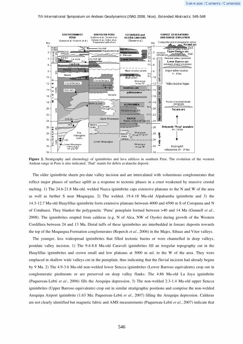
7th International Symposium on Andean Geodynamics (ISAG 2008, Nice), Extended Abstracts: 545-548
546
Figure 2. Stratigraphy and chronology of ignimbrites and lava edifices in southern Peru. The evolution of the western Andean range in Peru is also indicated. ‘Dad’ stands for debris avalanche deposit.
The older ignimbrite sheets pre-date valley incision and are intercalated with voluminous conglomerates that
reflect major phases of surface uplift as a response to tectonic phases in a crust weakened by massive crustal
melting. 1) The 24.6-21.8 Ma-old, welded Nazca ignimbrite caps extensive plateaus to the N and W of the area
as well as further S near Moquegua. 2) The welded, 19.4-18 Ma-old Alpabamba ignimbrite and 3) the
14.3-12.7 Ma-old Huaylillas ignimbrite form extensive plateaus between 4000 and 4500 m S of Coropuna and N
of Cotahuasi. They blanket the polygenetic ‘Puna’ peneplain formed between >40 and 14 Ma (Gunnell et al.,
2008). The ignimbrites erupted from calderas (e.g. N of Alca, NW of Oyolo) during growth of the Western
Cordillera between 24 and 13 Ma. Distal tuffs of these ignimbrites are interbedded in forearc deposits towards
the top of the Moquegua Formation conglomerates (Roperch et al., 2006) in the Majes, Sihuas and Vitor valleys.
The younger, less widespread ignimbrites that filled tectonic basins or were channelled in deep valleys,
postdate valley incision. 1) The 9.4-8.8 Ma-old Caraveli ignimbrites fill an irregular topography cut in the
Huaylillas ignimbrites and crown small and low plateaus at 3000 m asl. to the W of the area. They were
emplaced in shallow wide valleys cut in the peneplain, thus indicating that the fluvial incision had already begun
by 9 Ma. 2) The 4.9-3.6 Ma-old non-welded lower Sencca ignimbrites (Lower Barroso equivalents) crop out in
conglomeratic piedmonts or are preserved on deep valley flanks. The 4.86 Ma-old La Joya ignimbrite
(Paquereau-Lebti et al., 2006) fills the Arequipa depression. 3) The non-welded 2.3-1.4 Ma-old upper Sencca
ignimbrites (Upper Barroso equivalents) crop out in similar stratigraphic positions and comprise the non-welded
Arequipa Airport ignimbrite (1.63 Ma: Paquereau-Lebti et al., 2007) filling the Arequipa depression. Calderas
are not clearly identified but magnetic fabric and AMS measurements (Paquereau-Lebti et al., 2007) indicate that

7th International Symposium on Andean Geodynamics (ISAG 2008, Nice), Extended Abstracts: 545-548
547
Sencca ignimbrites are probably sourced at calderas or crater clusters that are buried beneath younger volcanic
complexes such as Chachani, Coropuna, and Ampato. A second phase of valley incision took place after 2.2 Ma
(Río Colca valley) or 1.4 Ma, the age of non-welded pumice-flow deposits, which had largely filled the canyon
of Río Cotahuasi. Younger ignimbrites exist but none exceeds 200 km2 and 10 km3. One such example is the
Yura Tuff N and W of Chachani, that may be contemporaneous with the Capillune Formation.
Four generations of edifices and time-volume-composition relationships
Dated lava flows and pyroclastic deposits indicate that four generations of composite and monogenetic
edifices have crowned the Western Cordillera and mostly overlie the ignimbrites (Fig. 2). 1) Although the
Tacaza arc is deeply eroded, roots of hydrothermally-altered edifices remain in the Caylloma area 60 km N of
the Frontal arc. 2) The 9 to 4 Ma-old Lower Barroso edifices are moderately eroded, subdued shields with a core
of 6-4 Ma-old basaltic andesite and andesite lava flows (e.g. near Cora Cora and Laguna Salinas); 3) The Upper
Barroso 3-1 Ma-old stratovolcanoes and dome complexes, with a wider range of composition from mafic
andesites to rhyolites, have been carved by glacial erosion and abundant scars of flank failures (e.g. Pichu Pichu
and Chachani); 4) The Pleistocene – Holocene volcanoes are composite cones such as El Misti, Ubinas, and
domes on caldera edges such as Ticsani. Most of these composite cones are younger than 0.8-0.6 Ma (Thouret et
al., 2001, 2005). The frontal arc includes coeval monogenetic fields like the Andahua-Orcopampa-Huambo field,
where strombolian cones and lava flows formed between 0.5 Ma and historic times (Delacour et al., 2007).
The 40Ar/39Ar chronology combined with volumes of composite cones allow eruption rate estimation, which
are minimums because of glacier erosion and explosive destructions. Eruption rate is apparently lower during the
first phase of the growth of stratovolcanoes over a long period (400 – 800 ka) and apparently accelerates during
maturation and growth of the summit cones: 0.6 km3/ky at Misti over 110 ka and 0.22 km3/ky at Ubinas over
250 ka. Eruption rates fluctuate between 0.1 and 1 km3/ky according on the time span considered and with
respect to magma composition and eruptive style (mafic effusive vs. evolved and pyroclastic). Composite cones
have changed between Plinian eruptions that form summit calderas (Misti 13-11 ka; Ubinas 25-9 ka). Large
debris avalanches occurred at composite cones and dome complexes during the last 0.5 Ma. The largest collapse
at Ticsani produced a 20 km3 debris-avalanche deposit but smaller, recurring debris avalanches as young as
middle-late Holocene have also occurred at the Ubinas cone and Tutupaca.
The 40Ar/39Ar chronology and petrology of lava flows and pyroclastic deposits allow us to estimate the
magmatic evolution through time (Fig. 3). Andesite and mafic andesite magmatism forms the base of
Figure 3. Nd and 87Sr/86Sr Plot of ignimbrites of the Cotahuasi and Arequipa areas. Isotope values of igneous rocks support the concept that Andean magmas are controlled by the composition and age of the Andean crust. The Arequipa and the Cotahuasi ignimbrites define a domain that overlaps the average CVZ magma composition domain. The Arequipa ignimbrites eNd is lower than the Cotahuasi ignimbrites eNd. These differences may be the result of the assimilation of crustal materials with different isotopic signatures during magma genesis. Recent geochemical and geophysical data pointed out two distinct crustal domains, termed Cordillera and Arequipa, in southern Peru (Mamani et al., 2008a,b).

7th International Symposium on Andean Geodynamics (ISAG 2008, Nice), Extended Abstracts: 545-548
548
stratovolcanoes beneath summit cones and are present in monogenetic compound lava flow fields throughout the
region, mostly along deep-seated, normal N80-trending faults (e.g. Ichupampa Fault). The monogenetic field of
Andahua-Orcopampa-Huambo has 25-50 km3 of lava, with an eruption rate of 0.09-0.18 km3/ky. The ascent of
magma producing coeval compound lava fields has bypassed the reservoirs of composite cones in the upper
crust: the magma genesis is attributed to partial melts of the lowermost part of the thick Andean continental crust
added to mantle-derived arc magmas in a high pressure MASH zone (Delacour et al., 2007).
Conclusion: implications on eruption frequency and hazards
From the chronostratigraphy, large-scale ignimbrite sheets (>20 km3) have erupted on intervals of 5 Ma but
many individual smaller ignimbrites have also occurred. Each of the four generations of composite and shield
volcanoes has lasted between 1 and 4 My but this belies the rapid growth of short-lived (<0.8 My) composite
cones, which have erupted at a rate of 0.2–1 km3/ky on average over the past 250 ka.
A 50 ka-long record of identified and dated tephra and lava flows is linked to 10 volcanic edifices and
monogenetic fields between Nevado Sara Sara and Yucumane. The record of the Frontal arc displays at least 50
events, i.e one eruption every kyr over the past 50 ka, including 12 large Plinian-type eruptions with >1 km3 of
tephra. If the more complete 15 kyr-old tephra record is taken at face value, the eruption frequency increases to 3
events per kyr, comprising two moderate-sized ashfalls every kyr and one voluminous Plinian pumice fall on a
2400–3600 yr interval. Very large eruptions such as the Huaynaputina AD1600 event potentially would have a
large effect on southern Peru, western Bolivia, and northernmost Chile. Such eruption could occur in the area
comprised between Huaynaputina, Ticsani and Tutupaca (Fig. 1): in this region, a long volcanic history and
recent eruptions of silicic magma suggest that similar vigorous eruptions may occur in the near geological future.
In addition, debris avalanches and landslides from from ignimbrites cliffs and from hydrothermally-altered
composite cones, even without any eruption, and subsequent debris flows pose serious threats to the population.
References Delacour A., Gerbe M.-C., Thouret J.-C., Wörner G., Paquereau-Lebti P., 2007 Magma evolution of Quaternary minor
volcanic centres in Southern Peru, Central Andes. Bull. Volc, 69, 6, 581-606. Gunnell Y., Thouret J.-C., Brichau S., Carter A., 2008 A low-temperature thermochronology of denudation, crustal uplift
and canyon incision in the Western Cordillera of southern Peru. Geoph. Res. Abs., vol. 10, EGU2008, Vienna. Mamani M., Tassara A., Wörner G., 2008a Composition and structural control of crustal domains in the central Andes. G3,
Geoch., Geoph., Geos., 9 (3) 10.1029/2007GC001925. Mamani M., Wörner G., Thouret J.-C., 2008b “Tracing a major crustal domain boundary based on the geochemistry of
minor volcanic centres in southern Peru”. Extended Abstract, 7th ISAG, Nice, September 2008, this volume. Paquereau-Lebti P., Thouret J.-C., Wörner G., Fornari M., Macedo O., 2006 Neogene and Quaternary ignimbrites in the
area of Arequipa, southern Peru: stratigraphical and petrological correlations. J. Volc. Geoth. Res., 154 : 251-275. Paquereau-Lebti P., Fornari M., Roperch P., Thouret J.-C., Macedo O., 2007 Paleomagnetic, magnetic fabric properties,
and 40Ar/39Ar dating, of Neogene - Quaternary ignimbrites in the Arequipa area, Southern Peru. Flow directions and implications for the emplacement mechanisms. Bull. Volcanol., DOI 10.1007/s00445-007-0181-y.
Roperch P., Sempere T., Macedo O., Arriagada C., M., Tapia C., Laj C., 2006 Counterclockwise rotation of late Eocene-Oligocene fore-arc deposits in southern Peru and its significance for oroclinal bending in the central Andes. Tectonics 25, TC3010.
Thouret J.-C., Suni J., Finizola A., Fornari M., Legeley-Padovani A., Frechen M., 2001 Geology of El Misti volcano near the city of Arequipa, Peru. Geol. Soc. Amer. Bull., 113 : 1593-1610.
Thouret J.-C., Rivera M., Wörner G., Gerbe M.-C., Finizola A., Fornari M., Gonzales K., 2005 Ubinas: evolution of the historically most active volcano in Southern Peru. Bull. Volc., 67 : 557-589.
Thouret J.C., Wörner G., Gunnell Y., Singer B., Zhang X., Souriot T., 2007 Geochronologic and stratigraphic constraints on canyon incision and Miocene uplift of the Central Andes in Peru. Earth Plan. Sci. Letters, 263 : 151-166.

7th International Symposium on Andean Geodynamics (ISAG 2008, Nice), Extended Abstracts: 549-552
549
The Proterozoic basement of the Arequipa massif, southern Peru: Lithologic domains and tectonics
Paul Torres1,2
, Aldo Alván1, & Harmuth Acosta
1
1 INGEMMET, Av. Canadá 1470, San Borja, Lima, Peru ([email protected])
2 Universidad Nacional de Ingeniería (UNI), Av. Tupac Amaru 210, Lima, Peru
KEYWORDS : Arequipa massif, lithologic domains, Proterozoic, tectonic evolution, Grenville
Introduction
The Proterozoic rocks outcrops along the southern coast of Peru, on the margin of the Pacific Ocean and
extends in the Western Cordillera of the Andes, forming a major exhibition of pre-Andean rocks where
tectonothermal activity has been recognized preliminarily throughout Proterozoic history; being Grenville ages
(~1000-1200 Ma) well documented. There are many gaps in knowledge of the Arequipa massif, for example, in
lithological and tectonic part, there are so many authors taking the massif as an undifferentiated complex. We
show in this paper a new Proterozoic basement mapping supported by field works. In addition we raised a
discussion of the tectonic evolution of this massif.
Regional geological setting
The Arequipa Massif is the main basement of central Andes (Wasteneys et al., 1995), displays a magmatic and
metamorphic evolution complex. This massif is mainly made of migmatitic gneiss rocks, thus between Camana
and Mollendo, the occurrence of the mineralogical joint: orthopyroxene-sillimanite-quartz is common in gneiss,
migmatite and granulite rocks, so that they are described as ultra-high-temperature rocks (Martignole et al.,
2003), that apparently is extending through all Proterozoic basement of central Andes between the southern Peru
and northern Chile. The oldest rocks displays ages between 2000-1900 Ma (Wasteneys el al., 1995; Dalmayrac
et al., 1977; Ries, 1976). Preliminary Rb-Sr and U-Pb geochronology implies granulites-amphibolites
metamorphic facies between ~1900 to 1800 Ma (Cobbing et al., 1977; Shacklenton et al., 1979), but recently
U-Pb geochronology analysis in zircons from gneisses near the Mollendo, Quilca and Camaná areas indicates a
high-degree metamorphism between 1200 and 970 Ma, whose ages put in evidence the orogenic-metamorphic
event named Grenville (Wasteneys et al., 1995), alternatively Dalmayrac et al., (1977), proposes that those rocks
underwent two metamorphic events, during the Paleoproterozoic (1950 Ma) and Neoproterozoic (600 Ma) times.
In the Southernmost part of Arequipa massif in Ilo, to the north of the environs of the Arica elbow, there are
outcrops one of the few Proterozoic anorthosite rocks occurrences (it is showing an Sm-Nd model age at
1150 Ma) [(Martignole et al., 2005)] documented in the Andes basement, also demonstrating the orogenic-
metamorphic Grenville belt indicated above. Whereas in the north part of the Arequipa massif, in the locality of
San Juan, there outcrops diamictites, interpreted as glaciers deposits (tillites) of Chiquerio Formation, probably
Neoproterozoico age (Caldas, 1979). Recent analyses of zircons and 13C isotopes from Chiquerío and San Juan
formations that showing an age of deposition for these glaciers deposits (unique in the proto-Andes belt)
between 635-750 Ma (Chew et al., 2007b). At the moment it is thought that Arequipa massif accreted to the
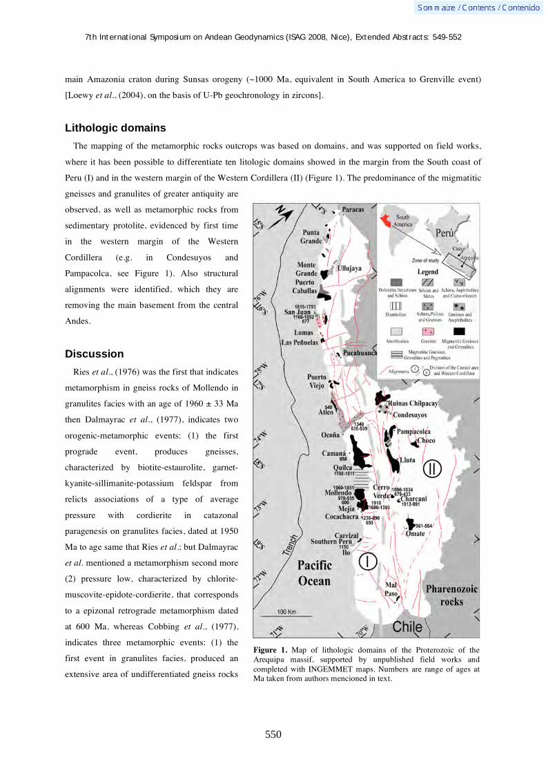
7th International Symposium on Andean Geodynamics (ISAG 2008, Nice), Extended Abstracts: 549-552
550
Figure 1. Map of lithologic domains of the Proterozoic of the Arequipa massif, supported by unpublished field works and completed with INGEMMET maps. Numbers are range of ages at Ma taken from authors mencioned in text.
main Amazonia craton during Sunsas orogeny (~1000 Ma, equivalent in South America to Grenville event)
[Loewy et al., (2004), on the basis of U-Pb geochronology in zircons].
Lithologic domains
The mapping of the metamorphic rocks outcrops was based on domains, and was supported on field works,
where it has been possible to differentiate ten litologic domains showed in the margin from the South coast of
Peru (I) and in the western margin of the Western Cordillera (II) (Figure 1). The predominance of the migmatitic
gneisses and granulites of greater antiquity are
observed, as well as metamorphic rocks from
sedimentary protolite, evidenced by first time
in the western margin of the Western
Cordillera (e.g. in Condesuyos and
Pampacolca, see Figure 1). Also structural
alignments were identified, which they are
removing the main basement from the central
Andes.
Discussion
Ries et al., (1976) was the first that indicates
metamorphism in gneiss rocks of Mollendo in
granulites facies with an age of 1960 ± 33 Ma
then Dalmayrac et al., (1977), indicates two
orogenic-metamorphic events: (1) the first
prograde event, produces gneisses,
characterized by biotite-estaurolite, garnet-
kyanite-sillimanite-potassium feldspar from
relicts associations of a type of average
pressure with cordierite in catazonal
paragenesis on granulites facies, dated at 1950
Ma to age same that Ries et al.; but Dalmayrac
et al. mentioned a metamorphism second more
(2) pressure low, characterized by chlorite-
muscovite-epidote-cordierite, that corresponds
to a epizonal retrograde metamorphism dated
at 600 Ma, whereas Cobbing et al., (1977),
indicates three metamorphic events: (1) the
first event in granulites facies, produced an
extensive area of undifferentiated gneiss rocks
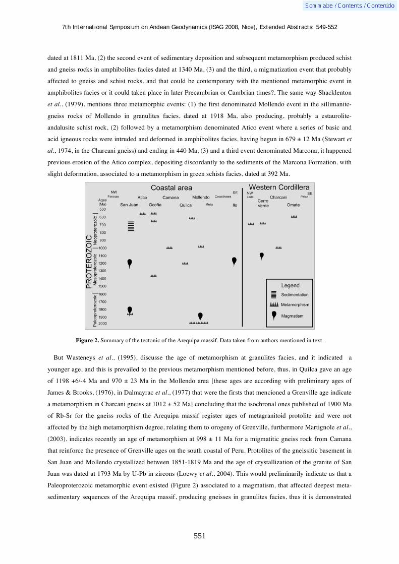
7th International Symposium on Andean Geodynamics (ISAG 2008, Nice), Extended Abstracts: 549-552
551
dated at 1811 Ma, (2) the second event of sedimentary deposition and subsequent metamorphism produced schist
and gneiss rocks in amphibolites facies dated at 1340 Ma, (3) and the third, a migmatization event that probably
affected to gneiss and schist rocks, and that could be contemporary with the mentioned metamorphic event in
amphibolites facies or it could taken place in later Precambrian or Cambrian times?. The same way Shacklenton
et al., (1979), mentions three metamorphic events: (1) the first denominated Mollendo event in the sillimanite-
gneiss rocks of Mollendo in granulites facies, dated at 1918 Ma, also producing, probably a estaurolite-
andalusite schist rock, (2) followed by a metamorphism denominated Atico event where a series of basic and
acid igneous rocks were intruded and deformed in amphibolites facies, having begun in 679 ± 12 Ma (Stewart et
al., 1974, in the Charcani gneiss) and ending in 440 Ma, (3) and a third event denominated Marcona, it happened
previous erosion of the Atico complex, depositing discordantly to the sediments of the Marcona Formation, with
slight deformation, associated to a metamorphism in green schists facies, dated at 392 Ma.
Figure 2. Summary of the tectonic of the Arequipa massif. Data taken from authors mentioned in text.
But Wasteneys et al., (1995), discusse the age of metamorphism at granulites facies, and it indicated a
younger age, and this is prevailed to the previous metamorphism mentioned before, thus, in Quilca gave an age
of 1198 +6/-4 Ma and 970 ± 23 Ma in the Mollendo area [these ages are according with preliminary ages of
James & Brooks, (1976), in Dalmayrac et al., (1977) that were the firsts that mencioned a Grenville age indicate
a metamorphism in Charcani gneiss at 1012 ± 52 Ma] concluding that the isochronal ones published of 1900 Ma
of Rb-Sr for the gneiss rocks of the Arequipa massif register ages of metagranitoid protolite and were not
affected by the high metamorphism degree, relating them to orogeny of Grenville, furthermore Martignole et al.,
(2003), indicates recently an age of metamorphism at 998 ± 11 Ma for a migmatitic gneiss rock from Camana
that reinforce the presence of Grenville ages on the south coastal of Peru. Protolites of the gneissitic basement in
San Juan and Mollendo crystallized between 1851-1819 Ma and the age of crystallization of the granite of San
Juan was dated at 1793 Ma by U-Pb in zircons (Loewy et al., 2004). This would preliminarily indicate us that a
Paleoproterozoic metamorphic event existed (Figure 2) associated to a magmatism, that affected deepest meta-
sedimentary sequences of the Arequipa massif, producing gneisses in granulites facies, thus it is demonstrated

7th International Symposium on Andean Geodynamics (ISAG 2008, Nice), Extended Abstracts: 549-552
552
that intrusive ones which cut to the Precambrian gneiss rocks of the San Juan from Marcona. Loewy et al.,
(2004), indicate that the Arequipa massif underwent three different pulses from metamorphism and deformation:
(1) 1820-1800 Ma, (2) 1200-940 Ma and (3) 440 Ma.
Conclusions
Analysis of the evolution of the northern part of Central Andes, in southern Peru and northern Chile shows a
magmatic and metamorphic polycyclic evolution in Proterozoic time, with a magmatism-metamorphism event at
~1000 Ma (Mesoproterozoic later) associate to metamorphism in granulites facies demonstrated in San Juan and
Mollendo, and an acid magmatism in San Juan and metamorphism in Camana-Mollendo and San Juan in the
Mesoproterozoic time, these evidences would be according to the accretion of the massif to the Amazonia
craton. The radiometric analyses carried out in Arequipa massif indicate three groups of well differentiated ages
in all the Proterozoic (Figure 2). The lithologic domains (Figure 1) show the first mapping and lithologic
division of the Arequipa massif and variety of the rocks from this massif as well as its relation with the
metamorphic degrees.
References Caldas J. (1979). “Evidencias de una glaciación Precámbrica en la costa sur del Perú”. Segundo Congreso Geológico
Chileno, Arica. p. J-29 a J-38. Chew, D., Kirkland, C., Schaltgger, U., Goodhue, R. (2007b). “Neoproterozoic glaciation in the Proto-Andes: Tectonic
implications and global correlation”. Geology, v.35, n.12, p.1095-1098. Cobbing, E., Ozard, J., Snelling, N. (1977). “Reconnaissance geochronology of the basement rocks of the Coastal Cordillera
of southern Perú”. Geological Society of American Bulletin, v.88, p. 241-246. Dalmayrac, B., Lancelot, J., Leyreloup, A. (1977). “Two-Billion-Year Granulites in the late Precambrian metamorphic
basement along the southern peruvian coast”. Science, v. 198, p. 49-51. Loewy, S., Connelly, J., Dalziel, I. (2004) “An orphaned basement block: The Arequipa-Antofalla Basement of the central
Andean margin of South America”. GSA Bulletin, v. 116, p. 171-187. Martignole, J., and Martelat, J. (2003). “Regional-scale Grenvillian-age UHT metamorphism in the Mollendo-Camana block
(basament of the Peruvian Andes)”, J. Metamorphic Geol. v. 21, p. 99-120. Martignole, J. Stevenson, R., & Martelat, J. (2005). “A Grenvillian anorthosite-mangerite-charnockite-granite suite in the
basement of the Andes: The Ilo AMCG suite (southern Perú)”, 6th International Symposium on Andean Geodinamics ISAG, Barcelona, Extend Abstacts: p. 481-484.
Ries, A. (1976). “Rb/Sr ages from the Arequipa Massif, southern Peru”. Instituto de estudios africanos, Boletín de la Universidad de Leeds.
Shackleton, R., Ries, A., Coward, M., Cobbold, P. (1979). “Structure, metamorphism and geochronology of the Arequipa massif of coastal Peru”. J. Geol. Soc. London 136:195—214
Stewart, W., Everden, J., Snelling, N. (1974). “Age Determinations from Andean Peru: A Reconnaissance Survey“, Geological Society of American Bulletin, v. 85, p. 1107-1116.
Wasteneys, H., Clarck, A., Farrar, E. & Langridge R. (1995). “Grenvillian granulite-facies metamorphism in the Arequipa Massif, Peru: a Laurentiia-Gondwana link”. Earth and Planetary Science Letters 132, p. 63-73.

7th International Symposium on Andean Geodynamics (ISAG 2008, Nice), Extended Abstracts: 553-554
553
Trachydacitic domes in the caldera of Pino Hachado, province of Neuquén, Argentina
Cynthia Tunstall1, Jorge E. Clavero
2 , & Victor A. Ramos
1
1 Laboratorio de Tectónica Andina, FCEyN, Universidad de Buenos Aires, Consejo Nacional de Investigaciones
Científicas y Técnicas, Argentina ([email protected]; [email protected]) 2 Sevicio Nacional de Geología y Minería, Avda. Santa María 0104, Santiago, Chile ([email protected])
KEYWORDS : domes, Pino Hachado, Neuquén Andes
Introduction
The existence of the caldera in the Pino Hachado region has been known in the literature since the work of
Muñoz and Stern (1985) & Mazzoni & Iñiguez Rodríguez (1986).
The Pino Hachado caldera is located between the 38o and 39o SL in the Main Cordillera of Neuquén on the
border of Argentina and Chile (Neuquén and Cautín provinces) in a retroarc geotectonic setting, which occurs
approximately 60 kms to the east of the present volcanic arc (figure 1).
Figure 1: Location map and satelite image of the Pino Hachado caldera.
Andesitic eruptions began in the Paleogene in this sector of the Andes but their major development took place
during the Neogene. The Pino Hachado volcanic centre was generated during the last retroarc volcanic episode
and is composed of the Pino Hachado caldera, in which ignimbrites and breccias dacitic and rhyolitic
composition were generated in an initial stage. Subsequent trachyandesitic lava flows were generated in a later
stage. Trachyandesitic domes are only found inside of the caldera (Muñoz & Stern, 1985; Muñoz & Stern 1988;
Muñoz, 1988b; Muñoz et al., 1989).

7th International Symposium on Andean Geodynamics (ISAG 2008, Nice), Extended Abstracts: 553-554
554
Previous works have allowed the definition of the principal units of the Pino Hachado postcaldera. Five formal
units have been proposed for Plio-Quaternary volcanism: Pailaleo Andesite, Litrán Basalt, Suarzo Basalt, Las
Tres Hermanas Andesites and El Volcán Basalt (Tunstall 2005).
The presence of numerous trachydacitic domes in the intracalderic region are the predominant volcanic
feature, among with the Cerros Las Tres Hermanas are the most outstanding examples where well-developed
conic form occurs without evidence of glacial erosion. They show columnar disjunction, a succession of flows
and maffic inclusions. Lithologically, they have porphyritic textures with groundmasses of hyalopylitic textures.
Phenocrysts (40 %) are composed of plagioclase, biotite, pyroxene and less amount of opaque minerals that
occasionally shows hexagonal sections.
According to the geochemical data these rocks have trachydacitic compositions in accordance to the diagrams
of Le Maitre (2002) and Winchester & Floyd (1977). The SiO2 and Na2O+K2O compositions vary between 65-
75% and 9-10% respectively, and classify in the class of subalkaline rocks (Irvine & Baragar 1971). The
calcalkaline signature come from the amount of alkalis, FeO* and MgO that evidence the whole sequence.
Conclusions
Those three eruptive centres are recognised independently as a postcaldera volcanic activity and their relative
ages has been established. Their similar petrography and geochemical signatures suggest that they should have
the same magmatic origin. The following contribution described new alkaline units of trachydacitic composition
inside the Las Tres Hermanas Andesites formation. These volcanic events contributes to a better understanding
of the magmatic evolution of the Pino Hachado caldera.
References Irvine, T. N. y Baragar, W. R. A., 1971. A guide to the chemical classification of the common volcanic rocks. Can. J. Earth
Sci., 8 (5): 523-548. Le Maitre, R. 2002. Igneous Rocks. A classification and glossary of terms. Recommendations of the Intarnational Union of
Geological Sciences, Subcomisión on the Systematics of Igneous Rocks. 2nd edition. Cambridge University Pres. 236 p. Mazzoni, M. e Iñiguez Rodríguez, A., 1986. Depósitos piroclásticos neógenos y cuaternarios en el área de Pino Hachado,
Prov. del Neuquén. 1º Reunión Argentina de Sedimentología (La Plata) Resúmenes 97-100, La Plata. Muñoz, J., 1988b. Evolution of Plioceno and Quaternary volcanism in the segment of the southern Andes between 38º and
39º S. University of Colorado (Unpublished Thesis), 160. Muñoz, J. y Stern, C., 1985. El complejo volcánico Pino Hachado en el sector nor-occidental de la Patagonia (38º-39ºS):
volcanismo plio-cuaternario de trasarco en Sudamérica. IVº Congreso geológico Chileno (Antofagasta), Actas 3: 381-412, Antofagasta.
Muñoz, J. y Stern, C., 1988. The Quaternary volcanic belt of the southern continental margin of South America: Transverse structural and petrochemical variations across the segment between 38° and 39°S. Journal of South American Earth Science 1 ( 2): 147-161
Muñoz Bravo, J., Stern, C., Bermúdez, A., Delpino, D., Dobbs, M.F., y Frey, F. A., 1989. El volcanismo plio-cuaternario a través de los 38º y 39ºS de los Andes. Revista de la Asociación geológica Argentina, 44: 270-286. Buenos Aires.
Tunstall, C., 2005. Geología de la caldera de Pino Hachado. Trabajo Final de Licenciatura. Universidad de Buenos Aires (inédito). Buenos Aires.
Winchester, J. A. y Floyd, P. A. (1977). Geochemical discrimination of different magma series and their differentiation products using immobile elements. Chemical Geology, 20:325-343.

7th International Symposium on Andean Geodynamics (ISAG 2008, Nice), Extended Abstracts: 555-557
555
Controls on erosion and clastic sediment flux in the Central Andes during the Late Cenozoic
Cornelius E. Uba, Gerold Zeilinger, Manfred Strecker Institut für Geowissenschaften, Universität Potsdam, Karl-Liebknechtstr. 24, 14476 Potsdam, Germany
Introduction
The Central Andes of south-central Bolivia is an integral part of the Andean orogenic system that is related to
the basement-involved shortening, uplift, thrust loading, and the subsequent eastward propagation of the Andean
deformation. The study area we examine here lies in the Chaco foreland basin that consists of the Subandean
Zone and the Chaco plain (Fig. 1; Uba et al., 2005). The basin development was as a result of the interaction of
the Nazca and the South American plates and its related simultaneous under-thrusting of the Brazilian Shield.
This activity led to widespread and pronounced shortening in the Eastern Cordillera in the Oligocene, which
produced folding and eastward migration of thrusting in the Interandean and Subandean Zones (e.g., Gubbels et
al., 1993; Uba et al., 2006). The study area lies within three major river catchments (rios Grande, Parapeti, and
Pilcomayo).
To unravel the controls on erosion and sediment flux in the Andes, we use isopach maps (well logs, seismic
lines, and measured sections) and recently published zircon U-Pb age data from Mio-Pliocene sedimentary strata
(Uba et al., 2007) to produce a 2D mass flux budget for the central Andes.
64°W 63°W
Quaternary
Rio
Pilcom
ayo
20°S
21°S
0 50
km
25
Ordovician
Silurian
Measured sections
Devonian
Carboniferous
Cretaceous
Tertiary
Neogene tuffs
and lava flows
RioPara
pe
ti
Villamontes
28
24
20
16
12
74 70 66
Salta
La Paz
Chaco
Plain
EasternC
ord
illera
Altip
lan
o
Puna
Su
ba
nd
ea
nZ
on
e
Western Cordillera
Figure 1. Geological map of the study area in the southern Bolivia showing the measured sections.

7th International Symposium on Andean Geodynamics (ISAG 2008, Nice), Extended Abstracts: 555-557
556
Geological setting
Many authors have previously postulated that the deformation front arrived in the Chaco foreland basin at
10 Ma (e.g., Gubbels et al., 1993). Recently, however, Uba et al. (2007) present ~12.4 Ma for the arrival of the
deformation front into the Subandean Zone. The Chaco foreland basin is characterized mostly by in-sequence,
thin-skinned thrusting, which include ramp anticlines and passive roof duplexes [Baby et al., 1992] separated by
thrust faults and synclines. Blind thrusting is another documented structural style in the basin (Uba et al., 2006).
The Chaco basin consists of up to 7.5 km thick late Cenozoic strata. The base of the foreland stratigraphy is
defined by the 250-m-thick, 26 - 12.4 Ma Petaca Formation. This formation consists of paleosol, conglomerate,
sandstone, and mudstone, which accumulated in a fluvial environment (Uba et al., 2005). Overlying the Petaca
Formation is the ~400-m-thick, 12.5-8 Ma Yecua Formation (Uba et al., 2007). This lacustrine-fluvial-shallow-
marine strata compose mostly of mudstone and sandstone deposited in a distal foredeep (Uba et al., 2005; 2006).
The Yecua Formation is overlain by the up to 4000-km-thick, 8 to 6 Ma, fluvial-megafan-deposited sandstone
and mudstone Tariquia Formation, which represents medial foredeep deposit. The up to 1600-m-thick,
5.94-2.1 Ma Guandacay Formation overlies transitionally the Tariquia Formation. The Guandacay Formation
consists of sandstone, conglomerate, and subordinate mudstone deposited in a medial fluvial megafan
environment (Uba et al., 2005; 2007). The late Cenozoic succession is capped by more than 1500-m-thick
2.1 Ma to present conglomerate and sandstone dominated Emborozú Formation that represents a proximal fluvial
megafan (Uba et al., 2005; 2007).
Results and conclusions
Our mass accumulation budget result shows that a total of 262,637 km3 of clastic sediment was deposited in
the Chaco Basin between ~26 Ma and the present (Fig. 2). Of this volume, 4200 km3 of sediment, representing
309 km3/Ma sediment supply rate, was deposited during the Petaca time. During 12.4-8 Ma (Yecua Fm) and
8-6 Ma (Tariquia Fm) 37,011 (sediment supply rate: 10,280 km3/Ma) and 103,322 km (51,661 km /Ma) of
sediments were deposited. Finally, the 6-2.1 Ma (Guandacay Fm) and 2.1 to present (Emborozú Fm) time slices
recorded 81,363 km (20,862 km /Ma) and 36,741 km (17,495 km /Ma) of sediment volume respectively.
Fig. 2. 3D model showing the late Cenozoic Chaco foreland basin geometry and configuration and the summary of sediment budget estimates for the five different late Cenozoic stratigraphic units.

7th International Symposium on Andean Geodynamics (ISAG 2008, Nice), Extended Abstracts: 555-557
557
These results show a continuous increase in sediment volume from the late Oligocene till its maximum during
the late Miocene, when a three-fold (103,322 km ) increase in the sediment supply and corresponding five-fold
(51,661 km /ma) increase in sediment supply rate is observed. Interestingly, the three-fold increase in mass flux
is consistent with rapid increase in sedimentation rate during the same period documented by Uba et al. (2007).
In addition, Uba et al. (2006) suggest that the basin witnessed accommodation space creation between 12-8 Ma
as a result of tectonic loading and coeval eastward advance of thrusting. The created space was then filled with
clastic sediments as a result of enhanced erosion during 8-6 Ma (Tariquia Fm) interval.
Using sediment flux as a proxy for continental erosion, our result shows that the eastern part of the central
Andes witnessed enhanced erosion and deposition during 8-6 Ma. This enhanced erosion from the late Miocene
to Pliocene is supported by apatite fission track thermochronometry (Ege, 2004; Barnes et al., 2006).
Furthermore, the increase in sediment discharge and enhanced erosion coincides with the deposition of
progradational sequences, changing from lacustrine-shallow marine mudstone to fluvial sandstone.
In addition, the rapid increased erosion and deposition and high erosion rate observed during the 8-6 Ma
interval after a low at 12.5-8 Ma reflect probably the reorganization of the paleo-drainage systems from small
rivers to the proto-Rios Grande, Parapeti, and Pilcomayo fluvial megafans. The change in river capture was
probably driven by stronger, wetter South American monsoon, which brought moisture to this previously semi-
arid part of the Andes (Strecker et al., 2007).
Although we recognize the potential importance of tectonic in influencing high sediment discharge and
erosion in the central Andes, however, apatite fission track thermochronologic and paleosurface studies in the
Eastern Cordillera and the Interandean zone show that the structures there were inactive during this time (Ege,
2004; Barke and Lamb, 2006). The interpretation of inactive structures is further supported by the enhanced
erosion during this time, which might have led to the retardation of deformation in the Subandean zone.
References Barke, R. & Lamb, S. 2006. Late Cenozoic uplift of the Eastern Cordillera, Bolivian Andes. Earth and Planetary Science
Letters 249: 350-367. Baby, P., Hérail, G., Salinas, R. & Sempere, T. 1992. Geometry and kinematic evolution of passive roof duplexes deduced
from cross-section balancing: Example from the foreland thrust system of the southern Bolivian Subandean Zone. Tectonics 11: 523-536.
Ege, H. 2004. Exhumations- und Hebungsgeschichte der zentralen Anden in Südbolivien (21°S) durch Spaltspur-Thermochronologie an Apatit. Ph. D. Thesis, Freie Universität Berlin, Berlin, 159 p.
Gubbels, T.L., Isacks, B.L. & Farrar, E. 1993. High-level surface, plateau uplift, and foreland development, Bolivian central Andes. Geology 21: 695-698.
Strecker, M.R., Alonso, R.N., Bookhagen, B., Carrapa, B., Hilley, G.E., Sobel, E.R., & Trauth, M.H. 2007. Tectonics and climate of the southern central Andes. Annual Review of Earth and Planetary Sciences 35: 747-787.
Uba, C.E., Heubeck, C. & Hulka, C. 2005. Facies analysis and basin architecture of the Neogene Subandean synorogenic wedge, southern Bolivia. Sedimentary Geology 180: 91-123.
Uba, C.E., Heubeck, C. & Hulka, C. 2006. Evolution of the late Cenozioc Chaco foreland basin, Southern Bolivia. Basin Reserach 18: 145-170.
Uba, C.E., Strecker, M.R., & Schmitt, A.K. 2007. Increased sediment accumulation rates and climatic forcing in the central Andes during the late Miocene. Geology 35: 979-982.

7th International Symposium on Andean Geodynamics (ISAG 2008, Nice), Extended Abstracts: 558-561
558
Diente Verde and Mario, Cañada Honda, San Luis, Argentina: Porphyry-type deposits in the South Pampean flat-slab region of the Central Andes
Nilda E. Urbina1 & P. Sruoga
1,2
1 Universidad Nacional de San Luis, Ej. de los Andes 950, 5700 San Luis, Argentina ([email protected])
2 CONICET, SEGEMAR, Av. J.A. Roca 651, 1322 Buenos Aires, Argentina ([email protected])
KEYWORDS : San Luis, porphyries, gold-copper, flat-slab, Mio-Pliocene
Introduction
The San Luis Tertiary Metallogenic Belt (SLMB) located in the Sierras Pampeanas of San Luis is related with
the subduction zone shallowing between 27º and 33º S (Fig. 1 A). Mineralization and volcanic rocks occur
within a west-northwest-trending magmatic belt from La Carolina in the west to El Morro in the east (Fig. 1 B).
Mesosilicic magmas belong to normal to high-K calc-alkaline and shoshonitic types. In a close spatial and
temporal linkage several mineralizations of epithermal and porphyry types are associated. Volcanic activity began at
about 12-13 Ma in the west and ended at 1.9 Ma in the east (Ramos et al. 1991, Urbina, 2005, Urbina y Sruoga,
In press). Volcanics and associated mineralization formed 600-700 kilometers east from the trench for about
10 m.y. and over a west-east distance of 80 kilometers.
The Diente Verde and Mario deposits are copper-gold porphyry mineralizations genetically related to the Late
Miocene-Late Pliocene volcanic activity. Both deposits are located at Cañada Honda district and are part of an
arc-transverse magmatic lineament at 33º S coincidently with the change of the subduction angle.
Diente Verde deposit
An intrusion centered district was suggested by Urbina et al. (1997) for Cañada Honda, based on the spatial
distribution of several low-sulfidation epithermal veins with regard to the high-level stock at Diente Verde.
Diente Verde is a gold-copper porphyry deposit consisting of stockwork sulfide veining associated with a small
intrusion centered within an andesitic stratovolcano (Fig. 1 C). Hydrothermal alteration and mineralization have
a symmetrical distribution surrounding the porphyritic subvolcanic intrusion. The sulfide ore-mineral
assemblage occurs either disseminated or in a stockwork. The alteration affects the rocks of the core, and spreads
outside from the volcanic edifice in an extensive hydrothermal halo (Fig. 1 C). K silicate alteration present in the
central zone is characterized by the presence of quartz veinlets that may occur as multidirectional stockwork or
subparallel arrays of closely spaced WNW-ESE, NE-SW, NW-SE-striking veinlets suggesting structural control
on emplacement. Veinlets from a few millimeters to 5 cm in width, are planar to slightly sinuous, and have
alteration halos composed mainly of biotite replacements accompanied by hydrothermal K feldspar. Quartz
veinlets have centrally located sulfides grains. Chalcopyrite and magnetite are the principal hypogene minerals
in K silicate alteration with traces of electrum, digenite, bornite, tennantite, covellite, enargite, pyrite and
pyrrhotite, which are A-type veinlets (Gustafson and Hunt, 1975) (Fig. 2). Veinlets with central suture of
chalcopyrite belonging to B-type (Gustafson and Hunt, 1975) are also present although in lesser amounts

7th International Symposium on Andean Geodynamics (ISAG 2008, Nice), Extended Abstracts: 558-561
559
(Fig. 2) (Suarez Funes, 2007). Outward from the central core phyllic and argillic alteration mineral assemblages
characterized by sericite, illite, quartz, kaolinite, smectite, albite, chlorite, ilmenite, pyrite, rutile and specularite
affect mainly volcanic breccias and andesite flows and overprint the early K silicate alteration. Magnetite from K
Figure 1. Simplified maps showing: A) location of the San Luis Metallogenic Belt in the Central Andean flat-slab region, B) regional distribution of Tertiary volcanic rocks in the Sierra de San Luis, and C) location of Diente Verde and Mario deposits at Cañada Honda district. Note the symmetrically centered distribution of hydrothermal alteration surrounding the volcanic edifice.

7th International Symposium on Andean Geodynamics (ISAG 2008, Nice), Extended Abstracts: 558-561
560
silicate alteration is variably martitized. In the outer alteration zone, abundant disseminated pyrite essentially
without chalcopyrite defines a peripheral, broad pyritic halo. Propylitic alteration is present as a discontinuous
outer aureole. Supergene alteration is represented by goethite, hematite, malachite and azurite. The gold-copper
ore zone coincides with the most densely stockworked porphyry averaging approximately 0.93 ppm Au and
7200 ppm Cu (Suarez Funes, 2007). Considering that the average gold content is 0.4 ppm, the Diente Verde
porphyry copper deposit may be defined as gold-rich (Sillitoe, 2000).
Mario deposit
Mario deposit is located 1200 m east from Diente Verde gold-copper porphyry deposit and was emplaced
approximately at the same topographic level. The outcrop of Mario is restricted to a 180-m long bulldozer
trench, with most of the inferred extent of the deposit concealed beneath the present surface. The mineralization
hosted by hornblende-bearing andesitic rock occurs as a multidirectional stockwork and disseminations (Arce et
al., 2005). Chalcopyrite with traces of bornite are coincident with the stockwork (Fig. 3). Abundant pyrite is
present in dominantly disseminated form. Hematite and magnetite occur abundantly disseminated in altered
rock, and alone as M-type veinlets (Clark and Arancibia, 1995) or with quartz. Much of the hematite is
developed by hypogene martitization of hydrothermal and accessory magmatic magnetite, although minor
specular hematite is also present. The associated hydrothermal alteration is intense and comprises K silicate
alteration (biotite accompanied by K feldspar) and peripheral propylitic (chlorite, calcite, epidote) assemblages.
Intermediate argillic (sericite, chlorite, calcite, smectite) and sericitic (sericite, quartz, pyrite) alterations are
believed to have overprinted and partially destroyed earlier K silicate alteration. Much of the hydrothermal
quartz is present as stockwork veinlets that range from 0.2mm to 3cm in width. They were formed along with
biotite-rich K silicate alteration. Chalcopyrite + pyrite ± magnetite are also thought to have been introduced with
early K silicate alteration and constitute, together with quartz, the A-type veinlets (Gustafson and Hunt, 1975)
(Fig. 3). Supergenic products are present as iron oxides (goethite and hematite) and copper carbonates (malachite
and azurite), in the form of coatings and as complete replacements of sulfides from quartz-veinlets stockwork in
the upper part of Mario. The gold contents averaging 0.3ppm Au, correlate well with the intensity of A-type
quartz veinlets, whereas the copper contents range from 100 to 200ppm (Vazquez, 2007).
Figure 2. Left: Quartz A-type veinlet with K silicate alteration halo. Rigth: B-type veinlet with chalcopyrite suture. bt: biotite, kfs: k feldspar, mt: magnetite, qtz: quartz, cp: chalcopyrite.

7th International Symposium on Andean Geodynamics (ISAG 2008, Nice), Extended Abstracts: 558-561
561
Figure 3. Left: Quartz veinlet stockwork. The veinlets are highlighted by goethite and hematite of supergene origin. Rigth: A-type veinlet of quartz (1mm width) with magnetite and chalcopyrite. Note the biotite in the K silicate halo.
Conclusions
The superficial gold-copper contents of Diente Verde and Mario porphyry mineralizations make the deposits
an interesting target for exploration. Besides, the remnants of K silicate alteration and the strongly intermediate
argillic/sericitic overprinted alteration at Diente Verde and Mario suggest that the present level of erosion is
showing the shallow parts of the copper-gold deposits and can be considered as evidence to expect a well
developed K silicate alteration at deeper levels. On the other hand, mineralogical affinities, and spatial and
temporal linkages suggest that Diente Verde and Mario deposits are genetically associated. Therefore, this aspect
might lead to assume the existence of cluster-type porphyry manifestations at Cañada Honda district.
The Diente Verde and Mario porphyry deposits are in SLMB, which reflects the extraordinary broadening of
the magmatic arc in the flat-slab segment at 33ºS. The unusual setting of SLMB at 600-700km from the trench
and the high cortical levels of emplacement, suggest a structural control in the magma ascent coincidently with
the change of the subduction angle, a situation that seems to be alike to the Farallón Negro district at 27ºS.
References
Arce, M., Urbina, N., Sruoga, P. 2005. “A new porphyry-type mineralization in Cañada Honda district, San Luis, Argentina”. In: 19th Colloquium on Latin American Geosciences. Potsdam, Germany. Terra Nostra 05/1: 13.
Clark, A., and Arancibia, O. 1995. “Occurrence, paragenesis and implications ofmagnetite=rich alteration=mineralization in calc=alkaline porphyry copper deposits”. In Clark, A. (ed) Giant ore deposits-II. Kingston, Ontario: 511-581.
Gustafson, L., and Hunt, J. 1975. The porphyry copper deposit at El Salvador, Chile. Economic Geology, 70: 857-912. Isacks, B. 1988. Uplift of the central Andean plateau and bending of the Bolivian Orocline. Journal of Geophysical Research
93: 3211-3231. Ramos, V., Munizaga, F. y Kay, S. 1991. “El magmatismo Cenozoico a los 33ºS de Latitud: Geocronología y Relaciones
Tectónicas”. In: 6º Congreso Geológico Chileno. Chile. Actas 1: 892-896. Sillitoe, R. H. 2000. “Gold-rich Porphyry Deposits: Descriptive and Genetic Models and Their Role in Exploration and
Discovery”. In Hagemann, S. and Brown, P. (eds) Gold in 2000. Society of Economic Geologists, Reviews in Economic Geology 13: 315-345.
Suarez Funes, L. 2007. Geología y metalogénesis del sector suroeste del Cerro Diente Verde, San Luis, Argentina. Tesis de Licenciatura, Universidad Nacional de San Luis (inédito), 80 p.
Urbina, N. 2005. “New insights into the timing of gold systems in the Tertiary metallogenic belt of San Luis, Argentina”. In: 6th International Symposium on Andean Geodynamics. Barcelona. Actas: 752-755.
Urbina, N.E. and Sruoga, P. In press. “K-Ar mineral age constraints on the Diente Verde porphyry deposit formation, San Luis, Argentina”. In: VI South American Symposium on Isotope Geology. 2008, San Carlos de Bariloche. Argentina. 4 p.
Urbina N. E., Sruoga P. and Malvicini L. 1997. Late Tertiary Gold-Bearing Volcanic Belt in the Sierras Pampeanas of San Luis, Argentina. International Geology Review. 39 (4): 287-306.
Vazquez, S. 2007. Geología y metalogénesis del sector NE del Cerro Diente Verde y mineralizaciones asociadas, Cañada Honda, San Luis, Argentina. Tesis de Licenciatura, Universidad Nacional de San Luis (inédito), 93 p.

7th International Symposium on Andean Geodynamics (ISAG 2008, Nice), Extended Abstracts: 562-565
562
Relationship between topography and seismicity in the Peruvian Andes: Influence of topography on stress field
V. Manuel Uribe1, Laurence Audin
2, Hugo Perfettini
2, & Hernando Tavera
3
1 Universidad Nacional Mayor de San Marcos, Av. Venezuela 3400, Lima 1, Peru ([email protected])
2 Institut de Recherche pour le Développement, Teruel 357, Lima 18, Peru
3 Instituto Geofísico del Perú, 4 etapa de Mayorazgo, Ate Vitarte, Lima, Peru
KEYWORDS : seismicity, topography, Andes, Peru, tectonic yield stress
Abstract Seismicity in Peru and the Andean Orogeny are two direct effects of the subduction process that occur for My
between the Nazca Plate and the South American Plate, eventhough both of them differ in time scale. During the inter-seismic period the background seismicity in Peru show a complex spatial distribution. We observed that the seismic activity anti correlates with the highest topography. As demonstrated by Bollinger et al., 2004 in Nepal, but in this case for a subduction zone, the stress field varies with topographic loading of the upper plate on the lower plate. Effective diminution until extinction of seismicity below the higher Andes (>2000m) is associated with a notable change in the state of stress, from compression to extension and also correlates with the fault kinematics on the upper plate.
Introduction
The seismic activity in Peru is heterogeneous with wide-ranging spatial and time distributions. We used the
seismic catalog provided by the Peruvian Institute of Geophysics (IGP: 1982-2005 and its 2007 update) (+ F.
Grange data set) and/or Tele-seismic data provided by the Harvard CMT catalog. We added the corrections
made by Engdahl & Villaseñor (2002). The IGP- Engdahl data set has 34088 seismic events with magnitude
range between 1-7.7 ML. The second data set was taken from F. Grange (1984), who implemented a dense
temporal net (~43 local stations) for the period 1980 – 1981. We used 888 events in total with superficial and
intermediate depths (<300 Km) between 13°30’S and 17°30’S, to take in consideration the changing slab
geometry from plane to normal in this special area. We used two data sets to analyze the focal mechanisms.
Tavera & Bufom (2001) create a data set used to study and analyze earthquakes in Peru during 1990-1996. They
took as reference 19 characteristic earthquakes in zones of high seismicity and these correspond to average
hypocenter parameters in the main seismogenic zones. The second data set is the Harvard Centroid-Moment-
Tensor (CMT). We used the global seafloor topography provided by Sandwell & Smith (1997) for topography
modeling.
The western edge of the South American Plate (from the trench to the western Cordillera along the Peruvian
fore-arc) shows compressive focal mecanisms which are typical from active subduction zones. In the sub-
Andean zone, the seismicity shows compressional pattern in the superficial part and extensional patterns below
(60-300 Km). Between these two areas, the high Cordillera of the Central Andes is present and the upper plate
shows extensional active faults whereas a net decrease in seismic activity can be noticed below the main relief.

7th International Symposium on Andean Geodynamics (ISAG 2008, Nice), Extended Abstracts: 562-565
563
Discussion
Bollinger et al. (2004), showed the influence of the topography on seismic activity during the inter-seismic
period in the Himalayas. He analyzed seismic data from the regional catalog and modeled the Coulomb stress.
Our study tries to demonstrate whether these parameters have a similar relationship in the Cordillera of the
Andes during the inter-seismic period and if the type of Coulomb modelling could be done in the Andes. The
Magnitude of completeness is Mc= 3.9 ML for the IGP data set. We did a decluster process to identify the
seismic crisis and aftershocks and substract it of the studied catalog.
Figure 1. Comparison between the Himalayan Model (after Bollinger et al., 2004) and the Andean Model. a) Microseismicity recorded between April 1995 and April 2000 by Nepal Seismological Center, Department of Mines of Geology. Ml 3.0. The grey band and red lines present the assumed location of the locked portion of the fault and the location of the 3500 m contour line (DEM-Gtopo30/USGS), respectively. B) Recorded seismicity between January 1982 and December 2005 (Peruvian Institute of Geophysics – IGP). The black dots represent superior events to 3.9 Ml. Focal mechanisms after Tavera & Buforn (2001). The grey section on the geological profile corresponds to the locked part between the two plates and red line present the location of the 2000 m contour line (Sandwell & Smith, 1997).
The seismic activity was separated in three zones:
1) Fore-arc zone, where the focal mechanisms showed a compressive tendency (feature commonly found in
active subduction zones) and this compressive regime dominates the state of stress. It generates that the first
stress component ( 1) is oriented ENE-WSW to E-W along the convergence boundary.
2) Sub-Andean zone (<60 Km) and the Amazone flat terrain. Here, focal mechanisms show reverse/thrust with
orientation E-W and ENE-WSW parallel to the Andes where the first stress component ( 1) has an orientation E-
W similar to the fore-arc zone. This compressive process here is mainly associated to the Brazilian convergence
shield beneath the Eastern Cordillera (Suárez et al., 1983).
a)
b)
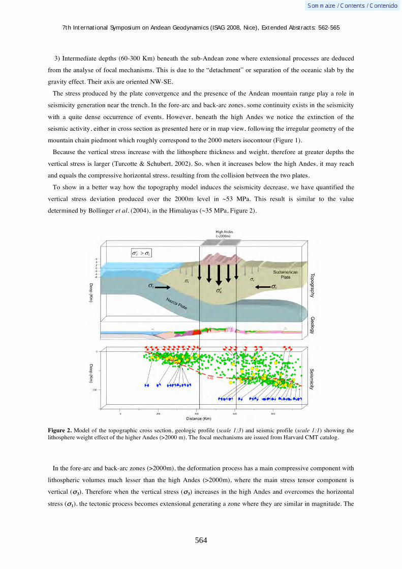
7th International Symposium on Andean Geodynamics (ISAG 2008, Nice), Extended Abstracts: 562-565
564
3) Intermediate depths (60-300 Km) beneath the sub-Andean zone where extensional processes are deduced
from the analyse of focal mechanisms. This is due to the “detachment” or separation of the oceanic slab by the
gravity effect. Their axis are oriented NW-SE.
The stress produced by the plate convergence and the presence of the Andean mountain range play a role in
seismicity generation near the trench. In the fore-arc and back-arc zones, some continuity exists in the seismicity
with a quite dense occurrence of events. However, beneath the high Andes we notice the extinction of the
seismic activity, either in cross section as presented here or in map view, following the irregular geometry of the
mountain chain piedmont which roughly correspond to the 2000 meters isocontour (Figure 1).
Because the vertical stress increase with the lithosphere thickness and weight, therefore at greater depths the
vertical stress is larger (Turcotte & Schubert, 2002). So, when it increases below the high Andes, it may reach
and equals the compressive horizontal stress, resulting from the collision between the two plates.
To show in a better way how the topography model induces the seismicity decrease, we have quantified the
vertical stress deviation produced over the 2000m level in ~53 MPa. This result is similar to the value
determined by Bollinger et al. (2004), in the Himalayas (~35 MPa, Figure 2).
Figure 2. Model of the topographic cross section, geologic profile (scale 1:3) and seismic profile (scale 1:1) showing the lithosphere weight effect of the higher Andes (>2000 m). The focal mechanisms are issued from Harvard CMT catalog.
In the fore-arc and back-arc zones (>2000m), the deformation process has a main compressive component with
lithospheric volumes much lesser than the high Andes (>2000m), where the main stress tensor component is
vertical ( 3). Therefore when the vertical stress ( 3) increases in the high Andes and overcomes the horizontal
stress ( 1), the tectonic process becomes extensional generating a zone where they are similar in magnitude. The

7th International Symposium on Andean Geodynamics (ISAG 2008, Nice), Extended Abstracts: 562-565
565
lithosphere weight generates a tectonic compensation which in turn produces the observed extinction in the
seismicity.
References Bollinger L., Avouac J.P., Cattin R., Pandey M.R., 2004. Stress buildup in the Himalaya. Journal of Geophysical Research,
109-B11405 Engdahl, E.R., Villaseñor A. 2002. Global Seismicity: 1900–1999, in W.H.K. Lee, H. Kanamori, P.C. Jennings, and C.
Kisslinger (editors), International Handbook of Earthquake and Engineering Seismology, Part A, Chapter 41, 665–690. Grange, F. 1984. Etude sismotectonique detaille de la subduction lithospherique au Sud-Pérou, Ph.D. Thesis, IRIGM,
Grenoble, France. Manrique M.O., 2003. Estimación del espesor de la corteza continental en el centro y sur del Perú a partir de fases PmP.
Compendio de trabajos de investigación CNDGIGP, Lima, 9p. Smith W. H., Sandwell D.T. 1997. Global sea floor topography from satellite altimetry and ship depth soundings. Science,
277: 1956-1962 Suárez O., Molnar P., Burchfiel C., 1983. Seismicity, fault plane solutions, depth of faulting and active tectonics of the
Andes of Peru, Ecuador and Southern Colombia. Journal of Geophysical Research, 88: 10403-10428. Tavera H. Buforn E., 2001. Source Mechanism of Earthquakes in Peru. Journal of Seismology, 5: 519-539. Turcotte D. L. & Schubert G., 2002. Geodynamics. Cambridge University Press, 2002, 406 p.

7th International Symposium on Andean Geodynamics (ISAG 2008, Nice), Extended Abstracts: 566-568
566
The Peruvian Pataz, Parcoy and Huachón districts: Evidence for a coherent, 400 km-long, Carboniferous orogenic gold belt along the Eastern Andean Cordillera?
Edina Vágó & Robert Moritz
Section des Sciences de la Terre, Université de Genève, Rue des Maraîchers 13, 1205 Geneva, Switzerland
([email protected], [email protected])
KEYWORDS : gold, orogenic, fluid, geochemistry, isotopes
Abstract The Eastern Peruvian Cordillera is the host of a major Carbonifeours belt of shear-zone hosted, auriferous
quartz veins. The major mining districts are Pataz and Parcoy in the north, and the Huachón district located 400 km to the south is interpreted as the southern extension of this belt. Previous investigations have interpreted these auriferous vein systems as orogenic gold deposits, however there is still an open debate about any possible magmatic link.
The gold-bearing veins are emplaced along NNW-oriented and NE-E dipping brittle-ductile shear zones, within or along the western margin of a granodioritic batholith. Our preliminary observations indicate that the orebodies share similar structural, paragenetic and hydrothermal alteration characteristics in all three districts. Typically, an early milky quartz-pyrite-arsenopyrite stage is followed by blue-grey quartz-galena-sphalerite-native gold, and a final barren calcite-quartz stage, accompanied by sericite, chlorite and carbonate alteration of the host rocks. The similarities support the existence of a ~400 km long gold belt along the Eastern Cordillera.
Detailed structural, fluid inclusion, isotopic and radiometric studies will compare ore forming events along this major gold belt, and address the issue about the controversial relationship of the gold deposits with any contemporaneous magmatic event, which still remains to be identified.
Figure 1. Situation of Pataz, Parcoy and Huachón districts along the Eastern Cordillera in the peruvian Andes (Haeberlin et al., 2002/b).
Figure 2. Schematic geological map of the Pataz gold province with the location of the main deposits. (Haeberlin et al., 2002/b).

7th International Symposium on Andean Geodynamics (ISAG 2008, Nice), Extended Abstracts: 566-568
567
Geological and structural setting
In relation with the Early Carboniferous calc-alkaline magmatism in the Eastern Cordillera of northern Peru
granodioritic, dioritic and monzogranitic bodies have been emplaced along a NW-SE oriented structural line
(Fig.s 1 & 2). Shear stress related tectonism dominated the Eastern Cordillera while gold-bearing quartz-sulfide
veins were emplaced within the batholith. In the north, the mineralized veins are located near the western margin
within the batholith body but towards the south they appear in central or eastern marginal position. The massive
quartz veins of Pataz deposit contain gold bearing pyrite, galena and sphalerite. Two main sets of mineralized
veins have economic importance in Pataz district: a NW-striking E-dipping (~45° to E) and an E-W striking flat
(~10° to E) extensional vein system. Mineralization in both types of vein has similar mineralogical composition
and structural control but gold concentrations are slightly higher in the flat veins.
Huachón district (10°40.6’S, 75°53.5’W), which could presumably belong to the southern extension of the
Maranón Valley gold belt, has ~48-60° dipping quartz veins to the southwest, within the west marginal part of
the granodiorite body of Paucartambo batholith with similar Fe and base-metal sulfide mineralization. Wall-rock
alteration around (~1-2m) the veins contains mainly sericite and chlorite, and is similar to Pataz district’s
alteration characteristics.
Ore and gangue mineralogy
In all districts pyrite is the ore related mineral and has two main types of appearance. Fine grained pyrite
which is mostly the gold bearing phase and coarse grained barren, euhedral pyrite which occurs in massive
stocks or disseminated related to the first and second stages of the mineralization (Haeberlin, 2004). The gold
concentrations are divers, generally 10-20 g/t and irregularly can attain higher values, up to ~3-4 oz/t. The most
common gangue mineral, quartz appears at least in three different generations, an early milky quartz, a second
stage blue-grey microgranular quartz related to the gold precipitation phase and a late stage white quartz
(Haeberlin, 2004). Beside the quartz, carbonate minerals appear in the late stage of the paragenesis. Alteration
minerals, principally chlorite and muscovite, do not show important variations related to the change in the
composition of the host rock.
Fluid geochemistry
Previous microthermometric measurements on the mineralization of Pataz speak about three fluid inclusion
populations which can be well related to the three stages of mineralization. The results reflect a mixing event
between an early hot brine fluid with a late phase low-temperature saline water (Haeberlin, 2002/a).
From Huachón district fluid inclusion study is currently undertaken. Our aim is to compare the different types
of fluids involved in the ore formation at Pataz, Parcoy and Huachón area. Therefore a comparative O isotopic
study will be done as well on quartz from divers elevations of the different ore mineralizations to constrain
sources of the ore forming fluids.

7th International Symposium on Andean Geodynamics (ISAG 2008, Nice), Extended Abstracts: 566-568
568
Summary
Current study consists of structural, petrological, dating and fluid-geochemical investigations of host rock and
mineralized bodies at Huachón district for tracing the possible evidences of a ~400 km long, coherent gold belt
in the central Eastern Cordillera of Peru.
References Haeberlin, Y. (2002/a) Geological and structural setting, age and geochemistry of the orogenic gold deposits at Pataz
Province, Eastern Andean Cordillera, Peru. Doctoral Thesis, University of Geneva, Terre et Environnement 36: 182 p.
Haeberlin, Y.,, Moritz, R., Fontboté, L., (2002/b) Paleozoic orogenic gold deposits in the eastern Central Andes and its
foreland, South America, Ore Geology Reviews 22, p. 41-59
Haeberlin, Y., Moritz, R., Fontboté, L., Cosca M., (2004) Carboniferous orogenic gold deposits at Pataz, Eastern Andean
Cordillera, Peru: Geological and structural framework, paragenesis, alteration, and 40Ar/39Ar geochronology, Economic
Geology, Vol. 99 p. 73-112.

7th International Symposium on Andean Geodynamics (ISAG 2008, Nice), Extended Abstracts: 569-570
569
Chemical and mineralogical characterization of the River Huasco (Norte Chico, Chile)
Ana Valdés1, Mireille Polvé
1, & Diego Morata
2
1 Laboratoire des Mécanismes et Transferts en Géologie, UMR 5563 / UR 154 CNRS–Université Paul Sabatier–
IRD–Observatoire Midi-Pyrénées, 14 avenue Edouard Belin, 31400 Toulouse, France ([email protected]) 2
Departamento de Geología, Facultad de Ciencias Físicas y Matemáticas, Universidad de Chile, Plaza Ercilla,
Santiago, Chile
KEYWORDS : waters, sediments, chemical composition, hydrothermalism, heavy metals
Geographical context
The area of study is located south of the third region of Atacama between 28°S and 29°S, corresponding to the
Huasco River Valley. The origin of this river is located at the confluence of the rivers “del Transito” and “del
Carmen”, which flows into the northern part of the city with the same name. The river Huasco extends for 88
kilometers and presents a basin of 9850 km2, with a general orientation east west.
Geographically the total surface of the basin is equivalent to a 13% of the regional surface area (III region of
Atacama). Through the Huasco River valley different urban centers can be found, for example, Puerto Huasco,
Freirina, Vallenar y Alto del Carmen. According to the 2002 census, there exist 15 sites, from which two are
cities and the rest rural areas. The cities found on the basin are Vallenar with 48040 inhabitants, and Huasco with
7945.
Objectives
Considering geologic, geographic and meteorological characteristics of the study area, the goal of the present
study is to characterize chemically and mineralogically the river Huasco through the analysis of water and
sediment samples, collected between the cities of Alto del Carmen and Huasco. This will allow us to know the
origin of the elements analysed, the determination of the transport mode of a metal by a surface drainage, and to
know some of the factors that control the dynamics of the river Huasco.
Methodology
Two field work sessions were organised within the framework of this project. The first field work was done on
April 2007 and the second was performed on Januray 2008. Each corresponding to 10 days of work.
The data obtained in the first field work period allows us to have a general knowledge of the study area. From
these results the general distribution of the elements allowed a more detailed sampling exercise during the
second field work campaign.
To accomplish the detailed sampling, two sections of the Huasco valley were defined. The first between Alto
del Carmen and Vallenar, and the second between Vallenar and Huasco. A total of 11 locations were sampled,
with one river water sample and one sediment sample taken at each location). Both sample groups were analysed
by ICP-MS (Inductively Coupled Plasma – Mass Spectrometry) at the LMTG, Toulouse, France.
7th International Symposium on Andean Geodynamics (ISAG 2008, Nice), Extended Abstracts: 569-570
570
Results
For each station, water and sediment are compared, and sediment mineralogy taken into account. Evolution of
water and sediment chemical compositions from upstream to downstream traces the local influence of each
formation, as the two sections sampled cross cut all the N-S geological formations. Water analysis from the two
field sessions show inter seasonal variations as they have been sampled during two successive summers. These
observations can be enlarged using the DGA (Dirección General de Aguas) data base.
The water analysis results obtained in both field sessions are compared with previous data from waters in this
area, in particular data from hydrothermal waters in order to quantify the dilution factors compared to these
hydrothermal waters. River sediments are compared with the mean value of the Andean continental crust.
All data are interpreted in terms of regional signature, local hydrothermal influence and mining activities.
Acknowledgements This work was possible by the support of the ALßAN EU grant to A.V. and the IRD-Chile. The first field work session was realized with the logistic support of professors Rodrigo Riquelme and Arturo Jensen of the Universidad Católica del Norte, Chile. In addition, the authors thank Maria Eliana Lorca from the Universidad de Chile for her assistance during field work. Finally A.V. thanks Raul Martinez for his help with English corrections.

7th International Symposium on Andean Geodynamics (ISAG 2008, Nice), Extended Abstracts: 571-572
571
Climatic impact on the erosive dynamics of the Pacific Central Andes revealed by cosmogenic and hydrological records of river sediments
Riccardo Vassallo1, Emilie Pépin
1, Vincent Regard
1, Jean-Loup Guyot
1, Sébastien Carretier
1,
Eric Gayer2, Laurence Audin
1, Frédéric Christophoul
1, Rodrigo Riquelme
3, Juan Julio
Ordóñez4, Fernando Escóbar-Cáceres
5
1 Laboratoire des Mécanismes et Transferts en Géologie, Toulouse, France
2 Institut de Physique du Globe, Paris, France
3 Universidad de Antofagasta, Chle
4 SENHAMI, Lima, Peru
5 DGA, Santiago, Chile
KEYWORDS : Pacific Andes, climate, erosion, cosmonucleids, suspended load
The Pacific side of the Central Andes, characterized by a similar tectonic pattern and by a strong North-South
climatic gradient, offers the opportunity to estimate the impact of climate variability on catchments denudation
rates. To understand the mechanisms and the rates of the geomorphic evolution along this mountain range, it is
important to quantify landscape processes over different time scales. For this reason, in our approach we coupled
historical records of hydrological events (suspended load data of the Chilean DGA and ongoing measurements in
Peruvian rivers), used to constrain erosion and transport rates over the last decades, with cosmogenic terrestrial
nuclides analysis in sediments, to extend the study of these processes over millennial timescales. This study is
supported by the project ANR "ANDES" jeunes chercheurs ANR-06-JCJC-0100.
We combined records of river suspended load fluxes over the last 40 years with measurements of cosmogenic
nuclide (10Be, 26Al, 21Ne) concentrations in alluviums and colluviums in 20 main catchments of Peru and Chili
(Figure 1). Short-term erosion rates are very low from South Peru up to the Central Chili, then increase with a
strong gradient around the region of Santiago, well correlating with the water discharge pattern over the range.
However correlations disappear in the zone of Chile characterized by large glaciers, which probably disturb the
erosion signal (Figure 2).
Lima
Santiago
Figure 1. Location of the samples of the cosmogenic nuclides analysis within the main Pacific catchments of South Peru and North Chili, and pictures showing examples of rivers sampling.

7th International Symposium on Andean Geodynamics (ISAG 2008, Nice), Extended Abstracts: 571-572
572
Figure 2. Annual mean water discharges and catchments erosion rates from data of the DGA (Chile).
To determine long-term erosion rates, we sampled river sands for cosmogenic analysis in similar
morphostructural areas for each catchment. Moreover, for some of them we extended the sampling to several
points of the river profile and to hillslopes, and collected different sizes of cobbles (Figure 3).
This approach will allow us to detect local variations of the erosion rates within the single catchments and to
better constrain the dynamics and transport of sediments in rivers. Preliminary long-term results of this study
will be presented for the first time at this conference.
Figure 3. Picture of the Ocona river (Peru) showing a valley morphology characterized by a wide active riverbed transporting alluviums (from sand to cobble size), and sapping hillslopes covered by regolith.

7th International Symposium on Andean Geodynamics (ISAG 2008, Nice), Extended Abstracts: 573-576
573
Thermotectonic history of the Northern Andes
D. Villagómez1, R. Spikings
1, D. Seward
2, T. Magna
3, W. Winkler
2, & A. Kammer
4
1 Département de Minéralogie, Université de Genève, 13 rue des Maraîchers, 1205 Genève, Switzerland
([email protected], [email protected]) 2 Geologisches Institut, ETH-Zurich, 8092 Zürich, Switzerland ([email protected],
[email protected]) 3 Institut de Minéralogie et Géochimie, Université de Lausanne, L’Anthropole, 1015 Lausanne, Switzerland
([email protected]) 4 Departamento de Geociencias, Universidad Nacional de Colombia, A.A. 14490 Bogotá, Colombia
KEYWORDS : Northern Andes, Tahami terrane, accretion, Caribbean plateau
Introduction
The Northern Andean Zone stretches from Ecuador, through Colombia to Venezuela and is characterized by
three sublinear topographic ridges, referred to as the Western, Central and Eastern Cordillera. The basement of
the Western Cordillera of Colombia and Ecuador is formed by multiple oceanic terranes mainly accreted during
the Mesozoic; the terranes are juxtaposed against the paleo-continental margin (Central Cordillera) across the
Romeral Fault Zone. The aim of this contribution is to provide a temporal framework for the pre-, syn- and post-
accretionary tectonic framework of Western Colombia. Our study is based on multiphase thermochronological
methods (40Ar/39Ar, apatite and zircon fission-track), geochronological (zircon U/Pb LA-ICPMS) and
geochemical (ICPMS and XRF) analyses of crystalline, sedimentary and mafic volcanic rocks from several
traverses across the Colombian Andes.
Paleocontinental margin
In Colombia the continental province crops out in the Central Cordillera. West of the Otú-Pericos Fault (Figure
1), this province (the so-called Tahami terrane, (Touissant and Restrepo, 1994)) is partly composed of medium-
to low-pressure Paleozoic metamorphic rocks (detrital U/Pb zircon ages ranging from 270-380 Ma), which are
intruded by syn- and post-collisional granitic stocks and granitic gneisses with U/Pb zircon ages between
200-300 Ma (Vinasco et al., 2006; this work). These granitic sequences are related to the agglutination of the
Pangea supercontinent during Permian and late break-up during Triassic times.
All these pre-Triassic rocks are intruded by Jurassic calc-alkaline granites of the Ibague Batholith (160 ± 3 Ma,
U/Pb) and Late Cretaceous intrusive rocks of the Antioquia Batholith (U/Pb ages between 83.75 ± 0 and
94.5 ± 1.7 Ma, (Ibañez-Mejía et al, 2007; this work)).
The Paleozoic metamorphic belt is bounded to the west by a narrow volcanic sedimentary body of the
Quebradagrande Complex (Figure 1), which geochemically has been interpreted as having formed in a zone of
back-arc spreading during the Albian-Aptian (Nivia et al., 2006). To the west, these calc-alkaline rocks are in
tectonic contact with isolated tectonic slices of amphibolites, eclogites and metamorphic basic intrusive rocks
exposed on the western flank of the Central Cordillera (Arquía Complex). Recently obtained U/Pb data of an
igneous body (Amagá granite) which intrudes these HP rocks yielded 227.6±4.5 Ma (Vinasco et al, 2006),
implying that the Arquía Complex is pre-Triassic and hence supports the ensialic marginal basin origin for the
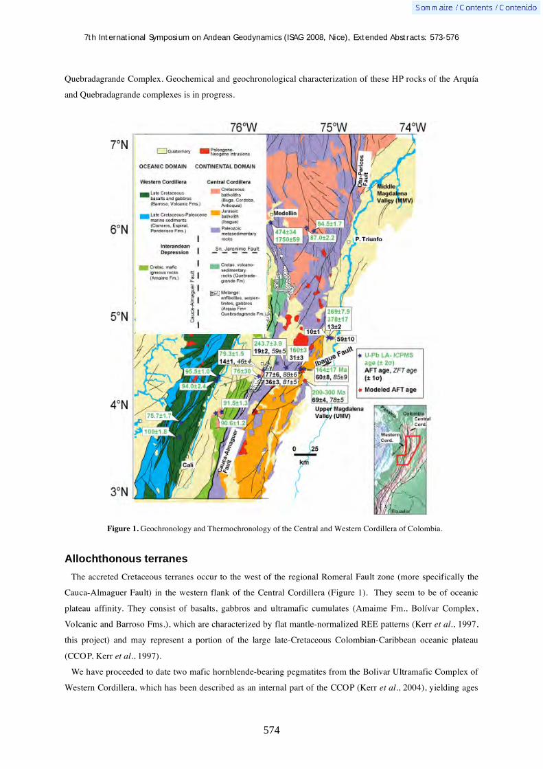
7th International Symposium on Andean Geodynamics (ISAG 2008, Nice), Extended Abstracts: 573-576
574
Quebradagrande Complex. Geochemical and geochronological characterization of these HP rocks of the Arquía
and Quebradagrande complexes is in progress.
Figure 1. Geochronology and Thermochronology of the Central and Western Cordillera of Colombia.
Allochthonous terranes
The accreted Cretaceous terranes occur to the west of the regional Romeral Fault zone (more specifically the
Cauca-Almaguer Fault) in the western flank of the Central Cordillera (Figure 1). They seem to be of oceanic
plateau affinity. They consist of basalts, gabbros and ultramafic cumulates (Amaime Fm., Bolívar Complex,
Volcanic and Barroso Fms.), which are characterized by flat mantle-normalized REE patterns (Kerr et al., 1997,
this project) and may represent a portion of the large late-Cretaceous Colombian-Caribbean oceanic plateau
(CCOP, Kerr et al., 1997).
We have proceeded to date two mafic hornblende-bearing pegmatites from the Bolivar Ultramafic Complex of
Western Cordillera, which has been described as an internal part of the CCOP (Kerr et al., 2004), yielding ages

7th International Symposium on Andean Geodynamics (ISAG 2008, Nice), Extended Abstracts: 573-576
575
of 94.0±2.4 and 95.5±1 Ma (U/Pb). New (U/Pb) ages on granitic rocks from the Buga Batholith are 90.6±1.2 and
91.5±1.3 Ma and may perhaps represent the initial stages of east-facing island arc activity that formed at the
juvenile active margin of the eastward migrating CCOP (and may be genetically related to the coeval Aruba
Batholith in the Southern Caribbean). We have also dated the arc-related Cordoba Batholith, which intrudes and
hence post-dates the mafic terranes. This rock yields a U/Pb age of 79.3±1.5 Ma, which constrains the minimum
age of the accreted terranes. Therefore, the age of the accreted terranes is likely to be between 95 and 80 Ma.
Time of accretion of the allochthonous terranes
In Colombia, several preliminary fission track (FT) ages have been obtained from the rocks of the Tahami
Terrane in the Central Cordillera (Figure 1). In the central section the apatite fission track (AFT) ages range
between ~77 and ~36 Ma. An older group of nearly indistinguishable AFT ages (ages within 1 error interval) of
77±6, 69±4 (sample 05DV82) and 60±8, 59±10Ma are representative of the region and were obtained from
samples located relatively far (>8 km) from local fault traces (e.g. Ibagué Fault). Samples close to sheared rocks
within the Ibagué Fault yielded younger AFT ages of 31±3 and 36±3 Ma (sample 05DV06). Four zircon fission
track (ZFT) ages on those same samples are indistinguishable within error (78±5, 81±5, 85±9, 88±6 Ma; Fig. 1).
We performed inverse modeling on some of these samples (05DV06 and 05DV82), using the annealing model
of Carlson et al. (1999), and the Monte-Carlo inverse modeling procedure of Ketcham et al. (1999) (Figure 2), to
constrain their potential thermal histories using the ZFT age as time constraint at ~250±50°C. Sample 05DV82
(mean track length of 14.54±0.76μm), located 20 km from the Ibagué Fault (Figure 1), cooled rapidly through
250˚C to ~ 60˚C at ~ 80-70 Ma. Sample 05DV06, located closer to the Ibagué Fault (Figure 1) hosts partially
annealed FT lengths in apatite (mean track length of 13.60±1.62 μm), suggesting they may have resided for a
significant amount of time within the apatite partial annealing zone (APAZ). The best-fit model indicates a rapid
cooling through ~ 250˚C to ~ 90˚C between 80-70 Ma, followed by slower cooling from 70-10 Ma and finally
renewed rapid cooling from ~ 60˚C to ~25˚C between 10 Ma to present.
Figure 2. Modeled T-t paths and track length distribution for two samples which crop out in the Central Cordillera. Monte-Carlo inverse modeling following procedure of Ketcham et al. (1999) and multi-kinetic approach (based on Dpar) according Carlson et al. (1999). APAZ = apatite partial annealing zone
Our study indicates that Jurassic granitoids (Ibagué Batholith) emplaced along the eastern border of the Central
Cordillera in Colombia cooled rapidly through ~ 250˚C to ~ 60˚C between 80-70 Ma. We conclude that an

7th International Symposium on Andean Geodynamics (ISAG 2008, Nice), Extended Abstracts: 573-576
576
important tectonic event produced exhumation in the paleocontinental margin during late Cretaceous and ascribe
this event to the accretion of the CCOP.
Preliminary conclusions
Initial stages of interaction between the CCOP and the Ecuadorian margin took place in Late Campanian –
Mastrichtian (75 - 65 Ma, Vallejo et al., 2006). However, our study shows that this event occurred slightly
earlier in Colombia. Hence it is plausible to suggest, pending additional data, that CCOP accretion took place in
southward direction due to the northward drifting of South America during the Late Cretaceous. This Campanian
accretion is coeval with the cessation of the late Cretaceous arc in Northern Colombia (Antioquia Batholith) due
to the clogging of the subduction zone caused by the collision between South America and the CCOP. As
already mentioned, this was synchronous with accelerated surface uplift and exhumation within the buttressing
continental rocks and is temporally corroborated by the onset of clastic sedimentation derived from the Central
Cordillera into the Upper-Middle Magdalena Valley (UMV-MMV, Figure 1) located immediate to the east.
Sediment progradation to the east (El Cobre sandstone) and the initiation of eastward shifting of the axis of
deposition of the MMV began during Campanian time (Villamil, 1999).
This work is supported by the Swiss National Science Foundation (DV & RS)
References Carlson, W.D., Donelick, R.A., Ketcham, R.A., 1999. Variability of apatite fission-track annealing kinetics: I Experimental
results. American Mineralogist. 84, 121 –1223. Ibañez-Mejia M., Tassinari C.C.G.,; Jaramillo J.M. 2007. U-Pb zircon ages of the “Antioquian Batholith”: geochronological constraints of late Cretaceous magmatism in the central Andes of Colombia. In Proceedings of XI
Congreso Colombiano de Geologia. Bucaramanga. Colombia. Kerr, A.C., Marriner, G.F., Tarney, J., Nivia, A., Saunders, A.D., Thirlwall, M.F., Sinton, C.W. 1997. Cretaceous Basaltic
Terranes in Western Colombia: Elemental, Chronological and Sr-Nd Isotopic Constraints on Petrogenesis. Journal of. Petrology. 38, 677–702.
Kerr, A.C., Tarney, J., Kempton, P.D., Pringle, M., Nivia, A. 2004. Mafic pegmatites intruding oceanic plateau gabbros and ultramafic cumulates from Bolivar, Colombia; evidence for a "wet" mantle plume? Journal of Petrology. 45, 1877-1906.
Ketcham, R.A., Donelick, R.A., Carlson, W.D. 1999. Variability of apatite fission-track annealing kinetics: III. Extrapolation to geological time scale. American Mineralogist, 84, 1235-1255.
Nivia A., Marriner G., Kerr A., Tarney J. 2006. The Quebradagrande Complex: A lower cretaceous ensialic marginal basin in the Central Cordillera of the Colombian Andes. Journal of South American Earth Sciences. 21. 423-436.
Toussaint, J.F., Restrepo, J.J., 1994. “The Colombian Andes during Cretaceous times”. In (J.A. Salfity), Cretaceous tectonics of the Andes, Verlag Braunschweig, Wiesbaden, Germany, 61–100.
Vallejo, C., Spikings, R., Luzieux, L., Winkler, W., Chew, D., Page, L., 2006. The early interaction between the Caribbean Plateau and the NW South American Plate. Terra Nova 18, 264–269.
Villamil T. 1999. Campanian-Miocene tectonostratigraphy, depocenter evolution and basin development of Colombia and western Venezuela. Palaeogeography, Palaeoclimatology, Palaeoecology. 153. 239-275.
Vinasco C.J., Cordani U.G., Gonzalez H., Weber M., Pelaez C. 2006. Geochronological, isotopic, and geochemical data from Permo-Triassic granitic gneisses and granitoids of the Colombian Central Andes. Journal of South American Earth Sciences 21. 355-371.

7th International Symposium on Andean Geodynamics (ISAG 2008, Nice), Extended Abstracts: 577-579
577
Cenozoic high-strontium andesites in the Eastern Cordillera of Northwestern Argentina, Central Andes
José Maria Viramonte1, Néstor Suzaño
1, Carolina Prescott
2,3, Raul Becchio
1, José Germán
Viramonte1, Marcelo Arnosio
3, & Marcio M. Pimentel
2
1
University of Salta and CONICET, Geonorte Institute, Av. Bolivia 5051, 4400 Salta, Argentina
([email protected]) 2 University of Brasilia, Geoscience Institute, Geochronology Laboratory, 70910-900, Brasilia, Brazil
3 University of Salta, Geonorte Institute, Av. Bolivia 5051, 4400 Salta, Argentina
KEYWORDS : Cenozoic, andesites, high-strontium, Eastern Cordillera, Central Andes
Cenozoic magmatism in the southern Central Andes occurs generally in the N–S trending volcanic arc and in
NW–SE trending transverse volcanic belts (Viramonte et al., 1984).
In the Eastern Cordillera of northwestern
Argentina, near the Huachichocana town (24º-65º,
Jujuy province; Figure. 1) crop out Cenozoic
andesites with high Sr contents. These rocks are
associated with the Lipez transverse belt (Figure 1)
and were firstly described by Ramos et al., (1967) as
“Huachichocana Andesite”. They are located ~590
Km from the trench in a back arc position and
represent one of the easternmost magmatism
between 23º and 25º LS with the Diego de Almagro
Complex (Hauser, 2005) and Alemania-Pampa
Grande Andesites (Figure. 1). The Huachichocana
rocks occur as a 200m-thick and 700m-large sill
along the “Tilcarica” unconformity between the
Puncoviscana Formation (Upper Precambrian-Lower
Cambrian) and the Meson Group (Mid-Upper
Cambrian). This body present columnar jointing and
have a porphyritic texture comprising by phenocrysts
of hornblende, biotite, clinopyroxene, orthopyroxene
and zoned plagioclase included in a cryptocrystalline
matrix. Titanite occurs as an accessory mineral.
Major and trace elements composition are
presented in Table 1. They have 61-63 % wt. SiO2
and according to the SiO2 vs K2O (Figure 2) diagram
Huachichocana rocks plot in the high-K andesite field. Figure 3 show that these rocks present the highest Sr
contents (950-1200 ppm) comparing with other andesites of the southern Central Andes. On chondrite
normalized diagram (Figure 4) these rocks display coherent REE patterns characterized by enrichment in LREE
Figure 1. Huachichocana location regarding the magmatic arc.

7th International Symposium on Andean Geodynamics (ISAG 2008, Nice), Extended Abstracts: 577-579
578
relative to HREE as indicated by La/SmN= 3.99 to 4.65 and Gd/YbN= 2.04 to 2.31. Also, the samples show very
minor Eu anomalies (Eu/Eu*=0.85-0.91).
Table 1. Major and trace elements of Huachichocana rocks
Sample Huachichocana HO-4 HO-5 HO-6 HO-7 SiO2 61.87 61.17 62.81 61.22 61.56
TiO2 0.57 0.60 0.496 0.56 0.56
Al2O3 16.40 17.16 17.18 17.45 17.18
Fe2O3 5.53 5.48 4.92 5.25 5.27
MnO 0.12 0.140 0.129 0.13 0.14
MgO 2.44 2.04 2.01 2.02 2.07
CaO 5.61 6.00 5.194 6.02 5.76
Na2O 3.18 3.20 3.194 3.58 3.51
K2O 3.05 2.69 3.08 2.48 2.54
P2O5 0.38 0.37 0.337 0.36 0.36
PPC 0.6 1.78 0.96 0.54 0.89
total 99.785 100.65 100.31 99.64 99.88
Ba 762 764 840 874 806
Rb 86 81 91 75 79
Sr 954 1061 1088 1202 1164
Zr 201 225 213 230 224
Y 25 26 25 25 25
Nb 17 20 19 20 21
Ni 10 11 9 9 8
Cr 6 4 3 3 2
La 35 46.5 41.1 45.5 46.6
Ce 65.7 85.4 76.4 83.9 85.2
Pr 7.79 9.89 8.9 9.67 9.93
Nd 30.3 37.5 33.7 37.1 37.7
Sm 5.65 6.61 6.09 6.71 6.46
Eu 1.64 1.82 1.62 1.89 1.82
Gd 5.31 6.02 5.53 6.03 5.96
Tb 0.75 0.8 0.75 0.8 0.81
Dy 3.95 4.2 3.88 4.19 4.15
Ho 0.76 0.82 0.75 0.8 0.8
Er 2.24 2.4 2.23 2.36 2.37
Tm 0.31 0.34 0.32 0.33 0.34
Yb 2.15 2.15 2.12 2.22 2.21
Lu 0.33 0.34 0.33 0.33 0.34
Sm-Nd and Sr isotopic data for selected samples are presented in table 2. These rocks show low 87Sr/86Sr ratios
(0.70591-0.70665), negative Nd values ranging from -2.2 to -5.4 and TDM model ages in the interval between
0.81 to 0.99 Ga.
Figure 3. SiO2 vs Sr diagram (modified from Ramos et al., 2004).
Figure 2. SiO2 vs K2O diagram (Peccerilo and Taylor, 1976).
Figure 4. Chondrite normalized REE patterns of Huachichocana rocks (normalizing values of Sun and Mc Donough, 1989)
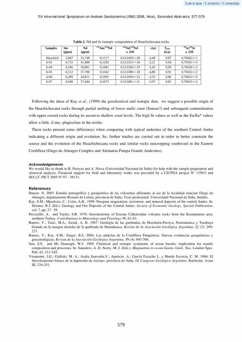
7th International Symposium on Andean Geodynamics (ISAG 2008, Nice), Extended Abstracts: 577-579
579
Table 2. Nd and Sr isotopic composition of Huachichocana rocks
Samples Sm
(ppm)
Nd
(ppm)
147Sm/
144Nd
143Nd/
144Nd
± 2SE
(o)
TDM
(Ga)
87Sr/
86Sr
± 2SE
Huachich 5,867 31,748 0,1117 0,512459+/-20 -3,49 0,87 0,70665+/-1
h-01 6,733 31,488 0,1292 0,512525+/-18 -2,21 0,94 0,70591+/-3
h-04 6,596 36,881 0,1081 0,512358+/-19 -5,45 0,99 0,70636+/-2
h-05 6,512 37,788 0,1042 0,512388+/-18 -4,88 0,91 0,70655+/-2
h-06 6,299 34,911 0,1091 0,512456+/-15 -3,55 0,86 0,70631+/-5
h-07 6,648 37,444 0,1073 0,512481+/-11 -3,07 0,81 0,70635+/-2
Following the ideas of Kay et al., (1999) the geochemical and isotopic data, we suggest a possible origin of
the Huachichocana rocks through partial melting of lower mafic crust (Sunsas?) and subsequent contamination
with upper crustal rocks during its ascent to shallow crust levels. The high Sr values as well as the Eu/Eu* values
allow a little, if any, plagioclase in the restite.
These rocks present some differences when comparing with typical andesites of the southern Central Andes
indicating a different origin and evolution. So, further studies are carried out in order to better constrain the
source and the evolution of the Huachichocana rocks and similar rocks outcropping southward in the Eastern
Cordillera (Diego de Almagro Complex and Alemania-Pampa Grande Andesites).
Acknowledgements We would like to thank to R. Pereyra and A. Nieva (Universidad Nacional de Salta) for help with the sample preparation and chemical analyses. Financial support for field and laboratory works was provided by a CIUNSA project Nº 1350/3 and SECyT, PICT 2005 Nº 07 - 38131.
References Hauser, N. 2005. Estudio petrográfico y geoquímico de las volcanitas aflorantes al sur de la localidad estacion Diego de
Almagro, departamento Rosario de Lerma, provincia de Salta. Tesis profesional. Universidad Nacional de Salta. Inédito. Kay, S.M.; Mpodozis, C., Coira, A.B., 1999. Neogene magmatism, tectonism, and mineral deposits of the central Andes. In:
Skinner, B.J. (Ed.), Geology and Ore Deposits of the Central Andes. Society of Economic Geology, Special Publication, vol. 7, pp. 27– 59.
Peccerillo, A. and Taylor, S.R. 1976. Geochemistry of Eocene Calkalcaline volcanic rocks from the Kastamanou area, northern Turkey. Contributions to Mineralogy and Petrology 58: 61-63.
Ramos, V.; Turic, M.A.; Zuzek, A. B. 1967: Geología de las quebradas de Huichaira-Pecoya, Purmamarca y Tumbaya Grande en la margen derecha de la quebrada de Humahuaca. Revista de la Asociación Geológica Argentina, 22 (3): 209-221.
Ramos, V.; Kay, S.M.; Singer, B.S. 2004. Las adakitas de la Cordillera Patagónica: Nuevas evidencias geoquímicas y geocrnológicas. Revista de la Asociación Geológica Argentina. 59 (4): 693-706.
Sun, S.S. and Mc Donough, W.F. 1989. Chemical and isotopic systematic of ocean basalts: implication for mantle composition and processes. In: Saunders, A. D. Norry, M..J. (Eds.), Magmatism in ocean basins. Geol.. Soc. London Spec. Pub. 42: 313-345.
Viramonte, J.G.; Galliski, M. A.; Araña Saavedra,V.; Aparicio, A.; García Escacho L. y Martín Escorza, C. M. 1984: El finivolcanismo básico de la depresión de Arizaro, provincia de Salta. IX Congreso Geológico Argentino, Bariloche. Actas III: 234-251.

7th International Symposium on Andean Geodynamics (ISAG 2008, Nice), Extended Abstracts: 580-582
580
Heterogeneous thermal overprint of a Late Palaeozoic fore-arc system in north-central Chile (32°–31°S) discernible by small scale equilibration and age domains (Ar-Ar; fission track)
Arne P. Willner1,2
, Hans-Joachim Massonne2, Masafumi Sudo
3, & Stuart Thomson
4
1 Institut für Geologie, Mineralogie & Geophysik, Ruhr-Universität, D-44780 Bochum, Germany
([email protected]) 2 Institut für Mineralogie und Kristallchemie, Stuttgart University, Azenbergstr. 18, D-70174 Stuttgart, Germany
3 Institut für Geowissenschaften, Potsdam University, Karl-Liebknechtstr. 24, D-14674 Potsdam, Germany
4 Department of Geology & Geophysics, Yale University, P.O. Box 208109, New Haven, CT 06520-8109, USA
KEYWORDS : Ar-Ar dating, fission track dating, accretionary system, thermal overprint, age resetting
Geological setting
The metamorphic basement in north-central Chile at lat. 31°-32°S shows various levels of a coastal
accretionary system which are telescoped to a short distance in outcrop by Mesozoic tectonic processes at the
southernmost end of the Atacama strike-slip system. The Choapa Metamorphic Complex (CMC) comprises low
grade rocks (metagreywacke, greenschist) and has the same structural inventory as the Western Series south of
34°S that originated by basal accretion (Willner et al. 2005). The Arrayán Formation (AF), dominated by very
low to low grade metagreywacke, shows similar structures as the Eastern Series south of 34°S which was formed
by frontal accretion (Richter et al. 2007). The Huentelauquén Formation (HF), unconformably overlying the
Arrayán Formation, is a heterogeneous sedimentary sequence of shelf deposits involving platform limestone,
conglomerate and neritic clastic sediments with an Upper Carboniferous to Permian biostratigraphic age
(Rebelledo and Charrier 1994). U/Pb-dating yielded a detrital magmatic zircon population in the metamorphic
basement which demonstrates a maximum age of deposition at 303 Ma for the HF. This deposition was
concomitant with that of the CMC (maximum deposition age 308 Ma) and , thus, occurred in a retrowedge basin.
On the other hand, deposition of the AF was considerably older (maximum deposition age 343 Ma; Willner et al.
2008) confirming the general relationship, as observed south of lat. 34°S, that basal accretion follows frontal
accretion in time in Chile (Richter et al. 2007). The oldest intrusion ages (Rb-Sr isochron) obtained by Irvine et
al. (1988) at 31°S are 220±20 Ma for a gabbro and 200±10 Ma for a monzogranite documenting the end of the
accretion process at the same time as in north-central Chile (Willner et al. 2005) and south-central Chile (Glodny
et al. 2005). This magmatic event is concomitant to an extensional event with ubiquitous basin opening in central
Chile. It was followed by bimodal dyke intrusions of a Jurassic fore-arc according to K/Ar ages of hornblende in
mafic dykes 133-213 Ma (Irvine et al. 1988). This corresponds to a similar K/Ar age spectrum of hornblende in
metabasite within the CMC at 154-220 Ma.
Pressure-temperature constraints
In the CMC metabasite with the assemblage Ca-amphibole - white mica - chlorite - quartz - plagioclase ±
epidote contains two generations of amphibole, white mica and plagioclase at thin section scale: actinolite, albite
and phengite (Si 3.25-3.33 pfu) define a relic metamorphic stage I at 6.0-7.5 kbar, 305-360°C, whereas
magnesiohornblende or tschermakitic hornblende, oligoclase and muscovite (Si 3.15-3.20 pfu) equilibrated at
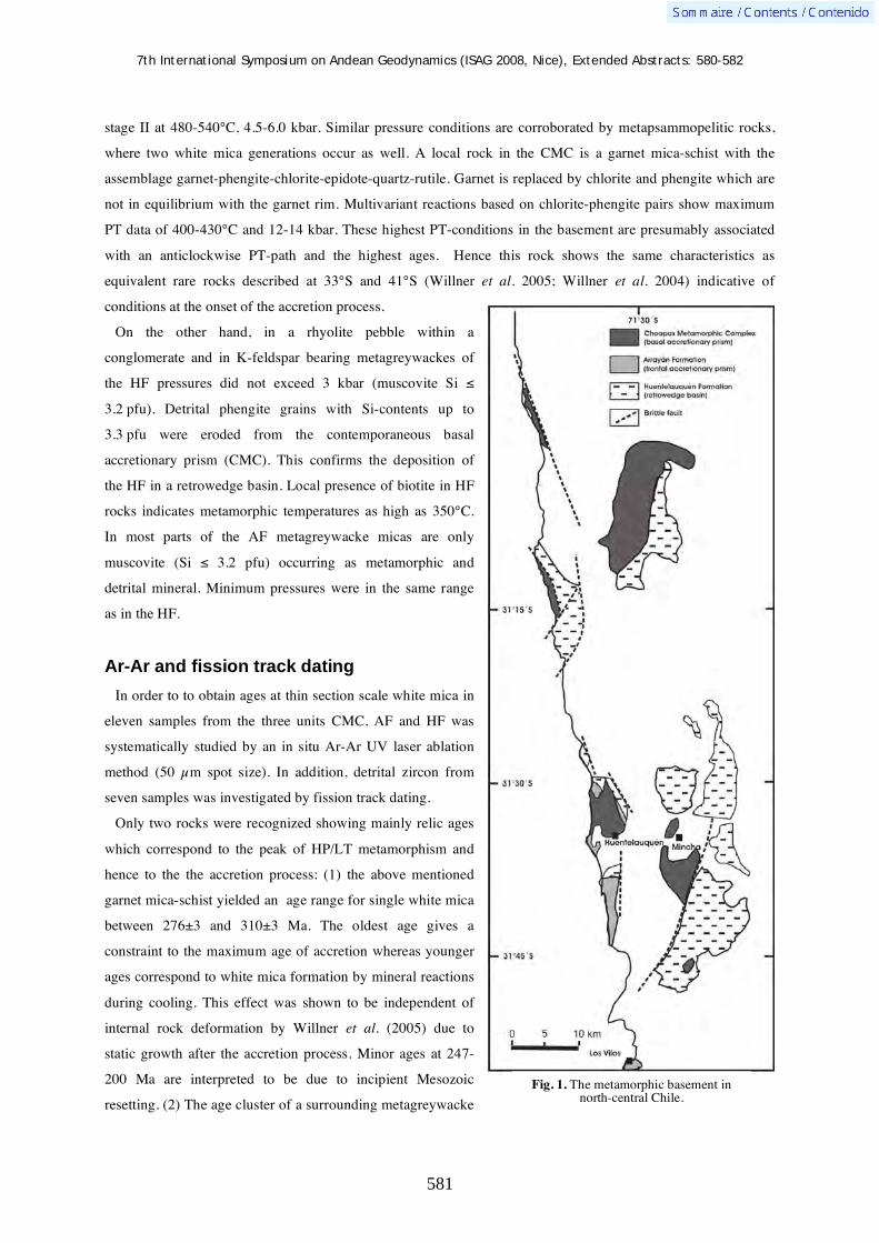
7th International Symposium on Andean Geodynamics (ISAG 2008, Nice), Extended Abstracts: 580-582
581
stage II at 480-540°C, 4.5-6.0 kbar. Similar pressure conditions are corroborated by metapsammopelitic rocks,
where two white mica generations occur as well. A local rock in the CMC is a garnet mica-schist with the
assemblage garnet-phengite-chlorite-epidote-quartz-rutile. Garnet is replaced by chlorite and phengite which are
not in equilibrium with the garnet rim. Multivariant reactions based on chlorite-phengite pairs show maximum
PT data of 400-430°C and 12-14 kbar. These highest PT-conditions in the basement are presumably associated
with an anticlockwise PT-path and the highest ages. Hence this rock shows the same characteristics as
equivalent rare rocks described at 33°S and 41°S (Willner et al. 2005; Willner et al. 2004) indicative of
conditions at the onset of the accretion process.
On the other hand, in a rhyolite pebble within a
conglomerate and in K-feldspar bearing metagreywackes of
the HF pressures did not exceed 3 kbar (muscovite Si
3.2 pfu). Detrital phengite grains with Si-contents up to
3.3 pfu were eroded from the contemporaneous basal
accretionary prism (CMC). This confirms the deposition of
the HF in a retrowedge basin. Local presence of biotite in HF
rocks indicates metamorphic temperatures as high as 350°C.
In most parts of the AF metagreywacke micas are only
muscovite (Si 3.2 pfu) occurring as metamorphic and
detrital mineral. Minimum pressures were in the same range
as in the HF.
Ar-Ar and fission track dating
In order to to obtain ages at thin section scale white mica in
eleven samples from the three units CMC, AF and HF was
systematically studied by an in situ Ar-Ar UV laser ablation
method (50 μm spot size). In addition, detrital zircon from
seven samples was investigated by fission track dating.
Only two rocks were recognized showing mainly relic ages
which correspond to the peak of HP/LT metamorphism and
hence to the the accretion process: (1) the above mentioned
garnet mica-schist yielded an age range for single white mica
between 276±3 and 310±3 Ma. The oldest age gives a
constraint to the maximum age of accretion whereas younger
ages correspond to white mica formation by mineral reactions
during cooling. This effect was shown to be independent of
internal rock deformation by Willner et al. (2005) due to
static growth after the accretion process. Minor ages at 247-
200 Ma are interpreted to be due to incipient Mesozoic
resetting. (2) The age cluster of a surrounding metagreywacke
Fig. 1. The metamorphic basement in north-central Chile.

7th International Symposium on Andean Geodynamics (ISAG 2008, Nice), Extended Abstracts: 580-582
582
shows a range of single white mica ages between 244±12 and 281±3 Ma. Again following our results of studies
south of lat. 34°S (Willner et al. 2005) we interpret the oldest age as the age of peak HP/LT metamorphism and
the younger age as that of white mica formation during cooling under 300°C. In both rocks about 35-40 Myrs of
retrograde mineral formation are documented. A zircon FT-age of 248±27 Ma is equivalent to the youngest
white mica age and represents cooling under ~280°C.
All further studied rock samples from the CMC, AF and HF show ages younger than 248 Ma with age clusters
at 190-219 Ma, 154-173 Ma and 131-137 Ma. These clusters match the time of first Mesozoic intrusions into the
accretionary wedge and Jurassic bimodal vein intrusions into the fore-arc setting and, thus, do not correspond to
HP/LT metamorphism and accretion. Most FT-ages are older than the Ar-Ar white mica ages. For instance, in
two samples from the CMC zircon FT-ages are at 274±18 and 272±40 approaching the maximum age of
metamorphism, whereas Ar-Ar white mica ages typically show wide age ranges at 199-248 Ma and 129-143 Ma.
We interpret the Upper Triassic to Jurassic Ar-Ar ages as resetting ages. Resetting affects detrital as well as
metamorphic white mica in a similar way. No primary detrital white mica ages are preserved. In some cases
several broad age clusters occur, whereas in some cases age peaks are narrow and can be interpreted as complete
resetting. Resetting is assumed to be due to influx of fluids ascending in hydrothermal systems within
extensional environments that are known from Upper Triassic to Jurassic times.
Furthermore, FT dating of three local zircon samples show astonishing young ages of 96±5 Ma and 104±5 Ma
and also a mixture of single values ranging from 99 to 281 Ma. The event at 100 Ma corresponds to a regional
short-time compressional episode with slight crustal thickening. Locally, a deeper part of the accretionary system
was probably exhumed along a fault and cooled below 280°C in Cretaceous times.
Summarising the in insitu Ar-Ar age study reveals a rather complex overprint history in a fore-arc setting of a
long-lived convergent margin that cannot be resolved into great detail by integrating methods.
References Glodny, J., Lohrmann, J., Echtler, H., Gräfe, K., Seifert, W., Collao, S. & Figueroa, O., 2005 - Internal dynamics of a
paleoaccretionary wedge: insights from combined isotope tectonochronology and sandbox modelling of the south-central Chilean forearc. Earth and Planetary Science Letters 231: 23-39.
Irvine, J.J., García, C., Hervé, F. & Brook, M., 1988 - Geology of part of a long-lived dynamic plate margin: the coastal cordillera of north-central Chile, latitude 30°51´-31°S. - Canadian.Journal of Earth Sciences 25: 603-624.
Rebelledo, S.& Charrier, R., 1997 - Evolución del basamento paleozoico en el área de Punta Claditas, Región de Coquimbo, Chile (31-32°S). Revista Geológica de Chile 21: 55-69.
Richter, P., Ring, U., Willner, A.P. & Leiss, B., 2007 - Structural contacts in subduction complexes and their tectonic significance: The Late Paleozoic coastal accretionary wedge of central Chile. - Journal of the Geological Society of London 164, 203-214.
Willner, A.P., Glodny, J., Gerya, T.V., Godoy, E. & Massonne, H.-J., 2004 - A counterclockwise PTt-path in high pressure-low temperature rocks from the Coastal Cordillera accretionary complex of South Central Chile: constraints for the earliest stage of subduction mass flow. – Lithos 75: 283-310.
Willner, A.P., 2005 - Pressure-temperature evolution of an Upper Paleozoic paired metamorphic belt in Central Chile (34°-35°30´S). - Journal of Petrology 46: 1805-1833.
Willner, A.P., Thomson, S.N., Kröner, A., Wartho, J.A., Wijbrans, J & Hervé, F., 2005 - Time markers for the evolution and
exhumation history of a late Palaeozoic paired metamorphic belt in central Chile (34°-35°30´S). - Journal of Petrology 46: 1835-1858.
Willner, A.P., Gerdes, A. & Massonne, H.-J., 2008a - History of crustal growth and recycling at the Pacific convergent margin of South America at latitudes 29°-36°S revealed by a U-Pb and Lu-Hf isotope study of detrital zircon from late Paleozoic accretionary systems. Chemical Geology, in press.
Willner, A.P., Richter, P., Ring, U., 2008b - Structural modification of a late Paleozoic accretionary system in north-central Chile (34°-35°S) during postaccretional shortening episodes at a long-lived active margin. Revista Geologica de Chile, in press.
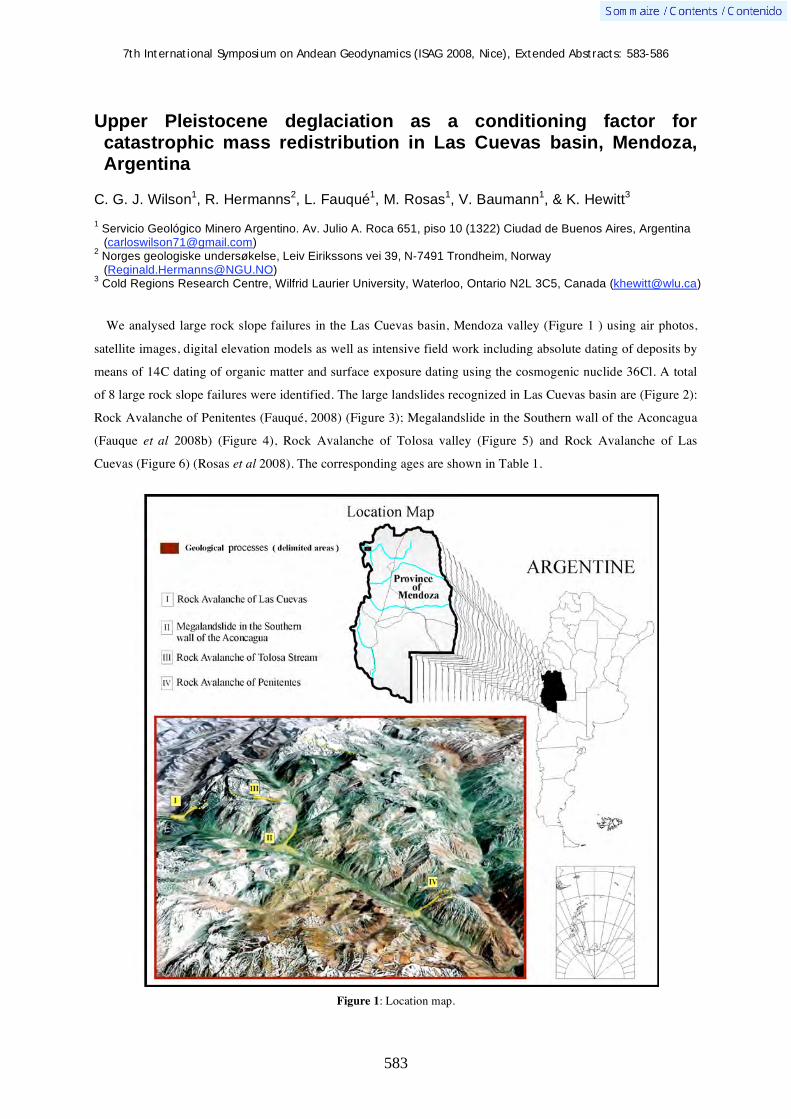
7th International Symposium on Andean Geodynamics (ISAG 2008, Nice), Extended Abstracts: 583-586
583
Upper Pleistocene deglaciation as a conditioning factor for catastrophic mass redistribution in Las Cuevas basin, Mendoza, Argentina
C. G. J. Wilson1, R. Hermanns
2, L. Fauqué
1, M. Rosas
1, V. Baumann
1, & K. Hewitt
3
1 Servicio Geológico Minero Argentino. Av. Julio A. Roca 651, piso 10 (1322) Ciudad de Buenos Aires, Argentina
([email protected]) 2 Norges geologiske undersøkelse, Leiv Eirikssons vei 39, N-7491 Trondheim, Norway
([email protected]) 3 Cold Regions Research Centre, Wilfrid Laurier University, Waterloo, Ontario N2L 3C5, Canada ([email protected])
We analysed large rock slope failures in the Las Cuevas basin, Mendoza valley (Figure 1 ) using air photos,
satellite images, digital elevation models as well as intensive field work including absolute dating of deposits by
means of 14C dating of organic matter and surface exposure dating using the cosmogenic nuclide 36Cl. A total
of 8 large rock slope failures were identified. The large landslides recognized in Las Cuevas basin are (Figure 2):
Rock Avalanche of Penitentes (Fauqué, 2008) (Figure 3); Megalandslide in the Southern wall of the Aconcagua
(Fauque et al 2008b) (Figure 4), Rock Avalanche of Tolosa valley (Figure 5) and Rock Avalanche of Las
Cuevas (Figure 6) (Rosas et al 2008). The corresponding ages are shown in Table 1.
Figure 1: Location map.

7th International Symposium on Andean Geodynamics (ISAG 2008, Nice), Extended Abstracts: 583-586
584
Figure 2:View of the Rock Avalanche of Las Cuevas from the west
Figure 3: Orthogonal view of Rock Avalanche of Penitentes in a North direction
All results of our dating indicate
postglacial events spanning from about 1500
years after the Last Glacial Maximum to the
early Holocene. Similar to other mountain
regions three of the deposits (Horcones
deposits and Penitentes deposit) have been
earlier misinterpreted as glacial deposits
resulting in an erroneous interpretation of
glacial stratigrapphy (Espizua L.E., 1989) of
the western Central Andes. However, detailed
sedimentologic analyses based on
mineralogic and grain roundness
investigation show that these deposits are the
result of complex interaction of rockslides
resulting from the large mountain failures
with valley glaciars and glacial valley fill
resulting in a mixture of various deposits.
Avalanche of Las Cuevas
Main scarp
i ii

7th International Symposium on Andean Geodynamics (ISAG 2008, Nice), Extended Abstracts: 583-586
585
These mountain slope failures started as high mobility rock avalanches however due to erosion of glacial ice
and glacial deposits these flow type landslides got more water saturated and continued for 34 km down from the
south wall of Aconcagua. The resulting deposits obstructed Horcones and Las Cuevas valleys, and thus caused
due to catastrophic dam failures several cascading catastrophic events.
Table 1
Process Stratigraphy Material Age Error Dating
Megalandslide in the Southernwall of the
Aconcagua i
- Lacustrine deposits
(pelites) 8.260 - 8.254 Carbon 14
Megalandslide in the Southernwall of the
Aconcagua i -
Lacustrine deposits
(pelites) 14.798 - 13.886 Carbon 14
Megalandslide in the Southernwall of the
Aconcagua ii Aconcagua group Volcanic rocks 11.110 - 8.170
Cosmogenic
nuclide
Rock Avalanche of Las Cuevas event i
Tordillo Formation and
Puente del Inca´s
Traquites
Conglomerates and red
sandstones. Traquites 13.125 875
Cosmogenic
nuclide
Rock Avalanche of Las
Cuevas event ii
Tordillo Formation and
Puente del Inca´s
Traquites
Conglomerates and red
sandstones. Traquites 10.250 750
Cosmogenic
nuclide
Rock Avalanche of Tolosa
Stream Juncal Formation
Volcanic and pyroclastic
rocks 9.307 -
Cosmogenic
nuclide
Rock Avalanche of Penitentes
Choiyoi Group Granite 13.890 920 Cosmogenic
nuclide
Rock Avalanche of Penitentes
Choiyoi Group Dacitic breccia, riolitic
and riodacitic igninbrites 11.820 790
Cosmogenic
nuclide
Rock Avalanche of Penitentes
Choiyoi Group Dacitic breccia, riolitic
and riodacitic igninbrites 10.620 730
Cosmogenic
nuclide
Furthermore rock slope failures along the south wall of Cerro Aconcagua caused glacial capture of glaciers
flowing east previously to rockslope. Today these glaciars are hanging glaciars in the South wall of Cerro
Aconcagua which collapse into the upper Horcones valley. Today's frequent glacial surges in lower Horcones
valley influencing security of mountaineer camps along the main rout towards Cerro Aconcagua are seen as a
long term effect of this post glacial slope collapses.
The absolute ages obtained vary between the Tardiglacial (15-1014 C ka BP) and the Postglacial Periods which
corresponds to the Early Holocene (10-8 14C Ka BP). Most of the dates belong to the Tardiglacial Period that is
characterized by a rapid change towards warmer conditions.
We interpret that in the Las Cuevas basin, the important loss of glacial ice generated destabilization of the
Mountain Geomorphic System due to the glacial “debuttresing” and changes of the elevation of permafrost
causing these multiple rockslides. Fauqué et al (2005) studied an example of this process at Puente del Inca
characterized by deep slope gravity deformation showing that slope processes due to the change of climatic
conditions is ongoing to the present.
The Las Cuevas River Basin analysis shows that the Upper Pleistocene climatic change caused an important
perturbation in high mountain processes. This evidence allows us to speculate the implications that present
global warming might have in this high mountain environment. However, it is likely that the possible changes
will be much smaller than those associated with the Upper Pleistocene Deglaciation (15000-10000 years

7th International Symposium on Andean Geodynamics (ISAG 2008, Nice), Extended Abstracts: 583-586
586
BP).This study was part of a project “Geoscientific study applied to land use planning in Puente del Inca”
(SEGEMAR, 2007) which was developed within the framework of the Multinational Andean Project,
Geosciences for Andean Communities (MAP-GAC) by the Argentine Geological Service (SEGEMAR) and the
Environmental Planning and Urban Development Direction (DOADU). It was developed with technical and
financial support of the Government of Canada.
The purpose of the study was to provide guidelines to the administrative and territorial organizations with
jurisdiction in Puente del Inca. These guidelines will allow to take decisions for rural planning and further
development of the community.
References Espizua, L.E.1989 Glaciaciones Pleistocenicas en la quebrada de los Horcones y rió de las Cuevas. Mendoza. Republica
Argentina Evans , S.G. and Clague, J.J., 1993. Glacier-related hazards and climate change. In : R. Bras (Editor), The world at Risk :
Natural Hazards and Climate Change. Am. Inst. Phys. Conf. Proc., 277 : 48-60. Fauqué, L., M. Rosas, R. Hermanns, V. Baumann, S. Lagorio, C. Wilson y K. Hewitt, 2008. Origen y edad del depósito
asignado al drift Penitentes. Mendoza, Argentina. XVII Congreso Geológico Argentino. En prensa. Jujuy. Fauqué, L., Hermanns, R., Rosas, M., Wilson, C., Lagorio, S., Baumann, V., Di Tommaso, I., Hewitt, K., Coppolecchia, M.
y González, M., 2007. Geomorfología. En: Estudio geocientífico aplicado al ordenamiento territorial de Puente del Inca. PMA-GCA. IGRM-SEGEMAR. Informe Final, 10-34. Buenos Aires.
Fauqué, L., M. Rosas, M. Coppolecchia, R. Hermanns, M. Etcheverría, A. Tejedo y C. Wilson, 2005. Laderas afectadas por deformaciones gravitacionales profundas en el valle del río Cuevas. Provincia de Mendoza. XVI Congreso Geológico Argentino, Actas 3: 515-520. La Plata.
Rosas, M., C. Wilson., R . Hermanns y L. Fauqué, 2008. Las avalanchas de rocas de Las Cuevas. Mendoza, Argentina. XVII Congreso Geológico Argentino. En prensa. Jujuy.
SEGEMAR, 2007. Estudio geocientífico aplicado al ordenamiento territorial de Puente del Inca. PMA-GCA. IGRM-SEGEMAR. Informe Final, 73 pp., Buenos Aires.
Figure 5: View of the Rock Avalanche of Tolosa Stream from the North.
Avalanche of Tolosa
Figure 4: View of the Megalandslide in the Southern wall of the Aconcagua facing the town of Puente del Inca a south east direction

7th International Symposium on Andean Geodynamics (ISAG 2008, Nice), Extended Abstracts: 587-591
587
Timing and causes of the growth of the Ecuadorian cordilleras, as inferred from their detrital record
Wilfried Winkler1, Cristian Vallejo
1,3, Léonard Luzieux
1,4, Richard Spikings
2, & Nergui Martin-
Gombojav1
1 Geological Institute, Department of Earth Sciences, ETH Zentrum HAD, 8092 Zurich, Switzerland
([email protected]) 2 Department of Mineralogy, University of Geneva, CH-1205 Geneva, Switzerland ([email protected])
3 Present Address: Salazar Resources, 10 de Agosto N37-232 y Villalengua, Quito, Ecuador
([email protected]) 4 Present Address: Holcim Group Support Ltd. CH-5113 Holderbank, Switzerland ([email protected])
KEYWORDS : Northern Andes, Carribean plateau, provenance analysis, detrital zircon U/Pb ages, paleotectonics
Introduction
The Andean cordilleras of Ecuador are considered to have formed during multiple, continent-ocean accretion
events since the Early Cretaceous. Thus, these distinct collision events should be documented in the sedimentary
record that evolved in response to the growth of the cordilleras. We review the growth of the Ecuadorian
cordilleras using compositional, geochronological, thermochronological data from the i) Late Cretaceous-Present
retro-arc foreland basin (Oriente and Subandean zone), ii) Late Cretaceous-Paleogene sedimentary basins that
precede, are coeval with and post-date the collision of the Caribbean plateau and arcs with the paleo-margin of
Ecuador (Cordillera Occidental and Costa), and other late post-collisional sedimentary rocks (Neogene) that
crop-out in the flat forearc (Costa).
Provenance has been estimated using standard heavy mineral analyses, which we combine with (1) single
detrital zircon grain U/Pb LA-ICPMS ages (to determine source rock ages and possible multiple recycling), and
(2) detrital zircon fission-track (FT) measurements and calculated lag-times (to determine the exhumation
history of the source regions). Finally, the inferred tectonic history of the Andean chain will be calibrated against
thermochronological results from the cordilleras.
Andean Amazon Basin (retro-arc foreland basin)
The Andean Amazon Basin, located east of the Cordillera Real in Ecuador, has been a depocenter since the
Aptian-Albian. The early heavy mineral assemblage, until the late Campanian-Maastrichtian, is characterized by
a simple stable mineral association (zircon-tourmaline-rutile; ZTR), which implies it was derived from the
erosion of shallow granitic continental crust and/or recycling of older sedimentary rocks. Detrital zircons in the
Hollin and Napo fms. yield a broad U/Pb age distribution, ranging from ~ 2.0-0.5 Ga, with a few ages older than
2.5 Ga, and some minor Paleozoic and Mesozoic ages (Martin-Gombojav and Winkler, 2008). A central
question is whether or not the basin was supplied exclusively from the Amazon craton during the early stage of
evolution, as it is believed according to sedimentological interpretations (e.g. Barragán et al. 2004), or if a
primordial cordillera to the west already existed. A primordial Cordillera Real may have existed because, i)
Proterozoic zircons are also frequently observed in the post-Campanian foreland basin series (Tena, Tiyuyacu,
Chalcana fms.), which were predominantly derived from the Cordillera Real (e.g. Christophoul et al. 2002), ii)
The entire basin fill succession yields a group of ZFT ages that range between 270 and 225 Ma. Most likely,

7th International Symposium on Andean Geodynamics (ISAG 2008, Nice), Extended Abstracts: 587-591
588
these zircons were derived from the Triassic Tres Lagunas granite (Litherland et al., 1994), which is a crustal
anatectite that formed via melting of the older Paleozoic basement and intruded Paleozoic schists of the
Cordillera Real (Litherland et al., 1994). The presence of blue (rutilated) quartz grains in the Hollin Fm., which
frequently occur within the Tres Lagunas Granite, corroborates this interpretation, and iii) Scattered ZFT lag-
times ranging between 60 and 0 Ma, measured in the Hollin and Napo fms., suggest rocks located west of the
basin were being eroded, possibly inherited from exhumation during the Peltetec event (e.g. Litherland et al.,
1994), and Jurassic Misahualli arc may also have been a source region. Independent evidence comes from a
palynologic analysis of the Napo Fm. (Vallejo et al. 2002), which reveals that the basin had no connection with
the paleo-Pacific.
The Turonian-Recent evolution of the Cordillera Real is recorded in the following manner. Since ~ 80 Ma, the
low zircon FT lag-times, combined with a frequent change of source regions, confirm that the cordillera was
exhuming rapidly (± 1 mm/year). Medium metamorphic grade minerals have been reworked since the
Maastrichtian-Paleocene (Tena Fm.), and high grade (kyanite, sillimanite) minerals have been reworked since
the Eocene. This trend documents the exhumation of progressively deep crustal levels in the Cordillera Real.
The appearance of recycled mafic, volcanic minerals (diopsidic augite, hypersthene, olivine and chromian
spinel) from the Late Oligocene on (~ 25 Ma) indicates that the Cordillera Occidental was exhuming. The
importance of this exhumation event is emphasized by subsequent constant lagtimes (± 35 Ma), and the
appearance of a second population of zircons with low lagtimes. This suggests that an important Oligocene event
has brought a large volume of source rocks in the Cordillera Real close to the partial annealing zone and steady
state exhumation prevailed since then.
Cordillera Occidental and Costa (forearc)
Basaltic lavas and hyaloclastites of the Pallatanga and Piñon units form the mafic basement of the Cordillera
Occidental and the coastal blocks, respectively. Radiometric age data (40Ar/39Ar, U/Pb SHRIMP) and
biostratigraphic correlations of overlying sedimentary rocks show the volcanic rocks erupted between ~ 90 and
87 Ma (Luzieux et al. 2006, Vallejo et al. 2006). Age data and geochemical signatures (e.g. Mamberti et al.
2003) indicate a derivation of these Ecuadorian rocks from the Caribbean oceanic plateau, which were shred off
during the collision and NE drift of the plateau with the Ecuadorian and Colombian margin of South America
(Spikings et al., 2001). In the coastal region, (1) paleomagnetic inclinations prove that the mafic basement
extruded at equatorial, low southern latidudes (Fig. 1), and (2) rapid, biostratographically constrained changes in
paleomagnetic declination reveal 20-50o vertical axis clockwise rotations occurring between 73 and 70 Ma.
Several volcanic arcs have been identified (Rio Cala, San Lorenzo and Las Orquideas), which intruded the
plateau sequence. Chronostratigraphic constraints from the Rio Cala Group in the Cordillera Occidental suggest
that initiation of east-facing subduction under the plateau occurred soon after extrusion of the plateau. Arc-
related turbidites solely contain mafic to intermediate volcanic-type heavy minerals, corroborating geochemical
evidence for an intra-oceanic origin (Vallejo et al. 2006), pre-dating the collision of the plateau with the South
America margin. The turbiditic Yunguilla Fm. was deposited along the South American continental margin prior
to, and during the collision of the plateau. Heavy minerals and detrital zircon U/Pb LA-ICPMS data reveal a
dominant component of Proterozoic ages (Vallejo 2007), similar to coeval sedimentary rocks in the Andean

7th International Symposium on Andean Geodynamics (ISAG 2008, Nice), Extended Abstracts: 587-591
589
Amazon Basin (Tena Fm.), implying that the Cordillera Real represented the prominent feature before the
plateau/arc collision.
Figure 1. Proposed model for the formation and collision of the Carribbean plateau and parts of the Greater Antilles Arc with the northern South America continent during Late Coniacian-Late Campanian (from Luzieux 2007). The large-scale plate tectonic situation is according to Duncan and Hargraves (1984).
The Paleocene Saguangal and Saquisilí fms., deposited on the newly created forearc, are post-accretion
formations. Their heavy mineral compositions show a mixture of continental crust and mafic volcanic grains.
Detrital zircon U/Pb ages from the Sanguagal Fm. correlate with source regions within the Cordillera Real. The
Paleocene-Eocene Angamarca Group as a whole (including the basal Saquisilí Fm.), was derived from medium-
grade metamorphic rocks in the Cordillera Real.
Cenozoic siliciclastic sediments covering the Piñon and Santa Elena blocks, as well as the Progreso basin fill,
depict a mixed detrital supply from accreted mafic volcanic basement and arcs, and from continental crust,
including medium- to high-grade metamorphic rocks in the Cordillera Real. However, the coeval distal forearc
(San Lorenzo, Pedernales and Esmeraldas blocks) and the sedimentary rocks of the Neogene Borbon and
Manabi basins were nearly exclusively derived from mafic rocks (Luzieux 2007). This suggests that already in
the Paleocene-Eocene an axial, southward directed drainage system, parallel to the evolving cordilleras,
developed in the forearc, as it prevails today.
Thermochronological calibrations
Numerous multi-phase 40Ar/39Ar, zircon and apatite FT and apatite (U-Th)/He data, which constrain the thermal,
exhumation and growth history of the cordilleras of Ecuador have been published (e.g. Spikings et al. 2001,
2005, Spikings and Crawhurst 2004). The Cordillera Real and Subandean zone were exhuming at high rates at

7th International Symposium on Andean Geodynamics (ISAG 2008, Nice), Extended Abstracts: 587-591
590
73-55 and 43-30 Ma. The source rocks of the Paleocene Saquisilí Fm. presumably situated in the Cordillera
Real, cooled rapidly during 74-65 Ma. The Amotape complex experienced significant cooling during 75-65 and
43-39 Ma (both events possibly associated with clockwise block rotations). Reactivation of fault blocks in the
Cordillera Occidental is inferred for the period 42-32 Ma and later during ca. 13 and 9 Ma. Furthermore, high
exhumation rates (> 1km/my) have been recorded in the northern and central Cordillera Real at 15, 9 and 5-3
Ma. The Cretaceous exhumation events correlate with the collision of the Caribbean plateau with the Ecuadorian
margin during ca. 75-65 Ma as also concluded by Luzieux et al. (2006) and Vallejo et al. (2006), using different
analytical techniques. Eocene exhumation was previously considered to be a response to accretion of the
Macuchi arc in the Eocene. However, Vallejo (2007) has shown that the Macuhi arc is autochthonous, and
enhanced exhumation during the Eocene may be a consequence of a significant change in plate convergence
directions.
The paleotectonic model
In conclusion we present a refined model of the Ecuadrian Andes (Fig. 1), which differs in several points from
earlier ones (e.g. Kerr et al. 2002). Soon after extrusion of the Caribbean plateau westward subduction under its
leading edge gave rise to intra-oceanic arc development (Rio Cala, San Lorenzo, Las Orquideas). The plateau
and overlying arcs drifted eastward and collided with the South America margin during the Campanian. This is
inferred from the termination of arc magmatism in the Early Maastrichtian, and the clockwise rotation of coastal
blocks during ca. 73-70 Ma. New, eastward subduction under the accreted oceanic plateau fragments was
established in the Late Maastrichtian. On the new active margin from the latest Maastrichtian to Eocene the
Silante, and subsequently, the Macuchi arc developed. Volcanism occurred coeval with the Saguangal Fm. and
Angamarca Group forearc basin deposition, which were mainly shed from the emerging Cordillera Real. There
is no positive evidence for an Eocene accretion of the Macuchi block, which would be geometrically
challenging, because the coastal blocks situated to the west (Piñon, San Lorenzo etc.) already collided with the
margin during the Late Cretaceous. Enhanced Eocene-Oligocene uplift in the cordilleras as documented by the
erosion of increasing deeper metamorphic levels in the Cordillera Real may also have involved the Cordillera
Occidental. Since the Late Oligocene, the scree of the Cordillera Occidental also contributes to the detrital flux
into the Andean Amazon Basin.
Acknowledgments We acknowledge the support by various Swiss National Science Foundation grants, in particular grant no. 2-72058-05.
References Barragán, R., Christophoul, F., White, H., Baby, P., Rivadeneira, M., Ramirez, F. and Rodas, J., 2004. Estratigraphia
secuencial del Cretacio de la Cuenca Oriente del Ecuador. In Baby, P., Rivadeneira, M., and Barragán, R. (eds.): La Cuenca Oriente: Geologia y Petroléo. Traveaux de l’Institut Français d’Etudes Andines, 144: 45-68.
Christophoul, F., Baby, P. and Dávila, C., 2002. Stratigraphic response to a major tectonic event in a foreland basin: the Ecuadorian Oriente basin from Eocene to Oligocene times. Tectonophysics, 345: 281-298.
Duncan, R.A., Hargraves, R.B. 1984. Plate tectonic evolution of the Caribbean region in the mantle reference frame. In Bonini, W.E., Hargraves, R.B., Shagam, R. (eds.): The Caribbean – South America Plate Boundary and Regional Tectonics. Geological Society of America Memoire, 162: 81–93.
Kerr, A.C., Aspden, J.A., Tarney, J. Pilatasig, L.F. 2002. The nature and provenance of accreted oceanic Blocks in western Ecuador: geochemical and tectonic constraints. Journal of the Geological Society, 159: 577-594.
Mamberti, M., Lapierre, H., Bosch, D., Ethien, R., Jaillard, E., Hernandez, J. and Polve, M., 2003. Accreted fragments of the

7th International Symposium on Andean Geodynamics (ISAG 2008, Nice), Extended Abstracts: 587-591
591
Late Cretaceous Caribbean-Colombian plateau in Ecuador. Lithos, 66: 173–199. Litherland, M., Aspden, J., Jemielita, R.A. 1994. The metamorphic belts of Ecuador. British Geological Survey. Overseas
Memoir, 11: 147 p. Luzieux, L.D.A., Heller, F., Spikings, F., Vallejo, C.F., Winkler, W. 2006. Origin and Cretaceous tectonic history of the
coastal Ecuadorian forearc between 1°N and 3°S: Paleomagnetic, radiometric and fossil evidence. Earth and Planetary Science Letters, 249: 400-414.
Luzieux, L.D.A. 2007. Origin and Late Cretaceous-Tertiary evolution of the Ecuadorian forearc. PhD Thesis, Institute of Geology ETH Zürich, Switzerland, 197 p.
Martin-Gombojav, N. and Winkler W. 2008. Recycling of Proterozoic crust in the Andean Amazon foreland of Ecuador: implications for orogenic development of the Northern Andes. Terra Nova, 20: 22-31.
Ruiz, G. M. H., Seward, D., Winkler W. 2004. Detrital thermochronology – a new perspective on hinterland tectonics, an example from the Andean Amazon Basin, Ecuador. Basin Research, 16: 413-430.
Spikings, R.A. Winkler, W., Seward, D., Handler, R. 2001. Along-strike variations in the thermal and tectonic response of the continental Ecuadorian Andes to the collision with heterogeneous oceanic crust. Earth and Planetary Science Letters, 186: 57-73.
Spikings, R.A. and Crawhurst, P.V. 2004. (U-Th)/He thermochronometric constraints on the late Miocene-Pliocene tectonic development of the northern Cordillera Real and the Interandean Depression, Ecuador. Journal of South American Earth Sciences, 17: 1-13.
Spikings, R.A., Winkler, W., Hughes, R.A., Handler, R., 2005. Thermochronology of allochthonous blocks in Ecuador: unraveling the accretionary and post-accretionary history of the Northern Andes. Tectonophysics, 399: 195–220.
Vallejo, C., Hochuli, P.A., Winkler, W., von Salis, K. 2002. Palynological and sequence stratigraphic analysis of the Napo Group in the Pungarayacu 30 well, Sub-Andean Zone, Ecuador. Cretaceous Research, 23: 845-859.
Vallejo, C., Spikings, R.A., Winkler, W., Luzieux, L., Chew, D., Page, L. 2006. The early interaction between the Caribbean Plateau and the NW South American Plate. Terra Nova, 18: 264-269.
Vallejo, C. 2007. Evolution of the Western Cordillera in the Andes of Ecuador (Late Cretaceous-Paleogene). PhD Thesis, Institute of Geology ETH Zurich, Switzerland, 208 p.

7th International Symposium on Andean Geodynamics (ISAG 2008, Nice), Extended Abstracts: 592-593
592
Damage zone and the occurrence of world-class porphyry copper deposits in the active margin of Chile: Geophysical signatures and tectonomagmatic inferences
Gonzalo Yáñez1,2
, Orlando Rivera3, Diana Comte
2, Mario Pardo
2, Luis Baeza
3, & Emilio
Vera2
1 CODELCO, Teatinos 258, piso 8, Santiago, Chile
2 Departamento de Geofísica, FCFM, Univ. de Chile, Blanco Encalada 2002, Santiago, Chile
3 Exploraciones Mineras Andinas S.A., Apoquindo 4775, oficina 602, Santiago, Chile
KEYWORDS : tectonomagmatic, porphyry copper, seismicity, gravity, magnetotelluric
World-class porphyry copper deposits represent an extremely anomalous tectono-magmatic process in actives
margins, in both, space and time. The delicate combination of favorable structures, stress regime, magmatic and
fluid source migration, traps, and preservation, might end up in an ore deposit if the appropriate equilibrium is
reached. In Chile, two of the most productive porphyry belts of the world, the Paleocene-Oligocene province of
Cordillera de Domeyko (20-26°S), and the Miocene-Pliocene metalotect of the high Andes (32-35°S), are the
best places to get some insights on the associated tectonomagmatic processes. The petrophysics of these
particulars tectono-magmatic domains of the Andean region, is inferred from a series of geophysical experiments
carry out in this project: natural seismicity, a regional gravimetric survey, and magnetotelluric transects. Those
geophysical experiments were initially carried out by Codelco and EMSA in the Cordillera de Domeyko, and
later on further extended to the principal cordillera of Central Chile in the framework of the ANILLO ACT18
and FONDECYT 1050758 projects.
From a regional scale perspective, these deposits are generally located in the flanks of a high gravimetric
anomaly: in the western flank of the Atacama Block in the northern domain (Cordillera de Domeyko), and the
northern and southern flank of the Mapocho-El Volcán Block (Central Chile). Gravity modeling constrained by
seismic tomography indicates that these dense and rigid/impervious blocks are located at mid-crustal depths
(15-20km), with densities at the order of 3.0 gr/cc. Natural seismicity is distributed in the periphery of these
blocks, further suggesting their rigid and impervious nature. In addition, deep crustal natural seismicity is also
aligned in NW, NE, and NS directions, following old and penetrative structures of lithospheric nature
(translithospheric domains), which are controlling the tectonomagmatic evolution of the margin and the
geometry of the dense and impervious blocks. In fact, world-class porphyry copper deposits are precisely located
in this permeable (and seismically active) periphery, generally intersecting the translithospheric fabric. Working
hypothesis in progress suggest a passive and active role of this dense and impervious blocks: in one side (passive
role) directing the magmas and fluid flow towards the flanks, and on the other hand (active role) providing a
likely complementary magma source of Cu for the mineralized bodies. Such a working hypothesis also suggests
a tectono-magmatic perspective beyond the Andean Cycle, as far as the accretion of Precambrian blocks (with
the attachment of young and buoyant slabs) to the proto South American lithosphere.
At a local scale, world-class porphyry copper deposits shows a gravity low (5-10 mgal) in direct response to a
pervasive damage zone (wide structural network, hydrothermal breccias and alteration products). Seismic
activity shows a concentration at depths in the range of 0-18 km, elongated in the direction of the particular
7th International Symposium on Andean Geodynamics (ISAG 2008, Nice), Extended Abstracts: 592-593
593
structural fabric of each deposit. It is interesting to point out that the depth extent of the natural seismicity is
deeper in the central zone (up to 15-18 km) compared with the northern domain (mostly concentrated below
8 km depth). We interpret this behavior as the result of a major volume of pore-fluid pressure in the southern
segment. Vp/Vs ratio within the deposits of the southern segment is characterized by maximum values (1.8-
1.85), whereas in the northern deposits the Vp/Vs ratio is transitional from high gradients towards low Vp/Vs
ratios (1.6-1.7). In the southern zone, this high Vp/Vs ratio is interpreted as a direct consequence of partially
saturated damage zones. In the northern zone, the rather opposite behaviour is attributed to a low Vp response as
a result of the pervasive damage domain, affecting the medium porosity (and density), under low humidity
conditions, further supported by the differences in the seismic depth extent already discussed. The likely
association of this natural seismic clustering and mine-blasts and/or induced mine-related has been thoroughly
analyzed. In mines where daily blast activity is applied (Chuquicamata, Río Blanco Los Bronces), seismicity is
concentrated in a window time of 2 hours after the blasts. Whereas in others (i.e. El Teniente mine), where blast
activity is minor, seismic activity is distributed randomly during the day. The induced effect in the first case is
evident given the direct cause-effect relationship, however, the space (wide in depth and distance) and time
(narrow concentration) distribution is highly peculiar. Our working hypothesis postulates that this behaviour is
the result of a highly deformed zone with a stick-slip recovery time of less than two hours. This time constant is
in agreement with direct observations of surface deformation in the banks of the mine, with a recovery time of
less than two hours.
Geoelectric imaging (MT studies), show that damage zones associated to world class porphyry Cu deposits are
also linked to low resistivities sub vertical domains (5-20 ohm-m) within scales of 5-10 km. These low resistivity
values are also characteristic of structural systems percolated by hydrous phases which is consistent with the
independent inferences provided by gravity and seismic studies.
The geophysical characterization of world-class-copper-deposits provides a robust framework for the necessary
tectonomagmatic conditions required for their spatial distribution and genesis.
This is a contribution to Project PBCT ACT 18.

594
author index
A ABASCAL, L. 13 ACEÑOLAZA, G. F. 17 ACOSTA, H. 549 ADAMS, C. J. 17 AGUDELO, W. 156 AGUILAR, G. 21 AGUILERA, F. 25,530 AGUILERA, N. G. 401 AGUIRRE, L. 29 AGUIRRE-URRETA, B. 33 AGUSTO, M. 101 ALBERT, F. 397 ALBINO, F. 281 ALEJANDRO, V. 265 ALLMENDINGER, R. 238 ALONSO, J. L. 401 ALVÁN, A. 549 ALVARADO, M. J. 37 ALVARADO, P. 41,75 ALVAREZ, V. 84 ANDERSON, M. 75 ANGLADE, A. 223 ARAUJO, S. 339
ARELLANO, S. 67 ARGOLLO, J. 44 ARMIJO, R. 48,77 ARMIJOS, E. 387 ARNOSIO, M. 577 ARON, F. 52,116,238 ARRIAGADA, C. 56,269,354,405 ASCH, G. 481 ASTINI, R. A. 60 ASTROZA, M. 41 AUDEMARD, F. A. 37 AUDIN, L. 64,253,295,474,521, 562,571 AVOUAC, J.-P. 64
B BABAULT, J. 508 BABY, P. 199,322,435,454 BACHMANN, O. 191 BAEZA, L. 592 BALDO, E.G. 427 BANCHIG, A. L. 344 BARBA, D. 67 BARBARAND, J. 199 BARCKHAUSEN, U. 94 BARRIENTOS, S. 41 BASSO, M. 116 BATAILLE, K. 348,413 BAUMANN, V. 583 BAZAN, H. 387 BEAN, C. J. 334
BEATE, B. 124 BECCHIO, R. 577 BECHIS, F. 71,330 BECK, S. 41,75 BÉJAR-PIZARRO, M. 77 BELMAR, M. 29 BELTRAN, A. 273 BENAVENTE, C. 295 BERMÚDEZ-CELLA, M. 81 BERNAL, C. 140 BERNAL, I. 534 BERNET, M. 81 BÉTHOUX, N. 84,302 BISCAYART, P. P. 88
BONDOUX, F. 64 BONVALOT, S. 77,136 BOOKER, J. R. 90 BORDARAMPÉ, C. P. 373 BOURDON, B. 191 BOUVET de MAISONNEUVE, C. 191 BRÄNDLEIN, D. 188 BRASSE, H. 188 BROWN, L. D. 277 BRUSSET, S. 199,322 BUATOIS, L. 195 BULNES, M. 401 BURD, A. 90 BURGOS, J. D. 140,454 BUSKE, S. 245
C CACYA, L. 545 CALAHORRANO, A. 94 CALDERÓN, S. 29 CALDERON, Y. 435 CAMPOS, J. 48 CAÑOLA, E. 97 CAPECCHIACCI, F. 101 Caracas Seismic M. P. group 500 CARBONEL, P. 442 CÁRDENAS, J. 105 CARDONA, A. 120 CARLIER, G. 105 CARLOTTO, V. 105,469,473 CARRASQUERO, S. I. 109 CARRETIER, S. 206,295,387,571 CARRIZO, D. 77,113,238 CARTER, A. 517 CASALLAS, I. F. 216 CASELLI, A. 101 CASQUET, C. 427 CEMBRANO, J. 52,116,238 CERECEDA, C. 369 CERREDO, M. 393 CHABALIER, J.-B. de 77 CHARADE, O. 77 CHARRIER, R. 160,206,269,357,397 CHARVIS, P. 84,223 CHAUVIN, A. 469 CHAZOT, G. 257 CHEW, D. 120 CHIARADIA, M. 124 CHICANGANA, G. 128, 132 CHLIEH, M. 136 CHRISTOPHOUL, F. 140,454,571 CISTERNA, C. E. 144 CLAVERO, J. E. 553 COBBOLD, P. R. 148 COIRA, B. L. 277 COLLO, G. 60,152 COLLOT, J.-Y. 84,156,292,306,431 COMTE, D. 160,206,277,341,592 CONTRERAS-REYES, E. 164,493 CORREA, M. J. 88 CORTÉS, J. M. 542 CORTÉS, J. 168,238 COTTEN, J. 257 CRISTALLINI, E. O. 71,219
D DAHLQUIST, J.A. 427

595
DAMM, T. 242 DARRAH, T. 25 DARROZES, J. 21,140,172,435,521 DÁVILA, F. M. 152,176 DE LA CRUZ, R. 524 DELACOUR, A. 545 DELAVAUD, E. 500 DELOUIS, B. 136 DELPIT, S. 180 DÉRAMOND, J. 454,521 DESHAYES, P. 184 DESSA, J.-X. 223 DÍAZ, D. 188 DÍAZ, J. 84 DOMÍNGUEZ, J. 500 DUNAI, T. 113,238 DUNGAN, M. A. 191,517
E ECHAVARRÍA, L. E. 88 ECHTLER, H. P. 326,348 ENCINAS, A. 195,206 ESCÓBAR-CÁCERES, F. 571 ESCRIG, S. 191 ESMERALDAS team 302 ESPITIA, W. 450 ESPURT, N. 199,322,435
F FABRE, D. 315 FACCENNA, C. 322 FANNING, M. 357,524 FARBER, D. L. 64,203,253,474 FARÍAS, M. 160,206,269,365 FAUQUÉ, L. 583 FAVETTO, A. 90,373 FERRER, O. 261 FINGER, K. L. 195 FINKEL, R. C. 253 FLUEH, E. R. 164,493 FOEKEN, J. 517 FOLGUERA, Alicia 231 FOLGUERA, Andrés 210,289,384,461,513 FONT, Y. 84,214 FORNARI, M. 442 FRAIZY, P. 387 FUNICIELLO, F. 322
G GABALDA, G. 136,168 GAILLER, A. 84,223 GALÁN, R. A. 216 GALINDO, C. 427 GALLEGO, A. 341
GALVE, A. 223 GARCÍA, V. H. 71,219 GARCÍA-CANO, L. C. 223 GARCÍA-MORABITO, E. 227 GAYER, E. 571 GERBE, M.-C. 257,446,545 GIAMBIAGI, L. 71,231,330 GIBERT, G. 235 GILBERT, H. 75 GIORDANENGO, G. 90 GOLDSTEIN, S. 191 GONZÁLEZ, A. 160 GONZÁLEZ, G. 52,113,116,168,238 GONZÁLEZ, M. 500 GONZÁLEZ-BONORINO, G. 13 GÖTZE, H.-J. 242,409,489 GOURGAUD, A. 446
GREVEMEYER, I. 94,164,493 GROSS, K. 245 GUILLAUME, B. 249 GUNNELL, Y. 281 GUTIÉRREZ, A. A. 261 GUYOT, J.-L. 387,571
H HACKNEY, R. 526 HALL, M. L. 67,351 HALL, S. R. 253,474 HANCOCK, G. S. 203 HASSANI, R. 235 HEIT, B. S. 277 HELLO, Y. 84,223 HÉRAIL, G. 172,365,458,474,521 HEREDIA, N. 401 HERMANNS, R. 384,583 HERMOZA, W. 199,435 HERNÁNDEZ, J. J. 500 HERVÉ, F. 485 HEWITT, K. 583 HIDALGO, S. 180,257 HUSSON, L. 249,381
I IAFFA, D. N. 261 IGLESIAS, M. 381 INGLES, J. 172 IZARRA, C. 489
J JACAY, J. 265,504 JACOVKIS, P. M. 417 JARA, P. 269 JWEDA, J. 191
K KAMMER, A. 132,273,450,573 KAUSEL, E. 48 KAY, S. M. 277 KIND, R. 277 KIRKLAND, C. L. 120 KLEY, J. 477 KLOTZ, J. 348 KO LER, J. 120 KUMMEROW, J. 481
L LA RUPELLE, A. de 281 LACASSIN, R. 48 LAFFAILLE, J. 37 LAGNOUS, R. 435 LANGE, D. 326 LANGMUIR, C. 191 LAPRIDA, C. 33 LARA, L. E. 116,285 LARSEN, J. 90 LAZO, D. G. 33 LE PENNEC, J.-L. 67,180,446 LEAL, V. 500 LEGRAND, D. 526 LIPPAI, H. 393 LITHGOW-BERTELLONI, C. 176 LITVAK, V. D. 289 LODOLO, E. 393 LÓPEZ, E. 292 LÓPEZ, S. M. 97 LOVELESS, J. 238 LUZIEUX, L. 587

596
M MACEDO, O. 334 MACHARÉ, J. 295 MAGNA, T. 120,573 MAIRE, E. 21,521 MAKSAEV, V. 357 MAMANI, M. 298,545 MANCHUEL, K. 84,302 MARCAILLOU, B. 156,306 MARENTES, M. 450 MARÍN-CERÓN, M. I. 310,538 MARIÑO, J. 446,545 MARQUES, F. O. 148 MARTELLI, K. 315 MARTIN, H. 257,446 MARTINA, F. 60 MARTÍNEZ, A. 231 MARTÍNEZ-DOPICO, C. I. 319 MARTIN-GOMBOJAV, N. 587 MARTINOD, J. 168,206,238,249,322, 381,474 MASSONNE, H.-J. 580 MCGLASHAN, N. A. 277 MEDINA, E. 25,116,530 MELNICK, D. 326,348 MENA, R. 144 MENICHETTI, M. 393 MERINO, D. 124 MESCUA, J. F. 71,231,330 MÉTAXIAN, J.-P. 334, 339 MICHAUD, F. 442 MIGEON, S. 431 MILLER, H. 17 MI KOVI , A. 120,337 MOLINA, D. 500 MON, R. 144,261 MONALDI, R. 477 MONFRET, T. 136,184,235,377 MONTEILLER, V. 334, 339 MORA, C. 341 MORALES, C. 500 MORATA, D. 29,569 MOREIRAS, S. M. 344 MORENO, H. 191 MORENO, M. 326,348 MORIGUTI, T. 310 MORITZ, R. 566 MOSER, D. 481 MOSER, E. 439 MOTHES, P. A. 67,351 MPODOZIS, C. 56,354 MUÑOZ, Marcia 357 MUÑOZ, Miguel 361 MUÑOZ, V. 365 MÜNTENER, O. 421
N NAKAMURA, E. 310 NARANJO, J. A. 191 NAVARRO, P. 369 NERCESSIAN, A. 77 NORIEGA, L. 387
O O’BRIEN, G. S. 334 OLIVEROS, V. 29 OLLARVES, R. J. 37 ORDÓÑEZ, J. J. 387,571 OROZCO, L. A. 90,373 ORTEGA, V. 116
OTTONE, E. G. 33
P PAGE, L. 517 PANKHURST, R.J. 427 PAQUEREAU-LEBTI, P. 545 PARDO, M. 136,184,377,592 PAZOS, P. J. 33 PEDOJA, K. 381 PENNA, I. M. 384 PÉPIN, E. 387,571 PÉREZ, D. J. 88,391 PÉREZ, P. 116 PERFETTINI, H. 64,562 PERONI, J. I. 393 PIMENTEL, M. M. 423,577 PINO, A. 265 PINTO, L. 397,458 PIRAQUIVE, A. 273 POBLET, J. 401 POBLETE, F. 405 POLVÉ, M. 569 POMBOSA, R. 387 POMPOSIELLO, M. C. 90,373 PONTOISE, B. 84,223,302 PRESCOTT, C. 577 PREZZI, C. 409 PULGARÍN, B. 97,538 PUTLITZ, B. 421
Q QUEZADA, J. 413 QUINTEROS, J. 417
R RAMÍREZ de ARELLANO, C. 421 RAMÓN, P. 67 RAMOS, V. A. 33,210,227,289,417,423, 461,513,553 RANERO, C. R. 94 RAPELA, C.W. 427 RATZOV, G. 431 RAULD, R. 48 REGARD, V. 295,381,435,474,571 RÉGNIER, M. 84,302 REICHERT, C. 94,164 RÉMY, D. 136,168,238 REUBI, O. 191 REUTHER, C.-D. 439 REYES, P. 442 RIBODETTI, A. 156,306 RIQUELME, R. 21,172,571 RIVERA, M. 369,446,545 RIVERA, O. 592 ROBIN, C. 67,180 ROBINSON, D. 277 ROBLES, W. A. 273,450 RODDAZ, M. 199,435,454 RODRÍGUEZ, L. M. 37 RODRÍGUEZ, M. P. 458 RODRÍGUEZ-FERNÁNDEZ, L. R. 401 ROJAS-VERA, E. 461 ROMERO, D. 465 ROPERCH, P. 56,354,469 ROSAS, M. 583 ROSSELLO, E. A. 148,373,477 RUEGG, J.-C. 77 RUIZ, G. M. H. 67,473,508 RUSSO, R. 341
597
S SÁBAT, F. 261 SAEZ, M. 41 SAILLARD, M. 295,474 SAINT-BLANQUAT, M. de 485 SALAZAR, E. 354 SALAZAR, L. 477 SALAZAR, P. 481 SAMANIEGO, P. 67,180 SÁNCHEZ, A. 485 SÁNCHEZ, J. 489 SÁNCHEZ-MAGARIÑOS, J. M. 391 SANDVOL, E. 277 SCHALTEGGER, U. 120,337 SCHERWATH, M. 164,493 SCHILLING, M. 496 SCHMIDT, S. 242,409 SCHMITZ, M. 489,500 SEGGIARO, R. E. 401 SEGOVIA, M. 84,214 SELLÉS, D. 191 SEMPERE, T. 265,281,504 SEWARD, D. 508,573 SHAPIRO, S. A. 245 SHERIDAN, M. 315 SIELFELD, G. 116 SINGER, A. 500 SINGER, B. 545 SOCQUET, A. 77 SOLÍS, C. 44 SOMOZA, R. 509 SOSSON, M. 292,431 SOULA, J.-C. 140,172,454,521 SOURIOT, T. 281 SPAGNUOLO, M. G. 513 SPENCE, G. 306 SPIKINGS, R. 120,517,573,587 SRUOGA, P. 558 STRECKER, M. R. 326,555 STRUB, M. 521 SUÁREZ, M. 524 SUDO, M. 580 SUZAÑO, N. 577
T TAIPE, E. 334 TASSARA, A. 206,496,526 TASSI, F. 25,101,530 TASSONE, A. 393 TAVERA, H. 64,214,534,562 TÉLLEZ, L. 538 TERRIZZANO, C. M. 542 THIELE, R. 48 THOMSON, S. 580 THOURET, J.-C. 281,298,315,446,545 TIPTEQ group 245 TORO, G. E. 97,538 TORRES, P. 549 TOSELLI, A. J. 17
TRIC, E. 235 TUNIK, M. 423 TUNSTALL, C. 553
U UBA, C. E. 555 URBINA, N. E. 558 URIBE, V. M. 562
V VÁGÓ, E. 566 VALDÉS, A. 569 VALETTE, B. 339 VALLEÉ, M. 500 VALLEJO, C. 587 VALLEJO, S. 351 VAN DER BEEK, P. 81 VAN WESTEN, C. 315 VARGAS, C. A. 128,132 VARGAS, G. 48 VARGAS, R. 315 VASELLI, O. 25,101,530 VASSALLO, R. 571 VAUCHEL, P. 387 VELÁSQUEZ, A. 273 VELOSO, E. 52,116,238 VERA, E. 184,377,592 VERGARA, M. 29 VILAS, J. F. 393 VILLAGÓMEZ, D. 573 VILLALBA, R. 44 VILLASEÑOR, A. 84 VIRAMONTE, J. G. 577 VIRAMONTE, J. M. 577
W WAGNER, L. 75 WANG, K. 306 WHITEHOUSE, M. J. 120 WIEGAND, M. 477 WIGGER, P. 245,481 WILLNER, A. P. 580 WILSON, C. G. J. 583 WINKLER, W. 573,587 WÖRNER, G. 298,545
Y YAGUPSKY, D. 71 YÁÑEZ, G. 377,592 YATES, B. A. 223 YEPES, H. 67 YUAN, X. 277
Z ZAMORA-VALCARCE, G. 461 ZANDT, G. 75 ZEILINGER, G. 555