Applications of deformation analysis in geodesy and geodynamics
Upload
independentCategory
view
3download
0
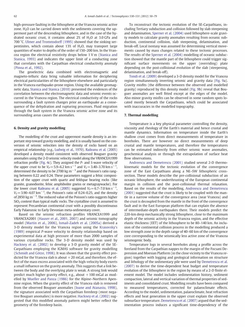
Tectonophysics 530–531 (2012) 50–79
Contents lists available at SciVerse ScienceDirect
Tectonophysics
j ourna l homepage: www.e lsev ie r .com/ locate / tecto
Geodynamics and intermediate-depth seismicity in Vrancea(the south-eastern Carpathians): Current state-of-the art
Alik Ismail-Zadeh a,b,c,⁎, Liviu Matenco d, Mircea Radulian e, Sierd Cloetingh d, Giuliano Panza f,g
a Geophysikalisches Institut, Karlsruher Institut für Technologie, Hertzstr. 16, Karlsruhe 76187, Germanyb International Institute of Earthquake Prediction Theory and Mathematical Geophysics, Russian Academy of Sciences, Profsoyuznaya str. 84/32, Moscow 117997, Russiac Institut de Physique du Globe de Paris, 1 rue Jussieu, Paris 75252, Franced Faculty of Geosciences, Utrecht University, Budapestlaan 4, 3584 CD Utrecht, The Netherlandse National Institute for Earth Physics, 12 Calugareni str., 077125, Magurele, Ilfov, Romaniaf Dipartimento di Geoscienze, Università di Trieste, Via Weiss 2, 34127 Trieste, Italyg The Abdus Salam International Centre for Theoretical Physics, Strada Costiera 11, 34014 Trieste, Italy
⁎ Corresponding author at: Geophysikalisches InstituE-mail address: [email protected] (A. Ismail
0040-1951/$ – see front matter © 2012 Elsevier B.V. Alldoi:10.1016/j.tecto.2012.01.016
a b s t r a c t
a r t i c l e i n f oArticle history:Received 15 March 2011Received in revised form 10 January 2012Accepted 12 January 2012Available online 20 January 2012
Keywords:Intermediate-depth seismicityTectonicsGeodynamicsSeismic hazardModellingVrancea
The Vrancea region of the south-eastern Carpathians is a remarkable site of intra-continental intermediate-depth seismicity. A large set of geological, geophysical, and geodetic observations has been accumulated forthe last few decades and utilised to improve our knowledge of the shallow and deep structures beneath Vran-cea, the crustal andmantle dynamics, and the linkage between deep and surface processes in the region. In thisarticle we review geology and tectonics of the Vrancea region including post-collisional to recent deforma-tions, syn- to post-collisional magmatism, and orogenic exhumation along the East and South Carpathians.The regional seismicity is analysed, and the recent seismic studies including reflection, refraction, body andsurface wave tomography are reviewed. We discuss new geodetic measurements of horizontal and verticalmovements in the region, geoelectric studies, density/gravity and thermal modelling. Qualitative and quanti-tative (including retrospective) geodynamicmodels developed for Vrancea are analysed. The knowledge of re-gional tectonics, geodynamics, seismicity, lithospheric deformation, and stress regime in the Vranceaearthquake-prone region assists in an assessment of strong groundmotion, seismic hazard and risk. The earth-quake simulation, seismic hazard, and earthquake forecasting models have also been reviewed providing alink between deep geodynamic processes and their manifestation on the surface. Finally we discuss unre-solved problems in Vrancea in order to improve our understanding of the regional evolution, present tecton-ics, mantle dynamics, intermediate-depth seismicity, and surface manifestations of the lithosphere dynamicsand to enhance our ability to forecast strong earthquakes in the Vrancea region. The problems to be solved in-clude: (i) the origin of the high-velocity body revealed by seismic tomography studies (oceanic versus conti-nental); (ii) the lithospheric scale mechanism driving the Miocene subsidence of the Transylvania basin;(iii) sub-crustal structure between 40 and 70 km; (iv) contemporary regional horizontal and vertical move-ments; and (v) a comprehensive seismic hazard assessment in the region.
© 2012 Elsevier B.V. All rights reserved.
Contents
1. Introduction . . . . . . . . . . . . . . . . . . . . . . . . . . . . . . . . . . . . . . . . . . . . . . . . . . . . . . . . . . . . . . . 512. Geology and tectonics . . . . . . . . . . . . . . . . . . . . . . . . . . . . . . . . . . . . . . . . . . . . . . . . . . . . . . . . . . 51
2.1. Post-collisional to recent deformations . . . . . . . . . . . . . . . . . . . . . . . . . . . . . . . . . . . . . . . . . . . . . . . 542.2. Syn- to post-collisional magmatism . . . . . . . . . . . . . . . . . . . . . . . . . . . . . . . . . . . . . . . . . . . . . . . . 542.3. Orogenic exhumation along the East and South Carpathians . . . . . . . . . . . . . . . . . . . . . . . . . . . . . . . . . . . . . 55
3. Seismicity and seismic studies . . . . . . . . . . . . . . . . . . . . . . . . . . . . . . . . . . . . . . . . . . . . . . . . . . . . . . 553.1. Regional seismicity . . . . . . . . . . . . . . . . . . . . . . . . . . . . . . . . . . . . . . . . . . . . . . . . . . . . . . . . 553.2. Seismic refraction and reflection studies . . . . . . . . . . . . . . . . . . . . . . . . . . . . . . . . . . . . . . . . . . . . . . 563.3. Seismic tomography . . . . . . . . . . . . . . . . . . . . . . . . . . . . . . . . . . . . . . . . . . . . . . . . . . . . . . . . 583.4. Seismic attenuation and anisotropy . . . . . . . . . . . . . . . . . . . . . . . . . . . . . . . . . . . . . . . . . . . . . . . . . 60
t, Karlsruher Institut für Technologie, Hertzstr. 16, Karlsruhe 76187, Germany. Tel.: +49 721 6084 4610.-Zadeh).
rights reserved.

51A. Ismail-Zadeh et al. / Tectonophysics 530–531 (2012) 50–79
4. Geodetic studies . . . . . . . . . . . . . . . . . . . . . . . . . . . . . . . . . . . . . . . . . . . . . . . . . . . . . . . . . . . . . 615. Geoelectric studies . . . . . . . . . . . . . . . . . . . . . . . . . . . . . . . . . . . . . . . . . . . . . . . . . . . . . . . . . . . 616. Density and gravity modelling . . . . . . . . . . . . . . . . . . . . . . . . . . . . . . . . . . . . . . . . . . . . . . . . . . . . . . 627. Thermal modelling . . . . . . . . . . . . . . . . . . . . . . . . . . . . . . . . . . . . . . . . . . . . . . . . . . . . . . . . . . . 62
7.1. Seismic temperature modelling . . . . . . . . . . . . . . . . . . . . . . . . . . . . . . . . . . . . . . . . . . . . . . . . . . 638. Geodynamic models . . . . . . . . . . . . . . . . . . . . . . . . . . . . . . . . . . . . . . . . . . . . . . . . . . . . . . . . . . . 64
8.1. Qualitative geodynamic models . . . . . . . . . . . . . . . . . . . . . . . . . . . . . . . . . . . . . . . . . . . . . . . . . . 648.2. Quantitative geodynamic models . . . . . . . . . . . . . . . . . . . . . . . . . . . . . . . . . . . . . . . . . . . . . . . . . 668.3. Retrospective (time-reverse) modelling . . . . . . . . . . . . . . . . . . . . . . . . . . . . . . . . . . . . . . . . . . . . . . 69
9. Earthquake simulation models . . . . . . . . . . . . . . . . . . . . . . . . . . . . . . . . . . . . . . . . . . . . . . . . . . . . . . 7110. Seismic hazard and earthquake forecasting models . . . . . . . . . . . . . . . . . . . . . . . . . . . . . . . . . . . . . . . . . . . . 7111. Conclusion: perspectives in studies of the Vrancea region . . . . . . . . . . . . . . . . . . . . . . . . . . . . . . . . . . . . . . . . . 74Acknowledgements . . . . . . . . . . . . . . . . . . . . . . . . . . . . . . . . . . . . . . . . . . . . . . . . . . . . . . . . . . . . . . 75References . . . . . . . . . . . . . . . . . . . . . . . . . . . . . . . . . . . . . . . . . . . . . . . . . . . . . . . . . . . . . . . . . . 75
1. Introduction
About a million earthquakes with magnitude greater than two areregistered each year; about a thousand of them are large enough to befelt; about a hundred earthquakes cause considerable damage, andonce in a few decades a catastrophic event occurs. Seismic events are amanifestation of the complex behaviour of the Earth's lithosphere struc-tured as a hierarchical system of blocks of different sizes. Driven by thedynamic processes in the Earth's crust and the uppermost mantle, thelithospheric blocks are involved in relative movement resulting in tec-tonic stress localization and its release in earthquakes. Themajor earth-quake activity coincides with the boundaries of lithospheric blocks,where these blocks interact and generate stresses at various depths.
Meanwhile there are several places in the world, where earth-quakes occur at intermediate depths in the mantle and far from theplate boundaries. Bucaramanga in Columbia (e.g., Zarifi et al., 2007),the Hindu Kush region close to the collision zone between the Indianand Eurasian plates (e.g., Khalturin et al., 1977; Mellors et al., 1995),and Vrancea in Romania are the prominent examples of localised in-termediate-depth seismicity. There are essential distinctions betweenthe seismicity in intra-continental regions and the ‘ordinary’ Benioffzones. For example, the Circum-Pacific seismic belt is a linear extend-ed structure several thousands of km in length and hundreds of km inwidth, where earthquakes with focal depth up to 60 km dominateand concentrate on a nearly continuous circle along subductionzones. The intra-continental seismicity is diffuse and does not corre-late with active subduction zones.
Repeated large intermediate-depth earthquakes in Vrancea of thesouth-eastern (SE) Carpathian region shake central and eastern Europe-an cities several hundred kilometres away from the hypocentres of theevents and cause destruction in Bucharest (the capital city of Romania).The earthquake-prone Vrancea region is situated at the bend of the SE-Carpathians and is bounded to the north and northeast by the East Eu-ropean platform, to the east by the Scythian platform, to the south-eastby the Dobrogea orogen, to the south and south-west by the Moesianplatform, and to the north-west by the Carpathian orogen and the Tran-sylvanian basin (Figs. 1 and 2). The epicentres of the mantle earth-quakes in the Vrancea region are concentrated within a very smallarea (Fig. 1b). The projection of the foci on a NW–SE vertical planeacross the bend of the East Carpathians (Fig. 2b) shows a seismogenicvolume about 110 km (deep)×70 km×30 km, and extending to adepth of about 180 km. Beyond this depth the seismicity ends sudden-ly: one single isolated Mw=4.1 earthquake recorded in 1982 at thedepth of 218 km represents an exception. According to the historicalcatalogue of Vrancea events (Radu, 1979; 1991), large intermediate-depth shocks with magnitudes Mw>6.5 occur three to five times percentury. In the XXth century, large events at depths d of 70 to 180 kmoccurred in 1940 (moment magnitude Mw=7.7, d=160 km), in 1977(Mw=7.5, d=100 km), in 1986 (Mw=7.2, d=140 km), and in 1990(Mw=6.9, d=80 km) (e.g., Oncescu and Bonjer, 1997).
One of the earliest publications on the topic of the Vrancea seis-micity and its tectonic implications is referred to the end of theXIXth century (Draghiceanu, 1896). Gutenberg and Richter (1954)drew attention to the Vrancea region as a place of remarkableintermediate-depth seismicity. Later McKenzie (1972) suggestedthat this seismicity is associated with a relic sinking lithosphere. The1977 disastrous earthquake and later the 1986 and 1990 earthquakesagain raised questions about the nature of the earthquakes. For thelast two decades (after the last strong Vrancea earthquake) many re-search groups worldwide (in Europe, USA, Japan and elsewhere)studied regional tectonics, geodynamics, and shallow and mantleseismicity. Several research groups collected a large set of geological,geophysical, and geodetic data and used the data to improve ourknowledge of the shallow and deep structures beneath Vrancea,their dynamics, and the linkage between the surface and deep pro-cesses in the region (Cloetingh et al., 2002, 2005). Many studies hada direct social relevance presenting seismic hazards, strong earth-quake modelling, and risk analysis.
2. Geology and tectonics
The peculiarity of the Vrancea intermediate-depth seismogenic re-gion is directly connectedwith its particular tectonic history, the geody-namic evolution being driven by the mosaic of units with contrastingcharacteristics and kinematic variations along the strike of the orogenicbelt. Therefore, understanding the dynamics of the Vrancea region re-quires the study of thememory inherited by the system from the recent,Miocene–Quaternary evolution and even older for local areas.
The CarpathianMountains are the result of a Triassic to Tertiary evo-lution of continental units and intervening oceans. The continentalunits are comprised of the interior Tisza–Dacia and Alps–Carpathian–Pannonian (ALCAPA) blocks, and the exterior the European/Scythian/Moesian continental foreland that mirrors the arcuate shape of theCarpathians (Fig. 2a, Săndulescu, 1988; Csontos and Vörös, 2004;Schmid et al., 2008). During the Mesozoic–Tertiary evolution, twooceanic domains separated Tisza, Dacia and the foreland, namelythe East Vardar Ocean to the west and the Ceahlău–Severin oceanto the east (Fig. 2a). The East Vardar Ocean is a remnant of the neo-Tethys that opened in the Middle Triassic times between Europeanand Apulian units, being fragmented and closing gradually in the Ro-manian Carpathians between Tisza and Dacia continental blocks dur-ing Late Jurassic to late Early Cretaceous times (e.g., Săndulescu,1988; Schmid et al., 2008).
At the exterior of the Carpathians, the Ceahlău–Severin oceanopened between the Dacia block and the European/Scythian/Moesianforeland (Fig. 2a) during Late Jurassic times and was connected west-wards to the larger domain of the Alpine Tethys (e.g., Săndulescu,1988). Connected eastwards with the European domain by a widethinned-continental transitional zone, i.e. the Carpathians embay-ment, the Ceahlău–Severin ocean started to close already during the

a
b
Fig. 1. a) Tectonic map of the Alps–Carpathians–Dinaridic system (simplified after Schmid et al., 2008). The inset represents the location of Fig. 2a. The dark grey line is the locationof the cross-section in Fig. 2b. Light grey lines are the locations of the VRANCEA1999 (V99) and VRANCEA2001 (V01) experiments. Thick black lines present the locations ofthe DRACULA I and DACIA-PLAN seismic profiles. Note that the entire intra-Carpathians domain is made up by 3 major units, Alps–Carpathians–Pannonian-ALCAPA, Tisza,and Dacia, derived either from the European or from the Adriatic margin. The thrust direction is indicated by a triangle. b) Digital elevation model and seismicity of the Alps–Carpathians–Dinaridic system. The location of earthquakes epicentres is taken from Bada et al. (2005) and the ROMPLUS catalogue (Radulian et al., 2002).
52 A. Ismail-Zadeh et al. / Tectonophysics 530–531 (2012) 50–79
late Early to Late Cretaceous time (Fig. 3). This concave-shaped embay-ment follows the present-day curved configuration of the Carpathianmountains (Fig. 1a), and it was invaded by the Tisza–Dacia block in anupper plate position during the Neogene retreat of a slab associatedwith the Alpine Tethys, i.e. by subduction roll-back (Fig. 3; e.g., Balla,1987; Royden, 1993; Ustaszewski et al., 2008). All the relics of this
slab were entirely subducted by the time when the emplacement ofthe external thin-skinned nappe pile over the undeformed forelandceased at around 11–9 Ma (Matenco et al., 2010).
The invasion of the Carpathians embayment was associated withlarge-scale clockwise rotations and N-, NE- and E-ward translations ofthe Tisza–Dacia block around the curved margin of the Moesian
a
b
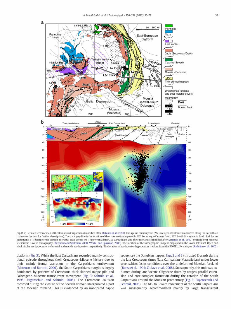
Fig. 2. a) Detailed tectonicmap of the Romanian Carpathians (modified afterMatenco et al., 2010). The ages inmillion years (Ma) are ages of volcanism observed along the Carpathianchain (see the text for further description). The dark grey line is the location of the cross section in panel b. PCF, Peceneaga–Camena Fault; STF, South Transylvania Fault; RM, RodnaMountains. b) Tectonic cross section at crustal scale across the Transylvania basin, SE Carpathians and their foreland (simplified after Matenco et al., 2007) overlaid over regionalteleseismic P-wave tomography (Bijwaard and Spakman, 2000; Wortel and Spakman, 2000). The location of the tomographic image is displayed in the lower left inset. Open andblack circles are hypocenters of crustal and mantle earthquakes, respectively. The location of earthquakes hypocentres is taken from the ROMPLUS catalogue (Radulian et al., 2002).
53A. Ismail-Zadeh et al. / Tectonophysics 530–531 (2012) 50–79
platform (Fig. 3). While the East Carpathians recorded mainly contrac-tional episode throughout their Cretaceous–Miocene history due totheir mainly frontal accretion in the Carpathians embayment(Matenco and Bertotti, 2000), the South Carpathians margin is largelydominated by patterns of Cretaceous thick-skinned nappe pile andPalaeogene–Miocene transcurrent movement (Fig. 3; Schmid et al.,1998; Fügenschuh and Schmid, 2005). The Cretaceous collisionrecorded during the closure of the Severin domain incorporated a partof the Moesian foreland. This is evidenced by an imbricated nappe
sequence (the Danubian nappes, Figs. 2 and 3) thrusted E-wards duringthe late Cretaceous times (late Campanian–Maastrictian) under lowergreenschists facies conditions over the undeformed Moesian foreland(Berza et al., 1994; Ciulavu et al., 2008). Subsequently, this unit was ex-humed during late Eocene–Oligocene times by orogen-parallel exten-sion and core-complex formation during the rotation of the SouthCarpathians around the Moesian promontory (Fig. 3; Fügenschuh andSchmid, 2005). The NE- to E-ward movement of the South Carpathianswas subsequently accommodated mainly by large transcurrent

Fig. 3. Step-wise retro-deformation of the oroclinal bending in the southern part of the Carpathians system (after Fügenschuh and Schmid, 2005) showing the situation a) at pre-sent; b) 16 Ma, during the Miocene continental collision and closure of the Carpathians embayment; c) 20 Ma, at the onset of the back-arc collapse of the Pannonian basin and theonset of closure of the Carpathians embayment; d) during the Danubian core-complex formation in South Carpathians; and e) after the late Middle Cretaceous to Late Cretaceousonset of closure of the Ceahlău–Severin ocean and before the onset of the Danubian core-complex. The white arrows indicate the orientations of Late Cretaceous thrusting (singlearrow) and Eocene extension (double arrow), respectively. For further details see Fügenschuh and Schmid (2005).
54 A. Ismail-Zadeh et al. / Tectonophysics 530–531 (2012) 50–79
movements along the ~100 km dextral offset recorded along the lateOligocene Cerna and Early Miocene Timok faults (Figs. 2 and 3; Berzaand Drăgănescu, 1988; Kräutner and Krstic, 2003). The final dockingof the South Carpathians against the Moesian platform was accommo-dated by dextral transpressive movements and up to 35 km foredeepoverthrusting during Middle–late Miocene times (Fig. 3; Matenco etal., 1997; Rabagia et al., 2011).
The Miocene, outward-vergent thrusting in the highly arcuateCarpathian orogenwas coeval with extension and subsidence observedin the back-arc basins (Pannonian/Transylvanian, Fig. 1), similar towhat is found in other orogens of the Africa/Europe collision zone(Facenna et al., 2004;Horváth et al., 2006).Massive extensional collapseis recorded in the Pannonian basin during the late Early–Middle Mio-cene roll-back of the Carpathian slab associated with the formation ofcore-complexes at the margin with the Alpine and Dinaridic orogens(Tari et al., 1992; 1999; Ustaszewski et al., 2010). This was followedby a thick sequence of sediments that formed during a thermal subsi-dence phase associated with the formation of the present astheno-sphere upwelling beneath the Pannonian basin (Horváth et al., 2006;Szafián and Horváth, 2006). Closely to the SE-Carpathians, subsidenceled to the deposition of thick Middle–Upper Miocene sediments in theTransylvanian Basin, that were subsequently exhumed during the Car-pathians collision ending at 9 Ma (Fig. 2; Matenco et al., 2010). Hence,Miocene extension is minor in the Transylvania basin, and its ratherunclear genesis is likely to be related to lithospheric scale mechanisms(Krézsek and Bally, 2006; Krézsek et al., 2010).
2.1. Post-collisional to recent deformations
Following the 9 Ma final event of nappe stacking, combined depthand kinematic studies demonstrate that two main mechanisms areevident from the style of deformation and were restricted to thearea of the SE-Carpathians (Leever et al., 2006; Matenco et al., 2007;Tărăpoancă et al., 2003). The subsidence, affecting the undeformedforeland since the Middle Miocene, continued and is still active. Therate of the subsidence (about 1 mm yr−1) is typical for westward-
directed subduction zones (Doglioni, 1994). This subsidence can berelated to the continuous gravitational pull exerted by the Vranceasub-crustal high-velocity body (interpreted as a relic oceanic slab,see Sections 3 and 8), the recent Pleistocene–Holocene migration ofdepocentres towards the foreland being related to a change in theslab-load applied position during steepening and, possibly, detach-ment. Meanwhile if the submerged slab is of a continental originand is composed of less dense rocks than the hosting mantle, theslab-pull mechanism casts a doubt of its effectiveness.
The onset of renewed contraction at the beginning of the Quater-nary is recorded by large scale folding and exposure of the westernFocsani basin flank and high-angle, basement involved, reverse faultslocated beneath the thin-skinned nappe pile (Fig. 2; Leever et al.,2006; Bocin et al., 2009). The Quaternary shortening (amounting upto 5 km) was laterally transferred to transcurrent movements alongthe major faults that bound the SE-Carpathians (i.e., the Trotus andIntramoesian faults, Fig. 2a). Significant patterns of active faultingcan be presently observed near the contact between the Moesianplatform and the North Dobrogean orogen (Fig. 2), explained as strainpartitioning at the contact between mechanically weak and strong,respectively, lithosphere (Matenco et al., 2007).
2.2. Syn- to post-collisional magmatism
Following an earlier onset of the calk-alkalinemagmatic activity in theback-arc of the western and the northern part of the East Carpathians,similar type of volcanism is recorded in the eastern part of the Transylva-nia basin migrating in age southwards (11–3.9 Ma; Fig. 2a), reflecting acommon source considered to be the subduction-metasomatised mantlewedge above the subducting slab (e.g., Mason et al., 1998; Seghedi et al.,2004). This along-strike migration of volcanism southwards has beenexplained by a combination of two mechanisms. An oblique subductiontook place during the final moments of continental convergence andwas followed by gradual slab-detachment along the orogenic strike(Seghedi et al., 1998). Such a detachmentmechanism should be associat-ed with a gradual migration in time of areas recording uplift and
55A. Ismail-Zadeh et al. / Tectonophysics 530–531 (2012) 50–79
subsidence along the orogenic strike (Buiter et al., 2002). Hence, this isnot observed in the case of the East Carpathians (Bertotti et al., 2003).The continuation of subduction until 3.9 Ma is at odds with the limitedamount of post-9 Ma shortening recorded in the SE-Carpathians(Leever et al., 2006; Matenco et al., 2010). Therefore, the genetic mecha-nisms of subduction-related magmatic generation appear to be clear, butthe overall discrepancies between the timing of the calc-alkalinemagma-tism, subduction-related shortening and associated vertical motions arestill a matter of debate.
Distinct magma generation sources are recorded in the prolonga-tion of the Moesian domain towards the orogenic hinterland at thecontact with the sediments of the Transylvania basin (Seghedi et al.,2011). The change of magmatism from normal calc-alkaline found inthe north took place in the prolongation of the contact between theEuropean and Moesian foreland (i.e., the Trotus fault, Fig. 2a), whereadakite-like calc-alkaline magmatism took place between 3.2–1.8 Maand 1.0–0.3 Ma. Seghedi et al. (2011) interpreted this magmatism asbeing derived from a toroidal-flow effect, due to horizontal astheno-spheric movement around the gradual steepening Vrancea slab nearthe tear-fault contact with the northern European foreland. Twoother distinct magmatic sources are observed, a Na- and K-alkalic vol-canism derived from asthenosphericmantle sources partly affected bymetasomatism, the primitive K-alkalic sources indicating mixing incrustal reservoirs. These magmas are interpreted to be the result oflocalised asthenospheric convection generating an upraise circuit be-hind the gradually sinking Vrancea slab (Seghedi et al., 2011) consis-tent with the results of the numerical modelling of instantaneousmantle flow beneath Vrancea (Ismail-Zadeh et al., 2005a). The overallspecificity of the magmas generated in the hinterland of the Moesiandomain demonstrates the lateral variability of the subduction systemin the East Carpathians associated with strong asymmetries in syn- topost-collisional slab behaviour.
2.3. Orogenic exhumation along the East and South Carpathians
The lateral asymmetry of subduction and collision mechanics ob-served in the kinematics of the East, SE, and South Carpathians isstrongly reflected by the associated orogenic exhumation, as derivedfrom low-temperature thermochronology studies. Although similaramounts of cumulated exhumation have been recorded (for instanceabout 4–6 km between 17 and 8 Ma; Sanders, 1998), the temporaland spatial distribution is quite variable along the strike of the moun-tain chain.
The exhumation of the South Carpathians reflects primarily thethick-skinned Cretaceous emplacement and the Eocene uplift duringcore-complex formation of the Danubian nappes. These deformationphases correspond to the main pulses of exhumation recorded by ahigh density of zircon and apatite fission-track ages, which spanfrom late Early Cretaceous to Eocene times (e.g., Fügenschuh andSchmid, 2005). Deformation associated with the Miocene thrustingand transpression of the South Carpathians is recorded by numerousfaults in the foredeep, but the overall low cumulated offset generatedlimited uplift and exhumation, only a small number of Miocene apa-tite fission-track (AFT) ages being recorded in particular near the con-nection with the Dinarides (Bojar et al., 1998). Exhumation in theorder of 5–6 km is recorded in the East Carpathians; Miocene agesbeing largely distributed over the entire mountain range (Sanderset al., 1999). This was enhanced in places, where the collision was lo-cally associated with transpressive movements generating largeruplifted area, such as the Rodna mountains in the northern hinterlandof the East Carpathians (Fig. 2a; Gröger et al., 2008).
Higher resolution, low temperature AFT and apatite (U–Th)/He(AHe) thermochronology data have become recently available forthe area of the SE-Carpathians (Merten et al., 2010; Necea, 2010).These data indicate an exhumation history that covers the entire Cre-taceous to recent contractional evolution. Cooling ages generally
decrease from Cretaceous in the hinterland to Miocene–Quaternarytowards the foreland, which generally overlap classical tectonicstages defined by field kinematics. Interesting is that the upperplate of the Ceahlău–Severin subduction system (the Bucoviniannappes, Fig. 2a) has not been exhumed at AHe resolution (less than1–1.5 km) since Cretaceous times. In terms of orogenic mechanics,this means that the Ceahlău–Severin zone did not recorded signifi-cant shortening after Cretaceous times and the subsequent Palaeo-gene–Quaternary (continental) subduction and associated crustaldeformation took place more towards the foreland (Merten et al.,2010). These exhumation studies demonstrate that the shorteningrecorded in the Carpathian embayment was a more gradual processstarting already in Palaeogene, without the existence of particularpeaks in tectonics episodes, as previously derived from post-tectoniccovers (e.g., Săndulescu, 1988).
In contrast, the tectonic evolution of the SE-Carpathians is over-printed by two younger exhumation events during latest Miocene–recent times. The first (latest Miocene–early Pliocene) occurred incentral part of the thin-skinned thrust belt, interpreted as enhanceddenudation in the mountain chain driven by a large sea-level dropin the Paratethys basins (i.e., the foreland of the Carpathians andthe Black Sea) during the Messinian Salinity Crisis (Merten et al.,2010). This event enhanced denudation around 5–6 Ma by increasingthe exposure of source areas and causing the widespread erosionpresently observed in the Carpathians foreland (Leever et al., 2010).The largest amount of exhumation recorded during the syn- andpost-collisional history of the Carpathians started during the Pleisto-cene exhumation and still takes place in the external part of the oro-genic belt. This event is associated with crustal-scale shortening byreverse faulting along steep basement thrusts, interpreted from re-cent geophysical observations, and the subsequent erosion of upliftedareas (Bocin, 2010; Merten et al., 2010). At lithospheric and mantlescale, this enhanced event must be related with the overall evolutionof the Vrancea lithosphere.
3. Seismicity and seismic studies
3.1. Regional seismicity
The seismic activity in the SE and South Carpathians is concentratedaround the orogenic bending area called Vrancea (or the Vrancea seis-mogenic zone). The crustal seismicity is scattered in space (Figs. 1band 2b) following a few noticeable patterns. The shallow earthquakesin front of the Carpathians arc bend occur in the Vrancea region extend-ing to the east in the Focsani basin (e.g., Popescu and Radulian, 2001a)and to the SE–NW trending Intramoesian and Peceneaga–Camena faults.Another significant pattern of shallow seismicity is observed alongthe South Carpathians in the Făgăraş–Sinaia region (e.g., Enescu et al.,1996) and continues along the Cerna fault down to theDanube. The shal-low seismicity is not prominent along the eastern branch of Carpathiansas well as in the Moesian and the East-European platforms. Other seis-mogenic zones are located in the western part of Romania at the contactbetween theApuseniMountains and the Pannonian basin (the Banat andCrişana–Maramureş regions, respectively; e.g., Popescu and Radulian,2001b) and in the north-eastern part of Bulgaria, close to the RomaniaBlack Sea seashore (the Sabla region). The seismic activity is at presentnegligible in the Transylvanian basin. Only two historical events arereported here, associated with significant damage (Radu and Toro,1996). Generally, the crustal seismicity is limited to low-to-moderatemagnitude earthquakes. Shocks greater than 6 are infrequently recordedin the Făgăraş–Sinaia region (maximum observedmagnitude of 6.5) andin the Sabla zone (maximum observed magnitude of 7.2). A detailedand comprehensive description of the seismogenic zones in Romaniacan be found in Radulian et al. (2000). The shallow seismicity corre-sponds to recent deformations, such as laterally trans-current move-ments along the major faults that bound the SE-Carpathians (the
56 A. Ismail-Zadeh et al. / Tectonophysics 530–531 (2012) 50–79
Intramoesian fault to south and the Peceneaga–Camena and Trotuşfaults to the north), the subsidence in the foreland as a consequenceof the gravitational pull exerted by the Vrancea sub-crustal high-velocity body or the contact still active between the South Carpathiansand the Moesian promontory.
In contrast with the crustal seismicity, a confined seismic activity isgenerated at intermediate depths in themantle beneath the Vrancea re-gion. The concentration of deformation and seismic energy release isextremely high in this depth range. The seismic moment release rateis quantified to 0.8×10¹⁹ N m yr−1 (Ismail-Zadeh et al., 2000; Wenzelet al., 1999). This rate is similar to the seismic moment release rate ofthe southern California, which amounts to 1.0×10¹⁹ N m yr−1 (Ward,1994). The seismic energy release in the Vrancea region is smaller inthe crust than in the sub-crustal mantle by three orders of magnitude.The strongest crustal earthquakes recorded in Romania are of magni-tude Mw=5.5 everywhere (except the Mw=6.5 events in the SouthCarpathians; Radu, 1979). Meanwhile, maximum magnitude ofrecorded events in the sub-crustal volume in Vrancea was Mw=7.7(Oncescu et al., 1999b).
The hypocentres of the Vrancea intermediate-depth events delin-eate a seismogenic body in the sub-crustal mantle. The hypothesisof a decoupling of the sub-crustal seismicity from the crustal seis-micity is based on an apparent deficit of seismic events within thedepth interval of 40 to 60 km (e.g., Fuchs et al., 1979;Oncescu,1984). However, the interpretation in terms of relic oceanic sub-ducted slab decoupled from the overlying lithospheric mantle ofthe upper plate is still questionable. Observations of contemporarytectonic stresses evidence the heterogeneity of crustal stresses inthe region and show no signal of a long wavelength stress patternthat would be expected for a strong coupling between the high ve-locity body and the upper plate. This led Müller et al. (2010) to theconclusion that the slab under Vrancea is only weakly coupled tothe crust as also suggested by Hackney et al. (2002) based ontheir gravity modelling.
A difference in the focal mechanism between the mantle earth-quakes and the earthquakes in the overlying crust was noticed byRadulian et al. (1999, 2000) and Bala et al. (2003), namely, predomi-nance of compressive regime (reverse faulting with extension on ver-tical) and extensional regime (normal and strike-slip faulting),respectively. This type of fault-plane solutions can be explained by aprocess of slab-pull controlling the kinematics of the orogenic system.At smaller scale, an anomaly in the stress regime of the Vrancea sub-crustal region was reported at the depths of about 100 km (Oncescuand Bonjer, 1997; Oncescu and Trifu, 1987), where a dehydration re-action or other fluid infiltration processes may take place (Ismail-Zadeh et al., 2000).
The scaling properties (the relationship between the corner fre-quency of seismic waves and earthquake's magnitude) of the Vranceaintermediate-depth source are generally compatible with the scalingproperties of the sources in the crust. However, a rather different pro-cess is revealed for the large Vrancea events (Mw>6.5), with rapidand very efficient rupture propagation over the source area (e.g.,Oncescu, 1989; Radulian et al., 2007). The investigation of spectraland time-domain scaling properties using wide-band digital recordsfrom 16 Vrancea earthquakes (3.7≤Mw≤7.4), showed a clear ten-dency for stress drops to be larger (10–20 MPa) than those for smallermagnitude (Mwb3.7) events or for typical shallow earthquakes(Gusev et al., 2002).
Information on the regional seismicity (the largest events) ex-tends back in time for more than thousand years (Oncescu et al.,1999b). The earthquake catalogue permanently updated by the Ro-manian National Institute for Earth Physics (Radulian et al., 2002;ROMPLUS catalogue, http://www.infp.ro/seismic-catalogue) shows anearly constant rate of background earthquakes with magnitude Mw
greater than 3 occurred in the Vrancea sub-crustal domain (below60 km depth): about 100 events a year. The largest shocks seem to
occur preferentially around 90 km and 130 km depth, where themajor brittle failures are supposed to be located (Radulian et al.,2008; Trifu and Radulian, 1991). The epicentral distribution is elon-gated on the NE–SW direction, in a window delimited to the NEby the Trotus fault and to the SW by the Intramoesian fault. Thesetwo major lithospheric faults control the present active tectonics(Matenco et al., 2007) that coincides with the spatial extension ofthe seismogenic volume. The horizontal extension of the active seis-mogenic volume coincides with the rupture length of the largestshocks, and its NE–SW orientation is close to the strike of most ofthe rupture planes in the fault plane solution.
3.2. Seismic refraction and reflection studies
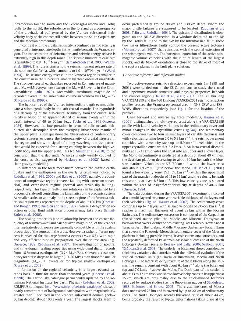
Two active-source seismic refraction experiments (in 1999 and2001) were carried out in the SE-Carpathians to study the crustaland uppermost mantle structure and physical properties beneaththe Vrancea region (Hauser et al., 2001; 2007). The 300 km longVRANCEA1999 and the 460 km long VRANCEA2001 seismic refractionprofiles crossed the Vrancea epicentral area in NNE–SSW and ESE–WNW directions, respectively (see Fig. 1 for the location of theprofiles).
Using forward and inverse ray trace modelling, Hauser et al.(2001) distinguished a multi-layered crust along the VRANCEA1999profile with lateral velocity variations in the sedimentary cover andminor changes in the crystalline crust (Fig. 4a). The sedimentarycover comprises two to four seismic layers of variable thickness andwith velocities ranging from 2.0 to 5.8 km s−1; the seismic basementcoincides with a velocity step up to 5.9 km s−1; velocities in theupper crystalline crust are 5.9–6.2 km s−1. An intra-crustal disconti-nuity at 18–31 km divides the crust into an upper and a lower layer.The Moho discontinuity is predicted at a depth of about 40 km nearthe Scythian platform decreasing to about 30 km beneath the Moe-sian platform. Velocities are 6.7–7.0 km s−1 within the lower crustand about 7.9 km s−1 just below the Moho. Hauser et al. (2001)found a low-velocity zone, LVZ (7.6 km s−1) within the uppermostpart of the mantle (at depths of 45 to 55 km) and the velocity beneaththis zone is at least 8.5 km s−1. This low velocity zone is situatedwithin the area of insignificant seismicity at depths of 40–60 km(Oncescu, 1984).
The data obtained during the VRANCEA2001 experiment indicatedalso a multi-layered structure with variable thickness of the layers andtheir velocities (Fig. 4b; Hauser et al., 2007). The sedimentary covercomprises up to 7 layers with seismic velocities of 2.0–5.9 km s−1. Itreaches a maximum thickness of about 22 km within the FocsaniBasin area. The sedimentary succession is composed of the Carpathianthin-skinned nappe pile, the Middle–late Miocene Transylvanianback-arc that covers locally thepre-existing Late Cretaceous extensionalTarnava Basin, the foreland Middle Miocene–Quaternary Focsani Basinthat covers the Paleozoic–Mesozoic sedimentary cover of the Moesianplatform including possible Permo-Triassic extensional structures, andthe repeatedly deformed Palaeozoic–Mesozoic succession of the NorthDobrogea Orogen (see also Krézsek and Bally, 2006; Seghedi, 2001;Tărăpoancă et al., 2003). The underlying basement shows considerablethickness variations that correlate with the individual evolution of thestudied tectonic units (i.e. Dacia or Bucovinian, Moesia and NorthDobrogea). The lateral velocity structure of these blocks along the seis-mic line remains constant with about 6.0 km s−1 along the basementtop and 7.0 km s−1 above the Moho. The Dacia part of the section isabout 33 to 37 km thick and shows low velocity zones in its uppermost15 km, which are presumably due to the thick-skinned tectonicsrecorded by surface studies (i.e. the Bucovinian nappes of Săndulescu,1988; Kräutner and Bindea, 2002). The crystalline crust of Moesiadoes not exceed 25 km and is covered by up to 22 km of sedimentaryrocks. The North Dobrogea records thickened crust of about 44 km,being probably the result of typical deformations taking place at the
upper crust
Distance, km
VRANCEA2001
5.0/5.25.6/5.85.7/5.9
6.0
6.06.3
6.46.7
6.76.86.8 6.5
6.56.56.3
6.3
6.36.2
6.16.16.2
6.2
6.2
6.3
5.55.5 5.5
5.1
5.45.4
5.4
5.3
5.15.15.1
5.55.6
4.8
4.64.94.84.8
4.84.65.14.0/4.2
4.74.7 4.1 4.0
4.84.3 4.5
5.6
5.9
5.95.7
5.7
5.55.95.9
5.85.86.36.36.0 6.0
6.0
6.0
6.16.1
6.16.2
6.0
6.0
6.0 6.0
6.2
6.2
6.4
7.17.17.1
6.9
7.0
7.0
8.08.0
8.0
7.9
7.9
0
10
20
30
40
50
600 40 80 120 160 200 240 280 360320 400
Moho
Moho
lower crust
middle crust
PCFWNW Transylvanian Basin Carpathians Focsani Basin North DobrogeaVR99 ESE
5.3 5.35.25.0
4.13.9
4.23.9
5.8 5.8 5.75.5 5.55.55.6
5.35.3 5.3
5.6
TF
4.3-4.7 4.4-4.72.1-2.7
4.0 3.3 3.54.54.4
4.75.3
5.75.25.9
5.9
Distance, km
VRANCEA1999
Dep
th, k
m
Dep
th, k
m
Gra
vity
, mga
l
6.2
6.7
6.7 6.7
7.07.9
7.9 7.9
7.9
5.55.0
5.2 5.5
5.5 5.35.8
5.8
5.9
5.9
6.2
6.26.2
6.7
7.0
7.07.0
8.0
8.5 8.5
? ? ?
??????
LVZ (7.6)
? ? ?8.0
4.7
5.85.3
COF IMFBUC
0
10
20
30
40
50
600 40 80 120 160 200 240 280 320
Moho
Moholower crust
upper crust
mroftalpnaiseoMmroftalpnaihtycSNNE SSW
2.352.55
2.502.622.58
2.45
2.70
2.85
3.25
2.482.25
* * *** * * * *** * * ** *** **
* *** * * * **
* *** **
****
* **** * ** **
-100
-80
-60
-40
-20
0
20 measured gravitycalculated gravity
*
c
a
b
Fig. 4. Seismic velocity models along the VRANCEA1999 (a) and VRANCEA2001 (b) profiles (see Fig. 1 for the location of the seismic profiles). Black numbers in the layers indicatethe P-wave velocities in km s−1. Blue numbers (panel a) are densities in 103 kg m−3. Thick solid lines mark areas constrained by reflections and/or refractions; dashed lines indicateless well constrained areas, and thin lines are extrapolations. TF, COF, IMF, and BUC (panel a) denote the Trotus, Capidava–Ovidiu, and Intramoesian faults, and Bucharest, respec-tively. VR99 (panel b) marks the intersection with the VRANCEA1999 seismic profile, and PCF denotes the Peceneaga–Camena fault. Modified after Hauser et al. (2001, 2007).c) Modelled and observed gravity anomalies (after Raileanu et al., 2005).
57A. Ismail-Zadeh et al. / Tectonophysics 530–531 (2012) 50–79
SE and S margin of the East European platform (Stephenson et al.,2006).
The DACIA-PLAN (Danube and Carpathian Integrated Action onProcess in the Lithosphere and Neotectonics) deep seismic reflectionsurvey was performed in 2001 in SE-Carpathians and their foreland(see Fig. 1 for the location) at the same time with the regional deeprefraction seismic survey VRANCEA2001. The main goal of this exper-iment was to study the deep structure of the external Carpathiansnappes and the architecture of Tertiary/Quaternary basins developedwithin and adjacent to the earthquake-prone Vrancea region, includ-ing the Focsani Basin. The interpretation of seismic reflection data(Panea et al., 2005) inferred the existence a 10-km thick graben un-derlying the easternmost part of the Carpathians nappes near thecontact with the Focsani Basin. A thick sedimentary succession was
imaged beneath the latter basin with a major crustal contact alongthe Peceneaga–Camena fault, the boundary between Moesia and theNorth Dobrogea.
Another seismic-reflection study DRACULA I (Deep Reflection Ac-quisition Constraining Unusual Lithospheric Activity) was carried outin 2004 (Fillerup et al., 2010). The seismic profile images the crustand upper mantle to depths of about 120 km beneath extendingsoutheast from the central Transylvanian basin across the EasternCarpathians and terminates on the northwest side of the Vrancea re-gion. TheDRACULA I profile complements a deep seismic reflection pro-file DACIA-PLAN (see Fig. 1 for the location of the profiles); two seismicprofiles DRACULA I and DACIA-PLAN are shown in Fig. 5. The profilesdelineate the crustal geometry from the Transylvanian basin to the Foc-sani basin. According to Fillerup et al. (2010), the lithospheric-scale

58 A. Ismail-Zadeh et al. / Tectonophysics 530–531 (2012) 50–79
structural features evident on the deep seismic profile include (Fig. 5):(a) coherent 42–46-km deep reflections beneath the Transylvanianbasin between km markers 0 and 25; (b) a package of reflections dip-ping NW about 20° extending from 10 to 20 km depth between kmmarkers 60 and 75, which is bounded above and below by shortbands of subhorizontal reflectivity; (c) reflectivity that gradually transi-tions into seismically transparent material at depths of 40–45 km be-tween km markers 25 and 80; (d) an abrupt shallowing of transitionalreflectivity beneath the Eastern Carpathians to depths of 30–33 km be-tweenmarkers 100 and 215, exceptwhere (e) prominent subhorizontalto slightly east-dipping (5°) reflections are present at 30–32 km depthbetween kmmarkers 125 and 150, and (f) the increase in depth of thetransitional reflectivity to 42–45 km depth beneath the Focsani basinbetween kmmarkers 215 and 320.
A high-resolution 2.5-D velocity model of the upper crust alongthe seismic reflection profile was built by using a tomography inversionof the DACIA-PLAN first arrival data (Bocin et al., 2005). The resultsdemonstrated that the data fairly accurately resolve the transitionfrom sediment to crystalline basement beneath the Focsani Basin,where industry seismic data are available for correlation, at depths upto about 10 km. In agreement with the velocity structures derivedfrom the inversion of the VRANCEA2001 first arrivals (Landes et al.,2004), basement in positions as shallow as 3–4 km has been detectedbeneath the external Carpathians nappes, inferring significant upliftby out-of-sequence thrusting, post-dating the emplacement of thethin-skinned nappe pile (Bocin et al., 2005). This has been correlatedwith the Quaternary inversion recorded in the Focsani basin and the ac-tive uplift of the external SE-Carpathians (Leever et al., 2006).
A velocity model of the Vrancea upper crust was developed byBocin et al. (2009) using 2-D forward ray tracing of densely spaced re-fraction data. The model was derived from more than 11,000 traveltimes recorded at stations 100 m apart picked from 42 shot gathersalong a 140 km line crossing the SE-Carpathian bending zone andthe adjacent deep (foreland) Focsani Basin. This model refines base-ment structure beneath the SE-Carpathian nappe stack and FocsaniBasin and provide yet another documentation of reverse faults onwhich crystalline rocks or highly metamorphosed Mesozoic sedimen-tary cover of the crystalline basement have been elevated to depths aslittle as 3.5–4 km (with a vertical displacement of at least 2–2.5 km)beneath the external SE-Carpathian nappes. Some of the basement
50
500
NW East CarpDistance, km
Moho
Continenta
Continentallithosphere
Asthenosph
Dep
th, k
m
Transylvanian Basin
100
100
150
150
200
Fig. 5. Depth-converted composite DRACULA I and DACIA-PLAN seismic reflection profiles wtion). Hypocenters of the earthquakes occurred from 1977 to 2008 are projected on the pr
fault systems appear to be recently active and are correlated withthe Quaternary exhumation of the external SE-Carpathians (Mertenet al., 2010).
Active and passive source seismic data were employed by Enciuet al. (2009) to study the crustal seismicity and geologic structuresin the SE-Carpathians. Crustal epicentres and focal mechanisms werecorrelated with deep industry seismic profiles and reprocessing of theDACIA-PLAN profile in order to understand the link between neotec-tonic foreland deformation and the Vrancea intermediate-depth seis-micity. Projection of crustal foreland hypocentres onto deep seismicprofiles identified active crustal faults in the SE-Carpathian foreland.Enciu et al. (2009) argue that there is a mechanical coupling betweenthe deepmantle zone of localised seismicity and the overlying forelandcrust. Their seismic reflection images revealed also the absence of westdipping reflectors in the crystalline crust and a slightly east dipping tohorizontal Moho in the proximity of the Vrancea area.
The reviewed seismic reflection and refraction studies showclearly the presence of complex crustal architecture, deformation,and fault structures controlling the shallow seismicity in the Vrancearegion.
3.3. Seismic tomography
In 1999 the international tomography experiment CALIXTO(Carpathian Arc Lithosphere X-Tomography) with 143 seismic stationswas conducted in south-eastern Romania (Martin et al., 2003). The dis-tance between stations ranged from 15–20 km (the Vrancea region) to25–30 km (outer margins of the network), covering a region of about350 km in diameter. During the field experiment 160 local eventswith magnitude Ml≥2.0 and 450 teleseismic events with magnitudeMb≥5.0 were recorded. The CALIXTO experiment offered a dense,high quality data set to study the lithospheric/asthenospheric systemunderneath SE-Carpathian. To increase the image resolution of struc-tures in the uppermost mantle and to reduce smearing from strongcrustal velocity anomalies into the upper mantle, Martin et al. (2005)applied crustal travel-time corrections by a priori information beforethe teleseismic travel-time inversion. They usedmodels of the sedimentdistribution in the region, Conrad andMoho depths, and crustal seismicP-wave velocities to compile a 3-D crustal model for SE-Carpathians.
SEathians
Moho
l crust
ereContinentallithosphere
Focsani Basin200 250 300
ith Vrancea seismicity projected onto the plane of the section (see Fig. 1a for the loca-ofile. Modified after Fillerup et al. (2010).
59A. Ismail-Zadeh et al. / Tectonophysics 530–531 (2012) 50–79
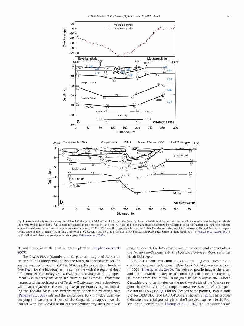
Using this crustal seismic velocity model Martin et al. (2006) per-formed a non-linear teleseismic body-wave tomography study provid-ing high-resolution imaging of the upper-mantle structure (Fig. 6). Thetomography images showed a high-velocity body beneath Vranceaand the Moesian platform. The body reaches a maximum depth ofabout 350–370 km (this is a maximum depth of high resolution tomog-raphy). The velocity perturbation is maximal between 110 and 150 kmdepth (5.2–5.8%) and almost constant for depths beneath 200 km(3.2–3.8%). Low velocity anomalies NW of the slab were modelledabove 110 km depth in agreement with a lithosphere–asthenosphereboundary at 110–150 kmdepth below theMoesian platform anddeeperthan 200 km under the East European platform. Depending on the geo-dynamic model adopted, the high-velocity body modelled by Martinet al. (2006) can be interpreted as a descending lithospheric slab or asdescending mantle lithosphere. The tomography images allow the de-termination of the geometry of the descending slab and its spatial rela-tion to the earthquake hypocentres. The slab extends to the southwestbeneath the Moesian platform, however this portion of the slab iscompletely aseismic.
Raykova and Panza (2006) determined a set of shear-wave ve-locity models of the lithosphere–asthenosphere system in the SE-Carpathians by the non-linear inversion of surface wave group ve-locity data obtained from a tomography analysis (Fig. 7). The localdispersion curves are assembled for the period range 7–150 s,combining regional group velocity measurements and published
Carpathians
44
46
47
48
43
45
Longit
23 24 2625
C1
D
B1B2
B3
A1
A2
A3
100
200
300
400
100
200
300
400100 200 300 400 500
300100 200 400 500
100
200
300
400300
100
200
300
400100 200 400 500 100 200
100 200
-4 -3-6 -5 -2 -1
Velocity pert
Distance, km
Distance, km
Distance, km Distanc
Dep
th, k
mD
epth
, km
Dep
th, k
m
Fig. 6. Vertical profiles of the relative P-wave velocity structure of the uppermost mantle as tthe profiles is presented in the overview map collated in the figure's centre. Faded coloursdepth earthquakes (1990–2000) within the corresponding depth interval.
global Rayleigh wave dispersion data. The resolution of the tomog-raphy data was improved using a priori information about theshallow crustal velocity structure. The lithosphere–asthenospherevelocity structure was reliably reconstructed to depths of about250 km. Local smoothness optimisation (Boyadzhiev et al., 2008)was applied to select the representative cellular structures, andthe three-dimensional shear-wave velocity model of the studiedregion was assembled with some estimate of uncertainties aboutlayering (thickness and shear-wave velocity). Raykova and Panza(2006) showed that the thickness of the lithosphere in the regionvaries from about 90 km to 170 km and the top of the astheno-sphere can be as deep as about 150 km. Mantle seismicity is asso-ciated with the fastest portion of high-velocity body detectedbelow the Moho. The seismogenic volume is located well abovethe bottom of the asthenospheric low velocity zone as shown inFig. 7.
Tondi et al. (2009) developed three-dimensional P- and S-wavevelocity and density images using the method of sequential integrat-ed inversion to P and S first arrivals from active source data collectedduring the VRANCEA1999 and VRANCEA2001 seismic refraction ex-periments (see Section 3.2), local earthquake data collected duringthe CALIXTO experiment and gravity measurements of the studiedarea. The models (explaining travel times and gravity data) showeda high velocity body, which exhibits fast VP, fast VS, high density,and a low VP/VS ratio consistent with the cold body.
Bla
ckSe
a
ude, E
Lude,
atitN
28 3027 29
A11
A2
A3
C1 B1
B2
B3D1
100
100
100
200
200
200
300
300
300
400
400
400
500
500
500300 400 500
100
200
300
400
100
200
300
400
100
200
300
400
100
200
300
400
300 400
1 2 3 4 5 6
urbation , %VP
e, km Distance, km
Distance, km
Distance, km
he result of the inversion with the CALIXTO data set (Martin et al., 2006). The location ofindicate poor theoretical resolution. Black dots mark the hypocentres of intermediate

200
300
T=25s12d
13d 14d 15d 16d17d
12e 13e 14e 15e16e 17e
12f 13f 14f 15f 16f 17f
12g 13g13g 15g16g
12h13h 14h15h
0
50
100
150
200
250
0
50
100
150
200
250
N
12h13h
12d
4.354.35
4.35
4.30
4.40
4.30
4.60
4.403.1-3.45
3.85-4.0
3.55-3.93.3-3.5
3.9-4.05
3.2-3.4
2.0-2.43.3-3.55
3.15-3.35
3.4-3.65
4.75 4.75
4.75 4.80
4.80
4.60
4.55 13d14h 14d14g
15h 15d15g 15f16g 16f 16e 16d
17f 17e 17d
a
b
Fig. 7. Results of the seismic tomography study by Raykova and Panza (2006). a) Ray-leigh wave group velocity tomography map (period 25 s) for the Carpathian domainshown as the percent deviation from the average reference group velocity. At each pe-riod, the local values of group velocity are calculated on a predetermined grid cell(1°×1°). The cells are marked by numbers. The white isolines represent the lateral res-olution, in km, of the data at this period. The thick black line denotes the location of themain thrust along Carpathian chain. The dashed grey lines mark the main faults in theregion. The remaining black lines represent geographical boundaries. b) Three-dimensional schematic view of the Carpathians region (view from the west). Seismicityrecorded in the period 1904–2004 with M>3 is represented by red dots. The num-ber(s) in cells indicates the shear-wave velocity (or its range) in km s−1.
60 A. Ismail-Zadeh et al. / Tectonophysics 530–531 (2012) 50–79
Kulakov et al. (2010) investigated the crustal and lithospheric struc-ture beneath the Vrancea seismic area using simultaneous tomographyinversion for the VP and VS anomalies and the VP/VS ratio and source lo-cations. The tomography images showed also the presence of a high-velocity body beneath Vrancea at a depth interval of about 60–200 kmthat mimic the distribution of intermediate-depth seismicity.
The recent seismic tomography studies reviewed above are ingood agreement with results of previous seismic tomography studies(e.g., Bijwaard and Spakman, 2000; Oncescu, 1984; Wenzel et al.,1999) and, in addition reveal more features missed in the earlier stud-ies. Despite seismic tomography studies suffer of considerable uncer-tainties and often supply images of the same seismic anomalysignificantly different, the location of the high velocity body beneaththe Vrancea region is remarkably robust. The different details are infact beyond the reach of standard tomography due to the limitationsof the theoretical framework employed; ray theory does not handle dif-fraction and frequency dependence, whereas normal mode perturba-tion theory requires weak and smooth lateral variations of structure(Anderson, 2007; Boschi et al., 2007; Boyadzhiev et al., 2008; Panza etal., 2007; Romanowicz, 2003; Waldhauser et al., 2002).
3.4. Seismic attenuation and anisotropy
The lithosphere–asthenosphere structure beneath the SE-Carpathiansis laterally heterogeneous, particularly across the arc bend in Vrancea. Asharp contrast between the high-velocity body sinking into the astheno-sphere and a NW-ward located asthenospheric upwelling are principalfeatures of the structure. Based on the waveform analysis of small-magnitude Vrancea earthquakes occurred during the CALIXTO experi-ment, Popa et al. (2005) and Radulian et al. (2006) showed an asymmet-ric pattern relative to the epicentral area. In the Transylvanian Basin andthe East Carpathians (approximately along the inner volcanic chain), theamplitudes are reducedby a factor of 20 on average and thehigh frequen-cies are attenuated compared to the amplitudes and the frequencies inthe foreland platform. This pattern is explained by a significant increaseof earthquake wave attenuation caused by a strong lateral variation ofthe upper mantle structure towards NW of the Vrancea intermediate-depth seismic active volume. This region corresponds to the most recentvolcanic activity in the PersaniMountains andwith the low-velocity zoneadjacent toward NW to the high-velocity body subducted beneath Vran-cea area as indicated by seismic tomography and heat flow results.
The seismic attenuation in the Vrancea region (Romania) was in-vestigated by Ivan (2007) from teleseismic recordings of P and pPwaves during the four strong intermediate-depth Romanian eventsthat occurred since the onset of digital instrumentation. Lateral vari-ations of the attenuation are obtained, with a very low QP area (valuesdown to 33) located in the north-western part of the Vrancea seismo-genic volume. For the stations with different azimuth angles in rela-tion to the epicentral area, QP values routinely exceed 200. Mostlikely, the low attenuation values are related to an upwelling mantlematerial located immediately beneath the crust, but limited in depthto at least 100 km.
Teleseismic P-waveforms recorded during the CALIXTO experimentwere used to determine the decay of spectral amplitude in a narrowband of 0.5–1.5 Hz (Weidle et al., 2007). The observations from therecorded data reveal a consistent pattern of increased t* (themean atten-uation along the entire travel path) values in the Vrancea region at thebend of the Carpathian arc, although themagnitude of the observed var-iation in t* is much higher than expected. Synthetic t* parameter compu-tations for the same event-receiver configurations reproduce theobserved pattern in terms of relative variations. Also, t* values tend tobe higher north of the centre as compared to south of it. When compar-ing only the pattern, not the amplitude of the t* observations, this agreesfairly well with the observation by Ivan (2003) who found higher atten-uation in the Focsani basin and lower attenuation around Bucharest andin Dobrogea. Investigations of teleseismic events recorded during a seis-mic refraction experiment in the East Carpathians also revealed strongamplitude variations along the profile with the largest t* parameters inthe centre part of the profile (Sudhaus and Ritter, 2005).
Russo et al. (2005) concluded that attenuation is low north and eastof the Vrancea region while it is high above and near Vrancea. This con-clusion is in general agreement with the observation of maximum t* inVrancea. Russo et al. (2005) investigated local Vrancea earthquakes andcalculated shear wave attenuation QS (at higher frequencies, approxi-mately 2–15 Hz). The Qmodel byWeidle et al. (2007) (with the valuesranging between 50 and 1000) coincides quite good with Russo et al.(2005) findings of high QS values east of the Vrancea seismic region(QS>400) and low QS above and west of Vrancea (QSb200).
Ivan et al. (2008) used the broadband stations of the seismic net-work in Romania to analyse shear-wave splitting in Vrancea and thesurroundings. They found that most stations far from Vrancea zoneshow fast polarisation azimuths φ around 135°, with a notable excep-tion in the Vrancea region. For example, at the station closely locatedto the epicentral zone, φ is about 50° with no apparent variationof the splitting parameters with back azimuth. Delay time values sug-gest the anisotropic layer could be thicker in platform areas with re-spect to the Alpine region. At least for some stations, the splitting
61A. Ismail-Zadeh et al. / Tectonophysics 530–531 (2012) 50–79
results look to be inconsistent with a vertical coherent lithosphericanisotropy mechanism. The spatial distribution of the broad-bandstations and the small number of available data for most stations donot allow identifying the source of SKS splitting as a fossil lithosphericanisotropy or as an asthenospheric mantle flow.
Russo and Mocanu (2009) studied shear wave splitting measure-ments from five intermediate-depth earthquakes in Vrancea (theevents of magnitude Mw>5.4 occurred at the depths of more than88 km). Source-side shear wave splitting from 32 measurements re-veals a systematic variability in upper mantle anisotropy beneathVrancea and surroundings. These splitting measurements were cor-rected for shear wave splitting due to upper mantle anisotropy be-neath the distant recording stations using published shear wavesplitting parameters. Shear waves taking off from Vrancea alongpaths that sample the East and South Carpathians have fast anisotro-py axes parallel to these ranges, whereas those leaving the source re-gion to traverse the upper mantle beneath the Transylvanian Basintrend NE–SW. Based on their results, Russo and Mocanu (2009) dis-tinguished three upper mantle volumes in the Carpathians region:(i) the upper mantle beneath the Carpathian arc, which is stronglyanisotropic with fabrics parallel to the local arc strike; (ii) the Tran-sylvanian Basin upper mantle fabrics trending NE–SW; and (iii) theanisotropy beneath the westernmost East European platform, whichmay be characterised by a shallow NW–SE trending fabric concentrat-ed in the cratonic lithosphere of the East European platform. Ray trac-ing to determine the upper mantle volumes sampled by the S wavesleaving the source region allowed Russo and Mocanu (2009) to as-cribe highly variable shear wave splitting to different regions, yield-ing results consistent with other studies of shear wave splitting(e.g., Ivan et al., 2008).
4. Geodetic studies
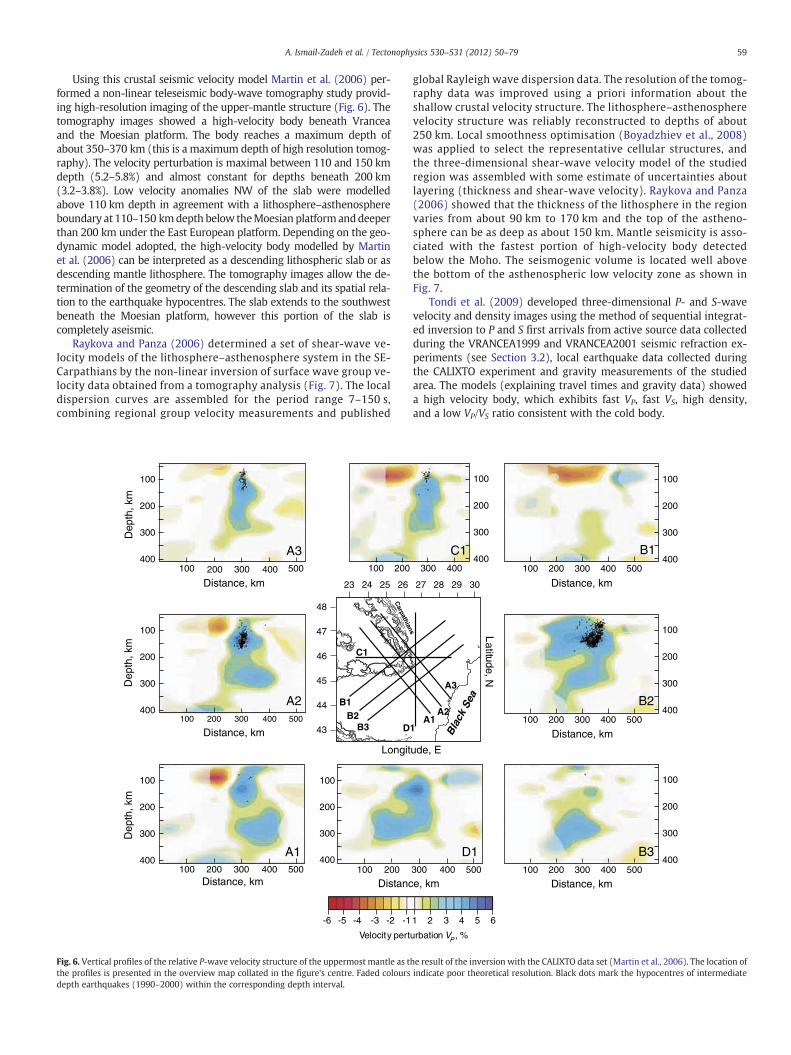
GPS measurements have been performed in the Vrancea region from1997 to 2006 (e.g., Dinter et al., 2001; Schmitt et al., 2007; Van der
Fig. 8. Interpolated horizontal (a) and vertical (b) velocity fields with respect to a fixed EurasGPS vectors. The black arrows (in panel a) present the interpolated horizontal velocities, andsubsidence (blue colours). The error ellipses show the 95% confidence level. The horizontal
Hoeven et al., 2005). The measurement campaigns for the firstyears revealed relative uplift rates in the Vrancea region of about10 mm yr−1 corresponding to an upper bound of 22 mm yr−1 (Dinteret al., 2001). Because no horizontal convergence is presently going on inthe SE-Carpathians, processes other than plate convergence are requiredto explain the observed vertical movement in the region above the slab.Themost plausible one is isostatic rebound of the crust pulled down dur-ing slab subduction and continental collision (Ismail-Zadeh et al., 2005b).
GPS measurements performed in the SE-Carpathians between 1997and 2004 were analysed by Van der Hoeven et al. (2005). The repeat-ability of their solutions is on the order of 1–4 mm for the horizontal,and 4–8 mm for the vertical component, and the resulting velocity esti-mates have an uncertainty of b1 mm yr−1 and b3 mm yr−1, respec-tively (Fig. 8). The region SE of the Carpathian bend zone shows ahorizontal movement towards SSE of about 2.5 mm yr−1, while theTransylvanian Basin shows very small motions with respect to Eurasia.The vertical velocity field indicates the existence of uplift and subsi-dence domains in the SE-Carpathians, in good agreement with Plio-cene–Quaternary orogen and basin studies. Another 29 GPS stationsinstalled in the last 3 yr will generate a denser velocity field in the com-ing years for this region.
Meanwhile the problem of discrepancies of the coordinate timeseries does not allow delivering reliable information on horizontaland vertical movements in the Vrancea region (Schmitt et al., 2007).Moreover, the strong earthquakes and faulting in the Vrancea seismicactive zone is too deep to be reliably correlated to horizontal displace-ments on the surface. Therefore, the observations on the horizontaland vertical movements can be correlated with crustal seismicityand the dynamics of the lower crust than with the sub-crustal seis-micity and mantle dynamics.
5. Geoelectric studies
Geoelectric studies can reveal the presence of volatiles at mantledepths. If a source of volatiles is available, there is a possibility of
ian plate (after Van der Hoeven et al., 2005). The red/blue arrows indicate the measuredthe coloured background of panel b illustrates the interpolated uplift (red colours) andmotion at the Eurasian plate boundaries is defined to be zero.
62 A. Ismail-Zadeh et al. / Tectonophysics 530–531 (2012) 50–79
high-pressure faulting in the lithosphere at the Vrancea seismic activezone. H2O can be carried down with the sediments covering the up-permost part of the descending lithosphere, and in the case of the hy-drated oceanic crust, it contains about 2% of H2O at 3.0 GPa and700 °C. Ulmer and Trommsdorff (1995) showed that the sinking ser-pentinites, which contain about 13% of H2O, may transport largequantities of water to depths of the order of 150–200 km. In the Vran-cea region the electrical resistivity drops below 1 V m (Stanica andStanica, 1993) and indicates the upper limit of a conducting zonethat correlates with the Carpathian electrical conductivity anomaly(Pinna et al., 1992).
The geoelectric data combined with electromagnetic andmagneto-telluric data bring valuable information for decipheringelectrical particularities of the lithosphere elsewhere and particularlyin the Vrancea earthquake-prone region. Using the available geomag-netic data, Stanica and Stanica (2010) presented the evidences of thecorrelation between the electromagnetic data and seismic events oc-curred in the Vrancea region. The electrical conductivity of the rockssurrounding a fault system changes prior an earthquake as a conse-quence of the dehydration and rupturing processes. Fluid migrationthrough the fault system in the Vrancea seismic active zone and itssurrounding areas causes the anomalies.
6. Density and gravity modelling
The modelling of the crust and uppermost mantle density is an im-portant step toward gravitymodelling, and it is usually based on the con-version of seismic velocities into the density of rocks based on anempirical relationship (e.g., Ludwig et al., 1970). Raileanu et al. (2005)developed a density model consistent with observed Bouguer gravityanomalies using the 2-D seismic velocitymodel along the VRANCEA1999refraction profile (Fig. 4c). They assigned the P- and S-wave velocity ofthe upper crust to be VP=5.9–6.2 km s−1 and VS=3.40–3.70 km s−1,determined the density to be 2700 kg m−3 and the Poisson's ratio rang-ing between 0.22 and 0.24. These parameters suggest a felsic composi-tion of the upper crust with quartz and feldspar bearing rocks (likegranite, granodiorite, felsic amphibolite gneiss or metagraywacke). Forthe lower crust Raileanu et al. (2005) suggested VP=6.7–7.0 km s−1,VS=3.90–4.07 km−1, the Poisson's ratio of 0.24–0.25, and the densityof 2850 kg m−3. The reduced value of the Poisson's ratio suggests higherSiO2 content than typical mafic rocks. The crystalline crust is assumed torepresent Precambrian continental crust with a possibly discontinuousEarly Palaeozoic to Early Devonian meta-sedimentary cover.
Based on the seismic refraction profiles VRANCEA1999 andVRANCEA2001 (Hauser et al., 2001, 2007) and seismic tomographymodel (Martin et al., 2006), Ismail-Zadeh et al. (2005a) derived a3-D density model for the Vrancea region using the Krasovsky's(1989) empirical P-wave velocity to density relationship based onexperimental data at high pressure of more than 2000 samples ofvarious crystalline rocks. The 3-D density model was used byHackney et al. (2002) to develop a 3-D gravity model of the SE-Carpathians employing the IGMAS software for gravity modelling(Schmidt and Götze, 1998). It was shown that the gravity effect pre-dicted for the Vrancea slab is about +20 mGal, and therefore, the ef-fect of the mass excess associated with the high-velocity body exertsa small influence on the gravity anomaly. This suggests that a link be-tween the body and the overlying plate is weak. A strong link wouldpredict much higher gravity effect, e.g., about +100 mGal as mod-elled by Mueller and Panza (1986) for the Alpine–Northern Apen-nine region. When the gravity effect of the Vrancea slab is removedfrom the observed Bouguer anomalies (Ioane and Atanasiu, 1998),the signature associated with the Carpathian foredeep (most nega-tive Bouguer anomalies) is more negative. Hackney et al. (2002) sug-gested that this modified anomaly pattern might better reflect thegeometry of the foredeep basin.
To reconstruct the tectonic evolution of the SE-Carpathians, in-cluding Tertiary subduction and collision followed by slab steepeningand delamination, Sperner et al. (2004) used lithosphere-scale gravi-ty models to calculate gravity anomalies resulting from oceanic sub-duction, continental collision, slab steepening, delamination, andbreak-off. Local isostasy was assumed for determining vertical move-ments caused by mass changes related to these tectonic processes.The results of the Sperner et al. (2004) modelling of oceanic subduc-tion showed that the mantle part of the lithosphere could trigger sig-nificant surface movements on the upper (overriding) platedepending on the post-collisional evolution of the slab (steepening,delamination, and break-off).
Tondi et al. (2009) developed a 3-D density model for the Vrancearegion simultaneously inverting seismic and gravity data (Fig. 9a).Gravity misfits (the difference between the observed and modelledgravity) reproduced by this density model (Fig. 9b) reveal that Bou-guer anomalies are well fitted except at the edges of the model.Also minor gravity misfits can be observed in some random spots lo-cated mostly beneath the Carpathians, which could be associatedwith inaccuracies in the modelled topography.
7. Thermal modelling
Temperature is a key physical parameter controlling the density,viscosity and rheology of the Earth's material and hence crustal andmantle dynamics. Information on temperature inside the Earth'sshallow crust comes from direct measurements of temperature inboreholes. There are however no direct measurements of deepcrustal and mantle temperatures, and therefore the temperaturescan be estimated indirectly from either seismic wave anomalies,geochemical analysis or through the extrapolation of surface heatflow observations.
Andreescu and Demetrescu (2001) studied several 2-D thermo-kinematic models for the tectonic evolution of the convergencezone of the East Carpathians along a NE–SW lithospheric cross-section. These models describe the pre-collisional subduction of anoceanic lithosphere, the underthrusting of the European continentalmargin in collision and the post-collisional thermal relaxation.Based on the results of the modelling, Andreescu and Demetrescu(2001) suggested that the crust is likely to be coupled with the man-tle in a narrow volume of the convergence area (near Vrancea) andthe crust is decoupled from the mantle in the front of the convergencefault and in the East European platform that can explain the absenceof intermediate-depth earthquakes there. Their models predict the220-km deep mechanically strong lithosphere, close to the maximumdepth of the seismic activity in the Vrancea region, and the effectiveelastic thickness (EET) of the lithosphere to be 80–140 km. An inclu-sion of the continental collision process in the modelling produced alow strength zone in the depth range of 40–60 km of the convergencecore corresponding to the seismically less active zone of the Vranceaseismogenic body.
Temperature logs in several boreholes along a profile across theforeland from the Carpathian nappes to the margin of the Focsani De-pression andMoesian Platform (in the close vicinity to the Vrancea re-gion) together with logging and geological information on structureand lithology of the sedimentary pile were used by Demetrescu et al.(2007) to derive the time-dependent heat budget and temperatureevolution of the lithosphere in the region by means of a 2-D finite el-ement model. The model includes sedimentation history, sedimentcompaction, lateral and vertical variation of thermal properties of sed-iments and consolidated crust. Modelling results have been comparedto measured temperatures, corrected for palaeoclimate effects.According to the model, sedimentation, palaeoclimate, heat refractioneffects and heat generation in the upper crust explain the observedsubsurface temperature. Demetrescu et al. (2007) argued that the sed-imentation process induces a significant time-dependency of the

5 km
TGF
IMF
PCF
TT
Z
15 km
35 km 70 km
150 km100 km
45
45
44
46
46
N
N
25 2526 26
density, kg m-32100 3500
27 2728 E 28 E
gravity misfit, mgal-20 -10 0 10 20
a b
Fig. 9. a) Density model for the Vrancea region contoured at 50 kg m−3 interval. b) Gravity misfit (observed–calculated) related to the density model. TTZ, the Tornquist–Teisseyrecompression zone; TGF, the Trans-Getica fault; PCF, the Peceneaga–Camena fault; and IMF, Intra-Moesian fault. Modified after Tondi et al. (2009).
63A. Ismail-Zadeh et al. / Tectonophysics 530–531 (2012) 50–79
temperature field of the underlying lithosphere with repercussions onits thermal thickness, metamorphic state and rheological behaviour.
Thermal modelling in the crust and uppermost mantle is usuallybased on solving the heat balance problem in a specified model do-main with unknown thermal conductivity, heat production, andboundary conditions. The unknown parameters are constrained bythe information coming from borehole temperature measurements.Recently, Tumanian (2008) used additional information, namely, thetemperatures converted from the seismic tomography model byRaykova and Panza (2006), to constrain the thermal parameters ofthe heat balance problem.
7.1. Seismic temperature modelling
The seismic velocity anomalies in the upper mantle can be attrib-uted to variations in temperature (e.g., Forte et al., 1994), althoughseveral factors other than temperature can also exert an influenceon seismic velocity: composition (Griffin et al., 1998), anelasticity(Karato, 1993), anisotropy and presence of melt or water (Karato,2003). Uppermost mantle composition has a complex effect on seis-mic velocity, while the effect is relatively small compared to the effectof temperature (Goes et al., 2000). During peridotite melting, garnetand clinopyroxene (fastest and slowest of four major mineralswhich compose the upper mantle) concentrate in the melt (Niu,1997), and therefore the change in composition of peridotite, as itmelts and the melt is extracted, does not appear to significantly affectseismic velocities (Jordan, 1979). Interpretation of seismic anisotropyis not always unique because of a trade-off between mantle flow ge-ometry and physical mechanisms of anisotropic structure formation(e.g., Smith et al., 2001).
Ismail-Zadeh et al. (2005a, 2008) used the seismic tomographymodel of the SE-Carpathians (Martin et al., 2006) to derive a seismictemperature model for the Vrancea region and its surroundings. In themodelling of synthetic P-wave seismic velocity anomalies, the effects
of anharmonicity (composition), anelasticity and partial melting onseismic velocities were considered. The anharmonic (frequency inde-pendent and non-attenuating) part of the synthetic velocities was cal-culated on the basis of published data on laboratory measurements ofdensity and elastic parameters of the main rock-forming minerals(e.g., Bass, 1995) at various thermodynamic conditions for the composi-tion of the crust and uppermostmantle (57.9% Ol, 16.3% CPx, 13.5%Opx,and 12.3% Gt; Green and Falloon, 1998) and the lithosphere (69% Ol,10% CPx, 19% Opx, and 2% Gt; Agee, 1993). Unfortunately, the composi-tion of the crust and the upper mantle in the Vrancea region is poorlyknown. A better knowledge of the composition can refine the seismictemperature model by Ismail-Zadeh et al. (2008). During the inversionof seismic velocity to temperature, the laterally averaged temperaturein the crust and mantle modelled by Demetrescu and Andreescu(1994) was used as the background temperature.
Depth slices (50–250 km) of the seismic temperature modelobtained by Ismail-Zadeh et al. (2008) are shown in Fig. 10. The lowtemperatures in the model are associated with the high-velocitybody beneath the Vrancea region and the East European platformand are already visible at depths of 50 km. The body image becomesclear at 70–110 km depth as a NE–SW oriented cold anomaly. Withincreasing depth (110–200 km depth) the thermal image of thebody broadens in NW–SE direction. The orientation of the cold bodychanges from NE–SW to N–S below the depth of 200 km. High tem-peratures are predicted beneath the Transylvanian Basin at about70–110 km depth. Two other high temperature regions are found at110–150 km depth below the Moesian platform and deeper than200 km under the East European platform and the North Dobrogeaorogen, which might be correlated with the regional variation of thelithosphere/asthenosphere boundary.
The smearing of the results of seismic tomography for the upper50 km does not allow correct prediction of the temperature in thecrust and uppermost mantle. The temperature at the shallow levelsof the SE-Carpathian lithosphere was modelled by Demetrescu and

Carpathians
Bla
ckS
ea
Latit
ude
N
44
46
47
48
43
45
23 24 26 28 3025 27 29
Carpathians
Blac
kSe
a
Temperature, K
300 470 640 810 980 1150 1320 1490 1660 1830 2000
mk57mk05
Carpathians
Blac
kSe
a
110 km
150 km
Carpathians
Blac
kSe
a
Carpathians
Blac
kSe
a200 km
Carpathians
Blac
kSe
a
250 km
650 km650 km
Longitude, E24 25 26 27 28
44
45
46
47 Neogene
volcanicarc
20 km 30 km 40 km
Fig. 10. Temperature model for the Vrancea region. The temperatures in the crust at the depths 20, 30, and 40 km (after Demetrescu and Andreescu, 1994) estimated from the sur-face heat flux in the region, and the seismic temperatures at the depth of 50 km and below are the result of the inversion of the P-wave velocity model. Theoretically well-resolvedregions are bounded by dashed line (Martin et al., 2006). The isolines present the surface topography. Modified after Ismail-Zadeh et al. (2008).
64 A. Ismail-Zadeh et al. / Tectonophysics 530–531 (2012) 50–79
Andreescu (1994) and Demetrescu et al. (2001) using measured sur-face heat flux constrained by palaeoclimate changes and the effects ofsedimentation. Fig. 10 shows the crustal (20–40 km) temperatures inthe Vrancea region derived from a model without magma chamber inthe crust (Demetrescu, pers. comm.) The high temperatures beneaththe Neogene volcanic area (25–26°E, 46–47°N) are associated withthe high surface heat flux (>80 mWm−2).
8. Geodynamic models
Several large earthquakes in Vrancea occurred in the XXth centurystimulated intensive geophysical, geological and geodetic studiesin the region. Several regional geodynamic models (qualitative andquantitative) have been proposed so far, which could be split intotwo sets of models. One set is based on the assumption that the
mantle seismicity in the Vrancea region is associated with a relic oce-anic lithosphere (attached to or already detached from the continen-tal crust), which is presently descending beneath the SE-Carpathians.The other set of models assumes that the Vrancea lithosphere thick-ened during continental collision, became unstable, and started tosink in the mantle finally delaminating from the crust and producingintermediate-depth earthquakes.
8.1. Qualitative geodynamic models
One of the first qualitative models proposed for the region was aseismic gap model by Fuchs et al. (1979). The authors observed thatthere is a spatial gap in seismicity at the depths of 40–70 km beneathVrancea, and this observation led them to the assumption that thesinking lithospheric plate had already detached from the continental

65A. Ismail-Zadeh et al. / Tectonophysics 530–531 (2012) 50–79
crust. The “seismic gap” should not be associated with the absence ofseismic events; small magnitude earthquakes occur at these depths aswell, but less frequent (at least for the last century) compared to thecrustal seismicity or earthquakes at depths of 70 to 180 km. Oncescu(1984) proposed that the intermediate-depth events are generated ina zone that separates the sinking slab from the neighbouring immo-bile part of the lithosphere rather than in the sinking slab itself.
Linzer (1996) explained the nearly vertical position of the Vranceaslab as the final roll-back stage of a small fragment of oceanic litho-sphere resulting from the Carpathian slab-retreat postulated byRoyden (1988; 1993). When the mechanically strong East Europeanand Scythian platforms started to enter the subduction zone, thebuoyancy forces of the thick continental crust exceeded the slabpull forces and convergence stopped after only a short period of con-tinental thrusting. Following the 11–9 Ma moment of final continen-tal collision, the lithospheric slab steepened beneath the Vrancearegion due to gravity, adding a vertical pull to the overlying litho-sphere (e.g., Sperner et al., 2005; Tărăpoancă et al., 2004). The hydro-static buoyancy forces promote the sinking of the slab, but viscousand frictional forces resist the descent. The combination of theseforces produces shear stresses at intermediate depths contributingto Vrancea seismicity (e.g., Ismail-Zadeh et al., 2000).
Various types of oceanic slab detachment combined or not com-bined with delamination (e.g., Girbacea and Frisch, 1998; Gvirtzman,2002; Sperner et al., 2001, 2005; Wortel and Spakman, 2000) havebeen proposed to explain the present seismic images of the descendingslab. Girbacea and Frisch (1998) assumed that the break-off, affectingonly the crustal portion of the slab, was followed by horizontal delami-nation of its lower portion. Wortel and Spakman (2000) suggested thata lateral migration of the slab detachment in the Carpathian arc is a keyfeature of the regional lithospheric dynamics (Fig. 11a). They hypothe-sised that a small tear in the slab initiates lateral rupture propagation. Inthe segment of the lithospheric plate boundary where the slab is stilldetached, the slab pull is not transferred to the lithosphere at the sur-face. Instead, the weight of the slab is at least partially supported bythe still continuous part of the slab, thereby concentrating the slabpull force. Stress concentration, with down-dip tension, near the tip ofthe tear causes further propagation. Sperner et al. (2001, 2005) sug-gested a model of Miocene subduction of oceanic lithosphere beneaththe Carpathian arc and subsequent soft continental collision, whichtransported cold and dense lithospheric material into the mantle.Sperner et al. (2004) proposed a model assuming Tertiary subduction,
Fig. 11. Several representative qualitative models. a) Plate boundary processes predicted to aconcentration of slab pull forces causes a pattern of subsidence (depocenter development) amodel for the lithospheric structure at the southeastern corner of Carpathians to illustrate hture of slab break-off migrating along plate boundary (after Gvirtzman, 2002). The detachinc) 3-D perspective lithosphere-scale block model (view towards NNW), illustrating a continthe lower front corner of the model.
which started with a shallow dipping slab followed by slab steepeningand delamination, so that the present position of the slab is sub-vertical. Based on the analysis of topography and crustal roots in the re-gion, Gvirtzman (2002) proposed that the cold mantle body imaged byseismic tomography under the SE-Carpathians is still viscously coupledto the lithosphere and pulls it downward. He estimated that the Vran-cea seismogenic body is shifted about 50 km east of the place of maxi-mum pull-down perhaps indicating that lithospheric tearing isoccurring at one side of the detaching root and not above it (Fig. 11b).
The obvious problem of all above detachment models is the re-quirement of migrating vertical movements in time and space alongthe strike of the orogen during the gradually propagating detachment(e.g., Buiter et al., 2002; van Hunen and Allen, 2011). Although initial-ly postulated both for the Carpathians foreland and for the Transylva-nia back-arc basin (Meulenkamp et al., 1996; Sperner et al., 2004),these postulations are clearly inconsistent with geological observa-tions. The assumption that depocentres migrate in the Transylvaniabasin during the Miocene as a result of processes taking place in theexternal Carpathians slab (Sperner et al., 2004) is at odds with the ki-nematics and geometry of the basin. Seismic and kinematic studiesdemonstrated that the assumed lower Miocene depocentre in thenorthern part of the Transylvania basin is in fact the foredeep of thePiennides system, which is intra-Carpathians deformation takingplace due to the coeval thrusting recorded between ALCAPA andTisza–Dacia units during their final moments of collision (e.g.,Tischler et al., 2008 and references therein). Subsequent Mioceneback-arc sedimentation recorded the rapid onset of deposition mi-grating westwards with depocentres being located roughly in a simi-lar position in the central part of the Transylvania basin, predating itscomplete exhumation at 9 Ma (Krézsek and Bally, 2006; Krézsek etal., 2010; Matenco et al., 2010). Such an early and regional exhuma-tion is not compatible with a migrating slab-detachment process. Ina similar way, the along strike migration accommodating gradualslab detachment is also not observed along the entire East, SE andSouth Carpathians foreland, where the main moments of subsidenceare synchronous (Bertotti et al., 2003; Matenco et al., 2003).
According to Carminati and Doglioni (2004), the Carpathians (andVrancea) had an evolution similar to that of the Apennines, wherewest-dipping subduction initiated along the retro-belt of a pre-existing orogen associated to east-dipping subduction (the Alps forthe Apennines, and the Dinarides for the Carpathians). In this inter-pretation, the Vrancea seismicity might be a result of stress
ccompany lateral migration of slab detachment (after Wortel and Spakman, 2000). Thend uplift migrating along strike. It also enhances arc migration (roll-back). b) Proposedow a lateral root delamination perpendicular to plate boundary fits in the regional pic-g root mainly hangs on independent block bounded by Trotus and Intra-Moesian faults.ental lithospheric delamination scenario (after Knapp et al., 2005). Vrancea is located in

66 A. Ismail-Zadeh et al. / Tectonophysics 530–531 (2012) 50–79
generation due to still active subduction. This is coherent with thePleistocene magmatism in the Pannonian and Transylvania back-arcbasins (Harangi and Lenkey, 2007; Seghedi et al., 2011). The subduc-tion is hanging in an eastward mantle relative flow (see also Doglioniet al., 1999), which is triggering its rollback and is enhanced by thenegative buoyancy of the subducted oceanic lithosphere of theOuter Carpathians slab during the closure of the Ceahlău–Severinocean. The ‘seismic gap’ in the slab may well be interpreted as theboundary between the subducted oceanic lithosphere, and the inher-ited subducted passive continental margin, which intrinsically has ashallower termination of its brittle properties (Carminati et al.,2002). Although the parallel between the Apennines and Carpathiansis interesting, the switch in subduction polarity taking place in theApennines–Betic subduction system at ~30–35 Ma, i.e. from Europelower plate to Adria lower plate (e.g., Handy et al., 2010; Michardet al., 2002) is not observed in the Carpathians and Dinarides,where major kinematic differences are observed between the twoorogens (Schmid et al., 2008). The closure of the Sava ocean of theDinarides took place in the latest Cretaceous times with the final mo-ment of collision being Eocene (Dimitrijević, 1997; Ustaszewski et al.,2010), while the closure of the Ceahlău–Severin ocean is late Early tolate Cretaceous and the final moment of collision is Miocene(Matenco et al., 2010; Săndulescu and Visarion, 1988).
While the geodynamicmodelsmentioned above assume the Vranceadescending lithosphere to be oceanic, Pana and Erdmer (1996) and Panaand Morris (1999) argue that there is no geological evidence of oceaniccrust in the Miocene evolution of the East Carpathians and the des-cending lithosphere is likely to be thinned continental or transitionallithosphere. Knapp et al. (2005) and Fillerup et al. (2010) considerthat the interpretations related to the oceanic origin of the Vranceaseismogenic body are inconsistent with geologic constraints fromthe East Carpathians and adjacent foreland. Derived from interpretationof geophysical data, the crust of continental affinity is interpreted to ex-tend significantly westward beneath the external thrust nappes of theEast Carpathians. According to Knapp et al. (2005), Neogene strata ofthe East Carpathians can be reconstructed much further westward toa position now occupied by the Transylvanian basin, and geologic struc-ture in the Carpathian foreland including theMoho is sub-horizontal di-rectly to the east of and above the Vrancea seismogenic zone. Thesegeologic relationships imply that the Vrancea zone occupies a regionoverlain by continental crust and does not appear to originate from asubducted oceanic slab along the length of the Carpathian orogen.The alternative model proposed by Knapp et al. (2005) and Fillerupet al. (2010) involves active continental lithospheric delaminationresulting fromMiocene closure of an intra-continental basin and result-ing lithospheric thickening (Fig. 11c). Delamination of thickened conti-nental lithosphere became an important geodynamic process inorogenic settings (e.g., Bird, 1978; Nelson, 1991) and was proposed asa plausible mechanism to explain mantle seismicity (e.g., Seber et al.,1996). Recently, based on seismic tomography images, Kulakov et al.(2010) also proposed that delamination of the continental lithospherecan play a role in the evolution of the Vrancea region. The lithosphericdelamination process, which might be responsible for Vranceaintermediate-depth seismicity, seems to be supportive of the idea ofsub-horizontal faulting in the slab (Ivan, 2011).
The controversy launching all these continental versus oceanic sub-stratum hypotheses starts from the following uncertainty: whether theoceanic lithosphere created by the Ceahlău–Severin ocean opening dur-ing the Late Jurassic–Early Cretaceous was entirely subducted bythe end of Cretaceous times or whether a large part of the remainingCarpathian embayment still contained the oceanic lithosphere for thepost-Cretaceous times. The Miocene molasse deposition incorporatedin the Carpathian thin-skinned units is of continental substratum. How-ever, the nature of the basement of the Palaeogene flysch deposits (e.g.,Belayouni et al., 2009; Miclaus et al., 2009) is largely unknown, as thistype of turbidides forms as a response of any slope deposition. As long
as this uncertainty exists, none of these qualitative models arguing forthe continental or oceanic nature of the Carpathian embayment canbe fully tested, and therefore, will remain speculative.
8.2. Quantitative geodynamic models
Several quantitative models were proposed to explain the dynam-ics of the descending lithosphere beneath the Vrancea region, in-duced mantle flow, stress localization, and lithosphere delaminationand detachment. One of the earlier dynamic models for Vranceawas developed by Ismail-Zadeh et al. (2000), who examined the ef-fects of viscous flow, phase transition, and dehydration on the stressfield of a relic slab to explain the intermediate-depth seismic activityin the Vrancea region. A 2-D model based on the Eulerian finite ele-ment method (Naimark et al., 1998) described a slab gravitationallysinking in the mantle. The model predicted (i) downward extensionin the slab as inferred from the stress axes of earthquakes, (ii) themaximum stress occurring in the depth range from 70 km to160 km, and (iii) a very narrow area of the maximum stress. Ismail-Zadeh et al. (2000) showed that the depth distribution of the annualaverage seismic energy released in earthquakes has a shape similar tothat of the depth distribution of the stress in the slab. Estimations ofthe cumulative annual seismic moment observed and associatedwith the volume change due to the basalt–eclogite phase changes inthe oceanic slab indicate that a pure phase-transition model cannotsolely explain the intermediate-depth earthquakes in the region.The authors considered that one of the realistic mechanisms for trig-gering these events in the Vrancea slab can be the dehydration ofrocks, which makes fluid-assisted faulting possible.
Hettel et al. (2000) presented a finite-element model of the des-cending visco-elastic slab and showed the onset of a necking processin the slab and decoupling between the slab and the overlying litho-sphere. To understand the processes of stress generation due to thedescending slab, Ismail-Zadeh (2003) analysed tectonic stress in-duced by the slab sinking in the mantle using an analytical modelfor corner flow (Batchelor, 1967). He found that the maximumshear stress migrates from the upper surface of the slab to its lowersurface in the course of changes in slab dynamics from its active sub-duction through slab roll-back to sinking solely due to gravity. Thechanges in stress distribution could explain the location of hypocen-tres of Vrancea events at the side of the slab adjacent to the East Eu-ropean platform.
Cloetingh et al. (2004) demonstrated that in low rate convergenceregimes such as the Carpathians, the subducted lithosphere hasenough time to interact with the mantle to advance towards a ther-mal resettlement. Their model incorporated lateral variations in thethermo-mechanical structure of the subducted lithosphere along thestrike of the orogen (Fig. 12). The authors demonstrate that the un-usual character of the subduction along the Carpathians arc can becontrolled by the thermo-mechanical age of the underthrusted litho-sphere and lateral variations in the interplay between the lithosphereand surface processes. Their model explained also the occurrence of avery deep, unusual foredeep basin geometry and anomalous subsi-dence in front of the bend zone of the Carpathians.
To analyse the crustal thickening, lithosphere detachment, andtectonic stress evolution during the slab descent, Ismail-Zadeh et al.(2005b) developed 2-D thermo-mechanical finite-element modelsof the post-Miocene sinking of the Vrancea slab subject to gravityforces. The models predicted lateral compression in the slab thatwere in agreement with those inferred from the stress axes of earth-quakes. It was found that the maximum stress occurs in the depthrange of 80 km to 200 km and the minimum stress falls into thedepth range of 40 km to 80 km, which corresponds to the area of in-significant seismicity (Fig. 13). It was also shown that high tectonicstress (leading to seismic activity) is preserved in the slab for a fewmillion years, even after the detachment.
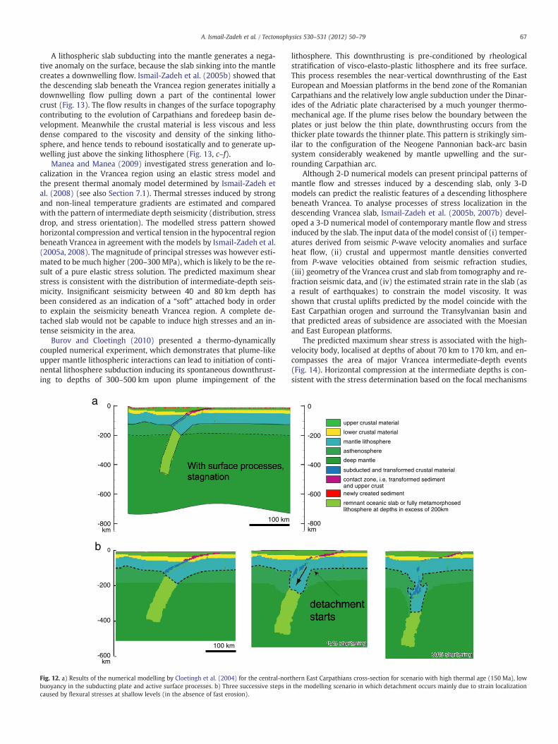
67A. Ismail-Zadeh et al. / Tectonophysics 530–531 (2012) 50–79
A lithospheric slab subducting into the mantle generates a nega-tive anomaly on the surface, because the slab sinking into the mantlecreates a downwelling flow. Ismail-Zadeh et al. (2005b) showed thatthe descending slab beneath the Vrancea region generates initially adownwelling flow pulling down a part of the continental lowercrust (Fig. 13). The flow results in changes of the surface topographycontributing to the evolution of Carpathians and foredeep basin de-velopment. Meanwhile the crustal material is less viscous and lessdense compared to the viscosity and density of the sinking litho-sphere, and hence tends to rebound isostatically and to generate up-welling just above the sinking lithosphere (Fig. 13, c–f).
Manea and Manea (2009) investigated stress generation and lo-calization in the Vrancea region using an elastic stress model andthe present thermal anomaly model determined by Ismail-Zadeh etal. (2008) (see also Section 7.1). Thermal stresses induced by strongand non-lineal temperature gradients are estimated and comparedwith the pattern of intermediate depth seismicity (distribution, stressdrop, and stress orientation). The modelled stress pattern showedhorizontal compression and vertical tension in the hypocentral regionbeneath Vrancea in agreement with the models by Ismail-Zadeh et al.(2005a, 2008). The magnitude of principal stresses was however esti-mated to be much higher (200–300 MPa), which is likely to be the re-sult of a pure elastic stress solution. The predicted maximum shearstress is consistent with the distribution of intermediate-depth seis-micity. Insignificant seismicity between 40 and 80 km depth hasbeen considered as an indication of a “soft” attached body in orderto explain the seismicity beneath Vrancea region. A complete de-tached slab would not be capable to induce high stresses and an in-tense seismicity in the area.
Burov and Cloetingh (2010) presented a thermo-dynamicallycoupled numerical experiment, which demonstrates that plume-likeupper mantle lithospheric interactions can lead to initiation of conti-nental lithosphere subduction inducing its spontaneous downthrust-ing to depths of 300–500 km upon plume impingement of the
0
-200
-400
-600
-800km
0
-200
-400
-600km
100 km
100 km
a
b
Fig. 12. a) Results of the numerical modelling by Cloetingh et al. (2004) for the central-norbuoyancy in the subducting plate and active surface processes. b) Three successive steps incaused by flexural stresses at shallow levels (in the absence of fast erosion).
lithosphere. This downthrusting is pre-conditioned by rheologicalstratification of visco-elasto-plastic lithosphere and its free surface.This process resembles the near-vertical downthrusting of the EastEuropean and Moessian platforms in the bend zone of the RomanianCarpathians and the relatively low angle subduction under the Dinar-ides of the Adriatic plate characterised by a much younger thermo-mechanical age. If the plume rises below the boundary between theplates or just below the thin plate, downthrusting occurs from thethicker plate towards the thinner plate. This pattern is strikingly sim-ilar to the configuration of the Neogene Pannonian back-arc basinsystem considerably weakened by mantle upwelling and the sur-rounding Carpathian arc.
Although 2-D numerical models can present principal patterns ofmantle flow and stresses induced by a descending slab, only 3-Dmodels can predict the realistic features of a descending lithospherebeneath Vrancea. To analyse processes of stress localization in thedescending Vrancea slab, Ismail-Zadeh et al. (2005b, 2007b) devel-oped a 3-D numerical model of contemporary mantle flow and stressinduced by the slab. The input data of the model consist of (i) temper-atures derived from seismic P-wave velocity anomalies and surfaceheat flow, (ii) crustal and uppermost mantle densities convertedfrom P-wave velocities obtained from seismic refraction studies,(iii) geometry of the Vrancea crust and slab from tomography and re-fraction seismic data, and (iv) the estimated strain rate in the slab (asa result of earthquakes) to constrain the model viscosity. It wasshown that crustal uplifts predicted by the model coincide with theEast Carpathian orogen and surround the Transylvanian basin andthat predicted areas of subsidence are associated with the Moesianand East European platforms.
The predicted maximum shear stress is associated with the high-velocity body, localised at depths of about 70 km to 170 km, and en-compasses the area of major Vrancea intermediate-depth events(Fig. 14). Horizontal compression at the intermediate depths is con-sistent with the stress determination based on the focal mechanisms
0
-200
-400
-600
-800km
1155%% sshhoorrtteenniinngg
3300%% sshhoorrtteenniinngg
thern East Carpathians cross-section for scenario with high thermal age (150 Ma), lowthe modelling scenario in which detachment occurs mainly due to strain localization

Distance, km
6.7 My ago
3.5 My ago
present day
0 100 200 300 400400
300
200
100
0
0 100 200 300 400400
300
200
100
0
0 100 200 300 400400
300
200
100
0
0 100 200 300 400400
300
200
100
0
0 100 200 300 400400
300
200
100
0
0 100 200 300 400400
300
200
100
0
0 100 200 300 400400
300
200
100
0
0 100 200 300 400400
300
200
100
0
0 100 200 300 400400
300
200
100
0
Dep
th,k
m
a
Dep
th,k
m
b
Distance, km
Dep
th,k
m
c
Distance, km
In 0.5 My after slab detachment
in 2.0 My
in 8.5 My
0 100 200 300 400 500 600
600
500
400
300
200
100
0
0 100 200 300 400 500 600
600
500
400
300
200
100
0
0 100 200 300 400 500 600
600
500
400
300
200
100
0
d
e
Distance, km
f
MPa
10 20 30 40 50 4 cm/yr
Fig. 13. Maximum tectonic shear stresses (grey shading) and axes of compression (panels in columns 1 and 3) and flow field (panels in columns 2 and 4) for the model evo-lution of the Vrancea slab descending in the mantle at successive times indicated. The slab is attached to the crust (columns 1 and 2, a, b, c) and detached from the crust (col-umns 3 and 4, d, e, f). Modified after Ismail-Zadeh et al. (2005b).
68 A. Ismail-Zadeh et al. / Tectonophysics 530–531 (2012) 50–79
of the earthquakes. Using numerous fault-plane solutions forintermediate-depth events, Oncescu and Trifu (1987) showed thatthe axes of compressional stress are almost horizontal. An increaseof shear stress due to the descending slab is one of the possibilitiesof stress generation. Another process could be a plastic instability athigh temperature, when runaway shear slip (failure) occurs at evenrelatively low shear stresses (Griggs and Baker, 1969). Faulting dueto metamorphic phase transitions (Green and Burnley, 1989) ordehydration-induced embrittlement (Hacker et al., 2003; Raleighand Paterson, 1965) may also play a role in the regional stress gener-ation and release. Meanwhile, estimations of the cumulative annualseismic moment observed and associated with the volume changedue to the basalt-eclogite phase changes in the Vrancea slab showthat a pure phase-transition model cannot solely explain theintermediate-depth earthquakes in the region (Ismail-Zadeh et al.,2000).
The high resolution seismic tomography studies revealed themantlebodybeneath theVrancea region exhibiting fastVP and VS seismic veloc-ities, high density, and a low VP/VS ratio. Based on this findings and geo-logical observations, the body was interpreted as a cold remnant of the
oceanic lithosphere. Meanwhile, Houseman and Gemmer (2007) con-sidered a model of lateral thinning of the continental lithosphere be-neath the Pannonian Basin and its thickening beneath the EastCarpathians and argued that the high-velocity body can be interpretedas the thickened continental lithosphere beneath the SE-Carpathiansdescending due to the Rayleigh–Taylor (R–T, gravitational) instability.Later Lorinczi and Houseman (2009) developed a three-dimensional fi-nite deformation model of the gravitational instability of a dense litho-sphere to explain the present distribution of deformation within thedownwelling lithosphere, both in terms of distribution of seismicityand amplitude of strain rates.
When the density of a lithospheric plate becomes larger thanthat of the surrounding mantle and when the lateral forces pushingthe plate into the mantle are insignificant, the lithosphere descendsmainly due to gravity forces, which pull it down into the mantle as aconsequence of the R–T instability. In this case, either oceanic orcontinental lithospheric plate will sink in the mantle because of pos-itive density contrast between the plate and the surrounding man-tle. Hence there is no principal difference between the R–Tinstability models, which assume the oceanic or continental origin
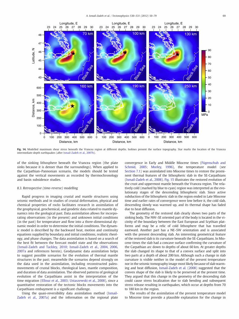
70 km 100 km 130 km
160 km 190 km 250 kmBl
ack
Sea
Blac
kSe
a
Blac
kSe
a
0
100
200
300
400
500
600
Longitude, E23 24 26 28 3025 27 29 23 24 26 28 3025 27 29 23 24 26 28 3025 27 29
Latit
ude,
N
44
46
47
48
43
45
Dis
tanc
e, k
m
Longitude, E Longitude, E
Distance, km
0 100 200 300 400 500 600 0 100 200 300 400 500 600 0 100 200 300 400 500 600
Distance, km Distance, km
MPa0
10
20
30
40
50
60
70
80
90
Fig. 14. Modelled maximum shear stress beneath the Vrancea region at different depths. Isolines present the surface topography. Star marks the location of the Vranceaintermediate-depth earthquakes (after Ismail-Zadeh et al., 2007b).
69A. Ismail-Zadeh et al. / Tectonophysics 530–531 (2012) 50–79
of the sinking lithosphere beneath the Vrancea region (the platesinks because it is denser than the surroundings). When applied tothe Carpathian–Pannonian scenario, the models should be testedagainst the vertical movements as recorded by thermochronologyand basin subsidence studies.
8.3. Retrospective (time-reverse) modelling
Rapid progress in imaging crustal and mantle structures usingseismic methods and in studies of crustal deformation, physical andchemical properties of rocks facilitates research in assimilation ofthe geophysical, geochemical, and geodetic data related to mantle dy-namics into the geological past. Data assimilation allows for incorpo-rating observations (in the present) and unknown initial conditions(in the past) for temperature and flow into a three-dimensional dy-namic model in order to determine the initial conditions. The dynam-ic model is described by the backward heat, motion and continuityequations supplied by boundary and initial conditions, realistic rheol-ogy, and phase changes. The data assimilation is based on a search ofthe best fit between the forecast model state and the observations(Ismail-Zadeh and Tackley, 2010; Ismail-Zadeh et al., 2004, 2006,2007a and references herein). Geodynamic data assimilation helpsto suggest possible scenarios for the evolution of thermal mantlestructures in the past; meanwhile the scenarios depend strongly onthe data used in the assimilation, including reconstructed paleo-movements of crustal blocks, rheological laws, mantle composition,and duration of data assimilation. The observed patterns of geologicalevolution of the Carpathians assist in the interpretation of thetime migration (Ellouz et al., 2003; Ustaszewski et al., 2008), since aquantitative restoration of the tectonic blocks movements into theCarpathians embayment is a significant challenge.
Using the quasi-reversibility data assimilation method (Ismail-Zadeh et al., 2007a) and the information on the regional plate
convergence in Early and Middle Miocene times (Fügenschuh andSchmid, 2005; Morley, 1996), the temperature model (seeSection 7.1) was assimilated into Miocene times to restore the promi-nent thermal features of the lithospheric slab in the SE-Carpathians(Ismail-Zadeh et al., 2008). Fig. 15 illustrates the restored evolution ofthe crust and uppermost mantle beneath the Vrancea region. The rela-tively cold (marked by blue to cyan) region was interpreted as the evo-lutionary stages of the descending lithospheric slab. Since activesubduction of the lithospheric slab in the region ended in Late Miocenetime and earlier rates of convergence were low before it, the cold slab,descending slowly was warmed up, and its thermal shape has fadeddue to heat diffusion.
The geometry of the restored slab clearly shows two parts of thesinking body. The NW–SE oriented part of the body is located in the vi-cinity of the boundary between the East European and Scythian plat-forms and may be a relic of cold lithosphere that has travelledeastward. Another part has a NE–SW orientation and is associatedwith the present descending slab. An interesting geometrical featureof the restored slab is its curvature beneath the SE-Carpathians. In Mio-cene times the slab had a concave surface confirming the curvature ofthe Carpathian arc down to depths of about 60 km. At greater depthsthe slab changed its shape to that of a convex surface and split intotwo parts at a depth of about 200 km. Although such a change in slabcurvature is visible neither in the model of the present temperaturenor in the seismic tomography imagemost likely because of slabwarm-ing and heat diffusion, Ismail-Zadeh et al. (2008) suggested that theconvex shape of the slab is likely to be preserved at the present time.They argued that this change in the geometry of the descending slabcould cause stress localization due to slab bending and subsequentstress release resulting in earthquakes, which occur at depths from 70to 180 km in the region.
The results of the assimilation of the present temperature modelto Miocene time provide a plausible explanation for the change in

70 A. Ismail-Zadeh et al. / Tectonophysics 530–531 (2012) 50–79
the spatial orientation of the slab from NE–SW to NS beneath 200 kmobserved in the seismic tomography image (Martin et al., 2006). Theslab bending might be related to a complex interaction between twoparts of the sinking body and the surrounding mantle. The sinking
S
N
11 Myr ago
16 Myr ago
22 Myr ago
350
km
Bla
ckSe
a
Carpathians
650 km
mk05
6
Vrancea
44
46
47
48
43
45
N,edutitaL
23 24 26 28 3025 27 29
Longitude, E
a
b
c
d
Fig. 15. a) 3-D thermal shape of the Vrancea slab and contemporary flow induced by the desthe Vrancea slab and pattern of mantle flow beneath the SE-Carpathians in the Miocene timlustrate the direction and magnitude of the flow. The surfaces marked by blue, dark cyan, aspectively, where δT=(Thav−T)/Thav, and Thav is the horizontally averaged temperature.intermediate-depth earthquakes (modified after Ismail-Zadeh et al., 2008).
body displaces the mantle, which, in its turn, forces the slab to deformdue to corner (toroidal) flows different within each of two sub-regions (to NW and to SE from the present descending slab). Also,the curvature of the descending slab can be influenced by slab
11 Myr ago
16 Myr ago
22 Myr ago
Black Sea
Carpathians
2 cm yr-1
650 km 650 km
cending slab beneath the SE-Carpathians. b)–d) Snapshots of the 3-D thermal shape ofes. Left panels: top view. Lower panels: side view from the SE toward NW. Arrows il-
nd light cyan illustrate the surfaces of 0.07, 0.14, and 0.21 temperature anomaly δT, re-The top surface presents the topography, and the red star marks the location of the
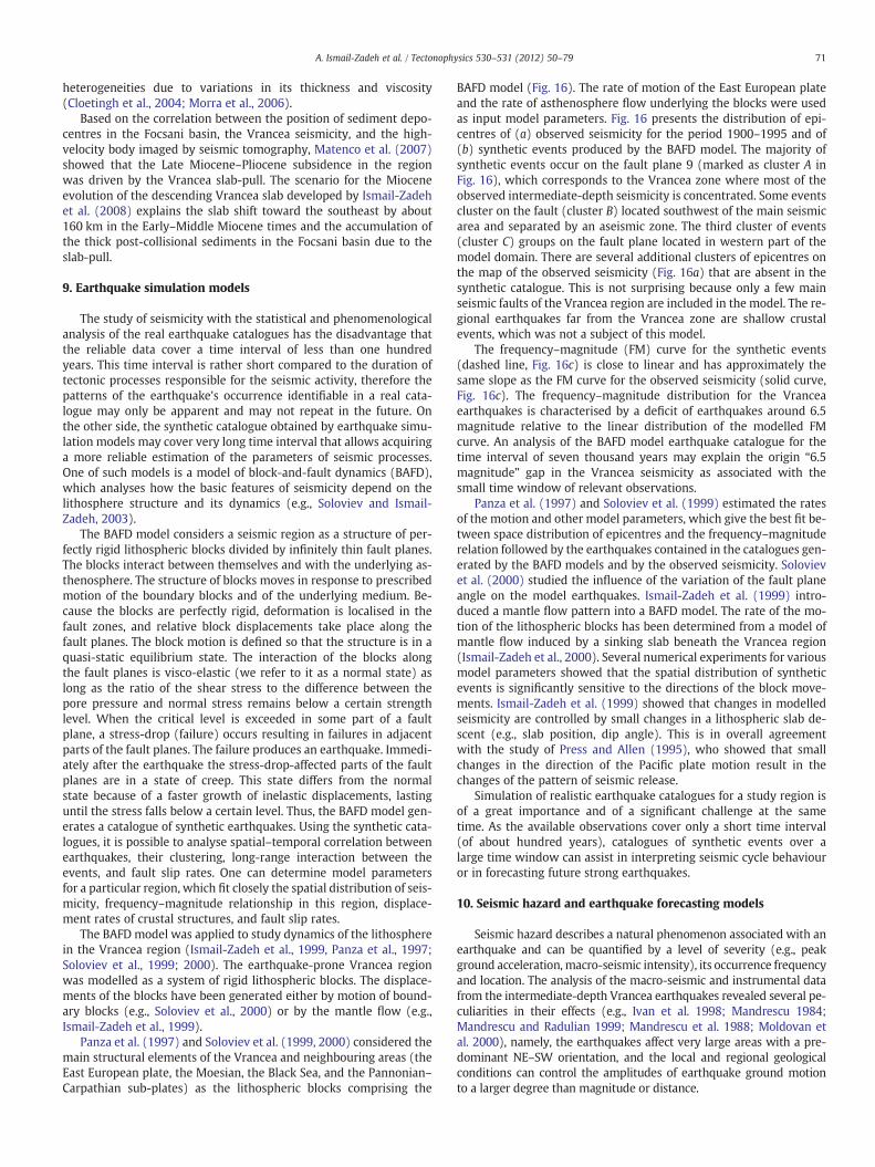
71A. Ismail-Zadeh et al. / Tectonophysics 530–531 (2012) 50–79
heterogeneities due to variations in its thickness and viscosity(Cloetingh et al., 2004; Morra et al., 2006).
Based on the correlation between the position of sediment depo-centres in the Focsani basin, the Vrancea seismicity, and the high-velocity body imaged by seismic tomography, Matenco et al. (2007)showed that the Late Miocene–Pliocene subsidence in the regionwas driven by the Vrancea slab-pull. The scenario for the Mioceneevolution of the descending Vrancea slab developed by Ismail-Zadehet al. (2008) explains the slab shift toward the southeast by about160 km in the Early–Middle Miocene times and the accumulation ofthe thick post-collisional sediments in the Focsani basin due to theslab-pull.
9. Earthquake simulation models
The study of seismicity with the statistical and phenomenologicalanalysis of the real earthquake catalogues has the disadvantage thatthe reliable data cover a time interval of less than one hundredyears. This time interval is rather short compared to the duration oftectonic processes responsible for the seismic activity, therefore thepatterns of the earthquake's occurrence identifiable in a real cata-logue may only be apparent and may not repeat in the future. Onthe other side, the synthetic catalogue obtained by earthquake simu-lation models may cover very long time interval that allows acquiringa more reliable estimation of the parameters of seismic processes.One of such models is a model of block-and-fault dynamics (BAFD),which analyses how the basic features of seismicity depend on thelithosphere structure and its dynamics (e.g., Soloviev and Ismail-Zadeh, 2003).
The BAFD model considers a seismic region as a structure of per-fectly rigid lithospheric blocks divided by infinitely thin fault planes.The blocks interact between themselves and with the underlying as-thenosphere. The structure of blocks moves in response to prescribedmotion of the boundary blocks and of the underlying medium. Be-cause the blocks are perfectly rigid, deformation is localised in thefault zones, and relative block displacements take place along thefault planes. The block motion is defined so that the structure is in aquasi-static equilibrium state. The interaction of the blocks alongthe fault planes is visco-elastic (we refer to it as a normal state) aslong as the ratio of the shear stress to the difference between thepore pressure and normal stress remains below a certain strengthlevel. When the critical level is exceeded in some part of a faultplane, a stress-drop (failure) occurs resulting in failures in adjacentparts of the fault planes. The failure produces an earthquake. Immedi-ately after the earthquake the stress-drop-affected parts of the faultplanes are in a state of creep. This state differs from the normalstate because of a faster growth of inelastic displacements, lastinguntil the stress falls below a certain level. Thus, the BAFD model gen-erates a catalogue of synthetic earthquakes. Using the synthetic cata-logues, it is possible to analyse spatial–temporal correlation betweenearthquakes, their clustering, long-range interaction between theevents, and fault slip rates. One can determine model parametersfor a particular region, which fit closely the spatial distribution of seis-micity, frequency–magnitude relationship in this region, displace-ment rates of crustal structures, and fault slip rates.
The BAFD model was applied to study dynamics of the lithospherein the Vrancea region (Ismail-Zadeh et al., 1999, Panza et al., 1997;Soloviev et al., 1999; 2000). The earthquake-prone Vrancea regionwas modelled as a system of rigid lithospheric blocks. The displace-ments of the blocks have been generated either by motion of bound-ary blocks (e.g., Soloviev et al., 2000) or by the mantle flow (e.g.,Ismail-Zadeh et al., 1999).
Panza et al. (1997) and Soloviev et al. (1999, 2000) considered themain structural elements of the Vrancea and neighbouring areas (theEast European plate, the Moesian, the Black Sea, and the Pannonian–Carpathian sub-plates) as the lithospheric blocks comprising the
BAFD model (Fig. 16). The rate of motion of the East European plateand the rate of asthenosphere flow underlying the blocks were usedas input model parameters. Fig. 16 presents the distribution of epi-centres of (a) observed seismicity for the period 1900–1995 and of(b) synthetic events produced by the BAFD model. The majority ofsynthetic events occur on the fault plane 9 (marked as cluster A inFig. 16), which corresponds to the Vrancea zone where most of theobserved intermediate-depth seismicity is concentrated. Some eventscluster on the fault (cluster B) located southwest of the main seismicarea and separated by an aseismic zone. The third cluster of events(cluster C) groups on the fault plane located in western part of themodel domain. There are several additional clusters of epicentres onthe map of the observed seismicity (Fig. 16a) that are absent in thesynthetic catalogue. This is not surprising because only a few mainseismic faults of the Vrancea region are included in the model. The re-gional earthquakes far from the Vrancea zone are shallow crustalevents, which was not a subject of this model.
The frequency–magnitude (FM) curve for the synthetic events(dashed line, Fig. 16c) is close to linear and has approximately thesame slope as the FM curve for the observed seismicity (solid curve,Fig. 16c). The frequency–magnitude distribution for the Vranceaearthquakes is characterised by a deficit of earthquakes around 6.5magnitude relative to the linear distribution of the modelled FMcurve. An analysis of the BAFD model earthquake catalogue for thetime interval of seven thousand years may explain the origin “6.5magnitude” gap in the Vrancea seismicity as associated with thesmall time window of relevant observations.
Panza et al. (1997) and Soloviev et al. (1999) estimated the ratesof the motion and other model parameters, which give the best fit be-tween space distribution of epicentres and the frequency–magnituderelation followed by the earthquakes contained in the catalogues gen-erated by the BAFD models and by the observed seismicity. Solovievet al. (2000) studied the influence of the variation of the fault planeangle on the model earthquakes. Ismail-Zadeh et al. (1999) intro-duced a mantle flow pattern into a BAFD model. The rate of the mo-tion of the lithospheric blocks has been determined from a model ofmantle flow induced by a sinking slab beneath the Vrancea region(Ismail-Zadeh et al., 2000). Several numerical experiments for variousmodel parameters showed that the spatial distribution of syntheticevents is significantly sensitive to the directions of the block move-ments. Ismail-Zadeh et al. (1999) showed that changes in modelledseismicity are controlled by small changes in a lithospheric slab de-scent (e.g., slab position, dip angle). This is in overall agreementwith the study of Press and Allen (1995), who showed that smallchanges in the direction of the Pacific plate motion result in thechanges of the pattern of seismic release.
Simulation of realistic earthquake catalogues for a study region isof a great importance and of a significant challenge at the sametime. As the available observations cover only a short time interval(of about hundred years), catalogues of synthetic events over alarge time window can assist in interpreting seismic cycle behaviouror in forecasting future strong earthquakes.
10. Seismic hazard and earthquake forecasting models
Seismic hazard describes a natural phenomenon associated with anearthquake and can be quantified by a level of severity (e.g., peakground acceleration, macro-seismic intensity), its occurrence frequencyand location. The analysis of the macro-seismic and instrumental datafrom the intermediate-depth Vrancea earthquakes revealed several pe-culiarities in their effects (e.g., Ivan et al. 1998; Mandrescu 1984;Mandrescu and Radulian 1999; Mandrescu et al. 1988; Moldovan etal. 2000), namely, the earthquakes affect very large areas with a pre-dominant NE–SW orientation, and the local and regional geologicalconditions can control the amplitudes of earthquake ground motionto a larger degree than magnitude or distance.
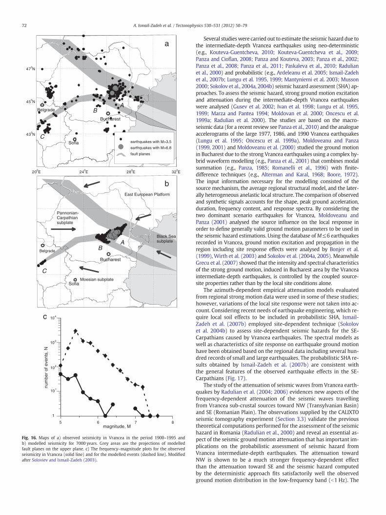
Bucharest
Sofia
Belgrade
C
BA
earthquakes with M>3.5
earthquakes with M>6.8
fault planes
47 N0
45 N0
43 N0
24 E020 E0 28 E0 32 E0
a
Bucharest
Sofia
Belgrade
C
AB
b
Black Seasubplate
Moesian subplate
Pannonian-Carpathiansubplate
East European Platform
5 6 7 8
1
104
103
102
101
tneveforeb
muns,
N
magnitude, M
c
Fig. 16. Maps of a) observed seismicity in Vrancea in the period 1900–1995 andb) modelled seismicity for 7000 years. Grey areas are the projections of modelledfault planes on the upper plane. c) The frequency–magnitude plots for the observedseismicity in Vrancea (solid line) and for the modelled events (dashed line). Modifiedafter Soloviev and Ismail-Zadeh (2003).
72 A. Ismail-Zadeh et al. / Tectonophysics 530–531 (2012) 50–79
Several studieswere carried out to estimate the seismic hazard due tothe intermediate-depth Vrancea earthquakes using neo-deterministic(e.g., Kouteva-Guentcheva, 2010; Kouteva-Guentcheva et al., 2009;Panza and Cioflan, 2008; Panza and Kouteva, 2003; Panza et al., 2002;Panza et al., 2008; Panza et al., 2011; Paskaleva et al., 2010; Radulianet al., 2000) and probabilistic (e.g., Ardeleanu et al. 2005; Ismail-Zadehet al., 2007b; Lungu et al. 1995, 1999; Mantyniemi et al. 2003; Musson2000; Sokolov et al., 2004a, 2004b) seismic hazard assessment (SHA) ap-proaches. To assess the seismic hazard, strong ground motion excitationand attenuation during the intermediate-depth Vrancea earthquakeswere analysed (Gusev et al. 2002; Ivan et al. 1998; Lungu et al. 1995,1999; Marza and Pantea 1994; Moldovan et al. 2000; Oncescu et al.1999a; Radulian et al. 2000). The studies are based on the macro-seismic data (for a recent review see Panza et al., 2010) and the analogueaccelerograms of the large 1977, 1986, and 1990 Vrancea earthquakes(Lungu et al. 1995; Oncescu et al. 1999a). Moldoveanu and Panza(1999, 2001) and Moldoveanu et al. (2000) studied the ground motionin Bucharest due to the strong Vrancea earthquakes using a complex hy-brid waveform modelling (e.g., Panza et al., 2001) that combines modalsummation (e.g., Panza, 1985; Romanelli et al., 1996) with finite-difference techniques (e.g., Alterman and Karal, 1968; Boore, 1972).The input information necessary for the modelling consisted of thesource mechanism, the average regional structural model, and the later-ally heterogeneous anelastic local structure. The comparison of observedand synthetic signals accounts for the shape, peak ground acceleration,duration, frequency content, and response spectra. By considering thetwo dominant scenario earthquakes for Vrancea, Moldoveanu andPanza (2001) analysed the source influence on the local response inorder to define generally valid ground motion parameters to be used inthe seismic hazard estimations. Using the database ofM≤6 earthquakesrecorded in Vrancea, ground motion excitation and propagation in theregion including site response effects were analysed by Bonjer et al.(1999), Wirth et al. (2003) and Sokolov et al. (2004a, 2005). MeanwhileGrecu et al. (2007) showed that the intensity and spectral characteristicsof the strong ground motion, induced in Bucharest area by the Vranceaintermediate-depth earthquakes, is controlled by the coupled source-site properties rather than by the local site conditions alone.
The azimuth-dependent empirical attenuation models evaluatedfrom regional strong motion data were used in some of these studies;however, variations of the local site response were not taken into ac-count. Considering recent needs of earthquake engineering, which re-quire local soil effects to be included in probabilistic SHA, Ismail-Zadeh et al. (2007b) employed site-dependent technique (Sokolovet al. 2004b) to assess site-dependent seismic hazards for the SE-Carpathians caused by Vrancea earthquakes. The spectral models aswell as characteristics of site response on earthquake ground motionhave been obtained based on the regional data including several hun-dred records of small and large earthquakes. The probabilistic SHA re-sults obtained by Ismail-Zadeh et al. (2007b) are consistent withthe general features of the observed earthquake effects in the SE-Carpathians (Fig. 17).
The study of the attenuation of seismic waves from Vrancea earth-quakes by Radulian et al. (2004; 2006) evidences new aspects of thefrequency-dependent attenuation of the seismic waves travellingfrom Vrancea sub-crustal sources toward NW (Transylvanian Basin)and SE (Romanian Plain). The observations supplied by the CALIXTOseismic tomography experiment (Section 3.3) validate the previoustheoretical computations performed for the assessment of the seismichazard in Romania (Radulian et al., 2000) and reveal an essential as-pect of the seismic ground motion attenuation that has important im-plications on the probabilistic assessment of seismic hazard fromVrancea intermediate-depth earthquakes. The attenuation towardNW is shown to be a much stronger frequency-dependent effectthan the attenuation toward SE and the seismic hazard computedby the deterministic approach fits satisfactorily well the observedground motion distribution in the low-frequency band (b1 Hz). The

Vrancea:Aug. 30, 1986PGA pattern
maximumhorizontal
component
earthquakedepth
+ < 60 km> 60 km
a
PGA, cm sreturn period
100 yr
-2
SOIL
100
100
100100
75
50
150
200200
c
PGA, cm sreturn period
100 yr
-2
ROCK
50
30
70
70
100
120
b
Fig. 17. Comparison of peak-ground accelerations (PGA) (maximum of two horizontal components) distribution during the Vrancea earthquake (a: MW=7.2, August 30, 1986) andthe results of the probabilistic seismic hazards assessment for two types of site conditions (b: rock and c: soil) at the return period of 100 yr. Numbers at the contours are scaled incm s−2 (modified after Ismail-Zadeh et al., 2007b).
73A. Ismail-Zadeh et al. / Tectonophysics 530–531 (2012) 50–79

74 A. Ismail-Zadeh et al. / Tectonophysics 530–531 (2012) 50–79
apparent contradiction with the historically based intensity mapsarises mainly from a systematic difference in the eigen-periods(type and size) of the buildings in the intra- and extra-Carpathianregions, thus the existing macro-seismic data based on buildings ofsmall dimensions, i.e. with high eigen-frequency (5–10 Hz), can hard-ly be representative of the real hazard for new and large dimension,tall buildings, with eigen-frequency above 1 Hz (Radulian et al.,2004; 2006). Recently Oth et al. (2009) used 55 intermediate-depthVrancea earthquakes to derive source spectra and site amplificationfunctions from S-waves in the frequency range of 05 to 20 Hz. Theirestimates can be used as a basis for stochastic simulations of groundmotions resulting from scenario earthquakes.
Though the assessment of seismic hazard is important in earth-quake preparedness, it does not answer the question of where,when, and how strong the next earthquake will occur. In the case ofintermediate-depth earthquakes in Vrancea, questions of “whendoes a big one occur?” and “how strong will be the earthquake?” be-come quite important. A few predictability studies have been per-formed in the Vrancea region using earthquake prediction methods:CN algorithm (Keilis-Borok and Rotwain, 1990) and M8 algorithm(Keilis-Borok and Kossobokov, 1990).
The CN algorithm is based on the quantitative identification ofpremonitory phenomena in the seismic activation preceding the oc-currence of strong earthquakes. The application of CN algorithm toVrancea earthquakes proved to provide valuable medium-term pre-dictions. Dmitrieva et al. (1988) predicted retrospectively the 1977Vrancea earthquake and in advance the 1986 Vrancea earthquake.Meanwhile, the application was failed to predict the 1990 event.Using an updated catalogue of the Vrancea earthquakes, Novikovaet al. (1996) predicted four of the five strong earthquakes with a mag-nitude above 6.4. The intermediate-term middle-range earthquakeprediction has been applied to Vrancea earthquakes after 1996 andhas been routinely updated. Romashkova and Kossobokov (2005)analysed the Vrancea catalogue and estimated the possibility to usethe M8 method to predict Vrancea earthquakes. Their conclusionwas that since the earthquakes of magnitude 4 and greater occurnot often in Vrancea, the earthquake data are insufficient for a directapplication of the M8 method to the region.
11. Conclusion: perspectives in studies of the Vrancea region
In this paper we have reviewed geology and tectonics of the Vran-cea region including post-collisional to recent deformations, syn- topost-collisional magmatism, and orogenic exhumation along theEast and South Carpathians. The regional seismicity has been thenanalysed, and the recent seismic refraction, reflection and tomogra-phy studies have been reviewed. This has been followed by a reviewof the geodetic and geoelectric studies and density/gravity and ther-mal modelling. We discussed qualitative and quantitative (includingretrospective) geodynamic models based on the huge set of geologi-cal, geophysical and geodetic data. A knowledge of regional tectonics,geodynamics, seismicity, lithospheric deformation, and stress regimein the Vrancea earthquake-prone region assists in assessment ofstrong ground motion, seismic hazard and risk. Hence the earthquakesimulation, seismic hazard, and earthquake forecasting models havealso been reviewed providing a link between deep geodynamic pro-cesses and their manifestation on the surface.
In this section we discuss perspective studies in the Vrancea re-gion based on the considerable geological and geophysical knowledgeof the region accumulated during the last decades and reviewed here.We made an emphasis on the following questions: (i) unresolvedproblems in the region; (ii) which kind of field, experimental and the-oretical studies should be conducted in the region to clarify still openproblems; (iii) how to improve our understanding on the evolution ofthe lithosphere and the mantle beneath Vrancea and surface manifes-tations of the lithosphere dynamics; (iv) what should be done to
develop reliable seismic hazard models in Vrancea; and (v) how toimprove our ability to forecast strong earthquakes in the Vrancearegion.
The disappearance of small oceanic basins during the closure ofthe neo-Tethys and Alpine Tethys poses a formidable puzzle that re-sults in the principal discrepancy between two types of tectonicmodels proposed for the evolution of the SE-Carpathians: oceanicversus continental origin of the high-velocity body revealed by seis-mic tomography studies. Further studies to clarify the origin of theVrancea lithosphere are of significant importance. In this context, im-proved reconstructions of the evolution of the Carpathians embay-ment, Ceahlău–Severin and other Alpine Tethys fragments arecritical for understanding the origin of the high-velocity anomaliespresently underlying the Alpine–Carpathians–Dinaridic system. Themethodology is readily available in studies developed elsewhere(e.g., Western Mediterranean, Handy et al., 2010).
The moment when the oceanic crust was entirely subducted canbe derived only through a greater depth of understanding of crustand mantle structures and their evolution. In this context, higher-resolution exhumation studies are able to quantify the moments oftransition from oceanic to continental subduction due to the inherentbuoyancy of continental lithosphere (Merten et al., 2010). Under-standing the lithospheric scale mechanism driving the Miocene subsi-dence of the sag-type Transylvania basin and its final exhumation at9 Ma (Krézsek and Bally, 2006; Matenco et al., 2010) are the key fea-tures for relating upper crustal vertical motions with the mechanics ofsubduction.
The overall geometry of the Pannonian back-arc strongly infers a hotlithosphere with almost no mechanical upper mantle (Horváth et al.,2006). In this context, thermal instability models (e.g., Gemmer andHouseman, 2007; Houseman and Gemmer, 2007) or plume-like uppermantle instabilities driving subduction initiation (Burov andCloetingh, 2010) are able to explain a fast removal of the mantle litho-sphere and its rapid lateral migration. An improved correlation ofthesemodelswith upper crustal verticalmotions and tectonic evolutionin the Pannonian–Carpathiandomain can provide critical constraints onthe evolution of observed high-velocity zones (Cloetingh et al., 2007;2011).
High-resolution (5–10 km) seismic tomography, joint 3-D seismicrefraction and reflection studies, seismic studies using receiver func-tions (Vinnik, 1977), ambient seismic noise (Shapiro and Campillo,2004), and seismic interferometry (Schuster, 2009) with subsequentthermo-mechanical modelling can help to reveal fine properties ofthe crust and uppermost mantle beneath SE-Carpathians, e.g. a de-tailed sub-crustal structure down to 70 km.
An observational experiment aiming to validate the existing seismicmodels could be conducted using ambient noise measurements(e.g., Fang et al., 2010). A collection and homogeneous processing ofmacro-seismic data for major Vrancea events is important to determine(in a reliable way not hampered by political boundaries) how seismicenergy distributes and decays in space for large Vrancea events. Thesamemacro-seismic data can be used for the retrieval of the faultmech-anism for the oldest events (e.g., Molchan et al., 2004).
Present observation data are still too scarce to allow a well-defined configuration of seismic anisotropy and the mechanisms(like asthenospheric flow or water enrichment), which are responsi-ble for the anisotropy. Reliable seismic anisotropy models would as-sist in geodynamic modelling.
Geodetic studies should be continued to collect more data on thehorizontal and vertical regional movement. The data could assist inestimation of the present movement in Vrancea and in refining geo-dynamic models.
Assimilation of high-resolution seismic, geophysical, geochemical,and geodetic data related to mantle dynamics into the geological pastshould be continued with emerging new data and models. This willrequire high-resolution three-dimensional mapping (5 to 10 km and

75A. Ismail-Zadeh et al. / Tectonophysics 530–531 (2012) 50–79
even finer mesh) of the present seismic velocity structure beneath theVrancea region; a reliable physical model to convert these seismic ve-locity anomalies into density and temperature anomalies; a refinedstructure of the mantle viscosity; paleo-geological reconstructionmodels; and efficient and accurate computational methods for dataassimilation (e.g., Ismail-Zadeh and Tackley, 2010).
A comprehensive site-dependent probabilistic and neo-deterministicseismic hazard assessment in the entire region should be performed toreveal the regions where the two methodologies give consistent results.
Monitoring of Vrancea earthquakes using prediction algorithms(e.g., Keilis-Borok and Rotwain, 1990) in combination with electro-magnetic and geodetic studies and detailed morphological–structuralanalysis of the region (e.g., Gorshkov et al., 2000) can assist in recog-nition of future earthquake sources and the times of increased proba-bilities of strong earthquakes.
All these scientific studies and new knowledge will lead to betterunderstanding of the evolution of SE-Carpathians, the present tecton-ics and seismicity in the Vrancea region, and finally will assist in reli-able assessment of seismic hazards and mitigation of seismic risk inthe region.
Acknowledgements
This work was supported by grants from the German ResearchFoundation (DFG IS 203/1-1), the French Ministry of Research, ItalianPNRA (2002–2010) and PRIN08, and the Russian Academy of Sciences.LM and SC acknowledge the funding of the Netherlands Research Cen-tre for Integrated Solid Earth Sciences. We thank Martha Savage (Edi-tor) and two anonymous reviewers for the constructive comments.We are also grateful to Tim Horscroft for inviting the review paper onVrancea for Tectonophysics.
References
Agee, C.B., 1993. Petrology of the mantle transition zone. Annual Review of Earth andPlanetary Sciences 21, 19–41.
Alterman, Z.S., Karal, F.C., 1968. Propagation of elastic waves in layered media by finitedifference methods. Bulletin of the Seismological Society of America 58, 367–398.
Anderson, D.L., 2007. The New Theory of the Earth. Cambridge University Press,Cambridge. 384 pp.
Andreescu, M., Demetrescu, C., 2001. Rheological implications of the thermal structureof the lithosphere in the convergence zone of the Eastern Carpathians. Journal ofGeodynamics 31, 373–391.
Ardeleanu, L., Leydecker, G., Bonjer, K.-P., Busche, H., Kaiser, D., Schmitt, T., 2005. Prob-abilistic seismic hazard map for Romania as a basis for a new building code. NaturalHazard and Earth System Sciences 5, 679–684.
Bada, G., Horváth, F., Toth, T., Fodor, L., Timar, G., Cloetingh, S., 2005. Societal aspects ofongoing deformation in the Pannonian region. In: Pinter, N., Grenerczy, G., Weber,J., Stein, S., Medak, D. (Eds.), The Adria Microplate: GPS Geodesy, Tectonics andHazards. NATO Science Series. Springer, Heidelberg, pp. 385–402.
Bala, A., Radulian, M., Popescu, E., 2003. Earthquakes distribution and their focal mech-anism in correlation with the active tectonic zones of Romania. Journal of Geody-namics 36, 129–145.
Balla, Z., 1987. Tertiary paleomagnetic data for the Carpatho-Pannonian region in thelight of Miocene rotation kinematics. Tectonophysics 139, 67–98.
Bass, J.D., 1995. Elasticity of minerals, glasses, and melts. In: Ahrens, T.J. (Ed.), MineralPhysics and Crystallography, A Handbook of Physical Constants. American Geo-physical Union, Washington, D.C, pp. 45–63.
Batchelor, G.K., 1967. An Introduction to Fluid Dynamics. Cambridge University Press,Cambridge. 615 pp.
Belayouni, H., Di Staso, A., Guerrera, F., Martín Martín, M., Micl uş, C., Serrano, F.,Tramontana, M., 2009. Stratigraphic and geochemical study of the organic-rich black shales in the Tarcău Nappe of the Moldavidian Domain (CarpathianChain, Romania). International Journal of Earth Sciences 98, 157–176 176.
Bertotti, G., Matenco, L., Cloetingh, S., 2003. Vertical movements in and around the SECarpathian foredeep: lithospheric memory and stress field control. Terra Nova15, 299–305.
Berza, T., Drăgănescu, A., 1988. The Cerna–Jiu fault system (South Carpathians, Romania),a major Tertiary transcurrent lineament. D.S. Inst. Geol. Geofiz 72–73, 43–57.
Berza, T., Balintoni, I., Iancu, V., Seghedi, A., Hann, H.P., 1994. South Carpathians.In: Berza, T. (Ed.), Geological Evolution of the Alpine–Carpathian–Pannonian-System, ALCAPA II, Field Guidebook: Rom. J. Tect. Reg. Geol., pp. 37–49.
Bijwaard, H., Spakman, W., 2000. Non-linear global P-wave tomography by iterated lin-earized inversion. Geophysical Journal International 141, 71–82.
Bird, P., 1978. Initiation of intracontinental subduction in the Himalaya. Journal of Geo-physical Research 83, 4975–4987.
Bocin, A., 2010. Crustal structure of teh SE Carpathians and its foreland from denselyspaced geophysical data. PhD Thesis, VU University Amsterdam, Amsterdam,122 pp.
Bocin, A., Stephenson, R., Tryggvason, A., Panea, I., Mocanu, V., Hauser, F., Matenco, L.,2005. 2.5D seismic velocity modelling in the south-eastern Romanian CarpathiansOrogen and its foreland. Tectonophysics 410, 273–291.
Bocin, A., Stephenson, R., Mocanu, V., Matenco, L., 2009. Architecture of the south-eastern Carpathians nappes and Focsani Basin (Romania) from 2D ray tracing ofdensely-spaced refraction data. Tectonophysics 476, 512–527.
Bojar, A.V., Neubauer, F., Fritz, H., 1998. Jurassic to Cenozoic thermal evolution of thesouthwestern South Carpathians: evidence from fission-track thermochronology.Tectonophysics 297, 229–249.
Bonjer, K.-P., Oncescu, M.-C., Driad, L., Rizescu, M., 1999. A note on empirical site re-sponses in Bucharest, Romania. In: Wenzel, F., Lungu, D., Novak, O. (Eds.), VranceaEarthquakes: Tectonics, Hazard and Risk Mitigation. Kluwer Academic Publishers,Dordrecht, pp. 149–162.
Boore, D.M., 1972. Finite-difference methods for seismic waves propagation in hetero-geneous materials. In: Bolt, B.A. (Ed.), Methods in Computational Physics, Vol. 11.Academic Press, New York, pp. 1–37.
Boschi, L., Ampueroa, J.-P., Peter, D., Maia, P.M., Soldati, G., Giardini, D., 2007. Petascalecomputing and resolution in global seismic tomography. Physics of the Earth andPlanetary Interiors 163, 245–250.
Boyadzhiev, G., Brandmayr, E., Pinat, T., Panza, G.F., 2008. Optimization for non-linearinverse problems. Rendiconti Lincei 19, 17–43.
Buiter, S.J.H., Govers, R., Wortel, M.J.R., 2002. Two-dimensional simulations of surfacedeformation caused by slab detachment. Tectonophysics 354, 195–210.
Burov, E., Cloetingh, S., 2010. Plume-like upper mantle instabilities drive subductioninitiation. Geophysical Research Letters 37, L03309. doi:10.1029/2009gl041535.
Carminati, E., Doglioni, C., 2004. Europe–Mediterranean tectonics. In: Selley, R., Cocks,R., Plimer, I. (Eds.), Encyclopedia of Geology. Elsevier, pp. 135–146.
Carminati, E., Giardina, F., Doglioni, C., 2002. Rheological control of subcrustal seismic-ity in the Apennines subduction (Italy). Geophysical Research Letters 29 (18).doi:10.1029/2001GL014084.
Ciulavu, M., Mahlmann, R.F., Schmid, S.M., Hofmann, H., Seghedi, A., Frey, M., 2008.Metamorphic evolution of a very low- to low-grade metamorphic core complex(Danubian window) in the South Carpathians. Geological Society of London. SpecialPublication 298, 281–315.
Cloetingh, S.A.P.L., Horvath, F., Bada, G., Lankreijer, A., 2002. Neotectonics and surfaceprocesses: the Pannonian Basin and Alpine/Carpathian System. EGU Special Publi-cation 3 (295 pp.).
Cloetingh, S.A.P.L., Burov, E., Matenco, L., Toussaint, G., Bertotti, G., Andriessen, P.A.M.,Wortel, M.J.R., Spakman, W., 2004. Thermo-mechanical controls on the model ofcontinental collision in the SE Carpathians (Romania). Earth and Planetary ScienceLetters 218, 57–76.
Cloetingh, S., Matenco, L., Bada, G., Dinu, C., Mocanu, V., 2005. The evolution of theCarpathians–Pannonian system: interaction between neotectonics, deep struc-ture, polyphase orogeny and sedimentary basins in a source to sink natural labo-ratory. Tectonophysics Special Volume 410 (507 pp.).
Cloetingh, S.A.P.L., Ziegler, P.A., Bogaard, P.J.F., Andriessen, P.A.M., Artemieva, I.M.,Bada, G., van Balen, R.T., Beekman, F., Ben-Avraham, Z., Brun, J.P., Bunge, H.P.,Burov, E.B., Carbonell, R., Facenna, C., Friedrich, A., Gallart, J., Green, A.G., Heidbach,O., Jones, A.G., Matenco, L., Mosar, J., Oncken, O., Pascal, C., Peters, G., Sliaupa, S.,Soesoo, A., Spakman, W., Stephenson, R.A., Thybo, H., Torsvik, T., de Vicente, G.,Wenzel, F., Wortel, M.J.R., 2007. TOPO-EUROPE: the geoscience of coupled deepEarth-surface processes. Global and Planetary Change Special Volume 58 (118 pp.).
Cloetingh, S., Gallart, J., de Vicente, G., Matenco, L., 2011. TOPO-EUROPE: from Iberia tothe Carpathians and analogues. Tectonophysics 502, 1–27.
Csontos, L., Vörös, A., 2004. Mesozoic plate tectonic reconstruction of the Carpathianregion. Palaeogeography, Palaeoclimatology, Palaeoecology 210, 1–56.
Demetrescu, C., Andreescu, M., 1994. On the thermal regime of some tectonic units in acontinental collision environment in Romania. Tectonophysics 230, 265–276.
Demetrescu, C., Nielsen, S.B., Ene, M., Serban, D.Z., Polonic, G., Andreescu, M., Pop, A.,Balling, N., 2001. Lithosphere thermal structure and evolution of the TransylvanianDepression — insight from new geothermal measurements and modelling results.Physics of the Earth and Planetary Interiors 126, 249–267.
Demetrescu, C., Wilhelm, H., Tumanian, M., Nielsen, S., Damian, A., Dobrică, V., Ene, M.,2007. Time-dependent thermal state of the lithosphere in the foreland of the East-ern Carpathians bend. Insights from new geothermal measurements and model-ling results. Geophysical Journal International 170, 896–912.
Dimitrijević, M.D., 1997. Geology of Yugoslavia, 2nd edition. Geoinstitute, Belgrade,Belgrade. 187 pp.
Dinter, G., Nutto, M., Schmitt, G., Schmidt, U., Ghitau, D., Marcu, C., 2001. Three dimen-sional deformation analysis with respect to plate kinematics in Romania. Reportson Geodesy 2, 29–42.
Dmitrieva, O.E., Keilis-Borok, V.I., Kossobokov, V.G., Kuznetsov, I.V., Levshina, T.A.,Mirzoev, K.M., Negmatullaev, S. Kh, Pisarenko, V.F., Rotwain, I.M., Shreider, S. Yu,1988. Identification of the periods of increased probability of strong earthquakesin seismoactive regions of USSR and other countries. In: Keilis-Borok, V.I. (Ed.),Numerical Modeling and Analysis of Geophysical Processes. Computational Seis-mology, vol. 20. Allerton Press, New York, pp. 97–107.
Doglioni, C., 1994. Foredeeps versus subduction zones. Geology 22, 271–274.Doglioni, C., Harabaglia, P., Merlini, S., Mongelli, F., Peccerillo, A., Piromallo, C., 1999.
Orogens and slabs vs. their direction of subduction. Earth-Science Reviews 45,167–208.
Draghiceanu, M., 1896. Les tremblement de Terre de la Roumanie et des Pays Environ-nants. Geologie appliquee, Bucarest: L'Institut d'Arts Graphiques Carol Gobl (98 pp.).

76 A. Ismail-Zadeh et al. / Tectonophysics 530–531 (2012) 50–79
Ellouz, N., Patriat, M., Gaulier, J.-M., Bouatmani, R., Sabounji, S., 2003. From rifting toAlpine inversion:Mesozoic andCenozoic subsidencehistoryof someMoroccan basins.Sedimentary Geology 156, 185–212.
Enciu, D.M., Knapp, C.C., Knapp, J.H., 2009. Revised crustal architecture of the south-eastern Carpathian foreland from active and passive seismic data. Tectonics 28,TC4013. doi:10.1029/2008TC002381.
Enescu, D., Popescu, E., Radulian, M., 1996. Source characteristics of the Sinaia (Romania)sequence of May–June 1993. Tectonophysics 261, 39–49.
Facenna, C., Piromallo, C., Crespo-Blanc, A., Jolivet, L., Rossetti, F., 2004. Lateral slab de-formation and the origin of the western Mediterranean arcs. Tectonics 23, TC1012.doi:10.1029/2002TC001488.
Fang, L., Wu, J., Ding, Z., Panza, G.F., 2010. High resolution Rayleigh wave group velocitytomography in North China from ambient seismic noise. Geophysical Journal Inter-national 181, 1171–1182.
Fillerup, M.A., Knapp, J.H., Knapp, C.C., Raileanu, V., 2010. Mantle earthquakes in theabsence of subduction? Continental delamination in the Romanian Carpathians.Lithosphere 2 (5), 333–340.
Forte, A.M., Woodward, R.L., Dziewonski, A.M., 1994. Joint inversions of seismic andgeodynamic data for models of three-dimensional mantle heterogeneity. Journalof Geophysical Research 99, 21,857–21,887.
Fuchs, K., Bonjer, K., Bock, G., Cornea, I., Radu, C., Enescu, D., Jianu, D., Nourescu, A.,Merkler, G., Moldoveanu, T., Tudorache, G., 1979. The Romanian earthquake ofMarch 4, 1977. II. Aftershocks and migration of seismic activity. Tectonophysics53, 225–247.
Fügenschuh, B., Schmid, S.M., 2005. Age and significance of core complex formation ina very curved orogen: evidence from fission track studies in the South Carpathians(Romania). Tectonophysics 404, 33–53.
Gemmer, L., Houseman, G.A., 2007. Convergence and extension driven by lithosphericgravitational instability: evolution of the Alpine–Carpathian–Pannonian system.Geophysical Journal International 168, 1276–1290.
Girbacea, R., Frisch, W., 1998. Slab in the wrong place: lower lithospheric mantle de-lamination in the last stage of the Eastern Carpathian subduction retreat. Geology26, 611–614.
Goes, S., Govers, R., Vacher, P., 2000. Shallow mantle temperatures under Europe fromP and S wave tomography. Journal of Geophysical Research 105, 11,153–11,169.
Gorshkov, A.I., Kuznetsov, I.V., Panza, G.F., Soloviev, A.A., 2000. Identification of futureearthquake sources in the Carpatho-Balkan orogenic belt using morphostructuralcriteria. Pure and Applied Geophysics 157, 79–95.
Grecu, B., Radulian, M., Mandrescu, N., Panza, G.F., 2007. H/V spectral ratios techniqueapplications in the city of Bucharest: can we get rid of source effect? Journal ofJapanese Society for Engineering Education 9 (1–2), 1–14.
Green II, H.W., Burnley, P.C., 1989. A new self-organizing mechanism for deep-focusearthquakes. Nature 341, 733–737.
Green, D.H., Falloon, T.J., 1998. Pyrolite: a Ringwood concept and its current expression.In: Jackson, I. (Ed.), The Earth's Mantle. Cambridge University Press, Cambridge,pp. 311–378.
Griffin, W.L., O'Reilly, S.Y., Ryan, C.G., Gaul, O., Ionov, D.A., 1998. Secular variation in thecomposition of subcontinental lithospheric mantle: geophysical and geodynamicimplications. In: Braun, J., et al. (Ed.), Structure and Evolution of the AustralianContinent: American Geophysical Union, Geodynamics Series, 26, pp. 1–26.
Griggs, D.T., Baker, D.W., 1969. The origin of deep-focus earthquakes. In: Mark, H., Fernbach,S. (Eds.), Properties of Matter Under Unusual Conditions. Wiley, New York, pp. 23–42.
Gröger, H.R., Fugenschuh, B., Tischler, M., Schmid, S.M., Foeken, J.P.T., 2008. Tertiary cool-ing and exhumation history in the Maramures area (internal eastern Carpathians,northern Romania): thermochronology and structural data. Geological Societyof London. Special Publication 298, 169–195.
Gusev, A., Radulian, M., Rizescu, M., Panza, G.F., 2002. Source scaling of intermediate-depth Vrancea earthquakes. Geophysical Journal International 151, 879–889.
Gutenberg, B., Richter, C.F., 1954. Seismicity of the Earth and Associated Phenomena.Princeton University Press, Princeton, N. J. (310 pp.).
Gvirtzman, Z., 2002. Partial detachment of a lithospheric root under the southeastCarpathians: toward a better definition of the detachment concept. Geology 30 (1),51–54.
Hacker, B.R., Peacock, S.M., Abers, G.A., Holloway, S.D., 2003. Subduction factory. 2. Areintermediate-depth earthquakes in subducting slabs linked to metamorphic dehydra-tion reactions? Journal of Geophysical Research 108, 2030. doi:10.1029/2001JB001129.
Hackney, R., Martin, M., Ismail-Zadeh, A., Sperner, B., Ioane, D., CALIXTO WorkingGroup, 2002. The gravity effect of the subducted slab beneath the Vrancea region,Romania. Geologica Carpathica 53, 119–121.
Handy, M.R., Schmid, S.M., Bousquet, R., Kissling, E., Bernoulli, D., 2010. Reconcilingplate-tectonic reconstructions of Alpine Tethys with the geological–geophysicalrecord of spreading and subduction in the Alps. Earth-Science Reviews 102,121–158.
Harangi, S., Lenkey, L., 2007. Genesis of the Neogene to Quaternary volcanism in theCarpathian–Pannonian region: role of subduction, extension, and mantle plume.Geological Society of America Special Papers 418, 67–92.
Hauser, F., Raileanu, V., Fielitz, W., Bala, A., Prodehl, C., Polonic, G., Schulze, A., 2001.VRANCEA99 — the crustal structure beneath the southeastern Carpathians andthe Moesian Platform from a seismic refraction profile in Romania. Tectonophysics340, 233–256.
Hauser, F., Raileanu, V., Fielitz, W., Dinu, C., Landes, M., Bala, A., Prodehl, C., 2007. Seis-mic crustal structure between the Transylvanian Basin and the Black Sea, Romania.Tectonophysics 430, 1–25.
Hettel, S., Regenauer-Lieb, K., Sperner, B., Wenzel, F., 2000. Last signal of a fading slab:data, constraints, and FE-modelling of Vrancea (SE-Romania). EOS. Transactions ofthe American Geophysical Union 81 (48), F1090.
Horváth, F., Bada, G., Szafian, P., Tari, G., Adam, A., Cloetingh, S., 2006. Formation anddeformation of the Pannonian Basin: constraints from observational data. Geolog-ical Society, London, Memoirs 32, 191–206.
Houseman, G.A., Gemmer, L., 2007. Intra-orogenic extension driven by gravitationalinstability: Carpathian–Pannonian orogeny. Geology 35, 1135–1138.
Ioane, D., Atanasiu, L., 1998. Gravimetric geoids and geophysical significances in Roma-nia. In: Ioane, D. (Ed.), Monograph of Southern Carpathians. Reports on Geodesy, 7.Institute of Geodesy and Geodetic Astronomy, Warsaw University of Technology,Warsaw, Poland, pp. 157–175.
Ismail-Zadeh, A.T., 2003.Modelling of stress and seismicity in the south-eastern Carpathians:basis for seismic risk estimation. In: Beer, T., Ismail-Zadeh, A.T. (Eds.), Risk Science andSustainability. Kluwer Academic Publishers, Dordrecht, pp. 149–162.
Ismail-Zadeh, A., Tackley, P., 2010. Computational Methods for Geodynamics. CambridgeUniversity Press, Cambridge. (332 pp.).
Ismail-Zadeh, A.T., Keilis-Borok, V.I., Soloviev, A.A., 1999. Numerical modelling of earth-quake flows in the southeastern Carpathians (Vrancea): effect of a sinking slab.Physics of the Earth and Planetary Interiors 111, 267–274.
Ismail-Zadeh, A.T., Panza, G.F., Naimark, B.M., 2000. Stress in the descending relic slab be-neath the Vrancea region, Romania. Pure and Applied Geophysics 157, 111–130.
Ismail-Zadeh, A., Schubert, G., Tsepelev, I., Korotkii, A., 2004. Inverse problem of ther-mal convection: numerical approach and application to mantle plume restoration.Physics of the Earth and Planetary Interiors 145, 99–114.
Ismail-Zadeh, A., Mueller, B., Schubert, G., 2005a. Three-dimensionalmodeling of present-day tectonic stress beneath the earthquake-prone southeastern Carpathians based onintegrated analysis of seismic, heatflow, and gravity observations. Physics of the Earthand Planetary Interiors 149, 81–98.
Ismail-Zadeh, A., Mueller, B., Wenzel, F., 2005b. Modelling of descending slab evolutionbeneath the SE-Carpathians: implications for seismicity. In: Wenzel, F. (Ed.),Perspectives in Modern Seismology. Lecture Notes in Earth Sciences, vol. 105.Springer-Verlag, Heidelberg, pp. 205–226.
Ismail-Zadeh, A., Schubert, G., Tsepelev, I., Korotkii, A., 2006. Three-dimensional for-ward and backward numerical modeling of mantle plume evolution: effects ofthermal diffusion. Journal of Geophysical Research 111, B06401. doi:10.1029/2005JB003782.
Ismail-Zadeh, A., Korotkii, A., Schubert, G., Tsepelev, I., 2007a. Quasi-reversibility meth-od for data assimilation in models of mantle dynamics. Geophysical Journal Inter-national 170, 1381–1398.
Ismail-Zadeh, A., Sokolov, V., Bonier, K., 2007b. Geodynamics, seismicity and seismichazard of the south-eastern Carpathians. Natural Hazards 42, 493–514.
Ismail-Zadeh, A., Schubert, G., Tsepelev, I., Korotkii, A., 2008. Thermal evolution andgeometry of the descending lithosphere beneath the SE-Carpathians: an insightfrom the past. Earth and Planetary Science Letters 273, 68–79.
Ivan, M., 2003. Short-period Qpp-p in Vrancea area — Romania. Journal of Balkan Geo-physical Society 6 (1), 46–52.
Ivan, M., 2007. Attenuation of P and pP waves in Vrancea area — Romania. Journal ofSeismology 11, 73–85.
Ivan, M., 2011. Crustal thickness in Vrancea area, Romania from S to P converted waves.Journal of Seismology. doi:10.1007/s10950-010-9225-4.
Ivan, I.A., Enescu, B.D., Pantea, A., 1998. Input for seismic hazard assessment usingVrancea source region. Romanian Journal of Physics 43, 619–636.
Ivan, M., Popa, M., Ghica, D., 2008. SKS splitting observed at Romanian broad-band seis-mic network. Tectonophysics 462, 89–98.
Jordan, T.H., 1979. Mineralogies, densities and seismic velocities of garnet lherzolitesand their geophysical implications. In: Boyd, F.R., Meyer, H.O.A. (Eds.), The MantleSample: Inclusions in Kimberlites and Other Volcanics. American GeophysicalUnion, Washington, D.C., pp. 1–14.
Karato, S.-I., 1993. Importance of anelasticity in the interpretation of seismic tomogra-phy. Geophysical Research Letters 20, 1623–1626.
Karato, S.-I., 2003.Mappingwater content in the uppermantle. In: Eiler, J., Hirschmann,M.(Eds.), Inside the Subduction Factory: American Geophysical Union, GeophysicalMonograph, 138, pp. 135–152 (Washington, D.C).
Keilis-Borok, V.I., Kossobokov, V.G., 1990. Premonitory activation of earthquake flow:algorithm M8. Physics of the Earth and Planetary Interiors 61, 73–83.
Keilis-Borok, V.I., Rotwain, I.M., 1990. Diagnosis of time of increased probability ofstrong earthquakes in different regions of the world: algorithm CN. Physics ofthe Earth and Planetary Interiors 61, 57–72.
Khalturin, V., Rautian, T., Molnar, P., 1977. The spectral content of Pamir Hindu Kushearthquakes: evidence of high-Q zone in the upper mantle. Journal of GeophysicalResearch 82, 2931–2943.
Knapp, J.H., Knapp, C.C., Raileanu, V., Matenco, L., Mocanu, V., Dinu, C., 2005. Crustalconstraints on the origin of mantle seismicity in the Vrancea Zone, Romania:the case for active continental lithospheric delamination. Tectonophysics 410,311–323.
Kouteva-Guentcheva, M., 2010. Estimates of some ground motion parameters, relatedto the damage potential of strong intermediate-depth Vrancea earthquakes. ActaGeodaetica et Geophysica Hungarica 45 (3), 356–371.
Kouteva-Guentcheva, M., Paskaleva, I., Panza, G.F., 2009. Earthquake source and localgeology effects on the seismic site response. In: Schanz, T., Iankov, R. (Eds.),Coupled Site and Soil-Structure Interaction Effects with Application to SeismicRisk Mitigation. Springer, pp. 33–42.
Krasovsky, S.S., 1989. Gravity Modeling of Deep-Seated Crustal Features and Isostasy(in Russian). Naukova Dumka, Kiev. (268 pp.).
Kräutner, H.G., Bindea, G., 2002. Structural units in the pre-Alpine basement of theEastern Carpathians. Geologica Carpathica 53, 143–146.
Kräutner, H.G., Krstic, B., 2003. Geological Map of the Carpatho-Balkanides BetweenOravita-Nis and Sofia. Geoinstitut, Belgrade.
77A. Ismail-Zadeh et al. / Tectonophysics 530–531 (2012) 50–79
Krézsek, C., Bally, A.W., 2006. The Transylvanian Basin (Romania) and its relation to theCarpathian fold and thrust belt: Insights in gravitational salt tectonics. Marine andPetroleum Geology 23, 405–442.
Krézsek, C., Filipescu, S., Silye, L., Matenco, L., Doust, H., 2010. Miocene facies associationsand sedimentary evolution of the Southern Transylvanian Basin (Romania): implica-tions for hydrocarbon exploration. Marine and Petroleum Geology 27, 191–214.
Kulakov, I., Zaharia, B., Enescu, B., Radulian, M., Popa, M., Parolai, S., Zschau, J., 2010.Delamination or slab detachment beneath Vrancea? New arguments from localearthquake tomography. Geochemistry, Geophysics, Geosystems 11 (3), Q03002.doi:10.1029/2009GC002811.
Landes, M., Fielitz, W., Hauser, F., Popa, M., Group, C., 2004. 3-D upper-crustal tomo-graphic structure across the Vrancea seismic zone, Romania. Tectonophysics 382,85–102.
Leever, K.A., Matenco, L., Bertotti, G., Cloetingh, S., Drijkoningen, G.G., 2006. Late oro-genic vertical movements in the Carpathian Bend Zone — seismic constraints onthe transition zone from orogen to foredeep. Basin Research 18, 521–545.
Leever, K.A., Matenco, L., Rabagia, T., Cloetingh, S., Krijgsman, W., Stoica, M., 2010.Messinian sea level fall in the Dacic Basin (Eastern Paratethys): palaeogeographicalimplications from seismic sequence stratigraphy. Terra Nova 22, 12–17.
Linzer, H.-G., 1996. Kinematics of retreating subduction along the Carpathian arc,Romania. Geology 24, 167–170.
Lorinczi, P., Houseman, G.A., 2009. Lithospheric gravitational instability beneath thesoutheast Carpathians. Tectonophysics 474, 322–336.
Ludwig, W.J., Nafe, J.E., Drake, C.L., 1970. Seismic refraction. In: Maxwell, A.E. (Ed.),New Concepts of Sea Floor Evolution. Wiley-Interscience, New York, pp. 53–84.
Lungu, D., Demetriu, S., Radu, C., Coman, O., 1995. Uniform hazard response spectra forVrancea earthquakes in Romania. Proc. 10th European Conference on EarthquakeEngineering, Balkema, Rotterdam, pp. 365–370.
Lungu, D., Cornea, T., Nedelcu, C., 1999. Hazard assessment and site dependent re-sponse for Vrancea earthquakes. In: Wenzel, F., Lungu, D., Novak, O. (Eds.), VranceaEarthquakes: Tectonics, Hazard and Risk Mitigation. Kluwer Academic Publishers,Dordrecht, pp. 251–267.
Mandrescu, N., 1984. Geological hazard evaluation in Romania. Engineering Geology20, 39–47.
Mandrescu, N., Radulian, M., 1999. Macroseismic field of the Romanian intermediate-depth earthquakes. In:Wenzel, F., Lungu, D., Novak, O. (Eds.), Vrancea Earthquakes:Tectonics, Hazard and Risk Mitigation. Kluwer Academic Publishers, Dordrecht,pp. 163–174.
Mandrescu, N., Anghel, M., Smalbergher, V., 1988. The Vrancea intermediate-depthearthquakes and the peculiarities of the seismic intensity distribution over the Ro-manian territory. Studii si Cercetari de Geofizica et Geografica Geofizica 26, 51–57.
Manea, V.C., Manea, M., 2009. Thermally induced stressed beneath the Vrancea area.In: Besutiu, L. (Ed.), Integrated Research on the Intermediate-Depth EarthquakeGenesis Within Vrancea Zone. Vergiliu, Bucharest, pp. 172–183.
Mantyniemi, P., Marza, V.I., Kijko, A., Retief, P., 2003. A new probabilistic seismic hazardanalysis for the Vrancea (Romania) seismogenic zone. Natural Hazards 29, 371–385.
Martin, M., the CALIXTO working group, 2003. High resolution teleseismic P-wave to-mography for SE-Romania. Geophysical Research Abstract 5, 10512.
Martin, M., Ritter, J.R.R., the CALIXTO working group, 2005. High-resolution teleseismicbody-wave tomography beneath SE Romania — I. Implications for three-dimensional versus one-dimensional crustal correction strategies with a newcrustal velocity model. Geophysical Journal International 162, 448–460.
Martin, M., Wenzel, F., the CALIXTO working group, 2006. High-resolution teleseismicbody wave tomography beneath SE-Romania — II. Imaging of a slab detachmentscenario. Geophysical Journal International 164, 579–595.
Marza, V.I., Pantea, A.I., 1994. Probabilistic estimation of seismic intensity attenuation forVrancea (Romania) subcrustal sources. Proceedings of the XXIV General Assemblyof the European Seismological Commission, Athens, Greece, vol. III, pp. 1752–1761.
Mason, P.R.D., Seghedi, I., Szakacs, A., Downes, H., 1998. Magmatic constraints on geo-dynamic models of subduction in the East Carpathians, Romania. Tectonophysics297, 157–176.
Matenco, L., Bertotti, G., 2000. Tertiary tectonic evolution of the external East Carpathians(Romania). Tectonophysics 316, 255–286.
Matenco, L., Bertotti, G., Dinu, C., Cloetingh, S., 1997. Tertiary tectonic evolution of theexternal South Carpathians and the adjacent Moesian platform (Romania). Tectonics16, 896–911.
Matenco, L., Bertotti, G., Cloetingh, S., Dinu, C., 2003. Subsidence analysis and tectonicevolution of the external Carpathian–Moesian Platform region during Neogenetimes. Sedimentary Geology 156, 71–94.
Matenco, L., Bertotti, G., Leever, K., Cloetingh, S., Schmid, S., Tărăpoancă, M., Dinu, C.,2007. Large-scale deformation in a locked collisional boundary: Interplay betweensubsidence and uplift, intraplate stress, and inherited lithospheric structure in thelate stage of the SE Carpathians evolution. Tectonics 26, TC4011. doi:10.1029/2006TC001951.
Matenco, L., Krézsek, C., Merten, S., Schmid, S., Cloetingh, S., Andriessen, P., 2010. Char-acteristics of collisional orogens with low topographic build-up: an example fromthe Carpathians. Terra Nova 22, 155–165.
McKenzie, D.P., 1972. Active tectonics of theMediterranean region. Geophysical Journalof the Royal Astronomical Society 30, 109–185.
Mellors, R.J., Pavlis, G.L., Hamburger, M.W., Al-Shukri, H.J., Lukk, A.A., 1995. Evidencefor a high-velocity slab associated with the Hindu Kush seismic zone. Journal ofGeophysical Research 100, 4067–4078.
Merten, S., Matenco, L., Foeken, J.P.T., Stuart, F.M., Andriessen, P.A.M., 2010. From nappestacking to out-of-sequence postcollisional deformations: Cretaceous to Quaterna-ry exhumation history of the SE Carpathians assessed by low-temperature thermo-chronology. Tectonics 29, TC3013.
Meulenkamp, J.E., Kovac, M., Cicha, I., 1996. On Late Oligocene to Pliocene depocentremigrations and the evolution of the Carpathian–Pannonian system. Tectonophysics266, 301–317.
Michard, A., Chaoluan, A., Feinberg, H., Goffe, B., Montigny, R., 2002. How does the Al-pine belt end between Spain and Morocco? Bulletin De La Societe Geologique DeFrance 173, 3–15.
Miclaus, C., Loiacono, F., Puglisi, D., Baciu, D., 2009. Eocene–Oligocene sedimentation inthe external areas of theMoldavide basin (Marginal Folds Nappe, Eastern Carpathians,Romania): sedimentological, paleontological and petrographic approaches. GeologicaCarpathica 60, 397–417.
Molchan, G.M., Kronrod, T.L., Panza, G.F., 2004. Shape of empirical and synthetic iso-seismals: comparison for Italian Mb=6 earthquakes. Pure and Applied Geophysics161, 1725–1747.
Moldovan, I.-A., Enescu, B.D., Ionescu, C., 2000. Predicting peak ground horizontal ac-celeration for Vrancea large earthquakes using attenuation relations for moderateshocks. Romanian Journal of Physics 45, 785–800.
Moldoveanu, C.L., Panza, G.F., 1999. Modelling for microzonation purposes of the seis-mic ground motion in Bucharest, due to the Vrancea earthquake of May 30, 1990.In: Wenzel, F., Lungu, D., Novak, O. (Eds.), Vrancea Earthquakes: Tectonics, Hazard,and Risk Mitigation. Kluwer Academic Publishers, Dordrecht, pp. 85–97.
Moldoveanu, C.L., Panza, G.F., 2001. Vrancea source influence on local seismic responsein Bucharest. Pure and Applied Geophysics 158, 2407–2429.
Moldoveanu, C.L., Marmureanu, G., Panza, G.F., Vaccari, F., 2000. Estimation of site effectsin Bucharest caused by the May 30–31, 1990, Vrancea seismic events. Pure andApplied Geophysics 157, 249–267.
Morley, C.K., 1996. Models for relative motion of crustal blocks within the Carpathianregion, based on restorations of the outer Carpathian thrust sheets. Tectonics 15,885–904.
Morra, G., Regenauer-Lieb, K., Giardini, D., 2006. Curvature of oceanic arcs. Geology 34,877–880.
Mueller, S., Panza, G.F., 1986. Evidence of a deep-reaching lithospheric root under theAlpine Arc. In: Wezel, F.C. (Ed.), The Origin of Arcs. Elsevier, Amsterdam, pp. 93–113.
Müller, B., Heidbach, O., Negut, M., Sperner, B., Buchmann, T., 2010. Attached or not at-tached — evidence from crustal stress observations for a weak coupling of theVrancea slab in Romania. Tectonophysics 482, 139–149.
Musson, R.M.W., 2000. Generalised seismic hazard maps for the Pannonian Basin usingprobabilistic methods. Pure and Applied Geophysics 157, 147–169.
Naimark, B.M., Ismail-Zadeh, A.T., Jacoby, W.R., 1998. Numerical approach to problemsof gravitational instability of geostructures with advected material boundaries.Geophysical Journal International 134, 473–483.
Necea, D., 2010. High-resolution morpho-tectonic profiling across an orogen: tectonic-controled geomorphology and multiple dating approach in the SE Carpathians.PhD Thesis, VU University Amsterdam, Amsterdam, 147 pp.
Nelson, K.D., 1991. A unified view of craton evolution motivated by recent deep seismicreflection and refraction results. Geophysical Journal International 105, 25–35.
Niu, Y., 1997.Mantlemelting andmelt extraction processes beneath ocean ridges: evidencefrom abyssal peridotites. Journal of Petrology 38, 1047–1074.
Novikova, O.V., Vorobieva, I.A., Enescu, D., Radulian, M., Kuznetsov, I., Panza, G.F., 1996.Prediction of the strong earthquakes in Vrancea, Romania, using the CN algorithm.Pure and Applied Geophysics 147, 99–118.
Oncescu, M.C., 1984. Deep structure of the Vrancea region, Romania, inferred from simul-taneous inversion for hypocentres and 3-D velocity structure. Annales Geophysicae 2,23–28.
Oncescu, M.C., 1989. Investigation of a high stress drop earthquake on August 30, 1986in the Vrancea region. Tectonophysics 163, 35–43.
Oncescu, M.C., Bonjer, K.P., 1997. A note on the depth recurrence and strain release oflarge Vrancea earthquakes. Tectonophysics 272, 291–302.
Oncescu, M.C., Trifu, C.I., 1987. Depth variation of moment tensor principal axes inVrancea (Romania) seismic region. Annales Geophysicae 5, 149–154.
Oncescu, M.C., Bonjer, K.P., Rizescu, M., 1999a. Weak and strong ground motion of in-termediate depth earthquakes from the Vrancea region. In: Wenzel, F., Lungu, D.,Novak, O. (Eds.), Vrancea Earthquakes: Tectonics, Hazard and Risk Mitigation.Kluwer Academic Publishers, Dordrecht, pp. 27–42.
Oncescu, M., Mârza, V., Rizescu, M., Popa, M., 1999b. The Romanian earthquake cata-logue between 984–1997. In: Wenzel, F., Lungu, D., Novak, O. (Eds.), Vranceaearthquakes: tectonics, hazard and risk mitigation. Kluwer Academic Publishers,Dordrecht, pp. 43–47.
Oth, A., Parolai, S., Bindi, D., Wenzel, F., 2009. Source spectra and site response fromS-waves of intermediate-depth Vrancea, Romania, earthquakes. Bulletin of theSeismological Society of America 99 (1), 235–254.
Pana, D., Erdmer, P., 1996. Kinematics of retreating subduction along the Carpathianarc, Romania: Comment. Geology 24, 862–863.
Pana, D., Morris, G.A., 1999. Slab in the wrong place: lower lithospheric mantle delam-ination in the last stage of the Eastern Carpathian subduction retreat: comment.Geology 27, 665–666.
Panea, I., Stephenson, R., Knapp, C., Mocanu, V., Drijkoningen, G., Matenco, L., Knapp, J.,Prodehl, K., 2005. Near-vertical seismic reflection image using a novel acquisitiontechnique across the Vrancea zone and Focsani Basin, south-eastern Carpathians(Romania). Tectonophysics 410, 293–309.
Panza, G.F., 1985. Synthetic seismograms: the Rayleigh waves modal summation. Jour-nal of Geophysics 58, 125–145.
Panza, G.F., Cioflan, C., 2008. Vrancea earthquakes: a special challenge for seismic iso-lation in Bucharest. In: Sannino, U., Sandi, H., Martelli, A., Vlad, I. (Eds.), ModernSystems for Mitigation of Seismic Action. AGIR, pp. 339–355.
Panza, G.F., Kouteva, M., 2003. Earth sciences contribution to the sustainable develop-ment of ground transportation systems: relevant case studies in Central Europe.
78 A. Ismail-Zadeh et al. / Tectonophysics 530–531 (2012) 50–79
Geodynamics of Central Europe and transportation. In: Beer, T., Ismail-Zadeh, A.(Eds.), Risk Science and Sustainability. Kluwer Academic Publishers, Dordrecht,pp. 127–148.
Panza, G.F., Soloviev, A.A., Vorobieva, I.A., 1997. Numericalmodelling of block-structure dy-namics: application to theVrancea region. Pure andApplied Geophysics 149, 313–336.
Panza, G.F., Romanelli, F., Vaccari, F., 2001. Seismicwave propagation in laterally heteroge-neous anelastic media: theory and applications to seismic zonation. Advances inGeophysics 43, 1–95.
Panza, G.F., Romanelli, F., Vaccari, F., Decanini, L., Mollaioli, F., 2002. Innovative globalassessment of the seismic hazard for Vrancea seismicity. Revue Roumaine de Geo-physique 46, 17–38.
Panza, G.F., Peccerillo, A., Aoudia, A., Farina, B., 2007. Geophysical and petrologicalmodeling of the structure and composition of the crust and upper mantle in com-plex geodynamic settings: the Tyrrhenian Sea and surroundings. Earth-ScienceReviews 80, 1–46.
Panza, G.F., Kouteva, M., Vaccari, F., Peresan, A., Cioflan, C.O., Romanelli, F., Paskaleva, I.,Radulian, M., Gribovszki, K., Herak, M., Zaichenco, A., Marmureanu, G., Varga, P.,Zivcic, M., 2008. Recent achievements of the neo-deterministic seismic hazard as-sessment in the CEI region. In: Santini, A., Moraci, N. (Eds.), Seismic EngineeringConference Commemorating the 1908 Messina and Reggio Calabria Earthquake:American Institute of Physics, 1020, pp. 402–409.
Panza, G.F., Radulian, M., Kronrod, T., Paskaleva, I., Radovanovic, S.I., Popa, M., Drumea,A., Gribovszki, K., Dojchinovski, D., Kouteva, M., Varga, P., Pekevski, L., 2010. Inte-grated unified mapping of the Vrancea macroseismic data for the CEI region. CD:14th European Conference on Earthquake Engineering, Proceedings, Ohrid, Repub-lic of Macedonia 30.08.2010–03.09.2010. ISBN: 978-608-65185-1-6 (paper 301).
Advanced Seismic Hazard Assessment. In: Panza, G.F., Irikura, K., Kouteva, M., Peresan,A., Wang, Z., Saragoni, R. (Eds.), Pure and Applied Geophysics, 168. doi:10.1007/s00024-010-0179-9.
Paskaleva, I., Kouteva, M., Vaccari, F., Panza, G.F., 2010. Characterization of the elasticdisplacement demand: case study Sofia city. Proceedings of the 50th InternationalConference on Recent Advances in Geotechnical Earthquake Engineering and SoilDynamics. San Diego, California, 24–29 May 2010 (Paper 6.06b).
Pinna, E., Soare, A., Stanica, D., Stanica, M., 1992. Carpathian conducti6ity anomaly andits relation to deep substratum structure. Acta Geodaetica et Geophysica Hungarica27, 35–45.
Popa, M., Radulian, M., Grecu, B., Popescu, E., Placinta, A.O., 2005. Attenuation in South-eastern Carpathians area: result of upper mantle inhomogeneity. Tectonophysics410, 235–249.
Popescu, E., Radulian, M., 2001a. Source characteristics of the seismic sequences in theEastern Carpathians foredeep region (Romania). Tectonophysics 338, 325–337.
Popescu, E., Radulian, M., 2001b. Fractal characteristics of time, space and size distribu-tions of the Banat earthquake sequences occurred in 1991. Romanian Journal ofPhysics 46, 485–498.
Press, F., Allen, C., 1995. Pattern of seismic release in the southern California region.Journal of Geophysical Research 100, 6421–6430.
Rabagia, T., Matenco, L., Cloetingh, S., 2011. The interplay between eustacy, tectonicsand surface processes during the growth of a fault-related structure as derivedfrom sequence stratigraphy: the Govora-Ocnele Mari antiform, South Carpathians.Tectonophysics 502, 196–220.
Radu, C., 1979. Catalogue of strong earthquakes occurred on the Romanian territory. Part I.—before 1901; part II— 1901–1979 (in Romanian). In: Cornea, I., Radu, C. (Eds.), Seismo-logical Studies on the March 4, 1977 Earthquake, Bucharest, Romanian, pp. 723–752.
Radu, C., 1991. Strong earthquakes occurred on the Romanian territory in the period1901–1990 (in Romanian). Vitralii 3, 12–13.
Radu, C., Toro, E., 1996. Two strong historical earthquakes in Transylvania (Romania):November 19, 1523 and October 3, 1880. Annali di Geofisica 39 (5), 1069–1078.
Radulian, M., Mandrescu, M.N., Popescu, E., Utale, A., Panza, G.F., 1999. Seismic activityand stress field in Romania. Romanian Journal of Physics 44, 1051–1069.
Radulian,M., Vaccari, F., Mandrescu,N., Panza,G.F.,Moldoveanu, C.L., 2000. Seismic hazardof Romania: deterministic approach. Pure and Applied Geophysics 157, 221–247.
Radulian, M., Popescu, E., Bala, A., Utale, A., 2002. Catalog of fault plane solutions for theearthquakes occurred on the Romanian territory. Romanian Journal of Physics 47,663–685.
Radulian, M., Popa, M., Grecu, B., Popescu, E., Panza, G.F., 2004. Seismic hazard of Romaniadue to Vrancea earthquakes— how asymmetric is the strong groundmotion distribu-tion. Acta Geodaetica et Geophysica Hungarica 39 (2–3), 309–318.
Radulian, M., Panza, G.F., Popa, M., Grecu, B., 2006. Seismic wave attenuation for Vranceaevents revisited. Journal of Earthquake Engineering 10 (3), 411–427.
Radulian, M., Bonjer, K.-P., Popescu, E., Popa, M., Ionescu, C., Grecu, B., 2007. The October27th, 2004 Vrancea (Romania) earthquake. ORFEUS Newsletter 1, 7.
Radulian, M., Popa, M., Carbunar, O., Rogozea, M., 2008. Seismicity patterns in Vranceaand predictive features. Acta Geodaetica et Geophysica Hungarica 43 (2–3),163–173.
Raileanu, V., Bala, A., Hauser, F., Prodehl, C., Fielitz, W., 2005. Crustal properties from Swave and gravity data along a seismic refraction profile in Romania. Tectonophy-sics 410, 251–272.
Raleigh, C.B., Paterson, M.S., 1965. Experimental deformation of serpentine and its tec-tonic consequences. Journal of Geophysical Research 70, 3965–3985.
Raykova, R.B., Panza, G.F., 2006. Surface waves tomography and non/linear inversion inthe southeast Carpathians. Physics of the Earth and Planetary Interiors 157, 164–180.
Romanelli, F., Bing, Z., Vaccari, F., Panza, G.F., 1996. Analytical computations of reflec-tion and transmission coupling coefficients for Love waves. Geophysical Journal In-ternational 125, 132–138.
Romanowicz, B., 2003. Global mantle tomography: progress status in the past 10 years.Annual Review of Earth and Planetary Sciences 31, 303–328.
Romashkova, L.L., Kossobokov, V.G., 2005. Analysis of the seismic catalogues for theVrancea region, Romania. Internal Report IC/IR/2005/018 of the Abdus Salam Inter-national Centre for Theoretical Physics, Trieste, Italy (17 pp.).
Royden, L.H., 1988. Late Cenozoic tectonics of the Pannonian basin system. AmericanAssociation of Petroleum Geology Memoir 45, 27–48.
Royden, L.H., 1993. Evolution of retreating subduction boundaries formed during con-tinental collision. Tectonics 12, 629–638.
Russo, R.M., Mocanu, V.I., 2009. Source-side shear wave splitting and upper mantleflow in the Romanian Carpathians and surroundings. Earth and Planetary ScienceLetters 287, 205–216.
Russo, R.M., Mocanu, V., Radulian, M., Popa, M., Bonjer, K.-P., 2005. Seismic attenuationin the Carpathian bend zone and surroundings. Earth and Planetary Science Letters237, 695–709.
Sanders, C., 1998. Tectonics and erosion, competitive forces in a compressive orogen: afission track study of the Romanian Carpathians. PhD Thesis, Vrije Universiteit,Amsterdam, 204 pp.
Sanders, C., Andriessen, P., Cloetingh, S., 1999. Life cycle of the East Carpathian Orogen:erosion history of a doubly vergent critical wedge assessed by fission track thermo-chronology. Journal of Geophysical Research 104 (095-29), 112.
Săndulescu, M., 1988. Cenozoic tectonic history of the Carpathians. In: Royden, L.H.,Horváth, F. (Eds.), The Pannonian Basin, A Study in Basin Evolution: AAPG Memoir,45, pp. 17–25.
Săndulescu, M., Visarion, M., 1988. La structure des plate-formes situées dans l'avant-pays et au-dessous des nappes du flysch des Carpathes orientales. St. tehn. econ.Geofiz. 15, 62–67.
Schmid, S.M., Berza, T., Diaconescu, V., Froitzheim, N., Fuegenschuh, B., 1998. Orogen-parallel extension in the South Carpathians during the Paleogene. Tectonophysics297, 209–228.
Schmid, S., Bernoulli, D., Fügenschuh, B., Matenco, L., Schefer, S., Schuster, R., Tischler, M.,Ustaszewski, K., 2008. The Alpine–Carpathian–Dinaridic orogenic system: correlationand evolution of tectonic units. Swiss Journal of Geosciences 101, 139–183.
Schmidt, S., Götze, H.-J., 1998. Interactive visualization and modification of 3D-modelsusing GIS-functions. Physics and Chemistry of the Earth 23 (3), 289–295.
Schmitt, G., Nuckelt, A., Knöpfler, A., Marcu, C., 2007. Three dimensional plate kine-matics in Romania. Proceedings of the International Symposium on StrongVrancea Earthquakes and Risk Mitigation, October 4–6, 2007, Bucharest, Romania,pp. 34–45.
Schuster, G.T., 2009. Seismic Interferometry. Cambridge University Press, Cambridge.(274 pp.).
Seber, D., Barazangi, M., Ibenbrahim, A., Demnati, A., 1996. Geophysical evidencefor lithospheric delamination beneath the Alboran Sea and Rif-Betic mountains.Nature 379, 785–790.
Seghedi, A., 2001. The North Dobrogea orogenic belt (Romania); a review. In: Ziegler,P.A., Cavazza, W., Robertson, A.F., Crasquin-Soleau, S. (Eds.), Peri-Tethys Memoir6; Peri-Tethyan Rift/Wrench Basins and Passive Margins. Memoires du MuseumNational d'Histoire Naturelle, 186. Ed. du Museum National d'Histoire Naturelle,Paris, France, pp. 237–257 (2001).
Seghedi, I., Balintoni, I., Szakacz, A., 1998. Interplay of tectonics and neogene post-collisional magmatism in the intracarpathian region. Lithos 45, 483–497.
Seghedi, I., Downes, H., Szakács, A., Mason, P.R.D., Thirlwall, M.F., Rou, E., Pécskay, Z.,Márton, E., Panaiotu, C., 2004. Neogene–Quaternary magmatism and geodynamicsin the Carpathian–Pannonian region: a synthesis. Lithos 72, 117–146.
Seghedi, I., Matenco, L., Downes, H., Mason, P.R.D., Szakács, A., Pécskay, Z., 2011. Tectonicsignificance of changes in post-subduction Pliocene-Quaternary magmatism in thesouth east part of the Carpathian-Pannonian Region. Tectonophysics 502, 146–157.
Shapiro, N.M., Campillo, M., 2004. Emergence of broadband Rayleigh waves from cor-relations of the ambient seismic noise. Geophysical Research Letters 31, L07614.doi:10.1029/2004GL019491.
Smith, G.P., Wiens, D.A., Fischer, K.M., Dorman, L.M., Webb, S.C., Hildebrand, J.A., 2001.A complex pattern of mantle flow in the Lau backarc. Science 292, 713–716.
Sokolov, V.Y., Bonjer, K.-P., Rizescu, M., 2004a. Assessment of site effect in Romania duringintermediate depth Vrancea earthquakes using different techniques. In: Chen, Y.T.,et al. (Ed.), Earthquake Hazard, Risk, and Strong Ground Motion. SeismologicalPress, Beijing, pp. 295–322.
Sokolov, V.Y., Bonjer, K.-P., Wenzel, F., 2004b. Accounting for site effect in probabilisticassessment of seismic hazard for Romania and Bucharest: a case of deep seismicityin Vrancea. Soil Dynamics and Earthquake Engineering 24, 929–947.
Sokolov, V.Y., Bonjer, K.-P., Oncescu, M., Rizescu, M., 2005. Hard rock spectral modelsfor intermediate-depth Vrancea (Romania) earthquakes. Bulletin of the Seismolog-ical Society of America 95, 1749–1765.
Soloviev, A.A., Ismail-Zadeh, A.T., 2003. Models of dynamics of block-and-fault systems.In: Keilis-Borok, V.I., Soloviev, A.A. (Eds.), Nonlinear Dynamics of the Lithosphereand Earthquake Prediction. Springer, Heidelberg, pp. 69–138.
Soloviev, A.A., Vorobieva, I.A., Panza, G.F., 1999. Modelling of block-structure dynamics:parametric study for Vrancea. Pure and Applied Geophysics 156, 395–420.
Soloviev, A.A., Vorobieva, I.A., Panza, G.F., 2000. Modelling of block structure dynamicsfor the Vrancea region: source mechanisms of the synthetic earthquakes. Pure andApplied Geophysics 157, 97–110.
Sperner, B., the CRC 461 Team, 2005. Monitoring of slab detachment in the Carpathians.In: Wenzel, F. (Ed.), Challenges for Earth Sciences in the 21st Century. Springer-Verlag, Heidelberg, pp. 187–202.
Sperner, B., Lorenz, F., Bonjer, K., Hettel, S., Müller, B., Wenzel, F., 2001. Slab break-off —abrupt cut or gradual detachment? New insights from the Vrancea region (SECarpathians, Romania). Terra Nova 13, 172–179.
Sperner, B., Ioane, D., Lilly, R.J., 2004. Slab behavior and its surface expression: new in-sights from gravity modeling in the SE-Carpathians. Tectonophysics 382, 51–84.

79A. Ismail-Zadeh et al. / Tectonophysics 530–531 (2012) 50–79
Stanica, D., Stanica, M., 1993. An electrical resistivity lithospheric model in the Carpathianorogen from Romania. Physics of the Earth and Planetary Interiors 81, 99–105.
Stanica, D., Stanica, D.A., 2010. Constraints on correlation between the anomalous be-haviour of electromagnetic normalized functions (ENF) and the intermediatedepth seismic events occurred in Vrancea zone (Romania). Terrestrial Atmosphericand Oceanic Sciences 21 (4), 675–683.
Stephenson, R.A., Yegorova, T., Brunet, M.F., Stovba, S., Wilson, M., Starostenko, V., Saintot,A., Kusznir, N., 2006. Late Palaeozoic intra- and pericratonic basins on the East Europe-an Craton and its margins. Geological Society, London, Memoirs 32, 463–479.
Sudhaus, H., Ritter, J.R.R., 2005. High-resolution measurement of the seismic attenuationacross the Vrancea region, Romania. Geophysical Research Letters 32, L10301.doi:10.1029/2004GL022148.
Szafián, P., Horváth, H., 2006. Crustal structure in the Carpatho-Pannonian region: in-sights from three-dimensional gravity modelling and their geodynamic signifi-cance. International Journal of Earth Sciences 95, 50–67.
Tărăpoancă, M., Bertotti, G., Matenco, L., Dinu, C., Cloetingh, S., 2003. Architecture of theFocsani depression: a 13 km deep basin in the Carpathians bend zone (Romania).Tectonics 22/6, 1074. doi:10.1029/2002TC001486.
Tărăpoancă, M., Carcia-Catellanos, D., Bertotti, G., Matenco, L., Cloetingh, S.A.P.L., Dinu,C., 2004. Role of the 3-D distributions of load and lithospheric strength in orogenicarcs: polystage subsidence in the Carpathians foredeep. Earth and Planetary ScienceLetters 221, 163–180.
Tari, G., Horváth, F., Rumpler, J., 1992. Styles of extension in the Pannonian basin.Tectonophysics 208, 203–219.
Tari, G., Dovenyi, P., Dunkl, I., Horváth, F., Lenkey, L., Stefanescu, M., Szafian, P., Toth, T.,1999. Lithospheric structure of the Pannonian basin derived from seismic, gravityand geothermal data. In: Durand, B., Jolivet, L., Horváth, F., Serrane, M. (Eds.), TheMediterranean Basins: Extension Within the Alpine Orogen: Geol Soc LondonSpec Publ, 156, pp. 215–250.
Tischler, M., Matenco, L., Filipescu, S., Groger, H.R., Wetzel, A., Fugenschuh, B., 2008.Tectonics and sedimentation during convergence of the ALCAPA and Tisza–Daciacontinental blocks: the Pienide nappe emplacement and its foredeep (N. Romania).Geological Society of London. Special Publication 298, 317–334.
Tondi, R., Achauer, U., Landes, M., Daví, R., Besutiu, L., 2009. Unveiling seismic and densitystructure beneath the Vrancea seismogenic zone, Romania. Journal of GeophysicalResearch 114, B11307. doi:10.1029/2008JB005992.
Trifu, C.I., Radulian, M., 1991. Frequency–magnitude distribution of earthquakes in Vran-cea: relevance for a discrete model. Journal of Geophysical Research 96, 4301–4311.
Tumanian, M., 2008. Thermal models simulating the tectonic processes in the extra-Carpathian area (on the Romanian territory). Acta Geodaetica et Geophysica Hungarica43, 183–194.
Ulmer, P., Trommsdorff, V., 1995. Serpentine stability to mantle depths and subduction-related magmatism. Science 268, 858–861.
Ustaszewski, K., Schmid, S., Fügenschuh, B., Tischler, M., Kissling, E., Spakman, W.,2008. A map-view restoration of the Alpine–Carpathian–Dinaridic system for theEarly Miocene. Swiss Journal of Geosciences 101, 273–294.
Ustaszewski, K., Kounov, A., Schmid, S.M., Schaltegger, U., Krenn, E., Frank, W.,Fügenschuh, B., 2010. Evolution of the Adria-Europe plate boundary in the north-ern Dinarides: from continent–continent collision to back-arc extension. Tectonics29, TC6017. doi:10.1029/2010tc002668.
Van der Hoeven, A.G.A., Mocanu, V., Spakman, W., Nutto, M., Nuckelt, A., Matenco, L.,Munteanu, L., Marcu, C., Ambrosius, B.A.C., 2005. Observation of present-day tec-tonic motions in the Southeastern Carpathians: results of the ISES/CRC-461 GPSmeasurements. Earth and Planetary Science Letters 239, 177–184.
Van Hunen, J., Allen, M.B., 2011. Continental collision and slab break-off: a comparisonof 3-D numerical models with observations. Earth and Planetary Science Letters302, 27–37.
Vinnik, L.P., 1977. Detection of waves converted from P to SV in the mantle. Physics ofthe Earth and Planetary Interiors 15, 39–45.
Waldhauser, F., Lippitsch, R., Kissling, E., Ansorge, J., 2002. High-resolution teleseismictomography of upper-mantle structure using an a priori three-dimensional crustalmodel. Geophysical Journal International 150, 403–414.
Ward, S.N., 1994. A multidisciplinary approach to seismic hazard in Southern California.Bulletin of the Seismological Society of America 84 (5), 1293–1309.
Weidle, C., Wenzel, F., Ismail-Zadeh, A., 2007. t* — an unsuitable parameter for anelas-tic attenuation in the Eastern Carpathians. Geophysical Journal International 170,1139–1150.
Wenzel, F., Lorenz, F.P., Sperner, B., Oncescu, M.C., 1999. Seismotectonics of the RomanianVrancea area. In:Wenzel, F., Lungu, D., Novak, O. (Eds.), Vrancea Earthquakes: Tecton-ics, Hazard and Risk Mitigation. Kluwer Academic Publishers, Dordrecht, pp. 15–25.
Wirth, W., Wenzel, F., Sokolov, V., Bonjer, K.-P., 2003. A uniform approach to urbanseismic effect analysis. Soil Dynamics and Earthquake Engineering 23, 735–758.
Wortel,M.J.R., Spakman,W., 2000. Subduction and slab detachment in theMediterranean–Carpathian region. Science 290, 1910–1917.
Zarifi, Z., Havskov, J., Hanyga, A., 2007. An insight into the Bucaramanga nest. Tectono-physics 443, 93–105.
Copyright © 2022 FDOKUMEN