Gare Pelma Sector – III, Coal Mining Project - Cspc.co.in
148
Annexure-IV Environment Baseline Study, Flora & Fauna Study & Land Use/ Land Cover Report for Gare Pelma Sector – III, Coal Mining Project Chhattisgarh State Power Generation Company Tehsil Tamnar, District Raigarh, Chhattisgarh February, 2020
-
Upload
khangminh22 -
Category
Documents
-
view
2 -
download
0
Transcript of Gare Pelma Sector – III, Coal Mining Project - Cspc.co.in

Annexure-IV
Environment Baseline Study, Flora & Fauna Study
& Land Use/ Land Cover Report
for
Gare Pelma Sector – III,
Coal Mining Project Chhattisgarh State Power Generation Company
Tehsil Tamnar, District Raigarh, Chhattisgarh
Febru
ary
, 2
02
0

Prepared By
GREENCINDIA CONSULTING PRIVATE LIMITED
607-611, Level-V, Shopprix Mall, Sector-V, Vaishali, Ghaziabad-201010 (U.P.)


Table of Content


TABLE OF CONTENT
Environment Baseline Study, Flora & Fauna Study & Land Use/ Land Cover Report GARE PELMA SECTOR III COAL BLOCK ,TAMNAR TEHSIL, RAIGARH DISTRICT, CHHATTISGARH
PROJECT CONSULTANT
GREENCINDIA CONSULTING (P) LTD
PROJECT PROPONENT
CSPGCL TOC-1
TABLE OF CONTENT
Section Name of Section Page No
1: INTRODUCTION & PROJECT DETAILS
1.1 INTRODUCTION 1-1
1.2 LOCATION OF COAL BLOCK 1-1
1.3 ACCESSIBILITY/COMMUNICATION 1-1
1.4 NATURE OF THE PROJECT 1-3
1.5 SIZE OF THE PROJECT 1-3
1.6 STUDY AREA 1-3
1.7 TOPOGRAPHY AND DRAINAGE 1-5
1.8 OBJECTIVES OF THE STUDY 1-6
1.9 APPROACH 1-7
2. ENVIRONMENT BASELINE STUDY
2.1 INTRODUCTION 2-1
2.2 DESCRIPTION OF ENVIRONMENT 2-1
2.2.1 Climate 2-1
2.2.2 Rainfall 2-1
2.2.3 Temperature 2-1
2.2.4 Humidity 2-2
2.2.5 Cloudiness 2-2
2.2.6 Winds 2-2
2.2.7 Special Weather Phenomena 2-3
2.3 STUDY AREA & STUDY PERIOD 2-3
2.4 METHODOLOGY 2-3
2.5 Primary Data Collection 2-3
2.6 SOIL QUALITY 2-4
2.6.1 Characteristics of the Soil in the Study Area 2-5
2.6.2 Observation & Interpretation 2-8
2.7 WATER ENVIRONMENT 2-12
2.7.1 Water Quality 2-12

TABLE OF CONTENT
Environment Baseline Study, Flora & Fauna Study & Land Use/ Land Cover Report GARE PELMA SECTOR III COAL BLOCK ,TAMNAR TEHSIL, RAIGARH DISTRICT, CHHATTISGARH
PROJECT CONSULTANT
GREENCINDIA CONSULTING (P) LTD
PROJECT PROPONENT
CSPGCL TOC-2
Section Name of Section Page No
2.7.2 Onsite Measurement 2-14
2.7.2.1 Ground Water Quality 2-14
2.7.2.2 Surface Water Quality 2-18
2.8 AIR ENVIRONMENT 2-23
2.8.1 Frequency & Parameter of Sampling 2-23
2.8.2 Instruments used for Sampling and Analytical Techniques 2.8.3 Analysis of Baseline Concentration
2-24
2-25
2.8.4 Observation & Interpretation 2-27
2.9 NOISE LEVEL 2-29
2.9.1 Sampling Techniques 2-30
2.9.2 Analysis of Result 2-31
3. FLORA & FAUNA STUDY
3.1 INTRODUCTION 3-1
3.2 OBJECTIVES OF THE STUDY 3-2
3.3 APPROACH 3-2
3.4 ECOLOGY OF THE AREA 3-2
3.5 METHODOLOGY 3-6
3.5.1 Data Collection 3-6
3.5.2 Period of survey 3-7
3.5.3 Methodology for Primary Data Collection and Analysis 3-7
3.5.3.1 Sampling of vegetation 3-7
3.5.3.2 Frequency 3-7
3.5.3.3 Abundance 3-7
3.5.3.4 Density 3-8
3.5.3.5 Basal Area 3-8
3.5.3.6 Importance Value Index (IVI) 3-8
3.5.3.7 Index of diversity 3-9
3.5.3.8 Data Analysis 3-9
3.6 METHODS FOR AQUATIC FLORA AND FAUNA AND TOTAL 3-9

TABLE OF CONTENT
Environment Baseline Study, Flora & Fauna Study & Land Use/ Land Cover Report GARE PELMA SECTOR III COAL BLOCK ,TAMNAR TEHSIL, RAIGARH DISTRICT, CHHATTISGARH
PROJECT CONSULTANT
GREENCINDIA CONSULTING (P) LTD
PROJECT PROPONENT
CSPGCL TOC-3
COLIFORMS & E.COLI
3.7 Methods for survey of fauna 3-10
3.8 Collection of secondary data 3-11
3.8.1 Interaction with Forest Department 3-11
3.8.2 Interaction with Local people 3-11
3.9 Flora & Fauna Study of Core Zone 3-11
3.9.1 Land use of Core Zone 3-11
3.9.2 The Revenue land 3-12
3.9.2.1 Chhote Jhad ka Jungle (Forest with smaller plants) 3-13
3.9.2.2 Bade Jhad ka Jungle (Forest with larger trees) 3-13
3.9.2.3 Forest Land 3-13
3.10 Study Area 3-14
3.11 Flora in the Core Zone 3-14
3.11.1 Trees 3-14
3.11.2 Shrubs 3-18
3.12 Fauna in the Core Zone 3-20
3.12.1 Mammals 3-20
3.12.2 Avifauna 3-21
3.12.3 Reptiles 3-21
3.12.4 Amphibian 3-21
3.12.5 Spiders and insects 3-22
3.12.6 Butterfly 3-23
3.13 Flora & Fauna Study of Buffer Zone 3-24
3.13.1 Land use of the Buffer Zone 3-24
3.13.2 Forest Area in Buffer Zone 3-26
3.14 Plant Species Recorded from the Buffer Area 3-29
3.14.1 Tree Species 3-29
3.14.2 Climbers Species 3-32
3.14.3 Herbs and Shrubs 3-32
Section Name of Section Page No

TABLE OF CONTENT
Environment Baseline Study, Flora & Fauna Study & Land Use/ Land Cover Report GARE PELMA SECTOR III COAL BLOCK ,TAMNAR TEHSIL, RAIGARH DISTRICT, CHHATTISGARH
PROJECT CONSULTANT
GREENCINDIA CONSULTING (P) LTD
PROJECT PROPONENT
CSPGCL TOC-4
3.14.4 Grasses and Bamboos 3-34
3.14.5 Epiphytes, Parasites and Other 3-35
3.14.6 Cultivated Plants 3-35
3.14.7 Ethnobiology (Medicinal Plants) 3-36
3.15 Fauna in The Buffer Zone 3-43
3.15.1 Fishes 3-44
3.15.2 Reptiles 3-45
3.15.3 Avifauna 3-46
3.15.4 Mammals 3-52
3.16 Ecological sensitive zones 3-54
3.17 Endangered Plants 3-54
4. LAND USE & LAND COVER
4.1 INTRODUCTION 4-1
4.2 SCOPE AND OBJACTIVE 4-2
4.2.1 Scope of Study 4-2
4.2.2 Objective of Study 4-2
4.3 STUDY METHODOLOGY 4-2
4.4 DATABASE USED IN THE STUDY 4-3
4.5 SECONDARY DATA 4-4
4.6 DIGITAL IMAGE PROCESSING 4-4
4.6.1 Image Rectification 4-4
4.6.2 Image Enhancement 4-4
4.6.3 Training & Signature Generation & Classification 4-4
4.6.4 Visual Interpretation and Land Use mapping 4-5
4.7 GENERATION OF LAND USE/LAND COVER MAP 4-5
4.8 STUDY LIMITATION 4-7
4.9 LAND-USE & LAND COVER IN STUDY AREA 4-7
4.9.1 Study Area Description 4-7
4.9.2 Land Use/Land Cover Pattern 4-7
Section Name of Section Page No

TABLE OF CONTENT
Environment Baseline Study, Flora & Fauna Study & Land Use/ Land Cover Report GARE PELMA SECTOR III COAL BLOCK ,TAMNAR TEHSIL, RAIGARH DISTRICT, CHHATTISGARH
PROJECT CONSULTANT
GREENCINDIA CONSULTING (P) LTD
PROJECT PROPONENT
CSPGCL TOC-5
Section Name of Section Page No
4.9.2.1 Forest Area 4-9
4.9.2.2 Built-up 4-11
4.9.2.3 Industrial Area 4-12
4.9.2.4 Mining Area 4-13
4.9.2.5 Crop Land/ Agriculture Land 4-14
4.9.2.6 Fallow Land 4-15
4.9.2.7 Open Scrub 4-16
4.9.2.8 Waste Land 4-16
4.9.2.9 Water Bodies 4-17
4.10 DRAINAGE PATTERN 4-17
4.11 TRENDS IN LAND-USE CHANGE IN CURRENT SCENARIO 4-17


TABLE OF CONTENT
Environment Baseline Study, Flora & Fauna Study & Land Use/ Land Cover Report GARE PELMA SECTOR III COAL BLOCK ,TAMNAR TEHSIL, RAIGARH DISTRICT, CHHATTISGARH
LIST OF TABLES
Table No. Name of the Table Page No
1.1 Co-ordinates of Project Site 1-2
1.2 Vicinity of the of Area 1-4
1.3 Distance and Direction of Forests from Project Site 1-4
2.1 Average Metrology data - Raigarh IMD Station 2-2
2.2 Methodology for Sample Collection & Analysis 2-3
2.3 Analytical Technique for Soil Sample 2-6
2.4 Soil Sampling Location and Results of Soil Testing 2-6
2.5 Standard Classification of Soil 2-7
2.6 Standard Operating Procedures (SOP) For Water & 2-12
2.7
Wastewater Sampling and Analysis Analytical Procedure
2-13
2.8 Result of Ground Water Analysis 2-15
2.9 Detection Limit 2-16
2.10 Surface Water Quality 2-18
2.11 Water Quality Criteria as per CPCB 2-19
2.12 Air Quality Monitoring Stations 2-24
2.13 Sampling & Analysis Methodology 2-25
2.14 Particulate Matter (PM10) in μg/m3 2-25
2.15 Particulate Matter (PM2.5) in μg/m3 2-26
2.16 Sulphur Dioxide (SO2) in μg/m3 2-26
2.17 Nitrogen Dioxide (NO2) in μg/m3 2-26
2.18 Carbon Monoxide (CO) in mg/m3 2-26
2.19 Consolidated 24 hours Averaging Values of AAQ (98th 2-27
2.20 Percentile) Ambient Noise Quality Standards as per CPCB
2-30
2.21 Noise Level in the Study Area 2-31
3.1 Land use of Core Zone 3-11
3.2 Cultivated Crops in Core Zone 3-12
3.3 Details of Forest Compartment 3-13
3.4 Phytosociological sampling locations 3-14
3.5 Site I (Tree) – Compt. No 738 (Karwahi PF) 3-15

TABLE OF CONTENT
Environment Baseline Study, Flora & Fauna Study & Land Use/ Land Cover Report GARE PELMA SECTOR III COAL BLOCK ,TAMNAR TEHSIL, RAIGARH DISTRICT, CHHATTISGARH
Table No. Name of the Table Page No
3.6 Site II (Tree) – Compt. No 722 (Silot RF) 3-16
3.7 Site III (Tree) – Compt. No 721 (Silot RF) 3-17
3.8 Site I (Shrub) – Compt. No 738 (Karwahi PF) 3-18
3.9 Site II (Shrub) – Compt. No 722 (Silot RF) 3-19
3.10 Site III (Shrub) – Compt. No 721 (Silot RF) 3-20
3.11 List of Mammals in Core Zone 3-21
3.12 List of Birds in Core Zone 3-21
3.13 List of Reptiles in Core Zone 3-22
3.14 List of Amphibian in Core Zone 3-22
3.15 List of Spider & Insects in Core Zone 3-23
3.16 List of Butterfly in Core Zone 3-23
3.17 Land Use Details of Buffer Zone 3-24
3.18 Protected, Reserve forests & Orange area buffer zone 3-26
3.19 Streams/Rivers in Buffer Zone 3-29
3.20 Tree Species in Buffer Zone 3-29
3.21 Climbers in Buffer Zone 3-32
3.22 Herbs and Shrubs in Buffer Zone 3-32
3.23 Grasses and Bamboos in Buffer Zone 3-34
3.24 Epiphytes, Parasites and Other in Buffer Zone 3-35
3.25 Cultivated Plants in Buffer Zone 3-35
3.26 Medicinal Plants in Buffer Zone 3-37
3.27 List of Fishes in Buffer Zone 3-44
3.28 Reptiles in Buffer Zone 3-45
3.29 Birds in Buffer Zone 3-46
3.30 Mammals in Buffer Zone 3-53
4.1 Details of Sensor Specifications 4-3
4.2 Area of Land-use/ Land Cover of Study Area 4-8
4.3 Land-use/ Land Cover of inside the Project Site Boundary 4-9
4.4 Distance and Direction of Forests from Project Site 4-11

TABLE OF CONTENT
Environment Baseline Study, Flora & Fauna Study & Land Use/ Land Cover Report GARE PELMA SECTOR III COAL BLOCK ,TAMNAR TEHSIL, RAIGARH DISTRICT, CHHATTISGARH
Figure No. Figure Name of the Figure
LIST OF FIGURES
Figure 1.1 Location of Project Site
Figure 1.2 Co-ordinates of Project Site
Figure 1.3 Topography of the Study Area
Figure 1.4 Elevation map of the study area
Figure 2.1 Soil Sampling Locations
Figure 2.2 Soil moisture Range Diagram
Figure 2.3 Water Sampling Locations
Figure 2.4 Air Quality Sampling Locations
Figure 2.5 Noise Level Monitoring Locations
Figure 2.6 Leq during Day time versus prescribed Standard
Figure 4.1 FCC Imagery of Study Area
Figure 4.2 Flowchart of LULC Preparation Process in the Study
Figure 4.3 The study area on Google Image
Figure 4.4 Pie-diagram of Land use/ land cover of Study Area
Figure 4.5 Land use/ land cover Map of Study Area
Figure 4.6 Pie-diagram of Land use/ land cover of Core zone Project Site
Figure 4.7 Land use/ land cover Map of Core zone Project Site
Figure 4.8 Drainage Pattern Map


Introduction
& Project Details


INTRODUCTION & PROJECT DETAILS
Environment Baseline Study, Flora & Fauna Study & Land Use/ Land Cover Report GARE PELMA SECTOR III COAL BLOCK ,TAMNAR TEHSIL, RAIGARH DISTRICT, CHHATTISGARH
PROJECT CONSULTANT
GREENCINDIA CONSULTING (P) LTD
PROJECT PROPONENT
CSPGCL 1-1
1.1 INTRODUCTION
11.. INTRODUCTION
Chhattisgarh State Electricity Board was formed in accordance with the section 5 of the
Electricity Supply Act 1948 as per the notification published in the gazette of the
Government of Chhattisgarh dated 15 November 2000. Chhattisgarh State Electricity
Board (CSEB) became functional w.e.f. 01.12.2000. Chhattisgarh State Electricity Board
has been recognized into five companies in accordance with the provisions contained in
the section 1331-134 of Electricity Act 2003 by the govt. of Chhattisgarh. Thus
Chhattisgarh State Power Generation Company limited w.e.f. 01.01.2009.
Ministry of Coal, Govt. of India has allotted the Gare-Pelma Sector-III Coal Block to
Chhattisgarh State Power Generation Company Limited (CSPGCL), Raipur in Mand
Raigarh coalfield. Mand-Raigarh coalfield is named on Mand River in Raigarh district of
Chhattisgarh State. It extends over an area of about 3700 Sq. K.M. and constitutes almost
the central part of the Son-Mahanadi Basin lies between Hasdo-Arand coalfield in the
northwest separated by basement high & IB valley coalfield in southeast. Korba coalfield
lies in the West.
1.2 LOCATION OF COAL BLOCK
Gare Sector III Block is located in the south-eastern part of the Mand-Raigarh coalfield.
The coal block is located at Dholnara, Bajarmuda, Khamriya, Karwahi and Milupara
villages of Tamnar Tehsil, Raigarh District Chattisgarh State. It is located about 15km
east of the Tehsil town of Tamnar and 45km northeast of the district headquarter,
Raigarh.
Gare Sector III is bounded by latitude 22°06'23.55" N and 22°10'3704" N and longitude
83°26'22.18" E and 83°31'19.00" E. It is covered by the Survey of India Toposheet No.
64 N/8 and 64N/12 on 1: 5000 scales of Mand-Raigarh Coalfield. The total areas of the
coal block are 688.969 Hectare as per coordinate given by Ministry of Coal.
1.3 ACCESSIBILITY/COMMUNICATION
Mand-Raigarh coalfield is well connected by National Highway No. 200 from Bilaspur
and State Highway No. 1 from Raigarh. Dharamjaygarh - Kharsia State Highway No. 23
also passes through the coalfield. Gare Sector III is connected with the district
headquarter, Raigarh, located about 45km southwest by an all weathered road via
Tamnar joining S.H.1 at Punjipatra at a distance of about 23km from Raigarh. The
accessibility within the sub-block is restricted during monsoon and also due to presence

INTRODUCTION & PROJECT DETAILS
Environment Baseline Study, Flora & Fauna Study & Land Use/ Land Cover Report GARE PELMA SECTOR III COAL BLOCK ,TAMNAR TEHSIL, RAIGARH DISTRICT, CHHATTISGARH
PROJECT CONSULTANT
GREENCINDIA CONSULTING (P) LTD
PROJECT PROPONENT
CSPGCL 1-2
of nalas and Protected Forest. Raigarh is nearest railhead on the Howrah-Mumbai line of
the South East Central Railway.
Figure1.1: Location of Project Site
Table1.1: Co-ordinates of Project Site
Source: Project Layout Plan by CSPGCL
Point Latitude Longitude
A 22°10'24.363'' N 83°27'48.422'' E
B 22°10'49.891'' N 83°27'26.624'' E A’ 22°10'25.840'' N 83°28'08.398'' E B’ 22°10'56.953'' N 83°27'47.866'' E
C 22°10'24.363'' N 83°27'48.422'' E
D 22°10'24.363'' N 83°27'48.422'' E
E 22°10'24.363'' N 83°27'48.422'' E

INTRODUCTION & PROJECT DETAILS
Environment Baseline Study, Flora & Fauna Study & Land Use/ Land Cover Report GARE PELMA SECTOR III COAL BLOCK ,TAMNAR TEHSIL, RAIGARH DISTRICT, CHHATTISGARH
PROJECT CONSULTANT
GREENCINDIA CONSULTING (P) LTD
PROJECT PROPONENT
CSPGCL 1-3
Figure 1.2: Co-ordinates of Project Site
1.4 NATURE OF THE PROJECT
The project is a mechanized open-cast/underground coal mining project and is
classified as Category-A” Mining Project by the Ministry of Environment & Forests, New Delhi as per the EIA Notification dated 14th September, 2006. The coal block is allotted
to M/s Chhattisgarh State Power Generation Company Raipur.
1.5 SIZE OF THE PROJECT
Gare Pelma coal Project & its pit head coal washery is spread over an area of 629.538
ha. The consist of Private land (388.379 ha), Government land (43.432), Reserved forest
(114.028), Protected Forest (25.585), Orange Forest (25.489) Chote Jhad Jungle
(24.442) and Bade Jhad ke jungle (32.625).
The proposed project in an integrated mechanized coal mine (Peak capacity @6.5 MTPA
& rated capacity @5 MTPA)having a pit head washery of raw coal input of capacity 5
MTPA.
The total geological reserves are estimated as 210.20 Mte (Consisting of 141.50 Mte
proved & 68.70 Mte Indicated Reserves). The corresponding Overburden has been
estimated as 293.50 Mcum at an average stripping ratio of 3.10 cum/t. The grade of the
coal as per the Geological Report is A to G. The weighted average quality of opencast project (OCP) is expected of Grade ‗G‘and that of underground project (UGP) as ‗D‘. 1.6 STUDY AREA
The land use report will describe the study area which covers a circular area of 10 km
radius taken from the boundary of the project site. There are 90-100 villages/
settlements comes in buffer zone (10km).

INTRODUCTION & PROJECT DETAILS
Environment Baseline Study, Flora & Fauna Study & Land Use/ Land Cover Report GARE PELMA SECTOR III COAL BLOCK ,TAMNAR TEHSIL, RAIGARH DISTRICT, CHHATTISGARH
PROJECT CONSULTANT
GREENCINDIA CONSULTING (P) LTD
PROJECT PROPONENT
CSPGCL 1-4
The nearest railway station is Raigarh at a distance of 32.2 km in SSW direction and
nearest commercial airport Swami Vivekananda International Airport, Raipur is at a
distance of 209.2 km SW from project Site. The nearest city is Raigarh is at distance of
31.0km SSW from project site. Table 1.2 shows the description of the infrastructure
Table 1.2 Vicinity of the of Area
Parameters of the Features Description of Features Distance (km) Direction
Nearest Railway Station Raigarh 32.2 SSW
Nearest Airport Swami Vivekananda
International Airport 209.2 SW
Nearest National Highway NH216 32.9 SSW
Nearest Town / Taluka HQ Tamnar 9.5 SSW
Nearest Road Village Road Inside Project
Site -
Nearest Settlement Bajramuda, Dholnara &
Milupara
Inside Project
Site -
Nearest Major Water Body Kelo River Inside Project
Site -
Source: (i) LISS IV Satellite Imagery of Study Area, 2019; (ii) SOI Toposheet Map Sheet No. 64N/7, 64N/8, 64N/11 &
64N/12, First Edition, 1975, Published under direction of Surveyor General of India, printed on 1975; (iii) Site Visit
Conducted by GreencIndia Consulting Private Limited, 2019 & (iv) Google Platform.
Although the core/buffer zone doesn’t fall in any National Park, wildlife sanctuary, wildlife corridor, tiger reserve, elephant reserves or biosphere reserve, there are a
number of Reserve Forest and Protected Forests in the study area, which are enlisted
below in Table 1.3.
Table 1.3: Distance and Direction of Forests from Project Site
Sl.
No.
Name of
Forest
Type of Forest
Distance (in km)
Direction
1
Silot RF
Reserved Forest (Dense
Mixed Jungle)
Inside Project Site
Boundary
N
2
Tolge West RF
Reserved Forest (Dense
Mixed Jungle)
4.5
NE
3
Tolge East RF
Reserved Forest (Dense
Mixed Jungle)
0.2
E

INTRODUCTION & PROJECT DETAILS
Environment Baseline Study, Flora & Fauna Study & Land Use/ Land Cover Report GARE PELMA SECTOR III COAL BLOCK ,TAMNAR TEHSIL, RAIGARH DISTRICT, CHHATTISGARH
PROJECT CONSULTANT
GREENCINDIA CONSULTING (P) LTD
PROJECT PROPONENT
CSPGCL 1-5
Sl.
No.
Name of
Forest
Type of Forest
Distance (in km)
Direction
4
Rampur PF
Protected Forest (Open
Mixed Jungle)
3.4
N
5
Deodongar RF
Reserved Forest (Open
Mixed Jungle)
3.7
N
6
Jamkhani RF
Reserved Forest (Dense
Mixed Jungle)
9.9
SE
7 Gare PF Dense Mixed Jungle 2.2 S
8
PF
Open Mixed Jungle
Inside Project Site
Boundary
SW
9 PF Open Mixed Jungle 0.6 SW
Source: i) LISS IV Satellite Imagery of Study Area, 2019; (ii) SOI Toposheet Map Sheet No. 64N/7, 64N/8, 64N/11 &
64N/12, First Edition, 1975, Published under direction of Surveyor General of India, printed on 1975; (iii) Site Visit
Conducted by GreencIndia Consulting Private Limited, 2019.
1.7 TOPOGRAPHY AND DRAINAGE
The core zone and 10 km radius buffer zone is covered in the Toposheet Nos. 64N/7,
64N/8, 64N/11 & 64N/12. Topography of the study area is provided in Figure 1.3.
The study area is undulating topography with several forest covered mounds as well as
flat land. The core zone has the elevation contour values in the range of 260m-400m
above MSL. Approximately 30% of the core zone is covered by forest area in Northern
part of project site.
The buffer zone (10 km radius from lease boundary) is mostly undulated terrain
exhibiting hills, hill remnants, valley and plains. Elevation of the buffer zone varies from
238m – 633m above MSL. About 50% of the buffer zone is covered by reserved and
protected forests. Elevation map of the study area is provided in Figure 1.4.
Water bodies refer to the collection of water in any ditches or manmade storages like
ponds, lakes, tanks, reservoirs etc. In the study areas these water bodies are present in
very small patches near some settlements in the whole study area except Northern part.
Major River Kelo passed towards East from the project site boundary and NE to SSE of
the study area.

INTRODUCTION & PROJECT DETAILS
Environment Baseline Study, Flora & Fauna Study & Land Use/ Land Cover Report GARE PELMA SECTOR III COAL BLOCK ,TAMNAR TEHSIL, RAIGARH DISTRICT, CHHATTISGARH
PROJECT CONSULTANT
GREENCINDIA CONSULTING (P) LTD
PROJECT PROPONENT
CSPGCL 1-6
Figure 1.3: Topography of the Study Area
1.8 OBJECTIVES OF THE STUDY
The present study is taken up to conduct Baseline Survey Environment,
Landuse/landcover Study and Flora Fauna Study of project area of Gare-Pelma Sector-
III Coal Block, Dist. Raigarh The objective of this study is as follows:

INTRODUCTION & PROJECT DETAILS
Environment Baseline Study, Flora & Fauna Study & Land Use/ Land Cover Report GARE PELMA SECTOR III COAL BLOCK ,TAMNAR TEHSIL, RAIGARH DISTRICT, CHHATTISGARH
PROJECT CONSULTANT
GREENCINDIA CONSULTING (P) LTD
PROJECT PROPONENT
CSPGCL 1-7
➢ To identify and assess the impact of the mine on the environment and its various
components viz., air, water, noise, soil in the core and buffer zone of the GP III
project site..
➢ To assess the nature and distribution of vegetation, Flora & Fauna in and around
the project site within the study area;
➢ Study of the Land use/Land cover within the core zone and buffer zone (study
area);
1.9 APPROACH
A participatory and consultative approach was followed for executing the assignment
on Biodiversity and Ecological Assessment of the Gare Pelma Sector III coal Mines
Projects. A team of experts have visited the project area and conducted the ecological
survey. Meetings were also held during the ecological survey with forest officials and
local community. Forest working plan, census handbook, gazetteer and other records
related to ecology of the region were also collected.

0 1.5 3 6 9 Km
Project:
GARE-PELMA SECTOR- III COAL BLOCK
TEHSIL- TAMNAR, DISTRICT- RAIGARH, CHHATTISGARH
ELEVATION MAP (GPIII- STUDY AREA)
83°24'0"E
83°30'0"E
83°36'0"E
± ±
Project Site
Legend
GP III Project Site
Study Area
Elevation (in m)
238 - 303.8
303.9 - 369.7
369.8 - 435.5
435.6 - 501.3
501.4 - 567.2
567.3 - 633
83°24'0"E 83°30'0"E
Page No. 7
83°36'0"E
CHHTTISGARH STATE POWER GENERATION COMPANY LIMITED
Scale: 1:1,00,000
Source:
Google Satellite Imagery, 2018 Digital Elevation Model (SRTM)
PPP RRR EEE PPP AAA RRR EEE DDD BBB YYY
GREENCINDIA CONSULTING PVT. LTD. Ghaziabad, Uttar Pradesh
(An ISO:9001 QMS, ISO: 14001 EMS & OHSAS: 18001 H&S MS Certified by BSI)
QCI-NABET Accrediate Environment Consultant
Certificate No.
NABET/EIA/1619/RA0058
22
°6'0
"N
22
°12
'0"N
22
°6'0
"N
22
°12
'0"N


Environment Baseline
Study


ENVIRONMENT BASELINE STUDY
Environment Baseline Study, Flora & Fauna Study & Land Use/ Land Cover Report GARE PELMA SECTOR III COAL BLOCK ,TAMNAR TEHSIL, RAIGARH DISTRICT, CHHATTISGARH
PROJECT CONSULTANT
GREENCINDIA CONSULTING (P) LTD
PROJECT PROPONENT
CSPGCL 2-1
22.. ENVIRONMENT BASELINE STUDY
2.1 INTRODUCTION
This chapter deals with the description of existing environmental setting of the project
area. Project study area boundary forms a distance of 10 km from the periphery of the
proposed site. Environmental baseline data includes the physical and biological data.
The baseline data collected has been utilized to establish baseline quality of various
environmental parameters.
2.2 DESCRIPTION OF ENVIRONMENT
2.2.1 Climate
The climate of this district is characterized by a hot dry summer and well distributed
rainfall in the southwest monsoon season. The cold season from December to February
is followed by the hot season from March to mid-June. The period from mid- June to
September constitutes the southwest monsoon season. The succeeding period lasting
till the end of November is the post monsoon or retreating monsoon season.
2.2.2 Rainfall
Records of rainfall in the district are available for 4 stations for very long periods. The
average annual rainfall in the district is 1619.7 mm. The total normal annual rainfall is
1639.2 mm at Raigarh. The monsoon rainfall is 1523.5 mm. The rainfall in the district
increases from the southwest towards the northeast and varies from 1445.8 mm. at
Sarangarh to 1726.6 mm. at Jashpurnagar. About 87 per cent of the annual rainfall in the
district is received during the southwest monsoon months, June to September, July
being the wettest month. There are on the average 78 rainy days (i.e. days with rainfall
of 2.5 mm or more) in a year in the district. This number varies from 68 at Sarangarh to
92 at Jashpurnagar. The heaviest rainfall in 24 hours recorded at any station in the
district was 360.9 mm at Raigarh on 10th July, 1958.
2.2.3 Temperature
There are two meteorological observatories in the district, one at Raigarh and the other
at Jashpurnagar. The observatory at Jashpurnagar has started very recently. So the
records of the observatory at Raigarh may be taken as representative of the
meteorological conditions in the district in general. Temperatures begin to increase
rapidly from about the beginning of March. May is usually the hottest month with the
mean daily maximum temperature at 45.8°C and the mean daily minimum at 28.9 °C.
The heat in May and the early part of June till the onset of the monsoon are trying. The
onset of the monsoon by about mid-June brings some relief as the temperatures
decrease appreciably. In September due to breaks in the monsoon which are not
uncommon, the day temperatures increase slightly and this increase continues in

ENVIRONMENT BASELINE STUDY
Environment Baseline Study, Flora & Fauna Study & Land Use/ Land Cover Report GARE PELMA SECTOR III COAL BLOCK ,TAMNAR TEHSIL, RAIGARH DISTRICT, CHHATTISGARH
PROJECT CONSULTANT
GREENCINDIA CONSULTING (P) LTD
PROJECT PROPONENT
CSPGCL 2-2
October. The temperatures begin to decrease rapidly after October. December and
January are generally the coldest months with the mean daily maximum at 28.4°C and
the mean daily minimum at 13.5°C. The district is sometimes affected by cold waves in
association with passing western disturbances across north India and then the
minimum temperature drops dorm to about 7°C.
2.2.4 Humidity
The relative humidity is high during the southwest monsoon season, generally
exceeding 75 per cent. The humidity decreases in the post-monsoon season. The air is
fairly dry in the cold season. The driest part of the year is the summer season when the
relative humidity in the afternoon is less than 25 percent.
2.2.5 Cloudiness
Skies are mostly heavily clouded or overcast during the monsoon season. In the latter
half of the summer and during the post monsoon season cloudiness is moderate. The
skies are mostly clear or lightly clouded during the rest of the year.
2.2.6 Winds
Winds are generally light with some strengthening in force during the late summer and
monsoon seasons. The winds blow generally from directions between north and east
during the post monsoon and winter months and early summer. Southwester lies and
westerly begin to blow from April-May and during the southwest monsoon season these
predominate. The normal monthly Temperature rainfall, humidity and average wind
speed of Raigarh dist. is given in Table 2.1.
Table 2.1: Average Metrology data - Raigarh IMD Station
Month
Average
Temperatur
e
(0C)
Average
Rainfall
(mm)
Humidity
(%)
Average
Wind Speed
(kmph)
August -18 27 213.17 51.0 10.0
September -18 27 77.55 75.0 8.20
October -18 29 10.2.0 55.0 6.60
November -18 27 0.40 47.0 5.20
December -18 22 98.60 49.0 6.40
January -19 23 26.30 39.0 5.50
February -19 27 16.30 34.0 6.90
March-19 32 14.50 28.0 8.80
April-19 38 9.60 20.0 9.60
May-19 40 1.00 22.0 10.40
June -19 37 161.90 44.0 11.90
July-19 30 493.20 74.0 13.40

ENVIRONMENT BASELINE STUDY
Environment Baseline Study, Flora & Fauna Study & Land Use/ Land Cover Report GARE PELMA SECTOR III COAL BLOCK ,TAMNAR TEHSIL, RAIGARH DISTRICT, CHHATTISGARH
PROJECT CONSULTANT
GREENCINDIA CONSULTING (P) LTD
PROJECT PROPONENT
CSPGCL 2-3
August -19 28 758.20 83.0 10.40
Source- Data from INDIA METEOROLOGICAL DEPARTMENT.
2.2.7 Special Weather Phenomena
During the monsoon season depressions from the Bay of Bengal move across the district
or its neighborhood causing widespread heavy rain and gusty winds. Storms and
depressions from the Bay of Bengal during October also occasionally reach the district
or its neighborhood and affect the weather. Thunderstorms occur in the summer and
monsoon seasons. Fogs are occasionally experienced during winter.
2.3 STUDY AREA & STUDY PERIOD
As mentioned in work order, study was conducted in area within a distance of 10km
from periphery of the Project site. Baseline data for environmental attributes like
landuse, ambient air, water, soil, noise, ecology and biodiversity data etc. were collected
as per schedule. The study was conducted during the post-monsoon season.
2.4 METHODOLOGY
Baseline data of environmental attributes like ambient air, water, soil, meteorology,
noise, ecology, socio-economic condition is collected as per the standard Terms of
Reference stipulated by MoEF&CC. The primary data are collected from site monitoring.
In case primary data is not possible to be collected due to long term data needs, the
secondary data collected from published sources and State agencies are used after
validation and updation using appropriate statistical technique prior to use. The
methodology adopted for study is given below
2.5 PRIMARY DATA COLLECTION
The primary data collection is a pre-requisite for an Environment Impact Assessment
Study in order to provide a description of the status and trends of environmental factors
against which the predicted changes can be compared and evaluated in terms of
importance. Wherever possible, the primary data are interpreted with site conditions
and secondary data. The data collected is mentioned in Table 2.2.
Table 2.2: Methodology for Sample Collection & Analysis
Sl.
No
Co
mp
on
en
t Primary Data
Frequency of
Sampling
No. of
Locations
Parameters
Instrument
Method
1. Ambient Air
Quality
24 hourly samples twice a
week for 3-
4 PM10 Respirable Dust Samplers (APM 460 BL) with gas attachment
Gravimetric
PM2.5 West & Gaek
SO2 Jacobs &

ENVIRONMENT BASELINE STUDY
Environment Baseline Study, Flora & Fauna Study & Land Use/ Land Cover Report GARE PELMA SECTOR III COAL BLOCK ,TAMNAR TEHSIL, RAIGARH DISTRICT, CHHATTISGARH
PROJECT CONSULTANT
GREENCINDIA CONSULTING (P) LTD
PROJECT PROPONENT
CSPGCL 2-4
Sl.
No
C
om
po
ne
nt Primary Data
Frequency of
Sampling
No. of
Locations
Parameters
Instrument
Method
months Hochheiser
NO2 Fine Particle Sample
-
CO NDIR Infrared Analysis
2. Noise Level
Different intervals of time for 24
hours
4 Leq for day time and Leq for night time
Integrated sound level
meter.
Measurements were taken following CPCB’s
procedure
3. Water
Quality
Once in study period
4GW&
4 SW samples
Physical, chemical and heavy metals
Spectro- photometer
Atomic Absorption
Spectro- photometer,
Flame Photometer
Titrametric, gravimetric, photometric,
AAS
4. Soil Quality
Once in study
period
4 samples Physico- chemical
characteristics
Kjeldal Nitrogen, PH
meter, conductivity
meter, hydrometer
Gravimetric, photometric
5. Ecology Once in study period
Study Area
Flora, fauna Field data collection
Quadrant method
Source: On-site monitoring/sampling by EEPL
2.6 SOIL QUALITY
The quality of soil is rather dynamic and can affect the sustainability and productivity of
land use. It is the end product of soil degradative or conserving processes and is
controlled by chemical, physical, and biological components of a soil and their
interactions (Papendick and Parr, 1992). Indicators, however, will vary according to the
location and the level of sophistication at which measurements are likely to be made
(Riley, 2001). Therefore, it is not possible to develop a single short list which is suitable
for all purposes. Syers et al. (1995) also emphasized the range of likely indicators rather
than the use of a single indicator.
Soil function Indicator

ENVIRONMENT BASELINE STUDY
Environment Baseline Study, Flora & Fauna Study & Land Use/ Land Cover Report GARE PELMA SECTOR III COAL BLOCK ,TAMNAR TEHSIL, RAIGARH DISTRICT, CHHATTISGARH
PROJECT CONSULTANT
GREENCINDIA CONSULTING (P) LTD
PROJECT PROPONENT
CSPGCL 2-5
Indicator Soil function
Soil organic matter (SOM) Soil structure, stability, nutrient retention; soil erosion Carter, 2002)
Physical: soil aggregate stability, infiltration and
bulk density
Retention and mobility of water and nutrients; habitat for macro and micro fauna (Bengtsson, 1998;
Swift et al., 2004)
Chemical: pH, extractable soil nutrients, N-P-K and base cationsCa Mg & K
Soil biological and chemical activity thresholds; plant available nutrients and potential for N and P as well
as loss of Ca, g & K (Doran and Jones, 1996a; Drinkwater et al., 1996)
Biological: microbial biomass C and N;
potentially mineralizable N
Microbial catalytic potential and repository for C and N; soil productivity and N supplying potential
(Cadisch and Giller, 1997; Doran and Jones, 1996b)
2.6.1 Characteristics of the Soil in the Study Area
Soil of the study area can be classified into three categories viz. i) Red soils, ii) Alluvial
soils and iii) Lateritic soils.
Red soil has limited distribution in the north-western part of the area. They are the red
coloured sedentary soils found mainly on laterite supporting Sal vegetation. They are
also found along the margins of small hills base of vegetation. They are free from
calcium carbonate (CaCO3), low in Base Exchange capacity and a highly unsaturated
base.
The alluvial soils have wide distribution in the eastern, central and south-eastern parts
of the area. They are grouped according to Damodar - Rajmahal riverine, Damodar
flatlands, Damodar highlands etc. The older alluvium amongst them is unaffected by
floods and siltation whereas the younger or never alluvium, found mostly in Damodar
flatland areas are enriched by silt deposition during floods.
The laterite soilhas wide distribution in the central, western and southwestern parts of
the area. Such soils are distinguished from the red soils by the occurrence of ferruginous
concretions in a definite layer.
According to textural type, soils of the area can be classified as following types – a)
Sandy, b) Sandy loam, c) Loam, d) Sandy clay loam and f) clay. Clay, clay dominated
loam and loam is mostly confined to the flood plain of the Damodar and other small
river valleys. The area as a whole is covered by loam and sandy loam.
For studying soil quality, 6 samples were collected from the study area by random grid
method of 10 m x 10 m grid by ramming a core-cutter into the soil up to a depth of 90
cm. Composite samples have been collected from each grid, by mixing of eight sub-
samples and reducing the weight to approximately 500 gm by conning and quartering
method. The samples were packed in polyethylene bags and assigned a number. The
collected samples were air dried at room temperature in the laboratory and lightly

ENVIRONMENT BASELINE STUDY
Environment Baseline Study, Flora & Fauna Study & Land Use/ Land Cover Report GARE PELMA SECTOR III COAL BLOCK ,TAMNAR TEHSIL, RAIGARH DISTRICT, CHHATTISGARH
PROJECT CONSULTANT
GREENCINDIA CONSULTING (P) LTD
PROJECT PROPONENT
CSPGCL 2-6
crushed with mortar-pastle and passed through 2 mm sieve. The soil samples were
analyzed for the physico-chemical properties by standard procedure as presented in
Table 2.3.
Table 2.3: Analytical Technique for Soil Sample
Sl. No.
Parameters Analytical Method Reference
1 Texture Sieve analysis &
Hygro meter -
2
Moisture Content
Gravimetric
Department of Agriculture & Co- operation, Govt. of India Page No. 76-
77:2011
3 pH pH meter IS2720- Part 26, 1987 by pH meter
4
Conductivity (1:2)
Conductivity meter
Department of Agriculture & Co- operation, Govt. of India Page No. 81-
82:2011
5 Organic Matter
Black method IS2720-(Part 22),1972, Reaffirmed 2001
7 Organic Carbon
Calculation IS2720-(Part-22),1972, Reaffirmed 2001
(By calculation)
8 Potassium Flame Photometric TM-S/13
9 Phosphorus Spectrophotometric TM-S/11
10 Nitrogen Distillation &
Titration TM-S/17
11 Infiltration Rate
TM-S/40
12 Bulk Density Sand replacement,
core cutter TM-S/34
13 Porosity TM-S/33
The soil quality as analysed from the collected samples and their locations shown in
Table 2.4 & Figure 2.1.
Table 2.4: Soil Sampling Location and Results of Soil Testing
Parameters Project
Site (S1)
Naya Rampur (S2)
Bajarmuda (S3)
Kolam (S4)
Texture Sandy Loam Silty Clay Silty Clay Silty Clay
Lome
Clay (%) 15 43 41 38
Silt (%) 28 45 41 51
Sand (%) 57 12 18 11
Bulk density (g/cm3) 1.29 1.12 1.24 1.23
Moisture content (%) 7.5 6.8 7.1 8.2
Infiltration Rate (%) 2.54 3.41 2.87 2.59
pH 6.7 7.3 6.1 7.1

ENVIRONMENT BASELINE STUDY
Environment Baseline Study, Flora & Fauna Study & Land Use/ Land Cover Report GARE PELMA SECTOR III COAL BLOCK ,TAMNAR TEHSIL, RAIGARH DISTRICT, CHHATTISGARH
PROJECT CONSULTANT
GREENCINDIA CONSULTING (P) LTD
PROJECT PROPONENT
CSPGCL 2-7
Parameters Project
Site (S1)
Naya Rampur (S2)
Bajarmuda (S3)
Kolam (S4)
EC (µmhos /cm) 147 154 162 149
Organic Carbon (%) 2.09 2.71 2.78 2.17
Available N (kg/ha) 387.1 429.2 413.6 741.6
Available P (kg/ha) 1.57 1.85 1.29 1.09
Available K (kg/ha) 288.3 198.4 241.9 318.4 Source: On-site monitoring/sampling by EEPL
Figure 2.1: Soil Sampling Locations
Standard Classification of Soil as per Indian Council of Agriculture Research, New Delhi
is presented below in Table 2.5.
Table 2.5: Standard Classification of Soil
S. No. Soil Test Classification
1.
pH
<4.5 Extremely acidic
4.51- 5.50 Very strongly acidic
5.51-6.0 moderately acidic
6.01-6.50 slightly acidic
6.51-7.30 Neutral
7.31-7.80 slightly alkaline

ENVIRONMENT BASELINE STUDY
Environment Baseline Study, Flora & Fauna Study & Land Use/ Land Cover Report GARE PELMA SECTOR III COAL BLOCK ,TAMNAR TEHSIL, RAIGARH DISTRICT, CHHATTISGARH
PROJECT CONSULTANT
GREENCINDIA CONSULTING (P) LTD
PROJECT PROPONENT
CSPGCL 2-8
S. No. Soil Test Classification 7.81-8.50 moderately alkaline
8.51-9.0 strongly alkaline 9.01 very strongly alkaline
2
Salinity Electrical Conductivity (mmhos/cm)
(1 ppm = 640 mmho/cm)
Up to 1.00 Average
1.01-2.00 harmful to germination
2.01-3.00 harmful to crops (sensitive to salts)
3
Organic Carbon
Up to 0.2: very less
0.21-0.4: less
0.41-0.5 medium,
0.51-0.8: on an average sufficient
0.81-1.00: sufficient >1.0 more than sufficient
4
Nitrogen (Kg/ha)
Up to 50 very less
51-100 less
101-150 good
151-300 Better >300 sufficient
5
Phosphorus (Kg/ha)
Up to 15 very less
16-30 less
31-50 medium,
51-65 on an average sufficient
66-80 sufficient >80 more than sufficient
6
Potash (Kg/ha)
0 -120 very less
120-180 less
181-240 medium
241-300 average
301-360 better >360 more than sufficient
Source: Handbook of Agriculture, Indian Council of Agriculture Research, New Delhi
2.6.2 Observation & Interpretation
Moisture: Soil moisture is important for hydrological, biological and biogeochemical
processes. The field moisture of all the samples range between 6.8% at S2 (Naya
Rampur) to 8.2% at near S4 (Kolam). Comparatively forest area soil is found to have
higher soil moisture as because plantation roots hold more water. The moisture content
of the study area,however, remains lower than the wilting point (refer Figure 2.2).

ENVIRONMENT BASELINE STUDY
Environment Baseline Study, Flora & Fauna Study & Land Use/ Land Cover Report GARE PELMA SECTOR III COAL BLOCK ,TAMNAR TEHSIL, RAIGARH DISTRICT, CHHATTISGARH
PROJECT CONSULTANT
GREENCINDIA CONSULTING (P) LTD
PROJECT PROPONENT
CSPGCL 2-9
Figure 2.2: Soil moisture Range Diagram
Bulk Density: Bulk density of a soil is a dynamic property that varies with the soil
structural conditions. In general, it increases with profile depth, due to changes in
organic matter content, porosity and compaction. It is required for gaseous exchange,
such as high bulk density would pose restriction to the growth of deeper-rooted plants
and may be one of the reasons of cessation of plant growth (Ghose et al., 2004). Bulk
density of the study area ranges between 1.12 gm/cm3 at S2 (Naya Rampur) to 1.29
gm/cm3 at S1 (Project site). A normal range of bulk densities for clay is 1.0 to 1.6
mg/m3 and a normal range for sand is 1.2 to 1.8 mg/m3 with potential root restriction occurring at ≥ 1.4 mg/m3 for clay and ≥1.6 mg/m3 for sand. Bulk density of a soil is a
dynamic property that varies with the soil structural conditions. In general, it increases
with profile depth, due to changes in organic matter content, porosity and compaction.
Infiltration Rate: Infiltration rate is dependent on soil texture (percentage of sand, silt,
and clay) and clay mineralogy. Water moves more quickly through the large pore spaces
in a sandy soil than it does through the small pores of a clay soil, especially if the clay is
compacted and has little or no structure or aggregation. Infiltration rate of the study
area ranges between minimum 2.54 cm/hr at S1 (project site) to maximum 3.41 cm/hr
at S1 (Naya Rampur).
Soil organic matter affects infiltration through its positive effect on the development of
stable soil aggregates, or crumbs. Highly aggregated soil has increased pore space and
infiltration. Soils high in organic matter also provide good habitat for soil biota, such as
earthworms, that through their burrowing activities, increase pore space and create
continuous pores linking surface to subsurface soil layers.
Soil Texture: According to the study of soil texture, the soil of the study area varies from
silty Sandy Loam (S1), silty Clay (S2 – S3) and silty Clay Loam (S4). Loam soil is ideal for

ENVIRONMENT BASELINE STUDY
Environment Baseline Study, Flora & Fauna Study & Land Use/ Land Cover Report GARE PELMA SECTOR III COAL BLOCK ,TAMNAR TEHSIL, RAIGARH DISTRICT, CHHATTISGARH
PROJECT CONSULTANT
GREENCINDIA CONSULTING (P) LTD
PROJECT PROPONENT
CSPGCL 2-10
growing crops because it retains nutrients well and retains water while still allowing
the water to flow freely. These soils allow for better water penetration than clays, better
water holding capacity and better nutrient retention than sands and silts, and more of
the soil moisture and nutrients available to the plants than in clays.
Electrical Conductivity: The electrical conductivity of soil is actually a measure of
salinity. Excessively high salinity can affect plants in the following ways: Specific toxicity
of a particular ion (such as Sodium), higher osmotic pressure around the roots prevents
an efficient water absorption by the plant. Some plants are more susceptible to
electrical conductivity than others and each species has an electrical conductivity
threshold, beyond which yield decreases. In the study area soil conductivity varies
between 147 µmhos /cm at S1(Project site) to 162 µmhos/cm at near S3 (Bajarmuda).
pH: The pH value recorded in the study area varies from 6.1 at S3 (Bajarmuda) to 7.3 at S2 (Naya Rampur), which are “Slightly Alkaline to moderate alkaline” as per ICAR report. Forest soil pH found lowest in the selected monitoring locations among the
study area and slightly acidic in nature. Naturally acidic soils are most commonly found
in areas where soils were formed from acid forming parent material, forest soils, mining
sites containing pyritic (iron and elemental sulfur [SO]) minerals. Soil acidity in the
seeding zone is becoming a problem on some cropland soils because of N fertilization.
Alkaline soils have a high saturation of base cations (K+, Ca2+, Mg2+ and Na+). This is
due to an accumulation of soluble salts which are classified as either saline soil
or alkaline soil.
Phosphorus: Phosphorus is the key content which plays an important role in the
photosynthesis, respiration, energy storage and transfer, cell division, cell enlargement
and several other properties in the living plant. Available Phosphorus ranges between
1.09 kg/ha at S4 (Kolam) site to 1.85 kg/ha at S2 (Naya Rampur). As per ICAR classification the phosphorus in the study area present is classified as “less” to “medium”. Potassium: Potassium is an essential plant nutrient and is required in large amounts for
proper growth and reproduction of plants. Potassium is considered second only to
nitrogen, when it comes to nutrients needed by plants, and is commonly considered as the “quality nutrient.” It affects the plant shape, size, color, taste and other measurements attributed to healthy produce. Potassium content in the study area
ranges between 198.4 kg/ha at S2 (Naya Rampur) to 318.4 kg/ha at S4 (Kolam). As per ICAR classification the potassium in the study area present is classified as “very less”. Nitrogen: Nitrogen is important because it is a major component of chlorophyll, the
compound by which plants use sunlight energy to produce sugars from water and
carbon dioxide during photosynthesis. It is also a major component of amino acids. Soil
nitrogen exists in three general forms: organic nitrogen compounds, ammonium
(NH4+) ions and nitrate (NO3-) ions. The majority of plant-available nitrogen is in the
inorganic forms NH4+ and NO3- (sometimes called mineral nitrogen). Nitrogen content

ENVIRONMENT BASELINE STUDY
Environment Baseline Study, Flora & Fauna Study & Land Use/ Land Cover Report GARE PELMA SECTOR III COAL BLOCK ,TAMNAR TEHSIL, RAIGARH DISTRICT, CHHATTISGARH
PROJECT CONSULTANT
GREENCINDIA CONSULTING (P) LTD
PROJECT PROPONENT
CSPGCL 2-11
in the surface soil of the study area varies between 387.1 kg/ha at S1 (Project Site) to
541.6 kg/ha at S4 (Kolam). As per ICAR classification the nitrogen in the study area present as “less” to “good” in the study area. Organic Carbon: The organic matter of the soil has its origin in the decay of dead plants
and animals Researches on soil and plants have received considerable impetus in
connection with the role of organic matter in regulating the growth of plants. But it
must be remembered that all organic matters are not beneficial to higher plants. In the
coastal region soil organic matter also rise by soil salt. The soil organic matter plays an
important role as the store house of plants nutrients. In the study area organic matter
varies between the 2.09% at S1 (Project site) to 2.78% at near S3 (Bajarmuda). As per
ICAR classification the organic matter found in the study area is “less” to “on an average sufficient”.
Sampling Code: S1 Name of Site: Near Project Site
Sampling Code: S2 Name of Site: Naya Rampur

ENVIRONMENT BASELINE STUDY
Environment Baseline Study, Flora & Fauna Study & Land Use/ Land Cover Report GARE PELMA SECTOR III COAL BLOCK ,TAMNAR TEHSIL, RAIGARH DISTRICT, CHHATTISGARH
PROJECT CONSULTANT
GREENCINDIA CONSULTING (P) LTD
PROJECT PROPONENT
CSPGCL 2-12
Sampling Code: S3 Name of Site: Bajarmuda
Sampling Code: N4 Name of Site: Kolam
2.7 WATER ENVIRONMENT
2.7.1 Water Quality
Four ground water and three surface water samples were collected and analyzed for
physico-chemical, heavy metals and bacteriological parameters in order to assess the
effect of industrial and agriculture activities. The sampling locations are shown in Figure
2.3. The samples were analyzed as per the procedures specified in 'Standard Methods
for the Examination of Water and Wastewater' published by American Public Health
Association (APHA) and IS 10500. Samples for physico-chemical analysis were collected
in polyethylene and glass bottle and preserved as per standard procedure (APHA 22nd
edtn.). Samples collected for metal content were acidified with 1ml HNO3. Samples for
bacteriological analysis were collected in sterilized bottles.
Table 2.6: Standard Operating Procedures (SOP) For Water & Wastewater Sampling
and Analysis
Sl.
No Parameter Sample collection
Sample
Size
Storage/
preservation
1 pH Grab sampling, Plastic /glass
container 50 ml On site analysis

ENVIRONMENT BASELINE STUDY
Environment Baseline Study, Flora & Fauna Study & Land Use/ Land Cover Report GARE PELMA SECTOR III COAL BLOCK ,TAMNAR TEHSIL, RAIGARH DISTRICT, CHHATTISGARH
PROJECT CONSULTANT
GREENCINDIA CONSULTING (P) LTD
PROJECT PROPONENT
CSPGCL 2-13
Sl.
No Parameter Sample collection
Sample
Size
Storage/
preservation
2 Electrical
Conductivity
Grab sampling, Plastic /glass
container 50 ml On site parameter
3 Total Dissolved
Solids
Grab sampling, Plastic /glass
container 100 ml
Refrigeration,can be
stored for 7 days
4
Oil & Grease
Wide mouth glass container
500 ml
Add HCl to pH>2,
refrigeration, 28
days
5
Hardness
Grab sampling, Plastic /glass
container
100 ml
Add HNO3 to pH<2,
refrigeration; 6
months
6 Chlorides Grab sampling,Plastic / glass
container 50 ml
Not required; 28
days
7 Sulphates Grab sampling, Plastic /glass
container 100 ml
Refrigeration; 28
days
8 Sodium,
Potassium Plastic container 100 ml
Not required; 6
months
9 Nitrates Plastic containers 100 ml Refrigeration; 48 hrs
10 Alkalinity Plastic/ glass containers 100 ml Refrigeration; 14
days
11 Heavy Metals Plastic/ Glass rinsed with
1+1 HNO3 500 ml
HNO3 to pH>2; Grab
sample; 6 months Source: Standard Methods for the Examination of Water and Wastewater, Published By APHA, 22nd Edition, 2012
The analytical procedures are described in Table 2.7. The error in ion-balance
computation, considering the relationship between the total cations (Ca2+, Mg2+, Na+,
K+) and the total anions (NO3-, SO42-, HCO3- and Cl-) for each set of complete analyses of
water sample, is observed to be within the range of acceptability (±3%) used in most
laboratories (Appelo and Postama 2005 and APHA 22nd edtn).
Table 2.7: Analytical Procedure
Sl. No. Parameters Analytical Method Reference
1 pH pH meter IS : 3025 (Part-11)
2 Turbidity Nephelometer IS : 3025 (Part-10)
3 Conductivity (at 25 C) Conductivity meter APHA 22st edition, 2510
B:2012
4 Total Dissolve Solids Gravimetric IS : 3025 (Part-16)
5 Alkalinity as CaCO3 Titrimetrically IS : 3025 (Part-23)
7 Total Hardness as
CaCO3
Titrimetrically IS : 3025 (Part-21)
8 Calcium as Ca Titrimetrically IS : 3025 (Part-40)
9 Magnesium as Mg Calculation APHA 22st edition,3500 Mg
B:2012
10 Sodium Flame Photometric APHA 22st edition, 3500 Na

ENVIRONMENT BASELINE STUDY
Environment Baseline Study, Flora & Fauna Study & Land Use/ Land Cover Report GARE PELMA SECTOR III COAL BLOCK ,TAMNAR TEHSIL, RAIGARH DISTRICT, CHHATTISGARH
PROJECT CONSULTANT
GREENCINDIA CONSULTING (P) LTD
PROJECT PROPONENT
CSPGCL 2-14
Sl. No. Parameters Analytical Method Reference
B:2012
11 Potassium Photometric APHA 22st edition,3500 K-
B:2012
12 Chloride as Cl Argenometric IS : 3025 (Part-32)
13 Sulphate as SO4 Tubidimetric IS : 3025 (Part-24)
14 Nitrate as NO3 Spectro
photometric IS : 3025 (Part-34)
15 Phosphate Spectrophotometric IS : 3025 (Part-31)
16 Fluoride as F Ion-meter APHA 22st edition,4500 F-
D:2012
17 Phenolic compound as
C6H5OH
Spectrophotometric IS : 3025 (Part-43)
18 Cyanide Spectrophotometric IS : 3025 (Part-27)
19 Dissolve Oxygen Winkler Method IS:3025 (Part-38), Reaffirmed
2009
20 Oil & Grease Gravimetric IS:3025 (Part 39), 1991
(Reaffirmed 2003)
21 Arsenic AAS IS : 3025 (Part-37)
22 Cadmium AAS IS : 3025 (Part-41)
23 Total Chromium AAS IS : 3025 (Part-52)
24 Iron AAS IS:3025 (Part-53), Reaffirmed
2009
25 Copper AAS IS : 3025 (Part-42)
26 Lead AAS IS : 3025 (Part-47)
27 Manganese AAS IS : 3025 (Part-59)
28 Mercury AAS IS : 3025 (Part-48)
29 Zinc AAS IS : 3025 (Part-49)
30 Total Coliform MPN Method IS : 1622 : 1981
2.7.2 Onsite Measurement
pH, temperature and conductivity were analyzed at the time of sample collection. For
dissolved oxygen, samples were collected in standard BOD bottle and fixed the oxygen
by manganese oxide and alkaline iodide immediately after collection of the sample.
2.7.2.1 Ground Water Quality
Groundwater is the major source of drinking water in the area. Besides, it is an
important source of water for the agricultural and the industrial sector. The villages in
the study area have used bore-well, as most of the residents of these villages make use
of this water for drinking, agricultural and other domestic uses. Therefore, bore-well
water have been considered for sampling. The results of the water quality monitored
during the study period are given in Table 2.8.

ENVIRONMENT BASELINE STUDY
Environment Baseline Study, Flora & Fauna Study & Land Use/ Land Cover Report GARE PELMA SECTOR III COAL BLOCK ,TAMNAR TEHSIL, RAIGARH DISTRICT, CHHATTISGARH
PROJECT CONSULTANT
GREENCINDIA CONSULTING (P) LTD
PROJECT PROPONENT
CSPGCL 2-15
Table 2.8: Result of Ground Water Analysis
e
Sl.
No
Parameters
Unit
Code of Sampling Sites
IS 10500:2012
Acceptable
limits
Permissibl
limits GW 1 GW 2 GW 3 GW 4
Project
Site
Naya
Rampur Bajarmuda Chirrramuda
Physical Parameters
1 Color Hazen <5 <5 <5 <5 5 15
2 Turbidity NTU <5 <5 <5 <5 1 5
3 pH -- 7.10 7.30 7.60 7.70 6.5-
8.5 NR
4 Conductivity µS/cm 439.0 747.7 406.8 691.1 $ $
5 TDS mg/l 267.8 463.60 263.0 429.8 500 2000
Chemical Parameters
6 Alkalinity mg/l 91.0 196.0 89.0 192.0 200 600
7 Total
Hardness mg/l 117.4 243.3 112.8 243.8 300 600
8 Calcium mg/l 15.20 48.20 18.8 47.9 75 200
9 Magnesium mg/l 19.30 29.90 16.0 30.2 30 100
10 Sodium mg/l 39.0 40.7 35.0 28.0 $ $
11 Potassium mg/l 6.0 9.0 5.0 10.0 $ $
12 Bicarbonate mg/l 91.0 196.0 89.0 192.0 $ $
13 Chloride mg/l 77.0 89.4 69.0 79.2 250 1000
14 Sulphate mg/l 18.70 27.1 17.3 36.8 200 400
15 Nitrate mg/l 1.60 23.3 1.7 1.63 45 NR
16 Fluoride mg/l 0.29 0.24 0.27 0.71 1.00 1.5
17 Phenolic
compound mg/l BDL BDL BDL BDL 0.001 0.002
18 Cyanide mg/l BDL BDL BDL BDL 0.05 NR
19 Aluminum mg/l BDL BDL BDL BDL 0.03 0.2
20 Arsenic mg/l BDL BDL BDL BDL 0.01 0.05
21 Cadmium mg/l BDL BDL BDL BDL 0.003 NR
22 Chromium mg/l BDL BDL BDL BDL 0.05 NR
23 Iron mg/l 0.13 0.41 0.08 0.27 0.30 NR

ENVIRONMENT BASELINE STUDY
Environment Baseline Study, Flora & Fauna Study & Land Use/ Land Cover Report GARE PELMA SECTOR III COAL BLOCK ,TAMNAR TEHSIL, RAIGARH DISTRICT, CHHATTISGARH
PROJECT CONSULTANT
GREENCINDIA CONSULTING (P) LTD
PROJECT PROPONENT
CSPGCL 2-16
e
Source: On-site monitoring/sampling and analysis by EEPL $- Not Specified, NR= No Relaxation
Table 2.9: Detection Limit
Sl.
No. Parameter Unit Detection limit
1 Cyanide (as CN) mg/l 0.008
2 Phenolic Compounds mg/l 0.001
3 Total Chromium (as Cr) mg/l 0.005
4 Zinc (as Zn) mg/l 0.005
5 Aluminum (as Al) mg/l 0.01
6 Copper (as Cu) mg/l 0.005
7 Manganese (as Mn) mg/l 0.005
8 Nickel (as Ni) mg/l 0.005
9 Arsenic (as As) mg/l 0.005
10 Lead (as Pb) mg/l 0.005
11 Selenium (as Se) mg/l 0.005
12 Cadmium (as Cd) mg/l 0.005
13 Hg µg/l 0.05
14 Iron mg/l 0.1
pH: The data revealed that the pH value of ground water samples varied from 7.10 to
7.70. The water samples were slight alkaline in characteristic. The reasons for such
conditions may be due to different types of buffers that may be present in the ground
water and presence of weak basic salt in the soil.
Conductivity: Conductivity of ground water ranged between 406.80 μS/cm to 747.70 μS/cm. The maximum value of EC was observed in at GW2 (Naya Rampur) and the
minimum value found in the sample at village at GW3 (Bajarmuda). No limit has been
specified by BIS for conductivity.
Sl.
No
Parameters
Unit
Code of Sampling Sites
IS 10500:2012
Acceptable
limits
Permissibl
limits GW 1 GW 2 GW 3 GW 4
Project
Site
Naya
Rampur Bajarmuda Chirrramuda
24 Copper mg/l BDL BDL BDL BDL 0.05 1.5
25 Lead mg/l BDL BDL BDL BDL 0.01 NR
26 Manganese mg/l BDL BDL BDL BDL 0.1 0.3
27 Mercury mg/l BDL BDL BDL BDL 0.001 NR
28 Zinc mg/l 0.14 0.07 0.16 0.23 5 15

ENVIRONMENT BASELINE STUDY
Environment Baseline Study, Flora & Fauna Study & Land Use/ Land Cover Report GARE PELMA SECTOR III COAL BLOCK ,TAMNAR TEHSIL, RAIGARH DISTRICT, CHHATTISGARH
PROJECT CONSULTANT
GREENCINDIA CONSULTING (P) LTD
PROJECT PROPONENT
CSPGCL 2-17
Hardness: Hard water makes it difficult for domestic water users. Hardness is defined as
the concentration of calcium and magnesium in water expressed as the equivalent of
calcium carbonate (CaCO3).
The maximum total hardness of ground water was found to be 243.79 mg/l in sample at
GW4 (Chirramuda) and the minimum was observed as 112.75 mg/l in the sample at
GW2 (Bajarmuda). 100 % of the samples were within the permissible limit
recommended by BIS (600 mg/l) and WHO (450 mg/l) but 75% of the samples exceed
the acceptable limit of BIS (300 mg/l).
Sulphate: Sulphate is a naturally occurring element found in ground water. Minimum
Sulphate concentration was found at GW3 (Bajarmuda, 17.30 mg/l) and a maximum of
36.80 mg/l at GW4 (Chirramuda). The acceptabled BIS limit for sulphate in drinking
water is 200 mg/l and maximum permissible limit is 400 mg/l. None of the samples
exceeded the acceptable limit and maximum permissible limit prescribed by BIS.
Chloride: The maximum chloride concentration (89.40 mg/l) was found at GW2-Naya
Rampur and the minimum (69.00 mg/l) was recorded at GW3-Bajarmuda.The samples
were compared with the BIS standard and all the samples were within the acceptable
limit of 250 mg/l.
Nitrate: The concentration of nitrate in ground water samples ranged from 1.60 mg/l at
GW1-Project Site to 2.30 mg/l at GW2-Naya Rampur. All the samples were compared
with the BIS standard and found within the acceptable limit of 45 mg/l.
Fluoride: Fluoride in groundwater has drawn worldwide attention due to its
considerable impact on human physiology. Though fluoride is considered as an essential
element at very lower concentration for human beings, higher concentration leads to
health defects. The maximum level of fluoride (0.71 mg/l) was found in GW4
(Chirramuda) and the minimum value (0.24 mg/l) was found at GW2 (Naya Rampur).
Heavy Metals: Some of the metals are essential to sustain life - calcium, magnesium,
potassium and sodium must be present for normal body functions. Also, cobalt, copper,
iron, manganese, molybdenum and zinc are needed at low levels as catalyst for enzyme
activities (Adepoju-Bello et al., 2009). However, excess exposure to heavy metals can
result in toxicity.
In the ground water samples, iron concentration was found in the range of 0.08 mg/l at
GW3 to 0.41 mg/l at GW2. The recommended BIS acceptable limit for iron in drinking
water is 0.3 mg/l. 75% of the samples recorded concentration more than the acceptable
limit.
Zinc concentration in the ground water samples were within the acceptable limit of 5
mg/l prescribed by BIS. Other heavy metals like arsenic, cadmium, chromium, copper,
lead, manganese and mercury were recorded below detection limit.

ENVIRONMENT BASELINE STUDY
Environment Baseline Study, Flora & Fauna Study & Land Use/ Land Cover Report GARE PELMA SECTOR III COAL BLOCK ,TAMNAR TEHSIL, RAIGARH DISTRICT, CHHATTISGARH
PROJECT CONSULTANT
GREENCINDIA CONSULTING (P) LTD
PROJECT PROPONENT
CSPGCL 2-18
2.7.2.2 Surface Water Quality
The samples for ascertaining surface water quality was collected from 3 locations. The
details of the locations and the water quality is shown in Table 2.10 & Ground water
sampling Locations and Surface water sampling Locations area shown in Figure 2.3.
Table 2.10: Surface Water Quality
Sl.
No.
Parameters
Unit
Site Code
SW1:
Chini
Nala
SW2:
Kelo
River
SW3:
Bendra
Nala
SW3: Pond
at
Bajarmuda
1 Color Hazen <5 <5 <5 <5
2 Turbidity NTU 20 25 32 20
3 pH -- 7.6 7.5 7.8 7.5
4 Conductivity (at
250C) µS/cm 328 318 351 301
5 Total Dissolve
Solids mg/l 196.0 194.0 216.0 191.0
6 Alkalinity as
CaCO3 mg/l 68.5 81.5 84 76.2
7 Total Hardness
as CaCO3 mg/l 109.3 95.0 130.0 98.5
8 Calcium as Ca mg/l 28.8 24.7 32.8 27.1
9 Magnesium as
Mg mg/l 9.1 8.1 11.7 7.5
10 Sodium mg/l 12 15 8 11
11 Potassium mg/l 8.8 9.2 7.1 8.1
12 Bi-Carbonate mg/l 68.5 81.5 84.0 76.2
13 Chloride as Cl mg/l 39.9 41.8 39.2 39.7
14 Sulphate as SO4 mg/l 19.5 8.4 18.7 9.1
15 Nitrate as NO3 mg/l 11.2 1.9 9.8 1.8
16 Fluoride as F mg/l 0.28 0.19 0.26 0.17
17 Phenolic
compound mg/l BDL BDL BDL BDL
18 Cyanide mg/l BDL BDL BDL BDL
19 DO mg/l 4.7 5.3 5.1 4.2
20 BOD mg/l 2.3 2.1 2.4 3.8
21 COD mg/l 6.9 8.9 7.3 7.8
22 Oil & Grease mg/l <5 <5 <5 <5
23 Arsenic mg/l BDL BDL BDL BDL
24 Cadmium mg/l BDL BDL BDL BDL
25 Total Chromium mg/l BDL BDL BDL BDL
26 Iron mg/l 0.29 1.18 2.18 1.19
27 Copper mg/l BDL BDL BDL BDL

ENVIRONMENT BASELINE STUDY
Environment Baseline Study, Flora & Fauna Study & Land Use/ Land Cover Report GARE PELMA SECTOR III COAL BLOCK ,TAMNAR TEHSIL, RAIGARH DISTRICT, CHHATTISGARH
PROJECT CONSULTANT
GREENCINDIA CONSULTING (P) LTD
PROJECT PROPONENT
CSPGCL 2-19
Sl.
No.
Parameters
Unit
Site Code
SW1:
Chini
Nala
SW2:
Kelo
River
SW3:
Bendra
Nala
SW3: Pond
at
Bajarmuda
28 Lead mg/l BDL BDL BDL BDL
29 Manganese mg/l BDL BDL BDL BDL
30 Mercury mg/l BDL BDL BDL BDL
31 Zinc mg/l BDL BDL BDL BDL
32 Total Coliform MPN/100ml 920 1400 1400 920 Source: On-site monitoring/sampling and analysis by EEPL
Table 2.11: Water Quality Criteria as per CPCB
Designated Best Use Class of Water
Criteria
Drinking water source without conventional treatment but after disinfection
A
• Total Coliform Organism MPN/100ml shall be 50 or less
• pH between 6.5 and 8.5 • Dissolved Oxygen 6mg/l or more • Biochemical Oxygen Demand 5 days 20°C
2mg/l or less
Outdoor bathing (Organised)
B
• Total Coliform Organism MPN/100ml shall be 500 or less
• pH between 6.5 and 8.5 • Dissolved Oxygen 5mg/l or more • Biochemical Oxygen Demand 5 days 20°C
3mg/l or less
Drinking water source after conventional treatment and disinfection
C
• Total Coliform Organism MPN/100ml shall be 5000 or less
• pH between 6 to 9 • Dissolved Oxygen 4mg/l or more • Biochemical Oxygen Demand 5 days 20°C
3mg/l or less
Propagation of Wild life and Fisheries
D
• pH between 6.5 to 8.5 • Dissolved Oxygen 4mg/l or more • Free Ammonia (as N) 1.2 mg/l or less
Irrigation, Industrial Cooling, Controlled Waste disposal
E
• pH between 6.0 to 8.5 • Electrical Conductivity at 25°C micro mhos/cm
Max.2250 • Sodium absorption Ratio Max. 26 • Boron Max. 2mg/l
Below-E • Not Meeting A, B, C, D & E Criteria

ENVIRONMENT BASELINE STUDY
Environment Baseline Study, Flora & Fauna Study & Land Use/ Land Cover Report GARE PELMA SECTOR III COAL BLOCK ,TAMNAR TEHSIL, RAIGARH DISTRICT, CHHATTISGARH
PROJECT CONSULTANT
GREENCINDIA CONSULTING (P) LTD
PROJECT PROPONENT
CSPGCL 2-20
Figure 2.3: Water Sampling Locations
GROUND WATER
Sampling Code: GW1 Name of Site: Near Project Site

ENVIRONMENT BASELINE STUDY
Environment Baseline Study, Flora & Fauna Study & Land Use/ Land Cover Report GARE PELMA SECTOR III COAL BLOCK ,TAMNAR TEHSIL, RAIGARH DISTRICT, CHHATTISGARH
PROJECT CONSULTANT
GREENCINDIA CONSULTING (P) LTD
PROJECT PROPONENT
CSPGCL 2-21
Sampling Code: GW2 Name of Site: Naya Rampur
Sampling Code: GW3 Name of Site: Bajarmuda
Sampling Code: GW4 Name of Site: Chirramuda

ENVIRONMENT BASELINE STUDY
Environment Baseline Study, Flora & Fauna Study & Land Use/ Land Cover Report GARE PELMA SECTOR III COAL BLOCK ,TAMNAR TEHSIL, RAIGARH DISTRICT, CHHATTISGARH
PROJECT CONSULTANT
GREENCINDIA CONSULTING (P) LTD
PROJECT PROPONENT
CSPGCL 2-22
SURFACE WATER
Sampling Code: SW1 Name of Site: Chini Nala
Sampling Code: SW2 Name of Site: Kelo River
Sampling Code: SW3 Name of Site: Bendra nala

ENVIRONMENT BASELINE STUDY
Environment Baseline Study, Flora & Fauna Study & Land Use/ Land Cover Report GARE PELMA SECTOR III COAL BLOCK ,TAMNAR TEHSIL, RAIGARH DISTRICT, CHHATTISGARH
PROJECT CONSULTANT
GREENCINDIA CONSULTING (P) LTD
PROJECT PROPONENT
CSPGCL 2-23
Sampling Code: SW4 Name of Site: Pond at bajarmuda
2.8 AIR ENVIRONMENT
The prime objective of the baseline air quality study was to establish the existing
ambient air quality of the study area, which will also help to assess the conformity to
standards of the ambient air quality during the operation of project. This section
describes the identification of sampling locations, methodology adopted during the
monitoring period and sampling frequency.
2.8.1 Frequency & Parameter of Sampling
Ambient air quality monitoring has been carried out twice a week in each location
during the study period (December 2016 to February 2017). The baseline data of
ambient air has been generated for the following parameters as mentioned below.
• PM10
• PM 2.5
• Sulphur-dioxide (SO2)
• Nitrogen dioxide (NO2)
• Carbon monoxide (CO)
• Heavy metals in PM10
The duration of sampling of fine particulate matter (PM2.5), Respirable particulate
matter (PM10), SO2 and NO2 was each twenty-four hourly continuous sampling per day
and CO was sampled for 8 hours continuous thrice in 24-hour duration. The monitoring
was conducted for two days in a week for one month. This is to allow a comparison with
the present revised standards mentioned in the latest Gazette Notification of the Central
Pollution Control Board (CPCB) (November 2009).
It was ensured that the equipment was placed at a height of at least 3 to 4 m above the
ground level at each monitoring station, for negating the effects of wind-blown ground
dust. The distance of the sampler from any air flow obstacle i.e. buildings, walls, was
more than two times the height of the obstacle. The equipment was placed at open
space free from trees and vegetation which otherwise act as a sink of pollutants

ENVIRONMENT BASELINE STUDY
Environment Baseline Study, Flora & Fauna Study & Land Use/ Land Cover Report GARE PELMA SECTOR III COAL BLOCK ,TAMNAR TEHSIL, RAIGARH DISTRICT, CHHATTISGARH
PROJECT CONSULTANT
GREENCINDIA CONSULTING (P) LTD
PROJECT PROPONENT
CSPGCL 2-24
resulting in lower levels in monitoring results. Monitoring has been carried out as per
the latest CPCB and MoEF&CC guidelines and notifications.
The monitoring locations have been selected keeping in mind the seasonal as well as the
annual wind direction pattern of the study area, accessibility, topography, safety and
presence of inhabited localities. The details of the monitoring locations are depicted in
the Table 2.12 and Figure 2.4.
Table 2.12: Air Quality Monitoring Stations
SL.NO. Sampling Code Name of site Latitude Longitude
1 AAQ 1 Near Project Site 22°11'0.50"N 83°30'50.91"E
2 AAQ2 Naya Rampur 22°12'9.74"N 83°30'15.22"E
3 AAQ3 Khamahariya 22° 9'15.20"N 83°31'36.36"E
4 AAQ4 Kolam 22° 8'47.24"N 83°27'3.11"E
Source: Selection of monitoring locations by EEPL
Figure 2.4: Air Quality Sampling Locations
2.8.2 Instruments used for Sampling and Analytical Techniques
With a view to collecting the samples, Envirotech Make Calibrated Respirable Dust
Samplers (RDS-APM 460 BL) along with Gaseous attachment and Fine Particulate

ENVIRONMENT BASELINE STUDY
Environment Baseline Study, Flora & Fauna Study & Land Use/ Land Cover Report GARE PELMA SECTOR III COAL BLOCK ,TAMNAR TEHSIL, RAIGARH DISTRICT, CHHATTISGARH
PROJECT CONSULTANT
GREENCINDIA CONSULTING (P) LTD
PROJECT PROPONENT
CSPGCL 2-25
Matter (FPS-APM 550) have been used. The RDS is capable of drawing air at a flow rate
of 0.95 to 1.3 m3/min with very little pressure drop for RDS and FPS is designed to
operate at an air flow rate of 1m3/hr. Filter papers (EPM 2000, Whatman & Whatman
46.2 mm dia) were used for the collection of samples to analyze them for particulate
matters and heavy metals. Samples for analyzing SO2 & NO2 were collected by drawing
air at a flow-rate of 0.5 liters per minute (lpm) through an absorbing solution for the
duration of 24 hrs. Sampling and analysis methodology adopted is given in Table 2.13.
Table 2.13: Sampling & Analysis Methodology
Sl.
No. Parameter Methodology
1 Particulate Matter 10 (PM10)
(µg/m3)
APM 550 Fine Particulate Sampler
(Gravimetric method)
2 Particulate Matter 10 (PM2.5)
(µg/m3)
APM 550 Fine Particulate Sampler
(Gravimetric method)
3 Sulphur Dioxide SO2 (µg/m3) West and Gaeke Method
4 Nitrogen dioxide NO2(µg/m3) IS 5182, Part 6, Jacob &Hochheiser modified
5 Carbon monoxide (mg/m3) IS 5182, Part 10, Non-dispersive Infrared
Absorption method
2.8.3 Analysis of Baseline Concentration
The analysis was carried out as per the method described in the applicable IS codes.
Various statistical parameters like 98th percentile, average, standard deviation,
maximum and minimum values have been computed from the observed raw data for all
the AAQ monitoring locations. The results are shown in Table 2.14 to Table 2.18.
Table 2.14: Particulate Matter (PM10) in μg/m3
100.0
80.0
60.0
40.0
20.0
0.0
AAQ1 AAQ2 AAQ3 AAQ4
Sites
Source: Monitoring/sampling/testing by Envirotech East Private Limited, Kolkata
Table 2.15: Particulate Matter (PM2.5) in μg/m3
80.0
60.0
40.0
20.0
Percentile 98 NAAQS
18.6 15.0 18.0 16.8
Percentile 98 56.5
48.7 53.0
NAAQS
51.8
PM
2.5
(g
/m3)
PM10
(μg/
m3)
Stations PM10 NAAQS
Near Project Site (AAQ1)
56.5 100
Naya Rampur (AAQ2)
48.7 100
Khamahariya (AAQ3)
53.0 100
Kolam (AAQ4) 51.8 100
Stations PM2.5 NAAQS
Near Project Site (AAQ1)
18.6 60
Naya Rampur (AAQ2)
15.0 60

ENVIRONMENT BASELINE STUDY
Environment Baseline Study, Flora & Fauna Study & Land Use/ Land Cover Report GARE PELMA SECTOR III COAL BLOCK ,TAMNAR TEHSIL, RAIGARH DISTRICT, CHHATTISGARH
PROJECT CONSULTANT
GREENCINDIA CONSULTING (P) LTD
PROJECT PROPONENT
CSPGCL 2-26
CO
(m
g/m
3)
Table 2.15: Particulate Matter (PM2.5) in μg/m3
80.0 Percentile 98 NAAQS
Source: Monitoring/sampling/testing by Envirotech East Private Limited, Kolkata
Table 2.16: Sulphur Dioxide (SO2) in μg/m3
Stations SO2 NAAQS
Near Project Site (AAQ1)
9.7 80
Naya Rampur (AAQ2)
7.5 80
Khamahariya (AAQ3)
6.3 80
Kolam (AAQ4) 8.3 80
Source: Monitoring/sampling/testing by Envirotech East Private Limited, Kolkata
Table 2.17: Nitrogen Dioxide (NO2) in μg/m3
100.0
80.0
60.0
40.0
20.0
0.0
AAQ1 AAQ2 AAQ3 AAQ4 Sites
Source: Monitoring/sampling/testing by Envirotech East Private Limited, Kolkata
Table 2.18: Carbon Monoxide (CO) in mg/m3
Stations CO NAAQS 2.50
2.00
1.50
1.00
0.50
0.00
0.36
AAQ1
Percentile 98 NAAQS
0.31 0.48
AAQ2 Sites
AAQ3
0.39
AAQ4
(8 hr.) Near Project Site
0.56 2 (AAQ1) Naya Rampur
0.51 2 (AAQ2)
Khamahariya 0.58 2
(AAQ3)
Kolam (AAQ4) 0.59 2 Source: Monitoring/sampling/testing by Envirotech East Private Limited, Kolkata
Heavy metals were recorded below detection limit except Pb, which was recorded only
in BAAQ8 (Durgapur) and BAAQ10 (Surya Alloy Industries). The 98th percentile of the
results for PM10, PM2.5, SO2, NO2, CO and Pb are presented in Table 2.19.
Table 2.19: Consolidated 24 hours Averaging Values of AAQ (98th Percentile)
Stations PM10 PM2.5 SO2 NO2 CO μg/m3 μg/m3 μg/m3 μg/m3 mg/m3
AAQ4 AAQ2SitesAAQ3 AAQ1
0.0
8.3 6.3 7.5 9.7
50.0
NAAQS Percentile 98
100.0
Percentile 98 NAAQS
14.3 10.9 13.1 12.7
SO
2 (g
/m3)
NO2
(μg/
m3)
Stations PM2.5 NAAQS
Khamahariya (AAQ3)
18.0 60
Kolam (AAQ4) 16.8 60
Stations NO2 NAAQS
Near Project Site (AAQ1)
14.3 80
Naya Rampur (AAQ2)
10.9 80
Khamahariya (AAQ3)
13.1 80
Kolam (AAQ4) 12.7 80

ENVIRONMENT BASELINE STUDY
Environment Baseline Study, Flora & Fauna Study & Land Use/ Land Cover Report GARE PELMA SECTOR III COAL BLOCK ,TAMNAR TEHSIL, RAIGARH DISTRICT, CHHATTISGARH
PROJECT CONSULTANT
GREENCINDIA CONSULTING (P) LTD
PROJECT PROPONENT
CSPGCL 2-27
Stations PM10 PM2.5 SO2 NO2 CO μg/m3 μg/m3 μg/m3 μg/m3 mg/m3
Near Project Site (AAQ1) 56.5 18.6 9.7 14.3 0.56
Naya Rampur (AAQ2) 48.7 15.0 7.5 10.9 0.51
Khamahariya (AAQ3) 53.0 18.0 6.3 13.1 0.58
Kolam (AAQ4) 51.8 16.8 8.3 12.7 0.59
National Ambient Air Quality Standard
Industrial, Residential, Rural & Other Areas
100** 60** 80** 80** 04***
Ecologically Sensitive Area (notified by Central Government)
100** 60** 80** 80** 04**
Source: Gazette of India Notification, dated 18th Nov, 2009
* Annual Arithmetic Means of minimum 104 measurements in a year at a particular site
taken twice a week 24 hourly at uniform intervals,
** 24 hourly or 8 hourly or 1 hourly monitored values, as applicable shall be complied
with 98% of the time in a year. 2% of the time they may exceed the limits but not on two
consecutive days of monitoring,
*** For CO, 1 hourly standard is being considered
2.8.4 Observation & Interpretation
Particulate Matter (PM10 & PM2.5): The minimum concentration of PM10and PM2.5 was
found to be 48.7µg/m3 and 15.0 µg/m3 respectively at AAQ2 (Naya Rampur). The
maximum concentration of these two parameters were recorded as 56.5 µg/m3 and 18.6
µg/m3 at AAQ1 (Near Project Site). Anthropogenic sources including fuel combustion,
incineration, domestic heating for households and fuel combustion for vehicles give rise
to PM10 concentration in the study area.
Higher concentration of PM2.5 were observed in near Project Site due to industrial
nature of the area and traffic. In all locations, PM10 and PM2.5 concentrations were
below the prescribed standard.
Sulphur Dioxide (SO2): The source of SO2 in the study area is mainly from burning fuels
containing sulfur or emissions from coal combustion depending on the Sulphur content
in the coal. Sulfur dioxide reacts with other substances in the atmosphere to form
sulfate aerosols (USEPA, 1982)1. Since most sulfate aerosols are part of PM2.5, they may
have an important role in the health impacts associated with fine particulates (WHO,
1979)2. However, the values of Sulphur pollutants in this case were found well below
the NAAQ standard.The concentration of SO2 in the study area ranges from 6.3 μg/m3 in AAQ3 (Khamahariya) to 9.7 μg/m3 in AAQ1 (Porject Site).
1USEPA (United States Environmental Protection Agency). 1982. Air Quality Criteria for Particulate Matter and Sulfur Oxides. EPA-600/8-82-029, December, Research Triangle Park, N.C.
2WHO (World Health Organization) 1979, “Sulfur Oxides and Suspended Particulate Matter,”
Environmental Health Criteria 8 Geneva

ENVIRONMENT BASELINE STUDY
Environment Baseline Study, Flora & Fauna Study & Land Use/ Land Cover Report GARE PELMA SECTOR III COAL BLOCK ,TAMNAR TEHSIL, RAIGARH DISTRICT, CHHATTISGARH
PROJECT CONSULTANT
GREENCINDIA CONSULTING (P) LTD
PROJECT PROPONENT
CSPGCL 2-28
Oxides of Nitrogen (NO2): In the study area, NO2 concentration varied between 10.9
µg/m3 at AAQ2 (Naya Rampur) to 14.3 µg/m3 at AAQ1 (Near Project Site). The values of
Oxides of Nitrogen were found well below the NAAQ standard. The primary sources of
NO2 are motor vehicles, electric utilities and residential sources that burn fuels. NO2 is
one of the main ingredients involved in the formation of ground level ozone, which can
trigger serious respiratory problems. It reacts to form nitrate particles, acid aerosols, as
well as NO2, which also cause respiratory problems (NAPAP 1991)3.
Carbon Monoxide (CO): 98 percentile values of CO in the study area varies from 0.51
mg/m3 in AAQ2 (Naya Rampur) to 0.59 mg/m3 in AAQ4 (Kolam). The values recorded
were below the prescribed standard of NAAQ.
Sampling Code: AAQ1 Name of Site: Near Project Site
Sampling Code: AAQ2 Name of Site: Naya Rampur
3NAPAP (National Acid Precipitation Assessment Program). Various years, 1987–91, Washington, D.C.:
Government Printing Office.

ENVIRONMENT BASELINE STUDY
Environment Baseline Study, Flora & Fauna Study & Land Use/ Land Cover Report GARE PELMA SECTOR III COAL BLOCK ,TAMNAR TEHSIL, RAIGARH DISTRICT, CHHATTISGARH
PROJECT CONSULTANT
GREENCINDIA CONSULTING (P) LTD
PROJECT PROPONENT
CSPGCL 2-29
Sampling Code: AAQ3 Name of Site: Khamahariya
Sampling Code: AAQ4 Name of Site: Kolam
2.9 NOISE LEVEL
Noise levels were recorded at an interval of 60 minutes during the day and night times
to compute the day equivalent and night equivalent level. The noise level was recorded
continuous for 24 hours at an interval of 1 hour. The noise level was monitored once
during the study period at each monitoring location. The noise level is recorded in
dB(A). The monitoring locations are shown in Figure 2.5.

ENVIRONMENT BASELINE STUDY
Environment Baseline Study, Flora & Fauna Study & Land Use/ Land Cover Report GARE PELMA SECTOR III COAL BLOCK ,TAMNAR TEHSIL, RAIGARH DISTRICT, CHHATTISGARH
PROJECT CONSULTANT
GREENCINDIA CONSULTING (P) LTD
PROJECT PROPONENT
CSPGCL 2-30
Figure 2.5: Noise Level Monitoring Locations
2.9.1 Sampling Techniques The SLM100 is a “Type 2” Integrating Sound Level Meter designed to meet the requirements of IS 15575 (Part1) 2005. The instrument has a frequency weighting of “A” type and allows the user to select Slow or Fast mode of measurement. A built-in
Data Logger can record all the important Sound Level parameters in Non-Volatile Flash
memory for 24 hours making detailed field data collection very simple. Each record
consists of the Leq, Lmin and Lmax Sound Pressure Level and Sound Exposure Level
(SEL) observed during the recording interval. A built-in Real Time Clock maintains a
date and time stamp in the recorded data. National Ambient Noise Quality Standards as
per CPCB is given in Table 2.20.
Table 2.20: Ambient Noise Quality Standards as per CPCB
Type of Area Limits in dB(A)
Leq* Day Time Night Time
Industrial Area 75 70
Commercial Area 65 55
Residential Area 55 45
Silence Zone 50 40 *-dB (A) Leq denotes the time weighted average of the level sound in decibels on scale A which is
relatable to human hearing

ENVIRONMENT BASELINE STUDY
Environment Baseline Study, Flora & Fauna Study & Land Use/ Land Cover Report GARE PELMA SECTOR III COAL BLOCK ,TAMNAR TEHSIL, RAIGARH DISTRICT, CHHATTISGARH
PROJECT CONSULTANT
GREENCINDIA CONSULTING (P) LTD
PROJECT PROPONENT
CSPGCL 2-31
Source: Pollution Control Acts, Rule and Notifications issued there under, by Pollution Control Law Series:
PCLS/02/2006(Fifth Edition) of Central Pollution Control Board, January 2006, pp 926
Day and Night time shall mean from 6:00 a.m. to 10:00 p.m. and 10:00 p.m. to 6:00 a.m. respectively
2.9.2 Analysis of Result
According to the classification of CPCB noise monitoring sites in buffer zone remain in
two type areas – residential zone (N2 to N3) and industrial zone (N1).
It could be concluded from Table 2.21 and Figure 2.6 that the monitored noise level in
the study area varied from 69.0 dB (A) at N1 (Project Site) to 44.7 dB(A) N2 (Naya
Rampur) during day time.
During night time, the noise level varied between 57.0 dB(A) to 40.1 dB(A) at N1.
Overall the ambient noise level in the monitored locations was found to be within the
permissible limits stipulated for residential and industrial areas.
Table 2.21: Noise Level in the Study Area
Sl No
Station Code
Monitoring Station
Average Leq value in dB (A)
Day Night
Lmax Lmin Leq Lmax Lmin Leq
1 N1 Project Site 69.0 58.4 65.4 57.0 53.5 55.3
2 N2 Naya Rampur 54.1 44.7 50.5 44.5 40.1 42.4
3 N3 Khamahariya 56.9 47.5 53.3 49.0 40.7 43.2
4 N4 Kolam 56.6 46.9 53.0 46.5 41.0 44.7 Source: On-site monitoring/sampling and analysis by EEPL
80.0
70.0
60.0
50.0
40.0
30.0
20.0
10.0
0.0
Project Site (N1) Naya Rampur (N2) Khamahariya (N3) Kolam (N4)
Noise Monitoring Sites
Figure 2.6: Leq during Day time versus prescribed Standard
L equ (Day) L equ (Night)
dB
(A
)
65
.4
55
.3
50
.5
42
.4
53
.3
43
.2
53
.0
44
.7

ENVIRONMENT BASELINE STUDY
Environment Baseline Study, Flora & Fauna Study & Land Use/ Land Cover Report GARE PELMA SECTOR III COAL BLOCK ,TAMNAR TEHSIL, RAIGARH DISTRICT, CHHATTISGARH
PROJECT CONSULTANT
GREENCINDIA CONSULTING (P) LTD
PROJECT PROPONENT
CSPGCL 2-32
Sampling Code: N1 Name of Site: Near Project Site
Sampling Code: N2 Name of Site: Naya Rampur
Sampling Code: N3 Name of Site: Khamahariya
Sampling Code: N4 Name of Site: Kolam

ENVIRONMENT BASELINE STUDY
Environment Baseline Study, Flora & Fauna Study & Land Use/ Land Cover Report GARE PELMA SECTOR III COAL BLOCK ,TAMNAR TEHSIL, RAIGARH DISTRICT, CHHATTISGARH
PROJECT CONSULTANT
GREENCINDIA CONSULTING (P) LTD
PROJECT PROPONENT
CSPGCL 2-33


Flora & Fauna
Study

FLORA & FAUNA STUDY
Environment Baseline Study, Flora & Fauna Study & Land Use/ Land Cover Report GARE PELMA SECTOR III COAL BLOCK ,TAMNAR TEHSIL, RAIGARH DISTRICT, CHHATTISGARH
PROJECT CONSULTANT
GREENCINDIA CONSULTING (P) LTD
PROJECT PROPONENT
CSPGCL 3-1
33.. FLORA & FAUNA STUDY
3.1 INTRODUCTION
Conservation of Biodiversity has become the most important requirement of the
present-day world. This is because survival of the man depends upon the biodiversity.
Biodiversity consists of two components: richness, or taxonomic diversity, and
evenness, or the distribution of individuals among taxa. Anthropogenic factors are
eroding both the richness as well as evenness components of the biodiversity,
jeopardizing the survival of human race itself. This realization has initiated serious
efforts towards conservation of both the components of biodiversity. One of the causes
for the erosion of biodiversity has been recognized to be the mining activity. Some of the
important minerals of our country are lying below the forests. Opencast mining of such
areas are bound to result in the destruction or fragmentation of the habitat. If the area
under mining is not having any endemic species then the mining will result only in the
reduction in the gene pool, i.e. the evenness component of the biodiversity. However,
mining an area with endemic species will have more drastic effect on biodiversity.
Similarly, if the area falls under crucial migratory route of a species then also the mining
may have some impact on such migratory species. Thus, it is required to evaluate the
area, going to be mined, for any endemic and endangered species and any direct or
indirect impact on biodiversity.
Mining is required for development. Then, is the mining antithesis of development? No,
it cannot be, provided sufficient measures are taken to offset the impact on biodiversity.
Present account is, thus, an evaluation of the status of the biodiversity of the proposed
mining lease area, and proposed offset measures to any negative impact on biodiversity.
Chhattisgarh state has almost sub-tropical humid climate, a climate good to support a
rich than 40% of its land area is covered with forests. However, only a fragmentary
knowledge of biodiversity of the state is there. In the animal kingdom, richness
component of almost all the mammals is known. Some listing of amphibian and fishes
are also available, but for other groups of animals, very little or almost no record is
available. Similarly, among plants Botanical Survey of India has published Flora for
some of the districts of the state. There are several publications on the medicinal plants
and some publications on the edible mushrooms of the state, but, for other groups of
plants, although, some research work has been done in the universities but there are no
published records of their wealth.
This chapter deals with the description of existing Ecological setting of the project area.
Project study area boundary forms a distance of 10 km from the periphery of the
proposed site. Ecological data includes the all about flora and fauna data (vegetation,

FLORA & FAUNA STUDY
Environment Baseline Study, Flora & Fauna Study & Land Use/ Land Cover Report GARE PELMA SECTOR III COAL BLOCK ,TAMNAR TEHSIL, RAIGARH DISTRICT, CHHATTISGARH
PROJECT CONSULTANT
GREENCINDIA CONSULTING (P) LTD
PROJECT PROPONENT
CSPGCL 3-2
wild animals, biodiversity of natural system, migratory routes of fauna and possibility of
breeding grounds & trophic status of the water bodies present in the study area).
3.2 OBJECTIVES OF THE STUDY
The present study was undertaken with the following objectives:
• To assess the nature and distribution of vegetation, wild animals, biodiversity of
natural system, migratory routes of fauna and possibility of breeding grounds &
trophic status of the water bodies present in the study area in and around the
project site within the study area;
• To assess the type of wild animals within the study area;
• To assess the biodiversity of natural system present in the study area;
• To ascertain migratory routes of fauna and possibility of breeding grounds
within the study area;
• To assess the trophic status of the water bodies, present in the study area.
3.3 APPROACH
A participatory and consultative approach was followed for executing the assignment
on Biodiversity and Ecological Assessment of the Gare Pelma Sector III coal Mines
Projects. A team of experts have visited the project area and conducted the ecological
survey. Meetings were also held during the ecological survey with forest officials and
local community. Forest working plan, census handbook, gazetteer and other records
related to ecology of the region were also collected.
3.4 ECOLOGY OF THE AREA
The area comes under broad category of sub-humid to dry deciduous, mixed and sal
forests. Sal forest is considered to be the sub-climax leading to mixed forest as the
climax formation. Natural vegetation of the area is a forest. Due to anthropogenic
factors, including the cattle grazing, savannas like structures have developed. These
factors are causing also rapid degradation of forest both in the plains and more
importantly in the hills as well. First to disappear from the forests of the area are the
timber trees like Bija (Pterocarpus marsupium) and Sal (Shorea robusta). This is then
followed by the extraction of fuel wood, leading to the conversion of forests to scrub
land and then to a grazing (grass) land. Soil in the area is mostly sandy loam locally
called as “matasi”. The area is under sub-tropical and dry to sub-humid climate. Winter
is mild to cool with lowest temperature occasionally going down below 100C in winter
while the peak summer temperature may reach up to 500C. Although occasional rains
are received, but most testing to the life is the, post monsoon, long dry spell of about
eight months. The dryness becomes more testing during the dry and hot summer

FLORA & FAUNA STUDY
Environment Baseline Study, Flora & Fauna Study & Land Use/ Land Cover Report GARE PELMA SECTOR III COAL BLOCK ,TAMNAR TEHSIL, RAIGARH DISTRICT, CHHATTISGARH
PROJECT CONSULTANT
GREENCINDIA CONSULTING (P) LTD
PROJECT PROPONENT
CSPGCL 3-3
months, particularly the months of March to mid-June, with scorching sun. Relative
humidity may go as low as 20% during this period. Typical climax vegetation of the area
is sal forest. According to Champion and Seth two types of forests are visible in the area
1. 3C/C2e. The Moist Peninsular sal forest and 2. The 3C/C3 Moist mixed deciduous
Forest.
Sal, under best protection and lesser disturbance grows to a height of 15 to 20
m. with 0.14 to 0.18 percent basal cover. Forests in the area range from heavily
degraded condition to relatively in good condition. The ground is covered with
herbaceous and shrub vegetation during the rainy months up to about middle of the
winter months (January}, after which most of the herbaceous vegetation is dead and
most of the shrubs start sheding leacves. Leaf fall of the trees start from late winter
month (February) which continues to about early summer (March). Actually some
plants start shedding their leaves as early as in the month of November (eg. Terminalia
tomentosa) while some species may continue shedding leaves till the Month of April.
However, new leaves start appearing from the middle of March and are almost
complete till about the end of the month of May. April and up to about middle of the
month of May are the months when the lower strata of the forest is almost totally
leafless, increasing the visibility to long distances. These are the best months to
observe the wildlife making them vulnerable to the poachers, also. To take a better
view of the wild life, it is best to seat near a water hole, which remain very few during
these months. Dominant tree, sal, is leafless for a shorter time ranging from a few days
to about a month, depending upon the sites. At moist places leafless condition of the
species is for a very short time. May is the month when the maximum thickness of leaf
litter is observed which continues up to the rainfall, when the disappearance of the
litter starts. However, fire may cause burning of the litter from a small to large areas.
Fire in the forests is very common in the area. The fire, however, does not cause much
damage. Herbaceous plants have already shed their seeds, most of which survive the
light surface fire. Similarly, the tubers are already buried deep in the soil going unhurt
due to surface fire. Trees are either leafless or have leaves very high from the ground,
hence, there is no damage to the foliage.
Disappearance of the litter, with the onset of rains, is very fast, due to hot and humid
condition. Almost all the litter has disappeared till about the month of October. Teak
litter is first to disappear while the sal litter may persist up to the month of December

FLORA & FAUNA STUDY
Environment Baseline Study, Flora & Fauna Study & Land Use/ Land Cover Report GARE PELMA SECTOR III COAL BLOCK ,TAMNAR TEHSIL, RAIGARH DISTRICT, CHHATTISGARH
PROJECT CONSULTANT
GREENCINDIA CONSULTING (P) LTD
PROJECT PROPONENT
CSPGCL 3-4
and even later. Tuberous, corm and rhizomatous forms like the members of Liliaceae
and Araceae are first to appear immediately after the onset of rains, followed by the
growth of other herbaceous species. Surface of the forest gets clothed well with
herbaceous vegetation within only 15-20 days. Insects, mollusks and reptiles are at
their peak, in the area, during this time Mushroom start growing after about fifteen
days to a month after the onset of rains. However, Astreus species is special to be
mentioned. This is believed to have mycorrhizal association with the sal. It starts
coming up within about a week of the rainfall in the area. However, only trained
persons are able to locate the mushroom because its fruiting body remains below the
soil, coming up only after the fruiting body has developed to non-edible stage.
Similarly, coming little later than the Astreus sp. is the Termitomyces sp. It grows on
termite mounds. Both the species of mushrooms are considered to be a delicacy in the
area fetching a good price in the market. Forest floor is replete with a large variety of
other edible and non-edible, mycorrhizal, saprophytic, parasitic and termitomycetes
fungi, more prominently the mushrooms.
The core and buffer zones include the village settlements with their cultivated
fields, forest areas as well as vast areas reduced to grasslands due to heavy,
anthropogenic disturbances. The disturbance includes cattle grazing and other illegal
operations including collection of fire wood. The flora and fauna are similar both in
core and buffer zones. The protected and reserve forest areas range from heavily
disturbed to much disturb. Chhote Jhad ka Jungle support shrubby growth of mostly
the species with good coppicing ability (Lagerstroemia parviflora, Shorea robusta) or
less important species (Chloroxylon swietenia). In more disturbed and open forest
land Holarrhaena antidysenterica dominates with its coppices. Some open places are
dominated by the small, shrub stage plants of Diospyros melanoxylon and Butea
monosperma. Teak (Tectona grandis) is not a natural species of the area but has been
planted at a few patches. Eucalyptus plantation is not much common in the area.
Village areas are heavily infested with weeds like Hyptis suaveolens, Xanthium
strumarium, Calatropis gigantea, Pennisetum pedicillatum and Ageratum conyzoides,
but the notorius weed Parthenium hysterophorus has not become much problematic
and has, so far not invaded the forest areas. Cultivated field bunds support good
growth of Hyptis suaveolens, Themeda quadrivalvis, Iselema laxum, Heteropogon
contortus, Bothriochloa pertusa and Pennisetum pedicillatum. Forest openings have

FLORA & FAUNA STUDY
Environment Baseline Study, Flora & Fauna Study & Land Use/ Land Cover Report GARE PELMA SECTOR III COAL BLOCK ,TAMNAR TEHSIL, RAIGARH DISTRICT, CHHATTISGARH
PROJECT CONSULTANT
GREENCINDIA CONSULTING (P) LTD
PROJECT PROPONENT
CSPGCL 3-5
grasses like Andropogon aciculatus, Andropogon fulvus, Eragrostis tenella, Aristida
setacea and herbs like Hemigraphis indica, the shade support the growth of psyophyte,
Oplismanus burmannii. The forests lack the Aonla (Emblica officinalis) trees mainly
due to lopping and cutting of the tree for fruit collection. Village outskirts are
identifiable from a distance due to presence of large Mahua (Madhuca latifolia) trees in
abundance. Also common are the mango (Mangifera indica) groves near to the villages.
Timber trees of larger girth, particularly Bija and Sal are almost absent. Sal being a
good coppicer is able to maintain its density but the Bija is progressing rapidly towards
disappearance from the forests.
The cultivated fields are generally plain areas under single crop cultivation,
lying fallow for almost eight months in a year. Rice is the major crop raised in the area
as kharif crop during the rainy season. The area has no irrigation facility hence Rabi
crop during dry season is not possible. The waste lands are used mostly as grazing
grounds. Some important features observed on these wastelands are that Aristida
adscecionis is the most common species, growing abundantly on the wastelands. The
species is not grazed by the cattle. At some other places coppicing of senha
(Lagerstroemia parviflora) with multiple shoots is observed. At some other places’ wastelands are covered by the scattered, bushy growth of tendu (Diospyros
melanoxylon) and Palas (Butea monosperma). These two plant species have proved to
be the only plant species able to survive in these highly disturbed areas. The remaining
soil surfaces, not covered by these bushes, are covered by the annual and perennial
grasses, sedges and forbs. The village settlements are small villages. Outside the village
houses, Palas (Butea monosperma) and Mahua (Madhuca latifolia) are seen commonly
growing outside the village areas. These are the trees which have been left un-cut
during the clearing of the forest for settlement. These trees have very little fuel or
timber values and are useful only when they are standing. Leaves of both the trees are used for the preparation of “Dona” and “Pattal”. The Butea tree is used for Lac
cultivation also. Mahua tree is the source of mahua flower used in the preparation of local alcoholic drink the “Daru or the Tharra” while its fruit yields an oil. Some mango trees are also observed outside the village areas, but are not so common in the
presently applied mining lease area, as could be observed outside the village areas in
other parts of Chhattisgarh.
Water bodies are

FLORA & FAUNA STUDY
Environment Baseline Study, Flora & Fauna Study & Land Use/ Land Cover Report GARE PELMA SECTOR III COAL BLOCK ,TAMNAR TEHSIL, RAIGARH DISTRICT, CHHATTISGARH
PROJECT CONSULTANT
GREENCINDIA CONSULTING (P) LTD
PROJECT PROPONENT
CSPGCL 3-6
1. Natural streams
2. Manmade ponds, dug wells and tube wells
Most of the streams are of seasonal type and are restricted mainly to the forest area.
The only perennial stream is the river Kelo. The river flows a long way down to the
soutgh to join the river Mahanadi. The river forms also the eastern boundary of the
applied mining lease area. Manmade or excavated ponds are quite common in the area.
In earlier days ponds and dug wells were the major source of water to the villages. A
peculiar feature of the excavated ponds is that their water remains silty for a long time
may be 10 to 12 years. During this period water is yellow in colour due to suspended
silt. Fishes and other aquatic life is rare including the hydrophytes. The water, even
then, supports a good number of frogs. The water becomes clear only after thick
growth of hydrophytes. Now-a-days the culture of excavated ponds is declining. Their
places are being taken over by the tube wells. Fast increase in the number of tube wells
is causing lowering down of the water table, rapidly. So far, no any serious pollution
has been recorded in any type of water or water bodies.
Basically, the area comes under al forest region with interspersed mixed forests. There
are patches of teak (Tectona grandis), and Sal plantations within the core zone
3.5 METHODOLOGY
3.5.1 Data Collection
The core and buffer zones, both the areas, include revenue forests including reserve
and protected forests, orange areas, chhote jhad ka jungle, bade jhad ka jungle, grazing
lands and cultivated lands. Hence, the flora and fauna are similar in core and buffer
zones and have been shown also, together. However, data were collected more
rigorously for the core zone as compared to the data collection in the buffer zone.

FLORA & FAUNA STUDY
Environment Baseline Study, Flora & Fauna Study & Land Use/ Land Cover Report GARE PELMA SECTOR III COAL BLOCK ,TAMNAR TEHSIL, RAIGARH DISTRICT, CHHATTISGARH
PROJECT CONSULTANT
GREENCINDIA CONSULTING (P) LTD
PROJECT PROPONENT
CSPGCL 3-7
Number of quadrats in which species occur Frequency = ----------------------------------------------------------------------- 100
Total number of quadrats studied
Total number of individuals of species Abundance = ---------------------------------------------------------------------------- 100
Total number of quadrats in which species occur
3.5.2 Period of survey
The area was visited in the month of August 2019 and September 2019. In data
collection the support and help of local forest officials were also taken. Data on the
density and frequency of the tree layer were collected mainly for the reserve and
protected forests and the orange areas. Information on wildlife was obtained mainly
through interviews of the local people.
3.5.3 Methodology for Primary Data Collection and Analysis
Extensive and intensive field visits for collection of primary data were carried out
during the study period. Plants parts or samples (from forests) were collected and
identified with the help of pertinent regional floras and herbaria. The survey on
agriculture land and other areas except forest land was done by identifying and
enumerating trees and other species by visual observations. The villagers were
interviewed to know about the agricultural crops and their rotation throughout the
year.
3.5.3.1 Sampling of vegetation Vegetation survey was conducted through ‘Quadrate Method’. The size of the quadrates was decided by number of species – area curve and mostly 10 m x 10 m for trees, 5 m x
5 m for shrubs and 1 m x 1 m for herbaceous species was adopted to conduct
vegetation studies. The analytic characters viz. frequency, abundance, density, basal
area and importance value index were calculated using following formulae.
3.5.3.2 Frequency
It is defined as the chance of finding a species in a particular area in a particular trial
sample. Thus, a higher frequency values shows a greater uniformity of its spread or
dispersion (Ambasht and Ambasht, 1990).
3.5.3.3 Abundance
It is the number of species occurring in a particular site. It does not give total picture of
the number strength of a species in an area because only the quadrats of occurrence
are taken into consideration (Ambasht and Ambasht, 1990).

FLORA & FAUNA STUDY
Environment Baseline Study, Flora & Fauna Study & Land Use/ Land Cover Report GARE PELMA SECTOR III COAL BLOCK ,TAMNAR TEHSIL, RAIGARH DISTRICT, CHHATTISGARH
PROJECT CONSULTANT
GREENCINDIA CONSULTING (P) LTD
PROJECT PROPONENT
CSPGCL 3-8
Total number of individuals of the species in all quadrats Density = ---------------------------------------------------------------------------------- 100
Total number of quadrats studied
C2 Basal Area or Cover = ----------------
4
Number of occurrence (frequency) of the species Relative frequency = ------------------------------------------------------------------------------- 100
Number of occurrence (sum of frequency) of all the species
Number of individuals (density) of the species Relative density = -------------------------------------------------------------------------------- 100
Number of individuals (sum of density) of all the species
3.5.3.4 Density
It is expressed as a numerical strength of a species. Though, density is an indicator of
the abundance of the species; it does not indicate the distribution of species with
regard to space. It helps to identify the dominant and rare species and is also an
indicator of the standing biomass and productivity of the region (Ambasht and
Ambasht, 1990).
Basal area or cover will also be quantified by selecting some stems of different sizes for
each species by the method described by Misra (1968).
3.5.3.5 Basal Area
It is an area occupied by the base of a tree. It is considered as a good indicator of the
size, volume, or weight of tree. Basal area provides information on the production or
dominance of larger and smaller trees in an ecosystem. It is one of the most important
parameters in estimating the standing biomass in area that in turn is used a measure of
productivity. The basal area was calculated by dividing 4 with the square of cbh.
Where, C is cbh (circumference at breast height) for trees and cgh (circumference at
ground level) for shrubs.
3.5.3.6 Importance Value Index (IVI)
The importance value index (IVI) was determined as the sum of the relative dominance
(basal cover), relative frequency and relative density (Curtis, 1959). IVI is a statistical
quantity which gives an overall picture of the importance of the species in the plant
community. Since the above relative parameters give clues individually all the
parameters are summed up in order to provide the total picture of sociological
structure of a species in a community, and called as Importance Value Index (IVI). It
thus incorporates three important parameters that are measure of diversity and
productivity of every species. Relative values and IVI are calculated as follows:

FLORA & FAUNA STUDY
Environment Baseline Study, Flora & Fauna Study & Land Use/ Land Cover Report GARE PELMA SECTOR III COAL BLOCK ,TAMNAR TEHSIL, RAIGARH DISTRICT, CHHATTISGARH
PROJECT CONSULTANT
GREENCINDIA CONSULTING (P) LTD
PROJECT PROPONENT
CSPGCL 3-9
IVI= Relative frequency + Relative dominance + Relative density
H’ = - ∑ (ni/N ) log ( ni/N )
Relative abundance may be used in places of relative dominance for shrubs and herbs.
Sum of basal cover of individual plants of a species will yield total stand basal cover of
that species.
3.5.3.7 Index of diversity The diversity index (H’) will be computed by using Shannon-Wiener information Index
(Shannon and Wiener, 1963). Information functions as follows:
Where, ni is the total number of individuals of species i and N is the total number of
individuals of all species in that community.
3.5.3.8 Data Analysis
The vegetation data have been quantitatively analyzed for density, frequency and basal
area as per Curtis & McIntosh (1950) and Ambasht and Ambasht (1990). The relative
values of frequency, density and dominance are determined following Phillips (1959)
and Misra (1968). These relative values were summed up for getting the value of
Importance Value Index (IVI) of individual species (Curtis 1959). On the basis of
Importance Value Index, dominant, co-dominant and associated species were
recognized in different sites.
3.6 METHODS FOR AQUATIC FLORA AND FAUNA AND TOTAL COLIFORMS AND E.COLI
Following groups of Aquatic flora and fauna (from surface water bodies) and
microbiological groups (from surface water bodies and groundwater samples) are
generally analyzed for studying aquatic biodiversity and biological water quality.
• Phytoplankton
• Aquatic weeds
• Zooplankton
• Fish species
Aquatic bodies are surveyed for the presence of aquatic weeds and the extent of their
coverage in the water bodies. The list of aquatic infesting the lakes and rivers is made.
Water samples are collected and preserved for phytoplankton and zooplankton
analysis as per Standard Methods. Phytoplankton are identified and enumerated by
Lackey Drop Count Method and zooplankton is identified and enumerated by
Sedgewick Rafter Method. Palmer’s Pollution Index was calculated for Phytoplankton
Total number of the species ------------------------------------------------------------ X 100
Number basal area of all the species Relative frequency =

FLORA & FAUNA STUDY
Environment Baseline Study, Flora & Fauna Study & Land Use/ Land Cover Report GARE PELMA SECTOR III COAL BLOCK ,TAMNAR TEHSIL, RAIGARH DISTRICT, CHHATTISGARH
PROJECT CONSULTANT
GREENCINDIA CONSULTING (P) LTD
PROJECT PROPONENT
CSPGCL 3-10
showing the presence of organic pollution in the water samples. Shannon Wiener Index
is applied to both phytoplankton and zooplankton to analyze their biodiversity in the
water bodies which is correlated with the tropic levels in the water bodies.
The list of fish species is prepared by inquiry with the local fishermen and data on
commercial fishery is obtained from local Fishery Department.
Total Coliforms and faecal coliforms (E. coli) are analyzed by Multiple Fermentation
Tube Method or Membrane Filter Technique Method as per Standard Methods
3.7 METHODS FOR SURVEY OF FAUNA
Collect the information on wild life present or occasional present or rarely present in
the core zone and buffer Zone (sampling station wise) by inquiry with forest persons
and local people and visual observation. The fauna is listed.
Random survey for the fauna was also carried out and recorded both in the core zone
and buffer zone. These covers scats, dung, sign etc., interview with the forest officials
and knowledgeable persons of the areas. Secondary data (from Forest Department and
published literature) are also collected.
Effort is made to identify the migratory paths of wild animals considering the water
sources, forest patches and fodder plants and grasslands in the study area and the
direct and indirect signs of their presence.
Effort is made to visualize the fragmentation of forest and obstruction of migratory
paths due to human activity like construction roads, canals, projects, conversion of
forest into agriculture and residential purpose etc. - present status
Effort is made to identify the impact of project activity and mitigation measures for:
• Modification of drainage pattern in /core zone and mitigation measures
• Impact on Wild life habitat in core zone or buffer zone and mitigation measures
• Impact of forest de-reservation on fragmentation of forest
• Impact of project activity (road construction, overhead rope way for ore or any
other activity) on migratory paths or habitat of the wild animals and mitigation
measures
• Impact of predicted air pollution on wild life and mitigation measures like water
spraying, green belt and other methods of dust control.
• Prediction of Impact of mining on the water pollution and aquatic life of
surrounding surface water bodies by studying drainage pattern and suggestion
of mitigation measures
• Impact of noise pollution on wild life and mitigation measures
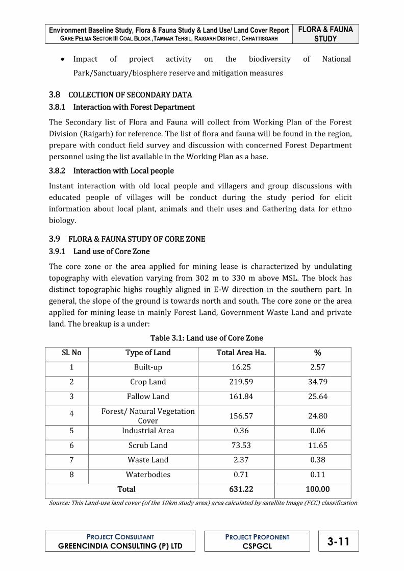
FLORA & FAUNA STUDY
Environment Baseline Study, Flora & Fauna Study & Land Use/ Land Cover Report GARE PELMA SECTOR III COAL BLOCK ,TAMNAR TEHSIL, RAIGARH DISTRICT, CHHATTISGARH
PROJECT CONSULTANT
GREENCINDIA CONSULTING (P) LTD
PROJECT PROPONENT
CSPGCL 3-11
• Impact of project activity on the biodiversity of National
Park/Sanctuary/biosphere reserve and mitigation measures
3.8 COLLECTION OF SECONDARY DATA
3.8.1 Interaction with Forest Department
The Secondary list of Flora and Fauna will collect from Working Plan of the Forest
Division (Raigarh) for reference. The list of flora and fauna will be found in the region,
prepare with conduct field survey and discussion with concerned Forest Department
personnel using the list available in the Working Plan as a base.
3.8.2 Interaction with Local people
Instant interaction with old local people and villagers and group discussions with
educated people of villages will be conduct during the study period for elicit
information about local plant, animals and their uses and Gathering data for ethno
biology.
3.9 FLORA & FAUNA STUDY OF CORE ZONE
3.9.1 Land use of Core Zone
The core zone or the area applied for mining lease is characterized by undulating
topography with elevation varying from 302 m to 330 m above MSL. The block has
distinct topographic highs roughly aligned in E-W direction in the southern part. In
general, the slope of the ground is towards north and south. The core zone or the area
applied for mining lease in mainly Forest Land, Government Waste Land and private
land. The breakup is a under:
Table 3.1: Land use of Core Zone
Sl. No Type of Land Total Area Ha. %
1 Built-up 16.25 2.57
2 Crop Land 219.59 34.79
3 Fallow Land 161.84 25.64
4 Forest/ Natural Vegetation Cover
156.57 24.80
5 Industrial Area 0.36 0.06
6 Scrub Land 73.53 11.65
7 Waste Land 2.37 0.38
8 Waterbodies 0.71 0.11
Total 631.22 100.00
Source: This Land-use land cover (of the 10km study area) area calculated by satellite Image (FCC) classification

FLORA & FAUNA STUDY
Environment Baseline Study, Flora & Fauna Study & Land Use/ Land Cover Report GARE PELMA SECTOR III COAL BLOCK ,TAMNAR TEHSIL, RAIGARH DISTRICT, CHHATTISGARH
PROJECT CONSULTANT
GREENCINDIA CONSULTING (P) LTD
PROJECT PROPONENT
CSPGCL 3-12
3.9.2 The Revenue lands
The revenue land consists of mostly the cultivated land. The cultivated lands are of two
types:
i. Upland
ii. Low land
I. Upland Cultivated Land
Up lands are cultivated only during the rainy months thus have only one crop. These
areas are generally near the village settlements. After rainy months these area
generally, lie fallow, exposed to some level of wind erosion. At some of the places with
irrigation facility some Rabi crops, mostly as vegetables, are raised on these uplands.
Crops cultivated on uplands as kharif crop include:
Table 3.2: Cultivated Crops in Core Zone Sl Local Name English name Botanical Name
A. Cerels 1 Dhan Paddy Oryza sativa 2 Makka Maize Zea mays
B. Pulses and oil 1 Arhar Pigeon pea Cajanus cajan 2 Til Sesamum Sesamum inicum 3 Kulthi Horse-gram Dolochos biflorus 4 Kusum Safflower Carthemus tinctorius 5 Urd Black gram Phaeolus mungo 6 Mungphali Ground nut Arachis hypogea
D. Vegetables 1 Tamatar Tomato Lycopersicum esculantum 2 Baigan Brinjal Solanum melongena 3 Bhindi Lady’s finger Abelmoschus esculentus 4 Barbatti Cowpea Vignainensis/unguiculatoo 5 Karela Bitter gourd Momordica charantia 6 Torai Ridge gourd Luffa acutangula 7 Kaddu Pumpkin Cucurbita moschata 8 Gilki Sponge gourd Luffa cylindrica 9 Palak Beet Beta vulgaris
10 Lalbhaji Amaranth Amaranthus spp. 11 Rakhia Kaddu White Gourd Benincasa hispida 12 Kundru - Coccinia grandis 13 Khira Cucumber Cucumis sativus 14 Lauki Bottle gourd Lagenaria siceraria 15 Chichinda Snake gourd Trichosanthes anguina 16 Ghuiyan Pichigi Colocasia esculenta 17 Dhaniya Coriander Coriandrum sativum
Source: Field Study by Greencindia Consulting Private Limited

FLORA & FAUNA STUDY
Environment Baseline Study, Flora & Fauna Study & Land Use/ Land Cover Report GARE PELMA SECTOR III COAL BLOCK ,TAMNAR TEHSIL, RAIGARH DISTRICT, CHHATTISGARH
PROJECT CONSULTANT
GREENCINDIA CONSULTING (P) LTD
PROJECT PROPONENT
CSPGCL 3-13
II. Low Land Cultivated Land
Low lands in the core zone are all un-irrigated land. Only a single crop of rice is raised
on these lands as a raifed crop. For almost eight months in a year these areas lie fallow.
Movement of cattle is a common feature in this area, scrapping any growing edible
plants on these areas. In addition to the cultivated crop many species of herbaceous
weeds make their appearance from late monsoon months to the end of winter months.
However, all the plants die with the approach of summer months and these areas are
totally devoid of any plant life during the summer months.
3.9.2.1 Chhote Jhad ka Jungle (Forest with smaller plants)
This is area categorized as forest only because it is in the possession of Forest
department. It includes an area of 24.442 ha constituting 3.88 percent of Core Zone.
The area is open grazing land. Some scattered bushes of tenu (Diuospyros
melanoxylon) are present here and there. Some isolated trees of Mahua may also be
observed in the area as the sole representative of forest trees. Barring the perennial
tendu bushes, vegetation in the form of herbs, is present in the area only during rainy
months.
3.9.2.2 Bade Jhad ka Jungle (Forest with larger trees):
An area of 8.183 ha is included under Bade Jhad ka Jungle constituting 1.30 percent of
the Core Zone.
3.9.2.3 Forest Land
An area of 165.102 ha, Reserve Forest 114.028 18.11 %, Protected Forest 25.585
(4.06) & Orange Area 25.489 Ha (4.05 %) are included under Forest Land constituting
26.23 percent of the Core Zone. The Forest area is under following compartments
Table 3.3: Details of Forest Compartment
Source: GP III Land schedule
S.N. Division Range Compartmen
t No. Forest Name
Category Of Forest
Area (In Ha.)
1
Raigarh
Tamnar
721 Silot RF 41.00
2 722 Silot RF 73.28
3 730 Milupara PF 5.40
4 743 Khamariya PF 4.20
5 738 Karwahi PF 15.98
6 733 Bhalwahidongri(A) OA 18.78
7 734 Bhalwahidongri(B) OA 3.12
8 735 Bhalwahidongri(C) OA 0.27
9 736 Bhalwahidongri(D) OA 1.35
10 737 Bhalwahidngri(E) OA 1.95
Total 165.10

FLORA & FAUNA STUDY
Environment Baseline Study, Flora & Fauna Study & Land Use/ Land Cover Report GARE PELMA SECTOR III COAL BLOCK ,TAMNAR TEHSIL, RAIGARH DISTRICT, CHHATTISGARH
PROJECT CONSULTANT
GREENCINDIA CONSULTING (P) LTD
PROJECT PROPONENT
CSPGCL 3-14
3.10 STUDY AREA
The study area included of core zone. Three study sites were selected on the basis of
forests, species richness and direction of the area: The details of phytosociological sam-
pling locations are shown in Table 3.4.
Table 3.4.: Phytosociological sampling locations
Code Name of Study Site Latitude (N) Longitude (E) Direction of
Block
Site-1 Karwahi reserve
Forest (738) 220 11 ’34.0 . 830 9’ 34.05 South
Site-2 Silot Reserve forest
(721) 220 11 ’10.4 830 8’ 53.19
Northe
West
Site-3 Silot Reserve Forest
(722) 220 10 ’46. 9 830 30’ 1.11 East
3.11 FLORA STUDY IN THE CORE ZONE
Shorea Robasta, Mahuca indica, Termanilia tomentosa etc. are as common species in the
study and command area of the region. Phytosociological characters of the study area
have been calculated for selected forest communities of the area.
3.11.1 Trees
Site wise phytosociological attributes of trees are given in Table 3.5 to Table 3.7. Tree
species in the Site-1 showed a total density of 1970.00 plants/ha with total basal cover

FLORA & FAUNA STUDY
Environment Baseline Study, Flora & Fauna Study & Land Use/ Land Cover Report GARE PELMA SECTOR III COAL BLOCK ,TAMNAR TEHSIL, RAIGARH DISTRICT, CHHATTISGARH
PROJECT CONSULTANT
GREENCINDIA CONSULTING (P) LTD
PROJECT PROPONENT
CSPGCL 3-15
(TBC) value of 309.06 m2/ha. The highest density was recorded for Shorea robusta,
Madhuca indica, and Terminallia tomentosa. Importance Value Index (IVI) was also
calculated for all species. Shorea robusta, revealed highest IVI (60.36) and emerged as a
dominant tree species. The co-dominant species of the site is Madhuca indica,
Terminallia tomentosa, Bridelia retusa, and Pongamia pinnata. The least dominant
species of the site is Anogeissus latifolia.
Table 3.5: Site I (Tree)– Compartment No 738 (Karwahi Protected Forest)
Botanical Name
Quadrates (10X10
m)
To
tal
Pla
nts
Fre
qu
en
cy
(%)
Ab
un
da
nce
De
nsi
ty
(Pla
nts
/h
a)
TB
C
(m2/
ha
)
Imp
ort
an
ce
Va
lue
In
de
x
1 2 3 4 5 6 7 8 9 1 0
Madhuca indica 5 3 4 0 2 0 4 4 0 4 26 70 3.7 1
260 88.4
1 53.8
7
Shorea robusta 3 7 6 9 5 6 3 5 0 2 46 90 5.1 1
460 66.4
2 60.3
6
Terminallia tomentosa
4 3 1 3 3 2 2 1 0 0 19 80 2.3 8
190 27.4
3 32.3
1
Bridelia retusa 2 3 0 3 2 3 1 2 0 0 16 70 2.2 9
160 29.3
0 29.6
7
Pongamia pinnata 0 3 4 2 0 4 0 0 8 0 21 60 3.5 0
210 23.1
5 28.4
9
Gmelina arborea 0 0 2 0 0 2 1 2 3 5 15 50 3.0 0
150 16.6
3 21.6
1
Careya arborea 0 0 0 0 3 5 2 0 5 4 19 50 3.8 0
190 14.0
4 22.8
1
Diospyros melanoxylon
0 0 0 0 0 4 2 3 3 0 12 40 3.0 0
120 29.2
6 22.4
5
Boswellia serrata 0 0 0 0 0 0 0 2 4 3 9 30 3.0 0
90 6.82 11.9
5
Semecarpus anacurdium
0 0 0 0 0 0 0 0 3 4 7 20 3.5 0
70 4.41 8.43
Anogeissus latifolia 0 0 0 0 0 0 0 0 4 3 7 20 3.5 0
70 3.22 8.04
197 580
197 0
Dominance of the site (Simpson Index) = 0.12
Diversity of the site (Shannon Weiner Index) = 0.99
Similarly, Site-2 and Site-3, are dominated by Shorea robusta, Madhuca indica,
Buchanania lanzan and Terminallia tomentosa with IVI values 47.46, 40.41, 27.27,
35.60, 36.69 and 21.59 respectively. Least dominant species in these sites are Albizzia
procera, Salmalia malabarica, Anogeissus latifolia, Dalbergia latifolia, Boswellia serrata
and Lagerstroemia parviflora.

FLORA & FAUNA STUDY
Environment Baseline Study, Flora & Fauna Study & Land Use/ Land Cover Report GARE PELMA SECTOR III COAL BLOCK ,TAMNAR TEHSIL, RAIGARH DISTRICT, CHHATTISGARH
PROJECT CONSULTANT
GREENCINDIA CONSULTING (P) LTD
PROJECT PROPONENT
CSPGCL 3-16
Table 3.6: Site II (Tree) - Compartment No 721 (Silot Reserve forest)
Botanical Name
Quadrates (10X10
m)
To
tal
Pla
nts
Fre
qu
en
cy
(%)
Ab
un
da
nce
De
nsi
ty
(Pla
nts
/h
a)
TB
C
(m2/
ha
)
Imp
ort
an
ce
Va
lue
In
de
x
1 2 3 4 5 6 7 8 9 1 0
Shorea robusta 8 5 6 4 6 2 0 1 3 0 35 80 4.3
8 350
29.7
5
47.4
6
Buchanania lanzan 4 4 3 0 4 0 0 1 0 1 17 60 2.8
3 170
16.3
8
27.2
7
Terminallia tomentosa
2 3 4 0 0 0 2 0 2 0 13 50 2.6
0 130
12.7
5
21.5
9
Acacia catechu 1 0 5 3 0 0 2 1 0 0 12 50 2.4
0 120
11.8
4
20.5
3
Garuga pinnata 0 2 2 2 0 0 1 0 2 1 10 60 1.6
7 100 5.53
17.3
2
Gmelina arborea 0 0 5 2 3 3 1 0 0 2 16 60 2.6
7 160
11.1
0
23.7
0
Madhuca indica 0 0 3 3 5 4 3 0 2 0 20 60 3.3
3 200
34.2
5
39.1
2
Diospyros melanoxylon
0 0 0 5 3 5 0 2 0 0 15 40 3.7
5 150
23.4
1
27.3
0
Bridelia retusa 0 0 0 0 0 5 0 3 1 1 10 40 2.5
0 100 9.63
16.7
3
Anogeissus latifolia 0 0 0 0 0 5 0 2 0 0 7 20 3.5
0 70 4.41 9.20
Azadirachta indica 0 0 0 0 0 5 2 3 0 0 10 30 3.3
3 100 4.60
12.3
7
Butea monosperma 0 0 0 0 0 0 2 0 2 2 6 30 2.0
0 60 2.76 9.19
Pterocarpus marsupium
0 0 0 0 0 0 3 1 0 1 5 30 1.6
7 50 2.30 8.39
Semecarpus anacurdium
0 0 0 0 0 0 0 2 0 1 3 20 1.5
0 30 1.38 5.33
Adina cordifilia 0 0 0 0 0 0 0 0 2 2 4 20 2.0
0 40 1.84 6.12
Albizzia procera 0 0 0 0 0 0 0 0 2 0 2 10 2.0
0 20 0.92 3.06
Salmalia malabarica 0 0 0 0 0 0 0 0 1 2 3 20 1.5
0 30 1.38 5.33
Total 188 680 188

FLORA & FAUNA STUDY
Environment Baseline Study, Flora & Fauna Study & Land Use/ Land Cover Report GARE PELMA SECTOR III COAL BLOCK ,TAMNAR TEHSIL, RAIGARH DISTRICT, CHHATTISGARH
PROJECT CONSULTANT
GREENCINDIA CONSULTING (P) LTD
PROJECT PROPONENT
CSPGCL 3-17
0
Dominance of the site (Simpson Index) = 0.089
Diversity of the site (Shannon Weiner Index) = 1.12
Table 3.7: Site III (Tree) - Compartment No 722 (Silot Reserve forest)
Botanical Name
Quadrates (10X10
m)
To
tal
Pla
nts
Fre
qu
en
cy
(%)
Ab
un
da
nce
De
nsi
ty
(Pla
nts
/h
a)
TB
C
(m2
/h
a)
Imp
ort
an
ce
Va
lue
In
de
x
1
2
3
4
5
6
7
8
9
1 0
Terminallia tomentosa
4 1 0 2 3 0 0 0 1 0 11 50 2.2
0 110
10.6
0
19.1
8
Shorea robusta 3 7 0 0 4 5 3 0 2 3 27 70 3.8
6 270
22.9
5
38.4
9
Madhuca indica 4 5 5 1 0 3 2 0 0 2 22 70 3.1
4 220
32.7
2
41.8
2
Gmelina arborea 2 5 4 0 0 1 2 0 0 1 15 60 2.5
0 150
12.3
4
23.8
0
Diospyros melanoxylon
1 3 2 0 1 1 3 1 1 0 13 80 1.6
3 130 5.77
21.0
6
Terminalia chebula 0 2 3 3 2 2 0 1 1 0 14 70 2.0
0 140
13.4
9
25.2
2
Adina cordifilia 0 0 3 2 2 3 0 0 0 0 10 40 2.5
0 100
12.6
4
18.6
4
Azadirachta indica 0 0 1 0 0 0 1 0 0 2 4 30 1.3
3 40
13.6
5
14.6
4
Terminaliya arjuna 0 0 2 2 1 2 0 0 0 0 7 40 1.7
5 70 8.48
14.3
4
Butea monosperma 0 0 0 2 2 0 0 1 0 0 5 30 1.6
7 50 3.15 8.59
Cleistanthus collinus
0 0 0 3 1 0 2 0 0 1 7 40 1.7
5 70 3.22
11.0
2
Ailanthus excels 0 0 0 1 2 0 2 0 0 0 5 30 1.6
7 50 2.30 8.05
Semecarpus anacurdium
0 0 0 0 0 2 2 2 0 0 6 30 2.0
0 60 2.76 8.91

FLORA & FAUNA STUDY
Environment Baseline Study, Flora & Fauna Study & Land Use/ Land Cover Report GARE PELMA SECTOR III COAL BLOCK ,TAMNAR TEHSIL, RAIGARH DISTRICT, CHHATTISGARH
PROJECT CONSULTANT
GREENCINDIA CONSULTING (P) LTD
PROJECT PROPONENT
CSPGCL 3-18
Aegle marmelos 0 0 0 0 0 0 2 0 1 1 4 30 1.3
3 40 1.84 7.20

FLORA & FAUNA STUDY
Environment Baseline Study, Flora & Fauna Study & Land Use/ Land Cover Report GARE PELMA SECTOR III COAL BLOCK ,TAMNAR TEHSIL, RAIGARH DISTRICT, CHHATTISGARH
PROJECT CONSULTANT
GREENCINDIA CONSULTING (P) LTD
PROJECT PROPONENT
CSPGCL 3-19
Pometia pinnata 0 0 0 0 0 0 1 5 2 0 8 30 2.6
7 80 3.68
10.6
1
Buchanania lanzan 0 0 0 0 0 0 0 2 0 1 3 20 1.5
0 30 1.38 5.09
Pterocarpus marsupium
0 0 0 0 0 0 0 3 1 0 4 20 2.0
0 40 1.84 5.94
Lagerstroemia parviflora
0 0 0 0 0 0 0 4 0 0 4 10 4.0
0 40 1.84 4.67
Anogeissus latifolia 0 0 0 0 0 0 0 0 3 0 3 10 3.0
0 30 1.38 3.82
Dalbergia latifolia 0 0 0 0 0 0 0 0 2 1 3 20 1.5
0 30 1.38 5.09
Boswellia serrata 0 0 0 0 0 0 0 0 0 3 3 10 3.0
0 30 1.38 3.82
Total 17 8
79
0
178
0 790
Dominance of the site (Simpson Index) = 0.074
Diversity of the site (Shannon Weiner Index) = 1.16
3.11.2 Shrubs
The shrub species at the forest floor are observed as Andrographis paniculata, Mucuna
prurita Asparagus racemosus Carissa carandus Ziziphus spp, Carissa spp and Calotropis
gigantea. The result of phytosociological characters was determined by calculating
frequency, density, importance value index, dominance and diversity of the selected
stands. The details of the phytosociological attributes are given in following Table 3.8 to
3.10.
Table 3.8: Site I (Shrubs) – Compartment No 738 (Karwahi Protected Forest)
Botanical Name
Quadrates (5X5 m)
To
tal
Pla
nts
F
req
ue
ncy
(%
)
Ab
un
da
nce
De
nsi
ty
(Pla
nts
/h
a)
TB
C (
m2/
ha
)
Imp
ort
an
ce
Va
lue
In
de
x
1
2
3
4
5
6
7
8
9
1 0
Andrographis paniculata
8 5 0 7 7 5 0 7 0 3 42 7 0
6.0 0
877.8 0
9.40 54.0
5
Asparagus racemosus
7 9 7 0 5 6 0 0 6 0 40 7 0
5.7 1
836.0 0
13.4 8
60.9 3

FLORA & FAUNA STUDY
Environment Baseline Study, Flora & Fauna Study & Land Use/ Land Cover Report GARE PELMA SECTOR III COAL BLOCK ,TAMNAR TEHSIL, RAIGARH DISTRICT, CHHATTISGARH
PROJECT CONSULTANT
GREENCINDIA CONSULTING (P) LTD
PROJECT PROPONENT
CSPGCL 3-20
Carissa carandus 3 6 5 5 6 0 4 3 5 6 43 9 0
4.7 8
898.7 0
10.5 1
61.2 2

FLORA & FAUNA STUDY
Environment Baseline Study, Flora & Fauna Study & Land Use/ Land Cover Report GARE PELMA SECTOR III COAL BLOCK ,TAMNAR TEHSIL, RAIGARH DISTRICT, CHHATTISGARH
PROJECT CONSULTANT
GREENCINDIA CONSULTING (P) LTD
PROJECT PROPONENT
CSPGCL 3-21
Croton oblongifolius
0 3 3 3 0 0 8 4 0 0 21 6 0
3.5 0
438.9 0
5.32 33.8
9
Zizyphus oenophile 0 0 5 6 0 3 5 5 6 0 30 6 0
5.0 0
627.0 0
6.12 39.7
4
Vitex negundo 0 0 0 4 0 0 3 2 3 2 14 5 0
2.8 0
292.6 0
3.73 25.2
2
Solanum nigram 0 0 0 0 0 0 0 5 3 5 13 3 0
4.3 3
271.7 0
2.22 17.2
9
Rauwolfia 0 0 0 0 0 0 0 0 0 6 6 1 0
6.0 0
125.4 0
1.32 7.67
20 9
4 4 0
4368.
10 52.0
8
Dominance of the site (Simpson Index) = 0.159
Diversity of the site (Shannon Weiner Index) = 0.83
Table 3.9: Site II (Shrubs)- Compartment No 721 (Silot Reserve forest)
Botanical Name
Quadrates (5X5 m)
To
tal
Pla
nts
Fre
qu
en
cy
(%)
Ab
un
da
nce
De
nsi
ty
(Pla
nts
/h
a)
T
BC
(m
2/
ha
)
Imp
ort
an
ce
Va
lue
In
de
x
1
2
3
4
5
6
7
8
9
1 0
Zizyphus oenophile
4 3 2 0 4 3 3 0 2 1 22 80 2.75 343.
2 1.89 48
36.8 35
Abrus precatorius 3 0 1 0 4 4 1 0 0 1 14 60 2.33
218. 4
2.13 01
28.7 71
Mucuna prurita 4 3 5 5 1 2 0 0 2 0 22 70 3.14 343.
2 4.37
2 44.5 13
Carissa carandus
3 4 3 0 1 3 0 2 1 0 17 80 2.12 265.
2 2.73 65
36.8 91
Croton oblongifolius
0 3 0 4 0 0 0 5 0 0 12 30 4 187.
2 1.00 75
17.3 69
Solanum nigram
0 0 4 3 0 4 2 3 2 3 21 50 4.2 327.
6 5.20 38
43.2 5
Smilax macrophylla
0 0 0 4 2 0 3 0 3 1 13 30 4.33 202.
8 2.62 67
24.2 86
Cynodon dactylon
0 0 0 0 0 5 2 3 1 0 11 40 2.75 171.
6 2.80 78
25.6 28
Imperata cylindrica
0 0 0 0 0 3 5 4 0 0 12 30 4 187.
2 1.82 58
20.5 4
Cuscuta reflexa 0 0 0 0 0 0 0 2 3 1 6 30 2 93.6 0.62 67
12.0 46
Butea superba 0 0 0 0 0 0 0 3 0 3 6 20 3 93.6 0.57 04
9.90 42
15 6
52 0
34.6 3
2433 .6
25.8 02
300. 03

FLORA & FAUNA STUDY
Environment Baseline Study, Flora & Fauna Study & Land Use/ Land Cover Report GARE PELMA SECTOR III COAL BLOCK ,TAMNAR TEHSIL, RAIGARH DISTRICT, CHHATTISGARH
PROJECT CONSULTANT
GREENCINDIA CONSULTING (P) LTD
PROJECT PROPONENT
CSPGCL 3-22
Dominance of the site (Simpson Index) = 0.104

FLORA & FAUNA STUDY
Environment Baseline Study, Flora & Fauna Study & Land Use/ Land Cover Report GARE PELMA SECTOR III COAL BLOCK ,TAMNAR TEHSIL, RAIGARH DISTRICT, CHHATTISGARH
PROJECT CONSULTANT
GREENCINDIA CONSULTING (P) LTD
PROJECT PROPONENT
CSPGCL 3-23
Table 3.10: Site III (Shrubs) - Compartment No 722 (Silot Reserve forest)
Botanical Name
Quadrates (5X5 m)
To
tal
Pla
nts
Fre
qu
en
cy
(%)
Ab
un
da
nce
De
nsi
ty
(Pla
nts
/h
a)
TB
C (
m2/
ha
)
Imp
ort
an
ce
Va
lue
In
de
x
1
2
3
4
5
6
7
8
9
1 0
Albizia lebbeck 2 2 0 4 0 0 3 4 3 0 18 60 3.00 270.0
0 1.49
29.2 5
Eugenia sp 4 3 3 0 5 1 2 0 5 0 23 70 3.29 345.0
0 3.36
42.5 9
Bombax ceiba 2 2 3 0 2 0 1 4 0 0 14 60 2.33 210.0
0 2.68
31.7 8
Sterculia urens 3 1 2 3 0 1 0 5 2 3 20 80 2.50 300.0
0 3.10
41.2 0
Madhuca latifolia
0 2 0 4 3 6 2 3 0 0 20 60 3.33 300.0
0 1.61
31.1 3
Buchanania lanzan
0 0 1 3 0 3 2 1 0 4 14 60 2.33 210.0
0 3.34
34.6 8
Melia azadirach
0 0 0 0 3 5 0 1 0 3 12 40 3.00 180.0
0 2.33
25.3 7
Cordia myxa 0 0 0 0 0 2 2 0 3 4 11 40 2.75 165.0
0 2.70
26.3 2
Rubbia cordifolia
0 0 0 0 0 3 1 1 1 0 6 40 1.50 90.00 0.88 14.9
9
Lannea grandis
0 0 0 0 0 0 0 0 3 3 6 20 3.00 90.00 0.60 10.2
1
Zizyphus xylopyrus 0 0 0 0 0 0 0 0 1 2 3 20 1.50 45.00 0.27 6.77
Murraya exotica
0 0 0 0 0 0 0 0 3 0 3 10 3.00 45.00 0.44 5.71
15 0
56 0
31.5 4
2250. 00
22.8 0
300. 01
Dominance of the site (Simpson Index) = 0.010
Diversity of the site (Shannon Weiner Index) = 1.01
3.12 FAUNA IN THE CORE ZONE
The terrestrial fauna includes common invertebrates and vertebrates. Wild fauna
species like Bear, Fox and Jackal were reported to be more common than other animal
species in the area. The major aquatic fauna are fishes, amphibians and water snakes.
The list of faunal species is given below:
Diversity of the site (Shannon Weiner Index) = 1.007

FLORA & FAUNA STUDY
Environment Baseline Study, Flora & Fauna Study & Land Use/ Land Cover Report GARE PELMA SECTOR III COAL BLOCK ,TAMNAR TEHSIL, RAIGARH DISTRICT, CHHATTISGARH
PROJECT CONSULTANT
GREENCINDIA CONSULTING (P) LTD
PROJECT PROPONENT
CSPGCL 3-24
3.12.1 Mammals
Table 3.11: List of Mammals in Core Zone
S.N
Local Name
English Name
Zoological Name
Status WL(Protection) Act 1972
Schedule Part 1 Siyar Jackal Canis aureus II II 2 Bhalu Sloth bear Melursus ursinus I I 3 Kharaha Indian hare Lepus ruficaudatus IV -
4 Gilhari squirrel Funambulus
pennanti IV -
5 Chamgadad fruit bat Cynopterus sphinx V -
6 Chooha Field rat Bandicota
benghalensis V -
7 Lomadi Indian fox Vulpus benghalensis II II 8 Bandar Monkey Macaca mulatta III -
9 Neola Mangoose Herpetes edwardsi IV - 10 Hurra Hyaena Hyaena hyaena III -
11 Langoor Common langur Semnopithecus
entellus II I
12 Chital Spotted dear Axis axis III - 13 Jangali billi Jungle cat Felis chaus II II 14 Jangalisuar Wid boar Sus scrofa III - 15 Sahi Porcupine Hystrix indica IV -
Source: Field Study by Greencindia Consulting Private Limited& Discussion with local people,Forest officials
3.12.2 Avifauna
Table 3.12: List of Birds in Core Zone
S. N English Name Zoological Name Status WL
(Protection) Act, 1972
1 House crow Corvrus splendens V 2 Comman myna Acridotheris tristis IV
3 Brahminy myna Sturnus pagodrum IV 4 Pied myna Sturnus contra IV 5 Black drongo Dicrurus adsimilis IV 6 Spotted dove Streptopelia chinensis IV
7 Blue jay Coracias benghalensis IV
8 Parakeet Psittacutla krameri IV
9 Little Green Bee-
Eater Merops orientalis IV
10 Koel, Cuckoo Eudynamys scolopaicea IV 11 Phakhta Streptopelia chinensis IV
12 Jangali Kaua Corvus macrorhynchos V 13 Jangali Tota Taccocua leschenaultia IV
14 Tania Tota Psittacula cyanocephala IV 15 Tota Psittacula krameri IV
16 Neelkanth Coracias benghalensis IV

FLORA & FAUNA STUDY
Environment Baseline Study, Flora & Fauna Study & Land Use/ Land Cover Report GARE PELMA SECTOR III COAL BLOCK ,TAMNAR TEHSIL, RAIGARH DISTRICT, CHHATTISGARH
PROJECT CONSULTANT
GREENCINDIA CONSULTING (P) LTD
PROJECT PROPONENT
CSPGCL 3-25
17 Bater (Grey Quail) Coturnix coturnix IV

FLORA & FAUNA STUDY
Environment Baseline Study, Flora & Fauna Study & Land Use/ Land Cover Report GARE PELMA SECTOR III COAL BLOCK ,TAMNAR TEHSIL, RAIGARH DISTRICT, CHHATTISGARH
PROJECT CONSULTANT
GREENCINDIA CONSULTING (P) LTD
PROJECT PROPONENT
CSPGCL 3-26
S. N English Name Zoological Name Status WL
(Protection) Act, 1972
18 Basanti (Indian
cuckoo) Cuculus micropterus IV
19 Kite Milvus migrans IV 20 Peafowl Pavo cristatus I
21 Redwhiskered
bulbul Pycnonotus jocosus IV
22 Besra Sparrow-
Hawk Accipiter vigratus IV
23 Paddy Bird/Pond
Bird Ardeola grayii IV
24 Small Blue Kingfisher
Alcido atthis IV
25 Scaup Duck Aythya marila IV 26 Common Hoopoe Epupa epops IV
Source: Field Study by Greencindia Consulting Private Limited& Discussion with local people, Forest officials
3.12.3 Reptiles
Table 3.13: List of Reptiles in Core Zone
S. N
Local Name
Zoological Name
Status WL(Protection) Act 1972
Schedule Part
1 Dhaman/Indian Rat snake Ptyas mucosus II II
2 Dhondwa/Water sanke Enhydris enhydris IV - 3 Nag/Cobra Naja naja II II 4 Common Karait Bungarus caeruleus IV - 5 Russel viper Vipera ruselli II II 6 Sita Ki Lath Amphiesma stolata - - 7 Girgit (Garden lizard) Calotes versicolor - -
Source: Field Study by Greencindia Consulting Private Limited& Discussion with local people, Forest officials
3.12.4 Amphibia
Table 3.14: List of Amphibia in Core Zone
S.N
Local Name
English Name
Zoological Name
Status WL(Protection) Act 1972
Schedule Part
1 Mendhak Bull frog Hoplobatrachus
tigerinus IV -
2 Mendhak Common toads Duttaphrynus melanostictus IV -
3 Mendhak Skipper frog Euphlyctis
cyanophlyctis IV -
4 Mendkak Small frog Microhyla ornata IV -

FLORA & FAUNA STUDY
Environment Baseline Study, Flora & Fauna Study & Land Use/ Land Cover Report GARE PELMA SECTOR III COAL BLOCK ,TAMNAR TEHSIL, RAIGARH DISTRICT, CHHATTISGARH
PROJECT CONSULTANT
GREENCINDIA CONSULTING (P) LTD
PROJECT PROPONENT
CSPGCL 3-27
5 Mendhak Tree frog Polypedates maculatus
IV -

FLORA & FAUNA STUDY
Environment Baseline Study, Flora & Fauna Study & Land Use/ Land Cover Report GARE PELMA SECTOR III COAL BLOCK ,TAMNAR TEHSIL, RAIGARH DISTRICT, CHHATTISGARH
PROJECT CONSULTANT
GREENCINDIA CONSULTING (P) LTD
PROJECT PROPONENT
CSPGCL 3-28
Source: Field Study by Greencindia Consulting Private Limited& Discussion with local people
3.12.5 Spiders and insects
Table 3.15: List of Spider & Insects in Core Zone
Sl Name Zoological Name
1 Hunting spider Pisarua mirabills
2 House spider Tegenaria domestica
3 Hair Dragonfly Brachytron pratense
4 Emperor Dragonfly Anax imperator
5 Grasshoppers -
6 Common Green Tettigonia viridissima
7 Rice grasshopper Hieroglyphus. Banian
8 Common painted Grasshopper Pecilocerus pictus
9 Paddy Jassids Nephotettix apicalis
10 Skeletonizers Hyblea purea mechaerales
11 Defoliators Hepalia mauritia
12 Swarming caterpillar Spodoptera mauritia
13 Ant lion Myrmeleo sp.
14 Scolopender Scolopendra morsitans
15 Praying mantid Sphoromantis lineola
16 Common stick insect Carausius morosus
17 Cockroach Blatta orientalis
18 American cockroach Periplanata americana
19 Firefly Aracnocampa sp.
Source: Field Study by Greenc India Consulting Private Limited& Discussion with local people, Forest officials
3.12.6 Butterfly
More than 20 species of butterfly have been recorded from the applied mining lease area.
Thirteen of them have been identified clearly as given below:
Table 316: List of Butterfly in Core Zone
Sl. No. Zoological Name
1 Acraea viola
2 Eurema andersoni
3 Eurema brigitta
4 Eurema laeta
5 Euthalia nais
6 Gandeca harina
7 Hypolimnas bolina

FLORA & FAUNA STUDY
Environment Baseline Study, Flora & Fauna Study & Land Use/ Land Cover Report GARE PELMA SECTOR III COAL BLOCK ,TAMNAR TEHSIL, RAIGARH DISTRICT, CHHATTISGARH
PROJECT CONSULTANT
GREENCINDIA CONSULTING (P) LTD
PROJECT PROPONENT
CSPGCL 3-29
8 Hypolimnos misippus
9 Junonia lemonias
10 Junonia orithiya
11 Neptis hylas
12 Phalanta phalantha
13 Tanaecia lepidea
Source: Field Study by Greenc India Consulting Private Limited& Discussion with local people, Forest officials
3.13 FLORA & FAUNA STUDY OF BUFFER ZONE
3.13.1 Land use of the Buffer Zone
The land cover in the buffer zone is also similar to the core zone. Tree density is much
reduced in the forest. Significant decrease in the density of larger trees particularly of
timber value like Bija is unfortunate. Similarly, the Aonla trees have almost
disappeared from the forest. Mahua trees in the orange area as well as in the forest
near the villages are prominent because they are the only trees left uncut with their
large crown. Sal trees of higher girth have become very rare. This is all due to illegal
cutting of the trees. Herb layer in the forest have mostly the species tolerant to grazing
and trampling. Most of the medicinal herbs have become rare and some of them like
Kaliyari have disappeared from the area. The list of medicinal plants includes the
herbaceous species like: Adiantum lunulatum, Asparagus racemosus, Celastrus
paniculata, Curculigo orchioides, Dioscorea bulbifera, Diplocyclos palmatus, Elephan
topus scaber, Evolvulus alsinoides, Hemidesmus indicus, Spilanthus calva and
Tephrosia purpurea and small tree species like Holarrhaena antidysenterica. Much
reduced abundance of Andrographis paniculata, the forest exhibit clear cut impact of
anth ropogenic factors like illegal cutting of trees, unsustainable removal of medicinal
plants and unchecked cattle grazing.
Buffer zone within 10 km radius from the applied lease area, on the basis of satellite
imagery interpretation consists of more than 41% of Forest Land while agriculture land
about 25.62% of the area.
Table 3.17: Land Use Details of Buffer Zone (Based on Satellite Imagery Interpretation)
Sl LU/LC Class Area in Ha. %
1 Built-up 778.79 1.61
2 Crop Land 12,369.39 25.62

FLORA & FAUNA STUDY
Environment Baseline Study, Flora & Fauna Study & Land Use/ Land Cover Report GARE PELMA SECTOR III COAL BLOCK ,TAMNAR TEHSIL, RAIGARH DISTRICT, CHHATTISGARH
PROJECT CONSULTANT
GREENCINDIA CONSULTING (P) LTD
PROJECT PROPONENT
CSPGCL 3-30
3 Fallow Land 8,053.51 16.68
4 Forest/ Natural Vegetation Cover 20,213.09 41.87
5 Industrial Area 566.18 1.17
6 Mining Area 1,468.80 3.04
7 Scrub Land 4,148.93 8.59
8 Waste Land 458.86 0.95
9 Waterbodies 218.73 0.45
Total Area in Ha. 48,276.28 100.00
Source: This Land-use land cover (of the 10km study area) area calculated by satellite Image (FCC) classification
Generally, a single crop, mostly the rice, is grown in the cultivated land in the rainy
season. Then the cultivated lands generally lie fallow for almost 8 months in a year.
Dense forest area is dominated by sal. The forests are at different stages of growth
depending upon the period after the area has been extracted. Selective removal of trees
of timber value like sal (Shorea robusta), bija (Pterocarpus marsupium), gamhar
(Gmelina arborea) etc. has converted the areas in to open forest. Further removal of
other trees like dhawra (Anogeissus latifolia) saja (Terminalia tomentosa) tendu
(Diospyros melanoxylon) etc. converts the area in to scrub land. These areas are
dominated by species with good coppicing ability or species multiplying with root
suckers like Senha (Lagerstroemia parviflora), tendu (Diospyros melanoxylon) and
dudhi (Wrightia tinctoria). Out of these destructions mahua (Madhuca latifolia) is the
only tree saved from scathing. Trees of mahua, left uncut, grow in to large trees with
bulbos crown. Scattered presence of the tree gives savanna like appearance to the
totally denuded, revenue forest areas, particularly surrounding the village settlements.
Due to this and also due to the ponds, generally surrounded by large trees of bargad
(Ficus benghalensis) and peepal (Ficus religiosa), occasionally with mango trees,
village settlements can be recognized from great distances. Elephant is emerging as
one of the causes for the destruction of crops. However, the hanuman langur, neola and
parrot have also been reported to be even more important in eating away and
destroying the crops, than the elephants. Hanuman langur has emerged in recent year
to be a great nucence and has become vermin not only due to destruction of the crop,
but because it causes damages to the houses by moving on the earthen tiled roofs.
There are some refugee settlements of migrants from Bangladesh (East Pakistan).

FLORA & FAUNA STUDY
Environment Baseline Study, Flora & Fauna Study & Land Use/ Land Cover Report GARE PELMA SECTOR III COAL BLOCK ,TAMNAR TEHSIL, RAIGARH DISTRICT, CHHATTISGARH
PROJECT CONSULTANT
GREENCINDIA CONSULTING (P) LTD
PROJECT PROPONENT
CSPGCL 3-31
These people cultivate tadi palm (Borassus flabellifer) and Chhind (Phoenix sylvestris)
for extracting tadi (the stem sap flow), for which these Bengali migrants have special
liking.
3.13.2 Forest Area in Buffer Zone
There are many Protected Forests within the 15 km radius area around the project site.
However, there are no National Parks, Wildlife Sanctuaries etc. within the 15-km area.
The environmental sensitive locations including forests and water bodies are given in
Table 3.18 & 3.19.
Table 3.18: Protected (PF), Reserve forests (RF) and Orange area (OA) in Buffer zone
Sl. Compartmen
t No. Division
Forest Range
Name of Forest Category of forest
Area (ha)
Direction
Forest in 0 - 2.5 km Radius
1 713 Raigarh Tamnar Silot RF 184.292 N
2 714 Raigarh Tamnar Silot RF 212.511 N
3 715 Raigarh Tamnar Silot RF 154.501 N
4 718 Raigarh Tamnar Silot RF 181.419 N
5 719 Raigarh Tamnar Silot RF 168.522 N
6 720 Raigarh Tamnar Silot RF 199.748 N
7 724 Raigarh Tamnar Silot RF 233.266 N
8 725 Raigarh Tamnar Silot RF 450.52 N
9 726 P Raigarh Tamnar Kharra PF 7.207 N
10 727 P Raigarh Tamnar - PF 9.813 N
11 728 P Raigarh Tamnar - PF 10.254 N
12 729 P Raigarh Tamnar Chhapedongri PF 4.797 N
13 731 P Raigarh Tamnar Kolam PF 16.897 W
14 735 OA Raigarh Tamnar Bhalwahidongri(C) OA 2.817 N
15 740 Raigarh Tamnar Mudgaon RF 13.154 S
16 741 P Raigarh Tamnar Saraitola PF 16.488 S
17 742 P Raigarh Tamnar Gare PF 53.888 S
18 746 P Raigarh Tamnar Lalpur PF 23.898 N
19 747 P Raigarh Tamnar Koylar PF 20.590 N
20 778 Raigarh Tamnar Tolge Purva RF 446.038 E
21 779 Raigarh Tamnar Tolge Purva RF 327.926 E
22 782 Raigarh Tamnar Tolge Purva RF 300.768 E
23 783 Raigarh Tamnar Tolge Purva RF 241.772 E
24 784 Raigarh Tamnar Tolge Purva RF 881.267 E
25 785 P Raigarh Tamnar - PF 74.887 E
26 787 P Raigarh Tamnar Konrkel PF 28.592 E
Forest in 2.5-5 km Radius
1 709 Raigarh Tamnar Silot RF 163.209 NW

FLORA & FAUNA STUDY
Environment Baseline Study, Flora & Fauna Study & Land Use/ Land Cover Report GARE PELMA SECTOR III COAL BLOCK ,TAMNAR TEHSIL, RAIGARH DISTRICT, CHHATTISGARH
PROJECT CONSULTANT
GREENCINDIA CONSULTING (P) LTD
PROJECT PROPONENT
CSPGCL 3-32
Sl. Compartmen
t No. Division
Forest Range
Name of Forest Category of forest
Area (ha)
Direction
2 710 Raigarh Tamnar Silot RF 137.462 NW
3 711 Raigarh Tamnar Silot RF 189.521 N
4 712 Raigarh Tamnar Silot RF 196.287 NW
5 716 Raigarh Tamnar Silot RF 116.394 N
6 717 Raigarh Tamnar Silot RF 90.375 N
7 744 P Raigarh Tamnar Pata PF 30.698 S
8 748 P Raigarh Tamnar Jaridih PF 18.994 N
9 749 P Raigarh Tamnar Hinjhor PF 51.970 N
10 750 P Raigarh Tamnar Sabjula PF 23.643 N
11 751 P Raigarh Tamnar Pelma PF 14.815 N
12 752 P Raigarh Tamnar Pandrikhol PF 16.763 N
13 755 P Raigarh Tamnar Semijar PF 19.036 E
14 756 P Raigarh Tamnar Murgapahar PF 15.728 E
15 757 P Raigarh Tamnar Tendu PF 11.086 E
16 765 Raigarh Tamnar Tolge Paschim RF 229.78 N
17 767 Raigarh Tamnar Tolge Purva RF 195.729 N
18 768 Raigarh Tamnar Tolge Purva RF 224.277 E
19 774 Raigarh Tamnar Tolge Purva RF - ES
20 775 Raigarh Tamnar Tolge Purva RF 346.267 ES
21 776 Raigarh Tamnar Tolge Purva RF 179.668 ES
22 777 Raigarh Tamnar Tolge Purva RF 243.678 ES
23 780 Raigarh Tamnar Tolge Purva RF 164.502 E
24 781 Raigarh Tamnar Tolge Purva RF 249.221 E
25 786 P Raigarh Tamnar Khamhariya RF 21.206 E
26 788 P Raigarh Tamnar Lamdarha RF 60.728 SE
27 789 P Raigarh Tamnar Dongamauha RF 118.837 SE
28 860 OA Raigarh Tamnar Kathauatikra OA 37.593 W
29 1352 Raigarh Gharghoda Deodogri RF 273.489 N
30 1361 P Raigarh Gharghoda Sukta Dongri PF 38.852 N
31 1362 P Raigarh Gharghoda Naya Rampur PF 42.116 N
32 1363 OA Raigarh Gharghoda Nayadih OA 11.936 N
33 1364 P Raigarh Gharghoda Lapda PF 42.069 N
Forest in 5 - 10 Km Radius
1 745 P Raigarh Tamnar Kelo PF 123.920 S
2 753 P Raigarh Tamnar Urba PF 7.342 N
3 754 P Raigarh Tamnar Deodogari PF 23.817 N
4 758 Raigarh Tamnar Tolge Paschim RF 288.392 N
5 759 Raigarh Tamnar Tolge Paschim RF 175.686 N
6 760 Raigarh Tamnar Tolge Paschim RF 213.012 N
7 761 Raigarh Tamnar Tolge Paschim RF 298.179 N
8 762 Raigarh Tamnar Tolge Paschim RF 204.743 N
9 763 Raigarh Tamnar Tolge Paschim RF 255.218 N

FLORA & FAUNA STUDY
Environment Baseline Study, Flora & Fauna Study & Land Use/ Land Cover Report GARE PELMA SECTOR III COAL BLOCK ,TAMNAR TEHSIL, RAIGARH DISTRICT, CHHATTISGARH
PROJECT CONSULTANT
GREENCINDIA CONSULTING (P) LTD
PROJECT PROPONENT
CSPGCL 3-33
Sl. Compartmen
t No. Division
Forest Range
Name of Forest Category of forest
Area (ha)
Direction
10 764 Raigarh Tamnar Tolge Paschim RF 323.315 N
11 766 Raigarh Tamnar Tolge Purva RF 212.81 N
12 769 Raigarh Tamnar Tolge Purva RF 347.056 E
13 770 Raigarh Tamnar Tolge Purva RF 265.716 E
14 771 Raigarh Tamnar Tolge Purva RF 444.683 ES
15 772 Raigarh Tamnar Tolge Purva RF 270.552 ES
16 773 Raigarh Tamnar Tolge Purva RF - ES
17 790 P Raigarh Tamnar Beljar PF 7.146 SE
18 791 P Raigarh Tamnar Tapranga PF 36.434 SE
19 792 P Raigarh Tamnar Janjgir PF 31.945 SE
20 793 P Raigarh Tamnar Bendra PF 59.346 SE
21 794 P Raigarh Tamnar Bajarmuda PF 33.470 SE
22 795 P Raigarh Tamnar Dakshin,
Dongamauha PF
26.794 S
23 796 P Raigarh Tamnar Dhaurabhantha PF 25.034 S
24 858 P Raigarh Tamnar Jhariyapali PF 56.942 W
25 859 OA Raigarh Tamnar Banai OA OA 6.905 W
26 861 P Raigarh Tamnar Banai PF 29.598 W
27 862 P Raigarh Tamnar Kerakhol PF 31.686 W
28 863 P Raigarh Tamnar Dongri PF 18.908 W
29 864 P Raigarh Tamnar Auraimuda PF 116.567 W
30 1335 OA Raigarh Gharghoda - OA - WN
31 1345 OA Raigarh Gharghoda Chanadongri OA 88.562 N
32 1346 OA Raigarh Gharghoda Mukhurmuda OA 57.772 N
33 1347 P Raigarh Gharghoda Bartangar PF 58.383 N
34 1348 P Raigarh Gharghoda Bichhinara PF 14.793 N
35 1349 P Raigarh Gharghoda Kharra Dongri PF 35.76 N
36 1350 OA Raigarh Gharghoda Kudhurmahua OA 23.826 N
37 1351 P Raigarh Gharghoda Kudhurmahua PF 24.211 N
38 1353 OA Raigarh Gharghoda Tilaipali OA 30.164 N
39 1354 P Raigarh Gharghoda Tal PF 17.45 N
40 1355 P Raigarh Gharghoda Ranmuda PF 29.246 N
41 1356 P Raigarh Gharghoda Bichhinar PF 12.933 N
42 1357 P Raigarh Gharghoda Jamjhor PF 52.597 N
43 1358 OA Raigarh Gharghoda Salhepatra OA 34.398 N
44 1359 P Raigarh Gharghoda Bagdhari PF 9.774 NW
45 1360 OA Raigarh Gharghoda Raikera OA 41.911 NW
46 321 Dharamjaigarh Lailunga - RF - N
47 322 Dharamjaigarh Lailunga - RF - N
48 323 Dharamjaigarh Lailunga - RF - N
49 324 Dharamjaigarh Lailunga - RF - N
50 325 Dharamjaigarh Lailunga - RF - N

FLORA & FAUNA STUDY
Environment Baseline Study, Flora & Fauna Study & Land Use/ Land Cover Report GARE PELMA SECTOR III COAL BLOCK ,TAMNAR TEHSIL, RAIGARH DISTRICT, CHHATTISGARH
PROJECT CONSULTANT
GREENCINDIA CONSULTING (P) LTD
PROJECT PROPONENT
CSPGCL 3-34
Sl. Compartmen
t No. Division
Forest Range
Name of Forest Category of forest
Area (ha)
Direction
51 331 P Dharamjaigarh Lailunga - PF - NE
52 332 P Dharamjaigarh Lailunga - PF - NE
53 333 P Dharamjaigarh Lailunga - PF - NE
54 334 P Dharamjaigarh Lailunga - PF - NE
55 335 P Dharamjaigarh Lailunga - PF - NE
56 336 P Dharamjaigarh Lailunga - PF - NE
57 337 P Dharamjaigarh Lailunga - PF - NE
58 338 P Dharamjaigarh Lailunga - PF - NE
59 339 P Dharamjaigarh Lailunga - PF - NE
60 341 Dharamjaigarh Lailunga - RF - NE
61 342 Dharamjaigarh Lailunga - RF - NE
62 343 Dharamjaigarh Lailunga - RF - NE
63 344 Dharamjaigarh Lailunga - RF - NE
64 345 Dharamjaigarh Lailunga - RF - NE
65 347 Dharamjaigarh Lailunga - RF - NE
66 348 Dharamjaigarh Lailunga - RF - NE
Source: Forest Copartment Record & Map of Raigarh & Dharmayjaygarh Division
Note: OA=Orange Area, PF = Protected Forest, RF = Reserve Forest
Table No 3.19: Strems/Rivers in Buffer Zone
Sl Name of water Stream Distance
From Project Site
Direction from Project Site
1 Kelo River Within Core Zone Extreme East
2 Pajhar Nala 5.5 West
3 Digi Nala 6 West
3.14 PLANT SPECIES RECORDED FROM THE BUFFER AREA
It is difficult to prepare an exhaustive list of all the species of plants, particularly the
herbs, from any sizable area. It may run in to at least 200 to 300 species. However, with
the following mentioned species of trees, shrubs and herbs, some other trees shrubs
and herbs were recorded from the core zone as well as from the buffer zone. A list of
the same is being given below:
3.14.1 Tree Species
Table 3.20: Tree Species in Buffer Zone
S. No. Vernacular/Local Name English Name Scientific Name
1 Akol Alangium salvifolium Cornaceae
2 Achar, Char Buchanania lanzan Anacardiaceae
3 Arjun, Kahu, Kauha Terminaliya arjuna Combretaceae

FLORA & FAUNA STUDY
Environment Baseline Study, Flora & Fauna Study & Land Use/ Land Cover Report GARE PELMA SECTOR III COAL BLOCK ,TAMNAR TEHSIL, RAIGARH DISTRICT, CHHATTISGARH
PROJECT CONSULTANT
GREENCINDIA CONSULTING (P) LTD
PROJECT PROPONENT
CSPGCL 3-35
S. No. Vernacular/Local Name English Name Scientific Name
4 Anjan Hardwickia binate Leguminosae
5 Amta Bauhiniya malabarica Leguminosae
6 Amaltaas Cassia fistula Leguminosae
7 Asta, Astara, Bosa Bauhiniya racemosa Leguminosae
8 Aam Mangifera indica Anacardiaceae
9 Aanola Emblica officinalis Euphorbiaceae
10 Imli Tamarindus indica Leguminosae
11 Kakai, Gorghati Flacourtia indica Bixaceae
12 Kachnar Bauhinia variegate Leguminosae
13 Karchi, Dudhi Holarrhena antidysenterica
Apocynaceae
14 Kathjamun Eugenia heyneana myrtaceae
15 Kasai, Saja Bridelia retusa Euphorbiaceae
16 Karanj, Karanji pongamia pinnata Leguminosae
17 Kari, Homba Miliusa tomentosa Anonaceae
18 Kalasiras Albizzia lebbek Leguminosae
19 Kali Dudhi Wrightia tomentosa Apocynaceae
20 Kumbhi Careya arborea Myrtaceae
21 Kullu Sterculia urens Streculiaceae
22 Kusum Scleichera oleosa Sapindaceae
23 Keolar Bauhinia purpurea Leguminosae
24 Kekad, Kekar Garuga pinnata Burseraceae
25 Kem, Mundi Mitragyna parviflora Rubiaceae
26 Khatua, Katma Antidesma diandrum Euphorbiaceae
27 Khirni Mimusops hexandra Sapotaceae
28 Khair Acacia catechu Leguminosae
29 Khamer Gmelina arborea Verbenaceae
30 Galgala Cochlosperium religiosu Bixaceae
31 Gilchi, Girchi Casearia graveolens Samydaceae
32 Gursukri Grewia hirsuta Tiliaceae
33 Gular Ficus glomerata Moraceae
34 Ghot,Ghatol Zizyphus xylopyra Rhamnaceae
35 Chichwa, Muyar Albizzia odortissima Leguminosae
36 Chirol Holoptelea integriflolia Ulmaceae
37 Chuna Zizyphus rugosa Rhamnaceae
38 Lamraci, Arn Elaeodendron glaucum Celastraceae
39 Jamun Syzygium cumini Myrtaceae
40 Jhingar, Moyan, Gunja Lannea coromandelica Anacardiaceae
41 Tinsa Ougeinia oojeinensis Leguminosae
42 Tendu Diospyros melanoxylon Ebenacea

FLORA & FAUNA STUDY
Environment Baseline Study, Flora & Fauna Study & Land Use/ Land Cover Report GARE PELMA SECTOR III COAL BLOCK ,TAMNAR TEHSIL, RAIGARH DISTRICT, CHHATTISGARH
PROJECT CONSULTANT
GREENCINDIA CONSULTING (P) LTD
PROJECT PROPONENT
CSPGCL 3-36
S. No. Vernacular/Local Name English Name Scientific Name
43 Dhur, Vrihar Euphorbia neriifolia Euphorbiaceae
44 Dudhi Wrightia tinctoria Apocynaceae
45 Dahiwas Cordia macleodii Boraginaceae
46 Dhobin Dalbergia paniculata Leguminosae
47 Dhaman Grewia tiliaefolia Tiliaceae
48 Dhaura Anogeissus latifolia Combretaceae
49 Neem Azadirachta indica Meliaceae
50 Tondri Casearia tomentosa Samydaceae
51 Palas Butea monosperma Leguminosae
52 Panjra, Gadhapalash Erythrina suberosa Leguminosae
53 Pakar Ficus infectoria Moraceae
54 Papda, Papra Gardenia latifolia Rubiaceae
55 Peepal Ficus religiosa Moraceae
56 Pula, Baranga kydia calycina Malvaceae
57 Feda, Kharhar Gardenia turgida Rubiaceae
58 Bad Ficus bengalensis Moraceae
59 Baheda Terminalia bellerica Combretaceae
60 Beeja Pterocarpus marsupium Leguminosae
61 Chhind, Kuchhachhind Phoenix acaulis Palmae
62 Bel Aegle marmelos Rutaceae
63 Ber, Bor Zizyphus mauritiana Rhamnaceae
64 Bhanwarsal, Bhormal Hymenodictyon excelsu m rubiaceae
65 Bhirra chloroxylon swietenia Meliaceae
66 Bhilwa, Beewa Semecarpus anacurdium Anacardiaceae
67 Madhukamini Murraya paniculata Rutaceae
68 Mahanim Ailanthus excels Simarubaceae
69 Mahua Madhuca indica Sapotaceae
70 Medsing Dolichandrone falcate Bignoniaceae
71 Mokha Schrebera swietceioides Oleaceae
72 Rekwa, Hiwar Acacia leucophloea Leguminosae
73 Roli, Sinduri Mallotus philippinensis Euphorbiaceae
74 Rohan, Rohni Soymida febrifuga Meliaceae
75 Harra Terminalia chebula Combretaceae
76 Haldu Adina cordifilia Rubiaceae
77 Hingot, Hingan Balanites aegyptiaca Simarubaceae
78 Shisham Dalbergia latifolia Leguminosae
79 Safed Siris Albizzia procera Leguminosae
80 Sagaun, Saag Tectona grandis Verbenaceae
81 Saaja Terminallia tomentosa Combretaceae
82 Saal Shorea robusta Depterocarpaceae

FLORA & FAUNA STUDY
Environment Baseline Study, Flora & Fauna Study & Land Use/ Land Cover Report GARE PELMA SECTOR III COAL BLOCK ,TAMNAR TEHSIL, RAIGARH DISTRICT, CHHATTISGARH
PROJECT CONSULTANT
GREENCINDIA CONSULTING (P) LTD
PROJECT PROPONENT
CSPGCL 3-37
S. No. Vernacular/Local Name English Name Scientific Name
83 Salai Boswellia serrata Burseraceae
84 Sitafal, Sharifa Anona squamosa Anonaceae
85 Senha, Lendiya Lagerstroemia parviflora Lythraceae
86 Semal Salmalia malabarica Malvaceae Source: (i) Forest Working Plan, Raigarh Division (ii) Field visit by GCPL (iii) Discussion with local people & officials
3.14.2 Climbers Species
Table 3.21: Climbers in Buffer Zone
S. No. Vernacular/Local Name English Name Scientific Name
1 Amarbel Cuscuta reflexa Convolvulaceae 2 Anantmul Hemidesmus indicus Asclepiadaceae 3 Irni, Churni Zizyphus Mugosa Rhamanaceae 4 Kaddu, Kand Dioscorea Bulbifera Dioscoreaceae 5 Karbel, Nagbel Cryptolepis buchanani Asclepiadaceae 6 Kakad Bel, Keksi Momordica diodica Cucurbitaceae 7 Kiwach, Kanchkuri Mucuna prurita Leguminosae 8 Kewati Ventilago calyculata Rhamanaceae 9 Khairbel, Kalibel Ventilago madraspatana Rhamanaceae
10 Gumchi, Gunj, Ratti Abrus precatorius Leguminosae 11 Gurar, Gaaj Milletia auriculata Leguminosae 12 Chameli jasminum arborescens Oleaceae 13 Chilati(Chhoti) Acacia pennata Mimoseae 14 Chilati(Badi) Acacia caesia Mimoseae 15 Dhimarbel, Chhorising Ichnocarpus frutescens Apocynaceae 16 Dokar Bel Spatholibus parrsflorus Leguminosae 17 Dudhi, Dudhbel Vallaris solanacea Apocynaceae 18 Nashbel, Mola Butea parviflora Leguminosae 19 Bechandi Dioscorea hispida Dioscoreaceae 20 Palas Bel, Bodal Butea superb Leguminosae 21 Pipar Bel, Faig Conbretum decandrum Combretaceae 22 Mahul, Maljhan Bauhinia vahlii Leguminosae 23 Malkangni, Faig Celastrus paniculata Celastraceae 24 Morbel Clematis triloba Ranunculaceae 25 Ramdataun Smilax macrophylla Liliaceae 26 Shikakai Acacia rugata Leguminosae 27 Satawar, Dashmoor Asparagas racemusos Liliaceae 28 Hadjodi Cissus quadrangularis Ampelidaceae
Source: (i) Forest Working Plan, Raigarh Division (ii) Field visit by GCPL (iii) Discussion with local people & officials
3.14.3 Herbs and Shrubs
Table 3.22: Herbs and Shrubs in Buffer Zone
S. No. Vernacular/Local Name English Name Scientific Name 1 Aak, Madwar Calotropis gigantea Asclepiadaceae

FLORA & FAUNA STUDY
Environment Baseline Study, Flora & Fauna Study & Land Use/ Land Cover Report GARE PELMA SECTOR III COAL BLOCK ,TAMNAR TEHSIL, RAIGARH DISTRICT, CHHATTISGARH
PROJECT CONSULTANT
GREENCINDIA CONSULTING (P) LTD
PROJECT PROPONENT
CSPGCL 3-38
S. No. Vernacular/Local Name English Name Scientific Name
2 Aak Calotropis procera Asclepiadaceae 3 Archid Vanda parviflora Orchidaceae 4 Uat Katara Echinops echinatus Compositeae 5 Aethi, Marodfalli Helicteres isora Streculiaceae 6 Kalabansa, Bandar Colebrookea oppositiflolia Labiateae 7 Karauda Carissa Spinarum Apocynaceae 8 Kathmular Ficus hispida Moraceae 9 Kharata, Gursukadi Grewia hirsute Tiliaceae
10 Kharata, Jungli mehandi Dodonaea viscose Sapondaceae 11 Gajar Parthenium hysterophorus Compositeae 12 Gokhru, Sarata Tribulus terrestris Zygophyllaceae 13 Gokhru Acanthospermum hispidum Zygophyllaceae 14 Gokhru Xanthium strumarium Compositeae 15 Chirayta Andropogon paniculata Palmae 16 Chirota, Tarvar Cassia tora Laguminosae 17 Chitavar, Chitrak Plumbago zeylanica Plumbaginaceae 18 Chind, Chui Phoenix acaulis Palmae 19 Jungli Baingan Solanum nigrum Solaneceae 20 JUngli Kela Ensete superbum Musaceae 21 Jungli Tilli Sesamum orientale Pedaliaceae 22 Jungli Tulsi ERanthemum purpurascents Acanthaceae 23 Jungli San Crotalaria psectabilis Leguminosae 24 Bhau Tamarix diocia Tamaricaceae 25 Tulsi Ocimum sanctum Labiateae 26 Dikamali, Kurru Gardenia Lucida Rubiaceae 27 Dhatura (white) Datura stramonium Solanaceae 28 Dhatura (black) Datura metel Solanaceae 29 Dhavai Woodfordia fruiticosa Lythraceaee 30 Nagfani Opuntia elator Cactaceae 31 Nirgud Vitex negundo Verbenaceae 32 Neel, Girgoli Indigofera tinctoria Leguminosae 33 Tigerclow, Bichhuacha Martynia annua Peda liaceae 34 Dodhra, Adhoda Achymthes aspera Amarantaceae 35 Bansuli Grewia rolhii Tiliaceae 36 Bodhi Eriolanea hookariana Steoulinaceae 37 Ban kapas Thespesia lampas Malvaceae 38 Ber Zizyphus jijuba Rhamnaceae 39 Bhandar, Bhaat Clerodendron viscosum Verbenaceae 40 Bhuvar, Vor, Vruhar Euphorbia neriifolia Euphorbiaceae 41 Makoy Zizyphus oenoplia Rhamnaceae 42 Martona Carvia callosa Acanthaceae 43 Madhukamini Murrata paniculata Rutaceae 44 Mehandi Lawsonia inermis Lythraceae
45 Mainar Catunaregam spinosa Rubiaceae

FLORA & FAUNA STUDY
Environment Baseline Study, Flora & Fauna Study & Land Use/ Land Cover Report GARE PELMA SECTOR III COAL BLOCK ,TAMNAR TEHSIL, RAIGARH DISTRICT, CHHATTISGARH
PROJECT CONSULTANT
GREENCINDIA CONSULTING (P) LTD
PROJECT PROPONENT
CSPGCL 3-39
S. No. Vernacular/Local Name English Name Scientific Name
46 Munga Moringa oleifora Moringaceae 47 Raimunia, Laitana Lantana camara Verbenaceae 48 Ratanjyot, Ranijhar Jatropha curcas Euphorbiaceae 49 Lipti, Lapti, Chikati Desmodium latifolium Leguminosae 50 Vaybanding Embelia prericottam Myrsinaceae 51 Vaikal Maytenus senegulensis Celastraceae 52 Van Tulsi Hyptis suaveolens Labiateae 53 Beshram, Sadabahar Ipomoea carnea Convolvulaceae 54 Siparkata, Pila, dhatura Argemone Mexicana Papaverceae 55 Sisal Agave sislana Agave veaece 56 Hathiakand Leea macrophylla - 57 Harisingar, Kharsali Nyctanthes arbortrisis Oleaceae Source: (i) Forest Working Plan, Raigarh Division (ii) Field visit by GCPL (iii) Discussion with local people & officials
3.14.4 Grasses and Bamboos
Table 3.23: Grasses and Bamboos in Buffer Zone
S. No. Vernacular/Local Name English Name Scientific Name 1 Anjan, Kus Cenchrus cliaris Gramineae 2 Kail, Marbel Dichanthium annulatum Gramineae 3 Katabahari, Bhod Aristida setaceae Gramineae 4 Karabahari, Gagru Coix gigantean Gramineae 5 Kolia Sitaria glauca Gramineae 6 Kaans Saccharum apontanuem Gramineae 7 Kushal, Sukal Heterpogon contortus Gramineae 8 Khas Vetiveria Ziznioides Gramineae 9 Gunher (bhusar sirra) Themeda quadrivalvis Gramineae 10 Chir (Chirbahari) Imeperata cylindrical Gramineae 11 Ponai, Poki falli Apluda mutica Gramineae 12 Ponia Schima sulcatum Gramineae 13 Phoolbahari Arundinella setose Gramineae 14 Bans Dendrocalamus strictus Gramineae 15 Baru Sorghum halepense Gramineae 16 Bhurbhusi Erodonagrostis tenella Gramineae 17 Merkel Bothriochloa pertusa Gramineae 18 Moya Pennisetum alopecures Gramineae 19 Mushan, Muchel Iseilema laxum Gramineae 20 Munj Saccharum munja Gramineae 21 Dinanath Pennisetum pedicellatum Gramineae 22 Dub Cynodon dactylon Gramineae 23 Rusa Cymbopogon martini Gramineae 24 Sabai, Bagai Eulaliopsis binata Gramineae 25 Senar Sehima nervosum Gramineae 26 Selria, Kill Digitaria sanguinalis Gramineae Source: (i) Forest Working Plan, Raigarh Division (ii) Field visit by GCPL (iii) Discussion with local people & officials

FLORA & FAUNA STUDY
Environment Baseline Study, Flora & Fauna Study & Land Use/ Land Cover Report GARE PELMA SECTOR III COAL BLOCK ,TAMNAR TEHSIL, RAIGARH DISTRICT, CHHATTISGARH
PROJECT CONSULTANT
GREENCINDIA CONSULTING (P) LTD
PROJECT PROPONENT
CSPGCL 3-40
3.14.5 Epiphytes, Parasites and Other
Table 3.24: Epiphytes, Parasites and Other in Buffer Zone
S. No. Vernacular/Local Name English Name Scientific Name
1 Amar bel Cuscuta reflexa Convolvulaceae 2 Ankid Vanda parviflora Orchidaceae 3 Bada, Badra Dendrophthoe Loranthaceae 4 Badra Viscum articulatum Loranthaceae 5 Katang Baas Bambusa arundincea Graminaceae 6 Tand Borassus flabelliefer Convovlaceae
Source: (i) Forest Working Plan, Raigarh Division (ii) Field visit by GCPL (iii) Discussion with local people & officials
3.14.6 Cultivated Plants
Table 3.25: Cultivated Plants in Buffer Zone
S. No. Local Name English Name Scientific Name
A. Cereals & Millets
1 Dhan Paddy Oryza sativa
2 Makka Maize Zea mays
3 Gehu Wheat Triticum sp.
4 Sawa Millet Panicum miliare
5 Minjri, Madia Millet Eleucine coracana
6 Kutki Minor millet Panicum miliare
7 Kodo Minor millet Paspalun scrobiculatum
8 Jwar Millet Sorghun vulgare
9 Jau Barley Hordeum vulgare
B. Pulses and oil
1 Arandi Castor seed Ricinus cummunis
2 Alsi Linseed Linum usitatissimun
3 Arhar Pigeon pea Cajanus cajan
4 Til Sesamum Sesamum inicum
5 Kulthi Horse-gram Dolochos biflorus
6 Kusum Safflower Carthemus tinctorius
7 Urd Black gram Phaeolus mungo
8 Mung Mung gram Phaseolus radiates
9 Surajmukhi Sunflower Helianthus annus
10 Sarson Mustard Brassica campestris var. sarso
11 Matar Pea Pisum sativum
12 Mungphali Ground nut Arachis hypogea
C. Fruit

FLORA & FAUNA STUDY
Environment Baseline Study, Flora & Fauna Study & Land Use/ Land Cover Report GARE PELMA SECTOR III COAL BLOCK ,TAMNAR TEHSIL, RAIGARH DISTRICT, CHHATTISGARH
PROJECT CONSULTANT
GREENCINDIA CONSULTING (P) LTD
PROJECT PROPONENT
CSPGCL 3-41
1 Kela Banana Musa paradisiaca
2 Aam Mango Mangifera indica
3 Nibbu Lime Citrus aurantifolia
4 Amrud Guava Psidium guajava
5 Papita Papaya Carica papaya
6 Kathal Jack-fruit Artocarpus heterophyllus
7 Seetaphal Custard-apple Annona squamosa
8 Ber Jujube Ziziphus mauritiana
D. Vegetables
1 Tamatar Tomato Lycopersicum esculantum
2 Baigan Brinjal Solanum melongena
3 Pattagovi Cabbage Brassica oleracea
4 Phulgovi Cauliflower Brassica oleracea
5 Ganthgovi Knolkhol Brassica oleracea
6 Bhindi Lady’s finger Abelmoschus esculentus
7 Barbatti Cowpea Vignainensis/unguiculatoo
8 Aloo Potato Solanum tuberosum
9 Muli Radish Raphanus sativas,
10 Karela Bitter gourd Momordica charantia
11 Torai Ridge gourd Luffa acutangula
12 Kaddu Pumpkin Cucurbita moschata
13 Gilki Sponge gourd Luffa cylindrica
14 Palak Beet Beta vulgaris
15 Lalbhaji Amaranth Amaranthus spp.
16 Rakhia Kaddu White Gourd Benincasa hispida
17 Kundru - Coccinia grandis
18 Khira Cucumber Cucumis sativus
19 Lauki Bottle gourd Lagenaria siceraria
20 Chichinda Snake gourd Trichosanthes anguina
21 Ghuiyan Pichigi Colocasia esculenta
22 Lahson Garlic Allium sativum
23 Dhaniya Coriander Coriandrum sativum Source: (i) Forest Working Plan, Raigarh Division (ii) Field visit by GCPL (iii) Discussion with local people & officials
3.14.7 Ethnobiology (Medicinal Plants):
Almost every plant species has got some or the other medicinal value. Recognition of
medicinal value of a plant varies also from region to region. Due to unchecked cutting and

FLORA & FAUNA STUDY
Environment Baseline Study, Flora & Fauna Study & Land Use/ Land Cover Report GARE PELMA SECTOR III COAL BLOCK ,TAMNAR TEHSIL, RAIGARH DISTRICT, CHHATTISGARH
PROJECT CONSULTANT
GREENCINDIA CONSULTING (P) LTD
PROJECT PROPONENT
CSPGCL 3-42
removal, many of the useful plant species have either disappeared or have become
exceedingly scarce in the area. This is true also for the medicinal plants. Only a few plant
species, to be named as medicinal plants, are visible in the area, but with much reduced
density. These include the herbaceous species like: asparagus racemosus, celastrus
paniculata, curculigo orchioides, dioscorea bulbifera, diplocyclos palmatus, elephantopus
scaber, evolvulus alsinoides, hemidesmus indicus and tephrosia purpurea, and small tree
species like holarrhaena antidysenterica.
Table 3.26: Medicinal Plants in Buffer Zone
S. No
.
Common Name
Scientific name
Parts used
Ethnobotanical / medicinal uses
1. Ratti Abrus precatorius
Seed Snake bite, fiver
2.
Katha Acacia catechu Bark, Hard Wood, Juice, Leaf, Flower
Toothache, cough and cold, stomach pain, coloring, betel nut
3.
Babool
Acacia nilotica
Whole Plants, Flower
Jaundice, itching, worms, tooth ache, eye elements, cough, facial paralysis, easy delivery, asthma, fever, carpentry work
4.
Khoruch Achyranthes aspera
Root, Seed, Whole Plant
Snake bite, stomach pain, fever, hydrophobia, skin problem, cough
5.
Bach Acorus calamus
Rhizome, Leaves
Delayed delivery, Abdominal disorder, eye and skin problem, cough, piles
6. Adusa Adhatoda vasica
Leaves, Root, Whole Plant
Asthma, urinary problem, piles, cough,
7.
Bel
Aegle marmelos
Leaf, Root, Fruit, Stem, Juice,
Mouth ulcer, Piles, Headache, headache, fever, weakness, dysentery, cataract, chest seed pain, as gum
8.
Siris
Albizia lebbek
Root, Flower Seed, Bark, Stem, Root, Flower
Scorpion bite, migraine, piles, hydrocele, toothache, wound and cut, carpentry
9.
Gritkumari
Aleo vera
Leaves Cosmetics, burns, cut and wound, fracture, gastric, eye problem, Headache
10. Chaulai bhaji
Amaranthus virdis
Leaves Eye elements, blood purification, fodder
11. Akarkara/ akarkha
Anacyclus pyrethrum
Whole Plant Heart disease, paralysis, stomach problem, fever, tooth ache
12. Chota Andrographis Whole Plant Malarial fever, for feeding cattles

FLORA & FAUNA STUDY
Environment Baseline Study, Flora & Fauna Study & Land Use/ Land Cover Report GARE PELMA SECTOR III COAL BLOCK ,TAMNAR TEHSIL, RAIGARH DISTRICT, CHHATTISGARH
PROJECT CONSULTANT
GREENCINDIA CONSULTING (P) LTD
PROJECT PROPONENT
CSPGCL 3-43
S. No
.
Common Name
Scientific name
Parts used
Ethnobotanical / medicinal uses
chirayata paniculata
13. Bhuineem Andrograthis panculata
Whole Plants Joint pain, jaundice, head ache, malaria, anti helm-antic
14. Ramphal Annona reticulata
Fruit, Leaf, Seeds, Stem
Digestion, tumor, cancer, diabetes
15. Sitaphal, chitaphal
Annona squamosa
Leaves, Fruits, Bark
Intoxicating, edible, seeds in diabetic problems
16.
Pilikatere Argemone maxicana
Yellow Milk, Oil, Root, Bark, Leaf
Ring worm, abdominal pain, ulcer, jaundice, cough, asthma, male impotency
17.
Satawar
Asparagus racemosus
Whole Plant
Piles, fever, wound, anti-toxic, weakness, cough, diarrhoea , head ache, asthma, urinary disorder
18.
Neem
Azadirachta indica
Seed Oil, Bark, Leaf, Wood, Fruit
Heart problems, eczema, arthritis, white discharge, ear and tooth ache, malaria, anti- toxic and anti-microbial, tooth washing, furniture making, chicken pox, blood purification, cosmetics
19.
Baans, Bans
Bambusa arundinacea
Whole Plant
Wound healing, tuberculosis, bronchitis, Leprosy, food and fodder, feeding of cow after delivery, musical instruments
20. Kachnar Bauhinia variegata
Buds, Bark, Flower
Constipation, antiseptic, stomatitis, piles
21. Punarnava Boerhaavia diffusa
Whole Plant Kidney stone, arthritis
22.
Semar Bombax ceiba Bark, Fruit, Leaves
Piles, leprosy, anti-dote, medicinal cotton, anemia, liver and spleen disease
23. Chironji Buchanania lanzan
Seed, Leaf Applied on cut, wound and eczema
24.
Palas
Butea monosperma
Gum, Root, Seed, Flower
Night blindness, eye disorder, epilepsy, diarrhea, eczema, arthritis, abdominal worm, cataract, worship, dyes
25. Patharchtta Byophyllum pillatum
Leaf, Stem Antiseptic, cures kidney stone, skin disease, head ache
26. Aak/ Akwan
Caltropis procera
Fruit, Whole Plant
Cut and wound, leprosy, dropsy, rheumatic pain, asthma, bronchitis
27. Papita Carica papaya Leaf, Fruit, Seed, Latex
Liver enlargement, heart problem, piles, skin problem,

FLORA & FAUNA STUDY
Environment Baseline Study, Flora & Fauna Study & Land Use/ Land Cover Report GARE PELMA SECTOR III COAL BLOCK ,TAMNAR TEHSIL, RAIGARH DISTRICT, CHHATTISGARH
PROJECT CONSULTANT
GREENCINDIA CONSULTING (P) LTD
PROJECT PROPONENT
CSPGCL 3-44
S. No
.
Common Name
Scientific name
Parts used
Ethnobotanical / medicinal uses
cosmetics
28. Karonda Carissa carandus
Root, Fruit Anemia, constipation
29. Amaltas Cassia fistula Leaf, Root, Seed, Wood
Ring worm, wound, fever, leprosy, cough
30. Brahmi, Brahmni
Centella asitica
Leaf, Whole Plant
Insomnia, enhance memory, hair anxiety, b.p. problem, chicken pox
31. Safedmusli Chlorophytum tuberosum
Root Tuberculosis, male impotency, tonic
32. Sevanti Chrysanthemu m corinarium
Flower, Bark, Root
Purgative, anti helmantic, Cultural use
33.
Hadjor Cissus quadrangulari s
Stem
Fracture
34. Nimbu/lim bu
Citrus medica Fruit, Leaf, Root, Whole Plant
Throat disorder, constipation, antiseptic digestion, dandruff, fever, cough, juices
35. Kochai Colocasia esulenta
Leaves Corm Vegetable, constipation, weakness, alopecia
36. Keu Costus speciosus
Rhizome Liver related disease
37. Kalimusali Curculigo orchioides
Root Juice Dysentery
38.
Amarbel Cuscuta reflexa
Whole Plant
Conjunctivitis, respiratory disorder, piles, ulcer, stomach problem, swelling of eye
39.
Doobghas
Cynodon dactylon
Leaves, Whole Plants
Leucorrhoea, excessive pus formation, piles, epilepsy, nasal bleeding, cancer, eczema, eye and mouth problem, headache, urinary problem, paper making, fodder
40.
Shisham Dalbergia sissoo
Oil, Leave, Whole Plant
Skin disorder, toothache, eye aliments, burning sensation, carpentry work
41. Gulmohar Delonix regia Leaf, Flower, Wood
Skin trouble, coloring
42.
Dhatura Dhatura strumoniun
Leaves Whole Plant
Eye problem, asthma, arthritis, headache, male impotency, cultural use
43. Tendu Diospyros melanoxylon
Pulp, Fruit, Leaf Healing of crack feet, edible, bad breath, dysentery
44. Fern Dryopteris filixmas Rhizome Anthelmintic

FLORA & FAUNA STUDY
Environment Baseline Study, Flora & Fauna Study & Land Use/ Land Cover Report GARE PELMA SECTOR III COAL BLOCK ,TAMNAR TEHSIL, RAIGARH DISTRICT, CHHATTISGARH
PROJECT CONSULTANT
GREENCINDIA CONSULTING (P) LTD
PROJECT PROPONENT
CSPGCL 3-45
S. No
.
Common Name
Scientific name
Parts used
Ethnobotanical / medicinal uses
45.
Amla, aawla Emblica officinalis
Seed, Fruit, Leaf, Bark
Constipation, arthritis, fever, itching, digestive, hair fall, diabetes, eye and skin problem
46. Kari Erycibe panculata
Leaf Night blindness
47. Dudhi Euphorbia hirta Root, Leaf
Cough, dysentery, Anti - asthmatic, milk secretion, fodder
48. Shankhpus hpi
Evovulus alsinoides
Whole Plant Headache, brain tonic, vomiting, diabetes, weakness
49. Bargad Ficus benghalensis
Latex, Leaf, Bark, Root
Prevent loss of hair, pain killer in joint pain, diabetes
50. Gular Ficus glomerata
Fruit Milkey Latex
Diabetes, asthma, piles, urinary problem
51. Dumar Ficus racemosa
Leaf, Fruit, Milk, Root
Leucorrhoea, piles, Stomach pain, dysentery, fiver, ulcer
52.
Peepal
Ficus religiosa
Whole Plants, Letex
Eczema, toothache, leucorrhoea, cutand wound, earache, cough and cold, jaundice, stomach pain, fodder, worship
53.
Gamhar Gmelina arborea
Root, Flower, Fruit, Bark Leaf, Wood
Weakness, snake bite, anti-dote, cut and wound, carpentry construction work
54. Haldu Haldinia cordifolia
Root, Bark Pain killer, intestinal worms
55.
Gudhal Hibiscus rosa sinensis
Flower, Seed, Leaves, Root
Hair fall, cough and cold, male impotency, stomach pain, worship.
56.
Chameli Jasmminum grandiflorum
Leaf, Root, Flower, Oil
Ulcer, headache, mouth disease, impotency, skin disease, ear problem, worm, fever, perfume
57. Ratanjot Jatropha curcas
Seed Oil Rheumatic pain, night blindness
58.
Mehandi Lawsonia inermis
Seeds, Leaves, Root
Eye disorder, hair fall and coloring, burn, jaundice, headache, stomach problem
59. Mahua Madhuca latifolia
Flower, Whole Plant
Anti-bacterial, carpentry work, pain killer, wine/liquor, worship
60.
Aam
Mangifera indica
Fruit, Whole Plant, Seeds
Cough and cold, anti-dysenteric worm, furniture work, religious use, heat stroke, for pickles, carpentry
61.
Mahaneem Melia azadirachta
Fruit, Seed, Whole Plant
Stomatitis, internal worm, stone in urinary bladder, swelling, etching, fever, eye problem

FLORA & FAUNA STUDY
Environment Baseline Study, Flora & Fauna Study & Land Use/ Land Cover Report GARE PELMA SECTOR III COAL BLOCK ,TAMNAR TEHSIL, RAIGARH DISTRICT, CHHATTISGARH
PROJECT CONSULTANT
GREENCINDIA CONSULTING (P) LTD
PROJECT PROPONENT
CSPGCL 3-46
S. No
.
Common Name
Scientific name
Parts used
Ethnobotanical / medicinal uses
62.
Pudina Mentha spicata
Leaf
Gastro intestinal disorder, fever, cholera, skin problem, cough and cold, sauces
63.
Lajwanti Mimosa pudica
Leaves, Root
Piles, diarrhea, swelling, jaundice, excessive urination, indigestion
64. Munga Moringa oleifera
Fruit, Bark, Leaves, Root
Piles, cough, intestinal worm, Bp., gum problem, headache
65. Mitha neem patti
Murraya koenigii
Root, Leaf Treatment of anemia, vomiting, wound, hair loss
66. Harsringar Nyctanthes arbortristis Stem, Flower Fracture, worship,
67. Vantulsa/ bantulsi
Osmium basilicum
Leaves, Seed, Root,
Cough and cold, green tea, giddiness
68. Karanj Pangamia pinnata
Seed, Leaf Leucoderma, parasiticide, malaria
69. Tejraj Peucedanum nagpurense
Bark, Leaf Joint pain, sexual disorders
70. Masbandhi Porana paniculata
Root Joining the fractured bone, wound
71. Amrood,bih i
Psidium guajava
Fruit, Whole Plant
Joint pain, cough, heart ailment, toothache, dysentery, ulcer
72. Bija Pterocarpus marsupium
Wood, Bark, Leaf
Diabetes, diarrhea, constipation, coloring
73.
Aanar Punica grantum
Fruit Leaf, Whole Plant
heart problem, eye and ear disorder, tonic, migraine, jaundice, vomiting, piles, worm
74.
Aarandi Ricinus communis
Leaf, Seed
Seed oil in purgative, piles, joint pain, hair fall, skin disease, head ache
75.
Rose Rosa damascene
Root Leaf, Flower,
Cultural use, wounds, diarrhea, diabetes, skin infection, cosmetics
76. Sarpagandh a
Roulfia serpentine
Root, Bark Snake bite, bp. Control, joint pain, fever, malaria, ulcer
77. Agastiya Sesbania grandiflora
Flower, Leaf, Stem, Bark
Constipation, migraine, epilepsy, leucorrhoea, pain killer
78. Saal/ sarai Shorea robusta
Fruit, Seed, Whole Plant
Dysentery, anti-dote, Furniture
79.
Jamun
Syzygium cumini
Fruit, Bark, Seed, Leaf
Piles, diabetes, loose motion, eye and ear problem, Syphilis, vomiting, lever swelling, furniture
80. Imli Tamarindus indica
Leaves, Bark, Seeds, Wood
Scorpion bite, scabies, stomach pain, furniture

FLORA & FAUNA STUDY
Environment Baseline Study, Flora & Fauna Study & Land Use/ Land Cover Report GARE PELMA SECTOR III COAL BLOCK ,TAMNAR TEHSIL, RAIGARH DISTRICT, CHHATTISGARH
PROJECT CONSULTANT
GREENCINDIA CONSULTING (P) LTD
PROJECT PROPONENT
CSPGCL 3-47
S. No
.
Common Name
Scientific name
Parts used
Ethnobotanical / medicinal uses
81.
Sagon Tectona grandis
Whole Plant
Burning sensation, arthritis, kidney and skin disease, furniture, diabetes, ulcer
82. Kahua/Arju n
Terminalia arjuna
Bark Leaf Heart and liver disease
83. Harra Terminalia chebula Fruit and Bark Digestion, skin problem
84. Bankapas Thespesia populnea
Stem, Bark, Flower
Dog bite, making in fiber and paper
85. Kaner Thevetia peruviana
Leaf, Flower Worship, toothache, healing, cut and wound
86. Giloy Tinospora cardifalia
Whole Plant Piles, eye problem, fiver, jaundice, arthritis
87. Ashwagand ha
Withnania somnifera
Leaves, Root, Whole Plant
Cough, stimulant, arthritis, ulcer
88. Ber Zizyphus jujube
Fruit, Leaf, Bark, Stem
Ulcer, fever, wound, abdominal pain, asthma, vegetable
89. Bhirra Chloroxylon swietenia
- Tuberculosis
90. Tulsi Ocimum sanctum Leaf Fainting
91. Karrewa - Fruit, Root Tuberculosis
92. Rohan Soymida febrifuga
Bark Tuberculosis
93. Vishakhpar a
- Root wound
94. Ashok Saraca asoka Bark attack
95. Banrakas - Root Joint pain
96. Kokai Flacourtia ramontchii
Bark Diarrhea
97. Dhawai Woodfordia fruticosa
Flower Menstruation
98. Astibhang - Bark fracture
99. Sambarbha ng
- Seeds Chest pain
100 Alsi - Seeds Chest pain
101 Kala Jeera - Seeds stomach pain
102 Tejrai Peucedanum nagpurense
Bark, Leaf Joint pain, Sexual disorders
103 Shivling - Seeds Pregnancy
104 Gritkumari Aleo vera Leaf Headache

FLORA & FAUNA STUDY
Environment Baseline Study, Flora & Fauna Study & Land Use/ Land Cover Report GARE PELMA SECTOR III COAL BLOCK ,TAMNAR TEHSIL, RAIGARH DISTRICT, CHHATTISGARH
PROJECT CONSULTANT
GREENCINDIA CONSULTING (P) LTD
PROJECT PROPONENT
CSPGCL 3-48
S. No
.
Common Name
Scientific name
Parts used
Ethnobotanical / medicinal uses
105 Vat - Root Diarrhea
106 Chat (bad)
- Milk Piles
107 Jungli Bhindi
Thespesia lampas
Root -
108 Teen Pattiyan
- Root Migraine
109 Fafan - Root Cough
110 Chitawar - Root Itching
111 Kelkand - Tubers Headache
112 Path Koriya - Root fecal bile
113 Tauraha - Bark Cancer (Early stage)
114 Besharam - Leaf Skin problem
115 Bagnakha - Seeds Skin problem
116 Bade Dashmul
- Stem Tuberculosis
Source: (i) Forest Working Plan, Raigarh Division (ii) Field visit by GCPL (iii) Discussion with local people & officials
3.15 FAUNA IN THE BUFFER ZONE
Vegetation cover in the area is patchy with patches of cultivated fields, grasslands,
shrubby forest with low to medium density. Water channels are scanty and of seasonal
nature. However, the scarcity of water from late winter to the summer season is a
major problem to the wildlife for their survival. Therefore, the wildlife is attracted to
the village ponds for water resulting in man-animal conflicts. Wolf (Canislupus) Scaly
ant eater (Mannis crassicauda), peacock (Pavo cristatus) and sloth bear (Melursus
ursinus) are the schedule I animals. The sloth bear is a common visitor to the area. The
animal is nocturnal but sometimes dares to enter the village outskirts even during the
day time. It enters the village area for many types of food including the Gular (Ficus
glomarata), Sugarcane (Saccharum officinarum), and tuberous crop like the potato
(Solanum tuberosum). However more attractive to the village area to the bear is the
mahua (Madhuca latifolia) flower. Flowering period of this tree is generally the months
of March and April and so the frequency of visit of bear is more during these two
months. Some mammals like Jackal (Canis aureus) and Fox (Vulpusbenghalensis) are
more common, night visitors of the area. Frugivorous, five stripped squirrels
(Funambulus pennanti) is seen only during the fruiting seasons of the trees, while
trees, producing fruits to the liking of frugivorous bats (Cynopterussphinx) are rare,
making the area, less probable place for their visit. Among the lizards, garden lizard

FLORA & FAUNA STUDY
Environment Baseline Study, Flora & Fauna Study & Land Use/ Land Cover Report GARE PELMA SECTOR III COAL BLOCK ,TAMNAR TEHSIL, RAIGARH DISTRICT, CHHATTISGARH
PROJECT CONSULTANT
GREENCINDIA CONSULTING (P) LTD
PROJECT PROPONENT
CSPGCL 3-49
(Calotes versicolor), forest calotes (Calotes rouxi) are the lizards while Buffstripped
keel back or Sita ki Lath (Amphiesma stolata), Cobra (Naja naja) and Dhaman or Indian
rat snake (Ptyas mucosus) are some of the common snakes of the area. Among the
amphibians the common toad (Bufo melanostictus) and the pond frog Rana
cyanophlictis are the common frogs observed in the area. Some of the birds, are House
crow (Corvrus splendens), Comman myna (Acridotheris tristis) Brahminy myna
(Sturnus pagodrum), Spotted dove (Streptopeliachinensis), Parakeet (Psittacutla
krameri) Koel, Cuckoo (Eudynamys scolopaicea), Phakhta (Streptopelia chinensis),
Jangali Kaua (Corvus macrorhynchos), Neelkanth (Coracias benghalensis), Bater or
Grey Quail (Coturnix coturnix), Basanti or Indian cuckoo (Cuculus micropterus), Kite
(Milvus migrans), and Cattle egret (Bubulcusibis). Included with these are some other
smaller animals belonging to group insect including the spiders, grasshoppers, insects
and butterflies.
3.15.1 Fishes
Table 3.27: List of Fishes in Buffer Zone
S. No. Vernacular/Local Na m English Name Scientific Name 1 Alli The Reba Cirrhina reba 2 Catla The Catla Catla catla 3 Kalod, Kaloti The Kalbasu Laben calbasu 4 Kursa, Goli - Labeo gonius 5 Common Carp The Common Carp Cyprinus carpio 6 Kut Rohu The Fringe-lipped carp Labeo fimbriatus 7 Kohira Ambassia Mastur aor 8 Kagi - Ambasus ranga 9 Kangi - Ambassu nama 10 Kharpata - Barbus sarana 11 Gagra The Large Murrel Ophicephalus marulius 12 Chal, Chalwa - Chela bacela 13 Telpya, Marki Rohu The Carp Tilipya mossibea 14 Naren The Mrigal Cirrhina mrigala 15 Paren The freshwater Shark Wallago attu 16 Patola - Notopeterus notopeterus 17 Pabda - Chena pabda 18 Bam - Mastacembelus armatus 19 Bata, Mohini The Bata Labeo bata 20 Mahasheer, Badas - Tortor 21 Magur - Clarius magur 22 Rohu The Rohu Labeo rohita 23 Samal Sor The Common Murrel Ophicephalus striatus 24 Sigi - Heteronopterus singhi 25 Singhal, Singda Catfish Mystus seenghla Source: (i) Forest Working Plan, Raigarh Division (ii) Field visit by GCPL (iii) Discussion with local people & officials

FLORA & FAUNA STUDY
Environment Baseline Study, Flora & Fauna Study & Land Use/ Land Cover Report GARE PELMA SECTOR III COAL BLOCK ,TAMNAR TEHSIL, RAIGARH DISTRICT, CHHATTISGARH
PROJECT CONSULTANT
GREENCINDIA CONSULTING (P) LTD
PROJECT PROPONENT
CSPGCL 3-50
3.15.2 Reptiles
Majority of the reptile species are fossorial in habit therefore the assessment of reptiles
and their diversity etc. holds special significance for any development projects. It is
difficult to conduct quantitative study on reptiles within a short period of time.
Therefore, the study relied on qualitative observations only. Study based on interview
survey, secondary literature (Forest Working Plan, Raigarh) as well as direct
observation were carried out. Therefore, only a check list of reptiles observed during
the study period was prepared. The checklist of reptiles reported from the study area is
given in Table 3.28.
Presence of python has been reported from villagers, although their occurrence could
not be sighted during the field visit. The presence of monitor lizard was also not
reported from the core or buffer zone. The star tortoise reported from the buffer area
is listed as 'vulnerable' by the IUCN.
Table 3.28: Reptiles in Buffer Zone
S. No
Local Name
English Name
Scientific Name
Protection Status
Schedule (WPA, 1972)
Conservation Status (IUCN)
1. Azgar Python Python molurus Sch I (Part
II) VU
2. Asdriya, Daboiya
Russel’s viper Vipera russelli Sch II LC
3. Kachua Indian starred Tortoise
Testudo elegaus Sch IV -
4.
Kachua The common Three kelled land tortoise
Geoemyda trijuga
Sch IV
NT
5. Krait Common krait Bungarus caerulens Sch IV LC
6. Krait (Dharidaar)
Banded krait Bungarus fasciatus Sch IV LC
7. Girgit Chameleon Calotes versicolor - -
8. Goh, Gobra Monitor Lizard
Varanus monitor Sch I (part
II) -
9. Chipkali House Lizard Hermidactylus domesticus
- -
10. Chipkali Lizard Hermidactylus flaviviridis
- -
11.
Dhaman
Non- Poisonous snake
Dendrophis pictus
Sch IV
-
12.
Dhaman
Non- Poisonous snake
Gongylophis comicus
Sch IV
-
13. Dhaman Non- Lycoden aulicus Sch IV -

FLORA & FAUNA STUDY
Environment Baseline Study, Flora & Fauna Study & Land Use/ Land Cover Report GARE PELMA SECTOR III COAL BLOCK ,TAMNAR TEHSIL, RAIGARH DISTRICT, CHHATTISGARH
PROJECT CONSULTANT
GREENCINDIA CONSULTING (P) LTD
PROJECT PROPONENT
CSPGCL 3-51
S. No
Local Name
English Name
Scientific Name
Protection Status
Schedule (WPA, 1972)
Conservation Status (IUCN)
Poisonous snake
14.
Dhaman
Non- Poisonous snake
Zameniss mucosus
Sch IV
-
15. Nag Cobra Naja naja Sch II - Source: (i) Forest Working Plan, Raigarh Division (ii) Field visit by GCPL (iii) Discussion with local people & officials
3.15.3 Avifauna
For creating baseline data on birds, we randomly walked in the study area during early
morning i.e. 6:00 am to 9:00 am and in the evening from 5:00 pm to 7:00 pm. These are
the time periods of the day when maximum bird movements are expected. We walked
randomly in the study area and carried out sightings of birds ad libitum and recorded
species based on their identification. Apart from walking randomly, we also relied on
specific habitat search for different species i.e. dense bushes, wetland, ponds, big trees,
agriculture areas etc. All the bird species are classified based on their conservation
status, their schedule under Wildlife Protection Act 1972 and IUCN Status. This was
used for finding out important bird species in the study area i.e. rare, endangered or
species of high conservation significance. The bird species reported from the study
area are tabulated in Table 3.29. No rare, endangered, endemic bird species were found
to breed in the core or buffer zone during site visit except the pea fowl which is listed
under Schedule I of Wildlife Protection Act, 1972.
Table 3.29: Birds in Buffer Zone
S. No.
Local Name
English Name
Scientific Name
Protection Status
Schedule (WPA, 1972)
Conserva tion Status (IUCN)
1 Agayia murari Rufostailed finch lark
Ammomanes phoenicurus
Sch IV LC
2 Ablak Maina, Kavdi Maina
Pied Myna Sturnus contra Sch IV
3 Ababil, Bhandik Swallow Hirundo rustica - LC
4 Aaruni Redwinged Bush lark
Miratra erythropte - -
5 Ullu Brown fish owl
Bubo zeylonensis Sch IV LC
6 Andha Bagla, Bhura Bagla
Pond Heron, paddy bird
Ardeola grayii Sch IV LC
7 Kathphora, Sona Golden backed Dinopium Sch IV -

FLORA & FAUNA STUDY
Environment Baseline Study, Flora & Fauna Study & Land Use/ Land Cover Report GARE PELMA SECTOR III COAL BLOCK ,TAMNAR TEHSIL, RAIGARH DISTRICT, CHHATTISGARH
PROJECT CONSULTANT
GREENCINDIA CONSULTING (P) LTD
PROJECT PROPONENT
CSPGCL 3-52
S. No.
Local Name
English Name
Scientific Name
Protection Status
Schedule (WPA, 1972)
Conserva tion Status (IUCN)
Pathi, Sutaar wood pecker bengalense
8
Kathphoria, Laal Potacha, Khod Pakshi
Chestnut bellied nuthatch
Sitta castanea
-
LC
9
Kathphora, Makhmali, Kapal Phor Pakshi
Velvetfronted Nuthatch
Sitta frontalis
-
LC
10
Kathphoria, Maratha Sutaar
Yellow fronted pied or Maratha wood pecker
Picoides mahrattenses
-
-
11 Kabutar Blue Pigeon
Rock Colunba livia Sch IV -
12
Kavarya Nartak
White spotted fantail flycatcher
Rhipidura albicollis
-
LC
13 Kasva, Dohuwa
Mo Large cuckooshrike
Coracina javensis - LC
14 Kagla, Latora Rufousbacked shrike
Lanius schach - LC
15 Kapshii Black Kite
winged Elanus caeruleus Sch IV LC
16 Kaalpathi, Sutaar Black backed woodpecker
Picoides articus - LC
17 Kaala Titar, Raak Titar
Grey partridge Francolinus pondicerianus
- LC
18 Kaala Pidda Pied Bushchat Saxicola caprata - LC
19 Kaala Bagla Black Ibis Pseudibis papillosa
- LC
20
Kilkilla
White breasted Kingfisher
Halcyon smyrnensis
-
LC
21 Kilkilla, Dhibar
Kabri y Pied Kingfisher
Ceryle rudis Sch IV LC
22 Katurga Large Barbet
Green Megalaima zeylainca - -
23 Kukal Indian Sandgrouse
Pterocles exustus - LC
24 Koyal Koel, Cuckoo Eudynamys scolopaica
Sch IV LC
25 Korutiya European Kestrei
Falco finnusculus - -
26 Kouwa House Crow Coryus splendens Sch IV

FLORA & FAUNA STUDY
Environment Baseline Study, Flora & Fauna Study & Land Use/ Land Cover Report GARE PELMA SECTOR III COAL BLOCK ,TAMNAR TEHSIL, RAIGARH DISTRICT, CHHATTISGARH
PROJECT CONSULTANT
GREENCINDIA CONSULTING (P) LTD
PROJECT PROPONENT
CSPGCL 3-53
S. No.
Local Name
English Name
Scientific Name
Protection Status
Schedule (WPA, 1972)
Conserva tion Status (IUCN)
27 Kowri Chiklaa Little Ringed Plover
Charadrius dubius
- LC
28 Khadpidda, Gappidas
Collared Bushchat
Saxicola torquata Sch IV LC
29 Gay Bagula Cattel Egret Bubulcus ibis Sch IV LC
30
Gid
Bengal vulture, Indian White backed vulture
Gyps bengalensis
-
CR
31 Gorraiya Chimni House Sparrow
Passer domesticus
Sch IV LC
32 Gadhari Baybacked Shrike
Lanius vittiatus - LC
33
Duddhu, Ullu
Great Horned Owl or Eagle Owl
Bubo bubo
IV
LC
34
Chakravaak, Surkhab
Brahming Duck or Ruddy Sheldrake
Tadorna ferruginea
-
LC
35 Chalotra Common Grey Hornbill
Tockus Biroatris - LC
36
Chaha
Common Snipe, Fantail Snipe
Gallinago gallinago
-
LC
37 Chatak Pied Crested cuckoo
Clamator jacobinus
- LC
38 Cheetah, Faakt Kavda
Spotted Dove Sterptopelia chinensis
- LC
39 Chirak Indian Robin Saxicoloides fulicatus
- LC
40 Chil Common pariah Kite
Milvus Migrans Sch IV LC
41 Chugad Spotted Owlet Athene brama - LC
42
Chipak
Common Indian Nightjar
Caprimulgus asiaticus
-
LC
43 Chota Kilkila Common Kingfisher
Alcedo atthis Sch IV LC
44 Chota Nikhar, Bulalchashm
Small minivet Pericrocotus cinnamomeus
- LC
45
Chota Bagula, Chota Pisari Bagula
Little Egret
Egretta garzetta
Sch IV
LC

FLORA & FAUNA STUDY
Environment Baseline Study, Flora & Fauna Study & Land Use/ Land Cover Report GARE PELMA SECTOR III COAL BLOCK ,TAMNAR TEHSIL, RAIGARH DISTRICT, CHHATTISGARH
PROJECT CONSULTANT
GREENCINDIA CONSULTING (P) LTD
PROJECT PROPONENT
CSPGCL 3-54
S. No.
Local Name
English Name
Scientific Name
Protection Status
Schedule (WPA, 1972)
Conserva tion Status (IUCN)
46
Chota Basat, Tabat
Crimson breasted Barbet, Coppersmith
Megalaima haemacephala
-
LC
47
Chota Sutaar
Brown Crown Pigmy wood pecker
Picoides nanus
-
LC
48 Choti Jungli Murgi
Red Supurfowl Galloperdix spadice - LC
49 Jardi Yellow wattled lapwing
Vanellus malabaricus
- LC
50 Jalmurgi Indian Moorhen
Gallinula chloropus
- LC
51 Jungli Kowa Jungle Crow Corvus macrorhynchos
- LC
52 Jungli Chugad Barred-jungle owlet
Glaucidium radiatum - LC
53 Jungli Totaa Sirkeer Cuckoo
Taccocua leschenaultii
- LC
54 Jungli Murgi Grey Junglefowl
Gallus sonneratii - LC
55 Titiihi, Titvi Red Wattled Lapwing
Vanellus indicus Sch IV LC
56 Tainya Tota, Tuyiia
Blossomheade d Parakeet
Psittacula cyanocephala
- LC
57 Tipkedaar Munia
Spotted Munia Lonchura punctulata
Sch IV LC
58 Dho Fakhta, Gora Hola
Indian Ring Dove
Streptopelia decaocto
- LC
59 Tari Ababil Ashy Swallow Shrike
Artamas fuscus - -
60 Tota, Kir Roseringed Parakeet
Psittacula Krameri
Sch IV LC
61 Tanbula, Turra Red Breasted Flycatcher
Muscicapa parva - LC
62 Chirchira Kalabhirbhira
Black redstart Phoenicurus ochruros
- LC
63
Dakshini Talwar Chonch Satbhai
Slatyheaded scimitar Babbler
Pomarhinus sciticeps
-
-
64 Darjin, Shindi Tailore Bird Orthobombus sutorius
- -
65 Diyora Ashycrowned Eremopterix - LC

FLORA & FAUNA STUDY
Environment Baseline Study, Flora & Fauna Study & Land Use/ Land Cover Report GARE PELMA SECTOR III COAL BLOCK ,TAMNAR TEHSIL, RAIGARH DISTRICT, CHHATTISGARH
PROJECT CONSULTANT
GREENCINDIA CONSULTING (P) LTD
PROJECT PROPONENT
CSPGCL 3-55
S. No.
Local Name
English Name
Scientific Name
Protection Status
Schedule (WPA, 1972)
Conserva tion Status (IUCN)
finch lark grisea
66 Deshi Maina Common Myna
Acridotheres tristis
Sch IV LC
67 Dhosan White wagtail Motachilla alba Sch IV
68 Nahar Ababil Indian Cliff Swallow
Hirundo fluvicola - LC
69 Nikhar, Pahadi Bulalchashm
Scarlet Minivet
Pericrocotus flammeus - LC
70 Nilkanth Indian Roller or Blue Jay
Coracias Benghalensis
Sch IV -
71 Nilima Tickell’s Blus Flycatcher
Muscicapa tickelliae
- LC
72
Nilmani
Black naped Blue Flycatcher
Hypothpnis azurea
-
LC
73 Pathhar Chitta Crested Bunting
Melophus lathami
- LC
74 Patinga, Benda radhu
Green Bee- eater
Merops orientalis Sch IV
75 Pandubbi Little grebe or Debchick
Podiceps ruficollis
- LC
76
Papiha
Common hawk cuckoo or Brain fever Bird
Cuculus varius
-
LC
77 Pahadi Bulbul Redwhiskered Bulbul
Pycnonotus Jocosus
- LC
78 Pahadi Bhujang Whitebellied Drongo
Dicrurus caerulescens - LC
79 Pandu Blueheaded Rock thrush
Monticola cinclorhyncha
- LC
80 Pilak Blackheaded oriole
Oriolus xanthornus
- LC
81 pilak Golden oriole Oriolus oriolus - LC 82 Pilakya Grey wagtail Motacilla cinerea - LC
83 Pila Gaal Bagla Yellow cheeked tit
Parus xanthogenys
- LC
84 Futki Ashy wren- warbler
Prinia socialis
LC
85 Bater Grey Quail Coturnix coturnix Sch IV
86 Baya, Sugran Common weaver Bird
Ploceus philippinus
- LC
87 Barsiri Stone Curlew Burhinus - LC

FLORA & FAUNA STUDY
Environment Baseline Study, Flora & Fauna Study & Land Use/ Land Cover Report GARE PELMA SECTOR III COAL BLOCK ,TAMNAR TEHSIL, RAIGARH DISTRICT, CHHATTISGARH
PROJECT CONSULTANT
GREENCINDIA CONSULTING (P) LTD
PROJECT PROPONENT
CSPGCL 3-56
S. No.
Local Name
English Name
Scientific Name
Protection Status
Schedule (WPA, 1972)
Conserva tion Status (IUCN)
oedicnemus
88 Bada Patringa Large Green Bee-eater
Merops superciliosus
- LC
89 Bada Batasi, Bada Ababbis
Alpine swift Apus melba - LC
90 Bramhani maina Grey headed myna
Sturnus malabaricus
- LC
91 Bulbul Redvented bulbul
Pynonotus cafer Sch IV
92 Bhujang, Kotwal King Crow, Black drongo
Dicrurus adsimilis - LC
93 Bhimraj, Bhrig Racquettailed Drongo
Dicrurus panadiseus
- -
94 Bhori Little Brown dove
Streptopelia senegalensis
Sch IV
95 Mamula Large pied wagtail
Motacilla maderaspatensis
- LC
96 Mahalat, takkachor
Indian Tree Pie
Dendrocitta vagabunda - LC
97
Mahoka,Mokha Bhardwaj
Crow- pheasant or coucal
Centropus sinensis
Sch IV
98 Mor, Mayur Common Pea fowl
Pavo cristatus - LC
99 Rajgidhha King Vulture Torgos calvus - LC 100 Ramgangra Grey tit Parus major Sch IV
101 Raytota,Kantha, Hiraman,Tota
Large Indian Parakeet
Psittacula eupatria
- NT
102 Rangin Kukal Pahadi Titar
Painted Sandgrouse
Pterocles indicus - LC
103 Rangin Titar Painted partridge
Francolinus pictus
Sch IV
104 Laiaa, Tarshepri Bhingri
Wiretailed Swallow
Hirundo smithii - LC
105 Lalmuniya Red muniya or Avadavat
Estrilda amandava - LC
106 Lawa Jungle Bush Quail
Perdicula asiatica Sch IV
107 Lawa, Loh Black Breasted or Rain Quail
Coturnix coromandelica
LC
108 Shankar Khora Purple Sunbird
Nectatinia asiatica Sch IV
109 Shama, Dayal Magpie Robin Copsychus - LC

FLORA & FAUNA STUDY
Environment Baseline Study, Flora & Fauna Study & Land Use/ Land Cover Report GARE PELMA SECTOR III COAL BLOCK ,TAMNAR TEHSIL, RAIGARH DISTRICT, CHHATTISGARH
PROJECT CONSULTANT
GREENCINDIA CONSULTING (P) LTD
PROJECT PROPONENT
CSPGCL 3-57
S. No.
Local Name
English Name
Scientific Name
Protection Status
Schedule (WPA, 1972)
Conserva tion Status (IUCN)
saularis
110 Shahbaj, Tarewala Garur
Crested Hawk Eagle
Spizhaetus cirrhatus
- LC
111 Shikra Shikra Accipiter badius Sch IV
112
Shubkanthi Jamin Kasturi
White throated ground Thrush
Zoothera citrine
-
113 Shubhrapathi Muniya
White backed munia
Lonchuru strite Sch IV -
114 Swargiya Nartak Dudhraj
Paradize fly catcher
Terpsiphone paradise
- -
115
Safed Gidhh
White scavenger vulture
Neophron percnopterus
-
EN
116 Saatbhai Jungle Babbler Turdoides striatus
Sch IV
117 Samanya Saatbhai
Common Babbler
Turdoides candatus
LC
118 Subhag Lora Aegithina tiphia Sch IV -
119 hariyal Common Green Pigeon
Treron phoenicoptera
Sch IV -
120 Hareba, harit, Kanchan
Gold Mantled chloropsis
Chloropsis cochinchinensis - NT
121 Hudhud, Hupu Hoopoe Upupa epops - LC Source: (i) Forest Working Plan, Raigarh Division (ii) Field visit by GCPL (iii) Discussion with local people & officials
3.15.4 Mammals
Like birds, mammals are also occupying higher trophic levels in many ecosystems and
respond quickly to the changes in their habitats therefore, serves as best indicators of
the ecosystem health. Owing to low presence of mammalian species in the study area, it
was difficult to estimate their population. More importantly, it was difficult to
accommodate the sightings of nocturnal and diurnal animals in the study. Therefore,
we prepared a qualitative check list of mammals based on their presences and absence
using indirect evidences. The mammalian species reported form the study area is listed
in Table 3.30. Among Schedule I species, elephant, Indian gazelle and wolf were
reported from the study area.

FLORA & FAUNA STUDY
Environment Baseline Study, Flora & Fauna Study & Land Use/ Land Cover Report GARE PELMA SECTOR III COAL BLOCK ,TAMNAR TEHSIL, RAIGARH DISTRICT, CHHATTISGARH
PROJECT CONSULTANT
GREENCINDIA CONSULTING (P) LTD
PROJECT PROPONENT
CSPGCL 3-58
Table 3.30: Mammals in Buffer Zone
S.
Local Name
English Name
Scientific Name
Protection Status
Schedule (WPA, 1972)
Conservation Status (IUCN)
1
Udan Gilhari
Greyheaded Flying squirrel
Petaurista elegans
Sch II Part I
LC
2
Kala Hiran, Mrig, Harna
Black Buck, Indian antelope
Antilpoe cervicapra
-
-
3 Khargosh Common Indian Hare
Lepus ruficaudatus
Sch IV -
4
Gilhari
The Three striped palm squirrel
Funambulus palmarum
Sch IV
LC
5
Gilhari The five striped palm squirrels
Funambulus pennant
Sch IV
-
6 Geedar, Siyar Jackal Canis aurus Sch II -
7 Gulbagh, Tendua
Panther Panthera pardus Sch I Part I
VU
8 Chamgadar Shortnosed Fruit Bat
Cynopterus sphinx IV LC
9
Chamgadar
Bcarded Sheath tailed Bat
Taphozous melanopogon
-
LC
10 Chinkara Indian Gazelle
Gazella gazella Sch I -
11 Chital Spotted Deer Axis axis Sch III -
12 Chuha Field Rat Bandicota bengalensis
IV LC
13 Chuha Indian Bash Rat
Golunnda ellioti - -
14 Chuhar, Moos Indian Field Mouse
Mus booduga IV LC
15 Chuhar, Moosa Spiny Field Mouse
Mus platythrix IV LC
16 Chuha Common House Rat
Rattus rattus IV LC
17 Sausinga Fourhorned Antelope
Tectraceros quadricornis
- -
18 Chhachhundar Grey Musk Shrew
Suncus murinus - LC
19 Junglee Kutta, Son Kutta
Indian Wild Dog
Cuon alpinus Sch II Part I -

FLORA & FAUNA STUDY
Environment Baseline Study, Flora & Fauna Study & Land Use/ Land Cover Report GARE PELMA SECTOR III COAL BLOCK ,TAMNAR TEHSIL, RAIGARH DISTRICT, CHHATTISGARH
PROJECT CONSULTANT
GREENCINDIA CONSULTING (P) LTD
PROJECT PROPONENT
CSPGCL 3-59
S.
Local Name
English Name
Scientific Name
Protection Status
Schedule (WPA, 1972)
Conservation Status (IUCN)
20 Junglee Billi Jungle Cat Felis Chaus Sch II -
21 Junglee Suwar, Warah
Indian Wildboar
Sus scrofa Sch III -
22 Nil, Nilgai Blue Bull Boselaphus tragocamelus
Sch III -
23 Newla Common Mangoose
Herpestes edwardi
Sch II -
24 Bagar Billa Hedgehog Paraechinus - LC
25 Bagh, Sher Tiger Panthera tigris I part I EN
26
Bijju
Indian ratel, Honey Badger
Mellivora capensis
I part I
LC
27 Bandar Rhesus Macaque
Macaca mulata Sch II -
28 Bhedki, Kakad, Kotri
Barking deer Muntiacus muntjak
III LC
29 Bhediya Wolf Canis lupus Sch I -
30 Richh, Bhalu Sloth beer Melursus ursinus I part I VU
31 Lakarbaghha, Jarakh
Striped hyaena
Hyaena hyaena III NT
32 Lomri Indian Fox Vulpes bengalensis
Sch II -
33 Langoor Common Langur
Prebytis antellus Sch II -
34 Shahi Indian Porcupine
Hystrix indica Sch II -
35
Silu, Baj Kit
Indian Pangolin Scaly ant eater
Manis crassicaudata
Sch I (Part I)
EN
36 Saambhar The Sambher Cervus unicolor III - Source: (i) Forest Working Plan, Raigarh Division (ii) Field visit by GCPL (iii) Discussion with local people & officials
3.16 ECOLOGICAL SENSITIVE ZONES
No National Parks, Wildlife sanctuaries, Wildlife corridors, Tiger reserves, Elephant reserves and Biosphere Reserves exist within 10-km radius from the ML boundary
3.17 ENDANGERED PLANTS
There is no presence of any threatened species in the study area.


Land use & Land cover
Study


LAND USE / LAND COVER STUDY
Environment Baseline Study, Flora & Fauna Study & Land Use/ Land Cover Report GARE PELMA SECTOR III COAL BLOCK ,TAMNAR TEHSIL, RAIGARH DISTRICT, CHHATTISGARH
PROJECT CONSULTANT
GREENCINDIA CONSULTING (P) LTD
PROJECT PROPONENT
CSPGCL 4-1
4. LANDUSE/LANDCOVER STUDY
4.1 INTRODUCTION
Land is the most important natural resource which embodies soil, water and associated
flora and fauna involving total ecosystem. The knowledge of land use and land cover is
important for many planning and management activities as it is considered as an
essential element for modelling and understanding the earth feature system. The term
land use relates to the human activity or economic function associated with a specific
piece of land, while the term land cover relates to the type of feature present on the
surface of the earth (Lillesand and Kiefer, 2000). Land use or land cover inventories are
assessed in increasing importance in various sectors like agricultural planning,
settlement and cadastral surveys, environmental studies and operational planning
based on agro-climatic zones. Information on land use or land cover allows a better
understanding of the land utilization aspects like cropping patterns, fallow lands,
forests, will betelands and surface water-bodies which are vital for development
planning. Land cover maps are presently being developed from local to national to
global scales.
The importance of Land use and Land cover (LULC) dynamics in general and forest
cover dynamics in particular is duly recognized by the International Geosphere
Biosphere Programme (IGBP), the International Human Dimension Programme (IHDP)
on Global Environmental Change (GEC), the United Nations Framework Convention on
Climate Change (UNFCC) and many other.
Satellite remote sensing technology has found its acceptance worldwide for rapid
resource assessment and monitoring, particularly in the developing world. Satellite
images have been utilized for land use and land cover mapping. National Aeronautical
and Space Administration (NASA) of USA has made most significant contributions with
satellite based remote sensing techniques. Since 1972, after the Landsat-1 was
launched, remote sensing technology and its application has undergone a tremendous
change in terms of sensing development, aerial flights with improved sensors, satellite
design development and operations including data reception, processing,
interpretation, and utilization of satellite images. All these advancements have widened
the applicability of remotely sensed data in various areas like forest cover, vegetation
type mapping, and their changes on a regional scale. If satellite data is judiciously used
along with the sufficient ground data, it is possible to carry out detailed forest
inventories, monitoring of land use, and vegetation cover at various scales. To date, the
most successful attempt in developing a general purpose classification scheme
compatible with remote sensing data has been by Anderson et al. 1976, which is also

LAND USE / LAND COVER STUDY
Environment Baseline Study, Flora & Fauna Study & Land Use/ Land Cover Report GARE PELMA SECTOR III COAL BLOCK ,TAMNAR TEHSIL, RAIGARH DISTRICT, CHHATTISGARH
PROJECT CONSULTANT
GREENCINDIA CONSULTING (P) LTD
PROJECT PROPONENT
CSPGCL 4-2
referred to as USGS classification scheme. Other classification schemes available for use
with remotely sensed data are basically modification of the above classification scheme
4.2 SCOPE & OBJECTIVE
4.2.1 Scope of Study
The scope of Land Use and Satellite Mapping Study includes analysis of input spatial &
non spatial data, digital image processing, image enhancement and image processing.
The study will emphasize on the following broad aspects:
• Spatial Data Sourcing: To study the land use pattern of the area using LISS IV multi-
spectral imagery will be used as input data. The spatial resolution of data will be
5.8m spread in various bands.
• Image Rectification: Image rectification procedures are often termed ‘pre- processing’ operations because they normally precede further manipulation and
analysis of the image data to extract specific information;
• Image Enhancement: High pass filter used to visualize more correctly the linear
features such as roads, rail, canal, river etc. Histogram Equalization is used to
distinguish area of the same tone;
• Image Interpretation, Mapping & Report Preparation: Several parameters like terrain
and various land use categories which are established on the map through mapping
procedures. And produce Land-use/ Land cover report based on satellite image
interpretation.
4.2.2. Objective of Study
A detailed land use mapping has been undertaken using satellite imagery to study the
land use pattern of the area, so that assessment of the predominant land use and change
in its pattern over a period of time can be assessed. This will help project implementing
agency to make decision on manmade activities experienced by them.
This will also help in determining the suitability of land for different uses, planning
future land uses for different objectives, analyzing land and land cover properties for
both resource inventories and scientific studies and siting of uses.
4.3 STUDY METHODOLOGY
The sensitivity of the receiving environment i.e. existing land use is studied through
Geographical Information System (GIS) techniques. Geographic Information Systems
(GIS) is a scientific technique, which has revolutionized the way that land is inventoried,
managed, planned, and studied. GIS provides the theories and methods for organization
and analysis of original measurements of location and secondary spatial data, as well as
topography. As an information system GIS provides for the organization, storage,
analysis, modeling, mapping, and display of physical and biological data, as well as the

LAND USE / LAND COVER STUDY
Environment Baseline Study, Flora & Fauna Study & Land Use/ Land Cover Report GARE PELMA SECTOR III COAL BLOCK ,TAMNAR TEHSIL, RAIGARH DISTRICT, CHHATTISGARH
PROJECT CONSULTANT
GREENCINDIA CONSULTING (P) LTD
PROJECT PROPONENT
CSPGCL 4-3
distribution of cultural or socio-economic data. GIS applications are diverse. They
include determining the suitability of land for different uses, planning future land uses
for different objectives, analyzing land and land cover properties for both resource
inventories and scientific studies, and sitting of developmental activities.
4.4 DATABASE USED IN THE STUDY
To study and map the land use pattern of the area, IRS-P6 LISS IV MX Multispectral
imagery (Resourcesat-1) with extension from 83°21'4.749" to 83°38'39.424" East and
22°17'32.998" to 22°3'51.923" North and from has been used as input data of 22nd
January, 2019. The spatial Resolution of the satellite data is 5.8 m. FCC Imagery of study
area shown in Figure 4.1. The bands used as input data for the current study have these
following features:
• Band 2: 0.52 - 0.59 μm (green): This band corresponds to the green reflectance of
healthy vegetation and is spanning the region between the blue and red chlorophyll
absorption bands.
• Band 3: 0.62 - 0.68 μm (red): This red chlorophyll absorption band of healthy green
vegetation is one of the most important bands for vegetation discrimination. In
addition, it is useful for soil boundary and geological boundary mapping. Band 3 may
exhibit more contrast than bands 1 and 2 because the effect of the atmosphere is reduced. The 0.69 m cut‐off represents the beginning of a spectral region from 0.68 to 0.75 m where vegetation reflectance crossovers occur that can reduce the
accuracy of vegetation studies.
• Band 4: 0.77 - 0.86 μm (near infrared): For reasons discussed above, the lower cut‐off for this band was placed above 0.75 m. This band is especially responsive to the amount of vegetation biomass present in a scene. It is useful for identification of vegetation types, and emphasizes soil‐crop and land‐water contrasts
Table 4.1: Details of Sensor Specifications
SPECIFICATIONS LISS-IV
No. of Bands 3 (MX)
Spectral Bands (µ) B2 0.52 – 0.59, B3 0.62 – 0.68 & B4 0.77 – 0.86
Resolution (m) 5.8m
Swath (Km) 70/23
Revisit (days) 5
Data Rate (Mbs per stream) 105
Source: National Remote Sensing Centre (NRSC), Govt. of India

FCC Imagery of Study Area (GPIII- STUDY AREA)
83°24'0"E 83°30'0"E 83°36'0"E
Ash Pond
GP IV Coal Mine
in l Power
lant Satellite Imagery Information
Scale: 1:50,000 Satellite Satellite Operato Satellite info
: Resourcesat 2 : ISRO : IRS-P6 (RESOURCESAT 1)
0 1 2 4 6 8 Km
83°24'0"E
83°30'0"E
Sensor : Spatial Resolution : Date of Capture :
83°36'0"E
LISS-IV 5.8m 22/01/2019
Page No. 10
22
°6'0
"N
22
°12
'0"N
22
°6'0
"N
22
°12
'0"N

LAND USE / LAND COVER STUDY
Environment Baseline Study, Flora & Fauna Study & Land Use/ Land Cover Report GARE PELMA SECTOR III COAL BLOCK ,TAMNAR TEHSIL, RAIGARH DISTRICT, CHHATTISGARH
PROJECT CONSULTANT
GREENCINDIA CONSULTING (P) LTD
PROJECT PROPONENT
CSPGCL 4-4
4.5 SECONDARY DATA
The secondary database considered for validation and geo‐referencing of the image is a follow:
• Topographical map in 1:50,000 scale of Survey of India: 64N/7, 64N/8, 64N/11 &
64N/12
• Village Level Maps and Cartographic Atlas on Regional Resource Mapping, 2011,
Census of India
• District Planning Series Map, NATMO, 1998;
4.6 DIGITAL IMAGE PROCESSING
The digital image processing includes image rectification; image enhancement; visual
interpretation and land use mapping. The processes are explained below.
4.6.1 Image Rectification
The satellite images are given in BSQ (Band Sequential) format. These are imported to
ERDAS environment. Then geometric correction applied to the images to correct the
distorted image data to create a more faithful representation of original scene. Image rectification procedures are often termed ‘pre-processing’ operations because they normally precede further manipulation and analysis of the image data to extract specific
information.
4.6.2 Image Enhancement
This procedure is applied to the images in order to more effectively display or record
the data for subsequent visual interpretation. High pass filter used to visualize more
correctly the linear features such as, roads, rail, canal, river etc. Histogram Equalization
was used to distinguished area of the same tone.
4.6.3 Training & Signature Generation & Classification
In order to add training samples, click the draw polygon icon. Now, we have to draw
polygons where you know the land cover class.
For example, draw a polygon for an urban area and continue drawing urban areas
representative of the entire image, not just a single area. After you have done a few,
select all of your urban polygons and merge them into a single class. After this we can
rename this training set as “urban”. Once finished, begin creating training sets for your other classes.
At Generate signature file, by collecting training samples for each class. In addition, we
have merged each class and renamed them accordingly.

LAND USE / LAND COVER STUDY
Environment Baseline Study, Flora & Fauna Study & Land Use/ Land Cover Report GARE PELMA SECTOR III COAL BLOCK ,TAMNAR TEHSIL, RAIGARH DISTRICT, CHHATTISGARH
PROJECT CONSULTANT
GREENCINDIA CONSULTING (P) LTD
PROJECT PROPONENT
CSPGCL 4-5
It’s time to create a signature file by clicking the “create a signature file” icon. We can revise or add additional samples, you can open it again at a later time.
Image classification toolbar gives several options for classification including: maximum
likelihood, ISO cluster, class probability and principal components. Each option has its own advantages but it’s best to test each one for requirement. As input, will need your signature file which has the training samples. In other words, this
generates a classified image with the classes we developed in our training set.
It may need a bit of trial and error with the signature files. Again, you can edit your
signature file and rerun the classification until you are happy with the results.
4.6.4 Visual Interpretation and Land Use mapping
Satellite imagery contains detail records of features on the ground at the time of
satellite overpass. An image interpreter systematically examines the images for
generating the information required by him. Other supporting materials such as
published maps and reports from various sources will increase the accuracy of the
interpretation. The chain of process in visual interpretation of the shape and pattern in
an image begins with detection. There are certain fundamental characteristics seen on
images which aid in the visual interpretation of satellite imagery. These are tone/color,
size, shape, texture, pattern, location, association, resolution and season. Visual
interpretation is subjective and differs from person to person and also upon the season,
scale, spectral bands, spatial resolution, overall image contrast &quality of the data.
The procedure for mapping for land use from satellite imagery of different season & on
different scale is well established. Several parameters like terrain, climatic conditions,
socio-economic trends, and environmental influences etc. play a vital role in the
existence of various land use categories.
4.7 GENERATION OF LAND USE/LAND COVER MAP
• Step-I Layer stacking of three distinct file into a single file and create FCC
• Step-II Select an appropriate band used throughout the analysis. An examination
of the three bands shows that the one visible band (2) provides less evidence of
the various water surfaces across the image. Band 4, the near infrared band,
clearly separates water bodies from other surfaces. Band 3 help to distinguish
vegetation cover.

LAND USE / LAND COVER STUDY
Environment Baseline Study, Flora & Fauna Study & Land Use/ Land Cover Report GARE PELMA SECTOR III COAL BLOCK ,TAMNAR TEHSIL, RAIGARH DISTRICT, CHHATTISGARH
PROJECT CONSULTANT
GREENCINDIA CONSULTING (P) LTD
PROJECT PROPONENT
CSPGCL 4-6
• Step-III Digital classification: Un-supervised ISO data classification carried out
considering green, red, NIR bands with 15 iterations and expected number of
classes 31.
• Step-IV Aggregation of classes obtain through this classification session into
classes having significance on the physical world was then carried out based on
DN value.
• Step-V Visual interpretation is also done since digital classification only consider
pixel values not the geographic location, association, shape, etc.
• Step-VI Comparison with some reference data and sample ground validation
• Step-VII Area Calculation of each Land Use/Land Cover Classes
• Line features layers overlay.
• Step-VIII Final Map and Report
Figure 4.2: Flowchart of LU/LC Preparation Process in the Study

LAND USE / LAND COVER STUDY
Environment Baseline Study, Flora & Fauna Study & Land Use/ Land Cover Report GARE PELMA SECTOR III COAL BLOCK ,TAMNAR TEHSIL, RAIGARH DISTRICT, CHHATTISGARH
PROJECT CONSULTANT
GREENCINDIA CONSULTING (P) LTD
PROJECT PROPONENT
CSPGCL 4-7
4.8 STUDY LIMITATION
There are some limitations for the interpretation of the satellite data. These are
mentioned below:
• One-time data sometimes give same spectral response of different objects
creates confusion in image analysis and sub classification
• One-time data is unable to show sub-classification in the study area
• Area of the line features like road, rail etc. is not been included since GIS does not
give any calculation.
4.9 LAND-USE & LAND COVER IN STUDY AREA
4.9.1 Study Area Description
The study area is the land area within 10km radius taken from the outer periphery of
the project site. The pattern of land use and land cover in the study area i.e. within 10
km radius is variable as the land is mainly Agricultural/ Crop Land and Forest Area. The
study area on Google Image is shown in Figure 4.3.
4.9.2 Land Use/Land Cover Pattern
The land use/land cover pattern of the Study Area have been framed from the Satellite
Imagery and Topo-sheet and authenticated by field visit. The land use/land cover
pattern can be divided into following 9 categories:
(i) Built-up
(ii) Crop Land
(iii) Fallow Land
(iv) Forest/ Natural Vegetation Cover
(v) Industrial Area
(vi) Mining Area
(vii) Scrub Land
(viii) Waste Land
(ix) Waterbodies
The Built-up, Crop Land, Fallow Land, Forest/ Natural Vegetation Cover, Industrial Area,
Mining Area, Scrub Land, Waste Land and Waterbodies are the lands cover in the study
area whereas the agricultural land, Industries, plantation, mining and built-up are the
land use in the study area. The given categories of land use and land cover pattern
covers an area of about 48,276.28 Ha. The percentage of land area covered in figures is
mentioned in the Table 4.2 and has been illustrated in the pie diagram in Figure 4.4 and
Land use/ land cover map of study area shown in Figure 4.5.

Scale: 1:50,000 0 1 2 4 6 8
Km
Google Imagery of Study Area (GPIII- STUDY AREA)
83°24'0"E 83°30'0"E 83°36'0"E
Ash Pond
GP IV Coal Mine
Jindal Power
Plant
83°24'0"E 83°30'0"E 83°36'0"E
Page No. 17
22
°6'0
"N
22
°12
'0"N
22
°6'0
"N
22
°12
'0"N

PROJECT CONSULTANT
GREENCINDIA CONSULTING (P) LTD
PROJECT PROPONENT
CSPGCL 4-8
Table 4.2: Area of Land-use/ Land Cover of Study Area
Land Type Area (in Ha) Area (in %)
Built-up 778.79 1.61
Crop Land 12,369.39 25.62
Fallow Land 8,053.51 16.68
Forest/ Natural Vegetation Cover 20,213.09 41.87
Industrial Area 566.18 1.17
Mining Area 1,468.80 3.04
Scrub Land 4,148.93 8.59
Waste Land 458.86 0.95
Waterbodies 218.73 0.45
Total 48,276.28 100.00
Source: i) LISS IV Satellite Imagery of Study Area, 2019; (ii) SOI Toposheet Map Sheet No. 64N/7, 64N/8, 64N/11 & 64N/12, First Edition, 1975, Published under direction of Surveyor General of India, printed on 1975; (iii) Site Visit Conducted by GreencIndia Consulting Private Limited, 2019.
Figure 4.4: Pie Diagram of Land-use/ Land Cover of Study Area
The Built-up, Crop Land, Fallow Land, Forest/ Natural Vegetation Cover, Industrial Area,
Industrial Area, Scrub Land, Waste Land and Waterbodies are the lands cover inside the
project site boundary whereas the agricultural land, Industries, plantation and built-up
are the land use inside the project site boundary. The given categories of land use and
land cover pattern covers an area of about 631.22 Ha. The percentage of land area
Environment Baseline Study, Flora & Fauna Study & Land Use/ Land Cover Report GARE PELMA SECTOR III COAL BLOCK ,TAMNAR TEHSIL, RAIGARH DISTRICT, CHHATTISGARH
LAND USE / LAND COVER STUDY


PROJECT CONSULTANT
GREENCINDIA CONSULTING (P) LTD
PROJECT PROPONENT
CSPGCL 4-9
covered in figures is mentioned in the Table 4.3 and has been illustrated in the pie
diagram in Figure 4.6 and Land use/ land cover map of project site shown in Figure 4.7.
Table 4.3: Land-use/ Land Cover of inside the Project Site Boundary
Land Type Area (in Ha) Area (in %)
Built-up 16.25 2.57
Crop Land 219.59 34.79
Fallow Land 161.84 25.64
Forest/ Natural Vegetation Cover 156.57 24.80
Industrial Area 0.36 0.06
Scrub Land 73.53 11.65
Waste Land 2.37 0.38
Waterbodies 0.71 0.11
Total Area 631.22 100.00
Source: i) LISS IV Satellite Imagery of Study Area, 2019; (ii) SOI Toposheet Map Sheet No. 64N/7, 64N/8, 64N/11 & 64N/12, First Edition, 1975, Published under direction of Surveyor General of India, printed on 1975; (iii) Site Visit Conducted by GreencIndia Consulting Private Limited, 2019.
Figure 4.6: Pie Diagram of Land-use/ Land Cover of Project Site
The Study area under different land-use/land cover is presented in the following points.
4.9.2.1 Forest Area
Forest covers a major portion of the study area. The forest land in the study area
consists mostly of Reserved Forest and Protected Forest. Some open jungle and dense
mixed and unnamed PF are situated in the in-study area. There are total 5 Reserved
Environment Baseline Study, Flora & Fauna Study & Land Use/ Land Cover Report GARE PELMA SECTOR III COAL BLOCK ,TAMNAR TEHSIL, RAIGARH DISTRICT, CHHATTISGARH
LAND USE / LAND COVER STUDY

83°32'0"E
LAND USE/ LAND COVER CLASSIFICATION (GPIII- CORE AREA)
± ±
1:5,50,000
Satellite Imagery Information
Legend
Band 3
Band 2
Band 1
Satellite
Satellite Operato
Satellite info
Sensor
: Resourcesat 2 : ISRO : IRS-P6 (RESOURCESAT 1) : LISS-IV
Spatial Resolution : 5.8m Date of Capture : 22/01/2019
Legend
GPIII
Builtup
Industry
Crop Land
Fallow Land
Scrub Land
Waste Land
Waterbodies
Forest/ Natural Vegetation Cover
Scale: 1:40,000
0 410 820 1,640 2,460 m
PPP RRR EEE PPP AAA RRR EEE DDD BBB YYY
83°28'0"E
83°30'0"E
Page No. 21
83°32'0"E
GREENCINDIA CONSULTING PVT. LTD. Ghaziabad, Uttar Pradesh
(An ISO:9001 QMS, ISO: 14001 EMS & OHSAS: 18001 H&S MS Certified by BSI)
QCI-NABET Accrediate Environment Consultant Certificate No.
NABET/EIA/1619/RA0058
22°1
0'0
"N
22°1
2'0
"N
22°1
0'0
"N
22°1
2'0
"N
83°28'0"E 83°30'0"E

LAND USE / LAND COVER STUDY
Environment Baseline Study, Flora & Fauna Study & Land Use/ Land Cover Report GARE PELMA SECTOR III COAL BLOCK ,TAMNAR TEHSIL, RAIGARH DISTRICT, CHHATTISGARH
PROJECT CONSULTANT
GREENCINDIA CONSULTING (P) LTD
PROJECT PROPONENT
CSPGCL 4-10
Forests are present within the study area- Silot RF, Tolge West RF, Tolge East RF,
Deodongar RF and Jamkhani RF. There are total 15 Protected Forests are present within
the study area- Gare PF, Rampur PF and unnamed 13 PFs. Distance and direction of
Reserved Forest from the Project boundary are shown in Table 4.4. In the study area
total 20,213.09 Ha area covers by forest land which is 41.87 % of the total land area and
about 156.57 Ha of forest land which is 24.8% inside the project site boundary.
Forests in the Study Area

LAND USE / LAND COVER STUDY
Environment Baseline Study, Flora & Fauna Study & Land Use/ Land Cover Report GARE PELMA SECTOR III COAL BLOCK ,TAMNAR TEHSIL, RAIGARH DISTRICT, CHHATTISGARH
PROJECT CONSULTANT
GREENCINDIA CONSULTING (P) LTD
PROJECT PROPONENT
CSPGCL 4-11
Table 4.4: Distance and Direction of Forests from Project Site
Sl. No. Name of
Forest Type of Forest
Distance (in
km) Direction
1
Silot RF
Reserved Forest (Dense Mixed Jungle)
Inside
Project Site
Boundary
N
2 Tolge West RF Reserved Forest (Dense Mixed Jungle) 4.5 NE
3 Tolge East RF Reserved Forest (Dense Mixed Jungle) 0.2 E
4 Rampur PF Protected Forest (Open Mixed Jungle) 3.4 N
5 Deodongar RF Reserved Forest (Open Mixed Jungle) 3.7 N
6 Jamkhani RF Reserved Forest (Dense Mixed Jungle) 9.9 SE
7 Gare PF Dense Mixed Jungle 2.2 S
8
PF
Open Mixed Jungle
Inside
Project Site
Boundary
SW
9 PF Open Mixed Jungle 0.6 SW
Source: i) LISS IV Satellite Imagery of Study Area, 2019; (ii) SOI Toposheet Map Sheet No. 64N/7, 64N/8, 64N/11 & 64N/12, First Edition, 1975, Published under direction of Surveyor General of India, printed on 1975; (iii) Site Visit Conducted by GreencIndia Consulting Private Limited, 2019.
4.9.2.2 Built-up
Settlements in the study area refers to the village as well as small settlements with all
infrastructural facilities like roads, railways, markets and various other facilities. In the
study area the settlements are mostly rural settlements scattered throughout the study
area in patches. Total area comes under built-up is 778.79 Ha of total study area, which
is 1.61% of the total land area. We can see some prominent settlements areas in the
study area like Tehli Rampur, Libra, Tamnar, Pata, Banai, Kunjemura, Tolge, Pelma,
Chotigurha, Budia, Kotrimar, Jharna, Bajarmura, Dolesara, Kondkel, Tapranga,
Dongamauha, Regaon, Amgaon, Jhinkabahal, Hinjhar, Rudopali, Dholnara, Basanpali,
Sarasmal Kosampali, Dhaurabhata, Murhinar, Beijor, Bagbari, Jamkani, Saraitola, Urba,
Barkaspali, Gare, Tilarpalli, Jarekela, Solhepali, Karuwahi, Bakhhinara, Chitwahi,
Raikera, kagnara, Bardih, Milupara, Devgarh, Nundarha, Charbhanta, Mudajoon,
Barmura, Kharra, Kaharchuan, Kolam, Rengar Bahari, Janjgir, Konpara, Lalpur,
Salihabhata, Kachkobo, Nagramunda, Bhalumuda, Chiramura, Kerakhol, Chhirwani,
Hardijharia, Lalpur, Potebirni, Nawapara, Sakta, Auraimura, Jharlapali, Manjhapara,
Khamharia, Marjakachhar, Lamdarha, Patrapali, Murhapali, Ajijgarh, Semijor,
Kudharikhar, Bordih, Mehloi, Jhankhadarha, Naya Rampur, Koilrdih, Kudhur Mauha,
Bhathijam, Jarhidih, Madwadumar, Banjikhol, Bartanagar, Muskura, Ganjpur, Mehloiand
etc.

LAND USE / LAND COVER STUDY
Environment Baseline Study, Flora & Fauna Study & Land Use/ Land Cover Report GARE PELMA SECTOR III COAL BLOCK ,TAMNAR TEHSIL, RAIGARH DISTRICT, CHHATTISGARH
PROJECT CONSULTANT
GREENCINDIA CONSULTING (P) LTD
PROJECT PROPONENT
CSPGCL 4-12
In the project site boundary 5 villages are fall namely Dholnara, Bajarmuda, Karwahi,
Khamariya & Milupara. Total 16.25 Ha area comes under built-up of total project site
boundary area, which is 2.57 % of the total project site boundary.
A View of Village Settlement
4.9.2.3 Industrial Area
The Industrial land covers an area of about 566.18 Ha. That is 1.17% of the total land
area. Main industries in the study area are Jindal Thermal Power Plant and their Ash
pond & some Coal washery plants found in study area. Total 0.36 Ha area comes under

LAND USE / LAND COVER STUDY
Environment Baseline Study, Flora & Fauna Study & Land Use/ Land Cover Report GARE PELMA SECTOR III COAL BLOCK ,TAMNAR TEHSIL, RAIGARH DISTRICT, CHHATTISGARH
PROJECT CONSULTANT
GREENCINDIA CONSULTING (P) LTD
PROJECT PROPONENT
CSPGCL 4-13
built-up of total project site boundary area, which is 0.06 % of the total project site
boundary.
A View of Industrial Area in Study Area
4.9.2.4 Mining Area
Mining is the extraction of valuable minerals or other geological materials from the
Earth, usually from an ore body, lode, vein, seam, reef or placer deposit. These deposits

LAND USE / LAND COVER STUDY
Environment Baseline Study, Flora & Fauna Study & Land Use/ Land Cover Report GARE PELMA SECTOR III COAL BLOCK ,TAMNAR TEHSIL, RAIGARH DISTRICT, CHHATTISGARH
PROJECT CONSULTANT
GREENCINDIA CONSULTING (P) LTD
PROJECT PROPONENT
CSPGCL 4-14
form a mineralized package that is of economic interest to the miner. Chhattisgarh is very reach state when it’s about mining minerals. And Tamnar region is mainly known for coal mining area. The area of mining activities is about 1,468.8 Ha. That is 3.04% of
the total land area which mostly found in southern part of the project site. There is no
mining activity found inside the project site boundary.
Mining Area Near the Project Area in Study Area
4.9.2.5 Crop Land/ Agriculture Land
The Agricultural land covers the major portion of the land area of about 12,369.39 Ha.
That is about 25.62% of the total area. The land has single and double cropped
agricultural practice. Some part of the land has been kept as current fallow where

LAND USE / LAND COVER STUDY
Environment Baseline Study, Flora & Fauna Study & Land Use/ Land Cover Report GARE PELMA SECTOR III COAL BLOCK ,TAMNAR TEHSIL, RAIGARH DISTRICT, CHHATTISGARH
PROJECT CONSULTANT
GREENCINDIA CONSULTING (P) LTD
PROJECT PROPONENT
CSPGCL 4-15
grasses are grown. This may be attributed to rain fed agricultural practice. These
agricultural lands are used for seasonal agricultural purposes. Most of the land is
cultivated. Plantation agriculture also found in various places in study area. Total
219.59 Ha area comes under Cropping land of total project site boundary area, which is
34.79 % of the total project site boundary.
Agriculture Land and Plantation within Study Area
4.9.2.6 Fallow Land
Fallow Land is farmland that has no crops on it, usually for a year, to recover its fertility
to grow crops. This type of land-use and land cover pattern covers about 8,053.51 Ha of
land which is 16.68% of the total study area. Total 161.84 Ha area comes under fallow
land of total project site boundary area, which is 25.64 % of the total project site
boundary.

LAND USE / LAND COVER STUDY
Environment Baseline Study, Flora & Fauna Study & Land Use/ Land Cover Report GARE PELMA SECTOR III COAL BLOCK ,TAMNAR TEHSIL, RAIGARH DISTRICT, CHHATTISGARH
PROJECT CONSULTANT
GREENCINDIA CONSULTING (P) LTD
PROJECT PROPONENT
CSPGCL 4-16
4.9.2.7 Open Scrub
Land area with the scrubs covers about 4,148.93 Ha that is about 8.59% of total study
area. This kind of land cover refers to the land area where the natural vegetation
consists of bushes and scrubs/shrubs and scanty growth of grasses. The soil of this type
of land area with very little vegetation is unsuitable for agricultural purposes and is
classified in the wasteland category. Only small bushes and grasses are sustained in the
soil. Generally this type of land cover may be observed to be spread within the
agricultural land areas. In the proposed study area also, this category of land cover is
spread in patches in the covering most of the land area.
Total 73.53 Ha area comes under scrub land of total project site boundary area, which is
11.65 % of the total project site boundary.
Open Scrub Area
4.9.2.8 Waste Land
Wastelands are lands which are unproductive, unfit for cultivation, grazing and other
economic uses due to rough terrain and eroded soils. The soil of this type of land area
with very little vegetation is unsuitable for agricultural purposes. This type of land-use
and land cover pattern covers about 458.86 Ha of land which is 0.95% of the total study
area.
Total 2.37 Ha area comes under waste land of total project site boundary area, which is
0.38 % of the total project site boundary.

LAND USE / LAND COVER STUDY
Environment Baseline Study, Flora & Fauna Study & Land Use/ Land Cover Report GARE PELMA SECTOR III COAL BLOCK ,TAMNAR TEHSIL, RAIGARH DISTRICT, CHHATTISGARH
PROJECT CONSULTANT
GREENCINDIA CONSULTING (P) LTD
PROJECT PROPONENT
CSPGCL 4-17
4.9.2.9 Water Bodies
Water bodies refer to the collection of water in any ditches or manmade storages like
ponds, lakes, tanks, reservoirs etc. In the study areas these water bodies are present in
very small patches near some settlements in the whole study area except Northern part.
Major River Kelo passed towards East from the project site boundary and NE to SSE of
the study area. Such types of water bodies are very few covering only 218.73 Ha of land
area which is 0.45% of total study area.
Total 0.71 Ha area comes under water bodies of total project site boundary area, which
is 0.11 % of the total project site boundary.
Rivers in the Study Area
4.10 DRAINAGE PATTERN
The area is drained by 2 major river/ nadi named Kelo Nadi and Pajhar Nadi. Kelo River
flows on the eastern part of the block in NE to SSE direction, Pajhar Nadi matched with
Kelo near Kasdol village. Several small streams all flowing from North and North-East to
South direction. Major Nadi Kelo flowing in the area and it found up to 4th order of
streams of this river in this study area. Some nalas and tributary found in study area
nemed Bendra Nala, Chini Nala, Dumer Nala, Timki Nala, Sukha Nala, Karanara Nala,
Pajhar Nadi, Digi Nala, Tedipara Nala. (Figure 4.8).
4.11 TRENDS IN LAND-USE CHANGE IN CURRENT SCENARIO
There are changes in the buffer zone of the project Site. The changes in the Study Area
are observed with increase in the size of some settlements and some Kutcha roads have
become pucca and mining area.
General land use changes as observed in the study are as follows:
• Major land use change which can be observed in the study area is the installation of
industries.

DRAINAGE PATTERN MAP (GPIII- STUDY AREA)
83°22'0"E
83°24'0"E
83°26'0"E
83°28'0"E
Bhathijam
83°30'0"E
Ganjpur
83°32'0"E
83°34'0"E
83°36'0"E
83°38'0"E
± ±
Project Site
Ajijgarh
Bartanagar Marjakachhar
Bardih Koilrdih Potebirni
Konpara
Chotigurha
Bakhhinara
Solhepali
Kudhur Mauha
Tilarpalli
Pelma
Bordih Tolge
kagnara
Kotrimar
Muskura
Raikera
Naya Rampur
Urba
Lalpur
Madwadumar
Hinjhar
Semijor
Kaharchuan
Auraimura
Charbhanta
Nundarha
Banai
Kerakhol
Chiramura
Bhalumuda
Bajarmura
Kharra Sakta
Lalpur
Milupara
Jarhidih Hardijharia
Chhirwani
Rengar Bahari
Kolam
Dholnara
Rudopali
Karuwahi
Khamharia
Banjikhol
Jhankhadarha Barkaspali Chitwahi Mudajoon Kondkel
Jharlapali
Patrapali Dolesara
Pata Saraitola
Lamdarha
Devgarh Murhapali
Jarekela
Regaon
Kunjemura
Ash Pond
Gare
Sarasmal Kosampali
Beijor Dongamauha
Janjgir
Barmura
Kachkobo
Murhinar
Nawapara
Manjhapara
Salihabhata Jindal Power
Tehli Rampur
JhinkabahalLibra
GP IV Coal Mine
Tapranga
Nagramunda
Jamkani
PPP RRR EEE PPP AAA RRR EEE DDD BBB YYY
Basanpali
Tamnar
Plant
Kudharikhar
Budia Bagbari
Mehloi
Jharna
Dhaurabhata
Amgaon
GREENCINDIA CONSULTING PVT. LTD. Ghaziabad, Uttar Pradesh
(An ISO:9001 QMS, ISO: 14001 EMS & OHSAS: 18001 H&S MS Certified by BSI)
QCI-NABET Accrediate Environment Consultant Certificate No.
83°22'0"E 83°24'0"E 83°26'0"E 83°28'0"E 83°30'0"E 83°32'0"E
Page No. 30
83°34'0"E 83°36'0"E 83°38'0"E NABET/EIA/1619/RA0058
CHHTTISGARH STATE POWER GENERATION COMPANY LIMITED
Scale: 1:1,00,000
Project:
GARE-PELMA SECTOR- III COAL BLOCK
TEHSIL- TAMNAR, DISTRICT- RAIGARH, CHHATTISGARH
9 Km
6 3 1.5 0
Legend
Stream/ Nala/ Drain
GP III Project Site
Study Area
Builtup
Industrial Area
Mining Area
Waterbodies
Sandy Area
Source:
SOI Toposheet No.: 64N/7, 64N/8, 64N/11 & 64N/12 Google Satellite Imagery, 2018
22
°6'0
"N
22
°8'0
"N
22
°10
'0"N
2
2°1
2'0
"N
22
°14
'0"N
2
2°1
6'0
"N
22
°6'0
"N
22
°8'0
"N
22
°10
'0"N
2
2°1
2'0
"N
22
°14
'0"N
2
2°1
6'0
"N
PROJECT CONSULTANT
GREENCINDIA CONSULTING (P) LTD PROJECT PROPONENT
CSPGCL 4-18
• Increment of mining activities and reduction in the forest land and agricultural land
found in study area.
• A railway line being installed in study area for industrial transport and process.
• It observed that increase in the size of some settlements.
Environment Baseline Study, Flora & Fauna Study & Land Use/ Land Cover Report GARE PELMA SECTOR III COAL BLOCK ,TAMNAR TEHSIL, RAIGARH DISTRICT, CHHATTISGARH
LAND USE / LAND COVER STUDY