G E U S - OSTI.GOV
135
- & G E U S GEOLOGICAL SURVEY OF DENMARK AND GREENLAND MlNlSTRY OF ENVIRONMENT AND ENERGY
-
Upload
khangminh22 -
Category
Documents
-
view
1 -
download
0
Transcript of G E U S - OSTI.GOV

-
& G E U S GEOLOGICAL SURVEY OF DENMARK A N D GREENLAND
M l N l S T R Y OF E N V I R O N M E N T AND ENERGY

The Geological Survey of Dennark and Greenland (Danmarks og Gmnlancls Geobgi.de Undersagelse - GEUS) is a research and advisory institution in the Danish Ministry of Environment and Energy.
GEUS was established in 1995 as a merger befaxen the fonner Geological Survey of Denmark (Danmarks Geologiske Undersageelse - DGU, established in 1888) and the former Geological Survey of Greenland (Granlands Geobgiske Undersagelse - GGU, established in 1946).
'The Survey's primary finction is to provide the essential geological semioe for the utilisation and protection of Dennark's, Greenland's and the Faeroe Island's natural resources. This involves mapping, data collection and basic research, in addition to providing impartial advice and presenting geological results to both the general public and the scientifi community.
The Survey has both a research and an advisory role with respect to environmental protection, water supply, raw n a W , exploration for and exploitation of oil, natural gas, geothermal energy, nature conservation, environmental history and climate.
In addition, the Survey takes part in research programmes supported by nafional and i n t e d d fino% and undertakes contract assignments fir private firms, concerning environment, raw materials and energy.
The following scientific publication series are issued by GEUS.
Geology of Denmark Survey Geology of Greenland Survey Bulletin Geological Survey of Denmark and Greenland Map Series
Publications in these series can be ordered at GEOGRAFFORLAGET Fruerhgjvej 43
T l f +45 64 44 1683 or direct through GEUS.
Scientific as well as practical reports are issued in
Dk - 5464 Bnnderup Fax + 45 64 44 16 97
Danmarks og Grernlands Geologiske Undersergelse Rapport
The reports in this series are printed in limited numbers; some are confidential.
For questions concerning these reports ask Geological Survey of Denmark and Greenland Geological Infomation and Data Centre Thoravej 8 Dk 2400 Copenhagen NV !l'lf + 45 38 1425 50 Fax + 45 38 1420 50
Released geophysical and well data can be ordered at the address mentioned above.
The following newsletters are issued by GEUS:
Greenland MINEX News - Greenland Mineral Exploration Newsletter
GHEnS - Greenland Hydrocarbon Exploration Information Service
Another issue is the popular scientific magazine
GEOLOGI - Nyt fra GEUS (in Danish) These three publications are available on request free of charge.

DANMARKS OG GR0NLANDS GEOLOGISKE UNDERSBGELSE RAPPORT 1 9 9 7 / 2 2
Well data summary sheets Volume 24
Central Graben wells
Revised version of DGU Datadocumentation 1995: I O
GEOLOGICAL SURVEY OF DENMARK AND GREENLAND MINISTRY OF ENVIRONMENT AND ENERGY
& G E U S

DISCLAIMER
illegible Portions of this document may be electronic image products. Images are produced from the best available original document.
I

1
Contents -
voIumes 1-30
13
17 17 17 19 20 20 21 23 24
. . . . . .
. . . . . .
. . . . . .
. . . . . .
. . . . . .
. . . . . .
. . . . . .
. . . . . .
. . . . . .
. . . . . .
. . . . . .
. . . . . .
. . . . . .
. . . . . .
. . . . . .
. . . . . .
. . . . . .
. . . . . .
. . . . . .
. . . . . .
. . . . . .
. . . . . .
. . . . . .
. . . . . .
25 25 25 27 28 28 29 31 34
. . . . . .
. . . . . .
. . . . . .
. . . . . .
. . . . . .
. . . . . .
. . . . . .
. . . . . .
. . . . . .
. . . . . .
. . . . . .
. . . . . .
. . . . . .
. . . . . .
. . . . . .
. . . . . .
. . . . . .
. . . . . .
. . . . . .
. . . . . .
. . . . . .
. . . . . .
. . . . . .
. . . . . .
35 35 35 37 38 38 39 40 41
. . . . . .
. . . . . .
. . . . . .
. . . . . .
. . . . . .
. . . . . .
. . . . . .
. . . . . .
. . . . . .
. . . . . .
. . . . . .
. . . . . .
. . . . . .
. . . . . .
. . . . . .
. . . . . .
. . . . . .
. . . . . .
. . . . . .
. . . . . .
. . . . . .
. . . . . .
. . . . . .
. . . . . .
43 43 43 45 46 46 47
. . . . . .
. . . . . .
. . . . . .
. . . . . .
. . . . . .
. . . . . .
. . . . . .
. . . . . .
. . . . . .
. . . . . .
. . . . . .
. . . . . .
. . . . . .
. . . . . .
. . . . . .
. . . . . .
. . . . . .
. . . . . .

2
Available well logs . . . . . . . . . . . . . . . . . . . . . . . . . . Available reports . . . . . . . . . . . . . . . . . . . . . . . . . . .
. . . . .
. . . . .
PER-1 Technical and administrative data . . . . . . . . . . . . . . . . . Casing . . . . . . . . . . . . . . . . . . . . . . . . . . . . . . . . . Lithologic column . . . . . . . . . . . . . . . . . . . . . . . . . . Lit host ratigr aphy . . . . . . . . . . . . . . . . . . . . . . . . . . . Chronost r at igraphy . . . . . . . . . . . . . . . . . . . . . . . . . . Samples . . . . . . . . . . . . . . . . . . . . . . . . . . . . . . . . Well tests . . . . . . . . . . . . . . . . . . . . . . . . . . . . . . . Available well logs . . . . . . . . . . . . . . . . . . . . . . . . . . Available reports . . . . . . . . . . . . . . . . . . . . . . . . . . .
Q-lX/Q-1 (ST 4) Technical and administrative data . . . . . . . . . . . . . . . . . Casing . . . . . . . . . . . . . . . . . . . . . . . . . . . . . . . . . Stratigraphic column Q-lX . . . . . . . . . . . . . . . . . . . . . Stratigraphic column Q-1 (ST 4) Lit hostratigraphy Q- 1X . . . . . . . . . . . . . . . . . . . . . . . Chr onos t r at igr aphy Q- 1X
Chronostratigraphy Q-1 (ST 4) . . . . . . . . . . . . . . . . . . . Samples Q.lX . . . . . . . . . . . . . . . . . . . . . . . . . . . . . Samples Q-1 (ST 4) . . . . . . . . . . . . . . . . . . . . . . . . .
Available well logs Q-1 (ST 4) . . . . . . . . . . . . . . . . . . . .
. . . . . . . . . . . . . . . . . .
. . . . . . . . . . . . . . . . . . . . . . Lithostratigraphy Q-1 (ST 4) . . . . . . . . . . . . . . . . . . . .
Available well logs Q-lX . . . . . . . . . . . . . . . . . . . . . . .
Available reports Q-lX/Q-l (ST 4) . . . . . . . . . . . . . . . . .
ROAR-2/2A Technical and administrative data . . . . . . . . . . . . . . . . . Casing . . . . . . . . . . . . . . . . . . . . . . . . . . . . . . . . . . Stratigraphic column ROAR-2 . . . . . . . . . . . . . . . . . . . Lit hostratigraphy ROAR-2 . . . . . . . . . . . . . . . . . . . . . Chronostr at igraphy ROAR-2 . . . . . . . . . . . . . . . . . . . . Samples ROAR-2 . . . . . . . . . . . . . . . . . . . . . . . . . . . Samples ROAR-2A . . . . . . . . . . . . . e . . . . . . . . . . . . Well tests . . . . . . . . . . . . . . . . . . . . . . . . . . . . . . . Available well logs ROAR-2 . . . . . . . . . . . . . . . . . . . . . Available well logs ROAR-2A . . . . . . . . . . . . . . . . . . . Available reports ROAR-2/2A . . . . . . . . . . . . . . . . . . . .
RUTH-1 Technical and administrative data . . . . . . . . . . . . . . . . . Casing . . . . . . . . . . . . . . . . . . . . . . . . . . . . . . . . . Lithologic column . . . . . . . . . . . . . . . . . . . . . . . . . . Lit hostratigraphy . . . . . . . . . . . . . . . . . . . . . . . . . . . C hronos t rat igraphy . . . . . . . . . . . . . . . . . . . . . . . . . . Samples . . . . . . . . . . . . . . . . . . . . . . . . . . . . . . . .
. . . . .
. . . . .
. . . . .
. . . . .
. . . . .
. . . . .
. . . . .
. . . . .
. . . . .
. . . . .
. . . . .
. . . . .
. . . . .
. . . . . .
. . . . .
. . . . .
. . . . .
. . . . .
. . . . .
. . . . .
. . . . .
. . . . .
. . . . .
. . . . .
. . . . .
. . . . .
. . . . .
. . . . .
. . . . .
. . . . .
. . . . .
. . . . .
. . . . .
. . . . .
. . . . .
. . . . .
. . . . .
. . . . .
. . . . . Well tests . . . . . . . . . . . . . . . . . . . . . . . . . . . . . . . . . . . . .
48 50
51 51 51 53 54 54 55 56 57 58
59 59 59 61 63 64 64 65 65 66 67 68 70 71
73 73 73 75 76 76 77 78 78 79 80 82
85 85 85 87 88 88 89 90

3
Available well logs . . . . . . . . . . . . . . . . . . . . . . . . . . . . . . . . 91 Available reports . . . . . . . . . . . . . . . . . . . . . . . . . . . . . . . . . 92
STEN-1 93 Technical and administrative data . . . . . . . . . . . . . . . . . . . . . . . 93 Casing . . . . . . . . . . . . . . . . . . . . . . . . . . . . . . . . . . . . . . . 93 Lithologic column . . . . . . . . . . . . . . . . . . . . . . . . . . . . . . . . 95 Lithos tratigr aphy . . . . . . . . . . . . . . . . . . . . . . . . . . . . . . . . . 96 Chroriostratigraphy . . . . . . . . . . . . . . . . . . . . . . . . . . . . . . . . 96 Samples . . . . . . . . . . . . . . . . . . . . . . . . . . . . . . . . . . . . . . 97 Available well logs . . . . . . . . . . . . . . . . . . . . . . . . . . . . . . . . 98 Available reports . . . . . . . . . . . . . . . . . . . . . . . . . . . . . . . . . 100
T-1X 101 Technical and administrative data . . . . . . . . . . . . . . . . . . . . . . . 101 Casing . . . . . . . . . . . . . . . . . . . . . . . . . . . . . . . . . . . . . . . 101 Lithologic column . . . . . . . . . . . . . . . . . . . . . . . . . . . . . . . . 103 Lit hostratigraphy . . . . . . . . . . . . . . . . . . . . . . . . . . . . . . . . . 104 Chronostratigraphy . . . . . . . . . . . . . . . . . . . . . . . . . . . . . . . . 104 Samples . . . . . . . . . . . . . . . . . . . . . . . . . . . . . . . . . . . . . . 105 Well tests . . . . . . . . . . . . . . . . . . . . . . . . . . . . . . . . . . . . . 106 Available well logs . . . . . . . . . . . . . . . . . . . . . . . . . . . . . . . . 107 Available reports . . . . . . . . . . . . . . . . . . . . . . . . . . . . . . . . . 108
T-3X 10⁹ Technical and administrative data . . . . . . . . . . . . . . . . . . . . . . . 109 Casing . . . . . . . . . . . . . . . . . . . . . . . . . . . . . . . . . . . . . . . 109 Lithologic column . . . . . . . . . . . . . . . . . . . . . . . . . . . . . . . . 111 Lit hostr atigr aphy . . . . . . . . . . . . . . . . . . . . . . . . . . . . . . . . . 112 Chronostratigraphy . . . . . . . . . . . . . . . . . . . . . . . . . . . . . . . . 112 Samples . . . . . . . . . . . . . . . . . . . . . . . . . . . . . . . . . . . . . . 113 Available well logs . . . . . . . . . . . . . . . . . . . . . . . . . . . . . . . . 114 Available reports . . . . . . . . . . . . . . . . . . . . . . . . . . . . . . . . . 116
TOVE-1 117 Technical and administrative data . . . . . . . . . . . . . . . . . . . . . . . 117 Casing . . . . . . . . . . . . . . . . . . . . . . . . . . . . . . . . . . . . . . . 117 Lithologic column . . . . . . . . . . . . . . . . . . . . . . . . . . . . . . . . 119 Lit host rat igraphy . . . . . . . . . . . . . . . . . . . . . . . . . . . . . . . . . 120 C hronost rat igraphy . . . . . . . . . . . . . . . . . . . . . . . . . . . . . . . . 120 Samples . . . . . . . . . . . . . . . . . . . . . . . . . . . . . . . . . . . . . . 121 Well tests . . . . . . . . . . . . . . . . . . . . . . . . . . . . . . . . . . . . . 121 Available well logs . . . . . . . . . . . . . . . . . . . . . . . . . . . . . . . . 123 Available reports . . . . . . . . . . . . . . . . . . . . . . . . . . . . . . . . . 124
VAGN-2 125 Technical and administrative data . . . . . . . . . . . . . . . . . . . . . . . 125 Casing . . . . . . . . . . . . . . . . . . . . . . . . . . . . . . . . . . . . . . . 125 Lithologic column . . . . . . . . . . . . . . . . . . . . . . . . . . . . . . . . 127 Lit hostratigraphy . . . . . . . . . . . . . . . . . . . . . . . . . . . . . . . . . 128

4
Chronostratigraphy . . . . . . . . . . . . . . . . . . . . . . . . . . . . . . . . 128 Samples . . . . . . . . . . . . . . . . . . . . . . . . . . . . . . . . . . . . . . 129 Well tests . . . . . . . . . . . . . . . . . . . . . . . . . . . . . . . . . . .-. . 129 Available well logs . . . . . . . . . . . . . . . . . . . . . . . . . . . . . . . . 130 Available reports . . . . . . . . . . . . . . . . . . . . . . . . . . . . . . . . . 131
.
.
.
5
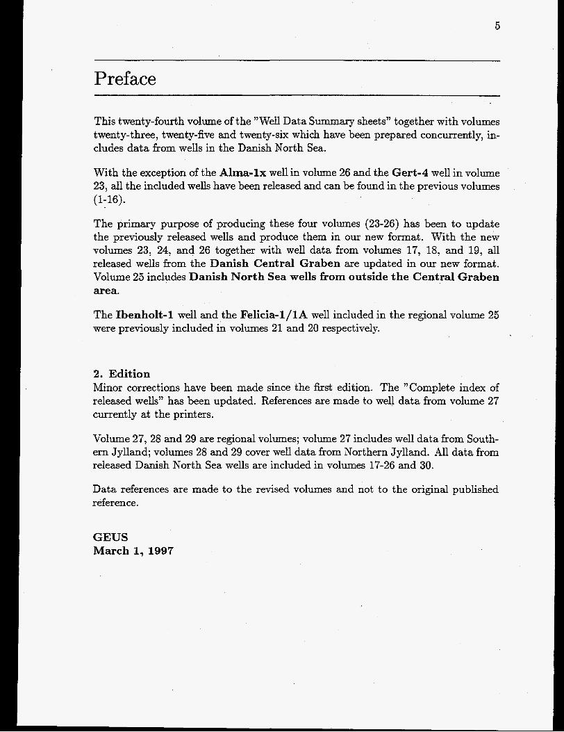
Preface
This twenty-fourth volume of the "Well Data Summary sheets" together with volumes twenty-three, twenty-five and twenty-six which have been prepared concurrently, in- cludes data from wells in the Danish North Sea.
With the exception of the Alma-lx well in volume 26 and the Gert-4 well in volume 23, all the included wells have been released and can be found in the previous volumes (1-16).
The primary purpose of producing these four volumes (23-26) has been to update the previously released wells and produce them in our new format. With the new volumes 23, 24, and 26 together with well data from volumes 17, 18, and 19, all released wells from the Danish Central Graben are updated in our new format. Volume 25 includes Danish North Sea wells from outside the Central Graben area.
The Ibenholt-1 well and the Felicia-l/lA well included in the regional volume 25 were previously included in volumes 21 and 20 respectively.
2. Edition Minor corrections have been made since the first edition. The "Complete index of released wells" has been updated. References are made to well data from volume 27 currently at the printers.
Volume 27, 28 and 29 are regional volumes; volume 27 includes well data from South- ern Jylland; volumes 28 and 29 cover well data from Northern Jylland. All data from released Danish North Sea wells are included in volumes 17-26 and 30.
Data references are made to the revised volumes and not to the original published reference.
GEUS March 1, 1997


8

9
Complete index of released wells in volumes 1-30
Well name Volume
A A-1X ............................. 26 A-2X ............................. 26
ADDA-1 ......................... 20 ADDA-2 ......................... 26 ADDA-3 ......................... 26 ALMA- 1X ....................... 26 AMALIE-l/lA ................... 30 ANNE-3 ......................... 20 ARNUM-1 ....................... 27 B B-1X ............................. 26 BO-1 ............................. 26 BOJE-1 .......................... 26 BORG-1 ........................ -27 BR0NS-1 ........................ 27 B0RGLUM-1 .................... 28 C C- 1X ............................. 25 CLEO-1 .......................... 20 D D-1X ............................. 25 DEEP-ADDA-1 .................. 26 DEEP-GORM (N-22/22A) ....... 18 DIAMANT- 1 .................... -20 E E-1X ............................ -26 E-2X ............................. 26 E-3X ............................ -26 E-4X ............................ -26 EAST-ROSA-1 ................... 26 EAST-ROSA-2 .................... 26 EAST-ROSA-3 ................... 20
AARS-l/ST3/ST4 ............... 29
Well name Volume
EAST-ROSA-FLANK-1 .......... 17 EDNA-1 ......................... 20 EG-1 ............................. 19 ELIN-1 .......................... -20 ELLY-1 .......................... 20 ELLY-2 .......................... 18 ELNA-1 .......................... 20 EMMA-1 ......................... 20 F F-1X ............................. 25 FALK-1 .......................... 20 FARS0-1 ........................ 29 FELICIA-l/lA .............. .20, 25 F JERRITSLEV-1 ................ 28 FJERRITSLEV-2 ............... -28 FLYVBJERG-1 ................... 28 FREDERIKSHAVN-1 ............. 28 FREDERIKSHAVN-2 ............ 28 FREDERIKSHAVN-3 ............ 28 G G-1X ............................. 21 GASSUM-1 ...................... 29 GERT-1 ......... ’. ................ 21 GERT-2 .......................... 21 GERT-3 .......................... 18 GERT-4 .......................... 23 GLAMSBJERG-1 ................. 2 GRIND STED- 1 ................... 2 GULNARE-1 ..................... 19 GWEN-2 ......................... 17 H H-1X ............................. 23 HALDAGER-1 ................... 28 HANS-1 .......................... 12

10
Well name Volume Well name Volume HARTE- 1 ......................... 2 HARTE-2 ......................... 2 HOBRO-1 ........................ 29 HORSENS-1 ...................... 2 HYLLEBJERG-1 ................. 29 HBNNING-1 ..................... 27 I I-1x ............................. 21 IBENHOLT- 1 ................ 21, 25 IDA-1 ............................ 30 INEZ-I ........................... 25 IRIS-1 ........................... 21 J J-1X ............................. 25 JENS- 1 ......................... - 2 3 JEPPEl ......................... 18 JOHN-1 .......................... 23 JOHN FLANKE-1 ............... 23 K K-1X ............................. 25 KARL-1 ......................... 21 KEGNES-1 ...................... 27 KIM- 1 ........................... 2 1 KVOLS-1 ........................ 29 KVERS-1 ....................... -27 L L-1X ............................. 25 LAV0-1 ........................... 2 LINDE1 .......................... 7 LIVA-I ........................... 21 LONE-1 .......................... 21 LULU-1 .......................... 21 LULU-2 .......................... 21 L0GUMKLOSTER-1 ............ 27 LBGUMKLOSTER-2 ............ 27 M M-1X ............................ 23 M-2X ............................ 23
MA-3 ............................. 1 MA-4 ............................. 1 MA-5 ............................. 1 MA-6 ............................. 1 MA-7 ............................. 1 M-8X ........................... -22 M-9X ............................ 23 M-1OX ........................... 23 MD-1 ............................. 1 MD-2 ............................. 1 MD-3 ............................. 1 MD-4 ............................. 1 MD-5 ............................. 1 MD-6 ............................. 1 MEJRUP-1 ...................... 14 MIDDLE-ROS A- 1 ................ 23 MIDDLE-ROSA-2 ................ 22 MIDDLE-RO S A-FLANK- 1 ....... 17 MONA-1 ......................... 22 MORS-1 ......................... 29 N N-1X ............................. 23 N-2X ............................. 23 N-3 ................................ 3 N-22/22A ........................ 18 NILS-1 ........................... 23 NILS-2 .......................... -23 NORA-1 ......................... 22 NORTH-JENS-1 .................. 22 NORTH- JENS-2 ................. 23 NBVLING-1 ...................... 2 0 0-1X ............................ -24 ODDESUND-1 ................... 29 OLAF-1 .......................... 24 OTTO-1 ......................... 24 P P-1X ............................. 24

Well name Volume PER-1 ........................... 24 PERNILLI3-1 .................... 17 Q Q-lX/Q-1 (ST 4) ................. 24 R R-1X .............................. 25 RAVN-1 .......................... 17 RAVN- 2 .......................... 18 RINGE-1 .......................... 2
RUTH-1 ......................... 24 R0DBY-1 ......................... 2 RODBY-2 ........................ - 2
ROAR-2/2A ..................... 24
RODDING-1 ..................... 29 RBDEKRO-1 .................... 27 R0NDE-1 ......................... 2 S S-1X ............................. 25 S.E. IGOR-1 ..................... 22 SKAGEN-1 ...................... 28 SKAGEN-2 ...................... 28 SKARV-1 ..................... .. 30 SKIVE-1 ......................... 29 SKIVE-2 ......................... 29 SLAGELSE-1 ..................... 2 STEN- 1 .......................... 24
. STENLILLE-1 .................... 8 STINA-1 ......................... 19 SBBY-1 ......................... 28 S0LLESTED-1 .................... 11 T T-1X ............................. 24 T-3X ............................. 24 TERNE-1 ........................ 16 THISTED-1 ...................... 28 . THISTED-2 ...................... 29 THISTED-3 ...................... 29 THISTED-4 ..................... -28
11
Well name Volume TORDENSKJOLD-1 ............. 17
T0NDER-1 ...................... 27 TOVE-1 ......................... 24
T0NDER-2 ...................... 27 TBNDER-3 ...................... 27 T0NDER-4 ...................... 27 T0NDER-5 ...................... 27 U u-1x ............................. 22 UGLE-1 .......................... 22 UGLEV-1 ........................ 29 ULLERSLEV-1 .................... 2 V v-1x ............................. 22 VAGN-2 ......................... 24 VARNBS- 1 ...................... 27 VEDSTED-1 ..................... 28 VEMB- 1 .......................... 2 VINDING-1 ....................... 2 VOLDUM-1 ....................... 2 W w-1x ............................ 22 WEST LULU-1 .................. 22 WEST LULU-2 .................. 22 WEST LULU-3 .................. 22 WEST LULU-4 .................. 17 0 0RSLEV-1 ........................ 2 ii ABENRW- 1 ..................... - 2 7

12
13
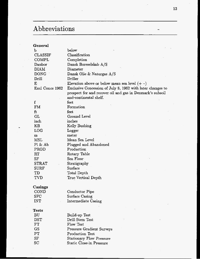
Abbreviations -
General b CLASSIF COMPL Danbor DIAM DONG Drill E Excl Concs 1962
f FM ft GL inch KB LOG m MSL PI & Ab PROD RT SF STRAT SURF TD TVD
Casings COND SFC INT
Tests BU DST FT GS PT SF sc
below Classification Completion Dansk Boreselskab A/S Diameter Dansk Olie & Naturgas A/S Driller Elevation above or below mean sea level (+ -) Exclusive Concession of July 8, 1962 with later changes to prospect for and recover oil and gas in Denmark’s subsoil and-continental shelf. feet Formation feet Ground Level inches Kelly Bushing Logger meter Mean Sea Level Plugged and Abandoned Product ion Rotary Table Sea Floor Stratigraphy Surface Total Depth True Vertical Depth
Conductor Pipe Surface Casing Intermediate Casing
Build-up Test Drill Stem Test Flow Test Pressure Gradient Surveys Production Test Stationary Flow Pressure Static Close-in Pressure

14
Logs and Tools AMS BGL BGT BHC
BHC/ACL BHGM BIQL CAL CALI CBL CCL CCL-PR CDL CDM
CDR CET
CMT CNL
COMP COR1 CPOR CPP CST DD & AD DDPL DIL DIP DIT DITE DLL DPOR DR DTCS EL EL-GR EPL EPT EWR EXP FDC FIL FMS FMT FPIT
BHC-GR
CDM-CDR
CIL-ECC
CNL-FDC
Auxiliary Measurement 'Sonde Borehole Geometry Log Borehole Geometry Tool BoreHole Compensated sonic log Borehole Compensated Sonic Gamma Ray Borehole Compensated Sonic Log / Acoustic Log Borehole Gravity Meter Survey Bond Index Quicklook Caliper Log Caliper Log Cement Bond Log Casing Collar Locator Casing Collar Log & Perforation Record Compensated Density Log Continous Dipmeter DipmeterDirectional Log Continous Directional Log, Computed Cement Evaluation Tool Casing Inspection Log & Electronic Casing Cal. Circumferential Microsonic Tool Compensated Neutron Log Compensated Neutron Formation Density Composite Log CORIBAND Computations Core Porosity Cross Plot Porosity Core Sampling Tool Dipmeter Dip & Azimuth Display Drilling Data Pressure Log Dual Induction Log Diplog Dual Induction Tool Phasor Induction Tool Dual Laterolog Density Porosity Directional Log/Abwei&ung DTC/DTS Computations Old (digitized) electrical logs Electrical Log - Gamma Ray Enginered Production Log Electromagnetic Propagat ion Tool Electromagnetic Wave Resistivity External Pressure Tool Formation Density Compensated log Fracture Identification Log (from SHDT tool) Formation Micro Scanner Multi Formation Tester Freepoint Indicator Tool
15
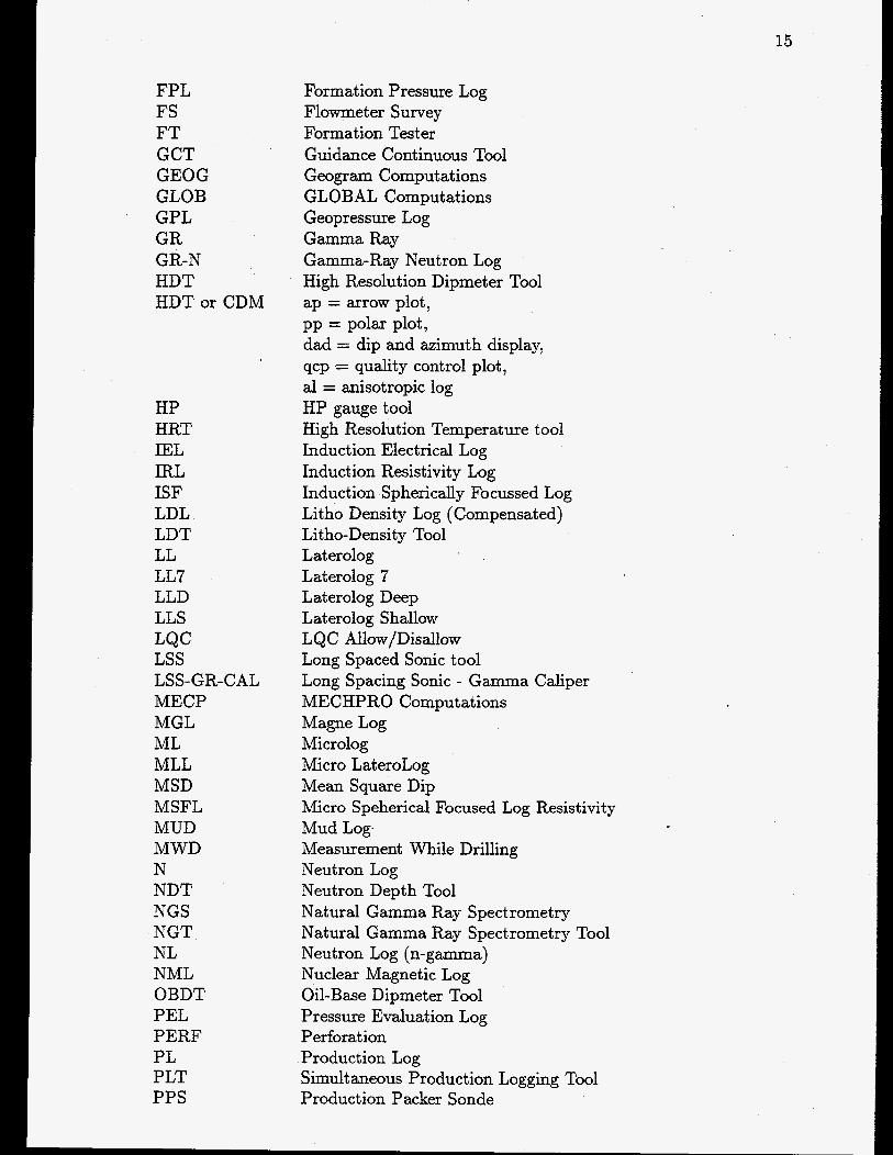
FPL FS FT GCT GEOG GLOB GPL GR
HDT HDT or CDM
GR-N
HP HRT IEL IRL ISF LDL LDT LL LL7 LLD LLS LQC LSS LSS-GR-CAL MECP MGL ML MLL MSD MSFL MUD MWD N NDT NGS NGT NL NML OBDT PEL PERF PL PLT PPS
Formation Pressure Log Flowmeter Survey Formation Tester Guidance Continuous Tool Geogram Computations GLOBAL Computations Geopressure Log Gamma Ray Gamma-Ray Neutron Log High Resolution Dipmeter Tool ap = arrow plot,
dad = dip and azimuth display, qcp = quality control plot, a1 = anisotropic log HP gauge tool High Resolution Temperature tool Induction Electrical Log Induction Resistivity Log Induction Spherically Focussed Log Litho Density Log (Compensated) Litho-Density Tool Laterolog Laterolog 7 Laterolog Deep Laterolog Shallow LQC Allow/Disallow Long Spaced Sonic tool Long Spacing Sonic - Gamma Caliper MECHPRO Computations Magne Log Microlog Micro LateroLog Mean Square Dip Micro Speherical Focused Log Resistivity Mud Log. Measurement While Drilling Neutron Log Neutron Depth Tool Natural Gamma Ray Spectrometry Natural Gamma Ray Spectrometry Tool Neutron Log (n-gamma) Nuclear Magnetic Log Oil-Base Dipmeter Tool Pressure Evaluation Log Perforat ion Production Log Simultaneous Production Logging Tool Production Packer Sonde
pp = polar plot,

16
PRG PRL PROX RFT SAR SDT SG SHDT SLS SNP SON SP STC svs T TDF TDT TS TVD VDL VL WF wss
- WST wvs
Pressure Gradient Pressure Log Proximity log Repeat Formation Tester Saraband Sonic Digital Tool Standard Gamma Ray Stratigraphic High Resolution Dipmeter Tool Sonic Long Spacing Sidewall Neutron Porosity log Sonic Log Spontaneous Potential Slowness Time Coherence Seismic Velocity Survey Temperature Log Tension Defection Log Thermal Decay Time log Temperature Survey True Vertical Depth Variable Density Log Velocity Log Wave Forms Well Seismic Survey Optical Well Seismic Tool Well Velocity Survey and Calibration of Sonic Logs

17
0-1x
TECHNICAL AND ADMINISTRATIVE DATA Location : Offshore Longitude : 05"19'19/'.4 Latitude : 55"22'011'.8 UTM Zone : 31 UTM Easting (x) : 647171.8 (m) UTM Northing (y) : 6138239.0 (m) Well block no. : 5505/22-1
Reference point : KB 92 ft above MSL. Water depth : 141 ft below MSL. TD log : ft below KB. TD drill : 11740 ft below KB. The well is : Vertical.
Structure: : Ryan
Spudded : 09/10-1972. Completed : 13/01-1973
Spud classification : Exploration Status (completion) : Plugged And Abandoned, L' icense : Duc Eneret 1962 A-SV Operat or : Gulf Contract or f ig : Transocean Ii
CASING top depth shoe depth diameter diameter
ft m ft m inch inch (decim.) 0.0 0.0 335.0 102.1 36" 36.000 0.0 0.0 734.9 224.0 18 5/8" 18.625 0.0 0.0 4007.9 1221.6 13 3/8" 13.375 0.0 0.0 8513.1 2594.8 9 5/V 9.625

18
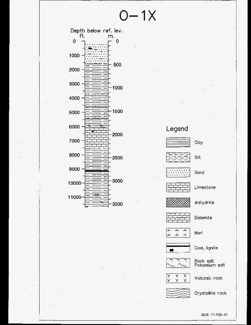
0-1x Depth below ref. lev.
ft. m. . . . . . .-. . . - ....... ...... - . . . . . . . .-. . . - .......
6000
2000 7000
11000 -
Legend I
Clay
Fi ..........
Silt
Sand
Limestone
Anhydrite
Dolomite
Marl
jl Coal, lignite
Rock salt Potassium salt
Volcanic rock
Crystalline rock
GEUS 17-FEB-97

20
LITHOSTRATIGRAPHY (Groups) Top Bottom Unit
f . below ref. level. 232.8 6096.7 Post Chalk Group
6096.7 7569.7 Chalk Group 7569.9 7819.8 Cromer Knoll Group 7819.8 10346.8 Jurassic units 9052.8 9829.8 Central Graben Group
10346.6 11739.8 Triassic units
CHRONOSTRATIGRAP HY (Periods)
Top Bottom Unit
232 1452 Quaternary 1452 6253 Tertiary 6253 7820 Cretaceous 7820 11347 Jurassic
10347 11740 Triassic
f . below ref. level.
0-1x 21
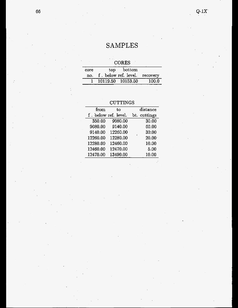
SAMPLES
CORES core top bottom no. f . below ref. level. recovery
0 1 6146.00 6188.00 77.0
CUTTINGS from to
f . below ref. level. 770.00 3380.00
3380.00 3440.00 3440.00 5180.00 5180.00 5300.00 5300.00 7370.00 7370.00 7410.00 7410.00 7430.00 7430.00 7750.00 7750.00 7770.00 7770.00 7970.00 7970.00 8000.00 8000.00 8200.00 8200.00 8240.00 8240.00 8660.00 8660.00 8680.00 8680.00 8700.00 8700.00 8720.00 8720.00 8970.00 8970.00 8990.00 8990.00 9860.00 9860.00 9880.00 9880.00 10170.00
10170.00 10210.00 10210.00 10490.00
distance bt. cuttings
30.00 60.00 30.00 60.00 30.00 10.00 20.00 10.00 20.00 10.00 30.00 10.00 20.00 10.00 20.00 10.00 20.00 10.00 20.00 10.00 20.00 10.00 30.00 10.00

22
from to distance bt. cuttings f . below ref. level.
10490.00 10540.00 10770.00 10950.00 10980 .OO 11230.00 11270.00 11410.00 11430.00 11520.00 11550.00 11590.00
10530.00 10770.00 10950.00 10980.00 11230.00 11270.00 11410.00 11430.00 11520.00 11550.00 11590.00 11740.00
40.00 30.00 10.00 30.00 10.00 20.00 10.00 20.00 30.00 10.00 20.00 30.00
SIDEWALL CORES 43 samples recovered from interval 8550 - 11350 ft below ref.leve1

0-1x
AVAILABLE WELL LOGS
23
COMPANY: Schlumberger - File no.: Log type, interval, suite no., run no., scale
7294 : Borehole Compensated Sonic Log (Gamma Ray) ) 736.00-11358.OOft ) , 1 )
7293 : Borehole Compensated Sonic Log-Gamma Ray , 736.00-11358.OOft ) , I , 1:200 7288 : Caliper Log ) 4008.00-8532.OOft ) ) 1 , 1:200 7287 : Caliper Log ) 4008.00-8532.OOft ) , 1 , 1 : l O O O 7290 : Caliper Log, 8300.00-8972.OOft ) ) 2 , 1:200 7289 : Caliper Log ) 8300.00-8972.OOft ) ) 2 , 1 : l O O O 7286 : Cement Bond Log (Gamma Ray) I 100.00-843O.OOft , , 1 ) 1:200 7285 : Cement Bond Log (Gamma Ray) ) 100.00-843O.OOft ) , 1 ) 1 : lOOO 7298 : Compensated Formation Density Log , 8512.00-11372.OOft ) , 1 , 1200 7297 : Compensated Formation Density Log , 8512.00-11372.OOft , , 1 , 1:lOOO 7296 : Compensated Neutron (Gamma Ray) ) 4000.00-1141O.OOft , , 4 ) 1:200 7295 : Compensated Neutron (Gamma Ray) ) 4000.00-1141O.OOft , , 4 , 1 : lOOO 7280 : Continuous Dipmeter (Computed Results - Four arm High Resolution ,
7279 : Continuous Dipmeter (Computed Results) - Four-Arm High Resolution )
7278 : Continuous Dipmeter (Computed Results) - Four-Arm High Resolution )
1 : lOOO
8513.00-11406.OOft , ) 1 , 1:O
8513.00-11406.OOft ) ) 1 , 1:200
8513.00-11406.OOft ) ) 1 ) 1: lOOO 7281 : Continuous Dipmeter (Computed Results) - Four-Arm High Resolution ~
8513.00-11406.OOft ) , 1 , 1 : l O O O 7266 : Continuous Dipmeter (Four-Arm High Resolution) ) 8513.00-11408.OOft , , 4 ,
1:20 7284 : Continuous Directional ( Computed ) ) 8513.00-11406.OOft ) ) 1 , 1:0 7291 : Induction - Electrical Log ) 4009.00-10783.OOft , , 1 , 1:200 7292 : Induction-Electrical Log ) 4009.00-10784.OOft , , 1 , 1 : l O O O 7283 : Laterolog ) 794.00-11375.OOft , , 1 , 1:200 7282 : Laterolog , 794.00-11375.OOft , , 1 ) 1: lOOO

24
AVAILABLE REPORTS
File no.: Author, company, title, publication date
2926: ROBERTSON RESEARCH : The micropalaeontology and stratigraphy , Jan- uary 1973.
2934: SCHLUMBERGER : Remarks to the computed results obtained from the high resolution dipmeter , January 1973.
2935: SCHLUMBERGER : Continuous dipmeter (tabulated) - Depth interval: 8504’- 11406’ - Correlation intv. 3 feet, step distance 3 feet, max. search angle 35 deg X 1). , January 1973.
2936: SCHLUMBERGER : Continuous dipmeter (tabulated) - Depth interval: 8512’- 11393’ - Correlation intv. 12 feet, step distance 9 feet, max. search angle 35 deg X 1). , January 1973.
2937: SCHLUMBERGER : Continuous dipmeter (tabulated) - Depth interval: 8915’- 9560’ - Correlation intv. 1 feet, step distance 1 feet, max. search angle 35 deg X 1). , January 1973.
2939: GULF OIL : Core analysis - Core no. 1 , January 1973. 2941: GULF : Completion report , August 1973. 2942: SEISMOGRAPH SERVICE LTD. : Well Velocity Survey , January 1973.

25
OLAF- 1
TECHNICAL AND ADMINISTRATIVE DATA Location : Offshore Longitude : 03”44‘05’‘.93 Latitude : 55”58‘20“.60 UTM Zone : 31 UTM Easting (x) : 545873.6 (m) UTM Northing (y) : 6203388.0 (m) Well block no. : 5503/3-1
Reference point Water depth TD log TD drill The well is
Structure:
Spudded Completed
: : 202 ft below MSL. : 14417 ft below KB. : 14405 ft below KB.
KB 106 ft above MSL.
. : Vertical.
: Olaf
: 15/04-1983. : 26/07-1983
Spud classification : Exploration Status (completion) : Plugged And Abandoned. License : Duc Eneret 1962 A-SV Operator : Chevron Contract or : Mmsk Drilling Rig : Mzrsk Explorer
CASING top depth shoe depth diameter diameter
ft m ft m inch inch (decim.) 317.9 96.9 419.9 128.0 30” 30.000 319.9 97.5 1015.1 309.4 20” 20.000 323.2 98.5 4258.9 1298.1 13 318” 13.375 323.2 98.5 11466.9 3495.1 9 5/8” 9.625
10941.9 3335.1 14119.1 4303.5 7” 7.000


Depth below ref. lev. ft. m.
0 1 r - 0 . . . . . .-. . j:&.T:L.:.[ . - . . . . . . . 1000 .-~*.:.*::.-. . . . . . .-. . .- .......
500 . . . . . .-. . . - . . . . . . . ...-..=
6000
2000 7000
2500 8000
9000
10000
1 1000
12000
13000
14000
Legend
.. ..- . . . . . . . . . 3000
3500
4000
Clay
Silt
Sand
Limestone
Anhydrite
Dolomite
Marl
Coal, lignite
Rock salt Potassium salt
Volcanic rock
Crystalline rock
GEUS 17-FEB-97

28
LITHOSTRATIGRAPHY (Groups)
Top Bottom Unit f . below ref. level.
309.0 9857.8 Post Chalk Group
11546.7 13888.0 Chalk Group undiff 13888.0 14402.0 Cromer Knoll Group
9857.8 13888.0 Chalk Group
CHRONOSTRATIGRAPHY (Periods) TOP Bottom Ufit
f . below ref. level. 308 2567 Quaternary
2567 9957 Tertiary 9957 1441 7 Cretaceous

OLAF-I
SAMPLES
CORES core top bottom no. f . below ref. level. recovery
1 11740.00 11769.00 100.0 2 14131.00 14143.00 66.0 3 14390.00 14402.00 100.0
CUTTINGS from to distance
bt. cuttings 430.00 3760.00 30.00
f . below ref. level.
3760.00 3880.00 4270.00 4740.00 4760.00 4790.00 4850.00 4880.00 4900.00 4930.00 4940.00 5060.00 5100.00 5120.00 5400.00 5930.00 5960.00 6100.00 6120.00 6220.00 6300.00
3880.00 4270.00 4740.00 4760.00 4790.00 4850.00 4880.00 4900.00 4930.00 4940.00 5060.00 5100.00 5120.00 5400.00 5930.00 5960.00 6100.00 6120.00 6220.00 6300.00 6320.00
60.00 30.00 10.00 20.00 10.00 20.00 30.00 20.00 30.00 10.00 20.00 40.00 10.00 20.00 10.00 30.00 20.00 10.00 20.00 10.00 20.00
29

30
from to f . below ref. level. 6320.00 7680.00 7680.00 7710.00 7710.00 7730.00 7730.00 7740.00 7740.00 7800.00 7800.00 7850.00 7850.00 7880.00 7880.00 8180.00 8180.00 8190.00 8190.00 8210.00 8210.00 8870.00 8870.00 8890.00 8890.00 8980.00 8980.00 9020.00 9020.00 9490.00 9490.00 9510.00 9510.00 14390.00
14390.00 14402.00
distance bt. cuttings
20.00 30.00 20.00 10.00 20.00 50.00 10.00 20.00 10.00 20.00 10.00 20.00 10.00 20.00 10.00 20.00 10.00 12.00
SIDEWALL CORES 120 samples recovered from interval 4300 - 14401 ft below ref.leve1
OLAF-1 31
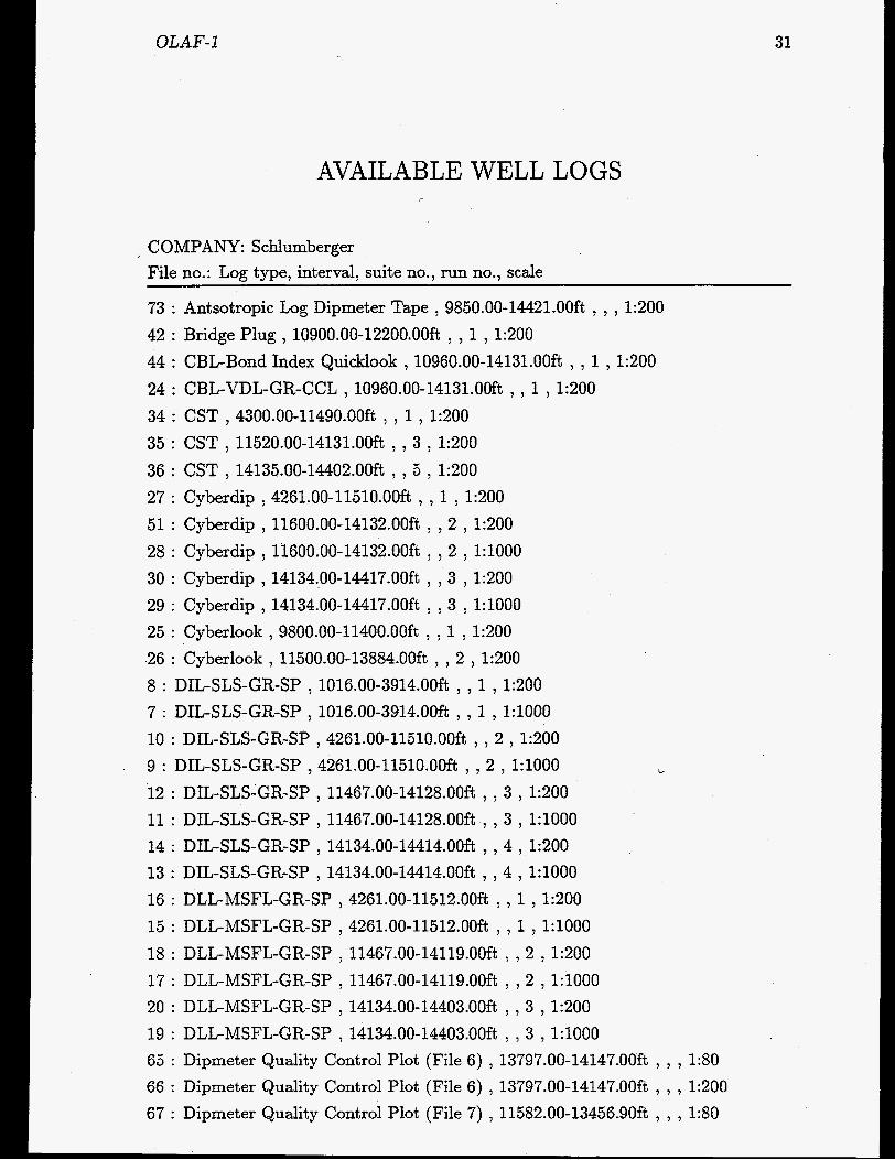
AVAILABLE WELL LOGS
COMPANY: Schlumberger File no.: Log type, interval, suite no., run no., scale
73 : Antsotropic Log Dipmeter Tape , 9850.00-14421.OOft , , , 1:200 42 : Bridge Plug , 10900.00-122OO.OOft , , 1 , 1:200 44 : CBL-Bond Index Quicklook , 10960.00-14131.OOft , , 1 , 1:200 24 : CBL-VDL-GR-CCL , 10960.00-14131.OOft , , 1 , 1:200 34 : CST , 4300.00-1149O.OOft , , 1 , 1~200 35 : CST , 11520.00-14131.OOft , , 3 , 1~200 36 : CST , 14135.00-14402.OOft , , 5 , 1~200 27 : Cyberdip , 4261.00-1151O.OOft , , 1 , 1:200 51 : Cyberdip , 11600.00-14132.OOft , , 2 , 1:200 28 : Cyberdip , 11600.00-14132.OOft , , 2 , 1: lOOO 30 : Cyberdip , 14134.00-14417.OOft , , 3 , 1:200 29 : Cyberdip , 14134.00-14417.OOft , , 3 , 1:lOOO 25 : Cyberlook , 9800.00-114OO.OOft , , 1 , 1:200 26 : Cyberlook , 11500.00-13884.OOft , , 2 , 1:200 8 : DIL-SLS-GR-SP , 1016.00-3914.OOft , , 1 , 1~200 7 : DIL-SLS-GR-SP , 1016.00-3914.OOft , , 1 , 1:lOOO 10 : DIL-SLS-GR-SP , 4261.00-1151O.OOft , , 2 , 1~200 9 : DIL-SLS-GR-SP , 4261.00-1151O.OOft , , 2 , 1:lOOO 12 : DIL-SLS-GR-SP , 11467.00-14128.OOft , , 3 , 1~200 11 : DIL-SLS-GR-SP , 11467.00-14128.OOft , , 3 , 1:lOOO 14 13 : DIL-SLS-GR-SP , 14134.00-14414.OOft , , 4 , 1: lOOO 16 : DLL-MSFL-GR-SP , 4261.00-11512.OOft , , 1 , 1~200 15 : DLL-MSFL-GR-SP , 4261.00-11512.OOft , , 1 , 1:lOOO 18 : DLL-MSFL-GR-SP , 11467.00-14119.OOft , , 2 , 1~200 17 : DLL-MSFL-GR-SP , 11467.00-14119.OOft , , 2,l:lOOO 20 : DLL-MSFL-GR-SP , 14134.00-14403.OOft , , 3 , 1~200 19 : DLL-MSFL-GR-SP , 14134.00-14403.OOft , , 3 , 1:lOOO
CI
DIL-SLS-GR-SP , 14134.00-14414.OOft , , 4 , 1~200
65 : Dipmeter Quality Control Plot (File 6) , 13797.00-14147.OOft , , , 1:80 66 : Dipmeter Quality Control Plot (File 6) , 13797.00-14147.OOft , , , 1:200 67 : Dipmeter Quality Control Plot (File 7) , 11582.00-13456.9Oft , , , 1:80

32
68 : Dipmeter Quality Control Plot (File 7) , 11582.00-13456.9Oft , , , 1:200 69 : Dipmeter Quality Control Plot (File 8) , 14181.00-1442O.OOft , , , 1:80 70 : Dipmeter Quality Control Plot (File 8) , 14181.00-1442O.OOft , , , 1:200 71 : Dipmeter Quality Control Plot (File 9) , 14150.00-14421.OOft , , , 1:80 72 : Dipmeter Quality Control Plot (File 9) , 14150.00-14421.OOft , , , 1:200 52 : Dipmeter Dip and Azimuth Display (All picks) , 4305.00-14405.OOft , , 0 , 1:200 54 : Dipmeter Dip and Azimuth Display (Selevtive Fitting) , 4428.00-14389.OOft , , ,
53 : Dipmeter Dip and Azimuth Display (Selvec) , 4429.00-14388.OOft , , , 1:200 56 : Dipmeter Quality Control Plot (File 1) , 11295.00-11504.OOft , , , 1:80 55 : Dipmeter Quality Control Plot (File 1) , 11295.00-11504.OOft , , , 1:200 57 : Dipmeter Quality Control Plot (File 2) , 5992.00-11503.OOft , , , 1:80 58 : Dipmeter Quality Control Plot (File 2) , 5992.00-11504.OOft , , , 1:200 59 : Dipmeter Quality Control Plot (File 3) , 4272.00-6074.00ft , , , 1:80 60 : Dipmeter Quality Control Plot (File 3) , 4272.00-6074.OOft , , , 1:200 61 : Dipmeter Quality Control Plot (File 4) , 9798.50-11411.5Oft , , , 1:80 62 : Dipmeter Quality Control Plot (File 4) , 9798.50-11411.5Oft , , , 1:200 63 : Dipmeter Quality Control Plot (File 5) , 13450.00-138OO.OOft , , , 1:80 64 : Dipmeter Quality Control Plot (File 5) , 13450.00-138OO.OOft , , , 1:200
1:200
47 : FIL , 9800.00-114OO.OOft , , 1 , 1:40 48 : FIL , 11467.00-122OO.OOft , , 2A , 1~40 49 : FIL , 12400.00-1252O.OOft , , 2 , 1~40 50 : FIL , 14134.00-14417.OOft , , 3 , 1~40 21 : HDT , 4261.00-1151O.OOft , , 1 , 1~200 23 : HDT , 4261.00-1151O.OOft , , 3 , 1:200 22 : HDT , 4261.00-1151O.OOft , 2 , 1:200 33 : HP (RFT) , 11574.00-125OO.OOft , , 2 , 1:O 1 : LDL-CNL-GR , 4261.00-11512.OOft , , 1 , 1:200 2 : LDL-CNL-GR , 4261.00-11512.OOft , , 1 , 1:lOOO 3 : LDL-CNL-GR , 11467.00-1413O.OOft , , 2 , 1:200 4 LDL-CNL-GR , 11467.00-1413O.OOft , , 2 , 1 : lOOO 5 : LDL-CNL-GR , 14134.00-14413.OOft , , 3 , 1~200 6 : LDL-CNL-GR , 14134.00-14413.OOft , , 3 , 1:lOOO 46 : Perforations , 0.00-0.00 , , 0 , 1:200 43 : Production Packer , 10940.00-11825.OOft , , 1 , 1:200 31 : RFT (6 Secs.) , 9898.00-1132O.OOft , , 1 , 1:0 32 : RFT (6 Secs.) , 11574.00-125OO.OOft , , 2 , 1:0 40 : Temperature Survey , 11700.00-12OOO.OOft , , 1 , 1:200 37 : Well Projection Plots , 4261.00-1151O.OOft , 1 , 1:0

OLAF-1 33
38 : Well Projection Plots , 11580.00-14132.OOft , , 2 , 1:0 39 : Well Projection Plots , 14134.00-14413.OOft , , 3 , 1:0
34
AVAILABLE REPORTS
File no.: Author, company, title, publication date
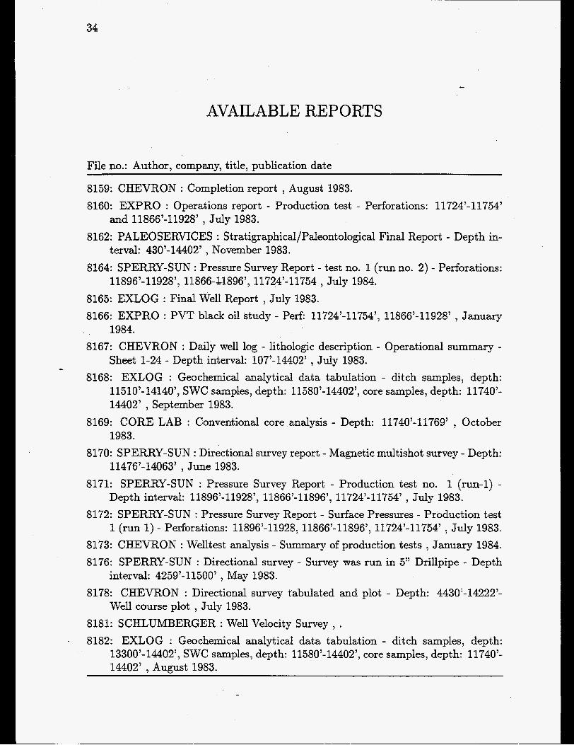
8159: CHEVRON : Completion report , August 1983. 8160: EXPRO : Operations report - Production test - Perforations: 11724’-11754’
8162: PALEOSERVICES : Stratigraphical/Paleontological Final Report - Depth in-
8164: SPERRY-SUN : Pressure Survey Report - test no. 1 (run no. 2) - Perforations:
8165: EXLOG : Final Well Report , July 1983. 8166: EXPRO : PVT black oil study - Perf: 11724’-11754’, 11866’-11928’ , January
1984. 8167: CHEVRON : Daily well log - lithologic description - Operational summary -
Sheet 1-24 - Depth interval: 107’-14402’ , July 1983. 8168: EXLOG : Geochemical analytical data tabulation - ditch samples, depth:
11510’-14140’’ SWC samples, depth: 11580’-14402’’ core samples, depth: 11740’- 14402’ , September 1983.
8169: CORE LAB : Conventional core analysis - Depth: 11740’-11769’ , October 1983.
8170: SPERRY-SUN : Directional survey report - Magnetic multishot survey - Depth: 11476’-14063’ , June 1983.
8171: SPERRY-SUN : Pressure Survey Report - Production test no. 1 (run-1) - Depth interval: 11896’-11928’’ 11866’-11896’, 11724’-11754’ , July 1983.
8172: SPERRY-SUN : Pressure Survey Report - Surface Pressures - Production test 1 (run 1) - Perforations: 11896’-11928, 11866’-11896’, 11724’-11754’ , July 1983.
8173: CHEVRON : Welltest analysis - Summary of production tests , January 1984. 8176: SPERRY-SUN : Directional survey - Survey was run in 5” Drillpipe - Depth
8178: CHEVRON : Directional survey tabulated and plot - Depth: 4430’-14222’-
8181: SCHLUMBERGER : Well Velocity Survey , . 8182: EXLOG : Geochemical analytical data tabulation - ditch samples, depth:
13300’-14402’, SWC samples, depth: 11580’-14402’, core samples, depth: 11740’- 14402’ , August 1983.
and 11866’-11928’ , July 1983.
terval: 430’-14402’ , November 1983.
11896’- 11928’’ 11866-C1896’, 11724’4 1754 , July 1984.
interval: 4259’-11500’ , May 1983.
Well course plot , July 1983.

TECHNICAL AND ADMINISTRATIVE DATA Location Longitude Latitude UTM Zone UTM Easting (x) UTM Northing (y) Well block no.
Reference point Water depth TD log TD drill The well is
Field: Structure:
Spudded Completed
Spud classification Status (completion) License Operator Contract or Rig
35
OTTO-1
Offshore 04’1 1‘22’’.91 56’09’07‘‘. 09 31 573909.0 (m) 6223769.0 (m) 5604/25-2
KB 112 ft above MSL. 205 ft below MSL. 9132 ft below KB. 9121 ft below KB. Vertical.
Svend North- Arne
21/12-1981. 20/03-1982
Exploration Plugged And Abandoned. Duc Eneret 1962 A-SV Chevron Dyvi Offshore Dyvi Beta
CASING top depth shoe depth diameter diameter
ft m ft m inch inch (decim.) 310.0 94.5 419.9 128.0 42” 42.000 310.0 94.5 1004.9 306.3 18 5/8” 18.625 350.1 106.7 4003.9 1220.4 13 3/8” 13.375
1000.0 304.8 8503.9 2592.0 9 5/8” 9.625

36

OTTO- 1 Depth below ref. lev.
ft. m. ..... . .-. F 0 O I ...- .... ....... . -
,ooo+*.-. . Y -.*.**y .... F .... ..... .-. . ...... .I-
3000 1000
4000
5000 1500
6000 2000
2500 8000
Legend
7000 Clay
9000 JE8$ Sand ..........
mi Limestone
Anhydrite
Dolomite
Marl
I I
1 1 7 Rock salt F] Potassium salt
v v 1 Volcanic rock i v v v
- Crystalline rock
GEUS 17-FEB-97

38
LITHOSTRATIGRAPHY (Groups) Top Bottom Unit
f . below ref. level. 317.0 8120.8 Post Chalk Group
8120.8 8933.8 Chalk Group 8933.8 8955.8 Cromer Knoll Group 8955.8 9119.8 Zechstein Grour,
CHRONOSTRATIGRAPHY (Periods)
TOP Bottom Unit f . below ref. level.
205 1687 Quaternary 1687 8121 Tertiary 8121 8956 Cretaceous 8956 9120 Permian

OTTO-I
SAMPLES
CORES core top bottom no.
1 2 3 4 5 6
- 7 8
f . below ref. level. 8115.00 8133.00 8133.00 8179.00 8179.00 8214.00 8214.00 8265.00 8265.00 8325.00 8325.00 8385.00 8385.00 8445.00 8445.00 8505.00
recovery 100.0 69.5
100.0 100.0 100.0 100.0 100.0 100.0
CUTTINGS from to
f . below ref. level. 390.00 5070.00
5070.00 5190.00 5190.00 6000.00 6000.00 7500.00 7500.00 8120.00 8120.00 8190.00 8190.00 8200.00 8200.00 8510.00 8510.00 9120.00
distance bt. cuttings
30.00 60.00 30.00 20.00 10.00 5.00
10.00 5.00
10.00
SIDEWALL CORES
39
44 samples recovered from interval 4100 - 8951 ft below ref.leve1

40
AVAILABLE WELL LOGS
COMPANY: Chevron File no.: Log type, interval, suite no., run no., scale
985 : Dipmeter - Dip and Azimuth Display (All Picks) , 4001.00-9111.OOft , , , 1:200 984 : Dipmeter - Dip and Azimuth Display (Selective Fitting) ) 4002.00-9067.OOft ) ,
, 1:200
COMPANY: Schlumberger File no.: Log type, interval, suite no., run no., scale
974 : 975 : 982 : 983 : 972 : 973 : 970 : 971 : 976 : 977 : 986 : 981 : 978 : 979 : 987 : 980 :
CBL-VDL-GR-CCL , 300.00-8324.OOft , ) 2 CBL-VDL-GR-CCL , 1400.00-8478.OOft , , 1 , 1~200
1:ZOO
Cyberdip , 3993.00-913O.OOft , ) 1 , 1:200 Cyberlook ) 8000.00-9OOO.OOft ) ) 1 , 1:200 DIL-BHC-GR , 3993.00-9125.OOft DIL-BHC-GR I 3993.00-9125.OOft , ) 2 , 1:lOOO DLT-MSFL-GR , 3993.00-913O.OOft , , 1 ) 1~200 DLT-MSFL-GR , 3993.00-913O.OOft ) ) 1 , 1:lOOO FDC-CNL-GR , 3993.00-913O.OOft , ) 1 , 1~200 FDC-CNL-GR ) 3993.00-913O.OOft ) ) 1 ) 1:lOOO
, 2 , 1~200
Fracture Identification Log ) 8100.00-895O.OOft , , 1 , 1:200 HDT ) 3993.00-913O.OOft , , 1 , 1~200 ISF-BHC-GR-SP , 317.00-403O.OOft ISF-BHC-GR-SP , 317.00-403O.OOft , , 1 ) 1:lOOO
) 1 , 1~200
Production Log , 8080.00-8315.OOft , , 1 ) 1:200 RFT-GR , 4980.00-889O.OOft , , 1 , 1:O

OTTO-1 41
AVAILABLE REPORTS
File no.: Author, company, title, publication date
1958: CHEVRON : Completion report , April 1982. 1959: EXLOG : Find well report - Vol. 1 (tekst) , January 1982. 1960: EXPRO : Production test no. 1 - Open hole test - Tested interval: 8504’43805’
1961: EXPRO : Production test no. 2 - Perforated interval: 8336’-8360’ , February
1962: EXPRO : Production test no. 3A - Perforated interval: 8260’-8324’ , February
1963: EXPRO : Production test no. 3B - Perforated intervals: 8160’-8240’ and
1964: EXPRO : Production test no. 4 - Perforated interval: 8120’-8144’ , March
1965: P.A. Wright , CHEVRON : Well test analysis report - Preliminary report (with
1966: EXPRO : PVT Study OR samples from DST no. 2 , November 1982. 1967: EXPRO : PVT Study on samples from DST no. 3A , November 1982. 1968: EXPRO : PVT Study on samples from DST no. 3B , November 1982. 1969: A.Chopelas , CHEVRON : PVT Study - Compositional Analysis - Final Re-
1970: CHEVRON : Fluid Analysis and PVT Evaluation , November 1982. 1971: PALEOSERVICES : Stratigraphical/Paleontological Final report - Depth in-
1976: CHEVRON : Final Results for PVT Study, DST NO. 2, 3A, 3B. , December
, February 1982.
1982.
1982.
8260’-8342’ , March 1982.
1982.
tables and figures) , November 1982.
port, DST 3A, 3B , November 1984.
terval: 360’-9120’ , April 1982.
1984. 1977: CORE LABORATORIES : Water analysis of a sample from test no. 1 ,
1979: PETROLEUM TESTING SERVICE, INC. : Mercury capillary pressure data
1982: PETROLEUM TESTING SERVICE, INC. : Viscosity and Gravity Data -
1983: PETROLEUM TESTING SERVICE, INC. : Core properties - Water and gas
1986: EXLOG : Description of core no. 1-8, 8115’-8505’. , .
February 1982.
- Drainage and imbibition , September 1982.
Test no. 2, 3A, 3B (with chromatograms) , March 1982.
drice tests - 2880 psi simulated reservoir stress , October 1982.
1988: GECO : Conventional core data - Core no. 1-8 , June 1982.

42
1992: CORE LAB : Core analysis report 1993: CORE LAB : Special Core Analysis study February 1985. 1994: CORE LAB : Special core analysis study April 1985. 1995: CORE LAB : Special core analysis study November 1985. 1998: SCHLUMBERGER : Measured depth versus calculated vertical depth - Tab-
1999: SCHLUMBERGER : Well course plot - Directional survey computed from
2058: SEISMOGRAPH SERVICE LTD. : Well velocity survey , January 1982. 12920: EXLOG : Final well report - V01.2 (enclosure) January 1982.
May 1984.
ulated interval: 4003’-9066’ , April 1982.
Dipmeter , March 1982.

43
P-1x
TECHNICAL AND ADMINISTRATIVE DATA Location Longitude Latitude UTM Zone UTM Easting (x) UTM Northing (y) Well block no.
Reference point Water depth TD log TD drill The well is
Structure:
Spudded Completed
Spud classification Status (completion) L’ icense Operat or Contractor Rig
: Offshore : 03”46‘10”.0 : 56”02‘04‘’.4 : 31 : 547947.6 (m) : 6210330.0 (m) : 5603/32-1
: : 214 ft below MSL. : 11466 ft below KB. : 11463 ft below KB. : Vertical.
KB 124 ft above MSL.
: Inge
21/01-1973. : 18/03-1973
: Exploration : Plugged And Abandoned . : Duc Eneret 1962 A-SV : Gulf : Zapata North Sea : Zapata Nordic
CASING top depth shoe depth diameter diameter
ft m ft m inch inch (decim.) 345.1 105.2 425.9 129.8 36” 36.000 345.1 105.2 942.9 287.4 20” 20.000 345.1 105.2 4711.9 1436.2 13 3/8” 13.375 345.1 105.2 10294.9 3137.9 9 5/8” 9.625


. -- ....
1000 +.~.'.".T.'.'t . . .-. .... .......
500 . -
.-.
11 000 $==t
,2500
' 3000
Legend
.......... wi . . . . . . . . .
Clay
Silt
Sand
Limestone
Anhydrite
Dolomite
Marl
Coal, lignite
Rock salt Potassium salt
Volcanic rock
Crystalline rock
GEUS 17-FEB-97

46
LITHOSTRATIGRAPHY (Groups)
Top Bottom Unit f . below ref. level. 339.0 9579.8 Post Chalk Group
10349.8 11037.8 Rotlienende Group 9579.8 10349.8 Chalk Group
CHRONOSTRATIGRAPHY (Periods)
TOP Bottom Unit f .-below ref, level. 338 2092 9742 10350 11040 11260
2092 Quaternary 9817 Tertiary 10350 Cretaceous 11040 Permian 11260 Carboniferous 11463 Precambrian .

P-IX 47
SAMPLES
CORES ~~~
core top bottom no. f . below ref. level. recovery
1 9330.00 9336.00 77.7 2 9513.00 9531.00 72.2 3 9578.00 9585.00 95.1 4 9744.00 9766.00 72.7 5 11454.00 11464.00 100.0
CUTTINGS from to dist a c e
f . below ref. level. bt. cuttings 950.00 11210.00 30.00
11210.00 11242.00 32.00 11242.00 11270.00 28.00 11270.00 11450.00 30.00
SIDEWALL CORES 31 samples recovered from interval 10323 - 11438 ft below ref.leve1

48
AVAILABLE WELL LOGS
COMPANY: Schlumberger File no.: Log type, interval, suite no., run no., scale
7303 : Borehole Compensated Sonic Log , 928.00-47OO.OOft , , 1 , 1:200 . 7302 : Borehole Compensated Sonic Log (Gamma Ray) , 928.00-11455.OOft , , 1 ,
7304 : Borehole Compensated Sonic Log (Gamma Ray) , 4712.00-10301.OOft , , 2 ,
7305 : Borehole Compensated Sonic Log (Gamma Ray) , 10305.00-11455.OOft , , 3 ,
7327 : Caliper Log (Gamma Ray) , 928.00-4692.OOft , , 1 , 1:200 7328 : Caliper Log (Gamma Ray) , 928.00-4692.OOft , , 1 , 1 : l O O O 7307 : Compensated Formation Density Log , 8450.00-11466.OOft , , 1 , 1:200 7308 : Compensated Formation Density Log , 11305.00-11466.OOft , , 3 1: lOOO 7306 : Compensated Neutron Log (Formation Density) , 8450.00-10312.OOft ? , 2 ,
7309 : Computer Processed Interpretation ( Coriband ) , 9000.00-1029O.OOft , , ,
1:lOOO
1:200
1:200
1:200
1:200 7310 : Continuous Dipmeter ( Computed Results ) , 4712.00-10309.OOft , , 1 , 1 : l O O O 7312 : Continuous Dipmeter ( Computed Results ) , 4712.00-10309.OOft , , 1 , 1 : lOOO 7314 : Continuous Dipmeter ( Computed Results ) ? 4712.00-10309.OOft , , 1 , 1 : lOOO 7311 : Continuous Dipmeter ( Computed Results ) , 10305.00-11466.OOft , , 2 , 1:O 7313 : Continuous Dipmeter ( Computed Results ) , 10305.00-11466.OOft , , 2 , 1:lOOO 7315 : Continuous Dipmeter ( Computed Results ) , 10305.00-11466.OOft , , 1 : l O O O 7324 : Continuous Dipmeter ( Four Arm High Resolution ) , 4712.00-10309.OOft , , ,
7325 : Continuous Dipmeter ( Four Arm High Resolution ) , 10305.00-11466.OOft , ,
7326 : Continuous Dipmeter ( Four Arm High Resolution - Computed Results ) ,
7316 : Continuous Directinal ( Computed ) , 4712.00-10309.OOft , , 1 , 1:0 7317 : Continuous Directional ( Computed ) , 10305.00-11466.OOft , , 2 , 1:0 7319 : Dual Laterolog (Sequentical) , 10305.00-11455.OOft , , 3 , 1:200 7318 : Dual Laterolog (Sequentical) , 10305.00-11455.OOft , , 3 , 1:lOOO 7321 : Induction - Electrical Log , 928.00-4682.OOft , , 1 , 1:200
1:200
, 1:200
4712.00-10309.OOft , ? 1 , 1:O

P-1x 49
7322 : Induction - Electrical Log , 928.00-4682.OOft , , 1 , 1:iOOO 7320 : Induction - Electrical Log , 4712.00-10312.OOft , , 2 , 1:200 7323 : Induction - Electrical Log ,4712.00-10312.OOft , , 2 , 1 : lOOO

50
AVAILABLE REPORTS
\
File no.: Author, company, title, publication date
2975: ROBERTSON RESEARCH : The micropalaeontology and stratigraphy , April
2976: ROBERTSON RESEARCH : Potassium-argon dating of a core sample at 11456
2978: GULF OIL : Completion Report , November 1973. 2980: SCHLUMBERGER : Computer processed interpretation - Shaly dual program
- Interval 9429’-10290’. , February 1973. 2981: SCHLUMBERGER : High resolution dipmeter - True vertical depth program
- Interval 4716’-11466’ (4716’-11375’ Vert). , March 1973. 2982: SCHLUMBERGER : High resolution dipmeter - True vertical depth program
- Interval 4720’- 10302’ (4720’-10221’ Vert) , February 1973. 2983: SCHLUMBERGER : Four- Arm high resolution continous dipmeter - Corn-
puted results - Interval 10308’-11466’ - 3 ft X 3 ft, 30 deg X 1 (Tabulated) , March 1973.
2984: SCHLUMBERGER : Four- Arm high resolution continous dipmeter - Com- puted results - Interval 4712’-10309’ - 3 f t X 3 f t , 30 deg X 1 (Tabulated) , February 1973.
2985: SCHLUMBERGER : Four-Arm high resolution continous dipmeter - Com- puted results - Interval 10305’-11466’ - 12 ft X 9 ft, 35 deg X 1 (Tabulated) , March 1973.
1973.
feet , December 1973.
2986: SCHLUMBERGER : Four- Arm high resolution continous dipmeter - Corn- puted results - Interval 4712’-10309’ - 12 ft X 9 ft, 35 deg X 1 (Tabulated) , February 1973.
2989: GULF OIL : Routine core analyses on core no. 3 and 4 , May 1973. 2994: SEISMOGRAPH SERVICE : Well velocity survey , March 1973. I

51
PER-1
TECHNICAL AND Location Longitude Latitude UTM Zone UTM Easting (x) UTM Northing (y) Well block no.
Reference point Water depth TD log TD drill The well is
Structure:
Spudded Completed
Spud classification Status (completion) License Operator Contractor Rig
ADMINISTRATIVE DATA Offshore 05”05’00N.8 55”47’30’‘.0 31 630640.8 (m) 6184994.0 (m) 550515-1
KB 116 ft above MSL. 117 ft below MSL. 9125 ft below KB. 9123 ft below KB. Vertical . Per
18/ 10- 1978. 23/11-1978
Exploration Plugged And Abandoned . Duc Eneret 1962 A-SV Chevron Mersk Drilling Mersk Explorer
CASING top depth shoe depth diameter diameter
ft m ft m inch inch (decim.) 241.1 73.5 375.0 114.3 36” 36.000 254.9 77.7 1507.9 459.6 20” 20.000 290.0 88.4 4488.8 1368.2 13 3/8” 13.375

52

500
3000 1000
4000
5000 1500
6000
7000
8000
9000
2000
i
- - 2500 -
Legend =
---
[SI ..
Clay
Silt
Sand
Limestone
Anhydrite
Dolomite
Marl
I I I Coal, lignite
Rock salt Potassium salt
! v v v Volcanic rock
Crystalline rock
GEUS 17-FEB-97

54
LITHOSTRATIGRAPHY (Groups) Top Bottom Unit
f . below ref. level.
6902.9 9073.8 Chalk Group 233.0 6902.9 Post Chalk Group
CHRONOSTRATIGRAPHY (Periods)
TOP Bottom Unit
232 1370 Quaternary f . below ref. level.
13’70 7067 9073
7067 Tertiary 9073 Cretaceous 9125 Precambrian

PER-I . 55
SAMPLES
CORES
no. f . below ref. level. recovery 1 6939.00 6979.00 33.0 2 6979.00 7005.00 100.0 3 7005.00 7041.00 97.0 4 7073.00 7121.00 100.0 5 9119.00 9123.00 57.5
core top bottom
CUTTINGS from to distance
bt. cuttings f . below ref. level. ~
270.00 1740.00 1800.00 4500.00 6000.00 6940.00 6960.00 6980.00
.7010.00 7015.00 7050.00 7080.00 7100.00 7130.00 9110.00 9115.00 9119.00
1740.00 1800.00 4500.00 6000.00 6940.00 6960.00 6980.00 70 10.00 70 15.00 7050.00 7080.00 71 00.00 71 30.00 9110.00 9115.00 9119.00
30.00 60.00 30.00 20.00 10.00 5.00
10.00 30.00
5.00 35.00 10.00 5.00
30.00 10.00 5.00 4.00
.. 9120.00 1.00
SIDEWALL CORES 50 samples recovered from interval 4987 - 9033 ft below ref.leve1

56
WELL TESTS TOP Bottom Test type
f . below ref. level. 6920 6963 DST 1

PER-I 57
AVAILABLE WELL LOGS
COMPANY: Chevron File no.: Log type, interval, suite no., run no., scale
7343 : Dipmeter ( Quality Control Plot ) ) 0.00-0.OOft ) , ) 1:0 7345 : Dipmeter Dip and Azimuth Display ( All Picks ) , 0.00-0.OOft , ) ) 1:0 7344 : Dipmeter Dip and Azimuth Display ( All Picks ) ) 0.00-0.OOft ) ) , 1:0 7346 : Dipmeter Dip and Azimuth Display ( Selvec ) , 0.00-0.00ft , , , 1:0
COMPANY: Schlumberger File no.: Log type, interval, suite no., run no., scale
7339 : Borehole Compensated Sonic Log ) 4496.00-9122.OOft , , 1 ) 1:200 7340 : Borehole Compensated Sonic Log ) 4496.00-9122.OOft , , 1 , 1:lOOO 7335 : Compensated Neutron Formation Density (Simultaneous) , 4496.00-9124.OOft
7336 : Compensated Neutron Formation Density (Simultaneous) ) 4496.00-9124.OOft
7334 : Continuous Dipmeter Four Arm High Resolution ) 4496.00-9123.OOft , , 1 )
, , 1,1:200
) , 1 , 1:lOOO
1:200 7341 : Dual Laterolog (Simultaneous) ) 4496.00-9124.OOft , , 1 ) 1200 7342 : Dual Laterolog (Simultaneous) ) 4496.00-9124.OOft , , 1 ) 1 : l O O O 7338 : Induction Resistivity Sonic Log (Simultaneous) , 1500.00-4509.OOft , , 1 )
7337 : Induction Resistivity Sonic Log (Simultaneous) , 1500.00-4509.OOft , ) 1 ) 1:200 1:lOOO

58
AVAILABLE REPORTS
File no.: Author, company, title, publication date
8262: CORE LAB : Porosity vs permeability , April 1979. 9492: CHEVRON : Completion Report , November 1978. 9493: PALEOSERVICES : Stratigraphical/Palaeontological Final Report , January
1979. 9495: SEISMOGRAPH SERVICE LDT. : Well Velocity Survey , November 1978. 9496: PALEOSERVICES : Report on the argon 39/40 dating of samples from the
9497: LYNES : Drill stem test no. 1 - Interval tested: 6900’-6940’ , November 1978. 9499: LYNES : Drill stem test no. 2 - Interval tested: 6906’-6946’ , November 1978. 9500: CORE LABORATORIES : Core analysis report - Depth: 6940’-7120’ , January
9502: EXPRO : Operations report - Drill stem tests nos. 1’2, and 3 - Interval tested:
basal core (9119’-9123’) , April 1979.
1979.
. 6900’-6940’, 6911’-6951’, and 6920’-6960 , November 1978.

59
Q-lX/Q-l (st 4)
TECHNICAL AND ADMINISTRATIVE DATA Location Longitude Latitude UTM Zone UTM Easting (x) UTM Northing (y) Well block no.
Reference point Water depth TD log TD drill The well is
Structure:
Spudded Completed
Spud classification : Status (completion) : License Operat or Contractor Rig
Offshore 04”06’14’’.8 56”05’30”.3 31 568699.6 (m) 6216978.0 (m) 5604/29-2
RT 122 ft above MSL. 196 ft below MSL. 14745 f t below RT. 14745 ft below RT. Vertical.
Gwen
28/03-1973. 04/ 10- 1973
Exploration Plugged And Abandoned . Duc Eneret 1962 A-SV Gulf Zapata North Sea Zapata Nordic
CASING top depth shoe depth diameter diameter
ft m ft m inch. m 310.0 94.5 431.1 131.4 42” 42.000 310.0 94.5 1003.9 306.0 20” 20.000 310.0 94.5 5996.1 1827.6 13 3/8” 13.375 310.0 94.5 12243.1 3731.7 9 5/8” 9.625 799.9 243.8 12946.8 3946.2 7” 7.000


4000
5000 1500
6000
2000 7000
2500 8000
9000
3500 12000
.........
Legend
......... I.-...-.- ...... .... -'I Sand
-1 Limestone
Anhydrite
Dolomite
Marl
t r i Coal, lignite
Potassium salt
Volcanic rock
Crystalline rock
GEUS 17-FEB-97

62

Q- 1 4) Depth below ref. lev.
ft. m. 0 -
1000 - -
-
2000 - -
3000 - -
4000 - -
5000 - -
6000 - -
7000 - -
8000 - -
9000 - -
1 0000 -
11000-
1 2000 -
-
-
13000 4000
Legend
El ..
Clay
Silt
Sand
Limestone
Anhydrite
Dolomite
Marl
Coal, lignite
Rock salt Potassium salt
Volcanic rock
Crystalline rock
GEUS 18-FEB-97

64
LITHOSTRATIGRAPHY (Groups)
Top Bottom Unit f . below ref. level.
319.9 10071.7 Post Chalk Group 10071.7 12999.6 Ch& Group 12999.7 13138.7 Cromer Knoll Group 13138.7 13501.0 Jurassic units
CHRONOSTRATIGRAPHY (Periods)
TOP Bottom Unit
320 2075 Quaternary 2075 10377 Tertiary
10377 13139 Cretaceous 13139 1350 1 Jurassic
f . below ref. level.

LITHOSTRATIGRAPHY (Groups) Top Bottom Unit
f . below ref. level. 12433.0 12999.6 Chalk Group 12999.7 13138.7 Cromer Knoll Group 13138.7 13905.7 Jurassic units 13905.7 14619.7 Bacton Group 14619.6 14744.6 Rotlienende Grouz,
65
CHRONOSTRATIGRAPHY (Periods) TOP Bottom Unit
f . below ref. level. 12433 13139 Cretaceous 13139 13906 Jurassic 13906 14620 Triassic 14620 14745 Permian
66 Q-1X
SAMPLES
CORES core top bottom no. f . below ref. level. recovery
1 10119.50 10153.50 100.0
CUTTINGS from to distance
bt. cuttings 350.00 9080.00 30.00
9080.00 9140.00 60.00 9140.00 12260.00 30.00
12260.00 12280.00 20.00 12280.00 12460.00 10.00 12460.00 12470.00 5.00 12470.00 13490.00 10.00
f . below ref. level.

Q-1 (ST 4)
SAMPLES
CUTTINGS
67
from to distance f . below ref. level. bt. cuttings 12530.00 14740.00 10.00 14740.00 14745.00 5.00

68 . Q-IX
AVAILABLE WELL LOGS
COMPANY: Schlumberger File no.: Log type, interval, suite no., run no., scale
7366 : Borehole Compensated Sonic Log (Gamma Ray) , 1005.00-6026.OOft , , 1 ,
7368 : Borehole Compensated Sonic Log (Gamma Ray) , 1005.00-6026.OOft , , 1 ,
7373 : Borehole Compensated Sonic Log (Gamma Ray) , 1005.00-24505.OOft , , 1 ,
7367 : Borehole Compensated Sonic Log (Gamma Ray) , 1090.00-6026.OOft , , 1 ,
7370 : Borehole Compensated Sonic Log (Gamma Ray) , 5999.00-12269.OOft , , 2 ,
7371 : Borehole Compensated Sonic Log (Gamma Ray) , 5999.00-12269.OOft , , 2 ,
7372 : Borehole Compensated Sonic Log (gamma Ray) , 1005.00-14505.OOft , , 1 ,
7358 : Compensated Formation Density Log , 9600.00-12277.OOft , , 1 , 1:200 7359 : Compensated Formation Density Log , 9600.00-12277.OOft , , 1 , 1:lOOO 7362 : Compensated Neutron Formation Density , 9600.00-12277.OOft , , 1 , 1:200 7361 : Compensated Neutron Formation Density , 9600.00-12277.OOft , , 1 , 1:lOOO 7356 : Continuous Dipmeter ( Computed Results ) , 6000.00-12277.OOft , , 1 , 1:O 7365 : Continuous Dipmeter ( Computed Results ) , 6000.00-12277.OOft , , 1 , 1:200 7355 : Continuous Dipmeter ( Computed Results ) , 6000.00-12277.OOft , , 1 , 1 : lOOO 7364 : Continuous Dipmeter ( Computed Results )( Interpreted Log ) , 6000.00-
7363 : Continuous Directeonal ( Computed ) , 6000.00-12277.OOft , , 1 , 1:0 7357 : Coriband ( Computed Processed Interpertation ) , 9600.00-1227O.OOft , , ,
7384 : Induction-Electrical Log , 1005.00-6032.OOft , , 1 , 1:200 7380 : Induction-Electrical Log , 1005.00-6032.OOft , , 1 , 1:lOOO
.7379 : Induction-Electrical Log , 1005.00-1473O.OOft , , 1 , 1200 7388 : Induction-Electrical Log , 1005.00-1473O.OOft , , 1 , 1: lOOO
1:200
1: lOOO
1:lOOO
1:500
1:200
1:lOOO
1 : 200
12277.00ft , , 1 , 1:O
1:200

69
7385 : Induction-Electrical Log , 6000.00-12277.OOft , , 2 , 1:200 7383 : Induction-Electrical Log , 6000.00-12277.OOft , , 2 , 1:lOOO 7360 : Playback ( IL - BHC - RWA - SWA ) , 12948.00-1452O.OOft , , , 1:SOO

70 &-I (ST 4)
AVAILABLE WELL LOGS
COMPANY: Schlumberger File no.: Log type, interval, suite no., run no., scale
7375 : Borehole Compensated Sonic Log - Gamma Ray , 12942.00-13607.OOft , ) 3 )
1:200 7374 : Borehole Compensated Sonic log - Gamma Ray ) 12942.00-13607.OOft ) ) 3
1 : l O O O 7377 : Borehole Compensated Sonic log - Gamma Ray ) 12947.00-14505.OOft , , 4 ,
. 1:lOOO 7376 : Borehole Compensated Sonic log - Gamma Ray ) 12948.00-14505.OOft , , 4 ,
7354 : Cement Bond log , 12238.00-12902.OOft , , 1 , 1:200 7353 : Cement Bond log , 12238.00-12902.OOft , , 1 , 1:lOOO 7386 : Induction-Electrical log ) 12948.00-13619.OOft , , 3 ) 1:200 7381 : Induction-Electrical log , 12948.00-13619.OOft 7387 : Induction-Electrical log , 12948.00-1473O.OOft ) ) 4 , 1:200 7382 : Induction-Electrical log ) 12948.00-1473O.OOft ~ , 4 1:lOOO
1:200
, 3 , 1: lOOO

Q-lX/Q-1 (ST 4) 71
AVAILABLE REPORTS
File no.: Author, company, title, publication date
3051: ROBERTSON RESEARCH : The Micropalaeontology and Stratigraphy , Oc-
3052: GULF : Completion Report , February 1974. 3054: Hugh Crocker , SCHLUMBERGER : High resolution dipmeter interpretation
report - Run 1 ) June 1973. 3058: SCHLUMBERGER : Four-arm high resolution continous dipmeter - Computed
results - Interval 6000’-12277’ - 3 ft X 3 ft, 30 deg X 1 (Tabulated). ) May 1973. 3059: SCHLUMBERGER : Four-arm high resolution continous dipmetet - Computed
results - Interval 6000’-12277’ - 12 ft X 9 ft, 35 deg X 1 (Tabulated). , May 1973. 3060: SCHLUMBERGER : High resulution dipmeter - True vertical dipmeter - In-
terval 6007’-12267’ (6007’-12263.9’ Vert). , May 1973. 3061: SCHLUMBERGER : Computer processed interpretation - Shaly dual program
- Interval: 12170’-12270’. , May 1973. 3064: SEISMOGRAPH SERVICE : Well velocity survey , September 1973.
tober 1973.

72
73
ROAR-2 /2A
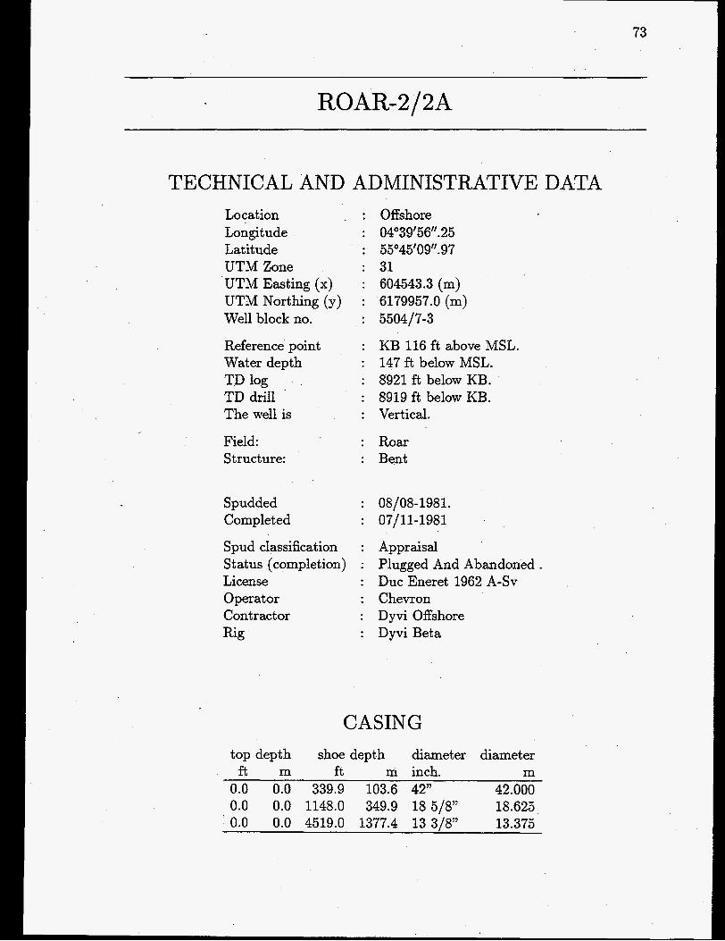
TECHNICAL AND ADMINISTRATIVE DATA Location Longitude Latitude UTM Zone UTM Easting (x) UTM Northing (y) Well block no.
Reference point Water depth TD log TD drill The well is
Field: Structure:
Spudded Completed
Spud classification Stat us (completion) License Operator Contractor Rig
Offshore 04'39'56''. 25 55'45'09''. 9 7 31 604543.3 (m) 6179957.0 (m) 5504/7-3
KB 116 ft above MSL. 147 ft below MSL. 8921 ft below KB. 8919 ft below KB. Vertical.
Roar Bent
08/08-1981. 07/11-1981
Appraisal Plugged And Abandoned. Duc Eneret 1962 A-SV Chevron Dyvi Offshore Dyvi Beta
CASING top depth shoe depth diameter diameter
f t m ft m inch. m 0.0 0.0 339.9 103.6 42" 42.000 0.0 0.0 1148.0 349.9 18 5/8" 18.625 0.0 0.0 4519.0 1377.4 13 3/8" 13.375

74

ROAR-2 Depth below ref. lev.
ft. m. . . . . . .-. . .- ....... . R . . . - . .
. . . . . .-. .
2000
3000 1000
4000
5000 1500
6000 2000
7000
2500 8000
Legend
......
Clay
Silt
Sand
Limestone
Anhydrite
Dolomite
Marl
Coal, lignite
Rock salt Potassium salt
Volcanic rock
Crystalline rock
GEUS 17-FEB-97

76 ROAR-2
LITHOSTRATIGRAPHY (Groups)
Top Bottom Unit f . below ref. level.
264.0 6639.9 Post Chalk Group 6639.9 8238.8 Chalk Group 8238.8 8919.8 Cromer Knoll Group
CHRONOSTRATIGRAPHY (Periods)
TOP Bottom Unit f . below ref. level. 263 1922 Quaternary
1922 6731 Tertiary 6731 8920 Cretaceous
.

ROAR-2
SAMPLES
CORES
no. f . below ref. level. recovery 1 6609.00 6643.00 91.0 2 6643.00 6703.00 100.0 3 6703.00 6732.00 100.0 4 6732.00 6733.00 0.0 5 6733.00 6793.00 0.6 6 6800.00 6832.00 17.2 7 6832.00 6864.00 100.0
core top bottom
CUTTINGS
77
from to distance f . below ref. level. bt. cuttings
280.00 4540.00 30.00 4540.00 5500.00 20.00 5500.00 6830.00 10.00 6830.00 6870.00 40.00 6870.00 8920.00 10.00
SIDEWALL CORES 62 samples recovered from interval 4580 - 8808 ft below ref.leve1

78 ROAR-2A
SAMPLES
CORES core top bottom -
no. f . below ref. level. recovery 1 6729.00 6751.00 100.0 2 6751.00 6778.00 37.0 3 6778.00 6796.00 56.0 4 6796.00 6826.00 66.0 5 6826.00 6856.00 73.0
CUTTINGS from to distance
f . below ref. level. bt. cuttings 6220.00 7230.00 10.00
SIDEWALL CORES 30 samples recovered from interval 6760 - 6853 ft below ref-level
WELL TESTS TOP Bottom Test type
f . below ref. level. 6650 6700 DST 4 6740 6746 DST 3 6792 6795 DST 2 6960 7040 DST 1

ROAR-2
AVAILABLE WELL LOGS
79
COMPANY: Dresser Atlas - File no.: Log type, interval, suite no., run no., scale
7585 : BHC - Acoustilog , 4473.00-8911.OOft , , 2 , 1:200 7586 : BHC - Acoustilog , 4473.00-8911.OOft , , 2 , 1:lOOO 7589 : Combination Imduction Electrical Log (BHC - Acoustilog) , 100.00-4532.OOft
7590 : Combination Induction Electrical Log (BHC - Acoustilog) , 100.00-4532.OOft 7 , 1A , 1:200
3 , 1A , 1:lOOO 7588 : Combination Induction Electrical Log (BHC - Acoustilog) , 100.00-8911.OOft
7587 : Combination Induction Electrical Log (BHC - Acoustilog) , 100.00-8911.OOft
7591 : Compensated Densilog - Compensated Neutron , 4480.00-892O.OOft , , 1 ,
7592 : Combination Densilog - Compensated Neutron , 4480.00-892O.OOft , , 1 , 1:200 7593 : Diplog - 4 ARM Diplog ,4495.00-8916.OOft , , 1 , 1:200 7595 : Dual Laterolog - Micro Laterolog , 4290.00-8919.OOft , , 1 , 1:lOOO
, , 1A , 1:200
, , 1A , 1:lOOO
1 : lOOO
.
7594 : Dual Laterolog - Micro Llaterolog , 4290.00-8919.OOft , , 1 , 1:200 7596 : Dual Laterolog - Proximity Log , 6550.00-8912.OOft , , 1 , 1:200 7597 : Dual Laterolog - Proximity Log , 6550.00-8912.OOft , , 1 , 1:lOOO 7600 : Epilog (Complex Reservoir Analysis) , 6600.00-89OO.OOft , , , 1:200 7599 : Formation Multi-Tester Log , 0.00-0.OOft , , , 1:O 7598 : HI Resolution - Fracture Investigation Log , 6550.00-725O.OOft , , 1 , 1:48

80
AVAILABLE WELL LOGS
COMPANY: Chevron File no.: Log type, interval, suite no., run no., scale
ROAR-2A
~~
7628 : Dipmeter - Dip and Azimuth Display (All Picks) , 4504.00-7223.OOft , , , 1:200 7627 : Dipmeter - Dip and Azimuth Display (Selevtive Fitting) , 4506.00-7223.OOft )
7631 : Dipmeter - Quality Control Plot (File 1) , 4502.00-7229.9Oft , , , 1:80 7634 : Dipmeter - Quality Control Plot (File 1) , 4502.00-7229.9Oft , , , 1:200 7633 : Dipmeter - Quality Control Plot (File 2) , 6602.00-6917.OOft , , , 1:80 7632 : Dipmeter - Quality Control Plot (File 2) , 6602.00-6917.OOft , ) , 1:200 7629 : Dipmeter - Quality Control Plot (File 3) , 6601.00-6908.OOft , , , 1:80 7630 : Dipmeter - Quality Control Polt (File 3) ) 6601.00-6908.OOft , , , 1:200
, ) 1:200
COMPANY: 'Schlumberger File no.: Log type, interval, suite no., run no., scale
7606 : BHC-GR ,6200.00-7218.OOft ) , 1 , 1 : lOOO 7607 : BHC-GR Playback , 6200.00-7218.OOft , , 1 , 1:200
7609 : Borehole Profile ) 4505.00-723O.OOft , ) 1 , 1:500 7611 : Borehole Profile Using HDT Caliper ) 4504.00-721O.OOft , , 2 , 1:200 7610 : Borehole Profile Using HDT Caliper , 4504.00-721O.OOft , , 2 , 1:lOOO
7608 : BHC-GR-VDL , 6200.00-7218.OOft , , 1 , 1~200
7612 : CBL-VDL-GR-BI ,4505.00-7099.OOft , ) 1 , 1~200 7621 : Coriband (Computed Processed Interpretation) , 6600.00-714O.OOft , , , 1:200 7624 : Cyberdip , 6200.00-7218.OOft , , 1 , 1:200 7620 : Cyberlook (Pas 2) ) 6550.00-714O.OOft , ) 1 , 1:200 7615 7616 : DLT-MSFL-GR , 4505.00-7215.OOft , ) 1 , 1~200
DLT-MSFL-GR , 4504.00-7215.OOft , , 1 ) 1:lOOO
7613 : Directional Log , 4504.00-7218.OOft ) ) 1 ) 1:200 7614 : Directional Log , 4504.00-7218.OOft , ) 1 , 1: lOOO 7618 : FDC-CNL-GR , 4505.00-723O.OOft , , 1 , 11200 7617 : FDC-CNL-GR , 4505.00-723O.OOft , , 1 , 1 : l O O O 7626 : Fracture Detevtion Log , 6600.00-6875.OOft , , 1 , 1:200 7625 HDT , 4505.00-7218.OOft , , 1 , 1:200
81
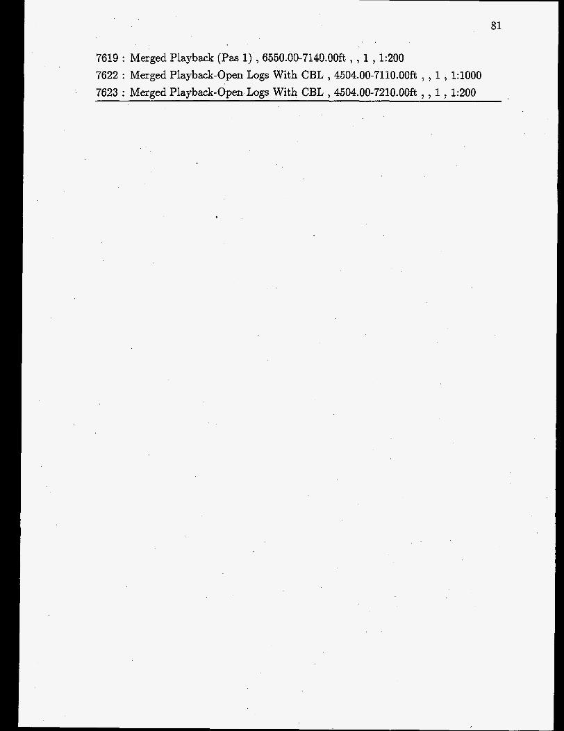
7619 : Merged Playback (Pas 1) , 6550.00-714O.OOft , , 1 , 1:200 7622 : Merged Playback-Open Logs With CBL , 4504.00-711O.OOft , , 1 , 1 : lOOO 7623 : Merged Playback-Open Logs With CBL , 4504.00-721O.OOft , , 1 , 1:200

82
AVAILABLE REPORTS
File no.: Author; company, title, publication date
ROAR-2/2A
6588: SEISMOGRAPH SERVICE LTD. : Well Velocity Survey , September 1981. 10708: CHEVRON : Completion Report , January 1982. 12857: EXLOG : Final well report - Vol.1 (tekst) , October 1981. 12858: EXLOG : Final well report - Vol. 2 (enclosures) ) October 1981. ,
12859: EXPRO : PVT condensate study - Sample interval: 6650’-6700’ - Test’ no.4
12860: EXPRO : PVT condensate study - Sample interval: 6760’-6746’ - Test no. 3
12861: EXPRO : Operations report - production tests 1, 2 , October 1981. 12862: EXPRO : Operations report - production tests 3, 4 - (del 1) , October 1981. 12863: EXPRO : Operations report - production tests 3, 4 - (del 2) , October 1981. 12864: CORE LABORATORIES : Core analysis report - Depth: 6637,7’-6804,9 )
(Danian) , May 1982.
(Maastrichtian) , May 1982.
December 1981. 12865: CORE LAB : Special core analysis study ) April 1985. 12866: CORE LAB : Special core analysis study , June 1985. 12867: CORE LAB : Special core analysis study ) March 1985. 12868: CHEVRON : Final report of Petrophysical measurements ) October 1984. 12875: CORELAB : Conventional core analysis , October 1981. 12877: KEPLINGER LABORATORIES : Summary of Steady-state oil-gas relative
permeability test 6665‘7.5” - 6830’9” , May 1983. 12885: PETROLEUM TESTING SERVICE, INC. : Porosity and air permeability
data at simulated reservoir stress - Depth: 6664?-6854’ , June 1982. 12871: LYNES : Downhole pressure survey report - drill stem test no. 1 - Depth:
6960’-7040’ , September 1981. 12872: LYNES : Downhole pressure survey report - drill stem test no. 2 - Depth:
6793’- 6795’ ) October 1981. 12873: LYNES : Drill stem test no. 3 - Depth: 6740’-6746’ ) October 1981. 12874: LYNES : Drill stem test no. 4 - Depth: 6650’-6700’ , October 1981. 12878: CHEVRON : Comparison of porosity and permeability data ) March 1983. 12879: CORE LABORATORIES : Water analysis - Sample number 3 from Produc-
tion test no. 2, sampled from stock tank ) November 1981. 12881: PALEOSERVICES : Stratigraphical/Paleontological Final report - Depth
interval: 250’-8,920’(Roar-2), and 6,210’-7,230’ (Roar 2A sidetrack) ) January 1982.

83
12882: CHEVRON : Well test analysis - test I, 2, 3, 4 - Tested interval: 6650’-7040’
12883: GECO : Conventional core analysis - Depth: 6729’-6841’ , DecemlSer 1981. 12884: CORE LABORATORIES : Water analysis - sampled from DST 1 - Depth:
6960’-7040’ , October 1981. 12886: PETROLEUM TESTING SERVICE, INC. : Porosity and air permeability
data at simulated reservoir stress Depth: 6731’-6834’ June 1982. 12887: PETROLEUM TESTING SERVICE, INC. : Viscosity, gravity and pour point
data - source: DST 2 - Depth 6793’-6795’ - zone: Maastrichtian , December 1981.
March 1984.
12888: PETROLEUM TESTING SERVICE, INC. : Geochemical analysis of water - source: water sample DST 1 - Depth: 6960’-7040’ - zone: Maastrichtian (aquifer) , October 1981.

84

RUTH-1
TECHNICAL AND ADMINISTRATIVE DATA Locat ion : Offshore Longitude : 04"54'53''. Latitude : 55"32'20''. UTM Zone : 31 UTM Easting (x) : 620835.5 (m) UTM Northing (y) : 6156557.0 (m) Well block no. 5504/16-4
Reference point Water depth TD log TD drill The well is
: KB 115 ft above MSL. : 127 ft below MSL. : 5618 ft below KB. : 5609 ft below KB. : Vertical.
Field: Subfield: Structure:
: Skjold : Skjold : Ruth
Spudded Completed
: 08/01-1977. : 19/03-1977
Spud classification : Exploration Status (completion) : Suspended . License : Duc Eneret 1962 A-SV Operator : Chevron Contract or : Mersk Drilling Rig : Mizrsk Explorer
CASING top depth shoe depth diameter diameter
ft m ft m inch inch (decim.) 0.0 0.0 358.0 109.1 30" 30.000 0.0 0.0 913.0 278.3 13 3/8" 13.375 0.0 0.0 4005.0 1220.7 9 5/8" 9.625 0.0 0.0 5596.0 1705.7 7" 7.000

86

1 C. I I I.
- 0 - 0 - ....... .. - . - ....... -. .1. - .... - ...... -.. 1000-'.'r.~.,.~.~.~.~.-
2000 --- -
.......-.. - . - ....... . . . - .... - ....... - . .- 500 - - - - - -
- - - - - - 3000 --- - - -:- 1000 -
- -- - - - - - - - - - - 4000 --I
- - -
Legend
... Sand ..........
'-1 Limestone
Anhydrite
Dolomite
Marl
Coal, lignite I
Potassium salt
rl Volcanic rock
Crystalline rock
GEUS 17-FEB-97

88
LITHOSTRATIGRAPHY (Groups) Top Bottom Unit
f . below ref. level.
5205.1 5590.0 Chalk Group 5590.0 5618.0 Zechstein Group
243.2 5205.1 Post Chalk Group
CHRONOSTRATIGRAPHY (Periods)
TOP Bottom Unit f . below ref. level.
242 1750 5266 5590
1750 Quaternary 5266 Tertiary 5590 Cretaceous 5617 Permian

RUTH-I 89
SAMPLES
CORES
no. f . below ref. level. recovery core top bottom
0 1 2 3 4 5 6 7 8 9
10 11 12 13 14 15 16
5206.00 5227.00 5246.00 5258.00 5281.00 5300.00 5333.00 5342.00 5349.00 5354.00 5376.00 5459.00 5474.00 5481.00 5498.00 5515.50
5227.00 5246.00 5258.00 5281.00 5300.00 5333.00 5342.00 5349.00 5354.00 5376.00 5384.00 5474.00 5481.00 5498.00 5515.50 5525.00
CUTTINGS
100.0 95.0
100.0 39.0
100.0 100.0 100.0 100.0 10.0
100.0 100.0 90.0 86.0 88.0 86.0
100.0
from to f . below ref. level.
380.00 4010.00 4010.00 4020.00 4020.00 4500.00 4500.00 5210.00 5210.00 5380.00 5380.00 5460.00 5460.00 5530.00 5530.00 5610.00
distance bt. cuttings
30.00 10.00 20.00 10.00 5.00
10.00 5.00
10.00
SIDEWALL CORES 23 samples recovered from interval 4050 - 5605 ft below ref.leve1

90
WELL TESTS TOP Bottom f . below ref. level. 5206 5232 5206 5232 5220 5560 5273 5290 5273 5290 5330. 5386
Test type
PT 3 PT 4 DST 1 PT 4 PT 2 PT 1

RUTH-I 91
AVAILABLE WELL LOGS
COMPANY: Chevron File no.: Log type, interval, suite no., run no., scale
8626 : Dipmeter (Dip and Aximuth Display) , 4008.00-5625.OOft , , 1 , 1:200 8624 : Dipmeter (Dip and Azimuth Display) , 4180.00-5575.OOft , , 1 , 1:500 8625 : Dipmeter (Quality Control Plot) , 0.00-0.00ft , , , 1:0 8627 : Oil in Place (Gamma Ray) , 5100.00-5614.OOft , , 1 , 1:200
COMPANY: Schlumberger File no.: Log type, interval, suite no., run no., scale
8615 : Borehole Compensated Sonic Log , 915.00-5614.OOft , , 1 , 1:200 8614 : Borehole Compensated Sonic Log , 915.00-5614.OOft , , 1 , 1 : l O O O 8629 : Cement Bond Log (Variable Density) , 2850.00-5578.OOft , , 1 , 1:200 8617 : Compensated Neutron Formation Density , 4005.00-5617.OOft , , 1 , 1:200 8616 : Compensated Neutron Formation Density , 4005.00-5617.OOft , , 1 , 1:lOOO 8618 : Compensated Neutron Log , 4700.00-5582.OOft , , 1 , 1:200 8623 : Continuous Dipmeter , 4005.00-5616.OOft , , 1 , 1:200 8620 : Dual Laterolog (Micro Spherical Log) , 4005.00-5617.OOft , , 1 , 1:200 8619 : Dual Laterolog (Micro Spherical Log) , 4005.00-5617.OOft , , 1 , 1: lOOO 8630 : Flowmeter Survey , 4690.00-528O.OOft , , 1 , 1:200 8628 : Global Log (DLL/MSFL/FDC/CNL/GR/BHC ,5150.00-559O.OOft , ,1,1:200 8621 : Induction-Electrical Log , 915.00-402O.OOft , , 1 , 1:200 8622 : Induction-Electrical Log , 915.00-402O.OOft , , 1 , 1:lOOO 8631 : Perforating Depth Control , 5206.00-556O.OOft , , , 1:200

92
r
AVAILABLE REPORTS
File no.: Author, company, title, publication date
5230: CHEVRON : Mercury Capillary Pressure Tests - Core analysis data - X-Ray
5231: EXPRO : Well Test Report , March 1977. 5233: FLOPETROL : High Accoracy Pressure and Temperature Report , February
5235: SPERRY-SUN : Pressure Survey Report - Test 1, lA, 2, 2A , February 1977. 5236: SPERRY-SUN : Pressure Survey Report - Production Test no. 3 , March 1977. 5237: EXPRO : Laboratory Report - Sampling no. 1 , March 1977. 5238: EXPRO : Laboratory Report - Sampling no. 1 Zone 3 , April 1977. 5239: EXPRO : Laboratory Report - Sampling no. 2 , April 1977. 5240: PALEOSERVICES : Palaeontological/Stratigraphical - Final report , March
5241: PALEOSERVICES : Paleontological/Stratigraphical - Final report - Interval:
diffraction - SEM microscopy , December 1981.
1977.
1977.
5,000’-561Q’ , January 1981. 5242: CORE LAB. : Core analysis - full diameter analysis , October 1977. 5244: PETROLEUM TESTING SERVICES : Core analysis - Core properties - Water
5246: SPERRY-SUN : Directional survey - Depth: 900’-5450’ , February 1977. 5247: CHEVRON : Core analysis - Mercury capillary pressure - Depth interval:
5252: CHEVRON : Dipmeter - Tabulated results - Depth: 4008.0)-5601.5’ , February
5253: HALLIBURTON : Drill stem test no. 1 - test interval: 5520’-5560’ (Hook wall
5344: CORE LAB. : Special core analysis study , July 1984. 7670: CHEVRON : Completion report , March 1977. 7671: SEISMOGRAPH SERVICE LTD. : Well Velocity Survey , January 1977.
and gas drive tests - Core nos. 1 ,2 ,3 ,10 , August 1979.
5209.83,-5520.25, , November 1977.
1977.
test) , February 1977.
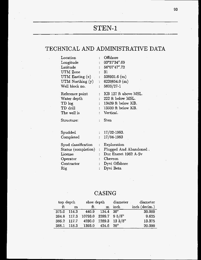
93
STEN-1
TECHNICAL Location Longitude Latitude UTM Zone
AND ADMINISTRATIVE DATA : Offshore : 03”37‘34‘’.69 : 56”07‘47‘‘.72 : 31
UTM Easting (x) : 538931.6 (m) UTM Northing (y) : 6220854.0 (m) Well block no. : 5603/27-1
Reference point : KB 127 ft above MSL. Water depth : 222 ft below MSL. TD log : 13439 ft below KB. TD drill : 13500 ft below KB. The well is : Vertical.
Structure:
Spudded Completed
Sten
17/02-1983. : 17/04-1983
Spud classification : Exploration Status (completion) : Plugged And Abandoned. License : Duc Eneret 1962 A-SV Operat or : Chevron Contractor : Dyvi Offshore Rig : Dyvi Beta
CASING top depth shoe depth diameter diameter
ft m ft m inch inch (decim.) 375.0 114.3 440.9 134.4 30” 30.000 384.8 117.3 10793.0 3289.7 9 5/8” 9.625 386.2 117.7 4230.0 1289.3 13 3/8” 13.375 388.1 118.3 1393.0 424.6 20” 20.000

94

STEN- 1 Depth below ref. lev.
ft, m. 0 1 r O . . . . . .-. . .- ....... . . . . . . - . .
1000 . * ~ - * ~ . - - * . - . - *
2000 * - ~ - * ~ * - * * * - . * .
. . .. ..-.. ~-~~~~~~ .- ...... ....... -.. 500
. . . . . .-. . . - . . . . . . . ...... -..
1000 3000 -j..I-..L...-.*.-.~ . . . . . .-. .
. - . . . . . . . 4000
5000 1500
6000
2000 7000
2500 8000
9000
10000 3000
1 1000 3500
Legend
Clay
..................... .. Sand
Limestone
Anhydrite
-1 Dolomite
/ I 1 Coal, lignite
Potassium salt
Volcanic rock
Crystalline rock
GEUS 17-FEB-97
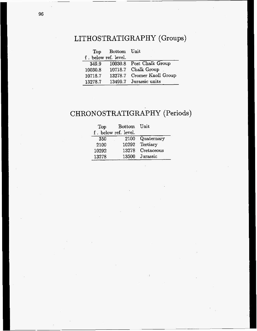
96
LITHOSTRATIGRAPHY (Groups) Top Bottom Unit
f . below ref. level. 349.9 10030.8 Post Chalk Group
10030.8 10718.7 Chalk Group 10718.7 13278.7 Cromer Knoll Group 13278.7 13499.7 Jurassic units
CHRONO STRATIGRAPHY (Periods)
Top Bottom Unit f . below ref. level.
350 2100 Quaternary 2100 10292 Tertiary
10292 13278 Cretaceous 13278 13500 Jurassic

STEN-1
SAMPLES
CORES
no. f . below ref. level. recovery 1 4315.00 4318.00 67.0
core - top bottom
CUTTINGS from to distance
f . below ref. level. 380.00 3230.00
3230.00 3290.00 3290.00 4310.00 4310.00 4315.00 4315.00 4317.00 4317.00 4340.00 4340.00 4700.00 4700.00 4760.00 4760.00 6020.00 6020.00 9200.00 9200.00 9240.00 9240.00 9500.00 9500.00 9880.00 9880.00 9900.00 9900.00 13500.00
bt. cuttings 30.00 60.00 30.00 5.00 2.00
23.00 30.00 60.00 30.00 20.00 10.00 20.00 10.00 20.00 10.00
SIDEWALL CORES 104 samples recovered from interval 4400 - 13440 ft below ref.leve1
97

98
AVAILABLE WELL LOGS
COMPANY: Chevron File no.: Log type, interval, suite no., run no., scale
8828 : Dipmeter Dip and Azimuth Display (All Picks) ,4627.00-10797.OOft I ) ) 1:200 8827 : Dipmeter Dip and Azimuth Display (All Picks) ) 4627.00-10797.OOft ) ) ) 1:200 8825 : Dipmeter Dip and Azimuth Display (Selective Fitting) ) 4628.00-10797.OOft )
8824 : Dipmeter Dip and Azimuth Display (Selective Fitting) ) 4628.00-10797.OOft )
8826 : Dipmeter Dip and Azimuth Display (Selvec) ) 4701.00-13456.OOft , , , 1:200 8821 : Dipmeter Quality Control Plot (File 1) ) 9987.00-10802.OOft , ) 1 ) 1:80 8822 : Dipmeter Quality Control Plot (File 1) ) 9987.00-10802.OOft ) , 1 ) 1:200 8818 : Dipmeter Quality Control Plot (File 1) ) 10794.00-1346O.OOft ) ) 2 , 1:80 8823 : Dipmeter Quality Control Plot (File 1) , 10794.00-13460.9Oft , ) 2 ) 1:200
) ) 1:200
) ) 1:200
8816 : Dipmeter Quality Control Plot (File 2) ) 4254.00-10781.OOft ) , 1 ) 1:80 8817 : Dipmeter Quality Control Plot (File 2) ) 4254.00-10781.OOft ) , 1 ) 1:200 8819 : Dipmeter Quality Control Plot (File 2) ) 10796.00-11029.OOft ) , 2 I 1:80 8820 : Dipmeter Quality Control Plot (File 2) ) 10796.00-11029.OOft 2 , 1:200
COMPANY: Schlumberger File no.: Log type, interval, suite no., run no., scale
8798 : CYBERLOOK ) 10000.00-10792.OOft ) ) 1 , 1~200 8797 : Cyberdip ) 4234.00-1081O.OOft , ) 1 ) 1:200 8833 : Cyberdip ) 10793.00-1347O.OOft ) ) 2 , 1:200 8799 : Cyberlook , 10797.00-112OO.OOft ) ) 2 ) 1:200 8795 : DIL-LSS-GR ) 1396.00-4247.OOft , ) 1 ) 1:200 8792 : DIL-LSS-GR ) 1396.00-4247.OOft ) ) 1 ) 1:lOOO 8794 : DIL-LSS-GR ) 4234.00-108OO.OOft , ) 2 ) 1:200 8793 DIL-LSS-GR , 4234.00-108OO.OOft ) ) 2 , 1:lOOO 8796 : DIL-LSS-GR , 10793.00-13398.OOft ) , 3 ) 11200 8791 : DIL-LSS-GR ) 10793.00-13398.OOft , ) 3 ) 1 : l O O O 8806 : DLL-MSFL-GR ) 4234.00-10812.OOft , , 1 , 1~200 8802 : DLL-MSFL-GR ) 4234.00-10812.OOft ) 1 , 1 : lOOO

STEN-I 99
8805 : DLL-MSFL-GR , 10793.00-13438.00ft, , 2 , 1:200 8809 8800 : FDC-CNL-GR , 10000.00-108OO.OOft , , 1 , 1~200 8807 : FDC-CNL-GR , 10000.00-108OO.OOft , , 1 , 1 : l O O O 8808 : HDT , 4234.00-108OO.OOft , , 1 , 1:200 8812 : HDT , 10793.00-1347O.OOft , , 2 , 1:200 8811 : LDL-CNL-GR , 4234.00-10804.OOft , , 1 , 1~200 8803 : LDL-CNL-GR , 4234.00-10804.OOft , , 1 , 1:lOOO 8810 : LDL-CNL-GR , 10793.00-13413.OOft , , 2,1:200 8801 : LDL-CNL-GR , 10793.00-13413.OOft , , 2 , 1:1000 8804 : LDL-CNL-GR (PB) , 10793.00-13413.00R , , 2 , 1~200 8814 : WSS , 700.00-1046O.OOft , , 1 , 110
DLL-MSFL-GR , 10793.00-13438.0Oft, , 2 , 1:lOOO
8813 : Well Projection Plots , 4234.00-108OO.OOft , , 1 , 1:0 8815 : Well Projection Plots , 10797.00-135OO.OOft , , 2 , 1:0
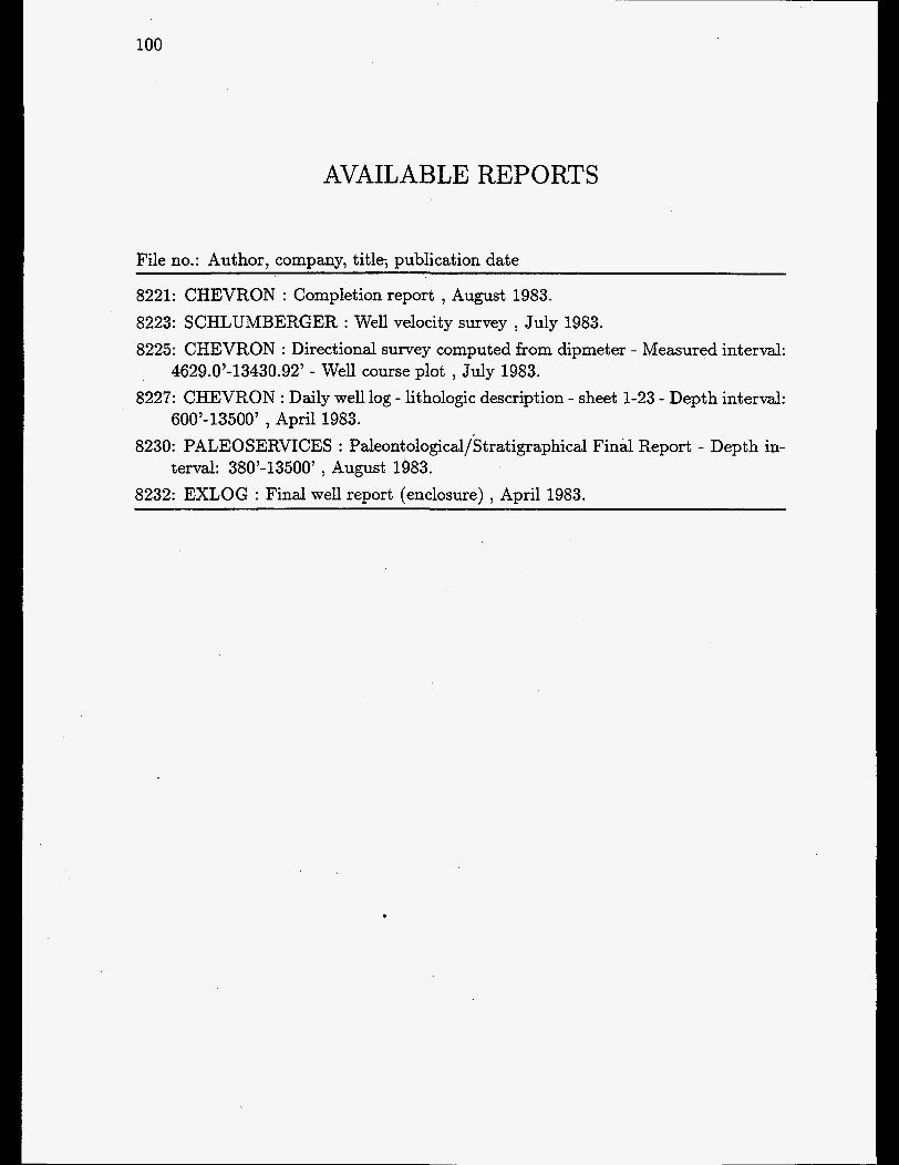
100
AVAILABLE REPORTS
File no.: Author, company, title, publication date
8221: CHEVRON : Completion report , August 1983. 8223: SCHLUMBERGER : Well velocity survey , July 1983. 8225: CHEVRON : Directional survey computed from dipmeter - Measured interval:
8227: CHEVRON : Daily well log - lithologic description - sheet 1-23 - Depth interval:
8230: PALEOSERVICES : Paleontological/Stratigraphical Final Report - Depth in-
8232: EXLOG : Final well report (enclosure) , April 1983.
4629.0’-13430.92’ - Well course plot , July 1983.
600’-13500’ , April 1983.
terval: 380’-13500’ , August 1983.
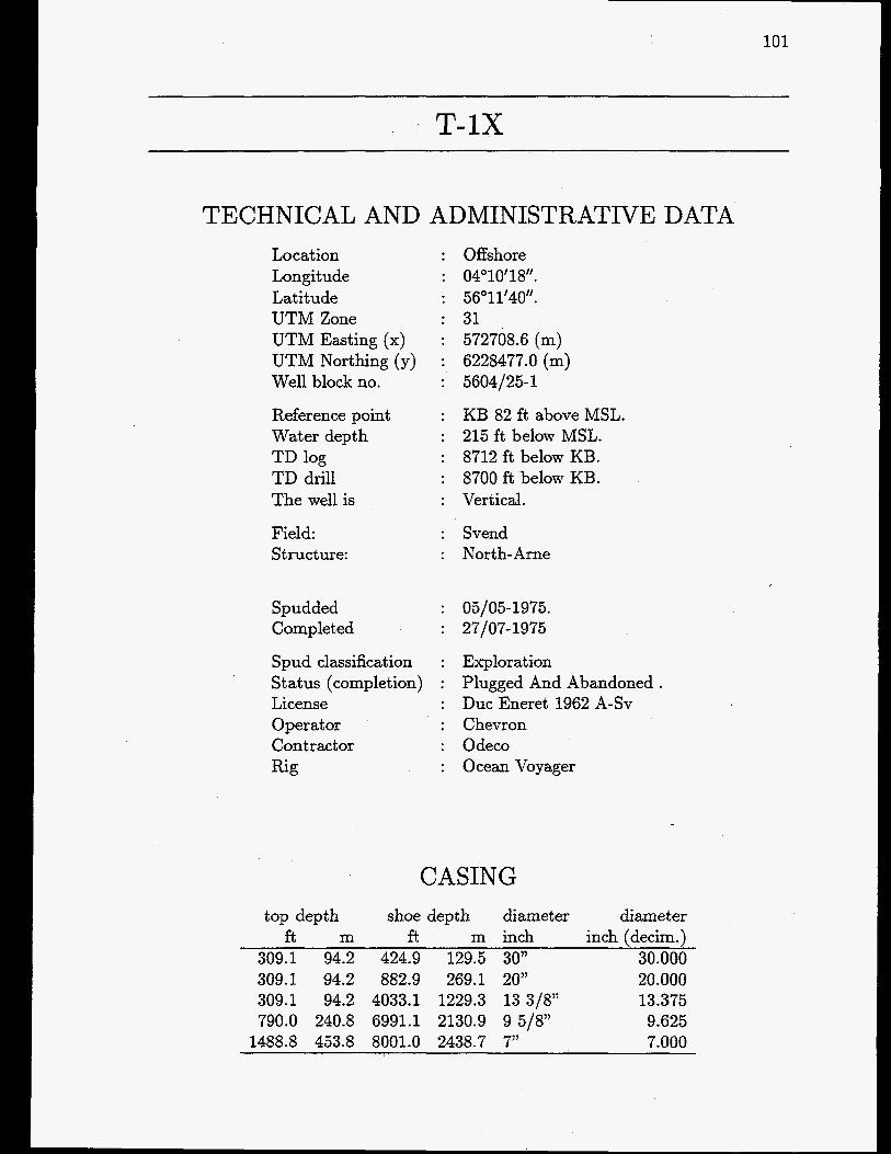
101
T-1X
TECHNICAL AND ADMINISTRATIVE DATA Location : Offshore Longitude : 04’10’18‘’. Latitude : 56’11’40”. UTM Zone : 31 UTM Easting (x) : 572708.6 (m) UTM Northing (y) : 6228477.0 (m) Well block no. : 5604/25-1
Reference point : KB 82 ft above MSL. Water depth : 215 ft below MSL. TD log : 8712 ft below KB. TD drill : 8700 ft below KB. The well is : Vertical.
Field: : Svend Structure: : North-Arne
Spudded Completed
Spud classification : Status (completion) : L’ icense Operator Contractor Rig
05105- 1975. 27/07- 1975
Exploration Plugged And Abandoned . Duc Eneret 1962 A-SV Chevron Odeco Ocean Voyager
CASING top depth shoe depth diameter diameter
ft m ft m inch inch (decim.) 309.1 94.2 424.9 129.5 30” 30.000 309.1 94.2 882.9 269.1 20” 20.000 309.1 94.2 4033.1 1229.3 13 3/8” 13.375 790.0 240.8 6991.1 2130.9 9 5/8” 9.625
1488.8 453.8 8001.0 2438.7 7” 7.000

102

Legend - Fl .... ..........
a
Clay
Silt
Sand
Limestone
Anhydrite
Dolomite
Marl
Coal, lignite
Rock salt Potassium salt
Volcanic rock
Crystalline rock
GEUS 17-FEB-97

104
LITHOSTRATIGRAPHY (Groups)
Top Bottom Unit f . below ref. level.
7282.9 7684.9 Chalk Group 7689.9 8712.9 Zechstein Group
298.0 7282.9 Post Chalk Group
CHRONOSTRATIGRAPHY (Periods)
TOP Bottom Unit f . below ref. level. 297
1720 7418 7690
1720 Quaternary 7418 Tertiary 7690 Cretaceous 8713 Permian

T-IX 105
SAMPLES
CORES ~ ~~~
core top bottom no. f . below ref. level. recovery
1 7215.00 7219.41 100.0 2 7239.00 7284.00 97.0 3 7284.00 7314.00 100.0 4 7314.00 7357.00 100.0 5 7357.00 7400.00 100.0 6 7400.00 7436.00 100.0 7 7436.00 7444.00 63.0 8 7444.00 7483.00 100.0 9 7483.00 7524.00 100.0
10 7524.00 7569.00 100.0 11 7569.00 7612.00 100.0 12 7612.00 7654.00 100.0 13 7654.00 7684.00 100.0 14 7684.00 7726.00 100.0
CUTTINGS from to
f . below ref. level. 930.00 4050.00
4050.00 4070.00 4070.00 4410.00 4410.00 4460.00 4460.00 4980.00 4980.00 6100.00 6100.00 7210.00 7210.00 7230.00 7230.00 7240.00 7240.00 7510.00 7510.00 7530.00 7530.00 8700.00
dist mce bt. cuttinas
30.00 20.00 10.00 50.00 10.00 20.00 10.00 20.00 10.00 30.00 20.00 10.00
SIDEWALL CORES 45 samples recovered from interval 4250 - 8600 ft below reflevel

106
WELL TESTS TOP Bottom
f . below ref. level. 4646 4766 741 7 7436 7446 7463 7476 7493 7503 7516 7543 7573 7596 7670
Test type
DST 3 DST 2 DST 2 DST 2 DST 2 DST 1 '
DST 1

T-IX
AVAILABLE WELL LOGS
~
107
COMPANY: Schlumberger File no.: Log type, interval, suite no., run no., scale
1046 : BHC-GR - Borehole Compensated Sonic Log ) 870.00-871O.OOft ) ) 1 ) 1:200 1028 : BHC-GR - Borehole Compensated Sonic Log ) 870.00-871O.OOft , ) 1 ) 1 : l O O O 1029 : BHC-GR - Borehole Compensated Sonic Log ) 879.00-4066.OOft ) , 1 ) 1:200 1031 : BHC-GR - Borehole Compensated Sonic Log ) 7017.00-871O.OOft ) , 3 ) 1:200 1030 : BHC-GR - Borehole Compensated Sonic Log (With Caliper) ) 4067.00-
1043 : CNL - Compensated Neutron Log ) 4400.00-7922.OOft , ) 3 ) 1:200 1050 : CNL - Compensated Neutron Log (run in cased hole) ) 890.00-4038.OOft ) ) 2
7017.00ft ) , 2 ) 1:200
, 1200 1047 : CNL - Compensated Neutron Log (run in cased hole) ) 890.00-4038.OOft ) ) 2
1042 : CNL-FDC - Simultaneous Compensated Neutron Formation Density ,4038.00- ) 1 : l O O O
8710.00ft ) ) 1 ) 1200 1041 : CNL-FDC - Simultaneous Compensated Neutron Formation Density ) 4038.00-
8710.00ft ) ) 1 ) 1:lOOO 1045 : Casing Collar Log and Perforating Record ) 7390.00-765O.OOft ) ) 1 ) 1:200 1044 : Cement Bond Log ) 4200.00-7915.OOft ) ) 1 ) 1:200 1038 : Dipmeter Dip and Azimuth Display ) 4000.00-87OO.OOft ) ) ) 1:200 1037 : Dipmeter Dip and Azimuth Display (Selvec) ) 4000.00-77OO.OOft , , ) 1:500 1036 : Dipmeter Quality Control Plot , 399.50-8494.OOft ) ) ) 1:O 1040 : Four-Arm High Resolution Continuous Dipmeter ) 4038.00-8712.OOft ) ) 1 .
1033 : IEL - Induction Electrical Log ) 870.00-7032.OOft ) , 1 , 1200 1032 : IEL - Induction Electrical Log , 870.00-7032.OOft ) , 1 ) 1:lOOO 1035 : Simultaneous Dual Laterolog Micro Spherical Log ) 4038.00-8711.OOft ) ) 1 )
1034 : Simultaneous Dual Laterolog-Micro Spherical Log ) 4038.00-7018.OOft ) ) 1 I
1200
1:200
1:lOOO

108
AVAILABLE REPORTS
File no.: Author, company, title, publication date
1993: CORE LAB : Special Core Analysis study , February 1985. 1994: CORE LAB : Special core analysis study , April 1985. 1995: CORE LAB : Special core analysis study , November 1985. 2009: PALEOSERVICES : Stratigraphical and Paleontological final report , Septem-
2010: CHEVRON : Completion report , June 1975. 2014: EXPRO : Operations report - productions tests - DST no. 1-4 , July 1975. 2015: GECO : Special core analysis February 1984. 2016: CORE LAB : Core analysis results - Interval: 7239’-7726’ , August 1975. 2017: CORE LAB : Reservoir fluid study September 1975. 2025: CHEVRON : Petrophysical evaluation of proved and potential Hydrocarbon-
2026: SCHLUMBERGER : Dipmeter print out, tabulated - Interval processed: 3993’-
2027: SCHLUMBERGER : Coriband - an analysis of complex lithology - computer
2030: SEISMOGRAPH SERVICE LIMITED : Well velocity survey , June 1975.
ber 1975.
bearing formations penetrated by Well T-1. , August 1978.
8766’ , July 1975.
processed interpretation - Interval: 7000’-8010’ , July 1975.

109
T-3X
TECHNICAL AND ADMINISTRATIVE DATA Location - Longitude Latitude UTM Zone UTM Easting (x) UTM Northing (y) Well block no.
Reference point Water depth TD log TD drill The well is
Field: Structure:
Spudded Completed
Spud classification
Offshore 04”10’48N.01 56” 10’44‘‘.40 31 573255.3 (m) 6226767.0 (m) 5604/25-3
KB 124 ft above MSL. 211 ft below MSL. 9246 f t below KB. 9124 ft below KB. Vertical.
Svend North- Arne
23/04-1983. 07/07-1983
Exploration Plugged And Abandoned . Duc Eneret 1962 A-SV Chevron Dyvi Offshore Dyvi Beta
Status (completion) : License Operat or Contractor Rig
CASING top depth shoe depth diameter diameter
f t m ft m inch inch (decim.) 356.0 108.5 450.1 137.2 30” 30.000 378.0 115.2 1366.1 ‘ 416.4 20” 20.000 379.9 115.8 4003.0 1220.1 13 3/8” 13.375 379.9 115.8 9211.9 2807.8 9 5/8” 9.625

110

T-3X Depth below ref. lev.
ft. m. 0 1 r O ..... . .-. t -I. - .......
C . . . . . . - . . I- 500
1500
2000
3000 1000
4000
5000
6000 2000
7000
2500 8000
Legend
Wl . . . . . . . .
Clay
Silt
Sand
Limestone
Anhydrite
Dolomite
Marl
Coal, lignite
Rock salt Potassium salt
Volcanic rock
Crystalline rock
GEUS 17-FEB-97
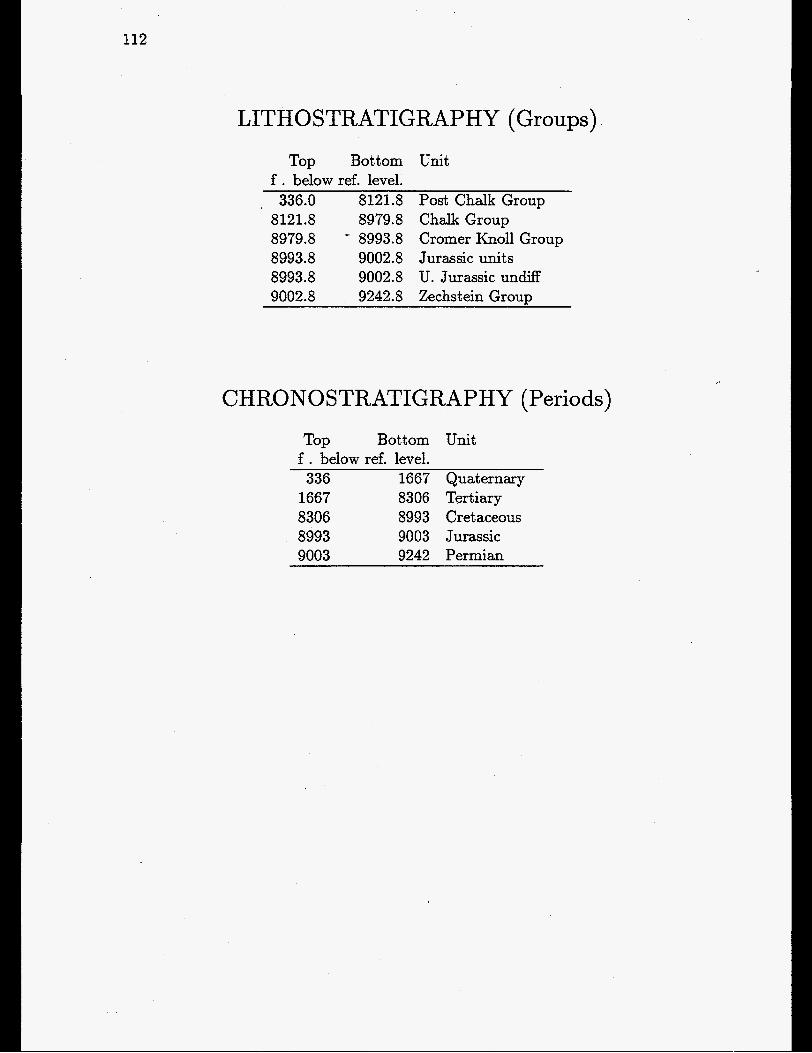
112
LITHOSTRATIGRAPHY (Groups)
Top Bottom f . below ref. level.
336.0 8121.8 8121.8 8979.8 8979.8 - 8993.8 8993.8 9002.8 8993.8 9002.8 9002.8 9242.8
Unit
Post Chalk Group Chalk Group Cromer Knoll Group Jurassic units U. Jurassic undifF Zechstein Group
CHRONO STRATIGRAPHY (Periods)
TOP Bottom Unit f . below ref. level. 336 1667 Quaternary
1667 8306 Tertiary 8306 8993 Cretaceous 8993 9003 Jurassic 9003 9242 Permian
. .

2'-3X
SAMPLES
CORES core top bottom no. f . below ref. level. recovery
1 8224.00 8232.00 42.0 2 8232.00 8239.00 100.0 3 8239.00 8291.00 96.0 4 8320.00 8379.00 100.0 5 8379.00 8401.00 59.0 6 8401.00 8458.00 98.0
- 7 8458.00 8499.00 90.0 8 8499.00 8538.00 97.0 9 8538.00 8576.00 95.0
CUTTINGS &om to distance
f . below ref. level. bt. cuttings 490.00 6010.00 30.00
6010.00 7510.00 20.00 7510.00 8240.00 10.00 8240.00 8300.00 60.00 8300.00 8320.00 10.00 8320.00 8580.00 260.00 8580.00 8710.00 10.00 8710.00 8730.00 20.00 8730.00 9250.00 10.00
SIDEWALL CORES 99 samples recovered from interval 3132 - 9148 ft below ref.leve1
113

114
AVAILABLE WELL LOGS
COMPANY: Chevron File no.: Log type, interval, suite no., run no., scale
1009 : Anisotropic Log (Dipmeter Tape) , 8090.00-9236.OOft , ) 1 ) 1:200 1018 : Dipmeter - Dip and Azimuth Display (All Picks) ) 4020.00-9198.OOft ) , , 1:2OO 1016 : Dipmeter - Dip and Azimuth Display (Selective Fitting) , 4160.00-9198.OOft ,
1017 : Dipmeter - Dip and Azimuth Display (Selvec) ) 4162.00-9197.OOft , , ) 1:200 1019 : Dipmeter - Quality Control Plot (File 1) , 3997.00-9233.9Oft ) , , 1:80 1020 : Dipmeter - Quality Control Plot (File 1) ) 3997.00-9233.9Oft , , , 1:200 1021 : Dipmeter - Quality Control Plot (File 2) , 8098.00-9001.OOft ) , , 1:80 1022 : Dipmeter - Quality Control Plot (File 2) , 8098.00-9001.OOft , , , 1:200 1023 : Dipmeter - Quality Control Plot (File 3) , 8095.00-8595.OOft ) , ) 1:80 1024 : Dipmeter - Quality Control Plot (File 3) ) 8095.00-8595.OOft , , , 1:200 1025 : Dipmeter - Quality Control Plot (File 4) , 7591.00-9209.OOft , ) , 1:80 1026 : Dipmeter - Quality Control Plot (File 4) , 7591.00-9209.OOft , ) , 1:200
, , 1:200
COMPANY: Schlumberger File no.: Log type, interval, suite no., run no., scale
998 : CBL-VDL-CCL-GR ) 7800.00-838O.OOft ) , 2 , 1~200 1005 : Cyberdip , 3994.00-9OOO.OOft , , 1 , 1:200 1006 : Cyberdip , 3994.00-9OOO.OOft , , 1 , 1:lOOO 1007 : Cyberlook ) 8000.00-9OOO.OOft , , 1 , 1:200 994 : DIL-LSS-GR , 325.00-3974.OOft , , 1 , 1:200 995 : DIL-LSS-GR ) 325.00-3974.OOft , , 1 , 1:lOOO 997 : DIL-LSS-GR ) 3850.00-9243.OOft , ) 2 , 1 : l O O O 996 : DIL-LSS-GR , 33850.00-9243.OOft ) , 2 , 1~200 992 : DLL-MSFL-GR ) 3995.00-9228.OOft , , 1 ) 1~200 993 : DLL-MSFL-GR , 3995.00-9228.OOft , , 1 , 1:lOOO 1013 : Enerjet Squeeze ) 8000.00-864O.OOft , , 1 ) 1:0 1014 : Enerjet Squeeze ) 8000.00-867O.OOft , , 2 ) 1:0 1001 : FDC-CNL-GR ) 7982.00-9241.OOft , , 1 ) 1:200 1002 : FDC-CNL-GR ) 7982.00-9241.OOft ) ) 1 , 1:1OOO

T-3X 115
1012 : Fracture Identification Log , 8100.00-9OOO.OOft ) , 1 , 1:200 1015 : Global (DIL-DDBHC-LDL-CNL-DLL-MSFL-GR-FDC Not Used) ) 8001.00-
9230.00ft , , 1 ) 1:200 1008 : HDT , 3994.00-9OOO.OOft ) , 1 , 1:200 999 : LDL-CNL-GR ) 3994.00-9238.OOft , , 1 , 1:200 1000 : LDL-CNL-GR , 3994.00-9238.OOft , ) 1 , 1:lOOO 1004 : RFT-HP GR (HP) ) 8164.00-8762.OOft , , 1 ) 1:0 1003 : RFT-HP GR (RFT) , 8164.00-7862.OOft , , 1 ) 1:O 1011 : Well Projections , 3994.00-9244,OOft , , 1 ) 1:0

116
AVAILABLE REPORTS
File no.: Author, company, title, publication date
1993: CORE LAB : Special Core Analysis study , February 1985. 1994: CORE LAB : Special core analysis study , April 1985. 1995: CORE LAB : Special core analysis study , November 1985. 2033: CHEVRON : Completion report , July 1983. 2035: PALEOSERVICES : Stratigraphical/Paleontological Final Report - Depth in-
2037: EXPRO : Operations report - Production test no. 1 - Perforated interval:
2038: EXPRO : Operations report - Production test no. 1A - Perforated interval:
2039: EXPRO : Operations report - Production test no. 2 - Perforated interval:
2040: CHEVRON GEOSCIENCES COMPAGNY : Well test analysis - Test nos. 1,
2041: SPERRY-SUN : Pressure survey report - Test no. 1 and 1A - Perforated
terval: 460’-9248’ , October 1983.
8304’-8368’ , June 1983.
8304’-8368’. , June 1983.
8228’-8164’ , July 1983.
lA, 2 , January 1984.
interval: 8304.4’-8348’ , June 1983. 2042: SPERRY-SUN : Pressure survey report - Test 2 (run 1) - Perforated interval:
8164’-8228’ , July 1983. 2043: CORE LAB. : Water analysis of sample no. 21, test 2A , September 1983. 2044: GECO : Special core analysis , February 1984. 2045: GECO : Routine core analysis , September 1983. 2048: I. Cowie, C. Baker , CHEVRON : Daily well log - Lithologic description -
2049: CORE LAB : Water analysis of a sample obtained during test 1 A , July 1983. 2051: SCHLUMBERGER : Well course plot - Directional survey computed from
2052: SCHLUMBERGER : Dipmeter Print out - Tabulated - Interval processed:
2057: SCHLUMBERGER : Well velocity survey , August 1983.
Operational summary, interval 124’-9248’ , May 1983.
Dipmeter, .
4022’-9197’ , June 1983.

117
TOVE- 1
TECHNICAL AND ADMINISTRATIVE DATA Location Longitude Latitude UTM Zone UTM Easting (x) UTM Northing (y) Well block no.
Reference point Water depth TD log TD drill The well is
Structure:
Spudded . Completed
Spud classification Status (completion License Operator Contractor Rig
Offshore 05"09'45".3 55" 15' 17". 3 31 637454.5 (m) 6125412.0 (m) 5505/21-3
KB 108 ft above MSL. 137 ft below MSL. 6163 ft below KB. 6162 ft below KB. Vertical.
Tove
08/ 09- 19 78. 15/10-1978
Exploration Plugged And Abandoned . Duc Eneret 1962 A-SV Chevron Maxsk Drilling Mamk Explorer
CASING top depth shoe depth diameter diameter
ft m ft m inch inch (decim.) 237.9 72.5 354.0 107.9 36" 36.000 261.2 79.6 820.9 250.2 20" 20.000 270.0 82.3 1527.9 465.7 13 3/8" 13.375 276.9 84.4 4020.0 1225.3 9 5/S7' 9.625 285.1 86.9 6130.9 1868.7 7" 7.000

118

TOVE- 1 Depth below ref. lev.
ft. m. 0 . . . . . .-. . .- ....... .-. - . . . . ...... - . .
. . . . . .-. . .- ....... ...- .... 500
1000
1500
Legend
I- ...... Sand
I l l 1 I I I I I
I I I I I I I I I
Limestone
Anhydrite
m] Dolomite
111 Coat, lignite
Potassium salt
Volcanic rock
Crystalline rock
GEUS 17-FEB-97

120
LITHOSTRATIGRAPHY (Groups)
Top Bottom Unit f . below ref. level. 245.9 5262.8 Post Chalk Group
5262.8 6109.8 Chalk Group 6109.8 6120.8 Cromer Knoll Group 6120.8 6161.8 Zechstein Group
CHRONOSTRATIGRAPHY (Periods) TOP Bottom Unit
f . below ref. level. 246 1650 Quaternary
1650 5426 Tertiary 5426 6121 Cretaceous 6121 6162 Permian

core
121
SAMPLES
CORES
no. 1 2 3 4 5 6 7 8 9
10
top bottom f . below ref. level. 5263.00 5291.00 5291.00 5315.00 5315.00 5325.00 5325.00 5336.00 5336.00 5349.00 5349.00 5383.00 5383.00 5416.00 5416.00 5480.00 5480.00 551 1 .OO 5511.00 5542.00
recovery 34.6 48.0
100.0 68.0
100.0 90.0
100.0 56.0
100.0 100.0
CUTTINGS from to
f . below ref. level. 350.00 4040.00
4040.00 4800.00 4800.00 5270.00 5270.00 5535.00 5535.00 5550.00 5550.00. 6150.00 6150.00 6162.00
distance bt. cuttings
30.00 20.00 10.00 5.00
15.00 10.00 12.00
SIDEWALL CORES 19 samples recovered from interval 4043 - 6155 ft below ref.leve1

122
WELL TESTS TOP Bottom Test type
f . below ref. level. 5270 5342 PT 2 5271 5342 DST2 5393 5446 PT 1 5422 5468 DST 1 5490 5510 DST 3

TOVE-1
AVAILABLE WELL LOGS
COMPANY: Chevron File no.: Log type, interval, suite no., run no., scale
8903 : Dipmeter (Dip And Azimuth Display - All Picks) , 4020.00-6152.OOft , , 1 ,
8902 : Dipmeter (Dip And Azimuth Display - All Picks) , 4020.00-6152.OOft , , 1 ,
8901 : Dipmeter (Dip And Azimuth Display - Selvec) , 4020.00-6152.OOft , , 1 , 1:500 8905 : Dipmeter (Quality Control Plot) , 0.00-0.OOft , , 1 , 1:O
1:200
1:500
COMPANY: Schlumberger File no.: Log type, interval, suite no., run no., scale
8894 : Borehole Compensated Sonic Log , 4017.00-6161.OOft , , 2 , 1:ZOO 8893 : Borehole Compensated Sonic Log , 4017.00-6161.OOft , , 2 , 1:lOOO 8898 : Casing Collar Log and Perfomation Record , 5270.00-551O.OOft , , 1 , 1:200 8897 : Cement Bond Log (With VDL) , 2500.00-614O.OOft , , 1 , 1:200 8892 : Compensated Neutron Formation Density Log, 4011.00-6161.OOft , , 1 , 1:ZOO 8891 : Compensated Neutron Formation Density Log, 4017.00-6161.OOft , , 1 , 1:lOOO 8899 : Continuos Dipmeter (Four Arm High Resolution) , 4017.00-612O.OOft , , 1 ,
8890 : Dual Laterolog (Micro Spherically Focused Log) , 4017.00-6161.OOft , , 1 ,
8889 : Dual Laterolog (Micro Spherically Focused Log) , 4017.00-6161.OOft , , 1 ,
8896 : Fracture Identification Log , 4017.00-6161.OOft , , 1 , 1:200 8888 : Induction Resistivity Sonic , 1530.00-4027.OOft , , 1 , 1:200 8887 : Induction Resistivity Sonic , 1530.00-4027.OOft , , 1 , 1:lOOO
1:200
1:200
1:lOOO

124
AVAILABLE REPORTS
File no.: Author, company, title, publication date
8259: CHEVRON : Completion Report ) September 1978. 8260: SEISMOGRAPH SERVICE LTD. : Well Velocity Survey , September 1978. 8261: CORE LAB : Core analysis report - Depth: 5263’-5542’ , January 1979. 8262: CORE LAB : Porosity vs permeability , April 1979. 8263: EXPRO : DST 1, 2, 3 - Depth intervals: 5271’-5343” 5423’-5469’, and 5410’-
5510’’ and Production test 1, 2 - Depth intervals: 5266’-5342’ and 5394’-5446’ , October 1978.
8265: EXPRO : Laboratory report - Bottom hole sample 1, 2 - Perforation: 5270’- 5342’ - Sampling depth: 5250’ , December 1978.
8266: PETRO-DATA : Survey report - Pressure temperature data - Depth: 5194’ , 0 ct ober 1978.
8267: PETRO-DATA : Survey report - Pressure temperature data - Depth: 5322’ ,
8268: LYNES : Drill stern test - Test no. 1 - Interval: 5423’-5469’ - Zone: Chalk ,
8269: LYNES : Drill stem test - Test no. 2 - Interval: 5271’-5342’ - Zone: Chalk ,
8271: PETROLEUM TESTING SERVICE : Geochemical analysis of water - DST
8272: CHEVRON : Dipmeter tabulated results - Processed interval: 4020’-6152’ ,
8273: CHEVRON : Oil analysis and comparison of oils from Tove-1 and Nils-1 wells
8274: HALLIBURTON : Formation test data - Test no. 1 - Tested interval: 5490’-
9787: PALEOSERVICES : Stratigraphical/Palaeontological Final Report , November
July 1978.
September 1978.
September 1978.
no. 3 - Depth: 5490’-5510’ ) November 1978.
October 1978.
) January 1979.
5510’ ) October 1978.

125
VAGN-2 -
TECHNICAL AND ADMINISTRATIVE DATA Location : Offshore Longitude : 05’09‘43‘’.6 Latitude : 55’19’21’’. UTM Zone : 31 UTM Easting (x) : 637190.8 (m) UTM Northing (y) : 6132943.0 (m) Well block no. : 5505121-2
Reference point : KB 107 ft above MSL. Water depth : 140 ft below MSL. TD log : 6335 ft below KB. TD drill : 6332 ft below KB. The well is : Vertical.
Structure: : Vagn
Spudded : 09/08-1978. Completed : 04/09-1978
Spud classification : Exploration Status (completion) : Plugged And Abandoned License : Duc Eneret 1962 A-SV Operator : Chevron Contractor : Mzrsk Drilling Rig : Mzrsk Explorer
CASING top depth shoe depth diameter diameter
ft m ft m inch inch (decim.) 257.9 78.6 350.1 106.7 36” 36.000 265.1 80.8 716.9 218.5 20” 20.000 270.0 82.3 1498.0 456.6 13 318” 13.375 280.8 85.6 4004.9 1220.7 9 5/8” 9.625
)

126

VAGN-2 Depth below ref. lev.
ft. m. . . . . . . - . . . - ....... .I. -. . . . . . . . . . - . . . . . . . . -. .
Legend
t Clay
mj Limestone
Anhydrite
m] -1 Marl
Dolomite
Coal, lignite
Rock salt Potassium salt
Volcanic rock I:: :: ::I Crystalline rock
GEUS 17-FEB-97

128
LITHOSTRATIGRAPHY (Groups)
Top Bottom Unit f . below ref. level. 247.9 5023.8 Post Chalk Group
5023.8 5880.8 Chalk Group 5880.8 5931.8 Cromer Knoll Group 5931.8 6335.8 Zechstein Group
CHRONOSTRATIGRAPHY (Periods)
Tap Bottom Unit f . below ref. level.
247 1607 Quaternary 1607 5072 Tertiary 5072 5932 Cretaceous 5932 6336 Permian

VAGN-2 129
SAMPLES
CORES core top bottom no. f . below ref. level. recovery
1 5021.00 5028.00 100.0 2 5028.00 5044.00 75.0 3 5044.00 5052.00 . 100.0 4 5052.00 5055.00 100.0 5 5055.00 5079.00 71.0 6 5079.00 5118.00 100.0 7 5118.00 5162.00 100.0 8 5162.00 5220.00 100.0 9 5220.00 5255.00 100.0
CUTTINGS from to distance
f . below ref. level. bt. cuttings 360.00 3990.00 30.00
3990.00 4000.00 10.00 4000.00 4030.00 30.00 4030.00 5020.00 10.00 5020.00 5110.00 5.00 5260.00 6330.00 10.00
SIDEWALL CORES 53 samples recovered from interval 4030 - 6306 f t below ref.leve1
WELL TESTS TOP Bottom Test type
f . below ref. level. 5020 5060 DST 2 5070 5110 DST 1
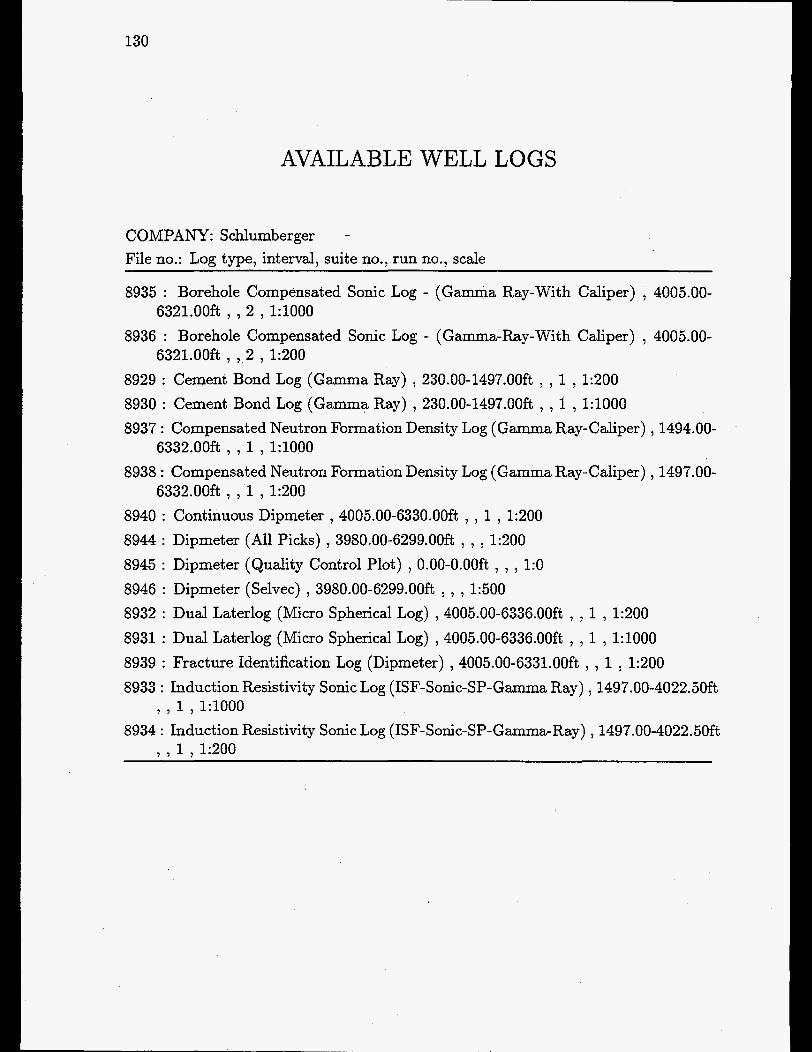
AVAILABLE WELL LOGS
130
COMPANY: Schlumberger - File no.: Log type, interval, suite no., run no., scale
8935 : Borehole Compensated Sonic Log - (Gamma Ray-With Caliper) , 4005.00-
8936 : Borehole Compensated Sonic Log - (Gamma-Ray-With Caliper) , 4005.00-
8929 : Cement Bond Log (Gamma Ray) , 230.00-1497.OOft , , 1 , 1:200 8930 : Cement Bond Log (Gamma Ray) , 230.00-1497.OOft , , 1 , 1:lOOO 8937 : Compensated Neutron Formation Density Log (Gamma Ray-Caliper) , 1494.00-
8938 : Compensated Neutron Formation Density Log (Gamma Ray-Caliper) , 1497.00-
8940 : Continuous Dipmeter , 4005.00-633O.OOft , , 1 , 1:200 8944 : Dipmeter (All Picks) , 3980.00-6299.OOft , , , 1:200
6321.00ft , , 2 , 1: lOOO
6321.00ft , , 2 , 1:200
6332.00ft , , 1 , 1:lOOO
6332.00ft , , 1 , 1:200
8945 : Dipmeter (Quality Control Plot) , 0.00-0.OOft , , , 1:0 8946 : Dipmeter (Selvec) , 3980.00-6299.OOft , , , 1:500 8932 : Dual Laterlog (Micro Spherical Log) , 4005.00-6336.OOft , , 1 , 1:200 8931 : Dual Laterlog (Micro Spherical Log) ,4005.00-6336.OOft , , 1 , 1 : lOOO 8939 : Fracture Identification Log (Dipmeter) , 4005.00-6331.OOft , , 1 , 1200 8933 : Induction Resistivity Sonic Log (ISF-Sonic-SP-Gamma Ray) , 1497.00-4022.5Oft
7 , 1 , 1 : l O O O 8934 : Induction Resistivity Sonic Log (ISF-Sonic-SP-Gamma-Ray) , 1497.00-4022.5Oft
, . 1 , 1:200

VA GN-2
AVAILABLE REPORTS
131
File no.: Author, company, title, publication date
8881: EXPRO : PVT analysis - Laboratory Report - Sampling no. 1 , December 1978.
8882: CHEVRON : Completion Report , September 1978. 8883: PALEOSERVICES : Stratigraphical/paleontological Final Report , October
8886: EXPRO : Operation Report - Open Hole Drill Stem Test - DST no. 1 and 2 ,
8887: LYNES UNITED SERVICES LTD. : Drill Stem Test - Technical Service
8888: LYNES UNITED SERVICES LTD. : Drill Stem Test - Technical Service
8889: Computed Dipmeter Results (tabulated) - Depth: 4020,2’-6298,6’ , September
8892: PETROLEUM TESTING SERVICE : Porosity and Permeability Data - Depth
8896: SEISMOGRAPH SERVICE LTD. : Well Velocity Survey and Calibration of
1978.
August 1978.
Report - Test no. 1 , August 1978.
Report - Test no. 2 , August 1978.
1978.
interval: 5021,4’-5255,3’ , March 1979.
Sonic Log , August 1978.