
Situational Leadership with the STIFIn Genetic Intelligence ...
Upload
independentCategory
view
1download
0
American Institute of Aeronautics and Astronautics
1
From Debris to Database: The Development of an Efficient Data Processing Chain for Space Situational Awareness
Services
Emmet Fletcher1, Vicente Navarro2 and Luis Martín3 European Space Agency, Villanueva de la Cañada, Madrid, 28691, Spain
and
Noelia Sánchez4 and Estrella Olmedo5 Elecnor Deimos, Tres Cantos, Madrid, 28760, Spain
The heart of an effective space surveillance system lies in the comprehensiveness and accuracy of the space object catalogue. The process to populate and maintain this catalogue is not a trivial exercise and requires the
manipulation of heterogeneous observation data to both perform orbit determination and correlation with objects already identified. The process should be sufficiently robust to allow the automatic incorporation of new objects as well as alerting for lost objects without a large overhead in terms of manpower and human interaction. The European Space Situational Awareness precursor programme has been developing such a system as part of its Space Surveillance element. This paper describes how the original design criteria were incorporated into the development of this system, as well as its incorporation into a modern service oriented
architecture.
I. Introduction n 2008, the ESA Council Meeting at Ministerial level made the resolution for the Agency to pursue the investigation and development of a European Space Situational Awareness (SSA) system1. The SSA Preparatory
Programme (PP) was therefore initiated with a view to providing services linked to three related areas: Space Surveillance and Tracking (SST), Space Weather (SWE) and Near-Earth Objects (NEO). This programme has and will develop new systems while reutilising existing assets made available either internally within ESA or through the participating ESA member states.
Space Situational Awareness (SSA) is defined as a comprehensive knowledge, understanding and maintained awareness of the population of space objects, the space environment and of the existing threats and risks. The overall aim of the Space Situational Awareness (SSA) Preparatory Programme is to support the European independent utilisation of and access to space for research or services, through providing timely and quality data, information, services and knowledge regarding the environment, the threats and the sustainable exploitation of the outer space surrounding our planet Earth. The Agency is responsible for the technical definition and development of the SSA system through to the deployment of an operational system.
In order to provide accurate services within the SST segment of the programme, a comprehensive database of Earth orbiting objects needs to be generated. The minimum size of the objects to be detected, the orbits which should be catalogued and the precision with which this data shall be maintained is defined through the synthesis of the mission requirements to customer requirements and from customer requirements to system requirements. In effect, the services to be provided drive the precision needed from the catalogue.
II. Data Processing Overview In order to populate this catalogue, an effective and autonomous means of accepting data from a network of
sensors, performing orbit determination on the observational data and correlating this data with pre-observed objects needs to be developed. In addition, this system – the data processing chain (DPC) – has to be able to propagate this orbital data into the future in order that it can be used by the relevant services. Once one combines these needs into 1 Space Surveillance and Tracking Manager, Space Situational Awareness Programme, ESA / ESAC, 2 Data Systems Manager, Space Situational Awareness Programme, ESA / ESAC. 3 Space Surveillance Engineer, Space Situational Awareness Programme, GMV at ESA / ESAC. 4 Head of SSA Division, Elecnor Deimos. 5 Project Engineer, Elecnor Deimos
I

American Institute of Aeronautics and Astronautics
2
an advanced architecture of sensors and its associated planning system, the overall scheme for the DPC becomes very complex.
In particular, the initialisation of the catalogue of objects, the so-called Cold Start of the Catalogue, is of special relevance to the Data Processing Chain since it requires the management of a huge amount of observational data. The coordination with the surveillance strategy performed by the sensors and with the Planning System for the planning and command of dedicated follow-ups that are essential for the cataloguing of objects in some specific orbital regions is, as it can be easily understood, of capital importance during this particular phase.
After the catalogue has been successfully initialised, the maintenance process of the orbital information should be organised in such an efficient and optimised way so as to allow the Data Processing Chain to work in smooth operations with the minimum possible human intervention. In consequence, it is of special relevance during this phase the automation of the processes that will follow each single piece of observational information, from the acceptance of such sensor information by the system, up to the publication of the produced orbital information in the catalogue of objects.
The activity that will drive the operations of the maintenance of the catalogue after it has been initialised will, however, be the so-called Catalogue Quality Monitoring function (together with the implementation of the surveillance strategy by the SSA sensors). The DPC has the specific requirement of maintaining the accuracy of the orbital information in the catalogue in such a way that it allows the conjunction prediction system to perform successful recognition of potential collisions of operational satellites with other objects in the catalogue. This means that, whenever the accuracy of the orbital data for a single object in the catalogue is detected to be falling outside the predefined thresholds, the DPC shall trigger the Planning System of the SST segment so as to request the required additional observations to the sensors in order to bring the accuracy of the information back to the appropriated limits.
It should be highlighted that it is of extreme importance during the construction of this complex system to establish the modularity of the system as one of the main requirements of the design and development phase. This will allow to, in the coming future, replace any existing component or algorithm by more developed or sophisticated ones.
The Data Processing Chain of the SSA Preparatory Programme is designed to handle a sustained rate for the reception of observations of 100 objects per minute, to manage a database of up to 5000 man-made space objects and to perform the whole processing of every single observation received in less than 30 minutes. These performance values are understood to be in line with what is requested for a Precursor Services system.
III. Observations Processing The observation classes delivered from the network of sensors within the SST system are heterogeneous in that
there are various different types of sensor considered to be utilised. Among these types one can consider optical or radar, tracking or surveillance (cued / non-cued), ground-based or space-based, integrated to the system or contributing from a third party. This leads to a number of types of observations that can be considered, each bringing its own specific characteristics and processing requirements. To this end, it has been considered for within the scope of the preparatory programme to expect data in Consultative Committee for Space Data Systems (CCSDS) Tracking Data Message (TDM) format2. This removes the uncertainty connected with the definition of the DPC input interface and establishes an international accepted standard as the main entry point of the system. The objective of such standardisation is to improve the interoperability of the system with the different sensors contributing to the SST and constituting a federated system which is, in fact, a system of systems.
The first step to be performed by the system is to implement a data fusion process integrating the observations coming from the different sensors, each one belonging to a specific type and with different characteristics and performances. The information is expected to be received in the form of tracks (coming from the radar sensors) or tracklets (coming from the optical sensors). A track potentially composed of the following elements: azimuth, elevation, range, range-rate and Radar Cross Section (RCS). And a tracklet composed of: right ascension, declination and visual apparent magnitude.
As it can be deduced when analysing the current version of the CCSDS TDM standard, it is not compatible with the information to be provided by the optical sensors. In particular, this standard does not consider the inclusion of the visual magnitude as an additional parameter produced by the observations. For this reason, a modification of such standard has been proposed for consideration by the CCSDS. In any case, and with the intention of testing the concept that may be implemented in the future, an evolution of such standard is going to be used by the DPC.
After the data has been received and integrated as part of the data fusion process, it will be validated in terms of format and contents and stored in a database of observations. Such storage system will contain all the observations
American Institute of Aeronautics and Astronautics
3
received by the SST from the various contributing sensors and will be classified by sensor type, sensor identifier and object identifier, after the correlation process has been successfully concluded.
The final function to be performed by this system consists in applying the appropriate calibration factors to better approximate to the specific characteristics of each sensor providing observations. These factors are determined as through dedicated calibration campaigns and permit the system to correct for any detected constant bias or drift introduced by the sensor in the operational observations.
IV. Correlation After a successful ingestion and initial validation of the observation data coming from all the SSA and Third
Party sensors has been performed, the system will identify, for each independent track provided, the object to which this information is potentially associated. If the information received is successfully linked to an already catalogued object, then it will help to improve the orbital data for such object and will extend the validity, in terms of accuracy, of such information. On the other hand, it is possible that the received tracks or tracklets are not found to correspond to any of the objects included in the catalogue, in which case it has to be temporarily classed as a potential new object observation. This temporary status is removed after future observations are received by the system for the same object, which would mean that, effectively, a new object has been discovered, detected and catalogued by the DPC.
Of special relevance during this phase is the performance of the system. Given the huge amount of man-made space objects that have been already catalogued by different systems (i.e. US Air Force Space Surveillance catalogue), it is easy to conclude that a single observation performed by a sensor will need to be correlated against several thousands of objects in the catalogue. The solution to this potential problem is the establishment of appropriate and efficient filters which allow the reduction of the number of potential candidates that the correlation process has to handle to a minimum.
As has been mentioned before, the DPC can be considered to correlate observations coming from the sensors. After the ingestion and validation of the observations, they have to be associated to one orbit stored in the catalogue or they have to be associated to an orbit of an object that is not already catalogued. In order to do this, the incoming observations are compared with the observables computed from the orbit estimations stored in the catalogue. Some filters have to take into account in order to reduce the number of orbits which are then compared with the incoming measurements. The DPC allows for three different filters:
The first filter consists in computing an orbit with the incoming tracklet and comparing observation, only with catalogued orbits that have similar orbital elements. The accuracy of this filter has been demonstrated to be low when the processed observations come from an optical survey. In this case, the tracklets are usually very short and therefore the accuracy in the first orbit computation is very poor (see section V for a brief description of the methods used for this computation and the reference literature3 for complete description of these algorithms and an analysis on the corresponding accuracy).
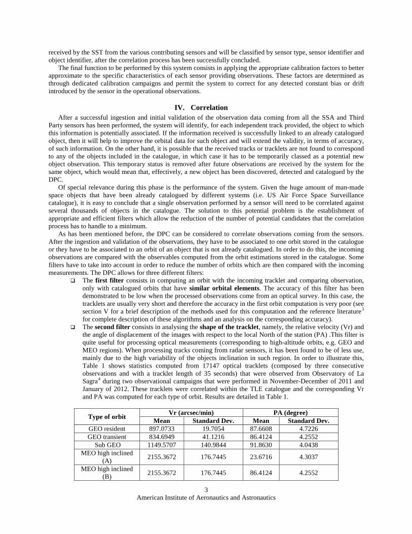
The second filter consists in analysing the shape of the tracklet, namely, the relative velocity (Vr) and the angle of displacement of the images with respect to the local North of the station (PA) .This filter is quite useful for processing optical measurements (corresponding to high-altitude orbits, e.g. GEO and MEO regions). When processing tracks coming from radar sensors, it has been found to be of less use, mainly due to the high variability of the objects inclination in such region. In order to illustrate this, Table 1 shows statistics computed from 17147 optical tracklets (composed by three consecutive observations and with a tracklet length of 35 seconds) that were observed from Observatory of La Sagra4 during two observational campaigns that were performed in November-December of 2011 and January of 2012. These tracklets were correlated within the TLE catalogue and the corresponding Vr and PA was computed for each type of orbit. Results are detailed in Table 1.
Type of orbit Vr (arcsec/min) PA (degree) Mean Standard Dev. Mean Standard Dev.
GEO resident 897.0733 19.7054 87.6608 4.7226 GEO transient 834.6949 41.1216 86.4124 4.2552
Sub GEO 1149.5707 140.9844 91.8630 4.0438 MEO high inclined
(A) 2155.3672 176.7445 23.6716 4.3037
MEO high inclined (B) 2155.3672 176.7445 86.4124 4.2552
American Institute of Aeronautics and Astronautics
4
GEO Transfer Orbits 725.2962 585.1098 85.8911 29.7778 Other 1134.7255 585.1098 88.0873 19.1146
Table 1. Statistics of Vr and PA computed from operational campaign performed in La Sagra The third filter consists in having previous knowledge on the surveillance observation strategies of the
sensors. In this case, the DPC needs to roughly know the area of sky that each sensor will cover. Then, the DPC stores, in advance, the predictions of where and when the orbits will cross each area of sky. Thus, when an incoming observation has to be processed, only the orbits that are expected to cross this sky area at this moment are considered for correlation. The operational implementation of this filter is still pending validation when considering a complex network of sensors implementing surveillance strategies of varying levels of complexity. The DPC is considered to be the most appropriate test-bed for this type of implementation.
After the filtering process has been performed, the differences between the received observations and the
simulated ones, for the candidate objects, are compared. Only the orbit that provides the minimum difference is considered as the best candidate for correlation. If the minimum difference is lower than predefined limits, then the correlation is considered as “successful”. Otherwise two different situations may occur: The observation corresponds to an un-catalogued object; or the observation corresponds to an already catalogued object that has performed a manoeuvre.
In addition, the DPC shall allow for the correlation of manoeuvrable objects. If the correlation process can be considered as one of the most demanding processes of the DPC in terms of design and implementation for free drift objects, it becomes even more complicated when trying to correlate objects that are operationally maintained and performing manoeuvres. In order to reduce the complexity of this task, a Manoeuvre Analysis function is included as part of the DPC so as to allow the determination of the most appropriate thresholds to be used when correlating manoeuvrable objects These thresholds are based on historical information of objects already detected as being performing manoeuvres.
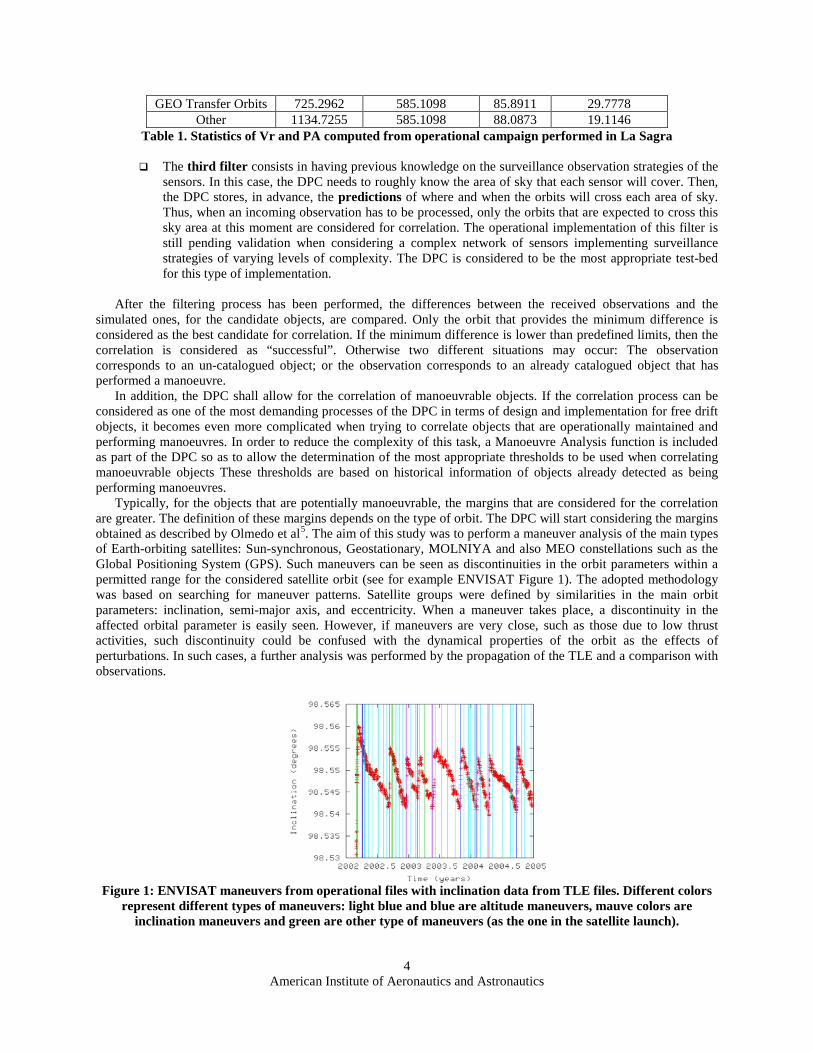
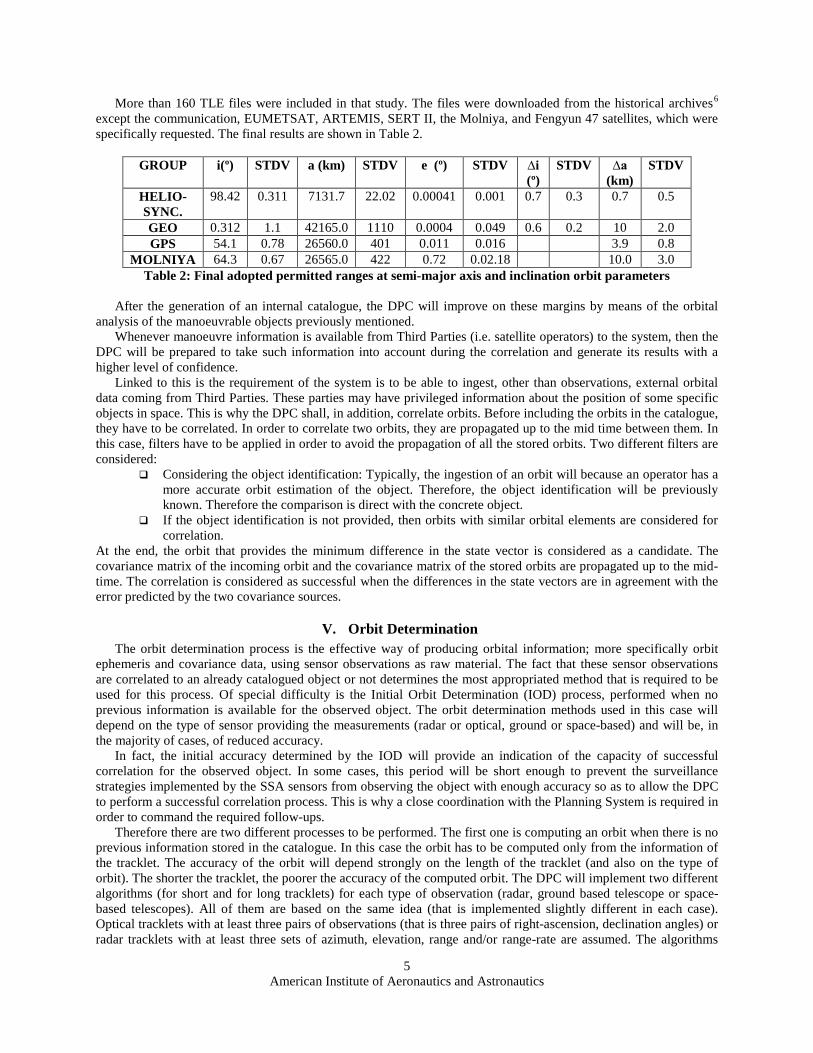
Typically, for the objects that are potentially manoeuvrable, the margins that are considered for the correlation are greater. The definition of these margins depends on the type of orbit. The DPC will start considering the margins obtained as described by Olmedo et al5. The aim of this study was to perform a maneuver analysis of the main types of Earth-orbiting satellites: Sun-synchronous, Geostationary, MOLNIYA and also MEO constellations such as the Global Positioning System (GPS). Such maneuvers can be seen as discontinuities in the orbit parameters within a permitted range for the considered satellite orbit (see for example ENVISAT Figure 1). The adopted methodology was based on searching for maneuver patterns. Satellite groups were defined by similarities in the main orbit parameters: inclination, semi-major axis, and eccentricity. When a maneuver takes place, a discontinuity in the affected orbital parameter is easily seen. However, if maneuvers are very close, such as those due to low thrust activities, such discontinuity could be confused with the dynamical properties of the orbit as the effects of perturbations. In such cases, a further analysis was performed by the propagation of the TLE and a comparison with observations.
Figure 1: ENVISAT maneuvers from operational files with inclination data from TLE files. Different colors
represent different types of maneuvers: light blue and blue are altitude maneuvers, mauve colors are inclination maneuvers and green are other type of maneuvers (as the one in the satellite launch).
American Institute of Aeronautics and Astronautics
5
More than 160 TLE files were included in that study. The files were downloaded from the historical archives6 except the communication, EUMETSAT, ARTEMIS, SERT II, the Molniya, and Fengyun 47 satellites, which were specifically requested. The final results are shown in Table 2.
GROUP i(º) STDV a (km) STDV e (º) STDV ∆i (º)
STDV ∆a (km)
STDV
HELIO- SYNC.
98.42 0.311 7131.7 22.02 0.00041 0.001 0.7 0.3 0.7 0.5
GEO 0.312 1.1 42165.0 1110 0.0004 0.049 0.6 0.2 10 2.0 GPS 54.1 0.78 26560.0 401 0.011 0.016 3.9 0.8
MOLNIYA 64.3 0.67 26565.0 422 0.72 0.02.18 10.0 3.0 Table 2: Final adopted permitted ranges at semi-major axis and inclination orbit parameters
After the generation of an internal catalogue, the DPC will improve on these margins by means of the orbital
analysis of the manoeuvrable objects previously mentioned. Whenever manoeuvre information is available from Third Parties (i.e. satellite operators) to the system, then the
DPC will be prepared to take such information into account during the correlation and generate its results with a higher level of confidence.
Linked to this is the requirement of the system is to be able to ingest, other than observations, external orbital data coming from Third Parties. These parties may have privileged information about the position of some specific objects in space. This is why the DPC shall, in addition, correlate orbits. Before including the orbits in the catalogue, they have to be correlated. In order to correlate two orbits, they are propagated up to the mid time between them. In this case, filters have to be applied in order to avoid the propagation of all the stored orbits. Two different filters are considered:
Considering the object identification: Typically, the ingestion of an orbit will because an operator has a more accurate orbit estimation of the object. Therefore, the object identification will be previously known. Therefore the comparison is direct with the concrete object.
If the object identification is not provided, then orbits with similar orbital elements are considered for correlation.
At the end, the orbit that provides the minimum difference in the state vector is considered as a candidate. The covariance matrix of the incoming orbit and the covariance matrix of the stored orbits are propagated up to the mid-time. The correlation is considered as successful when the differences in the state vectors are in agreement with the error predicted by the two covariance sources.
V. Orbit Determination The orbit determination process is the effective way of producing orbital information; more specifically orbit
ephemeris and covariance data, using sensor observations as raw material. The fact that these sensor observations are correlated to an already catalogued object or not determines the most appropriated method that is required to be used for this process. Of special difficulty is the Initial Orbit Determination (IOD) process, performed when no previous information is available for the observed object. The orbit determination methods used in this case will depend on the type of sensor providing the measurements (radar or optical, ground or space-based) and will be, in the majority of cases, of reduced accuracy.
In fact, the initial accuracy determined by the IOD will provide an indication of the capacity of successful correlation for the observed object. In some cases, this period will be short enough to prevent the surveillance strategies implemented by the SSA sensors from observing the object with enough accuracy so as to allow the DPC to perform a successful correlation process. This is why a close coordination with the Planning System is required in order to command the required follow-ups.
Therefore there are two different processes to be performed. The first one is computing an orbit when there is no previous information stored in the catalogue. In this case the orbit has to be computed only from the information of the tracklet. The accuracy of the orbit will depend strongly on the length of the tracklet (and also on the type of orbit). The shorter the tracklet, the poorer the accuracy of the computed orbit. The DPC will implement two different algorithms (for short and for long tracklets) for each type of observation (radar, ground based telescope or space-based telescopes). All of them are based on the same idea (that is implemented slightly different in each case). Optical tracklets with at least three pairs of observations (that is three pairs of right-ascension, declination angles) or radar tracklets with at least three sets of azimuth, elevation, range and/or range-rate are assumed. The algorithms
American Institute of Aeronautics and Astronautics
6
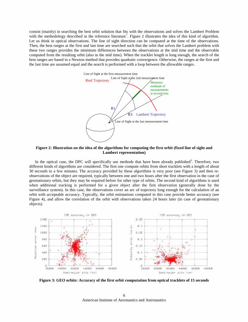
consist (mainly) in searching the best orbit solution that fits with the observations and solves the Lambert Problem with the methodology described in the reference literature7. Figure 2 illustrates the idea of this kind of algorithm. Let us think in optical observations. The line of sight direction can be computed at the time of the observations. Then, the best ranges at the first and last time are searched such that the orbit that solves the Lambert problem with these two ranges provides the minimum differences between the observations at the mid time and the observable computed from the resulting orbit (also in the mid time). When the tracklet length is long enough, the search of the best ranges are based in a Newton method that provides quadratic convergence. Otherwise, the ranges at the first and the last time are assumed equal and the search is performed with a loop between the allowable ranges.
Line of Sight at the last measurement time
Line of Sight at the first measurement time
Real Trajectory
R3
R1
Lambert Trajectory
Line of Sight at the 2nd measurement time Minimize
residuals of measurements at second time
Figure 2: Illustration on the idea of the algorithms for computing the first orbit (fixed line of sight and
Lambert representation)
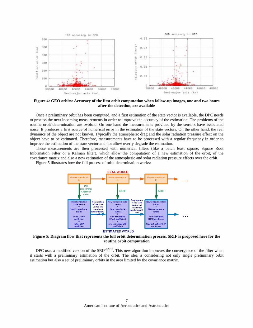
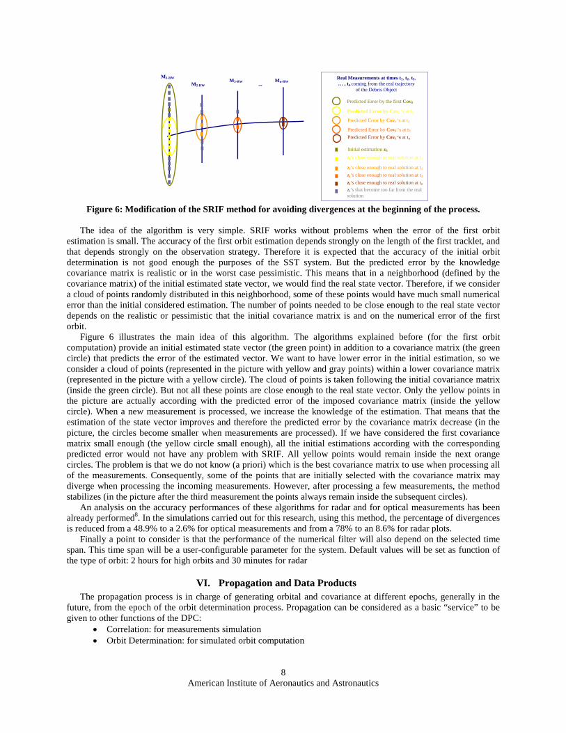
In the optical case, the DPC will specifically use methods that have been already published3. Therefore, two different kinds of algorithms are considered. The first one compute orbits from short tracklets with a length of about 30 seconds to a few minutes. The accuracy provided by these algorithms is very poor (see Figure 3) and then re-observations of the object are required, typically between one and two hours after the first observation in the case of geostationary orbits, but they may be required before for other type of orbits. The second kind of algorithms is used when additional tracking is performed for a given object after the first observation (generally done by the surveillance system). In this case, the observations cover an arc of trajectory long enough for the calculation of an orbit with acceptable accuracy. Typically, the orbit estimations computed in this case provide better accuracy (see Figure 4), and allow the correlation of the orbit with observations taken 24 hours later (in case of geostationary objects).
Figure 3: GEO orbits: Accuracy of the first orbit computation from optical tracklets of 15 seconds
American Institute of Aeronautics and Astronautics
7
Figure 4: GEO orbits: Accuracy of the first orbit computation when follow-up images, one and two hours
after the detection, are available
Once a preliminary orbit has been computed, and a first estimation of the state vector is available, the DPC needs to process the next incoming measurements in order to improve the accuracy of the estimation. The problems of the routine orbit determination are twofold. On one hand the measurements provided by the sensors have associated noise. It produces a first source of numerical error in the estimation of the state vectors. On the other hand, the real dynamics of the object are not known. Typically the atmospheric drag and the solar radiation pressure effect on the object have to be estimated. Therefore, measurements have to be processed with a regular frequency in order to improve the estimation of the state vector and not allow overly degrade the estimation.
These measurements are then processed with numerical filters (like a batch least square, Square Root Information Filter or a Kalman filter), which allow the computation of a new estimation of the orbit, of the covariance matrix and also a new estimation of the atmospheric and solar radiation pressure effects over the orbit.
Figure 5 illustrates how the full process of orbit determination works:
Figure 5: Diagram flow that represents the full orbit determination process. SRIF is proposed here for the
routine orbit computation
DPC uses a modified version of the SRIF8,9,10. This new algorithm improves the convergence of the filter when it starts with a preliminary estimation of the orbit. The idea is considering not only single preliminary orbit estimation but also a set of preliminary orbits in the area limited by the covariance matrix.
American Institute of Aeronautics and Astronautics
8
M1-RW
M2-RW M3-RW Mn-RW
Real Measurements at times t1, t2, t3, … , tn coming from the real trajectory
of the Debris Object ...
Predicted Error by the first Cov0
Predicted Error by Covi ‘s at t1
Predicted Error by Covi ‘s at t2
Predicted Error by Covi ‘s at t3 Predicted Error by Covi ‘s at tn
Initial estimation z0 zi‘s close enough to real solution at t1
zi‘s close enough to real solution at t2 zi‘s close enough to real solution at t3 zi‘s close enough to real solution at tn zi‘s that become too far from the real solution
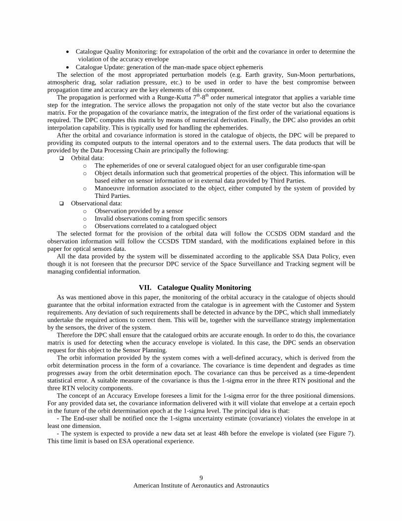
Figure 6: Modification of the SRIF method for avoiding divergences at the beginning of the process.
The idea of the algorithm is very simple. SRIF works without problems when the error of the first orbit
estimation is small. The accuracy of the first orbit estimation depends strongly on the length of the first tracklet, and that depends strongly on the observation strategy. Therefore it is expected that the accuracy of the initial orbit determination is not good enough the purposes of the SST system. But the predicted error by the knowledge covariance matrix is realistic or in the worst case pessimistic. This means that in a neighborhood (defined by the covariance matrix) of the initial estimated state vector, we would find the real state vector. Therefore, if we consider a cloud of points randomly distributed in this neighborhood, some of these points would have much small numerical error than the initial considered estimation. The number of points needed to be close enough to the real state vector depends on the realistic or pessimistic that the initial covariance matrix is and on the numerical error of the first orbit.
Figure 6 illustrates the main idea of this algorithm. The algorithms explained before (for the first orbit computation) provide an initial estimated state vector (the green point) in addition to a covariance matrix (the green circle) that predicts the error of the estimated vector. We want to have lower error in the initial estimation, so we consider a cloud of points (represented in the picture with yellow and gray points) within a lower covariance matrix (represented in the picture with a yellow circle). The cloud of points is taken following the initial covariance matrix (inside the green circle). But not all these points are close enough to the real state vector. Only the yellow points in the picture are actually according with the predicted error of the imposed covariance matrix (inside the yellow circle). When a new measurement is processed, we increase the knowledge of the estimation. That means that the estimation of the state vector improves and therefore the predicted error by the covariance matrix decrease (in the picture, the circles become smaller when measurements are processed). If we have considered the first covariance matrix small enough (the yellow circle small enough), all the initial estimations according with the corresponding predicted error would not have any problem with SRIF. All yellow points would remain inside the next orange circles. The problem is that we do not know (a priori) which is the best covariance matrix to use when processing all of the measurements. Consequently, some of the points that are initially selected with the covariance matrix may diverge when processing the incoming measurements. However, after processing a few measurements, the method stabilizes (in the picture after the third measurement the points always remain inside the subsequent circles).
An analysis on the accuracy performances of these algorithms for radar and for optical measurements has been already performed8. In the simulations carried out for this research, using this method, the percentage of divergences is reduced from a 48.9% to a 2.6% for optical measurements and from a 78% to an 8.6% for radar plots.
Finally a point to consider is that the performance of the numerical filter will also depend on the selected time span. This time span will be a user-configurable parameter for the system. Default values will be set as function of the type of orbit: 2 hours for high orbits and 30 minutes for radar
VI. Propagation and Data Products The propagation process is in charge of generating orbital and covariance at different epochs, generally in the
future, from the epoch of the orbit determination process. Propagation can be considered as a basic “service” to be given to other functions of the DPC:
• Correlation: for measurements simulation • Orbit Determination: for simulated orbit computation
American Institute of Aeronautics and Astronautics
9
• Catalogue Quality Monitoring: for extrapolation of the orbit and the covariance in order to determine the violation of the accuracy envelope
• Catalogue Update: generation of the man-made space object ephemeris The selection of the most appropriated perturbation models (e.g. Earth gravity, Sun-Moon perturbations,
atmospheric drag, solar radiation pressure, etc.) to be used in order to have the best compromise between propagation time and accuracy are the key elements of this component.
The propagation is performed with a Runge-Kutta 7th-8th order numerical integrator that applies a variable time step for the integration. The service allows the propagation not only of the state vector but also the covariance matrix. For the propagation of the covariance matrix, the integration of the first order of the variational equations is required. The DPC computes this matrix by means of numerical derivation. Finally, the DPC also provides an orbit interpolation capability. This is typically used for handling the ephemerides.
After the orbital and covariance information is stored in the catalogue of objects, the DPC will be prepared to providing its computed outputs to the internal operators and to the external users. The data products that will be provided by the Data Processing Chain are principally the following:
Orbital data: o The ephemerides of one or several catalogued object for an user configurable time-span o Object details information such that geometrical properties of the object. This information will be
based either on sensor information or in external data provided by Third Parties. o Manoeuvre information associated to the object, either computed by the system of provided by
Third Parties. Observational data:
o Observation provided by a sensor o Invalid observations coming from specific sensors o Observations correlated to a catalogued object
The selected format for the provision of the orbital data will follow the CCSDS ODM standard and the observation information will follow the CCSDS TDM standard, with the modifications explained before in this paper for optical sensors data.
All the data provided by the system will be disseminated according to the applicable SSA Data Policy, even though it is not foreseen that the precursor DPC service of the Space Surveillance and Tracking segment will be managing confidential information.
VII. Catalogue Quality Monitoring As was mentioned above in this paper, the monitoring of the orbital accuracy in the catalogue of objects should
guarantee that the orbital information extracted from the catalogue is in agreement with the Customer and System requirements. Any deviation of such requirements shall be detected in advance by the DPC, which shall immediately undertake the required actions to correct them. This will be, together with the surveillance strategy implementation by the sensors, the driver of the system.
Therefore the DPC shall ensure that the catalogued orbits are accurate enough. In order to do this, the covariance matrix is used for detecting when the accuracy envelope is violated. In this case, the DPC sends an observation request for this object to the Sensor Planning.
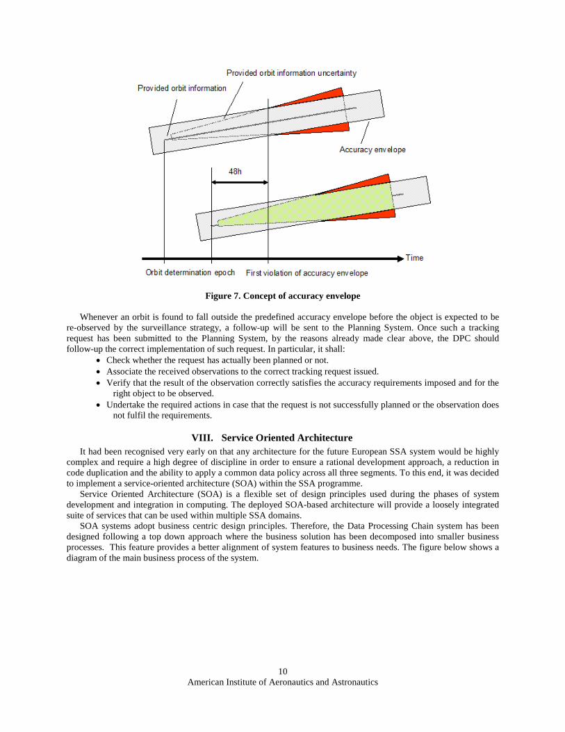
The orbit information provided by the system comes with a well-defined accuracy, which is derived from the orbit determination process in the form of a covariance. The covariance is time dependent and degrades as time progresses away from the orbit determination epoch. The covariance can thus be perceived as a time-dependent statistical error. A suitable measure of the covariance is thus the 1-sigma error in the three RTN positional and the three RTN velocity components.
The concept of an Accuracy Envelope foresees a limit for the 1-sigma error for the three positional dimensions. For any provided data set, the covariance information delivered with it will violate that envelope at a certain epoch in the future of the orbit determination epoch at the 1-sigma level. The principal idea is that:
- The End-user shall be notified once the 1-sigma uncertainty estimate (covariance) violates the envelope in at least one dimension.
- The system is expected to provide a new data set at least 48h before the envelope is violated (see Figure 7). This time limit is based on ESA operational experience.
American Institute of Aeronautics and Astronautics
10
Figure 7. Concept of accuracy envelope Whenever an orbit is found to fall outside the predefined accuracy envelope before the object is expected to be
re-observed by the surveillance strategy, a follow-up will be sent to the Planning System. Once such a tracking request has been submitted to the Planning System, by the reasons already made clear above, the DPC should follow-up the correct implementation of such request. In particular, it shall:
• Check whether the request has actually been planned or not. • Associate the received observations to the correct tracking request issued. • Verify that the result of the observation correctly satisfies the accuracy requirements imposed and for the
right object to be observed. • Undertake the required actions in case that the request is not successfully planned or the observation does
not fulfil the requirements.
VIII. Service Oriented Architecture It had been recognised very early on that any architecture for the future European SSA system would be highly
complex and require a high degree of discipline in order to ensure a rational development approach, a reduction in code duplication and the ability to apply a common data policy across all three segments. To this end, it was decided to implement a service-oriented architecture (SOA) within the SSA programme.
Service Oriented Architecture (SOA) is a flexible set of design principles used during the phases of system development and integration in computing. The deployed SOA-based architecture will provide a loosely integrated suite of services that can be used within multiple SSA domains.
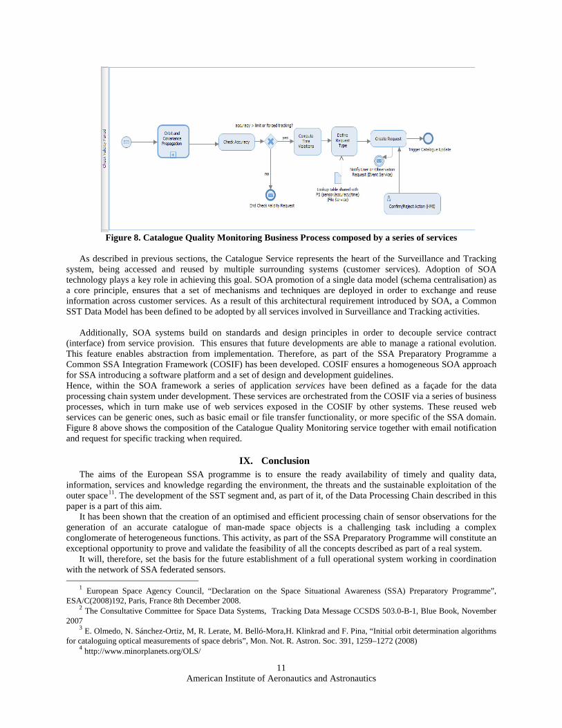
SOA systems adopt business centric design principles. Therefore, the Data Processing Chain system has been designed following a top down approach where the business solution has been decomposed into smaller business processes. This feature provides a better alignment of system features to business needs. The figure below shows a diagram of the main business process of the system.
American Institute of Aeronautics and Astronautics
11
Figure 8. Catalogue Quality Monitoring Business Process composed by a series of services
As described in previous sections, the Catalogue Service represents the heart of the Surveillance and Tracking
system, being accessed and reused by multiple surrounding systems (customer services). Adoption of SOA technology plays a key role in achieving this goal. SOA promotion of a single data model (schema centralisation) as a core principle, ensures that a set of mechanisms and techniques are deployed in order to exchange and reuse information across customer services. As a result of this architectural requirement introduced by SOA, a Common SST Data Model has been defined to be adopted by all services involved in Surveillance and Tracking activities.
Additionally, SOA systems build on standards and design principles in order to decouple service contract
(interface) from service provision. This ensures that future developments are able to manage a rational evolution. This feature enables abstraction from implementation. Therefore, as part of the SSA Preparatory Programme a Common SSA Integration Framework (COSIF) has been developed. COSIF ensures a homogeneous SOA approach for SSA introducing a software platform and a set of design and development guidelines. Hence, within the SOA framework a series of application services have been defined as a façade for the data processing chain system under development. These services are orchestrated from the COSIF via a series of business processes, which in turn make use of web services exposed in the COSIF by other systems. These reused web services can be generic ones, such as basic email or file transfer functionality, or more specific of the SSA domain. Figure 8 above shows the composition of the Catalogue Quality Monitoring service together with email notification and request for specific tracking when required.
IX. Conclusion The aims of the European SSA programme is to ensure the ready availability of timely and quality data,
information, services and knowledge regarding the environment, the threats and the sustainable exploitation of the outer space11. The development of the SST segment and, as part of it, of the Data Processing Chain described in this paper is a part of this aim.
It has been shown that the creation of an optimised and efficient processing chain of sensor observations for the generation of an accurate catalogue of man-made space objects is a challenging task including a complex conglomerate of heterogeneous functions. This activity, as part of the SSA Preparatory Programme will constitute an exceptional opportunity to prove and validate the feasibility of all the concepts described as part of a real system.
It will, therefore, set the basis for the future establishment of a full operational system working in coordination with the network of SSA federated sensors.
1 European Space Agency Council, “Declaration on the Space Situational Awareness (SSA) Preparatory Programme”, ESA/C(2008)192, Paris, France 8th December 2008.
2 The Consultative Committee for Space Data Systems, Tracking Data Message CCSDS 503.0-B-1, Blue Book, November 2007
3 E. Olmedo, N. Sánchez-Ortiz, M, R. Lerate, M. Belló-Mora,H. Klinkrad and F. Pina, “Initial orbit determination algorithms for cataloguing optical measurements of space debris”, Mon. Not. R. Astron. Soc. 391, 1259–1272 (2008)
4 http://www.minorplanets.org/OLS/

American Institute of Aeronautics and Astronautics
12
5 E. Olmedo, N. Sánchez Ortiz, M. Lerate, M. Belló-Mora, H. Klinkrad,
“Design and development of correlation techniques to maintain a space surveillance system catalogue”, Acta Astronautica 65 (2009) 1133–1148
6 http://celestrak.com 7 C. Simó, “Solución del problema de Lambert mediante regularización”. Collectanea Mathematica 24 (3), 231–248, 1973. 8 E. Olmedo, N. Sánchez-Ortiz, M. Ramos-Lerate, “Parallel Computation of Orbit Determination for Space Debris
population”, Lacoste, H. (Ed.), Proceedings of the Fifth European Conference on Space Debris, ESA SP-672 (CD-ROM), ESA Communication Production Office, ESTEC. European Space Agency, Noordwijk, The Netherlands, July, 2009.
9 E. Olmedo, N. Sánchez-Ortiz, N. Guijarro, J. Nomen, H. Krag, “Survey-only optical strategies for cataloguing space debris objects in the future European space surveillance system”, Advances in Space Research 48 (2011) 535–556
10 Bierman G.J., “Factorisation Methods for Discrete Sequential Estimation”, Mathematics in Science and Engineering, Volume 128, Academic Press 1977
11 European Space Agency, Space Situational Awareness Programme Board, SSA Mission Requirements Document, Rev. 3.
Copyright © 2022 FDOKUMEN