Formation Processes of Aeheulean Localities in the Hunsgi and Baichbal Valleys, Peninsular India
22
From: Paul Goldberg, Devid T. Bash 'and Michael D. Pe tra2li-i (eds . ) . 1993. Formtion Processes i n Archaeolo,c;ical Context. fJono- -- ---.- graphs- i n World Archrzco1or:y No. 17. Rladyson: Prehistory I3r€?"s. Formation Processes of Aeheulean Localities in the Hunsgi and Baichbal Valleys, Peninsular India K. Paddayya Deccan College Michael D. Petraglia Smithsonian Insfitution S tone Age investigations in India commenced one hundred and thirty years ago with the pioneering discoveries of Robert Bruce Foote around Madras (Foote 1916). Since that time, many important discoveries have been made, and impor- tant information about the Lower, Middle and Upper Paleolithic has been gathered. For the past three decades, and up to the present day, intens~ve regional studies have been performed in many parts of India, leading to an understanding of the geographical distribution of Paleolithic localities, Stone Age tech- nology, and the stratigraphic context of finds (for backgrounds, see Sankalia 1974; Jacobson 1979; Paddayya 1984; Misra 1987,1989). While much has been learned about the distribution and nature of Acheulean occurrences in India, little information about hominid behavior and activity has been acquired. This has primarily been due to the traditional emphasis placed on culture-stratigraphic relationships and the lack of large scale excavations at Paleolithic localitie.: in non-fluvial contexts. Behavior-orienled arcl~acologists in India have recognized that transported sites like those associated with high-energy river sediments and gravels do not help to rcconslrucl aspects of l~ominid aclivily. Emphasizing the discovery and invest~gation of local- ities in non-fluvial contexts, Jacobson (1970, 1975, 1985) and Paddapya (1977a, 1978,1982) systematically investigated localities in non-fluvial contexts, conducting large-scale, valley-wide surveys to recon- struct Acheulean activities. This represented an important departure from many othkr Paleolithic investigations in India, and it became apparent that in order to better understand Acheulean settlement and activity, not only did basin-wide surveys have to be carried out, but localities in their original depositional contexts had to be identified. Moreover, in order to analyze hominid activities, it has been realized that lateral excavations were needed to expose Paleolithic occupation surfaces (Corvinus 1968,1973,1981,1983). With the increased desire to understand intra-site and inter-site patterns, it was clear that more sophisti- cated approaches had to be used to deciphfr site formation processes. Most recently, Paddayya (1987a) has drawn attention to the multitude of processes that created the Stone Age archaeological r e k r d in India, broadly equivalent to formation process studies jn other parts of the world (Schiffer 1976, 1987; Binford 1981; Isaac 1989). For the first time in Indian Stone Age archaeology, emphasis was placed on the signili- cance of site formation research. This chapter expands upon the eilc form,~tion approach in India md discusses thc joint invcsl~g+ tion of Acheulean localities located in the Hunsgi and Baichbal Valleys, southern India. To illustrate thc various problems and issues raised by site formation
Transcript of Formation Processes of Aeheulean Localities in the Hunsgi and Baichbal Valleys, Peninsular India

From: Paul Goldberg, Devid T. Bash 'and Michael D. Pe t ra2 l i - i (eds . ) . 1993. F o r m t i o n Processes i n Archaeolo,c;ical Context. fJono- -- ---.- graphs- i n World Archrzco1or:y No. 17. Rladyson: Prehistory I3r€?"s.
Formation Processes of Aeheulean Localities in the Hunsgi and Baichbal Valleys, Peninsular India
K. Paddayya Deccan College
Michael D. Petraglia Smithsonian Insfitution
S tone Age investigations in India commenced one hundred and thirty years ago with the pioneering discoveries of Robert Bruce Foote
around Madras (Foote 1916). Since that time, many important discoveries have been made, and impor- tant information about the Lower, Middle and Upper Paleolithic has been gathered. For the past three decades, and up to the present day, intens~ve regional studies have been performed in many parts of India, leading to an understanding of the geographical distribution of Paleolithic localities, Stone Age tech- nology, and the stratigraphic context of finds (for backgrounds, see Sankalia 1974; Jacobson 1979; Paddayya 1984; Misra 1987,1989).
While much has been learned about the distribution and nature of Acheulean occurrences in India, little information about hominid behavior and activity has been acquired. This has primarily been due to the traditional emphasis placed on culture-stratigraphic relationships and the lack of large scale excavations at Paleolithic localitie.: in non-fluvial contexts.
Behavior-orienled arcl~acologists in India have recognized that transported sites like those associated with high-energy river sediments and gravels do not help to rcconslrucl aspects of l~omin id aclivily. Emphasizing the discovery and invest~gation of local- ities in non-fluvial contexts, Jacobson (1970, 1975, 1985) and Paddapya (1977a, 1978,1982) systematically
investigated localities in non-f luvial contexts, conducting large-scale, valley-wide surveys to recon- struct Acheulean activities. This represented an important departure from many othkr Paleolithic investigations in India, and it became apparent that in order to better understand Acheulean settlement and activity, not only did basin-wide surveys have to be carried out, but localities in their original depositional contexts had to be identified. Moreover, in order to analyze hominid activities, it has been realized that lateral excavations were needed to expose Paleolithic occupation surfaces (Corvinus 1968,1973,1981,1983).
With the increased desire to understand intra-site and inter-site patterns, it was clear that more sophisti- cated approaches had to be used to deciphfr site formation processes. Most recently, Paddayya (1987a) has drawn attention to the multitude of processes that created the Stone Age archaeological r e k r d in India, broadly equivalent to formation process studies jn other parts of the world (Schiffer 1976, 1987; Binford 1981; Isaac 1989). For the first time in Indian Stone Age archaeology, emphasis was placed on the signili- cance of site formation research.
This chapter expands upon the eilc form,~tion approach in India m d discusses thc joint invcsl~g+ tion of Acheulean localities located in the Hunsgi and Baichbal Valleys, southern India. To illustrate thc various problems and issues raised by site formation
62 Formafion Processes in Archaeological Context
processes, a representative sample of the Acheulean localities from the Hunsgi Valley (Gulbal 11, Hunsgi 11, Hunsgi V) and from the Baichbal Valley (Mudnur VIII, Mudnur X, Yediyapur I, Yediyapur IV, Yediyapur VI, Fatehpur V) was selected for compar- ison. Where appropriate, other Acheulean localities from the Hunsgi and Baichbal Valleys are mentioned to further illustrate problems and issues. The goal of this study is to place the localities on a relative, inter- pretive scale, assessing the degree to which natural processes influenced the composition and condition of the artifact accumulations and to infer the type and extent to which behavioral information was preserved at these localities.
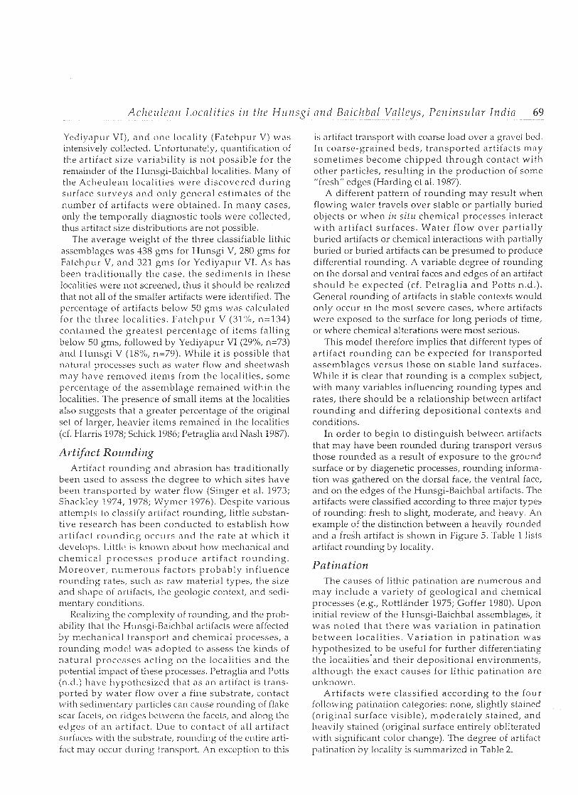
Regional Background The Hunsgi and Baichbal Valleys are located in the
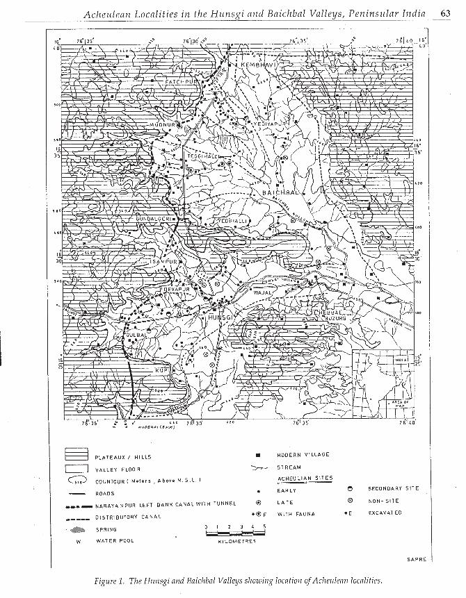
Gulbarga District of Karnataka. Although the valleys are separated from each other by a narrow remnant strip of a shale-limestone plateau, they still constitute a single erosional basin of Tertiary age (Mahadevan 1941; Mukherjee 1941). The basin contains the head- waters of a minor stream called the Hunsgi nullah, one of the minor left-bank feeders of the major Krishna River. The basin has a maximum length of 30 km (north-south) and measures about 500 square krns in extent (Figure 1). The basin is flanked by shale- limestone plateaus (at places capped by the Deccan Trap) on the southern and western sides and by low hills and outcrops of the Archaean formations (horn- blende schist and granite) on the northern and eastern sides. The basin floor itself is made up of granite gneiss and associated ridges of quartz, pegmatite and dolerite. The patches of limestone and shale occasion- ally found on the valley floor mark the remnants of erosion which carved out the basin. The enclosing of the valley by steep-sided escarpments on all sides and the lack of a direct relationship with a major river mark the basin off as a distinct and separate geographical unit.
The area forms part of the semi-arid and drought prone Deccan, with an average annual rainfall of about 65 cm, contributed by the southwest monsoon. The monsoonal climate came into existence in Peninsular India by the early part of the Pleistocene (Josl~i 1970). During the height of the wet, monsoonal season, the drainage pattern of the valley is dendritic, flowing towards the east and southeast. The season- ality of rainfall during the year largely governs the water flow in the beds of the nullahs and streams; the nullahs carry water only dur ing the wet season. During the wet season, numerous rills flow off the escarpments and drain lowards the valley floor. Shallow but perennial water bodies occur in the area
due to the activity of seep-springs emanating from the junction of shale and limestones with the underlying granite formations. The occurrence of thick and exten- sive travertine deposits proves that the activity of seep springs is of high antiquity based on uranium-series dates (Szabo et al. 1990).
Far from being a plainland, the valley floor presents a gently rolling topography resulting from the existence of a series of flattened, tongue-shaped sweeps of land separated from one another by shallow, linear-shaped depressions (8 to 10 km long and u p to 1 km in breadth) marking the ancient drainage tracts that carve out the valley floor. The present-day nullahs occupy the bottom portions of these depressions, with the gently rising sweeps of land along them serving as their inter-flueves. Many of the Acheulean localities found in the area occur on the upward sloping sides along the streams.
The Hunsgi-Baichbal Valleys have been under cultivation for at least two millennia, and more inten- sive cultivation for the last several hundred years. The vegetation today is characterized as a pseudo-steppe environment with low scattered shrubs (Gaussen et al. 1965). The discovery of small amounts of fauna at the Acheulean localities, including Bos, Bubn lus , Eleplzas, and Eqt ius, suggests that the area was a savanna woodland with sources of standing water (Paddayya 1985).
Stone Age research in the Hunsgi-Baichbal Valleys has been conducted since 1974 (Paddayya 1977a, 1977b, 1979,1982, 1987a, 1987b, 1987c, 1989, 1991). These prolonged investigations have brought to light a wealth of data pertaining to the Lower, Middle and Upper Paleolithic of the region. One important and significant difference in the distribution of these local- ities is that all Acheulean occurrences discovered to date are situated on the valley floor. After fifteen years of intensive survey, no Acheulean localities have been found on the plateaus above the valley floor and only Middle and Upper Paleolithic occur- rences occur on the surrounding plateaus.
Based upon seven uranium-series dates, the Acheulean localities have been dated from 150,000 B.P. to a minimum of 350,000 years B.P. (Szabo et al. 1990; Mishra 1992). Thus, the Acheulean localities date from the Middle Pleistocene to the early Late Pleistocene. Based upon currently accepted hominid chronologies this occupation may belong to an advanced form of Horno erectus or early representa- tives of Hovzo sapiens.
As stated above, surveys in the Hunsgi-Baichbal Valleys have emphasized the discovery of localities away from major river valleys for reconstructing Lhc settlement of Stone Age cultures (Paddayya 1978, 1982). This was in contrast to the then dominant
Acheu lean Local i t ies i n the Htrtzsgi and Baichbal Va l leys , Petzinsli lav India 63
PLATEAUX I H I L L S
T I VALLEY FLOOR
a COUNTOUR ( M e t e r s , Above M . 5 . L 1
ROADS
rr-- N A R A Y A N P U R LEFT B A N K CANAL W I T H TUNNEL
---_, OISTRIBUTORY C A N A L
SPRING
W WATER POOL
MODERN VILLAGE
S T R E A M
A C H E U L I A N S I T E S
EARLY
L A T E
W I T H FAUNA
SECONDARY S I T E
NON- S I T E
EXCAVATED
SAP R E
Figure 1. The Htlizsgi aizd Bnichbal Valleys sl~ozuirlg locafio~z ofAcheulea11 localities.
64 Fovi izat io~z Processes i i z Arc l z~eo lo , y i ca l C o i l t e s t ~_ _- . . . ._'! .~ -. - -
rcsearch paradigm in Indian Stone Agc! rc.search which concentrated on the construction of regional culture- sequences based on the study of secondary localities, such as those associated wi th r iver sect ions. Investigations in the Hunsgi Valley from 1974 to 1982 brought to light about 60 localities belonging to the Acheulean. Barring a dozen localities, all artifacts were discovered in non-fluviatile sedimentary contexts, and were therefore described as "primary" sites.
The implement-bearing horizon of the primary localities measured up to 25 cm in thickness and was usually overlain by a black soil, measuring up to half a meter in thickness. Based upon the estimated hori- zontal extent and composition of artifact clusters, these localities were divided into four groups: small (up to 25 specimens), medium (between 26 and 100 specimens), large (between 101 and 200 specimens), and very large (above 200 specimens). Two of these. so-called primary localities near Hunsgi (Localities Hunsg i V a n d Hunsg i VI) were excavated in an attempt to achieve a better understanding of the depo- sitional context of the occupation horizon and its spatial extent (Paddayya 1977b, 1979).
While this approach was generally welcomed and seen as a necessary departure in Indian prehistoric research, some doubts were also expressed about the "primary" character of the Acheulean localities of the area. In a review of the monograph dealing with the Hunsgi Valley study, Straus (1983) wondered whether or not the granite surface on which the Acheulenn horizon occurs could have been an ideal situation for spatial preservation without alteration. In addition, J.D. Clark (personal com~nunication, 1986) felt that the artifactual levels at these localities were colluvial in origin, implying that the artifacts were transported. A short time later, Lewis Binford (personal communica- tion, 1986) remarked that the sites were deflated, meaning that originally the localities had a fairly thick sedimentary cover which was eroded over the course of time.
At i l b o ~ ~ t tl>c s i i n ~ ~ ~ t i n ~ t , [hc,sv a r } ; t ~ ~ ) ~ ( ~ n t s L V C ~ I . ~ ~
made, I'adciayya (1987a) supported the perspc~ctivc~ that thc arcliac~ologic.al rc~-orci sllot~lcl 1101 1 ) ~ . v i c ~ ~ v c ~ c l simply as a dichotomy betwcc.n primary or scn)nti,lry sites, but rathcr as a continuum of sitc,s wit11 I c w ~ ~ r or greater degrees of preservat ion by natural a n d c~~ l tu ra l processes (cf. Schick 1986, 1987). The need for applying this concept in future investigations of the Achet~lean localities was therefore fully recognized and accepted.
Accordingly, some at tent ion was given to the problem of site formation in subsequent field investi- gations in the Baichbal Valley. Stildics from 1983 to 1989 consisted of an intensive survey of thr. valley floor leading to the discovery of oLTer 50 Achculean
localities (Paddayya 1987b, 1991). As was thc cast for tlic Hunsgi Valley localities, the Uaichbal localities also showed a distinct tendency to cluster along the sloping sides of inter-flueves, which together with ancient drainage tracts, contr ibuted to the gently rolling topography of the valley floor. The cluster of localities along the Fatehpur nullal-t is the richest group known from the area and consists of about 20 Acheulean localities in a stretch of about 3 to 4 kms (Paddayya 1989). One of these localities ly ing at Yediyapur (Locality VI) was excavated (Paddayya 1 9 8 7 ~ ) . In these studies, information was obtained about the environmental context of these localities- their relation to stream courses and/or the foothill zones, the nature of the local geological formation, the flat/sloping nature of the terrain around occurrences, and the nature of the sediment cover enveloping the artifactual material. Secondly, observations were also made about the horizontal integrity of the artifact scatters and about aspects of the lithic assemblages (e.g., number of artifacts, tool types, raw material composition). To investigate the potential disruptive effects of natural processes and the effects of surface run-off, an experimental station at Kembhavi in the Uaichbal Valley was established.
The main conclusion resulting isom the archaeolog- ical observations and from the experimental study is that gross categories like "primary" and "secondary" are certainly not n~eaningful for discussion about the Acheulean occurrences (see Schick 1987). Rather, it is more appropriate to conceive of these localities as representing various stages of preservation along a continuum, where there is a great degree of variability in natural and cultural formation processes. This vari- ability in natural and cultural formation processes is the subject of the remainder of this chapter.
Natural Formation Processes
Depositional Contexts
An increasing number of actualistic stuc1ic.s arc cloc~~~l lc,nl ing ~ I I V gc~nc~ral r~. l i l I i o ~ ~ s h i p I ~ C ~ ~ L V C Y ' I I t11('
ricpositional context of a site and the preservation of spnti,ll patterns (c.g., Isaac '1967; Rick 1976; Gill'ord and Uehrensmeyer 1977; Harris 1978; Bowers et al. 1983; Frostick and Reid 1983; Schick 1984, 1986, 1987; Petraglia and Nash 1987). 111 order to characterize the general depositional context of the Hunsgi-Uaicl-tbal localities, and to understand the potential postdeposi- tional processes which contributed to their formation, the localities were classified into the four following broad categories: a) fluvial occurrences, b) colluvial occurrences, c) sheetwash occurrences, and d) defla- tionary occurrences. Localities within the categor>~ of
Ac I IL ' I I I c~~ /~ L o c n l i t i ~ s ill 1/11' I - J I L I I S ~ I ~ ~ ~- - . - ~
fluvial occurrences have traclition;\lly been classified as "secondary" occurrences ~vhile loc'11itics \vithin Llw categories of colluvial, sheetwash ancl deflationary occurrences would have been classifiecl as "primciry" occurrences. The localities h,~Ce been divided into these four broad categories based upon their geomor- phic and sedimentological contexts. While the relat ionship between depos i t iona l context ancl integrity has been generally supported, the same studies often show that there can be tremendous vari- ation in str i i t igraphic integri ty wi th in thc stImc. depositional context. Nevertheless, the distinction between the four categor ies shou ld be a useful start ing point for character iz ing the dif ferences between the localities, and assessing the degree to
%
which the patterns are a result of cultural and natural p rocesses.
Flzrvinl Occl~rrences There are over a dozen localities belonging to this
category. Most of these occurrences lie in the south- western par t of the Hunsg i Valley; they are distributed over a distance of two kilometers from the shale-limestone plateau flanking tlie valley on the western side. Artifactual materials occur in fluvial gravels at all of these localities.
Gulbal I1 is the best known example of a fluvial conglomerate containing artifactual material. At this location a sheet-like limestone boulder and cobble conglomerate is exposed over an area measuring approximately a square kilometer in extent. In the gully sections exposed by present-day nullalis, tlie deposit was found to be about two meters thick. The deposit consists of sub-rounded to rounded cobbles and boulders, usually measuring up to 35 cm along their long axes. The conglomerates are set in a matrix of kankary silt and are fully cemented. Features s i~ch as size-sorting and orientation of rock pieces along their long axes can be observed in the deposit. The horizontal, sheet-like form of this conglomerate and the incipient nat~l re of size-sorting and orientation of clastic units along their long axes suggest that this deposit was laid down as a valley floor filling by sheet-floods. Rubble accumulations derived from the plateaus and kankar conglomerates (ancient slope deposits of pre-Acheulean age) probably served as the sources for the derivat ion of this deposit . In this connection, two to three meter thick kankar conglom- erate deposits, with Acheulean artifactual materials on its surface, were discovered in the foothill zone between the villages of Gulbal and Maralbhavi. While tliese localities often occur in stream channels, it should be noted that the origin of these materials cannot be f'lr from thc.ir source, since the, strc,,lnls ,>rc within the valley floor, and these do not flow off the
surrounding plateaus. In fact, it is also possible that some of the artifacts within the fluvial conglomerates are discarded objects in paleo-stream settings.
Collz~vinl Occz~rrerzces There are about half a dozen localities belonging to
this category. These localities are located in or close to the foothill zone of the plateaus. The best examples are provided by a locality near Kembhavi in the Baichbal Valley a n d a t Wajal VIII in the Hunsgi Vallcy. At both of these locations the implemcnt- bearing deposit measures more than a meter thick and is exposed as patches measur ing 50 to 80 meters across. The deposit consists of angular limestone debris with some of the blocks measuring over a lialf- meter across. The limestone blocks and debris are set in a matrix of consolidated kankary silt. Unlike the fluviatile conglomerates, these deposits are poorly sorted and tlie rock fragments still preserve angular features on their surfaces. The artifacts locally occur throughout the sedimentary deposits. Thus, these deposits are not tied to fluvial activity; rather, these likely represent debris flow pediment surfaces.
SIzeetzunsh Occurrences Slieetwash occurrences are common in the Hunsgi-
Uaichbal Valleys. The wide spread of the artifactual mater ia l a t the local i t ies appears to have been displaced by surface run-off. Consequently, i t is likely to have suffered some degree of horizontal displace- ment, particularly in situations where it occurs on sloping surfaces. Fafehpur VIII in the Baichbal Valley is one of the best examples of this situation, consisting of a discrete area of artifacts, but low in density and distributed over a large area. This situation would primarily occur in areas lacking vegetation cover, on localities which were not originally buried, or at local- it ies which have been exposed to tlie surface by deflation. This category occupies an intermediate posi t ion between t ranspor ted assemblages and deflated occurrences.
These are the most common types of localities encountered in the Hunsgi-Baichbal Valleys, occur- ring in both the foothill area and on the valley floor. Many localities were probably formerly covered with a black soil which, on account of erosion and agricul- tural activities, has been loosened and removed by surface runoff. This probably caused a portion of the artifactual material to be winnowed away, while the remainder of the assemblage settled in the same spot.
Although deflationary o<ccurrences are inferred to rc!prc~wnt areas of honiinid activity, there arc diffcr- ences among these localities with respect to their
66 Format ion Processes in A r c h a e o l o ~ i c a l Con tex t
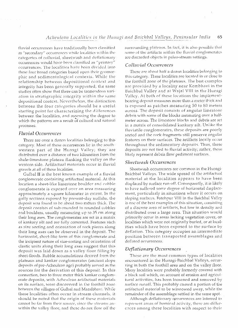
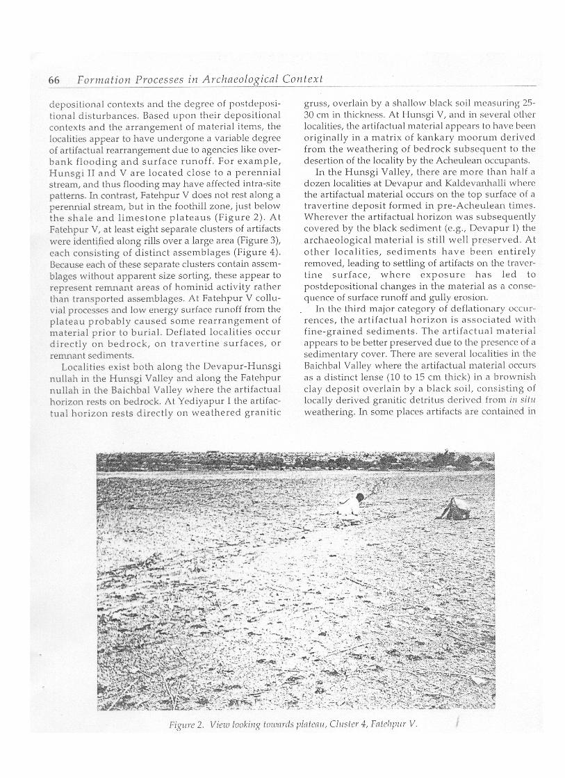
depositional contexts and the degree of postdeposi- tional disturbances. Based upon their depositional contexts and the arrangement of material items, the localities appear to have undergone a variable degree of artifactual rearrangement due to agencies like over- bank flooding and surface runoff. For example, Hunsgi I1 and V are located close to a perennial stream, and thus flooding may have affected intra-site patterns. In contrast, Fatehpur V does not rest along a perennial stream, but in the foothill zone, just below the shale and l imestone plateaus (Figure 2). At Fatehpur V, at least eight separate clusters of artifacts were identified along rills over a large area (Figure 3), each consisting of distinct assemblages (Figure 4). Because each of these separate clusters contain assem- blages without apparent size sorting, these appear to represent remnant areas of hominid activity rather than transported assemblages. At Fatehpur V collu- vial processes and low energy surface runoff from the plateau probably caused some rearrangement of material prior to burial. Deflated localities occur directly on bedrock, on travert ine surfaces, or remnant sediments.
Localities exist both along the Devapur-Hunsgi nullah in the Hunsgi Valley and along the Fatehpur nullah in the Baichbal Valley where the artifactual horizon rests on bedrock. At Yediyapur I the artifac- tual horizon rests directly on weathered granitic
gruss, overlain by a sl~allow black soil measuring 25- 30 cnn in thickness. At Hunsgi V, and in several other localities, the artifactual material appears to have been originally in a matrix of kankary moorum derived from the weathering of bedrock subsequent to the desertion of the locality by the Acheulean occupants.
In the Hunsgi Valley, there are more than half a dozen localities at Devapur and Kaldevanhalli where the artifactual material occurs on the top surface of a travertine deposit formed in pre-Acheulean times. Wherever the artifactual horizon was subsequently covered by the black sediment (e.g., Devapur I) the archaeological material is still well preserved. At other localities, sediments have been entirely removed, leading to settling of artifacts on the traver- tine surface, where exposure has led to postdepositional changes in the material as a conse- quence of surface runoff and gully erosion.
In the third major category of deflationary occur- rences, the artifactual horizon is associated with fine-grained sediments. The artifactual material appears to be better preserved due to the presence of a sedimentary cover. There are several localities in the Baichbal Valley where the artifactual material occurs as a distinct lense (10 to 15 cm thick) in a brownish clay deposit overlain by a black soil, consisting of locally derived granitic detritus derived from i l l sit11 weathering. In some places artifacts are contained in
Figure 3. F17tehpr V sho~uing c111sters.
the black soil, which measures up to 3 meters in thick- ness. The brown clay and black soil can be found at Mudnur VIII, Mudnur X, Yediyapur IV, and Yediyapur VI.
Artifact Analyses
In order to supplement the depositional informa- tion and to examine aspects of site formation, artifact analyses were performed including study of artifact size, rounding, patination, and weathering. Each of thesc-variables was considered useful for evaluating the contribution of natural processes on the formation of the localities, although it was recognized that multiple sets of criteria, rather than any one single variable, would be most useful for assessing site formation.
The following scction comparcs 3 Acheulean locali- ties from the Hunsgi Valley (Gulbal 11, Hunsgi 11,
Hunsgi V) and 6 localities from the Baichbal Valley (Mudnur VIII, Mudnur X, Yediyapur I, Yediyapur IV, Yediyapur VI, and Fatehpur V). As described above, Gulbal I1 was classified as a fluvial occurrence; the other eight localities were classified as deflationary occurrences, situated on bedrock, on travertine or in fine-grained sediments. Thus the goal of the following analysis is two-fold: a) to distinguish how Gulbal 11, a fluvial occurrence, differs from the localities which may be classified as deflationary occurrences, and b) to examine the variability between the localities classi- fied as deflationary occurrences. Unfortunately, at the time of this analysis, no information was collected on localities that could be classified as colluvial or sheet- wash occurrences.
Art i fact Size Distribzltions Archaeologists have recognized that artifact size
distributions may be used to indicate the role of

68 Format ion Processes iiz Archneolog-icnl _ ~_ Coirtext ___ _-.-
* ARTiFACTS ( F I N I S H E D TOOLS + D E B I T A G E J
0 ROCK P I E C E S , RAW M A T E R I A L ( GRANITE , OOLERITE, SCHIST , QUARTZ ,CHERT, E tc . J
0 20 LO 6 0 80 100 - C M S
natural processes in sort ing archaeological assern- Petraglia and Nash 1987; Petragiia 1987; Petraglia and blages (c f Schiffer 1983, 1987). Investigators have Potts n.d.) . However, as a s ingle variable, caution shown that art i fact assemblages may be sorted by should be exercised since the same studies h a \ ~ e some- natural processes, and small items may be selectively times shown that smal l i tems m a y remai11 at a site removed from sites by gravity, sheetwash, and fluvial despite the operation of natural processes. proccss5~s (e .g . , Isaac 1967; Rick 1976; I -J i~r l - is 1978; Two Achculcan assemblages Irom thc M~~r l sg i - Frost ick a n d Reid 1983; Schick 1984, 1986, 1987; l iaichbal Valleys have been excavated (I-lunsgi \I,
Yediyapur VI), a n d one locality (Fatehpur V) w'is intensively collected. Unfortunately, quantification of the artifact s ize variabil i ty is not possible for the remainder of tlie Hunsgi-Baichbal localities. Many of the A c h e ~ ~ l e a n localities lvere discovered dur ing surface surveys and only general estimates of the number of artifacts were obtained. In many cases, only the temporally diagnostic tools were collected, thus artifact size distributions are not possible.
The average weight of the three classifiable lithic assemblages was 438 gms for Hunsgi V, 280 gms for Fatehpur V, and 321 gms for Yediyapur VI. As has been traditionally the case, the sediments in these localities were not screened, thus it should be realized that not all of the smaller artifacts were identified. The percentage of artifacts below 50 gms was calculated for the three localit ies. Fatehpur V (31%, n=134) contained the greatest percentage of i tems falling below 50 grns, followed by Yediyapur VI (29'%, n=73) and Hunsgi V (I$%, 11~79). While it is possible that natural processes such as water flow and sheetwash may have removed items from the localities, some percentage of the assemblage remained within the localities. The presence of small items at the localities also suggests that a greater percentage of the original set of larger, heavier items remained in the localities (cf. Harris 1978; Schick 1986; Petraglia and Nash 1987).
Artifact Rorinding Artifact rounding and abrasion has traditionally
been used to assess the degree to which sites have been transported by water flow (Singer et al. 1973; Shackley 1974, 1978; Wymer 1976). Despite various attempts to classify artifact rounding, little substan- tive research has been conducted to establish how artifact round ing occurs and the rate at which i t clcvelops. Little is known about how mechanical and chemical processes p roduce art i fact round ing . Moreover , numerous factors probably influence rounding rates, such as raw material types, the size and shape of artifacts, the geologic context, and sedi- mentary conditions.
Realizing the complexity of rounding, and tlie prob- ability that the Hunsgi-Baiclibal artifacts were affected by mechanical transport and chemical processes, a rounding model was adopted to assess the kinds of natura l processes act ing on the localities and the potential impact of these processes. Petraglia and Potts (n.d.) have hypothesized that as an artifact is trans- ported by water flow over a fine substrate, contact with sedimentary particles can cause rounding of flake scar facets, on ricdges between the facets, and along the edges of an arti fact. Due to contact of all art i fact surfaces with the substrate, rounding of the entire arti- fact may occur during transport. An exception to this
is artifact transport with coarse load over a gravel bed. In coarse-grained beds, t ransported artifacts may sometimes become chipped through contact with other particles, resulting in the production of some "fresh" edges (Marding et al. 1987).
A different pattern of rounding may result when flowing water travels over stable or partially buried objects or when in s i tu chemical processes interact wi th art i fact surfaces. Water f low over partial ly buried artifacts or chemical interactions with partially buried or buried artifacts can be presumed to produce differential rounding. A variable degree of rounding on the dorsal and ventral faces and edges of an artifact should be expected (cf. Petraglia a i d Potts n.d.) . General rounding of artifacts in stable contexts would only occur in the most severe cases, where artifacts were exposed to the surface for long periods of time, or where chemical alterations were most serious.
This model therefore implies that different types of artifact rounding can be expected for transported assemblages versus those on stable land surfaces. While it is clear that rounding is a complex subject, with many variables influencing rounding types and rates, there should be a relationship between artifact rounding and differing deposit ional contexts and conditions.
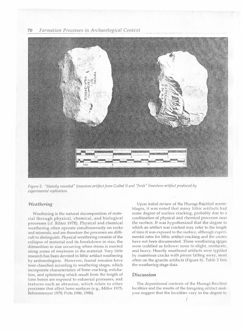
In order to begin to distinguish between artifacts that may have been rounded during transport versus those rounded as a result of exposure to the ground surface or by diagenetic processes, rounding informa- tion was gathered on the dorsal face, the ventral face, and on the edges of the Hunsgi-Baichbal artifacts. The artifacts were classified according to three major types of rounding: fresh to slight, moderate, and heavy. An example of the distinction between a heavily rounded and a fresh artifact is shown in Figure 5. Table 1 lists artifact rounding by locality.
The causes of lithic patination are numerous and may include a variety of geological and chemical processes (e.g., Rottldnder 1975; Goffer 1980). Upon initial review of tlie Hunsgi-Baichbal assemblages, it was noted that there was var iat ion in patination be tween localit ies. Var ia t ion in pat inat ion was hypothesized to be useful for further differentiating the localities'and their depositional environments, al though the exact causes for lithic patination are ~ ~ n k n o w n .
Artifacts were classified according to the four following patination categories: none, slightly stained (original surface visible), moderately stained, and heavdy stained (original surface entirely obliterated with significant color change). The degree of artifact patination by locality is summarized in Table 2.
70 Forlnation Processes ilz Arcl~neological - - Contex t
Figlire 5. "Heavi ly rounded" litilestorze clrt@ctfrotil Giilbal 11 ntld 'Ifresh" l i t rmtouc arfifrrct podziced by experirrrerztnl rrplicntioiz.
Weathering
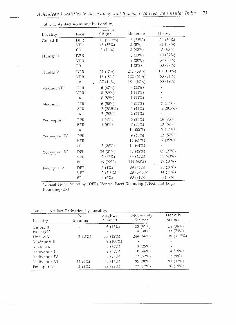
Weathering is the natural decomposition of mate- rial through physical, chemical, and biological processes (cf. Ritter 1978). Physical and chemical weathering often operate simultaneously on rocks and minerals, and are therefore the processes arc diffi- cult to distinguish. Physical weathering consists of the collapse of material and its breakdown in size, the dimunition in size occurring when stress is exerted along zones of weakness in the material. Very little research has been devoted to lithic artifact weathering by archaeologists. However, faunal remains have been classified according to weathering stages, which incorporate characteristics of bone cracking, exfolia- tion, and splintering which result from the length of time bones are exposed to subaerial processes, and features such as abrasion, which relate to other processes that affect bone surfaces (e.g., Miller 1975; Behrensmeyer 1978; Potts 1986, 1988).
Upon initial review of the Hunsgi-Baichbal assem- blages, it was noted that many Iithic artifacts had some degree of surface cracking, probably due to a combination of physical and chemical processes near the surface. It was hypothesized that the degree to which an artifact was cracked may refer to the length of time i t was exposed to thc surfacc, n l h ~ u g l i cxpcri- mental rates for ljthic artifact cracking and the causes have not been documented. Three weathering stages were codified as follows: none to slight, moderate, and heavy. Heavily weathered artifacts were typificd by numerous cracks with pieces falling away, most often on the granite artifacts (Figure 6). Table 3 lists the weathering stage data.
Discussion
The depositional contexts of the Hunsgi-Baichbal localities and the results of the foregoing artifact anal- yses suggest that the localities vary in the degree to
- -- -
ACIIL~IIIC(III L O C ( I ~ I ~ I C S I I I f l l ~ H u n s g i n t ~ d Bnichbnl Val leys, Pen insu lar India 71 - - --- - - - - - - - - - - - -- -
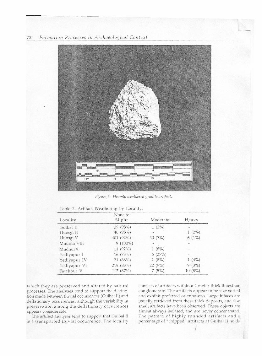
Table 1. Art~fact Rounding by Locality.
Fresh to Locality Face* S l lght Moderate Heavy
Gulbal I1 DFR 13 (32.5%)
Hunsgi I1
Hunsgi V
Mudnur VIII
Yediyapur I
Yediyapur IV
Yediyapur VI
VFIi E I<
DFR VFR ER
DFR VFR ER
DFR VFR ER
DFR VFIi ER
DFR VFR ER
DFR VFR ER
DFR VFR ER
DFR VFR ER
*Dorsal Facet Rounding (DFR), Ventral Facet Rounding (VFR), and Edge Ro~rnding (ER)
Table 2. Artifact Patination by Locality. No Sl ight ly Moderately Heav i l y
Locality Staining Stained Stained Stained
Gulhal I1 Hunsgi I1 Hunsgi V Mudnur VIII M L I ~ I I L I ~ X Yediyapur I Yediyapur IV Ycdiyapur VT
- 72 Format ion Processes in Archneolo,qicnl Co i l tex t
Table 3. Artifact Weathering by Locality.
None to Locality Slight Moderate Heavy
Gulbal I1 Hunsgi I1 Hunsgi V Mudnur VIII MudnurX Yediyapur I Yediyapur IV Yediyapur VI Fatehpur V
which they are preserved and altered by natural processes. The analyses tend to support the distinc- tion made between fluvial occurrences (Gulbal 11) and deflationary occurrences, although the variability in preservation among the deflationary occurrences appears considerable.
The artifact analyses tend to support that Gulbal I1 is a transported f luvial occurrence. The locality
consists of artifacts within a 2 meter thick limestone conglomerate. The artifacts appear to be size sorted and exhibit preferred orientations. Large bifaces are usually retrieved from these thick deposits, and few sinall artifacts have been observed. These objects are almost always isolated, and are never concentrated. The pat tern of h ighly rounded artifacts and a percentage of "chipped" artifacts at Gulbal I1 holds

rvith ihc model of transported assemblages in coarse- gr"ned stream beds. The lower proport ion of
artifacts in this assemblage either indicates burial of the artifacts once they were deposited, or gcncrd smoothening of these predominantly lime- stone objects by water flow.
In contrast to Gulbal 11, the deflationary occur- rences appear to be assemblages that have retained some degree of depositional integrity, although the degree to which they have been modified by natural processes varies.
Two localities situated in fine-grained sediments, Mudnur VIII and Mucinur X, appear to have retained the greatest dcgrce of deposit ional integrity. The favorable depositional setting and the artifact anal- yses appear to indicate well preserved assemblages, not seriously sorted by natural processes. The artifacts from the Mudnur localit ies are usual ly fresh in appearance, and are infrequently pat inated and weathered. Pedestr ian s ~ l r v e y over Mudnur X revealed a wide distribution of artifacts, with variable clusters of material, consisting of both small and large artifacts. Mudnur VIII consisted of a small number of standardized handaxes in a confined area, standing apart from all other Acheulean localities. The fine- grained deposi ts , the art i fact analyses and the presence of an unusual set of Acheulean artifacts would imply that the Mudnur localities retain a high dc>gl.c1c of' L~c~l~,lvior,~l inkgrity.
The Yediyapur VI assemblage occurs in a weath- ered granite gruss, partially covered by a black soil. The artifact analyses imply that Yediyapur VI retains some degree of integrity, but preservation is not as good as that noted at the Mudnur localities. A propor- tion of the smaller artifacts is present, implying that if winnowing occurred, it was not severe. Yediyapur VI displays variation in the degree of rounding on arti- facts, suggesting that ro~uiding has occurred as a result of long-term exposure to the surface rather than from transport. Indeed, the high percentage of weathered pieces supports tlie notion that artifacts were exposed to the surface for some length of time. Despite being covered by black soil, the presence of weathered arti- facts suggests that the assemblage was exposed on the surface before final burial, and thus postdepositional processes may have acted on this locality.
In the case of Hunsgi V and Fatehpur V, the sedi- ments were probably eroded away a long with a proportion of the artifacts, the assemblages corning to rest on or near bedrock surfaces. At these localities a proport ion of the smaller artifacts is still found, suggesting that not all of the smaller elements have been winnowed from the locality. These two localities do not contain large percentages of fresh artifacts nor highly roundcd artifacts suggesting that rounding has
occurred as a result of long-term exposure to the surface rather than from transport. While Fatehpur V contains high percentages of eroded pieces, the dorsal and ventral rounding values are quite different, arguing for exposure of artifacts rather than transport. The presence of some weathered pieces supports the notion that artifacts were exposed to the surface for some length of time.
Yediyapur I and Hunsgi I1 appear to be most affected by postdepositional processes, consisting of either severe in si tu processes or possibly transport. These localities are close to bedrock, and they have been exposed by erosion. Yediyapur I and Hunsgi 11 havc high pcrccntnges of hcavily rounded artifacts, suggesting the possibility of transport, tlie operation of long-term diagenetic processes, or exposure to the surface. Transport may be indicated by the high percentage of dorsal and ventral rounding and the high percentage of edge rounding. Hunsgi I1 displayed the greatest percentage of pat inated pieces, further signalling the operation of postdepositional processes. Yediyapur I contains a high percentage of weathered pieces, implying long-term exposure to the surface.
Yediyapur IV appears to occupy an intermediate position between the deflated sites. At this locality, the artifacts show signs of moderate rounding and weathering.
The sedimentary contexts and artifact analyses s~lggcst that the integrity of the Acheulean localities varies considerably. In order to put the Acheulean localities in a proper comparative framework, the localities were ranked according to the degree to which they have been modified by natural processes. The localities may be viewed on different interpretive scales, including basin-wide and intra-site scales.
Basin-Wide Scale The Hunsgi and Baichbal Valleys took their basic
geological configuration during the Tertiary. Since that time, there has been overall geological stability, and no evidence for tectonic movements. The basin has also been general ly stable, indicated by an unchanging basin configuration, the limited evidence for major fluvial activity, and the gentle gradient of the valley floor. These factors account for the preser- vation of the Acheulean localities to a degree not normally seen in high energy fluvial contexts.
The Hunsgi and Baichbal Valleys are not part of a large river valley with a deep channel, but rather the valleys occur in the headwater zone of the major Krishna drainage. There are no major rivers in the valley that could have caused long distance transport of the artifactual material. The Acheulean localities occur within distances varying from a few hundred meters to a few kilometers from the foothill zone and,

F o r t n n t i o ~ ~ Processes i ~ z Arcilncoloaicnl Corl text - - "
as a result, the question of long-distance transport cannot be supported.
Since the Aclieulcan localities occur in tlie head- water zone, the operat ion of low order al luvial processes has meant that the Acheulean localities have not been subject to f luvial processes of the magni tude experienced in major r iver valleys. However, because of their location, there was little source for sediment accun~ulation, and thus the Iocali- ties were not deeply buried.
Archaeological evidence may be used to support the lack of wholesale assemblage transport. The fact that there are Middle and Upper Paleolithic occupa- tions on tlie plateaus is significant, and means that the basin has certainly taken on its config~iration at least since the Middle Paleolithic. That is, if there was continuous erosion from the plateaus since the Middle Paleolithic, there would be little evidence of intact localities on these surfaces.
The Acheulean localities on the valley floor are distinct, localized occurrences, and certain patterns to be discussed below suggest they are tlie product of Acheulean activity, rather than transported accumula- tions. Factors such as surface runoff, minor stream action, and colluvial I3rocc.ssc.s surcly causcd spatial alterations at the localities. Howevcr, the magnitude of these natural processes were partially offset by factors like gentle slope of tlie valley floor and the presence of vegetation, part icular ly tlie grass cover which responds quickly to the availability of soil moisture.
Many of the Acheulean localities in the Hunsgi- Baichbal Valleys, and in many other valleys in India, occur in plowed fields. The denudation of artifactual levels could have been a serious factor especially in the last half century or so on account of vegetation clearance and reclamation of the land for agricultural purposes. It should be noted that in the Hunsgi- Baichbal Valleys, the effects of traditional Indian plowing have certainly been less disturbing than mechanical techniques. As such, the scope fo r displacement, both vertically and horizontally, of arti- facts is not as severe. This is particularly true in the case of Acheulean localities which tend to yield high percentages of large, heavy artifacts.
Site Scale A major question raised in this study is the implica-
tion of the depositional contexts of the localities for understanding spat ial integrity. The distinction between spot provenience and point provenience seems useful to bear in mind. In the former case the artifact assemblage is still confined to the spot or locality, whereas point provenience refers to the orig- inal posit ions in which the individual items at a locality are still preserved.
Judging the Acheulean localities of the area in terms of these parameters, one can say tlin t thc lowli- ties in fluviatile and colluvial situations lack both spot provenience and point provenience. Thc assc.mblagcs have clearly been displaced from their original posi- t ions. Nevertheless, consider ing the enclosed topographical sett ing of the area a n d the short distance that the assemblages could travel, ranging f rom a few tens of meters to a few kilometers of displacement, these localities are far less seconclary than true river cliff sections such as those found on thi, Narmada river valley and other rivers t l~rouglioul India. As a result , tliese localit ies are useful for purposes of general reconstruction, for example, typo- technological studies and raw material variability This is particularly true of colluvial situations sincc these localities tend also to produce raw materia blocks and debitage along with finished tools.
Localities subjected to a variable degree of mod i li cation by surface runoff occupy an intermediate ylacl between purely fluviatile and colluvial contexts on th one hand, and deflationary contexts on the ot11c.1 While it is true that these localities have suffcrcd ; ~ l ( c a r
ation in respect to both spot provenience and yoir- provenience, one cannot overlook the fact that thc.5 localities still prcscxrvc a large. portion of [11c, ori!;i~>, artifactual material and at spots lying close to thc orii i d localities. Hence they have a place of their 0Li.n the reconstruction of past liominid activities.
Localities that have been classified as deflation,l occurrences are characterized by spot provenicni Here the artifactual material is still preserved with the confines of their original localities. Even allncvii some m a r p for time lapse between location deserti, and its burial by sediments, these localities do I- appear to have undergone an extreme amount distortion by high energy natural processes. Thi> reflected in the lower energy depositional contt'h dense concentration of artifacts, occurrence of material blocks, variability in artifact types within among localities, occurrence of small cornponc~n\: debitage, and the results of the artifact analyses. effects of surface runoff, the most likely geomorr agency acting on these surfaces, is an important con: eration and indeed runoff likely affected the locali to variable degrees. However, tlie effects of surl runoff would have been counterbalanced by gr cover, ground vegetation and topographic conditj which tend to hold artifacts in place. The Kemhl experimental plot set up by the authors has shoi lack of artifact displacement despite several mon: seasons. None of the pieces p lanted on t11k 1 including the srnall pieces, has moved o~ltsidc o plot boundaries even after three annual seasons o Indian monsoon. On the contrary, the bottoms of
objects and the edges of smaller pieces have developed a tendency to become embedded in the sediments.
Even granting the inference that some of the locali- ties are on or close to or iginal spots of hominid activity, it is an altogether different matter with regard to point provenience. In a majority of the cases the individual pieces forming part of the Acheulean floors could have and probably indeed did suffer intra-site displacement ranging from a few centime- ters to many meters. I t is likely that smaller artifacts \vere winnowed f rom the localities and original spatial patterns were probably altered. Thus, intra-site patterns probably no longer can be directly inter- preted to be the result of hominid activities. This means that extreme caution should be exercised when attempting site structural interpretations.
Cultural Formation Processes
Based upon the variable preservat ion of the Acheulean localities, it should be possible to compare the localit~es for their ability to yield information about hominid activities. While transported and severely sorted localities would be limited in their ability to provide information about Acheulean technology and activity, a conclusion of this study is that some of the localities are not deposited far from their original spots, and certain other localities occur on or close to their origin'il spots. Trmsported sites would therefore allow for comparisons to be made between aspects of stone tool techr~ology and functional variabihty.
Technology
Table 4 lists the handaxe dimensions from each of the localit ies. The Yediyapur I and Fatehpur V handaxc wcights were low and the width to length ratios were high, indicative of short, and stout objects. On the other hand, the Mudnur VIII handaxes were heavy and had low width to length ratios, indicative
Table 4. Handaxe Dimensions bv Localitv.
of elongate objects. The two Mudnur X handaxes were small and had high thickness to width ratios [also evidenced by finds in the field], perhaps indicative of a special handaxe type, or perhaps heavy reworking.
Differences in handaxe ratios among the localities may partially be the result of stylistic variations. There is ample typo-technological evidence from the Hunsgi and Baichbal Valleys for distinguishing two stone tool stylistic variations within the Acheulean assemblages. While an explanation is not readily apparent, tlicsc two stylistic variations appear to correlate with sedi- ment types. The stylistic variation consists of a crude tradition as represented by localities where the artifac- tual horizon usually occurs on bedrock and a more developed or refined tradition as revealed by assem- blages associated with brownish clay deposits. The possibility is that the temporally earlier localities may have been deflated, while the later localities are still contained in non-eroded sediments.
This stylistic variation not only occurs between localities, but within localities. Yediyapur IV in the Baichbal Valley may be regarded as the most repre- sentat ive for demonstrat ing these two stylistic tradit ions wi th in one locality. In one par t of Yediyapur IV, an Acheulean assemblage based on the working of granite and dolerite and characterized by rough outlines of artifacts, pointed handaxes with thick cross-sections were found on the weathered granite surface. In another part of the Yediyapur IV, a brownish clay (1 to 1.5 meter thick) yielded an artifac- tual assemblage of l imestone and doler i te with artifacts showing fine flaking, thin cross-sections and reduction in overall size.
Raw Material Variability
Table 5 presents the raw material breakdown for each of the Hunsgi-Baichbal localities. Limestone is the principal raw material employed at localities in the Hunsgi Valley. Limestone was obtained as
Mean Mean Width/ Thick/ Mean Mean Local~ty No. Length Width T h ~ c k Length Width Weight
(cms) (ems) (ems) (ems) (ems) (gms)
Gulbal I1 12 15 9 5 .60 .55 902 Hunsg~ I1 1 S 17 10 5 .58 .50 1042 Hunsgi V 43 15 9 5 .60 .55 682 Mudnnr VIII 9 23 11 6 .47 .54 1302 MudnurX 2 12 h 4 .50 .66 265 Yediyapur I 10 12 8 4 .hh .5Q 443 Yccliy'ipur 1V I I 1 4 8 4 .57 .5ti 627 Yediyapur. V1 2 1 13 8 4 .61 .50 591 Fatclipur V 11 12 8 4 .66 .SO 455
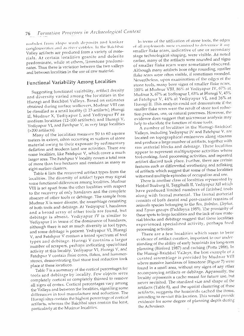
n o c i r ~ l ( l s from s l o l , ~ wash dvposits and kanknr conglomeratc.~ ,rnci ;IS rivc~r c~oL)I)I(~s. 111 I l r c , I ~ , ~ i c . l r O ~ ~ l Valley artifacts are produced from a variety of mate- rials. At certain localit ies grani te and doler i te predominate, while at others, limestone predomi- nates. Thus there is variation between the two valleys and between localities in the use of raw material.
Functional Variability Among Localities
Suggesting functional variability, artifact density and diversi ty varied among the localities in the Hunsgi and Baichbal Valleys. Based on estimates obtained during surface walkovers, Mudnur VIII can be classified as a small locality (1-25 artifacts); Hunsgi 11, Mudnur X, Yediyapur I, and Yediyapur IV as medium localities (12-100 artifacts); and Hunsgi V, Yediyapur V1, and Fatehpur V, as vcry large localities (>200 artifacts).
Many of the localities measure 50 to 60 square meters in extent, often occurring as scatters of storle material owing to their exposure by sedimentary deflation and modern land use activities. There arc some localities, like Fatehpur V, which cover a much larger area. The Fatehpur V locality covers a total area of more than two hectares and contains as many as eight surface clusters.
Table 6 lists the recovered artifact types from the localities. The diversity of artifact types may signal some functional differences among localities. Mudnur VIII is set apart from the other localities with respect to the recovery of only handaxes and the complete absence of other tools or debitage. The sample from Mudnur X is more diverse, the assemblage consisting of both tools and debitage. At Yediyapur I, handaxes and a broad ar ray of other tools are found, bu t debitage is absent . Yediyapur IV is simi lar to Yediyapur I in terms of the dominance of handaxes, although there is not as much diversity in tool types, and some debitage is present. Yediyapur VI, Hunsgi V, and Fatehpur V contain a broad spectrum of tool types and debi tagc. Munsgi V contains a larger number of scrapers, perhaps indicating specialized activity at this locality. Yediyapur VI, Hunsgi V, and Fatehpur V contain flake cores, flakes, and hammer- stones, demonstrating that stone tool reduction took place at these locations.
Table 7 is a summary of the cortical percentages for tools and debitage by locality. Few objects were completely cortical or completely thinned to remove all signs of cortex. Cortical percentages vary among the Valleys and between the localities, signalling some differences in tool manufacture and reduction. The Hunsgi sites contain the highest percentage of cortical artifacts, whereas the Baichbal sites contain the least, particularly at the Mudnur localities.
In ttrrns of thc utilization of stone tools, the cdgcs 0 1 ,111 i ~ i ~ l ) l c . ~ i i c * ~ i l : ; L V C - I . C ~ ( ~ . \ , ~ ~ ~ i i ~ r c ~ ( l l o c l c ' l ( ~ ~ . l ~ l i ~ i t ' i l $ I I I \ ~
smaller flake scars, indicative of use or secondary stage technological shaping, were visible. As noted earlier, many of the artifacts were rounded and signs of srnaller f lake scars were sometimes obscured. Although many artifacts bore edge rounding, smaller flake scars were often visible, i f sometimes rounded. Neverthelcss, upon examination of [he edges ol thc stone tools, many bore signs of smaller flake scars, 100% at Mudnur VIII, 86% at Yediyapur IV, 67% at Mudnur X, 67Y0 at Yediyapur I, 63% at Hunsgi V, 45%0 at Fatehpur V, 44% at Yediyapur VI, a n d 36"/0 at Hunsgi 11. This analysis could not demonstrate i f the smaller flake scars were the result of stone tool redtic- tion practices, use, or natural processes. However, the evidence does suggest that microwear analysis may help to elucidate the function of stone tools.
A number of localities in the Hunsgi-l3aiclibal Valleys, including Yediyapur IV and Fatehpur V, are located on topographical eminences along streanx arid produce a large number of artifacts, togekhcr with raw material blocks and debitage. These localities appear to represent multipurpose activities where tool-making, food processing activities, and repeated artifact discard took place. Further, there are certain features such as differential weathering and reflaking of artifacts which suggest that some of these localities witnessed multiple episodes of occupation and use.
There is another class of localities rcprescnted by Hebbal Buzburg 11, Teggihalli 11, Yediyapur XI1 which have produced limited numbers of finished tools along with faunal material . The faunal material consists of both dental and post-cranial remains of animals species belonging to the Bos, Bzlbnlils, Elcpllns, and Eqrlus groups (Paddayya 1985). The proximity of these spots to large localities and the lack of raw mate- rial blocks and debitage suggest that these localities experienced special ized act iv i ty, perhaps food processing activities.
There are a few localit ies which seem to bear evidencc of artifact c ~ ~ r ~ ~ t i o n , important to our t~nclcr- standing of the ability of early horninids for long-term planning (Binford 1987) and caching (Potts 1988). In the Hunsgi-Baichbal Valleys, the best example of a ctlrated assemblage is provided by Mudnur VlIl where massive handaxes of limestone (Figure 7) were found in a small area, without any signs of any other accompanying artifacts or debitage. Apparently, the locality represents a cache meant for future use, but never revisited. The standard size and shape of the artifacts (Table 8), and the spatial clustering of these artifacts, suggests the hominids cached the items, intending to re-visit this location. This would provide evidence for some degree of planning depth during the Acheulean.

Table 5 . Ra~v Materials by Locality.
limestone il~mrtzite chert sandstone shale granite dolerite schist filite quartz
GulbCll 11
Hunsgi I 1
Hunsgi V
Mudnur VIII
Mudnur X
Yediyap~~r I
Yediyapur IV
Yediynp~~r V1
Fatelipur V
Table 6. Number of Artifact Types by Locality.
chopper handaxe cleaver pick knife polyhedron spheroid end scraper side scraper
Gulbal I1 l-lunsg~ I1 Hunsgi V Mudnur VIII Mudnur X Y e d ~ y a p ~ ~ r 1 Yed~ynpur IV Yediyapur VI F , ~ t c h p ~ ~ r V
end/ hammer utilized discoid biface prepared backed tool flake flake angular
side scraper stone material butt core debris
C7~11h~il I 1 7 5 2 IH~11isgi I 1 2 2 4 1 Hunsgi V ,..
1 7 2 2 2 2 1 38 122 8 Mudnur VIII M L I ~ ~ L I ~ X 1 1 1 2 4 Yediyap~~r 1 3 4 Yediyapur lV - 4 Yediyap~~r VI 7 L 5 1 1 17 121 4 Fn tchp~~r V 2 5 1 1 2 3 75 1
Finally, there are many instances of the occurrence of one or of a few tools in a n area. These instances are spread all over the valley floor in a random fashion, perhaps indi- cating horninid activity over the entire landscape as has I N Y W ( ~ x , i ~ i ~ i ~ u ~ ~ I i11 ~\o~l-:, it(, , i l ~ l ) ~ . o , ~ ( ~ l ~ * s (o,~; , , ' l ' l~o~i\, i!, 1075; Foley 1981a,19Slb; Isaac 1984; Ebert 1991). These finds may represcmt s,itc~llitcs of activity hetwccm larplr locali- lics. In s c ~ i i c ~ c,ts(,s, I l ~ v i c l isol,~tcd ;~rLif,icts rn,ly rcyrcwmt single-episode cvclnts involving an indiviciud or '1 smcill group, perhaps for food collecting or processing activities.
Conclusions
T h e fo rego ing a t t e m p t t o examine t h e Acheu lean local i t ies of t he Hunsg i -Ba ichba l Val leys is a provi - :,ionail IIIOJOI t .on(,e~ming Llle ~ x ~ I , ~ l i v c roles p L i y ~ d l )y natural and c ~ ~ l t u r a l formation processes. W e hope that from this account it is clear that the Achculean localities vary consicir*ral~ly in tlicir prc~scrvation. Thcsc varied contexts are probably best understood by trcating them as the end-product of the interplay of two opposite sets

78 Format ion Processes ilz Arcllneologicnl C o n f e s t
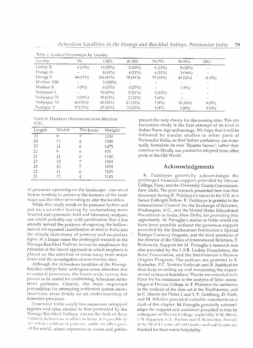
Table 7. Cortic,il Percentages b y Locality.
I.ocall tp @YO 1-25% 26.50% 51-75% 76-99 % 100%
Gulbal I1 4 (10%) 14 (35%) 8 (20%) 6 (1 5%) 8 (20%) Hunsgi I1 8 (42%) 4 (21%) 4 (21%) 3 (I 6%) Hunsgl V 44 (11%) 166 (41%) 78 (1 9%) 57 (14%) 49 (12%) 14 (3%) Mudnur VllI 9 (100%) Mudnur X 1 (9%) 6 (55%) 3 (27%) 1 (9 %) Yedlyapur I 1 6 (67%) 5 (21 %) 3 (12%) Ycd~yapur IV 3 (1 9%) 10 (63%) 2 (1 2%) 1 (6%)) Yed~y~ipur V1 66 (36%) 60 (33%) 21 (12%) 7 (4%) 18 (1 0 0 ) 9 (5%) Fatehpur V 37 (33%) 47 (43Y") 13 (1 2%) 4 (4%) 5 (4%) 4 (4%)
Table 8. I-Iand'ixe Dimensions from Mudnur VI I I .
Length Wid th Thickness Weight
23 9 7 1190
of processes operating on the landscape-one set of factors tending to preserve tlie features of the land- sc'lpe and the other set tending to alter the localities.
While this study needs to be pursued further and put on a sounder foot ing by undertak ing more detailed and systematic field and laboratory analyses, one could probably say with justification that it has already served the purpose of exposing the hollow- ness of oft-repeated classification of sites in India into the simple dichotomy of pr imary and secondary types. In a larger sense the prolonged research in the Hunsgi-Baichbal Valleys serves to emphasize the potential of the lateral approach in which emphasis is placed on the selection of areas away from major rivers and the investigation of non-riverine sites.
Altliougl~ the Aclieulean localities of the Hunsgi- Baichbal valleys have undergone some alteration due to n ' l t ~ ~ r a l ~ ~ O C C S S ~ S , the basin-wide survey has proven to be useful for establishing Aclieulean settle- ment pat terns. Clearly, the most important precondition for attempting settlement system recon- struct ions rests f i rmly 011 an unders tand ing of formation processes.
present the only chance for discovering sites. This site formation study is the first attempt of its kind in Indian Stone Age archaeology. We hope that it will be followed by simi lar s tud ies in other par ts of Peninsular India, so that Indian prehistory can even- tually formulate its own 'Rosetta Stones', rather than continue to blindly use yardsticks adopted from other parts of the Old World.
Acknowledgments K. Paddayya grateful ly acknowledges the
prolonged financial support provided by Deccan College, Pune, and the University Grants Commission, New Dellii. The joint research presented here was first disc~~ssed during K. Paddayya's travel to the U.S. as a Senior Fulbright Fellow. K. Paddayya is grateful to the International Council for the Exchange of Scholars, Washington, D.C., and the United States Educational Foundation in India, New Delhi, for providing this opportunity. M. Petraglia's studies in India would not have been possible without the generous support provided by the Smithsonian Institution's Special Foreign Currency Program, and the kind assistance of the director of the Office of International Relations, F. Berkowitz. Support for M. Petraglia's research was also provided by the L.S.B. Leakey Foundation, the Boise Foundation, and the Smithsonian's Human Origins Program. The authors are grateful to R. Korisettar, P.C. Venkata Subbaiah and R. Jhaldiyal for their help in setting up and monitoring the experi- mental station at Kembhavi. Thanks are extended to D. Nasli for his assistance in the analysis of lithic assem- blages at Deccan College, to T. Plummer for assistance in the analysis of the data set at the Smithsonian, and to C. Martin for Plates 2 and 3. P. Goldberg, D. Nash, and M. Schiffcr provided vnluabic comments on a cIr,liL v i this chapter. M. lJetraglia gratefully acknowl- edges the support and assistance provided to him by collca):t~cs a t Ikxcran Collcgc, cslwci;illy V.N. Misril, I-;.N. l i t ~ j q l ) ; ~ ~ ~ . i ~ , ( ; . I , . I L I I I ~ I I I I 1 1 1 1 1 1 I < . I i o i ~ i ! ~ ~ ~ l I , i ~ ~ . I : I . I ( # I I~ : . , I I 1 1 1 c - \ V O I 1 1 1 ( 1,1111c. 1 1 1 ( l i r 1 (~l i i tk~:, i111tI C i i r 1 kOt~t:i ~ I I C ~
thanked for their warm hospitality.
Uchre~xi~~lcyr~., A.K. 1978 Tnphonomic and Ecologic Information from Uonc Wcathcring. l l i ~ l ~ ~ o l ~ i o l o ~ ~ ! / 4: 1%)- 162.
Binford, L.R. 1981 Borzcs: Aircielif Merz n i ~ d Moiler11 Mytlrs. Academic Press, New York. 1987 Searching for Camps and Missing the Evidcncc? Another look at the Lower Paleolithic. In Tirc
Pleislucerzc Old World: Rcgilic~rinl I'crspczctiurs, cditcd by 0. Soffer, pp. 17-33. l'lcn~irn l'ress, New York. Bowers, P.M., Bonnichsen, R., and D.M. Hoch
1983 Flake Dispersal Experiments: Noncultural Transformation of the Archaeological Record. Airrevicn~~ Ant iqui ty 48553-572.
Corvinus, G.K. 1968 A1 Acheulian Occupation Floor at Chirki-on-Pravara, India. Crtrreiit Aitfhroyolopj 9:216-218. 1973 Excavations at an Acheulean Site at Chirki-on-Pravara in India. In Solrfh Asintr Arclzaeology,
edited by N. Hammond, pp. 13-28. Duckworth, London. 1981 A S i~ r vey of the Prnzmm River Systeirr i ir Wester11 Mnllnmslztra, Indin, Vol. I : The Stratigrtrylry m d
Geoiiiorphology of the Prnvclrcr R iw r Systcttr. Institut fiir Urgeschichte, Tubingen. 1983 A Strrvey ojtlrc Pmvnrn R iw r Sys fcm iir Wcsirrir Mnhnrndrtrn, lirdin, Vol. 2: The Ercnsintioi~s r$tlrc
Aclleiilian Site of Clrirki-ori-Prnuarr~, Iirdin. Institut fiir Urgeschichte, Tubingen. Ebert, J.
1991 Distr iht ioiml Arcl~aeolo~yy. Urliversity of New Mexico Press, Albuquerque. Foley, R.
1981a Off-Site Archaeology: An Alternative Approach for the Short-Sited. In Pnffci.11 oftl lc P c ~ f : Str~lfil>s i l t Worzoilr q f l fav id L. Clarke, edited by I. Hodder, G. Isaac, and N. Mammond, pp. 157-283. Cambridge University Press, Cambridge.
1981b Off-Site A'rcl~ncolojy nr~d ff~ot1011 R&I/llnti(7ti ill Ensfcwr Africn: A I I AituI!/sis of Regi017nl Ar fe f i c f Density in flie A,iiboseli, S o ~ ~ f l r r m Kcrlyn. BAR International Series 97, Oxlord.
Foote, R.B. 1916 T l x Fook Collcctioiz of ilrdinii Prelrisforic nird Protohistoric Arrtiqllifies: Notes or1 Tlreir Ages nnd
Distribufioiz. ~overnrnknt Museum, Madras. Frostick, L., and I. Reid
1983 Tapl~onornic Significai~ce of Sub-Aerial Transport of Vertebrate Fossils on Steep Semi-Arid Slopes. Lctlrnin 16:157-164.
Caussen, H., P. Legris, and M. Viart 1965 International Map of Vegetation and of Environmental Conditions - Notes on the Sheet
Godavari. Indian Council of Agricultural Research, New Dehi. Gifford, D.P., and A.K. 13ehrensmeyer
1977 Observed Formation and Burial of a Recent Human Occupation Site in Kenya. Ql in femnty Rescarcll 8:245-266.
Coffer, Z. 1980 Arclraeolo~~icol Clrernistrij: A S O I I ~ C C ~ J D O ~ oil fh Applicatiom ofChei?risfry to Arzlroeologtj. Wiley, New
York. Harding, P., Gibbard, P.L., Lewin, J., Macklk, M.G., and E.H. Moss
1987 The Transport and Abrasion of Flint Handaxes in a Gravel-Bed River. In Tile Hrrnzn~~ Uses $Flint arrd Cllcrt, edited by G. De G. Sieveking and M.H. Newcomer, pp. 115-126. Cambridge University Press, Cambridge.
Harris, J.W.K. 1978 Tlrc Karrrri I d r l s f r y , 1'11s Plnce it1 Enst Afi.icnrl Prcliistory. P11.D. Dissertatioii, University of California,
Berkeley, University Microfilms, A ru~ Arbor. Isaac, G.LI.
1967 Towards the Interpretation of Occupation Debris: Some Experinmzts and Observations. Krocbct, Anthropologicnl Society I3nyeus 37:31-57.
1934 The Arcl~aeology of Human Origins: Studies of the Lower Pleistocene in East Africa 1971-2981. In Advn~lces in World Ardmrolqyy, edited by F. Wendorf and A. CIose, pp. 1-87. Academic Press, New York.

1989 The Arcl lnivlogy of'H11111(711 O ~ i ~ y i i l s : Papers by C;I!/iii~ Isanc. Cambridge University Press, Cambridge. Jacobson, J.
1970 On Palaeolithic Occupation Floors in India. C ~ ~ r r c n t Anthropology 11:483. 1975 Early Stone Age Habitation Sites in Eastern Malwa. Proceedings of t l le Ainerican Pl~ilosophicnl
Society 119:280-297. 1979 Recent Developments in South Asian I'rchistory and Protohistory. Alziri~al Kevic7us of
A n tllropology 8:467-502. 1985 Acheulian Surface Sites in Central India. In Recent Advances i n Indo-Pncific Prclrisfory, edited by V.N. h l isr,~ ,~nci 1'. lZcll\\~c~c~~i, pt'. 4')-57. Chfl~rtl . ~ n ~ i 1111 1, Nv\\* I % , l l ~ i ,
Joshi, R.V. 1970 The Characteristics of the Pleistocene Climatic Events in the Indian Subcontinent - A Land of
Monsoon Climate. Indian Ai l t iquary 4:53-63. Mahadevan, C.
1941 Geology of the South and Southwestern Parts of Surapur Taluk of Gulbarga District. Journal, Hydernbad Geologicnl Sl lrvey 4:lO2-l6l.
Miller, G.J. 1975 A Study of Cuts, Grooves, and Other Marks on Recent and Fossil Bone: I1 Weather Cracks,
Fractures, Splinters, and Other Similar Natural Phenomena. In Lithic Tedznolocgj, edited by E.H. Swanson, pp. 211-226. Mouton, The Hague.
Misra, V.N. 1987 Middle Pleistocene Adaptations in India. In The Pleistoceizc Old World: Regionnl Perspectives,
edited by 0 . Soffer, pp. 99-119. Plenum Press, New York. 1989 Stone Age India: An Ecological Perspective. M a n and Enviromnent 14:17-64.
Mishra, S. 1992 The Age of the Acheulian in India: New Evidence. Current Anthropology 33:325-328.
Mukherjec, S.K. 1941 Geology of Parts of Surapur and Shahpur Taluks, Gulbarga District. Jownn l , Hyderabad Geological
S l ~ r v e y 4:9-54. I'addayya, K.
1977a An Acheulian Occupation Site at Hunsgi, Peninsular India: A Summary of the Results of Two Seasons of Excavation (1975-6). World Archaeology 8:344-355.
1977b The Acheulian Culture of the Hunsgi Valley (Shorapur Doab), Peninsular India. Proceedings of the Aii~cricnil Pllilosophical Socicty 121:383-406.
1978 New Research Designs and Field Techniques in the Palaeolithic Archaeology of India. World Arcllaeology 10:94-110.
1979 Excavation of a New Acheulian Occupation Site at Hunsgi, Peninsular India. Quartar 29/30:139- 155.
1982 Tlie A c l ~ ~ i l i a i l Clrltzrre of tile Hutlsgi Valley (Perlinslrlar India): A S e f t l e i r m f System Perspective. Deccan College, Poona.
1984 India. In Neue F o r s c h ~ ~ ~ g e n Zl l r A l t s t c i im i t , edited by 0 . Bar Yosef, et al., pp. 345-403. Verlag C.H. Bcck, Munich.
1985 Acheulian Occc~pation Sites and Associated Fossil Fauna from the Hunsgi-Baichbal Valleys, Peninsular India. Antl iropos 80:653-658.
1987a The Place of the Study of Site Formation Processes in Prehistoric Research in India. In Natllral Forrimtioil Processes and the Archneologicnl Record, edited by D.T. Nash and M.D. Petraglia, pp. 74-85. BAR International Series 352, Oxford.
1987b The Stone Age Cultural Systems of the Baichbal Valley, Gulbarga District, Karnataka - A Preliminary Report. Bullefitl of the Deccan College Research Ins f i tu te 46:77-100.
1987c Excavation of an Acheulian Occupation Site at Yediyapur, Peninsular India. Anfhropos 82:610-614. 1989 The Acheulian Culture Localities Along the Fatehpur Nullah, Baichbal Valley, Karnataka
(Peninsular India). In Old Problems and N e w Perspecti7m i n tlze Arclracology of South Asia, edited by J . M . Kcnnyrr, pp. 21-28. Univcrsily of Wisconsin Press, Madison.
1991 Thc Achculian Cultural Phase in the Baichbal Valley, Peninsular India. In l i~diatz Archneologicnl / / ( ' I 1 / 1 1 ~ ; i ' ( ! ; / I \ 1 / \ , \". ~ ~ f ~ / / l l f / ~ l l ' ~ l / < 1 1 / 1 / 1 / / ' i '!;/:;[ '/ l l ' if/), v0~11111~~ 1 , t , (1i f t3ci 1 1 ~ <-. b f i l ~ ~ ~ i l I ~ ~ t l C ~ I l t l 1 K,s, I L I I I I , ~ I I , I I I I 11,111, 11.1'. :LI~;,II,, , I I N I I ) . I < # : ~ ~ I I I I L I ~ I I [ I . /!'I 0 1 ~ A ~ I I I I I < ~ I L I I ' I U I U I ~ ~ ~ I I I , Lk l l~ l .
82 Format ion Processes in Archrzeolo~yicnl Con tes t - - -
Petraglia, M.D. 1987 Site Forrrrnfiorr I1roccsscs nt flrc AOri l l i l f i? i i r~: A Stlid!/ (lf LIpp-r Pnlrr~litl~ic Rocksllcltcr nllrl Hillslope
Deposits in So~~fl17ucstcriz Frarlcc. Ph.1). Disscrtntion, University of New Mexico, University Microfilms, Ann Arbor.
Petraglia, M.D., and D.T. Nash 1987 The Impact of Fluvial Processes on Experimental Sites. In Nntrlra1 Forr)lntiorr Processes r7rld tlle
Arclmeolo~ical Record, edited by D.T. Nas l~ and M.D. Petraglia, pp. 108-130. BAR International Series 352, Oxford.
Petraglia, M.D., and R. Potts n.d. Water Flow and the Formation of Early Pleistocene Artifact Sites in Olduvai Gorge, Tanzania.
Manuscript in possession of authors. Potts, R. -
1986 Temporal Span of Bone Accumulations at Olduvai Gorge and Implications for Early Foraghg Behavior. Paleobiology 12:25-31.
1988 Early Horizirzid Activities nt O l d ~ ~ v a i . Aldine de Gruyter, Chicago. Rick, J.W.
1976 Downslope Movement and Archaeological Lntrasite Spatial Analyses. Anmicar? Ant iqui ty 41:133-144. Ritter, D.F.
1978 Process Geon~orplrology. Wm. C. Brown company Publishers, Dubuque. Rottlander, R.
1975 The Formation of Patina on Flint. Archaeonlcfry 17:106-110. Sankalia, H.D.
1974 The Prelristory and pro toll is tor!^ of India and Pakistan. Deccan College Postgraduate and Research Institute, Poona.
Schick, K.D. 1984 Processes of Palneolitllic Site Forlilatiou: ,411 Expcriiizerlfal S f ~ r d y . P11.D. Dissertation, University of
California, Berkeley, University Microfilms, Ann Arbor. 1986 Stoile Age Sites in the Makirzg: Exper i~rer~ts ill the Forrrratiorr a d Trarrsforrirntiorz ofArc1~aadogicnl
Occurrel~ces. BAR International Series 319, Oxford. 1987 Experimentally-Derived Criteria for Assessing Hydrologic Disturbance of Archaeological Sites.
In Nntural Formtiorz Processes and the Arclrneological Record, edited by D.T. Nash and M.D. Petraglia, pp. 86-107. BAR International Series 352, Oxford.
Schiffer, M.B. 1976 Belznuioral Archeology. Academic Press, New York. 1983 Toward the Identification of Formation Processes. Aiizericnir Ai l t iqui ty 48:675-706. 1987 Fomratiorz Processes of the Arcllneological Record. University of New Mexico Press, Albuquerque.
Shackley, M.L. 1974 Stream Abrasion of Flint Implements. Nature 248:501-502. 1978 The Behaviour of Artefacts as Sedimentary Particles in a Fluviatile Environment. Archneorlretry
2O:55-61. Singer, R., Wymer, J., Gladfelter, B.G., and R.G. Wolff
1973 Excavation of the Clactonian Industry at the Golf Course, Clacton-On-Sea, Esscx. l ~ r o c e c ~ f i ~ ~ g s of the Prclristoric Society 39:6-74.
Straus, L.G. 1983 Review of Tlic Aclrrrrlint~ Cl~lliirr' r!f tlw 111~rls~gi V n l l q 11y K . I'addayya's. ]orrriri71 c?f A i ~ t l ~ r o ~ ) o l o ~ ~ i ( : ( i l
1~cs~'rrrclr 39:447-449. Szabo, B.J., C. McKirmey, T.S. Dalbey, and K. I'addayya
1990 On the Age of the Acheulian Culture of the Hunsgi-Baichbal Valleys, Peninsular India. Blllletiiz qf the Deccan College Post-Graduate and Resmrcll Iizstitute 50:317-321.
Thomas, D.H. 1975 Non-Site Sampling in Archaeology: Up the Creek Without a Site? In Sarnplirz~ in Arclraeolo,c
edited by J.W. Mueller, pp. 61-81. University of Arizona Press, Tucson. Wymer, J.J.
1976 The Interpretation of Palaeolithic Cultural and Faunal Material found in Pleistocenf In Geonrchaeology: Earth Scierzce arrd the Past, edited by D.A. Davidson and M.L. Shack' 334. Duckworth, London.