Flood risk and socio-ecological resilience in a Late Antique ...
24
André Filipe Oliveira da Silva, André Madruga Coelho, José Simões and Silvana R. Vieira de Sousa (dir.) Juvenes - The Middle Ages seen by Young Researchers Vol. II - Space(s) Publicações do Cidehus Flood risk and socio-ecological resilience in a Late Antique and Medieval countryside Managing a post-Roman alluvial landscape in the Ravenna hinterland Michele Abballe and Marco Cavalazzi DOI: 10.4000/books.cidehus.18989 Publisher: Publicações do Cidehus Place of publication: Évora Year of publication: 2022 Published on OpenEdition Books: 16 March 2022 Series: Biblioteca - Estudos & Colóquios Electronic EAN: 9791036591372 http://books.openedition.org Electronic reference ABBALLE, Michele ; CAVALAZZI, Marco. Flood risk and socio-ecological resilience in a Late Antique and Medieval countryside: Managing a post-Roman alluvial landscape in the Ravenna hinterland In: Juvenes - The Middle Ages seen by Young Researchers: Vol. II - Space(s) [online]. Évora: Publicações do Cidehus, 2022 (generated 22 mars 2022). Available on the Internet: <http://books.openedition.org/cidehus/ 18989>. ISBN: 9791036591372. DOI: https://doi.org/10.4000/books.cidehus.18989. This text was automatically generated on 22 March 2022.
-
Upload
khangminh22 -
Category
Documents
-
view
2 -
download
0
Transcript of Flood risk and socio-ecological resilience in a Late Antique ...
André Filipe Oliveira da Silva, André Madruga Coelho, José Simões andSilvana R. Vieira de Sousa (dir.)
Juvenes - The Middle Ages seen by Young ResearchersVol. II - Space(s)
Publicações do Cidehus
Flood risk and socio-ecological resilience in a LateAntique and Medieval countrysideManaging a post-Roman alluvial landscape in the Ravenna hinterland
Michele Abballe and Marco Cavalazzi
DOI: 10.4000/books.cidehus.18989Publisher: Publicações do CidehusPlace of publication: ÉvoraYear of publication: 2022Published on OpenEdition Books: 16 March 2022Series: Biblioteca - Estudos & ColóquiosElectronic EAN: 9791036591372
http://books.openedition.org
Electronic referenceABBALLE, Michele ; CAVALAZZI, Marco. Flood risk and socio-ecological resilience in a Late Antique andMedieval countryside: Managing a post-Roman alluvial landscape in the Ravenna hinterland In: Juvenes -The Middle Ages seen by Young Researchers: Vol. II - Space(s) [online]. Évora: Publicações do Cidehus,2022 (generated 22 mars 2022). Available on the Internet: <http://books.openedition.org/cidehus/18989>. ISBN: 9791036591372. DOI: https://doi.org/10.4000/books.cidehus.18989.
This text was automatically generated on 22 March 2022.
Flood risk and socio-ecologicalresilience in a Late Antique andMedieval countrysideManaging a post-Roman alluvial landscape in the Ravenna hinterland
Michele Abballe and Marco Cavalazzi
Introduction
1 The city of Ravenna, which was the capital of the Western Roman Empire and later of
the Exarchate, is currently surrounded by a fertile and cultivated hinterland. However,
this is the result of a long «conflictual» relationship between the environment and the
human communities that inhabited this area. Indeed, the vast cultivated areas that are
exploited nowadays were often reclaimed from woodlands and wetlands that had
naturally formed. This has been possible thanks to a long history of land and water
management practices that are still necessary today to prevent catastrophic floods and
avoid the collapse of the local agricultural system.
2 The first to promote large scale projects were the Romans, laying out regular field
systems bordered by channels that acted as collectors for the excess water (i.e.
centuriation). This system started to malfunction towards the end of the Roman period
in many areas of the Po Valley, and people during the Middle Ages often preferred to
live on the higher and driest parts of the landscape, which were less subject to flooding
(FICARA, 2006; MANCASSOLA, 2012; CURTIS et al., 2014; BRANDOLINI et al., 2020).
However, these transformations were not passively accepted by the local communities,
which instead had put in place mechanisms of adaptation and resilience throughout
the Middle Ages to survive in a «hostile» and rapidly changing landscape. In fact, these
mechanisms have been already documented in several areas of the Po valley, in
particular in the plains of Reggio Emilia (MANCASSOLA, 2012; BRANDOLINI et al.,
2018a), Modena (RUCCO et al., 2019; BRANDOLINI, 2020), Verona (CASTAGNETTI, 1977;
SAGGIORO, 2010, 2012; SAGGIORO et al., 2012) and Comacchio (RUCCO, 2015, 2021). The
Flood risk and socio-ecological resilience in a Late Antique and Medieval cou...
Juvenes - The Middle Ages seen by Young Researchers
1

hinterland of Ravenna represents another area where the local socio-ecological
systems had to react to the environmental crises that occurred after the Roman period.
With this study, we specifically want to focus on the strategies of land division, land
reclamation and flood resilience promoted during three main chronological periods
(5th-7th c. CE; 8th-11th c. CE; 12th-13th c. CE.). Furthermore, we want to understand to
what extent larger urban systems influenced the local communities. To reach these
aims, we use a diachronic, multidisciplinary, and multiscalar approach, combining
results of a post-doc research at the University of Bologna (Marco Cavalazzi, PhD) and a
PhD research at Ghent University (Michele Abballe). The post-doc research focuses on
the study of the evolution of the rural landscape in the Ravenna hinterland between
the 12th-13th centuries, taking into account archaeological data and written sources1.
The PhD research aims to reconstruct how the landscape was in Roman times and how
it later evolved, integrating morphological analysis of digital elevation models, the
study of aerial and satellite images and geoarchaeological fieldwork2.
3 This approach is an element of novelty. The Italian landscape archaeology has been
criticised for being mostly a “site” archaeology, thus focussing on the analysis of the
archaeological sites, their connections and distribution, while neglecting the study of
the environment (MILANESE, 2004, 62-64; STAGNO, 2018, 30). Recently the attention to
this aspect is greater than in the past: for instance, in the Po Valley region, the number
of geoarchaeological investigations is growing rapidly (RUCCO, 2015, 2020, 2021;
BRANDOLINI et al., 2018a, 2018b, 2020; BIANCHINI et al., 2019; RUCCO et al., 2019;
BRANDOLINI, 2020, 2021; ABBALLE, in press). Still, there is a lack of ongoing systematic
artefact survey projects that can collect new archaeological information and cross it
with the novel environmental and geological data.On the contrary, using new
archaeological, geological and geographical data together with information from the
written sources, we managed to shed light on some strategies of water management
and land reclamation promoted by the local communities and to document the
interferences that larger urban systems like Ravenna and Faenza had on the
countryside.
Ravenna and its hinterland
4 The study area gravitates around the city of Ravenna (Fig. 1), which Emperor Augustus
chose as the seat of the Roman fleet in the near location of Classe (CHEVALLIER, 1968;
BOLLINI, 1990), and then became capital of the Western Roman Empire in 402 CE. The
subsequent urban development created a strong economic and political relationship
between the capital and a large hinterland (GNOLI, 2006; BAZZOCCHI, 2008; AUGENTI et
al., 2010). Even after 476 CE, Ravenna continued to have a crucial role until the end of
the Exarchate (mid-8th c. CE), as well as after, when the presence of the Archbishopric
allowed the city to preserve a central role in the eastern part of the Po Valley region
(CARILE, 1991 - 1992; VASINA, 1993).
5 Archaeologically, this importance of Ravenna is also testified by the excavations at
Classe, the harbour of the city, that until the beginning of the 7th c., continued to be
one of the main Mediterranean harbours, «capable of managing several imported goods
that were intended to be distributed, more than simply supplying the inhabitants of the
Late Antique capital» (trans. from AUGENTI et al., 2010, 610). At the same time, in some
rural areas nearby Ravenna, a substantial increase in the human presence has been
Flood risk and socio-ecological resilience in a Late Antique and Medieval cou...
Juvenes - The Middle Ages seen by Young Researchers
2
recorded since the 5th c., like in the Decimano area (located south of Ravenna, see
MANCASSOLA, 2008a) or north of Cesena (NEGRELLI, 2008, 237-256). On the contrary,
inner areas of the Po Valley started to be abandoned already since the 3rd-4th c.,
including also urban settlements (e.g. Veleia or Claterna, WARD PERKINS, 1988; AUGENTI
et al., 2015).
6 During this long period, several urban actors have played a major role in influencing
the social-ecological systems of the hinterland of Ravenna. Firstly, the urban
aristocracy of the Late Antique capital, then its archbishops and, in particular, from the
10th c., also the many urban monasteries that mainly developed from the patrimony of
the Church of Ravenna. Later on, especially from the 12th c. CE, Ravenna and other
cities located along the Via Aemilia, such as Imola, Faenza, Forlì and Rimini, started to
affirm their control on this area of the Po Valley, often competing with each other to
create their own civil district (VASINA, 1986). From a geomorphological point of view,
the research area is located in the southeastern part of the Po Valley, around 15-25 km
inland of Ravenna, and according to previous studies, has been shaped mainly by the
rivers Santerno and Senio (FRANCESCHELLI et al., 2007). When flowing within the flat
floodplain, these Apennine rivers naturally developed raised alluvial ridges made of
sandy and loamy sediments, flanked by more depressed areas called backswamps,
characterised by deposits of fine silts and clays left behind by flood events (CHARLTON,
2007).
7 To limit the risks of flooding, the Romans realised the first large-scale land and water
management project in the area (centuriazione), dividing the cultivated land into square
fields delimited by roads and ditches (SETTIS, 1993; MUZZIOLI, 2010). Later on, due to
an interplay of lack of maintenance of the irrigation systems, likely occurred towards
the end of the Roman period, and the starting of a cooling climate phase known as Late
Antique Little Ice Age (or LALIA: BÜNTGEN et al., 2011; CHRISTIANSEN et al., 2012), the
waterlogged areas increased their extension and new marshy areas developed covering
the previous Roman farmland with its rural sites. A local example of this regional
phenomenon is the so-called Orizzonte Veggiani, a stratigraphic layer identified below
the present town of Lugo that developed in the Early Middle Ages, often in the presence
of wet conditions, and that covered Roman farmsteads with up to 5m of alluvium
(FRANCESCHELLI et al., 2007, 119-120).
8 However, this worsening of the environmental conditions contrasts with the
preservation of the local Roman regular field system, which represents one of the best-
preserved examples in the Emilia-Romagna region. Previous studies already focused on
possible ways to keep the system working or to restore it even after an abandonment
phase (BOTTAZZI et al., 2008, 201; FRANCESCHELLI, 2008, 120; CHOUQUER, 2015, 126).
Specifically for the area of Lugo, the monasteries of Ravenna have been suggested as
the promoters for this process of «sewing up» the system (trans. from FRANCESCHELLI,
2015).
9 However, the area is characterised by the existence of other two regular field systems,
the so-called Centuriazione di Bagnacavallo and Centuriazione di Massa Lombarda3. While
the literature agrees on dating the second one to the 13th c., in relation to new settlers
coming from Lombardy that arrived in the area in 1251 CE (MONTANARI, 2000), for the
first two possible chronologies have been suggested: Late Antiquity (PASQUALI, 1975;
BOTTAZZI, 1994) or Early Middle Ages (FRANCESCHELLI et al., 2007, 156-158). However,
these two hypotheses were proposed when almost no archaeological and geological
Flood risk and socio-ecological resilience in a Late Antique and Medieval cou...
Juvenes - The Middle Ages seen by Young Researchers
3

data were available, so mainly relying on the written sources: the results of our
fieldwork can potentially contribute significantly to the debate.
Fig. 1 - Study area, with major regular field systems and main nearby cities
Methods and data
10 The archaeological dataset used for this study was collected during the landscape
archaeological project «Bassa Romandiola», promoted since 2009 by the University of
Bologna to investigate the north-western lowland of Ravenna4. The main method used
by the project is artefact survey, later followed by geophysical surveys,
geoarchaeological analysis, and large-scale excavations (CAVALAZZI et al., 2015, 2018).
11 Five campaigns of artefact survey allowed to investigate approximately 15% of the
territory of Bassa Romagna sub-region (i.e. 78 sq. km of the whole context, namely 525
sq. km) and to document 71 archaeological sites, dated from Late Antiquity to the
Modern Age (Fig. 2). The artefact survey was intensive and systematic (CAMBI et al.,
1994, 161-179), with the archaeologists walking in parallel lines at a 10-metre distance
from each other (Fig. 3.1), to collect any visible archaeological find such as pottery
sherds, coins, etc5 and recording their position with a handle GPS, like in a site-less
survey6.
12 In particular, we focused on the results collected in 2009, 2012, 2016 and 2018, in the
territories of Lugo, Bagnacavallo and Cotignola.
Flood risk and socio-ecological resilience in a Late Antique and Medieval cou...
Juvenes - The Middle Ages seen by Young Researchers
4

Fig. 2 - Sample strategy of the Bassa Romandiola project and archaeological sites detected by theartefact survey (seasons 2009-2018)
13 Despite the promising results obtained by the project, we knew from the start that the
study area was affected until the last century by several events of river diversion and
by large reclamations projects, which are well-known thanks to the written sources and
historical cartography (GAMBI, 1949). These transformations have profoundly changed
the «Roman» and «medieval» landscape, with many areas now covered by later alluvial
sediments that limit the chances to find archaeological sites using non-invasive
methods as artefact survey. Abandoned fluvial ridges can represent exceptions to this
phenomenon because, being originally raised on the floodplain, they are less prone to
be later covered by alluvium. Therefore, these geomorphological landforms can be used
to study past settlement patterns also through surface methods.
14 However, to better understand the original topography existing in the past, which
undoubtedly influenced the settlement dynamics and the susceptibility to flooding
events, geoarchaeological investigations have been recently included in the methods
used by the project. So far, most activities have been carried out using a hand auger set
from the Dutch company Eijkelkamp, because it is inexpensive, relatively quick and not
too invasive (Fig. 3.2)7. However, this method has several limits, including the
maximum reachable depth (usually no more than 5-6 metres) and the difficulty in
collecting undisturbed samples for field interpretation and laboratory investigations
(e.g. pollen or sediment analyses). To overcome these limits, three continuous
mechanical corings were carried out in the area of the so-called Centuriazione di
Bagnacavallo, where the alluvial sediments were likely to be thicker (Figs. 3.3-4). During
the work in the field, the soil samples have been described paying particular attention
to their estimated amount of sand, silt and clay content. Thus, it was later possible to
divide the layers into two major categories: layers deposited by a nearby watercourse
when the amount of sand is predominant (i.e. crevasse/levee) and layers deposited by a
more distant watercourse when instead silt and/or clay are prevailing (i.e. floodplain =
Flood risk and socio-ecological resilience in a Late Antique and Medieval cou...
Juvenes - The Middle Ages seen by Young Researchers
5

dry environment; marsh/swamp = wet environment)8. Furthermore, possible evidence
of pedological processes and/or anthropic activities have been documented, allowing
us to recognise palaeosols covered by later alluvial events9. Finally, thanks to an
analysis of all the archaeological data available for the study area, relative dating of the
palaeosols and of the other intermediate layers was proposed.
15 For this paper, we considered the nine augers carried out south-southwest of the town
of Lugo and two mechanical cores that were instead carried out with the so-called
Centuriazione di Bagnacavallo, at the border between the towns of Lugo and Bagnacavallo.
Figs. 3.1-4 - Different methods used: artefact survey (1), manual augering with soil samples (2),continuous mechanical coring (3) with an example of continuous soil sample (4)
Integrating archaeological and geological data
16 The first of the analysed zones is located to the south-southwest of the city of Lugo (Fig.
4.1). Here, on top of a fluvial ridge with a south-north orientation (infra), a parish
church (i.e. S. Stefano di Barbiano) existed at least from the 9th c. CE (PASQUALI, 1993).
At the beginning of the 13th c. the Commune of Faenza, an ancient municipium located
along the Via Aemilia (to the south), founded ex-novo a fortified village (a burgus novum)
called Zagonara, near the rural church of S. Andrea in Zagonara , that existed already
since the 11th c. (TOLOSANO, 131; GADDONI et al., 1912, no. 771). The village was
abandoned entirely in the 15th c. (MASCANZONI, 2004) and the site is now used for
agricultural purposes and no standing structures survive. The area around the site of
Zagonara was investigated by the landscape archaeology project «Bassa Romandiola» in
2009 through artefact survey (Fig. 4.1), allowing to identify the abandoned fortified late
medieval village and its church. Furthermore, several sparse sites were detected in its
surroundings, which mostly date from the 8th/9th, except two that show traces of
earlier phases, dating back to the 5th-7th c. (CAVALAZZI, 2012, CAVALAZZI et al., 2018).
These archaeological sites were located along the main parcel’s limits (the centuriatio),
and this allows us to assume the coexistence between this part of the centuriation and
Flood risk and socio-ecological resilience in a Late Antique and Medieval cou...
Juvenes - The Middle Ages seen by Young Researchers
6
the sites themselves. All these sparse sites around the village of Zagonara were
abandoned in the 13th c., when the new village was founded; this site has been
excavated since 2017. After five excavation campaigns, we brought to light the remains
of the church and a large production area, together with traces of occupation that dates
before the foundation of the village by the Commune of Faenza in 13th c. (CAVALAZZI,
2017; 2018; FIOROTTO et al., 2020).
17 Two kilometres east of this zone, the survey 2018 discovered the site of another
abandoned fortified village, known as Budrio (Fig. 4.1), that was also founded by the
commune of Faenza at the beginning of the 13th c. (TOLOSANO, 131)10. Compared to the
nearby area around the site of Zagonara, here no pre-existing archaeological sites were
identified: this 13th-century village represents the only settlement known and that was
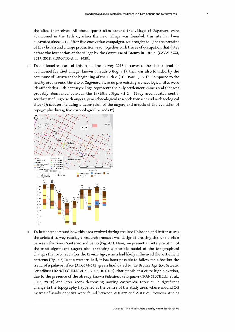
probably abandoned between the 14/15th c.Figs. 4.1-2 - Study area located south-
southwest of Lugo: with augers, geoarchaeological research transect and archaeological
sites (1); section including a description of the augers and models of the evolution of
topography during five chronological periods (2)
18 To better understand how this area evolved during the late Holocene and better assess
the artefact survey results, a research transect was designed crossing the whole plain
between the rivers Santerno and Senio (Fig. 4.1). Here, we present an interpretation of
the most significant augers also proposing a possible model of the topographical
changes that occurred after the Bronze Age, which had likely influenced the settlement
patterns (Fig. 4.2).In the western half, it has been possible to follow for a few km the
trend of a palaeosurface (AUG074-072, green line) dated to the Bronze Age (i.e. Geosuolo
Formellino: FRANCESCHELLI et al., 2007, 104-107), that stands at a quite high elevation,
due to the presence of the already known Paleodosso di Bagnara (FRANCESCHELLI et al.,
2007, 29-30) and later keeps decreasing moving eastwards. Later on, a significant
change in the topography happened at the centre of the study area, where around 2-3
metres of sandy deposits were found between AUG072 and AUG052. Previous studies
Flood risk and socio-ecological resilience in a Late Antique and Medieval cou...
Juvenes - The Middle Ages seen by Young Researchers
7
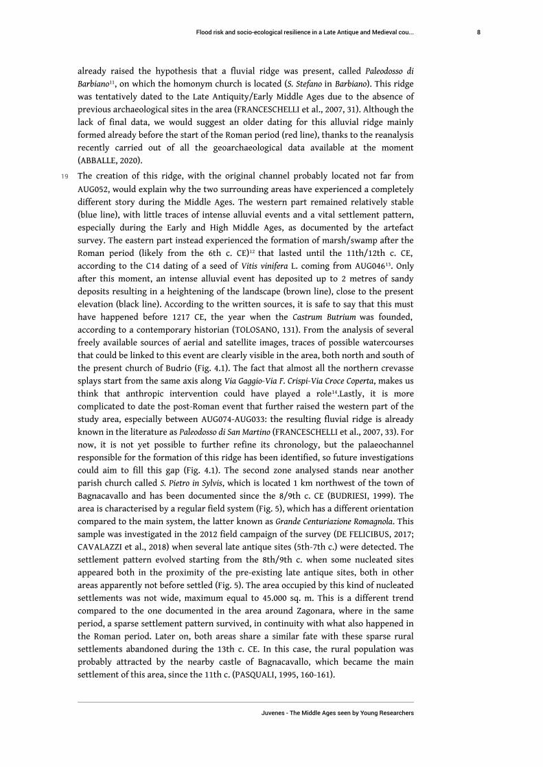
already raised the hypothesis that a fluvial ridge was present, called Paleodosso di
Barbiano11, on which the homonym church is located (S. Stefano in Barbiano). This ridge
was tentatively dated to the Late Antiquity/Early Middle Ages due to the absence of
previous archaeological sites in the area (FRANCESCHELLI et al., 2007, 31). Although the
lack of final data, we would suggest an older dating for this alluvial ridge mainly
formed already before the start of the Roman period (red line), thanks to the reanalysis
recently carried out of all the geoarchaeological data available at the moment
(ABBALLE, 2020).
19 The creation of this ridge, with the original channel probably located not far from
AUG052, would explain why the two surrounding areas have experienced a completely
different story during the Middle Ages. The western part remained relatively stable
(blue line), with little traces of intense alluvial events and a vital settlement pattern,
especially during the Early and High Middle Ages, as documented by the artefact
survey. The eastern part instead experienced the formation of marsh/swamp after the
Roman period (likely from the 6th c. CE)12 that lasted until the 11th/12th c. CE,
according to the C14 dating of a seed of Vitis vinifera L. coming from AUG04613. Only
after this moment, an intense alluvial event has deposited up to 2 metres of sandy
deposits resulting in a heightening of the landscape (brown line), close to the present
elevation (black line). According to the written sources, it is safe to say that this must
have happened before 1217 CE, the year when the Castrum Butrium was founded,
according to a contemporary historian (TOLOSANO, 131). From the analysis of several
freely available sources of aerial and satellite images, traces of possible watercourses
that could be linked to this event are clearly visible in the area, both north and south of
the present church of Budrio (Fig. 4.1). The fact that almost all the northern crevasse
splays start from the same axis along Via Gaggio-Via F. Crispi-Via Croce Coperta, makes us
think that anthropic intervention could have played a role14.Lastly, it is more
complicated to date the post-Roman event that further raised the western part of the
study area, especially between AUG074-AUG033: the resulting fluvial ridge is already
known in the literature as Paleodosso di San Martino (FRANCESCHELLI et al., 2007, 33). For
now, it is not yet possible to further refine its chronology, but the palaeochannel
responsible for the formation of this ridge has been identified, so future investigations
could aim to fill this gap (Fig. 4.1). The second zone analysed stands near another
parish church called S. Pietro in Sylvis, which is located 1 km northwest of the town of
Bagnacavallo and has been documented since the 8/9th c. CE (BUDRIESI, 1999). The
area is characterised by a regular field system (Fig. 5), which has a different orientation
compared to the main system, the latter known as Grande Centuriazione Romagnola. This
sample was investigated in the 2012 field campaign of the survey (DE FELICIBUS, 2017;
CAVALAZZI et al., 2018) when several late antique sites (5th-7th c.) were detected. The
settlement pattern evolved starting from the 8th/9th c. when some nucleated sites
appeared both in the proximity of the pre-existing late antique sites, both in other
areas apparently not before settled (Fig. 5). The area occupied by this kind of nucleated
settlements was not wide, maximum equal to 45.000 sq. m. This is a different trend
compared to the one documented in the area around Zagonara, where in the same
period, a sparse settlement pattern survived, in continuity with what also happened in
the Roman period. Later on, both areas share a similar fate with these sparse rural
settlements abandoned during the 13th c. CE. In this case, the rural population was
probably attracted by the nearby castle of Bagnacavallo, which became the main
settlement of this area, since the 11th c. (PASQUALI, 1995, 160-161).
Flood risk and socio-ecological resilience in a Late Antique and Medieval cou...
Juvenes - The Middle Ages seen by Young Researchers
8

Fig. 5 - Study area located north-northwest of Bagnacavallo, with corings and archaeological sites
20 Before the survey, previous studies already hypothesised the presence of possible
different fluvial ridges in the area (FRANCESCHELLI et al., 2007, 31-32, nos. 7-8-12), so
artefact survey could potentially give back interesting results, as it did. However, to
better understand the recent evolution of the study area, two cores were realised in
August 2019 near some of the sites discovered, which have clearly confirmed the
presence of fluvial ridges, which correspond to the crevasse/levee layers (Fig. 6).
Considering that we have no archaeological data coming from excavation, we can still
use the data from the survey to hypothesise a relative chronology for the development
of this small area. Since late antique sites (5th-7th c.) were recorded nearby CR06, this
area must have remained geomorphologically stable since at least that period. The
occurrence of periodic flood events cannot be excluded, rather it is highly likely and we
probably have evidence for these from the analysis of the aerial and satellite images,
that shows a large crevasse splay (Fig. 5), which seems to be datable to the beginning of
20th c15. Nevertheless, the discovery of these archaeological sites suggests that the
floods have not significantly affected the area, at least in terms of sedimentary intake.
Then, comparing this core to CR05, the first element that stands out is a c. 3 m
difference in elevation. If we consider that next to this last core, in 2016 a sparse site
dated to 11th/13th c. was located, this elevation difference could testify to the
activation of a different fluvial ridge closer to this area in a later period.
Flood risk and socio-ecological resilience in a Late Antique and Medieval cou...
Juvenes - The Middle Ages seen by Young Researchers
9

Fig. 6 - Description of the two corings carried northwest of Bagnacavallo
21 Especially after having proposed this last interpretation, it becomes necessary to
underline the limits of our datasets. On the one hand, the artefact survey suffers from
several biases that can mislead historical reconstructions (AMMERMAN, 1981; ALLEN,
1991; ALCOCK, 1999; SAGGIORO, 2003; BANNING et al., 2017), e.g. the ones caused by the
intensity of the survey16 or the visibility of the sample area 17. Anyhow, in our study
areas the settlement distribution responds to homogeneous trends; this reinforces our
considerations and interpretations, which seems to be coherent and responding to an
actual historical situation, despite all the limits mentioned above.
22 Biases due to visibility are even more relevant in an alluvial environment as the Po
Valley since the deposition of fluvial sediments can raise the local topography and
completely hide archaeological sites. To overcome this limit, we defined a
geoarchaeological campaign to better understand the regional geomorphology
evolution. This approach has given excellent results in the first area, to the south of
Lugo, where archaeological data from the excavation were already available. The same
results are more difficult to reach in the second area, where the only archaeological
data were collected by artefact survey. Therefore becomes clear, especially for this
second area, the need for absolute dating for some crucial layers that could help us to
create a more robust model. In the meantime, the two augering transects presented in
this paper, based on a reanalysis of all the data available at the moment, show a
realistic representation of how the two areas selected for this study evolved during the
late Holocene, which helps us to better understand the evolution of the settlement
patterns. Lastly, they represent a working hypothesis to direct the collection of new
data in order to confirm our reconstructions.
Flood risk and socio-ecological resilience in a Late Antique and Medieval cou...
Juvenes - The Middle Ages seen by Young Researchers
10

Interpretation
23 After having presented the data collected and given a first geomorphological overview
of the evolution of the two study areas, we offer three more complex and refined social-
ecological interpretations for specific historical periods: 5th-6th c.; 9th-11th c.;
12th-13th c. CE. These are based on the resilience theory by C.S. Holling (1973) as the
main interpretative framework, which allowed us to exploit our datasets better thanks
to the corroboration with some crucial information coming from the written sources18.
24 According to this theory, a socio-ecological system is never fixed and motionless. In a
dynamic movement, it passes through four different functions in a sort of circular
evolution: 1. growth («R» function, in which «rapid colonisation of recently disturbed
areas is emphasised»; GUNDERSON et al., 2002, 33); 2. conservation («K» function, in
which «slow accumulation and storage of energy and material are emphasised» ); 3.
release («Omega» phase, when the capital’s accumulation, i.e. the resources, «become
increasingly fragile» or «overconnected», «until suddenly released»); 4. reorganisation
(«Alfa» phase, in which the system minimises the loss and reorganises itself and the
«nutrients» -in ecological terms- for the next phase of exploitation). In this framework,
the resilience of the system is the capacity to react to external stress, and to go through
these different phases, adapting itself.
25 Obviously, our dataset was collected into a local scale, inside a sub-regional context (a
level located between what David Clarke defined as semi-micro level and macro level,
1977). Anyhow, at this level, we can detect the influences of bigger socio-ecological
systems based in the main urban centres: Ravenna, between the 5th and 11th c. CE;
Faenza, between the 12th-13th c. CE. It is clear, as in the «Panarchy» framework - an
updated and multiscalar vision of C.S. Holling theory (Fig. 7.1-2, GUNDERSON et al.,
2002, 7) -, that also historical socio-ecological systems function at multiple scales, with
several interactions between these different levels, in a hierarchic and dynamic
relationship. On the one hand, the bigger levels, larger and slower to change, can
influence the smaller systems, diffusing the accumulated memory of the system’s
dynamics («remember connection»). On the other hand, the lower levels, faster and
smaller, can experiment and test innovative solutions when triggering a crisis («revolt
connection»).
Figs. 7.1-2 - On the left (no. 1) the four ecosystem functions of the resilience framework - r, K, Ω,and α - (from GUNDERSON et al. 2002, fig. 2-1, 34 -); on the right (no. 2) the panarchicalconnections (from GUNDERSON et al. 2002, fig. 3-10, 75)
Flood risk and socio-ecological resilience in a Late Antique and Medieval cou...
Juvenes - The Middle Ages seen by Young Researchers
11
26 The functions of these complex multilevel systems in our field of research were very
similar to the ones that currently interest our contemporary systems if, for instance,
we focus on adaptive water governance. Indeed, B. Cosens and L. H. Gunderson (2018,
313) recently said: «with the onset of Anthropocene, global and regional changes in
biophysical inputs to these systems will challenge their capacity to respond while
maintaining functions of water supply, flood control, hydropower production, water
quality, and biodiversity».
Reacting with strength: urban aristocracy and late antique land-
reclamation
27 The area near Bagnacavallo and the church of S. Pietro in Sylvis is where we can clearly
detect specific dynamics in action immediately after the end of the Roman Age since
the presence of sparse settlements dated to the 5th-7th c. CE shows the capacity of the
system to react to a crisis. These settlements exploited an area corresponding to a
raised fluvial ridge that likely developed towards the end of the Roman period,
therefore offered shelter from subsequent flood events. Later on, in the same area the
church was founded around the 9th c. CE (probably already from the 8th c.) and at the
same time, there was an increase in the number of sites. These elements demonstrate
the capacity of the local socio-ecological system to react to a previous crisis (an
«Omega» phase) and to reorganise itself immediately after.
28 From the analysis of some contemporary written sources, we can see that this answer
of the local system could actually have a connection with a larger socio-ecological
system, which we can probably interpret as a «remember» connection. In particular,
we refer to some elements highlighted by Gianfranco Pasquali (1995, 186-190), who
analysed two 6th c. papyri that document transactions of lands in this area:
The landowners were part of the urban elite of Ravenna (foeminea and viri clarissimi, honesti
or devoti), acting transactions of very high value19;
In the area limites pubblici still survived (i.e. the public division of land with streets and
channels), as well as the public administration and circumscriptions (a pagus and the
districtus civitatis);
A silva is also mentioned, testifying the presence of non-agricultural lands, maybe in the
form of wetlands;
Some of the owners were of Gothic origin with public functions (fleet officers, members of
the court) and probably received these lands from one of the kings of the Ostrogoths.
29 Therefore, after a relevant crisis between the 3rd and 4th c. and natural extreme events
that occurred probably between the 5th and the beginning of the 6th c., the area of
Bagnacavallo was immediately exploited by the urban elites, certainly also through
water governance actions. It is not sure if the so-called Centuriazione di Bagnacavallo was
outlined, or started to be outlined already in this period, but it is certain at least that
these landowners, acting in this extreme and marginal environment20, had to deal with
the management of water drainage and had to deploy infrastructures for flood
prevention. At the same time, we cannot also exclude the intervention of public
authorities linked to the city of Ravenna or the mentioned Pagus. These supra-local
levels could possess the knowledge to activate a «remember» connection, allowing the
reorganisation of this area, assuring its success.
•
•
•
•
Flood risk and socio-ecological resilience in a Late Antique and Medieval cou...
Juvenes - The Middle Ages seen by Young Researchers
12

The continuity through the early Middle Ages: monasteries,
peasants and local owners
30 Starting from the 8th-9th c., until the 12th c., we can observe an increased number of
settled sites both in Bagnacavallo and Lugo, with no break or crisis in the settlement
patterns clearly detectable during this long period. Furthermore, geomorphology
profoundly influenced the settlement choices, with the prominent fluvial ridges often
chosen for placing both religious sites (as S. Pietro in Sylvis or S. Andrea in Zagonara) and
fortified settlements (as the castle of Bagnacavallo).
31 Specifically for the area of Zagonara, the archaeological sites were distributed along the
main elements of land division (i.e. the cardi and decumani of the centuriation). This
demonstrates that a land division of ancient origin still existed in the period, preserved
likely through a process of vertical transmission (CHOUQUER, 2015).
32 Previous historical researches (PASQUALI, 1995; MANCASSOLA, 2008b) highlighted
additional elements that contribute to our understanding:
Large monastic estates developed from the 8th-9th c. in Ravenna area, that continued to
grow in the following centuries, thanks to the donations from the Church and the
Archbishops of Ravenna as well as from the urban aristocracy;
Fortified castles started to appear in the investigated area from the 10th c. (also RONCHINI,
2006);
The environment conserved a mixed aspect, with agricultural landscape units mixed with
forest and humid zones (also FIOROTTO, 2018);
Several monastic farms were present there, which likely acted as the main actors for both
water management and land reclamation processes. The most common were the massae,
large and compact farms, frequently located at the limits of the uncultivated lands, while
the curtes, the bipartite farms of the manorial system, were rarer.
From the 11th-12th c. expressions of personal and familiar territorial powers started to
emerge, centred on the control of castles (castrum cum curtis, i.e. a castle centre of a civil
district; also PALLOTTI, 2018);
Surely starting from the 12th c. (probably also before), the peasants were obliged by the
owners to inhabit the parcel they cultivated; this is why they were named «supersedentes»
( = those who live upon) in the contracts.
33 These additional elements help us to refine our interpretative framework: the
reorganisation of the system was not due to natural agents but to a socio-economic
transformation, consisting in the birth of the urban monastic estates and their being
connected to the rural areas, through local administrators, clientes and peasants. There
was no dramatic shift from the Late Antique system and this new cycle continued
without a crisis in growth («R» phase) and conservation («K» phase) functions until the
11th-12th c., when the situation rapidly changed. The anthropic actors (monasteries,
local elites, and peasants) in this long cycle can be defined as K-strategists, an
expression used in ecology for the species that tend to have slower growth rates, acting
in «an arena of contest competition», while R-strategists species are characterised by
rapid growth in «an arena where scramble competition succeeds» (GUNDERSON et al.,
2002, 33). The functioning of the system was probably assured also by: limited flood
events and other environmental stress caused by natural agents, at least until the
11th-12th c.; the memory of the knowledge of previous cycles concerning the adaptive
mechanisms, especially regarding water governance.
•
•
•
•
•
•
Flood risk and socio-ecological resilience in a Late Antique and Medieval cou...
Juvenes - The Middle Ages seen by Young Researchers
13

The great revolution? Urban communes managing the landscape
34 The situation seems to completely change between the second half of the 12th and the
13th c. CE. Our geoarchaeological data showed as this period is characterised by several
flood events in the area of Budrio, but similar phenomena could have also occurred
near San Martino (Lugo) and Bagnacavallo, if we accept the dating proposed by
previous studies for the formation of some fluvial ridges (FRANCESCHELLI et al., 2007).
Therefore, this general hydrological instability could be related to a cycle of climate
instability known as Medieval Climate Anomaly (LÜNING et al., 2019). These events
could have probably caused the abandonment of several sites north of Budrio and
Zagonara, as it seems possible to deduce from the available historical sources. This is
likely the case of castles like Bassianica and Sancti Ilari, which were located
approximately in the areas where the present city of Lugo stands nowadays. From an
archaeological point of view, it is clear that this period coincides with a radical
reorganisation of the settlement pattern since all the sparse settlements in the area of
Zagonara and Bagnacavallo are abandoned.
35 From the historical sources, it is clear that new actors started to play a significant role
in the countryside since the second half of the 12th c.: the urban communes and the
new urban elites (PASQUALI, 1995; PALLOTTI, 2018). As happened in other zones of
central and northern Italy (DE VERGOTTINI, 1929; MUCCIARELLI et al., 2009;
CAVALAZZI, 2019), the near urban communes of Faenza, Imola, Forlì, and Ravenna,
started to affirm their territorial authority (the districtus) on their nearby countryside,
with our study area that became a conflict zone between the city of Faenza, Ravenna
and Imola. The political phenomenon materialised on the landscape in different ways:
In 1217 the commune of Faenza founded several new fortified villages, such as Budrio and
Zagonara, strategically placed along the northern border of its district (CAVALAZZI, 2021);
This intervention included several actions to ensure the water drainage in the lower part of
its district, including excavating channels to reclaim new farmable land21. This was probably
carried out through a process of lateral transmission (CHOUQUER, 2015), resulting in a new
regular field system very similar to the Roman centuriation;
Other public authorities (the commune of Imola, the count of Bagnacavallo, the bishop of
Imola, and the archbishop of Ravenna) adopted similar behaviours, starting to exploit
woodlands and wetlands like in Massa Lombarda and Villafranca di Forlì, often in
association with the founding of new settlements (ABBALLE, in press) or the reinforcement
of pre-existing ones, such as Bagnacavallo, deeply influencing the rural population (also
CAVALAZZI et al., 2018).
36 It is clear that the commune of Faenza was an agent of stress for the local system due to
its deep interventions on the local socio-ecological system. This organisation was put in
place through various lines of actions starting from the settlement patterns that
evolved from sparse to nucleated. Water governance also had a major role, increasing
the exploitable agricultural area at the expense of biodiversity22. Thus, the creation of
these new fortified villages, at the border of its district, was not only to control the area
from a political and military point of view (FASOLI, 1942), but also to reclaim land to
exploit (SETTIA, 1991) and assure new resources to the city of Faenza. The broad and
robust intervention in this area of a public authority with its large amount of resources
(with a «remember connection») defined a new trajectory for the local system, with a
•
•
•
Flood risk and socio-ecological resilience in a Late Antique and Medieval cou...
Juvenes - The Middle Ages seen by Young Researchers
14
relevant shift from a still successful previous trend. This massive and swift intervention
responded to what before we defined «K-strategists»’ behaviour.
Conclusions
37 Using archaeological and geological data combined with the written sources, we
analysed how socio-ecological historical systems reacted to natural and anthropogenic
stress factors after the Roman period. In particular, we were able to follow the
importance of flood-risk management practices on the success of the local systems for
all the three different periods analysed. However, these local systems were
substantially helped by the intervention of the larger systems represented by urban
authorities, through a «remember» connection, as defined by the Panarchy theory. In
particular, during crises like extreme flood events, which occurred especially during
the 5th-6th c. and the 12th-13th c. CE, this connection with the cities of Ravenna and
Faenza seems to have been essential to assure the resilience and subsequent
reorganisation of the local systems. This probably means that, in a particular situation
of crisis, in a marginal and extreme landscape like the one investigated the local
resources are not enough to assure a complete reorganisation of the local system, with
a strong «revolt» connection. Anyhow, the intervention of urban agents (elites,
authorities, landowners) was an expected response here, in the area examined, as well
as in other areas of the Po plain, where the urban networks in several cases survived
(even if radically transformed) after the end of the Roman Age, strongly joining at
several levels the urban centres to their countryside.
BIBLIOGRAPHY
ABBALLE, Michele (2020) – “From scattered data to palaeolandscape reconstruction: a case study
from the Romagna plain, Italy”. In Tagliani, M.; Canciani, V.; Tommasi, F. (eds.). In Humanities:
approaches, contamination and perspectives. Conference proceedings, Verona 17-18th October
2019, Verona: Cierre Edizioni, p. 73-85.
ABBALLE, Michele (in press) - Geoarchaeological mapping of medieval wetlands and their
reclamation in the hinterland of Ravenna: two case studies from Massa Lombarda (RA) and
Villafranca di Forlì (FC). ArcheoLogica Data. Vol. 2.
ALCOCK, Susan E. (1999) – “Extracting meaning from ploughsoil assemblages: assessments of the
past, strategies for the future”. In Bintliff, J.; Sbonias, K (eds.). In Reconstructing Past Population
Trends in Mediterranean Europe. Oxford: Oxbow Books, pp. 1-4.
ALLEN, Michael J. (1991) – “Analysing the landscape: a geographical approach to archaeological
problems”. In Schofield, A. J. (ed.). In Interpreting artefact scatters. Contribution to ploughzone
archaeology. Oxford: Oxbow Books, pp. 39-58.
AMMERMANN, Albert J. (1991) - Survey and archaeological research. America Review of
Anthropology. Vol. 10, pp. 63-88.
Flood risk and socio-ecological resilience in a Late Antique and Medieval cou...
Juvenes - The Middle Ages seen by Young Researchers
15

AMOROSI, Alessandro [et al.] (2017) - Global sea-level control on local parasequence architecture
from the Holocene record of the Po Plain, Italy. Sedimentology in Italy: recent advances and insights.
Vol. 87, pp. 99-111. [Accessed 1st November 2021]. Available at: 10.1016/j.marpetgeo.2017.01.020.
ASSORATI, Giovanni (2015) – “La «Romagnola» in Età romana dagli studi degli ultimi vent’anni”.
In Storiografia e Archeologia nella «Romandiola». Tradizione e nuove ricerche sul territorio.
Lugo: Walberti, pp. 25-101.
AUGENTI, Andrea; BONDI, Mila (2015) – “L’atlante delle città italiane dall’Antichità al Medioevo:
primi risultati del progetto; Italia settentrionale e centrale”. In Arthur, P.; Imperiale, M. L. (eds.).
In VII Congresso Nazionale di Archeologia Medievale. Borgo S. Lorenzo (FI): All’Insegna del Giglio.
Vol. 1. pp. 140-144.
AUGENTI, Andrea; CIRELLI, Enrico (2010) - “Classe: un osservatorio privilegiato per il commercio
della Tarda Antichità”. In Menchelli, S. (ed.). In LRCW3: late Roman coarse wares, cooking wares
and amphorae in the Mediterranean: archaeology and archaeometry: comparison between
western and eastern Mediterranean. BAR international series 2185(1). Oxford: Archaeopress. Vol.
II, pp. 605-616.
BANNING, Edward B. [et al.] (2017) - Quality Assurance in Archaeological Survey. Journal of
Archaeological Method and Theory. Vol. 24, n° 2, pp. 466-488. [Accessed 1st November 2021].
Available at: 10.1007/s10816-016-9274-2.
BAZZOCCHI, Alessandro (2008) - Esercito e società tra principato e tarda antichità. Il caso della regio
VIII. Ravenna: Alma Mater Studiorum - Università di Bologna. Tesi di dottorato. [Accessed 1st
November 2021]. Available at: http://amsdottorato.unibo.it/id/eprint/706.
BIANCHINI, Gianluca [et al.] (2019) - Late Holocene palaeo-environmental reconstruction and human
settlement in the eastern Po Plain (northern Italy). CATENA, 176, pp. 324-335.
BOLLINI, Maria (1990) - “La fondazione di Classe e la comunità classiaria”. In Susini, G. (ed.). In
Storia di Ravenna. Vol. I, L’evo antico. Venezia: Marsilio, pp. 297-320.
BOTTAZZI, Gianluca (1994) - “Il reticolo centuriale di Bagnacavallo: la sistemazione paesaggistica
e infrastrutturale della pianura romagnola antica”. In Calbi, A.; Susini, G. (eds.). In Storia di
Bagnacavallo. Bagnacavallo; Bologna: Comune di Bagnacavallo; Banca popolare dell’Adriatico.
Vol. 1, pp. 71-95.
BOTTAZZI, Gianluca; LABATE, Donato (2008) - “La centuriazione nella pianura modenese e
carpigiana”. In Bonacini, P.; Ori, A. M. (eds.). In Storia di Carpi. La città e il territorio dalle origini
all’affermazione dei Pio. Modena: Mucchi. Vol. I, pp. 177-206.
BRANDOLINI, Filippo (2020) - Late-Holocene Human Resilience in a Fluvial Environment: A
Geoarchaeological Dataset for the Central Po Plain (N Italy). Journal of Open Archaeology Data. Vol.
8, n° 1. [Accessed 1st November 2021]. Available at: 10.5334/joad.62.
BRANDOLINI, Filippo (2021) – Tecniche digitali e geoarcheologia per lo studio del paesaggio medievale.
Uno studio interdisciplinare in Pianura Padana centrale. Oxford: BAR Publishing.
BRANDOLINI, Filippo; CARRER, Francesco (2020) - Terra, Silva et Paludes. Assessing the Role of
Alluvial Geomorphology for Late-Holocene Settlement Strategies (Po Plain – N Italy) Through
Point Pattern Analysis. Environmental Archaeology, pp. 1-15. [Accessed 1st November 2021].
Available at: 10.1080/14614103.2020.1740866.
BRANDOLINI, Filippo; CREMASCHI, Mauro (2018a) – “Valli-Paludi nel Medioevo: il rapporto tra
uomo e acque nella Bassa Pianura Reggiana: le bonifiche “laiche” per colmata”. In Sogliani, F.;
Flood risk and socio-ecological resilience in a Late Antique and Medieval cou...
Juvenes - The Middle Ages seen by Young Researchers
16

Gargiulo, B.; Annunziata, E.; Vitale, V. (eds.). In VIII Congresso Nazionale di Archeologia
Medievale. Firenze: All’Insegna del Giglio, pp. 72-75.
BRANDOLINI, Filippo; CREMASCHI, Mauro (2018b) - The Impact of Late Holocene Flood
Management on the Central Po Plain (Northern Italy). Sustainability. Vol. 10, n° 11. [Accessed 1st
November 2021]. Available at: 10.3390/su10113968.
BUDRIESI, Roberta (1999) - Viaggio nelle pievi della provincia di Ravenna. Ravenna: Longo Angela.
BÜNTGEN, Ulf [et al.] (2011) - 2500 Years of European Climate Variability and Human
Susceptibility. Science. Vol. 331, n° 6017, pp. 578-582. [Accessed 1st November 2021]. Available at:
10.1126/science.1197175.
CAMBI, Franco; TERRENATO, Nicola (1994) - Introduzione all’archeologia dei paesaggi. Roma: Nuova
Italia scientifica.
CAMPOPIANO, Michele; MENANT, François (2015) - Agriculture irrigue: l’italia padana. In I
paesaggi agrari d’Europa (secoli XIII-XV). Roma: Viella, 2015. pp. 291-322.
CARILE, Antonio (ed.) (1991) - Storia di Ravenna. Venezia: Marsilio. Vol. I.
CARILE, Antonio (ed.) (1992) - Storia di Ravenna. Venezia: Marsilio. Vol. II.
CASTAGNETTI, Andrea (1977) - “La pianura veronese nel medioevo”. In Borelli, G. (ed.) - Una città
e il suo fiume. Verona e l’Adige. Verona: Banca Popolare di Verona, pp. 35-138. [Accessed 1st
November 2021]. Available at: http://www.rmoa.unina.it/4933/1/Castagnetti_Pianura.pdf.
CAVALAZZI, Marco (2012) - “Progetto «Bassa Romandiola». La campagna di ricognizione nel
territorio di Lugo di Romagna (RA)”. In Galetti, P. (ed.) - Paesaggi, comunità, villaggi medievali.
Spoleto: Fondazione Centro italiano di studi sull’Alto Medioevo, pp. 703-708.
CAVALAZZI, Marco (2017) - FASTI - Castello di Zagonara - Season 2017. [Accessed 1st November 2021].
Available at: http://www.fastionline.org/excavation/micro_view.php?
fst_cd=AIAC_4645&curcol=sea_cd-AIAC_9729.
CAVALAZZI, Marco (2018) - FASTI - Castello di Zagonara - Season 2018. [Accessed 1st November 2021].
Available at: http://www.fastionline.org/excavation/micro_view.php?
fst_cd=AIAC_4645&curcol=sea_cd-AIAC_10220.
CAVALAZZI, Marco (2019) - Un ordine fragile. La costruzione del distretto del Comune di Reggio Emilia
(XII-XIII secolo). Bologna: Bononia University Press.
CAVALAZZI, Marco (2021) - “Paesaggi del potere in età comunale. Villaggi abbandonati e nuove
fondazioni in area ravennate nel XIII secolo: fonti archeologiche e scritte a confronto”. In ISCUM (ed.). In
Tiziano Mannoni: attualità e sviluppi di metodi e idee. Sesto Fiorentino (FI): All'Insegna del Giglio, pp.
512-515.
CAVALAZZI, Marco [et al.] (2015) - “Archeologia dei paesaggi in Bassa Romagna. Il progetto Bassa
Romandiola (2009-2013)”. In Storiografia e Archeologia nella «Romandiola». Tradizione e nuove
ricerche sul territorio. Lugo: Walberti, pp. 129-172.
CAVALAZZI, Marco [et al.] (2018) - Archeologia dei paesaggi in Bassa Romagna. Il progetto Bassa
Romandiola (2009-2016). Archeologia Medievale. Cultura materiale, insediamenti, territorio. Vol. XLV, pp.
317-334.
CHARLTON, Ro (2007) - Fundamentals of Fluvial Geomorphology. London; New York: Routledge.
CHEVALLIER, Raymond (1968) – “Navigations et ports antiques. Esquisse d’une problématique”.
In Atti del convegno internazionale di studi sulle antichità di Classe (Ravenna, 14-17 ottobre 1967).
Ravenna: A. Longo, pp. 219-248.
Flood risk and socio-ecological resilience in a Late Antique and Medieval cou...
Juvenes - The Middle Ages seen by Young Researchers
17
CHOUQUER, Gérard (2015) - Les parcellaires médiévaux en Émilie et en Romagne. Centuriations et trames
coaxiales. Morphologie et droit agraires. Paris: Observatoire des formes du foncier dans le monde.
France International pour l’Expertise Foncière (FIEF).
CHRISTIANSEN, Bo; LJUNGQVIST, Fredrik C. (2012) - The extra-tropical Northern Hemisphere
temperature in the last two millennia: reconstructions of low-frequency variability. Climate of the
Past. Vol. 8, n° 2, pp. 765-786. [Accessed 1st November 2021]. Available at: https://doi.org/
10.5194/cp-8-765-2012.
CLARKE, David L. (1977) - Spatial archaeology. London: Academic Press.
COSENS, Barbara; GUNDERSON, Lance (2018) - Practical Panarchy for Adaptive Water Governance:
Linking Law to Social-Ecological Resilience. Springer.
CURTIS, Daniel R.; CAMPOPIANO, Michele (2015) - Medieval land reclamation and the creation of
new societies: comparing Holland and the Po Valley, c.800–c.1500. Journal of Historical Geography.
Vol. 44, pp. 93-108. [Accessed 1st November 2021]. Available at: 10.1016/j.jhg.2013.10.004.
DE FELICIBUS, Michela (2017) - Società e popolamento altomedievale nel pievato di San Pietro in
Sylvis. Studi Romagnoli. Vol. LXVIII, pp. 457-470.
DE VERGOTTINI, Giovanni (1929) - Origini e sviluppo storico della comitatinanza. Studi senesi. Vol.
43, pp. 347-481.
FASOLI, Gina (1942) - Ricerche sui borghi franchi dell’alta Italia. Rivista di storia del diritto italiano.
Vol. 15, pp. 139-214.
FICARA, Marilisa (2006) - “L’occupazione dei dossi fluviali nel territorio di Reggio Emilia: il caso di
Canolo di Mezzo”. In Mancassola, N.; Saggioro, F. (eds.). In Medioevo, paesaggi e metodi.
Mantova: SAP, pp. 147-168.
FIOROTTO, Celeste (2018) - Human settlement and environment in the medieval Bassa Romagna
(Ravenna, Italy) c. 800–1200. Medieval Settlement Research. Vol. 33, pp. 28-39.
FIOROTTO, Celeste; CARRA, Maria Letizia; CAVALAZZI, Marco (2020) - The castrum of Zagonara. An
archaeobotanical approach to the study of a medieval castle’s human-environment dynamics. In Tagliani,
M.; Canciani, V.; Tommasi, F. (eds.). In Humanities: approaches, contamination and perspectives.
Conference proceedings, Verona 17-18th October 2019. Verona: Cierre Edizioni, pp. 125-137.
FRANCESCHELLI, Carlotta (2008) - Dynamiques de transmission de la morphologie agraire:
«pérennisation» et «effacement» de la centuriation romaine dans la plaine sud du Po. Agri
centuriati: an International Journal of Landscape Archaeology. Vol. 5, pp. 77-105.
FRANCESCHELLI, Carlotta (2015) - Riflessioni sulla centuriazione romana: paradigmi
interpretativi, valenza paesaggistica, significato storico. Agri centuriati: an International Journal of
Landscape Archaeology. Vol. 12, pp. 153-174.
FRANCESCHELLI, Carlotta; MARABINI, Stefano (2007) - Lettura di un territorio sepolto: la pianura
lughese in età romana. Bologna: Ante Quem.
FRANCOVICH ONESTI, Nicoletta (2007) - I nomi degli Ostrogoti. Firenze: Firenze University Press.
GAMBI, Lucio (1949) - L’insediamento umano nella regione della bonifica romagnola. Roma: Consiglio
nazionale delle Ricerche.
GADDONI, Serafino; ZACCHERINI, Goffredo (eds.) (1912) - Chartularium Imolense. Imola: Unganiae.
Vol. 1-2.
Flood risk and socio-ecological resilience in a Late Antique and Medieval cou...
Juvenes - The Middle Ages seen by Young Researchers
18

GNOLI, Tommaso (2006) - “Le epigrafi”. In Augenti, A.; Bertelli, C. (eds.). In Santi, banchieri, re.
Ravenna e Classe nel VI secolo. San Severo il tempio ritrovato. Milano: Skira, pp. 182-191.
GUNDERSON, Lance H.; HOLLING, C. S. (eds.) (2002) - Panarchy: Understanding Transformations in
Human and Natural Systems. Washington, Covelo, London: Island Press.
HOLLING, C. S. (1973) - Resilience and Stability of Ecological Systems. Annual Review of Ecology and
Systematics. Vol. 4, pp. 1-23.
LÜNING, Sebastian et al. (2019) - The Medieval Climate Anomaly in the Mediterranean Region.
Paleoceanography and Paleoclimatology. Vol. 34, n° 10, pp. 1625-1649. [Accessed 1st November 2021].
Available at: 10.1029/2019PA003734.
MANCASSOLA, Nicola (2008a) - “Le forme del popolamento rurale nel territorio Decimano dalla
caduta dell’Impero Romano all’anno Mille”. In Ficara, M; Manzelli, V. (eds.). In Orme nei campi.
Archeologia a sud di Ravenna. Firenze: All’Insegna del Giglio. pp. 89-104.
MANCASSOLA, Nicola (2008b) - L’azienda curtense tra “Langobardia” e “Romania”: rapporti di lavoro e
patti colonici dall’età carolingia al Mille. Bologna: CLUEB.
MANCASSOLA, Nicola (2012) - “Uomini e acque nella pianura reggiana durante il Medioevo (secoli
IX-XIV)”. In Canzian, D.; Simonetti, R. (eds.). In Acque e territorio nel Veneto medievale. Roma:
Viella, pp. 115-132.
MASCANZONI, Leardo (2004) - “La battaglia di Zagonara (28 luglio 1424)”. In Lazzari, T.;
Mascanzoni, L.; Rinaldi, R. (eds.). In La norma e la memoria. Studi per Augusto Vasina. Roma:
Istituto storico italiano per il Medioevo. [Accessed 1st November 2021]. Available at: http://
www.rmoa.unina.it/906/.
MILANESE, Marco (2004) - “Dal castello all’uliveto, Archeologia e storia delle trasformazioni del
paesaggio in Val di Nievole tra XVIII e XIX secolo”. In Milanese, M., Baldassarri, M. (eds.). In Il
castello e l’uliveto. Massa: Comune di Massa e Cozzile, pp. 53-73.
MONTANARI, Massimo (2000) - “Contadini e signori”. In Montanari, M. (ed.). In La storia di Imola.
Dai primi insediamenti all’ancien régime. Imola: La Mandragora Editrice, pp. 199-208.
MUCCIARELLI, Roberta; PICCINNI, Gabriella; PINTO, Giuliano (eds.) (2009) - La costruzione del
dominio cittadino sulle campagne. Siena: Protagon.
MUZZIOLI, Maria Pia (2010) - Le ricerche sui resti della centuriazione cinquant’anni dopo. Atlante
Tematico di Topografia Antica. Vol. 20, pp. 7-49.
NEGRELLI, Claudio (2008) - “Dalla Tarda Antichità all’Alto Medioevo (V-IX secolo)”. In Gelichi, S.;
Negrelli, C. (eds.). In A misura d’uomo. Archeologia del territorio cesenate e valutazione dei
depositi. Borgo S. Lorenzo (FI): All’Insegna del Giglio, pp. 237-256.
ORTON, Clive (2000) - Sampling in Archaeology. New York: Cambridge University Press.
PALLOTTI, Riccardo (2018) - Castelli e poteri signorili. Nella Romagna settentrionale (secoli XI-XIII).
Cesena: Il Ponte vecchio.
PASQUALI, Gianfranco (1975) - Insediamenti rurali, paesaggio agrario e toponomastica fondiaria
nella circoscrizione plebana di S. Pietro in Silvis di Bagnacavallo (secc. X-XII). Studi Romagnoli.
Vol. XXVI, pp. 359-380.
PASQUALI, Gianfranco (1993) - Dal Magnum Forestum di Liutprando ai pievati del Duecento: l’enigma
del territorio Faventino acto Corneliense. Bologna: CLUEB.
Flood risk and socio-ecological resilience in a Late Antique and Medieval cou...
Juvenes - The Middle Ages seen by Young Researchers
19
PASQUALI, Gianfranco (1995) - Contadini e signori della bassa: insediamenti e «deserta» del ravennate e
del ferrarese nel medioevo. Bologna: CLUEB.
REDMAN, Charles L. (2005) - Resilience Theory in Archaeology. American Anthropologist. Vol. 107,
n° 1, pp. 70-77.
REGESTO ROSSINI = ROSSINI, Giuseppe - Schedario faentino. [Accessed 1st November 2021].
Available at: http://manfrediana.comune.faenza.ra.it/index.php.
RONCHINI, Massimo (2006) - Le origini di Lugo alla luce di nuovi documenti (secc. X-XI). Studi
Romagnoli. Vol. LVII, pp. 33-51.
RUCCO, Alessandro A. (2015) - Comacchio nell’alto Medioevo: Il paesaggio tra topografia e
geoarcheologia. Sesto Fiorentino (FI): All’Insegna del Giglio.
RUCCO, Alessandro A. (2020) - Archeologia stratigrafica di un paesaggio emiliano. La pianura a nord-est
di Bologna tra tarda Antichità e Medioevo. Sesto Fiorentino (FI): All’Insegna del Giglio.
RUCCO, Alessandro A. (2021) - “Comacchio (FE): geoarcheologia delle bonifiche tra l’alto Medioevo e il
Novecento”. In Corrò, E.; Vinci, G. (eds.). In Palinsesti programmati nell’Alto Adriatico? Decifrare,
conservare, pianificare e comunicare il paesaggio. Venezia: Edizioni Ca’ Foscari, pp. 59-72. [Accessed 1st
November 2021]. Available at: https://edizionicafoscari.unive.it/en/edizioni4/libri/
978-88-6969-480-6/comacchio-fe-geoarcheologia-delle-bonifiche-tra-la/.
RUCCO, Alessandro A. [et al.] (2019) - Geoarcheologia nel territorio di Nonantola (MO): studio
geomorfologico, sedimentologico e archeobotanico dell’area dell’antica Selva Zena. Archeologia
Medievale. Cultura materiale. Insediamenti. Territorio. Vol. XLVI, pp. 157-177.
SAGGIORO, Fabio (2003) - Distribuzione dei materiali e definizione del sito: processi di conoscenza
e d’interpretazione dei dati di superficie altomedievali in area padana. In Peduto, P.; Fiorillo, R.
(eds.). In III Congresso Nazionale di Archeologia Medievale. Borgo S. Lorenzo (FI): All’Insegna del
Giglio.
SAGGIORO, Fabio (2010) - Paesaggi di pianura: trasformazioni del popolamento tra età romana e
Medioevo. Insediamenti, società e ambiente nella pianura tra Mantova e Verona. Borgo San Lorenzo:
All’Insegna del Giglio.
SAGGIORO, Fabio (2012) - Paesaggi in equilibrio: uomo e acqua nella Pianura Padana Centrale tra
IV e IX secolo. Antiquité tardive: revue internationale d’histoire et d’archéologie. Vol. 20, pp. 47-67.
SAGGIORO, Fabio; VARANINI, Gian Maria (2012) - “Insediamento umano, terra e acque nella
pianura veronese (IX-XIV secoIo): archeologia e fonti scritte”. In Canzian, D.; Simonetti, R. (eds.).
In Acque e territorio nel Veneto medievale. Roma: Viella, pp. 95-114.
SETTIA, Aldo A. (1991) - Chiese, strade e fortezze nell’Italia medievale. Roma: Herder.
SETTIS, Salvatore (ed.) (1993) - Misurare la terra: centuriazione e coloni nel mondo romano. Modena:
Franco Cosimo Panini.
STAGNO, Anna Maria (2018) - Gli spazi dell’archeologia rurale. Risorse ambientali e insediamenti
nell’Appennino ligure tra XV e XXI secolo. Sesto Fiorentino: All’insegna del Giglio.
THOMAS, David Hurst (1975) - “Nonsite sampling in archaeology: up the creek without a site?”. In
Mueller, J. W. (ed.). In Sampling in Archaeology. Tucson: Univ. of Arizona Press, pp. 61-81.
TOLOSANO, Magistri (1936-1939) - Magistri Tolosani Chronicon Faventinum (AA. 20 av.C.-1236).
Bologna: Zanichelli.
Flood risk and socio-ecological resilience in a Late Antique and Medieval cou...
Juvenes - The Middle Ages seen by Young Researchers
20

VASINA, Augusto (1986) - Comuni e signorie in Emilia e in Romagna: dal secolo XI al secolo XV. Torino:
UTET Libreria.
VASINA, Augusto (ed.) (1993) - Storia di Ravenna. Venezia: Marsilio. Vol. III.
WARD-PERKINS, Bryan (1988) - “The towns of northern Italy: rebirth or renewal?”. In Hodges, R.;
Hobley, B. (eds.). In The Rebirth of Towns in the West AD 700-1050. London: Council for British
Archaeology, pp. 16-27.
NOTES
1. This post-doc research was carried out by Marco Cavalazzi, it started in July 2018 and ended in
July 2019; the title is «The impact of the birth of urban districts on rural landscape (12th - 13th
c.): an historical and archaeological research» and it has been renewed and a second phase is now
in progress. It has been funded by the Comitato per i Beni Culturali del Comune di Lugo, the
Cotignola and Lugo communes, and with Climate Kic Action funds (European Institute of
Technology, 2015); anyhow the artefact survey dataset was collected in different field seasons,
starting from 2009 (CAVALAZZI et al., 2018).
2. This doctoral research is carried out at the Department of Archaeology of Ghent University
(January 2018 - January 2022), within a Joint Doctoral Programme in Arts and Humanities with
the University of Verona. The title of the project is «Geoarchaeology and palaeoDEMs modelling
to assess the archaeological potential of Ravenna and its hinterland». The research is funded by
the Special Research Fund of Ghent University (BOF), while the fieldwork carried out in 2019 was
also funded by a grant of the Research Foundation – Flanders (FWO).
3. Novel geoarchaeological data are available from the area of the so-called Centuriazione di Massa
Lombarda, see ABBALLE, in press.
4. The field director of the project is one of the authors (Marco Cavalazzi), while the scientific
director is prof. Andrea Augenti from the Department of History and Cultures. The project is
funded by several institutions: the towns of Lugo, Cotignola, Conselice, and Fusignano, the
Fondazione Flaminia, the Centro di Studi sulla Romandiola Nord Occidentale, the Fondazione
Cassa di Risparmio e Banca del Monte di Lugo.
5. Except building materials, such as bricks or roof tiles.
6. THOMAS, 1975; CAMBI et al., 1994: 256-257; ORTON, 2000, 81; the GPS used was a Garmin 60Cx,
later replaced by a Garmin 64s.
7. The methodology is explained more in detail in ABBALLE, in press. Furthermore, all data
generated through hand augering are available in the accompanying dataset.
8. This interpretation is based on the facies-lithology relationship proposed for the Holocene
geological record of the Po Plain by AMOROSI et al., 2017, 102, fig. 2.
9. This was done also applying hydrochloric acid (HCl) to the soil sample to roughly establish the
amount of calcium carbonate (CaCO3) still present, which naturally decreases with increasing
exposure to weathering. The amount of carbonate was established based on the intensity of the
effervescence observed and it was measured in a range of 0-4, following the guidelines developed
for the CARG project and keeping in mind that usually levels between 0-2 testify the occurrence
of pedological processes for a prolonged period (http://www.isprambiente.gov.it/it/progetti/
suolo-e-territorio-1/progetto-carg-cartografia-geologica-e-geotematica/linee-guida).
10. The location Budrio appeared in the written sources only from the end of the 12th c.; the
toponym is associated with the term villa (an open settlement) only from the half of the 13th c.,
therefore after the foundation of the village by the Faenza commune (REGESTO ROSSINI, 597).
11. Part of the paleochannel that formed this ridge could have been mapped south of the study
area, see Fig. 4.1.
Flood risk and socio-ecological resilience in a Late Antique and Medieval cou...
Juvenes - The Middle Ages seen by Young Researchers
21
12. It seems likely to associate this wet environment with the Orizzonte Veggiani, whose formation
was dated to the 6th c. CE: FRANCESCHELLI et al., 2007, 115-154, 148-151.
13. The seed comes from a soil sample from the depth 2.35-2.50 m; Beta-531205 [920±30 BP;
1028-1184 (95.4%) cal CE].
14. A similar interpretation has been proposed for the Tagliata Canal in Reggio Emilia, where
although the crevasse splays have a recognizable relief (BRANDOLINI et al., 2018b).
15. The local community still has memories of this flood event.
16. The intensity of the survey is the energy applied by archaeologists in the artefact survey; it
takes into account the ratio between surface examined and time spent (CAMBI et. al., 1994,
136-144).
17. The visibility quantifies the possibility to identify an artefact (CAMBI et. al., 1994, 151-158).
18. See REDMAN, 2005 for the use of the Resilience theory in archaeology.
19. See on this argument also ASSORATI, 2015, 78-80; FRANCOVICH ONESTI, 2007, 11 and 18.
20. The wetlands to the north of this area, known both from the written sources and modern
cartography, were reclaimed only from the Late Middle Ages onwards.
21. « ...fossata magna et profunda ad liberandum districtum eorum et ad derimandum aquas
inutiles atque superfluas usque in valles...» (TOLOSANO, 131); see also FRANCESCHELLI et al.,
2007, 154; 163-164.
22. On the relevant role of Communes and City-states on the water management in their districts
in 12th-15th c., with particular attention to the west part of the Po valley, see CAMPOPIANO et
al., 2015.
ABSTRACTS
In this paper we used archaeological and geological data and information from the written
sources to understand how socio-ecological systems reacted to several ecological crises that
occurred after the Roman period. The region investigated is the northwest hinterland of
Ravenna, a sub-region known today as Bassa Romagna. Like other parts of the Po Valley, this area
was primarily characterised by the presence of wetlands and woodlands, ultimately reclaimed
only in the 20th century. A multidisciplinary approach allowed us to understand better which
phenomena of anthropic persistence and practices of land reclamation were put in place after
ecological crises, often linked to flood events. In particular, water management processes emerge
as a key element for the success of the socio-ecological systems acting in the area, starting from
Late Antiquity to the Late Middle Ages. Furthermore, we investigated the relationship between
local systems and larger urban ones, like Ravenna and its hostile commune of Faenza, and how
these directly influenced the countryside.
INDEX
Keywords: landscape archaeology, geoarchaeology, flood resilience, land division, land
reclamation, Ravenna
Flood risk and socio-ecological resilience in a Late Antique and Medieval cou...
Juvenes - The Middle Ages seen by Young Researchers
22

AUTHORS
MICHELE ABBALLE
Universiteit Gent/Università di Verona, [email protected]
MARCO CAVALAZZI
Università di Bologna, [email protected]; University of Michigan, [email protected]
Flood risk and socio-ecological resilience in a Late Antique and Medieval cou...
Juvenes - The Middle Ages seen by Young Researchers
23