“Building resilience to climate change impacts after the 2011 flood disaster at the University of...
38
BUILDING RESILIENCE TO CLIMATE CHANGE IMPACT AFTER THE 2011 FLOOD DISASTER AT THE UNIVERSITY OF IBADAN, NIGERIA PROF ISAAC F. ADEWOLE VICE CHANCELLOR, UNIVERSITY OF IBADAN PROF. S.B. AGBOLA PHYSICAL PLANNING UNIT UNIVERSITY OF IBADAN MR. FAITH KASSIM DEPARTMENT OF URBAN AND REGIONAL PLANNING FACULTY OF THE SOCIAL SCIENCES UNIVERSITY OF IBADAN 1
Transcript of “Building resilience to climate change impacts after the 2011 flood disaster at the University of...

BUILDING RESILIENCE TO CLIMATE CHANGE IMPACT AFTER THE 2011 FLOOD
DISASTER AT THE UNIVERSITY OF IBADAN, NIGERIA
PROF ISAAC F. ADEWOLE
VICE CHANCELLOR,
UNIVERSITY OF IBADAN
PROF. S.B. AGBOLA
PHYSICAL PLANNING UNIT
UNIVERSITY OF IBADAN
MR. FAITH KASSIM
DEPARTMENT OF URBAN AND REGIONAL PLANNING
FACULTY OF THE SOCIAL SCIENCES
UNIVERSITY OF IBADAN
1
BUILDING RESILIENCE TO CLIMATE CHANGE IMPACT AT THE UNIVERSITY OF
IBADAN,NIGERIA
1. Introduction
The world is experiencing dramatic environmental and socio-
economic change in recent decades. Phenomena such as population
growth, rapid urbanization process, increasing natural resources
depletion, environmental degradation, climate change and climate
variability, and the increase in natural and human induced
disasters have affected social and economic development in many
part of the world (Makoka and Kaplan, 2005). Throughout the
history of human existence and development, one of the functions
of any settlement is to provide safety and protection to its
inhabitants from the onslaught of invaders or pest and pestilence
(Alioune and Agbola, 2009). The concentration of wealth,
knowledge and power in cities made it possible for the
construction of some of the greatest projects to protect people
and property from the vagaries of nature. Today, the constructed
projects are threatened by climate change and climate variability
as witnessed in the 2011 flood disaster within the University of
Ibadan campus.
2
Settlements and its associated infrastructural needs, as noted by
UN-Habitat (2008), are one of humanity’s most complex creations,
never finished, never definitive. They are like a journey that
never ends. However, the most complex challenge facing
infrastructures in human settlements is the global environmental
change, particularly climate change and climate variability.
These represent one of the greatest environmental, social,
economic and political threats to human existence. As noted by
Kates and Wilbanks (2003), while climate change is global in its
manifestations and components, it is also a deeply rooted local
incidence. It is in this context that settlement plays a crucial
role in the climate change discourse.However, as noted by Romero-
Lankao(2008) beyond the obvious risks and vulnerabilities that
climate change predisposesanenvironment to, such area is expected
to play a pivotal role in mitigation and adaptation efforts.
Thus, as vulnerability increase, there are also increasing
opportunities that provide important strategies and resources for
creating innovative adaptation, mitigation and resilience
strategies to respond to the climate change.
The central focus of this paper is that lessons can be drawn from
examining how the University of Ibadan has adapted to conditions
of increasing vulnerability to climate change induced
disaster.This paper is organized in eight sections: the first
section is the introduction, while the second and third are the
context of the study and the methodology. The fourth section
3
outlines the conceptual interpretation of resilience. The
occurrence and impact of the 2011 flood disaster on the
University community are contained in the fifth section while
section six gives account of the present state of the structural
resilience intervention undertaken by the University. Section
seven concludes by drawing inferences from the present projects
as sustainable measures for future development.
2. University of Ibadan:The Context of the Study
The University of Ibadan is Nigeria’s premier University. In
1943, the British Government set up two Commissions, the Elliot
and Asquith Commissions, to advice on the establishment of
Universities in its West African colonies. The report from the
Commissions gave rise to the establishment of the University
College in Nigeria and Ghana. One of the established Colleges was
located in Ibadan and later metamorphosed to the first University
in the country. Thus, the University College, Ibadan, was founded
in 1948, as an external College of the University of London. On
17th November, 1948, the Secretary of State for the Colonies cut
the first sod at the permanent site of the University, about 8
kilometers from the temporary site. In 1953, the College moved
from the temporary accommodation in Army Barracks, Eleyele to its
permanent site that covered over 1,185.04 hectares of land. The
College became a full fledge University in 1962.
4
Out of the University land area of 1185.04 hectares, the existing
campus occupies 670.90 hectares. The Ajibode resettlement area
covers 105.61 hectares and the developing extension site for
future expansion plan occupies 514.14 hectares. The present
campus, developed under Phase I, is fully built up to the extent
that it is difficult to accommodate any new building project. The
Phase II is located at Ajibode, adjacent to the present site. It
is designed for postgraduate programmes and other private sector
driven initiatives.
University of Ibadan is located in the south western region of
Nigeria about 160 km from the Atlantic Ocean coast and situated
at an altitude of 209m above sea level. The annual rainy season
occurs from April to October with a characteristic August break
during which rainfall abates.However, in recent years, the break
is no longer constant leading to increase in rainfall.
Meteorological conditions within the University indicate a mean
daily minimum temperature of between 22.1 and 24.4ºC, mean daily
maximum temperature of 24.9 and 36.8ºC, total precipitation
(125.2 – 278.5 mm), and mean relative humidity at 10.00 am (76 –
88 mm).
The present campus of the University is adorned with varied
infrastructures. These, however, exist purposely to complement
academic programmes in the Faculties of Arts, Science,
Agriculture and Forestry, the Social Sciences, Education,
5

Veterinary Medicine, Technology, Law and Pharmacy and the College
of Medicine (Faculties of Basic Medical Sciences, Clinical
Sciences, Dentistry and Public Health). Other academic wings of
the University include: the Library, Institutes of African
Studies, Education, Child Health and Centres like African
Regional Centre for Information Science (ARCIS), Centre for Peace
and Conflict Studies (CEPAS) Centre for Sustainable Development
(CESDEV) Centre for Petroleum Energy, Economic and Law (CPEEL).
The University, also, provides a wide range of support
facilities. These include: the Computing Centre, University
Press, Arts Theatre, Ibarapa Community Health Project,
Behavioural Sciences Research Unit, Schlumberger Learning Centre,
University Guess Houses, University Staff Quarters, Student Hall
of Residence, Staff Club, Student Union Building, Event Centre,
Bookshop, Abadina Media Resource Centre, UI Radio Station,
Weather Station, Awba Dam, Water Treatment Plant, Fuel Station,
Power Station, Research Management Office, International Office,
as well as Community Service Units such as Works and Maintenance
and University Health Services. Other academic supporting
facilities/infrastructures include Zoological Garden, Botanical
Garden, the University Teaching and Research Farm, Fish Farm,
Greeneries, Landscape, Sporting Facilities, Economic Trees and
Religious Centres.
6

It is on this dense campus with its fully developed Faculties,
support facilities and infrastructure that the 2011 rain wreaked
havoc on without notice
3. Method and Tools
This paper relied on an existing survey of the literature on
vulnerability, risk, resilience and coping mechanism for the
built environment as applied to a University setting. An intimate
discussion of the setting provides a rich background to the
understanding of the context of this paper. Direct observations
and inventory of affected areas through Geographic Information
System (GIS), also, provide a before-and-after analyses of the
affected areas in the University campus. The various notes,
reports and comments of the various arms of the University and
from visitors on the flood incident provide another rich source
of information for the paper.These are supplemented with numerous
photographs on the incident and the resilient projects.
4. Resilience: A Conceptual Interpretation
Resilience is a complex multi-interpretable concept with
contested definitions and relevance. Holling (1973) introduced
the resilience concept into the ecological literature as a way of
understanding nonlinear dynamics. A resilient community, like
ecosystems, can better withstand ‘disturbances’ and adapt to
7
change when required. Resilience is the capacity of a system,
community or society potentially exposed to hazards to adapt, by
resisting or changing, in order to reach and maintain an
acceptable level of functioning and structuring. This is
determined by the degree to which the social system is capable of
organizing itself to increase its capacity for learning from past
disasters for better future protection andto improve risk
reduction measures (Jabeen, et al 2010). This highlights the
degree of anticipatory or proactive adaptation before the event
occurs. It also underlines the importance of learning from past
events, the need to adapt to potential risk and the ability to
deal with uncertainty. Also, it highlights the importance of
people’s capacities before a disrupting event.
Resilience is also the ability of a system to recover from the
effect of an extreme loadthat may have caused harm.This implies,
unlike the latter definition, that damage can occur and the
system will be able to recover. This type of adaptation can be
termed reactive, hence, it takes place after the impacts of
climate change have occurred. Pelling’s (2003) definition of
resilience as the ability of an actor to cope with or adapt to
hazard merges with the proactive and reactive resilience. It is a
product of thedegree of planned preparation undertaken in the
light of a potential hazard, and ofspontaneous or premeditated
adjustments made in response to felt hazard, includingrelief and
rescue. Pelling’s definition introduces the terms ‘cope’ and
8
‘adapt’ in his interpretation of resilience. Within the climate
change discourse, ‘coping capacity’ and ‘adaptive capacity’ are
often used interchangeably. Resilience includes both coping
strategies and adaptive strategies. Coping refers to the actions
and activities that take place within existing structures, often
short-term strategies.
As noted by Alberti, et al (2003), resilience is the degree to
which communities cope with alteration before re-organizing a new
set of structures and processes. Thus, resilience is related to
the degree to which settlements can maintain human functions as
well as ecosystem functions. Resilience is the ability of people
and society to adapt to a changing world and to take advantage of
the new possibilities offeredby change and disturbance. As noted
by Beatley (2009), managing resilience is intimately related to
the capacity of communities fortimely and effective response and
recovery when disasters occur. Such responses depend heavily on
local community institutions and social networks. Therefore,
resilience could be strengthened by elements such as knowledge of
hazards, shared community values, positive social and economic
trends, healthy partnerships among social groups and
organizations, and strong social communication infrastructures
To Vella, et al (2012), community resilience takes three different
forms. These include; resistance, which refers to the ability of
a community to absorb perturbation; recovery, which focuses on
9

the speed and ability to recover from the stressors and
creativity, which addresses the ability of a social system to
maintain a constant process of creating and recreating, that the
community not only responds to adversity, but in doing so,
reaches a higher level of functioning. In the context of
disasters, Berkes (2007) argues that community resilience
involves a set of adaptive capacities and it is a strategy for
promoting effective disaster preparedness, response and
maintaining community sustainability. However, as noted by
Saavedra and Budd (2009), effective undertaking of climate
change-related planning actions in response to climatic
disturbances depends on the capacity of communities to accept
change and reorganize and take advantage of events to foster
adaptive transformations. This capacity to accommodate change
should be reflected in concrete actions directed toward
preparation for unpredictable disaster events resulting from
climate change and climate variability. It is in these regard
that the University of Ibadan can be regarded as a resilient
community because of its ability to absorb severe perturbation,
recover from same with speed and proactively put in place
structures that would forestall and or limit future damages from
climate change events.
5. The 2011 Flood Disaster
The University, since its inception in 1948, has been on the path
of sustainable development. This is evident in the allocations of
10

land to different activities within the Phase I campus premises.
The academic support facilities/infrastructures such as the
Zoological and Botanical Gardens, the University Teaching and
Research Farm and Fish Farm are located in areas that will
enhance their productivity and sustainability before the
localization of the global effects of climate change and climate
variability predisposed the University community to flood
disaster.
On Friday, 26th August, 2011, a torrential rainfall with uncommon
intensity occurred in the city of Ibadan. The amount of rain that
day was 187.55mm and it is ranked as the third heaviest rainfall
starting at 16:40 until 20:00 hour but with intermittent
drizzling until 23:00 hour accompanied with a wind speed of
65km/hr. At the end of the rainfall, many parts of the city,
including the University of Ibadan community were inundated with
property and other infrastructural facilities and services either
destroyed or severely damaged. Indeed, the damages were
dramatically higher that the celebrated River Ogunpa flood in
1980. Although the city of Ibadan was counting its losses, as
reported in the national newspaper, the University of Ibadan
started counting its own losses before the rain stopped.The Head
of Department of Wildlife and Fisheries Management, whose newly
stocked fish ponds were washed away, promptly reported the losses
to the Vice-Chancellor. (Plate 1).
Plate 1: Collapsed Walls of the Fish Ponds
11

Source: Office of the Vice-Chancellor, University of Ibadan (2011)
This loss was only a tip of the iceberg as the losses to the
University became more apparent with more reports of damages from
different departments and units of the University. After the
painstaking tour of the reported damaged areas by the University
Management on Monday 29th August, 2011, it was observed that
fourteen (14) areas of University were visibly and severely
affected but with different degree of impacts. Perhaps the most
visible were the collapsed perimeter fences of the University
along Oyo and Ajibode roads, Abadina/Teaching and Research Farm
and the Abadina Quarters/Department of Forest Resources
Management fence (Plate 2).
Plate 2: Collapsed Fences
12

Source: Office of the Vice-Chancellor, University of Ibadan (2011)
The damages at the Teaching and Research Farm were massive as
four of the poultry pen foundations were washed away while the
Zoological Garden was not spared. The Samonda Stream, which
virtually divided the Zoo into two, became unprecedentedly
swollen, washing away the walkways on the stream and flooded the
animal cages and the children’s playground (Plate 3).
Plate 3: Flooded Warthog Cage and Washed Away Walkway.
Source: Office of the Vice-Chancellor, University of Ibadan (2011)
Added to the highlighted damages was the severe loss at the
Botanical Garden where a building foundation was washed away and
materials in the flooded Administrative building and exotic plant
species which are rare to source were lost to the flood (Plate
4).
Plate 4: Washed Away Nursery and Exotic Plant Species at theBotanical Garden
13
Source: Office of the Vice-Chancellor, University of Ibadan (2011)
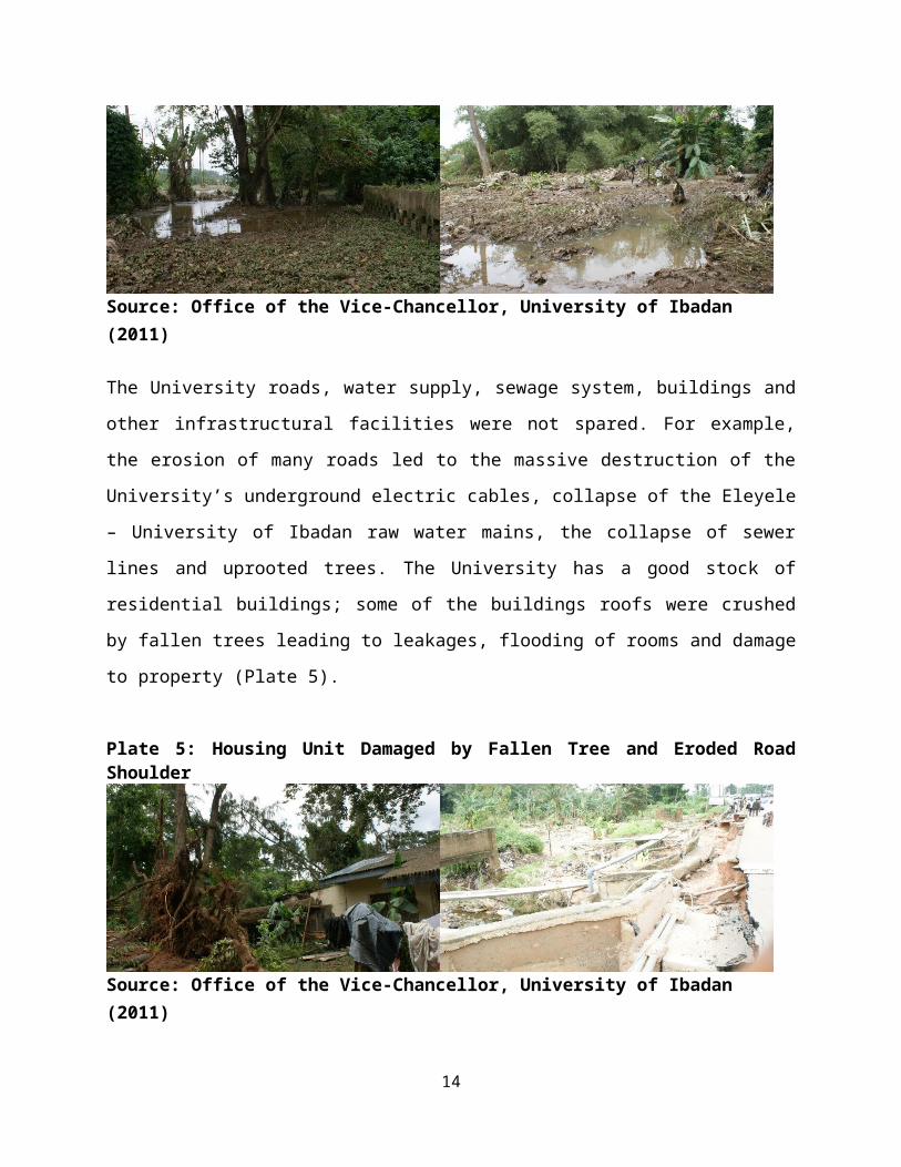
The University roads, water supply, sewage system, buildings and
other infrastructural facilities were not spared. For example,
the erosion of many roads led to the massive destruction of the
University’s underground electric cables, collapse of the Eleyele
– University of Ibadan raw water mains, the collapse of sewer
lines and uprooted trees. The University has a good stock of
residential buildings; some of the buildings roofs were crushed
by fallen trees leading to leakages, flooding of rooms and damage
to property (Plate 5).
Plate 5: Housing Unit Damaged by Fallen Tree and Eroded RoadShoulder
Source: Office of the Vice-Chancellor, University of Ibadan (2011)
14

Similarly, the University Bookshop was flooded after the rain
where books, furniture and other equipment worth millions of
naira were damaged (Plate 6). The general impact of the flood in
terms of damages in the different infrastructure in which the
University relied are as presented in Table 1.
Plate 6: Damaged Books at the Flooded University Bookshop
Source: Office of the Vice-Chancellor, University of Ibadan (2011)
15

Table 1.0: Impact of the August 2011 Flood on Structures and Infrastructure Within the
UniversityS/N Damages Remedy Cost
Estimate1 Collapsed Fences
a) Sokoto Crescentb) Abadina College/Teaching and Research Farmc) 33kv Sub-Stationd) Perimeter Fence at Orogun and Ajibode Roade) Experimental Forest Resource
Management/Abadina Fence
Reconstruction of fences withreinforced concrete foundation
N20m
2 On-Going Construction Works At The TeachingResearch Farm
a) 4 Poultry Pens
b) Collapse of Newly Construction Fish Ponds
Reconstruction of sub-structural blockwork with reinforced concrete columnstiffening. Reconstruction of failed ponds withadequate drainage
N4m
N12m
3. Fish Farm: 5 Flooded Fish Ponds and Loss ofStock
Reconstruction of failed pond andrestocking with fishes
N40m
4. Zoological Gardena) Collapsed walkway over canal
b) Flooded animal cagesc) Siltation of canal d) Drowning of animals
Reconstruction of walkway withreinforced concrete and expansion ofbridge on Appleton roadReconstruction of cagesChannelization of stream.Restocking
N150m
5 Faculty Of Agriculture And Forestrya) Siltation of drainsb) Flooding of offices
Expansion of drains N13m
6 Road Networka) Washing away of embankment of Road 1,
Ajibode ExtensionChannelization of stream from Orogunto Ajibode N5billion
16
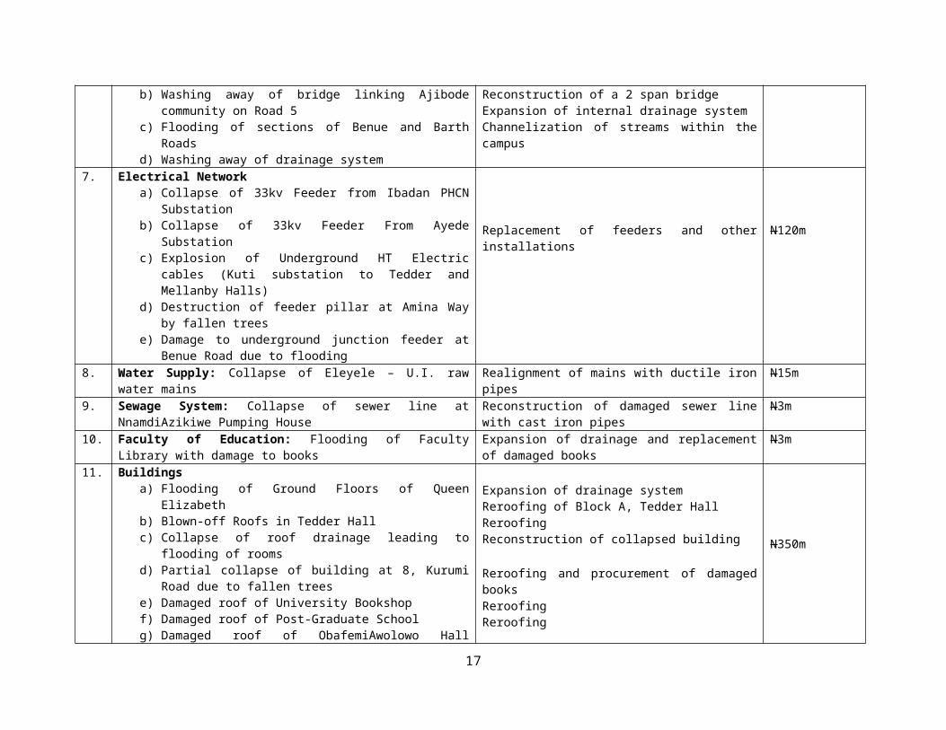
b) Washing away of bridge linking Ajibodecommunity on Road 5
c) Flooding of sections of Benue and BarthRoads
d) Washing away of drainage system
Reconstruction of a 2 span bridgeExpansion of internal drainage systemChannelization of streams within thecampus
7. Electrical Networka) Collapse of 33kv Feeder from Ibadan PHCN
Substation b) Collapse of 33kv Feeder From Ayede
Substationc) Explosion of Underground HT Electric
cables (Kuti substation to Tedder andMellanby Halls)
d) Destruction of feeder pillar at Amina Wayby fallen trees
e) Damage to underground junction feeder atBenue Road due to flooding
Replacement of feeders and otherinstallations
N120m
8. Water Supply: Collapse of Eleyele – U.I. rawwater mains
Realignment of mains with ductile ironpipes
N15m
9. Sewage System: Collapse of sewer line atNnamdiAzikiwe Pumping House
Reconstruction of damaged sewer linewith cast iron pipes
N3m
10. Faculty of Education: Flooding of FacultyLibrary with damage to books
Expansion of drainage and replacementof damaged books
N3m
11. Buildingsa) Flooding of Ground Floors of Queen
Elizabeth b) Blown-off Roofs in Tedder Hallc) Collapse of roof drainage leading to
flooding of roomsd) Partial collapse of building at 8, Kurumi
Road due to fallen treese) Damaged roof of University Bookshopf) Damaged roof of Post-Graduate Schoolg) Damaged roof of ObafemiAwolowo Hall
Expansion of drainage systemReroofing of Block A, Tedder HallReroofingReconstruction of collapsed building
Reroofing and procurement of damagedbooksReroofingReroofing
N350m
17
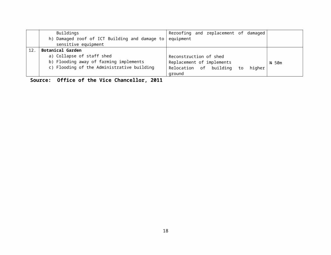
Buildingsh) Damaged roof of ICT Building and damage to
sensitive equipment
Reroofing and replacement of damagedequipment
12. Botanical Gardena) Collapse of staff shedb) Flooding away of farming implementsc) Flooding of the Administrative building
Reconstruction of shedReplacement of implementsRelocation of building to higherground
N 50m
Source: Office of the Vice Chancellor, 2011
18

Shortly after the Management’s survey of the areas affected by
the flood, the Vice-Chancellor requested the Works and
Maintenance Department to identify and cost the damages caused by
the rain. The cost of repairing all the identified damages and
remedies to forestall a recurrence was estimated to be Five
Billion, Seven Hundred and Eighty Two Million Naira (N5.782b) $1
= 155 Naira)
The magnitude of the flood devastation informed the visit of
notable personalities into the University for an on the spot
rapid assessment. The personalities that visit the University
include: the: Governor of Oyo State; Federal Minister of
Education; Executive Secretary of the National University
Commission;Pro-Chancellor and Chairman of Council of the
University, among other personalities. During the visit,
donations were made to the University as rehabilitation and
recovery fund by the visitors. The University also received, with
gratitude, some donations from benevolent individuals and
corporate organizations to augment the cost of mitigating the
effects of the flood disaster (Table 2). The received donations
were only a widow’s mite in the long journey of providing the
needed finances to fast-tract the recovery and build resilience
against future occurrences.
Table2:Corporate and Individual Donations to Rehabilitate theFlood Affected AreasS/N Corporate Organisation/Individual Amount (N)
19
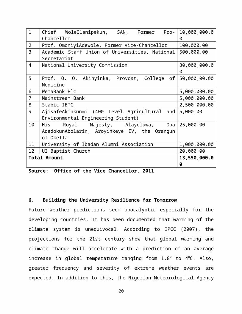
1 Chief WoleOlanipekun, SAN, Former Pro-Chancellor
10,000,000.00
2 Prof. OmoniyiAdewole, Former Vice-Chancellor 100,000.003 Academic Staff Union of Universities, National
Secretariat500,000.00
4 National University Commission 30,000,000.00
5 Prof. O. O. Akinyinka, Provost, College ofMedicine
50,000,00.00
6 WemaBank Plc 5,000,000.007 Mainstream Bank 5,000,000.008 Stabic IBTC 2,500,000.009 AjisafeAkinkunmi (400 Level Agricultural and
Environmental Engineering Student)5,000.00
10 His Royal Majesty, Alayeluwa, ObaAdedokunAbolarin, Aroyinkeye IV, the Orangunof OkeIla
25,000.00
11 University of Ibadan Alumni Association 1,000,000.0012 UI Baptist Church 20,000.00Total Amount 13,550,000.0
0Source: Office of the Vice Chancellor, 2011
6. Building the University Resilience for Tomorrow
Future weather predictions seem apocalyptic especially for the
developing countries. It has been documented that warming of the
climate system is unequivocal. According to IPCC (2007), the
projections for the 21st century show that global warming and
climate change will accelerate with a prediction of an average
increase in global temperature ranging from 1.80 to 40C. Also,
greater frequency and severity of extreme weather events are
expected. In addition to this, the Nigerian Meteorological Agency
20
(NIMET) 2012 and 2013 Seasonal Rainfall Predictions (SRP) provide
essential weather advisories and early warning to planners,
disaster managers, decision makers and operators in various
rainfall sensitive socio-economic sectors.
The prediction model which is based on the strong tele-connection
between El Nino/Southern Oscillations (ENSO), Sea Surface
Temperature (SST) anomalies and rain-bearing weather system over
Nigeria indicated that Oyo State is one of the States in Nigeria
that will experience above normal rainfall amount (NIMET, 2013).
Given the experiences of floods in Ibadan city and the associated
impacts due mainly to the drainage patterns and the urbanization
processes within the city, it is high time for the University, as
a microcosm of Ibadan city, to develop enduring mitigation,
adaptation and resilience strategies to effectively respond to
the predicted flood disaster.
6.1 The Resilience Projects
After the August 2011 rain and in a bid to mitigate future flood
occurrence and other extreme weather events, the University
started by adopting a combination of structural and non-
structural approaches in building resilience for the University
community. The structural approaches include engineering
interventions like river channel modifications, embankments
through channelization and reservoir design to control the flow
of river and or to control the spread of flooding. The non-
structural approaches include formal flood warning system21
(forecast from University’s weather station), land use controls
on flood prone areas and building regulation enforcement.
However, for the purpose of this study, the structural approaches
will be highlighted and the responses are grouped into the
following: Agricultural, Tourism and Infrastructural facilities
and services which are the most affected in the flood incident.
6.1.1 Building Resilience for Agricultural Infrastructure
According to the International Food Policy Research Institute
(IFPRI) (2006), 25% of agricultural activities in sub Saharan
African countries rely heavily on seasonal rainfall. However, due
to research inclination of the University, her agricultural
activities have to be all year round with minimum reliance on
rainfall as major source of water. This is the mindset of the
University planners for locating the Faculty of Agriculture and
Forestry and most of the Faculty’s activities either at the banks
of streams or on Fadama land. This is done purposely to take
advantage of high water tables within these environments. Today,
climate change has made nonsense of the natural order of
agricultural sustainability within the University. As climate
change and climate variability impact is evolving, there is the
compelling need for the University to respond by curtailing the
negative impact associated with it. Consequently, as the flood of
August 2011 made real the threat of climate change on
agricultural activities as shown in Table 1, the University
responded by building resilience of the affected structures.22

Four poultry pens affected at the Teaching and Research Farm
(TRF) were reconstructed. The block work substructures washed
away by the flood were reconstructed with reinforced concrete
column stiffening. Also, the collapsed fish ponds at the TRF were
reconstructed with adequate drainage to aid free flow of excess
storm water within the farm premises. At the Fish Farm, the
entire fish ponds were inundated. It is important to note that
the construction of the fish pond involves the adequate knowledge
of the types of soil, the angle of retention of a particular type
of soil, the interaction between water and soil, the behavior of
soil under the permanently wet and submerged condition and many
more. The construction of ponds should also ensure: least amount
of seepage or leakage and loss of water, safeguard against
siltation, side collapse, predatory and aquatic animals and
protection from possibility of flooding or overflowing of water.
The interview conducted with the Fish Farm Manager in the course
of this study revealed that all these indices for construction
were taken into consideration at the initial construction of the
Fish Farm. However, with climate change and climate variability,
the associated flooding and experiences of this massive flood,
there is need to review the accepted norms in fish pond
construction to meet the challenges of global climatic change and
rainfall patterns. Today, the entire fish ponds have been
reconstructed with emphasis on strengthening and building the
pond area resilience against flooding. The pre disaster fish23

ponds were dug-up pond. Today, bearing in mind the widespread
devastation of the 2011 flood on the natural dugout ponds, the
majority of the ponds have been reconstructed using stone and
concrete slab to reduce erosion and withstand impacts of future
flood.
Plate 7: Reconstruction of Washed Away Ponds with Stone-ConcreteSlab
Source: Field Survey 2013
The most important component of the fish pond is the perimeter
dike which is designed and constructed to free the pond area from
floods. Also the utility and sustainability of the pond system
depends on the strength and lifetime of the perimeter dike. With
this realization in mind, the newly constructed perimeter dyke
was adequately compacted to reduce erosion. In addition to these,
and to functionally mitigate future flood occurrence, the peak
flow of the 2011 flood was taken into consideration. Thus, the
perimeter dike at the fish pond in about 1 meter higher than the
peak flow of the devastating flood. Also, to reduce every day
wear, tear and general erosion, the wet and dry sides of the dike
were covered with perennial creeping grass. The same procedure
24

was adopted for the remaining dugout ponds within the Fish Farm
(Plate 8).
Plate 8: Grassing of Wet and Dry Sides of Fish Pond Dykes
Source: Field Survey 2013
The reconstruction and expansion of the existing Fish Farm after
the 2011 flood have greatly increased the productivity of the
Fish Farm. According to the Farm Manager, before the flood, the
Farm has only 5 ponds dedicated to research and seasonal
commercial activities. However, the flood disaster came with
added advantages of opening up a vast area for fish farm
expansion. Today,the farm has seized the initiative created by
the flood by expanding the number of fish ponds to over 30 with
increasing stock of fish to meet the University and its environs’
commercial catfish needs in and out of season. To preserve excess
harvest from the Fish Farm, the management has procured a number
of locally fabricated industrial ovens to meet various customers’
needs and to enhance a longer shelf life of the harvested fish.
The flood has boosted the Faculty of Agriculture and Forestry
and, by extension, the University Internally Generated Revenue
25

6.1.2 Interventions at the Zoological and Botanical Gardens
The Zoological and Botanical Gardens were established in 1948.
The Zoological Garden was established as a menagerie to support
teaching and research in the department of Zoology. Over the
years, the animals’ collection grew in number and diversity and
the menagerie became a full-fledged Zoo in 1974. Today, apart
from displaying animals for teaching, research and an important
tourist destination in Nigeria, the Zoo is primarily for the
conservation of endangered animal species. The garden is home to
a wide array of animals comprising mammals, birds, reptiles, and
amphibians.
The Botanical garden undertakes conservation of a wide range of
endangered and threatened plants mainly supporting in-situ
conservation programme. The Garden has continued to demonstrate a
high sense of commitment to recreation, education, conservation
and sustainable environmental needs of Nigeria as the foremost
botanical garden in the country. The garden is divided into seven
components namely: the nursery; the rose garden; the
horticultural section; the children section with recreational
facilities; the arboretum; the aquatic section and the rock
section. The garden is adorned with wide collection of orchid,
bryophyte/fern, economic trees palms, exotic and indigenous flora
as well as the ornamented.
For sustainability, the location of these two facilities used for
tourism, education and research activities require the presence26

of perennial water body. Accordingly, the Zoological and
Botanical Gardens were located at the banks of Samonda Stream and
River Ona respectively. The impacts of the August 2011 flood on
the Gardens are highlighted in Plate 3 and Table 1. At the
Botanical Garden, due to predictable future flooding as a result
of climate change and climatic variability, the Staff Shed and
Administrative Building inundated during the rain were relocated
to be built on higher and safer ground while the recreational and
the aquatic sections have been expanded by 30 meters inward into
the buffer of Teaching and Research Farm to create adequate set
back from River Ona and to accommodate more tourists (Plate 9).
Plate 9: Relocated Staff Shed and Administrative Building andNewly Developed Nursery
Source: Field Survey 2013
The level of destruction at the Zoological Garden (drowning of
animals, flooded animal cages, and washed away walkways on
Samonda Stream) necessitated the channelization of the
Streamthroughout its course within the University into Awba Dam.
The damaged cages during the flood were rebuilt and the washed
27

away walkways were reconstructed using reinforced concrete.
Indeed, the entire Zoological Garden was retrofitted. It was as
if the University was waiting for disaster to strike before
taking this bold step at paying dedicated attention to the Zoo
(Plate 10).
Plate 10: Reconstructed Walkways at the Zoo
Source: Field Survey 2013
6.1.3 Infrastructural Facilities and Services
Extensive infrastructural facilities and services were damaged by
the flood. These include; roads, bridges, building, electrical
power installations, water supply, sewage system and teaching and
research supporting facilities such as class rooms, books and
furniture. The University has responded to these damages by
implementing short, medium and long term structural and non-
structural resilience strategies to combat the immediate and
future occurrence of flood disaster within the University
28

environment. However, the most extensive intervention is the
channelization and rehabilitation of roads networks and Awba Dam
drainage system. The drainage system is central to the
university’s resilience project because an entire section of the
University’s natural habitat for the development of fish pond,
Zoological Garden and the University’s mini water work project is
located within the drainage network.
During the August 2011 flooding in Ibadan, the catchments and the
drainage basin of the dam within the University campus was
extensively flooded. After vigorous and in-depth analysis of
short, medium and long term solution of the flood along the dam’s
catchment area by the university authority, the most viable
option available to the university is to channelizeSamonda Stream
and rehabilitate Awba dam to increase its capacity for storm
water retention.
6.1.3.1 The Channelization of Samonda Stream
The channelization project for Samonda Stream is divided into two
segments: The Upper Awba dam and the Lower Awba dam
channelization. The Upper Awba project started from the boundary
of the University with Emmanuel College and ends by the bridge of
Independence Hall Drive beside the University’s Fish Farm ponds
covering a total of 610 meters. The second section, Lower Awba
project, starts from the Independence Hall Drive Bridge, through
the Zoological Garden to Appleton Road Bridge covering a total of
about 1 kilometer (Plate 11).29

Plate 11: Samonda Stream Channelization Project
Source: Field Survey 2013
6.1.3.2 Road Infrastructures Rehabilitation and Maintenance
All the road infrastructures affected by the flood, including the
bridge linking Ajibode community with the University, have been
rehabilitated to facilitate movement of vehicles and people
within and outside the University campus. Also, as part of the
channelization efforts, bridges on Appleton and Barth roads and
on Independence Hall Drive will be reconstructed and expanded to
accommodate and fit into the present design of the channelization
(Plate 12).
30
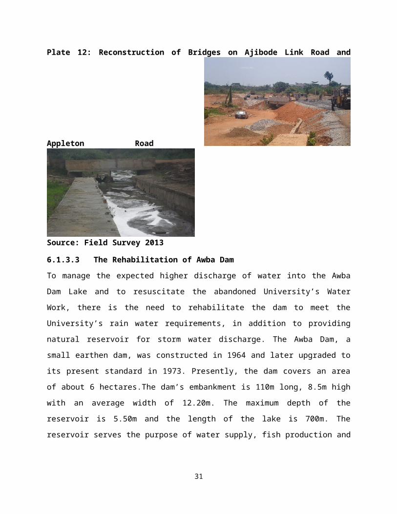
Plate 12: Reconstruction of Bridges on Ajibode Link Road and
Appleton Road
Source: Field Survey 2013
6.1.3.3 The Rehabilitation of Awba Dam
To manage the expected higher discharge of water into the Awba
Dam Lake and to resuscitate the abandoned University’s Water
Work, there is the need to rehabilitate the dam to meet the
University’s rain water requirements, in addition to providing
natural reservoir for storm water discharge. The Awba Dam, a
small earthen dam, was constructed in 1964 and later upgraded to
its present standard in 1973. Presently, the dam covers an area
of about 6 hectares.The dam’s embankment is 110m long, 8.5m high
with an average width of 12.20m. The maximum depth of the
reservoir is 5.50m and the length of the lake is 700m. The
reservoir serves the purpose of water supply, fish production and
31

research and has a capacity of 227 million liters of water with a
treatment rate of about 68,000 liters per day.
The Awba dam has operated for 39 years and it is due for
comprehensive rehabilitation. The rehabilitation’s focus,
essentially is, on sediment removal; installation of penstock
valves in the spillway to improve impoundment level of the lake
reservoir, perimeter fencing and clearing of water hyacinth on
the lake surface. From the analysis of the components and
perimeter of the dam, it hasbeen established that the reservoir,
after 39 years of operation, in line with general characteristics
of rivers and streams, must have lost significant portions of the
storage volume to sediments. Today, according to Adesina (2012),
the dam is uneconomical and unsafe due largely to the
accumulation, over the years, of about 57,283.54m3 of sediments
which represents 58.07% of the normal (service) volume of the dam
(Plate 13).
Plate 13: AwbaDamOvergrown with Weeds and Trees
Source: Field Survey 2013
32
It is important to note that, as a surface reservoir, the dam is
primarily constructed for two main purposes; to provide raw water
for the University’s mini water works and to serve as flood
mitigation structure. However, the gradual but significant
reduction in the storage volume of the dam implies that large
surface area of the dam would either induce large storm water
(flood) flow past the spillway structure, leading to dam collapse
and extensive flooding of the downstream structure or induce a
backwash flood leading to extensive flooding of area upstream of
the dam as witnessed during the August 2011 flood.
The present rehabilitation works will also entail total
restoration of the perimeter fence for the dam. This is essential
to provide restriction to human and animal from gaining access to
the dam’s reservoir. Also, the upstream and the downstream of the
dam have been overgrown with weeds and trees especially water
hyacinth. This weed has covered a substantial part of the dam
surface. The rehabilitation work will remove water hyacinth from
9,470m2area of the dam (Adesina 2012).
7. Conclusion
Vulnerability to present climatic variability are likely to
intensify vulnerability to future climate changes since future
changes in average conditions, to a large extent, will involve an
intensification of present variability and extremes. Many
serious problems have arisen because climate conditions and
variability have been ignored in development projects, and many33

societies are not well adapted to their current climate let alone
prepare for additional climate change (Agbola, 2010). Resilience
to climate change and climate variability and trends should be
seen as a regular feature of human existence. Therefore,
knowledge, skills, technologies, institutional arrangements and
strategies should be developed as important foundations for
adapting to longer-term climate change. However, the
devastations that accompany severe storms, floods and droughts
are dramatic evidence that more still have to be done to adapt to
emerging climate change induced disasters. Mainstreaming
adaptation and building resilience of vulnerable community can
yield broad based benefits that go beyond reducing climate change
impacts but can contribute to sustainable development and more
resilient environmental systems.
Indeed, the IPCC (2007) notes that action on adaptation is as
urgent as mitigation. Emerging insights from adaptive and
community based resource management suggest that building
resilience into both human and ecological systems is an effective
way to cope with environmental change characterised by future
surprises or unknowable risks. Given the global importance of
climate change and adaptation options, adaptive capacity and
other means of reducing risk should be prioritised. Hence, the
distinct need to explore how communities can constitute a model
of resilience to adapt to climate change should be intensified
(Kelly and Adger2000; Smit, et al 2000 Tompkins and Adger (2004)).
34
As noted by Budd, et al (2008), major disruptions of the dynamics
of any system could well result from the impact of climate change
and success in dealing with these disturbances depends on the
capacity of communities to foster transformations. This capacity
should be reflected in concrete actions such as those aimed at
building resilience and those intended at developing the capacity
to withstand undesirable consequences resulting from global
climate change. Similarly, the capacity of an area to accommodate
new conditions is dependent on some of the area’s features.In
this regard, openness to change and the ability to adapt and to
share information and resources in collective action stand out as
key elements of resilience.The University has been battered by
climate change induced flood disaster in 2011. The University has
also responded by building resilience that is focused on making
the University reap the benefits associated with climate change
and climate variability through proactive management of the flood
prone areas in the University. It is anticipated that these
resilient measures will stand the test of time.
Reference
Adesina M. 2012. Rehabilitation of Awba Dam: Design Report. University ofIbadan, Ibadan
Agbola, Tunde, 2010, “Current Climate Variability and ObservedClimate Change: The Actual and Potential Impact on Urbanareas”, Paper Presented at the START-WARIMA Nigeria NationalScience Policy Dialogue on Climate Change, 23-25th Feb,University of Ibadan, Nigeria
35

Alberti, M. Marzluff, J. M. Shulenberger, E. Bradley, G. Ryan,C.andZumbrunnen, C. 2003. “Integrating Humans into Ecology:Opportunities and Challenges for Studying Urban Ecosystems,”Bioscience,53 (12): 1169–1179
Alioune B and Agbola ‘Tunde 2009.“Planning Nigerian Cities forIncreased Communication and Security” Keynote Paper Presented atthe 40th Annual Conference of the Nigerian Institute of TownPlanners Held at Choice Hotels Ltd, Awka, Between the 29th and30th October, 2009
Beatley, T. 2009.Planning for Coastal Resilience: Best Practices for CalamitousTimes, Washington, DC, Island Press.
Berkes, F. 2007. “Understanding Uncertainty and ReducingVulnerability: Lessons from Resilience Thinking.” NaturalHazards41: 283–295.
Budd, W.W.Lovrich, N. Pierce, J. C. and Chamberlain, B.2008.“Cultural Sources of Variations in USUrbanSustainability Attributes,” Cities, 25 (5): 257–267
Cutter, S L. 1996. “Vulnerability to EnvironmentalHazards”Progress in Human Geography 20, 529-539.
Harrison, P. 1997. Population and Sustainable Development: Five Years AfterRio. New York: United Nations Population Fund (UN-PFA)
Holling, C. S. 1973. “Resilience and Stability of EcologicalSystems”.Annual Review of Ecology andSystematics4 (1):1-23.
Intergovernmental Panel on Climate Change (IPCC) 2001.“ClimateChange 2001: Impacts, Adaptation and Vulnerability.”AContribution of theWorking Group II to the Third AssessmentReport of theIntergovernmental Panel on ClimateChange (eds.) McCarthy, J.J.,Canziani,O.F.,Leary, N.A.,Dokken,D.J. and K.S. White).Cambridge:Cambridge University Press.
36
Intergovernmental Panel on Climate Change (IPCC) 2007.ClimateChange 2007: The Physical Science Basis. Contribution of Working Group 1 to theFourth Assessment Report of the Intergovernmental Panel on Climate Change.Summary for Policymakers Retrieved on the 6th February, 2008from (http://ipcc-wg1.ucar.edu/wg1/Report/AR4WG1-Print-SPM.pdf)
International Food Policy Research Institute [IFPRI] 2006. “HowWill Agriculture Adapt to a Shifting Climate?” IFPRIForum.December.
Jabeen, H.; Johnson, C. and Allen A. 2 010. “Built-inResilience: Learning from Grassroots Coping Strategies forClimate Variability.” Environment and Urbanization 22 (2): 415 - 431
Kates and Wilbanks, T. J. 2003. “Making the Global Local:Responding to Climate Concerns from the Bottom Up.” Environment;45 (3): 12 – 23
Makoka, D. and Kaplan, M. 2005. Poverty and Vulnerability: Term PaperInterdisciplinary Course International Doctoral Studies Programme. Bonn;Centre for Development Research, University of Bonn
Nigerian Environmental Study/Action Team (NEST) 2004.Five Multi-Sector Surveys on Nigeria’s Vulnerability and Adaptation to Climate Change.Ibadan: NEST
Nigerian Meteorological Agency (NIMET) 2013.Seasonal rainfall Predictionand Socio-Economic Implications. NIMET, Abuja
Office of the Vice Chancellor, University of Ibadan. 2011. “Afterthe Rains…” A Presentation of the Aftermath of the August26, 2011 Rainfall in Ibadan. University of Ibadan
Pelling, M. 2003. The Vulnerability of Cities: Natural Disaster and SocialResilience. London: Earthscan.
37
Romero Lankao, P., 2008: “Urban Areas and Climate Change: Reviewof Current Issues and Trends” Issues paper prepared for Citiesand Climate Change: Global Report on Human Settlements 2011
Saavedra,C and Budd, W. W. 2009. “Climate Change andEnvironmental Planning: Working to Build CommunityResilience and Adaptive Capacity in Washington State, USA,”Habitat International, 33 (3): 246–252,
Smit, B., Burton, I., Klein, R. J. T. and Wandel, J. 2000. “AnAnatomy of Adaptation to Climate Change and Variability”.ClimaticChange45: 223-52.
Tompkins, E. L. and Adger, W. N. (2004).“Does Adaptive Managementof Natural Resources Enhance Resilience to ClimateChange?”Ecology and Society9(2): 1-14.
UN-Habitat 2008.State of the World’s Cities 2008/2009: Harmonious Cities Overviewand Key Findings. Nairobi: UN-Habitat.
Uwejamomere, T. 2003 Climate Change in Nigeria: A Communication Guide.Ibadan: Nigerian Environmental Study/Action Team (NEST)
Vella, K.; Dale A.; Cottrell A.; and Gooch M. 2012. “AssessingCommunity Resilience to Climate Change” Proceeding of the 12thInternational Coral Reef Symposium, Cairns, Australia 9 – 13 July2012. 19A Human Impacts on Coral Reef General Session
38