Fire behavior in northern Rocky Mountain forests
131
FIRE BEHAVIOR IN NORTHERN ROCKY MOUNTAIN FORESTS NORTHERN ROCKY MOUNTAIN FOREST & RANGE EXPERIMENT STATION Station Paper No. 29. by J, S. Barrows, Chief Division of Eire Research Northern Rocky Mountain Forest and Range Experiment Station Missoula, Montana May 1951 This file was created by scanning the printed publication. Errors identified by the software have been corrected; however, some errors may remain.
-
Upload
khangminh22 -
Category
Documents
-
view
1 -
download
0
Transcript of Fire behavior in northern Rocky Mountain forests

FIRE BEHAVIOR
IN
NORTHERN ROCKY MOUNTAIN FORESTS
NORTHERN ROCKY MOUNTAIN FOREST & RANGE EXPERIMENT STATION
S t a t i o n P a p e r No. 2 9 .
by
J, S. Barrows, Chief Division of Eire Research
Northern Rocky Mountain Forest and Range Experiment Station Missoula, Montana
May 1951
This file was created by scanning the printed publication.Errors identified by the software have been corrected;
however, some errors may remain.

ACKNOWLEDGEMENTS
This publication reflects the work of many people. Much of the basic fire behavior data have been drawn from fire research performed at the Priest Rivei Experimental Forest by H. T. Gisborne, George M. Jenison, and G. Lloyd Hayes. A large part of the general fire behavior information used in the manuscript has been furnished by the Division of Fire Control, Region 1, U. S. Forest Service, and personnel of the national forests.
Special acknowledgement is made to George R. Fahnestock of the Division of Fire Research who analyzed much of the basic data and prepared the burning index conversion tables contained in the appendix. C. K. Lyman, Supervisor of the Lolo National Forest, assisted in writing the chapter on fuels and in preparing the fuel rate-of-spread classification keys contained in the appendix. W« R» Krumm, Fire V/eather Forecaster, U. S. Yfeather Bureau, Missoula, Montana, served as an adviser on the weather aspects of fire behavior.
Mrs. Edna H. Campbell and Mrs. Bernice D. Beall assisted in statistical work and typed the manuscript. Illustrations were prepared by John B. LaCasse. Helpful advice on the manuscript was received from many officials of the Forest Service, and especially from George M. Jemison, A. A. Brown, C. A. Gustafson, Floyd M. Godden, Kermit 7f. Linstedt, A. E. Spaulding, Fred I. Stillings, Fred M. Fite, R. S. Angle, and George R. Fahnestock.
iii

PREFACE
Although forestry dates back hundreds of years, organized forest fire research has been underway less than 30 years. During much of this tine the major efforts have been devoted to studies of fire behavior or closely allied fields. As a result, much has been learned about how fires act, in spite of the relatively short period of organized effort. Knowledge stemming from many research projects, plus the experience gained from the control of thousands of fires, provides a good foundation for a general understanding of the complex subject.
The main purpose of this publication is to summarize the most important aspects of fire behavior as we now know them. The author recognizes that there are still many unknowns in the behavior of forest and range fires. These unknownswill be the targets of future research. In the meantime it is important that the best available information on fire behavior be placed in the hands of the men who must carry on the vital task of fire control.
In many respects this is a progress report on fire behavior research. A large part of the publication interprets the significance of past research results to an understanding of how fires start and spread under various forest conditions. Other parts of the publication reflect the results of recent research. Some of the information on fuel classification, burning index variations, topographic influences, and rate-of-spread estimates is reported for the first time.
Four major phases of fire research at the Northern Rocky Mountain Forest and Range Experiment Station provided basic knowledge which makes this publication possible. The development of methods for measuring fire weather and rating forest inflammability with a burning index meter fostered systematic evaluation of weather influence on fire behavior. The fuel classification system provided an important basis for analyzing the rate of spread of fires. Studies of fire weather at various positions and aspects at the Priest River Experimental Forest contributed essential information on topographic influences. Detailed analysis of thousands of reports of actual fires uncovered many key facts and provided a means of testing several basic hypotheses on fire behavior.
iv

TABLE OF CONTENTS
Page
CHAPTER I - INTRODUCTION 1
CHAPTER II - PRINCIPLES OF COMBUSTION 7
CHAPTER III - WEATHER 21
CHAPTER IV - TOPOGRAPHY 47
CHAPTER V - FUELS 65
CHAPTER VI - FIRE BEHAVIOR RATING- 89
APPENDIX . . " 103
LITERATURE CITED 121
v

FIGURES
Humber Title Page
1 Typical small fire (photograph) facing 1
2 The process of judging fire behavior 4
3 The fire triangle 6
4 Fuel arrangement influences ignition 9
5 Shaggy-barked snags ignite easier than smooth snags 10
6 Gases from heated fuel will ignite 11
7 Breaking the fire triangle 13
8 Radiant heat decreases inversely with the square of 15 the distance from the fire
9 Radiant heat is great in concentrated fuels 16
10 Steep slopes increase radiant heat transfer 16
11 Wind increases radiant heat transfer 17
12 Tree crowns receive heat through convection currents 18
13 Fire danger station (photograph) 20
14 Cumulative precipitation, October through September, 24 at Priest River Experimental Forest, Idaho
15 Cumulative precipitation, October through September, 25 at Missoula, Montana, and Helena, Montana
16 Total July and August precipitation in normal, wettest, 26 and driest years
17 Percent of days in July and August according to minimum 29 relative humidity, Priest River Experimental Forest, Idaho
18 Average final size of fire according to wind velocity 30 at first attack
19 Northern Rocky Mountain scale of wind velocity 32
20 Cumulonimbus cloud (photograph) 35
21 Lenticular clouds (photograph) 3 7
VI

FIGURES
Number Title Page
22 Stratocumulus and alto stratus clouds (photographs) 38
23 The Northern Rocky Mountain burning index meter 39
24 Initial rate of spread according to burning index 40
25 Average final perimeter per fire according to 41 burning index
26 Variation in burning index on a typical mid-summer 42 day
27 The Northern Rocky Mountain fire danger meter 44
28 Frequency of occurrence of fire danger classes in 45 July and August
29 Fire in rough, mountainous topography (photograph) 46
30 Fire occurrence by aspect 48
31 Percent of fires on each aspect reaching sizes of 49 ten acres or more
32 How mountain tops differ from valley bottoms during 52 months of July and August
33 Percent of fires originating on various slope positions 53
34 Average annual fires per million acres by elevation 55
35 Percent of fires in each slope position reaching 58 sizes of ten acres or more
36 Percent of fires in each slope class reaching sizes 59 of ten acres or more
37 Fires on steep slopes have a wedge shape 60
38 Flames bend back into the fire at the top of a slope 60
39 Spot fires on steep slopes may outflank main fire 61
40 Fires easily cross narrow canyons 62
41 Fires in a box canyon have an upward draft like a 62 fire in a stove
vii

FIGURES
Number Title
42 Canyons form paths for the flow of air
43 Aerial and ground fuels in a forest (photograph)
44 Fuel components
45 Uniform fuels
46 Patchy fuels
47 Typical example of a large volume of both small- and large-sized components in ground fuels (photograph)
48 Low rate-of-spread fuel type (photograph)
49 Medium rate-of-spread fuel type (photograph)
50 High rate-of-spread fuel type (photograph)
51 Extreme rate-of-spread fuel type (photograph)
52 Flash rate-of-spread fuel type (photograph)
53 Blowup on a large fire (photograph)
TABLES
Fire conditions in various elevation zones in the northern Rocky Mountains
How burning index varies by period of day, aspect, and elevation
General character is t ics of five fuel rate-of-spread types in the northern Rocky Mountains
v i i i

1 0) fH
H H
? -P •H
h CD
8 -P CD
rH (D
5 >C ^f PM Cu U 9) o PH
o +»

CHAPTER I. INTRODUCTION
Knowledge of fire behavior is an essential requirement for firefighters. Successful fire control operations depend, first of all, upon the ability of the protection forces to judge where and when fires will start and how they will behave once ignition takes place. Every member of the fire-fighting team from ranger to smokechaser must be able to make reliable estimates of the behavior of fires burning under a wide variety of conditions. These estimates must be good enough to provide the basis for decisions which will lead to fast, efficient, and safe firefighting.
FIRE BEHAVIOR AND SUPPRESSION METHODS
The character and difficulty of the suppression job on every fire depends largely upon the behavior of the fire. The speed, strength, and type of attack are governed by the location of the fire and its reaction to the surrounding environment. Each change in environment may change fire behavior and in turn call for some adjustment in firefighting strategy and techniques. The ability of the men handling the suppression job to evaluate the behavior pattern largely determines the efficiency and economy of the entire firefighting operation.
A primary purpose of evaluating the behavior of every fire is to reduce or prevent unexpected "blowups and runs." A careful check on everything that will affect the behavior of a fire reduces the chances for the "unexpected." When a skilled size-up has been made in advance, the unexpected may become expected and a potential blowup or run may often be anticipated soon enough to be prevented. Effective fire control requires that suppression plans and action be carried out in accordance with continuing estimates and forecasts of what the fire is going to do. Analysis of fire behavior is a basic requirement in firefighting applicable equally to the one-man smokechaser fire or the big fire where hundreds of men are in action.
FIRE BEHAVIOR AND SAFETY
An important reason for understanding fire behavior is to provide safety for the firefighters. Every fire behavior situation calls for specific safety measures. Experience gained from fighting thousands of fires has shown that the suppression job may be accomplished with a reasonable degree of safety. To achieve safety it is highly important that all firefighters have a general knowledge and the leaders of the firefighting forces have a high degree of knowledge of fire behavior.
The most dangerous individual in a suppression organization is usually the man who is afraid of fire. Fear is largely a result of ignorance. Many risks can be eliminated from firefighting if each man knows what to expect the fire to do. The average firefighter need not be an expert on all phases of fire behavior, but he should have a working knowledge of ignition, combustion, and rate of spread of fires burning in forest fuels. Equipped with such basic fire behavior "know-how" the individual firefighter can approach his job without fear and with confidence that he can perform required duties in a safe and efficient manner.
-1-

FIRE BEHAVIOR AND THE FOREST MANAGER
In the northern Rocky Mountains fires influence many phases of the forest management job. The behavior of fires is an important factor in the growth, harvesting, and regeneration of forest crops. How often fires occur and how hot they burn affect both the quality and quantity of products harvested from the forest. The forest manager may influence fire behavior by the nature of his operations, especially in timber cutting. When a forest is opened up by thinning or harvesting operations, lower humidities, higher temperatures, and higher wind velocities are created within the stands. Fire behavior is thereby affected. Sometimes the debris remaining after logging constitutes a fuel condition which greatly increases the chance for fires to ignite and burn intensely For these reasons it is important for forest managers to know fire behavior and to be able to evaluate the influence of forest management operations on it.
JUDGING FIRE BEHAVIOR
Many complex factors influence the ignition, rate of spread, and general behavior of fires. Some of these factors can be measured more or less precisely with instruments. Others do not lend themselves to exact measurements and therefore must be evaluated in general terms. The combined effects of all factors, whether measured precisely or not, determin the behavior of a fire. No single factor, such as wind, steepness of slope, or kind of fuel, will provide the answer to questions of when and where fires will start and how fast they will spread. Likewise, no singl instrument or meter will answer these fundamental questions. Therefore it is necessary for the fire control man to develop a system aided by instruments and other guides where available, which will help him evaluat the combined effects of all significant factors influencing fire behavior
Keen observation is a fundamental requirement in judging fire behavior. Many visible signs are present in the forest to assist the fire control man in arriving at reliable decisions. These include such things as the color of the grass and other annual vegetation, the position of a fire on a slope, the time of day, and the ammount of sunshine filtering throug the forest canopy. One of the purposes of this handbook is to analyze th importance and the meaning of the most significant of the many factors that may be observed and to present a method of evaluating their combined effects.
The process of judging fire behavior, as illustrated in figure 2, may be subdivided into five steps:
1. Basic knowledge. The foundation for judging fire behavior must rest on basic knowledge of the principles of combustion: What is necessary for combustion to occur? What causes the rate of combustion to be increased or decreased? How may combustion be reduced or stopped?
2. Forest knowledge. Three basic factors in a forest area — weather, topography, and fuels — are important indicators of fire behavior.
-2-

3. Aids and guides. Several aids and guides are available to assist in evaluating weather, topography, and fuels.
4. Estimate of situation. The probabilities for various patterns of fire behavior are systematically explored by an estimate of the situation based upon the combined effects of weather, fuels, and topography.
5. Decision. The end product of the fire behavior analysis is a decision outlining when, where, and how to control the fire and spelling out any special safety measures required.
•3-

Q 2 < or LU X
z LU X ^
_ l
O cr I— 7 o i )
P ^ o X
1 LU re LZ I
,n LU
a: r> co < IE >-UJ
u_ < CO
1T a?
< O u_ U_ < LL. ,
S £ o !< Z —' . jL CL LO
1 ^ + 1 s t f a: uj p 3 ^ ^ £5 < < w z 5 3 o LU 2 O
CO Q_
< 2 O X o_ < o o Q_
o R
>-X Q .
£ o p 6 X a. i < QC L U
<
3 J X >-I I1 i t
ION
CAT
u_ CO CO
< L_J
LU Z3 u _
co Q. < 2 L U
a. >-i— _ J L U
>-X n < OC O
TOPO
•
TT , L U
&; > 2 | co ,_ fc= I J - —' = ;
Zoo m 8 o co -irf
LEV
ATI
TE
EPNE
SP
ECT
HER
MA
HA
PE
O
LU co <L y— co
II
UE
LS
u_ * •
t —
z . LU t Z CO \—
77\.U~> Z LU LU UJ Q P _ ^ z o •*- LU |— LU U- LO L_> "J-1 OC O z < 2 p 5 2 S 3 «2 z ac 0 O O :sc < 0 > S
CO
Z-
STAT
IO
DC L U X h -
< U J
=s
APS
;>
IND
EX
0 z x rr CO
CO
<:
FORE
C
OC
X (— < ^
••W
EA
TH
ER
If
PR
EC
IPIT
ATI
ON
TE
MP
ER
ATU
RE
RELA
TIVE
HU
MID
ITY
WIN
D
CLO
UD
CO
VE
R
2>


f/k. FIRE 1BM6IE
Figure 3. Combustion is a process involving the combination of three things — heat, oxygen, and fuel. An understanding of the variation of these three factors is fundamental to an understanding of forest fire behavior.
-6-

CHAPTER II. PRINCIPLES OF COMBUSTION
Fire is a chemical reaction in which energy is produced. When forest material burns there is a chemical combination of the oxygen in the air with wood, pitch, and other burnable elements in the fuel. In the forest we normally encounter several stages in the fire process — first the igniting spark, then a period of smoldering, and finally the more rapid combustion of fuels. We know that the phenomenon of fire sometimes involves violent action — leaping flames, dense smoke, intense heat, loud noises, and occasional explosions. The action of a fire throughout its life is governed by certain natural laws or principles of combustion, as they are termed here. An understanding of these principles is a basic step in judging the effect of various environmental factors on fire behavior.
THE FIRE TRIANGLE
Three things — heat, oxygen, and fuel — are required in proper combination before ignition and combustion will occur. If any one of the three is absent, ignition or combustion will not occur. Likewise, if the three elements are not in proper balance, there will be no fire. Variations in balance among heat, oxygen, and fuel govern the violence of the fire, and careful observation of these three essentials indicates to the firefighter whether the fire will only smolder and spread slowly or will flame brightly and travel rapidly.
Everyone has observed some of the fundamental actions of fire. A lighted match is held under a sheet of newspaper and the paper quickly breaks into flame. The fire triangle has been joined. The match provides sufficient heat, a newspaper is a combustible fuel, and the oxygen in the atmosphere is sufficient to support combustion. A glass jar is placed over the burning paper and the flames gradually subside as the oxygen in the confined space is consumed. The fire triangle has been broken by shutting off the oxygen supply.
There are various ways in which the fire triangle may be broken or altered either to slow down or to speed up the combustion process. An attempt is made to ignite a water-soaked sheet of newspaper with a match. In this case the match doesn't provide sufficient heat to cause flame. The balance in the fire triangle has been broken. To regain the balance in the triangle a blowtorch is substituted for the match. The torch dries out the paper and combustion occurs in the part of the paper exposed to the intense heat. The experiment is repeated, this time with a tightly rolled piece of dry newspaper. Again it is difficult for the match to ignite the paper. The fire triangle has been altered because the paper is so tightly rolled that oxygen is not readily available to the combustible material.
The task of the firefighter is to visualize the fire triangle as applied to forest conditions. The same basic principles apply. The ease of ignition and rate of combustion are determined by the amount of heat, the availability of oxygen, and the type of fuel.

Heat
How much heat is required to ignite forest fuels? It is difficult to answer this question specifically because of the variations in the nature of forest fuels. Nearly all substance on earth may be consumed or changed radically in form by fire if enough heat is applied. Steel may be melted and water boiled away. Most of the easily ignitible and combustible materials are largely composed of carbon. Vegetative material, such as forest fuels, is high in carbon content and ignites at relatively low temperatures provided the moisture content is low and the substance is freely exposed to the air. During the forest fire season a large part of the vegetative matter in a forest — duff, dead limb wood, pine needles, tree branches, rotted logs, etc. — becomes dry enough to be ignited easily. Actual heat requirements for ignition of forest fuels varies from approximately 500° to 750°F. Many common ignition sources provide the required heat, including a burning match, a glowing cigarette, and a lightning bolt.
Ignition often depends upon the length of time that the fuel is exposed to heat. Dry pine needles may be ignited in a few seconds by the heat from a flaming match. Moist pine needles also may be ignited by a match if subjected to the heat for several minutes. When wood fuels are exposed to heat for a long period of time, the normal ignition temperature may be lowered. David J. Price of the Bureau of Agricultural Engineering and Chemistry has shown that wood exposed to a temperature of 400°F. for approximately half an hour will ignite (7).l/
The ease of ignition of forest fuels when exposed to heat for a considerable time has an important influence on fire behavior. In a coniferous forest a hot fire burning in a tangle of down logs and dry limb wood may generate enough heat to transform the green tree crowns above the fire into an easily ignitible condition. All that is needed to cause the tree crowns to break into flame is a flying ember and a gust of wind. Similarly, a fire smoldering in a pile of leaves may generate enough heat to lower the normal ignition temperature. When the leaves are stirred up, the whole pile breaks into flame. The stirring of the pile lets in enough oxygen for the preheated leaves to be easily ignited.
Oxygen
Normally the atmosphere at elevations where forest fires occur contains about 21 percent oxygen. When the oxygen content of the air is reduced to less than 15 percent, most materials will not burn. Within the forest there is sufficient oxygen to permit ignition and combustion. However, some of the forest fuels may be arranged so that air, and consequently oxygen, is not available in sufficient amount to support a fire. In deep, tightly compacted duff only the top particles can get enough air to permit a fire to burn. In this situation a fire will burn from the top down with combustion taking place in each layer as it is exposed to the air. On the
YJ Numbers in parentheses refer to Literature Cited listed at the end of this report.
-8-

other hand, in a very loose layer of pine needles the entire mass is fairly well exposed to air and consequently combustion will take place rapidly (figure 4).
FUEL ARRANGEMENT INFLUENCES IGNITION
Figure 4. A loose pile of sticks ignites more easily than a tightly packed bundle because more surface area of the fuel is exposed to air.
When wind blows on a fire, a forced draft of oxygen is present to speed up the combustion process. In addition, as will be shown later, the wind has a physical reaction on the flames, often bending them into positions that create more favorable situations for the spread of the fire. Wind forces oxygen around fuel particles where the flow of air may be normally restricted.
Fuel
Under forest conditions fuel is a major variable in the fire triangle. Fuel constitutes the leg of the triangle that is often most difficult to evaluate properly. The firefighter must become acquainted with the general nature of forest fuels if he is to attain a thorough understanding of the principles of combustion.
Ease of ignition and combustion of forest fuels (figure 5) depends mainly upon the kind of fuel (is it logging slash or dense duff in a green forest?), fuel continuity (is the fuel distributed more or less evenly over the area or only present in patches?), moisture content (does it feel damp when touched or does it crackle and appear very brittle?), and fuel temperature (is the fuel exposed to the heat of the sun or does it lie in cool shade?).
-9-

SHAGGY BARKED SNAGS IGNITE EASIER THAN SMOOTH SNAGS
Figure 5. A shaggy-barked snag ignites easily because the finely divided stringers of bark provide dry kindling material fully exposed to air.
COMBUSTION
When fuels are heated to a given temperature, gases are produced which wil ignite if combined with oxygen. When one observes a log fire, he will not that the flames may appear to be coming directly from the fuel. Actually the flames come from the ignited gases emerging from the heated log. This phenomenon may be illustrated by heating dry pine needles in a covered coffee can with a nail-sized hold in the lid to permit liberation of gases These gases may be ignited with a match (figure 6). Flames will not occur within the coffee can, but if heat is applied to the can long enough, the pine needles will be consumed and only ashes will remain.
The process of combustion is actually oxidation in which the combustible substance ignites with oxygen. There may be several stages to the oxidation process. Under certain conditions oxidation may be so slow that it is not accompanied by the heat and light normally associated with combustion. In thiskso-called "slow combustion" stage heat is dissipated very rapidly, in fact nearly as fast as it is liberated; and as a result no appreciable rise in temperature occurs. "Slow combustion" is not common in forest fuels.
-10-

Figure 6. Heat applied to a coffee can full of pine needles will generate ignitible gases. In the combustion process the visible flames are actually burning gases liberated by heated fuel.
In forest fires two common stages of combustion are smoldering and flaming. In the smoldering stage heat is liberated and a rise in fuel temperature occurs. However, flame is absent or present only intermittently. Normally the absence of flame is caused by insufficient oxygen or by moisture in the fuels. Lack of oxygen or moisture in the fuels will slow up the oxidation process. When a fire is in the smoldering stage, all the elements of the fire triangle are present but not in a combination to permit rapid combustion.
iVhen a fire is in the flaming stage, all the elements of the fire triangle heat, oxygen, and fuel — are in proper combination for rapid oxidation to occur. Thus flame in itself provides a guide to an understanding of fire behavior.
-11-

The flames of very hot fires may be observed intermittently in the smoke at a considerable distance above the fire. In some cases oxygen is consumed so rapidly near the base of the fire that combustion of the gases is incomplete. As these superheated gases rise, they reach a fresh oxygen supply and break into flame. Tor this reason it may appear that the smoke of some fires is itself flaming.
Re-ignition of apparently dead fires is an important factor to be observed in the combustion process. The important element in re-ignition is heat. Although neither flames nor smoke may be observed, a fire can break out again if sufficient heat remains. Re-ignition occurs easily where fuels have been subjected to heat for a considerable length of time. To prevent re-ignition the good firefighter feels out fuels with his hands before leaving the area. If heat is still present, he knows that the control job is incomplete.
BREAKING THE FIRE TRIANGLE
In fire control operations the objective is to prevent combustion by breaking the fire triangle. The fire triangle is broken when any one of the heat, oxygen, and fuel legs is removed or altered to such an extent that combustion can no longer occur. Many methods may be employed in this process (figure 7). Use of water reduces heat: if a sufficient volume of water is applied, the fuel temperature can be lowered below the ignitior point. Smothering with dirt reduces oxygen: if the air supply can be shul off until all fuels are thoroughly cooled, further combustion can be prevented. Building a line in which all inflammable material is removed from the path of the fire prevents further spread by robbing the fire of fuel.
Usually in forest firefighting combustion is reduced or stopped by attacking more than one of the three legs of the fire triangle. The actual method of suppression is often dictated by the available equipment and manpower. However, the most effective methods for each part of the fire and for each stage of the suppression operation can be determined by keen observation of the combustion process.
Reducing Heat
The principles of combustion indicate the best method of applying water to reduce heat. Since the objective is to reduce fuel temperature, water should be applied directly on the fuels being consumed. A common mistake is to apply water on the flames rather than the fuels. As explained previously, the flames are actually burning gases liberated by the heated fuels. If the liberation of these gases is to be stopped, the fuels themselves must be cooled by the water. Some of the water played on the flames may reach the fuels, but a large part of it will either miss its mark or be lost through vaporization. If water is being used for cooling purposes) the ultimate target is always the fuel.
Occasionally water may be used for other purposes than direct cooling of fuels. In a very hot fire accompanied by leaping flaraes the nozzle-man may not be able to get close enough to the fuels to apply water directly on the trouble spot. In such cases a fog nozzle should be used to knock
-12-

BREAKING <Mk. EIRE TRIANGLE
Figure 7. In forest fire control the objective is to stop combustion by removing or altering one or more legs of the fire triangle.
down the flames. Fog performs a smothering function on the flaming gases by occupying air space with millions of finely divided particles of water These water particles also assist in cooling the heated gases being liberated by the fuels. Once the flames have been knocked down the nozzle-man immediately returns to his primary job of thoroughly cooling the heated fuels that are generating inflammable gases.
The type of fuel largely influences the nature and rate of combustion, and in turn each fuel calls for special techniques in the use of vrater to reduce heat. For example, in oil tank fires it is sheer folly to direct a high-pressure straight stream of water onto the surface of the oil. Such a penetrating force of water will only punch a hole in the oil surface, stir up the fuel, and expose more area to be burned. In oil fires a fog should be applied to perform the dual function of smothering and cooling. Various forest fuels likewise call for specific techniques when an attack is made on the heat leg of the fire triangle. These techniques will be discussed later in the chapter on fuels.
-13-

Reducing Oxygen
Fires burning in forest fuels are difficult to smother completely. Soil thrown on burning forest material may retard combustion by shielding portions of the fuel surface from the air. Because of the ponus nature of most soils, it is difficult to shut off completely the supply of oxygen in this manner. Throwing dirt on fires is nevertheless an important means of reducing the rate of combustion after which the control operation may be continued by attacking one of the other legs of the fire triangle.
In very fine fuels, such as dry grass, the oxygen supply may be reduced easily. Fuels of this nature do not retain heat for long periods, and therefore combustion may normally be checked by temporarily shielding the fuel surface from the air. For this reason gunnysacks, fire swatters, and shovelfuls of earth correctly applied are effective implements in smothering grass fires. Wherever larger accumulations of inflammable material, such as dead stems and leaves, lie beneath the stand of grass, there is danger of re-ignition. The understory material may hold enough heat to cause the fire to break out again as soon as an adequate supply of oxygen becomes available. This danger can be determined by careful observation of the fuel.
Removing Fuel
In forest fire control work the removal of fuel is the most common method of attacking the fire triangle. Actually this method does not prevent combustion in the area on fire. The fire continues to burn until the fuel is consumed or the combustion process is broken by some other means. However, removal of the fuel in the path of the fire does prevent the fire from spreading any further. Thus the fire triangle is broken indirectly.
The nature of the fuel removal operation is dictated by the influence of fuels on behavior of the fire. A slowly advancing fire burning in sparse ground fuels may be checked simply by constructing a fire line down to mineral soil. However, a hot or a fast-running fire may require several other fuel removal operations. Snags which may cause spot fires may have to be felled. Thickets of reproduction or dry brush may have to be weeded out. Low-hanging limbs which may permit the build-up of a crown fire may have to be removed. Concentration of limbs and logs may have to be broken up. The objective throughout all these operations is to remove or to reduce the inflammable substance which may either allow the fire to build up in intensity or to continue to spread.
HEAT TRANSFER
The rate and amount of heat transferred influences the rate of spread and the intensity of a fire. Combustion cannot be sustained unless heat continues to be transferred. Heat transfer occurs by three means — radiation, convection, and conduction.
-14-

Radiation
Radiation is a process by which heat energy is transmitted from its sourc to an object. Radiant heat is commonly known as an important means of warming the interiors of buildings. Heated pipes laid in the floor of a room release heat energy which is transmitted to objects and individuals. In forest fires radiation is an important means of transferring heat from a burning fuel to another fuel nearby.
Radiant heat transfer decreases inversely with the square of the distance from the fire (figure 8). If an object located 1 foot from the fire receives 100 heat units, then an object 2 feet from the fire will receive only 25 heat units, and an object 10 feet away only 1 unit. The actual number of heat units will vary according to the intensity of the fire, bu the decrease of radiant heat according to distance from the source always will remain in the same ratio.
Figure 8. Radiant heat transfer decreases inversely with the square of the distance from the fire.
Radiant heat transfer plays an important part in fire behavior. A pile of logs may create a hot fire because the burning logs radiate heat to each other (figure 9). However, if these logs are separated and laid out a foot or two from each other, the fire will quickly die down. Separating the logs effectively reduces radiant heat transferred from one fuel unit to another. In firefighting, the laws governing radiant heat transfer can-be used as a guide for suppression techniques. The location and width of fire lines must be governed in part by the rate of radiant heat transfer. Potentially hot fires and spots where dangerous flareups might occur can often be prevented by breaking up the fuels or, in other words, by reducing the radiant heat transfer between fuels.
-15-

RADIANT HEAT IS GREAT IN CONCENTRATED FUELS
CONCENTRATED FUELS SEPARATED FUELS
Figure 9. A pile of logs creates a hot fire because the burning logs radiate heat to each other. When the pile is broken up, radiant heat transfer is greatly reduced.
STEEP SLOPES INCREASE MDIANT HEAT TRANSFER
Figure 10. Fuels upslope from a fire receive more heat than fuels on the downslope side.
-16-

Steepness of slope influences the amount of radiant heat transmitted to fuels upslope and downslope from the fire (figure 10). On the upslope side of a fire the fuels receive more heat because they are closer to the source of that heat. This is one reason why fires often spread more rapidly on steep slopes than on level ground.
Wind influences radiant heat transfer in two ways. First, wind increases the rate of combustion, thus creating a hotter fire; and second, wind bends the flames, thus decreasing the distance between the heat source and fuels lying in the path of the fire (figure 11). The dual effect of the hotter fire and the bent-over flames dries and heats the fuels lying ahead to such an extent that rate of spread may be greatly accelerated. Often a fire will burn into the wind. This action occurs because the wind increases combustion to such a degree that a large amount of radiant heat may be transmitted even to the fuels lying on the upwind side.
WIND INCREASES M D M T HEAT TRANSFER
Figure 11. Wind bends over flames and thus provides more radiant heat to fuels immediately downwind from the fire.
Convection
Heat is also transferred through the movement of hot masses of air — a process called convection. The common hot-air furnace used in homes takes advantage of the principle of heat transfer by convection. Air is easily heated and is capable of holding and transmitting heat. When forest fuels become heated by hot air masses moving from an adjacent fire, more favorable conditions are created for those fuels to be ignited and to burn.
Hot air masses have a tendency to rise because of their light weight in relation to cooler air masses. The air near the ceiling of a heated room is warmer than that near the floor. Kindling is placed at the bottom
-17-

when you light a wood fire so that the fuels above may receive heat through convection. In a forest fire the fuels lying in the path of convection currents are heated and thus transformed into a more inflammable condition. The hot air mass rising from a surface fire transfers a large amount of heat to the tree crowns and brings them nearer to the ignition temperature (figure 12).
TREE CROWNS RECEIVE HEAT THROUGH CONVECTION CURRENTS
Figure 12. Tree crowns receive heat through convection currents rising from ground fires.
-18-

When fires break out in tree crowns and other aerial fuels, heat transfer by convection is often increased. Sparks and burning embers from the burning tree crowns and snags will drop to start new fires in fuels on the ground. As these ground fires gain in intensity, more hot air masses rise through the aerial fuels and a type of chain reaction is created. For this reason firefighters are alxvays alert to the danger of hot surface fires burning underneath a forest canopy. These surface fires must be cooled promptly, and bad fuel masses which are apt to create hot fires should be broken up.
Keat transfer through convection is increased by wind which moves hot masses of air ahead of the fire. Wind again performs a dual function by increasing the rate of combustion, thus creating more heat, and by accelerating the transport of hot air masses. When driven by wind, the hot convection currents may move closer to the ground fuels and create more inflammable conditions in the understory vegetation of the forest.
Fuels located above a fire on steep slopes also receive heat by the movement of convection currents up the slope. This is one more reason why fires often burn very rapidly up the sides of steep mountains. The fuels upslope are subjected to an accelerated rate of heating and drying.
Conduction
Wood is a poor conductor of heat. This is well illustrated by the fact that a wooden handle on a hot frying pan remains cool enough to be grasped by a bare hand. Because wood is such a poor conductor of heat, )his method of heat transfer is relatively unimportant in evaluating forest fire behavior.
-19-

ft
p4
- 2 0 -

CHAPTER III. WEATHER
Weather is the most important variable to be considered in evaluating fire behavior. Hourly, daily, weekly, monthly, and yearly variations in weather conditions all exert some influence on how, when, and where fires will start; how they will behave once ignited; and how difficult they will be to control. Weather is of special importance because it may change quickly and because the changes may result in rapid and very significant differences in fire behavior.
REGIONAL WEATHER CONDITIONS
En the northern Rocky Mountain region weather conditions are significantly iifferent in three broad zones.
The Western Zone
Ihe western zone includes all of northern Idaho, northeastern Washington, and a small area in northwestern Montana. The zone is characterized by vet, moderately cold winters and hot, dry summers. Annual precipitation Ln forest areas varies from 20 to 60 inches and occurs mainly in the form )f snow except during the spring and fall rainy seasons. Monthly precipitation in both July and August normally averages less than 1 inch, thunderstorms, accompanied by little or no rain, are frequent and intense luring the summer months. Hot, dry winds, usually of moderate velocity, )low into the zone during the summer from the semi-arid plateaus of Idaho md Washington. The western zone receives enough winter precipitation ;o foster dense forest growth and thus has abundant fuels. In the dry summers the heavy fuels often become highly inflammable and contribute to me of the most severe fire problems in the United States.
The Central Zone
The central zone covers nearly all of Montana west of the Continental )ivide. This zone has the same general fire weather characteristics as ;he western zone except that it receives considerably less winter and spring precipitation. In the forest areas annual precipitation varies 'rom 12 to 50 inches. Fuels range from light and flashy types in the jrass and open timber lands to heavy types in the densely forested areas.
The Eastern Zone
The eastern zone includes all of Montana east of the Continental Divide, lorthwestern Wyoming, and the forested areas of northwestern South Dakota, uinual precipitation in forest areas varies from 8 to 25 inches. One of ;he basic differences between the eastern and the central or western zones 18 the character of summer thunderstorms. In the eastern zone the thunderstorms are frequently accompanied by moderate amounts of rain which pre-rent excessive drying of fuels. However, only a slight decrease in summer )recipitation is required to bring about dangerous burning conditions, because of the low annual precipitation in much of the eastern zone, fuels ire sparse and generally flashy in character.
-21-

USE OF WEATHER INFORMATION
Weather is both the friend and the foe of the firefighter. During very-hot, dry, or windy weather fires burn rapidly and are difficult to control On the other hand, cool, damp weather may create conditions where fires hardly burn at all and are easily controlled. Between these two extremes are many variations influencing combustion. One of the big jobs of the firefighter is to interpret these conditions to show probable rate of spread and general behavior of fires and difficulty of control.
Full use and interpretation of weather information requires:
1. Daily measurement of key variables. Fire weather stations are located at key points in forest areas to measure basic weather factors such as temperature, precipitation, relative humidity, fuel moisture, and wind velocity and direction.
2. Plotting and analysis of seasonal trends. The cumulative effect! of long periods of hot, dry weather or cool, damp weather can be visualized best if the daily measurements of key factors are plotted on charts or graphs. Periodic analysis of these charts provides a valuable means of interpreting seasonal trends.
3. Integration of key factors into a single index. Use of the burning index meter provides a means of interpreting the combined effects of basic weather factors.
4. Observation and analysis of weather forecasts. When evaluating probable fire behavior it is necessary to look ahead. Today's weather and burning conditions must be compared with those which will probably occur tomorrow. Throughout the fire season daily fire weather forecasts are available for this purpose.
5. Interpretation of weather conditions in various fuels and topography. Weather conditions have different effects on fire behavior in various fuels and topography. Fuel rate-of-spread tables and burning index conversion tables (contained in the appendix) are available to assist in the interpretation of these factors.
6. Keen observation of weather at the site of a fire. Fully localized weather measurements may not be available on each fire. However, keen observation of certain weather indicators, such as character of the vegetation and dampness of the ground, may assist in estimating fire behavior.
MEASURED FIRE WEATHER FACTORS
Certain weather conditions may be measured more or less precisely. In forest fire control work these measurements are taken daily at fire weatt stations located "at key points in each forest area. The principal weathe factors measured and the instruments used to measure them are:
-22-

Weather Factor Instruments
Precipitation Rain guage Temperature Thermometer 2/ Relative humidity Fan or sling
psychrometer 2/ Wind velocity Anemometer Fuel moisture Fuel moisture indicator
sticks and scales
Precipitation
Precipitation varies widely in rough, mountainous country. Normally, precipitation is greater at higher than at lower elevations. Air is pushed upward as it flows across high mountains, resulting in cooling and condensation. Because of the increased condensation, precipitation may occur over mountains for a longer period than over lower country. For this reason winter snowfall is greater in the high mountain areas. Evaporation loss accounts for part of the reduced precipitation at lower elevations This los:? is specially noticeable during summer thunder-showers .
In the northern Rocky Mountains precipitation generally decreases from west to east. The western zone of the region is often under the influence of moist maritime air coming in from the Pacific. Successive mountain ranges prevent much of this air from reaching the eastern zone. As a result the annual average precipitation in the eastern zone is about half bhat of the western zone. Annual precipitation in the central zone falls about midway between these two extremes.
Che precipitation year, for fire control purposes, is measured from Dctober 1 through September 30 rather than on a calendar year basis. This Ls done to show the effect of autumn and early winter precipitation on fuels which may be subjected to fire during the following summer. Great variations in rainfall occur during the precipitation year in the various iones of the region. As shown in figure 14, the wettest year at the Priest River Experimental Forest in the western zone had nearly 24 more inches of rainfall than the driest year. At Missoula, Montana, in the central zone bhe variation between wettest and driest years is nearly 13 inches; and at Helena, Montana, in the eastern zone the same variation is over L8 inches (figure 15).
Rainfall in July and August is of great interest to firefighters. Even vhen a dry winter or spring has occurred, it is still necessary to have a Iry summer to bring about a critical fire season. As shown in figure 16, great variations in summer rainfall have been observed at representative /eather stations in the western, central, and eastern zones of the region. & Missoula in the summer of 1889 no measurable precipitation occurred luring July and August. Stations in both the eastern and western zones of the region have recorded much less than J inch of rain for these two months.
2J7 At some stations temperature and relative humidity are continuously recorded on a hygrothermograph.
iniinio-rii- - 2 3 -
CUMULATIVE PRECIPITATION
0 J 1 1 1 1 1 1 1 1 1 1 1 OCT NOV DEC JAN FEB MAR APR MAY JUNE JULY AUG SEPT
MONTH
Figure 14. Cumulative precipitation, October through September, at Priest River Experimental Forest in wettest, normal, and driest years.
-24-

CUMULATIVE PRECIPITATION October Ihrougli September
V MISSOULA MONTANA
-1 i 1 1 1 1 r
OCT NOV DEC JAN FEB MAR APR MAY JUNE JULY AUG SEPT
MONTH
Mt HEL€NA MONTANA
1 1 1 1 1 1 r OCT NOV DEC JAN FEB MAR APR MAY JUNE JULY AUG SEPT
MONTH
Figure 15. Cumulative precipitation, October through September, at Missoula, Montana, and Helena, Montana, in wettest, normal, and driest years.
-25-

TOTAIJU1Y a n d AUGUST PRECIPITATION IN NORMAL, WETTEST and DRIEST YEARS
5i
5 » a.
CJ ki ct H. k. o CO 2-\
^ _
I-
<H PRIEST RIVER IDAHO
Figure 16. July and August precipitation at Priest River Experimental Forest, Idaho; Missoula, Montana; and Helena, Montana, during normal, wettest, and driest years.
The time of year when precipitation occurs is an important factor influencing fire behavior. Heavy winter precipitation does not mean that the following fire season will be an easy one. The effect of winter precipitation may be broken by a long, dry spring and summer. Likewise, the effect of light winter precipitation may be nullified by a wet spring or summer. However, precipitation is a valuable indicator of trends, and
-26-

when cumulative rainfall is recorded and plotted the firefighter obtains a good idea of whether the*fire season may be characterized as being wet aormal, or dry.
Oie principal effect of rainfall is to dampen fuels. For this reason, and is explained later, it is necessary to measure fuel moisture specifically is an important element in fire danger rating. Rainfall has different jffects in different fuels. These effects may be summarized as follows:
Light flashy fuels (such as grass or lightly compacted pine needles). . small amount of rain quickly slows up combustion but the effect will be hort-lived. Two or three hours of sunshine nullifies the effects of a ight rain.
Medium fuels (such as dead limbwood and twigs). More rain is required o prevent or slow down combustion in medium fuels than in light fuels, owever, once medium fuels of this nature are dampened, the effect will ast longer than in light flashy fuels.
Heavy fuels (such as large limbs and down logs). Long periods of dry eather are necessary to transform heavy fuels into a dangerously inflam-able condition. Once dried out these fuels are affected only slightly by ight rains. Soaking rains of more than one-quarter inch are required to educe inflammability materially.
he length of time between summer rains has an important bearing on the uring of grass and other annual vegetation. Even when total July-August recipitation is relatively low, the occurrence of frequent very light ains will retard the rate of curing of herbaceous vegetation and thus borten the period of high inflammability. Long dry spells in late June ad early July have the effect of moving up the date of curing of annual egetation and thus creating a longer period of high inflammability.
Temperature
ir temperature has a direct influence on fire behavior because of heat equirements for ignition and combustion. Fuels receive heat by radiation rom the sun and by convection from the surrounding mass of air. If air emperature is high, fuel temperature will be affected. As a result there ill be a decrease in the amount of additional heat required for ignition, or example, if a fuel ignites at 500 degrees and the fuel has a tempera-ure of 150 degrees, then only an additional 350 degrees are required to tart combustion.
uel temperature influences the rate of spread of a fire. Warm fuels burn aster than cold fuels because less heat energy is required for ignition, uel temperature will vary according to site conditions. In open areas uels exposed to direct sunshine will be warmer than those in the shade, n some areas heat reflected from limestone cliffs or light-colored ground lso may increase fuel temperature.
-27-

Relative Humidity
Relative humidity is the term used in fire control to express the dryness of the air. Relative humidity may be defined as the ratio of actual mass of water vapor per unit of space or volume to the mass of water vapor thai would saturate that volume at the same temperature and pressure* Thus when relative humidity is expressed as 30 percent, it means that space contains 30 percent of the moisture that it could hold at that temperature and pressure.
Relative humidity is a very important indicator of fire behavior. In the earlier years of organized fire control relative humidity was about the only daily weather variable used in evaluating burning conditions. In son states logging operations are shut down when relative humidity falls to a given level. Research has shown the need to evaluate other weather factoi in rating burning conditions, but nevertheless relative humidity in itseli is a useful indicator.
As with precipitation, the effect of relative humidity varies according tc fuel condition. Light flashy fuels are sensitive to changes in relative humidity. In a grass fire changes in relative humidity are quickly reflected in the rate of combustion. In a fire in heavy fuels these changes occur more slowly because of the increased time required for the heavier material to gain or lose moisture.
In the northern Rocky Mountain region four general humidity classes may b« used to describe differences in burning conditions:
Burning Conditions Relative Humidity
Easy Above 40 percent Moderate 26 to 40 percent Dangerous 15 to 25 percent Critical Below 15 percent
Research at the Priest River Experimental Forest has shown the frequency of days in each relative humidity class during the heart of the fire season. As illustrated in figure 17, an average of 46 percent of the day; during July and August have a minimum relative humidity in the moderate class, while 39 percent are classified as dangerous, 13 percent easy, and 2 percent critical.
Relative humidity fluctuates widely during each 24-hour period. Relative humidity is higher in the early morning hours because the temperature is lower. Relative humidity is partly a function of temperature. Consequen ly, since cool air cannot hold as much moisture as warm air, the relative humidity must rise whenever temperature falls, if there has been no chang in moisture content. For the same reason the humidity is almost always higher over high country than over low country on hot afternoons. As wil be shown later, relative humidity also fluctuates according to aspect.
-28-

PERCENT OF DAYS IN JULYand AUGUST ACCORDING TO MINIMUM RELATIVE HUMIDITY- -Pries* River Experimental
Fores ! • Idaho
O/ht^A0% 26-40% 15-25% te£<H&\b%
Figure 17. Frequency of occurrence of each, relative humidity class during July and August at the Priest River Experimental Forest, Idaho.
Wind Velocity and Direction
Wind influences the rate of spread and general behavior of a fire. High winds cause the flame front of a fire to move ahead rapidly. In addition they may cause the fire to run in the crowns of trees, to jump barriers that would normally stop a fire, and to spot ahead of the main fire front.
Studies of area burned have shown that wind velocity is a key factor influencing the size of a fire (1). As illustrated in figure 18, the average size per fire increases greatly as wind velocity increases. Where wind velocity at time of initial attack was of gale force, fires averaged 3500 acres in size as compared to only 8 acres when light wind velocity occurred.
Fortunately, high winds are not common during the fire season in the northern Rocky Mountains. Studies of over 1200 fires have shown that light wind velocities occur on 56 percent of the fires. Winds are generally stronger in areas east of the Continental Divide. Over 20 percent of the fires east of the Continental Divide had wind velocities greater than 18 miles per hour as compared to only 7 percent in areas west of the divide.
-29-
AVERAGE FINAL SIZE OF FIRE ACCORDING TO WIND VELOCITY AT FIRST ATTACK 3498-2
LIGHT GENTLE MODERATE FRESH STRONG GAL€ 0-7 8-12 13-18 19-24 25-38 39-54
WIND VELOCITY IN MIL£S PER HOUR
Figure 18. Average final size per fire in the national forests of Region 1 according to wind velocity at time of first attack. (Basis 12,790 fires, 1936-1944)
Under forest conditions wind velocities vary greatly between ground and tree top level. Studies in a dense stand of timber at the Priest River Experimental Forest have shown that average wind velocities are about 7 times greater at a height of 150 feet above the ground than they are 2 feet above the ground (2). This fact emphasizes the importance of preventing fires from climbing into tree crowns. The firefighter has a muct greater chance of effecting control if he can fight the fire while it remains in ground fuels.
Average wind velocities also vary according to the type of forest cover. In open stands of timber or brush and grass air movement is much less restricted than in dense forests. In areas where trees are closely space or where underbrush is thick, air movement is obviously restricted. Elevation also is an important factor influencing wind velocities. Winds ai rtormally much greater in high mountain areas.
-30-

Then high winds occur, fires have a pronounced wedge shape. The point of he wedge is pushed forward by the wind. Wind may cause several long 'ingers to protrude ahead of the main front of large fires. Flames on the dges of a wind-blown fire will be drawn toward the center by the updraft aused by intense heat. For this reason it is often possible to make a lanking attack on the edges of a wedge-shaped fire, whereas great diffi-ulty and often great danger will be experienced in attempting to work on be narrow, fast-moving flame front at the head of the fire.
ind velocities are measured by anemometers at all fire weather stations, aese observations should be carefully watched by fire men to gain a -full ppreciation of daily variations. In addition it is often necessary to stimate wind velocities in the field where precise measurements are not yailable. Wind velocities may be estimated by keen observation of moving rass, waving tree tops, or smoke drift. The Northern Rocky Mountain sale of Wind Velocity, shown in figure 19, may be used as a guide for Lassifying wind velocities into broad ranges.
Ind direction varies widely in rough, mountainous country. High ridges id mountains may form partial barriers to prevailing winds. Narrow canons often form troughs channeling wind according to the direction of the anyon. Local observation of prevailing wind directions under various Dpographic conditions should be made in all areas as a part of the fire ceparedness program.
isty winds and frequent abrupt changes in wind direction are danger sig-als which usually indicate the presence of unstable air. These conditions lould serve as a warning signal that a fire may change rapidly in intensify or direction of travel. Gusts of high velocity frequently cause fires 3 spot ahead. The sudden occurrence of gusty winds may be the first idication that a general increase in wind velocity is to occur.
^recasts of changes in wind direction or velocity are highly important, scause up-to-date Weather Bureau forecasts cannot be provided for the seal conditions encountered on every fire, it is usually necessary for ae firefighter to make his own estimates. The following are some general aideUnes which may assist him in making such estimates:
Morning winds. Shortly after sunrise winds from the east may be xpected because heated air warmed by the sun which is already shining a more eastward areas will move toward the west as progressive heating ccurs. This effect is most noticeable along ridges and at higher Levations.
Aspect and wind velocity. During a daily period wind velocities sually increase first on east-facing slopes and next on south-facing lopes. This order of increase in velocity occurs because east slopes re the first aspect heated by the sun in the morning. This progressive ncrease in wind velocity will continue to occur as the sun moves around he compass from east to west.
-31-

id UJ "J 7 . cca -a
l - B - J . UJ It. z *~ I z > - Z o " z -< O U J |Q to to ± u. <
—pwn -
z>-
° go !±duJ
l < ou
O - 2 °
-Ia S a LJJUJ % u-
Z [3 LLIO
UJ § uJh-
£ i
z "-3 ; ^ ^
•32-

Upslope winds. In the morning at about 9 ofclock upslope winds will generally commence and will continue throughout most of the day. At 9 a.m. ;he night inversion which has resulted from radiational cooling and drain-ge of cold air into the valleys has been broken by the heating of air at ower elevations. This heated air is relatively light in weight and has natural tendency to rise.
Downslope winds. In the late afternoon, shortly after shadows fall n an area, the upslope winds will stop. After a short transition period ownslope winds will commence as heavy cold air drains into the valleys.
Peak wind velocities. Under normal atmospheric conditions mid-summer ind velocities normally reach their peak during the mid-afternoon hours, a the upper slopes of the mountains the peak velocities may be reached uch later in the day, and frequently at night.
Fuel Moiature
tie moisture content of forest fuels has an important influence on fire shavior. When fuels are moist, combustion is slow because part of the squired heat is wasted in converting moisture to steam. As fuels become rier, the rate of combustion is increased because less heat is required D drive off moisture.
ael moisture is a factor which reflects the influence of other weather actors. Forest fuels pick up and give off moisture according to tempera-ure, precipitation, dryness of the air, and wind. Fine fuels, such as rass, have the greatest day-to-day variation because more of the fuel urface is exposed to the air. Heavy fuels, such as large logs, fluctuate ather slowly in moisture content. Only the surface of a large log is ex-Dsed to air, and therefore drying or wetting must take place progressive-j from the outer layer inward. For this reason heavy fuels do not become ary dry until long periods of dry weather have occurred. For the same sason light rains affect only the outer layer of a dry log, and the log ill return to a dry condition again after the surface is exposed to dry air.
a fire control work throughout the West fuel moisture content is measured y specially prepared fuel moisture sticks §• inch in diameter which have a oven-dry weight of 100 grams. These sticks are exposed to the air at ire weather stations and are weighed daily to determine fuel moisture ontent in percent. Thus, a stick weighing 106 grams has a moisture con-en t of 6 percent. The readings represent the moisture content of dead ranchwood and other fuels of this character.
esearch at the Priest River Experimental Forest has shown the average luctuations of fuel moisture sticks. During July and August 69 percent f the days will have a late afternoon fuel moisture reading of 6 to 0 percent. On 19 percent of the days the moisture content will be over 0 percent, and on 12 percent of the days stick moisture falls below percent. Readings of less than 6 percent indicate that small to medium-ized fuel particles are highly inflammable. Continued readings showing ow moisture content in §-inch sticks indicate that heavier fuels are ecoming very dry.
-33-

OBSERVED EIRE WEATHER FACTORS
In addition to factors which, are measured at fire weather stations, several other aspects of weather may provide important information on the ignition tnd general behavior of fires. These observed factors include lightning, cloud cover, and certain weather indicators such as the occurrence of dust devils.
Lightning
In the northern Rocky Mountains lightning causes 75 percent of the fires. Lightning fires occur in every month from April through October, with July and August being the peak occurrence periods. Generally, the number of lightning fires builds up during the season in three stages, with occurrence rising steadily through the last of May, then falling off slightly before again building up to the seasonal peak reached in the last 10-day period of July. After the July peak a remarkable mid-season slump in lightning fires normally occurs in early August and then is followed by a third build-up lasting through the month and occasionally into September
The region averages nearly 1600 lightning fires annually. The worst occurrence zones are in western Montana and northern Idaho forests. Nearly six times as many lightning fires occur in forests west of the Continental Divide as in the eastern slope forests. Lightning fires often occur in bunches. During the 15-year period 1931 through 1945 individual national forests had daily loads of 10 or more lightning fires on 354 occasions. During the same period daily regional loads of 50 or more fires occurred 76 times. In July 1940 nearly 1500 lightning fires occurred on the national forests during the middle 10-day period of July.
Lightning fires have several peculiar fire behavior characteristics. Ignition often takes place in aerial fuels such as tree tops or snags. Studies of approximately 12,000 fires have shown that nearly 50 percent of the lightning fires start in a dead snag, green tree top, or in tree moss (1). Burning material from these aerial fuels will drop to the ground and start fires there. If light to moderate amounts of rain occur with the lightning, these fires may smolder and remain undetected for a considerable length of time. Turbulent winds often accompany thunderstorms and may fan lightning fires in their incipient stages.
Cloud Cover
The type of clouds that pass over a fire may give indication of probable fire behavior. The average firefighter cannot be expected to be expert enough in meteorology to identify quickly and accurately all types of clouds. However, he should be alert to some basic and readily recognizable features of clouds which will provide valuable information on the probable behavior of a fire.
Cumulus type clouds are frequently troublemakers in that the air ahead of them and surrounding them is of a very turbulent nature. One of the most common cumulus type clouds is the cumulonimbus cloud normally associated with thunderstorms. As illustrated in figure 20, this cloud with its towering, turbulent-appearing head may be easily recognized. Whenever a
-34-

<D
3 -p
•H
• Z O O o
.—. =1 co ®
5 pq
A -p co
H .H § co 3 u
• H CO
-P rf 0
rH 3 £>
£ &H
<tf 3 o
r-{ o CQ 3 ^ H •H rf O
d
urn
o
o <X2
0)
1 M
• CO
• ta „
ri eg
« f-i CD H H W
•
>> , 0
O -P o A P<
• co t * 3 o
co 3 £> e • H S=S O
i § o
(
- 3 5 -

sizable cumuliform cloud passes near a fire, stronger, gusty surface winds should be expected. The strongest winds will occur in front of the cloud blowing away from the cloud center, but some increased wind also should be expected on both leading sides of the formation, blowing away from the cloud. On a large fire cumulonimbus clouds may develop overhead because of the convective rise of great masses of heated air. In such cases the turbulent air resulting from the formation of the cloud usually will not materially affect the fire itself because that air v/ill be moving ahead of the cloud.
Lenticular clouds, or windblown clouds as they are sometimes called, may often provide advance warning of an increase in wind velocity. As illustrated in figure 21, these clouds may be recognized by their tops which have a definite streamered or windblown appearance. When lenticular cloud, appear in a fire area, the occurrence of high wind velocity in the upper atmosphere is indicated. This is often followed by increased wind velocities at ground level. Surface wind direction will be oriented in directio: of obvious stream effect of lenticular clouds.
Stratified clouds virtually always indicate conditions favorable to the firefighter. When stratified clouds, such as the stratocumulus or alto-stratus shown in figure 22, are present, it is usually an indication of stable conditions in the atmosphere. Under stratified clouds vertical convection will be low and air movement will be limited. For these reasons fires may be expected to remain quiet when a more or less uniform covering of stratified clouds is present. This will be particularly true if stratified clouds are low.
Dust Devils
Dust devils are miniature whirlwinds in which turbulent air picks up loose soil and other fine material on the surface of the ground and lifts it into the air with a spiraling motion. Dust devils indicate the presence of very unstable air and are usually associated with high temperature conditions. .They are especially noticeable in open, flat areas or areas which contain sparse vegetation. On a fire they may be sometimes observed inside the burn picking up ashes.
Dust devils may be the warning signal that a whirling action will occur on the fire. So-called blowups may be preceded by the appearance of dust devils. In all cases they^hould be regarded by the firefighter as a definite signal that gusty winds, changing wind directions, and general turbulent conditions are occurring or are about to occur, and that as a result the fire may be expected to pick up in intensity or possibly change the direction of its run. Although winds under these conditions will be gusty and locally changeable, the general movement usually will be south or southwest to north or northeast, and this direction will be shown by movement of the dust devils.
-36-

ft
& 3 -P co
co 0
•H - p •H o o rH CD
!> T3 Pi
•H
^ -a •H ^1 0) -P CO o
•H TZl P!
•rH
W •H fH CO
cul
•H -P Pi 0) H
0 fH
•H <tH
CO
<*H O 0
-P •H W
CD .3 •P -P CO
CD CO CO CD *H o p{
•H
H H •H £ CO
t J
win
•p CO
^i - p
3 co
o - p rH co
co T i 3 o
w p)
•H
fi s a> .d
d o
•H -P
0) r-l
• rH N a) | bD
CO fcq
Pi 01
co Pi o •H
-P en
> CD H
a>
rH H CD
q en
>> r "
o p o
s fe
- 3 7 -

Figure 22. Stratified clouds, such as the stratocumulus in the upper photo and altostratus in the lower photo, indicate stable conditions in the atmosphere. Under such conditions fires will receive very little wind. (Photos by W. S. Davis and C. F. Brooks, U. S. Weather Bureau)
-38-

FIRE DANGER RATING
From the beginning of organized protection fire control men have recognized the need for a rating system which would integrate the effect of key-weather factors on fire behavior. At the Northern Rocky Mountain Forest and Range Experiment Station fire research technicians have spent many years studying this problem and performing necessary field experiments (3). As a result fire control men now have an extremely valuable method of making systematic evaluations of burning conditions.
Burning Index
Burning index expresses the relative severity of burning conditions as influenced by key weather factors. The purpose of burning index is to provide a uniform system for evaluating and expressing burning conditions.
Figure 23. The Northern Rocky Mountain burning index meter.
<)4!«2(i()—31 4

In the old days one ranger might describe the burning conditions on his district as being "pretty tough." Another might say "dry as a bone." Still another might say "moderate, or not bad." These descriptions were not uniform in character nor could they be properly analyzed. Today the picture has changed. Fire control men now have a sound and uniform method of measuring, evaluating, and describing burning conditions. In describing the day-to-day situation all fire control men now talk the same language. They say burning index is 55 or 70 or whatever the situation may be as measured by instruments at fire weather stations and evaluated by the burning index meter.
In the northern Rocky Mountains four key factors are used in determining burning index. These factors in effect express the combined influence of many other weather factors. Calendar date is used to express the cumulative effect of drying of fuels as the fire season progresses. Relative humidity is used to evaluate the dryness of the air, and fuel moisture to evaluate the dryness of fuels. Wind velocity expresses the important factor of air movement. The combined effects of these four factors are rated by the Northern Rocky Mountain burning index meter (figure 23). Burning index is expressed in numerical terms from 1 to 100 with 1 indicating the easiest burning conditions and 100 the most severe.
INITIAL RATE OF SPREAD ACCORDING TO BURNING INDEX
BURNING INDEX
Figure 24. Average rate of spread from discovery to first attack according to burning index. (Basis 2953 fires, national forests, R-l, 1936-1948)
-40-

Studies of thousands of fires have shown the meaning of burning index. As turning index increases, the rate of spread of fires increases. Likewise, as burning index increases, the average final size per fire increases As illustrated in figure 24, at a burning index of 20 the average initial rate of spread of fires from discovery to attack is less than 4 chains per hour perimeter increase. At a burning index of 80 average rate of spread increases to over 20 chains per hour. Studies of more than 10,000 fires have shown that final perimeters average nearly six times greater at a burning index of 80 than at a burning index of 20 (figure 25).
Burning index varies throughout each 24-hour period. Normally, the peak burning index is reached in the late afternoon hours and the lowest burning index in the early morning hours (figure 26). Hourly variations in burning index differ according to aspect and elevation. These differences are discussed in detail in the chapter on topography.
0.
AVERAGE FINAL PERIMETERPER FIRE ACCORDING TO BURNING INDEX
60 -r
50
^ 40
^ 30 -
0:
!S 20
io -
B , M.
• -M-
m ^m 1
4 1 1 p — i 1 II 1 • 1 1 1 ii i II 1 1
10 20 30 40 50 BURNING INDEX
60 70 80
Figure 25. Average final perimeter per fire according to burning index on day of attack. (Basis 10,724 fires, national forests, R-l, 1936-1944)
-41-

VARIATION IN BURNING INDEX ON A TYPICAL MID-SUMMER DAY
65 -r
T—r-r MiD' 4 m NISHT
T—i I i—i—i I i—i—i I i—i—i I i—i—r 8 m NOON 4p.m. 8pm MID
NIGHT HOUR OF DAY
Figure 26. Average daily variation in burning index on a typical mid-summer day at the Priest River Experimental Forest. (Basis July-August observations, 1936-1939)
Use of burning index in evaluating fire behavior requires careful observation of daily ratings throughout the fire season. Daily ratings should be plotted on a chart so that seasonal trends can be visualized by the firefighter. VJhen he estimates behavior of a specific fire, he should convert burning index as measured at fire weather stations to the probable index at the site of the fire. This can be done with conversion tables (contained in the appendix) which allow for variations caused by aspect and elevation at various periods of the day.
Under critical fire weather conditions it is often advisable to measure burning index at more than one time during the day. Normally, the instruments at fire weather stations are read and burning index computed just prior to 5 p.m. However, when action is being taken on fires at other
-42-

hours of the day, it is often necessary to obtain current information on burning index so that proper fire behavior estimates may be made. When weather conditions are stable, it is possible to anticipate changes in burning index for a few hours ahead. • Tables for this purpose are contained in the appendix.
Burning index must be interpreted separately in each major fuel type. Fires in flashy fuels, such as dry grass, will begin to spread rapidly at a much lower burning index than in heavy fuels. Detailed studies of hun-ireds of fires have shown that the average rate of spread in dry grass is Dver 20 chains per hour at a burning index of 50. On the other hand, nedium fuels, such as may be found in many coniferous forests, will have an average rate of spread of only 4 chains per hour at a burning index Jf 50. A series of tables contained in the appendix is available for making estimates of rate of spread in all major fuel types according to variations in burning index.
Fire Danger Classes
Cn evaluating fire danger two factors that have no influence on fire be-lavior — lightning occurrence and visibility — are added to burning .ndex to obtain a fire danger rating. In the northern Rocky Mountains a "ire danger meter is used for this purpose. The meter, as shown in 'igure 27, uses the burning index rating, visibility measured at lookout stations, and lightning occurrence during the last 24, 48, or 72 hours ;o obtain a numerical fire danger rating on a scale of 1 to 100. When risibility is restricted by haze or smoke, added danger is created because .ookouts and others may not be able to detect fires, and therefore the Langer class rating is raised by the meter. Likewise, when lightning has >ccurred, there is a stronger likelihood of an increased fire load. If risibility is unrestricted or lightning has not occurred, the burning .ndex and fire danger ratings are the same. In estimating fire behavior he burning index meter should be used in all cases. The fire danger leter provides additional information needed in manning various positions ind stations and in general fire preparedness planning.
in analysis of over 7000 daily observations obtained during a 12-year )eriod has shown the frequency of occurrence of various classes of fire langer. In the northern Rocky Mountain region the danger class on over 12 percent of the days in July and August runs from 45 to 62. As illustrated in figure 28, very few days of especially low fire danger occur. )nly 6 percent of the days in July and August have a danger rating of .ess than 28. However, 24 percent of the days in July and August have a Tire danger rating of 63 to 78, and 4 percent have ratings of 79 to 95. [hus, during about 30 percent of the summer an especially high degree of 'ire preparedness is required.
WEATHER FORECASTS
Personnel throughout the fire control organization must be alert to changes In the weather. Good fire control men develop an attitude of constantly Looking forward, of anticipating what the consequences will be of either Improved or more critical weather in the hours and days ahead. In studying
-43-

Figure 27. The Northern Rocky Mountain fire danger meter.
probable fire behavior, the firefighter must compare today's weather with that which will probably occur tomorrow. On a going fire the fire behavior conditions brought about by current weather must be compared with those which may be anticipated in the immediate future.
During the fire season daily fire weather forecasts are issued to all fire control organizations. While these forecasts are localized by the V/eathei Bureau as far as possible, they are necessarily somewhat broad in character. To make these forecasts fully useful, fire control men on each protection unit should analyze their significance in accordance with local knowledge of the country and of the generally prevailing weather.
wherever possible the weather forecast should be interpreted in terms of burning index. For example, assume that the burning index at 5 p.m. today is 65, For tomorrow the weather forecast predicts lower humidity
-44-

50-i
FREQUENCY OF OCCURRENCE OF FIRE DANGER CLASSES IN JULY and AUGUST
VERY LOW LOW MODERATE AVERAGE HIGH VERY HIGH EXTREME
I-10 11-27 28-44 45-62 63-78 79-95 96-100 FIRE DANGER CLASS
Figure 28. Frequency of occurrence of various classes of fire danger during July and August. (Basis 7440 daily observations on the 11 western national forests, 8-1, 1936-1945)
and stronger winds. 7/ith such a forecast a much higher burning index would be expected. Calculations of this nature should be made every day. Daily practice in this procedure assists greatly in the development of ability to interpret weather forecasts and, as a result, to become more skilled in estimating fire behavior.
-45-

l\- • »,
i f*
f "i ' f,*-•••" _, _ T .**"! . ^ .
4; ~- , •". : . - ] ;
\
f£*' **i: - ^
it 1 W
< . g - f
u>
J ' ' : ' • ' S '
P - i ' 'V
\
» f. 7 -
*•
wmftM "'? f * • .1
- 4 6 -

CHAPTER IV. TOPOGRAPHY
In rough country such as the northern Rocky Mountains topography has a great influence on fire behavior. Land masses influence the general climate of an area, but in addition differences in topography cause local variations in climate and day-to-day weather conditions. These variations in turn influence the character of forest growth and the inflammability of fuels.
Topography provides a useful and easily recognized indicator of fire behavior. Fires often have distinctive behavior characteristics according to aspect, elevation, position on slope, steepness of slope, and shape of the surrounding country. These topographic features are usually easy to identify in the field and thus are important factors in the evaluation of fire Dehavior.
ASPECT
Aspect, sometimes referred to as exposure, describes the direction in /rtiich a slope faces. Fire conditions vary greatly according to aspect. These variations occur primarily because different aspects receive differ-3nt amounts of sunshine and wind.
En general, south and southwest slopes provide favorable conditions for the ignition and spread of fires. These slopes receive more direct sunshine, and therefore air and fuel temperatures are somewhat higher. Over ruch of the northern Rocky Mountain region summer winds from the southwest are hot and dry. Snow melts at an earlier date on south slopes. For these reasons the vegetation on south-facing slopes is not only sparser but is also drier and more inflammable than vegetation on north-facing slopes.
Research at the Priest River Experimental Forest has shown north and south slope variations in temperature and relative humidity (4). On south slopes average July-August temperature in higher and relative humidity is lower. lowever, as discussed later in this chapter, elevation also plays an important part in these variations, lifhen the combined effects of aspect and elevation are considered, some striking indicators of fire behavior become evi dent.
Detailed studies of over 21,000 fires on the national forests have shown how fire occurrence and rate of spread vary by aspect (1). More fires occur on south and southwest slopes than on any other aspect. As shown in figure 30, about 31 percent of all fires occur on these two aspects. Similarly, more fires become large in size on these aspects. About 7 percent of the fires originating on south or southwest slopes reach sizes of 10 acres or more (figure 31). On north slopes less than 3 percent of the fires reach these sizes. The large-fire potential is nearly 2§ times greater on south or southwest slopes than on north slopes.
-47-

16-1
14-
$ 10
4H
FIRE OCCURRENCE BY ASPECT
r~i
UU L€VEL N NE E SE S SW W NW
Figure 30. Percent of fires according to aspect at point of origin, (Basis 21,048 fires, national forests, R-l, 1931-1944)
ELEVATION
In the northern Rocky Mountains there is a vertical difference of more than 10,000 feet between the lowest valleys and the highest mountains. A-
Lewiston, Idaho, the elevation is only 757 feet above sea level. Along the Continental Divide there are many peaks over 10,000 feet, and in nort] western Wyoming some peaks are over 13,000 feet above sea level. Between these extremes of elevation are a variety of weather and fuel conditions which create distinctive fire control problems.
Fire behavior evaluations call for the interpretation of two broad elevation factors — elevation above sea level and elevation in relation to surrounding country.
Elevation Above Sea Level
Climatic differences in the northern Rocky Mountains may be readily observed. On a hot July day a man in shirt sleeves standing in a valley bottom may look up at eternal snow on mountain peaks. This man is in a'
-48-

PERCENT OF FIRES ON EACH ASPECT REACHING SIZES OF TEN ACRES ORMOKE
cDO L€VEL N NE E SE S SW W NW
Figure 31. The percent of fires reaching large size increases steadily around the compass from north to south. (Basis 21,048 fires, national forests, R-l, 1931-1944)
•emperate climatic zone, but the mountain peaks above him are in a sub-rtic zone. Between these two extremes are a wide range of climatic onditions in which forest fire behavior problems are vastly different.
or fire control purposes northern Rocky Mountain topography may be class-fied into four broad elevation zones — lowland, mountain, subalpine, and lpine. Elevation ranges within these zones will vary somewhat according o latitude and position east or west of the Continental Divide. A summary f the important factors within these zones is shown in table 1.
he lowland zone is generally the most arid part of the northern Rocky ountain region. With the exception of some areas in northern- Idaho and ortheastern Washington, tree growth is limited in this zone. Outside he agricultural areas, grass, brush, and scattered stands of ponderosa ine characterize the vegetation. The fire season is longer in this zone han in any part of the region. Snow has usually melted in this zone by he end of March. Generally, the fire season begins in May and continues hrough most of October. Except in very wet seasons, grass and other erbaceous vegetation begin to cure early in July and by the middle of he month are in a highly inflammable condition.
be mountain zone contains the great bulk of the forest growth. Fire onditions within this zone vary widely according to local climatic fac-ors. Snow begins to melt in April, and a large part of the zone contains are ground by the end of May. The fire season is shorter than in the owland zone and generally begins about the middle of June, reaches a peak uring the last 2 weeks of August, and extends through most of September, erbaceous vegetation normally begins to cure late in July and is highly nflammable by the middle of August.
-49-

>1 <H
© o fl &D © O © xl u CQ U -P -H CO iD 60 p^ © r> fl co <5 ©
Hi
CQ
c o ^ © ro toil M) f-4 co C!J CQ rH © © © u r -P S <H © o
o
© O C\i] bD fl © CO w r l P © © rH r* "P © <; co a
O r-fl •H *
© O) }> Pi © © rH tf
M O rH •P ©
fl -P O © fl © •H > fl) T* -P -H fl -H •H -P -H > CQ CO P "H O rH fl Q PM © O
PH O
fl O •H •P © © fl > O © tsl
rH
1 to to H H
> > - P
a o S o
o to t
to H
>> 3 H>
i o o CM rH
X I rH O i H
u u © P i s <:
p © ©
<VH 1
O O o o o o to to
- p CQ © H
1 O H <M
> > P © O
a o
o C\2 1 to
>> 3 Hs
X I O O CO U 1 CO lO a -n
-p © ©
<tH 1
o o o o o o H to
-p CQ ©
^5
n=l fl © H £
a
1 to rH
©
g 1-3
| to CM
>> 3 I-J
i o rH
rH •H U Pi <
1 o o o lO
o cq -p P i © CO
to rH
fl «*
to r-{
©
§ H>
-P © ©
<H
o o o co
-p to © M
i o CM
© r l
H>
1 O CM
t>>
3 Ho
1 r-i
rH •H h P. <
1 o o 8
fl •H ©
-P
1 a
o CM
-P P | © CO
o H
3 <
LO rH
©
| H
P © ©
SH
o o o t£>
p CQ ©
• ^
o to CM rH
r*» - p r-j P i fl ©
Hj CO
| lO rH rH
-P M p fl © <; co
i to to H CM
© >>
§3 H5 r-j
-P © © <IH
o 1 O
o o o -o o CO rH
-P CQ © H
to to CM rH
>t -P H (* fl © H> CO
1 O rH H
•p to p fl © «; co
1 to rH
rH © pj bO
3 fl H> < ;
- p © ©
<iH
| o o o o o o <£> <T>
-P CQ
•9? fc~
'
© fl
•H P .
rH © XJ fl
CO
1 to H
•> 3 h
©
> o X!
<$
Si to CM
b0 fl <:
-p © ©
<rH
O O O
* o rH
P CQ ©
w
"iol 1 rH
rH • p
bO P i fl © <U CO
P © ©
<IH © l> o o o X" O
<£J CA
-p en £ ft
© fl
•H P i
H
<<
-p © •p ©
• to ffl © © > tQ O CQ
£g © ©
O en ©
•H X I r l
n3 © O ri bO
<H
o - p PI ©
p fl © o © P i
o
© t o P i
fl • O ©
© -p > P © fl ©
rH O ri
© © s S fl
rH >
© r t bO © © o U © -r(
< ; ©
riwiwi
- 5 0 -

The subalpine zone i s an area of great contrasts . During much of the year th i s zone is covered with snow, but during a short part of the summer very high f i re danger may prevai l . Forest growth i s characterized by mixed stands of Engelmann spruce, alpine f i r , and limber and white-barked pine. The f i re season i s short, usually extending only from la te July into the f i r s t week or two of September. Most of the snow does not melt unt i l July, and scattered snow banks may remain through August. In a normal season very l i t t l e of the grass cures. Under severe conditions scattered stands of cured and highly inflammable grass will be found in l a t e August. High winds are common in th i s zone.
The alpine zone generally presents no f i re problem in th i s region. This zone occurs only in the highest mountain areas and i s almost ent i re ly devoid of t ree growth. Tundra, alpine flowers, and grasses characterize the vegetation. Only in the most c r i t i c a l l y dry seasons wil l any of this vegetation carry f i r e .
Elevation in Relation to Surrounding Country
^fountain tops and valley bottoms have different burning conditions at various times during a 24-hour period. Under se t t led , mid-summer atmospheric conditions a daily interchange of a i r occurs between the valley bottoms and the mountain tops . During the day the a i r in the valley bottoms is much warmer than that near the mountain tops. Because of i t s Light weight th is heated air has a tendency to r i s e . At night when the leating by the sun discontinues, heavier cold a i r masses drain into the ralley bottoms. As a resul t of th i s interchange, summer nighttime temperatures are usually lower in the valley bottoms than at the mountain tops .
Research at the Pr ies t River Experimental Forest has shown the differences Ln both temperature and re la t ive humidity between valley-bottom and aountain-top s ta t ions (4). As i l lus t r a t ed in figure 32, July-August temperatures have been found to be higher on the mountain tops from 10 p.m. shrough 6 a..m. The mountain-top a i r is-also dr ie r a t night. At Pr ies t tiver re la t ive humidity was found to be lower on the mountain tops from 3 p.m. through 8 a.m. Tests elsewhere in the region have shown that these same conditions generally prevai l .
[he differences between valley bottoms and mountain tops are very important in evaluating f i re behavior. For about a 12-hour period from 8 a.m. ;o 8 p..m. valley bottoms have the most dangerous f i r e conditions. As light approaches the trend i s reversed. Cool, moist a i r pours into the ralley bottoms and the f i re danger diminishes. However, on the upper slopes f i re danger is higher, and for th i s reason many f i res may not juiet down materially during the nighttime hours.
The Thermal Belt
\s pointed out above, f i r e conditions are different at various.times of lay on the mountain tops and in valley bottoms. Between these txvo extremes i s a mid-slope area called the thermal belt where summer f i re con-l i t ions are usually more severe than in any other topographic subdivision.
- 5 1 -

HOW MOUNTAIN TOPS DIFFER FROM VALLEY ROTTOMS DURING MONTHS
of JULY a n d AUGUST 10 -i
5
- 0
5 H
10
15
T€MP€RATUR€
MORNING TRANSITION PERIOD
MWyftttSKl'
EVENING TRANSITION PERIOD
NIGHT
Si
50-|
4 0 -
30-
20
10-
10 J
RELATIVE HUMIDITY
MORNING TRANSITION PERIOD
DAY EVENING TRANSITION PERIOD
NIGHT
Figure 32. Variations in temperature and relative humidity during July and August between mountain tops and valley bottoms at Priest River Experimental Forest, Idaho. (Basis 1936-1939 measurements at weather stations located at 2300 feet and 5600 feet above sea level)
-52-

The thermal belt normally occupies the middle one-third of mountain slopes and its elevation range in the northern Rocky Mountains may vary from 3000 to 8000 feet. During settled July-August weather conditions the thermal belt has neither the very high temperatures of valley bottoms nor the relatively low temperatures of the mountain tops. Research at the Priest iiver Experimental Forest has shown that during a 24-hour period the ther-nal belt has higher average temperatures and lower relative humidity than jccurs in any other zone (4).
Elevation and Fire Occurrence
In the northern Rocky Mountains elevation is an important indicator of "ire occurrence. More fires start on or near the mountain tops than in my other position. As shown in figure 33, 35 percent of all fires on the Lational forests start near the top of a slope. Mid-slope areas have the second greatest number of fires, base of the slope third, and level areas Lave the fewest fires.
PERCENT OF FIRES ORIGINATING ON VARIOUS SLOPE POSITIONS
L£VEL BASE OF MIDDLE OF TOP OF SLOPE SLOPE SLOPE
Figure 33. Percent of f i res according to slope position at point of or ig in . (Basis 12,796 f i r e s , national fores ts , R-l, 1931-1939)
-53-

Lightning accounts for the high fire occurrence near the mountain tops. This is especially true in areas where the elevation range and other factors are of a nature which permits tree growth to the tops of the mountain As shown in figure 34, 74 lightning fires per million acres occur between 5000 and 6000 feet in the national forests lying west of the Continental Divide. In the national forests east of the Continental Divide the greatest number of lightning fires occur at the lowest elevations. The reason for this unusual situation is probably that many of the high mountain are; on the eastern national forests contain very sparse fuels. On the other hand, the area lying between 3000 and 4000 feet is characterized by scattered stands of ponderosa pine and grass. Such fuels become very dry during the fire season and are easily ignited.
Man-caused fires occur in greatest numbers in the elevation zones where Man's activities are the greatest. In the forests lying west of the Continental Divide the greatest number of man-caused fires occur between 2000 and 3000 feet. In the national forests lying east of the Continental Divide peak man-caused fire occurrence is in the 5000- to 6000-foot zone.
COMBINED EFFECTS OF PERIOD OF DAY, ASPECT, AND ELEVATION
The foregoing paragraphs have emphasized basic influences of aspect and elevation on fire ignition and behavior. "iVhen a firefighter sizes up burning conditions, he must consider the combined effects of these factor In addition he must recognize that the combined effects of aspect and ele vation will be different during various periods of the day.
The combined effects on fire behavior of period of day, aspect, and elevation may be illustrated by observing how burning index fluctuates under the influence of these factors. Table 2 illustrates these fluctuations on a typical mid-summer day. Assume that at 8 a.m. during the morning transition period burning index, as measured at a valley-bottom fire danger station, is 40. On the same day at 2 p.m. the burning index has increased to 61. At 8 p.m. during the evening transition period burning index has dropped to 53, and by 2 a.m. it is down to 43. These are typic variations in burning index during settled mid-summer weather. The lovjes burning index is recorded during the morning transition period and the highest during the day, usually in the late afternoon.
The problem of the firefighter is to convert the valley-bottom burning index to that which will probably occur at some place on a mountain slope Table 2 shows the general relationships of burning index on various aspec and elevations to that occurring in the valley bottom. These relationships may be summarized as follows:
Lower elevations. On the north slopes burning index is lower during all periods of the day and night than at valley-bottom stations. On souJ
slopes burning index is slightly higher during all periods except the evening transition period vihen it is about the same as the valley bottom
Thermal belt. On north slopes burning index is about the same as t] valley bottom during the morning transition period, is lower during the i and evening transition period, and is higher at night. On south slopes burning index is higher at all times than in the valley bottom or at any
other elevation. -54-

AVEMGE A T O M FIRES PERMILLM ACRES BY E1EVATM
80 n
7 0 -
60
5 0 -
4 0 -
3 0 -
2 0 -
10 •
0 J
fORESTS WEST OF CONTINENTAL DIVIDE
2000 z&- 3000 £*• 4000 6 * 5000 6 * 6000 6 * 7000 Feet 2999 Feet 3999 Feet 4999 Feet 5999 Feet 6999 Feet OR MORE
k k <o ct ^ k ^ k O
5i k ^ k
fORESTS EAST OF CONTINENTAL DIVIDE 30 -t
20
10 •
0 J
3000 -6* 3999 Feet
4000 6 * 5000 6 * 6000 6 * 7000 Feet 4999 Feet 5999 Feet 6999 Feet OR MORE
W/, ' LIGHTNING CAUSED MAN CAUSED
Figure 34. Average annual number of fires per million acres in each 1000-foot elevation zone in forests east and west of the Continental Divide. (Basis 16,793 fires, national forests, R-l, 1936-1944)
-55-
i» co
"in o
Pf CD
Pi
s jrH!
P! O
e< w
rH rP CO
&H
Mountain Slopes
Burning Index on
Higher
Elevations
Thermal
Belt
Lower
Elevations
Aspect
Burning Index
at Valley
Bottom
Station
Period of Day
3
o
9. to
North
LO
CO
South
9
Morning Transition
Period
6 a.m. - 10 a.m.
in
o LO
^ <<*•
North
CO LO
South
H
Day Period
10 a.m. - 6 p.m.
en
CO to
North
H LO
in
LO
South
LO LO
Evening Transition
Period
6 p.m. - 10 p.m.
in
in
o to
North
co
H LO
in
South
CO
Night Period
10 p.m. - 6 a.m.
m B <q
i
>> rH Ho PI • O cn ACO 3 cn
rH t * I <D <o w to co cn pq rH
^
- 5 6 -

Upper elevations. On north slopes burning index is about the same uring the morning transition period as at the valley bottom, is lower uring the day and evening transition period, and is higher at night. On outh slopes burning index is higher than the valley bottom at night and xring the morning transition period, and is lower during the day and rening transition period. In general, there is less difference between srth and south slopes at upper elevations than in the thermal belt or at >wer elevations.
lalysis of many thousands of fires in several years of fire weather mea-lrements has provided data for tables showing burning index conversion ictors for all hours of the day at various aspects and elevations. These ibles, contained in the appendix, are intended for use as general guides i evaluating fire behavior. However, they must be interpreted as showing ?ends and are not intended to show exact burning index ratings.
POSITION OF FIRE ON SLOPE
.re behavior at various positions on a slope may be influenced not only T aspect and elevation but also by the magnitude of the fuel body and >pographic barriers. When a fire starts at the bottom of a slope, an rtire mountainside of fuels may lie in its path. Once a fire starting ; the base of a slope gains headway, the availability of a continuous lei body makes a large burn possible. As shown in figure 35, a high srcentage of fires starting at the base of a slope reach sizes of ) acres or more. The fact that these fires are large in size probably jans that they travel into the thermal belt, and in many cases into the jper slopes. The dangerous burning conditions in the thermal belt and ; some periods of the day in the upper slopes may contribute to the large Lze of such fires.
STEEPNESS OF SLOPE
:her conditions being equal, fires burn more rapidly on steep slopes. In sneral, as steepness of slope increases, rate of spread increases. As splained previously, combustion is accelerated on steep slopes primarily scause of increased heat transfer through radiation and convection.
scause of the rugged character of the country in the northern Rocky auntains the majority of the fires vail occur on moderate to steep slopes, fcudies of over 21,000 fires on the national forests have shown that 2 percent of the fires occur on slopes that are steeper than 20 percent, ily 16 percent of the fires occur on slopes of 5 percent or less. These tudies have shown also that more fires spread to large size on the steeper Lopes. As illustrated in figure 36, over 7 percent of the fires on very teep slopes reach sizes of 10 acres or more as compared to less than percent on gentle slopes.
ires running up a slope generally have a wedge shape similar to the nape of fires driven by strong winds (figure 37). Flames on the flanks f the fire will be pulled inward by the intense heat. When fires reach
-57-
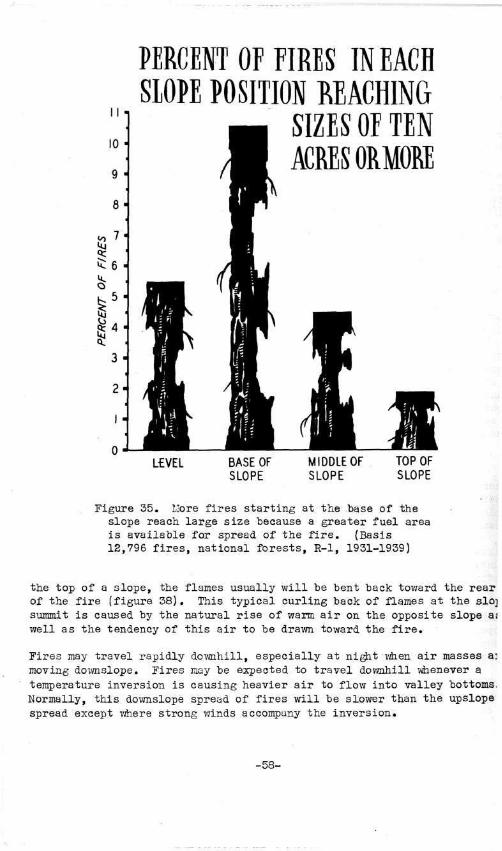
PERCENT OF M I S IN EACH SLOPE POSITION REACHING
SIZES OE TEN ACRES ORMORE
L£VEL BASE OF SLOPE
MIDDLE OF SLOPE
TOP OF SLOPE
Figure 35. Llore fires starting at the base of the slope reach large size because a greater fuel area is available for spread of the fire. (Basis 12,796 fires, national forests, R-l, 1931-1939)
the top of a slope, the flames usually will be bent back toward the rear of the fire (figure 38). This typical curling back of flames at the slo] summit is caused by the natural rise of warm air on the opposite slope a: well as the tendency of this air to be drawn toward the fire.
Fires may travel rapidly downhill, especially at night when air masses a: moving downslope. Fires may be expected to travel downhill whenever a temperature inversion is causing heavier air to flow into valley bottoms, Normally, this downslope spread of fires will be slower than the upslope spread except where strong winds accompany the inversion.
-58-

is 5:
PERCENT OF FIRES W EACH SIOPE CLASS REACHING SIZES OF TEN ACRES ( M O R E
GENTL€ SLOPE 0-20%
MODERAH SLOPE 21-40%
STEEP SLOPE 41-60%
VERY STEEP SLOPE Over 60 %
Figure 36. As slope steepness increases, a higher percentage of fireaireach large size. (Basis 21,158 fires, national forests, R-l, 1931-1944}
In forest areas a ground fire creeping dpwnslope may create a dangerous situation for a reburn in the tree crowns. Heat from the ground fire dries out the tree crowns as it moves downslope; and whenever conditions are favorable for an upslope movement of air, a crown fire is likely. This condition is most likely to occur on the day after a night movement of a fire downslope.
Steep slopes exert several physical effects on a fire. Burning material may roll downhill and start spot fires below the main fire. On steep slopes a vertical fire line running up and down the slope on the sides of a fire may be outflanked by a spot fire starting on the bottom of the slope (figure 39). Because of this possibility the flanks of fires on steep slopes cannot be considered safe until the lower slope portions have been thoroughly mopped up.
-59-

FIRES m STEEP SLOPES HAVE A WEDGE SHAPE
Figure 37. Fires on steep slopes usually are characterized by a definite head, wedge shape, and flames on the flanks drawn inward.
FLAMES M D BACK INTO THE FIRE AT THE TOP OEA SLOPE
Figure 38. As a fire reaches a slope summit, the updraft from the opposite side of the mountain will bend flames into the burn.
-60-

SPOT FIRES ON STEEP SLOPES MAY OUTFMNK MAIN FIRE
Figure 39. The spot fire on the left of the fire line may burn rapidly upslope and outflank the main fire.
SHAPE OF COUNTRY
rugged mountainous areas the shape of the country is of great importance the firefighter who must evaluate fire behavior. Narrow canyons, side ainages, sharp ridges, and massive irregular slopes all have a bearing the direction of travel, rate of spread, and general behavior of fires, perience in this region has shown the following topographic features to of special importance:
Narrow canyons. Wind direction will normally follow the direction the canyon. Wind eddies and strong upslope air movement may be expect-at sharp bends in a canyon. Radiant heat transfer from one slope to other is great, and as a result fires may easily spot across the canyon igure 40). Near the bottom of the canyon there is little difference tween conditions on various aspects.
Wide canyons. Prevailing wind direction will not be altered to any eat extent by the direction of the canyon. Cross-canyon spotting of res is not common except in high winds. Strong differences will occur tween general fire conditions on north and south aspects.
Box canyons. Fires starting near the base of box canyons will react milar to a fire in a stove (figure 41). Air will be drawn in from the nyon bottom creating very strong upslope drafts. These same conditions y occur at the head of narrow canyons and at the head of high mountain .lleys.
-61-

FIRES EASILY CROSS NARROW CANYONS
Figure 40. Fuels on the opposite slope from a fire in a narrow canyon are subjected to intense heat and flying embers.
FIRES IN ABOXCANYON HAVE AN UPWARD DRAFT LIKE A EIRE IN A STOVE
Figure 41. Box canyons and chimneys created by sharp ridges provide avenues for intense updrafts.
-62-

Ridges. Fires burning along lateral ridges may change direction en they reach a point where the ridge drops off into a canyon (figure 42). is change of direction is caused by the flow of air in the canyon. In :ne cases a whirling motion by the fire may result from a strong flow of v around the point of a ridge.
C A M S K M PATHS FOR THE F10¥ OF AIR
Figure 42. In narrow canyons wind may follow the direction of the canyon. Fires approaching a canyon on a lateral ridge may change direction when they reach the zone influenced by the canyon air movement.
-63-

, - • , : • - . ak«
ma
Figure 43. A forest contains a wide variety of fuel lying on the groui and suspended in the air. Recognition of the inflammability of varic fuel combinations is an essential part of fire behavior analysis.
-64-

1
CHAPTER V. FUEIS
Zeen observation of variations in forest fuels is essential in making •eliable estimates of fire behavior. Fuel is the material of primary con-em to fire control men. The good firefighter must be able to evaluate oth inflammability and difficulty of control in the various fuel situa-ions encountered in a forest area.
JMILAlfllABILITr ANALYSIS
n a forest great differences exist in the character of the inflammable aterial. Deep duff, newly fallen dead leaves, clumps of grass, litters f dry twigs and branches, down logs, low shrubs, green tree branches, anging moss, snags, and many other types of material are present. Each f these materials has distinctive burning characteristics. The inflam-ability of a particular fuel body is governed by the burning characteris-ics of individual materials and the combined effects of the various types f materials present.
efore fuel inflammability can be analyzed, the physical characteristics f combustible forest materials must be classified. Such a classification ermits the identification of the fuel factors vjhich influence inflamma-ility. After the fuel has been properly classified, topographic and eather factors must be considered before rate of spread and general be-avior of fires in that fuel can be determined.
ecause forest fuels are so varied and complex, it is necessary to develop systematic approach to inflammability analysis. First, the fuel body s subdivided into two broad classes — ground fuels- and aerial fuels figure 44). Then each of these classes is evaluated according to the ar-angement, compactness, continuity, volume, and moisture content of the rincipal materials involved. To the beginner in fuel classification the nflammability analysis procedure may seem somewhat complex and time-con-uming. However, after practice the procedure becomes more or less auto-latic and is performed quickly and easily. The thoroughly trained and ex-'erienced fire man constantly, although subconsciously, makes an inflammability analysis of the various fuels encountered on a fire.
GROUND FUELS
kround fuels include all inflammable material lying on or immediately above .he ground or in the ground. The principal materials are duff, tree roots, lead leaves, grass, fine dead wood, down logs, stumps and large limbs, and .ow brush and reproduction.
Duff
)uff i s par t i a l ly decayed vegetative matter on the forest f loor . Duff seldom has a major influence on the rate of spread of a f i re because normally i t i s moist and rather t ight ly compressed so that l i t t l e of the surface is freely exposed to a i r . However, duff i s inflammable even though the r a t e of combustion i s slow. In forest f i res most of the duff
-65-

FUEL COMPONENTS
TREE BRAND
MOSS
SNAGS
LOW VEGETATI
LARGE LOGS
L£AVES GRA! & LIMBWOC
DUFF
ROOTS
SOIL
Figure 44. Principal components of ground fuels and aerial fuels.
-66-

is consumed down to mineral soil. Sometimes duff contributes to the rate of spread by furnishing a path for the fire to creep between patches of more inflammable material.
rhe smoldering characteristics of duff fires make them somewhat difficult to control. Fire lines dug down to mineral soil are required in duff areas. The only exception to this general rule can be made when examination by an expert fire technician shows that the lower layers of duff are too wet or too tightly compressed to burn. Frequently duff fires Inside a fire line are best mopped up by turning over the duff with a shovel, loosening the material for better exposure to air and allowing It to burn out. Water may be used effectively, but great care must be ;aken to stir the fuel to make certain that all particles are thoroughly soaked. Extinguishing duff fires by smothering with dirt is very diffi-sult to accomplish.
Roots
toots are not an important factor in rate of spread because greatly •estricted air supply prevents rapid combustion. However, fires can sreep slowly in roots — in fact some fires have escaped control because i root provided an avenue for the fire to cross the control line. The lost inflammable roots are the large laterals stemming out from dead snags, lontrol of root fires is accomplished simply by cutting the root where it jrosses the fire line. Mop-up of persistent fires may require complete ixcavation of roots.
Dead Leaves
L.S leaves on the ground decay, they gradually become part of the duff .ayer. However, before this decay takes place, leaves are a highly in-'lammable material and should be considered separately in evaluating ;round fuels. In northern Rocky Mountain forests the cover of dead leaves >n the ground is composed primarily of needles which have dropped from soniferous trees. Ponderosa pine needles are the most inflammable. Their .arge size and shape lead to a loose arrangement allowing free circulation >f air. Smaller needles, such as those from Douglas-fir, generally are .ess inflammable because they are more tightly compacted on the ground.
feedles which are still attached to dead branches are especially inflam-lable because they are freely exposed to air and normally are not in_ iirect contact with more moist material on the ground. Needles remaining m fallen limbs form a highly combustible kindling for larger material, for this reason logging slash containing dry needles is a very dangerous *uel.
lany techniques are necessary in controlling fires where leaves or needles ire the primary fuel. The advance of a fast-running fire may be checked temporarily by smothering with dirt or cooling with water. Only a light jover of dirt thrown with a sweeping motion of a shovel is necessary to 3low down a needle fire. Vflien water is used in checking the advance, a spray or fog-type stream is most effective, with the water being aimed at
-67-

the base and directly in front of the flames. A penetrating straight stream of water is most effective for mopping up a needle fire. Careful stirring of all inflammable material is necessary. A fire line is esser tial around all fires burning in a continuous cover of needles.
Grass
Grass, weeds, and other small plants are important ground fuels influenc rate of spread. The key factor in these fuels is the degree of curing. Succulent green grass acts as a fire barrier. During the course of a nc mal fire season grass goes through a curing process and gradually become drier and more inflammable. Finally the stems and leaves of the grass c due to lack of moisture and the major part of the cover becomes highly inflammable. Cured grass, if present in large and uniform volume, provides the most inflammable ground fuel found in the region.
Grass and other small plants occur on the floor of almost all forests. Firefighters need to observe the volume and continuity of the grass cov« In dense forests where little sunlight reaches the ground, there is verj little grass. In more open forests, such as mature stands of ponderosa pine, there may be a large amount. If a more or less continuous cover c dry grass occurs on the forest floor, the rate of spread of a fire will be governed largely by that cover rather than by the heavier fuels norms associated with a forest.
The ease of control of fires in dry grass depends mainly on the volume c grass. If the volume is low, the fire is often cool enough to permit wc near the edge of the flame front. If the volume of grass is great, the resulting hot fire handicaps work close to the fire front. In grass fii smothering with dirt or swatters and cooling with a spray or fog stream of water are effective control methods. Both methods require follow-up insure that no hangover fires remain. Wherever forest material, such a: mat of dead pine needles, twigs, or small limbs, is intermixed with the stand of grass, a fire line dug down to mineral soil usually is requirei
Fires in dry grass often have very high rates of spread. For this reasi special safety measures must be observed. A discussion of the required safety measures is contained in Chapter VI.
Fine Dead Wood
Fine dead wood consists of twigs, small limbs, bark, and rotting materi Normally the fine dead wood classification is confined to material with diameter of less than 2 inches. These fine dead ground fuels are among the most important of all materials influencing rate of spread and gene fire behavior in forest areas. Fine dead wood is ignited easily and of provides the main avenue for carrying fire from one area to another. I is the kindling material for larger heavier fuels.
In areas where there is a great volume of fine dead wood, a fire rapidl develops tremendous heat. The effect would be much the same if a fireplace or stove were loaded with nothing except kindling. Timber stands
-68-
that are decadent, fire-killed, bug-killed, or diseased, or that are heavily wind-thrown, usually have large amounts of fine dead wood on the ground. The greatest volume of fine dead wood usually is found in areas containing logging slash. Under dry conditions fires in such areas will burn violently, and the strong convection currents created by the intense heat will pick up burning embers and throw them out ahead, thus causing spot fires beyond the main fire front.
In some areas the occurrence of fine dead wood may be spotty. Accumulations of this material may be found bunched up under an occasional tree or snag. In such cases the firefighter must be alert to the fact that a very hot fire may develop in these accumulations. Sometimes a crown fire may break out above a jungle of fine dead limb ivood or a blaze may creep up a snag. These troublesome situations may be avoided by breaking up the worst bunches of fine dead wood before the fire reaches them.
Granulated dry rotten wood, while not an especially important factor in rate of spread, is a highly ignitible fuel. Flying embers from the main fire often cause spot fires in rotten wood lying on the ground or in hollow places on old logs or stumps. Firefighters searching for spot fires should seek out and carefully check these areas. Granulated rotten wood consists of millions of finely divided particles which are partially exposed to air. Accumulations of rotten wood burn in a manner similar to a saxvdust pile, flhen such material is on fire, a control line dug down to mineral soil is essential because complete smothering with dirt or cooling with water is very difficult to accomplish.
In most forest fires the control job must be aimed largely at checking the spread of fires in fine dead wood together with the associated material (mainly duff and leaves) lying underneath. Unless a large volume of dry grass is present, the fine dead wood is the most important fuel and should receive the first and most concentrated attention. If the fire is very hot, the first action may require smothering with dirt or cooling with water. The smothering and cooling stage should be regarded as a temporary step to check the spread of the fire. Final control requires a fire line dug down to mineral soil in nearly all cases.
Down Logs, Stumps, and Large Limbs
Heavy fuels, such as dorm logs, stumps, and large limbs, require long periods of hot dry weather before they become highly inflammable. However, when such material reaches a dry state, very hot fires may develop. The most dangerous heavy fuels are those containing stringers of dry wood, shaggy bark, or many large checks and cracks. Smooth-surfaced material is less inflammable because it dries out more slowly, has little surface exposed to air, and contains less attached kindling fuel. Extremely hot fires may develop in piles of down logs and large limbs or in crisscrossed windfall because the various fuel components will radiate heat to each other. However, individual limbs and logs will not burn hotly unless the fire is supported by large accumulations of fine dead wood.
-69-
The control of an advancing fire seldom rests on ability to suppress the fire in heavy fuels. In almost all areas containing large logs and limb; there will also be an accumulation of fine dead wood which is a much mor< important factor influencing rate of spread. Usually fires will not advance from log to log unless finer fuels are present or the area is lite] ally covered with logs which radiate heat to each other.
Once a fire becomes well established in heavy fuels, complete suppressioi is difficult. A control line around the area is essential. Smothering with dirt or cooling with water is effective but requires very large volumes of both agents. In some cases it is necessary to allow the fire to burn out until the heat has subsided sufficiently to permit final mop-up operations to take place. When a fire is allowed to burn out in logs containing stringers of bark, a careful lookout must be kept for spot fires caused by embers carried in the strong convection currents. If at all possible, hot fires in such areas should be promptly cooled by any available means.
Low Brush and Reproduction
Low brush, tree seedlings, and small saplings are classified as ground fuels because they are so closely intermixed with the inflammable materia on the forest floor. This understory vegetation may either accelerate 01 slow up the rate of spread of a fire. Normally, during the early part oi a fire season the shading from understory vegetation prevents rapid dryir of other ground fuels. However, as the season progresses continued high air temperature and low relative humidity will dry out both the fuel lyir on the ground and the understory vegetation. When this stage is reached, much of the low vegetation, and especially small coniferous trees, become fire carriers.
The understory vegetation in a forest often provides a link between grout fuels and aerial fuels. The crowns of small trees may catch on fire and in turn spread the fire to aerial fuels in the forest canopy. Thickets of reproduction or dead brush may provide the first means for a surface fire to flare up and spread into the crowns of the overstory trees. In anticipation of this possibility alert firefighters will break up reproduction thickets along the fire line, or wherever possible will locate control lines to prevent the fire from spreading into these danger areas.
It is not uncommon for a fire to creep through ground fuels under low brush or reproduction during periods of low burning index, such as during the night. The heat from the creeping fire dries out the leaves and sten of the low brush and reproduction. Then on the following day as the burning index increases, a reburn occurs. Often on the reburn the dried low vegetation burns hotly and carries the fire to the aerial fuels causing a crown fire.
AERIAL FUELS
Aerial fuels include all green and dead material located in the upper forest canopy. The main aerial fuel components are tree branches and crowns, snags, moss, and high brush.
-70-

Tree Branches and Crowns
The live needles of coniferous trees are a highly inflammable fuel. Their arrangement on tree branches allows free circulation of air. In addition the upper branches of trees are more freely exposed to wind and sun than most ground fuels. These factors, plus the volatile oils and resins contained in coniferous needles, make tree branches and crowns important components in aerial fuels. *
1 Tree branches and crowns are flashy fuels whichvreact Quickly to changes in relative humidity. Crown fires seldom occur when relative humidity is high. However, coniferous needles will dry out quickly when exposed to hot dry air. The dryness of needles is influenced by the transpiration process in a tree. When the ground is moist, trees are pumping a large amount of moisture into the air through the leaves. As the ground becomes drier, the transpiration process slows down and as a result leaves and branches become drier and more inflammable. Dead branches on trees are an important aerial fuel. Concentrations of dead branches such as found in insect- or disease-killed stands may cause a fire to spread from tree to tree. Likewise, concentrations of dead branches on the lower trunks of trees may provide an avenue for fires to spread from ground fuels into tree crowns. The most inflammable dead branches are those still containing needles.
Fires in the upper crowns of trees are extremely difficult to control. The main control method must be aimed at suppressing the fire in ground fuels and, if possible, in preventing the fire from entering the tree crowns. Removal of limbs on the lower trunks of trees is one method of preventing crown fires. Limbs should be removed wherever a concentration of ground fuels makes a crown fire likely.
Snags
Snags are one of the most important aerial fuels influencing fire behavior. Studies of nearly 12,000 fires in the national forests of Region 1 have shown that over 34 percent of the fires started in snags (1). This high fire occurrence rate indicates the inflammability of snags. Although in most forests green trees greatly outnumber snags, more fires start in the latter because the fuel is drier and is arranged for easier ignition.
Snags vary widely in character and consequently in their effect on fire behavior. Smooth, solid snags containing very little bark and few checks or cracks are not highly inflammable. On the other hand, broken-topped, shaggy-barked, or partially decayed snags are ignited easily and have a major influence on the spread of fires. Burning embers blown from shaggy-barked snags are prolific starters of spot fires. In areas containing very large numbers of snags the fire may spread from one trunk to another because of the intense radiation of heat.
Fires in burning snags must be controlled promptly. Wherever possible the main control effort on the fire must be designed to prevent the blaze from getting into snags. .Vhen fires do become established in snags, the
!>403_><i O—ni (; - 7 1 -

control method usually requires that the snags be felled. Snag-falling is especially important if shaggy bark is being carried from the burning trunk by wind or strong convection currents.
Tree Moss
Moss hanging on trees is the lightest and flashiest of all aerial fuels. Moss is important principally because it provides a means of spreading fires from ground fuels to other aerial fuels or from one aerial compone to another. Like other light flashy fuels moss reacts quickly to change in relative humidity. During dry weather crown fires may develop easily in heavily moss-covered stands. Control methods of moss fires are aimed primarily at breaking up ground fuels so as to prevent the fire from ent ing the tree crowns through the hanging moss. In addition, lower limbs containing tree moss should be removed at all danger spots.
High Brush
The crowns of high brush are classified as aerial fuels because they are distinctly separated by distance from ground fuels. In the northern Rocky Mountain region heavy stands of brush may develop in old burns and often form the principal vegetative cover in such areas. Crown fires in brush fuels ordinarily will not occur unless heavy ground fuels are present to develop the required heat. However, in some brush stands a high proportion of dead stems may create a sufficient volume of fine dead aerial fuels to permit very hot and fast-spreading crown fires. Key fac tors in evaluating the behavior of fires in high brush are therefore the volume, arrangement, and general condition of ground fuels and the presence of fine dead aerial fuels.
FUEL CONTINUITY
Fuel continuity describes the distribution of fuels in a given area. Fuel continuity is an important fire behavior factor because the distribution of fuels influences the potential area where a fire may spread as well as the rate of spread. If a dangerous fuel is uniformly distribute over an entire area, a high potential exists for a complete burn to occu at a rapid and uninterrupted rate of spread. However, if the fuel body is broken up by patches of bare ground or much less inflammable material both the potential area of the burn and the rate of spread of the fire are affected.
A wide range of fuel continuity conditions will be found in most forest areas. However, for the sake of simplicity in making fire behavior esti mates, two broad fuel continuity classes are recognized as follows:
Uniform fuels (figure 45) — include all fuels distributed continuously over the area being evaluated. Areas containing a network of stringers or blocks which connect with each other to provide a continuou path for the spread of fire are included in this classification.
Patchy fuels (figure 46) — include all fuels distributed unevenly over the area being evaluated. Definite breaks should be present, such patches of rocky outcroppings or plots where the dominant vegetation is much lower inflammability than the main fuel body.
-72-

UNIFORM FUELS
Figure 45. Uniform fuels are characterized by a continuous layer of inflammable ground cover.
PATCHY FUELS
Figure 46. Patchy fuels are characterized by definite breaks in the ground cover which will reduce the rate of spread of a fire.
-73-

FUEL VOLUME
As the amount of inflammable material in a given area increases, the amount of heat produced by a fire also increases. The hottest fires, as well as those most difficult to control, occur in areas containing the greatest quantity of fuel.
In evaluating fuel volume the quantity of both small- and large-sized fue! components should be observed (figure 47). A great volume of small materials, such as fine dead wood, indicates ample kindling for the ignition o: other fuels. A great volume of either small- or large-sized material ind: cates a high potential for a hot fire. Where fires develop in area^. containing a great volume of large-sized material, there will be intense radiation of heat to fuels lying in the path of the fire.
FUEL COMPACTNESS
Fuel compactness — the number of individual fuel particles per unit of volume — varies greatly in all kinds of fuel but is significant principally in duff and dead leaves lying on the ground. Fires burn rapidly in loosely compacted fuels because more of the individual fuel particles are freely exposed to air.
Compactness of duff and dead leaves varies according to tree species. In ponderosa pine the needles are loosely compacted because of the shape and size of the needles. For this reason surface fires usually spread more rapidly in a ponderosa pine forest than in other species. An uncompacted arrangement of needles also occurs in western red cedar, but intense shading and higher fuel moisture usually keep rate of spread in ground fuels below that observed in ponderosa pine. In forests composed of most' of the other species, the smaller needles become densely compacted on the ground, thus reducing the surface freely exposed to air and reducing the rate of spread of fires.
FUEL MOISTURE
Two conditions of fuel moisture have major influences on the rating of fuel types. One concerns the greenness or curing stage of vegetation. The other relates to the shade and protection furnished by green timber.
In grass fuels moisture content is a critical factor in determining inflammability. Fires either will not spread at all or will spread only at a low rate in grasses which are rank green; but when the same grasses become cured and dry, fires will race through them at an extremely rapid rate. The degree of curing of grass is difficult to- evaluate and requires keen observation of the grass stand. For purposes of considering fire behavior, the moisture content of grass can be judged according to the state of curing as follows:
Green — In the normal June with frequent rains grass is rank green. The condition can be recognized by the green color, and by the cool, moist feel when crushed in the hand.
-74-

Figure 47. Typical example of a large volume of both small-and large-sized components in ground fuels.
-75-

Curing — As summer drouth periods occur and hot, dry weather preva: grasses ordinarily progress through a period of gradual curing. This stj is detected by close observation of the individual grass clumps or stems, For cheatgrass the curing stage is typified by a lavender tinge commonly' referred to as the purple stage. For most other grasses the curing stage is less easily detected. At first only the tips of grass blades become tan or brown in color, or individual grass blades take on a cured appearance. In early stages of curing the grass stand may appear to be green, and the curing stage can be recognized only by close inspection of individual grass stems. In the advanced stages of curing the grass stand usually appears tan or brownish, and close inspection is necessary to detect the green condition of leaf bases.
Cured — In the cured stage grasses are completely dried to a tan o] brownish hue, and the stems feel dry or crackly when crushed or rubbed ii the hand.
The progress of grass curing varies considerably with species, weather c< ditions, and soil. Cheatgrass ordinarily cures two to three weeks earli< than other species. In the normal summer cheatgrass is completely cured by mid-July. Weather influences curing depending upon summer rains. DUJ ing the usual summer when July and August rains are confined to infrequei showers of light or moderate intensity, most grasses commence to cure during early July and gradually progress to the cured stage by late July or early August. In wet years grasses may not cure until late August. Conversely, there are years with spring drouth when grasses cure complete by early July. Soils influence curing primarily because of soil moistur* relationships. In the deep, moist soils bordering creeks curing is much slower than in the thin soils on slopes.
Some grasses seldom reach a dangerous cured condition. During most year: beargrass, prevalent in the high country, and the sedges found in high mountain meadows do not cure to a dangerous state like common bunch grasses.
The shade and protection afforded by timber stands influence fuel type ratings because of favorable fuel moisture conditions that are created ( In a dense forest ground fuels are protected from the sun and wind. Tern peratures and wind velocities are lower so that moisture does not evapor as rapidly from the dead fuels on the ground (6). As these favorable in fluences are constant, the effects can be accounted for when rating fuel types. Lower ratings are assigned to fuels which are situated beneath dense timber canopies.
The moisture content of fuels is influenced also by aspect, but this influence is not constant. Large variations occur with altitude, time o year, time of day, and other factors. Hence, for the purpose of fuel ty classification, aspect is disregarded. 3/ Fuel types are classified on
3/ In the past aspect has been considered in preparing fuel type maps. Recent research has shown that it is more desirable to use aspect on in making actual rate-of-spread estimates according to burning index
-76-

basis of the physical characteristics of the fuels disregarding any diffe ences created by aspect. When rate of spread of a fire is estimated aspect enters the considerations through its influence on weather factors
SPECIAL FIRE BEHAVIOR FACTORS IN FUELS
Spot Fires
The development of spot fires depends not only upon the topographic and weather factors but also upon the character of fuels in the main fire and the fuels beyond the main fire. In the main fire rotten, shaggy-barked snags, such as broken-topped hemlock snags, and large quantities of groum fuels, such as those found in heavy logging slash, are the fuels most likely to cause spot fires. Spot fires are frequently started by crown fires. Crown fires in single trees or small groups of trees can start spot fires a short distance ahead. Widespread crown fires with their intense heat and strong convection currents can throw burning embers far out ahead.
Fuels which ignite most readily from embers thrown out ahead of the main fire, listed in the order of their susceptibility, include:
1. Rotten wood on the ground, on logs, and in snags. 2. Moss and lichens in tree tops. 3. Slash, particularly when compacted in tight piles. 4. Duff. 5. Cured grass.
Spot fires become more frequent and severe with lower fuel moisture and increased wind. On an average dry August afternoon the smallest sparks will ignite rotten wood or tree moss quickly. In compacted slash, in duff, and in cured grass larger burning embers are required to start spot fires unless there is sufficient wind to fan smoldering material into flames.
Crown Fires
Many forests contain a combination of aerial and ground fuels that favor the development of crown fires. Fuel conditions which influence the prob ability and character of crown fires include:
1. Volume and arrangement of timber canopy. 2. Volume and arrangement of fine dry aerial fuels such as moss and
dead twigs. 3. Position of aerial fuels above ground fuels. 4. Character of ground fuels.
In open forests where single trees or small clumps of trees are well isolated from each other, crown fires are usually confined to single trees o small groups of trees. Crowning in such cases increases rate of spread b intensifying heat and by causing spot fires, but it vail not result in racing crown fires like those which sometimes occur in dense forests.
-77- "

then the t imber canopy i s s u f f i c i e n t l y dense and continuous to ca r ry broa< cas t crown f i r e s , the s e v e r i t y of the crown f i r e i s in f luenced by the q u a n t i t y , cha r ac t e r , and arrangement of d ry fuels in the a i r and on the ground.
In most f o r e s t s t r e e moss and dead a e r i a l f u e l s , such as small t w i g s , have t he g r e a t e s t in f luence on croxvn f i r e s . Trees loaded wi th moss and l ichen* t h a t extend from the t i p s of the t r e e s to the ground presen t the worst cond i t i ons , but severe crown f i r e s can s t a r t xvhen f i n e a e r i a l fue l s a r e s i t u a t e d high above the ground i f a s u f f i c i e n t amount of ground fue l s are p resen t to c rea t e i n t ense h e a t . The inf luence of d i s t ance from ground t o a e r i a l fuels v a r i e s with the volume and inf lammabi l i ty of ground f u e l s . •i/hen the ground i s covered by the heav ie s t cedar logging s l a s h , crowning w i l l occur when a e r i a l fuels a re a maximum height of 100 f e e t o r more above ground. Crown f i r e s seldom develop above l i g h t ground fue l s where duff i s the p r i n c i p a l m a t e r i a l un less t r e e branches o r moss extend cont inuously down to wi th in 2 or 3 f ee t of the ground.
An important cons ide ra t ion i n eva lua t i ng fuel cond i t ions i s the l ike l ihood of reburns in t r e e crowns over p rev ious ly burned ground f u e l s . A combinat i o n of f u e l , weather , and topographic cond i t ions may confine a f i r e t o ground fue l s fo r a cons iderable per iod of t ime. ^Vhile the f i r e i s burning on the ground, the a e r i a l fue ls may be scorched, s inged, and become c r i t i c a l l y d r y . F i n a l l y condi t ions change and a crown f i r e develops which sweeps back over the a r e a . Fuel c o n d i t i o n s , xvhere a crown f i r e of t h i s type may get i t s s t a r t , a r e s i m i l a r to those in f luenc ing any o t h e r crown f i r e . However, t h i s type of crown f i r e may develop e a s i e r and burn more exp los ive ly because of t h e drying of a e r i a l fuels caused by the sur face f i r e .
FUEL RATE-OF-SPHEAD CLASSIFICATION
In the foregoing, i nd iv idua l fue l elements in f luenc ing f i r e behavior were analyzed. I f a f i r e f i g h t e r i s to r a t e the inf lammabi l i ty of a p a r t i c u l a r f u e l body, he must consider the e f f e c t s of each element and of the combined e f f e c t s of the va r ious elements on each o t h e r . The end r e s u l t of such an a n a l y s i s i s to express fue l inf lammabil i ty in terms of r a t e of spread . The ob j ec t i ve i s to provide a y a r d s t i c k which subdivides fue l s i n t o r e l a t i v e r a t e - o f - s p r e a d groups .
Fuel Types
Long established procedure in the northern Rocky Mountains calls for the classification of fuels according to rate of spread and resistance to control (8). Rate of spread indicates the speed at which a fire will gaiE perimeter. Resistance to control indicates the difficulty of the fire-fighting job. In fire behavior analyses the rate-of-spread classification is the dominant factor.
Forest fire research has shown that fuels may be grouped into five rate-of-spread types (1). These types are described as low, medium, high, extreme, and flash. Actual rate of spread of fires in each type depends
-78-

upon the weather and topographic factors at the site. However, under the same weather and topographic conditions fires in medium rate-of-spread fuels will gain perimeter faster than in low fuels, and in high rate-of-spread fuels the fire perimeter increase will be faster than in medium fuels, etc. The general characteristics of each rate-of-spread type are shown in table 3. Representative examples are shown in figures 48 through 52.
Rate-of-Spread Classification Keys
Studies of forest and range conditions in the northern Rocky Mountains lave enabled fuel rate-of-spread classification keys to be prepared [tables A-l to A-7, inclusive, in appendix). These keys are intended as general guides in determining fuel rate-of-spread classification based lpon what an observer sees in examining a particular forest or range area. i separate key is used for each of the following situations:
Grass and Range Land Brush and Reproduction Dense Coniferous Forests Open Coniferous Forests Subalpine and Spruce Forests Logging Slash Cut-Over Forests With Slash Disposal Work Completed
rse of the keys in determining fuel rate-of-spread classification requires .he following steps:
1. Select the key in the above list which is most representative of he area being classified.
2. Select the appropriate description of ground fuels from the guides ontained in key.
3. Under the appropriate description of ground fuels select the aer-al fuel description contained in the key that is most representative of he area (or in the case of grass fuels select the proper curing condition).
4. Read the rate-of-spread c lass i f ica t ion .
Use of Fuel Rate-of-Spread Types in Fire Behavior Analysis
nee a given fuel body has been properly classified according to rate-f-spread type the firefighter is interested in an accurate estimate of ow fast the fire will gain perimeter and in any s'pecial fire behavior haracteristics that are common in the type. A method for estimating per-meter increase according to fuel type, aspect, position of fire on slope, teepness of slope, and burning index is discussed in Chapter VI. Special ire behavior characteristics of each type are as follows:
-79-

e
S SH
3 ° S • H CD H -P ctj ca
3 ffS
© -p J8
© # M CO r H r l CO CO - H t> 4>
« ! - H
d M
d co 0 Pt ft
CO 1
SH
o 1 ©
- p
<g
ra o
• r l • p ra
• H r l (D
•p o co r l CO
9 <D
p* _ r *
w *-
for
: ir
es:
_. fr o d C-co SH © O H
PI m ft^.
CO lO -P CO co
xi ^HJ CO CO o Pi fc-ft
CO H pq
SH O -P
(0
d o
• r l - P CO
• H SH • H ra ra CO
rH O
1 1
| B o A
©
ft
ra
a • H
co 3 o 1 1 1
ra H ©
5 d d 3 o r l O
• CO SO co d co
| CO SH
>> fn 0 t>
• co r H CO
3 <H
* J
3 o ft s •d CO
CD
d
© Pi
• H SH
© ra r l CO ft
CO
PI • H
d d 3 O
SH
i» H rH CO d
3 ©
1 EH
• m d
t xi d ©
§ ra
£
i <M
nd ©
• P o ©
• p
o • r l U ft ©
, 0
>> s rH -H rH -P © r t © © m PI PI © © b O d
O
• CO
i n
• <
» o r^
1 a ©
o PI o o
r H © Pi o • H CO © o o o
• a H ©
a SH
XS d 3 o
fi SD
d © ©
xi
© PI
• r l SH
SH O
0} - p
3 g § ra
© - p CO Pi ©
d Q
t }
*
1 <d O © u
© - p ft fX O ©
© r l ! > > - P © p U S r l O
* , ra u ra >> © 2 'H -2 S rH S
© -H © Pt -P © © U p{ ©
EH © m W) Pi
©
• ra d CO rH b0 © <-© d - H Pi SH CQ nd
«g g © 3 o
P>4 O SH h .. c5 >>
• H CO r H
, Q • CO S h S
•H rH ra H J» 3
.M xi - H © d rH ft
ra EH ra © Be m O - H •
H SH X) d
o o T j U Xi o d
SH CO
o • d •
d - P 3 d o d w o
• r l © - H •p m £ -p CO © O © in Pi r l 3
-P ft SH >d
o • o
H
O
• t o
1 • H d ©
a
- d © •p ra >> o d xi H © Pt ra © •p • d © ra O - P P -D f l r l d © ft © © >> ft
m rH d ra >> © w ra
H Pt d B - d H ft -H d ra raw)©
•H d d • P © •» - H •»
Pi -p m d ra ra in -P >H ra ft o ra © ©
© - P Pi >> ra Pi d ©
H M O O d ra <IH o ^
~ c © « S 0) & r-i &
rH Td -H © +a © © ft -H Xi p M <^ d SH Pi ra -H
ra m ^ J & >d ^ i o ra d i Pi d >>
3 >> © fi > O M t ) p O fi bD d © tjD © o » , d
J3 ft ra • • d m -p « m ra d ra ra nd © >> © © +3 rH
• d d ft Pi ra © ra o o co -H
© S SH r l <iH d d o
• r l - r l d SH CO SH • © W
pj xi fi Xi CO SH 3 d • • H o ra d ^ H w
O 1 rH _ ra -d SH -H -H d
+3 d - P ^J © d co © l M 3 -Q >> &p 3 o d H 3 o S d >> - H ^3 © ' H co t> * d
^ S © • © © © m Pi $0 £ © ,d S © Pi O ft © t> ca Pi S d -P O
r l SH EH - r l CQ O
o • CO
CM
o • to
H
f • H
w
ra I ra M H © ra.
• d • >> © bo co rH M d ra © Pi - H ra M co ciO Pi h P t f f l d D ra i o
r-i >, r-{ Xi 60 ©
r H © ^ ^ ^ © 4 H © o d ra ©
SH ^ ! SH SH O
d o d d *H ra 3 ra ^d p fn *d d fi © d © 6 f l p P 4^
H o r n d 3 SH ra d © © >> - p
d © rH © fcOrH P,
© £H ra © d © d d
• H r H C0 O SH d S
> 5 SH Pi © d O © ft d
t> >> ra d EH o «
• r l • CO -P d • d ra 3 -p Pi r i ra d 3
- P © . O d d to © d © © O © FH rH d ft W) o d d O d © - r l
• r i f l Id
r? " r ^ ^ ra o ra co © -P g r l • 3 — Q
- d r a g t>> © tso r l M © ©
© o d -d >. p, ra -p
o • i n
to
o • co
rH
2
©
-p W N
•d d d o ra
to m d m >H ra d U -H S ra
-p s CD © © Pi A o to
© Xi rl © d P. © 3 © © d
SH h O FH
- d 03 -d A d +> CO - H
- P ^ ra
• . d © to m ra d rH © to
<* « u
o d +> -H
t)0 • d W © o d H
• H
s ^ o ra o ©
K-? r H r l H O «J r l CO © ra d ra © Pi W to •
d co . © o ^ ft d S _p> 3 ' H EH ^> rH
O
• i n t o
o • to
to
xi ra ro
^-t fo
- 8 0 -

MM J L ><WfcWBLiiu^^ti^i)HP^HPBHF"'' -* M& •«v>jJ*J' ,;•**,- H i l l
- • .«* r3^j •p*^ , ~~ ,-aB
f -T^^Sfc.- « • * • i i i
" " • *'!' ' .-':<\j*^*<«»^§- x»^8HMS^i6 |KV^Si^ *. '+ ' ^ \ ~ ^ r * ~ • : A:\ V \ \
* * ^ v J SiMtt*£- ^ ^ « ';*_ £ • e? %. --i .<-*;• . '--jf.- %Jr' ••.• V V ' ^*—•*-' ." #<-*'" i % r
•;. - _ j ^ * ; ' ^ ^ . : .
* ^f^'' '•• -'^''^^smk^ ^ i%' " ; : < T - ^ V - ' "*"" '^ttJiigiiiTiiiiiiMr'.."
' -*v^' J' . » ! • . fk's \ "" l'.- :*" ?> 4 l • ' 'A; .^mt
- ' „ $
3
^ < >?& *. .-$
d
B
^^xm*t«---
# ^ '"
t? *''i •
. \'V*V
• j . ** -'" •
•
—«... m
': ' "'*ML' '?••.-,.. " '• >" m u g
•'- •> " - ^ ^ T W '
•1 i \
1. '.. l i t
5
i .
PR
-81-

•A p •>* ",
Ifff!' - ;
mm • « - . i *«g
* ~ .-^-v- *"*' *&*--.- •" ~»*
J^>"
' 5 ' £" -
4-^C-:
' '. ~$ 2* ,*- c:
•^-mm
•Jwf>S»T-- •
..-'
ESS >," . : * v - * -~~ .- *- * , - J - MK&- -' •c i-^sj^t?
Figure 49. Medium rate-of-spread fuel type. Ground fuels are shaded, but include a moderate amount of fine dead material. A fire in the ground fuels may spread into aerial fuels.
-82-

•iJMtiAm
«„-—
^ ^ ^ M * — ™ - — ! — — * ~ * ^
, , . ^ , 1 , , ^ . , .. i . i ^ i —
T_^*Se^d
— ~ , - , s
** - -. •* ' . -^^t^Sr
"^^V:
a
•
-r :
r
•
. • * . .*" t*
•1 ' '• m
CO H i CD CO
PM fs
1 -P •A w O S © -tf
*
- 8 3 -

u
- 8 4 -

* H
CD
T 3 CO Pi -p
CO >s
PI £ CD O
ft •P
o PI
CD
s
CO CD p!
tn iH I (D
o <5 © "3
W CD
fr
- 8 5 -

Low rate-of-spread fuels . Most ground fuels in t h i s type are dense] shaded and protected from wind. Under extreme drouth conditions ground fuels may become highly inflammable. Crown f i res are not common; but wh( crowning does occur, much higher than average ra tes of spread may be expected. Spot f i res are not common except where crown f i res occur.
Medium rate-of-spread fuels . Rate of perimeter increase of f i r e s burning in ground fuels i s only s l ight ly higher than in low rate-of-spres fuels . The big difference i s the probabil i ty of crown f i r e s . A higher percentage of crown f i res develop in medium rate-of-spread fuels than in any other type.
High rate-of-spread fue ls . Fires in snags are often a major problei in th is type. Spot f i res are common, and when they occur much higher than average rates of spread may be anticipated.
Extreme rate-of-spread fuels . Except for the grass types, th is fue] c lassif icat ion usually has a combination of large amounts of fine and heavy materials . Very hot f i res r e su l t . Spot f i res are common and are i major factor contributing to rate of spread. Because of the intense heal and tendency of f i res to spot ahead, normal bar r ie r s , such as roads and streams, wil l seldom stop a running fij^e in t h i s type.
Flash rate-of-spread fuels. Cr i t ica l factor in this type i s s ta te c curing of vegetation. Rate-of-spread classif icat ion within the type can actually vary from low to flash depending upon whether vegetation i s gre< or cured. Fires wi l l burn clean and hangover f i r e s are r a r e . Spot f ire; are not common unless logging slash i s present.
- 8 6 -

•4!«l'(i()—;-)! 7

Figure 53. Teamwork by all members of the fire control organization ir rating fire behavior is necessary to prevent "blowups" like this or i handle such situations safely when they do occur.

CHAPTER VI. FIRE BEHAVIOR RATINE
> fire behavior rating is an evaluation of the combined effects of all ertinent weather, topographic, and fuel conditions. In the initial size-p of a fire each major factor may be evaluated separately, but in reaching decision on what the fire is going to do it is necessary to consider the interrelationship of all factors. The objective of all fire behavior rat-ags is to provide the following information:
1. Rate of spread. Estimate the number of chains per hour that the Lre will gain perimeter.
2. Special behavior. Determine the probability of crown fires and sot fires.
3. Safety factors. Determine when and where the probable behavior ' the fire may call for special safety measures by the firefighting irsonnel.
ESTIMATE OF THE SITUATION
.re behavior predictions are based upon information of weather, topog-iphy, and fuel at the site of the fire. To insure that all pertinent Lformation is obtained and properly evaluated, an estimate of the situa-.on is made on each fire. The estimate of the situation is a continuing •ocess beginning with the discovery of the fire and carrying on through .e dispatching, initial attack, and follow-up stages of the fire sup-•ession operations.
The Weather Estimate
e weather estimate is an evaluation of the effects on fire behavior of st, present, and future weather conditions. The weather estimate should ecifically be based on:
1. Cumulative drying
a. Do soil and vegetative conditions in the fire area indicate prolonged drouth?
b. How many days have elapsed since the last rain of 0.2 inch or more at the nearest weather station?
c. Is there evidence in the fire area of recent light rains?
2. Burning index
a. What is the burning index at the nearest fire weather station?
b. What is the current burning index at the site of the fire?
c. Can burning index be expected to increase or decrease in the hours immediately ahead?
-89-

3. Wind direction and velocity
a. What is the prevailing wind direction in the fire area?
b. What is the current wind velocity in the fire area?
c. Is the fire area freely exposed to wind?
d. Is the fire approaching a topographic site where a change i: wind direction or velocity may be expected?
e. What changes in wind velocity and direction may be anticipa' in the hours immediately ahead?
4« Special weather conditions
a. Does cloud cover in fire area indicate possibility of turbulent or stable air?
b. Have dust devils been observed in fire area?
5. Weather forecast
a. Does the weather forecast indicate the probability of more severe or less severe burning conditions?
b. Does the weather forecast indicate the probability of a major change in burning index rating?
The Topography Estimate
The topography estimate should specifically include an evaluation of:
1. Aspect
a. What direction does the slope face at the present position of the fire?
b. As the fire progresses will it burn on a slope facing in a different direction?
2. Position of fire on slope
a. Is the fire on the lower, middle, or upper one-third of a slope? . .
b. On what part of the slope will the main fire front be during the night? During the day?
3. Steepness of slope
a. What is the slope steepness in percent in the fire area?
-90-

b. As the fire progresses will there be a major change in slope steepness?
c. Will the steepness of the slope cause material to roll out of the fire area?
4. Special topographic features
a. Will wind direction and general air movement be influenced by-canyons, ridges, and other major topographic features?
b. Does the proximity of adjacent slopes make spot fires on those slopes likely?
c. Do any of the major topographic features provide fire barriers?
The Fuel Estimate
fuel estimate is an analysis of the inflammability of all fuels in the 3 area. The fuel estimate should specifically include an evaluation of:
1. Condition of herbaceous vegetation
a. Is the grass and other herbaceous vegetation green, curing, or cured in the fire area?
b. Is there a sufficient quantity of grass present to make it the dominant ground fuel?
2. Fuel types
a . What i s the r a t e - o f - s p r e a d c l a s s i f i c a t i o n of t h e fue l in t h e area where the f i r e i s burning?
b . As the f i r e p rogresses w i l l d i f f e r e n t fue l types be encount e r ed?
c . Does t h e combination of a e r i a l and ground fue ls make crown f i r e s or spot f i r e s l i k e l y ?
d. Are t h e r e s i g n i f i c a n t breaks or e s p e c i a l l y dangerous jackpots i n t he fue l type?
ESTIMATING RATE OF SPREAD OF SMALL FIRES
-of-spread estimates provide an evaluation of how fast a fire will gain meter. Such estimates provide the most important basis for reaching sions on general fire behavior. In addition they provide the basis for rmining suppression force requirements and suppression methods.
-91-

Initial Rate of Spread
A rate-of-spread estimate should be made as soon as a fire is discovered This estimate is usually made by the dispatcher or the person responsib] for planning initial action on the fire. The first objective of the es1 mate is to determine the rate at which the fire will gain perimeter betv discovery and first attack. Preparation of the initial rate-of-spread estimate requires the following information:
1. Weather
Average burning index at the site of the fire during the perioc from discovery to first attack (as determined from B.I. conversion tables).
2. Topography
Aspect. (Is' the fire on a north or south slope?)
Position of fire on slope. (Is the fire on the lower, middle, or upper one-third of a slope?)
Steepness of slope. (Estimated in percent.)
3. Fuel
The fuel rate-of-spread type at the site of the fire. (Is it low, medium, high, extreme, or flash?)
Aids for Estimating Initial Rate of Spread
The many complex factors influencing fire behavior and the inability.to measure some of these factors precisely make it difficult to obtain exac computations of rate of spread. No mechanical instrument or slide rule can be expected to present exact rate-of-spread figures for every fire. Keen observation of key factors and good judgment in the interpretation of these factors is the main and essential requirement in estimating rai of spread. However, as an aid to judgment, several guides are available for dispatchers and fire suppression personnel.
Burning Index Conversion Tables are available for estimating hourly chai in burning index and for converting ratings at a valley-bottom or mount* top station to some other position on a mountain slope (tables A-8 throi A-14 in appendix). These tables are especially useful to dispatchers ii estimating average burning index at the site of a fire from discovery tc first attack.
A Rate-of-Spread Table is available for estimating perimeter increase a cording to fuel type, slope steepness, and burning index'at the site of fire (table A-16 in appendix).
-92-

A Sample Problem in Estimating Initial Rate of Spread
1 p.m. on July 20 the observer at Pine Mountain Lookout Station discover fire and immediately reports its location and the following information the dispatcher at the Bear Lake Ranger Station:
Aspect: South
Slope position: Middle of slope (thermal belt)
Slope steepness: Moderate (26 to 50$)
Size of fire: Spot
Type of forest: Dense mature
Visible fuels: Medium
Wind: Light, southwest
Precipitation: Rone since very light rain during electrical storm last night
i dispatcher knows that clear weather has prevailed over all the district .ce the brief electrical storm of the previous evening. During the noon .r burning index measured at the ranger station is 59. The weather fore-t does not indicate any major change in wind, temperature, or relative ddity. From his knowledge of the situation and from the lookout observe report the dispatcher believes that the weather in the fire area is erally the same as at the ranger station except for differences caused local site and topographic conditions. Therefore, he believes that he make a reliable estimate of the burning index at the site of the fire..
dispatcher takes the following action:
1. He plots the location of the fire on a map. The fuel type map the area, plus the'lookout observer's report, indicates that the fuels medium in rate of spread.
2. lie estimates that an initial attack force can reach the fire in ours.
3. Through use of a burning index conversion table (table A-9) he imates that the average burning index at the site of the fire will be during the next 3 hours.
4. Applying the converted burning index to a rate-of-spread table ble A-16) he estimates that during the next 3 hours the fire will gain imeter at a rate of 5 chains per hour in medium fuels on a moderately ep slope•
5. From the above calculations he estimates that the fire will have erimeter of 15 chains at 4 p.m.
-93-

Follow-Up Estimates of Rate of Spread
Upon arrival at a fire the forest officer in charge should make a new estimate of the rate of spread. He is in a good position to make a reliable estimate because he has a direct view of the influencing factors. In addition he can calculate how fast the fire has spread in the past under the observed conditions and can use these calculations as a guide i making an estimate of future spread.
BEHAVIOR OF LARGE FIRES
Large fires are capable of spreading at much faster rates than small fire During a dry August afternoon a 50-acre fire with a perimeter of 120 chai may spread in 2 hours to 3000-acre size with a perimeter of more than 900 chains, or an average rate of spread of about 400 chains per hour. Under very severe conditions even faster rates of spread have occurred or large fires.
In forest areas high rates of spread on large fires are nearly always the result of crowning or spotting. Therefore, the first requirement in judg ing general behavior and rate of spread is to determine whether fuel, weather, and topographic conditions make crown fires and spot fires likel
Wind is a major factor in the spread of crown fires. At a burning index of 60 to 80 with gentle to moderate winds, fires of 100 chains perimeter or more which are crowning or spotting ahead may be expected to double their perimeter each hour during the peak afternoon burning period. On very steep slopes or under very severe wind conditions long stringers of fire may extend out from the main perimeter. However, if the fuel body is continuous, the intervening areas may be expected to burn out later.
Definite breaks in the rate of spread of large fires are often governed by topography. Running crown fires or fires in single burns that are spotting ahead and traveling from snag to snag generate great speed and heat and may be expected to burn out an entire drainage during'a hot, drj afternoon. However, a major reduction in rate of spread may be anticipat when such fires reach a ridge top, unless high winds or critically dry ar inflammable fuels are causing spot fires far ahead of the main flame fror
In mountainous areas the various sectors of a large fire will vary xvidelj in behavior at night. Fires in sectors at lower elevations and in valley bottoms will quiet down early in the evening. Shortly after shadows fall on the lower slopes of a mountain a noticeable break in the violence of fires may be observed. At upper elevations, and especially in the therme belt, fires in heavy fuels may not quiet down until well after dark. Under critically dry conditions crowning and spotting may continue well into the night.
BEHAVIOR OF BACKFIRES'
Backfires started at the proper time and place provide an effective means of combating the main fire. However, great care must be taken in such operations to insure that existing conditions will enable the backfires
-94-

bo assist rather than aggravate the suppression task. A careful estimate aust be made of all factors which will influence the behavior of both the lain fire and the backfires.
i distinction must be made between backfiring and burning out small strips ietween the fire line and the edge of the burn. Burning-out is a common peration in fire suppression wherever the fire line is not located direct-y on the edge of the main fire. The intervening area of unburned material etween the fire line and the edge of the main fire is normally only a few eet wide. Deliberate burning of this strip cleans up inflammable material nd has the effect of widening the control line.
iolent or erratic behavior of fires in the burn-out strip should be ex-remely rare because the suppression personnel can plan the operation so s to avoid danger points. The heat from the main fire will pull the urn-out fire inward, away from the control line. The burning of narrow trips should continue even xvhen critically dry conditions exist. If onditions are too severe to start a burn-out fire, then it may be antici-ated that the constructed fire line vail not stop the main fire. The ain danger areas in a burn-out strip are snags, concentrations of heavy ' round fuels, and live trees with branches extending to the ground or with oss which may cause crown fires. In all of these cases the dangerous uels should be removed or broken up or a control line built to prevent ither the burn-out fire or the main fire from reaching the trouble spots.
ackfiring refers to an indirect method of fire control in which a fire is ntentionally set on the fire side of a control line located a considerable istance away from the main bum. The method differs from burning-out briefly because of the greater area to be consumed by the intentionally at fire. Backfiring is strictly an emergency measure and is used only bien more direct methods are totally unsuccessful. Backfiring should be .-nployed only by experienced fire control personnel.
tie initial behavior of a backfire is the same as any other fire burning, rider similar conditions. In the initial stages the backfire usually ill not be pulled inward by the heat from the main fire because of the istance between the two fires. For this reason it is necessary to select time and place for setting the backfire which will insure its travel award the main fire. As the backfire approaches the main fire the heat rom the main fire will pull the two together.
ery slow rates of spread are not desired.for backfires. The area to be urned out should be cleaned up before moist night air reduces the fires o a smoldering condition. Usually the best time to set a backfire is bout 1 or 2 hours after the peak afternoon burning index. Early morning ackfires are almost always unsuccessful. During those hours work should e attempted directly on the edge of the main fire. Wherever there is a hoice, heavy ground fuels and snags should be avoided in backfires, ight, flashy fuels are desirable.
-95-

DUTIES OF PERSONNEL IN FIRE BEHAVIOR RATING
Successful fire behavior rating requires participation by all members of the fire control organization. Teamwork by all members of the organizat: is necessary to identify, report, and evaluate the pertinent factors influencing fire behavior. Important duties of various personnel in making fire behavior ratings are as follows:
Lookout observers
1. Observe and maintain a daily record of pertinent weather conditions in the area seen from the lookout station. Make a special effort 1 observe areas covered by thundershowers and light rains.
2. On each fire observe and report the factors which will assist ii making the initial estimate of rate of spread, including position of fir< on slope, aspect, slope steepness, type of forest, visible fuels, wind direction and velocity, precipitation, color of smoke, and initial size and general behavior of fire.
3. After submitting initial report make follow-up observations and report any major changes in behavior or in conditions in the fire area.
Aerial observers
1. On initial discovery of each fire observe and report all factors listed in duty number 2 above for lookout observers.
2. While flying over fire area, observe and report special factors which can be noticed from aircraft, such as air turbulence, direction fire is traveling, fuel conditions, barriers, and special topographic features.
3. On follow-up or scouting flights make detailed observations of area already burned, sketch size and shape of fire, carefully study fuels and topography in the path of the fire, determine probable direction of spread, look for spot fires, and identify danger spots.
Dispatchers
1. Maintain ready for instant use all available aids in rating fir* behavior, including fuel type maps, burning index conversion tables, and rate-of-spread tables and computers.
2. Observe, record, and plot daily weather conditions. Wherever possible maintain rainfall maps of the district. Watch weather trends and be alert to prolonged periods of drouth and high burning index. Know the current burning index at all times. During especially dangerous periods or periods of changing weather obtain as many daily readings frox fire weather stations as necessary to keep currently informed on burning index ratings. Carefully study and evaluate weather forecasts. Anticips changes. From the current information and the weather forecast estimate tomorrow's burning index.
-96-

3. Make a daily evaluation and estimate of the district fire situa-ion, and especially of the weather situation. Keep all fire control ersonnel informed of the situation, and especially of the current burning idex and the weather forecast.
4. Estimate the initial rate of spread on every fire. Make follow-3 estimates xvherever possible. Check your estimates with the rate of )read which actually occurred.
5. When dispatching the initial attack force, give them your estimate ' the burning index at the site of the fire, the probable changes during ie next several hours, and your estimate of the initial rate of spread.
iQkechasers and smoke jumpers
1. Before leaving for the fire obtain pertinent fire behavior infor-tion, especially current burning index, estimated burning index at the te of the fire, probable changes in burning index during the next several urs, and the weather forecast.
2. Upon arrival at the fire anticipate its probable behavior. Make estimate of the situation based upon keen observation of fuel, weather, d topographic factors.
3. Observe how fast the fire has spread between discovery and your rival. Make your own estimate of future rate of spread.
4. Make careful observations of both aerial and ground fuels.t Look r combinations that may cause spot fires or crown fires.
5. Look for special factors that may influence fire behavior, in-uding movement of clouds, especially thunderheads over fire area, dust vils, and outstanding topographic features.
6. Anticipate when and where major changes in fire behavior will cur based upon your continuing estimate of the fuel, topographic, and ather situation.
okejumper spotters
1. Before leaving for the fire obtain pertinent fire behavior infor-tion. It is desirable that this information include current burning dex at the nearest fire weather station, estimated burning index at the te of the fire, probable changes in burning index during the next veral hours, and the weather forecast.
2. Upon arrival over fire area make a brief estimate of the fire havior situation. Look especially for position of fire on slope, aspect, ad direction on ground, and dangerous fuels.
3. Before the smokejumpers leave the aircraft inform them of your timate of the situation. If a large crew of smokejumpers is to jump, ordinate your estimate with the squad leader or foreman.
4. Inform the forest dispatcher of your fire behavior observations.
-97-
Fire boss
1. Before leaving for the fire make necessary arrangements to rece: pertinent fire behavior information, and especially fire weather information and weather forecasts. Obtain all possible information on the curn situation.
2. Equip yourself with necessary maps, a burning index meter, burn: index conversion tables, rate-of-spread tables, relative humidity charts and a pocket, sling psychrometer.
3. Upon arrival at the fire establish the means for obtaining curn information on fuels and topography on all sectors of the fire. Establi: a scouting procedure and brief scouts and aerial observers on the fire bi havior information that you desire.
4. On large and dangerous fires make arrangements for the employme: of a mobile fire weather unit or for the receipt of special fire weather forecasts. On all other fires obtain current burning index from the nea: est fire weather station. Estimate burning index on the critical sector of the fire. Correct your estimates by local measurement of relative humidity with a sling psychrometer and careful observation of wind veloc ity. Anticipate changes in burning index at various topographic positio: and at various periods of the day and night.
5. Before each burning period make a detailed estimate of the fuel topographic, and weather situation. Compute rate of spread on each majo sector during the previous burning period. Estimate rate of spread duri the next burning period. Estimate the number of chains of fire line whi must be worked. Anticipate when and where crown fires and spot fires ma occur.
6. Make sure that the sector bosses and crew foremen understand tb fire behavior situation and that they pass this information on to crew members.
Sector boss
1. Become thoroughly acquainted with the fire behavior situation i your sector. Study the fuels that are burning and the fuels in the pati of the fire. Study the topography. Know the general situation on adjacent sectors.
2. From general weather information available on the fire area estimate the probable burning index in your sector and the probable houi ly changes during the day and night.
3. Identify the possible danger spots in your sector. Estimate when and where crown fires and spot fires may occur. Look for points where wind direction may change. Anticipate periods when wind velocity may increase.
-98-

4. Brief your foremen on the fire behavior situation in the sector md any possible changes that may occur from fire activity in adjacent lectors. Ask foremen to keep you informed of important factors or changes hich they observe. Make sure that foremen brief their crews on the fire ehavior situation.
rew foreman
1. Become thoroughly acquainted with the fire behavior situation i the area where your crew is to work. Know the general situation in Ijacent areas within the sector.
2. Observe all pertinent fuel and topographic factors in your crew's ?ea. Identify the danger spots, ".flier ever possible locate your fire Lne so that the fire will not reach dangerous fuel concentrations. Cool >wn fires and break up fuels in areas where crown fires may start. Look >r fuels that may cause spot fires and treat these fuels promptly.
3. Plan your work so that dangerous areas on the line are manned iring the most critical part of the burning period. Patrol areas out-.de the fire line where spot fires may occur.
4. Inform your crew of the probable fire behavior situation. Point it areas where high rates of spread, crown fires, or spot fires may occur, ve your crew explicit instructions on procedures to be followed in hand-.ng dangerous spots or in making withdrawal from the area. Point out .e location of safe areas where the crew may retreat to if necessary.
5. Keep your sector boss informed of the fire behavior situation. sist him in evaluating the probable behavior and rate of spread of res in the sector.
FIRE SAFETY MEASURES
thorough understanding of fire behavior is essential to the promotion safety in firefighting operations. Accidents often occur when soiled "unexpected fire behavior" develops. To avoid these "unexpected ents," the first and most important safety measure on every fire, re-rdless of size, is to make the estimate of the fire behavior situation ich has been emphasized throughout this chapter. Fires behave accord-g to certain laws. Runaway fires do not just happen. tfhen keen servations and evaluations are made of weather, topography, and fuels, ere are very slim chances for firefighters to be surprised suddenly by unexpected blowup.
ery fire behavior situation calls for special safety measures. In most ses the best safety measure is aggressive and intelligent firefighting med at abating the danger spot. For use as a general guide, the follow-g are a few important fire behavior situations and appropriate safety asures for those situations:
-99-

Fire Behavior Situation Safety Measures
Spot Fires
>nvection currents from a hot fire 1 a group of shaggy-barked snags re carrying burning embers into aburned fuels.
1. Cool down fires at base of snai and break up or remove dangerous ground fuels.
2. Patrol for spot fires and prom j ly control all fires discovered.
3. Keep all men away from burning snags except a small squad performing the control 30b around the snag,
4. Fall the snags as soon as possible. Follow standard snag-falling safety procedures.
During the early afternoon of a dry August day a crew is building line on the lower side of a fire lying about midway up a moderately steep mountain slope. The fire is burning in ground fuels in a type classified medium in rate of spread. The forest is dense and a few trees have hanging moss. A hot spot fire is discovered about 200 feet below the main fire.
1. Anticipate the probability that both the main fire and the spot fir may crown.
2. Promptly devote major attention to control of the spot fire. Recog nize that it may move rapidly upslo into the main fire.
3. Make immediate plans for moverae of the crew to a safer position bel the spot fire.
Grass Fires
At 8 a.m. on a clear morning following a day when peak burning index was 68, a fire near the base of a long, moderately steep slope has an uncontrolled perimeter of 15 chains. The area in the path of the fire is an open ponderosa pine forest with a uniform understory of dense, cured bunchgrass and scattered pine needles. At the present time the fire is quiet.
1. Recognize that the flashy fuels will dry out rapidly during the next 2 or 3 hours and that about 10 a.m. the burning index will increase significantly.
2. Take aggressive control action immediately.
3. Anticipate that the fire may develop a high rate of spread before noon. Plan work so that fire is flanked by control lines from the back toward the head. Patrol flanks for spot fires. Plan an es cape route for use if necessary.
-100-

Fire Behavior Situation Safety Measures
Grass Fires (cont'd)
fire is burning in a mixed stand f Douglas-fir and ponderosa pine bout 100 yards above the base of steep slope in a narrow canyon, le opposite south slope of the myon is covered with a uniform :and of cured cheatgrass. The )ute to and from the fire, in-.uding the route used by the water ->y, follows a rough trail along le south slope. It is 1 p.m. and Le estimated burning index at the re is 65.
1. Recognize that if a fire becomes established on the south slope, the rate of spread may be over 100 chains per hour.
2. Take aggressive action to control the north slope fire. Prevent any material from rolling down to the base of the slope. Treat any areas in the fire which may cause crown fires or spot fires.
3. Establish an alternate route to and from the fire.
small crew is making good process beating out the edges of a "ass fire. They are working up a ;eep, south slope on the flanks * the fire and have already cover-l about 25 chains of line. It is . a.m. and the peak afternoon irning index is expected to be lout 70 in the thermal belt.
1. Anticipate that a smoldering fire might cross into unburned fuel below the crew and race up the slope flanking their position.
2. Send 1 or 2 men back down the edge of the worked line to patrol and handle any smoldering fires.
3. Instruct the crew to get into the burned area if a flanking fire should threaten their position.
Crown Fires
small, hot fire is burning in a ingle of windfall underneath a ;nse forest of lodgepole pine and • few Engelmann spruce. Some of Le trees have hanging moss and ie lodgepole pine overstory is rtially killed from insect at-(cks. The fire is approaching a rt of the windfall which runs into thicket of spruce reproduction, ••is a hot, windy afternoon. The •ound in the area is very dry.
1. Recognize that the conditions are ideal for the development of a crown fire.
2. Take aggressive action to cool down the fire in the windfall. Remove reproduction. Limb up trees over and around the fire. Prevent fire from becoming established in snags.
3. Observe wind direction. For possible emergency use select a safe place of retreat where the wind will blow the fire away from your position.
-101-
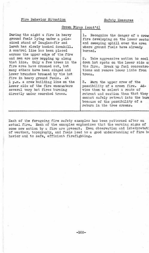
Eire Behavior Situation Safety Measures
Crown Fires (cont'd)
During the night a fire in heavy ground fuels lying under a pole-sized stand of Douglas-fir and larch has slowly backed downhill. A control line has been placed across the upper edge of the fire and men are now mopping up along that line. Only a few trees in the fire area have crowned out, but many others have been singed and lower branches browned by the hot fire in heavy ground fuels. At 1 p.m. a crew building line on the lower side of the fire encounters several very hot fires burning directly under scorched trees.
1. Recognize the danger of a crow] fire developing on the lower secto: and sweeping uphill over the area where ground fuels have already burned.
2. Take aggressive action to cool down hot spots on the lower side o: the fire. 3reak up fuel concentrations and remove lower limbs from trees.
3. Vfern the upper crew of the possibility of a crown fire. Advise them to select a route of retreat and caution them that they cannot safely retreat into the bun because of the possibility of a reburn in the tree crowns.
Each of the foregoing fire safety examples has been patterned after an actual fire. Each of the examples emphasizes that the warning signs of some new action by a fire are present. Keen observation and interpretat: of weather, topography, and fuels lead to a good understanding of fire b< havior and to safe, efficient firefighting.
-102-

APPENDIX
FUEL RATE-OF-SPREAD CLASSIFICATION KEYS
Table A-l Grass and Range Land Table A-2 Brush and Reproduction Table A-3 Dense Coniferous Forests Table A-4 Open Coniferous Forests Table A-5 Subalpine and Spruce Forests Table A-6 Logging Slash Table A-7 Cut-Over F o r e s t s With S lash Disposal Vfork Completed
BURNING INDEX CONVERSION TABLES
Table A-8 Val ley Bottom t o Lower One-Third of Mountain Slope Table A-9 Val ley Bottom t o Middle One-Third of Mountain Slope Table A-10 Valley Bottom to Upper One-Third of Mountain Slope Table A-ll Mountain Top to Middle One-Third of Slope Table A-12 Mountain Top to Lower One-Third of Slope Table A-l3 Mountain Top to Valley Bottom Table A-14 Mountain Top to North Aspect on Upper One-Third of
Mountain Slope Table A-l5 Cumulative Hourly Change in Burning Index
RATE-OF-SPRSAD TABLE
Table A-l6 Average Initial Rate of Spread According to Fuel Type, Slope Steepness, and Burning Index at Site of Fire
:>4!W2<iO—51- -103-

LITERATURE CITED
(1) BARROWS, J . S . 1951. Forest Fires in the northern Rocky Mountains. Northern
Rocky Mountain Forest and Range Experiment Station. Station Paper No. 28, illus.
(2) GISBOME, H. T.
1941. How the wind blows in the forest of northern Idaho. Northern Rocky Mountain Forest and Range Experiment Station. Progress Report, illus.
(3) 1936. Measuring fire weather and forest inflammability.
USDA Circular No. 398, illus.
(4) EAYES, G. LLOYD 1941. Influence of altitude and aspect on daily variations in
factors of forest fire danger. USDA Circular No. 541, illus. -
(5) HORNBY, L. G. 1935. Fuel type mapping in Region One. Journal of Forestry,
Vol. 33, No. 1.
(6) JEMISON, GEORGE M. 1935. Influence of weather factors on moisture content of
light fuels in forests of the northern Rocky Mountains. Journal of Agricultural Research, Yol. 51, No. 10, illus.
(7) PRICE, DAVID J. 1939. How fires start and how they burn. Pennsylvania Firemen's
Training Conference, State College, Pennsylvania. Mimeographed.
(8) U. S. FOREST SERVICE 1936. Fuel type standards, Region One. Northern Rocky Mountain
Forest and Range Experiment Station.

LIST OF PREVIOUS PUBLICATIONS W THIS SERIES
Station Paper No.
1 * A preliminary study of root diseases in western white pine, by John Ehrlich. Oct. 1939.
2 # Possibilities of partial cutting in young western white pine, by E. F. Rapraeger. Jan. 1940.
3 Blister rust control in the management of western xvhite pine, by Kenneth P. Davis and Virgil D. Moss. June 1940.
4 Possibilities of wood-pulp production in the northern Rocky Mountain region, by E. F. Rapraeger. Mar. 1941.
5 Results to date of studies of the durability of native woods treated and untreated, by C. N. Whitney. Rev. Jan. 1946.
6 Changes in Benewah County forest statistics, by Paul D. Kemp. July 1947.
7 * A guide for range reseeding on and near the national forests of Montana, by C. Allan Friedrich. Oct. 1947.
8 Pole blight - a nexv disease of western white pine, by C. A. Wellner. Nov. 1947.
9 Management practices for Christmas tree production, by C. A. Wellner and A. L. Roe. Nov. 1947.
10 The merits of lodgepole pine poles, by I. V. Anderson. Nov. 1947.
11 Tables for approximating volume growth of individual trees, by P. D. Kemp and M. E. Metcalf. Mar. 1948.
12 Forest resource statistics, Cascade County, Montana, by H. J. Pissot and E. F. Peffer. Apr. 1948.
13 Forest resources of northern Montana, by C. W. Brown and 17. C. Hodge. June 1948.
14 List of publications available for distribution or loan, 1910 through 1947. NRM station. June 1948.
15 Review of published information on the larch-Douglas fir forest type, by Russell K. LeBarron. Nov. 1948
* Out of print. Loan copies may be obtained upon request.
6 U. S GOVERNMENT PRINTING OFFICE : O—1951

Station paper No.
16 Development of a blister rust control policy for the national forests in the Inland Empire, by Donald N. Matthews and S. Blair Hutchison. Dec. 1948.
17 Disintegration of girdled western hemlock and grand fir, by Austin E. Helmers. December 1948.
18 Suggested Montana Douglas-fir Christmas tree standards, by S. Blair Hutchison and Ben M. Huey. January 1949.
19 The possibilities of modifying lightning storms in the Northern Rockies, by Vincent J. Schaefer. January 1949.
20 Forest resources of southern Montana, by W. C. Hodge, C. W. Brown, and T. L. Finch. May 1949.
21 Forest resources of northeast Washington, by Paul D. Kemp and H. J. Pissot. May 1949.
22 Bibliography of ponderosa pine, by A. L. Roe and K. N. Boe. March 1950.
23 Forest resources of south central Montana, by T. L. Finch, W. C. Hodge, and M. E. Metcalf. April 1950.
24 The cubic foot as a national log-scaling standard, by E. F. Rapraeger. June 1950.
25 Montana forest resource and industry statistics, by Paul D. Kemp and M. B. Dickerman. October 1950.
26 St. Johnswort on western ranges, by Grant A. Harris. February 1951.
27 Sampling in tree measurement sales on northern region forests, by D. W. Lynch. March 1951.
28 Forest fires in the northern Rocky Mountains, by J. S. Barrows. April 1951.

Table A-l. Fuel Rate-of-Spread Classification Key for
GRASS AND RANGE LAND
Definition: Non-forested areas where grass and small plants form the dominant vegetative cover. Scattered trees or brush may be present, but not in sufficient density to shade more than 5 to 10% of ground fuels.
Ground Fuels
Specific Kind of Fuel (Select description most representative of area)
Cheatgrass (Bromus spp.) (Moderate to dense stands.)
Ran^e Type - Good to Excellent Condition (Moderate to dense stands with mat of dead stems and leaves lying on ground.)
Range Type - Fair to Poor Condition (Plants clipped short over much of area, but little bare soil is exposed. Usually is moderately to heavily grazed.)
Depleted Range (Much bare soil exposed due to overgrazing or poor site; very shallow or no litter of dead stems and leaves.)
Alpine Parks and Meadows (Moderate to dense stand of grass and flowers. Stands remain green and wet except in periods of prolonged drouth.)
Fuel Continuity 1/
Patchy
Uniform 2/
Patchy
Uniform
Patchy
Uniform
Patchy
Uniform
Patchy
Uniform
Rate-of-Spread Classification
Grass Green (About 75$ or more of plants are
green, moist and succulent)
Low
Low
Low
Low
Low
Low
Low
Low
Low
Low
Grass Cured (Brown, yellow or red color predominates.
Stems are generally dry and brittle)
Flash
Flash
Extreme
Flash
High
Extreme
Medium
Medium
Medium
High
1/ Fuel continuity represents the arrangement of dry grass, rotten material, and the litter of dead leaves and stems.
2/ Uniform continuity includes not only the arrangement of fuels distributed evenly over the fire area, but also those arranged in a network fashion where stringers or blocks of fuel are connected with each other forming a continuous path for spread of fires.
Notes: Green grass is normally a fire barrier. However during the curing stage grass that appears green may be dry enough to permit medium to high rates of spread. Spotting in grass fires is uncommon except where rotten wood or exposed dry vegetative matter is present. Dense stands of cured cheatgrass and bunch-grass will cause fires to spread faster than any ground fuel found in the region.
»403M ()—51

Table A-2. Fuel Rate-of-Spread Classification Key for
BRUSH AND REPRODUCTION
Definition: Areas where trees over 20 feet in height are widely scattered singly or in small groups and where woody shrubs and/or reproduction exist in either scattered or dense uniform stands. Includes areas of multiple burn as well as solid fields of dense ceanothus.
Ground Fuels
Specific Kind of Fuel (Select description most representative of area.)
Sage Brush - Sparse Ground Fuel (Very thin and scattered stands of grass; much bare soil exposed. )
Sage Brush - Grass (Moderately dense to very dense stands of grass; dead twigs and branches may be scattered on ground. Use this classification only when grass is cured.)
Scattered Brush or Reproduction (Sparse dead ground fuels. Typical of multiple burns or plantations where fire has consumed or charred most of the logs and dead branchwood.)
Dense Brush Fields - Few Logs (Typical of dense ceanothus or mixed brush fields where fire has consumed most of the logs and snags.)
Brush and Reproduction With •Numerous Logs
(Typical of single burns in white pine timber zone where there are many snags.)
Fuel Volume 1/
Any quantity
Any quantity
Sparse dead ground fuels
Sparse dead branch-wood. Healthy shrubs. Moderate to large quantity of dead branch-wood. Sickly shrubs.
Fine dead branchwood and loose bark sparse Moderate to large quantity of dead branchwood and loose bark.
Fuel Continuity 2/
Patchy
Uniform 3/
Patchy
Uniform
Patchy
Uniform
Patchy
Uniform Patchy
Uniform Patchy
Uniform Patchy
Uniform
Rat
Few Snags (Less than 4 rotten or shaggy-barked snags per acre.)
Low
Medium
High
Extreme
Medium
High
Low
Medium Medium
High Medium
High Medium
High
e-of-Spread Classification
Numerous
4 or more rotten or shaggy-barked snags per acre of any species less than cedar, hemlock or fir.
Medium
High
High
High High
Extreme
Snags
4 or more rotten or shaggy-barked cedar, hemlock, or grand fir snags per acre.
High
Extreme
High
Extreme Extreme
Extreme
1/ Fuel volume refers to the relative quantity of dead branchwood, dead brush stems, rotten material, loose bark and grass.
2/ Fuel continuity refers to the combined arrangement of dead branchwood, dead brush stems, rotten material, loose bark and grass.
J3/ Uniform continuity includes not only the arrangement of fuels distributed evenly over the fire area, but also those arranged in a network fashion where stringers or blocks of fuel are connected with each other forming a continuous path for spread of fire.
Notes: A wide variety of brush types occur in the Northern Rocky Mountains. The descriptions given cover only the more important fire types. In brush and reproduction the quantity and arrangement of fine dead fuels has the most significant influence on rate of spread. Crown-to-crown fire spread through brush and reproduction may occur where there is a large quantity of dead brush stems or other dead fuels. In scattered brush types grass is usually the most important rate-of-spread factor.
949326 0—51
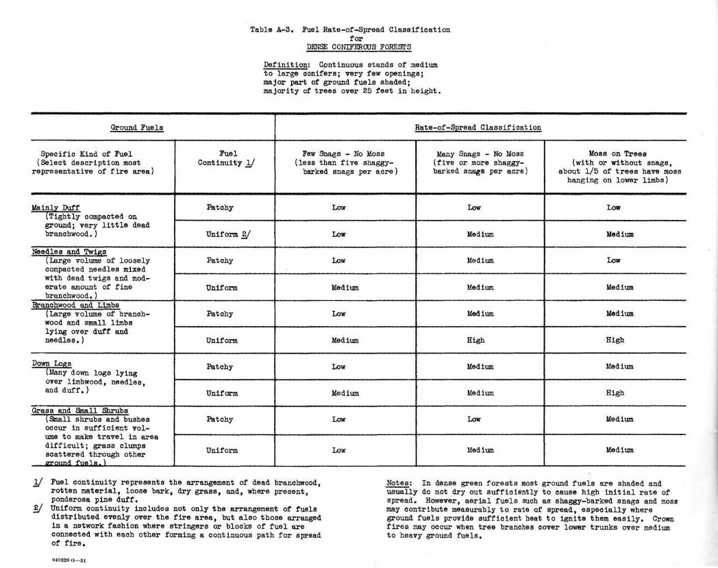
Table A-3. Fuel Rate-of-Spread Classification for
DENSE CONIFEROUS FORESTS
Definition: Continuous stands of medium to large conifers; very few openings; major part of ground fuels shaded; majority of trees over 25 feet in height.
Ground Fuels
Specific Kind of Fuel (Select description most
representative of fire area)
Mainly Duff (Tightly compacted on ground; very little dead branchwood.)
Needles and Twigs (Large volume of loosely compacted needles mixed with dead txvigs and moderate amount of fine branchwood.)
Branchwood and Limbs (Large volume of branch-wood and small limbs lying over duff and needles.)
Down Logs (Many down logs lying over limbwood, needles, and duff.)
Grass and Small Shrubs (Small shrubs and bushes occur in sufficient volume to make travel in area difficult; grass clumps scattered through other srround fuels.)
Fuel Continuity 1/
Patchy
Uniform 2/
Patchy
Uniform
Patchy
Uniform
Patchy
Uniform
Patchy
Uniform
Few Snags - No Moss (less than five shaggy-barked snags per acre)
Low
Low
Low
Medium
Low
Medium
Low
Medium
Low
Low
Rate-of-Spread Classification
Many Snags - No Moss (five or more shaggy-barked snags per acre)
Low
Medium
Medium
Medium
Medium
High
Medium
Medium
Low
Med ium
Moss on Trees (with or without snags,
about 1/5 of trees have moss hanging on lower limbs)
Low
Medium
Low
Medium
Medium
High
Medium
High
Medium
Medium
1/ Fuel continuity represents the arrangement of dead branchwood, rotten material, loose bark, dry grass, and, where present, ponderosa pine duff.
2/ Uniform continuity includes not only the arrangement of fuels distributed evenly over the fire area, but also those arranged in a network fashion where stringers or blocks of fuel are connected with each other forming a continuous path for spread of fire.
Notes: In dense green forests most ground fuels are shaded and usually do not dry out sufficiently to cause high initial rate of spread. However, aerial fuels such as shaggy-barked snags and moss may contribute measurably to rate of spread, especially where ground fuels provide sufficient heat to ignite them easily. Crown fires may occur when tree branches cover lower trunks over medium to heavy ground fuels.
D48S26 O—51

Table A-4. Fuel Rate-of-Spread Classification Key for
OPEN CONIFEROUS FORESTS
Definition: " Trees generally not close enough to completely shade ground fuels; includes seedling and sapling, pole and mature stands.
Ground Fuels
Specific Kind of Fuel (Select description most
representative of fire area)
Very Sparse Ground Fuels (Thin layer of duff, needles and twigs with much bare ground exposed.)
Needles and Twigs (Large volume of loosely compacted needles mixed with moderate amount of branchwood.)
Branchwood and Limbs (Large volume of branch-wood and limbs lying over duff and needles.)
Doivn Logs (Many down logs lying over limb wood, needles, and duff.)
Grass (Most of forest floor covered with grass mixed with other fine fuels.)
Fuel Continuity 1/
Patchy
Uniform 2/
Patchy
Uniform
Patchy
Uniform
Patchy
Uniform
Patchy
Uniform
_ . — ....
Rate-of-Spread Cla
Few Snags (less than four shaggy-barked snags per acre)
Low
Low
Low (Medium in Ponderosa Pine)
Medium (High in Ponderosa Pine)
Low
Medium
Low
Medium
Low (Medium when grass is cured)
Low (High when grass is cured)
ssification
Many Snags (four or more shaggy-barked •nags, per acre)
Low
Medium
Medium
High
Medium
High
Medium
High
Medium (High when grass is cured)
Medium (Extreme when grass is cured)
1/ Fuel continuity represents the arrangement of dead branch-wood, rotten material, loose bark, dry grass, and, where present, ponderosa pine duff.
2/ Uniform continuity includes not only the arrangement of fuels distributed evenly over the fire area, but also those arranged in a network fashion where stringers or blocks of fuel are connected with each other forming a continuous path for spread of fire.
Notes: Most mature ponderosa pine forests will fit this key except where mixture of Douglas-fir and larch shade ground fuels. In such cases use key for DENSE GREEN FORESTS. In open forests crown fires are infrequent except where heavy ground fuels are arranged under groups of trees. Grass and other herbaceous vegetation normally will cure earlier in the season in open forests than in dense forests.
:>4!>:i2H O — 5 1

Table A-5. Fuel Rate-of-Spread Classification Key for
SOBALPINE AND SPRUCE FORESTS
Definition: Open to dense stands of Engelmann spruce, alpine fir, limber pine, and white bark pine. Except for some spruce stands, this type generally occurs at elevations of 6>OQ0 to 10,000 feet. Associated species may include mountain hemlock, alpine larch, and lodgepole pine.
1/ Fuel continuity represents the arrangement of dead branchwood, rotten material, loose bark, dry grass, and duff.
2/ Uniform continuity includes not only the arrangement of fuels distributed evenly over the fire area, but also those arranged in a network fashion where stringers or blocks of fuel are connected with each other forming a continuous path for spread of fires.
Ground Fuels
Specific Kind of Fuel (Select description most representative of fire area)
Spruce Bottoms (Deep duff, much loose bark, many down logs, ferns scattered through area.)
Sparse Ground Fuels (Scattered small limbs and very thin layer of duff; much bare soil and rock exposed; scattered clumps of grass and flowers.)
Limbwood (Moderate to heavy layer of limbwood, especially around base of mature trees; scattered down logs.)
Heavy Windfall (Many trees on ground and leaning above ground; heavy accumulation of limbs and tops.)
Fuel Continuity 1/
Patchy
Uniform 2/
Patchy
Uniform
Patchy
Uniform
Patchy
Uniform
Rate-of-Spread Classification
Few Snags - No Moss (less than four shaggy-barked snags per acre)
Low
Low
Low
Low
Low
Medium
Medium
Medium
Many Snags - No Moss (four or more shaggy-barked snags per acre; may include
live trees with shaggy-broken tops and limbs)
Moss on Trees (with or without snags about 1/5 of trees have moss hanging on lower
limbs)
m -
Low Med ium
Medium
Low
Medium
Medium
Medium
Medium
High
High
Medium
Medium
Medium
High
High
Extreme
Notes; Fuels are difficult to classify according to rate of spread in sub-alpine forests. Because the ground is free of snow for only a short period of the year, these areas are in a moist condition and are characterized by clumps of green, succulent grass and flowers. However, many factors may contribute to serious fire conditions. Wind is common and assists in drying out fuels. Snow breakage, windfall and moss may often cause dangerous fuel conditions. Tree-to-tree fire spread may occur where there are tangles of dead limbs and tops. Spot fires are common where rotten wood occurs on the ground or on logs and shaggy stumps. In spruce stands fires will burn very deep, especially where squirrel caches occur at the base of old trees.

Table A-6. Fuel Rate-of-Spread Classification Key for
LOGGING SLASH
Definition: Areas where untreated logging slash forms the dominant fuel.
Ground Fuels
Specific Kind of Fuel
(Select description most representative of fire
area)
Larch-Douglas Fir or Lodgepole Pine Slash
White Pine Slash (Normally includes debris from several other species. If about 25$ of debris is cedar, use cedar classification. )
Cedar Slash (In most cases cedar slash will include debris from other species.)
Ponderosa Pine Without Grass (Only scattered or very thin stands of grass present. This type may include some mixture of larch and Douglas-fir.)
Ponderosa Pine With Grass (Grass stands moderately dense to very dense. When grass is green use classification for ponderosa pine without grass.)
Fuel Continuity 1/
Patchy
Uniform 2/
Patchy
Uniform
Patchy
Uniform
Patchy
Uniform
Patchy
Uniform
Rate-of-Spread Classification
Partially Cut Stands
60 to 90$ of ground surface shaded by remaining trees
Little moss on trees and rotten or shaggy-barked snags fewer than four per acre
Low
Medium
Medium
Medium
Medium
High
Medium
High
High
Extreme
Considerable moss on trees or four or more rotten shaggy-barked snags per acre
Medium
High
High
High
High
Extreme
High
High
Extreme
Extreme
30 to 59% of ground surface shaded by remaining trees
Little moss on trees and rotten or shaggy-barked snags fewer than four per acre
Medium
High
High
High
High
Extreme
_ ..
Medium
High
High
Extreme
Considerable moss on trees or four or more rotten snaggy-barked snags per acre
High
High
High
Extreme
Extreme
Extreme
High
Extreme
Extreme
Flash
Clear-Cut Stands (Only scattered green trees remain)
Few Snags (Less than four rotten or shaggy-barked snags per acre
Medium
• High
High
Extreme
Extreme
Extreme
High
Extreme
Extreme i
1 Flash
Many Snags (Four or more rotten or shaggy-barked snags per acre
High
Extreme
Extreme
Extreme
Extreme
Extreme
Extreme
Extreme
Extreme
Flash
1/
2/
Fuel continuity represents the arrangement of dead branchwood, rotten material, loose bark, dry grass, and where present, ponderosa pine duff. Uniform continuity includes not only the arrangement of fuels distributed evenly over the fire area, but also those arranged in a network fashion where stringers or blocks of fuel are connected with each other, forming a continuous path for spread of fire. Slash windrowed in lodgepole pine clear-cutting is classed as uniform.
!)4!>32<> ( ) — 5 1
Notes: When dry needles are still attached to 25$ or more of the branchwood, use the next higher classification, i.e., raise Medium to High, etc., but do not use a higher classification than extreme unless there are cured grass stands of moderate or greater density. 7/hen wind velocity is less than 8 or 10 miles per hour, the great heat generated by
fires in heavy slash may actually retard rate of spread because of the tendency of convection currents to force flames and heat inward and upward from the perimeter. Spotting is common in slash fires during dry summer weather, especially if rotten or shaggy-barked snags are present.

w xaDie A-Y. jjuei wa^e-oi -opreaa oj .assnicatlon &ey for
CUT-OVER FORESTS WITH SLASH DISPOSAL WORK COMPLETED
Definition: Areas where 20 to 100$ of merchantable timber has been removed and reproduction is not yet fully shading openings; slash accumulations have been burned or broken up so that slash is no longer the dominant ground fuel in which a fire will spread from one area to another.
Ground Fuels
Specific Kind of Fuel
(Select description most representative of fire area)
Fuel Description
Sparse Dead Branchwood and Loose Bark
(Usually occurs where slash has been nearly 100$ piled and burned or where hot fires have consumed most all the slash without leaving numerous snags.)
Moderate to Large Quantity of Small Dead Branchwood and Loose Bark
(Typical of areas where partial slash disposal has been undertaken or where hot fire has killed numerous residual trees that have or will become rotten or shaggy-barked snags. Grass is sparse or absent.)
Grass (Moderately dense to very dense stands of grass with or without dead branchwood and logs.) Zf
Species of Dead Ground
Fuel
Dead ground fuels of any species
Less than 35% of dead ground fuels are cedar
35% or more of dead ground fuels are cedar
Dead ground fuels of any species
Fuel
Continuity 1/
Patchy
Uniform 2/
Patchy
Uniform
Patchy
Uniform
Patchy
Uniform
Rate-of-Spread Classification
Partially Cut Stands
60 to 90% of ground fuels shaded by remaining trees
Little moss on trees and rotten or ehaggy-barked snags fewer than four per acre
Low
Low
Medium
Medium
Medium
Medium
Medium
High
Considerable moss on trees or four or more rotten or shaggy-barked snags per acre
Low
Low
Medium
Medium
Medium
High
Medium
High
30 to 59% of ground fuels shaded by remaining trees
Little moss on trees and rotten or shaggy-barked snags fewer than four per acre
Low
Low
Medium
Medium
Medium
High
Medium
Extreme
Considerable moss on trees or four or more- rotten or shaggy-barked snags per acre
Medium
Medium
High
High
High
Extreme
High
Extreme
Clear-Cut Stands (Only scattered
green trees remain)
Few Snags Many Snags
(Less than four (Four or more rotten or shag- rotten or gy-barked snags shaggy-barked
per acre) snags per acre)
Low High
Low High
Medium High
High Extreme
High Extreme
High Extreme
High Extreme
Flash Flash
1/ Fuel continuity represents the arrangement of dead branchwood, rotten material, loose bark, dry grass, and, where present, ponderosa pine duff.
2/ Uniform continuity includes not only the arrangement of fuels distributed evenly over the fire area, but also those arranged in a network fashion where stringers or blocks of fuel are connected with each other forming a continuous path for spread of fire.
3/ When grass is green drop the medium classification to low and drop all other ratings by two classifications, i.e., lower High down to Low, Extreme to Medium, and Flash to High.
1149320 O—51
Notes: The finer ground fuels in exposed cut-over areas will dry out easily until reproduction shades openings. Where tractors have been used in slash disposal, numerous patches of low or medium rate-of-spread classification may result from scarification of ground and mixture of soil with fine fuels. In areas of partial slash disposal rate-of-spread classification will vary widely in cut-over stands according to volume and arrangement of the slash left.

Table A-8. Correction to Valley Bottom burning index which wi l l give average burning index in the lower one-third of a mountain slope for a given number of hours after measurement.
Time of B.I. Measurement
Morning 0600-0659 0700-0759 0800-0859 0900-0959
1000-1059 1100-1159 1200-1259 1300-1359 1400-1459 1500-1559 1600-1659 1700-1759
Evening 1800-1859 1900-1959 2000-2059 2100-2159
Night 2200-2259 2300-2359 2400-2459 0100-0159 0200-0259 0300-0359 0400-0459 0500-0559
0 hour N
- 4 - 7 -10 -13
-15 -16 -16 -16 -17 -17 -17 -17
-16 -16 -15 -14
-12 -11 -10 - 8 - 6 - 5 - 4 - 3
S
+ 4 + 3 + 3 + 3
+ 3 + 3 + 3 + 3 + 3 + 3 + 2 + 2
+ 1 + 1 + 1 + 1
+ 1 + 1 + 1 + 1 + 2 + 2 + 3 + 4
1 N
- 6 - 9 -12 -14
-16 -16 -16 -17 -17 -17 -17 -17
-16 -16 -15 -13
-12 -11 - 9 - 7 - 6 - 5 - 4 - 4
hour S
+ 4 + 3 + 3 + 3
+ 3 + 3 + 3 + 3 + 3 + 2 + 2 + 2
+ 1 + 1 + 1 + 1
+ 1 + 1 + 1 + 2 + 2 + 2 + 4 + 4
Correction Factor According to Time and 2 hours N
- 7 -10 -13 -15
-16 -16 -16 -17 -17 -17 -17 -16
-16 -15 -14 -12
-11 -10 - 8 - 6 - 5 - 4 - 4 - 5
S
+ 3 + 3 + 3 + 3
+ 3 + 3 + 3 + 3 + 3 + 2 + 2 t 1
+ 1 • 1 + 1 + 1
+ 1 + 1 + 1 + 2 + 2 + 3 + 4 + 4
3 hours N
- 8 -11 -14 -15
-16 -16 -17 -17 -17 -17 -17 -16
-15 -14 -13 -12
-10 - 9 - 7 - 6 - 5 - 4 - 5 - 6
S
+ 3 + 3 + 3 + 3
+ 3 + 3 + 3 + 3 + 2 + 2 + 2 + 1
+ 1 + 1 + 1 + 1
+ 1 + 1 + 2 + 2 + 3 + 3 + 4 + 4
4 hours N S
-10 + 3 -12 + 3 -14 + 3 -15 + 3
-16 + 3 -16 + 3 -17 + 3 -17 + 3 -17 + 2 -17 + 2 -16 + 1 -15 + 1
-15 + 1 -14 + 1 -12 • 1 -11 + 1
- 9 + 1 - 8 + 1 - 7 + 2 - 5 + 2 - 4 + 3 - 5 +3 - 6 + 3 - 7 +3
Aspect 5 hours N
-11 -13 -14 -16
-16 -17 -17 -17 -17 -16 -16 -15
-14 -13 -12 -10
- 9 - 7 - 6 - 6 - 5 - 6 - 7 - 9
S
+ 3 + 3 + 3 + 3
+ 3 + 3 + 3 + 2 + 2 + 2 + 1 + 1
0 + 1 + 1 + 1
+ 1 + 2 + 2 • 3 + 3 + 3 + 3 + 3
6 hours N
-12 -13 -15 -16
-16 -17 -17 -17 -16 -16 -15 -14
-13 -12 -11 - 9
- 8 - 7 - 6 - 6 - 6 - 7 - 8 -10
S
+ 3 + 3 + 3 + 3
+ 3 + 3 + 2 + 2 + 2 + 1 + 1 + 1
+ 1 + 1 + 1 + 1
+ 2 + 2 + 3 + 3 + 3 + 3 + 3 + 3
7 hours N
-12 -14 -15 -16
-16 -17 -17 -16 -16 -16 -15 -14
-13 -12 -10 - 9
- 7 - 6 - 6 - 7 - 7 - 8 - 9 -11
S
+ 3 + 3 + 3 + 3
+ 3 + 2 + 2 + 2 + 2 + 1 + 1 + 1
+ 1 + 1 + 1 + 2
+ 2 + 2 + 2 + 3 + 3 + 3 + 3 + 3
8 hours N
-13 -14 -15 -16
-16 -16 -16 -16 -16 -16 -14 -13
-12 -11 - 9 - 8
- 7 - 6 - 6 - 8 - 7 - 9 -10 -11
S
+ 3 + 3 + 3 • 3
+ 3 + 2 + 2 + 2 + 2 + 1 + 1 + 1
+ 1 + 1 + 1 + 2
+ 2 + 2 + 3 + 3 + 3 + 3 + 3 + 3
TO USE TABLE:
1. Select time of burning index measurement in valley bottom. 2. To estimate burning index at another location at same time measurement is taken, read correction for proper aspect in 0 hour column.
Example: At 1600 B.I. in valley bottom is 59. At the same time estimated B.I. on lower south slope is -t-2 or 61. 3. To estimate average burning index for a given number of hours at another location, read correction for proper aspect in column show
ing length of estimate in hours. Example: At 1600 B.I. in valley bottom is 55. Average B.I. for the next 3 hours on a lower north slope will be -17 or 38.
!>4932<i O — 5 1

Table A-9. Correction to Valley Bottom burning index which wil l give average burning index in the middle (Thermal Belt) one-third of a mountain slope for a given number of hours after measurement.
Time of B.I. Measurement
Morning 0600-0659 0700-0759 0800-0859 0900-0959
Day. 1000-1059 1100-1159 1200-1259 1300-1359 1400-1459 1500-1559 1600-1659 1700-1759
Evening 1800-1859 1900-1959 2000-2059 2100-2159
Nirirb 2200-2259 2300-2359 2400-2459 0100-0159 0200-0259 0300-0359 0400-0459 0500-0559
0 N
+ 5 + 3 0
- 6
- 9 -11 -11 -11 -11 -11 -10 -10
- 8 - 6 - 4 - 2
- 1 0
+ 1 + 2 + 2 + 3 + 4 + 4
hour S
+14 +14 +14 +12
+10 + 8 + 7 + 6 + 5 + 4 + 3 + 3
+ 3 + 3 + 4 + 4
+ 5 + 5 + 6 + 7 + 8 +10 +12 +13
1 hour N
+ 4 + 2 - 3 - 8
-10 -11 -11 -11 -11 -11 -10 - 9
- 7 - 5 - 3 - 2
- 1 + 1 + 2 + 2 + 3 + 4 + 4 + 5
S
+14 +14 +13 +11
+ 9 + 8 + 6 + 6 + 4 + 4 + 3 + 3
+ 3 + 4 + 4 + 4
+ 5 + 6 + 6 + 8 + 9 +11 +12 +14
Correction Factor According to Time and 2 hours N
+ 3 - 1 - 5 - 8
-10 -11 -11 -11 -11 -10 - 9 - 8
- 6 - 4 - 2 - 1
0 + 1 + 2 + 2 + 3 + 4 + 4 + 4
S
+14 +13 +12 +10
+ 9 + 7 + 6 + 5 + 4 + 3 + 3 + 3
+ 3 + 4 + 4 + 5
+ 5 + 6 + 7 + 8 +10 +12 +13 +14
3 hours N
0 - 3 - 7 - 9
-11 -11 -11 -11 -11 -10 - 9 - 7
- 5 - 3 - 2 - 1
+ 1 + 1 + 2 + 3 + 3 + 4 + 4 + 3
S
+14 +12 +11 + 9
+ 8 + 6 + 6 + 4 + 4 + 3 + 3 + 3
+ 4 + 4 + 4 + 5
+ 6 + 6 + 8 + 9 +11 +12 +13 +14
4 hours N
- 1 - 5 - 7 -10
-11 -11 -11 -11 -10 - 9 - 8 - 6
- 4 - 3 - 1 0
+ 1 + 2 + 2 + 3 + 4 + 4 + 3 + 1
S
+13 +12 +10 + 9
+ 8 + 6 + 5 + 4 + 4 + 3 + 3 + 3
+ 4 + 4 + 5 + 5
+ 6 + 7 + 9 +10 +11 +13 +13 +14
Aspect 5 hours N
- 3 - 6 - 8 -10
-11 -11 -11 -10 - 9 - 8 - 7 - 5
- 4 - 2 - 1 0
+ 1 + 2 + 3 + 3 + 4 + 3 + 2 - 1
S
+12 +11 +10 + 8
+ 7 + 6 + 5 + 4 + 4 + 3 + 3 + 4
+ 4 + 4 + 6 + 6
+ 7 + 8 + 9 +11 +12 +13 +13 +13
6 hours N
- 4 - 6 - 8 -10
-11 -11 -10 -10 - 9 - 7 - 6 - 4
- 3 - 1 0
+ 1
+ 2 + 2 + 3 + 3 + 3 + 2 0
- 2
S
+12 +10 + 9 + 7
+ 6 + 5 + 4 + 3 + 4 + 3 + 4 + 4
+ 4 + 5 + 6 + 6
+ 8 + 9 +10 +11 +12 +13 +13 +12
7 hours N
- 5 - 7 - 9 -10
-11 -10 -10 - 9 - 8 - 7 - 5 - 4
- 2 - 1 0
+ 1
+ 2 + 3 + 3 + 3 + 2 + 1 - 1 - 3
S
+11 +10 + 8 + 7
+ 6 + 5 + 4 + 4 + 4 + 4 + 4 + 4
+ 5 + 5 + 6 + 7
+ 8 + 9 +10 +12 +12 +12 +12 +11
8 hours N
- 5 - 7 - 9 -10
-10 -10 - 9 - 8 - 7 - 6 - 4 - 3
- 2 - 1 + 1 + 1
+ 2 + 3 + 3 + 2 + 1 - 1 - 2 - 4
S
+10 + 9 + 8 + 6
+ 6 + 5 + 4 + 4 + 4 + 4 + 4 + 5
+ 5 + 6 + 7 + 8
+ 9 +10 +11 +12 +12 +12 +12 +11
TO USE TABLE:
1. Select time of burning index measurement in valley bottom. 2. To estimate burning index at another location at same time measurement is taken, read correction for proper aspect in 0 hour column.
Example: At 1600 B.I. in valley bottom is 59. At the same time estimated B.I, on middle south slope is +3 or 62. 3. To estimate average burning index for a given number of hours at another location, read correction for proper aspect in column show
ing length of estimate in hours. Example: At 1600 B.I. in valley bottom is 55. Average B.I. for the next 3 hours on a middle north slope will be -9 or 46.
!>4!)32« ()—51

Table A-10. Correction to Valley Bottom burning index which will give average burning index in the upper one-third of a mountain slope for a given number of hours after measurements.
Time of B.I. Measurement
Morning 0600-0659 0700-0759 0800-0859 0900-0959
Day 1000-1059 1100-1159 1200-1259 1300-1359 | 1400-1459 1500-1559 1600-1659 1700-1759
Evening 1800-1859 1900-1959 2000-2059 2100-2159
Night 2200-2259 2300-2359 2400-2459 0100-0159 0200-0259 0300-0359 0400-0459 0500-0559
0 N
+ 5 + 3 0
- 6
- 9 -10 -10 - 9 - 9 - 9 - 8 - 8
- 8 - 7 - 6 - 4
- 2 - 1 0
+ 1 + 2 + 2 + 3 + 4
hour S
+ 8 • 8 + 7 + 4
+ 1 0
- 1 - 2 - 3 - 3 - 4 - 3
- 3 - 2 - 2 0
+ 1 + 2 + 3 + 4 + 5 + 6 + 6 + 7
1 N
+ 4 + 2 - 3 - 8
-10 -10 -10 - 9 - 9 - 9 - 8 - 8
- 8 - 7 - 5 - 3
- 2 - 1 + 1 + 2 + 2 + 3 + 4 + b
hour S
+ 8 + 8 + 6 + 2
0 0
- 2 - 2 - 3 - 4 - 4 - 3
- 2 - 2 - 1 0
+ 2 + 2 + 4 + 4 + 6 + 6 + 7 + 8
i
Correction Factor According to Time and 2 hours N
+ 3 - 1 - 5 - 8
-10 -10 - 9 - 9 - 9 - 8 - 8 - 8
- 7 - 6 - 4 - 2
- 1 0
+ 1 + 2 + 2 + 3 + 4 + 4
S
+ 8 + 6 + 4 + 2
0 - 1 - 2 - 3 - 3 - 3 - 3 - 3
- 2 - 1 0
+ 1
+ 2 + 3 + 4 + 5 + 6 + 6 + 7 + 8
3 hours N S
+ 1 + 7 - 3 + 5 - 6 + 3 - 9 + 1
-10 - 1 -10 - 2 - 9 - 2 - 9 - 3 - 9 - 3 - 8 - 3 - 8 - 3 - 7 - 2
- 6 - 2 - 5 - 1 - 3 0 - 2 + 2
- 1 + 2 + 1 + 4 + 1 + 4 + 2 + 5 + 3 + 6 + 4 + 7 + 4 + 7 + 3 + 8
4 hours N S
- 1 +6 - 4 + 4 - 7 + 2 - 9 0
- 9 - 1 - 9 - 2 - 9 - 3 - 9 - 3 - 8 - 3 - 8 - 3 - 7 - 3 - 7 - 2
- 5 - 1 - 4 0 - 3 + 1 - 1 + 2
0 + 3 + 1 + 4 + 2 + 5 + 2 +6 + 3 + 6 + 3 + 7 + 3 + 7 + 1 + 7
Aspect 5 hours N
- 3 - 5 - 7 - 9
- 9 - 9 - 9 - 9 - 8 - 8 - 7 - 6
- 5 - 3 - 2 - 1
0 + 1 + 2 + 3 + 3 + 3 + 2 - 1
S
+ 5 + 3 + 2 0
- 2 - 2 - 3 - 3 - 3 - 3 - 2 - 2
- 1 0
+ 1 + 2
+ 4 + 4 + 5 + 6 + 7 + 7 + 7 + 6
6 hours N
- 4 - 6 - 8 - 9
- 9 - 9 - 9 - 8 - 8 - 7 - 6 - 5
- 4 - 3 - 1 0
+ 1 + 2 + 2 + 3 + 3 + 2 0
- 2
S
+ 4 + 2 + 1 - 1
- 2 - 2 - 3 - 3 - 3 - 2 - 2 - 1
0 + 1 + 2 + 3
+ 4 + 5 + 6 + 6 + 7 + 7 + 6 + 5
in . i j
7 hours N
- 5 - 6 - 8 - 9
- 9 - 9 - 9 - 8 - 7 - 7 - 6 - 5
- 3 - 2 - 1 0
+ 1 + 2 + 3 + 3 + 2 0
- 1 - 3
S
• 3 + 2 0
- 1
- 2 - 2 - 3 - 3 - 2 - 2 - 1 0
0 + 1 + 2 + 3
+ 4 + 5 + 6 + 6 + 6 + 6 + 5 + 4
8 hours N
- 5 - 7 - 9 - 9
- 9 - 9 - 8 - 8 - 7 - 6 - 5 - 4
- 3 - 2 - 1 + 1
+ 2 + 2 + 2 + 2 0
- 1 - 2 - 4
S
+ 3 + 1 0
- 1
- 2 - 2 - 3 - 2 - 2 - 2 - 1 0
+ 1 + 2 + 3 + 4
+ 5 + 5 + 6 + 6 + 6 + 5 • 4 + 4
TO USE TABLE:
1. Select time of burning index measurement in valley bottom. 2. To estimate burning index at another location at same time measurement is taken, read correction for proper aspect in 0 hour column.
Example: At 1600 B.I. in valley bottom is 59. At the same time estimated B.I. on upper south slope is -4 or 55. 3. To estimate average burning index for a given number of hours at another location, read correction for proper aspect in column show
ing length of estimate in hours. Example: At 1600 B.I. in valley bottom is 55. Average B.I. for the next 3 hours on an upper north slope will be -8 or 47.
!>4i)320 0—51

TO USE TABLE;
Table A-ll. Correction to Mountain Top burning index which will give average burning index on the middle one-third of a mountain slope for a given number of hours after measurement.
Time of B.I. Measurement
Morning 0600-0659 0700-0759 0800-0859 0900-0959
5sz 1000-1059 1100-1159 1200-1259 1300-1359 1400-1459 1500-1559 1600-1659 1700-1759
Evening 1800-1859 1900-1959 2000-2059 2100-2159
Night 2200-2259 2300-2359 2400-2459 0100-0159 0200-0259 0300-0359 0400-0459 0500-0559
0 N
- 3 - 5 - 7 -10
-10 -11 -10 - 9 - 8 - 8 - 6 - 7
- 5 - 4 - 2 - 2
- 2 - 2 - 2 - 2 - 3 - 3 - 2 - 3
hour S
+ 6 + 6 + 7 + 8
+ 9 + 8 + 8 + 8 + 8 + 7 + 7 + 6
+ 6 + 5 + 6 + 4
+ 4 + 3 + 3 + 3 + 3 + 4 + 6 + 6
1 N
- 4 - 6 - 9 -10
-10 -10 -10 - 9 - 8 - 7 - 6 - 6
- 4 - 3 - 2 - 2
- 3 - 2 - 2 - 2 - 3 - 2 - 2 - 3
hour S
+ 6 + 6 + 8 + 8
+ 8 + 8 + 8 + 8 + 8 + 7 + 6 + 6
+ 6 + 6 + 5 + 4
+ 4 + 3 + 2 + 3 + 4 + 5 + 6 + 6
Correction 2 hours N
- 5 - 7 - 9 -10
-10 -10 - 9 - 8 - 8 - 7 - 6 - 5
- 4 - 3 - 2 - 2
- 2 - 2 - 2 - 2 - 3 - 3 - 3 - 4
S
+ 6 + 7 + 8 + 8
+ 8 + 8 + 8 + 8 + 7 + 7 + 6 + 6
+ 6 + 5 + 5 + 4
+ 3 + 3 + 3 + 3 + 4 + 5 + 6 + 6
Factor According to Time and 3 hours N
- 6 - 8 -10 -10
-10 - 9 - 9 - 8 - 8 - 6 - 6 - 4
- 3 - 2 - 2 - 2
- 2 - 2 - 2 - 2 - 3 - 3 - 3 - 5
S
+ 7 + 8 + 8 + 8
+ 8 + 8 + 8 + 8 + 7 + 6 + 6 + 6
+ 5 + 5 + 4 + 4
+ 3 + 3 + 4 + 4 + 5 + 5 + 6 + 6
4 hours N S
- 7 + 7 - 9 + 8 -10 + 8 -10 + 8
-10 + 8 - 9 + 8 - 8 + 8 - 8 + 7 - 7 + 7 - 6 + 6 - 5 +6 - 4 + 5
- 3 +5 - 2 + 4 - 2 + 4 - 2 + 3
- 2 +3 - 2 +3 - 2 + 4 - 3 + 4 - 3 +5 - 3 +6 - 4 + 6 - 6 + 7
Aspect 5 hours N
- 8 - 9 -10 -10
- 9 - 9 - 8 - 7 - 7 - 5 - 4 - 4
- 3 - 2 - 2 - 2
- 2 - 2 - 2 - 3 - 3 - 4 - 5 - 6
S
+ 7 + 8 + 8 + 8
+ 8 + 8 + 7 + 7 + 6 + 6 + 6 + 5
+ 5 + 4 + 4 + 3
+ 3 + 4 + 4 + 5 + 5 + 6 + 6 + 7
6 hours N
- 8 - 9 - 9 - 9
- 9 - 8 - 8 - 7 - 6 - 5 - 4 - 3
- 3 - 2 - 2 - 2
- 2 - 2 - 3 - 3 - 4 - 5 - 6 - 7
S
+ 7 + 8 + 8 + 8
+ 8 + 7 + 7 + 7 + 6 + 6 + 5 + 5
+ 4 + 4 + 4 + 3
+ 4 + 4 + 4 + 5 + 5 + 6 + 7 + 7
7 hours N
- 8 - 9 - 9 - 9
- 9 - 8 - 7 - 6 - 6 - 4 - 4 - 3
- 3 - 2 - 2 - 2
- 2 - 2 - 3 - 4 - 4 - 5 - 6 - 7
S
+ 8 + 8 + 8 + 8
+ 8 + 7 + 7 + 7 + 6 + 6 + 5 + 5
+ 4 + 4 + 4 + 4
+ 4 + 4 + 4 + 5 + 6 + 6 + 7 + 7
8 hours N
- 8 - 9 - 9 - 9
- 8 - 8 - 7 - 6 - 5 - 4 - 4 - 3
- 3 - 2 - 2 - 2
- 3 - 3 - 3 - 4 - 5 - 6 - 7 - 8
S
+ 8 + 8 + 8 + 8
+ 7 + 7 + 7 + 6 + 6 + 5 + 5 + 4
+ 4 + 4 + 4 + 4
+ 4 + 4 + 5 + 5 + 6 + 7 + 7 + 7
1. Select time of burning index measurement on mountain top. 2. To estimate burning index on a middle slope at the same time the mountain top measurement is taken, read correction opposite selected
time in 0 hour column for aspect desired. Example: At 1600 burning index on mountain top is 50. The estimated 1600 correction for middle south slopes is +7, and the burning index therefore is 57.
3. To estimate average burning index on a middle slope for a given number of hours after measurement at a mountain top station, read correction opposite time of measurement and in column headed by number of hours for which average burning index is desired. Example: At 1100 burning index on mountain top is 40. The estimated 1100 correction to give average burning index for the next five hours on a middle north slope is -9; hence, average burning index will be 31.

Table A-12. Correct ion t o Mountain Top burning index which w i l l g ive average burning index on t h e lower one - th i rd of a mountain slope for a given number of hours a f t e r measurement.
Time of B.I. Measurement
Morning 0600-0659 0700-0759 0800-0859 0900-0959
Day 1000-1059 1100-1159 1200-1259 1300-1359 1400-1459 1500-1559 1600-1659 1700-1759
Evening 1800-1859 1900-1959 2000-2059 2100-2159
Night 2200-2259 2300-2359 2400-2459 0100-0159 0200-0259 0300-0359 0400-0459 0500-0559
0 N
-12 -15 -17 -17
-16 -16 -15 -14 -14 -14 -13 -14
-13 -14 -13 -14
-13 -13 -13 -12 -11 -11 -10 -10
hour S
- 4 - 5 - 4 - 1
+ 2 + 3 + 4 • 5 + 6 + 6 + 6 + 5
+ 4 + 3 + 3 + 1
0 - 1 - 2 - 3 - 3 - 4 - 3 - 3
1 hour N
-14 -16 -17 -16
-16 -16 -14 -14 -14 -14 -14 -14
-14 -14 -14 -14
-13 -13 -12 -12 -11 -10 -10 -11
S
- 4 - 4 - 2
0
+ 2 + 4 + 5 + 6 + 6 + 6 + 6 + 5
+ 4 + 3 + 2 0
0 - 2 - 2 - 3 - 4 - 4 - 3 - 4
Correction 2 hours N
-15 -16 -17 -16
-16 -15 -14 -14 -14 -14 -13 -14
-14 -14 -13 -13
-13 -13 -12 -11 -11 -10 -11 -12
S
- 4 - 3 - 1 + 1
+ 3 + 4 + 5 + 6 + 6 + 6 + 5 + 4
+ 3 + 2 + 1 0
- 1 - 2 - 3 - 3 - 3 - 3 - 3 - 4
Factor According to Time and 3 hours K
-15 -16 -16 -16
-15 -15 -14 -14 -14 -14 -13 -14
-14 -14 -13 -13
-13 -12 -12 -11 -10 -11 -12 -14
S
- 3 - 2
0 + 2
+ 4 + 4 + 5 + 6 + 6 + 5 + 4 + 4
+ 3 + 2 + 1 0
- 2 - 2 - 3 - 3 - 3 - 4 - 4 - 4
4 hours N S
-15 - 2 -16 - 1 -16 + 1 -16 + 3
-15 + 4 -15 + 5 -14 + 5 -14 + 6 -14 + 5 -14 + 5 -13 + 4 -14 + 3
-13 + 2 -13 + 1 -13 0 -13 - 1
-12 - 2 -12 - 3 -11 - 3 -11 - 3 -11 - 3 -12 - 4 -13 - 4 -14 - 3
Aspect 5 hours N
-16 -16 -16 -15
-15 -14 -14 -14 -14 -14 -13 -14
-13 -13 -13 -13
-12 -12 -11 -11 -12 -12 -14 -14
S
- 2 0
+ 2 + 3
+ 4 + 5 + 5 + 5 + 5 + 4 + 4 + 3
+ 2 + 1 0
- 1
- 2 - 3 - 3 - 3 - 4 - 4 - 3 - 2
6 hours N
-16 -16 -16 -15
-15 -14 -14 -14 -14 -14 -13 -13
-13 -13 -13 -12
-12 -11 -11 -12 -12 -13 -14 -15
S
- 1 + 1 + 2 + 4
+ 5 + 5 + 5 + 5 + 5 + 4 + 3 + 2
+ 1 0
- 1 - 2
- 2 - 3 - 3 - 4 - 4 - 3 - 3 - 2
7 hours N
-15 -16 -15 -15
• -14 -14 -14 -14 -14 -14 -13 -13
-13 -13 -12 -12
-12 -12 -12 -12 -13 -13 -14 -15
S
0 + 1 + 3 + 4
+ 5 + 5 + 5 + 5 + 4 + 4 + 2 + 2
+ 1 0
- 1 - 2
- 2 - 3 - 3 - 4 - 3 - 3 - 2 - 1
8 hours N
-15 -15 -15 -15
-14 -14 -13 -14 -14 -13 -13 -13
-13 -13 -12 -12
-12 -12 -12 -13 -13 -14 -14 -15
S
+ 1 + 2 + 3 + 4
+ 5 + 5 + 5 + 4 + 4 + 3 + 2 + 1
0 - 1 - 1 - 2
- 3 - 3 - 3 - 3 - 3 - 2 - 1
0
TO USE TABLE:
1. Select time of burning index measurement on mountain top. 2. To estimate burning index on a lower slope at the same time the mountain top measurement is taken, read correction opposite selected
time in 0 hour column for aspect desired. Example: At 1600 burning index on mountain top is 50. The estimated 1600 correction for lower south slopes is +6, and the burning index therefore is 56.
3. To estimate average burning index on a lower slope for a given number of hours after measurement at a mountain top station, read correction opposite time of measurement and in column headed by number of hours for which average burning index is desired. Example: At 1100 burning index on mountain top is 40. The estimated 1100 correction to give average burning index on a lower north slope for the next five hours is -14; hence, average burning index will be 26.
!)49326 O—51

Table A-13. Correction to Mountain Top burning index which will give average burning index in valley-bottoms for a given number of hours after measurement•
Time of B.I. Measurement
Morning 0600-0659 0700-0759 0800-0859 0900-0959
Day 1000-1059 1100-1159 1200-1259 1300-1359 1400-1459 1500-1559 1600-1659 1700-1759
Evening 1800-1859 1900-1959 2000-2059 2100-2159
Night 2200-2259 2300-2359 2400-2459 0100-0159 0200-0259 0300-0359 0400-0459 0500-0559
0 hour
-8 -8 -7 -4
-1 0 +1 +2 +3 +3 +4 +3
+3 +2 +2 0
-1 -2 -3 -4 -5 -6 -6 ,. -7
1 hour
-8 -8 -6 -2
0 0 +2 +2 +3 +4 +4 +3
+2 +2 +1 0
-2 -2 -4 -4 -6 -6 -7 -8
Correction Factoi 2 hours
-8 -6 -4 -2
0 +1 +2 +3 +3 +3 +3 +3
+2 +1 0 -1
-2 -3 -4 -5 -6 -6 -7 -8
3 hours
-7 -5 -3 -1
0 +2 +2 +3 +3 +3 +3 +2
+2 +1 0 -2
-2 -4 -4 -5 -6 -7 -7 -8
• According 4 hours
-6 -4 -2 0
+1 +2 +3 +3 +3 +3 +3 +2
+1 0 -1 -2
-3 -4 -5 -6 -6 -7 -7 -7
to Time and 5 hours
-5 -3 -8 0
+1 +2 +3 +3 +3 +3 +2 +2
+1 0 -1 -2
-4 -4 -5 -6 -7 -7 -7 -6
Aspect 6 hours
-4 -2 -1 +1
+2 +2 +3 +3 +3 +2 +2 +1
0 -1 -2 -3
-4 -5 -6 -6 -7 -7 -6 -5
7 hours
-3 -2 0 +1
+2 +2 +3 +3 +2 +2 +1 0
0 -1 -2 -3
-4 -5 -6 -6 -6 -6 -5 -4
8 hours
-2 -1 0 +1
+2 +2 +3 +2 +2 +2 +1 0
-1 -2 -3 -4
-5 -5 -6 -6 -6 -5 -4 -4
TO USE TABLE:
1. Select time of burning index measurement on mountain top. 2. To estimate burning index in the valley bottoms at the same time the mountain top measurement is taken,
read correction opposite selected time in 0 hour column. Example: At 1600 burning index on mountain top is 50. The estimated 1600 correction for valley bottom is +4, and the burning index therefore is 54.
3. To estimate average burning index in valley bottoms for a given number of hours after measurement at a mountain top station, read correction opposite time of measurement and in column headed by number of hours for which average burning index is desired. Example: At 1100 burning index on mountain top is 40. The estimated 1100 correction to give average valley bottom burning index for the next five hours is +2; hence, average burning index will be 42.
!>4!>32<S O — 5 1

Table A-14. Correction to Mountain Top burning index which will give average burning index on north aspects of the upper one-third of a mountain slope for a given number of hours after measurement. 1/
Time of B.I. Measurement
Morning 0600-0659 0700-0759 0800-0859 0900-0959
Day 1000-1059 1100-1159 1200-1259 1300-1359 1400-1459 1500-1559 1600-1659 1700-1759
Evening 1800-1859 1900-1959 2000-2059 2100-2159
Night 2200-2259 2300-2359 2400-2459 0100-0159 0200-0259 0300-0359 0400-0459 0500-0559
0 hour
-3 -5 -7 -10
-10 -10 -9 -7 -6 -6 -5 -5
-5 -5 -4 -4
-3 -3 -3 -3 -3 -3 -3 -3 <-
1 hour
-4 -6 -8 -10
-10 -10 -8 -6 -6 -6 -5 -5
-5 -4 -4 -4
-3 -3 -3 -3 -3 -3 -3 -3
Correction Factor 2 hours
-5 -7 -9 -10
-10 -9 -7 -6 -6 -5 -5 -5
-5 -4 -4 -3
-3 -3 -3 -3 -3 -3 -3 -4
3 hours
-6 -8 -9 -10
-9 -8 -7 -6 -6 -5 -5 -5
-4 -4 -4 -3
-3 -3 -3 -3 -3 -3 -4 -4
According 4 hours
-7 -8 -9 -9
-8 -8 -7 -6 -5 -5 -5 -5
-4 -4 -3 -3
-3 -3 -3 -3 -3 -3 -4 -6
to Time and 5 hours
-8 -8 -9 -9
-8 -7 -6 -6 -5 -5 -5 -4
-4 -4 -3 -3
-3 -3 -3 -3 -3 -4 -5 -6
Aspect 6 hours
-8 -8 -8 -8
-8 -7 -6 -6 -5 -5 -4 -4
-4 -4 -3 -3
-3 -3 -3 -3 -4 -5 -6 -7
7 hours
-8 -8 -8 -8
-7 -7 -6 -5 -5 -4 -4 -4
-4 -4 -3 -3
-3 -3 -3 -4 -5 -6 -6 -7
8 hours
-7 -8 -8 -8
-7 -6 -6 -5 -5 -4 -4 -4
-4
-3 -3 -3
-3 -3 -4 -4 -5 -6 -7 -7
2/ No correction required for south aspects. Conditions essentially the same as at mountain top.
TO USE TABLE:
1. 2.
3.
Select time of burning index measurement on mountain top. To estimate burning index on an upper north slope at the same time the mountain top measurement is taken, read correction opposite selected time in 0 hour column. Example: At 1600 burning index on mountain top is 50. The estimated 1600 correction for upper north slopes is -5, and the burning index is therefore 45. To estimate average burning index on an upper north slope for a given number of hours after measurement at a mountain top station, read correction opposite time of measurement and in column headed by number of hours for which average burning index is desired. Example: At 1100 burning index on mountain top is 40. The estimated 1100 correction to give average burning index on an upper north slope for the next five hours is -7; hence, average burning index will be 33.
1)49320 O—51

Table A-15. Cumulative Hourly Change in Burning Index \J
-p
<D
CD
§ cd
£ •
•
4-i o
g o K*H
0000 0100 0200 0300 0400 0500 0600 0700 0800 0900 1000 1100 1200 1300 1400 1500 1600 1700 1800 1900 2000 2100 2200 2300
0010
-2
/// +2 +4 +6 +8 +9 +7 +5 -1 -5 -9
-12 -15 -17 -18 -17 -15 -13 -10 -8 -7 -5 -3
0200
-3 -2
/// +2 +4 +6 +7 +5 +3 -2 -7
-11 -14 -17 -19 -20 -19 -17 -15 -12 -10 -9 -7 -5
0020
-5 -4 -2
/// +2 +4 +5 +3 +1 -4 -9
-13 -16 -19 -21 -22 -21 -19 -17 -14 -12 -11 -9 -7
0400
-8 -6 -4 -2
/// +2 +3 +1 -1 -7 -11 -15 -18 -21 -23 -23 -22 -20 -18 -15 -13 -12 -10 -8
0500
-9 -8 -6 -4 -2
/// +1 0 -3 -8
-13 -17 -20 -23 -25 -26 -25 -23 -21 -18 -16 -15 -13 -11
0600
-10 -9 -7 -5 -3 -1
/// -1 -4 -9 -14 -18 -21 -24 -26 -27 -26 -24 -22 -19 -17 -16 -14 -12
0700
-9 -8 -6 -4 -2 0 +1
/// -3 -8 -13 -17 -20 -23 -25 -26 -25 -23 -21 -18 -16 -15 -13 -11
Hour for which B.I. is desired
0090
-6 -4 -3 -1 +2 +4 +4 +3
/// -4 -10 -14 -17 -20 -22 -23 -22 -20 -18 -15 -13 -12 -10 -8
0900
-1 +1 +2 +5 +7 +8 +9 +8 +5
/// -4 -8
-11 -14 -16 -17 -16 -14 -12 -9 -7 -6 -4 -2
1000
+4 +6 +7 +9
+11 +13 +14 +13 +10 +4
/// -4 -7
-10 -12 -13 -12 -10 -8 -5 -3 -2 0 +2
1100
+8 +9
+11 +13 +15 +17 +18 +16 +13 +8 +3
/// -3 -6 -8 -9 -8 -6 -4 -1 +1 +2 +4 +6
1200
+10 +12 +14 +16 +18 +19 +20 +19 +16 +11 +6 +3
/// -3 -5 -6 -5 -3 -1 +2 +4 +5 +7 +9
1300
+13 +15 +17 +19 +21 +22 +23 +22 +19 +14 +9 +6 +3
/// -2 -3 -2 -1 +1 +4 +6 +7 +9
+11
1400
+15 +17 +19 +21 +23 +25 +26 +24 +21 +16 +12 +8 +5 +2
/// -1 0 +2 +4 +7 +9 +10 +12 +14
1500
+16 +18 +20 +22 +24 +26 +27 +25 +23 +17 +12 +9 +6 +3 +1
/// +1 +3 +5 +8
+10 +11 +13 +15
1600
+15 +17 +19 +21 +23 +25 +26 +24 +21 +16 +12 +8 +5 +2 0
-1
/// +2 +4 +7 +9
+10 +12 +14
1700
+14 +15 +17 +19 +21 +23 +24 +23 +19 +14 +9 +6 +3 0
-2 -3 -2
/// +2 +5 +7 +8 +10 +12
1800
+12 +13 +15 +17 +19 +21 +21 +20 +17 +12 +7 +4 +1 -2 -4 -5 -4 -2
/// +3 +5 +6 +8
+10
1900
+9 +10 +13 +15 +17 +18 +19 +18 +15 +10 +5 +2 -1 -4 -6 -7 -6 -4 -2
/// +2 +3 +5 +7
! 2000
+7 +8 +10 +13 +16 +16 +17 +16 +13 +8 +3 0
-3 -6 -8 -9 -8 -6 -4 -1
/// +1 +3 +5
2100
+5 +7 +8 +11 +12 +14 +15 +14 +11 +6 +1 -2 -5 -8
-10 -11 -10 -8 -6 -3 -1
/// +2 +4
0023 1
+4 +5 +7 +9 +11 +13 +14 +12 +9 +4 0
-4 -7
-10 -12 -13 -12 -10 -8 -5 -3 -2
/// +2
2300
2400
+2 /// +3 +2 +5 +3 +7 +5 +9 +7
+11 +9 +12 +10 +10 +9 +7 +6 +2 +1 -2 -4 -6 -7 -9 -10
-12 -13 -14 -15 -15 -16 -14 -15 -12 -13 -10 -11 -7 -8 -5 -6 -4 -5 -2 -3
/// o
1/ Based on average bi-hourly change during normal ( se t t l ed ) summer weather beginning on the f i f t h day in July on which burning index reached 30 or more. B . I . measured at 2300-foot clearcut s t a t i on , Pr ies t River Experimental Forest , July and August, 1936-1939.
!)4932fi O—51

Table A-16. Average Initial Rate of Spread 1/ According To Fuel Type, Slope Steepness, and Burning Index at Site of Fire. 2/
Fuel Rate of Spread Type
Low-
Medium
High
Extreme
Flash
Slope Steepness 3/ Percent
0-10 11-25 26-50 51-75 Over 75
0-10 11-25 26-50 51-75 Over 75
0-10 11-25 26-50 51-75 Over 75
0-10 11-25 26-50 51-75 Over 75
0-10 11-25 26-50 51-75 Over 75
1-10
0 0 1 1 2
0 1 1 2 3
0 1 2 3 4
1 1 2 3 5
1 1 2 3 5
11-20
1 1 1 2 3
1 1 2 3 4
1 1 2 3 5
3 4 6 9 15
5 7 10 16 25
21-30 31-40
Burn ins
41-50
1 1 1 1 2 2 3 3 4 5
1 1 1 2 2 3 3 4 5 6
2 3 3 4 4 6 6 9 10 15
4 5 6 7 8 10 13 16 20 1 25
12 15 17 21 24 30 38 48 60 75
1 2 3 4 6
2 2 3 5 8
4 6 8 13 20
6 9 12 19 30
19 27 38 60 95
J
Index
51-60
in Chair
2 2 3 5 V
2 3 4 6 10
5 7 10 16 25
8 11 16 25 40
24 34 48 76 120
[ 61-70 ! 71-80
2 3 4 6 8
2 3 5 7 12
6 9 12 19 30
10 14 20 32 50
30 42 60 95 150
2 3 4 7 10
3 4 6 9 15
8 11 16 25 40
13 19 26 41 65
37 52 74 117 185
81-90
3 4 6 9 15
4 6 8 13 20
9 13 18 28 45
16 22 32 50 80
46 65 92 146 230
91-100
4 6 8 13 20
5 7 10 16 25
12 17 24 38 60
19 27 38 60 95
57 81 114 181 285
1/ Average Initial Rate of Spread refers to perimeter increase between discovery of fire and first attack. This rate of spread may be anticipated during the first 4 to 5 hours.
2/ Table based upon study of 2955 fires in national forests, R-l, 1936-1944. Values for very high and very low burning index have been estimated.
3/ General descriptions used in slope descriptions are: Level, 0-10%; Gentle, 11-25%; Moderate, 26-50%; Steep, 51-75%; Very Steep, over 75%.
!!4»32<iO—51