Final Planning & Environmental Linkages (PEL) Study Report
151
DOCUMENT NAME MONTH AND YEAR 29 ROAD INTERCHANGE AT I-70 PEL STUDY Final Planning & Environmental Linkages (PEL) Study Report Submitted to: Mesa County Public Works City of Grand Junction Engineering P.O. Box 20,000 250 North 5th Street Grand Junction, CO 81502 Grand Junction, CO 81501 Submitted by David Evans and Associates, Inc. 1600 Broadway, Suite 800 Denver, CO 80202 September 2020
-
Upload
khangminh22 -
Category
Documents
-
view
0 -
download
0
Transcript of Final Planning & Environmental Linkages (PEL) Study Report
DOCUMENT NAME MONTH AND YEAR
29 ROAD INTERCHANGE AT I-70
PEL STUDY
Final
Planning & Environmental Linkages
(PEL) Study Report
Submitted to:
Mesa County Public Works City of Grand Junction Engineering
P.O. Box 20,000 250 North 5th Street
Grand Junction, CO 81502 Grand Junction, CO 81501
Submitted by
David Evans and Associates, Inc.
1600 Broadway, Suite 800
Denver, CO 80202
September 2020


PEL STUDY REPORT SEPTEMBER 2020
DAVID EVANS AND ASSOCIATES, INC. Table of Contents Page i
TABLE OF CONTENTS
Introduction ............................................................................................................................... 1
Study Area ................................................................................................................................................. 2
Regional Planning Context ......................................................................................................................... 2
Land Use .................................................................................................................................................... 5
Purpose and Need ...................................................................................................................... 7
Purpose ..................................................................................................................................................... 7
Need .......................................................................................................................................................... 7
Project Goals ........................................................................................................................................... 12
Alternatives Evaluation .............................................................................................................. 13
No Action Alternative .............................................................................................................................. 13
Level 1 (Purpose and Need) Screening .................................................................................................... 14
Level 1 Screening Results ........................................................................................................................ 19
Agency and Public Coordination ................................................................................................ 20
Technical Team ........................................................................................................................................ 20
Resource Agency Coordination ............................................................................................................... 21
Additional Stakeholder Coordination ...................................................................................................... 22
Public Engagement .................................................................................................................................. 22
Public Comments ..................................................................................................................................... 24
Study Recommendations ........................................................................................................... 26
Alternatives to be Carried Forward ......................................................................................................... 26
Recommended Alternative ...................................................................................................................... 27
Environmental Summary ........................................................................................................... 34
Built Environment .................................................................................................................................... 35
Natural Environment ............................................................................................................................... 40
Action Plan ................................................................................................................................ 46
CDOT Interchange Approval Process ....................................................................................................... 46
Identification of the Preferred Alternative .............................................................................................. 48
FHWA Interstate Access Request ............................................................................................................ 48
PEL STUDY REPORT SEPTEMBER 2020
DAVID EVANS AND ASSOCIATES, INC. Table of Contents Page ii
LIST OF TABLES
Table 1. Travel Demand Forecasting Land Use Growth ............................................................ 5
Table 2. Existing and Committed Projects Included in No Action Alternative ......................... 13
Table 3. Level 1 Screening Results ........................................................................................... 19
Table 4. Public Comment Themes ........................................................................................... 24
Table 5. Noise Abatement Criteria and Study Area Presence ................................................. 39
Table 6. Preliminary Level 2 Evaluation Criteria ...................................................................... 49
LIST OF FIGURES
Figure 1. Study Area .................................................................................................................. 3
Figure 2. Future Land Use ......................................................................................................... 6
Figure 3. Grand Junction Arterial Roadway Network ................................................................ 8
Figure 4. Grand Junction Designated Truck Routes ................................................................. 10
Figure 5. Action Alternatives ................................................................................................... 17
Figure 6. Potential 29 Road Cross-Section............................................................................... 30
Figure 7. 29 Road Improvements ............................................................................................ 31
Figure 8. Potential New Horizon Drive Connection ................................................................. 33
Figure 9. Project Implementation Process .............................................................................. 47
APPENDICES
A. Level 1 Screening Matrix
B. Resource Agency Coordination Summary
C. Public Comments
D. North Airport Local Roadway Connection Concept
E. Environmental Resource Maps
F. Agency Support Documentation
G. PEL Questionnaire
PEL STUDY REPORT SEPTEMBER 2020
DAVID EVANS AND ASSOCIATES, INC. Table of Contents Page iii
LIST OF ACRONYMS
AASHTO American Academy of State Highway Transportation Officials
BLM Bureau of Land Management
CDOT Colorado Department of Transportation
CFR Code of Federal Regulations
FAA Federal Aviation Administration
FEMA Federal Emergency Management Administration
FHWA Federal Highway Administration
GVMPO Grand Valley Metropolitan Planning Organization
I-70B I-70 Business Loop
MP mile post
MCRTM Mesa County Regional Travel Model
NAC noise abatement criteria
NEPA National Environmental Policy Act
PEL Planning and Environmental Linkages
SPFs safety performance functions
UPRR Union Pacific Railroad
US United States Highway
U.S. United States
USACE U.S. Army Corps of Engineers
USFWS U.S. Fish and Wildlife Service
PEL STUDY REPORT SEPTEMBER 2020
DAVID EVANS AND ASSOCIATES, INC. Table of Contents Page iv
Intentionally blank page

PEL STUDY REPORT SEPTEMBER 2020
DAVID EVANS AND ASSOCIATES, INC. Introduction Page 1
INTRODUCTION
Mesa County and the City of Grand Junction, in coordination with the Grand Valley Metropolitan
Planning Organization (GVMPO) and Colorado Department of Transportation (CDOT), initiated
this Planning and Environmental Linkages (PEL) study to investigate the need and vision for
improved access to I-70 between Horizon Drive and the I-70 Business Loop (I-70B) in Grand
Junction. An interchange at 29 Road has long been identified in many local and regional plans as
a way to enhance local and regional connectivity, as part of a larger plan to provide connections
in and around Grand Junction. Mesa County and the City of Grand Junction partnered on
transportation improvements to support this connectivity for decades, including completion of
Riverside Parkway and the project to carry 29 Road over I-70B and the Union Pacific Railroad
(UPRR). The city and county continued their partnership through this study to determine the
best way to provide enhanced access to I-70 northeast of downtown Grand Junction.
The study was conducted following Federal Highway Administration (FHWA) PEL guidance
regarding the integration of transportation planning and the National Environmental Policy Act
(NEPA) process, which encourages the use of planning studies to provide information for
incorporation into future NEPA documents (23 Code of Federal Regulations [CFR] 450). The goal
of these early integrated planning efforts is to streamline subsequent alternatives analysis during
the NEPA processes. This PEL study is intended to provide the framework for the long-term
implementation of transportation improvements as funding is available. The following NEPA
process principles were followed for this PEL study:
� Preparation of a project Purpose and Need
� Screening of alternatives utilizing a NEPA-appropriate process to identify feasible and
significantly different alternatives
� Coordination with federal, state, and local agencies, including concurrence at key
decision points to align with those of the NEPA process:
� Purpose and Need
� Screening evaluation criteria
� Development of a range of alternatives
� Identification of alternatives to move forward, as project funding is available
A project Purpose and Need was developed in accordance with Council of Environmental Quality
NEPA regulations (40 CFR 1506.13). A public process utilizing technical data was applied to

PEL STUDY REPORT SEPTEMBER 2020
DAVID EVANS AND ASSOCIATES, INC. Introduction Page 2
identify a reasonable range of alternatives, as described by the Council on Environmental Quality
guidance (40 CFR 1502.14). Reasonable alternatives include those that are practical or
reasonable from the technical and economic standpoint and using common sense. Initial
improvement concepts were screened to eliminate those that did not meet the project Purpose
and Need. Based on the alternatives evaluation, two new interchange alternatives were
identified to carry forward into future NEPA processes and project development.
This PEL Study Report summarizes the findings and recommendations for the project. The Area
Conditions Report (June 2019), available on the project web page
(www.mesacounty.us/residents/transportation/29-road), was completed during this study and
provides additional information and details regarding the existing conditions.
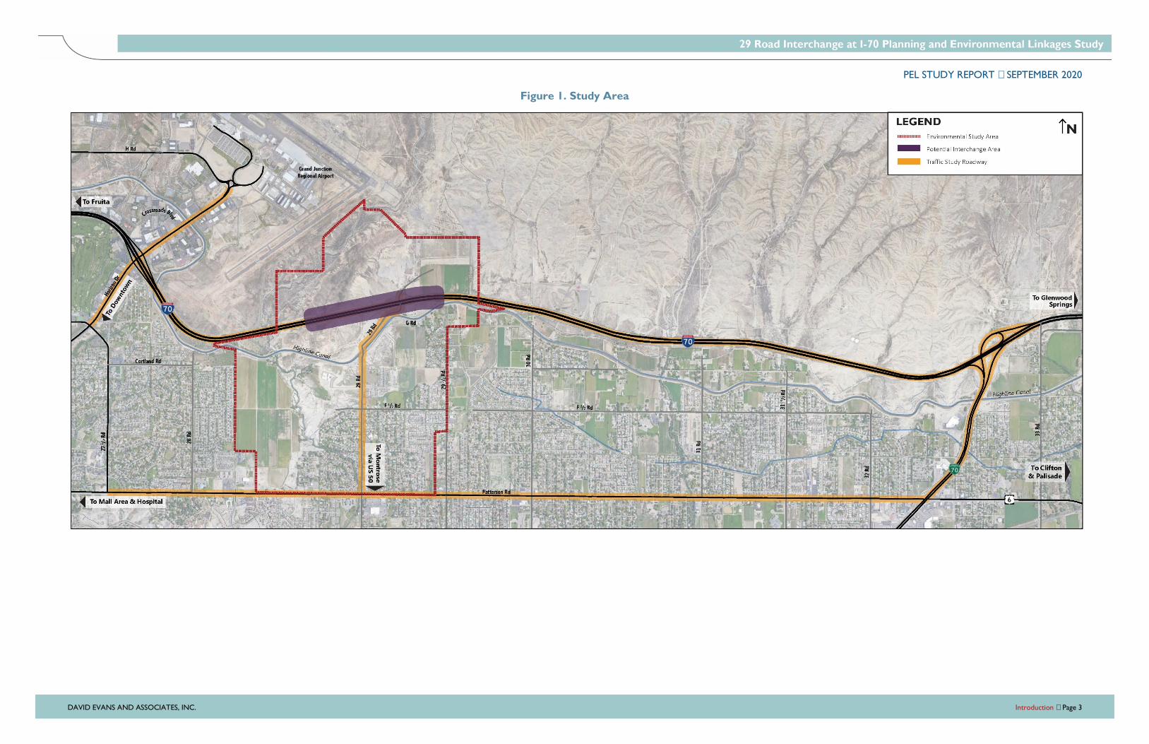
Study Area
The traffic study area and the environmental resource review study area are illustrated in
Figure 1. The traffic study roadways lie within the City of Grand Junction and unincorporated
Mesa County. Traffic volumes were studied along I-70, 29 Road, Patterson Road, and at the
adjacent Horizon Drive and I-70B interchanges. Environmental conditions were studied for
the area surrounding a potential 29 Road interchange location, between CDOT mile post
(MP) 32.7 and MP 33.5. This area was chosen based on CDOT’s standard one-mile minimum
interchange spacing for urban areas (2018 CDOT Roadway Design Guide Section 10.5.3, page
10-12) and area physical constraints, like the Highline Canal.
Regional Planning Context
Many plans have considered improved access to I-70 between Horizon Drive and I-70B. The
planning studies and plans reviewed for this PEL study are listed below. Summaries of these
plans can be found in the Area Conditions Report (June 2019).
� Grand Junction Circulation Plan (2018), Grand Junction
� Grand Valley Regional Transportation Plan Update 2040 (2014), Mesa County
� Grand Junction Regional Airport Master Plan (2009), Grand Junction Regional Airport
� Wildlife Hazard Management Plan (2008), Grand Junction Regional Airport
The Grand Junction Circulation Plan and the Grand Junction Regional Airport Master Plan
both identify a new interchange at 29 Road and I-70.
PEL STUDY REPORT SEPTEMBER 2020
DAVID EVANS AND ASSOCIATES, INC. Introduction Page 3
Figure 1. Study Area

PEL STUDY REPORT SEPTEMBER 2020
DAVID EVANS AND ASSOCIATES, INC. Introduction Page 4
Intentionally blank page
PEL STUDY REPORT SEPTEMBER 2020
DAVID EVANS AND ASSOCIATES, INC. Introduction Page 5
Land Use
Existing Land Use
South of I-70 between Horizon Drive and I-70B, land uses consist primarily of established
single-family residential neighborhoods with churches and schools. Matchett Park, located
west of 29 Road, has remained undeveloped since it was acquired in 1996, but it is planned
as a regional recreational amenity. North of F 1/2 Road, properties remain largely
undeveloped except for Independence Academy Charter School (Independence Academy)
and single family homes. The North I-70 Frontage Road ties into 29 Road just north of the 29
Road bridge over I-70, providing access from areas south of I-70 to the Grand Junction Motor
Speedway and other recreation. Two single family residences and an electrical substation are
located on 29 Road north of the Highline Canal.
Future Land Use
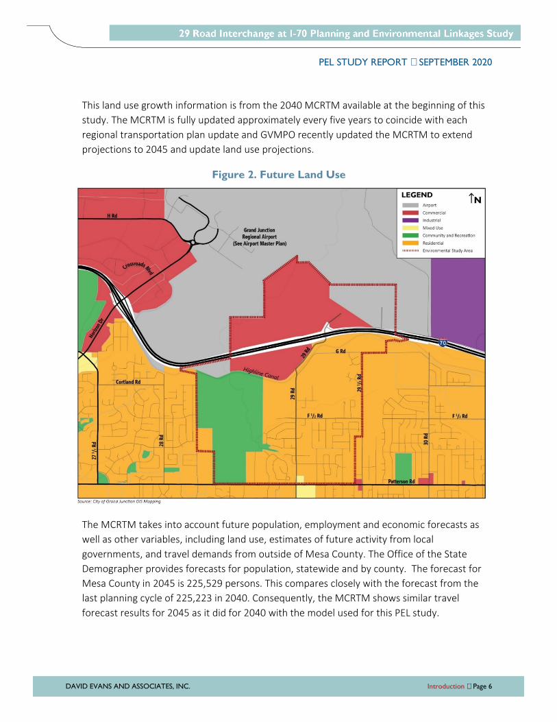
Future planned land uses are depicted in Figure 2. The land use represented on this map
reflects the City of Grand Junction and Mesa County’s land use vision for the study area, as
shown in the Grand Junction Comprehensive Plan. Residential development will remain
between I-70 and Patterson Road with large areas of commercial and industrial development
in the undeveloped properties north of the Highline Canal and I-70. Details on the planned
development expected in the undeveloped areas north of I-70 and between the airport and
the I-70B interchange are described in the Purpose and Need chapter of this report.
The Mesa County Regional Transportation Planning Office estimates future transportation
demand through the use of a travel demand model, formally known as the Mesa County
Regional Travel Model (MCRTM). Socioeconomic data from the GVMPO 2010 and 2040
MCRTMs used for this study were compiled for the traffic analysis zones partially or fully
located within the environmental study area boundaries shown in Figure 2. The household
and employment totals for the year 2010 and forecasted year 2040 are shown in Table 1. As
shown, employment in the area was forecasted to increase by almost 580 jobs by year 2040,
an increase of 421% over existing year 2010 totals. Population in the area was forecasted to
increase by over 600 households, an increase of 79% over existing year 2010 totals.
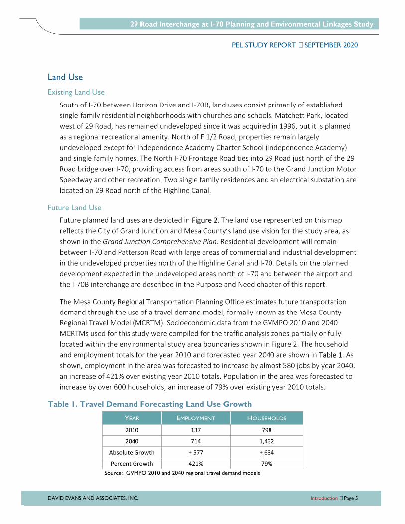
Table 1. Travel Demand Forecasting Land Use Growth
YEAR EMPLOYMENT HOUSEHOLDS
2010 137 798
2040 714 1,432
Absolute Growth + 577 + 634
Percent Growth 421% 79%
Source: GVMPO 2010 and 2040 regional travel demand models
PEL STUDY REPORT SEPTEMBER 2020
DAVID EVANS AND ASSOCIATES, INC. Introduction Page 6
This land use growth information is from the 2040 MCRTM available at the beginning of this
study. The MCRTM is fully updated approximately every five years to coincide with each
regional transportation plan update and GVMPO recently updated the MCRTM to extend
projections to 2045 and update land use projections.
Figure 2. Future Land Use
The MCRTM takes into account future population, employment and economic forecasts as
well as other variables, including land use, estimates of future activity from local
governments, and travel demands from outside of Mesa County. The Office of the State
Demographer provides forecasts for population, statewide and by county. The forecast for
Mesa County in 2045 is 225,529 persons. This compares closely with the forecast from the
last planning cycle of 225,223 in 2040. Consequently, the MCRTM shows similar travel
forecast results for 2045 as it did for 2040 with the model used for this PEL study.

PEL STUDY REPORT SEPTEMBER 2020
DAVID EVANS AND ASSOCIATES, INC. Purpose and Need Page 7
PURPOSE AND NEED
This Purpose and Need statement was developed in coordination with agency stakeholders with
review by the general public. The specific needs, summarized below, are based on the analysis
and findings documented in this report and in separate documents prepared as part of this
project, including the Area Conditions Report. Thorough documentation of the process and
recommendations is a critical element of the PEL process so the decisions can be used in future
NEPA processes.
The existing Horizon Drive interchange provides the main access to the Grand Junction Regional
Airport north of I-70. The existing I-70B interchange has directional ramps only to/from the
south, providing direct movements into and out of the Clifton area and southeastern areas of
Grand Junction. The 29 Road corridor serves as an arterial north-south travel corridor connecting
people in north and south Grand Junction to United States Highway (US) 50, I-70B, North
Avenue, and Patterson Road. There is an existing bridge carrying 29 Road over I-70, but no
access to/from I-70. South of I-70 between the Horizon Drive and I-70B interchanges, land uses
consist primarily of single-family residential neighborhoods with community resources. A future
business park and commercial and industrial development is planned and zoned for the large
undeveloped properties east of the Grand Junction Regional Airport, directly adjacent to and
north of I-70.
Purpose
The purpose of the project is to enhance the region’s transportation network to improve
local and regional connectivity and to provide enhanced access to/from I-70 to planned land
use.
Need
Improved access to I-70 is needed to:
� Address limited transportation network connectivity with no east-central north-south
arterial corridor with access to/from I-70; and
� Provide transportation infrastructure needed to support planned land use adjacent to
and north of I-70.

PEL STUDY REPORT SEPTEMBER 2020
DAVID EVANS AND ASSOCIATES, INC. Purpose and Need Page 8
System Linkage
The City of Grand Junction arterial roadway network (shown in Figure 3) includes several
major east-west roadway corridors providing continuous connections between the eastern
and western edges of the city (at the I-70 and US 50 interchange and the I-70 and I-70B
interchange): I-70, Patterson Road, US 6 (North Avenue), Riverside Parkway/D Road, I-70B,
and US 50. There are three bridges across the Colorado River that lead directly north through
Grand Junction from US 50, the state highway providing access to/from southern Colorado
and further southwest with connections to Utah, Arizona, and New Mexico. The 5th Street
bridge leads to the I-70 and US 50 interchange on the west side of the city. The 32 Road
bridge leads to the I-70 and I-70B interchange on the east side of the city. The 29 Road
bridge provides access through the central area of Grand Junction with a bridge over the
UPRR railyard, a grade-separated interchange at I-70B, and connections to the east-west
corridors listed above, but does not directly access I-70.
The I-70 and Horizon Drive interchange provides the main access to the Grand Junction
Regional Airport and the business areas south of the airport, but Horizon Drive is not a direct
north/south route through the city and does not provide a continuous route to/from US 50.
Figure 3. Grand Junction Arterial Roadway Network
PEL STUDY REPORT SEPTEMBER 2020
DAVID EVANS AND ASSOCIATES, INC. Purpose and Need Page 9
The lack of redundant and continuous north-south arterial corridors with connections to key
east-west corridors (I-70, Patterson Road, US 6 (North Avenue), Riverside Parkway/D Road,
I-70B, and US 50) limits travel choices for residents, visitors, and businesses in central,
southeast, and downtown Grand Junction. Additional infrastructure redundancy in the
arterial transportation network, specifically related to north-south continuity through the city
and I-70 freeway access, will also improve the ability for travelers to move through and
around the city with acceptable traffic operations after a disruptive event or changing
conditions (e.g., construction impacts, emergency or planned closures).
The absence of a north-south arterial corridor with an I-70 interchange in the central Grand
Junction area east of downtown creates out-of-direction travel paths for access to/from I-70.
Residents in established and growing neighborhoods south of I-70 currently must travel east
or west on local streets and/or through multiple intersections along east-west corridors to
access I-70. Intersections along 29 Road south of I-70 currently operate at level of service D
(LOS D) during the morning peak hour with localized congestion observed at the access to
the Independence Academy during school ingress and egress periods. With residential
commuter and school traffic in the morning peak hour, queues on southbound 29 Road at
Patterson Road typically extend past adjacent neighborhood accesses. By 2040, traffic
operations at the 29 Road intersections are expected to degrade to LOS F during the morning
peak hour and LOS E during the evening peak hour.
The existing I-70 and Horizon Drive interchange operates well with LOS A at the ramp
terminal roundabouts during peak hours. There are no identified safety issues at the I-70 and
Horizon Drive interchange, but Horizon Drive south of I-70 has a high number of sideswipe
and angle crashes due to the traffic volumes and density of driveways with a two-way-left-
turn center lane. As future traffic increases, safety issues related to congestion will worsen.
With a street connection only to the south, the I-70B interchange operates well with fully
directional movements on and off the freeway without traffic moving through an
intersection. The existing I-70B interchange configuration would not provide I-70 access for
the planned development areas north of I-70.
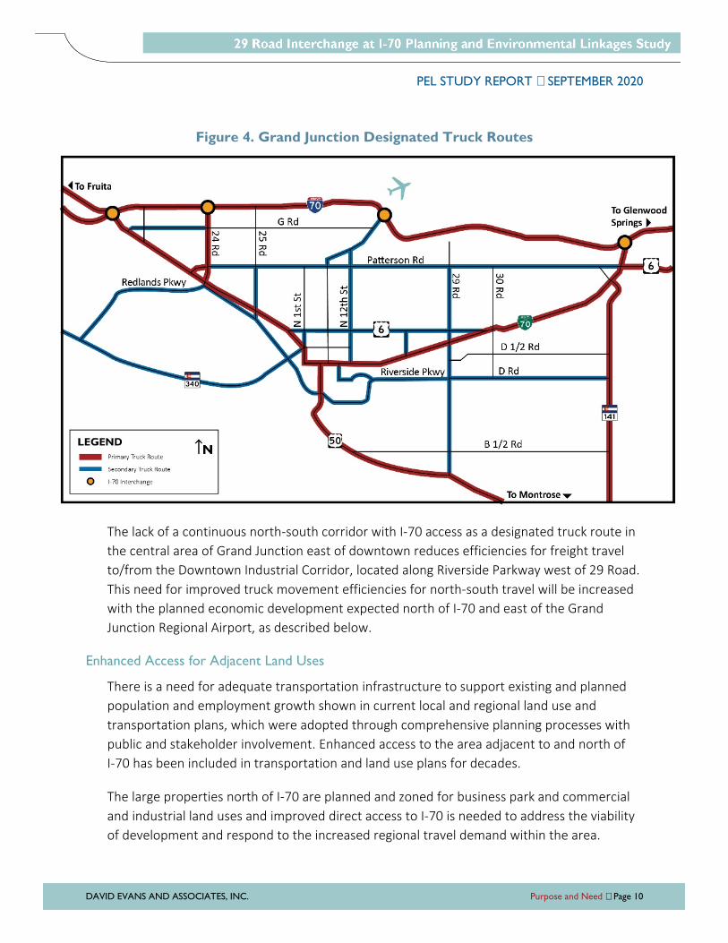
Designated truck routes through the city are illustrated in Figure 4. US 50, I-70B, and 24 Road
are designated primary truck routes with I-70 interchanges. Horizon Drive is a designated
secondary truck route south of I-70. 29 Road is designated a secondary truck route between
US 50 and Patterson Road.
PEL STUDY REPORT SEPTEMBER 2020
DAVID EVANS AND ASSOCIATES, INC. Purpose and Need Page 10
Figure 4. Grand Junction Designated Truck Routes
The lack of a continuous north-south corridor with I-70 access as a designated truck route in
the central area of Grand Junction east of downtown reduces efficiencies for freight travel
to/from the Downtown Industrial Corridor, located along Riverside Parkway west of 29 Road.
This need for improved truck movement efficiencies for north-south travel will be increased
with the planned economic development expected north of I-70 and east of the Grand
Junction Regional Airport, as described below.
Enhanced Access for Adjacent Land Uses
There is a need for adequate transportation infrastructure to support existing and planned
population and employment growth shown in current local and regional land use and
transportation plans, which were adopted through comprehensive planning processes with
public and stakeholder involvement. Enhanced access to the area adjacent to and north of
I-70 has been included in transportation and land use plans for decades.
The large properties north of I-70 are planned and zoned for business park and commercial
and industrial land uses and improved direct access to I-70 is needed to address the viability
of development and respond to the increased regional travel demand within the area.
PEL STUDY REPORT SEPTEMBER 2020
DAVID EVANS AND ASSOCIATES, INC. Purpose and Need Page 11
Improved I-70 access for the area north of the freeway would open up almost 1,400 acres of
developable parcels north of I-70, south of the urban development boundary, and between
the airport and I-70B, including multiple large parcels zoned for Business Park Mixed Use,
Industrial, Commercial/Industrial, and Future Industrial Reserve. A parcel north of I-70 at 29
Road is zoned Planned Development and is about 230 acres owned by one property owner,
which can be master-planned for a major business and commercial development. The
proposed Horizon View Business Park would be the largest planned business park in the city
and would be capable of marketing larger sites for economic development recruitment
purposes. With an interstate-accessible location, the property is also suitable for larger retail
developments, such as an outlet mall, entertainment center, or membership warehouse
store serving regional trade. If the land north of I-70 is developed consistent with current
plans, travel demand and congestion will grow substantially along 29 Road, as it is the only
bridge across I-70 in this area. As a business and commercial development and/or business
park, users will travel east or west on local streets and/or east-west corridors to access I-70,
contributing to future congestion throughout the area between Horizon Drive and I-70B
south of I-70.
The City of Grand Junction, Grand Junction Economic Partnership, and other economic
development partners have had success with recruiting new business to Grand Junction from
the Colorado Front Range, including Rocky Mount Roof Racks and Bonsai Zip Lines. In
addition, the Bureau of Land Management (BLM) is in the process of relocating their
headquarters from Washington DC to Grand Junction. The area north of I-70 and near the
airport would provide a differentiated site for economic development recruitment.
Improved access to I-70 between Horizon Drive and I-70B will also benefit existing and
planned community resources and recreation facilities. Independence Academy was recently
constructed along 29 Road south of I-70. A charter school for pre-Kindergarten through 8th
grade within Mesa County Valley School District 51, the school attracts students throughout
Grand Junction. Improved access to I-70 and the city’s transportation network will enhance
access for the school’s existing community, as well as planned future expansion.
Matchett Park, located west of 29 Road and south of I-70, has remained undeveloped since it
was acquired in 1996, but it is planned as a regional recreational amenity. There is currently
limited regional access to the future park facilities. There is also currently no multimodal
access to BLM recreational opportunities north of I-70 and east of the airport.
PEL STUDY REPORT SEPTEMBER 2020
DAVID EVANS AND ASSOCIATES, INC. Purpose and Need Page 12
Project Goals
Additional goals of enhanced access to/from I-70 between Horizon Drive and I-70B are to:
� Be consistent with local and regional plans
� Improve network capacity
� Improve safety for all modes
� Balance local access and regional mobility
� Enhance local multimodal travel options along planned Active Transportation Corridors
� Avoid, minimize, or mitigate environmental impacts
� Complement local community surroundings and context
PEL STUDY REPORT SEPTEMBER 2020
DAVID EVANS AND ASSOCIATES, INC. Alternatives Evaluation Page 13
ALTERNATIVES EVALUATION
The intent of the alternatives development and evaluation process is to identify and screen a
broad range of reasonable alternatives for the study area that recognizes the project Purpose
and Need and diverse elements of the transportation system and surrounding environment. The
process includes developing screening criteria based on the project Purpose and Need and goals,
developing a range of reasonable alternatives, and narrowing options, if possible, through a
documented and multi-tiered screening process. The PEL study screening process documents
the recommendations for alternatives to be considered during future project development and
NEPA process(es).
The intent of this PEL study was to identify and evaluate alternatives that meet the project
Purpose and Need. The study concluded at the end of Level 1 screening with multiple reasonable
alternatives meeting the Purpose and Need recommended for consideration with future NEPA
process(es).
No Action Alternative
The No Action alternative is included for comparison to the action alternatives under NEPA
(40 CFR §1502.14). Under the No Action alternative, only programmed projects that are
planned and funded by CDOT, Mesa County, City of Grand Junction, or other entities would
be completed. Safety and maintenance activities that are required to sustain the base
transportation system would be provided. New connections and capacity improvements in
the “Existing + Committed” projects in the Grand Valley 2040 Regional Transportation Plan,
excluding the widening of 29 Road from Patterson Road with a new interchange at I-70, are
listed in Table 2. These projects are in the 2040 MCRTM utilized this study. GVMPO recently
updated the MCRTM to extend projections to 2045 and the No Action alternative will be
updated to the latest MCRTM with the travel demand forecasting in future project phases.
Table 2. Existing and Committed Projects Included in No Action Alternative
CORRIDOR SEGMENT LANES FORECAST
YEAR I-70B – Rimrock Avenue to 1st and Grand Four lanes with median 2020
24 Road – Patterson Road to I-70 Five lanes 2020
22 Road – New facility across UPRR and US 6 to River Road Three lanes 2030
F 1/2 Road Parkway – I-70B east to 25 Road/Patterson Road Four lanes with median 2040
23 ½ Road – F 1/2 to G Road Three lanes Post 2040
Source: GVMPO
PEL STUDY REPORT SEPTEMBER 2020
DAVID EVANS AND ASSOCIATES, INC. Alternatives Evaluation Page 14
Level 1 (Purpose and Need) Screening
The purpose of the Level 1 screening is to eliminate fatally flawed alternatives or alternatives
that do not meet the project Purpose and Need. Level 1 screening is supported by the
baseline data compiled and collected for the study. During the Level 1 screening, alternatives
are evaluated qualitatively using available data and professional judgment of the project
team engineering and planning staff.
Level 1 screening criteria were developed to screen concepts using the primary elements of
the project Purpose and Need: system linkage and enhanced access for adjacent land uses.
Concepts were evaluated with a “Yes” or “No” answer to the following questions to
demonstrate each alternative’s ability to meet the individual project needs.
� System Linkage
� Does the alternative improve local connectivity with a central north-south
arterial corridor with I-70 access?
� Will the alternative improve regional connectivity with additional capacity and
reduced delays along north-south arterials with I-70 access within the study
area?
� Will the alternative improve the ability for travelers to move through and around
the region with acceptable traffic operations?
� Does the alternative improve truck movement efficiencies within the city?
� Enhanced Access for Adjacent Land Uses
� Is the alternative consistent with (not in conflict with) adopted local and regional
plans?
� Does the alternative provide transportation infrastructure needed to support
planned land use adjacent to and north of I-70?
An alternative that has a “No” answer to any of the questions is considered to not fully meet
the project Purpose and Need. If a concept should be evaluated quantitatively and with more
criteria in order to make an informed decision, it was carried forward for further evaluation
in future NEPA process(es).
Alternatives Development
A variety of alternatives were identified for consideration, focusing on the project Purpose
and Need to improve north-south network connectivity and provide transportation
infrastructure needed to support planned land use. The range of alternatives developed for
PEL STUDY REPORT SEPTEMBER 2020
DAVID EVANS AND ASSOCIATES, INC. Alternatives Evaluation Page 15
the project included arterial corridor improvements with new interchange access to I-70, as
well as improvements to the existing I-70 interchanges between Horizon Drive and I-70B.
Given the area constraints and the needs described in the Purpose and Need, the following
conceptual action alternatives, in addition to the No Action alternative, were considered in
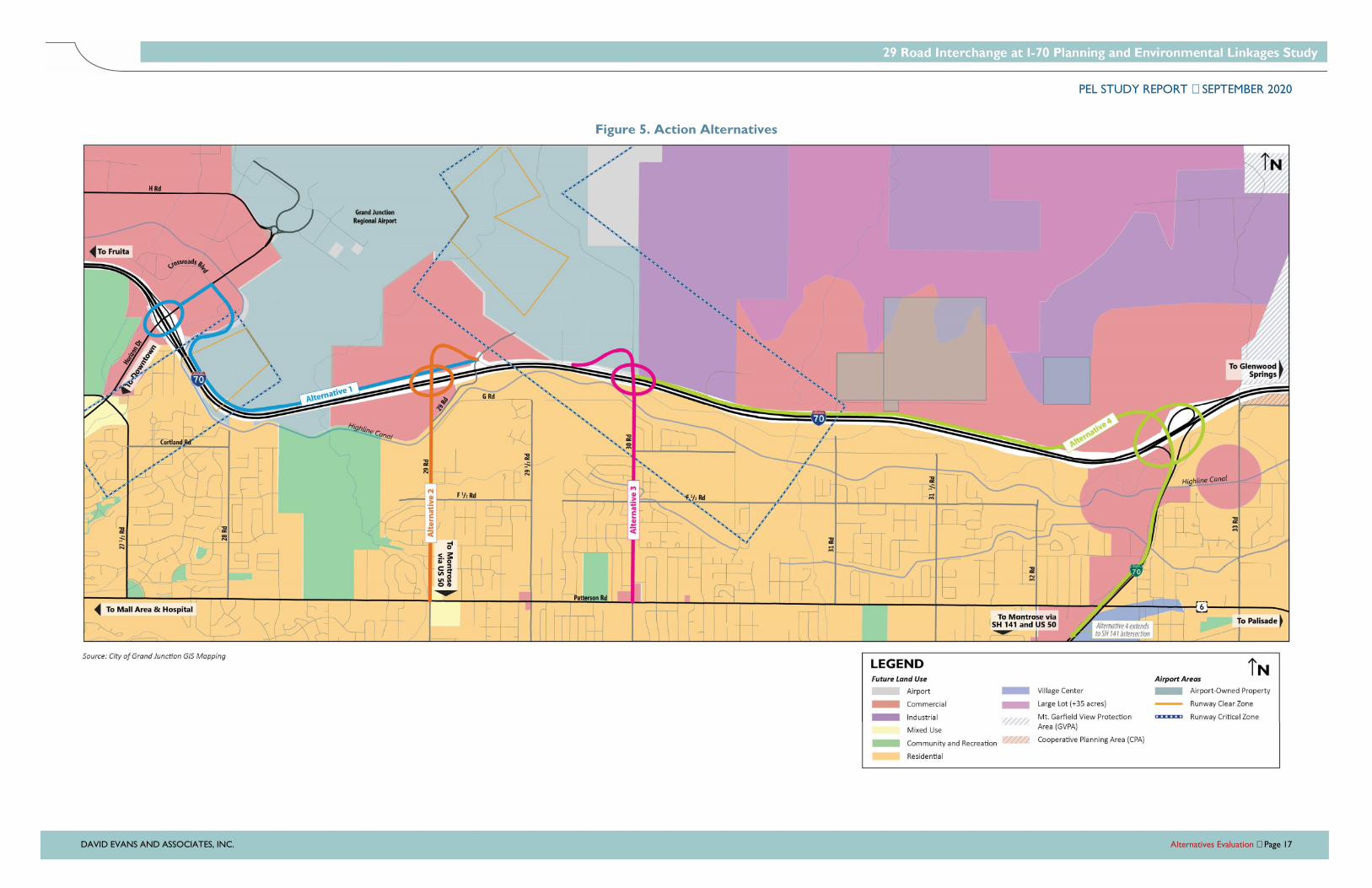
the Level 1 screening. Illustrations of the action alternative concepts are included in Figure 5.
Alternative 1 – I-70/Horizon Drive Interchange Improvements and New North Connection
� Capacity improvements at the I-70/Horizon Drive ramp terminal roundabouts
� Capacity and operational improvements along Horizon Drive north of I-70
� New major collector roadway from the Horizon Drive/Crossroads Boulevard
intersection, across the Highline Canal, and around the airport property within CDOT
right-of-way adjacent to I-70, terminating at the 29 Road/North I-70 Frontage Road
intersection
� New multimodal facilities along new major collector with connections to Active
Transportation Corridor at Horizon Drive
Alternative 2 – New I-70/29 Road Interchange with North Connection
� New grade-separated interchange on I-70 at 29 Road with an arterial connection to the
North I-70 Frontage Road
� Capacity and operational improvements along 29 Road from I-70 to Patterson Road
� New multimodal facilities along 29 Road
Alternative 3 – New Midpoint Interchange with North Connection
� New grade-separated interchange on I-70 approximately halfway between the existing
Horizon Drive and I-70B interchanges (located at 30 Road) with an arterial connection
to the North I-70 Frontage Road
� Capacity and operational improvements along 30 Road from I-70 to Patterson Road
� New multimodal facilities along 30 Road
Alternative 4 – I-70/I-70B (Clifton) Interchange Reconfiguration and New North Connection
� Reconfiguration of the I-70/I-70B interchange to provide arterial access north of I-70
� Capacity and operational improvements along I-70B from I-70 to SH 141
� New principal arterial roadway extending north from the I-70 interchange and west to
the existing paved North Frontage Road
� New multimodal facilities along the new principal arterial with connections to Active
Transportation Corridors crossing I-70B south of I-70

PEL STUDY REPORT SEPTEMBER 2020
DAVID EVANS AND ASSOCIATES, INC. Alternatives Evaluation Page 16
Intentionally blank page
PEL STUDY REPORT SEPTEMBER 2020
DAVID EVANS AND ASSOCIATES, INC. Alternatives Evaluation Page 17
Figure 5. Action Alternatives

PEL STUDY REPORT SEPTEMBER 2020
DAVID EVANS AND ASSOCIATES, INC. Alternatives Evaluation Page 18
Intentionally blank page
PEL STUDY REPORT SEPTEMBER 2020
DAVID EVANS AND ASSOCIATES, INC. Alternatives Evaluation Page 19
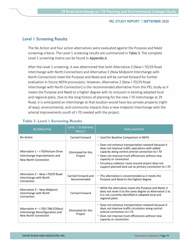
Level 1 Screening Results
The No Action and four action alternatives were evaluated against the Purpose and Need
screening criteria. The Level 1 screening results are summarized in Table 3. The complete
Level 1 screening matrix can be found in Appendix A.
After the Level 1 screening, it was determined that both Alternative 2 (New I-70/29 Road
Interchange with North Connection) and Alternative 3 (New Midpoint Interchange with
North Connection) meet the Purpose and Need and will be carried forward for further
evaluation in future NEPA process(es). However, Alternative 2 (New I-70/29 Road
Interchange with North Connection) is the recommended alternative from this PEL study as it
meets the Purpose and Need to a higher degree with its inclusion in existing adopted local
and regional plans. Due to the long history of planning for the new I-70 interchange at 29
Road, it is anticipated an interchange at that location would have less private property (right-
of-way), environmental, and community impacts than a new midpoint interchange with the
arterial improvements south of I-70 needed with the project.
Table 3. Level 1 Screening Results
ALTERNATIVE LEVEL 1 SCREENING
RESULT EXPLANATION
No Action Carried Forward Used for Baseline Comparison in NEPA
Alternative 1 – I-70/Horizon Drive
Interchange Improvements and
New North Connection
Eliminated for this Project
Does not enhance transportation network because it does not improve traffic operations with added capacity along central arterial connection to I-70
Does not improve truck efficiencies without new capacity or connection
Circuitous collector route around airport does not support planned land use as primary connection to I-70
Alternative 2 – New I-70/29 Road Interchange with North Connection
Carried Forward and Recommended
This alternative is recommended as it meets the Purpose and Need to the highest degree
Alternative 3 – New Midpoint Interchange with North Connection
Carried Forward
While the alternative meets the Purpose and Need, it does not meet it to the same degree as Alternative 2 as it is not currently identified in adopted local and regional plans
Alternative 4 – I-70/I-70B (Clifton) Interchange Reconfiguration and New North Connection
Eliminated for this Project
Does not enhance transportation network because it does not improve traffic circulation along central arterial connection to I-70
Does not improve truck efficiencies without new capacity or connection
PEL STUDY REPORT SEPTEMBER 2020
DAVID EVANS AND ASSOCIATES, INC. Agency and Public Coordination Page 20
AGENCY AND PUBLIC COORDINATION
Understanding the ideas, perspectives, and needs of key stakeholders was critical to building
broadly supported decisions and solutions. The involvement of federal, state, and local agencies
and community members was emphasized throughout the PEL study process and feedback was
solicited at key decision points to guide the alternatives evaluation and shape the study
recommendations.
Technical Team
The study included the formation of a Technical Team that met frequently to provide
technical input and guidance. The Technical Team was heavily involved in shaping the project
Purpose and Need, alternatives that were considered, and alternatives evaluation. Members
of the Technical Team kept their respective elected officials updated. The Technical Team
included staff from:
� Mesa County
� City of Grand Junction
� GVMPO
� CDOT
� FHWA
� Grand Junction Regional Airport
� Federal Aviation Administration
(FAA)
During the first Technical Team meeting, members reviewed and agreed to group goals and
expectations as well as a method of consensus for key decision points, which was
documented through acceptance of the distributed meeting notes. The Technical Team
provided a formal mechanism through which agency representatives could communicate
regional and local needs relating to transportation decisions for the PEL study.
Seven meetings of the Technical Team were held:
� September 20, 2018
� November 7, 2018
� January 15, 2019
� April 30, 2019
� September 12, 2019
� December 11, 2019
� July 16, 2020
PEL STUDY REPORT SEPTEMBER 2020
DAVID EVANS AND ASSOCIATES, INC. Agency and Public Coordination Page 21
Resource Agency Coordination
The study was coordinated with local, state and federal resource agencies, including:
� BLM
� City of Grand Junction Parks and Recreation
� Colorado Department of Public Health and Environment Air Pollution Control Division
� Colorado Department of Public Health and Environment Hazardous Materials and
Waste Management Division
� Colorado Department of Public Health and Environment Water Quality Control Division
� Colorado Historical Society State Historic Preservation Officer
� Colorado Parks and Wildlife Northwest Region – Grand Junction
� Grand Junction Regional Airport
� Grand Valley Water Users Association
� Mesa County Historical Society
� Mesa County Irrigation District
� Palisade Irrigation District
� U.S. Army Corps of Engineers Regulatory Division – Colorado West Branch
� U.S. Bureau of Reclamation, Western Colorado Area Office
� U.S. Environmental Protection Agency Region 8
� U.S. Fish and Wildlife Service Colorado Field Office
� Ute Water Conservancy District
Information was distributed to representatives at these resource agencies at three points
during the study. Early in the study, a letter and study area map were mailed as an
introduction to the PEL study process and confirmation of preferred contact information was
requested. A second letter requested review of the Draft Area Conditions Report related to
their specific resource(s). The final letter provided a link to the Draft PEL Study Report
documenting the draft study recommendations to facilitate review of potential resource
impacts and next steps required for future NEPA processes. A summary matrix of the
resource agency coordination and input is included in Appendix B.
PEL STUDY REPORT SEPTEMBER 2020
DAVID EVANS AND ASSOCIATES, INC. Agency and Public Coordination Page 22
Additional Stakeholder Coordination
Small group meetings were held with individuals representing public agencies, organizations,
and other stakeholders directly affected by the project to identify likely impacts and help
shape the study recommendations. These meetings and presentations occurred as follows:
� GVMPO Technical Advisory Committee meeting – January 9, 2019
� Grand Junction City Council workshop – January 14, 2019
� Mesa County Board of County Commissioners briefing – January 15, 2019
� GVMPO Technical Advisory Committee meeting – February 13, 2019
� Grand Junction Regional Airport Board update – April 4, 2019
� FHWA and CDOT Draft Purpose and Need review meeting – May 16, 2019
� CDOT and Local Agency leadership meeting – February 26, 2020
� Associated Members for Growth and Development meeting – September 2, 2020
Public Engagement
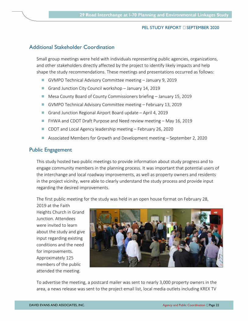
This study hosted two public meetings to provide information about study progress and to
engage community members in the planning process. It was important that potential users of
the interchange and local roadway improvements, as well as property owners and residents
in the project vicinity, were able to clearly understand the study process and provide input
regarding the desired improvements.
The first public meeting for the study was held in an open house format on February 28,
2019 at the Faith
Heights Church in Grand
Junction. Attendees
were invited to learn
about the study and give
input regarding existing
conditions and the need
for improvements.
Approximately 125
members of the public
attended the meeting.
To advertise the meeting, a postcard mailer was sent to nearly 3,000 property owners in the
area, a news release was sent to the project email list, local media outlets including KREX TV
PEL STUDY REPORT SEPTEMBER 2020
DAVID EVANS AND ASSOCIATES, INC. Agency and Public Coordination Page 23
publicized the meeting in advance and after the meeting, and local agency partners
distributed information on their websites, to their email list serves, and through social media.
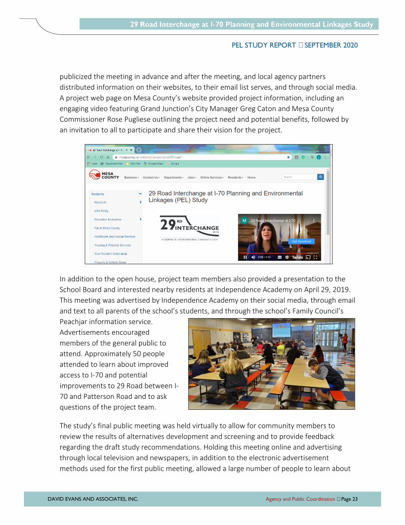
A project web page on Mesa County’s website provided project information, including an
engaging video featuring Grand Junction’s City Manager Greg Caton and Mesa County
Commissioner Rose Pugliese outlining the project need and potential benefits, followed by
an invitation to all to participate and share their vision for the project.
In addition to the open house, project team members also provided a presentation to the
School Board and interested nearby residents at Independence Academy on April 29, 2019.
This meeting was advertised by Independence Academy on their social media, through email
and text to all parents of the school’s students, and through the school’s Family Council’s
Peachjar information service.
Advertisements encouraged
members of the general public to
attend. Approximately 50 people
attended to learn about improved
access to I-70 and potential
improvements to 29 Road between I-
70 and Patterson Road and to ask
questions of the project team.
The study’s final public meeting was held virtually to allow for community members to
review the results of alternatives development and screening and to provide feedback
regarding the draft study recommendations. Holding this meeting online and advertising
through local television and newspapers, in addition to the electronic advertisement
methods used for the first public meeting, allowed a large number of people to learn about

PEL STUDY REPORT SEPTEMBER 2020
DAVID EVANS AND ASSOCIATES, INC. Agency and Public Coordination Page 24
the proposed improvements and offer comments while maintaining physical distance and
avoiding the spread of COVID-19. A video was posted to the project web page with graphics
and associated text both on screen and read aloud, followed by a survey. The video was
viewed approximately 600 times. For those without internet access, hard copies of the
graphics and on-screen text were available at the Mesa County Central Services Building for
pick-up, along with printed comment forms.
Public Comments
Input was solicited at the public meetings and community members were also able to submit
comments via the project web page throughout the course of the study. Comments received
were posted to the project web page and shared with the project staff and Technical Team.
Summaries of comments received are included in Appendix C and main comment themes are
summarized in Table 4.
Table 4. Public Comment Themes
SOURCE COMMENT THEME
Surrounding Public Meeting #1
Strong agreement with Purpose and Need elements. The interchange is needed.
This project is long awaited and should be funded.
The project will bring improved travel efficiency and needed connections.
The project could benefit the economy and prepares the city for future growth.
Characteristics of neighborhoods surrounding the project may be changed and residential impacts could occur due to increased traffic, trucks, and noise.
Concern that this project may increase traffic on Patterson Road.
Traffic calming measures need to be implemented.
Pedestrian safety is important.
Include bike lanes or facilities that promote safe pedestrian travel (especially near the school).
Need a signalized intersection at Independence Academy.
29 Road will need widened and traffic calming measures added.
Many suggestions for other roadway improvements around the city in addition to a 29 Road interchange.
Concern regarding commercial development (at the interchange south of I-70) near homes and Independence Academy.
Independence Academy School Board & Community Meeting
Need additional bond money designated for this project.
Morning and afternoon congestion should be fixed with traffic signal improvements.
Don’t do the project and fix existing roads instead.
Consider plans for the 29 Road interchange that have been in place for many years. The interchange is needed.
PEL STUDY REPORT SEPTEMBER 2020
DAVID EVANS AND ASSOCIATES, INC. Agency and Public Coordination Page 25
SOURCE COMMENT THEME
Project Web Page Between Public Meetings
Support for the project beginning quickly.
Funds should be spent on other projects in the County instead.
The project will improve airport connections but landing lights may distract drivers.
Concern that new access to 29 Road will add additional traffic to nearby roadways.
Concern that the project will impact the Grand Valley Power substation.
Surrounding Public Meeting #2
Majority of commenters support the study’s recommended alternative (New I-70/29 Road Interchange with North Connection).
- Positive outcomes anticipated, including improved access and reduced congestion.
- 29 Road interchange is long overdue and necessary for the community.
- Best option of all the alternatives presented.
Concerns of those opposed to study recommendations:
- Impacts along 29 Road with truck traffic, school/bicyclist/pedestrian safety issues, and added congestion.
- Don’t want neighborhood character change, including increased noise/pollution.
- Don’t agree with the need for a new interchange and/or it should not be a funding priority.
Need improvements to 29 Road south of Patterson with new interchange.
Need for safe walking and bicycling facilities, especially for children.
Mixed reviews for the New Midpoint Interchange with North Connection.
- Support due to improved access and avoiding impacts to 29 Road.
- May be less convenient and more impactful than a 29 Road interchange.
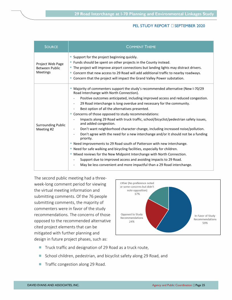
The second public meeting had a three-
week-long comment period for viewing
the virtual meeting information and
submitting comments. Of the 76 people
submitting comments, the majority of
commenters were in favor of the study
recommendations. The concerns of those
opposed to the recommended alternative
cited project elements that can be
mitigated with further planning and
design in future project phases, such as:
� Truck traffic and designation of 29 Road as a truck route,
� School children, pedestrian, and bicyclist safety along 29 Road, and
� Traffic congestion along 29 Road.
PEL STUDY REPORT SEPTEMBER 2020
DAVID EVANS AND ASSOCIATES, INC. Study Recommendations Page 26
STUDY RECOMMENDATIONS
Based on the results of the alternatives evaluation process, two alternatives will be carried
forward into future project development and NEPA evaluation. These recommendations were
presented at the second public meeting for the PEL study to solicit feedback on the alternatives
evaluation process and the draft study recommendations. Comments received from the public
indicate overall support for the study recommendations. Themes of the public comments on the
project are described in the Public and Agency Coordination section of this report.
Alternatives to be Carried Forward
Two action alternatives meet the project Purpose and Need and are considered reasonable
alternatives to be carried forward into future NEPA process(es):
� Alternative 2 – New I-70/29 Road Interchange with North Connection
� Alternative 3 – New Midpoint Interchange with North Connection
Only the potential locations along I-70 and arterial connections for the new interchanges
were identified for this study. Interchange concept layouts will be developed and evaluated
with the next phases of project development, as a preferred alternative is identified in the
NEPA process. Design elements will be defined to consider design solutions to minimize costs
and operational, safety, and property impacts while maximizing project connectivity and
access benefits for the surrounding region. As project development moves forward, the area
conditions inventory and environmental overview completed for this PEL study should be
reviewed and updated as needed to reflect the most current conditions for consideration of
impacts and avoidance.
Interchange Spacing
According to the CDOT Roadway Design Guide (2018), the minimum interchange spacing
should be one mile in urban areas. It also notes that in urban areas spacing of less than one
mile may be allowed with the use of auxiliary lanes, grade-separated ramps, or collector-
distributor roads. The area surrounding I-70 and 29 Road is within the GVMPO urban
boundary and is considered an urban area. Interchange spacing is defined by American
Association of State Transportation Officials (AASHTO) as the distance between the cross-
streets.
PEL STUDY REPORT SEPTEMBER 2020
DAVID EVANS AND ASSOCIATES, INC. Study Recommendations Page 27
With the initial alternatives developed for the PEL study, an interchange at 29 Road
(Alternative 2) is expected to have spacing of about 1.4 to 1.6 miles to Horizon Drive. An
interchange located about halfway between the existing Horizon Drive and I-70B
interchanges (Alternative 3) would have spacing of about 2.6 miles to Horizon Drive. More
distance between interchanges may be better for freeway operations, but an interchange in
the vicinity of 29 Road does meet the CDOT and AASHTO recommended minimums.
The National Cooperative Highway Research Program (NCHRP) Report 687 Guidelines for
Ramp and Interchange Spacing (Transportation Research Board, 2011) outlines research of
the impact of ramp spacing on mainline freeway speed. It showed that ramp spacing (the
distance between ramp gore points) has the greatest impact when traffic volumes of the
freeway, the ramps, or both are near, but not at, capacity. Under low to moderate volume,
such as the existing and future forecasted volumes at I-70, 29 Road, and Horizon Drive,
changes in ramp spacing generally have little effect on freeway operations.
Considering a potential 29 Road interchange location between MP 32.7 and MP 33.5 and a
typical diamond interchange layout, the distance between the 29 Road and Horizon Drive
ramp merge and diverge points (the ramp spacing) is estimated at about 4,700 feet. The
NCHRP Report 687 provides a planning level tool depicting the relationship between
entrance-exit ramp spacing and relative crash risk. The tool shows that the incremental
safety benefit of providing ramp spacing longer than 2,600 feet is relatively negligible.
Recommended Alternative
Alternative 2 (New I-70/29 Road Interchange with North Connection) is the recommended
alternative from this PEL study as it meets the Purpose and Need and project goals to the
highest degree with its inclusion in existing adopted local and regional plans. It is also
anticipated an interchange at 29 Road would have less private property (right-of-way),
environmental, and community impacts than the new midpoint interchange alternative. The
following sections describe several considerations for further assessment during future NEPA
process(es) and project development.
I-70 Freeway Operations and Safety
As part of the initial area conditions evaluation, projected traffic forecasts utilizing the 2040
Mesa County Regional Travel Model (the most current available model during the study)
were developed. A new interchange at 29 Road was included in the “Existing + Committed”
projects in the Grand Valley 2040 Regional Transportation Plan. The project team completed
traffic analysis for I-70 and the adjacent interchanges with and without a new interchange at
PEL STUDY REPORT SEPTEMBER 2020
DAVID EVANS AND ASSOCIATES, INC. Study Recommendations Page 28
29 Road using Highway Capacity Software. The forecasts and initial I-70 evaluation and
results are described in the Area Conditions Report.
The 2040 traffic forecasts show a 30% increase in traffic along I-70 between Horizon Drive
and 29 Road with the addition of the new interchange connection. For the initial analysis, the
I-70 operations between the 29 Road and Horizon Drive were analyzed as separate ramp
merge and diverge areas with no auxiliary lane connection between the on and off ramps.
The I-70 traffic analyses with and without the new interchange showed an increase in
vehicular density along I-70 with the new 29 Road interchange. The freeway and the ramp
merge and diverge areas would operate well at LOS A or LOS B during the AM and PM peak
hours in 2040 with or without the new interchange. This indicates that the freeway would
not be negatively impacted with the approximate 1.5-mile spacing between the 29 Road and
Horizon Drive interchanges.
Auxiliary Lane Analysis
An additional Highway Capacity Software analysis was completed to consider an auxiliary
lane in each direction along I-70 between the Horizon Drive and 29 Road interchanges to
potentially mitigate impacts to I-70 traffic from short ramp-to-ramp trips. The analysis looked
at the future traffic operations of the weaving segment, which is defined by the Highway
Capacity Manual as the segment between an on ramp and an off ramp where the two ramps
are connected by an auxiliary lane. Under this scenario, the two ramps would be connected
by an auxiliary lane that drops at the off ramp, creating a one-sided weave where no weaving
maneuver requires more than one lane change. The analysis results show the weaving
segment between the interchanges would operate at LOS A or LOS B during the AM and PM
peak hours with the 2040 traffic projections.
Operations Beyond 2040
To consider operations beyond the 2040 traffic volume projections, a sensitivity analysis was
completed to evaluate increased levels of traffic volumes. The freeway and ramp volumes at
each interchange were linearly increased until any segment operated worse than LOS D. In
the eastbound direction, the weaving section degraded to LOS F in the PM peak hour at
double the 2040 projected traffic volumes. In the westbound direction, the weaving section
did not degrade to LOS F until PM peak hour volumes were at levels 2.5 times the 2040
projected traffic volumes.
Considering the average 3.2% annual growth rate in the travel demand model forecasts
along this segment of I-70, the weaving section would not degrade to unacceptable (lower
than LOS D) operations until after 2060. That far into the future, it can be expected that
PEL STUDY REPORT SEPTEMBER 2020
DAVID EVANS AND ASSOCIATES, INC. Study Recommendations Page 29
advancements in connected and autonomous vehicles will likely increase the general
capacity of freeway and weaving, merging, and diverging areas. This may prolong the
operations along this section of I-70 even longer.
The planning-level analysis completed for this study with the Highway Capacity Software
shows that constructing a new interchange on I-70 in the vicinity of 29 Road will not create
operational issues well beyond the planning horizon. Increasing the interchange spacing from
Horizon Drive with the new interchange located about halfway between Horizon Drive and
I-70B (as in the Alternative 3 developed with this study) does not change the operational
results from the Highway Capacity Software.
Future project development to define the specific location of the new interchange and the
interchange layout with lane configurations for the ramps and I-70 design should consider
more detailed traffic analysis with microsimulation software to identify specific operational
issues and potential mitigation measures.
Safety
The crash history for the section of I-70 from west of Horizon Drive to east of I-70B
interchanges from January 2015 to December 2017 is summarized in the Area Conditions
Report. There is a spike in the number of crashes that occurred around milepost (MP) 32,
where there is a curve just east of the Horizon Drive interchange. In late 2018 cable rail was
installed in the I-70 median near Horizon Drive and in early 2019 the I-70 speed limit was
reduced from 75 miles per hour to 70 miles per hour between MP 24.9 (west of the study
area) to MP 32.2 (east of the curves east of Horizon Drive) due to a high number of crashes
experienced in the area.
CDOT developed Highway Segment Safety Performance Functions (SPFs) to estimate the
average crash frequency for a specific site type as it relates to the annual average daily traffic
of the facility. These SPFs are used to predict the potential that a corridor has for crash
reduction based on the observed versus the predicted crash frequency. Based on the
number of crashes from 2015 through 2017, the SPF for this section of I-70 is around the
expected mean for Urban 4-Lane Divided Freeways with an average annual daily traffic of
23,100 vehicles per day, indicating a moderate potential for crash reduction.
Within the potential 29 Road interchange area (MP 32.7-33.5), there was a spike in crashes
at MP 33. However, four of the five of those crashes occurred within one hour of one day in
snow/icy conditions, indicating that most of those crashes can be considered secondary
crashes.

PEL STUDY REPORT SEPTEMBER 2020
DAVID EVANS AND ASSOCIATES, INC. Study Recommendations Page 30
With the I-70 safety mitigation measures implemented recently within the study area, future
projects phases for the interchange should include a full safety evaluation with the latest
crash data, including as much time after the changes as possible in the evaluation period.
29 Road Arterial Improvements
As shown in the Area Conditions Report, the 2040 traffic volume projections along 29 Road
increase substantially to over 28,000 vehicles per day between I-70 and F 1/2 Road with the
29 Road interchange at I-70 connection. The I-70/29 Road interchange project includes
widening 29 Road to a four-lane arterial with multimodal improvements between I-70 and
Patterson Road. The potential typical sections for 29 Road are shown in Figure 6. The City of
Grand Junction standard cross-section for a principal arterial is 110 feet wide with a
detached sidewalk on both sides of the roadway. However, a narrowed cross-section with
reduced median, outside lane, and sidewalk buffer width may be considered to reduce the
overall right-of-way width to 90 feet. To further minimize property impacts at specific
locations, the sidewalk buffer may be eliminated with an attached sidewalk.
Figure 6. Potential 29 Road Cross-Section
When 29 Road is widened to a four-lane arterial with the I-70 interchange connection,
intersections will be modified with enhanced improvements (traffic signal or roundabout) at
full-movement intersections. The potential locations for future enhanced intersection
PEL STUDY REPORT SEPTEMBER 2020
DAVID EVANS AND ASSOCIATES, INC. Study Recommendations Page 31
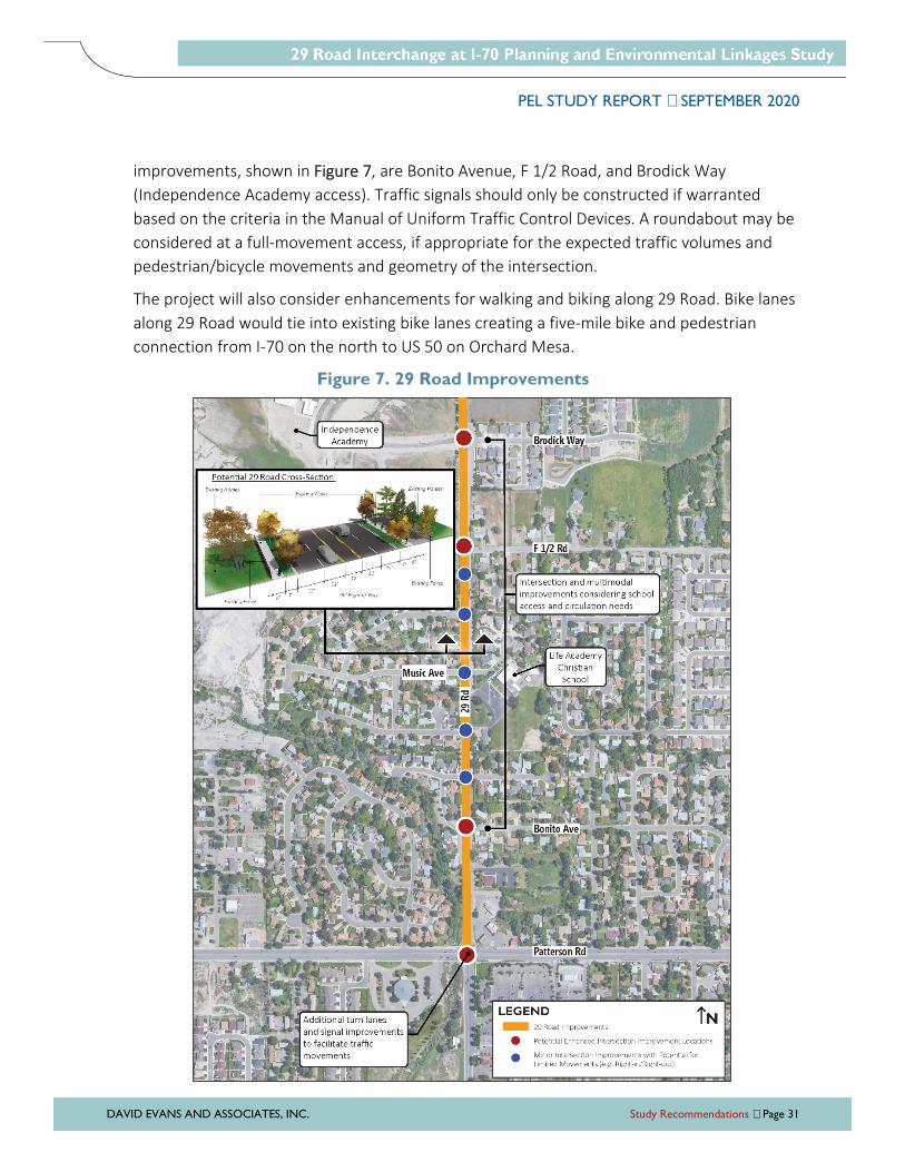
improvements, shown in Figure 7, are Bonito Avenue, F 1/2 Road, and Brodick Way
(Independence Academy access). Traffic signals should only be constructed if warranted
based on the criteria in the Manual of Uniform Traffic Control Devices. A roundabout may be
considered at a full-movement access, if appropriate for the expected traffic volumes and
pedestrian/bicycle movements and geometry of the intersection.
The project will also consider enhancements for walking and biking along 29 Road. Bike lanes
along 29 Road would tie into existing bike lanes creating a five-mile bike and pedestrian
connection from I-70 on the north to US 50 on Orchard Mesa.
Figure 7. 29 Road Improvements
PEL STUDY REPORT SEPTEMBER 2020
DAVID EVANS AND ASSOCIATES, INC. Study Recommendations Page 32
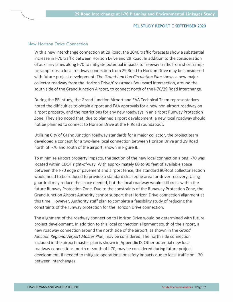
New Horizon Drive Connection
With a new interchange connection at 29 Road, the 2040 traffic forecasts show a substantial
increase in I-70 traffic between Horizon Drive and 29 Road. In addition to the consideration
of auxiliary lanes along I-70 to mitigate potential impacts to freeway traffic from short ramp-
to-ramp trips, a local roadway connection from 29 Road to Horizon Drive may be considered
with future project development. The Grand Junction Circulation Plan shows a new major
collector roadway from the Horizon Drive/Crossroads Boulevard intersection, around the
south side of the Grand Junction Airport, to connect north of the I-70/29 Road interchange.
During the PEL study, the Grand Junction Airport and FAA Technical Team representatives
noted the difficulties to obtain airport and FAA approvals for a new non-airport roadway on
airport property, and the restrictions for any new roadways in an airport Runway Protection
Zone. They also noted that, due to planned airport development, a new local roadway should
not be planned to connect to Horizon Drive at the H Road roundabout.
Utilizing City of Grand Junction roadway standards for a major collector, the project team
developed a concept for a two-lane local connection between Horizon Drive and 29 Road
north of I-70 and south of the airport, shown in Figure 8.
To minimize airport property impacts, the section of the new local connection along I-70 was
located within CDOT right-of-way. With approximately 60 to 90 feet of available space
between the I-70 edge of pavement and airport fence, the standard 80-foot collector section
would need to be reduced to provide a standard clear zone area for driver recovery. Using
guardrail may reduce the space needed, but the local roadway would still cross within the
future Runway Protection Zone. Due to the constraints of the Runaway Protection Zone, the
Grand Junction Airport Authority cannot support that Horizon Drive connection alignment at
this time. However, Authority staff plan to complete a feasibility study of reducing the
constraints of the runway protection for the Horizon Drive connection.
The alignment of the roadway connection to Horizon Drive would be determined with future
project development. In addition to this local connection alignment south of the airport, a
new roadway connection around the north side of the airport, as shown in the Grand
Junction Regional Airport Master Plan, may be considered. The north side connection
included in the airport master plan is shown in Appendix D. Other potential new local
roadway connections, north or south of I-70, may be considered during future project
development, if needed to mitigate operational or safety impacts due to local traffic on I-70
between interchanges.
PEL STUDY REPORT SEPTEMBER 2020
DAVID EVANS AND ASSOCIATES, INC. Study Recommendations Page 33
Figure 8. Potential New Horizon Drive Connection
PEL STUDY REPORT SEPTEMBER 2020
DAVID EVANS AND ASSOCIATES, INC. Environmental Summary Page 34
ENVIRONMENTAL SUMMARY
The purpose of this section is to summarize environmental resources present and identify next
steps to be completed during future NEPA process(es). Both alternatives carried forward from
this PEL study involve a new interchange on I-70, which is a federal facility and will require
compliance with NEPA requirements, regardless of the funding source. Specific environmental
impacts and mitigation measures will be determined during the subsequent NEPA evaluation
process and included in final plans as improvements move to construction.
The Area Conditions Report provides detailed information regarding regulatory requirements for
the resources analyzed for this PEL Study. The environmental study area is focused around the
area of most likely physical impacts of a new I-70 interchange at 29 Road. The environmental
study area did not include the area for Alternative 3 (New Midpoint Interchange with North
Connection); all discussion of existing conditions in the following sections are only for the
recommended alternative: Alternative 2 (New I-70/29 Road Interchange with North Connection).
If Alternative 3 is selected as the preferred alternative in a future NEPA process, environmental
resources will need to be further reviewed and assessed for presence prior to determining
impacts and mitigation. The next steps information for each resource applies to both alternatives
as the regulatory processes are the same regardless of interchange location.
As discussed in the Agency and Public Coordination Section of this report, resource agencies
were provided the Draft PEL Study Report for review. Comments were received from the
following agencies and incorporated as appropriate in this report:
� City of Grand Junction Parks and Recreation
� Colorado Department of Public Health and Environment Hazardous Materials and
Waste Management Division
� Colorado Historical Society State Historic Preservation Officer
� Colorado Parks and Wildlife Northwest Region – Grand Junction
� Grand Junction Regional Airport
� Grand Valley Drainage District
� Palisade Irrigation District
� U.S. Bureau of Reclamation, Western Colorado Area Office
� U.S. Environmental Protection Agency Region 8
� U.S. Fish and Wildlife Service Colorado Field Office
PEL STUDY REPORT SEPTEMBER 2020
DAVID EVANS AND ASSOCIATES, INC. Environmental Summary Page 35
The following agencies responded stating no issues with the project and no comments on the
report:
� BLM
� Colorado Department of Public Health and Environment Air Pollution Control Division
� Colorado Department of Public Health and Environment Water Quality Control Division
� Grand Valley Water Users Association
� U.S. Army Corps of Engineers Regulatory Division – Colorado West Branch
� Ute Water Conservancy District
The following agencies did not respond or provide comments on the Draft PEL Study report:
� Mesa County Historical Society
� Mesa County Irrigation District
The resources assessed for this study are listed below. Maps of resources present in the study
area can be found in Appendix E.
� Built Environment:
» Air Quality
» Community and Social Resources
» Floodways and 100-year Floodplains
» Hazardous Materials
» Historic Resources
» Noise
» Parks and Recreational Resources
� Natural Environment:
» Prime and Unique Farmlands
» Water Quality
» Threatened and Endangered Species
and Biological Resources
» Wetlands and Waters of the U.S.
Built Environment
Air Quality
The study area is located within the Western Slope monitoring region and is within an
attainment status for all National Ambient Air Quality Standard criteria pollutants (carbon
monoxide, ground level ozone, sulfur dioxide, nitrogen dioxide, particulate matter, and lead).
PEL STUDY REPORT SEPTEMBER 2020
DAVID EVANS AND ASSOCIATES, INC. Environmental Summary Page 36
As both alternatives carried forward are located in an attainment area, no quantitative
analysis would be required in a subsequent NEPA analysis as long as the area continues to be
in attainment for the six criteria pollutants. A qualitative analysis of impacts may be required.
Community Resources
Land use in the study area is composed primarily of residential and agricultural, with
interspersed commercial development primarily along Patterson Road. Community and
social resources within the study area include:
� Independence Academy Charter School (675 29 Road)
� Life Tabernacle Church and Academy Christian School (363 29 Road)
� Grace Point Church (606 28 3/4 Road)
� Bookcliff Heights Congregation (608 29 Road)
� Darla Jean Park (2868 Darla Drive)
� Matchett Park (28 1/4 Road and Patterson Road)
There are no environmental justice (low income or limited-English proficient) populations
located in the study area.
Information on community composition and community issues should be collected and
refined throughout future project development. The study area should at least include
communities within and immediately surrounding the preferred alternative. Additionally,
ongoing conversations with property owners, businesses, and residences potentially affected
should also be a critical part of future project development.
Floodways and 100-year Floodplains
A review of Federal Emergency Management Agency (FEMA) flood insurance rate maps was
conducted and no FEMA floodplain designations occur within the study area. The existing
Indian Wash channel runs northwest to southeast through the project area, running adjacent
to 29 Road just north of Patterson Road. There is no designated FEMA floodplain north of
Patterson Road, but to the south of Patterson Road is a designated Zone AE with base flood
elevations determined. The upstream crossing of I-70 for Indian Wash consists of a two-cell
10-foot by 10-foot reinforced concrete box culvert.
Changes to 29 Road may require hydraulic modeling for the channel with future project
development due to the proximity to the channel and the downstream floodplain
designation.
PEL STUDY REPORT SEPTEMBER 2020
DAVID EVANS AND ASSOCIATES, INC. Environmental Summary Page 37
Hazardous Materials
The environmental records search identified hazardous material facilities present in the or
near the study area. Only one facility was identified within the environmental study area: the
Lucky Me gas station in the northeast corner of the 29 Road and Patterson Road intersection.
A Modified Phase I Environmental Site Assessment or CDOT Initial Site Assessment should be
conducted at site-specific locations to evaluate hazardous materials that may require
remediation prior to acquisition or development. Based on the results of the future
investigations, further subsurface investigations, including the collection of subsurface soil
samples and groundwater samples, may be required to delineate the specific horizontal and
vertical extents of contamination. During the design process, this information can be used to
identify avoidance options, when possible, and to develop specific contaminated
soils/groundwater material management or mitigation measures. The Colorado Department
of Public Health and Environment Hazardous Materials and Waste Management Division
should be contacted regarding potential surface water and groundwater issues that may be
encountered during construction.
Historic Resources
There are no properties listed on the Colorado State Register of Historic Properties or the
National Register for Historic Places (NRHP) in the study area, however there are properties
that have been previously recorded in the study area. The City of Grand Junction does not
have any designated landmarks or historic districts within the study area.
A total of nine historic properties have been previously recorded within the study area,
including eight residential properties and one irrigation ditch. The residences were
constructed between 1900 and 1925. Previous survey of these properties was conducted in
1981 and no assessment was made regarding their eligibility. It is possible that the eligibility
status noted in this report could change once the Section 106 process takes place.
The irrigation ditch, the Government Highline Canal, was constructed between 1912 in 1915
and is significant for its association with early Bureau of Reclamation irrigation programs and
the economic development of Mesa County. The canal extends for 55 miles through the
northern area of Grand Valley. Sections of the canal have been lined with membranes and
concrete. The Government Highline Canal was determined Officially Eligible in 1985. This
resource extends across the width of the study area south of I-70 and will be potentially
impacted by both alternatives carried forward.
PEL STUDY REPORT SEPTEMBER 2020
DAVID EVANS AND ASSOCIATES, INC. Environmental Summary Page 38
During future NEPA process(es), historic resources will need to be evaluated under Section
106 of the National Historic Preservation Act and Section 4(f) (23 CFR 774) of the U.S.
Department of Transportation Act of 1966 (Section 4(f)). An Area of Potential Effect will need
to be established and all historic resources identified in this study will need to be evaluated
for eligibility and effects once a project is identified and funded to move forward into NEPA.
In addition, any other resources that are 45 years or older that have not been previously
surveyed or were outside the environmental study area will need to be evaluated.
If there is an adverse effect determination under Section 106 for a historic property, there
also may be a “use” under Section 4(f). Use of Section 4(f) resources should be avoided and
minimized wherever possible. A Section 4(f) evaluation may be required if use of these
resources occurs as a result of the project.
Noise
CDOT categorizes the sensitivity of noise receptors based on a property’s land use type and
has associated Noise Abatement Criteria (NAC) for each land use type. The NAC are noise
levels that are compared to existing or future noise levels during NEPA to determine the
impact threshold. The land use types, NAC decibel level, activity description and study area
presence are summarized in Table 5.
A noise assessment should be performed to determine noise sensitive receptors that may be
impacted by the preferred alternative in NEPA. Typically, any receptors within 500 feet of the
roadway are included in the analysis to be sure that they will not exceed the NAC threshold.
The noise assessment should include modeling both existing and future conditions to
evaluate if mitigation may be required.
For noise mitigation to be recommended as part of the project, it must be considered both
“reasonable and feasible” based on CDOT criteria. Noise mitigation is feasible if it can be
constructed without major engineering or safety issues, provides a reduction of at least five
decibels to at least one impacted receptor, and a wall that is 20 feet high or less reduces
noise by at least seven decibels at a minimum of one benefitted receptor. Reasonableness
deals with whether the barrier can be designed to achieve a noise reduction of seven
decibels at a minimum of one benefitted receptor, whether the barrier can be constructed in
a cost-efficient manner, and the desires of the community. All three of these criteria must be
met for a barrier to be considered reasonable to construct.
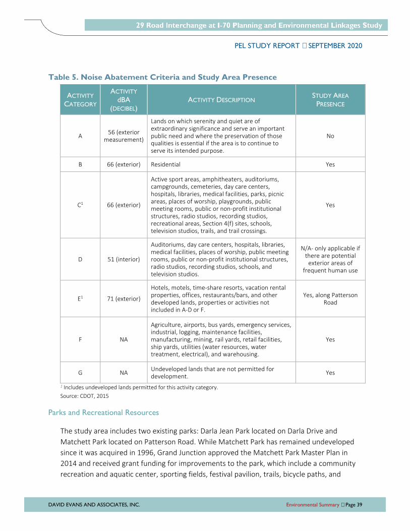
PEL STUDY REPORT SEPTEMBER 2020
DAVID EVANS AND ASSOCIATES, INC. Environmental Summary Page 39
Table 5. Noise Abatement Criteria and Study Area Presence
ACTIVITY
CATEGORY
ACTIVITY
dBA
(DECIBEL) ACTIVITY DESCRIPTION
STUDY AREA
PRESENCE
A 56 (exterior
measurement)
Lands on which serenity and quiet are of extraordinary significance and serve an important public need and where the preservation of those qualities is essential if the area is to continue to serve its intended purpose.
No
B 66 (exterior) Residential Yes
C1 66 (exterior)
Active sport areas, amphitheaters, auditoriums, campgrounds, cemeteries, day care centers, hospitals, libraries, medical facilities, parks, picnic areas, places of worship, playgrounds, public meeting rooms, public or non-profit institutional structures, radio studios, recording studios, recreational areas, Section 4(f) sites, schools, television studios, trails, and trail crossings.
Yes
D 51 (interior)
Auditoriums, day care centers, hospitals, libraries, medical facilities, places of worship, public meeting rooms, public or non-profit institutional structures, radio studios, recording studios, schools, and television studios.
N/A- only applicable if there are potential
exterior areas of frequent human use
E1 71 (exterior)
Hotels, motels, time-share resorts, vacation rental properties, offices, restaurants/bars, and other developed lands, properties or activities not included in A-D or F.
Yes, along Patterson Road
F NA
Agriculture, airports, bus yards, emergency services, industrial, logging, maintenance facilities, manufacturing, mining, rail yards, retail facilities, ship yards, utilities (water resources, water treatment, electrical), and warehousing.
Yes
G NA Undeveloped lands that are not permitted for development.
Yes
1 Includes undeveloped lands permitted for this activity category.
Source: CDOT, 2015
Parks and Recreational Resources
The study area includes two existing parks: Darla Jean Park located on Darla Drive and
Matchett Park located on Patterson Road. While Matchett Park has remained undeveloped
since it was acquired in 1996, Grand Junction approved the Matchett Park Master Plan in
2014 and received grant funding for improvements to the park, which include a community
recreation and aquatic center, sporting fields, festival pavilion, trails, bicycle paths, and

PEL STUDY REPORT SEPTEMBER 2020
DAVID EVANS AND ASSOCIATES, INC. Environmental Summary Page 40
nature viewing areas. Grand Junction is currently working on a citywide Parks, Recreation,
and Open Space Master Plan, which will be completed in 2021 and will prioritize
improvements for parks, recreation facilities, and open spaces.
Other existing recreational facilities in the study area include neighborhood interconnecting
trails that utilize sidewalks and other paved off-road shared paths for pedestrian and bicycle
travel. There are also bicycle lanes in both directions of Patterson Road.
Outside of the study area and approximately 0.5 mile north of I-70, the majority of the land is
owned and managed by the BLM. The area is referred to as the Grand Valley Off-Highway
Vehicle Special Recreation Management Area and encompasses approximately 15 square
miles bounded by 27 1/4 Road to the west and 32 Road to the east. The BLM’s Resource
Management Plan (2015) includes 29 Road as an access point for the Grand Valley SRMA, but
according to BLM’s online interactive map there are currently no recreational facilities, trails,
or other designated points of interest in the area. The Resource Management Plan states
that 29 Road offers opportunities for future development of recreation support facilities such
as parking/unloading areas, restrooms, campsites, and event venues.
Impacts to public parks and recreational resources are generally under the jurisdiction of
Section 4(f), which affords special protection to existing and planned parks, recreation areas,
and wildlife/waterfowl refuges that are open to the public and affected by a federal
transportation project. Potential recreational Section 4(f) properties that could be impacted
by the preferred alternative in NEPA should be evaluated for Section 4(f) applicability. When
FHWA determines that a project as proposed may use a Section 4(f) property, there are
three methods available to approve the use; preparing a de minimis impact determination;
applying a programmatic Section 4(f) evaluation; or preparing an individual Section 4(f)
evaluation. If the preferred alternative impacts a Section 4(f) property, one of these
processes will need to be completed.
Natural Environment
Prime and Unique Farmlands
Approximately 397 acres (36%) of the study area is classified as “prime farmland if irrigated.”
These areas occur within Matchett Park and throughout the eastern and southeastern
portions of the study area. Much of the land in the southeastern study area is currently
residential and would not qualify as prime farmland because it is not available for farming.
Further evaluation of other lands identified as “prime farmland if irrigated” would be
PEL STUDY REPORT SEPTEMBER 2020
DAVID EVANS AND ASSOCIATES, INC. Environmental Summary Page 41
required to determine if irrigation water is being applied. No unique farmland was identified
in the study area.
A detailed analysis of the project design impacts to the existing prime farmland should occur
as well as coordination with local planners and other local officials. Coordination with the
Natural Resource Conservation Service should be part of further project development to be
sure that changes resulting from a project are compatible with environmental regulations
and the local planning offices. Additionally, ongoing conversations with property owners,
businesses, and residents potentially affected will be a critical part of the project
development process.
Water Quality
According to Colorado’s Section 303(d) List (effective March 2, 2018), all tributaries to the
Colorado River, including wetlands, are listed as impaired from the Government Highline
Canal Diversion to a point immediately below Salt Creek. Within the study area, this includes
Indian Wash (Waterbody ID: COLCLC13b_D) which is listed as impaired for aquatic life use
due to selenium and iron. A total maximum daily load, which is a calculation for the
maximum amount of pollutant allowed to enter an impaired waterbody, for this stream
segment has not yet been developed.
Impaired waters should be considered during future project development and efforts should
be made to avoid and minimize impacts to water-related resources to the extent possible,
including the implementation of control measures during construction to minimize sediment
runoff. As the project progresses, continued coordination will be required with local, state,
and federal agencies to maintain water quality standards within the study area.
The wasteway at Indian Wash is designed to waste all water that drains within that reach of
the Canal in case of an emergency. This will need to be fully considered by any modeling in
this area during future design phases.
The Grand Valley Drainage District was created to facilitate and manage irrigation return
flows and many of their drains are comingled with municipal separate storm sewer waters.
Future NEPA and design phases will need to consider new separate storm sewer system
facilities. In addition, new impervious surface from any alternative and potential impacts to
Indian Wash and Fruitvale Drainage will need to be considered during NEPA and design
phases.
PEL STUDY REPORT SEPTEMBER 2020
DAVID EVANS AND ASSOCIATES, INC. Environmental Summary Page 42
Threatened and Endangered Species and Biological Resources
As described below, federal and state species lists were reviewed for potential presence in
the study area. While additional information regarding biological resources, such as non-
threatened and endangered species and noxious weeds were not included in the Area
Conditions Report, next steps for these resources are included in this study.
Federally Listed Species
A review of the U.S. Fish and Wildlife Service (USFWS) Information for Planning and
Consultation system (USFWS, 2019) indicates that there is a potential for nine threatened
and endangered species to occur, or potentially be affected by activities, in the study area:
� Yellow-billed Cuckoo (Coccyzus americanus)
� Bonytail Chub (Gila elegans)
� Colorado Pikeminnow (Ptychocheilus lucius)
� Humpback Chub (Gila cypha)
� Razorback Sucker (Xyrauchen texanus)
� Colorado Hookless Cactus (Sclerocactus glaucus)
No critical habitat exists within the study area for any federally listed species. However, the
Colorado River is designated as critical habitat for the bonytail chub, Colorado pikeminnow,
humpback chub, and razorback sucker. The Government Highline Canal extends through the
study area and receives water diverted from the Colorado River. The study area is located
within the Upper Colorado River Endangered Fish Recovery Program and water depletions in
the basin may adversely affects these species. The USFWS has prepared a Programmatic
Biological Opinion for Section 7 consultation related to water depletions in the Upper
Colorado Basin.
Yellow-billed cuckoo use riparian wooded habitat with dense cover and Colorado hookless
cactus occur primarily on alluvial benches along the Colorado and Gunnison Rivers, as well as
other tributaries on gravelly or rocky surfaces or on river terrace deposits. Indian Wash,
which has an intermittent flow, may not operate as suitable habitat for the cuckoo but
should be considered for further review and potential future field surveys for both species.
PEL STUDY REPORT SEPTEMBER 2020
DAVID EVANS AND ASSOCIATES, INC. Environmental Summary Page 43
State-Listed Species
According to the Colorado Natural Heritage Program Tracking List, 12 state-listed species
were identified with the possible potential to occur in the study area:
� Northern Leopard Frog (Lithobates pipiens) � Bonytail Chub (Gila elegans)
� Burrowing Owl (Athene cunicularia) � Roundtail Chub (Gila robusta)
� American Peregrine Falcon (Falco peregrinus
anatum)
� Long-nosed Leopard Lizard (Gambelia
wislizenii)
� Ferruginous Hawk (Buteo regalis) � Razorback Sucker (Xyrauchen texanus)
� Bald Eagle (Haliaeetus leucocephalus) � Kit Fox (Vulpes macrotis)
� Humpback Chub (Gila cypha) � Colorado Pikeminnow (Ptychocheilus Lucius)
There are white-tailed prairie dog (Cynomys leucurus) towns located within and adjacent to
the study area. These towns are often utilized by burrowing owls for habitat. Although
burrowing owls have not been observed in the area, there is potential for burrowing owls to
be present. Colorado Parks and Wildlife recommends the following, which will also be
documented during future NEPA process(es):
� If construction is to take place between March 1 and October 31, the area should be
surveyed for the presence of burrowing owls prior to construction activities occurring.
The owls are susceptible to being buried and killed in their holes by construction
activity.
� If construction is to occur between November 1 and February 28, it is very unlikely
owls would be present during construction. Burrowing owls are migratory and are
rarely found in Colorado in the winter.
Section 7 of the Endangered Species Act
During subsequent NEPA process(es) and project development, comprehensive and updated
special-status species lists will need to be obtained and, if appropriate, a field survey will
need to be conducted for federal- and state-listed species. If species of concern are found to
be within the study area, further coordination with the appropriate regulatory agencies must
take place and suitable measures will need to be developed to avoid and/or minimize
impacts to these sensitive resources.
Migratory Bird Treaty Act and Bald and Golden Eagle Protection Act
In order to comply with these Acts, preconstruction and during construction surveys for
nesting birds (including eagles and other raptors) should be done if any ground-disturbing
PEL STUDY REPORT SEPTEMBER 2020
DAVID EVANS AND ASSOCIATES, INC. Environmental Summary Page 44
activities are planned during the nesting season. The nesting season varies by species but is
generally from April 1 to August 31. If active nests are present, no-work buffers or other
restrictions will likely be required around the nest during construction activities. The size of
the buffer will be determined in coordination with Colorado Parks and Wildlife, USFWS, and
CDOT biologists. There are suitable areas within the potential interchange area for red-tailed
hawk nesting. Colorado Parks and Wildlife recommends survey of the potential nesting sites
for nesting activity prior to construction activities occurring. Red-tailed hawk nesting activity
occurs between February 15 and July 15. If eagles are expected to be present, additional
surveys may be required to identify winter roosting sites, which may also require no-work
buffers or other restrictions. Further guidance on required surveys can be found in Section
240 Protection of Migratory Birds of the CDOT Standard Specifications for Road and Bridge
Construction.
Noxious Weeds
A noxious weed survey should be completed during an on-site reconnaissance survey. The
survey should map noxious weed populations, and if recommended based on the results of
the survey, an integrated noxious weed management plan may need to be prepared for the
project.
Wetlands and Waters of the U.S.
According to the USFWS National Wetland Inventory, the study area contains numerous
potential wetlands, including both palustrine emergent and palustrine scrub-shrub.
Generally, palustrine emergent wetlands are dominated by emergent (herbaceous)
vegetation and palustrine scrub-shrub wetlands are dominated by shrubs. The study area
wetlands occur in topographic swales, roadside and irrigation ditches, and/or in association
with streams.
Other potential waters of the U.S. identified in the study area include Indian Wash and
Government Highline Canal. Indian Wash is an open channel with intermittent flow. Within
the study area, Indian Wash meanders adjacent to agricultural land within Matchett Park and
continues through residential areas before ultimately discharging to the Colorado River.
Government Highline Canal (Canal) is a manmade open channel with regulated flow and is
operated by the Grand Valley Water Users’ Association. Any impact from a future project on
the Government Highline Canal system that adds to its regulatory obligations will not be
permitted. The Canal is approximately 55 miles long and extends through the study area
south of I-70, potentially impacted by both alternatives carried forward. Government
PEL STUDY REPORT SEPTEMBER 2020
DAVID EVANS AND ASSOCIATES, INC. Environmental Summary Page 45
Highline Canal and portions of Indian Creek are classified by the National Wetland Inventory
as riverine features.
In addition, the Canal is under the jurisdiction of the U.S. Bureau of Reclamation and is
operated and maintained by the Grand Valley Water Users’ Association. Any alternative,
including the recommended alternative, that would result in the crossing of and potential
impact to the Canal would need to align wherever crossing the Canal and/or Operations and
Maintenance (O&M) roads and facilities. The O&M facilities include, but are not limited to,
siphons, head gates, laterals, drains and the O&M Road. In addition, stormwater drainage
from the proposed roads cannot be discharged into the Canal or O&M facilities. Any
multimodal transportation connections associated with the recommended alternative,
including trails along the Canal, as identified in the County's Master Trail and/or
Transportation Plans will first need to consult with the U.S. Bureau of Reclamation, the Grand
Valley Water Users’ Association, Mesa County Irrigation District, and the Palisade Irrigation
District. Current policy does not allow O&M roads or other facilities to be used by the public
for recreation. Several provisions would need to be met before any new trails along O&M
facilities would be considered.
Wetland delineations should be completed during the next phase of project development in
the areas that could be impacted by project-related activities. Impacts to wetlands should be
avoided where feasible. Due to their importance, impacts to water-related resources,
specifically waters of the U.S. including wetlands, should be avoided. If avoidance is not
feasible, best management practices should be implemented to reduce direct and indirect
impacts to these resources.
If waters of the U.S. in the area of potential impacts are considered to be U.S. Army Corps of
Engineers (USACE) jurisdictional, impacts would likely be permitted under a USACE Section
404 Nationwide Permit. Only the USACE has the authority to make final determinations
regarding jurisdiction, permitting, and mitigation. CDOT mitigates all wetland impacts at a 1:1
ratio (up to or equal to USACE mitigation, not in addition) regardless of USACE jurisdictional
status, or mitigation requirements.
PEL STUDY REPORT SEPTEMBER 2020
DAVID EVANS AND ASSOCIATES, INC. Action Plan Page 46
ACTION PLAN
The PEL process is intended to provide the framework for the long-term implementation of the
recommended alternative as funding is available and to be used as a resource for future NEPA
documentation. Funding for the interchange construction has not been identified at this time.
Identification of a recommended interchange location in this PEL study is consistent with the
FHWA’s objective of evaluating and selecting transportation solutions on a broad enough scale
to provide meaningful analysis and next steps for further project development. However, the
requirements of fiscal constraint must be satisfied for FHWA and CDOT to approve further NEPA
documentation.
The next steps in the project development process are outlined and illustrated in Figure 9. These
steps will be coordinated with CDOT and FHWA to ensure consistency with the interchange
approvals and NEPA processes.
CDOT Interchange Approval Process
A new interstate interchange requires adherence to CDOT Policy and Procedural Directive
1601 Interchange Approval Process. The 1601 process is an established process to review
and approve new interchanges or major improvements to existing interchanges that connect
with the state or the federal-aid highway system.
The 1601 process can begin with Mesa County and the City of Grand Junction officially
notifying CDOT of the project initiation. Following a pre-application meeting and
Intergovernmental Agreement, the County and City may use many components of this PEL
study as elements of the interchange System Level Study. This flow of information from the
PEL study into the System Level Study is consistent with FHWA’s policy that is intended to
streamline and eliminate duplicate documentation for FHWA interchange access approval.
As described in the Study Recommendations section of this report, updated traffic and safety
data, updated traffic forecasts, plus additional traffic and safety analysis will be required for
the area surrounding the interchange, as well as the adjacent interchanges, to identify
potential operational and safety benefits and impacts along I-70 as part of the NEPA process.
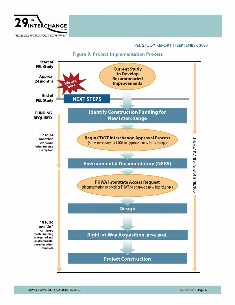
PEL STUDY REPORT SEPTEMBER 2020
DAVID EVANS AND ASSOCIATES, INC. Action Plan Page 47
Figure 9. Project Implementation Process
PEL STUDY REPORT SEPTEMBER 2020
DAVID EVANS AND ASSOCIATES, INC. Action Plan Page 48
Identification of the Preferred Alternative
The first steps in the NEPA process will focus on additional information or updates to
baseline data (such as updating the traffic forecasts with the new GVMPO travel demand
model and updating the safety evaluation with the most recent crash data) which will rapidly
identify and document the preferred alternative. Utilizing the Purpose and Need and project
goals developed with this PEL study, the two alternatives carried forward can be quickly
screened with a Level 2 comparative screening. The Level 2 screening expands measures for
each evaluation criterion from Level 1 screening and provides additional screening criteria
based on the project goals. These measures can be a mix of qualitative and quantitative
assessments, based on the criteria and the availability of data. The preliminary Level 2
comparative screening criteria that was developed as part of the overall alternatives
evaluation with this PEL study are shown in Table 6.
Prior to starting the NEPA documentation, a PEL-to-NEPA Transition Memorandum will
reference this PEL Report for the Purpose and Need, alternatives development, and Level 1
screening conducted during the PEL study, and will provide a brief summary of the Level 2
evaluation. This memo will substantiate the reason for proceeding into the NEPA
documentation with one action alternative and the No Action Alternative.
The CDOT NEPA scoping process will utilize environmental data and analyses gathered during
this PEL study to identify potential areas for supplemental environmental resource
information or additional resources that were not assessed as part of this study, such as
visual resources.
FHWA Interstate Access Request
Interchange conceptual layouts and design elements needed along I-70 and local
connections for the preferred alternative will be refined during the development of the NEPA
analysis and documentation.
As a new interchange, a full Interstate Access Request will be required for FHWA approval.
The Interstate Access Request documentation may be completed and submitted during
analysis for FHWA “acceptance”. Final approval for the new access cannot precede the
completion of NEPA, but once NEPA is completed, approval of the access is granted if there
are no changes in the interchange location or layout of the “accepted” concept.
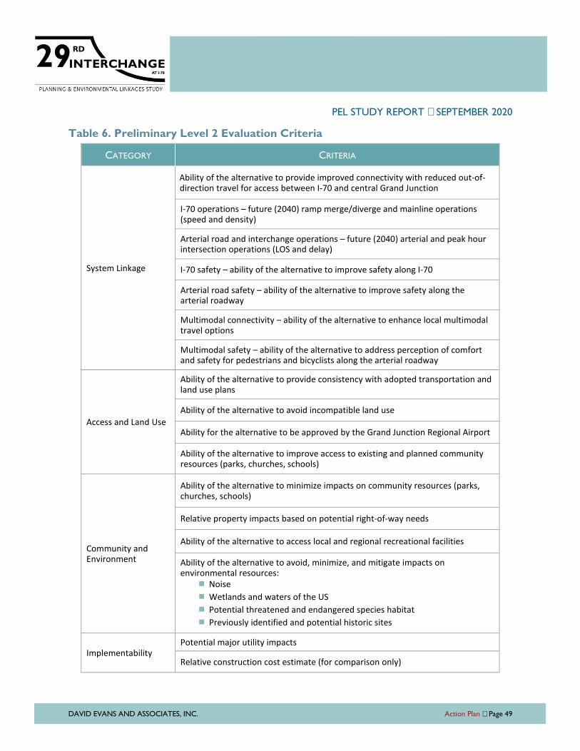
PEL STUDY REPORT SEPTEMBER 2020
DAVID EVANS AND ASSOCIATES, INC. Action Plan Page 49
Table 6. Preliminary Level 2 Evaluation Criteria
CATEGORY CRITERIA
System Linkage
Ability of the alternative to provide improved connectivity with reduced out-of-direction travel for access between I-70 and central Grand Junction
I-70 operations – future (2040) ramp merge/diverge and mainline operations (speed and density)
Arterial road and interchange operations – future (2040) arterial and peak hour intersection operations (LOS and delay)
I-70 safety – ability of the alternative to improve safety along I-70
Arterial road safety – ability of the alternative to improve safety along the arterial roadway
Multimodal connectivity – ability of the alternative to enhance local multimodal travel options
Multimodal safety – ability of the alternative to address perception of comfort and safety for pedestrians and bicyclists along the arterial roadway
Access and Land Use
Ability of the alternative to provide consistency with adopted transportation and land use plans
Ability of the alternative to avoid incompatible land use
Ability for the alternative to be approved by the Grand Junction Regional Airport
Ability of the alternative to improve access to existing and planned community resources (parks, churches, schools)
Community and Environment
Ability of the alternative to minimize impacts on community resources (parks, churches, schools)
Relative property impacts based on potential right-of-way needs
Ability of the alternative to access local and regional recreational facilities
Ability of the alternative to avoid, minimize, and mitigate impacts on environmental resources:
� Noise
� Wetlands and waters of the US
� Potential threatened and endangered species habitat
� Previously identified and potential historic sites
Implementability
Potential major utility impacts
Relative construction cost estimate (for comparison only)

PEL STUDY REPORT SEPTEMBER 2020
DAVID EVANS AND ASSOCIATES, INC. Appendix
APPENDIX A
Level 1 Screening Matrix

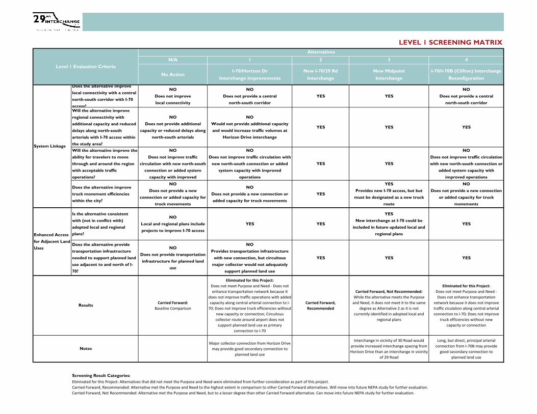
LEVEL 1 SCREENING MATRIX
N/A 1 2 3 4
No ActionI-70/Horizon Dr
Interchange Improvements
New I-70/29 Rd
Interchange
New Midpoint
Interchange
I-70/I-70B (Clifton) Interchange
Reconfiguration
Does the alternative improve
local connectivity with a central
north-south corridor with I-70
access?
NO
Does not improve
local connectivity
NO
Does not provide a central
north-south corridor
YES YES
NO
Does not provide a central
north-south corridor
Will the alternative improve
regional connectivity with
additional capacity and reduced
delays along north-south
arterials with I-70 access within
the study area?
NO
Does not provide additional
capacity or reduced delays along
north-south arterials
NO
Would not provide additional capacity
and would increase traffic volumes at
Horizon Drive interchange
YES YES YES
Will the alternative improve the
ability for travelers to move
through and around the region
with acceptable traffic
operations?
NO
Does not improve traffic
circulation with new north-south
connection or added system
capacity with improved
NO
Does not improve traffic circulation with
new north-south connection or added
system capacity with improved
operations
YES YES
NO
Does not improve traffic circulation
with new north-south connection or
added system capacity with
improved operations
Does the alternative improve
truck movement efficiencies
within the city?
NO
Does not provide a new
connection or added capacity for
truck movements
NO
Does not provide a new connection or
added capacity for truck movements
YES
YES
Provides new I-70 access, but but
must be designated as a new truck
route
NO
Does not provide a new connection
or added capacity for truck
movements
Is the alternative consistent
with (not in conflict with)
adopted local and regional
plans?
NO
Local and regional plans include
projects to improve I-70 access
YES YES
YES
New interchange at I-70 could be
included in future updated local and
regional plans
YES
Does the alternative provide
transportation infrastructure
needed to support planned land
use adjacent to and north of I-
70?
NO
Does not provide transportation
infrastructure for planned land
use
NO
Provides transportation infrastructure
with new connection, but circuitous
major collector would not adequately
support planned land use
YES YES YES
Carried Forward:
Baseline Comparison
Eliminated for this Project:
Does not meet Purpose and Need - Does not
enhance transportation network because it
does not improve traffic operations with added
capacity along central arterial connection to I-
70; Does not improve truck efficiencies without
new capacity or connection; Circuitous
collector route around airport does not
support planned land use as primary
connection to I-70
Carried Forward,
Recommended
Carried Forward, Not Recommended:
While the alternative meets the Purpose
and Need, it does not meet it to the same
degree as Alternative 2 as it is not
currently identified in adopted local and
regional plans
Eliminated for this Project:
Does not meet Purpose and Need -
Does not enhance transportation
network because it does not improve
traffic ciculation along central arterial
connection to I-70; Does not improve
truck efficiencies without new
capacity or connection
Major collector connection from Horizon Drive
may provide good secondary connection to
planned land use
Interchange in vicinity of 30 Road would
provide increased interchange spacing from
Horizon Drive than an interchange in vicinity
of 29 Road
Long, but direct, principal arterial
connection from I-70B may provide
good secondary connection to
planned land use
Screening Result Categories:
Eliminated for this Project: Alternatives that did not meet the Purpose and Need were eliminated from further consideration as part of this project.
Carried Forward, Recommended: Alternative met the Purpose and Need to the highest extent in comparison to other Carried Forward alternatives. Will move into future NEPA study for further evaluation.
Carried Forward, Not Recommended: Alternative met the Purpose and Need, but to a lesser degree than other Carried Forward alternative. Can move into future NEPA study for further evaluation.
Notes
Alternatives
Level 1 Evaluation Criteria
System Linkage
Enhanced Access
for Adjacent Land
Uses
Results

PEL STUDY REPORT SEPTEMBER 2020
DAVID EVANS AND ASSOCIATES, INC. Appendix
APPENDIX B
Resource Agency Coordination Summary

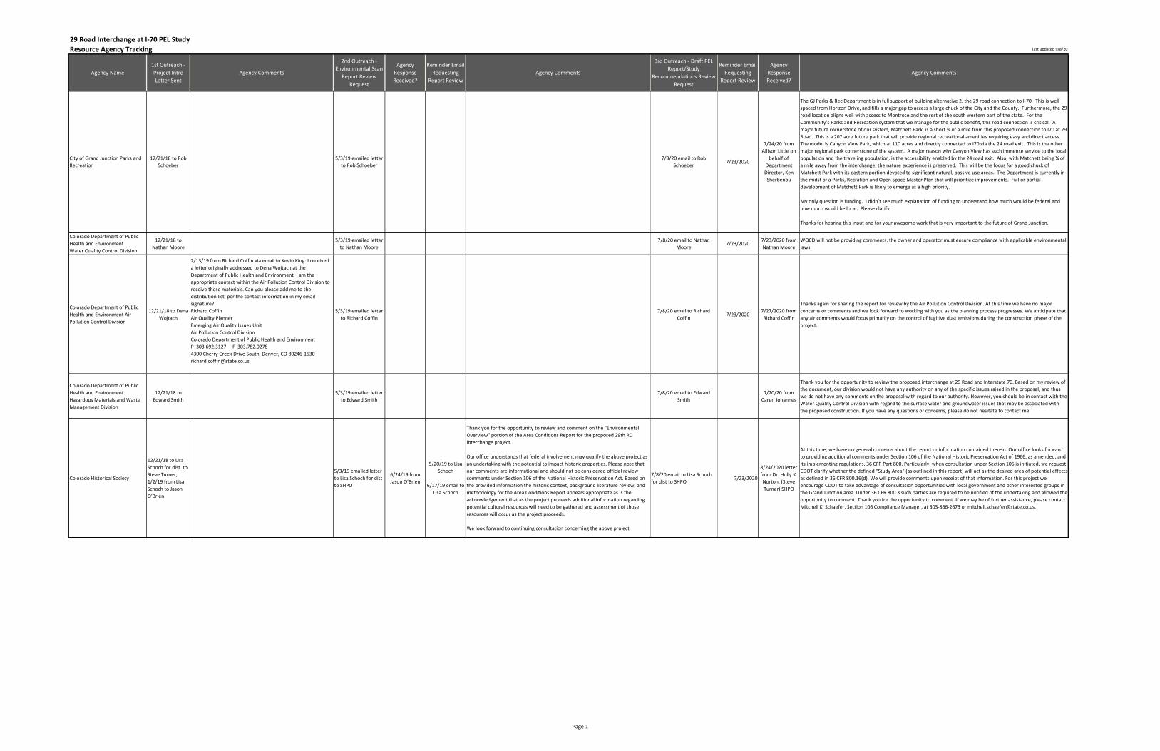
Resource Agency Tracking last updated 9/8/20
Agency Name
1st Outreach -
Project Intro
Letter Sent
Agency Comments
2nd Outreach -
Environmental Scan
Report Review
Request
Agency
Response
Received?
Reminder Email
Requesting
Report Review
Agency Comments
3rd Outreach - Draft PEL
Report/Study
Recommendations Review
Request
Reminder Email
Requesting
Report Review
Agency
Response
Received?
Agency Comments
City of Grand Junction Parks and
Recreation
12/21/18 to Rob
Schoeber
5/3/19 emailed letter
to Rob Schoeber
7/8/20 email to Rob
Schoeber7/23/2020
7/24/20 from
Allison Little on
behalf of
Department
Director, Ken
Sherbenou
The GJ Parks & Rec Department is in full support of building alternative 2, the 29 road connection to I-70. This is well
spaced from Horizon Drive, and fills a major gap to access a large chuck of the City and the County. Furthermore, the 29
road location aligns well with access to Montrose and the rest of the south western part of the state. For the
Community’s Parks and Recreation system that we manage for the public benefit, this road connection is critical. A
major future cornerstone of our system, Matchett Park, is a short ¾ of a mile from this proposed connection to I70 at 29
Road. This is a 207 acre future park that will provide regional recreational amenities requiring easy and direct access.
The model is Canyon View Park, which at 110 acres and directly connected to I70 via the 24 road exit. This is the other
major regional park cornerstone of the system. A major reason why Canyon View has such immense service to the local
population and the traveling population, is the accessibility enabled by the 24 road exit. Also, with Matchett being ¾ of
a mile away from the interchange, the nature experience is preserved. This will be the focus for a good chuck of
Matchett Park with its eastern portion devoted to significant natural, passive use areas. The Department is currently in
the midst of a Parks, Recration and Open Space Master Plan that will prioritize improvements. Full or partial
development of Matchett Park is likely to emerge as a high priority.
My only question is funding. I didn’t see much explanation of funding to understand how much would be federal and
how much would be local. Please clarify.
Thanks for hearing this input and for your awesome work that is very important to the future of Grand Junction.
Colorado Department of Public
Health and Environment
Water Quality Control Division
12/21/18 to
Nathan Moore
5/3/19 emailed letter
to Nathan Moore
7/8/20 email to Nathan
Moore7/23/2020
7/23/2020 from
Nathan Moore
WQCD will not be providing comments, the owner and operator must ensure compliance with applicable environmental
laws.
Colorado Department of Public
Health and Environment Air
Pollution Control Division
12/21/18 to Dena
Wojtach
2/13/19 from Richard Coffin via email to Kevin King: I received
a letter originally addressed to Dena Wojtach at the
Department of Public Health and Environment. I am the
appropriate contact within the Air Pollution Control Division to
receive these materials. Can you please add me to the
distribution list, per the contact information in my email
signature?
Richard Coffin
Air Quality Planner
Emerging Air Quality Issues Unit
Air Pollution Control Division
Colorado Department of Public Health and Environment
P 303.692.3127 | F 303.782.0278
4300 Cherry Creek Drive South, Denver, CO 80246-1530
5/3/19 emailed letter
to Richard Coffin
7/8/20 email to Richard
Coffin7/23/2020
7/27/2020 from
Richard Coffin
Thanks again for sharing the report for review by the Air Pollution Control Division. At this time we have no major
concerns or comments and we look forward to working with you as the planning process progresses. We anticipate that
any air comments would focus primarily on the control of fugitive dust emissions during the construction phase of the
project.
Colorado Department of Public
Health and Environment
Hazardous Materials and Waste
Management Division
12/21/18 to
Edward Smith
5/3/19 emailed letter
to Edward Smith
7/8/20 email to Edward
Smith
7/20/20 from
Caren Johannes
Thank you for the opportunity to review the proposed interchange at 29 Road and Interstate 70. Based on my review of
the document, our division would not have any authority on any of the specific issues raised in the proposal, and thus
we do not have any comments on the proposal with regard to our authority. However, you should be in contact with the
Water Quality Control Division with regard to the surface water and groundwater issues that may be associated with
the proposed construction. If you have any questions or concerns, please do not hesitate to contact me
Colorado Historical Society
12/21/18 to Lisa
Schoch for dist. to
Steve Turner;
1/2/19 from Lisa
Schoch to Jason
O'Brien
5/3/19 emailed letter
to Lisa Schoch for dist
to SHPO
6/24/19 from
Jason O'Brien
5/20/19 to Lisa
Schoch
6/17/19 email to
Lisa Schoch
Thank you for the opportunity to review and comment on the "Environmental
Overview" portion of the Area Conditions Report for the proposed 29th RD
Interchange project.
Our office understands that federal involvement may qualify the above project as
an undertaking with the potential to impact historic properties. Please note that
our comments are informational and should not be considered official review
comments under Section 106 of the National Historic Preservation Act. Based on
the provided information the historic context, background literature review, and
methodology for the Area Conditions Report appears appropriate as is the
acknowledgement that as the project proceeds additional information regarding
potential cultural resources will need to be gathered and assessment of those
resources will occur as the project proceeds.
We look forward to continuing consultation concerning the above project.
7/8/20 email to Lisa Schoch
for dist to SHPO7/23/2020
8/24/2020 letter
from Dr. Holly K.
Norton, (Steve
Turner) SHPO
At this time, we have no general concerns about the report or information contained therein. Our office looks forward
to providing additional comments under Section 106 of the National Historic Preservation Act of 1966, as amended, and
its implementing regulations, 36 CFR Part 800. Particularly, when consultation under Section 106 is initiated, we request
CDOT clarify whether the defined "Study Area" (as outlined in this report) will act as the desired area of potential effects
as defined in 36 CFR 800.16(d). We will provide comments upon receipt of that information. For this project we
encourage CDOT to take advantage of consultation opportunities with local government and other interested groups in
the Grand Junction area. Under 36 CFR 800.3 such parties are required to be notified of the undertaking and allowed the
opportunity to comment. Thank you for the opportunity to comment. If we may be of further assistance, please contact
Mitchell K. Schaefer, Section 106 Compliance Manager, at 303-866-2673 or [email protected].
29 Road Interchange at I-70 PEL Study
Page 1
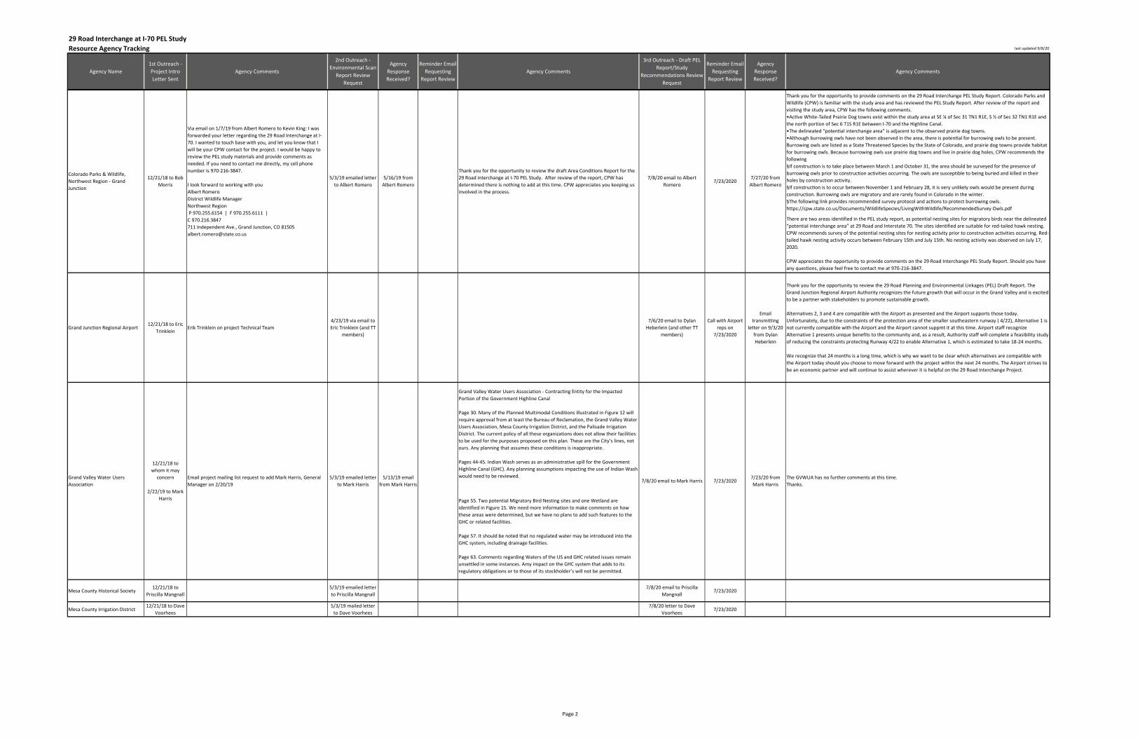
Resource Agency Tracking last updated 9/8/20
Agency Name
1st Outreach -
Project Intro
Letter Sent
Agency Comments
2nd Outreach -
Environmental Scan
Report Review
Request
Agency
Response
Received?
Reminder Email
Requesting
Report Review
Agency Comments
3rd Outreach - Draft PEL
Report/Study
Recommendations Review
Request
Reminder Email
Requesting
Report Review
Agency
Response
Received?
Agency Comments
29 Road Interchange at I-70 PEL Study
Thank you for the opportunity to provide comments on the 29 Road Interchange PEL Study Report. Colorado Parks and
Wildlife (CPW) is familiar with the study area and has reviewed the PEL Study Report. After review of the report and
visiting the study area, CPW has the following comments.
•AcNve White-Tailed Prairie Dog towns exist within the study area at SE ¼ of Sec 31 TN1 R1E, S ½ of Sec 32 TN1 R1E and
the north portion of Sec 6 T1S R1E between I-70 and the Highline Canal.
•The delineated “potenNal interchange area” is adjacent to the observed prairie dog towns.
•Although burrowing owls have not been observed in the area, there is potenNal for burrowing owls to be present.
Burrowing owls are listed as a State Threatened Species by the State of Colorado, and prairie dog towns provide habitat
for burrowing owls. Because burrowing owls use prairie dog towns and live in prairie dog holes, CPW recommends the
following
§If construcNon is to take place between March 1 and October 31, the area should be surveyed for the presence of
burrowing owls prior to construction activities occurring. The owls are susceptible to being buried and killed in their
holes by construction activity.
§If construcNon is to occur between November 1 and February 28, it is very unlikely owls would be present during
construction. Burrowing owls are migratory and are rarely found in Colorado in the winter.
§The following link provides recommended survey protocol and acNons to protect burrowing owls.
https://cpw.state.co.us/Documents/WildlifeSpecies/LivingWithWildlife/RecommendedSurvey Owls.pdf
There are two areas identified in the PEL study report, as potential nesting sites for migratory birds near the delineated
“potential interchange area” at 29 Road and Interstate 70. The sites identified are suitable for red-tailed hawk nesting.
CPW recommends survey of the potential nesting sites for nesting activity prior to construction activities occurring. Red-
tailed hawk nesting activity occurs between February 15th and July 15th. No nesting activity was observed on July 17,
2020.
CPW appreciates the opportunity to provide comments on the 29 Road Interchange PEL Study Report. Should you have
any questions, please feel free to contact me at 970-216-3847.
Grand Junction Regional Airport12/21/18 to Eric
TrinkleinErik Trinklein on project Technical Team
4/23/19 via email to
Eric Trinklein (and TT
members)
7/6/20 email to Dylan
Heberlein (and other TT
members)
Call with Airport
reps on
7/23/2020
transmitting
letter on 9/3/20
from Dylan
Heberlein
Thank you for the opportunity to review the 29 Road Planning and Environmental Linkages (PEL) Draft Report. The
Grand Junction Regional Airport Authority recognizes the future growth that will occur in the Grand Valley and is excited
to be a partner with stakeholders to promote sustainable growth.
Alternatives 2, 3 and 4 are compatible with the Airport as presented and the Airport supports those today.
Unfortunately, due to the constraints of the protection area of the smaller southeastern runway ( 4/22), Alternative 1 is
not currently compatible with the Airport and the Airport cannot suppmt it at this time. Airport staff recognize
Alternative 1 presents unique benefits to the community and, as a result, Authority staff will complete a feasibility study
of reducing the constraints protecting Runway 4/22 to enable Alternative 1, which is estimated to take 18-24 months.
We recognize that 24 months is a long time, which is why we want to be clear which alternatives are compatible with
the Airport today should you choose to move forward with the project within the next 24 months. The Airport strives to
be an economic partner and will continue to assist wherever it is helpful on the 29 Road Interchange Project.
Grand Valley Water Users Association - Contracting Entity for the Impacted
Portion of the Government Highline Canal
Page 30. Many of the Planned Multimodal Conditions illustrated in Figure 12 will
require approval from at least the Bureau of Reclamation, the Grand Valley Water
Users Association, Mesa County Irrigation District, and the Palisade Irrigation
District. The current policy of all these organizations does not allow their facilities
to be used for the purposes proposed on this plan. These are the City’s lines, not
ours. Any planning that assumes these conditions is inappropriate.
Pages 44-45. Indian Wash serves as an administrative spill for the Government
Highline Canal (GHC). Any planning assumptions impacting the use of Indian Wash
would need to be reviewed.
Page 55. Two potential Migratory Bird Nesting sites and one Wetland are
identified in Figure 15. We need more information to make comments on how
these areas were determined, but we have no plans to add such features to the
GHC or related facilities.
Page 57. It should be noted that no regulated water may be introduced into the
GHC system, including drainage facilities.
Page 63. Comments regarding Waters of the US and GHC related issues remain
unsettled in some instances. Amy impact on the GHC system that adds to its
regulatory obligations or to those of its stockholder’s will not be permitted.
Mesa County Historical Society12/21/18 to
Priscilla Mangnall
5/3/19 emailed letter
to Priscilla Mangnall
7/8/20 email to Priscilla
Mangnall7/23/2020
Mesa County Irrigation District12/21/18 to Dave
Voorhees
5/3/19 mailed letter
to Dave Voorhees
7/8/20 letter to Dave
Voorhees7/23/2020
Grand Valley Water Users
Association7/8/20 email to Mark Harris
5/3/19 emailed letter
to Mark Harris
7/8/20 email to Albert
Romero
Thank you for the opportunity to review the draft Area Conditions Report for the
29 Road interchange at I-70 PEL Study. After review of the report, CPW has
determined there is nothing to add at this time. CPW appreciates you keeping us
involved in the process.
5/16/19 from
Albert Romero
5/3/19 emailed letter
to Albert Romero
Email project mailing list request to add Mark Harris, General
Manager on 2/20/19
Via email on 1/7/19 from Albert Romero to Kevin King: I was
forwarded your letter regarding the 29 Road Interchange at I-
70. I wanted to touch base with you, and let you know that I
will be your CPW contact for the project. I would be happy to
review the PEL study materials and provide comments as
needed. If you need to contact me directly, my cell phone
number is 970-216-3847.
I look forward to working with you
Albert Romero
District Wildlife Manager
Northwest Region
P 970.255.6154 | F 970.255.6111 |
C 970.216.3847
711 Independent Ave., Grand Junction, CO 81505
7/23/20 from
Mark Harris
The GVWUA has no further comments at this time.
Thanks.
5/13/19 email
from Mark Harris
12/21/18 to
whom it may
concern
2/22/19 to Mark
Harris
7/23/2020
7/27/20 from
Albert Romero7/23/2020
12/21/18 to Bob
Morris
Colorado Parks & Wildlife,
Northwest Region - Grand
Junction
Page 2
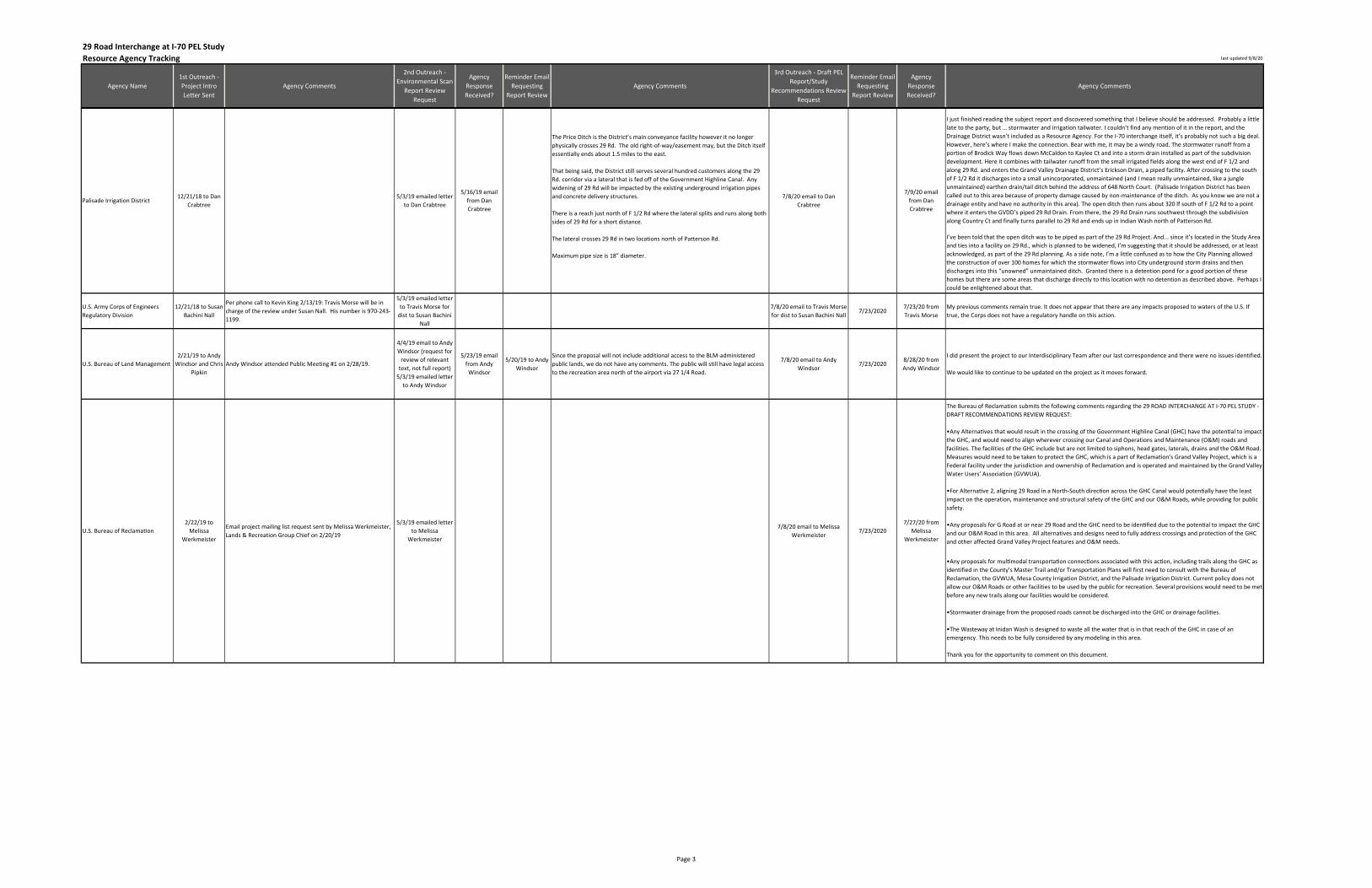
Resource Agency Tracking last updated 9/8/20
Agency Name
1st Outreach -
Project Intro
Letter Sent
Agency Comments
2nd Outreach -
Environmental Scan
Report Review
Request
Agency
Response
Received?
Reminder Email
Requesting
Report Review
Agency Comments
3rd Outreach - Draft PEL
Report/Study
Recommendations Review
Request
Reminder Email
Requesting
Report Review
Agency
Response
Received?
Agency Comments
29 Road Interchange at I-70 PEL Study
I just finished reading the subject report and discovered something that I believe should be addressed. Probably a little
late to the party, but … stormwater and irrigation tailwater. I couldn’t find any mention of it in the report, and the
Drainage District wasn’t included as a Resource Agency. For the I-70 interchange itself, it’s probably not such a big deal.
However, here’s where I make the connection. Bear with me, it may be a windy road. The stormwater runoff from a
portion of Brodick Way flows down McCaldon to Kaylee Ct and into a storm drain installed as part of the subdivision
development. Here it combines with tailwater runoff from the small irrigated fields along the west end of F 1/2 and
along 29 Rd. and enters the Grand Valley Drainage District’s Erickson Drain, a piped facility. After crossing to the south
of F 1/2 Rd it discharges into a small unincorporated, unmaintained (and I mean really unmaintained, like a jungle
unmaintained) earthen drain/tail ditch behind the address of 648 North Court. (Palisade Irrigation District has been
called out to this area because of property damage caused by non-maintenance of the ditch. As you know we are not a
drainage entity and have no authority in this area). The open ditch then runs about 320 lf south of F 1/2 Rd to a point
where it enters the GVDD’s piped 29 Rd Drain. From there, the 29 Rd Drain runs southwest through the subdivision
along Country Ct and finally turns parallel to 29 Rd and ends up in Indian Wash north of Patterson Rd.
I’ve been told that the open ditch was to be piped as part of the 29 Rd Project. And... since it’s located in the Study Area
and ties into a facility on 29 Rd., which is planned to be widened, I’m suggesting that it should be addressed, or at least
acknowledged, as part of the 29 Rd planning. As a side note, I’m a little confused as to how the City Planning allowed
the construction of over 100 homes for which the stormwater flows into City underground storm drains and then
discharges into this “unowned” unmaintained ditch. Granted there is a detention pond for a good portion of these
homes but there are some areas that discharge directly to this location with no detention as described above. Perhaps I
could be enlightened about that.
U.S. Army Corps of Engineers
Regulatory Division
12/21/18 to Susan
Bachini Nall
Per phone call to Kevin King 2/13/19: Travis Morse will be in
charge of the review under Susan Nall. His number is 970-243-
1199.
5/3/19 emailed letter
to Travis Morse for
dist to Susan Bachini
Nall
7/8/20 email to Travis Morse
for dist to Susan Bachini Nall7/23/2020
7/23/20 from
Travis Morse
My previous comments remain true. It does not appear that there are any impacts proposed to waters of the U.S. If
true, the Corps does not have a regulatory handle on this action.
U.S. Bureau of Land Management
2/21/19 to Andy
Windsor and Chris
Pipkin
Andy Windsor attended Public Meeting #1 on 2/28/19.
4/4/19 email to Andy
Windsor (request for
review of relevant
text, not full report)
5/3/19 emailed letter
to Andy Windsor
5/23/19 email
from Andy
Windsor
5/20/19 to Andy
Windsor
Since the proposal will not include additional access to the BLM-administered
public lands, we do not have any comments. The public will still have legal access
to the recreation area north of the airport via 27 1/4 Road.
7/8/20 email to Andy
Windsor7/23/2020
8/28/20 from
Andy Windsor
I did present the project to our Interdisciplinary Team after our last correspondence and there were no issues identified.
We would like to continue to be updated on the project as it moves forward.
The Bureau of Reclamation submits the following comments regarding the 29 ROAD INTERCHANGE AT I-70 PEL STUDY -
DRAFT RECOMMENDATIONS REVIEW REQUEST:
•Any AlternaNves that would result in the crossing of the Government Highline Canal (GHC) have the potenNal to impact
the GHC, and would need to align wherever crossing our Canal and Operations and Maintenance (O&M) roads and
facilities. The facilities of the GHC include but are not limited to siphons, head gates, laterals, drains and the O&M Road.
Measures would need to be taken to protect the GHC, which is a part of Reclamation’s Grand Valley Project, which is a
Federal facility under the jurisdiction and ownership of Reclamation and is operated and maintained by the Grand Valley
Water Users’ Association (GVWUA).
•For AlternaNve 2, aligning 29 Road in a North-South direcNon across the GHC Canal would potenNally have the least
impact on the operation, maintenance and structural safety of the GHC and our O&M Roads, while providing for public
safety.
•Any proposals for G Road at or near 29 Road and the GHC need to be idenNfied due to the potenNal to impact the GHC
and our O&M Road in this area. All alternatives and designs need to fully address crossings and protection of the GHC
and other affected Grand Valley Project features and O&M needs.
•Any proposals for mulNmodal transportaNon connecNons associated with this acNon, including trails along the GHC as
identified in the County's Master Trail and/or Transportation Plans will first need to consult with the Bureau of
Reclamation, the GVWUA, Mesa County Irrigation District, and the Palisade Irrigation District. Current policy does not
allow our O&M Roads or other facilities to be used by the public for recreation. Several provisions would need to be met
before any new trails along our facilities would be considered.
•Stormwater drainage from the proposed roads cannot be discharged into the GHC or drainage faciliNes.
•The Wasteway at Inidan Wash is designed to waste all the water that is in that reach of the GHC in case of an
emergency. This needs to be fully considered by any modeling in this area.
Thank you for the opportunity to comment on this document.
The Price Ditch is the District’s main conveyance facility however it no longer
physically crosses 29 Rd. The old right-of-way/easement may, but the Ditch itself
essentially ends about 1.5 miles to the east.
That being said, the District still serves several hundred customers along the 29
Rd. corridor via a lateral that is fed off of the Government Highline Canal. Any
widening of 29 Rd will be impacted by the existing underground irrigation pipes
and concrete delivery structures.
There is a reach just north of F 1/2 Rd where the lateral splits and runs along both
sides of 29 Rd for a short distance.
The lateral crosses 29 Rd in two locations north of Patterson Rd.
Maximum pipe size is 18” diameter.
7/8/20 email to Dan
Crabtree
7/9/20 email
from Dan
Crabtree
7/27/20 from
Melissa
Werkmeister
Palisade Irrigation District12/21/18 to Dan
Crabtree
5/3/19 emailed letter
to Dan Crabtree
5/16/19 email
from Dan
Crabtree
5/3/19 emailed letter
to Melissa
Werkmeister
2/22/19 to
Melissa
Werkmeister
U.S. Bureau of Reclamation 7/23/20207/8/20 email to Melissa
Werkmeister
Email project mailing list request sent by Melissa Werkmeister,
Lands & Recreation Group Chief on 2/20/19
Page 3

Resource Agency Tracking last updated 9/8/20
Agency Name
1st Outreach -
Project Intro
Letter Sent
Agency Comments
2nd Outreach -
Environmental Scan
Report Review
Request
Agency
Response
Received?
Reminder Email
Requesting
Report Review
Agency Comments
3rd Outreach - Draft PEL
Report/Study
Recommendations Review
Request
Reminder Email
Requesting
Report Review
Agency
Response
Received?
Agency Comments
29 Road Interchange at I-70 PEL Study
EPA appreciates the opportunity to review the July 2020 Draft 29 Road Interchange at I-70 Planning and Environmental
Linkages Study Report. Based on our cooperating agency review we have the following comments and
recommendations:
EPA understands that the Report reflects an important nexus between transportation forecasting/planning process and
NEPA to the public and stakeholders, and as such, it is necessary that key concepts for a future NEPA analysis are
accurately defined and explained in this report. Under NEPA, the No Action alternative is necessarily included as a
baseline because it provides a benchmark, enabling decisionmakers to compare the magnitude of environmental effects
of the range of action alternatives under consideration. In other words, meeting the Purpose and Need for agency
action is not a “threshold” or “standard” by which to judge whether the No Action will be carried through detailed
alternatives analysis in an EIS. EPA suggests deleting the first sentence on Line 15, page 12, for purposes of accuracy
under the statute and being clear about the NEPA process from the onset. Such clarification will allow for transparency
in the process for alternatives flowing from transportation planning into the review of action alternatives for the EIS.
As a complement to the above suggested change, EPA recommends that the sentence beginning with “The No Action
alternative is included…” on lines-15-16, page 12, be edited with the addition of “…under NEPA (40 CFR §1502.14).” This
proposed edit would provide a direct, accurate statement regarding the purpose of No Action in relation to the action
alternatives carried forward through detailed analysis in an EIS.
EPA recognizes that the draft PEL Study Report is an essential building block in determining scope of future
environmental review under NEPA, particularly in identifying potentially affected natural resources and community
stakeholders. We note that this draft Report does not contemplate visual resource impacts in its overview of potential
effects to resources within the project area. EPA suggests that visual resources be considered within the scope of
analysis under NEPA to demonstrate proper consideration of all potential effects from construction of a highway
infrastructure project. While the proposed 29 Road Interchange at I-70 may be consistent with immediately surrounding
visual elements, it would be beneficial to decision makers and the public to understand why this resource area was not
considered a necessary focus for impacts analysis under NEPA.
Based on the authority conferred to the U.S. Fish and Wildlife Service (Service) by
the Fish and Wildlife Act of 1956 (916 U.S.C. 742(a)-754); Fish and Wildlife
Coordination Act (FWCA - 16 U.S.C. 661-667(e)); National Environmental Policy
Act of 1969 (NEPA - 42 U.S.C. 4321-4347); Department of Transportation Act (49
U.S.C. 1653(±)), and; Endangered Species Act of 1973, as amended (ESA - 50 CFR
§402.14), as well as multiple Executive Orders, policies and guidelines, and
interrelated statutes to ensure the conservation and enhancement of fish and
wildlife resources (e.g., Migratory Bird Treaty Act (MBTA - 16 U.S.C. 703), and Bald
and Golden Eagle Protection Act (BGEPA - 16 U.S.C. 668)), the Service reviewed
your May 3, 2019, request to review the 29 Road Interchange at 1-70 Planning
and Environmental Linkages Study in Grand Junction, Mesa County, Colorado. The
purpose of the study is to define the need and an overall vision for the future 29
Road and I-70 interchange.
According to your report, habitats for the Yellow-billed Cuckoo (Coccyzus
americanus), bonytail chub (Gila elegans), Colorado pikeminnow (Ptychocheilus
lucius), humpback chub (Gila cypha), razorback sucker (Xyrauchen texanus), and
Colorado hookless cactus
(Sclerocactus glaucus), are present in or near the project area.
In addition, critical habitat for the Yellow-billed cuckoo has been proposed along
the Colorado River south of the project area, and critical habitats for the
razorback sucker and Colorado pikeminnow have been designated along the
Colorado River south of the project area. As you are likely aware, impacts to these
and potentially other species and their critical habitats will need to be re-
evaluated once an alternative has been chosen.
Further, we appreciate your commitment to conducting surveys for raptors and
nesting birds, if warranted, before and during construction. We also appreciate
your commitment to applying no-work buffers in accordance with the Colorado
Department of Transportation's (CDOT) Specification 240, Protection of Migratory
Birds, and to coordinating with the Service, Colorado Parks and Wildlife, and
CDOT on minimizing impact to nesting birds.
Thank you for the opportunity to comment. If the Service can be of further
assistance, please contact Alison Deans Michael of my staff at 303 236-4758.
Grand Valley Drainage District N/A N/A 7/10/20 email to Tim Ryan 7/23/20207/23/20 from
Scott Godfrey
The District’s review comments are:
1.There is no reference to the long standing, (cited in the Williams 2000 study), drainage infrastructure deficiencies in
the 29 Rd study area. Grand Valley Drainage District was created to facilitate and manage irrigation return flows.
However, many of our drains are comingled with MS4 waters. Improvements, or as recommended, new separate storm
sewer system facilities are not addressed in the report.
2.Also the report does not address impacts to the District’s services in the Study RecommendaNons; Interchanges at 29
Rd and 30 Rd. These interchanges and the related increase in impervious surfaces will have significant impacts to both
of the Drainage systems that the District refers to as the Indian Wash drainage and the Fruitvale drainage. The concept
that these drains are seasonal or solely used for surface water is a misnomer. These systems carry a significant amount
of their flows from ground water seep that is a year round phenomenon, and is not diminished by stormwater
detention, but are significantly increased by the influx of undetained MS4 water during storm events.
Ute Water District
12/21/18 to
whom it may
concern
Email project mailing list request sent by David Priske, District
Engineer on 2/20/19
5/3/19 emailed letter
to David Priske
5/7/19 via email
from Dave Priske
Took a quick 20k foot look at the report. I don’t think the District has any
comments regarding this phase of the study. 7/8/20 email to David Priske 7/23/2020
7/24/20 from
Dave Priske
District Staff have reviewed the Draft Area Conditions Report for the 29 Road Interchange at I-70 PEL Study. At this
time, the District has no specific comments to add; we support this project from a transportation access improvement
view. The District appreciates you keeping us involved in the process.
5/3/19 emailed letter
to Lisa Lloyd
12/21/18 to Lisa
Lloyd
U.S. Environmental Protection
Agency Region 8
7/8/20 email to Kristin
Salamack for dist to Susan
Linner
7/27/20 from
Krisin Salamack
Thank you for the opportunity to review the PEL study report for the 29th Rd Interchange at I-70. My comments are in
keeping with the comments from Alison Michael from the 5/13/2019 letter. I’d like to add some guidance specific to
potential future field surveys for yellow-billed cuckoo and Colorado hookless cactus which are the most likely terrestrial
species to have suitable habitat. Yellow-billed cuckoo use riparian wooded habitat with dense cover and Colorado
hookless cactus occur primarily on alluvial benches along the Colorado and Gunnison Rivers as well as other tributaries
on gravelly or rocky surfaces or on river terrace deposits. According to the PEL study report, the Indian Wash occurs
within the study area. Since the study indicates this Wash has an intermittent flow, which indicates it may not operate
as suitable habitat for the cuckoo, it should be looked at closely for both of these species when determining land within
the study area that may have suitable habitat and could be considered for further review and potential future field
surveys.
These are the extent of my comments at this stage.
7/23/2020
7/27/20 from
Julie Ann Smith in
support of Matt
Hubner
7/23/20207/9/20 email to Matt Hubner
U.S. Fish and Wildlife Service - ES/
CFO
12/21/18 to Alison
Deans Michael for
dist to Susan
Linner
5/3/19 emailed letter
to Alison Deans
Michael for dist to
Susan Linner
5/13/19 letter
from Leslie
Ellicood for Drue
DeBerry, via
Alison Deans
Michael
Page 4

PEL STUDY REPORT SEPTEMBER 2020
DAVID EVANS AND ASSOCIATES, INC. Appendix
APPENDIX C
Public Comments

DAVID EVANS AND ASSOCIATES, INC. Public Meeting #1 Summary of Comments Page 1
Public Meeting #1 Summary of Comments
The first public meeting for the 29 Road Interchange at I-70 Planning and Environmental Linkages (PEL)
Study was held on February 28, 2019 at the Faith Heights Church in Grand Junction. This meeting was
held from 4:00 – 6:00 PM in an open house format, with no formal presentation. Attendees were invited
to learn about the study and give input regarding existing conditions. Approximately 125 members of the
public attended the meeting.
To advertise the meeting, a postcard mailer was sent to nearly 3,000 property owners in the area, a news
release was sent to the project email list and local media outlets, advertised on KREX news, and local
agency partners distributed information on their websites, to their email list serves, and through social
media.
Following is a summary of comments submitted from the beginning of the project through March 31,
2019. Comments were compiled from various sources, including those submitted via email and the
project web page surrounding the meeting, and on comment forms and project team member notepads
during the meeting.
Do you agree with the draft project Purpose and Need elements? What do you
think the purpose of a new 29 Road interchange and any other transportation
improvements recommended by this study should be?
Project Support
I agree with the draft project purpose and need elements.
I am in favor of building an interstate interchange at 29 Road. Let’s build it!
Build it.
It is a needed change.
Please complete this project. It has been needed for years.
I definitely agree! This project is LONG OVERDUE. We need a new connection to I-70.
I’m not opposed to it.
I’m excited by the potential for improved convenience of access, not only to I-70 but also for
sidewalks, bike paths along 29 Road.
Yes. Yes. Widen and streamline 29 Road.
Overall, I think a new interchange would be positive and help with access and traffic flow.
I’d like to see it happen soon!
Get it done.
Hope project moves forward.
DAVID EVANS AND ASSOCIATES, INC. Public Meeting #1 Summary of Comments Page 2
Build it and people will travel more effective.
It looks very promising — have to see how the plans develop.
After attending the Public Meeting #1 Overview, it was educational to learn the master plan of
the intersection project. Having lived in Grand Junction my entire life, it is a project that is
desperately needed and a long time coming. Knowing that funding is always a major hurdle, it
should be made clear to the parties involved for the funding options how important this project is
to the future of the Grand Junction area and the positive impact it will have for future growth and
economic development.
We need this interchange. It's right in the middle of Grand Junction and would make it so much
more convenient get to get to North Avenue to get to Orchard Mesa to get to Highway 50. I vote
Yes to a 29 Road interchange.
The need for a route connecting I-70 to Highway 50 has been an existence since the 60's. This
project has been begged for for decades. At this point, with the eastern side of Grand Junction
needing revitalization before it totally dries up, the need for 29 Road connection with I-70 is even
more crucial. Completion of a 29 Road connection with I-70 will bring much need commerce into
the area, increased tourism traffic, increased consumers headed towards points south on Hwy 50
and more efficient traffic flow north and south. Please do everything possible to make this long
needed addition a reality.
I am very excited that planning has FINALLY commenced for the 29 Road link to I-70! I live on the
south side of Patterson just west of 29 Road, and I work on Horizon Drive. Turning left into heavy
traffic on Patterson Road every day is difficult and dangerous! It would make life so much easier
and less stressful if I could turn right onto Patterson and then left at the traffic light on 29 Road
and be able to access I-70 to get to work on Horizon Drive. I wish this had been done decades
ago!
I like the idea of a 29 Road interchange at I-70 as long as residents who live in that area have all
their concerns addressed. Growth is inevitable in our valley and access to 6 & 50 to Delta via 29
Road would be a boon to many. Along with other pro reasons for the development, I would hope
it might bring more interest in revitalizing North Avenue east of 12th Street by having more
business interest in that area. Right now it seems to be the forgotten child in the city.
What a relief to receive a card in the mail about the 29 Road Interchange with I-70. This 29 Road
and I-70 interchange has been sorely needed by the citizens of Mesa County and ALL TRAVELERS
needing direct access from I-70 & 29 Road to Fruitvale, North Avenue, the Walmart area
shopping, Orchard Mesa, and of course, Hwy 50 south to Delta/Montrose and beyond. Frankly,
I'm very surprised that this project was not completed at least fifteen years ago! It's been
obvious that this is a NEEDED exit from I-70 to service many thousands of locals and visitors to
the Western Slope. With its completion, the use of the bridge on 29 Road over the Colorado
River will see the increased use for which it was built. After completion, the savings in time, fuel,
and yes, patience, would be HUGE. We cannot say strongly enough that this project should be
put on the fast-track much sooner than later.
I fully support the proposed 29 Road interchange. If approved, it will not only provide an
additional link to I-70, but encourage economic growth. Businesses can take advantage of the
undeveloped land north of the interstate paving way for future growth for the city. As a resident
DAVID EVANS AND ASSOCIATES, INC. Public Meeting #1 Summary of Comments Page 3
who has to get around through Patterson Road to access I-70 via the business loop, having a 29
Road interchange would help me reduce 10 minutes of travel time. Furthermore, even after the
construction of the 29 Road interchange, I presume the majority of commuters traveling west
from Palisade will frequently still use the I-70B Clifton exit as a means to reach Highway 50.
However, commuters traveling east from Horizon Drive in addition to many residents and tourists
coming from GJ regional airport, will realize the benefit of a direct route to Hwy 50 from 29 Road
interchange, which saves travel time, instead of long way detours via Hwy 50 GJ exit, or I-70B
Clifton exit.
Agree - would improve Matchett Park & Rec Center access off I-70 and take pressure off
Patterson Road and Horizon Drive.
It would reduce traffic on Horizon Drive and 27 ½ Road and provide direct access to I-70B and
Highway 50.
The city of Grand Junction needs to prepare for its future growth and transportation is key to that
overall need. We know the city will continue to grow. We don’t know where the millions of
people living on our three coasts who will be displaced as the seas rise will want to live but all
inland cities like Grand Junction need to prepare. So my take is that the purpose of the new 29
Road Interchange must be to prepare for increased volumes of transportation. I commend the
results of this study.
To save energy moving traffic from point A to point B. Today we burn a tremendous amount of
energy. Stop and go. Example: before when we stopped at a stop light and we wanted to turn
right we had to wait for the light to turn green. Now we can turn right on red.
The existing conditions seem to strongly confirm the need for the project. The potential issues, if
any, are not immediately obvious to a layman like me.
As our airport connects with more cities directly the traffic volumes in and out of the airport will
grow rapidly. Several main arteries are already stressed with airport traffic and the new road into
the airport is an essential need. This new airport artery is a brilliant addition and is a tribute to
those who proposed it.
Residential Impact Concerns
Traffic Impacts
What is projected increase of highway traffic count on 29 Road south North Avenue? There is a
lot of residential impact. Access to Hwy 50 is already available on Exit 37.
Looks like traffic on N. 29 Road (north of F 1/2 Road) will increase from 500 to 26,000 cars per
day. Residents off Brodick Road will not be able to get out of their neighborhood and onto 29
Road with this amount of cars. There is no other way (at this time) to get out of this
neighborhood. Cars at stop signs at F 1/2 Road would also have a tough time trying to get onto 29
Road.
When the interchange is in, the area to the north will expand causing a lot of truck traffic on the
residential area of 29 Road.
Concern that this project will bring increased traffic to the area where people are walking in the
neighborhoods.
DAVID EVANS AND ASSOCIATES, INC. Public Meeting #1 Summary of Comments Page 4
It is going to cause too much noise.
Noise will be an issue.
We have a house on 29 1/2 Road. It is a nice country road where people enjoy the quiet and walk
their dogs. I'm concerned what new traffic and noise impact might be with the new interchange
and would like to see the traffic study impact to include 29 1/2 Road. Thanks.
Some impact from extra traffic but I think we can live with it.
I heard comments from other attendees regarding traffic and noise — increased traffic, more
noise. The project will affect 29 Road residences.
I already know that I cannot stop this project, but needs to have some way to slow people down
also. Too many people use it as a race track to get to the desert already.
Right of Way
I would like to know if/how much they plan to widen the street? We have a gravel area in front of
our house that I am sure they are going to take some of it for this project.
Concern regarding the amount of room 29 Road improvements would require and encroachment
into yards.
Will 29 Road be widened onto my property? Will there be barriers put up for traffic noise?
Property Values
I was wondering if there will be any study on the impact of residential property values for the
homes in the study area.
As a property owner who backs up to 29 Road I have a serious concern in regards to the loss of
value to a home I have owned for 20+ years. What is the plan to compensate those who will lose
value with the increase in traffic?
Multiple Concerns/Other
I question the need for this project given that the Clifton exit is 2 miles or so east and also
connects directly to Hwy 50. I appreciate what's been built so far on 29 Road, but if it's designed
to be a major thoroughfare why wasn't it designed to be a 4-lane road rather than 2 lanes? From
Patterson north to I-70 I don't see how it's possible to have 4 lanes and so you have a high
volume of traffic, including trucks, going through a 2 lane residential area. I know this has been in
the planning stages for a number of years, but I don't see that you've done any planning for what
the effects of this project might be for residents along 29 Road. Unless I get much better
information I'm opposed to this project.
Living on 29 Road, I would like to see more about what is being done to protect my home value,
sound issues, traffic coming through my front yard, etc.
I think it makes sense but living on 29 Road makes me very nervous.
I feel that there is no consideration for residents who want a quiet neighborhood to live and raise
children.
An interchange will bring thieves, vandals and transients into the neighborhoods along 29 Road.
DAVID EVANS AND ASSOCIATES, INC. Public Meeting #1 Summary of Comments Page 5
Please share your thoughts regarding existing conditions and/or issues in the
project study area.
I live near [info redacted] Patterson and Partee, one block from 29 Road and I have been waiting
years for this project that started at Highway 50 to be finished. I look forward to this being
completed. Traffic on my residential street has been impacted only because traffic cannot turn
east onto Patterson without going to the 29 Road exit so they make a u-turn on Partee. Please
take into account the amount of traffic on 29 Road and change the light for north and south
traffic so that it stays green longer. That actually needs to occur now.
Patterson very busy. 29 Road moderately busy. Project long overdue.
Has the new residential area east of 29 Road been considered?
School Concerns
I am concerned about the school that is on 29 Road. My house faces 29 Road and my address
looks like it would have a 29 Road address. I would like to make sure there are going to be
sidewalks from at least the school to Patterson Road. I see kids walking on the street all the time
and I am afraid someone is going to get ran over.
I was unable to make the public meeting, but I am concerned about the volume of traffic and the
effect on subdivisions along 29 Road. Most subdivisions do not have a second exit onto Patterson.
In the morning and afternoon the traffic is very congested with parents shuttling their children to
the Charter school near the canal. It is very difficult during those time to enter 29 Road. When
the traffic accessing I-70 is added to this school traffic it will be impossible for the residents to
access 29 Road and Patterson. Some can access Patterson via Partee, but trying to turn left
without a stop light is very hazardous. I have lived on Bonito for over 50 years and am very
concerned about the large increase in traffic. When I walk my dog in the morning or afternoon
during the school start/end time I cannot cross 29 Road on foot.
What's planned for Brodick Way which is across from Independence Academy? It's already
difficult to get onto 29 Road from Brodick Way during school drop off and pick up time and then
to add traffic from I-70 could make it next to impossible to get onto 29 Road.
Worried about school traffic.
Concerned about excessive speed, especially with school.
Many folks commented on the school and kids and traffic. However, have heard from others that
only two kids currently walk to school.
The school will fight school property acquisition.
Right now we need sidewalks all the way to Patterson Road. The road needs to be repaired and
more turn lane space put it in at Patterson Road to accommodate the school traffic.
We own a house on Darla Drive and are against a 29 Road interchange at I-70. Why would you
want to put an interchange to I-70 in a residential area and on a road where two schools are
located? The traffic on 29 Road is already bad in the morning and afternoon when school starts
and finishes.
DAVID EVANS AND ASSOCIATES, INC. Public Meeting #1 Summary of Comments Page 6
What suggestions do you have regarding a new 29 Road interchange at I-70?
Bicycle and Pedestrian Accommodations
At the public open house meeting on February 28, it was mentioned that as part of this proposed
development 29 Road would be expanded to five lane from Patterson Road to I-70. This road
would also include bike lanes "and/or" a detached paved multi-modal trail. I put "and/or" in
quotes because I wasn't able to catch if the plan was for a detached trail and bike lanes, or just
one or the other. It's very possible that this hasn't even been determined yet. I'd like to provide
the perspective of a long time local cyclist [affiliated with Mesa County Bicycling Alliance]: The
users of a detached trail are not the same group of cyclists who prefer a bike lane, and in fact,
due the speed differential, are actually incompatible. Detached trails attract slower moving
traffic, commonly including walkers and children, while more experienced utility and recreation
cyclists much prefer bike lanes due to the increased safety at intersections and the ability to
travel more quickly (also bike lanes tend to be better maintained, but that's another story). Given
that this project includes a frontage road on the north side of I-70 that connects to H Road at the
airport, I anticipate that this portion of 29 Road will be very popular with utility and recreation
cyclists. It will allow cyclists in the eastern part of Grand Junction to much more easily go to and
from norther Grand Junction and the farm roads in the Fruita area. Therefore, I strongly
recommend that both bike lanes and detached (or attached) paved multi-modal trails be included
in the design for 29 Road, and that at least bike lanes be included for the entire length of the
frontage road that accesses H Road. Thank you.
Will there be any projection/recommendations for increased public transportation and safe bike
lanes in the study area?
Hope it includes bike lanes.
Keep bike lanes on 29 Road, keep the bike lanes south or north clean.
I would welcome the 29 Road interchange IF it includes pedestrian and bicycle
amenities/improvements. Right now it is deplorable!!
Hikers, bikers, and school children need walkways, paths, and accommodations.
School-related Improvements
Pedestrian improvements/bicycle access for schools. Particularly if traffic will increase due to the
interchange.
Need light at school intersection.
Need turn lane to accommodate school traffic, when they get out in the afternoon.
Today the traffic from Independence Academy and Walnut Estates have a conflict at the
intersection with 29 Road. We need a stoplight/turn signal, and sidewalks.
29 Road Improvements within the Study Area
Stoppages and slow down on 29 Road need to be minimized. 29 Road should be planned as a 5
lane road and all necessary easements obtained even if only 3 lanes are initially built. The study
should make sure the existing property owners along 29 Road are dealt with fairly.
DAVID EVANS AND ASSOCIATES, INC. Public Meeting #1 Summary of Comments Page 7
Need to widen 29 Road. Should lessen Patterson Road traffic.
Need to widen 29 Road.
Link it to H Road and airport.
29 Road will need traffic calming elements (like Horizon) and lower speed limits.
Largest concern for 29 Road being calmed and lower speed (30-35 mph).
No roundabouts please those things are confusing and dangerous!
Other Hopefully the final design and improvements will not impinge on the Grand Valley Power Facility,
including the solar farm.
Build it and they will come.
Be sure to prepare for a huge volume of truck, auto and bus traffic. I believe the volume will be
greater than anticipated.
Like every proposal there will be those who oppose it and will seek cutbacks. If forced to make
some cutbacks I strongly suggest that the new airport road must not be cut. I also suggest that
rather than cut any part of the proposal it would be better to stretch out the construction time
frame because every part of it is needed.
General suggestions and comments
29 Road Improvements Outside of the Study Area
I just want to know if 29 Road will be 4 laned all the way through to Highway 50? If that's not part
of the plan, you are only asking for increased disaster. As somebody that drives 29 Road every
day, there are major issues when it transitions from four lanes to two lanes at the Riverside and
29 Road intersection. During heavy volume times of transit traffic 29 Road can be backed up from
the Riverside intersection all the way to the 6 and 50 overpass. Has anyone actually gone out and
done a study on the amount of vehicles that utilize 29 Road on the southern end? I believe it
could be a huge asset to Mesa County if it's done properly. Thank you for all your time and energy
and effort being put into this matter.
First, why not finish 29 Road (4-lane) from D Road to Highway 50? Second, 4 lane 29 Road from
North Avenue to Patterson Road. Third, finish 29 Road, 4 lane from Patterson including an
interchange. You should not start at I-70 and go to Patterson Road will contribute massively to
more congestion on the whole length of 29 Road.
Improve Other Roadways
The same type of planning was done for North Avenue. Stage 1 of that project was supposed to
address issues that were at the top of the list of most importance... being traffic congestion,
speeding, installation of bike lanes.... And after millions were spent, all we got was an oversized
sidewalk and some plants. Now not only is North Avenue as unsafe as it was before, but now the
sidewalk is unsafe as well. I have been hit by people racing down the sidewalk while I was
walking....and cars now zoom off North Avenue into and out of business parking lots...without a
DAVID EVANS AND ASSOCIATES, INC. Public Meeting #1 Summary of Comments Page 8
care as they cut across the sidewalk. This project has not reduced the speeds, or the congestion,
or given more access with bike lanes to get students and citizens out of cars and onto bikes in the
heart of the city.... So why would this new 29 Road be any different.... follow up and fix the failed
project on North Avenue, then I would give this new project my blessing to move forward.
G Road should be 5 laned from Hwy 6 & 50 all the way to 29 Road. We badly need another east -
west corridor.
Simply widen 29 Road and build a frontage road to Horizon Drive utilizing the existing 29 Road/I-
70 Bridge. No exit is necessary. Just build “G” Road or one frontage road to connect Horizon
Drive to Clifton. Make I-70 a toll road from DeBeque to Utah and build up enough money to pay
cash for the improvements. Privatize I-70 and allow tolls. Reduce traffic on Patterson Road – it’s
already too much!
A lot of interest in seeing F 1/2 Road completed through to the east and west.
Issues with no connection across F ½ Road to the east. Would like sub-divide property, but can’t
without that.
Why don’t you expand the current interchanges of 32 Road and 24 Road to truck traffic and make
those 4 lane roads. They are already in place and would cause the taxpayers a lot less to
upgrade. (D Road to Highway 50) and all 24 Road.
Freight from Utah to Denver, going to Delta and Montrose can easily use 32 Road interchange.
Why isn’t 32 Road completed (4-lane) from D Road to Highway 50?
Need road repair, sidewalks to Patterson Road.
The interchange will add to the congestion that already exists on Patterson Road. Your study said
11,800 cars/day below Patterson on 29 Road.
Why are improvements/paving upgrades being completed on Riverside when 29 Road is such a
mess?
Zoning and Commercial Development
Multiple comments have been made regarding future commercial zoning south of the interstate
adjacent to the residential zoning.
Please make certain, wherever possible, that future development minimizes non-arid tolerant
landscaping. The Colorado River is already oversubscribed.
Concerned about commercial development at interchange.
I would like to see all commercial zoning north of I-70; not south of I-70 close to school and
neighborhoods. We don't want gas stations, etc. in this area.
Sewer and water and utilities to the proposed commercial development are a key problem.
I can’t see the need for an interchange. It will only benefit business above I-70, without the
necessary roads to Highway 50.
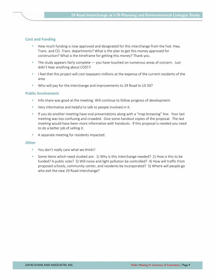
DAVID EVANS AND ASSOCIATES, INC. Public Meeting #1 Summary of Comments Page 9
Cost and Funding
How much funding is now approved and designated for this interchange from the Fed. Hwy.
Trans. and CO. Trans. departments? What is the plan to get this money approved for
construction? What is the timeframe for getting this money? Thank you.
The study appears fairly complete — you have touched on numerous areas of concern. Just
didn’t hear anything about COST!!
I feel that this project will cost taxpayers millions at the expense of the current residents of the
area.
Who will pay for the interchange and improvements to 29 Road to US 50?
Public Involvement
Info share was good at the meeting. Will continue to follow progress of development.
Very informative and helpful to talk to people involved in it.
If you do another meeting have oral presentations along with a “map browsing” line. Your last
meeting was too confusing and crowded. Give some handout copies of the proposal. The last
meeting would have been more informative with handouts. If this proposal is needed you need
to do a better job of selling it.
A separate meeting for residents impacted.
Other
You don’t really care what we think!!
Some items which need studied are: 1) Why is this interchange needed? 2) How is this to be
funded? A public vote? 3) Will noise and light pollution be controlled? 4) How will traffic from
proposed schools, community center, and residents be incorporated? 5) Where will people go
who exit the new 29 Road interchange?

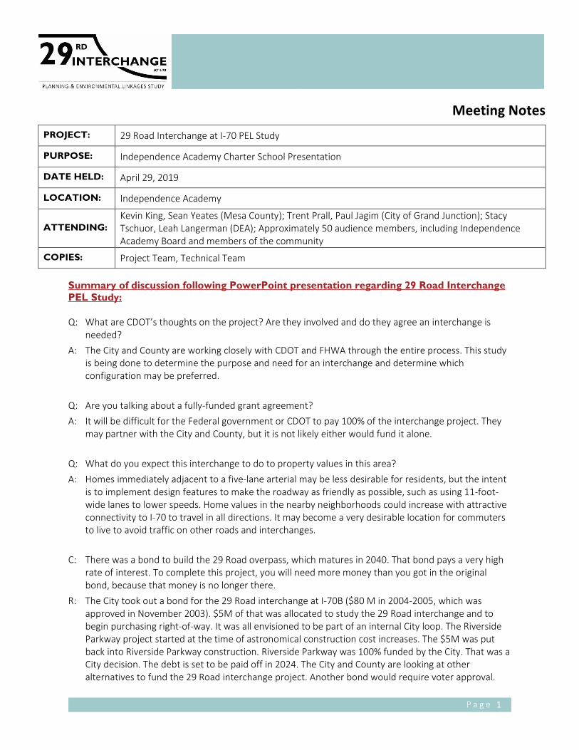
P a g e 1
Meeting Notes
PROJECT: 29 Road Interchange at I-70 PEL Study
PURPOSE: Independence Academy Charter School Presentation
DATE HELD: April 29, 2019
LOCATION: Independence Academy
ATTENDING:
Kevin King, Sean Yeates (Mesa County); Trent Prall, Paul Jagim (City of Grand Junction); Stacy
Tschuor, Leah Langerman (DEA); Approximately 50 audience members, including Independence
Academy Board and members of the community
COPIES: Project Team, Technical Team
Summary of discussion following PowerPoint presentation regarding 29 Road Interchange PEL Study:
Q: What are CDOT’s thoughts on the project? Are they involved and do they agree an interchange is
needed?
A: The City and County are working closely with CDOT and FHWA through the entire process. This study
is being done to determine the purpose and need for an interchange and determine which
configuration may be preferred.
Q: Are you talking about a fully-funded grant agreement?
A: It will be difficult for the Federal government or CDOT to pay 100% of the interchange project. They
may partner with the City and County, but it is not likely either would fund it alone.
Q: What do you expect this interchange to do to property values in this area?
A: Homes immediately adjacent to a five-lane arterial may be less desirable for residents, but the intent
is to implement design features to make the roadway as friendly as possible, such as using 11-foot-
wide lanes to lower speeds. Home values in the nearby neighborhoods could increase with attractive
connectivity to I-70 to travel in all directions. It may become a very desirable location for commuters
to live to avoid traffic on other roads and interchanges.
C: There was a bond to build the 29 Road overpass, which matures in 2040. That bond pays a very high
rate of interest. To complete this project, you will need more money than you got in the original
bond, because that money is no longer there.
R: The City took out a bond for the 29 Road interchange at I-70B ($80 M in 2004-2005, which was
approved in November 2003). $5M of that was allocated to study the 29 Road interchange and to
begin purchasing right-of-way. It was all envisioned to be part of an internal City loop. The Riverside
Parkway project started at the time of astronomical construction cost increases. The $5M was put
back into Riverside Parkway construction. Riverside Parkway was 100% funded by the City. That was a
City decision. The debt is set to be paid off in 2024. The City and County are looking at other
alternatives to fund the 29 Road interchange project. Another bond would require voter approval.

P a g e 2
C: Follow-up audience member comment: It would be very important that all of Mesa County, not just
the City, bonds. My concern about this whole thing is that the City moves money to other areas other
than the roads. Concerned about money being put into Three Rivers Convention Center.
R: The City is very much about transparency so funding information is publicly available.
Q: A few years ago there was talk about continuing F ½ Road to 32 Road. Is the long term plan to take it
further east?
A: I believe that is shown on the Grand Valley Circulation Plan. F ½ is planned to tie into Matchett Park
as soon as funding becomes available.
Q: The Clifton exit and Horizon exit don’t seem to have a lot of traffic. If CDOT doesn’t think and
interchange is needed here, why does the County think so?
A: This study is being done to determine if an interchange is needed at 29 Road. The goal is providing
better local roadway connectivity and alternative access points to the interstate. Horizon Drive does
get fairly busy and as the vacant land develops, the congestion will increase. If all the money was in
the bank, it would take at least five years to construct the 29 Road interchange. The City and County
want to proactively address and plan for connectivity needs. Also, one interchange serving the airport
is a bit of a security issue. It will be helpful for them to have more points of access.
Q: Are there any plans to include improvements to the intersection at 29 Road and Patterson Road? The
southbound left turn lane isn’t long enough.
A: This study will evaluate how that intersection functions and determine how to address short and long
term needs there.
Q: We just had an election and voted on a tax increase. Where was that money slated to go? Now that it
failed, what is Plan B?
A: A portion of the proposed sales tax increase was for this interchange and 29 Road improvements, as
well as other projects around the city such as backbone roads like 26 Road and 26 ½ Road. The
funding plan is using a three-legged stool approach. The first leg was sales tax. The second leg is using
existing resources, such as repurposing funds from the old Riverside Parkway bond. Also, TABOR
excess funds are being used to improve the City’s pavement index until 2022. After 2022, these funds
could be moved and used for transportation capacity. The third leg involves increasing transportation
impact fees when development comes in. Transportation impact fees haven’t been increased in the
City since 2008. The City feels that development should pay their share. As a replacement to the
failed quarter-cent tax, the City will look at taking TABOR excess funds that are currently being used
on pavement index until 2022 to go to transportation capacity. The second and third options will
require voter approval.
Q: There are a number of developments going in along 29 ½ Road between Patterson Road and G Road.
This is a farm to market road without sidewalks. Are there any plans to improve 29 ½ Road?
A: The quarter-cent sales tax would have paid for that type of project, and transportation impact fees
could also help with this. This isn’t currently in the five-year Capital Improvement Plan.
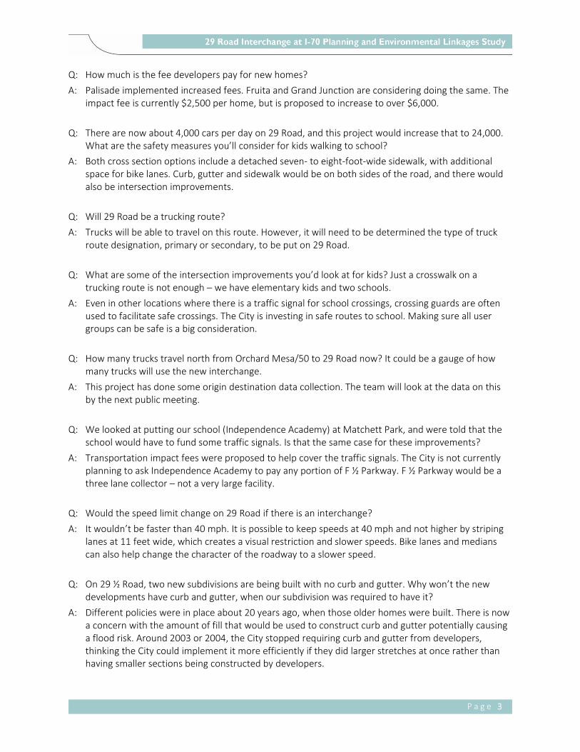
P a g e 3
Q: How much is the fee developers pay for new homes?
A: Palisade implemented increased fees. Fruita and Grand Junction are considering doing the same. The
impact fee is currently $2,500 per home, but is proposed to increase to over $6,000.
Q: There are now about 4,000 cars per day on 29 Road, and this project would increase that to 24,000.
What are the safety measures you’ll consider for kids walking to school?
A: Both cross section options include a detached seven- to eight-foot-wide sidewalk, with additional
space for bike lanes. Curb, gutter and sidewalk would be on both sides of the road, and there would
also be intersection improvements.
Q: Will 29 Road be a trucking route?
A: Trucks will be able to travel on this route. However, it will need to be determined the type of truck
route designation, primary or secondary, to be put on 29 Road.
Q: What are some of the intersection improvements you’d look at for kids? Just a crosswalk on a
trucking route is not enough – we have elementary kids and two schools.
A: Even in other locations where there is a traffic signal for school crossings, crossing guards are often
used to facilitate safe crossings. The City is investing in safe routes to school. Making sure all user
groups can be safe is a big consideration.
Q: How many trucks travel north from Orchard Mesa/50 to 29 Road now? It could be a gauge of how
many trucks will use the new interchange.
A: This project has done some origin destination data collection. The team will look at the data on this
by the next public meeting.
Q: We looked at putting our school (Independence Academy) at Matchett Park, and were told that the
school would have to fund some traffic signals. Is that the same case for these improvements?
A: Transportation impact fees were proposed to help cover the traffic signals. The City is not currently
planning to ask Independence Academy to pay any portion of F ½ Parkway. F ½ Parkway would be a
three lane collector – not a very large facility.
Q: Would the speed limit change on 29 Road if there is an interchange?
A: It wouldn’t be faster than 40 mph. It is possible to keep speeds at 40 mph and not higher by striping
lanes at 11 feet wide, which creates a visual restriction and slower speeds. Bike lanes and medians
can also help change the character of the roadway to a slower speed.
Q: On 29 ½ Road, two new subdivisions are being built with no curb and gutter. Why won’t the new
developments have curb and gutter, when our subdivision was required to have it?
A: Different policies were in place about 20 years ago, when those older homes were built. There is now
a concern with the amount of fill that would be used to construct curb and gutter potentially causing
a flood risk. Around 2003 or 2004, the City stopped requiring curb and gutter from developers,
thinking the City could implement it more efficiently if they did larger stretches at once rather than
having smaller sections being constructed by developers.
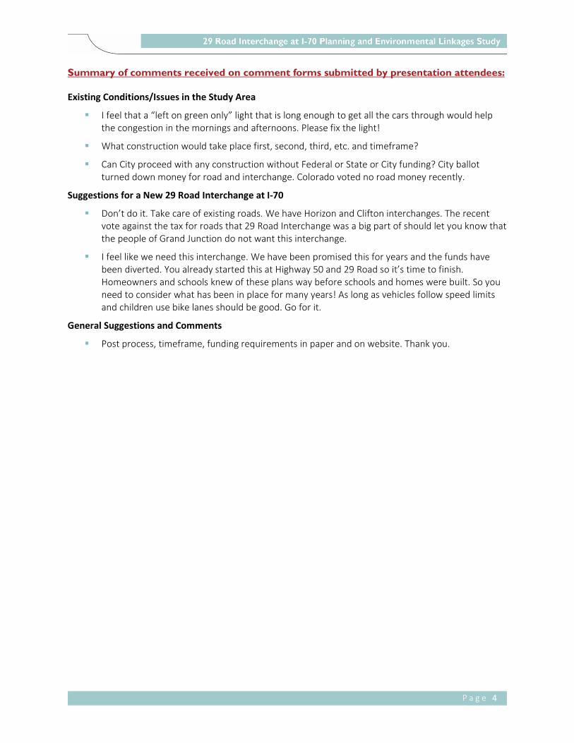
P a g e 4
Summary of comments received on comment forms submitted by presentation attendees:
Existing Conditions/Issues in the Study Area
I feel that a “left on green only” light that is long enough to get all the cars through would help
the congestion in the mornings and afternoons. Please fix the light!
What construction would take place first, second, third, etc. and timeframe?
Can City proceed with any construction without Federal or State or City funding? City ballot
turned down money for road and interchange. Colorado voted no road money recently.
Suggestions for a New 29 Road Interchange at I-70
Don’t do it. Take care of existing roads. We have Horizon and Clifton interchanges. The recent
vote against the tax for roads that 29 Road Interchange was a big part of should let you know that
the people of Grand Junction do not want this interchange.
I feel like we need this interchange. We have been promised this for years and the funds have
been diverted. You already started this at Highway 50 and 29 Road so it’s time to finish.
Homeowners and schools knew of these plans way before schools and homes were built. So you
need to consider what has been in place for many years! As long as vehicles follow speed limits
and children use bike lanes should be good. Go for it.
General Suggestions and Comments
Post process, timeframe, funding requirements in paper and on website. Thank you.
DAVID EVANS AND ASSOCIATES, INC. Public Meeting #1 Summary of Comments Page 1
Summary of Comments Received Between
Public Meetings #1 and #2
Following is a summary of comments submitted via email and the project web page from April 1, 2019
through May 27, 2020.
Comments
Project Support
The Grand Junction Regional Airport needs another airport access point.
When evaluating interstate exit configurations the team should consider the possible distraction
of the landing lights from planes as they approach runway end 29. A diamond might be less
distraction for drivers than any circular patterns like a cloverleaf.
I am all for the completion of the project, been hoping it will start soon.
The sooner, the better!
Project Opposition
Really bad idea. Simple. Won’t get used that much because the way Highway 50 is angled. Think
about it.
The 29 Road access is simply going to dump more traffic on Patterson Road, and will not serve to
reduce congestion along that corridor. Additionally, the county needs to spend less time and
money on this unneeded corridor, and more money cleaning up the self created trash dumps
scattered throughout the valley. Doing so would make it a much more pleasant area in which to
live and improve the existing traffic corridors that are already in place but not traveled due to the
poor condition of the neighborhoods. For example, North Avenue is a fine traffic corridor, and if
the city and county would conduct "in fill" practices and redevelopment in the areas from 30
Road to 28 Road, perhaps the traffic wouldn't be so heavy and condensed elsewhere in the
valley. Instead, they continue to over develop around the mall creating terrible congestion. Ditto
for Patterson Road. How about a fix and expansion of 1st Street from Patterson to North? How
about an expansion of G Road from Horizon Drive to 22 Road?
Property Impacts
The concept plans of the interchange that show the proposed locations of the on/off ramps
indicate that the location of the east-bound onramp going through an existing Grand Valley
Power electrical substation. The relocation of this substation is not feasible, and the onramp will
need to be located farther west to avoid this parcel.
I understand we really do need an interchange on 29 Rd. If you look up my address on G Rd, you'll
see that there is a two lane street in front of my house. I do NOT want G Rd to become a busier
thoroughfare as in putting G Rd through to 30 Rd. We don't have sidewalks here and this area is a
well known walking loop due to the lack of traffic around here. Plus, my house was built in 1947
and is much closer to the street. Not to mention that I'm one of the few people around here that
DAVID EVANS AND ASSOCIATES, INC. Public Meeting #1 Summary of Comments Page 2
is still on septic. Widening the street will inevitably get into my leach field. Oh, and I can't tap into
the city sewer system because it doesn't come down the street this far. The last I was told from
the city is that if my septic system is affected, I will have to pay the city to bring the sewer down
and have to pay to tap in as well (which will obviously bankrupt me and I'll lose the house. Period.
So, if the street is widened, does that mean I'll be bought out for the project? Also, based on the
initial interchange design, it shows that the end of the e/b acceleration ramp goes behind my
house. I think the noise and additional traffic will be absolutely unbearable. I have more issues,
but I figure this is a good start. Many thanks for your time.
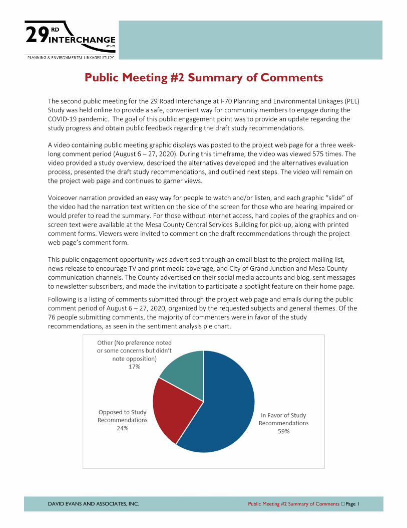
DAVID EVANS AND ASSOCIATES, INC. Public Meeting #2 Summary of Comments Page 1
Public Meeting #2 Summary of Comments
The second public meeting for the 29 Road Interchange at I-70 Planning and Environmental Linkages (PEL)
Study was held online to provide a safe, convenient way for community members to engage during the
COVID-19 pandemic. The goal of this public engagement point was to provide an update regarding the
study progress and obtain public feedback regarding the draft study recommendations.
A video containing public meeting graphic displays was posted to the project web page for a three week-
long comment period (August 6 – 27, 2020). During this timeframe, the video was viewed 575 times. The
video provided a study overview, described the alternatives developed and the alternatives evaluation
process, presented the draft study recommendations, and outlined next steps. The video will remain on
the project web page and continues to garner views.
Voiceover narration provided an easy way for people to watch and/or listen, and each graphic “slide” of
the video had the narration text written on the side of the screen for those who are hearing impaired or
would prefer to read the summary. For those without internet access, hard copies of the graphics and on-
screen text were available at the Mesa County Central Services Building for pick-up, along with printed
comment forms. Viewers were invited to comment on the draft recommendations through the project
web page’s comment form.
This public engagement opportunity was advertised through an email blast to the project mailing list,
news release to encourage TV and print media coverage, and City of Grand Junction and Mesa County
communication channels. The County advertised on their social media accounts and blog, sent messages
to newsletter subscribers, and made the invitation to participate a spotlight feature on their home page.
Following is a listing of comments submitted through the project web page and emails during the public
comment period of August 6 – 27, 2020, organized by the requested subjects and general themes. Of the
76 people submitting comments, the majority of commenters were in favor of the study
recommendations, as seen in the sentiment analysis pie chart.
DAVID EVANS AND ASSOCIATES, INC. Public Meeting #2 Summary of Comments Page 2
Please provide feedback regarding the alternatives development and
evaluation.
I support the addition of access to I-70 from 29 Road.
I agree the 29 Road interchange is the best option.
I primarily agree with the I-70/29 Road Interchange option.
We have always been for the 29 Road Interchange. We believe it is much needed as our
population grows.
I'm glad the evaluation shows the value of a new interchange at 29 or 30 Road. This will be a
welcome change.
A North - South corridor is already in place with the 29 Road bridge over the Colorado River and
the Union Pacific rail corridor. Alternative 2 is the only reasonable solution from a cost standpoint
and functionality. Alternatives 1, 3 and 4 are unreasonable.
The process seems reasonable although it has taken forever.
Anything to lighten the traffic on 27 1/2 Road between Patterson and Horizon Dr. Drivers have a
hard time trying to enter 27 1/2 Road from our subdivisions and with a round about going in on
27 1/2 Road and G Road it’s going to get worse.
Thank you for providing it to us to see the thought process.
The video only covered the process.......not the potential positives and negatives. This is like
asking people to comment on a new movie...based only on a video of how they hired the actors.
There is nothing there to give feedback on.
I don't see any of the alternatives as viable.
Will any of the improvements identified in Alternative 1 be pursued further to make access
improved from the airport to 29 Road other than on I-70? Once upon a few reviews ago, the
modeling indicated that lanes would needed to be added to I-70 between Horizon Drive and a 29
Road interchange. Is that still the case or did something change?
I attended the February 2019 public meeting. I have read the information on this site, and I
watched the accompanying video. The discussion seems to be just about which of the two
alternatives to proceed with, not why any such improvement is really necessary. The planners
seem to be prioritizing potential "economic growth" over liveable communities, and the rapid
transportation of motorized vehicles over people. There isn't any discussion of the non-
quantifiable costs involved, such as degradation of the quality of the affected neighborhoods.
Making Grand Junction into a less liveable community will have adverse economic costs as well.
Haven't you people learned anything from the mistakes made in places like Denver? Further, in
regard to this process, I find it condescending that the City and County would simply say to us
'here are your two choices, decide' without honestly considering the option of not building an
interchange at all. It has the appearance that the City and County are determined to spend the
money no matter what the public says.
DAVID EVANS AND ASSOCIATES, INC. Public Meeting #2 Summary of Comments Page 3
I am writing you to voice my concerns about the 29 Road I-70 Interchange project. I have been
familiarizing myself with the plans and would like to know more about the process and timeline
and why you feel this interchange is needed. My concerns and issues are as follows:
» Has a study or assessment been made to show the necessity and impacts of this project?
Do the benefits outweigh the negative impacts and the cost?
» Where’s the funding? The scale of the project will require extensive funds.
Based on our observations, adding an interchange at either location would alleviate a lot of traffic
currently going through 27 1/2, Patterson, and G Road. That would help traffic in those areas
considerably.
Do you agree with the study’s recommended alternative? Please provide
comments regarding both alternatives below.
Carried Forward, Recommended: New I-70/29 Road Interchange with North Connection
(including 29 Road improvements between I-70 and Patterson Road)
Benefits/In Favor
Yes, a new I-70 interchange is needed.
I agree with the 29 Road option. I work on 29 1/2 Road but have to use the interstate to get to
and from work every day. This improvement would be wonderful as I have to access the
interstate through Clifton or Horizon at this time. I would much rather be able to go down 29
Road.
I agree this is a real necessity in Grand Junction. There is so much traffic congestion on Patterson
Road during peak travel times. I live in the north east part of town and have always wished for a
29 Road exit to and from the interstate.
I think this project will provide an essential North South connection to I-70 between 32 Road and
Horizon Drive. This is vital to relieve future traffic circulation issues on the main East West
roadways such as Patterson Road and North Avenue.
Agree.
I think this would be great. It would be nice to have a connection to I-70 between Horizon and
Clifton.
Yes, we agree with this recommendation.
Agree with this I-70/29 road interchange this makes the most sense and least intrusive changes.
Go for it!! Long overdue!
I believe that this would be the best plan.
I am very supportive of this measure to move forward as an additional option to connect with
I-70 and even the airport and future expansion as it may happen for this area.
Great idea - congestion in and around North Avenue is affecting safety of motorists and
pedestrians.
I agree and look forward to the completion of this project. It is one long in coming, to be sure.
DAVID EVANS AND ASSOCIATES, INC. Public Meeting #2 Summary of Comments Page 4
This drive route option not only provides another good access to the airport but it serves as a
route for handling internal access for those centrally located between Clifton and Horizon drive. It
also provides a good access point for commercial vehicles to North Avenue and even the
industrial zone south of North Avenue and near 29 Road. The four quadrants surrounding the I-70
entrance/exit points on both sides will provide for additional commercial and vendor operations.
I have lived in the 29 Road north Grand Junction area for the last 15+ years and have longed for
the 29 Road/I-70 interchange. It is a much needed connection to I-70 that would help alleviate a
lot of traffic from East Grand Junction to the Mall area along Patterson/F Road. It's not beneficial
for a large population between 28 1/2 Road and 31 Road to use the Clifton I-70 interchange or
the Horizon I-70 interchange for getting across town. You might as well stay on F Road. This will
change that. Plus it will give a quick exit to the east and also complete the loop south from I-70 to
Hwy 50.
Our family feels this proposed exit/interchange would help to alleviate the excessive traffic
congestion that plagues Grand Junction. Hopefully, as alluded to, this would be the first of other
implemented solutions to assist with traffic flow.
Yes. I think the interchange with I-70 and 29 Road is essential.
Yes the I-70/29 Road Interchange is needed. Concentrated traffic at Horizon Drive and 32 Road
lead to excess traffic, noise, pollution and accidents.
Looks like the best choice for a much needed I-70 interchange. Plan looks good from the
interstate to Patterson but what about the connection at Highway 50? It will have a big impact on
that neighborhood.
I just moved here from Denver and this is the first I have heard about it, but I support making this
area more accessible.
29 Road is an artery of our community. Connecting it to I-70 would greatly benefit our
community. A must.
I would be in favor of going forward with the 29 Road interchange and would vote to fund this if it
came up in an election ballot measure. I am in favor of this option.
Please get this project started. This is the most direct way for persons travelling from Orchard
Mesa to get to the Interstate. Even though I don't live there, it will take the burden off of Horizon
Drive.
Long overdue! please build it now.
Yes. This really needs to be done!
Agree. Alternate of adding an exit at 29 Road makes the most sense and will making getting
across the valley much easier. Often trips from north west Grand Junction to Orchard Mesa are
difficult. Transportation in the region could benefit from increased use of I-70 and adding this exit
will help that.
Yes, the recommended alternative sounds good. An interchange at 29 Road would be awesome!
This is what this area of town needs to make the freeway easier to access.
If are going to build it, this one is probably preferable.
DAVID EVANS AND ASSOCIATES, INC. Public Meeting #2 Summary of Comments Page 5
Yes build ASAP. Having access to future Matchett Park will be extremely beneficial.
Yes, I agree with this alternative. It will provide excellent access to many points in the city.
I'm so happy that this is finally happening!!!! We've needed this for more than 15 years.
Great job on this presentation. We welcome this project! We live near 29 Road and Patterson,
and through this means more traffic in our area, we thoroughly agree with the need for "better"
traffic flow in the greater GJ area! The 29 Road interchange with I-70 will provide a tremendous
benefit to our area. (Plus...if you can arrange for a Cracker Barrel Restaurant to be placed near
the new interchange, then life will be good!! May capitalism do its work!) Again - great job,
everyone! Your hard work is appreciated.
I have reviewed the attached update and watched the short video. I am highly in favor of the
proposed 29 Road interchange to connect with I-70.
It seems like this one was preferred because of an already determined preference. It makes sense
to choose this option for many reasons.
I agree with the recommended alternative.
Although I live off 29 Road, and the result will mean more traffic going past, I think this is the best
choice given the fact that the road goes all the way to I-70 already.
I have wanted an I-70/29 Road Interchange for decades! I wish it had been done years ago!
I think that the I-70/29Road Interchange is long overdue. It should also help reduce the
congestion on Patterson.
As a 20 year resident of Darla Jean subdivision I support this project. This project is long overdue.
I agree that 29 Road is the better option.
Yes it would be nice, but have 30 Road would be great as well.
I like using 29 Road when I go into town, from Whitewater, and this would also be the most direct
route off of I-70 for truckers either going East on Hwy 50 or coming into town from Hwy 50
Delta/Montrose to get onto I -70. This always seemed like an unfinished project after the river
bridge was put in at 29 Road.
Seems to be the best option.
The 29 Road interchange seems to be the absolute logical choice. 29 Road already runs from Hwy
50 all the way to Patterson Road and above, which would make the interchange a straight
through access point across the valley. I-70/29 Road is a much better choice than 30 Road. It also
would have much less impact on residents that are located on those two roads. To minimize
impact on local residents, 29 Road is the best choice.
If I read the slides correctly, one of the reasons for not recommending the midpoint interchange
is because it would need to be designated a truck route. What kind of truck traffic is anticipated?
Is 29 Road currently designated a truck route? If it were signed a truck route from the state
highways at either end, does that imply CDOT ownership or responsibility? Also, truck route
designation seems to be in conflict with the stated goal of improving pedestrian and bicycle
access, especially given the school in close proximity to the new interchange and the designated
school walking routes for the neighborhood.
DAVID EVANS AND ASSOCIATES, INC. Public Meeting #2 Summary of Comments Page 6
The I-70/29 Road interchange has long been needed to relieve congestion on Patterson and
facilitate east west traffic in GJ. Sooner the better, traffic congestion continues to grow on
Patterson Avenue.
Concerns or Opposed
This will cause too much traffic on 29 Road. I live on Texas and it is difficult to make a left hand
turn on 29 Road during rush hour. Also nobody stops on 29 Road when children are walking
home. Several times I have seen them run across the 29 Road on the crosswalk because cars are
not stopping. With any type of big truck traffic or increased road use this is a nightmare.
Too much noise, increase air pollution in a higher populated area.
I am not in favor of this recommendation. The impact on the communities along 29 Road would
be subject to noise, traffic congestion and possibly property damage. We enjoy the quiet of our
neighborhood.
I disagree.
I am greatly worried about the added traffic on 29 Road. I ride my bike along this road extensively
to commute to work, and see this proposed change as a huge hinderance to this activity. 30 Road
already appears to be set up for additional traffic, at least up to F 3/4 road. It is unclear from your
presentation why this alternative was eliminated. It appears to be better developed, wider, and
less of an impact on owner properties. 29 Road has numerous homes right on the proposed
improvements. I am thinking particularly of the home on corner of 29 and F 1/2 and the homes
off of Bonito and Hermosa. This seems to be an added expense to the project that using 30 Road
would not incur.
No, there isn't any funding for it and it is not necessary. If you want to improve the traffic into
Grand Junction, put a concrete wall along the south side of I-70 between Clifton exit and pull out
before Palisade. It's someone’s special interest.
My concern is the amount of traffic south of Patterson as trucks and large vehicles use this to
access Hwy 50. There should be a weight limit south of Patterson so these don't use the 29 Road
bridge.
It seems that the City of Grand Junction continues to not listen to its residents and taxpayers. The
need to link I-70 to Hwy 50 is done by Hwy 141 which does not go through residential
neighborhoods (or school zones) and is better equipped to handle heavy traffic, is maintained by
the state and offers easy access to fuel stations and food for travelers and truckers. Risking the
safety of children and residents for a truck route that is not needed should not be a priority for
the Grand Valley.
I live near 29 Road and it sounds dreadful, there’s too much traffic on Patterson at this time, and
29 is a narrow road, I like the idea of 30 Road much better as it spreads it out.
We live on 29 Road. We are both 80 years old and have a reverse mortgage. If we are put out of
our home we would have no place to live. My husband is on oxygen and all that extra traffic
fouling the air would be very bad for his lungs. Another consideration is the school on 29 Road.
Traffic is backed up for blocks as there are no school buses for the 300 students.
No, I disagree.
DAVID EVANS AND ASSOCIATES, INC. Public Meeting #2 Summary of Comments Page 7
The proposed route along 29 Road between I-70 and Hwy 50 would cut off approximately 3 miles
compared to the existing route at 32 Road. It is not a good idea to put a truck route through 29
Road. Near the north end you are cutting through neighborhoods that will be negatively
impacted such a route. There are neighborhoods close to 29 Road along much of its route that
will be negatively impacted by the increased truck traffic. It would be no faster than the existing
route on 32 Road because of the reduced speeds on 29 Road. There are four schools within about
a quarter mile of 29 Road. A truck route is not appropriate. I must ask who exactly in Grand
Junction is going to benefit from further carving up the city with major roads. Only the land
owners on I-70. Shame on you if you really think this is what Grand Junction needs.
While at first I thought this would be a good thing when I realized traffic on 29 Road would go
from 500 to 26,000 vehicles a day I realized this will threaten the neighborhoods on either side of
29 Road. Noise, traffic, pollution and a reduction of walk-able neighborhoods are the main
downsides to this project. Not to mention wasting taxpayer funds on a project that is a
duplication of current access. The 32 Road exit is much better suited to carry the type of
commercial traffic to Highway 50. Also, the Horizon Drive exit which is one and half miles west
and already has accommodations for travelers in place. Plus after a dismal year of Covid it seems
important to support the business on Horizon Drive and continue the support in the upcoming
years. Considering the above factors there is no real need to have 29 Road connect to Highway
50, 32 Road already does that quite nicely and it is 4 lanes with several center turn lanes. 29 Road
presently does not have these features in place, which will either require widening or result in be
bumper to bumper traffic from I-70 all the way to Highway 50. When coming from the west, the
I-70 business loop provides direct access to Highway 50. So, why do the city/Mesa Co. want to do
this project? Is it the possibility that the land at the 29 Road and I-70 junction could profit the city
and or county? I understand that public budgets are squeezed right now, but is sacrificing the
comfort and safety of the local citizenry the right way to resolve the present shortfall? 29 Road
with one lane in each direction and a single turn lane will never be able to handle this much
traffic. Children going to and from Nisley Elementary School and Bookcliff Middle school will need
pedestrian crossings which will make timing of lights to facilitate traffic flow impossible. God help
anyone that trying exit their neighborhood and turn across traffic, or trust thier kids to walk back
and forth from school safely. Putting several large truck stops off the I-70 interchange will mean
29 Road will become the main throughfare to access highway 50. I'm not sure the people that live
along 29 Road are comfortable with a lot more truck traffic in their area. Presently the people
north of Patterson on 29 Road have a quiet existence, which will disappear once this project is
built. Truck stops in winter are noisy pollution filled areas as truckers' idle engines all night to stay
warm and keep engines from freezing up. This project is a solution in search of a problem. There
already are 2+ ways to access Highway 50, 32 Road in Clifton is a mere 3 miles to the east.
Horizon Blvd to the west is only 1 1/2 miles to the west. This project is total duplication! brought
on by access to free federal highway funds. The city professes to want to help Horizon Blvd
businesses, but what do they think this will do to traffic and business along that corridor? Scrap
this project, it's not needed and will ruin the neighborhoods along 29 Road forever. Total waste
of taxpayer money.
I do not agree with the proposal for the New I-70/29 Road interchange. I do not want huge
commercial trucks driving through our neighborhood along with all the other traffic it will bring.
We have two schools on 29 Road and it will not be safe for the children to walk or ride their bikes
on 29 Road anymore. The amount of noise and pollution it will bring is heavily underestimated. I
DAVID EVANS AND ASSOCIATES, INC. Public Meeting #2 Summary of Comments Page 8
live on a corner of 29 Road and I believe my property value will go down. It definitely won’t go up.
I think the city should improve the existing interchanges.
The traffic exiting I-70 will have nowhere to go increasing traffic on Patterson. I do not want I-70
traffic any closer. Patterson and 29 Road are already over used. The I-70 exit is not necessary.
Why spend millions of dollars on a unnecessary interchange in a residential neighborhood with
schools next to 29 road. Putting an interchange will increase unnecessary traffic, reduce safety
measures for our children, and cause chaos for all. During the school year, school traffic is backed
up on 29 Road north of Patterson from Independence Academy Charter school entrance
completely to F Road between 7:30-8:30am and between 3:30-4:30pm. This school does not
offer a bussing system, therefore children who attend this school from pre-K to 8th grade must
be dropped off and picked up by a private vehicle. This school has roughly 500 students, plus staff
members. There are several bus stops along the way of 29 Road north of Patterson. Bussing
systems to other elementary, middle and high schools will temporarily delay traffic as well. Safety
is always a concern in my eyes. I feel like I currently live in a safe neighborhood, with minimal
noise. With an interchange brings transients, out of towners and others unfamiliar with the area.
With there being two schools on 29 Road, it would be very easy for a child to be abducted from a
school play yard or a bus stop and the criminal will hop on the interstate and never be seen again
with OUR children. There are several bus stops along the way of 29 Road, children who also walk
to and from school daily on a safe path, will deem no longer safe if this interchange is built. I live
off 29 Road, there is no reason why another interchange need built with one 3 miles East and 3
miles West of us. It does not take very much extra time to access these, my husband and I both
work in Fruita and we do not want this. Truckers have simple access from the interchange off 32
Road to Highway 50, no need to build an alternative route. It is undesirable to bring commercial
trucks in our neighborhoods. There is no extra room on 29 Road for these truckers to pull over for
a flat tire or to map a route. Most of our neighborhood side streets are not large enough to allow
these large 18 wheelers who are lost, to allow for them to turn around in a cul-de-sac. We need
to focus our money elsewhere on updating roads and interchanges instead of building a new one
that is not sensible. If I wanted to live next to an interstate interchange, I would have bought
elsewhere. Our children are our priority, and for parents to not feel safe letting their kids walk or
ride their bike to school, play in the neighborhood, or even enjoy an evening stroll is not fair to
us.
This alternative is not acceptable. It would be highly disruptive to communities between
Patterson Road and I-70 and would adversely affect all of the communities along the entire
length of 29 Road. The increased traffic on 29 Road would effectively divide the city between east
and west (more than it already is). We've all watched eastern Grand Junction deteriorate over the
last few decades, this would only hasten the process.
Carried Forward, Not Recommended: New Midpoint Interchange with North Connection
(including 30 Road improvements between I-70 and Patterson Road)
Benefits/In Favor
30 Road needs improvement whether or not there is a midpoint interchange.
Given the negative impacts and issues of putting an I-70 interchange at 29 Road, the Midpoint
Interchange Alternative should continue to be considered. 29 Road is close to Horizon Drive.
DAVID EVANS AND ASSOCIATES, INC. Public Meeting #2 Summary of Comments Page 9
I am located very close to 29 Road and Patterson. I already hear traffic at night and would prefer
for it not to become louder. Also concerned with future business growth in that area which could
play into further air pollution and noise. I live in a newer subdivision and was not aware of these
plans 10 years ago when I bought the property. Therefore I am in favor of moving this to 30 Road.
which happens to be where I lived prior to my last move. There are less homes in that area and it
is a short distance from I-70B and I-70 to impact less area.
Having this option midway between horizon and the business loop exits makes a lot of sense.
Perhaps it didn't get selected because there seems to be an already established bias for 29 Road.
Perhaps they should be compared more equitably without the bias for 29 Road.
We prefer this option as safer for the community considering the proximity to schools on 29
Road.
This would be appreciated to assist with positive traffic flow in this specific area.
Definitely needed.
I would like to see improvement on 30 Road and create an intersection. This would be a great
idea.
Concerns or Opposed
This just doesn't seem as convenient, and after watching the video, it looks more impactful.
The location of 30 Road doesn't make sense to invest this type of funding because it doesn't
connect to I-50/regional traffic and has much more residential neighborhoods along it that 29
Road.
I do not believe that this would help anything at all.
Not nearly effective as a 29 Road interchange.
I agree this isn't a good alternative.
No, again, it's someone’s special interest.
This is a dumb idea. Why is it even considered?
The 30 Road option does not make sense to me, as it does not offer a direct route between I-70
and Hwy 50/Orchard Mesa.
This would make 30 Road and I-70B even more dangerous.
No.
Do not add 30 Road at this time.
I-70/29 Road Interchange much better location.
Unnecessary.
This is a viable consideration, but I agree that 29 Road makes more sense.
This looks like it would be added costs to continue 30 Road to I-70.
This would be dumb. 29 Road already has a straight shot to I-70. 29 road needs improvement
from Patterson to G road. West Side walks are non-existent from F to F ¼.
DAVID EVANS AND ASSOCIATES, INC. Public Meeting #2 Summary of Comments Page 10
The 29 corridor makes more sense.
Not the best choice. Would entail having to cross connect with other roadways instead of the
straight through ability of 29 Road.
I do not agree with this proposal either.
I am not advocating for a 30 Road interchange, particularly with the lack of infrastructure along
30 Road for peds and bikes and all of the back out driveways. I am curious about the implication
of providing improved access to BLM recreation lands north of I 70. Does this mean consideration
of the north frontage road improvements beyond the existing?
Like the 29 Road alternative, this project is not desirable for the same reasons.
Please provide input, issues, or concerns that should be considered as the
project moves forward with the next phases of project development.
No concerns. The sooner this can happen, the better!
Please make improvements to 29 Road now. It’s dangerous for kids going to schools. Improve 29
to the canal today! A frontage road to Horizon may be useful.
Development continues along Patterson further dumping traffic on this busy road. Get this done
and move up the priority!
Intersection Treatments
No more roundabouts.
No stinking roundabouts!
No roundabouts!!
I have a concern about roundabouts. Would prefer a center turn lane.
I suggest a roundabout at Patterson and 29 Road. And reduced speed limits on North Avenue
from 29 Road to 1st Street.
There are already 11 stop lights between F Road and eastbound Highway 50. Please consider
roundabouts for additional intersections. They are much more efficient.
I am a bit concerned about the right in, right out portion.
I would not recommend right in right out in the intersections as this would be a traffic nightmare
during school hours and heavy traffic. Northbound traffic attempting to turn right in to Darla Jean
would have to yield and be backed up all the way to Patterson.
Please, for the love of God, make the turn light when you are going east on Patterson and turning
north on 29 Road a little longer during school days! You are lucky to get 3 cars through, and there
is so much traffic trying to get to the school. I know it needs to be controlled, but I find it
ridiculous that the 3rd car is racing through the light when it changes. Please have someone look
at that. There has to be a way to get another couple cars through at least. Thank you for letting
me voice my one gripe! Thank you for all you guys are doing.

DAVID EVANS AND ASSOCIATES, INC. Public Meeting #2 Summary of Comments Page 11
Insure that you make enough turn lanes for Orchard and Patterson due to more people using that
route.
Please don't be overly creative and find ways to short the budget by not having all 4 on/off ramps
like the 29 Road bridge at I-70 Business Loop, or lane switch overs...
Improvements to 29 Road South of Patterson
If the recommended I-70/29 Road interchange is going to be implemented, we should consider
improvements to the intersections of 29 and North Avenue too. There is a Walgreens and post
office on that intersection and a Walmart nearby-- increased traffic would most likely utilize those
stores more and the parking lot entrances/exits should not interfere with traffic flow. The same
goes for the Safeway on Patterson & 29 Road. Bike lane/path improvement should be integrated
into the project, especially since the Bike Path is cut off by 29 Road. there should be a safe
alternative to biking on 29 Road to connect to Unaweep or C 1/2 Road to eventually get to Eagle
Rim Park or Colonias Park to join the bike path again. If the project improving 29 Road is going to
increase traffic, we should consider a bike path bridge over 29th and extension of the path along
the river to those parks.
If this alternative is selected, there should be improvements to 29 Road thru to Hwy 50. I can see
where this new interchange would provide a straight route from I-70 to Hwy 50 and would
increase the traffic south of Patterson by a large amount. Perhaps closing some intersections
such as Pinyon and 29 Road would be in order.
Lane additions will be needed from Patterson to the North Avenue to accommodate the traffic.
Having one lane from Patterson to North Avenue is already taxing, especially with two schools
(i.e. Bookcliff and Nisley) traffic and with the expected increase of traffic from this proposal would
need to be accounted for.
Careful development of businesses at Hwy 50 and reduce impact on the homes there from noise
and increased safety issues.
The project needs to address 29 Road from Hwy 50 to River Road, increase to 4 lanes. 29 Road
between Patterson and North needs to increase to 4 lanes. Consideration should be given to both
left and right turn lanes. Right turn lanes are so important to keep traffic moving. The whole of 29
Road should be 4 lanes minimum.
Traffic should be limited south of Patterson and over the 29 Road bridge. This interchange will
increase the volume and size of traffic linking I-70 and Hwy 50.
Considering traffic going south towards Montrose, as well as the south side of the city/Orchard
Mesa, are the 2 lanes between Patterson and North Ave enough for estimated traffic? My
concern is that it will get congested through there, especially around Orchard Avenue, where I
have seen young children walking to go to school (Bookcliff Middle and Nisley Elementary). I
realize it's not possible to add lanes there due to existing homes, I'm just curious if that area has
been evaluated for safety in regards to possible congestion.
Property and/or Neighborhood Impacts
Find a way to appease the residents along 29 Road north of F Road. They will have the greatest
opposition to this project because of traffic and noise.
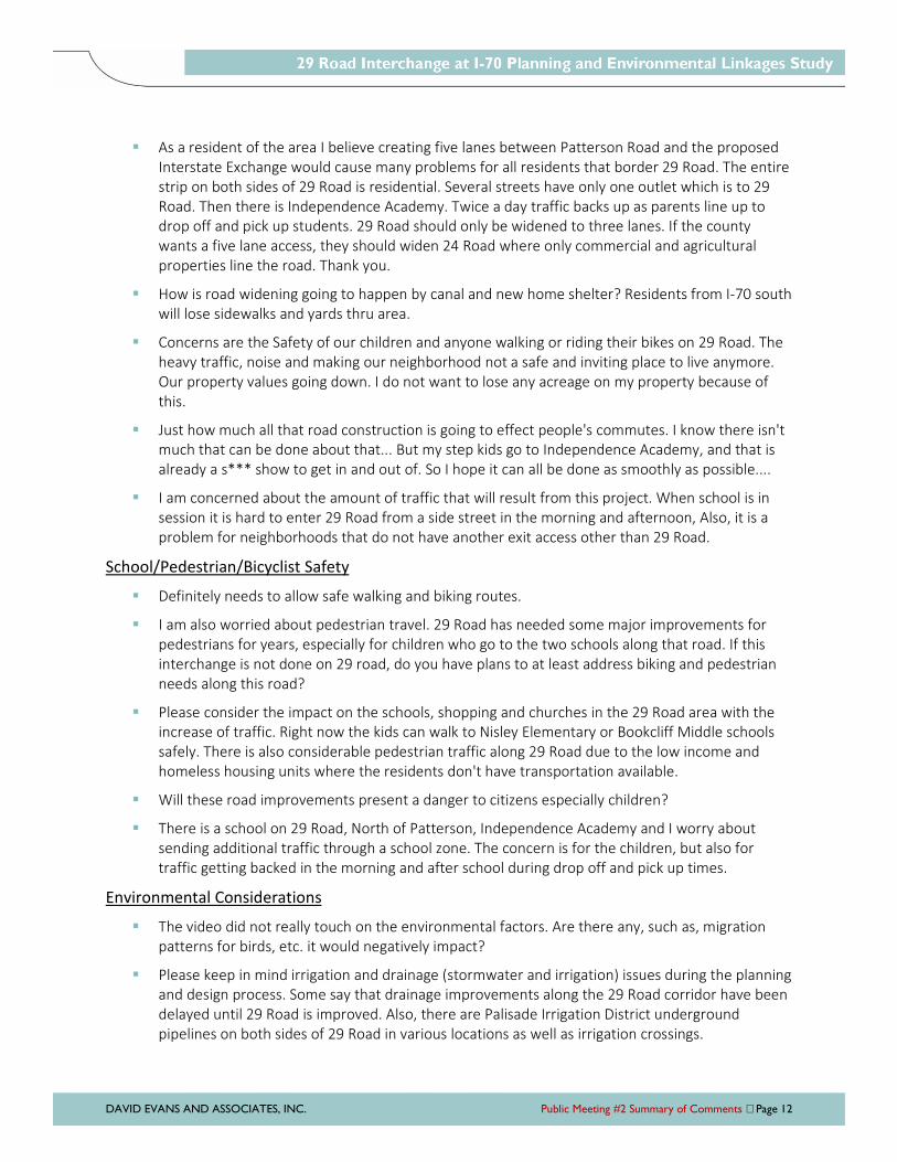
DAVID EVANS AND ASSOCIATES, INC. Public Meeting #2 Summary of Comments Page 12
As a resident of the area I believe creating five lanes between Patterson Road and the proposed
Interstate Exchange would cause many problems for all residents that border 29 Road. The entire
strip on both sides of 29 Road is residential. Several streets have only one outlet which is to 29
Road. Then there is Independence Academy. Twice a day traffic backs up as parents line up to
drop off and pick up students. 29 Road should only be widened to three lanes. If the county
wants a five lane access, they should widen 24 Road where only commercial and agricultural
properties line the road. Thank you.
How is road widening going to happen by canal and new home shelter? Residents from I-70 south
will lose sidewalks and yards thru area.
Concerns are the Safety of our children and anyone walking or riding their bikes on 29 Road. The
heavy traffic, noise and making our neighborhood not a safe and inviting place to live anymore.
Our property values going down. I do not want to lose any acreage on my property because of
this.
Just how much all that road construction is going to effect people's commutes. I know there isn't
much that can be done about that... But my step kids go to Independence Academy, and that is
already a s*** show to get in and out of. So I hope it can all be done as smoothly as possible....
I am concerned about the amount of traffic that will result from this project. When school is in
session it is hard to enter 29 Road from a side street in the morning and afternoon, Also, it is a
problem for neighborhoods that do not have another exit access other than 29 Road.
School/Pedestrian/Bicyclist Safety
Definitely needs to allow safe walking and biking routes.
I am also worried about pedestrian travel. 29 Road has needed some major improvements for
pedestrians for years, especially for children who go to the two schools along that road. If this
interchange is not done on 29 road, do you have plans to at least address biking and pedestrian
needs along this road?
Please consider the impact on the schools, shopping and churches in the 29 Road area with the
increase of traffic. Right now the kids can walk to Nisley Elementary or Bookcliff Middle schools
safely. There is also considerable pedestrian traffic along 29 Road due to the low income and
homeless housing units where the residents don't have transportation available.
Will these road improvements present a danger to citizens especially children?
There is a school on 29 Road, North of Patterson, Independence Academy and I worry about
sending additional traffic through a school zone. The concern is for the children, but also for
traffic getting backed in the morning and after school during drop off and pick up times.
Environmental Considerations
The video did not really touch on the environmental factors. Are there any, such as, migration
patterns for birds, etc. it would negatively impact?
Please keep in mind irrigation and drainage (stormwater and irrigation) issues during the planning
and design process. Some say that drainage improvements along the 29 Road corridor have been
delayed until 29 Road is improved. Also, there are Palisade Irrigation District underground
pipelines on both sides of 29 Road in various locations as well as irrigation crossings.
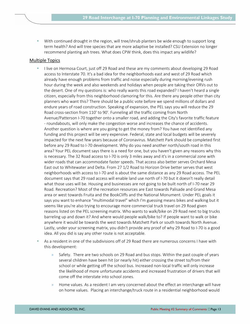
DAVID EVANS AND ASSOCIATES, INC. Public Meeting #2 Summary of Comments Page 13
With continued drought in the region, will tree/shrub planters be wide enough to support long
term health? And will tree species that are more adaptive be installed? CSU Extension no longer
recommend planting ash trees. What does CPW think, does this impact any wildlife?
Multiple Topics
I live on Hermosa Court, just off 29 Road and these are my comments about developing 29 Road
access to Interstate 70. It's a bad idea for the neighborhoods east and west of 29 Road which
already have enough problems from traffic and noise especially during morning/evening rush
hour during the week and also weekends and holidays when people are taking their ORVs out to
the desert. One of my questions is: who really wants this road expanded? I haven't heard a single
citizen, especially from this neighborhood clamoring for this. Are there any people other than city
planners who want this? There should be a public vote before we spend millions of dollars and
endure years of road construction. Speaking of expansion, the PEL says you will reduce the 29
Road cross-section from 110' to 90'. Funneling all the traffic coming from North
Avenue/Patterson I-70 together onto a smaller road, and adding the City's favorite traffic feature
- roundabouts, will only make the congestion worse and increases the chance of accidents.
Another question is where are you going to get the money from? You have not identified any
funding and this project will be very expensive. Federal, state and local budgets will be severely
impacted for the next few years because of Coronavirus. Matchett Park should be completed first
before any 29 Road to I-70 development. Why do you need another north/south road in this
area? Your PEL document says there is a need for one, but you haven't given any reasons why this
is necessary. The 32 Road access to I-70 is only 3 miles away and it's in a commercial zone with
wider roads that can accommodate faster speeds. That access also better serves Orchard Mesa
East out to Whitewater and Delta. From 27 1/2 Road to Horizon Drive better serves that west
neighborhoods with access to I-70 and is about the same distance as any 29 Road access. The PEL
document says that 29 road access will enable land use north of I-70 but it doesn't really detail
what those uses will be. Housing and businesses are not going to be built north of I-70 near 29
Road. Recreation? Most of the recreation resources are East towards Palisade and Grand Mesa
area or west towards Fruita and the BookCliffs and the National Monument. Under PEL goals it
says you want to enhance "multimodal travel" which I'm guessing means bikes and walking but it
seems like you're also trying to encourage more commercial truck travel on 29 Road given
reasons listed on the PEL screening matrix. Who wants to walk/bike on 29 Road next to big trucks
barreling up and down it? And where would people walk/bike to? If people want to walk or bike
anywhere it would be towards the west towards Matchett Park or south towards North Avenue.
Lastly, under your screening matrix, you didn't provide any proof of why 29 Road to I-70 is a good
idea. All you did is say any other route is not acceptable.
As a resident in one of the subdivisions off of 29 Road there are numerous concerns I have with
this development:
» Safety. There are two schools on 29 Road and bus stops. Within the past couple of years
several children have been hit (or nearly hit) either crossing the street to/from their
school or while getting off the school bus. Increased non-local traffic will only increase
the likelihood of more unfortunate accidents and increased frustration of drivers that will
come off the interstate into school zones.
» Home values. As a resident I am very concerned about the effect an interchange will have
on home values. Placing an interchange/truck route in a residential neighborhood would
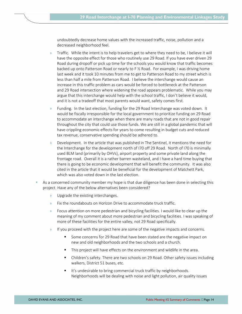
DAVID EVANS AND ASSOCIATES, INC. Public Meeting #2 Summary of Comments Page 14
undoubtedly decrease home values with the increased traffic, noise, pollution and a
decreased neighborhood feel.
» Traffic. While the intent is to help travelers get to where they need to be, I believe it will
have the opposite effect for those who routinely use 29 Road. If you have ever driven 29
Road during dropoff or pick up time for the schools you would know that traffic becomes
backed up onto Patterson Road or nearly to F ½ Road. For example, I was driving home
last week and it took 10 minutes from me to get to Patterson Road to my street which is
less than half a mile from Patterson Road. I believe the interchange would cause an
increase in this traffic problem as cars would be forced to bottleneck at the Patterson
and 29 Road intersection where widening the road appears problematic. While you may
argue that this interchange would help with the school traffic, I don’t believe it would,
and it is not a tradeoff that most parents would want, safety comes first.
» Funding. In the last election, funding for the 29 Road Interchange was voted down. It
would be fiscally irresponsible for the local government to prioritize funding on 29 Road
to accommodate an interchange when there are many roads that are not in good repair
throughout the city that could use those funds. We are still in a global pandemic that will
have crippling economic effects for years to come resulting in budget cuts and reduced
tax revenue, conservative spending should be adhered to.
» Development. In the article that was published in The Sentinel, it mentions the need for
the Interchange for the development north of I70 off 29 Road. North of I70 is minimally
used BLM land (primarily by OHVs), airport property and some private land along the
frontage road. Overall it is a rather barren wasteland, and I have a hard time buying that
there is going to be economic development that will benefit the community. It was also
cited in the article that it would be beneficial for the development of Matchett Park,
which was also voted down in the last election.
As a concerned community member my hope is that due diligence has been done in selecting this
project. Have any of the below alternatives been considered?
» Upgrade the existing interchanges.
» Fix the roundabouts on Horizon Drive to accommodate truck traffic.
» Focus attention on more pedestrian and bicycling facilities. I would like to clear up the
meaning of my comment about more pedestrian and bicycling facilities. I was speaking of
more of these facilities for the entire valley, not 29 Road specifically.
» If you proceed with the project here are some of the negative impacts and concerns.
Some concerns for 29 Road that have been stated are the negative impact on
new and old neighborhoods and the two schools and a church.
This project will have effects on the environment and wildlife in the area.
Children’s safety. There are two schools on 29 Road. Other safety issues including
walkers, District 51 buses, etc.
It’s undesirable to bring commercial truck traffic by neighborhoods.
Neighborhoods will be dealing with noise and light pollution, air quality issues

DAVID EVANS AND ASSOCIATES, INC. Public Meeting #2 Summary of Comments Page 15
and congestion. Their quality of life will change dramatically. What concessions
do you usually make for this kind of traffic for the neighborhoods?
Our community has a great feel, sense of community and a small town flavor.
Developments put that culture at risk. It’s important to be smart and thoughtful
with growth. This project has the potential to change the character of Grand
Junction that many in the community value.
Having a canal close to the interstate causes more issues and expense.
Our priorities should be the maintenance and safety of I-70 and our local roads.
Grand Valley Power’s substation and solar farm southeast corner of 29 Road
bridge over I-70.
Significant overhead power and communication lines along 29 Road.
Changes to canal may require hydraulic modelling for the channel.
As for details:
» F½ intersection could use of roundabout or a light. Noting the volume of traffic for the
Independence Academy (and having family who attend there), I would suggest a traffic
light. A roundabout would potentially be too congestive during morning and afternoon
pickups making F½ westbound entrance difficult.
» Brodick Way is a very sticky wicket making the solution most difficult. Virtually all
westbound traffic in the morning turns south bound. Many a kind north bound soul stops
and yields to a few cars turning, but this then backs up the north bound I.A. traffic flow.
Having a light here may be too close to the F½ light and a roundabout may also be too
congestive. Obviously, traffic flows from that subdivision will increase with growth. A light
may allow for a better traffic pulse.
» The amount of landfill for the Northwest portion of 29 Road. near Bonita is massive, and I
often ponder this as I drive by.
» The private land impact would appear to be less than another options, thus, making this
the best option, right?
» I totally concur with the 5 lane plan where possible. This will definitely aid in traffic flow.
» The bike lanes would be most helpful in the overall connectivity flow of the valley.
» Life Academy's school start and traffic flow seems to be synced differently with
Independence Academy, but I'm sure those who attend there would have a better view
of the congestion issues.
» With the increase in residential homes in this area, this interchange is a welcomed
addition easing cross town movement. Currently, I sometimes back track to Clifton
interchange in order to avoid traffic congestion on Patterson.
» Thank you for all the hard work and perseverance. As noted, this is a very needful and
vital project for our community.
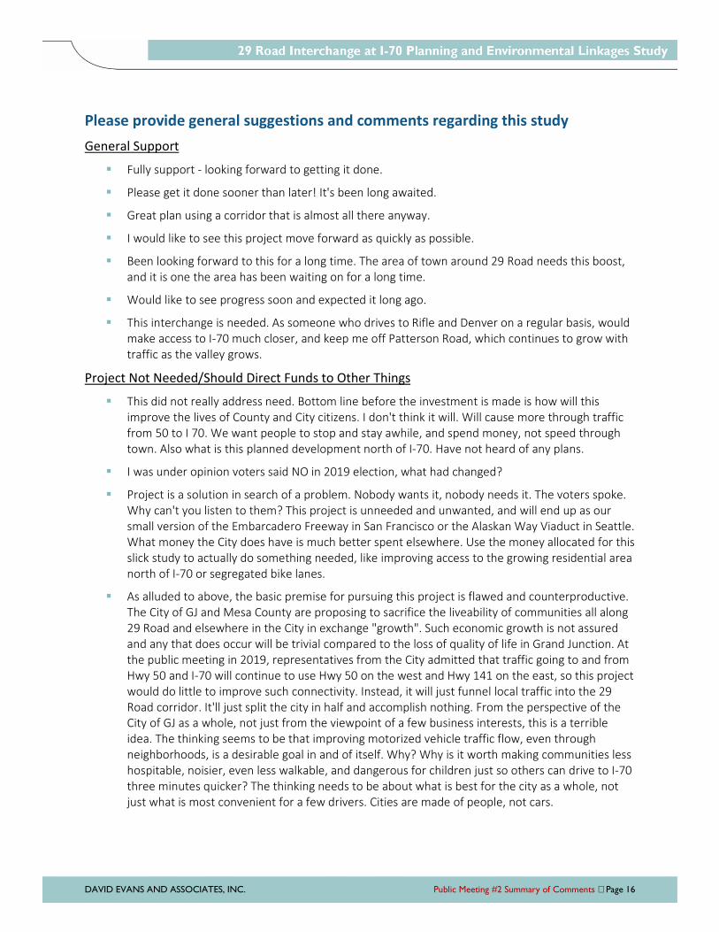
DAVID EVANS AND ASSOCIATES, INC. Public Meeting #2 Summary of Comments Page 16
Please provide general suggestions and comments regarding this study
General Support
Fully support - looking forward to getting it done.
Please get it done sooner than later! It's been long awaited.
Great plan using a corridor that is almost all there anyway.
I would like to see this project move forward as quickly as possible.
Been looking forward to this for a long time. The area of town around 29 Road needs this boost,
and it is one the area has been waiting on for a long time.
Would like to see progress soon and expected it long ago.
This interchange is needed. As someone who drives to Rifle and Denver on a regular basis, would
make access to I-70 much closer, and keep me off Patterson Road, which continues to grow with
traffic as the valley grows.
Project Not Needed/Should Direct Funds to Other Things
This did not really address need. Bottom line before the investment is made is how will this
improve the lives of County and City citizens. I don't think it will. Will cause more through traffic
from 50 to I 70. We want people to stop and stay awhile, and spend money, not speed through
town. Also what is this planned development north of I-70. Have not heard of any plans.
I was under opinion voters said NO in 2019 election, what had changed?
Project is a solution in search of a problem. Nobody wants it, nobody needs it. The voters spoke.
Why can't you listen to them? This project is unneeded and unwanted, and will end up as our
small version of the Embarcadero Freeway in San Francisco or the Alaskan Way Viaduct in Seattle.
What money the City does have is much better spent elsewhere. Use the money allocated for this
slick study to actually do something needed, like improving access to the growing residential area
north of I-70 or segregated bike lanes.
As alluded to above, the basic premise for pursuing this project is flawed and counterproductive.
The City of GJ and Mesa County are proposing to sacrifice the liveability of communities all along
29 Road and elsewhere in the City in exchange "growth". Such economic growth is not assured
and any that does occur will be trivial compared to the loss of quality of life in Grand Junction. At
the public meeting in 2019, representatives from the City admitted that traffic going to and from
Hwy 50 and I-70 will continue to use Hwy 50 on the west and Hwy 141 on the east, so this project
would do little to improve such connectivity. Instead, it will just funnel local traffic into the 29
Road corridor. It'll just split the city in half and accomplish nothing. From the perspective of the
City of GJ as a whole, not just from the viewpoint of a few business interests, this is a terrible
idea. The thinking seems to be that improving motorized vehicle traffic flow, even through
neighborhoods, is a desirable goal in and of itself. Why? Why is it worth making communities less
hospitable, noisier, even less walkable, and dangerous for children just so others can drive to I-70
three minutes quicker? The thinking needs to be about what is best for the city as a whole, not
just what is most convenient for a few drivers. Cities are made of people, not cars.
DAVID EVANS AND ASSOCIATES, INC. Public Meeting #2 Summary of Comments Page 17
This project was put to the voters in 2019 and they rejected it. Let it die already. Quit paying
consultants money to tell the City and County only what they want to hear and start listening to
the people who live here and will be adversely affected by this project.
No, it's another special interest for the city/county. Place that infrastructure money into new city
snow removal, snow plows, shop personnel, drivers. Patch the pot holes on I-70 business loop,
Patterson and North Avenue. Tearing up 29 Road and I-70 is a boondoggle and will cause traffic
noise and air pollution to established housing. The infrastructure money can be spent on schools.
It should be spent there on health and safety. 2018 group labeled it transportation. In 2018, the
group was probably considering the river front project, colon river recreation, bosai, and all the
tourists they would attract! Lol now, we have Covid, and there will be something else, so put the
money into winter equipment. Supplies, labor, and the concrete fence.
Improvement Suggestions Outside Study Area
Personally I have been in this valley for 38 yrs and I have often wondered why many of our
North/South roads are not connected to I-70 and I-70B automatically. I don't think they should be
in just a few locations otherwise traffic congestion, noise and air pollution are unavoidable.
Frontage roads along both highways can accommodate directing traffic to on and off ramps. Our
current frontage roads are confusing as some don't continue the length of the highways so there
is a lot of stops and starts. Thank goodness we do have the 29 Road bridge to 6 & 50 as that was
long overdue. Thanks for allowing input.
Other
Thank you for the presentation and the opportunity to respond and give input.
Need to provide a more detailed map.
Graphic on p 23 is miss labeled. F 1/4 is labeled as Music. Music is one street north.
CDOT is worthless and they cannot manage highways to save themselves whatsoever. Look at
how they manage the roads between GJ and Delta and GJ and Palisade. If we have to rely on
CDOT engineers then we are screwed (i.e. highways described above are the example). We need
reliable engineers to provide a meaningful design.

PEL STUDY REPORT SEPTEMBER 2020
DAVID EVANS AND ASSOCIATES, INC. Appendix
APPENDIX D
North Airport Local Roadway Connection Concept

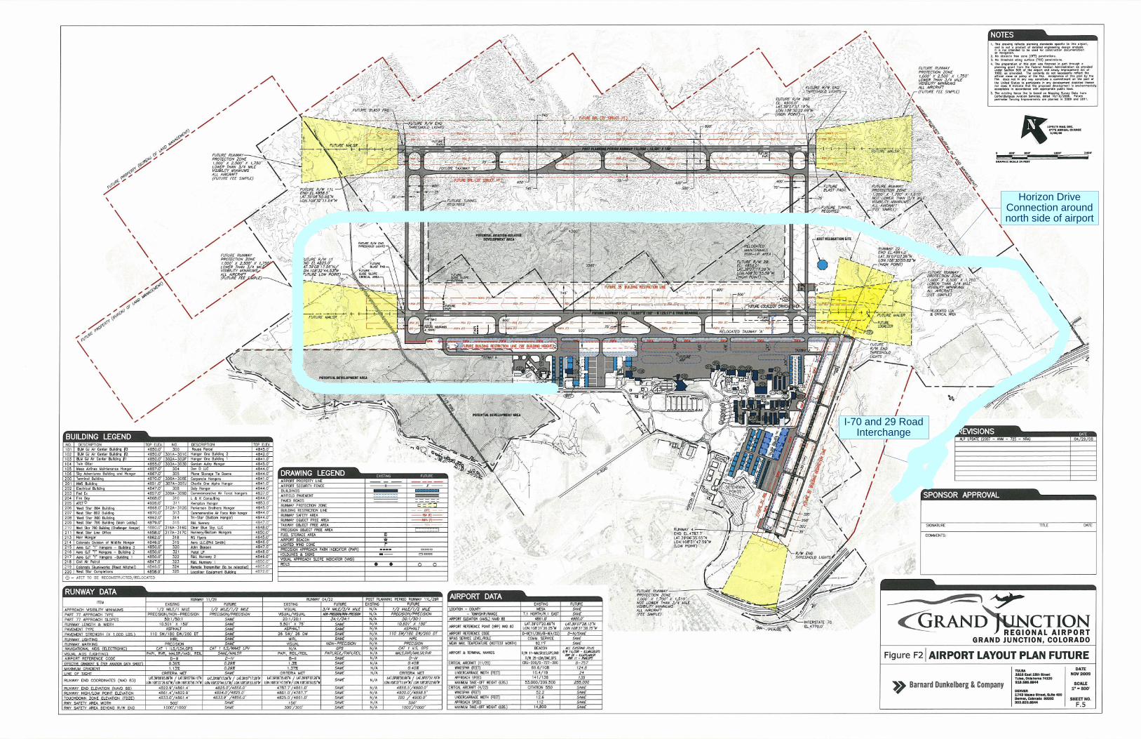
I-70 and 29 RoadInterchange
Horizon DriveConnection aroundnorth side of airport

PEL STUDY REPORT SEPTEMBER 2020
DAVID EVANS AND ASSOCIATES, INC. Appendix
APPENDIX E
Environmental Resources

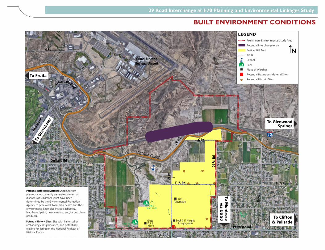
29 R
d
29 1 / 2
Rd
30 R
d
G Rd
F 1/2 Rd
Patterson Rd
28 R
d
27 1 / 2
RdHo
rizon
Dr
Cortland Rd
H Rd
Grand JunctionRegional Airport
F 1/2 Rd
Crossroads Blvd
MatchettPark
Darla Jean Park
Spring Valley II
ParkSpring Valley I
Park
BurkeyPark
Highline Canal
29 Rd
Grace Point
Church
Book Cliff Heights Congregation
LifeTabernacle
Highline Canal
To Clifton & Palisade
To Glenwood Springs
To Fruita
To Mall Area & Hospital
To D
ownt
own
To Montrose
via US 50
LEGENDPreliminary Environmental Study Area
Poten�al Interchange Area
Residen�al Area
Trails
School
Park
Place of Worship
Poten�al Hazardous Material Sites
Poten�al Historic Sites
N
Poten�al Hazardous Material Sites: Site that previously or currently generates, stores, or disposes of substances that have been determined by the Environmental Protec�on Agency to pose a risk to human health and the environment. Examples include asbestos, lead-based paint, heavy metals, and/or petroleum products.
Poten�al Historic Sites: Site with historical or archaeological significance, and poten�ally eligible for lis�ng on the Na�onal Register of Historic Places.
BUILT ENVIRONMENT CONDITIONS
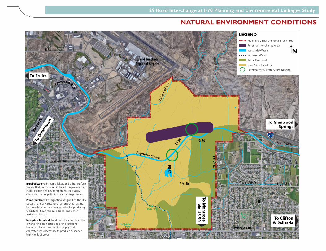
29 R
d 29 1 / 2
Rd
30 R
d
G Rd
F 1/2 Rd
Patterson Rd
28 R
d
27 1 / 2
RdHo
rizon
Dr
Cortland Rd
H Rd
Grand JunctionRegional Airport
F 1/2 Rd
Crossroads Blvd
MatchettPark
Darla Jean Park
Spring Valley II
ParkSpring Valley I
Park
BurkeyPark
Highline Canal
29 Rd
India
n W
ash
Price Ditch
St ub Ditch
To Clifton & Palisade
To Glenwood Springs
To Fruita
To Mall Area & Hospital
To D
ownt
own
To Montrose
via US 50
LEGENDPreliminary Environmental Study Area
Poten�al Interchange Area
Wetlands/Waters
Impaired Waters
Prime Farmland
Non-Prime Farmland
Poten�al for Migratory Bird Nes�ng
N
Impaired waters: Streams, lakes, and other surface waters that do not meet Colorado Department of Public Health and Environment water quality standards due to pollu�on or other impairment.
Prime Farmland: A designa�on assigned by the U.S. Department of Agriculture for land that has the best combina�on of characteris�cs for producing food, feed, fiber, forage, oilseed, and other agricultural crops.
Non-prime Farmland: Land that does not meet the criteria for classifica�on as prime farmland because it lacks the chemical or physical characteris�cs necessary to produce sustained high yields of crops.
NATURAL ENVIRONMENT CONDITIONS
PEL STUDY REPORT SEPTEMBER 2020
DAVID EVANS AND ASSOCIATES, INC. Appendix
APPENDIX F
Agency Support Documentation


Colorado Division 12300 W. Dakota Ave., Suite 180
Lakewood, Colorado 80228
May 19, 2021 720-963-3000
Mr. Michael Goolsby
Region 3 Transportation Director
222 South 6th Street, Rm 317
Grand Junction, CO 81501
Subject: Approval of 29 Road Interchange at I-70 Planning and Environmental
Linkages (PEL) Study
Dear Mr. Goolsby:
This letter is to acknowledge the completion of the PEL study initiative undertaken by
Mesa County and the City of Grand Junction, in cooperation with the Colorado Department
of Transportation (CDOT), for the 29 Road interchange at I-70, including the study of the
I-70 corridor from Horizon Drive to I-70B to develop a vision for improved local and
regional connectivity and enhanced access to/from I-70 in the east-central area of Grand
Junction. We appreciate and commend the efforts the team has undertaken to conduct this
planning study in a manner consistent with the Federal Highway Administration (FHWA)
PEL guidance. The benefits of this streamlining effort will undoubtedly be realized in terms
of time and cost savings on future NEPA studies conducted within the area planning study
limits.
The final PEL Questionnaire submitted to CDOT on January 22, 2021 provides a good
summary of the work completed in the PEL study and the information that will be needed
once the project begins the CDOT Policy Directive 1601 process and NEPA process. The
strengths of the study include: focused coordination with state and federal environmental
resource agencies, extensive public involvement through the process, and the development
of a Purpose and Need statement following NEPA guidance. Areas the FHWA has
identified as needing further analysis are: the functional reclassification of 29 Road,
changes to residential character, noise analysis, air quality, changes to pedestrian mobility
and any EJ impacts. As project funding becomes available, it will be necessary for FHWA
to meet with the local agency sponsors and CDOT to determine the scope of the NEPA
study, including level of study required, Purpose and Need, logical termini, and the extent
to which the study can be used to supplement or replace certain milestones in the NEPA
process.

2
If you have any questions, please feel free to contact Jeff Bellen, Area Engineer, at
[email protected] or 720-963-3438.
Sincerely,
John M. Cater, P.E.
Division Administrator
Copies:
David Cesark, CDOT Region 3 Planning and Environmental Manager
Jason Smith, CDOT Region 3 West Program Engineer
Trenton Prall, City of Grand Junction
Scott Mai, Mesa County
Tory Halouska, CDOT HQ PEL Program Manager
JOHN M
CATER
Digitally signed by
JOHN M CATER
Date: 2021.05.19
14:36:45 -06'00'
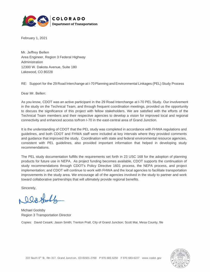
222 South 6th St, Rm 317, Grand Junction, CO 81501-2769 P 970.683.6250 F 970.683-6227 www.codot.gov
February 1, 2021 Mr. Jeffrey Bellen Area Engineer, Region 3 Federal Highway Administration 12300 W. Dakota Avenue, Suite 180 Lakewood, CO 80228
RE: Support for the 29 Road Interchange at I-70 Planning and Environmental Linkages (PEL) Study Process
Dear Mr. Bellen:
As you know, CDOT was an active participant in the 29 Road Interchange at I-70 PEL Study. Our involvement in the study on the Technical Team, and through frequent coordination meetings, provided us the opportunity to discuss the significance of this project with fellow stakeholders. We are satisfied with the efforts of the Technical Team members and their respective agencies to develop a vision for improved local and regional connectivity and enhanced access to/from I-70 in the east-central area of Grand Junction.
It is the understanding of CDOT that the PEL study was completed in accordance with FHWA regulations and guidelines, and both CDOT and FHWA staff were included at key intervals where they provided comments and guidance that improved the study. Coordination with state and federal environmental resource agencies, consistent with PEL guidelines, also provided important information that helped in developing study recommendations.
The PEL study documentation fulfills the requirements set forth in 23 USC 168 for the adoption of planning products for future use in NEPA. As project funding becomes available, CDOT supports the continuation of study recommendations through CDOT's Policy Directive 1601 process, the NEPA process, and project implementation; and CDOT will continue to work with FHWA and the local agencies to facilitate transportation improvements in the study area. We encourage all of the agencies involved in the study to partner and work toward collaborative partnerships that will ultimately provide regional benefits.
Sincerely,
Michael Goolsby Region 3 Transportation Director Copies: David Cesark; Jason Smith; Trenton Prall, City of Grand Junction; Scott Mai, Mesa County, file
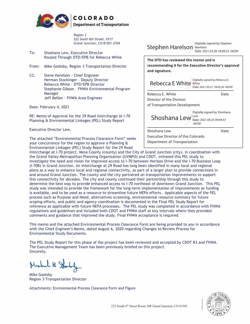
222 South 6th Street Room 308 Grand Junction, CO 81501
www.codot.gov
Region 3
222 South 6th Street, #317
Grand Junction, CO 81501-2769
To: Shoshana Lew, Executive Director Routed Through DTD/EPB for Rebecca White From: Mike Goolsby, Region 3 Transportation Director CC: Steve Harelson - Chief Engineer Herman Stockinger – Deputy Director Rebecca White – DTD/EPB Director
Stephanie Gibson – FHWA Environmental Program Manager
Jeff Bellen – FHWA Area Engineer Date: February 4, 2021 RE: Memo of Approval for the 29 Road Interchange at I-70 Planning & Environmental Linkages (PEL) Study Report Executive Director Lew, The attached “Environmental Process Clearance Form” seeks
your concurrence for the region to approve a Planning & Environmental Linkages (PEL) Study Report for the 29 Road Interchange at I-70 project. Mesa County (county) and the City of Grand Junction (city), in coordination with the Grand Valley Metropolitan Planning Organization (GVMPO) and CDOT, initiated this PEL study to investigate the need and vision for improved access to I-70 between Horizon Drive and the I-70 Business Loop (I-70B) in Grand Junction. An interchange at 29 Road has long been identified in many local and regional plans as a way to enhance local and regional connectivity, as part of a larger plan to provide connections in and around Grand Junction. The county and the city partnered on transportation improvements to support this connectivity for decades. The city and county continued their partnership through this study to determine the best way to provide enhanced access to I-70 northeast of downtown Grand Junction. This PEL study was intended to provide the framework for the long-term implementation of improvements as funding is available, and to be used as a resource to streamline future NEPA efforts. Applicable aspects of the PEL process such as Purpose and Need, alternatives screening, environmental resource summary for future scoping efforts, and public and agency coordination is documented in the Final PEL Study Report for reference as applicable with future NEPA processes. The PEL study was completed in accordance with FHWA regulations and guidelines and included both CDOT and FHWA staff at key intervals where they provided comments and guidance that improved the study. Final FHWA acceptance is required. This memo and the attached Environmental Process Clearance Form are being provided to you in accordance with the Chief Engineer's Memo, dated August 6, 2020 regarding Changes to Review Process for Environmental Study Documents. The PEL Study Report for this phase of the project has been reviewed and accepted by CDOT R3 and FHWA. The Executive Management Team has been previously briefed on this project. Sincerely,
Mike Goolsby Region 3 Transportation Director
Attachments: Environmental Process Clearance Form and Figure
The DTD has reviewed this memo and is
recommending it for the Executive Director’s approval
and signature.
Rebecca E. White Date
Director of the Division
of Transportation Development
Shoshana Lew Date
Executive Director of the Colorado
Department of Transportation
Rebecca E WhiteDigitally signed by Rebecca E
White
Date: 2021.03.21 18:02:20 -06'00'
Stephen HarelsonDigitally signed by Stephen
Harelson
Date: 2021.03.26 18:09:23 -06'00'
Shoshana LewDigitally signed by Shoshana
Lew
Date: 2021.04.23 09:44:57
-06'00'
222 South 6th Street Room 308 Grand Junction, CO 81501
www.codot.gov
Environmental Process Clearance Form
Date: February 4, 2021
RE: Memo of Approval for the 29 Road Interchange at I-70 PEL Study Report
Select one: PEL Environmental Assessment Environmental Impact Statement FONSI ROD Reevaluation
Has this project been briefed to the EMT previously? Yes. Is this a Local Agency Project? Yes.
Brief Project Description: Where is it and what is being proposed, what was the problem trying to be solved, where in the process is the project, how long
has it been worked on and who has been involved. Note whether the project is included in the 10-year Vision and, if not,
explain the primary impetus for the study. Include a summary of available or predicted funding and an estimate of when
construction could start. Please note any GHG reduction elements or strategies. Attach a map if that helps with the description.
Mesa County (county) and the City of Grand Junction (city), in coordination with the GVMPO and
CDOT, initiated this PEL study to investigate the need and vision for improved access to I-70 between
Horizon Drive and I-70B in Grand Junction. An interchange at 29 Road has long been identified in
many local and regional plans as a way to enhance local and regional connectivity, as part of a larger
plan to provide connections in and around Grand Junction. The county and the city partnered on
transportation improvements to support this connectivity for decades, including completion of
Riverside Parkway and the project to carry 29 Road over I-70B and the Union Pacific Railroad
(UPRR). The city and county continued their partnership through this study to determine the best
way to provide enhanced access to I-70 northeast of downtown Grand Junction. See Figure 1, Study
Area.
The study was conducted following Federal Highway Administration (FHWA) PEL guidance
regarding the integration of transportation planning and the National Environmental Policy Act
(NEPA) process, which encourages the use of planning studies to provide information for
incorporation into future NEPA documents (23 Code of Federal Regulations [CFR] 450). The goal of
these early integrated planning efforts is to streamline subsequent alternatives analysis during the
NEPA processes. This PEL study is intended to provide the framework for the long-term
implementation of transportation improvements as funding is available.
CDOT was an active participant in the 29 Road Interchange at I-70 PEL Study. Our involvement in the
study on the Technical Team and through frequent coordination meetings provided us the
opportunity to discuss the significance of this project with fellow stakeholders. We are satisfied with
the efforts of the Technical Team members and their respective agencies to develop a vision for
improved local and regional connectivity and enhanced access to/from I-70 in the east-central area
of Grand Junction.
Existing Corridor Conditions
I-70 is a four-lane divided interstate highway through the study area. The highway provides regional
connectivity to Utah and to the Colorado Front Range as well as to the recreational and mountain
communities in the central Colorado Rocky Mountains. The speed limit was recently reduced from
75 miles per hour (mph) to 70 mph between MP 24.9 (west of the US 50 interchange) to MP 32.2
(east of the curves east of the Horizon Drive interchange) due to crash history. The speed limit
through the rest of the study area remains 75 mph. I-70 has 12-foot through lanes and a depressed
median width of 20 feet. Approximate measurements indicate that the paved shoulders in this area
222 South 6th Street Room 308 Grand Junction, CO 81501
www.codot.gov
are 5 feet (inside) and 12 feet (outside). Both inside and outside shoulders have intermittent rumble
strips installed as a safety measure.
29 Road is classified as a principal arterial in the Grand Junction Circulation Plan. It provides a
regional north-south connection between Patterson Road on the north and US 50 on the south. North
of Patterson Road, 29 Road provides local access to neighborhoods and community facilities, as well
as access to private properties north of I-70. 29 Road has a speed limit of 40 mph throughout the
study area. The roadway through the study area generally has one through lane in each direction,
and those lanes are approximately 11 feet wide. The roadway generally has unpaved (gravel)
shoulders of varying width. Between F1/4 Road and F1/2 Road, the roadway is wider to the west
with an additional lane width and curb and gutter instead of a soft shoulder. This section also includes
a detached sidewalk that is set back from the roadway. Additional setback and sidewalk have also
been provided adjacent to the neighborhood at Brodick Way on the east side of 29 Road.
South of I-70 between Horizon Drive and I-70B, land uses consist primarily of established single-
family residential neighborhoods with churches and schools. Matchett Park, located west of 29 Road,
has remained undeveloped since it was acquired in 1996, but it is planned as a regional recreational
amenity. North of F 1/2 Road, properties remain largely undeveloped except for Independence
Academy Charter School (Independence Academy) and single-family homes. The North I-70 Frontage
Road ties into 29 Road just north of the 29 Road bridge over I-70, providing access from areas south
of I-70 to the Grand Junction Motor Speedway and other recreation. Based on the Grand Junction
Comprehensive Plan, residential development will remain between I-70 and Patterson Road with
large areas of commercial and industrial development in the undeveloped properties north of the
Highline Canal and I-70.
The PEL study documentation fulfills the requirements set forth in 23 USC 168 for the adoption of
planning products for future use in NEPA. Funding for the I-70 interchange construction has not
been identified at this time. Mesa County and City of Grand Junction will continue collaborating to
identify funding sources and funding partnerships, including through state and federal grant
opportunities. As project funding becomes available, CDOT supports the continuation of study
recommendations through CDOT’s Policy Directive 1601 process, the NEPA process, and project
implementation and will continue to work with FHWA and the local agencies to facilitate
transportation improvements in the study area. We encourage all of the agencies involved in the
study to partner and work toward collaborative partnerships that will ultimately provide regional
benefits.
The project is not included in the 10-year vision, but has been identified as a top priority by the local
agencies. Funding by the locals is expected to be forthcoming.
Environmental Review: Summarize review by planning and environmental staff, at the region, at DTD/EPB, and with regulators/resource agencies and FHWA. Is FHWA supportive of the project in general? Please note if the study document was based on a previous PEL and
whether that PEL narrowed alternatives. Are there more than one build alternatives assessed? Have GHG reduction strategies or
operational improvements been included?
The PEL study was completed in accordance with FHWA regulations and guidelines and included
both CDOT and FHWA staff at key intervals where they provided comments and guidance that
improved the study. Coordination with state and federal environmental resource agencies,
consistent with PEL guidelines, also provided important information that helped in developing
study recommendations.
An environmental overview was prepared as part of the PEL study to identify resources early in the
planning process. The environmental overview contains environmental resource information and
mapping that was obtained using readily available resources such as file searches, GIS mapping,
222 South 6th Street Room 308 Grand Junction, CO 81501
www.codot.gov
windshield surveys, and literature review. All the environmental and community resources topics
summarized in the environmental scan will need to be reviewed in NEPA.
As project development moves forward, the area conditions inventory and environmental overview
completed for this PEL study should be reviewed and updated as needed to reflect the most current
conditions for consideration of impacts and avoidance.. Consultations with appropriate agencies
and continued public involvement will also be required. Environmental data were reviewed at the
area level. During NEPA, the limits of the Preferred Alternative will need to be evaluated relative to
environmental impacts.
The R3 Transportation Director is familiar with the project and has reviewed the documents.
Are there any resources that are notably impacted? What was the notable resource impacted, mitigations recommended? [e.g., Are there any environmental justice issues or adverse impacts to historic structures?] Discuss any impacts to resources that are above the threshold identified in “Attachment D: The CatEx Criteria Checklist”
The following resources may be impacted by the Recommended Alternative and should be further
assessed during NEPA.
§ Air Quality – No impacts to air quality are anticipated. A qualitative air quality analysis
may be required during NEPA.
§ Community and Social Resources – Depending on the final alignment and layout of the
Recommended Alternative, there could impacts to community and social resources. Area
residents expressed concern about changes to the community character and impacts
along 29 Road with truck traffic, school/bicyclist/pedestrian safety issues, and added
congestion. Ongoing coordination and conversations with property owners, businesses,
and residences potentially affected should also be a critical part of future project
development.
§ Floodways and 100-year Floodplains – Depending on the final alignment of the
Recommended Alternative, changes to 29 Road may require hydraulic modeling for the
channel with future project development due to the proximity to the channel and the
downstream floodplain designation.
§ Hazardous Materials – Due to the presence of potential hazardous materials in the study
area, a Modified Phase I Environmental Site Assessment or CDOT Initial Site Assessment
should be conducted at site-specific locations to evaluate hazardous materials that may
require remediation prior to acquisition or development.
§ Historic Resources – Potential historic resources may be impacted by the Recommended
Alternative. During future NEPA process(es), historic resources will need to be evaluated
under Section 106 of the National Historic Preservation Act and Section 4(f) (23 CFR
774) of the U.S. Department of Transportation Act of 1966 (Section 4(f)).
§ Noise – The Recommended Alternative has the potential to impact sensitive noise
receptors and a noise assessment should be conducted during NEPA.
Parks and Recreational Resources – Impacts to parks and recreational resources are
not anticipated; however, should impacts occur, the project must comply with
Section 4(f).
§ Prime and Unique Farmlands – Additional analysis during NEPA will be required to
determine if farmlands are being irrigated and if the Recommended Alternative would
impact them. A detailed analysis of the project design impacts to the existing prime
farmland should occur as well as coordination with local planners and other local
officials, including the Natural Resource Conservation Service.
222 South 6th Street Room 308 Grand Junction, CO 81501
www.codot.gov
§ Water Quality – Impaired waters should be considered during future project
development and efforts should be made to avoid and minimize impacts to water-
related resources to the extent possible, including the implementation of control
measures during construction to minimize sediment runoff. New separate storm sewer
system facilities will need to be considered during future NEPA/design phases.
§ Threatened and Endangered Species and Biological Resources – As there is potential for
state and federally threatened species to occur in the study area, comprehensive and
updated special-status species lists will need to be obtained during NEPA. If appropriate,
a field survey will need to be conducted for federal- and state-listed species and the
project will need to comply with Section 7 of the Endangered Species Act, the Migratory
Bird Treaty Act, and Golden Eagle Protection
Act.
§ Wetlands and Waters of the U.S. – A wetland delineation will need to be completed
during NEPA and the project must follow Section 404 of the Clean Water Act should
there be impacts to jurisdictional wetlands and waters of the U.S. Engineering Review: Summarize any key engineering constraints or other design considerations that factored into the final outcome of the study including reasons why an alternative was selected, review conducted by the project manager of a project’s design, scope, budget, feasibility of schedules, assumptions regarding materials, etc. Is the solution cost effective?
A variety of alternatives were identified for consideration, focusing on the project Purpose and Need
to improve north-south network connectivity and provide transportation infrastructure needed to
support planned land use. The range of alternatives developed for the project included arterial
corridor improvements with new interchange access to I-70, as well as improvements to the existing
I-70 interchanges between Horizon Drive and I-70B. Given the area constraints and the needs
described in the Purpose and Need, the following conceptual action alternatives, in addition to the
No Action alternative, were considered in the Level 1 screening.:
§ Alternative 1 – I-70/Horizon Drive Interchange Improvements and New North
Connection: Capacity improvements at the I-70/Horizon Drive interchange with new
major collector roadway from the Horizon Drive to 29 Road and new multimodal
facilities.
§ Alternative 2 – New I-70/29 Road Interchange with North Connection: New grade-
separated interchange on I-70 at 29 Road with capacity and operational improvements
along 29 Road from I-70 to Patterson Road and new multimodal facilities along 29 Road.
§ Alternative 3 – New Midpoint Interchange with North Connection: New grade-
separated interchange on I-70 approximately halfway between the existing Horizon
Drive and I-70B interchanges (located at 30 Road) with capacity and operational
improvements along 30 Road from I-70 to Patterson Road and new multimodal facilities
along 30 Road.
§ Alternative 4 – I-70/I-70B (Clifton) Interchange Reconfiguration and New North
Connection: Reconfiguration of the I-70/I-70B interchange to provide arterial access
north of I-70 with capacity and operational improvements along I-70B and a new
principal arterial roadway extending north from the I-70 interchange and west to the
existing paved North Frontage Road and new multimodal facilities.
After the Level 1 screening, it was determined that both Alternative 2 (New I-70/29 Road
Interchange with North Connection) and Alternative 3 (New Midpoint Interchange with North
Connection) meet the Purpose and Need and could be carried forward for further evaluation in future
NEPA processes. However, Alternative 2 (New I-70/29 Road Interchange with North Connection) is
the Recommended Alternative from this PEL study as it meets the Purpose and Need to a higher
degree and would have fewer impacts. It is included in existing adopted local and regional plans, and
due to the long history of planning for a new I-70 interchange at 29 Road, it is anticipated an
222 South 6th Street Room 308 Grand Junction, CO 81501
www.codot.gov
interchange at the 29 Road location would have less private property (right-of-way), environmental,
and community impacts than a new midpoint interchange with the arterial improvements that would
be required with the project.
Is there a 1601 approval needed? No.
Has any construction funding been identified in the STIP for this project? No, but funding from the locals is expected to
be forthcoming.
Key stakeholders: List key stakeholders (e.g. local governments, interest groups), note any elements of the project that were controversial or difficult to resolve and describe other contextual or policy items worth highlighting. (e.g. adherence to Managed Lanes PD). Is there a high level of controversy with stakeholders or the public?
FHWA: Joel Barnett (Region 3 Area Engineer, former); Tricia Sergeson
(Transportation Specialist, former); Shaun Cutting (Program Delivery Team Leader); Jeff Bellen
(Region 3 Area Engineer, current); Stephanie Gibson (Environmental Program Manager)
Project Team: Kevin King (Mesa County Project Manager); Scott Mai (Mesa County Engineering
Director); Sean Yeates (Mesa County Senior Engineer); Pete Baier (Mesa County Administrator); Paul
Jagim (City of Grand Junction Project Manager, former); Trent Prall (City of Grand Junction Public
Works Director); Dean Bressler (Grand Valley MPO Senior Transportation Planner); Dana Brosig
(Grand Valley MPO Director).
Technical Team: Agency Team: Greg Moberg (Mesa County); Stephanie Reecy (Mesa County); David
Thornton (City of Grand Junction); Eric Trinklein (Grand Junction Airport, former); Dylan Heberlein
(Grand Junction Airport); Angela Padalecki (Grand Junction Airport); Kandice Krull (Federal Aviation
Administration); Michael Goolsby (CDOT Region 3); Jason Smith (CDOT Region 3); Rob Beck (CDOT
Region 3); David Cesark (CDOT Region 3); Zane Znamenacek (CDOT Region 3); Mark Bunnell (CDOT
Region 3); Troy Halouska (CDOT PEL Program Manager); Jeff Bellan and Tricia Sergeson (FHWA
representatives). DEA Consultant Team: Stacy Tschuor (Project Manager); Leah Langerman (Public
Involvement); Kara Swanson (Environmental); Sara Ciasto (Design); Hannah Polow (Multimodal);
Heather Gade (Traffic, former); Joe Hart (Quality Assurance). EPS Consultant Team: Daniel Guimond
(Project Manager); Brian Duffany (Analyst).
Public and Stakeholder Coordination Overview
General Public
§ February 2019 Open House had approximately 125 attendees
§ April 2019 Community Presentation at Independence
Academy had approximately 50 attendees
§ August 2020 Virtual Public Meeting video was viewed
approximately 600 times
§ 29 Road and I-70 PEL Study was updated throughout the
study Grand Valley MPO Technical
Advisory Committee
§ Presentation January 9, 2019
§ Presentation February 13, 2019
Grand Junction City Council
Workshop
§ Presentation January 14, 2019
Mesa County Board of County
Commissioners Meeting
§ Presentation January 15, 2019
Grand Junction Regional
Airport Board
§ Update April 4, 2019
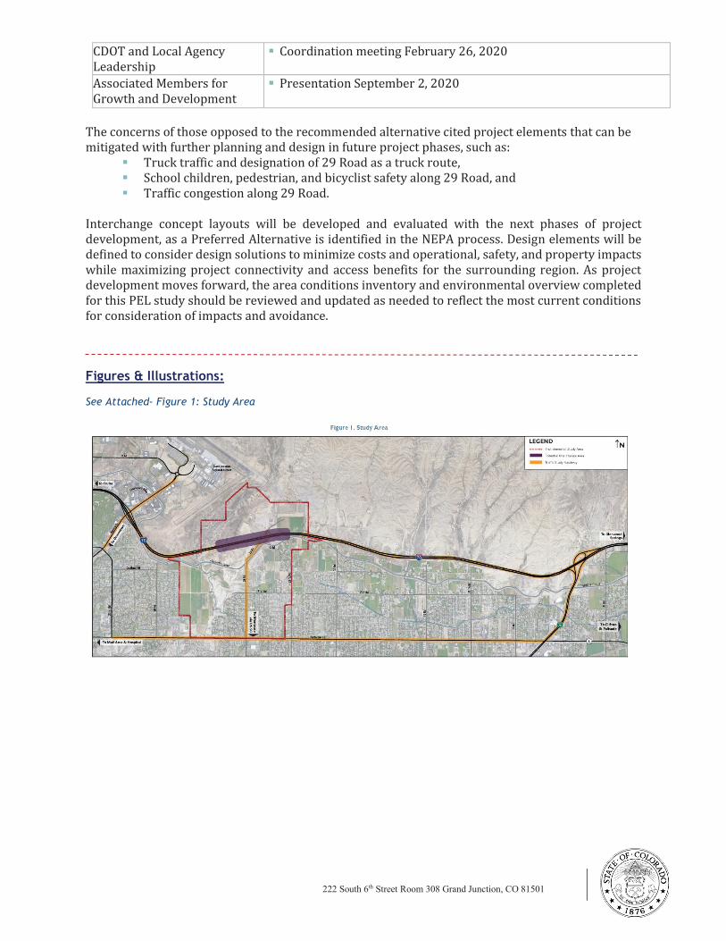
222 South 6th Street Room 308 Grand Junction, CO 81501
www.codot.gov
CDOT and Local Agency
Leadership
§ Coordination meeting February 26, 2020
Associated Members for
Growth and Development
Meeting
§ Presentation September 2, 2020
The concerns of those opposed to the recommended alternative cited project elements that can be
mitigated with further planning and design in future project phases, such as:
§ Truck traffic and designation of 29 Road as a truck route,
§ School children, pedestrian, and bicyclist safety along 29 Road, and
§ Traffic congestion along 29 Road.
Interchange concept layouts will be developed and evaluated with the next phases of project
development, as a Preferred Alternative is identified in the NEPA process. Design elements will be
defined to consider design solutions to minimize costs and operational, safety, and property impacts
while maximizing project connectivity and access benefits for the surrounding region. As project
development moves forward, the area conditions inventory and environmental overview completed
for this PEL study should be reviewed and updated as needed to reflect the most current conditions
for consideration of impacts and avoidance.
Figures & Illustrations:
See Attached- Figure 1: Study Area
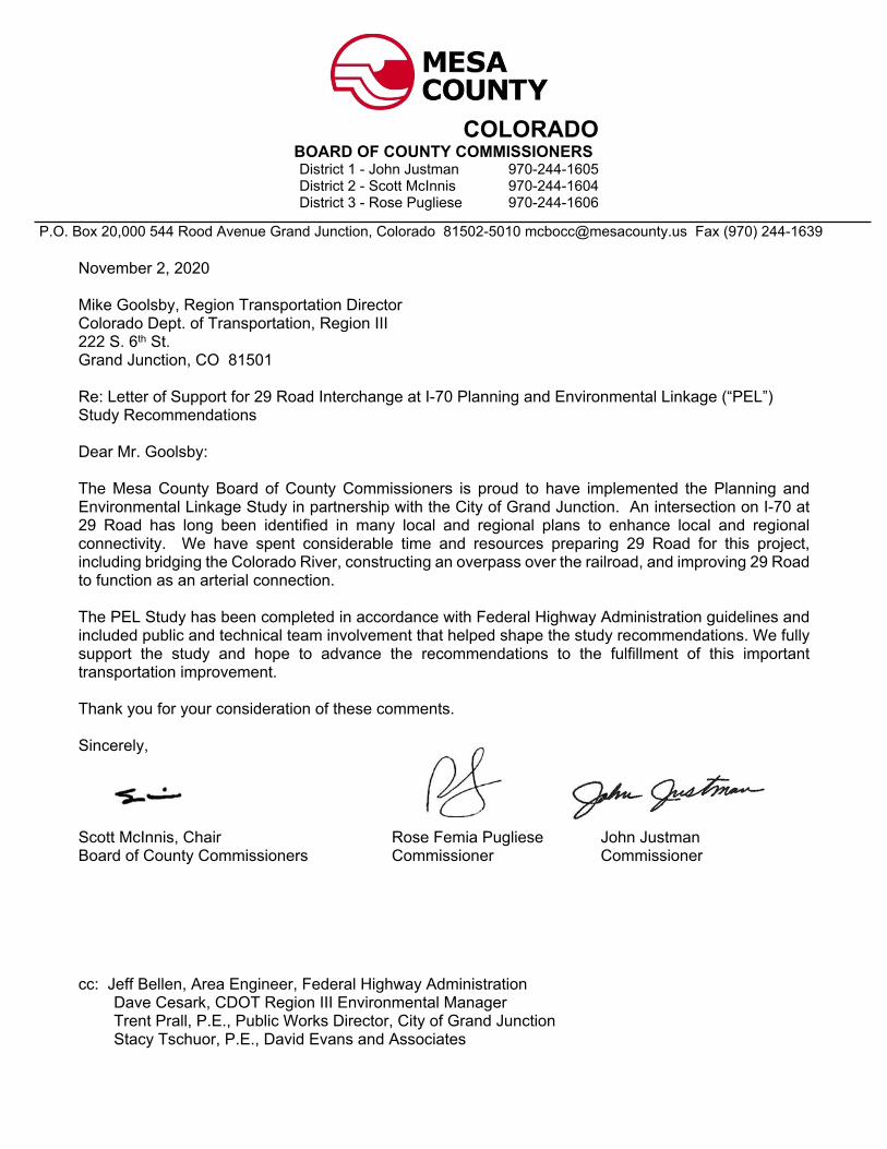
P.O. Box 20,000 544 Rood Avenue Grand Junction, Colorado 81502-5010 [email protected] Fax (970) 244-1639
November 2, 2020
Mike Goolsby, Region Transportation DirectorColorado Dept. of Transportation, Region III222 S. 6th St.Grand Junction, CO 81501
Re: Letter of Support for 29 Road Interchange at I-70 Planning and Environmental Linkage (“PEL”) Study Recommendations
Dear Mr. Goolsby:
The Mesa County Board of County Commissioners is proud to have implemented the Planning and Environmental Linkage Study in partnership with the City of Grand Junction. An intersection on I-70 at 29 Road has long been identified in many local and regional plans to enhance local and regional connectivity. We have spent considerable time and resources preparing 29 Road for this project, including bridging the Colorado River, constructing an overpass over the railroad, and improving 29 Road to function as an arterial connection.
The PEL Study has been completed in accordance with Federal Highway Administration guidelines and included public and technical team involvement that helped shape the study recommendations. We fully support the study and hope to advance the recommendations to the fulfillment of this important transportation improvement.
Thank you for your consideration of these comments.
Sincerely,
Scott McInnis, Chair Rose Femia Pugliese John JustmanBoard of County Commissioners Commissioner Commissioner
cc: Jeff Bellen, Area Engineer, Federal Highway Administration Dave Cesark, CDOT Region III Environmental Manager Trent Prall, P.E., Public Works Director, City of Grand Junction Stacy Tschuor, P.E., David Evans and Associates
COLORADOBOARD OF COUNTY COMMISSIONERSDistrict 1 - John Justman 970-244-1605District 2 - Scott McInnis 970-244-1604District 3 - Rose Pugliese 970-244-1606
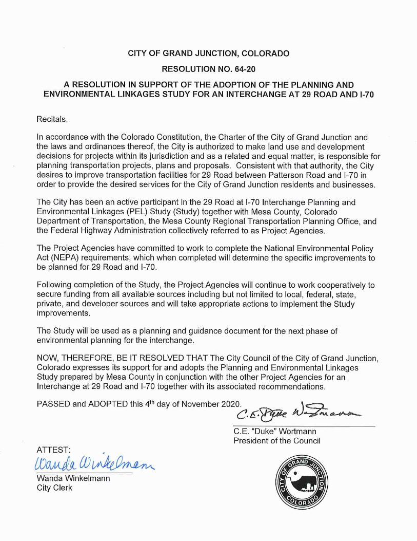
CITY OF GRAND JUNCTION, COLORADO
RESOLUTION NO. 64-20
A RESOLUTION IN SUPPORT OF THE ADOPTION OF THE PLANNING ANDENVIRONMENTAL LINKAGES STUDY FOR AN INTERCHANGE AT 29 ROAD AND 1-70
Recitals.
In accordance with the Colorado Constitution, the Charter of the City of Grand Junction andthe laws and ordinances thereof, the City is authorized to make land use and developmentdecisions for projects within its jurisdiction and as a related and equal matter, is responsible forplanning transportation projects, plans and proposals. Consistent with that authority, the Citydesires to improve transportation facilities for 29 Road between Patterson Road and 1-70 inorder to provide the desired services for the City of Grand Junction residents and businesses.
The City has been an active participant in the 29 Road at 1-70 Interchange Planning andEnvironmental Linkages (PEL) Study (Study) together with Mesa County, ColoradoDepartment of Transportation, the Mesa County Regional Transportation Planning Office, andthe Federal Highway Administration collectively referred to as Project Agencies.
The Project Agencies have committed to work to complete the National Environmental PolicyAct (NEPA) requirements, which when completed will determine the specific improvements tobe planned for 29 Road and 1-70.
Following completion of the Study, the Project Agencies will continue to work cooperatively tosecure funding from all available sources including but not limited to local, federal, state,private, and developer sources and will take appropriate actions to implement the Studyimprovements.
The Study will be used as a planning and guidance document for the next phase ofenvironmental planning for the interchange.
NOW, THEREFORE, BE IT RESOLVED THAT The City Council of the City of Grand Junction,Colorado expresses its support for and adopts the Planning and Environmental LinkagesStudy prepared by Mesa County in conjunction with the other Project Agencies for anInterchange at 29 Road and 1-70 together with its associated recommendations.
PASSED and ADOPTED this 4th day of November 2020.A-^^*»^
?0.
^.^.^5e /U-^i
C.E."Duke"Wortmann
President of the Council
Wanda WinkelmannCity Clerk

525 S. 6 t h St reet | Depar tment 5093 | P.O. Box 20,000 | Grand Junct ion, CO 81502-5001
(970) 255-7188 www.r tpo.mesacounty.us r [email protected]
November 4, 2020
Shaun Cutting, Program Delivery Team Leader Colorado Division Federal Highway Administration U.S. Department of Transportation 12300 West Dakota Avenue, Suite 180 Lakewood, Colorado 80228 Support for the 29 Road Interchange Planning and Environmental Linkages (PEL) Study Process The staff at the Grand Valley MPO (GVMPO) was included as a full participant in the 29 Road Interchange Planning and Environmental Linkages Study process. Our involvement in the study on the Technical Team and through frequent Project Team meetings provided us the opportunity to review project analyses and documents as well as to provide essential traffic projections from the Mesa County Regional Travel Model. We appreciate the efforts of all Technical Team members and their respective agencies. The PEL study was completed in accordance with FHWA guidelines, and included Colorado Department of Transportation (CDOT) and FHWA staff at key intervals. Coordination with state and federal environmental resource agencies, consistent with PEL guidelines, also provided information that aided the study process. Study efforts included extensive and meaningful public and stakeholder involvement, which helped shape the study recommendations. The GVMPO looks forward to participating in future phases of study, including rigorous evaluation of alternatives, required to satisfy the National Environmental Policy Act and CDOT’s Policy Directive 1601 process. Thank you for your time, attention, and participation in the study process. Sincerely, Dana Brosig, Director Grand Valley MPO CC: Stacy Tschuor, David Evans and Associates, Inc.
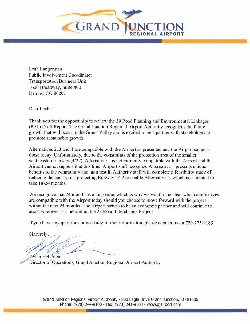
PEL STUDY REPORT SEPTEMBER 2020
DAVID EVANS AND ASSOCIATES, INC. Appendix
APPENDIX G
PEL Questionnaire

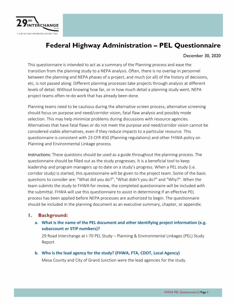
FHWA PEL Questionnaire Page 1
Federal Highway Administration – PEL Questionnaire
December 30, 2020
This questionnaire is intended to act as a summary of the Planning process and ease the
transition from the planning study to a NEPA analysis. Often, there is no overlap in personnel
between the planning and NEPA phases of a project, and much (or all) of the history of decisions,
etc, is not passed along. Different planning processes take projects through analysis at different
levels of detail. Without knowing how far, or in how much detail a planning study went, NEPA
project teams often re-do work that has already been done.
Planning teams need to be cautious during the alternative screen process; alternative screening
should focus on purpose and need/corridor vision, fatal flaw analysis and possibly mode
selection. This may help minimize problems during discussions with resource agencies.
Alternatives that have fatal flaws or do not meet the purpose and need/corridor vision cannot be
considered viable alternatives, even if they reduce impacts to a particular resource. This
questionnaire is consistent with 23 CFR 450 (Planning regulations) and other FHWA policy on
Planning and Environmental Linkage process.
Instructions: These questions should be used as a guide throughout the planning process. The
questionnaire should be filled out as the study progresses. It is a beneficial tool to keep
leadership and program managers up to date on a study’s progress. When a PEL study (i.e.
corridor study) is started, this questionnaire will be given to the project team. Some of the basic
questions to consider are: "What did you do?", "What didn't you do?" and "Why?". When the
team submits the study to FHWA for review, the completed questionnaire will be included with
the submittal. FHWA will use this questionnaire to assist in determining if an effective PEL
process has been applied before NEPA processes are authorized to begin. The questionnaire
should be included in the planning document as an executive summary, chapter, or appendix.
1. Background:
a. What is the name of the PEL document and other identifying project information (e.g.
subaccount or STIP numbers)?
29 Road Interchange at I-70 PEL Study – Planning & Environmental Linkages (PEL) Study
Report
b. Who is the lead agency for the study? (FHWA, FTA, CDOT, Local Agency)
Mesa County and City of Grand Junction were the lead agencies for the study.
FHWA PEL Questionnaire Page 2
c. Provide a brief chronology of the planning activities (PEL study) including the year(s)
the studies were conducted. (Include project start date and end date).
Planning to enhance local and regional connectivity for residential and commercial areas
surrounding downtown Grand Junction began in the 1980s and in the early 2000s design
and construction began for projects to build the transportation network. The I-70/29
Road interchange is one of the final elements to provide improved transportation
connectivity.
The timeline for this PEL study:
Study began – September 2018
Final Area Conditions Report (June 2019)
Purpose and Need Statement – November 2019
Final Planning & Environmental Linkages (PEL) Study Report – September 2020
Study concluded – October 2020
d. Provide a description of the existing transportation corridor, including project limits,
length of study corridor, modes, number of lanes, shoulder, access control and
surrounding environment (urban vs. rural, residential vs. commercial, etc.)
The traffic study roadways lie within the City of Grand Junction and unincorporated Mesa
County. Traffic volumes were studied along I-70, 29 Road, Patterson Road, and at the
adjacent Horizon Drive and I-70B interchanges. Environmental conditions were studied
for the area surrounding a potential 29 Road interchange location, between CDOT mile
post (MP) 32.7 and MP 33.5.
South of I-70 between Horizon Drive and I-70B, land uses consist primarily of established
single-family residential neighborhoods with churches and schools. Matchett Park,
located west of 29 Road, has remained undeveloped since it was acquired in 1996, but it
is planned as a regional recreational amenity. North of F 1/2 Road, properties remain
largely undeveloped except for Independence Academy Charter School (Independence
Academy) and single-family homes. The North I-70 Frontage Road ties into 29 Road just
north of the 29 Road bridge over I-70, providing access from areas south of I-70 to the
Grand Junction Motor Speedway and other recreation. Based on the Grand Junction
Comprehensive Plan, residential development will remain between I-70 and Patterson
Road with large areas of commercial and industrial development in the undeveloped
properties north of the Highline Canal and I-70.
I-70 is a four-lane divided interstate highway through the study area. The highway
provides regional connectivity to Utah and to the Colorado Front Range as well as to the
recreational and mountain communities in the central Colorado Rocky Mountains. The
speed limit was recently reduced from 75 miles per hour (mph) to 70 mph between MP
FHWA PEL Questionnaire Page 3
24.9 (west of the US 50 interchange) to MP 32.2 (east of the curves east of the Horizon
Drive interchange) due to crash history. The speed limit through the rest of the study
area remains 75 mph. I-70 has 12-foot through lanes and a depressed median width of
20 feet. Approximate measurements indicate that the paved shoulders in this area are 5
feet (inside) and 12 feet (outside). Both inside and outside shoulders have intermittent
rumble strips installed as a safety measure.
29 Road is classified as a principal arterial in the Grand Junction Circulation Plan. It
provides a regional north-south connection between Patterson Road on the north and US
50 on the south. North of Patterson Road, 29 Road provides local access to
neighborhoods and community facilities, as well as access to private properties north of
I-70. 29 Road has a speed limit of 40 mph throughout the study area. The roadway
through the study area generally has one through lane in each direction, and those lanes
are approximately 11 feet wide. The roadway generally has unpaved (gravel) shoulders of
varying width. Between F1/4 Road and F1/2 Road, the roadway is wider to the west with
an additional lane width and curb and gutter instead of a soft shoulder. This section also
includes a detached sidewalk that is set back from the roadway. Additional setback and
sidewalk have also been provided adjacent to the neighborhood at Brodick Way on the
east side of 29 Road.
There is a traffic signal at the intersection of 29 Road and Patterson Road, and 29 Road
widens to include right and left turn lanes at the intersection. All other intersections
along 29 Road within the study area are two-way stops with 29 Road having priority.
e. Who was the sponsor of the PEL study? (CDOT, Local Agency [name the local agency],
Other)
Mesa County and City of Grand Junction
f. Who was included on the study team (Name and title of agency representatives, PMT,
TWG, consultants, etc.)?
FHWA: Joel Barnett (Region 3 Area Engineer, former); Tricia Sergeson
(Transportation Specialist, former); Shaun Cutting (Program Delivery Team Leader);
Jeff Bellen (Region 3 Area Engineer, current); Stephanie Gibson (Environmental
Program Manager)
Project Team: Kevin King (Mesa County Project Manager); Scott Mai (Mesa County
Engineering Director); Sean Yeates (Mesa County Senior Engineer); Pete Baier
(Mesa County Administrator); Paul Jagim (City of Grand Junction Project Manager,
former); Trent Prall (City of Grand Junction Public Works Director); Dean Bressler
(Grand Valley MPO Senior Transportation Planner); Dana Brosig (Grand Valley MPO
Director)
FHWA PEL Questionnaire Page 4
Technical Team: Mesa County and City of Grand Junction Project Team members;
FHWA representatives; Greg Moberg (Mesa County); Stephanie Reecy (Mesa
County); David Thornton (City of Grand Junction); Eric Trinklein (Grand Junction
Airport, former); Dylan Heberlein (Grand Junction Airport); Angela Padalecki (Grand
Junction Airport); Kandice Krull (Federal Aviation Administration); Michael Goolsby
(CDOT Region 3); Jason Smith (CDOT Region 3); Rob Beck (CDOT Region 3); David
Cesark (CDOT Region 3); Zane Znamenacek (CDOT Region 3); Mark Bunnell (CDOT
Region 3); Troy Halouska (CDOT PEL Program Manager)
DEA Consultant Team: Stacy Tschuor (Project Manager); Leah Langerman (Public
Involvement); Kara Swanson (Environmental); Sara Ciasto (Design); Hannah Polow
(Multimodal); Heather Gade (Traffic, former); Joe Hart (Quality Assurance)
EPS Consultant Team: Daniel Guimond (Project Manager); Brian Duffany (Analyst)
g. List the recent, current or near future planning studies or projects in the vicinity?
What is the relationship of this project to those studies/projects?
An interchange at 29 Road has long been identified in many local and regional plans to
enhance local and regional connectivity, as part of a larger plan to provide connections in
and around Grand Junction. The I-70/29 Road interchange is shown in the current Grand
Junction Circulation Plan and Grand Junction Regional Airport Master Plan, is included as
an alternative in the Grand Valley 2045 Regional Transportation Plan. The existing and
planned population and employment growth utilized for this study are consistent with
the current local and regional land use plans.
The Final Area Conditions Report (June 2019) includes summaries of the planning studies
and plans that were reviewed to determine if their recommendations would influence
this study or future projects, including:
Grand Junction Circulation Plan (2018), Grand Junction
Grand Valley Transit Strategic Plan (2018), Mesa County
Grand Valley Regional Transportation Plan Update (2014), Mesa County
Mesa County Coordinated Transit and Human Services Transportation Plan (2014),
Mesa County
Grand Junction Regional Airport Master Plan (2009), Grand Junction Regional
Airport
Wildlife Hazard Management Plan (2008), Grand Junction Regional Airport
Several of the studies provided usable data and recommendations for transportation
improvements that were considered during the alternatives development and screening,
including the evaluation and recommendations for the new I-70 interchange at 29 Road
in the regional and local transportation and land use plans.
FHWA PEL Questionnaire Page 5
Land use forecasts utilized by the PEL study are from the 2040 Mesa County Regional
Transportation Model (MCRTM) available at the beginning of the study. Grand Valley
MPO recently updated the MCRTM to extend projections to 2045 and update land use
projections. The MCRTM takes into account future population, employment and
economic forecasts as well as other variables, including land use, estimates of future
activity from local governments, and travel demands from outside of Mesa County. The
Office of the State Demographer provides forecasts for population, statewide and by
county. The forecast for Mesa County in 2045 is 225,529 persons. This compares closely
with the forecast from the last planning cycle of 225,223 in 2040. Consequently, the
MCRTM shows similar travel forecast results for 2045 as it did for 2040 with the model
used for this PEL study.
New connections and capacity improvements in the “Existing + Committed” projects in
the Grand Valley 2040 Regional Transportation Plan, excluding the widening of 29 Road
from Patterson Road with a new interchange at I-70, are listed below. These projects are
in the 2040 MCRTM utilized by this study.
Existing and Committed Projects Included in No Action Alternative
CORRIDOR SEGMENT LANES FORECAST
YEAR
I-70B – Rimrock Avenue to 1st and Grand Four lanes with median 2020
24 Road – Patterson Road to I-70 Five lanes 2020
22 Road – New facility across UPRR and US 6 to River Road Three lanes 2030
F 1/2 Road Parkway – I-70B east to 25 Road/Patterson Road Four lanes with median 2040
23 ½ Road – F 1/2 to G Road Three lanes Post 2040
2. Methodology used:
a. Did the Study follow the FHWA PEL Process? If the Study was conducted by another
US DOT Agency, provide a crosswalk table to demonstrate how the FHWA Process was
utilized.
The study followed the FHWA PEL Process, outlined in the CDOT PEL Handbook (2016).
b. How did the Study meet each of the PEL Coordination Points identified in 23 USC 168?
FHWA coordination occurred at the following official coordination points in the process.
Coordination Point #1 Determining the Reason for the PEL Study - Mesa County and
City of Grand Junction representatives met with CDOT staff prior to kicking off the
study to determine that a PEL study was the appropriate next step in the planning
process for this project.
Coordination Point #2 Purpose and Need – Review and input for Purpose and Need
Statement by CDOT and FHWA May through November 2019 with approval via
CDOT and FHWA communication in November 2019.
FHWA PEL Questionnaire Page 6
Coordination Point #3 Alternatives Screening – Review and input of Level 1
screening with approval of screening recommendations by CDOT and FHWA via
meeting in May 2020.
Coordination Point #4 PEL Document – Review of Draft PEL Study Report with
approval of report via Technical Team meeting in July 2020.
In addition, CDOT and FHWA representatives attended Technical Team meetings for
presentation of study materials and overall project updates.
c. What NEPA terminology/language was used and how did you define them? (Provide
examples or list)
Purpose and Need Statement – statement clarifying the expected outcome of the
project and defining the problems to be addressed by the project
No Action Alternative – alternative that would leave the transportation system as it
is currently without any improvements, except those already committed by a
government or an agency or those with identified funds for construction
Alternatives Development and Screening – process of identifying potential options
and evaluating whether the options meet the project purpose, need, and goals
Carried Forward – screening result indicating that the alternative meets the project
purpose and need and may be evaluated further in the next level of evaluation
Recommended – screening result indicating that the alternative meets the project
purpose and need and is selected to advance to a future NEPA study
Not Recommended – screening result indicating that the alternative is removed
from consideration for further evaluation for the project due to comparatively
negligible benefits and/or higher impacts than other options
Eliminated – screening result indicating that the alternative does not meet the
purpose and need established within this study
d. How do you see these terms being used in NEPA documents?
These terms will continue to be used in the same manner in future NEPA documents. The
term “Recommended Alternative“ can be used to refer to the recommendations from
the alternatives evaluation conducted in the PEL study when identifying the Preferred
Alternative in the Alternatives chapter of a future NEPA document or when referencing
PEL report recommendations for the NEPA documentation of the project phase.
FHWA PEL Questionnaire Page 7
e. What were the key steps and coordination points in the PEL decision-making process?
Who were the decision-makers and who else participated in those key steps? For
example, for the corridor vision, the decision was made by CDOT and the local agency,
with buy-in from FHWA, USACE, and USFWS.
Subject matter experts from the consultant team made determinations based on
professional judgment, which were vetted with the Project Team, then the Technical
Team (TT). As the study’s decision-making group, the TT was made up of technical and
leadership representatives of Mesa County, City of Grand Junction, CDOT, Grand Valley
MPO, Grand Junction Airport, Federal Aviation Administration (FAA), and FHWA. These
agencies provided input at these milestones:
TT Meeting April 30, 2019: Area Conditions
TT Meeting October 11, 2019: Purpose and Need
TT Meeting December 11, 2019: Level 1 Evaluation Results
TT Meeting #7 July 16, 2020: Action Plan
f. How should the PEL information below be presented in NEPA?
The PEL study information should be presented in NEPA in a similar fashion as it was used
in the PEL Study Report. The NEPA study should build on the purpose and need and goals
developed by the PEL study. Additional detail will be available as the design progresses
and data needs updated. The environmental overview and resource agency input should
be used to scope for the NEPA evaluation.
3. Agency coordination:
a. Provide a synopsis of coordination with federal, tribal, state and local environmental,
regulatory and resource agencies. Describe their level of participation and how you
coordinated with them.
The study was coordinated with local, state and federal resource agencies, including:
Bureau of Land Management
City of Grand Junction Parks and Recreation
Colorado Department of Public Health and Environment Air Pollution Control
Division
Colorado Department of Public Health and Environment Hazardous Materials and
Waste Management Division
Colorado Department of Public Health and Environment Water Quality Control
Division
Colorado Historical Society State Historic Preservation Officer
Colorado Parks and Wildlife Northwest Region – Grand Junction

FHWA PEL Questionnaire Page 8
Grand Junction Regional Airport
Grand Valley Drainage District
Grand Valley Water Users Association
Mesa County Historical Society
Mesa County Irrigation District
Palisade Irrigation District
U.S. Army Corps of Engineers Regulatory Division – Colorado West Branch
U.S. Bureau of Reclamation, Western Colorado Area Office
U.S. Environmental Protection Agency Region 8
U.S. Fish and Wildlife Service Colorado Field Office
Ute Water Conservancy District
Information was distributed to representatives at these resource agencies at three points
during the study. Early in the study, a letter and study area map were mailed as an
introduction to the PEL study process and confirmation of preferred contact information
was requested. A second letter requested review of the Draft Area Conditions Report
related to their specific resource(s). The final letter provided a link to the Draft PEL Study
Report documenting the draft study recommendations to facilitate review of potential
resource impacts and next steps required for future NEPA processes.
A summary matrix of the resource agency coordination and input is included in Appendix
B of the Final PEL Study Report.
b. What transportation agencies (e.g. for adjacent jurisdictions) did you coordinate with
or were involved in the PEL study? This includes all federal agencies if the study is
being led by a local agency or transit oriented study seeking to utilize the FHWA PEL
Process.
The study included the formation of a Technical Team that met frequently to provide
technical input and guidance. Members of the Technical Team kept their respective
elected officials updated. The Technical Team included staff from:
Mesa County
City of Grand Junction
Grand Valley MPO
CDOT
FHWA
Grand Junction Regional Airport
FAA
FHWA PEL Questionnaire Page 9
c. What steps will need to be taken with each agency during NEPA scoping?
Mesa County – will be a financial partner and lead agency, leading efforts on local
roadway and multimodal connections
City of Grand Junction – will be a financial partner and lead agency, leading efforts
on local roadway and multimodal connections
Grand Valley MPO – will be involved with regionally significant projects and may
facilitate financing if awarded regional funding
CDOT – will be involved with oversight and approvals of projects involving I-70
FHWA – will be involved with oversight and approvals of projects involving I-70 and
federally funded projects
Grand Junction Regional Airport – will be involved with oversight and approvals of
projects impacting the airport properties or operations
FAA – may serve as a cooperating agency and will be involved with oversight and
approvals of projects impacting the airport properties or operations
4. Public coordination:
a. Provide a synopsis and table of coordination efforts with the public and stakeholders.
Public and Stakeholder Coordination Overview
ORGANIZATION OUTREACH
General Public
February 2019 Open House had approximately 125 attendees
April 2019 Community Presentation at Independence Academy had approximately 50 attendees
August 2020 Virtual Public Meeting video was viewed approximately 600 times
29 Road and I-70 PEL Study was updated throughout the study
Grand Valley MPO Technical Advisory Committee
Presentation January 9, 2019
Presentation February 13, 2019
Grand Junction City Council Workshop
Presentation January 14, 2019
Mesa County Board of County Commissioners Meeting
Presentation January 15, 2019
Grand Junction Regional Airport Board
Update April 4, 2019
CDOT and Local Agency Leadership
Coordination meeting February 26, 2020
Associated Members for Growth and Development Meeting
Presentation September 2, 2020

FHWA PEL Questionnaire Page 10
5. Corridor Vision/Purpose and Need:
a. What was the scope of the PEL study and the reason for doing it?
Mesa County and the City of Grand Junction, in coordination with the Grand Valley MPO
and CDOT, initiated this PEL study to investigate the need and vision for improved access
to I-70 between Horizon Drive and the I-70 Business Loop (I-70B) in Grand Junction. An
interchange at 29 Road has long been identified in many local and regional plans to
enhance local and regional connectivity, as part of a larger plan to provide connections in
and around Grand Junction. Mesa County and the City of Grand Junction partnered on
transportation projects to support this vision for decades, including completion of
Riverside Parkway and the project to carry 29 Road over I-70B and the Union Pacific
Railroad (UPRR). The City and County continued their partnership with this study to
determine the best way to provide enhanced access to I-70 northeast of downtown
Grand Junction.
The goal of these early integrated planning efforts is to streamline subsequent
alternatives analysis during the NEPA processes. This PEL study is intended to provide the
framework for the long-term implementation of transportation improvements as funding
is available.
b. What is the vision for the corridor?
The recommendations in the PEL study provide a continuous north-south arterial corridor
with connections to key east-west corridors to enhance the transportation network with
improved travel choices for residents, visitors, and businesses in central, southeast, and
downtown Grand Junction. Additional redundancy in the arterial transportation network,
specifically related to north-south continuity through the city and I-70 freeway access,
will also improve the ability for travelers to move through and around the city with
acceptable traffic operations after a disruptive event or changing conditions.
The recommended transportation infrastructure will support existing and planned
population and employment growth shown in current local and regional land use and
transportation plans, which were adopted through comprehensive planning processes
with public and stakeholder involvement. Enhanced access to the area adjacent to and
north of I-70 has been included in transportation and land use plans for decades.
c. What were the goals and objectives?
Goals of enhanced access to/from I-70 between Horizon Drive and I-70B are to:
Be consistent with local and regional plans
Improve network capacity
Improve safety for all modes
FHWA PEL Questionnaire Page 11
Balance local access and regional mobility
Enhance local multimodal travel options along planned Active Transportation
Corridors
Avoid, minimize, or mitigate environmental impacts
Complement local community surroundings and context
d. What is the PEL Purpose and Need statement?
Purpose
The purpose of the project is to enhance the region’s transportation network to improve
local and regional connectivity and to provide enhanced access to/from I-70 to planned
land use.
Need
Improved access to I-70 is needed to:
Address limited transportation network connectivity with no central north-south
arterial corridor with access to/from I-70; and
Provide transportation infrastructure needed to support planned land use adjacent
to and north of I-70.
e. What steps will need to be taken during the NEPA process to make this a project-level
purpose and need statement?
This Purpose and Need statement addresses the overall I-70 interchange project. If a
phase of the project moves forward separately, the Purpose and Need statement may
need to be focused to address the specific needs at that location. Individual project
elements that advance out of the Recommended Alternative should address the overall
purpose identified in the Final PEL Study Report.
6. Range of alternatives considered, screening criteria and screening
process:
a. What types of alternatives were looked at? (Provide a one or two sentence summary
and reference document.)
A variety of alternatives were identified for consideration, focusing on the project
Purpose and Need to improve north-south network connectivity and provide
transportation infrastructure needed to support planned land use. The range of
alternatives developed for the project included arterial corridor improvements with new
interchange access to I-70, as well as improvements to the existing I-70 interchanges
between Horizon Drive and I-70B. Given the area constraints and the needs described in

FHWA PEL Questionnaire Page 12
the Purpose and Need, the following conceptual action alternatives, in addition to the No
Action alternative, were considered in the Level 1 screening.:
Alternative 1 – I-70/Horizon Drive Interchange Improvements and New North
Connection: Capacity improvements at the I-70/Horizon Drive interchange with
new major collector roadway from the Horizon Drive to 29 Road and new
multimodal facilities
Alternative 2 – New I-70/29 Road Interchange with North Connection: New grade-
separated interchange on I-70 at 29 Road with capacity and operational
improvements along 29 Road from I-70 to Patterson Road and new multimodal
facilities along 29 Road
Alternative 3 – New Midpoint Interchange with North Connection: New grade-
separated interchange on I-70 approximately halfway between the existing Horizon
Drive and I-70B interchanges (located at 30 Road) with capacity and operational
improvements along 30 Road from I-70 to Patterson Road and new multimodal
facilities along 30 Road
Alternative 4 – I-70/I-70B (Clifton) Interchange Reconfiguration and New North
Connection: Reconfiguration of the I-70/I-70B interchange to provide arterial access
north of I-70 with capacity and operational improvements along I-70B and a new
principal arterial roadway extending north from the I-70 interchange and west to
the existing paved North Frontage Road and new multimodal facilities
The Alternatives Evaluation section of the Final PEL Study Report includes the description
of the alternatives, criteria, and a summary of the evaluation.
b. How did you select the screening criteria and screening process?
The screening criteria were developed to screen alternatives using the primary elements
of the project Purpose and Need. The process was developed to identify and evaluate
alternatives that meet the Purpose and Need for consideration with future NEPA
processes.
c. For alternative(s) that were screened out, briefly summarize the reasons for
eliminating or not recommending the alternative(s). (During the initial screenings, this
generally will focus on fatal flaws)
The No Action and four action alternatives were evaluated against the Purpose and Need
screening criteria. During the screening process, alternatives were eliminated if the
concept had a fatal flaw or did not meet the Purpose and Need. The Level 1 screening
results are summarized below. The complete Level 1 screening matrix can be found in
Appendix A of the Final PEL Study Report.
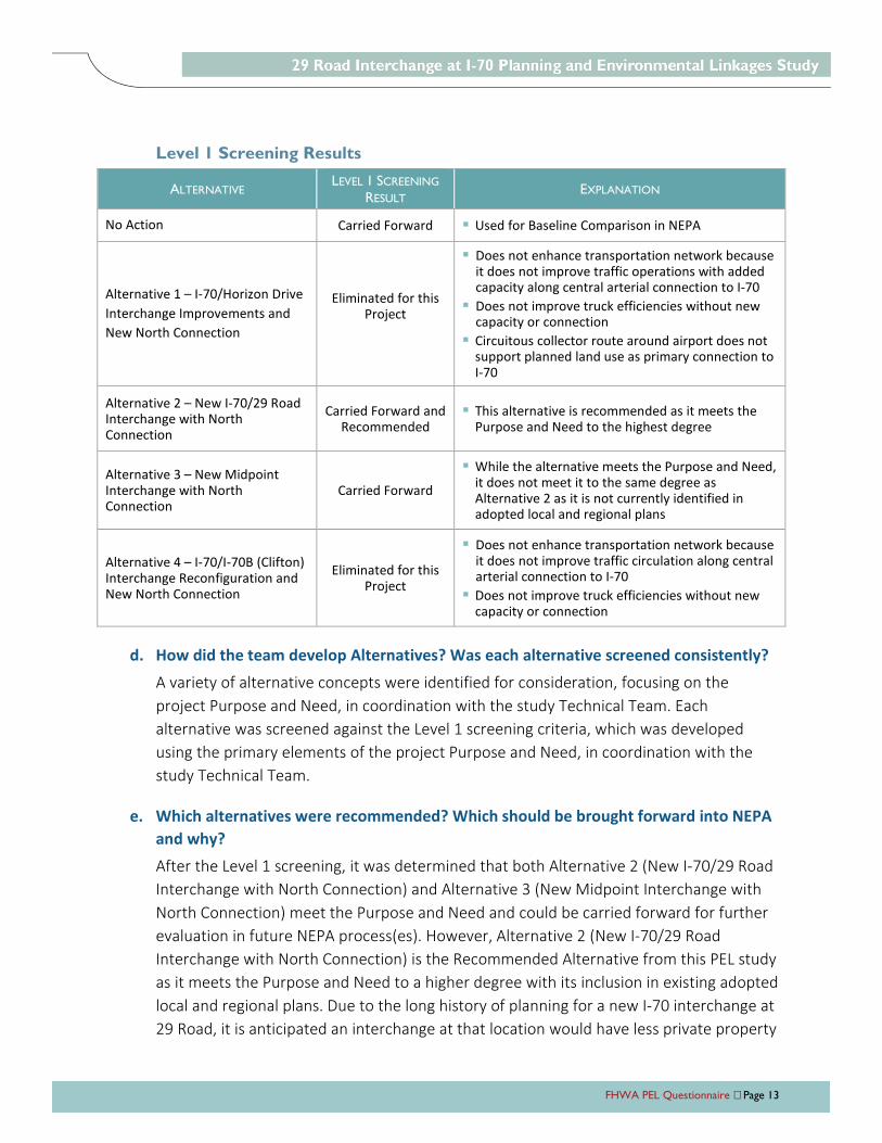
FHWA PEL Questionnaire Page 13
Level 1 Screening Results
ALTERNATIVE LEVEL 1 SCREENING
RESULT EXPLANATION
No Action Carried Forward Used for Baseline Comparison in NEPA
Alternative 1 – I-70/Horizon Drive
Interchange Improvements and
New North Connection
Eliminated for this Project
Does not enhance transportation network because it does not improve traffic operations with added capacity along central arterial connection to I-70
Does not improve truck efficiencies without new capacity or connection
Circuitous collector route around airport does not support planned land use as primary connection to I-70
Alternative 2 – New I-70/29 Road Interchange with North Connection
Carried Forward and Recommended
This alternative is recommended as it meets the Purpose and Need to the highest degree
Alternative 3 – New Midpoint Interchange with North Connection
Carried Forward
While the alternative meets the Purpose and Need, it does not meet it to the same degree as Alternative 2 as it is not currently identified in adopted local and regional plans
Alternative 4 – I-70/I-70B (Clifton) Interchange Reconfiguration and New North Connection
Eliminated for this Project
Does not enhance transportation network because it does not improve traffic circulation along central arterial connection to I-70
Does not improve truck efficiencies without new capacity or connection
d. How did the team develop Alternatives? Was each alternative screened consistently?
A variety of alternative concepts were identified for consideration, focusing on the
project Purpose and Need, in coordination with the study Technical Team. Each
alternative was screened against the Level 1 screening criteria, which was developed
using the primary elements of the project Purpose and Need, in coordination with the
study Technical Team.
e. Which alternatives were recommended? Which should be brought forward into NEPA
and why?
After the Level 1 screening, it was determined that both Alternative 2 (New I-70/29 Road
Interchange with North Connection) and Alternative 3 (New Midpoint Interchange with
North Connection) meet the Purpose and Need and could be carried forward for further
evaluation in future NEPA process(es). However, Alternative 2 (New I-70/29 Road
Interchange with North Connection) is the Recommended Alternative from this PEL study
as it meets the Purpose and Need to a higher degree with its inclusion in existing adopted
local and regional plans. Due to the long history of planning for a new I-70 interchange at
29 Road, it is anticipated an interchange at that location would have less private property
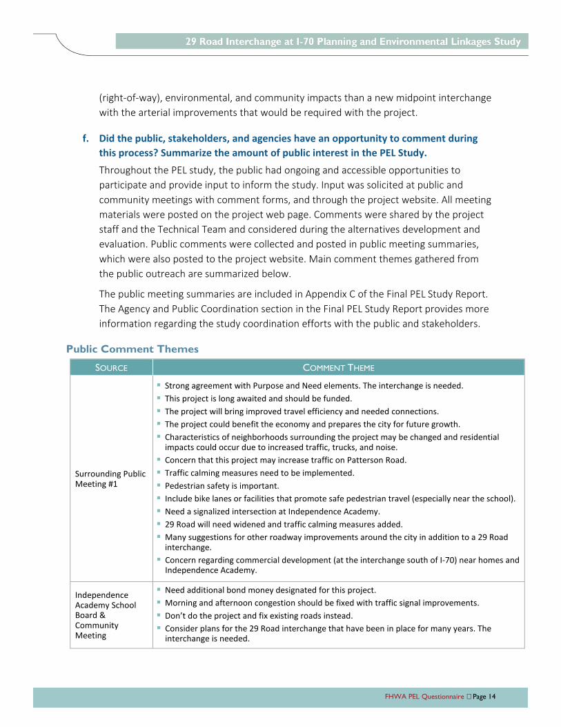
FHWA PEL Questionnaire Page 14
(right-of-way), environmental, and community impacts than a new midpoint interchange
with the arterial improvements that would be required with the project.
f. Did the public, stakeholders, and agencies have an opportunity to comment during
this process? Summarize the amount of public interest in the PEL Study.
Throughout the PEL study, the public had ongoing and accessible opportunities to
participate and provide input to inform the study. Input was solicited at public and
community meetings with comment forms, and through the project website. All meeting
materials were posted on the project web page. Comments were shared by the project
staff and the Technical Team and considered during the alternatives development and
evaluation. Public comments were collected and posted in public meeting summaries,
which were also posted to the project website. Main comment themes gathered from
the public outreach are summarized below.
The public meeting summaries are included in Appendix C of the Final PEL Study Report.
The Agency and Public Coordination section in the Final PEL Study Report provides more
information regarding the study coordination efforts with the public and stakeholders.
Public Comment Themes
SOURCE COMMENT THEME
Surrounding Public Meeting #1
Strong agreement with Purpose and Need elements. The interchange is needed.
This project is long awaited and should be funded.
The project will bring improved travel efficiency and needed connections.
The project could benefit the economy and prepares the city for future growth.
Characteristics of neighborhoods surrounding the project may be changed and residential impacts could occur due to increased traffic, trucks, and noise.
Concern that this project may increase traffic on Patterson Road.
Traffic calming measures need to be implemented.
Pedestrian safety is important.
Include bike lanes or facilities that promote safe pedestrian travel (especially near the school).
Need a signalized intersection at Independence Academy.
29 Road will need widened and traffic calming measures added.
Many suggestions for other roadway improvements around the city in addition to a 29 Road interchange.
Concern regarding commercial development (at the interchange south of I-70) near homes and Independence Academy.
Independence Academy School Board & Community Meeting
Need additional bond money designated for this project.
Morning and afternoon congestion should be fixed with traffic signal improvements.
Don’t do the project and fix existing roads instead.
Consider plans for the 29 Road interchange that have been in place for many years. The interchange is needed.
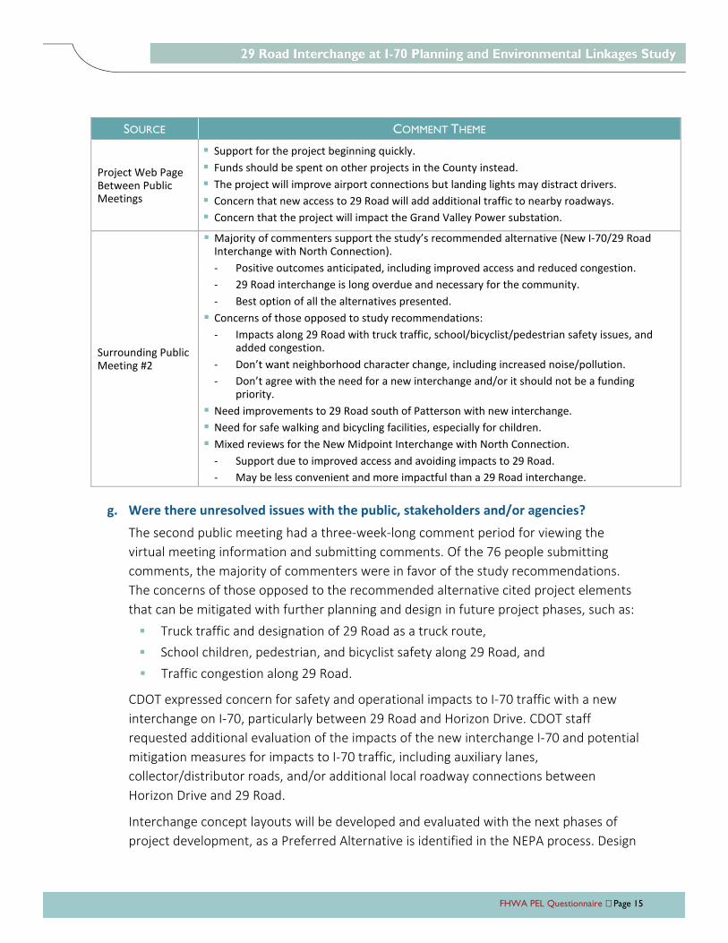
FHWA PEL Questionnaire Page 15
SOURCE COMMENT THEME
Project Web Page Between Public Meetings
Support for the project beginning quickly.
Funds should be spent on other projects in the County instead.
The project will improve airport connections but landing lights may distract drivers.
Concern that new access to 29 Road will add additional traffic to nearby roadways.
Concern that the project will impact the Grand Valley Power substation.
Surrounding Public Meeting #2
Majority of commenters support the study’s recommended alternative (New I-70/29 Road Interchange with North Connection).
- Positive outcomes anticipated, including improved access and reduced congestion.
- 29 Road interchange is long overdue and necessary for the community.
- Best option of all the alternatives presented.
Concerns of those opposed to study recommendations:
- Impacts along 29 Road with truck traffic, school/bicyclist/pedestrian safety issues, and added congestion.
- Don’t want neighborhood character change, including increased noise/pollution.
- Don’t agree with the need for a new interchange and/or it should not be a funding priority.
Need improvements to 29 Road south of Patterson with new interchange.
Need for safe walking and bicycling facilities, especially for children.
Mixed reviews for the New Midpoint Interchange with North Connection.
- Support due to improved access and avoiding impacts to 29 Road.
- May be less convenient and more impactful than a 29 Road interchange.
g. Were there unresolved issues with the public, stakeholders and/or agencies?
The second public meeting had a three-week-long comment period for viewing the
virtual meeting information and submitting comments. Of the 76 people submitting
comments, the majority of commenters were in favor of the study recommendations.
The concerns of those opposed to the recommended alternative cited project elements
that can be mitigated with further planning and design in future project phases, such as:
Truck traffic and designation of 29 Road as a truck route,
School children, pedestrian, and bicyclist safety along 29 Road, and
Traffic congestion along 29 Road.
CDOT expressed concern for safety and operational impacts to I-70 traffic with a new
interchange on I-70, particularly between 29 Road and Horizon Drive. CDOT staff
requested additional evaluation of the impacts of the new interchange I-70 and potential
mitigation measures for impacts to I-70 traffic, including auxiliary lanes,
collector/distributor roads, and/or additional local roadway connections between
Horizon Drive and 29 Road.
Interchange concept layouts will be developed and evaluated with the next phases of
project development, as a Preferred Alternative is identified in the NEPA process. Design
FHWA PEL Questionnaire Page 16
elements will be defined to consider design solutions to minimize costs and operational,
safety, and property impacts while maximizing project connectivity and access benefits
for the surrounding region. As project development moves forward, the area conditions
inventory and environmental overview completed for this PEL study should be reviewed
and updated as needed to reflect the most current conditions for consideration of
impacts and avoidance.
7. Planning assumptions and analytical methods:
a. What is the forecast year used in the PEL study?
2040 was the forecast year used in the PEL study, which was the current Mesa County
Regional Transportation Model (MCRTM) available at the beginning of the study. Grand
Valley MPO recently updated the MCRTM to extend projections to 2045. Traffic forecasts
for the area will need to be updated as the project moves into NEPA.
b. What method was used for forecasting traffic volumes?
The horizon year for this study is 2040, consistent with the horizon year for the Grand
Valley Transportation Plan that was current at the beginning of the study. The 2040
MCRTM was used to develop 2040 traffic forecasts for the study area roadways, with and
without a new interchange at I-70/29 Road. Due to the complexity of real-world travel
behavior, the travel demand model is not expected to provide precise traffic volume
forecasts. To improve the reliability of forecasts, a post-processing adjustment of the
2040 traffic volumes was performed. The adjustment methodology compared the
existing year model traffic volumes to actual traffic counts in the study area. The 2040
traffic forecasts were adjusted based on factors and/or differences for model versus
actual traffic volumes.
The 2040 GVMPO model includes the transportation network with the “Existing +
Committed” projects in the Grand Valley 2040 Regional Transportation Plan, which
includes the 29 Road interchange at I-70, widening 29 Road to four through lanes. In
order to evaluate the difference in area traffic volumes and operations with and without
the I-70/29 Road interchange, the 2040 GVMPO model was also run with the interchange
removed from the transportation network.
Forecasting and traffic analysis methods and results are discussed in further detail in the
Operations Mobility section of the Area Conditions Report and the Study
Recommendations section of the Final PEL Study Report.
FHWA PEL Questionnaire Page 17
c. Are the planning assumptions and the corridor vision/purpose and need statement
consistent with the long-range transportation plan?
The 2040 MCRTM was the travel demand model for most current regional long-range
transportation plan available at the beginning of the study. The project Purpose and
Need and goals are consistent with the Grand Junction Circulation Plan and the travel
demand and land use assumptions in the Grand Valley Regional Transportation Plan and
Grand Junction Comprehensive Plan that were current at the beginning of the study.
d. What were the future year policy and/or data assumptions used in the transportation
planning process related to land use, economic development, transportation costs and
network expansion?
Grand Valley MPO recently updated the MCRTM to extend projections to 2045. A
comparison to the updated MCRTM shows similar travel forecast results for 2045 as it did
for 2040 with the model used for this PEL study. Traffic forecasts for the area will need to
be updated as the project moves into NEPA.
8. What pieces of the PEL can transfer directly to the NEPA phase of a
project?
Purpose and Need Statement
Environmental Overview information in the Area Conditions Report
Alternatives development and screening results
Public input and comments
Environmental Resource Agency input and information regarding next steps
9. Resources (wetlands, cultural, etc.) reviewed. For each resource or
group of resources reviewed, provide the following:
a. In the PEL study, at what level of detail were the resources reviewed and what was
the method of review?
An environmental overview was prepared as part of the PEL study to identify resources
early in the planning process. The environmental overview, included in the Area
Conditions Report, contains environmental resource information and mapping that was
obtained using readily available resources such as file searches, GIS mapping, windshield
surveys, and literature review. All the environmental and community resources topics
summarized in the environmental scan will need to be reviewed in NEPA.
FHWA PEL Questionnaire Page 18
b. Is this resource present in the area and what is the existing environmental condition
for this resource?
The resources described below were assessed for presence in the study area surrounding
I-70 and 29 Road. The Environmental Overview section of the Area Conditions Report
contains detailed environmental resource information and mapping for these resources.
Air Quality – Study area is located within the Western Slope monitoring region and
is within an attainment status for all National Ambient Air Quality Standard criteria
pollutants.
Community and Social Resources – There are two schools, two churches, and two
parks located within the study area and no environmental justice (minority, low
income, or limited-English proficient) populations located in the study area.
Floodways and 100-year Floodplains – There are no designated floodways or
floodplains within the study area; however, there is a designated floodplain south
of Patterson Road.
Hazardous Materials – One potential hazardous material facility, a gas station, was
identified in the study area.
Historic Resources – There are no properties listed on the National Register of
Historic Places (NRHP). A total of nine historic properties have been previously
recorded within the study area, including eight residential properties and one
irrigation ditch. The ditch, the Government Highline Canal, was found to be eligible
for the NRHP in 1985.
Noise – Activity Categories B (residential), C (community resources), E
(hotels/restaurants/offices), F (agricultural/industrial), and G (undeveloped lands)
are present within the study area.
Parks and Recreational Resources – The study area includes two existing parks:
Darla Jean Park located on Darla Drive and Matchett Park located on Patterson
Road.
Prime and Unique Farmlands – Approximately 36% of the study area is classified as
“prime farmland if irrigated”.
Water Quality – Indian Wash is listed on the 303(d) list as impaired for aquatic life
use due to selenium and iron.
Threatened and Endangered Species and Biological Resources
» Potential for nine federally threatened and endangered species to occur in the
study area
» No critical habitat exists within the study area for federally threatened and
endangered species
» Potential for 12 state-listed species to occur in the study area
FHWA PEL Questionnaire Page 19
Wetlands and Waters of the U.S. – Wetlands in the study area occur in topographic
swales, roadside and irrigation ditches, and/or in association with streams.
Potential non-wetland waters of the U.S. include Indian Wash and Government
Highline Canal.
c. What are the issues that need to be considered during NEPA, including potential
resource impacts and potential mitigation requirements (if known)?
The Environmental Summary section of the Final PEL Study Report contains discussion of
potential resource impacts and potential mitigation requirements for the resources
reviewed for the study. The following resources may be impacted by the Recommended
Alternative and should be further assessed during NEPA.
Air Quality – No impacts to air quality are anticipated. A qualitative air quality
analysis may be required during NEPA.
Community and Social Resources – Depending on the final alignment and layout of
the Recommended Alternative, there could impacts to community and social
resources. Area residents expressed concern about changes to the community
character and impacts along 29 Road with truck traffic, school/bicyclist/pedestrian safety
issues, and added congestion. Ongoing coordination and conversations with property
owners, businesses, and residences potentially affected should also be a critical
part of future project development.
Don’t agree with the need for a new interchange and/or it should not be a funding priority.
Floodways and 100-year Floodplains – Depending on the final alignment of the
Recommended Alternative, changes to 29 Road may require hydraulic modeling for
the channel with future project development due to the proximity to the channel
and the downstream floodplain designation.
Hazardous Materials – Due to the presence of potential hazardous materials in the
study area, a Modified Phase I Environmental Site Assessment or CDOT Initial Site
Assessment should be conducted at site-specific locations to evaluate hazardous
materials that may require remediation prior to acquisition or development.
Historic Resources – Potential historic resources may be impacted by the
Recommended Alternative. During future NEPA process(es), historic resources will
need to be evaluated under Section 106 of the National Historic Preservation Act
and Section 4(f) (23 CFR 774) of the U.S. Department of Transportation Act of 1966
(Section 4(f)).
Noise – The Recommended Alternative has the potential to impact sensitive noise
receptors and a noise assessment should be conducted during NEPA.
FHWA PEL Questionnaire Page 20
Parks and Recreational Resources – Impacts to parks and recreational resources are
not anticipated; however, should impacts occur, the project must comply with
Section 4(f).
Prime and Unique Farmlands – Additional analysis during NEPA will be required to
determine if farmlands are being irrigated and if the Recommended Alternative
would impact them. A detailed analysis of the project design impacts to the existing
prime farmland should occur as well as coordination with local planners and other
local officials, including the Natural Resource Conservation Service.
Water Quality – Impaired waters should be considered during future project
development and efforts should be made to avoid and minimize impacts to water-
related resources to the extent possible, including the implementation of control
measures during construction to minimize sediment runoff. New separate storm
sewer system facilities will need to be considered during future NEPA/design
phases.
Threatened and Endangered Species and Biological Resources – As there is
potential for state and federally threatened species to occur in the study area,
comprehensive and updated special-status species lists will need to be obtained
during NEPA. If appropriate, a field survey will need to be conducted for federal-
and state-listed species and the project will need to comply with Section 7 of the
Endangered Species Act, the Migratory Bird Treaty Act, and Golden Eagle Protection
Act.
Wetlands and Waters of the U.S. – A wetland delineation will need to be completed
during NEPA and the project must follow Section 404 of the Clean Water Act should
there be impacts to jurisdictional wetlands and waters of the U.S.
d. How will the data provided need to be supplemented during NEPA?
Additional analysis will be required during NEPA to examine the new potential resource
impacts and new potential mitigation requirements. Consultations with appropriate
agencies and continued public involvement will also be required.
Environmental data were reviewed at the area level. During NEPA, the limits of the
Preferred Alternative will need to be evaluated relative to environmental impacts. Refer
to the Action Plan section of the Final PEL Study Report for more information on the
transition of the project from the PEL study into NEPA.
FHWA PEL Questionnaire Page 21
10. List resources that were not reviewed in the PEL study and why?
Indicate whether or not they will need to be reviewed in NEPA and
explain why.
The following resources were not reviewed in the PEL study and may need to be evaluated
in NEPA depending on the NEPA class of action and the context of the Preferred Alternative
and project location:
Geologic Resources and Soil
Water Quality
Vegetation and Noxious Weeds
Land Use
Paleontology
Archaeology
Utilities
Environmental Justice
Economic Resources
Energy
Right-of-Way
Visual Resources
11. Were cumulative impacts considered in the PEL study? If yes, provide
the information or reference where it can be found.
Cumulative impacts were not considered in the PEL study. They will be considered during
future NPEA processes.
12. Describe any mitigation strategies discussed at the planning level that
should be analyzed during NEPA.
The PEL study did not describe mitigation strategies other than identifying next steps to be
considered for each resource. The discussion of next steps will inform scoping and schedule
at the initiation of future NEPA processes.
13. What needs to be done during NEPA to make information from the
PEL study available to the agencies and the public? Are there PEL study
products which can be used or provided to agencies or the public during
the NEPA scoping process?
This PEL study was intended to provide the framework for the long-term implementation
of improvements as funding is available, and to be used as a resource to streamline future
NEPA efforts. Published documentation resulting from the PEL process is posted on the
FHWA PEL Questionnaire Page 22
Mesa County website. Applicable aspects of the I PEL process such as Purpose and Need,
alternatives screening, environmental resource summary for future scoping efforts, and
public and agency coordination is documented in the Final PEL Study Report for reference
as applicable with future NEPA processes.
14. Are there any other issues a future project team should be aware of?
a. Examples: Utility problems, access or ROW issues, encroachments into ROW,
problematic land owners and/or groups, contact information for stakeholders, special
or unique resources in the area, etc.
Through the process of completing the PEL study, CDOT expressed concern for safety and
operational impacts to I-70 traffic with a new interchange on I-70, particularly between
29 Road and Horizon Drive. The planning-level analysis completed for this study showed
that constructing a new interchange on I-70 in the vicinity of 29 Road will not create
operational issues well beyond the planning horizon. However, future project
development to define the specific location of the new interchange and the interchange
layout with lane configurations for the ramps and I-70 design should consider more
detailed traffic analysis with microsimulation software to identify specific operational
issues and potential mitigation measures.
With a new interchange connection at 29 Road, the 2040 traffic forecasts developed for
the PEL study show a substantial increase in I-70 traffic between Horizon Drive and 29
Road. In addition to the consideration of auxiliary lanes or a collector/distributor road
along I-70 to mitigate potential impacts to freeway traffic from short ramp-to-ramp trips,
a local roadway connection from 29 Road to Horizon Drive may be considered with
future project development. The Grand Junction Circulation Plan shows a new major
collector roadway from the Horizon Drive/Crossroads Boulevard intersection, around the
south side of the Grand Junction Airport, to connect north of the I-70/29 Road
interchange.
During the PEL study, the Grand Junction Airport and FAA Technical Team
representatives noted the difficulties to obtain airport and FAA approvals for a new non-
airport roadway on airport property, and the restrictions for any new roadways in an
airport Runway Protection Zone. They also noted that, due to planned airport
development, a new local roadway should not be planned to connect to Horizon Drive at
the H Road roundabout. To minimize airport property impacts, a new local connection
between Horizon Drive and 29 Road north of I-70 and south of the airport may be located
within CDOT right-of-way, but the roadway would still cross within the future Runway
Protection Zone. Due to the constraints of the Runaway Protection Zone, the Grand
Junction Airport Authority cannot support that Horizon Drive connection alignment at
FHWA PEL Questionnaire Page 23
this time. However, Authority staff plan to complete a feasibility study of reducing the
constraints of the runway protection for the Horizon Drive connection.
Other potential new local roadway connections, north or south of I-70, may be
considered during future project development, if needed to mitigate operational or
safety impacts due to local traffic on I-70 between interchanges.
More detailed discussions of considerations for further assessment during future NEPA
processes and project development are included in the Study Recommendations –
Recommended Alternative section in the Final PEL Study Report.
15. Provide a table of identified projects and/or a proposed phasing plan for
corridor build out.
The Final PEL Study Report includes an Action Plan section that outlines the next steps in
the project development process for a new interchange on I-70. The project
implementation process, including adherence to the CDOT Policy and Procedural Directive
1601 Interchange Approval Process, will be coordinated with CDOT and FHWA to ensure
consistency with the interchange approvals and NEPA process.
16. Provide a list of what funding sources have been identified to fund
projects from this PEL?
Funding for the I-70 interchange construction has not been identified at this time. Mesa
County and City of Grand Junction will continue collaborating to identify funding sources
and funding partnerships, including through state and federal grant opportunities.