Final Basic Assessment Report - gcs-sa.biz
373
L GCS (Pty) Ltd. Reg No: 2004/000765/07 Est. 1987 Offices: Johannesburg (Head Office) | Durban | Gaborone | Lusaka | Maseru | Windhoek | Ostrava Directors: AC Johnstone (CEO) | A Wilke | M Van Rooyen | W Sherriff (Financial) | N Marday (HR) Non-Executive Director: B Wilson-Jones 4a Old Main Road, Judges Walk, Kloof, Kwazulu-Natal, South Africa, 3610 PO Box 819, Gillitts, 3603, South Africa Tel: +27 (0) 31 764 7130 Fax: +27 (0) 11 803 5745 Web: www.gcs-sa.biz Final Basic Assessment Report Mining of Sand on Portion 8 of Farm Kruisfontein No. 193, Humansdorp, Eastern Cape Version – Final July 2022 Kouga Sand GCS Project Number: 21-0703 DMRE Ref No: EC30/5/1/3/2/10704MP
-
Upload
khangminh22 -
Category
Documents
-
view
0 -
download
0
Transcript of Final Basic Assessment Report - gcs-sa.biz

L
GCS (Pty) Ltd. Reg No: 2004/000765/07 Est. 1987
Offices: Johannesburg (Head Office) | Durban | Gaborone | Lusaka | Maseru | Windhoek | Ostrava
Directors: AC Johnstone (CEO) | A Wilke | M Van Rooyen | W Sherriff (Financial) | N Marday (HR)
Non-Executive Director: B Wilson-Jones
4a Old Main Road, Judges Walk, Kloof, Kwazulu-Natal, South Africa, 3610 PO Box 819, Gillitts, 3603, South Africa Tel: +27 (0) 31 764 7130 Fax: +27 (0) 11 803 5745 Web: www.gcs-sa.biz
Final Basic Assessment Report
Mining of Sand on Portion 8 of Farm Kruisfontein No. 193,
Humansdorp, Eastern Cape
Version – Final
July 2022
Kouga Sand
GCS Project Number: 21-0703
DMRE Ref No: EC30/5/1/3/2/10704MP

Kouga Sand Final Basic Assessment Report
21-0703 July 2022 ii
Final Basic Assessment Report
Mining of Sand on Portion 8 of Farm Kruisfontein No.193, Humansdorp, Eastern Cape
July 2022
21-0703
DOCUMENT ISSUE STATUS
Issue Final
GCS Reference Number 21-0703
DMRE Reference EC30/5/1/3/2/10704MP
Title Final Basic Assessment Report: Mining of Sand on Portion 8 of Farm Kruisfontein No.193, Humansdorp, Eastern Cape
Name Signature Date
Author Janice Callaghan
July 2022
Document Reviewer Magnus van Rooyen July 2022
Director Sign Off Magnus van Rooyen July 2022
LEGAL NOTICE This report or any proportion thereof and any associated documentation remain the property of GCS until the mandator effects payment of all fees and disbursements due to GCS in terms of the GCS Conditions of Contract and Project Acceptance Form. Notwithstanding the aforesaid, any reproduction, duplication, copying, adaptation, editing, change, disclosure, publication, distribution, incorporation, modification, lending, transfer, sending, delivering, serving or broadcasting must be authorised in writing by GCS. In compliance with the Protection of Personal Information Act, No. 37067 of 26 November 2013, please ensure the following:
• Any personal information provided herein has been provided exclusively for use as part of the public participation registration process, and may therefore not be utilised for any purpose, other than that for which it was provided.
• No additional copies may be made of documents containing personal information unless permission has been obtained from the owner of said information.
• All documentation containing personal information must be destroyed as soon as the purpose for which the information was collected has run out.
.

Kouga Sand Final Basic Assessment Report
21-0703 July 2022 iii
Disclaimer
Information contained in this report relating to the project description is based on information
supplied by the client and other client-appointed sources. It is assumed that the information
provided to GCS is correct.
Environmental and social data, as well as Environmental Impact Assessment, provided in this
report is based on information supplied by specialists in their respective fields, as well as
existing information pertaining to the area in question (including previous site investigation
data and information from the Department of Environmental Affairs’ Online Screening Tool).
It has been assumed that the information provided to GCS to perform the outcomes of this
report is correct.
No responsibility is accepted by GCS for incomplete or inaccurate data supplied by others (the
client and external sources). Where gaps have been identified these are listed for
consideration by the responsible decision-makers.
GCS’s opinions, conclusions and recommendations are based upon information that existed at
the time of the start of the production of this document.
NOTE: Notable additions/changes since the Draft Basic Assessment Report
(DBAR) (dated June 2022) are indicated by italic underlined text in this
report.

Kouga Sand Final Basic Assessment Report
21-0703 July 2022 iv
EXECUTIVE SUMMARY
GCS Water and Environmental Consultants (Pty) Ltd (GCS) was appointed by Kouga Sand (Pty)
Ltd (Kouga Sand) to conduct the Environmental Authorisation (EA) process for the proposed
mining of sand on Portion 8 of Kruisfontein No. 193, Humansdorp, Eastern Cape. This
application for EA is being undertaken on behalf of Kouga Sand (the applicant) and, as such,
will be submitted to the Department of Mineral Resources and Energy (DMRE) as the competent
authority.
NEED AND DESIRABILITY
There is an increasing demand for building sand in the Kouga Local Municipality, as various
activities require this product, such as the upgrading of roads and expansion of towns. Wind
farms have already been constructed, with additional phases planned. These projects all
require sand for the construction, as well as for roads. The limited number of mines in the
area mean that sand has to be trucked in from other nearby areas which increases the price
of the product. As a result, this mine would contribute to the development and economic
growth of the surrounding areas. It is therefore important for additional sand mines to be
constructed to meet the needs of the Municipality.
SITE DESCRIPTION
The proposed site is 4.9ha. The site is currently vacant and highly disturbed with very sparse
vegetation. Previously, the site was used for wattle farming. It has since been cleared, with a
few trees remaining. It is located within a primarily agricultural-based area, and the site will
be accessed via existing farm roads.
LISTED ACTIVITIES
Listed activities in terms of the 2014 NEMA EIA regulations, as amended:
Notice Activity Description of related activity Applicability
1 21 Any activity including the operation of that
activity which requires a mining permit in terms
of section 27 of the Mineral and Petroleum
Resources Development Act, 2002 (Act No. 28 of
2002), including —
a) associated infrastructure, structures
and earthworks, directly related to the
extraction of a mineral resource[,] ; or
[including activities for which an
exemption has been issued in terms of
Mining of building sand

Kouga Sand Final Basic Assessment Report
21-0703 July 2022 v
Notice Activity Description of related activity Applicability
section 106 of the Mineral and
Petroleum Resources Development Act,
2002 (Act No. 28 of 2002)]
b) the primary processing of a mineral
resource including winning, extraction,
classifying, concentrating, crushing,
screening or washing;
but excluding the secondary processing of a
mineral resource, including the smelting,
beneficiation, reduction, refining, calcining or
gasification of the mineral resource in which case
activity 6 in Listing Notice 2 applies.
1 22 The decommissioning of any activity requiring –
(i) a closure certificate in terms of section 43 of
the Mineral and Petroleum Resources
Development Act, 2002 (Act No. 28 of 2002)
Provision has been made for
closure.
1 27 The clearance of an area of 1 hectares or more,
but less than 20 hectares of indigenous
vegetation, except where such clearance of
indigenous vegetation is required for—
i. the undertaking of a linear activity; or
ii. maintenance purposes undertaken in
accordance with a maintenance
management plan.
Clearing of vegetation for mine
SPECIALIST STUDIES
The following specialist studies were identified as required based on the Department of
Forestry, Fisheries and Environment Screening Tool:
Theme Sensitivity Study Undertaken
Reason
Agriculture High No The area is already disturbed due to current landuse activities
Animal Species Medium No The area is already disturbed due to current landuse activities
Aquatic Very High Yes Required
Heritage Low Yes The area is known for artefacts
Civil Aviation Low No Not required
Defence Low No Not required
Paleontology High No Not required
Plant Species Medium No The area is already disturbed due to current landuse activities
Terrestrial Biodiversity
Very High Yes Required
PUBLIC PARTICIPATION PROCESS
The comment period was run from 31 May 2022 to 1 July 2022. Two site notices detailing
information about the project and the BA Process, as well as invitation to register as I&APs,
were placed at two locations on 15 February 2022. A newspaper advertisement for the

Kouga Sand Final Basic Assessment Report
21-0703 July 2022 vi
registration and participation of I&APs was placed in the Kouga Express Newspaper on 17
February 2022.
ENVIRONMENTAL IMPACT STATEMENT
The following potential impacts associated with the proposed project are rated as Medium
(Negative) significance (pre-mitigation):
• Loss of minimal indigenous vegetation present on site;
• Spread of alien invasive plant species;
• Contamination as a result of leaking portable toilet facilities; and
• Alteration of catchment drainage due to change in baseline topography.
It must be emphasised that all of these medium negative impacts can be mitigated to a low
significance.
The following impacts associated with the proposed project are considered to be of Positive
significance:
• Removal of alien invasive vegetation existing on site;
• Potential employment opportunities for a limited number of local residents; and
• Potential economic benefit for the area from the sale of the product.
In the decommissioning phase, the receiving environment will be rehabilitated as closely
as possible to the natural condition of the area.
ENVIRONMENTAL MANAGEMENT PROGRAMME
An Environmental Management Programme (EMPr) related to the construction and operational
phases of the proposed mine is included as Appendix E.
CONCLUSIONS
The EAP is confident that all major impacts associated with the proposed sand mine have been
adequately described and mitigated. In the impact assessment, consideration has been given
to the relatively short duration of the proposed operation, and the localised nature of the
potential impacts.
In light of the above, and given the generally medium-low impacts associated with the
proposed mine, as well as the strict implementation of the proposed mitigation measures

Kouga Sand Final Basic Assessment Report
21-0703 July 2022 vii
including those in the detailed EMPr (Appendix E), the EAP is confident that the project can
proceed without significant impact on the receiving environment.
YOUR OPPORTUNITY TO PARTICIPATE
This FBAR has been compiled for submission to the DMRE as the CA. Any further comments
on this report must be submitted on or before 12 August 2022, directly to Ms Hloniphile
Dlamini, the assessing officer, by means of the following:
Tel: 041 403 6600
Fax: 086 710 1055
Email: [email protected]
Post: Private Bag X 6076
Port Elizabeth
6000
Please ensure that GCS is copied in any submissions to the DMRE.

Kouga Sand Final Basic Assessment Report
21-0703 July 2022 viii
CONTENTS PAGE
1 INTRODUCTION .......................................................................................................................... 1
1.1 BACKGROUND AND OVERVIEW ......................................................................................................... 1 1.2 DETAILS OF APPLICANT AND ENVIRONMENTAL ASSESSMENT PRACTITIONER (EAP) ..................................... 4
2 PROJECT DESCRIPTION ............................................................................................................... 4
2.1 SITE DESCRIPTION .......................................................................................................................... 4 2.1.1 Existing and Adjacent Land Uses ...................................................................................... 4 2.1.2 Historical Land Uses .......................................................................................................... 5 2.1.3 GPS Coordinates ............................................................................................................... 5
2.2 LAND OWNERSHIP ......................................................................................................................... 7 2.3 DESCRIPTION OF PROPOSED ACTIVITY ................................................................................................ 7
3 LEGAL FRAMEWORK ................................................................................................................... 9
3.1 THE CONSTITUTION OF THE REPUBLIC OF SOUTH AFRICA, 1996 (ACT NO. 108 OF 1996) .......................... 9 3.2 NATIONAL ENVIRONMENTAL MANAGEMENT ACT, 1998 (ACT 107 OF 1998) ENVIRONMENTAL IMPACT
ASSESSMENT REGULATIONS (2014) AS AMENDED ........................................................................................... 9 3.2.1 Applicable Listed Activities .............................................................................................. 10 3.2.2 Screening and Initial Site Sensitivity Verification ............................................................ 11
3.3 ENVIRONMENTAL CONSERVATION ACT, 1989 (ACT NO. 73 OF 1989), AS AMENDED .............................. 12 3.4 NATIONAL ENVIRONMENTAL MANAGEMENT: WASTE ACT, 2008 (ACT NO.59 OF 2008), AS AMENDED ..... 13 3.5 NATIONAL ENVIRONMENTAL MANAGEMENT: AIR QUALITY ACT, 2004 (ACT NO. 39 OF 2004), AS AMENDED
13 3.6 NATIONAL ENVIRONMENTAL MANAGEMENT: BIODIVERSITY ACT, 2004 (ACT NO. 10 OF 2004) ................ 14 3.7 CONSERVATION OF AGRICULTURAL RESOURCES ACT, 1983 (ACT NO. 43 OF 1983) ................................ 15 3.8 NATIONAL WATER ACT, 1998 (ACT NO. 36 OF 1998) ...................................................................... 15 3.9 NATIONAL HERITAGE RESOURCES ACT, 1999 (ACT NO. 25 OF 1999) .................................................. 16 3.10 OCCUPATIONAL HEALTH AND SAFETY ACT, 1993 (ACT NO. 85 OF 1993) ............................................. 17 3.11 HAZARDOUS SUBSTANCES ACT, 1973 (ACT NO 15 OF 1973) ............................................................. 17
4 PROJECT MOTIVATION AND NEED & DESIRABILITY .................................................................. 17
5 DEVELOPMENT ALTERNATIVES ................................................................................................. 18
5.1 POTENTIAL ALTERNATIVES ............................................................................................................. 18 5.2 NO GO ALTERNATIVE ................................................................................................................... 18
6 ENVIRONMENTAL ATTRIBUTES................................................................................................. 18
6.1 CLIMATE .................................................................................................................................... 19 6.2 TOPOGRAPHY AND GEOLOGY ......................................................................................................... 20 6.3 TERRESTRIAL BIODIVERSITY ............................................................................................................ 24
6.3.1 Flora ................................................................................................................................ 24 6.3.2 Fauna .............................................................................................................................. 24
6.4 HYDROLOGY AND AQUATIC FEATURES ............................................................................................. 25 6.5 SOCIO-ECONOMIC CONTEXT .......................................................................................................... 28 6.6 CULTURAL HERITAGE RESOURCES ................................................................................................... 28
7 PUBLIC PARTICIPATION PROCESS ............................................................................................. 28
7.1 OBJECTIVES OF PUBLIC PARTICIPATION ............................................................................................ 29 7.2 PUBLIC PARTICIPATION PROCESS .................................................................................................... 29 7.3 PUBLIC REVIEW OF DRAFT BAR ...................................................................................................... 30 7.4 COMMENTS AND RESPONSES ......................................................................................................... 30
8 IMPACT ASSESSMENT ............................................................................................................... 30
8.1 METHODOLOGY .......................................................................................................................... 30 8.2 NO-GO IMPACTS ......................................................................................................................... 32 8.3 CONSTRUCTION PHASE ................................................................................................................. 32
8.3.1 Surface Water ................................................................................................................. 32

Kouga Sand Final Basic Assessment Report
21-0703 July 2022 ix
8.3.2 Fauna .............................................................................................................................. 32 8.3.3 Flora ................................................................................................................................ 33 8.3.4 Rivers and Wetlands ....................................................................................................... 33 8.3.5 Geology and Topography ................................................................................................ 34 8.3.6 Soil .................................................................................................................................. 34 8.3.7 Land Use ......................................................................................................................... 35 8.3.8 Traffic .............................................................................................................................. 35 8.3.9 Cultural and Heritage Resources .................................................................................... 36 8.3.10 Socio-Economic ............................................................................................................... 36 8.3.11 Noise ............................................................................................................................... 36 8.3.12 Visual .............................................................................................................................. 37 8.3.13 Air ................................................................................................................................... 37
8.4 OPERATIONAL PHASE ................................................................................................................... 38 8.4.1 Surface Water ................................................................................................................. 38 8.4.2 Fauna .............................................................................................................................. 38 8.4.3 Flora ................................................................................................................................ 38 8.4.4 Rivers and Wetlands ....................................................................................................... 39 8.4.5 Geology and Topography ................................................................................................ 40 8.4.6 Soil .................................................................................................................................. 40 8.4.7 Land Use ......................................................................................................................... 41 8.4.8 Traffic .............................................................................................................................. 41 8.4.9 Cultural and Heritage Resources .................................................................................... 42 8.4.10 Socio-Economic ............................................................................................................... 42 8.4.11 Noise ............................................................................................................................... 43 8.4.12 Visual .............................................................................................................................. 43 8.4.13 Air ................................................................................................................................... 43
8.5 DECOMMISSIONING PHASE ............................................................................................................ 44 8.5.1 Surface Water ................................................................................................................. 44 8.5.2 Fauna .............................................................................................................................. 44 8.5.3 Flora ................................................................................................................................ 44 8.5.4 Rivers and Wetlands ....................................................................................................... 45 8.5.5 Geology and Topography ................................................................................................ 45 8.5.6 Soil .................................................................................................................................. 46 8.5.7 Land Use ......................................................................................................................... 47 8.5.8 Traffic .............................................................................................................................. 47 8.5.9 Cultural and Heritage ..................................................................................................... 47 8.5.10 Socio-Economic ............................................................................................................... 48 8.5.11 Noise ............................................................................................................................... 48 8.5.12 Visual .............................................................................................................................. 48 8.5.13 Air Quality ....................................................................................................................... 49
8.6 CUMULATIVE IMPACTS .................................................................................................................. 49 8.6.1 Loss of Indigenous Vegetation ........................................................................................ 50 8.6.2 Loss of Alien Invasive Plant Species ................................................................................ 50 8.6.3 Spread of Alien Invasive Plant Species ............................................................................ 50 8.6.4 Disruption of an Open Space Corridor ............................................................................ 51 8.6.5 Alteration of the catchment drainage regime of the area .............................................. 51
9 ASSUMPTIONS, UNCERTAINTIES, AND GAPS IN KNOWLEDGE .................................................. 51
10 SPECIALIST RECOMMENDATIONS ............................................................................................. 52
11 ENVIRONMENTAL IMPACT STATEMENT ................................................................................... 53
11.1 NEGATIVE IMPACTS ...................................................................................................................... 53 11.2 POSITIVE IMPACTS ....................................................................................................................... 53 11.3 SITE SENSITIVITY .......................................................................................................................... 53
12 MOTIVATION OF THE EAP......................................................................................................... 56
13 REFERENCES ............................................................................................................................. 57

Kouga Sand Final Basic Assessment Report
21-0703 July 2022 x
LIST OF FIGURES
Figure 1-1: Regional Locality Map ..................................................................... 2 Figure 1-2: Site Locality Map ........................................................................... 3 Figure 2-1: Land use of the proposed site ............................................................ 6 Figure 2-2: Proposed Site Layout ...................................................................... 8 Figure 6-1: Rainfall and temperature averages for Humansdorp, Eastern Cape (Meteoblue, 2022) ..................................................................................................... 19 Figure 6-2: Predominant wind directions recorded in Humansdorp (Meteoblue, 2022) ...... 20 Figure 6-3: Average wind speeds recorded per month in Humansdorp (Meteoblue, 2022) .. 20 Figure 6-4: Topography of the proposed site ...................................................... 22 Figure 6-5: Geology of the proposed site ........................................................... 23 Figure 6-6: Vegetation of the proposed site ....................................................... 26 Figure 6-7: Rivers and wetlands around the proposed site ...................................... 27 Figure 11-1: Sensitive Features on and around the site .......................................... 55
LIST OF TABLES
Table 1-1: Contact details for applicant .............................................................. 4 Table 1-2: Contact details for EAP .................................................................... 4 Table 2-1: Co-ordinates of the corner points of the proposed mining area ..................... 5 Table 2-2: Property Owner Details .................................................................... 7 Table 3-1: Listed activities in terms of the 2014 NEMA EIA regulations, as amended ....... 10 Table 3-2: Site Sensitivities (based on the property description) from DFFE online screening tool ....................................................................................................... 12 Table 6-1: Sensitive plant species identified as potentially present within the study site 24 Table 6-2: Sensitive animal species identified as potentially present within the study site24 Table 8-1: Severity or magnitude of impact. ...................................................... 30 Table 8-2: Spatial Scale – extent of area being impacting upon. ............................... 31 Table 8-3: Duration of activity ....................................................................... 31 Table 8-4: Probability ................................................................................. 31 Table 8-5: Impact significance ratings (maximum of 100). ...................................... 31
LIST OF APPENDICES
APPENDIX A: QUALIFICATIONS AND DECLARATION OF EAP
APPENDIX B: SPECIALIST STUDIES
APPENDIX C: DFFE ONLINE SCREENING REPORT
APPENDIX D: PUBLIC PARTICIPATION
APPENDIX E: ENVIRONMENTAL MANAGEMENT PROGRAMME
APPENDIX F: DETAILED IMPACT ASSESSMENT
APPENDIX G: PROPERTY TITLE DEED

Kouga Sand Final Basic Assessment Report
21-0703 July 2022 xi
ACRONYMS AND ABBREVIATIONS
BA Basic Assessment
CARA Conservation of Agricultural Resources Act, 1983 (Act No. 43 of 1983)
CBA Critical Biodiversity Area
CR Critically Endangered
CRR Comments and Responses Report
CV Curriculum Vitae
DBAR Draft Basic Assessment Report
DFFE Department of Forestry and Fisheries and Environment
DMRE Department of Mineral Resources and Energy
DWS Department of Water and Sanitation
EA Environmental Authorisation
EAP Environmental Assessment Practitioner
ECA Environment Conservation Act, 1989 (Act No. 73 of 1989)
ECBCP Eastern Cape Biodiversity Conservation Plan
ECO Environmental Control Officer
EIA Environmental Impact Assessment
EMPr Environmental Management Programme
EN Endangered
ESA Ecological Support Area
FBAR Final Basic Assessment Report
FEPA Freshwater Ecosystem Priority Area
GDP Gross Domestic Product
GCS GCS Water and Environmental Consultants (Pty) Ltd
GNR Government Notice Regulation
GPS Global Positioning System
ha Hectares
I&AP Interested and Affected Party
IDP Integrated Development Plan
LT Least Threatened
km kilometres
Kouga Sand Kouga Sand (Pty) Ltd
m Metres
m3 Cubic metres
mamsl Metres above mean sea level
mm Millimetres
MP Mining Permit
MPRDA Mineral and Petroleum Resources Development Act, 2002

Kouga Sand Final Basic Assessment Report
21-0703 July 2022 xii
NCR Noise Control Regulations
NEMA National Environmental Management Act, 1998 (Act No. 107 of 1998)
NEMA EIA Regulations
National Environmental Management Act, 1998 (Act 107 of 1998) Environmental Impact Assessment Regulations (2014) as amended
NEM:AQA National Environmental Management: Air Quality Act, 2004 (Act No. 39 of 2004), as amended
NEM: BA National Environmental Management: Biodiversity Act, 2004 (Act No. 10 of 2004)
NEM:WA National Environmental Management: Waste Act, 2008 (Act No.59 of 2008), as amended
NFEPA National Freshwater Ecosystem Priority Area
NGO Non-Governmental Organisation
NHRA National Heritage Resources Act, 1999 (Act No. 25 of 1999)
NWA National Water Act, 1998 (Act No. 36 of 1998)
OHSA Occupational Health and Safety Act, 1993 (Act No. 85 of 1993)
PIA Palaeontological Impact Assessment
PM Project Manager
PPP Public Participation Process
SAHRA South African Heritage Resources Agency
SANBI South African National Biodiversity Institute
SANS South African National Standards
SAPS South African Police Services
SEIA Scoping and Environmental Impact Assessment
SCC Species of Conservation Concern
SS Site supervisor
The Constitution The Constitution of the Republic of South Africa, 1996 (Act No. 108 of 1996)
TOPS Threatened or Protected Species
VN Vulnerable
WMA Water Management Area

Kouga Sand Final Basic Assessment Report
21-0703 July 2022 Page 1
1 INTRODUCTION
1.1 Background and Overview
GCS Water and Environmental Consultants (Pty) Ltd (GCS) was appointed by Kouga Sand (Pty)
Ltd (Kouga Sand) to conduct the Environmental Authorisation (EA) process for the proposed
mining of sand on Portion 8 of Kruisfontein No. 193, Humansdorp, Eastern Cape. This
application for EA is being undertaken on behalf of Kouga Sand (the applicant) and, as such,
will be submitted to the Department of Mineral Resources and Energy (DMRE) as the competent
authority.
Owing to the nature and scale of the project, an Application for EA is required. The
Applications for EA and Mining Permit have been undertaken in terms of the National
Environmental Management Act, 1998 (Act No. 107 of 1998) (NEMA) and the Mineral and
Petroleum Resources Development Act, 2002 (MPRDA). This report has been prepared per the
2014 Environmental Impact Assessment (EIA) Regulations, as amended.
Kouga Sand Final Basic Assessment Report
21-0703 July 2022 Page 2
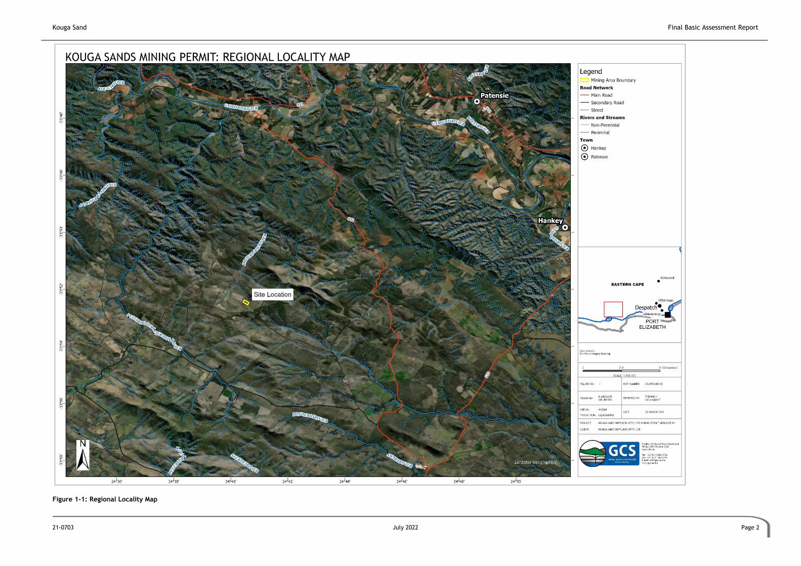
Figure 1-1: Regional Locality Map

Kouga Sand Final Basic Assessment Report
21-0703 July 2022 Page 3
Figure 1-2: Site Locality Map

Kouga Sand Final Basic Assessment Report
21-0703 July 2022 Page 4
1.2 Details of Applicant and Environmental Assessment Practitioner (EAP)
The details of the applicant are provided in Table 1-1.
Table 1-1: Contact details for applicant
ITEM DETAILS
Project Applicant Kouga Sand (Pty) Ltd
Registration Number: K2021769912
Trading Name: Kouga Sand
Responsible Person: Lu-Daan van Niekerk
Contact Persons Lu-Daan van Niekerk
Postal Address Chatten Farm, Humansdorp
Postal Code: 6330 Cell: 0837949497
E-mail: [email protected]
The contact details of the EAP are provided in Table 1-2 and the EAP’s CV is attached as
Appendix A.
Table 1-2: Contact details for EAP
ITEM DETAILS
Company Name GCS Water and Environmental Consultants (Pty) Ltd
Company Representative Magnus van Rooyen Janice Callaghan
Professional Registration Pr.Sci.Nat Cand.Sci.Nat, EAPASA
Telephone No. +27 (0)31 764 7430 +27 (0)31 764 7430
Facsimile No. +27 (0)11 803 5745 +27 (0)11 803 5745
E-mail Address [email protected] [email protected]
Postal Address PO Box 819, Gillitts, 3603 PO Box 819, Gillitts, 3603
2 PROJECT DESCRIPTION
2.1 Site description
2.1.1 Existing and Adjacent Land Uses
The current land use of surrounding farms is agriculture. The site is currently cleared and in a
disturbed state. According to Figure 2-1, the current land uses on the site are low shrubland,
contiguous low forest and thicket, and fallow land and old fields. The area is currently zoned
as agriculture according to the Kouga Land Use Scheme, dated December 2020.

Kouga Sand Final Basic Assessment Report
21-0703 July 2022 Page 5
2.1.2 Historical Land Uses
Historically the study site was cleared for agricultural use (circa 1994) and has subsequently
being left to be overgrown by alien invasive Acacia mearnsii that is systematically cleared from
the site by the landowner for the production of firewood.
2.1.3 GPS Coordinates
The Global Positioning System (GPS) coordinates of the proposed mining area are provided in
Figure 1-2. The approximate mid-point of the proposed area to be developed is at 33°52'27.99"S
24°40'32.08"E. The co-ordinates of the corner points as described in Table 2-1.
Table 2-1: Co-ordinates of the corner points of the proposed mining area
Point Latitude Longitude
A 33°52'32.49"S 24°40'35.36"E
B 33°52'27.84"S 24°40'37.86"E
C 33°52'22.24"S 24°40'28.41"E
D 33°52'27.05"S 24°40'25.82"E

Kouga Sand Final Basic Assessment Report
21-0703 July 2022 Page 6
Figure 2-1: Land use of the proposed site

Kouga Sand Final Basic Assessment Report
21-0703 July 2022 Page 7
2.2 Land Ownership
The identified property is owned by the Phillips Family Trust. Refer to Table 2-2 for the
applicable property details, and Appendix G for the title deed.
Table 2-2: Property Owner Details
Farm Details SG Code Total Property Size (ha)
Portion 8 of Farm Kruisfontein No 193 C03400000000019300008 534.780
2.3 Description of Proposed Activity
The mining will be conducted as an opencast operation with the sand removed at surface and
put through a screen to remove all root material from the sand.
The excavation will be conducted with an excavator which will excavate the sand from the
mining area in a concurrent strip-mining process to a depth not exceeding 3m. The sand will be
put through a drum-sieve to remove any plant root material that might be in the sand. The sand
will then be stockpiled and loaded on tipper trucks for transport from the site to the point of
sale. It is envisaged that four (4) truck loads of material will be removed from site per day.
An access road to the application area already exists in the form of a farm road.
The following infrastructure will be positioned on site:
• Product stockpile (100m2);
• Opencast pits (4.5ha); and
• Site office (50m2).
It is anticipated that there will be three (3) workers present on site. These workers will not
be housed on site.

Kouga Sand Final Basic Assessment Report
21-0703 July 2022 Page 8
Figure 2-2: Proposed Site Layout

Kouga Sand Final Basic Assessment Report
21-0703 July 2022 Page 9
3 LEGAL FRAMEWORK
This chapter details applicable legal provisions and aims to provide a review of relevant national
and provincial legislation and regulations, and policy documents, which apply to, or have
implications for, the proposed mine.
3.1 The Constitution of the Republic of South Africa, 1996 (Act No. 108 of 1996)
The legal reference source for environmental law in South Africa is found in the Constitution of
the Republic of South Africa, 1996 (Act No.108 of 1996)(The Constitution). All environmental
aspects should be interpreted within the context of The Constitution. The Constitution is the
supreme act to which all other acts must speak to and sets out the rights for every citizen of
South Africa and aims to address past social injustices. The Constitution has enhanced the
status of the environment since environmental rights have been established (Section 24) and
other rights created in the Bill of Rights which impact on environmental management. Section
24 of the Constitution states that:
“Everyone has the right:
a) To an environment that is not harmful to their health or well-being;
b) To have the environment protected, for the benefit of present and future generations,
through reasonable legislative and other measures that:
i. Prevent pollution and ecological degradation;
ii. Promote conservation; and
iii. Secure ecologically sustainable development and use of natural resources while
promoting justifiable economic and social development”.
The Applicant must ensure that environmental impacts are avoided, mitigated or managed as
far as possible throughout the life cycle of the project.
3.2 National Environmental Management Act, 1998 (Act 107 of 1998)
Environmental Impact Assessment Regulations (2014) as amended
The National Environmental Management Act, 1998 (Act No. 107 of 1998)(NEMA) is South
Africa’s overarching framework for environmental legislation giving effect to the constitutional
environmental right and provides the framework for regulatory tools in respect of
environmental impacts. Section 24 of NEMA regulates environmental authorisations.
Of particular importance is the requirement of ‘duty of care’ with regards to environmental
remediation stipulated in Section 28 of NEMA. Section 28 (1) states that:

Kouga Sand Final Basic Assessment Report
21-0703 July 2022 Page 10
“Every person who causes has caused or may cause significant pollution or degradation of the
environment must take reasonable measures to prevent such pollution or degradation from
occurring, continuing or recurring, or, in so far as such harm to the environment is authorised
by law or cannot be reasonably be avoided or stopped, to minimise and rectify such pollution
or degradation of the environment."
As such, the Applicant must ensure that environmental impacts are avoided, mitigated or
managed as far as possible throughout the life cycle of the project.
Regulations promulgated under NEMA include the Environmental Impact Assessment (EIA)
Regulations (2014) published under Government Notice Regulation (GNR) 326, as amended 4
April 2017, and the associated Listing Notices: Listing Notice 1 (GNR327), 2 (GNR325) and 3
(GNR324). Section 24(5) of NEMA stipulates that certain “listed activities” require
environmental authorisation by way of either a Basic Assessment (BA) or a full Scoping and
Environmental Impact Assessment (SEIA) as defined in the Listing Notices. Activities listed under
Listing Notice 1 and 3 require a BA process to be undertaken while those listed under Listing
Notice 2 require a full Scoping and SEIA process. Table 3-1 provides an assessment of the
applicable listed activities.
3.2.1 Applicable Listed Activities
The proposed project will require EA and Mining Permit (MP) through a BA process, due to the
Activities 21, 22(i) and 27 of Listing Notice 1 being triggered (Table 3-1).
Table 3-1: Listed activities in terms of the 2014 NEMA EIA regulations, as amended
Notice Activity Description of related activity Applicability
1 21 Any activity including the operation of that
activity which requires a mining permit in terms
of section 27 of the Mineral and Petroleum
Resources Development Act, 2002 (Act No. 28 of
2002), including —
c) associated infrastructure, structures
and earthworks, directly related to the
extraction of a mineral resource[,] ; or
[including activities for which an
exemption has been issued in terms of
section 106 of the Mineral and
Petroleum Resources Development Act,
2002 (Act No. 28 of 2002)]
d) the primary processing of a mineral
resource including winning, extraction,
classifying, concentrating, crushing,
screening or washing;
but excluding the secondary processing of a
mineral resource, including the smelting,
beneficiation, reduction, refining, calcining or
gasification of the mineral resource in which case
activity 6 in Listing Notice 2 applies.
Mining of sand
1 22 The decommissioning of any activity requiring – Provision has been made for

Kouga Sand Final Basic Assessment Report
21-0703 July 2022 Page 11
Notice Activity Description of related activity Applicability
(i) a closure certificate in terms of section 43 of
the Mineral and Petroleum Resources
Development Act, 2002 (Act No. 28 of 2002)
closure.
1 27 The clearance of an area of 1 hectares or more,
but less than 20 hectares of indigenous
vegetation, except where such clearance of
indigenous vegetation is required for—
i. the undertaking of a linear activity; or
ii. maintenance purposes undertaken in
accordance with a maintenance
management plan.
Clearing of vegetation for mine
3.2.2 Screening and Initial Site Sensitivity Verification
Based on the Procedures for the Assessment and Minimum Criteria for Reporting on Identified
Environmental Themes in terms of Sections 24(5)(a) and (h) and 44 of the NEMA, when applying
for EA (GN R320 of 20 March 2020) (the Protocols), the required level of assessment must be
based on the findings of the Initial Site Sensitivity Verification and must comply with Appendix
6 of the EIA Regulations promulgated under sections 24(5) and 44 of the NEMA, where a
specialist assessment is required.
An Initial Site Sensitivity Verification must be undertaken by an EAP or a registered specialist
with expertise in the relevant environmental theme being considered. The Initial Site Sensitivity
Verification must be undertaken through the use of:
• A desktop analysis, using satellite imagery; and
• A preliminary on-site inspection to identify if there are any discrepancies with the
current use of land and environmental status quo versus the environmental sensitivity
as identified on the national web-based environmental screening tool, such as new
developments, infrastructure, indigenous/pristine vegetation, etc.
The outcome of the Initial Site Sensitivity Verification must be recorded in the form of a report
that-
• Confirms or disputes the current use of the land and environmental sensitivity as
identified by the national web-based environmental screening tool;
• Contains motivation and evidence (e.g. photographs) of either the verified or different
use of the land and environmental sensitivity; and
• Is submitted together with the relevant assessment report prepared following the
requirements of the EIA Regulations.

Kouga Sand Final Basic Assessment Report
21-0703 July 2022 Page 12
The site has several sensitivities and associated reporting requirements, as shown in Table 3-2.
The assessment was based on the property description, using the Department of Forestry,
Fisheries and Environment (DFFE) online screening tool (24 March 2022) (Appendix G).
Table 3-2: Site Sensitivities (based on the property description) from DFFE online screening
tool
THEME VERY HIGH
HIGH MEDIUM LOW
Agriculture X
Animal Species X
Aquatic Biodiversity X
Archaeological and Cultural Heritage X
Civil Aviation X
Defence X
Paleontology X
Plant Species X
Terrestrial Biodiversity X
3.3 Environmental Conservation Act, 1989 (Act No. 73 of 1989), as amended
The Environmental Conservation Act, 1989 (Act No. 73 of 1989)(ECA) has now largely been
replaced by the NEMA but certain provisions remain in force. Section 21 of the ECA relates to
the control of activities that may have a detrimental effect on the environment, which require
written authorization issued by the relevant authority.
The national Noise Control Regulations (NCR) (GN R154 in Government Gazette No. 13717 dated
10 January 1992) (NCR) were promulgated In terms of Section 25 of the ECA, relating to noise,
vibration and shock. The NCRs were revised under Government Notice Number R55 of 14
January 1994 to make it obligatory for all authorities to apply the regulations. In accordance
with the Act, two procedures exist for assessing and controlling noise, respectively
• South African National Standard (SANS) 10328:2008 Methods for environmental noise
impact assessments;
• SANS 10103:2004 ‘The measurement and rating of environmental noise with respect to
annoyance and speech communication’; and
• Other SANS.
The proposed development is likely to temporarily increase ambient noise levels during the
construction and operational phases. Noise impacts are closely related to construction and
mining activities and trucks transporting the product from site. It must be emphasized that
there will be a maximum of four trucks per day removing material from site. The EMPr includes
mitigation measures relating to the mitigation of noise impacts.

Kouga Sand Final Basic Assessment Report
21-0703 July 2022 Page 13
3.4 National Environmental Management: Waste Act, 2008 (Act No.59 of 2008),
as amended
The purpose of the National Environmental Waste Management Act, 2008 (Act No. 59 of 2008)
(NEM:WA) is to regulate, inter alia, the duty of care, management, transport and disposal of
waste. Section 16(1) of the NEM: WA provides that:
“A holder of waste must, within the holder’s power, take all reasonable measures to –
a. avoid the generation of waste and where such generation cannot be avoided,
to minimise the toxicity and amounts of waste that are generated;
b. reduce, re-use, recycle and recover waste;
c. where waste must be disposed of, ensure that the waste is treated and
disposed of in an environmentally sound manner;
d. manage the waste in such a manner that it does not endanger health or the
environment or cause a nuisance through the noise, odour or visual impacts;
e. prevent any employee or any person under his or her supervision from
contravening this Act; and
f. prevent the waste from being used for an unauthorised purpose.”
The NEM: WA also provides for a licensing regime specific to waste management activities.
While no Waste Management Licence is required for this development, the Applicant must
ensure that waste is appropriately managed throughout the life cycle of the project, as per
the proposed mitigation measures in Section 8, where relevant, and the EMPr.
3.5 National Environmental Management: Air Quality Act, 2004 (Act No. 39 of
2004), as amended
The National Environmental Management: Air Quality Act, 2004 (Act No. 39 of 2004)(NEM:AQA)
regulates activities which may have a detrimental effect on ambient air quality including
certain processes and dust-generating activities.
The NEM: AQA Dust Control Regulations (1 November 2013). prescribe dust fallout rates for
residential and non-residential areas. For activities where the dustfall standard is exceeded,
a dustfall monitoring report must be compiled and submitted.
An Air Emissions Licence will not be required, however, a duty of care should be employed
during construction to minimise air pollution as far as possible. The Applicant must take all
reasonable measures to minimise the generation of dust and ensure compliance with the Dust
Control Regulations.

Kouga Sand Final Basic Assessment Report
21-0703 July 2022 Page 14
3.6 National Environmental Management: Biodiversity Act, 2004 (Act No. 10 of
2004)
The National Environmental Management: Biodiversity Act, 2004 (Act No. 10 of 2004) (NEM: BA)
provides for the management and conservation of South Africa’s biodiversity within the
framework of the NEMA. This Act allows for the protection of species and ecosystems that
warrant national protection, the sustainable use of indigenous biological resources, the fair and
equitable sharing of benefits arising from bio-prospecting involving indigenous biological
resources and the establishment and functions of the South African National Biodiversity
Institute (SANBI).
The 2007 Threatened or Protected Species (TOPS) Regulations (GN R150, as amended) provides
protection through a permit system as well as through the identification of restricted
activities. If required, the relevant permits will be applied for.
The Act also provides for duty of care with regards to control of alien species, and the national
list of ecosystems that are threatened or in need of protection, that was published under GN
1002 of 9 December 2011, providing a listing of threatened or protected ecosystems and species
in one of the following four categories: critically endangered (CR), endangered (EN), vulnerable
(VN), protected (species only), and least threatened (LT). The purpose of listing threatened
ecosystems is primarily to reduce the rate of ecosystem and species extinction. This includes
preventing further degradation and loss of structure, function and composition of threatened
ecosystems. The purpose of listing protected ecosystems is primarily to preserve witness sites
of exceptionally high conservation value. The site is located within Critical Biodiversity Area
(CBA) 1, Ecological Support Area (ESA) 1 and 2 and Freshwater Ecosystem Priority Area
(FEPA) Subcatchments, based on the DFFE screening tool (24 March 2022). Care must be
taken to ensure no protected species or ecosystems are lost, and permits must be applied
for if necessary.
The NEM: BA Alien and Invasive Species Regulations (Government Notice 590 of August 2014)
categorises the different types of alien and invasive plant and animal species and how they
should be managed:
• Category 1a Listed Invasive Species – species that must be combatted or eradicated;
• Category 1b Listed Invasive Species – species that must be controlled;
• Category 2 Listed Invasive Species – species that require a permit and must not be
allowed to spread outside of the designated area; and
• Category 3 Listed Invasive Species – species which are subject to exemptions in terms
of the section requiring a permit, but where such a species occurs in riparian areas,
must, for these regulations, be considered to be a Category 1b Listed Invasive Species
and must be managed according to regulation 3.

Kouga Sand Final Basic Assessment Report
21-0703 July 2022 Page 15
The Applicant must also control and eradicate alien and invasive species in line with the NEM:
BA Alien and Invasive Species Regulations.
3.7 Conservation of Agricultural Resources Act, 1983 (Act No. 43 of 1983)
The purpose of the Conservation of Agricultural Resources Act, 1983 (Act No. 43 of 1983)(CARA)
is to ensure that natural agricultural resources of South Africa are conserved through
maintaining the production potential of land, combating and preventing erosion, preventing
the weakening or destruction of water sources, protecting vegetation, and combating weeds
and invader plants.
Most of the provisions are accounted for in more recent legislation such as NEM: BA and NEMA
and no applications are required in terms of CARA, however, measures to mitigate potential
impacts on agricultural resources, such as soil erosion, alien invasion and protection of
vegetation and water resources are included in the EMPr.
3.8 National Water Act, 1998 (Act No. 36 of 1998)
The National Water Act, 1998 (Act No. 36 of 1998) (NWA) is the fundamental law for managing
South Africa’s water resources. The NWA provides the legal basis upon which to develop tools
such as the authorisation of water uses as defined in Chapter 4 of the NWA.
Section 2 of the National Water Act, 1998 (Act No. 36 of 1998( (NWA) provides for the
protection, use, development, conservation and control of water resources while ensuring:
• Promoting sustainable use of water;
• Protection of aquatic and associated ecosystems and biological diversity; and
• Reducing and preventing pollution and degradation of water resources.
Sections 12 -20 of the NWA include provisions relating to the protection of water resources,
including the water reserve and water quality. Section 13 relates to the establishment of water
quality objectives, including:
• The presence and concentration of particular substances in the water
• The characteristics and quality of the water resource and the in-stream and riparian
habitat
• The characteristics and distribution of aquatic biota
• The regulation and prohibition of in-stream and land-based activities which may affect
the quantity and quality of the water resources
Section 19 of the NWA provides for pollution prevention and requires that a person who owns,
controls occupies or uses the land in question, is responsible for taking reasonable measures
to prevent pollution of water resources. A catchment management agency may take action to

Kouga Sand Final Basic Assessment Report
21-0703 July 2022 Page 16
prevent or remedy the pollution and recover all reasonable costs from the responsible party.
The ‘reasonable measures’ which have to be taken may include measures to:
• Cease, modify or control any act or process causing the pollution;
• Comply with any prescribed waste standard or management practice;
• Contain or prevent the movement of pollutants;
• Eliminate any source of pollution;
• Remedy the effects of the pollution; and
• Remedy the effect of any disturbance to the bed and banks of a watercourse”.
Pollution may be deemed to occur when the following are affected:
• The quality, pattern, timing, water level and assurance of instream flow;
• The water quality, including the physical, chemical and biological
• Characteristics of the water;
• The character and condition of the in-stream and riparian habitat; and
• The characteristics, condition and distribution of the aquatic biota”.
Section 21 of the NWA lists water uses which can only be legitimately undertaken through the
water use authorisation issued by the regional Department of Water and Sanitation (DWS). From
Google Earth, it is evident that a few dams are located to the north of the site, presumably for
the agricultural activities surrounding them. Specialists have confirmed that no natural
watercourses or wetlands are located within the study area. No water use triggers have been
identified, as such, no water use license has been applied for. Measures have been included in
the EMPr to ensure that any potential impacts on water resources are appropriately mitigated.
The DWS has been provided with all the information associated with the application, with the
understanding that they will provide feedback in this regard.
3.9 National Heritage Resources Act, 1999 (Act No. 25 of 1999)
The National Heritage Resources Act, 1999 (Act No. 25 of 1999) (NHRA) requires that all heritage
resources, that is, all places or objects of aesthetic, architectural, historical, scientific, social,
spiritual, linguistic or technological value or significance are protected. In terms of Section 38
(1) of the NHRA, subject to the provisions of subsections (7), (8) and (9), the following activities
trigger the need for a HIA:
• Any development or other activity which will change the character of a site;
• The re-zoning of a site exceeding 10 000 m² in extent; or
• Any other category of development provided for in regulations by the South African
Heritage Resources Agency (SAHRA) or a Provincial Heritage Resources Agency (PHRA).

Kouga Sand Final Basic Assessment Report
21-0703 July 2022 Page 17
As such, a Heritage Survey was prepared and is included as Appendix B-1, and the
recommendations, where relevant, are included in Section 8 of this report and the EMPr.
3.10 Occupational Health and Safety Act, 1993 (Act No. 85 of 1993)
The Occupational Health and Safety Act (Act 85 of 1993) (OHSA) Makes provision to protect
the health and safety of employees at work or others affected by activities undertaken by
businesses or industries.
The Applicant must adhere to the stipulations within the Act throughout the lifecycle of the
activity.
3.11 Hazardous Substances Act, 1973 (Act No 15 of 1973)
The Hazardous Substances Act, 1973 (Act 15 of 1973) aims to control the production, import,
use, handling and disposal of hazardous substances. Under the Act, hazardous substances are
defined as substances that are toxic, corrosive, irritant, strongly sensitising, flammable and
pressure generating under certain circumstances and may injure, cause ill-health or even death
in humans.
Where hazardous substances from any of the 4 groups below are to be used, (see below) care
must be taken to ensure that or sourced from a licensed sourced, transported, handled and
disposed of in compliance with the provisions of the Act.
• Group I: industrial chemicals (IA) and pesticides (IB);
• Group II: 9 classes of wastes excluding Class 1: explosives and class 7: radioactive
substances;
• Group III: electronic products and group; and
• Group IV: radioactive substances.
The list of group IA hazardous substances is provided in the Act.
Hazardous substances may be stored, handled or transported as part of the proposed project
and include diesel and other liquid fuel, oil and hydraulic fluid, cement, etc.
4 PROJECT MOTIVATION AND NEED & DESIRABILITY
There is an increasing demand for building sand in the Kouga Local Municipality, as various
activities require this product, such as the upgrading of roads and expansion of towns. Wind
farms have already been constructed, with additional phases planned. These projects all
require sand for the construction, as well as for roads. The limited number of mines in the area
mean that sand has to be trucked in from other nearby areas which increases the price of the

Kouga Sand Final Basic Assessment Report
21-0703 July 2022 Page 18
product. As a result, this mine would contribute to the development and economic growth of
the surrounding areas. It is therefore important for additional sand mines to be constructed to
meet the needs fo the Municipality.
5 DEVELOPMENT ALTERNATIVES
Development alternatives are defined in relation to a proposed activity as different means of
meeting the general purposes and requirements of the activity, which may include alternatives
to –
• The property on which, or location where it is proposed to undertake the activity;
• The type of activity to be undertaken;
• The design or layout of the activity;
• The technology to be used in the activity;
• The operational aspects of the activity; and
• The option of not implementing the activity.
5.1 Potential Alternatives
No property or location alternatives have been assessed.
No alternate development types, layouts or technologies have been considered, as the activity
is the basic mining of sand. This involves the stripping and storage of topsoil, mining of sand,
and transporting it to the supplier. The only possible alternate activity would be alternate land
uses.
5.2 No Go Alternative
Should the proposed mine development not go-ahead, the shortage of sand for projects and
developments in the area will not be alleviated.
6 ENVIRONMENTAL ATTRIBUTES
This section outlines the biophysical and cultural heritage attributes of the study area, and
indicates any environmental sensitivities that must be considered in planning and design, and
in the impact assessment process.

Kouga Sand Final Basic Assessment Report
21-0703 July 2022 Page 19
6.1 Climate
The area receives an average ranging between 400mm and 650mm per annum, dependent on
the location within the Kouga Municipality (IDP, 2021). As indicated in Figure 6-1, the area
receives predominantly winter rainfall, with most of the rainfall occurring during April and
November, i.e. Autumn and Spring (Meteoblue, 2022).
The climate of the area is noted to be subtropical. Frost and snow are uncommon in this area.
The warmest mean daily maximum temperature is recorded as 26°C in February, while the
coolest mean daily minimum temperature is 7°C in July (Meteoblue, 2022)(Figure 6-1).
Figure 6-1: Rainfall and temperature averages for Humansdorp, Eastern Cape (Meteoblue,
2022)
The area is noted to be windy, with the predominant wind direction being a south-
southwesterly direction (Figure 6-2). It is noted that the most days with the highest average
windspeed (between 28km/hr and 37km/hr) occurs in October, with a general trend of
increased days recorded between August and November (Figure 6-3).

Kouga Sand Final Basic Assessment Report
21-0703 July 2022 Page 20
Figure 6-2: Predominant wind directions recorded in Humansdorp (Meteoblue, 2022)
Figure 6-3: Average wind speeds recorded per month in Humansdorp (Meteoblue, 2022)
6.2 Topography and Geology
The proposed site can be considered to be flat to having undulating plains at the foot of the
Kouga Mountains, which is expected in this part of the Eastern Cape. The site is approximately

Kouga Sand Final Basic Assessment Report
21-0703 July 2022 Page 21
90-100m above mean sea level (amsl). Refer to Figure 6-4. The study site is located on a gentle
north-easterly facing slope. The natural topography of the study site has been altered by the
establishment of drainage contours when the area was used for agricultural activities.
The site is situated in the Baviaanskloof Formation, Table Mountain Group of the Cape
Supergroup (Geological Survey Sheet 3324 Port Elizabeth) (Figure 6-5). This consists of
quartzitic sandstone. It is likely that the erosion or weathering of the shale results in the
formation of the deposit.
The soils on the study site are imperfectly drained sandy soils, often shallow and often with a
hard plinthic horizon at depths varying between 3m to 6m. The soils on the site are yellow to
greyish sandy soils with a very thin organic layer at surface.

Kouga Sand Final Basic Assessment Report
21-0703 July 2022 Page 22
Figure 6-4: Topography of the proposed site

Kouga Sand Final Basic Assessment Report
21-0703 July 2022 Page 23
Figure 6-5: Geology of the proposed site

Kouga Sand Final Basic Assessment Report
21-0703 July 2022 Page 24
6.3 Terrestrial Biodiversity
6.3.1 Flora
The proposed site is located in the Kouga Grassy Sandstone Fynbos vegetation (FFs 28) (Mucina
& Rutherford, 2006) (Figure 6-6), which is classified as Least Threatened. In terms of the the
DFFE Online Screening Tool that assesses the area in terms of the natural distribution of
certain Species of Conservation Concern (SCC) and those listed on the IUCN Red List of
Threatened Species, or South Africa’s National Red List website, the species listed in Table
6-1 were identified as potentially being present on site.
Table 6-1: Sensitive plant species identified as potentially present within the study site
Scientific name Sensitivity Present on site (Y/N)
Argyrolobium crassifolium Medium N
Argyrolobium trifoliatum Medium N
Indigofera hispida Medium N
Paranomus reflexus Medium N
Erica gladulosa subsp. breviflora Medium N
Gymnosporia elliptica Medium N
Amphiglossa callunoides Medium N
Relhania decussata Medium N
Sensitive species 315* Medium N
Aristea nana Medium N
Bobarta macrocarpa Medium N
Sensitive species 654* Medium N
* These species are indicated as specific numbers due to their collectable nature
Due to the high level of disturbance on the site, none of the sensitive plant listed in Table 6-1
were identified by the specialist during the site visit.
6.3.2 Fauna
In terms of the the DFFE Online Screening Tool that assesses the area in terms of the natural
distribution of certain SCC and those listed on the IUCN Red List of Threatened Species, or
South Africa’s National Red List website, the species listed in Table 6-2 were identified as
potentially being present on site.
Table 6-2: Sensitive animal species identified as potentially present within the study site
Class Scientific name Sensitivity
Present on site (Y/N)
Invertebrate Aneuryphymus montanus Medium N
Aves Tyto capensis Medium N
Aves Notis denhami Medium N
Aves Circus maurus Medium N

Kouga Sand Final Basic Assessment Report
21-0703 July 2022 Page 25
Aves Sarothrura affinis Medium N
Mammalia Chlorotalpa duthieae Medium N
Not specified Sensitive species 7 Medium N
* These species are indicated as specific numbers due to their collectable nature
It was confirmed by the specialist that, in most cases, although the study site falls within the
natural habitat for these species to occur, the disturbed nature of the habitat renders it
unsuitable for any of these species. Although the habitat on site is suitable for Notis denhami,
no signs of these species were observed during the site visit, however the area surrounding
the study site is considered to be of suitable habitat.
6.4 Hydrology and Aquatic Features
The site falls within the Droeëkloof River catchment that is a tributary of the Gamtoos River
approximately 18km to the northeast of the site, which is part of the Mzimvubu-Tsitsikamma
Water Management Area (WMA). The upper reaches of the Droeëkloofrivier start approximately
200m to the north of the proposed permitarea.
The upper reaches of a small seasonal, unnamed tributary of the Dieprivier starts approximately
620m to the southeast of the permit area and drains into the Kabeljousrivier. None of the
features indicated above initiate within the boundaries of the permit area or within 100m of
the boundaries of the site.
The interrogation of the National Freshwater Ecosystem Priority Areas (NFEPA) (2014) database
managed by the South African Biodiversity Institute (SANBI) has not identified any aquatic
features (wetlands or watercourses) within the boundaries of the permit area. There are two
agricultural dams located to the north of the site, 220m and 480m respectively (refer to Figure
6-7).
The aquatic layer of the Eastern Cape Biodiversity Conservation Plan (2019) (ECBCP), which is
currently not gazetted, classifies the site to be located in a Freshwater CBA1 as a result of its
location in an ESA1 which forms part of the Gamtoos River catchment. The sector plan confirms
the absence of any aquatic features within the study site.

Kouga Sand Final Basic Assessment Report
21-0703 July 2022 Page 26
Figure 6-6: Vegetation of the proposed site

Kouga Sand Final Basic Assessment Report
21-0703 July 2022 Page 27
Figure 6-7: Rivers and wetlands around the proposed site

Kouga Sand Final Basic Assessment Report
21-0703 July 2022 Page 28
6.5 Socio-Economic Context
The site is located in the Kouga Local Municipality, within the Sarah Baartman District
Municipality. Humansdorp is one of the primary nodes in the municipality, and one of two
primary urban settlements with main retail and commercial activities.
According to the 2016 Community Survey, the estimated population size of Kouga Local
Municipality is 112 941 (Kouga Local Municipality, 2020). Although it is the smallest region in
the District, it has the largest population, representing approximately 24% of the District’s
population. It also has the fastest annual growth rate in the District of 3.22% per annum, as
opposed to 1.1% for the District. The largest race group in Kouga is Coloured, followed by Black
African and then White. The most commonly spoken first language is Afrikaans, followed by
Xhosa.
As of 2016, Kouga contributed 31% of the Gross Domestic Product (GDP) of the Sarah Baartman
District Municipality (Kouga Local Municipality, 2021). It was also estimated than 14.42% of
households were living on R30 000 or less per annum. Based on 2016 data, 91.4% of the
Municipality’s water supply is provided by both regional and local water schemes. Drinking
water quality is tested weekly, and is constantly above the norms, except for in Ward 3 and 8,
which is a constant issue. 98.6% of households have access to piped water, while 86.9% of
households have access to electricity. It is also reported that 83.4% of households have flush
toilets.
6.6 Cultural Heritage Resources
Based on a desktop assessment (Umlando, 2022), no archeological features are noted on site.
There is a circular feature outside the project boundary on the southwest corner. During the
field survey that was undertaken, no artefacts or heritage features were noted within the study
area, or directly adjacent.
A desktop Palaeontological Impact Assessment (PIA) was undertaken as project site is in an area
of high sensitivity. It was determined that trace fossils may be found but are not significant.
No significant palaeontological finds have been made in this underlying rock formation. As such,
exemption from a PIA has been applied for.
7 PUBLIC PARTICIPATION PROCESS
The Public Participation Process (PPP) is a legislated requirement environmental authorisation
procedure. Refer to Appendix H for related documentation.

Kouga Sand Final Basic Assessment Report
21-0703 July 2022 Page 29
7.1 Objectives of Public Participation
The procedures followed during the undertaking of the PPP for the proposed Application for EA
must adhere to the NEMA principle whereby the participation of all Interested and Affected
Parties (I&APs) in environmental governance must be promoted, and all people must have the
opportunity to develop the understanding, skills and capacity necessary for achieving equitable
and effective participation, and involvement by vulnerable and disadvantaged individuals must
be ensured (NEMA, Section 2(1)(f)).
The primary objectives of the PPP are to:
• Identify key stakeholders (i.e. Non-Governmental Organisations [NGOs], municipalities,
government departments, traditional authorities) and I&APs (i.e. surrounding
businesses, residents, landowners, interested members of the public);
• Inform I&APs about the proposed Application for EA;
• Establish lines of communication between I&APs and the project team to deal with
potentially contentious issues;
• Provide ample opportunity to all parties to exchange information and express their
views and raise issues and concerns; and
• Obtain contributions of I&APs and ensure that all issues, concerns and questions raised
are fully documented and assessed as part of the BA process.
7.2 Public Participation Process
The public participation process included the following activities (refer to Appendix H):
• An electronic I&AP database was developed, which was maintained and updated
throughout the project;
• An English advertisement for the registration and participation of I&APs was placed in
the Kouga Express newspaper on 17 February 2022;
• Two English notice boards detailing information about the project and the BA Process,
as well as invitation to register as I&APs, were placed at three strategic points around
the development site on 15 February 2022. All notice boards were designed to the
specification of Section 54 (3) of the NEMA EIA Regulations; and
• Email notifications were circulated to all registered I&APs on the database (as
applicable) inviting comments until 1 July 2022.

Kouga Sand Final Basic Assessment Report
21-0703 July 2022 Page 30
7.3 Public Review of Draft BAR
The Draft Basic Assessment Report (DBAR) was made available for public comment for 30 days,
from 31 May 2022 to 1 July 2022 (30 days). The report was also made available electronically
via the GCS Website (www.gcs-sa.biz) or on a CD upon request.
7.4 Comments and Responses
All comments received during the application process have been captured in a Comments and
Responses Report (CRR). This CRR was updated on a continuous basis and is to be presented to
the authorities and other I&APs together with the consultation and final reports as a full record
of issues raised, including responses on how the issues were considered during the application
process. Refer to Appendix H for this report.
8 IMPACT ASSESSMENT
This section outlines the anticipated environmental impacts associated with each phase of the
proposed prospecting activities. Furthermore, this section has been completed with
consideration of comments made by I&APs.This section outlines the anticipated environmental
impacts associated with each phase of the proposed sand mine. These impacts are rated in
terms of significance.
8.1 Methodology
The assessment of potential impacts was addressed in a standard manner to ensure that a wide
range of impacts were comparable. The ranking criteria and rating scales were applied to all
potential impacts identified by the EMPr. The following methodology was used to rank these
impacts. Clearly defined rating and rankings scales (Table 8-1 -Table 8-4) were used to assess
the impacts associated with the proposed activities. The impacts identified by each specialist
study and through public participation were combined into a single impact rating table for ease
of assessment.
Table 8-1: Severity or magnitude of impact.
Not applicable/none/negligible 0
Minor 2
Low 4
Moderate 6
High 8
Very high/extreme 10

Kouga Sand Final Basic Assessment Report
21-0703 July 2022 Page 31
Table 8-2: Spatial Scale – extent of area being impacting upon.
Not applicable/none/negligible 0
Site only 1
Local (within 5km) 2
Regional/neighbouring areas (5 km to 50 km) 3
National 4
International 5
Table 8-3: Duration of activity
Not applicable/none/negligible 0
Immediate 1
Short term (reversible, 0-5 years) 2
Medium term (difficult to reverse with effort, 5-15 years) 3
Life of the activity (long term – very difficult to reverse with extensive effort) 4
Beyond life of the activity (permanent – not reversible) 5
Table 8-4: Probability
Not applicable/none/negligible 0
Improbable / almost never / Annually or less 1
Low probability / Very seldom / 6 monthly 2
Medium probability / Infrequent / Temporary / Monthly 3
Highly probable / Often / semi-permanent / Weekly 4
Definite / Always / permanent / Daily 5
Each identified impact was assessed in terms of severity, spatial scale and duration (temporal
scale). Significance was then determined as follows:
Significance = (Magnitude + Duration + Scale) x Probability
Impacts were rated as either of high, moderate or low significance on the basis provided in
Table 8-5.
Table 8-5: Impact significance ratings (maximum of 100).
Significance Environmental Significance Points Colour Code
High (positive) >60 H
Medium (positive) 30 to 60 M
Low (positive) <30 L
Neutral 0 N
Low (negative) >-30 L
Medium (negative)
-30 to -60 M
High (negative) <-60 H

Kouga Sand Final Basic Assessment Report
21-0703 July 2022 Page 32
8.2 No-Go Impacts
To contextualise the potential impacts of the project’s activities and associated infrastructure,
the existing impacts (or status quo) associated with current terrestrial biodiversity conditions
need to be described in terms of the vegetation patterns, structure and composition. This status
quo should be used as the comparison against which the other project impacts are assessed.
The main issues identified with the existing impacts are:
• The presence of alien invasive vegetation will persist on the study area and will
proliferate from the site.
Since these existing impacts will continue even if the project is not implemented, they are
considered to be “no-go” impacts.
8.3 Construction Phase
8.3.1 Surface Water
The table below indicates the potential impacts based on activities and the proposed mitigation
measures.
Impacts Significance
Before Mitigation Before Mitigation
Increase in surface runoff and velocity, leading to erosion
28 10
Mitigation Measures • Restrict vegetation clearing to specific footprints.
• Undertake continual monitoring to identify erosion as early as possible to remedy.
• Implement the necessary stormwater control measures to ensure no uncontrolled discharge of stormwater takes place.
8.3.2 Fauna
The table below indicates the potential impacts based on activities and the proposed mitigation
measures.
Impacts Significance
Before Mitigation After Mitigation
Disturbance or mortality incidents of terrestrian fauna.
28 10
Mitigation Measures • Restrict all movement of vehicles and heavy machinery to permissible, designated areas. No off-road driving beyond designated areas may be allowed.
• Strict speed limits must be set and adhered to.
• Driving between dusk and dawn should be permissible to emergency situations only.

Kouga Sand Final Basic Assessment Report
21-0703 July 2022 Page 33
8.3.3 Flora
The table below indicates the potential impacts based on activities and the proposed mitigation
measures.
Impacts Significance:
Before Mitigation After Mitigation
Loss of minimal indigenous vegetation present on site
44 18
Loss of alien invasive vegetation
44 44
Spreading of alien invasive plant species
33 18
Contamination of the area by domestic waste
21 8
Mitigation Measures • A seedbed of alien plants will be present within the cleared soils. This seedbed and the plants that originate from it must be managed as follows: o The Mining Permit footprint must be clearly surveyed and
demarcated before any construction or operations are set to commence, to ensure that the area to be cleared is limited to only the areas that are necessary for the mining activities.
o The cleared areas must be regularly monitored for the establishment of alien plant species. These must be cleared when they appear.
o If alien invasive plant species become a problem on the mining area aite, a formal Alien Invasive Management Plan must be set up and implemented. This plan must make provision for the identification and eradication of these species.
• Even though the impacts of contamination of the area by domestic waste are considered to be low pre-mitigation, the following mitigation measures must be included to further reduce the significance of the impact: o A designated eating area must be established within the
mining area. o Covered domestic waste bind must be present at the
eating area to receive all the domestic waste generated by the labour.
o The capacity of these domestic bins must be monitored on a daily basis to ensure they are emptied timeously.
o The domestic waste from these waste bins must be removed off site and disposed of at a municipal landfill site ona weekly basis or more regularly if the bins fill up quicker.
• Restrict all movement of vehicles and heavy machinery to permissible areas. No off-road driving beyond designated areas may be allowed.
8.3.4 Rivers and Wetlands
The table below indicates the potential impacts based on activities and the proposed mitigation
measures.
Impact Significance:
Before Mitigation Before Mitigation
Increase in runoff and erosion.
10 5

Kouga Sand Final Basic Assessment Report
21-0703 July 2022 Page 34
Impact Significance:
Before Mitigation Before Mitigation
Mitigation Measures • A seedbed of alien plants will be present within the cleared soils. This seedbed and the plants that originate from it must be managed as follows: o The Mining Permit footprint must be clearly surveyed and
demarcated before any construction or operations are set to commence, to ensure that the area to be cleared is limited to only the areas that are necessary for the mining activities.
o The cleared areas must be regularly monitored for the establishment of alien plant species. These must be cleared when they appear.
o If alien invasive plant species become a problem on the mining area aite, a formal Alien Invasive Management Plan must be set up and implemented. This plan must make provision for the identification and eradication of these species.
• Undertake continual monitoring to identify erosion as early as possible to remedy.
• Implement the necessary stormwater control measures to ensure no uncontrolled discharge of stormwater takes place.
8.3.5 Geology and Topography
The table below indicates the potential impacts based on activities and the proposed mitigation
measures.
Impact Significance:
Before Mitigation Before Mitigation
Change in baseline topography
28 20
Mitigation Measures • Restrict disturbance to designated footprint.
• Strict adhereance to the EMPr.
• Ensure proper access control to the development area o Fencing. o Security. o Barriers.
• Ensure warning signs are erected on the perimeter of these areas.
• Structural safety to be ensured according to engineering standards.
8.3.6 Soil
The table below indicates the potential impacts based on activities and the proposed mitigation
measures.
Impact Significance:
Before Mitigation Before Mitigation
Contamination of the area by petrochemical spillages
18 6
Contamination of the area as a result of leaking portable toilet facilities
32 8

Kouga Sand Final Basic Assessment Report
21-0703 July 2022 Page 35
Impact Significance:
Before Mitigation Before Mitigation
Mitigation Measures • Even though the impacts of contamination of the area by petrochemical spillages are considered to be low pre-mitigation, the following mitigation measures must be included to further reduce the significance of the impact: o All plant and equipment that make use of petrochemical
substances must be checked for leakages on a daily basis. o All plant and equipment that are found to be leaking
must be removed from the property and only returned once the leakages have been addressed.
o If any petrochemical substances are stored on the property, this storage must be done on an impermeable surface in a bunded area that makes provision for 110% of volume of the substances that are stored.
o All refuelling of plant and equipment must be conducted over a driptray.
o If any plant or equipment is to be parked on site, these must be parked within the demarcated construction footprint that has been cleared.
o If any spillages from plant or equipment occur, the spill must be immediately contained, the contaminated soils must be collected and bagged in impermeable bags and stored on site to be removed and disposed of by a registered service provider.
• Regarding portable chemical toilets, the following must be implemented: o Only portable chemical toilets with a sealed reservoir will
be allowed on site. o The capacity of the reservoirs in the portable chemical
toilets must be monitored on a daily basis to ensure that they can be serviced timeously.
o All removal of the collected sewage waste from the portable chemical toilets must be conducted by a registered service provider for disposal at a municipal waste water treatment facility.
8.3.7 Land Use
The table below indicates the potential impacts based on activities and the proposed mitigation
measures.
Impact Significance:
Before Mitigation Before Mitigation
Change in land use from disturbed area to mining
12 5
Mitigation Measures • Restrict disturbance to designated footprint.
• Restrict vehicle movement to designated access roads.
• Strict adherence to the EMPr.
• All areas disturbed by activities must be subject to rehabilitation.
8.3.8 Traffic
The table below indicates the potential impacts based on activities and the proposed mitigation
measures.

Kouga Sand Final Basic Assessment Report
21-0703 July 2022 Page 36
Impact Significance:
Before Mitigation Before Mitigation
Minimal, intermittent increase in number of trucks on the road
12 6
Mitigation Measures • The road is designed according to the specifications of a provincial road. The applicant will assist where feasibly possible to repair and maintain the road.
8.3.9 Cultural and Heritage Resources
The table below indicates the potential impacts based on activities and the proposed mitigation
measures.
Impact Significance:
Before Mitigation Before Mitigation
Disturbance of palaeontological material
7 5
Mitigation Measures • Adhere to footprint areas.
• A Chance find procedure should be implemented for the duration of the project with inputs from stakeholders and the local community, should there be a heritage resource identified.
• For any chance finds of heritage resources, such as graves, all work must cease in the affected area and the Contractor must immediately inform the Project Manager (PM). A heritage specialist must be called to site for inspection. The relevant heritage resource agency (SAHRA) must also be informed about the finding.
• Should any recent remains be found on site that could potentially be human remains, the South African Police Service (SAPS) as well as SAHRA must be informed. No SAPS official may remove remains until the correct permit/s have been obtained.
8.3.10 Socio-Economic
The table below indicates the potential impacts based on activities and the proposed mitigation
measures.
Impact Significance:
Before Mitigation Before Mitigation
Potential employment opportunities for a limited number of local residents
16 16
Mitigation Measures • Positive impact, so no mitigation measures required.
8.3.11 Noise
The table below indicates the potential impacts based on activities and the proposed mitigation
measures.

Kouga Sand Final Basic Assessment Report
21-0703 July 2022 Page 37
Impact Significance
Before Mitigation Before Mitigation
Minimal increase in ambient noise levels
20 8
Mitigation Measures • The Contractor must keep noise level within acceptable limits.
• Comply with ECA (GN R154 of 10 January 1992) and all local noise bylaws.
• Restrict the use of sound amplification equipment for communication and emergency only.
• Any complaints received by the Contractor regarding noise must be recorded and communicated to the SS and PM.
• Develop a Code of Conduct for the site establishment phase in terms of the behaviour of construction staff.
8.3.12 Visual
The table below indicates the potential impacts based on activities and the proposed mitigation
measures.
Impact Significance
Before Mitigation Before Mitigation
Visual intrusion 27 14
Mitigation Measures • Limit the site footprint to the designated works area.
• Limit the site establishment duration.
• Reinstating and rehabilitating disturbed areas as soon as possible.
• Limiting site establishment activities to working hours.
• Ensure that the site is in a visually acceptable state at all times.
• Ensure a complaints register is in place to record and address complaints.
• Undertake rehabilitation efforts as soon as feasibly possible
8.3.13 Air
The table below indicates the potential impacts based on activities and the proposed mitigation
measures.
Impact Significance
Before Mitigation Before Mitigation
Generation of dust 20 7
Air pollution from equipment 20 7
Mitigation Measures • Implement dust suppression measures.
• Ensure a complaints register is in place to record and address complaints.
• Fuel-saving through optimal vehicle and equipment use scheduling.
• Servicing and maintenance of vehicles, and machinery.
• Use of fuel-saving technology.
• Use of low carbon and sulphur fuels.
• Restricting vehicle speeds on access routes and other unsurfaced areas of the work site.

Kouga Sand Final Basic Assessment Report
21-0703 July 2022 Page 38
Impact Significance
Before Mitigation Before Mitigation
• Restrict vehicle access to defined areas to avoid unnecessary off-road vehicle movements outside of the active work sites.
8.4 Operational Phase
8.4.1 Surface Water
The table below indicates the potential impacts based on activities and the proposed mitigation
measures.
Impacts Significance
Before Mitigation Before Mitigation
Increase in surface runoff and velocity, leading to erosion
28 10
Mitigation Measures • Restrict operational activities to specific footprints.
• Undertake continual monitoring to identify erosion as early as possible to remedy.
• Implement the necessary stormwater control measures to ensure no uncontrolled discharge of stormwater takes place.
8.4.2 Fauna
The table below indicates the potential impacts based on activities and the proposed mitigation
measures.
Impacts Significance
Before Mitigation After Mitigation
Disturbance or mortality incidents of terrestrian fauna.
28 10
Mitigation Measures • Restrict all movement of vehicles and heavy machinery to permissible, designated areas. No off-road driving beyond designated areas may be allowed.
• Strict speed limits must be set and adhered to.
• Driving between dusk and dawn should be permissible to emergency situations only.
8.4.3 Flora
The table below indicates the potential impacts based on activities and the proposed mitigation
measures.
Impacts Significance:
Before Mitigation After Mitigation
Loss of minimal indigenous vegetation present on site
44 18
Loss of alien invasive vegetation
44 44

Kouga Sand Final Basic Assessment Report
21-0703 July 2022 Page 39
Impacts Significance:
Before Mitigation After Mitigation
Spreading of alien invasive plant species
33 18
Contamination of the area by domestic waste
21 8
Mitigation Measures • Provision must be made for concurrent rehabilitation of the mining operations which will ensure that the permit area is mined in designated sections.
• The mined out sections will be rehabilitated and planted with an indigenous grass seed mix in the first growing season after it has been mined out. This will limit the operational area to the current operational area.
• A seedbed of alien plants will be present within the cleared soils. This seedbed and the plants that originate from it must be managed as follows: o The Mining Permit footprint must be clearly surveyed and
demarcated before any construction or operations are set to commence, to ensure that the area to be cleared is limited to only the areas that are necessary for the mining activities.
o The cleared areas must be regularly monitored for the establishment of alien plant species. These must be cleared when they appear.
o If alien invasive plant species become a problem on the mining area aite, a formal Alien Invasive Management Plan must be set up and implemented. This plan must make provision for the identification and eradication of these species.
• Even though the impacts of contamination of the area by domestic waste are considered to be low pre-mitigation, the following mitigation measures must be included to further reduce the significance of the impact: o A designated eating area must be established within the
mining area. o Covered domestic waste bind must be present at the
eating area to receive all the domestic waste generated by the labour.
o The capacity of these domestic bins must be monitored on a daily basis to ensure they are emptied timeously.
o The domestic waste from these waste bins must be removed off site and disposed of at a municipal landfill site ona weekly basis or more regularly if the bins fill up quicker.
• Restrict all movement of vehicles and heavy machinery to permissible areas. No off-road driving beyond designated areas may be allowed.
8.4.4 Rivers and Wetlands
The table below indicates the potential impacts based on activities and the proposed mitigation
measures.
Impact Significance:
Before Mitigation Before Mitigation
Increase in runoff and erosion.
10 5

Kouga Sand Final Basic Assessment Report
21-0703 July 2022 Page 40
Impact Significance:
Before Mitigation Before Mitigation
Mitigation Measures • A seedbed of alien plants will be present within the cleared soils. This seedbed and the plants that originate from it must be managed as follows: o The Mining Permit footprint must be clearly surveyed and
demarcated before any construction or operations are set to commence, to ensure that the area to be cleared is limited to only the areas that are necessary for the mining activities.
o The cleared areas must be regularly monitored for the establishment of alien plant species. These must be cleared when they appear.
o If alien invasive plant species become a problem on the mining area aite, a formal Alien Invasive Management Plan must be set up and implemented. This plan must make provision for the identification and eradication of these species.
• Undertake continual monitoring to identify erosion as early as possible to remedy.
• Implement the necessary stormwater control measures to ensure no uncontrolled discharge of stormwater takes place.
8.4.5 Geology and Topography
The table below indicates the potential impacts based on activities and the proposed mitigation
measures.
Impact Significance:
Before Mitigation Before Mitigation
Alteration of catchment drainage due to change in baseline topography
35 10
Mitigation Measures • Restrict disturbance to designated footprint.
• Strict adhereance to the EMPr.
• Ensure proper access control to the development area o Fencing. o Security. o Barriers.
• Ensure warning signs are erected on the perimeter of these areas.
• Structural safety to be ensured according to engineering standards.
• Provision must be made during concurrent rehabilitation that the topography is free draining in the natural drainage direction of the surrounding area.
8.4.6 Soil
The table below indicates the potential impacts based on activities and the proposed mitigation
measures.
Impact Significance:
Before Mitigation Before Mitigation
Contamination of the area by petrochemical spillages
18 6

Kouga Sand Final Basic Assessment Report
21-0703 July 2022 Page 41
Impact Significance:
Before Mitigation Before Mitigation
Contamination of the area as a result of leaking portable toilet facilities
32 8
Mitigation Measures • Even though the impacts of contamination of the area by petrochemical spillages are considered to be low pre-mitigation, the following mitigation measures must be included to further reduce the significance of the impact: o All plant and equipment that make use of petrochemical
substances must be checked for leakages on a daily basis. o All plant and equipment that are found to be leaking
must be removed from the property and only returned once the leakages have been addressed.
o If any petrochemical substances are stored on the property, this storage must be done on an impermeable surface in a bunded area that makes provision for 110% of volume of the substances that are stored.
o All refuelling of plant and equipment must be conducted over a driptray.
o If any plant or equipment is to be parked on site, these must be parked within the demarcated construction footprint that has been cleared.
o If any spillages from plant or equipment occur, the spill must be immediately contained, the contaminated soils must be collected and bagged in impermeable bags and stored on site to be removed and disposed of by a registered service provider.
• Regarding portable chemical toilets, the following must be implemented: o Only portable chemical toilets with a sealed reservoir will
be allowed on site. o The capacity of the reservoirs in the portable chemical
toilets must be monitored on a daily basis to ensure that they can be serviced timeously.
o All removal of the collected sewage waste from the portable chemical toilets must be conducted by a registered service provider for disposal at a municipal waste water treatment facility.
8.4.7 Land Use
The table below indicates the potential impacts based on activities and the proposed mitigation
measures.
Impact Significance:
Before Mitigation Before Mitigation
Change in land use from disturbed area to mining
12 5
Mitigation Measures • Restrict disturbance to designated footprint.
• Restrict vehicle movement to designated access roads.
• Strict adherence to the EMPr.
• All areas disturbed by activities must be subject to rehabilitation.
8.4.8 Traffic
The table below indicates the potential impacts based on activities and the proposed mitigation

Kouga Sand Final Basic Assessment Report
21-0703 July 2022 Page 42
measures.
Impact Significance:
Before Mitigation Before Mitigation
Minimal, intermittent increase in number of trucks on the road
12 6
Mitigation Measures • The road is designed according to the specifications of a provincial road. The applicant will assist where feasibly possible to repair and maintain the road.
8.4.9 Cultural and Heritage Resources
The table below indicates the potential impacts based on activities and the proposed mitigation
measures.
Impact Significance:
Before Mitigation Before Mitigation
Disturbance of palaeontological material
7 5
Mitigation Measures • Adhere to footprint areas.
• A Chance find procedure should be implemented for the duration of the project with inputs from stakeholders and the local community, should there be a heritage resource identified.
• For any chance finds of heritage resources, such as graves, all work must cease in the affected area and the Contractor must immediately inform the PM. A heritage specialist must be called to site for inspection. SAHRA must also be informed about the finding.
• Should any recent remains be found on site that could potentially be human remains, the SAPS as well as SAHRA must be informed. No SAPS official may remove remains until the correct permit/s have been obtained.
8.4.10 Socio-Economic
The table below indicates the potential impacts based on activities and the proposed mitigation
measures.
Impact Significance:
Before Mitigation Before Mitigation
Potential employment opportunities for a limited number of local residents
16 16
Potential economic benefit for the area from the sale of the product
16 16
Mitigation Measures • Positive impact, so no mitigation measures required.
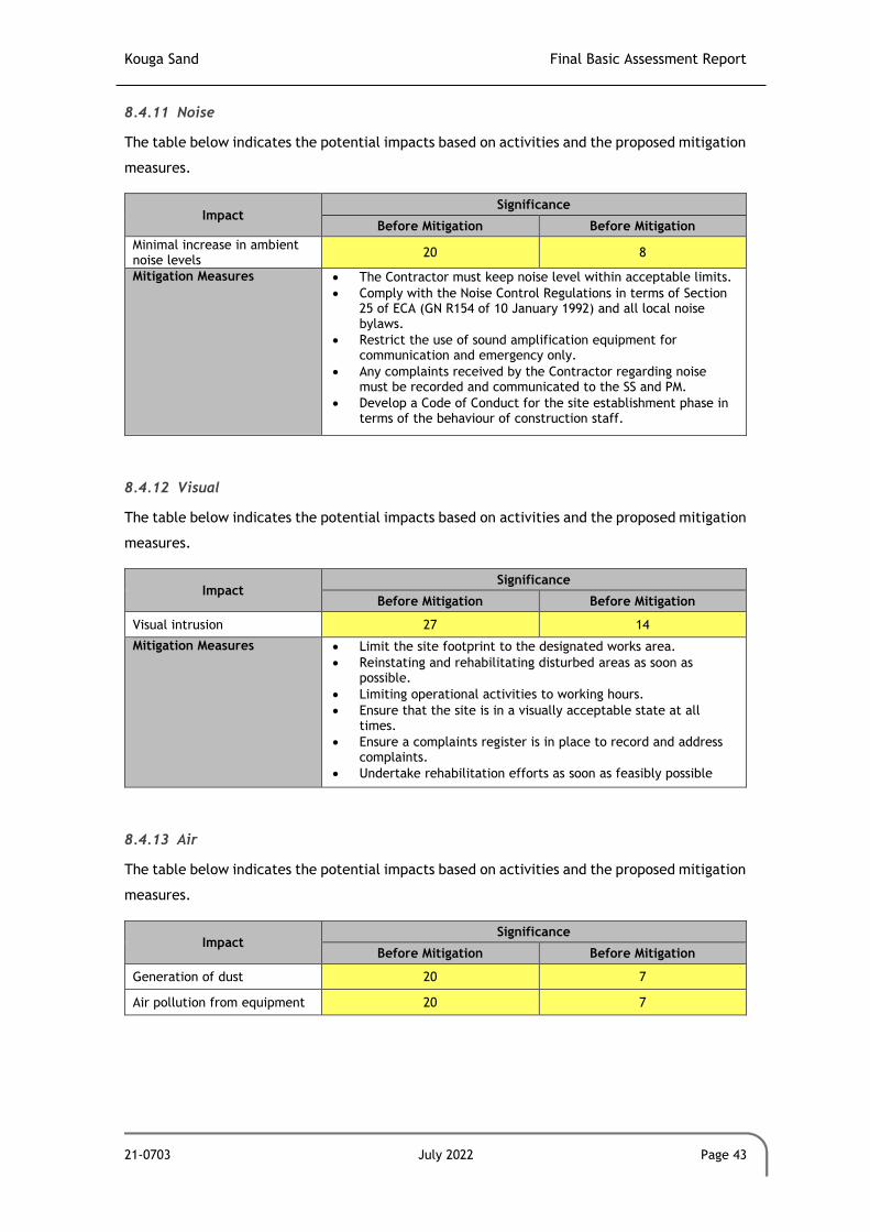
Kouga Sand Final Basic Assessment Report
21-0703 July 2022 Page 43
8.4.11 Noise
The table below indicates the potential impacts based on activities and the proposed mitigation
measures.
Impact Significance
Before Mitigation Before Mitigation
Minimal increase in ambient noise levels
20 8
Mitigation Measures • The Contractor must keep noise level within acceptable limits.
• Comply with the Noise Control Regulations in terms of Section 25 of ECA (GN R154 of 10 January 1992) and all local noise bylaws.
• Restrict the use of sound amplification equipment for communication and emergency only.
• Any complaints received by the Contractor regarding noise must be recorded and communicated to the SS and PM.
• Develop a Code of Conduct for the site establishment phase in terms of the behaviour of construction staff.
8.4.12 Visual
The table below indicates the potential impacts based on activities and the proposed mitigation
measures.
Impact Significance
Before Mitigation Before Mitigation
Visual intrusion 27 14
Mitigation Measures • Limit the site footprint to the designated works area.
• Reinstating and rehabilitating disturbed areas as soon as possible.
• Limiting operational activities to working hours.
• Ensure that the site is in a visually acceptable state at all times.
• Ensure a complaints register is in place to record and address complaints.
• Undertake rehabilitation efforts as soon as feasibly possible
8.4.13 Air
The table below indicates the potential impacts based on activities and the proposed mitigation
measures.
Impact Significance
Before Mitigation Before Mitigation
Generation of dust 20 7
Air pollution from equipment 20 7

Kouga Sand Final Basic Assessment Report
21-0703 July 2022 Page 44
Impact Significance
Before Mitigation Before Mitigation
Mitigation Measures • Implement dust suppression measures.
• Ensure a complaints register is in place to record and address complaints.
• Fuel-saving through optimal vehicle and equipment use scheduling.
• Servicing and maintenance of vehicles, and machinery.
• Use of fuel-saving technology.
• Use of low carbon and sulphur fuels.
• Restricting vehicle speeds on access routes and other unsurfaced areas of the work site.
• Restrict vehicle access to defined areas to avoid unnecessary off-road vehicle movements outside of the active work sites.
8.5 Decommissioning Phase
8.5.1 Surface Water
The table below indicates the potential impacts based on activities and the proposed mitigation
measures.
Impacts Significance
Before Mitigation Before Mitigation
Compaction of soil during rehabilitation activities leading to increased runoff velocity and erosion
28 10
Mitigation Measures • Restrict operational activities to specific footprints.
• Undertake continual monitoring to identify erosion as early as possible to remedy.
• Implement the necessary stormwater control measures to ensure no uncontrolled discharge of stormwater takes place.
• Rehabilitation activities must ensure the area reflects the natural drainage direction of the surrounding areas.
8.5.2 Fauna
The table below indicates the potential impacts based on activities and the proposed mitigation
measures.
Impacts Significance
Before Mitigation After Mitigation
Restoration of habitats will encourage fauna to return to the area.
28 28
Mitigation Measures • None required – positive impact.
8.5.3 Flora
The table below indicates the potential impacts based on activities and the proposed mitigation
measures.

Kouga Sand Final Basic Assessment Report
21-0703 July 2022 Page 45
Impacts Significance
Before Mitigation After Mitigation
Spreading of alien invasive vegetation
44 9
Mitigation Measures • A seedbed of alien plants will be present within the cleared soils. This seedbed and the plants that originate from it must be managed as follows: o The Mining Permit footprint must be clearly surveyed and
demarcated before any construction or operations are set to commence, to ensure that the area to be cleared is limited to only the areas that are necessary for the mining activities.
o The cleared areas must be regularly monitored for the establishment of alien plant species. These must be cleared when they appear.
o If alien invasive plant species become a problem on the mining area aite, a formal Alien Invasive Management Plan must be set up and implemented. This plan must make provision for the identification and eradication of these species.
8.5.4 Rivers and Wetlands
The table below indicates the potential impacts based on activities and the proposed mitigation
measures.
Impact Significance:
Before Mitigation Before Mitigation
Increase in runoff and erosion.
10 5
Mitigation Measures • A seedbed of alien plants will be present within the cleared soils. This seedbed and the plants that originate from it must be managed as follows: o The Mining Permit footprint must be clearly surveyed and
demarcated before any construction or operations are set to commence, to ensure that the area to be cleared is limited to only the areas that are necessary for the mining activities.
o The cleared areas must be regularly monitored for the establishment of alien plant species. These must be cleared when they appear.
o If alien invasive plant species become a problem on the mining area aite, a formal Alien Invasive Management Plan must be set up and implemented. This plan must make provision for the identification and eradication of these species.
• Undertake continual monitoring to identify erosion as early as possible to remedy.
• Implement the necessary stormwater control measures to ensure no uncontrolled discharge of stormwater takes place.
8.5.5 Geology and Topography
The table below indicates the potential impacts based on activities and the proposed mitigation
measures.

Kouga Sand Final Basic Assessment Report
21-0703 July 2022 Page 46
Impact Significance:
Before Mitigation Before Mitigation
Alteration of catchment drainage due to change in baseline topography
35 10
Mitigation Measures • Strict adhereance to the EMPr.
• Provision must be made during concurrent rehabilitation that the topography is free draining in the natural drainage direction of the surrounding area.
8.5.6 Soil
The table below indicates the potential impacts based on activities and the proposed mitigation
measures.
Impact Significance:
Before Mitigation Before Mitigation
Contamination of the area by petrochemical spillages
18 6
Contamination of the area as a result of leaking portable toilet facilities
32 8
Mitigation Measures • Even though the impacts of contamination of the area by petrochemical spillages are considered to be low pre-mitigation, the following mitigation measures must be included to further reduce the significance of the impact: o All plant and equipment that make use of petrochemical
substances must be checked for leakages on a daily basis. o All plant and equipment that are found to be leaking
must be removed from the property and only returned once the leakages have been addressed.
o If any petrochemical substances are stored on the property, this storage must be done on an impermeable surface in a bunded area that makes provision for 110% of volume of the substances that are stored.
o All refuelling of plant and equipment must be conducted over a driptray.
o If any plant or equipment is to be parked on site, these must be parked within the demarcated construction footprint that has been cleared.
o If any spillages from plant or equipment occur, the spill must be immediately contained, the contaminated soils must be collected and bagged in impermeable bags and stored on site to be removed and disposed of by a registered service provider.
• Regarding portable chemical toilets, the following must be implemented: o Only portable chemical toilets with a sealed reservoir will
be allowed on site. o The capacity of the reservoirs in the portable chemical
toilets must be monitored on a daily basis to ensure that they can be serviced timeously.
o All removal of the collected sewage waste from the portable chemical toilets must be conducted by a registered service provider for disposal at a municipal waste water treatment facility.

Kouga Sand Final Basic Assessment Report
21-0703 July 2022 Page 47
8.5.7 Land Use
The table below indicates the potential impacts based on activities and the proposed mitigation
measures.
Impact Significance:
Before Mitigation Before Mitigation
Restoration of disturbed areas as closely as possible to natural land use
12 12
Mitigation Measures • None required – positive impact.
8.5.8 Traffic
The table below indicates the potential impacts based on activities and the proposed mitigation
measures.
Impact Significance:
Before Mitigation Before Mitigation
Minimal, intermittent increase in number of trucks on the road
12 6
Mitigation Measures • The road is designed according to the specifications of a provincial road. The applicant will assist where feasibly possible to repair and maintain the road.
8.5.9 Cultural and Heritage
The table below indicates the potential impacts based on activities and the proposed mitigation
measures.
Impact Significance:
Before Mitigation Before Mitigation
Disturbance of palaeontological material
7 5
Mitigation Measures • Adhere to footprint areas.
• A Chance find procedure should be implemented for the duration of the project with inputs from stakeholders and the local community, should there be a heritage resource identified.
• For any chance finds of heritage resources, such as graves, all work must cease in the affected area and the Contractor must immediately inform PM. A heritage specialist must be called to site for inspection. The relevant heritage resource agency (SAHRA) must also be informed about the finding.
• Should any recent remains be found on site that could potentially be human remains, the SAPS as well as SAHRA must be informed. No SAPS official may remove remains until the correct permit/s have been obtained.

Kouga Sand Final Basic Assessment Report
21-0703 July 2022 Page 48
8.5.10 Socio-Economic
The table below indicates the potential impacts based on activities and the proposed mitigation
measures.
Impact Significance:
Before Mitigation Before Mitigation
Potential employment opportunities for a limited number of local residents
16 16
Mitigation Measures • Positive impact, so no mitigation measures required.
It is important to note that, although employment opportunities will be available during the
decommissioning phase, these opportunities will cease with the closure of the operation.
8.5.11 Noise
The table below indicates the potential impacts based on activities and the proposed mitigation
measures.
Impact Significance
Before Mitigation Before Mitigation
Minimal increase in ambient noise levels
20 8
Mitigation Measures • The Contractor must keep noise level within acceptable limits.
• Comply with the Noise Control Regulations in terms of Section 25 of ECA (GN R154 of 10 January 1992) and all local noise bylaws.
• Restrict the use of sound amplification equipment for communication and emergency only.
• Any complaints received by the Contractor regarding noise must be recorded and communicated to the SS and PM.
• Develop a Code of Conduct for the site establishment phase in terms of the behaviour of construction staff.
8.5.12 Visual
The table below indicates the potential impacts based on activities and the proposed mitigation
measures.
Impact Significance
Before Mitigation Before Mitigation
Visual intrusion 27 14
Mitigation Measures • Limit the site footprint to the designated works area.
• Reinstating and rehabilitating disturbed areas as soon as possible.
• Limiting rehabilitation activities to working hours.
• Ensure that the site is in a visually acceptable state at all times.
• Ensure a complaints register is in place to record and address complaints.

Kouga Sand Final Basic Assessment Report
21-0703 July 2022 Page 49
Impact Significance
Before Mitigation Before Mitigation
• Undertake rehabilitation efforts as soon as feasibly possible
8.5.13 Air Quality
The table below indicates the potential impacts based on activities and the proposed mitigation
measures.
Impact Significance
Before Mitigation Before Mitigation
Air pollution from equipment undertaking rehabilitation activities
20 6
Mitigation Measures • Implement dust suppression measures.
• Ensure a complaints register is in place to record and address complaints.
• Fuel-saving through optimal vehicle and equipment use scheduling.
• Servicing and maintenance of vehicles, and machinery.
• Use of fuel-saving technology.
• Use of low carbon and sulphur fuels.
• Restricting vehicle speeds on access routes and other unsurfaced areas of the work site.
• Restrict vehicle access to defined areas to avoid unnecessary off-road vehicle movements outside of the active work sites.
8.6 Cumulative Impacts
Section 2 of the NEMA requires the consideration of cumulative impacts as part of the
environmental assessment process. EIAs have traditionally, however, failed to come to terms
with such impacts, largely as a result of the following considerations:
• Cumulative effects may be local, regional or global in scale and dealing with such
impacts requires co-ordinated institutional arrangements; and
• EIA’s are typically carried out on specific developments, whereas cumulative impacts
result from broader biophysical, social and economic considerations, which typically
cannot be addressed at the project level.
Cumulative impacts associated with this type of development could lead to initial, incremental
or augmentation of existing types of environmental degradation, including impacts on the soil
and land use within the available habitat. Pollution of these elements might not always be
immediately evident, but incremental increases might rise to levels where biological attributes
could be affected adversely on a local or regional scale. In most cases, these effects are not
bound and are dispersed or diluted over an area that is much larger than the actual footprint
of the causal factor. These impacts are usually most prevalent in areas where continuous and
long-term impacts have been experienced. However in this instance, this is not envisaged.

Kouga Sand Final Basic Assessment Report
21-0703 July 2022 Page 50
The following cumulative impacts have been identified and assessed.
8.6.1 Loss of Indigenous Vegetation
Impact Description Impact Rating
The mining operations will be conducted as an open cast surface mining operation which will result in the removal of the vegetation from the active mining areas. As a result of this clearance, it is likely that some indigenous vegetation will be cleared from the site. However, with the level of alien invasive plant infestation (Acacia mearnsii) the indigenous vegetation will be limited to pioneering grass species that has established on the site as a result of the existing land use.
Furthermore, the rehabilitation of the site will make provision for the reestablishment of the same pioneering grasses that would have been removed during the mining activities.
This cumulative impact can therefore be successfully managed and mitigated.
Low
8.6.2 Loss of Alien Invasive Plant Species
Impact Description Impact Rating
The mining operations will be conducted as an open cast surface mining operation which will result in the removal of vegetation from the active mining areas. As a result of this clearance, large numbers of alien invasive plant species (Acacia mearnsii) will be removed from the site. In addition to the physical removal of these plants, the associated seedbed of this species will be removed with the removed sand, which will limit the amount of revegetation of the species that might occur.
As such, the mining activities is considered to have a medium positive impact on the loss of alien invasive plant species from the area.
Medium
8.6.3 Spread of Alien Invasive Plant Species
Impact Description Impact Rating
Due to the existing presence of alien invasive species on the old agricultural areas within the mining site, the risk of these species spreading from the site is present. However, since these species will be removed during the mining activities, the impact is considered to be limited.
Furthermore, the management of alien invasive plant species must be included in the EMPR for the operations. The measures included in this plan must have as a goal to reduce the spread of the alien invasive species and to eradicate them from area within the property in which they occur. Similarly, the rehabilitation of the site during the decommissioning phase must make provision for the planting of indigenous pioneering grasses on the site. As such implementation of these plans will result in the improvement of the vegetative biodiversity on the property and result in an improvement of the current biodiversity baseline on the site.
This cumulative impact can therefore be successfully managed and mitigated.
Low

Kouga Sand Final Basic Assessment Report
21-0703 July 2022 Page 51
8.6.4 Disruption of an Open Space Corridor
Impact Description Impact Rating
The site that is designated as the mining permit area is currently vacant land. The operations on the site will therefore change this “vacant land” status for the duration of the operations. As Mining Permits issued in terms of the Mineral and Petroleum Resources Development Act (Act No. 28 of 2002) makes provision for the mining of an area for no longer than 4 years, this disruption will only be present for that duration.
The rehabilitation of the site will make provision for the shaping of the mining area to blend in with the surrounding topography and associated drainage as well as for the planting of pioneering grasses that are endemic to the area.
This cumulative impact can therefore be successfully managed and mitigated.
Low
8.6.5 Alteration of the catchment drainage regime of the area
Impact Description Impact Rating
Due to the nature of the open cast mining, the excavation associated with the mining activity will result in an impact to the localized catchment stormwater runoff. However, as the site will be rehabilitated to be free draining in the natural drainage direction, all stormwater runoff from the site will end up in the appropriate catchment. In addition, the relatively small size of the site as well as the position high up in the particular catchment will further limit the impact of the mining activities on the surrounding hydrology.
This cumulative impact can therefore be successfully managed and mitigated.
Low
9 ASSUMPTIONS, UNCERTAINTIES, AND GAPS IN KNOWLEDGE
Information in this report has been obtained from various sources. The following gaps,
uncertainties or assumptions have been identified:
• The impact descriptions and assessment are based on the author’s understanding of the
proposed development based on the information provided.
• It is assumed that the existing farm road will be used, and no new access roads
constructed.
The following assumptions were made in the Terrestrial Biodiversity Assessment Report:
• The assessment of the potential impacts of the proposed development is based on the
terrestrial biodiversity features on the development site is based on the project
description provide in the sections above. If the project description is amended, the
impact identification and assessment contained in this report may also change.
• The findings of the Terrestrial Biodiversity report are limited to a single day long site
visit conducted on 4 January 2022 which is considered to be mid-summer. The seasonal
timing of the site assessment is not considered to influence / compromise the findings
of the assessment.

Kouga Sand Final Basic Assessment Report
21-0703 July 2022 Page 52
• The following desktop information was used to augment the finding of the Terrestrial
Biodiversity Assessment:
o Electronic biodiversity databases managed by SANBI;
o Available provincial electronic biodiversity databases; and
o Wetland and Riparian Habitat Delineation Document (DWS report);
The following assumptions were made in the Aquatic Assessment Report:
• The assessment of the potential impacts of the proposed operations, is based on the
aquatic features on the site and the operational activities provided. If the
development layout and operations is amended, the impact identification and
assessment contained in this report may also change.
• The findings of the Aquatic Assessment Report are limited to a single day long site
visit conducted on 4 January 2022 which is considered to mid-summer. The seasonal
timing of the site assessment is not considered to influence / compromise the findings
of the assessment.
• The identification and possible delineation of the wetland and riparian areas within
the development site was conducted in terms of the procedures as specified by the
DWS.
• The determination of the Present Ecological State and the Ecological Importance and
Sensitivity of the wetland and watercourses that may have been identified would have
been conducted by using the WET-Assess Models.
• The classification of any identified aquatic features would have been conducted in
accordance with the classification system of inland aquatic ecosystem as prescribed by
Ollis et al., 2013
• The following desktop information was used to augment the finding of the assessment:
o Electronic biodiversity databases managed by SANBI;
o Available provincial electronic biodiversity databases;
o Wetland and Riparian Habitat Delineation Document (DWS report); and
o Classification system for wetlands and other aquatic ecosystems in South
Africa (Inland Systems) (Ollis et al., 2013 – SANBI Biodiversity Series 22).
10 SPECIALIST RECOMMENDATIONS
The following recommendations are proposed by the Terrestrial Biodiversity Compliance
Statement:
• It is recommended that an Environmental Control Officer (ECO), who meets the
requirements of the NEMA: EIA Regulations (2014) as amended, be appointed to
conduct biannual audits of the operations for the duration of the project. An audit

Kouga Sand Final Basic Assessment Report
21-0703 July 2022 Page 53
report must be completed for each audit and be submitted to the DMRE.
• Furthermore, a specialist ecologist should conduct a site visit at the commencement
of the rehabilitation phase of the project to ensure that the contractor is adequately
informed of the rehabilitation requirements associated with the works.
11 ENVIRONMENTAL IMPACT STATEMENT
11.1 Negative Impacts
The following potential impacts associated with the proposed project are rated as Medium
(Negative) significance (pre-mitigation):
• Loss of minimal indigenous vegetation present on site;
• Spread of alien invasive plant species;
• Contamination as a result of leaking portable toilet facilities; and
• Alteration of catchment drainage due to change in baseline topography.
It must be emphasised that all of these medium negative impacts can be mitigated to a low
significance.
11.2 Positive Impacts
The following impacts associated with the proposed project are considered to be of Positive
significance:
• Removal of alien invasive vegetation existing on site;
• Potential employment opportunities for a limited number of local residents; and
• Potential economic benefit for the area from the sale of the product.
In the decommissioning phase, the receiving environment will be rehabilitated as closely
as possible to the natural condition of the area.
11.3 Site Sensitivity
The sensitivity of the receiving environment is depicted in Figure 11-1. A 100m buffer from all
watercourses has been observed. As previously mentioned, the aquatic layer of the ECBCP,
which is currently not gazetted, classifies the site to be located in a Freshwater CBA1 as a
result of its location in an ESA1 which forms part of the Gamtoos River catchment. The sector

Kouga Sand Final Basic Assessment Report
21-0703 July 2022 Page 54
plan, as well as the site visit by a specialist, confirms the absence of any aquatic features
within the study site.
The correct implementation of the mitigation measures outlined in section 8 of this report, as
well as the EMPr, will ensure that all potential impacts are managed, mitigated or avoided as
far as practicably possible.

Kouga Sand Final Basic Assessment Report
21-0703 July 2022 Page 55
Figure 11-1: Sensitive Features on and around the site

Kouga Sand Final Basic Assessment Report
21-0703 July 2022 Page 56
12 MOTIVATION OF THE EAP
The EAP is confident that all major impacts associated with the proposed sand mine have been
adequately described and mitigated. In the impact assessment, consideration has been given
to the relatively short duration of the proposed operation, and the localised nature of the
potential impacts.
In light of the above, and given the generally medium-low impacts associated with the proposed
mine, as well as the strict implementation of the proposed mitigation measures including those
in the detailed EMPr (Appendix E), the EAP is confident that the project can proceed without
significant impact on the receiving environment.

Kouga Sand Final Basic Assessment Report
21-0703 July 2022 Page 57
13 REFERENCES
GCS. 2022. Kouga Sand Aquatic Compliance Statement Associated with the Kouga Sand Mining
Permit Application on a Portion of the Farm Kruisfontein No. 193 Near Humansdorp, Eastern
Cape Province. GCS Project Number 21-0703.
GCS. 2022. Terrestrial Biodiversity Compliance Statement Associated with the Kouga Sand
Mining Permit Application on a Portion of the Farm Kruisfontein No. 193 Near Humansdorp,
Eastern Cape Province. GCS Project Number 21-0703.
Meteoblue. 2022. Simulated Historical Climate and Weather Data for Humansdorp. Accessed:
https://www.meteoblue.com/en/weather/historyclimate/climatemodelled/humansdorp_sou
th-africa_995094
Kouga Local Municipality. 2021. Final Integrated Development Plan (2017/2022) Review.
Kouga Local Municipality. 2020. Kouga Municipality 2020/21 Draft Annual Report.
Umlando. 2022. Heritage Survey of the Proposed Kouga Sand Mine, Portion 8 of Kruisfontein
No. 193, Humansdorp, Eastern Cape.

Kouga Sand Final Basic Assessment Report
APPENDICES

Kouga Sand Final Basic Assessment Report
APPENDIX A: QUALIFICATIONS AND DECLARATION OF EAP


Page 1 of 6
CORE SKILLS
• Environmental Impact Assessments
• Scoping Reports
• Preliminary Environmental Assessment
• Mining Right and Applications
• Environmental Management Programmes
• Strategic Environmental Assessments
• Wildlife Management Plans
DETAILS
Qualifications
• BSc – Botany & Zoology
• B.SC Honours - Botany
• Specialist Student
• Post Graduate Diploma in Teaching
• Masters Degree: Environmental Management
Memberships
• SACNASP
• International Association of
Impact Assessors
Languages
• English - fluent
• Afrikaans- fluent
• German – fair
• Dutch – fair
• Zulu - adequate
In addition to holding a Masters Degree: Environmental
Management, Magnus also holds a BSc degree in Botany and
Zoology, an Honours Degree in Botany and a Post Graduate
Certificate in Education.
Magnus has 13 years’ experience in projects involving
Environmental Impact Assessments in various developmental
sectors (Mining and Agricultural Sector, National Roads, Pipelines,
Dams, and Residential Developments), conducting of Specialist
Biodiversity Assessments associated with Environmental Impact
Assessments and Project Feasibility Studies. He has experience in
the compilation of Resettlement Policy Framework Plans
associated with infrastructure development projects.
Magnus has experience in working on various private and public
sectors as well as rural and urban environments in various
countries.
His expertise lies within the mining sector where he has gained
extensive exposure to all the aspects of mining projects from the
pre-feasibility, prospecting, environmental impact assessment
Magnus has experience in the following areas:
• Environmental Impact Assessments
• Scoping Reports
• Preliminary Environmental Assessment
• Mining Right and Permit Applications
• Environmental Management Programmes
• Strategic Environmental Assessments
• Wildlife Management Plans
MAGNUS VAN ROOYEN
Technical Director
PROFILE

WORK EXPERIENCE
Page 2 of 6
Year Employer Position Role and Responsibility
2007 – 2020 JG Afrika (Pty) Ltd Executive Associate Project Management of an environmental contingent of 4 people and conducting
Environmental Impact Assessments
2006 – 2007 JG Afrika (Pty) Ltd Environmental Scientist Conducted a wide range of infrastructure related Environmental Impact
Assessments
2002 – 2005 Department of
Conservation Ecology,
University of Stellenbosch
Biodiversity Researcher Conducted field work, sampling, laboratory work and logistics associated with two
projects within the Conservation Ecology Department
2002 – 2005 Department of Botany and
Zoology, University of
Stellenbosch
Junior Lecturer in Botany Lectured Botany practical component of the first-year Natural Science Degree
2001 – 2002 Paul Roos Gymnasium Biology Teacher Teaching the South African Biology curriculum to high school students

PROJECT EXPERIENCE
Page 3 of 6
Biodiversity Assessment Projects Biodiversity Assessment Projects
Mamatwan Tailings Facility
Biodiversity and Wetland Assessment for the site to be used for the establishment of the new tailings facility on the South32 Mamatwan Manganese Mine near Hotazel. Hillside Aluminum Desalination Plant Biodiversity Screening Assessment for the infrastructure network associated with the South32 Hillside Aluminum Desalination Plant in Richards Bay.
Lichtenburg Siding Expansion Biodiversity Assessment for the proposed expansion of the Lichtenburg Cement Siding, North West Province.
Nacala Dam Project
Riparian Vegetation Study for the Ecological Reserve Determination Specialist Study for the
Environmental Impact Assessment for the Nacala Dam Project in Mozambique.
National Route N8
Vegetation Specialist Study for the Environmental Impact Assessment for the National Route N8.
National Route N2 uMgeni Interchange ImprovementsEnvironmental Impact Assessment for proposed
improvements to the uMgeni Road Interchange and the National Route N2. The project included an extensive
public participation process within the city of Durban, KwaZulu-Natal during the process.
Qudeni Link Road
Vegetation Specialist Study for the Environmental Impact Assessment for the Qudeni Rural Link Road.
Municipal Landfill Site Identification Negative mapping and ground truthing for the options analysis for the identification of a District Municipality Landfill Site.
Port Related Projects Pier 1 Phase 2 expansion Environmental Impact Assessment for proposed expansions to Pier 1 within the Durban Harbour. Locomotive Turning Table in the Port of Richards Bay Environmental Impact Assessment for proposed Locomotive Turn Table in within the Port of Richards Bay. Rail line construction in the Port of Richards Bay Environmental Impact Assessment for proposed additional rail line into the Richards Bay Coal Terminal in the Port of Richards Bay.

PROJECT EXPERIENCE
Page 4 of 6
Environmental Monitoring – RME Projects Durban Harbour Environmental Monitoring Duties for all the RME construction projects within the Durban harbour. Ore Loading Facility at Kalia in Guinea Environmental Impact Assessment for the proposed Ore Loading Facility in Kalia in Guinea, West.
Roads Projects National Route N2 uMgeni Interchange Improvements Environmental Impact Assessment for proposed improvements to the uMgeni Road Interchange and the National Route N2. The project included an extensive public participation process with a range of public and private sector stakeholders. National Route N11 upgrade Environmental Impact Assessment for proposed upgrade of the National Route N11. The project included a public participation process with a range of public and private sector stakeholders as well as specialist studies associated with the river crossings. National Route N2 improvement and upgrade Environmental Impact Assessment for proposed upgrade of the National Route N2. The project included a public participation process with a range of public and private sector stakeholders as well as specialist studies associated with the river crossings. National Route N3 Chota Motala Interchange Environmental Audits Environmental Monitoring for the construction of the Chota Motala Interchange on the National Route N3. National Route R30 Environmental Audits Environmental Monitoring for the construction of the National Route R30.
Agricultural Projects uMngano Community Dairy Development Project Environmental and Social Impact Assessment for the Development of a 200ha dairy for the uMngano Community in KwaZulu-Natal, South Africa. uMngano Community Vegetable Project Environmental and Social Impact Assessment for the Development of a 180ha vegetable growing project for the uMngano Community in KwaZulu-Natal, South Africa. Sundays River Citrus Project Environmental and Social Impact Assessment for the Development of a 100ha citrus project in the Sundays River Valley in the Eastern Cape, South Africa.
Water Projects Nacala Dam project in Mozambique for the Millennium Challenge Corporation Environmental and Social Impact Assessment for the Nacala Dam project in Nacala, Mozambique. The study included the management of a range of specialist studies which included; biodiversity (fauna and flora) assessments, health impact assessments, social impact assessments, a hydrocensus, geotechnical investigation and an ecological flow requirement assessment. The project was conducted under the auspices

PROJECT EXPERIENCE
Page 5 of 6
of the Millennium Challenge Corporation. Mpofana Bulk Water Supply Scheme Environmental Impact Assessment for the Bulk Water Supply Scheme which included an extensive public facilitation process with affected landowners and other specialist studies. KwaHlokohloko Rural Water Supply Scheme Environmental Impact Assessment for the Rural Water Supply Scheme which included an extensive public facilitation process with the rural landowners and tribal leaders. Conservation Management Plans Ndumo Game Reserve Management Plan Compilation of the Management Plan for the KwaZulu-Natal Wildlife Ndumo Game Reserve in northern KwaZulu-Natal. The compilation was conducted in accordance to the National Environmental Management: Protected Areas Act (No 57 of 2003).
Mining Projects Uithoek Colliery for Miranda Mineral Holdings Environmental Impact Assessment for the establishment of the Uithoek Colliery including the management of a range of specialist studies which included a hydrological and geohydrological assessment, a biodiversity assessment, a social and heritage assessment and a repatriation plan for residents on the site. Burnside Colliery for Miranda Mineral Holdings Environmental Impact Assessment for the establishment of the Burnside Colliery including the management of a range of specialist studies which included a hydrological and geohydrological assessment, a biodiversity assessment, a social and heritage assessment and a repatriation plan for residents on the site. Ultimate Goal Colliery for Corobrik (Pty) Ltd Environmental Impact Assessment for the establishment of the Ultimate Goal Colliery including the management of a range of specialist studies which included a hydrological and geohydrological assessment, a biodiversity assessment, a social and heritage assessment and a repatriation plan for residents on the site. Klipwaal Gold Mine for Miranda Mineral Holdings Environmental Due Diligence assessment on the Klipwaal Gold Mine which included an assessment of completed and required rehabilitation, a contaminated land liability assessment and an evaluation of the structure and the possible impact of the slurry dams. Afrimat Quarries Compliance Audits Compliance audits and Due Diligence assessments of the Afrimat Quarry operations in South Africa. These audits are conducted on a two yearly basis. Private and Public Sector Development Projects Provincial Legislature Precinct Environmental and Social Impact Assessment for the proposed Provincial Legislature Precinct. This study consisted of a large public facilitation component and extensive engagement with private and public sector stakeholders.

PROJECT EXPERIENCE
Page 6 of 6
DECLARATION
I, Magnus Van Rooyen hereby declare that the details furnished above are true and correct to the best of my knowledge and
belief and I undertake to inform you of any changes therein, immediately. In case any of the above information is found to be
false or untrue or misleading or misrepresenting, I am aware that I may be held liable for it.
Signature: Date: 27/02/2021
Camps Drift Canal Mixed Use Development Environmental Impact Assessment for proposed improvements to the uMgeni Road Interchange and the National Route N2. The project included an extensive public participation process within the city of Durban, KwaZulu-Natal during the process. Tiger Lodge Development Environmental Impact Assessment for the proposed Tiger Lodge Tourism Development. Paradise Lodge Development Environmental Impact Assessment for the proposed Paradise Lodge Tourism Development.


Page 1 of 8
PROFILE
Janice Callaghan Junior Environmental Consultant
Janice is a Junior Environmental Consultant at GCS Water and
Environmental since April 2018 with 4 years’ experience. She forms
part of the Durban Environmental Unit and has undertaken various
applications including Water Use License Applications, Integrated
Water and Waste Management Plans, Environmental Impact
Assessments and Environmental Management Programmes.
She pays great attention to detail and is a self-motivated individual,
who is passionate about the environment with a particular interest
in biogeography and conservation. Janice is both team player and
able to work independently and is always keen to learn. Her
methodical and organized approach benefits her in the workplace
when meeting deadlines and she copes well under pressure.
Professional Affiliations:
• SACNASP (Cand.Sci.Nat) • IAIAsa • AIEMA
• SSAG
Areas of Expertise:
• Reviewing specialist studies and compiling reports; • Database compilation and management; • Compiling environmental authorisation applications for
various mining projects in terms of NEMA, NEM:WA and NWA;
• Undertaking environmental audits; • Compiling Annual Financial Provisioning Updates; • Rehabilitation Strategy Implementation Plan; • Report writing; • Compilation of tender documents; • Writing proposals; • Assisting with information material and report
compilation.
CORE SKILLS
• Water Use Licensing
• EIAs and BARs
• Section 24G reports
• RSIP reports
• Auditing
• Annual Decommissioning, Rehabilitation and Closure Updates
DETAILS
Qualifications
• BSc (Hons) Environmental Science
• Certificate from UCT in Occupational Health and Safety
• Certificate from University of British Columbia in Ecodesign for Cities and Suburbs
Membership
• Cand.Sci.Nat
• AIEMA
• Society of South African Geographers
• IAIAsa Languages
• English – fluent
• Afrikaans - fluent Countries Worked In
• South Africa
• Mozambique

Project Experience Professional Experience
Page 2 of 6
Work Experience
Period Employer Position Role/ Responsibility
March 2020 to present
GCS Junior Environmental Consultant - Undertaking environmental authorization processes
- Mine closure and financial provisioning
- Environmental Officer assistance to Buffalo Coal
- Client liaison
- Project management
April 2018 to March 2020
GCS Intern - Assisting environmental consultants with environmental applications

Page 3 of 6
Project Experience
Year Client Project Description Role/Responsibility
Audits
2019 Buffalo Coal Annual EMPr and WUL audits for Coalfields, Aviemore and
Magdalena operations
Assisting the lead auditor in site work and compilation of the audit reports.
2020 Buffalo Coal Annual EMPr and WUL audits for Coalfields, Aviemore and
Magdalena operations
Assisting the lead auditor in site work and compilation of the audit reports.
2020 Samancor Annual audits for 6 operations Assisting with compilation and internal review of the documents prior to sending for client review.
2020 Eskom Legal compliance audit for Majuba
power station
Assisting the lead auditor in site work and compilation of the audit
reports.
2020 Eskom Biennial PCB Audit Assisting the lead auditor in site work and compilation of the audit
reports.
2021 ZAC Annual IWUL Audit Lead auditor undertaking the site audit and compilation of report.
2021 Northam Platinum Biennial Environmental
Performance Audits for Booysendal’s North and South
Operations
Assisting lead auditor with document compilation, and review of
final document before sending to the client for review.
2021 Arcadis Audit of EnviroServ’s Mavoco Landfill Site
Lead auditor undertaking the site audit and compilation of report.
2021 Arcadis Review of Harmony’s Deelkraal
Landfill
Documentation review and report.
2021 Tronox Norms and Standards Audit of
Waste Management
Assisting the lead auditor to undertake the audit and report
compilation.
2021 Buffalo Coal Annual EMPr and WUL audits for Coalfields, Aviemore and
Magdalena operations
Assisting the lead auditor in site work and compilation of the audit reports.
2022 Tharisa External EMPr Audit Lead auditor responsible for the compilation of report
RSIPs
2019 Buffalo Coal Magdalena Colliery RSIP Update Updating the RSIP undertaken in 2014 prior to the
commencement of S24G activities
2020 Exxaro Rietkuil RSIP Compiling a RSIP for the Rietkuil Siding in compliance with their IWUL
2020 Exxaro Belfast RSIP Update Finalising the document with client comments

Page 4 of 6
Project Experience
2020 Marula Platinum RSIP update Undertaking the annual update of the RSIP in compliance with the IWUL
2020 Anglo American Mafube Coal RSIP update Undertaking the annual update of the RSIPs in compliance with the IWUL
2020 Tharisa Minerals RSIP update Internal review of the update compiled by GCS prior to sending to the client for review.
IWULAs
2018 Frame Knitting Manufacturers
WULA for borehole Report writing and compilation, license application forms, public participation and follow-ups with DWS.
2018 - 2020 Buffalo Coal Magdalena IWULA Amendment Report writing and compilation, and data analysis
2018 - 2019 Tendele Coal Somkhele IWULA Amendment Public participation and associated report writing
2018 - 2020 South 32 Roypoint IWULA Data management, public participation
2018 - 2019 Buffalo Coal Aviemore New Adit and Access Road WULA
Data management, report compilation and submission
2020 – present Celrose Clothing WULA for borehole Project management, client liason
2020 – present Buffalo Coal Coalfields IWULA Finalisation Uploading of documents to e-WULAAS portal, client liaison
EMPr Amendments
2021 Interwaste EMP Amendment for the Interwaste Waste Management Facility in Germiston, Gauteng
Update the current EMPr to reflect on-site activities and fulfill the regulatory requirements.
2021 De Beers Consolidated Mines Limited
Environmental Management Programme Amendment Application for the Voorspoed Diamond Mine, Free State Province
Assisting with the finalization of the EMPr for public review and submission
2021 Dorning Group Stonewall Quarry EMPr Amendment Update the current EMPr to reflect on-site activities and fulfill the regulatory requirements.
2021 Sibanye Stillwater Burnstone EMPr Amendment Report writing and compilation, public participation
2021 Exxaro Coal Thabametsi EMPr Amendment Amend the current EMPr to reflect on site conditions.
2022 Northam Platinum Booysendal North and South EMPr Amendments
Amend the current EMPr to make provision for
Environmental Authorisations
2018 – 2019 Buffalo Coal Coalfields Calcine Plant BA Report writing and compilation, public participation
2018 – 2019 Buffalo Coal Aviemore New Adit and Access Road EA Data management, report compilation and submission

Page 5 of 6
Project Experience
2018 – 2020 ZAC ZAC New Adit and Opencast Mining Operations
Report writing and compilation of BARs, public participation
2018 - 2019 Buffalo Coal Magdalena S24G application Writing and compiling Section 24G EIA, and EMPr, and public participation
2020 Phumaf Engineering Gauteng Rapid Land Release Environmental Assessments
Compilation of Scoping Report and Basic Assessment Reports, public participation
2019 - 2021 Buffalo Coal Magdalena Waste Management License EIA
Report writing, public participation
2021 Exxaro/Cennergi Grootegeluk Self Generation/Lephalale Solar Environmental Authorisation
Information review, report writing and compilation, public participation
2022 Kouga Sand Mining Permit Application Information review, report writing and compilation, public participation
2022 Mentorskraal Familie Trust
Mining Permit Application Information review, report writing and compilation, public participation
2022 Hard Ventures Prospecting Right Application Information review, report writing and compilation, public participation
2022 Imvukazane Resources Prospecting Right Application Information review, report writing and compilation, public participation
Mine Closure and Financial Provisioning
2019 Buffalo Coal Annual Financial Provisioning Update in terms of GNR 1147 for Magdalena, Aviemore and Wesselsnek
Updating closure costing; annual rehabilitation plan; final rehabilitation, decommissioning and closure plan; and environmental risk assessment for each site.
2020 Buffalo Coal Annual Financial Provisioning Update in terms of GNR 1147 for Magdalena, Aviemore and Wesselsnek
Updating closure costing; annual rehabilitation plan; final rehabilitation, decommissioning and closure plan; and environmental risk assessment for each site.
2020 - present Corobrik/Investec Application for mine closure for the Corobrik Avoca site for a development to be undertaken
Mine closure application in terms of NEMA and the MPRDA.
2021 Midmar Crushers Prospecting Right Closure Compile an Environmental Risk Report and the Final Performance Assessment Report in support of the MPRDA requirements.
2021 Buffalo Coal Annual Financial Provisioning Update in terms of GNR 1147 for Magdalena, Aviemore and Wesselsnek
Updating closure costing; annual rehabilitation plan; final rehabilitation, decommissioning and closure plan; and environmental risk assessment for each site.
Environmental Officer
2019 - present Buffalo Coal Ad hoc work as required Environmental Officer assistance to Buffalo Coal
Renewable Energy
2021 Cennergi Lephalale Solar Plant Environmental assessment for a solar plant

Page 6 of 6
Project Experience
Other
2018 – present Exxaro Belfast RAP LRP analysis and RAP compilation
2018 Airports Company South Africa
KSIA Storm Water Monitoring Sorting of monitoring data
2018 CIG Standerton SIA Database compilation and management, data analysis, assisting with report writing
2018 – present CIG Standerton Oil Mill Phase 2 Data management, stakeholder engagement
2020 Tendele Coal Somkhele Health Impact Assessment Undertake an environmental Health Impact Assessment under the guidance of an external reviewer, in terms of the IFC and South African Department of Health Guidelines for undertaking such an assessment.

Page 7 of 6
Project Experience
DECLARATION
I, Janice Callaghan, hereby declare that the details furnished above are true and correct to the best of my knowledge and belief and I
undertake to inform you of any changes therein, immediately. In case any of the above information is found to be false or unt rue or
misleading or misrepresenting, I am aware that I may be held liable for it.
Signature: Date: 04 May 2022

Janice Susan CallaghanRegistration Number: 122924
Environmental Science (Candidate Natural Scientist)
11 March 2020 31 March 2023
To verify this certificate scan this code


Kouga Sand Final Basic Assessment Report
APPENDIX B: SPECIALIST STUDIES

4a Old Main Road, Judges Walk, Kloof, Kwazulu-Natal, South Africa, 3610
PO Box 819, Gillitts, 3603, South Africa
Tel: +27 (0) 31 764 7130 Fax: +27 (0) 31 764 7140 Web: www.gcs-sa.biz
GCS (Pty) Ltd. Reg No: 2004/000765/07 Est. 1987
Offices: Durban Johannesburg Lusaka Ostrava Pretoria Windhoek
Directors: AC Johnstone (Managing) PF Labuschagne A Gunn W Sherriff (Financial)
Non-Executive Director: B Wilson-Jones
www.gcs-sa.biz
AQUATIC COMPLIANCE STATEMENT ASSOCIATED WITH THE KOUGA SAND MINING PERMIT
APPLICATION ON A PORTION OF THE FARM KRUISFONTEIN NO. 193, NEAR HUMANSDORP,
EASTERN CAPE PROVINCE
Version – final
March 2022
GCS Project Number:
janicec
Typewritten text
21-0703

Kouga Sand
21-0703/Aquatic Assessment/MVR/mvr i
AQUATIC COMPLIANCE STATEMENT ASSOCIATED WITH THE KOUGA SAND MINING PERMIT APPLICATION ON A PORTION OF THE FARM KRUISFONTEIN NO. 193, NEAR HUMANSDORP,
EASTERN CAPE PROVINCE
Version – final
March 2022
DOCUMENT ISSUE STATUS
Report Issue Final
GCS Reference Number GCS Ref – 21-0703
Client Reference
Title
AQUATIC COMPLIANCE STATEMENT ASSOCIATED WITH THE KOUGA SAND MINING PERMIT APPLICATION ON A PORTION OF THE FARM KRUISFONTEIN NO. 193, NEAR HUMANSDORP, EASTERN CAPE PROVINCE
Name Signature Date
Author Magnus van Rooyen
March 2022
Director Magnus van Rooyen
March 2022
LEGAL NOTICE This report or any proportion thereof and any associated documentation remain the property of GCS until the mandator effects payment of all fees and disbursements due to GCS in terms of the GCS Conditions of Contract and Project Acceptance Form. Notwithstanding the aforesaid, any reproduction, duplication, copying, adaptation, editing, change, disclosure, publication, distribution, incorporation, modification, lending, transfer, sending, delivering, serving or broadcasting must be authorised in writing by GCS.

Kouga Sand
21-0703/Aquatic Assessment/MVR/mvr ii
CONTENTS PAGE
1 INTRODUCTION .......................................................................................................................... 1
2 BACKGROUND ............................................................................................................................ 1
2.1 LOCATION AND EXTENT ................................................................................................................... 1 2.2 PROPOSED DEVELOPMENT ............................................................................................................... 4
3 SCOPE OF WORK ........................................................................................................................ 4
4 ASSUMPTIONS AND KNOWLEDGE GAPS ..................................................................................... 5
5 BASELINE PROFILE OF THE STUDY SITE ....................................................................................... 6
5.1 TOPOGRAPHY AND DRAINAGE .......................................................................................................... 6 5.2 SOILS .......................................................................................................................................... 6 5.3 AQUATIC FEATURES ........................................................................................................................ 6 5.4 VEGETATION ................................................................................................................................. 7 5.5 LAND USE ..................................................................................................................................... 7
6 AQUATIC FEATURE COMPLIANCE STATEMENT ........................................................................... 8
7 IMPACT ASSESSMENT ................................................................................................................. 9
8 CONCLUSION .............................................................................................................................. 9
LIST OF FIGURES
Figure 2-1: Locality map of the study area on the Remainder of Portion 8 of the Farm Kruisfontein No. 193 ..................................................................................... 2 Figure 2-2: Extent of the study area (in red) on the Remainder of Portion 8 of the Farm Kruisfontein No. 193 ................................................................................... 3 Figure 5-1: Location of the site in the larger distribution of the Kouga Grassy Sandstone Fynbos (FFs28) vegetation type ........................................................................ 7 Figure 6-1: Location of the two small farm dams (in green) identified in the NFEPA database (2014) ...................................................................................................... 8
LIST OF TABLES
Table 2-1: Corner point coordinates of the study site (see Figure 1-2) ......................... 1 Table 1-1: Contents of the compliance statement and the applicable sections ............... 4
LIST OF PLATES
Plate 5-1: View of the altered topography on the site, note the contour in the foreground 6

Kouga Sand
21-0703/Aquatic Assessment/MVR/mvr 1
AQUATIC COMPLIANCE STATEMENT ASSOCIATED WITH THE
KOUGA SAND MINING PERMIT APPLICATION ON A PORTION OF
THE FARM KRUISFONTEIN NO. 193, NEAR HUMANSDORP,
EASTERN CAPE PROVINCE
1 INTRODUCTION
GCS Water and Environment (Pty) Ltd has been appointed by Kouga Sand (Pty) Ltd to conduct
an Aquatic Assessment of the area associated with their Mining Permit Application. The
assessment will be submitted in support of the Application for Environmental Authorisation
that will be conducted in accordance with the requirements of the National Environmental
Management Act (Act No. 107 of 1998): Environmental Impact Assessment Regulations (2014),
as amended.
2 BACKGROUND
The Mining Permit Application has been lodged in accordance with the Mineral and Petroleum
Resources Development Act (Act No. 28 of 2002), as such, the application area is limited to
a 5ha portion of land within the boundaries of the Remainder of Portion 8 of the Farm
Kruisfontein No. 193.
2.1 Location and extent
The property is located approximately 15km (direct line of sight) to the northwest of the
town of Humansdorp with access to the site being via an existing farm road that turns off an
existing gravel Provincial Road. The location of the study area is provided in Figure 1-1. The
corner point coordinates of the study area are provided in the table below. The extent of
the study site is provided in Figure 1-2.
Table 2-1: Corner point coordinates of the study site (see Figure 1-2)
Coordinate Longitude Latitude A 24° 40' 35.36" E 33° 52' 32.49" S
B 24° 40' 37.86" E 33° 52' 27.84" S
C 24° 40' 28.41" E 33° 52' 22.24" S
D 24° 40' 25.82" E 33° 52' 27.05" S

Kouga Sand
21-0703/Aquatic Assessment/MVR/mvr 2
Figure 2-1: Locality map of the study area on the Remainder of Portion 8 of the Farm Kruisfontein No. 193
Study area

Kouga Sand
21-0703/Aquatic Assessment/MVR/mvr 3
Figure 2-2: Extent of the study area (in red) on the Remainder of Portion 8 of the Farm Kruisfontein No. 193
Existing farm road
Provincial Road

Kouga Sand
21-0703/Aquatic Assessment/MVR/mvr Page 4
2.2 Proposed development
As mentioned, the study area has an extent of 5ha as regulated by the Mineral and Petroleum
Resources Development Act (Act No. 28 of 2002) for Mining Permits. The mining of the sand
from the study area will be conducted with an excavator which will excavate the sand from
the mining area in a concurrent strip-mining process to a depth not exceeding 3m.
The sand will be put through a drum-sieve to remove any plant root material that might be
in the sand. The sand will then be stockpiled and loaded on tipper trucks for transport from
the site to the point of sale.
3 SCOPE OF WORK
The Department of Forestry, Fisheries and Environment’s online Screening Tool has indicated
that the aquatic conditions on the site has a “low sensitivity” and as such the assessment
that deals with this aspect will take the form of a compliance statement. The content of the
compliance statement and which sections of the report it can be found is detailed in Table
1-1 below.
Table 3-1: Contents of the compliance statement and the applicable sections
Content Section
Contact details of the specialist, the registration details with the South
African Council for Natural Scientific Professions (SACNASP), their field of
expertise and a curriculum vitae.
Appendix A
A signed statement of independence. Appendix B
A statement on the duration, date and season of the site inspection and the
relevance of the season to the outcome of the assessment.
Section 4
A baseline profile description of the biodiversity and ecosystems on site. Section 5
The methodology used to verify the sensitivities of the aquatic biodiversity
features on the site, including the equipment and modelling used where
relevant.
Section 4
In the case of a linear activity, confirmation from the aquatic biodiversity
specialist that, in their opinion, based on the mitigation and remedial
measures proposed, the land can be returned to the current state within
two years of completion of the construction phase.
NA
Where required, proposed impact management outcomes or any monitoring
requirements for inclusion in the Environmental Management Programme
(EMPr).
Section 7

Kouga Sand
21-0703/Aquatic Assessment/MVR/mvr Page 5
Content Section
A description of the assumptions made as well as any uncertainties or gaps
in knowledge or data.
Section 4
Any conditions to which this statement is subjected. Section 7
4 ASSUMPTIONS AND KNOWLEDGE GAPS
The following are assumptions made in the completion of the report:
• The assessment of the potential impacts of the proposed operations, is based on the
aquatic features on the site and the operational activities provided. If the
development layout and operations is amended, the impact identification and
assessment contained in this report may also change.
• The findings of the report are limited to a single day long site visit conducted on 4
January 2022 which is considered to mid-summer. The seasonal timing of the site
assessment is not considered to influence / compromise the findings of the
assessment.
• The identification and possible delineation of the wetland and riparian areas within
the development site was conducted in terms of the procedures as specified by the
Department of Water and Sanitation.
• The determination of the Present Ecological State and the Ecological Importance and
Sensitivity of the wetland and watercourses that may have been identified would
have been conducted by using the WET-Assess Models.
• The classification of any identified aquatic features would have been conducted in
accordance with the classification system of inland aquatic ecosystem as prescribed
by Ollis et al., 2013.
• The following desktop information was used to augment the finding of the
assessment:
o Electronic biodiversity databases managed by the South African National
Biodiversity Institute (SANBI);
o Available provincial electronic biodiversity databases;
o Wetland and Riparian Habitat Delineation Document (Department of Water and
Sanitation report);
o Classification system for wetlands and other aquatic ecosystems in South Africa
(Inland Systems) (Ollis et al., 2013 – SANBI Biodiversity Series 22); and

Kouga Sand
21-0703/Aquatic Assessment/MVR/mvr Page 6
5 BASELINE PROFILE OF THE STUDY SITE
The section below deals with the baseline conditions on the assessment site and makes
provision for desktop findings as well as observations made during the site assessment.
5.1 Topography and drainage
The study site is located on a gentle north-easterly facing slope with all surface water runoff
from the site taking place in a north-easterly direction. The natural topography of the study
site has been altered by the establishment of drainage contours when the area was used for
agricultural activities.
From a drainage point of view, the study area falls within the Fish to Tsitsikamma Catchment
at the uppermost extreme of the Droekloof River catchment that is a tributary of the Gamtoos
River approximately 18km to the northeast of the site.
No watercourses are present on the study site
Plate 5-1: View of the altered topography on the site, note the contour in the foreground
5.2 Soils
The soils on the study site are imperfectly drained sandy soils, often shallow and often with
a hard plinthic horizon at depths varying between 3m to 6m. The soils on the site are yellow
to greyish sandy soils with a very thin organic layer at surface.
5.3 Aquatic features
The aquatic layer of the Eastern Cape Biodiversity Conservation Plan (2019) (ECBCP) classifies
the site to be located in a Freshwater Critical Biodiversity Area 1 (CBA1) as a result of its
location in an Ecological Support Area 1 (ESA1) which forms part of the Gamtoos River
catchment. The layer confirms the absence of any aquatic features within the study site.

Kouga Sand
21-0703/Aquatic Assessment/MVR/mvr Page 7
5.4 Vegetation
The vegetation on the study area is classified as Kouga Grassy Sandstone Fynbos (FFs28) by
National Vegetation Map (2012) managed by the South African National Biodiversity Institute
(SANBI). The SANBI reference places the vegetation type in the Eastern Fynbos-Renosterveld
Bioregion within the Fynbos Biome and classifies the vegetation type as having a “least
threatened” conservation status.
Figure 5-1: Location of the site in the larger distribution of the Kouga Grassy Sandstone Fynbos (FFs28) vegetation type
5.5 Land use
Historically the study site was cleared for agricultural use (circa 1994) and has subsequently
being left to be overgrown by alien invasive Acacia mearnsii (Black Wattle) that is
systematically cleared from the site by the landowner for the production of firewood. The
long term infestation of the alien invasive plant has established a significant seedbed in the
soil on the site which results in natural regrowth of the species once cleared.
Study area

Kouga Sand
21-0703/Aquatic Assessment/MVR/mvr Page 8
6 AQUATIC FEATURE COMPLIANCE STATEMENT
The dominant aquatic feature in the catchment is the seasonal Droeëkloofrivier that drains
the larger area to the north and forms a tributary of the Gamtoosrivier. The upper reaches
of the Droeëkloofrivier starts approximately 200m to the north of the permit area.
The upper reaches of a small seasonal, unnamed tributary of the Dieprivier starts
approximately 620m to the southeast of the permit area and drains into the Kabeljousrivier.
None of the features indicated above initiate within the boundaries of the permit area or
within 100m of the boundaries of the site.
The interrogation of the National Freshwater Ecosystem Priority Areas (NFEPA) (2014)
database managed by the South African Biodiversity Institute (SANBI) has not identified any
aquatic features (wetlands or watercourses) within the boundaries of the permit area. The
dataset does identify two small agricultural dams to the north of the site, 220m and 480m
respectively.
Figure 6-1: Location of the two small farm dams (in green) identified in the NFEPA database (2014)
The Eastern Cape Biodiversity Sector Plan (2019), which is currently ungazetted, indicates
the permit area to be located in an Ecological Support Area 1 and identifies the property as
part of an ecologically sensitive catchment. The sector plan goes further to confirm the
absence of any wetlands within the permit area.

Kouga Sand
21-0703/Aquatic Assessment/MVR/mvr Page 9
The site visit that was conducted confirmed the information included in the datasets.
7 IMPACT ASSESSMENT
The assessment of the permit area has found that there are no aquatic features (wetlands or
watercourses) within the site footprint. As such, the activity will not impact on any such
features.
However, as the site is located within a Freshwater CBA 1 due to its location in a Freshwater
Ecological Support Area it is highly recommended that provision must be made for the
following management measures:
• Construction phase: Implementation of stormwater management measures to ensure
that no uncontrolled discharge of stormwater form the permit site will take place
during the construction phase.
• Operational phase: Provision must be made in the stormwater management of the
operational mining permit area that no uncontrolled stormwater discharge is to take
place into any natural watercourse.
8 CONCLUSION
The DFFE Online Screening Tool has indicated that the Aquatic Theme has a LOW sensitivity.
The finding of this assessment can confirm this finding as there is no aquatic features present
on the site and that the development will pose little or no impact to the catchment that it
occurs in, if provision is made for the management measures highlighted in Section 7.

Kouga Sand
21-0703/Aquatic Assessment/MVR/mvr Page 10
APPENDIX A
SPECIALIST CURRICULUM VITAE

Summary CV
Magnus van Rooyen is a professionally registered Environmental Scientist with
the South African Council for Natural Scientific Professions (SACNASP) (Reg. No.
400335/11). Mr van Rooyen has more than 15 years’ experience in the environmental sector, both as an terrestrial and aquatic specialist as well as an
environmental assessment practitioner. He holds a post-graduate qualification in
Botany as well as Environmental Management and an undergraduate degree in
Botany and Zoology.
● GCS Water and Environment (Pty) Ltd (2021 – present)
● JG Afrika (Pty) Ltd (2005 – 2020)
● University of Stellenbosch (2002 – 2005)
Selected projects
Project Name: Durban Dig-out Port Biodiversity Baseline Assessment
Client: Transnet Capital Project
Location: Durban, South Africa
Date: 2012 – 2014
Activities Performed: Conducted the biodiversity baseline assessment of the site
identified for the new Durban Dig-out Port. The biodiversity assessment made provision for the
assessment of the terrestrial ecology (mammals, birds, reptiles and vegetation) and the aquatic
ecology (wetlands and watercourses occurring on the site to determine the baseline status of
these aspects. Specific duties included the assessment of the aquatic features (wetlands and
watercourses) as well as the amphibians.
Project Name: Riversdale Anthracite Mine Biodiversity and Wetland Assessment
Client: Canyon Shared Services
Location: Vryheid, South Africa
Date: 2019
Activities Performed: Undertaking the wetland and biodiversity specialist study in support
of the Application for Environmental Authorisation and the Water Use Licence Application for the
Riversdale Anthracite Mine near Vryheid.
Project Name: Southport Development Estuarine and Vegetation Assessment
Client: Royston Chapman
Location: Southport, South Africa
Date: 2020
Activities Performed: Undertaking of the estuarine and vegetation specialist study in
support of the Application for Environmental Authorisation and the Water Use Licence Application
for the development of a housing complex in Southport, KwaZulu-Natal.
Project Name: KwaHlokohloko Bulk Water Supply Scheme Wetland and Vegetation
Assessment
Client: Terratest (Pty) Ltd
Location: KwaHlokohloko Community, South Africa
Date: 2020
Activities Performed: Undertaking the wetland and vegetation specialist study in support
of the Application for Environmental Authorisation for the implementation of the KwaHlokohloko
Bulk Water Supply Scheme near Eshowe in the KwaZulu-Natal.
Project Name: Kilimon Bulk Water Supply Wetland and Vegetation Assessment
Client: Terratest (Pty) Ltd
Location: Kilimon Community, South Africa
Date: 2020
Activities Performed: Undertaking the wetland and biodiversity specialist study in support
of the Application for Environmental Authorisation for the Kilimon Bulk Water Supply Scheme
near Ixopo in KwaZulu-Natal.
Name Surname
Magnus van Rooyen
Personal summary
Year of birth:
4 September 1976
Nationality:
South African
Languages:
● Afrikaans
● English
● German
Qualifications:
● MPhil (Environmental
Management)
● Post Graduate Certificate
in Education (Biology and
Science)
● BSc Hons (Botany)
● BSc (Botany and Zoology)
Key skills:
● Aquatic Ecologist
● Terrestrial Ecologist

Kouga Sand
21-0703/Aquatic Assessment/MVR/mvr Page 11
APPENDIX B
SPECIALIST DECLARATION

Kouga Sand
21-0703/Aquatic Assessment/MVR/mvr Page 12
SPECIALIST DECLARATION
I, Magnus Van Rooyen, declare that:
• I act as an independent specialist;
• Results will be interpreted in an objective manner, even if the viewpoints are not favourable
to the applicant;
• I have the relevant expertise to conduct a report of this nature, including knowledge of the
National Environmental Management Act (Act 107 of 1998) and the National Water Act (Act 36
of 1998);
• I will comply with the act(s) and other relevant legislation; and
• I understand that any false information published in this document is an offense in terms of
regulation 71 and is punishable in terms of Section 24 (f) of the Act.
__________________________
Magnus Van Rooyen
Environmental Scientist
Pr.Sci.Nat 400335/11

4a Old Main Road, Judges Walk, Kloof, Kwazulu-Natal, South Africa, 3610
PO Box 819, Gillitts, 3603, South Africa
Tel: +27 (0) 31 764 7130 Fax: +27 (0) 31 764 7140 Web: www.gcs-sa.biz
GCS (Pty) Ltd. Reg No: 2004/000765/07 Est. 1987
Offices: Durban Johannesburg Lusaka Ostrava Pretoria Windhoek
Directors: AC Johnstone (Managing) PF Labuschagne A Gunn W Sherriff (Financial)
Non-Executive Director: B Wilson-Jones
www.gcs-sa.biz
TERRESTRIAL BIODIVERSITY COMPLIANCE
STATEMENT ASSOCIATED WITH THE KOUGA SAND
MINING PERMIT APPLICATION AREA ON A PORTION
OF THE FARM KRUISFONTEIN NO. 193 NEAR
HUMANSDORP, EASTERN CAPE PROVINCE
Version – final
March 2022
GCS Project Number: 21-0703

Kouga Sand MP
21-0703/Terrestiral biodiversity/MVR/mvr i
TERRESTRIAL BIODIVERSITY COMPLIANCE STATEMENT ASSOCIATED WITH THE KOUGA SAND MINING PERMIT APPLICATION AREA ON A PORTION OF THE FARM KRUISFONTEIN
NO. 193 NEAR HUMANSDORP, EASTERN CAPE PROVINCE
Version – final
March 2022
DOCUMENT ISSUE STATUS
Report Issue Final
GCS Reference Number GCS Ref – 21-0703
Client Reference
Title
TERRESTRIAL BIODIVERSITY COMPLIANCE STATEMENT ASSOCIATED WITH THE KOUGA SAND MINING PERMIT APPLICATION AREA ON A PORTION OF THE FARM KRUISFONTEIN NO. 193 NEAR HUMANSDORP, EASTERN CAPE PROVINCE
Name Signature Date
Author Magnus van Rooyen
March 2022
Director Magnus van Rooyen
March 2022
LEGAL NOTICE This report or any proportion thereof and any associated documentation remain the property of GCS until the mandator effects payment of all fees and disbursements due to GCS in terms of the GCS Conditions of Contract and Project Acceptance Form. Notwithstanding the aforesaid, any reproduction, duplication, copying, adaptation, editing, change, disclosure, publication, distribution, incorporation, modification, lending, transfer, sending, delivering, serving or broadcasting must be authorised in writing by GCS.

Kouga Sand MP
21-0703/Terrestiral biodiversity/MVR/mvr ii
CONTENTS PAGE
1 INTRODUCTION ..................................................................................... 1
2 BACKGROUND ....................................................................................... 1
2.1 LOCATION AND EXTENT ............................................................................ 1 2.2 PROPOSED DEVELOPMENT .......................................................................... 4
3 SCOPE OF WORK ................................................................................... 4
4 METHODOLOGY ..................................................................................... 5
5 ASSUMPTIONS AND KNOWLEDGE GAPS ......................................................... 5
6 BASELINE PROFILE OF THE STUDY SITE ........................................................ 6
6.1 TOPOGRAPHY AND DRAINAGE ...................................................................... 6 6.2 SOILS ............................................................................................. 8 6.3 AQUATIC FEATURES ............................................................................... 8 6.4 VEGETATION ...................................................................................... 8 6.5 LAND USE ......................................................................................... 9
7 PLANT SPECIES COMPLIANCE STATEMENT ..................................................... 9
8 ANIMAL SPECIES COMPLIANCE STATEMENT ................................................. 12
9 TERRESTRIAL BIODIVERSITY COMPLIANCE STATEMENT ................................... 14
10 IMPACT ASSESSMENT ............................................................................ 14
10.1 NO-GO IMPACTS ................................................................................. 14 10.2 CONSTRUCTION AND OPERATIONAL PHASE IMPACTS ............................................... 15 10.3 DECOMMISSIONING PHASE IMPACTS ............................................................... 15 10.4 CUMULATIVE IMPACTS ........................................................................... 15
11 MANAGEMENT AND MITIGATION MEASURES ................................................. 24
12 MONITORING REQUIREMENTS .................................................................. 24
13 REASONED OPINION BY THE SPECIALIST ..................................................... 24
14 CONCLUSION ...................................................................................... 24
15 CONCLUSION ...................................................................................... 25
16 REFERENCES ...................................................................................... 25
LIST OF FIGURES
Figure 2-1: Locality map of the study area on the Remainder of Portion 8 of the Farm Kruisfontein No. 193 ..................................................................................... 2 Figure 2-2: Extent of the study area (in red) on the Remainder of Portion 8 of the Farm Kruisfontein No. 193 ..................................................................................... 3 Figure 6-1: Location of the site in the larger distribution of the Kouga Grassy Sandstone Fynbos (FFs28) vegetation type ........................................................................ 8
LIST OF TABLES
Table 2-1: Corner point coordinates of the study site (see Figure 1-2) ......................... 1 Table 3-1: Site sensitivity ratings as per the DFFE Online Screening Tool ...................... 4 Table 7-1: Sensitive plant species identified as potentially present within the study site ... 9 Table 8-1: Sensitive plant species identified as potentially present within the study site . 13 Table 10-1: No-go impacts associated with the Mining Permit activities ..................... 16 Table 10-2: Construction and operational impacts associated with the Mining Permit activities ................................................................................................ 16 Table 10-3: Decommissioning impacts associated with the Mining Permit activities ........ 20 Table 10-4: Cumulative impacts associated with the Mining Permit activities ............... 22

Kouga Sand MP
21-0703/Terrestiral biodiversity/MVR/mvr iii
LIST OF PLATES
Plate 6-1: View of the altered topography on the site, note the contour in the foreground 7 Plate 7-1: View of the dense stands of Acacia mearnsii (Black Wattle) on the study site, looking in a north-easterly direction across the site .............................................. 10 Plate 7-2: View of the Acacia mearnsii (Black Wattle) on the site, looking in a northernly direction across the site .............................................................................. 11

Kouga Sand MP
21-0703/Terrestiral biodiversity/MVR/mvr 1
TERRESTRIAL BIODIVERSITY COMPLIANCE STATEMENT
ASSOCIATED WITH THE KOUGA SAND MINING PERMIT
APPLICATION AREA ON A PORTION OF THE FARM KRUISFONTEIN
NO. 193 NEAR HUMANSDORP, EASTERN CAPE PROVINCE
1 INTRODUCTION
GCS Water and Environment (Pty) Ltd has been appointed by Kouga Sand (Pty) Ltd to conduct
a Vegetation Assessment of the area associated with their Mining Permit Application. The
assessment will be submitted in support of the Application for Environmental Authorisation
that will be conducted in accordance with the requirements of the National Environmental
Management Act (Act No. 107 of 1998): Environmental Impact Assessment Regulations (2014),
as amended.
2 BACKGROUND
The Mining Permit Application has been lodged in accordance with the Mineral and Petroleum
Resources Development Act (Act No. 28 of 2002), as such, the application area is limited to
a 5ha portion of land within the boundaries of the Remainder of Portion 8 of the Farm
Kruisfontein No. 193.
2.1 Location and extent
The property is located approximately 15km (direct line of sight) to the northwest of the
town of Humansdorp with access to the site being via an existing farm road that turns off an
existing gravel Provincial Road. The location of the study area is provided in Figure 1-1. The
corner point coordinates of the study area are provided in the table below. The extent of
the study site is provided in Figure 1-2.
Table 2-1: Corner point coordinates of the study site (see Figure 1-2)
Coordinate Longitude Latitude A 24° 40' 35.36" E 33° 52' 32.49" S
B 24° 40' 37.86" E 33° 52' 27.84" S
C 24° 40' 28.41" E 33° 52' 22.24" S
D 24° 40' 25.82" E 33° 52' 27.05" S

Kouga Sand MP
21-0703/Terrestiral biodiversity/MVR/mvr 2
Figure 2-1: Locality map of the study area on the Remainder of Portion 8 of the Farm Kruisfontein No. 193
Study area

Kouga Sand MP
21-0703/Terrestiral biodiversity/MVR/mvr 3
Figure 2-2: Extent of the study area (in red) on the Remainder of Portion 8 of the Farm Kruisfontein No. 193
Existing farm road
Provincial Road

Kouga Sand MP
21-0703/Terrestiral biodiversity/MVR/mvr 4
2.2 Proposed development
As mentioned, the study area has an extent of 5ha as regulated by the Mineral and Petroleum
Resources Development Act (Act No. 28 of 2002) for Mining Permits. The mining of the sand
from the study area will be conducted with an excavator which will excavate the sand from
the mining area in a concurrent strip-mining process to a depth not exceeding 3m.
The sand will be put through a drum-sieve to remove any plant root material that might be
in the sand. The sand will then be stockpiled and loaded on tipper trucks for transport from
the site to the point of sale.
3 SCOPE OF WORK
This report will be submitted in support of the Application for Enviromental Authorisation in
accordance with the requirements of the National Environmental Management Act (Act No.
107 of 1998): Environmental Impact Assessment Regulations (2014), as amended. As such,
the scope of works associated with this report makes provision for compliance with the
requirements of these regulations.
The terrestrial biodiversity site sensitivity rating provided by the Department of Forestry,
Fisheries and Environment’s online Screening Tool is provided in the table below.
Table 3-1: Site sensitivity ratings as per the DFFE Online Screening Tool
Theme Sensitivity Comments
Animal species Medium Potential presence of SCC
Aquatic biodiversity Low Absence of any aquatic features
Plant species Medium Potential presence of SCC
Terrestrial biodiversity High Presence in Ecological Support Area 1 SCC = Species of Conservation Concern
A site sensitivity verification assessment was conducted and has largely refuted the various
sensitivity ratings due to the significant transformation that the terrestrial biodiversity on
the site has undergone. This transformation has been as a result of the historical clearance
of the vegetation from the site for agricultural purposes and the subsequent invasion of the
site by alien invasive plant species, Acacia mearnsii (Black Wattle).
In accordance with the Gazetted protocol for specialist assessment and minimum report
content requirements for environmental impacts terrestrial biodiversity components
Compliance Statements must be completed for the biodiversity themes that are identified in
the DFFE Online Screening Tool. As such, this Compliance Notice must be read with the
information contained in the Site Sensitivity Verification Report.
The sections below provides the Compliance Statements that relate to the terrestrial
biodiversity aspects (animals, plants and biodiversity) of the site.

Kouga Sand MP
21-0703/Terrestiral biodiversity/MVR/mvr 5
4 METHODOLOGY
A literature review and desktop analysis were undertaken prior to the site assessment,
utilizing various sources including the South African National Biodiversity Institute (SANBI)
data and other relevant sources. Recent and historical aerial imagery of the site was
reviewed in order to identify points of investigation during the site assessment.
Based on the information generated through the desktop assessment, a site assessment was
undertaken to identify the following:
• Sites of geomorphological or topographical variance were identified and subjected to
an evaluation of species present identified during the site walkover.
• Signs of Species of Conservation Concern (SCC) identified in the DFFE Online
Screening Tool were noted, if present.
• Any additional species of significance, not identified within the DFFE Online
Screening Tool were noted.
The site assessment was conducted on 4 January 2022 by Mr Magnus van Rooyen from GCS
Water and Environment (Pty) Ltd, who is a registered professional with the South African
Council for Natural Scientific Professions (Reg. No. 400335/11).
All data was collected and subjected to evaluation in order to:
• Give overall consideration of the status of the habitat on the study site;
• Identify any habitat anomalies or impacts on the study site that will impact on the
habitat status;
• Enable the interpretation of the data in order to prioritize and evaluate the habitat
status on the study area.
5 ASSUMPTIONS AND KNOWLEDGE GAPS
The following are assumptions made in the completion of the report:
• The assessment of the potential impacts of the proposed development is based on
the terrestrial biodiversity features on the development site is based on the project
description provide in the sections above. If the project description is amended, the
impact identification and assessment contained in this report may also change.
• The findings of the report are limited to a single day long site visit conducted on 4
January 2022 which is considered to be mid-summer. The seasonal timing of the site
assessment is not considered to influence / compromise the findings of the
assessment.

Kouga Sand MP
21-0703/Terrestiral biodiversity/MVR/mvr 6
• The following desktop information was used to augment the finding of the
assessment:
o Electronic biodiversity databases managed by the South African National
Biodiversity Institute (SANBI);
o Available provincial electronic biodiversity databases;
o Wetland and Riparian Habitat Delineation Document (Department of Water and
Sanitation report);
6 BASELINE PROFILE OF THE STUDY SITE
The section below deals with the baseline conditions on the assessment site and makes
provision for desktop findings as well as observations made during the site assessment.
6.1 Topography and drainage
The study site is located on a gentle north-easterly facing slope with all surface water runoff
from the site taking place in a north-easterly direction. The natural topography of the study
site has been altered by the establishment of drainage contours when the area was used for
agricultural activities.
From a drainage point of view, the study area falls within the Fish to Tsitsikamma Catchment
at the uppermost extreme of the Droekloof River catchment that is a tributary of the Gamtoos
River approximately 18km to the northeast of the site.
No watercourses are present on the study site.

Kouga Sand MP
21-0703/Terrestiral biodiversity/MVR/mvr 7
Plate 6-1: View of the altered topography on the site, note the contour in the foreground

Kouga Sand MP
21-0703/Terrestiral biodiversity/MVR/mvr 8
6.2 Soils
The soils on the study site are imperfectly drained sandy soils, often shallow and often with
a hard plinthic horizon at depths varying between 3m to 6m. The soils on the site are yellow
to greyish sandy soils with a very thin organic layer at surface.
6.3 Aquatic features
The aquatic layer of the Eastern Cape Biodiversity Conservation Plan (2019) (ECBCP) classifies
the site to be located in a Freshwater Critical Biodiversity Area 1 (CBA1) as a result of its
location in an Ecological Support Area 1 (ESA1) which forms part of the Gamtoos River
catchment. The layer confirms the absence of any aquatic features within the study site.
6.4 Vegetation
The vegetation on the study area is classified as Kouga Grassy Sandstone Fynbos (FFs28) by
National Vegetation Map (2012) managed by the South African National Biodiversity Institute
(SANBI). The SANBI reference places the vegetation type in the Eastern Fynbos-Renosterveld
Bioregion within the Fynbos Biome and classifies the vegetation type as having a “least
threatened” conservation status.
Figure 6-1: Location of the site in the larger distribution of the Kouga Grassy Sandstone Fynbos (FFs28) vegetation type
Study area

Kouga Sand MP
21-0703/Terrestiral biodiversity/MVR/mvr 9
6.5 Land use
Historically the study site was cleared for agricultural use (circa 1994) and has subsequently
being left to be overgrown by alien invasive Acacia mearnsii (Black Wattle) that is
systematically cleared from the site by the landowner for the production of firewood. The
long term infestation of the alien invasive plant has established a significant seedbed in the
soil on the site which results in natural regrowth of the species once cleared.
7 PLANT SPECIES COMPLIANCE STATEMENT
As per the DFFE Online Screening Tool, the terrestrial plant theme has been rated with a
MEDIUM rating. This rating is based on the following:
• Suspected habitat for Species of Conservation Concern (SCC) based either on there
being records for this species collected in the past, prior to 2002, or being a natural
area included in a habitat sustainability model; and
• SCC listed on the IUCN Red List of Threatened Species or South Africa’s National Red
List website as Critically Endangered, Endangered or Vulnerable according to the
IUCN Red List 3.1. Categories and Criteria and under the national category as Rare.
The plant species that have been identified in the DFFE Online Screening Tool that may occur
on the study site are provided in the table below.
Table 7-1: Sensitive plant species identified as potentially present within the study site
Scientific name Sensitivity Present on site (Y/N)
Argyrolobium crassifolium Medium N
Argyrolobium trifoliatum Medium N
Indigofera hispida Medium N
Paranomus reflexus Medium N
Erica gladulosa subsp. breviflora Medium N
Gymnosporia elliptica Medium N
Amphiglossa callunoides Medium N
Relhania decussata Medium N
Sensitive species 315* Medium N
Aristea nana Medium N
Bobarta macrocarpa Medium N
Sensitive species 654* Medium N *These species are indicated as specific numbers due to their collectable nature
It can be confirmed that the study site falls within the natural distribution of these plant
species, but due to the historic clearance of the study site for agricultural activities and the
subsequent invasion of the site by alien invasive Acacia mearnsii (Black Wattle), none of these
species are present on the site.

Kouga Sand MP
21-0703/Terrestiral biodiversity/MVR/mvr 10
Plate 7-1: View of the dense stands of Acacia mearnsii (Black Wattle) on the study site, looking in a north-easterly direction across the site

Kouga Sand MP
21-0703/Terrestiral biodiversity/MVR/mvr 11
Plate 7-2: View of the Acacia mearnsii (Black Wattle) on the site, looking in a northernly direction across the site

Kouga Sand MP
21-0703/Terrestiral biodiversity/MVR/mvr 12
8 ANIMAL SPECIES COMPLIANCE STATEMENT
As per the DFFE Online Screening Tool, the terrestrial animal theme has been rated with a
MEDIUM rating. This rating is based on the following:
• Suspected habitat for Species of Conservation Concern (SCC) based either on there
being records for this species collected in the past, prior to 2002, or being a natural
area included in a habitat sustainability model; and
• SCC listed on the IUCN Red List of Threatened Species or South Africa’s National Red
List website as Critically Endangered, Endangered or Vulnerable according to the
IUCN Red List 3.1. Categories and Criteria and under the national category as Rare.
The animal species that have been identified in the DFFE Online Screening Tool that may
occur on the study site are provided in the table below.
It can be confirmed that the study site falls within the natural distribution of these animal
species, but due to the historic clearance of the study site for agricultural activities and the
subsequent invasion of the site by alien invasive Acacia mearnsii (Black Wattle), the habitat
on the site is not suitable for any of these species. As such, no signs of the presence of these
species were observed during the site assessment.

Kouga Sand MP
21-0703/Terrestiral biodiversity/MVR/mvr 13
Table 8-1: Sensitive plant species identified as potentially present within the study site Class Scientific name Common name Sensitivity Present
on site (Y/N)
Comment
Invertebrate Aneuryphymus montanus Yellow-winged Agile
Grasshopper
Medium N The species is associated with fynbos vegetation which is absent on the study site. No habitat is therefore present within which these species can survive.
Aves Tyto capensis African Grass Owl
Medium N The species favours tall, dense short to medium grassland in the vicinity of vleis. No such habitat is present on the site and as such, the species is absent.
Aves Notis denhami Denham’s Bustard
Medium N The preferred habitat of this species is grassland, shrubland fynbos and agricultural fields. The habitat on the site is therefore suitable for this species, however, none were encountered during the site assessment. It must be noted that the entire area surrounding the study site is considered to be of suitable habitat.
Aves Circus maurus Black Harrier Medium N The preferred habitat of this species is fynbos, renosterveld and Karoo shrubland, dry grassland and croplands. The habitat on the study site is not suitable for this species and is therefore considered absent. No sign of this species or any nesting sites were identified during the site visit.
Aves Sarothrura affinis Striped Flufftail Medium N The preferred habitat of this species consists of montane grassland, along streams and marshy areas. No such habitat is present on the study site, which correlates with the absence of the species on the site.
Mammalia Chlorotalpa duthieae Duthie’s Golden Mole
Medium N The natural habitat of this species consists of subtropical or tropical moist lowland forest, moist savanna, temperate grassland and arable pastureland. The habitat on the site does not reflect this preferred habitat and nor were any signs of moles (mole hills) observed during the site assessment.
Not specified Sensitive species 7 Medium N *These species are indicated as specific numbers due to their collectable nature

Kouga Sand MP
21-0703/Terrestiral biodiversity/MVR/mvr Page 14
9 TERRESTRIAL BIODIVERSITY COMPLIANCE STATEMENT
As per the DFFE Online Screening Tool, the terrestrial biodiversity theme has been rated with
a VERY HIGH rating. This rating is based on the presence of the site within an Ecological
Support Area (ESA) as per the ECBCP (2019). The classification of the site in this ESA relates
to the species that may be present on the site (as discussed above) as well as the location of
the site in the upper reaches of the Gamtoos River Catchment that is a river identified as a
National Freshwater Ecosystem Priority Area.
However, as discussed in the sections above, the habitat as well as the topography of the site
has been altered which greatly reduce the sites importance as an ESA.
10 IMPACT ASSESSMENT
Likely impacts associated with the proposed mining of sand on the identified terrestrial and
biodiversity baseline have been identified through the undertaking of site visits, consultation
of published information, comments from the relevant authority and independent assessment
by the Environmental Project Team. Impacts have also been identified by the specialist
assessments undertaken.
The impact assessment will make provision for the assessment of the following impacts:
• No-go impacts;
• Construction phase impacts;
• Operational phase impacts;
• Decommissioning phase impacts; and
• Cumulative impacts.
Impacts identified were assessed according to the criteria outlined in Appendix B. Each
impact was ranked according to extent, duration, magnitude and probability. These criteria
are based on the Department of Environmental Affairs and Tourism (DEAT) (now the
Department of Environmental Affairs, Forestry and Fisheries) Guideline Document to the EIA
Regulations(1998). Where possible, mitigatory measures were recommended for the impacts
identified.
10.1 No-go impacts
To contextualise the potential impacts of the project’s activities and associated
infrastructure, the existing impacts (or status quo) associated with current terrestrial
biodiversity conditions need to be described in terms of the vegetation patterns, structure
and composition. This status quo should be used as the comparison against which the other
project impacts are assessed. The main issues identified with the existing impacts are:

Kouga Sand MP
21-0703/Terrestiral biodiversity/MVR/mvr Page 15
• The presence of alien invasive vegetation will persist on the study area and
will proliferate from the site.
Since these existing impacts will continue even if the project is not implemented, they are
considered to be “no-go” impacts.
10.2 Construction and operational phase impacts
This section will assess the impacts associated with the implementation of the proposed
development on the terrestrial biodiversity on the Mining Permit area. As the construction
and operational activities are directly aligned, they are similar and will be assessed as such.
The following impacts have been identified:
• Loss of indigenous vegetation.
• Loss of alien invasive vegetation.
• Spreading of alien invasive plant species.
• Contamination of the area by petrochemical spillages.
• Contamination of the area by domestic waste.
• Contamination of the area as a result of leaking portable toilet facilities.
10.3 Decommissioning phase impacts
The mining permit area will be closed and rehabilitated with the expiry of the Mining Permit.
The impacts associated with the rehabilitation are as follows:
• Spreading of alien invasive vegetation.
• Loss of alien invasive vegetation.
• Alternation of the catchment drainage regime.
10.4 Cumulative impacts
The following cumulative impacts associated with the mining activities have been identified:
• Loss of indigenous vegetation.
• Loss of alien invasive plant species.
• Spread of alien invasive plant species.
• Disruption of an open space corridor.
• Alternation of the catchment drainage regime.

Kouga Sand MP
21-0703/Terrestiral biodiversity/MVR/mvr Page 16
Table 10-1: No-go impacts associated with the Mining Permit activities Nature of impact
Impact summary Without mitigation Significance rating (pre-mitigation)
Proposed mitigation and management measures
With mitigation Significance rating (post-mitigation)
S = Status; E = Spatial extent; D = Duration; P = Probability; M = Magnitude
S = Status; E = Spatial extent; D = Duration; P = Probability; M = Magnitude
S* E D M P S E D M P
Habitat degradation
The current land use management will persist and as such, the continuous proliferation of the alien invasive plant species from the old agricultural areas will continue.
- 2 4 8 4 Score: 56 Medium Negative
None, as the no-go option reflects the status quo.
- 1 4 6 4 Score: 56 Medium Negative
Table 10-2: Construction and operational impacts associated with the Mining Permit activities Nature of impact Impact summary Without mitigation Significance
rating (pre-mitigation)
Proposed mitigation and management measures
With mitigation Significance rating (post-mitigation)
S = Status; E = Spatial extent; D = Duration; M = Magnitude P = Probability
S = Status; E = Spatial extent; D = Duration; M = Magnitude P = Probability
S* E D M P S E D M P
Loss of indigenous vegetation.
The surface mining of sand will require the removal of vegetation. The removed vegetation might include some indigenous grass species.
- 1 2 8 4 Score: 44 Medium Negative
Provision must be made for concurrent rehabilitation of the mining operations which will ensure that the permit area is mined in designated sections. The mined out sections will be rehabilitated and planted with an indigenous grass seed mix in the first growing season after it has been mined out. This will limit the operational area to the current operational area.
- 1 2 6 2 Score: 18 Low
Negative
Loss of alien invasive
vegetation.
A large component of the
vegetation on the site consists
of alien species. The mining
activities on the site will
result in these as well as the
associated seedbed to be
removed.
+ 1 2 8 4 Score: 44
Medium
Positive
The removal of the alien invasive
vegetation and the associated
seedbed in the soil is a positive
impact. No mitigation measures are
required.
- 1 2 8 4 Score: 44
Medium
Positive

Kouga Sand MP
21-0703/Terrestiral biodiversity/MVR/mvr Page 17
Nature of impact Impact summary Without mitigation Significance rating (pre-mitigation)
Proposed mitigation and management measures
With mitigation Significance rating (post-mitigation)
S = Status; E = Spatial extent; D = Duration; M = Magnitude P = Probability
S = Status; E = Spatial extent; D = Duration; M = Magnitude P = Probability
S* E D M P S E D M P
Spreading of alien invasive
plant species.
The clearance of vegetation
from the mining area will
provide an opportunity for
alien invasive species to settle
on the site.
- 2 3 6 3 Score: 44
Medium
Negative
A seedbed of alien plants will be
present within the cleared soils. This
seedbed and the plants that originate
from the seedbed must be managed as
follows:
• The Mining Permit footprint must
be clearly survey and demarcated
before any construction or
operations is to commence.
• This must be done to ensure that
areas to be cleared limited to only
the areas that are necessary for
the mining activities.
• The cleared areas must be
regularly monitored for the
establishment of alien plant
species. These must be cleared
when they appear.
• If alien invasive plant species
become a problem on the mining
area site, a formal Alien Invasive
Management Plan must be set up
and implemented. This plant
must make provision for the
identification and eradication of
these species.
• The rehabilitation of these
cleared areas must commence as
soon as practically possible after
construction activities have
ceased.
- 1 2 3 3 Score: 18
Low
Negative

Kouga Sand MP
21-0703/Terrestiral biodiversity/MVR/mvr Page 18
Nature of impact Impact summary Without mitigation Significance rating (pre-mitigation)
Proposed mitigation and management measures
With mitigation Significance rating (post-mitigation)
S = Status; E = Spatial extent; D = Duration; M = Magnitude P = Probability
S = Status; E = Spatial extent; D = Duration; M = Magnitude P = Probability
S* E D M P S E D M P
Contamination of the area by
petrochemical spillages.
The presence of plant and
equipment on the mining area
poses a risk to contamination
of the environment through
any leaks.
- 1 1 4 3 Score: 18
Low
Negative
Even though the impact pre-
mitigation is considered to be low, the
following mitigation measures must
be included into the EMPR to further
reduce the significance of the impact:
• All plant and equipment that
make use of petrochemical
substances must be checked
leakages on a daily basis before
operations commence.
• All plants and equipment that are
found to be leaking must be
removed from the property and
only returned once the leakages
have been addressed.
• If any petrochemical substances
are stored on the property, this
storage must be done on an
impermeable surface in a bunded
area that makes provision for
110% of volume of the substances
that are stored.
• All refuelling of plant and
equipment must be conducted
over a drip-tray.
• If any plant or equipment is to be
parked on the site, these must be
parked within the demarcated
construction footprint that has
been cleared.
• If any spillages from plant or
equipment occur, the spill must
- 1 1 4 1 Score: 6
Low
Negative

Kouga Sand MP
21-0703/Terrestiral biodiversity/MVR/mvr Page 19
Nature of impact Impact summary Without mitigation Significance rating (pre-mitigation)
Proposed mitigation and management measures
With mitigation Significance rating (post-mitigation)
S = Status; E = Spatial extent; D = Duration; M = Magnitude P = Probability
S = Status; E = Spatial extent; D = Duration; M = Magnitude P = Probability
S* E D M P S E D M P
be immediately contained, the
contaminated soils must be
collected and bagged in
impermeable bags and stored on
site to be removed and disposed
of by a registered service
provider.
Contamination of the area by
domestic waste.
The employees associated
with the mining activities will
generate an amount of
domestic waste on the site
which could spread from the
site and contaminate the
areas surrounding the site.
- 1 2 4 3 Score: 21
Medium
Negative
Even though the impact pre-
mitigation is considered to be low, the
following mitigation measures must
be included into the EMPR to further
reduce the significance of the impact:
• A designated eating area must be
established within the mining
area.
• Covered domestic waste bins
must be present at the eating
area to receive all the domestic
waste generated by the labour.
• The capacity of these domestic
waste bins must be monitored on
a daily basis to ensure that they
are emptied timeously.
• The domestic waste from these
waste bins must be removed off
site and disposed of at a
municipal landfill site on a weekly
basis or more regularly if the bins
fill up quicker.
- 1 1 2 2 Score: 8
Low
Negative
Contamination of the area as a
result of leaking portable toilet
facilities.
Portable toilet facilities will
be present of the property to
- 1 1 6 4 Score: 32
Medium
Negative
The following mitigation measures
must be included into the EMPR:
- 1 1 2 2 Score: 8
Low
Negative

Kouga Sand MP
21-0703/Terrestiral biodiversity/MVR/mvr Page 20
Nature of impact Impact summary Without mitigation Significance rating (pre-mitigation)
Proposed mitigation and management measures
With mitigation Significance rating (post-mitigation)
S = Status; E = Spatial extent; D = Duration; M = Magnitude P = Probability
S = Status; E = Spatial extent; D = Duration; M = Magnitude P = Probability
S* E D M P S E D M P
service the labour associated
with the mining activities.
These toilets will pose a risk
of leakages and spillages
which may impact on the
terrestrial biodiversity on the
site.
• Only portable chemical toilets
with a sealed reservoir will be
allowed on site.
• The capacity of the reservoirs in
the portable chemical toilets
must be monitored on a daily
basis to ensure that they can be
serviced timeously.
• All removal of the collected
sewage waste from the portable
chemical toilets must be
conducted by a registered service
provider for disposal at a
municipal waste water treatment
facility.
Table 10-3: Decommissioning impacts associated with the Mining Permit activities
Nature of impact Impact summary Without mitigation Significance rating (pre-mitigation)
Proposed mitigation and management measures
With mitigation Significance rating (post-mitigation)
S = Status; E = Spatial extent; D = Duration; P = Probability; M = Magnitude
S = Status; E = Spatial extent; D = Duration; P = Probability; M = Magnitude
S* E D M P S E D M P
Spreading of alien invasive vegetation
Alien invasive plant species might settle within the mining area from where these species could spread into the surrounding areas.
- 2 3 6 4 Score: 44 Medium Negative
A seedbed of alien plants will be
present within the cleared soils.
This seedbed and the plants that
originate from the seedbed must be
managed as follows:
- 1 2 3 3 Score: 9 Low Negative

Kouga Sand MP
21-0703/Terrestiral biodiversity/MVR/mvr Page 21
Nature of impact Impact summary Without mitigation Significance rating (pre-mitigation)
Proposed mitigation and management measures
With mitigation Significance rating (post-mitigation)
S = Status; E = Spatial extent; D = Duration; P = Probability; M = Magnitude
S = Status; E = Spatial extent; D = Duration; P = Probability; M = Magnitude
S* E D M P S E D M P • The Mining Permit footprint
must be clearly survey and
demarcated before any
construction or operations is to
commence.
• This must be done to ensure
that areas to be cleared limited
to only the areas that are
necessary for the mining
activities.
• The cleared areas must be
regularly monitored during the
decommissioning phase for the
establishment of alien plant
species. These must be cleared
when they appear.
• If alien invasive plant species
become a problem on the
mining area site, a formal Alien
Invasive Management Plan must
be set up and implemented.
This plant must make provision
for the identification and
eradication of these species.
Loss of alien invasive plant species
The current impacts in the catchments associated with the aquatic features will persist under the current land use conditions.
- 2 4 8 4 Score: 56 Medium Negative
- 2 4 6 4 Score: 56 Medium Negative

Kouga Sand MP
21-0703/Terrestiral biodiversity/MVR/mvr Page 22
Nature of impact Impact summary Without mitigation Significance rating (pre-mitigation)
Proposed mitigation and management measures
With mitigation Significance rating (post-mitigation)
S = Status; E = Spatial extent; D = Duration; P = Probability; M = Magnitude
S = Status; E = Spatial extent; D = Duration; P = Probability; M = Magnitude
S* E D M P S E D M P
Alternation of the catchment drainage regime
The excavations associated with the mining activities will influence the baseline topography. This alteration to the topography will be limited to the mining area.
- 1 2 4 5 Score: 35 Medium Negative
The rehabilitation of the site must make provision for a topographical condition that is free draining in the natural drainage direction of the surrounding area.
- 1 1 0 5 Score: 10 Low Negative
Table 10-4: Cumulative impacts associated with the Mining Permit activities Nature of impact Impact description Impact rating
post
mitigation
Loss of indigenous
vegetation.
The mining operations will be conducted as an open cast surface mining operation which will result in the removal of the vegetation from
the active mining areas. As a result of this clearance, it is likely that some indigenous vegetation will be cleared from the site. However,
with the level of alien invasive plant infestation (Acacia mearnsii) the indigenous vegetation will be limited to pioneering grass species that
has established on the site as a result of the existing land use.
Furthermore, the rehabilitation of the site will make provision for the reestablishment of the same pioneering grasses that would have been
removed during the mining activities.
This cumulative impact can therefore be successfully managed and mitigated.
Low Negative
Loss of alien invasive plant
species.
The mining operations will be conducted as an open cast surface mining operation which will result in the removal of vegetation from the
active mining areas. As a result of this clearance, large numbers of alien invasive plant species (Acacia mearnsii) will be removed from the
site. In addition to the physical removal of these plants, the associated seedbed of this species will be removed with the removed sand,
which will limit the amount of revegetation of the species that might occur.
As such, the mining activities is considered to have a medium positive impact on the loss of alien invasive plant species from the area.
Medium
Positive

Kouga Sand MP
21-0703/Terrestiral biodiversity/MVR/mvr Page 23
Nature of impact Impact description Impact rating
post
mitigation
Spread of alien invasive
plant species.
Due to the existing presence of alien invasive species on the old agricultural areas within the mining site, the risk of these species spreading
from the site is present. However, since these species will be removed during the mining activities, the impact is considered to be limited.
Furthermore, the management of alien invasive plant species must be included in the EMPR for the operations. The measures included in
this plan must have as a goal to reduce the spread of the alien invasive species and to eradicate them from area within the property in
which they occur. Similarly, the rehabilitation of the site during the decommissioning phase must make provision for the planting of
indigenous pioneering grasses on the site. As such implementation of these plans will result in the improvement of the vegetative biodiversity
on the property and result in an improvement of the current biodiversity baseline on the site.
This cumulative impact can therefore be successfully managed and mitigated.
Low
Negative
Disruption of an open space
corridor.
The site that is designated as the mining permit area is currently vacant land. The operations on the site will therefore change this “vacant
land” status for the duration of the operations. As Mining Permits issued in terms of the Mineral and Petroleum Resources Development Act
(Act No. 28 of 2002) makes provision for the mining of an area for no longer than 4 years, this disruption will only be present for that
duration.
The rehabilitation of the site will make provision for the shaping of the mining area to blend in with the surrounding topography and
associated drainage as well as for the planting of pioneering grasses that are endemic to the area.
This cumulative impact can therefore be successfully managed and mitigated.
Low Negative
Alteration of the
catchment drainage
regime of the area.
Due to the nature of the open cast mining, the excavation associated with the mining activity will result in an impact to the localised
catchment stormwater runoff. However, as the site will be rehabilitated to be free draining in the natural drainage direction, all stormwater
runoff from the site will end up in the appropriate catchment. In addition, the relatively small size of the site as well as the position high
up in the particular catchment will further limit the impact of the mining activities on the surrounding hydrology.
This cumulative impact can therefore be successfully managed and mitigated.
Low Negative

Kouga Sand MP
21-0703/Terrestiral biodiversity/MVR/mvr Page 24
11 MANAGEMENT AND MITIGATION MEASURES
The management and mitigation measure to be included in the Environmental Management
Programme Report (EMPR) for the mining activities are provided in tables 10-1 to 10-3, above.
12 MONITORING REQUIREMENTS
It is recommended that an Environmental Control Officer, who meets the requirements of
the NEMA: EIA Regulations (2014) as amended, be appointed to conduct biannual audits of
the operations for the duration of the project. An audit report must be completed for each
audit and be submitted to the Department of Mineral Resources and Energy.
Furthermore, a specialist ecologist should conduct a site visit at the commencement of the
rehabilitation phase of the project to ensure that the contractor is adequately informed of
the rehabilitation requirements associated with the works.
13 REASONED OPINION BY THE SPECIALIST
Appendix 6 of the National Environmental Management Act (Act No. 107 of 1998):
Environmental Impact Assessment Regulations (2014), as amended requires that the specialist
conducting a specialist study for submission with an Application for Environmental
Authorisation provide a reasoned opinion on whether an authorisation should be granted.
The following is the specialist’s reasoned opinion in this regard.
14 CONCLUSION
Based on the findings of the assessment it is the opinion of the Specialist that there are no
reasons that the development should not be authorised in accordance with the specifications
as presented in this assessment. The authorisation must make provision for the various
management and mitigation measures detailed in this report.
The following considerations were taken for the generation of the reasoned opinion regarding
the potential terrestrial biodiversity impacts of the proposed mining operations associated
with the mining area:
• The nature and extent of the proposed activities to be undertaken on the site;
• The location of any terrestrial biodiversity areas within the study area.
• The location of these activities to any sensitive terrestrial biodiversity areas on the
site.

Kouga Sand MP
21-0703/Terrestiral biodiversity/MVR/mvr Page 25
• The assessment of the potential impacts and risks on these terrestrial biodiversity
features posed by the mining operations.
Based on the above considerations as well as the site verification that was conducted
(attached in Appendix C), no sensitive terrestrial biodiversity features were encountered on
the Mining Permit footprint. As such, the impacts that are associated with the mining
activities on the terrestrial biodiversity with applying mitigation measures are low. It is also
considered that with the appropriate rehabilitation measures implemented, the mining area
can be returned to the current ecological status at the end of the validity period of the
permit.
It is therefore the specialist’s opinion that the authorisation for the project should be
granted.
15 CONCLUSION
The DFFE Online Screening Tool has indicated that the Terrestrial Biodiversity Theme has a
VERY HIGH sensitivity. However, the findings of this assessment as well as the Site
Verification does not agree with this rating. As such the impacts on the current terrestrial
biodiversity mining area is considered to be acceptable, especially if consideration is given
to the management and mitigation measures as highlighted in this report.
16 REFERENCES
BOON, R., 2010. Pooley’s Trees of Eastern South Africa – A Complete Guide. Flora and Fauna
Publication Trust.
MINTER, L.R., BURGER, M., HARRISON, J.A., BRAACK, H.H., BISHOP, P.J., and KLOEPFER, D.
eds. 2004. Atlas and Red Data Book of the Frogs of South Africa, Lesotho and Swaziland.
SI/MAB Series # 9. Smithsonian Institution. Washington DC.
MARNEWICK, MD, RETIEF EF, THERON NT, WRIGHT DR, ANDERSON TA. 2015. Important Bird
and Biodiversity Areas of South Africa. Birdlife South Africa, Johannesburg.
MUCINA, L. and RUTHERFORD, M.C. (eds.), 2006. The Vegetation of South Africa, Lesotho
and Swaziland. Strelitzia Publishers.
POOLEY, E., 2005. A Field Guide to Wild Flowers of KwaZulu-Natal and the Eastern Region.
Natal Flora Publication Trust.
VAN OUDTSHOORN, F., 2006. Guide to grasses of Southern Africa. Briza Publications.
Van Wyk et al., 2000, Photographic guide to trees of Southern Africa. Briza Publications.

Kouga Sand MP
21-0703/Terrestiral biodiversity/MVR/mvr Page 26
APPENDIX A
SPECIALIST CURRICULUM VITAE

Summary CV
Magnus van Rooyen is a professionally registered Environmental Scientist with
the South African Council for Natural Scientific Professions (SACNASP) (Reg. No.
400335/11). Mr van Rooyen has more than 15 years’ experience in the environmental sector, both as an terrestrial and aquatic specialist as well as an
environmental assessment practitioner. He holds a post-graduate qualification in
Botany as well as Environmental Management and an undergraduate degree in
Botany and Zoology.
● GCS Water and Environment (Pty) Ltd (2021 – present)
● JG Afrika (Pty) Ltd (2005 – 2020)
● University of Stellenbosch (2002 – 2005)
Selected projects
Project Name: Durban Dig-out Port Biodiversity Baseline Assessment
Client: Transnet Capital Project
Location: Durban, South Africa
Date: 2012 – 2014
Activities Performed: Conducted the biodiversity baseline assessment of the site
identified for the new Durban Dig-out Port. The biodiversity assessment made provision for the
assessment of the terrestrial ecology (mammals, birds, reptiles and vegetation) and the aquatic
ecology (wetlands and watercourses occurring on the site to determine the baseline status of
these aspects. Specific duties included the assessment of the aquatic features (wetlands and
watercourses) as well as the amphibians.
Project Name: Riversdale Anthracite Mine Biodiversity and Wetland Assessment
Client: Canyon Shared Services
Location: Vryheid, South Africa
Date: 2019
Activities Performed: Undertaking the wetland and biodiversity specialist study in support
of the Application for Environmental Authorisation and the Water Use Licence Application for the
Riversdale Anthracite Mine near Vryheid.
Project Name: Southport Development Estuarine and Vegetation Assessment
Client: Royston Chapman
Location: Southport, South Africa
Date: 2020
Activities Performed: Undertaking of the estuarine and vegetation specialist study in
support of the Application for Environmental Authorisation and the Water Use Licence Application
for the development of a housing complex in Southport, KwaZulu-Natal.
Project Name: KwaHlokohloko Bulk Water Supply Scheme Wetland and Vegetation
Assessment
Client: Terratest (Pty) Ltd
Location: KwaHlokohloko Community, South Africa
Date: 2020
Activities Performed: Undertaking the wetland and vegetation specialist study in support
of the Application for Environmental Authorisation for the implementation of the KwaHlokohloko
Bulk Water Supply Scheme near Eshowe in the KwaZulu-Natal.
Project Name: Kilimon Bulk Water Supply Wetland and Vegetation Assessment
Client: Terratest (Pty) Ltd
Location: Kilimon Community, South Africa
Date: 2020
Activities Performed: Undertaking the wetland and biodiversity specialist study in support
of the Application for Environmental Authorisation for the Kilimon Bulk Water Supply Scheme
near Ixopo in KwaZulu-Natal.
Name Surname
Magnus van Rooyen
Personal summary
Year of birth:
4 September 1976
Nationality:
South African
Languages:
● Afrikaans
● English
● German
Qualifications:
● MPhil (Environmental
Management)
● Post Graduate Certificate
in Education (Biology and
Science)
● BSc Hons (Botany)
● BSc (Botany and Zoology)
Key skills:
● Aquatic Ecologist
● Terrestrial Ecologist

Kouga Sand MP
21-0703/Terrestiral biodiversity/MVR/mvr Page 27
APPENDIX B
SPECIALIST DECLARATION
Kouga Sand MP
21-0703/Terrestiral biodiversity/MVR/mvr Page 28
SPECIALIST DECLARATION
I, Magnus Van Rooyen, declare that:
• I act as an independent specialist;
• Results will be interpreted in an objective manner, even if the viewpoints are not favourable
to the applicant;
• I have the relevant expertise to conduct a report of this nature, including knowledge of the
National Environmental Management Act (Act 107 of 1998) and the National Water Act (Act 36
of 1998);
• I will comply with the act(s) and other relevant legislation; and
• I understand that any false information published in this document is an offense in terms of
regulation 71 and is punishable in terms of Section 24 (f) of the Act.
__________________________
Magnus Van Rooyen
Environmental Scientist
Pr.Sci.Nat 400335/11

Kouga Sand MP
21-0703/Terrestiral biodiversity/MVR/mvr Page 29
APPENDIX C
SITE VERIFICATION REPORT

4a Old Main Road, Judges Walk, Kloof, Kwazulu-Natal, South Africa, 3610
PO Box 819, Gillitts, 3603, South Africa
Tel: +27 (0) 31 764 7130 Fax: +27 (0) 31 764 7140 Web: www.gcs-sa.biz
GCS (Pty) Ltd. Reg No: 2004/000765/07 Est. 1987
Offices: Durban Johannesburg Lusaka Ostrava Pretoria Windhoek
Directors: AC Johnstone (Managing) PF Labuschagne A Gunn W Sherriff (Financial)
Non-Executive Director: B Wilson-Jones
www.gcs-sa.biz
SITE SENSITIVITY VERIFICATION ASSOCIATED WITH THE KOUGA SAND MINING PERMIT APPLICATION
AREA ON A PORTION OF THE FARM KRUISFONTEIN NO. 193 NEAR HUMANSDORP, EASTERN CAPE
PROVINCE
Version – final
March 2022
GCS Project Number: 21-0703
Client Reference:

Kouga Sand
21-0703/Site Sensitivity Verification/MVR/mvr i
SITE SENSITIVITY VERIFICATION ASSOCIATED WITH THE KOUGA SAND MINING PERMIT APPLICATION AREA ON A PORTION OF THE FARM KRUISFONTEIN NO. 193 NEAR
HUMANSDORP, EASTERN CAPE PROVINCE
Version – final
March 2022
DOCUMENT ISSUE STATUS
Report Issue Final
GCS Reference Number GCS Ref – 21-0703
Client Reference
Title
SITE SENSITIVITY VERIFICATION ASSOCIATED WITH THE KOUGA SAND MINING PERMIT APPLICATION AREA ON A PORTION OF THE FARM KRUISFONTEIN NO. 193 NEAR HUMANSDORP, EASTERN CAPE PROVINCE
Name Signature Date
Author Magnus van Rooyen
March 2022
Director Magnus van Rooyen
March 2022
LEGAL NOTICE This report or any proportion thereof and any associated documentation remain the property of GCS until the mandator effects payment of all fees and disbursements due to GCS in terms of the GCS Conditions of Contract and Project Acceptance Form. Notwithstanding the aforesaid, any reproduction, duplication, copying, adaptation, editing, change, disclosure, publication, distribution, incorporation, modification, lending, transfer, sending, delivering, serving or broadcasting must be authorised in writing by GCS.

Kouga Sand
21-0703/Site Sensitivity Verification/MVR/mvr ii
CONTENTS PAGE
1 INTRODUCTION .......................................................................................................................... 1
2 BACKGROUND ............................................................................................................................ 1
2.1 LOCATION AND EXTENT ................................................................................................................... 1 2.2 PROPOSED DEVELOPMENT ............................................................................................................... 4
3 SCOPE OF WORK ........................................................................................................................ 4
3.1 DESKTOP ANALYSES OF THE PHYSICAL ATTRIBUTES OF THE STUDY AREA ..................................................... 5 3.2 PRELIMINARY SITE ASSESSMENT ...................................................................................................... 13
4 CONCLUSION ............................................................................................................................ 18
5 SPECIALIST DECLARATION ........................................................................................................ 18
LIST OF FIGURES
Figure 2-1: Locality map of the study area on the Remainder of Portion 8 of the Farm Kruisfontein No. 193 ..................................................................................... 2 Figure 2-2: Extent of the study area (in red) on the Remainder of Portion 8 of the Farm Kruisfontein No. 193 ..................................................................................... 3 Figure 3-1: Location of the site in the larger distribution of the Kouga Grassy Sandstone Fynbos (FFs28) vegetation type ........................................................................ 5 Figure 3-2: Aerial photo of the study area, dated 1985 ........................................... 7 Figure 3-3: Aerial photo of the study area, dated 1994 ............................................ 8 Figure 3-4: Aerial photograph of the study area, dated 2003 ..................................... 9 Figure 3-5: Arial photograph of the study site, dated 2003, showing the stand of Acacia mearnsii (Black Wattle) ............................................................................... 10 Figure 3-6: Arial photograph of the study site, dated 2011, showing the stand of Acacia mearnsii (Black Wattle) ............................................................................... 11 Figure 3-7: Arial photograph of the study site, dated 2013, showing the stand of Acacia
mearnsii (Black Wattle) ............................................................................... 11 Figure 3-8: Arial photograph of the study site, dated 2016, showing the stand of Acacia mearnsii (Black Wattle) ............................................................................... 12 Figure 3-9: Arial photograph of the study site, dated 2020, showing the stand of Acacia mearnsii (Black Wattle) ............................................................................... 12
LIST OF TABLES
Table 2-1: Corner point coordinates of the study site (see Figure 1-2) ......................... 1 Table 3-1: Site sensitivity ratings as per the DFFE Online Screening Tool ...................... 4
LIST OF PLATES
Plate 3-1: View of the dense stands of Acacia mearnsii (Black Wattle) on the study site, looking in a north-easterly direction across the site .............................................. 14 Plate 3-2: View of the Acacia mearnsii (Black Wattle) on the site, looking in a northernly direction across the site .............................................................................. 15 Plate 3-3: View of the dense stands of Acacia mearnsii (Black Wattle) on the site with the germinating seedlings in the foreground ........................................................... 16 Plate 3-4: View of the altered topography on the site, note the contour in the foreground ........................................................................................................... 17

Kouga Sand
21-0703/Site Sensitivity Verification/MVR/mvr 1
SITE SENSITIVITY VERIFICATION ASSOCIATED WITH THE KOUGA
SAND MINING PERMIT APPLICATION AREA ON A PORTION OF
THE FARM KRUISFONTEIN NO. 193 NEAR HUMANSDORP,
EASTERN CAPE PROVINCE
1 INTRODUCTION
GCS Water and Environment (Pty) Ltd has been appointed by Kouga Sand (Pty) Ltd to conduct
a Vegetation Assessment of the area associated with their Mining Permit Application. The
assessment will be submitted in support of the Application for Environmental Authorisation
that will be conducted in accordance with the requirements of the National Environmental
Management Act (Act No. 107 of 1998): Environmental Impact Assessment Regulations (2014),
as amended.
2 BACKGROUND
The Mining Permit Application has been lodged in accordance with the Mineral and Petroleum
Resources Development Act (Act No. 28 of 2002), as such, the application area is limited to
a 5ha portion of land within the boundaries of the Remainder of Portion 8 of the Farm
Kruisfontein No. 193.
2.1 Location and extent
The property is located approximately 15km (direct line of sight) to the northwest of the
town of Humansdorp with access to the site being via an existing farm road that turns off an
existing gravel Provincial Road. The location of the study area is provided in Figure 1-1. The
corner point coordinates of the study area are provided in the table below. The extent of
the study site is provided in Figure 1-2.
Table 2-1: Corner point coordinates of the study site (see Figure 1-2)
Coordinate Longitude Latitude
A 24° 40' 35.36" E 33° 52' 32.49" S
B 24° 40' 37.86" E 33° 52' 27.84" S
C 24° 40' 28.41" E 33° 52' 22.24" S
D 24° 40' 25.82" E 33° 52' 27.05" S

Kouga Sand
21-0703/Site Sensitivity Verification/MVR/mvr 2
Figure 2-1: Locality map of the study area on the Remainder of Portion 8 of the Farm Kruisfontein No. 193
Study area

Kouga Sand
21-0703/Site Sensitivity Verification/MVR/mvr 3
Figure 2-2: Extent of the study area (in red) on the Remainder of Portion 8 of the Farm Kruisfontein No. 193
Existing farm road
Provincial Road

Kouga Sand
21-0703/Site Sensitivity Verification/MVR/mvr 4
2.2 Proposed development
As mentioned, the study area has an extent of 5ha as regulated by the Mineral and Petroleum
Resources Development Act (Act No. 28 of 2002) for Mining Permits. The mining of the sand
from the study area will be conducted with an excavator which will excavate the sand from
the mining area in a concurrent strip-mining process to a depth not exceeding 3m.
The sand will be put through a drump-seive to remove any plant root material that might be
in the sand. The sand will then be stockpiled and loaded on tipper trucks for transport from
the site to the point of sale.
3 SCOPE OF WORK
This report will be submitted in support of the Application for Enviromental Authorisation in
accordance with the requirements of the National Environmental Management Act (Act No.
107 of 1998): Environmental Impact Assessment Regulations (2014), as amended. As such,
the scope of works associated with this report makes provision for compliance with the
requirements of these regulations.
The site sensitivities identified in the Department of Forestry, Fisheries and Environment’s
(DFFE) Online Screening Tool are provided in the table below.
Table 3-1: Site sensitivity ratings as per the DFFE Online Screening Tool
Theme Sensitivity Comments
Animal species Medium Potential presence of species of conservation concern
Aquatic biodiversity Low Absence of any aquatic features
Plant species Medium Potential presence of species of conservation concern
Terrestrial biodiversity High Presence in Ecological Support Area 1
As such, in accordance with the Gazetted protocols for the specialist assessment and
minimum report content requirements for environmental impact on various biodiversity
themes, a site verification assessment must be conducted to confirm or refute the findings
of the DFFE Online Screening Tool.
The site verification was conducted by using the applying the following activities:
• a desktop analysis incorporating the use of satellite imagery;
• a preliminary site inspection; and
• other relevant geographical information that might be available.
The outcome of the site sensitivity verification must be recorded in a report form that:
• Confirms or disputes the current use of the land and environmental sensitivity as
identified by the screening tool, such as new developments or infrastructure, the
change of biodiversity status, etc.;

Kouga Sand
21-0703/Site Sensitivity Verification/MVR/mvr 5
• Contains a motivation and evidence (e.g. photographs) of either the verified or
different use of land and environmental sensitivity; and
• Is submitted together with the relevant assessment report prepared in accordance
with the requirements of the Environmental Impact Assessment Regulations.
3.1 Desktop analyses of the physical attributes of the study area
The vegetation on the study area is classified as Kouga Grassy Sandstone Fynbos (FFs28) by
National Vegetation Map (2012) managed by the South African National Biodiversity Institute
(SANBI). The SANBI reference places the vegetation type in the Eastern Fynbos-Renosterveld
Bioregion within the Fynbos Biome and classifies the vegetation type as having a “least
threatened” conservation status.
The reference describes the vegetation type to consist of low shrubland with sparse,
emergent tall shrubs and sominated by grasses in the undergrowth, or grassland with
scattered ericoid shrubs.
Figure 3-1: Location of the site in the larger distribution of the Kouga Grassy Sandstone Fynbos (FFs28) vegetation type
Study area

Kouga Sand
21-0703/Site Sensitivity Verification/MVR/mvr 6
The National Environmental Management: Biodiversity Act (Act No. 10 of 2004) does not
identify any “critically endangered” or “endangered” ecosystems that overlap the study site.
While the ungazetted Eastern Cape Biodiversity Sector Plan (2019) indicates that the study
site contians no forest stands and that the site forms the upper reaches of a natural
catchment. The plan further classifies the site as a Conservation Biodiversity Area (CBA) 1.
An evaluation of date historical imagery of the site, it has become clear that the site has
been disturbed by the establishment of agricutlural fields as far back as 1985. These
agricultural practices on the site persisted until 1994, confirmed by the images below.

Kouga Sand
21-0703/Site Sensitivity Verification/MVR/mvr 7
Figure 3-2: Aerial photo of the study area, dated 1985

Kouga Sand
21-0703/Site Sensitivity Verification/MVR/mvr 8
Figure 3-3: Aerial photo of the study area, dated 1994

Kouga Sand
21-0703/Site Sensitivity Verification/MVR/mvr 9
Figure 3-4: Aerial photograph of the study area, dated 2003

Kouga Sand
21-0703/Site Sensitivity Verification/MVR/mvr 10
The agricultural activities ceased between 1994 and 2003 when the study area was overgrown
by dense stands of alien invasive Acacia mearnsii (Black Wattle). This alien plant species
forms a substantial seedbank in the soil in the areas that it grows from where the next
generation of plants germinate.
The landowner is currently in the process of using the stands of Black Wattle trees as a soucre
of commerical firewood and as such is in the process of clearing these trees from the study
site. However, as mentioned above, the rejuvenation of the trees from the seedbank in the
soil results in the infestation of these aliens persisting on the site. The gradual clearing of
these trees is visible on sequential aerial images of the study site.
Figure 3-5: Arial photograph of the study site, dated 2003, showing the stand of Acacia mearnsii (Black Wattle)

Kouga Sand
21-0703/Site Sensitivity Verification/MVR/mvr 11
Figure 3-6: Arial photograph of the study site, dated 2011, showing the stand of Acacia mearnsii (Black Wattle)
Figure 3-7: Arial photograph of the study site, dated 2013, showing the stand of Acacia mearnsii (Black Wattle)
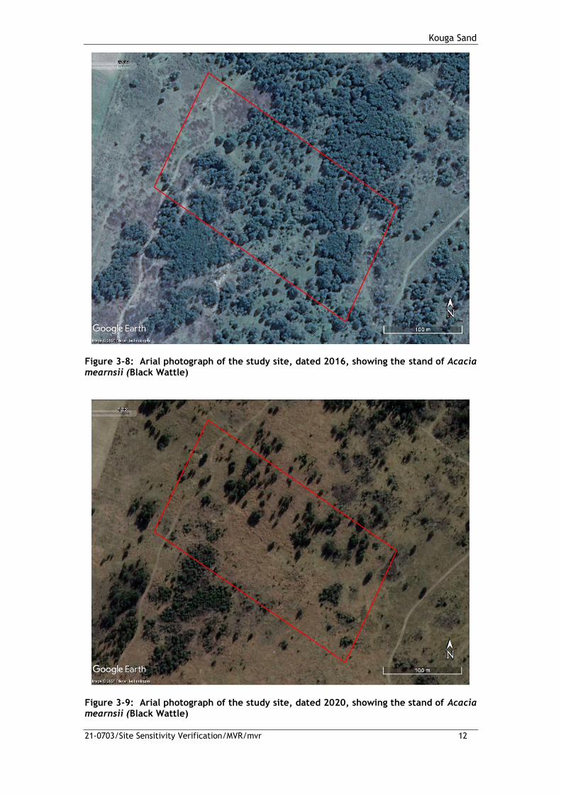
Kouga Sand
21-0703/Site Sensitivity Verification/MVR/mvr 12
Figure 3-8: Arial photograph of the study site, dated 2016, showing the stand of Acacia mearnsii (Black Wattle)
Figure 3-9: Arial photograph of the study site, dated 2020, showing the stand of Acacia mearnsii (Black Wattle)

Kouga Sand
21-0703/Site Sensitivity Verification/MVR/mvr 13
3.2 Preliminary site assessment
The site assessment was conducted on 4 January 2022 by Mr Magnus van Rooyn from GCS
Water and Environment (Pty) Ltd. The findings of the site assessment confirmed the
following:
• The topography on the study area shows clear signs of disturbance as a result of the
agriculural activities that historically took place on on the property.
• The stands of Acacia mearnsii (Black Wattle) still proliferate over the site as well as
large parts of the surrounding areas.
• The indigenous vegetation is limited to indigenous prioneer grasses that establish
after each clearfelling event assocaited with the current landuse on the site.
• No ericoide plant species or typical fynbos species were present on the site, likely as
a direct result of the previous disturbance of the site and the subsequent invasion by
the stands of Acacia mearnsii (Black Wattle).
• No signs of any aquatic features are present on the study site.
• No signs of any animals or any bird nesting sites were found on the site.
The above findings are illustrated in the photos of the site.

Kouga Sand
21-0703/Site Sensitivity Verification/MVR/mvr 14
Plate 3-1: View of the dense stands of Acacia mearnsii (Black Wattle) on the study site, looking in a north-easterly direction across the site

Kouga Sand
21-0703/Site Sensitivity Verification/MVR/mvr 15
Plate 3-2: View of the Acacia mearnsii (Black Wattle) on the site, looking in a northernly direction across the site

Kouga Sand
21-0703/Site Sensitivity Verification/MVR/mvr 16
Plate 3-3: View of the dense stands of Acacia mearnsii (Black Wattle) on the site with the germinating seedlings in the foreground

Kouga Sand
21-0703/Site Sensitivity Verification/MVR/mvr 17
Plate 3-4: View of the altered topography on the site, note the contour in the foreground

Mimosa Road Development
21-0703/Site Sensitivity Verification/MVR/mvr Page 18
The hisotrical clearance of the natural vegetation form the study site as well as the heavy infestation
of Acacia mearnsii (Black Wattle) has resulted in current vegetation on the site being severely
transformed and consists of isolated wattle trees and pioneer grasses that is typical to the surrounding
areas. The severe alteratio of the vegetation on the property has significantly impacted on the other
terrestrial biodiversity components of the study site.
4 CONCLUSION
The findings of the site verification assessment has refutes the HIGH sensitivity rating for the Terrestria
Biodiversity Theme, the MEDIUM Plant and Animal Theme as the site has undergone current and
historical distrubances as a result of agricultural activities, which resulted in the invasion of alien plant
species. These alien Acacia mearnsii (Blakc Wattle) are activity management and cleared from the site,
but re-establishes when cleared as a result of the substantial seedbed present in the soil.
5 SPECIALIST DECLARATION
I, Magnus Van Rooyen, declare that:
• I act as an independent specialist;
• Results will be interpreted in an objective manner, even if the viewpoints are not favourable
to the applicant;
• I have the relevant expertise to conduct a report of this nature, including knowledge of the
National Environmental Management Act (Act 107 of 1998) and the National Water Act (Act 36
of 1998);
• I will comply with the act(s) and other relevant legislation; and
• I understand that any false information published in this document is an offense in terms of
regulation 71 and is punishable in terms of Section 24 (f) of the Act.
__________________________
Magnus Van Rooyen
Environmental Scientist
Pr.Sci.Nat 400335/11

Kouga Sand MP
21-0703/Terrestiral biodiversity/MVR/mvr Page 30
APPENDIX D
IMPACT ASSESSMENT METHODOLOGY

Kouga Sand MP
21-0703/Terrestiral biodiversity/MVR/mvr Page 31
IMPACT ASSESSMENT METHODOLOGY
Likely impacts associated with the proposed development on the identified aquatic and terrestrial
biodiversity baseline have been identified through the undertaking of site visits, consultation of
published information, comments from Interested and Affected Parties, comments from the relevant
authority and independent assessment by the Environmental Project Team. Impacts have also been
identified by the specialist assessments undertaken.
The impact assessment will make provision for the assessment of the following impacts:
• No-go impacts;
• Planning and design phase impacts;
• Construction phase impacts;
• Operational phase impacts;
• Decommissioning phase impacts; and
• Cumulative impacts.
Impacts identified were assessed according to the criteria outlined below. Each impact was ranked
according to extent, duration, magnitude and probability. These criteria are based on the Department
of Environmental Affairs and Tourism (DEAT) (now the Department of Environmental Affairs, Forestry
and Fisheries) Guideline Document to the EIA Regulations(1998). A significance rating was calculated as
per the methodology outlined below. Where possible, mitigatory measures were recommended for the
impacts identified.
Status of the Impact
The impacts were assessed as having either of the following:
Table 1: Impact status classification
Classification Definition
Negative effect at a cost to the environment
Positive effect a benefit to the environment
Neutral Neutral effect on the environment
Extent of the Impact
The extent of each impact was rated as being one of the following:
Table 2: Impact extent classification
Classification Definition
1 Site - within the boundaries of the development site
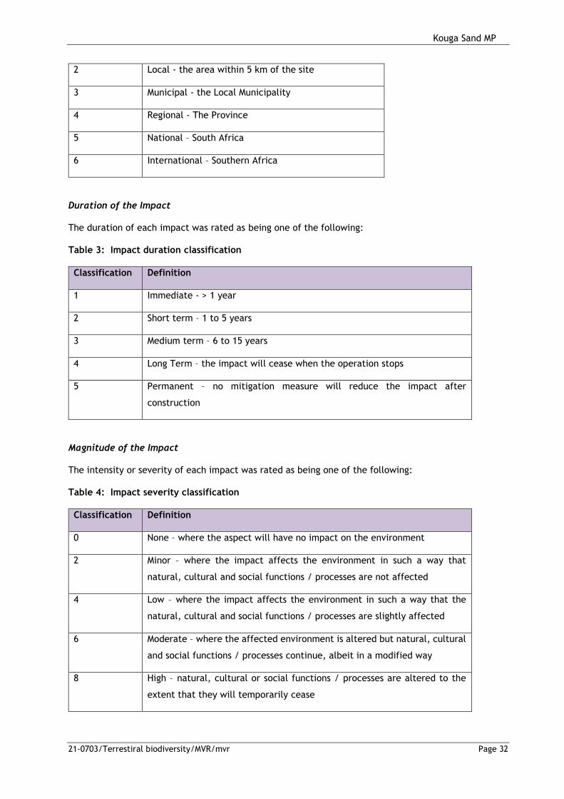
Kouga Sand MP
21-0703/Terrestiral biodiversity/MVR/mvr Page 32
2 Local - the area within 5 km of the site
3 Municipal - the Local Municipality
4 Regional - The Province
5 National – South Africa
6 International – Southern Africa
Duration of the Impact
The duration of each impact was rated as being one of the following:
Table 3: Impact duration classification
Classification Definition
1 Immediate - > 1 year
2 Short term – 1 to 5 years
3 Medium term – 6 to 15 years
4 Long Term – the impact will cease when the operation stops
5 Permanent – no mitigation measure will reduce the impact after
construction
Magnitude of the Impact
The intensity or severity of each impact was rated as being one of the following:
Table 4: Impact severity classification
Classification Definition
0 None – where the aspect will have no impact on the environment
2 Minor – where the impact affects the environment in such a way that
natural, cultural and social functions / processes are not affected
4 Low – where the impact affects the environment in such a way that the
natural, cultural and social functions / processes are slightly affected
6 Moderate – where the affected environment is altered but natural, cultural
and social functions / processes continue, albeit in a modified way
8 High – natural, cultural or social functions / processes are altered to the
extent that they will temporarily cease

Kouga Sand MP
21-0703/Terrestiral biodiversity/MVR/mvr Page 33
10 Very high / unknown – natural, cultural or social functions / processes are
altered to the extent that they will permanently cease
Probability of Occurrence
The likelihood of the impact actually occurring is indicated as either:
Table 5: Impact probability classification
Classification Definition
0 None – the impact will not occur
1 Improbable – the possibility of the impact materialising is very low as a result of
design, historic experience or implementation of adequate corrective actions
2 Low – there is a probability that the impact will occur
3 Medium – the impact may occur
4 High – it is most likely that the impact will occur
5 Definite / unknown – the impact will occur regardless of the implementation of any
prevention or corrective actions, or it is not known what the probability will be,
based on a lack of published information
Significance of the Impact
Based on the information contained in the points above, the potential impacts have been assigned a
significance weighting (S). This weighting is formulated by adding the sum of the numbers assigned to
extent (E), duration (D) and magnitude (M) and multiplying this sum by the probability (P) of the impact.
S = (E+D+M)*P
The significance weightings are ranked as:
Table 6: Impact significance rating
Impact
rating
Definition
< 30 Low – the impact would not have a direct influence on the decision to develop in
the area;
30 – 60 Medium – the impact could influence the decision to develop in the area unless it
is effectively managed / mitigated;
> 60 High - the impact must have an influence on the decision-making process for
development in the area.

Page 1 of 30
Kouga HIA Umlando 28/04/2022
HERITAGE SURVEY OF THE PROPOSED KOUGA
SAND MINE, PORTION 8 OF KRUISFONTEIN
NO. 193, HUMANSDORP, EASTERN CAP
FOR GCS WATER & ENVIRONMENTAL
CONSULTANTS
DATE: 28 APRIL 2022
By Gavin Anderson
Umlando: Archaeological Surveys and Heritage
Management
PO Box 10153, Meerensee, 3901
Phone/fax: 035-7531785 Fax: 0865445631
Cell: 0836585362

Page 2 of 30
Kouga HIA Umlando 28/04/2022
TABLE OF CONTENT
INTRODUCTION ......................................................................................................................... 4 NATIONAL HERITAGE RESOURCES ACT OF 1999 ............................................................... 9 METHOD ................................................................................................................................... 11
Defining significance ............................................................................................................ 12 RESULTS .................................................................................................................................. 15
DESKTOP STUDY .................................................................................................................. 15 PIA PALAEONTOLOGICAL SENSITIVITY .............................................................................. 19 FIELD SURVEY ........................................................................................................................ 20 CONCLUSION .......................................................................................................................... 22 REFERENCES .......................................................................................................................... 22 EXPERIENCE OF THE HERITAGE CONSULTANT ............................................................... 23 DECLARATION OF INDEPENDENCE ..................................................................................... 23
TABLE OF FIGURES FIG. 1 GENERAL LOCATION OF THE TURBINES & PROPOSED ACCESS ROADS ................. 5 FIG. 2: AERIAL OVERVIEW OF THE STUDY AREA ..................................................................... 6 FIG. 3: TOPOGRAPHICAL OVERVIEW OF THE STUDY AREA ................................................... 7 FIG. 4: SCENIC VIEWS OF THE STUDY AREA ............................................................................ 8 FIG. 5: LOCATION OF KNOWN HERITAGE SITES IN THE GENERAL AREA .......................... 16 FIG. 6: LOCATION OF THE STUDY AREA IN 1953 .................................................................... 17 FIG. 7: LOCATION OF THE STUDY AREA IN 1967 .................................................................... 18 FIG. 9: QUARTZITE OUTCROP ................................................................................................... 21 FIG 10: QUARTZITE CORE .......................................................................................................... 21

Page 3 of 30
Kouga HIA Umlando 28/04/2022
Abbreviations
HP Historical Period
IIA Indeterminate Iron Age
LIA Late Iron Age
EIA Early Iron Age
ISA Indeterminate Stone Age
ESA Early Stone Age
MSA Middle Stone Age
LSA Late Stone Age
HIA Heritage Impact Assessment
PIA Palaeontological Impact Assessment

Page 4 of 30
Kouga HIA Umlando 28/04/2022
INTRODUCTION
GCS Water and Environmental Consultants (Pty) Ltd (GCS) was appointed by
Kouga Sand (Pty) Ltd (Kouga Sand) to conduct the Environmental Authorisation
(EA) process for the proposed mining of sand on Portion 8 of Kruisfontein No.
193, Humansdorp, Eastern Cape. This application for EA is being undertaken on
behalf of Kouga Sand (the applicant) and, as such, will be submitted to the
Department of Mineral Resources and Energy (DMRE) as the competent
authority.
The mining will be conducted as an opencast operation with the sand removed at
surface and put through a screen to remove all root material from the sand.
The excavation will be conducted with an excavator with the saleable product
being removed off site with tipper trucks. The tipper trucks will be loaded by a
single TLB.
An access road to the application area already exists in the form of a farm road.
The following infrastructure will be positioned on site:
Product stockpile (100m2);
Opencast pits (4.5ha); and
Site office (50m2).
Umlando was requested to undertake an HIA for the proposed mine. Figures
1 – 4 show the location of the proposed mine.

Page 5 of 30
Kouga HIA Umlando 28/04/2022
FIG. 1 GENERAL LOCATION OF THE TURBINES & PROPOSED ACCESS ROADS

Page 6 of 30
Kouga HIA Umlando 28/04/2022
FIG. 2: AERIAL OVERVIEW OF THE STUDY AREA

Page 7 of 30
Kouga HIA Umlando 28/04/2022
FIG. 3: TOPOGRAPHICAL OVERVIEW OF THE STUDY AREA1
1 3324DC

Page 8 of 30
Kouga HIA Umlando 28/04/2022
FIG. 4: SCENIC VIEWS OF THE STUDY AREA

Page 9 of 30
Kouga HIA Umlando 28/04/2022
NATIONAL HERITAGE RESOURCES ACT OF 1999
The National Heritage Resources Act of 1999 (pp 12-14) protects a variety of
heritage resources. This are resources are defined as follows:
1. “For the purposes of this Act, those heritage resources of South Africa which
are of cultural significance or other special value for the present community
and for future generations must be considered part of the national estate and
fall within the sphere of operations of heritage resources authorities.
2. Without limiting the generality of subsection (1), the national estate may
include—
2.1. Places, buildings, structures and equipment of cultural significance;
2.2. Places to which oral traditions are attached or which are associated with
living heritage;
2.3. Historical settlements and townscapes;
2.4. Landscapes and natural features of cultural significance;
2.5. Geological sites of scientific or cultural importance;
2.6. Archaeological and palaeontological sites;
2.7. Graves and burial grounds, including—
2.7.1. Ancestral graves;
2.7.2. Royal graves and graves of traditional leaders;
2.7.3. Graves of victims of conflict;
2.7.4. Graves of individuals designated by the Minister by notice in the
Gazette;
2.7.5. Historical graves and cemeteries; and
2.7.6. Other human remains which are not covered in terms of the Human
Tissue Act, 1983 (Act No. 65 of 1983);
3. Sites of significance relating to the history of slavery in South Africa;
3.1. Movable objects, including—

Page 10 of 30
Kouga HIA Umlando 28/04/2022
4. Objects recovered from the soil or waters of South Africa, including
archaeological and palaeontological objects and material, meteorites and rare
geological specimens;
4.1. Objects to which oral traditions are attached or which are associated
with living heritage;
4.2. Ethnographic art and objects;
4.3. Military objects;
4.4. objects of decorative or fine art;
4.5. Objects of scientific or technological interest; and
4.6. books, records, documents, photographic positives and negatives,
graphic, film or video material or sound recordings, excluding those that
are public records as defined in section 1(xiv) of the National Archives of
South Africa Act, 1996 (Act No. 43 of 1996).
5. Without limiting the generality of subsections (1) and (2), a place or object is
to be considered part of the national estate if it has cultural significance or
other special value because of—
5.1. Its importance in the community, or pattern of South Africa’s history;
5.2. Its possession of uncommon, rare or endangered aspects of South
Africa’s natural or cultural heritage;
5.3. Its potential to yield information that will contribute to an understanding
of South Africa’s natural or cultural heritage;
5.4. Its importance in demonstrating the principal characteristics of a
particular class of South Africa’s natural or cultural places or objects;
5.5. Its importance in exhibiting particular aesthetic characteristics valued by
a community or cultural group;
5.6. Its importance in demonstrating a high degree of creative or technical
achievement at a particular period;
5.7. Its strong or special association with a particular community or cultural
group for social, cultural or spiritual reasons;
5.8. Its strong or special association with the life or work of a person, group
or organisation of importance in the history of South Africa; and

Page 11 of 30
Kouga HIA Umlando 28/04/2022
5.9. sites of significance relating to the history of slavery in South Africa”
METHOD
The method for Heritage assessment consists of several steps.
The first step forms part of the desktop assessment. Here we would consult
the database that has been collated by Umlando. These database contain
archaeological site locations and basic information from several provinces
(information from Umlando surveys and some colleagues), most of the national
and provincial monuments and battlefields in Southern Africa
(http://www.vuvuzela.com/googleearth/monuments.html) and cemeteries in
southern Africa (information supplied by the Genealogical Society of Southern
Africa). We use 1st and 2nd edition 1:50 000 topographical and 1937 aerial
photographs where available, to assist in general location and dating of buildings
and/or graves. The database is in Google Earth format and thus used as a quick
reference when undertaking desktop studies. Where required we would consult
with a local data recording centre, however these tend to be fragmented between
different institutions and areas and thus difficult to access at times. We also
consult with an historical architect, palaeontologist, and an historian where
necessary.
The survey results will define the significance of each recorded site, as well
as a management plan.
All sites are grouped according to low, medium, and high significance for the
purpose of this report. Sites of low significance have no diagnostic artefacts or
features. Sites of medium significance have diagnostic artefacts or features and
these sites tend to be sampled. Sampling includes the collection of artefacts for
future analysis. All diagnostic pottery, such as rims, lips, and decorated sherds
are sampled, while bone, stone, and shell are mostly noted. Sampling usually
Page 12 of 30
Kouga HIA Umlando 28/04/2022
occurs on most sites. Sites of high significance are excavated and/or extensively
sampled. Those sites that are extensively sampled have high research potential,
yet poor preservation of features.
Defining significance
Heritage sites vary according to significance and several different criteria
relate to each type of site. However, there are several criteria that allow for a
general significance rating of archaeological sites.
These criteria are:
1. State of preservation of:
1.1. Organic remains:
1.1.1. Faunal
1.1.2. Botanical
1.2. Rock art
1.3. Walling
1.4. Presence of a cultural deposit
1.5. Features:
1.5.1. Ash Features
1.5.2. Graves
1.5.3. Middens
1.5.4. Cattle byres
1.5.5. Bedding and ash complexes
2. Spatial arrangements:
2.1. Internal housing arrangements
2.2. Intra-site settlement patterns
2.3. Inter-site settlement patterns
3. Features of the site:
3.1. Are there any unusual, unique or rare artefacts or images at the
site?

Page 13 of 30
Kouga HIA Umlando 28/04/2022
3.2. Is it a type site?
3.3. Does the site have a very good example of a specific time period,
feature, or artefact?
4. Research:
4.1. Providing information on current research projects
4.2. Salvaging information for potential future research projects
5. Inter- and intra-site variability
5.1. Can this particular site yield information regarding intra-site
variability, i.e. spatial relationships between various features and artefacts?
5.2. Can this particular site yield information about a community’s social
relationships within itself, or between other communities?
6. Archaeological Experience:
6.1. The personal experience and expertise of the CRM practitioner
should not be ignored. Experience can indicate sites that have potentially
significant aspects, but need to be tested prior to any conclusions.
7. Educational:
7.1. Does the site have the potential to be used as an educational
instrument?
7.2. Does the site have the potential to become a tourist attraction?
7.3. The educational value of a site can only be fully determined after
initial test-pit excavations and/or full excavations.
8. Other Heritage Significance:
8.1. Palaeontological sites
8.2. Historical buildings
8.3. Battlefields and general Anglo-Zulu and Anglo-Boer sites
8.4. Graves and/or community cemeteries
8.5. Living Heritage Sites
8.6. Cultural Landscapes, that includes old trees, hills, mountains,
rivers, etc related to cultural or historical experiences.

Page 14 of 30
Kouga HIA Umlando 28/04/2022
The more a site can fulfill the above criteria, the more significant it becomes.
Test-pit excavations are used to test the full potential of an archaeological
deposit. This occurs in Phase 2. These test-pit excavations may require further
excavations if the site is of significance (Phase 3). Sites may also be mapped
and/or have artefacts sampled as a form of mitigation. Sampling normally occurs
when the artefacts may be good examples of their type, but are not in a primary
archaeological context. Mapping records the spatial relationship between
features and artefacts.
The above significance ratings allow one to grade the site according to
SAHRA’s grading scale. This is summarised in Table 1.
TABLE 1: SAHRA GRADINGS FOR HERITAGE SITES
SITE SIGNIFICANCE
FIELD RATING
GRADE RECOMMENDED MITIGATION
High Significance
National Significance
Grade 1 Site conservation / Site development
High Significance
Provincial Significance
Grade 2 Site conservation / Site development
High Significance
Local Significance
Grade 3A / 3B
High / Medium Significance
Generally Protected A
Site conservation or mitigation prior to development / destruction
Medium Significance
Generally Protected B
Site conservation or mitigation / test excavation / systematic sampling / monitoring prior to or during development / destruction
Low Significance
Generally Protected C
On-site sampling monitoring or no archaeological mitigation required prior to or during development / destruction

Page 15 of 30
Kouga HIA Umlando 28/04/2022
RESULTS
DESKTOP STUDY
The desktop study consisted of analysing various maps for evidence of prior
habitation in the study area, as well as for previous archaeological surveys. The
general area has very archaeological surveys in the past (fig. 5) and none have
been with 50m of the study area.
The 1953 topographical map indicates that the area is covered by grassland
with some agricultural activity to the north (fig. 9). Several agricultural fields and
built structures are noted on the map, but none occurs within the study area.
The 1961 aerial photograph was the earliest available
(http://www.cdngiportal.co.za/cdngiportal/). The photograph shows the area is
grassland/low bush, with erosion area (fig. 10). In the southwestern corner, there
is a circular feature just outside of the study area.

Page 16 of 30
Kouga HIA Umlando 28/04/2022
FIG. 5: LOCATION OF KNOWN HERITAGE SITES IN THE GENERAL AREA

Page 17 of 30
Kouga HIA Umlando 28/04/2022
FIG. 6: LOCATION OF THE STUDY AREA IN 19532
2 3324DC Andrieskraal

Page 18 of 30
Kouga HIA Umlando 28/04/2022
FIG. 7: LOCATION OF THE STUDY AREA IN 19673
3 459_013_08155

Page 19 of 30
Kouga HIA Umlando 28/04/2022
PIA PALAEONTOLOGICAL SENSITIVITY
The mine is in an area of high sensitivity, and thus a desktop study was
initially undertaken (fig. 8). The PIA desktop was undertaken by Dr. Alan Smith
(appendix A). He states:
“The proposed sand mining operation will take place in rocks colour coded
yellow in the SAHRIS Map. This is a small site (150 X 300m) and to be constructed
on agricultural land. The underlying rock is Peninsula Formation of the Table
Mountain Group. Trace fossils may be found but these are not significant. No
significant palaeontological finds have been made in this lithology.
Consequently there is no reason to conduct a PIA for this project.
Exemption from Palaeontological Impact Assessment (PIA) is requested for this
project. However a “Chance Find Protocol” is attached to cover any chance find.”
FIG. 8: PALAEONTOLOGICAL SENSITIVITY MAP
.
COLOUR SENSITIVITY REQUIRED ACTION
RED VERY HIGH field assessment and protocol for finds is required
ORANGE/YELLOW HIGH desktop study is required and based on the outcome
of the desktop study, a field assessment is likely
GREEN MODERATE desktop study is required
BLUE LOW no palaeontological studies are required however a
protocol for finds is required
GREY INSIGNIFICANT/ZERO no palaeontological studies are required

Page 20 of 30
Kouga HIA Umlando 28/04/2022
WHITE/CLEAR UNKNOWN
these areas will require a minimum of a desktop
study. As more information comes to light, SAHRA
will continue to populate the map.
FIELD SURVEY
The field survey was undertaken in April 2022. Ground visibility was very
good and parts of the area had been recently burnt. The erosion gullies and
various aardvark holes also gave an indication to the type of soil and deposit in
that specific area, as well as potential artefacts. The study area was surveyed
and there are noticeable areas of previous earthmoving activity. This is in the
form of semi-terracing. Alternatively, it is the result of continual aardvark holes
over the decades.
The circular feature noted on the 1961 aerial photograph is a natural quartz
outcrop (fig. 9). One ESA/MSA core was noted near the outcrop (fig. 10). The
outcrop could have been used as a quarry in the remove past; however, no
definite signs of quarrying were noted. The outcrop is outside of the study area
and will not be affected.
No other artefacts or heritage features were noted within the study area, or
on its borders.
No further HIA mitigation is required.

Page 21 of 30
Kouga HIA Umlando 28/04/2022
FIG. 9: QUARTZITE OUTCROP
FIG 10: QUARTZITE CORE

Page 22 of 30
Kouga HIA Umlando 28/04/2022
CONCLUSION
A HIA was undertaken for the proposed Kouga Sands mine. An isolated
ESA/MSA stone core was noted as well as a potential quartzite quarry. The
quarry is outside of the study area.
No other artefacts or features were noted within the study area. No further
heritage mitigation is required.
The ‘Chance Find Protocol’ for the palaeontological material needs to form
part of the EMPr
REFERENCES
459_013_08155
3324DC Andrieskraal 1953,

Page 23 of 30
Kouga HIA Umlando 28/04/2022
EXPERIENCE OF THE HERITAGE CONSULTANT
Gavin Anderson has a M. Phil (in archaeology and social psychology) degree
from the University of Cape Town. Gavin has been working as a professional
archaeologist and heritage impact assessor since 1995. He joined the
Association of Professional Archaeologists of Southern Africa in 1998 when it
was formed. Gavin is rated as a Principle Investigator with expertise status in
Rock Art, Stone Age and Iron Age studies. In addition to this, he was worked on
both West and East Coast shell middens, Anglo-Boer War sites, and Historical
Period sites.
DECLARATION OF INDEPENDENCE
I, Gavin Anderson, declare that I am an independent specialist consultant and
have no financial, personal or other interest in the proposed development, nor the
developers or any of their subsidiaries, apart from fair remuneration for work
performed in the delivery of heritage assessment services. There are no
circumstances that compromise the objectivity of my performing such work.
Gavin Anderson
Archaeologist/Heritage Impact Assessor

Page 24 of 30
Kouga HIA Umlando 28/04/2022
APPENIDX A
PIA DESKTOP

Page 25 of 30
Kouga HIA Umlando 28/04/2022
Dr Alan Smith
Alan Smith Consulting
29 Browns Grove
Sherwood
Durban
4091
UMLANDO: Archaeological Surveys & Heritage Management PO Box 102532, Meerensee, KwaZulu-Natal 3901 phone (035)7531785 fax: 0865445631 cell: 0836585362 / 0723481327 Email:[email protected]
Letter of Exemption from Palaeontological Impact Assessment for:
KOUGA SAND MINING: KOUGA LOCAL MUNICIPALITY, EASTERN CAPE.
Dear Sir
Dr Alan Smith was asked by UMLANDO: Archaeological Surveys & Heritage
Management to conduct a PIA for the above named project.
.
The proposed sand mining operation will take place in rocks colour coded yellow in the
SAHRIS Map. This is a small site (150 X 300m) and to be constructed on agricultural
land. The underlying rock is Peninsula Formation of the Table Mountain Group. Trace

Page 26 of 30
Kouga HIA Umlando 28/04/2022
fossils may be found but these are not significant. No significant palaeontological finds
have been made in this lithology.
Consequently there is no reason to conduct a PIA for this project. Exemption from
Palaeontological Impact Assessment (PIA) is requested for this project. However a
“Chance Find Protocol” is attached to cover any chance find.
Should any of the proposed plans change then the project will need to be reassessed in
terms of a PIA
Dr Alan Smith.
Alan Smith Consulting
19 April, 2022

Page 27 of 30
Kouga HIA Umlando 28/04/2022
CHANCE FIND PROTOCOL
This Chance Find Protocol must be included in the site EMPr.
If any fossils are found, a Palaeontologist must be notified immediately by the ECO
and/or EAP and a site visit must be arranged at the earliest possible time with the
Palaeontologist.
In the case of the ECO or the Site Manager becoming aware of suspicious looking
palaeo-material:
The construction must be halted in that specific area and the Palaeontologist must
be given enough time to reach the site and remove the material before excavation
continues.
Mitigation will involve the attempt to capture all rare fossils and systematic
collection of all fossils discovered. This will take place in conjunction with
descriptive, diagrammatic and photographic recording of exposures, also
involving sediment samples and samples of both representative and unusual
sedimentary or biogenic features. The fossils and contextual samples will be
processed (sorted, sub-sampled, labeled, and boxed) and documentation
consolidated, to create an archive collection from the excavated sites for future
researchers.
Functional responsibilities of the Developer
1. At full cost to the project, and guided by the appointed Palaeontological Specialist,
ensure that a representative archive of palaeontological samples and other records is
assembled to characterize the palaeontological occurrences affected by the excavation
operation.
2. Provide field aid, if necessary, in the supply of materials, labour and machinery to
excavate, load and transport sampled material from the excavation areas to the sorting
areas, removal of overburden if necessary, and the return of discarded material to the
disposal areas.
3. Facilitate systematic recording of the stratigraphic and palaeo-environmental features
in exposures in the fossil-bearing excavations, by described and measured geological
sections, and by providing aid in the surveying of positions where significant fossils are
found.

Page 28 of 30
Kouga HIA Umlando 28/04/2022
4. Provide safe storage for fossil material found routinely during excavation operations by
construction personnel. In this context, isolated fossil finds in disturbed material qualify
as “normal” fossil finds.
5. Provide covered, dry storage for samples and facilities for a work area for sorting,
labeling and boxing/bagging samples.
6. Costs of basic curation and storage until collected. Documentary record of
palaeontological occurrences must be done.
7. The contractor will, in collaboration with the Palaeontologist, make the excavation
plan available to the appointed specialist, in which appropriate information regarding
plans for excavations and work schedules must be indicated on the plan of the excavation
sites. This must be done in conjunction with the appointed specialist.
8. Initially, all known specific palaeontological information will be indicated on the plan.
This will be updated throughout the excavation period.
9. Locations of samples and measured sections are to be pegged, and routinely and
accurately surveyed. Sample locations, measured sections, etc., must be recorded three-
dimensionally if any “significant fossils” are recorded during the time of excavation.

Page 29 of 30
Kouga HIA Umlando 28/04/2022
DETAILS OF SPECIALIST
Dr Alan Smith
Private Consultant: Alan Smith Consulting, 29 Brown’s Grove, Sherwood, Durban,
4091
&
Honorary Research Fellow: Discipline of Geology, School of Agriculture, Earth and
Environmental Sciences, University of KwaZulu-Natal, Durban.
Role: Specialist Palaeontological Report production
Expertise of the specialist:
o PhD in Geology (University of KwaZulu-Natal), Pr. Sc. Nat., I.A.H.S.
o Expert in Vryheid Formation (Ecca Group) in northern KZN, this having been the
subject of PhD.
o Scientific Research experience includes: Fluvial geomorphology, palaeoflood
hydrology, Cretaceous deposits.
o Experience includes understanding Earth Surface Processes in both fluvial and
coastal environments (modern & ancient).
o Alan has published in both national and international, peer-reviewed journals. He
has published + 50 journal articles with 497 citations (detailed CV available on
request).
o Attended and presented scientific papers and posters at numerous international and
local conferences (UK, Canada, South Africa) and is actively involved in research.
Selected recent palaeo-related work includes:
o Desktop PIA: Proposed middle income housing units on Portion 23 of Farm Lot H
Weston 13026, Bruntville, Mpofana Local Municipality. Client: UMLANDO.
o Desktop PIA: Proposed ByPass Pipeline for Ulundi bulk water pipeline upgrade.
Client: UMLANDO.
o Fieldwork PIA: Bhekuzulu Epangweni KZN water reticulation project, Cathkin
Park. Client: Mike Webster, HSG Attorneys.
o Fieldwork PIA: Mpungoze water supply scheme, Empangeni. Client: Enviropro.
o Fieldwork PIA: Helpmekaar Dam. Client: Afzelia environmental consultants.
o Desktop PIA: Zuka valley, Ballito. Client: Mike Webster, HSG Attorneys.
o Mevamhlope proposed quarry palaeontology report. Client: Enviropro.

Page 30 of 30
Kouga HIA Umlando 28/04/2022
o Desktop PIA: Proposed Lovu Desalination site. Client: eThembeni Cultural
Heritage.
o Desktop PIA: Tinley Manor phase 2 North & South banks: eThembeni Cultural
Heritage
o Desktop PIA: Tongaat. Client: eThembeni Cultural Heritage.
o Palaeontological Assessment Reports (3) to Scatec Solar SA (Pty) Ltd on an
Appraisal of Inferred Palaeontological Sensitivity for a Potential Photo Voltaic
Park at (1) Farm Rooilyf near Groblershoop, N Cape; (2) Farm Riet Fountain No.
Portions 1 and 6, 18km SE of De Aar, N Cape; and (3) Dreunberg, near
Burgersdorp, Eastern Cape. Client: Sustainable Development Projects.

Kouga Sand Final Basic Assessment Report
APPENDIX C: DFFE ONLINE SCREENING REPORT

Page 1 of 17 Disclaimer applies 24/03/2022
SCREENING REPORT FOR AN ENVIRONMENTAL AUTHORIZATION AS REQUIRED BY THE 2014 EIA REGULATIONS – PROPOSED SITE
ENVIRONMENTAL SENSITIVITY
EIA Reference number: EC30/5/1/3/2/10704MP
Project name: Kouga Sand MP
Project title: Kouga Sand MP
Date screening report generated: 24/03/2022 13:26:26
Applicant: Kouga Sand
Compiler: J Callaghan
Compiler signature: .....................................................................................................
Application Category: Mining|Mining Permit

Page 2 of 17 Disclaimer applies 24/03/2022
Table of Contents
Proposed Project Location .................................................................................................................... 3
Orientation map 1: General location .................................................................................................. 3
Map of proposed site and relevant area(s) ........................................................................................... 4
Cadastral details of the proposed site ................................................................................................ 4
Wind and Solar developments with an approved Environmental Authorisation or applications under consideration within 30 km of the proposed area ................................................................... 4
Environmental Management Frameworks relevant to the application ............................................. 4
Environmental screening results and assessment outcomes ............................................................... 5
Relevant development incentives, restrictions, exclusions or prohibitions ....................................... 5
Map indicating proposed development footprint within applicable development incentive, restriction, exclusion or prohibition zones ............................................................................................ 6
Proposed Development Area Environmental Sensitivity .................................................................... 6
Specialist assessments identified ........................................................................................................ 7
Results of the environmental sensitivity of the proposed area. ........................................................... 9
MAP OF RELATIVE AGRICULTURE THEME SENSITIVITY ...................................................................... 9
MAP OF RELATIVE ANIMAL SPECIES THEME SENSITIVITY................................................................. 10
MAP OF RELATIVE AQUATIC BIODIVERSITY THEME SENSITIVITY ..................................................... 11
MAP OF RELATIVE ARCHAEOLOGICAL AND CULTURAL HERITAGE THEME SENSITIVITY .................. 12
MAP OF RELATIVE CIVIL AVIATION THEME SENSITIVITY .................................................................. 13
MAP OF RELATIVE DEFENCE THEME SENSITIVITY ............................................................................. 14
MAP OF RELATIVE PALEONTOLOGY THEME SENSITIVITY ................................................................. 15
MAP OF RELATIVE PLANT SPECIES THEME SENSITIVITY ................................................................... 16
MAP OF RELATIVE TERRESTRIAL BIODIVERSITY THEME SENSITIVITY ............................................... 17

Page 3 of 17 Disclaimer applies 24/03/2022
Proposed Project Location
Orientation map 1: General location
General Orientation: Kouga Sand MP

Page 4 of 17 Disclaimer applies 24/03/2022
Map of proposed site and relevant area(s)
Cadastral details of the proposed site Property details:
No Farm Name Farm/ Erf No Portion Latitude Longitude Property Type 1 KRUISFONTEIN 193 0 33°53'38.25S 24°42'23.4E Farm 2 KRUISFONTEIN 193 8 33°52'50.76S 24°41'23.75E Farm Portion Development footprint1 vertices: No development footprint(s) specified.
Wind and Solar developments with an approved Environmental Authorisation or applications under consideration within 30 km of the proposed area No nearby wind or solar developments found.
Environmental Management Frameworks relevant to the application
No intersections with EMF areas found.
1 “development footprint”, means the area within the site on which the development will take place and incudes all ancillary developments for example roads, power lines, boundary walls, paving etc. which require vegetation clearance or which will be disturbed and for which the application has been submitted.

Page 5 of 17 Disclaimer applies 24/03/2022
Environmental screening results and assessment outcomes
The following sections contain a summary of any development incentives, restrictions, exclusions or prohibitions that apply to the proposed development site as well as the most environmental sensitive features on the site based on the site sensitivity screening results for the application classification that was selected. The application classification selected for this report is: Mining|Mining Permit.
Relevant development incentives, restrictions, exclusions or prohibitions The following development incentives, restrictions, exclusions or prohibitions and their implications that apply to this site are indicated below.
Incentive, restriction or prohibition
Implication
Strategic Gas Pipeline Corridors-Phase 2: Mossel Bay to Coega
https://screening.environment.gov.za/ScreeningDownloads/DevelopmentZones/Combined_GAS.pdf
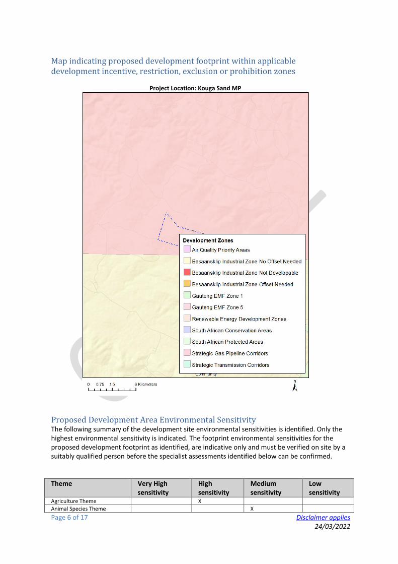
Page 6 of 17 Disclaimer applies 24/03/2022
Map indicating proposed development footprint within applicable development incentive, restriction, exclusion or prohibition zones
Project Location: Kouga Sand MP
Proposed Development Area Environmental Sensitivity The following summary of the development site environmental sensitivities is identified. Only the highest environmental sensitivity is indicated. The footprint environmental sensitivities for the proposed development footprint as identified, are indicative only and must be verified on site by a suitably qualified person before the specialist assessments identified below can be confirmed.
Theme Very High sensitivity
High sensitivity
Medium sensitivity
Low sensitivity
Agriculture Theme X
Animal Species Theme X

Page 7 of 17 Disclaimer applies 24/03/2022
Aquatic Biodiversity Theme X
Archaeological and Cultural Heritage Theme
X
Civil Aviation Theme X Defence Theme X Paleontology Theme X
Plant Species Theme X
Terrestrial Biodiversity Theme X
Specialist assessments identified Based on the selected classification, and the environmental sensitivities of the proposed development footprint, the following list of specialist assessments have been identified for inclusion in the assessment report. It is the responsibility of the EAP to confirm this list and to motivate in the assessment report, the reason for not including any of the identified specialist study including the provision of photographic evidence of the site situation.
No
Specialist assessment
Assessment Protocol
1 Agricultural Impact Assessment
https://screening.environment.gov.za/ScreeningDownloads/AssessmentProtocols/Gazetted_General_Agriculture_Assessment_Protocols.pdf
2 Archaeological and Cultural Heritage Impact Assessment
https://screening.environment.gov.za/ScreeningDownloads/AssessmentProtocols/Gazetted_General_Requirement_Assessment_Protocols.pdf
3 Palaeontology Impact Assessment
https://screening.environment.gov.za/ScreeningDownloads/AssessmentProtocols/Gazetted_General_Requirement_Assessment_Protocols.pdf
4 Terrestrial Biodiversity Impact Assessment
https://screening.environment.gov.za/ScreeningDownloads/AssessmentProtocols/Gazetted_Terrestrial_Biodiversity_Assessment_Protocols.pdf
5 Aquatic Biodiversity Impact Assessment
https://screening.environment.gov.za/ScreeningDownloads/AssessmentProtocols/Gazetted_Aquatic_Biodiversity_Assessment_Protocols.pdf
6 Hydrology Assess
https://screening.environment.gov.za/ScreeningDownloads/AssessmentProtocols/Gazetted_General_Requirement_Assessment_Protocols.pdf

Page 8 of 17 Disclaimer applies 24/03/2022
ment 7 Noise
Impact Assessment
https://screening.environment.gov.za/ScreeningDownloads/AssessmentProtocols/Gazetted_Noise_Impacts_Assessment_Protocol.pdf
8 Radioactivity Impact Assessment
https://screening.environment.gov.za/ScreeningDownloads/AssessmentProtocols/Gazetted_General_Requirement_Assessment_Protocols.pdf
9 Traffic Impact Assessment
https://screening.environment.gov.za/ScreeningDownloads/AssessmentProtocols/Gazetted_General_Requirement_Assessment_Protocols.pdf
10
Geotechnical Assessment
https://screening.environment.gov.za/ScreeningDownloads/AssessmentProtocols/Gazetted_General_Requirement_Assessment_Protocols.pdf
11
Socio-Economic Assessment
https://screening.environment.gov.za/ScreeningDownloads/AssessmentProtocols/Gazetted_General_Requirement_Assessment_Protocols.pdf
12
Plant Species Assessment
https://screening.environment.gov.za/ScreeningDownloads/AssessmentProtocols/Gazetted_Plant_Species_Assessment_Protocols.pdf
13
Animal Species Assessment
https://screening.environment.gov.za/ScreeningDownloads/AssessmentProtocols/Gazetted_Animal_Species_Assessment_Protocols.pdf

Page 9 of 17 Disclaimer applies 24/03/2022
Results of the environmental sensitivity of the proposed area.
The following section represents the results of the screening for environmental sensitivity of the proposed site for relevant environmental themes associated with the project classification. It is the duty of the EAP to ensure that the environmental themes provided by the screening tool are comprehensive and complete for the project. Refer to the disclaimer.
MAP OF RELATIVE AGRICULTURE THEME SENSITIVITY
Very High sensitivity High sensitivity Medium sensitivity Low sensitivity X
Sensitivity Features:
Sensitivity Feature(s) High Annual Crop Cultivation / Planted Pastures Rotation;Land capability;01. Very low/02. Very low/03.
Low-Very low/04. Low-Very low/05. Low High Annual Crop Cultivation / Planted Pastures Rotation;Land capability;06. Low-Moderate/07. Low-
Moderate/08. Moderate Low Land capability;01. Very low/02. Very low/03. Low-Very low/04. Low-Very low/05. Low Medium Land capability;06. Low-Moderate/07. Low-Moderate/08. Moderate

Page 10 of 17 Disclaimer applies 24/03/2022
MAP OF RELATIVE ANIMAL SPECIES THEME SENSITIVITY
Where only a sensitive plant unique number or sensitive animal unique number is provided in the screening report and an assessment is required, the environmental assessment practitioner (EAP) or specialist is required to email SANBI at [email protected] listing all sensitive species with their unique identifiers for which information is required. The name has been withheld as the species may be prone to illegal harvesting and must be protected. SANBI will release the actual species name after the details of the EAP or specialist have been documented.
Very High sensitivity High sensitivity Medium sensitivity Low sensitivity X
Sensitivity Features:
Sensitivity Feature(s) Medium Invertebrate-Aneuryphymus montanus Medium Aves-Tyto capensis Medium Aves-Circus maurus Medium Aves-Neotis denhami Medium Aves-Sarothrura affinis Medium Aves-Circus ranivorus Medium Mammalia-Chlorotalpa duthieae Medium Sensitive species 7

Page 11 of 17 Disclaimer applies 24/03/2022
MAP OF RELATIVE AQUATIC BIODIVERSITY THEME SENSITIVITY
Very High sensitivity High sensitivity Medium sensitivity Low sensitivity X
Sensitivity Features:
Sensitivity Feature(s) Low Low sensitivity Very High Freshwater ecosystem priority area quinary catchments

Page 12 of 17 Disclaimer applies 24/03/2022
MAP OF RELATIVE ARCHAEOLOGICAL AND CULTURAL HERITAGE THEME SENSITIVITY
Very High sensitivity High sensitivity Medium sensitivity Low sensitivity X Sensitivity Features:
Sensitivity Feature(s) Low Low sensitivity

Page 13 of 17 Disclaimer applies 24/03/2022
MAP OF RELATIVE CIVIL AVIATION THEME SENSITIVITY
Very High sensitivity High sensitivity Medium sensitivity Low sensitivity X Sensitivity Features:
Sensitivity Feature(s) Low Low sensitivity

Page 14 of 17 Disclaimer applies 24/03/2022
MAP OF RELATIVE DEFENCE THEME SENSITIVITY
Very High sensitivity High sensitivity Medium sensitivity Low sensitivity X Sensitivity Features:
Sensitivity Feature(s) Low Low Sensitivity

Page 15 of 17 Disclaimer applies 24/03/2022
MAP OF RELATIVE PALEONTOLOGY THEME SENSITIVITY
Very High sensitivity High sensitivity Medium sensitivity Low sensitivity X
Sensitivity Features:
Sensitivity Feature(s) High Features with a High paleontological sensitivity

Page 16 of 17 Disclaimer applies 24/03/2022
MAP OF RELATIVE PLANT SPECIES THEME SENSITIVITY
Where only a sensitive plant unique number or sensitive animal unique number is provided in the screening report and an assessment is required, the environmental assessment practitioner (EAP) or specialist is required to email SANBI at [email protected] listing all sensitive species with their unique identifiers for which information is required. The name has been withheld as the species may be prone to illegal harvesting and must be protected. SANBI will release the actual species name after the details of the EAP or specialist have been documented.
Very High sensitivity High sensitivity Medium sensitivity Low sensitivity X
Sensitivity Features:
Sensitivity Feature(s) Medium Argyrolobium crassifolium Medium Argyrolobium trifoliatum Medium Indigofera hispida Medium Lotononis acuminata Medium Paranomus reflexus Medium Erica glandulosa subsp. breviflora Medium Gymnosporia elliptica Medium Amphiglossa callunoides Medium Relhania decussata Medium Sensitive species 315 Medium Aristea nana Medium Bobartia macrocarpa Medium Sensitive species 654

Page 17 of 17 Disclaimer applies 24/03/2022
MAP OF RELATIVE TERRESTRIAL BIODIVERSITY THEME SENSITIVITY
Very High sensitivity High sensitivity Medium sensitivity Low sensitivity X
Sensitivity Features:
Sensitivity Feature(s) Very High Critical biodiveristy area 1 Very High Ecological support area 1 Very High Ecological support area 2 Very High FEPA Subcatchments

Kouga Sand Final Basic Assessment Report
APPENDIX D: PUBLIC PARTICIPATION

i
Comments and Responses Report (CRR)
Application for Environmental Authorisation and a Mining Permit for the
Mining of Sand on Portion 8 of Farm Kruisfontein 193, Humansdorp,
Eastern Cape
GCS Ref. No: 21-0703 DMRE Ref. No: EC30/5/1/3/2/10704MP
Version: Final
July 2022
Table of Contents
1. OVERVIEW OF THE PUBLIC PARTICIPATION PROCESS ............................................................................. 1
2. PURPOSE OF PUBLIC PARTICIPATION ...................................................................................................... 1
3. PUBLIC PARTICIPATION PROCESS ............................................................................................................ 1
4. COMMENTS RECEIVED FROM I&APS ....................................................................................................... 3
List of Appendices
Appendix A: Database
Appendix B: Advertisement
Appendix C: Notification Email
Appendix D: Site Notices
Appendix E: Submissions from Stakeholders During Project Inception
Appendix F: Submissions from Stakeholders on the DBAR

1
1. OVERVIEW OF THE PUBLIC PARTICIPATION PROCESS
This Comments and Responses Report (CRR) provides a summary of the comments, questions and
issues raised by stakeholders since the announcement of the application in February 2022, and
availability of the Draft Basic Assessment Report for comment in June 2022, the application for an
Environmental Authorisation in terms of the National Environmental Management Act, 1998 (Act No.
107 of 1998) (NEMA), and a Mining Permit in terms of the Mineral and Petroleum Resources
Development Act, 2002 (MPRDA) for the mining of sand on Portion 8 of Farm Kruisfontein No 193,
Humansdorp, Eastern Cape. The applicant is Kouga Sand (Pty) Ltd.
2. PURPOSE OF PUBLIC PARTICIPATION
The primary objectives of the PPP are to:
• Identify key stakeholders (i.e. Non-Governmental Organisations [NGOs], municipalities,
government departments, traditional authorities) and I&APs (i.e. surrounding businesses,
residents, landowners, interested members of the public);
• Inform I&APs about the proposed Application for EA;
• Establish lines of communication between I&APs and the project team to deal with
potentially contentious issues;
• Provide ample opportunity to all parties to exchange information and express their views
and raise issues and concerns; and
• Obtain contributions of I&APs and ensure that all issues, concerns and questions raised
are fully documented and assessed as part of the BA process.
3. PUBLIC PARTICIPATION PROCESS
This section provides a short summary of the various public participation activities undertaken in
support of the abovementioned application.
3.1 Identification of stakeholders
A stakeholder database or list of I&APs was compiled and was updated as the process unfolded and
as more I&APs registered. The database was compiled: a) using lists of contact details of previous
application processes in the area; b) using information provided by stakeholders in response to
advertisements published, site notices placed and/or emails sent; and c) from information provided
by I&APs in response to an invitation to provide contact details of other stakeholders which may have
been interested or affected. A list of the stakeholder database is appended (Appendix A).
2
3.2 Announcement of the regulatory processes
The public participation process included the following activities:
• An electronic I&AP database was developed, which was maintained and updated throughout
the project (Appendix A);
• An English advertisement for the registration and participation of I&APs was placed in the
Kouga Express newspaper on 17 February 2022 (Appendix B);
• Two English notice boards detailing information about the project and the BA Process, as well
as invitation to register as I&APs, were placed at three strategic points around the
development site on 15 February 2022. All notice boards were designed to the specification
of Section 54 (3) of the NEMA EIA Regulations (Appendix D)
3.3 Comments and Responses Report
All comments received during the application process have been captured in a Comments and
Responses Report (CRR). This CRR was updated on a continuous basis and is to be presented to the
authorities and other I&APs together with the consultation and final reports as a full record of issues
raised, including responses on how the issues were considered during the application process. Refer
to Appendix H for this report.
3.4 Review of the Draft Basic Assessment Report
The Draft Basic Assessment Report (DBAR) was made available for public comment for 30 days, from
31 May 2022 to 1 July 2022 (30 days).
The availability of the Report for review and comment was announced to stakeholders through the
following means:
• Email notifications were circulated to all registered I&APs on the database (as applicable)
inviting comments until 1 July 2022 (Appendix C).
• The report was available electronically via the GCS Website (www.gcs-sa.biz) or on a CD
upon request.
3.5 Review of the Final Basic Assessment Report
The Final Basic Assessment Report was prepared after the comment period of the Draft Report has
expired. The availability of the Final Report and where copies of the Final Report can be obtained
for review and comment has been communicated in a notification letter to registered I&APs via email.
The Final Basic Assessment Report and its accompanying reports were published on the project
website.

3
4. COMMENTS RECEIVED FROM I&APS
The following table records all comments received from I&APs to date, and the responses.
Comments Contributor GCS response
1. Invitation to register placed in Kouga Express Newspaper and Site Notices erected.
I act on behalf of the owner of The Remainder of Portion 10 of the Farm 193 Kruisfontein being the Hein Nel Familie Trust.
Your undated above notice has today been brought to my attention by an adjacent interested party.
No other form of notification was received.
Kindly furnish me with a contact address at the DMRE in order that I can ensure that my objection to the application is noted.
Kindly also furnish me with the full application as the notice which you sent out is deficient and misleading as will be set out below.
Kindly acknowledge receipt and confirm that my objection has been noted against the application.
Heinrich Nel Email 17 February 2022
Your email below is acknowledged and recorded. You will be registered as an interested and affected party in this application process.
For clarity, please find the site plan for the application area attached.
All further information regarding the application will be forwarded to you.
Statement of interest and objection.
1. The notice referred to above does not identify the relevant property with any measure of clarity.
2. The description of the relevant property does not show which portion of the farm it relates to. The Farm 193 Kruisfontein referred to has been divided into many portions. The Google Maps Photo gives no coordinates.
3. I know the area and can see that it is close to my client’s farm but cannot identify the property. I suspect that it is adjacent.
4. If that is the case, I wish to record that the adjacent owner has made use of unregistered alien labourers which has perpetrated a housebreaking incident on my client’s property in the past. Any escalation in occupancy may exacerbate this threat.
5. The description of the access road is incorrect as the area is served by a provincial dirt road and not a “farm road” as indicated. The provincial dirt road to the area is about 17 kilometres long and is proclaimed as such.
1-3. The purpose of the site notice was to inform stakeholders of the proposed project in the area. More explicit detail was made available in the DBAR.
4. It can be confirmed that the Applicant for the Mining Permit has no intention of making use of any unregistered foreign labour.
5. Noted, this has been corrected in the DBAR.
6-7. Noted. The applicant has undertaken to assist where feasibly possible to repair and maintain the road.
8. Noted.

4
6. The provincial road is in a shocking state of disrepair and hardly gives access to the local farming community as it is. The road gives access to about 20 farm properties. It cannot possibly, even from a layman’s perspective handle additional traffic in the form of heavy trucks.
7. No indication is given as to the maintenance and repair obligations which will be required if heavy trucks use the road.
8. I reserve my client’s rights to amplify its objections to the application upon receipt of the full application.
Kindly acknowledge receipt hereof.
Your comments have been received and will be included in the application process.
I represent Mooville Pty Ltd as Director. As affected party I would like to object to this matter aswell.
I agree to all reasons mentioned by Mr.Nel as well as this area has been a farming community for many many years and industrialising this area does not sit well with current property owners.
Could you please register us as an affected and interested party.
Willem van Vuuren Email 21 February 2022
You will be added to the Interested and Affected Party database and will be provided with all information that is generated by the application.
To whom it may concern
As the developers of Honeyville Eco village and Nature Reserve We would like to formally and officially object to the proposed application / development on the above mentioned property.
We currently own the Honeyville Nature reserve and eco village development, and this will bring serious unwanted traffic and noise to the area, which directly affects and contradicts our conservation and rehabilitation values and partnerships with Eastern cape parks board, and other affiliates.
We have very rare and precious wildlife and doing a lot of work to conserve and keep this intact which will be disturbed through these activities.
We currently have homeowners who bought into the peace and quiet that the nature reserve and eco village offers.
Additionally, the road is currently in a terrible state and cannot handle any additional movement and heavy trucks, as well human activity in the area.
Zak Venter Email 21 February 2022
We will register you as an interested and affected party and ensure that all information that is generated through the Application is forwarded to you.
Your email below will also be captured on the Comments and Responses Report that will be submitted with the Application.
We note that the Honeyville Eco Village and Nature Reserve is located some 10.35km to the southeast of the proposed site. Due to the scale of the proposed mine, it is not anticipated that the activities will impact on the Nature Reserve. A maximum of 4 truckloads of sand will be transported per day.

5
Kindly acknowledge receipt and confirm that my objection has been noted against the application.
I am the owner of Portion 2 of the farm Kruisfontein number 193 in the Kouga Municipality, District Humansdorp, Eastern Cape Province.
I herewith wish to object to the application for mining rights as per the reference above.
Kindly acknowledge receipt and confirm that my objection has been noted against the application.
Hester van Rooyen Letter dated 22 February 2022 sent by email on23 February 2022
We will register you as an interested and affected party and ensure that all information that is generated through the Application is forwarded to you.
Your email below will also be captured on the Comments and Responses Report that will be submitted with the Application.
Statement of interest and objection:
1. The notice referred to above does not identify the relevant property with any measure of clarity.
2. The description of the relevant property does not show which portion of the farm it relates to. The Farm 193 Kruisfontein referred to has been divided into many portions.
3. The Google Maps Photo gives no coordinates. 4. I know the area and can see that it is close to my farm but
cannot identify the property. I suspect that it is adjacent. 5. If that is the case, I wish to record that the adjacent owner
has made use of unregistered alien labourers which has perpetrated a housebreaking incident on a neighbouring property in the past. Any escalation in occupancy may exacerbate this threat.
6. The description of the access road is incorrect as the area is served by a provincial dirt road and not a “farm road” as indicated. The provincial dirt road to the area is about 17 kilometres long and is proclaimed as such.
7. The provincial road is in a shocking state of disrepair and hardly gives access to the local farming community as it is. The road gives access to about 20 farm properties. It cannot possibly, even from a layman’s perspective, handle additional traffic in the form of heavy trucks.
8. No indication is given as to the maintenance and repair obligations which will be required if heavy trucks use the road.
9. The area is a traditional rural farming community and the industrialisation thereof by mining activities will affect its character permanently.
1-4. Please find attached a map indicating the location of the Application Area.
5. It can be confirmed that the Applicant for the Mining Permit has no intention of making use of any unregistered foreign labour. Furthermore, a maximum of 3 workers will be required and will not stay on site.
6. This has been corrected in the Draft Basic Assessment Report and Final Basic Assessment Report.
7-8. The road is designed according to the specifications of a provincial road. The applicant will assist where feasibly possible to repair and maintain the road.
9. The Mining Permit is valid for a period of 2 years with an option to extend for a year and another year, making it potentially valid for a maximum period of 4 years. In accordance with the requirements of the Mining Permit Application as well as the Application for Environmental Authorisation, the area will need to be rehabilitated upon completion of all sand mining activities. The impact of the operations will therefore not be permanent. Furthermore, the Mining Permit area is limited to a 5ha area which is relatively small area in the larger landscape.

6
10. The area has indigenous fynbos and mining activities will damage the fragile ecosystem.
I reserve my rights to amplify my objections to the application upon receipt of the full application.
10. It is acknowledged that the larger area surrounding the application site contains some fynbos elements, however, there are none of these elements present on the site. In addition, the area does not fall in an endangered or critically endangered ecosystems as defined in the National Environmental Management: Biodiversit Act (Act No. 10 of 2004). Furthermore, the vegetation on the study area is classified as Kouga Grassy Sandstone Fynbos (FFs28) by National Vegetation Map (2012) managed by the South African National Biodiversity Institute (SANBI). The SANBI reference places the vegetation type in the Eastern Fynbos-Renosterveld Bioregion within the Fynbos Biome and classifies the vegetation type as having a “least threatened” conservation status. It was however noted by the specialist who conducted the specialist assessment that this vegetation type was not present on the site, due to the highly degraded nature of the vegetation as a result of alien invasive plant infestation.
Your comment is noted.
I am the owner of Portion 8 of the Farm Quarrie Kraal Nr 149 in the Kouga Munisipaliteit, District Humansdorp, Eastern Province.
I herewith wish to object to the application for mining rights next to my farm as per the reference above.
Kindly acknowledge receipt and confirm that my objection has been noted against the application.
Jan van Rooyen Letter dated 23 February 2022 sent by email on 23 February 2022
We will register you as an interested and affected party and ensure that all information that is generated through the Application is forwarded to you.
Your email below will also be captured on the Comments and Responses Report that will be submitted with the Application.
Statement of interest and objection.
1. The notice referred to above does not identify the relevant property with any measure of clarity.
2. The description of the relevant property does not show which portion of the farm it relates to. The Farm 193 Kruisfontein referred to has been divided into many portions. The Google Maps Photo gives no coordinates.
3. I know the area and can see that it is close to my client’s farm but cannot identify the property. I suspect that it is adjacent.
4. The description of the access road is incorrect as the area is served by a provincial dirt road and not a “farm road” as
1-3. Please find attached a map indicating the location of the Application Area.
4. This has been corrected in the Draft Basic Assessment Report and Final Basic Assessment Report.

7
indicated. The provincial dirt road to the area is about 17 kilometres long and is proclaimed as such.
5. The provincial road is in a shocking state of disrepair and hardly gives access to the local farming community as it is. The road gives access to about 20 farm properties. It cannot possibly, even from a layman’s perspective handle additional traffic in the form of heavy trucks.
6. No indication is given as to the maintenance and repair obligations which will be required if heavy trucks use the road.
7. I reserve my client’s rights to amplify its objections to the application upon receipt of the full application.
8. The area is a traditional rural farming community and the industrialisation thereof by mining activities will effect its character permanently.
5-6. The road is designed according to the specifications of a provincial road. The applicant will assist where feasibly possible to repair and maintain the road.
7. Comment is noted.
8. The Mining Permit is valid for a period of 2 years with an option to extend for a year and another year, making it potentially valid for a maximum period of 4 years. In accordance with the requirements of the Mining Permit Application as well as the Application for Environmental Authorisation, the area will need to be rehabilitated upon completion of all sand mining activities. The impact of the operations will therefore not be permanent. Furthermore, the Mining Permit area is limited to a 5ha area which is relatively small area in the larger landscape
I am the owner Portion of the Property known as Farm Oukraal Kraal Nr 148 in the Kouga Munisipaliteit, District Humansdorp, Eastern Province.
I herewith wish to object to the application for mining rights next to my farm as per the reference above.
Kindly acknowledge receipt and confirm that my objection has been noted against the application.
Ansa de Jager Email 28 February 2022
We will register you as an interested and affected party and ensure that all information that is generated through the Application is forwarded to you.
Your email below will also be captured in the Comments and Responses Report that will be submitted with the Application.
Statement of interest and objection.
1. The notice referred to above does not identify the relevant property with any measure of clarity.
2. The description of the relevant property does not show which portion of the farm it relates to. The Farm 193 Kruisfontein referred to has been divided into many portions. The Google Maps Photo gives no coordinates.
3. I know the area and can see that it is close to my client’s farm but cannot identify the property. I suspect that it is adjacent.
4. The description of the access road is incorrect as the area is served by a provincial dirt road and not a “farm road” as indicated .The provincial dirt road to the area is about 17 kilometres long and is proclaimed as such.
1-3. Please find attached a map indicating the location of the Application Area.
4. This has been corrected in the Draft Basic Assessment Report and Final Basic Assessment Report.
5-6. The road is designed according to the specifications of a provincial road. The applicant will assist where feasibly possible to repair and maintain the road.

8
5. The provincial road is in a shocking state of disrepair and hardly gives access to the local farming community as it is. The road gives access to about 20 farm properties. It cannot possibly, even from a layman’s perspective handle additional traffic in the form of heavy trucks.
6. No indication is given as to the maintenance and repair obligations which will be required if heavy trucks use the road.
7. I reserve my client’s rights to amplify its objections to the application upon receipt of the full application.
The area is a traditional rural farming community and the industrialisation thereof by mining activities will effect its character permanently.
7. Comment is noted.
The Mining Permit is valid for a period of 2 years with an option to extend for a year and another year, making it potentially valid for a maximum period of 4 years. In accordance with the requirements of the Mining Permit Application as well as the Application for Environmental Authorisation, the area will need to be rehabilitated upon completion of all sand mining activities. The impact of the operations will therefore not be permanent. Furthermore, the Mining Permit area is limited to a 5ha area which is relatively small area in the larger landscape.
I here with wish to object to the application to mining rights on farm Kruisfontein number 193 as per the reference above.
Kindly acknowledge receipt and confirm that my objection has been noted against the application.
Maryna Erasmus Letter sent by email 21 March 2022
We will register you as an interested and affected party and ensure that all information that is generated through the Application is forwarded to you.
Your email below will also be captured in the Comments and Responses Report that will be submitted with the Application.
Please find attached a map indicating the location of the Application Area.
Statement of interest and objection:
1. There is not sufficient water on the applicant’s farm nor to any adjacent properties to do any dust control to the mining area and the access road. The said area does have significant high wind speeds and the removal of any vegetation and increase of traffic will increase dust pollution to the area.
2. The access road will not be sufficient to handle heavy traffic. The existing access road is not wide enough to handle double lane traffic and this will increase the possibility for accidents on the road. The current road is also not maintained by the local municipality and the local residents can barely use the road in its current state. As per the notice I don’t see any maintenance plan to upgrade the access road.
3. As per the Google maps photo it does not show the exact area where the mining will take place. As per my understanding this will be adjacent to portion 8, farm Quarrie Kraal, Number 149, Kouga municipality. This area will not be sufficient as there is constant
1. As mentioned in Section 8 of the DBAR and in the EMPr, vegetation clearance will be kept to a minimum, and will be rehabilitated as soon as practicable. The area is already sparse in vegetation due to its disturbed state.
2. The road is designed according to the specifications of a provincial road. The applicant will assist where feasibly possible to repair and maintain the road. On site, the existing farm access road off the provincial road.
3. The proposed site is located on Portion 8 of Farm Kruisfontein, No 198. The purpose of the site notice

9
livestock next to this area. The existing boundary fence will not be sufficient as an increase in people can lead to theft in the community.
No specific coordinates have been given on the notice.
4. As it stands the area is very quiet and with the increase of heavy construction vehicles to this area, this will be a huge impact on noise pollution.
5. The local residents and myself preserve the nature and wildlife of this area, therefore I feel that the increase of people, construction vehicles, dust and noise will have a negative effect on the nature and wildlife wellbeing.
As per my reasons above, I object to any mining as per notice.
4 -5. All impacts have been assessed in Section 8 of the Draft BAR and appropriate management and mitigation measures have been indicated in the Draft BAR and the EMPr.
2. Confirmation of Contact for the local Khoisan Community
You can use the details below to register us on your database and you can use my e-mail address to forward any notifications as well as Gavin's reports to enable us to submit comments with regard to these applications.
I have cc'd our chairperson: Ms. Cynthia August (who is also a ward councillor in Hankey) in this email.
Kobus Reichert Email response to GCS’ enquiry 24 March 2022
Thank you for the details.
We have added you both to our database, and will forward you the reports for comment when available.
3. Comments on the DBAR
Attached please find my objections together with those of Jan and Hester Van Rooyen.
Kindly acknowledge receipt and confirm that it will be lodged.
Heinrich Nel Letter sent by email 27 June 2022
Your letters are acknowledged and will be included in the application.
You will be kept informed of any updates regarding the application.
General Objections to the proposed development:
1. Kindly refer to the objections of Jan and Hester Van Rooyen attached hereto. I addition I wish to raise the following general objections.
2. I wish to emphasise that I am a direct neighbour to the relevant property. I know the area intimately and have been living on the adjacent property since 2007.
3. At that time the only activity which took place on the proposed mining property was livestock farming by the previous owner.
4. The present owner subsequently purchased the farm some 10 years ago and started off with milk goat farming and cheese
1 – 6. Comments are noted.
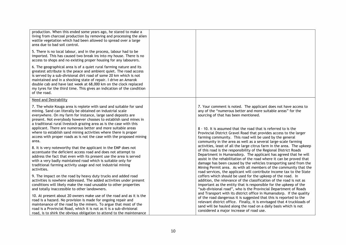
10
production. When this ended some years ago, he stared to make a living from charcoal production by removing and processing the alien wattle vegetation which had been allowed to spread over a large area due to bad soil control.
5. There is no local labour, and in the process, labour had to be imported. This has caused two break ins into my house. There is no access to shops and no existing proper housing for any labourers.
6. The geographical area is of a quiet rural farming nature and its greatest attribute is the peace and ambient quiet. The road access is served by a sub-divisional dirt road of some 20 km which is not maintained and in a shocking state of repair. I drive an Amarok double cab and have last week at 68,000 km on the clock replaced my tyres for the third time. This gives an indication of the condition of the road.
Need and Desirability
7. The whole Kouga area is replete with sand and suitable for sand mining. Sand can literally be obtained on industrial scale everywhere. On my farm for instance, large sand deposits are present. Not everybody however chooses to establish sand mines in a traditional rural livestock grazing area as is the case with this applicant. There are numerous better and more suitable areas where to establish sand mining activities where there is proper access with proper roads as is not the case with the proposed mining area.
8. It is very noteworthy that the applicant in the EMP does not accentuate the deficient access road and does not attempt to address the fact that even with its present use the area is served with a very badly maintained road which is suitable only for traditional farming activity usage and not industrial mining activities.
9. The impact on the road by heavy duty trucks and added road activities is nowhere addressed. The added activities under present conditions will likely make the road unusable to other properties and totally inaccessible to other landowners.
10. At present about 20 owners make use of the road and as it is the road is a hazard. No provision is made for ongoing repair and maintenance of the road by the miners. To argue that most of the road is a Provincial Road, which it is not as it is a sub-divisional road, is to shirk the obvious obligation to attend to the maintenance
7. Your comment is noted. The applicant does not have access to any of the “numerous better and more suitable areas” for the sourcing of that has been mentioned.
8 - 10. It is assumed that the road that is referred to is the Provincial District Gravel Road that provides access to the larger farming community. This road will be used by the general community in the area as well as a several large-scale farming activities, least of all the large citrus farm in the area. The upkeep of this road is the responsibility of the Regional District Roads Department in Humansdorp. The applicant has agreed that he will assist in the rehabilitation of the road where it can be proved that damage has been caused by the vehicles transporting sand from the Mining Permit area. As with all members of the community that the road services, the applicant will contribute income tax to the State coffers which should be used for the upkeep of the road. In addition, the relevance of the classification of the road is not as important as the entity that is responsible for the upkeep of the “sub-divisional road”, who is the Provincial Department of Roads and Transport with its district office in Humansdorp. If the quality of the road dangerous it is suggested that this is reported to the relevant district office. Finally, it is envisaged that 4 truckloads of sand will be hauled along the road on a daily basis which is not considered a major increase of road use.

11
and upkeep of the road if you know full well that you will use heavy trucks and that you will damage the road for other road users. To fail to deal with maintenance and upkeep of the road in the report is to ignore the factual situation that the road is not maintained by the authorities.
Construction Phase
11. Very few people live in the geographical area and there are no human settlements close by. The area is of a rural nature, fit only for traditional farming activities. To refer to “Job Creation” as being a reason for establishing an industrial mining activity in the area is a ruse and pandering to sentiment which is out of place.
12. Any job creation would involve relocation of external labour to the area with the associated social problems accompanying such activity. In the past the owner has made use of unregistered foreign labour which speaks for itself.
13. There are no local people for whom employment is to be created and the applicant is challenged to provide a list of any local inhabitants who would be employed.
11. The operation will provide employment for approximately 3 workers, who will not be housed on site.
12 - 13. The applicant will bring the required labour to the sand mining area on a daily basis and will not make use of any ineligible labour.
Operational Phase
14. What has been stated above is also relevant hereto. The statement that the development would be to the “Benefit of the local Municipality by reducing the cost of sand” however deserves some comment. The cost of sand from the proposed area would have to factor in the cost of transporting the sand over a 20 km unsuitable and badly maintained dirt road which is not fit for such purpose.
15. The economic impact of the further deterioration of the dirt road is never even referred to, but will definitely, on any logical economic basis not lead to the reduction of the cost of sand, but to the increase of such costs. Interestingly, no mention is made of how many existing sand mines already exist in the area nor of their location.
16. Very disconcertingly the Applicant does not refer to the relevant dirt road, puts no plan in place for the ongoing upgrading and maintenance thereof and the obvious impact thereon that the industrialised movement of trucks which are not of a rural agricultural type will have on the road is not dealt with at all. The
14 - 16. It is assumed that the road that is referred to is the Provincial District Gravel Road that provides access to the larger farming community. This road will be used by the general community in the area as well as a several large-scale farming activities, least of all the large citrus farm in the area. The upkeep of this road is the responsibility of the Regional District Roads Department in Humansdorp. The applicant has agreed that he will assist in the rehabilitation of the road where it can be proved that damage has been caused by the vehicles transporting sand from the Mining Permit area. As with all members of the community that the road services, the applicant will contribute income tax to the State coffers which should be used for the upkeep of the road. In addition, the relevance of the classification of the road is not as important as the entity that is responsible for the upkeep of the “sub-divisional road”, who is the Provincial Department of Roads and Transport with its district office in Humansdorp. If the quality of the road dangerous it is suggested that this is reported to the relevant district office. Finally, it is envisaged that 4 truckloads of

12
inescapable conclusion is that the other road users will have to bear the consequences of the Applicant’s activities.
sand will be hauled along the road on a daily basis which is not considered a major increase of road use.
Random Comments
17. Ad 4 – See the comments above
18. Ad 6.4- No mention is made of the fact that the site is situated right on top of the Greater Baviaans Aquifer and the possible impact thereon.
19. Ad 8.2.8 To describe the road as having been designed according to provincial road standards is to ignore the realities and the present state thereof. To state that the applicant will assist “where feasibly possible” to maintain and repair is equal to saying absolutely nothing will be done to attend to the inevitable deterioration which will be caused by the Applicant’s trucking activities.
20. Ad 8.2.10 As already stated there is no “local community” to benefit.
21. Ad 8.2 11 The ambient noise level in the area is zero. You can literally hear a normal car driving kilometres away. The rattle and clang of industrial machinery and trucks will destroy the ambient noise level and peace and quiet in the area forever.
22. The area is situated next to a nature reserve. No mention is made of this in the application. Environmental impact incidents will under the circumstance occur every day that the rattle and clang of the activities disturb the natural peace and quiet. The activities are not suitable for the area.
23. The remaining report and annexures are not dealt with specifically as all the issues already dealt with are only repeated therein under different headings.
17. Comments addressed above.
18. Based on the impacts assessed in Section 8 of the BAR, the impact on the groundwater is negligible.
19. The condition of the road is the responsibility of the Provincial Department of Roads and Transport to maintain, however the applicant will assist where feasible and where proof can be provided that the damage to the road was caused by the trucks servicing the sand mine.
20. It is envisaged that 3 employment opportunities will be generated for the mining operation, which would indeed benefit those employees and their families.
21. Section 8 of the Draft BAR, as well as the EMPr (appendix E to the Draft BAR) details the noise mitigation measures to be implemented. Due to the scale of mining that is proposed, it is not anticipated to have a significant impact.
22. According to the Register of Protected Areas available from the Department of Forestry, Fisheries and Environment (https://dffeportal.environment.gov.za/portal/apps/webappviewer/index.html?id=7e27f116dd194c1f9d446dacc76fe483, the nearest Reserves are African Whisper Game Reserve (approximately 9.5km to the east of the proposed site), Honeyville Ecovillage and Nature Reserve (approximately 10.35km to the south east), Thaba Manzi Game Farm (approximately 13.5km to the southwest) and Jumanji Game Farm (16.8km to the southwest).

13
23. Comment is noted.
1 Identification
This document contains comments on the Draft Basic Assessment Report (DBAR): Mining of Sand on Portion 8 of Farm Kruisfontein No 193, Humansdorp, Eastern Cape dd May 2022, GCS Project Number: 21-0703, DMRE Ref No: EC30/5/1/3/2/10704MP, and Appendices thereto.
Hester van Rooyen Letter dated 14 June 2022, attached to email from H Nel on 27 June 2022.
No response required.
2 Introduction
I, Martha Hester van Rooyen, ID 570211 0015 084, am the owner of portion 2 of the farm Kruisfontein No 193, Humansdorp, Eastern Cape, which borders directly on portion 8. I grew up on another neighbouring farm, now owned and actively farmed by my brother Jan van Rooyen. I know the area well, including its climate, fauna, flora and general rural character.
No response required.
3 Flaws and Omissions in the DBAR
3.1 Hydrology and Aquatic Features
I refer to section 6.4 and various other sections in the document. The study failed to recognize that the mining area is, in normal rainfall years, actually a vlei and becomes impassable for vehicles and machinery. The two agricultural dams mentioned are indeed fed from the vlei and are essential water sources for livestock and wild animals. Mr David Phillips is well aware of this fact - my brother had to tow his vehicles from the mud as recently as 2015.
It is general knowledge that the area has experienced a severe 7 year drought, but we all trust that these conditions will not prevail much longer and normal rainfall will return.
3.2 Climate
Section 6.2 states rainfall mostly in spring and autumn; Table 5.2 in the draft EMP refers to the area as summer rainfall and dry season in winter; Table 5.22 refers to November - January as the wet season. These are simply wrong - the area is predominantly a winter rainfall region, with summers getting dryer.
According to the Department of Agricultural Technical Services, the average annual rainfall for the region is 585 mm, somewhat lower than the stated figures.
3.1. An aquatic study was undertaken (Appendix B). According to the NFEPA database, there are no wetland features within the boundaries of the permit area, or within 100m of the site boundary. A site visit undertaken by the specialist verified this finding.
3.2 This will be addressed and rectified in the FBAR where necessary.
3.3 The reports relate to the 5ha Mining Permit application area and the direct impacts on this area as well as the cumulative impacts on the larger environment. As the activities associated with the Mining Permit that may affect the fauna and flora is limited to the 5ha footprint, it is not necessary to consider the larger area in this regard.
3.4 The maps that are provided in the documentation was done in accordance with the requirements of the National Environmental Management Act (Act No. 107 of 1998): Environmental Impact Assessment Regulations (2014), as amended. The 5ha area is located within the farm boundaries of an existing farm with the coordinates provided on the maps as well as in the text in the

14
The average midday temperature in February is much higher than the 25 °C stated, lately in the high thirties and even forties.
The report also fails to mention that very strong winds blow from time to time, known to uplift soil even from cultivated fields.
3.3 Too narrow spatial scale
The report was written on the mining area in isolation, not taking the adverse effect on the surrounding area into account. The mining area is currently in a bad state due to years of black wattle invasion, neglect and bad farming practices. Of course there are hardly any indigenous fauna and flora in the demarcated area, but the same is not at all true for the surrounding areas, which are actively farmed.
The report completely fails to convey the impact of the proposed mining activities on the neighbouring farms and even on the region - the agriculture, fauna, flora, biodiversity and living conditions on all neighbouring farms will be negatively impacted by the dust, air pollution, soil and groundwater pollution, noise and increased human presence caused by the proposed mining activities. In terms of dust, road deterioration and noise, all neighbouring farm owners and all farm owners adjacent to the complete section of dirt road used by the trucks, will be seriously disadvantaged.
3.4 Failure to show farm boundaries
No farm boundaries are shown on the maps and images provided, failing to convey to the public how close the proposed mining area is to neighbouring farms, and how many other farm owners will be adversely affected.
3.5 Missing operational figures
The extent of the proposed mining operation is not mentioned, for example:
• how many truck loads of sand per day?
• how many workers on an average day?
• will the workers stay on site?
3.6 Wrong assumptions about road conditions
The report states that 'The road is designed according to the specifications of a provincial road '. While this may be true for the
documents provided for PPP. As such, the location and extent of the Mining Permit area could easily have been determined by any member of public that whished to find the site.
3.5 This has been addressed in the FBAR, please refer to section 2.
3.6 The road is designed according to the specifications of a provincial road. The applicant will assist where feasibly possible to repair and maintain the road. On site, the existing farm access road off the provincial road.
3.7 The enforcement of the management and mitigation measures are the responsibility of the Compliance and Enforcement Section of the Department of Mineral Resources and Energy.
3.8 It can be confirmed that the Applicant for the Mining Permit has no intention of making use of any unregistered foreign labour. Furthermore, a maximum of 3 workers will be required and will not stay on site.
3.9 The requirement for a Financial Guarantee for Rehabilitation is issued as a condition of the Mining Permit. As such, the trust fund will need to be in place before the Mining Permit will be issued by the relevant authority. The compliance with the requirement of the decommissioning and rehabilitation is the responsibility of the relevant authority.

15
design, it certainly is not true for the maintenance. The dirt provincial road, from the point where it turns off the tarred road to Hankey, is in a shocking state of disrepair and hardly gives access to the local farming community as it is. The road gives access to about 20 farm properties. It cannot possibly, even from a layman’s perspective, handle additional traffic in the form of heavy trucks.
3.7 Impractical Mitigation measures
The various mitigation measures may be a good paper exercise, but is totally impractical in the area concerned. Besides, these are suggestions rather than enforcible measures. To mention a few: there is not sufficient water to control dust, neither at the excavation site, nor along the dirt road - this will simply not be done; portable toilets will not be cleaned regularly, if they will be erected at all, resulting in pollution of soil and underground water; noise reduction, a private security company, perimeter fencing, site supervision, covering of top soil, etc will simply be too cumbersome and costly and will not be adhered to, as is the case with other operational quarry sites in the region.
A complaints register is useless, as complaints will not be taken seriously. This will leave the onus on neighbouring farmers to take legal action against the developers and operators, which they do not have the time and money for.
3.8 Labour
There is no guarantee that local labour will be used. It is known that Mr David Phillips has made use of unregistered alien labourers which has perpetrated a housebreaking incident on a neighbouring property in the past.
3.9 Decommissioning
Appendix F states that decommissioning of the mine and specifically removal of alien vegetation will have a positive outcome on the environment - you certainly do not need to excavate an open cast mine to rehabilitate the area!
While Table 7-1 of the EMP indicates a preliminary closure cost, it is nowhere stated that funds for this purpose will be held in a trust account from the beginning of operations - there is thus no guarantee that any decommissioning actions will be performed.

16
4 Objection to the Proposed Mining Activities
The basis of my objection to the proposed mining activities, in no particular order, is listed below.
4.1 Natural vleiland
The natural vleiland in the proposed mining area will be permanently damaged, causing erosion and affecting the natural hydrology and ecosystem in the region.
4.2 Dust and sand
The dust from excavation, stored stockpiles and transportation will be deposited on cultivated fields and veld of neighbouring farms, damaging or even destroying crops and natural vegetation and thus adversely affecting grazing livestock and wild animals. The same holds for sand and soil uplifted by strong winds. The proposed site is less than 100m away from cultivated fields on the farm of Jan van Rooyen. The dust may also affect the health of residents close to the access road.
4.3 Air and soil pollution
The trucks and machinery used in the operations will pollute the clear farm air with carbon dioxide and other substances, to be inhaled and smelled by humans and animals alike.
Spillages from trucks and machinery and failure to use toilet facilities will pollute soil and ground water.
4.4 Noise
The noise from trucks, machinery and the operations in general as well as increased human activity will be a disturbance in the houses of farmers and farm workers, some of which are close to the mining site, and be detrimental to livestock and wild animals in the surrounding area.
There are still a few Cape Grysbok (Raphicerus melanotis) in the area (almost extinct in the Eastern Cape), as well as grey duiker - both species breed throughout the year, and will probably relocate to quieter, but not necessarily safe, areas.
4.5 Property values
4.1 An aquatic study was undertaken (Appendix B). According to the NFEPA database, there are no wetland features within the boundaries of the permit area, or within 100m of the site boundary. A site visit undertaken by the specialist verified this finding.
4.2 Section 8 of the FBAR, as well as the EMPr (Appendix E to the FBAR), indicate appropriate mitigation measures to be followed, to minimize the impact of dust on surrounding areas.
4.3 It is expected that 4 truck loads of sand will be removed from site each day.
Appropriate mitigation measures have been included in Section 8 of the BAR and the EMPr to address these potential impacts.
4.4 Management and mitigation measures to limit the impact of noise on the environment is provided in the EMPR. The presence of Cape Grysbok (Raphicerus melantis) is noted and it is likely that they will initially move away from the area, but will most certainly return again.
4.5 In the absence of any substantiation of this statement, the comment is noted as no response in this regard can be generated without proof that the property values will be affected.
4.6 In the absence of any substantiation of this statement, the comment is noted as no response in this regard can be generated without proof that the property values will be affected.
4.7 Comment is noted. The EMPR places the responsibility on the vehicles servicing the mining activities to obey all traffic regulations such as speed limits and adherence to road signs.
4.8 The mining operations are limited to a 5ha area in a very large landscape. The compliance with the management and mitigation

17
Property values of neighbouring farms will drop as a result of the industrialization and disturbance to the rural environment. The living quality of neighbours will be adversely affected.
4.6 Poaching and crime
It is expected that poaching and crime will increase in the area due to increased presence of non-local people.
4.7 The access road
The increased traffic will render the already bad provincial road impassable. Slow moving wide vehicles will cause traffic disruption and unsafe road conditions.
4.8 Overall Effect on the Environment
The adverse effect on the environment and local farm owners and residents is expected to be much worse than that stated in the report, mainly for two reasons: the spatial scale used in the analysis should have a higher weight, 2 or even 3 in most cases; and there is no guarantee that the recommended mitigation measures will be implemented.
measures included in the EMPR is the responsibility of the relevant authority. If any such non-compliances are observed, it can be reported to the Compliance and Monitoring Section of the Department of Mineral Resources and Energy.
5 Conclusion
As a party to be directly affected by the proposed mining activities, I strongly object to the proposed sand mine.I reserve my rights to amplify my objection if and when additional information becomes available.
Your stance has been noted.
Hiermee wil ek my besware teen die beplande Sandmyn langs my eiendom se grens deur Kouga Sand indien.
1. Die betrokke area is direk langs my eiendom se grens geleë alhoewel daar geen duidelike grens heinings op die betrokke kaart gesien kan word nie. Ek boer intensief op aangeplante weiding met hoë gehalte wol aangrensend tot die gebied. Die stof en geraas wat uit so ‘n myn bedrywigheid voortspruit kan tot groot verliese aan inkomste vir my lei. Dit is geleë in ‘n gebied met baie wind wat stofbesoedeling etlike honderde meters meebring.
2. Aangesien die beöogde myn direk land my eiendom se grensheining is sal die ‘n uiterse negatiewe impak op die waarde van my eiendom hê.
Jan van Rooyen Letter sent by email, attached to email from H Nel on 27 June 2022.
1. Section 8 of the FBAR, as well as the EMPr (Appendix E to the FBAR), indicate appropriate mitigation measures to be followed, to minimize the impact of dust and noise on surrounding areas.
2. No proof is provided as to how the location of the 5ha Mining Permit area will adversely impact the property value of the much larger neighbouring farm. In the absence of any substantiating proof it is very difficult to provide a response in this regard. However, it stands to reason that if sand deposits are also present on the neighbouring farm, the value of the land could likely be increased.

18
3. Die geraas wat die myn bedrywighede meebring sal ‘n negatiewe uitwerking op my skape hê wat aangrensend wei.
4. Die myn is in ‘n vleiland gebied geleë. Die gebied is nou droog weens die afgelope dewe jaar se lae reënval. In normale jare is dit ‘n vlei wat dien as ‘n kosbare bron van water vir die veë suipings laer af. Die water beland uiteindelik in die Gamtoosriver wat onder hoë druk is. Die gemiddelde reen val in die gebied is 580mm en nie soos aangedui in die aansoek nie.
5. Die openbare toegangsroete tot die gebied is nie geskik vir swaar voertuie nie en op plekke slegs 3.9 wyd. Die pad word swak onderhou en is die enigste roete tot my eiendom. ‘n Gedeelte van die roete is sleg as ‘n onder geskikte pad wat ek self moet onderhou.
6. Die stof wat die swaar voertuie teweeg bring het ‘n baie negatiewe uitwerking op die fynbos veld vir etlike 100 meter langs die pad.
7. Die kwessie van werkskapping in die gebied is debateerbaar aangesien Mnr Phillips slegs van Zimbabiese burgers gebruik maak.
3. Many mining activities are present on the verges of agricultural land where livestock is farmed. In the absence of any supporting information as to how the mining activities are considered to impact on the livestock, it is difficult to provide a response in this regard.
4. An aquatic study was undertaken (Appendix B). According to the NFEPA database, there are no wetland features within the boundaries of the permit area, or within 100m of the site boundary. A site visit undertaken by the specialist verified this finding.
5. The comment is noted, but as mentioned before, the road is a Provincial Road with the upkeep and maintenance responsibility of the road being with the Provincial Department of Roads and Transport.
6. The area on each side of the road is disturbed.
7. It can be confirmed that the Applicant for the Mining Permit has no intention of making use of any unregistered foreign labour. Furthermore, a maximum of 3 workers will be required and will not stay on site.
Below find my findings with regards to the draft report.
Access Roads:
The current state of the roads can barely handle the current daily traffic. The access roads haven’t been graded by the Local Municipality for the last 2 years. The contractor will have to make means in his budget to maintain the current access road leading from the R330 to the site. With heavy loads on a constant basis the road will not be suitable for any traffic. The current farm road leading from the R330 is not suitable for double lane traffic and this will increase the risk of accidents, the current signage as per the regulation is not up to standard and will have to be dealt with accordingly by the contractor.
Dust pollution will have a negative impact on the local farming community, animals, and vegetation while heavy load will be
Maryna Erasmus Letter sent by email on 1 July 2022.
The road is designed according to the specifications of a provincial road. Although roads are the responsibility of the Kouga Local Municipality to maintain, the applicant will assist where feasibly possible to repair and maintain the road.
Section 8 of the FBAR, as well as the EMPr (Appendix E to the FBAR), indicate appropriate mitigation measures to be followed, to minimize the impact of dust and noise on surrounding areas.

19
transported. Being in a water scares area and not being allowed to take water from any natural water course, dust control will not be an option.
Construction Activities:
Below activities is duly noted in draft report as per reference number above:
• Materials to be sorted by screening or washing
• No water to be used during mining process
• Open cast mine
• Stockpile of topsoil
• Increase in heavy vehicles
• Employment opportunities
When washing material water will be required, with increase in traffic dust control will have to be implemented on a daily basis to ensure all construction workers, local community and animals stay safe. Being it an open cast mine and topsoil being stockpiled, necessary precautions will have to be made to ensure no wind erosion or dust pollution take place. The increase in traffic close to the community is a huge problem this will increase the possibility of stock theft and or even worse murders. With no water to be used during the construction process I cannot see this being solved in any other way, the site will be located in a water scares area and also not allowed to take water from natural water course, this project cannot continue.
New employment opportunities will be minimum due to most of the works will be subcontracted out. The local community will not benefit from any of this.
The increase of noise will have a huge impact on the local community and animals, especially adjacent neighbours, this is a very quiet and peaceful area. In this area all residents strive to conserve the area.
The draft is for the mining site area, however the mining will affect the surrounding area as well. With an increase in people and vehicles, the area will be littered. Animals will move out of the area due to the increase of movement. Littering will be a huge risk to wild animals as animals might ingest plastic, causing the animal so
Section 8 of the FBAR, as well as the EMPr (Appendix E to the FBAR), indicate appropriate mitigation measures to be followed, to minimize all impacts on surrounding areas. Refer to these sections for more detail on the measures to be implemented.
The mining operations are limited to a 5ha area in a very large landscape. The compliance with the management and mitigation measures included in the EMPR is the responsibility of the relevant authority. If any such non-compliances are observed, it can be reported to the Compliance and Monitoring Section of the Department of Mineral Resources and Energy.
It can be confirmed that the Applicant for the Mining Permit has no intention of making use of any unregistered foreign labour. Furthermore, a maximum of 3 workers will be required and will not stay on site.

20
suffocate. Tin can cut the legs and hooves of roaming animals. These cuts will be badly infected if not treated and there is no easy way to treat a wild animal. Glass laying around can start wildfires especially when the veld is dry. The vegetation in this area burns easily when dry.
Wildfires is ‘n high risk for animals and residents.
With topsoil being blowen away by wind how will rehabilitation take place after construction? It is extremely important to have plants covering the topsoil, as the plant material prevent the wind to cause erosion. Erosion is already a huge problem in South Africa, and we need to prevent it in any way possible.
This project will have a huge impact on the environment. The impact will not only be on the designated construction areas but will be all along the access roads.
Method statements will not be adhered to and followed due to the lack of resources.
Site Location:
With the access roads already not being in a good state, this project will not be cost effective and profitable to continue with. The damage to the road will cause damage to the trucks. To maintain the trucks will be at a huge cost. The location of the mining area next to portion 8, farm Quarrie Kraal, number 149, Kouga Municipality will not be feasible as there is a lot of livestock, the dust and noise will have a huge impact in the productivity of these animals.
The additional sand mine added will not be of a good choice, in fact, this will increase the local price of sand.
There is so many negative impacts for both the environment, residents and Kouga Sand, that I feel it is not worth it to go ahead with the mining. I hereby object to the proposed open cast mine – Kouga Sand
The access road to the Mining Permit area is a Provincial Road, the maintenance of which is the responsibility of the Provincial Department of Roads and Transport. The applicant is well aware of the state of the road and is of the belief that material can be hauled from the site in a cost effective manner.
Your stance is noted

21
APPENDIX A: DATABASE

Sector Name Surname Company Tel Mobile E-mail
Provincial Authority Hlomiphile Dlamini DMRE
Provincial Authority Zukile Pityi Land Claims Commissioner
Provincial Authority Roads and Public works
Provincial Authority Thandolwethu Manda Roads and Public works
Provincial Authority Thembani Nyokana Rural Development and Land Reform
Provincial Authority Dayalan Govender EDEAT
Provincial Authority Mandilake Zenzile DWS
Provincial Authority Bolekwa Kama DWS
Provincial Authority Lwazikazi Dimbaza DWS
Provincial Authority ECPRA
Municipality Jacques Alexander Ward 4 councillor
Adjacent Landowner Heinrich Nel
Adjacent Landowner Hester van Rooyen
Adjacent Landowner Jan van Rooyen
Adjacent Landowner Maryna Erasmus
Interested and Affected Parties Ansa de Jager
Interested and Affected Parties Willem van Vuuren
Interested and Affected Parties Zak Venter
Interested and Affected Parties Kobus Reichert Gamtkwa Khoisan Council
Interested and Affected Parties Cynthia AugustGamtkwa Khoisan Council
Chairperson/ Ward Councillor (Hankey)

22
APPENDIX B: ADVERTISEMENT

10 Kouga Express CLASSIFIEDS | GEKLASSIFISEERD 17 February 2022
042 293 2973 F: 042 293 3957
Geklassifiseerd EX KOUGA
20 000 COPIES WEEKLY
press
FOR ANY PERSONAL ASSISTANCE WITHYOUR KOUGA EXPRESS ADVERTISING.
General, Property, Notices,Vacancy and ClassifiedAdverts
Please Contact
TAMMARINE SCHARNECK
T: 042 293 2973 F: 042 293 3957
Email: [email protected]
C. DU PLESSISMUNCIPALMANAGER
P. O. Box 21 | JEFFREYS BAY | 6330SONDLO & KNOPP ADVERTISING
KOUGAl o c a l m u n i c i p a l i t yGood Governance through Service Excellence
KOUGAMUNICIPALITY (EC108)NOTICE NUMBER: 31/2022DRAFTANNUALREPORT
Notice is herewith given in terms of Section 127of the Municipal Finance Management Act, 56 of2003 that the Council of Kouga Local Municipalityat its meeting held on 31 January 2022, adopted the2020/21 Draft Annual Report.
The report will be available for public scrutiny andcomments on the following platforms: • KougaMunicipal Offices and Libraries (Jeffreys Bay,Humansdorp, St Francis Bay, Hankey and Patensie)during normal office hours from Thursday 17February 2022.
• Municipal Website at www.kouga.gov.za• Email at [email protected]
Members of the public and interested parties areinvited to submit written comments on the 2020/21Draft Annual Report, comments to reach the Officeof the Municipal Manager by no later than 12:00pm on Friday 4 March 2022.
Written comments may also be submitted pere-mail to [email protected] on or before 12:00pm on Friday 4 March 2022.
In terms of the provisions of Section 21 of theMunicipal Systems Act, 32 of 2000, communitymembers who are not able to read or write andhave inputs and comments may request assistanceat their respective Ward Councillor’s office whichwill enable them to make such submissions.All comments submitted must be clearlymarked:
COMMENTS ON THE 2020/2021 DRAFTANNUALREPORT
NOTIFICATION OF AN APPLICATION FOR ENVIRONMENTALAUTHORISATION PROCESS IN TERMS OF THE NATIONALENVIRONMENTAL MANAGEMENT ACT (ACT NO. 107 OF 1998):ENVIRONMENTAL IMPACT ASSESSMENT REGULATIONS (2014), ASAMENDED FOR THE PROPOSED KOUGA SAND OPERATIONS ON APORTIONOFTHEFARMKRUISFONTEINNO. 193, NEARHUMANSDORP
GCS Ref No: 21-0703 DMRE Ref No: EC30/5/1/3/2/10704MP
Background and Project DescriptionKouga Sand proposes to open a building sand mine on a portion of the Farm Kruisfontein No. 193,approximately 19km northwest of Humansdorp. The Mining Permit will be used for the mining of buildingsand from the application area. The mining will be conducted as an opencast operation with the sandremoved at surface and put through a screen to remove all root material from the sand. The excavation willbe conducted with an excavator with the saleable product being removed off site with tipper trucks. Anaccess road to the application area already exists in the form of a farm road.
Activities for which Environmental Authorisation is being sought:The Project triggers the following potential Listed Activities in terms of the NEMA EIA Regulations (2014,as amended):
• GN R327, 07 April 2017, Listing Notice 1 – Activities 21, 22(i) and 27.
As such, the Application for Environmental Authorisation will take the form of a Basic Assessment Processas specified in the NEMA: EIA Regulations.
Project Progress and Participation:GCS Water and Environmental Consultants (Pty) Ltd (GCS), has been appointed to undertake thenecessary environmental processes for the above-mentioned Project and this notification forms part of thepublic consultation process as required by the NEMA EIA Regulations (2014, as amended). An Applicationfor Environmental Authorisation has been lodged with the Competent Authority and a Draft BasicAssessment Report has been compiled.
Opportunity to Participate:GCS Water and Environmental Consultants (Pty) Ltd (GCS), has been appointed to undertake theApplication for Environmental Authorisation for the project and this notification forms part of the publicconsultation process as required by the NEMA EIA Regulations (2014, as amended). Interested andaffected parties are hereby invited to register as a stakeholder for this project.
How do I participate?:As per the NEMA: EIA Regulations (2014), as amended, interested and affected parties can register for theprocess by sending their name, contact details (phone number, email address, fax, etc.) and a clearstatement of interested in the application to the contact details below. Interested and affected parties arerequested to use the project reference number 21-0703 in their request for registration.
Please submit all comments directly to GCS, by using the contact details below:JaniceCallaghanTel: 031 764 7130E-mail: [email protected]: PO Box 819, Gillitts, 3603
X1X4AA2W-KG170222
X1X49F4D-KG170222
KOUKAMA MUNISIPALITEITOPROEP TOT ONDERSOEK VAN DIE 2021 ALGEMENE
WAARDASIEROL EN INDIENING VAN BESWAREKennis geskied hiermee ingevolge die bepalins van artikel 49(1)(a)(i)(ii)saamgelees met artikel 78(2) van die Wet op Nasionale Eiendomsbelasting,Nr. 6 van 2004, soos gewysig, dat die Koukamma Munisipaliteit se AlgemeneWaardasierol vir die tydperk 14 Februarie 2022 tot 31 Maart 2022 beskibaar isvir openbare ondersoek en die vorms vir die indiening van besware isverkrygbaar gedurende kantoorure van die munisipale kantoor in Kareedouw,Joubertina, Biblioteke en al die satelietkantore of op diemunisipalewebwerf bywww.koukammamunicipality.gov.zaNEEM ASB. KENNIS DIE SLUITINGSDATUM VIR DIE INDIENING VANBESWARE IS31MAART2022OM16:00.Ingevolge artikel 49(1)(a)(ii) saamgelees met artikel 78(2) van dieWet, word 'nuitnodiging gerig aan enige eiendomeienaar of ander persoon wat graag 'nbeswaar by die Munisipale Bestuurder wil indien ten opsigte van enigeonderwerp, insluitend die kategorie vervat of weggelaat van die waardasierolgedurende die bogemelde tydperk.Aandag word uitdruklik gerig op die bepaling in artikel 50(2) wat bepaal dat 'nbeswaar verwant aan 'n spesifieke individuele eiendom moet wees en niesodanig teen diewaardasierol nie.Aandag word verder gerig op die bepaling in artikel 50(3) wat bepaal dat diemunisipale bestuurder moet bystaan as beswaarmaker om 'n beswaar in tedien as die beswaarmaker nie kan lees of skryf nie. Persone wat bystandbenodig word genooi om gebruik te maak van hierdie diens deur dieInkomsterekenmeester (mnr. Thandile Fiki) gedurende kantoorure te kontak bydie munisipaliteit se Kareedouw-kantoor by telefoonnommer 042 288 7200/042 288 7256.Besware gemerk “Aandag Algemene Waardasiebesware” mag per e-posgestuur word na [email protected] of per geregistreerde pos na:Privaat Saak X011, Kareedouw 6400 of per hand afgelewer by: KoukammaMunicipalitieit, Keetstraat 5, Kareedouw.
…………………………..Mnr.M.P.KateMunisipaleBestuurder11FEBRUARIE2022
KOUKAMMA MUNICIPALITYNOTICE CALLING FOR INSPECTION OF 2021 GENERAL VALUATION
ROLL AND LODGING OF OBJECTIONNotice is hereby given in terms of the provision of Section 49(1)(a)(i)(ii) readtogether with section 78(2) of the Municipal Property RatesAct No 6 of 2004 asamended that the General Valuation Roll of the KoukammaMunicipality for the
th stperiod 14 February 2022 To 31 March 2022 is open for public inspectionand the forms for the lodging of objection are obtainable at theMunicipal Ofcesin Kareedouw, Joubertina, Libraries and all the satellite ofces during officehours orMunicipal website atwww.koukammamunicipality.gov.zaPLEASE NOTE THAT THE CLOSING DATE FOR THE LODGING OF
STOBJECTIONS ISTHE31 MARCH2022AT16H00.In terms of Section 49(1)(a)(ii) read with Section 78(2) of theAct, an invitation ishereby extended to any owner of property or other persons who so desires tolodge an objection with the Municipal Manager in respect of any matter,including the category, reflected in or omitted from the valuation roll during theabovementioned period.Attention is pertinently invited to the provision in Section 50((2) which stipulatesthat an objection must be in relation to a specific individual property and notagainst the valuation roll as such.Attention is further invited to the provision Section 50(3) which provides that theMunicipal Managermust assist an objector to lodge an objection if that objectoris unable to read or write. Persons requiring assistance are invited to make useof this service by contacting the Revenue Accountant (Mr Thandile Fiki) at theKareedouw Ofces of the municipality at telephone number 042 2887 200/042 2887 256 during office hours.Objections endorsed “Attention General Valuation Objections” can either bee-mailed to [email protected] Mail to: Private Bag X011, Kareedouw, 6400 or Hand delivered to:KoukammaMunicipality, 5 Keet Street, Kareedouw.
…………………………..MrM.PKateMunicipalManager11FEBRUARY2022
X1X4AA61-KG170222
STEP 1:
Check our websitewww.auctionone.co.za
and facebook page, Auction One to see what
we are about, the results we achieve and the
ultra-simple, yet effective way that we sell
houses by virtue of on-site or on-line
Auctions.
VERY IMPORTANT NOTICE!REAL ESTATE BUSINESS OPPORTUNITY.
WE HAVE ONE FRANCHISE LICENSE AVAILABLE FOR
NTREE PT RX EE NN ERR IU ALO CU HO AY ME PR IOA N?
Book your private and confidential interview slotby calling Justin on 0837892550 or email [email protected].
STEP 2:
Interested applicants should have:
1) NQF 4 or 5 Real Estate.
2) Property knowledge and keen interest in
people.
3) Ambitious and motivated.
4) Full training in house and back up
supported by head office.
JEFFREYS BAY ST FRANCIS BAY&

23
APPENDIX C: NOTIFICATION EMAIL

1
Janice Callaghan
From: Janice Callaghan
Sent: 31 May 2022 10:12 PM
Subject: Notification of Public Review Period - Application for Environmental Authorisation
and Mining Permit for Kouga Sand (EC30/5/1/3/2/10704MP)
Bcc:
Dear Registered Interested and Affected Party
NOTIFICATION OF AN APPLICATION FOR ENVIRONMENTAL AUTHORISATION IN TERMS OF THE NATIONAL
ENVIRONMENTAL MANAGEMENT ACT (ACT NO. 107 OF 1998): ENVIRONMENTAL IMPACT ASSESSMENT
REGULATIONS (2014) AS AMENDED AND A MINING PERMIT IN TERMS OF THE MINERAL AND PETROLEUM
RESOURCES DEVELOPMENT ACT (ACT 28 OR 2002) FOR THE PROPOSED KOUGA SAND OPERATIONS ON PORTION 8
OF THE FARM KRUISFONTEIN NO. 193, NEAR HUMANSDORP, EASTERN CAPE.
Kouga Sand proposes to open a building sand mine on Portion 8 of the Farm Kruisfontein No. 193, approximately
19km northwest of Humansdorp. The Mining Permit will be used for the mining of building sand from the
application area. The mining will be conducted as an opencast operation with the sand removed at surface and put
through a screen to remove all root material from the sand. The excavation will be conducted with an excavator
with the saleable product being removed off site with tipper trucks. An access road to the application area already
exists in the form of a farm road off the provincial road.
The Project triggers the following potential Listed Activities in terms of the NEMA EIA Regulations (2014, as
amended):
• GN R327, 07 April 2017, Listing Notice 1 – Activities 21, 22(i) and 27.
We would like to inform you of your opportunity to participate by providing comments and raising issues of concern
regarding the proposed application. The report and supporting documents are available for review and comment for
30 days from the date of this email, i.e. 31 May 2022 to 1 July 2022.
The report can also be downloaded from the GCS website: https://gcs-sa.biz/wp-content/uploads/2022/05/21-
0703-Kouga-Sand-DBAR-Draft-for-Public-Review-Upload.pdf
A hard copy version of the report is available upon request.
You are invited to submit your comments in writing to GCS by means of the following, with your name and contact
details no later than close of business on 1 July 2022:
Janice Callaghan
Tel: 031 764 7130
E-mail: [email protected]
Mail: PO Box 819, Gillitts, 3603
Please use the reference number 21-0703 in all correspondence.

2
Kind regards

1
Janice Callaghan
From: Microsoft Outlook
To:
Sent: 31 May 2022 10:12 PM
Subject: Relayed: Notification of Public Review Period - Application for Environmental
Authorisation and Mining Permit for Kouga Sand (EC30/5/1/3/2/10704MP)
Delivery to these recipients or groups is complete, but no delivery notification was sent by the destination server:

2
Subject: Notification of Public Review Period - Application for Environmental Authorisation and Mining Permit for Kouga Sand (EC30/5/1/3/2/10704MP)

24
APPENDIX D: SITE NOTICES

NOTIFICATION OF AN APPLICATION FOR ENVIRONMENTAL AUTHORISATION PROCESS IN TERMS OF THE NATIONAL ENVIRONMENTAL MANAGEMENT ACT (ACT NO. 107 OF 1998): ENVIRONMENTAL IMPACT ASSESSMENT REGULATIONS (2014), AS AMENDED FOR THE PROPOSED KOUGA SAND OPERATIONS ON A PORTION OF THE FARM KRUISFONTEIN NO. 193, NEAR HUMANSDORP
GCS REF NO: 21-0703
DMRE Ref No: EC30/5/1/3/2/10704MP
Background and Project Description: Kouga Sand proposes to open a building sand mine on a portion of the Farm Kruisfontein No. 193, approximately 19km northwest of Humansdorp. The Mining Permit will be used for the mining of building sand from the application area. The mining will be conducted as an opencast operation with the sand removed at surface and put through a screen to remove all root material from the sand. The excavation will be conducted with an excavator with the saleable product being removed off site with tipper trucks. An access road to the application area already exists in the form of a farm road. Activities for which Environmental Authorisation is being sought: The Project triggers the following potential Listed Activities in terms of the NEMA EIA Regulations (2014, as amended):
• GN R327, 07 April 2017, Listing Notice 1 – Activities 21, 22(i) and 27. As such, the Application for Environmental Authorisation will take the form of a Basic Assessment Process as specified in the NEMA: EIA Regulations. Opportunity to Participate: GCS Water and Environmental Consultants (Pty) Ltd (GCS), has been appointed to undertake the Application for Environmental Authorisation for the project and this notification forms part of the public consultation process as required by the NEMA EIA Regulations (2014, as amended). Interested and affected parties are hereby invited to register as a stakeholder for this project. How do I participate?: As per the NEMA: EIA Regulations (2014), as amended, interested and affected parties can register for the process by sending their name, contact details (phone number, email address, fax, etc.) and a clear statement of interested in the application to the contact details below. Interested and affected parties are requested to use the project reference number 21-0703 in their request for registration. Please submit all comments directly to GCS, by using the contact details below: Janice Callaghan Tel: 031 764 7130 E-mail: [email protected] Mail: PO Box 819, Gillitts, 3603

Figure 1: Locality map of the proposed Kouga Sand Operations

GCS Site Notice Locations
Project: Kouga Sands Mining Permit Application
GCS Reference Number: 21-0703
DMRE Reference Number: EC30/5/1/3/2/10704MP
Date placed: 15 February 2022
Image GPS Coordinates
33°53'7.03"S 24°41'8.99"E
33°52'48.77"S 24°40'44.39"E

Site Notice Locations

25
APPENDIX E: SUBMISSIONS FROM STAKEHOLDERS DURING PROJECT INCEPTION

1
Janice Callaghan
From: Janice Callaghan
Sent: 01 March 2022 04:08 PM
To: Ansa De Jager
Cc: Magnus Van Rooyen
Subject: RE: Objection of mining rights
Attachments: Kouga Sand Map of the Application Area.pdf
Good afternoon,
Thank you for your email below.
We will register you as an interested and affected party and ensure that all information that is generated through
the Application is forwarded to you.
Your email below will also be captured in the Comments and Responses Report that will be submitted with the
Application.
Please find attached a map indicating the location of the Application Area.
Kind regards
From: Ansa De Jager < >
Sent: 28 February 2022 03:28 PM
To: Janice Callaghan <[email protected]>
Subject: Fwd: Objection of mining rights
Please find attached
---------- Forwarded message ---------
From: Jan van Rooyen
Date: Mon, 28 Feb 2022, 14:48
Subject: Petisie nr 3
To: < >
Kleinfontein
HUMANSDORP
6300
23 Februarie 2022

2
GCS Water and Environment
Attention: Janice and Magnus
OBJECTION TO MINING RIGHTS APPLICATION
GSC Ref No 21-0703 DMRE Ref No EC30/5/1/3/2/10704MP
Good day,
I am the owner Portion of the Property known as Farm oukraal Kraal Nr 148 in the Kouga Munisipaliteit,
District Humansdorp, Eastern Province.
I herewith wish to object to the application for mining rights next to my farm as per the reference above.
Kindly acknowledge receipt and cornfirm that my objection has been noted against the application.
Statement of interest and objection.
1. The notice referred to above does not identify the relevant property with any measure of clarity.
2. The description of the relevant property does not show which portion of the farm it relates to. The Farm 193
Kruisfontein referred to has been divided into many portions.
The Google Maps Photo gives no coordinates.
3. I know the area and can see that it is close to my client’s farm but cannot identify the property. I suspect
that it is adjacent.
4. The description of the access road is incorrect as the area is served by a provincial dirt road and not a “farm
road” as indicated .The provincial dirt road to the area is about 17 kilometres long and is proclaimed as
such.
5. The provincial road is in a shocking state of disrepair and hardly gives access to the local farming community
as it is. The road gives access to about 20 farm properties. It cannot possibly, even from a layman’s
perspective handle additional traffic in the form of heavy trucks .
6. No indication is given as to the maintenance and repair obligations which will be required if heavy trucks use
the road.
7. I reserve my client’s rights to amplify its objections to the application upon receipt of the full application.
9. The area is a traditional rural farming community and the industrialisation thereof by mining activities will effect
its charater permanently.
Kind Regards

3
Jess de Jager

1
Janice Callaghan
From: Magnus Van Rooyen
Sent: 21 February 2022 10:04 AM
To:
Cc: Janice Callaghan; ;
Subject: RE: GCS Ref No 21-0703 DMRE Ref No EC30/5/1/3/2/10704MP
Good morning Mr van Vuuren,
You will be added to the Interested and Affected Party database and will be provided with all information that is
generated by the application.
All the best,
From: Willem van Vuuren < >
Sent: Monday, 21 February 2022 09:58
To: Magnus Van Rooyen <[email protected]>;
Cc: Janice Callaghan <[email protected]>; ;
Subject: Re: GCS Ref No 21-0703 DMRE Ref No EC30/5/1/3/2/10704MP
Good Morning
I represent Mooville Pty Ltd as Director.As affected party i would like to object to this matter aswell.
I agree to all reasons mentioned by Mr.Nel as well as this area has been a farming community for many
many years and industrialising this area does not sit well with current property owners.
Could you please register us as an affected and interested party.
Regards
Willem van Vuuren
From: Magnus Van Rooyen
Sent: Thursday, February 17, 2022 11:34 AM To:
Cc: Janice Callaghan ; ; ; Subject: RE: GCS Ref No 21-0703 DMRE Ref No EC30/5/1/3/2/10704MP
Good morning Mr Nel,
Your email below is acknowledged and recorded. You will be registered as an interested and affected party in this
application process.
For clarity, please find the site plan for the application area attached.
All further information regarding the application will be forwarded to you.
All the best,

2
Magnus Van Rooyen Technical Director Pr. Sci. Nat. (400335/11)
Tel +27 (0) 31 764 7130 Fax +27 (0) 31 764 7140 Cell 0842492365 Web www.gcs-sa.biz
Address 4a Old Main Road, Judges Walk, Kloof, 3610, KwaZulu-Natal, South Africa
Established in 1987
Water | Environmental | Geotechnical Engineering | Renewable Energy | GIS
From: < >
Sent: 17 February 2022 11:04 AM
To: Janice Callaghan <[email protected]>
Cc: ; Nel Mentz < >;
Subject: GCS Ref No 21-0703 DMRE Ref No EC30/5/1/3/2/10704MP
Good day,
I act on behalf of the owner of being the Hein Nel Familie
Trust.
Your undated above notice has today been brought to my attention by an adjacent interested party.
No other form of notification was received.
Kindly furnish me with a contact address at the DMRE in order that I can ensure that my objection to the application
is noted.
Kindly also furnish me with the full application as the notice which you sent out is deficient and misleading as will be
set out below.
Kindly acknowledge receipt and confirm that my objection has been noted against the application.
Statement of interest and objection.
1. The notice referred to above does not identify the relevant property with any measure of clarity.
2. The description of the relevant property does not show which portion of the farm it relates to. The Farm 193
Kruisfontein referred to has been divided into many portions.
The Google Maps Photo gives no coordinates.
3. I know the area and can see that it is close to my client’s farm but cannot identify the property. I suspect
that it is adjacent.
4. If that is the case I wish to record that the adjacent owner has made use of unregistered alien labourers
which has perpetrated a housebreaking incident on my client’s property in the past. Any escalation in
occupancy may exacerbate this threat.
5. The description of the access road is incorrect as the area is served by a provincial dirt road and not a “farm
road” as indicated .The provincial dirt road to the area is about 17 kilometres long and is proclaimed as
such.
6. The provincial road is in a shocking state of disrepair and hardly gives access to the local farming community
as it is. The road gives access to about 20 farm properties. It cannot possibly, even from a layman’s
perspective handle additional traffic in the form of heavy trucks .
7. No indication is given as to the maintenance and repair obligations which will be required if heavy trucks use
the road.
8. I reserve my client’s rights to amplify its objections to the application upon receipt of the full application.
Kindly acknowledge receipt hereof.
Groete/Regards
Hein Nel
Attorney : NelMentzSteynEllis Inc
3
Managing Trustee : Groenewald / Hein Nel Familie/ Ollie & Rhona Nel Familie Trusts
Curator and Member : NelMentz Likwidateurs CC
4 Siebert /14 Bureau Street
P O Box 440
Humansdorp 6300
Cell
Consider the environment before printing this email.
DISCLAIMER: The provisions of Section 11 of the Electronic Communications and Transactions Act 25 of 2002 apply to this email notice and make it enforceable and binding on the recipient/addressee. This email message (including attachments) contains information which may be confidential and/or legally privileged. Unless you are the intended recipient, you may not use, copy or disclose to anyone the message or any information contained in the message or from any attachments that were sent with this email, and If you have received this email message in error, please advise the sender by email, and delete the message. Unauthorised disclosure and/or use of information contained in this email may result in civil and criminal liability. Everything in this e-mail and attachments relating to the official business of GCS Water & Environment (Pty) Ltd (GCS) or any of its subsidiaries, is proprietary to the company. Caution should be observed in placing any reliance upon any information contained in this e-mail, which is not intended to be a representation or inducement to make any decision in relation to GCS after consultation with appropriate legal, regulatory, tax, technical, business, investment, financial, and accounting advisors. The e-mail address of the sender may not be used, copied, sold, disclosed or incorporated into any database or mailing list for spamming and/or other marketing purposes without the prior consent of GCS. Neither the sender of the e-mail, nor GCS shall be liable to any party for any direct, indirect or consequential damages, including, without limitation, loss of profit, interruption of business or loss of information, data or software or otherwise. No warranties are created or implied that an employee of GCS and/or a contractor of GCS is authorized to create and send this e-mail.

1
Janice Callaghan
From: Janice Callaghan
Sent: 23 February 2022 12:29 PM
To: ' '; Magnus Van Rooyen
Cc: ; ; ;
; ;
Subject: RE: GCS Ref No 21-0703 DMRE Ref No EC30/5/1/3/2/10704MP
Good day
Thank you for your comments.
You will be registered as an interested and affected party on this application and all documents that are prepared
through the process will be made available to you.
Your submission will also be captured in the Comments and Responses Report that will be submitted with the
Application.
Kind regards
-----Original Message-----
From:
Sent: 23 February 2022 12:14 PM
To: Janice Callaghan <[email protected]>; Magnus Van Rooyen <[email protected]>
Cc: ; ; ; ;
;
Subject: GCS Ref No 21-0703 DMRE Ref No EC30/5/1/3/2/10704MP
Good Morning
Kindly refer to attached document and reply as requested.
Kind regards
Hester van Rooyen

Pretoria0081
22 February 2022GCS Water and EnvironmentE-mail: Janice Callaghan <[email protected]>Attention: Magnus van Rooyen
OBJECTION TO MINING RIGHTS APPLICATIONGSC Ref No 21-0703 DMRE Ref No EC30/5/1/3/2/10704MP
Good day,
I am the owner of in the Kouga Municipality, District Humansdorp, Eastern Cape Province.
I herewith wish to object to the application for mining rights as per the reference above.
Kindly acknowledge receipt and confirm that my objection has been noted against the application.
Statement of interest and objection:
• The notice referred to above does not identify the relevant property with any measure of clarity.
• The description of the relevant property does not show which portion of the farm it relates to. The Farm 193 Kruisfontein referred to has been divided into many portions.
• The Google Maps Photo gives no coordinates.
• I know the area and can see that it is close to my farm but cannot identify the property. I suspect thatit is adjacent.
• If that is the case I wish to record that the adjacent owner has made use of unregistered alien labourers which has perpetrated a housebreaking incident on a neighbouring property in the past. Any escalation in occupancy may exacerbate this threat.
• The description of the access road is incorrect as the area is served by a provincial dirt road and not a “farm road” as indicated .The provincial dirt road to the area is about 17 kilometres long and is proclaimed as such.
• The provincial road is in a shocking state of disrepair and hardly gives access to the local farming community as it is. The road gives access to about 20 farm properties. It cannot possibly, even from a layman’s perspective, handle additional traffic in the form of heavy trucks .
• No indication is given as to the maintenance and repair obligations which will be required if heavy trucks use the road.
• The area is a traditional rural farming community and the industrialisation thereof by mining activities will affect its character permanently.
• The area has indigenous fynbos and mining activities will damage the fragile ecosystem.
• I reserve my rights to amplify my objections to the application upon receipt of the full application.
Kind Regards
Martha Hester van Rooyen

1
Janice Callaghan
From: Janice Callaghan
Sent: 23 February 2022 01:30 PM
To: Jan van Rooyen; Magnus Van Rooyen
Subject: RE: Correction of objection letter
Dear Jan
Thank you, noted and recorded.
Kind regards
From: Jan van Rooyen < >
Sent: 23 February 2022 01:24 PM
To: Magnus Van Rooyen <[email protected]>; Janice Callaghan <[email protected]>
Subject: Correction of objection letter
Goodday
This is a correction letter on 22 February 2022. Because I am the owner.
Sorry for the mistake.
Kind regards
Jan

6300
23 Februarie 2022
GCS Water and Environment
Attention: Janice and Magnus
OBJECTION TO MINING RIGHTS APPLICATION
GSC Ref No 21-0703 DMRE Ref No EC30/5/1/3/2/10704MP
Good day,
I am the owner of in the Kouga Munisipaliteit,
District Humansdorp, Eastern Province.
I herewith wish to object to the application for mining rights next to my farm as per the reference
above.
Kindly acknowledge receipt and cornfirm that my objection has been noted against the application.
Statement of interest and objection.
1. The notice referred to above does not identify the relevant property with any measure of
clarity.
2. The description of the relevant property does not show which portion of the farm it relates
to. The Farm 193 Kruisfontein referred to has been divided into many portions.
The Google Maps Photo gives no coordinates.
3. I know the area and can see that it is close to my client’s farm but cannot identify the
property. I suspect that it is adjacent.
4. The description of the access road is incorrect as the area is served by a provincial dirt road
and not a “farm road” as indicated .The provincial dirt road to the area is about 17 kilometres long
and is proclaimed as such.
5. The provincial road is in a shocking state of disrepair and hardly gives access to the local
farming community as it is. The road gives access to about 20 farm properties. It cannot possibly,
even from a layman’s perspective handle additional traffic in the form of heavy trucks .
6. No indication is given as to the maintenance and repair obligations which will be required if
heavy trucks use the road.
7. I reserve my client’s rights to amplify its objections to the application upon receipt of the
full application.
9. The area is a traditional rural farming community and the industrialisation thereof by mining
activities will effect its charater permanently.
Kind Regards
Jan Willem van Rooyen

1
Janice Callaghan
From: Janice Callaghan
Sent: 22 March 2022 10:55 AM
To: Maryna Erasmus
Cc: Magnus Van Rooyen
Subject: RE: OBJECTION TO MINING RIGHTS APPLICATION
Attachments: Kouga Sand Map of the Application Area.pdf
Good day,
Thank you for your email below.
We will register you as an interested and affected party and ensure that all information that is generated through
the Application is forwarded to you.
Your email below will also be captured in the Comments and Responses Report that will be submitted with the
Application.
Please find attached a map indicating the location of the Application Area.
Kind regards
From: Maryna Erasmus < >
Sent: 21 March 2022 09:46 PM
To: Janice Callaghan <[email protected]>
Subject: OBJECTION TO MINING RIGHTS APPLICATION
Good day Janice,
Please find attached my objection to mining rights as per notice GCS 21-0703.
Kind regards,
Maryna Erasmus

HUMANSDORP
6300
GCS Water and Environment
Attention: Janice Callaghan
OBJECTION TO MINING RIGHTS APPLICATION
GCS REF. NO.: 21-0703
DMRE Ref No.: EC30/5/1/3/2/10704MP
Good day,
I here with wish to object to the application to mining rights on farm Kruisfontein number 193 as per
the reference above.
Kindly acknowledge receipt and confirm that my objection has been noted against the application.
Statement of interest and objection:
1. There is not sufficient water on the applicant’s farm nor to any adjacent properties to do any
dust control to the mining area and the access road. The said area does have significant high
wind speeds and the removal of any vegetation and increase of traffic will increase dust
pollution to the area.
2. The access road will not be sufficient to handle heavy traffic. The existing access road is not wide
enough to handle double lane traffic and this will increase the possibility for accidents on the
road. The current road is also not maintained by the local municipality and the local residents
can barely use the road in its current state.
As per the notice I don’t see any maintenance plan to upgrade the access road.
3. As per the Google maps photo it does not show the exact area where the mining will take place.
As per my understanding this will be adjacent to portion 8, farm Quarrie Kraal, Number 149,
Kouga municipality. This area will not be sufficient as there is constant livestock next to this area.
The existing boundary fence will not be sufficient as an increase in people can lead to theft in the
community.
No specific coordinates have been given on the notice.

4. As it stands the area is very quiet and with the increase of heavy construction vehicles to this
area, this will be a huge impact on noise pollution.
5. The local residents and myself preserve the nature and wildlife of this area, therefor I feel that
the increase of people, construction vehicles, dust and noise will have a negative effect on the
nature and wildlife wellbeing.
As per my reasons above, I object to any mining as per notice.
Kind regards,
Maryna Erasmus

1
Janice Callaghan
From: Magnus Van Rooyen
Sent: 21 February 2022 05:59 PM
To: Zak Venter; Janice Callaghan
Subject: RE: GCS Ref No 21-0703 DMRE Ref No EC30/5/1/3/2/10704MP
Good afternoon Zak,
Thank you for your email below.
We will register you as an interested and affected party and ensure that all information that is generated through
the Application is forwarded to you.
Your email below will also be captured on the Comments and Responses Report that will be submitted with the
Application.
If you have any questions, please feel free to contact either myself or Janice.
All the best,
From: Zak Venter < >
Sent: Monday, 21 February 2022 17:40
To: Janice Callaghan <[email protected]>; Magnus Van Rooyen <[email protected]>
Subject: FW: GCS Ref No 21-0703 DMRE Ref No EC30/5/1/3/2/10704MP
To whom it may concern
As the developers of Honeyville Eco village and Nature Reserve We would like to formally and officially object to the
proposed application / development on the above mentioned property.
We currently own the Honeyville Nature reserve and eco village development, and this will bring serious unwanted
traffic and noise to the area, which directly affects and contradicts our conservation and rehabilitation values and
partnerships with Eastern cape parks board, and other affiliates.
We have very rare and precious wildlife and doing a lot of work to conserve and keep this in tact which will be
disturbed through these activities
We currently have home owners who bought into the peace and quiet that the nature reserve and eco village
offers.
Additionally The road is currently in a terrible state and cannot handle any additional movement and heavy trucks,
as well human activity in the area
Kindly acknowledge receipt and confirm that my objection has been noted against the application.
Much appreciated
Zak Venter

2
HONEYVILLE ECO RESERVE

1
Janice Callaghan
From: Janice Callaghan
Sent: 24 March 2022 06:27 PM
To: kobus reichert
Cc:
Subject: RE: Mining Permit Applications - Humansdorp, Eastern Cape
Dear Kobus
Thank you for the details.
We have added you both to our database, and will forward you the reports for comment when available.
Kind regards
From: kobus reichert < >
Sent: 24 March 2022 01:52 PM
To: Janice Callaghan <[email protected]>
Cc:
Subject: Re: Mining Permit Applications - Humansdorp, Eastern Cape
Dear Janice,
Thank you for your enquiry.
You can use the details below to register us on your database and you can use my e-mail address to
forward any notifications as well as Gavin's reports to enable us to submit comments with regard to
these applications.
I have cc'd our chairperson: Ms. Cynthia August (who is also a ward councillor in Hankey) in this e-
mail.
Best regards
Kobus Reichert
Gamtkwa Khoisan Council
Reg. no: 066-969 NPO
P.O Box 689
Jeffreys Bay
6330
Cell:
Tel/Fax:
On Thursday, March 24, 2022, 10:56:06 AM GMT+2, Janice Callaghan <[email protected]> wrote:
Dear Kobus
I trust this email finds you well.

2
We are busy with two projects in the Eastern Cape near Humansdorp, Gavin Anderson suggested I contact you. I would like to enquire if you are still the contact for the local Khoisan community in the area, to include in the I&AP database?
Kind regards
Janice Callaghan Junior Environmental Consultant
To help protect you r priv acy, Microsoft Office prevented automatic download of this picture from the Internet.GCS Water & Environmental
Tel +27 (0) 31 764 7130 Fax +27 (0) 31 764 7140 Cell
Web www.gcs-sa.biz
Address 4a Old Main Road, Judges Walk, Kloof, 3610, KwaZulu-Natal, South Africa
Established in 1987
Water | Environmental | Geotechnical Engineering | Renewable Energy | GIS
Consider the environment before printing this email.
DISCLAIMER: The provisions of Section 11 of the Electronic Communications and Transactions Act 25 of 2002 apply to this email notice and make it enforceable and binding on the recipient/addressee. This email message (including attachments) contains information which may be confidential and/or legally privileged. Unless you are the intended recipient, you may not use, copy or disclose to anyone the message or any information contained in the message or from any attachments that were sent with this email, and If you have received this email message in error, please advise the sender by email, and delete the message. Unauthorised disclosure and/or use of information contained in this email may result in civil and criminal liability. Everything in this e-mail and attachments relating to the official business of GCS Water & Environment (Pty) Ltd (GCS) or any of its subsidiaries, is proprietary to the company. Caution should be observed in placing any reliance upon any information contained in this e-mail, which is not intended to be a representation or inducement to make any decision in relation to GCS after consultation with appropriate legal, regulatory, tax, technical, business, investment, financial, and accounting advisors. The e-mail address of the sender may not be used, copied, sold, disclosed or incorporated into any database or mailing list for spamming and/or other marketing purposes without the prior consent of GCS. Neither the sender of the e-mail, nor GCS shall be liable to any party for any direct, indirect or consequential damages, including, without limitation, loss of profit, interruption of business or loss of information, data or software or otherwise. No warranties are created or implied that an employee of GCS and/or a contractor of GCS is authorized to create and send this e-mail.

26
APPENDIX F: SUBMISSIONS FROM STAKEHOLDERS ON THE DBAR

Re: Kouga Sand H Nel
GCS Project Nr: 21-0703 Boomkloof
DMRE No EC 30/5/1/3/2/10704MP 27 June 2022
General Objections to the proposed development: H Nel
1. Kindly refer to the objections of Jan and Hester Van Rooyen attached hereto. I addition I
wish to raise the following general objections.
2. I wish to emphasise that I am a direct neighbour to the relevant property. I know the area
intimately and have been living on the adjacent property since 2007.
3. At that time the only activity which took place on the proposed mining property was
livestock farming by the previous owner.
4. The present owner subsequently purchased the farm some 10 years ago and started off with
milk goat farming and cheese production. When this ended some years ago, he stared to
make a living from charcoal production by removing and processing the alien wattle
vegetation which had been allowed to spread over a large area due to bad soil control.
5. There is no local labour, and in the process, labour had to be imported. This has caused two
break ins into my house. There is no access to shops and no existing proper housing for any
labourers.
6. The geographical area is of a quiet rural farming nature and its greatest attribute is the
peace and ambient quiet. The road access is served by a sub-divisional dirt road of some 20
km which is not maintained and in a shocking state of repair. I drive an Amarok double cab
and have last week at 68,000 km on the clock replaced my tyres for the third time. This gives
an indication of the condition of the road.
Need and Desirability
7. The whole Kouga area is replete with sand and suitable for sand mining. Sand can literally be
obtained on industrial scale everywhere. On my farm for instance, large sand deposits are
present. Not everybody however chooses to establish sand mines in a traditional rural
livestock grazing area as is the case with this applicant. There are numerous better and more
suitable areas where to establish sand mining activities where there is proper access with
proper roads as is not the case with the proposed mining area.
8. It is very noteworthy that the applicant in the EMP does not accentuate the deficient access
road and does not attempt to address the fact that even with its present use the area is
served with a very badly maintained road which is suitable only for traditional farming
activity usage and not industrial mining activities.
9. The impact on the road by heavy duty trucks and added road activities is nowhere
addressed. The added activities under present conditions will likely make the road unusable
to other properties and totally inaccessible to other landowners.
10. At present about 20 owners make use of the road and as it is the road is a hazard. No
provision is made for ongoing repair and maintenance of the road by the miners. To argue
that most of the road is a Provincial Road, which it is not as it is a sub-divisional road, is to
shirk the obvious obligation to attend to the maintenance and upkeep of the road if you
know full well that you will use heavy trucks and that you will damage the road for other
road users. To fail to deal with maintenance and upkeep of the road in the report is to ignore
the factual situation that the road is not maintained by the authorities.
Construction Phase

11. Very few people live in the geographical area and there are no human settlements close by.
The area is of a rural nature, fit only for traditional farming activities. To refer to “Job
Creation” as being a reason for establishing an industrial mining activity in the area is a ruse
and pandering to sentiment which is out of place.
12. Any job creation would involve relocation of external labour to the area with the associated
social problems accompanying such activity. In the past the owner has made use of
unregistered foreign labour which speaks for itself.
13. There are no local people for whom employment is to be created and the applicant is
challenged to provide a list of any local inhabitants who would be employed.
Operational Phase
14. What has been stated above is also relevant hereto. The statement that the development
would be to the “Benefit of the local Municipality by reducing the cost of sand” however
deserves some comment. The cost of sand from the proposed area would have to factor in
the cost of transporting the sand over a 20 km unsuitable and badly maintained dirt road
which is not fit for such purpose.
15. The economic impact of the further deterioration of the dirt road is never even referred to,
but will definitely, on any logical economic basis not lead to the reduction of the cost of
sand, but to the increase of such costs. Interestingly, no mention is made of how many
existing sand mines already exist in the area nor of their location.
16. Very disconcertingly the Applicant does not refer to the relevant dirt road, puts no plan in
place for the ongoing upgrading and maintenance thereof and the obvious impact thereon
that the industrialised movement of trucks which are not of a rural agricultural type will
have on the road is not dealt with at all. The inescapable conclusion is that the other road
users will have to bear the consequences of the Applicant’s activities.
Random Comments
17. Ad 4 – See the comments above
18. Ad 6.4- No mention is made of the fact that the site is situated right on top of the Greater
Baviaans Aquifer and the possible impact thereon.
19. Ad 8.2.8 To describe the road as having been designed according to provincial road
standards is to ignore the realities and the present state thereof. To state that the applicant
will assist “where feasibly possible” to maintain and repair is equal to saying absolutely
nothing will be done to attend to the inevitable deterioration which will be caused by the
Applicant’s trucking activities.
20. Ad 8.2.10 As already stated there is no “local community” to benefit.
21. Ad 8.2 11 The ambient noise level in the area is zero. You can literally hear a normal car
driving kilometres away. The rattle and clang of industrial machinery and trucks will destroy
the ambient noise level and peace and quiet in the area forever.
22. The area is situated next to a nature reserve. No mention is made of this in the application.
Environmental impact incidents will under the circumstance occur every day that the rattle
and clang of the activities disturb the natural peace and quiet. The activities are not suitable
for the area.
23. The remaining report and annexures are not dealt with specifically as all the issues already
dealt with are only repeated therein under different headings.
Hein Nel

Pretoria0081
21 June 2022GCS Water and Environmental ConsultantsE-mail: Janice Callaghan <[email protected]>Attention: Magnus van Rooyen
1 Identification
This document contains comments on the Draft Basic Assessment Report (DBAR): Mining of Sand on Portion 8of Farm Kruisfontein No 193, Humansdorp, Eastern Cape dd May 2022, GCS Project Number: 21-0703, DMRERef No: EC30/5/1/3/2/10704MP, and Appendices thereto.
2 Introduction
I, Martha Hester van Rooyen, ID , am the owner of ,Humansdorp, Eastern Cape, which borders directly on portion 8.
I grew up on another neighbouring farm, now owned and actively farmed by my brother Jan van Rooyen. I knowthe area well, including its climate, fauna, flora and general rural character.
3 Flaws and Omissions in the DBAR
3.1 Hydrology and Aquatic Features
I refer to section 6.4 and various other sections in the document. The study failed to recognize that the miningarea is, in normal rainfall years, actually a vlei and becomes impassable for vehicles and machinery. The twoagricultural dams mentioned are indeed fed from the vlei and are essential water sources for livestock and wildanimals. Mr David Phillips is well aware of this fact - my brother had to tow his vehicles from the mud as recentlyas 2015.
It is general knowledge that the area has experienced a severe 7 year drought, but we all trust that theseconditions will not prevail much longer and normal rainfall will return.
3.2 Climate
Section 6.2 states rainfall mostly in spring and autumn; Table 5.2 in the draft EMP refers to the area as summerrainfall and dry season in winter; Table 5.22 refers to November - January as the wet season. These are simplywrong - the area is predominantly a winter rainfall region, with summers getting dryer.
According to the Department of Agricultural Technical Services, the average annual rainfall for the region is585 mm, somewhat lower than the stated figures.
The average midday temperature in February is much higher than the 25 °C stated, lately in the high thirties andeven forties.
The report also fails to mention that very strong winds blow from time to time, known to uplift soil even fromcultivated fields.
3.3 Too narrow spatial scale
The report was written on the mining area in isolation, not taking the adverse effect on the surrounding area intoaccount. The mining area is currently in a bad state due to years of black wattle invasion, neglect and badfarming practices. Of course there are hardly any indigenous fauna and flora in the demarcated area, but thesame is not at all true for the surrounding areas, which are actively farmed.
The report completely fails to convey the impact of the proposed mining activities on the neighbouring farms andeven on the region - the agriculture, fauna, flora, biodiversity and living conditions on all neighbouring farms willbe negatively impacted by the dust, air pollution, soil and groundwater pollution, noise and increased humanpresence caused by the proposed mining activities. In terms of dust, road deterioration and noise, allneighbouring farm owners and all farm owners adjacent to the complete section of dirt road used by the trucks,will be seriously disadvantaged.
Page 1 of 3

3.4 Failure to show farm boundaries
No farm boundaries are shown on the maps and images provided, failing to convey to the public how close theproposed mining area is to neighbouring farms, and how many other farm owners will be adversely affected.
3.5 Missing operational figures
The extent of the proposed mining operation is not mentioned, for example:• how many truck loads of sand per day?• how many workers on an average day?• will the workers stay on site?
3.6 Wrong assumptions about road conditions
The report states that 'The road is designed according to the specifications of a provincial road '. While this maybe true for the design, it certainly is not true for the maintenance. The dirt provincial road, from the point where itturns off the tarred road to Hankey, is in a shocking state of disrepair and hardly gives access to the localfarming community as it is. The road gives access to about 20 farm properties. It cannot possibly, even from alayman’s perspective, handle additional traffic in the form of heavy trucks.
3.7 Impractical Mitigation measures
The various mitigation measures may be a good paper exercise, but is totally impractical in the area concerned.
Besides, these are suggestions rather than enforcible measures. To mention a few: there is not sufficient waterto control dust, neither at the excavation site, nor along the dirt road - this will simply not be done; portabletoilets will not be cleaned regularly, if they will be erected at all, resulting in pollution of soil and undergroundwater; noise reduction, a private security company, perimeter fencing, site supervision, covering of top soil, etcwill simply be too cumbersome and costly and will not be adhered to, as is the case with other operationalquarry sites in the region.
A complaints register is useless, as complaints will not be taken seriously. This will leave the onus onneighbouring farmers to take legal action against the developers and operators, which they do not have the timeand money for.
3.8 Labour
There is no guarantee that local labour will be used. It is known that Mr David Phillips has made use ofunregistered alien labourers which has perpetrated a housebreaking incident on a neighbouring property in thepast.
3.9 Decommissioning
Appendix F states that decommissioning of the mine and specifically removal of alien vegetation will have apositive outcome on the environment - you certainly do not need to excavate an open cast mine to rehabilitatethe area!
While Table 7-1 of the EMP indicates a preliminary closure cost, it is nowhere stated that funds for this purposewill be held in a trust account from the beginning of operations - there is thus no guarantee that anydecommissioning actions will be performed.
4 Objection to the Proposed Mining Activities
The basis of my objection to the proposed mining activities, in no particular order, is listed below.
4.1 Natural vleiland
The natural vleiland in the proposed mining area will be permanently damaged, causing erosion and affectingthe natural hydrology and ecosystem in the region.
4.2 Dust and sand
The dust from excavation, stored stockpiles and transportation will be deposited on cultivated fields and veld ofneighbouring farms, damaging or even destroying crops and natural vegetation and thus adversely affectinggrazing live stock and wild animals. The same holds for sand and soil uplifted by strong winds. The proposedsite is less than 100m away from cultivated fields on the farm of Jan van Rooyen. The dust may also affect thehealth of residents close to the access road.
4.3 Air and soil pollution
The trucks and machinery used in the operations will pollute the clear farm air with carbon dioxide and other
Page 2 of 3
substances, to be inhaled and smelled by humans and animals alike.
Spillages from trucks and machinery and failure to use toilet facilities will pollute soil and ground water.
4.4 Noise
The noise from trucks, machinery and the operations in general as well as increased human activity will be adisturbance in the houses of farmers and farm workers, some of which are close to the mining site, and bedetrimental to livestock and wild animals in the surrounding area.
There are still a few Cape Grysbok (Raphicerus melanotis) in the area (almost extinct in the Eastern Cape), aswell as grey duiker - both species breed throughout the year, and will probably relocate to quieter, but notnecessarily safe, areas.
4.5 Property values
Property values of neighbouring farms will drop as a result of the industrialization and disturbance to the ruralenvironment. The living quality of neighbours will be adversely affected.
4.6 Poaching and crime
It is expected that poaching and crime will increase in the area due to increased presence of non-local people.
4.7 The access road
The increased traffic will render the already bad provincial road impassable. Slow moving wide vehicles willcause traffic disruption and unsafe road conditions.
4.8 Overall Effect on the Environment
The adverse effect on the environment and local farm owners and residents is expected to be much worse thanthat stated in the report, mainly for two reasons: the spatial scale used in the analysis should have a higherweight, 2 or even 3 in most cases; and there is no guarantee that the recommended mitigation measures will beimplemented.
5 Conclusion
As a party to be directly affected by the proposed mining activities, I strongly object to the proposed sand mine.
I reserve my rights to amplify my objection if and when additional information becomes available.
Yours sincerely
Martha Hester van Rooyen
Page 3 of 3


1
Janice Callaghan
From: Janice Callaghan
Sent: 01 July 2022 01:07 PM
To: Maryna Erasmus
Subject: RE: Notification of Public Review Period - Application for Environmental
Authorisation and Mining Permit for Kouga Sand (EC30/5/1/3/2/10704MP)
Dear Maryna
Thank you for your email.
We have received your comments and they will be included in the submission of the application.
Kind regards
From: Maryna Erasmus < >
Sent: 01 July 2022 12:34 PM
To: Janice Callaghan <[email protected]>
Subject: Re: Notification of Public Review Period - Application for Environmental Authorisation and Mining Permit
for Kouga Sand (EC30/5/1/3/2/10704MP)
Good day Janice,
I do apologise for my previous email as I have attached the wrong file.
Please find herewith attached my objection to the proposed mining.
Kind regards,
Maryna
On Fri, 1 Jul 2022 at 12:30, Maryna Erasmus < > wrote:
21-0703-Kouga-Sand-DBAR-Draft-for-Public-Review...
Good day Janice,
Hope you are doing well.
Thank you for sending the link for the proposed application.
Please find attached my objection to mining.
Kind regards,
Maryna
On Tue, 31 May 2022 at 22:11, Janice Callaghan <[email protected]> wrote:
Dear Registered Interested and Affected Party

2
NOTIFICATION OF AN APPLICATION FOR ENVIRONMENTAL AUTHORISATION IN TERMS OF THE NATIONAL
ENVIRONMENTAL MANAGEMENT ACT (ACT NO. 107 OF 1998): ENVIRONMENTAL IMPACT ASSESSMENT
REGULATIONS (2014) AS AMENDED AND A MINING PERMIT IN TERMS OF THE MINERAL AND PETROLEUM
RESOURCES DEVELOPMENT ACT (ACT 28 OR 2002) FOR THE PROPOSED KOUGA SAND OPERATIONS ON
PORTION 8 OF THE FARM KRUISFONTEIN NO. 193, NEAR HUMANSDORP, EASTERN CAPE.
Kouga Sand proposes to open a building sand mine on Portion 8 of the Farm Kruisfontein No. 193, approximately
19km northwest of Humansdorp. The Mining Permit will be used for the mining of building sand from the
application area. The mining will be conducted as an opencast operation with the sand removed at surface and
put through a screen to remove all root material from the sand. The excavation will be conducted with an
excavator with the saleable product being removed off site with tipper trucks. An access road to the application
area already exists in the form of a farm road off the provincial road.
The Project triggers the following potential Listed Activities in terms of the NEMA EIA Regulations (2014, as
amended):
• GN R327, 07 April 2017, Listing Notice 1 – Activities 21, 22(i) and 27.
We would like to inform you of your opportunity to participate by providing comments and raising issues of
concern regarding the proposed application. The report and supporting documents are available for review and
comment for 30 days from the date of this email, i.e. 31 May 2022 to 1 July 2022.
The report can also be downloaded from the GCS website: https://gcs-sa.biz/wp-content/uploads/2022/05/21-
0703-Kouga-Sand-DBAR-Draft-for-Public-Review-Upload.pdf
A hard copy version of the report is available upon request.
You are invited to submit your comments in writing to GCS by means of the following, with your name and contact
details no later than close of business on 1 July 2022:
Janice Callaghan
Tel: 031 764 7130
E-mail: [email protected]
Mail: PO Box 819, Gillitts, 3603
Please use the reference number 21-0703 in all correspondence.

3
Kind regards
Janice Callaghan Junior Environmental Consultant
To help protect you r priv acy, Microsoft Office prevented automatic download of this picture from the Internet.GCS Water & Environmental
Tel +27 (0) 31 764 7130 Fax +27 (0) 31 764 7140 Cell
Web www.gcs-sa.biz
Address 4a Old Main Road, Judges Walk, Kloof, 3610, KwaZulu-Natal, South Africa
Established in 1987
Water | Environmental | Geotechnical Engineering | Renewable Energy | GIS
Consider the environment before printing this email.
DISCLAIMER: The provisions of Section 11 of the Electronic Communications and Transactions Act 25 of 2002 apply to this email notice and make it enforceable and binding on the recipient/addressee. This email message (including attachments) contains information which may be confidential and/or legally privileged. Unless you are the intended recipient, you may not use, copy or disclose to anyone the message or any information contained in the message or from any attachments that were sent with this email, and If you have received this email message in error, please advise the sender by email, and delete the message. Unauthorised disclosure and/or use of information contained in this email may result in civil and criminal liability. Everything in this e-mail and attachments relating to the official business of GCS Water & Environment (Pty) Ltd (GCS) or any of its subsidiaries, is proprietary to the company. Caution should be observed in placing any reliance upon any information contained in this e-mail, which is not intended to be a representation or inducement to make any decision in relation to GCS after consultation with appropriate legal, regulatory, tax, technical, business, investment, financial, and accounting advisors. The e-mail address of the sender may not be used, copied, sold, disclosed or incorporated into any database or mailing list for spamming and/or other marketing purposes without the prior consent of GCS. Neither the sender of the e-mail, nor GCS shall be liable to any party for any direct, indirect or consequential damages, including, without limitation, loss of profit, interruption of business or loss of information, data or software or otherwise. No warranties are created or implied that an employee of GCS and/or a contractor of GCS is authorized to create and send this e-mail.

1
Janice Callaghan
From: Microsoft Outlook
To: Maryna Erasmus
Sent: 01 July 2022 01:07 PM
Subject: Relayed: RE: Notification of Public Review Period - Application for Environmental
Authorisation and Mining Permit for Kouga Sand (EC30/5/1/3/2/10704MP)
Delivery to these recipients or groups is complete, but no delivery notification was sent by the destination server:
Subject: RE: Notification of Public Review Period - Application for Environmental Authorisation and Mining Permit for
Kouga Sand (EC30/5/1/3/2/10704MP)

GCS Water and Environment
Attention: Janice Callagan
OBJECTION TO MINING RIGHTS APPLICATION – BASIC ASSESMENT REPORT
GCS PROJECT NUMBER: 21-0703
DMRE REF: EC30/5/1/3/2/10704MP
Below find my findings with regards to the draft report:
Access Roads:
The current state of the roads can barely handle the current daily traffic. The access roads haven’t
been graded by the Local Municipality for the last 2 years. The contractor will have to make means in
his budget to maintain the current access road leading from the R330 to the site. With heavy loads
on a constant basis the road will not be suitable for any traffic. The current farm road leading from
the R330 is not suitable for double lane traffic and this will increase the risk of accidents, the current
signage as per the regulation is not up to standard and will have to be dealt with accordingly by the
contractor.
Dust pollution will have a negative impact on the local farming community, animals, and vegetation
while heavy load will be transported. Being in a water scares area and not being allowed to take
water from any natural water course, dust control will not be an option.
Construction Activities:
Below activities is duly noted in draft report as per reference number above:
• Materials to be sorted by screening or washing
• No water to be used during mining process
• Open cast mine
• Stockpile of topsoil
• Increase in heavy vehicles
• Employment opportunities
When washing material water will be required, with increase in traffic dust control will have to be
implemented on a daily basis to ensure all construction workers, local community and animals stay
safe. Being it an open cast mine and topsoil being stockpiled, necessary precautions will have to be
made to ensure no wind erosion or dust pollution take place. The increase in traffic close to the
community is a huge problem this will increase the possibility of stock theft and or even worse
murders. With no water to be used during the construction process I cannot see this being solved in
any other way, the site will be located in a water scares area and also not allowed to take water
from natural water course, this project cannot continue.

New employment opportunities will be minimum due to most of the works will be subcontracted
out. The local community will not benefit from any of this.
The increase of noise will have a huge impact on the local community and animals, especially
adjacent neighbours, this is a very quiet and peaceful area. In this area all residents strive to
conserve the area.
The draft is for the mining site area, however the mining will affect the surrounding area as well.
With an increase in people and vehicles, the area will be littered. Animals will move out of the area
due to the increase of movement. Littering will be a huge risk to wild animals as animals might ingest
plastic, causing the animal so suffocate. Tin can cut the legs and hooves of roaming animals. These
cuts will be badly infected if not treated and there is no easy way to treat a wild animal. Glass laying
around can start wildfires especially when the veld is dry. The vegetation in this area burns easily
when dry
Wildfires is ‘n high risk for animals and residents.
With topsoil being blowen away by wind how will rehabilitation take place after construction? It is
extremely important to have plants covering the topsoil, as the plant material prevent the wind to
cause erosion. Erosion is already a huge problem in South Africa, and we need to prevent it in any
way possible.
This project will have a huge impact on the environment. The impact will not only be on the
designated construction areas but will be all along the access roads.
Method statements will not be adhered to and followed due to the lack of resources.
Site Location:
With the access roads already not being in a good state, this project will not be cost effective and
profitable to continue with. The damage to the road will cause damage to the trucks. To maintain
the trucks will be at a huge cost. The location of the mining area next to portion 8, farm Quarrie
Kraal, number 149, Kouga Municipality will not be feasible as there is a lot of livestock, the dust and
noise will have a huge impact in the productivity of these animals.
The additional sand mine added will not be of a good choice, in fact, this will increase the local price
of sand.
There is so many negative impacts for both the environment, residents and Kouga Sand, that I feel it
is not worth it to go ahead with the mining.
I hereby object to the proposed open cast mine – Kouga Sand
Maryna Erasmus

Kouga Sand Final Basic Assessment Report
APPENDIX E: ENVIRONMENTAL MANAGEMENT PROGRAMME

4a Old Main Road, Judges Walk, Kloof, Kwazulu-Natal, South Africa, 3610 PO Box 819, Gillitts, 3603, South Africa Tel: +27 (0) 31 764 7130 Fax: +27 (0) 11 803 5745 Web: www.gcs-sa.biz
Environmental Management Plan (EMPr)
Mining of Sand on Portion 8 of Farm Kruisfontein 193,
Humansdorp, Eastern Cape
Final
July 2022
Kouga Sand (Pty) Ltd
GCS Project Number: 21-0703
DMRE Ref No: EC30/5/1/3/2/10704MP

Kouga Sand Environmental Management Programme
21-0703 July 2022 Page ii
Environmental Management Plan (EMP)
Mining of Sand on Portion 8 of Farm Kruisfontein 193, Humansdorp, Eastern Cape
Final
July 2022
DOCUMENT ISSUE STATUS
Report Issue Final
GCS Reference Number 21-0703
DMRE Reference EC30/5/1/3/2/10704MP
Title Environmental Management Programme (EMPr)
Name Signature Date
Author Janice Callaghan
July 2022
Document Reviewer Magnus van Rooyen July 2022
LEGAL NOTICE
This report or any proportion thereof and any associated documentation remain the property of GCS until the mandator effects payment of all fees and disbursements due to GCS in terms of the GCS Conditions of Contract and Project Acceptance Form. Notwithstanding the aforesaid, any reproduction, duplication, copying, adaptation, editing, change, disclosure, publication, distribution, incorporation, modification, lending, transfer, sending, delivering, serving or broadcasting must be authorised in writing by GCS. In compliance with the Protection of Personal Information Act, No. 37067 of 26 November 2013, please ensure the following:
• Any personal information provided herein has been provided exclusively for use as part of the public participation registration process, and may therefore not be utilised for any purpose, other than that for which it was provided.
• No additional copies may be made of documents containing personal information unless permission has been obtained from the owner of said information.
• All documentation containing personal information must be destroyed as soon as the purpose for which the information was collected has run out.

Kouga Sand Environmental Management Programme
21-0703 July 2022 Page iii
DISCLAIMER
Information contained in this report relating to the project description is based on
information supplied by the client and other client-appointed sources. It is assumed that the
information provided to GCS is correct.
Environmental and social data, as well as Environmental Impact Assessment, provided in this
report is based on information supplied by specialists in their respective fields, as well as
existing information pertaining to the area in question (including previous site investigation
data and information from the Department of Environmental Affairs’ Online Screening Tool).
It has been assumed that the information provided to GCS to perform the outcomes of this
report is correct.
No responsibility is accepted by GCS for incomplete or inaccurate data supplied by others
(the client and external sources). Where gaps have been identified these are listed for
consideration by the responsible decision-makers.
GCS’s opinions, conclusions and recommendations are based upon information that existed
at the time of the start of the production of this document.
NOTE: Notable additions/changes since the Draft Basic Assessment Report
(DBAR) (dated June 2022) are indicated by italic underlined text in this
report.

Kouga Sand Environmental Management Programme
21-0703 July 2022 Page iv
ACRONYMS AND ABBREVIATIONS
BA Basic Assessment
CA Competent Authority
CARA Conservation of Agricultural Resources Act, 1983 (Act No. 43 of 1983)
CBA Critical Biodiversity Area
CLO Community Liaison Officer
DFFE Department of Forestry, Fisheries and Environment
DMRE Department of Mineral Resources and Energy
DWS Department of Water and Sanitation
EA Environmental Authorisation
EAP Environmental Assessment Practitioner
EAPASA Environmental Assessment Practitioners of South Africa
EAR Environmental Audit Report
ECA Environmental Conservation Act, 1989 (Act No. 73 of 1989)
EIA Environmental Impact Assessment
EMPr Environmental Management Programme
ERAP Emergency Response Action Plan
ESA Ecological Support Area
FPA Fire Protection Agency
FPO Fire Protection Officer
GCS GCS Water and Environmental Consultants (Pty) Ltd
GDP Gross Domestic Product
GIS Geographic Information System
GN Government Notice
GNR Government Notice Regulation
GPS Global Positioning System
h hours
ha hectare
HCS Hazardous Chemical Substance
HIA Heritage Impact Assessment
HiP Hluhluwe-iMfolozi Park
I&AP Interested and Affected Party
IAP Invasive Alien Plants
Imvukuzane Resources Imvukuzane Resources (Pty) Ltd
km kilometre
L litres
m metres

Kouga Sand Environmental Management Programme
21-0703 July 2022 Page v
m2 square metres
m3 cubic metres
mamsl metres above mean sea level
mm millimetres
MSDS Material Safety Data Sheets
NCR Noise Control Regulations
NEMA National Environmental Management Act, 1998 (Act No, 107 of 1998)
NEM: AQA National Environmental Management: Air Quality Act, 2004 (Act No. 39 of 2004)
NEM: BA National Environmental Management: Biodiversity Act, 2004 (Act No. 10 of 2004)
NEM: WA National Environmental Management: Waste Act, 2008 (Act No. 59 of 2008)
NHRA National Heritage Resources Agency
NFEPA National Freshwater Ecosystems Priority Area
NPAES National Protected Areas Expansion Strategy
NRTA National Road Traffic Act, 1996 (Act No. 93 of 1996)
NWA National Water Act, 1998 (Act No. 36 of 1998)
OHSA Occupational Health and Safety Act, 1993 (Act No. 85 of 1993)
PM Project Manager
PPE Personal Protective Equipment
PPP Public Participation Process
SABS South African Bureau of Standards
SACNASP South African Council for Natural Scientific Professionals
SAHRA South African Heritage Resources Agency
SAHRIS South African Heritage Resources Information System
SANS South African National Standards
SAPS South African Police Services
SARTSM South African Road Traffic Signs Manual
SCC Species of Conservation Concern
SS Site Supervisor
SWMP stormwater management plan
TOPS Threatened or Protected Species
WMA Water Management Area
WUL Water Use License
WULA Water Use License Application

Kouga Sand Environmental Management Programme
21-0703 July 2022 Page vi
TABLE OF CONTENTS
1 INTRODUCTION .......................................................................................................................... 1
1.1 BACKGROUND ............................................................................................................................... 1 1.2 PURPOSE OF THE EMPR.................................................................................................................. 5 1.3 CONTENT OF THE EMPR ................................................................................................................. 6 1.4 DETAILS OF THE EAP ...................................................................................................................... 7 1.5 DETAILS OF THE APPLICANT ............................................................................................................. 8 1.6 ASSUMPTIONS AND LIMITATIONS ...................................................................................................... 8 1.7 APPLICABLE LEGISLATION, POLICY AND BEST PRACTICE GUIDELINES ........................................................... 8 1.8 ASPECTS OF THE ACTIVITY THAT ARE COVERED BY THE EMPR ................................................................ 15 1.9 DESCRIPTION OF PROPOSED ACTIVITY .............................................................................................. 15 1.10 PROJECT PHASES AND ACTIVITIES .................................................................................................... 15 1.11 COMPOSITE ENVIRONMENTAL SENSITIVITY MAP ................................................................................ 16
2 ENVIRONMENTAL IMPACT STATEMENT ................................................................................... 18
2.1 NEGATIVE IMPACTS ...................................................................................................................... 18 2.2 POSITIVE IMPACTS ....................................................................................................................... 18
3 ROLES AND RESPONSIBILITIES .................................................................................................. 19
4 ENVIRONMENTAL DOCUMENTATION REPORTING AND COMPLIANCE ..................................... 22
4.1 DOCUMENT CONTROL/FILING SYSTEM ............................................................................................. 22 4.2 DOCUMENTATION TO BE AVAILABLE ................................................................................................ 22 4.3 MONTHLY ENVIRONMENTAL CHECKLIST ........................................................................................... 22 4.4 REQUIRED METHOD STATEMENTS................................................................................................... 23 4.5 ENVIRONMENTAL INCIDENT LOG ..................................................................................................... 24 4.6 NON-COMPLIANCE ....................................................................................................................... 24 4.7 CORRECTIVE ACTION RECORDS ........................................................................................................ 25 4.8 PHOTOGRAPHIC RECORD ............................................................................................................... 25 4.9 COMPLAINTS REGISTER ................................................................................................................. 26 4.10 CLAIMS FOR DAMAGES .................................................................................................................. 26 4.11 INTERACTIONS WITH I & APS ......................................................................................................... 26 4.12 ENVIRONMENTAL AUDITS .............................................................................................................. 27 4.13 BIANNUAL EXTERNAL ENVIRONMENTAL AUDIT .................................................................................. 27 4.14 FINAL ENVIRONMENTAL AUDITS ...................................................................................................... 27 4.15 ENVIRONMENTAL TRAINING AND AWARENESS-RAISING ...................................................................... 28
5 PROPOSED IMPACT MANAGEMENT ACTIONS .......................................................................... 28
6 CLOSURE .................................................................................................................................. 43
6.1 CLOSURE OBJECTIVES ................................................................................................................... 43 6.2 CLOSURE GOALS .......................................................................................................................... 43
7 FINANCIAL PROVISION ............................................................................................................. 44
8 DECLARATION .......................................................................................................................... 45
LIST OF FIGURES
Figure 1-1: Regional Locality Map ..................................................................... 2 Figure 1-2: Locality Map indicating GPS coordinates ............................................... 3 Figure 1-3: Proposed Layout ............................................................................ 4 Figure 1-4: Composite Environmental Sensitivity Map ............................................ 17

Kouga Sand Environmental Management Programme
21-0703 July 2022 Page vii
LIST OF TABLES
Table 1-1: Contents of this Environmental Management Programme (EMPr) .................... 6 Table 1-2: Details of the EAP ........................................................................... 7 Table 1-3: Details of the Applicant .................................................................... 8 Table 1-4: Applicable legislation, policy and best practice guidelines ........................... 9 Table 1-5: GPS coordinates ........................................................................... 15 Table 3-1: Roles and Responsibilities for Implementation of the EMPr ........................ 20 Table 5-1: Environmental Training .................................................................. 30 Table 5-2: Site Establishment Development ....................................................... 30 Table 5-3: Access Roads and Traffic ................................................................ 31 Table 5-4: Water Use and Supply Management .................................................... 31 Table 5-5: Stormwater and Wastewater Management ............................................ 32 Table 5-6: Solid and Hazardous Waste Management .............................................. 32 Table 5-7: Vegetation Clearing ...................................................................... 33 Table 5-8: Protection of Fauna ...................................................................... 34 Table 5-9: Protection of Heritage Resources ...................................................... 34 Table 5-10: Health and Safety ....................................................................... 35 Table 5-11: Sanitation ................................................................................. 35 Table 5-12: Emergency procedures.................................................................. 36 Table 5-13: Hazardous Substances .................................................................. 36 Table 5-14: Equipment Maintenance and Storage Aspect ........................................ 38 Table 5-15: Dust Emissions Aspect .................................................................. 38 Table 5-16: Noise Mitigation Aspect ................................................................. 39 Table 5-17: Fire Prevention Aspect ................................................................. 39 Table 5-18: Stockpile Aspect ......................................................................... 39 Table 5-19: Civil works Aspect ....................................................................... 40 Table 5-20: Socio-Economic Aspect ................................................................. 40 Table 5-21: Visual Aspect ............................................................................. 41 Table 5-22: Landscaping and Rehabilitation Aspect .............................................. 41 Table 7-1: Preliminary Financial Provisioning...................................................... 45
LIST OF APPENDICES
Appendix A .............................................................................................. 46 Appendix B .............................................................................................. 47

Kouga Sand Environmental Management Programme
21-0703 July 2022 Page 1
1 INTRODUCTION
1.1 Background
GCS Water and Environmental Consultants (Pty) Ltd (GCS) was appointed by Kouga Sand (Pty)
Ltd (Kouga Sand) to conduct the Environmental Authorisation (EA) process for the proposed
mining of sand on Portion 8 of Kruisfontein No. 193, Humansdorp, Eastern Cape. This
application for EA is being undertaken on behalf of Kouga Sand (the applicant) and, as such,
will be submitted to the Department of Mineral Resources and Energy (DMRE) as the competent
authority.
Owing to the nature and scale of the project, an Application for EA is required. The
Applications for EA and Mining Permit have been undertaken in terms of the National
Environmental Management Act, 1998 (Act No. 107 of 1998) (NEMA) and the Mineral and
Petroleum Resources Development Act, 2002 (MPRDA). A detailed description of the aspects
of the project covered in this Environmental Management Programme (EMPr) is provided in
Section 2.

Kouga Sand Environmental Management Programme
21-0703 July 2022 Page 2
Figure 1-1: Regional Locality Map

Kouga Sand Environmental Management Programme
21-0703 July 2022 Page 3
Figure 1-2: Locality Map indicating GPS coordinates

Kouga Sand Environmental Management Programme
21-0703 July 2022 Page 4
Figure 1-3: Proposed Layout
Kouga Sand Environmental Management Programme
21-0703 July 2022 Page 5
1.2 Purpose of the EMPr
Section 19 of the NEMA Environmental Impact Assessment (EIA) Regulations of 2014, as
amended (GN R982 in GG 38282, December 2014), requires that the Applicant submit an EMPr
to the Competent Authority. This EMPr will form part of the EA for the proposed new sand
mine, once approved.
The EMPr is an important environmental management tool, developed in line with best
practices under NEMA and other environmental legislation, and informed by the EAP’s
professional experience as well as any relevant specialist information. The EMPr provides
management guidance for activities undertaken at the development site. If correctly followed,
the EMPr ensures that any adverse environmental impacts which could result from the
development are adequately managed and mitigated.
The EMPr outlines all environmental management and monitoring actions required throughout
the project lifecycle. The EMPr is legally binding and any person who contravenes the
provisions herein is liable for imprisonment or a fine. This document should be viewed as “live”
and thus, should be updated as and when necessary. The purpose of this document is therefore
to guide environmental management throughout the various lifecycle phases of the proposed
development.
The objectives of the EMPr are as follows:
• Ensure compliance with the relevant environmental legislation and conditions of the
EA;
• Ensure that development activities are appropriately managed;
• Verify environmental performance through information on impacts as they occur;
• Respond to changes or unforeseen events; and
• Provide feedback on the continual improvement in environmental performance.
It is understood that all contract documentation related to the construction, operation and
decommissioning (if required) of the proposed development will include the conditions of the
EA and provisions of the EMPr. It is important to note that the contractual obligations must
include the recording of any complaints on the project in the environmental register. Further,
it is incumbent on the ECO to keep an accurate audit trail showing compliance with the EMPr
during the construction phase.
This EMPr will remain a dynamic document throughout the life of the project. Once the EA has
been issued by DMRE, the EMPr must be updated to include the specific conditions in the EA,
as well as any required monitoring or reporting requirements of DMRE.

Kouga Sand Environmental Management Programme
21-0703 July 2022 Page 6
1.3 Content of the EMPr
According to Appendix 4 of the NEMA EIA Regulations of 2017, as amended (GNR 326 in GG
40772, April 2017), the EMPr for a project must include certain information. Table 1-1
describes how this report meets those requirements.
Table 1-1: Contents of this Environmental Management Programme (EMPr)
REQUIREMENT SECTION IN THIS
REPORT
Details of—
(i) the EAP who prepared the EMPr; and
(ii) the expertise of that EAP to prepare an EMPr, including a curriculum
vitae;
Section 1.4
Appendix A
A detailed description of the aspects of the activity that are covered by
the EMPr as identified by the project description; Section 1.7
A map at an appropriate scale which superimposes the proposed activity,
its associated structures, and infrastructure on the environmental
sensitivities of the preferred site, indicating any areas that should be
avoided, including buffers;
Figure 1-4 and Figure
1-5
A description of the impact management outcomes, including
management statements, identifying the impacts and risks that need to
be avoided, managed and mitigated as identified through the
environmental impact assessment process for all phases of the
development including—
(i) Planning and design;
(ii) Pre-construction activities;
(iii) Construction activities;
(iv) Rehabilitation of the environment after construction and where
applicable post-closure; and
(v) Where relevant, operation activities;
Section 5
A description of proposed impact management actions, identifying the
manner in which the impact management outcomes contemplated above
will be achieved, and must, where applicable, include actions to—
(i) Avoid, modify, remedy, control or stop any action, activity or process
which causes pollution or environmental degradation;
(ii) Comply with any prescribed environmental management standards or
practices;
(iii) Comply with any applicable provisions of the Act regarding the
closure, where applicable; and
Section 5
Section 6
Section 7

Kouga Sand Environmental Management Programme
21-0703 July 2022 Page 7
(iv) Comply with any provisions of the Act regarding financial provision for
rehabilitation, where applicable;
The method of monitoring the implementation of the impact management
actions; Section 5
The frequency of monitoring the implementation of the impact
management actions; Section 5
An indication of the persons who will be responsible for the
implementation of the impact management actions; Section 5
The time periods within which the impact management actions must be
implemented; Section 5
The mechanism for monitoring compliance with the impact management
actions; Section 5
A program for reporting on compliance, taking into account the
requirements as prescribed by the Regulations; Section 5
An environmental awareness plan describing the manner in which—
(i) The applicant intends to inform his or her employees of any
environmental risk which may result from their work; and
(ii) Risks must be dealt with in order to avoid pollution or the degradation
of the environment; and
Section 4.15
Section 5
Any specific information that may be required by the competent
authority.
NA
1.4 Details of the EAP
The details of the EAP who prepared this report can be found in Table 1-2. The EAP CV and
registrations are attached as Appendix A.
Table 1-2: Details of the EAP
ITEM DETAILS
Company Name GCS Water and Environmental Consultants (Pty) Ltd
Company Representative Magnus van Rooyen Janice Callaghan
Professional Registration Pr.Sci.Nat Cand.Sci.Nat, EAPASA
Telephone No. +27 (0)31 764 7430 +27 (0)31 764 7430
Facsimile No. +27 (0)11 803 5745 +27 (0)11 803 5745
E-mail Address [email protected] [email protected]
Postal Address PO Box 819, Gillitts, 3603 PO Box 819, Gillitts, 3603

Kouga Sand Environmental Management Programme
21-0703 July 2022 Page 8
1.5 Details of the Applicant
The applicant is Kouga Sand. The relevant contact details for the applicant are provided in
Table 1-3.
Table 1-3: Details of the Applicant
ITEM DETAILS
Project Applicant Kouga Sand (Pty) Ltd
Registration Number: K2021769912
Trading Name: Kouga Sand
Responsible Person: Lu-Daan van Niekerk
Contact Persons Lu-Daan van Niekerk
Postal Address Chatten Farm, Humansdorp
Postal Code: 6330 Cell: 0837949497
E-mail: [email protected]
1.6 Assumptions and Limitations
This EMPr has been drafted with the acknowledgement of the following assumptions and
limitations:
• Information used to guide the development of this EMPr was gained during the site
visit, through the national web-based screening tool, through specialist input and using
the EAP’s experience in such developments;
• The mitigation measures recommended in this EMPr document are based on the
preliminary risks/impacts identified in the BAR. These impacts were identified
according to the activities described and the known receiving environment.
1.7 Applicable legislation, policy and best practice guidelines
The EMPr has been developed using knowledge of relevant national, provincial and local
legislation and policy as well as best practice guidelines. The Applicant is bound to comply
with the legislation and policy provisions throughout the life cycle of the project. Table 1-4
lists the relevant legislation and guidelines applicable to the development.
The environment is considered to be composed of biophysical, ecological, economic and social
components. Construction is a disruptive activity, and all due consideration must be given to
the environment, including the social environment during the execution of the project to
minimize negative impacts on affected parties. Minimisation of areas disturbed by
construction activities (i.e. the footprint of the development area) should reduce many of the
construction-related environmental impacts of the project and reduce rehabilitation

Kouga Sand Environmental Management Programme
21-0703 July 2022 Page 9
requirements and costs. All relevant standards relating to international, national, provincial
and local legislation, as applicable, should be adhered to. This includes requirements relating
to waste generation and emissions, waste disposal practices, noise regulations, road traffic
ordinances, etc. Every effort should be made to minimize, reclaim, and/or recycle waste
materials.
Table 1-4: Applicable legislation, policy and best practice guidelines
LEGISLATION/
GUIDELINES DESCRIPTION
APPLICABILITY
The Constitution
of the Republic
of South Africa
(Act 108 of
1996)
The Constitution is the supreme act to which
all other acts must speak to and sets out the
rights for every citizen of South Africa and
aims to address past social injustices. With
respect to the environment, Section 24 of
the constitution states that:
“Everyone has the right:
a) To an environment that is not harmful
to their health or well-being;
b) To have the environment protected, for
the benefit of present and future
generations, through reasonable
legislative and other measures that:
i. Prevent pollution and ecological
degradation;
ii. Promote conservation; and
iii. Secure ecologically sustainable
development and use of natural
resources while promoting
justifiable economic and social
development”.
The Applicant must ensure that
environmental impacts are
avoided, mitigated or managed
as far as possible throughout the
life cycle of the project.
National
Environmental
Management Act
(Act 107 of
1998), as
amended
Framework law giving effect to the
constitutional environmental right. Provides
the framework for regulatory tools in
respect of environmental impacts. Section
24 of NEMA regulates environmental
authorisations.
Section 28(1) states that “Every person who
causes, has caused or may cause significant
pollution or degradation of the environment
must take reasonable measures to prevent
such pollution or degradation from
occurring, continuing or recurring, or, in so
far as such harm to the environment is
authorised by law or cannot reasonably be
avoided or stopped, to minimise and rectify
such pollution or degradation of the
environment”.
Applicable listed activities
identified in terms of the 2014
NEMA EIA Regulations, as
amended, are:
• Listing Notice 1, Activity
21;
• Listing Notice 1, Activity
22(i); and
• Listing Notice 1, Activity
27.
As such, a BA process must be
followed to obtain the necessary
EA in terms of the NEMA.
The Applicant must ensure that
environmental impacts are
avoided, mitigated or managed
as far as possible throughout the
life cycle of the project.

Kouga Sand Environmental Management Programme
21-0703 July 2022 Page 10
LEGISLATION/
GUIDELINES DESCRIPTION
APPLICABILITY
Environmental
Conservation Act
(73 of 1989)
(ECA), as
amended
The ECA has now largely been replaced by
the NEMA but certain provisions remain in
force.
Section 21 of the ECA relates to the control
of activities that may have a detrimental
effect on the environment, which require
written authorization issued by the relevant
authority.
The national Noise Control Regulations (NCR)
(GN R154 in Government Gazette No. 13717
dated 10 January 1992) (NCR) were
promulgated In terms of Section 25 of the
ECA, relating to noise, vibration and shock.
The NCRs were revised under Government
Notice Number R55 of 14 January 1994 to
make it obligatory for all authorities to
apply the regulations. In accordance with
the Act, two procedures exist for assessing
and controlling noise, respectively:
• South African National Standard (SANS)
10328:2008 Methods for environmental
noise impact assessments;
• SANS 10103:2004 ‘The measurement
and rating of environmental noise with
respect to annoyance and speech
communication’; and
• Other SANS.
The proposed development is
likely to temporarily increase
ambient noise levels during the
construction and operational
phases. Noise impacts are closely
related to construction and
mining activities and trucks
transporting the product from
site. It must be emphasized that
there will be a maximum of four
trucks per day removing
material from site. The EMPr
includes mitigation measures
relating to the mitigation of
noise impacts.
National
Environmental
Management:
Waste Act (Act
59 of 2008)
(NEM: WA), as
amended
Regulates inter alia the duty of care,
management, transport and disposal of
waste. Section 16(1) of the NEM: WA
provides that:
“A holder of waste must, within the holder’s
power, take all reasonable measures to –
a) avoid the generation of waste and
where such generation cannot be
avoided, to minimise the toxicity and
amounts of waste that are generated;
b) reduce, re-use, recycle and recover
waste;
c) where waste must be disposed of,
ensure that the waste is treated and
disposed of in an environmentally sound
manner;
d) manage the waste in such a manner that
it does not endanger health or the
environment or cause a nuisance
through the noise, odour or visual
impacts;
e) prevent any employee or any person
under his or her supervision from
contravening this Act; and
While no Waste Management
Licence is required for this
development, the Applicant must
ensure that waste is
appropriately managed
throughout the life cycle of the
project, as per the proposed
mitigation measures in Section 8,
where relevant, and the EMPr.

Kouga Sand Environmental Management Programme
21-0703 July 2022 Page 11
LEGISLATION/
GUIDELINES DESCRIPTION
APPLICABILITY
f) prevent the waste from being used for
an unauthorised purpose.”
The NEM: WA also provides for a licensing
regime specific to waste management
activities.
National
Environmental
Management:
Air Quality Act
(Act 39 of 2004)
(NEM: AQA), as
amended
Regulates activities which may have a
detrimental effect on ambient air quality
including certain processes and dust-
generating activities.
The NEM: AQA Dust Control Regulations (1
November 2013). prescribe dust fallout rates
for residential and non-residential areas. For
activities where the dustfall standard is
exceeded, a dustfall monitoring report must
be compiled and submitted.
An Air Emissions Licence will not
be required, however, a duty of
care should be employed during
construction to minimise air
pollution as far as possible. The
Applicant must take all
reasonable measures to minimise
the generation of dust and
ensure compliance with the Dust
Control Regulations.
National
Environmental
Management:
Biodiversity Act
(Act 10 of 2004)
(NEM: BA)
The Act provides for the management and
conservation of South Africa’s biodiversity
within the framework of the NEMA. This Act
allows for the protection of species and
ecosystems that warrant national
protection, the sustainable use of
indigenous biological resources, the fair and
equitable sharing of benefits arising from
bio-prospecting involving indigenous
biological resources and the establishment
and functions of the South African National
Biodiversity Institute (SANBI). The 2007
Threatened or Protected Species Regulations
(GN R150, as amended) provides protection
through a permit system as well as through
the identification of restricted activities. If
required, the relevant permits will be
applied for.
The Act also provides for duty of care with
regards to control of alien species and
provides a listing of threatened or protected
ecosystems and species in one of the
following four categories: critically
endangered (CR), endangered (EN),
vulnerable (VN), protected (species only),
and least threatened (LT).
The purpose of listing threatened
ecosystems is primarily to reduce the rate
of ecosystem and species extinction. This
includes preventing further degradation and
loss of structure, function and composition
of threatened ecosystems. The purpose of
listing protected ecosystems is primarily to
preserve witness sites of exceptionally high
conservation value.
The site is located within Critical
Biodiversity Area (CBA) 1,
Ecological Support Area (ESA) 1
and 2 and Freshwater Ecosystem
Priority Area (FEPA) Sub
catchments, based on the DEFF
screening tool (24 March 2022).
Care must be taken to ensure no
protected species or ecosystems
are lost, and permits must be
applied for if necessary.
The Applicant must also control
and eradicate alien and invasive
species in line with the NEM: BA
Alien and Invasive Species
Regulations.

Kouga Sand Environmental Management Programme
21-0703 July 2022 Page 12
LEGISLATION/
GUIDELINES DESCRIPTION
APPLICABILITY
The NEM: BA Alien and Invasive Species
Regulations (Government Notice 590 of
August 2014) categorises the different types
of alien and invasive plant and animal
species and how they should be managed:
• Category 1a Listed Invasive Species –
species that must be combatted or
eradicated;
• Category 1b Listed Invasive Species –
species that must be controlled;
• Category 2 Listed Invasive Species –
species that require a permit and must
not be allowed to spread outside of
the designated area; and
• Category 3 Listed Invasive Species –
species which are subject to
exemptions in terms of the section
requiring a permit, but where such a
species occurs in riparian areas, must,
for these regulations, be considered to
be a Category 1b Listed Invasive
Species and must be managed
according to regulation 3.
Conservation of
Agricultural
Resources Act
(Act 43 of 1983)
(CARA)
The purpose of CARA is to ensure that
natural agricultural resources of South Africa
are conserved through maintaining the
production potential of land, combating and
preventing erosion, preventing the
weakening or destruction of water sources,
protecting vegetation, and combating weeds
and invader plants. Most of the provisions
are accounted for in more recent legislation
such as NEM: BA and NEMA and no
applications are required in terms of CARA.
Measures to mitigate potential
impacts on agricultural
resources, such as soil erosion,
alien invasion and protection of
vegetation and water resources
are included in the EMPr.
National Water
Act (Act 36 of
1998) (NWA)
Section 2 of the National Water Act, 1998
(Act No. 36 of 1998( (NWA) provides for the
protection, use, development, conservation
and control of water resources while
ensuring:
• Promoting sustainable use of water;
• Protection of aquatic and associated
ecosystems and biological diversity;
and
• Reducing and preventing pollution and
degradation of water resources.
Sections 12 -20 of the NWA include
provisions relating to the protection of
water resources, including the water reserve
and water quality. Section 13 relates to the
Specialists have confirmed that
there are no natural
watercourses or wetlands
located within the study area. No
water use triggers have been
identified, as such, no water use
license has been applied for.
Measures have been included in
the EMPr to ensure that any
potential impacts on water
resources are appropriately
mitigated.
The Department of Water and
Sanitation (DWS) has been
consulted, however no comments
have been received to date.
Should the need arise, the DWS

Kouga Sand Environmental Management Programme
21-0703 July 2022 Page 13
LEGISLATION/
GUIDELINES DESCRIPTION
APPLICABILITY
establishment of water quality objectives,
including:
• The presence and concentration of
particular substances in the water
• The characteristics and quality of the
water resource and the in-stream and
riparian habitat
• The characteristics and distribution of
aquatic biota
• The regulation and prohibition of in-
stream and land-based activities which
may affect the quantity and quality of
the water resources
Section 19 of the NWA provides for pollution
prevention and requires that a person who
owns, controls occupies or uses the land in
question, is responsible for taking
reasonable measures to prevent pollution of
water resources. A catchment management
agency may take action to prevent or
remedy the pollution and recover all
reasonable costs from the responsible party.
The ‘reasonable measures’ which have to be
taken may include measures to:
• Cease, modify or control any act or
process causing the pollution;
• Comply with any prescribed waste
standard or management practice;
• Contain or prevent the movement of
pollutants;
• Eliminate any source of pollution;
• Remedy the effects of the pollution;
and
• Remedy the effect of any disturbance
to the bed and banks of a
watercourse”.
Pollution may be deemed to occur when the
following are affected:
• The quality, pattern, timing, water
level and assurance of instream flow;
• The water quality, including the
physical, chemical and biological
• Characteristics of the water;
• The character and condition of the in-
stream and riparian habitat;
• The characteristics, condition and
distribution of the aquatic biota”.
Section 21 of the NWA recognises and
defines water uses that require the approval
of the Department of Water and Sanitation
will confirm the applicable water
uses and processes to be
followed.

Kouga Sand Environmental Management Programme
21-0703 July 2022 Page 14
LEGISLATION/
GUIDELINES DESCRIPTION
APPLICABILITY
(DWS) in the form of a General Authorisation
or Water Use Licence (WUL). There are
restrictions on the extent and scale of
identified activities, determined through a
risk assessment, for which General
Authorisations apply.
The National
Heritage
Resources Act
(Act 25 of 1999)
(NHRA)
In terms of the NHRA, any person who
intends to undertake “any development …
which will change the character of a site
exceeding 5,000 m2 in extent”, “the
construction of a road…powerline, or
pipeline…exceeding 300 m in length” must
at the very earliest stages of initiating the
development notify the responsible heritage
resources authority, namely the South
African Heritage Resources Agency (SAHRA)
or the relevant provincial heritage agency.
A Heritage assessment has been
undertaken and the
recommendations will form part
of this EMPr.
Occupational
Health and
Safety Act (Act
85 of 1993)
(OHSA)
Makes provision to protect the health and
safety of employees at work or others
affected by activities undertaken by
businesses or industries.
The Applicant must adhere to
the stipulations within the Act
throughout the lifecycle of the
activity.
Hazardous
Substances Act
(Act 15 of 1973)
Hazardous Substances Act aims to control
the production, import, use, handling and
disposal of hazardous substances. Under the
Act, hazardous substances are defined as
substances that are toxic, corrosive, irritant,
strongly sensitising, flammable and pressure
generating under certain circumstances and
may injure, cause ill-health or even death in
humans.
Where hazardous substances from any of the
4 groups below are to be used, (see below)
care must be taken to ensure that or
sourced from a licensed sourced,
transported, handled and disposed of in
compliance with the provisions of the Act.
• Group I: industrial chemicals (IA) and
pesticides (IB);
• Group II: 9 classes of wastes excluding
Class 1: explosives and class 7:
radioactive substances;
• Group III: electronic products and
group; and
• Group IV: radioactive substances.
The list of group IA hazardous substances is
provided in the Act.
Hazardous substances may be
stored, handled or transported as
part of the proposed project and
include diesel and other liquid
fuel, oil and hydraulic fluid,
cement, etc.

Kouga Sand Environmental Management Programme
21-0703 July 2022 Page 15
1.8 Aspects of the activity that are covered by the EMPr
The proposed mine comprises various aspects which fall within the 4.99 ha development area,
and which are the subject of this EMPr. These are outlined in this Section.
The Global Positioning System (GPS) coordinates of the proposed mine are provided in Table
1-5 with a corresponding map of GPS points in Figure 1-3. The approximate mid-point of the
proposed area to be developed is at at 33°52'27.99"S 24°40'32.08"E.
Table 1-5: GPS coordinates
Point on Map Latitude Longitude
Point A 33°52' 32.49"S 24°40' 35.36"E
Point B 33°52' 27.84"S 24°40' 37.86"E
Point C 33°52' 22.24"S 24°40' 28.41"E
Point D 33°52' 27.05"S 24°40' 25.82"E
1.9 Description of Proposed Activity
The mining will be conducted as an opencast operation with the sand removed at surface and
put through a screen to remove all root material from the sand.
The excavation will be conducted with an excavator which will excavate the sand from the
mining area in a concurrent strip-mining process to a depth not exceeding 3m. The sand will
be put through a drum-sieve to remove any plant root material that might be in the sand.
The sand will then be stockpiled and loaded on tipper trucks for transport from the site to
the point of sale. It is envisaged that four (4) truck loads of material will be removed from
site per day. The site will be mined in sections within the greater mining area, with
concurrent rehabilitation as mining progresses.
An access road to the application area already exists in the form of a farm road.
The following infrastructure will be positioned on site:
• Product stockpile (100m2);
• Opencast pits (4.5ha); and
• Site office (50m2).
It is anticipated that there will be three (3) workers present on site. These workers will not
be housed on site.
1.10 Project Phases and Activities
The proposed project will have the following phases which are included within the scope of
this EMPr:

Kouga Sand Environmental Management Programme
21-0703 July 2022 Page 16
Planning and Design Phase activities will include:
• Site design and layout;
• Identification of service infrastructure already present in the area;
• Construction planning; and
• Relevant permitting.
Construction phase activities will include:
• Vegetation clearance;
• Topsoil stripping and stockpiling where necessary; and
• Site establishment.
During the operational phase, activities will include:
• Excavation;
• Stormwater Management;
• Removal of alien invasive vegetation;
• Concurrent rehabilitation; and
• Use of roads.
Decommissioning and rehabilitation activities will include:
• Removal of offices;
• Revegetation;
• Replacement of topsoil; and
• Profiling of site.
Throughout the project lifecycle, the construction, operating and decommissioning teams
must be prepared for unplanned emergencies or incidents threatening human health or the
environment.
1.11 Composite Environmental Sensitivity Map
Based on the results of the desktop assessment and specialist opinions, a composite
environmental sensitivity map showing the proposed sand mine is shown in Figure 1-4
Key sensitive features identified within the proposed project footprint through the
Department of Forestry, Fisheries and Environment (DFFE) Screening Report include the
following:
• Very High Terrestrial and Aquatic Sensitivity based on the web-based national
screening tool owing to the location within National Freshwater Ecosystem Priority
Area (NFEPA) and Critical Biodiversity Area (CBA) 1; and
High Agricultural and Palaeontology Sensitivity.

Kouga Sand Environmental Management Programme
21-0703 July 2022 Page 17
Figure 1-4: Composite Environmental Sensitivity Map

Kouga Sand Environmental Management Programme
21-0703 July 2022 Page 18
2 ENVIRONMENTAL IMPACT STATEMENT
Appendix 4 of the 2014 NEMA EIA Regulations, as amended, requires that the EMPr include a
description of the impact management outcomes, including management statements, identifying the
impacts and risks that need to be avoided, managed and mitigated as identified through the
environmental impact assessment process for all phases of the development. The impacts identified
during the Basic Assessment phase are summarised in this Section.
There are no impacts rated “High” or Very High”. All negative impacts are reduced to “Low”
significance post-mitigation.
2.1 Negative Impacts
The following potential impacts associated with the proposed project are rated as Medium
(Negative) significance (pre-mitigation):
• Loss of minimal indigenous vegetation present on site;
• Spread of alien invasive plant species;
• Contamination as a result of leaking portable toilet facilities; and
• Alteration of catchment drainage due to change in baseline topography.
It must be emphasised that all of these medium negative impacts can be mitigated to a low
significance.
2.2 Positive Impacts
The following impacts associated with the proposed project are considered to be of Positive
significance:
• Removal of alien invasive vegetation existing on site;
• Potential employment opportunities for a limited number of local residents; and
• Potential economic benefit for the area from the sale of the product.
In the decommissioning phase, the receiving environment will be rehabilitated as closely as
possible to the natural condition of the area.
Kouga Sand Environmental Management Programme
21-0703 July 2022 Page 19
3 ROLES AND RESPONSIBILITIES
The effective implementation of this EMPr is dependent on established and clear roles,
responsibilities and reporting lines within an institutional framework. This section of the EMPr gives
guidance to the various environmental roles and reporting lines, however, project-specific
requirements will ultimately determine the need for the appointment of a specific person(s) to
undertake specific roles and or responsibilities. As such, it must be noted that if no specific person,
for example, an Environmental Control Officer (ECO) is appointed, the holder of the EA remains
responsible for ensuring that the duties of the ECO indicated in this document are undertaken. See
Table 3-1.
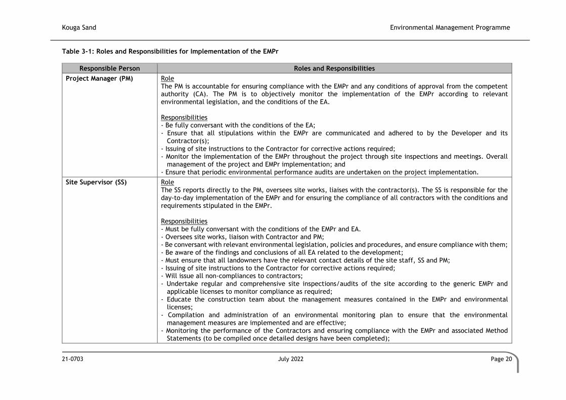
Kouga Sand Environmental Management Programme
21-0703 July 2022 Page 20
Table 3-1: Roles and Responsibilities for Implementation of the EMPr
Responsible Person Roles and Responsibilities
Project Manager (PM) Role The PM is accountable for ensuring compliance with the EMPr and any conditions of approval from the competent authority (CA). The PM is to objectively monitor the implementation of the EMPr according to relevant environmental legislation, and the conditions of the EA. Responsibilities - Be fully conversant with the conditions of the EA; - Ensure that all stipulations within the EMPr are communicated and adhered to by the Developer and its
Contractor(s); - Issuing of site instructions to the Contractor for corrective actions required; - Monitor the implementation of the EMPr throughout the project through site inspections and meetings. Overall
management of the project and EMPr implementation; and - Ensure that periodic environmental performance audits are undertaken on the project implementation.
Site Supervisor (SS) Role The SS reports directly to the PM, oversees site works, liaises with the contractor(s). The SS is responsible for the day-to-day implementation of the EMPr and for ensuring the compliance of all contractors with the conditions and requirements stipulated in the EMPr. Responsibilities - Must be fully conversant with the conditions of the EMPr and EA. - Oversees site works, liaison with Contractor and PM; - Be conversant with relevant environmental legislation, policies and procedures, and ensure compliance with them; - Be aware of the findings and conclusions of all EA related to the development; - Must ensure that all landowners have the relevant contact details of the site staff, SS and PM; - Issuing of site instructions to the Contractor for corrective actions required; - Will issue all non-compliances to contractors; - Undertake regular and comprehensive site inspections/audits of the site according to the generic EMPr and
applicable licenses to monitor compliance as required; - Educate the construction team about the management measures contained in the EMPr and environmental
licenses; - Compilation and administration of an environmental monitoring plan to ensure that the environmental
management measures are implemented and are effective; - Monitoring the performance of the Contractors and ensuring compliance with the EMPr and associated Method
Statements (to be compiled once detailed designs have been completed);

Kouga Sand Environmental Management Programme
21-0703 July 2022 Page 21
- In consultation with the SS order the removal of person(s) and/or equipment which are in contravention of the specifications of the EMPr and/or environmental licenses;
- Liaison between the PM, Contractors, authorities and other lead stakeholders on all environmental concerns; - Compile a regular Environmental Audit Report (EAR) highlighting any non-compliance issues as well as satisfactory
or exceptional compliance with the EMPr; - Keep a record of environmental incidents (spills, impacts, legal transgressions etc.) as well as corrective and
preventive actions taken; - Keep a public complaints register in which all complaints are recorded, as well as action taken; - Facilitate training for all personnel on the site – this may range from carrying out the training to reviewing the
training programmes of the Contractor; - Follow-up on pre-warnings, defects, non-conformance reports; - Measure and communicate environmental performance to the Contractor; - Maintenance, update and review of the EMPr; and - Communication of all modifications to the EMPr to the relevant stakeholders
Contractor
Role The Contractor has overall responsibility for ensuring that all work, activities, and actions linked to the delivery of the contract are in line with the EMPr and that Method Statements are implemented as described (to be compiled once detailed designs have been completed). External contractors must ensure compliance with this EMPr while performing the onsite activities as per their contract with the Project Developer. The contractors are required, where specified, to provide Method Statements setting out in detail how the impact management actions contained in the EMPr will be implemented (to be compiled once detailed designs have been completed). Responsibilities - Project delivery and quality control for the development services as per appointment; - Employ a suitably qualified person to monitor and report to the Project Developer’s appointed person on the daily
activities on-site during the construction period; - Ensure that safe, environmentally acceptable working methods and practices are implemented, and that
equipment is properly operated and maintained, to facilitate proper access and enable any operation to be carried out safely;
- Attend on site meeting(s) prior to the commencement of activities to confirm the procedure and designated activity zones;
- Ensure that contractors’ staff repair, at their own cost, any environmental damage as a result of a contravention of the specifications contained in EMPr, to the satisfaction of the SS.

Kouga Sand Environmental Management Programme
21-0703 July 2022 Page 22
4 ENVIRONMENTAL DOCUMENTATION REPORTING AND COMPLIANCE
To ensure accountable and demonstrated implementation of the EMPr, several reporting systems,
documentation controls and compliance mechanisms must be in place as a minimum requirement.
4.1 Document control/Filing system
The holder of the EA is solely responsible for the upkeep and management of the EMPr file. As a
minimum, all documentation detailed below will be stored in the EMPr file. A hard copy of all
documentation shall be filed, while an electronic copy may be kept where relevant. A duplicate file
will be maintained in the office of the SS (where applicable). This duplicate file must remain current
and up-to-date. The filing system must be updated, and relevant documents added as required. The
EMPr file must be made available at all times on request by the CA or other relevant authorities. The
EMPr file will form part of any environmental audits undertaken as prescribed in the EIA Regulations.
4.2 Documentation to be available
At the outset of the project the following preliminary list of documents shall be placed in the filing
system and be accessible at all times:
• A full copy of the signed EA from the CA in terms of NEMA;
• Any amendments to the EA;
• Copy of the generic and site-specific EMPr as well as any amendments thereof;
• Copy of declaration of implementing generic EMPr and subsequent approval of site-specific
EMPr and amendments thereof;
• All method statements (to be compiled once detailed designs have been completed);
• Completed environmental checklists;
• Minutes and attendance register of environmental site meetings;
• An up-to-date environmental incident log;
• A copy of all instructions or directives issued;
• A copy of all corrective actions signed off. The corrective actions must be filed in such a way
that a clear reference is made to the non-compliance record;
• Complaints register.
4.3 Monthly Environmental Checklist
The SS is required to complete a Monthly Environmental Checklist, the format of which is to be agreed
upon prior to commencement of the activity. The SS is required to sign and date the checklist, retain
a copy in the EMPr file and submit a copy of the completed checklist to the PM weekly. The checklists

Kouga Sand Environmental Management Programme
21-0703 July 2022 Page 23
will form the basis for the Monthly Environmental Reports. Copies of all completed checklists will be
attached as Annexures to the EAR as required in terms of the EIA Regulations.
4.4 Required Method Statements
The method statement will be done in such detail that the SS can assess whether the contractor's
proposal is in accordance with the EMPr (to be compiled once detailed designs have been completed).
The method statement must include the following:
• Development procedures;
• Materials and equipment to be used;
• Getting the equipment to and from the site;
• How the equipment/ material will be moved while on site;
• How and where the material will be stored;
• The containment (or action to be taken if containment is not possible) of leaks or spills of
any liquid or material that may occur;
• Timing and location of activities;
• Compliance/ non-compliance with the EMPr; and
• Any other information deemed necessary by the SS.
Unless indicated otherwise by the Project Manager, the Contractor shall provide the following method
statements to the Project Manager no less than 14 days prior to the commencement date of the
activity:
• Site establishment;
• Vegetation management – Protected, clearing, aliens, felling;
• Access management – Roads, gates, crossings etc.;
• Fire plan;
• Waste management -transport, storage, segregation, classification, disposal (all waste
streams);
• Social interaction – complaints management, compensation claims, access to properties etc.;
• Emergency preparedness – Spills, training, other environmental emergencies;
• Dust and noise management methodologies; and
• Heritage and palaeontology management.
The SS shall monitor and ensure that the contractors perform in accordance with these method
statements. Completed and agreed method statements between the holder of the MP and the
contractor must be included in the environmental file. A generic format of a method statement is
supplied as Appendix B.

Kouga Sand Environmental Management Programme
21-0703 July 2022 Page 24
4.5 Environmental Incident Log
The SS is required to maintain an up-to-date and current Environmental Incident Log. The
Environmental Incident Log is a means to record all environmental incidents and/or all non-
compliance notice would not be issued. An environmental incident is defined as:
• Any deviation from the listed impact management actions (listed in this EMPr) that may be
addressed immediately by the SS. (For example, a contractor’s staff member littering or a
drip tray that has not been emptied);
• Any environmental impact resulting from an action or activity by a contractor in
contravention of the environmental stipulations and guidelines listed in the EMPr which as a
single event would have a minor impact but which if cumulative and continuous would have
a significant effect (for example no toilet paper available in the ablutions for an afternoon);
and
• General environmental information such as road kills or injured wildlife.
The SS is to record all environmental incidents in the Environmental Incident Log. All incidents
regardless of severity must be reported to the Developer. The Log is to be kept in the EMPr file and
at a minimum, the following will be recorded for each environmental incident:
• The date and time of the incident;
• Description of the incident;
• The name of the Contractor responsible;
• The incident must be listed as significant or minor;
• If the incident is listed as significant, a non-compliance notice must be issued, and recorded
in the log;
• Remedial or corrective action taken to mitigate the incident; and
• Record of repeat minor offences by the same contractor or staff member.
The Environmental Incident Log will be captured in the EAR.
4.6 Non-compliance
A non-compliance notice will be issued to the responsible contractor by the SS or PM. The non-
compliance notices will be issued in writing; a copy filed in the EMPr file and will at a minimum
include the following:
• Time and date of the non-compliance;
• Name of the contractor responsible;
• Nature and description of the non-compliance;
• Recommended / required corrective action; and
• Date by which the corrective action is to be completed.

Kouga Sand Environmental Management Programme
21-0703 July 2022 Page 25
The contractors shall act immediately when a notice of non-compliance is received and correct
whatever is the cause for the issuing of the notice. Complaints received regarding activities on the
development site pertaining to the environment shall be recorded in a dedicated register and the
response noted with the date and action taken. The SS should be made aware of any complaints. Any
non-compliance with the agreed procedures of the EMPr is a transgression of the various statutes and
laws that define how the environment is managed. Failure to redress the cause shall be reported to
the relevant CA for them to deal with the transgression, as it deems fit. The contractor is deemed
not to have complied with the EMPr if, inter alia, there is a deviation from the environmental
conditions, impact management outcomes and impact management actions activities, as approved
in generic and site-specific EMPr as relevant as set out in the EMPr, which deviation has, or may
cause, an environmental impact.
4.7 Corrective action records
For each non-compliance notice issued, a documented corrective action must be recorded. On
receiving a non-compliance notice from the SS, the contractor will ensure that the corrective actions
required take place within the stipulated timeframe. On completion of the corrective action, the SS
is to issue a Corrective Action Report in writing. If satisfied that the corrective action has been
completed, the SS is to sign-off on the Corrective Action Report and attach the report to the non-
compliance notice in the EMPr file.
Corrective action is considered complete once the report has been signed off by the SS
4.8 Photographic record
A digital photographic record will be kept. The photographic record will be used to show before,
during and post-rehabilitation evidence of the project as well used in cases of damages claims if they
arise. Each image must be dated, and a brief description note attached.
The Contractor shall:
• Allow the SS access to take photographs of all areas, activities and actions.
• The SS shall keep an electronic database of photographic records which will include:
o Pictures of all areas designated as work areas, camp areas, development sites and
storage areas taken before these areas are set up;
o All bunding and fencing;
o Road conditions and road verges;
o Condition of all farm fences;
o Topsoil storage areas;
o All areas to be cordoned off during construction;
o Waste management sites;
o Ablution facilities (inside and out);

Kouga Sand Environmental Management Programme
21-0703 July 2022 Page 26
o Any non-conformances deemed to be “significant”;
o All completed corrective actions for non-compliance;
o All required signage;
o Photographic recordings of incidents;
o All areas before, during and post-rehabilitation; and
o Include relevant photographs in the Final Environmental Audit Report.
4.9 Complaints register
The SS shall keep a current and up-to-date complaints register. The complaints register is to be a
record of all complaints received from communities, stakeholders and individuals. The Complaints
Record shall:
• Record the name and contact details of the complainant;
• Record the time and date of the complaint;
• Contain a detailed description of the complaint;
• Where relevant and appropriate, contain photographic evidence of the complaint or damage
(SS to take relevant photographs); and
• Contain a copy of the SS written response to each complaint received and keep a record of
any further correspondence with the complainant. The SS’s written response will include a
description of any corrective action to be taken and must be signed by the Contractor, SS
and affected party. Where a damage claim is issued by the complainant, the SS shall respond
as described below.
4.10 Claims for damages
If a Claim for Damages is submitted by a community, landowner or individual, the SS shall:
• Record the full detail of the complaint as described above;
• The PM will evaluate the claim and associated damage and submit the evaluation to the
Senior Site Representative for approval;
• Following consideration by the PM, the claim is to be resolved and settled immediately, or
the reason for not accepting the claim communicated in writing to the claimant. Should the
claimant not accept this, the SS shall, in writing report the incident to the Developer’s
negotiator and legal department; and
• A formal record of the response by the SS to the claimant as well as the rectification of the
method of making payments not amount will be recorded in the EMPr file.
4.11 Interactions with I & APs

Kouga Sand Environmental Management Programme
21-0703 July 2022 Page 27
Open, transparent and good relations with affected landowners, communities and regional staff are
an essential aspect to the successful management and mitigation of environmental impacts.
The SS shall:
• Ensure that all queries, complaints and claims are dealt with within an agreed timeframe;
• Ensure that any or all agreements are documented, signed by all parties and a record of the
agreement kept in the EMPr file;
• Ensure that complaints telephone numbers are made available to all landowners and affected
parties; and
• Ensure that contact with affected parties is courteous at all times.
4.12 Environmental audits
Internal environmental audits of the activity and implementation of the EMPr must be undertaken.
The findings and outcomes are included in the EMPr file and submitted to the CA at intervals as
indicated in the EA.
The SS must prepare a monthly EAR. The final report will be circulated to the PM and filed in the
EMPr file. At a frequency determined by the EA, the SS shall submit the monthly reports to the CA.
At a minimum, the monthly report is to cover the following:
• Environmental Checklists;
• Deviations and non-compliances with the checklists;
• Non-compliances issued;
• Completed and reported corrective actions;
• Environmental Monitoring; and
• General environmental findings and actions.
4.13 Biannual External Environmental Audit
As recommended by the biodiversity specialist, the applicant must appoint an Environmental Control
Officer, who meets the requirements of the NEMA: EIA Regulations (2014) as amended, to conduct
biannual audits of the operations for the duration of the project. An audit report must be compiled
for each audit and submitted to the DMRE.
4.14 Final environmental audits
On completion of the rehabilitation and/or requirements of the EA, a final EAR is to be prepared and
submitted to the CA. The EAR must comply with Appendix 7 of the EIA Regulations.

Kouga Sand Environmental Management Programme
21-0703 July 2022 Page 28
4.15 Environmental Training and Awareness-Raising
The Contractor, sub-contractors and employees require an appropriate level of environmental
awareness and competence to ensure continued compliance with environmental legislation,
conditions of the EA and the provisions in the EMPr. Training needs should be identified based on the
available and existing capacity of site personnel (including all Contractors and sub-contractors) to
undertake the required management actions and monitoring activities. All personnel must be
adequately trained to perform their designated tasks to an acceptable standard.
Upfront environmental training is aimed at:
• Promoting environmental awareness;
• Informing the main contractor of all environmental procedures, policies and programmes
applicable;
• Providing generic training on the implementation of environmental management
specifications; and
• Providing job-specific environmental training to understand the key environmental features
of the construction site and the surrounding environment.
Training will be offered in the main languages. In addition to the upfront environmental training by
the ECO, the Contractor should make provision for regular training or “Toolbox Talks”.
General environmental awareness must be fostered to ensure that environmental incidents are
minimised and there is environmental compliance.
5 PROPOSED IMPACT MANAGEMENT ACTIONS
This section outlines aspects related to the development of the proposed mine and associated
infrastructure and for each aspect, a set of prescribed impact management outcomes and associated
impact management actions have been identified. Holders of EAs are responsible to ensure the
implementation of these outcomes and actions for all projects as a minimum requirement, to mitigate
the impact of such aspects.
This must be signed and dated on each page by both the contractor and the holder of the EA prior to
commencement of the activity. The method statements are prepared and agreed to by the holder of
the EA (to be compiled once detailed designs have been completed - a generic format is supplied as
Appendix B). Each method statement must also be duly signed and dated on each page by the
contractor and the holder of the EA. This template, once signed and dated, is legally binding. The
holder of the EA will remain responsible for its implementation.
Appendix 4 of the 2014 NEMA EIA Regulations requires that the EMPr aim to achieve the following
through the proposed impact management actions:

Kouga Sand Environmental Management Programme
21-0703 July 2022 Page 29
• Avoid, modify, remedy, control or stop any action, activity or process which causes pollution
or environmental degradation;
• Comply with any prescribed environmental management standards or practices;
• Comply with any applicable provisions of the Act regarding the closure, where applicable;
and
• Comply with any provisions of the Act regarding financial provision for rehabilitation, where
applicable.
It must be noted that this section has been revised based on comments received from I&APs. As such,
there are no specific changes marked as per the Disclaimer.

Kouga Sand Environmental Management Programme
21-0703 July 2022 Page 30
Table 5-1: Environmental Training
Impact management outcome Impacts on the environment are minimised during site establishment and the development footprint is kept to the demarcated development area.
Impact Management Actions Implementation Monitoring
Responsible Person
Method of Implementation
Timeframe for Implementation
Responsible Person Frequency Evidence of Compliance
- All staff must receive environmental awareness training prior to the commencement of the activities;
- The Contractor must allow for sufficient sessions to train all personnel;
- Refresher environmental awareness training is available as and when required;
- All staff are aware of the conditions and controls linked to the EA and within the EMPr and made aware of their roles and responsibilities in achieving compliance with the EA and EMPr;
- The Contractor must erect and maintain information posters at key locations on site, and the posters must include the following information as a minimum:
a) Safety notifications; and b) No littering.
- Environmental awareness training must include as a minimum the following: a) Description of significant environmental impacts, actual or potential, related to their work activities; b) Mitigation measures to be implemented when carrying out specific activities; c) Emergency preparedness and response procedures; e) Procedures to be followed when working near or within sensitive areas; f) Wastewater management procedures; g) Water usage and conservation; h) Solid waste management procedures; i) Sanitation procedures; j) Fire prevention; k) Disease prevention; and l) Prevention and containment of spills, leaks and other impacts to watercourses
- A record of all environmental awareness training courses undertaken as part of the EMPr must be available;
- Educate workers on the dangers of open and/or unattended fires; - A staff attendance register of all staff to have received
environmental awareness training must be available. - Course material must be available and presented in appropriate
languages that all staff can understand.
PM Contractor SS
• Schedule training sessions with all contractors as required prior to construction
• Document all trainees
Prior to the start of construction activities
SS Schedule training sessions with all contractors as required prior to construction
• Training register/s
• Information posters
• Training materials
Table 5-2: Site Establishment Development
Impact management outcome Impacts on the environment are minimised during site establishment and the development footprint is kept to the demarcated development area.
Impact Management Actions Implementation Monitoring
Responsible Person
Method of Implementation
Timeframe for Implementation
Responsible Person Frequency Evidence of Compliance
- Minimize activity duration; - All excavated areas will be cordoned off; - Limit the operational footprint; - A method statement must be provided by the contractor prior to any
onsite activity that includes the layout of the mining area in the form
PM Contractor SS
• SS to approve method statements
• Approved method statements to be included in the
Prior to the start of construction activities
SS Prior to construction
• Approved method statements included in updated EMPr

Kouga Sand Environmental Management Programme
21-0703 July 2022 Page 31
of a plan showing the location of key infrastructure and services (where applicable), including but not limited to ablution facilities, hazardous materials storage areas (including fuels), designated access routes, waste and wastewater management;
- Location of infrastructure must be within approved area to ensure that the site does not impact on sensitive areas identified in the environmental assessment or site walkthrough;
- Sites must be located where possible on previously disturbed areas; - The use of existing accommodation for contractor staff, where
possible, is encouraged; - Identification of access-restricted areas is to be informed by the
environmental assessment, site walkthrough, and any additional areas identified during development;
- To mitigate the localised visual impact through the storage of equipment and machinery, and the storage of reflective materials, a shade cloth fence can be erected around the construction camp/s.
- Erect, demarcate and maintain a temporary barrier with clear signage around the perimeter of any access restricted area, colour coding could be used if appropriate; and
- Unauthorised access and development related activity inside access restricted areas are prohibited.
updated EMPr - a generic format is supplied as Appendix B
(to be compiled once detailed designs have been completed - a generic format is supplied as Appendix B)
Table 5-3: Access Roads and Traffic
Impact management outcome Minimise impact on traffic mobility and access and minimise the impact on the local road network
Impact Management Actions Implementation Monitoring
Responsible Person
Method of Implementation
Timeframe for Implementation
Responsible Person Frequency Evidence of Compliance
- All contractors must be made aware of all these permissible access routes;
- Adequate road signage according to the South African Road Traffic Signs Manual (SARTSM);
- Maximum use of both existing servitudes and existing roads must be made to minimize further disturbance;
- The applicant will assist with appropriate, timely and high-quality maintenance required in terms of TRH20;
- Any access route deviation from that in the written agreement must be closed and re-vegetated immediately, at the contractor’s expense;
- Implementation of pedestrian safety initiatives.
PM Contractor SS
• Training of contractors
• Road maintenance programme
Prior to the start of construction activities
SS Prior to construction
• Training registers
• Photographic records of affected access routes
• Complaints register
• Environmental incident register
Table 5-4: Water Use and Supply Management
Impact management outcome Undertake responsible water usage.
Impact Management Actions Implementation Monitoring
Responsible Person
Method of Implementation
Timeframe for Implementation
Responsible Person Frequency Evidence of Compliance
- Onsite water harvesting measures for rainwater are recommended where possible;
- Ensure water conservation is being practised by: a. Minimising water use during the cleaning of equipment; b. Undertaking regular audits of water systems; c. Including a discussion on water usage and conservation during environmental awareness training; and d. Possible recycling of greywater is recommended where possible.
PM Contractor SS
• Keep records of water sources and volumes on site
All phases (ongoing) SS All phases (ongoing) • Records of water sources and volumes on site
• Training registers
• Training materials

Kouga Sand Environmental Management Programme
21-0703 July 2022 Page 32
Table 5-5: Stormwater and Wastewater Management
Impact management outcome Impacts on the environment caused by stormwater and wastewater discharges during construction are avoided.
Impact Management Actions Implementation Monitoring
Responsible Person
Method of Implementation Timeframe for
Implementation Responsible Person Frequency
Evidence of Compliance
- Restrict vehicle movement to designated access roads. - Restrict vegetation clearing to specific footprints. - Capture and contain runoff from areas cleared of vegetation, and
existing access roads - Responsible waste management must be implemented to
minimize pollution of water resources. - After every rainfall event, the contractor must check the site for
erosion damage and rehabilitate this damage immediately. - Demarcated dirty areas to be limited to roads, parking areas and
chemical storage areas. - Regarding portable chemical toilets, the following must be
implemented: o Only portable chemical toilets with a sealed reservoir will
be allowed on site. o The capacity of the reservoirs in the portable chemical
toilets must be monitored on a daily basis to ensure that they can be serviced timeously.
o All removal of the collected sewage waste from the portable chemical toilets must be conducted by a registered service provider for disposal at a municipal waste water treatment facility.
PM Contractor SS
• Compile and implement stormwater management measures
• Certificates of safe disposal for general, hazardous and recycled waste
• Record spills/ discharges and environmental incidents
All phases (ongoing) SS All phases (ongoing) • Certificates of safe disposal for general, hazardous and recycled waste
• Complaints register
• Environmental incident register
Table 5-6: Solid and Hazardous Waste Management
Impact management outcome Wastes are appropriately stored, handled and safely disposed of at a recognised waste facility.
Impact Management Actions Implementation Monitoring
Responsible Person
Method of Implementation
Timeframe for Implementation
Responsible Person Frequency Evidence of Compliance
- Even though the impacts of contamination of the area by petrochemical spillages are considered to be low pre-mitigation, the following mitigation measures must be included to further reduce the significance of the impact:
o All plant and equipment that make use of petrochemical substances must be checked for leakages on a daily basis.
o All plant and equipment that are found to be leaking must be removed from the property and only returned once the leakages have been addressed.
o If any petrochemical substances are stored on the property, this storage must be done on an impermeable surface in a bunded area that makes provision for 110% of volume of the substances that are stored.
o All refuelling of plant and equipment must be conducted over a driptray.
o If any plant or equipment is to be parked on site, these must be parked within the demarcated construction footprint that has been cleared.
o If any spillages from plant or equipment occur, the spill must be immediately contained, the contaminated soils must be collected and bagged in impermeable bags and stored on site to be removed and disposed of by a registered service provider.
PM Contractor SS
• Compile and implement appropriate stormwater management measures
• Certificates of safe disposal for general, hazardous and recycled waste
• Record spills/ discharges and environmental incidents
All phases (ongoing) SS All phases (ongoing) • Certificates of safe disposal for general, hazardous and recycled waste
• Complaints register
• Environmental incident register
• Training register
• Training materials

Kouga Sand Environmental Management Programme
21-0703 July 2022 Page 33
Impact management outcome Wastes are appropriately stored, handled and safely disposed of at a recognised waste facility.
Impact Management Actions Implementation Monitoring
Responsible Person
Method of Implementation
Timeframe for Implementation
Responsible Person Frequency Evidence of Compliance
- Even though the impacts of contamination of the area by domestic waste are considered to be low pre-mitigation, the following mitigation measures must be included to further reduce the significance of the impact:
o A designated eating area must be established within the mining area.
o Covered domestic waste bind must be present at the eating area to receive all the domestic waste generated by the labour.
o The capacity of these domestic bins must be monitored on a daily basis to ensure they are emptied timeously.
o The domestic waste from these waste bins must be removed off site and disposed of at a municipal landfill site on a weekly basis or more regularly if the bins fill up quicker.
Table 5-7: Vegetation Clearing
Impact management outcome Vegetation clearing is restricted to the authorised development footprint of the proposed infrastructure.
Impact Management Actions Implementation Monitoring
Responsible Person
Method of Implementation
Timeframe for Implementation
Responsible Person Frequency Evidence of Compliance
- Indigenous vegetation outside of the designated Works area must be left undisturbed;
- Restrict all movement of vehicles and heavy machinery to permissible areas. No off-road driving beyond designated areas may be allowed;
- Restrict the movement of personnel and construction vehicles to where they are needed;
- Strategically plan the location of site camps and laydown areas so that minimal vegetation is cleared;
- Provision must be made for concurrent rehabilitation of the mining operations which will ensure that the permit area is mined in designated sections;
- The mined out sections will be rehabilitated and planted with an indigenous grass seed mix in the first growing season after it has been mined out. This will limit the operational area to the current operational area;
- A seedbed of alien plants will be present within the cleared soils. This seedbed and the plants that originate from it must be managed as follows: o The Mining Permit footprint must be clearly surveyed and
demarcated before any construction or operations are set to commence, to ensure that the area to be cleared is limited to only the areas that are necessary for the mining activities.
o The cleared areas must be regularly monitored for the establishment of alien plant species. These must be cleared when they appear.
o If alien invasive plant species become a problem on the mining area, a formal Alien Invasive Management Plan must be set up and implemented. This plan must make provision for the identification and eradication of these species.
PM Contractor SS
• Certificates of safe disposal for general, hazardous and recycled waste
• Implementation of an alien and invasive plant control and eradication plan
All phases (ongoing) SS All phases (ongoing) • Environmental incident register
• Training register
• Training materials
• Monitoring of success of rehabilitation
• Register of herbicide usage
• Certificates of safe disposal for general, hazardous and recycled waste

Kouga Sand Environmental Management Programme
21-0703 July 2022 Page 34
- The SS must undertake monthly compliance monitoring audits. Terrestrial ecosystem aspects that must be monitored related to monitoring freshwater ecosystem impacts include:
- The condition of the demarcations/fence. - Evidence of any no-go area incursions. - The condition of temporary runoff, erosion and sediment
control measures and evidence of any failures or sediment deposits.
- Evidence of erosion. - Visual assessment of stormwater quality. - The condition of waste bins and the presence of litter within
the working area. - Evidence of solid waste dumping within the no-go areas. - Evidence of hazardous materials spills and soil
contamination. - Presence of alien invasive and weedy vegetation within the
working area. - Rehabilitation and revegetation methods and success.
Table 5-8: Protection of Fauna
Impact management outcome Disturbance to fauna is minimised.
Impact Management Actions Implementation Monitoring
Responsible Person
Method of Implementation
Timeframe for Implementation
Responsible Person Frequency Evidence of Compliance
- If possible, the construction activities are to commence in the winter months to ensure that the animal species that will actively move from the site is not currently rearing young as the movement with young animals could potentially cause mortality amongst the young animals;
- No poaching will be tolerated under any circumstances. All animal dens close to the works areas must be marked as “No-Go” areas;
- No Threatened or Protected species (ToPs) and/or protected fauna as listed according to NEM: BA and relevant provincial ordinances may be removed and/or relocated without appropriate authorisations/permits;
- In areas where snakes are abundant, snake deterrents to be deployed;
- Strict speed limits must be set and adhered to; - Driving between dusk and dawn should be permissible to emergency
situations only; - Monitor the establishment of invasive species and remove as soon
as detected, whenever possible before regenerative material can be formed, destroy all material to prevent re-establishment
PM Contractor SS
• Demarcation of SCC, sensitive habitats prior to construction.
All phases (ongoing) SS All phases (ongoing) • Environmental incident register
• Training register
• Training materials
• Monitoring of success of rehabilitation
Table 5-9: Protection of Heritage Resources
Impact management outcome Impact on heritage resources is minimised.
Impact Management Actions Implementation Monitoring
Responsible Person
Method of Implementation
Timeframe for Implementation
Responsible Person Frequency Evidence of Compliance
- For any chance finds of heritage resources, such as graves, all work must cease in the affected area and the Contractor must immediately inform the SS. A heritage specialist must be called to site for inspection. The relevant heritage resource agency (the Institute) must also be informed about the finding.
- The heritage specialist will assess the significance of the resource and guide the way forward.
PM Contractor SS
• Reporting of heritage findings to SAHRA
• Reporting of graves/ human remains to SAPS
All phases (ongoing) SS All phases (ongoing) • Environmental incident register
• Training register
• Training materials
• Permits for damage or repairs to heritage sites

Kouga Sand Environmental Management Programme
21-0703 July 2022 Page 35
Impact management outcome Impact on heritage resources is minimised.
Impact Management Actions Implementation Monitoring
Responsible Person
Method of Implementation
Timeframe for Implementation
Responsible Person Frequency Evidence of Compliance
- A heritage management plan should be compiled that indicates buffer zones and management actions for known and unknown heritage sites and sites of social importance in the prospecting area. Under no circumstances may any heritage material be destroyed or removed from the site unless under the direction of a heritage specialist.
- Should any recent remains be found on site that could potentially be human remains, the SAPS as well as the Institute must be informed. No SAPS official may remove remains until the correct permit/s have been obtained.
- The local community should be engaged when an area is cleared to assist with identifying graves as well as places of social and spiritual significance.
• Records of reports to heritage agencies/ SAPS
Table 5-10: Health and Safety
Impact management outcome
All precautions are taken to minimise the risk of injury, harm, illness or complaints.
Impact Management Actions Implementation Monitoring
Responsible Person Method of Implementation
Timeframe for Implementation
Responsible Person Frequency Evidence of Compliance
- Identify fire hazards, demarcate and restrict public access to these areas as well as notify the local authority of any potential threats e.g. large brush stockpiles, fuels etc.;
- All unattended open excavations must be adequately fenced or demarcated;
- Ensure warning signs are erected on the perimeter of these areas. - Adequate protective measures must be implemented to prevent
unauthorised access to the Works area; - Ensure structures vulnerable to high winds are secured; and - Maintain an incidents and complaints register in which all incidents
or complaints involving the public are logged.
Community Liaison Officer (CLO)
• Appointment of CLO and implementation of the complaints register process
All phases (ongoing) CLO All phases (ongoing) • Complaints register
• Training register
• Training materials
- Ensure that the workforce is sensitised to the effects of HIV/ acquired immunodeficiency syndrome (AIDS);
- The Contractor must ensure that information posters on AIDS are displayed in the Contractor Camp area;
- Appropriate Personal Protective Equipment (PPE) to be provided to all staff on site;
- Medical support must be made available as appropriate; and - Provide access to Voluntary HIV Testing and Counselling Services.
PM Contractor SS
• Awareness raising and posters
• Access to appropriate PPE
All phases (ongoing) SS All phases (ongoing) • Number of staff reporting as sick/ number of sick leave days
• Complaints register
• Training register
• Training materials
Table 5-11: Sanitation
Impact management outcome Clean and well-maintained toilet facilities are available to all staff to minimise the risk of disease and impact on the environment.
Impact Management Actions Implementation Monitoring
Responsible Person
Method of Implementation
Timeframe for Implementation
Responsible Person Frequency Evidence of Compliance
- Minimum 1 toilet per 10 users. - Only portable chemical toilets with a sealed reservoir will be
allowed on site.
PM Contractor SS
• Demarcation of SCC, sensitive habitats prior to construction
All phases (ongoing) SS All phases (ongoing) • Complaints register

Kouga Sand Environmental Management Programme
21-0703 July 2022 Page 36
- The capacity of the reservoirs in the portable chemical toilets must be monitored daily to ensure that they can be serviced timeously.
- The use of ablution facilities and or mobile toilets must be used at all times and no indiscriminate use of the veld for ablutions must be permitted under any circumstances;
- Toilets must not be located within the 1:100yr flood line of a watercourse or the recommended buffer of any wetlands.
- Toilets must be secured to the ground to prevent them from toppling due to wind or any other cause.
- Spillage should be prevented when the toilets are cleaned or emptied.
- Toilets must be emptied before long weekends and workers holidays and must be locked after working hours.
- Toilets must be serviced weekly, and the ECO must inspect toilets to ensure compliance with health standards.
- Waste must be disposed of at a suitably licensed facility. - A copy of the waste disposal certificates must be maintained.
• Certificates of safe disposal for general, hazardous and recycled waste
• Record spills/ discharges and environmental incidents
• Training register
• Training materials
• Certificates of safe disposal for general, hazardous and recycled waste
• Environmental incident register
Table 5-12: Emergency procedures
Impact management outcome Emergency procedures are in place to enable a rapid and effective response to all types of environmental emergencies.
Impact Management Actions Implementation Monitoring
Responsible Person
Method of Implementation
Timeframe for Implementation
Responsible Person Frequency Evidence of Compliance
- Compile an Emergency Response Action Plan (ERAP) prior to the commencement of the proposed project;
- The Emergency Plan must deal with accidents, potential spillages and fires in line with relevant legislation;
- All staff must be made aware of emergency procedures as part of environmental awareness training;
- The relevant local authority must be made aware of a fire as soon as it starts; and
- In the event of an emergency, necessary mitigation measures to contain the spill or leak must be implemented.
PM Contractor SS
• Compile ERAP prior to the commencement of construction
• Demarcation of SCC, sensitive habitats prior to construction
• Certificates of safe disposal for general, hazardous and recycled waste
• Record spills/ discharges and environmental incidents
All phases (ongoing) SS All phases (ongoing) • Complaints register
• Training register
• Training materials
• ERAP
• Environmental incident register
Table 5-13: Hazardous Substances
Impact management outcome Safe storage, handling, use and disposal of hazardous substances.
Impact Management Actions Implementation Monitoring
Responsible Person
Method of Implementation
Timeframe for Implementation
Responsible Person Frequency Evidence of Compliance
- No refuelling, servicing or chemical storage should occur within 50m of any watercourse.
- The use and storage of hazardous substances to be minimised and non-hazardous and non-toxic alternatives substituted where possible;
- Even though the impacts of contamination of the area by petrochemical spillages are considered to be low pre-mitigation, the following mitigation measures must be included to further reduce the significance of the impact:
PM Contractor SS
• Compile ERAP prior to the commencement of construction
• Compile HCS control sheet
• MSDS
All phases (ongoing) SS All phases (ongoing) • Complaints register
• Training register
• Training materials
• ERAP
• HCS control sheet and updates

Kouga Sand Environmental Management Programme
21-0703 July 2022 Page 37
o All plant and equipment that make use of petrochemical substances must be checked for leakages on a daily basis.
o All plant and equipment that are found to be leaking must be removed from the property and only returned once the leakages have been addressed.
o If any petrochemical substances are stored on the property, this storage must be done on an impermeable surface in a bunded area that makes provision for 110% of volume of the substances that are stored.
o All refuelling of plant and equipment must be conducted over a driptray.
o If any plant or equipment is to be parked on site, these must be parked within the demarcated construction footprint that has been cleared.
o If any spillages from plant or equipment occur, the spill must be immediately contained, the contaminated soils must be collected and bagged in impermeable bags and stored on site to be removed and disposed of by a registered service provider.
- All hazardous substances must be stored in suitable containers as defined in the Method Statement (to be compiled once detailed designs have been completed – a generic format is supplied as Appendix B);
- Containers must be marked to indicate contents, quantities and safety requirements;
- All storage areas must be bunded. The bunded area must be of sufficient capacity to contain a spill/leak from the stored containers;
- Bunded areas to be suitably lined with a South African Bureau of Standards (SABS) approved liner;
- No unauthorised access into the hazardous substances’ storage areas must be permitted;
- No smoking must be allowed within the vicinity of the hazardous storage areas;
- Adequate fire-fighting equipment must be made available at all hazardous storage areas;
- An appropriately sized spill kit kept onsite relevant to the scale of the activity/s involving the use of hazardous substances must be available at all times;
- The responsible operator must have the required training to make use of the spill kit in emergencies;
- An appropriate number of spill kits must be available and must be located in all areas where activities are being undertaken.
• Demarcation of SCC, sensitive habitats prior to construction
• Certificates of safe disposal for general, hazardous and recycled waste
• Record spills/ discharges and environmental incidents
• MSDS
• Spill kits available on site
• Environmental incident register

Kouga Sand Environmental Management Programme
21-0703 July 2022 Page 38
Table 5-14: Equipment Maintenance and Storage Aspect
Impact management outcome Soil, surface water and groundwater contamination are minimised.
Impact Management Actions Implementation Monitoring
Responsible Person
Method of Implementation
Timeframe for Implementation
Responsible Person Frequency Evidence of Compliance
- During servicing of vehicles or equipment, a suitable drip tray must be used to prevent spills onto the soil;
- Leaking equipment must be repaired immediately or be removed from the site to facilitate repair;
- All areas must be monitored for oil and fuel spills; - Appropriately sized spill kit kept onsite relevant to the scale of the
activity taking place must be available.
PM Contractor SS
• Compile ERAP prior to the commencement of construction
• Compile HCS control sheet
• MSDS
• Certificates of safe disposal for general, hazardous and recycled waste
• Record spills/ discharges and environmental incidents
All phases (ongoing) SS All phases (ongoing) • Complaints register
• Training register
• Training materials
• ERAP
• HCS control sheet and updates
• MSDS
• Spill kits available on site
• Environmental incident register
Table 5-15: Dust Emissions Aspect
Impact management outcome Dust prevention measures are applied to minimise the generation of dust.
Impact Management Actions Implementation Monitoring
Responsible Person
Method of Implementation
Timeframe for Implementation
Responsible Person Frequency Evidence of Compliance
- Take all reasonable measures to minimise the generation of dust as a result of project development activities to the satisfaction of the SS.
- Comply with the National Dust Control Regulations, GN 36974 of 1 November 2013, in terms of the NEM: AQA, as amended, and all applicable local bylaws.
- Removal of vegetation must be avoided until soil stripping is required and similarly exposed surfaces must be re-vegetated or stabilised as soon as is practically possible.
- Excavation, handling and transport of erodible materials must be avoided under high wind conditions or when a visible dust plume is present.
- During high wind conditions, the SS must evaluate the situation and make recommendations as to whether dust damping measures are adequate, or whether working will cease altogether until the wind speed drops to an acceptable level.
- Where possible, soil stockpiles must be located in sheltered areas where they are not exposed to the erosive effects of the wind.
- Where erosion of stockpiles becomes a problem, erosion control measures must be implemented at the discretion of the SS.
- Vehicle speeds must not exceed 40 km/h along dust roads or 20 km/h when traversing unconsolidated and non-vegetated areas.
- All incoming and outgoing truck loads must be covered. - Avoid dust-generating works during extremely windy conditions. - Apply an appropriate dust suppression protocol to limit the
generation of dust through construction activities and traffic on unsealed roads – there may be the need for frequent wetting of the access road.
PM Contractor SS
• Compile ERAP prior to the commencement of construction
• MSDS
• Certificates of safe disposal for general, hazardous and recycled waste
• Record spills/ discharges and environmental incidents
All phases (ongoing) SS All phases (ongoing) • Complaints register
• Training register
• Training materials
• ERAP
• MSDS
• Spill kits available on site
• Certificates of safe disposal for general, hazardous and recycled waste
• Environmental incident register

Kouga Sand Environmental Management Programme
21-0703 July 2022 Page 39
- When working near (within 100 m) a potential sensitive receptor, limit the number of simultaneous activities to a minimum as far as possible.
- Ensure that all construction vehicles are maintained to the manufacturer’s specifications.
Table 5-16: Noise Mitigation Aspect
Impact management outcome Prevent unnecessary noise to the environment by ensuring that noise from development activity is mitigated.
Impact Management Actions Implementation Monitoring
Responsible Person
Method of Implementation
Timeframe for Implementation
Responsible Person Frequency Evidence of Compliance
- The Contractor must keep the noise level within acceptable limits. - Comply with the Noise Control Regulations in terms of Section 25
of the ECA (GN R154 of 10 January 1992) and all local noise bylaws. - Any complaints received by the Contractor regarding noise must be
recorded and communicated to the ECO and DPM. - Operating hours as determined by the environmental authorisation
are adhered to during the development phase. Where not defined, it must be ensured that development activities must still meet the impact management outcome related to noise management.
PM Contractor SS
• Control of working hours
All phases (ongoing) SS All phases (ongoing) • Complaints register
• Training register
• Training materials
• Environmental incident register
Table 5-17: Fire Prevention Aspect
Impact management outcome Prevention of uncontrollable fires.
Impact Management Actions Implementation Monitoring
Responsible Person
Method of Implementation
Timeframe for Implementation
Responsible Person Frequency Evidence of Compliance
- Ensure compliance with the National Veld and Forest Fire Act (101 of 1998);
- Designate smoking areas where the fire hazard could be regarded as insignificant;
- Smoking must be controlled as per the Tobacco Products Control Act, 1993 (Act No. 83 of 1993), as amended.
- Firefighting equipment must be available on all vehicles located on site;
- The local Fire Protection Agency (FPA) must be informed of construction activities;
- Contact numbers for the FPA and emergency services must be communicated in environmental awareness training and displayed at a central location on site;
- Two-way swop of contact details between SS and FPA.
PM Contractor SS
• Emergency contact details on site
All phases (ongoing) SS All phases (ongoing) • Complaints register
• Training register
• Training materials
• Emergency contact details on site
• Environmental incident register
Table 5-18: Stockpile Aspect
Impact management outcome Reduce erosion and sedimentation as a result of stockpiling.
Impact Management Actions Implementation Monitoring
Responsible Person
Method of Implementation
Timeframe for Implementation
Responsible Person Frequency Evidence of Compliance
- The designated work area is to be cleared- topsoil is to be removed and stockpiled for later reinstatement.
- All material that is excavated during the project development phase (either during piling (if required) or earthworks) must be
PM Contractor SS
• Demarcation of SCC, sensitive habitats and watercourses prior to construction
All phases (ongoing) SS All phases (ongoing) • Complaints register
• Training register
• Training materials

Kouga Sand Environmental Management Programme
21-0703 July 2022 Page 40
Impact management outcome Reduce erosion and sedimentation as a result of stockpiling.
Impact Management Actions Implementation Monitoring
Responsible Person
Method of Implementation
Timeframe for Implementation
Responsible Person Frequency Evidence of Compliance
stored appropriately on site to minimise impacts to watercourses, watercourses and water bodies.
- All stockpiled material must be maintained and kept clear of weeds and alien vegetation growth by undertaking regular weeding and control methods.
- The slope and height of stockpiles must be limited to 1.5m and are not be sloped more than a ratio of 1:2 to avoid collapse.
- During periods of strong winds and heavy rain, the stockpiles must be covered with appropriate material (e.g. cloth, tarpaulin etc.) if possible.
- Where possible, sandbags (or similar) must be placed at the bases of the stockpiled material to prevent erosion of the material.
• Implementation of the approved alien and invasive plant control and eradication plan
• Emergency contact details on site
• Environmental incident register
Table 5-19: Civil works Aspect
Impact management outcome Impact on the environment minimised during civil works.
Impact Management Actions Implementation Monitoring
Responsible Person
Method of Implementation Timeframe for
Implementation Responsible Person Frequency
Evidence of Compliance
- Where terracing is required, topsoil must be collected and retained for re-use later to rehabilitate disturbed areas.
- Areas to be rehabilitated include terrace embankments. - Where required, all sloped areas must be stabilised to
ensure proper rehabilitation is effected and erosion is controlled.
- These areas can be stabilised using design structures or vegetation as specified in the design to prevent erosion of embankments. The contract design specifications must be adhered to and implemented strictly.
- All excess spoil generated during excavation activities must be disposed of in an appropriate manner and at a recognised landfill site.
- Spoil can, however, be used for landscaping purposes and must be covered with a layer of 150 mm topsoil for rehabilitation purposes.
PM Contractor SS
• Demarcation of SCC, sensitive habitats and watercourses prior to construction
• Implementation of the alien and invasive plant control and eradication plan
All phases (ongoing) SS
All phases (ongoing) • Complaints register
• Training register
• Training materials
• Certificates of safe disposal for general, hazardous and recycled waste
• Environmental incident register
Table 5-20: Socio-Economic Aspect
Impact management outcome Enhanced socio-economic development.
Impact Management Actions Implementation Monitoring
Responsible Person
Method of Implementation Timeframe for
Implementation Responsible Person Frequency
Evidence of Compliance
- Ensure that construction workers are identifiable. All workers should carry identification cards and wear identifiable clothing.
- Fence off the construction site and control access to these sites. - Appoint an independent security company to monitor the site. - Develop and implement communication strategies to facilitate
community liaison. - Communicate the limitation of opportunities created by the
project through Community Leaders and Ward Councillors. - Wherever feasible, residents should be recruited to fill semi and
unskilled jobs.
CLO • Recording complaints/ grievances in the complaints register
• Maintain records of correspondence with Interested and Affected Parties
All phases (ongoing) SS CLO
All phases (ongoing) • Complaints register
• Training register
• Training materials
• HIV Infections Policy

Kouga Sand Environmental Management Programme
21-0703 July 2022 Page 41
Impact management outcome Enhanced socio-economic development.
Impact Management Actions Implementation Monitoring
Responsible Person
Method of Implementation Timeframe for
Implementation Responsible Person Frequency
Evidence of Compliance
- Women should be given equal employment opportunities and encouraged to apply for positions.
- Develop and implement a collaborative and constructive approach to conflict resolution as part of the external stakeholder engagement process.
- Sustain continuous communication and liaison with neighbouring owners and residents.
- Ensure that operators and drivers are properly trained and make them aware, through regular toolbox talks, of any risk they may pose to the community. Place specific emphasis on the vulnerable sector of the population such as children and the elderly.
- Regularly monitor the effect that construction is having on infrastructure and immediately report any damage to infrastructure to the appropriate authority.
- Ensure that where communities’ access is obstructed that this access is restored to an acceptable state.
- Ensure that all affected landowners and tourist associations are regularly consulted.
- A Grievance Mechanism should be put in place and all grievances should be dealt with transparently.
Table 5-21: Visual Aspect
Impact management outcome Minimise the visual impact
Impact Management Actions Implementation Monitoring
Responsible Person
Method of Implementation Timeframe for
Implementation Responsible Person Frequency
Evidence of Compliance
- Ensure that the site is in a visually acceptable state at all times.
- Use suitable building finishes/colours that blend in with the surrounding landscape.
- Set up visual screens (such as trees, shrubs or hedges) along the perimeter of the study area.
- Choose suitable types of lighting that minimize glare and sky glow.
- Utilize motion sensor lights at security buildings. - Ensure a complaints register is in place to record and address
complaints. - Implement concurrent rehabilitation, and ensure the
smallest area possible is cleared of vegetation at a time.
PM Contractor SS
• Recording complaints/ grievances in the complaints register
• Maintain records of correspondence with Interested and Affected Parties
• Concurrent rehabilitation.
All phases (ongoing) SS All phases (ongoing) • Complaints register
• Training register
• Training materials
• Environmental incident register
Table 5-22: Landscaping and Rehabilitation Aspect
Impact management outcome Areas disturbed during the development phase are returned to a state that approximates the original condition.
Impact Management Actions Implementation Monitoring
Responsible Person
Method of Implementation Timeframe for
Implementation Responsible Person Frequency
Evidence of Compliance
- Prior to rehabilitation, a specialist ecologist should conduct a site visit at the commencement of the rehabilitation phase of the project to ensure that the contractor is adequately informed of the rehabilitation requirements associated with the works.
PM Contractor SS
• Rehabilitation Plan/ Strategy
• Quantum Cost Calculation for Rehabilitation
All phases (ongoing) SS All phases (ongoing) • Complaints register
• Training register
• Training materials

Kouga Sand Environmental Management Programme
21-0703 July 2022 Page 42
- Provision must be made for concurrent rehabilitation of the mining operations which will ensure that the permit area is mined in designated sections.
- The mined out sections will be rehabilitated and planted with an indigenous grass seed mix in the first growing season after it has been mined out. This will limit the operational area to the current operational area.
- A seedbed of alien plants will be present within the cleared soils. This seedbed and the plants that originate from it must be managed as follows: o The Mining Permit footprint must be clearly surveyed
and demarcated before any construction or operations are set to commence, to ensure that the area to be cleared is limited to only the areas that are necessary for the mining activities.
o The cleared areas must be regularly monitored for the establishment of alien plant species. These must be cleared when they appear.
o If alien invasive plant species become a problem on the mining area aite, a formal Alien Invasive Management Plan must be set up and implemented. This plan must make provision for the identification and eradication of these species.
o Undertake continual monitoring to identify erosion as early as possible to remedy.
• Environmental incident register

Kouga Sand Environmental Management Programme
21-0703 July 2022 Page 43
6 CLOSURE
6.1 Closure Objectives
The closure objectives for the site have been identified as follows:
• At closure, all stockpiles, infrastructure and equipment will be removed. Other
residue deposits, if any, will be removed and disposed of at a registered waste site.
• All waste will be removed to a registered waste facility and scrap metal, if any, will
be sold to a recycling company.
• Hydrocarbons and any contaminated soil will be removed from site.
• The slope faces will be profiled to a gradient of 1:3, to allow the depression created
in the topography through mining to be absorbed into the landscape.
• Sharp edges will be prevented in order to blend the site in with the surrounding
landscape.
• The sides of the mine will be ripped and topsoiled, and revegetated.
• The revegetated areas will display adequate vegetation cover.
• Internal roads will be ripped and rehabilitated.
• No erosion will take place on the production faces.
• The aesthetics of the area will be largely reinstated as far as possible.
• The rehabilitated area will be kept clear of alien invasive species.
• Animals will be able to return safety to the site and the proposed land-use, grazing,
will be achieved within 2 years after rehabilitation has been completed.
• Residents will not be subjected to any post closure social or environmental impacts.
6.2 Closure Goals
The closure vision is underpinned by the more specific closure objectives listed in this section.
These objectives are stated qualitatively and would become more specific as the actual
closure measures are devised, implemented and their performance determined:
• Physical stability: To remove and/or stabilise surface infrastructure that is present
on the mine to facilitate the implementation of the planned final land use;
• Environmental quality: To ensure that local environmental quality is not adversely
affected by possible physical effects and chemical contamination arising from the
mine site, as well as to sustain catchment yield as far as possible after closure;

Kouga Sand Environmental Management Programme
21-0703 July 2022 Page 44
• Health and safety: To limit the possible health and safety threats to humans and
animals using the rehabilitated mine site as it becomes available;
• Land capability/land use: To re-instate suitable land capabilities over the various
portions of the mine site to facilitate the progressive implementation of the planned
final land use;
• Aesthetic quality: To leave behind a rehabilitated mine site that, in general, is not
only neat and tidy, giving an acceptable overall aesthetic appearance, but which in
terms of this attribute is also aligned to the planned final land use;
• Biodiversity: To encourage, where appropriate, the re-establishment of indigenous
vegetation on the rehabilitated mine sites such that the terrestrial and aquatic
biodiversity is largely re-instated over time; and
• Social: To ensure that the infrastructure transfers, if applicable, measures and/or
contributions made by the mine towards the long-term socio-economic benefit of the
local communities are lasting and sustainable.
7 FINANCIAL PROVISION
Section 24P of NEMA requires that:
(1) An applicant for an environmental authorisation relating to prospecting,
exploration, mining or production must, before the Minister responsible for
mineral resources issues the environmental authorisation, comply with the
prescribed financial provision for the rehabilitation, closure and ongoing post
decommissioning management of negative environmental impacts.
Furthermore, the regulations now require a mine to conduct an annual review of the following:
• A final rehabilitation plan;
• An annual rehabilitation plan; and
• An environmental risk assessment report.
The financial closure liability calculations are initial estimates that have been prepared by
GCS and submitted as part of the EIA/EMP Report for the proposed site. The required closure
costs should the mine undergo sudden closure as well as for Life Of Mine (LOM) were calculated
using the infrastructure data and layouts as described in the EIA and EMPr Report.
Currently there are no liabilities at the proposed site (Greenfield site). Upon completion of
construction activities and commencement of operational activities at the proposed site, it is
recommended that the financial provision be reviewed and updated to account for any
shortfalls or differences. Table 7-1 indicates a preliminary total closure cost for both LOM and
Sudden Closure.

Kouga Sand Environmental Management Programme
21-0703 July 2022 Page 45
Table 7-1: Preliminary Financial Provisioning
Kouga Sand Preliminary Financial Provisioning LOM Closure Cost Sudden Closure Cost
1 Surface Infrastructure R46 401.66 R46 401.66
1.1 Buildings & Structures R27 841.00 R27 841.00
1.2 Fencing R18 560.66 R18 560.66
2 Mining Areas & Waste Sites R262 456.24 R262 456.24
2.1 Opencast Area R261 958.47 R261 958.47
2.2 Stockpile R497.76 R497.76
Sub Total 1 R308 857.90 R308 857.90
12% Preliminary and General
10% Contingency R30 885.79 R30 885.79
Sub Total 2 (excluding VAT) R339 743.69 R339 743.69
Grand Total (including VAT) R390 705.24 R390 705.24
8 DECLARATION
The proponent/applicant or holder of the EA affirms that he/she will abide and comply with
the prescribed impact management outcomes and impact management actions and have the
understanding that the impact management outcomes and impact management actions are
legally binding. The proponent/applicant or holder of the EA affirms that he/she will provide
written notice to the CA 14 days prior to the date on which the activity will commence of
commencement of construction to facilitate compliance inspections.
---------------------------------------------------------- -----------------------------------
Signature Proponent/applicant/ holder of EA Date
NOTE:
Should the EA be transferred to a new holder, this declaration must be completed by the new
holder and submitted with the application for an amendment of the EA in terms of
Regulations 29 or 31 of the EIA Regulations, whichever applies. The information submitted
for an amendment to an environmental authorisation will be considered to be incomplete
should a signed copy of the EMPr not be submitted. Once approved, the EMPr becomes legally
binding to the new EA holder.

Kouga Sand Environmental Management Programme
21-0703 July 2022 Page 46
APPENDIX A
Curriculum Vitae of Environmental Assessment Practitioner (EAP)

Page 1 of 6
CORE SKILLS
• Environmental Impact Assessments
• Scoping Reports
• Preliminary Environmental Assessment
• Mining Right and Applications
• Environmental Management Programmes
• Strategic Environmental Assessments
• Wildlife Management Plans
DETAILS
Qualifications
• BSc – Botany & Zoology
• B.SC Honours - Botany
• Specialist Student
• Post Graduate Diploma in Teaching
• Masters Degree: Environmental Management
Memberships
• SACNASP
• International Association of
Impact Assessors
Languages
• English - fluent
• Afrikaans- fluent
• German – fair
• Dutch – fair
• Zulu - adequate
In addition to holding a Masters Degree: Environmental
Management, Magnus also holds a BSc degree in Botany and
Zoology, an Honours Degree in Botany and a Post Graduate
Certificate in Education.
Magnus has 13 years’ experience in projects involving
Environmental Impact Assessments in various developmental
sectors (Mining and Agricultural Sector, National Roads, Pipelines,
Dams, and Residential Developments), conducting of Specialist
Biodiversity Assessments associated with Environmental Impact
Assessments and Project Feasibility Studies. He has experience in
the compilation of Resettlement Policy Framework Plans
associated with infrastructure development projects.
Magnus has experience in working on various private and public
sectors as well as rural and urban environments in various
countries.
His expertise lies within the mining sector where he has gained
extensive exposure to all the aspects of mining projects from the
pre-feasibility, prospecting, environmental impact assessment
Magnus has experience in the following areas:
• Environmental Impact Assessments
• Scoping Reports
• Preliminary Environmental Assessment
• Mining Right and Permit Applications
• Environmental Management Programmes
• Strategic Environmental Assessments
• Wildlife Management Plans
MAGNUS VAN ROOYEN
Technical Director
PROFILE
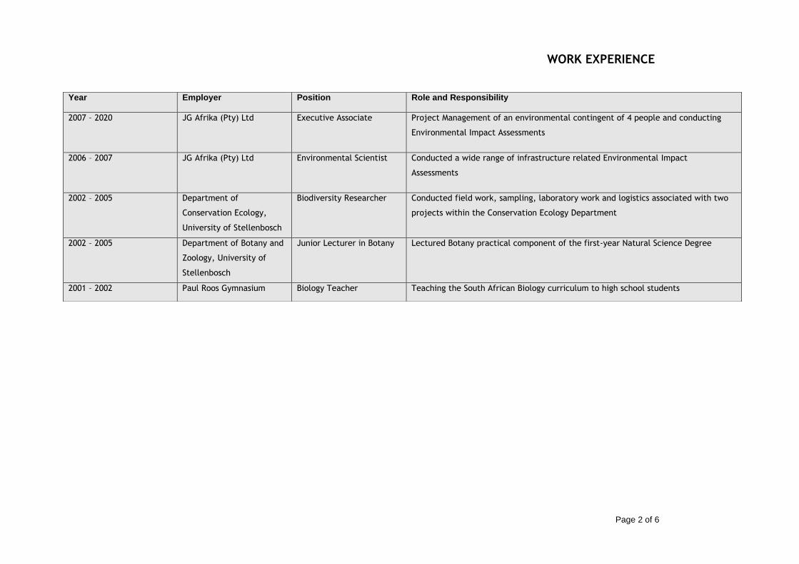
WORK EXPERIENCE
Page 2 of 6
Year Employer Position Role and Responsibility
2007 – 2020 JG Afrika (Pty) Ltd Executive Associate Project Management of an environmental contingent of 4 people and conducting
Environmental Impact Assessments
2006 – 2007 JG Afrika (Pty) Ltd Environmental Scientist Conducted a wide range of infrastructure related Environmental Impact
Assessments
2002 – 2005 Department of
Conservation Ecology,
University of Stellenbosch
Biodiversity Researcher Conducted field work, sampling, laboratory work and logistics associated with two
projects within the Conservation Ecology Department
2002 – 2005 Department of Botany and
Zoology, University of
Stellenbosch
Junior Lecturer in Botany Lectured Botany practical component of the first-year Natural Science Degree
2001 – 2002 Paul Roos Gymnasium Biology Teacher Teaching the South African Biology curriculum to high school students

PROJECT EXPERIENCE
Page 3 of 6
Biodiversity Assessment Projects Biodiversity Assessment Projects
Mamatwan Tailings Facility
Biodiversity and Wetland Assessment for the site to be used for the establishment of the new tailings facility on the South32 Mamatwan Manganese Mine near Hotazel. Hillside Aluminum Desalination Plant Biodiversity Screening Assessment for the infrastructure network associated with the South32 Hillside Aluminum Desalination Plant in Richards Bay.
Lichtenburg Siding Expansion Biodiversity Assessment for the proposed expansion of the Lichtenburg Cement Siding, North West Province.
Nacala Dam Project
Riparian Vegetation Study for the Ecological Reserve Determination Specialist Study for the
Environmental Impact Assessment for the Nacala Dam Project in Mozambique.
National Route N8
Vegetation Specialist Study for the Environmental Impact Assessment for the National Route N8.
National Route N2 uMgeni Interchange ImprovementsEnvironmental Impact Assessment for proposed
improvements to the uMgeni Road Interchange and the National Route N2. The project included an extensive
public participation process within the city of Durban, KwaZulu-Natal during the process.
Qudeni Link Road
Vegetation Specialist Study for the Environmental Impact Assessment for the Qudeni Rural Link Road.
Municipal Landfill Site Identification Negative mapping and ground truthing for the options analysis for the identification of a District Municipality Landfill Site.
Port Related Projects Pier 1 Phase 2 expansion Environmental Impact Assessment for proposed expansions to Pier 1 within the Durban Harbour. Locomotive Turning Table in the Port of Richards Bay Environmental Impact Assessment for proposed Locomotive Turn Table in within the Port of Richards Bay. Rail line construction in the Port of Richards Bay Environmental Impact Assessment for proposed additional rail line into the Richards Bay Coal Terminal in the Port of Richards Bay.

PROJECT EXPERIENCE
Page 4 of 6
Environmental Monitoring – RME Projects Durban Harbour Environmental Monitoring Duties for all the RME construction projects within the Durban harbour. Ore Loading Facility at Kalia in Guinea Environmental Impact Assessment for the proposed Ore Loading Facility in Kalia in Guinea, West.
Roads Projects National Route N2 uMgeni Interchange Improvements Environmental Impact Assessment for proposed improvements to the uMgeni Road Interchange and the National Route N2. The project included an extensive public participation process with a range of public and private sector stakeholders. National Route N11 upgrade Environmental Impact Assessment for proposed upgrade of the National Route N11. The project included a public participation process with a range of public and private sector stakeholders as well as specialist studies associated with the river crossings. National Route N2 improvement and upgrade Environmental Impact Assessment for proposed upgrade of the National Route N2. The project included a public participation process with a range of public and private sector stakeholders as well as specialist studies associated with the river crossings. National Route N3 Chota Motala Interchange Environmental Audits Environmental Monitoring for the construction of the Chota Motala Interchange on the National Route N3. National Route R30 Environmental Audits Environmental Monitoring for the construction of the National Route R30.
Agricultural Projects uMngano Community Dairy Development Project Environmental and Social Impact Assessment for the Development of a 200ha dairy for the uMngano Community in KwaZulu-Natal, South Africa. uMngano Community Vegetable Project Environmental and Social Impact Assessment for the Development of a 180ha vegetable growing project for the uMngano Community in KwaZulu-Natal, South Africa. Sundays River Citrus Project Environmental and Social Impact Assessment for the Development of a 100ha citrus project in the Sundays River Valley in the Eastern Cape, South Africa.
Water Projects Nacala Dam project in Mozambique for the Millennium Challenge Corporation Environmental and Social Impact Assessment for the Nacala Dam project in Nacala, Mozambique. The study included the management of a range of specialist studies which included; biodiversity (fauna and flora) assessments, health impact assessments, social impact assessments, a hydrocensus, geotechnical investigation and an ecological flow requirement assessment. The project was conducted under the auspices

PROJECT EXPERIENCE
Page 5 of 6
of the Millennium Challenge Corporation. Mpofana Bulk Water Supply Scheme Environmental Impact Assessment for the Bulk Water Supply Scheme which included an extensive public facilitation process with affected landowners and other specialist studies. KwaHlokohloko Rural Water Supply Scheme Environmental Impact Assessment for the Rural Water Supply Scheme which included an extensive public facilitation process with the rural landowners and tribal leaders. Conservation Management Plans Ndumo Game Reserve Management Plan Compilation of the Management Plan for the KwaZulu-Natal Wildlife Ndumo Game Reserve in northern KwaZulu-Natal. The compilation was conducted in accordance to the National Environmental Management: Protected Areas Act (No 57 of 2003).
Mining Projects Uithoek Colliery for Miranda Mineral Holdings Environmental Impact Assessment for the establishment of the Uithoek Colliery including the management of a range of specialist studies which included a hydrological and geohydrological assessment, a biodiversity assessment, a social and heritage assessment and a repatriation plan for residents on the site. Burnside Colliery for Miranda Mineral Holdings Environmental Impact Assessment for the establishment of the Burnside Colliery including the management of a range of specialist studies which included a hydrological and geohydrological assessment, a biodiversity assessment, a social and heritage assessment and a repatriation plan for residents on the site. Ultimate Goal Colliery for Corobrik (Pty) Ltd Environmental Impact Assessment for the establishment of the Ultimate Goal Colliery including the management of a range of specialist studies which included a hydrological and geohydrological assessment, a biodiversity assessment, a social and heritage assessment and a repatriation plan for residents on the site. Klipwaal Gold Mine for Miranda Mineral Holdings Environmental Due Diligence assessment on the Klipwaal Gold Mine which included an assessment of completed and required rehabilitation, a contaminated land liability assessment and an evaluation of the structure and the possible impact of the slurry dams. Afrimat Quarries Compliance Audits Compliance audits and Due Diligence assessments of the Afrimat Quarry operations in South Africa. These audits are conducted on a two yearly basis. Private and Public Sector Development Projects Provincial Legislature Precinct Environmental and Social Impact Assessment for the proposed Provincial Legislature Precinct. This study consisted of a large public facilitation component and extensive engagement with private and public sector stakeholders.

PROJECT EXPERIENCE
Page 6 of 6
DECLARATION
I, Magnus Van Rooyen hereby declare that the details furnished above are true and correct to the best of my knowledge and
belief and I undertake to inform you of any changes therein, immediately. In case any of the above information is found to be
false or untrue or misleading or misrepresenting, I am aware that I may be held liable for it.
Signature: Date: 27/02/2021
Camps Drift Canal Mixed Use Development Environmental Impact Assessment for proposed improvements to the uMgeni Road Interchange and the National Route N2. The project included an extensive public participation process within the city of Durban, KwaZulu-Natal during the process. Tiger Lodge Development Environmental Impact Assessment for the proposed Tiger Lodge Tourism Development. Paradise Lodge Development Environmental Impact Assessment for the proposed Paradise Lodge Tourism Development.


Page 1 of 8
PROFILE
Janice Callaghan Junior Environmental Consultant
Janice is a Junior Environmental Consultant at GCS Water and
Environmental since April 2018 with 4 years’ experience. She forms
part of the Durban Environmental Unit and has undertaken various
applications including Water Use License Applications, Integrated
Water and Waste Management Plans, Environmental Impact
Assessments and Environmental Management Programmes.
She pays great attention to detail and is a self-motivated individual,
who is passionate about the environment with a particular interest
in biogeography and conservation. Janice is both team player and
able to work independently and is always keen to learn. Her
methodical and organized approach benefits her in the workplace
when meeting deadlines and she copes well under pressure.
Professional Affiliations:
• SACNASP (Cand.Sci.Nat) • IAIAsa • AIEMA
• SSAG
Areas of Expertise:
• Reviewing specialist studies and compiling reports; • Database compilation and management; • Compiling environmental authorisation applications for
various mining projects in terms of NEMA, NEM:WA and NWA;
• Undertaking environmental audits; • Compiling Annual Financial Provisioning Updates; • Rehabilitation Strategy Implementation Plan; • Report writing; • Compilation of tender documents; • Writing proposals; • Assisting with information material and report
compilation.
CORE SKILLS
• Water Use Licensing
• EIAs and BARs
• Section 24G reports
• RSIP reports
• Auditing
• Annual Decommissioning, Rehabilitation and Closure Updates
DETAILS
Qualifications
• BSc (Hons) Environmental Science
• Certificate from UCT in Occupational Health and Safety
• Certificate from University of British Columbia in Ecodesign for Cities and Suburbs
Membership
• Cand.Sci.Nat
• AIEMA
• Society of South African Geographers
• IAIAsa Languages
• English – fluent
• Afrikaans - fluent Countries Worked In
• South Africa
• Mozambique

Project Experience Professional Experience
Page 2 of 6
Work Experience
Period Employer Position Role/ Responsibility
March 2020 to present
GCS Junior Environmental Consultant - Undertaking environmental authorization processes
- Mine closure and financial provisioning
- Environmental Officer assistance to Buffalo Coal
- Client liaison
- Project management
April 2018 to March 2020
GCS Intern - Assisting environmental consultants with environmental applications

Page 3 of 6
Project Experience
Year Client Project Description Role/Responsibility
Audits
2019 Buffalo Coal Annual EMPr and WUL audits for Coalfields, Aviemore and
Magdalena operations
Assisting the lead auditor in site work and compilation of the audit reports.
2020 Buffalo Coal Annual EMPr and WUL audits for Coalfields, Aviemore and
Magdalena operations
Assisting the lead auditor in site work and compilation of the audit reports.
2020 Samancor Annual audits for 6 operations Assisting with compilation and internal review of the documents prior to sending for client review.
2020 Eskom Legal compliance audit for Majuba
power station
Assisting the lead auditor in site work and compilation of the audit
reports.
2020 Eskom Biennial PCB Audit Assisting the lead auditor in site work and compilation of the audit
reports.
2021 ZAC Annual IWUL Audit Lead auditor undertaking the site audit and compilation of report.
2021 Northam Platinum Biennial Environmental
Performance Audits for Booysendal’s North and South
Operations
Assisting lead auditor with document compilation, and review of
final document before sending to the client for review.
2021 Arcadis Audit of EnviroServ’s Mavoco Landfill Site
Lead auditor undertaking the site audit and compilation of report.
2021 Arcadis Review of Harmony’s Deelkraal
Landfill
Documentation review and report.
2021 Tronox Norms and Standards Audit of
Waste Management
Assisting the lead auditor to undertake the audit and report
compilation.
2021 Buffalo Coal Annual EMPr and WUL audits for Coalfields, Aviemore and
Magdalena operations
Assisting the lead auditor in site work and compilation of the audit reports.
2022 Tharisa External EMPr Audit Lead auditor responsible for the compilation of report
RSIPs
2019 Buffalo Coal Magdalena Colliery RSIP Update Updating the RSIP undertaken in 2014 prior to the
commencement of S24G activities
2020 Exxaro Rietkuil RSIP Compiling a RSIP for the Rietkuil Siding in compliance with their IWUL
2020 Exxaro Belfast RSIP Update Finalising the document with client comments

Page 4 of 6
Project Experience
2020 Marula Platinum RSIP update Undertaking the annual update of the RSIP in compliance with the IWUL
2020 Anglo American Mafube Coal RSIP update Undertaking the annual update of the RSIPs in compliance with the IWUL
2020 Tharisa Minerals RSIP update Internal review of the update compiled by GCS prior to sending to the client for review.
IWULAs
2018 Frame Knitting Manufacturers
WULA for borehole Report writing and compilation, license application forms, public participation and follow-ups with DWS.
2018 - 2020 Buffalo Coal Magdalena IWULA Amendment Report writing and compilation, and data analysis
2018 - 2019 Tendele Coal Somkhele IWULA Amendment Public participation and associated report writing
2018 - 2020 South 32 Roypoint IWULA Data management, public participation
2018 - 2019 Buffalo Coal Aviemore New Adit and Access Road WULA
Data management, report compilation and submission
2020 – present Celrose Clothing WULA for borehole Project management, client liason
2020 – present Buffalo Coal Coalfields IWULA Finalisation Uploading of documents to e-WULAAS portal, client liaison
EMPr Amendments
2021 Interwaste EMP Amendment for the Interwaste Waste Management Facility in Germiston, Gauteng
Update the current EMPr to reflect on-site activities and fulfill the regulatory requirements.
2021 De Beers Consolidated Mines Limited
Environmental Management Programme Amendment Application for the Voorspoed Diamond Mine, Free State Province
Assisting with the finalization of the EMPr for public review and submission
2021 Dorning Group Stonewall Quarry EMPr Amendment Update the current EMPr to reflect on-site activities and fulfill the regulatory requirements.
2021 Sibanye Stillwater Burnstone EMPr Amendment Report writing and compilation, public participation
2021 Exxaro Coal Thabametsi EMPr Amendment Amend the current EMPr to reflect on site conditions.
2022 Northam Platinum Booysendal North and South EMPr Amendments
Amend the current EMPr to make provision for
Environmental Authorisations
2018 – 2019 Buffalo Coal Coalfields Calcine Plant BA Report writing and compilation, public participation
2018 – 2019 Buffalo Coal Aviemore New Adit and Access Road EA Data management, report compilation and submission

Page 5 of 6
Project Experience
2018 – 2020 ZAC ZAC New Adit and Opencast Mining Operations
Report writing and compilation of BARs, public participation
2018 - 2019 Buffalo Coal Magdalena S24G application Writing and compiling Section 24G EIA, and EMPr, and public participation
2020 Phumaf Engineering Gauteng Rapid Land Release Environmental Assessments
Compilation of Scoping Report and Basic Assessment Reports, public participation
2019 - 2021 Buffalo Coal Magdalena Waste Management License EIA
Report writing, public participation
2021 Exxaro/Cennergi Grootegeluk Self Generation/Lephalale Solar Environmental Authorisation
Information review, report writing and compilation, public participation
2022 Kouga Sand Mining Permit Application Information review, report writing and compilation, public participation
2022 Mentorskraal Familie Trust
Mining Permit Application Information review, report writing and compilation, public participation
2022 Hard Ventures Prospecting Right Application Information review, report writing and compilation, public participation
2022 Imvukazane Resources Prospecting Right Application Information review, report writing and compilation, public participation
Mine Closure and Financial Provisioning
2019 Buffalo Coal Annual Financial Provisioning Update in terms of GNR 1147 for Magdalena, Aviemore and Wesselsnek
Updating closure costing; annual rehabilitation plan; final rehabilitation, decommissioning and closure plan; and environmental risk assessment for each site.
2020 Buffalo Coal Annual Financial Provisioning Update in terms of GNR 1147 for Magdalena, Aviemore and Wesselsnek
Updating closure costing; annual rehabilitation plan; final rehabilitation, decommissioning and closure plan; and environmental risk assessment for each site.
2020 - present Corobrik/Investec Application for mine closure for the Corobrik Avoca site for a development to be undertaken
Mine closure application in terms of NEMA and the MPRDA.
2021 Midmar Crushers Prospecting Right Closure Compile an Environmental Risk Report and the Final Performance Assessment Report in support of the MPRDA requirements.
2021 Buffalo Coal Annual Financial Provisioning Update in terms of GNR 1147 for Magdalena, Aviemore and Wesselsnek
Updating closure costing; annual rehabilitation plan; final rehabilitation, decommissioning and closure plan; and environmental risk assessment for each site.
Environmental Officer
2019 - present Buffalo Coal Ad hoc work as required Environmental Officer assistance to Buffalo Coal
Renewable Energy
2021 Cennergi Lephalale Solar Plant Environmental assessment for a solar plant

Page 6 of 6
Project Experience
Other
2018 – present Exxaro Belfast RAP LRP analysis and RAP compilation
2018 Airports Company South Africa
KSIA Storm Water Monitoring Sorting of monitoring data
2018 CIG Standerton SIA Database compilation and management, data analysis, assisting with report writing
2018 – present CIG Standerton Oil Mill Phase 2 Data management, stakeholder engagement
2020 Tendele Coal Somkhele Health Impact Assessment Undertake an environmental Health Impact Assessment under the guidance of an external reviewer, in terms of the IFC and South African Department of Health Guidelines for undertaking such an assessment.

Page 7 of 6
Project Experience
DECLARATION
I, Janice Callaghan, hereby declare that the details furnished above are true and correct to the best of my knowledge and belief and I
undertake to inform you of any changes therein, immediately. In case any of the above information is found to be false or unt rue or
misleading or misrepresenting, I am aware that I may be held liable for it.
Signature: Date: 04 May 2022

Janice Susan CallaghanRegistration Number: 122924
Environmental Science (Candidate Natural Scientist)
11 March 2020 31 March 2023
To verify this certificate scan this code


Kouga Sand Environmental Management Programme
21-0703 July 2022 Page 47
APPENDIX B
Generic Method Statement

Kouga Sand Environmental Management Programme
21-0703 July 2022 Page 48
Generic Method Statement Information pertaining to the activity which will be undertaken:
What activity will take place?
How will the activity be undertaken (methods)?
Machinery/plant/equipment or vehicles which will be needed?
Materials required and relevant hazard status?
Where on site will the activity take place and what will the extent of the activity be?
Timeframes of activity (start and end dates)?
Impact and Risk Assessment of the Activity:
Impact sources
Receptors
Objective
Risks
Notes

Kouga Sand Environmental Management Programme
21-0703 July 2022 Page 49
The following signatures represent a binding agreement to the Method Statement and EMPr by
all Contractors and Sub-Contractors involved in the above activity.
Role Name Company Date Signature
Client
Engineer/Applicant’s
representative
Contractor
ECO

Kouga Sand Final Basic Assessment Report
APPENDIX F: DETAILED IMPACT ASSESSMENT

Significance Environmental Significance Points Colour Code
High (positive) >60 H
Medium (positive) 30 to 60 M
Magnitude:=M Duration:=D Low (positive) <30 L
10: Very high/don’t know 5: Permanent Neutral 0 N
8: High 4: Long-term (ceases with the operational life) Low (negative) >-30 L
6: Moderate 3: Medium-term (5-15 years) Medium (negative) -30 to -60 M
4: Low 2: Short-term (0-5 years) High (negative) <-60 H
2: Minor 1: Immediate
0: Not applicable/none/negligible 0: Not applicable/none/negligible
Scale:=S Probability:=P
5: International 5: Definite/don’t know
4: National 4: Highly probable
3: Regional 3: Medium probability
2: Local 2: Low probability
1: Site only 1: Improbable
0: Not applicable/none/negligible 0: Not applicable/none/negligible
The maximum value that can be achieved is 100 Significance Points (SP).
Environmental effects were rated as follows:
Status of Impact
+: Positive (A benefit to the receiving environment)
N: Neutral (No cost or benefit to the receiving environment)
-: Negative (A cost to the receiving environment)

M D S P
TO
TA
L
ST
AT
US
SP M D S P
TO
TA
L
ST
AT
US
SP
Surface Water
Site establishment •Increase in surface runoff and velocity, leading to erosion
4 2 1 4 28 - L
•Restrict vegetation clearing to specific footprints.
•Undertake continual monitoring to identify erosion as early as possible to remedy.
•Implement the necessary stormwater control measures to ensure no uncontrolled discharge of stormwater takes place. 2 2 1 2 10 - L
Fauna
Site establishment •Disturbance or possible mortality incidents of terrestrian
fauna.
4 2 1 4 28 - L
•Restrict all movement of vehicles and heavy machinery to permissible, designated areas. No off-road driving beyond
designated areas may be allowed.
•Strict speed limits must be set and adhered to.
•Driving between dusk and dawn should be permissible to emergency situations only.
4 2 1 2 14 - L
Flora
Site establishment •Loss of minimal indigenous vegetation present on site
8 2 1 4 44 - M
•Restrict all movement of vehicles and heavy machinery to permissible areas. No off-road driving beyond designated
areas may be allowed.
•Provision must be made for concurrent rehabilitation of the mining operations which will ensure that the permit area is
mined in designated sections.
•The mined out sections will be rehabilitated and planted with an indigenous grass seed mix in the first growing season
after it has been mined out. This will limit the operational area to the current operational area.
6 2 1 2 18 - L
Site establishment •Loss of alien invasive vegetation8 2 1 4 44 + M
The removal of alien invasive vegetation and the associated seedbed in the soil is a positive impact. No mitigation
measures are required.8 2 1 4 44 + M
Site establishment •Spreading of alien invasive plant species
6 3 2 3 33 - M
•A seedbed of alien plants will be present within the cleared soils. This seedbed and the plants that originate from it
must be managed as follows:
oThe Mining Permit footprint must be clearly surveyed and demarcated before any construction or operations are set
to commence, to ensure that the area to be cleared is limited to only the areas that are necessary for the mining
activities.
oThe cleared areas must be regularly monitored for the establishment of alien plant species. These must be cleared
when they appear.
oIf alien invasive plant species become a problem on the mining area aite, a formal Alien Invasive Management Plan
must be set up and implemented. This plan must make provision for the identification and eradication of these species.
3 2 1 3 18 - L
Site establishment •Contamination of the area by domestic waste
4 2 1 3 21 - L
•Even though the impacts of contamination of the area by domestic waste are considered to be low pre-mitigation, the
following mitigation measures must be included to further reduce the significance of the impact:
oA designated eating area must be established within the mining area.
oCovered domestic waste bind must be present at the eating area to receive all the domestic waste generated by the
labour.
oThe capacity of these domestic bins must be monitored on a daily basis to ensure they are emptied timeously.
oThe domestic waste from these waste bins must be removed off site and disposed of at a municipal landfill site ona
weekly basis or more regularly if the bins fill up quicker.
2 1 1 2 8 - L
Rivers and Wetlands
Construction
ENVIRONMENTAL SIGNIFICANCE
AFTER MITIGATION
ACTIVITY POTENTIAL IMPACT(S)
ENVIRONMENTAL SIGNIFICANCE
BEFORE MITIGATION
RECOMMENDED MITIGATION MEASURES

Site establishment •Increase in runoff and erosion.
2 2 1 2 10 - L
•A seedbed of alien plants will be present within the cleared soils. This seedbed and the plants that originate from it
must be managed as follows:
oThe Mining Permit footprint must be clearly surveyed and demarcated before any construction or operations are set
to commence, to ensure that the area to be cleared is limited to only the areas that are necessary for the mining
activities.
oThe cleared areas must be regularly monitored for the establishment of alien plant species. These must be cleared
when they appear.
oIf alien invasive plant species become a problem on the mining area aite, a formal Alien Invasive Management Plan
must be set up and implemented. This plan must make provision for the identification and eradication of these species.
•Undertake continual monitoring to identify erosion as early as possible to remedy.
•Implement the necessary stormwater control measures to ensure no uncontrolled discharge of stormwater takes place.
2 2 1 1 5 - L
Geology and Topography -
Site establishment •Change in baseline topography
4 2 1 4 28 - L
•Restrict disturbance to designated footprint.
•Strict adhereance to the EMPr.
•Ensure proper access control to the development area
oFencing.
oSecurity.
oBarriers.
•Ensure warning signs are erected on the perimeter of these areas.
•Structural safety to be ensured according to engineering standards.
2 2 1 4 20 - L
Soil
Vehicle Movements •Contamination of the area by petrochemical spillages
4 1 1 3 18 - L
•Even though the impacts of contamination of the area by petrochemical spillages are considered to be low pre-
mitigation, the following mitigation measures must be included to further reduce the significance of the impact:
oAll plant and equipment that make use of petrochemical substances must be checked for leakages on a daily basis.
oAll plant and equipment that are found to be leaking must be removed from the property and only returned once the
leakages have been addressed.
oIf any petrochemical substances are stored on the property, this storage must be done on an impermeable surface in
a bunded area that makes provision for 110% of volume of the substances that are stored.
oAll refuelling of plant and equipment must be conducted over a driptray.
oIf any plant or equipment is to be parked on site, these must be parked within the demarcated construction footprint
that has been cleared.
oIf any spillages from plant or equipment occur, the spill must be immediately contained, the contaminated soils must
be collected and bagged in impermeable bags and stored on site to be removed and disposed of by a registered service
provider.
4 1 1 1 6 - L
Site establishment •Contamination of the area as a result of leaking portable
toilet facilities
6 1 1 4 32 - M
•Regarding portable chemical toilets, the following must be implemented:
oOnly portable chemical toilets with a sealed reservoir will be allowed on site.
oThe capacity of the reservoirs in the portable chemical toilets must be monitored on a daily basis to ensure that they
can be serviced timeously.
oAll removal of the collected sewage waste from the portable chemical toilets must be conducted by a registered
service provider for disposal at a municipal waste water treatment facility.
2 1 1 2 8 - L
Land Use
Site establishment •Change in land use from disturbed area to mining
4 1 1 2 12 - L
•Restrict disturbance to designated footprint.
•Restrict vehicle movement to designated access roads.
•Strict adherence to the EMPr.
•All areas disturbed by activities must be subject to rehabilitation.
2 2 1 1 5 - L
Traffic
Site establishment •Minimal, intermittent increase in number of trucks on the
road 4 1 1 2 12 - L •The road is designed according to the specifications of a provincial road. The applicant will assist where feasibly
possible to repair and maintain the road. 2 2 2 1 6 - L
Cultural and Heritage

Site establishment
•Disturbance of palaeontological material
4 2 1 1 7 - L
•Adhere to footprint areas.
•A Chance find procedure should be implemented for the duration of the project with inputs from stakeholders and the
local community, should there be a heritage resource identified.
•For any chance finds of heritage resources, such as graves, all work must cease in the affected area and the Contractor
must immediately inform the Project Manager/Developer. A heritage specialist must be called to site for inspection.
The relevant heritage resource agency (SAHRA) must also be informed about the finding.
•Should any recent remains be found on site that could potentially be human remains, the South African Police Service
(SAPS) as well as SAHRA and AMAFA must be informed. No SAPS official may remove remains until the correct permit/s
have been obtained.
2 2 1 1 5 - L
Socio-Economic
Site establishment •Potential employment opportunities for a limited number
of local residents 4 2 2 2 16 + L
•Positive impact, so no mitigation measures required.
4 2 2 2 16 + L
Noise
Site establishment •Increase in ambient noise levels.
6 2 2 2 20 - L
•The Contractor must keep noise level within acceptable limits.
•Comply with the Noise Control Regulations in terms of Section 25 of the Environment Conservation Act, 1989 (Act No.
73 of 1989) (ECA) (GN R154 of 10 January 1992) and all local noise bylaws.
•Restrict the use of sound amplification equipment for communication and emergency only.
•Any complaints received by the Contractor regarding noise must be recorded and communicated to the Site Supervisor
(SS) and Project Manager (PM).
•Develop a Code of Conduct for the site establishment phase in terms of the behaviour of construction staff.
4 2 2 1 8 - L
Visual
Site establishment •Visual intrusion.
6 1 2 3 27 - L
•Limit the site footprint to the designated works area.
•Limit the site establishment duration.
•Reinstating and rehabilitating disturbed areas as soon as possible.
•Limiting site establishment activities to working hours.
•Ensure that the site is in a visually acceptable state at all times.
•Ensure a complaints register is in place to record and address complaints.
•Undertake rehabilitation efforts as soon as feasibly possible
4 2 1 2 14 - L
Air
Clearing of vegetation •Generation of dust.
6 2 2 2 20 - L 4 2 1 1 7 - L
Vehicle movements •Air pollution from equipment.
6 2 2 2 20 - L 4 2 1 1 7 - L
•Implement dust suppression measures.
•Ensure a complaints register is in place to record and address complaints.
•Fuel-saving through optimal vehicle and equipment use scheduling.
•Servicing and maintenance of vehicles, and machinery.
•Use of fuel-saving technology.
•Use of low carbon and sulphur fuels.
•Restricting vehicle speeds on access routes and other unsurfaced areas of the work site.
•Restrict vehicle access to defined areas to avoid unnecessary off-road vehicle movements outside of the active work
sites.
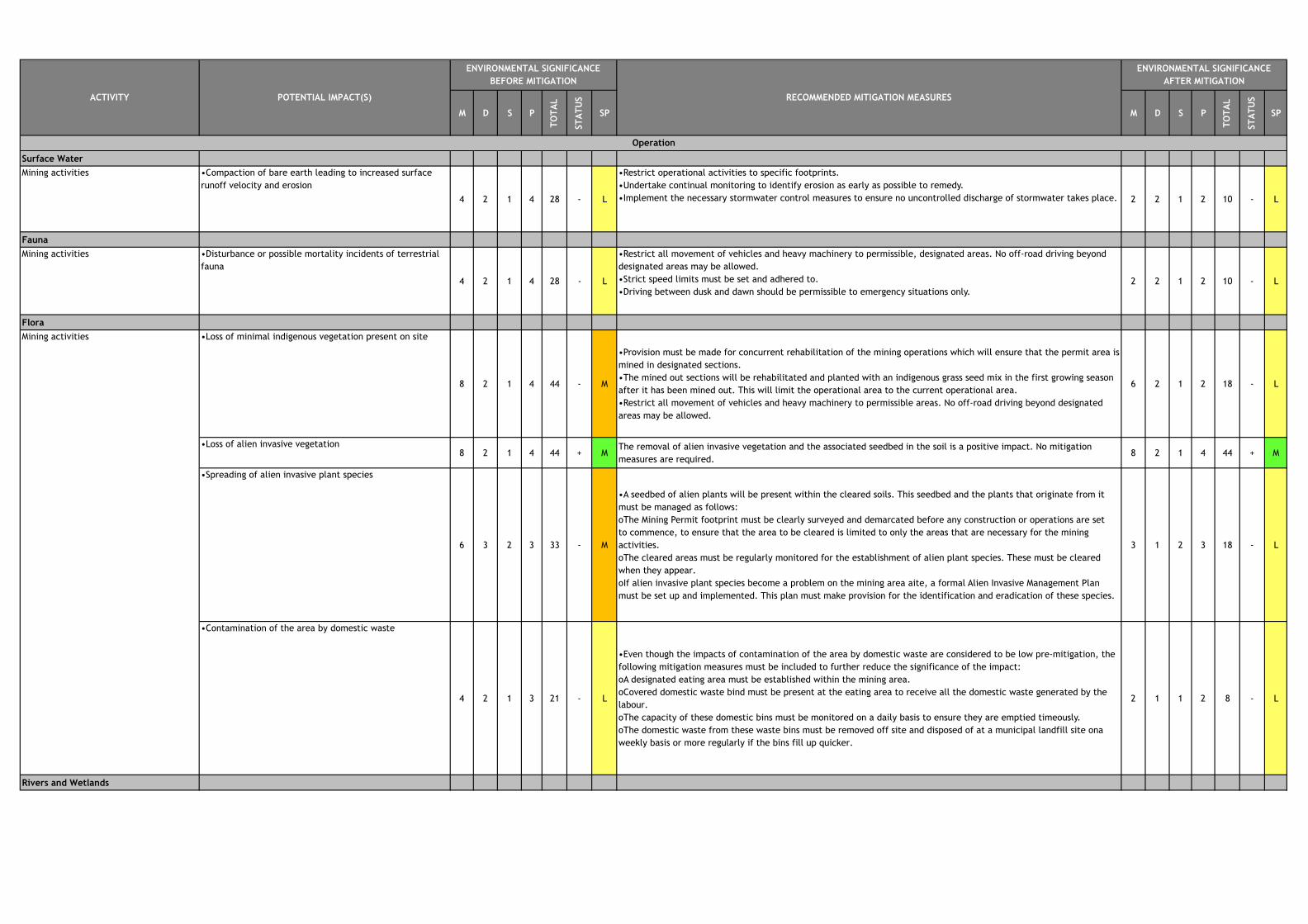
M D S P
TO
TA
L
ST
AT
US
SP M D S P
TO
TA
L
ST
AT
US
SP
Surface Water
Mining activities •Compaction of bare earth leading to increased surface
runoff velocity and erosion
4 2 1 4 28 - L
•Restrict operational activities to specific footprints.
•Undertake continual monitoring to identify erosion as early as possible to remedy.
•Implement the necessary stormwater control measures to ensure no uncontrolled discharge of stormwater takes place. 2 2 1 2 10 - L
Fauna
Mining activities •Disturbance or possible mortality incidents of terrestrial
fauna
4 2 1 4 28 - L
•Restrict all movement of vehicles and heavy machinery to permissible, designated areas. No off-road driving beyond
designated areas may be allowed.
•Strict speed limits must be set and adhered to.
•Driving between dusk and dawn should be permissible to emergency situations only.2 2 1 2 10 - L
Flora
•Loss of minimal indigenous vegetation present on site
8 2 1 4 44 - M
•Provision must be made for concurrent rehabilitation of the mining operations which will ensure that the permit area is
mined in designated sections.
•The mined out sections will be rehabilitated and planted with an indigenous grass seed mix in the first growing season
after it has been mined out. This will limit the operational area to the current operational area.
•Restrict all movement of vehicles and heavy machinery to permissible areas. No off-road driving beyond designated
areas may be allowed.
6 2 1 2 18 - L
•Loss of alien invasive vegetation8 2 1 4 44 + M
The removal of alien invasive vegetation and the associated seedbed in the soil is a positive impact. No mitigation
measures are required.8 2 1 4 44 + M
•Spreading of alien invasive plant species
6 3 2 3 33 - M
•A seedbed of alien plants will be present within the cleared soils. This seedbed and the plants that originate from it
must be managed as follows:
oThe Mining Permit footprint must be clearly surveyed and demarcated before any construction or operations are set
to commence, to ensure that the area to be cleared is limited to only the areas that are necessary for the mining
activities.
oThe cleared areas must be regularly monitored for the establishment of alien plant species. These must be cleared
when they appear.
oIf alien invasive plant species become a problem on the mining area aite, a formal Alien Invasive Management Plan
must be set up and implemented. This plan must make provision for the identification and eradication of these species.
3 1 2 3 18 - L
•Contamination of the area by domestic waste
4 2 1 3 21 - L
•Even though the impacts of contamination of the area by domestic waste are considered to be low pre-mitigation, the
following mitigation measures must be included to further reduce the significance of the impact:
oA designated eating area must be established within the mining area.
oCovered domestic waste bind must be present at the eating area to receive all the domestic waste generated by the
labour.
oThe capacity of these domestic bins must be monitored on a daily basis to ensure they are emptied timeously.
oThe domestic waste from these waste bins must be removed off site and disposed of at a municipal landfill site ona
weekly basis or more regularly if the bins fill up quicker.
2 1 1 2 8 - L
Rivers and Wetlands
ENVIRONMENTAL SIGNIFICANCE
AFTER MITIGATION
ACTIVITY POTENTIAL IMPACT(S)
ENVIRONMENTAL SIGNIFICANCE
BEFORE MITIGATION
RECOMMENDED MITIGATION MEASURES
Operation
Mining activities

Mining activities •Increase in runoff and erosion.
2 2 1 2 10 - L
•A seedbed of alien plants will be present within the cleared soils. This seedbed and the plants that originate from it
must be managed as follows:
oThe Mining Permit footprint must be clearly surveyed and demarcated before any construction or operations are set
to commence, to ensure that the area to be cleared is limited to only the areas that are necessary for the mining
activities.
oThe cleared areas must be regularly monitored for the establishment of alien plant species. These must be cleared
when they appear.
oIf alien invasive plant species become a problem on the mining area aite, a formal Alien Invasive Management Plan
must be set up and implemented. This plan must make provision for the identification and eradication of these species.
•Undertake continual monitoring to identify erosion as early as possible to remedy.
•Implement the necessary stormwater control measures to ensure no uncontrolled discharge of stormwater takes place.
2 2 1 1 5 - L
Geology and Topography -
Mining activities •Alteration of catchment drainage due to change in
baseline topography
4 2 1 5 35 - M
•Restrict disturbance to designated footprint.
•Strict adhereance to the EMPr.
•Ensure proper access control to the development area
oFencing.
oSecurity.
oBarriers.
•Ensure warning signs are erected on the perimeter of these areas.
•Structural safety to be ensured according to engineering standards.
•Provision must be made during concurrent rehabilitation that the topography is free draining in the natural drainage
direction of the surrounding area.
0 1 1 5 10 - L
Soil
Vehicle Movements from mining activities •Contamination of the area by petrochemical spillages
4 1 1 3 18 - L
•Even though the impacts of contamination of the area by petrochemical spillages are considered to be low pre-
mitigation, the following mitigation measures must be included to further reduce the significance of the impact:
oAll plant and equipment that make use of petrochemical substances must be checked for leakages on a daily basis.
oAll plant and equipment that are found to be leaking must be removed from the property and only returned once the
leakages have been addressed.
oIf any petrochemical substances are stored on the property, this storage must be done on an impermeable surface in
a bunded area that makes provision for 110% of volume of the substances that are stored.
oAll refuelling of plant and equipment must be conducted over a driptray.
oIf any plant or equipment is to be parked on site, these must be parked within the demarcated construction footprint
that has been cleared.
oIf any spillages from plant or equipment occur, the spill must be immediately contained, the contaminated soils must
be collected and bagged in impermeable bags and stored on site to be removed and disposed of by a registered service
provider.
4 1 1 1 6 - L
Site operation •Contamination of the area as a result of leaking portable
toilet facilities
6 1 1 4 32 - M
•Regarding portable chemical toilets, the following must be implemented:
oOnly portable chemical toilets with a sealed reservoir will be allowed on site.
oThe capacity of the reservoirs in the portable chemical toilets must be monitored on a daily basis to ensure that they
can be serviced timeously.
oAll removal of the collected sewage waste from the portable chemical toilets must be conducted by a registered
service provider for disposal at a municipal waste water treatment facility.
2 1 1 2 8 - L
Land Use
Mining activities •Temporary change in land use.
4 1 1 2 12 - L
•Restrict disturbance to designated footprint.
•Restrict vehicle movement to designated access roads.
•Strict adherence to the EMPr.
•All areas disturbed by activities must be subject to rehabilitation.
2 2 1 1 5 - L

Traffic
Mining activities •Minimal, intermittent Increase in traffic.4 1 1 2 12 - L
•The road is designed according to the specifications of a provincial road. The applicant will assist where feasibly
possible to repair and maintain the road. 2 1 2 1 5 - L
Cultural and Heritage
Vehicle Movements
•Disturbance of palaeontological material
4 2 1 1 7 - L
•Adhere to footprint areas.
•A Chance find procedure should be implemented for the duration of the project with inputs from stakeholders and the
local community, should there be a heritage resource identified.
•For any chance finds of heritage resources, such as graves, all work must cease in the affected area and the Contractor
must immediately inform the Project Manager/Developer. A heritage specialist must be called to site for inspection.
The relevant heritage resource agency (SAHRA) must also be informed about the finding.
•Should any recent remains be found on site that could potentially be human remains, the South African Police Service
(SAPS) as well as SAHRA and AMAFA must be informed. No SAPS official may remove remains until the correct permit/s
have been obtained.
2 2 1 1 5 - L
Socio-Economic
Mining activities •Potential employment opportunities for a limited number
of local residents 4 2 2 2 16 + L 4 2 2 2 16 + L
Mining activities •Potential economic benefit for the area from the sale of
the product 4 2 2 2 16 + L 4 2 2 2 16 + L
Noise
Mining activities •Increase in ambient noise levels.
6 2 2 2 20 - L
•The Contractor must keep noise level within acceptable limits.
•Comply with the Noise Control Regulations in terms of Section 25 of the Environment Conservation Act, 1989 (Act No.
73 of 1989) (ECA) (GN R154 of 10 January 1992) and all local noise bylaws.
•Restrict the use of sound amplification equipment for communication and emergency only.
•Any complaints received by the Contractor regarding noise must be recorded and communicated to the Site Supervisor
(SS) and Project Manager (PM).
•Develop a Code of Conduct for the site establishment phase in terms of the behaviour of construction staff.
4 2 2 1 8 - L
Visual
Vehicle Movements •Visual intrusion.
6 1 2 3 27 - L
•Limit the site footprint to the designated works area.
•Limit the site establishment duration.
•Reinstating and rehabilitating disturbed areas as soon as possible.
•Limiting operational activities to working hours.
•Ensure that the site is in a visually acceptable state at all times.
•Ensure a complaints register is in place to record and address complaints.
•Undertake rehabilitation efforts as soon as feasibly possible
4 2 1 2 14 - L
Air 2
Mining activities •Generation of dust.
6 2 2 2 20 - L 4 2 1 1 7 - L
Vehicle Movements •Air pollution from equipment.
6 2 2 2 20 - L 4 2 1 1 7 - L
•Implement dust suppression measures.
•Ensure a complaints register is in place to record and address complaints.
•Fuel-saving through optimal vehicle and equipment use scheduling.
•Servicing and maintenance of vehicles, and machinery.
•Use of fuel-saving technology.
•Use of low carbon and sulphur fuels.
•Restricting vehicle speeds on access routes and other unsurfaced areas of the work site.
•Restrict vehicle access to defined areas to avoid unnecessary off-road vehicle movements outside of the active work
sites.
•Positive impact, so no mitigation measures required.

M D S P
TO
TA
L
ST
AT
US
SP M D S P
TO
TA
L
ST
AT
US
SP
Surface Water
Rehabilitation •Compaction of soil during rehabilitation activities leading
to increased runoff velocity and erosion.
4 2 1 4 28 - L
•Restrict operational activities to specific footprints.
•Undertake continual monitoring to identify erosion as early as possible to remedy.
•Implement the necessary stormwater control measures to ensure no uncontrolled discharge of stormwater takes place.
•Rehabilitation activities must ensure the area reflects the natural drainage direction of the surrounding areas. 2 2 1 2 10 - L
Fauna
Rehabilitation •Restoration of habitats will lead to fauna returning to the
area. 4 2 1 4 28 + L •None required – positive impact.
4 2 1 4 28 + L
Flora
Rehabilitation •Spreading of alien invasive vegetation
8 2 1 4 44 - M
•A seedbed of alien plants will be present within the cleared soils. This seedbed and the plants that originate from it
must be managed as follows:
oThe Mining Permit footprint must be clearly surveyed and demarcated before any construction or operations are set
to commence, to ensure that the area to be cleared is limited to only the areas that are necessary for the mining
activities.
oThe cleared areas must be regularly monitored for the establishment of alien plant species. These must be cleared
when they appear.
oIf alien invasive plant species become a problem on the mining area aite, a formal Alien Invasive Management Plan
must be set up and implemented. This plan must make provision for the identification and eradication of these species
6 2 1 2 18 - L
Rivers and Wetlands
Rehabilitation •Increase in runoff and erosion.
2 2 1 2 10 - L
•A seedbed of alien plants will be present within the cleared soils. This seedbed and the plants that originate from it
must be managed as follows:
oThe Mining Permit footprint must be clearly surveyed and demarcated before any construction or operations are set
to commence, to ensure that the area to be cleared is limited to only the areas that are necessary for the mining
activities.
oThe cleared areas must be regularly monitored for the establishment of alien plant species. These must be cleared
when they appear.
oIf alien invasive plant species become a problem on the mining area aite, a formal Alien Invasive Management Plan
must be set up and implemented. This plan must make provision for the identification and eradication of these species.
•Undertake continual monitoring to identify erosion as early as possible to remedy.
•Implement the necessary stormwater control measures to ensure no uncontrolled discharge of stormwater takes place.
2 2 1 1 5 - L
Geology and Topography -
Rehabilitation •Alteration of catchment drainage due to change in
baseline topography
4 2 1 5 35 - M
•Restrict disturbance to designated footprint.
•Strict adhereance to the EMPr.
•Ensure proper access control to the development area
oFencing.
oSecurity.
oBarriers.
•Ensure warning signs are erected on the perimeter of these areas.
•Structural safety to be ensured according to engineering standards.
•Provision must be made during concurrent rehabilitation that the topography is free draining in the natural drainage
direction of the surrounding area.
0 1 1 5 10 - L
Decommissioning
ENVIRONMENTAL SIGNIFICANCE
AFTER MITIGATION
ACTIVITY POTENTIAL IMPACT(S)
ENVIRONMENTAL SIGNIFICANCE
BEFORE MITIGATION
RECOMMENDED MITIGATION MEASURES

Soil
Vehicle Movements from mining activities •Contamination of the area by petrochemical spillages
4 1 1 3 18 - L
•Even though the impacts of contamination of the area by petrochemical spillages are considered to be low pre-
mitigation, the following mitigation measures must be included to further reduce the significance of the impact:
oAll plant and equipment that make use of petrochemical substances must be checked for leakages on a daily basis.
oAll plant and equipment that are found to be leaking must be removed from the property and only returned once the
leakages have been addressed.
oIf any petrochemical substances are stored on the property, this storage must be done on an impermeable surface in
a bunded area that makes provision for 110% of volume of the substances that are stored.
oAll refuelling of plant and equipment must be conducted over a driptray.
oIf any plant or equipment is to be parked on site, these must be parked within the demarcated construction footprint
that has been cleared.
oIf any spillages from plant or equipment occur, the spill must be immediately contained, the contaminated soils must
be collected and bagged in impermeable bags and stored on site to be removed and disposed of by a registered service
provider.
4 1 1 1 6 - L
Site operation •Contamination of the area as a result of leaking portable
toilet facilities
6 1 1 4 32 - M
•Regarding portable chemical toilets, the following must be implemented:
oOnly portable chemical toilets with a sealed reservoir will be allowed on site.
oThe capacity of the reservoirs in the portable chemical toilets must be monitored on a daily basis to ensure that they
can be serviced timeously.
oAll removal of the collected sewage waste from the portable chemical toilets must be conducted by a registered
service provider for disposal at a municipal waste water treatment facility.
2 1 1 2 8 - L
Land Use
Rehabilitation •Restoration of disturbed areas as closely as possible to the
previous land use. 4 1 1 2 12 + L •None required – positive impact.
4 1 1 2 12 + L
Traffic
Rehabilitation •Minimal, intermittent Increase in traffic.4 1 1 2 12 - L
•The road is designed according to the specifications of a provincial road. The applicant will assist where feasibly
possible to repair and maintain the road. 2 1 2 1 5 - L
Cultural and Heritage
Rehabilitation
•Damage to and/or destruction of non-renewable
archaeological resources.
•Damage to and/or destruction of burial grounds.
•Unmarked graves can be accidentally exposed.
4 1 1 3 18 - L
•Adhere to footprint areas.
•A Chance find procedure should be implemented for the duration of the project with inputs from stakeholders and the
local community, should there be a heritage resource identified.
•For any chance finds of heritage resources, such as graves, all work must cease in the affected area and the Contractor
must immediately inform the Project Manager/Developer. A heritage specialist must be called to site for inspection.
The relevant heritage resource agency (SAHRA) must also be informed about the finding.
•Should any recent remains be found on site that could potentially be human remains, the South African Police Service
(SAPS) as well as SAHRA and AMAFA must be informed. No SAPS official may remove remains until the correct permit/s
have been obtained.
2 1 1 1 4 - L
Socio-Economic
Rehabilitation •Potential employment opportunities for a limited number
of local residents 4 2 2 2 16 + L •Positive impact, so no mitigation measures required.
4 2 2 2 16 + L
Noise
Mining activities •Increase in ambient noise levels.
6 2 2 2 20 - L
•The Contractor must keep noise level within acceptable limits.
•Comply with the Noise Control Regulations in terms of Section 25 of the Environment Conservation Act, 1989 (Act No.
73 of 1989) (ECA) (GN R154 of 10 January 1992) and all local noise bylaws.
•Restrict the use of sound amplification equipment for communication and emergency only.
•Any complaints received by the Contractor regarding noise must be recorded and communicated to the Site Supervisor
(SS) and Project Manager (PM).
•Develop a Code of Conduct for the site establishment phase in terms of the behaviour of construction staff.
4 2 2 1 8 - L

Visual
Rehabilitation •Visual intrusion.
6 1 2 3 27 - L
•Limit the site footprint to the designated works area.
•Reinstating and rehabilitating disturbed areas as soon as possible.
•Limiting rehabilitation activities to working hours.
•Ensure that the site is in a visually acceptable state at all times.
•Ensure a complaints register is in place to record and address complaints.
•Undertake rehabilitation efforts as soon as feasibly possible.
4 2 1 2 14 - L
Air
Rehabilitation •Air pollution from equipment.
6 2 2 2 20 - L
•Implement dust suppression measures if dust becomes a problem.
•Ensure a complaints register is in place to record and address complaints.
•Fuel-saving through optimal vehicle and equipment use scheduling.
•Servicing and maintenance of vehicles, and machinery.
•Use of fuel-saving technology.
•Use of low carbon and sulphur fuels.
•Restricting vehicle speeds on access routes and other unsurfaced areas of the work site.
•Restrict vehicle access to defined areas to avoid unnecessary off-road vehicle movements outside of the active work
sites.
4 1 1 1 6 - L

Kouga Sand Final Basic Assessment Report
APPENDIX G: PROPERTY TITLE DEED

WinDeed Database D/O PropertyHUMANSDORP RD, KRUISFONTEIN, 193, 0, KING WILLIAMS TOWN
0861 946 [email protected]
search.windeed.co.za | www.windeed.co.za
Page 1 of 2
DISCLAIMERThis report contains information provided to LNRM by content providers and LNRM cannot control the accuracy of the data nor the timely accessibility. LNRM will not be held liable for any claims based on reliance of the search information provided. This report is subject to the terms and conditions of LexisNexis Risk Management Agreement. LexisNexis Risk Management (Pty) Ltd is a registered credit bureau (NCRCB26).
SEARCH CRITERIA
Search Date Farm Number
Reference Registration Division
Report Print Date Portion Number
Farm Name Remaining Extent
Deeds Office Search Source WinDeed Database
Property Type Diagram Deed Number
Farm Name Local Authority
Farm Number Province
Registration Division Remaining Extent
Portion Number Extent
Previous Description LPI Code
AFRICAN BEE TRUST
Company Type Document
Registration Number Microfilm / Scanned Date
Name Purchase Price (R)
Multiple Owners Purchase Date
Multiple Properties Registration Date
Share (%)
# Institution Microfilm / Scanned Date
CONVERTED FROM CTN -
2 - 1985 0036 0541
PTN HU RD 193/1-10 Unknown --3
UnknownFARM HU 193
--1
Amount (R)Document
ENDORSEMENTS (5)
-
2020/08/18NO
2020/06/13NO
4 600 000AFRICAN BEE TRUST
-IT88/2019(S)
T8615/2020TRUST
Owner 1 of 1
OWNER INFORMATION (1)
C03400000000019300000-
442.6329H0
NOHUMANSDORP RD
EASTERN CAPE193
DIAS DCKRUISFONTEIN
UIQ6-19/1826FARM
PROPERTY INFORMATION
King Williams Town
NO-
02022/03/24 14:18
HUMANSDORP RD21-0703
1932022/03/24 14:18
Any personal information obtained from this search will only be used as per the Terms and Conditions agreed to and in accordance with applicable data protection laws including the Protection of Personal Information Act, 2013 (POPI), and shall not be used for marketing purposes.

0861 946 [email protected]
search.windeed.co.za | www.windeed.co.za
Page 2 of 2
DISCLAIMERThis report contains information provided to LNRM by content providers and LNRM cannot control the accuracy of the data nor the timely accessibility. LNRM will not be held liable for any claims based on reliance of the search information provided. This report is subject to the terms and conditions of LexisNexis Risk Management Agreement. LexisNexis Risk Management (Pty) Ltd is a registered credit bureau (NCRCB26).
FARM HU 193 Unknown
5 - -
HISTORIC DOCUMENTS (11)
Document Amount (R)
1 - -
T31080/2014CTN 2 900 000
3 - 2002 0348 3911
B47252/2005CTN Unknown
5 SNYMAN ANDRE HEINRICH 1986 0613 2333
T22082/1986CTN 155 000
7 BEZUIDENHOUDT ANDREAS NORTJE
1993 0519 2910
T49181/1993CTN 230 000
9 NICO BOTHA FAMILIE TRUST
2002 0348 3896
T26834/2002CTN 500 000
11 ZYL JOHANNA MAGRIETA VAN
2005 1212 4232500 000T26834/2002CTN
2005 1212 4232ZYL LOURENS MATHYS VAN
10
400 000T25648/1997CTN
1997 0261 0434VERMAAK JOHANNES C & M M M/I
8
180 000T34834/1988CTN
1988 0850 1858GROENEWALD ELIAS JOHANNES
6
UnknownT148/1977CTN
2005 1212 4202-4
UnknownB20411/2002CTN
-SCOTT IT FARM TRUST2
1 700 000B17046/2014CTN
Microfilm / Scanned DateInstitution#
UnknownPTN HU RD 193/1-10
--4
# Institution Microfilm / Scanned DateAmount (R)Document
ENDORSEMENTS (5)