Field prospecting of Únanovka creek basin (South Moravia, Znojmo District)
8
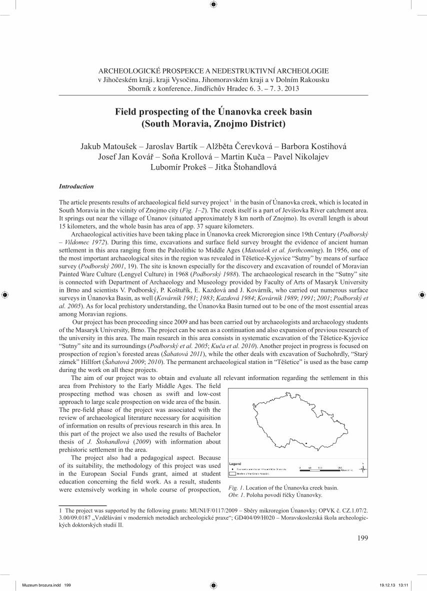
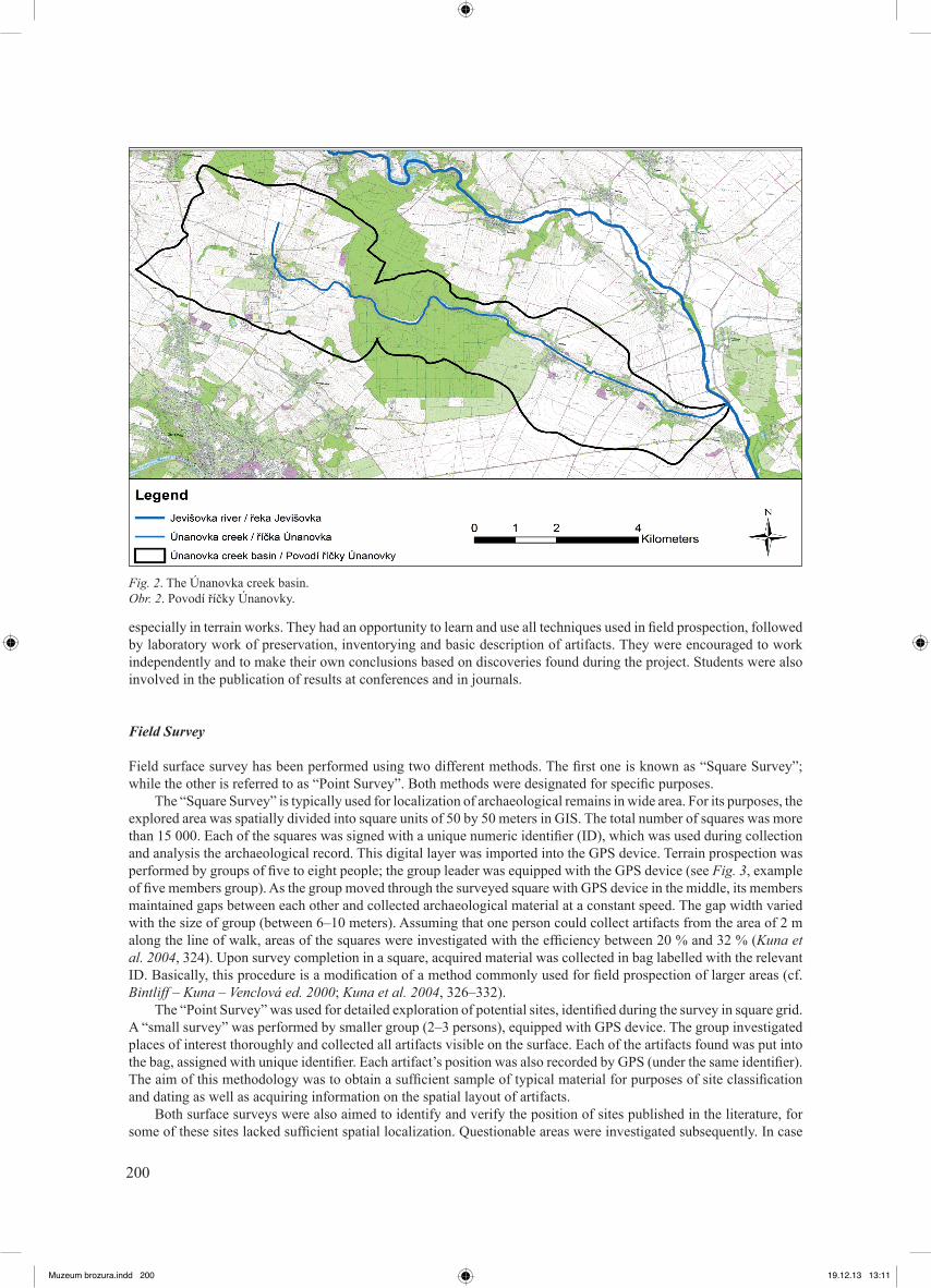
199 ARCHEOLOGICKÉ PROSPEKCE A NEDESTRUKTIVNÍ ARCHEOLOGIE v Jihočeském kraji, kraji Vysočina, Jihomoravském kraji a v Dolním Rakousku Sborník z konference, Jindřichův Hradec 6. 3. – 7. 3. 2013 Field prospecting of the Únanovka creek basin (South Moravia, Znojmo District) Jakub Matoušek – Jaroslav Bartík – Alžběta Čerevková – Barbora Kostihová Josef Jan Kovář – Soňa Krollová – Martin Kuča – Pavel Nikolajev Lubomír Prokeš – Jitka Štohandlová Introduction The article presents results of archaeological field survey project in the basin of Únanovka creek, which is located in South Moravia in the vicinity of Znojmo city (Fig. 1–2). The creek itself is a part of Jevišovka River catchment area. It springs out near the village of Únanov (situated approximately 8 km north of Znojmo). Its overall length is about 15 kilometers, and the whole basin has area of app. 37 square kilometers. Archaeological activities have been taking place in Únanovka creek Microregion since 19th Century (Podborský – Vildomec 1972). During this time, excavations and surface field survey brought the evidence of ancient human settlement in this area ranging from the Paleolithic to Middle Ages (Matoušek et al. forthcoming). In 1956, one of the most important archaeological sites in the region was revealed in Těšetice-Kyjovice “Sutny” by means of surface survey (Podborský 2001, 19). The site is known especially for the discovery and excavation of roundel of Moravian Painted Ware Culture (Lengyel Culture) in 1968 (Podborský 1988). The archaeological research in the “Sutny” site is connected with Department of Archaeology and Museology provided by Faculty of Arts of Masaryk University in Brno and scientists V. Podborský, P. Koštuřík, E. Kazdová and J. Kovárník, who carried out numerous surface surveys in Únanovka Basin, as well (Kovárník 1981; 1983; Kazdová 1984; Kovárník 1989; 1991; 2001; Podborský et al. 2005). As for local prehistory understanding, the Únanovka Basin turned out to be one of the most essential areas among Moravian regions. Our project has been proceeding since 2009 and has been carried out by archaeologists and archaeology students of the Masaryk University, Brno. The project can be seen as a continuation and also expansion of previous research of the university in this area. The main research in this area consists in systematic excavation of the Těšetice-Kyjovice “Sutny” site and its surroundings (Podborský et al. 2005; Kuča et al. 2010). Another project in progress is focused on prospection of region’s forested areas (Šabatová 2011), while the other deals with excavation of Suchohrdly, “Starý zámek” Hillfort (Šabatová 2009; 2010). The permanent archaeological station in “Těšetice” is used as the base camp during the work on all these projects. The aim of our project was to obtain and evaluate all relevant information regarding the settlement in this area from Prehistory to the Early Middle Ages. The field prospecting method was chosen as swift and low-cost approach to large scale prospection on wide area of the basin. The pre-field phase of the project was associated with the review of archaeological literature necessary for acquisition of information on results of previous research in this area. In this part of the project we also used the results of Bachelor thesis of J. Štohandlová (2009) with information about prehistoric settlement in the area. The project also had a pedagogical aspect. Because of its suitability, the methodology of this project was used in the European Social Funds grant, aimed at student education concerning the field work. As a result, students were extensively working in whole course of prospection, 1 The project was supported by the following grants: MUNI/F/0117/2009 – Sběry mikroregion Únanovky; OPVK č. CZ.1.07/2. 3.00/09.0187 „Vzdělávání v moderních metodách archeologické praxe“; GD404/09/H020 – Moravskoslezská škola archeologic- kých doktorských studií II. Fig. 1. Location of the Únanovka creek basin. Obr. 1. Poloha povodí říčky Únanovky. 1 Muzeum brozura.indd 199 19.12.13 13:11
Transcript of Field prospecting of Únanovka creek basin (South Moravia, Znojmo District)
199
ARCHEOLOGICKÉ PROSPEKCE A NEDESTRUKTIVNÍ ARCHEOLOGIEv Jihočeském kraji, kraji Vysočina, Jihomoravském kraji a v Dolním Rakousku
Sborník z konference, Jindřichův Hradec 6. 3. – 7. 3. 2013
Field prospecting of the Únanovka creek basin (South Moravia, Znojmo District)
Jakub Matoušek – Jaroslav Bartík – Alžběta Čerevková – Barbora Kostihová
Josef Jan Kovář – Soňa Krollová – Martin Kuča – Pavel Nikolajev Lubomír Prokeš – Jitka Štohandlová
Introduction
The article presents results of archaeological field survey project54 in the basin of Únanovka creek, which is located in South Moravia in the vicinity of Znojmo city (Fig. 1–2). The creek itself is a part of Jevišovka River catchment area. It springs out near the village of Únanov (situated approximately 8 km north of Znojmo). Its overall length is about 15 kilometers, and the whole basin has area of app. 37 square kilometers.
Archaeological activities have been taking place in Únanovka creek Microregion since 19th Century (Podborský – Vildomec 1972). During this time, excavations and surface field survey brought the evidence of ancient human settlement in this area ranging from the Paleolithic to Middle Ages (Matoušek et al. forthcoming). In 1956, one of the most important archaeological sites in the region was revealed in Těšetice-Kyjovice “Sutny” by means of surface survey (Podborský 2001, 19). The site is known especially for the discovery and excavation of roundel of Moravian Painted Ware Culture (Lengyel Culture) in 1968 (Podborský 1988). The archaeological research in the “Sutny” site is connected with Department of Archaeology and Museology provided by Faculty of Arts of Masaryk University in Brno and scientists V. Podborský, P. Koštuřík, E. Kazdová and J. Kovárník, who carried out numerous surface surveys in Únanovka Basin, as well (Kovárník 1981; 1983; Kazdová 1984; Kovárník 1989; 1991; 2001; Podborský et al. 2005). As for local prehistory understanding, the Únanovka Basin turned out to be one of the most essential areas among Moravian regions.
Our project has been proceeding since 2009 and has been carried out by archaeologists and archaeology students of the Masaryk University, Brno. The project can be seen as a continuation and also expansion of previous research of the university in this area. The main research in this area consists in systematic excavation of the Těšetice-Kyjovice “Sutny” site and its surroundings (Podborský et al. 2005; Kuča et al. 2010). Another project in progress is focused on prospection of region’s forested areas (Šabatová 2011), while the other deals with excavation of Suchohrdly, “Starý zámek” Hillfort (Šabatová 2009; 2010). The permanent archaeological station in “Těšetice” is used as the base camp during the work on all these projects.
The aim of our project was to obtain and evaluate all relevant information regarding the settlement in this area from Prehistory to the Early Middle Ages. The field prospecting method was chosen as swift and low-cost approach to large scale prospection on wide area of the basin. The pre-field phase of the project was associated with the review of archaeological literature necessary for acquisition of information on results of previous research in this area. In this part of the project we also used the results of Bachelor thesis of J. Štohandlová (2009) with information about prehistoric settlement in the area.
The project also had a pedagogical aspect. Because of its suitability, the methodology of this project was used in the European Social Funds grant, aimed at student education concerning the field work. As a result, students were extensively working in whole course of prospection,
1 The project was supported by the following grants: MUNI/F/0117/2009 – Sběry mikroregion Únanovky; OPVK č. CZ.1.07/2. 3.00/09.0187 „Vzdělávání v moderních metodách archeologické praxe“; GD404/09/H020 – Moravskoslezská škola archeologic-kých doktorských studií II.
Fig. 1. Location of the Únanovka creek basin. Obr. 1. Poloha povodí říčky Únanovky.
1
Muzeum brozura.indd 199 19.12.13 13:11
200
especially in terrain works. They had an opportunity to learn and use all techniques used in field prospection, followed by laboratory work of preservation, inventorying and basic description of artifacts. They were encouraged to work independently and to make their own conclusions based on discoveries found during the project. Students were also involved in the publication of results at conferences and in journals.
Field Survey
Field surface survey has been performed using two different methods. The first one is known as “Square Survey”; while the other is referred to as “Point Survey”. Both methods were designated for specific purposes.
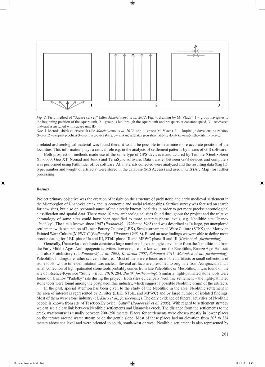
The “Square Survey” is typically used for localization of archaeological remains in wide area. For its purposes, the explored area was spatially divided into square units of 50 by 50 meters in GIS. The total number of squares was more than 15 000. Each of the squares was signed with a unique numeric identifier (ID), which was used during collection and analysis the archaeological record. This digital layer was imported into the GPS device. Terrain prospection was performed by groups of five to eight people; the group leader was equipped with the GPS device (see Fig. 3, example of five members group). As the group moved through the surveyed square with GPS device in the middle, its members maintained gaps between each other and collected archaeological material at a constant speed. The gap width varied with the size of group (between 6–10 meters). Assuming that one person could collect artifacts from the area of 2 m along the line of walk, areas of the squares were investigated with the efficiency between 20 % and 32 % (Kuna et al. 2004, 324). Upon survey completion in a square, acquired material was collected in bag labelled with the relevant ID. Basically, this procedure is a modification of a method commonly used for field prospection of larger areas (cf. Bintliff – Kuna – Venclová ed. 2000; Kuna et al. 2004, 326–332).
The “Point Survey” was used for detailed exploration of potential sites, identified during the survey in square grid. A “small survey” was performed by smaller group (2–3 persons), equipped with GPS device. The group investigated places of interest thoroughly and collected all artifacts visible on the surface. Each of the artifacts found was put into the bag, assigned with unique identifier. Each artifact’s position was also recorded by GPS (under the same identifier). The aim of this methodology was to obtain a sufficient sample of typical material for purposes of site classification and dating as well as acquiring information on the spatial layout of artifacts.
Both surface surveys were also aimed to identify and verify the position of sites published in the literature, for some of these sites lacked sufficient spatial localization. Questionable areas were investigated subsequently. In case
Fig. 2. The Únanovka creek basin. Obr. 2. Povodí říčky Únanovky.
Muzeum brozura.indd 200 19.12.13 13:11
201
a related archaeological material was found there, it would be possible to determine more accurate position of the localities. This information plays a critical role e.g. in the analysis of settlement patterns by means of GIS software.
Both prospection methods made use of the same type of GPS devices manufactured by Trimble (GeoExplorer XT 6000, Geo XT, Nomad and Juno) and TerraSync software. Data transfer between GPS devices and computers was performed using Pathfinder office software. All materials collected were analyzed and the resulting data (bag ID, type, number and weight of artifacts) were stored in the database (MS Access) and used in GIS (Arc Map) for further processing.
Results
Project primary objective was the creation of insight on the structure of prehistoric and early medieval settlement in the Microregion of Únanovka creek and its economic and social relationships. Surface survey was focused on search for new sites, but also on reconnaissance of the already known localities in order to get more precise chronological classification and spatial data. There were 10 new archaeological sites found throughout the project and the relative chronology of some sites could have been specified to more accurate phase levels, e.g. Neolithic site Únanov “Padělky”. The site is known since 1947 (Podborský – Vildomec 1968) and was described as “a large, yet unexplored settlement with occupation of Linear Pottery Culture (LBK), Stroke-ornamented Ware Culture (STbK) and Moravian Painted Ware Culture (MPWC)” (Podborský – Vildomec 1968, 8). Based on new findings we were able to define more precise dating for LBK phase IIa and III, STbK phase III and MPWC phase II and III (Kuča et al., forthcoming).
Generally, Únanovka creek basin contains a large number of archaeological evidence from the Neolithic and from the Early Middle Ages. Anthropogenic activities, however, are also known from the Eneolithic, Bronze Age, Hallstatt and also Protohistory (cf. Podborský et al. 2005; Kovárník 2007; Šabatová 2011; Matoušek et al., forthcoming). Paleolithic findings are rather scarce in the area. Most of them were found as isolated artifacts or small collections of stone tools, whose time delimitation was unclear. Several artifacts are presumed to originate from Aurignacian and a small collection of light-patinated stone tools probably comes from late Paleolithic or Mesolithic; it was found on the site of Těšetice-Kyjovice “Sutny” (Kuča 2010, 284; Bartík, forthcoming). Similarly, light-patinated stone tools were found on Únanov “Padělky” site during the project. Both sites evidence a Neolithic settlement – the light-patinated stone tools were found among the postpaleolithic industry, which suggest a possible Neolithic origin of the artifacts.
In the past, special attention has been given to the study of the Neolithic in the area. Neolithic settlement in the area of interest is represented by 21 sites (LBK, STbK, and MPWC) and by large number of isolated findings. Most of them were stone industry (cf. Kuča et al., forthcoming). The only evidence of funeral activities of Neolithic people is known from site of Těšetice-Kyjovice “Sutny” (Podborský et al. 2005). With regard to settlement strategy we can see a clear link between Neolithic settlements and Únanovka creek. The distance from the settlements to the creek watercourse is usually between 200–250 meters. Places for settlements were chosen mostly in lower places on the terrace around water stream or on the gentle slope. Most of these places had an elevation from 205 to 284 meters above sea level and were oriented to south, south-west or west. Neolithic settlement is also represented by
Fig. 3. Field method of “Square survey” (after Mateiciucová et al. 2012, Fig. 4, drawing by M. Vlach). 1 – group navigates to the beginning position of the square unit, 2 – group is led through the square unit and prospects at constant speed, 3 – recovered material is assigned with square unit ID. Obr. 3. Metoda sběrů ve čtvercích (dle Mateiciucová et al. 2012, obr. 4, kresba M. Vlach). 1 – skupina je dovedena na začátek čtverce, 2 – skupina prochází čtvercem a provádí sběry, 3 – získané artefakty jsou shromážděny do sáčku označeného číslem čtverce.
1 2 3
Muzeum brozura.indd 201 19.12.13 13:13
202
two Hillfort site. Both Hillfort sites were occupied by people from Moravian Panted Ware Culture and are located in the area of Tvořihráz Forest (Štohandlová 2009, 57; Šabatová 2011). Based on evidence found, Neolithic settlement can be divided into different time phases. LBK settlement in the area can be classified as the phase I and II of this culture. Phase III is represented by STbK settlement. Phases I and II are represented by MPWC. Relation between Neolithic settlements occupation over time is an interesting phenomenon. Sites of Linear Pottery Culture were reused by colonization of people with Stroke-ornamented Ware Culture. Moravian Painted Ware Culture settlement was in certain aspects connected to the previous settlement of Stroke-ornamented Ware Culture. Based on particular evidence (e.g. interaction in style of decorating pottery), coexistence of both these cultures at same time could be assumed (Podborský 1969, 582; Kazdová 1988, 117–118; 2004, 56–57).
Several conclusions are possible on the basis of the study of lithic industry. First, there is prevalent use of metabasites of Jizerské hory for production of polished stone industry in the LBK and STbK. The following culture (MPWC) made an extensive use of local and regional raw materials. Most tools were made of amphiboles and greenschist of the Želešice-type originating from Brno massif (Kuča – Vokáč 2008). The most abundant raw material for production of chipped stone industry was the Krumlovský les-type chert. Siliceous weathering products of serpentinites and Olomučany-type cherts were used in smaller scale. Rarely, cretaceous cherts, local rock crystals and imported raw materials like Szentgál-type radiolarite, Abensberg-Arnhofen-type chert, silicites of northern provenance (erratic flints, the Jurassic-Cracow flints) and obsidian were used. Due to single place’s frequent use by more Neolithic cultures, it is sometimes difficult to determine the culture which created particular stone tools. In a limited extent we can deduce some connection between raw materials and Neolithic cultures. The Olomučany-type chert and the Szentgál-type radiolarite were used by LBK culture (Mateiciucová 2001; Vokáč 2003, 112–115; Mateiciucová 2008; Přichystal 2009, 116). The Bavarian Abensberg-Arnhofen-type chert is evidence of long-distance contacts in western direction and can possibly be assigned to STbK (Mateiciucová 2001, 216–217; Vokáč 2003, 37, 116; Kazdová 2008, 69; Přichystal 2009, 88). In the time of MPWC the local crystallized rock crystals and obsidians of eastern provenance was used (Vokáč 2003, 121–122). Other raw stone materials were used across all Neolithic cultures – it concerns erratic flints, the Jurassic-Cracow flints and the Krumlovský les-type chert (cf. Mateiciucová 2001; Vokáč 2003, 112–123).
Eneolithic settlement reached this region, according to the latest findings, only marginally and with lower intensity than the Neolithic one (14 sites). Residential components were recognized for the Jordanov group, Funnelbeaker Culture, Baden Culture, Jevišovice Culture and Bell-Beaker Culture. Burial mounds, solitary or arranged in groups, were found in several sites (Podborský – Vildomec 1972, 98, 222; Podborský et al. 2005; Šabatová 2005, 193;
Fig. 4. Surveyed polygons. Obr. 4. Polygony prozkoumané během sběrů.
Muzeum brozura.indd 202 19.12.13 13:13

203
Štohandlová 2009, 60; Šabatová 2011, 49). Těšetice-Kyjovice “Sutny” site excavation uncovered residential unit of Baden Culture (Golec 2003) and a grave with round ditch of Bell-Beaker Culture (Kazdová et al. 2011). The most substantial evidence of the Eneolithic settlements is known from the Hillforts “Starý zámek” and “Deblínek”(Bíško 2008; Šabatová 2010; 2011, 47). Residential structure of the Eneolithic settlement, in comparison to one from the Neolithic, moved to area’s forest part (Šabatová 2011, 49).
Bronze Age settlements were also relatively dense in this area. Remains of Únětice Culture (Early Bronze Age) were identified in cadaster of Suchohrdly village (in the site “Purkrábka”) and Hillfort “Deblínek”. Important settlement of Únětice Culture was in cadaster of Těšetice village, where settlement in Těšetice-Kyjovice “Sutny” site and settlement with the burial area in “Vinohrady”, “Palliardiho cihelna” and “Písečník” sites were identified. The end of Early Bronze Age is represented by Věteřov Culture, which shows some links to previous Únětician settlement. People of the Únětice and Věteřov Cultures often settled the same locations, as observed in Těšetice “Vinohrady”, “Sutny” and “Palliardiho cihelna” sites. Settlement in the intermediate phase of the Bronze Age – Middle Danube Tumulus Culture was sparser in comparison to the previous period in the Microregion (site “Vinohrady”, “Purkrábka”). Population density increased only due to inflow of people of Middle-Danube Urnfield Culture, especially the older phase of this culture (Velatice Culture; Podborský – Vildomec 1972, 214, 219). New findings of Early Bronze Age were collected during our prospecting of “Nad hliníkem” site in the cadaster of the Práče village. Bronze Age pottery was also found in “Nad betonkou” site in the cadaster of Těšetice. As for settlement strategy, there is a clear link between human activities and the watercourse of Únanovka creek. Settlements are mostly located within a distance of 250 m from the water source. The burial site was often located closer to water source (100–200 m). This trend applies particularly to Únětice Culture settlement and can be seen in the previous Bell-Beaker Culture already. Site elevation location is also similar to previous Eneolithic settlements. Lowland settlements are situated at the elevation of 242 to 294 meters above sea; “Deblínek” Hillfort location has the elevation of 356 meters above sea. The burial site was situated in lower elevation point of 200 meters above sea (Štohandlová 2009, 74–76).
The Early Iron Age findings were poor in comparison to the previous period. Several sites contained settlements, which continued from the Bronze Age (Těšetice “Vinohrady”, Těšetice-Kyjovice “Sutny”, Tvořihráz “Purkrábka”). Other settlements were moved to lower positions. The burial site of Horákov Culture, in the contrary, was moved to higher position (Podborský – Vildomec 1972, 219, 223; Štohandlová 2009, 76–77). Surface survey did not uncover any artifacts from Early Iron Age (Matoušek et al., forthcoming).
Late Iron Age pottery was found only in few sites in the Únanovka creek basin. A settlement was found near the Suchohrdy village. Two graves and isolated finds of pottery were discovered in the cadaster of Únanov (Podborský – Vildomec 1972, 214). During the surface survey, artifacts of La Téne Culture were found in the site of Těšetice “Nad betonkou”.
Only one piece of pottery was collected in this site, presumably originating from the Roman Period (Matoušek et al., forthcoming). Other finds from this period were scant in the area. Only a few artifacts from cadaster of Těšetice were identified, but unfortunately without any further information (Podborský – Vildomec 1972, 203, 219).
Surface surveys enabled identification of ten new Early Medieval sites. There was high density of settlement in Microregion during the early medieval period. Reasons for this are e.g. exceptional environmental conditions, flat terrain, available water sources and land for agriculture. Presence of iron ores (limonite) near the Plaveč village and the source of kaolin near the Únanov village might have been an advantage, as well. The investigated area was also important for communication, for it was situated in close the Amber Trail routes leading from Vienna through Znojmo and Moravské Budějovice to the basin of Elbe river (Měřínský 2002, 327–328; Vágner 2009, 15–18, 27–28).
Discussion
Surface survey was selected as an appropriate method to achieve project objectives. Advantages of collections have already been mentioned; they are fast, they require little equipment (besides GPS devices) and do not require complicated procedures.
Despite the obvious advantages, surface surveys have disadvantages, as well. Surface collections can’t provide a complete and comprehensive picture of the last settlement – they can capture only those areas, in which underground objects were built. Therefore, collections do not provide a balanced view of the track components, because of their dependency on many factors such as the number of objects in the area, the number of identifiable artifacts, which are moved to the surface layer as a result of plowing. “Number and type of collected artifacts also depends on many attribute of the landscape and ways of manipulation with the soil, such as the depth of topsoil and subsoil, the depth of plowing” (Neustupný 1982, 180). Surface survey usually helps to uncover residential areas, funeral sites or others. Besides, functional terms do not cover the full residential structure or chronological structure of settlements (Kuna et al. 2004, 319). The fact that no artifacts were found during the surface surveys in some fields does not mean the
Muzeum brozura.indd 203 19.12.13 13:13
204
absence of settlement in the past. Past settlement evidence may disappear as a result of erosion. And vice versa, eroded material accumulation can cause underground objects’ inaccessibility, i.e. they are out of reach of plowing, and thus the material cannot pass to the surface layers (Kuna et al. 2004, 312–313). Different tillage depth in the cultivation of various crops, seasonal agricultural work, weather conditions and other factors may cause the disappearance and appearance of archaeological artifacts that, although present, are impossible to capture (Kuna et al. 2004, 319–320).
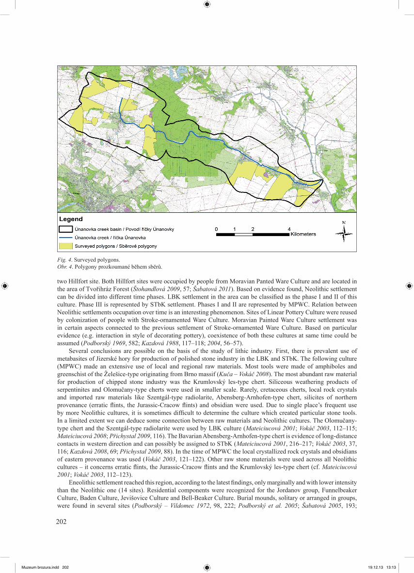
The most frequent material in the project, originated from the High Middle Ages and Modern Era, was found in 18 of 22 polygons (Fig. 4). This pottery was often exported to fields with manure and has greater resistance to destruction by erosion and tillage versus the older one (Prehistoric or Early Medieval). For this reason, no settlement can be anticipated on the basis of artifacts found in this place. Most of artifacts found by surface survey come from Neolithic and from the Early Medieval. Other periods were represented by only one artifact from the Eneolithic and several artifacts from the Bronze Age and La Téne period. This fact may have several explanations. One possible reason is that due to their closeness to surface or situation in less recessed objects, the remnants from these periods were already destroyed in the past due to agricultural activities and related erosion. We have an evidence of archaeological situation destruction as a result of plowing in the basin. It was observed during research performed in Těšetice-Kyjovice location: “After topsoil removal by means of heavy machinery during field research in the sector of A4 in 1991, some objects’ upper parts reaching into topsoil were being gradually destroyed as a result of deep plowing. The same goes for graves, some of which were kept very shallow and intensive agricultural activities destroyed many of them completely” (Dočkalová – Koštuřík 1996, 5). A comparison of posthole pits’ estimated and preserved depth was made for archaeological situation in the sector B4. It showed that the original Neolithic surface layer of 30–60 cm width was destroyed as a result of plowing and erosion (Matoušek 2008, 50).
It is also possible that people living in these periods searched for new locations for their settlement, which were different from those of Neolithic and the Early Middle Ages inhabitants. These locations remain unexploited by agriculture today and are inaccessible for surface survey (built-up areas, forests). All these correspond with the conclusion reached during the project of archaeological research in the forest area of the region. The fact that the newly acquired datable material from Tvořihráz forest prospections can be associated with the period between the end of the Neolithic Age and the early Middle Eneolithic, and significant proportion of settlements from this period, documented research on the screening near Suchohrdly “Starý Zámek” location, shows a significant shift in population of region from open terraces to the area now covered by forest (Šabatová 2011, 50).
Different way of land exploitation in the Únanovka basin in these periods is another option; settlements could have been concentrated in fewer locations, or a part of region might have been used by the communities residing outside its borders.
Conclusion
Surface surveys yield new information extending the previous knowledge about archaeological relics and the structure of prehistoric and early medieval settlement in the Microregion of Únanovka creek.
Apart from the discovery of 10 new sites, relative chronology of some sites was precised. For the Neolithic settlement residential aspects and economic-distribution models would be reconstruct. Obtained data will be used for building and testing of predictive models. Used survey methodology was proven to be suitable for collection of primary archaeological data.
Surface survey is supposed to continue in future to obtain information about the areas currently inaccessible due to agricultural activities. Prospection activities will be extended with microprobing and geophysical methods. Based on geophysical data, new sites for detailed archaeological research would be selected. Investigation of the site Únanov „Padělky“ (Kuča et al., forthcoming) might be the example, which give perspective for further research in the future.
References
Bartík, J., forthcoming: Kyjovice (okr. Znojmo). Přehled výzkumů 54–1. Brno.Bintliff, J. – Kuna, M. – Venclová, M. eds. 2000: The Future of Surface Artifact Survey in Europe. Somerset.Bíško, R. 2008: Využití metod nedestruktivní archeologie na příkladu hradiska „Deblínek“, k. ú. Suchohrdly. Rukopis bakalářské
práce uložené na Ústavu archeologie a muzeologie FF MU Brno. Dočkalová, M. – Koštuřík, P. 1996: Seskupení hrobů nositelů kultury s lineární keramikou na neolitickém sídlišti v Těšeticích-
Kyjovicích, okr. Znojmo, Sborník prací Filozofické fakulty brněnské univerzity M 1, 5–30.Golec, M. 2003: Těšetice-Kyjovice 6. Horákovská kultura v těšetickém mikroregionu. Brno.Kazdová, E. 1984: Těšetice-Kyjovice 1. Starší stupeň kultury s moravskou malovanou keramikou. Brno.- 1988: Osídlení lidu s vypíchanou keramikou v Sutnách u Těšetic-Kyjovic, Sborník prací Filozofické fakulty brněnské
Muzeum brozura.indd 204 19.12.13 13:13

205
univerzity E 33, 109–120.- 2004: Osídlení lidem s keramikou vypíchanou na Znojemsku. In: Kazdová, E. – Měřínský, Z. – Šabatová, K. (eds.), K poctě
Vladimíru Podborskému, přátelé a žáci k sedmdesátým narozeninám. Brno, 55–70. - 2008: Kultura s vypíchanou keramikou. In: Čižmář, Z. (ed.), Život a smrt v mladší době kamenné. Brno, 67–75.Kazdová, E. – Kuča, M. – Šabatová, K. – Trampota, F. – Prokeš L. – Hložek, M. – Kolář, J. – Petřík, J. 2011: Kyjovice (okr.
Znojmo), Přehled výzkumů 52–1, 180–182. Kovárník, J. 1981: Archeologické nálezy na jižní a jihozápadní Moravě, Přehled výzkumů 1981, 77–78. - 1983: Výsledky terénního archeologického průzkumu na Znojemsku (okr. Znojmo), Přehled výzkumů 1983, 103. - 1989: Nové archeologické nálezy ze Znojemska a Třebíčska (okr. Třebíč, Znojmo), Přehled výzkumů 1989, 130. - 1991: Další archeologické lokality ze Znojemska a Třebíčska, Přehled výzkumů 1991, 102–107. - 2001: Dějiny archeologického bádání na Znojemsku. In: Podborský, V. (ed.), 50 let archeologických výzkumů Masarykovy
univerzity na Znojemsku. Brno, 139–156.- 2007: Laténský kostrový hrob ženy s bronzovými ozdobami z Únanova, okr. Znojmo, Pravěk NŘ 17, 393–404.Kuča, M. 2010: Kyjovice (okr. Znojmo), Přehled výzkumů 51, 284.Kuča, M. – Kazdová, E. – Hladilová, Š. – Nývltová Fišáková, M. – Prokeš, L. 2010: Těšetice-Kyjovice 7. Osídlení kultury s
moravskou malovanou keramikou mezi příkopem a vnější palisádou rondelu. Brno.Kuča, M. – Matoušek, J. – Bartík, J. – Kovář, J. J. – Čerevková, A. – Krollová, S. – Kostihová, B. – Nikolajev, P., forthcoming:
Neolitická lokalita Únanov – „Padělky“ (okr. Znojmo), Jižní Morava.Kuča, M. – Vokáč, M. 2008: Exploitation of rocks for polished stone industry from the Brno Massif, South Moravia (Czech
Republic). In: Přichystal, A. – Krmíček, L. – Halavínová, M., Petroarchaeology in the Czech republic and Poland at the beginning of the 21st century. Brno – Wroclaw, 95–109.
Kuna, M. et al. 2004: Kuna, M. – Beneš, J. – Dreslerová, D. – Gojda, M. – Hrubý, P. – Křivánek, R. – Majer, A. – Prach, K. – Tomášek, M. 2004: Nedestruktivní archeologie. Teorie, metody a cíle. Praha.
Mateiciucová, I. 2001: Surovina kamenné štípané industrie v moravském neolitu. In: Podborský, V. (ed.), 50 let výzkumů Masarykovy univerzity na Znojemsku. Brno, 213–224.
- 2008: Talking stones: the chipped stone industry in lower Austria and Moravia and the beginnings of the Neolithic in Central Europe (LBK), 5700–4900 BC. Brno.
Mateiciucová, I. – Vlach, M. – Matoušek, J. – Milo, P. – Tencer, T. 2012: Surface survey and geophysical prospection in the micro-region of Tell Arbid, NE Syria: a preliminary report. In: Matthews, R. – Curtis, J. (eds.), Proceedings of the 7th International Congress on the Archaeology of the Ancient Near East (ICAANE). Wiesbaden, 17–32.
Matoušek, J. 2008: Prostorová analýza koncentrací na lokalitě Těšetice-Kyjovice, poloha Sutny. Rukopis bakalářské práce uložené na Ústavu archeologie a muzeologie FF MU Brno.
Matoušek, J. – Kuča, M. – Prokeš, L. – Štohandlová, J., forthcoming: Příspěvek k metodice povrchového sběru: povrchová prospekce mikroregionu povodí říčky Únanovky. Předběžná analýza výsledků. Sborník prací Filozofické fakulty brněnské univerzity M 17.
Měřínský, Z. 2002: České země od příchodu Slovanů po Velkou Moravu I. Praha.Neustupný, E. 1982: Optimalizace výzkumu archeologického regionu. In: Metodologické problémy československé archeologie.
Praha, 178–182.Podborský, V. 1969: Neolitické a halštatské sídliště u Těšetic-Kyjovic na Moravě, Památky archeologické 60, 572–592. - 1988: Těšetice-Kyjovice IV. Rondel osady lidu s moravskou malovanou keramikou. Brno. - 2001: Poválečné archeologické výzkumy Ústavu archeologie a muzeologie Filozofické fakulty MU na Znojemsku a
Břeclavsku. In: Podborský, V. (ed.), 50 let archeologických výzkumu Masarykovy univerzity na Znojemsku. Brno, 13–36. Podborský, V. – Kazdová, E. – Kovárník, J. 2005: Pravěk mikroregionu potoka Těšetičky/Únanovky. Brno.Podborský, V. – Vildomec, V. 1968: Výzkum neolitického a halštatského sídliště v „Sutnách“ u Kyjovic, Přehled výzkumů 1967,
8–11.- 1972: Pravěk Znojemska. Brno. Přichystal, A. 2009: Kamenné suroviny v pravěku východní části střední Evropy. Brno.Šabatová, K. 2005: Lid středodunajských popelnicových polí a jeho sakrální aktivity. In: Podborský, V. et al., Pravěk mikroregionu
potoka Těšetičky/Únanovky. K problematice pravěkých sociálních struktur. Brno, 114–119.- 2009: Suchohrdly (okr. Znojmo), Přehled výzkumů 50, 278.- 2010: Suchohrdly (okr. Znojmo), Přehled výzkumů 51, 338.- 2011: Intenzivní studium osídlení v souvislých porostech na příkladu lesního území v mikroregionu říčky Únanovky, Sborník
prací Filozofické fakulty brněnské univerzity M16, 43–52.Štohandlová, J. 2009: Prostorová analýza pravěkého osídlení mikroregionu říčky Únanovky. Rukopis bakalářské práce uložené na
Ústavu archeologie a muzeologie FF MU Brno.Vágner, M. 2009: Raně středověké osídlení středního Podyjí, Jevišovky a Rokytné. Rukopis bakalářské práce uložené na Ústavu
archeologie a muzeologie FF MU Brno.Vokáč, M. 2003: Suroviny kamenné štípané industrie v pravěku jihozápadní Moravy. Rukopis diplomové práce uložené na Ústavu
archeologie a muzeologie FF MU Brno.
Muzeum brozura.indd 205 19.12.13 13:13
206
Jakub Matoušek – Jaroslav Bartík – Alžběta Čerevková – Barbora Kostihová – Josef Jan Kovář – Soňa Krollová – Martin Kuča – Pavel Nikolajev – Lubomír Prokeš – Jitka Štohandlová: Povrchové prospekce v povodí říčky Únanovky (jižní Morava, okr. Znojmo).
Předložený článek shrnuje dosavadní výsledky archeologických výzkumů, které vypovídají o minulém osídlení v povodí říčky Únanovky (obr. 1–2). Zaměřuje se zejména na výsledky projektů povrchových sběrů v této oblasti (Matoušek et al., v tisku). Povrchové sběry zde probíhají od roku 2009 za účasti archeologů a studentů katedry archeologie FF MU v Brně. Oblast je již odedávna díky své poloze a příhodným přírodním podmínkám vhodná pro osídlení, což dokazují četné archeologické výzkumy, které zde probíhají od 19. století (Podborský – Vildomec 1972; Podborský et al. 2005). Od roku 1956 se centrem systematických výzkumů v této oblasti stala lokalita Těšetice-Kyjovice „Sutny“, která byla objevena při povrchových sběrech. Archeologický výzkum této lokality je prováděn Ústavem archeologie a muzeologie FF MU v Brně. Vědecko-výzkumná archeologická stanice Těšetice sloužila jako základna při projektu povrchových prospekcí.
Povrchové sběry v povodí říčky Únanovky byly prováděny dvěma způsoby. První metoda se nazývala „Sběry ve čtvercích“ (obr. 3) a sloužila k vyhledání dostupných archeologických pramenů z celého území povodí (obr. 4). Druhá užitá metoda, „Bodové sběry“, sloužila k bližšímu zkoumání potencionálních lokalit, které byly vybrány na základě nálezů učiněných při sběrech ve čtvercích. Během obou uvedených typů povrchových sběrů byl kladen důraz i na identifikaci a ověření poloh dříve známých, ale v literatuře nedostatečně publikovaných lokalit.
Hlavním cílem povrchových prospekcí v mikroregionu říčky Únanovky bylo vytvoření představy o sídelních strukturách a socioekonomických aspektech pravěkého a raně středověkého osídlení. Projekt sběrů byl tedy zaměřen na vyhledání dosud neznámých lokalit a na průzkum již dříve známých, ale nepřesně chronologicky a prostorově zařazených lokalit. V průběhu celého projektu bylo objeveno deset nových lokalit. Pro některé již dříve známé lokality bylo možno určit jejich přesnější dataci do fází příslušných kultur. Jako příklad lze uvést lokalitu Únanov „Padělky“ (Kuča et al., v tisku).
Obecně lze říci, že nejvíce nálezů, které potvrzují osídlení v povodí říčky Únanovky, chronologicky náleží do mladší doby kamenné a raného středověku. Pozitivní nálezy osídlení byly potvrzeny i pro eneolit, dobu bronzovou, dobu halštatskou a protohistorii. Nejméně nálezů v oblasti pochází z paleolitu. Jedná se spíše o jednotlivé artefakty štípané industrie s nejasnou datací.
Muzeum brozura.indd 206 19.12.13 13:13