federal republic of nigeria - World Bank Documents and Reports
155
i FEDERAL REPUBLIC OF NIGERIA FEDERAL ROADS DEVELOPMENT PROJECT (FRDP) ROAD SECTOR DEVELOPMENT TEAM (RSDT) ENVIRONMENTAL AND SOCIAL IMPACT ASSESSMENT OF AKURE-ILESHA ROAD REHABILITATION PROJECT FINAL REPORT Submitted by SEEMS NIGERIA LIMITED AUGUST, 2012 Public Disclosure Authorized Public Disclosure Authorized Public Disclosure Authorized Public Disclosure Authorized Public Disclosure Authorized Public Disclosure Authorized Public Disclosure Authorized Public Disclosure Authorized
-
Upload
khangminh22 -
Category
Documents
-
view
1 -
download
0
Transcript of federal republic of nigeria - World Bank Documents and Reports

i
FFEEDDEERRAALL RREEPPUUBBLLIICC OOFF NNIIGGEERRIIAA
FEDERAL ROADS DEVELOPMENT PROJECT (FRDP)
ROAD SECTOR DEVELOPMENT TEAM (RSDT)
ENVIRONMENTAL AND SOCIAL IMPACT ASSESSMENT OF AKURE-ILESHA ROAD REHABILITATION PROJECT
FINAL REPORT
Submitted by
SEEMS NIGERIA LIMITED
AUGUST, 2012
Pub
lic D
iscl
osur
e A
utho
rized
Pub
lic D
iscl
osur
e A
utho
rized
Pub
lic D
iscl
osur
e A
utho
rized
Pub
lic D
iscl
osur
e A
utho
rized
Pub
lic D
iscl
osur
e A
utho
rized
Pub
lic D
iscl
osur
e A
utho
rized
Pub
lic D
iscl
osur
e A
utho
rized
Pub
lic D
iscl
osur
e A
utho
rized
wb350881
Typewritten Text
E1576 v14
wb350881
Typewritten Text

ii
TABLE OF CONTENTS PAGE
Title i
Table of Contents ii
List of Tables vi
List of Figures vii
List of Plates viii
Abbreviations and Acronyms ix
Acknowledgement xii
ESIA Report Preparers xiii
EXECUTIVE SUMMARY xiv
1.0 Introduction 1
1.1 Background 2
1.2 Project Overview 2
1.3 Regulatory Framework 7
1.3.1 National Legislations 8
1.3.2 Other Environmental Regulations Governing Environmental Protection 9
1.3.3 Statutory Limits/Standards 10
1.3.4 State Legislation 10
1.3.5 International Standards, Treaties and Conventions 11
1.3.6 Health, Safety and Environmental Policies and Guidelines of FMW 11
1.3.7 Organisation and Responsibilities 11
1.3.8 World Bank Policies 13
1.4 Environmental Impact Assessment 15
1.4.1 ESIA Objectives 16
1.4.2 Scope of the ESIA 16
1.4.3 Terms of Reference 17
1.4.4 Methodology 17
1.5 Structure of the Report 18
2.0 Project Justification 20
2.1 Need for the Project 20
2.2 Project Alternatives 20
2.2.1 No Project 20
2.2.2 Using other Travel Modes 21
2.2.3 Alternative Alignments 21
2.2.4 Upgrading the Existing Roads 21
2.3 Project Benefits 21
2.4 Envisaged Substainability 21
2.5 Type of Project 22
2.6 Project Location 22

iii
2.7 Existing conditions of the project Road 22
2.7.1 Shoulders of the Road 23
2.7.2 Pavement 24
2.7.3 Exisitng Alignment 24
2.7.4 Drainage 25
2.7.5 Traffic Volume 25
2.7.6 Road Furniture 25
2.8 Design Standards 26
2.9 Input and Output of Raw Materials and Products 27
2.9.1 Raw Material Supply 27
2.9.2 Process Inputs 27
2.9.3 Sources of Energy Availale of the Project 27
2.10 Project Operation and Maintenance 27
2.11 Project Life cycle 27
2.12 Project Schedule 27
3.0 Description of the Environment 28
3.1 Introduction 28
3.2 Baseline Data Acquisition Methods 28
3.2.1 Sampling Methods & Field Measurement 29
3.2.2 Quality Assurance/Control Procedure 30
3.3 Description of the Baseline Status of the project area 30
3.3.1 Climate/Meteorology 30
3.3.2 Air Temperature 31
3.3.3 Relative Humidity 33
3.3.4 Rainfall 33
3.3.5 Wind Speed & Direction 35
3.3.6 Air Quality 37
3.3.7 Noise 38
3.3.8 Soils 38
3.3.8.1 Physical Properties 38
3.3.8.2 Chemical Properties 40
3.3.8.3 Soil Microbiology 40
3.3.8.4 Land Use 41
3.3.9 Geology & Hydrogeology 41
3.3.9.1 Geology of the Project area 41
3.3.9.2 Geophysical Studies characteristics 42
3.3.9.3 Hydrogeological Characteristics 42
3.3.9.4 Geophysical (Geolectric) Characteristics 43
3.3.10 Vegetation 43
3.3.11 Aquatic System 46
3.3.11.1 Water Quality 46
3.3.11.2 Water Microbiology 47
3.3.11.3 Hydrobiology 48
3.3.11.4 Fish/Fisheris 50

iv
3.3.11.5 Sediment 51
3.3.12 Terrestial Fauna and Wildlife 53
3.3.13 Waste Management 55
3.3.14 Socio Economics 55
3.3.14.1 The Project Environment 55
3.3.14.2 Socioeconomic Attributes 56
3.3.14.3 Community Health status 66
3.3.14.4 Consultation with Key Stakeholders 67
3.4 Institutional Arrangement 69
3.5 Budget for the Implementation of ESMP 71
4.0 Associated & Potential Environmental Impacts 72 4.1 Impact Prediction Methodology 72
4.2 Impact Appraisal 78
4.2.1 Environmental Issues 78
4.2.2 Environmental Consequences 83
4.3 Significant Positive Impact 83
4.4 Significant Negative Impact 84
4.5 Raw materials Impacts 84
4.6 Process Impact 84
4.7 Project Specific Incremental 84
4.8 Project Specific Cummulative Effects 84
4.9 Project Specific Long/Short term Effects 84
4.10 Project Specific Adverse/Beneficial Effects 84
4.11 Project Specific Direct/Indirect Effects 84
4.12 Project Specific Reversiable/Irreversiable Effects 84
4.13 Project Specific Risk and Hazard Assessment 85
4.13.1 Risk Scenerio 85
5.0 Mitigation of Potential and Associated Environmental Impacts 86
5.1 Best Available Control Technology 86
5.1.1 Site Clearing and Civil Work Construction 86
5.1.2 Highway Operations and Maintenance 87
5.2 Decommissioning Plan 90
6.0 Environmental and Social Management Plan 91
6.1 Introduction 97
6.2 Waste Management Strategies 97
6.3 Waste Management Programme 99
6.4 Waste Management 99
6.5 Monitoring Schedule 100
6.6 Environmental Audit 100
6.6.1 Contingency Planning 100
6.6.2 Project Organisation and Responsibilities 100
6.7 Follow-Up Action Plan 101

v
6.8 Inter-Agency and Public/NGO 101
7.0 Conclusions and Recommendations 103
References 104
Appendices 106
vi
LIST OF TABLES
PAGES
Table 3.1: Summar of Weather condition Recorded at various sampling stations along 34
Akure Ilesha road
Table 3.2: Sammpling Coordinates of Air pollutants & Noise Measurements 35
(Wet & Dry season)
Table 3.3a: Air Quality Characteristics of theproject area (Wt & Dry Season) 36
Table 3.3b: Regulatory Standards for Ambient Air Quality 37
Table 3.4: Noise Characteristics of the project area (Wet & Dry Season) 37
Table 3.5: Sampling Cordinates for water Quality 38
Table 3.6: Summary of Physico-Chemical Characteristic of Soils of the project area 39
Table 3.7: The Geology Beneath the Proposed Akure-Ilesha Rehabilitation road 41
Table 3.8: VES Station and the GPS Geograghic Co-ordinates 41
Table 3.9: Classification of Soil Resistivity in terms of its Corrosivity 42
Table 3.10: Checklist of Crops plants in farms encountered along the Proposed 45
Rehabilitation road
Table 3.11: Checklist of common Economic Plant species along the route 45
Table 3.12: Sampling Coordinate for water Quality 46
Table 3.13: Summary of Physio-Chemical characteristics of water from the 47
Rivers/Streams & Boreholes/Wwells in the study area
Table 3.14a: Checklist of Phytoplankton groups 49
Table 3.14b: Distribution of Phytoplankton in the water of the project area 50
Table 3.15a: Checklist of Zooplankton Groups 50
Table 3.15b: Distribution of Zooplankton in the water of the project area 50
Table 3.16: A checklist of the fish species inhaiting the Sampled Rivers during the 50
period of study
Table 3.17: Physico-Chemical Characteristics of Sediments of Rivers/Streams in the 52
species in the area
Table 3.18: List of Wildlife species sighted or reported around the project area 54
Table 4.19: Major settlements & their Geographical locations relative to the proposed 55
Rehabilitation Akure-Ilesha road
Table 3.20: Socioeconomics characteristics of PAPs 56
Table 3.21: Socioeconomics of Charateristics of PAPs 62
Table 3.22: The Summary of the Outcome of the Consultation 68
Table 4.1: Impact Indicators for various Environmental Components 75
Table 4.2: Environmental Impacts o road Construction & Operations 76
(from RAU’s (1990)Method)
Table 4.3: Impact Evaluation Matrix or the Akure-Ilesha road development project 77
Table 4.4: Summary of project Actions & Potential Impacts 79
Table 6.1: Summary of Environmental Management Responsiilities for various 92
stages of project
Table 6.2: Monitoring Impact Indicators 93

vii
Table 6.3a: Environmental Monitoring Programme for the road Development Project 94
Table 6.3b Monitoring Programme of the Project affected people 95
Table 6.4: Environmental Monitoring Programme for the Road Development Project 97
Table 6.5: Environmental and SocialManagement Plan for the road Development project 99
LIST OF FIGURES
1.1 Map of Nigeria showing Ondo State & Osun State Travesed by Akure-
Ilesh road(Red line)
3
1.2 Map of part of Southwestern Nigeria Showing the Akure-Ilesh
Travelling Osun & Ondo State
4
1.3 Osun State Local government areas Traversed by Akure-Ilesha road 5
1.4 Ondo State Local governmntareas Traversed by Akure-Ilesha 6
1.5 Satellite Image showing Akure-Ilesha (A122) road betwwen red arrows 7
3.1 Sampling & location Map of the study area 29
3.2. Temperature regime in the Project area 31
3.3. Relative Humidity Regime inthe study area 32
3.4 Prevailing Wind directions in the study area 34
3.5 Distribution of PAPs by Community 57
3.6 Age Distribution 58
3.7 Marital Status 59
4.8 Education 60
3.9 Primary Occupation 60
3.10 Skills (The PAPs are mostly unskilled workers) 61
3.11 Annual Income 61
3.12 Family Size 63
3.13 Length of stay in the Community 63
3.14 Type of House Lived in 64
3.15 Source of water 65
3.16 Attitude towards the road 65
3.17 Expected Benefits from the Projects 66

viii
LIST OF PLATES
PLATE 2.1 Akure –Ilesha road at Iwaraja 22
PLATE 2.2 Akure-Ilesha road at Ikere jut in Akure 22
PLATE 2.3 ROW Encroachment y Structires 23
PLATE 2.4 Common view of sholder conditions along Akure-Ilesha road 24
PLATE 2.5 Segm,ents of road pavement failure & Pot holes road 24
PLATE 2.6 Common Alignment on Akure-Ilesha road 25
PLATE 2.7 Some of the few road Signage Infrastructure 26
PLATE 3.1 Fallow/ Bush Regrowth Vegetation stand 44
PLATE 3.2 Fallow/ Bush Regrowth Vegetation stand 44
PLATE 3.3 Consultation meeting with people in Akure 68
PLATE 3.4 Consuktation meeting with people in Erinmo 69

ix
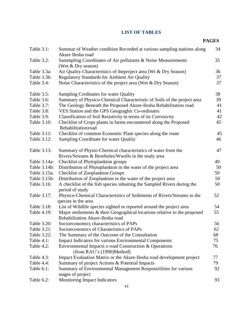
LIST OF ABBREVIATIONS AND ACRONYMS
GENERAL
ASL Above sea level
BDL Below Detection Limit
BOD Biochemical Oxygen Demand
DC Double Circuit
DO Dissolved Oxygen
DPR Department of Petroleum Resources
DS Dissolved Solids
EC Electrical Conductivity
EIA Environmental Impact Assessment
HC Hydrocarbon
HSE Health, Safety and Environment
ITN Insecticide Treated Nets
SS Suspended solids
TDS Total Dissolved Solids
THC Total Hydrocarbon
TSP Total Suspended Particulate
VES Vertical Electrical Sounding
VOC Volatile Organic Compounds
ROW Right of Way
ESIA Environmental and Social Impact Assessment
UNITS OF MEASUREMENT
cfu/ml Colony forming unit per milliliter
cm Centimeter
dBA Decibel
ft Feet
g Gramme
k Kilogramme
g/cm Gramme per Centimeter
Km Kilometer
m Meter
m3 Meter Cube
meq Milliequivalent
mg Milligramme
mg/Kg Milligramme per Kilogramme
mg/l Milligramme per Litre
ml Millilitre
mm Millimetre

x
m/s Meter per Second
NTU Turbidity Unit o/oo Parts per thousand
oN Degree North
PH Hydrogen ion concentration
ppb parts per billion ppm parts per million
ToC Temperature in degrees Celsius
g Microgramme
S micro Siemen
m micrometer
% Percentage
CHEMICAL ELEMENTS AND COMPOUNDS
Al Aluminum
C Carbon
Ca Calcium
CaCO3 Calcium Carbonate
CCl4 Carbon Tetrachloride
Cd Cadmium
Cl Chloride
CO Carbon Monoxide
CO2 Carbon Dioxide
Cr Chromium
Cu Copper
Fe Iron
H Hydrogen
H2O water
H2S Hydrogen Sulphide
Hg Mercury
K Potassium
Mg Magnesium
Mn Manganese
N Nitrogen
Na Sodium
Na2PO4 Sodium phosphate
NaOH Sodium hydroxide
NH3 Ammonia
NH4+ Ammonium ion
NH4F Ammonium flouride
Ni Nickel
NO2 Nitrite ion
NO3 Nitrate ion
NOX Nitrogen Oxides
xi
O2 Oxygen
P Phosphorus
Pb Lead
PO4 Phosphate
SiO2 Silicate
SO2 Sulphur dioxide
SO4 Sulphate ion
V Vanadium Zn Zinc
STRUCTURES AND EQUIPMENT
AAS Atomic Absorption Spectrophotometer
GPS Global Positioning System
ORGANIZATIONS
APHA America Public Health Association
API American Petroleum Institute
ASME American Society of Mechanical Engineers
ASTM American Society for Testing and Materials
DPR Department of Petroleum Resources
FAO Food and Agricultural Organization of the United
Nations
FEPA Federal Environmental Protection Agency
FMENV Federal Ministry of Environment
FMEH & UD Federal Ministry of Environment, Housing & Urban
Development
ISO International Standard Organisation
SEEMS Scienctific Energy and Environment Management
Systems
WB World Bank
WHO World Health Organisation
FMW Federal Ministry of Works
RSDT Road Sector Development Team

xii
ACKNOWLEDGEMENT
The Federal Ministry of Works (FMW) wishes to acknowledge with thanks, the opportunity
granted it by the Federal Government of Nigeria, through its agencies, to conduct this
Environmental and Social Impact Assessment of Akure-Ilesha Road Rehabilitation Project.
This report has been prepared in line with the national and international regulatory requirements
and standards for FMW by SEEMS Nigeria Limited. The Project Team enjoyed a cordial working
relationship with the Road Sector Development Team (RSDT), the Elders, Chiefs and Youths of
the communities along the study corridor.
The active participation of the RSDT in the ESIA study from the conceptual stage, supervision and
review of the preliminary results is hereby acknowledged.
.
xiii
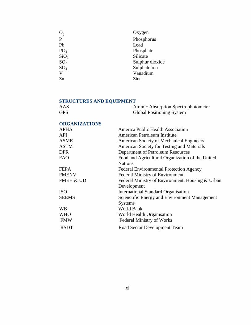
ESIA REPORT PREPARERS
SEEMS’ Project Team:
Project Proponents: Federal Ministry of Works
Road Sector Development Team
Name Task Assigned
Prof. A.F. Oluwole Consultation
Prof. P.O. Aina Coordination
Prof F.A. Akeredolu
Oluwasesan Joshua
Fasuyan Abiodun
Meteorology, Air Quality,
Climate and Noise Data
Prof A.O. Isichei
Dr. V.F. Olaleye
Ecology Study
Dr A.O. Akinfala
Dr. O.O. Awotoye
Wildlife & Artefacts
Prof O.I. Asubiojo
Dr. F.M. Adebiyi
Surface Water &
Hydrodynamics
Dr Y.A. Asiwaju- Bello Hydrology
Prof. M.O. Olorunfemi
Dr O.A. Akintonrinwa
Geology / Geophysics
Dr. J. Oyedele
Nurudeen Owolabi
Soil Study
K.A. Adewara GIS
Prof (Mrs) ) O.A. Aina
Mrs. O.A. Tijani
Socio-Economics
Prof G. E. Erhabor
Dr A.O. Fatusi
Community Health
Dr. S.O. Oke
Dr. J.I. Muoghalu
Vegetation
Prof. I.F. Adeniyi Aquatic Study
Dr .Ife Adewumi Waste Management
Engr. O.S. Aderinola
Highway Engineering
xiv
EXECUTIVE SUMMARY
INTRODUCTION
The Federal Government of Nigeria has proposed, through the Federal Ministry of Works (FMW)
Road Sector Development Team, to rehabilitate the Akure-Ilesha Road. This may require
debottlenecking of the road network through the construction and maintenance of roads and
rehabilitation of degraded ones. While the justification of road development projects from socio-
economic considerations cannot be overemphasized, the cumulative environmental consequences
of such projects need to be brought to fore.
In order to ensure environmental protection vis-à-vis the highway sector projects of such
magnitudes, an Environmental Impact Assessment (EIA) is required and mandatory in Nigeria as
stipulated by Environmental Impact Assessment Decree No. 86 of 1992 of the Federal Ministry of
Environment (formerly Federal Environmental Protection Agency (FEPA).
The project will not involve land acquisition along the existing right of way (ROW) but
involuntary resettlement will occur due to loss of roadside space vendors, traders, mechanics and
other informal activity. However, no number of environmental and social safeguards policies will
be triggered. In line with the Resettlement policy framework that was prepared and disclosed by
the project, a Resettlement Action Plan (RAP) is currently underway to address the issues of
involuntary settlement. The ESMF has been prepared for the project and this ESIA in line with the
specific World Bank Safeguard policies based on screening checklist.This report presents the
environmental and social impact assessment of the road development.
Objectives of the ESIA
The main purpose of this ESIA is to establish a baseline of existing conditions in the project area
and to assess proactively the potential impact and associated impacts, including health and socio-
economic, of the proposed road construction, rehabilitation and operation on the area with a view
to mitigating the identified significant adverse impacts to acceptable level.
The objectives of the ESIA study for Akure-Ilesha road are to:
Collecting information/data on existing conditions (baseline studies) from records, surveys
and consultation with local residents with local residents, experts and professionals;
Characterizing the existing environmental and social conditions and predicting the
significance of major impacts (including reviewing expected trends within the influence of
the road project);
Developing approaches to avoid, mitigate or compensate any adverse impacts and
resolving conflicts and enhance positive impacts;
Producing an EMP; and

xv
Providing for the involvement of the public in the assessment and for reviewing the
proposed road project in an open, transparent and participatory manner
Methodology
The methodology adopted for conducting this ESIA is as follows:
Extensive literature review, detailed baseline survey from field sampling and laboratory analyses.
Identification of potential impacts ansd mitigation measures; and development of Environmental
and Social Management Plan (ESMP)
ADMINISTRATIVE AND LEGAL FRAMEWORK
The constitution of the Federal Republic of Nigeria confers jurisdiction on the Federal Government
to regulate the operations and development activities in the Nigerian transport sector. These,
together with applicable International conventions provide a basis for an ESIA of the project. The
development will take account of Nigerian laws and regulations, and international conventions that
apply to the subject development. In the event of discordance between EIA laws in Nigeria and
that of World Bank safeguard policies, the more stringent will take precedence.Some of these laws
and regulations that apply to the subject development are listed below:
National Legislations
State Legislation
International Standards, Treaties and Conventions
Health, Safety and Environment Policies and Guidelines of FMW
World Bank Safeguard Policies
PROJECT JUSTIFICATION: NEED FOR THE PROJECT
Nigeria’s economy is highly dependent on good road network to facilitate haulage of people,
goods and services. Therefore, its inadequacy can be a serious constraint to national development.
Development of this road would be a confidence reassurance measure to improve the movement of
commuter and good along the corridor.
PROJECT LOCATION AND OVERVIEW The Akure-Ilesha road is located within co-ordinates (expressed in the Universal Traverse Mercator
(UTM) coordinates of Zone 31 using Minna datum) 070082mN, 0842594mE and 074566mN,
0805470mE. The topography along the highway route which stretches through a distance of about
74km is gently undulating. It starts from the end of the dual carriage at Iwaraja Ilesha and terminates
in Akure at the Akure-Ikere/Akure-Owo junction.
In general, the project will involve some civil works, vegetation (bush) clearing, earth (soil)
movement, topographic levelling, alignment and re-alignment of road segments, creation of road
pavement, coal tarring, etc with potential environmental impacts. The works will be hosted and
founded on surface and the near-surface earth
DESCRIPTION OF THE PROJECT ENVIRONMENT
The baseline environmental conditions of the project area are summarized as follows:

xvi
Climate/Meteorology
The project area is associated with high temperatures (22oC-34oC), high humidities for most of the
year. Mean monthly relative humidity is generally high with the highest values occurring in July
(92%) and August (92%) and lowest values recorded in December (76%), January (68%) and
March (78%). Rainfall in the project area is generally high, with mean total annual rainfall of
1353.3mm and 1418.2mm for Akure and Osogbo, respectively. The project area has a calm
weather with wind speed ranging between 0.5 m/s to 5.7m/s. During the dry season, the wind
direction is northeast while the southwest winds are dominant during the wet season.
Air Quality The project area has excellent ambient air quality, with all the measured pollutant indicators being
below FMENV regulatory limits. The ambient air concentrations ranged between <0.01ppm and
0.01 (ppm) for SOx, between <0.01ppm and 0.01ppm for NOx, and between <1ppm and 2ppm for
CO. The concentration of H2S was not detectable. SPM ranged between 60 (g.m-3
) and 206
(g.m-3
).
Noise
The (daytime) ambient noise levels measured at different locations within and outside the study
area ranged from values of 47.9 decibels-acoustic (dBA) to 70.5dBA in some communities. All the
ambient noise levels recorded were below Ministry of Environment permissible exposure limits of
85 dB(A) for 8 hour exposure.
Soils, Land Use and Agriculture
The Akure-Ilesha road is underlain by four major soils. These soils which are derived from
basement complex rocks comprise broad groups of poorly drained and well upland drained soils.
The well drained soils covered over 70% of the study area and have good potential to support
arable crops. The soils which ranged in texture from sand to sandy clay loam in the topsoil with
69.0% to 85.0% sand, 6.9% to 12.0% silt are acidic (pH 4.5 to 5.7), low electrical conductivity
(58-190µS/cm), low organic matter contents 1.08-4.43%), low to adequate total N ranged (0.05-
0.38%). The phosphorus concentrations ranged from 10.6 to 31.3ppm and most of the values fall
within the accepted range of 7.0-20.00ppm for agricultural purposes.
Geomorphology, Geology and Hydrogeology
The geology underlying the proposed Rehabilitation road is composed of Precambrian Basement
Complex rocks. The subsurface layers, which are strongly dependent on the solid geology, vary from
clay to sandy clay and clayey sand and basement bedrock beneath the segment underlain by basement
complex rocks
Water Studies
Turbidity levels of the water bodies ranged between 15 and 225NTU, indicating turbid waters
during the wet season. The values were generally above the FMENV/DPR limit of 10 NTU. The
water bodies were slightly acidic or slightly alkaline with pH values varying from 5.5-7.6.
Electrical conductivity, which is a measure of the ionic richness of the river course, ranged between 22 and 260μS/cm. These values are typical of fresh water bodies. The surface waters in

xvii
the project area are slightly acid to alkaline (pH 7.43-8.06 and mean 7.68±0.0.12), fresh and non-
saline, with low chloride and conductivities of 160-780Scm-1; high levels of dissolved oxygen
(DO =2.4-5.6mgl-1). The biochemical oxygen demand (BOD) of the samples are (0.85 -2.40mg/l-
1) below 5.0mg/l-1, indicating low levels of organic pollution.
The concentrations of heavy metals of the waters, especially the pollution indicators - Hg, Cr, Pb,
Ni and V, are very low or below detectable limits and Federal Ministry of Environment (FMENV)
and WHO limits, thus showing no evidence of contamination.
Sediment Physical and Chemical Properties
The sediments were mainly sandy (sand 65.8% - 85.5%, clay 5.2%-18.4%, silt 9.3%-15.8%),
acidic (pH4.4-5.7) and low electrical conductivity (66.8-130.2μS/cm) indicating that the
environment under study is within the freshwater habitat. The sediment samples had low contents
of organic carbon (1.48 and 2.28%), nitrogen (0.15 to 0.32%) low to moderate phosphorus
concentrations (5.8 to 34.5ppm). The concentrations of nitrate (0.072-0.112ppm), ammonium
(4.62-18.27ppm), sulphate (10.48-22.80ppm), and chloride (28.6-58.8ppm). ECEC (4.48-
7.39meq/100g) and the contents of contributory exchangeable cations are also low. The low
concentrations of heavy metals and total hydrocarbon showed that there was no accumulation of
pollutants in the sediments.
Ecology
Planktons
Sixty eight taxa of phytoplankton belonging to three divisions namely bacillariophyta or diatoms,
cyanophyta or blue-green algae, and chlorophyta or green algae, were identified during the studies.
The diatoms comprised the bulk of the flora with 51.5% followed by Chlorophyta with 33.8%.
Cyanophyta constituted 14.7%. The blue-greens occurred in a few sampling stations.
Fish and Fisheries
Fish study was conducted on fishes obtained from rivers along the proposed rehabilitation road and
through interviews and literature search. Fishing activities are carried out mostly in the nights,
early mornings and evenings, and generally done from dug out canoes. Generally, there was more
fish during the wet season compared to the dry season. The fishing gears commonly used includes
castnets, set nets, drift nets, gill nets and hook on line as well as fish fence. Fishing is carried out
by migrant fishermen, few indigenes also participate in fishing activities.
Vegetation
The main block of the Nigerian forest formation at low and medium altitude along this route is
Lowland Rainforest. The high human population densities and their activities along the
rehabilitation road have greatly transformed the complex structure and species richness of this
route. Plant cover in the study area consisted predominantly of farmlands, fallow lands at various
stages of regeneration and degraded remnant lowland tropical moist forests (freshwater swamp and
dry-land rainforests

xviii
Wildlife
A check list of forty four (44) wildlife species belonging to 36 families were encountered, based on
ground surveys and participatory rural appraisal interviews is shown in Table 4.18. Of the species
of vertebrate wildlife identified, the avifauna and mammals were the dominant groups.
The mammals, reportedly sighted or reported to occur in the area were mainly browsers or grazers including medium-sized mammals such as duikers and antelopes
Socio-Economics
There were at least 7 major settlements within 2 km on either side of the Akure-Ilesha road. These
communities were studied in detail for the social impact assessment.
Socioeconomic data was collected in seven locations. The affected communities are Akure, Owena
Ijesa, Owena Owode, Igbara Oke, Erin Oke, Erinmo and Ipetu Ijesa. The distribution indicates that
most of the PAPs are in Akure and Owena-Ijesa
There were many PAPs in Akure because of its size and population (the city is the Capital of Ondo
state and a magnet to people from all parts of the state, including roadside artisans and traders).
Owena-Ijesa however has the largest number of PAPs due to having lots of structures too close to
the highway (the encroachments include permanent physical structures and makeshift shops). The
distribution of the PAPs by ethnicity shows that they are all virtually of the Yoruba ethnicity.
About 61% of the PAPs are Christians while the rest are of the Islamic faith. Most of the PAPs are
females, 44% are males while the remaining 56% are females. Most of the PAPs are roadside
traders. These are two areas where women are mainly engaged to earn a living, hence their
preponderance among the PAPs.
Examining the education level of the PAPs, from figure 4.8 shows that about 40% either did not go
to school at all or attended only primary school. 38% attended secondary school while 15% had
tertiary education. The literacy level is generally high, with 85% having at least primary education.
The occupational distribution of the PAPs shows in figure 3.9 that they are predominantly roadside
traders (77%). A further 14% claim to be business contractors. The others are mainly petty traders
artisan.
Community Health Status
The common ailments reported are malaria, typhoid fever, coughs, and water borne diseases e.g.
diarrheoa, cholera and guinea worm. Health facilities prevalent in the project area include patient
medicine stores, local herbal dispenses.
Consultation
In-depth consultations were conducted at various times at the Palaces of the traditional rulers
between SEEMS Socio-Economic Team, leaders, different social groups and youth leaders of each
community. The socio-economic benefits were appreciated as well as possible reduction in
accident rate.
xix
Institutional Arrangement
One of the basic elements of any Environmental and Social Impact Assessment (ESIA)
implementation and management is the appropriate institutional framework that will ensure the
timely establishment and functioning of the team or agency mandated to implement the plan.
The major institutions that are involved in the ESIA are the Federal Ministry of Environment,
Road Sector Development Team – Federal Ministry of Works, the World Bank, Federal Ministry
of Transportation, State Ministry of Environmental, State Waste Management Authority, State
Ministry of Health, Environmental NGOs, State Minitsry of Transportation, Federal Road Safety
and Local Government Area in each project designated area. Their functions could also be
complimentary or over lapping.
In the execution of the project, the RSTD will be responsible for the implementation of the
mitigation measures through their contractor who would be accountable to the RSTD. This
contractor shall have an Environmental Engineer on site who will be responsible for all
environmental issues. Whereas the World Bank will monitor the execution/ implementation of the
project by RSTD. The EIA Division the Federal Ministry of Environment in collaboration with
affected state Ministry of Environment will carry out regulatory monitoring to ensure that all
agreed mitigations are actually implemented in line with regulatory requirements.
RSDT shall be represented by Social and Environmental Officer who will be responsible for the
implementation of the EMPFMENV and the Local environmental regulating bodies. Alternatively,
an independent consultant may be hired by the RSDT to implement the EMP. The World Bank and
FMENV will routinely supervised the implementation of this ESMP
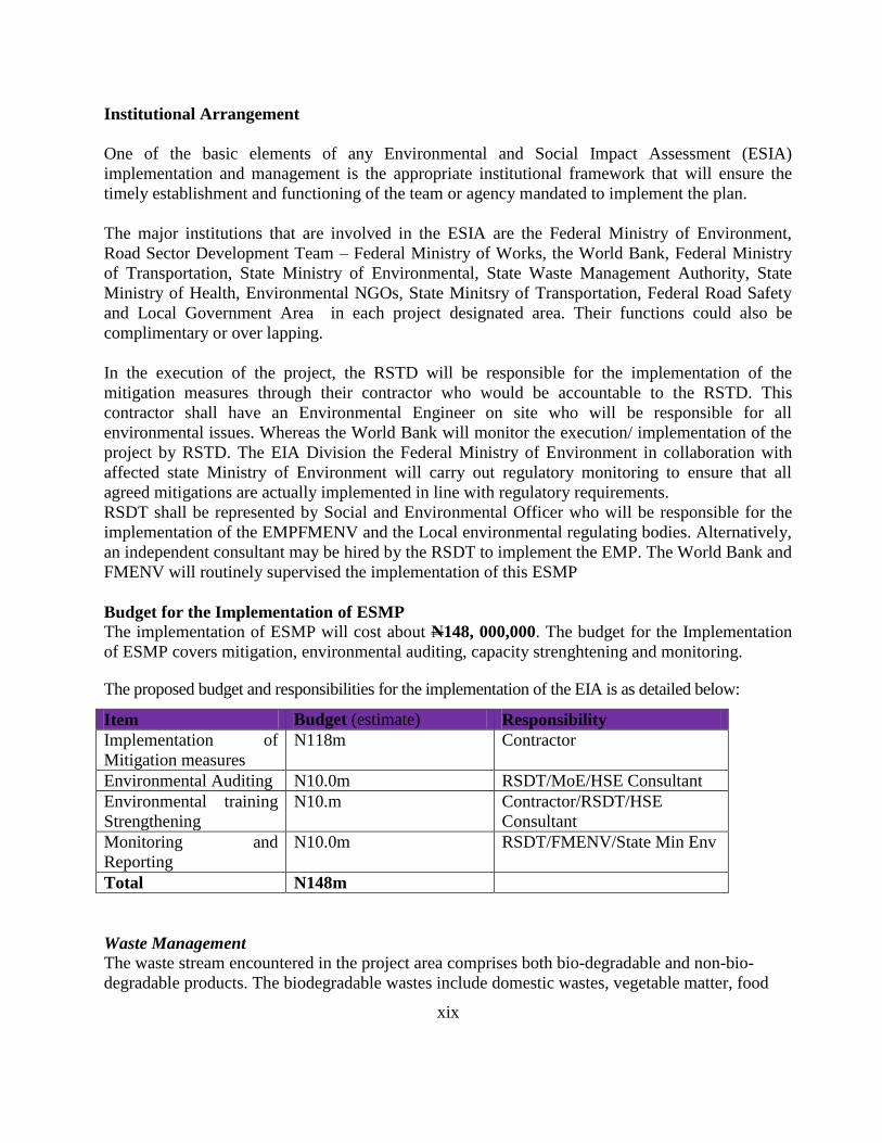
Budget for the Implementation of ESMP
The implementation of ESMP will cost about N148, 000,000. The budget for the Implementation
of ESMP covers mitigation, environmental auditing, capacity strenghtening and monitoring.
The proposed budget and responsibilities for the implementation of the EIA is as detailed below:
Item Budget (estimate) Responsibility
Implementation of
Mitigation measures
N118m Contractor
Environmental Auditing N10.0m RSDT/MoE/HSE Consultant
Environmental training
Strengthening
N10.m Contractor/RSDT/HSE
Consultant
Monitoring and
Reporting
N10.0m RSDT/FMENV/State Min Env
Total N148m
Waste Management The waste stream encountered in the project area comprises both bio-degradable and non-bio-
degradable products. The biodegradable wastes include domestic wastes, vegetable matter, food
xx
remnants and other assorted organic materials. Waste is also generated by craftsmen engaged in
various trades. The non-bio-degradable wastes include plastics, glasses, scraps from past sand
mining, scraps of vehicle involved in accidents on Akure-Ilesha expressways.Wastes are disposed
of generally by free litter. Dry refuse is burnt and the residue used as much on plants around
homesteads.
POTENTIAL ENVIRONMENTAL IMPACTS AND MITIGATION
The project is intended to rehabilitate the already existing Akure-Ilesha road. No severe
unprecedented and or cumulative negative impacts were identified; however the following
significant adverse impacts and corresponding mitigation measures were identified
Air Quality and Noise
The land clearing and construction-related atmospheric emission (CO, HC and NOx emissions),
dust and noise impacts will occur though these will be short-lived. Operational phase noise impact
will be long term and increase over time as traffic volume on the project roads increases. The site
workers and some communities would therefore experience discomforting construction and
operational noise from construction equipment if mitigating measures are not put in place.
Mitigation
During site clearing, preparation and construction, all equipment and vehicles that show
excessive emissions of particulates due to poor engine adjustment or other inefficient
operating conditions shall not be operated unless corrective measures are taken.
The construction site shall be watered regularly during dry season to minimize fugitive dust
emissions.
Operational emission impact will be mitigated by the upgrading of the existing roads and
consequent increase in motor vehicle speeds to reduce acceleration/deceleration on the roads
and reduce CO, HC and NOx emissions.
During construction and facility operation, workers will be provided with ear muffs and other
protectors to mitigate noise and air quality(dust) impacts;
Construction work on built-up areas will be limited to day time. Planting of trees within 5 metres shall be established between road and residential/
community during operation activities in order to reduce effect of noise.
Water Quality
Surface runoff from disturbed soil and in-river construction activities will impact surface water
quality during construction. Such impacts will be temporary and limited to small areas
downstream, but can affect a large portion of an adjacent fish pond. The construction camp stations
will also generate effluent containing COD, SS, and O&G. The effluent will eventually be
discharged to the water bodies. During the operational phase, small quantities of sediment and
dripping oil and grease from the road surface may be washed out and discharged to nearby surface
water bodies as runoff during the rainy season. As this would also be the season when the rivers
have their highest flow rates, the impact to water quality will be small. Long-term impacts on
water quality in other rivers in the Project area during expressway operation will be low.

xxi
Mitigation
All contractors will be required to build septic tanks at their construction camps for waste
disposal. They will also be required to have sound environmental management programs
for the storage of hazardous materials, solid waste collection and disposal, and
environmental contingency plans.
During construction, surface water flows shall be controlled and if necessary channelled to
temporary discharge points to minimize the potential threat of erosion and siltation in the
receiving water channels.
Ecology
Contamination of surface and groundwater will arise from chemical effluents, solid waste and
domestic sewage discharge and discarded lubricants, fuel and oils. Discharge of effluents has
potentials for water pollution with attendant effect on water quality and aquatic life.
Mitigation
Selective and controlled clearing of vegetation restricted to what is needed for the project
will be carried out
To mitigate the impact of loss of vegetation, trees and bushes will be planted on both sides
of the expressway, and land will be seeded to grass the embankment in an expressway
landscape plan.
Social and Health Impacts
Identified potential impacts include:
Interference with traffic and economic activities and increased safety risk to local
road users due to increased traffic during construction and project operation
Increase in social vices (drug abuse, commercial sex workers, teenage pregnancies,
etc) and increased pressure on existing infrastructure and health care facilities
(housing, educational and recreational facilities) from influx of people (job seekers)
Health impairment from equipment (air pollutants) gaseous emissions inhalation
Social & health problems (new communicable diseases, sexually transmitted
infections (STIs), HIV/AIDS) from influx of job seekers & post-construction
demobilisation of large contigent of workers
Improved employment opportunities for indigenes and rural economy from phases
of project implementation
Mitigation
Payment of commensurate compensation for economic crops and surface rights to
displaced or dispossessed parties.
Resettlement of displaced people

xxii
Youths from the host communities will be given priority in unskilled labour
employment;
FMW will provide on-the-job training for unskilled and semi-skilled workers
(especially from the host communities) during the construction and project
operation periods.
Community assistance programmes will be provided along with project
development to boost the health status and socio-economic conditions of the
stakeholders;
Development of green areas in the Project site to mitigate noise impact;
Implementation of safety regulations at all times.
Development of careful proactive management to avoid many of the social risks
that have troubled project development areas
Provision of construction camp and sanitary facilities
Compliance with company’s safety regulations around worksite
Awareness campaign to enlighten the communities/field workers on the
implications of drug and alcohol abuse, unprotected sex, prostitution and the need
to sustain healthy lifestyle and behaviour.
Medical facilities shall be provided on site, with critical cases transferred to retainer
hospitals.
Alternative source of potable water shall be provided during construction
Waste Management
The construction camps will generate effluent containing COD and SS. The effluent will
eventually be discharged to the water bodies. During the operational phase, small quantities of
sediment and dripping oil and grease from the road surface may be washed out and discharged to
nearby surface water bodies as runoff during the rainy season.
Mitigation
All contractors will be required to build septic tanks at their construction camps for waste
disposal. They will also be required to have sound environmental management programs
for the storage of hazardous materials, solid waste collection and disposal, and
environmental contingency plans.
Environmental and Social Management Plan
The prroposed Environmental and Social Management Plan (ESMP) approach which is designed
to guarantee and achieve the implementation of the ESIA findings and FMW’s Corporate HSE
policy objectives, will include:
Effective integration of ESIA into project design, from construction through
abandonment;
Environmental Monitoring of development phases including operations and close
down;
Specific training of staff and contractors to enhance environmental awareness; and
Sustained consultation with all stakeholders at all times on the field development.

xxiii
CONCLUSION
This ESIA has been carried out by the project proponent in order to comply with the statutory
requirements and to identify, evaluate and mitigate the significant potential impacts of the
development project on the environment. An Environment and Social Management Plan (ESMP)
has also been developed as a guide to ensure environmental sustainability during and after the
execution of the various project activities.
The Akure-Ilesha highway route is underlain by clays, sandy clays, clayey sands, sands and
laterites occurring at varying depths and locations along the route. The road development will
lower transportation cost, reduce travel time and will provide a significant aid to the poor through
greatly improved transport infrastructure and access to marketplaces. The
construction/rehabilitation and operation of the Project will bring a large number of direct and
induced employment opportunities to the local economy.
Eventhough the ESIA shows that there are none of the significant potential impacts identified that
cannot be adequately managed and mitigated, an environmental management plan is required for
effective mitigation of the potential impacts following the conduct of full ESIA.
1
CHAPTER ONE
INTRODUCTION
1.1 Background Roads play a key role in the socio-economic development of any Nation. Development in the
industry, agriculture, service, trade and other major sectors of a country’s economy depend to a
large extent on the efficiency of the existing road network. In Nigeria, the need for the
development and maintenance of efficient and adequate road infrastructure to meet the rapid rise
in the traffic volume and to provide a fillip to the socio-economic development of the country is
indeed evident. This may require debottlenecking of the road network through the construction
and maintenance of roads and rehabilitation of degraded ones. While the justification of road
development projects from socio-economic considerations cannot be overemphasized, the
cumulative environmental consequences of such projects need to be brought to fore. In order to
ensure environmental protection and safety of the population, vis-à-vis, the highway sector
projects of such magnitudes, an Environmental and Social Impact Assessment (ESIA) which is
mandatory in Nigeria as stipulated by Environmental Impact Assessment Decree No. 86 of 1992
of the Federal Ministry of Environment (formerly Federal Environmental Protection Agency
(FEPA) is required. Similarly the multilateral aid agencies, including the World Bank require
ESIA as part of their conditions for project funding.
The project will not involve land acquisition along the existing right of way (ROW) but
involuntary resettlement will occur due to loss of roadside space vendors, traders, mechanics and
other informal activity. However, few numbers of environmental and social safeguards policies
will be triggered. In line with the Resettlement policy framework that was prepared and disclosed
by the project, a Resettlement Action Plan (RAP) is currently underway to address the issues of
involuntary settlement. The World Bank’s Operational Policy 4.12 (Involuntary Settlement)
encourages the participation of displaced people in resettlement planning and implementation.
The policy covers direct economic and social impacts that both results from the World Bank-
assisted investment projects
It is in compliance with the national and international regulations of minimizing impact on the
environment in which it operates that Federal Ministry of Works (FMW) that is charged with the
responsibility for the planning, design, construction and maintenance of the Federal Highways
has planned to proactively conduct an ESIA of the Federal Roads Development Project (FRDP)
for the rehabilitation and maintenance of some federal roads including the Akure - Ilesha road. Earlier, at the preparatory stage, a number of safeguard instruments were prepared to guide the
project namely, the Resettlement Policy Framework (RPF) and the Environmental and Social
Management Framework (ESMF). These instruments were prepared because of the multiple sub-
projects nature of the project, whose detailed engineering design, precise location and the entire
gamut of environmental and social safeguard issues were not fully understood then. The basic
idea in the preparation of the instruments was to ensure that the RSDT sub-projects’
environmental and social impacts were identified, assessed, evaluated and appropriately
mitigated, managed and monitored as early as possible in the overall project management.

2
The Resettlement Policy Framework (RPF) is in place to enhance the quality and efficiency of
the works program. The RPF sets out the general terms under which land needed for the
program is acquired and outlines the steps needed before any occupied land, whether part of the
existing rights of way or outside them, can be entered and used in construction and
reconstruction tasks. The RPF establishes a process for treating fully and fairly, and in a timely
way, whatever rights to occupy such space that individuals and enterprises may have.
The ESMF on the other hand has been prepared to satisfy national and state regulatory
requirements as well as World Bank‟s mandate for project of such magnitude and it addresses
the environmental and socio-economic consequences of the project. The framework also
identifies the project-environment interactions during operational phase and defines standard
procedures and methods for incorporating environmental and social concerns into the selection,
planning and implementation of all sub-projects carried out under the project. Both the RPF &
ESMF contain checklist for screening project activities for the potential environmental and social
impacts, EA category and appropiate mitigation. In line with these provisions of the ESMF, the
proposed Akure-Ilesha road was screened for potential adverse environmental and social
impacts. The report of the screening also classified the EA category as B and recommended the
preparation of ESIA for the mitigation of potential adverse impacts of the rehabilitation of the
Akure-Ilesha Road
Presented here is the Final Report of the ESIA of the Akure - Ilesha road rehabilitation and
maintenance project which will be carried out in compliance with the provisions of the ESIA
Decree 86 of 1992 and FMW’s Corporate Health, Safety and Environmental policy.
The need for ESIA of road projects may be seen in the context of sustainable development, to:
Ensure that environmental concerns are explicitly addressed and incorporated into the
project decision making process,
Anticipate and avoid, minimize or offset the adverse significant biophysical, social and
other relevant effects of development proposals,
Maintain eco-system and conserve bio-diversity,
Protect the productivity and capacity of natural systems and the ecological processes
which maintain their functions,
Promote development that is sustainable and optimizes resource use and management
opportunities.
1.2 Project Overview
The project involves road rehabilitation through the widening (in places) and improving the
pavement of the present roadway by grading and paving with asphalt surfacing. Small portions
may be built on new alignments to bypass areas where significant disturbance to village
properties and people would otherwise occur. In general, the project will involve some civil
works, vegetation (bush) clearing, earth (soil) movement, topographic levelling, alignment and re-
alignment of road segments, creation of road pavement, coal tarring, etc with potential
environmental impacts. The works will be hosted and founded on surface and the near-surface earth
Project Location

3
The Akure-Ilesha road is located within co-ordinates (expressed in the Universal Traverse Mercator
(UTM) coordinates of Zone 31 using Minna datum) 070082mN, 0842594mE and 074566mN,
0805470mE. The topography along the highway route which stretches through a distance of about
74km is gently undulating. It starts from the end of the dual carriage at Iwaraja Ilesha and
terminates in Akure at the Akure-Ikere/Akure-Owo junction. It traverses Osun, and Ondo states
and 5 Local Government Areas – Akure South, Ifedore (Ondo State), Atakunmosa East,
Atakunmosa West and Oriade (Osun State) LGAs and transecting or outlying some urban and
rural settlements (Figures 1.1-1.4). The topography along the highway is gently undulating. The
Satellite image in Figure 1.5 shows the location of the Akure-Ilesha road (A122).
Figure 1.1: Map of Nigeria showing Ondo and Osun States
Traversed by Akure-Ilesha Road (Red Line)

4
Figure 1.2: Map of Part of Southwestern Nigeria Showing the Akure-Ilesha Road
Traversing Osun and Ondo States.
(Modified After Spectrum Road Map, 2002)

5
Figure 1.3: Osun State Local Government Areas Traversed by Akure-Ilesha Road

6
Figure 1.4: Ondo State Local Government Areas Traversed by Akure-Ilesha Road

7
Figure 1.5: Satellite Image showing Akure - Ilesha (A122) Road (between red arrows)
1.3 REGULATORY FRAMEWORK
The work scope of this project involves development of roads and highways and related
activities. The constitution of the Federal Republic of Nigeria confers jurisdiction on the Federal
Government to regulate the operations and development activities in this sector. These, together
with applicable International conventions provide a basis for an ESIA of the project. The
development will take account of the following Nigerian laws and regulations, and international
conventions that apply to the subject development:
1.3.1 National Legislations
Environmental Impact Assessment Procedural/Sectoral Guidelines for Infrastucture
development projects (1995) of the Federal Ministry of Environment Guideline

8
Decree No. 58 of 30 December 1988: Federal Environmental Protection Agency Decree.
Decree No. 86 of 10 December 1992: National Environmental Protection (Management
Procedure on Environmental Impact Assessment) Regulations.
Federal Highways Draft Bill 2001 It provides guidelines and standards for construction,
maintenance and operation of highways,
Quarries Act 350 LFN of 1990
(i) Federal Environmental Protection Agency Decree No 58 of 30 December 1988 (as
amended by Decree 59 of 1992 and further amended by Decree 14 of 1999)
The Federal Environmental Protection Agency (FEPA), now Federal Ministry of Environment
(FME), was established by Decree No. 58 of 1988 (amended by the FEPA Decree 59 of 1992).
The Agency has responsibility for the protection and development of the environment in general,
and environmental technology, including initiation of policies in relation to environmental
research and technology.
(ii) National Effluent Limitation Regulations 1991
This Decree was issued in 1991. It provides national Guidelines and Standards for industrial
effluents, gaseous emissions, noise, air quality and hazardous wastes management for Nigeria.
(iii) National Environmental Protection (Pollution and Abatement in Industries in Facilities
Producing Waste) Regulations, 1991
This provides general guidelines for the containment of pollution in industries that generate
harmful wastes. These include:
Regulations S.1.8, S.1.9, S.1.15 of 15 August 1991
National Environmental Protection (Effluent Limitation) Regulations S.I.8 (FEPA,
1991).
National Environmental Protection (Pollution Abatement in Industries and Facilities
Generating Wastes) Regulations – S.I.9 (FEPA, 1991).
National Environmental Protection (Management of Solid and Hazardous Wastes)
Regulation S.I. 15
Waste Notification
Industries are obliged to notify the FMENV of all toxic hazardous and radioactive wastes which
are stored on site or which are generated as part of operations (Regulations 1991, Article 2).
Waste Management
With regard to waste management, a legal basis exists in Nigeria for the establishment and
implementation of a “cradle-to-grave” tracking system. Specifically, the Solid and Hazardous
Wastes Management Regulations 1991 provide for the establishment of a documentation scheme
to cover the generation, transport, treatment and disposal of hazardous wastes.
(iv) Environmental Impact Assessment Decree No. 86 of 10 December 1992
This decree provides the guideline for activities or development projects for which ESIA is
mandatory in Nigeria. Such developments include oil and gas fields, conversion of mangrove
swamps covering area of 50 hectares or more for industrial use, land/coastal reclamation projects

9
involving an area of 50 hectares or more. Pursuant to this, the ESIA Decree No 86 sets out the
procedure for prior consideration of environmental issues in certain categories of public and
private development projects.
(v) Federal Ministry of Environment Sectoral Guidelines for ESIA
The FEPA Act, cap 131, LFN, 1990 allocates powers of environment legislation making and
enforcement to the Federal Environmental Protection Agency (FEPA).
In-line with its functions, FEPA has published the ESIA Sectoral Guidelines (revised in
September 1995). The guidelines cover major development projects and are intended to inform
and assist proponents in conducting ESIA studies.
(vi) Harmful Waste Decree No. 42 of 25 November 1988
Harmful Wastes (Special Criminal Provisions etc.).
(vii) Ordinance of 23 May 1937: Forest Ordinance - Northern Region and Decree No. 36 of
26 August 1991 Federal National Parks Decree
For instance, Decree No. 86/92 (Management Procedure on Environmental Impact
Assessment) includes a number of provisions concerning protected areas and makes an
ESIA mandatory where: Logging or conversion of forestland to other land uses is
planned to take place within river basin catchment areas and irrigation areas for
hydropower generation.
(vii) National Environmental Standards and Regulations Enforcement Agency
(NESREA) Act 2007
NESREA is charged with the responsibility of enforcing all environmental laws, guidelines,
policies, standards and regulations in Nigeria. It also has the responsibility to enforce compliance
with provisions of international agreements, protocols, conventions and treaties on the
environment
1.3.2 Other Environmental Regulations Governing Environmental Protection The environmental regulations related to the protection of environment include:
(i) Criminal Code
Section 247 of the Nigerian Criminal code makes it an offence punishable with up to 6 months
imprisonment for “Any person who: Violates the atmosphere in any place so as to make it
noxious to the health of persons in general dwelling or carrying on business in the
neighbourhoods or passing along a public way or, does any act which is, and which he knows or
has reason to believe to be, likely to spread the infection of any disease dangerous to life,
whether human or animal”.
(ii) Forestry Act, 1958
Provides for the preservation of forests and the setting up of forest reserves and makes it an
offence, punishable with a fine of N100 or up to 6 months imprisonment to cut down trees over 2
feet in girth or to set fire to the forest except under special circumstances.

10
(iii) Land Use Decree 1978
States that “… it is also in the public interest that the rights of all Nigerians to use and enjoy land
in Nigeria and the natural fruits thereof in sufficient quality to enable them to provide for the
sustenance of themselves and their families should be assured, protected and preserved”.
1.3.3 Statutory Limits/Standards
The Guidelines and standards for Environmental Pollutions Control in Nigeria (1991) of the
Federal Ministry of Environment provides interim permissible effluent limits as protective
measures against the indiscriminate discharge of particulate matter and untreated industrial
effluent into lakes, rivers, estuaries, lagoons and coastal waters. The national limitations on
effluent and gaseous emissions in Nigeria as applicable to the construction and operational
phases of the proposed project are shown in Appendix 1. These statutory limits shall also form
the basis for future environmental monitoring of the project.
1.3.4 State Legislation The Nigerian Constitution allows States to make legislations, laws and edicts on the
Environment. The ESIA Decree No. 86 of 1992 also recommends the setting up of State
Environmental Protection Agencies (SMENV), to participate in regulating the consequences of
project development on the environment in their area of jurisdiction. SMENVs thus have the
responsibility for environmental protection at the state level within their states. The functions of
the SMENV s include:
Routine liaison and ensuring effective harmonisation with the FMENV in order to
achieve the objectives of the National Policy on the Environment;
Co-operate with FMENV and other relevant National Directorates/Agencies in the
promotion of environmental education;
Be responsible for monitoring compliance with waste management standards;
Monitor the implementation of the ESIA and the Environmental Audit Report (EAR)
guidelines and procedures on all developments policies and projects within the State.
In accordance with the provisions of Section 24 of Decree 58 of 1988 and Chapter 131 of the
Laws of the Federation of Nigeria, the State Environmental Protection Agencies were formed in
Akure –Ilesha which are important stakeholders in the proposed project because the site of the
project is within the two States.
1.3.5 International Standards, Treaties and Conventions Global and Regional Treaties and Conventions are, in principle, binding in first instance on
National Governments that accede to them. They are obliged to implement such arrangements
through national legislation. At the international level, Nigeria is party to a number of

11
Conventions that are relevant to the proposed development project. UNEP (1991) provides an
overview of applicable, international Treaties and conventions. The more relevant ones are
reviewed briefly below:
(i) Vienna Convention for the Protection of the Ozone Layer, including the Montreal
Protocol and the London Amendment
The objectives of this Convention adopted in 1985 are to protect human health and the
environment against adverse effects resulting or likely to result from human activities which
modify or are likely to modify the Ozone Layer and to adopt agreed measures to control human
activities found to have adverse effects on the Ozone Layer.
(ii) Convention on the Conservation of Migratory Species of Wild Animals or Bonn
Convention
The Bonn Convention’s adopted in 1979 aims at the conservation and management of migratory
species (including waterfowl and other wetland species) and promotion of measures for their
conservation, including habitat conservation.
(iii) Convention on Biological Diversity
The objectives of this Convention, which was opened for signature at the 1992 Rio Earth Summit
and adopted in 1994, are the conservation of biological diversity, the sustainable use of its
components and the fair and equitable sharing of benefits arising out of the utilization of genetic
resources, including by appropriate access to genetic resources by appropriate transfer of
relevant technologies.
(iv) Convention concerning the Protection of the World Cultural and Natural Heritage or
World Heritage Convention
This Convention adopted in 1972 defines cultural and natural heritage. The latter is defined as
areas with outstanding universal value from the aesthetic and conservation points of view.
1.3.6 Health, Safety and Environment Policies and Guidelines of FMW
The following will be FMW’s objectives, targets and minimum environmental practice. It will be
the policy of FMW to:
(i) establish and maintain the highest standards of occupational health, safety and
environmental protection at work, so as to prevent personal injury or illness,
property damage, fires security losses and environmental pollution and to ensure
that its consumers and customers are provided with products that are safe in use
by designing safety into all product and processes;
(ii) Require its staff and contractors working on their behalf to apply health, safety
and environmental matters; provide them with relevant information and discuss
with them related company policies and practices;

12
(iii) Develop and maintain contingency procedures, in co-operation with authorities
and emergency services, in order to minimise harm from accidents;
(iv) Work with government and others in the development of improved regulations
and industry standards, which relate to health, safety and environmental matters;
(v) Conduct or support research towards the improvement of health, safety and
environmental aspects of their products, processes and operations;
(vi) Facilitate the transfer to others, freely or on a commercial basis, of know-how
developed by the component companies in these fields.
HSE Commitment Statement will ensure that:
“FMW is committed to:
Pursue the goal of no harm to people
Protect the environment
Use material and energy efficiently to provide products and services
Develop energy resources, products and services consistent with these aims
Consult with stakeholders and publicly report on performance
Manage Health, Safety and Environment matters as any other key business activity
Promote a culture in which all FMW employees, contractors and partners share this
Commitment”.
In this way FMW intends to earn the confidence of the customers, shareholder and society at
large, by being a good neighbour and contribute to sustainable development.
In the implementation of these policies, FMW will be guided by the following objectives
amongst others;
Collective and personal responsibility;
Regular consultation and the involvement of stakeholders;
Utilisation of best available equipment, materials, contractors, specialist services and
operational methods;
Maintenance of clean, healthy and safe working environment;
Provision of appropriate protective clothing and equipment;
Safeguarding the health and safety of employees and protecting people, property and
environment in hazardous/emergency planning/situations within the vicinity of FMW
operations;
Maintaining adequate provisions for the prevention of fire, fire-fighting, fire
evacuation;
Provide expert professional support on occupational health issues;
Have certified safety, health and environmental protection specialist;
establish and maintain close working relationship with all relevant Government
Agencies;
Report and investigate incidents/accidents with potential damage to workers and
environment and take necessary actions; and
Ensure that FMW minimum standards and Nigerian legislation product safety
standards are achieved.
1.3.7 Organisation and Responsibilities

13
The responsibility for implementing the FMW HSE Policy will reside with Planning Division of
the Highway Department.
1.3.8 World Bank Safeguard Policies
Operational Directive 4.01 ‘Environmental Assessment’ (1991)
The World Bank is committed to a number of operational and safeguards policies which aim to
prevent and mitigate undue harm to people and their environment in any development initiative
involving the bank. These policies provide guidelines for bank and borrower staff in the
identification, preparation, and implementation of programs and projects. There are ten World
Bank Environmental/Safeguard Policies.
Relevant World Bank Safeguard Policies
The World Bank safegaurd policies that may be triggered by the proposed project are:
(i) World Bank Safeguard PolicyOP/BP 4.01: Environmental Assessment The is the umbrella policy for the Bank's environmental 'safeguard policies' which among others
include: Natural Habitats (OP 4.04), Forests (OP 4.36), Pest Management (OP
4.09), Physical Cultural Resources (OP 4.11), and Safety of Dams (OP 4.37)
The Bank requires environmental assessment (EA) of projects proposed for Bank financing to
help ensure that they are environmentally sound and sustainable, and thus improve decision
making. Such EAs are carried out by the borrower to evaluate a project's potential environmental
risks and impacts in its area of influence. The EA process analyzes project alternatives; identifies
ways of improving project selection, siting, planning, design, and implementation by preventing,
minimizing, mitigating, or compensating for adverse environmental impacts and enhancing
positive impacts; and includes the process of mitigating and managing adverse environmental
impacts throughout project implementation. The Bank favours preventive measures over
mitigatory or compensatory measures, whenever feasible.
EA looks at the interaction of the project with the natural environment (air, water, and land);
human health and safety; social aspects (involuntary resettlement, indigenous peoples, and
physical cultural resources); and where applicable, transboundary and global environmental
aspects.World Bank safeguard policy and Nigeria EIA law are very similar indeed. However, in
the event discordance between World Bank policy and the existing laws in Nigeria, the more
stringent shall apply
Summary of Provisions:
States that all projects proposed for World Bank Group funding require EA
review/analysis to ensure that they are environmentally and socially sound/sustainable.
An EA evaluates a project’s potential environmental impacts; examines project
alternatives; identifies ways of preventing, minimizing, mitigating or compensating for
adverse environmental impacts and enhancing positive impacts.
EA considers: the natural environment (air, water and land); human health and safety;
social aspects (involuntary resettlement, cultural property); as well as, trans-boundary and
global environmental aspects.
Projects are categorized based on environmental significance and the type of EA
required.

14
Category A - projects are those whose impacts are sensitive, diverse, unprecedented, felt
beyond the immediate project environment and are potentially irreversible over the long
term. Such projects require full EA. Category ‘A’ projects require a full EIA undertaken
by independent EA experts.
Category B - projects involve site specific and immediate project environment
interactions, do not significantly affect human populations, do not significantly alter
natural systems and resources, do not consume much natural resources (e.g., ground
water) and have adverse impacts that are not sensitive, diverse, unprecedented and are
mostly reversible. Category B projects will require partial EA, and environmental and
social action plans.
Category C - Projects are mostly benign and are likely to have minimal or no adverse
environmental impacts. Beyond screening, no further EA action is required for a
Category C project, although some may require environmental and social action plans.
Category FI - A proposed project is classified as Category FI if it involves investment
of Bank funds through a financial intermediary, in subprojects that may result in adverse
environmental impacts.
Project sponsors for Category A projects must prepare a Public Consultation and
Disclosure Plan (PCDP) and an Environmental Action Plan (EAP). Project sponsor must
consult project-affected groups and local NGOs at least twice: before TORs for EA are
finalized and once a draft EA report is prepared.
During project implementation, the project sponsor reports on compliance with (a)
measures as agreed upon with IFC, including implementation of an EAP; (b) status of
mitigative measures; and (c) the findings of monitoring programs.
The World Bank Pollution Prevention and Abatement Handbook describe pollution prevention
and abatement measures and emission levels that are normally acceptable to the Bank. However,
taking into account borrower country legislation and local conditions, the Bank works with
alternative emission levels and approaches to pollution prevention and abatement for projects.
The EA report must provide full and detailed justification for the levels and approaches chosen
for the particular project or site.
(ii) Operational Policy/Bank Procedure 4.04 - Natural Habitat - seeks to ensure that
World Bank-supported infrastructure and other development projects take into account the
conservation of biodiversity, as well as the numerous environmental services and products which
natural habitats provide to human society
(iii) Operational Policy/Bank Procedure 4.36 - Forests. This policy aims to reduce
deforestation, enhance the environmental contribution of forested areas, promote afforestation,
reduce poverty, and encourage economic development.

15
(iv) Operational Policy 4.09 - Pest Management - policy recognizes that pesticides can be
persistent and harmful to the environment for a long time. If pesticides must be used, the policy
requires that Pest Management Plan (PMP) be prepared by the borrower, either as a stand-alone
document or as part of an Environmental Assessment.
(v) Operational Policy /Bank Procedure 4.11 - Physical Cultural Resources seeks to
avoid, or mitigate, adverse impacts on cultural resources from development projects that the
World Bank finances. This project will not affect physical cultural resources because it requires
no land acquisition.
(vi) Operational Policy 4.12: Involuntary Resettlement is concerned with situations
involving involuntary taking of land and involuntary restrictions of access to legally designated
parks and protected areas. The policy aims to avoid involuntary resettlement to the extent
feasible, or to minimize and mitigate its adverse social and economic impacts. It promotes
participation of displaced people in resettlement planning and implementation, and its key
economic objective is to assist displaced persons in their efforts to improve or at least restore
their incomes and standards of living after displacement.
Summary of Provisions:
Operational Policy 4.12 is forthcoming; projects must comply with OD 4.30, Involuntary
Resettlement in the interim.
Aims to avoid or minimise the involuntary resettlement of people required for projects.
Applied wherever land, housing, or other resources are taken involuntarily from people.
Sets out procedures for baseline studies impact analyses and mitigation plans for affected
people.
Project sponsors must implement a Resettlement Action Plan (RAP), as specified in the
policy.
However, in the course of implementing the road project, a number of environmental and
social safeguards policies will be triggered. Temporally shops and structures along the
ROW of the road corridor will be displaced. This will result to involuntary displacement
and disturbance of access to means of livelihoods, and therefore, triggering the World
Bank's Operational Policy 4.12 (Involuntary Resettlement).
RAP must address both physical resettlement and economic effects of displacement.
The physical cultural resource will not be affected because the project requires no land
acqusition
1.4 ENVIRONMENTAL AND SOCIAL IMPACT ASSESSMENT
Environmental impact is any alteration of the environmental conditions or creation of a new set
of environmental conditions adverse or beneficial caused or induced by the action or set of
actions under consideration. ESIA is the documentation of an environmental analysis, which
includes identification, interpretation, prediction and mitigation of impacts caused by a proposed

16
action or project. FMW has commissioned this ESIA study in order to anticipate the impacts of
road development on the environment. The objective is to articulate the mitigation measures that
will be incorporated into the project Environmental Management Plan and design. The ESIA
study which covers the baseline studies, consultation programmes, environmental quality
assessment and impact prediction and quantification was conducted in consonance with the laid
down procedures contained in the National Sectoral Guidelines for Environmental Impact
Assessment (Decree 86 of 1992) for transportation development projects (roads and highways)
issued by the Federal Ministry of Environment in 1995.
1.4.1 ESIA Objectives
The main purpose of this ESIA is to establish a baseline of existing conditions in the project area
and to assess proactively the potential impact associated impacts, including health, socio-
economic and gender issues of the proposed construction and operation of the roads on the
environment. It aims at ensuring sustainable development (i.e. the minimization of negative
impacts) during project conception and implementation through the conduct of baseline pre-
impact studies of the environment, systematic identification and evaluation of the potential
impacts of proposed projects, plans, programme or legislative actions and mitigating negative
impacts from the project as well as monitoring the environment during and after the project.The
main specific objectives of the ESIA are to:
(i) establish the existing biological, physical and socio-economic conditions of the
project area;
(ii) characterize the environment, thereby identifying the resultant hazards (including
social) associated with the project;
(iii) identify, evaluate and predict the impacts of the project on the environment
including socio-economic and health aspects with adequate interfacing and
project interaction;
(iv) make recommendations to eliminate/mitigate/control the magnitude and
significance of the impacts;
(iv) ensure proper consultation with the host communities around the proposed project
site;
(v) development of an Environmental Management Plan (EMP) that will ensure
environmental sustainability throughout the project life-span.
1.4.2 Scope of the ESIA
The Scope of Work for the ESIA requires field observations, field measurements and laboratory
analyses. It also covers all the phases of the road development and improvement project
including mobilization, construction, operation, maintenance and decommissioning in as much
as the activities take place within the field area and the access routes and in as far as these
activities are within the responsibility of FMW. The study has focused on evaluating the
potential environmental impacts due to road development activities thereby, providing guidelines
for the project execution.

17
Detailed workscope for the ESIA includes:
Project definition and preparation of TOR for the study in accordance with
FMENV guidelines
Preparation of Preliminary Impact Assessment
Extensive literature search for theoretical support and direction.
Screening, preliminary impact assessment and scoping
Carrying out a detailed baseline survey involving field sampling and
laboratory analysis of the collected samples
Predicting the potential impacts of project activities using appropriate
models, and recommending options for mitigation of impacts
Development of a comprehensive Environmental Management Plan,
including monitoring, decommissioning/abandonment and remediation
plans
Preparation of detailed reports to meet FMENV standards.
1.4.3 Terms of Reference The Terms of Reference (TOR) used as a guide in executing and implementing the ESIA study
of Akure-Ilesha road under Phase I of FRDP, rehabilitation and operation include the following
tasks:
Outline the general scope of the ESIA study including the overall data requirements on
the proposed project and affected environment
Carry out the detailed Environmental baseline studies of the ambient environment;
Define the procedures and protocols for identification and assessment of associated and
potential impacts;
Select appropriate mitigation measures for such impacts and develop an effective
Environmental Management Plan for the project;
Define framework for interaction and integration of views of a multidisciplinary project
team with regulators, host communities and other stakeholders;
Define relevant framework of legal and administrative requirements of the project.
Prepare the ESIA Report for the approval/permit to commence the projects from the
Federal Ministry of Environment.
1.4.4 Methodology
The methodology adopted for conducting this ESIA is as follows:
(i) Literature Search
Desktop research was carried out to establish an environmental information database for the
ESIA. Consulted materials include textbooks, articles, reports, maps and photographs, as
specified in the references section to this report.
(ii) Field Work and Laboratory Analysis
A reconnaissance survey was first undertaken to familiarize the ESIA Team with the proposed
project area and to facilitate concept design of field work execution. Baseline data gathering and

18
laboratory analysis were then carried out to verify and complement information obtained from
literature search. The fieldwork covered all the relevant aspects of the ecological and socio-
economic environment.
(iii) Validation
The systematic incorporation of expert opinions, as well as mathematical modeling techniques
were used to identify potential environmental impacts and to predict their magnitudes and
significance (empirical worst case scenario). Experts in the relevant fields (as listed in the list of
report preparers) were consulted for their opinions on issues relating to the potential ecological
impacts of the proposed project.
(iv) Consultation with Stakeholders
Stakeholder consultation is a very important aspect of the ESIA study. The result of the process
forms the basis for consultation with key stakeholders who are identified in Chapter 3 of this
report.
(v) Project Logistics
The logistic support for the project included the following:
A preliminary project kick-off meeting was held between FMW and Professor Oluwole,
the Project Consultants’ Team Leader. The meeting discussed the Terms of Reference
prepared by the Clients in relation to the Work Plan submitted by the Contractor. The
details of the Scope of Services for the Project were agreed upon;
A Pre-mobilization meeting before the fieldwork commenced;
Field Work and sample collection were carried out at the project site;
Consultation and interaction with Stakeholders within the communities along the route in
project area;
Administration of ESIA survey questionnaires, FGD and in-depth interview;
Analysis of results;
Preparation of draft ESIA Report;
Submission of ESIA Report to the regulatory authority, FMENV.
1.5 Structure of the Report
The ESIA report is presented in nine chapters. Chapter 1 is the Introduction. It gives relevant
background information on the project, FMW (the ESIA proponent), the Statutory Regulations
and project objectives. In addition, it highlights the environmental assessment process.
Chapter 2 discusses justification for the project, project alternatives the proposed project and
processes, namely, type, input and output of raw materials and products, project operation and
maintenance and schedule. Chapter 3 describes the existing environmental status of the study
area, consultations, institutional arrangement, budget for the implementation of ESMP and
Chapter 4 identifies and predicts the potential impacts. Chapter 5 proffers mitigative and
ameliorative measures. The project involves road rehabilitation through the widening (in places)
and improving the pavement of the present roadway by grading and paving with asphalt
surfacing. Small portions may be built on new alignments to bypass areas where significant
disturbance to village properties and people would otherwise occur. In general, the project will

19
involve some civil works, vegetation (bush) clearing, earth (soil) movement, topographic levelling,
alignment and re-alignment of road segments, creation of road pavement, coal tarring, etc with
potential environmental impacts. The works will be hosted and founded on surface and the near-
surface earth
e adverse potential impacts identified. Chapter 6 presents the Environmental Management Plan
that will be adopted throughout the project cycle. It also includes the Monitoring Plan that will
ensure the effectiveness of the mitigative measures and the remediation plans after de-
commissioning/closure. Chapter 7 contains the Conclusions.

20
CHAPTER TWO
PROJECT DESCRIPTION
2.1 NEED FOR THE PROJECT
Nigeria’s economy is highly dependent on good road network to facilitate haulage of people,
goods and services. Its inadequacy can therefore be a serious constraint to national development.
Handling increased traffic volumes efficiently require widen the existing road network through
the rehabilitation of degraded portions. The Akure-Ilesha road is one of the major and shorter
road linking our Federal Capital-Abuja and carrying the bulk of the commuter and goods.
Development of this road would be a confidence reassurance measure to improve the movement
of vehicles. The rehabilitation of the study road is also considered necessary to accommodate the
existing and projected traffic demand, improve the transportation infrastructure of the states and
promote economic development in and around the project corridors.
2.2 PROJECT ALTERNATIVES
Study alternatives will be considered that best suit the purpose and need for the Project. Potential
alternatives include (1) taking no action; (2) using alternative travel modes; (3) improving the
existing facilities; and, (4) alternative alignments construction of a multi-lane, controlled access
facility on new location. Design variations of alignment and grade will be incorporated into the
study of each of the alternatives. In conceiving the development options and scenarios, the
following main factors were also considered:
availability of raw materials,
process facilities,
cost effectiveness and more effective utilization of resources.
2.2.1 No-Project
A no-project or no-development scenario in which road development/improvement project is
not executed. With the “no-project” option, existing levels of service and safety deficiencies in
the project area will worsen as automobile and truck traffic volumes continue to increase and
would make industrial and socio-economic development impossible or unaffordably expensive.
This will negatively impact the nation’s economy that is highly dependent on good road network.
This scenario is therefore rejected as it would prevent meeting the nation’s growing transport
needs.
In general all the interactions with the communities were positive. They wanted the project to
commence in earnest. The results of the public meetings and the completed questionnaires
supported the Project and considered it a necessity to promote economic development and reduce
poverty in the region.
2.2.2 Using Other Travel Modes Other modes of efficient passenger travel and goods movement over long distances include air,
rail, transit, and marine. With regards to goods movement the only realistic alternative to
trucking is rail. Rail, transit is feasible alternatives for transporting passengers. However,

21
currently there is no passenger and goods rail service between Akure and Ilesha and very limited
distance transit service. Therefore other modes of travel are not seen as effective alternatives.
2.2.3 Alternative Alignments Alternative alignment options would be prohibitively expensive and more disruptive, and could
lead to loss of revenues from diverted traffic. It would also entail very high costs for property
acquisition and compensation claims, lost employment, a decreased tax base, and reduced access.
This alternative is not acceptable as it would be prohibitively expensive.
2.2.4 Upgrading the Existing Roads
Dualizing existing Akure-Ilesha road to a dual carriage will debottleneck the existing road
network to facilitate more efficient haulage of people, goods and services. It will accommodate
the existing and projected traffic demand, improve the transportation infrastructure of the region
and promote economic development in and around the project corridors. This alternative is
acceptable.
2.3 PROJECT BENEFITS
There are tangible benefits some of which are listed below:
• reduce the transport operating cost by improving the riding quality of the road.
• reduce journey time by minimizing congestion in urban centers.
• minimize road accidents by increasing road widths, improving inter sections and road
geometry.
• upgrade roads to function in all weathers, by improving drainage and raising road
levels.
• provide route options to achieve better distribution of traffic.
• minimize annual road maintenance costs.
• minimize the environmental impact from road improvement works.
2.4 ENVISAGED SUSTAINABILITY
The road development project will be undertaken according to best industry practice, including
standard and time-tested design, standard construction methods, standard operational procedures
and fully trained and qualified personnel to man the project. For any form of development to be
sustainable, it should also incorporate an enhancement and the preservation of the existing
environment. The sustainability of the project is based on the above premise and on the
following specific considerations:
Time-tested standard civil designs as listed below. This will improve the life cycle
costs, environmental performance and project economics;
All other works would follow Standard Construction methods of FMW so as to
keep the disruption to the environment at acceptable levels;
The use of best available technology and effective waste management will be
carried out to enhance environmental protection;
Operation, maintenance and upkeep of roads by periodic inspection in accordance
with the operational procedures developed through FMW’s extensive experience.
Project management by fully trained and qualified personnel who are conversant
with the FMW’s HSE policy guidelines;

22
2.5 TYPE OF PROJECT The project involves road rehabilitation through the widening (in places) and improving the
pavement of the present roadway by grading and paving with asphalt surfacing. Small portions
may be built on new alignments to bypass areas where significant disturbance to village
properties and people would otherwise occur. In general, the project will involve some civil
works, vegetation (bush) clearing, earth (soil) movement, topographic levelling, alignment and re-
alignment of road segments, creation of road pavement, coal tarring, etc with potential
environmental impacts. The works will be hosted and founded on surface and the near-surface earth.
2.6 PROJECT LOCATION
The Akure-Ilesha road is located within co-ordinates (expressed in the Universal Traverse Mercator
(UTM) coordinates of Zone 31 using Minna datum) 070082mN, 0842594mE and 074566mN,
0805470mE. The topography along the highway route which stretches through a distance of about
74km is gently undulating. It starts from the end of the dual carriage at Iwaraja Ilesha and
terminates in Akure at the Akure-Ikere/Akure-Owo junction.
Plate 2.1:Akure-Ilesha Road at Iwaraja Plate 2.2: Akure-Ilesha Road at Ikere Jct in Akure
2.7 EXISTING CONDITIONS OF PROJECT ROAD
The project covered a distance of 74 kilometer and involved 5 metres right of way (ROW) on
either side and from the edge of the road. A site assessment of the project roads, covering the full
length of approximately 74km from the Ado-Ekiti junction in Akure to Iwaraja junction in
Ilesha. The objectives of this study were:
To assess the present condition of the local network at each location so as to determine
the present state of effects of the local environment

23
To ascertain the details of the road geometry (width, slopes, curvature, etc) pavement
construction method and pavement conditions, drainage location and condition of
structures;
To ascertain the present site of the road development in its locality, the communities
served by the section of the highway, the common goods moved, the alternative mode of
transportation, problems militating transport and travel within these locations.
The following were the observations made during the survey:
2.7.1 Shoulders of the Road
The existing single lane in general was 7.30m wide and the width of the existing shoulders
varied from 1.20 to 1.5m (of the required width of 2.75m) the condition of which was mostly
heavily vegetated (especially after FUTA at Akure), eroded or non-existent. Even though
originally paved with asphaltic material, the condition of the roads ranged from fair to poor and
has fallen below acceptable standards in places because of neglect and inadequate maintenance.
Akure-Ilesha road was generally fairly good with less frequent pavement distress features like
potholes, cracks, ruts, edge failure and erosion (especially around Erinmo and Ilara Mokin ) bad
shoulders with loss of surfacing).
Plate 2.3: ROW Encroachment by Structures

24
Plate 2.4: Common View of Shoulder Conditions along Akure-Ilesha Road
2.7.2 Pavement
The pavement of the existing Akure-Ilesha road was mostly of naturally occurring lateritic
materials stabilized with cement as sub-base course and crushed stone as base course. The
surfacing is of hot-rolled asphaltic concrete. Some portions of the pavement have deteriorated;
these will have to be rehabilitated along with the road
The Ondo State section was fairly good with less frequent pavement failures but shouldiers over-
grown by bush especially around FUTA gate in Akure.
Plate 2.5: Segments of Road Pavement Failure and Pot holes along Akure-Ilesha Road
2.7.3 Existing Alignment
The alignment generally traverses a flat to gently rolling terrain. Most of the existing road
between Iwaraja junction and Erinmo has long straight sections but rough elevation while section
between Owena and Akure has sharp corners. The horizontal and vertical alignments appear
sufficient for the proposed road design of 100km/hr. However, some of the horizontal alignment
has to be improved upon to satisfy geometric design requirements.
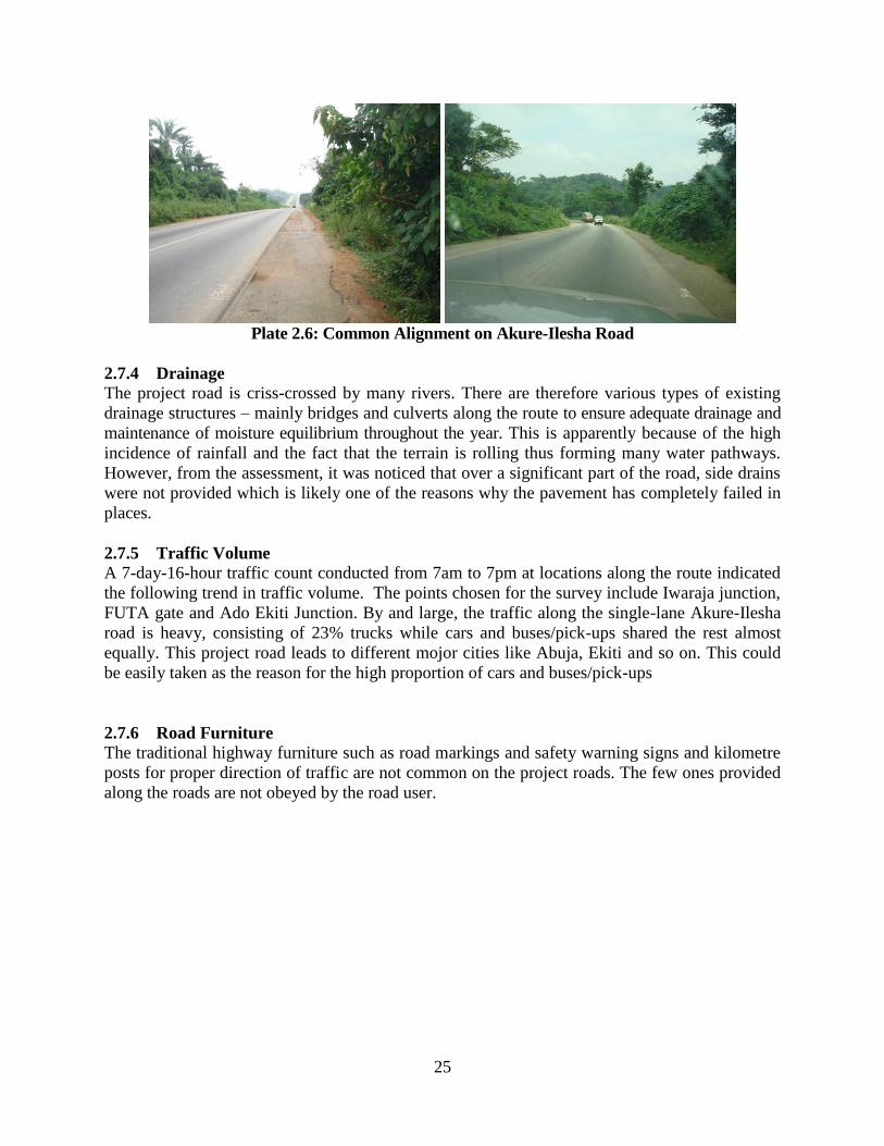
25
Plate 2.6: Common Alignment on Akure-Ilesha Road
2.7.4 Drainage
The project road is criss-crossed by many rivers. There are therefore various types of existing
drainage structures – mainly bridges and culverts along the route to ensure adequate drainage and
maintenance of moisture equilibrium throughout the year. This is apparently because of the high
incidence of rainfall and the fact that the terrain is rolling thus forming many water pathways.
However, from the assessment, it was noticed that over a significant part of the road, side drains
were not provided which is likely one of the reasons why the pavement has completely failed in
places.
2.7.5 Traffic Volume
A 7-day-16-hour traffic count conducted from 7am to 7pm at locations along the route indicated
the following trend in traffic volume. The points chosen for the survey include Iwaraja junction,
FUTA gate and Ado Ekiti Junction. By and large, the traffic along the single-lane Akure-Ilesha
road is heavy, consisting of 23% trucks while cars and buses/pick-ups shared the rest almost
equally. This project road leads to different mojor cities like Abuja, Ekiti and so on. This could
be easily taken as the reason for the high proportion of cars and buses/pick-ups
2.7.6 Road Furniture
The traditional highway furniture such as road markings and safety warning signs and kilometre
posts for proper direction of traffic are not common on the project roads. The few ones provided
along the roads are not obeyed by the road user.

26
Plate 2.7: Some of the Few Road Signage Infrastructure
2.8 DESIGN STANDARDS
The horizontal and vertical alignments of this route as they exist will in a lot of cases meet with
the design standards required of Federal highways by the Federal Ministry of Works without
much impediment and re-alignment. In general, the road design shall be carried out to the
Federal Ministry of Works’ “Highway Manual Part I – Design”, unless when this is not
justifiable due to site constraints or economic considerations. The design speed required is
100Km/hr. Where re-alignment is considered, after examining various alternatives, long
stretches joined by large curves of minimum radius 300m will be aimed at. Permanent features
like bridges and culverts shall be provided in accordance with the Federal Highways standards.
The design standards upon which the road development shall be based are as follows:
Design Rehabilitation Road Project
(i) Design Speed 100km/hr
(ii) Type of Road Single lane carriageway
(iii) Carriageway Width 8.0m
(iv) Shoulder Width 2.5m
(v) Drainage 2.5m
(vi) Maximum Grade 5%
(vii) Pavement Laterite subbase, crushed stone base course, with
thickness specified after determination of the soil bearing
capacity
(viii) Surfacing AC binder and wearing courses shall be used for
pavement/Surfacing Design)
(ix) Design parameters Curve radius, curve lengths, sight distances and other
parameters shall correspond to the 100km/hr design speed.

27
2.9 INPUT AND OUTPUT OF RAW MATERIALS AND PRODUCTS
2.9.1 Raw Material Supply
Major inputs in the road project include the various construction equipment and machinery for
vegetation (bush) clearing, earth (soil) movement, topographic levelling, alignment and re-
alignment of road segments, creation of road pavement, coal tarring and construction materials
including bitumen, gravel and fill material usually excavated on site. The coal burning
residual/bottom ash has also been used widely as a subgrade material.
2.9.2 Process Inputs
Road pavement is usually of lateritic materials stabilized with cement as sub-surface course and
crushed stone as base course while the surfacing is of hot-rolled asphaltic concrete
2.9.3 Sources of Energy Available to the Project
Petroleum products which include motor gasoline, dual purpose kerosene, automotive gas oil,
liquefied petroleum gas, low- and high-pour fuel oil and base oil represent major energy sources
in Nigeria available to the project.
2.10 ROJECT OPERATION AND MAINTENANCE
Optimum highway operation will ensure free flow of traffic at the designed speed to avoid
frequent acceleration/deceleration which is environmentally undesirable) and maintain high level
of safety. Road infrastructure will therefore be maintained to achieve these objectives by periodic
inspection of roads to maintain good drainage, bridges and culverts in functional conditions, and
rehabilitation as necessary for timely rectification of road failures through reworking or
strengthening of base and sub-bases of deteriorated pavement to improve their structural integrity
and asphalt surfacing as necessary, clearing of road shoulders of bush and maintaining adequate
road furniture.
2.11 PROJECT LIFE CYCLE
The project will go through conceptual/design stages (in which the ESIA outputs will be fed
back into improving the final design for sustainable development). During the construction and
operational phases, negative environmental impacts identified in this ESIA (and documented in
the Environmental Management Plan) will be guarded against. At the end of project life span, the
decommissioning plan will be activated.
2.12 PROJECT SCHEDULE
The total duration from zero date to commissioning of plant is 12 months. The remaining phases
required prior to construction include completion of the environmental impact assessment and
screening, detailed field survey and geometric design, and acquisition of the required right of
way especially for the Owena-Akure section of the expressway. This is estimated to take one to
two years to complete. Construction thereafter will depend on the availability of funding. The
project of the expressway is expected to be maintained and to remain in operation indefinitely.

28
CHAPTER THREE
DESCRIPTION OF THE ENVIRONMENT
3.1 Introduction
This chapter presents the environmental (biophysical, health and social) setting of the study area
along Akure and Ilesha road. In this study, the environmental characteristics of the project area were established through extensive literature search, field sampling/measurements, laboratory analysis, stakeholder consultation and data interpretation. Gaps in environmental baseline information of the area were identified, and
fieldwork activities designed to acquire additional data to fill these gaps was then planned and
conducted.
3.2 Baseline Data Acquisition Methods
Prior to commencing baseline studies, known issues and impacts identified from some of the
ESIA projects review were used in further developing the scope of this study. These identified
issues were complemented by examining inventory of potential negative impacts of major energy
and industry developments as contained in the Guidelines for Environment Assessment of
Energy and Industry Projects, Vol. 111, World Bank Technical Paper no. 154. Environment
Department.
3.2.1 Sampling Methods and Field Measurement
A two-season fieldwork was embarked upon for the biophysical as well as social and health
studies. The field sampling and measurement was carried out between September 20 and
September 23, 2011 for wet season fieldwork and between January 30 and February 3, 2012 for
the dry season. FMENV Guidelines and Standards were strictly adhered to in the course of field sampling and measurement. A multi-disciplinary approach was adopted for the ecological characterization and data acquisition. The environmental components covered include topography, climate/Meteorology, air quality, and noise soil, vegetation, animal ecology, aquatic systems including ecology and fisheries, geology/geophysics/hydrogeology, socio-economics, health status assessment and waste management. The sampling points were geo-referenced using Global Positioning
System (GPS).The coordinates were used to generate sampling and location map for the study
area ( see Figure 3.1) . Parameters with short-holding time were determined in-situ using calibrated instruments. Detailed field sampling methodologies are provided in Appendix

29
810000 820000 830000 840000 850000 860000
705000
710000
715000
720000
725000
730000
735000
740000
745000
810000 820000 830000 840000 850000 860000
705000
710000
715000
720000
725000
730000
735000
740000
745000
Iwaraja Junction
Erinmo
Erin Oke Junction
Ipetu-Ijesha Junction
Ikeji-Arakeji Junction
Owena
Igbara oke Junction
Ado-Ekiti Junction
Ilara Mokin Junction
Akure
Akure-Ile
sha Road
Owena River
0 10000 20000 30000 40000 cm
Contour lines are in feet (ft)
LegendROW
Water Sample
Soil Sample
Air & Noise
Afariogun
Figure 3.1: Sampling and Location Map of the Study Area 3.2.2 Quality Assurance/Control Procedure Quality Assurance/quality Control (QA/QC) procedures covered all aspects of the study, including sample collection, handling, laboratory analyses, data coding and manipulation, statistical analyses, presentation and communication of results. Chain of
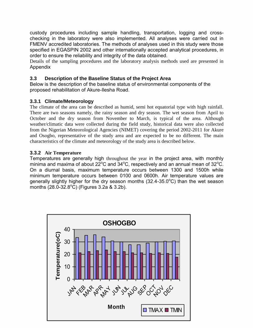
30
custody procedures including sample handling, transportation, logging and cross-checking in the laboratory were also implemented. All analyses were carried out in FMENV accredited laboratories. The methods of analyses used in this study were those specified in EGASPIN 2002 and other internationally accepted analytical procedures, in order to ensure the reliability and integrity of the data obtained. Details of the sampling procedures and the laboratory analysis methods used are presented in Appendix 3.3 Description of the Baseline Status of the Project Area Below is the description of the baseline status of environmental components of the proposed rehabilitation of Akure-Ilesha Road. 3.3.1 Climate/Meteorology The climate of the area can be described as humid, semi hot equatorial type with high rainfall.
There are two seasons namely, the rainy season and dry season. The wet season from April to
October and the dry season from November to March, is typical of the area. Although
weather/climatic data were collected during the field study, historical data were also collected
from the Nigerian Meteorological Agencies (NIMET) covering the period 2002-2011 for Akure
and Osogbo, representative of the study area and are expected to be no different. The main
characteristics of the climate and meteorology of the study area is described below.
3.3.2 Air Temperature
Temperatures are generally high throughout the year in the project area, with monthly minima and maxima of about 22oC and 34oC, respectively and an annual mean of 32oC. On a diurnal basis, maximum temperature occurs between 1300 and 1500h while minimum temperature occurs between 0100 and 0600h. Air temperature values are generally slightly higher for the dry season months (32.4-35.0oC) than the wet season months (28.0-32.8oC) (Figures 3.2a & 3.2b).
OSHOGBO
0
10
20
30
40
JAN
FEBMAR
APRMAY
JUN
JULAUG
SEPOCT
NOVDEC
Month
Tem
pera
ture
(oC
)
TMAX TMIN

31
Figures 3.2a-b: Temperature Regime in the Project Area Source: Nigerian Meteorological Agencies (NIMET)
The highest mean temperature values occur in the month of February at the peak of the dry season while the lowest temperature occurs in the month of August at the peak of the wet season. During the field studies, the temperatures recorded at various sampling locations along Akure-Ilesha road which ranged from 32.6-34.8
oC in the dry season and
from 28.4-31.5oC in the wet season fall within the historical range of temperatures for the area
(Table 3.1). 3.3.3 Relative Humidity
The mean monthly RH for the area is shown in Figures 3.3a & 3.3b with the highest values
occurring in July (92%) and August (92%) and lowest values recorded in December (76%),
January (68%) and March (78%). As expected, mean monthly relative humidity values are high
for the wet season months when the influence of the moisture-laden southwesterlies is greatest.
During the field monitoring, daily relative humidity of 69-88% was recorded for wet season and
52-62% for dry season (Table 3.1). Maximum relative humidity values generally occurred
between 0700h and 0900h while minimum relative humidity values were recorded between
1000h and 1600h.
AKURE
05
10152025303540
JAN FEBMAR
APRMAY JUN JUL
AUG SEPOCT
NOVDEC
Month
Tem
per
atu
re(o
C)
TMAX TMIN

32
Figures 3.3a &b: Relative Humidity Regime in the Project Area Source: Nigerian Meteorological Agencies
AKURE
0
20
40
60
80
100
JAN FEBMAR
APRMAY JUN JUL
AUG SEPOCT
NOVDEC
Month
Ral
ativ
e H
umid
ity(%
)
9 HOURS 15 HOURS

33
3.3.4 Rainfall
Rainfall in the project area is generally high, with mean total annual rainfall of 1353.3mm and
1418.2mm for Akure and Osogbo, respectively. The rainfall pattern shows a double maxima
resulting in two identifiable seasons: the raining season (April to October) typified by the
southwest trade winds and the dry season (November to March) characterized by the northeast
trade winds which bring harmattan. Rainfall is heaviest during the months of May and June.
About 65% of the total rainfall occurs between April and September whilst only about 10% of
the annual total falls between November and February.
3.3.5 Wind Speed and Direction The project area has a calm weather with wind speed ranging between 0.5 m/s to 5.7m/s (Figure
3.4). The mean surface wind speed and direction are influenced by seasonal variation. Two main air masses alternate with the season. During the dry season, the northeast winds predominate while the southwest winds are dominant during the wet season (Figure 3.4). The highest wind speed is recorded at the onset of the wet season when early rains are torrential and accompanied by squalls, lightning, and thunder. The wind speeds are lower in the nights than during the days. During the field study the mean wind speed varied from 1.0 to 2.2m/s during the wet season and 1.3 – 3.2 m/s during the dry season.

34
Figure 3.4: Prevailing Wind Directions in the Study Area
(Source: Nigerian Meteorological Agencies)
Table 3.1: Summary of Weather Conditions Recorded at Various Sampling Stations along Akure-Ilesha Road (Wet And Dry Season Field Studies)
Station Season Temperature
oC
Relative
Humidity
%
Wind Speed
m/s
Wind
Direction
SS1 Dry 32.6 58 2.5 N
Wet 31.3 88 2.2 SW
SS2 Dry 34.0 62 1.9 NW
Wet 31.5 80 2.1 SW
SS3 Dry 34.4 57 1.6 NE
Wet 30.4 81 2.8 SSE
SS4 Dry 33.8 52 1.8 NW
Wet 31.5 69 3.2 SW
SS5 Dry 33.7 62 2.0 E
Wet 29.4 81 1.9 SW
SS6 Dry 34.8 59 2.0 N
Wet 31.3 80 2.5 SSE
SS7 Dry 34.0 58 1.2 N
Wet 30.5 87 2.5 SW
Wet 31.5 72 2.5 S
SS8 Dry 34.1 62 2.2 E
Wet 28.4 77 1.8 SW Source: Field work 2011&2012
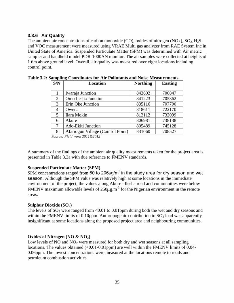
35
3.3.6 Air Quality The ambient air concentrations of carbon monoxide (CO), oxides of nitrogen (NOx), SO2, H2S
and VOC measurement were measured using VRAE Multi gas analyzer from RAE System Inc in
United State of America. Suspended Particulate Matter (SPM) was determined with Air metric
sampler and handheld model PDR-1000AN monitor. The air samples were collected at heights of
1.6m above ground level. Overall, air quality was measured over eight locations including
control point.
Table 3.2: Sampling Coordinates for Air Pollutants and Noise Measurements
S/N Location Northing Easting
1 Iwaraja Junction 842602 700847
2 Omo Ijesha Junction 841223 705362
3 Erin Oke Junction 835116 707700
4 Owena 818611 722170
5 Ilara Mokin 812112 732099
6 Akure 806981 738138
7 Ado-Ekiti Junction 805489 745128
8 Afariogun Village (Control Point) 831060 708527 Source: Field work 2011&2012
A summary of the findings of the ambient air quality measurements taken for the project area is
presented in Table 3.3a with due reference to FMENV standards.
Suspended Particulate Matter (SPM)
SPM concentrations ranged from 60 to 206μg/m3 in the study area for dry season and wet
season. Although the SPM value was relatively high at some locations in the immediate
environment of the project, the values along Akure –Ilesha road and communities were below
FMENV maximum allowable levels of 250g.m-3
for the Nigerian environment in the remote
areas.
Sulphur Dioxide (SO2)
The levels of SO2 were ranged from <0.01 to 0.01ppm during both the wet and dry seasons and
within the FMENV limits of 0.10ppm. Anthropogenic contribution to SO2 load was apparently
insignificant at some locations along the proposed project area and neighbouring communities.
Oxides of Nitrogen (NO & NO2)
Low levels of NO and NO2 were measured for both dry and wet seasons at all sampling
locations. The values obtained (<0.01-0.01ppm) are well within the FMENV limits of 0.04-
0.06ppm. The lowest concentrations were measured at the locations remote to roads and
petroleum combustion activities.
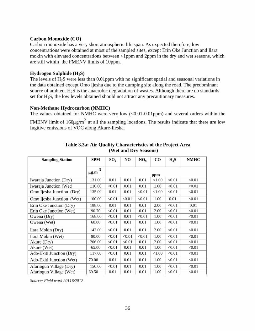
36
Carbon Monoxide (CO)
Carbon monoxide has a very short atmospheric life span. As expected therefore, low
concentrations were obtained at most of the sampled sites, except Erin Oke Junction and Ilara
mokin with elevated concentrations between <1ppm and 2ppm in the dry and wet seasons, which
are still within the FMENV limits of 10ppm.
Hydrogen Sulphide (H2S)
The levels of H2S were less than 0.01ppm with no significant spatial and seasonal variations in
the data obtained except Omo Ijesha due to the dumping site along the road. The predominant
source of ambient H2S is the anaerobic degradation of wastes. Although there are no standards
set for H2S, the low levels obtained should not attract any precautionary measures.
Non-Methane Hydrocarbon (NMHC)
The values obtained for NMHC were very low (<0.01-0.01ppm) and several orders within the
FMENV limit of 160g/m3
at all the sampling locations. The results indicate that there are low
fugitive emissions of VOC along Akure-Ilesha.
Table 3.3a: Air Quality Characteristics of the Project Area
(Wet and Dry Seasons)
Source: Field work 2011&2012
Sampling Station SPM
SO2 NO
NOx
CO
H2S
NMHC
g.m-3
ppm
Iwaraja Junction (Dry) 131.00 0.01 0.01 0.01 <1.00 <0.01 <0.01
Iwaraja Junction (Wet) 110.00 <0.01 0.01 0.01 1.00 <0.01 <0.01
Omo Ijesha Junction (Dry) 135.00 0.01 0.01 <0.01 <1.00 <0.01 <0.01
Omo Ijesha Junction (Wet) 100.00 <0.01 <0.01 <0.01 1.00 0.01 <0.01
Erin Oke Junction (Dry) 188.00 0.01 0.01 0.01 2.00 <0.01 0.01
Erin Oke Junction (Wet) 90.70 <0.01 0.01 0.01 2.00 <0.01 <0.01
Owena (Dry) 168.00 <0.01 0.01 <0.01 1.00 <0.01 <0.01
Owena (Wet) 60.00 <0.01 0.01 0.01 1.00 <0.01 <0.01
Ilara Mokin (Dry) 142.00 <0.01 0.01 0.01 2.00 <0.01 <0.01
Ilara Mokin (Wet) 90.00 <0.01 <0.01 <0.01 1.00 <0.01 <0.01
Akure (Dry) 206.00 <0.01 <0.01 0.01 2.00 <0.01 <0.01
Akure (Wet) 65.00 <0.01 0.01 0.01 1.00 <0.01 <0.01
Ado-Ekiti Junction (Dry) 117.00 <0.01 0.01 0.01 <1.00 <0.01 <0.01
Ado-Ekiti Junction (Wet) 70.00 0.01 0.01 0.01 1.00 <0.01 <0.01
Afariogun Village (Dry) 150.00 <0.01 0.01 0.01 1.00 <0.01 <0.01
Afariogun Village (Wet) 69.50 0.01 0.01 0.01 1.00 <0.01 <0.01

37
Table 3.3b: Regulatory Standards for Ambient Air Quality
S/N Contaminant Averaging
Period
Maximum Concentration (µg/m3)
WHO FMENVa World Bank
b
1. CO 1 – Hr 30,000
8 – Hr 22,800 10,000
24 – Hr 11,400
2. NOX 24 – Hr 200 75 – 113
0.04-0.06ppm
150
3 SO2 1 – Hr 125 260(0.1ppm)
24 – Hr 26(0.01ppm)
4 O3 24 – Hr 100-120
5. PM2.5 24 – Hr 25
6. PM10 24 – Hr 80
7 Non –Methane HC 160
8. TSP 1 – Hr 600
24 – Hr 250 80 aSource: FMENV (1991);
bSource: World Bank (1998)
3.3.7 Noise The noise levels (Table 3.4) varied from 47.9 to 70.5dB (A) in the dry season and from 57.0 to
69.0dB (A) in the wet season. The highest noise level was recorded at Ado-Ekiti junction due to
the high level of traffic while lowest noise level was recorded at Afariogun (rural) community.
The main sources of sound in the project area are vehicular traffic and human conversation.
Slight seasonal variations observed in the data were not significant. The results indicate that the
mean noise levels recorded at the different receptors within the project area were below the
Maximum Allowable Laeq (Hourly) of 90dB (A) limit of FMENV.
Table 3.4: Noise Characteristics of the Project Area (Wet and Dry Seasons)
Sampling Station Noise Level
LAeq(dBA)
Wet season Dry season
Iwaraja Junction 64.80 58.40
Omo Ijesha Junction 63.40 57.20
Erin Oke Junction 62.70 60.90
Owena 65.10 60.00
Ilara Mokin 64.30 59.50
Akure 66.50 64.40
Ado-Ekiti Junction 69.00 70.50
Afariogun Village 57.00 47.90
Source: Field work 2011&2012

38
3.3.8 Soil
The Akure-Ilesha road is underlain by four major soils. These soils which are derived from
basement complex rocks comprise broad groups of poorly drained and well upland drained soils.
The well drained soils covered over 70% of the study area and have good potential to support
arable crops. The coordinates of the soil sample is given in Table 3.5 while the physical and
chemical properties of the soils of the proposed rehabilitation Akure-Ilesha road are presented
for the wet and dry seasons in Table 3.6.
Table 3.5: Sampling Coordinates for Water Quality
S/N Source Northing Easting
1 Iwaraja Junction 842586 700855
2 Afariogun Junction 831062 708527
3 Ilara Mokin Junction 812081 732063
4 Akure 807007 738129
5 Ado Ekiti Junction 805488 745108 Source: Field work 2011&2012
3.3.8.1 Physical Properties
In general, the soils ranged in texture from sand to sandy loam in the topsoil (top 15cm of soil
profile) with the sand fraction varying from 69.0% to 85.0% with mean values of 76.4 ± 6.3%
and 67.5 ± 13.5% in the top 15cm and the subsoil horizons respectively and the silt fractions
from 6.9% to 12.0% (means of 8.6 ± 5.1% and 11.1 ± 6.5% in top and sub soil layers
respectively. The soils were moderately aerated, as porosity values (computed from measured
bulk density values) ranged from 47.0 to 52.0%, with mean values of 50.0 ± 2.8% in the top
soils.
3.3.8.2 Chemical Properties The soils are characterised by acidic reaction (pH range of 4.5 to 5.7 in the surface 15cm to pH
4.6 to 5.3 at lower depths with mean values of 5.4 ± 0.36 and 5.0 ± 0.19 for the top and sub-soil
horizons, respectively), low EC (58-190µS/cm) and low organic matter (1.08-4.43%), total
nitrogen (0.05-0.38% with mean for top and sub-soils of 1.05±0.20 and 0.83±1.8%,
respectively). Contents of available phosphorus were moderate to high in the soils with available
P ranging from 10.6 to 31.3 ppm for all soils and mean values of 18.2±7.3ppm in top soils and
16.7±5.8ppm in the sub soils, while the concentrations of other anions were low to moderate and
composed mainly of nitrates (0.06-0.32ppm); ammonium (0.12-19.5ppm) and sulphates (0.76-
8.56ppm). The chloride concentrations were generally low (77.6-995ppm). Contents of
exchangeable cations were either low or moderate. Range of values of exchangeable cations in
the soils was for potassium, 0.06 to 0.26 cmol/Kg soil, calcium, 2.03 to 5.21 cmol/Kg soil;
magnesium, 1.50 to 2.71 cmol/Kg soil, and sodium, 0.08 to 0.18cmol/Kg, low ECEC 3.88-4.85
cmol/Kg and moderate to high base saturation values (82-98%).
Heavy metal and hydrocarbon contents of the soils were generally low and of little or no
environmental consequences. Contents of iron (Fe) varied widely from 119.5 to 230.7 ppm

39
(mean = 188.4 ± 67.5ppm and 201.6±45.7 in the top and subsoil layers, respectively). Values of
Mn varied from 63.2 to 125.9µg/g with mean values of 89.3±35.28 µg/g in surface soils and
117.6±34.13 µg/g in the subsurface layers. The soils contain adequate concentrations of other microelements or heavy metals for the healthy growth of plants. There was no indication of accumulation of microelements (Table 3.6) as a result of past/present farming practices or industrial activities or the construction of the existing road.
Table 3.6: Summary of Physico-Chemical Characteristics
of Soils of the Project Area
Parameters Mean/Season 1Normal Soil
Values Dry Wet
pH 4.6-5.5 4.5-5.7 5.0 – 6.0 EC, μS/cm 48.2-210.0 58-190 % OM 0.72-2.25 1.08-4.43 1.0 % N 0.05-0.25 0.05-0.38 0.15 NO3, ppm 0.02-0.180 0.06-0.32 NH4
+1, ppm 0.22-4.26 0.12-19.5 6-10
Available P, ppm 8.58-20.6 10.6 - 31.3 7-20 SO4 ppm 0.55-7.10 0.76-8.56 Cl, ppm 58.2-615.0 77.6-995.3 Na, cmol/kg 0.12-0.21 0.08 to 0.18 K, cmol/kg 0.10-0.22 0.06 - 0.26 Ca, cmol/kg 3.15-4.68 2.03 to 5.21 2-5 Mg, cmol/kg 2.02-2.26 1.50 to 2.71 0.1-10 ECEC cmol/kg 3.33-5.25 3.88-4.85 8.0 – 16 Base Saturation, % 80-98 82-98 50 Fe, ppm 130.0-280.4 119.5 - 230.7 4.5 mg/kg Mn, ppm 55.8-115.1 63.2 - 125.9 1.0 Zn, ppm 2.65-6.50 3.22-8.15 1.0 Cu, ppm 0.22-1.14 0.27-0.65 0.2 Cr, ppm 0.32-1.10 0.37-1.13 Cd, ppm 0.01-0.04 0.01-0.03 Ni, ppm 0.10-0.22 0.14-0.22 V, ppm 0.01-0.06 0.01-0.05 Pb, ppm 0.82-3.48 1.01-3.54 Hg, ppm 0-0.0 0.0-0.0 THC, ppm 4.45-8.75 6.52 - 18.25 30 Clay % 4.9-32.4 3.0-36.1 Silt % 5.2-15.6 5.9-12.0 Sand % 62.4-79.5 59.0-85.0
Source: Field work 2011&2012 &1Alloway, 1990
40
The total hydrocarbon concentrations of the soils of the study area were low with values
varying widely from 6.5 to 18.2 mg/g THC (mean values of 12.2±6.6 mg/g and 8.1±5.7mg/g for
the top and sub soils, respectively). These could be from biogenic sources (decaying plant and animal parts - suberins, waxes, chitin etc). There is therefore no addition of hydrocarbon from anthropogenic or pathogenic sources within the study area.
3.3.8.3 Soil Microbiology
Total heterotrophic bacteria abundance ranged from 3.20-8.26x10⁵ and 2.85-7.25x10
5 CFU g
-1 in
the surface and subsurface samples respectively during the dry season. During the wet season,
the counts were slightly higher ranging from 3.83-8.88 x10⁵ and 1.83-8.25x10
5 CFU g
-1 in the
surface and subsurface samples, respectively. The pre-dominant heterotrophic bacterial isolates were Bacillus sp, Pseudomonas sp, Serratia sp, Escherichia sp, Vibro sp,
Flavobacterium sp and Alkalegenes sp. The abundance of heterotrophic fungi varied from 2.50-
5.15 x10³ and 3.12-6.33x10
3 CFU g
-1 in surface and subsurface samples in the dry-season.
Lower counts were observed during the wet season. The major fungal isolates are Penicillium
sp, Aspergillus sp, Candida sp, and Mucor sp. Hydrocarbon utilizing bacteria and fungi in the
surface and subsurface were higher during the wet season sampling than during the dry season.
Heterotrophic bacteria and fungi were generally more numerous in the surface than subsurface.
This trend may be related with availability of more organic material and better growth conditions
in the surface than the subsurface. The low percentage of hydrocarbon utilizes to heterotrophy
(less than 5%) in both seasons indicates that the soils have no recent anthropogenic hydrocarbon
pollution.
3.3.8.4 Land Use
The predominant types of vegetation traversed along Akure-Ilesha road are secondary forest re-
growth, with sparse population of various food crops. Major changes, which had occurred during
the wet season sampling included denser thicket and taller canopy stature of the predominant
vegetation types, greener colouration of the leaves for both planted crops and wild plants and the
submergence of some low growing grasses in the lowland areas along the proposed rehabilitation
road.
The primary use of land in the communities along the proposed rehabilitation road is for
agriculture. Most of the land area was cultivated to arable crops such as cassava (Manihot spp.),
followed by cocoyam (Xanthsomonas spp.), yam (Dioscorea spp), yam (Dioscorea spp) and
vegetables (Telferia, Amaranths spp) in a descending order. The lands were also cultivated to
some deep-feeding tree crops such as oil palm (Eleais guineensis), and cashew (Anarcardium
occidentalis) trees and in a few upland places such as Owena areas there were Cocoa
(Theobroma cacao) tree plantations.
3.3.9 Geology and Hydrogeology
3.3.9.1 Geology of the Project Area The geology underlying the proposed Rehabilitation road is composed of Precambrian Basement
Complex rocks . The geology and the lithological units along the rehabilitation road are contained in

41
Table 3.7.
Table 3.7: The Geology Beneath the Proposed Benin-Osogbo Rehabilitation road
VES
Loc.
Site Description Geology Lithological Unit
1 Akure (Ondo State) Basement Complex Migmatite Gneiss
2 Ilara Mokin (Ondo State) Basement Complex Charnockite
3 Owena-Igbara Oke (Ondo
State)
Basement Complex Migmatite Gneiss
4 Abule-Fariogun Junction,
Ipetu (Osun State)
Basement Complex Migmatite Gneiss
5 Iwaraja Junction (Osun State) Basement Complex Metasediment
(Sources of Geological Information: Rahaman, 1976; Geological Survey Nigeria, 1974; Offodile, 2002)
3.3.9.2 Geophysical Studies
Geophysical investigation involving Schlumberger vertical electrical soundings (VES) was carried
out along the proposed rehabilitation road at five (5) localities at intervals varying from 6.0 – 15.0
km. The depth sounding measurements were required for both near and sub-surface soil resistivity
determination and sub-surface imaging for stratigraphic sequence delineation. The description and
geographical co-ordinates of the VES stations are shown in Table 3.6 .
3.3.9.3 Hydrogeological Characteristics
The proposed rehabilitation road is mainly basement complex terrains.The groundwater within the
segment underlain by the basement complex area (VES 1-5) is contained in weathered and or
fractured basement columns. Groundwater yield is dependent on the degree of weathering and
fracturing. It is highest where groundwater flow is assisted by fractures. The groundwater table
varies from few meters, in basement complex area, to several tens of meters.
Table 3.8: VES Stations and the GPS Geographic Co-ordinates.
VES Site Description UTM (Zone 31)
Easting; Northing
Geographic Coordinate
Latitude; Longitude
1 Ala-Elefosan (Ondo State) 761159; 783808m 7o 05.14’; 5
o 21.85’
2 Ilara Mokin (Ondo State) 732170; 812054m 7o 20.53’; 5
o 06.19’
3 Owena-Igbara Oke (Ondo State) 722899; 819098m 7o 24.38’; 5
o 01.17’
4 Abule-Fariogun Junction, Ipetu
(Osun State)
708623; 830943m 7o 30.84’; 4
o 53.44’
5 Iwaraja Junction (Osun State) 700951; 842585m 7o 37.17’; 4
o 49.29’
Source: Field work 2011&2012
Recharges and Discharges
42
The major source of aquifer recharge in the project area is surface precipitation (rainfall). The high
annual average rainfall over the area ensures adequate groundwater recharge. Other sources include
lateral water movement from streams and rivers and basal groundwater flow.
Discharge sources include groundwater abstraction from boreholes located within the project area
and evapo-transpiration.
3.3.9.4 Geophysical (Geoelectric) Characteristics
General Features of the VES Curves
The VES curves are the H, K, HA, KH, KQ and QH type.
Geoelectric Parameters and Geoelectric/Stratigraphic Sections
The subsurface geoelectric sequence is determined by the geology. The characteristics are the
following:
Basement Complex Environment for VES 1-5;
1st Layer: Topsoil: Clay/Sandy Clay/Clayey Sand.
Resistivity: 31 - 621 ohm-m; Thickness: 0.6 – 1.6 m
2nd Layer: Weathered Layer: This is composed of Clay/Sandy clay.
Resistivity: 29 - 379 ohm-m; Thickness: 1.2 – 24.8 m
3rd Layer: Basement Bedrock (fractured in places).
Resistivity: 112 - ∞ ohm-m; Rockhead at:1.2 – 26.0 m
Groundwater Quality
In the study area, the basement complex rocks are generally known to host fresh water.
Soil Resistivity and Corrosivity Evaluation
The formation of corrosion cells which can lead to severe corrosion failures are known to be
associated with low resistivities. Soil resistivity can be classified in terms of the degree of soil
corrosivity as shown in Table 3.9.
Table 3.9: Classification of Soil Resistivity in terms of its Corrosivity
SOIL RESISTIVITY (ohm-m) SOIL CORROSIVITY
Up to 10 Very Strongly Corrosive (VSC)
10 – 60 Moderately Corrosive (MC)
60 – 180 Slightly Corrosive (SC)
180 and above Practically Non-Corrosive (PNC) (Based on Baeckmann and Schwenk, 1975 and Agunloye, 1984)
43
The subsoil resistivity within the depth range of 0 - 2 m within which the base of the rehabilitation
road could be founded varies from 29 – 3912 ohm-m (Figure 3.8). Based on Table 3.9 above, soils
with layer resistivity values within this range are moderately corrosive to practically non-corrosive.
3.3.10 Vegetation The main block of the Nigerian forest formation at low and medium altitude along this route is
Lowland Rainforest. The high human population densities and their activities along the
rehabilitation road have greatly transformed the complex structure and species richness of this
route. Plant cover in the study area consisted predominantly of farmlands, fallow lands at various
stages of regeneration and degraded remnant lowland tropical moist forests (freshwater swamp
and dry-land rainforests). Plates 3.1-3.2 capture the some of the various vegetation forms
encountered along the proposed rehabilitation road
The bush re-growth vegetation includes fallow of less than five years of age. The rotational bush
fallow systems of cultivation accounts for much of the structural and floristic variations as well
as the micro pattern of the present cover along the route. Elaeis guineensis (oil palm) forms an
upper stratum with isolated crowns in most of the encountered fallowlands while a great variety
of species with relatively small crowns generally in lateral contact with each other such as
Albizia zygia, Alstonia boonei, Anthocleista vogelli, Mangifera indica, Myrianthus arboreus,
Azadiractha indica, Bambusa vulgaris, Alchornea spp, Blighia sapida, Newbouldia laevis,
Ricinus communis, Tithonia diversifolia, Tremia orientalis, and Cnetis ferruginea form the
middle stratum. Herbaceous species such as Panicum maximum, Aspilia africana, Urena lobata,
Axonopus compresus, Sida acuta, Andropogon gayanus. Imperata cylindrica and Chromolaena
odorata form the ground layer. Climbers, epiphytes, saprophytes and parasite are also found
along this route. The epiphytic components include a large number of lower cryptograms and
ferns and flowering epiphytes were conspicuous. The tree density is is generally low as a result
of human influence.
Fallow land vegetation of the following distinct physiognomy was encountered at the study site:
Fallow land vegetation with Tremia orientalis as the dominant woody species and
Chromolaena odorata as the dominantnt shrubby/herbaceous species.
Fallow land vegetation with Musanga cecrepoides as the dominantnt woody
species and Chromolaena odorata as the dominant shrubby/herbaceous species
Fallow land vegetation dominated by Cassia siamea (woody species and
Chromolaena odorata (shrubby/herbaceous species)
Fallowwland vegetation with woody species such as Cassia siamea, Cola
gigantea,Mangifera indica,Elaeis guineensis and shrubs such Jatropha
species,Ricinus communis,Chromolaena odorata and Solanum torvum
guineensis,Newbouldia laevis Trema orientalis and Spondias mombim,
Fallow land vegetation with woody species such as Alstonia boonei,Alchornea
cordifolia,Gliricidia sepium,Anthoclestia vogelli,shrubs such as Chromolaena
odorata and grasses as ground layer such as Andropogon spp, Panicum maximum
Fallowland vegetattion of fresh water swamp dominated by Alchornea cordifolia
and Elaeis guineensis

44
Fallowland vegetation of grasses and Chromolaena odorata with evidence of
annual burning
Fallowland vegetation dominated by Tithonia diversifolia
Plate 3.1 Fallow / Bush Regrowth Vegetation Stand
Plate 3.2 Fallow / Bush Regrowth Vegetation Stand
Agriculture
The major cultivated crops in the areas include cassava (Mannihot esculenta), Yams (Dioscorea
sp), Pumpkin (Telfainia occidentalis), banana and plantaing (Musa sp). Tree species, which offer
non-timber forest products (barks, fruits, roots etc) that play roles in traditional medicine and
nutrition, abound in the areas and include Raphia hookeri (wine palm), Alstonia booneii (Stool
wood), Harungana madagascariensis (Blood tree), and Musanga cercropioides (Umbrella trees).
Checklist of crops encountered along the rehabilitation road are presented in Table 3.10
The study area has a diversity of plants that are of economic importance, including their uses as fuel, timber, dyes, vegetable, edible fruits and seed trees, medicinal and religious plants and sponge. A checklist of the common economic plants within the study area is presented in Table 3.11.

45
Table 3.10: Checklist of Crops Plants in Farms Encountered along the Proposed Rehabilitation Road
S/N Scientific Name
Family/Sub family
Common Name
Uses/Economic Importance
Density (No./ha)
1 Zea mays Poaceae Maize/Corn Grains 10,000
2 Manihot
esculenta
Euphoriace Cassava Root tuber 2,500
3 Arachis
hypogea
Fabaceae
(papilionaceae)
Groundnut Peanuts 30,000
4 Dioscorea
rotundata
Dioscoreaceae White yam Stem tuber 5,000
5 Dioscorea alata Discoreaceae Water yam Stem tuber 5,000
6 Vigna
unguiculata
Fabaceae Cowpea Grain legume 20,000
7 Dioscorea
trifoliate
Dioscoreaceae Yellow yam Stem tuber 2,500
8 Capsicum
Annum
Solanaceae Pepper Spice 5,000
9 Lycopersicon
esculentum
Solanaceae Tomato Fruit vegetable 5,000
10 Corchorus
olitorus
Malvaceae
Yoruba:
Ewedu
Leafy vegetable
edible fruits
10,000
11 Hibiscus
Esculentus
Malvaceae Okra Edible fruit 5,000
12 Oryza sativa Poaceae Rice Grains 80,000
13 Citrulus lanatus Cucurbitaceae Melon Seeds for soup 2,500
14 Saccharum
officinarum Poaceae Sugar cane Edible
stem/sugar 2,500
Source: Field work 2011&2012
Table 3.11: Checklist of Common Economic Plant Species along the route
Economic Plant Species Common Name Use(s)
1. Mangifera indica Mango Edible fruit
2. Alchornea spp Christinas bush Medicinal
3. Raphia hookeri Rafia Wine
4. Elaeis guineensis Oil palm Palm oil / wine brown
5. Alstonia boonei Alstonia Medicinal / timber
6. Manihot esculenta Cassava Food product

46
7. Oryza sativa Rice Food prodcts
8. Musa spp Banana Food product
9. Xanthosoma mafaffa Cocoyam Food products
10. Abelmoschus esculentus Okro Food products
11. Zea mays Maize Food product
12. Rauvolfia vomitoria Medicinal
13. Chromolaena odorata Awolowo/Akintola Medicinal
14 Ananas spp Pineapple Food product
15 Piliostigma
thonningii Thonning’s piliostigm
Dye yielding, Religions purposes
16 Daniellia oliveri
African copaiba balsam
Timber, fuel wood
17 Vitex doniana
Black plum Yoruba: orinla
Fuel wood, Edible fruits
18 Anacardium occidentalis Cashew Edible fruit, Medicinal
19 Mangifera indica
Mango
Edible fruit, Medicinal
20 Tectonia grandis
Teak
Used as poles for high/low tension electric lines
21 Citrus aurantium Orange Edible fruit Source: Field work 2011&2012
3.3.11 Aquatic System 3.3.11.1 Water Quality
The water body investigated along the proposed rehabilitation road axis was only one perennial
river: Owena River. Baseline information on the existing water quality of the study area is presented in Table 4.12 and Table 4.13. Table 3.12: Sampling Coordinate for Water Quality
S/N Source Type Easting Northing
1 Iwaraja Junction Well 842726 700826
2 Owena River River 818872 722305
3 Ado-Ekiti Junction Well 805488 745108 Source: Field work 2011&2012
The water temperature at sampling varied between 26.8.0ºC and 33.4ºC.. The conductivity of
water samples which is a reflection of the low total dissolved solids content varied between
22.5μS and 260μS/cm (Ado-Ekiti junction-well water) . The poor ionic contents of the water
samples were probably responsible for the low conductivity. In the western axis of the
rehabilitation road, the TDS of water which ranged between 59.4 mgl-1
and 287.6 mg/l was also
reflected as high conductivity values. The dissolved oxygen content of water ranged between
1.80 mgl-1
and 5.6 mgl-1
. As expected, the DO content of flowing river water was higher than

47
those of borehole and well water samples respectively, because of high rate of turbulence and
atmospheric dissolution at the air-water interphase.
The levels of the biogenic cations and those of some heavy metals assayed in the water samples
collected along the rehabilitation road axis is shown in Table 3.13. he Mg2+
level ranged
between 0.10 mgl-1
and 4.60 mgl-1
(Owena River samples).
In the water samples collected from most locations the Mn2+
and Fe2+
ionic contents were very
high, while Zn2+
and Cr2+
which were the minor elements had relatively low concentration. The
other assayed heavy metals occurred in trace amounts and below recommended limits set by FMENV.
The total hydrocarbon values reported were quite low in most sampling stations. It fluctuated between 0.55mg/l and 2.75mg/l. These levels are generally lower than recommended limits for inland waters in Nigeria.
3.3.11.2 Water Microbiology Twenty species of bacteria and fifteen of fungi were isolated from the surface water bodies
including those of human origin. The bacterial isolates belong to two orders: Pseudomonadales
and Eubacteriales while the fungal isolates belong to 3 Orders - Mucorales, Moniliales and
Sphaeriales. The prominent isolates were Pseudomonas fluorescens, P. aeruginosa and
Klebsiella pneumoniae and Yeasts sp. Heterophic bacteria and Fungi abundance in the waters
ranged from 2.15 x 10⁴ – 8.75 x 10
4 and 1.75 x 10
3 – 3.5510
3 CFU ml
-1, respectively. The low
proportion (<1%) of hydrocarbon utilizers to heterotrophs indicates that the water bodies
sampled were not contaminated with hydrocarbons. Saccharomyces (yeast), Mucor, Aspergillus,
Candida, and Penicillium were the predominant fungi species whereas Bacillus, Staphylococcus,
Serretia, Proteus and Pseudomonas were the major bacteria species. Results also revealed that
most of the water bodies contained coliforms, confirmed as faecal in origin in excess of 50
MPN/100ml.
Table 3.13: Summary of Physico-Chemical Characteristics of Water
From the Rivers/Streams and Boreholes/Wells in the study area
Parameter
Surface Water Ground Water 1Limit Min Max Min Max
Water temperature ˚C 27.4 33.4 26.8 28.5
pH 5.7 7.6 6.6 7.5
6.5-9.5
Conductivity μS/cm 30 102 22.5 260
Total dissolved Solids (mgl-1
) 70.5 220 29 287.6
1200
Apparent colour (Pt-Co) 90.3 224.15 8.75 160.5
OD, mg/l 2.4 5.6 1.8 3.3
5
COD, mg/l 4.2 7.8 8.4 12.0
50
48
Turbidity (NTU) 15.5 225.5 3.79 46.97
Alkalinity Mgl-1
CaCO3) 0.94 46.0 2.0 80.0
Acidity (Mgl-1
CaCO3) 2 4.15 2 12
Chloride (Mgl-1
) 0.8 2.8 0.95 10.08
Bicarbonate (Mgl-1
) 1.08 55.2 2.4 116
Sulphate (Mgl-1
) 0.11 0.65 0.16 1.06
250
Nitrate (Mgl-1
) 0.01 3 0.01 0.7
50
Sodium (mgl-1
) 0.45 1.15 0.1 2.2 200
Potassium (mgl-1
) 4.35 31.13 2.94 257.35
Calcium (mgl-1
) 0.05 0.61 0.2 22
Magnesium (μgl-1
) 0.15 4.6 0.1 2.5
Manganese (μgl-1
) 21 115.4 7 196.5
0.1
Iron (μgl-1
) 0.15 190.4 16.5 248
0.3
Copper (μgl-1
) 1.05 3.84 0.65 3.15
2
Zinc (μgl-1
) 2.6 10.2 4.8 39
Lead (μgl-1
) 0.05 1.6 0.04 0.5
0.01
Chromium (μgl-1
) 1.11 2.05 0.05 1.6
0.05
Cadmium (μgl-1
) 0.06 1.4 0.06 0.9
0.003
Nickel (μgl-1
) 0.85 2.38 2.02 17
0.02
Arsenic (μgl-1
) 0.01 0.06 0.014 0.075
Mercury (μgl-1
) 0 0 0 0
0.001
THC 0.55 2.75 0.28 0.62
10
Source: Field work 2011&2012
3.3.11.3 Hydrobiology Phytoplankton The phytoplankton assemblages of the surface waters along the proposed rehabilitation road
shows that the species richness varied between 8 and 20 species with 68 taxa of phytoplankton belonging to three divisions namely bacillariophyta or diatoms, cyanophyta or blue-green algae, and chlorophyta or green algae identified during the studies (Table 3.14a and Table 3.14b).In Owena River water, the phytoplankton flora consists of 2 Blue green algae
(Cyanophyta), 4 chlorophytes (Chlorophyta) and 7 diatom species.
The diatoms comprised the bulk of the flora with 51.5% followed by Chlorophyta with 33.8% and Cyanophyta forming 14.7%. The blue-greens are known to be tolerant of pollution because of their ability to utilize high nutrient levels, and have been known to tolerate high levels of stress in aquatic environment. The low diversity levels reported

49
for the phytoplankton flora may be attributable to alterations of the physico-chemical conditions of the water (Copper and Wihun 1975). Table 3.14a: Check list of Phytoplankton Groups Division Chlorophyta Closterium acerosum
C. moniliferum
Cosmarium sp.
Desmidium sp.
Eudorina elegans
Hyalotheca dissiliens
Micrasterias radiata
Mongeilia spherocarpa
Oedogonium grande
Pediastrum duplex
Spirogyra varians
Ulothrix tenuissima
Zygnema pectinatum
Scenedesmus spp.
Division Cyanophyta
Nostoc spp. Anabaena solitaria
Anacystis cyanea
Chroococcus limieticum
Chroococcus turgidus
Microcystis aeruginosa
Oscillatoria borneltia
Oscillatoria Formosa
O. limosa
Division Bacillariophyta
Asterionella formosa,
Fragilaria crotenensis,
Navicula radiosa,
Synedra ulna
Melosira varians Aulocoseira granulata
Frustulia rhomboides
Pinnularia viridis
Surirella elegans
Source: Field work 2011&2012
Table 3.14b: Distribution of Phytoplankton in the waters of the project area
Group Number
of Species
Total
Abundance
% Abundance
Cyanophyta 10 478 14.7
Chlorophyta 23 1099 33.8
Bacillariophyta 35 1672 51.5 Source: Field work 2011&2012
Zooplankton The results on zooplankton taxa, abundance and distribution encountered during the rainy season
are presented in Tables 3.15a and 3.15b. The data show that four major groups of zooplankton
containing a total of 16 taxa were observed. In Owena River water samples, the micro
invertebrate fauna consist of 3 rotifers and 2 arthropodic species.
The Rotifera made up 75.0% while Cladocerans constituted 17.9% and Arthropoda 7.1% of the total population. Rotifers dominated the water bodies followed by the Cladocerans . Generally, the zooplanktons are sparse in terms of numbers of individuals and taxa richness. In terms of abundance, Nauplius larvae are relatively the most abundant, followed by insect larvae. Species diversity, which expresses species richness, was determined using the Simpson’s Diversity Index. The analysis showed low species diversity.

50
Table 3.15a: Check list of Zooplankton Groups
Arthropoda
Cyclops sp.
Chydorus sp
Nauplia of Cyclopod
Chaoborus sp.
Rotifera
Rotaria neptunia
Asplanchna priodonta
Brachionus falcatus
Keratella cochlearis
Lecane luna
Notholca sp.
Trichocerca bicristata
Cladocera
Bosmina longirostris
Diaphanosoma sp.
Ceriodaphinna sp.
Moina micrura
Source: Field work 2011&2012
Table 3.15b: Distribution of Zooplankton in the waters of the project area
Group Number
of Species
Total
Abundance
% Abundance
Arthropoda 2 80 7.1
Rotifera 4 824 75.0
Cladocera 4 196 17.9 Source: Field work 2011&2012
3.3.11.4 Fish/fisheries Fish study was conducted on fishes obtained from rivers along the proposed rehabilitation road and through interviews and literature search. Fishing activities are carried out mostly in the nights, early mornings and evenings, and generally done from dug out canoes. Generally, there was more fish during the wet season compared to the dry season. The fishing gears commonly used includes castnets, set nets, drift nets, gill nets and hook on line as well as fish fence. Fishing is carried out by migrant fishermen, few indigenes also participate in fishing activities. Fifteen fish species distributed in 7 families were identified. The checklist of fishes
observed in the river along the rehabilitation road is shown in Table 3.16. Table 3.16: A checklist of the fish species inhabiting the sampled rivers during the period
of study
Family Species Name Common Name Economic
Importance
Abundance
Mormyridae Mormyrus rume Mormyrid High Low
Cyprinidae Barbus ablabes Minnow/Barbels Low High
B. callipterus Minnow/Barbels Low High

51
Hepsetidae Hepsetus odoe African River Pike High Very High
Malapteruridae Malapterurus electricus Electric Fish Fairly High Low
Clariidae Clarias gariepinus Mudfish Very High Very High
Heterobranchus bidorsalis Mudfish Very High Very High
Cyprinodontidae Epiplatys senegalensis Pan chax Low Very Low
Channidae Channa obscura Snake Head Very High High
Cichlidae Hemichromis bimaculatus African Jewel fish High High
H. fasciatus Five spotted
Tilapia
Fairly High High
Oreochromis niloticus Nile Tilapia Very High Very High
Tilapia zillii Red Belly Tilapia Very High Very High Source: Field work 2011&2012
In terms of species richness, Cichlidae was dominant. Fish processing within the study area is basically traditional using indigenous technology. Traditional smoking kiln or earthen ovens were prevalent throughout the study area. The smoked fish is consumed within the family unit and/or sold at the local markets. Gymnarchus niloticus (Mormyrid), Channa obscura (Snake head fish), Heterotis niloticus
(African bony tongue fish), and Chrysichthys auratus (Silver cat fish) were the most palatable among the fish species. All the fishes examined did not show any physical evidence of parasitic infestation. There was no observation of disease infestation, abnormalities or physical deformities. Analysis of the condition factors (KF), an index of the well being of the fish, showed that the fishes were healthy and well fed in relatively undisturbed environment. The factors on the average were well above the critical value of 1.0.
3.3.11.5 Sediment Physico-Chemical Characteristics The physico-chemical characteristics of sediment samples are presented in Table 3.17. The
sediments were mainly sandy (sand 65.8% - 85.5%, clay 5.2%-18.4%, silt 9.3%-15.8%), acidic
(pH4.4-5.7) and low electrical conductivity (66.8-130.2μS/cm) indicating that the environment
under study is within the freshwater habitat. The sediment samples had low contents of organic
carbon (1.48 and 2.28%), nitrogen (0.15 to 0.32%) low to moderate phosphorus concentrations
(5.8 to 34.5ppm). The concentrations of nitrate (0.072-0.112ppm), ammonium (4.62-18.27ppm),
sulphate (10.48-22.80ppm), and chloride (28.6-58.8ppm) are considered low but the nutrients are
adequate to support the healthy growth of benthic population. The exchangeable cation exchange
capacity (ECEC) is low, ranging from 4.48to 7.39meq/100g sediment. The major contributors to
the ECEC were Ca (2.25-4.43meq/100g sediment), Mg 1.24 to 2.24meq/100g sediment), and Na
(0.12 to 0.44 meq/100g sediment). The heavy metal concentrations are low in the sediment
samples and there was no indication of their accumulation in the samples. No mercury (Hg) was
detected in the sediment samples. The total hydrocabon content (THC) varied from 0.78 to
4.52ppm and these can be accounted for from biogenic sources mainly of vegetal debris. Thus
there was no oil pollution of the sediment.

52
Sediment Microbiology
Microorganism abundance was generally higher in the sediment than in the overlying water
body. This is understandable given that deposition and subsequent degradation of organic
material in the sediment releases dissolved organic carbon and materials into the sediment. These
materials are utilized by heterotrophs for growth and incorporated into their body biomass.
Heterotrophic bacteria in the sediment varied from 8.06 x 10⁴ – 9.15 x 10
5 CFU g
-1 during wet
season. Heterotrophic fungi in the sediment had mean abundance of 8.75 x 10³ CFUg
-1. The
sediment samples also had hydrocarbon utilizers to heterotrophic microbes’ ratio of less than
4.5%, indicating that the area had no recent hydrocarbon pollution.
Table 3.17: Physico-Chemical Characteristics of Sediments of Rivers/Streams
in the study area
Parameters Sediment
Clay % 12.0
Silt % 7.6
Sand % 80.4
pH 4.8
EC, μS/cm 130.2
% C 2.26
% N 0.17
NO3, ppm 0.112
NH4+1
, ppm 17.10
Available P, ppm 8.9
SO4 ppm 22.8
Cl, Meq/100g soil 58.8
Na, Meq/100g soil 0.16
K, Meq/100g soil 0.28
Ca, Meq/100g soil 2.89
Mg, Meq/100g soil 1.56
ECEC, Meq/100g soil 3.93
Base Saturation, % 92.8
Fe, ppm 128. 2
Mn, ppm 75.8
Zn, ppm 4.75
Cu, ppm 1.82
Cr, ppm 0.08
Cd, ppm 0.06
Ni, ppm 0.12
V, ppm 0 Pb, ppm 0 Hg, ppm 0 THC, ppm 1.12
Source: Field work 2011&2012

53
3.3.12 Terrestrial Fauna and Wildlife
A check list of forty four (44) wildlife species belonging to 36 families were encountered, based
on ground surveys and participatory rural appraisal interviews is shown in Table 3.18. Of the
species of vertebrate wildlife identified, the avifauna and mammals were the dominant groups.
The mammals, reportedly sighted or reported to occur in the area were mainly browsers or grazers including medium-sized mammals such as duikers and antelopes. Others include
some primates (Cercopithecus Erthropgaster) and rodents (small mammals) like Thryonomys
swinderianus (cutting grass), Xerus erythropus (ground squirrel) and Cricetomys gambianus
(Gambia pouched rat). At Afariogun village crossing, the farmer interviewed confirmed the
presence of the primates (Papio anubis, Erythrocebus patas, and Goilla gorilla) as well as those
of the Reed buck (Redunca redunca) and the Civet cat (Cirettictis civetta) was also confirmed by
famers in the forest reserve area. The observed mammalian taxonomic diversity was however
low for this environment indicating a disturbed ecosystem, due to farming activities and annual
bush burning.
Amphibians and reptiles include frogs, toads, lizards, and snakes (cobra and vipers). Toads are represented by the genus Bufo while the frogs were mainly Rana spp. The reptiles are represented by snakes (Cobra, viper, and African python); lizards (Hemidactylus brooki, Brook’s gecko; Chameleo senegalensis, African chameleon; and Agama agama, the rainbow lizard). Four (4) reptilian species which were not sighted during the rainy period were
sighted during the dry season. These are the rainbow lizard, the monitor lizard (Varanus
niloticus), the black cobra (Naja nigricollis) and the West African Green tree mamba
(Dendroaspis viridis).
A number of species sighted in the rainy season but not during the dry season include the mouse-
brown sun bird (Anthreptes gabonicus) (which is known to be dependent on nectars of flowers)
and Black and White-tailed hornbill (Tockus fasciatus). The Senegal Indigo Finch (Vindua
calybeata) and the Yellow Fronted Canary (Serinus mozambicus) sighted during the rainy season
were also absent during the dry season. Black hawks were sighted along the water banks.
In general, low densities and sparse distribution of wildlife were observed in the project area,
apparently due to the exposure of the study area has anthropogenic impacts such as clearance for
agriculture, annual bush burning and hunting (including the setting of traps). Literature review
and information gap analysis also revealed a dearth of information on the wildlife of the project
area, resulting in an unclear picture of wildlife diversity, abundance and distribution. Most of the
wildlife taxa would, therefore, be classified as not evaluated’ or “data deficient” based on IUCN
(1994) guidelines. This implies that data is insufficient to assign conservation status to these
wildlife taxa. Under these circumstances, the IUCN (1994) recommends that such organisms
should be given the same degree of protection as threatened taxa, at least until their status can be
evaluated. Other than the small mammals whose conservation status may be considered as

54
satisfactory (survival not threatened), most vertebrate wildlife would be considered as rare (and
therefore vulnerable). Some of the mammalian (Athercunus africanus and Tragelephus spekei),
avifauna (Family Arceidae) and reptilian (Pyton (Morelia spilotata) and Crocodyius) species
identified are threatened or endangered and international trade is either prohibited or requiring
licenses (NEST, 1991).
Table 3.18: List of Wildlife Species sighted or reported around the project area
Common Name Biological Name Detection
method
(DS/IH)
Decrees
11/1985
National
Resources
Conservation
Council, 1992
MAMMALIAN
White throated
Guenon
Cercopithecus
Erthropgaster
IH Vulnerable
Common Rats Rattus rattus 10
House Mouse Mus musculus 5
Gambia pouched rat Cricetomys gambianus 10
African Palm Squirrel Epixerus ebii 8 Schedule 1 Endangered
Ground Squirrel Xenus erythropus IH
Grass Cutters Thryonomys swinderianus IH
African Civet Civettictis civetta IH Threatened
Small Deer IH
Antelope Neotragus batesi IH
Bushbuck Tragelaphus scriplus IH
Maxwell’s Duiker Cephalopus maxwelli IH Vulnerable
Porcupine Atherunus africanus IH Schedule 1
Nigerian musk shrew Crocidura nigenriae IH
REPTILIA
African Pyton Morelia spilotata IH
Black Cobra Naja melanoleuca IH Schedule 1
Viper Echis caminatus IH
Black Tree Snake Thrasops occidentalis IH
Snake Dendroaspis viridis IH
Snake Atheris chloraechis IH
Common Lizards Agamma agamma 15
Monitor Lizard Veranus niloticus 20
AMPHIBIAN
Frogs Dicoglossus sp 5
Long-Legged Frog Ptychodena sp 4
Toads Bufo regularis 5
Crabs 2
African chameleon Chameleo senegalensis, 2
AVIES
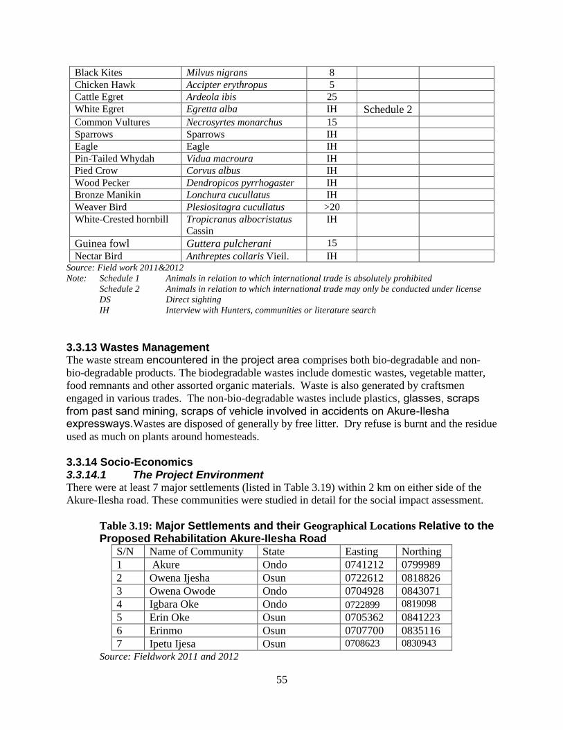
55
Black Kites Milvus nigrans 8
Chicken Hawk Accipter erythropus 5
Cattle Egret Ardeola ibis 25
White Egret Egretta alba IH Schedule 2
Common Vultures Necrosyrtes monarchus 15
Sparrows Sparrows IH
Eagle Eagle IH
Pin-Tailed Whydah Vidua macroura IH
Pied Crow Corvus albus IH
Wood Pecker Dendropicos pyrrhogaster IH
Bronze Manikin Lonchura cucullatus IH
Weaver Bird Plesiositagra cucullatus >20
White-Crested hornbill Tropicranus albocristatus
Cassin
IH
Guinea fowl Guttera pulcherani 15
Nectar Bird Anthreptes collaris Vieil. IH Source: Field work 2011&2012
Note: Schedule 1 Animals in relation to which international trade is absolutely prohibited
Schedule 2 Animals in relation to which international trade may only be conducted under license
DS Direct sighting
IH Interview with Hunters, communities or literature search
3.3.13 Wastes Management The waste stream encountered in the project area comprises both bio-degradable and non-
bio-degradable products. The biodegradable wastes include domestic wastes, vegetable matter,
food remnants and other assorted organic materials. Waste is also generated by craftsmen
engaged in various trades. The non-bio-degradable wastes include plastics, glasses, scraps from past sand mining, scraps of vehicle involved in accidents on Akure-Ilesha expressways.Wastes are disposed of generally by free litter. Dry refuse is burnt and the residue
used as much on plants around homesteads.
3.3.14 Socio-Economics 3.3.14.1 The Project Environment There were at least 7 major settlements (listed in Table 3.19) within 2 km on either side of the
Akure-Ilesha road. These communities were studied in detail for the social impact assessment.
Table 3.19: Major Settlements and their Geographical Locations Relative to the Proposed Rehabilitation Akure-Ilesha Road
S/N Name of Community State Easting Northing
1 Akure Ondo 0741212 0799989
2 Owena Ijesha Osun 0722612 0818826
3 Owena Owode Ondo 0704928 0843071
4 Igbara Oke Ondo 0722899 0819098
5 Erin Oke Osun 0705362 0841223
6 Erinmo Osun 0707700 0835116
7 Ipetu Ijesa Osun 0708623 0830943
Source: Fieldwork 2011 and 2012

56
3.3.14.2 Socioeconomic Attributes
Table 3.20: Socioeconomic Characteristics of PAPs
Variables Frequency percentage
Name of village/town
Akure 36 37.11
Owena Ijesa 47 48.45
Owena Owode 6 6.19
Igbara Oke 1 1.03
Erin Oke 4 4.12
Erinmo 2 2.06
Ipetu Ijesa 1 1.03
Ethnicity
Yoruba 98 98.99
Igbo 1 1.01
Religion
Christianity 60 60.61
Islam 39 39.39
Age
11-20 6 5.94
21-30 32 31.68
31-40 25 24.75
41-50 27 26.73
51-60 8 7.92
61+ 3 2.97
Marital Status
Single 12 11.88
Married 76 75.25
Divorced 3 2.97
Widow 10 9.90
Level of Education
Primary 24 23.76
Secondary 38 37.62
Vocational/Technical 8 7.92
Tertiary 15 14.85
No formal education 16 15.84
Occupation
Farming/hunting 1 0.99
Technician 4 3.96
Trading 78 77.23
Business/contractor 14 13.86
Teaching 1 0.99
Civil servant 2 1.98
Student/apprentice 1 0.99
Skills
Mason 1 1.03
Technician 4 4.12
Politician 1 1.03
Transporter 2 2.06
Unskilled 89 91.75
Annual income (₦)
1000-10000 1 0.99
11000-20000 1 0.99
21000-30000 0 0

57
31000-40000 0 0
41000-50000 1 0.99
51000-60000 4 3.96
61000-70000 3 2.97
71000-80000 7 6.93
Above 80000 84 83.17
Source: Field work 2011&2012
Figure 3.5: Distribution of PAPs by Community
Socioeconomic data was collected in seven locations as shown in Table 3.19 and figure 3.5. The
affected communities are Akure, Owena Ijesa, Owena Owode, Igbara Oke, Erin Oke, Erinmo
and Ipetu Ijesa. The distribution indicates that most of the PAPs are in Akure and Owena-Ijesa.
There were many PAPs in Akure because of its size and population (the city is the Capital of
Ondo state and a magnet to people from all parts of the state, including roadside artisans and
traders). Owena-Ijesa however has the largest number of PAPs due to having lots of structures
too close to the highway (the encroachments include permanent physical structures and
makeshift shops, Plate 1.2).
Ethnicity
The distribution of the PAPs by ethnicity shows that they are all virtually of the Yoruba
ethnicity. The road project actually runs through two states whose indigenes are of Yoruba
descent, hence the nearly 100% Yoruba ethnicity.
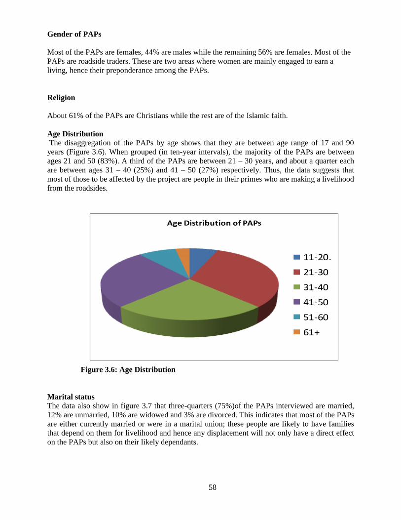
58
Gender of PAPs
Most of the PAPs are females, 44% are males while the remaining 56% are females. Most of the
PAPs are roadside traders. These are two areas where women are mainly engaged to earn a
living, hence their preponderance among the PAPs.
Religion
About 61% of the PAPs are Christians while the rest are of the Islamic faith.
Age Distribution The disaggregation of the PAPs by age shows that they are between age range of 17 and 90
years (Figure 3.6). When grouped (in ten-year intervals), the majority of the PAPs are between
ages 21 and 50 (83%). A third of the PAPs are between 21 – 30 years, and about a quarter each
are between ages 31 – 40 (25%) and 41 – 50 (27%) respectively. Thus, the data suggests that
most of those to be affected by the project are people in their primes who are making a livelihood
from the roadsides.
Figure 3.6: Age Distribution
Marital status The data also show in figure 3.7 that three-quarters (75%)of the PAPs interviewed are married,
12% are unmarried, 10% are widowed and 3% are divorced. This indicates that most of the PAPs
are either currently married or were in a marital union; these people are likely to have families
that depend on them for livelihood and hence any displacement will not only have a direct effect
on the PAPs but also on their likely dependants.
Age Distribution of PAPs
11-20.
21-30
31-40
41-50
51-60
61+

59
Figure 3.7: Marital status
Education Examining the education level of the PAPs, from figure 3.8 shows that about 40% either did not
go to school at all or attended only primary school. 38% attended secondary school while 15%
had tertiary education. The literacy level is generally high, with 85% having at least primary
education.

60
Figure 3.8: Education
Occupation
The occupational distribution of the PAPs shows in figure 3.9 that they are predominantly
roadside traders (77%). A further 14% claim to be business contractors. The others are mainly
artisans. This is not surprising giving the educational qualifications and the locations where they
earn their livelihood (by the roadside). This suggests that they are mostly struggling to make a
livelihood from the mostly petty trading they engage in by the sides of the Akure – Ilesa
highway. The skills reported by the respondents further underscores the educational and
occupational data described earlier. About 9 in 10 of the interviewed PAPs were unskilled
workers (92%) while the remaining 8% comprises mainly of technicians and transporters.

61
Figure 3.9: Primary Occupation
Figure 3.10: Skills (The PAPs are mostly unskilled workers)
Annual Income
The income distribution of the affected persons show that majority of them (83%) earn incomes
in excess of ₦80,000 per annum. Only a few earn less than ₦70,000 per annum among the
affected persons.
Figure 3.11: Annual Income

62
Table 3.21: Socioeconomic Characteristics of PAPs
Variables Frequency percentage
Family size
1-3 32 34.04
4-6 44 46.81
7-10 14 14.89
11-15 2 2.13
16-20 2 2.13
Length of stay in the community (years)
0-5. 32 32.32
6-10. 28 28.28
11-15. 8 8.08
16-20. 10 10.10
Above 20 years 12 12.12
Since birth 9 9.09
Type of house
Thatched 21 21.88
Thatched/wooden 28 29.17
Zinc roof/wooden 12 12.50
Zinc roof/block 35 36.46
Type of waste discharge system
Water system 3 3.23
Pit system 6 6.45
Bucket system 6 6.45
River 1 1.08
Bush swamp 58 62.37
Other 19 20.43
House Refuse Disposal
Dustbin 29 31.87
Open dumping on land/creeks 33 36.26
Composting 4 4.40
Incineration 3 3.30
Others 22 24.18
Source of drinking water
Tap 44 44.0
Well 33 33.0
Stream 4 4.0
Other 19 19.0
Attitude to this project
Support the project 85 86.73
Resist the project 8 8.16
No idea 4 4.08
Demand compensation 1 1.02
Benefit expected from road project
Employment opportunity 11 11.11
Economic boom 73 73.74
Infrastructural development 12 12.12
Scholarship 2 2.02
Hospital 1 1.01
Source: Field work 2011&2012

63
Family size
The socioeconomic data shows that many of the affected persons are members of large families.
About 66% belong to families with a size ranging between 4 to 20 members while a third of the
affected persons are part of families with a size range of 1 to 3 members. The family size of 4 – 6
persons is the most common family size in the area with a proportion of 47%.
Figure 3.12: Family Size
Length of Stay in the Community
The findings show that majority (32%) of the affected persons have stayed in the communities
for less than six years while about a fifth (21%) have been living in the communities either since
birth or for at least twenty years. About 47% of the affected persons have lived in the
communities where they were interviewed for between 6 years and 20 years.
Figure 3.13: Length of stay in the Community

64
Type of House Lived in
The findings also show that only 36% of the affected structures are made of blocks/zinc roof.
About 13% of the structures are wooden/zinc roof while 29% are wooden structures with
thatched roof. The remaining 22% are only thatched structures.
Figure 3.14: Type of House Lived In
Type of toilet
The type of toilet facilities used by the affected persons show that only a tenth (10%) use proper
toilets (sewage system or pit latrine). The remaining 90% defecate in the bush or nearby swamps.
Also, the disposal of house refuse by the affected persons show that only about a third (32%)
have dustbins in their structures. About 36% of the affected persons dispose of refuse wherever
they find convenient (open dumping). About 8% dispose of refuse by either composting or
incineration of the refuse.

65
Source of Water
Figure 3.15: Source of Water
The findings show that 44% of the affected persons source their drinking water from a tap while
33% drink from wells. The portability of the well water cannot be determined as the wells were
not examined by the interview team, also the frequency of supply of the tap water was not asked.
The remaining quarter (23%) of the affected persons drink from streams and other sources.
Attitude towards the road project
Figure 3.16: Attitude towards the Road
The findings also show that almost all the affected persons are favourably disposed to the
project. About 8% are opposed to the project while the remaining 92% have no opposition to the
project; 87% outrightly supports the project.

66
Expected benefits from the project
Figure 3.17: Expected benefits from the project
On the benefits that the affected persons expect should accrue from the project, most expects that
the project will impact positively on the communities in terms of employment and economic
opportunities and infrastructural developments.
3.3.14.3 Community Health Status
Common health facilities in the project area include Chemist Stores, hospitals, and clinics,
(private and/or government owned). Chemist or patent store is the most common and the most
used health facility in the rural communities. Self medication is practised in at least 7 out of 10
households. In the urban sites, hospitals and clinics were reported as the popularly used health
facilities. Other alternative local health resources are Traditional Birth Attendants (TBA) and
Herbalists. The common ailments reported are malaria, typhoid fever, coughs, and water borne
diseases e.g. diarrheoa, cholera and guinea worm.
Knowledge, Attitude and Practice Regarding Sexually Transmitted Infections
About 56% of the respondents have heard of sexually transmitted infections (STIs) but only 11%
reported that they can describe symptoms of STIs in women and while none reported being able
to describe symptoms of STIs in men. Also, about 41% of the respondents have heard of
HIV/AIDS though only about 3% knows of a person who is infected or have died of HIV/AIDS.
The symptoms of STIs described for women include bunrning pains on urination, genital
ulcers/sores, itching, abdominal pains and genital discharge
67
3.3.14.4 Consultation with Key Stakeholders
Early and effective community engagement engenders the success of risks and impacts
identification and management. It is therefore our wish to effect the International Finance
Corporation (IFC) process of “free Prior and informed consultation with Affected Communities”
at the various stages of activities. Before the commencement of the study, meetings and
consultations will be held with community leaders and different groups to gain accessibility to
the affected portions of the road.
Consultation process and outcome are important and seen as early and mandatory
exercise as the best strategy to overcome the problems that may arise during project
execution and as a means to achieve the overall scope of the activities of the project. This
is in line with the definition of World Bank which defined Consultation as “the soliciting
of people’s views on a proposed action and engaging them in a dialogue”. It is pertinent
as a process of informing the community of the need for citing a project in their domain,
the scope and the need for the community to own and safeguard the project as
beneficiaries and stakeholders. It also affords an opportunity for input and feedback
information, aimed at strengthening the development project and avoiding negative
impacts or mitigating them, where they cannot be avoided.
Based on these, the public consultation which started with the reconnaissance level-survey was
done at two levels, viz community level and project affected person’s level.
Community Consultations
Field activities that took place offered the opportunity to interact with host communities along Akure-Ilesha road. The consultation took place across the corridor in order to sample the opinion of the people on the project and their expectations from the proponent. During the subsequent field work that commenced on September 17, 2011,
consultative meetings through FGDs, In-depth Interviews and questionnaire survey were
conducted at various times at the Palaces of the traditional rulers between SEEMS Socio-
Economic Team, leaders, different social groups and youth leaders of each community. At the
meetings, the socio-economic benefits and environmental implications of the proposed project,
and the need for and objectives of an environmental impact assessment were explained. The socio-economic aspect of the studies involved field interviews and consultation with the host communities, the leaders, and other community representatives. The community leaders interviewed included the chiefs of the different villages. Issues of concern raised by the communities during the meetings and interviews are as summarized below.
Issues and Concerns
Opinions gathered through interaction with stakeholders along the proposed rehabilitation road
indicate that the people are well disposed to the project. However, issues and concerns were
expressed by them. Some of the issues raised and the way they were addressed at the meetings
are highlighted in Table 3.22 below.

68
Table 3.22: Summary of the outcome of the Consultation
S/N Issues Raised Recommended Action
1 That government should inform PAPs on
time when the road project operation will
take place to enable them remove their
belongings
That a workable time line be given
to PAPs for early evacuation of
belongings
2 That the project authority should ensure that
compensation benefits reach the actual
PAPs
That the resettlement committee
should ensure transparency in
dispensing compensation benefits
3 That practical alternative in the form of by-
pass be constructed where feasible to enable
the people’s movement during project
operation phase
That contractor should show
professional standards and social
responsibility during road
rehabilitation by providing
temporary access way so that
communities and commuters are
not hindered from going about their
normal businesses
That contractor should put in place
appropriate safeguard measures and
signal words to prevent public
intrusion into construction work
areas
4 That government should engage their
youths in employment even as casual
labourers in the proposed road rehabilitation
RSDT/FMW is happy to have
everyone’s support as the project is
for the common good of everyone
especially those that transverse the
corridor.
In general, interactions with the communities were positive and there was widespread
appreciation of the consultation process undertaken. In terms of proposed road rehabilitation
project, the communities were of the view that it would afford considerable potential for
providing significant socio-economic benefits and community assistance projects. However,
their priority was to ensure that compensations are paid.
Community Expectations
Views on expectations of what the proposed project would bring to the people were unanimous
and people ranked them in the following order of priority:
Pipe-borne water supply;
Primary health care centers/c
Electricity supply;

69
Plate 3.1: Akure Consultation Meeting Plate 3.2: Owena Consultation Meeting
Plate 3.3 Owena Youth Forum Meeting Plate 3.4: Erinmo Meeting
3.4 INSTITUTIONAL ARRANGEMENT
One of the basic elements of any Environmental and Social Impact Assessment (ESIA)
implementation and management is the appropriate institutional framework that will ensure the
timely establishment and functioning of the team or agency mandated to implement the plan.
The major institutions that are involved in the ESIA are the Federal Ministry of Environment,
Road Sector Development Team – Federal Ministry of Works, the World Bank, Federal Ministry
of Transportation, State Ministry of Environmental, State Waste Management Authority,
Environmental NGOs, State Minitsry of Transportation, Federal Road Safety and Local
Government Area in each project designated area. Their functions could also be complimentary
or over lapping.
The roles and responsibilities of the institutions regarding Environmental and Social Impact
Assessment Implementation are below;
70
Road Sector Development Team and World Bank
They will be responsible for compliance with safety and environmental standards and
regulations. The RSDT and World Bank shall be charged with the following specific tasks:
The developing and maintaining of the Environmental and Social Management Plan
(ESMP) and associated plans for materials management, waste management, accident
preparedness and response, inspection and monitoring, staff training;
The implementation of the Environmental and Social Management Plan related tasks;
Conducting or organising periodic audits;
Initiating or organising corrective actions when necessary;
Preparing and managing documentation related to environmental performance;
Regular and incidental reporting to the FMW management;
Liaising and reporting to the appropriate environmental regulatory authorities.
Ministry of Transport (Federal and State)
The Ministry formulates policies and other agencies. It also sees to the implementation of policy
decisions and coordinates various transport law and policies. Statutorily, the Ministry is
mandated to: provide road infrastructures, enforce traffic regulations, carry out public education
and enlightenment. Specifically Ministry shall work with RSDT/World Bank to ensure that
affected people are compensated in areas that will not impede traffic and also with the NURTW.
Federal Ministry of Environment
Federal Ministry of Environment is the supreme reference authority in environmental matters in
Nigeria although state and local government authorities and institutions including their
environmental departments are still expected to play their traditional role of monitoring and
enforcing standards as well as fixing penalties charges, taxes and incentives to achieve certain
environmental goals. The agency was also empowered to initiate specific programmes of
environmental protection and may establish monitoring stations or networks to locate sources of
and dangers associated with pollution. Furthermore, it had powers to conduct public
investigations or enquiries into aspects of pollution (Federal Government of Nigeria, 1988). The
Ministry shall work directly with RSDT/World Bank.
State Ministry of Environment
The Ministry is responsible for the overall environmental policy of the State. Pursuant to the
fulfillment of its responsibilities, the government enacted the Environmental Sanitation law
2000. The law provide for Environmental sanitation in the affected states (Osun and Ondo), and
establishment of environmental sanitation Corps and for connected purposes. It imposes
responsibility on all facets of environmental media, and prohibition of certain acts and conducts.
The Ministry shall work directly with RSDT/World Bank.
Federal Road Safety Commission (FRSC)
Federal Road Safety Commission has the power to regulate, control and manage traffic and other
related matters. Parts of the functions of the commission include:
Conducting high visible day and night traffic patrols to enforce traffic rule and
regulations and clear the highways of obstruction;

71
Reducing the incidence and severity of road traffic accidents
Safeguarding highways from encroachment from the activities (market, trading e.t.c.)
Safeguarding motor vehicles and motor cyclists
The Ministry shall mandate FRSC to enforce traffic regulations on the road during construction
and operation phases of the project. FRSC shall report directly to RSDT.
Local Government Areas and Environmental NGO
These are part of stakeholders for the implementation of ESIA. The ESIA work shall be carried
out in close cooperation with Local Government Area (LGA) and Environmental NGO. Relevant
NGOs and affected LGAs shall be consulted and the outcome of consultation shall be forwarded
to World Bank through RSDT.
State Waste Management Authority
The affected State Waste Management Authority shall coordinate the waste management of the
project activities especially, construction phase. The Authority shall report to RSDT through
Ministry of Environment.
3.5 BUDGET FOR THE IMPLEMENTATION OF ESMP
The budget for the Implementation of ESMP covers mitigation, Environmental Auditing,
capacity strenghtening and monitoring (Table3.23).
Table 3.23: Budget for the Implementation of ESMP
Item Budget Estimate (N) Responsibility
Mitigation 118,000,000 Contractor
Environmental Auditing 10,000,000 RSDT/Consultant
Capacity Strengthening 10,000,000 RSDT/World Bank
Monitoring 10,000,000 RSDT/FMENV/State Ministry
of Environment
Total 148,000,000
Total budgetary Estimate for ESMP Implementation: N148, 000,000

72
CHAPTER FOUR
ASSOCIATED AND POTENTIAL ENVIRONMENTAL IMPACTS
4.1 IMPACT PREDICTION METHODOLOGY
To be of most benefit, it is essential that an environmental assessment is carried out to identify
significant impacts early in the project cycle so that recommendations can be built into the
design. The first stage in the identification of impacts is to establish the scope of the
investigations needed for each of the environmental components. This was carried out using a
combination of desk study, consultation with stakeholders and field survey to characterize the
ambient environment. Then, the potential impacts were assessed and mitigation measures
identified. The significance of the environmental impacts of the project was also established. The
objectives of this chapter are to:
• Identify potential environmental and social impacts of the proposed project
activities, both negative and positive;
• Empirically predict the likelihood and magnitude of such impacts and evaluate the
significance of changes likely to result from them; and
• Proffer appropriate impact mitigation and/or control measures.
Methods for the assessment of environmental impacts range from simple checklists and
qualitative impact matrices to much more complex computer-based approaches using, for
example, simulation modeling and optimization, geographical information systems (GIS), or
expert systems techniques. The methods of assessment also ought to include some of the more
important aspects, such as legal, procedural and institutional components, that may differ widely
from country to country and from project to project.
The following five major approaches are considered for this study:
(i) Leopold matrix (Leopold et al., 1971)
(ii) Peterson Matrix (Peterson et al., 1974)
(iii) Overlays (McHarg, 1968); and
(iv) Battelie Environmental Evaluation System (Dee et al., 1972).
(v) Rau'Ad Hoc method' (Rau 1990)
All of these methods employ the following steps:
Identification of impacts
Prediction of impacts
Evaluation and interpretation of impacts
Communication
Inspection procedure
For this project, the associated and potential impacts of the project activities were predicted
using a combination of the Peterson Interaction Model (Peterson 1974) which relates project
activities with environment components and the Rau'Ad Hoc method (Rau 1990). This
methodology is expected to indicate whether the impact is beneficial or adverse, whether it has
temporal or spatial dimension, cumulative, spontaneous, and primary or secondary (Table 7.2).

73
The Leopold Matrix, (Leopold, et al. 1971), another assessment method, was used to identify
cause-effect relationships between specific project actions in the environment and potential
environmental impacts. The checklist presented in Table 7.1 shows a comprehensive list of
environmental effects and impact indicators that helped to review possible consequences of
contemplated actions. The method provides a semi-quantitative insight into the potential
impacts, specified as an expert opinion value for Impact Magnitude and one for Impact
Significance. Magnitude represents the extent and duration of interaction between the activity
and the environment. Significance which represents the severity of impact and the importance of
the environmental component is related to the rate by which legislative environmental standards
are exceeded. A significant impact is considered to be an impact that should be taken into
account during the decision-making process.
(i) The Leopold Matrix
The Leopold Matrix is a comprehensive checklist designed for the identification,
evaluation, assessment and analysis of environmental impacts on the Development
project following the interaction matrix analysis approach by Leopold. The Leopold
Matrix developed for the road construction/rehabilitation project is provided as Table 6.3.
The checklist interaction matrix for environmental impact assessment was obtained by
placing identified existing environmental components in the columns and the proposed
project activities in the rows of the matrix. The number on the left hand side of the
diagonal, in a cell, represents the magnitude of identified impact, while that on the right
hand side, represents the importance or significance of the impact. A plus (+) sign
indicates a positive or beneficial impact while the minus (-) sign is used to express
negative or adverse impact. The process is summarized as follow:
The Leopold Matrix Table
Columns represent identified existing environmental components
Rows, proposed project activities
Cells – x/y
where x = magnitude of identified impact, and y = importance or significance of impact.
(+) sign = positive or beneficial impact
(-) sign = negative or adverse impact.
An attribute description package is complied and by means of "value functions",
measured environmental parameters such as pollutant concentrations are translated into
environmental quality rating of high quality, moderate and poor quality with numerical
ratings of (0 -1.9), (2.0 - 5.9) and (6.0 - 10.0), respectively:
The magnitude (severity of impacts) is scaled as follows:
1 - 2 - negligible
3 - 4 - mild
5 - 6 - moderate
7 - 10 - severe
The degree of importance or probability of identified impacts:
1 - 2 - negligible
3 - 4 - low
5 - 6 - medium
7 - 10 - high.

74
The criteria applied to the screening of various activities are:
(i) Magnitude - probable level of severity.
(ii) Prevalence - likely extent of the impact.
(iii) Duration and frequency - likely duration - long-term, short-term or intermittent.
(iv) Risks - probability of serious impacts.
(v) Importance - value attached to the undisturbed project environment.
Example of impact indicator value derivation:
If baseline noise level is 40dBA and project activity is predicted to result in incremental
impact of 10dBA then resultant noise level = 50dBA
Since resultant environmental noise level of 50dBA<55dBA, the environmental quality is
rated as high with indicator value of 0-1.9.
if the incremental impact raises the environmental noise level to between 55dBA and 60
dBA then impact indicator value will be 2-6.
If the incremental impact raises the environmental noise level to > 60dBA then impact
indicator value will be 7-10.
Total Impact Score = sum of {(x) x (y)} for each environmental component and for each
project activity. Thus the far right column in Table = total impact on environmental
component. While the lowest row = total impact caused by each project activity.
Procedure
A panel of experts from SEEMS LTD (see list of Consultants) independently ranked the
impacts of each project activity on selected environmental indicator, on a 1 - 10 scale.
Independent scores were then statistically analyzed and the results of the scores judged as
follows:
if variance, s2 < 5% of the mean, subjectivity was minimal and the score was good; if s2
> 5% but < 10% of the mean, the score was fair, then scorers were given the opportunity
to review their scores. This process was repeated and the parameters with high levels of
scores (5 and above) were then considered for detailed impact assessment and mitigation.

75
TABLE 4.1: IMPACT INDICATORS FOR VARIOUS ENVIRONMENTAL
COMPONENTS
Environmental
Components
Impact Indicators
Climate Humidity, temperature, rainfall, wind speed and direction
Air Quality Particulates, NOx, SOx, CO2, CO, Oil and grease
Water Quality Solids (DS, SS), turbidity, toxicity, eutrophication, contamination,
microbiology, E. coli
Hydrology Drainage, discharge, hydrologic balance, sedimentation, erosion.
Hydrogeology Ground water level, quality & availability
Soil/Landuse Erosion, fertility, subsidence, farming, hunting, recreation.
Ecology Diversity, distribution & abundance of Aquatic & Terrestrial Flora &
Fauna.
Fisheries Productivity, diversity & abundance.
Archaeology Cultural relics, shrines & taboos.
Noise & Vibration Day-time disturbance, hearing loss, communication impairment,
annoyance
Socio-economic Population, income, settlement pattern, health, safety and security.
Wildlife & Forestry Abundance, diversity of species, numbers of unique, rare or
endangered species.
(ii) Peterson Matrix
Peterson Matrix is a modification of Leopold Matrix which relies directly on the multiplication
properties of matrices. Also, the individual impacts are subjectively evaluated on an ordinal scale
by a team of assessors, and separate matrix layers are produced for physical and human impacts.
The matrices are also multiplied to find the effect of the casual elements on human environment
while the resulting product is weighed according to the significance of the human impact. The
‘weighted’ impacts are finally aggregated to produce a single overall impact score.
(iii) The Rau'Ad Hoc method
The Rau method provides guidance for total impact assessment while suggesting the broad
nature of these possible impacts. Using this, it is possible to quickly judge the order of
magnitude of effects or impacts as follows: No effect, Positive effect, Negative effect,
Beneficial, Adverse, Problematic, Short-term, Long-term, Reversible, Irreversible. The total
potential impact of the proposed project is assessed in Table 4.2 according to the Rau'Ad Hoc
method.
(iv) Prime Potential Impacts
The results of total impact evaluation as presented in Table 4.2 indicate that both the construction
and the operation phases of the development projects will contribute to the adverse impacts on
the project environment unless proper mitigation measures are put in place. The nature of the
impacts is however different in each of the phases and projects. The impacts resulting from
operations would generally be long term, as indicated by the higher figures for impact
magnitude. The prime contributors to the total impact are the air emissions and socioeconomic
impact.
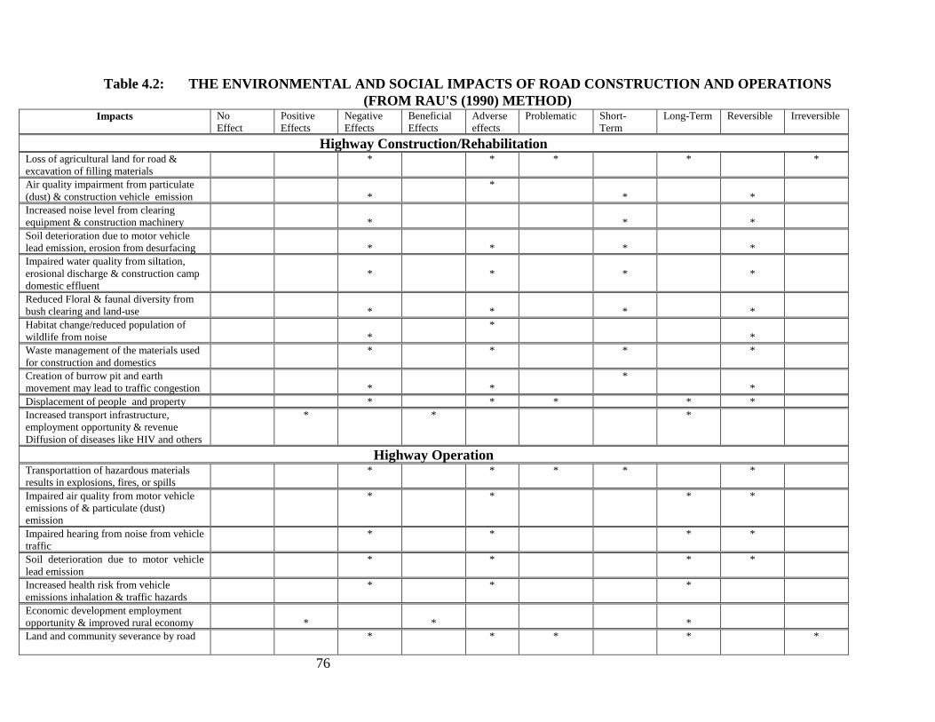
76
Table 4.2: THE ENVIRONMENTAL AND SOCIAL IMPACTS OF ROAD CONSTRUCTION AND OPERATIONS
(FROM RAU'S (1990) METHOD) Impacts No
Effect
Positive
Effects
Negative
Effects
Beneficial
Effects
Adverse
effects
Problematic Short-
Term
Long-Term Reversible Irreversible
Highway Construction/Rehabilitation Loss of agricultural land for road &
excavation of filling materials
* * * * *
Air quality impairment from particulate
(dust) & construction vehicle emission
*
*
*
*
Increased noise level from clearing
equipment & construction machinery
*
*
*
Soil deterioration due to motor vehicle
lead emission, erosion from desurfacing
*
*
*
*
Impaired water quality from siltation,
erosional discharge & construction camp
domestic effluent
*
*
*
*
Reduced Floral & faunal diversity from
bush clearing and land-use
*
*
*
*
Habitat change/reduced population of
wildlife from noise
*
*
*
Waste management of the materials used
for construction and domestics
* * * *
Creation of burrow pit and earth
movement may lead to traffic congestion
*
*
*
*
Displacement of people and property * * * * *
Increased transport infrastructure,
employment opportunity & revenue
Diffusion of diseases like HIV and others
* * *
Highway Operation Transportattion of hazardous materials
results in explosions, fires, or spills
* * * * *
Impaired air quality from motor vehicle
emissions of & particulate (dust)
emission
* * * *
Impaired hearing from noise from vehicle
traffic
* * * *
Soil deterioration due to motor vehicle
lead emission
* * * *
Increased health risk from vehicle
emissions inhalation & traffic hazards
* * *
Economic development employment
opportunity & improved rural economy
*
*
*
Land and community severance by road
* * * * *

77
TABLE 4.3: IMPACT EVALUATION MATRIX FOR THE AKURE-ILESHA ROAD DEVELOPMENT
PROJECT
PHASE DEVELOPMENT ACTIVITIES
Site
Preparation
Excavation Construction
Operation &
Maintenance
Environmental Components
Bush
cle
arin
g &
des
tum
pin
g
Acc
ess
road
const
ruct
ion
Road
T
raff
ic
Em
issi
ons
Was
te D
isposa
l
Lev
elli
ng/C
om
pac
tion
Spoil
Dis
posa
l
Oil
spil
l/le
akag
e
Em
issi
ons
Acc
iden
ts
Haz
ardous
Was
tes
Weig
hti
ng F
acto
r
Tota
l w
eig
hte
d F
acto
r
1. CLIMATE 1
Wind direction & speed -1/0 -2/-1 -1
Temperature -3/-2 -4/-2 -4/-2 -6
2. AIR QUALITY 2
TSP -1/-2 -3/-2 -1/-2 -3/-2 -3/-2 -10
NOx, SOx, CO -3/-1 -3/0 -3/-4 -3/0 -4/-4 -4/-3 -12
HC -2/-2 -3/-2 -3/-2 -3/-2 -8
3. WATER QUALITY 2
Solids -1/-2 -2/-2 -2/-1 -2/-1 -2/-2 -2/-1 -3/-2 -11
Turbidity -1/-2 -2/-2 -2/-1 -2/-2 -2/-1 -2/-2 -10
Toxicity -3/-1 -3/-2 -3
BOD/COD -3/-1 -3/-2 -3
4. HYDROLOGY 2
Drainage -3/-2 -4/-2 -4/-2 -2/-2 -8
Hydrologic balance -2/-2 -2/0 -2/0 -2
5. HYDROGEOLOGY 2
Groundwater quality -2/-1 -2/-2 -3/-2 -5
Groundwater level -2/-2 -3/-2 -2/-2 -3/-2 -8
6. SOIL & LANDUSE 3
Soil erosion -4/-2 -4/-3 -4/-3 -8
Farming -4/-2 -2/-2 -4
7. ECOLOGY 2
Flora & Fauna diversity -4/-2 -4/-3 -3/-3 -3/-2 -4/-3 -4/-3 -16
Flora & Fauna abundance -4/-2 -4/-2 -3/-3 -3/-2 -4/-3 -3/-2 -14
8. FISHERIES 1
Productivity -2/-2 -2
Fish kill -2/-1 -1
9. NOISE 2
Impared hearing -3/0 -3/-2 -3/-2 -4/-3 -7
Communication interference -3/-3 -3/-2 -3/-2 -4/-3 -10
10.WILDLIFE/FORESTRY 1
Diversity & abundance -3/-1 -3/-1 -3/-1 -3
Habitat -3/-2 -3/-1 -3/-1 -4
11.SOCIO-ECONOMIC 2
Population 3/10 4/10 20
Income 4/10 4/10 20

78
Health & -3/-8 -3/-2 -4/-3 -13
Aesthetics 4/10 10
Total Impact -1 -8 -13 -12 -11 -19 -6 -8 -19 -20 -12 -129
Notes: 0=No impact; 1-2=minimum; 3-4=Small; 5-6=Moderate; 7-8=Significant; 9-10 =Severe; x/y = Impact
Magnitude/Indicator Value
4.2 IMPACT APPRAISAL
4.2.1 Environmental Issues
Direct impacts of road development result from construction, maintenance and operation of the
facility. The most significant project-related impacts are those related to site preparation
activities, construction and commissioning and operation and maintenance. Some of the major
project actions that will have potential impacts on the environment are discussed in the next
section.
The poject activities which may impact the environment include:
Site Preparation Activities
These consist essentially of bush clearing and de-stumping of approximately 120ha of mainly
agricultural land for the new carriageway of the proposed dualized Akure-Ilesha road, levelling,
grading and compacting.
Construction/Civil Work and Commissioning
The project construction activities will involve civil engineering construction works, vegetation
(bush) clearing, earth (soil) movement, topographic levelling, alignment and re-alignment of road
segments, creation of road pavement, coal tarring and bridge and culvert works. The pavement will
be mostly of lateritic materials (200mm) stabilized with cement as sub-base course and crushed
stones (200mm) as base course and the surfacing of hot-rolled asphaltic concrete (40mm) and
20mm surface dressing.
Operation and Maintenance Activities
Periodic inspection of roads to maintain good drainage, bridges and culverts in functional
conditions, road rehabilitation by mending potholes, rutting, reworking or strengthening of base
and sub-bases of deteriorated pavement to improve their structural integrity and asphalt surfacing
as necessary, clearing of road shoulders of bush and maintaining adequate road furniture.
4.2.2 Environmental Consequences of the Project
The potential impacts resulting from project actions are summarized in Table 4.4. The potential
impacts are discussed as follow:
Site Clearing and Construction/Civil Work
The impact of these activities on the environment will depend of the types of clearing and
construction equipment used.
(i) Air quality
The primary air emissions during project construction will be from pug mills and airborne dust
from construction truck movements and bush clearing and construction equipment. Air
monitoring for similar highway projects have indicated that at 100 m leeward to the source,
concentrations of pug mill emissions were up to 1.2 to 1.7 mg/m3 and dust (as TSP) from truck

79
traffic 20 mg/m3; contaminated areas could reach 150 m leeward. TSP of 60-206 (g.m-3
)
measured in the area during the study for both wet and dry season was lower in concentration
than the acceptable limit of 250g.m-3
in any given day stipulated by FMENV.
The clearing and construction activities will also be of short duration thus making the impact of
low significance.
Table 4.4: Summary of Project Actions and Potential Impacts
Project Activity
Potential Impact
1 Land Clearing Air quality impairment from clearing equipment gaseous (S02 C02) &
particulate (dust) emission
Noise from bush clearing equipment
Soil deterioration due to desurfacing & compaction
Loss of land, property and population displacement;
Loss of vegetation, wildlife & wildlife habitat
Degradation of surface water quality by discharge from runoff &
erosion
Loss of biodiversity vegetation & wildlife
Interference with farming activities;
2 Construction Air quality impairment from construction-related equipment gaseous
(S02 C02) & fugitive (dust) emission
Contamination of surface & groundwater from construction camp
chemical effluents, solid waste and domestic sewage discharge &
discarded lubricants, fuel and oils
Noise from construction equipment
Soil deterioration due to desurfacing & compaction
Diffusion of disease like HIV/AIDS
Creation of burrow pit and earth movement equipment
Traffic congestion
3 Operation &
maintenance Air quality impairment from emission of gases (CO, S02, N02)
Noise from vehicle traffic
Risk to health and safety from dust and gaseous emissions inhalation
& traffic
Provision of improved transport infrastructure to neighbourhood
Improved employment opportunities & rural economy
(ii) Noise
The main noise sources during construction are construction machinery, which are known to
generate noise at levels from 76 dB(A) to 98 dB(A) measured 5 m from running machines. At
about 100 m, the noise levels are expected to reduce to levels within the daytime national noise
standards of 85 dB(A). The noise will have an impact mostly on construction workers and
residents living within 100 meters from the construction sites. Impacts during construction will
arise from equipment noise, blasting and vibration and, during operation, those closest to the
highway will hear vehicle movement. The existing ambient noise level (LA90) along the study

80
corridor is within acceptable limits (47.9-70.5 dBA). The noise sources during site preparation
and construction activities are the internal combustion diesel engines powering bush clearing and
civil works.
(iii) Ecology
Site clearing will destroy the plant community and wildlife habitat, leading to the death of plants
and relatively immobile animals as well as the migration of the animals that are capable of
escaping. This will lead to the reduction of biodiversity in the area and possible soil erosion by
rain water due to soil exposure. The majority of lands crossed by the Akure-Ilesha road are
forests.
Although there are no known rare or endangered plants or animal species within the corridor for
the proposed alignment, there are known occurrences within the broader study area. Therefore,
there exists some potential for impacts by the proposed alignment. Fauna species along the
Akure-Ilesha route are sparse due to habitat fragmentation and agricultural usage.
Construction noise may disrupt nearby wildlife during their nesting period.
(v) Water Quality
During the bush clearing and construction stage, silt from disturbed soil and in-river construction
activities may result in increased suspended solids (SS) in rivers immediately downstream from
the expressway, and duck/fish ponds and water wells near the roads. Such impacts will be
temporary and limited to small areas downstream, but can affect a large portion of an adjacent
fish pond. Construction camps will generate domestic effluent of 60 L per person per day on
average, and total wastewater in the largest camp may be up to 60,000 L per day. If discharged
directly into natural water bodies, the domestic effluent from construction camps would raise
COD concentrations by about 1.2 mg/L in large rivers and up to 34.7 mg/L in smaller streams.
During the operational stage, small quantities of sediment and dripping oil and grease from the
road surface may be washed out and discharged to nearby surface water bodies as runoff during
the rainy season. As this would also be the season when the rivers have their highest flow rates,
the impact to water quality will be small. The two surface stations will generate effluent
containing COD and SS. The effluent will eventually be discharged to the Rivers, year-round.
(vii) Wildlife and Forestry
The proposed project is expected to have direct impact on wildlife and forestry in the following
ways:
Site preparation and construction will result in the reduction of wildlife
habitats for arboreal and infaunal species.
Noise from the use of clearing and construction equipment and machinery will
cause the migration of much of the remaining wildlife from project areas.
Bush clearing will lead to the loss of important vegetation and economic tree
species (oil palm, kola, and cocoa trees) which constitute over 65% of the
area.
(viii) Socio-Economics & Health
The proposed Akure-Ilesha alignment will directly impact several homes and is in close
proximity to residential development at several locations. Indirect negative impacts may include

81
increased noise and pollution levels, and reduced access to properties. The Akure-Ilesha
rehabilitation will separate certain farmland from farmers and some villages from one another on
both sides of the alignment. It will limit the access of certain farmers to their fields and certain
rural residents to schools, markets, services, and relatives and friends. About 8 villages and
throughout the Project area will be affected. Also, some farmland originally cultivated as one
parcel will be split into two.
Increased motor vehicle traffic from project development would constitute nuisance and higher
safety risk to local road users (cyclists and pedestrians). A number of crossings will be
constructed under the expressway. The majority of the crossings are designed to be at existing
roads and meet the need for agricultural and social activities. The crossings will eliminate the
impact of land and community severance, except that pedestrians who otherwise could walk to
their destinations through the field will have to walk no more than 300 m on average to one of
the crossings. Social & health problems (new communicable diseases, sexually transmitted
infections (STIs), HIV/AIDS) from influx of job seekers & post-construction demobilisation of
large contigent of workers
Migration of workers and alteration of existing population characteristics are envisaged as the
employment opportunities bring an influx of new people to the project area.
The Project will improve infrastructure in the region and make the area more attractive to outside
investments. Economic benefits will also include higher efficiency in transport of local raw
materials (minerals, agricultural produce such as fruits, etc.) and finished goods to local and
outside markets. More tangible and immediate benefits will be increased employment
opportunities directly related to project construction and operation. Of an estimated 11 million
labor-days required for the expressway construction, 50 percent is expected to come from the
local labor force. Of the labor requirements for roads construction, 80-90 percent will come
directly from seasonal labor of the rural villages. Indirect employment related to services,
vendors, etc. will generate additional income-earning opportunities, especially for women and
children during the construction period.
Recreation
The proposed alignment is expected to have very little impact on recreation in the area.
Utilities
The proposed alignment crosses a high voltage power transmission line, several lower voltage
power transmission lines, telephone and cable lines, and municipal water and sewer lines. There
are currently no gas pipelines in the study area.
Temporary disruption of power, telecommunication services, and municipal services may occur
as they will be crossed by the proposed Highway during construction. Utilities are typically
encountered at roadway crossing locations.
Heritage Resources and Archaeology
There are no heritage properties, National Historic Sites, or known archaeological/fossil sites
within the corridor for the proposed alignment.

82
Project Operation
The impact of the activities associated with Highway operation phase of this project is discussed
succinctly below:
(i) Air Quality and Noise
A model using the Gaussian Equation was applied to forecast air contamination for Class D
Atmospheric Stability during project operation. The modeling results indicate that CO
concentrations will be below the national standards beyond 10 m from the expressway in the
year 2019. The model forecasts that NOx concentration (daily average) will slightly exceed the
standards for one receptor in the year 2010 and for five in 2019. None of the forecast parameters
exceed the standards for the roads. Long-term air quality monitoring is needed to confirm the air
modelling forecasts for the Project area. Because of the low traffic and the absence of sensitive
receptors nearby, the Akure-Ilesha roads will have negligible air quality impact.
The noise impact will be long term and increase over time as traffic volume on the project roads
increases. Positively, the site preparation and construction phases of the project would provide
short-term (as long as the activities last) employment to a number of people from within the
communities. The site workers and some communities would therefore experience discomforting
construction and operational noise from construction equipment if mitigating measures are not
put in place.
(ii) Ecology
Contamination of surface and groundwater will arise from chemical effluents, solid waste and
domestic sewage discharge and discarded lubricants, fuel and oils. Discharge of effluents has
potentials for water pollution with attendant effect on water quality and aquatic life.
(iii) Wildlife and Forestry
Operational noise from process vehicles will cause the migration of wildlife from project areas.
(iv) Socio-Economics and Community Health
The project development activities have both positive and negative impacts on the
socioeconomic and health conditions of the area in which additional indirect employment
opportunities in the downstream industries will be created in the region. This will be
accompanied by improved social services and rural economy.
Other potential socio-economic impacts associated with Highway operation include: higher risk
to health and safety from increased traffic, discomforting operational noise to communities,
permanent loss of agricultural land and productivity. Increased motor vehicle traffic from
project operation would constitute nuisance and higher safety risk to local road users (cyclists
and pedestrians). Public/environmental health and nuisance issues associated with dust and
exhaust fumes can arise and may have a significant effect on neighbouring locations.
83
The project would result in increased accessibility to the area due to the creation of new access
roads; this coupled with the influx of people to the project area may lead to the loss of cultural
values of the inhabitants.
Energy Impacts
The energy impact of a proposed project deals with the amounts of energy consumed, produced
or conserved by the project in the context of supply and demand for those types of energy. Since
essentially all projects consume, produce or conserve measurable amounts of energy in one form
or another, an energy impact assessment is appropriate for all projects.
Energy impact assessment includes determination of :
the sources of energy available to the project
other demands for these energy supplies
the net effects on supply/demand
alternatives and their energy impacts
the amount of energy consumed, produced or conserved by the project.
conservation measures.
Petroleum products which include motor gasoline, dual purpose kerosene, automotive gas oil,
liquefied petroleum gas, low- and high-pour fuel oil and base oil represent major energy sources
in Nigeria.
The energy flow for the proposed project is as follows:
Construction (Energy Consumption)
Site preparation - Bush clearing/destumping, excavation, sand filling,
paving etc - Diesel fuel
Pavement -Aspalt.
Operation
Motor gasoline - Petrol
4.3 SIGNIFICANT POSITIVE IMPACTS
The significant positive impacts associated with the project include:
Improved transportation infrastructure and the associated financial benefits to the
stakeholders;
Development of downstream industries dependent on electric energy
Provision of employment opportunities including the opening up of an otherwise
rural area.
4.4 SIGNIFICANT NEGATIVE IMPACTS
There are no expected significant negative impacts that cannot be mitigated.

84
4.5 RAW-MATERIALS IMPACTS
Petroleum products are the major raw materials that will be consumed in the construction and
operational phases. Since these are not renewable, the project will be accompanied by some
measure of resource depletion.
4.6 PROCESS IMPACT
There are no significant process impacts because virtually all the potential adverse environmental
impacts particularly the discharge of gas and particulates will be mitigated in the environmental
management plan.
4.7 PROJECT SPECIFIC INCREMENTAL ENVIRONMENTAL CHANGES
No project specific incremental environmental changes were identified.
4.8 PROJECT SPECIFIC CUMULATIVE EFFECTS
No project specific cumulative effects were detected.
4.9 PROJECT SPECIFIC LONG/SHORT TERM EFFECTS
The long and short-term project specific impacts include gas emission and noise. Mitigation
measures have been provided.
The impacts resulting from operations would generally be insignificant, as indicated by the low
figures for impact magnitude (see impact evaluation matrix Tables 5.3).
4.10 PROJECT SPECIFIC REVERSIBLE/IRREVERSIBLE EFFECTS
The environmental effects are mostly reversible. Raw materials consumption is, however,
irreversible.
4.11 PROJECT SPECIFIC DIRECT/INDIRECT EFFECTS
The direct and indirect effects of the proposed project include :
provision of improved transportation infrastructure to neighbourhood
Increased employment opportunity, and revenue for inhabitants of the area from direct
employment and indirectly by the downstream industries that depend on the
establishment of the improved transportation infrastructure.
4.12 PROJECT SPECIFIC ADVERSE/BENEFICIAL EFFECTS
Major adverse effects include:
Impaired air quality from S02, C02 & particulate (dust) emission
Impaired hearing due to noise from construction activities and traffic operation
Increased health risk from dust and gas emission inhalation and vehicle traffic
The beneficial effects are the following:
provision of improved transportation infrastructure to neighbourhood

85
Increased employment opportunity, and revenue for inhabitants of the area from direct
employment and indirectly by the downstream industries that depend on the
establishment of the improved transportation infrastructure.
4.13 PROJECT SPECIFIC RISK AND HAZARD ASSESSMENT
The hazards associated with various events in the project are summarized under the following
scenarios:
4.13.1 Risk Scenarios
In nearly all aspects of the project, there is a potential risk of an accidental event leading to an
unwanted impact. Some specific operations carry a greater risk of accidents. The risk scenarios
identified that can create environmental hazard include:
Transportattion of hazardous materials resulting in explosions, fires, or spills
Motor vehicle accidents during transportation
Abandonment of roads

86
CHAPTER FIVE
MITIGATION OF POTENTIAL AND ASSOCIATED ENVIRONMENTAL
IMPACTS
5.1 BEST AVAILABLE CONTROL TECHNOLOGY
In order to ensure that the impacts emanating from the project activities are mitigated, time-
tested standard designs, employing new technology with bias for environmental safety and
economics will be adopted in all the phases of the project - construction, operation and
maintenance. The measures that will mitigate the impacts identified with the respective project
activities are reviewed as follow:
In general, the road design shall be carried out to the Federal Ministry of Works Federal
Highways standards (Highway Manual Part I – Design), unless when this is not justifiable due to
site constraints or economic considerations. The design speed required is 100Km/hr, where re-
alignment is considered, after examining various alternatives, long stretches joined by large
curves of minimum radius 300m will be aimed at. Permanent features like bridges and culverts
shall be provided in accordance with the Federal Highways standards. Horizontal and vertical
alignments of the route will conform with the design standards required of federal highways by
the Federal Ministry of Works without much impediment and re-alignment.
5.1.1 Site Clearing and Civil Work/Construction
Air Quality and Noise
The clearing and construction-related impacts such as equipment emission and noise impacts are
short-term in duration. Their impact is not predicted to be worse than the present level in the
area. The residual impact of equipment emissions will be negligible except to construction
workers. During dry season and in sensitive areas, hauling roads will be watered to suppress
dust. The residual impact of airborne dust will be limited to small areas close to truck roads and
terminated shortly after the end of truck traffic.
Equipment and vehicles that show excessive emissions of particulates due to poor engine
adjustment or other inefficient operating conditions shall not be operated unless corrective
measures are taken. In addition to the emission control, the workers will be provided with
adequate personal protective equipment particularly nose masks for the effective protection
against the inhalation of particulate matter and ear muffs where necessary to operators exposed
to noise for long duration.
Soil
During construction operations it will be ensured that surface water flows are controlled and if
necessary channelled to temporary discharge points. Such points shall be located, designed and
constructed in a manner that will minimize the potential threat of erosion in the receiving waters.
Surface runoff within the worksite shall be drained into a suitable silt trap before its discharge
into an outlet drain, ditch, stream or river. The silt trap shall be of adequate size and shall be
regularly de-silted.

87
Water Quality
During the construction stage, silt from disturbed soil and in-river construction activities may
result in increased suspended solids (SS) in rivers immediately downstream from the
expressway, and fish ponds and water wells near the roads. Such impacts will be temporary and
limited to small areas downstream, but can affect a large portion of an adjacent fish pond.
Surface runoff to fish ponds and drinking water wells by the roads will be intercepted to prevent
impact on these water bodies. The residual impact on water quality during construction will
basically be short-term increases in SS concentrations in the rivers immediately downstream
from the expressway. Increased SS may drive the fish population, away from the impacted area;
but the impact will dissipate soon after the construction terminates. The receiving water bodies
may be impacted in terms of increased COD and SS by the final discharges from the service area
septic tanks during dry season when river flows are minimum.
Waste Management
Construction camps will generate domestic effluent of 60 L per person per day on average, and
total wastewater in the largest camp may be up to 60,000 L per day. If discharged directly into
natural water bodies, the domestic effluent from construction camps would raise COD
concentrations by about 1.2 mg/L in large rivers and up to 34.7 mg/L in smaller streams.
All contractors will be required to build septic tanks at their construction camps as part of the
construction contracts. This will remove approximately 40-50 percent of the COD and 50-70
percent of the SS. During construction, contractors will also be required to have sound
environmental management programs for the storage of hazardous materials, solid waste
collection and disposal, and environmental contingency plans.
Highway Integrity
To ensure a stable highway, the road pavement will be founded directly on competent clayey
sand/sand/lateritic layer. Where cuts are inevitable, it must rarely go beyond 0.5 m. If the cut
exposes the incompetent clay substratum, it must be excavated and backfilled with competent
lateritic soil. Where cuts are made into the incompetent clayey substratum, serious consideration
must be given to drainage and slope protection to prevent slope breakdown and leaching of
feldspathic and siliceous materials resulting in cavities and troughs on the slope surface with toe
slumps and sometimes slip failure. Because of the heavy rainfall in the project area and the
subsequent high runoff, drainage channels will be properly designed and constructed on the roads to
ensure that moisture equilibrium is maintained throughout the year. Normal Highway maintenance
practices will be in place.
5.1.2 Highway Operations and Maintenace
Atmospheric Emissions & Noise Impact Due to construction activities the noise level is expected to increase in the project area. In order to mitigate the
impact of noise in the project area, work will be limited to day time in built-up areas. In addition, workers will be
obliged to consistently use Personal Protection Equipment (PPE) especially ear mufflers.
Lead Emission to Soil
A motor vehicle lead emission model projected that by the year 2019, lead concentrations in the
soil within 1 km of the proposed project alignments will be up 33 mg/kg through accumulated
increase of motor vehicle emissions. Although this is an almost 60 percent increase from the
existing baseline lead concentrations in the soil, it will still be far below the 300 mg/kg limit set
by applicable national standards. The impact of motor vehicle emissions to the soil will be

88
insignificant, and no specific mitigation measure is necessary. In fact, the impact to the soil is
expected to be of little relevance if the use of leaded gasoline is discouraged.
Soil ErosionMost of the required fill material will be excavated on site, creating ditches on both
sides of the roadways. Surface erosion and silt runoff may occur on the bare embankment, and
unprotected slopes during heavy rainfall. Total silt erosion due to the Project is estimated to be
about 1,500 tons/yr during construction and nil during operation when the landscaping is
finished. Because of the flat terrain, the lost silt is expected to settle in side ditches, which are
designed for surface water runoff from the Project. The roadway embankment slopes will be
grassed and treed soon after the expressway is completed. Land disturbance will be limited to the
construction period. Erosion and silt runoff during road operation will be negligible.
Construction and proper termination of drains in natural water courses such as rivers and streams
Water Quality
During the operational stage, small quantities of sediment and dripping oil and grease from the
road surface may be washed out and discharged to nearby surface water bodies as runoff during
the rainy season. As this would also be the season when the rivers have their highest flow rates,
the impact to water quality will be small. The construction camp stations will generate effluent
containing COD and SS. The effluent will eventually be discharged to the Rivers, year-round.
Surface runoff to fish ponds and drinking water wells by the roads will be intercepted to prevent
impact on these water bodies. Long-term impacts on water quality in other rivers in the Project
area during expressway operation will be low. During construction and operation, water quality
in the major rivers will be monitored for SS and COD to confirm the result of the impact
Transportation of Hazardous Materials
Planned measures to mitigate impacts from accidents involving transport of hazardous materials
which could threaten the safety of people, and pollute waterways and soils in accident areas are
the following. (i) Individuals (drivers, etc.) transporting hazardous materials will be examined
when entering the expressway to ensure possession of appropriate operation permits. Vehicles
will be inspected to ensure appropriate marks and equipment. (ii) Vehicle operators will be
forbidden to smoke cigarettes while with the vehicles, and will be warned through appropriate
signs for traffic safety while passing rivers, villages, and other sensitive areas. (iii) When
accidents occur, vehicle operators will be required to report immediately to public security (the
police) and the environmental authority and take appropriate emergency measures according to
relevant guides to minimize potential spread of the spilled materials. (iv) An emergency response
team will be established to deal with accidents involving hazardous materials. The team will
involve fire departments, police, and environmental specialists. They will be trained to properly
handle these accidents and to be familiar with necessary emergency measures such as prompt
evacuation of residents nearby as needed. (v) An emergency phone system will be installed along
the expressway for prompt reporting of environmental emergencies, as well as other accidents.
The telephone number for the environmental emergency teams will be posted in each of the
phone booths.
Socio-Economic & Health
To mitigate the impact of loss of vegetation, trees and bushes will be planted on both sides of the
expressway, and land will be seeded to grass the embankment in an expressway landscape plan.
As the lost cultivated land economic crops, and property within the proposed ROW to be

89
demolished cannot be recovered elsewhere, affected farmers will be compensated to offset the
lost production and revenue or resettled. Impacts on agricultural output and revenue, are
expected to be insignificant after compensation. The potential land acquisition, compensation
and resettlement requirements in the road right-of-way of the proposed road alignments will be
determined in accordance with the World Bank’s Safeguard Operational Directive on
Involuntary Resettlement. A resettlement plan will be prepared based on the number of persons
to be affected and government or private owned properties to be expropriated because of the road
construction. Costs to mitigate this problem, or dislocate the affected persons, if any will be
estimated. The lists of those persons to be (fully and partially) affected by the project with the
type, number and size of houses to be demolished both in urban and rural areas, farmlands to be
taken (permanently and temporarily), fruit and other trees to be removed and other related issues
consultant will also be assessed. Youths from the host communities will be given priority in
unskilled labour employment; FMW will provide on-the-job training for the unskilled and semi-
skilled workers (especially from the host communities) during the construction period.
FMW shall provide construction camp, sanitary facilities and alternative source of potable water
during construction. The medical facilities shall be provided on site, with critical cases
transferred to retainer hospitals. Also, awareness campaign to enlighten the communities/field
workers on the implications of drug and alcohol abuse, unprotected sex, prostitution and the need
to sustain healthy lifestyle and behaviour.
The key environmental protection measure for new industrial developments as a result of the
road development is sound environmental planning and management. No developments will be
allowed without an appropriate environmental impact assessment and mitigation plan.
5.2 DECOMMISSIONING PLAN
The project Highway is generally expected to be maintained and to remain in operation
indefinitely and the operation and maintenance procedure provide for monitoring the
performance and the integrity of the system components. However, when the performance of the
system scales to diminishing returns, or a new replacement road is in place standard procedures
for decommissioning shall be invoked. A decommissioning team is set up to plan and implement
laid down guidelines on decommissioning. The following activities are involved in
decommissioning /abandonment:
Cut off passage or accessibilty
Disposal of Wastes;
Rehabilitation of Site by regetation etc.
At the end of decommissioning, various solid wastes are segregated according to their types and
then disposed of according to FMENV waste disposal guidelines.

90
CHAPTER SIX
ENVIRONMENTAL AND SOCIAL MANAGEMENT PLAN
6.0 INTRODUCTION
Environmental and Social management is a planned, integrated programme aimed at ensuring
that unforeseen and unidentified impacts of a proposed project are contained and brought to an
acceptable minimum. In conducting its business activities, FMW places a strong emphasis on
maintaining safe and healthy working conditions for its personnel and minimising the effect of
its activities on the natural environment. These objectives are achieved through the
implementation of the policy and guidance that integrate environmental management approaches
into its developmental and operational schemes and which typically addresses a number of
environmental issues including the following:
Identification of environmental sensitivities;
Identification of potential significant impacts;
Adoption of design measures or operational procedures that reduce impacts to acceptable
levels;
Establishing emergency and contingency plans;
Monitoring the effectiveness of environmental protection; and
Auditing the success of the overall strategy.
The ESIA of road development (construction and rehabilitation) has addressed the impacts of the
project. The results show that the impacts of the project are not severe and are thus acceptable.
As part of the continuing process of management of Health, Safety and Environment issues
relating to the project, the latter issues of monitoring and audit can now be addressed.
In order to ensure that the environmental consideration and mitigation recommendations
of the ESIA are implemented and to guarantee the achievement of FMW’s Corporate
Policy on environment and that the provisions of the Health and Safety plan are
accommodated in subsequent stages of the projects, an Environmental and Social
Management Plan (ESMP) has been developed. The ESMP consists of plans, procedures
and programmes, covering areas such as: the handling of hazardous materials and wastes,
emission and discharge monitoring, site inspection and auditing and emergency response.
It is formulated to ensure that the environmental mitigation requirements outlined in the
ESIA are central to the management of the implementation and operation of the proposed
projects.
6.1 Introduction: Environmental and Social management Plan (ESMP)
In this section the plan for mitigating the identified significant adverse environmental and social
impacts is presented. For easy understanding and implementation, this section include a
summary of the impacts and corresponding mitigation measures, including responsibility and
cost; institutional arrangement; monitoring; and capacity building for the implementation of the
ESMP.
Table 6.1a: Summary of Environmental and Social Impacts and Mitigation Measures
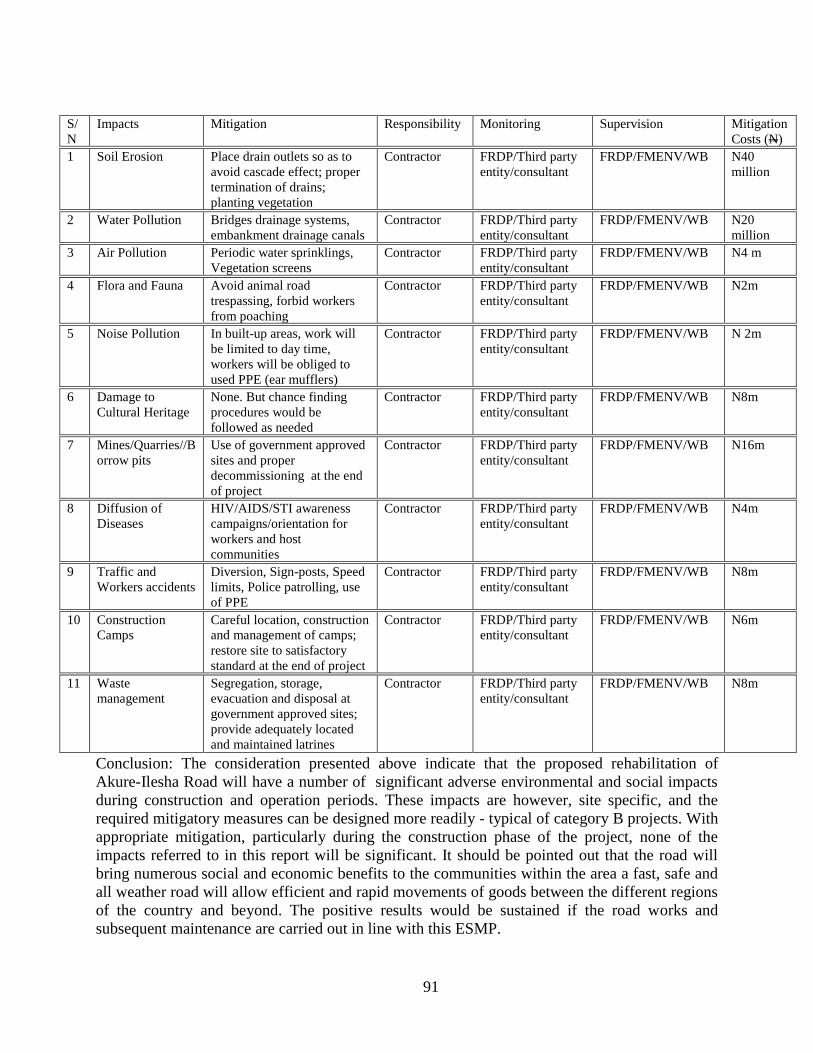
91
S/
N
Impacts Mitigation Responsibility Monitoring Supervision Mitigation
Costs (N)
1 Soil Erosion Place drain outlets so as to
avoid cascade effect; proper
termination of drains;
planting vegetation
Contractor FRDP/Third party
entity/consultant
FRDP/FMENV/WB N40
million
2 Water Pollution Bridges drainage systems,
embankment drainage canals
Contractor FRDP/Third party
entity/consultant
FRDP/FMENV/WB N20
million
3 Air Pollution Periodic water sprinklings,
Vegetation screens
Contractor FRDP/Third party
entity/consultant
FRDP/FMENV/WB N4 m
4 Flora and Fauna Avoid animal road
trespassing, forbid workers
from poaching
Contractor FRDP/Third party
entity/consultant
FRDP/FMENV/WB N2m
5 Noise Pollution In built-up areas, work will
be limited to day time,
workers will be obliged to
used PPE (ear mufflers)
Contractor FRDP/Third party
entity/consultant
FRDP/FMENV/WB N 2m
6 Damage to
Cultural Heritage
None. But chance finding
procedures would be
followed as needed
Contractor FRDP/Third party
entity/consultant
FRDP/FMENV/WB N8m
7 Mines/Quarries//B
orrow pits
Use of government approved
sites and proper
decommissioning at the end
of project
Contractor FRDP/Third party
entity/consultant
FRDP/FMENV/WB N16m
8 Diffusion of
Diseases
HIV/AIDS/STI awareness
campaigns/orientation for
workers and host
communities
Contractor FRDP/Third party
entity/consultant
FRDP/FMENV/WB N4m
9 Traffic and
Workers accidents
Diversion, Sign-posts, Speed
limits, Police patrolling, use
of PPE
Contractor FRDP/Third party
entity/consultant
FRDP/FMENV/WB N8m
10 Construction
Camps
Careful location, construction
and management of camps;
restore site to satisfactory
standard at the end of project
Contractor FRDP/Third party
entity/consultant
FRDP/FMENV/WB N6m
11 Waste
management
Segregation, storage,
evacuation and disposal at
government approved sites;
provide adequately located
and maintained latrines
Contractor FRDP/Third party
entity/consultant
FRDP/FMENV/WB N8m
Conclusion: The consideration presented above indicate that the proposed rehabilitation of
Akure-Ilesha Road will have a number of significant adverse environmental and social impacts
during construction and operation periods. These impacts are however, site specific, and the
required mitigatory measures can be designed more readily - typical of category B projects. With
appropriate mitigation, particularly during the construction phase of the project, none of the
impacts referred to in this report will be significant. It should be pointed out that the road will
bring numerous social and economic benefits to the communities within the area a fast, safe and
all weather road will allow efficient and rapid movements of goods between the different regions
of the country and beyond. The positive results would be sustained if the road works and
subsequent maintenance are carried out in line with this ESMP.

92
The ESMP has been comprehensively developed by following international standards for
(environmental) management planning. It covers all the phases of the projects from project
design to project decommissioning. The various responsibilities and tasks involved in
implementing the ESMP for the development project vary with the project stage and are
summarized in Table 6.1 and appendix 4. The key issues are briefly discussed below.
Table 6.1: SUMMARY OF ENVIRONMENTAL AND SOCIAL MANAGEMENT RESPONSIBILITIES
FOR VARIOUS STAGES OF PROJECT
S/N Project Phase Action
1 Project design Review design compliance with ESMP and
regulations
2 Project planning and
scheduling
Setting up of an environmental focal point and
institutional arrangement
3 Contingency planning Training, plan development and implementation
4 Project mobilization Supervision of the process
5 Construction phase supervision Supervision including inspection, monitoring, and
auditing activities
6 Construction, demobilization Supervision of the process
7 Operations and maintenance
phase supervision
Supervision including inspection, monitoring and
auditing of activities
8 Project Decommissioning Post project monitoring and auditing
(i) Waste Management Guidelines
During the construction and subsequent operation an maintenance phases, it is inevitable that
discharges of materials to the environment will occur. If these are not controlled, they may act as
a source of environmental disturbance or nuisance. The level of discharge expected has been
quantified in Chapter seven. All the wastes that cannot be re-used will be safely managed and
disposed off in a manner that meets regulatory requirements. Below are the waste management
guidelines and waste disposal systems that will be considered in this project.
(ii) Waste Inventory
The primary wastes include exhaust emission gas – sulfur dioxide, carbon monoxide,
construction materials, fuel storage containers, scrap metal and domestic and sewage wastes.
These wastes shall first be segregated, minimized and/or disposed of in accordance with waste
management standards as outlined in this Section of the report.
(iii) Inspections, Audits and Monitoring
During the course of construction and operation of facility, and eventual decommissioning of the
project, agents of regulatory authorities and FMW shall conduct regular inspections to determine
the level of compliance with the guidelines of the ESMP and applicable regulations and statutes.
Specifically, the FMENV waste discharge requirements (FEPA, 1994), and FMW waste
management guidelines must be complied with. Site inspections by FMW and regulatory
authorities shall be regular not necessarily according to any structured pattern. The inspection of
facilities, in accordance with the industry practice, will be at least once in six months.

93
(iv) Monitoring Objectives
In order to measure and quantify the impacts of the project development on the receiving
environment, the following monitoring objectives are established:
(i) Monitor alterations in existing physical, chemical, biological and social
characteristics of the environment.
(ii) Determine whether any detected changes in environmental components are caused
by the project or natural occurrences.
(iii) Determine the impacts of non compliance with ESIA and ESMP requirements by
the contractor, in particular to monitor emissions and discharges and ensure
compliance with local, national and international standards.
(iv) Determine the effectiveness of the ameliorating measures
(v) highlight areas of concern unforeseen in the ESIA and ESMP and provide a basis
for recommending further amelioration measures.
(v) Impact Indicators
In identifying impact indicators, priority is given to environmentally sensitive areas, and in this
regard, it is noteworthy that the entire project area falls under this category. Based on the results
of baseline studies and consideration of FMENV limits, the following impact indicators (Table
6.2) are identified with the corresponding environmental components.
Table 6.2: Monitoring Impact Indicators
Environmental Components Impact Indicators
Atmospheric Particulates, Volume discharged, SOx, NOx,
CO, heavy and trace metals, and HC.
Soil Texture, pH, Total Organic Carbon, Nutrients,
Heavy metals Water Quality:
DO, COD, BOD, pH, Nutrients, Turbidity,
TDS, TSS, Heavy metals, Hardness
Aquatic ecology Diversity, Abundance, Benthic Fauna
Socio-Economic Health status
(vi) Monitoring Programme
A monitoring programme is being designed which will meet the data needs of FMW for self
enforcement of corporate policy and compliance with national and international regulatory
standards. The programme is based on the status of the existing environment and the assessed
incremental impact of the additional facilities on areas designated as environmentally sensitive.
The proposed monitoring programme is shown in Table 6.3.

94
Table 6.3a: Environmental Monitoring Programme for the Road Development Project
Impact
Parameter
Time of
Impact/Project
Phase
Impact
Indicator
FME
Limits
Sampling
Location
Sampling
Frequency
Sampling
Method
Monitoring
Duration
Monitoring
Personnel
Ambient Air
Quality &
particulate
and gaseous
emission
Site preparation,
Construction &
Operation of
facility
TSP
NO2
SO2
CO
HC
600g/m3
100 g/m3
300 g/m3
20 ppm
Receiving air -
upwind &
downwind of site
Daily, during site
preparation,
construction & for 1
month after;
Once every three
months during
operation of facility
Air Sampler
Short-term
Long-term
FMW
(Highway
Div)
Contractor
(ENV)
Noise Site Preparation,
Construction &
Operation of
facility
Noise Level 80 dBA (8-hr) Work Site and
200 m away
Daily (During site
preparation,
construction; Monthly
during production
Decibel Noise
Meter
Short-term
Long-term
FMW
Contractor
(ENV)
Water
Quality
(Surface &
Underground
)
Site Preparation,
Construction
pH
Temperature
Oil & Grease
Salinity
COD
BOD
Turbidity
TDS
TSS
Heavy Metals
as specified in
FMENV
Guidelines
(i) Receiving
water - 500m
upstream &
downstream of
discharge point;
(ii) Monitoring
wells onsite &
downgradient;
Daily during
Land preparation &
construction & for 1
month after
Water Sampler,
Turbidi-meter
and pH-meter
Short-term
FMW
Contractor
(ENV)
Soil Site Preparation,
Operation of
facility &
Decommissioning
Particle Size,
Total Org C,
Oil & Grease
Heavy Metals,
Nutrients,
50m each side of
Highway
corridor.
For at least 1 year
after project
commissioning
Visual Inspection
and Soil Sampler
Compliance,
Data Bank
Long-term
FMW
Contractor
(ENV)
Note:
short-term = Duration of clearing/Construction
Long-term = Duration of Operational activities

95
Presented in Table 6.3b is the monitoring programme of the Project Affected Peoples; the table
highlights the different phases, various activities, and the responsibilities
Table 6.3b: Monitoring Programme of the Project Affected Peoples
Time of
Impact/Project Phase
Activities Responsibility
PLANNING
Scoping and Screening
Initial site visit an consultation
Identification of Resettlement
and Social Issues
Application of safeguard policies
Categorization
Action plan
Screening Report
WB No-Objection
Consultant:
Supervision by
FMW/FMHUD-PIU
DESIGN AND
CONSTRUCTION
Compensation
Construction
WB No-Objection
Consultant:
Supervision by
FMW/FMHUD-PIU
EXECUTION
Implementation and monitoring
Implementation of ESMP
Monitoring and reporting on
environmental and social
mitigation measures
Monitoring and reporting of
Resettlement and livelihood
issues
Contractors
Supervision by
FMW/FMHUD-PIU
and the community
OPERATIONS (POST-
IMPLEMENTATION)
Operation and maintenance
Maintenance
Monitoring and reporting of
Resettlement and social
livelihood issues
Contractors
Supervision by
FMW/FMHUD-
PIU and the
community
i) Scope of Monitoring:
The monitoring programme will be developed to verify the emissions and discharges based on
existing national and international regulations on environmental pollution and on the findings in
each monitoring campaign. The Environmental Guidelines and Standards for the Industry in
Nigeria (FMENV, 1991) defines a required monitoring programme and the World Bank policies.
The initial emissions and discharge monitoring programme is outlined in Table 6.2. The
environment in the project area can be verified by focusing on measuring specific indicators of
environmental and socia parameters that is representative for the overall environmental quality
and at the same time relatively easy to measure.
(viii) Parameters to be Monitored
The indicators of environmental quality of the surface water which will be monitored include:
96
Dissolved oxygen
Total N
pH
Biological or chemical oxygen demand (BOD or COD)
Turbidity
Oil and grease
Heavy metals
Discharges
- fluid discharges project operation;
- recipient water monitoring ; and
Emissions
During construction, operations and maintenance of the proposed project, all emissions of air,
water and noise shall comply with regulatory limits. In addition to the above programmes,
monitoring will be undertaken for the following atmospheric emissions:
- Particulates
- Volume discharged
- SOx
- NOx
- CO
- Heavy metals, and
- HC
(ix) Monitoring Methodology
The procedures for assessing the impacts of projects on the environment. include:
identifying the source and characteristics of all wastes generated;
quantifying emissions and discharges to the environment; and
quantifying and qualifying land-take and its direct effect on terrestrial
ecology.
This environmental and social assessment will continue to evolve along with the project, and
is in fact the iterative process of impact mitigation. Monitoring and audit will continue
throughout the

97
life of these projects. Monitoring may involve measuring specific indicators of environmental
quality parameters and comparing with baseline levels. The frequency of this depends on the
results of the monitoring and inspections. If the results of the monitoring measurements give rise
to concern about the environmental quality and social issue. For example, more detailed surveys
will be performed which may include the sampling and analysis of organisms living within the
habitats and PAPs livelihood of the project area.
6.2 WASTE MANAGEMENT STRATEGIES
The strategies of waste management which will be adopted are summarised as follows:
To reduce the volumes of wastes generated.
To recycle and re-use waste where feasible.
To treat hazardous waste and make them inert before disposal.
To ensure safe and responsible collection, storage and disposal of all wastes.
To provide auditable records of all waste streams.
To monitor waste disposal activities in order to prevent future liabilities.
To reduce the negative impact of the project operations on the environment.
6.3 WASTE MANAGEMENT PROGRAMME Construction activities will result in the generation of a variety of wastes which can be divided
into distinct categories based on their constituents, as follows:
surplus excavated material (public fill) that require disposal;
construction and demolition(C&D) waste;
chemical waste; and
municipal waste.
The guideline for waste management would be used to further develop and articulate a tailored
waste management plan that takes account of waste identification methods, waste storage, waste
tracking, monitoring and audit of waste disposal sites.
Table 6.4: Environmental Monitoring Programme for the Road Development Project
Discharge Type Impact
Indicator
FMENV Limits Sampling
Frequency
Monitoring
Personnel
Sewage and
Domestic waste
Chloride
Quantity
Weekly
Daily
FMW Contractor
Solid Wastes
Quantity
Segregated & treated
according to current
FMW Guidelines
Segregated
& Quantity
recorded
weekly
FMW Contractor
Diesel oil
Lube oil
Volume
Monthly
FMW Contractor

98
Excavated material is defined as inert virgin material removed from the ground and sub-surface.
Excavated material may be generated during the reprovisioning of slip roads / local access roads,
drainage and utility undertakings and slope works. The proposed widening will involve
extending and modifying the existing embankments to facilitate the construction of new
carriageways at-grade with the existing Highway. This will include the clearance of high quality
topsoil used for planting as well as cutting and filling of existing fill from the embankment
construction to accommodate both widened embankments as well as retaining walls in areas of
limited space.
It has been identified that even with the reuse of excavated materials, there will be a net deficit of
construction fill. A number of sources of fill have been investigated for the project.
Whilst there are a variety of sources of fill, the suitability of any such fill may need to be
determined for particular uses. In particular, stringent acceptability criteria are likely to be
applied to any materials used in reinforced slopes and associated structures where stability is a
consideration.
The environmental management measures would focus on reducing the production of dust,
atmospheric emission, risks to life and accidents and energy efficiency and should include:
Developing procedures to minimise the generation of particulates around the site;
Implementing noise abatement programmes (depending upon the sensitivity of neighbouring
facilities);
Maintenance and efficiency of any on-site abatement equipment and treatment plant.
Excavated Materials
Some excavated material will be generated during the reprovisioning of slip roads / local access
roads, drainage and utility undertakings and slope works. However, there is likely to be a net
deficit of fill. It is anticipated that cut material arising through the works will be reused on site
thereby minimising the volume necessary for disposal. Where material is to be reused on site or
where material is brought in to the site from the identified source, fill (and topsoil) may need to
be stockpiled. Stockpiles have the potential to cause nuisance through fugitive emissions to air or
increased suspended sediments of local water courses where materials are allowed to be eroded.
Areas for stockpiling have not been determined at this stage, however given that any stockpiling
results in “double-handling” of material (which is time consuming) , it can be reasonably
assumed that this would be minimised as far as possible by the contractor. If the appropriate
measures are taken for the management of stockpiles, impacts are not considered to be
significant.

99
Table 6.5: Environmental and Social Management Plan for the Road Development
Project Aspect Environmental &
Social hazard
Impact Degree of
Impact
Mitigation Measures
Site clearing and
preparation
Physical disturbance Land-take, disturbance and loss
of flora & fauna; Loss of
property; Human displacement
Increased erosion potential
Acceptable adequate supervisionn during site
clearing, preparation
Compensation & Resettlement
Construction
Dust & emission from
earth moving equipment
Increased traffic &
noise
Wastes discharge
Public health and nuisance;
loss of wildlife
Road safety
Water quality and ecology
Acceptable Create safety zone
Water hauling road/site
Locate equipment 300m away
from sensitive receptor
Highway Operation &
Maintenance
Air emission
Noise
Risk to life from traffic
Accidents
Human health Acceptable Motor speed related emission
control Provision of ear defenders
Wastes discharge Water quality and ecology Acceptable Compliance with FMENV
regulations
Provide waste Incinerator
Employment
opportunities
Improved quality of life Acceptable Provide training to unskilled local
labour
Decommissioning Wastes Human health Acceptable Standard waste disposal guidelines
Human health, hydrology
Erosion potential
Acceptable Land rehabilitation:
re-vegetation
6.4 WASTE MANAGEMENT
The Waste Management Plan (WMP) shall be developed and implemented according to a best-
practice philosophy of waste management. There are various waste management options, which
can be categorised in terms of preference from an environmental viewpoint. The options
considered to be more preferable have the least impacts and are more sustainable in a long-term
context. Hence, the hierarchy is as follows:
avoidance and minimisation, i.e. avoiding or not generating waste through changing or
improving practices and design;
reuse of materials, thus avoiding disposal (generally with only limited reprocessing);
recovery and recycling, thus avoiding disposal (although reprocessing may be required);
and
treatment and disposal, according to relevant laws, guidelines and good practice.
There is anticipated shortfall in fill requirements as such:
fill
should be re-used on site;
Inert material deemed unsuitable for reuse on site, reclamation or land formation; and
noninert
construction waste material should be disposed of at a landfill;
The suitability (or otherwise) of material for reuse on site shall be detailed in the WMP. If, for
any reason, the recommendations cannot be implemented, full justification should be given in the

100
WMP for approval by EPD.
As identified above, there is anticipated shortfall in fill requirements and excavated materials are
expected to be reused on-site. Excavated material should be segregated, such that topsoil is
stored separately from fill and treated accordingly to avoid degradation.
Any stockpiles should be sited away from existing watercourses and suitably covered to prevent
wind erosion and impacts air quality and water.
6.5 MONITORING SCHEDULE
The monitoring actions required and frequency will vary depending on the parameter to be
determined and discharge type as summarized in Tables 6.2, 6..3a.and 6.3b
6.6 ENVIRONMENTAL AUDIT
The effectiveness of the ESIA process relies on the availability and quality of information and
data. In order to ensure that the ESIA process remains valid and robust, the monitoring data
must be reliable. Audit schemes aim at verifying the effectiveness of environmental control and
highlights areas of weakness in environmental management. The audits are focused on areas of
project perceived to be environmentally sensitive and having the highest environmental risk. The
environmental audit process provides an assessment of the project, environmental management
strategies and the effectiveness of the system in fulfilling the Company's environmental policy.
Regular audit would be carried out for every major facility during construction and operations
and maintenance, including on-site processing and storage facilities, waste disposal facility,
maintenance facilities and emergency response facilities
6.6.1 Contingency Planning
Despite all care and diligence exercised in project execution, accidents do occur. Accidents
could occur from equipment failure or third party sabotage, all to the detriment of the
environment. Consequently, Contingency Plans are usually made to handle such situations.
Although serious incident is unlikely, FMW has in place a Contingency Plan which will be
activated; regularly updated with periodic exercises conducted.
6.6.2 Project Organization and Responsibilities
FMW has to establish a policy and schedule for responsibilities and training on matters relating
to the environment. There is a line responsibility for which all level of staff is accountable. Line
management will take full responsibility for environmental issues.
A focal point, the Management Safety, Health and Environmental (SHE) Committee, which will
consist of Director of Highways, Deputy Director of Planning (Highways), RSDT, FMW HSE
Manager, FMW Director, HSE representatives of the different zones will be set up to coordinate
HSE performance and will be responsible for compliance with safety and environmental
standards and regulations. The Committee has been charged with the following specific tasks:
The developing and maintaining of the Environmental and Social Management Plan
(ESMP) and associated plans for materials management, waste management, accident
preparedness and response, inspection and monitoring, staff training;

101
The implementation of the Environmental Management Plan related tasks;
Conducting or organising periodic audits;
Initiating or organising corrective actions when necessary;
Preparing and managing documentation related to environmental performance;
Regular and incidental reporting to the FMW management;
Liaising and reporting to the appropriate environmental regulatory authorities.
The Works Controller is responsible for maintenance of the safety and pollution control
equipment. The Quality Control Manager will operate independently from the Plant Manager.
The Quality Control Unit will be staffed with at least two licensed chemists and one safety
engineer.
FMW’s management thus, affirms total commitment to safety and plans to ensure that all
environmental considerations are integrated into related activities. Induction and training courses
for staff are part and an effective parcel of environmental management system, which is of
paramount importance to FMW.
6.7 FOLLOW-UP ACTION PLAN:
The FMENV is expected to conduct surprise inspection from time to time to confirm the
compliance with its standards.
Signs of poor housekeeping should be noted in the inspection of facility such road failures in
form of pitting, rutting and slipping;
Procurement of the monitoring equipment to analyze traffic count, weighing bridge,
emission, ambient air quality, noise and water quality;
Provision of adequate personal protective equipment, particularly effective protection
against inhalation of particulate matter and ear protectors;
The age of process equipment and the presence of emission abatement technology;
The means of transport to and from the site and the associated impacts;
The boundary of the site should be walked to determine the adjacent properties/facilities
and their sensitivity;
Views of stakeholders on the operation at the road facility;
The disposal routes of any collected waste;
Contact should be made with the local regulatory agencies to determine compliance
record and whether complaints have been made by the public;
Annual compilation of all the monitoring results and highlight of the activities related to
facility social, safety and the environment of the quality control unit;
6.8 INTER-AGENCY AND PUBLIC/NGO
The ESIA work shall be carried out in close cooperation with ERA. The Consultant shall assist
in coordinating the Environmental Assessment with other governmental agencies, notably the
Environmental Protection Authority (EPA), Wildlife Conservation Organization (WCO) and
ERA’s Environmental Monitoring and Safety Branch (EMSB), and in communicating with and
obtaining the views of local affected groups and persons and NGOs, particularly in cases of new
road alignments. Relevant institutions or individuals should be consulted and the outcome of

102
consultation should be forwarded. The New Driving Force Programme will be implemented
through a set of projects for the promotion of purchasing fuel efficient vehicles and of driver
training and communication of fuel efficient driving behaviour. This programme will involve
many NGO’s and transport business organizations that address individual companies and drivers.
Extra funding of up to N25 million till 2005 must expand this programme and support a new
pilot research project involving mass public driver training methods that can be developed for
training of about 1 million licensed drivers.

103
CHAPTER SEVEN
CONCLUSIONS AND RECOMMENDATIONS This ESIA has been carried out by the project proponent in order to comply with the statutory
requirements and to identify, evaluate and mitigate the significant potential impacts of the
development project on the environment. An Environment and Social Management Plan (ESMP)
has also been developed as a guide to ensure environmental sustainability during and after the
execution of the various project activities.
The Akure-Ilesha highway route is underlain by clays, sandy clays, clayey sands, sands and
laterites occurring at varying depths and locations along the route.To ensure a stable highway,
the road pavement must be founded directly on competent clayey sand/sand/lateritic layer. The
road development will lower transportation cost, reduce travel time and will provide a significant
aid to the poor through greatly improved transport infrastructure and access to marketplaces. The
construction/rehabilitation and operation of the Project will bring a large number of direct and
induced employment opportunities to the local economy.
The adverse impacts generated by the expressway will be avoided or reduced to insignificant
levels through appropriate mitigation and compensation measures. Such measures include a
reforestation and landscape program along the project alignments to compensate for green field
lost to the project, construction of separated crossings under the expressway to mitigate
agricultural field and rural community severance, construction of wastewater treatment facilities
in service areas, increases in the height of residential property perimeter walls to attenuate noise
levels; building of temporary roads to minimize the effect on the traffic during upgrading of the
project road; development of sound environmental programs during construction to mitigate such
impacts as noise, dust and silt runoff; and establishment of environmental emergency teams to
minimize impacts of motor vehicle accidents involving hazardous materials.
The overall impacts on the bio-physical environment associated with the project development are
either not significant or can be managed within reasonable and acceptable limits by applying all
identified mitigation measures contained in this report. The ESIA also shows that there is no
major environmental issue to impede the development and operation of the project if the
recommended mitigation measures are implemented and pollution control facilities are properly
put in place, operated, and maintained, and FMW maintains a continued social responsibility for
the displaced people. To ensure the protection of the environment from anticipated adverse
impacts and to decide whether to take further actions for impact mitigation where needed, noise,
air quality, and water quality will be monitored during construction and operation.

104
REFERENCES
ADENIYI, I.F. (1987): The Chemical Composition of Niger Delta Waters. In Final Report on
The Environmental Pollution Monitoring of the Niger Delta Basin of Nigeria. Vol. 5.
ALLOWAY, B. J. 1990. Heavy metals in soils. Blakie & John Wiley & Sons Inc. Glasgow &
London. pp 29-39
ALPHA (1981). Standard Methods for the Examination of Water and Waste Water, American
Public Health Assoc., N.Y.
APHA, AWWA, APCF(1980): Standard methods for the examination of water and waste water.
New York
Abbreviated Resettlement Action Plan (ARAP) Report of Proposed Rehabilitation of Akure-
Ilesha Road by FMW,2011
BLACK, C.A. (ed) 1994). Methods of Soil Analysis. American Soc. of Agron, Madison, WI
(USA), Parts 1 & 2.
BLOCKER, P. C., 1973. ‘Major aspects air pollution monitoring in urban and industrial Area’
Concawe. The Hague.
BRAY, R.H., and KURTZ, L.T. (1945). Determination of Total Organic and available form of
Phosphorus in soils. Soil Sci.:59:45-49.
BS 5228: 1975. British Standards Specifications on Construction Noise
BUCHANAN, R.E. and GIBBONS, N.E. (1974). Bergey's Manual of Determinative
bacteriology. 8th ed. The Williams and Wilkins Company Baltimore USA.
BURKE, K., 1969. Neogene and Quartenary Tectonics of Nigeria. In Geology of Nigeria.
(edited by Kogbe, C.A.). Elizabethan Publishing Co. Lagos. Nigeria. pp 363.
CONCAWE, 1994. Environmental Quality Standards, Concawe Review Vol. 3 No.2, p.18-19
FEPA (1991) Federal Environmental Protection Agency, Guidelines and Standards for
Environmental Pollution Control in Nigeria. 238 pp
FEPA. 1991 Guideline and standards for Industrial effluents, Gaseous Emissions and Hazardous
Management in Nigeria. Federal Environmental Protection Agency, Lagos
Geological Survey Division, (1974). Geological Map of Nigeria. Publication, Federal Ministry of
Mines and Power, Nigeria.

105
GOLTERMAN, H.L. CHYMO, R.S., and OHRISTEAD, M.A.N. (1978): Methods for Physical
and Chemical Analysis of Freshwater. IBP Handbook No. 8. Blackwell Scientific
Publications. Oxford.
International Finance Corporation (IFC) Operational Policies 4.01.
International Finance Corporation (IFC) General Health and Safety Guidelines.
International Finance Corporation (IFC) -Environmental, Health and Safety Guidelines for
Waste Management Facilities
KOGBE, C. A. 1976. Geology of Nigeria. Elizabethan Publishers, Ibadan.
LEOPOLD, L.B. CLARKE, F.E; HANSHAW; B.B. and BALSLEY, J.R (1971). A procedure
for evaluating environmental impact. Geological Survey Circular 645, Government
Printing Office, Washington, D.C. 13 pp
HAYWARD, D and OGUNTOYIBO, J 1987. Climatology of West Africa. Barens and Nobles,
New Jersey, USA 271p.
OJO, (1972). The Climates of West Africa, Heinemann Books Limited, Ibadan.
REYMENT, R. A. 1965. Aspects of the Geology of Nigeria, 133 pp., Ibadan Univ. Press.
JONES, H. A. & R. D. HOCKEY, 1964. The geology of part of South-western Nigeria.
Geological Survey of Nigeria Bull. No. 31, 1-87, 8 pb.
U.S. Dept. of Agriculture. 1994. Soil taxonomy. A basic system of soil classification for making
and interpreting soil surveys.
USEPA (1979): Methods for Chemical Analysis of Water and Wastes. Environmental
Monitoring and Support Laboratory, Cincinnati, Ohio 45268. EPA - 600/4-79-020
(March, 1979).
Viets, F.C. and W.L Lindsay (1973). Testing Soils for Zn, Cu, Mn, and Fe. In: Soil Testing and
Plant Analysis. (Eds. L.M. Walsh and J.D. Bexton). Soil Sci Soc. Am. Inc. Madison Wl.
Walkley J.T. and Black C.A. (1934). An examination of the method for determining Soil
Organic Matter and a proposal modification of the Chromic acid and titration method.
Soil Sci. 37; 29-38.
Westphal, A. ( 1976): Protozoa. Blackie. Glasgow and London.
WHO, 1976. Selected Methods of Measuring Air Pollutants, WHO offset Publication No. 24, E,
Geneva.
W.H.O (1984). World Health Organization Guidelines on Drinking Water Quality. Vol. I, II, III.
Geneva.

106
APPENDICES

107
APPENDIX 1
ENVIRONMENTAL STANDARDS
Inorganic constituents for drinking water quality
(Source: WHO, 1993)
Characteristic Health-based guideline
Antimony (mg/l) 0.005
Arsenic mg/l 0.01
Barium mg/l 0.7
Boron mg/l 0.3
Cadmium mg/l 0.003
Chromium mg/l 0.05
Copper mg/l 2
Cyanide mg/l 0.07
Fluoride mg/l 1.5
Lead mg/l 0.01
Manganese mg/l 0.5
Mercury mg/l 0.001
Molybdenum mg/l 0.07
Nickel mg/l 0.02
Nitrate mg/l 50
Nitrite mg/l 3
Selenium mg/l 0.01
Uranium g/l 140
Consumer acceptability
level
Aluminium mg/l 0.2
Chloride mg/l 250
Hardness as CaCO3 mg/l 500
Hydrogen sulphide mg/l 0.05
Iron mg/l 0.3
Manganese mg/l 0.1
PH 6.5-9.5
Sodium mg/l 200
Sulphate mg/l 250
Total dissolved solids mg/l 1200
Zinc mg/l 4

108
Emission Standards, Environmental (Motor Vehicle noise) Regulations 1987
(Environmental Quality Act 1974).
Item Category of Vehicle Maximum Sound
Level Permitted (dBA)
3 Used for the carriage of goods. Permitted maximum
weight does not exceed 3.5 tons. Engine is less than 200
hp DIN
81
6 Used for the carriage of goods. Permitted maximum
weight exceeds 3.5 tons. Engine is less than 200 hp DIN
86
7 Used for the carriage of goods. Permitted maximum
weight foes not exceed 3.5 tons. Engine is 200 hp DIN or
more.
88
Source: Environmental Quality Act 1974 and Regulations
Nigeria Ambient Air Quality Standard (FEPA, 1991)
Pollutants Time of Average Limit
Particuclates
Sulphur Oxides
Sulphur Dioxide
Non-Methane Hydrocarbon
Carbon Monoxide
Nitrogen Oxides
(Nitrogen Dioxide)
Photochemical Oxidants
Daily Average of hourly values (1 hour)
Daily Average of hourly values ( 1 hour)
Daily Average of hourly values ( 1 hour)
Daily Average of hourly values (3 hourly
averages)
Daily Average of hourly values (8 hourly
average)
Daily Average of hourly values (range)
Hourly Values
250ug/m3
600ug/m3
0.01ppm
160ug/m3
10ppm
(20ppm)
0.04-0.06ppm
0.06
Noise Exposure Limits for Nigeria (FEPA, 1991)
Duration/Day-Hours Permissible Exposure Limit dB(A)
8 90
6 92
4 95
3 97
2 100
1½ 102
1 105
½ 110
¼ 115
Impulsive or Impact Noise < 140 dB, Peak

109
Effluent Limitation/Guidelines in Nigeria for all Categories of Industries (FEPA, 1991)
Parameters Units in Milligram per litre (mg/l)
Unless Otherwise Stated
Limit for Discharge into Surface
Water
Limit for Land
Application
Temperature Less than 40oC within 15 minutes
of out fall
Less than 40oC
Colour (Lovibond Units) 7 -
pH 6 – 9 6 – 9
BOD5 at 20oC 50 500
Total Suspended Solids 30 -
Total Dissolve Solids 2,000 2,000
Chloride (as CI) 600 600
Sulphate (as SO42-
) 500 1,000
Sulphide (as S2-
) 0.2 -
Cyanide (as CN-) 0.1 -
Detergents (linear alkylated suphonate as
methylene blue active substance)
15
15
Oil and Grease 10 30
Nitrate (as NO3) 20 -
Phosphate (as PO43-
) 5 10
Arsenic (as As) 0.1 -
Barium (as Ba) 5 5
Manganese (as Mn) 5 -
Phenolic Compounds (as phenol) 0.2 -
Chlorine (free) 1.0 -
Cadmium, Cd Less than 1 -
Chromium (trivalent and hexavalent) Less than 1 -
Copper Less than 1 -
Lead Less than 1 -
Tin (as Sn) 10 10
Iron (as Fe) 20 -
Mercury 0.05 -
Nickel Less than 1 -
Selenium Less than 1 -
Silver 0.1 -
Zinc Less than 1 -
Total Metals 3 -
Calcium (as Ca2+
) 200 -
Magnesium (as Mg2+
) 200 -
Boron (as B) 5 5
Alkyl Mercury Compounds Not detectable Not detectable
Polychlorinated Biphenyls (PCBs) 0.003 0.003
Pesticides (Total) Less than 0.01 Less than 0.01
Alpha Emitter, uc/ml 10-7
-
Beta Emitters, uc/ml 10-6
-
Coliforms (daily average) 400MP/100ml 500MP/100ml
Suspended Fibre - -

110
International Finance Corporation (IFC) /World Bank Policies and Guidelines
Ambient Air
Concentrations of contaminants, measured outside the project boundary, should not exceed the
following limits:
Particulate Matter (<10m)
Annual Arithmetic Mean 100 g/m3
Maximum 24 hour Average 500 g/m3
Nitrogen Oxides, as NO2
Annual Arithmetic Mean 100 g/m3
Maximum 24 hour Average 200 g/m3
Sulfur Dioxide
Annual Arithmetic Mean 100 g/m3
Maximum 24 hour Average 500 g/m3
Workplace Air Quality
Threshold limit values (TLVs):
Arsenic 0.5 mg/m3
Carbon Monoxide 29 mg/m3
Copper 1 mg/m3
Free Silica 5.0 mg/m3
Hydrogen Cyanide 11 mg/m3
Hydrogen Sulfide 14 mg/m3
Lead, Dusts & Fumes, as Pb 0.15 mg/m3
Nitrogen Dioxide 6 mg/m3
Particulate (Inert or Nuisance Dusts) 10 mg/m3
Sulfur Dioxide 5 mg/m3
Workplace Noise
Ambient Noise levels should not exceed 85dBA
Liquid Effluents
pH 6 to 9
BOD5 50 mg/l
Oil and Grease 20 mg/l
Total Suspended Solids 50 mg/l
Temperature – at the edge of Max 5oC above
ambient temperature
A designated mixing zone receiving waters – max 3oC if
receiving waters>28oC

111
Residual Heavy Metals
Arsenic 1.0 mg/l
Cadmium 0.1 mg/l
Chromium, Hexavalent 0.05 mg/l
Chromium, Total 1.0 mg/l
Copper 0.3 mg/l
Iron, Total 2.0 mg/l
Lead 0.6 mg/l
Mercury 0.002 mg/l
Nickel 0.5 mg/l
Zinc 1.0 mg/l
1Source: The World Bank policies and guidelines, supplemented with information from OECD
sources and the proposed revisions to the World Bank guidelines.
Cyanide
In no case should the concentration in the receiving water outside of a designated mixing zone
exceed 0.022mg/l
Free Cyanide 0.1 mg/l
Total Cyanide 1.0 mg/l
Week Acid Dissociable 0.5 mg/l
Measures to prevent access by wildlife and livestock are required for all open
waters (examples tailings impoundments and pregnant leach ponds) where WAD cyanide is in
excess of 50 mg/l.
Ambient Noise
Maximum Allowable Leq (hourly), in dB(A)
Receptor Day time
07:00 – 22:00
Night time
22:00 – 07:00
Residential;
Institutional;
Educational
Industrial;
Commercial
55
70
45
70

112
APPENDIX 2
FIELD SAMPLE HANDLING CHARACTERISTICS Parameters Volume
required, ml
Container Maximum
Holding Time
Preservation
pH 25 P, G 6 hrs In situ determination
Conductivity 100 P, G 24 hrs In situ determination
Colour 50 P G 24hrs In situ determination
Odour 200 G 24hrs In situ determination
Turbidity 100 P, G 7 days In situ determination
TDS 50 P, G 6 months Filter on site
TSS 50 - 6months Filter on site
Salinity (Cl) 50 P, G 7days Not required
COD 50 P, G 7 days 2ml H2SO4 per litre
BOD 1000 P, G 6days Refrigeration at 40C
DO 300 G No holding In situ determination
Ammonia 400 P, G 24hrs Cool at 40C H2SO4 to pH<2
Oil & Grease 1000 G 24hrs Cool at 40C H2SO4 to pH<2
NO3 100 P, G 24hrs Cool at 40C H2SO4 to pH<2
Chromium 100 P, G - HNO3 to pH<2
Cadmium 100 P, G 6 months HNO3 to pH<2
Copper 100 P, G 6 months HNO3 to pH<2
Iron 100 P, G 6 months HNO3 to pH<2
Mercury 100 P, G 38days, glass Filter, HNO3 to pH<2
Lead 100 P, G 6 months HNO3 to pH<2
Nickel 100 P, G 6 months HNO3 to pH<2
Zinc 100 P, G 6 months HNO3 to pH<2
Vanadium 100 P, G 6 months HNO3 to pH<2
Calcium 100 P, G 7days None required
Magnesium 100 P, G 6 months HNO3 to pH<2
P = Plastic sample container G = Glass sample container

113
ANALYTICAL METHODS
I SOIL
Soil pH
Prior to laboratory analysis, soil samples were air-dried, gently crushed with pestle in agate
mortar and passed through 2-mm sieve. The less than 2-mm fractions were retained for the
following analysis. This was determined in 1:2 soil-water ratio after allowing for 30-minute
equilibration.
Particle Size Distribution Particle size analysis was carried out using the hydrometer method with Sodium
hexametaphosphate as dispersing agent as described by Day (1953).
Organic Matter This was determined by the acidified dichromate digestion and ferrous ammonium sulphate
titration method of Walkley and Black (1934).
Available Phosphorus Avail-P was extracted by the Bray-No 1 procedure (0.03N NH4F + 0.025 N HCl). The P-
concentration was then determined colorimetrically by the molybdo-phosphoric and -blue
technique.
Exchangeable Cations (Na+, K+, Mg2+, Ca2+)
These were extracted with 1N neutral (pH 7.0) ammonium acetate solution. The K and Na were
determined using Collins Flame Analyzer while Ca and Mg concentrations were determined by
Atomic Absorption Spectrophotometer.
Exchangeable Acidity
This comprises Al3+ and H+ which were extracted by 1N KCl solution and titrated against 0.05
N standard solution of NaOH.
Cation Exchange Capacity (CEC)
This was computed as the sum of the exchangeable bases (Na+, K+, Mg2+, Ca2+) and
exchangeable acidity (Al3++H+).
Base Saturation This was computed as the sum of cations expressed as a percent of the effective cation exchange
capacity.
Exchangeable Fe+++
For this analysis, 2.5g of the finely ground soil sample was shaken in a conical flask with 25ml
of 1N ammonium acetate for 1 hour and then filtered into plastic containers. Iron (Fe+++
) was
determined using an Atomic Absorption Spectrophotometer. The concentrations of this cation

114
was calculated with reference to the dilution on factor and expressed in milligram equivalent per
100g of soil (meg/100/gsoil).
Total-Nitrogen This was determined by the semi-micro kjeldahl digestion method. The ammonia was absorbed
into the boric acid mixed indicator solution and then titrated with standard 0.01N sulphuric acid
solution.
Chloride A 1:2½ soil-water suspension was shaken for one hour on orbit shaken. The suspension was
filtered using suction pump. The chloride content was determined by titration with 0.1N AgNO3
solution and potassium chromate as internal standard.
Sulphate Sulphur:
Potassium phosphate monobasic (KH2PO4) was used for the extraction and SO4-S of the extract
was gravimetrically determined by barium chloride method as in Black(1965).
Oil & Grease
The oil content (grease) of the soils was determined by shaking 10g of a representative soil
sample with 10ml of toluene and the oil extracted measured at 420mm using a spectronic 20
spectrophotometer. Absorbance was read directly. With reference to standard curve and
multiplication by the appropriate dilution, factor, the hydrocarbon concentration was calculated.
Heavy Metals
The dried sub-samples were used in this analysis. The samples were finely ground to facilitate
accurate measurements. Four grams (4gm) of this sample was weighed and put into a 250ml
beaker to which was added 100ml of distilled water and 1ml of analytical grade concentrated
HNO3 (specific gravity 1.42). A foaming reaction on addition of the acid indicated the presence
of carbonates, in which case the acid was slowly added. Then 10ml of analytical grade
concentrated HCI (specific gravity 1.19) was added. The beaker was covered with ribbed watch
glasses and heated on hot plate at 950C, care was taken not to allow the solution to boil our bump
by addition of anti bumping substances to prevent splattering and hence affecting the accuracy of
the measurements. Heating was continued until 10-15ml of the solution was left in the beaker.
This was then brought down, allowed to cool before being filtered into a 100ml volumetric flask
and made up to volume with distilled water. The digested filtrate was used for the determination
of the various trace metals by the Atomic Absorption/Flame Emission Spectrophotometer
(SHIMADZU MODEL AA-670).
Soil Microbiology: The soil samples were first subjected to conditioning by storing first in a refrigerator and then at
room temperature for two days in order to restore normal microbial activities and avoid
fluctuations in the numbers due to sporulation.
The conditioned samples were then ground in stomacher homogenizer in the collection bag to
break up lumps. One gramme of the soil sample was weighed and added to 99ml sterile
115
enrichment mineral solution in 250ml comical flasks. The samples were shaken for 6hr at room
temperature in a Gallenkamp incubator shaker at 80-100 rev/min.
Dilution/media for cultivation:
Serial dilutions in sterile water put to 10-6
were prepared. The highest dilution was used for the
enumeration of hydrocarbon decomposing bacteria and for the determination of total bacterial
counts on mineral salt plus 1% hydrocarbon containing media with the addition of an antifungal
agent and on plate count agar, respectively.
Inoculation/incubation
One ml aliquot from the highest dilution was pipetted into sterile pets dishes placed on a rotating
plate holder and the media was poured over. The plates were rotated until the media was partially
set, covered and incubated at 35oC for 48h for total bacterial count and for hydrocarbon
decompresers at 30oC for 14 days. Counts were expressed as cfu/ml/g substrate after counting on
a colony counter.
II WATER
The parameters measured in the laboratory include: pH, conductivity, total suspended solids,
total dissolved solids, chloride, total alkalinity, hardness, sulphate, phosphate, nitrate, turbidity,
chemical oxygen demand, oil and grease, surfactant, iron and heavy metals. Details and
principles of the methods are as shown below:
Electrical Conductivity
The electrical conductivity of the samples were measured using Lovibond conductivity meter
(Type CM-21).
Total Suspended Solids
This parameter was measured by the gravimetric method (APHA, 1995). Water samples, 200ml
were filtered through pr-weighed 0.5 u membrane filters. The filters were then dried to constant
eight in an oven at 103 – 105oC.
Chloride
The Chloride content was determined by Mohr’s method potassium chromate indicator solution
was added to the water sample and titrated with silver nitrate (which reacts with
chlorides/bromides in water to form precipitates of the corresponding salts) to the formation of
brick-red silver chromate precipitate as he end point. (APHA, 1975) limit of detection is
1.0mg/l.
Total Alkalinity
Total Alkalinity was determined by titrating 100ml of the water samples with 0.02N H2SO4
solution using methyl orange as the indicator (APHA, 1975) limit of detection is 1.0mg/l as
CaCO3.

116
Sulphate
Sulphate was determined by the turbidimeter method (APHA, 1975) colloidal Barium sulphate
was formed by the reaction of sulphate with barium ion in a barium chloride-hydrochloric acid
solution in the presence of glycerol ad ethyl alcohol. The colour intensity was measured using
spectrophotometer (Spectronic 20) at 420mm wavelength. Limit of detection is 1.0mg/l.
Sulphide was measured by a titrimetric (iodine) method (APHA, 1975).
Phosphate
Phosphate was determined by the Stannous Chlorine method (APHA), 1975, (Galley et al.
1975). Phosphate in water reacts with ammonium molybdate in acidic medium to form
molybdo-phosphoric acid, which is reduced to molybdenum blue complex by stannous chloride.
The intensity of colour was measured using Spectronic 20 (Spectrophotometer) at 690mm. The
limit of detection is 0.05mg/l.
Nitrate
The nitrates content of the samples was determined by the Brucine-Sulphate method (APHA,
1975). To 2ml of the water sample, was added 2ml of H3SO4 and 0.2ml of Brucine sulphate
heated in a water bath. The intensity of the resultant yellow coloration was measured using a
spectrophotometer (Spectronic 20) at 410nm. Limit of detection is 0.5mg/l.
Chemical Oxygen Demand
The chemical oxygen demand (COD) was determined using the Permanganate method as
modified by Welcher (1975). It is a titrimetric method and the COD is recorded as the
permanganate value in mg/l.
Oil and Grease
Oil and grease was measured after pre-extracting 100ml sample with 10.0ml carbon
tetrachloride, using a Horiba Oil Content Analyzer (OCMA-200, range 0 – 100 ppm).
Heavy Metals
Heavy metals were determining by direct aspiration using a varian Atomic Absorption
Spectrophotometer (AAS) model AA-10 with manual sample changer equipped with a C.T.A
graphic table atomizer.
III AIR QUALITY
Suspended Particulate Matter
Pre-weighed filter paper are placed in a high volume air sampler, air is then sucked into the unit
containing the filter paper within the sampler for 4 hours. The filter paper is then re-weighed,
with the old weight subtracted from the new and the difference is the weight of the particulate in
air. This is then subjected to some conversion and represented in parts per million (ppm).
Hydrocarbon Gases (VOC)
The equipment is switched on and using the various buttons for measurement of the various
gases, the values are read out automatically. Readings are only taken when the values have
stabilised, that is, when the values are no longer rising or falling. Usually the equipment is

117
allowed enough time to suck in air and analyse to obtain representative sample readings. Time
interval between measurements of the various hydrocarbon gases is about 5 minutes. Each
analyte was estimated more than once for good representation.
Ammonia (NH3), Carbon Monoxide (CO), Sulphur Oxides (SOx), Nitrogen Oxides (NOx),
and Hydrogen Sulphide (H2S)
Lamotte Air Pollution Test Equipment with Lamotte® Model BD Air Sampling Pump was used
with appropriate absorbing solutions and reagents recommended for each parameter.

118
APPENDIX 3
SOCIO-ECONOMIC QUESTIONNAIRE
119
ESIA QUESTIONNAIRE
Akure-Ilesha Road Rehabilitation
1. SETTLEMENT CODE
1.1 Date of Interview _________________
1.2 Name of village/Quarter____________
1.3 Population………………………
1.4 L. G. A _________________________
1.5 State ___________________________
1.6 Ethnic Groups ____________________
2. RESPONDENT SOCIAL DATA
2.1 Sex
2.1.1 Male
2.1.2 Female
2.2 Age
2.2.0 <10 years
2.2.1 11 - 20 years
2.2.2 21 – 30 years
2.2.3 31 – 40 years
2.2.4 41 – 50 years
2.2.5 51 – 60 years
2.2.6 Over 61 years
2.3 Marital Status
2.3.1 Single
2.3.2 Married
2.3.3 Divorced
2.3.4 Widow
2.3.5 Widower
2.4 Level of Education
2.4.1 Primary School
2.4.2 Secondary School
2.4.3 Vocational / Technical
School
2.4.4 Tertiary School
2.4.5 No Formal Education
2.5 Employment/Occupation
2.5.1 Farming/Hunting
2.5.2 Fishing
2.5.3 Technician
2.5.4 Trading
2.5.5 Business / Contractor
2.5.6 Teaching
2.5.7 Civil Servant
2.5.8 Retired
2.5.9 Student / Apprentice
2.5.10 Unemployed
2.5.11 Others (Specify)
2.6 Skills
2.6.1 Mason
2.6.2 Welder
2.6.3 Technician
2.6.4 Fisherman
2.6.5 Politician
2.6.6 Transporter
2.6.7 Unskilled
2.7 Length of Service
2.7.1 0 – 5 years
2.7.2 6 – 10 years
2.7.3 11 – 20 years
2.7.4 21 – 30 years
2.7.5 Above 30 years
2.8 What is your annual income?
2.8.1 1,000 - 10,000
2.8.2 11,000 - 20,000
2.8.3 21,000 - 30,000
2.8.4 31,000 - 40,000
2.8.5 41,000 - 50,000
2.8.6 51,000 - 60,000
2.8.7 61,000 - 70,000
2.8.8 71,000 - 80,000
2.8.9 Above 80,000
2.9 Family size
2.9.1 1- 3
2.9.2 4 – 6
2.9.3 7 – 10
2.9.4 11 – 15
2.9.5 16 – 20
2.9.6 Above 20
2.10 Age Distribution of household
(Including Parents)
MALE Age range FEMALE
2.10.1 0 - 14
2.10.2 15 – 24
2.10.3 25 – 34
2.10.4 35 - 44
2.10.5 45 - 54
2.10.6 Above 55
2.11 Distribution of household occupation
MALE Status FEMALE
2.11.1 Student / Apprentice
2.11.2 Business / Contractor
2.11.3 Technician
2.11.4 Farming/Fishing/Hunting
2.11.5 Teaching
2.11.6 Civil servant
2.11.7 Married / House Wife
2.11.8 Unemployed
2.11.9 Others (Specify)
2.12 How many births in the last 12 months?
2.12.1 :........................................
2.13 How many deaths in the last 12
months
2.13.1 :........................................
2.14 List the common sickness in the
settlement ?
2.14.1 :........................................
2.14.2 :........................................
2.15 List the Environmental problems in the
settlement
2.15.1 Soil infertility
2.15.2 Pest attack / invasion
2.15.3 Soil salinity
2.15.4 Erosion
2.15.5 Rain storm / flooding
2.15.6 Others (specify)
2.15.7 No idea
2.16 Status of Respondent
2.16.1 Traditional Ruler/Head of
Settlement
2.16.2 Church Leader
2.16.3 Traditional Chief/Councillor
2.16.4 Family head
2.16.5 Union Leader
2.16.6 Doctor/Nurse/Herbalist
2.16.7 Immigrant/Settler
2.16.8 Visitor
2.16.9 Others (Specify)
120
2.17 Who should speak for your community on
project matters?.
2.17.1 Chief
2.17.2 Community chairman
2.17.3 Community secretary
2.17.4 Youth leader
2.17.5 Church leader
2.18 How long have you lived in the settlement
2.18.1 0 – 5 years
2.18.2 6 – 10 years
2.18.3 11 – 15 years
2.18.4 16 – 20 years
2.18.5 Above 20 years
2.18.6 Since birth
2.19 What is your religion
2.19.1 Traditional
2.19.2 Islam
2.19.3 Christianity
2.19.4 Worship God
2.19.5 Atheist
2.20 Of what use are the water bodies in your
area?
2.20.1 Fisheries
2.20.2 Irrigation
2.20.3 Domestic
2.20.4 Transportation
2.20.5 Recreation
2.20.6 None
2.20.7 Others (specify)
3. RESPONDENS’ ECONOMIC DATA
3.1 Annual Income (Naira)
2.8.1 1,000 - 10,000
2.8.2 11,000 - 20,000
2.8.3 21,000 - 30,000
2.8.4 31,000 - 40,000
2.8.5 41,000 - 50,000
2.8.6 51,000 - 60,000
2.8.7 61,000 - 70,000
2.8.8 71,000 - 80,000
2.8.9 Above 80,000
3.2 What type of house do you (own /live in)
3.2.1 Thatched
3.2.2 Thatched/wooden
3.2.3 Thatched/mud
3.2.4 Zinc roof/wooden
3.2.5 Zinc roof/mud
3.2.6 Zinc roof/block
3.3 How many sleep in one room
3.3.1 1
3.3.2 2
3.3.3 4
3.3.4 6
3.3.5 8
3.3.6 >8
3.4 Do you own
3.4.1 Canoe
3.4.2 Bicycle
3.4.3 Motor – Cycle
3.4.4 Car / Lorry
3.4.5 Engine boat
3.4.6 Fish pond
3.4.7 House
3.4.8 Other (specify)
3.5 What other properties do you own ?
3.5.1 Rubber plantation
3.5.2 Palm plantation
3.5.3 Cocoa plantation
3.5.4 Forestry / Raffia palm
3.5.5 Farm land
3.5.6 Poultry (specify)
3.5.7 None
3.5.8 Others (specify)
3.6 Rank order pattern of land ownership
3.6.1 Inheritance
3.6.2 Tenant / lease
3.6.3 Family
3.6.4 Outright purchase
3.6.5 Communal
3.6.6 Others (Specify)
3.7 What is the total size of your land in
hectares?
3.7.1 0 - 5 (1 = football field)
3.7.2 2 - 3
3.7.3 4 - 5
3.7.4 6 - 7
3.7.5 Above 7
3.7.6 None
3.8 Which are the farming methods in your
area?
3.8.1 Garden
3.8.2 Fallow
3.8.3 Shifting cultivation
3.8.4 Rotational bush fallow
3.8.5 No idea
3.9 What cropping system is common here ?
3.9.1 Mono - Cropping
3.9.2 Mixed - Cropping
3.9.3 Inter - Cropping
3.9.4 Others (specify)
3.9.5 No idea
3.10 What has been the nature of Agricultural
yield?
3.10.1 Increasing
3.10.2 Decreasing
3.10.3 The same
3.11 Form of Fish farming
3.11.1 Net (canoe)
3.11.2 Net (Motorized Boat)
3.11.3 Hook
3.11.4 Trap/Basket
3.11.5 Any other (specify)
3.13.7 ……………………………….
3.12 What has been the nature of fish yield in the
past five years
3.12.1 Increasing
3.12.2 Decreasing
3.12.3 Constant
3.13 What is your usual means of
Transportation?.
3.13.1 Canoe
3.13.2 Engine Boat
3.13.3 Motorcycle
3.13.4 Car
3.13.5 Bicycle
3.14 Name Sacred sites in your community

121
3.14.1 ……………………………….
3.14.2 ……………………………….
3.14.3 ……………………………….
3.14.4 ……………………………….
3.14.5 ……………………………….
3.14.6 ……………………………….
4 RESPONDENTS ATTITUDE TO COMPANY
/ENVIRONMENT
4.1 Name the companies in this area and state the benefits
you have derived from
them....………………………………..?
4.1.1 Employment
4.1.2 Scholarship
4.1.3 Community Project (specify)
4.1.4 Skills Acquisition
4.1.5 None
4.1.6 Negative
4.1.7 Name negative effects
4.2 Are you aware of any intended project in the
Community? (Yes / No) If yes, What is it?
4.2.1 Cement factory
4.2.2 Power Transmission Line
4.2.3 Development project (specify)
4.2.4 No idea
4.3 What benefit do you expect from this Road project?
4.3.1 Employment opportunity
4.3.2 Economic boom
4.3.3 Infrastructural development
4.3.4 Scholarship
4.3.5 Housing
4.3.6 Hospital
4.3.7 Others (specify)
4.4 What is your attitude to this project?
4.4.1 Support the project
4.4.2 Resist the project
4.4.3 No idea
4.4.4 Demand compensation
4.5 What pipeline related social-problems do you have in
your area ?
4.5.1 Youth / Juvenile delinquency
4.5.2 Land dispute
4.5.3 Chieftaincy tussle
4.5.4 Inter-family problem
4.5.5 Inter-village / Tribal conflict
4.5.6 Acute unemployment
4.5.7 Child abuse/ Infant pregnancy
4.5.8 Alcoholism, Prostitution
4.5.8 Other (specify)
4.6 What are your fears on the proposed Road Rehab
project in order
of importance
4.6.1 Loss of land (acquisition/deforestation)
4.6.2 Damage to farmland
4.6.3 Pollution of air/waterways
4.6.4 Health problems
4.6.5 Socio-cultural interference
4.6.6 High cost of living
4.6.7 Increased population
4.6.8 Soil infertility
4.6.9 Social disorder
4.6.10 Frequent death
4.6.11 Others (specify)
4.6.12 Explain your fears in details
4.6.13 ……………………….
4.6.14 ……………………….
4.6.15 ……………………….
4.7 Give general comment on activities of FMW or any
other company in this community ?
4.7.1 .............................................................
4.7.2 .............................................................
4.7.3 .............................................................
4.7.4 ………………………………………
4.7.5 ………………………………………
4.8 What Power Transmission Line induced problem
have you experienced, when and where ?
4.8.1 ..............................................................
4.8.2 ..............................................................
4.8.3 ...............................................................
4.8.4 ……………………………………….
4.8.5 ……………………………………….
4.9 Type of waste discharge system
4.9.1 Water System
4.9.2 Pit system
4.9.3 Bucket system
4.9.4 River
4.9.5 Bush/swamp
4.9.6 Others (specify)......................................
4.10 Source of water supply
4.10.1 ..........................................................
4.10.3 ..........................................................
4.10.3 ..........................................................
4.11 Do you have the following in the river/creek ?
4.11.1 Shrimps/prawns
4.11.2 Oysters
4.11.3 Thias
4.11.4 Periwinkles
4.11.5 Scallops
4.11.6 Crabs
4.11.7 Others (specify).........................
4.12 Types of wild life in the area
4.12.1 .................................................
4.12.2 .................................................
4.12.3 .................................................
4.13 List in order of importance what you expect from
FMW
4.13.1 ……………………………………
4.13.2 ……………………………………
4.13.3 ……………………………………
4.13.4 ……………………………………
4.13.5 ……………………………………
4.13.6 ……………………………………
4.14 Which group(s) in your community suffers most
from industrial activities
4.14.1 …………………………………..
4.14.2 …………………………………..
4.14.3 …………………………………..
4.14.4 …………………………………..
4.14.5 …………………………………..

122
QUESTIONNAIRE FOR COMMUNITY
HEALTH SURVEY (HIA)
A) SOCIO-DEMOGRAPHIC VARIABLES
1. Name of
Town/village_______________________________
2. House Hold No. (District/settlement/house
no.)__________
3. Age (Last
birthday)_________________________________
4. Sex: (a) Male (b) Female
5. Marital Status: (a) Married (b) Single (c) Divorced (d)
Separated
6. What is the highest level of education you attained?
7 Occupation _________________________________
8. Income per Month (for Adults only):
_________________
9. Ethnic Group: ________________________________
B) LIFE STYLE / HABITS
1. Common food/preparations taken in the community
______________________________________________
______________________________________________
2. During the last 4 weeks how often have you had drinks
containing alcohol? Would you say:
3. Smoking (Yes / No)
If yes, how many sticks per day?………….
4. Use of Tobacco (Yes / No)
5. Exercise (Yes / No)
Type …………………. (b) How often ……………….
C) COMMON HEALTH HAZARDS IN THE
COMMUNITY
1. During the last 12 months have you been admitted into a
hospital on account of ill health? (Yes / No)
2. If yes for which condition?
3. List all illness episodes in the last 12 months:
______________________________________________
______________________________________________
4. Which disease conditions in your opinion poses the
greatest health threat to the community: (in order of
priority)
5. How many people on the average died in your
community within the last 12 months: Adults --------------
Under 5 --------------- Less than one year -------------
6. What in your opinion is the most important cause of
death in the community?
(a) Amongst children under one year
_____________________________
(b) Amongst children under 5 years
_____________________________
(c) Amongst adults
___________________________________________
D) IMMUNISATION STATUS (CHILDREN)
Have you received any of the following vaccines?
(i) DPT (Yes / No)
(ii) BCG (Yes / No)
(iii) Oral Polio Vaccine (OPV) (Yes / No)
(iv) Typhoid
(v) Yellow Fever
(vi) Tetanus Toxoid
(vii) Small Pox
(viii) Hepatitis Vaccine
(ix) Others (Specify)
E) KAP REGARDING SEXUALLY TRANSMITTED
INFECTIONS
1. Have you ever heard of diseases that can be transmitted
through sexual intercourse?
2. Can you describe any symptoms of sexually transmitted
diseases in women?
1. Abdominal pains
-
3. Can you describe any symptoms of sexually transmitted
disease in men?
res
4 Have you heard of HIV/AIDS
5 Do you have a close friend or close relative who is
infected with HIV or who has died of AIDS?
6 In your opinion, can people protect themselves from
contracting sexually transmitted diseases or HIV/AIDS?
Yes No
Yes No
If yes by what means
______________________________________
7 Do you think this project will increase or decrease the
chances of people contracting sexually transmitted
diseases and HIV/AIDS?
o Yes will increase chances
o Yes will decrease chances
o No difference
o Don’t know
8 If yes, how
______________________________________________
9 What do you think can be done to prevent people from
contracting sexually transmitted diseases and
HIV/AIDS during this project? _______________

123
F COMMUNITY HEALTH NEEDS
1 What in your opinion are the most important health needs
of your Community. (Score in order of priority 1 – 5)
lth services / clinics
2 In order of preference, what do think should be done to
improve the Health Services in your community?
(i) ___________________________________________
(ii) ___________________________________________
(iii) __________________________________________
3 What Health problems do you think may arise because of
this project in your Community?
(i) ___________________________________________
(ii) ___________________________________________
(iii) __________________________________________
(iv) __________________________________________
4. In order of preference what do you think should be done
to minimize these anticipated health problems?
(i) ___________________________________________
(ii) ___________________________________________
(iii) __________________________________________
(iv) __________________________________________
G) ENVIRONMENTAL HEALTH
1. What is the source of your drinking water?
ther (Specify)
2. How do you dispose your faeces?
(a) Bucket System
(b) Pit latrine
(c) Water System
(d) Bush
(e) Into River/Stream
(f) others (specify)
3. How do you dispose your house refuse?
(a) Dustbin
(b) Open dumping on land / creeks
(c) Composting
(d) Incineration
YES No
(e) Others (specify).
(H) OCCUPATIONAL EXPOSURES
(a) Have you been exposed to any of the following (Explain
possible sources)
(b) Have you had any of the following occupational
illnesses: (Explain symptoms)
Cancer and malignant blood disease
-health
Thanks a lot for your patience and co-operation.

124
HIGHWAY CONSTRUCTION/REHABILITATION: IMPACTS .How would you describe the road networks around this area? And what will you like to see done?
How would you see an attempt to construct a highway near this community?
What will you personally gain, if a highway is constructed via this community?
What will you personally lose, if a highway is constructed via this community?
Who is most likely to become richer if a highway is constructed via this community? (Tick as appropriate)
Who is likely to become poorer if a highway is constructed via this community?
What types of goods are men in this community likely to transport using road facilities?
What types of goods are women in this community likely to transport using road facilities?
How often do men travel out of this community for business/trading?
How often do women travel out of this community for business/trading activities?
If a highway is to be constructed near this community, what are those things you would want the government to do to ensure that
your community fully supports this venture?
What other suggestions you would like to give the government to ensure that the project succeeds:
What other impacts of the highway construction do you envisage in the following area:
the Health of the people during and after the construction of the road
Economic life for men, women, and youths;
Social life of the community, especially as the construction workers interact with the local community;
Risk factors i.e increase in the volume of vehicles travelling along the high way
Risk factors relating to the construction period
Land use implication of the highway construction as some land may have to be taken over by the highway
How would the people consider the issue of compensation if the highway takes over some of the land owned by the local
community?
How forms should the compensation take for men; women; and youths?
Under what conditions would you like the highway to be constructed, such that the local community will have a say in this
process?
Who are in the best position to negotiate with government/construction company on behalf of the community?
What specific roles should men play in this process?
What specific roles should women play in this process?
What specific roles should youths play in this process.
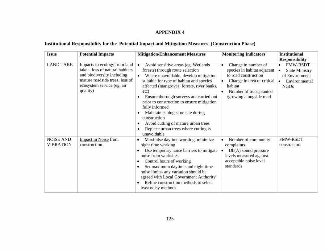
125
APPENDIX 4
Institutional Responsibility for the Potential Impact and Mitigation Measures (Construction Phase)
Issue Potential Impacts Mitigation/Enhancement Measures Monitoring Indicators Institutional
Responsibility
LAND TAKE Impacts to ecology from land
take – loss of natural habitats
and biodiversity including
mature roadside trees, loss of
ecosystem service (eg. air
quality)
Avoid sensitive areas (eg. Wetlands
forests) through route selection
Where unavoidable, develop mitigation
suitable for type of habitat and species
affected (mangroves, forests, river banks,
etc)
Ensure thorough surveys are carried out
prior to construction to ensure mitigation
fully informed
Maintain ecologist on site during
construction
Avoid cutting of mature urban trees
Replace urban trees where cutting is
unavoidable
Change in number of
species in habitat adjacent
to road construction
Change in area of critical
habitat
Number of trees planted
/growing alongside road
FMW-RSDT
State Ministry
of Environment
Environmental
NGOs
NOISE AND
VIBRATION
Impact in Noise from
construction
Maximise daytime working, minimize
night time working
Use temporary noise barriers to mitigate
noise from worksites
Control hours of working
Set maximum daytime and night time
noise limits- any variation should be
agreed with Local Government Authority
Refine construction methods to select
least noisy methods
Number of community
complaints
Db(A) sound pressure
levels measured against
acceptable noise level
standards
FMW-RSDT
constractors

126
Impact in Noise from
construction
Construction methods refinement for the
method least likely to cause vibration
Protect residents from level of vibration
which causes nuisance
Protect buildings from level of vibration
which causes damage
Number of community
complaints
Integrity of structures
Occurrence of damage
caused by vibrations
FMW-RSDT
construction
contractors
Issue Potential Impacts Mitigation/Enhancement Measures Monitoring Indicators Institutional
Responsibility
AIR
QUALITY
Impacts to air quality from
dust
Enclosure and damping down of
stockpiles
Water spraying especially of unpaved
roads
Sheeting of vehicles carrying waste and
dusty materials
Wheel cleaning facilities
Limit vehicle speeds on unpaved
surfaces
Implement procedure for monitoring
wind speed and direction
Undertake visual inspections
Design and implement strategy for
demolition of structures that will
minimize dust creation and exposure to
receptors
Number of community
complaints about dust
Levels of airborne
particulate matter
Undertake visual
inspections
FMW-RSDT
construction
constractors

127
Impacts to air quality from
construction related
emissions
Use processes that do not generate
hazardous fumed and / or hazardous dust
Ensure that airborne hazards do not
escape from the site to affect members of
the public and surrounding environment
Do not burn materials on site
Ensure machinery is well on site
Ensure machinery is switched off when
not in use
Levels in air of:
Carbon monoxide (CO)
8 hours
Nitrogen dioxide (NO2)
1 hour
Photochemical oxidants
measured as ozone (03) 1
hour
Sulphur dioxide (SO2) 1
hour
Lead (Pb) 1 year
Particles as PM10 1 day
Particles as TSP 1 day
CO2 / Green House
Gasses
FMW-RSDT
construction
constractors
SOIL AND
WATER
Impacts to soil and water
from increased soil erosion:
Construction activities such
as grading, excavations, and
borrowing/ quarrying
Inadequate design of culverts
and drainage controls
Design:
Use surface drainage controls & mulch
on vulnerable surfaces and slopes
Line receiving surfaces with stones or
concrete
Locate & design borrow/ quarry sites
for erosion control during road
construction & future maintenance
operations
Construction:
Limit earth movement &soil exposure
to the dry season
Balance cut & fill for minimum
deposition of earth
Provide sedimentation basins
Resurface & re-vegetate exposed
surfaces
Integrity of road structures
Degree of erosion
Quality of surface
water(turbidity)
FMW-RSDT
construction
constractors

128
Install drainage ditches to divert water
away from road
Impacts to water from
accidental spillages Ensure procedures are in place to deal
with accidental spillages
Install drainages systems w/ appropriate
treatment
Presence of
contaminates in surface
water (including oil & gas,
suspended solids)
FMW-RSDT
construction
contractors
State Waste
Management
Authority to
monitor
CONTAMINA
TED LAND
AND WATSE
Impacts to public and staff
health and safety from
contaminated land and waste
Safe disposal strategy for solid waste:
collect all solid waste from all site areas
and dispose of either in local landfill or
well-screened waste pits
Develop and implement remediation for
contaminated land
Local complaints of
excessive waste & odours
BOD, COD, SS, and oil
levels in soil (measured
once a month during
construction /
rehabilitation phase)
FMW-RSDT
construction
contractors
State Waste
Management
Authority to
monitor
TRAFFIC
AND
TRANSPORT
Disruption to roadside
residents, passing pedestrians
and passing traffic
Minimise construction duration;
Plan and implement temporary road and
pedestrian traffic management measures;
Minimize construction generated traffic
Transport construction workers to site
on dedicated transport
Number of complaints
received from roadside
residents and road users
FMW-RSDT
construction
contractors
Federal
Ministry of
Transportation
State Mnistry
of Transportation
Federal Road
Safety

129
SOCIO-
ECONOMICS
Impacts to archaeology and
cultural heritage: Loss of or
damage to structures of
historic, religious, cultural or
archaeological significance
Identify areas where buildings of
historical or cultural significance
predominates
Avoid buildings of cultural, historical
or religious significance through careful
route selection
Apply chance find procedures in
construction clauses
Numbers of chance finds
occurrences
Records of measures
implemented to ensure
protection of structures of
cultural significance
FMW-RSDT
construction
contractors
Legacy
(Building
conservation
NGO)
Impacts to public health
from stagnant pools of water
created in construction
borrow pits and quarries, and
on road sides, that breed
disease carriers
Develop and implement plan to deal
with drainage impacts including:
Drive roads after moderate rains to
identify areas that collect or gully water
Ensure proper drainage of construction
areas and road sides
Coordinate construction phases with
dry season
Ensure current system can handle
improved drainage (prevent runoff
erosion/ reservoir overflow)
Changes in occurrence
of illness or disease(
particularly malaria) in
roadside communities
Reported incidence of
flooding/ reduced drainage
capacity during
construction
FMW-RSDT
construction
contractors
(Ministry of
Health to
monitor)
Involuntary resettlement due
to loss of roadside space for
vendors, traders, mechanics
and other informal activity
Develop Resettlement Action Plan
(RAP) according to guidelines set by
World Bank Safeguard Policy:
Identification and notification of all
Project Affected Peoples(PAPs)
Assessment and valuation of all
property loss
Identification of suitable alternative
land for resettlement(considering
accessibility, electricity, water, etc)
Payment of compensation where
appropriate
Number of project
affected people adequately
compensated and resettled
Number of complaints
received through
grievance mechanism
Records of consultation
meetings before and after
relocation
Evaluation of
livelihoods of PAPs post
resettlement to alternative
Local
Government
Authority
Community
Development
NGOs
Community
based
Organizations
(CBOs)
Land
Regularization

130
Assistance to PAPs with relocation and
livelihoods rehabilitation post relocation
Establishment of a grievance
mechanism
location Directorate
Land Valuation
Bureau
Ministry of
Women’s Affairs
and Poverty
Alleviation
Impacts to employment and
social networks from influx
of construction workers,
including social disruption
and tension over
employment opportunities
Ensure that contractors work with
CBOs to ensure that local people are
used as far as possible for non-skilled
jobs
Ensure that contractor has and
implements a code of conduct for all
construction workers (see Camp code of
conduct below)
Number of local people
employed by contractors
Reported incidence of
conflict between local
residents & project
workers
Reports from involved
CBOs
FMW-RSDT
construction
contractors
Community
Development
NGOs
HEALTH
AND SAFETY
Impacts to health and safety
of construction workers
Plan/ Implement occupational health
measures/ training programmes (certifiable/
verifiable) for workers & subcontractors
Use proper protective equipment/
preventative practices
Security controls at worksites (incl. traffic
controls)
Effective monitoring/ incident reporting @
site
Ensuring minimum working conditions
including regular breaks
Number of accidents/
incidents recorded
Contractors have satisfactory
Health and safety plan in
place
FMW-RSDT
construction
contractors
Impacts to health and safety
of pedestrians
Management of project waste removal/
treatment, incl. measures to prevent water/
air contamination
Effective traffic control and exclusion of
Number of accidents/
incidents reported
Complaints from public
FMW-RSDT
construction
Contractors

131
public from construction sites where
possible
State Ministry
of Transportation
State Waste
Management
Authority to
monitor

132