FBIOM¶ FSL 2 0)5A FOL FBIOM¶ FSL 2 0)5A FOL FBIOM¶ FSL 2 0 ...
224
UTAH OIL AND GAS CONSERVATION COMMISSION REMARKS WELL LOG ELECTRIC LOGS X _a I WATER SANDS LOCATION INSPECTED SUB REPORT/abd DATE F)LED LAND FEE & PATENTED X STATE LEASE NO PUBLIC LEASE NO INDIAN DRILL)NG APPROVED 2/24/88 (Exception Location) SPUDDED IN COMPLETED PUT TO PRODUCING INITIAL PRODUCTION GRAvlTY A PI. GOR. PRODUCING ZONES NONE TOTAL DEPTH 11097 WELL ELEVATION 6756 DATE ABANDONED FIELD UNDESICNATFD UNIT. COUNTY WELLNO U.P.R.C. #l API #43-043-30290 LOCATION g Î »FROM (N) (S) LINE 2052' FWL FT FROM (E) (W) LINE Sm 14 - L4 SEC (BHL) 210 P- FBIOM¶ FSL 2 0)5A FOL NWSE TWP RGE SEC OPERATOR TWP RGE SEC OPERATOR 25 7E UTAH OIL AND GAS CONSERVATION COMMISSION REMARKS WELL LOG ELECTRIC LOGS X _a I WATER SANDS LOCATION INSPECTED SUB REPORT/abd DATE F)LED LAND FEE & PATENTED X STATE LEASE NO PUBLIC LEASE NO INDIAN DRILL)NG APPROVED 2/24/88 (Exception Location) SPUDDED IN COMPLETED PUT TO PRODUCING INITIAL PRODUCTION GRAvlTY A PI. GOR. PRODUCING ZONES NONE TOTAL DEPTH 11097 WELL ELEVATION 6756 DATE ABANDONED FIELD UNDESICNATFD UNIT. COUNTY WELLNO U.P.R.C. #l API #43-043-30290 LOCATION g Î »FROM (N) (S) LINE 2052' FWL FT FROM (E) (W) LINE Sm 14 - L4 SEC (BHL) 210 P- FBIOM¶ FSL 2 0)5A FOL NWSE TWP RGE SEC OPERATOR TWP RGE SEC OPERATOR 25 7E UTAH OIL AND GAS CONSERVATION COMMISSION REMARKS WELL LOG ELECTRIC LOGS X _a I WATER SANDS LOCATION INSPECTED SUB REPORT/abd DATE F)LED LAND FEE & PATENTED X STATE LEASE NO PUBLIC LEASE NO INDIAN DRILL)NG APPROVED 2/24/88 (Exception Location) SPUDDED IN COMPLETED PUT TO PRODUCING INITIAL PRODUCTION GRAvlTY A PI. GOR. PRODUCING ZONES NONE TOTAL DEPTH 11097 WELL ELEVATION 6756 DATE ABANDONED FIELD UNDESICNATFD UNIT. COUNTY WELLNO U.P.R.C. #l API #43-043-30290 LOCATION g Î »FROM (N) (S) LINE 2052' FWL FT FROM (E) (W) LINE Sm 14 - L4 SEC (BHL) 210 P- FBIOM¶ FSL 2 0)5A FOL NWSE TWP RGE SEC OPERATOR TWP RGE SEC OPERATOR 25 7E
-
Upload
khangminh22 -
Category
Documents
-
view
0 -
download
0
Transcript of FBIOM¶ FSL 2 0)5A FOL FBIOM¶ FSL 2 0)5A FOL FBIOM¶ FSL 2 0 ...

UTAH OIL AND GAS CONSERVATION COMMISSION
REMARKS WELL LOG ELECTRIC LOGS X _a I WATER SANDS LOCATION INSPECTED SUB REPORT/abd
DATE F)LED
LAND FEE & PATENTED X STATE LEASE NO PUBLIC LEASE NO INDIAN
DRILL)NG APPROVED 2/24/88 (Exception Location)SPUDDED IN
COMPLETED PUT TO PRODUCING
INITIAL PRODUCTION
GRAvlTY A PI.
GOR.
PRODUCING ZONES NONETOTAL DEPTH 11097WELL ELEVATION 6756DATE ABANDONED
FIELDUNDESICNATFD
UNIT.
COUNTY
WELLNO U.P.R.C. #l API #43-043-30290LOCATION g Î »FROM (N) (S) LINE 2052' FWL FT FROM (E) (W) LINE Sm 1 4 - L 4 SEC
(BHL) 210 P- FBIOM¶ FSL 2 0)5A FOL NWSETWP RGE SEC OPERATOR TWP RGE SEC OPERATOR
25 7E

GEOLOGICTOPS:QUATERNARY Mt Chinte MotasAlluvium Mp AA r il Shinarump Manning CanyonLake beds Masuk Moenkopi MississippianPleistocene Colorado Sinbad HumbugLake beds Sego PERMIAN BrazerTERTIARY Buck Tongue Kaibab Pilot ShalePliocene Castiegate Coconino MadisonSalt Lake Mancos Cutler LeadvineOligocene Upper Hoskinnini RedwallNorwood Middle DeChelly DEVONIANEocene Lower White Rim UpperDuchesne River Emery Organ Rock MiddleUinta Blue Gate Cedar Mesa LowerBridger Ferron Halgaite Tongue OurayG Re Fraontiaer Phaosphoria EMc
acken
Ced
onynaninS
pai(Goodridge) SAnett
son DolomiteBuckhorn Wolfcamp Sevy DolomiteJURASSIC CARBON I FEROUS North Point
Wasatch Morrison Pennsylvanian SILURIANStone Cab n Salt Wash Oguirrh Laketown DolomiteColton San Rafeal Gr Weber ORDOVICIANFlagstaff Summerville Morgan Eureka QuartziteNovth Horn Bluft Sandstone Hermosa Pogonip LimestoneAlmy Curtis CAMBRIANPaleocene Entrada Pardox LynchCurrent Creek Moab Tongue Ismay BowmanNorth Horn Carmel Desert Creek TapeatsCRETACEOUS Glen Canyon Gr Akah OphirMontana Navajo Barker Creek TinticMesaverde Kayenta PRE CAMBRIANPrice River Wingate Cane CreekBlackhawk

ERON COMPANY U.S.A FB 11198POST OFFICE BOX 1600 • MIDLAND, TEXAS79702-1600
DIVBl0NOFPRODUCTION DEPARTMENT
DiL,GAS&MININGSOUTHWESTERN DIVISION
February 10, 1988
U.P.R.C. #1(SENW)Sec. 17, T2N, R7E Surface(NWSE)Sec. 17, T2N, R7E BHLSummit County, Utah
Mr. John R. BazaDivision of Oil, Gas and Mining355 West North Temple3 Triad Center, Suite 350Salt Lake City, Utah 84180-1203
Attached is an application for permit to drill and a plat for the U.P.R.C. #1well with a surface location of 2335' FNL and 2052' FWLand an anticipatedbottomhole location of approximately 2100' FSL and 2500' FEL of Sec. 17, T2N,R7E, Summit County, Utah. Please note that the original U.P.R.C. #1 locationin the (NWSE)of Sec. 17 has been changed to the U.P.R.C. #3 and that this wellwill be numbered the U.P.R.C. #1.
The proposed bottomhole location is not in the center of the quarter quartersection due to geological reasons. We, therefore, request an exception toStatewide Spacing Rule No. 302. Exxon operates all offset acreage within a460' radius of the wellbore.
The well will not be directionally drilled, but will be allowed to driftwithout control to the anticipated bottomhole location. Directional surveysindicating the actual bottomhole location will be submitted with completionreports.
If you have any questions concerning this application, please contact JamesCunningham at the letterhead address, or call 915-686-4405.
p,Charlotte HarperPermits Supervisor
CHH:cjfAttachments
A DIVISION OF EXXON

lorn UGC-In SU JCATE*
STATEÖF UTAH ru n. on
DEPARTMENT OF NATURAL RESOURCE5DIVISION OF OIL & GAS DMSIONOF
s. - M..aeo. ..., seria, so.
OiLGAS&MINING Fee
APPLICATIONFOR PERMIT TO DRILL, DEEPEN, OR PLUG BACK 6. H Inshan. AUotto or TrHm Name
la. Type of Work7. Unit Agreement NameDRILL DEEPEN O PLUG BACK
b. Type of Well ~¯
Oil Gas Single Multiple 8. Farm or Lense NamWell - Well Other Zone Zone. Nameof operator U.P.R.C.
Exxon Corp. Attn: Permits Supervisor •'I N°
i. Addmse of Operator
P. O. Box 1600, Midland, TX 79702 vieldand Pool,Bildent4. Location of Well (Report locntion clearly nml in accordance with any State requirements.•> Undesignated
At surface2335' FNL and 2052' FWL of Sec. 17, (SENW) «Îsu vey o
Är< BIk,
At proposed prod. BoneApprox. 2100' FSL and 2500' FEL of Sec. 17, (NWSE) Sec. 17, T2N, R7E
14. Distance in miles and direction from neamat town or post office* 12. County or Parrish 13. State
11 miles East from Coalville Summit Utah15. Disata e from proposed*
2335' Surface 16. No. of acres in lease 17. Noth f acres assignedproperty or lease line, it. 3300 ' BHL 3240 40(Also to nearest drig. line. if any)
lb. Distance from proposed location° 1100' Surface 19. Proposed depth 20. Rotary or cable toolsto nearest tvell, drilling, completed,or applied for, on this lease, ft 1320 ' BHL 11, 000 ' Rotary
21. Elevations (Show whether DF, RT, GR, etc.) 22. Approx. date stork will start•
GR-6756.5 ungraded April 1, 198823.
PROPOSED CASING AND CEMENTING PROGRAM
Size of Hole Size of Casing Weight per Foot Setting Depth Quantity of Cement
26 16 Line Pipe 80 55 ft.3
12 1/4 9 5/8 40 1,500 470 ft.38 3/4 7 26, 35 11,000 375 ft.3
Surface Owner: Bow Valley Development Corp.1725 North 200 West, Suite 2CProvo, Utah 84604Steven Stewart ph.no. 801-377-6700
Exxon Corp. contact for additional information - James Cunningham ph. no. 915-686-4405.
IN ABOVE SPACE DESCRIBE PROPOSED PROGRAM: If proposal is to deepen or plug back, give data on pn.sent productive zone and proposed new pro-ductive zone. If povosal is to drill or deepen directionally, give pertinent data on subsurface locations and measured and true vertical depths. Give blowoutpreventer program, if any.24· gagCharlotte Harpe
ÏThis space for Federal or State office use)
Permit No. Approval DateAPPROVED BY THE STATE
OF DTAFPDTVTSTONOFApproved by.... ... ............... Title... . .. ...... ...
Ol L, GAS, AND (I INGConditions of approval, if any: TE
*See Instructions On Revers.\ LL SPAC NA -

WILLILal H. SMITH & ASSOCIUS P.C.SURVEYING CONSULTANTS
POST OFFICE BOX820 T 2 H R 7 g 550 EAST 2 NORTHGREEN RIVER, WYOMING 82935 Recore 389'26°W
- 80./7 «A PHONE 307-875-3638
Meas.: 387*J20G"E-2752GO'Meas· Ng9'06'0("E-f37244'
Ii I
I I
SCALE: 1" = 1000'Exxm C y US.A.
O Found Brass Cap 2052(Bbitam hole eco/kn = 2500' FEL
- Found Stone 2m'Fst)
o2500' "
p
Note: Basis of bearkgr eslaWirhed fromSolar Coservolkn.
Io
Meas.· NB7°2744"W-26J7.24' Meas.• N88'5854°°W-26680&°
Record 40.20 «A .yRecord 40.00 cA
I L of Green River, Wyoming hereby certify that in accordance with a request
from Lt‡h Gem , of Weg Tex for Emm comomaUS.A.
made a survey on the.. ..day of EN 191for location and elevation of the WRC Ma /
As shown on the above map, the wellsite is in the WM pf theNW/4
of Section 17, Township 2 Morfh
, Range 7 Eel of the Sdf Lake Base &
Markilm ammffcomfr.3&ie of IAA Ekm/Amà €?5Edk mannsbd ammt Dr/mr est-Mhèsd ham apel edemdba 70tG hooted
on the meetAbeet sætAW IdL T£N 87E er shownm Mr WFJ 7//T /wo T&An Unif°
Reference Point 300' AOTTH set « #5 rear Ðwww/Amfor of r* # 6679 J
Reference Point300° EAST set a#3 Ekvalke kg of rubar . G7603
Referenen Point300° WEST hee/ed & coor/rw/he m N/A
R af aranen Pnint 350' SOUTH se/ « #5 rear Ekvelha kg of re
UTAH R . 5909 •• ¿
g No.5909
De 2REGISTERED = JOHNI.
own by• WWR WYOMING UTAH IDAHo DOUNAR INEVADA NEW MEXICO ARIZONA
""'"" "

Exxon CorporationUPRC #1
Surface: 2335' FNL and 2052' FWLSection 17, T2N, R7E
Bottom Hole: 2100' FSL, 2500' FELSection 17, T2N, R7E
Summit County, UtahDrilling Plan
1. Geologic markers:
The estimated tops of important geologic markers:
Tertiary SurfaceFrontier 1,500'Aspen 3,400'Kelvin 4,300'Stump 6,700'Preuss 7,200'Twin Creek 9,200'Nugget 10,600'
2. The estimated depths at which the top and the bottom of anticipated oil,water, gas or other mineral bearing formations are expected to beencountered:
Top Bottom How ProtectedFresh Water O' 1,500' Surface casing - cemented to surfaceOil 9,200' 11,000' Production casing - cemented above 9,200'
3. Minimum specifications for pressure control equipment:
A. Casing Head Equipment:
"A" Section 9-5/8" LTC x 11" - 3000 - sweetTubinghead 11" - 3000 x 7-1/16" - 5000 - sweetTubinghead Adaptor 7-1/16" - 5000 x 2-9/16" - 5000 - sweetTree 2-9/16" - 5000 - sweet
B. Blowout Preventer Equipment:
Type Pressure Rating Installed on Casing
Type Al Diverter System 150 psi 16"Type RSRA BOP Stack 5000 psi 9-5/8"
Additional preventers may be added and/or preventers with higherpressure ratings may be substituted, depending on equipment provided bydrilling contractor. Schematic diagram of preventer type is attached.
C. Testing:
Operational Testing: An operational test consisting of closing theannular preventer and pipe rams on the drill pipe and closing the blindrams on open hole will be performed on each round trip but not morethan once each

Exxon Corporation - UPRK,/1Summit County, UtahDrilling PlanPage 2
Pressure Testing: An initial pressure test will be performed afternippling up on a casing string but prior to drilling out. Equipmentwill be tested to 300 psi and 100% of the pressure rating on installa-tion.
Subsequent pressure tests will be conducted:
o Upon any change in rams or other component of the BOP stack and/orchoke manifold.
o At least every thirty (30) days.
Subsequent pressure tests will be at 300 psi and the lesser of 50% ofthe manufacturer's rated pressure of the BOPE, the maximum anticipatedpressure to be contained at the surface, 1 psifft of the last casingstring depth, or 70% of the minimum internal yield pressure of anycasing subject to test.
Blowout Prevention Drills: A drilling crew proficiency test to performthe well shut-in procedure will be performed at least once each weekwith each crew.
D. BOP Control Unit:
Unit will be hydraulically operated and have one control stationlocated at least 60' from wellbore and one located on the rig floor.
4. Auxiliary Equipment and Proposed Casing Program:
A. Auxiliary Equipment:
1. Kelly Cocks: Upper and lower installed on kelly.
2. Safety Valve: Full opening ball type valve to fit each type andsize of drill pipe in use will be available on therig floor in the open position at all times for usewhen the kelly is not connected to the drill string.
B. Casing:
String Size/Weight/Grade/Conn Depth Interval
Gonductor 16"/line pipe O - 80'
Surface 9-5/8"|40#|K55/LTC 0 - 1,500'
Production 7"|26#/N80/LTC O - 4,500'7"|26#/R55/LTC 4,500'- 6,550'7"|26#|N80/LTC 6,550'- 8,650'7"|35#/P110/LTC 8,650'- 9,650'7"|35#/N80/LTC

Exxon Corporation - UPR&w41 s,/
Summit County, UtahDrilling PlanPage 3
C. Cement:
Approximate Top of CementCasing Depth Çement Type Cement Volume (Gauge hole)
13-3/8" 80' Readi-Mix 55 ft3 Surface
9-5/8" 1,500' Light Cement 315 ft3 SurfaceClass "H" 155 ft3
7" 11,000' Light Cement 175 ft3 9,200'*Class "H" 200 ft3
* Calculated cement volume will be adequate to cover all hydrocarbonbearing zones.
D. Casing Test Procedures:
1. Surface casing (9-5/8"): 1,500 psi test pressure
2. Production casing (7"): 3,500 psi test pressure
5. Circulating Medium Characteristics:
A. Type and anticipated characteristics of drilling fluid:
MW FV PV YP WLpepth Interval Mud Type (ova) (sec/qt) ÍS21 (#/100 ft2) (cc/30 min) pH
0-1,500' Spud Mud 8.4-8.9 26-35 -- -- -- 8.5+1,500-8,500' FWM 8.4-9.0 30-50 5-12 6-20 10-15 9.5+8,500-TD SWM 8.8-10.4 36-46 5-17 6-18 10 9.5+
Mud weight and viscosity will be maintained at minimum levelscompatible with operating conditions.
B. Quantities of Mud and Weighting Material:
1. Quantity: Not less than ± 200 bb1s of mud will be in surface mudpits at all times.
2. Weighting Material: At least 200 sx of barite will be stocked onlocation. Stock point for barite and all other mud additions willbe located within a two-hour radius.
C. Mud System Monitoring Equipment:
1. Pit Volume Totalizer: PVT will be used to monitor mud pits.
2. Trip Tank: Tank will be used to keep hole full of fluid on tripsand to monitor hole behavior during

Exxon Corporation - UPRL.41 s,xSummit County, UtahDrilling PlanPage 4
6. Anticipated type and amount of coring, testing and logging:
A. Drill Stem Tests: 1 is anticipated in the Twin Creek.2 are anticipated in the Nugget.
C. Logging Program:
From surface casing to total depth: BHC-Sonic-GR-CALDIL-GR-SPMudlogger
From 9,000' to total depth: FDC-CNL-GR-CAL
From surface to total depth: VSP
7. Expected bottom hole pressures, abnormal pressures and temperatures or anypotential hazards:
A. Bottom hole pressure is expected to be less than 4,800 psi at totaldepth.
B. H2S is not expected.
8. Other Facets of Proposed Operation:
Completion Program: Perforate, stimulate, and production test intervalsbased on wireline logs and shows.
Contact A. L. Sossaman at (915) 686-4352 with any questions concerningthis Drilling Plan.
A. L. Sossaman

TYPE- Aki olvERTER syst
AISER TO EXTENDAggyg pk0W LING.;-----••••-••--••-----•----••-•I**moonanso
I FLONLINE TYFE I AfasarsLocanon.I to be specified in iI Bid sheet & Drilling Order I n,I-•------- •••i 3 TAL OMLTAMOISWOT& Totimmopon
avestimeons
VALVE ENATALLTIMESTAM WNiki DAlkkiNG SURIIACE
MOLE.
sLOPE UP TO Paivant PLuomNGRMERVE
1 I3i ii I --comoucron
i i
i I
am----sunfaca camme
COMPONENT SPECIFICATIONS
1. Flanged or screwed flapper type check valve -- 3" minimum nominal dia. and 150 psiminimum working pressure.
2. Flanged or screwed gate or plug valves -- 3" minimum nominal dia. and 150 psi minimumworking pressure. NOTE: Outer valves are optional if pump type trip tank is tied ir.toFlowline Type.
3. Kill line to pump water and minimize fire hazard when gas is flowing out diverter line.3" thread-o-let welded to conductor.
4. 3" welded collar with bullplug. This connection is used to clean out cement.5. 2" welded collar with tapped bullplug, valve, and pressure gauge.6. Annular BOP companion flange -- screwed or welded to conductor casing. NOTE: A flanged
spool with a diverter line side outlet can be used to save rig-up time.7. Helded collar -- 2" minimum nominal dia. -. with bullplug. Cleanout connections.8. Diverter line minimum 6" internal diameter.9. Top of annular preventer must be equipped with an API flange ring gasket. All flange
studs must be in place or holes filled in with screw type plugs.
NOTE:A. Unless specified otherwise in the Bid Letter and/or Contract, the contractor will
furnish and maintain all of the above equipment including annular BOP, flovline typeand trip tank line connections.
B. The diverter line valves and other diverter component equipment must be 150 psi minimumworking pressure.
C. The diverter line valves must be designed to maintain full open or closed position.D. Diverter lines must be securely anchgred. Sleeve-type couplin5s should not be used for
pipe joint connections and 45° or 90 ells must not be installed on the end of diverterlines to direct flow downward. These can cause the line to "kick-up" when large flowvolumes are
TYPE- Aki olvERTER syst
AISER TO EXTENDAggyg pk0W LING.;-----••••-••--••-----•----••-•I**moonanso
I FLONLINE TYFE I AfasarsLocanon.I to be specified in iI Bid sheet & Drilling Order I n,I-•------- •••i 3 TAL OMLTAMOISWOT
& Totimmoponavestimeons
VALVE ENATALLTIMESTAM WNiki DAlkkiNG SURIIACE
MOLE.
sLOPE UP TO Paivant PLuomNGRMERVE
1 I3i ii I --comoucron
i i
i I
am----sunfaca camme
COMPONENT SPECIFICATIONS
1. Flanged or screwed flapper type check valve -- 3" minimum nominal dia. and 150 psiminimum working pressure.
2. Flanged or screwed gate or plug valves -- 3" minimum nominal dia. and 150 psi minimumworking pressure. NOTE: Outer valves are optional if pump type trip tank is tied ir.toFlowline Type.
3. Kill line to pump water and minimize fire hazard when gas is flowing out diverter line.3" thread-o-let welded to conductor.
4. 3" welded collar with bullplug. This connection is used to clean out cement.5. 2" welded collar with tapped bullplug, valve, and pressure gauge.6. Annular BOP companion flange -- screwed or welded to conductor casing. NOTE: A flanged
spool with a diverter line side outlet can be used to save rig-up time.7. Helded collar -- 2" minimum nominal dia. -. with bullplug. Cleanout connections.8. Diverter line minimum 6" internal diameter.9. Top of annular preventer must be equipped with an API flange ring gasket. All flange
studs must be in place or holes filled in with screw type plugs.
NOTE:A. Unless specified otherwise in the Bid Letter and/or Contract, the contractor will
furnish and maintain all of the above equipment including annular BOP, flovline typeand trip tank line connections.
B. The diverter line valves and other diverter component equipment must be 150 psi minimumworking pressure.
C. The diverter line valves must be designed to maintain full open or closed position.D. Diverter lines must be securely anchgred. Sleeve-type couplin5s should not be used for
pipe joint connections and 45° or 90 ells must not be installed on the end of diverterlines to direct flow downward. These can cause the line to "kick-up" when large flowvolumes are

TYPE-RSRA BCP STACK
THREE PREVENTERS
FLCULINE TYPE || te be specified in I( Bid Sheet 6 Drilling Order !
ANNULAN
ELINOLMS I
LINE MANIFOLD
septAAMS
SECTION -
COMPONENT SPECIFICATIONS
1. Screwed or flanged plug or gate valves -- 2" minimum nominal dia. -- same workingpressure as "A" section.
2. Tee with tapped bullplug, needle valve, and pressure gauge.3. Flanged plug or gate valve -- 2" minimum nominal dia. -- same working pressure as BOP
stack. NOTE: Outer valves are optional if pump type trip tank is tied into FlovlineType.
4. Flanged sprin5-loaded or flapper type check valve -- 2" minimum nominal dia. -- sameworking pressure as BOP stack.
5. Drilling spool of sufficient height to allow stripping with 2 flanged side outlets --
3" choke and 2" kill line minimum nominal dia.6. Flanged hydraulically controlled gate valve -- 3" minimum nominal dia. -- same working
pressure as BOP stack.7. Flanged plus or Bate valve -- 3" minimum nominal dia. -- same working pressure as BOP
stack.8. Top of annular preventer must be equipped with an API flange ring gaskat. All flange
studs must be in place or holes filled in with screw type plugs.
NOTE:A. Unless specified otherwise in the Bid Letter and/or Contract, the contractor will
furnish and maintain all components shown above Exxon's wellhead.B. The choke line between the drilling spool and choke manifold should not contain any
bend or turn in the pipe body. Any bend or turn required should be made with a runningtee with a blind flange or velded bullplug. All connections should be flanged orwelded. All fabrications requiring welding must be done by a certified welder. Veldsshould be stress relieved when required.
C. Plug valves should be equivalent to the Howco Lo-Tore and gate valves equivalent to theCameron Type

February 10, 1988
TO: John Baza
FROM: James Cunningham
SUBJECT: Permit for water source
We have made application with the Water Rights department to add the place ofuse and point of diversion for the U.P.R.C. #1 to the attached permit fortemporary change of water. Wewill be using the same 16 acre feet that we haveappropriated from Wright Dairy Partnership.
If you have any questions concerning our water source, please call me at915-686-4405.

STATEOF UTAH Norman H. Bongerter, GovernorNATURALRESOURCES Dee C. Honsen, Executive DirectorWoter Rights Robert L Morgon, State Engineer
1636 West North Temple · Suite 220 - Salt Loke City, UT84116-3156 • 801-533-6071
e
December 21, 1987
Exxon Corp.P.O. Box 1600Midland, TX 79702
Gentlemen: Temporary Chenge †87-35-2
Temporary Change Number †87-35-2 has been approved subject toprior rights and the following conditions and s†lpulations:
1) No more water may be diverted than the 16.0 acre-feetof water as described in the application.
2) AII diversion from the temporary point of diversionmust cease December 30, 1988.
A copy of the Approved Temporary Change Application is returnedherewith for your records and future reference.
Sinperely,
'J mes E. RIIey, P.E.Aree Engineer
cc: Kent L. Jones, P.E.Directing Appropriations Engineer
Chalk Creek/Hoy†sville Water User's Corp.c/o Lawrence Wright, Pres.Chalk Creek RoadCoolville, UT 84017
on equal opportunity

a
ÄPPLICATIÒÑFOR TEMPORARY CHANGFbConace Exxos OF WATER RECEIVED , ,T,yoo9is- &¾-44o STATEOF UTAHwerg7,......womrn..a
Rona
Forthe purpose ofobtaining permission tomake a temporary change ofwater in the State ofUtaN, applicationishereby made to the State Engineer, based uponthe following showingof facts, submittedin accordancewiththerequirements of the Laws of Utah.
'WATER RIGHTNO. - *APPI.lCATIONNO. t $ - N ·KChangesare proposed in (check those applicable)
x point ofdiversion. X place ofuse X nature ofuse X period ofuse.1. OWNERINFORMATION
Name: Exxon Corp. Attn: Permits Supervisor •IntBIOSf•-%P. O. Box 1600
Midland Stata• Texas yty pap. 79702
2. 'PRIORITYOFCH ANer· •FII.INGDATE:'Is this changeamendatory?(Yes/No):
3. RICHTFVinFNCFORV• Chalk Creek-Hovtsville Water Users Corooration 16 shares fromCert. #113 dated 2-1-41. Application 8170-C, Cert. #8459
Prine appenvertTempnrnry hange Applicatinns fnr this right•
* *•••••••••••••••••••••••••••••• HERETOFORE* * *•••••••••••••••••••••••••••••
4. QUANTlTYOF WATER: cis and/or 16 ac•ft.5. Engger. South Fork Chalk Creek
0, ORNTV• Smit 5,#fh ¿T/ý7. POINT(C) OF BIVFR4tnN• 51*, 37 min. E 735' from North quarter corner of sec. 34,
T2N, RSE, Summit County, Utah.
Daarriptinn nf Diverting Wnrkc·
8. POINT(S)OF REDIVERSIONThe water has been redivertedfrom at a point:
neerriptinnnf niverting Wnrkm·
9. POINT(S)OF RETURN -
The amount of water consumedis cfs or 14 ac-it.The amount of water returned is cis or o ac•ft.The water has been returned to the natural stream/source at a point(s):
'These items are to be completedby the Division of Water Rights.
Temporary

' 20. NATUREAND PERIODOF USEIrrigatlon: From J......L...... to daStockwatering: From J..-.J....- to -.-./J-....Domest ic: From ..-. J..... J-.... to ......./--../.......
Municipal: From ....J-....J.-... to _...J. _.I..... •
Mining: From .....Jd.....- to -...JJ-Power:
.From .......J...-J...-- to -...J-..J-
Other: From.i...J..ll.L to ....1 yg_ y 88
21. PURPOSEAND EXTENTOF USEIrrigation: acres.Solesupplyof acres.Sinckwatering (number and kind)·
Domestic: Families and/or Persons.Muntelpal (name)•
Mining· Mining District at the Mine
Ores mined·Pnwar. Plant name• Typp• Caparity•
Other (dnacrthnþ Oil and Gas Well Drilliner
22. PIACE OF USELegal description of place ofuse by 40 acre tract(s): U.P.R.C. #1 well located (NWSE) of Sec. 17,
T2N, R7E and the U.P.R.C. #2 well located (SWNE) of Sec. 17, T2N, R7E, S.L.M., Summit
County, Utah.
23. STORAGEReservnir Name· Not Applicable ¾tnrage Perind• from in
Capacity: ac-ft. Inundated Area: acres.Height of dam: feet.Legal description of inundated area by 40 trart(s)·
24. EXPIANATORYThe following is set forth to define more clearly the full purpose of this application. Include any supplementalwater rights used for the same purpose. (Use additional pages ofsamesizeif necessary): Water will be
pumped from the South Fork Chalk Creek at the location described in paragraph 17 and
will be hauled by truck approximately 3 1/2 miles to the points of use as described
in paragraph 22 above. Water will also be pumped from wella at locations to pits.
44¥¥ë¥¥4¥¥¥**¥¥¥¥¥¥¥¥¥¥¥©¥¥¥¥¥¥¥¾¥¥¥¥¥¥¥¥¥¥¥¥¥¥ë¥¥¥¥¥¥¥¥¥¥¥¥¥¥¥¥¥¥**¥
Theundersigned hereby acknowledgesthat even though he/she/they mayhave been assisted in the preparationof the above·numbered application through the courtesy of the employees of the Division of Water Rights, allresponsibility for the accuracy of the information contained rein, at the time of filing, rests with theapplicant(s).
Signature f

030101
OPERATOR DATE '
WE NAME
T .2R ff COUNTY
3- 3 O.2fd
A I NUMBER TYPE OF LEASE
CHECK OFF:
PLAT /ND 'NEARESTWELL
LEASE FIELD OTASH OROIL SHALE
PROC N EN ,
A PROVAL LETTER:
SPACING: R615-2-3 R615-3-2UNIT
R615-3-3CAUSE NO. & DATE
STIPULATIONS:
030101
OPERATOR DATE '
WE NAME
T .2R ff COUNTY
3- 3 O.2fd
A I NUMBER TYPE OF LEASE
CHECK OFF:
PLAT /ND 'NEARESTWELL
LEASE FIELD OTASH OROIL SHALE
PROC N EN ,
A PROVAL LETTER:
SPACING: R615-2-3 R615-3-2UNIT
R615-3-3CAUSE NO. & DATE
STIPULATIONS:
030101
OPERATOR DATE '
WE NAME
T .2R ff COUNTY
3- 3 O.2fd
A I NUMBER TYPE OF LEASE
CHECK OFF:
PLAT /ND 'NEARESTWELL
LEASE FIELD OTASH OROIL SHALE
PROC N EN ,
A PROVAL LETTER:
SPACING: R615-2-3 R615-3-2UNIT
R615-3-3CAUSE NO. & DATE
STIPULATIONS:

STATEOF UTAH Norman H. Bangerter. Governor
NATURALRESOURCES Dee C. Hansen. Executive Director
Oil, Gas & Mining Dianne R. Nielson, Ph.D., Division Director
355 W. North Temple •3 Triad Center · Suite 350 • Salt Lake City, UT84180-1203 •801-538-5340
February 24, 1988
Exxon CorporationP. O. Box 1600Midland, Texas 79702
Gentlemen:
Re: U.P.R.C. #l - (Surf.) SE NW, (BHL) NW SE, Sec. 17, T. 2N, R. 7E(Surf.) 2335' FNL, 2052' FWL, (BHL) 2100' FSL, 2500' FEL$ummit County, Utah
Approval to drill the referenced well is hereby granted inaccordance with Rule R615-3-3, Oil and Gas Conservation GeneralRules, subject to the following stipulations:
1. The reserve pit shall be lined with tear resistant plasticliner with a minimum thickness of 12 mil.
2. After excavation and lining of reserve pit and prior toplacing fluids in the pit, the operator shall notify DOGMto allow inspection of pit liner.
3. Submittal of directional drilling data upon completion ofdrilling operations to properly ascertain the location ofthe producing formation.
In addition, the following actions are necessary to fully complywith this approval:
1. Spudding notification to the Division within 24 hours afterdrilling operations commence.
2. Submittal of an Entity Action Form to the Division withinfive working days of the time that the well is spudded or achange in operations or interests necessitates a change inentity status.
3. Submittal to the Division of completed Form OGC-8-X, Reportof Water Encountered During Drilling.
4. Prompt notification to the Division should you determinethat it is necessary to plug and abandon this well. NotifyJohn R. Baza, Petroleum Engineer, (Office) (801) 538-5340,(Home) 298-7695, or R. J. Firth, Associate Director, (Home)571-6068.
on equal opportunity

Page 2Exxon CorporationU.P.R.C. #1February 24, 1988
5. Compliance with the requirements of Rule R615-3-22, Gas
Flaring or Venting, Oil and Gas Conservation General Rules.
6. Prior to commencement of the proposed drilling operations,
plans for toilet facilities and the disposal of sanitarywaste at the drill site shall be submitted to the localhealth department having jurisdiction. Any such drillingoperations and any subsequent well operations must beconducted in accordance with applicable state and localhealth department regulations. A list of all local health
departments and copies of applicable regulations areavailable from the Division of Environmental Health, Bureau
of General Sanitation, telephone (801) 538-6121.
7. This approval shall expire one (1) year after date ofissuance unless substantial and continuous operation is
underway or an application for an extension is made prior
to the approval expiration date.
The API number assigned to this well is 43-043-30290.
Associate Director, Oil & Gas
asEnclosurescc: Branch of Fluid Minerals
D. R. Nielson

Water Permit OK
DIVISIONOFOIL,GASANDMINING
SPUDDINGINFORMATIONAPI #43-043-30290
NAFEOFCOPPANY: EXXON CORPORATION
WElit'WE: urac si
SECTIONNW SE 17 IOWNSHIP 2N RANGE 7E COUNTY Summit
DRIllINGCONTRACTORRIG#SPÐDED:DATE 3-11-98
TIME
OW Dry Hole Digger
DRILLINGWILL COMMENCE3-22-88 - 8:45 PM - Adcor Rig #66
REPORTEDBY
TELEFHONEÑ
DME 3-24-88 SW

STATE OF UTAHtoth.-r instr wimus on
rewn.e wiriDEPARTMENT F NATURAL RESOURCES• DIVISION L OIL, GAS, AND MINING -
i, s.sa.. ......arson suo .saras, no.
Fee .
SUNDRYNOTKESAND REPORTSON WELLSDe not use this to o re a et 1 r o a r to to diferest r... 04070 5
1• . unst seassusaw waxa
Exxon Corp. Attn: Permits Supervisor U.P.R.C.
P. O. Box 1600 Midland, TX 79702 1
At sortaee Undesignated
2335' FNL and 2052' FWL of Sec. 17, (SENW) 11. sec..T..s..x..oass.s.exaseawar os assa
BHL-Approx. 2100' FSL and 2500' FEL of Sec. 17, (NWSE) Sec. 17, T2N, R7E
14. Psaat:T so• IL staT&Tiews ( ww or, sT, om,see,) 12. Counts os raassa 18. stats
,2 Q GR 6756.5 Summit Utah
isch Appropnete BoxToindicate Nature of Notice, Report,or ÔtiterDefe
TasT watas ascTM
t.x,N :ALTsa
castWo warsa smotorp
aussaquant serosT :AlttNO
WELL
PRACTURE TREAT McLttpt.s cosiPt.ETB reacttras tasaTusnT ALysaane cassmo
SMOOT na AC3DI38 ASANDOM• gagottug om aflotalNe asassomassat•Spud T
acrAsa ws&L citanos PLama (Other)iffors: Report results of multiple co-pletion es Wel
(Other) t'..mpletten ur Recompletton Report and t.og inrm.)
1T. osscasas rununamo na curutt.sTao orzaartoNa (Clourly stats•nit pertinent details. and give pertinent dates. Inetuding eettaated date of starting anyproposei work. It well is direetionalir drilled. give subsurface leentione and measured and true vertiest depths for au markers and senes perti-
neas to this work.)
The captioned well spudded 3-22-88.
Ii I Íterebyeartity tha e toregoingis true an correet
BIGNED TITI.E Administrative Specialist DATs 3-28-88
(This space for ederal er State omee ase)
AP"*^VED ST TITLE DATE
Cu;•assa., -5 OF APPROVAL. 17 ANT:
*SeeInstructionson Reverse
STATE OF UTAHtoth.-r instr wimus on
rewn.e wiriDEPARTMENT F NATURAL RESOURCES• DIVISION L OIL, GAS, AND MINING -
i, s.sa.. ......arson suo .saras, no.
Fee .
SUNDRYNOTKESAND REPORTSON WELLSDe not use this to o re a et 1 r o a r to to diferest r... 04070 5
1• . unst seassusaw waxa
Exxon Corp. Attn: Permits Supervisor U.P.R.C.
P. O. Box 1600 Midland, TX 79702 1
At sortaee Undesignated
2335' FNL and 2052' FWL of Sec. 17, (SENW) 11. sec..T..s..x..oass.s.exaseawar os assa
BHL-Approx. 2100' FSL and 2500' FEL of Sec. 17, (NWSE) Sec. 17, T2N, R7E
14. Psaat:T so• IL staT&Tiews ( ww or, sT, om,see,) 12. Counts os raassa 18. stats
,2 Q GR 6756.5 Summit Utah
isch Appropnete BoxToindicate Nature of Notice, Report,or ÔtiterDefe
TasT watas ascTM
t.x,N :ALTsa
castWo warsa smotorp
aussaquant serosT :AlttNO
WELL
PRACTURE TREAT McLttpt.s cosiPt.ETB reacttras tasaTusnT ALysaane cassmo
SMOOT na AC3DI38 ASANDOM• gagottug om aflotalNe asassomassat•Spud T
acrAsa ws&L citanos PLama (Other)iffors: Report results of multiple co-pletion es Wel
(Other) t'..mpletten ur Recompletton Report and t.og inrm.)
1T. osscasas rununamo na curutt.sTao orzaartoNa (Clourly stats•nit pertinent details. and give pertinent dates. Inetuding eettaated date of starting any
proposei work. It well is direetionalir drilled. give subsurface leentione and measured and true vertiest depths for au markers and senes perti-
neas to this work.)
The captioned well spudded 3-22-88.
Ii I Íterebyeartity tha e toregoingis true an correet
BIGNED TITI.E Administrative Specialist DATs 3-28-88
(This space for ederal er State omee ase)
AP"*^VED ST TITLE DATE
Cu;•assa., -5 OF APPROVAL. 17 ANT:
*SeeInstructionson Reverse

Š$RAL RESOURCES
From:
Date: y'- NN
O For your information and file.
For necessary action.
O I directly to origin with a copy to this
O Please draft a replyfor signature of
and
return by the following dote
O
Š$RAL RESOURCES
From:
Date: y'- NN
O For your information and file.
For necessary action.
O I directly to origin with a copy to this
O Please draft a replyfor signature of
and
return by the following dote
O
Š$RAL RESOURCES
From:
Date: y'- NN
O For your information and file.
For necessary action.
O I directly to origin with a copy to this
O Please draft a replyfor signature of
and
return by the following dote
O

STATE OF UTAHDIVISION OF OIL, GAS AND MINING
COMPANY: gy g ;
80PE TEST INR PER SENN ME:
WELL NAME: API J -
QTR/QTÖJ' /g SECTION / WELLSIGN TWP RANGE
INSPECTOR: yy-gg)S DATE:
DRILLING CONTRACTOR (1, pg RIG
RIG OPERATIONS:
DEPTH () LAST CASING
TEST BY wy -,,ç WATER Jyg MUD
PRESSURE RATING OF STACK p¿?Q/S H2S RATED
TEST PRESSURESfog /pt/00 KELLYCOCK: UPPER LOWER
INSIDE BOP •/ FULL OPENING VALVE ON FLOOR
WRENCHFOR FULL OPENING VALVE/KELLYCOCK ON FLOOR
STACK - LISTED AS ARRANGED - TOP TO BOTTOM:
ADDITIONAL COMMENTS: www A L P. / F.56
REPORTED BY: V¿·- e P NE:
DATE: -- - SIGNED
I-- ----wo- mas Tainr-rar-Linr"AIT f%ñaf3AAIV ATTAf%Q ((\Di/ ÖÇ

• vassa v'F•w•&t? DJEIA1.9 ilesss.a=.aaa.
STATE OF UTAN (Other in.,trurnon, on
DEPARTMEN ' NATURAL RESOURCES•·r ist
• DIVISION k IL, GAS, AND MINING i. s.saas amano.arson ... ....aa, no.
Fee
SUNDRYNOT1CESAND REPORTSON WELLS(De aet see this form to roæs a tÔ Ëro a r t k
otr. rm easwet.t. I.Al war.t. otsaawaxa or orsastos
Exxon Corp. Attn: Permits Supervisor U.P.R.C.
P. O. Box 1600, Midland, TX 79702 0 L,GAS&Mika3 1
aee slee essee IT below.)At eartaes Undesignated
2335' FNL and 2052' FWL of Sec. 17, (SENW) li• ••*••a.,x,oass.x.ama
soavat os assa
BHL-Approx. 2100' FSL and 2500' FEL of Sec. 17, (NESW) Sec. 17, T2N, R7E
14. Psaaste so. 15. saavasseste tahaw whether er, ar. en, saa, là. coasts os rañiadi 18. stats
43 043 30290 GR 6756.5 Summit Utah
tecir Appropriate BoxToladicate Nature of Notice,Report,or OdierDatasesses or zusantsex se: aussagesse itseest or:
Tase waras asetert rot.t. os ALTER CagtWO wATSB SMOT4p 8898558100 WELL
PSACTWBS TBBAT MCLTIPLE COMPt.ETS PRACTUsa tasATMBWT ALTsalWe CAstWe
snoor na Acsossa I asaneou• smoutsee om arsessane asassomassaT•
BEPAIS waLt. cnases Pt.exa (Other) Monthly Drilling Report xitterts: Report results et autttpie sempletion es Wel
(Other) ......('..mplettou ur Recompletion Report and £,og inre.)
17. osscasas ranensmo na cuest•t.sTao opnaarlossa (Clourty state nit pertinent defeils. and give pertinent dates, including estimated date of starting anypropeast work. It well is direetionally drilled, give enbaartaae leentions and measured and trum vertical depths for en markers and senes pertl•
.
asas to this werk.) •
3-12 thru 3-15-88 Drill conductor hole and cemented 16" conductor in place @ 120'. Had
state inspection of reserve pit.liner.
3-16 thru 3-17-88 Move in and set up septic system.
3-18 thru 3-21 M.I.R.U.
3-22-88 Spud and drill 12¼" hole.
3-23 thru 3-25-88 Drill surf hole to 1552'.
3-25-88 RU and run 36 jts of 9 5/8"/40#/K-55/LTC, set @ 1545', cemented w/ 685 sxCLH, did not circulate to surface. Pumped additional 150 sx cmt on topout job, circ. 8 BBL to pit.
3-26-88 N.U. BOP's and test BOP's and valves - choke manifold to 300 psi and .
3000 psi - OK. Ran gyro and drilled out of casing.
3-27 and 28 Drill and run surveys, tripped for hole in pipe, RIH w/ new bit.
3-29 thru 3-31-88 Drill, run surveys and function test BOP's.
H. I My eartify titat teregetas is true and correct
SIGNED ' WTLg Administrative Soecialist otra 4-R-ARote brå ohnson
(This space ter Federal or State esce ase)
AP""AVED ST ETLE DATE
CW.was.. °5 07 APPROVAL, 17 ANT:
*SeeInskuetionson Revers.

QUICK TESTOFFICE (801) 789-8159
Exxon U.S.A. Inc.UPRC #14-9-88
TEST # ITEM TESTED PRESSURE MIN. HELD RESULTS
1 Choke line with manual valveclosed. Choke manifold withvalves 2,3, &6 closed 300 5 No visable leaks.
2100 5 No visable leaks.
2 Same test, closed valves1,8, &4 300 5 No visable leaks.
3 Blind rams, kill line withvalve #1 closed, choke lineand choke manifold with valve5,7, &8 closed. 300 5 No visable leaks.
2100 5 No visable leaks.
4 Same test, closed super choke,opened valve #7 on manifold 3000 5 No visable leaks.
2100 - Slight leak , work super choke.
5 Same test 2100 5 No visable leaks.
6 Pipe rams valve #2 on killline. choke line with HCRvalve closed 300 5 No visable leaks.
2100 - Lost Oring on test plug. (replace)
7 Same test 2100 5 No visable leaks.
8 Same test, closed valves3 &4 on kill line closed manualvalve on choke line 300 .5 No visable leaks.
2100 5 No visable

Exxon (con't)
TEST # ITEM TESTED PRESSURE MIN. HELD RESULTS
9 Inside BOP 300 5 No visable leaks.2100 5 No visable leaks.
10 Lower kelly cock 300 5 No visable leaks.2100 5 No visable leaks.
11 Upper kelly cock 300 5 No visable leaks.2100 5 No visable leaks.
12 Safety valve 300 5 No visable leaks.2100 5 No visable leaks.
13 Hydril, kill line withvalves # 4 closed, choke linewith HCR valve closed, 100'9 5/8 CSG. 300 5 No visable leaks.
1500 5 No visable

Annu.t.d5
tp't3LIND Sm
LCR
L 31PE âm
4
4peroke
\ /Û C
Annu.t.d5
tp't3LIND Sm
LCR
L 31PE âm
4
4peroke
\ /Û C
Annu.t.d5
tp't3LIND Sm
LCR
L 31PE âm
4
4peroke
\ /Û C

obobob

e,
e
e
e,
e
e
e,
e
e

STATE OF UTAHDIVISION OF OIL, GAS AND MINING
80PE TEST INSPECTION FORM
COMPANY: t-'X W) O REPRESENTATIVE: HM CLAAO
WELL NAME: LAŸ¾Œ API# L{ 3- Ó¾ - SOZ4 O
QTR/QTR S DU) SECTION ) WELLSIGN TWP ZÑ RANGE 6.
INSPECTOR: RAL \Lo DATE: 2 3DRILLING CONTRACTOR pyrggi RIG # (pda
RIG OPERATIONS: Tmpene op-r game Opug moro¢L yp g (ACK
DEPTH !$1 LAST CASING $ C/·O < 0 ¡S
TEST BY ngué ac TEgrw¿ WATER MUD
PRESSURE RATING OF STACK f)(3C)C) H2S RATED
TEST PRESSURES 3Oo /2/CO KELLYCOCK: UPPER LOWER
INSIDE BOP"
FULL OPENING VALVE ON FLOOR C-"
WRENCH FOR FULL OPENING VALVE/KELLYCOCK ON FLOOR ' "
STACK - LISTED AS ARRANGED - TOP TO BOTTOM:.
ADDITIONAL COMMENTS: TESTE O Cho/cg VM Au I F ( A 2" /OhO
TiSTED uWTC 4O' or CA eA 2-oo ao
REPORTED BY: OH10 Alp) PHONE: S - £†3 /
DATE: $Ÿ SIGNED:
(IF TESTED BY INDEPENDENT COMPANY, ATTACH COPY OF TEST)

STATEOF UTAH Normon H. Bangerter. GovernorNATURALRESOURCES Dee C. Hansen. Executive Director
.
Water Rights Robert L. Morgan, State Engineer
1636 West North Temple • Suite 220 •Salt Lake City, UT84116-3156•801-533-6071 i
March 15, 1988
Exxon Corp.P.O. Box 1600Midland TX 79702
Gentlemen: Temporary Change †88-35-1
Temporary Change Number 88-35-1 has been approved subject to
prior rights and the follow1ng condi†lons and stipulations.
1) No more water may be diverted than the 16.0 acre-feet of
water as described in the application.
2) All diversion from the temporary point of diversion must
cease March 15, 1989.
A copy of the Approved Change application is returned herewl†h
for your records and future reference.
Sincerely,
William L. Burton, for
James E. Riley, P.E.Area Eng1neer
WLB/JER/II
cc: Kent L. Jones, P.E.Direc†lon Appropriations Engineer
Chalk Creek/Hoy†sville Water User's Corp.
c/o Lawrence Wright, Pres.516 East Chalk Creek Road
Coal ville, UT 84017
an equal opportunity
STATEOF UTAH Normon H. Bangerter. GovernorNATURALRESOURCES Dee C. Hansen. Executive Director
.
Water Rights Robert L. Morgan, State Engineer
1636 West North Temple • Suite 220 •Salt Lake City, UT84116-3156•801-533-6071 i
March 15, 1988
Exxon Corp.
P.O. Box 1600Midland TX 79702
Gentlemen: Temporary Change †88-35-1
Temporary Change Number 88-35-1 has been approved subject to
prior rights and the follow1ng condi†lons and stipulations.
1) No more water may be diverted than the 16.0 acre-feet of
water as described in the application.
2) All diversion from the temporary point of diversion must
cease March 15, 1989.
A copy of the Approved Change application is returned herewl†h
for your records and future reference.
Sincerely,
William L. Burton, for
James E. Riley, P.E.Area Eng1neer
WLB/JER/II
cc: Kent L. Jones, P.E.Direc†lon Appropriations Engineer
Chalk Creek/Hoy†sville Water User's Corp.
c/o Lawrence Wright, Pres.516 East Chalk Creek Road
Coal ville, UT 84017
an equal opportunity

.APPLICATICA FOR TEMPOIUuY CHANGEOF WATER «
Fee Paid 5
Receipt #
STATEOF UTAH Microfilmed
ROII#
forthepurposeolobtainingpermissiontomakeatemporarychangeofwaterinthcStateofUtah,applicationishereby made to the State Engineer, based upon the following showingof facts, submitted in accordance with thercquirements of Section 73-3-3Utah Code Annotated 1953, as amended.
TEMPORARY CHANGE APPLICATION NO. †88-35-1
Proposed changes: point of diversion IXl, place of use IXI, nature of use IXI.
1. NAME: Exxon Corp.c/o Permits Supervisor
ADDRESS: P.O. Box 1600 Midland, TX 79702
2. FILING DATE: March 15, 1988
3. RIGHT EVIDENCED BY: Chalk Creek-Hoytsville Water Users Corp. 16 shares
from Cert. #113 d†d 2/1/41; Appl. 8170C. Cert 8459
HERETOFORE referenced¡from gater Right: 35-8814
4. FLOW: 16.0 acre-feet
5. SOURCE: South Fork Chalk Creek
6. COUNTY: Summit
7. POINT(S) OF DIVERSION:
(1) S 456 ft. E 576 ft. from N¾ corner, Section 14, T2N, RSE, SLBM
Source: South Fork Chalk Creek
8. NATURE OF USE:IRRIGATION: Total: 2000.00 acres
PERIOD OF USE: March 1 to November 1
OTHER: 011 and gas well drilling.
PERIOD OF USE: January 1 to December 31
9. PLACE OF USE:
THE FOLLOWING TEMPORARY CHANGES ARE PROPOSED
10. FLON: 16.0 acre-feet REMAINING WATER: Same as HERETOFORE
11. SOURCE: South Fork Chalk CreekContinued on Next

TEMPORARY CHANGE APPLICATION NO. †88-35-1 Page 2
12. COUNTY: Summit COMMON DESCRIPTION:
13. POINT(S) OF DIVERSION: Changed as foi lows:
(1) S 2140 ft. W 2000 ft. from NE corner, Section 14, T2N, R6E, SLBM
Source: South Fork Chalk Creek(2) S 2650 ft. E 2052 1†. from NW corner, Section 17, T2N, R7E, SLBM
Source: South Fork Chalk Creek(3) S 1900 ft. W 2200 ft. from NE corner, Section 17, T2N, R7E, SLBM
Diameter of Well: 8 Ins. Depth: 500 to 1000 ft.
(4) S 2335 1†. E 2052 ft. from NW corner, Section 17, T2N, R7E, SLBM
Diameter of Weli: 8 ins. Depth: 500 to 1000 ft.(5) N 1377 ft. W 1757 ft. from SE corner, Section 17, T2N, R7E, SLBM
Diameter of Well: 8 ins. Depth: 500 to 1000 ft.
14. PLACE OF USE: Changed as follows:NORTH-EASTÍ NORTH-WEST¾ SOUTH-WEST¼ SOUTH-EAST¼
-O NE NW SW SE NE NW SW SE NE NW SW SE NE NW SW SE
Sec 17, T2N, R7E, SLBM : : X: : : : X : : :,
: X: :
15. NATURE OF USE: Changed as follows:OTHER: Oli and Gas well Drilling
PERIOD OF USE: March 15, 1988 to March 15, 1989
EXPLANATORY
Water will be pumped from the South Fork Chalk Creek at the locations de-
scribed and wlll be piped to the location or hauled by truck approximately
3 1/2 miles to the points of use as described. Water will also be pumped from
wells at locations to pl†s.
The undersigned hereby acknowledges that even though he/she may have been assisted in
the preparation of the above-numbered application through the courtesy of the employees
of the State Engineer's Office, all responsibility for the accuracy of the information
contained therein, at the †Ime of filing, rests wlth the appiicant.
Signature of
TEMPORARY CHANGE APPLICATION NO. †88-35-1 Page 2
12. COUNTY: Summit COMMON DESCRIPTION:
13. POINT(S) OF DIVERSION: Changed as foi lows:
(1) S 2140 ft. W 2000 ft. from NE corner, Section 14, T2N, R6E, SLBM
Source: South Fork Chalk Creek(2) S 2650 ft. E 2052 1†. from NW corner, Section 17, T2N, R7E, SLBM
Source: South Fork Chalk Creek
(3) S 1900 ft. W 2200 ft. from NE corner, Section 17, T2N, R7E, SLBM
Diameter of Well: 8 Ins. Depth: 500 to 1000 ft.
(4) S 2335 1†. E 2052 ft. from NW corner, Section 17, T2N, R7E, SLBM
Diameter of Weli: 8 ins. Depth: 500 to 1000 ft.(5) N 1377 ft. W 1757 ft. from SE corner, Section 17, T2N, R7E, SLBM
Diameter of Well: 8 ins. Depth: 500 to 1000 ft.
14. PLACE OF USE: Changed as follows:NORTH-EASTÍ NORTH-WEST¾ SOUTH-WEST¼ SOUTH-EAST¼
-O NE NW SW SE NE NW SW SE NE NW SW SE NE NW SW SE
Sec 17, T2N, R7E, SLBM : : X: : : : X : : :,
: X: :
15. NATURE OF USE: Changed as follows:OTHER: Oli and Gas well Drilling
PERIOD OF USE: March 15, 1988 to March 15, 1989
EXPLANATORY
Water will be pumped from the South Fork Chalk Creek at the locations de-
scribed and wlll be piped to the location or hauled by truck approximately
3 1/2 miles to the points of use as described. Water will also be pumped from
wells at locations to pl†s.
The undersigned hereby acknowledges that even though he/she may have been assisted in
the preparation of the above-numbered application through the courtesy of the employees
of the State Engineer's Office, all responsibility for the accuracy of the information
contained therein, at the †Ime of filing, rests wlth the appiicant.
Signature of

TEMPORARY CHANGE APPL I CAT I ON NUMBER: †88-35-1
f . March 15, 1988 Chango Appi Ication received.
2. March 15, 1988 Appilcation designated for APPROVAL by JER and JER.
3. Comments:
Conditions:This application is hereby APPROVED, dated March 15, 1988, subject to priorrights and this application will expire on March 15, 1989.
James E. RIley, Area Engineerfor
Robert L. Morgan, State

D Ale Jack T44 rvases Ind. 'g 577930
DATE RIG NAME AND#
OPERATOR WELL NAME AND NO.
COUNTY STATE S TOWNSHIP RANGE
EQUIPMENT TESTEDRAMS T 21 Û©RAMS 30/0 9) OpRAMSANNULARB.O.P. 3ÛÙ ÛÛ Manf6CHOKEI INF 3ÛÔ ÛÛ M-45KILLI INE 30 b..4&UPPERKELLY & nyLOWERKFI I Y )Û A ,s
FETY
ADDITIONALTESTS COMMENTS
SING UNIT PSI '7 non a n CLOSING'0MEOF AAM en - < HYDRIL Ÿkc4SED CASING HEADVÄVE SFT EAR RING
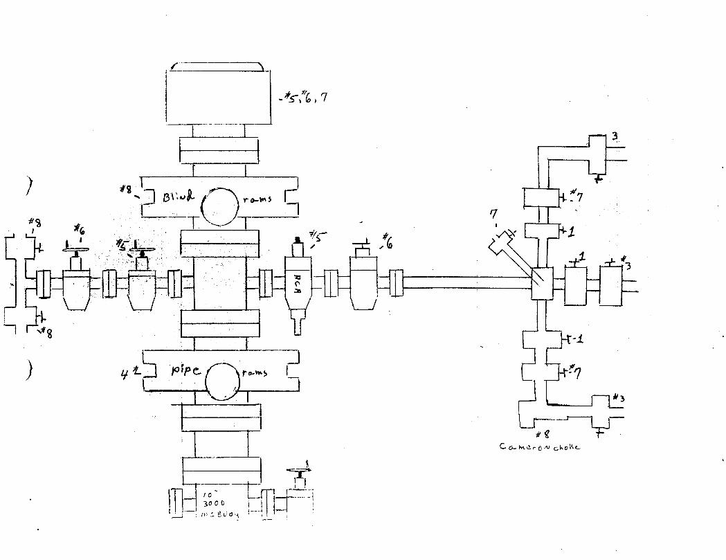
Akt , 7
8\ 7
g i. PPC ry
a (-MerCN Cho O
C c.vos
Akt , 7
8\ 7
g i. PPC ry
a (-MerCN Cho O
C c.vos
Akt , 7
8\ 7
g i. PPC ry
a (-MerCN Cho O
C c.vos

OMPANY LEASE WELL NAM€ # DAT ~)F TEST RIG # ANO NAME
TIME
a. ,- «- n .a o at p 4 a «<4
/ /290 3oop Asd . /Âe. 3 .A va..IC-P.; e inawÂnl//7 2C 2 I //7
/2 / no erA<., e. a.. a / nlÊ
\le . L
».... +L \ .,, , a 4 ,
300 -- /) 1.n /st to c.r
2 Iopno,< † e, d ,. \ , \
scop, h H ur Ah,pA ciaArses s.a ? n 9
no. «r,r a at ¢ 4-0 Ý•tan sna.ata..wis, hat
4-0 4. rrUkt
tipper 14'r.l -ano Jew *100 A L
† ast J.« c.n.» e.» We. 3 y ,.Kr. p p 6.I


b a d'e y .
-••b a d'e y .
-••b a d'e y .
-••

Exxon U.S.A. Inc.UPRC #1
eetg°"y y-« 7- To zfa
Range 7EAdcor #66
4-09-88Tested by Ron Cook
APR15 1988SIONOF
Exxon U.S.A. Inc.UPRC #1
eetg°"y y-« 7- To zfa
Range 7EAdcor #66
4-09-88Tested by Ron Cook
APR15 1988SIONOF
Exxon U.S.A. Inc.UPRC #1
eetg°"y y-« 7- To zfa
Range 7EAdcor #66
4-09-88Tested by Ron Cook
APR15 1988SIONOF

Form OGCC-1 beS TA TE OF UT A H BUBMIT IN TRIPLICATB•
(Other instructions on re•de) È. LBABB DESIGNATION AND SERIAL NO.OlL & GAS CONSERVA
Fee. IF INDIAN, ALLOTTBB OB TRISE NAMESUNDRYNOTICES EPORTSON S
(Do not use this to m toAr r alsoÔ NWa°a*.'a'm•a •"'•"'•"
7. UNIT AORREMENT NAMEorm eAsWELL WELL OTHER
2. waxa or orsaatos u., ma a e, i s. raan om LEASE NAME
Exxon Corporation Attn: Permits Supervisor U.P.R.C.8. Abonnes or ormaAtoa 0. wBLL NO.
P. O. Box 1600, Midland, TX 79702 14. LocATIox or waLL (Report location clearly and in accordance with any State requirementa.* 10. EtBLD AND POOL, 08 WILDCAT
See also space IT below.)At sartaes Undesignated
2335' FNL and 2052' FWL of Sec. 17, (SENW) - 11. asc.,s.,s.,s.,oaar.x.axoSURVET 05 ASEA
BHL (Approx) 2100' FSL and 2500' FEL of Sec. 17, (NESW) Sec. 17, T2N, R7E
14. Paamis No. 15. ELEVATIONS (Show whether DF, RT. 05, sto.) 1Ê. COUNTT 08 PARIBM 18. STATE
43-043-30290 GR 6756.5 Summit Utah
te• ChecicAppropnete BoxTo indicate Natureof Notice, Report,or OtiserDatonowsca or suraxesox so: suassevax: aarons or:
ruer wATER BRUT•OPP PUI.L OR ALTER CAalNG WATER BRUT•Orr REFAIRING WELL
PRACTURE TREAT MULTIPLE COMPLETE FRACTURE TREATMENT ALTERING CAalNO
SHOOT OR ACIDIBE ABANDON* DBOUTINO OR ACIDIEING ABANDONNENT*
REPAIR WELL C11ANGE PLANs (Other) Monthly Drilling Re,porti¯
(Norm: Report results of multiple completion on Wel(Other) ('ompletion or Recompletion Report and Log form.)17. DEscaraE ranPOSED OR CUMl'LETED OPERATioNa (Clearly state all pertinent details, and give pertinent dates, including estimated date of starting any
proposed work. It well is directionally drilled, give subsurface loestions and measured and true vertical depths for all markers and zones perti-neat to this work.) •
4-01-88 thru 4-10-88 Drilling from 3360'-5091'. Run surveys. Function test BOPs, trip forbit and hole in pipe.
4-10-88 Trip pipe, pressure test BOP's (witnessed by Frank Matthews w/ Utah O & G Commission).
4-11-88 thru 4-15-88 Drilling from 5091'-6282', run surveys, function test BOP's, trip forholes in pipe and motor problems.
4-15-88 Encountered drlg break from 6271'-6280'. 63 BBL pit gain. SIDPP 205 psi. Weight upmud w/ salt to 9.9 PPG. To kill water flow.
4-16-88 Back to drilling.
4-17-88 Drilling, drilling break from 6437'-6446'. Well flowed again. SIDPP 200 psi. Built
MW to 10.6 PPG.
4-18-88 thru 4-21-88 Drilling w/ some lost returns, trips for motor problems, fish forsurvey tool.
4-22-88 thru 4-26-88 Drill, trip for motor problems, run surveys. On 4-26, pressure testedBOP' s to 300 psi and 2100 psi (test witnessed by Brad Hill w/ Utah O & G Commission) .
4-26-88 thru 4-30-88 Drilling to 7717'. Function test BOP's.
18. I hproby eer foregotag is true and correct
Administrative Specialist 5-3-88BIGNED TITLE DATEen Johnson(This space r Federal or State omce use)
APPROVED BT TITLE DATECONDITIONS OP APPROVAL, 17 ANT:
*SeeInstructionson iteverse

MAY311988880NOF
DOUBLE JACK TESTING & SERVICES, INC. jgg
B.O.P. Test Report
B.O.P. Test Performed on (date)
Oil Company Exxon
Well Name & Number U.P.P.C. 1
Section 17
Township 2n
Range 7e
County Summit Utah
Drilling Contractor Adcor 66
Oil Company Site Representative John
Rig Tool Pusher.
Tested out of Evanston
Notified Prior to Test Utah oil Gas
Copies of This Test, Report Sent to: Utah
Site Rep
Original Chart & Test Report on File at: Evanton
Tested by: Double Jack Testing & Services, Inc.108 Parkview RoadP.O. Box 2097Evanston, Wyoming

Form OGCC-1 beS TA TE OF U i MI SUBMIT IN TRIPLICATB•
tructions on re·
OIL & GA S CON SERVA TION COMMI SSI fs.naas massonarsoN AND SERIAL NO.
Fee. F 3NDIAN, ALLOTTBB 08 Talas NAME
SUNDRYNOTKESAND REPORTS · LLS(Do not use this form for proposals to drill or to deepen or plug a t eser
Use "APPLICATION FOR PERMIT-" for sueb proposals.)
I· 7. ..., ..... MENTN AME
W LLWABLL O . ... DMSIONCF
s. nam. er or...... OIL,CAD&MININb A. FARM 08 LBASE NAME
Exxon Corporation Attn: Permits Supervisor U.P.R.C.8. annaass or oransson e. was.r. no.
P.O. Box 1600, Midland, TX 79702 14. LOCATION OF WELL (Report location clearly and in accordance with any State requirements.• 10. FIELD AND POOL, 05 WILDCAT
See also space 17 below.)At surtaes Undesignated2335' FNL and 2052' FWL of Sec. 17, (SENW) 11. sac..w.,s.,x.,oast,s.axo
80BTET 08 ABBA
BHL (Approx) 2100' FSL and 2500' FEL of Sec. 17, (NESW) Sec. 17, T2N, R7E14. Pannst No. 15. slavATroxa (Show whether or, RT, en, ete.) 12. Conser os Pants- 1Ë. sTara
43-043-30290 GR 6756.5 Summit Utah
10. CheckAppropnate BoxToIndicate Nature of Notice, Report,or OtherDataNOTICE OF INTENT30N TO: SUBSEQUENT REPORT 07:
TEST WATSB BRUT•OPP PULL OR ALTER CAstNO WATER BHUT•Org REPAIRINO WELL
FRACTURE TREAT MULTIPLE COMPLETE FRACTURE TBBATMENT ALTERING CAalNO
SHOOT OR ACIDIZE ABANDON* BROOTING OR ACIDIEINO ABANDONMENT*
REPAIR WELL CHANGE PLANs X (Other)(NoTE: Report results of multiple completion on Wel
(Other)-
('ompletion er Recompletion Report and Log form.)17. DEscalaE PROPosso OR cuMILETED DPERATIONE (Clearly state all pertinent details, and give pertinent dates, including estimated date of starting any
proposed work. It well is directionally drilled, give subsurface locations and rneasured and true vertical depths for all markers and nones perti-nent to this work.) •
Utah Oil and Gas Commission representative, John Baza, gave verbal approval onMay 31, 1988 to extend the permitted depth for the captioned well to 11,200'.
COPY
18.Administrative Specialist 6-1-
(This space for Federal or State osce use) APPROVED BY THE STATEAPPROVED BY TITLE OF UTAI1 DIVf3\CONDITIONS OF APPROVAL, IF ANY:
OIL GAS AND MINING
*SeeInstructionson
Form OGCC-1 beS TA TE OF U i MI SUBMIT IN TRIPLICATB•
tructions on re·
OIL & GA S CON SERVA TION COMMI SSI fs.naas massonarsoN AND SERIAL NO.
Fee. F 3NDIAN, ALLOTTBB 08 Talas NAME
SUNDRYNOTKESAND REPORTS · LLS(Do not use this form for proposals to drill or to deepen or plug a t eser
Use "APPLICATION FOR PERMIT-" for sueb proposals.)
I· 7. ..., ..... MENTN AME
W LLWABLL O . ... DMSIONCF
s. nam. er or...... OIL,CAD&MININb A. FARM 08 LBASE NAME
Exxon Corporation Attn: Permits Supervisor U.P.R.C.8. annaass or oransson e. was.r. no.
P.O. Box 1600, Midland, TX 79702 14. LOCATION OF WELL (Report location clearly and in accordance with any State requirements.• 10. FIELD AND POOL, 05 WILDCAT
See also space 17 below.)At surtaes Undesignated2335' FNL and 2052' FWL of Sec. 17, (SENW) 11. sac..w.,s.,x.,oast,s.axo
80BTET 08 ABBA
BHL (Approx) 2100' FSL and 2500' FEL of Sec. 17, (NESW) Sec. 17, T2N, R7E14. Pannst No. 15. slavATroxa (Show whether or, RT, en, ete.) 12. Conser os Pants- 1Ë. sTara
43-043-30290 GR 6756.5 Summit Utah
10. CheckAppropnate BoxToIndicate Nature of Notice, Report,or OtherDataNOTICE OF INTENT30N TO: SUBSEQUENT REPORT 07:
TEST WATSB BRUT•OPP PULL OR ALTER CAstNO WATER BHUT•Org REPAIRINO WELL
FRACTURE TREAT MULTIPLE COMPLETE FRACTURE TBBATMENT ALTERING CAalNO
SHOOT OR ACIDIZE ABANDON* BROOTING OR ACIDIEINO ABANDONMENT*
REPAIR WELL CHANGE PLANs X (Other)(NoTE: Report results of multiple completion on Wel
(Other)-
('ompletion er Recompletion Report and Log form.)
17. DEscalaE PROPosso OR cuMILETED DPERATIONE (Clearly state all pertinent details, and give pertinent dates, including estimated date of starting anyproposed work. It well is directionally drilled, give subsurface locations and rneasured and true vertical depths for all markers and nones perti-nent to this work.) •
Utah Oil and Gas Commission representative, John Baza, gave verbal approval onMay 31, 1988 to extend the permitted depth for the captioned well to 11,200'.
COPY
18.Administrative Specialist 6-1-
(This space for Federal or State osce use) APPROVED BY THE STATEAPPROVED BY TITLE OF UTAI1 DIVf3\CONDITIONS OF APPROVAL, IF ANY:
OIL GAS AND MINING
*SeeInstructionson

STATE OF UTAHDIVISION OF OIL, GAS AND MINING
BOPE TEST INSPECTION FORM
COMPANY: )< REPRESENTATIV
WELL NAME: API# f3-QTR/QTR SECTION WELLSIGN TWP RANGE
INSPECTOR: DATE: ' - $ÑDRILLING CONTRACTOR C,o
,RIG
RIG OPERATIONS: // p y
DEPTH / O þ j LAST CASING @ / $0
TEST BY' WATER MUD
PRESSURE RATING F STACK ppp ggt H2S RATED p
TEST PRESSURES /OO / Joo KELLYCOC' : UPPER V LOWER
INSIDE BOP / FULL OPENING VALVE ON FLOOR
WRENCH FOR FULL OPENING VALVE/KELLYCOCK ON FLOOR
STACK - LISTED AS ARRANGED - TOP TO BOTTOM:
ADDITIONAL COMMENTS:
REPORTED BY: PHONE: ÍO/
DATE: Ö~~ SIGNED: ,f-
(IF TESTED BY INDEPENDENT COMPANY, ATTACH COPY OF TEST

Form OGCC-1 beST A TE OF UT A H SUBMIT IN TRIPLICATE*
(Other instructions on re-. LEASE DEBIGNATION AND SERIAL NO.
OIL & GAS CONSERVATION COMMISS Fee
SUNDRYNOTKESAND REPORTS ELLS. 17 INDIAN, ALLOTTER OR TRIBE NAME
(Do not use this to m- toAr rŠCo alsO r 1 r o eepenforr pleprop
La et es
1. 7. UNIT AGREEMENT NAME
*AL WABLL O ....a Monthly Drillinq Report ind0N OF2. NAME OF OPERATOR 8. FARM OR LEASE NAME
Exxon Corporation Attn: Permits Supervisor U.P.R.C.8. ADDBBBS OF OPERATOR 9. WELL NO.
P.O. Box 1600, Midland, TX 79702 14. LOCATION OF WELL (Report location clearly and in accordance with any State requirements.• 10. FIELD AND POOL, 08 WILDCAT
See also space 17 below.)at .arf••• Undesignated11. SEC., T., R., M., OR BLE. AND
2335' FNL & 2052' FWLof Sec. 17 (SENW)""""°"
BHL (Approx) 2100' FSL & 2500' FEL of Sec. 17 (NESW) Ser 17 T?F P7F14. PERMIT NO. 15. ELEVATIoNa (Show whether or, RT, on, sto.) 12. couNTY os'PARIan '1É.sTATE
43-043-30290 GR 6756.5 Summit Iltahle• CheckAppropnote BoxTo Indicate Natureof Notice,Report,or OtherData
NOTICE OF INTENTION 20: BUBSEQURNT REPORT 07:
TEST WATER BRUT•OFF PULL OR ALTER CASING WATER BHUT-OFF REPAIRING WELL
FRACTURE TREAT MULTIPLE COMPLETE FRACTURE TREATMENT ALTERING CASING
SHOOT OR ACIDIZE ABANDON* SHOOTING OR ACIDIZING ABANDONMENT*
REPAIR WELL CHANGE PLANs (Other) Monthly Wil l ing Report x(NoTE: Report results of multiple completion on Wel
¯
(Other) ('ompletion or Recompletion Report and Log form.)
17. DESCRIBE PROPOSED OR CUMPLETED OPERATIONs (Clearly state all pertínent details, and give pertinent dates, including estimated date of starting anyproposed work. If well is directionally drilled, give subsurface locations and measured and true vertical depths for all markers and zones perti-
nent to this work.) *
5-1 thru 5-31-88 Drilling, function and pressure test BOP's, pick up and drill with mudmotor, run surveys.
OILANDGASDRN RJF
JRB GLH
DTS SLS
MICROFILM
]_- FILE
i8. I hpreby certit t foregoing is true and correct
SIGNED « TITLE Administrative Specialist ses 06-10-88eto/ rn lohnson
(This space for Federal or State ofBee use)
APPROVED BT TITLE DATE
CONDITIONS OF APPROVAL, IF ANY :
*SeeInstructionson Reverse

Form OGCC-1 beTATE OF - T IN TRIPLICATE*
ne 5 E DESIONATION AND BERIAL NO.OIL & GASX (S VATIR COMMISSION Fee
N . IF INDIAN, ALLOTTEE OR TRIBE NAMESUNDR'f¯ QTICESAND REPORTSON WE(Do not use this form for sals to drill or to deepen or plug back to a di t
Use TION FOR PERMIT-" for such proposals.)
.
T.UNITAGREEMENTNAME
°w'ir... O 'w'.".... O ..... Monthly Drilling Report2. sama or oPERATOR ---- 8. FARM OB LEASE NAME
Exxon Corporation Attn: Permits Supervisor U.P.R.C.8. ADDRESS 07 OPERATOR 0. WELL NO.
P.O. Box lann Mid1 nd TY 707Û2 16. LocATzox or wELL (ReportilocationfolgiaplARA: accordance with any State requirements.• 10. riiLD ÀÑÌPOOL OR WILDCAT
See also space 17 below.) *
**••dan * Undesignated3JA 11. BBC., T., B., M., OR BLK. AND
2335' FNL & SFTWL DPSWC. 17 (SENW) .oun on a..a
BHL (Approx) 2100' FSL & 2500' FEL of Sec. 17 (NESW) Sec. 17 T?h R7F14. PsaWIT NO. 16. mz.svATzoNs (Show whether pr, mT. 04, etc.) 12. coDNTT on'rantaa '18. -TATE
43-043-30290 GR6756.5 Summit Utahle• CheckAppropnote BoxTo indicate Natureof Notice,Report,or OtherData
NOTICE 07 INTENTION TO: BUSSEQUENT REPORT 07:
TEST WATER SBUT•OUT PULL OR ALTER CASING wATER SHUT-OFF REPAIRING WELL
FRACTURE TREAT hiCLTIPLE COMPLETE FRACTURE TREATMENT ALTERING CAglNG
SHOOT OR ACIDIEE ABANDON* SHOUTING R ACIDIg!NO ABANDONMENT*
REPAIR WELL CIIANGE PLANS (Other) Onth ly UYil l i ng Report T(NOTE: Report restilts of multiple completion on Wel
(Other) ('umpletion or Recompletion Report and Log form.)
17. DESCRIDE PROPOSED OR COMl'LETED OPERATIONs (Clearly state n11 pertinent details, and give pertinent dates, including estimated date of starting anyproposed work. If well is distetionally drilled, give subsurface locations and rneasured and true vertical depths for all markers and zones perti-nut½thiswork.)*
6-1 thru 6-3-88 Drilling, function and pressure test BOP's. Drill to TD of 11,114. Beginlogging. Log through 6-6-88.6-7 & 6-8, run production casing: 0 - 1315' 5 1/2"/20#/SOO-90/BT
1315' - 1921' 5 1/2"/20#|C95/BT1921' - 3055' 5 1/2"/20#|L80/LTC3055' - 8440' 5 1/2"|17#/L80/LTC8440' - 9936' 5 1/2"/23#/P110/LTC9936' - 11112' 5 1/2"/20#/L80/LTC
Two stage cement job: 1st stage - 550 sx CLH w/.4% HRS. TOC 9700' (calc)2nd stage - Lead, 1350 sx HLC w/.4% HR5. Tail, 1000 sx CLHw/.3% HR5
TOC800' (calc)6-9 thru 6-21 WOcompletion rig.6-22 MIRUcompletion rig. NUBOPS6-23 thru 6-26 DODVtool, clean out to 11077'6-27 Ran GR/CLLfrom 11066'-8500'6-28 Perfed: 11000'-10956' (4spf), Swabbed.6-29 Swabbed6-30 Ran Temp. Log
18. I h¢reby certity foregoing is true and correct
BIGNED TIR,E Administrative Specialist say, 07-28-88nson
(This space for Federal or State ofBee use)
APPROVED BT TITLE DATE
CONDITIONS OF APPROVAL, IF ANY:
*SeeInskuenonson

LABORATORY, INC.Bacteriological and Chemical Analysis
40 WEST LOUISEAVENUESALTLAKECTY,UTAH84115
PHONE466-8761
DATE" 08/05/88
CERTIFICATEOFANALYSIS
ELVAY CONSTRUCTIONP.O. BOX 609EVANSTON, WY SS-DO21á.7
82930
SAMPLE: L10UID SAMPLE UPRC #1 FROM EXXON RECEIVED 7-15-88 FORE.P. TOXIC ANALYSIS USING PROCEDURE SWS4 FOR LEACHABLEMETALS STARTING AT 1 P.M.
RESULTS
1-Arsenic as As ms/1 SM304 .006
1-Barium as Ba ms/1 SM303C 1.58 ,
1-Cadmium as Cd ms/1 SM304 <.005
1-Chromium as Cr ms/1 SM304 .020
1-Lead SPike Recovery "/. 98.95
1-Lead as Pb me/1 SM304 <.001
1-Lead eb (duP1) ms/1 SM304 <.001
1-MercurY as He ms/1 SM32OA <.0004
1-Selenium as Se ms/1 SM304 <.001
1-Silver as As me/1 SM304 <.001
1-PH Initial Units 4.75
3-React.as H2S ms/ksEPA376.1 2.40
3-React.as HCN ms/ks EPA9010 <,02I
All reports are submitted as the confidental property of clients. Authorization for publication of our reports, conclusions, or, extracts from or regarding them, is reservedpending our written approval as a mutual protection to clients, the public and

o
LABORATORY, INC.Bacteriological and Chemical Analysis
40 WEST LOUISEAVENUESALTLAKECITY,UTAH 84115
PHONE466-8761
PAGE" 2
CERTIFICATE OF ANALYSIS88-002167
RESULTS
Isnitability-40 CFR 261.21 F. 200
Lieuid "/. E.P. To×ic SW 846 100
Sol ids X EP Toxic SW 846 <.5
FORD LAB RATORY, INC.
Au reports are submitted as the confidental property of clients. Authorization for publication of our reports, conclusions, or, extracts from or regarding them, is reservedpending our written approval as a mutual protection to clients, the public and

Form OGCC-1 beS TA TE OF U TA H STIBMIT IN TRIPLICATE*
LEAaE DESIONATION AND SERIAL NO.
OIL & GAS ONSERV N COMMISSI egIF INDIAN, ALLOTTEE OR TalaE NAME
SUNDRYNOTICESAND REPORTS WE(Do not use this tor:BT T oposals to drill or to deepen or plug back o a A e r
Use * LICATION FOR PERMIT-" for such proposals.)
i. T. UNIT AGREEMENT WÊMB
'wir. Ð 'w^."..= O onthly Drilling Report DILGM AWNFING
È. WARE 07 OFEBATOR 8. Pang om LBAsz NAME
Exxon Corporat4on Attn: Permits Supervisor U.P.R.C.. ADDRESS 07 OPERATOR 9. WELL NO.
P.O. Box 1600, llidlpnd, TX 79702 14. LOCATION OF WELL ROWpyt locatiortfint and in accordance with any State requiremente.• 10. FIELD AND POOL, OB WILDCAT,'L°,gae.1' Undesignated
11. BBC., T., R., M., OR BLE. AND
2335' FNL & 2052' FWEofac. 17 (SENW) *"""******
BHL (Approxtt100' FSL1 2500' FEL of Sec. 17 (NESW) Sec. 17, T2N R7F14. Psau!T NO. 15. -LEVATioNs (Show whether or, mT, on, etc.) 12. covNTY 05 PAalsB 18. BTATE
43-043-30290 GR 6756.5 Summit Utah16. CheckAppropnate BoxTo Indicate Natureof Notice,Report,or OtherData
NOTICE OF INTENT30N 20: 50BBBQUENT REPORT 07:
TEST WATER SEUT•OFF PULL OR ALTER CAalNG WATER SHUT•Orr REPAIRING WELL
FRACTURE TREAT MULTIPLE COMPLETE FRACTURE TREATMENT ALTERING CAalNG
SHOOT OR ACIDIZE ABANDON* BROOTIN R AÇIDiz!NO ABANDONMENT*
REPAIR WELL C1tANGE PLANS (Other) OnthTy D ling Report ¯x¯
(NoTE: Report results of multiple completion on Wel(Other) __
('ompletion or Rrcompletion Report and Log form.)
17. DESCRIBE PROPOSED OR 00MPLETED OPERATIONs (Clearly state all pertinent details, and give pertinent dates, including estimated date of starting anyproposed work. It well is directionally drilled, give subsurface locations and measured and true vertical depths for all markers and zones perti-
nent to this work.) •
7-1 Finish running temp. log.7-2, 3 & 4 Well shut in.7-5, 6 & 7 Swab.7-8 thru 19 Well shut in.7-20 Set CIBP 0 10944', cap w/ 1sx of cmt7-21 Test CIBP to 7000 psi. Perf from 10903' to 10826' (2spf), swabbed.7-22 thru 26 Well SI.7-27 Acidize new perfs w/ 7500 gal of 28% HCL.7-28 thru 31 swab.
ii. Ï hgreby certify at foregoing is true and correct
BIGNED TITLE AdminiStrative Specialist ,,,,08-09-88
, o nson(This space for eral or State omee use)
APPROVED BY TITLE DATE
CONDITIONS OF APPROVAL, IF ANY:
*Seeinstructionson Reverse

Form OGCC•l beSTATE OF UTAH STIBMIT IN TRIPLICATE•
(Other instructions on re-verse side) 5. LEASE DESIONATION AND BERIAL NO.
OIL & GAS CONS2AVATION COMMISSI eeF INDIAN, ALLOTTEE OB TRIBE NAME
SUNDRYNOÌKES AND REPORTS LS(Do not use this form for pro le to drill or to deepen or plug b a eservoir.
Use "APP TION FOR PERMIT-" for such p .) p 4 .
'wi... U 'w'.'a r. O ... ly Dri ll i ng Reports. san.orExÊn
Corporati Attn: PermitsËpLbWäÑlNG U.
8. ADDassa or orsaarom 9. ws&L mo.
P.O. Box 1600, id1a UL19702 14. AalsoN ornw L Re rt locati elearly ee with any State requirements.• 10. FisLD AND POOL, OR WILDCAT
at .arrae. Undesignated11. SEC., T., B., M., OR BLE. AND
2335' FNL& 205É'-.J¾k-of Sec 17 (SENW) .unar on anna
BHL (Approx) 2100' FSL & 2500' FEL of Sec. 17 (NESW) Ser 17 T?N R7F14. PERMIT NO. 15. ELEVATIONs (Show whether or, RT, on, etc.) 12. COUNTY Oik PARtBR 18. 3TATE
43-043-30290 GR 6756.5 Stimmit Utaha• CheekAppropnot. BoxTo Indicate Natureof Notice,Report,or OtherData
NOTICE OF IWTENTION TO: BUBSEQUENT REPORT 07:
TEST WATEE BRUT•Orr PULL OR ALTER CASING WATER BHUT-Orr REPAIRING WELL
FRACTURE TREAT MULTIPLE COMPLETE FRACTURE TREATMENT ALTERING CASING
BHOOT OR ACIDIZE ABANDON* BHOUTIN OR ACIDIEING ABANDONMENT*
REPAIR WELL CIIANGE PLANs (Other) Onthly Dml ing Report ¯¯x¯
(Nors: Report results of multiple completion on Wel(Other) Completion or Recompletion Report and Log form.)
17. DEBCRIDE PnnPOSED OR COMPLETED OPERATIONS (Clearly state all pertinent details, and give pertinent dates, including estimated date of starting anyproposed work. It well is directionally drilled, give subsurface locations and measured and true vertical depths for all markers and zones perti-nent to this work.) •
8-1 Swab8-2 & 3 Well shut in.8-4 Set CIBP @ 10800', cap w/ 1 sx cmt.8-5 Perf. from 10692' - 10720' (2spf), 10574' - 10602' (2spf), swabbed.8-6 Swab, measure influx.8-7 Acidize w/ 6048 gal of 28% HCL. Swabbed.8-8 & 9 Swab.8-10 Swab. Set CIBP @ 10686', cap w/ 1 sx cmt. Swab.8-11 Swab.8-12 Acidize w/ 2503 gal of 28% HCL. Swab.8-13 & 14 Well SI.8-15 Swab.8-16 thru 8-31 Well SI for evaluation.
18. I h¢reby certify foregoing is true and correct¯¯
BIGNED TITLE Administrative Specialist ,,,,09-21-88
(This space for eral or State omce use)
APPROVED BT TITLE DATECONDITIONS OF APPROVAL, 17 ANY:
*SeeInstructionson Reverse
Form OGCC•l beSTATE OF UTAH STIBMIT IN TRIPLICATE•
(Other instructions on re-verse side) 5. LEASE DESIONATION AND BERIAL NO.
OIL & GAS CONS2AVATION COMMISSI eeF INDIAN, ALLOTTEE OB TRIBE NAME
SUNDRYNOÌKES AND REPORTS LS(Do not use this form for pro le to drill or to deepen or plug b a eservoir.
Use "APP TION FOR PERMIT-" for such p .) p 4 .
'wi... U 'w'.'a r. O ... ly Dri ll i ng Reports. san.orExÊn
Corporati Attn: PermitsËpLbWäÑlNG
U.8. ADDassa or orsaarom 9. ws&L mo.
P.O. Box 1600, id1a UL19702 14. AalsoN ornw L Re rt locati elearly ee with any State requirements.• 10. FisLD AND POOL, OR WILDCAT
at .arrae. Undesignated11. SEC., T., B., M., OR BLE. AND
2335' FNL& 205É'-.J¾k-of Sec 17 (SENW) .unar on anna
BHL (Approx) 2100' FSL & 2500' FEL of Sec. 17 (NESW) Ser 17 T?N R7F14. PERMIT NO. 15. ELEVATIONs (Show whether or, RT, on, etc.) 12. COUNTY Oik PARtBR 18. 3TATE
43-043-30290 GR 6756.5 Stimmit Utaha• CheekAppropnot. BoxTo Indicate Natureof Notice,Report,or OtherData
NOTICE OF IWTENTION TO: BUBSEQUENT REPORT 07:
TEST WATEE BRUT•Orr PULL OR ALTER CASING WATER BHUT-Orr REPAIRING WELL
FRACTURE TREAT MULTIPLE COMPLETE FRACTURE TREATMENT ALTERING CASING
BHOOT OR ACIDIZE ABANDON* BHOUTIN OR ACIDIEING ABANDONMENT*
REPAIR WELL CIIANGE PLANs (Other) Onthly Dml ing Report¯¯x¯
(Nors: Report results of multiple completion on Wel(Other) Completion or Recompletion Report and Log form.)
17. DEBCRIDE PnnPOSED OR COMPLETED OPERATIONS (Clearly state all pertinent details, and give pertinent dates, including estimated date of starting anyproposed work. It well is directionally drilled, give subsurface locations and measured and true vertical depths for all markers and zones perti-nent to this work.) •
8-1 Swab8-2 & 3 Well shut in.8-4 Set CIBP @ 10800', cap w/ 1 sx cmt.8-5 Perf. from 10692' - 10720' (2spf), 10574' - 10602' (2spf), swabbed.8-6 Swab, measure influx.8-7 Acidize w/ 6048 gal of 28% HCL. Swabbed.8-8 & 9 Swab.8-10 Swab. Set CIBP @ 10686', cap w/ 1 sx cmt. Swab.8-11 Swab.8-12 Acidize w/ 2503 gal of 28% HCL. Swab.8-13 & 14 Well SI.8-15 Swab.8-16 thru 8-31 Well SI for evaluation.
18. I h¢reby certify foregoing is true and correct¯¯
BIGNED TITLE Administrative Specialist ,,,,09-21-88
(This space for eral or State omce use)
APPROVED BT TITLE DATE
CONDITIONS OF APPROVAL, 17 ANY:
*SeeInstructionson Reverse

Form OGCC-1 be ÛÛÎÊÎ Î$$$ST A TE OF UT A H BUBMIT IN TRIPLICATE*
(Other instructions on re-5. LEASE DESIONATION AND BERIAL NO.
OIL & GAS CONSERVATION COMMISSION $ OF FEEnil na &MININ"U Õ. Er INDIAN, ALLOTTEE OR TRIME NAME
SUNDRYNOTICESAND REPORTSON WELLS(Do not use this form for promosals to drill or to deepen or plug back to a diferent reservoir.
Use "APPLICATION FOR PERMIT-" for such proposals.)
i. . UNIT AGREEMENT NAME
'w't.... O '.'."LI. O .....Monthly Drilling ReportA. WAMS OF OPBBATOR B. FARM 08 LEASE NAME
Exxon Corporatiort Attn: Permits Supervisor U.P.R.C.8. Anommes or oramarom 9. wBLL NO.
P.O. Box 1600, Midland, TX 79702 14. LOCATION OF WELL Report location clearinni in accordance with any State requirements.• 11 risiD AND POOL, ÒB WILDCAT
.','A°.gae.17 ) Undesign ated11. SEC., T., R., M., OR BLE. AND
2335' FNL & 2052' FWLof Sec. 17 a(SENW) soavar on an.«
BHL (Approx) 2100 FSt 2500' FEL of Sec. 17 (NESW) S_ec._17, T2N, R7E14. PERMIT NO. 15. at.svATIONs (8 whether DF, RT, on, etc.) 12. COUNTY 05 PARIsa 18. BTATE
43-043-30290 GR 6756.5 Summit Utah
te· CheckAppropnote BoxTo Indicate Natureof Notice,Report,or OtherDataNOTICE OF INTENTION 20: BUBBBQUENT REPORT 07:
TEST WATER BRUT-Orr PULL OR ALTER CASING WATER SHUT-Org REPAIRING WELL
FRACTURE TREAT MULTIPLE COMPLETE FRACTURE TBEATMENT ALTERING CASING
..oor on acion.._
ABANDON* SHOOTIN E NL+1Ii ngRe^¾N NMENT*
REPAIR WELL CIIANGE PLANs (Other)(NOTE: Report results of multiple completion on Wel
(Other) Completion or Recompletion Report and Log form.)
17. DESCRIBE PROPOSED OR COMPLETED OPERATIONs (Clearly state all pertinent details, and give pertinent dates, including estimated date of starting any
proposed work. It well is directionally drilled. sive subsurface locations and measured and true vertical depths for all markers and zones pert!-
nent to this work.) *
9-1 thru 9-5 Well SI9-6 Swab & Run Temp Log9-7 Run Temp Log, Set CIBP @ 10675' and test to 3000#-0K, Set Cmt retainer @10490',9-8 Pump 200 sx CLGand attempt sqz.9-9 Pump 200 sx CLG and attempt sqz.9-10 Pump 100 sx CLG w/ 1/4# per sx D-29 and 10# per sx d-42, and 100 sx CLG. Got sqz.9-11 SI9-12 Found TOC@ 10480', begin to drill out cmt. & retainer.9-13 Fish for cone, mill.9-14 Drill out to 10658', test sqz - OK.9-15 Set pkr @ 10466', perf Twin Creek @ 10398-10428,10438-10496,10514-10526,10536-10541.9-16 Swab.9-17 thru 9-20 Well SI.9-21 & 9-22 Swab.9-23 thru 9-25 SI.9-26 Acid frac w/ 10000 gal of 28% HCL.9-27 thru 9-29 Swab.9-30 Well SI.
Ïiireby certify at oregoing is true and correct
BIGNED 26 I'
I alU!IllhUIITITLE
Administrative Specialist 10-13-88
(This space for FMeral or State omee use)
APPROVED BT TITLE DATE -
CONDITIONS OF APPROVAI, IF ANY:
*SeeInstructionson Reverse

FormOGCC-1b• NOV07 ggST A TE OF UT A H , IT IN TRIPLICATE*(Other instructions on re•verse side) 5. LEASE DESIONATION AND BERIAL NO.
OIL & GAS CONSERVATION COMMisstoN FEEL .,
-, arm ui läisdi IF INDIAN, ALLOTTEE OR TRIBE NAME
SUNDRYNOTICESAND REPORTSON W LS(Do not use this form for proDosals to drill er to deepen or plug back to a diRerent reservoir.
Use ••APPIACATION POR PERMIT-" for such proposals.)
(, 7. UNIT AGREEMENT NAMS
ar. O 'w^.".... O es...Monthly Drilling Report2. sans or ormastos 8. raan oB LEASE NAME
Exxon Corporation Attn: Permits Supervisor U.P.R.C.8. Anotaas or oramarom 9. wïLE No.
P.O. Box 1600, Midl and, TX 79707 14. LOCATION OF WELL (Report location clearly and.Ju a nedan altasay State requirements.• 10. PiBLD AND POOL, 08 WLDCAT
See also space 17 below.)at .arrae. Undesignated11. SEC., T., B., M., OR BLE. AND
2335' FNL& 2052' FWLof Sec. 17 (SENW) **"''****'
BHL (Approx) 2100' FSL &'2500' FEL""if Sec. 17 (NESW) Sec. 17, T?N, R7F14. PERMIT NO. 15. ELEVATroNs (Show whether DF, RT, OR, ego.) 12. coDNTY 05 PARien 18. BTATE
43-043-30290 GR 6756.5 Summit Utah1•· CheckAppropnote BoxTo indicate Natureof Notice,Report,or ÔtherDato
NOTICE OF INTENTION TO: BUmsmQUENT REPORT 07:
TEST WATER BEUT•OFF PULL OR ALTER CASINO WATER SHUT-Orr REPAIRING WELL
FRACTURE TREAT MULTIPLE COMPLETE FRACTURE TREATMENT ALTERING CABING
BHOOT OR ACIDIEE ABANDON* BBOUTIN OO"n DT 1i n ReoN MENT*
REPAIR WELL CilANGE PLANs (Other)(Notz: Report results of multiple completion on Wel
(Other) ('umpletion or Recompletion Report and Log form.)
17. DESCRIDE PROPOSED OR COMPLETED OPERATIONs (Clearly state all pertinent details, and give pertinent dates, including estimated date of starting anyproposed work. If well is directionally drilled, give subsurface locations and measured and true vertical depths for all markers and zones pertt-
nent to this work.) *
10-1 thru 10-9 Well SI10-10 Set CIBP @ 10565.10-11 Tested CIBP to 3000# - OK, Perfed: 10536 - 10541, 10514 - 10526, 10438 - 10496,
10398 - 10428, 2spf, 218 shots.10-12 & 13 Swab.10-14 Acidized w/ 9500 gal of 28% HCL. Swab.10-15 Swab10-16 SI10-17 Swab10-18 Set CIBP @ 10300' and cap w/ 3 sx cmt. Test to 2000# - OK. Well temporarily abandon.
This well has uphole potential for use as a water disposal well. This use isbeing evaluated.
ii. I hereby certify foregoing is true and correct
BIGNED TITLE Administrative Special ist »,,,11-02-88
(This space to Federal or State omce use)
APPROVED BY TITLE DATE
CONDITIONS OF APPROVAI4 IF ANY:
*Seeinstructionson Reverse

SCIENTIFIC DRILUNG CONTROLS pass / OFSURVEY FIELD REPORT
.n..n. VISO 3970// for DATE:
MrFF i N SURVEYOR: a
LOCATEON: rnethod of calculation SURVEY TYPE:
LEASE: PROPo ol -
MEASURED TRUE VERTICAL VERfiCAL OURSE INC. BEARIMG COOR[5NATES DOG LEGDEPTH DEPTH SECTION DEV PER 100'- M D - M LATITUDE N/S DEPARTURE EM
/od - 700 --
- If ¯ Ñ 5 $¯¯ */ Æ & -30/ J ff200 .
Rod.
-.06
- ½' .5
0.î¯ al .97 i .//«/ .Vsoo .
./ý
- f/T 5 22 g/ .gs s .7/«/ ./f'
) .
£¯t>o.
-.aa t/s ì () .gy s /./3 «/ ..ar
f.VX) . ti.oo . ./$
¯ á 5 AÍT / .14', 5 .73
/ x->ÑÔ . (o g9 .¶ j 30 / - 5 - f /. ;195
.9 t' ..y/
800 - 991 -% 3.ot. /- Ñ 5 E- 1 /gs 4.77 E m9'00 - 399 .W Š~3] A- ŸÝ $Ÿ¯ Ê /.79 5 A.sf E .5/
//200 . 9¾.T.'t 9.4/ R- f¢ Ngf- 6 /rs ya.x£ .st,
poo . // 99 .a a .49 3 -'/A Al'?? E .x, # a .we ¢/93/)ð . IMR .m
A. .W 3-W a) 5 J.s3 n/ x>.o;J .,g
/f'd0 . /399 .10 )R.4n V¯ .1.714 Al B.ts-E .Þ/4/få
. /Wt' M m .99
f¯ il skr ¥ av.tot o
THE HOnt2¢ NTAL DISPLAt EMENT AT THE DEPTH WHITE - CUEFOMER FILE
OF muAI.SE OW-O i

Fo O 3 SUBal;T IN DUPLIC * 56 64 01STATE OF AH (See other instructd
on reverse side)/ DEPARTMENT OF NATURAL RESOURCES
DIVISION OF OIL, GAS, AND MINING 5. LEASE DESIGNATION AND BERIAL NO.
Fee
WELLCOMPLETION OR RECOMPLETIONREPORTAND LOG *8. IF INDIAN, ALLOTTBB OB TRIBE NAME
ta. TYPE OF WELL. Ott, GAsWELL WELL DET
7. UNIT AGREEMENT NAME
b. TYPE OF COMPLETION:
ELORIC EP- IFS
R.' S. - om EAsa M
2. NAME OF OPERATÕR NOV ·F·a.c.9. wELI. NO.
Evvon Corp,3. Anonzas or orsaATom uraiúbl GF 1
P.O. Box 1600, Midland, Tx 79702 011 ßAR&MINING 10. FIELD AND POOL, 08 WILDCAT
4. LOCATroN or WELL (Report location clearly and in accordance toith any ßtatereg iresiann)• Undesignatedat surta** 2335' FNL & 2052 FWL of Sec 17 (SENW) 11. sec., t., a., x., OR BLOCK AND BOBTRY
OR ABBA
At top prod. interval reported below
At total depth 2592' FWL & 22 O' FSL of sec 17 Sec 17, T2N, R7E
14. PERMIT NO- DATE ISSt'ED 12. COUNTY 08 13. BTATEPARISH
43-043-30290 | 2-24-Š8 Summitt UtahIS. DATE SPCDDED 16. DATE T.D. REACEIED 11 DATE COMPL. (Ready to prod.) 18. ELEVATIONs (Dr. maa, BT, GB, ETC.)e 19. ELET. CAszNGHEAD
3-22-88 i 6-3-88 N/A | GR 6756.5 I N/A20. 1WrAL DEPrR. ED & TVD 21. PLUO, 3ACK T,D,. MD A TVD 22. IW Mt LTIPLE COMPL., 23. INTERVALS ROTART TOOLS CABLE TOOLS
HOW MANT* DRILLED BTMD-11097,TVD-11008 10300 X
24. PRODUCING INTERVAL(S), OF THIS COMPLF.TION-TOP, BOTTON, NAME (MD AND TTD). 25. wAB DIRECTIONALSURTET MADE
Non Yes
6. TT38 ELECTRIC AND OTHER LOGli li;Ñ 27. WAS WELL COBSD
DLL/MSFL , SDT, LDT/CNL, FMS, WST No
28 CARING RECORD (Report all strings set in socil)
CASIN'r-BizE WEIGHT. LB/FT. DEFTH SET (MD) HOLE sigg CEMENTING RECORD AMOUNT PULLED
conductor 16" line pipe 120 26 60 sx. approx.
9 b 8 40 1545 12¼ 500 sx HLC,185sx CLH,150s> CLH
2Õ 7 3 11112 8 3/4 2900 sx CLH
29 LINER RECORD 30. TUBING RECORD
RI TOP (MD) TTOM (MD) 5ACK5 CENENT* SCREEN (MD) SIžE DEPTE BET (MD) PACKgm SET (MD)
7 7 /A 1021A
31. FEBVORATION n so (interval, a and number) 32. ACID. SHOT. FRACTURE. CEMENT SQUEEZE, ETC.
11000-10956 4 SPF DEPTR INTERVAL (MD) AMOUNT AND KIND OF MATERIAL 065D
10903-10826 2 SPF CIBP @ 10944 Cap w/ 1 sx cmt.10692-10720, 10574-10602 2 SPF 10903-10826 7500 Gal 28% HCL10398-10541 2 SPF (sqz'd and reperfed) CIBP @ 10800 Cap w/ 1 sx cmt.
10574-10720 6048 Gal 28% HCL. Cont. on Back.33.• PRODUCTION
DATS FIRST PRODUCTICE I PRODUCTION METIEG*> (Flotoing, gas lift, pumping--eise end igge of pump) WELL BTATUS (Pr0ANCing orsAst-in)
DATE OF TEST HOCES TESTED CHOKE RIZE PROD'N. FOR OIL-BÉL. r.AS--MCF. WATEtt--BBL. GAS•OIL BATIOTEST PERIOD 1
PLOW. TUmlNO FRama. | CASING PRESSCRE at.CULATRO IL-BBL GAS-MCF. WATER--BBL OIL GRATITT-API (CORE.)
34. DISPOSiTION OF GAS (ÑOld, sagd for fugl, Wi€d, etc.) TSET WITNESSED BT
35. LlaT or ATTACEMENTS
T,DGS Di Tert innM Snrvev form ner-A-Y30. I hereËlycertify that foregoing lin attarbed information is complete and correct av determined from all available records
SIGNED TITLE Administrative Specialist DATE 11-11-88Rf en .Tohnson
*(SeeInstructionsand Speensfor Additional Data on Reverse
Fo O 3 SUBal;T IN DUPLIC * 56 64 01STATE OF AH (See other instructd
on reverse side)/ DEPARTMENT OF NATURAL RESOURCES
DIVISION OF OIL, GAS, AND MINING 5. LEASE DESIGNATION AND BERIAL NO.
Fee
WELLCOMPLETION OR RECOMPLETIONREPORTAND LOG *8. IF INDIAN, ALLOTTBB OB TRIBE NAME
ta. TYPE OF WELL. Ott, GAsWELL WELL DET
7. UNIT AGREEMENT NAME
b. TYPE OF COMPLETION:
ELORIC EP- IFS
R.' S. - om EAsa M
2. NAME OF OPERATÕR NOV ·F·a.c.9. wELI. NO.
Evvon Corp,3. Anonzas or orsaATom uraiúbl GF 1
P.O. Box 1600, Midland, Tx 79702 011 ßAR&MINING 10. FIELD AND POOL, 08 WILDCAT
4. LOCATroN or WELL (Report location clearly and in accordance toith any ßtatereg iresiann)• Undesignatedat surta** 2335' FNL & 2052 FWL of Sec 17 (SENW) 11. sec., t., a., x., OR BLOCK AND BOBTRY
OR ABBA
At top prod. interval reported below
At total depth 2592' FWL & 22 O' FSL of sec 17 Sec 17, T2N, R7E
14. PERMIT NO- DATE ISSt'ED 12. COUNTY 08 13. BTATEPARISH
43-043-30290 | 2-24-Š8 Summitt UtahIS. DATE SPCDDED 16. DATE T.D. REACEIED 11 DATE COMPL. (Ready to prod.) 18. ELEVATIONs (Dr. maa, BT, GB, ETC.)e 19. ELET. CAszNGHEAD
3-22-88 i 6-3-88 N/A | GR 6756.5 I N/A20. 1WrAL DEPrR. ED & TVD 21. PLUO, 3ACK T,D,. MD A TVD 22. IW Mt LTIPLE COMPL., 23. INTERVALS ROTART TOOLS CABLE TOOLS
HOW MANT* DRILLED BTMD-11097,TVD-11008 10300 X
24. PRODUCING INTERVAL(S), OF THIS COMPLF.TION-TOP, BOTTON, NAME (MD AND TTD). 25. wAB DIRECTIONALSURTET MADE
Non Yes
6. TT38 ELECTRIC AND OTHER LOGli li;Ñ 27. WAS WELL COBSD
DLL/MSFL , SDT, LDT/CNL, FMS, WST No
28 CARING RECORD (Report all strings set in socil)
CASIN'r-BizE WEIGHT. LB/FT. DEFTH SET (MD) HOLE sigg CEMENTING RECORD AMOUNT PULLED
conductor 16" line pipe 120 26 60 sx. approx.
9 b 8 40 1545 12¼ 500 sx HLC,185sx CLH,150s> CLH
2Õ 7 3 11112 8 3/4 2900 sx CLH
29 LINER RECORD 30. TUBING RECORD
RI TOP (MD) TTOM (MD) 5ACK5 CENENT* SCREEN (MD) SIžE DEPTE BET (MD) PACKgm SET (MD)
7 7 /A 1021A
31. FEBVORATION n so (interval, a and number) 32. ACID. SHOT. FRACTURE. CEMENT SQUEEZE, ETC.
11000-10956 4 SPF DEPTR INTERVAL (MD) AMOUNT AND KIND OF MATERIAL 065D
10903-10826 2 SPF CIBP @ 10944 Cap w/ 1 sx cmt.10692-10720, 10574-10602 2 SPF 10903-10826 7500 Gal 28% HCL10398-10541 2 SPF (sqz'd and reperfed) CIBP @ 10800 Cap w/ 1 sx cmt.
10574-10720 6048 Gal 28% HCL. Cont. on Back.
33.• PRODUCTION
DATS FIRST PRODUCTICE I PRODUCTION METIEG*> (Flotoing, gas lift, pumping--eise end igge of pump) WELL BTATUS (Pr0ANCing orsAst-in)
DATE OF TEST HOCES TESTED CHOKE RIZE PROD'N. FOR OIL-BÉL. r.AS--MCF. WATEtt--BBL. GAS•OIL BATIOTEST PERIOD 1
PLOW. TUmlNO FRama. | CASING PRESSCRE at.CULATRO IL-BBL GAS-MCF. WATER--BBL OIL GRATITT-API (CORE.)
34. DISPOSiTION OF GAS (ÑOld, sagd for fugl, Wi€d, etc.) TSET WITNESSED BT
35. LlaT or ATTACEMENTS
T,DGS Di Tert innM Snrvev form ner-A-Y30. I hereËlycertify that foregoing lin attarbed information is complete and correct av determined from all available records
SIGNED TITLE Administrative Specialist DATE 11-11-88
Rf en .Tohnson*(SeeInstructionsand Speensfor Additional Data on Reverse

INSTRUCTIONS
General: This form is desigred for subruitting a compleb and correct =cu c,npletka repare and Mg on all types of lands and leases to either a Federal agency or a State agency,
or both, pursuant to applicable Federal and/or Sde laws and r solsUan Any ssary apwia! Instructions concerning the use of this form anti the at:Inber of cogiles to be
subudtted, particularly with regard to local, area, Sr regional p av:ee sud pr a lees. either are shown below or will be issued by, or may be obtained from, the local Federal
and/or State odo See instructious on items 22 and 24, and 33 w reaardag separate reywta for separate etunpletions.
If not filed prhe u die time this summary reco:d la submitted a of all cerently a allaMe log (drillers, geciogista. sample and core analysis, all types electric, etc.), forma-
tion and pressure tests, and ecdonal earvey:t abould be aistléã herete e the extent reqaked by applicable Federal end/or State laws and regulations. All attachments
should be listed on this form. see item 35.Stem 4: If there are no applicable State requirementa, lõeations en Federal er Indian land abould be described in accordance with Federal requirements. Consult local State
or Federal ofilce for specific instructions.Ifm 18: Indicate whteh elevation is used as reference (where not otherwim show >r depth treasure:nenta given in other spaces on this form and in any attachments.
items 22 awd 20 If this well a vaalpleted for separate production from raare than e interval zone (multiple completion), so state in item 22, and in item 24 show the producing
interval, >r intervals, top(s), bottom(s) and uame(s) (if any) for only the interval reported in item 88. Submit a separate report (page) on this form, adequately identified,
for each additional interval to be separately produced, showing the additlanal data pertinent to such interval.
item 29: "ßacks Cement". Attached supplemental records for this well should show the details of any multiple stage cementing and the location of the cementing tool.
Item 33: Submit a separate completion report on this form for each interval to be separately produced. (See instruction for items 22 and 24 above.)
*Item 32 Cont. CIBP @ 1067510398-10541,Acidize w/ 95- GAL
CIBP @ 10686,Cap w/ 1 sx cmt. SQZ perfs @ 10602-10574 w/ 500 sx CLG of 28% HCL
10574-10602, Acidized w/ 2503 Gal of 28% HCL 10398-1021, Acid-Frac w/ 10000 Gal 28% HCL
CIBP @ 10565 CIBP @ 10300, Cap w/ 3 sx cmt.
37. BUMMARY OF POROUS ZONES:BHOW ALL IMPORTANT EONES OF POROBITT AND CONTENTS THEREOF; CORED INTERVALB; AKD ALL DRILL-STEM TESTB, INCLUDzme 38. GEOLOGIC MARKERS
DEPTH INTBBVAL TESTED, CUSBION USED, TIME TOOL OPEN. FLOWING AND BHUT-IN PREBOURRE, AND RECOTERESS
FORMATION TOP gOgg DESCRIPTION, CONTENTS, BTC• TOFNAME
Nugget MD 10956 Md 11000 Watermaan. omera ransvaar.narra
TVD 10867 TVD 10911 Bear River 3726 3691
Twin Creek MD 10826 MD 10903 Water Kelvin 4230 4184
TVD 10737 TVD 10814
Twin Creek MD 10574 MD 10602 DRYStump 6367 6297
TVD 10486 TVD 10514 Preuss 6910 6836
Twin Creek MD 10398 MD 10541 Dry Preuss Salt 8813 8728
TVD 10310 TVD 10453Twin Creek 9446 9360
Gypsum Spring 10917 10828
Nugget 10947 10858
INSTRUCTIONS
General: This form is desigred for subruitting a compleb and correct zeß conplettaa report and Mg on all types of lands and leases to either a Federal agency or a State agency,
or both, pursuant to applicable Federal and/or Sde laws and r geistbe Any ssary apwia! Instructions concerning the use of this form anti the nuinber of coglies to be
subudtted, particularly with regard to local, area, Sr regional y av:ee sud pr a lees. either are shown below or will be issued by, or may be obtained from, the local Federal
and/or State o&:e See instructious on items 22 and 24, and 33 w reaardag separate reywta for separate etunpletions.
If not filed prhe a die time this sammary reco:d la submittei e of all cerently a allaMe log (drillers, geciogista. sample and core analysis, all types electric, etc.), forina-
tion and pressure tests, and eedenal earvey:t abould be a herete o the extent reqaked by applicable Federal end/or State laws and regulations. All attachments
should be listed on this form. see item 35.Stem 4: If there are no applicable State requirementa, lõeations en Federal er Indian land abould be described in accordance with Federal requirements. Consult local State
or Federal office for specific instructions.itre: 18: Indicate which elevation is used as reference (where not otherw½e show r depth measure:nenta given in other spaces on this form and in any attachments.
items 22 awd 20 If this well b emapleted for separate production from mare than e interval zone (multiple completion), so state in item 22, and in item 24 show the producing
interval, >r intervals, top(s), bottom(s) and uame(s) (if any) for only the interval reported in item 88. Submit a separate report (page) on this form, adequately identified,
for each additional interval to be separately produced, showing the additlanal data pertinent to such interval.
item 29: "ßacks Cement". Attached supplemental records for this well should show the details of any multiple stage cementing and the location of the cementing tool.
Item 33: Submit a separate completion report on thier form for each interval to be separately produced. (See instruction for items 22 and 24 above.)
*Item 32 Cont. CIBP @ 1067510398-10541,Acidize w/ 95- GAL
CIBP @ 10686,Cap w/ 1 sx cmt. SQZ perfs @ 10602-10574 w/ 500 sx CLG of 28% HCL
10574-10602, Acidized w/ 2503 Gal of 28% HCL 10398-10gl, Acid-Frac w/ 10000 Gal 28% HCL
CIBP @ 10565 CIBP @ 10300, Cap w/ 3 sx cmt.
37. BUMMARY OF POROUS ZONES:BNOW ALL IMPORTANT EONES OF POROBITT AND CONTENTS THERBOF; CORED INTERVALB; AKD ALL DRILL-STEM T-STS, INCLUDzme i 38. GEOLOGIC MARKERS
DEPTH INTBBVAL TESTED, CUSBION UBSD, TIME TOOL OPEN. FLOWING AND BBUT-IN PREBBURRE, AND RECOTERIES•
FORMATION Tor nomi DESCRIPTION, CONTENTS, BTC. ggyNAME
Nugget MD 10956 Md 11000 Watermaan. omrra ransvaar.narra
TVD 10867 TVD 10911 Bear River 3726 3691
Twin Creek MD 10826 MD 10903 Water Kelvin 4230 4184
TVD 10737 TVD 10814
Twin Creek MD 10574 MD 10602 DRYStump 6367 6297
TVD 10486 TVD 10514 Preuss 6910 6836
Twin Creek MD 10398 MD 10541 Dry Preuss Salt 8813 8728
TVD 10310 TVD 10453Twin Creek 9446 9360
\ Gy um Spring 10 7
donstaley
Highlight
donstaley
Highlight

Form OGCÇ•1beSTATE OF UTAH st'ButT IN TatPLicATE•
(Otbe i structione en re-
OIL & GAS CONSERVATION COMMISSIOINDIAN. ALLOTTRE 05 TRIS AMS
SUNDRYNOTICESAND REPORTSO £5(Do not see this form for r als to drill or to deepen or pl g ba NSti t reservoir.
Use "A TION FOR PERMIT-" for su pro .)
MIT AOBBEMENT MAME
'wir.» © 'w'." O ..... Month1,y Drilling Report. MARS OF OPB4&t0g
ÃBM OB LEASE MAME
ExxorrCorporation Attn: Permits Supënriser U P.R.C.8. Assuse or orsages
¯wBl.LNO.
P.O. Box 1600, Midland, TX 79702 14. WCATion or WELL Reportlocation eÍearly and to accordance with any State requirements.• 10 WIELD AWD POOL, OB WILDCAT
2.°.'&°."'''" Undesignated11. BBC., T., B., M., 05 BLE. AND
2335' F‡it 8052tFWL of Sec. 17 (SENW) * "" ***"*
BHL(Approx) 2:100' FSL & 2500' FEL of Sec. 17 (NESW) Sec, 17, T2N, R7F14. PERMIT NO. 15. Bl2VATaoNa (Show whether Dr. -T. on, ete.) 12. couNTT Os Paalan 18. stats
43-043-30290 GR 6756.5 Summit Utah
ChecicAppropnoteËoxToIndicofeNatureof Notice,Report,or OtherDatamorsca or suransson wo: susasecas: aarost or:
TERT WATER BRUT•0FF PULL OB ALTER Cas!NO WATER BRUT•0FF REPAtatNG WELL
FRACTURE TBBAT MULTIPLE COMPLETE PRACTURE TBEATMENT ALTERIWG Cas!NO
ENOOT OR AClblzE ABANDON* SHOUTIN 000 e a no Asa0NWNNENT*
BUPAIR WELL C11ANGE PLama (Other) 9 $(Nors: Report results of multiple completion on Wel
(Other) Completion ur Recompletion Report and Log form.)
17. DEscalat rnnPOSED OR fuMPLETED OPERATIONS (Clearly state all pertinent details, and give pertinent dates. including estimated date of starting any
proposed work. It well is directionally drilled. sive subsurface locations and measured and true vertical depths for all markers and annes perti-
ment to this work.) •
10-1 thru 10-9 Well SI10-10 Set CIBP 0 10565.10-11 Tested CIBP to 3000# - OK, Perfed: 10536 - 10541, 10514 - 10526, 10438 - 10496,
10398 - 10428, 2spf, 218 shots.10-12 & 13 Swab.10-14 Acidized w/ 9500 gal of 28% HCL. Swab.10-15 Swab10-16 SI10-17 Swab10-18 Set CIBP 9 10300' and cap w/ 3 sx cmt. Test to 2000# - OK. Well temporarily abandon.
This well has uphole potential for use as a water disposal well. This use isbeing evaluated.
18. I aprebycertify tha e foregoing is true an6 correct
BIGNED TITI.E Administrative Specialist 11-02-88
%†e en .inhntnn
(Tbie space for Federal or State oSce see)
APPROVED ST TITLE DATE
CONDITIONS OF APPROVAL. 17 ANT:
*S., Instructionson Reverse
Form OGCÇ•1beSTATE OF UTAH st'ButT IN TatPLicATE•
(Otbe i structione en re-
OIL & GAS CONSERVATION COMMISSIOINDIAN. ALLOTTRE 05 TRIS AMS
SUNDRYNOTICESAND REPORTSO £5(Do not see this form for r als to drill or to deepen or pl g ba NSti t reservoir.
Use "A TION FOR PERMIT-" for su pro .)
MIT AOBBEMENT MAME
'wir.» © 'w'." O ..... Month1,y Drilling Report. MARS OF OPB4&t0g
ÃBM OB LEASE MAME
ExxorrCorporation Attn: Permits Supënriser U P.R.C.8. Assuse or orsages
¯wBl.LNO.
P.O. Box 1600, Midland, TX 79702 14. WCATion or WELL Reportlocation eÍearly and to accordance with any State requirements.• 10 WIELD AWD POOL, OB WILDCAT
2.°.'&°."'''" Undesignated11. BBC., T., B., M., 05 BLE. AND
2335' F‡it 8052tFWL of Sec. 17 (SENW) * "" ***"*
BHL(Approx) 2:100' FSL & 2500' FEL of Sec. 17 (NESW) Sec, 17, T2N, R7F14. PERMIT NO. 15. Bl2VATaoNa (Show whether Dr. -T. on, ete.) 12. couNTT Os Paalan 18. stats
43-043-30290 GR 6756.5 Summit Utah
ChecicAppropnoteËoxToIndicofeNatureof Notice,Report,or OtherDatamorsca or suransson wo: susasecas: aarost or:
TERT WATER BRUT•0FF PULL OB ALTER Cas!NO WATER BRUT•0FF REPAtatNG WELL
FRACTURE TBBAT MULTIPLE COMPLETE PRACTURE TBEATMENT ALTERIWG Cas!NO
ENOOT OR AClblzE ABANDON* SHOUTIN 000 e a no Asa0NWNNENT*
BUPAIR WELL C11ANGE PLama (Other) 9 $(Nors: Report results of multiple completion on Wel
(Other) Completion ur Recompletion Report and Log form.)
17. DEscalat rnnPOSED OR fuMPLETED OPERATIONS (Clearly state all pertinent details, and give pertinent dates. including estimated date of starting any
proposed work. It well is directionally drilled. sive subsurface locations and measured and true vertical depths for all markers and annes perti-
ment to this work.) •
10-1 thru 10-9 Well SI10-10 Set CIBP 0 10565.10-11 Tested CIBP to 3000# - OK, Perfed: 10536 - 10541, 10514 - 10526, 10438 - 10496,
10398 - 10428, 2spf, 218 shots.10-12 & 13 Swab.10-14 Acidized w/ 9500 gal of 28% HCL. Swab.10-15 Swab10-16 SI10-17 Swab10-18 Set CIBP O 10300' and cap w/ 3 sx cmt. Test to 2000# - OK. Well temporarily abandon.
This well has uphole potential for use as a water disposal well. This use isbeing evaluated.
18. I aprebycertify tha e foregoing is true an6 correct
BIGNED TITI.E Administrative Specialist 11-02-88
%†e en .inhntnn
(Tbie space for Federal or State oSce see)
APPROVED ST TITLE DATE
CONDITIONS OF APPROVAL. 17 ANT:
*S., Instructionson Reverse
donstaley
Highlight
donstaley
Highlight

56 64 03FILE IN TRIPLICATEFORMOGC-8-X
STATEOF UTAHDEPARTMENTOF NATURALRESOURCES'1 "
DIVISION OF OIL, GASANDMINING ,0
1588 West North TempleSalt Lake City, Utah 84116
*REPORTOF WATERENCOUNTEREDDURINGDRILLING*
(um Name & Mumbeg u.v.a.c. #1
Ogg/gg‡QA Exxon Corporation gg¿ P.O. Box 1600, Midland, TX 79702
Ogg‡);ggggg Adcor Drilling, Inc. 4 1625 Broadway, Ste. 2180, Denver, CO
80202l.OCAfÂOR Ê€C. 17 f. 2N 2, 7E (g Summit
Water Sands
Volume Quality
From To Flow Rate or Head Fiesh or Salty
1, 6271 6280 205 SIDPP with 8.7 ppg mud weight* Fresh
2.
3.
4.
5.(Lontinue of reverse side if necessary)
* Estimated Bottom Hole Pressure of 3,042 psi (9.3 ppg Pore Pressure)
Fannation TogoFlow occurred in the Kelvin FormationKelvin formation occurs from 6278' to 6288' (log meas.)RemaAh.a
NOTE: (a) Repoxt on t.h¿a goAm as prov¿ded goa¿n Rule C-20, Gened Rufea
and Regulat¿ono and Rules og PAact¿ce and PAoceduAe.
(b) Ig aunter analysia has been made og the above reposted zone,pteas e goasaanda copy along su¿th th¿a
56 64 03FILE IN TRIPLICATEFORMOGC-8-X
STATEOF UTAHDEPARTMENTOF NATURALRESOURCES'1 "
DIVISION OF OIL, GASANDMINING ,0
1588 West North TempleSalt Lake City, Utah 84116
*REPORTOF WATERENCOUNTEREDDURINGDRILLING*
(um Name & Mumbeg u.v.a.c. #1
Ogg/gg‡QA Exxon Corporation gg¿ P.O. Box 1600, Midland, TX 79702
Ogg‡);ggggg Adcor Drilling, Inc. 4 1625 Broadway, Ste. 2180, Denver, CO
80202
l.OCAfÂOR Ê€C. 17 f. 2N 2, 7E (g Summit
Water Sands
Volume Quality
From To Flow Rate or Head Fiesh or Salty
1, 6271 6280 205 SIDPP with 8.7 ppg mud weight* Fresh
2.
3.
4.
5.(Lontinue of reverse side if necessary)
* Estimated Bottom Hole Pressure of 3,042 psi (9.3 ppg Pore Pressure)
Fannation TogoFlow occurred in the Kelvin FormationKelvin formation occurs from 6278' to 6288' (log meas.)RemaAh.a
NOTE: (a) Repoxt on t.h¿a goAm as prov¿ded goa¿n Rule C-20, Gened Rufea
and Regulat¿ono and Rules og PAact¿ce and PAoceduAe.
(b) Ig aunter analysia has been made og the above reposted zone,pteas e goasaanda copy along su¿th th¿a

EgON COMPANYU.S.A.POST OFFICE BOX 1600 • MIDLAND, TEXAS79702-1600
PRODUCTION DEPARTMENTSOUTHWESTERN DIVISION
DMSIONOFOIL.GAS&MINING
January 26, 1989
U.P.R.C. #1Section 17, T2N, R7ESummit County, Utah
Utah Oil & Gas Conservation Commission355 West North TempleState Office Building3 Triad Center, Suite 350Salt Lake City, Utah 84180-1203
Attached is the directional survey you requested for the captioned well. If Ican be of further assistance, please call me at (915) 688-7548.
Step en JohnsonAdministrative Specialist
SJJ:jmfAttachment
il Jo.9/
A DIVISION OF EXXON

Division of Oil, Gas and MiningPHONE CONVERSATION DOCUMENTATION FORM
Route origina1/copy to:[ ] Well File f / C'-. * Suspense E] Other
(Return Date) A////9(Location) SecG_Twp .M Rng 7e (To - Initials) /Ál,5.(API No.) #f ç</3- .Jo..zf d
1. Date of Phone Call: g//4/77 Time: /a A
2. DOGM Employee (name) (Initiated Call M)Talked to:
Name (Initiated Call t 3) - Phone No. (fo / ) 7/f- o3.5/
of (Company/Organization) wo-
3. Topic of Conversation:
4. Highlights of Conversation:

Mision of Oil, Gas and MiningPHONE CONVERSATION DOCUMENTATION FORM
Route original/cop oE3 Well File ! f. # | û s Other
(Location) Secfy_Twp2.Al Eng '¯ff (Ti IKißaË)(API No.) 43 04 3 3r>2.97)
1. Date of Phone Call: 2 -23 9() Time: It'.OO
2. DOGM Employee (name) IC)¢4 (Initiated CallTalked to:
Nam 601... (Initiated Call t]) - Phone No. ( / )¾9-
of (Company/Organization) XV ŸÑA3 4.e
3. Topic of Conversatio t.t?S t c'r7OA NW , A tL
4. Highlights of Conversation: .A a.» a 9 r2.7.r./ Â, 44py Âg

Division of Oil, Gas and HiningPHONE CONVERSATION DOCUMENTATION,FORM
[3 e/copy
[] Suspense l3 Other(Return Date)
(Location) Sec/ATwp NRng Ÿk (To - Initials)(API No.) 44 -Ð¥A -.302 fo
1. Date of Phone Call: Ÿ 2 Ÿ Í Time: I dû N
2. DOGM Employee (name) 4 (Initiated CallTalked to:
Nam if (I itiated Call E ) - Phone No. Ñ/ÖÁ 700
of (Company/Organ ation)
3. Topic of Conversation: / ,.4 //
4. Highlights of

Division of 011, Gas and MiningPRONE CONVERSATIO DOCUMENTATION-FORM
Route oer g /copy.. E] Suspense EJ Other
(Return Date)(Location) See) NpÀN Rng & (To - Initials)(API No.) 44 Ð¥d -.3oA9e
1. Date of Phone Call: 9 / Time: 0 N
2. DOGeMEmployee (name) (Initiated Call
Nam if a., ( nitiated Call [ ]) - Phone No. Ñ. ÁÑ~~Á/00
of(Company/Organ° ation)
3. Topic of Conversation: ,4 // ..
4. Highlights of

Division of Oil, Gas and MiningPHONE CONVERSATION DOCUMENTATION FORM
Route original/copy
E] Well File E] Other
(Location) Se(API No.) g
1. Date of Phoa & ' 3c (V) - 7pg /
2. DOGM Emy & I (Initiated CallTalked to: / L'c ' D .
Nam No. 9/ /Ñ /00
of (Compan
3. Topic of Cor
4. Highlights
6-mE OREenemä suNd00 EinoCSŒt tR LtE UPRC 6Uma ittE 3 ŸPO43 30ZSO
YodMIE AM &oESTr½ (Alt m5 (910 636¾48, faW1 ff 7ebw
a) / Co &5

Div sion of Oil, Gas and a .
PHONE CONVERSATION DOCUMENTATION FORM
Route original/cop to'E3 Well File i f Úf. # | Suspense Other
(Returnþate)(Location) SecgTwp2]O Rng '77 (To - Initials)(API No.) 43 043 3DZ97)
1. Date of Phone Call: 2--23 W) Time: / I'. OO
2. DOGM Employee (name) 10<'t (Initiated CallTalked to:
Nam y of.- (Initiated Call t 3) - Phone No. ( / )¾9of (Company/Organization) yyp Ffe 3 4 t -
Topic of Conversatio S t&C'TTC)A Mr1 , Ñ.40
4. Highlights of Conversation: \,--7 rz/w/ ,Âr r ÁÎa

v sion of Oil, Gas and HiniPHONE CONVERSATION DOCUMENTATION FORM
Route original/copy to:[3 Well File g/ 6// Suspense t ] Other
(Return Date)(Location) SecŒTwp .M Rng yr (To - Initials) AAS.(API No.) ¢,/- ¾/3- Jopa
1. Date of Phone Call: (//4/JP Time: /a A
2. DOGM Employee (name) (Initiated Call M)Talked to:Name (Initiated Call t 3) - Phone No. (fo/ ) 7/6 o3.3/
of (Company/Organization) ymp/
3. Topic of Conversation:
4. Highlights of Conversation: ,,/
v sion of Oil, Gas and HiniPHONE CONVERSATION DOCUMENTATION FORM
Route original/copy to:[3 Well File g/ 6// Suspense t ] Other
(Return Date)(Location) SecŒTwp .M Rng yr (To - Initials) AAS.(API No.) ¢,/- ¾/3- Jopa
1. Date of Phone Call: (//4/JP Time: /a A
2. DOGM Employee (name) (Initiated Call M)Talked to:
Name (Initiated Call t 3) - Phone No. (fo/ ) 7/6 o3.3/
of (Company/Organization) ymp/
3. Topic of Conversation:
4. Highlights of Conversation: ,,/

Division of Oil, Gas and HiningPHONE CONVERSATION DOCUMENTATION FORM
Route original/copy to:[ ] Well File Æg/ •'/ Suspense [ ] Other
(Return Date)(Location) Sec/Z_Twp .M Rng Fe~ (To - Initials) AS.(API No.) ç',f çç/3- .Jogo
1 . ne: Ja A
2. (Initiated Call MT
E]) - Phone No. (fo / ) 7//- o3.3/
Division of Oil, Gas and HiningPHONE CONVERSATION DOCUMENTATION FORM
Route original/copy to:[ ] Well File Æg/ •'/ Suspense [ ] Other
(Return Date)(Location) Sec/Z_Twp .M Rng Fe~ (To - Initials) AS.(API No.) ç',f çç/3- .Jogo
1 . ne: Ja A
2. (Initiated Call MT
E]) - Phone No. (fo / ) 7//- o3.3/
Division of Oil, Gas and HiningPHONE CONVERSATION DOCUMENTATION FORM
Route original/copy to:[ ] Well File Æg/ •'/ Suspense [ ] Other
(Return Date)(Location) Sec/Z_Twp .M Rng Fe~ (To - Initials) AS.(API No.) ç',f çç/3- .Jogo
1 . ne: Ja A
2. (Initiated Call MT
E]) - Phone No. (fo / ) 7//- o3.3/

-> February 24, 198s-/
Exxon CorporationP. O. Box 1600Midland, Texas 79702
Gentlemen:
Re: U.P.R.C. #1 - (Surf.) SE NW, (BHL) NW SE, Sec. 17, T. 2N, R. 7E
(Surf.) 2335' FNL, 2052' FWL, (BHL) 2100' FSL, 2500' FEL
$ummit County, Utah
Approval to drill the referenced well is hereby granted in
accordance with Rule R615-3-3, Oil and Gas Conservation General
Rules, subject to the following stipulations:
1. The reserve pit shall be lined with tear resistant plastic
liner with a minimum thickness of 12 mil.
2. After e×cavation and lining of reserve pit and prior toplacing fluids in the pit, the operator shall notify DOGM
to allow inspection of pit liner.
3. Submittal of directignal drillinn data unon comoletion of
drilling operations to properly ascertain the location ofthe producing formation.
In addition, the following actions are necessary to fully comply
with this approval:
1. Spudding notification to the Division within 24 hours after
drilling operations commence.
2. Submittal of an Entity Action Form to the Division within
five working days of the time that the well is spudded or a
change in operations or interests necessitates a change inentity status.
3. Submittal to the Division of completed Form OGC-8-X, Report
of Water Encountered During Drilling.
4. Prompt notification to the Division should you determine
that it is necessary to plug and abandon this well. Notify
John R. Baza, Petroleum Engineer, (Office) (801) 538-5340,
(Home) 298-7695, or R. J. Firth, Associate Director, (Home)
571-6068.
on equal opportunity

WESTERN ATTACHMENT #7bENVIRONMBa'ALSERVICES AND
TESTING INC.6756 West Uranium Road 76 Imperial Drive, Unit ICasper, Wyoming 82604 Evanston, Wyoming 82930
.307/234-5511 307/789-6420
Client: Union Pacific Resource Company Lab #: 93-5116
Address: P.O.Box 7, Fort Worth, TX 76101Attention: Fred McDougal
Analyzed By: KB,KAH,GLH Date Submitted: 10-11-93 Date Analyzed: 10-13-93
Operator: UPRC Sample Date: 10-07-93
Well #: 19-2x-7e Location:
Field: Elkhorn Formation: Twin Creek
County: Summit Interval:
state: Utah sample Point: Wellhead
CATIONS mg/1 meq/1 ANIONS mg/1 meq/1
Sodium (Na) 24412 1061.85 Chloride (Cl) 46485 1311.28
Potassium (K) 713 18.24 Sulfate (504) 752 15.66
Calcium (Ca) 4738 236.43 Bicarbonate (HCO3) 151 2.47
Magnesium (Mg) 562 46.26 Carbonate (CO3) 0 0.00
Iron (Fe) 10.8 0.39 Hydroxide (OH) O 0.00
Total Cations ........ 1363.17 Total Anions ............. 1329.41
Total Dissolved Solids, mg/1 88356
Resistivity @ 68 F, ohm-meters 0.124
Observed pH, units 6.29
Laboratory Supervisor
the analysis.opinions or interpretations contained in this report are based on observations and material supplied by the client for whose exclusive and confidential use this report has been made.
The interpretations or opinions expressed represent the best judgement of Western Environmental Services and Testing. Inc. Western Environmental assumes no responsibility and makes no
warranty or representations. expressed or implied as to the productivity, proper operations, or profitableness however of any oil. gas. coat mineral, property. well. sand, soil or any other
application or connection with which this report is used or relied upon for any

ATTACHMENT #8
WATTON CínNYON
WATER ANAlYSIS
§.4.¤!Pl.t..ÙTE..TXiß.. C 99¾
:Well : 3-1 : 4-1 : 3-5 : 9- N.S.2:N.S.1:11-1 :Avtrage
:Number of: 1 : 1 1 4 4 : 1 : 1 :
: Samples :
: K : : 1641 : 5970 : : 3125 2031 : 8320 : 3711 :
: Ca : 24048 : 10140 : 12144 : 2826 : 17094 : 23807 : 12525 : 15150 :
: Mg : 7275 : 1545 : 2530 : 182 : 1995 : 2397 : 1290 : 1947 :
: SO4 : 144 : 529 : 721 : 1298 : 289 : 240 : 769 : 529 :
: Cl : 134362 : 79504 : 55993 : 31489 : 104823 : 126986 : 86986 : 90851 :
: HCO3 : 43800 : 183 : 61 : 183 : 37 : 30 : 304 : 183 :
: TDS : 272300 : 129764 : 91867 : 53 24 : 168789 : 204897 : 145255 : 148114 :
* concentrations arerin PPM (or

ATTACHMENT #7a
NUGGET
WATER ANALYSIS
s Well : 3-9 2-1 : 2 3 - 6 3-4 NS A ge :
:Number of: 3 : 5 • " - , • 1 : 3 : 2 : 3 : 1 : :
: Samples : : : : : : : : : :
: Na : 13931 : 17861 : 10574 : 17907 : 11609 : 11747 : 9862 : 7724 : 9724 : 12321 :
K : : 781 : 586 : : 2N : : 547 : 469 : 391 : 500 :
: Ca : 1283 : 1944 : 942 : 1984 : 002 : 822 : 741 : 681 : 321 : 1 16 :
: Mg : 170 : 268 : 109 : 182 : 24 : 182 : 97 : 61 : 122 : 134 :
: SO4 : 1972 : 1250 : 1827 : 2260 : 2164 : 2308 : 1587 : 1298 : 3078 : 1972 :
:-------------------------------------------------------------- -------------------------------------------------:
: C1 : 22163 : 30071 : 17376 : 29716 : 17411 : 18156 : 15745 : 12128 : 13688 : 19610 :
: HCO3 : 426 : . 304 : 487 : 426 : 730 : 365 : 608 : 487 : 487 : 487 :
: TDS : 40480 : 52220 : 31550 : 52480 : 32980 : 33610 : 28824 : 24284 : 27601 : 36000 :
* concentrations are in PPM (or

ATTACHMENT #6
8 Union PacificResourcesAmaniesymimanniemacnipamilan
INTER-OFFICE CORRESPONDENCETO: C.D. Minzenmayer Of?TCE: ITW/3706
FROM: F.W. McDougal ,- November3,1993
Proposed SWD Operations - UPRC 17-1Elkhorn Field, Summit County, Utah
The Overthrust team is converting the UPRC 17-1 to SUD to handle water generated by
production operations on the UPRR 19-2X and the Newton Sheep 18-1. Currentlywe are
hauling water from the 19-2X to Pineview for disposal and the Judd 34-1H for
drilling, and Exxon is hauling from the 18-1 to a public disposal pit. We intend
to eliminate the need to haul water by injecting it into the Nugget formation in the17-1.
Water Source
The water to be injected in the UPRC 17-1 will be mainly produced water from the
Twin Greek formation, minor amounts of water from other operations (such as killing
and stimulating) will occasionally be disposed of in the 17-1. Subsequent
development wells in the area could be added to the SWD system.
Facilities
We are designing our facilities for 4000 BPD at 2500 psi but our anticipated
operating conditions will be less than 2500 psi and 1500 BPD. Our facilities will
include:
• 2-1000 bbl, fiberglass lined, steel tanks. One tank will be used as a gunbarrel for oil skimming and the other will serve as a clear water storage
tank. The main water storage facilities will be located at the producing
well batteries.• An electrically powered, positive displacement pump and the associated
transformer and switch board. Electricity might be temporarily generated
onsite until powerlines can be ran to the location.• Wellsite automation to some degree. The level of automation has not be
determined yet and will probably be installed after the well is in use.• A 4" low pressure fiberglass flowline from the 18-1. The line will run
uphill from the 18-1 then over to the 17-1 and completely avoid the slide

Water Analysis
I have attached a "typical" Twin Creek water analysis as well as the actual water
analysis for the UPRR 19-2X. The "typical" Twin Creek water analysis is probablymore representative of what we will be disposing of in the UPRC 17-1 SWD. Both the19-2X and the 18-1 produced waters have been dramatically effected by the lostcirculation during drilling operations on the 19-2X.
UPRC 17-1 History
The UPRC 17-1 was drilled as a delineation well by Exxon in 1988. The Nugget andTwin Creek were tested extensively and proved to be wet. The well was temporarilyabandoned in October 1988 and has remained shut-in since with no upside potential.
cc: Central File, Active Wellfile, Pete Straub - Evanston, WY,

ATTACKMENT #5Current Wellbore Diagram UPRC17-1
17-2N-7ESummitCounty,Utah
0 - 1545'9 5/8" 0DSURFCSGL
6000-9679-
0 - 10218'322 jts2.875"0D 6.50#|ft UpsetTBC
10000-
10270- 10300'CIBP3 sx cmt
10398- 10428'PERFŠ /
10438- 10496'PERFS10514- 10526'PERFS 5;Q2:|
10500_ 10556-10565'Clf¾>1 sx cmt 10536 - 10541'PERFS
10574- 10602'PERFS10677- 10686'CIBP1 sx cml 10692- 10720'PERF
10791 - 10800'Clf¾>1 sx cmt 10826- 10864'PERF10872- 10903'PERF
10935- 10944'CIBP1 sxs cmt10956 - 11000'PERFS
0 - 11114'5.5"0DPRODCSC11114-
KBELEV:6773'PBTD:10300'TD:

ATTACHMENT #4
01NRC 17-1 October28,1993NW/4 Sec 17, T2N-R7ESummit County, Utah
Convert Well to Balt Water Disposal
Well Data:
TD 11,114', PETD 10,270' (est)51/,"|20#|SOO-90 @ 1315', 20#|C95 1921', 20#/L80 3055', 17#/L80 @8440', 23#/P110 @9936', & 20#/L80 11,112'
Note: See attached wellbore schematic for additional well data.
1. MIRU WSU for 24 hr ops. Spot pump, pit & pwr swivel. Dig earth pitto take cat rtns in. ND WH, NU BOP. Cire hole w/ prod wtr throughkill string. POOH & stand back kill string.
2. The following table details the CIBPs which have to be drilled out andthe test perfs which have to be sqz'd. Use the table as follows:1. PU 4'/," blade bit & 4-31/," DCs, drill out the cmt capped
CIBP(s) @ "0 out CIBP", tag PBTD @"Btm CIBP". SI pipe rams &est pump in rate, report to engineering.
2. POOH w/ bit & DCs. PU sqz pkr, RIH & set @ "Sqz Pkr". M&P "SqzVol", disp t/ EOT, slow down to'/, BPM as cmt enters perfs,stage as necessary. Sqz must test to 1000 psi. Repeat sqz asnecessary (NOTE: Exxon used '/4 per sx cellophane flakes and 10#per sx Koalite very effectively on 10,574'-602').
3. Repeat for next set. Test last sqz to 1000 psi for 30 min whilerecording press on chart. Drill out last CIBP and shoe jt to11,100'. POOH & LD WS & collars.
9 out Top Btm Btm Sqa SqaCIBP Pert Perf CISP Pkr Vol
10,300 10,398 10,541 10,565 9,948 40 sxs
10,565 10,574 10,720 10,800 10,124 40 sxs10,686
10,800 10,826 10,903 10,944 10,376 30 sxs
10,944 10,956 11,000 0 sxs
3. MIRU WL & packoff. Run GR/CCL/CEL PBTD to TOC. Perf 11,020'-100'with a 3'/," esg gun, 4 SPF, 15 gram charges, total of 320 holes. RDMOWLU.
4. PU Baker Model R, double grip, nickel plated pkr, & RIH on 2'/," N806.5# DUOLINE Brd EUE. Spaceout & set pkr @ 10,800' with 20M#compression. ND BOP NU WH. Break down perfs & conduct injection

with rig pump. ACDZ as necessary.
5. Notify Dan Jarvis (801)538-5340 w/ State of Utah 48 hours before test.Test pkr, tbg & csg to 1000 psi for 15 min. Put well on injection.
cc: M.P. Staub (Evanston), P.R. Smith (Pineview), Central File
with rig pump. ACDZ as necessary.
5. Notify Dan Jarvis (801)538-5340 w/ State of Utah 48 hours before test.Test pkr, tbg & csg to 1000 psi for 15 min. Put well on injection.
cc: M.P. Staub (Evanston), P.R. Smith (Pineview), Central File
with rig pump. ACDZ as necessary.
5. Notify Dan Jarvis (801)538-5340 w/ State of Utah 48 hours before test.Test pkr, tbg & csg to 1000 psi for 15 min. Put well on injection.
cc: M.P. Staub (Evanston), P.R. Smith (Pineview), Central File

Mon Oct 25 16:30:37 1993
1> range of w is twincrktops
1> retrieve (w.apino,w.depth,w.tíname,w.co,w.tfcode)2> where w.apino="4304330290"
+--------------------+-----------+-----------------------------------+------+--------+
|apino depth |tfname |co |tfcode+--------------------+-----------+-----------------------------------+------+--------+
|4304330290 | 8813.000| PI 1000SALT\4so4sso290 I 10947.000|NUGGET PI 1551NGGT\4so4sao2eo i 10917.000|GYPSUM SPRINGS PI 1552GPSP14304330290 | 6910.000|PREUSS |PI 1553PRSS
4304330290 | 6367.000\STUMP ÍPI 1553STMP4304330290 | 9446.000|TWIN CREEK IPI 553TCRK4304330290 | 3726.000|BEAR RIVER |PI |602BRRV4304330290 \ 4230.000| |PI 1602KLVN4304330290 | 10947.OOOINUGGET |UPR \551NGGT
\4so4aso2eo I los41.ooolWATTON CANYON ÍUPR \553WTCN4304330290 | 6773.OOOlKB |UPR 1000KB
+--------------------+-----------+-----------------------------------+------+--------+
(11 rows)End of

UPRC 17-1 Sec17,2N-7E E immit,UtahATTACHMENT #2
AMElicAWgjA Al e iUPie
AU[RICARgA P[IIPRI
i
I
.'N 7E
N Union Pacific( ! Resources
A Subeldiary of Union Paolna
UPRC 17-1 Sec17,2N-7E E immit,UtahATTACHMENT #2
AMElicAWgjA Al e iUPie
AU[RICARgA P[IIPRI
i
I
.'N 7E
N Union Pacific( ! Resources
A Subeldiary of Union Paolna
UPRC 17-1 Sec17,2N-7E E immit,UtahATTACHMENT #2
AMElicAWgjA Al e iUPie
AU[RICARgA P[IIPRI
i
I
.'N 7E
N Union Pacific( ! Resources
A Subeldiary of Union Paolna
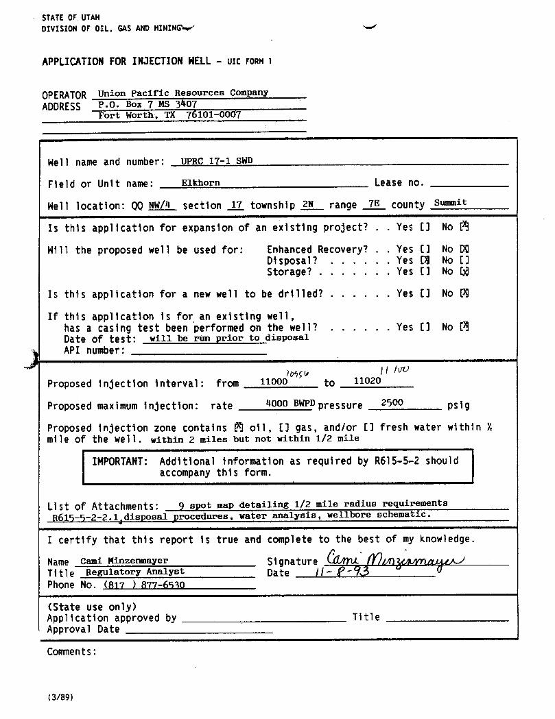
STATEOF UTAHDIVISION OF OIL, GAS ANDMINING
APPLICATIONFORINJECTIONNELL- ulc FORM l
OPERATOR Union Pacific Resources Company
ADDRESS P.O. Box 7 MS 3407Fort Worth, TX 76101-0007
Nell name and number: UPRC 17-1 SWD
Field or Unit name: Elkhorn Lease no.
Nell location: QQNW/4 section _ET_township 2N rangg 7E COUnty summit
Is this application for expansion of an existing project? . . Yes [] No [
Will the proposed well be used for: Enhanced Recovery? . . Yes E] No DODisposal? . . . . . . Yes [3 No []Storage? . . . . . . . Yes [] No []B
Is this application for a new well to be drilled? . . . . . . Yes [] No 99
If this application is for an existing well,has a casing test been performed on the well? . . . . . . Yes [] No EBDate of test: will be run prior to disposal
API number:
Proposed injection interval: from 11ooo to 11020
Proposed maximum injection: rate 4000 BWPDpressure 2500 psig
Proposed injection zone contains 3 oil, EJ gas, and/or E3 fresh water within 'lmile of the well. within 2 miles but not within 1/2 mile
IMPORTANT:Additional information as required by R615-5-2 shouldaccompany this form.
List of Attachments: ÿ spot map detailing 1/2 mile radius requirementsR615-5-2-2.1 disposal procedures, water analysis, wellbore schematic.
I certify that this report is true and complete to the best of my knowledge.
Name Cami Minzenmayer Signature //11 a A-/
Title Regulatory Analyst Date //Phone No. (817 ) 877-6530
(State use only)Application approved by TitleApproval Date
Comments:

M Union PacÌfl6111111'Resources
A Subsidiary of Union Pacific Corporation
via FEDERAL EXPRESSNovember 10, 1993
Utah Board of Oil, Gas, and MiningSuite 350, 3 Triad Center355 West North TempleSalt Lake City, Utah 84180-1203
RE: Appheation for Salt-Water Disposal WouU.P.R.C. 17-1NWI4 Section 17-2N-7E DIVISIONOFS-it County, Utah OIL, GAS& MINING
Gentlemen:
Enclosed you will find Union Pacific Resources Co. (UPRC) application to convert the above-mentioned well toa salt-water disposal well.
This application contains the following information in accordance with Rule 615.5:
1. Application for Injection Well - UIC Form 1 which shows:a. name, description, and depth of disposal intervalb. estimated maximum pressurec. average daily rate of disposal in barrels per day
2. Attachment 1.a & 1.b - surface, working interest and/or mineral owners in a 1/2-mile radius andaffidavit of notification
3. Attachment 2 - 9-spot map of area, indicating the area of interest4. Attachment 3 - representative log of reservoir & tops which will be affected by SWD5. Attachment 4 - engineer's conversion procedure6. Attachment 5 - current and proposed wellbore schematic7. Attachment 6 - proposed SWD operations8. Attachment 7.a & 7.b - water analysis for the Nugget formation9. Attachment 8 - water analysis for the Twin Creek formation
Should additional information be required, please direct questions and/or correspondence to the undersigned at theletterhead address or by calling (817) 877-6530.
Sincerely yours,
UNION PACIFIC RESOURCES COMPANY
Cami MmzenmayerRegulatory Analyst
:CM
attachments
Union Pacific Resources CompanyP.O. Box 7Fort Worth, Texas 76101-0007817 / 877-6000TWX 910 893 5024Telex
M Union PacÌfl6111111'Resources
A Subsidiary of Union Pacific Corporation
via FEDERAL EXPRESS
November 10, 1993
Utah Board of Oil, Gas, and MiningSuite 350, 3 Triad Center355 West North TempleSalt Lake City, Utah 84180-1203
RE: Appheation for Salt-Water Disposal WouU.P.R.C. 17-1NWI4 Section 17-2N-7E DIVISIONOFS-it County, Utah OIL, GAS& MINING
Gentlemen:
Enclosed you will find Union Pacific Resources Co. (UPRC) application to convert the above-mentioned well toa salt-water disposal well.
This application contains the following information in accordance with Rule 615.5:
1. Application for Injection Well - UIC Form 1 which shows:a. name, description, and depth of disposal intervalb. estimated maximum pressurec. average daily rate of disposal in barrels per day
2. Attachment 1.a & 1.b - surface, working interest and/or mineral owners in a 1/2-mile radius and
affidavit of notification3. Attachment 2 - 9-spot map of area, indicating the area of interest4. Attachment 3 - representative log of reservoir & tops which will be affected by SWD5. Attachment 4 - engineer's conversion procedure6. Attachment 5 - current and proposed wellbore schematic7. Attachment 6 - proposed SWD operations8. Attachment 7.a & 7.b - water analysis for the Nugget formation9. Attachment 8 - water analysis for the Twin Creek formation
Should additional information be required, please direct questions and/or correspondence to the undersigned at theletterhead address or by calling (817) 877-6530.
Sincerely yours,
UNION PACIFIC RESOURCES COMPANY
Cami MmzenmayerRegulatory Analyst
:CM
attachments
Union Pacific Resources CompanyP.O. Box 7Fort Worth, Texas 76101-0007817 / 877-6000TWX 910 893 5024Telex

ee • •
-ee
Schlumberger .
COMPANY EXXON USA 4xo rrw¿D
WELL U.P.R.C. #1
FIELD WILDCAT
. 5 COUNTY SUMMIT STATE UTAH¯ ¯¯
2335° FNL 2052° FWLOther Services:DLDL/MSFL --- ----- ---
LDT/CNT Inse se
o 4 a a API SERIAL NO. SECT. TWP. RANGE • o o- o - 2 SHDT
8 I S i 8 43043 30290 17 2N 7E wsT <u° °-
Permanent Datum GL Elev. 6751.0 F EleÑ.:K.Ó.8773.Log Measured From KB 22.0 F above Perm. Datum D.F.8772
OtWang Measured Frost KB G.L.0761. O O O
Date 04-JUN-88
Run No. ONE
Depth Driler 11114.0 F
Depth Logger (SchL) 11108.0 F
stm. Log interval 11108.0 F © o o
Top Log interval 1500.0 F o o o
Casing-Driller 9 5/8 @1543.0 F Oasing-Logger 1545,0 F
Bit Size 8 3/4Type Fluid in Hole SWM
Dens- Visc. 10 40 LB/G 41.0 SpH Fid. Loss 9.0 8.8 C3
Source of Sample TANKo .
-
• oRm o Meas. Temp. 058 OHMM @ 63.0 DEGF In
--
Rmt e Meas. Temp. .045 OHMM @ 63.0 DEGF -
Rmc © M$as. Temp. .086OHMM O 63.0 DEGF
Source: Rmf Rmc MEAS CALC.-
am a BNT .021 OHMM @ 188. DECF
w Circulation Ended 3 JUN 88 7:30 PM
Logger on Bottom 4/6/88 0323 HRS. --- -
| Î
Max. Rec- Temp. 188. DEGF
Equip. Location 8190 EVANSTON..
-o o ,o
.--
Recorded By EGEMO/RICHTER i • • •--•
- - I 90 o ' Iamata-----a um man immaÆg
ee • •
-ee
Schlumberger .
COMPANY EXXON USA 4xo rrw¿D
WELL U.P.R.C. #1
FIELD WILDCAT
. 5 COUNTY SUMMIT STATE UTAH¯ ¯¯
2335° FNL2052° FWL
Other Services:DLDL/MSFL --- ----- ---
LDT/CNT Inse se
o 4 a a API SERIAL NO. SECT. TWP. RANGE • o o- o - 2 SHDT
8 I S i 8 43043 30290 17 2N 7E wsT <u° °-
Permanent Datum GL Elev. 6751.0 F EleÑ.:K.Ó.8773.Log Measured From KB 22.0 F above Perm. Datum D.F.8772
OtWang Measured Frost KB G.L.0761. O O O
Date 04-JUN-88
Run No. ONE
Depth Driler 11114.0 F
Depth Logger (SchL) 11108.0 F
stm. Log interval 11108.0 F© o o
Top Log interval 1500.0 F o o o
Casing-Driller 9 5/8 @1543.0 F Oasing-Logger 1545,0 F
Bit Size 8 3/4Type Fluid in Hole SWM
Dens- Visc. 10 40 LB/G 41.0 SpH Fid. Loss 9.0 8.8 C3
Source of Sample TANKo .
-
• oRm o Meas. Temp. 058 OHMM @ 63.0 DEGF In
--
Rmt e Meas. Temp. .045 OHMM @ 63.0 DEGF -
Rmc © M$as. Temp. .086OHMM O 63.0 DEGF
Source: Rmf Rmc MEAS CALC.-
am a BNT .021 OHMM @ 188. DECF
w Circulation Ended 3 JUN 88 7:30 PM
Logger on Bottom 4/6/88 0323 HRS. --- -
| Î
Max. Rec- Temp. 188. DEGF
Equip. Location 8190 EVANSTON..
-o o ,o
.--
Recorded By EGEMO/RICHTER i • • •--•
- - I 90 o ' Iamata-----a um man immaÆg

ttachment 1.a
UPRC 17-1Surface Owner, Working Interest and/or Mineral Owners
1/2 mile radius
Surface Owner Working Interest Owners Mineral Owners
Section 8-2N-7E:S/2 S/2
Edward L. Gillmor Conquest Expl. Co. Bass Enterprises3819 South 2000 East 1331 Lamar, Suite 900 Production Co.Holladay, UT 84109 Houston, TX 77010-3088 1211 Ft.Worth Nat'l Bank
Attn: Jane Pereski Bldg.Fort Worth, TX 76102
Geodyne Resources, Inc.Sampson Plaza Newton Sheep CompanyTwo West Second Street a limited partnershipTulsa, OK 74103 3744 South 6400 West
Salt Lake City, UT 84120N. Central Oil Corp.6001 Savoy Drive Bow Valley Coal ResourcesSuite 600 Inc.Houston, TX 77036 1700 Broadway, Suite 900
Denver, CO 80290Amoco Production Co.P.O. Box 800Denver, CO 80201Attn: Greg

Section 1 2N-7E: All
Edward L. Gillmor UPRC Bass Enterprises Production3819 South 2000 East Co.Holladay, UT 84109 Exxon Corporation Newton Sheep Company
P.O. Box 1600 Bow Valley Coal ResourcesMidland, TX 79702-1600 Inc.Attn: Robert Fields
Conquest Exploration Co.
Oryx Energy Co.13155 Noel Rd.Dallas, TX 75240
N. Central Oil Corp.
EM Nominee Partnershipclo Hallwood Energy Co.
4582 S. Ulster Pkwy. St.Suite 1700Denver, CO 80220Attn: Kathleen Volk
HS Resources, Inc.216 16th St., 14th FloorDenver, CO 80202
Amoco Production Co.
Section 20-2N-7E: N/2
EdwardL. Gillmor3819 South 2000 East Conquest Exploration Co. Bass EnterprisesHolladay,UT 84109 N. Central Oil Corp. Production Co.
EM Nominee Partnership Newton Sheep CompanyHS Resources, Inc.Amoco Production

ATTACHMENT1.a
Edward L. Gilknor P 374 613 5393819 South 2000 EastHolladay, UT 84109
UPRC 17-1 (CM)
conquestExpl. Co. P 374 613 5401331 Lamar, Suite 900Houston, TX 77010-3088Attn: Jane Pereski
UPRC 17-1 (CM)
Geodyne Resources, Inc. P 374 613 541Sampson PlazaTwo West Second StreetTulsa, OK 74103
UPRC 17-1 (CM)
N. Central Oil Corp. P 374 613 5956001 SavoyDrive, Suite 600Houston, TX 77036
UPRC 17-1 (CM)Amoco Production Co· P 374 613 596P.O. Box 800Denver, CO 80201Attn: Greg Shewmaker
UPRC 17-1 (CM)
Bass Enterprises Production Co. P 374 613 5971211 Ft.Worth Nat'l Bank Bldg.Fort Worth, TX 76102
UPRC 17-1 (CM)
Newton Sheep Company P 374 613 5983744 South 6400WestSalt Lake City, UT 84120
UPRC 17-1 (CM)
Bow Valley Coal Resources P 374 613 5991700 Broadway, Suite 900Denver, CO 80290
UPR C 17.1

Exxon Corporation P 374 613 600P.O. Box 1600Midland, TX 79702-1600Attn: Robert Melds
TTPRC 17-1 (CM
Oryx Energy Co• P 374 613 60113155 Noel Rd.Dallas, TX 75240
TTPRC 17-1 (CE
EM Nomi hip P 374 613 602clo HallwoodEnergy Co.4582 S. Ulster Pkwy. St.Suite 1700Denver, CO 80220Attn: Kathleen VolkUPRC 17-1 (CM)
HS Resources, Inc• P 374 613 603216 16th St., 14th FloorDenver, CO 80202
UPRC 17-1 (CM)
P 374 613 604
P 374 613 605
P 374 613 606
P 374 613

Attachment 1.b
Affidavit of Notification of Interested Parties
I, Cami Minzenmayer, as Regulatory Analyst for Union Pacific Resources Co., do solemnlyswear that the attached list of surface, working interest and/or mineral owners, for the UPRC17-1 have been notified via certified mail on November 10, 1993.
The attached list indicates the "Certified Mail Tracking Number" for reference.
Cami MinzenmayerRegulatory Analyst
The State of TexasCounty of Tarrant
Before me, a Notary Public, on this day personally appeared ÇamiMinzenmayer knownto me to be the person whose name is subscribedto the foregoinginstrument and acknowledgedto me that she executedthe same for the purposes conside therein expressed.
Given under my hand and seal f offi t J_Qthda f m r, A.D. 1993.
(SEAL)RACHELLEL.IIONTGOIERY
Pu , f Te s
# MyComm.Exp.OCT31, 1994(Print name of Notary ublic
My commission expires the of

© Union PaucResources
via Federal Express
November 17, 1993
Utah Department of Natural Resources
Division of Oil, Gas, and Mining355 N. Temple - 3 Triad Center, Suite 350
Salt Lake City, Utah 84180Attn: Mr. Dan Jarvis
RE: UPRC 17-1SWD applicationNWl4 Sec. 17-2N-7ESummit County, Utah
Dear Dan,
Pursuant to our conversation on November 16, please find attached the following information
requested to complete Union Pacific Resources' application for salt-water disposal:
a. a representative Nugget water analysis
b. proof of fresh water protectionc. confining intervals which prevent vertical migration of injected water
d. information to support the Nugget fracture pressure requested
Please notice the changes on UIC Form 1, proposed injection interval is 10956'-11100' and the
proposed maximum injection is 10,000 BWPD.
If any additional information is needed, please contact myself at (817) 877-6530 or Fred
McDougal at (817) 877-7887.
Sincerely,
UNION PACIFIC RESOURCES COMPANY
Cami MinzenmayerRegulatory Analyst
attachmentsÑOVj $ 99)DMSION OF
OIL, GAS & MINING
Union Pacific Resources CompanyP.O. Box 7Fort Worth, Texas 76101-0007817 / 877-6000TWX 910 893 5024Telex

S Union PacificResourcesAalbal ryof Udm Feine Colpomism
INTER-OFFICE CORRESPONDENCE
TO: C.D. Minzenmayer0FTICE: ITW/3706
FROM: F.W. McDougalNommier 17, 1993
Supplemental Information - UPRC 17-1 SWD Application
Elkhorn Field, Summit County, Utah
Representative Nugget Water Analysis
I have attached our most recent Nugget water analysis. It was taken on produced
water from the UPRR 3-2, Pineview field, approximately 13,300' from the UPRC 17-1.
The UPRR 3-2 was recently recompleted to the Nugget, 9600'-9726'. This is a
representative Nugget water sample.
Fresh Water Protection
The fresh water intervals in the UPRC 17-1 are isolated from the injection interval
by approximately 5800' of cement in the 5'/," casing/hole annulus. The base of the
fresh water corresponds to the top of the Kelvin formation as per telecom with Dan
Jarvis, Utah Division of Oil, Gas & Mining, November 17, 1993. The Kelvin top in
this well is 4230'. The top of the cement in this well is estimated to be 5300'
based on a reported cement volume of 2900 sacks Class H (assumed yield of 1.18
ft*/sack) and the Integrated Cement Volume calculated from the MSFL derived caliper
log and assumed pipe size of 5'/ ".
Confining Intervals which prevent Vertical Migration of Injected Water
The Nugget is bounded by the Gypsum Springs (29' thick in the UPRG 17-1, red shale)
above and the Ankareh (414' thick in the UPRR 3-2, Deep red, maroon and yellowish
to orange shale) below. Both of the bounding formations are shales and should
prevent vertical migration of injected water.
Nugget Fracture Pressure
The fracture gradient in the Nugget is estimated to be 0.86 "'/, from the Binghma
2-1A frac job and the Bingham 2-3 acid job (fracture gradient used in the Bingham
& Son's No. 1 SWD Application, February 10, 1992). Assuming 8.6 ppg water the
static wellhead pressure at which the top Nugget perf, 10,956', fractures is 4522
psi. We are asking for a maximum wellhead pressure of 2500 psi (which includes
friction pressure) putting us 2000 psi below the fracture pressure.

<<\22 NOV -1.5 50 IVJ•4d MiltVlLW PNŸ¾.Box4321 Houston.Texas/7210-4321 r.ori ....-..........
ATERANALYSISREPORT I. (713) 460-6600 Telex: 4942225 ENCEHOU ©
SHEETNUMilER
APANYDA
D COUNTYORPARISN STATE
A OHUNIT SAMPLESOURCE WATERS0ußC£ IFORMATiuN)
THFT. BNT,1 SAMPl.ESOURCE TEMP..7 WATER.BBL/DAY OIL,88L/DAY GAS.MMCF/DAY
tíSAMPLED TYPEOFWATER: PRODUCED OSUPPLY OWATERFLOOD 0 ALTWATERDISPOSAL
// / TYPEOFPRODUCTioN: OPRIMARY OwATERFLooo . OCO,FLOOD OPOLYMERFLOOD OSTEAMFLOOD
WATER ANALYSIS PATTERN(NUMBERBESIDElON SYMBOL INDICATESme/iscAL£ UNIT)
a+ 20 15 10 5 0 5 10 16.
20 ci-1141 IIII illi lill Illi IIII illi 1111
"•" --++++++++- -4+H- H+ +H+ -H-H- --H-H- -H-H- 6°• ---
DISSOLVED SOLIDS DISSOLVED GASES
CATIONS melt ms/ NYOROGENSULFIDE,M26
Of AL HARDNESS CAnsoN D)OXIOi,CO2
ALCluaCa" OXYGEN.02 .
AAGNESURMg" PHYSICAL PROPERTIESRON(TOTAL)Fa'"
Eri(REOOXPOTENTIAL)00)UM,Ne'(CALC.)
SPECIFICGRAVITY
ANIONS me/I mg/5lUHHIDilY,PIUUNilà
MLORIDE.Ci TOTALDIS$OLVEDSOkt0S (CALC.) mg/)
ULFATE,504 STABlüTYINDEX y .p
AABONATE,COÙ 0 Y
JCAR60NATE.HCO 4 Y
YOROXYLCH• CaSO, 50LUBluf Yg y mg/l
ULFIDE,S" e 7 mg/t
MAX.Caso 4 POSSIBLE(CALC.) m0/l
MAX.BaSO4POSSIBLE (CALC.) mg/l
FIESIDUALHYDROCARBONS ppm (Vol/Voli
PENDEDSOMDS(OMARTATivElDIRONSULFIDE DIRONOXiOE OCALCIUMCAftBONATE OCALCIUMSULFATE DACIDINSOLUBLE
V.ARKSANDAECOMMENDATIONS.
ENGINEEA DIST. No. ADDRESS / OFFICE PHONE HOMEPHONE
I.YtEDGY DATE DisTalauflON 'O CuŠ0MER OREGION O DISTRICT
/g//, «gg') /////R O EC

UPRC1MU-2N-7E «
SumilCounty,Utok' 0- 1545'95/8"00SURFCSG
J L
0-.10800' 2.875"096.50f/ft000UpsetIBG
10398- 10428'SQUEEEPERFS10438-10496' SQUEEEPŒFS10514- 10526'SQUEEEPRES10536- 10541'SQUEEEPUES10574- 10602'SQUEEEPERFS
10692- 10720'SQUEEEPUES
10826- 10864'SQUEEEPERESJWHM1EW PACKER 10826- 10864'SQUEEEPERFS10872- 10903'SQUEEEPERFS10872- 10903'SQUEEEPERFS10956- 11000'PERES11020- 11100'PERFS
(New'a 0- 11114'5.5"00PRODCSG
KBELEV:6773'PBID:10300'ID:

TTACHMENT #4
DPRC 17-1 October28,1993NW/4 Sec 17, T2N-R7ESummit County, Utah
Convert Well to Balt Water Disposal
Well Data:
TD 11,114', PETD 10,270' (est)5'/2"/20#/SOO-90 @ 1315 '
, 20#/C95 @ _1921' , 20#/LSO 3055 ', 17#|L80
8440', 23#/P110 @ 9936', & 20#fL80 @41,112'
Note: See attached wellbore schematic for additional well data.
1. MIRU USU for 24 hr ops. Spot pump, pit & pwr swivel. Dig eardh pitto take cmt rtus in. ND WH, NU BOP. Cire hole w/ prod wtr throughkill string. POOH & stand back kill string.
2. The following table details the CISPs which have to be drilled out andthe test perfs which have to be sqz'd. Use the table as follows:1. PU 4'/," blade bit & 4-3'/," DCs, drill out the omt capped
CIEP(s) @ "4 out CIEP", tag P3TD @"Etm CIBP". SI pipe rams &est pump in rate, report to engineering.
2. POOH w/ bit & DCs. PU sqz pkr, RIH & set @ "Sqz Pkr". M&P "SqzVol", disp t/ EOT, slow down to'/, EPH as cmt enters perfs,stage as necessary. Sqz must test to 1000 psi. Repeat sqz asnecessary (NOTE: Exxon used '/4 per sx cellophane flakes and 10#per sx Koalite very effectively on 10,574'-GO2').
3. Repeat for next set. Test last sqz to 1000 psi for 30 min while
recording press on chart. Drill out last CIBP and shoe jt to11,100'. POOH & LD WS & collars.
I out Top Stm Stm Sqz SqzCIBP Perf Perf CIBP Pkr Vol
10,300 10,398 10,541 10,565 9,948 40 sxs
10,565 10,574 10,720 10,800 10,124 40 sxs10,686
10,800 10,826 10,903 10,944 10,376 30 sxs
10,944 10,956 11,000 0 sxs
3. MIRU WL & packoff. Run GR/CCL/C3L PETD to TOC. Perf 11,020'-100'with a 3'/," csg gun, 4 SPF, 15 gram charges, total of 320 holes. RDMO
4. PU Baker Model R, double grip, nickel plated pkr, & 'n 2'/," NSO6.5# DUOLINE 8rd EUE. Spaceout & set pkr , with 20M#compression. ND BOP NU WH. Break down perfs & conduct injection
TTACHMENT #4
DPRC 17-1 October28,1993NW/4 Sec 17, T2N-R7ESummit County, Utah
Convert Well to Balt Water Disposal
Well Data:
TD 11,114', PETD 10,270' (est)5'/2"/20#/SOO-90 @ 1315 '
, 20#/C95 @ _1921' , 20#/LSO 3055 ', 17#|L80
8440', 23#/P110 @ 9936', & 20#fL80 @41,112'
Note: See attached wellbore schematic for additional well data.
1. MIRU USU for 24 hr ops. Spot pump, pit & pwr swivel. Dig eardh pitto take cmt rtus in. ND WH, NU BOP. Cire hole w/ prod wtr throughkill string. POOH & stand back kill string.
2. The following table details the CISPs which have to be drilled out andthe test perfs which have to be sqz'd. Use the table as follows:1. PU 4'/," blade bit & 4-3'/," DCs, drill out the omt capped
CIEP(s) @ "4 out CIEP", tag P3TD @"Etm CIBP". SI pipe rams &est pump in rate, report to engineering.
2. POOH w/ bit & DCs. PU sqz pkr, RIH & set @ "Sqz Pkr". M&P "Sqz
Vol", disp t/ EOT, slow down to'/, EPH as cmt enters perfs,stage as necessary. Sqz must test to 1000 psi. Repeat sqz asnecessary (NOTE: Exxon used '/4 per sx cellophane flakes and 10#per sx Koalite very effectively on 10,574'-GO2').
3. Repeat for next set. Test last sqz to 1000 psi for 30 min while
recording press on chart. Drill out last CIBP and shoe jt to11,100'. POOH & LD WS & collars.
I out Top Stm Stm Sqz SqzCIBP Perf Perf CIBP Pkr Vol
10,300 10,398 10,541 10,565 9,948 40 sxs
10,565 10,574 10,720 10,800 10,124 40 sxs10,686
10,800 10,826 10,903 10,944 10,376 30 sxs
10,944 10,956 11,000 0 sxs
3. MIRU WL & packoff. Run GR/CCL/C3L PETD to TOC. Perf 11,020'-100'with a 3'/," csg gun, 4 SPF, 15 gram charges, total of 320 holes. RDMO
4. PU Baker Model R, double grip, nickel plated pkr, & 'n 2'/," NSO6.5# DUOLINE 8rd EUE. Spaceout & set pkr , with 20M#compression. ND BOP NU WH. Break down perfs & conduct injection

O State of UtahDEPARTMENT OF NATURAL RESOURCESDIVISION OF OIL, GAS AND MINING355 West North Temple
Michael O. Leavitto..mor 3 Triad Center, Suite 350
Ted Stewart Salt Lake City, Utah 84180-1203
Executive Director 801-538-5340
James W. Carter 801-359-3940 (Fax)Division Director 801-538-5319 (TDD)
December 10, 1993
Mr. Don BatesExxon CorporationP.O. Box 1600Midland, Texas 79702-1600
Dear Mr. Bates:
Re: Notification of Sale or Transfer of Lease Interest - UPRC #1 Well, Section 17, Township2 N., Range 7 E., Summit County, Utah, API No. 43-043-30290
The division has received notificationof a change of operator from Exxon Corporation to UnionPacific Resources Co. for the referenced wells which are located on fee leases.
Rule R649-2-10, of the Utah Oiland Gas Conservation General Rules, requires that the ownerof a lease provide notificationto any person with an interest in such lease (working interest orroyalty interest), when all or part of that interest in the lease is sold or transferred.
This letter is written to advise Exxon Corporation of its responsibility to notify all individuals withan interest in these leases of the change of operator. Please provide written documentation ofthis notification to the division no later than January 1, 1994.
dincerely,
Don StaleyAdministrative SupervisorOil and Gas
idcOl201R.J.Firth fer res¾

04/11/94 15:21 001
UnionPacificResources
FAX TRAN5MISS10N
DATE:
TIME:
TO:
LOCATION:
FAX NUMBER: 5
FROM:
MAIL STAl10N: LOCATION
I ONE NUMBER: I Ñ_& G_ikA-A '7¾ ' 8/7 - E'??- 6 .13 ¤
NUMBERUF PAGES INCLUDINGCOVER}
COMMENTS:
Union Pacilie nnnomen, (;.mspany
P.0 BOR 7 i p2(w@ &fort WOnh, Texan 16101 000;O17I $77 0000
Xn in non r.n?-I f,5inina

1L. 3AS AND N181NG OPERAI i ..
OrESATu,
ACT ON FORH- rcRM 6 A00RE
ACIEON C RÉNT HEW APE N NO ELL NAME NEI.'. GCATION SPUO IFFECTlYE
(00E EN ITY NO. ENTET1 '10. QQ SC TP RG f COUNTY DATE DATE
Yhi 3 to a 3 MQE //>,#yhELL 1 Cf.MMENTS
) WELL 2 COMMENTS
I
VELL3 £4MPENES:
I iI I
½El.L 4 Eutt'sEllTS:NN y,r
LD
ELL 5 CCHNEIIT5:
ACTIOli (CDES (See instrurier.s an t.ack ut form)A - Establish new ertity for new wel' (single wett onlyf'B - AalLi 3tW W&ll LC EtiftËDg 80Ëity ÍgrCUp Of Unit WBÎT) I tufe
C - Re-assign sell 'rca and existing entity to another existing ent'tyD - Ne-assigei sell 'ree ene existilig entity to a rtew entity / •
E - Other (explain ir ..onr.ents section) Ti
110TE: Use C(itNENT settier lo explain why each Action Code was selected. Phone No. / 7

© Union PacŸcResourcesA Subsidiary of Union Pacific Corporation
via Federal Express
November 17, 1993
Utah Department of Natural ResourcesDivision of Oil, Gas, and Mining355 N. Temple - 3 Triad Center, Suite 350Salt Lake City, Utah 84180Attn: Mr. Dan Jarvis
RE: UPRC 17-1SWD applicationNWl4 Sec. 17-2N-7ESummit County, Utah
Dear Dan,
Pursuant to our conversation on November 16, please find attached the following informationrequested to complete Union Pacific Resources' application for salt-water disposal:
a. a representative Nugget water analysisb. proof of fresh water protectionc. confining intervals which prevent vertical migration of injected waterd. information to support the Nugget fracture pressure requested
Please notice the changes on UIC Form 1, proposed injection interval is 10956'-11100' and theproposed maximum injection is 10,000 BWPD.
If any additional information is needed, please contact myself at (817) 877-6530 or FredMcDougal at (817) 877-7887.
Sincerely,
UNION PACIFIC RESOURCES COMPANY
Regulatory Analyst //attachments
Union Pacific Resources CompanyP.O. Box 7Fort Worth, Texas 76101-0007817 / 877-6000TWX 910 893 5024Telex

S Union PacificResourcesASubiMimyofwdon scinCmpomian
INTER-OFFICE CORRESPONDENCETO: C.D. Minzenmayer 0FTICE: INW/3706FROM: F.W. McDougal Nummher 17, 1993
Supplemental Information - UPRC 17-1 SWD ApplicationElkhorn Field, Summit County, Utah
Representative Nugget Water Analysis
I have attached our most recent Nugget water analysis. It was taken on producedwater from the UPRR 3-2, Pineview field, approximately 13,300' from the UPRC 17-1.The UPRR 3-2 was recently recompleted to the Nugget, 9600'-9726'. This is arepresentative Nugget water sample.
Fresh Water Protection
The fresh water intervals in the UPRC 17-1 are isolated from the injection intervalby approximately 5800' of cement in the 51/2" casing/hole annulus. The base of thefresh water corresponds to the top of the Kelvin formation as per telecom with DanJarvis, Utah Division of Oil, Gas & Mining, November 17, 1993. The Kelvin top inthis well is 4230'. The top of the cement in this well is estimated to be 5300'based on a reported cement volume of 2900 sacks Class H (assumed yield of 1.18fta/sack) and the Integrated Cement Volume calculated from the MSFL derived caliperlog and assumed pipe size of 5'/ ".
Confining Intervals which prevent Vertical Migration of Iqjected Water
The Nugget is bounded by the Gypsum Springs (29' thick in the UPRC 17-1, red shale)above and the Ankareh (414' thick in the UPRR 3-2, Deep red, maroon and yellowishto orange shale) below. Both of the bounding formations are shales and shouldprevent vertical migration of injected water.
Nugget Fracture Pressure
The fracture gradient in the Nugget is estimated to be 0.86 "I/, from the Bingham2-1A frac job and the Bingham 2-3 acid job (fracture gradient used in the Bingham& Son's No. 1 SWD Application, February 10, 1992). Assuming 8.6 ppg water thestatic wellhead pressure at which the top Nugget perf, 10,956', fractures is 4522psi. We are asking for a maximum wellhead pressure of 2500 psi (which includesfriction pressure) putting us 2000 psi below the fracture pressure.

g44,ag NOV 13 '93 10:42 PINEVIEW PRÇIK ¿p¯ U.Ÿuinar/210.4321 P.1/1
ATEAANALYSISREPORT " 713)460-6800 Telex:4942225ENCEHOUSHE TNUMBER
¯
FifLO COUNTYORPAfuSH STATE
LEASE0H UIST SAMPLESOURCE WATER80ußCE IFORMATis‡0
WTHFT. ONT.1 SAMPLE TEMP..? WATER,68L/DAY OIL,68L/DAY GAS.MMCF/OAY
DA IE SAMPLED TYPEOFWATEA: PRODUCED OSUPPLY 0 WATERFLOOD 0 SALTWATER Di$POSAL
// TYPSOFPRODUCTION. OPRIMARY OwATERFLOOD . OCO2FLOOO OPOLYMERFLOOD OSTEAMFLOOD
WATER ANALYSISPATTERN(NUMBERBESIDE¡ON SYMBOL INDICATESme/ISCALEUMT)
+ 20 16 10 5 0 . 5 10 15 20 Cl-
"•" - +- -H-H---+- H-- --H+F H -++-H-+H •• -
DISSOLVED SOLlDS DISSOLVED GASES
CAYt0NS mej¡ mg/l NYOROGENSULFIDEH2S WI
TOTALHAM CARBON DIOXIDE,CO2 L
CALCluM,Ca OXVGEN.OgMAGNESIUM, Mg
PHYSICALPROPERTIESlAONITOTAt.)Fe
BAntüM,Be(REDOXPOTENTIAL)
SOOlUM,Ns*(CALC.
SPECIFICGRAVITY
ANIONS e/t mg/l IUHUIUliY,PIUUNilk
CHLORIDE.CI' pp TOTALDIS$OLVEDSOUDS(CALC.) mg/l
SULFATE,SO, pp sTAstuf YINDEX y .7
CAABONATE,COg" g y
BlCAA60NATE.HCO 4 y
HYOBOXYL.CH CaSO4 SQLUBluTY g 'F mg/l
SULFl0E,S" g V mg/l
MAx. CaSO 4 MMSW WAW.) 48
MAX.BaSO4 POSSIBLE (CALC.) mg/l
RESIDUALHYDROCARBONS ppm (vol/Voi;
suSVf:Not080MOS(OMAMTATlVE)08RONSULFIDE DIAONOXIDE OCALCIUMCAABONATE OCALCiuMSULFATE OACIOINSOLUGLE
MMARKSANDRECOMMENDATIONE.
SCENGINitA DIST.NO. A00ASSS p / OFFicE PHONE HOMEPHONE
///, C «g5 Á¾¾rw po 7-77¶--//ry'.._ .
ANatvzio av DATE DisTaleurKm 'O CUÅ0MER 0 REGloN ODISTRICT
/ d') ‡ ýf O ECENGINEER

IVISIONOF 016, bA> ANu nansnu
APPLICATIONFOR IN3ECTIONWELL- ulc rona i s-
OPERATOR Union Pacific Resources Company
ADDRESS P.O. Box 7 MS 3407Fort Worth, TX 76101-0007
Hell name and number: UPRC 17-1 swD
Field or Unit name: Elkhorn Lease no.
Nell location: QQNW/4 section L7_township 2N range 7E county summit
Is this application for expansion of an existing project? . . Yes [] No E
Will the proposed well be used for: Enhanced Recovery? . . Yes EJ No DQDisposal? . . . . . . Yes [3 No [3Storage? . . . . . . . Yes EJ No [g
Is this application for a new well to be drilled? . . . . . . Yes EJ No 99
If this application is for an existing well,has a casing test been performed on the well? . . . . . . Yes [] No E4Date of test: will be run prior to disposal
API number:
roposed injection interval: from 144 0 to 11020-
Proposed maximum injection: rate apea awpopressure 2500 psi
Proposed injection zone contains 99 oil, EJ gas, and/or EJ fresh water within X
mile of the Well. within 2 miles but not within 1/2 mile
IMPORTANT: Additional information as required by R615-5-2 shouldaccompany this form.
List of Attachments: 9 spot map detailing 1/2 mile radius requirements
R615-5-2-2.1 disposal procedures, water analysis, wellbore schematic.
I certify that this report is true and complete to the best of my knowledge.
Name Cami Minzenmayer Signature Ét7tt //T)g a .¢ØTitle Regulatory Analyst Date ¡¡- g-Phone No. (817 ) 877-6530
(State use only)Application approved by Title
Approval Date
Comments:
(3/89)
f I .. . I I 1 If
IVISIONOF 016, bA> ANu nansnu
APPLICATIONFOR IN3ECTIONWELL- ulc rona i s-
OPERATOR Union Pacific Resources Company
ADDRESS P.O. Box 7 MS 3407Fort Worth, TX 76101-0007
Hell name and number: UPRC 17-1 swD
Field or Unit name: Elkhorn Lease no.
Nell location: QQNW/4 section L7_township 2N range 7E county summit
Is this application for expansion of an existing project? . . Yes [] No E
Will the proposed well be used for: Enhanced Recovery? . . Yes EJ No DQDisposal? . . . . . . Yes [3 No [3Storage? . . . . . . . Yes EJ No [g
Is this application for a new well to be drilled? . . . . . . Yes EJ No 99
If this application is for an existing well,has a casing test been performed on the well? . . . . . . Yes [] No E4
Date of test: will be run prior to disposal
API number:
roposed injection interval: from 144 0 to 11020-
Proposed maximum injection: rate apea awpopressure 2500 psi
Proposed injection zone contains 99 oil, EJ gas, and/or EJ fresh water within X
mile of the Well. within 2 miles but not within 1/2 mile
IMPORTANT: Additional information as required by R615-5-2 shouldaccompany this form.
List of Attachments: 9 spot map detailing 1/2 mile radius requirements
R615-5-2-2.1 disposal procedures, water analysis, wellbore schematic.
I certify that this report is true and complete to the best of my knowledge.
Name Cami Minzenmayer Signature Ét7tt //T)g a .¢ØTitle Regulatory Analyst Date ¡¡- g-Phone No. (817 ) 877-6530
(State use only)Application approved by Title
Approval Date
Comments:
(3/89)
f I .. . I I 1 If

#5 (0.5 i copygi gig
UPRC17-117-2N-7E '-'
O- 1545'95/8"00SURFCSGSmitcounty,lite
.] L.
0- 10800'2.875"006.50f/ft900UpsetIBG
10398- 10428'SQUEEZEPERFS10438- 10496'SQUEEZEPERES1051‡- 10526'SQUEEZEPERES10536-10541'SQUEEZEPERES10574- 10602'SQUEEZEPERES
10692- 10720'SQUEEZEPERES
JWHOWRBiN.PACKER 19826- 10864'SQUEEZEPERFS10826- 10864'SQUEEZEPERES10872- 10903'SQUEEZEPERES10872- 10903'SQUEEZEPERES10956- 11000'PERES11020- 11100'PERES
'a 0- 11114'5.5"00PRODCSG
' ' PBID:10300'ID:

ATTACHMENT#4
UPRC 17-1 October28,1993NW/4 Sec 17, T2N-R7ESummit County, Utah
.
Convert Well to Balt Water Disposal
Well Data:
TD 11,114', PETD 10,270' (est)51/2"|20#|SOO-90 @ 1315 '
, 20#/C95 _1921' , 20#/L80 @ 3055 ', 17#|L80 @
8440', 23#/P110 @9936', & 20#fL80 41,112'
Note: See attached wellbore schematic for additional well data.
1. MIRU WSU for 24 hr ops. Spot pump, pit & pwr swivel. Dig earth pitto take cmt rtns in. ND WH, NU BOP. Circ hole w/ prod wtr throughkill string. POOH & stand back kill string.
2. The following table details the CIBPs which have to be drilled out andthe test perfs which have to be sqz'd. Use the table as follows:1. PU 4'/," blade bit & 4-3'/," DCs, drill out the cmt capped
CISP(s) @ "4 out CISP", tag PETD @ "Etm CISP". SI pipe rams &est pump in rate, report to engineering.
2. POOH w/ bit & DCs. PU sqz pkr, RIH & set @ "Sqz Pkr". MAP "SqzVol", disp t/ E0T, slow down to'/, BPM as cmt enters perfs,stage as necessary. Sqz must test to 1000 psi. Repeat sqz asnecessary (NOTE: Exxon used '/4 per sx cellophane flakes and 10#per sx Koalite very effectively on 10,574'-602').
3. Repeat for next set. Test last sqz to 1000 psi for 30 min whilerecording press on chart. Drill out last CISP and shoe jt to11,100'. POOH & LD WS & collars.
I out Top Btm Stm Sqz SqsCIBP Perf Perf CIBP Pkr Vol
10,300 10,398 10,541 10,565 9,948 40 sxs
10,565 10,574 10,720 10,800 10,124 40 sxs10,686
10,800 10,826 10,903 10,944 10,376 30 sxs
10,944 10,956 11,000 0 sxs
3. MIRU WL & packoff. Run GR/CCL/CEL PETD to TOC. Perf 11,020'-100'with a 3'/," csg gun, 4 SPF, 15 gram charges, total of 320 holes. RDMO
4. PU Baker Model R, double grip, nickel plated pkr, 'n 27/," NSO6.5# DUOLINE 8rd EUE. Spaceout & set pkr @ with 20M#compression. ND BOP NU WH. Break down perfs & conduct injection

State of UtahDEPARTMENT OF NATURAL RESOURCESDIVISION OF OIL, GAS AND MINING355 West North Temple
Michael O. Leavittamm 3 Triad Center, Suite 350
Ted Stewart Salt Lake City, Utah 84180-1203
Executive Director 801-538-5340
James W. Carter 801-359-3940 (Fax)Divisian Directar 801-538-5319 (TDD)
December 15, 1993
Summit County Bee20 North MainCoalville,Utah 84017
Gentlemen:
Re: Notice of Agency Action - Cause No. UIC-143
Enclosed is a copy of the referenced Notice of Agency Action. Please publishthe Notice, once only, as soon as possible. Please send proof of publication andbilling to the Division of Oil,Gas and Mining, 355 West North Temple, 3 Triad Center,Suite 350, Salt Lake City, Utah 84180-1203.
Sincerely,
Lisa D. ClementAdministrative Secretary
Enclosure

ATTACHMENT #5 C>ST CO MVS RS (
UPRCil-I-
1MlHESumitCounty,lltah
O- 1545'95/8"ODSURFCSGJ L
0- 10800'2.875"006.50f/ft000UpsetIBG
10398- 10428'SQUEEZEPERES10438- 10496'SQUEEZEPERES10514- 10526'SQUEEZEPERFS10536- 10541'SQUEEZEPERFS10574- 10602'SQUEEZEPERFS
10692- 10720'SQUEEZEPERFS
10826- 10864'SQUEEZEPERFS10800- 10810'REW.PACKER===10826- 10864'SQUEEZEPERFS10872- 10903'SQUEEZEPERFS10872- 10903'SQUEEZEPERFS10956- 11000'PERFS11020- 11100'PERFS
O- 11114'5.5"ODPRODCSG(Ned
KBElBl:6773'PBID:10300'TD:

O State of UtahDEPARTMENT OF NATURAL RESOURCESDIVISION OF OIL, GAS AND MINING355 West North Temple
Michael O. Leavittmœ 3 Triad Center, Suite 350
Ted Stewart Salt Lake City, Utah 84180-1203
Executive Director 801-538-5340
James W. Carter 801-359-3940 (Fax)Division Directar 801-538-5319 (TDD)
December 15, 1993
Newspaper Agency CorporationLegal Advertising157 Regent StreetSalt Lake City, Utah 84110
Gentlemen:
Re: Notice of Agency Action - Cause Nos. UIC-140,UIC-142,and UIC-143
Enclosed is a copy of the referenced Notice of Agency Action. Please publishthe Notice, once only, as soon as possible. Please send proof of publication andbilling to the Division of Oil, Gas and Mining, 355 West North Temple, 3 Triad Center,Suite 350, Salt Lake City, Utah 84180-1203.
Sincerely,
Lisa D. ClementAdministrative Secretary
Enclosure

APPLICATIONFOR IN3ECTION HELb,y ulc rons i
OPERATOR Union Pacific Resources Company
ADDRESS P.o. Box 7 MS 3407Fort Worth, TX 76101-0007
Hell name and number: UPRC 17-1 SWD
Field or Unit name: Elkhorn Lease no.
Hell location: QQNW/4 section 1_7_ township 2N range 7E county Summit
Is this application for expansion of an existing project? . . Yes [] No [
Hill the proposed well be used for: Enhanced Recovery? . . Yes [] No 90Disposal? . . . . . . Yes [3 No EJStorage? . . . . . . . Yes [] No [¾
Is this application for a new well to be drilled? . . . . . . Yes [] No 99
If this application is for an existing well,has a casing test been performed on the well? . . . . . . Yes EJ No [6Date of test: will be run prior to disposal
API number:
Proposed injection intérval: from to
Proposed maximum injection: rate - BWPDpressure 2500 psig
Proposed injection zone contains 99 oil, [] gas, and/or EJ fresh water within '/
mile of the Well. within 2 miles but not within 1/2 mile
IMPORTANT: Additional information as required by R615-5-2 shouldaccompany this form.
List of Attachments: 9 spot map detailing 1/2 mile radius requirements
R615-5-2-2.1 disposal procedures, water analysis, wellbore schematic.
I certify that this report is true and complete to the best of my knowledge.
Name Cami Minzenmayer Signature 17tt //1)g a ¿A.../
Title Regulatory Analyst Date ll- ('-9L3Phone No. (817 ) 877-6530
(State use only)Application approved by Title
Approval Date
Comments:
(3/89)
- I I i I 1 I i ' I I I I T e¶

12/07/93 15:17 UNION "CIFIC REGULATORYDEPT + 801355092252648 NO.782 POO1
Union PacificResources
A Subsidiaryof Union Pacific Corporation
FACSIMILETRANSMISSION
UNION PACIFIC RESOURCES COMPANY
TO: ' DATEP/7 TIME:zoo esFAX * LOCATION:gje of U¾LFROM:Cad M wangTELEPHONE (817)(774SRO
NUMBER OF PAGES ( + COVER
PLEASE NOTE: The information contained in this facsimile is privileged and confidential,and isintended only.for the use of the individual named above and others who have been specificallyauthorizedto receive such. If the recipientis not the intended recipient, youare hereby notifiedthatany dissemination,distribution orcopyingof thiscommunicationis strictlyprohibited. If you havereceivedthiscommunicationin error,please immediatelynotifyus by telephone.
Thank You,Susan

12/07/93 15:18 UNION PACIFIC REGULATORYDEPT + 801355092252648 NO.782 POO2
DEP AJEAmoURCES
s,a.....b..gnamen ano Annalkunmer
DiVISIONOF OIL. GASANDMINING N/Ai indsen Anonsa or ŸribeName
N/A
N/A
O W., Og g oner repenismsuo uPac 17-1 swod opstaanr 10. APIwoiMumber
Union Pacific Resources Company 4 -04)-g02g0
eiOpermar 4. TelephoneNumber R and Weel,orWildest
P.O. Box 7 NS 3407, Pox•t Worth. TX 76101-0007 (817)877-6530 B1kbox•ni Tilagenetweg
Feetage : 2335'FNL & 2052'?WL cenaty: Summit00. See.T.,A.,M. : WW/4 800 . 17 2N-'FE Slais : UTAN
o ••=e-=- o -- o -· o New Cong u n
O camen• * O Pu= •r^tter casing o..in 0 Puu '^n.r c..ingO onano.orrian. O R•= l•tl n O Change ofPlan• 0 Shoot orAndze
g Conversionto inM 0 ShootW Acidize O Conymatonto injecuen 0 sta alar.O Fr• ur•Tr•• 0 "•nt « Fler• 0 F antw.Treat 0 war.,staa.ortO unisoi.compi.nn 0 Water Shut-OH Q Ossar
0 ©lh•'Date ofWorkCompiegen
ApproximateDateWorkWDIStart Upon approvalReportsoeutserMulipleCompisionsand to dlierent asserveksonWS.t.00MPl.EFIORORRICOMFWilON t,QBinsa.• Mut be asaampanimipyasementpriistggn tamqn,
13. DESCRIBEPROPoaEB OR00MPI.EriD OP-MTIONB(Clostly slatt ai partsent delais, and givepsfinsat doise, RwsR is dbeation-Ny grited, givesubsuriseslosadens and measurse and tusevoldosidepass sures memeteandannes periners tooisweek.)Union Pacifie Resources Ccampany requests permission to convert the above-mentioned well to aSWDwith the following procedura:
1. HERW WR ter 24 hr opp, $pat pump, pig 6 part suival. Dig earab pian e.k. ..e reus in. a m. w aœ. etr. a.t. ./ w.a ver nu..* * out e., sta atm ses seskL11 atring, 2008 & stand back kill auring.
2. The ia33eutas table desatte the Clats shieh have to be drilled out and i 10.300 10,398 10.343 10.$65 9.9&B 40 ansthe seas perk whLeh have en ha sqw•¢. Uma the sable as tallows: 14,565 30.574 10,730 30,500 10.134 60 aos1. FU 4'/," hLais bic & 4•3'f,• DCs. drt11 out the est ed 10,486
C3D(a) ( •0 ens c;sy•, tog 73W ! *Bt- CI3r•, SI ptpa ram & ---- ---- ---- ---
est pump ta rase, repers me angsamersag, 10.800 10.828 10,903 10,946 30.376 30 ama2. 2008 v/ bis 6 DCs. FWsta pkt. R28 & set 8 •5;* Tkt". M6F '5qs
le1•, 4Lop t/ 202, a2ew dem se'/, spx as mz saaers parts. 10.944 10,956 11,900 0 aussunga as massaaty. Squ must test to 3000 poi. Repeat sqa aslineessary (5025: k-en used 1/4 per su es11ephans flakes and 10s 3. 8220 VI, 6 paokott. Bun 05/CCI./CEL 75W to loc. Forf 11.020'-100'per as xeatLte *efy estestime3y me 30,574'-602•). with a 3'/.* es; gm. & SPP, is gram ehargas, sesal at 320 holes, taig
3. Repeat ter ment set. Test last squ to 3000 poi Set 30 ats while WI·¾-seessetag ptmas as, shara. Drill ens last CIB? ani shoe ja se11.300*. 7008 6 LD US 6 sellars. 4. 20 Beher Medal x, double grip, miekal 71sema phr, & BIN em 3'/." Wao
4.Se DUOLINE Brd EDE. Spassent & ses pkr g 10,000* wtab 20tWee-pression. WD507 50 115. Exeak down ports 6 eenduas indestien testwith rig p-p. ACD: as aseessary.
a a
sigyna
r
Cambi
a r Tine Regulatory Analyst om. 12-07-93
y,one Acceprea oy tne stateof Utah Division ofOil, Gas ancl MšningDate: 77- E- f5
(840) See instruodons on Neverse Side

BEFORE THE DIVISIONOF OIL, GAS AND MININGDEPARTMENTOF NATURALRESOURCES
STATE OF UTAH
-ooOoo---
IN THE MATTEROF THE APPLICATION : AMENDEDOF UNION PACIFICRESOURCES NOTICE OF AGENCY ACTIONCOMPANY FOR ADMINISTRATIVE :APPROVALOF THE UPRC #1 WELL CAUSE NO. UIC-143LOCATEDIN SECTION 17, TOWNSHIP :2 NORTH,RANGE7 EAST, S.L.M.,SUMMIT COUNTY, UTAH, AS A :CLASS II INJECTION WELL
---ooOoo---
THE STATE OF UTAH TO ALL PERSONS INTERESTED IN THE ABOVE ENTITLED MATTER.
Notice is hereby given that the Divisionis commencingan informal adjudicativeproceeding to consider the application of Union Pacific Resources Company foradministrative approval of the UPRC #1 Well, located in Section 17, Township 2 North,Range 7 East, Summit County, Utah, for conversionto a Class II injection well. Theproceeding willbe conducted in accordance with Utah Admin. R.649-10, AdministrativeProcedures.
The interval from 10,956 feet to 11,100 feet (Nugget Formation) willbe selectivelyperforated for water injection. The maximumrequested injection pressure is 2500 psig andthe estimated maximuminjection volume willbe 10,000 barrels of water per day.
Any person desiring to object to the applicationor otherwise intervene in theproceeding, must file a written protest or noticeof intervention with the Division withinfifteendays followingpublication of this notice. If such a protest or notice of intervention isreceived, a hearing will be scheduled before the Board of Oil, Gas and Mining. Protestantsand/or intervenors should be prepared to demonstrate at the hearing how this matter affectstheir interests.
DATEDthis 15th day of December, 1993.
STATE OF UTAHDIVISIONOF OIL, GAS AND MINING
RAssociate

Union Pacific Resources CompanyUPRC #1 Well
Cause No. UIC-143
Publication Notices were sent to the following:
Newspaper Agency CorporationLegal Advertising157 Regent StreetSalt Lake City, Utah 84110
Summit County Bee20 North MainCoalville,Utah 84017
Bureau of Land ManagementVernal District Office170 South 500 EastVernal, Utah 84078
Cami MinzenmayerUnion Pacific Resources CompanyP.O. Box 7 MS 2602Fort Worth, Texas 76101-0007
Dan JacksonU.S. Environmental Protection AgencyRegion VIII999 18th StreetDenver, Colorado 80202-2466
Lisa D. ClementAdministrative SecretaryDecember 15,


yision of Gil, Gas and MiningPERATORCHANGEHORKSHEET
"°uti
1 -
ttach all documentation received by the division regarding this change. 2
nitial each listed item when completed. Write N/A if item is not applicable. 3-VLC4-RJF
KChange of Operator (well sold) O Designation of Agent _i
] Designation of Operator O Operator Name Change Only 6
The operator of the well(s) listed below has changed (EFFECTIVE DATE: 12-08-93 )
TO (new operator) UNION PACIFIC RESOURCES CO FROM (former operator) EXXON CORPORATION
(address) PO BOX 7 MS 2602 (address) Po Box 4721FORT WORTH TX 76101-0007 HOUSTON TX 77210-4721
CAMI MINZENMAYER DON BATES
phone ( 817 ) 877-6530 phone (915 )688-7874
account no. N 9465 account no. µ0420
Hell(S) (attach additional page if needed):
Name:WER.C. #1 API: 43-043-30290 Entity: 10860 SeclLTwp_2]LRngllL Lease Type: FEE
Name: API: Entity: Sec_ _Twp___Rng___ Lease Type:Name: API: Entity: Sec_ _Twp___Rng___ Lease Type:Name: API: Entity: Sec_ _Twp___Rng___ Lease Type:Name: API: Entity: Sec_ _Twp___Rng___ Lease Type:Name: API: Entity: Sec_ Twp___Rng___ Lease Type:Name: API: Entity: Sec_ _Twp___Rng___ Lease Type:
I
O RATO
R
RE61 -M1ENTATSuOnNdry
or other legal documentation has been received from formeroperator (Attach to this form). (p,) g-g,pg
2. (Rule R615-8-10) Sundry or other legal documentation has been received from newoperator(Attach to this form)· (A,U /zq46)
3. The Department of Commerce has been contacted if the new operator above is not currentlyoperating any wells in Utah. Is company registered with the state? (yes/no) Ifyes, show company file number:
4. (For Indian and Federal Hells ONLY) The BLM has been contacted regarding this change(attach Telephone Documentation Form to this report). Make note of BLM status incomments section of this form. Management review of Federal and Indian well operatorchanges should take place prior to completion of steps 5 through 9 below.
5. Changes have been entered in the Oil and Gas Information System (Hang/IBM) for each welllisted above. (p-t4g]
6. Cardex file has been updated for each well listed above-fiz-t-fá2
Y 7. Well file labels have been updated for each well listed above. 12
& 8. Changes have been included on the monthly "Operator, Address, and Account Changes" memofor distribution to State Lands and the Tax Commission.fiz-t-A >
1 9. A folder has been set up for the Operator Change file, and a copy of this page has beenplaced there for reference during routing and processing of the original documents.
- OVER

'ERATOR CHANGEWORKSHEET(CONTINUED) Initial each item when completed. Write N/A if item is not applicable.
NTITY REVIEH
& 1. (Rule R615-8-7) Entity assi ments have been reviewed for all wells listed above. Hereentity changes made? (yes/ o (If entity assignments were changed, attach copies ofForm 6, Entity Action Form).
8 42. State Lands and the Tax Commission have been notified through normal procedures ofentity changes.
OND VERIFICATION (Fee wells only)
1. (Rule R615-3-1) The new operator of any fee lease well listed above has furnished aproper bond . seg tol do..df?»>
Payoao]Tom/ A-17 sanna dogany.
2. A copy of this form has been placed in the new and forme'ropear ors/'Nbo
files.
63. The former operator ha requested a release of liability from their bond (yes(pi) ___.
Today's date ÊuvmL9, 1993 . If yes, division response was made by letterdated 19___.
ÆASE INTEREST OHNER NOTIFICATION RESPONSIBILITY
)(†1. (Rule R615-2-10) The former oper,ator/1essee of any fee lease well listed above has beennotified by letter dated PL(to 19 22, of their responsibility to notify anyperson with an interest in such lease of the change of operator. Documentation of suchnotification has been requested.
2. Copies of documents have been sent to State Lands for changes involving State leases.
FILMING
. All attachments to this form have been microfilmed. Date: (3ecensbe.< 2') 1918 .
LING
1. C_o_Dies of all attachments to this form have been filed in each well file.
2. The original of this form and the original attachments have been filed in the OperatorChange file.
COMMENTS

ËORM e O OF UTAH
DMSION OF OIL,GAS AND MINING5. Lasse Designamon and Serlei Number:
Fee
SUNDRY NOTICES AND REPORTS ON WELLS • U haarTdbeN-ne: -
Do not use this form for poposals to ddli new walls, deepen exisung wolle, or to seerent plugged and abandoned welia 7. UnkAgreemern Name:
u.. ArrucanON FOR PERMITTO DRR OR DEEPEN lann for auch proposals.
B. Wei Name and Number:tryp.orw•u: OILO GAsO OTHER: DRYHOLEU. P. R. C. #1
2. Name of Operator: 9. API Wei Number:
Exxon Corp. 43-043-302903. Address and Telephone Number: 10. Field and Pool, or Widcat:
P 0 Fox 1600, Mid]<3n<i, TX, 79702-1600 (915) 688-7874 Undesignated4. Locadon af Wei
Footages: 2335' FtlL & 2052' FWLof Sec. 17 c..ar: Summitt••= 7 •M.: (SENW); Sec. 17, T-2N, R-7E se...: Utah
11- CHECK APPROPRIATE BOXES TO INDICATE NATUREOF NOTICE, REPORT, OR OTHER DATANOTICEOF INTENT SUBSEQUENTREPORT
(Submit he Dupilasteþ (Submit Orighmi Form Only)
O Abandonment O New Construction 0 Abandonment O New Construcdon
O casingRepair O Pull or Alter casino O casingRepair O Pull or Alter casingO Change of Plans O Recompletion 0 changeof Plan• 0 Shoot or Acidize
O conversionto injection 0 Shoot or Acidize O conversionto injection 0 Vent or Flare
O Fracture Treat 0 ventor Flar• 0 Fracture Treat O Water Shut-OR
0 Multiple Compledon 0 Water Shut-Off 0 OtherGOther Operator Change
Date of work compledon
Approximate date work will start Report meuMs of MuMple Compiegens and Reeempinions to dilemnt maanoire en WELLCOMPUEDON OR RECOMPumON MID LOGSonn.
• Must be accompanied by a cement werMic-Monspot.
12. DESCAIBEPROPOSEDORCOMPLETEDOPERA110NS (Clearlystate all partinert detalle, and give perdnent daims. If wei is direcionally drMed,glue subsurface locadans and measured and tmeverdcal depths for all markersand zones postinent to Wilswork.)
Effective 12/08/93, Exxon Coro. sold the above mentioned wellbore in it'sentirety to Union Pacific Resources Company.
Address: 801 Cherry StreetMail Station 3407Ft. Dorth, TX 76102 -
(This spone for State mee

O State of UtahDEPARTMENT OF NATURAL RESOURCESDIVISION OF OIL, GASAND MINING355 West North Temple
Michael O. Leavitta...., 3 Triad Center, Suite 350
TM Sumn Salt Lake City, Utah 84180-1203
Executive Director 801-538-5340
James W. Carter 801-359-3940 (Fax)Division Director 801-538-5319 (TDD)
December 10, 1993
Mr. Don BatesExxon CorporationP.O. Box 1600Midland, Texas 79702-1600
Dear Mr. Bates:
Re: Notification of Sale or Transfer of Lease Interest - UPRC #1 Well, Section 17, Township2 N., Range 7 E., Summit County, Utah, API No. 43-043-30290
The division has received notificationof a change of operator from Exxon Corporation to UnionPacific Resources Co. for the referenced wells which are located on fee leases.
Rule R649-2-10, of the Utah Oiland Gas Conservation General Rules, requires that the ownerof a lease provide notification to any person with an interest in such lease (working interest orroyalty interest), when all or part of that interest in the lease is sold or transferred.
This letter is written to advise Exxon Corporation of its responsibility to notifyall individuals withan interest in these leases of the change of operator. Please provide written documentation ofthis notificationto the division no later than January 1, 1994.
Sincerely,
Don StaleyAdministrative SupervisorOiland Gas
Idccc: R.J. Firth

O State of UtahDEPARTMENT OF NATURAL RESOURCESDIVISION OF OIL, GASAND MINING355 West North Temple
Michael O. Leavitto..mor 3 Triad Center, Suite 350
Ted Stewart Salt Lake City, Utah 84180-1203
Executive Director 801-538-5340
James W. Carter 801-359-3940 (Fax)Division Directar 801-538-5319 (TDD)
January 31, 1994
Union Pacific Resources CompanyP.O. Box 7 MS 3407Fort Worth, Texas 76101-0007
Re: UPRC 1 Well, Section 17, Township 2 North, Range 7 East, Summit County, Utah
Gentlemen:
Pursuant to Utah Admin. Code R.649-5-3-3, the Divisionof Oil, Gas and Mining (the"Division") issues its administrative approval for conversion of the referenced well to a ClassII injection well. Accordingly, the following stipulations shall apply for full compliance withthis approval:
1. Compliance with all applicable requirements regarding operation, maintenanceand reporting for Underground Injection Control ("UIC")Class II injection wellspursuant to Utah Admin. Code R.649-1 et seg.
2. Conformance with all conditions and requirements of the application submittedby Union Pacific Resources Company.
3. Provide notification to the Division prior to commencing injection operations.
4. Submittal of a copy of the cement bond log which verifies the cement topoutside the five and one-half inch casing.
Following completion of the well conversion work, pressure testing and otheroperations and submittal of the required documents to the Division, a final UICpermit willbeissued. If you have any questions regarding this approval or the necessary requirements,please contact Dan Jarvis at this office.
Sincerely,
R. .
° hAssociate Director
Idccc: Dan Jackson, Environmental Protection Agency

PROOF OF PUBLKATION•œu m•
STATE OF UTAH, BEFORE THE DIVISION Off
County of Summit, iSS- OIL, GAS AND MINING
DEPARTMENT OFNATURAL RESOURCES
STATEOF UTAHy Shirley B. Phelps IN THE MATTER OF THE
APPLICATION , OF UNIONbeing first duly sworn, depose and say that I am the PACIFIC RESOUitCES COM-
PANY FOR ADMINISTRATIVEbookkeeper of The Summit County Bee, a week- APPROVAL OF THE UPRC #1
WELL LOCATED IN SECTION4, TOWNSHIÍ•2 NORTH,
ly newspaper of general circulation, published once each week at RANGE 7 BAST, S.L.M.,SUMMIT COUNTY, UTAH, AS
Coalville, Utah, that the notice attached hereto and which is a A CLASS II INJECilON WELL 'NOTICE OF AGENCY ACTION
Notice of Agency Action CAUSENO.UIC-143THE STATE OF UTAll TO
ALL PERSONS INTERESTED INTHE ABOVE ENTITLEDMATTER.
Notice is hereby given that theDivision is commencingan infor-mal adjudicative proceeding to con-sider the application of UnionPacific Resources Company foradnlinistrative approval of theUPAC #1 Well, located in Section4, Township 2 North, Range 7
was published in said newspaper for 1 « East, Summit County, Utah, forconversion to a Class II injection
& issuep, the first publication having been made on the well. The proceedings will lie con-ducted in accordance with Utah
24 day of December, 19_93, and-the-tást Admin. R.649-10, Administrative
Proce¢lures.
, 19 , that said The interval from 10,956 feet to11,100 feet (Nugget Formation)will be selectively perforated fornotice was published in the regular and entire issue of every number water injection. The maximum re-quested injection pressure is 2500
of the paper during the period and times of publication, and the same psig and the estimäted niaxiniúminjection volunté Will be 10,000
was published in the newspaper proper and not in any supplement· barrels of water per day.Any person desiring to object to
the appliçation or otherwise inter-A A vene in theproceeding must file a-
written protest or notice of inter-24 vention with the Division within
Subscribed and sworn to before me this day of fifteen days following publicationof -this notice. If such a protest or
December 19 93 notice of interventionis received, ahearing wiß be scheduled beforetheBoard of Oil, Gas angMining.Protestants ahdA>r iëtervenors
No Public should beyopated a demânstrateat the hearing how this matterafh wis their interests.
My commission expires Nov 1 19 .
DATED this 15th day ofDecember,1993.
STATE OF UTAHDIVISIOKOP'OIL, GAS
ANIŸMININGRJ. Firth
Associate Dhectory co Published in The SummitNo County BeeDegegiber

PROOF OF PUBLKATIONBE9F IVIS GOF' DEPARTMENT OF
NATURAL RESOURCESSTÀTEOPtifAH
IN THE MATTER OP THEAPPLICÄÝION OF UNIONPACIFIC RESOURCESCOMFA Y FOR
STATE OF UTAH, ADMINISÌIiÃTIŸEAPPROVALCounty of Summit, i OF TifÈ UPRCÍ#1 WELL
LOCATED IN SECTION 17,TOWNSHIP 2 NORTH, ItANGE
y Shirley B. Phelps ? EAST, S.L M. $UMMIT' COUNTY,UTAH, AS A CLASS
TI INJECITONWËILbeing first duly sworn, depose and say that I am the AMENDED
NOTICE OF AGENCY ACTIONbookkeeper of The Summit County Bee, a week- CAUSE N0.UIC-143
THE, STATE OF UTAH TOly newspaper of general circulation. published once each week at ALL PERSONS INTERESTED IN
THE ABOVE ENTITLED
Coalville, Utah, that the notice attached hereto and which is a MATTER.Notice is hereby given that the
Approval of the UPRC #1 Well Division ia commencing ah infor-mal agdicati pmceedingto con-
Amended Notice of Agency Action sider the apphcation ¾f UnionPacific Resourced Company foradministrative'approvalof theUPRC #1 Well, ladifediri Section17, ToWaal¾p 2 North, Range 7East, Summit County, Utah, forconversion to a Cig R.injectionwel The pmeee¢n will be con-ducted in accordance with UtahAdmin. R.649-10, AdministrativeProcedure.
The interval from 10,956 feet towas published in said newspaper for 1 11,100 feet (Nugget Formation)
will be selectively perforated forde issueg, the first publication having been made on the water ingtion. The ngximum re-
quested mjection pressure is 25007 day of January
, 19 ,1tnd-thrPdst psig and the estimated maximum
on the day of 19 that said injection volume will be 10,barrels of water perday.
notice was published in the regular and entire issue of every number Any person desiring to objectthe application or otherwise inter-vene in the proceeding, must file aof the paper during the period and tirnes of publication, and the same wžitten protest or notice of inter-vention with the Division withinwas published in the newspaper proper and not in any supplement fifteen days following publicationof this notice. If such a protest ornotice of intervention is received, a
4 A 7, Ad hearing will be scheduled before theBoard of Oil, Gas and Mining.Protestants and/or intervenors
Subscribed and sworn to before me this 7 day of should be prepaired to demonstrateat the hearing how this matterJanuar y
, 19 9 affects their interests.DATED this 15th day of
/ Ot'tDecember 1993.
'Notary blic ' DIVISION OP ÔIL,
GAS AND MININGRJ. Firth
Associate DirectorMy commission expires Nov 1, 19_9Á.
Published in The SummitCounty Bee January 7, 1994.
Notary PublicSUSAN F. BUYS E
345 North600 East

Newspaper Agency Corporation143 SOL H MAIN ST. Obt,ßaltfakegribune ) DESERET VS CUSTOMER ' S
SALT LAKE CITY. UTAH 841 pyFED. TAX I D. M 87-0217663
CUSTOMER NAME AND ADDRESS ACCOUNT NUNBER BILLING DATE
DIV OF OIL, GAS & MINING LE-538)340 01/08/94355 W NO TEMPLE, #350SALT LAKE CITY, UT 84180 FOR BILLING INFORMATION
CALL (801) 237-2822
AFFIDAVIT OF PUBLICATION
AS NEWSPAPER AGENCY CORPORATION LEGAL BOOKKEEPER, I CERTIFY THAT THE ATTACHEDADVERTISEMENT OF AMENDEDNOTTCE OF AGENCY ACTTONCAUSE NO. UTC-1 FOR
DTV OF OTL, GAS & MTNTNG WAS PUBLISHED BY THE NEWSPAPER AGENCYCORPORATION, AGENT FOR THE SALT LAKE TRIBUNE AND DESERET NEWS,DAILY NEWSPAPERSPRINTED IN THE ENGLISH LANGUAGE WIT GENERAL CIRCURATION IN UTAH,AND PUBLISHEDIN SALT LAKE CITY, SALT LAKE COUNT IN THE STATE OF UTAH.
PUBLISHED ON MN 08 1994
SIGNATURE
AMENDED 01/08/94NOT1 USFEANGNY A4C3TION DATEBEFORETHEDIVISIONOF OIL,
GAS AND MININGDEPARTMENTOF NATURAL
RESOURCES,STATEOFUTAH ACCOUNT NAME TELEPHONE'ËO'NHEMFATTEONFTHAE UC
L°NURSCRASCEAMP YVAFH V OF OIL GAS & MINING 801- 38- 340
UPke & I vvELLLOCATED I TEIgoNN 7 IEO SH O SCHEDULE AD NUMBERCOUNTY,UTAH,AS A CLASSII IN-JECTION WELL.
THESTATEOFUTAHTOALLPER-AN 08 19 4 15820060SONS INTERESikDIN IHEABOVEENTITLEDMATTER. UST. REF. NO. CAPTION MISC.CHARGES
Nolio la hereby givon t atthe DMslon is commencing ainto aia cat
pat°on E #UIC-143 AMENDEDNOTICEOF AGENCYACTIONCAUSE NO. UIC-1
.00
o"° v'ta od lenst Ve SIZE TIMES RATE AD CHARGE
Ioc ted in Section 17, Townst*coNonh
Utaeo CEan rS rnnto
3 LINES 1 COLUMN 1 1.64 119.72a Class IIi eclion x,\. Th dr;°°$dir
ancwŠhcÊadhuc
min AND PAYABLE ON RECEIPT OF THIS INVOICE TOTAL AMOUNT DUER.649-10, Administrative Proce-dures.
The Interval from 10,956 feet THANK YOU FOR USING LEGAL ADV ERTISING.
mum requested injectiongaaed Jo°xim"ui"Po"edce PLEASE RETURN THIS PORTION LEGAL ADvoso"w°|e"$e'r'$.10,000barrelsof
WITH YOUR PAYMENT IN THE ENCLOSED ENVELOPE ADVERTISINGAny person desiring to object
'°,'",y°a'¶"I'noanono eACCOUNT NUMBER AD NUMBER BILLING DATE PAY THIS AMOUNT
must file a written potest or no-
LE-538¶340 1¶820060 01/08/94 119.72will be scheduled before the LEGAL ADVERTISING MAKE CHECKS PAYABLE TO:Board o oli s annde nors
NEWSPAPER AGENCY CORPORATIONe abepre red to demon- PLEASE REMI T TO :'$aaeaa'nectsthea o this
-------- DIV OF OIL, GAS Se MININGDATEDthis 15th day of De- NEWSPAPER AGENCY CORPORATION 355 W NO TEMPLE , #350
cember, 1993.
STATEOFUTAH P.O. BOX 45838 SALT LAKE CITY, UT 84180so OIL,GAS SALT LAKE CITY, UTAH 84145-0838
/s/ R. J. FirthAssociated Director15820060

Newspaper Agency Corporation143 L 1AIN ST. eþaltgakegibun¢ DES£RET 'S CUSTOMER ' S
SALT LAKE CITY, UTAH 84143 COPyFED. TAX ID. # 87-0217663 LEGAL ADVERTISING INVOICE
CUSTOMER NAME AND ADDRESS ACCOUNT NUMBER BILLING DATE
DIV OF OIL, GAS & MINING LE-5385340 12/22 93355 W NO TEMPLE, #350SALT LAKE CITY, UT 84180 FOR BILLING INFORMATION
CALL (801) 237-2822
AFFIDAVIT OF PUELICATION
AS NEWSPAPER AGENCY CORPORATION LEGAL BOOKKEEPER, I CERTIFY THAT THE ATTACHEDADVERTISEMENT Of NOTICE OF AGENCY ACTTONCAUSE NO. UTC-143BEFOR FOR
DTV OF OTL. GAS & MTNTNG WAS PUBLISHED BY THE NEWSPAPER AGENCYCORPORATION, AGENT FOR THE SALT LAKE TRIBUNE AND DESERET NEWS,DAILY NEWSPAPERSPRINTED IN THE ENGLISH LANGUAGE WITH GENERAL CIRCURATION IN UTAH,AND PUBLISHEDIN SALT LAKE CITY, SALT LAKE COUNTY IN THE STATE OF UTAH.
PUBLISHED ON 50 21
SIGNATURE '
NOTICEOFAGENCYACTION i 12/22/93CAUSENO.UIC-143 LTEBEFORETHEDIVISIONOF OIL,GAS AND MINING
DEPARTMENTOF NATURALRESOURCES,STATEOF UTAH
IN THEMATTEROF THEAPPLICA- ACCOUNT NAME TELEPHONETION Of UNION PA IF1 PF-SOURCES COMPANY FOR AD-
$14"^*JEELLALOCAEADLISEHCEpFOIL, GAS & MINING 801-538-5340IION 4. IOWNäHIF i NORTll,c^ONNETYUT SS MC SUs SCHEDULE AD NUMBERJECTIONWELL
SOHNES EERSFTEAHNTOEAPERE 21 1993 CH710160ENTITLEDMATTER T . REF . NO . CAPTION MISC . CHARGES
Notice is hereby given thatthe Div¡sion is commencing oninformal adlud\cative proceed-Ingtoconsidertheapplication UIC-143 NOTICE OF AGENCY ACTIONCAUSE NO. UIC-143BEFOR
.00
ut Union Pacific noennroe<compagY f ad nist a vee SIGE TIMES RATE AD CHARGEopcpatedIn Section 4. Township 2North, Range 7 East, S.L.M.,Sum-mitccunN, a.easa adniINES 1 COLUMN 1 1.64 116.44
be conducte in a utncde trUataheAdmcendu D PAYABLE ON RECEIPT OF THIS INVOICE TOTAL AMOUNT DUE
116.44The Interval from 10,956 feet°on"Ji°°beeseelN geye oiaat-
THANK YOU FOR USING LEGAL ADVERTISING.ed for water injection. Te maxi-mum requested injection
.w oi"Neif°'' PLEASE RETURN THIS PORTION LEGAL Aovee NT
AnypersondesIringtoobject; WITH YOUR PAYMENT IN THE ENCLOSED ENVELOPE ADVERTISINGto the application or otherwisevielweise in th: p'22]T'ilrgtTc"e"oΰntawmytegrDriv° CCOUNT NUMBER AD NUMBER BILLING DATE PAY THIS AMOUNTslon within fifteen days follow-ing publication of this notice. Ilsuch protest or notice of inter-LiŸ'benISscheedeueedd,baef eeadt¾ LE-¶385340 CHT10160 12/22/93 116.44Board of O¡¡, Goa ad Mining.Protestants and/or Intervenors LEGAL ADVERTISING MAKE CHECKS PAYABLE TO:shou1dbehpreLaredtohdemohi NEWSPAPER AGENCY CORPORATION
a er affects their nSerests. PLEA SE REMI T TO :DATEDthis 15th day of De- ----------- ---------- --- DIV OF OIL, GAS & MINING
comber, 1993. NEWSPAPER AGENCY CORPORATION 355 W NO TEMPLE , #350Soli^IÏ¡o°ioit.eAs P.O. BOX 45838 SALT LAKE CITY, UT 84130
AND MININGs/ hDirector SALT LAKE CITY, UTAH 84145-0838
CH710160
Newspaper Agency Corporation143 L 1AIN ST. eþaltgakegibun¢ DES£RET 'S CUSTOMER ' S
SALT LAKE CITY, UTAH 84143 COPyFED. TAX ID. # 87-0217663 LEGAL ADVERTISING INVOICE
CUSTOMER NAME AND ADDRESS ACCOUNT NUMBER BILLING DATE
DIV OF OIL, GAS & MINING LE-5385340 12/22 93355 W NO TEMPLE, #350SALT LAKE CITY, UT 84180 FOR BILLING INFORMATION
CALL (801) 237-2822
AFFIDAVIT OF PUELICATION
AS NEWSPAPER AGENCY CORPORATION LEGAL BOOKKEEPER, I CERTIFY THAT THE ATTACHEDADVERTISEMENT Of NOTICE OF AGENCY ACTTONCAUSE NO. UTC-143BEFOR FOR
DTV OF OTL. GAS & MTNTNG WAS PUBLISHED BY THE NEWSPAPER AGENCYCORPORATION, AGENT FOR THE SALT LAKE TRIBUNE AND DESERET NEWS,DAILY NEWSPAPERSPRINTED IN THE ENGLISH LANGUAGE WITH GENERAL CIRCURATION IN UTAH,AND PUBLISHEDIN SALT LAKE CITY, SALT LAKE COUNTY IN THE STATE OF UTAH.
PUBLISHED ON 50 21
SIGNATURE '
NOTICEOFAGENCYACTION i 12/22/93CAUSENO.UIC-143 LTEBEFORETHEDIVISIONOF OIL,GAS AND MINING
DEPARTMENTOF NATURALRESOURCES,STATEOF UTAH
IN THEMATTEROF THEAPPLICA- ACCOUNT NAME TELEPHONETION Of UNION PA IF1 PF-SOURCES COMPANY FOR AD-
$14"^*JEELLALOCAEADLISEHCEpFOIL, GAS & MINING 801-538-5340IION 4. IOWNäHIF i NORTll,c^ONNETYUT SS MC SUs SCHEDULE AD NUMBERJECTIONWELL
SOHNES EERSFTEAHNTOEAPERE 21 1993 CH710160ENTITLEDMATTER T . REF . NO . CAPTION MISC . CHARGES
Notice is hereby given thatthe Div¡sion is commencing oninformal adlud\cative proceed-Ingtoconsidertheapplication UIC-143 NOTICE OF AGENCY ACTIONCAUSE NO. UIC-143BEFOR
.00
ut Union Pacific noennroe<compagY f ad nist a vee SIGE TIMES RATE AD CHARGEopcpatedIn Section 4. Township 2North, Range 7 East, S.L.M.,Sum-mitccunN, a.easa adniINES 1 COLUMN 1 1.64 116.44
be conducte in a utncde trUataheAdmcendu D PAYABLE ON RECEIPT OF THIS INVOICE TOTAL AMOUNT DUE
116.44The Interval from 10,956 feet°on"Ji°°beeseelN geye oiaat-
THANK YOU FOR USING LEGAL ADVERTISING.ed for water injection. Te maxi-mum requested injection
.w oi"Neif°'' PLEASE RETURN THIS PORTION LEGAL Aovee NT
AnypersondesIringtoobject; WITH YOUR PAYMENT IN THE ENCLOSED ENVELOPE ADVERTISINGto the application or otherwisevielweise in th: p'22]T'ilrgtTc"e"oΰntawmytegrDriv° CCOUNT NUMBER AD NUMBER BILLING DATE PAY THIS AMOUNTslon within fifteen days follow-ing publication of this notice. Ilsuch protest or notice of inter-LiŸ'benISscheedeueedd,baef eeadt¾ LE-¶385340 CHT10160 12/22/93 116.44Board of O¡¡, Goa ad Mining.Protestants and/or Intervenors LEGAL ADVERTISING MAKE CHECKS PAYABLE TO:shou1dbehpreLaredtohdemohi NEWSPAPER AGENCY CORPORATION
a er affects their nSerests. PLEA SE REMI T TO :DATEDthis 15th day of De- ----------- ---------- --- DIV OF OIL, GAS & MINING
comber, 1993.NEWSPAPER AGENCY CORPORATION 355 W NO TEMPLE , #350Soli^IÏ¡o°i
oit.eAs P.O. BOX 45838 SALT LAKE CITY, UT 84130AND MININGs/ hDirector SALT LAKE CITY, UTAH 84145-0838
CH710160

State of UtahDEPARTMENT OF NATURAL RESOURCESDIVISION OF OIL, GAS AND MINING355 West North Temple
Michael O e3 Triad Center, Suite 350
Ted Stewart Salt Lake City, Utah 84180-1203
Executive Director 801-538-5340
James W. Carter 801-359-3940 (Fax)
Division Director 801-538-5319 (TDD)
January 31, 1994
Union Pacific Resources CompanyP.O. Box 7 MS 3407Fort Worth, Texas 76101-0007
Re: UPRC 1 Well, Section 17, Township 2 North, Range 7 East, Summit County, Utah
Gentlemen:
Pursuant to Utah Admin. Code R.649-5-3-3, the Division of Oil, Gas and Mining (the"Division") issues its administrative approval for conversion of the referenced well to a ClassII injection well. Accordingly, the following stipulations shall apply for full compliance withthis approval:
1. Compliance with all applicable requirements regarding operation, maintenanceand reporting for Underground Injection Control ("UIC")Class II injection wellspursuant to Utah Admin. Code R.649-1 et seq.
2. Conformance with all conditions and requirements of the application submittedby Union Pacific Resources Company.
3. Provide notification to the Division prior to commencing injection operations.
4. Submittal of a copy of the cement bond log which verifies the cement topoutside the five and one-half inch casing.
Following completion of the well conversion work, pressure testing and otheroperations and submittal of the required documents to the Division, a final UIC permit will beissued. If you have any questions regarding this approval or the necessary requirements,please contact Dan Jarvis at this office.
Sincerely,
R. . hAssociate Director
Idccc: Dan Jackson, Environmental Protection Agency

FORM8TE OF UTAH
DIVISION OF OIL, GASANDHINING 8. 1.EASE BE388NH30N AND SERIAL NO.
N/AO. $F SWDIAW. ALLOTTEE 05 TRIBE WAME
WELLCOMPLETION OR RECOMPLETIONREPORTAND LOG N/AELL Et.I. O .., O Other SWD t. unst acassusar mana
a TYPE OF COMPI.ETION: N/AEL 0 .'.°."." Ð :" O :".' O :7,'u.O oa., & -••- ->-=
2. naus or orsaarom UPRC (SWD)Union Pacific Resources Company , W LI. NO.
a. asoansa or ersaaron
P.O. Box 7, MS 3006 Fort Worth, TX 76 ao. rass.» aan root., on wn.ncar
4. s.ocarson or usa.a. t hepers a.catie. eteersy and in areerd.... **** r'"' Elkhornat ..rea,, 2335' FNL & 2052' FWL 11. SEC T 4., M., OR BLOCR AWD SDETET
At top prod, interval reported below../ NW/4 Sec. 17-2N-7E
At total depa Same14. API SIO. DATE 588UED 12. COUWTT 13. STATE
43-043-30290 2-24-88 Summit UtahIS. DATE SPUDDED 16. DATE T.D. LEACMED IÎ. DATE COMPL. (Ñtsdy NO prog.) 18. ELETATIOWS (Dr. BER. T. GE. ETC.) 19. ELET. CAalN&BBAD
12-7-93 1-6-94 | 2-24-94 dispose 6756 GR20. teTAL ourTE. Ma a TTD 31. FLUB BACK T.S., Ma a Tva 22. Er MULTTPLE COMFL.. 23. INTERVALS BOTART TOOLS CABLE TOOI.8
MOW MANT DRILLED ST11121 N/A
24.Ü1SPOSS ItTERTAL(B). OF TRES COMPLET30M--TOP. BOTTOK. NAME (MD AND TTD) 25. WA3 DIRECT30.'IALSURTET MADE
Nuggett 10950' -11100, No
26. TTTE st.ECrasc ano oTama Loss EDMWASWELL CottD yss NO (S.We•••Jr•••I
Da:LL sTEM TEST Yti NO See restroe *adriPRICASING RECORD (Report en stringa set in wcN)
cassuc sass wzasst. La./rr. marTa asT tygg get,g SISE CEgg2tT3NC RECORD AMOUWT POLLED
29. LINER RECORD 30. TUBING RECORD88EE TOP (MD) 30TTOM (MD) SACES CEMENT scìLEEN (MD) 832E DEPTE SET (MD) PACEER SET (MD)
N/A 2 7/8" 10884' 10921'
1. raarORATION accomo (Anterwel,a er end number) 32. ACID. SNOT, FRACTURE. CEMENT SOUEEEE. ETC.10950' - 11100' 3 3/8" 22 gramsDEPTS INTERTAL (ND) AAKOUltT AND EIND OF MATEE3AL CRED
9700'-10217 mix & Dumo 50 SXS. "G" Spot at9700: Set pkr. Displace 3000#to 1021'(' TOC=10244'
10347' Displace 50 SXS. G33 fli800881 PRODUCTION **Continue on back"DATE riasT aseoUewleW PRODUCTION METHOD (klessing,gas lifs, pumptsp-ears and type of pump) WELL STATUS (Producang er
shut-in)2-24-94 disposal
DATE OF TE3T BOUR3 TE3TED CROEE SIZE PROD'N. FOR Of BEL. GAS-MCF. WATER-BEL. GA3•OIL BATIOTEST PEB30D
N/AFIDW. TV3tWO PRang. CAsiNC PRE38URE CALCULATED OIL-SSL. GAS-MCF. WATER-BEL. OIL GRATITT•AFI (CORE.)24.soca mars
34 otarositzoN or sus (ßeid, used for fuel, t•ented, etc.) TE3T WITWEs-ED BT
N/A Dan Jarvis/Frank Matthews35T OF ATTACENENT3
forwarded under separate coveras Isrbcereer ce to a e arson t. complete and correct as deteraniard from an available records
See Spaces for Additional Date on Reverse Side
FORM8WTE OF UTAH
DIVISION OF OIL, GASANDHINING 8. 1.EASE BE33CNAT30N AND SERIAA. NO.
N/A
WELLCOMPLETION OR RECOMPLETIONREPORTAND LOG "°"" °""
ELLcact... O .., O Other SWD t. unst acassusar mana
a TYPE OF COMPI.EHON: N/ANEW WORK þEEP• PLUC DIFF. ·
WELL OVEB EW BACK aceva. Other 6. ramas os 4.sass naus
2. name or orsaaroa UPRC (SWD)Union Pacific Resources Company
a. asoamaa or ersaaron
P.O. Box 7, MS 3006 Fort Worth, TX 76 o- zo. rass.o una root., on wn.ncar
4. s.ocarson or usa.a. thepers a.cation esserar and in areerdance seisA se vre..rr ents) Elkhorn1:..,«.,, 2335' FNL & 2052' FWL u.nc : a.....osas.oexanosoarsv
At top prod, interval reported below NW/4 Sec. 17-2N-7E
At total depa Same F1. W01, GM&WHO14. API p . DATE 588UED 12. COUWTT 13. STATE
43-043-30290 2-24-88 Summit Utah15. DATE SPUDDED 16. DATE T.n. asacuco 17. Darc coupL. (Ready to prod.) 18. ELETATIOWS (Dr. BER. RT. GE. ETC.) 19. ELET. CAalNOBBAD
12-7-93 1-6-94 | 2-24-94 dispose 6756 GR20. teTAL ourTE. Ma a TTD 31. FLUS BACK T.S., MS A TTO 22. IT MULTIPLE COMFL.. 23. INTERVAI.S BOTART TOOLS CABLE TOOI.8
MOW MANT DRILLED ST11121 - N/A
24.Ü1SPOSS NTERTAL(a). OF TRES COMPLET30M--TOP. BOTTOK. NAME (MD AND TTD) 25. WA3 DIRECT30.'IALSURTET MADE
Nuggett 10950' - 11100' No26. TTTE St.ECrasc ano of-Ex Loss EDM
WASWELL Cotto VES No S.ws...lyssa;DalLL STEM TEST TES NO )$ewremesse sedriPRI
CASING RECORD (Report en stringa set in wcN)CassNC sags WE3eRT. La./rT. BEPTR SET (Mg) NOi,E SizE CrugxTINC RECORD AMOUWT POLLED
29. LINER RECORD 30. TUBING RECORD88EE TOP (MD) 30TTOM (MD) SACES CEMENT SCAEEN (MD) 832E DEPTE SET (MD) PACEER SET (MD)
N/A 2 7/8" 10884' 10921'
31. raaroaATroN ascono (Intervel, a er end number) 32. ACID. SHOT. FRACTURE. CEMENT SQUEEEE. ETC.10950' - 11100' 3 3/8" 22 gramsDNS INTERTAL (ND) skioUffT AWD EINo or NATExtAL eszD
9700'-10217 mix & oumo 50 SXS. "G" Spot at9700: Set pkr. Displace 3000#to 1021'(' TOC=10244'
10347' Displace 50 SXS. G33
fli800881 PRODUCTton **Continue on back"DATE riasT aseoue9tese PaoDUCTION METHOD (klessing,gas ifft, pumpimp--esas sad type of pump) wELL STATUS (Producang er
shut-in)2-24-94 disposal
DATE OF TE3T BOUR3 TE3TED CROEE SIZE PROD'N. FOR Of BEL. GAS-MCF. WATER-BEL. GA3•OIL BATIOTEST PEB30D ¡
N/Aranw. TV3tWO PRESS. CASINC PRE33URE CALCULATED OIL-SSL. GAS-MCF. WATER-BEL. OIL GRATITT•AFI (CORE.)24.soca mars
34 otarositzoN or sus (ßeid, used for fuel, t•rnted, etc.) TE3T WITWEs-ED BT
N/A Dan Jarvis/Frank Matthews35T OF ATTACEMENT3
forwarded under separate cover36 Isrbcereer ce to a e arson t. complete and correct as determined from an arausble records
See Spaces for Additional Date on Reverse Side
FORM8TE OF UTAH
DIVISION OF OIL, GASANDHINING 8. 1.EASE SHBONAT30N AND SERIAL NO.
N/A
WELLCOMPLETION OR RECOMPLETIONREPORTAND LOG """ °' "' '
ELL Et.I. O .., O Other SWD t. unst acassusar mana
a TYrz or court.zyton: N/AWEW WORK EEP• FLUC pirf.WELL OVER EW BACK RESTA. Û$$ , FARM 08 LEASE WAME
2. name or orsaaroa UPRC (SWD)Union Pacific Resources Company
a. asoamaa or ersaarna #1P.O. Box 7, MS 3006 Fort Worth, TX 76 ao. rass.» ane root., on wn.ncar
4. s.ocarson or usa.s. sheport see.si..steerty and in sceerd.... wisa e vre.re emes Elkhornas sortae, 2335' FNL & 2052' FWL u. gc : a.....os as.oex ano soarsv
At top prod, interval reported below NW/4 Sec. 17-2N-7E
At total depa Same14. API SIO. DATE 588UED 12. COUWTT 13. STATE
43-043-30290 2-24-88 Summit Utah15. DATE SPUDDED 16. DATE T.D. REACHED 17. DATE COMPL. (Ready to prod.) 18. ELETATIOWS (Dr. BER, T. BE. ETC.) 19. ELET. CAalN&BBAD
12-7-93 1-6-94 ¡ 2-24-94 dispose 6756 GR20. teTAL Darym. Ma a TTD 31. PLtfo BAcx t.a. Ma a Tva 22. IF MULTIPLE COMFL.. 23. INTERVALS BOTART TOOLS CABLE TOOI.8
MOW MANT DRILLED ST11121 - N/A
24.Ü1SPOS81acTsaTALia), or Tass coMPLET30M--TOP. BOTTOK. NAME (MD AND TTD) 25. WA3 DIRECT30.'IALSURTET MADE
Nuggett 10950' -11100• No
26. TTTE 88.ECTRIC AWD OTHER LOSS ROM $7WASWELL CORED TES NO (S.A..seenslyssa;
ORILL STEM TEST TES NO À$ewrosesse sadri
CASING RECORD (Report en stringa set in wcN)CastNC 588E WE3GRT. LE.frT. DEPTR SET (MD) Mot.E SizE CEugxTINC RECORD AMOUWT POLLED
29. LINER RECORD 30. TUBING RECORD88EE TOF (MD) 30TTOM (MD) SACES CEMENT schEEN (MD) sizE pgPTE SET (MD) PACEER SET (MD)
N/A 2 7/8" 10884' 10921'
$1. raaroaATroN accomo (Antervel,esar end number) 32. ACID. SNOT. FRACTURE. CEMENT SQUEEEE. ETC.10950' - 11100' 3 3/8" 22 gramsDEPTS INTERTAL (ND) AbioUstT AWD EINo or NATExtAL CazD
9700'-10217 mix & oumo 50 SXS. "G" Spot at9700: Set pkr. Displace 3000#to 1021'(' TOC=10244'
10347' Displace 50 SXS. G33
fli800881 PRODUCTton **Conti ¡q on back"DATE riasT aseoUewleW Pa0DUCT30W METWOD (Élessing,pas ifft, pumpimp--esas sad typt of pump) WELL STATUS (Producang er
shut-in)2-24-94 disposal
DATE OF TE3T BOUR3 TE3TED CROEE SIZE PROD'N. FOR Of BEL. Gas-MCF. WATER-BEL. GA3•OIL BATIOTEST PEB30D
N/AFIDW. TV3tWO PRang. CAsiNC PRE38URE CALCULATED OIL-SSL. GAS-MCF. WATER-BEL. OIL GRATITT•AFI (CORE.)24.soca mars
34 otarositzoN or sus (ßeid, used for fuel, t•ented, etc.) TE3T WITWEs-ED BT
N/A Dan Jarvis/Frank Matthews35T OF ATTACENENT3
forwarded under separate coveras Isrbcereer ce to a e arson t. complete and correct as deteraniard from an available records
See Spaces for Additional Date on Reverse Side
donstaley
Highlight
donstaley
Highlight
donstaley
Highlight
donstaley
Highlight
donstaley
Highlight
donstaley
Highlight

INSTRucTIONS
This form should be completed in compliance with the Utah 011 nd Gas Conservation General Rules. If not filed prior to this time, all logs,tests, and directional surveys as required by Utah Rules shd514 be attached and submitted with this report.ITEM 18: Indicate which elevation is used as reference for diptB2measurements given in other spaces on this form and on any attachments.ITEMS22 and 24: If this well is completed for separate prödue ion from more than one interval zone (multiple completion), so state in item 22,and in item 24 show the producinginterval, or intervals, top(s), bottom(s) and name(s) for only the interval reported in item 33. Submit aseparate report (page) on this fore, adequately identified, for each additional interval to be separately produced, showing the additional datapertinent to such interval.ITEH 29: "Sacks Cement": Attached supplemental records for this well should show the details of any multiple stage cementing and the location ofthe cementing tool. s-ITEH 33: Submit a separate completion report on this form for each interval to be separately produced (see instruction for items 22 and 24 aboA .
37. SUHMARYOF POROUSZONES: 38. GEOLOGICMARKERSShow all important zones of porosity and contents thereof; cored intervals;and all drill-stem tests, including depth interval tested, cushion used,time tool .pen. flowing nd shut-in o assures. and recoveries.
Formation Top Bottom Description. contents. etc. Name on** Cknitinued frcma #32 Haas. Depth True Vert.Depth
10650'-10920' Spot 50 SXs. AG300 cmt.-10900 pumped 2500 gal. - 15%
acid + 1000 gal. prod.wtr. + 2500 gais.15% acid + 68 blils. wtr. A
Wattcni Carlyon 10295'Boundary Ridge 10511'Rich 10575'Slide Rock 10826'GypEnan Springs 10916'Nuggett

Union Pacik© ResourcesA Subsidiary of Union Pacific Corporation
March 10, 1994
Mr. Dan JarvisState of Utah, Department of Natural Resources ...-....
Division of Oil, Gas, and Mining lif.05mL. 38355 West North Temple3 Triad Center, Suite 350Salt Lake City, Utah 84180-1203
UPRC No. 1 SVDW - Step Rate TestSec 17 T2N-R7EElkhorn Field, Summit County, Utah
Dear Mr. Jarvis:
I have attached the Step Rate Test performed on the above well January 14,1994. A quick glance at the plot shows the well was actually cleaning upduring the test. I do not think we ever fractured the formation duringthe test based on the last data point which showed we developed aconstriction toward the end of the test. I do not think this is a validStep Rate Test.
I agree with your conclusion, a significant volume of water needs to beinjected into the well before the next Step Rate Test is performed.
If you have any questions please feel free to call me at (817)877-7887.
Very Truly Yours,
Fred McDougalPetroleum Engineer
c:\wp51\1tr\jarv2.ltr
Union Pacific Resources CompanyP.O. Box 7Fort Worth, Texas 76101-0007817 / 877-6000TWX 910 893 5024Telex

UPRC No. 1 - Step Rate TestElkhom Field, Summit County, Utah
W5HOO 2MO UPRC No. 1 - Step Rate Test750 0.20 Elkhom Field, Summit County, Utah
1000 0.32 30001250 0.321500 0.60 26
1750 1.20 e 2000 - - - -- -4
2000 2.202250 3.00 1500 -- e
2500 3.10 $ iooo - -e --
e500 -O --
II
OO 1 2 3 4
BPM
Rates held constant for 15 min, pressure was measured at end of time period
ЩEDWWMARI 519W
MV.0FOILGAS&

romu e STATE OF UTAH
DIVISION OIL, GAS AND MININGS. LammeDemagnabon and Senal Number:
Fee
SUNDRY NOTICES AND REPORTS ON WELLS '" *"'°°°""
N/A
7. Una Agreement Nameonnot use esisform for proposals to dral new wens, ee•pen enimung••Ils, or to seenior¢upped and abandoned webs.
Use APPUCATION FOR PEAMfT TO DRIG.OR DEEPEN form ier such propaeals. N/A
8. Well Name and Number1. Type er wen: OIL 0 GAs B OTHER: UPRC 17-1 SWD
2. Name of Operator: 8. API Well Number
Union Pacif ic Resources Company 43-043-30290
3. Address and Telephone Number: 10. Field and Pool, or Waldcat:
P.O. Box 7 - MS/3006, Fort Worth. Texas 76101-0007 Elkhorn
4. Location of Well
Fontages: 2,335' FNL, 2,052' FWL Sec. 17, T. 2N., R. 7E. County: Summit
OQ. Soc.,T..FL,M.: Sec. 17, T. 2N., R. 7E• easte: Utah
t· CHECK APPROPRIATE BOXES TO INDICATE N\TURE OF NOTICE, REPORT, OR OTHER DATA
NOTICE OF INTENT SUBSEOUENTREPORT(SubmR In Dupucate) (Submit Original Form Only)
O Abandonment O New Construction O Abandonment New Construction
0 casingR•Pair O Puti er Altercasine O Casing Repair Pull or Alter Casing
O changeof Plans O Recompletion O Change of Plans O Shoot or Acidize
0 conversionto inj••tion 0 Shoot or Acidize O Conversion to injection 0 ventor Flare
O Fracture Treat O Vent or Flare O Fracture Treat 0 Water Shut-Off
O Multiple completion 0 Water Shut-Off O Other
Other step-rate pressure testDate of work completion
Approximate date work will start upon approval Report resulls of Muniple CompieUons and Rooompletions to dMerent reservoirson WELLcoMPLEnON OR RECOMPLERON AND LOG torm.
* Must be accompanied by a cement verilication report.
12 DESCRIBEPROPOSEDOR COMPLETEDOPERATioNS(Clearlystate all pertinent details, and give pertinent dates. It well is directionally drilled, give subsurface locations and measured and truevertcal depths for all markers and zones pertinent to this work.)
UPRC plans on conducting a step-rate pressure test to determine parting pressure of the Nugget Formation.
Will request permission to increase maximum allowable injection pressure from 1,500 psig to 2,500 psig
depending on results of step-rate test.
Please contact the undersigned at (817) 877-7952 if additional information is needed.
JCT39
asignature: V.F. Brazelton y¡n.: Sr. Regulatory Analyst Date: 10-28-94
(This space for State une only)
APPROVEDBYTHESTATEOF UTAH DIVISION OFOIL, GAS, AND IVjlNING

STATE OF UTAH OPERATIONS MONTH/YR: FEBRUARY, 1994DIVISION OF OIL, GAS AND MINING
MONTHLY INJECTION REPORT - UIC FORM 3 APR 4 l994
OPERATOR : UNION PACIFIC RESOURCESADDRESS : PO BOX 7
FORT WORTH, TX 76101-0007 CORRECTED REPORT [ ]
Well Name and Number: UPRC #1
Field or Unit Name: Elkhorn API No. 43-043-30290
Well Location:QQ_/ Sec. 17/ Township 2 N/ Range TE/ County Summit
Date Disposed Service Pressure Operating Pres. Annulus Pres.
1 0 0 0 0 02 0 0 0 0 03 0 0 0 0 04 0 0 0 0 05 0 0 0 0 06 0 0 0 0 0
11 0 0 0 0 012 0 0 0 0 013 0 0 0 0 014 0 0 0 0 015 0 0 0 0 016 0 0 0 0 017 0 0 0 0 018 0 0 0 0 019 0 0 0 0 020 0 0 0 0 021 0 0 0 0 022 0 0 0 0 023 789 24 1,350 1,350 024 243 4 1,400 1,400 025 1,083 24 1,400 1,400 026 730 24 1,200 1,200 027 529 24 1,200 1,200 028 0 0 1,200 1,200 0
29 030 031 0 0
Total volume injected for month 3,374AIItime cumulative volume injected 3,374
I certifythat this report is true and complete to the best of mykNnamwdge.CAROLYN
FLUMAN Signature:Title: PRODUCTION CLERK Date: ARCH ,1994
Phone #:

O State of Utah -
DEPARTMENT OF NATURAL RESOURCESDIVISION OF OIL, GAS AND MINING355 West North Temple
MichaelO.Luntt 3 Triad Center. Suite 350
Ted Stewart Salt Lake City, Utah 84180-1203
Executive Director 801-538-5340
James W. Carter 801-359-3940 (Fax)Division Director 801-538-5319 (TDD)
UNDERGROUND INJECTION CONTROL PERMIT
Cause No. UIC-143
Operator: Union Pacific Resources Company
Well: UPRC #1
Location: Section 17, Township 2 North, Range 7 East,Summit County
API No.: 43-043-30290
Well Type: Disposal
Stipulations of Permit Approval
1. Approval for conversion to Injection Well issued onJanuary 31, 1994.
2. Maximum Allowable Injection Pressure: 1500 psig
3. Maximum Allowable Injection Rate: 10,000 bb1s per day
Approved by:
R.J. th DateAssociate Director, Oil and

DIVISIONOF OIL, GAS AND MININGUNDERGROUND INJECTION CONTROL PROGRAM
PERMITDECISION DOCUMENT
Applicant: UPRC Well: UPRC #1
Location: Sec. 17, T.2 N., R.7 E., Summit County
Ownershlp Issues:The proposed well is located in section 17, township 2 north, range 7 east Summit
County, Utah. The surface location is owned by Mr. Edward Gillmor.There are variousowners and working interest owners within the 1/2 milearea, all of which have been senta notice of intent to convert. An affidavithas been filed stating that surface and mineralowners were notified.
Well Integrity:The wellproposed for injection is the UPRC #1. This wellhas a 9 5/8" surface casing set
at 1545 feet and is cemented to surface. A 5.5" production casing was set from surfaceto 11114 feet and cemented with 2900 sacks of cement. The cement top is estimated tobe at approximately 5300 feet. The proposed zone of injection lies within the NuggetFormation at a depth of 10956-11100 feet. A 2 7/8" tubing will be set in a packer atapproximately 10915 feet. This construction should adequately protect allUSDW's.Thereare no producing or abandoned wells in the 1/2 milearea of review.A casing test shouldbe performed at the time of conversion and a casing/tubing pressure test should beperformed prior to injection.
Ground Water Protection:The base of moderatelysaline water is at a depth of approximately 6288 feet located
in the Kelvin Formation in the area ofthe proposed well.Underground sources of drinkingwater in the area may be present in the surface alluviumand in shallow sands withintheUpper Cretaceous Formations. The upper confining zone consists of impermeable shaleand limestone beds of the Twin Creek Formation and the silts,shales and salt of thePreuss Formation. The lower confining zone consists of shale, and sand stringers of theAnkara Formation. Any shallow fresh water zones will be adequately protected by theexisting construction.No corrective action is needed.
Oil/Gas & Other Mineral Resources Protection:Injection into this well should have no adverse affects on any offsetting production.
Bonding:UPRC holds a statewide bond in the amount of $80,000

Actions Taken and Further Approvals Needed:A public notice for the injection wellwill be published in both the Salt Lake Tribune and
the Summit Count Bee.It is the opinion of the Division staff that approval be granted afterthe 15 day notice period ifno objections are received. A cement bond log should be runon the 5 1/2" casing to verify the cement top. If cement has not been circulated above6288 feet it may be necessary to squeeze cement through this zone.
DJJ 01-06-94Reviewers

O Stat'e of UtahDEPARTMENT OF NATURAL RESOURCESDIVISION OF OIL, GAS AND MINING355 West North Temple
Michael O. LeavittGovernor 3 Triad Center, Suite 350
Ted Stewart Salt Lake City, Utah 84180-1203
Executive Director 801-538-5340
James W. Carter 801-359-3940 (Fax)Division Director 801-538-5319 (TDD)
August 14, 1996
Union Pacific ResourcesP.O. Box 7, MS 3600Fort Worth, Texas 76101-0007
Re: Mechanical Integrity of Disposal Wells Located in SummitCounty, Utah
Gentlemen:
Recently mechanical integrity tests were conducted onseveral of Union Pacific Resources Company's ('UPRC") disposalwells located in Summit County, four of which were witnessed byDivision staff members. Five of the wells, which are listedbelow, would not pass a pressure test and thus did notdemonstrate mechanical integrity.
Clark 4--1 Sec. 4, T2N, R7E 3-0$-500UPRC #1 Sec. 17, T2N, R7E 04 ib>ŸUPRC 33-1 Sec. 33, T2N, R6E 7-o(L3e>39UPRC 3-5 Sec. 3, T2N, R7E Ÿ3-og9eo35UPRC 10 -3 Sec . 10 , T2N, R7E I/3443--R T7
The Clark 4-1, UPRC #1, and UPRC 33-1 wells are NuggetFormation injectors which appear to have casing leaks whiletubing and packer remain sound. These wells should be repairedso that mechanical integrity is again established and maintained.This work should be commenced within 90 days following receipt ofthis letter.
The UPRC 3-5 and UPRC 10-3 wells are Stump injectors whichaccording to monthly reports are not being used for injection.The 3-5 appears to have a casing leak while the 10-3 showsevidence of tubing and casing failure. The Division and Board ofOil, Gas and Mining have previously voiced concern aboutinjection into the Stump Formation and in fact

Page 2Union Pacific ResourcesAugust 14, 1996
discontinuing this practice, letter dated August 2, 1988 andOrder in Cause No. 160-14, (both available upon request).Subsequently, we recommend that UPRC give serious considerationto plugging both of these wells.
The UPRC 5-1 (Jones) well was not tested and is reportedlyon the list for plugging by UPRC. Since this well hasdemonstrated integrity problems in the past and is not being used ,,for injection we also encourage plugging it· Lt.g >,'7E //s oŸ33 007
If you would like to discuss the testing and/or your plansfor repair of the wells, please contact me at 801-538-5297 orDan Jarvis at 801-538-5338.
Sincerely,
Gil HuntEnvironmental Manager, Oil &

08/08/1996 17:35 801336?'72 PINEVIEW PAGE 01
Anthor: Paul R. Smith at UPRC-FW-FB1subject: Mechanical Integrity Testing of Pineview SWD Wells------------------------------------ Message Contents -----•-----------------------
Binghamn & Sons #1 Pumped 65 BBLS o£ treated water. 1000PSI on backsideand 500PSI on thy held pressure on backside for 30 min. . Well pressure {Teated OKi (when injection pumps were down the tog pressure was 110PSI)
McDonald 31-3 Pumped 3 BBLS of treated water. 1000PSI on backside )and 770PSI on thy with injection pump running. (when injection pumpwas down the pressure went to 120PsI) Well pressure Tested aKt
Clark 4-1: Pumped 29 BBLS of treated water, 1000PSI on backside and 530PSIon thy, held pressure on backside for 30 min. . The backside bled off to /700PSI in 20 min. then held. Looks like the twin eteek perfs. are stillleaking because the injection pressure came up to 1125PSI at the same time· 5 c
Does not look like we have communication between the thg and annulus.Well did not pressure testi gi /
UPRC #1 Exxon: Puxqped 2 BBLS of treated water. 1000FSI on backside and67578I on the tubing with the injection ponpa shutdown. Held pressure onbackside for 30 min. After 10 min. the backside bled o£f to 900PSI westarted the injection pumps and tbg pressure went to 1080PsI. After 25
GLmin, the backside was at 775981 the thg was holding at 1125PSI. Looks like /the Berta , are still leaking on this well, Does not look like we haveco-a cation between the tbg and annulus. well did not separe test!
UPER 33-1 Conoco: Pumped 390 BELS treated water. 100PSI on hacei and g-Q 3-- 0635981 on the tubing with the injection ymnp zunning. Well did not test ç ys bEleaking in pax£s. Well did not pressere test!
UPRR 8-S:Psy^ 1 BBL treated water. 10009sI on backside and 2200981 on CStby. rzessure dropped o££ to 700281 on backside pumped back up to 1000PsIon back side and shut in to go test the bingham 10-3. Backside presaura c.down to 550PsI in one hour. Well did not presanze test!
Blonquist 26-4: Pumped 5 BELs treated water. 100098£ on backside and 1600on thg. Held pressure £or 15 min. Well Pressure Tested OK!
UPER 10-3: Bad 500PSI on backside and water at surface. Pumped 10 SELS of SCA 'tWeated water. Well did not pressure test. state would like for us to P&Athis well as soon as possible.
Cig-o - 3oooUPER 5-1 Jones : on P&A list. I
O State of UtahDEPARTMENTOFNATURALRESOURCESDIVISION OP OIL, GAS AND MINING
Undergroundinjecion controiPrograrn1694 West North ¾mple. Suite 1210Box145801
,
Salt Lake City,Utah 8411495001801-5395338
O 801-859 2940 (Fax)Daniel Jarvis

Union PacmeS ResourcesA Subsidiarv of Union Pacdic Corooration
October 15,1996
Division of Oil, Gas and MiningUtah Department of Natural ResourcesP. O. Box 145811594 West North Temple - Suite 1210Salt Lake City, Utah 84114-5801
ATTN: Mr. Gil Hunt
RE: Sundry Notice of Intent to Repair Casing LeakUPRC 17-1 SWDSection 17, T. 2 N., R. 7 E., SLMSummit Juan County, Utah
Dear Mr. Hunt:
Enclosed please find one original plus one copy of a Sundry Notice of Intent to Repair CasingLeak for the above referenced well located in Summit County, Utah, along with the proposedprocedure. We will appreciate your earliest consideration and approval of the request.
Please call me at (8 17) 877-7952, FAX (8 17) 87707942, if you have any questions or needadditional information.
Yours truly,
UNION PACIFIC RESOURCES COMPANY
nrulatnory
Analyst
OCT161996
O!V.OFOIL,GAS&MINING
Union Pacific Resources CompanyP.O. Box 7Fort Worth, Texas 76101-0007817 / 877-6000TWX 910 893 5024Telex

FORM 9STATE OF UTAH
DIVISION OF OIL, GAS AND MINING 5. Lease Designation and Serial No.
Fee6. If Indian, Allotee or Tribe Name
SUNDRY NOTICES AND REPORTSON WELLS NA
Do not use this form for proposate to drill new walls, deepen existing wolle, or to reenter plugged and abandoned wella. 7. Unit Agreement Name
Use APPLICATION FOR PERMIT TO DRILL OR DEEPEN form for such proposals NA
1. Type of Well: 8. Well Name and Number
OIL ( ) GAS ( ) OTHER: ( ) INJ. ( X ) UPRC 17-1 SWD9. API Well Number
2. Name of Operator 43-043-30290
Union Pacific Resources Company ATTN: W. F. Brazelton 10. Field and Pool, or Wildcat
3. Address and Telephone Number
P. O. Box 7 MS 3006 Fort Worth, Texas 76101-0007 Elkhorn
Telephone (817) 877- 7952 (-6000 Main Number)
4. Location of Well
Footages 2335' FNL, 2052' FWL Sec. 17, T. 2 N., R. 7 E. county Summit
QQ, Sec., T., R., M. NSEW Sec. 17, T. 2 N., R. 7 E.
state Utah
19 CHECK APPROPRIATE BOXES TO INDICATE NATURE OF NOTICE, REPORT, OR OTHER DATA
NOTICE OF INTENT SUBSEQUENT REPORT
(Submit in Duplicate) (Submit Original Form Only)
( ) Abandonment ( ) New Construction ( ) Abandonment * ( ) New Construction
( X ) Casing Repair ( ) Pull or Alter Casing ( ) Casing Repair ( ) Pull or Alter Casing
( ) Change of Plans ( ) Recompletion ( ) Change of Plans ( ) Shoot of Acidize
( ) Conversion to Injection ( ) Shoot or Acidize ( ) Conversion to injection ( ) Vent or Flare
( ) Fracture Test ( ) Vent or Flare ( ) Fracture Treat ( ) Water Shut-Off Shutoff
( ) Multiple Completion ( ) Water Shutoff ( ) Other
(X ) Other: Sundry Request
Date of work completion
Approximate date work will start: Upon Approval Report results of Multiple completions and Reclamations to differentreservoirs on WELL COMPLETION OR RECOMPLETION AND LOG form.* Must be accompanied by a cement verification report.
12. DESCRIBE PROPOSED OR COMPLETED OPERATIONS (Clearly state all pertinent details, and give pertinent dates. If well is directionally drilled, give subsurface
locations and measured and true vertical depths for all markers and zones pertinent to this work).
Union Pacific Resources Company proposes to attempt to repair the casing in the UPRC 17-1 SWD according to the accompanying
procedure. We will appreciate your prompt consideration and approval of this request.
OCT1 û l996
PLEASE CONSIDER ALL SUBMITTALS PERTAINING TO THIS WELL AS "COMPANY CONFIDENTIAL" Div. OFOIL,GAS& MININGIf additional information is needed, please contact the undersigned at (817) 877-7952, FAX (817) 877-7942
N me/Signature: W. F. Brazelton Title: Senior Regulatory Analyst Date: 96-10-15
(This space for State se only)
FORM 9STATE OF UTAH
DIVISION OF OIL, GAS AND MINING 5. Lease Designation and Serial No.
Fee6. If Indian, Allotee or Tribe Name
SUNDRY NOTICES AND REPORTSON WELLS NA
Do not use this form for proposate to drill new walls, deepen existing wolle, or to reenter plugged and abandoned wella. 7. Unit Agreement Name
Use APPLICATION FOR PERMIT TO DRILL OR DEEPEN form for such proposals NA
1. Type of Well: 8. Well Name and Number
OIL ( ) GAS ( ) OTHER: ( ) INJ. ( X ) UPRC 17-1 SWD
9. API Well Number
2. Name of Operator 43-043-30290
Union Pacific Resources Company ATTN: W. F. Brazelton 10. Field and Pool, or Wildcat
3. Address and Telephone Number
P. O. Box 7 MS 3006 Fort Worth, Texas 76101-0007 Elkhorn
Telephone (817) 877- 7952 (-6000 Main Number)
4. Location of Well
Footages 2335' FNL, 2052' FWL Sec. 17, T. 2 N., R. 7 E. county Summit
QQ, Sec., T., R., M. NSEW Sec. 17, T. 2 N., R. 7 E.
state Utah
19 CHECK APPROPRIATE BOXES TO INDICATE NATURE OF NOTICE, REPORT, OR OTHER DATA
NOTICE OF INTENT SUBSEQUENT REPORT
(Submit in Duplicate) (Submit Original Form Only)
( ) Abandonment ( ) New Construction ( ) Abandonment * ( ) New Construction
( X ) Casing Repair ( ) Pull or Alter Casing ( ) Casing Repair ( ) Pull or Alter Casing
( ) Change of Plans ( ) Recompletion ( ) Change of Plans ( ) Shoot of Acidize
( ) Conversion to Injection ( ) Shoot or Acidize ( ) Conversion to injection ( ) Vent or Flare
( ) Fracture Test ( ) Vent or Flare ( ) Fracture Treat ( ) Water Shut-Off Shutoff
( ) Multiple Completion ( ) Water Shutoff ( ) Other
(X ) Other: Sundry Request
Date of work completion
Approximate date work will start: Upon Approval Report results of Multiple completions and Reclamations to differentreservoirs on WELL COMPLETION OR RECOMPLETION AND LOG form.* Must be accompanied by a cement verification report.
12. DESCRIBE PROPOSED OR COMPLETED OPERATIONS (Clearly state all pertinent details, and give pertinent dates. If well is directionally drilled, give subsurface
locations and measured and true vertical depths for all markers and zones pertinent to this work).
Union Pacific Resources Company proposes to attempt to repair the casing in the UPRC 17-1 SWD according to the accompanying
procedure. We will appreciate your prompt consideration and approval of this request.
OCT1 û l996
PLEASE CONSIDER ALL SUBMITTALS PERTAINING TO THIS WELL AS "COMPANY CONFIDENTIAL" Div. OFOIL,GAS& MININGIf additional information is needed, please contact the undersigned at (817) 877-7952, FAX (817) 877-7942
N me/Signature: W. F. Brazelton Title: Senior Regulatory Analyst Date: 96-10-15
(This space for State se only)

UPRC #1
Objective: To place a Mara-Seal treatment in the Watton and/or Slide Rock formations in order to
provide a positive surface pressure test of 1,000 psi as per the state of Utah.
Info; See attached well schematic. The well was recently injected into the annulus where it
was found to have an injection rate of 0.5 - 1.0 BPM into the Watton and/or Slide Rock
formation.
Field : Elkhorn Max. Surface Press. : 5,500 psi**Check Wellhead Rating
Location : Sec. 17 T2N R7EBHST (Est.) : 185 ° F
Countv / State : Summit Co., Utah
Procedure:
1. RU Dowell to annulus. Continue water disposal in the Nugget in order to ensure that Mara-Seal
does not channel behind casing.
2. Test Lines.
3. Pump 5 BBL's water to ensure tree is correct and establish injection rate.
4. Pump 135 BBL's Mara-Seal. Attempting to place l 13 BBL's Mara-Seal in the formation and 22
BBL in the Tubing Annulus.
5. Displace with 131 BBL's water.
6. RD Dowell and allowMara-Seal 2 Days to crosslink.
Use the following concentrations:
• J492 - 18.4 #/BBL (5 %) Gelling Agent• J491 - 0.39 gal/BBL Crosslinker• J493 - 0.95 gal/BBL Delay

UPRC#1
O'
2 7/8" 6.5# Tubing
1,545'9 5/8" Surface Casing
5" 20# Casing
10,398-428'438-496' /514-526'536-541' Watton Canyon Sqze Perfs
710.574-602'692-720'
10,826-864' 7 Slide Rock Sqze Peds872-903'
10,915, Packer
10,956-11,100'Gross Nugget Injection Perfs
11,114,
UPRC#1
O'
2 7/8" 6.5# Tubing
1,545'9 5/8" Surface Casing
5" 20# Casing
10,398-428'438-496' /514-526'536-541' Watton Canyon Sqze Perfs
710.574-602'692-720'
10,826-864' 7 Slide Rock Sqze Peds872-903'
10,915, Packer
10,956-11,100'Gross Nugget Injection Perfs
11,114,
UPRC#1
O'
2 7/8" 6.5# Tubing
1,545'9 5/8" Surface Casing
5" 20# Casing
10,398-428'438-496' /514-526'536-541' Watton Canyon Sqze Perfs
710.574-602'692-720'
10,826-864' 7 Slide Rock Sqze Peds872-903'
10,915, Packer
10,956-11,100'Gross Nugget Injection Perfs
11,114,

O State-of UtahDEPARTMENT OF NATURAL RESOURCESDIVISION OF OIL, GAS AND MINING1594 West North Temple, Suite 1210
Michael O. Leavitt PO Box 145801GovernorTed Stewart Salt Lake City,Utah 84114-5801
Executive Director 801-538-5340
Lowell P. Braxton801-359-3940 (Fax)
Division Director 801-538-7223 (TDD)
January 27, 1999
Union Pacific Resources CompanyAttn: Dorothy MoravekP.O. Box 7 MS 29-3006-01
Fort Worth, Texas 76101-0007
Re: Notification of Sale or Transfer of Fee Lease Interest
The Division has received notification of a change ofoperator from Union Pacific Resources Co. to Citation Oil & Gas
Corporation for the following well(s) which are located on a fee
lease:
Well Name Sec.-T.-R. API Number
Bingham 1-43-3 03-02N-07E 43-043-30029
Judd 34-3 34-02N-06E 43-043-30098
Judd 34-1 34-02N-06E 43-043-30061
UPRR 3-1 03-02N-07E 43-043-30012
UPRR 3-2 03-02N-07E 43-043-30015
UPRR 3-6 03-02N-07E 43-043-30036
UPRR 3-9 03-02N-07E 43-043-30151
Bingham 2-1 02-02N-07E 43-043-30026
Bingham 2-1A 02-02N-07E 43-043-30125
Bingham 2-2 02-02N-07E 43-043-30028
Bingham 2-3 02-02N-07E 43-043-30033
Bingham 2-4 02-02N-07E 43-043-30038
Bingham 10-1 10-02N-07E 43-043-30025
Pineview 4-3 04-02N-07E 43-043-30077
Pineview 4-4S 04-02N-07E 43-043-30083
Blonquist 26-3 26-02N-06E 43-043-30235
Newton Sheep 1 18-02N-07E 43-043-30284
UPRR 1H 19-2X 19-02N-07E 43-043-30300
Judd 34-1H 34-02N-06E 43-043-30301
UPRR 3-10 03-02N-07E 43-043-30302
UPRR 17-2H 17-02N-07E

Page 2Dorothy MoravekNotification of SaleJanuary 27, 1999
Well Name Sec.-T.-R. API Number
UPRR 35-2H 35-02N-06E 43-043-30305
Newton Sheep 20-1H 20-02N-07E 43-043-30310
Judd 4-1H 04-01N-06E 43-043-30311
Blonquist 26-1H 26-02N-06E 43-043-30314
Bingham 2-6H 02-02N-07E 43-043-30317
UPR 3-11H 03-02N-07E 43-043-30318
Blonquist 26-4 26-02N-06E 43-043-30268
UPRC 33-1 33-02N-06E 43-043-30233
Clark 4-1 04-02N-07E 43-043-30071
UPRC 1 17-02N-07E 43-043-30290
B.A. Bingham & Sons 1 02-02N-07E 43-043-30295
Utah Administrative Rule R649-2-10 states; the owner of alease shall provide notification to any person with an interestin such lease, when all or part of that interest in the lease issold or transferred.
This letter is written to advise Union Pacific Resources Co.
of its responsibility to notify all individuals with an interestin this lease (royalty interest and working interest) of thechange of operator. Please provide written documentation of thisnotification to:
Utah Royalty Owners AssociationBox 1292Roosevelt, Utah

Page 3Dorothy MoravekNotification of SaleJanuary 27, 1999
Your assistance in this matter is appreciated.
Sincerely,
Kristen D. Risbeck
cc: Citation Oil & Gas CorporationUtah Royalty Owners Association, Kent Stringham
John R. Baza, Associate DirectorOperator File
Page 3Dorothy MoravekNotification of SaleJanuary 27, 1999
Your assistance in this matter is appreciated.
Sincerely,
Kristen D. Risbeck
cc: Citation Oil & Gas CorporationUtah Royalty Owners Association, Kent Stringham
John R. Baza, Associate DirectorOperator File
Page 3Dorothy MoravekNotification of SaleJanuary 27, 1999
Your assistance in this matter is appreciated.
Sincerely,
Kristen D. Risbeck
cc: Citation Oil & Gas CorporationUtah Royalty Owners Association, Kent Stringham
John R. Baza, Associate DirectorOperator File

FORM 9STATE OF UTAH
DIVISION OF OIL, GAS AND MININ G 5. Lease Designationand SerialNo.
Fee6. If Indian, Allotee or TribeName
SUNDRYNOTICES AND REPORTS ON WELLS NADo not use thb formfor proposals to drtilnewwells,deepen exbdngwells,or to reemerplugged and abandonedwelk. 7. Unit Agreement Name
UseAPPLICATION FOR PERMITTO DRILLOk DEEPENformfor suchproposals NA1. Type of Well: 8. Well Name and Number
OIL ( X ) GAS ( ) OTHER: ( ) IN). ( ) Exxon (UPRC) #1 SWD9. API Well Number
2. Name of Operator 43-043-30290
Union Pacific Resources Company 10. Field and Pool, o
J. Address and Telephone Number
P. O. Box7 MS29-3006-01 Fort Worth, Texas76101-0007 ElkhornTelephone (817) 321-6739
4. Location of Well
Footages 2335' FNL, 2052' FWL county SummitQQ,Sec., T., R., M. (SENW) Sec. 17, T2N-R7E
state Utaha CHECKAPPROPRIATEBOXESTO INDICATENATURE 3F NOTICE, REPORT,OR OTHER DATA
NOTICE OF INTENT SUBSEQUENT REPORT
(Submit in Duplicate) (Submit Original Form Only)
( )Abandonment ( ) New Construction ( )Abandonment * ( ) New Construction
( ) Casing Repair ( ) Pull or Alter Casing ( ) Casing Repair ( ) Pull or Alter Casing
( ) Change of Plans ( ) Recompletion ( ) Change of Plans ( ) Shoot of Acidize
( ) Conversion to Injection ( ) Shoot or Acidize ( ) Conveision to Injection ( ) Vent or Flare
( ) FractureTest ( ) Vent or Flare ( ) FractureTreat ( ) Water Shut-Off Shutoff
( ) Muldple Completion ( ) Water Shutoff ( ) Other
( X ) Other: Change of OperatorDate of work completion
Approximate date work will start: Upon Approval Report results of Muldple Compledons and Reclamations to differentreservoirson WELLCOMPLETION OR RECOMPLETION AND LOG form.* Must be accompanied by a cement verificadon report.
12. DESCRIBEPROPOSEDOR COMPLETED OPERATIONS(Clearly state all pertinent details, and give pertinent dates. If well is directionally drilled, give subsurface
locationsand measured and true verdcaldepths for all marken and zonesperdnent to this work).
Union Pacific Resources Company has sold the captioned wellto Citation Oil a Gas Corp. P. O. Box 690688, Houston, Texas 77269-0688
and requeststhat Citationbe named Operator of Recordeffective January1, 1999. Pleasereleasethis well from coverageunder Union PacificResources
Company's Utah Statewide Bond #2447222.
On behalf of Union PacificResourcesCompanyI hereby certify that the foregoing is true and correct:
Dorothy Moravek C- Title: Regulatory Analyst Date  -/
By execution of this document, Citation Oil at Gas Corp. requests the State of Utah to approve it as Operator of Record for the above captioned well.
Citation accepts responsibility for this well under it's Utah Statewide Bond #587800.
t3. On behalf of C n Oil at Gas Corp. ereby certify that the foregoing is true and correct:
Robert T. Kennedy TItle: Vice President-Land Date:
(This space for State use only)
(12/92) , DEC2 4 1998L.
OlV.OFOIL,GAS&
FORM 9STATE OF UTAH
DIVISION OF OIL, GAS AND MININ G 5. Lease Designationand SerialNo.
Fee6. If Indian, Allotee or TribeName
SUNDRYNOTICES AND REPORTS ON WELLS NADo not use thb formfor proposals to drtilnewwells,deepen exbdngwells,or to reemerplugged and abandonedwelk. 7. Unit Agreement Name
UseAPPLICATION FOR PERMITTO DRILLOk DEEPENformfor suchproposals NA1. Type of Well: 8. Well Name and Number
OIL ( X ) GAS ( ) OTHER: ( ) IN). ( ) Exxon (UPRC) #1 SWD9. API Well Number
2. Name of Operator 43-043-30290
Union Pacific Resources Company 10. Field and Pool, o
J. Address and Telephone Number
P. O. Box7 MS29-3006-01 Fort Worth, Texas76101-0007 ElkhornTelephone (817) 321-6739
4. Location of Well
Footages 2335' FNL, 2052' FWL county Summit
QQ,Sec., T., R., M. (SENW) Sec. 17, T2N-R7E
state Utaha CHECKAPPROPRIATEBOXESTO INDICATENATURE 3F NOTICE, REPORT,OR OTHER DATA
NOTICE OF INTENT SUBSEQUENT REPORT
(Submit in Duplicate) (Submit Original Form Only)
( )Abandonment ( ) New Construction ( )Abandonment * ( ) New Construction
( ) Casing Repair ( ) Pull or Alter Casing ( ) Casing Repair ( ) Pull or Alter Casing
( ) Change of Plans ( ) Recompletion ( ) Change of Plans ( ) Shoot of Acidize
( ) Conversion to Injection ( ) Shoot or Acidize ( ) Conveision to Injection ( ) Vent or Flare
( ) FractureTest ( ) Vent or Flare ( ) FractureTreat ( ) Water Shut-Off Shutoff
( ) Muldple Completion ( ) Water Shutoff ( ) Other
( X ) Other: Change of OperatorDate of work completion
Approximate date work will start: Upon Approval Report results of Muldple Compledons and Reclamations to differentreservoirson WELLCOMPLETION OR RECOMPLETION AND LOG form.* Must be accompanied by a cement verificadon report.
12. DESCRIBEPROPOSEDOR COMPLETED OPERATIONS(Clearly state all pertinent details, and give pertinent dates. If well is directionally drilled, give subsurface
locationsand measured and true verdcaldepths for all marken and zonesperdnent to this work).
Union Pacific Resources Company has sold the captioned wellto Citation Oil a Gas Corp. P. O. Box 690688, Houston, Texas 77269-0688
and requeststhat Citationbe named Operator of Recordeffective January1, 1999. Pleasereleasethis well from coverageunder Union PacificResources
Company's Utah Statewide Bond #2447222.
On behalf of Union PacificResourcesCompanyI hereby certify that the foregoing is true and correct:
Dorothy Moravek C- Title: Regulatory Analyst Date  -/
By execution of this document, Citation Oil at Gas Corp. requests the State of Utah to approve it as Operator of Record for the above captioned well.
Citation accepts responsibility for this well under it's Utah Statewide Bond #587800.
t3. On behalf of C n Oil at Gas Corp. ereby certify that the foregoing is true and correct:
Robert T. Kennedy TItle: Vice President-Land Date:
(This space for State use only)
(12/92) , DEC2 4 1998L.
OlV.OFOIL,GAS&

01/19/99 DET A I L WELL D A T A menu: opt 00api num: 4304330290 prod zone: NGSD sec twnshp range qr-qr
entity: 10860 : UPRC #1 17 2.0 N 7.0 E SENWwell name: UPRC 1operator: N9465 : UNION PACIFIC RESOURCES CO meridian: Sfield: 2 : UNDESIGNATEDconfidential flag: confidential expires: alt addr flag:
* * * application to drill, deepen, or plug back * * *
lease number: FEE lease type: 4 well type: OTsurface loc: 2335 FNL 2052 FWL unit name:prod zone loc: 2100 FSL 2500 FEL depth: 11200 proposed zone: NGSDelevation: 6756' GR apd date: auth code:* * completion information * * date recd: 940308 la/pa date:spud date: 931207 compl date: 940224 total depth: 11121'
producing intervals: 10950-11110'
bottom hole: 2298 FSL 2592 FWL first prod: 940224 well status: WDW
24hr oil: 24hr gas: 24hr water: gas/oil ratio:* * well comments: directionl: D api gravity:
931210 RECOMPL/CONV WDW;SEE ALSO TWNCR:
opt: 21 api: 4304330290 zone: date(yymm): enty acct:

OPRATOR CHANGE WORKSHE1-KDR -KAS e-2 7-SJ
Attach all documentationreceived by the divisionregarding this change. 3-JRB 8-FILE
Initialeach listed item when completed. Write N/A if item is not applicable. 4-CDW ¡5-KDR
R Change of Operator (well sold) O Designation of Agent0 Designation of Operator O Operator Name Change Only
The operator of the well(s) listed belowhas changed, effective: 1-1-99
TO: (new operator) CTTATTON OTT. & CAS CORP FROM: (old operator) HNTON PARTWTC RRROHRERR P.O
(address) P.O. Box 690688 (address) P.O. BOI J MS 29-3006-01ROUSTON, TI 77269-0688 FORT NORTH, TX 76101-0007
RUTH ANN AT.FORD BOROTRY MORAVRE
Phone: (281) 469-9664 Phone: (817) 321-6739
Account no. NO265 Account no. N946.¶
WELL(S) attach additional page if needed:
Name: *SEE ATTACHED* API: S' S' OMÒEntity: S T R_
Lease:Name: API: Entity: S T R Lease:Name: API: Entity: S
_
T R_
Lease:Name: API: Entity: S
_
T R_
Lease:Name: API: Entity: S
_T R
_Lease:
Name: API: Entity: S_
T R_
Lease:Name: API: Entity: S T R Lease:-IIIIIII I
OPERATOR CHANGE DOCUMENTATION
1. (r649-8-10) Sundryor other legaldocumentation has been received fromthe FORMER operator (attach to this
2. (r649-8-10) Sundry or other legal documentation has been received from the NEW operator (Attach to this
3. The Department of Commerce has been contacted if the new operator above is not currently operating anywells in Utah. Is the company registered with the state? (yes/no) If yes, show company file number:
4. FOR INDIAN AND FEDERAL WELLS ONLY. The BLM has been contacted regarding this change. Makenote of BLM status in comments section of this form. BLM approval of Federal and Indian well operatorchanges should ordinarily take place prior to the division's approval, and before the completion of steps 5through 9 below.
5. Changes have been in te and Gas Information System (3270) for each well listed above.
. Cardex file has
beeen
ted for ea h well listed above.
7. Well file labels have been updated for each well listed above. yflgdfili St|5/·dk
. Changeshave been included on the monthly "Operator, Address, and Account Changes" memo for distributionto Trust Lands, Sovereign Lands, UGS, Tax Commission, etc. g. gj,44)
9. A folder has been set up for the Oprator Change file, and a copy of this page has been placed there foroference durineroutine andorecessme of theorieinaldocuments:
- OVER

OPERATOR CHANGE WORKSHEET (cont od) - Initial each item when completed. Write N' f item is not applicable. •
ENTITY REVIEW
l. (r649-8-7) Entity assignments have been reviewed for all wells listed above. Were entity changes made?
(yes/no) ÛO If entity assignments were changed, attach copies of Form 6, Entity Action Form.
2. Trust Lands, Sovereign Lands, Tax Commission, etc., have been notified through normal procedures of entitychanges.
BOND VERIFICATION - (FEE WELLS ONLY)
1. (r649-3-1) The NEW operator of fee lease well list d above has furnished a proper bond.
2. A copy of this form has been placed in the new and former operator's bond files.
3. The FORMER operator has requested a release of liability from their bond (yes/no) , as of today's date. If yes, division response was made to this request by letter dated Ô ' (0'M .
I
LEASE INTEREST OWNER NOTIFICATION OF RESPONSIBILITY
1. Copies of documents have been sent on to at Trust Lands for changes
involving State leases, in order to remind that agency of their responsibility to review for proper bonding.
2. (r649-2-10) The former operator of any fee lease wells listed above has been contacted and informed by letterdated /•Ž'l ' Ÿ$ 19
_,of their responsibility to notify all interest owners of this change.
FILMING
9 1. All attachments to this form have been microfilmed. Today's date: OO '.
I
FILING
1. Copies of all attachments to this form have been filedin each well file.
2. The original of this form, and the original attachments are now being filed in the Operator Change file.
I

OIL & GAS CORP.
March 29, 1999
Kristen RisbeckState of UtahPO Box 145801Salt Lake City, Utah 84114-5801
Re: Transfer of Authority to Inject
Dear Ms. Risbeck:
Enclosed please find an original and one copy of the form 5 to transfer the following wells intoCitation Oil & Gas Corp.'s name.
UPRC 33-1 SWD 43-043-30233Blonquist 26-4 SWD 43-043-30268Clark 4-1 SWD 43-043-30071Exxon UPRC #1 SWD 43-043-30290B. A. Bingham & Sons Inc. #1 43-043-30295
If you have any questions regarding this form, please contact the undersigned at 281-469-9664.Thank you.
Sincerely,
Sharon WardRegulatory Administrator
Cc: DorRothyMoravek
P.O. Box 690688 • Houston, TX77269-0688 •

STATE OF UTAHDIVISIONOF OIL, GAS AND MINING
TRANSFER OF AUTHORITY TO INJECT - UIC FORM 5
Well name and number: Exxon (UPRC) #1 SWD
Field or Unit name: Elkhorn API No. 43-043-30290
Well location: QQ SENW Section 17 Township 2N Range 7E County Summit
Effective Date of Transfer: January 1, 1999
CURRENT OPERATOR
Transfer approved by:
Name Doroth Moravek Company Union Pacific Resources Company
Signature JV Address P. O. Box 7, MS 29-3006-01
Title Regulatory Analyst Fort Worth, Texas 76101
Date March 23, 1999 Phone ( 817 ) 321-6739
Comments:
NEW OPERATOR
Transfer approved by:
Name Sharon Ward Company Citation Oil & Gas Corp.
Signature Address P. O. Box 690688
Title Regulatory Administrator Houston, Texas 77269-0688
Date March 29, 1999 Phone (281) 469-9664Comments:
raanseferæappnroed by Title ¿†//
Approval Date
(3/89) DAPR 2 1999
DN.0FOIL,GAS&

\
STATEOF UTAHDivision of Oil. Gasand Mining
355 West North Temple3 TriadCenter,Suite350
SaltLaKeCity,Utah 84180-1203
INJECTION WELL - PRESSURE TEST
testDate:_4/23/97 Well Owner/Operator: UNIONPACIFICRESOURCES
Disposal Well: _YES Enhanced Recovery Well: Other:
API No.: 43-04_ ___
Well Name/Number: lÁfËC Ñ / EXXo W
Section: g i ? Township: 4 4 Range: A '7&'
Initial Conditions:
Tubing - Rate: Pressure: psi
Casing/Tubing Annulus - Pressure: M psi
Conditions During Test:
Time(Minutes) Annulus Pressure Tubine Pressure
ConditionsAfter Test:
Tubing Pressure: psi
Casing/Tabing Annulus Pressure: o psi
Operator Representative OGM

FORM 9 3TATEOF UTAH
DIVISION OF OIL, GAS AND MINING5. Lease Designation and Serial Number:
Fee6. If Indian, Allottee or Tribe Name:
SUNDRY NOTICESAND REPORTS ON WELLS N/A
Do not use this form for proposals to drill new wells, deepen existing wells, or to re-enter plugged and abandoned wells. 7. Unit Agreement Name:
Use APPLICATION FOR PERMIT TO DRILL OR DEEPEN form for such proposals N/A1. Type of Well: 8. Well Name and Number:
OIL GAS OTHER: UPRC 17-1 SWDO O
2. Name of Operator 9. API Well Number:
Citation Oil & Gas Corp. 43-043-30290
3. Address and Telephone Number: 10. Field and Pool, or Wildcat:
P.O. Box 690688, Houston, Texas 77269-0688 (281) 517-7194 Ekhorn (Nugget)4. Location ofWell
Footages: 2335' FNL & 2052' FWL county: Summit
QQ, Sec., T., R., M.: SE NW; Sec. 17, T2N, R7E state: Utah
11 CHECK APPROPRIATE BOXESTO INDICATE NATURE OF NOTICE, REPORT, OR OTHER DATA
NOTICE OF INTENT SUBSEQUENT REPORT(Submit in Duplicate) (Submit OriginalForm Only)
O Abandonment New Construction Abandonment* New Construction
O casingRepair O Pull or Alter Casing Casing Repair Pull or Alter Casing
O Change of Plans Recompletion Change of Plans Shoot or Acidize
O conversionto injection O Shoot or Acidize Conversion to Injection Vent or Flare
O Fracture Treat Vent or Flare Fracture Treat Water Shut-Off
O Multiple Completion Ü Water Shut-Off Other Change in well status
OtherDate of work completion 7/18/2001
Approximate date work will startReport results of Multiple Completions and Recompletions to different reservoirson WELLCOMPLETIONOR RECOMPLETION AND LOG form
* Must be accompaniedby a cement verificationreport.
12. DESCRIBE PROPOSED OR COMPLETED OPERATIONS(Clearlystate all pertinent details, and give pertinent dates. Ifwellis directionally drilled, give subsurface locations and measured and trueverticaldepths for all markersand zones pertinent to this work.)
This well was shut in on 10/2/99. It has been reactivated 7/18/2001.
ame & Signature: / / Debra Harris vitie: Prod./Regulatory Coord. Date: 8/23/2001
(This space for State use only)
Accepted by the(12\92) (See instructions on Reverse Side> Utah Division of
011,Gas and Mining
FORRECORD

State of Utah -
DEPARTMENT OF NATURAL RESOURCESDIVISION OF OIL, GAS AND MINING1594 West North Temple, Suite 1210PO Box 145801
Michael O. LeavittGovernor Salt Lake City, Utah 84114-5801
Robert L. Morgan (801) 538-5340 telephoneExecutive Director (801) 359-3940 fax
Lowell P. Braxton (801) 538-7223 TTYDivision Director www.nr.utah.gov August 28, 2002
Val MeadowsCitation Oil and Gas Corporation3603 East Chalk Creek RoadCoalville UT 84017
Re: Pressure Test for Mechanical Integrity, UPRC l Well, Section 17, Township 2 North,Range 7 East, Summit County, Utah
Dear Val:
The Underground Injection Control Program, which the Division of Oil, Gas and Mining(DOGM) administers in Utah, requires that all Class, II injection wells demonstrate mechanicalintegrity. Rule R649-5-5.3 of the Oil and Gas Conservation General Rules requires that thecasing-tubing annulus above the packer be pressure tested at a pressure equal to the maximumauthorized injection pressure or 1,000 psi, whichever is lesser, provided that no test pressure isless than 300 psi. This test shall be performed at least once in every five-year period beginningin October 1982. Please make arrangements and ready the well for testing during the week ofSeptember 23rd or September 30th as outlined below:
1. Operator must furnish connections, and accurate pressure gauges, hot oil truck (orother means of pressuring annulus), as well as personnel to assist in openingvalves etc.
2. The casing-tubing annulus shall be filled prior to the test date to expedite testing,as each well will be required to hold pressure for a minimum of 15 minutes.
3. If mechanical difficulties or workover operations make it impossible for the wellsto be tested on this date the tests may be rescheduled.
4. Company personnel should meet DOGM representatives at the field office orother location as negotiated.
5. All bradenhead valves with exception of the tubing on the injection wells must beshut-in 24 hours prior to testing.
Utah!WhereMeas
Page 2Citation Oil and Gas CorporationAugust 28, 2002
Please contact me at (801) 538-5296 to arrange a meeting time and place or negotiate adifferent date, if this one is unacceptable.
Sincerely,
Lisha CordovaReclamation Specialist
Page 2Citation Oil and Gas CorporationAugust 28, 2002
Please contact me at (801) 538-5296 to arrange a meeting time and place or negotiate adifferent date, if this one is unacceptable.
Sincerely,
Lisha CordovaReclamation Specialist
Page 2Citation Oil and Gas CorporationAugust 28, 2002
Please contact me at (801) 538-5296 to arrange a meeting time and place or negotiate adifferent date, if this one is unacceptable.
Sincerely,
Lisha CordovaReclamation Specialist

DIL & GAS COAP.
RECEIVEDNovember 6, 2002
OIL, GAS AND MSNINGState of UtahDivision of Oil, Gas and Mining1594 West North Temple, Suite 1210P.O. Box 145801Salt Lake City, Utah 84114-5801
Attn: Mr. Dan Jarvis
Re: Variance from MIT Testing Per Utah Rule R649-9-8UPRC #1 API # 43-043-30290Elkhorn FieldSummit County, Utah
Dear Commission:
Citation Oil and Gas Corp. respectively requests a one year variance on pressure testing theUPRC #1 well to allow time to complete its waterflood study of the Elkhorn field. During thepretest the packer displayed a slight leak. Citation is currently evaluating the waterfloodpotential of the Elkhorn field and should this study conclude that the field has waterfloodpotential, Citation will most likely need the UPRC #1 SWD for this project. Until this study iscompleted or the well passes an MIT test, the UPRC #1 well will remain shut-in.
If you have any questions, or require additional information, please contact the undersigned at281-517-7309. Thank you.
Respectfully Requested,
Sharon WardRegulatory Administrator
P.O. Box 690688 • Houston, TX 77269-0688 •

Division of Oil, Gas and MiningPHONE CONVERSATION DOCUMENTATION FORM
Route original/copy to:
Well File Suspense Other
//fÑt'A/ (Return Date)(Loc.) Sec fr/ Twp St/ Rng . VE (To-Initials)
(API No.) //3 - M/§- 90'jo
1. Date of Phone Call: ||-¡E- 90û) Time: ||.00
2. DOGM Employee (name) fu e ( 2Initiated Call)
Talked to:
Name §L, | Je Á ( Initiated Call) - Phone No. ()?/ ) 9 /9- '7Tct>
of (Company/Organization)
3. Topic of Conversation: //taa " N
4. Highlights of

Ð ËILE EDIT FORMS REPORTS VIEW RECORDS ADMIN WINDow HELP - 6
[L Qg FAVORITES - Go - Q Y,
Gll"/ X% 9tv A > >× ©a- U.IMIT EMIT Y MIT Tests
API WeH No: 43-043-30290-00-00 Multiple Tests for 10/29/2002 00:00This Wen>>> 04/23/1997 00:00
08/08/1996 00:0010/29/2002 0:00 Reason For 5-year Test 01/13/1994 00:00
T e of HET Date to editiviewData for WeHs Using APM data for this weB:
Ann. Mon. Result :Other Interrlal MIT
Initial Test Pressure: psig Test Result: Failure Wau Status: Static
Final Test Pressure: psig Witnessed? Yes hij.Pressure: psig
Duration of Test: min. Insp. Name: Lisha Cordova hij. Rate: BPD
Repair Due Date: Type of IMI Failuxe:
Repair Completion Date: Cause of IMI Failure:
Result of Repair: Data Mod:
Notes: RAT Survey;fluid level 1400' in tubing prior to test;hot oil truck hooked up to tbg & began pumping at 1/4bpm-surf pressure 500 psi;test indicates that some fluid laaks up past pkr and exits perfd intervals @10826-10864' arid 10872-10903' (pe2fs emt sadd in 1997) the 2emainder fluid moves down and exits perfs @10956-
Record: M 1 & ki km of 4
Cdmments on IMIT FLTR CAPS NIJM
S,TART N.. igO.. Ð W. U M.. gg MY COMPUTER : " DESKTOP " N d©%, 10:42

G GWPC's RBDMS - UTAN - DJIC MoNITORING DATAÛILE (DIT FORMS REPORTS VIEW RECORDS ADMIN W_INDOW HELP -
+• 4 FAvoRITES - Go -
M elk V A te 11‡ T Wv A -- M Bio- U.By Well By P UIC Monitor API Futer 43-043-30290-00-00
Wou Name: Operator:
County:API WeH No: 3-043-3EI29El-00-EID Wen Type: Imj.F1mia Type: Ann. Fluin Type:
Max. AHowableInj. Pmssure:
aar: 2001 -j Injection Well Monitoring Databy Month
MO Adi DIq Days Pt[ms] Pa(ms] Fluid Dt ModA 1 O O i 0 1400 0 0 03/05/2001
3 O O i 0 1400 0 0 05/03/20014 O ËTÎ 14Ò0 0 Oi/0Ï/2Õ015 0 1400 0 0 07/02/20016 O 0 400 0 0 08/06/2001
ËTÛ 3 4_00 0 489 09/06/2001BO O 3 1400 0 44| 10/01/2001-+--
9 O O 0 0 0 Di 11/06/200110 O O 5 0 0 83 12/13/200111 O o
¯¯ ¯¯
0 _ 01/09/200212 0 0 0 02/11/2002
Record:
ÍÄNieÏI Number NUM
igsymT N. |AO.. Ð W. U U.. MY COMPUTER I " DESKTOP " Ni % 1 1:41

G GWPC's REDMS - UTAN - MIC MoNITORING DATJOEDIT FORMS REPORTs VIEW RECORDS ADMIN WINDow HELP - 6
FAvoRITES - Go - Y,
M- I.d & "J Ate lii WTiv A >-M н-,
Öl «·) By Well By P UIC Monitor ariras..\43-043-30290-00-00-j
Weß Name: Operador:
County:API WeH No: 3-043-30290-00-00 Weu Type: hj. FluM Type: Ann. FluM Type: g
Max. AHowablehd. Pressure:
ear: 2002 Injection WeH Moniinring Databy Month
MO Ad DIq Days Pt(ms] Pa(mx) Fluid Dt Modk 1 OO Oi 0 0 0 03/04/2002
2 OS o o 08/20023 O i O O 0 0 0 04/29/20024 0 0 0 07/08/20025 0 07/08/20026 0 0 0 08/05/20027 09/04/2002
& OO
Record: 1 i em of 10
[ÞWell Ñumb FLTR NUM
gaarg EN... WOI... GlW... UlUI... MYCOMPUTER " DESKTOP " Ni % 11:41

OIL & GAS CORR
December 11, 2002 OECI 6 2002
Attn: Lisha CordovaDIVOFOIL,GAS &MINING
Division of Oil, Gas and Mining1594 West North Temple, Suite 1210Salt Lake City, Utah 84114-5801
RE: UPRC #1 Injection Profile
Dear Ms. Cordova:
Enclosed is a copy of the injection profile you requested on December 10, 2002. After talking toJohn Long, I discovered that the injection profile had been sent to one of our engineers here inthe Houston office. Sorry for the delay.
If you require additional information, please contact the undersigned, at 281-517-7309. Thankyou.
Sincerely,
Sharon WardRegulatory AdministratorCitation Oil & Gas Corp.
P.O. Box 690688 • Houston, TX 77269-0688 •

JAN. 6.2003 4:07PM CITATION OIL-PRODUCTION NO.043 P.1/1
oit a eAa com.
Fax Cover Sheet
DATE: January6, 2003
TO: LISHA CORDOVA I PHONE: (801) 538-5340Stateof Utah - DOGM FAX: (801) 359-3940
FROM: DebraHarris PHONE: (281)517-7194Production Department FAX: (281) 469-9667
Numberof pages includingcover sheet:
Message:
Per our conversation this morning concerning the UPRC #1 (Exxon), I am faxing UnionPacificResources daily workover reports which followed the Notice of Intent to repair the casing in thiswell approvedby your office on 10/17/1996. I believethis Mara-Seal treatmentand thefollowingMITshouldanswer your questionsconcerning follow-up to the sundry.
Thauks for sending the additional correspondence which was missing from our well file andplease lt me know if you need additional information.
Debra HarrisProduction/RegulatoryCoordinator JAN 6
DIVOF OIL,GAS& MINING
8223 Willow Place South • Suite 250 • Houston, TX 77070 ·5623 •

---" NO.042 P.2/7iGE 61JAN. 6.2003 4:OOPM CITATION OIL-PRODUCTION
Union Pacific Res.v..«c'es Dad& wpr«IDaÑyËompletionand Workover ReportProposed Wegic Mechanical irtogrity TestPC: Lind Grent Team:OverthrustLaa: UPiltC#1 SWC Field: ElkhomRig;. supervisor:Talbott/ Smith
Casing&TubingOD Et aradaRemarks6-1/2" 20 LBO 9930'-11,112'2-7/8"
.5 N-00 347)Is Duoline2 tbgg 10853.01'Packer Detan Ancher set agg g Remarks10921R-3
OperadensBHAFrom To
08¾\_ MIRI),&_
_., __ Bly Osindallan 1.800thHeld 1099 imi on annutuswm 0 Psi on thgPressurgbult tp 1100 PB1in 30 min. 1 KB 20.00gleedpressureoffto9PSI 1 Jt2-7/8"6.5# NSODuoline 31.39Pympedpressurebackupto 1000 PSIonannulus 1 pup 8.15hekiB 1000PS)for16Wiln, 346 Jt2-7/8"6.5# NSODuoline 10853.01mataatal mighthave shiftirigfromthe 1 R-3 OGpkr 7.26pressuredroponthefristtee¢afteritwas¢ablethe i WLEG 1.23pressuredid notchapga.JimThompaan wah¾stateorutahwasthewinesel
TotalSHA 10921.93Costs
Oty Description Ç40stR)G 40.00Westherford 80.00Truoking 80.00Dowell/ Schlumberger 80.00Dalbo $120.00Hot-Co $200.00Ogwell/ Schlumberger 40,00Contingency5% 80,00Supervisor $250.00
50.00Total Dailycost , 8570.00Cumuistive Cost to Date

JAN. 6.2003 4:01PM CITATION OIL-PRODUCTION rum.vmw NO.042 P.3 BE 62
Union Pacinc Resac ,'n and WIoh \*ction Rate / PumpMare-Seat
i.se: UPAC&I SWt Team:OverthrustNIR• Dowell Field:Elkhom
Tpibelt/ Sm1‡ÿCasing & ublag :00 R Gilde manama6-1/2" 20 * 90SB'-11,112'NW 0.6 N kþ Duoline2 [email protected]'Packer ostag og g.
20 Iltaa , gggg¡gg19021R-3 i
I
ensF T . ; BNA08:30
asI A 7/8"8.0# NGODunline
,it 7/8"8.6# N80Duoline 10861 R-3 DG* 7.25
.1 WLEG 1.23
1002¶esoats
Dangription
*0.00DOW !!/ SchlumberDR $13,053.80Dalbo 0907.50Centrallft $0.00Dowelli Schlumberger 80.00
5% SLOO00
$0.00Total DailyCost $14,961.40Cumulative Cost toDate

JAN. 6.2003 4'02PM CITATION OIL-PRODUCTION NO.042 P.4/7
DOWELL SCHLUI RGER INCORPORATEDPiO. BOX 4378 ft0ÛSTON, TEXAB77210
innummemina....mes ans.mamannen... .....STARAND thereuerstaMast11AdamwSitaittimtat¾Sitti--A
saplesentSM$ilmeaulbestlyteesseptmesignenselaar,
os..aus emumma anssai.oresu pi..n..s annessiaans asseis.e sammasina.,,,s....npa gg Sotcutt 0F Cug10MOR ONAMMONIžEDREPNaamirATlWEthafallowinssMtWICRINSTRUSSONain-wilhaamge-alismaandsenaliensaspihand-als inveres ese ofMusservietemnersimitt mestedasansserviseemer.miseena esser tosulgenito
duneswereinesised and as aussissapagemas in amam-umammer
Memoeal BISW1titBOF CU CR AUTHORGEDNEPREGENFATME
GUsiCMERNMMaan CusroManp copmuctNUMtWt T 588IMoi000E WolWOMit. 9o o Worlinver AeRM
STATE 0005 COUNTYPAMBH CODE CITY
Utah 43 Surumit(UT) Q 43'
ACCOUNUNGCODEB ROUNDWP Mamat
fliM NICEREF. NO. MA EGSMENTAI¾aîROCERUBSD mer GustmY UlWPPIECE sAMOUNT
102875•100 Batch Mbter 51-100 BBL,Mobilization HR 7.5 32.00 240.00102875-100Batali Mixit .400 BC,W Giäihin iW 11.6 151.00 981.50102871-116 DC8/Combo, Longstring/Acid.Mobillsation Hit 7.5 65.00 412.50102871-116 DC8/Combo, Longstring/Aald,On Location HR 8 281.00 2,088.00059897-000 PACRIPAC HR 8 13.00 104.00058498-000 Plokup,Mobilizationi HR 7.5 2.00 15.00088498-000 Plokup,OnLocation HR 8 8.00 64.00048021-000 SiloSetter, Mobilization HR 7.5 17.00 127.50048021-000 SitoSetier. On Location HR 6.6 81.00 526.50102476-00't Service Techniciang HR 43.5 24.75 1,076.83102478-000 SupervisorlFleidEng (hrs) HR 15.6 30.46 471.98102478-001 Loading HR 1 22.50 22.50058498-000 Gasoline GAL 25 1.14 28.50104947-085 4492, Crosslinker GAL 110 12.60 1,386.00104948-055 J493, Delay Agent GAL 96 6.87 842.65058498-000 051, Diesel Fuel Cardtrol GAL 160 1.31 198.36058498-000 US1. Diesel Fuel Non-Cardtrol GAL 86 1.40 119.00
TOTALCOST FROMPAGE i & 2: 13,083.90u:cm.ommo,comonernovenwo.mAGIN 987.29 1,218.36 2,175.65 4,351.30ausrota 13,083.90
REMARMS: myg 0.000%TMON31toiLto •
CouNyy 40004TMON $130M$0 -
CWV TRON $13MS.00TOTAt.
D80510 (RER 10

CEMENTJAN. 6.2OO3:Pt 4:03PM CITATION OIL-PRO tat|A O 42 P.5/
os·4eë·A^ PAINTEDINU.S.A.VELL SCHLUMBERGERINCORPORATED os wm
WEI.L DATk BOTTOM TOPerrein asso..rsi..TOTA DEWFH WESHT
TH E
i,i vor
NOMUD 80. Ohp. Capaally
slots: inskins pening. FromeeuneLassito mes in Olip.Capaalq
011AP
a cons osPTN narinTYPE TYPE
Naad & Ptuas ( IgTBG Q D.P. SOUEEzE JOB /
Q D WRIGHT s r• DE
O GRADE TMI, PIPE SizE DEPTH
IS CABINGifuB1NGSŒCUARD9 YEB O NO O THARAD TUBINGVOi,UME Ebb
UFT PRESSURE , pg¡ CASible T &UAAACËAAÉA R WD NEW guSED CASINé TOOL Obis
PREBOUAEMMIT ppg PSI BUMPPI.UGTO . PS QA D DEPTH TOT Bbis
NOTATE - APM RECI ¥t0CATE . PT No. of Centraînera jNÑUALVOLUME
JOB ŠCHEDULED FOF MtRIVEON L )OATION L.EFTI.OCA110N
TIME PRESSURS PUWP... TIME.pg, AT TIME:4,ygg DAÆ•yÃ,y TIME: J.f.yg* DATE:y y
0001 N 8400 AW M a avi · Lo• ETM -
EMANNS
CUCOMPOBiflON OP CEMENT1NGSYSTEMS
1.
8.
5.
6.
FLUID TYPE YOt.UME .. DONSITY PRESSURE MAX. ,p MINI J
Q HEBITAT . O 3NG80. CIRCULATION LOST .. O YE8 Q NO Coment OkoulatedTo Buf. O YES O NO ... Obis.
BREAKDOWN PINAL PSI DISPLACEMEMYVOL. gg p' BMs TY Q 05. O STORAGE O BRINEWATER
washedThru Perfs OY TO FT. MEASURED DISPt.ACEMRNTgg O WIREUNE WELL MIGAS O INÆCTION O WILOCAT
PERFORATIONS CUSTOMEAREPRESENTATIVE 08

4:05PM CITATION OIL-PR T
rt Job Report -
NO.042 P 6/
Well UPRC#1 Client Union PaolfloResourcesFW An SIRNo. 1500-2639Country U.S.A- Job Dale 3/21/97 8:48:54AM
Time
- Presanut --- Torimem
•stmacaulam0N-m:=-::::::::::----------. : : armam
Pieeme Test unas
M:48 00 -
tàSD M -
11:12:® •
11:54:00 -
12'30:00 •
1818 00 •t
14:00:00 •
14:42 00 -
•10adn
is:noo -. i :111 lillii illil i 1'I'i'

JAN. 6.2003 g_g05PM 801CITATION OIL-PRODUCTION NO.042 P.7/7--• PINEVIEW PAGE 01
ProposetWorie PressureTestCSG/ stablishIrgectionRatePC: 1.andGrant Teenn ovenbruet1.se: UPRC#1 SWC Pleid: ElkhornRig: Summit SupervisorsTalbottI Sml‡
casing&fubing00 !ËÎ Alidt Remarks
5-1/2" 20 1.80 0030'·11,112'2-7/5" 6.8 N40 347)tsDuollns2 tbgg 10853.91'Peaker Detail Anohor eet gMD Ima samarka10921R•3
Òperadens BHAFrom To06:$ð MlÀUAuln> Ott Gilidplion J.80:Ib
GSG171.iPSI. bleed ÒÀlÔOffto OPSI 1 KB 20,00
Pump1ngdownback side 1 Jt2-7/8"6.8#N80Duoline 31.39. .05 BPM ÉAÒÒËŠl f pup 8.15
1.30 BPM i 340 Jt2-7/8"8.5# NSODuoline 10888.01Pressure tobuildcutDeckonfate to .00 BPAA i R-3 DGpkr 7.25.RWM B 3000PBI 1 wteG 1.23
Don Notspeartoflavo©àleekTolag.gHA 2..1:Ëcosta
Ogg Description CastRIG $400.00Weatherford 80.00Trucking 8715.00Roustabouta 80.00Dalbo $100.00Centratift $0.00Dowell| Schlumberger 80.00Contingency8% $120.00Supervisor $260.00
80.00
Total DailyCost $1,886.00CumulativeCosttoDate

XXtttttttttttttttttttttttttttttttttttttttttttttttttttttttttttttt************************************P.01 I
TRANSACTIONREPORT *JAN-06-2003MON10:17 AM *
FOR: OIL,GAS&HINING 801 359 3940 *
* DATESTART RECEIVER TXTIME PAGESTYPE NOTE Mt DP *
**
* JAN-0610:14 AM12814699667 2'25" 9 SEND OK 896 *
TOTAL: 2M25S PAGES: 9 *
8ttttttttttttttttttttttttttttttttttt%tttttttttt%%ttttt%ttt%tt%%tt%Attttt%ttttttttttttt111111118ttt**
O State of UtahDEPARTMENT OF NATURALRESOURCESDIVISION OF OIL, GASAND MINING1594 West North Temple, Suite 1210PO Box 145801
Michel O, Leavitt Salt Lake City, Ulan84114-5801
Governor 809538·5340
latwellP. Braxton801-359-3940 (Fax)
Division Director 801-538-7223 (TOD)
DIVISIONOF OIL, GAS AND MININGFACSIMILE COVER SHEET
DATE: en , ( fod3
FAX #: M \ 9 9/g '/
ATTN: rf Gra
COMPANY: () A &
DEPARTMENT:
NUMBER OF PAGES: (tNCLUDING THIS ONE)
FROM:

INJECTIONROlW( TION
PLs '" ""< PROFILE
COMPANY CITATION OIL AND GAS CORPORATION
WELL U.P.R.C. #1
FIELD ELKHORN
COUNTy SUMMIT STATE UT
LOCATION: OTHER SERVICES
335'U.N.L. & 52' F.W.L.
c. 17.
2N ME 7EPERM. DATUM GROUND LEVEL ELEV. $773' ELEV. K.B. 6773'LOG MEASURED FROM K.B, 22 FT. ABOVE PERMANENT DATUM D.F 6772'
DRILLING MEASURED FROM K,0. G L.6751'
DATE 29-OCT.-2002RUN NO. ONEDEPTH DRILLER 11,114'OEPTH LOGGER 11, 030 '
TÓP LOG_ INTERVAL 9, 945 'PEN HOLE SIZE
TYPE FLUIo WATER
MAX. REC. TEMP. °F 214EST. CEMENT TOP
TIMË WELL READY 01y F OIL, GAS & MININGTIME LOGGER ON BTM.EQUTP. NO. 14LOCATION VERNALRECORDED BY K. STRATTONHITNESSED BY MR. VAL MEADONS
BOREHOLE RECORD TUBING RECORDRUN NO. BIT FROM TO SIZE WGT. * FROM TO
2 7/8" 6.5 SURF. 10,921'
CASING RECORD SIZE WT/FT GRADE TYPE JOINT TOP BOTTOMSURFACE STRING 9 5/8" SURF. 1,543'PROT. STRINGRRÓD. STRING 5 1/2" 20# SURF, 11,1_14'
INJECTIONROlW( TION
PLs '" ""< PROFILE
COMPANY CITATION OIL AND GAS CORPORATION
WELL U.P.R.C. #1
FIELD ELKHORN
COUNTy SUMMIT STATE UT
LOCATION: OTHER SERVICES
335'U.N.L. & 52' F.W.L.
c. 17.
2N ME 7EPERM. DATUM GROUND LEVEL ELEV. $773' ELEV. K.B. 6773'LOG MEASURED FROM K.B, 22 FT. ABOVE PERMANENT DATUM D.F 6772'
DRILLING MEASURED FROM K,0. G L.6751'
DATE 29-OCT.-2002RUN NO. ONEDEPTH DRILLER 11,114'OEPTH LOGGER 11, 030 '
TÓP LOG_ INTERVAL 9, 945 'PEN HOLE SIZE
TYPE FLUIo WATER
MAX. REC. TEMP. °F 214EST. CEMENT TOP
TIMË WELL READY 01y F OIL, GAS & MININGTIME LOGGER ON BTM.EQUTP. NO. 14LOCATION VERNALRECORDED BY K. STRATTONHITNESSED BY MR. VAL MEADONS
BOREHOLE RECORD TUBING RECORD
RUN NO. BIT FROM TO SIZE WGT. * FROM TO
2 7/8" 6.5 SURF. 10,921'
CASING RECORD SIZE WT/FT GRADE TYPE JOINT TOP BOTTOM
SURFACE STRING 9 5/8" SURF. 1,543'PROT. STRINGRRÓD. STRING 5 1/2" 20# SURF, 11,1_14'

SQUEE ED PERF
S UEEZED PERFI I I
R A TRACER SURVEYS INDICAT FLUID
CKER BEING PUMPED DOWNHOLE EXIT TUBING ANDSPLITS. PART OF THE INJECT D FLUID LEAKSUP PAST PACKER AND EXITS P RFORATEDINTERVALS AT 10.826'-10,86 ' AND -10.872 -1 903'. REMAINDER OF FLUID
MOVES DOWN AND EXITS PERFO ATED INTERVAL
AT 10 956 11 100
FUuND NO INO1 ATION OF UPHARDMOVEMENT OF FLUID \CHANNELINGFROM PERFORATED INTERVAL AT10,95b -11, 100'. R/A TRACERCHECKS PERFORATED INTERVAL AT10,95t-'-11.100' O.K.
-T.D.L -

FILE EDIT FORMS REPORTS VIEW RECORDS ÄDMIN WINDow HELP .. 6 X
FAVORITES - Go - O Y,
IMIT EMIT
API WeH No: 43-043-30290-00-00 UPRC 1 Multiple Tests for 10/29/2002 00:00This WeH >>> 04/23/1997 00:00
CITATIONOIL & GASCORP SUMMIT 08Æls/1996 00:00
10/29/2002 0:00 Reason For S-year Test 01/13/1994 00:00Test:
Type of IMIT Date to editiviewData for WeHz Using APM data for this weH:
Ann. Mon. Result :Other Intenial MIT
Initial Test Pressure: psig Test Result: Failure WeH Status: Static
Final Test Pressure: psig Witnessed? Yes Inj.Pressure: psig
Duration of Test: min. Insp. Name: Lisha Cordova Inj. Rate: BPD
Repair Due Date: Type of IMI Failure:
Repair Completion Date: Cause of IMI Failure:
Result of Repair: Date Mod: 12/16/2002
Notes: RAT Su2vey;fluid level 1400' m tubing pror to test;hot oil truck hooked up to thg & began pumpmg at 1/4bpm-su2f pressure 500 psi;test maicates that some fluid leaks up past pkr and exits perf d mtervals i 10826-
10864' and 10872-10903' (verfs emt soz'd m 1997) the remamder fluid moves down and exits perfs !¢10956-
Record: 14 | | 1 > kl Am| of 4
Comments on IMIT FLTR CAPS NUM
ÀSTART EN.. O.. Ð W. Ð M. MY COMPUTER DESKTOP " i O:54

O State of Utah -
DEPARTMENT OF NATURAL RESOURCESDIVISION OF OIL, GAS AND MINING1594 West North Temple, Suite 1210
Michael O. LeavittGovernor PO Box 145801
Kathleen Clarke Salt Lake City, Utah 84114-5801
Executive Director 801-538-5340
Lowell P. Braxton 801-359-3940 (Fax)Division Director 801-538-7223 (TDD) January 8, 2003
Sharon WardCitation Oil & Gas CorporationP. O. Box 690688Houston, Texas 77269-0688
Re: Pressure Testing Variance - UPRC #1, Section 17, Township 2 North, Range 7East, Summit County, Utah, API No. 43-043-30290
Dear Sharon:
In response to your request for a one year variance on pressure testing for theabove referenced well, please be advised that the Division of Oil, Gas and Mining (the"Division") hereby grants Citation Oil & Gas Corporation ("Citation") approval. TheUPRC #1 well is to remain shut-in during this one year variance, as stated in your letterdated November 6, 2002.
Division staff members witnessed the Radioactive Tracer ("RAT") Survey,conducted by Production Logging Services, on October 29, 2002. The survey indicatedthat fluid being pumped downhole exits the tubing and splits, part of the injected fluidleaks up past the packer and exits squeezed (Mara-Seal, April 1997) perforated intervalsat 10826-10864' and 10872-10903', the remainder of the fluid moves downhole and exitsthe approved perforated interval at 10956-11100'. A copy of the RAT Survey,confirming the above, was received on December 16, 2002.
At present, the UPRC #1 well has failed to meet the mechanical integrityrequirements of the Division due to packer leak and "squeezed" perforation leaks at10826-10864' and 10872-10903'. However, the Divisions' records indicate that the wellis not injecting and has been shut-in since November 2001, and poses no immediate orpresumed threat to the environment, groundwater, subsurface formations, or surroundingwells. Therefore, a one year variance on pressure testing is granted at this time, allowingCitation time to complete its study of the waterflood potential in the Elkhorn field, as

Page 2Citation Oil & Gas CorporationJanuary 8, 2003
Should you have any questions regarding this matter please call Lisha Cordova,Dan Jarvis or myself at (801) 538-5340.
Sincerely,
Gil HuntTechnical Services Manager, Oil & Gas
lecc: Citation O&G Corporation, Val Meadows
Well
Page 2Citation Oil & Gas CorporationJanuary 8, 2003
Should you have any questions regarding this matter please call Lisha Cordova,Dan Jarvis or myself at (801) 538-5340.
Sincerely,
Gil HuntTechnical Services Manager, Oil & Gas
lecc: Citation O&G Corporation, Val Meadows
Well
Page 2Citation Oil & Gas CorporationJanuary 8, 2003
Should you have any questions regarding this matter please call Lisha Cordova,Dan Jarvis or myself at (801) 538-5340.
Sincerely,
Gil HuntTechnical Services Manager, Oil & Gas
lecc: Citation O&G Corporation, Val Meadows
Well

Division of Oil, Gas and Mining
PHONE CONVERSATION DOCUMENTATION FORM
Route original/copy to:
Well File fjk vrn / Suspense SOther
it. ] Gr |H (Return Date) g|Se, ( L(Loc.) Sec 20 Twp jg Rng 46 (To-Initials) / p / 4 y, D(API No.) /3.cl/7-Joy)o W/y 3e;2fo
1. Date of Phone Call: - |6 ,2 p '5 Time: | : Sc
2. DOGM Employee (name) y ( SInitiated Call)
Talked to:
Name ( W f ,- ( Initiated Call) - Phone No. ( 2'3)) § ¡ 7-7fÇO
of (Company/Organization) (9 E$
3. Topic of Conversation: '( nym /Ën, /Î'/ 50 >Ê
4. Highlights of

STATE OF UTAH FORM 9
DEPARTMENTOF NATURALRESOURCESDIVISIONOF OIL, GAS AND MINING 5. LEASEDESIGNATIONANDSERIALNUMBER
FEE
SUNDRY NOTICES AND REPORTS ON WELLS6.NIFINDIAN,ALLOTTEEORTRIBENAME:
7. UNITor CA AGREEMENT NAME:Do not use this form for proposals to drillnew wells, significantly deepen existing wells below current bottom-hole depth, reenter plugged wells, or to Elkhorn Watton Can on
drillhorizontal taterals. Use APPLICATIONFOR PERMIT TO DRILLform for such proposals.
1. TYPE OF WELL 8. WELLNAMEand NUMBEROIL WELL GAS WELL OTHER SWD Elkhorn Watton Canyon Unit 17-1SkJD
2. NAMEOF OPERATOR: 9. API NUMBER:
Citation Oil and Gas Corp. -043-30290
3. ADDRESS OF OPERATOR: PHONE NUMBER 10. FIELDAND POOL, OR WILDCAT:
P.O. Box 690688 CITY Houston STATE TX zi,77269 (281) 517-7800 Twin Creek Watton Canyon Field4. LOCATIONOF WELL
FOOTAGESATSURFACE: 2335' FNI..&2052' FWL COUNTY: SUMMIT
QTR/QTR, SECTION, TOWNSHIP, RANGE, MERIDIAN:SENW 17 2N 7E STATE:UTAH
n. CHECK APPROPRIATE BOXES TO INDICATENATUREOF NOTICE, REPORT, OR OTHER DATATYPE OF SUBMISSION TYPE OF ACTION
O ^CIDIZE DEEPEN REPERFORATE CURRENT FORMATIONNOTICE OF INTENT
(Submit in Duplicate) ALTERCASING FRACTURE TREAT SIDETRACKTO REPAIR WELL
Approximate date workwillstart: CASING REPAIR NEW CONSTRUCTION TEMPORARILYABANDON
CHANGETO PREVIOUS PLANS OPERATOR CHANGE TUBINGREPAIR
CHANGETUBING PLUG ANDABANDON VENT OR FLARE
SUBSEQUENT REPORT CHANGEWELL NAME PLUG BACK WATER DISPOSAL(Submit Original Form Only)
CHANGEWELL STATUS PRODUCTION (STARTIRESUME) WATER SHUT-OFFDate of work completion:
O COMMINGLEPRODUCING FORMATIONS RECLAMATION OF WELLSITE OTHER:
CONVERT WELLTYPE RECOMPLETE - DIFFERENT FORMATION
12 DESCRIBE PROPOSED OR COMPLETED OPERATIONS. Clearly show all pertinent details including dates, depths, volumes, etc.
Per Docket No. 2003-007, Cause #252-01, Citation Oil and Gas Corp. has recieved approval to establish the Elkhorn WattonCanyon Unit.All wells covered under this agreement willnow be called the Elkhorn Watton Canyon Unit.
UPRC #1 willnow be known as Elkhorn Watton Canyon Unit 17-1 SWD
Christi Rapsilver TITLE PrOduction File ClerkNAME(PLEASE PRINT)
DATE
(This space for State use only)
(5/2000) (See Instructions on Reverse

STATE OF UTAH FORM 9
DEPARTMENTOF NATURALRESOURCESDIVISIONOF OIL,GAS AND MINING 5. LEASEDESIGNATIONANDSERIALNUMBER:
Fee
SUNDRY NOTICES AND REPORTS ON WELLS6. IFINDIAN,ALLOTTEEORTRIBENAME:
7. UNITor CA AGREEMENTNAME:Do notuse thisform for proposals to drillnewwells,significantlydeepen existing wells below current bottom-hole depth, reenterplugged wells, or to -
drillhorizontal laterals. Use APPLICATIONFOR PERMIT TO DRILLform for such proposals. Elkhorn Watton Canyon Unit
t TYPE OF WELL 8. WELLNAMEand NUMBER:OIL WELL GAS WELL Q OTHER SWD Elkhorn Watton Canyon Unit 17
2 NAMEOF OPERATOR: 9. API NUMBER:
Citation Oil & Gas Corp.. g, 043-302903 ADDRESS OF OPERATOR: PHONE NUMBER: 10. FIELDAND POOL, OR WILDCAT:
PO Box 690688 crry Houston STATE 2|P 77269 (281) 517-7800 Twin Creek Watton Canyon FId
4 LOCATIONOF WELL
FOOTAGES AT SURFACE: COUNTY Summit
QTRIQTR, SECTION, TOWNSHIP, RANGE, MERIDIAN:SENW 17 2N 7E STATE:UTAH
CHECK APPROPRIATE BOXES TO INDICATENATURE OF NOTICE, REPORT, OR OTHER DATA
TYPE OF SUBMISSION TYPE OF ACTION
O ACIDIZE DEEPEN REPERFORATE CURRENT FORMATION
O NOTICEOF INTENT(Submit In Duplicate) ALTERCASING FRACTURETREAT SIDETRACKTO REPAIRWELL
Approximate date work willstart CASING REPAIR NEWCONSTRUCTION TEMPORARILYABANDON
CHANGETO PREVIOUS PLANS OPERATOR CHANGE TUBINGREPAIR
O CHANGETUBING PLUG ANDABANDON VENT OR FLARE
O SUBSEQUENT REPORT CHANGEWELLNAME PLUG BACK WATER DISPOSAL
(Submit Original Form Only)O CHANGEWELLSTATUS PRODUCTION(STARTIRESUME) WATER SHUT-OFF
Date of work completion:COMMINGLEPRODUCING FORMATIONS RECLAMATIONOF WELLSITE OTHER: Monitor well
O CONVERTWELLTYPE RECOMPLETE - DIFFERENT FORMATION
12. DESCRIBE PROPOSED OR COMPLETED OPERATIONS. Clearly show all pertinent details including dates, depths, volumes, etc.
Citation Oil&Gas Corp. requests permission to hold the Elkhorn Watton Canyon Unit #17-1 (formerly known as the UPRC 17-
1) well as an observation well. We willmonitor the fluid level and pressure on the back side. Upon changes willtakeappropriate action.
NAME(PLEASEPRINT) Sharon Ward. .
SIGNATURE
TrfLEE Regukitory Administrator
APPHUVeu av i ne a I A I E(ThisspaceforStateuseonly) OF UTAH DIVISION OF
OIL, , AtlD MINING SEP24 22:3
STATE OF UTAH FORM 9
DEPARTMENTOF NATURALRESOURCESDIVISIONOF OIL,GAS AND MINING 5. LEASEDESIGNATIONANDSERIALNUMBER:
Fee
SUNDRY NOTICES AND REPORTS ON WELLS6. IFINDIAN,ALLOTTEEORTRIBENAME:
7. UNITor CA AGREEMENTNAME:Do notuse thisform for proposals to drillnewwells,significantlydeepen existing wells below current bottom-hole depth, reenterplugged wells, or to -
drillhorizontal laterals. Use APPLICATIONFOR PERMIT TO DRILLform for such proposals. Elkhorn Watton Canyon Unit
t TYPE OF WELL 8. WELLNAMEand NUMBER:OIL WELL GAS WELL Q OTHER SWD Elkhorn Watton Canyon Unit 17
2 NAMEOF OPERATOR: 9. API NUMBER:
Citation Oil & Gas Corp.. g, 043-302903 ADDRESS OF OPERATOR: PHONE NUMBER: 10. FIELDAND POOL, OR WILDCAT:
PO Box 690688 crry Houston STATE 2|P 77269 (281) 517-7800 Twin Creek Watton Canyon FId
4 LOCATIONOF WELL
FOOTAGES AT SURFACE: COUNTY Summit
QTRIQTR, SECTION, TOWNSHIP, RANGE, MERIDIAN:SENW 17 2N 7E STATE:UTAH
CHECK APPROPRIATE BOXES TO INDICATENATURE OF NOTICE, REPORT, OR OTHER DATA
TYPE OF SUBMISSION TYPE OF ACTION
O ACIDIZE DEEPEN REPERFORATE CURRENT FORMATION
O NOTICEOF INTENT(Submit In Duplicate) ALTERCASING FRACTURETREAT SIDETRACKTO REPAIRWELL
Approximate date work willstart CASING REPAIR NEWCONSTRUCTION TEMPORARILYABANDON
CHANGETO PREVIOUS PLANS OPERATOR CHANGE TUBINGREPAIR
O CHANGETUBING PLUG ANDABANDON VENT OR FLARE
O SUBSEQUENT REPORT CHANGEWELLNAME PLUG BACK WATER DISPOSAL
(Submit Original Form Only)O CHANGEWELLSTATUS PRODUCTION(STARTIRESUME) WATER SHUT-OFF
Date of work completion:COMMINGLEPRODUCING FORMATIONS RECLAMATIONOF WELLSITE OTHER: Monitor well
O CONVERTWELLTYPE RECOMPLETE - DIFFERENT FORMATION
12. DESCRIBE PROPOSED OR COMPLETED OPERATIONS. Clearly show all pertinent details including dates, depths, volumes, etc.
Citation Oil&Gas Corp. requests permission to hold the Elkhorn Watton Canyon Unit #17-1 (formerly known as the UPRC 17-
1) well as an observation well. We willmonitor the fluid level and pressure on the back side. Upon changes willtakeappropriate action.
NAME(PLEASEPRINT) Sharon Ward. .
SIGNATURE
TrfLEE Regukitory Administrator
APPHUVeu av i ne a I A I E(ThisspaceforStateuseonly) OF UTAH DIVISION OF
OIL, ,AtlD MINING SEP24 22:3

OIL & GAS COAP.
January 9, 2004
State of UtahDivision of Oil, Gas and Mining1594 West North Temple, Suite 1210P.O. Box 145801Salt Lake City, Utah 84114-5801
Attn: Mr. Dan Jarvis
Re: Variance from MIT Testing Per Utah Rule R649-9-8UPRC #1 API # 43-043-30290Elkhorn FieldSummit County, Utah
Dear Commission:
Citation Oil and Gas Corp. respectively requests an additional years variance on pressure testingthe UPRC #1 well. The waterflood has been fully running for one month. Citation's reservoirdepartment needs additional time to complete a comprehensive study of the Elkhorn field.
The results of the ongoing study could conclude that the UPRC #1 SWD well is needed for thisproject. Until this study is completed or the well passes an MIT test, the fluid level and pressureon the backside will be monitored and the well will remain shut-in during this evaluationperiod.
If you have any questions, or require additional information, please contact the undersigned at281-517-7309. Thank you.
Respecthlly Reque
Sharon Ward RECEIVEDRegulatory Administrator
JAN12 2004DIV.0F OIL GAS A MIM
P.O. Box 690688 • Houston, TX 77269-0888 •

Division of Oil, Gas and MiningPHONE CONVERSATION DOCUMENTATION FORM
Route original/copy to:
Well File Suspense Other
ËI gn Á¾L( n /Áh;j-/'7-/50.0 (Return Date)(Loc.) Sec |7 Tw ,2Ñ Rng . 9C (To-Initials)
(API No.) Ÿ3-0 ¾--3o;290
1. Date of Phone Call: ( Time: ¿)
2. DOGM Employee (name) ( nitiated Call)
Talked to:
Name SLgÅ, t ( Initiated Call) - Phone No. ) 6/ 'S Ob
of (Company/Organization) ÛÁf¾ 0 i É
3. Topic of Conversation: ÍN / T A V ,w, O 7 A i N ,,7 a -
4. Highlights of

MICHAEL O. LEAVITTGovernor
OLENE S. WALKERLieutenant Governor
State of UtahJanuary 15, 2004
Department ofNatural Resources
Division ofOil, Gas & Mining Sharon Ward
Citation Oil & Gas CorporationROBERT L. MORGAN P. O. Box 690688
Executive Director Houston, Texas 77269-0688LOWELL P. BRAXTON
Division Director
Re: Pressure Testing Variance - Elkhorn (Watton Canyon) Unit 17-1SWD (formerly UPRC #1), Section 17, Township 2 North, Range7 East, Summit County, Utah, API No. 43-043-30290
Dear Sharon:
In response to your request for a one year variance on pressuretesting for the above referenced well, please be advised that the Divisionof Oil, Gas and Mining (the "Division") hereby grants Citation Oil & GasCorporation ("Citation") approval. The Elkhorn (Watton Canyon) Unit17-1 SWD well is to remain shut-in during this one year variance and thefluid level and pressure on the backside should be monitored, as stated inyour letter dated January 9, 2004.
Division staff members witnessed the Radioactive Tracer ("RAT")Survey, conducted by Production Logging Services, on October 29, 2002.The survey indicated that fluid being pumped downhole exits the tubingand splits, part of the injected fluid leaks up past the packer and exitssqueezed (Mara-Seal, April 1997) perforated intervals at 10826-10864'
and 10872-10903', the remainder of the fluid moves downhole and exitsthe approved perforated interval at 10956-11100'. A copy of the RATSurvey, confirming the above, was received on December 16, 2002.
At present, the Elkhorn (Watton Canyon) Unit 17-1 SWD well hasfailed to meet the mechanical integrity requirements of the Division due topacker leak and "squeezed" perforation leaks at 10826-10864' and 10872-10903'. However, the Divisions' records indicate that the well is notinjecting and has been shut-in since November 2001, and poses noimmediate or presumed threat to the environment, groundwater,subsurface formations, or surrounding wells.
/1594 West North Temple. Suite 1210, PO Box 145801, Salt Lake City, UT 84114-5801 e
telephone (80 0 538 5340 • facsimile (80 Il 359-3940 • TTY (80 H 538-7223 • wwinogm.utah.gor Where meas

Page 2Citation Oil & Gas CorporationJanuary 15, 2004
Therefore, a one year variance on pressure testing is granted at thistime, allowing Citation time to complete a comprehensive study of thewaterflood potential in the Elkhorn field now that enhanced recoveryoperations have commenced in the Elkhorn (Watton Canyon) Unit.
Should you have any questions regarding this matter please call meat (801) 538-5296 or Dan Jarvis at (801) 538-5338.
Sincerely,
Lisha CordovaPetroleum Specialist
leenclosurecc: Citation O&G Corporation, Val Meadows
Well

MICHAEL O. LEAVITTGovernor
OLENE S. WALKERLieutenant Governor
State f Utah CONDITIONS OF APPROVAL TO RETAINDepartment of SWD AS A SHUT-IN MONITOR WELL
Natural ResourcesWell Name and Number: Elkhorn Watton Canyon Unit 17
Division of API Number: 43-043-30290Oil, Gas & Mining Operator: Citation Oil & Gas Corporation
Reference Document: Original Sundry Notice datedROEBERT L. DM N September 15, 2003, received by DOGM on September 24, 2003
LOWELL P. BRAXTONDivision Director
Approval is valid until January 1, 2005 with the following conditions. Approval for extension ofshut-in may be applied for at that time.
Approval Conditions:
1. RAT test in October of 2002 showed leaks in packer and in previously squeezed leaks inthe Twin Creek. Fluid/pressure from waterflood in Twin Creek may be seen throughleaking perfs. Waste could occur once this breakthrough is encountered. Pressure fromwaterflood should inhibit any contamination from disposal zone into Twin Creek.Pressures (Tubing, Casing and Casing/Casing) and Fluid Levels shall be monitored andreported to the Division on a Monthly basis as a minimum.
2. Notify the Division immediately if there are changes in pressures or fluid levels. Pleasenotify Dustin Doucet at 801-538-5281. Remedial action will be necessary at this timeand could include setting of a bridge plug or cement plug to isolate the Nugget formation.
3. All other requirements for notice and reporting in the Oil and Gas Conservation GeneralRules shall apply.
March 17, 2004Dustin K. Doucet DatePetroleum Engineer
1594 West North Temple, Suite 1210, PO Box 145801, Salt Lake City, UT 84114-5801 etelephone (801) 538-5340 • facsimile (801) 359-3940 •TTY (801) 538-7223 • www.ogm.utah.gov When ideas

01L & GAS CORP.
July 20, 2005
RECEIVEDJUL222¾
State of UtahDepartment of Natural Resources DNOFOIL,GAS&MININGDivision of Oil, Gas and Mining1594 West North Temple, Suite 1210P.O. Box 145801Salt Lake City, Utah 84114-5801
ATTN: Mr. Dan Jarvis
Re: Variance from Mechanical Integrity Testingper Utah Rule R649-9-8Elkhorn (Watton Canyon) Unit 17-1 SWD(formerly UPRC #1) API 43-043-30290SE NW Sec. 17, T2NS, R7ESummit County, Utah
Dear Mr..Jarvis:
Citation Oil & Gas Corp. respectively requests a variance on pressure testing for the abovereferenced well, pursuant to Utah Rule R649-9-8.
Per requirements stipulated in your Variance approval letter dated January 15, 2004, the wellcontinues to be shut in with no volumes or pressures and monitored monthly with UIC Form 3being submitted as required.
To date, we have realized no significant, positive response to the waterflood; however, we willcontinue to monitor and reevaluate the performance during the coming budget year.
Sincerely,
Debra HarrisRegulatory/Production Coordinator
xc: Steve GurleyVal Meadows
P.O. Box 690688 • Houston, TX 77269-0688 •
01L & GAS CORP.
July 20, 2005
RECEIVEDJUL222¾
State of UtahDepartment of Natural Resources
DNOFOIL,GAS&MININGDivision of Oil, Gas and Mining1594 West North Temple, Suite 1210P.O. Box 145801Salt Lake City, Utah 84114-5801
ATTN: Mr. Dan Jarvis
Re: Variance from Mechanical Integrity Testingper Utah Rule R649-9-8Elkhorn (Watton Canyon) Unit 17-1 SWD(formerly UPRC #1) API 43-043-30290SE NW Sec. 17, T2NS, R7ESummit County, Utah
Dear Mr..Jarvis:
Citation Oil & Gas Corp. respectively requests a variance on pressure testing for the abovereferenced well, pursuant to Utah Rule R649-9-8.
Per requirements stipulated in your Variance approval letter dated January 15, 2004, the wellcontinues to be shut in with no volumes or pressures and monitored monthly with UIC Form 3being submitted as required.
To date, we have realized no significant, positive response to the waterflood; however, we willcontinue to monitor and reevaluate the performance during the coming budget year.
Sincerely,
Debra HarrisRegulatory/Production Coordinator
xc: Steve GurleyVal Meadows
P.O. Box 690688 • Houston, TX 77269-0688 •

Division of Oil,Gas and MiningPHONE CONVERSATION DOCUMENTATION FORM
Route originallcopy to:
O Well File I~/Ñan lef d g| < Suspense Other(Return Date)
(Loc.) Sec l9 Twp M Rne . ŸE (To-Initials)(API No.) Ñ3-fŠ¾-3ag/t>
l. Date of Phone call: A þÁ5 Time: oI
2. DOGM Employee (name) y ( nitiated Call)Talked to:
Name 1/4| fyla , s ( Initiated Call) - Phone No. 36) S'3 - 9|S/. of (Company/Organization) ( .Û
3. Topic of Conversation: (7/ / p p-.
4. Highlights of

JON M. HUNTSMAN, JR.Governor
GARY R. HERBERTLieutenant Governor
State of Utah
Department of July 28, 2005
Natural ResourcesMICHAEL R. STYLER
Executive Director
Ms. Debra HarrisDivision of. Citation Oil & Gas CorporationOil, Gas & Mimng
P. O. Box 690688JOHN R. BAZA Houston, Texas 77269-0688Division Director
Re: Pressure Testing Variance #3 - Elkhorn (Watton Canyon) Unit 17-1 SWD(formerly UPRC #1), Section 17, Township 2 North, Range 7 East, SummitCounty, Utah, API No. 43-043-30290
Dear Ms. Harris:
In response to your letter dated July 20, 2005, whereby it is requested that apressure testing variance for the above referenced well be granted, please be advisedthat the Division of Oil, Gas and Mining (the "Division") does hereby grant CitationOil & Gas Corporation ("Citation") a 3" one-year mechanical integrity test ("MIT")variance. The Elkhorn (Watton Canyon) Unit 17-1 SWD well ("the well") is toremain shut-in during this one year variance and the fluid level and pressure on thebackside should continue to be monitored.
The Division previously granted one-year MIT variances on January 8, 2003,and January 15, 2004, to allow Citation time to complete a comprehensive study ofthe waterflood potential in the Elkhorn field/Watton Canyon Unit ("the field/unit").Enhanced recovery operations commenced in the field/unit in November 2003.
Division staff members witnessed the Radioactive Tracer ("RAT") Survey,conducted by Production Logging Services, on October 29, 2002. The surveyindicated that fluid being pumped down hole exits the tubing and splits, part of theinjected fluid leaks up past the packer and exits squeezed (Mara-Seal, April 1997)perforated intervals at 10826-10864' and 10872-10903', the remainder of the fluidmoves down hole and exits the approved perforated interval at 10956-11100'. Acopy of the RAT Survey, confirming the above, was received on December 16, 2002.
At present, the well has failed to meet the mechanical integrity requirementsof the Division due to packer leak and "squeezed" perforation leaks at 10826-10864'and 10872-10903'. However, the Division's records indicate that the well is not
1594 WestNorth Temple, Suite 1210, PO Box 145801, Salt Lake City,UT 84114-5801telephone(801) 538-5340 • facsimile (801)359-3940• TTY (801) 538-7458 •

Page 2Ms. Debra HarrisJuly 28, 2005
injecting and has been shut-in since November 2001, and poses no immediate orpresumed threat to the environment, groundwater, subsurface formations, orsurrounding wells.
Should you have any questions regarding this matter please call me at(801) 538-5296 or Dan Jarvis at (801) 538-5338.
Sincerely,
Lisha CordovaPetroleum Specialist
LC:jc
cc: Dan Jarvis, Acting Technical Services ManagerCitation O&G Corporation, Val MeadowsWell

STATE OF UTAH FORM 9DEPARTMENT OF NATURAL RESOURCES
DIVISION OF OIL, GAS AND MINING 5 LEASEDESIGNATIONANDSERIALNUMBER
Fee6 IFINDIAN,ALLOTTEEOR TRIBENAMESUNDRY NOTICES AND REPORTS ON WELLS7 UNITorCAAGREEMENTNAME
Do not use this formfor pmposals todFill new wells, significantlydeepen existingwells belowcurrent bottom-holedeplh, reenter plugged wells, or to Elkhorn Watton Can on Unitdrillhorizontal laterals. Use APPUCATIONFOR PERMITTO DRILLformfor such proposals.1. TYPEOF WELL 8. WELLNAMEand NUMBER: O i ...\ g(.A.OIL WELL GAS WELL OTHER Elkhorn Wa#on Canyon †·7=†2. NAMEOF OPERATOR 9. APINUMBER:
Citation Oil & Gas Corp. 43043302903. ADDRESSOF OPERATOR PHONENUMBER: 10. FIELDANDPOOL, OR WLDCAT:PO Box 6906888 Houston STATE IP 77269 (281) 517-7800 Elkhorn Field
4. LOCATION OF WELL
FOOTAGESATSURFACE 2335' FNL & 2052' FWL COUNTY: Summit
QTRIQTR, SECTION,TOWNSHIP, RANGE,MERIDIAN SENW 17 2N 7E STATE:UTAH
11 CHECK APPROPRIATE BOXES TO INDICATE NATURE OF NOTICE, REPORT, OR OTHER DATATYPE OF SUBMISSION TYPE OF ACTION
ACIDIZE DEEPEN REPERFORATECURRENTFORMATIONNOTICE OF INTENT
(Subnit in Dupicate) ALTER CASING FRACTURETREAT SIDETRACKTO REPAIRMLL
Approximate date workwillstart: CASINGREPAIR NEWCONSTRUCTION TEMPORARILY ABANDCN
CHANGETO PREVIOUSPLANS OPERATORCHANGE TUBINGREPAIR
CHANΠTUBING PLUGAND ABANM VENTOR FLARE
O SUBSEQUENT REPORT CHANGEWELL NAME PLUGBACK WATER DISPOSAL(SubmitOrignal Fonn Only)
O CHANGEWELLSTATUS O PRODUCTION(START/RESUME) WATERSHUT-OFFDate of workcompletion:
COMMINGLEPRODUCINGFORMATIONS RECLAMATIONOF WELLSITE OTHER:
CONVERT WELL TYPE RECOMPLETE- DIFFERENT FORMATION
12 DESCRIBE PROPOSED OR COMPLETED OPERATIONS. Clearly show all pertinent details including dates, depths, volumes, etc.
Citation requests permission to temporarilyabandon the Elkhorn Watton Canyon 17-1 with the attached procedure. ChadStallard with Citation received verbal approval for this procedure prior to this sundry being submitted.
RECEIVEDAUS1O2OU
DIV.0F0lL,GAS&MINING
NAME(PLEASEPRINT) Sharon Ward TITLE Permi#ing Manager
SIGNATURE DATE 8/10/2006
(This space for State use only) ES A E
(92000) 0G ---....
OATE

Well History Summary
Well: Elkhorn Field, Watton Canyon 17-1 SWD
Surface Location: 2335' FNL & 2052' FWL, SE NW, Section 17, T-2-N, R-7-ESummit County, Utah
API#: 43-043-30290
Elevations: 6756' GL6776' KB
l1,134'PBTD: 11,127'
Casing: 16" @120' (22" Hole) cmt'd Wl? sx9 5/8", 40#, N-80 LTC @1545' (12 1/4" Hole) cmt'd Wl835 sx5 1/2" 17, 20, & 23# csg to 9936' & 5 1/2" 20# csg F/9936 to TD @l1,112' (6 1/2" Hole) cmt'dW/2900 sx Class H
Tubing: 347 jts, 2 7/8", 6.5#, N-80, EUE, 8rd DUOLINE-2 tbg
Initial Completion: CO well to PBTD @l1,077'. Perf Nugget F/10,956 - 77 & 78 - 11,000' (4 JSPF). Run6-10/88 temp log F/10,832 - 11,056' (wtr flow noted F/Nugget). Set CIBP @10,944 W/l sk cmt
on top of it. Perf Twin Creek F/10,826 - 64 & 72 - 903' (2 JSPF). Tag PBTD @10,919'.Acidize peds W/7500 gals 28% HCl WINE & FE adds using 150 BS to divert @5 BPM& 3400 psi max. Set CIBP @10,800' W/l sk cmt on top of it. Perf Twin CreekF/10,574 - 602 & 692 - 720' (2 JSPF). Acidize perfs W/6048 gals 28% HCl using 120BS to divert. Set CIBP @10,686' W/1 sk cmt on top of it. Re-acidize peds 10,574 - 602W/2500 gals 28% HCl. Run temp log & discover fluid movement F/below peds. SetCIBP @10,675 & test to 3000 psi - OK. Set CICR @10,490'. SQZ perfs 10,574 - 602in 3 attempts W/a total of 600 sx cmt. CO well to 10,658 & test SQZ - OK. Perf TwinCreek F/10,398 - 428, 38 - 96, 514 - 26, & 36 - 41' (2 JSPF). Acid frac W/10000 gals28% using 80 BS to divert. Set CIBP @10,565' & test to 3000 psi - OK. Reperf TwinCreek F/10,398 - 428, 38 - 96, 514 - 26, & 36 - 41' (2 JSPF). Acidize all perfs Wl9500gals 28% HCl using 225 BS to divert. Set CIBP @10,300' Wl3 sx cmt on top of it &test to 2000 psi - OK. TA well.
Initial Potential: Unsuccessful completion
Logs Available: None RECEIVED
History Updated: 12/5/02 AA
Well Status: SI Nugget SWD wellDIV.0FOIL,GAS&MNNG

Elldiorn Field, Exxon UPRC #1 SWDPage 2 of3
Perforations: Twin Creek: 10,398 - 428, 38 - 96, 514 - 26, & 36 - 41' (4 JSPF) (Shot - 9 &10/88)(SQZ'd - 12/93)10,574 - 602' (2 JSPF) (Shot - 8/88) (SQZ'd - 9/88)10,692 - 720' (2 JSPF) (Shot - 8/88) (SQZ'd - 12/93)10,826 - 64 & 72 - 903' (2 JSPF) (Shot - 7/88) (SQZ'd - 12/93)
Nugget: 10,950 - 11,100' (4 JSPF) (12/93)OH from 11,112 - 11,134' (7' of sd left in OH section to l1,127') (1/94)
Workovers & Other History:
12/93 CO well to 10,563'. SQZ all open Twin Creek Perfs F/10,398 - 428, 38 - 96, 514 - 26, & 36 -
41'. CO well to 10,561' & test SQZ - OK. CO well to 10,740'. Re-SQZ perfs - no other dataavailable. CO well to 10,732' & test SQZ to 1340 psi. Lost 50 psi in 30 min. CO well to10,932'. Spot cmt F/10650 - 920' & pressure test - OK. CO well to l1,108'. Perf NuggetF/10950 - 11,100'. Acidize W/5000 gals 15% HCl. Deepen well to l1,134'. Spot 27 sx sd. SetCICR @10,553' & SQZ W/150 sx cmt. CO well to l1, 127'. Set PKR @10,921'. Testbackside to 1000 psi - OK. Establish pump-in rate of .3 BPM @1000 psi, .75 BPM @1500 psi,& 2.25 BPM @2000 psi. Convert to wtr disposal well.
9/95 Pump 14,100 gals of 3 - 8% HCl down well in an attempt to increase injectivity. Establish finalinjectivity @3.5 BPM @1700 psi.
4/97 Test injectivity @ .6 BPM @3000 psi. Pump 145 BBLS of Mara-seal followed by 45 BBLStreated wtr to a max pressure of 4,240 psi dn csg-tbg annulus. Pressure test annulus to 1000 psifor 15 min - OK. SI well. ($17,116)
10/02 Attempt to establish csg integrity - would not hold. Run RA tracer survey & found PKR @10,921' to be leaking. Apply to the State of Utah Oil & Gas Commission for a 1 year variancefrom having to fix or P&A the well until further Elkhorn field waterflood studies can be

Elldiorn Field, Exxon UPRC #1 SWDPage 3 of 3Work Over Procedure:Comments: 1. Suspected packer leak.
Objective: TA well
1. MIRUSU.
2. ND Tree. NU 5M BOP's.
3. Release packer at 10,919' and TOOH w/ 2-7/8" tubing, standing back. Perform visual inspection oftubing.
4. RIH w/5 ½" CIBP and set at 10,900. Dump 100' cement on top of CIBP.
5. WOC. Pressure test annulus to 1000 psi. Contact Chad Stallard (713-249-4671) with the results. Ifwell will MIT test thenproceed to step 8. If not continue to step 6.
6. POOH and PU 5 ½" CIBP. RIH and set at 10,350'. Set CIBP and dump 100' cement on top.
7. WOC and test. Contact Chad Stallard with results.
8. POOH leaving 2 jts tubing in the hole.
9. ND BOP's. NU tree. RECEIVED
10. RDMOSU.
DIV.0F0lL,GAS&MINING
List of Citation ContactsForeman Val Meadows Cell: 435.640.0559 Office: 435.336.5631Engineer Chad Stallard Office: 281-517-7527 Cell:

Date: 12-5-02Citation Oil & Gas Corporation
Elkhorn Field, Watton Canyon17-1 SWDGround Elevation = 6756' Wellbore Diagram Surface LocationRKB = 6776' Present Status 2335' FNL & 2052' FWL,KB = 20' SE NW, Sec. 17, T-2-N,
Wellh ad - 7 /16" SM R-7-E, Summit County, UTHole Size 16" @120' cmt'd Wl? sx= 22"
Hole Size TOC @800' By Calculation.=12 1/4"
9 5/8" 40# N-80LTC Csg @1545'cmt'd Wl835 sx
Ho61eS2izeRECEIVEDAU6O9 2M
DIV.0F0lL,GAS&MINING
Twin Creek Perfs: 10,398 - 428, 38 - 96, 514 - 26, & 36 - 41 (4 JSPF)(Shot-9 & 10/88) (SQZ'd-12/93)
Twin Creek Perfs: 10,574 - 602 (2 JSPF) (Shot-8/88) (SQZ'd-9/88)
Twin Creek Perfs: 10,692 - 720 (2 JSPF) (Shot-8/88) (SQZ'd-12/93)
Twin Creek Perfs: 10,826 - 64 & 72 - 903 (2 JSPF) (Shot-7/88) (SQZ'd-12/93)
Nugget Perfs: 10,950 - 11,100 (4 JSPF) (12/93)
5 1/2" 17, 20, & 23# Csg to 9936' & 5 1/2" 20# esg F/9936 - 11,112'PBTD = 11,127' cmt'd W/2900 sx Class H
TD = 11,134' 4 3/4" Open Hole section F/11,112 - 11,134 W/7' of sand in bottom of

Date: 8-8-06Citation Oil & Gas Corporation
Elkhorn Field, Watton Canyon 17-1 SWDGround Elevation = 6756' Wellbore Diagram Surface LocationRKB = 6776' Pronosed 2335' FNL & 2052' FWL,KB = 20' SE NW, Sec. 17, T-2-N,
R-7-E, Summit County, UTHole Size= 22"
16" @120' cmt'd Wl? sx
Hole Size TOC @800' By Calculation.=12 1/4" 9 5/8" 40# N-80
LTC Csg @1545, RECEIVEDcmt'd W/835 sx AUSO9 2lm
Hole Size DIV.0F01L,GAS&MINING= 6 1/2"
CIBP @10,350' w/100' cmt
Twin Creek Perfs: 10,398 - 428, 38 - 96, 514 - 26, & 36 - 41 (4 JSPF)(Shot-9 & 10/88) (SQZ'd-12/93)
Twin Creek Perfs: 10,574 - 602 (2 JSPF) (Shot-8/88) (SQZ'd-9/88)
Twin Creek Perfs: 10,692 - 720 (2 JSPF) (Shot-8/88) (SQZ'd-12/93)
Twin Creek Perfs: 10,826 - 64 & 72 - 903 (2 JSPF) (Shot-7/88) (SQZ'd-12/93)
CIBP @10,900' w/100' cmt
Nugget Perfs: 10,950 - 11,100 (4 JSPF) (12/93)
5 1/2" 17, 20, & 23# Csg to 9936' & 5 1/2" 20# esg F/9936 - 11,112'PBTD = 11,127' cmt'd W/2900 sx Class H
TD = 11,134' 4 3/4" Open Hole section F/11,112 - 11,134 W/7' of sand in bottom of

STATE OF UTAH FORM 9DEPARTMENTOF NATURAL RESOURCES
DIVISIONOF OIL, GAS AND MINING 5 LEASEDESIGNATIONANDSERIAL NUMBER
Fee6. IF INDIAN,ALLOTTEEOR TRIBE NAMESUNDRY NOTICES AND REPORTS ON WELLS7. UNITor CA AGREEMENTNAME:
Do not use this form for proposals to diillnewwells, significantlydeepen existing wells below currentbottom-hole depth, reenter plugged wells, or t° Elkhorn Watton Can on Unitdrillhorizontal laterals. Use APPLICATIONFOR PERMIT TO DRILLfomi for such proposals1. TYPE OF WELL 8. WELLNAMEand NUMBER:
OlL WELL GAS WELL OTHER Elkhorn Watton Canyon2.NAMEOFOPERATOR: 9.APINUMBER:
Citation Oil & Gas Corp. 43043302903 ADDRESS OF OPERATOR: PHONE NUMBER: 10. FIELD AND POOL, OR WLDCAT:PO Box 6906888 Houston TX 77269 (281) 517-7800 Elkhorn Field
4 LOCATIONOF WELL
FOOTAGESATSURFACE 2335' FNL&2052' FWL COUNTY: Summit
QTR/QTR. SECTlON, TOWNSHIP, RANGE, MERIDIAN: SENW 17 2N 7E STATE:UTAH
CHECK APPROPRIATE BOXES TO INDICATE NATUREOF NOTICE, REPORT, OR OTHER DATATYPE OF SUBMISSION TYPE OF ACTION
O ACIDIZE DEEPEN REPERFORATE CURRENTFORMATIONNOTICE QF INTENT
(Submit in Duplicate) ALTER CASING FRACTURE TREAT SIDETRACKTO REPAIR WELL
Approximate date work willstart: CASING REPAIR NEW CONSTRUCTION TEMPORARILY ABANDON
CHANGETO PREVIOUS PLANS OPERATOR CHANGE TUBINGREPAlR
CHANGE TUBING PLUG AND ABAND VENT OR FLARE
SUBSEQUENT REPORT CHANGEWELLNAME PLUGBACK WATERDISPOSAL(Submit Original Form Only)
CHANGE WELLSTATUS PRODUCTION (START/RESUME) WATER SHUT-OFFDate of workcompletion
COMMINGLEPRODUCING FORMATIONS RECLAMATIONOF WELLSITE OTHER:
CONVERT WELLTYPE RECOMPLETE - DIFFERENT FORMATlON
12 DESCRIBE PROPOSED OR COMPLETED OPERATIONS. Clearly show all pertinent details including dates, depths, v olumes, etc.
Citation requests permission to temporarilyabandon the Elkhorn Watton Canyon 17-1 with the attached procedure. ChadStallard with Citation received verbal approval for this procedure prior to this sundry being submitted.
NAME(PLEASEPRINT) Sharon Ward TITLE Permitting Manager
SIGNATURE DATE 8/10/2006
(This spacefor State use only) RECEIVEDAUS1 1 2006
(5/2000) (See Instructions on Reverse Side) Olv.GFOlL,GAS&

Well History Summary
Well: Elkhorn Field, Watton Canyon 17-1 SWD
Surface Location: 2335' FNL & 2052' FWL, SE NW, Section 17, T-2-N, R-7-ESummit County, Utah
API#: 43-043-30290
Elevations: 6756' GL6776' KB
'TD; l1,134'PBTD: 11,127'
Casing: 16" @120' (22" Hole) cmt'd W/? sx9 5/8", 40#, N-80 LTC @1545' (12 1/4" Hole) cmt'd W/835 sx5 1/2" 17, 20, & 23# csg to 9936' & 5 1/2" 20# csg F/9936 to TD @l1,112' (6 1/2" Hole) cmt'dW/2900 sx Class H
Tubing: 347 jts, 2 7/8", 6.5#, N-80, EUE, 8rd DUOLINE-2 tbg
Initial Completion: CO well to PBTD @ l 1,077'. Perf Nugget F/10,956 - 77 & 78 - 11,000' (4 JSPF). Run6-10/88 temp log F/10,832 - 11,056' (wtr flow noted F/Nugget). Set CIBP @10,944 W/1 sk cmt
on top of it. Perf Twin Creek F/10,826 - 64 & 72 - 903' (2 JSPF). Tag PBTD @10,919'.Acidize perfs W/7500 gals 28% HCl W/NE & FE adds using 150 BS to divert @5 BPM& 3400 psi max. Set CIBP @10,800' W/1 sk cmt on top of it. Perf Twin CreekF/10,574 - 602 & 692 - 720' (2 JSPF). Acidize perfs W/6048 gals 28% HCl using 120BS to divert. Set CIBP @10,686' W/1 sk cmt on top of it. Re-acidize perfs 10,574 - 602W/2500 gals 28% HCl. Run temp log & discover fluid movement F/below perfs. SetCIBP @10,675 & test to 3000 psi - OK. Set CICR @10,490'. SQZ perfs 10,574 - 602in 3 attempts W/a total of 600 sx cmt. CO well to 10,658 & test SQZ - OK. Perf TwinCreek F/10,398 - 428, 38 - 96, 514 - 26, & 36 - 41' (2 JSPF). Acid frac W/10000 gals28% using 80 BS to divert. Set CIBP @10,565' & test to 3000 psi - OK. Reperf TwinCreek F/10,398 - 428, 38 - 96, 514 - 26, & 36 - 41' (2 JSPF). Acidize all perfs W/9500gals 28% HCl using 225 BS to divert. Set CIBP @10,300' W/3 sx cmt on top of it &test to 2000 psi - OK. TA well.
Initial Potential: Unsuccessful completion
Logs Available: None
History Updated: 12/5/02
Well Status: SI Nugget SWD well
C:\Documents and Settings\sward\Local Settings\Temporary Internet Files\OLK36\WattCanyon

Elkhorn Field, Exxon UPRC #1 SWDPage 2 of 3
Perforations: Twin Creek: 10,398 - 428, 38 - 96, 514 - 26, & 36 - 41' (4 JSPF) (Shot - 9 &10/88)(SQZ'd - 12/93)10,574 - 602' (2 JSPF) (Shot - 8/88) (SQZ'd - 9/88)10,692 - 720' (2 JSPF) (Shot - 8/88) (SQZ'd - 12/93)10,826 - 64 & 72 - 903' (2 JSPF) (Shot - 7/88) (SQZ'd - 12/93)
Nugget: 10,950 - 11,100' (4 JSPF) (12/93)OH from 11,112 - 11,134' (7' of sd left in OH section to 11,127') (1/94)
Workovers & Other History:
12/93 CO well to 10,563'. SQZ all open Twin Creek Perfs F/10,398 - 428, 38 - 96, 514 - 26, & 36 -
41'. CO well to 10,561' & test SQZ - OK. CO well to 10,740'. Re-SQZ perfs - no other dataavailable. CO well to 10,732' & test SQZ to 1340 psi. Lost 50 psi in 30 min. CO well to10,932'. Spot cmt F/10650 - 920' & pressure test - OK. CO well to l1,108'. Perf NuggetF/10950 - 11,100'. Acidize W/5000 gals 15% HCl. Deepen well to l 1,134'. Spot 27 sx sd. SetCICR @10,553' & SQZ W/150 sx cmt. CO well to l1, 127'. Set PKR @10,921'. Testbackside to 1000 psi - OK. Establish pump-in rate of .3 BPM @1000 psi, .75 BPM @1500 psi,& 2.25 BPM @2000 psi. Convert to wtr disposal well.
9/95 Pump 14,100 gals of 3 - 8% HCl down well in an attempt to increase injectivity. Establish finalinjectivity @3.5 BPM @1700 psi.
4/97 Test injectivity @.6 BPM @3000 psi. Pump 145 BBLS of Mara-seal followed by 45 BBLStreated wtr to a max pressure of 4,240 psi dn csg-tbg annulus. Pressure test annulus to 1000 psifor 15 min - OK. SI well. ($17,116)
10/02 Attempt to establish esg integrity - would not hold. Run RA tracer survey & found PKR @10,921' to be leaking. Apply to the State of Utah Oil & Gas Commission for a 1 year variancefrom having to fix or P&A the well until further Elkhorn field waterflood studies can be

Elkhorn Field, Exxon UPRC #1 SWDPage 3 of 3Work Over Procedure:Comments: 1. Suspected packer leak.
Objective: TA well
1. MIRUSU.
2. ND Tree. NU 5M BOP's.
3. Release packer at 10,919' and TOOH w/ 2-7/8" tubing, standing back. Perform visual inspection oftubing.
4. RIH w/5 ½" CIBP and set at 10,900. Dump 100' cement on top of CIBP.
5. WOC. Pressure test annulus to 1000 psi. Contact Chad Stallard (713-249-4671) with the results. Ifwell will MIT test then proceed to step 8. If not continue to step 6.
6. POOH and PU 5 ½" CIBP. RIH and set at 10,350'. Set CIBP and dump 100' cement on top.
7. WOC and test. Contact Chad Stallard with results.
8. POOH leaving 2 jts tubing in the hole.
9. ND BOP's. NU tree.
10. RDMOSU.
List of Citation ContactsForeman Val Meadows Cell: 435.640.0559 Office: 435.336.5631Engineer Chad Stallard Office: 281-517-7527 Cell:

Date: 12-5-02Citation Oil & Gas Corporation
Elkhorn Field, Watton Canyon17-1 SWDGround Elevation = 6756' Wellbore Diagram Surface LocationRKB = 6776' Present Status 2335' FNL & 2052' FWL,KB = 20' SE NW, Sec. 17, T-2-N,
Wellhoad = 7 ;/15" (5M) R-7-E, Summit County, UTHole Size 16" @120' cmt'd Wl? sx= 22"
Hole Size TOC @800' By Calculation.=12 1/4"
9 5/8" 40# N-80LTC Csg @1545'cmt'd Wl835 sx
Hole Size= 6 1/2"
Qty Description Length Depth--- KB (used) 20 20.001 2 7/8" 6.5# N-80 Duo line 31.39 51.391 2 7/8" pup jt 8.15 59.54
346 2 7/8" 6.5# N-80 Duoline 10,853.00 10,912.541 Model R-3 DGPKR 7.25 10,919.79l WLEG l.23 10,921.02
Twin Creek Perfs: 10,398 - 428, 38 - 96, 514 - 26, & 36 - 41 (4 JSPF)(Shot-9 & 10/88) (SQZ'd-12/93)
Twin Creek Perfs: 10,574 - 602 (2 JSPF) (Shot-8/88) (SQZ'd-9/88)
Twin Creek Perfs: 10,692 - 720 (2 JSPF) (Shot-8/88) (SQZ'd-12/93)
Twin Creek Perfs: 10,826 - 64 & 72 - 903 (2 JSPF) (Shot-7/88) (SQZ'd-12/93)
Nugget Perfs: 10,950 - 11,100 (4 JSPF) (12/93)
5 1/2" 17, 20, & 23# Csg to 9936' & 5 1/2" 20# csg F/9936 - 11,112'PBTD = 11,127' cmt'd Wl2900 sx Class H
TD = 11,134' 4 3/4" Open Hole section F/l l,112 - 11,134 W/7' of sand in bottom of

Date: 8-8-06Citation Oil & Gas Corporation
Elkhorn Field, Watton Canyon 17-1 SWDGround Elevation = 6756' Wellbore Diagram Surface LocationRKB = 6776' Proposed 2335' FNL & 2052' FWL,KB = 20' SE NW, Sec. 17, T-2-N,
R-7-E, Summit County, UTHole Size= 22"
16" @120' cmt'd Wl? sx
Hole Size TOC @800' By Calculation.=12 1/4" 9 5/8" 40# N-80
LTC Csg @1545, RECEIVEDcmt'd Wl835 sx AUSO9 2M
Hole Size DIV.0F0lL,GAS&MINING= 6 1/2"
CIBP @10,350' w/100' cmt
Twin Creek Perfs: 10,398 - 428, 38 - 96, 514 - 26, & 36 - 41 (4 JSPF)(Shot-9 & 10/88) (SQZ'd-12/93)
Twin Creek Perfs: 10,574 - 602 (2 JSPF) (Shot-8/88) (SQZ'd-9/88)
Twin Creek Perfs: 10,692 - 720 (2 JSPF) (Shot-8/88) (SQZ'd-12/93)
Twin Creek Perfs: 10,826 - 64 & 72 - 903 (2 JSPF) (Shot-7/88) (SQZ'd-12/93)
CIBP @10,900' w/100' cmt
Nugget Perfs: 10,950 - 11,100 (4 JSPF) (12/93)
5 1/2" 17, 20, & 23# Csg to 9936' & 5 1/2" 20# esg F/9936 - 11,112'PBTD = 11,127' cat'd W/2900 sx Class H
TD = 11,134' 4 3/4" Open Hole section F/11,112 - 11,134 W/7' of sand in bottom of

AUG.24'200614:06 2814699667 Citation #5312 P.002/004
STATEOF UTAN FORM9DEPARTMENT OF NATURALRESOURCES
DMSION OF OIL GASANDMINING a reasseeSIOMBONANDSERIALNQM$
Feeli IVINÒIAN,ALLOTTEEOR 14194 ÑAIASUNDRYNOTICESANDREPORTSONWEI.,LS7 LINIT pr ÇAAGREEMENTNAMEconotus•vn tenner encesammennne..w. emeannyesepenemns we ben..unmi tone.neeladam esenterm"" "" ElkhomWettonConyonUnitdlillit0FIEnnial 1845184.UseAPPI.ICAT10NPOR PERMITTÔDAII.LAllTil fprsuchpieposah.
i TYPEOF WELL 0. WELLNAMEgnsOILWELL GAS WELL OTHER ElkhomWatton Canyon test-a NAmt 04 6AgiATse o Amisudbün;CitationOII &Gas Corp. 4304330290
& AAARESSOF OPERATOR: PMONENUMUEN: 40 MkLDANDPOOL,OR WLOCA1PO Box6900888 Houston Ur, TX 4.77269 (281) 517-7800 Elkhom Field
4 LOCATIONOF WELL
FOOTAGESAYSURPAos: 2335'FNL&2052'FWL COUNir: SUN |Ì
OTA TR, SECTION,TOWNSH1P, RANGE.MERICIAN;SENW 17 2N 7E ems:UTAN
n CHECKAPPROPRIATEBOXESTO INDICATENATURE OF NOTICE, REPORT, OROTHERDATATYPE OF SUBMISSION TYPEOF ACTION
NOTICE OF INTEWTACIDIEE DESÞEN REWERFORATEÇURRENTFÒRMAñÔN
.-own.* O ALWWCASWO FRACTURE1MAP 51DETRACKTONEWAIRytSLt.a.............- cas..- MEWÇONETNVGngN WWOMRMAMNDON
O •=-estor=·v=us- O o--wenesaw•• O -•-
O CM TUBING PLUGANDABANIXN VEWOR ME
O BUBBBOUENTREPOR CemNGEWEU.NAME RUG MM MTER DISPOSAL
O CMANGEWELLSTATUS mgDuenON (STmmEgug MTER EMI,iTaryDale erwenteempleton
O COMMWOLEPRODUCWGWWONG RÊOLAMaiTIONQF YtSLLSW gggg;O convem*su.wns O RECOMREft-WWWENTFO-CM
12. DESCRIGEPROPOSED OR COMPt.gTEDOPERATIONS. Cleerlyshow;)I pertinentgetalin including dalen, deptha, v slumes, et¢.
CitationsubmRstheattachedmodifiedprocedure and proposed wellbore schematic to plug back and bringthe Elkhom WattonCanyon Unit 17-1 SWDwellback into nagulatorycompliance,
s., g...... Sharon Ward,,, , Permitting Manager
SIGNATURE DAYS
(TRIO 90000 Tor Shis Isse ofMy)
I
pp RECEIVED' OF AUS2 4 2006
OlVOFO!L,GAS&

AUG.24'2006 14:07 2814699667 Citation #5312 P.003/004
ElkhornField, ExxonUPRC#1 SWDPage3 of3Work OverProcedute:
Objective: TAwell to obtain MIT
Steps 1 through 4 have beencompleted.
1. MIRUSU. ND Tree. NU SMBOP's.2. Workpipe to 110K(~40KOSW)to release PKR. Failedattempt to Release PKR at 10,919'.3. Loaded tubing with 5 BW and pressured to 1000# and noted no communicationwith tubing-casing
annulus.4. MI RU WL. Ran freepoint w/ followingresults.
> 100%freepipe @10,000'> 50%freepipe @10,680'> 40% freepipe @10,750'> 20% fæepipe @10,837
NOTE: The following is the desired "alternate" TA procedure requiring approval ffom State andUIC.
5. MI RU Halliburton. Establish injection via Duoline tubing into Nugget peŒs(10,950' -- 11,100') @2000 psi (~2BPM). Monitor annulus for communication. If tubing-casingannulus startsto cirenlatenotify CTR office immediately.
6. Mix and pump 20 sx cement and displace to 10,720' (200' above PKR) w/ 53 BW. Note: Cementvolume calculated to fill casingfromPKR to topNuggetperf and200' of2 7/8" Duolinetbg.
7. RD pump truck. RU WL. RIH andjet-cut tubing@10,500' (Pull tension into tubingpriorto cut). RDWLif 1*cut is successful.
8. PUH & LD tubing to 10,350'. RU Halliburton. Establish circulation via tubing up tubing-casingannulus.
9. Mix and spot a 100' (15 sack)balancedcementplug.10. PUHto 10,000'and WOC.11. AttemptMIT to 1000psito establishcasingintegrity.RD Halliburton.12. ContactTed Smith (801-538-5303)DOGM to arrange their visit to witness the cement tag and pressure
test.13. RTHand tag cement. Pressure test annulus to 1000 psi. ContactChad Stallard(713-249-4671)with the
results.14. POOH leaving 2 jts tubing in the hole with collar on bottom.15. ND BOP's. NU tree.16. RDMOSU.
Ust ofCita#onContactsForeman ValMeadows Cell: 435.640.0559 Office:435.336.5631Engineer ChadStallard Omee:281-517-7521 Cell: 713.249.4671
Jeff Teare 281.517.7199MarkBing

AUG.24'2006 14:07 2814699667 Citation #5312 P.004/004
Date:12-5-02Citation Oil & Gas Corporation
Elkhorn Field, Exxon UPRC #1 SWDGround Elevation = 6756* Wellbore Diagram surfaceLeestiumRKB = 6776' fregent Status 2335' FNL & 2052' FWL,KB = 20' SENW, Sec. 17, T-2-N,
WeRhead= 7 1/14" S R-7-E,SummitCounty,UT
Hole Size 16" @120' cat'd Wl? sx= 22"
Hole Size Toc g 800'By calculation.-12 1/4"
9 5/8"40#N-80LTC Csg @1845'emt'd Wl835 sx
Hole Size- 6 1/2"
11
11
100' balanced plug (18 sx)From 10350'-10250'
Twin Creek Perfs: 10,398- 428, 38 - 96.514 - 26, & 36 -41 (4 JSPF)(Shot•9& 10/88)(SQZ'd-12/93)
TWinCreekPerfs: 10,574- 602 (2 JSPF)(Shot-8/88)(SQz'd.9/88)
TOC 10720' TwinCreekPerfs: 10,692-720 (2 JSPF)(Shot-8/88)(SQZ'd-12/93)
TwinCreekPerik: 10,826 - 64 & 72 - 903 (2 JSPF)(Shot-7/88)(SQZ'd-12/93)
20 sx plug
NuggetPerfb:10,950- 11,190 (4 JSPF)(12/93)
5 1/2" 17,20, & 23# Csg to 9936' & 5 1/2" 20# cagF/9936 - 11,112'PETD= 11,127' cat'd Wl2900sx Class H
TD = 11,134' 4 3/4" Open Hole section F/11,112 - 11,134Wl7' ofsand in bottom of

8/24/2006 Wellbore Diagram r263
API Well No: 43-043-30290-00-00 Permit No: UIC-143.1 Well Name/No: ELKHORN WATTON CYN U 17-1
Company Name: CITATION OIL & GAS CORP
Location: Sec: 17 T: 2N R: 7E Spot: SENW String InformationCoordinates: X: 484673 Y: 4528477
,
Bottom Diameter Weight LengthStrmg (it sub) (inches) (Ib/ft) (ft)
Field Name: ELKHORNSURF 1545 9.625
County Name: SUMMIT PROD 11114 5.5T1 10810 2.875 303
Cement from 1545 ft. to surface
Surface: 9.625 in. @ 1545 ft.
Hole: Unknown (o
Cement InformationBOC TOC
String (ft sub) (it sub) Class SacksSURF 1545 0
oye -)
Perforation Informmation
(itsub) (itsub) Shts/Ft NoShts DtSqueeze3d6 102 10956 11100
Formation InformationFormation Depth
R42
STUMP 6367Te . (10 PREU 6910' Packer: @ 10810 ft.
(I SWNCR 9446i , Tubing: 2.875 in. @ 10810 ft.
r .WTCYN 10295P uction: 5.5 in. @ 11114 ft BOURIDG 10511
'I : 11114 TVD: PBTD: 10300 38
Page
8/24/2006 Wellbore Diagram r263
API Well No: 43-043-30290-00-00 Permit No: UIC-143.1 Well Name/No: ELKHORN WATTON CYN U 17-1
Company Name: CITATION OIL & GAS CORP
Location: Sec: 17 T: 2N R: 7E Spot: SENW String InformationCoordinates: X: 484673 Y: 4528477
,
Bottom Diameter Weight LengthStrmg (it sub) (inches) (Ib/ft) (ft)
Field Name: ELKHORNSURF 1545 9.625
County Name: SUMMIT PROD 11114 5.5
T1 10810 2.875 303
Cement from 1545 ft. to surface
Surface: 9.625 in. @ 1545 ft.
Hole: Unknown (o
Cement InformationBOC TOC
String (ft sub) (it sub) Class SacksSURF 1545 0
oye -)
Perforation Informmation
(itsub) (itsub) Shts/Ft NoShts DtSqueeze3d6 102 10956 11100
Formation InformationFormation Depth
R42
STUMP 6367Te . (10 PREU 6910' Packer: @ 10810 ft.
(I SWNCR 9446i , Tubing: 2.875 in. @ 10810 ft.
r .WTCYN 10295
P uction: 5.5 in. @ 11114 ft BOURIDG 10511
'I : 11114 TVD: PBTD: 10300 38
Page

AUG.24'2006 14:06 2814699667 Citation #5312 P.001/004
on. a mas comp.
DATE:
COMPANY:
CoNTACT: 94 c
FAXNO: 7 -
FROM:
TIle following document (s) onsist of pages, including this cover page.Please contact tlieaboveat 281) 517-7800 Ifa problemarlses In thetransmissiotlofadocument.
Telecopier Number Traftsmittirig From (281) 469-9697
The informationcontained within thistelefaxis Atiomey Þrlvilegedand confidenSal Information önlyfor theusó of the Individualentitynamed as recipient ifyou are not he 1.ntendedroolplent,thenyou are hereby notlfled thatany dlatemlnadon, distribution, orcopingpf this communloation1satrfettyprohiblted, ifyou have tweelved thiscomniuriloationinettor, please notify us immediatelybytelephotteand retyyn thecyiginaltriessage tous et the \¢tterhead address belouvia theU.S.Postal Service.
- RECEIVED·AUS2 4 2006
' DWOFOII,,GAS&MINING8223 WillowPlace South wHou.ston, Texas 77070-5623•281/517-7000 • Fax

GW
PE'sR
BD
MS
-
Utah
-
[MIT
Information]
J ae
FynsR
egrts¾
gemä
&gndow
b
JMIB
\ëaT\
x489\=
4&
‡1‡ 9%[v\n|*•
h-U
."I
!ev
MIT
Tests
APIW
eRN
•sM
uldpleTests for
0909/200600
00This
Wan»>
10/2920000
09mpf2006 0
00R
eesenFor
year Test0808/1996
0000
Datellim
asTests
01/13/1994 00:00Type eilM
ITD
atais
editkiewD
atafor
Wells
Using
APH
dataforthis
welk
Am
a. Mem
. Rasm
itaStd. A
muks
Pres. Test
Imidal Test Paessuses
psigTest B
asmits
Acceptable
'.)W
enStatus:
Static=j
Maal
TestPaessurespsig
Waw
Ye
-jIgPas-
psis
Dum
adenof Tests
min.
Insp. Nam
esI¾
Rain:
BPD
Notes:
phšgadbachitemporarily
abandomd.
Cm
tsqs Nugget injection
perfs @10950-11100'
(8/2506),cut
tog wlykr$10500' (8f25&
8/2606),set balaricedpas
@10350-10200'
aboveTw
inCreek sqz
perfs10903-10398'(9Æ
Ð6), tested
easing(9/906)
seeabove.
NEX
TM
IT:9/9/2011
Record:
Iej_Ab lklIkelof
5
I WelN
umber
startN
ovel-delveredA
ppicati...W
ei Selection criteriaM
ITInform
ationg
OIL&
GA
5 INFO
RM
ATIO
...2:52
GW
PE'sR
BD
MS
-
Utah
-
[MIT
Information]
J ae
FynsR
egrts¾
gemä
&gndow
b
JMIB
\ëaT\
x489\=
4&
‡1‡ 9%[v\n|*•
h-U
."I
!ev
MIT
Tests
APIW
eRN
•sM
uldpleTests for
0909/200600
00This
Wan»>
10/2920000
09mpf2006 0
00R
eesenFor
yearTest
0808/199600
00D
atellimas
Tests01/13/1994 00:00
Type eilMIT
Data
iseditkiew
Data
forW
ellsU
singA
PHdata
forthisw
elk
Am
a. Mem
. Rasm
itaStd. A
muks
Pres. Test
Imidal Test Paessuses
psigTest B
asmits
Acceptable
'.)W
enStatus:
Static=j
Maal
TestPaessurespsig
Waw
Ye
-jIgPas-
psis
Dum
adenof Tests
min.
Insp. Nam
esI¾
Rain:
BPD
Notes:
phšgadbachitemporarily
abandomd.
Cm
tsqs Nugget injection
perfs @10950-11100'
(8/2506),cut
tog wlykr$10500' (8f25&
8/2606),set balaricedpas
@10350-10200'
aboveTw
inCreek sqz
perfs10903-10398'(9Æ
Ð6), tested
easing(9/906)
seeabove.
NEX
TM
IT:9/9/2011
Record:
Iej_Ab lklIkelof
5
I WelN
umber
startN
ovel-delveredA
ppicati...W
ei Selection criteriaM
ITInform
ationg
OIL&
GA
5 INFO
RM
ATIO
...2:52

CITATION OIL & GAS
WATTON CANYON17-1
API Well No.:
9/8/2006SUMMIT
RECEIVEDSEPO9 2006
DIVOFOIL,GAS&MINING
PLUG
Customer Representative:VALMEADOWS
Halliburton Operator:CLAYSHEFFER
Ticket No.:4610407
CITATION OIL & GAS
WATTON CANYON17-1
API Well No.:
9/8/2006SUMMIT
RECEIVEDSEPO9 2006
DIVOFOIL,GAS&MINING
PLUG
Customer Representative:VALMEADOWS
Halliburton Operator:CLAYSHEFFER
Ticket No.:4610407
CITATION OIL & GAS
WATTON CANYON17-1
API Well No.:
9/8/2006SUMMIT
RECEIVEDSEPO9 2006
DIVOFOIL,GAS&MINING
PLUG
Customer Representative:VALMEADOWS
Halliburton Operator:CLAYSHEFFER
Ticket No.:4610407

CIT
ATI
ON
OIL
&G
AS
PLU
GA
|<
nane
dR
pun
DS
Ptne
ipD
CD
1812
-300
0
17-
-11
16-
15-
-10
-250
0
14-
-9
13-
12-
-8-2
000
11-
-7
10- 9-
-6-1
500
8--5
7-y
6--4
-100
0
5--3
4- 3--2
-500
2--1
1-
12:4
012
:45
12:5
012
:55
13:0
013
:05
13:1
013
:15
98
2006
98
2006
Tim
e
Cus
tom
er:
CIT
ATI
ON
JobD
ate:
9-8-
06Ti
cket
#:46
1040
7H
ALL
BU
Wro
NC
emW
invl
.7.0
Wel
lDes
e:V
AL
MEA
DO
WS
JobT
ype:
PLU
G08
-sep
-06
CIT
ATI
ON
OIL
&G
AS
PLU
GA
|<
nane
dR
pun
DS
Ptne
ipD
CD
1812
-300
0
17-
-11
16-
15-
-10
-250
0
14-
-9
13-
12-
-8-2
000
11-
-7
10- 9-
-6-1
500
8--5
7-y
6--4
-100
0
5--3
4- 3--2
-500
2--1
1-
12:4
012
:45
12:5
012
:55
13:0
013
:05
13:1
013
:15
98
2006
98
2006
Tim
e
Cus
tom
er:
CIT
ATI
ON
JobD
ate:
9-8-
06Ti
cket
#:46
1040
7H
ALL
BU
Wro
NC
emW
invl
.7.0
Wel
lDes
e:V
AL
MEA
DO
WS
JobT
ype:
PLU
G08
-sep
-06

, MALLIBURTOI\I JOB SUMMARY aß7aym,September08,2006
REGION NWAICOUNTRY BDA ISTATE COUNTY
North America Roc Mountains Utah SUMMITU ID I EMPL # H.E.S PLOYËE NAME PSL DEPARTMENT
\364677 CLAY SHEFFER CementinqÖCAhoN COMPANY: CUSTO REPI PHONE
Vernal, Utah CITATION OIL & GAS VALMEADOWSneitsiAuouen WEU. TYPE MUWie
OILAÈU.LO ATION DEPARTMENT SAPBOMONUMBER JOBTYPE
COALVILLE Cementinq PLUG.EAGE NAME Well No SEC/fWPIRNG
WATTON CANYON 17-1H.E.8. EMP NAME / EMP &I (EXPOSURE HOURS) HRS HRS HRS HRS
CLAY SHEFFER364677 « REYNOLDS, DON 121480 m
TRIPP, KENNETH JR. 189604 - GREG GARCIA TWS u
KARL LEMKE389842 u
LÒÈEZ, RYÁÑ347583 «
H.E.S.UNITFSI(RITMILES) RITMLES RITMLES RITMILES RITMILES
1071$779 36010638382 360
10264848-10574680 36010026538-10025021 360
Eorm.Ñame Type:Form. Thickness Erom lo Galled Out On Location Job Started Job CompletedPacker Type Set At Date 8-Sep-06 8-Sep-06 8-Sep-06 8-Sep-06Bottom Hole Temp. PressureRetainer Depth Total Depth Time 0500 1200 1240 1313
Type a id Size Qty Make Casing New/Used Weight size Grade From To Max.AllowËIoat Collar HES SurfaceFloat Shoe HES IntermediateCentralizers HES ProductionTop Plug HES Tubinq used 6.9 2.78" O' 10,350'LimitÔIamp HES DrillPipeBASKET HES Open Hole Shots/Ft.Insert Float HES PerforationsGuide Shoe HES PerforationsWeld-A HEs bv lool
t or t oursDisp. Fluid production,h20 Density 8.8 Lb/Gal . . ŠEE JOB LÓÒProp. Type Size LbProp. Type Size LbAcid Tvoe Gal. %Acid Type Gal. %Surfactant Gal. InNE Agent Gal. InFluid Loss Gal/Lb inGellingAgent Gal/Lb InFric. Red. Gal/Lb InBreaker Gal/Lb in . .
Blocking Agent Gal/LbPerfpac Balls Qty. ÑgúnigAbÑðrsepoWerOther Ordered Avail. UsedKCL substitute Amade Runem BPMOther Treating Disp. OverallOther ÒBinint AtÅpeOther Feet Reason
ComeniDataŠtage Šacks Cement BulklŠks Additives WlRq. Yield Lbs/Gal
1 15 TYPE G SKS .2% HR-5 4.96 1.15 15.8
SumatoryCirculating yes Displacement Preflush: Gal - BBI 20,bbis Type: h20Breakdown Maximum Load & Bkdn: Gal - BBI Pad:Bbl -GalLost Returns no Excess IRetumGal BBI Calc.Disp Bbl 43.14bbisCmt Rtm#Bbl Actual TOC Calc. TOC: Actual Diso. 43.00bbisAverage Frac. Gradient Treatment: Gal - BBI Diso:Bbl-GalShut In: Instant 5 Min. 15 Min Cement Slurrv Gal - BBI 3.07
Total Volume Gal - BBI
THE INFORMATION STATED HEREINIS CORRECTCUSTOMER

TICKET& TICKET DATE
HALLIBURTOI\I JOB LOG 4610407 9/8/2006REGION NWAICOUNTRY BDA ISTATE COUNTY
NORTH AMERICA LAND Rocky Mountains Utah SUMMITMBU IDI EMPL# H.E.8 EMPLOYEENAME PSL DEPARTMENT
364677 CLAY SHEFFER CementinqLOCATION COMPANY CUSTOMERREP / PHONE
Vernal, Utah CITATIONOIL & GAS VAL MEADOWST1CKET AMOUNT WELL TYPE APIIUWI #
02 GASNELLLOCATION DEPARTMENT JOB PURPOSE CODE Description
C ALVILLE Cementing PLUGLLAbb uvELLA WelINo skal luuÞi WNu
WATTONCANYON 17-
9/8/2006
0500 CALLEDOUT1200 ON LOCATION1210 SAFETY MEETING1238 3000 TEST1240 2 10BBLS 520 CIRCULATEDWELL1245 2.5 900 END1246 2.5 20 920 FRESH WATER1254 2.3 3BBLS 690 CEMENT @15.8 (3BBLS)1256 2.5 620 FRESH WATER1258 3 888 DISPLACE PRODUCTION WATER1313 3 43 1200 END

CITATION OIL & GAS
WATTON CANYON17-1
API Well No.:4304330290
8/25/2006SUMMIT RECEIVED
SEPO9 2006DIVOFOIL,GAS&MINING
SQUEEZEIPLUG
Customer Representative:VALMEADOWS
Halliburton Operator:CLAY SHEFFER
Ticket No.:4588069
CITATION OIL & GAS
WATTON CANYON17-1
API Well No.:4304330290
8/25/2006SUMMIT RECEIVED
SEPO9 2006DIVOFOIL,GAS&MINING
SQUEEZEIPLUG
Customer Representative:VALMEADOWS
Halliburton Operator:CLAY SHEFFER
Ticket No.:4588069
CITATION OIL & GAS
WATTON CANYON17-1
API Well No.:4304330290
8/25/2006SUMMIT RECEIVED
SEPO9 2006DIVOFOIL,GAS&MINING
SQUEEZEIPLUG
Customer Representative:VALMEADOWS
Halliburton Operator:CLAY SHEFFER
Ticket No.:4588069

TICKET & TlCKET DATE
HALLIBURTOI\l JOB LOG 4588069 8/25/2006REGION NWA/COUNTRY BDA ISTATE COUNTY
NORTH AMERICA LAND Rocky Mountains Utah SUMMITMBU ID I EMPL g H.E.S EMPLOYEE NAME PSL DEPARTMENT
364677 CLAY SHEFFER CementinqLOCATION COMPANY CUSTOMER REP / PHONE
Vernal, Utah CITATION OIL & GAS VAL MEADOWSilckkl AMOUNI WELL IYUE AÑl/Uni#
02 GAS 4304330290WELL LOCATION DEPARTMENT JOB PURPOSE CODE Description
COAI .VILLE,UTAH Cementing SQUEEZElPLUGLEAs64ELL# WelINo skc/ IWÞi WÑG
WATTON CANYON 17-Chart Time Rate Volume Pmµ est .g Job Description I Remarks
NO. (BPM) (BBL)(GAL) TC Tbg 3eg
8/25/2006
1000 CALLEDOUT1600 ON LOCATION1610 SAFETY MEETING
1653 7000 TEST PUMP & LINES
1655 2 10 START INJECTION RATE2 15 3200 END
1715 1.8 2500 START CEMENT @15.8# 20-SKS.4.1 END
1717 2 2700 START DISPLACEMENT1735 3.3 3650 END1750 BLEED WELL
8/26/2006FREE POINT TBG.
0955 2 PUMP DOWN TBG. @10,350'3 5000 END NO CIRCULATION
R.I.H W/ WIRELINE MAKESURE TBG. IS CUT1313 1 5 PUMP DOWN TBG. @10,003'
2.6 1000 END NO CIRCULATION1320 RIG PUMP DOWN CSG. 1000 PSI. NO CIRCULATION1700 RIG DOWN
NO CIRCULATION
THANKS C.SHEFFER AND

CITA
TION
PLUG
JOB
Arabad
Rak
(hpmt
DS
Pressurepsh
D18
12-4000
17-11
16--3500
15--10
-14-
13-9
-3000
12--8
'
11_-
-2500
10-9--6
-2000
8--5
7--1500
6--4
-
3-1000
3--2
2-500
-1
-
1-0..
i..r"
.i..0-0
09:0010:00
11:0012:00
13:0014:00
15:0016:00
826
20068
262006
Time
Custom
er:C
ITATIO
NJob
Date:
8-26-06Ticket #:
4588069H
ALLIB
UR
TON
Cem
Win
vl.7.0W
ellDese:
VA
LM
EAD
OW
SJobType:SQ
UEEZE
/PLUG
JOB
26-Aug-06
CITA
TION
PLUG
JOB
Arabad
Rak
(hpmt
DS
Pressurepsh
D18
12-4000
17-11
16--3500
15--10
-14-
13-9
-3000
12--8
'
11_-
-2500
10-9--6
-2000
8--5
7--1500
6--4
-
3-1000
3--2
2-500
-1
-
1-0..
i..r"
.i..0-0
09:0010:00
11:0012:00
13:0014:00
15:0016:00
826
20068
262006
Time
Custom
er:C
ITATIO
NJob
Date:
8-26-06Ticket #:
4588069H
ALLIB
UR
TON
Cem
Win
vl.7.0W
ellDese:
VA
LM
EAD
OW
SJob
Type:SQU
EEZE/PLU
GJO
B26-A
ug-06

CITA
TION
OIL
&G
AS
SQU
EEZEA
(m
hincIka
ihpn(
DS
Pressure(pso
DE
1812
-4000
17-
3500
13--9
-3000
12--8
gi_-
-2500
10--6
-2000
-5
7_1500
-1000
3--2
2_-500
-1
1-0i
0-0
17:0017:10
17:2017:30
17:4017:50
18:00825
2006825
2006Tim
e
Custom
er:C
ITATIO
NJobD
ate:8-25-06
Ticket #:458806
MA
cumU
FtroNC
emW
invl.7.0
WellD
ese:V
AL
MEA
DO
WS
JobType:
SQU
EEZE26-A
ug-06
CITA
TION
OIL
&G
AS
SQU
EEZEA
(m
hincIka
ihpn(
DS
Pressure(pso
DE
1812
-4000
17-
3500
13--9
-3000
12--8
gi_-
-2500
10--6
-2000
-5
7_1500
-1000
3--2
2_-500
-1
1-0i
0-0
17:0017:10
17:2017:30
17:4017:50
18:00825
2006825
2006Tim
e
Custom
er:C
ITATIO
NJob
Date:
8-25-06Ticket #:
458806M
Acum
UFtroN
Cem
Win
vl.7.0W
ellDese:
VA
LM
EAD
OW
SJob
Type:SQ
UEEZE
26-Aug-06
CITA
TION
OIL
&G
AS
SQU
EEZEA
(m
hincIka
ihpn(
DS
Pressure(pso
DE
1812
-4000
17-
3500
13--9
-3000
12--8
gi_-
-2500
10--6
-2000
-5
7_1500
-1000
3--2
2_-500
-1
1-0i
0-0
17:0017:10
17:2017:30
17:4017:50
18:00825
2006825
2006Tim
e
Custom
er:C
ITATIO
NJob
Date:
8-25-06Ticket #:
458806M
Acum
UFtroN
Cem
Win
vl.7.0W
ellDese:
VA
LM
EAD
OW
SJob
Type:SQ
UEEZE
26-Aug-06

CEMENT JOB SUMMARY SHEET
Job Type SQUEEZE/PLUG
MeasureCasing Size Weight Grade d DepthSurfaceIntermediateProduction 5-1/2" 20#Tubing 2-7/8" 10719'Drill PipePACKER 10919'
CEMENT DATASpacer Bbis
Cement 1 TYPE G 20 SacksAdditives .2% HR-5
Weight (Iblgal) 15.80 Yield (cuft/sk) 1.15 Water (gallsk)4.96
Cement 2 SacksAdditives
Weight (Iblgal) Yield (cuftIsk) Water (gallsk)
Cement 4 SacksAdditives
Weight (Iblgal) Yield (cuft/sk) Water (gallsk)
Displacement #REF! (IbIgal)
CEMENTING EQUIPMENT
Provider HESGuide Shoe ea. Centralizers ea.Float Shoe ... Plug Type ea.
Float Collar ea. Packer n.DV Tool n. Retainer
CEMENT JOB SUMMARY SHEET
Job Type SQUEEZE/PLUG
MeasureCasing Size Weight Grade d DepthSurfaceIntermediateProduction 5-1/2" 20#Tubing 2-7/8" 10719'Drill PipePACKER 10919'
CEMENT DATASpacer Bbis
Cement 1 TYPE G 20 SacksAdditives .2% HR-5
Weight (Iblgal) 15.80 Yield (cuft/sk) 1.15 Water (gallsk)4.96
Cement 2 SacksAdditives
Weight (Iblgal) Yield (cuftIsk) Water (gallsk)
Cement 4 SacksAdditives
Weight (Iblgal) Yield (cuft/sk) Water (gallsk)
Displacement #REF! (IbIgal)
CEMENTING EQUIPMENT
Provider HESGuide Shoe ea. Centralizers ea.
Float Shoe ... Plug Type ea.
Float Collar ea. Packer n.DV Tool n. Retainer

drdova - ElkhornWatton Canyon 17-1 SWD - TA Page 1
From: Lisha CordovaTo: [email protected]: 8/10/2006 1:37:48 PMSubject: ElkhornWatton Canyon 17-1 SWD - TA
Hi Chad,
Attached is approval to perform TA operations on the well.
Please call Dan Jarvis (Operations Manager) priorto conducting operations so that he can arrange tohave a Div. staff member onsite for witnessing/testing. He can be reached at either (801) 538-5338 or onhis cell phone at (801) 231-8956.
Yesterday you mentioned that the work may commence sometime next week, please let Dan know if
plans have changed.
Thanks for your help!
CC: Dan Jarvis; Dustin

STATE OF UTAH FORM 9DEPARTMENT OF NATURAL RESOURCES
DIVISION OF OIL, GAS AND MINING 5 LEASEDEStGNATIONANDSERIALNUMBERFee
6 IF INDIAN, ALLOTTEEOR TRIBENAMESUNDRY NOTICES AND REPORTS ON WELLS7 UNITor CA AGREEMENTNAMEDo not use INs formfor proposals to drillnew wells, significantlydeepen existingwellsbelowcurrent bottom4 Ole depth, feenter plugged wells, or to Elkhorn Watton Can on Unitdrillhorizontallaterals. Use APPUCATIONFOR PERMITTO DRILLformfor such proposals
1. TYPEOF WELL 8 WELLNAMEand NUMBEROIL WELL GAS WELL OTHER Elkhom Watton Canyon 17-12. NAMEOF OPERATOR 9 APINUMBER:Citation Oil & Gas Corp. 4304330290
3 ADDRESSOF OPERATOR PHONENUMBER: 10. FIELDANDPOOL, OR WLDCAT:PO Box 6906888 a a Houston STATE TX , 77269 (281) 517-7800 Elkhom Field
4 LOCATION OF MELL
FOOTAGESATSURFAce 2335' FNL & 2052' FWL COUNTY Summit
QTRKlTR. SECTION, TOWNSHIP, RANGE.MERIDIAN SENW 17 2N 7E STATEUTAH
n CHECK APPROPRIATE BOXES TO INDICATE NATURE OF NOTICE, REPORT, OR OTHER DATATYPE OF SUBMISSION TYPE OF ACTION
O ACIDIZE DEEPEN REPERFORATECURRENTFORMATIONNOTICE OF INTENT
(Submit in Dupicate) ALTER CASWG FRACTURETREAT SIDETRACKTO REPAIRWELL
Approumale date workwillsM CASINGREPAIR NEWCONSTRUCTION TEMPORARILY ABANDON
O CHANGETO PREVIOUSPLANS OPERATORCHANGE TUBINGREPAIR
O CHANGE TUBING PLUGANDABANO VENTOR FLARE
O SUBSEQUENT REPORT CHANGE WELLNAME PLUGBACK WATER DISPOSAL(SubmitOriginalFormOnly)
O CHANGEWELLSTATUS PRODUCTION(START/RESUME) WATERSHUT-OFFDate of wort mmpletion
O COMMINGLEPRODUCWGFORMATIONS RECLAMATIONOF WELLSITE OTHER:
O CONVERTWELL1YPE RECOMPLETE- DIFFERENT FORMAllON
12 DESCRIBE PROPOSED OR COMPLETED OPERATIONS. Clearlyshow all pertinent details including dates, depths, v olumes, etc.
Citation requests permission to temporarilyabandon the Elkhorn Watton Canyon 17-1 with the attached procedure. ChadStallard with Citation received verbal approval for this procedure prior to this sundry being submitted.
RECEIVEDAUS1O2OŒl
DIV.0FOIL,GAS&MINING
NAME(PLEASEPRINT) Sharon Ward TITLE Permitting Manager
SIGNATURE DATE 8/10/2006
(This space for stateuse only)
T ES A E
(5/2000) Reverse Side)
DATE

Well History Summary
Well: Elkhorn Field, Watton Canyon 17-1 SWD
Surface Location: 2335' FNL & 2052' FWL, SE NW, Section 17, T-2-N, R-7-ESummit County, Utah
API#: 43-043-30290
Elevations: 6756' GL6776' KB
T_D: 11,134'PBTD: 11,127'
Casing: 16" @120' (22" Hole) cmt'd Wl? sx9 5/8", 40#, N-80 LTC @1545' (12 1/4" Hole) cmt'd Wl835 sx5 1/2" 17, 20, & 23# csg to 9936' & 5 1/2" 20# csg F/9936 to TD @11,112' (6 1/2" Hole) emt'dW/2900 sx Class H
Tubing: 347 jts, 2 7/8", 6.5#, N-80, EUE, 8rd DUOLINE-2 tbg
Initial Completion: CO well to PBTD @l1,077'. Perf Nugget F/10,956 - 77 & 78 - 11,000' (4 JSPF). Run6-10/88 temp log F/10,832 - 11,056' (wtr flow noted F/Nugget). Set CIBP @10,944 W/1 sk cmt
on top of it. Perf Twin Creek F/10,826 - 64 & 72 - 903' (2 JSPF). Tag PBTD @10,919'.Acidize perfs Wl7500 gals 28% HCl WINE & FE adds using 150 BS to divert @5 BPM& 3400 psi max. Set CIBP @10,800' Wll sk cmt on top of it. Perf Twin CreekF/10,574 - 602 & 692 - 720' (2 JSPF). Acidize perfs W/6048 gals 28% HCl using 120BS to divert. Set CIBP @10,686' Wll sk cmt on top of it. Re-acidize perfs 10,574 - 602W/2500 gals 28% HCl. Run temp log & discover fluid movement F/below peds. SetCIBP @10,675 & test to 3000 psi - OK. Set CICR @10,490'. SQZ perfs 10,574 - 602in 3 attempts W/a total of 600 sx cmt. CO well to 10,658 & test SQZ - OK. Perf TwinCreek F/10,398 - 428, 38 - 96, 514 - 26, & 36 - 41' (2 JSPF). Acid fracW/10000 gals28% using 80 BS to divert. Set CIBP @10,565' & test to 3000 psi - OK. Reperf TwinCreek F/10,398 - 428, 38 - 96, 514 - 26, & 36 - 41' (2 JSPF). Acidize all perfs W/9500gals 28% HCl using 225 BS to divert. Set CIBP @10,300' Wl3 sx cmt on top of it &test to 2000 psi - OK. TA well.
Initial Potential: Unsuccessful completion
Logs Available: None RECEIVED
History Updated: 12/5/02 AUG09 2M
Well Status: SI Nugget SWD well DIV.0FOIL,GAS&MNNG

Elkhom Field, Exxon UPRC #1 SWDPage 2 of 3
Perforations: Twin Creek: 10,398 - 428, 38 - 96, 514 - 26, & 36 - 41' (4 JSPF) (Shot - 9 &10/88)(SQZ'd - 12/93)10,574 - 602' (2 JSPF) (Shot - 8/88) (SQZ'd - 9/88)10,692 - 720' (2 JSPF) (Shot - 8/88) (SQZ'd - 12/93)10,826 - 64 & 72 - 903' (2 JSPF) (Shot - 7/88) (SQZ'd - 12/93)
Nugget: 10,950 - 11,100' (4 JSPF) (12/93)OH from 11,112 - 11,134' (7' of sd left in OH section to 11,127') (1/94)
Workovers & Other History:
12/93 CO well to 10,563'. SQZ all open Twin Creek Perfs F/10,398 - 428, 38 - 96, 514 - 26, & 36 -
41'. CO well to 10,561' & test SQZ - OK. CO well to 10,740'. Re-SQZ perfs - no other dataavailable. CO well to 10,732' & test SQZ to 1340 psi. Lost 50 psi in 30 min. CO well to10,932'. Spot cmt F/10650 - 920' & pressure test - OK. CO well to l1,108'. Perf NuggetF/10950 - 11,100'. Acidize W/5000 gals 15% HCl. Deepen well to l1,134'. Spot 27 sx sd. SetCICR @10,553' & SQZ W/150 sx cmt. CO well to 11, 12T. Set PKR @10,921'. Testbackside to 1000 psi - OK. Establish pump-in rate of .3 BPM @1000 psi, .75 BPM @1500 psi,& 2.25 BPM @2000 psi. Convert to wtr disposal well.
9/95 Pump 14,100 gals of 3 - 8% HCl down well in an attempt to increase injectivity. Establish finalinjectivity @3.5 BPM @1700 psi.
4/97 Test injectivity @ .6 BPM @3000 psi. Pump 145 BBLS of Mara-seal followed by 45 BBLStreated wtr to a max pressure of 4,240 psi dn csg-tbg annulus. Pressure test annulus to 1000 psifor 15 min - OK. SI well. ($17,116)
10/02 Attempt to establish esg integrity - would not hold. Run RA tracer survey & found PKR @10,921' to be leaking. Apply to the State of Utah Oil & Gas Commission for a 1 year variancefrom having to fix or P&A the well until further Elkhorn field waterflood studies can be

Elkhorn Field, Exxon UPRC #1 SWDPage 3 of 3Work Over Procedure:Comments: 1. Suspected packer leak.
Objective: TA well
1. MIRUSU.
2. ND Tree. NU 5M BOP's.
3. Release packer at 10,919' and TOOH w/ 2-7/8" tubing, standing back. Perform visual inspection oftubing.
4. RIH w/5 ½" CIBP and set at 10,900. Dump 100' cement on top of CIBP.
5. WOC. Pressure test annulus to 1000 psi. Contact Chad Stallard (713-249-4671) with the results. Ifwell will MIT test then proceed to step 8. If not continue to step 6.
6. POOH and PU 5 ½" CIBP. RIH and set at 10,350'. Set CIBP and dump 100' cement on top.
7. WOC and test. Contact Chad Stallard with results.
8. POOH leaving 2 jts tubing in the hole.
9. ND BOP's. NU tree. RECEIVED
10. RDMOSU.AUSO9 2M
DIV.0FOIL,GAS&MINING
List of Citation ContactsForeman Val Meadows Cell: 435.640.0559 Office: 435.336.5631Engineer Chad Stallard Office: 281-517-7527 Cell:

Date: 12-5-02Citation Oil & Gas Corporation
Elkhorn Field, Watton Canyon17-1 SWDGround Elevation = 6756' Wellbore Diagram Surface LocationRKB = 6776' Present Status 2335' FNL & 2052' FWL,KB = 20' SE NW, Sec. 17, T-2-N,
Wellh ad = 7 /16" SM R-7-E, Summit County, UTHole Size 16" @120' cmt'd Wl? sx= 22"
Hole Size TOC @800' By Calculation.=12 1/4"
9 5/8" 40# N-80LTC Csg @1545'emt'd Wl835 sx
Hole Size RECEIVED= 6 1/2AUSO9 2M
DIV.0F0lL,GAS&MINING
Twin Creek Perfa: 10,398 - 428, 38 - 96, 514 - 26, & 36 - 41 (4 JSPF)(Shot-9 & 10/88) (SQZ'd-12/93)
Twin Creek Perfa: 10,574 - 602 (2 JSPF) (Shot-8/88) (SQZ'd-9/88)
Twin Creek Perfa: 10,692 - 720 (2 JSPF) (Shot-8/88) (SQZ'd-12/93)
Twin Creek Perfs: 10,826 - 64 & 72 - 903 (2 JSPF) (Shot-7/88) (SQZ'd-12/93)
Nugget Perfs: 10,950 - 11,100 (4 JSPF) (12/93)
5 1/2" 17, 20, & 23# Csg to 9936' & 5 1/2" 20# esg F/9936 - 11,112'PBTD = 11,127' cmt'd W/2900 sx Class H
TD = 11,134' 4 3/4" Open Hole section F/11,112 - 11,134 W/7' of sand in bottom of

Date: 8-8-06Citation Oil & Gas Corporation e
Elkhorn Field, Watton Canyon 17-1 SWDGround Elevation = 6756' Wellbore Diagram Surface LocationRKB = 6776' Proposed 2335' FNL & 2052' FWL,KB = 20' SE NW, Sec. 17, T-2-N,
R-7-E, Summit County, UTHole Size= 22"
16" @120' emt'd Wl? sx
Hole Size TOC @800' By Calculation.=12 1/4" 9 5/8" 40# N-80
LTCCsg@1545, RECEIVEDcmt'd Wl835 sx AUSO9 2¾
Hole Size DIV.0FOIL,GAS&MINING= 6 1/2"
cgO (-CIBB @10,350' w c
\01 Twin Creek Perfs: 10,398 - 428, 38 - 96, 514 - 26, & 36 - 41 SPF)C9rekœP
: 0 574
-12/93)2
JSPF) (Shot-8/88) (SQZ'd-9/88)
Twin Creek Perfs: 10,692 - 720 (2 JSPF) (Shot-8/88) (SQZ'd-12/93)
Twin Creek Perfs: 10,826 - 64 & 72 - 903 (2 JSPF) (Shot-7/88) (SQZ'd-12/93)
CIBP 00
c>f Nugget Perts: 10,950 - 11,100 (4 JSPF) (12/93)
5 1/2" 17, 20, & 23# Csg to 9936' & 5 1/2" 20# esg F/9936 - 11,112'PBTD = 11,127' emt'd Wl2900 sx Class H
TD = 11,134' 4 3/4" Open Hole section F/11,112 - 11,134 WM' of sand in bottom of

Lisha Cordova - Re: Elkhorn Watton Canyon 17-1 SWD Variance Request Page 1
From: Lisha CordovaTo: Sharon WardDate: 8/4/2006 12:59:59 PMSubject: Re: Elkhorn Watton Canyon 17-1 SWD Variance Request
Hi Sharon,
The approved injection zonelinterval for the referenced well is the Nugget Formation/10956-11100' (CauseNo. UIC-143). Approval to commence injection was granted on 7/5/94, with a maximum allowableinjection pressure of 1500 psig, & maximum allowable injection rate of 10,000 bbis per day.
A RAT survey was conducted on 10/29/02 (failed to meet the mechanical integrity requirements of the Div.due to packer leak & "squeezed" perforation leaks at 10826-10864', and 10872-10903'). Since then,Citation has been granted 3 MIT variances with the conditions that the; 1) well remain shut-in, and 2) fluidlevel & pressure on the backside be continuallymonitored. Both conditions are being met.
Citationwill need to complywiththe requirements of R649-5 et al "Underground Injection Control ofRecovery Operations and Class Il Injection Wells" (rules located at www.oqm.utah.qov ) before approvalto inject into any other zoneslintervals willbe granted.
It is imperative that action be taken immediately by Citation to meet the mechanical integrity requirementsof R649-5-5 "Testing and Monitoring of Injection Wells". R649-5-2.1 states "injection wells shall becompleted, equipped, operated, and maintained in a manner thatwill prevent pollution and damage to anyUSDW, or other resources and willconfine injected fluids to the interval approved". Any further MITvariances willneed to be approved by Div. management (see below).
UIC permitting questions can be directed to Brad Hill,Permitting Manager at (801) 538-5315, or DanJarvis, Operations Manager at (801) 538-5338.
Thanks for your assistance in thismatter.
Lisha Cordova, Petroleum SpecialistDiv. of Oil, Gas, and Mining(801) 538-5296
>>> "Sharon Ward" <[email protected]> 8/2/2006 12:43 PM >>>
Lisha,
I spoke to the engineer over thiswell and he has indicated thatCitationwould prefer to bring the Elkhorn Watton Canyon Unit17-1(formerly UPRC #1) in Section 17, Township 2 North, Range 7 East, SummitCounty, back on injection. Can we set the packer 50' above the topperforationwhich I find at 10,398'? That would place the packer at +/-
10, 348'. Citation would then MIT the well and place back on injection.The API number for thiswell is 43-043-30290.
Ifwe can do thiswhat do you need from us? Will a sundry suffice?
Thank you,
Sharon E. WardManager Permitting / Well RecordsCitationOil&Gas Corp.Wk:

Lisha Cordova - Re Elkhorn Watton Canyon 17-1 SWD Variance Request Page 2s
Fax: 281-469-9667
CC: Brad Hill; Dan
Lisha Cordova - Re Elkhorn Watton Canyon 17-1 SWD Variance Request Page 2s
Fax: 281-469-9667
CC: Brad Hill; Dan
Lisha Cordova - Re Elkhorn Watton Canyon 17-1 SWD Variance Request Page 2s
Fax: 281-469-9667
CC: Brad Hill; Dan

Divisionof Oil,Gasand MiningPHONE CONVERSATION DOCUMENTATION FORM
Routeoriginal/copyto:
Well File Suspense Othern /gu |7-| Seh (RetumDate) þo(Loc.) Sec j'~fTwp gd Rng . 7E (To-Initials)
(API No.) (g - 3D†p
1. Date of Phone Call: - 2 /, Time: S 0
2. DOGM Employee (name) ( nitiated Call)Talked to:
Name 5 rm la)(¡Å ( Initiated Call) - Phone No. (X| \ 6'/ 7-7 b. of (Company/Organization)
3. Topic of Conversation: f)BRµ¾¯p 4,rr
. ,
4. Highlights of

OIL & GAS CORP.
RECENED
July 18, 2006 ÑL Î 5
ON.0F0\L,GAS M\N\NG
Dan JarvisState of UtahDepartment of Natural ResourcesDivision of Oil, Gas and Mining1594 West North Temple, Suite 1210Salt Lake City, Utah 8114-5801
Re: Request for Variance ExtensionMechanical Integrity TestingPer Utah Rule R649-9-8Elkhorn (Watton Canyon) Unit 17-1 SWDSummit County, Utah
Dear Mr. Jarvis:
Citation Oil & Gas Corp. requests a year extension on the Pressure Testing Variance for theElkhorn (Watton Canyon) Unit 17-1 SWD (formerly UPRC #1) in section 17, Township 2 North,Range 7 East of Summit County, Utah, API No. 43-043-30290 under Utah Rule R649-9-8.
Per the requirements stipulated in the variance approval letter dated July 28, 2005, the wellcontinues to be shut-in with no volumes or pressures and has been monitored monthly with UICform 3 being submitted as required.
There has been no significant, positive response to the waterflood but will continue to monitorand evaluate the performance of the unit throughout the year.
Respectfully Requested,
Sharon WardPermitting Manager
P.O. Box 690688 • Houston, TX 77269-0888 •

STATEOFUTAH FORM9DEPARTMENTOF NATURALRESOURCES
DIVISIONOF OIL, GAS AND MINING 5 LEASEDESIGNATIONANDSERIALNUMBER
Fee6. IF INDIAN,ALLOTTEEOR TRIBE NAME
7 UNITor CA AGREEMENTNAMEDo not use this form for proposals to diill new wells,significantly deepen existing wellsbelow current bottom-hole depth, reenter plugged wells, or to Elkhorn Watton Can on UnitdrillholizontaHaterals. Use APPLICATIONFOR PERMIT TO DRILLform for such proposals.
1 TYPE OF WELLOILWELL GAS WELL Q OTHER Injection 8 WELL NAMEand NUMBER
Elkhorn Watton Canyon 17-12. NAMEOF OPERATOR: 9 API NUMBER:
Citation Oil &Gas Corp. 43043302903. ADDRESS OF OPERATOR: PHONE NUMBER 10 FIELDAND POOL, OR WLDCAT
PO Box 6906888 Houston TX 77269 (281) 517-7800 Elkhorn Field4 LOCATIONOF WELL
FOOTAGESATSURFACE: 2335' FNL &2052' FWL COUNTY Summit
QTR/QTR. SECTION, TOWNSHIP, RANGE MERIDIAN SENW 17 2N 7E STATEUTAH
it CHECK APPROPRIATE BOXES TO INDICATENATUREOF NOTICE, REPORT, OR OTHER DATA
TYPE OF SUBMISSION TYPE OF ACTIONACIDIZE DEEPEN REPERFORATE CURRENTFORMATION
NOTICE OF INTENT(Submit in Duplicate) ALTER CASING FRACTURE TREAT SIDETRACK TO REPAIR WELL
Approximate date work willstart: CASING REPAIR NEW CONSTRUCTION TEMPORARILYABANDON
CHANGE TO PREVIOUS PLANS OPERATOR CHANGE TUB1NGREPAIR
CHANGETUBlNG PLUG AND ABANDO4 VENT OR FLARE
SUBSEQUENT REPORT CHANGE WELLNAME PLUG BACK WATER DISPOSAL(Submit Original Form Only)
O CHANGE WELLSTATUS PRODUCTION (START/RESUME) WATER SHUT-OFFDate of work completion.
O COMMINGLEPRODUCING FORMATIONS RECLAMATIONOF WELLSITE OTHER: MIT9/11/2006
CONVERT WELLTYPE RECOMPLETE - DIFFERENT FORMATION
12 DESCRIBE PROPOSED OR COMPLETED OPERATIONS. Clearly show all pertinent details including dates, depths, volumes, etc.
Citation moved in service unit, after several attempts pulled tubing. Tripped back in with tubing,Spotted 220 gal of 12.5%bleach with 10 bbls clean water. Displaced with 25 bbls clean water down tubingat 137 joints in. Continued working in holewashing down casing up tubing. Bringing up a lot of Mara seal solids. Finished in hole with 315 joints. Hauled one load ofwater and Mara seal to disposal. Continued working in hole with tubing to 10381'. Pulled out 3 stands. Hauled a load ofwater and Mara seal to disposal. LD 1 joint. Mixed and spotted 15+ sacks cement at 10350' to 10250'. Rigged down cementtruck. Sent load of Mara seal and water to disposal. Tagged plug @ 10200'. LD one joint. Changed out leaking pipe rams onBOP. Pressure tested to 1000# for 15 minutes. Lisha Cordova with state of Utah witnessed test. Circulated packer fluid incasing. Took out of hole with tubing and laid down. Nippled down BOP. Ran in hole with 2 joints,collar on bottom. Hung offtubing. Nippled up well head. Rigged down and drained up pump lines. Emptied and cleaned flat tank. Rigged down andmoved off service unit. Moved off pump and tank. BOEgandrental tank. Well temporarilyabandoned with successful MIT on9/8/06. - ACCepted by me
Utah Division ofOil, Gas and Mining
NAME(PLEASEPRINT) Sharon Ward TITLE Pe ing Manager
SIGNATURE DATE 9/19/2006
(This space for State use only) RECENEDSEP252005
(5/2000) (See Instructions on Reverse Side) DN.0FOIL,GAS&

STATE OF UTAH FORM 9
DEPARTMENTOF NATURALRESOURCESDIVISIONOF OIL, GASAND MINING 5. LEASEDESIGNATIONANDSERIALNUMBER:
FEE6. IF INDIAN,ALLOTTEEOR TRIBENAME
SUNDRY NOTICES AND REPORTS ON WELLS7. UNITor CA AGREEMENTNAME:
Do not use this form for proposals to drillnewwells, significantlydeepen existing wellsbelow current bottom-hole depth, reenterplugged wells, or to Elkh Watt C Unitdrillhorizontal laterais. Use APPLICATIONFOR PERMIT TO DRILLform for such proposals. Orn 00 anyOD
1. TYPE OF WELL 8. WELL NAMEand NUMBER:OILWELL GAS WELL OTHER SWD Elkhorn Watton Canyon Un 17-1
2.NAMEOFOPERATOR: 9.APINUMBER:
Citation Oil& Gas Corp. 43043302903. ADDRESS OF OPERATOR: PHONE NUMBER: 10. FIELD AND POOL, OR WLDCAT
PO Box 690688 Houston TX 77269 (281) 517-7309 Elkhorn (Watton Canyon)4 LOCATIONOF WELL
FOOTAGESATSURFACE: 2335 FNL 2052 FWL COUNTY: Summit
QTR/QTR, SECTION, TOWNSHIP, RANGE, MERIDIAN: SENW 17 2N 7E STATE:UTAH
CHECK APPROPRIATE BOXES TO INDICATENATUREOF NOTICE, REPORT, OR OTHER DATA
TYPE OF SUBMISSION TYPE OF ACTION
ACIDIZE DEEPEN REPERFORATE CURRENTFORMATIONNOTICE OF INTENT
(Submit in Duplicate) ALTER CASING FRACTURE TREAT SIDETRACKTOREPAIR WELL
Approximate date work willstart: CASING REPAIR NEW CONSTRUCTION TEMPORARILYABANDON
CHANGETO PREVIOUS PLANS OPERATOR CHANGE TUBINGREPAIR
CHANGETUBING PLUG AND ABANDΠVENT OR FLARE
O SUBSEQUENT REPORT CHANGEWELL NAME PLUGBACK WATER DISPOSAL(Submit Original Form Only)
O CHANGE WELLSTATUS PRODUCTION (START/RESUME) WATER SHUT-OFF
Date of workcompletion:COMMINGLEPRODUCING FORMATIONS RECLAMATIONOF WELLSITE OTHER:
O CONVERT WELLTYPE RECOMPLETE - DIFFERENT FORMATlON
12 DESCRI BE PROPOSED OR COMPLETED OPERATIONS. Clearly show all pertinent details including dates, depths, v olumes, etc.
Citation Oil & Gas Corp. proposes to plug and abandon the Elkhorn Watton Canyon 17-1 (formerly UPRR 1) with the attachedprocedure.
NAME(PLEASEPRINT) Sharon Ward TITLE Permitting Manager
SIGNATURE DATE 4/11/2007
(This space for State use only) PROVED BYTHE STATEF UTAH DiVISION OF RECEIVEDIL, GP AND MINING
(5/2000) See Instru Reverse
STATE OF UTAH FORM 9
DEPARTMENTOF NATURALRESOURCESDIVISIONOF OIL, GASAND MINING 5. LEASEDESIGNATIONANDSERIALNUMBER:
FEE6. IF INDIAN,ALLOTTEEOR TRIBENAME
SUNDRY NOTICES AND REPORTS ON WELLS7. UNITor CA AGREEMENTNAME:
Do not use this form for proposals to drillnewwells, significantlydeepen existing wellsbelow current bottom-hole depth, reenterplugged wells, or to Elkh Watt C Unitdrillhorizontal laterais. Use APPLICATIONFOR PERMIT TO DRILLform for such proposals. Orn 00 anyOD
1. TYPE OF WELL 8. WELL NAMEand NUMBER:OILWELL GAS WELL OTHER SWD Elkhorn Watton Canyon Un 17-1
2.NAMEOFOPERATOR: 9.APINUMBER:
Citation Oil& Gas Corp. 43043302903. ADDRESS OF OPERATOR: PHONE NUMBER: 10. FIELD AND POOL, OR WLDCAT
PO Box 690688 Houston TX 77269 (281) 517-7309 Elkhorn (Watton Canyon)
4 LOCATIONOF WELL
FOOTAGESATSURFACE: 2335 FNL 2052 FWL COUNTY: Summit
QTR/QTR, SECTION, TOWNSHIP, RANGE, MERIDIAN: SENW 17 2N 7E STATE:UTAH
CHECK APPROPRIATE BOXES TO INDICATENATUREOF NOTICE, REPORT, OR OTHER DATA
TYPE OF SUBMISSION TYPE OF ACTION
ACIDIZE DEEPEN REPERFORATE CURRENTFORMATIONNOTICE OF INTENT
(Submit in Duplicate) ALTER CASING FRACTURE TREAT SIDETRACKTOREPAIR WELL
Approximate date work willstart: CASING REPAIR NEW CONSTRUCTION TEMPORARILYABANDON
CHANGETO PREVIOUS PLANS OPERATOR CHANGE TUBINGREPAIR
CHANGETUBING PLUG AND ABANDΠVENT OR FLARE
O SUBSEQUENT REPORT CHANGEWELL NAME PLUGBACK WATER DISPOSAL(Submit Original Form Only)
O CHANGE WELLSTATUS PRODUCTION (START/RESUME) WATER SHUT-OFF
Date of workcompletion:COMMINGLEPRODUCING FORMATIONS RECLAMATIONOF WELLSITE OTHER:
O CONVERT WELLTYPE RECOMPLETE - DIFFERENT FORMATlON
12 DESCRI BE PROPOSED OR COMPLETED OPERATIONS. Clearly show all pertinent details including dates, depths, v olumes, etc.
Citation Oil & Gas Corp. proposes to plug and abandon the Elkhorn Watton Canyon 17-1 (formerly UPRR 1) with the attachedprocedure.
NAME(PLEASEPRINT) Sharon Ward TITLE Permitting Manager
SIGNATURE DATE 4/11/2007
(This space for State use only) PROVED BYTHE STATEF UTAH DiVISION OF RECEIVEDIL, GP AND MINING
(5/2000) See Instru Reverse

PROPOSED PLUGGING PROCEDURE FORCITATION OIL AND GAS CORP.
Well: Exxon UPRC #1 SWDField: ElkhornCounty: Summit County, Utah
Work Over Procedure:
Objective: P&A well
1. MIRUSU. Load well with FSW.2. Remove Tree. Install BOPS3. RIH w/tubing to 6,000'.4. Set 30 sx plug from 5800' - 6000'.5. Pull up reverse out and WOC.6. Lower tbg and tag TOC and record.7. Pull tbg up to 1600'.8. Set 30 sx plug from 1400' - 1600'.9. Pull up reverse out and WOC.10. Lower tbg and tag TOC and record.11. Lay tbg down.12. Set 30 sx cement plug from 4' - 50'.13. Cut and cap well 4' below ground level.14. RDMOSU.
List of Citation ContactsForeman Val Meadows Cell: 435.640.0559 Office: 435.336.5631Engineer Chad Stallard Office: 281-517-7527 Cell: 713.249.467l
C:\Documents and Settings\sward\Local Settings\Temporary Internet Files\OLK26\WattCanyon_17-l Proc

Date: 12-5-02Citation Oil & Gas Corporation
Elkhorn Field, Watton Canyon17-1 SWDGround Elevation = 6756' Wellbore Diagram Surface LocationRKB = 6776' Present Status 2335' FNL & 2052' FWL,KB = 20' SE NW, Sec. 17, T-2-N,
Wellhead = 7 1/16" (5M) R-7-E, Summit County, UTHole Size 16" @120' cmt'd Wl? sx= 22"
Hole Size TOC @800' By Calculation.=12 1/4"
r (ot9 5/8" 40# N-80 g(y 4 <C Csg @1545'cmt'd Wl835 sx
Hole Size ga er KLM= 6 1/2"
100 sx Balanced plug from 10350' - 10450'
Twin Creek Perfs: 10,398 - 428, 38 - 96, 514 - 26, & 36 - 41 (4 JSPF)(Shot-9& 10/88) (SQZ'd-12/93)
Twin Creek Perfs: 10,574 - 602 (2 JSPF) (Shot-8/88) (SQZ'd-9/88)
Twin Creek Perfs: 10,692 - 720 (2 JSPF) (Shot-8/88) (SQZ'd-12/93)
Twin Creek Perfs: 10,826 - 64 & 72 - 903 (2 JSPF) (Shot-7/88) (SQZ'd-12/93)
20 sx plug
Nugget Perfs: 10,950 - 11,100 (4 JSPF) (12/93)
5 1/2" 17, 20, & 23# Csg to 9936' & 5 1/2" 20# csg F/9936 - 11,112'PBTD = 11,127' ' cmt'd Wl29()0 sx Class H
TD = 11,134' 4 3/4" Open Hole section F/11,112 - 11,134 W/7' of sand in bottom of

Date: 12-5-02Citation Oil & Gas Corporation
Elkhorn Field, Watton Canyon17-1 SWDGround Elevation = 6756' Wellbore Diagram Surface LocationRKB = 6776' Proposed Status 2335' FNL & 2052' FWL,KB = 20' SE NW, Sec. 17, T-2-N,
Wellhead = 7 1/16" (5M) R-7-E, Summit County, UTHole Size 16" @120' cmt'd Wl? sx= 22"
30 sx Balanced plug from 4' - 50'
Hole Size Toc @800' By calculation.=12 1/4"
9 5/8" 40# N-80LTC Csg @1545'cmt'd W/835 sx
Hole Size 30 sx Balanced plug from 1400' - 1600'= 6 1/2"
30 sx Balanced plug from 5800' - 6000'
100 sx Balanced plug from 10350' - 10450'
Twin Creek Perfs: 10,398 - 428, 38 - 96, 514 - 26, & 36 - 41 (4 JSPF)(Shot-9 & 10/88) (SQZ'd-12/93)
Twin Creek Perfs: 10,574 - 602 (2 JSPF) (Shot-8/88) (SQZ'd-9/88)
Twin Creek Perfs: 10,692 - 720 (2 JSPF) (Shot-8/88) (SQZ'd-12/93)
Twin Creek Perfs: 10,826 - 64 & 72 - 903 (2 JSPF) (Shot-7/88) (SQZ'd-12/93)
20 sx plug
Nugget Perfs: 10,950 - 11,100 (4 JSPF) (12/93)
5 1/2" 17, 20, & 23# Csg to 9936' & 5 1/2" 20# csg F/9936 - 11,112'PBTD = 11,127' cmt'd Wl2900 sx Class H
TD = 11,134' 4 3/4" Open Hole section F/11,112 - 11,134 Wl7' of sand in bottom of

JON M. HUNTSMAN, JR.Governor
e GARY R. HERBERTLieutenant Governor
State of Utah CONDITIONS OF APPROVALDepartment of TO PLUG AND ABANDON WELL
Natural ResourcesMICHAEL R. STYLER Well Name and Number: Elkhorn Watton Cyn Unit 17-1
Executive Director API Number: 43-043-30290
Division of Operator: Citation Oil & Gas CorporationOil, Gas & Mining Reference Document: Original Sundry Notice dated April 11, 2007,
JOHN R. BAZAreceived by DOGM on April 13, 2007
Division DirectorApproval Conditions:
1. Notify the Division at least 24 hours prior to conducting abandonment operations. Please call Dan Jarvis at 801-538-5338.
2. Cement shall be Class H neat cement mixed at 16.4 ppg with a yield of 1.06 cf/sk unless a different type is approved by theDivision.
3. Add Plug #l: A 200' plug (±25sx) shall be balanced across the fresh water flows in the Kelvin formation and also the topof the Stump formation from 6400' to 6200' (R649-3-24-3.3).
4. Move Plug #2 (procedural step #4): The plug shall be placed approximately 1800' shallower across the Kelvin formationtop from 4230' to 4000' (R649-3-24-3.3).
5. Plug #4 (procedural step #12) shall include filling the 9 5/8" x 5 ½" annulus from a minimum of 50' MD back to surface.
6. The casing walls adjacent to all plugs shall be cleaned by a casing scraper, wax knife or other generally accepted methodprior to setting any cement plugs. A gauge ring should be run to the appropriate depth to verify the casing walls are clean.
7. All balanced plugs shall be tagged to ensure the plugs are at the depths specified.
8. All intervals between plugs shall be filled with non-corrosive fluid.
9. Surface reclamation shall be done in accordance with R649-3-34 - Well Site Restoration. Evidence of compliance withthis rule should be supplied to the Division upon completion of reclamation.
10. All requirements in the Oil and Gas Conservation General Rule R649-3-24 shall apply.
l 1. If there are any changes to the plugging procedure or wellbore configuration, notify Dustin Doucet at 801-538-5281 (ofc)or 801-733-0983 (home) prior to continuing with the procedure.
12. All other requirements for notice and reporting in the Oil and Gas Conservation General Rules shall apply.
May 29, 2007Dustin K. Doucet DatePetroleum Engineer
1594 West NorthTemple, Suite 1210, PO Box 145801, Salt lake City, UT 84114-5801
telephone(801)538-5340 • facsimile (801) 359-3940 • TI Y (801)538-7458 • www.ogm
JON M. HUNTSMAN, JR.Governor
e GARY R. HERBERTLieutenant Governor
State of Utah CONDITIONS OF APPROVALDepartment of TO PLUG AND ABANDON WELL
Natural ResourcesMICHAEL R. STYLER Well Name and Number: Elkhorn Watton Cyn Unit 17-1
Executive Director API Number: 43-043-30290
Division of Operator: Citation Oil & Gas CorporationOil, Gas & Mining Reference Document: Original Sundry Notice dated April 11, 2007,
JOHN R. BAZAreceived by DOGM on April 13, 2007
Division DirectorApproval Conditions:
1. Notify the Division at least 24 hours prior to conducting abandonment operations. Please call Dan Jarvis at 801-538-5338.
2. Cement shall be Class H neat cement mixed at 16.4 ppg with a yield of 1.06 cf/sk unless a different type is approved by theDivision.
3. Add Plug #l: A 200' plug (±25sx) shall be balanced across the fresh water flows in the Kelvin formation and also the top
of the Stump formation from 6400' to 6200' (R649-3-24-3.3).
4. Move Plug #2 (procedural step #4): The plug shall be placed approximately 1800' shallower across the Kelvin formationtop from 4230' to 4000' (R649-3-24-3.3).
5. Plug #4 (procedural step #12) shall include filling the 9 5/8" x 5 ½" annulus from a minimum of 50' MD back to surface.
6. The casing walls adjacent to all plugs shall be cleaned by a casing scraper, wax knife or other generally accepted method
prior to setting any cement plugs. A gauge ring should be run to the appropriate depth to verify the casing walls are clean.
7. All balanced plugs shall be tagged to ensure the plugs are at the depths specified.
8. All intervals between plugs shall be filled with non-corrosive fluid.
9. Surface reclamation shall be done in accordance with R649-3-34 - Well Site Restoration. Evidence of compliance withthis rule should be supplied to the Division upon completion of reclamation.
10. All requirements in the Oil and Gas Conservation General Rule R649-3-24 shall apply.
l 1. If there are any changes to the plugging procedure or wellbore configuration, notify Dustin Doucet at 801-538-5281 (ofc)or 801-733-0983 (home) prior to continuing with the procedure.
12. All other requirements for notice and reporting in the Oil and Gas Conservation General Rules shall apply.
May 29, 2007Dustin K. Doucet DatePetroleum Engineer
1594 West NorthTemple, Suite 1210, PO Box 145801, Salt lake City, UT 84114-5801
telephone(801)538-5340 • facsimile (801) 359-3940 • TI Y (801)538-7458 • www.ogm

5 5ß007 Wellbore Diagram r263
API Well No: 43-043-30290-00-00 Permit No: UIC-143.1 Well Name/No: ELKHORN WATION CYN U 17-1
Company Name: CITATION OIL & GAS CORP
Location: See: 17 T: 2N R: 7E Spot: SENW String Information
Coordinates: X: 484673 Y: 4528477 Bottom Diameter Weight LengthString (ft sub) (inches) (Ib/ft) (ft)
Field Name: ELKHORN SURF 1545 9.625 40 1545
County Name: SUMMIT PROD 11114 5.5 20 1315
PROD 11114 5.5 20 606 (¡g)PROD 11114 5.5 20 1134 (308)
PROD 11114 5.5 17 5385 (,fe - 9 lak) PROD 11114 5.5 23 1494 $47
(«>A Xia 30s 4 PROD 11114 5.5 20 1176(MRCement from 1545 ft. to surface T1 10810 2.875Surface: 9.625 in. @ 1545 ft' PKR 10810
ole: Unknown § '
Cement Information
BOC TOCString (ft sub) (ft sub) Class Sacks
r iCa .rt
PROD 11114 9700 H 550
OD 8440 800 HH 0
Perforation Information
Top Bottom(ft sub) (ft sub) Shts/Ft No Shts Dt Squeeze
10956 11100
10398 10903
Cement from 8440 ft. to 800 ft
Formation Information.nO39o-Afo(ac.uk3) Formation Depth
& /02de i BRRVR 37267 to3't& KELVN 4230
Cement fr 11114 ft. to 9700 ft. STUMP 6367
/010 PREU 6910Packer: @10810 ft TWNCR 9446Tu i g: 2.875 in. @ 10810 ft WTCYN 10295
Produ n: 5.5 in. @11114 ft BOURIDG 10511SLIDE RK 10826
GYP SPR 1091&Hole: Unknown
T I: 11114 TVD: PBTD: 10300
Page
5 5ß007 Wellbore Diagram r263
API Well No: 43-043-30290-00-00 Permit No: UIC-143.1 Well Name/No: ELKHORN WATION CYN U 17-1
Company Name: CITATION OIL & GAS CORP
Location: See: 17 T: 2N R: 7E Spot: SENW String Information
Coordinates: X: 484673 Y: 4528477 Bottom Diameter Weight LengthString (ft sub) (inches) (Ib/ft) (ft)
Field Name: ELKHORN SURF 1545 9.625 40 1545
County Name: SUMMIT PROD 11114 5.5 20 1315
PROD 11114 5.5 20 606 (¡g)PROD 11114 5.5 20 1134 (308)
PROD 11114 5.5 17 5385 (,fe - 9 lak) PROD 11114 5.5 23 1494 $47
(«>A Xia 30s 4 PROD 11114 5.5 20 1176(MRCement from 1545 ft. to surface T1 10810 2.875Surface: 9.625 in. @ 1545 ft' PKR 10810
ole: Unknown § '
Cement Information
BOC TOCString (ft sub) (ft sub) Class Sacks
r iCa .rt
PROD 11114 9700 H 550
OD 8440 800 HH 0
Perforation Information
Top Bottom(ft sub) (ft sub) Shts/Ft No Shts Dt Squeeze
10956 11100
10398 10903
Cement from 8440 ft. to 800 ft
Formation Information.nO39o-Afo(ac.uk3) Formation Depth
& /02de i BRRVR 37267 to3't& KELVN 4230
Cement fr 11114 ft. to 9700 ft. STUMP 6367
/010 PREU 6910Packer: @10810 ft TWNCR 9446
Tu i g: 2.875 in. @ 10810 ft WTCYN 10295
Produ n: 5.5 in. @11114 ft BOURIDG 10511SLIDE RK 10826
GYP SPR 1091&Hole: Unknown
T I: 11114 TVD: PBTD: 10300
Page

STATE OF UTAH FORM 9
DEPARTMENT OF NATURAL RESOURCESDIVISION OF OIL, GAS AND MINING 5. LEASEDESIGNATIONANDSERIALNUMBER:
FEE6. IF INDIAN,ALLO1TEEOR TRIBE NAME
SUNDRY NOTICES AND REPORTS ON WELLS7. UNITor CA AGREEMENTNAME
Do notuse thisform for proposals to drill new wells, significantlydeepen existing wells below current bottom-hole depth, reenterplugged wells,or t° Elkhorn Watton Can on Unitdrillhorizontal laterals. Use APPLICATIONFOR PERMIT TO DRILLfomi for such proposals.
1. TYPE OF WELL8. WELL NAMEand NUMBER
OIL WELL GAS WELL OTHER SWD Elkhorn Watton Canyon Un 17-1
2. NAMEOF OPERATOR:9. API NUMBER:
Citation Oil &Gas Corp. 4304330290
3. ADDRESS OF OPERATOR: PHONE NUMBER: 10. FIELDAND POOL, OR WLDCAT:
PO Box 690688 Houston , ,,, TX a, 77269 (281) 517-7309 Elkhorn (Watton Canyon)
4. LOCATIONOF WELL
FOOTAGESATSURFACE: 2335 FNL 2052 FWL COUNTY: Summit
QTR/QTR, SECTION, TOWNSHIP, RANGE, MERIDIAN: SENW 17 2N 7E STATE:UTAH
n CHECK APPROPRIATE BOXES TO INDICATENATUREOF NOTICE, REPORT, OR OTHER DATA
TYPE OF SUBMISSION TYPE OF ACTION
O ACIDIZE DEEPEN REPERFORATE CURRENTFORMATION
O NOTICE OF INTENT(Submit in Duplicate) ALTER CASING FRACTURE TREAT SIDETRACKTO REPAIR WELL
Approximate date work willstart CASING REPAIR NEW CONSTRUCTION TEMPORARILYABANDON
CHANGETO PREVIOUS PLANS OPERATOR CHANGE TUBINGREPAIR
CHANΠTUBING PLUG AND ABAND VENT OR FLARE
SUBSEQUENT REPORT CHANGEWELLNAME PLUGBACK WATER DISPOSAL
(Submit Original Form Only)CHANGE WELLSTATUS PRODUCTION (START/RESUME) WATER SHUT-OFF
Date of workcompletion:COMMINGLEPRODUCING FORMATIONS RECLAMATIONOF WELL SITE OTHER:
9/15/2007 CONVERT WELLTYPE RECOMPLETE - DIFFERENT FORMATION
12 DESCRIBE PROPOSED OR COMPLETED OPERATIONS. Clearly show all pertinent details including dates, depths, v olumes, etc.
Removed tree. Unable to remove tbg hanger. Removed 5 1/2" csg WH. LD 2 jts tbg &WH wltbg hanger stuck. Installed a
different WH. NU BOP's & RU equip & rig floor. PU tbg. RIH to 6400'. Broke circ. &set 30 sxs 16.4# cmt plug from6200-6400'. Put 15 gal pkr fluid, pulled tbg out of cmt. Rvs'd clean &WOC. Tagged TOC @6177'. Pulled tbg to 4230'. Set
30 sxs 16.4# cmt plug from 4230-4000'. Pulled tbg out of cmt. Rvs'd out clean. WOC. Tagged plug @3972'. Pulled to 1599'.
Set 30 sxs cmt plug. Pulled up rvs'd out &WOC. Did not tag. Pulled back up to 1599'. Set another 30 sxs cmt plug & pulled
up out of cmt. Rvs'd out. Tagged cmt plug @ 1403'. LD tbg & pulled up to 140.48'. Set 17 sxs cmt plug from 144'-4' inside 5
1/2" csg. LD tbg. RD tongs, floor &removed BOP's. Dug cellar w/backhoe. Cut window in 9 5/8" csg. Cut window in 5 1/2"
window & cut offWH. Set 13 sxs cmt plug inside 9 5/8". Did not set. Cmt dropped inside 5 1/2". Set 17 sxs cmt plug inside 5
1/2" from 144-4'. Tagged cmt inside 5 1/2" @2'. RD MO. Well plugged and abandoned on 9/15/2007. Plugs witnessed by
DOGM.
Accepted WIgleUtah Division of
Oil, Gas and Mining
FORRECORDONLY
NAME(PLEASEPRINT) Sharon Ward TITLE Permitting Manager
SIGNATURE / DATE 9/17/2007
(This spacefor State use only) RECEIVEDSEP28 2007
(50000) (See instructions on Reverse Side) DIVOFOIL,GAS&

STATE OF UTAH FORM 9
DEPARTMENTOF NATURAL RESOURCESDIVISION OF OIL, GAS AND MINING 5. LEASE DESIGNATIONAND SERIAL NUMBER:
FEE
SUNDRY NOTICES AND REPORTS ON WELLS6. [FINDIAN,ALLOTTEEORTRIBENAME:
7. UNITor CA AGREEMENTNAME:°"°*""°*""'°rm for proposals to drill new wells, significantly deepen existing wells below current bottom-hole depth, reenter plugged wells, or t° Elkhorn Watton Can on Unitdrillhorizontal laterals. Use APPLICATION FOR PERM1T TO DRILL form for such proposals.
1. TYPE OF WELL 8. WELL NAME and NUMBER:OIL WELL GAS WELL OTHER Plugged Elkhorn Watton Canyon Un 17-1
2.NAMEOFOPERATOR: 9.APlNUMBER:
Citation Oil & Gas Corp. 43043302903. ADDRESS OF OPERATOR: PHONE NUMBER: 10. FlELDAND POOL, OR WlLDCAT:
PO Box 690688 Houston STATE TX z,p77269 (281) 517-7309 Elkhorn (Watton Canyon)4. LOCATIONOF WELL
FOOTAGESATSURFACE: 2335 FNL 2052 FWL COUNTY: Summit
QTR/QTR, SECTION, TOWNSHIP, RANGE, MERIDIAN: SENW 17 2N 7E STATE:UTAH
CHECK APPROPRIATE BOXES TO INDICATE NATURE OF NOTICE, REPORT, OR OTHER DATATYPE OF SUBMISSION TYPE OF ACTION
ACIDIZE DEEPEN REPERFORATE CURRENT FORMATIONNOTICE OF INTENT
(Submit in Duplicate) ALTERCASlNG FRACTURE TREAT SIDETRACK TO REPAlR WELL
Approximate date work willstart: CASING REPAIR NEW CONSTRUCTION TEMPORARILYABANDON
CHANGETO PREVIOUS PLANS OPERATOR CHANGE TUBINGREPAIR
CHANGETUBING PLUG ANDABANDON VENT OR FLARE
SUBSEQUENT REPORT CHANGEWELL NAME PLUG BACK WATER DISPOSAL(Submit Original Form Only)
CHANGE WELLSTATUS PRODUCTION(START/RESUME) WATER SHUT-OFFDate of work completion:
O COMMINGLEPRODUCING FORMATIONS RECLAMATIONOF WELLSITE OTHER:
CONVERT WELLTYPE RECOMPLETE - DIFFERENT FORMATION
12. DESCRIBE PROPOSED OR COMPLETED OPERATIONS. Clearly show all pertinent details including dates, depths, volumes, etc.
The above well was plugged and abandoned on 9/15/2007. The location has since been reclaimed per the surface agreementand is ready for inspection to release this well from our bond.
NAME (PLEASE PRINT) Sharon Ward .
TITLE Permitting Manager
SIGNATURE DATE 10/27/2009
(This space for State use only)
RECEIVED
(5/2000) (See Instructions on Reverse Side)
Olk0FOlL,GAS&
STATE OF UTAH FORM 9
DEPARTMENTOF NATURAL RESOURCESDIVISION OF OIL, GAS AND MINING 5. LEASE DESIGNATIONAND SERIAL NUMBER:
FEE
SUNDRY NOTICES AND REPORTS ON WELLS6. [FINDIAN,ALLOTTEEORTRIBENAME:
7. UNITor CA AGREEMENTNAME:°"°*""°*""'°rm for proposals to drill new wells, significantly deepen existing wells below current bottom-hole depth, reenter plugged wells, or t° Elkhorn Watton Can on Unitdrillhorizontal laterals. Use APPLICATION FOR PERM1T TO DRILL form for such proposals.
1. TYPE OF WELL 8. WELL NAME and NUMBER:OIL WELL GAS WELL OTHER Plugged Elkhorn Watton Canyon Un 17-1
2.NAMEOFOPERATOR: 9.APlNUMBER:
Citation Oil & Gas Corp. 43043302903. ADDRESS OF OPERATOR: PHONE NUMBER: 10. FlELDAND POOL, OR WlLDCAT:
PO Box 690688 Houston STATE TX z,p77269 (281) 517-7309 Elkhorn (Watton Canyon)4. LOCATIONOF WELL
FOOTAGESATSURFACE: 2335 FNL 2052 FWL COUNTY: Summit
QTR/QTR, SECTION, TOWNSHIP, RANGE, MERIDIAN: SENW 17 2N 7E STATE:UTAH
CHECK APPROPRIATE BOXES TO INDICATE NATURE OF NOTICE, REPORT, OR OTHER DATA
TYPE OF SUBMISSION TYPE OF ACTIONACIDIZE DEEPEN REPERFORATE CURRENT FORMATION
NOTICE OF INTENT(Submit in Duplicate) ALTERCASlNG FRACTURE TREAT SIDETRACK TO REPAlR WELL
Approximate date work willstart: CASING REPAIR NEW CONSTRUCTION TEMPORARILYABANDON
CHANGETO PREVIOUS PLANS OPERATOR CHANGE TUBINGREPAIR
CHANGETUBING PLUG ANDABANDON VENT OR FLARE
SUBSEQUENT REPORT CHANGEWELL NAME PLUG BACK WATER DISPOSAL(Submit Original Form Only)
CHANGE WELLSTATUS PRODUCTION(START/RESUME) WATER SHUT-OFFDate of work completion:
O COMMINGLEPRODUCING FORMATIONS RECLAMATIONOF WELLSITE OTHER:
CONVERT WELLTYPE RECOMPLETE - DIFFERENT FORMATION
12. DESCRIBE PROPOSED OR COMPLETED OPERATIONS. Clearly show all pertinent details including dates, depths, volumes, etc.
The above well was plugged and abandoned on 9/15/2007. The location has since been reclaimed per the surface agreementand is ready for inspection to release this well from our bond.
NAME (PLEASE PRINT) Sharon Ward .
TITLE Permitting Manager
SIGNATURE DATE 10/27/2009
(This space for State use only)
RECEIVED
(5/2000) (See Instructions on Reverse Side)
Olk0FOlL,GAS&


![Volume 3, Number 5A, 2013[1]](https://static.fdokumen.com/doc/165x107/63255b717fd2bfd0cb036bf8/volume-3-number-5a-20131.jpg)