Fault block kinematics at a releasing stepover of the Eastern California shear zone: Partitioning of...
30
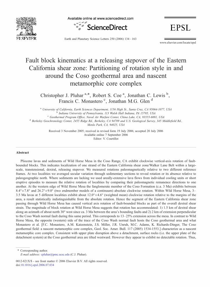
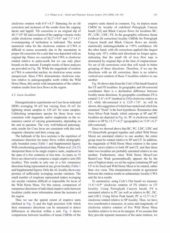
Fault block kinematics at a releasing stepover of the Eastern California shear zone: Partitioning of rotation style in and around the Coso geothermal area and nascent metamorphic core complex Christopher J. Pluhar a, ⁎ , Robert S. Coe a , Jonathan C. Lewis b , Francis C. Monastero c , Jonathan M.G. Glen d a University of California, Earth Sciences Department, 1156 High St., Santa Cruz, CA 95064-1077, USA b Indiana University of Pennsylvania, 113 Walsh Hall Indiana, PA 15705, USA c Geothermal Program Office, Naval Air Warfare Center, China Lake, CA, 93555-6001, USA d Berkeley Geochronology Center, 2455 Ridge Rd., Berkeley, CA 94709 and U.S. Geological Survey, 345 Middlefield Rd., Menlo Park, CA, 94025, USA Received 3 November 2005; received in revised form 19 July 2006; accepted 20 July 2006 Available online 7 September 2006 Editor: V. Courtillot Abstract Pliocene lavas and sediments of Wild Horse Mesa in the Coso Range, CA exhibit clockwise vertical-axis rotation of fault- bounded blocks. This indicates localization of one strand of the Eastern California shear zone/Walker Lane Belt within a large- scale, transtensional, dextral, releasing stepover. We measured rotations paleomagnetically relative to two different reference frames. At two localities we averaged secular variation through sedimentary sections to reveal rotation or its absence relative to paleogeographic north. Where sediments are lacking we used areally-extensive lava flows from individual cooling units or short eruptive episodes to measure the relative rotation of localities by comparing their paleomagnetic remanence directions to one another. At the western edge of Wild Horse Mesa the fanglomerate member of the Coso Formation (c.a. 3 Ma) exhibits between 8.4° ± 7.8° and 26.2° ± 9.0° (two endmember models of a continuum) absolute clockwise rotation. Within Wild Horse Mesa, 3– 3.5 Ma lavas at 5 different localities exhibit about 12.0° ± 4.6° (weighted mean) clockwise rotation relative to the margins of the area, a result statistically indistinguishable from the absolute rotation. Hence the segment of the Eastern California shear zone passing through Wild Horse Mesa has caused vertical axis rotation of fault-bounded blocks as part of the overall dextral shear strain. The magnitude of block rotation at Wild Horse Mesa suggests that rotation has accommodated: 1) 1.5 km of dextral shear along an azimuth of about north 30° west since ca. 3 Ma between the area's bounding faults and 2) 2 km of extension perpendicular to the Coso Wash normal fault during this same period. This corresponds to 13–25% extension across the mesa. In contrast to Wild Horse Mesa, the opposite (western) side of the trace of the Coso Wash normal fault hosts the Coso geothermal area and what Monastero et al. [F.C. Monastero, A.M. Katzenstein, J.S. Miller, J.R. Unruh, M.C. Adams, K. Richards-Dinger, The Coso geothermal field: a nascent metamorphic core complex, Geol. Soc. Amer. Bull. 117 (2005) 1534-1553.] characterize as a nascent metamorphic core complex. Consistent with upper plate disruption above a detachment, surface rocks (i.e. the upper plate of the detachment system) at the Coso geothermal area are tilted westward. However they appear to exhibit no detectable rotation. Thus, Earth and Planetary Science Letters 250 (2006) 134 – 163 www.elsevier.com/locate/epsl ⁎ Corresponding author. E-mail address: [email protected] (C.J. Pluhar). 0012-821X/$ - see front matter © 2006 Elsevier B.V. All rights reserved. doi:10.1016/j.epsl.2006.07.034
-
Upload
independent -
Category
Documents
-
view
0 -
download
0
Transcript of Fault block kinematics at a releasing stepover of the Eastern California shear zone: Partitioning of...
tters 250 (2006) 134–163www.elsevier.com/locate/epsl
Earth and Planetary Science Le
Fault block kinematics at a releasing stepover of the EasternCalifornia shear zone: Partitioning of rotation style in and
around the Coso geothermal area and nascentmetamorphic core complex
Christopher J. Pluhar a,⁎, Robert S. Coe a, Jonathan C. Lewis b,Francis C. Monastero c, Jonathan M.G. Glen d
a University of California, Earth Sciences Department, 1156 High St., Santa Cruz, CA 95064-1077, USAb Indiana University of Pennsylvania, 113 Walsh Hall Indiana, PA 15705, USA
c Geothermal Program Office, Naval Air Warfare Center, China Lake, CA, 93555-6001, USAd Berkeley Geochronology Center, 2455 Ridge Rd., Berkeley, CA 94709 and U.S. Geological Survey, 345 Middlefield Rd.,
Menlo Park, CA, 94025, USA
Received 3 November 2005; received in revised form 19 July 2006; accepted 20 July 2006Available online 7 September 2006
Editor: V. Courtillot
Abstract
Pliocene lavas and sediments of Wild Horse Mesa in the Coso Range, CA exhibit clockwise vertical-axis rotation of fault-bounded blocks. This indicates localization of one strand of the Eastern California shear zone/Walker Lane Belt within a large-scale, transtensional, dextral, releasing stepover. We measured rotations paleomagnetically relative to two different referenceframes. At two localities we averaged secular variation through sedimentary sections to reveal rotation or its absence relative topaleogeographic north. Where sediments are lacking we used areally-extensive lava flows from individual cooling units or shorteruptive episodes to measure the relative rotation of localities by comparing their paleomagnetic remanence directions to oneanother. At the western edge of Wild Horse Mesa the fanglomerate member of the Coso Formation (c.a. 3 Ma) exhibits between8.4°±7.8° and 26.2°±9.0° (two endmember models of a continuum) absolute clockwise rotation. Within Wild Horse Mesa, 3–3.5 Ma lavas at 5 different localities exhibit about 12.0°±4.6° (weighted mean) clockwise rotation relative to the margins of thearea, a result statistically indistinguishable from the absolute rotation. Hence the segment of the Eastern California shear zonepassing through Wild Horse Mesa has caused vertical axis rotation of fault-bounded blocks as part of the overall dextral shearstrain. The magnitude of block rotation at Wild Horse Mesa suggests that rotation has accommodated: 1) 1.5 km of dextral shearalong an azimuth of about north 30° west since ca. 3 Ma between the area's bounding faults and 2) 2 km of extension perpendicularto the Coso Wash normal fault during this same period. This corresponds to 13–25% extension across the mesa. In contrast to WildHorse Mesa, the opposite (western) side of the trace of the Coso Wash normal fault hosts the Coso geothermal area and whatMonastero et al. [F.C. Monastero, A.M. Katzenstein, J.S. Miller, J.R. Unruh, M.C. Adams, K. Richards-Dinger, The Cosogeothermal field: a nascent metamorphic core complex, Geol. Soc. Amer. Bull. 117 (2005) 1534-1553.] characterize as a nascentmetamorphic core complex. Consistent with upper plate disruption above a detachment, surface rocks (i.e. the upper plate of thedetachment system) at the Coso geothermal area are tilted westward. However they appear to exhibit no detectable rotation. Thus,
⁎ Corresponding author.E-mail address: [email protected] (C.J. Pluhar).
0012-821X/$ - see front matter © 2006 Elsevier B.V. All rights reserved.doi:10.1016/j.epsl.2006.07.034

135C.J. Pluhar et al. / Earth and Planetary Science Letters 250 (2006) 134–163
the style of block rotation may be partitioned: with clockwise vertical-axis rotation dominating in the Wild Horse Mesa andhorizontal axis rotation (tilting) in the geothermal area.© 2006 Elsevier B.V. All rights reserved.
Keywords: Eastern California shear zone; Walker Lane Belt; Coso volcanic field; Wild Horse Mesa; China Lake; Paleomagnetism; Vertical-axisrotation; Metamorphic core complex; Kinematics; Pliocene
1. Introduction
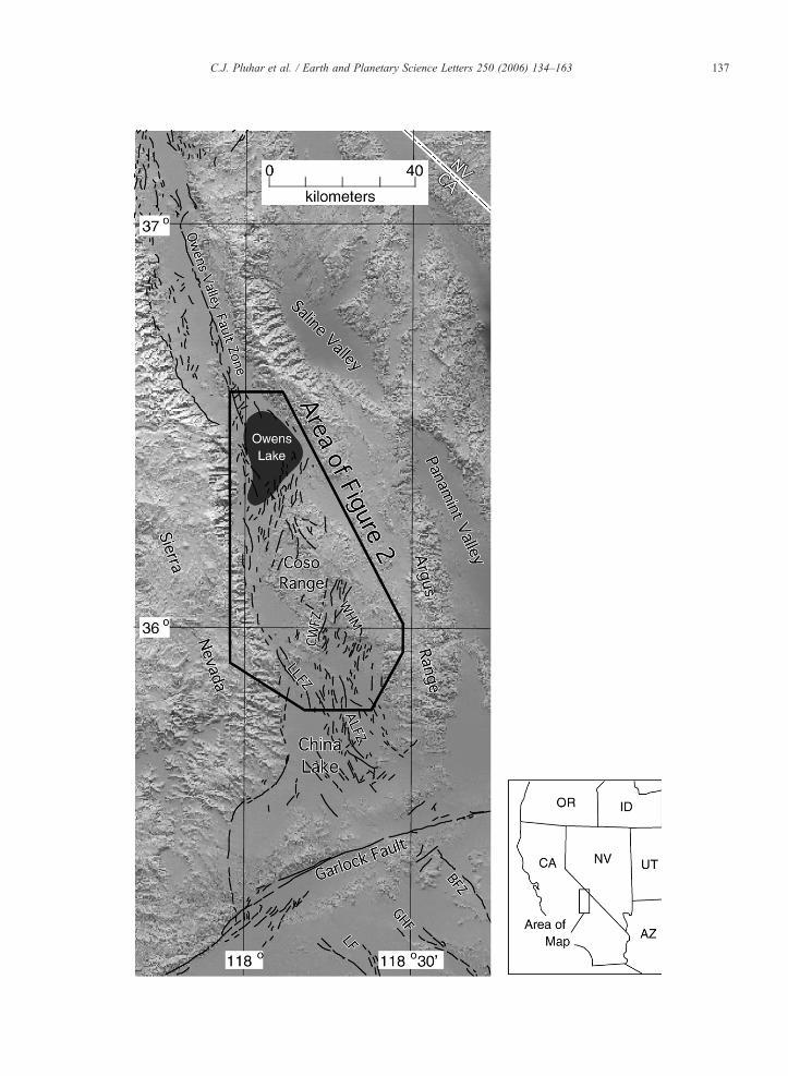
Monastero and coworkers [1,2] have suggested thatthe Coso geothermal area, CA results from a nascentmetamorphic core complex below a detachment systemat 3–4 km depth. This area resides within a releasingstepover in the westernmost, and currently most active,e.g. [3,4], strand of the Eastern California shear zone/southern Walker Lane Belt (ECSZ), composed of theOwens Valley, Little Lake, Calico, Harper and JohnsonValley–Homestead Valley–Camp Rock system of faultzones [5–7] (Fig. 1). The current study examines thekinematics of block rotations in and around thegeothermal area since about 3 Ma and provides a lowerbound on total dextral and extensional displacementaccommodated by rotation within an adjacent obliqueextensional area composed of Wild Horse Mesa andCoso Basin (Fig. 2).
For the segment of the ECSZ north of the Garlockfault, no estimates exist for total displacement since itsinception (though previous workers measure variableamounts of dextral motion since Sierran batholith em-placement, e.g. [8–10]). This dearth of data stems in partfrom the absence of exposed Cenozoic units crossing thissegment of the ECSZ to provide piercing points. Ourstudy is motivated by the presence of Pliocene lavas ofthe Coso Range within the stepover between the OwensValley and Little Lake fault zones for use as indicators ofdextral shear.
However, this goal is complicated by the distributednature of shear in the Coso Range due to the releasingright step in the dextral ECSZ. Rather than simple offsetunits and features, Coso exhibits an anastomosingnetwork of active faults that theory would predict (e.g.[11]) has accommodated shear by vertical axis rotation.This study presents evidence from deflected paleomag-netic remanence directions for such vertical axis rotation.Using these data, fault geometry, and kinematics, wepresent an estimate of the total minimum dextral dis-placement and extension implied by this rotation, anddefine the bounding structures accommodating it. Thismethod measures only the rotational component ofdeformation and uses the rotation to back out the shearstrain required to produce it. Thus, true dextral shear
strain in the study area may be substantially greater thanthe lower bound we present. In other words, we assume apinned block model, and if the blocks are unpinned, thetotal displacement across the study area would be larger.
2. Regional geology/previous work
The Coso Range (Fig. 2) is composed of Mesozoicbasement with a patchy veneer of Pliocene andPleistocene extrusive rocks [12]. TheMesozoic basement,correlative with plutonic rocks of the Sierra Nevadabatholith, is chiefly composed of Jurassic and Cretaceousfelsic and mafic plutons, minor associated metamorphicrocks, and Independence dikes [13,14]. These rocks formbasement highlands within a range flanked to the northand south by Owens Lake and China Lake/Indian WellsValley, respectively. The Coso Range has been physio-graphically separated from the SierraNevada by the SierraNevada frontal fault, and the Inyo Mountains by inferredstructures in lower Centennial Flat.
The exposed Mesozoic basement has been moderatelyfaulted during the Late Cenozoic by oblique dextral-ex-tension of the Owens Valley/Death Valley extendedterrane [15]. Current seismogenic deformation accom-modates northwestward motion of the Sierra Nevada/Great Valley microplate relative to stable North America[16]. This is corroborated by geodetic studies [3,17].Thus, north- or northeast-striking left-stepping en echelonnormal faults and northwest-striking dextral strike-slipfaults accommodate the northwest-striking dextral shear.The latter structures are not easily discernable in the studyarea except in the basins north and south of the range.Rather, normal (or oblique) faults dominate the geomor-phology and in the Wild Horse Mesa have developed tothe point of forming an anastomosing network. However,beneath the Wild Horse Mesa there is evidence for purestrike-slip at depth [16,18,19].
Just to the west of the Wild Horse Mesa (and on theopposite side, the footwall, of the CosoWash fault zone)lies the Coso geothermal area (Figs. 1 and 2). Monastero[2] and Monastero et al. [1] have suggested that thisgeothermal field results from an actively-forming meta-morphic core complex beneath a detachment at 3–4 kmdepth. They present seismological, geochemical, and

136 C.J. Pluhar et al. / Earth and Planetary Science Letters 250 (2006) 134–163
gravity data to support this hypothesis. No detailedhypothesis for the kinematics of inception and evolutionof this feature have yet been advanced, but our studyplaces constraints on possible models.
Several previous kinematic studies indicate thatexposed Mesozoic basement blocks in and aroundCoso have experienced no detectable net vertical axisrotation since the Mesozoic. Using the strike ofIndependence dikes in several regions of California,Ron and Nur [20] concluded that no rotation of the hostbasement blocks had occurred in the Argus Range.Whitmarsh et al. [21] conducted paleomagnetic analysisof some Late Mesozoic Independence dikes andinterpreted the data as indicating at least 30° ofnorthwestward tilting, but no net vertical axis rotationin the region of southern Rose Valley (Fig. 2). Schweig[22] analyzed Miocene volcanic rocks in the nearbyArgus Range and found no significant vertical axisrotation (3.6°±13.7° clockwise). As we now know,however, all of these previous studies were outside of theregion of greatest Cenozoic strain, the Coso Basin andWild Horse Mesa.
The Coso Basin and Wild Horse Mesa comprise arhombic depression (Fig. 2 inset) that exhibitspervasive anastomosing normal or oblique faults (Fig.2) and is bounded on the west by the large left-steppingen echelon east-dipping Coso Wash normal fault zone(Fig. 1). The active Coso Hot Springs and fault scarpsdeveloped in Quaternary alluvium [12] along the CosoWash fault zone attest to its ongoing activity. Thenortheast edge of the Coso Basin/Wild Horse Mesarhombic depression is the Wild Horse Mesa fault zone,which we define as the lineament formed by the edgeof Mesozoic basement outcrops paralleling an align-ment of strike-slip seismic focal mechanisms andmicroseismicity [1]. To the southeast, the rhombicdepression is bounded by the west-dipping Argusfrontal fault zone [15].
The Wild Horse Mesa and Coso Basin are filledwith Pliocene and younger lavas, tuffs, epiclastic rocks,and sedimentary units of various types. The Coso Basinis filled with at least several hundred meters oflacustrine White Hills sequence [15] and alluvialunits, with only about 70 m of the lake beds exposedat Earth's surface at the White Hills anticline [13]. TheWild Horse Mesa is composed largely of Pliocene calc-
Fig. 1. Quaternary faults along part of the Eastern California shear zone/Walkwhile further north shear is localized on the Owens Valley fault zone and furthHorse Mesa (WHM) and vicinity, occupies a heavily faulted part of this regionfault zone, LLFZ— Little Lake fault zone, BFZ— Blackwater fault zone, Gwestern strand of the ECSZ are depicted, derived from [47].
alkaline volcanic rocks [23] that spill southwards andwestwards into the Coso Basin. These rocks are mostlybasalts and basaltic andesites with infrequent andesite,dacite and rare rhyolitic pyroclastic rocks. Identifica-tion of different mafic eruptive units, while distin-guishable paleomagnetically and geochemically [24], isdifficult in the field because of the very similarappearance of these ubiquitously plagioclase–phyricunits. Duffield and Bacon [12] lumped all flows ofsimilar composition together into mapping units,reflecting this difficulty.
Pluhar and co-workers [18,24,25] significantlyrefined the volcanic stratigraphy of the Wild HorseMesa (Fig. 3) using paleomagnetic remanence directionof units, major and trace element geochemistry, andstratigraphic relations. Groups of lava flows at alocality with the same geochemistry and similarremanence directions were assigned to an eruptiveunit. A given eruptive unit could typically be found atmore than one locality, allowing compilation of amaster stratigraphy for the area. The current studydepends on this previous work in order to examine thesmall differences in remanence direction across eacheruptive unit.
3. Methods
Directly measuring the magnitude of strike-slipdisplacement accurately across an area accommodatingthis movement by vertical-axis rotation is oftenimpossible. In a region of rotating blocks, fault slipmust be summed across many faults to get a truemeasure of total slip. However, measurement of finiterotation of fault-bounded blocks provides a moretractable solution by allowing calculation of the min-imum slip necessary at the region boundaries to allowthe observed rotation (e.g. [26] or [27] for predictingrotation rate and thus deriving slip). We measure finiterotations using the deflection of paleomagnetic rema-nence directions.
3.1. Paleomagnetism of sedimentary rocks
In the most simple case, paleomagnetic measure-ments of vertical-axis rotations are made on sedimentaryrocks. Sampling through a stratigraphic section allows
er Lane Belt. The Coso Range occupies an area of distributed faulting,er south along the Airport Lake fault zone (ALFZ). The study area, Wildof distributed shear. Other structures of interest: CWFZ— CosoWashHF— Gravel Hill fault, LF— Lockhart fault. Only active faults of the
137C.J. Pluhar et al. / Earth and Planetary Science Letters 250 (2006) 134–163

Fig. 2. Geologic and sampling locality map. Tertiary and Mesozoic basement rocks of greater Coso Range are shown. Locality names are as follows;AL — Airport Lake, BC — Black Canyon, CF — (near) Cole’s Flat, CHS — Coso Hot Spring, FS — fault scarp locality, HS — Haiwee Spring,HSB and HSD — Haiwee Spring localities B and D, HR — Haiwee Reservoir, LDC and UDC — lower and upper Dead End Canyon, PC —Petroglyph Canyon, RC— Renegade Canyon, RCB to RCE— Renegade Canyon localities B through E, RDT— rhyodacite airfall pumice ([12,48]unit Tcp), RHT — rhyolite ash and pumice, SP — (near) Silver Peak, and WHB — White Hills locality B. Geology is drawn from [12,47,49,50].
138 C.J. Pluhar et al. / Earth and Planetary Science Letters 250 (2006) 134–163

139C.J. Pluhar et al. / Earth and Planetary Science Letters 250 (2006) 134–163
averaging out of secular variation of Earth's magneticfield. In addition there is no ambiguity on the exactbedding correction to apply, since all but fanglomerateexhibits original horizontality. Therefore, after tiltcorrection, the mean direction of a group of samplesthrough such a section points to paleogeographic northfor the tectonic block on which the sediments ride,providing a marker of rigid-body rotation.
We sampled weakly-lithified sedimentary rocks atthree localities (see Fig. 2). The Haiwee Reservoirlacustrine (locality HR) section, located in a nearbybasin, yielded poor directional results and will be dis-cussed no further (also see [28]). The White Hillssection B (WHB) is also lacustrine and thought to bePlio-Pleistocene based on paleontologic evidence [13]and a single bracketing age of 3.11±0.21 Ma from abasalt encountered at a depth of 418 m in a drill corefrom the White Hills [15]. The lacustrine sections weresampled by collecting large oriented handsamples thatwere then subdivided into multiple specimens. TheCoso Wash (CWA, Fig. 2) section, Late Pliocene in age
Fig. 3. Composite volcanic stratigraphy for Wild Horse Mesa and Renegadegeochemical fingerprinting coupled with field relations and existing geochronthe maximum observed number of flows for each unit. Where used, unit abbreAr isochron age from Richard Whitmarsh (personal communication, 2000). Pdetailed magnetostratigraphy and new geochronology for these rocks.
[12,18,25], spans 12 m of the Coso Formationfanglomerate member with overlying pyroclastic rocks(b1 m thick) and a capping dacite lava flow.Paleomagnetic fanglomerate samples collected fromthis locality were individually carved, a plastic boxplaced over each in situ sample, and orientationrecorded. Some pyroclastic samples were derived fromsubdivision of a large oriented handsample. Dacite lavasamples were collected and treated with the sametechniques described for lavas.
Oriented sediment samples were analyzed by stan-dard paleomagnetic methods including thermal and/oralternating field (AF) stepwise demagnetization experi-ments and principal component analysis (PCA) [29,30]of the resulting demagnetization paths (Fig. 4). Forsediments, thermal demagnetization was the preferredtechnique because of the possibility of secondarychemical remanent magnetization components or detri-tal hematite signals. PCA yields the characteristicremanent magnetization (ChRM) direction (usuallyconsidered the primary magnetization) for each
Canyon based on combined paleomagnetic remanence direction andology from previous studies [18,24,25]. Unit polarity is indicated as isviations are from [12], K/Ar geochronology from [13], except *— Ar/olarity: R — reversed, N — normal. Pluhar et al. [25] will present the

Fig. 4. Example sample demagnetization data. Zijderveld diagrams depicting some aspects of demagnetization behavior. Sedimentary sampleWHB19C illustrates the strong role of hematite in the primary magnetization, resulting in sample stability up to its Curie temperature and a shallowedinclination. WHB9G is a strongly overprinted sedimentary sample with a weak primary magnetization preserved above 660 °C. CWA7 illustratesstable normal polarity magnetization of Coso Formation fanglomerate. AL0601A represents typical lava sample behavior — nearly univectorialdecay to the origin. CF0104A portrays the usually easy removal of secondary overprints using low levels of AF demagnetization. AF and thermaldemagnetization is compared for sample BD1403 to illustrate the adequacy of AF for these rocks. AF is usually preferable for the lavas because of itseffectiveness at removing isothermal remanence from lightning strikes, the most common significant overprint.
140 C.J. Pluhar et al. / Earth and Planetary Science Letters 250 (2006) 134–163
specimen. Where multiple specimens were derived froma single oriented hand sample, all ChRMs determinedwere averaged [31] to give a mean ChRM for thesample. For each locality, the mean of all independently-oriented ChRMs yields the best estimate of paleogeo-graphic north.
Standard tilt corrections were applied to WHB sedi-ments to restore beds to original horizontality. However,it would be incorrect to assume that the fanglomeratewas deposited on a horizontal surface. Alluvial fanstypically exhibit slopes (i.e. original dips) of 5°–10°, asdo the modern fans in Coso Wash. Thus at Coso Washwe restore beds to an original dip rather than horizontal,as discussed in the Results section.
3.2. Paleomagnetism of volcanic rocks
The major Cenozoic rock type available in the studyarea is basalt and basaltic andesite. Lavas are often lessthan ideal for averaging out secular variation becausemany flows can be emplaced in a very short period,yielding a thick stratigraphic section representing thesame geologic instant and thus paleomagnetic direction.However, we utilize such rocks because they presentother advantages for paleomagnetic studies. Lavas veryfaithfully record Earth's magnetic field, and generallythis paleomagnetic signal can be measured much moreaccurately and precisely than that in sediments. There-fore, if a laterally-extensive lava flow or flow group can
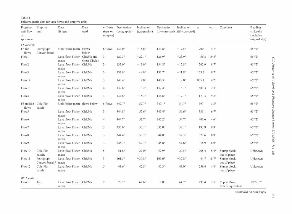
Table 1Paleomagnetic data for lava flows and eruptive units
Eruptiveunit floworspecimen
Eruptiveunit
Datafit type
Dataused
n (flows,steps orsamples)
Declination(geographic)
Inclination(geographic)
Declination(tilt-corrected)
Inclination(tilt-corrected)
κ α95 Comment Beddingstrike/dip(includesoriginal dip)
FS localityFS topflows
PetroglyphCanyon basalt
Unit Fisher mean Flowsbelow
6 flows 134.0° −15.6° 133.8° −17.5° 200 4.7° 65°/2°
Flow1 Lava flow Fishermean
ChRMs andGreat Circles
3 127.3° −22.1° 126.9° −23.9° 56.8 19.4° 65°/2°
Flow2 Lava flow Fishermean
ChRMs 3 135.0° −15.9° 134.8° −17.8° 202.9 8.7° 65°/2°
Flow3 Lava flow Fishermean
ChRMs 3 133.9° −9.9° 133.7° −11.8° 163.2 9.7° 65°/2°
Flow14 Lava flow Fishermean
ChRMs 3 140.4° −17.0° 140.3° −19.0° 855.1 4.2° 65°/2°
Flow13 Lava flow Fishermean
ChRMs 4 132.6° −13.2° 132.4° −15.1° 1601.3 2.3° 65°/2°
Flow4 Lava flow Fishermean
ChRMs 3 134.8° −15.3° 134.6° −17.1° 177.3 9.3° 65°/2°
FS middleflows
Cole Flatbasalt
Unit Fisher mean flows below 5 flows 342.7° 52.7° 343.1° 54.7° 397 3.8° 65°/2°
Flow5 Lava flow Fishermean
ChRMs 3 344.8° 57.6° 345.4° 59.6° 335.1 6.7° 65°/2°
Flow6 Lava flow Fishermean
ChRMs 4 344.7° 52.7° 345.2° 54.7° 403.6 4.6° 65°/2°
Flow7 Lava flow Fishermean
ChRMs 3 335.0° 50.1° 335.0° 52.1° 193.9 8.9° 65°/2°
Flow8 Lava flow Fishermean
ChRMs 3 344.4° 50.3° 344.8° 52.3° 321.6 6.9° 65°/2°
Flow9 Lava flow Fishermean
ChRMs 3 345.3° 52.7° 345.8° 54.6° 318.9 6.9° 65°/2°
Flow10 Cole Flatbasalt?
Lava flow Fishermean
ChRMs 5 51.8° 29.0° 52.9° 29.5° 205.4 5.4° Slump block,out of place
Unknown
Flow11 PetroglyphCanyon basalt?
Lava flow Fishermean
ChRMs 3 161.5° −30.8° 161.6° −32.8° 44.7 18.7° Slump block,out of place
Unknown
Flow12 Cole Flatbasalt
Lava flow Fishermean
ChRMs 5 43.6° 42.3° 45.3° 43.0° 259.4 4.8° Slump block,out of place
Unknown
BC localityFlow1 Tan Lava flow Fisher
meanChRMs 7 28.7° 62.6° 8.8° 64.2° 297.4 3.5° Repeat flow,
flow 5 equivalent190°/10°
(continued on next page) 141C.J.
Pluhar
etal.
/Earth
andPlanetary
ScienceLetters
250(2006)
134–163

Table 1 (continued)
Eruptiveunit floworspecimen
Eruptiveunit
Datafit type
Dataused
n (flows,steps orsamples)
Declination(geographic)
Inclination(geographic)
Declination(tilt-corrected)
Inclination(tilt-corrected)
κ α95 Comment Beddingstrike/dip(includesoriginal dip)
BC localityFlowA1 Lava flow Fisher
meanChRMs 3 15.0° 62.5° 356.0° 61.7° 291.9 7.2° Repeat flow,
flow 5 equivalent190°/10°
Flow2 PetroglyphCanyon basalt
Lava flow Fishermean
ChRMs 6 141.1° −17.0° 139.6° −9.4° 128.1 5.9° Repeat flow, flow 6–8equivalent
190°/10°
Flow2B Lava flow Fishermean
ChRMs andGreat Circles
6 141.9° −10.5° 141.1° −3.0° 143 5.9° Repeat flow, flow 6–8equivalent
190°/10°
Flow3 Lava flow Fishermean
ChRMs 6 142.8° −22.4° 140.5° −14.9° 522.9 2.9° Repeat flow, flow 6–8equivalent
190°/10°
Flow3B Lava flow Fishermean
ChRMs 5 136.8° −11.2° 136.0° −3.1° 288.3 4.5° Repeat flow, flow 6–8equivalent
190°/10°
Flow4 Tan Lava flow Fishermean
ChRMs andGreat Circles
6 338.6° 62.6° 325.2° 56.3° 65.3 8.5° 190°/10°
Flow5 Lava flow Fishermean
ChRMs andGreat Circles
6 20.5° 59.4° 3.4° 59.7° 408.4 3.4° 190°/10°
BCmiddleflows
PetroglyphCanyon basalt
Unit Fisher mean Flows below 3 flows 140.8° −19.7° 138.9° −12.1° 487.5 5.6° 190°/10°
Flow6 Lava flow Fishermean
ChRMs 6 140.5° −17.2° 139.0° −9.5° 303.8 3.9° 190°/10°
Flow7 Lava flow Fishermean
ChRMs 6 140.9° −18.1° 139.3° −10.5° 65.8 8.3° 190°/10°
Flow8 Lava flow Fishermean
ChRMs 6 140.8° −23.9° 138.5° −16.2° 242.1 4.3° 190°/10°
BC basalflows
Black Canyonflows
Unit Fisher mean Flows below 10 flows 31.8° 32.6° 25.4° 35.8° 554.4 2.1° 190°/10°
Flow9 Lava flow Fishermean
ChRMs 5 30.4° 33.1° 23.8° 36.0° 155.1 6.2° 190°/10°
Flow10 Lava flow Fishermean
ChRMs 5 37.1° 34.0° 30.4° 38.1° 176.6 5.8° 190°/10°
Flow11 Lava flow Fishermean
ChRMs 10 34.9° 27.5° 29.6° 31.4° 63.9° 6.1 190°/10°
Flow12 Lava flow Fishermean
ChRMs 8 31.4° 31.8° 25.1° 34.9° 225.9 3.7° 190°/10°
Flow13A Lava flow Fishermean
ChRMs 3 33.7° 26.5° 28.6° 30.1° 159.5 9.8° 190°/10°
Flow13B Lava flow Fishermean
ChRMs 3 27.0° 33.2° 20.3° 35.6° 214.3 8.4° 190°/10°
142C.J.
Pluhar
etal.
/Earth
andPlanetary
ScienceLetters
250(2006)
134–163
Flow13C Lava flow Fishermean
ChRMs 3 38.5° 35.6° 31.5° 39.8° 129.8 10.9° 190°/10°
Flow13D Lava flow Fishermean
ChRMs 3 30.2° 30.9° 24.1° 33.9° 90.6 13.0° 190°/10°
Flow14A Lava flow Fishermean
ChRMs 2 29.4° 36.8° 21.8° 39.5° 234.8 16.4° 190°/10°
Flow14B Lava flow Fishermean
ChRMs 5 27.3° 31.5° 21.0° 34.0° 250.8 4.8° 190°/10°
BC localityFlow15A Lava flow Fisher
meanChRMs 5 33.6° 31.6° 27.4° 35.1° 572.5 3.2° 190°/10°
Flow15B Lava flow Fishermean
ChRMs 2 31.3° 32.9° 24.8° 36.0° 881.7 8.4° 190°/10°
Flow16 Lava flow Fishermean
ChRMs 7 27.1° 36.3° 19.6° 38.6° 205.1 4.2° 190°/10°
Flow17 Lava flow Fishermean
ChRMs 5 29.9° 33.5° 23.2° 36.4° 588.2 3.2° 190°/10°
Flow18 Lava flow Fishermean
ChRMs 6 34.2° 32.8° 27.7° 36.4° 586.9 2.8° 190°/10°
CHSlocality
Black Canyonflows
Unit Fisher mean ChRMs 30 40.7° 7.5° 40.7° 7.5° 9.1 9.2°° Sans outliers Unknown
CHSlocality
Unit Fisher mean ChRMs 35 39.7° −2.1° 39.7° −2.1° 5.2 11.9° All samples Unknown
CF localityCF Cole Flat basalt Unit Fisher mean Sites below 4 sites 331.1° 52.0° 331.1° 52.0° 641.2 3.6° Unknownsite 1 Lava flow Fisher
meanChRMs andGreat Circles
5 329.2° 50.8° 329.2° 50.8° 544.3 3.4° Same flow repeated Unknown
site 2 Lava flow Fishermean
ChRMs 4 331.5° 49.2° 331.5° 49.2° 356.5 4.9° Same flow repeated Unknown
site 3 Lava flow Fishermean
ChRMs 7 336.0° 54.1° 336.0° 54.1° 281.8 3.6° Same flow repeated Unknown
site 4 Lava flow Fishermean
ChRMs andGreat Circles
5 327.9° 53.8° 327.9° 53.8° 379.9 4.1° Same flow repeated Unknown
LBlocality
Un-namedandesite
Unit Fisher mean ChRMs andGreat Circles
8 348.2° 51.0° 348.2° 51.0° 900.5 1.9° Unknown
SPlocality
Silver Peakbasalt
Unit Fisher mean ChRMs 11 139.6° −23.2° 138.5° −24.7° 167.7 3.5° 110°/3°
UDClocality
PetroglyphCanyon basalt
Unit Fisher mean ChRMs 5 136.6° −14.1° 136.6° −14.1° 517.2 3.4° Unknown
LDC localityLDC Petroglyph
Canyon basaltUnit Fisher mean ChRMs below 6 flows 137.9° −22.5° 137.9° −22.5° 80.3 7.5° Unknown
OC0102A Least squarethru origin
22–105 mT 6 136.1° −20.5° 136.1° −20.5° 1.1 0.0° Unknown
OC0204A Least squarethru origin
15–199 mT 9 145.6° −13.5° 145.6° −13.5° 0.4 0.0° Unknown
(continued on next page)
143C.J.
Pluhar
etal.
/Earth
andPlanetary
ScienceLetters
250(2006)
134–163

Table 1 (continued)
Eruptiveunit floworspecimen
Eruptiveunit
Datafit type
Dataused
n (flows,steps orsamples)
Declination(geographic)
Inclination(geographic)
Declination(tilt-corrected)
Inclination(tilt-corrected)
κ α95 Comment Beddingstrike/dip(includesoriginal dip)
LDC localityOC0302A Least square
thru origin15–199 mT 9 140.4° −24.4° 140.4° −24.4° 1 0.0° Unknown
OC0403A Least squarethru origin
15–199 mT 9 137.3° −19.0° 137.3° −19.0° 0.6 0.0° Unknown
OC0501A Least squarethru origin
15–199 mT 9 134.7° −20.3° 134.7° −20.3° 0.7 0.0° Unknown
OC0604A Least squarethru origin
32–199 mT 7 132.4° −37.1° 132.4° −37.1° 1.5 0.0° Unknown
PC localityPC22 Petroglyph
Canyon basaltLava flow Fishermean
ChRMs andGreatCircles
6 137.7° −16.6° 137.2° −17.7° 107.6 6.6° 105°/2°
PC21 Silver Peakbasalt
Lava flow Fishermean
ChRMs 9 151.9° −17.9° 151.5° −19.3° 66.5 6.4° 105°/2°
PC middleflows
Black Canyonflows
Unit Fisher mean Flows below 4 flows 36.3° 33.4° 36.8° 35.2° 516.4 4.0° 105°/2°
PC20 Lava flow Fishermean
ChRMs 3 34.5° 29.4° 34.9° 31.3° 940.2 4.0° 105°/2°
PC19 Lava flow Fishermean
ChRMs 3 34.5° 35.4° 35.0° 37.3° 551.9 5.3° 105°/2°
PC18 Lava flow Fishermean
ChRMs 4 37.6° 32.5° 38.1° 34.3° 223.1 6.2° 105°/2°
PC17 Lava flow Fishermean
ChRMs 3 38.6° 36.2° 39.3° 38.0° 120.4 11.3° 105°/2°
PC basalflows
PetroglyphCanyonandesite
Unit Fisher mean Flows below 16 flows 4.3° 51.9° 3.8° 53.9° 395.8 1.9° 105°/2°
PC16 Lava flow Fishermean
ChRMs 2 12.8° 50.9° 12.7° 52.9° 722.8 9.3° 105°/2°
PC1513A M050–M675 7 4.8° 48.8° 4.4° 50.8° 1.7 0.0° 105°/2°PC15 Lava flow Fisher
meanChRMs 2 4.6° 52.3° 4.1° 54.3° 280.6 15.0° 105°/2°
PC14 Lava flow Fishermean
ChRMs 2 4.3° 52.8° 3.8° 54.8° 237.8 16.3° 105°/2°
PC13 Lava flow Fishermean
ChRMs 2 5.8° 50.4° 5.4° 52.4° 523.2 10.9° 105°/2°
PC12 Lava flow Fishermean
ChRMs 2 8.2° 53.4° 7.9° 55.4° 1427.4 6.6° 105°/2°
Table 1 (continued)144
C.J.
Pluhar
etal.
/Earth
andPlanetary
ScienceLetters
250(2006)
134–163
PC11 Lava flow Fishermean
ChRMs 2 13.7° 53.8° 13.7° 55.8° 157 20.1° 105°/2°
PC10 Lava flow Fishermean
ChRMs 2 1.8° 53.3° 1.1° 55.2° 1552.9 6.3° 105°/2°
PC09 Lava flow Fishermean
ChRMs 2 5.4° 51.8° 5.0° 53.8° 541.3 10.8° 105°/2°
PC localityPC08 Lava flow Fisher
meanChRMs 2 351.6° 55.2° 350.4° 57.0° 200 17.8° 105°/2°
PC07 Lava flow Fishermean
ChRMs 3 5.8° 55.0° 5.3° 57.0° 194.4 8.9° 105°/2°
PC06 Lava flow Fishermean
ChRMs 4 7.9° 51.1° 7.6° 53.1° 150.8 7.5° 105°/2°
PC05 Lava flow Fishermean
ChRMs 2 2.7° 54.2° 2.1° 56.1° 749 9.1° 105°/2°
PC04 Lava flow Fishermean
ChRMs 7 1.9° 48.8° 1.4° 50.8° 2064.1 1.3° 105°/2°
PC03 Lava flow Fishermean
ChRMs 6 1.8° 49.9° 1.3° 51.9° 467.8 3.1° 105°/2°
PC02 Lava flow Fishermean
ChRMs 4 4.0° 47.9° 3.6° 49.9° 362 4.8° 105°/2°
PC01 Lava flow Fishermean
ChRMs 6 356.7° 47.5° 356.0° 49.4° 526.6 2.9° 105°/2°
RC localityRC01 QTbr2 Lava flow Fisher
meanChRMs 9 181.6° −48.0° 181.6° −48.0° 189.7 3.7° Unknown
RC02 Lava flow Fishermean
ChRMs andGreat Circles
12 193.4° −42.5° 193.4° −42.5° 108.5 4.2° Unknown
RC03 Lava flow Fishermean
ChRMs 3 173.1° −48.4° 173.1° −48.4° 370.3 6.4° Unknown
RC04 Lava flow Fishermean
ChRMs 3 173.0° −67.3° 173.0° −67.3° 433.9 5.9° Unknown
RC05' QTbr1 Lava flow Fishermean
ChRMs 3 219.2° −77.5° 219.2° −77.5° 35.3 21.1° Unknown
RC05 Lava flow Fishermean
ChRMs andGreat Circles
3 207.9° −81.5° 207.9° −81.5° 283.2 8.6° Unknown
RC06A Lava flow Fishermean
ChRMs 3 256.2° −83.7° 256.2° −83.7° 1128 3.7° Unknown
RC06B Lava flow Fishermean
ChRMs andGreat Circles
3 236.3° −77.6° 236.3° −77.6° 94.8 14.9° Unknown
RC06C Lava flow Fishermean
ChRMs andGreat Circles
3 199.3° −81.6° 199.3° −81.6° 1446.6 3.8° Unknown
RC07 Lava flow Fishermean
ChRMs 3 249.1° −76.5° 249.1° −76.5° 741.6 4.5° Unknown
(continued on next page)
145C.J.
Pluhar
etal.
/Earth
andPlanetary
ScienceLetters
250(2006)
134–163

Table 1 (continued)
Eruptiveunit floworspecimen
Eruptiveunit
Datafit type
Dataused
n (flows,steps orsamples)
Declination(geographic)
Inclination(geographic)
Declination(tilt-corrected)
Inclination(tilt-corrected)
κ α95 Comment Beddingstrike/dip(includesoriginal dip)
RC localityRC08 Lava flow Fisher
meanChRMs 3 247.9° −72.4° 247.9° −72.4° 398.1 6.2° Unknown
RC09 Lava flow Fishermean
ChRMs 3 256.3° −78.2° 256.3° −78.2° 554.1 5.2° Unknown
RC10 Lava flow Fishermean
ChRMs 3 256.0° −79.9° 256.0° −79.9° 1078.6 3.8° Unknown
RC11 Lava flow Fishermean
ChRMs 3 265.9° −78.2° 265.9° −78.2° 1982.7 2.8° Unknown
RC12 Lava flow Fishermean
ChRMs 3 259.7° −72.0° 259.7° −72.0° 528 5.4° Unknown
RC13 Lava flow Fishermean
ChRMs 3 254.8° −74.6° 254.8° −74.6° 702.3 4.7° Unknown
RC14 Lava flow Fishermean
ChRMs 3 234.0° −75.0° 234.0° −75.0° 212.5 8.5° Unknown
RCBlocality
QTbr4 Lava flow Fishermean
ChRMs andGreat Circles
8 184.7° −50.5° 184.7° −50.5° 369.4 2.9° Unknown
RCClocality
QTbr3 Lava flow Fishermean
ChRMs 7 181.5° −60.2° 181.5° −60.2° 525.2 2.6° Unknown
RCDlocality
QTbr4 Lava flow Fishermean
ChRMs 7 181.1° −40.8° 181.1° −40.8° 12.9 17.5° Unknown
RCElocality
QTbr2 Lava flow Fishermean
ChRMs andGreat Circles
7 172.3° −49.6° 172.3° −49.6° 212.5 4.3° Unknown
AL localityFlow1 Coso Basin
andesiteLava flow Fishermean
ChRMs 5 224.0° −38.0° 207.3° −42.4° 76.1 8.8° 203°/20°
Flow2 Lava flow Fishermean
ChRMs 6 207.2° −27.9° 196.6° −27.5° 253.8 4.2° 203°/20°
Flow3 Lava flow Fishermean
ChRMs 5 197.0° −46.2° 178.5° −40.8° 132.7 6.7° 203°/20°
Flow4 Lava flow Fishermean
ChRMs 5 192.5° −15.0° 188.0° −10.6° 541.5 3.3° 203°/20°
Flow5 Lava flow Fishermean
ChRMs 4 164.9° −45.5° 153.3° −31.5° 37.6 15.2° 203°/20°
Dike orsill
Dike or sillFisher mean
ChRMs 4 183.6° −47.7° 166.9° −38.2° 27.9 17.7° 203°/20°
Dike7 Dike Fishermean
ChRMs 3 195.1° −23.2° 187.5° −19.1° 217.6 8.4° 203°/20°
146C.J.
Pluhar
etal.
/Earth
andPlanetary
ScienceLetters
250(2006)
134–163

HS localityHS Haiwee
Springs basaltUnit Fisher mean Flows and
samples below19 flows 338.5° 43.5° 315.0° 55.1° 192.6 2.4° Mean of many
attitudes →117.1°/22.8°
Flow01 Lava flow Fishermean
ChRMs 7 338.8° 43.9° 314.9° 55.5° 368.6 3.1° 117.1°/22.8°
HS localityFlow02 Lava flow Fisher
meanChRMs 7 341.0° 42.7° 318.5° 55.3° 278.3 3.6° 117.1°/
22.8°Flow03 Lava flow Fisher
meanChRMs 5 339.0° 45.7° 313.4° 57.2° 445.3 3.6° 117.1°/
22.8°Flow04 Lava flow Fisher
meanChRMs 5 342.5° 50.0° 312.6° 62.0° 450.2 3.6° 117.1°/
22.8°Flow05 Lava flow Fisher
meanChRMs 6 332.4° 44.4° 307.8° 53.6° 696.4 2.5° 117.1°/
22.8°Flow06 Lava flow Fisher
meanChRMs 7 336.1° 43.0° 312.8° 53.9° 317.2 3.4° 117.1°/
22.8°Flow07 Lava flow Fisher
meanChRMs 7 337.8° 44.0° 313.8° 55.3° 788.9 2.2° 117.1°/
22.8°Flow08 Lava flow Fisher
meanChRMs 6 335.3° 43.4° 311.7° 53.8° 180.3 5.0° 117.1°/
22.8°Flow09 Lava flow Fisher
meanChRMs 6 339.7° 43.9° 315.9° 55.9° 249.4 4.3° 117.1°/
22.8°Flow10 Lava flow Fisher
meanChRMs 6 342.2° 44.6° 318.0° 57.5° 536.5 2.9° 117.1°/
22.8°Flow11 Lava flow Fisher
meanChRMs 4 345.1° 47.3° 318.7° 60.8° 1259.2 2.6° 117.1°/
22.8°HS1304A Least square thru
origin15–199 mT 9 348.2° 43.7° 326.0° 58.8° 0.7 0.0° 117.1°/
22.8°HS13A2A Least square thru
origin15–199 mT 9 335.9° 39.5° 315.4° 50.7° 0.4 0.0° 117.1°/
22.8°HS1403A Least square thru
origin45–199 mT 6 344.1° 37.3° 326.2° 51.6° 2.6 0.0° 117.1°/
22.8°HS1502A Least square thru
origin15–199 mT 9 331.1° 33.7° 314.4° 43.7° 0.4 0.0° 117.1°/
22.8°HS1603A Least square thru
origin22–199 mT 8 332.0° 39.1° 311.6° 48.9° 0.2 0.0° 117.1°/
22.8°HS1707B Least square thru
origin80–199 mT 4 334.1° 49.6° 304.2° 58.5° 0.5 0.0° 117.1°/
22.8°HS1806A Least square thru
origin15–199 mT 10 333.0° 37.4° 313.9° 47.7° 0.3 0.0° 117.1°/
22.8°HS1908A Least square thru
origin22–199 mT 8 346.7° 50.7° 316.5° 64.2° 0.2 0.0° 117.1°/
22.8°
HSB localityHSB Haiwee
Springs basaltUnit Fisher mean Flows below 9 flows 338.9° 61.5° 328.2° 63.9° 332.5 2.8° 130°°/6°
(continued on next page)
147C.J.
Pluhar
etal.
/Earth
andPlanetary
ScienceLetters
250(2006)
134–163

Table 1 (continued)
Eruptiveunit floworspecimen
Eruptiveunit
Datafit type
Dataused
n (flows,steps orsamples)
Declination(geographic)
Inclination(geographic)
Declination(tilt-corrected)
Inclination(tilt-corrected)
κ α95 Comment Beddingstrike/dip(includesoriginal dip)
HSB localityFlow1 Lava flow Fisher
meanChRMs 6 338.3° 56.6° 330.4° 60.2° 297.7 3.9° 130°/6°
Flow2 Lava flow Fishermean
ChRMs 6 335.5° 60.7° 325.9° 63.9° 283.1 4.0° 130°/6°
Flow2' Lava flow Fishermean
ChRMs 5 325.3° 59.0° 315.6° 61.3° 526.7 3.3° 130°/6°
Flow3 Lava flow Fishermean
ChRMs 6 346.9° 61.7° 338.2° 65.9° 316 3.8° 130°/6°°
Flow4 Lava flow Fishermean
ChRMs 8 347.4° 64.1° 337.6° 68.4° 196.9 4.0° 130°/6°
Flow5 Lava flow Fishermean
ChRMs 6 343.5° 62.1° 334.1° 66.1° 175.6 5.1° 130°/6°
Flow6 Lava flow Fishermean
ChRMs 6 341.6° 62.1° 332.0° 65.9° 1228.1 1.9° 130°/6°
Flow7 Lava flow Fishermean
ChRMs 8 341.6° 66.2° 329.8° 69.9° 263.2 3.4° 130°/6°
Flow8 Lava flow Fishermean
ChRMs andGreat Circles
6 333.0° 59.7° 323.5° 62.7° 112.9 6.4° 130°/6°
Flow9 Lava flow Fishermean
ChRMs 6 188.6° −41.4° 186.6° −47.0° 95.5 6.9° 130°/6°
Flow10 Lava flow Fishermean
ChRMs 6 187.7° −42.8° 185.5° −48.4° 89.1 7.1° 130°/6°
Flow11 Lava flow Fishermean
ChRMs 6 192.7° −33.7° 191.5° −39.5° 109.4 6.4° 130°/6°
HSD localityFlow1 Lava flow Fisher
meanChRMs 5 324.6° 44.9° 309.3° 18.6° 88 8.2° Only overprint (?)
directions184°/35°
Flow1and 2
HaiweeSprings basalt
Lava flow Fishermean
ChRMs 8 4.4° 44.7° 334.7° 35.4° 73.5 6.5° Only good directions 184°/35°
Flow2 Lava flow Fishermean
ChRMs 4 5.8° 50.0° 330.6° 39.7° 226.6 6.1° All directions forflow 2
184°/35°
148C.J.
Pluhar
etal.
/Earth
andPlanetary
ScienceLetters
250(2006)
134–163

149C.J. Pluhar et al. / Earth and Planetary Science Letters 250 (2006) 134–163
be identified, measuring the directional differences fromone locality to another reveals the relative rotationbetween localities to within about ±5°. The identificationof such units at Coso volcanic field is presentedelsewhere [18,24,25].
We sampled eighteen localities of Late Pliocene andEarly Pleistocene lavas. Localities varied in character,representing anywhere from one to twenty-one indi-vidual lava flows. At most localities (BC, CWA, UDC,PC, HS, HSB, HSD, SP, CF, CHS, RCB, RCC, RCD,RCE — see Fig. 2) six or more oriented drill coreswere collected from each lava flow. At some localities(AL, RC, FS) as few as three samples were collectedper flow. At locality LDC we collected only orientedhand samples. These latter data are identified as such inTable 1 (and Supplemental figure). For all lava samplesexcept handsamples, sun compass or sight pointcorrections were applied to account for local magneticanomalies.
Lava samples were stepwise thermal or AF demag-netized. Lava samples typically exhibited univectorialdecay (Fig. 4) to the origin unless affected by lightningstrikes. Since AF demagnetization is far more effectivethan thermal for isolating magnetization components inlightning-affected samples, it was the favored methodfor lavas. Fig. 4 shows a comparison between thermaland AF demagnetization data, showing that AF per-forms at least as well as thermal demagnetization for thesample depicted.
Demagnetization data were analyzed using PCA, andmean directions were calculated for each lava flow [31]from the sample ChRMs for that flow (Supplementalfigure). Both ChRM and flow mean data are tabulated inTable 1. For eruptive units that contain multiple lavaflows the flow mean directions were averaged to yield aunit mean direction for that locality. For tectonicanalysis we compare unit mean directions betweenlocalities. The tilt corrections presented here are thoserequired to restore lava flow tops to horizontal. Sincelavas flow by virtue of a slope, this introduces errors intothe tilt-corrected directions. Flow direction can beestimated for most localities from outcrop pattern, theknown location of many of the eruptive centers [12] orelongate vesicles. The flow directions usually suggestthat flow tops at the localities sampled here representoriginal dips.
In addition to lavas, we collected and analyzed silicicairfall pyroclastic samples from two localities (RHT andRDT). These samples carry many magnetizationcomponents and appear magnetically unstable atmoderate to high demagnetization steps, suggestingmagnetization acquisition during flight or before
achieving a final orientation in the aggrading pile. Inaddition, thermal demagnetization tends to breaksamples apart by differential expansion of the largemicas contained therein. Thus, these low quality datawill be discussed no further.
4. Results
4.1. Sedimentary sections
Fig. 5 and Table 2 show data for CosoWash andWhiteHills. The dispersion of individual sample ChRMs aboutthe mean is the result of secular variation of Earth'smagnetic field plus sampling errors and any infidelity inremanence recording by the sediments. Data from theWHB sediments (Fig. 5A) are all of reversed polarityconsistent with previous age constraints that placed thesection around 2Ma [13]. The remanence carrier inWhiteHills sediments includes magnetite and hematite, asindicated by the coherent demagnetization paths to ther-mal demagnetization up to 680 °C (Fig. 4). The tilt-corrected mean direction of D (declination)=175.5°, I(inclination)=−21.4° and α95 (region that is 95% likely toenclose the true mean direction)=10.1° for 13 indepen-dently-oriented handsamples (N=13) is statisticallyindistinguishable from geographic south but is signifi-cantly shallowed in inclination. This inclination shallow-ing from an expected mean inclination of −55.7° (fromthe expected pole for North America for the age of theselake beds, calculated from the REVEL plate motionmodel [32]) is likely due to the tendency of magnetizedtabular hematite, which is ordinarily magnetized in theplane of the grain, to lie flat and post-sedimentationcompaction (e.g. see [33–36] for discussions of theseeffects and methods for correcting them).
The section at CWA is entirely normal polarity,consistent with the inferred age of Coso Wash fanglome-rate of around 3Ma [13]. Where AF demagnetized, CWAsamples exhibited median destructive fields (MDFs)around 20 mT, suggesting the presence of significantmulti-domain magnetite. Normalized intensity curves forthermally demagnetized samples monotonically decreasetowards zero, reaching less than 10%ofNRM intensity bythe Curie temperature of magnetite, indicating this as thedominant remanence carrier for these samples.
We expect CWA sediments to average out secularvariation, because the thickness spanned (12.4 m)contains evidence of many separate depositional events,each being a few tens of centimeters thick. The fang-lomerate is unconformably overlain by a pyroclasticlayer composed largely of lapilli and a capping dacitelava, probably both derived from a nearby dome. In
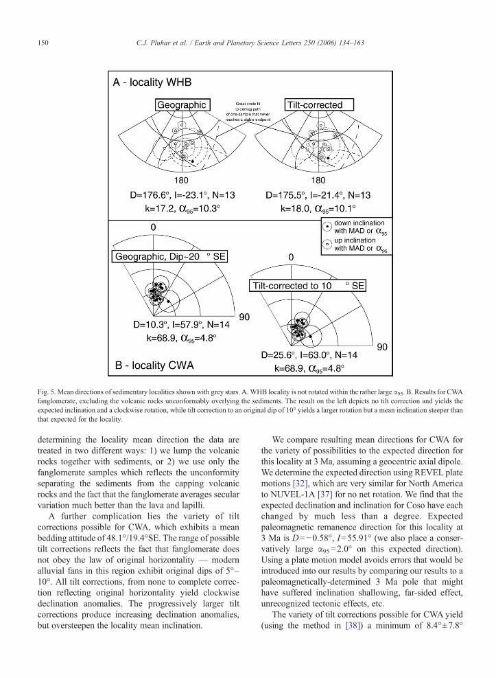
Fig. 5. Mean directions of sedimentary localities shown with grey stars. A. WHB locality is not rotated within the rather large α95. B. Results for CWAfanglomerate, excluding the volcanic rocks unconformably overlying the sediments. The result on the left depicts no tilt correction and yields theexpected inclination and a clockwise rotation, while tilt correction to an original dip of 10° yields a larger rotation but a mean inclination steeper thanthat expected for the locality.
150 C.J. Pluhar et al. / Earth and Planetary Science Letters 250 (2006) 134–163
determining the locality mean direction the data aretreated in two different ways: 1) we lump the volcanicrocks together with sediments, or 2) we use only thefanglomerate samples which reflects the unconformityseparating the sediments from the capping volcanicrocks and the fact that the fanglomerate averages secularvariation much better than the lava and lapilli.
A further complication lies the variety of tiltcorrections possible for CWA, which exhibits a meanbedding attitude of 48.1°/19.4°SE. The range of possibletilt corrections reflects the fact that fanglomerate doesnot obey the law of original horizontality — modernalluvial fans in this region exhibit original dips of 5°–10°. All tilt corrections, from none to complete correc-tion reflecting original horizontality yield clockwisedeclination anomalies. The progressively larger tiltcorrections produce increasing declination anomalies,but oversteepen the locality mean inclination.
We compare resulting mean directions for CWA forthe variety of possibilities to the expected direction forthis locality at 3 Ma, assuming a geocentric axial dipole.We determine the expected direction using REVEL platemotions [32], which are very similar for North Americato NUVEL-1A [37] for no net rotation. We find that theexpected declination and inclination for Coso have eachchanged by much less than a degree. Expectedpaleomagnetic remanence direction for this locality at3 Ma is D=−0.58°, I=55.91° (we also place a conser-vatively large α95=2.0° on this expected direction).Using a plate motion model avoids errors that would beintroduced into our results by comparing our results to apaleomagnetically-determined 3 Ma pole that mighthave suffered inclination shallowing, far-sided effect,unrecognized tectonic effects, etc.
The variety of tilt corrections possible for CWA yield(using the method in [38]) a minimum of 8.4°±7.8°
151C.J. Pluhar et al. / Earth and Planetary Science Letters 250 (2006) 134–163
clockwise rotation with 0.4°±4.3° flattening for no tiltcorrection and inclusion of the results from the cappingdacite and lappili. Tilt correction to an original dip of48.1°/10° SE and exclusion of the capping volcanic rocksyields clockwise rotation of 26.2°±9.0° and 7.1°±4.2°oversteepening of inclination is indicated. The actualnumerical value for the clockwise rotation of CWA isdifficult to assess accurately due to the uncertainty inproper tilt correction for a unit that was deposited with anoriginal dip. Hence we conclude that CWA is clockwiserotated relative to paleo-north but we can only placebounds on the amount. Example results of these analysesare provided on Fig. 5B. While the magnitude of rotationat CWA is somewhat unclear, its clockwise sense seemsunequivocal. Since CWA demonstrates clockwise rota-tion relative to paleogeographic north within the WildHorse Mesa, this assists with interpretation of the relativerotation results from lava flows in the region.
4.2. Lava localities
Demagnetization experiments on Coso lavas indicatedMDFs averaging 50 mT but varying from 10 mT forlightning struck samples to 120 mT for some samples.Unblocking temperature spectra for these lavas wereconsistent with magnetite and/or maghemite as the re-manence carrier of varying granulometry, depending onthe unit in question. The very well-behaved paleomag-netic results for Coso lavas are consistent with this rockmagnetic character and their young age.
The hallmark of the lava sections is the repetition ofremanence direction for many flows within stratigraphi-cally bounded zones (Table 1 and Supplemental figure).With corroborating geochemical data, Pluhar et al. [24,25]interpreted these to be single eruptive units, emplaced inthe span of a few centuries or less time. As many as 19flows are observed to compose a single eruptive unit (HSlocality). This results in only one or a few remanencedirections being represented at any given locality (Table 1and Supplemental figure).Only theAL locality shows anypromise of sufficiently averaging secular variation. Thesmall number of eruptions represented makes averagingout secular variation difficult or impossible for lavas ofthe Wild Horse Mesa. For this reason, comparison ofremanence directions of individual eruptive units betweenlocalities yields more information about the tectonics ofthe region.
Thus we use the spatial extent of eruptive units(defined in Fig. 3) and the high precision with whichtheir remanence directions can be measured to detectdifferences in direction within a unit. Fig. 6 showscomparisons between localities of mean ChRMs of the
eruptive units shared in common. Fig. 6a depicts meanChRM by locality of redefined Petroglyph Canyonbasalt [24] and Black Canyon flows for localities BC,PC, LDC, UDC, FS. In the geographic reference frame(without tilt correction) locality ChRMs for PetroglyphCanyon basalt and Black Canyon flows are mostlystatistically indistinguishable at N95% confidence. Onthe other hand, with tilt corrections applied (the largestbeing only 10°), within-unit directions no longer agree,indicating that the small tilt of lava flow tops isdominated by original dips at the time of emplacement.No set of tilt corrections exist that will result in bettergrouping of these directions. Therefore, if we use thedirections with no tilt correction, there is no relativevertical-axis rotation of these 5 localities relative to oneanother.
Fig. 6b shows data from the Cole's Flat basalt found atthe CF and FS localities. In geographic and tilt-correctedcoordinates there is a declination difference betweenlocality mean directions. In geographic coordinates FS isrotated 11.6°±6.9° (method in [38]) clockwise relative toCF, while tilt-corrected it is 12.0°±7.0°. As will beshown, this suggestion ofwhich has rotated andwhich hasremained “fixed” is the best hypothesis. Remanence datafrom Silver Peak basalt, which outcrops at SP and PClocalities are depicted in Fig. 6c. PC is clockwise rotatedrelative to SP by 12.3°±6.2° (geographic) or 13.0°±6.2°(tilt-corrected).
Since we showed above that BC, PC, LDC, UDC andFS (henceforth grouped together and called Wild HorseMesa) are unrotated relative to one another, the entiregroup must be rotated relative to SP and CF. In addition,the magnitude of Wild Horse Mesa rotation is the same(within error) relative to both SP and CF, and thus theselatter two localities are probably unrotated relative to oneanother. Furthermore, since Wild Horse Mesa/CosoBasin/Coso Wash geomorphically appears the be thearea of highest strain, we set the region containing SP andCF to be fixed and Wild Horse Mesa to be rotated, ratherthan vice versa. This interpretation results in agreementbetween the rotation results at sedimentary locality CWAand the lava results.
To summarize, using Cole's Flat basalt we measure11.6°±6.9° clockwise rotation of FS relative to CFlocality. Using Petroglyph Canyon basalt, FS isunrotated relative to PC (as well as relative to BC, DC,and LDC). Using Silver Peak basalt, PC is 12.3°±6.2°clockwise rotated relative to SP locality. Thus, we havetwo corroborative measures, in sense and magnitude, ofclockwise relative rotation of five Wild Horse Mesalocalities relative to two at its margins. If we assume thatthey provide separate measures of the same rotation, we
Table 2Paleomagnetic data for sedimentary localities
White Hills lakebeds, WHB locality
Specimen orsample number
Data fit type Demagsteps used
n (stepsor samples)
Stratigraphic position(m from base)
Declination(geographic)
Inclination(geographic)
Declination(tilt-corrected)
Inclination(tilt-corrected)
κ α95 Comment Beddingstrike/dip
WHB1 Sample Fishermean
ChRMsbelow
3 samples 31 152.4° −35.5° 155.4° −31.5° 1533.3 3.1° Fishermean
292°/6°
WHB001D Least squarethru origin
580°–680° 5 150.5° −36.0° 153.6° −32.2° N/A 6.7°
WHB001H Least squarethru origin
580°–690°
7 155.2° −35.4° 158.0° −31.1° N/A 8.5°
WHB001L Least squarethru origin
75 mT–670°
15 151.6° −35.2° 154.5° −31.2° N/A 4.6°
WHB003B Least squarethru origin
600°–690°
7 24.6 167.3° −27.5° 168.2° −20.7° N/A 2.8° 274°/7°
WHB4 Sample Fishermean
ChRMsbelow
4 samples 23 172.9° −25.1° 171.5° −25.3° 20.3 20.9° Fishermean
168°/3°
WHB004F Least square T200°–T580°
9 173.3° −23.6° 172.0° −23.9° N/A 25.0°
WHB004I Least square T200°–T580°
9 158.8° −7.9° 158.4° −7.5° N/A 14.7°
WHB004P Least squarethru origin
T300°–T670°
11 176.8° −44.4° 173.8° −44.8° N/A 11.5°
WHB004X Least squarethru origin
M020–T630°
7 184.7° −23.2° 183.4° −24.0° N/A 21.6°
WHB009G Least squarethru origin
660°–700°
5 18 170.7° 8.3° 170.7° 11.3° N/A 29.6° 258°/3°
WHB010A Least squarethru origin
250°–690°
16 17.3 192.0° −41.9° 191.0° −39.2° N/A 3.9° 258°/3°
WHB011A Great circlefit
645°–690°
5 15.5 74.9° 50.7° 72.6° 55.4° N/A 21.9° 184°/5°
WHB012F Least squarethru origin
250°–645°
12 15 180.8° −50.3° 174.9° −49.8° N/A 5.6° 184°/5°
WHB013G Least squarethru origin
500°–690°
11 8.5 188.4° −26.4° 186.0° −26.6° N/A 5.0° 184°/5°
WHB014A Least squarethru origin
645°–690°
5 6.5 199.8° −18.7° 198.1° −20.0° N/A 11.6° 184°/5°
WHB015A Least squarethru origin
575°–680°
7 5.5 175.6° −27.2° 173.1° −26.4° N/A 17.8° 184°/5°
WHB016M Least squarethru origin
250°–670°
14 4.2 178.5° −13.5° 177.4° −13.0° N/A 4.0° 184°/5°
WHB017A Least squarethru origin
500°–700°
12 3.7 178.7° −13.4° 177.6° −12.9° N/A 2.4° 184°/5°
WHB019C Least squarethru origin
525°–680°
9 1.7 180.6° −18.2° 179.0° −17.8° N/A 1.3° 184°/5°
152C.J.
Pluhar
etal.
/Earth
andPlanetary
ScienceLetters
250(2006)
134–163
Coso Formation fanglomerate member, CWA Locality
Specimen orsamplenumber
Data fit type Demagsteps used
n (steps orsamples)
Stratigraphic position(m from base)
Declination(geographic)
Inclination(geographic)
Declinationn(tilt-corrected to10°SE)
Inclination(tilt-corrected to10°SE)
κ α95 Comment Strike/dip(includesoriginal dip) a
Tdo Sample Fishermean
ChRMsbelow
4 samples 12 351.1° 48.4° 359.0° 56.4° 251 5.8° Capping 48.1°/1†9.4° b
Tdo101A Least squarethru origin
10 mT–199 mT
11 356.3° 53.0° 6.7° 60.3° N/A 1.8° Dacite
Tdo102A Least squarethru origin
22 mT–199 mT
8 343.3° 48.9° 349.7° 57.7° N/A 0.4°
Tdo103A Least squarethru origin
22 mT–199 mT
8 352.0° 44.4° 358.7° 52.4° N/A 0.5°
Tdo104A Least squarethru origin
15 mT–199 mT
9 353.2° 46.9° 0.9° 54.7° N/A 2.4°
CWA21 Sample Fishermean
ChRMsbelow
4 samples 9.7 358.4° 39.7° 4.9° 46.9° 858.1 3.1° Pyroclastics 48.1°/19.4° b
80F0021A Least squarethru origin
10 mT–200 mT
10 354.6° 40.2° 0.8° 48.0° N/A 1.4°
80F0021B Least squarethru origin
400°–665°
10 356.4° 38.7° 2.5° 46.2° N/A 1.6°
CWA21F Least squarethru origin
10 mT–140 mT
8 1.4° 40.6° 8.5° 47.5° N/A 1.4°
80F0021G Least squarethru origin
350°–665°
11 1.1° 39.0° 7.7° 45.9° N/A 1.6°
CWA19 Least squarethru origin
20 mT–130 mT
7 8 354.2° 55.6° 5.5° 63.1° N/A 3.3° 48.1°/19.4°
CWA18 Least squarethru origin
160°–100 mT
8 9.5 17.9° 50.6° 29.9° 54.7° N/A 5.3° 48.1°/19.4°
CWA17 Least squarethru origin
350°–600°
8 9.5 13.1° 46.2° 23.0° 51.2° N/A 9.9° 48.1°/19.4°
CWA15 Least squarethru origin
160°–600°
12 9.9 14.4° 49.8° 25.8° 54.5° N/A 6.1° 48.1°/19.4°
CWA14 Least squarethru origin
300°–600°
9 10.9 5.2° 47.6° 14.9° 53.8° N/A 2.2° 48.1°/19.4°
CWA13 Least squarethru origin
250°–600°
10 11 4.5° 16.6° 7.2° 23.3° N/A 1.6° 48.1°/19.4°
80F0012 Least squarethru origin
35 mT–200 mT
6 10 3.7° 57.3° 17.8° 63.4° N/A 4.2° 48.1°/19.4°
CWA11 Least squarethru origin
250°–600°
10 −1 6.7° 68.2° 31.9° 73.1° N/A 7.0° 48.1°/19.4°
CWA10 Least squarethru origin
200°–600°
11 −1.5 12.2° 66.6° 35.8° 70.8° N/A 7.4° 48.1°/19.4°
CWA9 Least squarethru origin
200°–580°
10 7 22.6° 64.8° 44.6° 67.3° N/A 4.7° 48.1°/19.4°
(continued on next page)
153C.J.
Pluhar
etal.
/Earth
andPlanetary
ScienceLetters
250(2006)
134–163
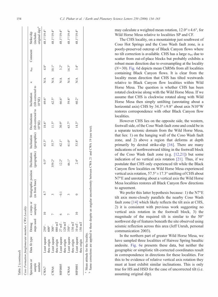
Table2(contin
ued)
CosoFormationfang
lomeratemem
ber,CWALocality
Specimen
orsample
number
Datafittype
Dem
agstepsused
n(steps
orsamples)
Stratigraphic
positio
n(m
from
base)
Declin
ation
(geographic)
Inclination
(geographic)
Declin
ationn
(tilt-corrected
to10
°SE)
Inclination
(tilt-corrected
to10
°SE)
κα 9
5Com
ment
Strike/dip
(includes
original
dip)
a
CWA7
Leastsquare
thru
origin
250°–
600°
104.7
0.5°
63.3°
18.6°
69.6°
N/A
4.8°
48.1°/19
.4°
CWA6
Leastsquare
thru
origin
300°–
080mT
73
359.2°
55.7°
11.5°
62.5°
N/A
10.1°
48.1°/19
.4°
80F0
005
Leastsquare
thru
origin
27mT–
120mT
6−0.1
12.2°
62.1°
30.9°
66.6°
N/A
3.2°
48.1°/19
.4°
CWA4
Leastsquare
thru
origin
350°–
130mT
73
46.1°
61.0°
63.7°
59.8°
N/A
14.3°
48.1°/19
.4°
80F0
001
Leastsquare
thru
origin
10mT–
150mT
100
2.4°
53.8°
14.3°
60.2°
N/A
3.4°
48.1°/19
.4°
aMeanattitudeforthelocality.
bSam
ecorrectio
nsareappliedto
thesedespite
anangularunconformity
betweenCWA
21andCWA
19(see
text).
154 C.J. Pluhar et al. / Earth and Planetary Science Letters 250 (2006) 134–163
may calculate a weighted mean rotation, 12.0°±4.6°, forWild Horse Mesa relative to localities SP and CF.
The CHS locality, on a mountaintop just southwest ofCoso Hot Springs and the Coso Wash fault zone, is apoorly-preserved outcrop of Black Canyon flows whereno tilt correction is available. CHS has a large α95 due toscatter from out-of-place blocks but probably exhibits arobust mean direction due to oversampling at the locality(N=30). Fig. 6d depicts mean ChRMs from all localitiescontaining Black Canyon flows. It is clear from thelocality mean direction that CHS has tilted westwardsrelative to Black Canyon flow localities within WildHorse Mesa. The question is whether CHS has beenrotated clockwise along with the Wild Horse Mesa. If weassume that CHS is clockwise rotated along with WildHorse Mesa then simply untilting (unrotating about ahorizontal axis) CHS by 34.3°±9.8° about axis N10°Wrestores correspondence with other Black Canyon flowlocalities.
However CHS lies on the opposite side, the western,footwall side, of the CosoWash fault zone and could be ina separate tectonic domain from the Wild Horse Mesa,that lies: 1) on the hanging wall of the Coso Wash faultzone, and 2) above a region that deforms at depthprimarily by dextral strike-slip [16]. There are manyindications of northwestward tilting in the footwall blockof the Coso Wash fault zone (e.g. [12,21]) but someindication of no vertical axis rotation [21]. Thus, if wepostulate that CHS only experienced tilt while the BlackCanyon flow localities on Wild Horse Mesa experiencedvertical axis rotation, 57.5°±17.3° untilting of CHS aboutN7°E and unrotating about a vertical axis the Wild HorseMesa localities restores all Black Canyon flow directionsto agreement.
We prefer this latter hypothesis because: 1) the N7°Etilt axis more-closely parallels the nearby Coso Washfault zone [14] which likely reflects the tilt axis at CHS,2) it is consistent with previous work suggesting novertical axis rotation in the footwall block, 3) themagnitude of the required tilt is similar to the 50°northwest dip of features beneath the site observed usingseismic reflection across this area (Jeff Unruh, personalcommunication 2003).
In the northern part of greater Wild Horse Mesa, wehave sampled three localities of Haiwee Spring basalticandesite. Fig. 6e presents these data, but neither thegeographic or simplistic tilt-corrected coordinates resultin correspondence in directions for these localities. Forthis to be evidence of relative vertical axis rotation theymust at least exhibit similar inclinations. This is onlytrue for HS and HSD for the case of uncorrected tilt (i.e.assuming original dip).

Fig. 6. Measures of Rotation from Lavas. Eruptive unit mean directions are averaged within locality and unit. In all cases except F, geographiccoordinates are preferred because of original dips of lava flows (e.g. note increased scatter in A, tilt-corrected). (A) Localities within Wild HorseMesa are not rotated relative to one another. (B and C) Localities within Wild Horse Mesa are rotated relative to Cole's Flat area. (D) CHS is tiltedrelative to Wild Horse Mesa. (E) Results suggesting unaccounted-for, large original dips. (F) The shallow inclination suggests that secular variation isnot fully averaged. (G and H) No discernable rotation within the large error bars. No tilt-correction is available for these latter two groups of localities.
155C.J. Pluhar et al. / Earth and Planetary Science Letters 250 (2006) 134–163
There are several possible explanations for this. Whilegeochemically the same and exhibiting the same polarity,these sections may record different times in Earth's secularvariation. This is improbable because of the thickness of theunit (nineteen flows at HS), close proximity of the localitiesand the absence of remanence variation within a locality.These all suggest rapid voluminous eruption that coveredthe small area of these localities. Unaccounted-for originaldips probably cause part of themismatch in directions, withthe remainder resulting from relative rotation between thelocalities. For example, complete tilt-correction of HS andcorrection of HSB to an original dip of about 10°southwards results in equivalent inclinations and aclockwise rotation of HSB relative to HS. The number ofdegrees of freedom on the solution is intractably large —onemust solve for original dip of each pair of localities plus
relative vertical axis rotation between each pair given thehard constraint of the remanence directions and theguideline of flow “attitudes”. More information about theflow direction from knowledge of the eruptive sourcewould help in constraining the solution. In short, HaiweeSpring localities suggest original dips and perhaps relativevertical axis rotation, but a quantitative measure ispremature without additional data.
Andesites first recognized by Whitmarsh [14] to bePliocene in age (map unit Tbb “basalt” of Coso Basin,3.7±0.6 Ma isochron age, renamed Coso Basin andesite[24]) showed some promise in averaging out secularvariation. Along the Coso Wash fault zone, the ALlocality contains 5 flows, a dike, and a sill (Fig. 6f), eachrecording a different remanence direction. Field relationssuggest that the flows have been tilted to the west back
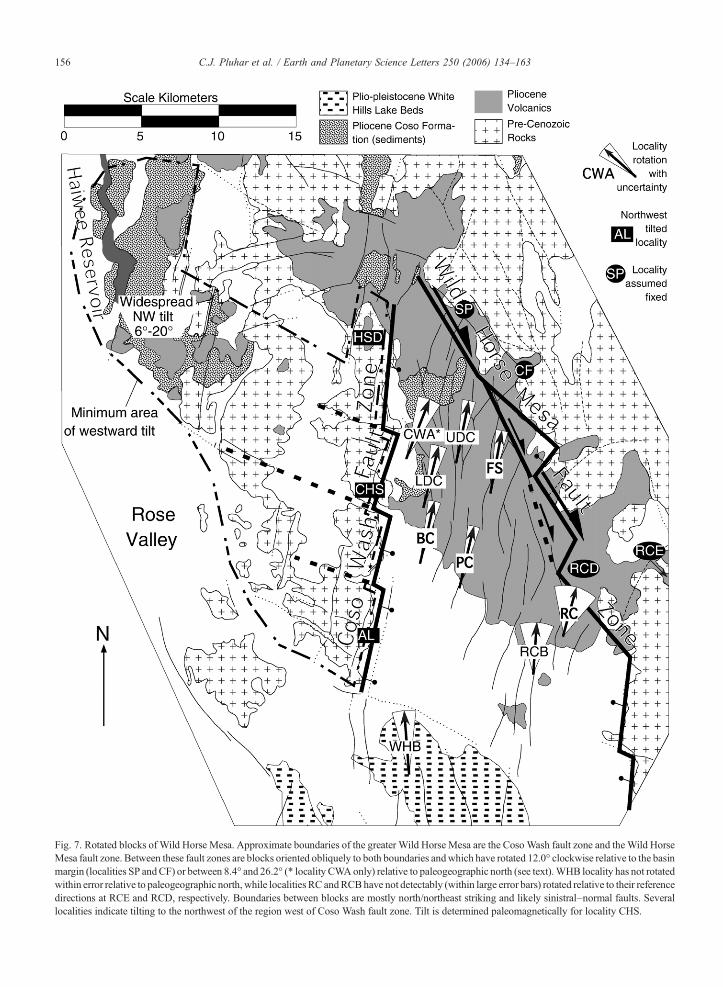
Fig. 7. Rotated blocks of Wild Horse Mesa. Approximate boundaries of the greater Wild Horse Mesa are the CosoWash fault zone and theWild HorseMesa fault zone. Between these fault zones are blocks oriented obliquely to both boundaries andwhich have rotated 12.0° clockwise relative to the basinmargin (localities SP andCF) or between 8.4° and 26.2° (* locality CWAonly) relative to paleogeographic north (see text).WHB locality has not rotatedwithin error relative to paleogeographic north, while localities RC andRCBhave not detectably (within large error bars) rotated relative to their referencedirections at RCE and RCD, respectively. Boundaries between blocks are mostly north/northeast striking and likely sinistral–normal faults. Severallocalities indicate tilting to the northwest of the region west of Coso Wash fault zone. Tilt is determined paleomagnetically for locality CHS.
156 C.J. Pluhar et al. / Earth and Planetary Science Letters 250 (2006) 134–163

Table 3Rotations relative to rigid block containing SP and CF
Independent paths Mean rotations
Path into WildHorse Mesa
Rotation a α95 Locality Meanrotationa
(weightedby α95)
α95
SPtoPC −12.3° 6.2°PC −13.2° 5.2°
CFtoFStoPC −15.3° 9.6°CFtoFStoBC −18.4° 9.2°
BC −13.1° 5.7°SPtoPCtoBC −9.8° 7.2°SPtoPCtoLDC −12.5° 10.5°
LDC −14.0° 7.3°CFtoFStoLDC −15.5° 10.2°CFtoFStoUDC −13.1° 8.3°
UDC −11.7° 6.0°SPtoPCtoUDC −10.1° 8.6°CFtoFS −11.6° 6.9°
FS −10.5° 5.5°SPtoPCtoFS −8.6° 9.2°SptoPCtoFStoCF 3.0° 11.4°
SPrelative toCF
3.0° 11.4°
a Negative=clockwise.
157C.J. Pluhar et al. / Earth and Planetary Science Letters 250 (2006) 134–163
towards the eruptive source, a near-surface intrusivebody now exposed by erosion. When tilt-corrected toyield an assumed original dip of 10° to the southeast (asindicated by lavas having flowed that direction), thelocality yields a mean remanence direction indistin-guishable from geographic south, although very shallowin inclination. This shallow inclination indicates thateither the tilt correction is inappropriate or that secularvariation was not well averaged out. As a result, noconclusion about vertical axis rotation or its absence canbe drawn from this locality.
Several Plio-Pleistocene lavas at the southeastern endof Wild Horse Mesa (localities RC, RCB, RCC, RCDand RCE) indicate no relative rotation within uncertain-ties between the localities containing them. Duffield andBacon [12] mapped basalt of Renegade Canyon andsubdivided it into multiple subunits, QTbr1–QTbr8. Wehave sampled QTbr2 and QTbr4 at two localities eachand found no statistically distinguishable directionaldifference between each pair of directions (Fig. 6g, h).However, the errors on these results are quite large: forunit QTbr2 RC has rotated 15.5°±26.1° clockwiserelative to RCE, while for unit QTbr4 RCB has rotated3.6°±19.1° clockwise relative to RCD. Thus the resultsin the region of these localities are inconclusiveregarding rotation of the magnitude measured furtherto the northwest on older lavas.
A review of these results yields a coherent kinematicmodel for Wild Horse Mesa and the Coso geothermalarea. The CWA (fanglomerate) locality reveals clock-wise absolute rotation relative to paleogeographic north(Fig. 7). The five Wild Horse Mesa lava localities (BC,PC, UDC, LDC, and FS) are similar to one another inmean direction but are clockwise-rotated relative to CFand SP. We propose that the latter two sites have notrotated relative to one another (Fig. 7). A quantitativeassessment of rotation of each sampled locality relativeto CF and SP allows assignment of formal errors to thesemeasures of rotation. For example, we calculate theamount of rotation of locality BC relative to the un-rotated region including CF and SP results by adding therotation of PC relative to SP (using the Silver Peakbasalt) to the rotation of BC relative to PC (using eitherBlack Canyon flows or Petroglyph Canyon basalt), andpropagating the errors (Table 3). For each locality withinWild Horse Mesa two such independent routes ofrelative rotation measurement are possible given ourpresent data, one starting with a comparison of PC to SPand another using a comparison of CF to FS. Thus, eachmeasure of rotation for the 5 localities within WildHorse Mesa results from a weighted mean of two inde-pendent paths from the locality to the assumed stable
region. In addition we may follow a path between CFand FS to reveal their relative rotation, but since onlyone independent path exists given the current data, theerror is too large to be of much use. These calculations(Table 3) quantitatively show what has already beenverbally stated here; that Wild Horse Mesa blocks are allequally rotated, within error (now formally calculated inTable 3). Errors on the measurements presented here arenot small enough to discern whether there is spatialvariability in clockwise rotation within the clockwise-rotated region, although that is expected for a regionwith non-parallel boundaries [11] such as the WildHorse Mesa.
5. Discussion
Our results provide several lines of evidenceindicating that Wild Horse Mesa has experiencedclockwise vertical-axis rotation since ca. 3 Ma whilethe adjacent Coso geothermal area and environs haveexperienced westward tilting (Fig. 7). These results,combined with previous studies, yield a quantitativekinematic model for the geothermal area andWild HorseMesa that must be satisfied by models of formation of anascent metamorphic core complex beneath the geo-thermal area.
Our results are consistent with block rotation at thenear-surface at Wild Horse Mesa that accommodatesregional dextral transtension. Long axes of fault-bounded blocks are oriented north–south to N20°Eand are oblique to the geodetically-determined dextralmotion at this latitude: 1) across the Eastern California
158 C.J. Pluhar et al. / Earth and Planetary Science Letters 250 (2006) 134–163
shear zone (Airport Lake fault zone) of about N40°W[3] and 2) due to Sierra Nevada microplate motionrelative to stable North America of N43°W [39].Consequently, fault-bounded blocks of the Wild HorseMesa are oriented more favorably for accommodatingthe regional shear with a component of rotation thanthey are for either pure dextral slip or dip-slip on thefaults between them (see [11,40–43] for discussions ofsuch kinematics). As rotation proceeds, space problemsbetween the rigid blocks result in cataclasis of blocksand a fining of the scale of blocks. This results inanastomosing faults such as those exhibited so well inthe Wild Horse Mesa lavas. Any block models thatattempt to replicate this must thus be a simplification ofthis complex process.
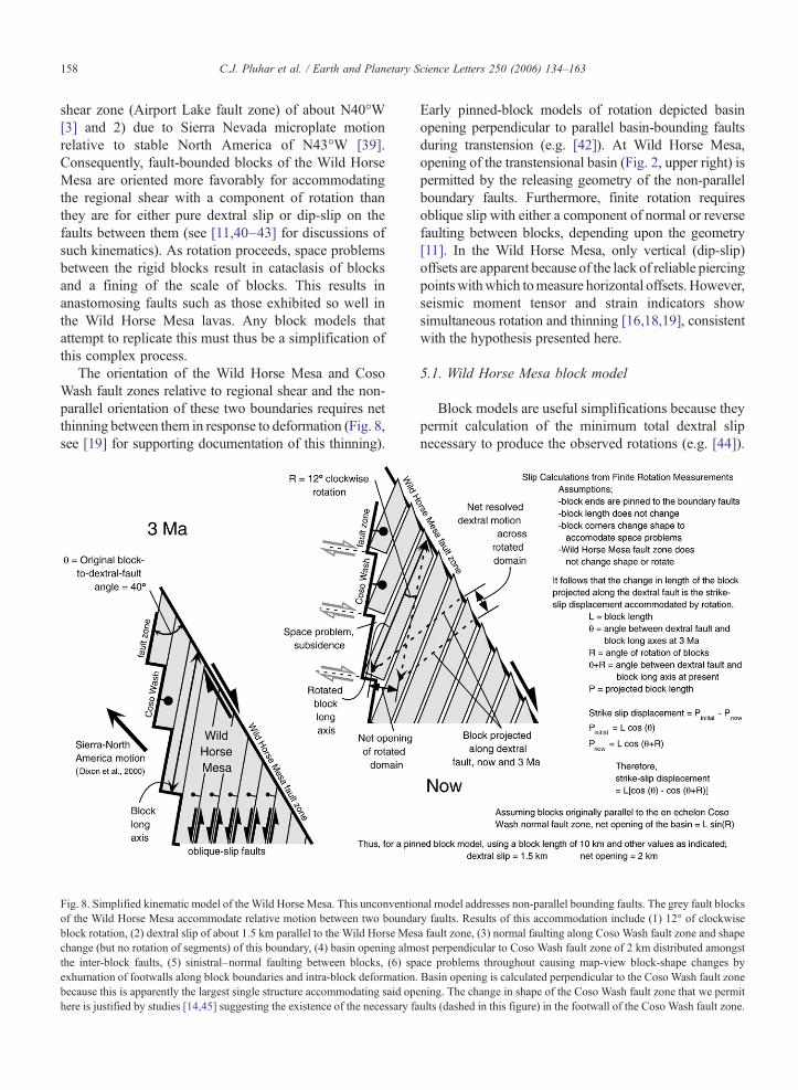
The orientation of the Wild Horse Mesa and CosoWash fault zones relative to regional shear and the non-parallel orientation of these two boundaries requires netthinning between them in response to deformation (Fig. 8,see [19] for supporting documentation of this thinning).
Fig. 8. Simplified kinematic model of the Wild Horse Mesa. This unconventioof the Wild Horse Mesa accommodate relative motion between two boundablock rotation, (2) dextral slip of about 1.5 km parallel to the Wild Horse Meschange (but no rotation of segments) of this boundary, (4) basin opening almthe inter-block faults, (5) sinistral–normal faulting between blocks, (6) spexhumation of footwalls along block boundaries and intra-block deformation.because this is apparently the largest single structure accommodating said ophere is justified by studies [14,45] suggesting the existence of the necessary fa
Early pinned-block models of rotation depicted basinopening perpendicular to parallel basin-bounding faultsduring transtension (e.g. [42]). At Wild Horse Mesa,opening of the transtensional basin (Fig. 2, upper right) ispermitted by the releasing geometry of the non-parallelboundary faults. Furthermore, finite rotation requiresoblique slip with either a component of normal or reversefaulting between blocks, depending upon the geometry[11]. In the Wild Horse Mesa, only vertical (dip-slip)offsets are apparent because of the lack of reliable piercingpointswithwhich tomeasure horizontal offsets.However,seismic moment tensor and strain indicators showsimultaneous rotation and thinning [16,18,19], consistentwith the hypothesis presented here.
5.1. Wild Horse Mesa block model
Block models are useful simplifications because theypermit calculation of the minimum total dextral slipnecessary to produce the observed rotations (e.g. [44]).
nal model addresses non-parallel bounding faults. The grey fault blocksry faults. Results of this accommodation include (1) 12° of clockwisea fault zone, (3) normal faulting along Coso Wash fault zone and shapeost perpendicular to Coso Wash fault zone of 2 km distributed amongstace problems throughout causing map-view block-shape changes byBasin opening is calculated perpendicular to the Coso Wash fault zoneening. The change in shape of the Coso Wash fault zone that we permitults (dashed in this figure) in the footwall of the Coso Wash fault zone.

159C.J. Pluhar et al. / Earth and Planetary Science Letters 250 (2006) 134–163
Fig. 8 depicts a calculation of minimum dextral slipbetween the basin-bounding faults, given the observedrotations and assuming that blocks are pinned to theboundary faults. Typically, such calculations requireblock length, width and orientation relative to strike-slipboundary faults (e.g. [44]). The calculation shown in Fig.8 is somewhat different for the following reasons. First,blocks deform internally by widespread small-offsetfaulting to accommodate changes in shape and showevidence for cataclasis into progressively smaller size[18]. This shape change is evident from reverse faultseismic focal mechanisms [18] within this transtensionalbasin. However, internal block deformation is of muchsmaller magnitude than slip between blocks and thus thesimplification of block rigidity is permissible. Recog-nizing this, our model simplifies the problem such thatblocks are largely rigid, but block corners are free tochange shape, preventing unrealistic holes (such as thosenonetheless depicted on Fig. 8 in order to follow theblock motions) from opening between blocks and thezone boundaries. Second, oblique faulting betweenadjacent blocks results in apparent widening of blocksin map view as footwalls are exhumed across inclinedfaults. For these two reasons the exact width of theblocks becomes irrelevant to this calculation.
Rotation and cataclasis of blocks within the WildHorse Mesa resides within a larger region of transten-sion. Thus, zone boundaries are probably deformable.For a transtensional basin with non-parallel boundariesone expects increasing strain and therefore rotation nearthe apex of the zone boundaries [11]. However, our datashow uniform rotation for the areas sampled, withinerror. Permitting zone boundaries to deform allowsuniform rotation and acknowledges the obvious defor-mation occurring outside the Wild Horse Mesa. Thedotted faults west of the Coso Wash normal fault (Fig. 8)permit such deformation and are a schematic represen-tation of displacements found byWalker and Whitmarsh[45]. It is important to note that rotated blocks of WildHorse Mesa may be an upper-crustal feature situatedabove one or more dextral master faults at depth, asindicated by the differing character of seismogenicstrain with depth [16,18]. The fault blocks in our modelare an expedient simplification used to capture theessence of the kinematics of the upper crust.
The rotated blocks in the region where we collectedour paleomagnetic data are about 10 km long. The Fig.8 cartoon depicts blocks with longer dimensions furthersouth and east of our sampled area. We refrain fromconducting the proceeding calculations for longerrotated blocks because: 1) we lack rotation data for c.a.3 Ma rocks from longer blocks, and 2) the region where
cartoon blocks would tend to be longest show evidenceof block cataclasis, meaning that initially highly-elongate blocks will have broken up over time withincreasing accumulated strain. With an estimated blocklength of 10 km obtained from a largely-coherent blockcontaining locality FS and perhaps PC and bounded by aN100-meter fault scarp, we calculate a minimum dextraloffset of 1.5 km along the Wild Horse Mesa basin-bounding fault zone (Fig. 8). Current seismogenicdeformation and geodesy indicates that rotation con-tinues [19]. The calculated minimum offset is easilyachievable given the geodetically-determined slip ratesacross the Coso Range andWild Horse Mesa of 5.3 mm/yr determined by McClusky et al. [3]. A comparison ofgeodetic rates and our calculations could provideconstraints on the time required to produce the observedresult. However, our data do not: 1) span the entire regionspanned by the geodetic results or 2) account for thedextral shear accommodated by unpinning the blocks inour model. The Coso Wash normal fault especiallywarrants this unpinning since there is clear displacementbetween Wild Horse Mesa and the region to the west. Asa result our data only accounts for a fraction of the totaldeformation across the region spanned by the geodeticdata, and the current results provide no robust constrainton the age of onset of dextral shear in the Wild HorseMesa.
In addition to dextral offset, the block modelpresented here suggests 2 km of extension distributedacross the Wild Horse Mesa oriented perpendicular tothe Coso Wash normal fault zone, approximately north100° east. The width of Wild Horse Mesa along thisazimuth at the region where the rotation data wascollected is 8–15 km. Thus, this model suggests 13–25% extension across Wild Horse Mesa exclusive ofextension localized on the Coso Wash fault itself.
5.2. Tilt (horizontal axis rotation) within the study area
The paleomagnetic results discussed suggest thatWild Horse Mesa lavas exhibit original dips. Our mostrobust data derive from large blocks that exhibit little tiltaside from small-magnitude original dips. This indicatesthat net tilting of the entire volume of the Wild HorseMesa is minimal.
On the other hand, westward tilt west of the CosoWash fault zone, above Monastero et al.'s [1] nascentmetamorphic core complex, appears to be a widespreadfeature (Fig. 7). The Coso Formation between HaiweeReservoir and the geothermal field is mostly tilted in thissense [12]. Paleomagnetic data from CHS and lava flowattitudes from AL and HSD indicate tilts of 20° to 35° or
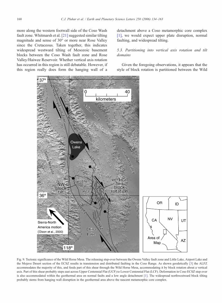
160 C.J. Pluhar et al. / Earth and Planetary Science Letters 250 (2006) 134–163
more along the western footwall side of the Coso Washfault zone.Whitmarsh et al. [21] suggested similar tiltingmagnitude and sense of 30° or more near Rose Valleysince the Cretaceous. Taken together, this indicateswidespread westward tilting of Mesozoic basementblocks between the Coso Wash fault zone and RoseValley/Haiwee Reservoir. Whether vertical axis rotationhas occurred in this region is still debatable. However, ifthis region really does form the hanging wall of a
Fig. 9. Tectonic significance of the Wild Horse Mesa. The releasing step-overthe Mojave Desert section of the ECSZ results in transtension and distributaccommodates the majority of this, and feeds part of this shear through the Waxis. Part of this shear probably steps east across Upper Centennial Flat (UCF)is also accommodated within the geothermal area on normal faults and a loprobably stems from hanging wall disruption in the geothermal area above t
detachment above a Coso metamorphic core complex[1], we would expect upper plate disruption, normalfaulting, and widespread tilting.
5.3. Partitioning into vertical axis rotation and tiltdomains
Given the foregoing observations, it appears that thestyle of block rotation is partitioned between the Wild
between the Owens Valley fault zone and Little Lake, Airport Lake anded faulting in the Coso Range. As shown geodetically [3] the ALFZild Horse Mesa, accommodating it by block rotation about a verticalto Lower Centennial Flat (LCF). Deformation in Coso ECSZ step overw angle detachment [1]. The widespread northwestward block tiltinghe nascent metamorphic core complex.

161C.J. Pluhar et al. / Earth and Planetary Science Letters 250 (2006) 134–163
Horse Mesa and the geothermal area (Figs. 7 and 9).Rotation about a vertical axis characterizes the formerarea while tilt (horizontal-axis rotation) typifies thelatter. The style of rotation appears to be determined bymaster faults at depth controlling the behavior of upper-crustal blocks. Vertical axis rotation in Wild HorseMesa occurs above probable dextral faults beneathabout 5 km depth [16,18,19], while the horizontal axisrotation (tilting) in the geothermal area is associatedwith a detachment fault at depth [1]. This partitioning ofrotation thus appears to reflect the partitioning of themaster faults.
5.4. The role of the study area in regional tectonics
Dextral shear accommodated by rotation in the WildHorse Mesa merges with or steps over to the AirportLake fault zone to the south (Fig. 9). North of WildHorse Mesa modern dextral shear strain has been tracedto the northwest corner of the Coso Range where itemerges into southern Owens Lake (J. Unruh, personalcommunication, 2005). This strain may link to theOwens Valley dextral strike-slip system through a seriesof subsurface faults that have been mapped by seismicreflection [46]. This semi-continuous structure is onestrand of the Eastern California shear zone linking theOwens Valley fault zone with the Airport Lake faultzone. Some regional shear is probably also routed westof the Coso Range by the Little Lake fault zone, as wellas beneath the geothermal area on a detachment (ornormal faults) described above. This normal ordetachment faulting probably merges with the SierraNevada frontal fault and other structures at westernOwens Lake.
6. Conclusions
Relative to a region northwest of the study area, c.a.3 Ma basalts of Wild Horse Mesa exhibit 12.0°±4.6° ofclockwise vertical-axis rotation of fault bounded blocks,as demonstrated paleomagnetically. Relative to absolutepaleogeographic north, sedimentary rocks of similar agewithin Wild Horse Mesa are also clockwise rotatedbetween 8.4°±7.8° and 26.2°±9.0° depending upon themethod of data analysis. Abundant, probably obliquesinistral–normal, north-northeast striking faults accom-modate block rotation near the surface between the left-stepping Coso Wash normal fault zone and the right-stepping, dextral Wild Horse Mesa fault zone (Figs. 7, 8,and 9). The rotation within Wild Horse Mesa accom-modates a strand of the Eastern California shear zone asit steps across the Coso Range in a releasing bend.
Calculations show that vertical axis rotations of 12°between the bounding faults of Wild Horse Mesa yield aminimum dextral offset of 1.5 km along a strike ofN30°W, subparallel to the Wild Horse Mesa fault zoneand 2 km of extension perpendicular to the Coso Washfault zone. This represents 13–25% extension acrossWild Horse Mesa since about 3Ma. These results place alower bound on total offset on this strand of the ECSZand total extension across the hypothesized nascent Cosometamorphic core complex, respectively.
The Coso geothermal area (the hanging wall abovethe nascent core complex) is tilted as many separateblocks to the northwest. This suggests partitioning ofblock rotation style in response to fault partitioning. TheWild Horse Mesa exhibits clockwise vertical axisrotation, while the geothermal area exhibits down tothe west horizontal axis rotation with the two regionsbeing separated by the Coso Wash normal fault zone.
Acknowledgements
The authors gratefully acknowledge the staff of theChina Lake Naval Air Weapons Station; Steve Bjornstad,Kelly Hastings, Robert Johnson, and Allen Katzenstein ofthe Geothermal Program Office and Jan Lawson of theEnvironmental Project Office for logistical support. Ad-ditional thanks to John Lyons, Henry Scott, Kim Knight,Julie Friedman, Jennifer Hartman, Ray Wheeler, KellieTownsend, and Paul Nelson. This manuscript benefitedgreatly from the thoughtful review of 2 anonymous re-ferees. This work was funded by contract N68936-01-C-0094 from the Department of Defense, U.S. NavyGeothermal Program Office.
Appendix A. Supplemental figure
Supplementary data associated with this articlecan be found, in the online version, at doi:10.1016/j.epsl.2006.07.034.
References
[1] F.C. Monastero, A.M. Katzenstein, J.S. Miller, J.R. Unruh, M.C.Adams, K. Richards-Dinger, The Coso geothermal field: anascent metamorphic core complex, Geol. Soc. Amer. Bull. 117(2005) 1534–1553.
[2] F.C. Monastero, Dynamics of the nascent Coso MetamorphicCore Complex, East-Central California, Proc. Geol. Soc. Am. 34(2003) 304.
[3] S.C. McClusky, S.C. Bjornstad, B.H. Hager, R.W. King, B.J.Meade, M.M. Miller, F.C. Monastero, B.J. Souter, Present daykinematics of the Eastern California shear zone from a geodeticallyconstrained block model, Geophys. Res. Lett. 28 (2001)3369–3372.

162 C.J. Pluhar et al. / Earth and Planetary Science Letters 250 (2006) 134–163
[4] T.H. Dixon, S. Robaudo, J. Lee, M.C. Reheis, Constraints onpresent day basin and range deformation from space geodesy,Tectonics 14 (1995) 755–772.
[5] J.C. Savage, M. Lisowski, W.H. Prescott, An apparent shear zonetrending north-northwest across the Mojave Desert into OwensValley, EasternCalifornia,Geophys. Res. Lett. 17 (1990) 2113–2116.
[6] R.K. Dokka, C.J. Travis, Role of the Eastern California shearzone in accommodating Pacific-North American plate motion,Geophys. Res. Lett. 17 (1990) 1323–1326.
[7] R.K. Dokka, C.J. Travis, Late Cenozoic strike-slip faulting in theMojave Desert, California, Tectonics 9 (1990) 311–340.
[8] A.R.C. Kylander-Clark, D.S. Coleman, A.F. Glazner, J.M.Bartley, Post-Cretaceous dextral offset of 65 km across OwensValley, California, implied by correlation of the Golden Bear andCoso dike sets, Proc. Geol. Soc. Am. 35 (2003) 80.
[9] A.F. Glazner, J.M. Bartley, D.S. Coleman, A.R.C. Kylander-Clark, Evidence from the independence dike swarm for 65 km ormore of post-Jurassic dextral offset across Owens Valley,California, Proc. Geol. Soc. Am. 35 (2003) 80.
[10] D.C. Ross, Correlation of granitic plutons across faulted OwensValley, California, U.S. Geol. Surv. Prof. Pap. P0450-D (1962)D86–D88.
[11] J.F. Dewey, Transtension in arcs and orogens, Int. Geol. Rev. 44(2002) 402–439.
[12] W.A. Duffield, C.R. Bacon, Geologic map of the Coso volcanicfield and adjacent areas, Inyo County, California, US Geol. Surv.Misc. Inv. I-1200, 1981.
[13] W.A. Duffield, C.R. Bacon, G.B. Dalrymple, Late Cenozoicvolcanism, geochronology, and structure of the Coso Range, InyoCounty, California, J. Geophys. Res. 85 (1980) 2381–2404.
[14] R.S. Whitmarsh, A geologic map of the Coso Range, withsupplemental U–Pb geochronology and Ar–Ar thermochronol-ogy, Proc. Geol. Soc. Am. 28 (1996) 123–124.
[15] F.C. Monastero, J.D. Walker, A.M. Katzenstein, A.E. Sabin,Neogene evolution of the Indian Wells Valley, East-CentralCalifornia, in: A.F. Glazner, J.D. Walker, J.M. Bartley (Eds.),Memoir — Geol. Soc. Am., vol. 195, 2002, pp. 199–228.
[16] J.R. Unruh, E. Hauksson, F.C. Monastero, R.J. Twiss, J.C. Lewis,Seismotectonics of the Coso Range–Indian Wells Valley region,California; transtensional deformation along the southeastern marginof the Sierran Microplate, in: A.F. Glazner, J.D. Walker, J.M.Bartley (Eds.), Memoir — Geol. Soc. Am., vol. 195, 2002, pp.277–294.
[17] R.A. Bennett, B.P. Wernicke, N.A. Niemi, A.M. Friedrich, J.L.Davis, Contemporary strain rates in the northern Basin and Rangeprovince from GPS data, Tectonics 22 (2003), doi:10.1029/2001TC001355.
[18] J.C. Lewis, C.J. Pluhar, Pliocene to Recent kinematics of theWild Horse Mesa and Coso Wash: an integrated study usingmicropolar theory and paleomagnetic determinations to examinespatial and temporal variations in strain, Report to Dept. ofDefense, Geothermal Prog. Office, 2003.
[19] J.C. Lewis, R.J. Twiss, C.J. Pluhar, F.C. Monastero, Multipleconstraints on divergent strike-slip deformation along the easternmargin of the Sierran microplate, SE California, in: Geol. Soc.Am. Spec. Pap. Exhumation associated with continental strike-slip fault systems in press.
[20] H. Ron, A. Nur, Vertical axis rotation in the Mojave; evidencefrom the Independence dike swarm, Geology 24 (1996) 973–976.
[21] R.S. Whitmarsh, J.D. Walker, F.C. Monastero, Mesozoic andCenozoic structural framework of the Coso Range and adjacentareas of Eastern California, Proc. Geol. Soc. Am. 28 (1996) 124.
[22] E.S. Schweig III, Basin-range tectonics in the Darwin Plateau,southwestern Great Basin, California, Geol. Soc. Amer. Bull. 101(1989) 652–662.
[23] S.W. Novak, C.R. Bacon, Pliocene Volcanic Rocks of the CosoRange, Inyo County, California, U.S. Geol. Surv. Prof. Pap.P1383 (1986).
[24] C.J. Pluhar, R.S. Coe, D.E. Sampson, J.M.G. Glen, F.C.Monastero, S.B. Tanner, Lava fingerprinting using paleomagne-tism and innovative X-ray fluorescence spectroscopy; a casestudy from the Coso volcanic field, California, Geochem.,Geophys., Geosyst. 6 (2005), doi:10.1029/2004GC000707.
[25] C.J. Pluhar, S. Nomade, J.M.G. Glen, R.S. Coe, P.R. Renne, F.C.Monastero, Magnetostratigraphy, geochronology and geochem-ical evolution of the Pliocene Coso volcanic field, CA andcontemporaneity with Sierra Nevada delamination, Geol. Soc.Am. Bull. In preparation.
[26] A. Nur, H. Ron, Block rotations, fault domains and crustaldeformation, Ann. Tecton. 1 (1987) 40–47.
[27] S.H. Lamb, Behavior of the brittle crust in wide plate boundaryzones, J. Geophys. Res. 99 (1994) 4457–4483.
[28] M.J. Grant, The chronologic and stratigraphic evolution of theCoso Range, Inyo County, California, Master's thesis, Universityof Southern California, 1986.
[29] J.L. Kirschvink, The least-squares line and plane and the analysisof palaeomagnetic data, Geophys. J. R. Astron. Soc. 62 (1980)699–718.
[30] J.P. Cogné, PaleoMac: a MacIntosh application for treatingpaleomagnetic data and making plate reconstructions, Geochem.,Geophys., Geosyst. 4 (2003), doi:10.1029/2001GC000227.
[31] R.A. Fisher, Dispersion on a sphere, Proc. R. Soc. Lond., Ser., A217 (1953) 295–305.
[32] G.F. Sella, H.D. Dixon, A. Mao, REVEL: a model for Recentplate velocities from space geodesy, J. Geophys. Res. 107 (2002),doi:10.1029/2000JB000033.
[33] L. Tauxe, D.V. Kent, Properties of a detrital remanence carried byhaematite from study of modern river deposits and laboratoryredeposition experiments, Geophys. J. R. Astron. Soc. 76 (1984)543–561.
[34] N.D. Opdyke, K.W. Henry, A test of the dipole hypothesis, EarthPlanet. Sci. Lett. 6 (1969) 138–151.
[35] L. Tauxe, Inclination flattening and the geocentric axial dipolehypothesis, Earth Planet. Sci. Lett. 233 (2005) 247–261.
[36] D.V. Kent, L. Tauxe, Corrected paleolatitudes for Pangea in theLate Triassic, Science 307 (2005) 240–244.
[37] C. DeMets, R.G. Gordon, D.F. Argus, S. Stein, Effect of recentrevisions to the geomagnetic time scale on estimates of currentplate motion, Geophys. Res. Lett. 21 (1994) 2191–2194.
[38] H.H. Demarest Jr., Error analysis for the determination oftectonic rotation from paleomagnetic data, J. Geophys. Res. 88(1983) 4321–4328.
[39] T.H. Dixon, M. Miller, F. Farina, H. Wang, D. Johnson, Present-day motion of the Sierra Nevada block and some tectonicimplications for the Basin and Range Province, North AmericanCordillera, Tectonics 19 (2000) 1–24.
[40] H. Ron, Deformation along the Yammuneh, the restraining bendof the Dead Sea transform: paleomagnetic data and kinematicimplications, Tectonics 6 (1987) 653–666.
[41] A. Nur, H. Ron, O. Scotti, Fault mechanics and the kinematics ofblock rotations, Geology 14 (1986) 746–749.
[42] B.P. Luyendyk, A model for Neogene crustal rotations,transtension, and transpression in Southern California, Geol.Soc. Amer. Bull. 103 (1991) 1528–1536.
163C.J. Pluhar et al. / Earth and Planetary Science Letters 250 (2006) 134–163
[43] W.R. Dickinson, Kinematics of transrotational tectonism in theCalifornia transverse ranges and its contribution to cumulativeslip along the San Andreas transform fault system, Geol. Soc.Am., Spec Pap. 305 (1996).
[44] H. Ron, R. Freund, Z. Garfunkel, Block rotation by strike-slipfaulting: structural and paleomagnetic evidence, J. Geophys. Res.89 (1984) 6256–6270.
[45] J.D. Walker, R.S. Whitmarsh, A tectonic model for the Cosogeothermal area, Geothermal Program Review XVI, A StrategicPlan for Geothermal research Report DOE/EE-0188, US Dept.Energy, 1998, pp. 2-17–2-24.
[46] Neponset Geophysics Corp., Aquila Geosciences, Inc., FinalReport: Phase 3 and Phase 4 Seismic Program Owens Lake, InyoCounty, California, for Great Basin Air Quality ManagementDistrict, 1997.
[47] C.W. Jennings, G.J. Saucedo, R.L. Dart, M.N. Machette, D.Burns, G.D. Faneros, J.D. Little, J.R. Davis, Digital Database ofFaults from the Fault Activity Map of California and AdjacentAreas, Calif. Div. Mines Geol., DMG CD 2000-006, 2000.
[48] C.R. Bacon, D.M. Giovannetti, W.A. Duffield, G.B. Dalrymple,R.E. Drake, Age of the Coso Formation, Inyo County, California,U.S. Geol. Surv. Bull. 1527 (1982).
[49] M.C. Stinson, Geologic map and sections of the Keeler 15-minute quadrangle, Inyo County, Calif. Div. Mines Geol., MapSheet 38, 1977.
[50] M.C. Stinson, Geologic map and sections of the HaiweeReservoir 15-minute quadrangle, Inyo County, California,Calif. Div. Mines Geol., Map Sheet 37, 1977.