Farledsförbättring i Vänern. Ekens och Lurö skärgårdar. Arkeologisk utredning etapp 2
23
Farledsförbättring i Vänern Ekens och Lurö skärgårdar Arkeologisk utredning etapp 2 Otterstads och Eskilsäters socknar, Lidköpings och Säffle kommuner, Västra Götalands och Värmlands län Staffan von Arbin & Delia Ní Chíobháin Bohusläns museum Rapport 2010:43
Transcript of Farledsförbättring i Vänern. Ekens och Lurö skärgårdar. Arkeologisk utredning etapp 2
Farledsförbättring i VänernEkens och Lurö skärgårdarArkeologisk utredning etapp 2Otterstads och Eskilsäters socknar, Lidköpings och Säffle kommuner, Västra Götalands och Värmlands län
Staffan von Arbin & Delia Ní ChíobháinBohusläns museum Rapport 2010:43

Farledsförbättring i VänernEkens och Lurö skärgårdar
Arkeologisk utredning etapp 2
Otterstads och Eskilsäters socknar, Lidköpings och Säffle kommuner, Västra Götalands och Värmlands län
Bohusläns museum Rapport 2010:43
ISSN 1650-3368
Författare Staffan von Arbin & Delia Ní Chíobháin
Layout och teknisk redigering Lisa K Larsson
Grafisk form Gabriella Kalmar
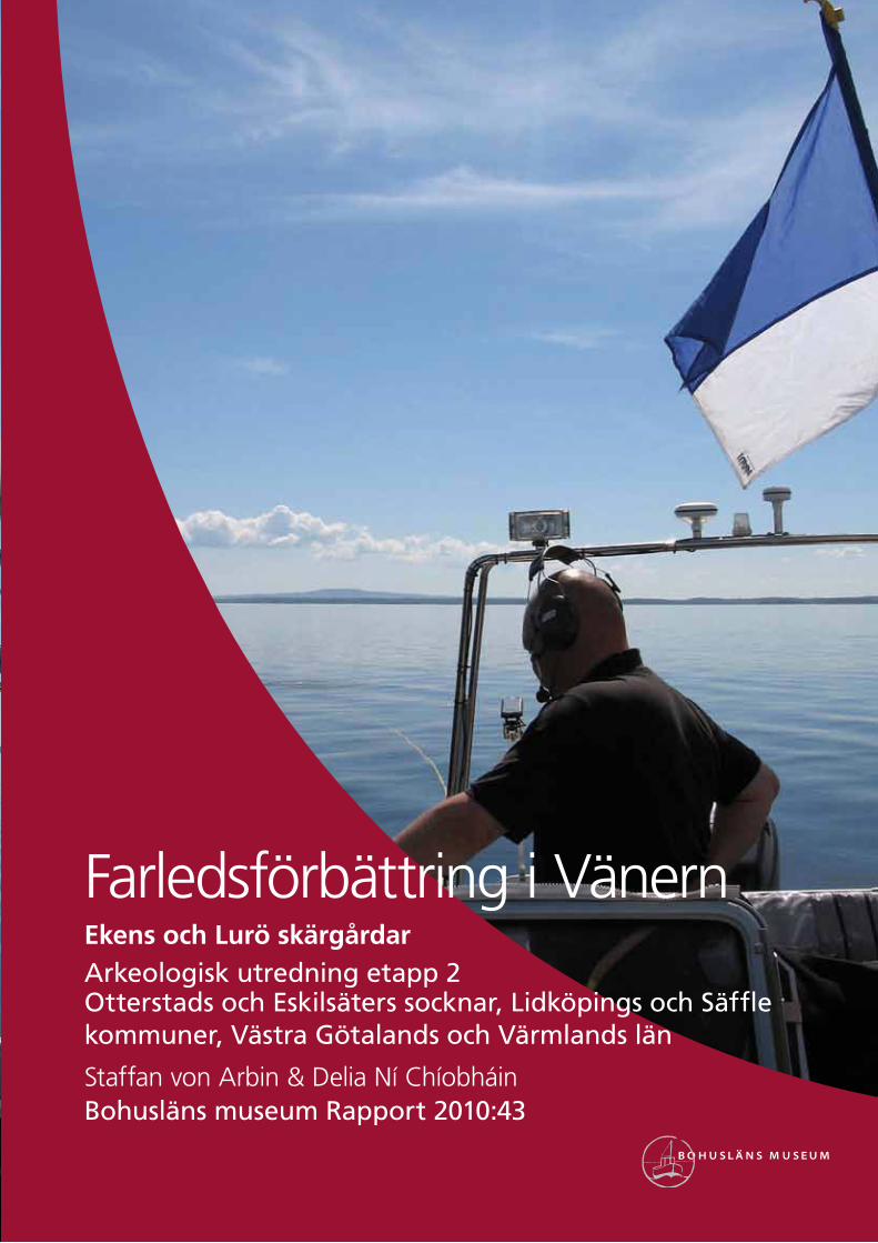
Omslagsbild Foto taget av Delia Ní Chíobháin. Fotot visar dykningsverksamhet i Eken skärgård.
Tryck Grafisk Precision AB, 2010
Kartor ur allmänt kartmaterial, © Lantmäteriverket medgivande 90.8012
Kartor godkända från sekretessynpunkt för spridning Lantmäteriet 2010-06-15. Dnr 601-2010/1697
Bohusläns museum
Museigatan 1
Box 403
451 19 Uddevalla
tel 0522-65 65 00, fax 0522-126 73
www.vastarvet.se, www.bohuslansmuseum.se
InnehållSammanfattning ....................................................................................................................................5
Background .....................................................................................................................................................5
Cultural landscape .............................................................................................................................5Shipping ..............................................................................................................................................................5Shipping channels .................................................................................................................................7Shipwrecks ......................................................................................................................................................9
Method ...................................................................................................................................................................9
Results ...................................................................................................................................................................10
Conclusion and recommendations..................................................................10
Referenser .......................................................................................................................................................11Litteratur .........................................................................................................................................................11Otryckta källor ........................................................................................................................................ 12
Tekniska och administrativa uppgifter ....................................................... 13
Bilagor ................................................................................................................................................................... 14

4 Bohusläns museum 2010:43
Figur 1. Utsnitt ur GSD-Röda kartan/Fastighetskartan med platsen för undersökningen markerad.
Farledsförbättring i Vänern 5
SammanfattningPå uppdrag av Sjöfartsverket utförde Bohusläns museum, i samarbete med Värmlands museum och Vänermuseet, i juni 2010 en marinarke-ologisk utredning, etapp 2, inom delar av Ekens och Lurö skärgårdar, Vänern. Utredningen utfördes med anledning av planerade farledsför-bättrande åtgärder och omfattade sju områden vilka valts ut på basis av resultatet av en första utredningsetapp i augusti 2009. Arbetet, som bestod av okulär dykande besiktning samt sticksondering, resulterade i fynden av ett stockankare av 1800-talstyp (Eskilsäter 302) samt en lös bordplanka från ett klinkbyggt fartyg av okänd ålder (Eskilsäter 303). Båda fynden indikerar vrakförekomster i närområdet, det vill säga ut-anför de berörda exploateringsområdena. Eftersom planerade åtgärder är av en mycket begränsad omfattning gör Bohusläns museum bedöm-ningen att de registrerade objekten ej kommer att påverkas av planerade exploateringar. Några ytterligare antikvariska åtgärder bedöms således inte vara nödvändiga.
BackgroundBohusläns museum, in co-operation with Vänermuseet and Värmlands museum, was commissioned by Sjöfartsverket to carry out phase 2 of a maritime archaeological survey. This survey is in advance of planned measures to improve safety of navigation along the Stånguddenleden and Milskärsleden channels via the archipelagos of Lurö and Eken in Lake Vänern. The plans include, among other things, improved marking and blasting/removal by dredging of a number of natural rock outcrops. The plan also includes the removal of Lilla Milskär and Östra Stenskär lighthouses.
The archaeological survey has been conducted in collaboration with Roland Peterson of Vänermuseet and Björn Wallbom of Värmlands museum. The survey was conducted on seven areas of interest, chosen in light of research carried out in phase 1, the results of which suggests that the area has been important for shipping for a very long time (von Arbin 2009). The results also indicate that unknown ancient remains in the form of ship communications may be affected by work planned by the company.
Cultural landscapeShipping
Lurö archipelago is located in central Lake Vänern, at the intersection of the north-south and east-west channels of the lake. Due to its strategic location and many good ports the archipelago has always been a natural centre of communication. Ancient remains and previous archaeological
6 Bohusläns museum 2010:43
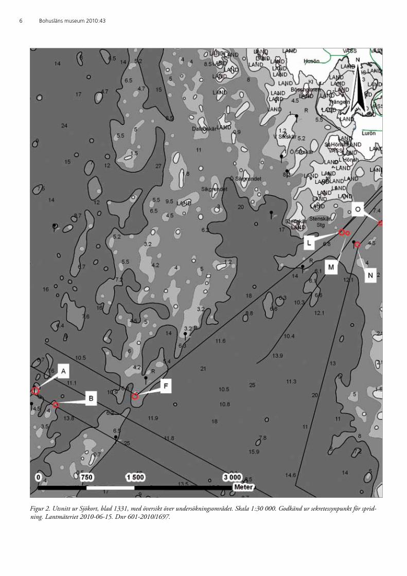
Figur 2. Utsnitt ur Sjökort, blad 1331, med översikt över undersökningsområdet. Skala 1:30 000. Godkänd ur sekretessynpunkt för sprid-ning. Lantmäteriet 2010-06-15. Dnr 601-2010/1697.
Farledsförbättring i Vänern 7
investigations indicate that the area has been exploited since prehistoric times, specifically in the Iron Age (Jansson 1995). The route via Kålland and Värmlandsnäs, via Byälven and Glasfjorden and up towards Norway is one of the earliest known transport routes. During the 1000’s it came to be an important route for pilgrims to travel to and from the shrine in Nidaros (Westerdahl 1977:61; Sigsjö 1990). A regular ferry service between Kållandsö and Värmlandsnäs Lurö can be affirmed from the 1600s (Westerdahl 2003:66).
According to a long-standing tradition, there was a Cistercian mon-astery on Lurö during the early medieval period. There is some support for this tradition in the written source material (Sigsjö 1990; Andersson 1995:36). According to surviving written records, the monastery in Varnhem had ownership interests in Lurö during the late medieval period at least. Some of these interests appear to have been linked to the rich salmon fisheries in the island’s surroundings (Sigsjö 1990:56; Jansson 1995:68). Archaeological investigations of the ruins that are tradition-ally identified as the foundations of the monastery have not revealed any monastery, but rather the remains of a Romanesque church. The area also contains several foundations which date from the 800s until the 1700s (Andersson 1995).
Shipping on Vänern during the medieval period was strongly orient-ed towards the Göta river valley and the towns of Kungahälla, Lödöse and Nya Lödöse, whose roles would later be taken over by Göteborg. A number of towns developed along the shores of Vänern, beginning in the late medieval period. Most of these were already significant market places but once given city charters, trade and maritime transport grew in importance. Cereals, among other cargo, were transported from Dalsland and Västergötland to Värmland. In the opposite direction timber, tar and iron were transported and a significant proportion was shipped fur-ther down the Göta River (Lidholm 1940:426; Holmström 2000:20). A significant part of this traffic passed through the Lurö archipelago.
Shipping channelsStångudden and Milskärslederna are presumed to have functioned as sailing channels in antiquity. Stånguddenled is thought to be illustrated on one of the oldest charts of Lake Vänern. The chart, called Hydrog-raphisk charta öfver Wästra Delen af Sjön Wenern eller så kallade Dalbo- Sjön, was drawn by Vice Admiral John Nordenankar in 1788. In the Special charta öfver Lurö Skärgård i Sjön Wenern from 1789, also signed by the aforementioned Nordenankar, this point is called the Södra leden (Freudendahl 1982).
A series of measures to improve safety for shipping in Lake Vänern began in the late 1700s and was initiated by the mayor and hydrog-rapher Petter John Warberg. Buoyage of the main shipping routes was financed by a special fund called Fonden för seglationens förbättrande å

8 Bohusläns museum 2010:43
sjön Wenern. This initiative came to form the foundation for what later would become Vänern sailing board, that is, the organization which un-til 2004 was responsible navigation of the lake (Holmström 2000:22; Lidholm 1956).
The earliest lighthouses along the channel sections in question are Stånguddens fyr (fig. 3) and the former lighthouse on Norra Trädgård-sholmen, which was established by 1864. The name Stångudden sug-gests that there had previously been a beacon on the site in the form of a pole. Other lighthouses that are or have been in use in the area include (year of construction in parentheses): Lurö Röskär (1915), Lilla Milskär (1957), Carlosgrundet (1957), Pålgrunden (1958), Norra Trädgårdsgrundet (1963), Lemongrund (1973) and Östra Stenskär (1987). Several of the lighthouses listed were preceded by
Figur 3. Stånguddens fyr på Lurö. Foto taget av Anders Martinsson, 1998. Foto i Vänermuseets arkiv.
Farledsförbättring i Vänern 9
light buoys, the earliest being at Lemongrund which was established as early as 1898.
ShipwrecksBoth Eken and Lurö archipelagos have the highest densities of shipwrecks in Vänern. This ratio naturally reflects the shipping lanes in these two areas, but is also a consequence of the waters being difficult to navigate, as well as having a large number of dangerous underwater grounds. This is evident from the many documented earlier shipwrecks located in the shipping channels related to this survey. However, it should be noted that a large number of incidents only refer generally to Lurö or Ekens archi-pelagos and sometimes only “Vänern”. It is of course possible to allude that some of this data does in fact affect the proposed development area.
The areas identified as shipwrecks premises are Lemongrund (un-known vessel, 1858), Stenskär (J(e)anette 1855, and two unknown vessels, 1869 and 1881), Pålskären (unknown vessel, 1858), Milskär (unknown vessels, 1865) and Trädgårdsholmen (the galeas Victor Em-manuel, 1891). In 1881 the galeas Frideborg sank after having collided with the steamship Idun between Stenskär and Norra Trädgårdsgrun-det (Westerdahl 2003 and the archives of Vänermuseet and Bohusläns museum).
The data related to shipwrecks is low despite some known ancient shipwreck sites in the area. The National Heritage Boards digital archae-ological records, FMIS, contains data of only three, namely Bo Harald (Otterstad 250/259), foundered in 1957, Carmen (Otterstad 255), sunk in 1981 and Atlantic (Otterstad 252/260), sank 1989. All are located in relation to Carlosgrund. Although none of the listed vessel remains are older than 100 years, and therefore not yet protected by the Herit-age Act, at least one of them, Carmen, may be attributed a significant cultural and historical value. The ship was built in 1888 as an älvbåt, a kind of sailing barge which was a characteristic vessel type on the Göta River in the 1800s and early 1900s (Granlund et al. 1951:643 and the archives of Sjöfartsmuseet in Göteborg). Carmen is the only known pre-served wreck of this vessel type.
Some other vessel remains have been located in the area but not re-ported to FMIS. On the east side of Pålgrundet Roland Petersson lo-cated three highly degraded remnants of clinker-built ships in the 1980s. Exact positions of the sites are uncertain, as are updates on their current condition and legal status.
MethodThe survey was conducted by maritime archaeologists from Bohusläns museum, Värmlands museum and Vänermuseet. Dives were conducted on areas which are to be affected by the proposed work. Two main areas

10 Bohusläns museum 2010:43
were chosen for survey, one located North of Kållandsö with sites A, B and F (fig. 2, bilaga 1). The other area was located south east of Lurö and contained the sites L, M, N and O (fig. 2, bilaga 2). A visual sur-vey and probing of the seabed was conducted within each survey area.
ResultsDuring the survey, two objects of archaeological significance were locat-ed (bilaga 3). An anchor with part of the anchor chain (Eskilsäter 302) from circa 1800s was located within area M and a stray clinker plank (Eskilsäter 303) was located within area L. The clinker plank was circa 2 meters long and little eroded. Both objects suggest the presence of ship remains in the vicinity, that is, outside the survey areas.
Conclusion and recommendationsConsidering the planned work is of a limited extent it is not expect-ed that the objects Eskilsäter 302 and Eskilsäter 303 will be affected Bohuslän museum therefore have no archaeological comments to make on the proposed plans.

Farledsförbättring i Vänern 11
ReferenserLitteratur
Andersson, S. 1995. Lurö – en centralplats i Vänern? I: Wadensjö, B. (red.). Lurö – centrum i Vänerland? Forskningsrapport 95:20. Centrum för historiskfilosofisk forskning. Högskolan i Karlstad.
von Arbin, S. 2009. Farledsförbättring i Vänern. Ekens och Lurö skär-gårdar. Arkeologisk utredning etapp 1. Otterstad och Eskilsäter socknar, Lidköpings och Säffle kommuner, Västra Götlands och Värmlands län. Rapport 2009:31. Bohusläns museum. Uddavalla.
Freudendahl, A.P. 1982. Lurö skärgård och Värmlandsnäs. Carl Zaka-riasson. Ed. Granlund, S., Bergman, G., Claesson, C. & Hammarskär, K.-E. 1951. Svenska seglare och motorseglare. En samling monografier m.m. Halmstad.
Granlund, S., Bergman, G., Claesson, C. & Hammarskär, K.-E- 1951. Svenska seglare och motorseglare. En samling monografier m.m. Halmstad.
Holmström, E. 2000. Vänerns fyrar – lysande kulturhistoria. En bok om Vänerns fyrar och deras kulturmiljö. Vänermuseet. Lidköping.
Jansson, U. 1995. Bebyggelse och landskap på Lurö. I: Wadensjö, B. (red.). Lurö – centrum i Vänerland? Forskningsrapport 95:20. Centrum för historiskfilosofisk forskning. Högskolan i Karlstad.
Lidholm, B. 1940. Vänerns sjöfart genom tiderna särskilt med avseende på Värmland. I: Värmland förr och nu 1939–1940. Karlstad.
Lidholm, B. 1956. Venerns Seglationsstyrelse. En historik. Lidköping.
Sigsjö, R. 1990. Kyrkan på Lurö – Västsveriges första kloster? Fornvän-nen 85.
Westerdahl, C. 1977. Fornlämningar och fornfynd i Götene kommun. En översikt./Om äldre Vänersjöfart. En introduktion. Götene kultur-nämnds småskriftsserie 1/2 1976/1977. Götene.
12 Bohusläns museum 2010:43
Westerdahl, C. 2003. Vänern. Landskap – människa – skepp. Om en maritim inlandskultur vid Vänern. Båtdokgruppen. Skärhamn.
Otryckta källor
Bohusläns museums arkiv, Uddevalla.
FMIS, Informationssystemet för fornminnen, Riksantikvarieämbetet, Stockholm.
Vänermuseets arkiv, Lidköping.
Sjöfartsmuseet i Göteborgs arkiv.
Farledsförbättring i Vänern 13
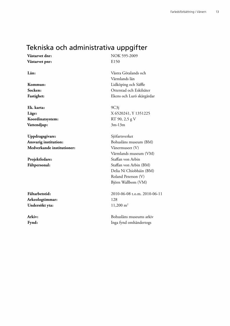
Tekniska och administrativa uppgifterVästarvet dnr: NOK 595-2009Västarvet pnr: E150
Län: Västra Götalands och Värmlands länKommun: Lidköping och SäffleSocken: Otterstad och EskilsäterFastighet: Ekens och Lurö skärgårdar
Ek. karta: 9C3jLäge: X 6520241, Y 1351225 Koordinatsystem: RT 90, 2,5 g VVattendjup: 3m-13m
Uppdragsgivare: SjöfartsverketAnsvarig institution: Bohusläns museum (BM)Medverkande institutioner: Vänermuseet (V) Värmlands museum (VM)Projektledare: Staffan von ArbinFältpersonal: Staffan von Arbin (BM) Delia Ní Chíobháin (BM) Roland Peterson (V) Björn Wallbom (VM)
Fältarbetstid: 2010-06-08 t.o.m. 2010-06-11Arkeologtimmar: 128Undersökt yta: 11,200 m2
Arkiv: Bohusläns museums arkivFynd: Inga fynd omhändertogs

14 Bohusläns museum 2010:43
BilagorBilaga 1. Karta över undersökningsområdet A, B, F. Skala 1:10 000. God-känd ur sekretessynpunkt för spridning. Lantmäteriet 2010-06-15. Dnr 601-2010/1697.
Bilaga 2. Karta över undersökningsområdet L, M, N, O. Skala 1:10 000. Godkänd ur sekretessynpunkt för spridning. Lantmäteriet 2010-06-15. Dnr 601-2010/1697.
Bilaga 3. Karta över undersökningsområdet L, M, N, O och objekt 1 och 2. Skala 1:4 000. Godkänd ur sekretessynpunkt för spridning. Lantmäteriet 2010-06-15. Dnr 601-2010/1697.
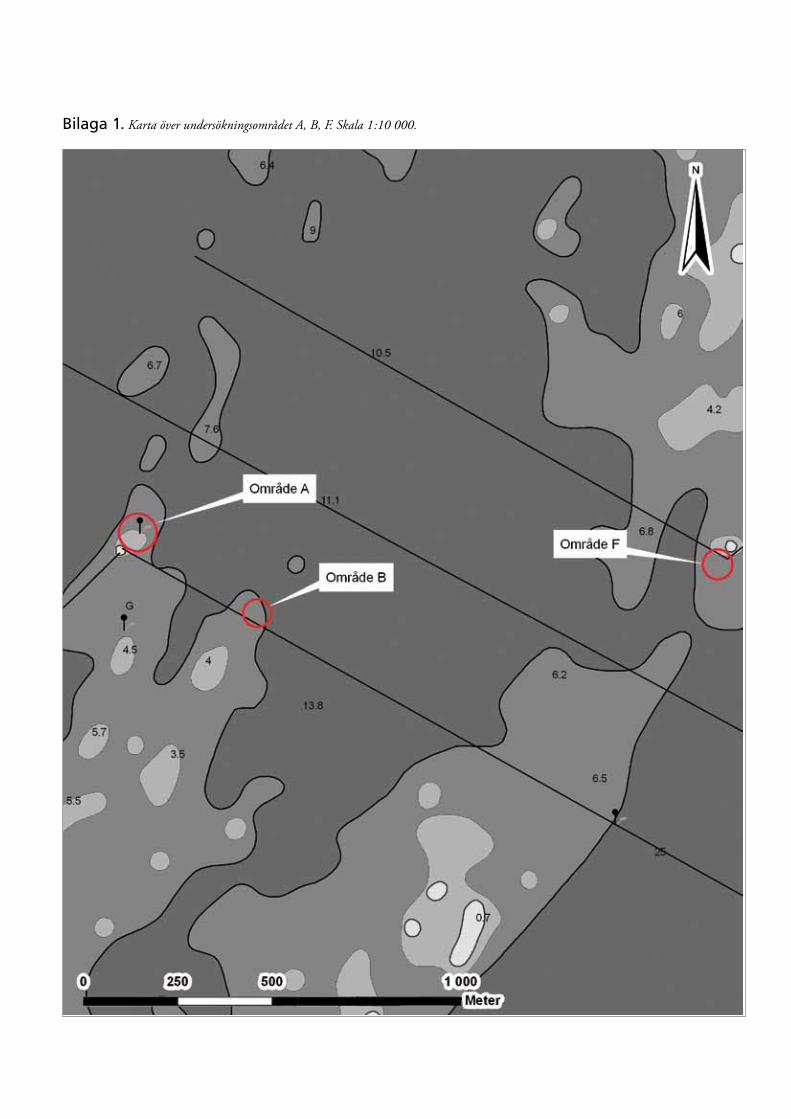
Bilaga 1. Karta över undersökningsområdet A, B, F. Skala 1:10 000.

Bilaga 2. Karta över undersökningsområdet L, M, N, O. Skala 1:10 000.
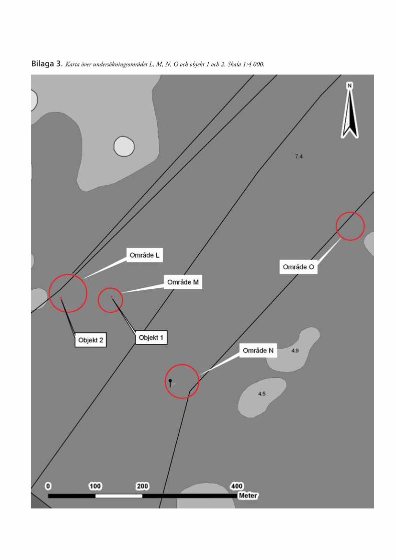
Bilaga 3. Karta över undersökningsområdet L, M, N, O och objekt 1 och 2. Skala 1:4 000.


Farledsförbättring i VänernEkens och Lurö skärgårdarArkeologisk utredning etapp 2Otterstads och Eskilsäters socknar, Lidköpings och Säffle kommuner, Västra Götalands och Värmlands län
Staffan von Arbin & Delia Ní ChíobháinBohusläns museum Rapport 2010:43