Fan beheading and drainage d ,nn khk iversion as evidence of a 3200-2800 BP earthquake event in the...
24
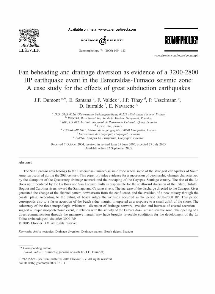
Fan beheading and drainage diversion as evidence of a 3200-2800 BP earthquake event in the Esmeraldas-Tumaco seismic zone: A case study for the effects of great subduction earthquakes J.F. Dumont a, * , E. Santana b , F. Valdez c , J.P. Tihay d , P. Usselmann e , D. Iturralde f , E. Navarette g a IRD, UMR 6526, Observatoire Oce ´anographique, 06235 Villefranche sur mer, France b INOCAR, Base Naval Sur, Av. de la Marina, Guayaquil, Ecuador c IRD, UR 092, Instituto Nacional de Patrimonio Cultural , Quito, Ecuador d UPPA, Pau, France e CNRS-UMR 6012, Maison de la ge ´ographie, 34090 Montpellier, France f Universidad de Guayaquil, Guayaquil, Ecuador g ESPOL, Campus La Prosperina, Guayaquil, Ecuador Received 7 October 2004; received in revised form 25 June 2005; accepted 27 July 2005 Available online 22 September 2005 Abstract The San Lorenzo area belongs to the Esmeraldas–Tumaco seismic zone where some of the strongest earthquakes of South America occurred during the 20th century. This paper provides evidence for a succession of geomorphic changes characterized by the disruption of the Quaternary drainage network and the reshaping of the Cayapas–Santiago estuary. The rise of the La Boca uplift bordered by the La Boca and San Lorenzo faults is responsible for the southward diversion of the Palabi, Tululbi, Bogota ´ and Carolina rivers toward the Santiago and Cayapas rivers. The increase of the discharge directed to the Cayapas River generated the change of the channel pattern downstream from the confluence, and the avulsion of a new estuary through the coastal plain. According to the dating of beach ridges the avulsion occurred in the period 3200–2800 BP. This period corresponds also to a faster accretion of the beach ridge margin, interpreted as a response to a small uplift of the shore. The coherency of the three morphologic evidences—diversion of drainage network, avulsion and increase of coastal accretion— suggest a unique morphotectonic event, in relation with the activity of the Esmaraldas–Tumaco seismic zone. The opening of a direct communication through the mangrove margin may have brought favorable conditions for the development of the La Tolita archaeological site after 3000 BP. D 2005 Elsevier B.V. All rights reserved. Keywords: Active tectonics; Drainage diversion; Drainage pattern; Beach ridges; Ecuador 0169-555X/$ - see front matter D 2005 Elsevier B.V. All rights reserved. doi:10.1016/j.geomorph.2005.07.011 * Corresponding author. E-mail address: [email protected] (J.F. Dumont). Geomorphology 74 (2006) 100 – 123 www.elsevier.com/locate/geomorph
-
Upload
independent -
Category
Documents
-
view
1 -
download
0
Transcript of Fan beheading and drainage d ,nn khk iversion as evidence of a 3200-2800 BP earthquake event in the...
www.elsevier.com/locate/geomorph
Geomorphology 74 (
Fan beheading and drainage diversion as evidence of a 3200-2800
BP earthquake event in the Esmeraldas-Tumaco seismic zone:
A case study for the effects of great subduction earthquakes
J.F. Dumont a,*, E. Santana b, F. Valdez c, J.P. Tihay d, P. Usselmann e,
D. Iturralde f, E. Navarette g
a IRD, UMR 6526, Observatoire Oceanographique, 06235 Villefranche sur mer, Franceb INOCAR, Base Naval Sur, Av. de la Marina, Guayaquil, Ecuador
c IRD, UR 092, Instituto Nacional de Patrimonio Cultural , Quito, Ecuadord UPPA, Pau, France
e CNRS-UMR 6012, Maison de la geographie, 34090 Montpellier, Francef Universidad de Guayaquil, Guayaquil, Ecuador
g ESPOL, Campus La Prosperina, Guayaquil, Ecuador
Received 7 October 2004; received in revised form 25 June 2005; accepted 27 July 2005
Available online 22 September 2005
Abstract
The San Lorenzo area belongs to the Esmeraldas–Tumaco seismic zone where some of the strongest earthquakes of South
America occurred during the 20th century. This paper provides evidence for a succession of geomorphic changes characterized
by the disruption of the Quaternary drainage network and the reshaping of the Cayapas–Santiago estuary. The rise of the La
Boca uplift bordered by the La Boca and San Lorenzo faults is responsible for the southward diversion of the Palabi, Tululbi,
Bogota and Carolina rivers toward the Santiago and Cayapas rivers. The increase of the discharge directed to the Cayapas River
generated the change of the channel pattern downstream from the confluence, and the avulsion of a new estuary through the
coastal plain. According to the dating of beach ridges the avulsion occurred in the period 3200–2800 BP. This period
corresponds also to a faster accretion of the beach ridge margin, interpreted as a response to a small uplift of the shore. The
coherency of the three morphologic evidences—diversion of drainage network, avulsion and increase of coastal accretion—
suggest a unique morphotectonic event, in relation with the activity of the Esmaraldas–Tumaco seismic zone. The opening of a
direct communication through the mangrove margin may have brought favorable conditions for the development of the La
Tolita archaeological site after 3000 BP.
D 2005 Elsevier B.V. All rights reserved.
Keywords: Active tectonics; Drainage diversion; Drainage pattern; Beach ridges; Ecuador
0169-555X/$ - s
doi:10.1016/j.ge
* Correspondin
E-mail addre
2006) 100–123
ee front matter D 2005 Elsevier B.V. All rights reserved.
omorph.2005.07.011
g author.
ss: [email protected] (J.F. Dumont).
J.F. Dumont et al. / Geomorphology 74 (2006) 100–123 101
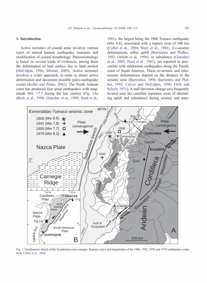
1. Introduction
Active tectonics of coastal areas involves various
types of natural hazard, earthquake, tsunamis and
modification of coastal morphology. Paleoseismology
is based on several kinds of evidences, among them
the deformation of land surface due to fault motion
(McCalpin, 1996; Morner, 2003). Active tectonics
involves a wider approach, in order to detect active
deformation and document possible paleo-earthquake
events (Keller and Pinter, 2002). The North Andean
coast has produced four great earthquakes with mag-
nitude Mw N7.7 during the last century (Fig. 1A)
(Beck et al., 1998; Gutscher et al., 1999; Herd et al.,
1942 (Mw 7.8)
1958 (Mw 7.7)
1979 (Mw 8.2)
1906 (Mw 8.8)
Esmeraldas-Tumaco seismic zone
CarnegieRidge
Sub
duct
ion
trenc
h
Gulf ofGuayaquil
- 100
0m
-2000 m
Coa
stal
Nazca Plate
0°
80°W
Plateconvergence
+
+
1942
1942
190
1
NazcaPlate
CarribeanPlate 10°N
0°
GUAYAQUIL
Gua
yaqu
il- C
arac
as
Meg
ashe
ar
70°W80°W
NorthAndean
Block
CARACAS
Tala
raA
rc South AmericanPlate
Fig.1A
*
BFig. 1. Geodynamic sketch of the Ecuadorian active margin. Rupture zones
from Collot et al., 2004.
1981), the largest being the 1906 Tumaco earthquake
(Mw 8.8), associated with a rupture zone of 500 km
(Collot et al., 2004; Herd et al., 1981). Co-seismic
deformations, either uplift (Barrientos and Plafker,
1992; Ortlieb et al., 1996), or subsidence (Gonzalez
et al., 2002; Herd et al., 1981), are reported in asso-
ciation with subduction earthquakes along the Pacific
coast of South America. These co-seismic and inter-
seismic deformations depend on the distance to the
seismic zone (Barrientos, 1996; Barrientos and Plaf-
ker, 1992; Carver and McCalpin, 1996; Fitch and
Scholz, 1971). A null elevation change axis frequently
located near the coastline separates areas of alternat-
ing uplift and subsidence during seismic and inter-
And
ean
Cor
dille
ra
Esmeraldas
Tumaco
Cor
dille
raFig. 2
100 km
Guaya
quil
-
Carac
asM
egas
hera
Plateconvergence
Quito
Carchi
Colombia
Ecuador
1979
1958
1958
6
906
Guayaquil
Borbó
nBas
in*
A
and magnitudes of the 1906, 1942, 1958 and 1979 earthquakes come

J.F. Dumont et al. / Geomorphology 74 (2006) 100–123102
seismic deformations (Barrientos, 1996; Fitch and
Scholz, 1971). Up to 8 m uplift and 6 m subsidence
have been observed in relation to the 1946 magnitude
8.2 Nankaido earthquake in Japan, and surface defor-
mation has been continuing 3 years after the earth-
quake (Fitch and Scholz, 1971). Herd et al. (1981)
report co-seismic subsidence of up to 1.6 m in relation
to the 1979 magnitude 7.8 Tumaco earthquake.
This study supports the hypothesis that co-seismic
deformation over a subduction zone may also produce
change of the drainage network and/or adjustment of
the drainage pattern that can be useful for paleoseis-
mology of extreme events. In flat areas and wet
climate, light vertical motion of the surface morphol-
ogy can generate striking changes of the drainage
pattern. This approach has been previously used to
study active surface deformation in wetland and allu-
vial plains of the Amazonian foreland basins
(Dumont, 1991, 1993; Dumont and Fournier, 1994;
Schumm et al., 2000). There, low range vertical defor-
mations resulted in river diversion and channel pattern
change along small rivers, and avulsion of the main
streams. Similar climate and drainage conditions exist
in the Esmeraldas–Tumaco coastal margin of North-
ern Ecuador and Colombia.
2. Geological background
The Nazca and South American plates converge
along the South American active margin at a rate of 7–
8 cm/yr with a nearly W–E trend (De Mets et al.,
1990; Kellogg and Vega, 1995). From the Gulf of
Guayaquil (south) to the Ecuador–Colombian border
(north) the obliquity of the subduction zone with the
plate motion increases up to 30–50 degrees (Fig. 1A)
(Ego et al., 1996) . This oblique subduction favors the
northeastward escape of the North Andean block at a
rate of about 1 cm/yr along the Guayaquil–Caracas
megashear (Dumont et al., 2005; Ego et al., 1996)
(Fig. 1B). The northward motion of the Andean Block
goes along with a roughly N–S trending extension in
the Ecuadorian coastal margin, involving NE–SW
dextral and NW–SE sinestral transtension faults
(Alvarado, 1998; Deniaud, 2000; Dumont et al.,
1997, 2005; Santana and Dumont, 2002).
The San Lorenzo area is located landward of the
Esmeraldas–Tumaco seismic zone (Fig. 1A) (Collot
et al., 2002), defined in reference to the great 1906
earthquake, one of the strongest earthquake regis-
tered on earth (Mw 8.8). The rupture zone of the
1906 earthquake has been reactivated by 3 strong
earthquakes in 1942 (Mw 7.9), 1958 (Mw 7.8) and
1979 (Mw 7.9) (Collot et al., 2004; Herd et al.,
1981; Kelleher, 1972; Swenson and Beck, 1996),
and strong earthquakes also probably occurred in
the same area in 1868 and 1875 (Scheu, 1911).
The 1979 earthquake has been accompanied by a
coastal subsidence of up to 1.6 m, a ground failure
extending up to 60 km inland, and co-seismic uplift
is reported offshore, on the edge of the continental
shelf (Herd et al., 1981).
The coastal margin of central Ecuador is character-
ized by a steady uplift during the Quaternary giving
flight of marine terraces up to an elevation of 300 m
(Pedoja, 2003). This uplift is related to the subduction
of the Carnegie Ridge (Gutscher et al., 1999; Pedoja
et al., 2001). The segment of uplifting coast stops to
the north on the NW–SE trending Yanayaca fault (Fig.
2) (CERESIS, 1985; Pedoja, 2003). From Las Penas
to the Manglar Cap the Bay of Ancon de Sardinas
(Fig. 2) constitutes a wide delta formed between the
outlet of the Cayapas–Santiago and Mataje rivers,
located on the southern and northern borders of the
delta, respectively. The delta area constitutes a 15-km
wide margin of mangrove, beach ridges and tide
channels, bounded sharply inland by a continuous
10–15 m cliff. This cliff also represents the limit of
the mid Holocene post-glacial transgression (Tihay
and Usselmann, 1995).
The Pleistocene deposits of the San Lorenzo area
are represented by the Cachabi (also called Canoa)
and San Tadeo formations (Fig. 3) (Baldock, 1982;
CODIGEM, 1993). The regional extension of these
formations describes a large fan along the lower
slopes of the Andean Cordillera, down to the coast.
The uppermost San Tadeo Formation crops out along
the northern slopes of the fan. It includes pyroclastics,
volcanic conglomerate, laharic and mudflow material,
forming sheets or fluvial terraces entrenched in the
Cachabi Formation (Baldock, 1982). The Cachabi
Formation represents a continental fan made of
sand, mud, tuff, gravel and conglomerate. The mate-
rial is deeply weathered in reddish-yellow clay, with
only ghosts of siliceous pebbles showing the original
facies.

Fig. 2. Geologic sketch of the area of San Lorenzo, localised on Fig. 1. Numbers 1, 2 and 3 represent the different drainage areas described in the
text.
J.F. Dumont et al. / Geomorphology 74 (2006) 100–123 103
The basement of the Cachabi and San Tadeo for-
mations belongs to the Borbon Formation of the
Borbon Basin, that was active since the Middle
Eocene to the Upper Pliocene (Aalto and Miller,
1999; Deniaud, 2000; Evans and Whittaker, 1982).
The depocenter of the north Borbon Basin is located
below the Ancon de Sardinas Bay, near the estuary of
the Cayapas–Santiago river and the city of San Lor-
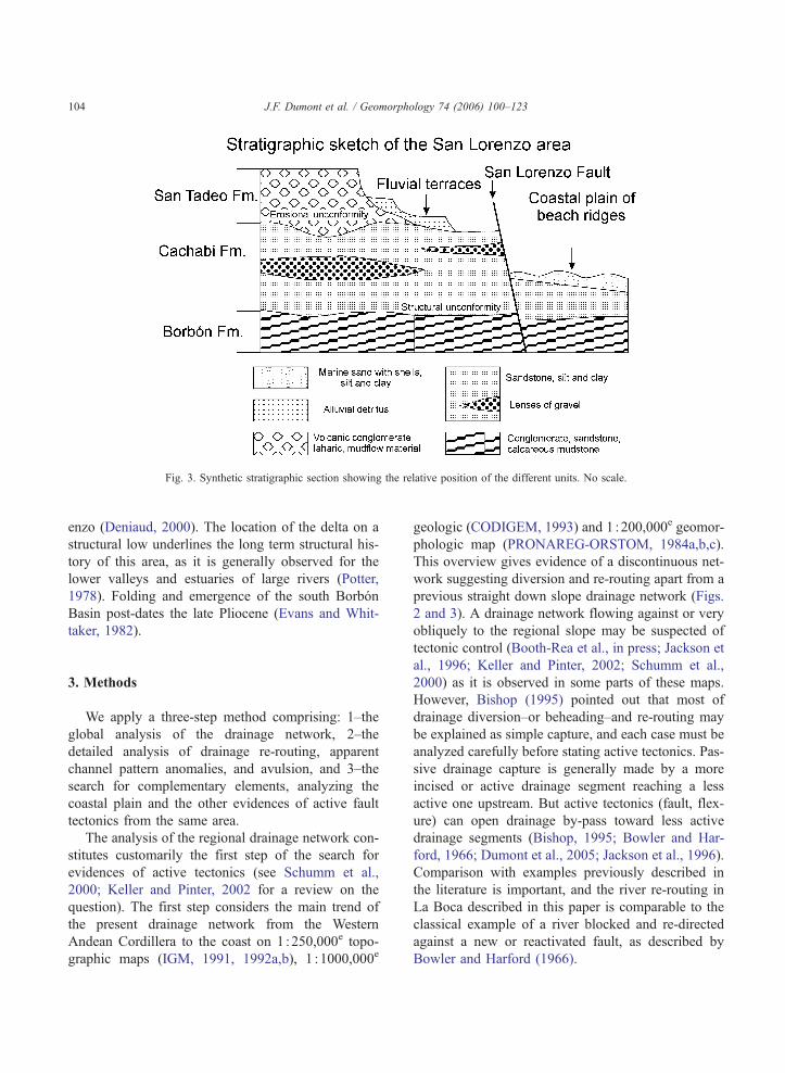
Fig. 3. Synthetic stratigraphic section showing the relative position of the different units. No scale.
J.F. Dumont et al. / Geomorphology 74 (2006) 100–123104
enzo (Deniaud, 2000). The location of the delta on a
structural low underlines the long term structural his-
tory of this area, as it is generally observed for the
lower valleys and estuaries of large rivers (Potter,
1978). Folding and emergence of the south Borbon
Basin post-dates the late Pliocene (Evans and Whit-
taker, 1982).
3. Methods
We apply a three-step method comprising: 1–the
global analysis of the drainage network, 2–the
detailed analysis of drainage re-routing, apparent
channel pattern anomalies, and avulsion, and 3–the
search for complementary elements, analyzing the
coastal plain and the other evidences of active fault
tectonics from the same area.
The analysis of the regional drainage network con-
stitutes customarily the first step of the search for
evidences of active tectonics (see Schumm et al.,
2000; Keller and Pinter, 2002 for a review on the
question). The first step considers the main trend of
the present drainage network from the Western
Andean Cordillera to the coast on 1 :250,000e topo-
graphic maps (IGM, 1991, 1992a,b), 1 :1000,000e
geologic (CODIGEM, 1993) and 1 :200,000e geomor-
phologic map (PRONAREG-ORSTOM, 1984a,b,c).
This overview gives evidence of a discontinuous net-
work suggesting diversion and re-routing apart from a
previous straight down slope drainage network (Figs.
2 and 3). A drainage network flowing against or very
obliquely to the regional slope may be suspected of
tectonic control (Booth-Rea et al., in press; Jackson et
al., 1996; Keller and Pinter, 2002; Schumm et al.,
2000) as it is observed in some parts of these maps.
However, Bishop (1995) pointed out that most of
drainage diversion–or beheading–and re-routing may
be explained as simple capture, and each case must be
analyzed carefully before stating active tectonics. Pas-
sive drainage capture is generally made by a more
incised or active drainage segment reaching a less
active one upstream. But active tectonics (fault, flex-
ure) can open drainage by-pass toward less active
drainage segments (Bishop, 1995; Bowler and Har-
ford, 1966; Dumont et al., 2005; Jackson et al., 1996).
Comparison with examples previously described in
the literature is important, and the river re-routing in
La Boca described in this paper is comparable to the
classical example of a river blocked and re-directed
against a new or reactivated fault, as described by
Bowler and Harford (1966).
J.F. Dumont et al. / Geomorphology 74 (2006) 100–123 105
The second step comprises the detailed analysis of
some characteristic points of the drainage diversions
that disrupt the original fan network, at the head of the
fan, in the middle part, and finally in the coastal plain.
Channel slope, channel trend change, as well as dry
valley, are important elements to analyze and interpret
the reshaping of the drainage network. Downstream
the drainage network enters the delta area, showing
combination of anastomosed and meandering pat-
terns. Different channel patterns with the same slope
imply changing hydrologic characteristics such as
discharge and sediment transport (Schumm et al.,
2000), that should be a key for the understanding of
drainage pattern in the coastal plain.
The third step considers complementary elements
that belong to the geographic and structural context.
In the coastal plain we analyze the space–time accre-
tion of the beach ridges in order to date the avulsion
and the opening of the present Cayapas–Santiago
estuary. Also space–time diagram of the beach ridge
accretion will specify the coastal plain evolution.
Finally the evidences of active fault motion are ana-
lyzed in the context of the morphological changes
observed.
4. The drainage network
Between the Carchi area in the Western Andean
Cordillera and the Bay of Ancon de Sardinas (Fig. 2)
the drainage network presents three parts (IGM,
1992a,b). The area 1 (Fig. 2) extends from the Carchi
area (about 2000 m) to Alto Tambo (500 m), and is
drained along by the Mira River, one of the main
rivers of northern Andes. The Mira River valley is
entrenched about 1000 m in the upper slopes of the
Cordillera, and about 200–300 m in the Alto Tambo
area. At Alto Tambo the trend of the Mira River turns
to the north, joining the catchment area of the San
Juan River, and reaching the coast in the Manglar Cap
in Colombia (Fig. 2).
Area 2 (Fig. 2) extends over 40 km downslope
from the Alto Tambo area (500–700 m) to a NE–SW
trending line joining Tululbi to Concepcion (20–50
m). The drainage network of area 2 comprises from
north to south the Mataje, Palabi, Tululbi, Bogota and
Carolina rivers. The trend of the three last rivers
converge upstream in Alto Tambo, close to the Mira
River, and the first two converge at 10 km to the north
(Figs. 2 and 6). This upstream convergence of the
drainage describes a fan network called the El Placer
fan (Winckell and Zebrowski, 1997). In the down-
stream part of area 2 (Fig. 2) the drainage network of
the El Placer fan is sharply re-routed to the SW, the
Palabi, Tululbi, Bogota and Carolina rivers joining
together the Santiago River. Along the NE margin
of the El Placer fan the Mataje River flows straight
down slope, reaching the coast along the structural
border of the Bay of Ancon de Sardinas.
Area 3 (Fig. 2) covers a 30-km wide lowland
margin (0–50 m), including the San Lorenzo upland
and the coastal plain. The San Lorenzo upland is
characterized by a poor drainage network in the
central part, with the Cayapas–Santiago and Mataje
rivers located at the southern and northern borders of
the area, respectively. The 15-km wide and 50-km
long coastal plain includes mangrove, tidal channels,
salted marshes and beach ridges, and the estuaries of
the Cayapas–Santiago and Mataje rivers. A striped
pattern of beach ridges is observed in the southern
part, disappearing progressively to the north below
mangrove and tidal channels. The Cayapas and San-
tiago rivers drain the Western Andean Cordillera
south of the Mira River catchment area. These rivers
join together before to cross the delta through the
common Cayapas–Santiago estuary. A total of four
large tide channels cross the coastal plain, from
south to north: the Cayapas–Santiago, Boca de
Limones, Bolivar and Mataje channels (Fig. 4). But
only the Cayapas–Santiago and Mataje channels
located, respectively, in the SW and the NE are the
outlets of important rivers. The other ones constitute
the outlet of very small rivers without relation with
the size of the channel (Fig. 4). Near San Lorenzo
the Bolivar channel is connected landward with the
Estero El Salto (Fig. 4), characterized by a typical ria
morphology carved in the San Lorenzo upland, and
interpreted, as it is generally the case for such pat-
tern, either for eustatic or tectonic effect, or both,
suggesting a drowned Holocene valley.
4.1. Reconstruction of the Pleistocene fan drainage
The different segments of the present drainage net-
work are reconstructed on Fig. 5, describing a large fan
with the Mira River as the fan feeder at the head, the El
X3
X4
BA
E
D
C
F
G
I
J
K
MN
P
O
Q
Z
Z'
+
A
B1
B2
Fault
Upland below 20 mUpper Cayapas terrace
Mangrove
Upland over 20 mPleistocene fan
Estimated 2800-3200 BPbeach ridge line
Beach ridges
Limit of recentbeach ridges
pattern
Floodplain area
+ Bank of dead oyster
Nm
0 5 10 15
12 345
67
t,s
A: 658-469 BP *B: 771-539 BP *C: 3471-2983 BP *D: 3251-2854 BP *E: 3260-2830 BP *F: 1707-1299 BP *
G: 2781-2340 BP *H: 460-0 BP +I: 5935-5581 BP *J: 5938-5600 BP *K: 4132-3686 BP *L: 4230-3806 BP *
M: 3200-2780 BP +N: 5050-4860 BP +O: 5450-5130 BP +P: 6880-6660 BP +Q: 3840-3580 BP +
* from Tihay and Usselmann (1995) + This study
Ages from the beach ridges of the coastal plain
H
L
SanLorenzo
Ancón
Valdez
0 5km
Fig. 12
Fig. 11
Fig. 9
Boca de
Limones channelCayapas-Santiago
estuary
EsteroEl Salto
La BocaUplift
COLOMBIA
ECUADOR
Bay of Ancónde Sardinas
La Tolita
Las Peñas
Bolivar
channel
Y2
Y1
X2
X1
B1
ES
LFWS
LF
SLF
N
12
3
4
5
6
7
3σ
2σ 1σ
N
1 3
2
σ σ
σ
Rio Mataje
Mataje Fault
J.F. Dumont et al. / Geomorphology 74 (2006) 100–123106
J.F. Dumont et al. / Geomorphology 74 (2006) 100–123 107
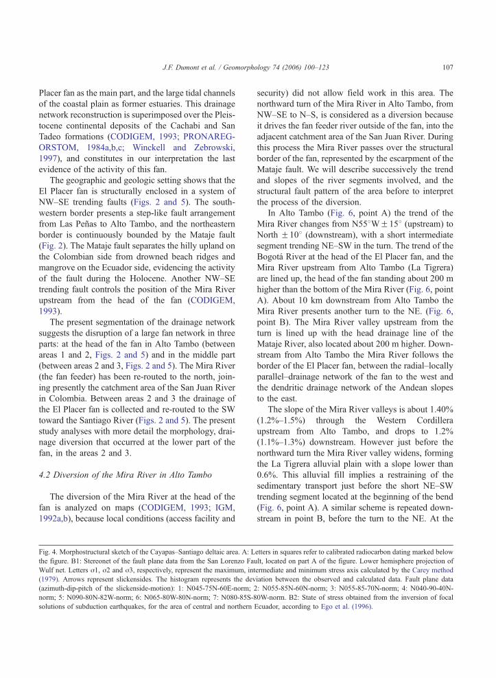
Placer fan as the main part, and the large tidal channels
of the coastal plain as former estuaries. This drainage
network reconstruction is superimposed over the Pleis-
tocene continental deposits of the Cachabi and San
Tadeo formations (CODIGEM, 1993; PRONAREG-
ORSTOM, 1984a,b,c; Winckell and Zebrowski,
1997), and constitutes in our interpretation the last
evidence of the activity of this fan.
The geographic and geologic setting shows that the
El Placer fan is structurally enclosed in a system of
NW–SE trending faults (Figs. 2 and 5). The south-
western border presents a step-like fault arrangement
from Las Penas to Alto Tambo, and the northeastern
border is continuously bounded by the Mataje fault
(Fig. 2). The Mataje fault separates the hilly upland on
the Colombian side from drowned beach ridges and
mangrove on the Ecuador side, evidencing the activity
of the fault during the Holocene. Another NW–SE
trending fault controls the position of the Mira River
upstream from the head of the fan (CODIGEM,
1993).
The present segmentation of the drainage network
suggests the disruption of a large fan network in three
parts: at the head of the fan in Alto Tambo (between
areas 1 and 2, Figs. 2 and 5) and in the middle part
(between areas 2 and 3, Figs. 2 and 5). The Mira River
(the fan feeder) has been re-routed to the north, join-
ing presently the catchment area of the San Juan River
in Colombia. Between areas 2 and 3 the drainage of
the El Placer fan is collected and re-routed to the SW
toward the Santiago River (Figs. 2 and 5). The present
study analyses with more detail the morphology, drai-
nage diversion that occurred at the lower part of the
fan, in the areas 2 and 3.
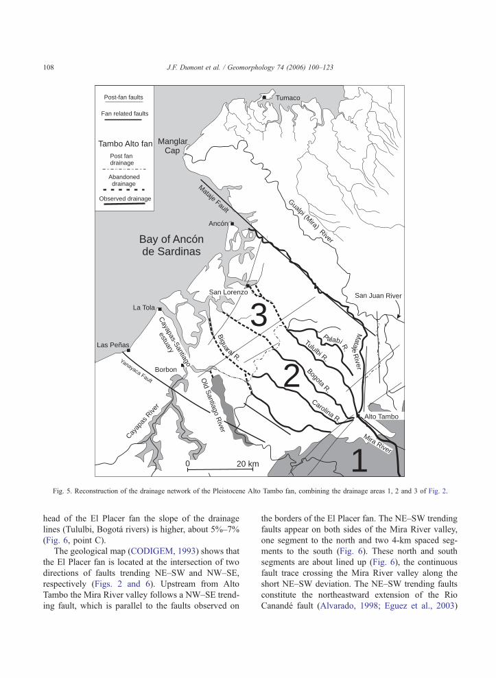
4.2 Diversion of the Mira River in Alto Tambo
The diversion of the Mira River at the head of the
fan is analyzed on maps (CODIGEM, 1993; IGM,
1992a,b), because local conditions (access facility and
Fig. 4. Morphostructural sketch of the Cayapas–Santiago deltaic area. A: L
the figure. B1: Stereonet of the fault plane data from the San Lorenzo Fau
Wulf net. Letters j1, j2 and j3, respectively, represent the maximum, int
(1979). Arrows represent slickensides. The histogram represents the dev
(azimuth-dip-pitch of the slickenside-motion): 1: N045-75N-60E-norm; 2
norm; 5: N090-80N-82W-norm; 6: N065-80W-80N-norm; 7: N080-85S-8
solutions of subduction earthquakes, for the area of central and northern E
security) did not allow field work in this area. The
northward turn of the Mira River in Alto Tambo, from
NW–SE to N–S, is considered as a diversion because
it drives the fan feeder river outside of the fan, into the
adjacent catchment area of the San Juan River. During
this process the Mira River passes over the structural
border of the fan, represented by the escarpment of the
Mataje fault. We will describe successively the trend
and slopes of the river segments involved, and the
structural fault pattern of the area before to interpret
the process of the diversion.
In Alto Tambo (Fig. 6, point A) the trend of the
Mira River changes from N558WF158 (upstream) to
North F108 (downstream), with a short intermediate
segment trending NE–SW in the turn. The trend of the
Bogota River at the head of the El Placer fan, and the
Mira River upstream from Alto Tambo (La Tigrera)
are lined up, the head of the fan standing about 200 m
higher than the bottom of the Mira River (Fig. 6, point
A). About 10 km downstream from Alto Tambo the
Mira River presents another turn to the NE. (Fig. 6,
point B). The Mira River valley upstream from the
turn is lined up with the head drainage line of the
Mataje River, also located about 200 m higher. Down-
stream from Alto Tambo the Mira River follows the
border of the El Placer fan, between the radial–locally
parallel–drainage network of the fan to the west and
the dendritic drainage network of the Andean slopes
to the east.
The slope of the Mira River valleys is about 1.40%
(1.2%–1.5%) through the Western Cordillera
upstream from Alto Tambo, and drops to 1.2%
(1.1%–1.3%) downstream. However just before the
northward turn the Mira River valley widens, forming
the La Tigrera alluvial plain with a slope lower than
0.6%. This alluvial fill implies a restraining of the
sedimentary transport just before the short NE–SW
trending segment located at the beginning of the bend
(Fig. 6, point A). A similar scheme is repeated down-
stream in point B, before the turn to the NE. At the
etters in squares refer to calibrated radiocarbon dating marked below
lt, located on part A of the figure. Lower hemisphere projection of
ermediate and minimum stress axis calculated by the Carey method
iation between the observed and calculated data. Fault plane data
: N055-85N-60N-norm; 3: N055-85-70N-norm; 4: N040-90-40N-
0W-norm. B2: State of stress obtained from the inversion of focal
cuador, according to Ego et al. (1996).
Cayapas-Santiago
estuary
Cayap
asRive
r
Mira River
San Juan River
Gualpi (Mira)River
Mataje Fault
Old
Santiago
River
San Lorenzo
Borbon
Tumaco
Alto Tambo
La Tola
Las Peñas
Ancón
Mataje
River
Bay of Ancónde Sardinas
BogotaR.
Tululbi R.
Biguaral R.
Palabi R.
Carolina R.
ManglarCap
Yanayaca Fault
0 20 km 1
2
3
Tambo Alto fan
Fan related faults
Observed drainage
Abandoneddrainage
Post fandrainage
Post-fan faults
Fig. 5. Reconstruction of the drainage network of the Pleistocene Alto Tambo fan, combining the drainage areas 1, 2 and 3 of Fig. 2.
J.F. Dumont et al. / Geomorphology 74 (2006) 100–123108
head of the El Placer fan the slope of the drainage
lines (Tululbi, Bogota rivers) is higher, about 5%–7%
(Fig. 6, point C).
The geological map (CODIGEM, 1993) shows that
the El Placer fan is located at the intersection of two
directions of faults trending NE–SW and NW–SE,
respectively (Figs. 2 and 6). Upstream from Alto
Tambo the Mira River valley follows a NW–SE trend-
ing fault, which is parallel to the faults observed on
the borders of the El Placer fan. The NE–SW trending
faults appear on both sides of the Mira River valley,
one segment to the north and two 4-km spaced seg-
ments to the south (Fig. 6). These north and south
segments are about lined up (Fig. 6), the continuous
fault trace crossing the Mira River valley along the
short NE–SW deviation. The NE–SW trending faults
constitute the northeastward extension of the Rio
Canande fault (Alvarado, 1998; Eguez et al., 2003)
Alto TamboEl Placer
Bogotá R.
Tululbi R.
Mira
R.
Mira River
La TigreraM
atajeR
.
San
tiago
Riv
er
Can
andé
Faul
t Zon
e
Carolina R.
Cachabi R.
2000
2000
1000
1000
1000
1000
500
500
500
100
10 km
A
B
C
N
Fig. 6. Morphologic sketch of the head part of the El Placer fan. Thick lines are faults from the geological map (CODIGEM, 1993), and thick
dotted lines are extrapolated faults with high probability, and thin dotted lines subdued possible faults. Letters refer to commentary in the text.
J.F. Dumont et al. / Geomorphology 74 (2006) 100–123 109
(Fig. 6), suspected of right-lateral Quaternary motion
on the basis of observation on radar images (Alvar-
ado, 1998). The North Canande fault is defined here
as the extension of the Canande fault in the Alto
Tambo area. The NE–SW river segments north of
the Canande fault is interpreted as another segment
of the Canande fault zone.
The Mira River valley presents a right hand offset
of 1.5–2 km at the crossing point with the Canande
fault. The occurrence of the El Tigrera alluvial plain
supports the hypothesis of restraining drainage along
the fault segment, and thus the recent motion of the
fault. This allows speculation that the river offset
corresponds to the fault motion since the entrench-
ment of the Mira River, that is since no more than
approximately the middle Pleistocene. This gives a
rough estimation of a slip rate of 1–2 mm/year.
It is difficult to apply the same analysis to the other
NE–SW trending segment downstream from point B
(Fig. 6), because it is located in an area of relatively
low topography suggesting weak tectonic control and
possibly easier natural diversions and adjustment
(Dumont et al., 2005; Huang, 1993). In those cases
the dextral apparent offset can be far higher than the
tectonic offset along the fault. However the tectonic
offset along the Canande fault and the parallel fault to
J.F. Dumont et al. / Geomorphology 74 (2006) 100–123110
the north are not enough to explain the diversion of
the Mira River outside the structural limits of the El
Placer fan. We also need to consider the N–S trend-
ing segments driving the Mira River to Colombia.
The geological map does not show N–S trending
faults in the studied area, but such faults are frequent
in the southwestern part of the Borbon Basin, along
the Esmeraldas River valley (Eguez et al., 2003), and
near the coast (Santana et al., 2001; Witt, 2001). In
particular the two more recent tectonic events
observed in the Pliocene deposits are successively
E–W and N–S extensions (Santana et al., 2001; Witt,
2001), but only the last one affects the Holocene
(Santana and Dumont, 2002) as it will be shown
later in the San Lorenzo area. We interpret here the
NS trending river segments as controlled by faults
formed or reactivated during the early E–W exten-
sion event of the Quaternary, before the Holocene.
NE–SW as well as NW–SE trending faults are able
to have been moved during this event. This exten-
sion tectonic event is able to have reduced the
activity of the fan. The result would be the opening
of new drainage lines toward the north along fault
segments linking new or pre-existing drainage lines.
The entrenchment of the Mira River along the border
structures of the fan occurred during this period. The
more recent and still active N–S extension did not
drastically change this pattern of morphostructures.
This recent event is characterized by transtension
motion, and dextral motion along the NE–SW trend-
ing faults (Santana and Dumont, 2002). It may be
hypothesized that this recent motion is more pre-
cisely responsible for the restraining flow where
the Canande fault cuts the Mira River valley at
point A, resulting in the formation of alluvial fill
like that of La Tigrera.
According to Bishop’s (1995) classification of river
diversion the process observed here involves the pre-
servation of drainage lines and transfer of drainage
areas between adjacent catchments. This is a btop–downQ process, the tectonism at the point of river
capture determining the rearrangement of the catch-
ment area downstream. According to Bishop (1995),
rejuvenation head may appear at or above the elbow
of capture, depending on the original height difference
between the bed of the two rivers involved in the
rearrangement and the change in discharge for the
stream receiving the diverted flow. In the present
case the capture of the Mira River occurs along drai-
nage lines located at the structural border of the fan
with the Andean Cordillera.
Since the diversion occurred the Mira River has
been entrenched about 200 m relative to the head of
the El Place fan. This suggests that the diversion
probably occurred before the Holocene. A rough cal-
culation of a minimum age can be made considering
the entrenchment of the Pastaza River inside its fan on
the other side of the Andes, under similar climate. The
calculation using the 5–6.7 mm/year�1 entrenchment
of the Pastaza River (Bes de Berc et al., 2005) as a
maximum rate gives a minimum of about 40,000
years for the entrenchment of the Mira River, since
the abandonment of the fan drainage network.
More probably, as suggested before, a middle
Pleistocene age can be suggested for the beginning
of the diversion at the head of the fan.
4.3 Southward deflection of fan drainage
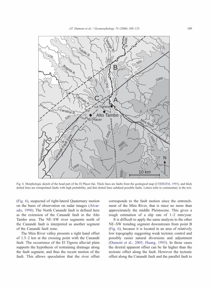
The Palabi, Tululbi and Bogota rivers are sharply
re-routed to the southwest against the La Boca upland
in the downslope part of area 2 (Fig. 2). The topogra-
phy of the La Boca area is only 20–30 m over the
bottom of the valleys, but defines a continuous
watershed between the middle and lower parts of the
El Placer fan (areas 2 and 3, Fig. 2). We studied in
particular the turn of the Tululbi and Bogota rivers
near Carondelet (Fig. 7) because of the relatively easy
access and its representativeness as drainage diversion.
North of Carondelet the Tululbi River flows in an
opposite trend relative to the regional slope, as it has
been re-routed against the La Boca upland 5 km to the
north (Fig. 2). The Bogota River reaches the La Boca
upland near Carondelet, flowing inside a 30–40 m
deep and 0.15% sloping valley incised in the Cachabi
Formation. It merges with the Tululbi River at an
elevation of 14 m against the La Boca upland. Down-
stream from the turn, the slope is only 0.03%, with a
meandering pattern at the surface of a wide floodplain
that extends widely to the SE. The border of the La
Boca upland is 15–20 m over this floodplain. This
border is interpreted as a fault that created the mor-
phology that re-routed the Bogota River to the south
together with the Tululbi River. A key element is the
observation of a dry valley across the La Boca upland,
in continuation of the Bogota River upstream from
14 m28m
21 m
Carondelet
La BocaLa
Boca Fault
Zaspi
R.
Bogota R.
Tululbi R.
2 km
Rai
lway
. .
.
.
.
.
.
35m
48m
50m
45m
Slope 0.0
3%
Slope 0.14%
Slope0.15%
La Bocauplift
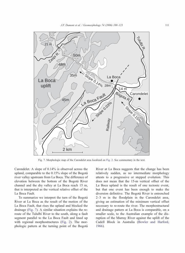
Fig. 7. Morphologic map of the Carondelet area localized on Fig. 2. See commentary in the text.
J.F. Dumont et al. / Geomorphology 74 (2006) 100–123 111
Carondelet. A slope of 0.14% is observed across the
upland, comparable to the 0.15% slope of the Bogota
river valley upstream from La Boca. The difference of
elevation between the bottom of the Bogota River
channel and the dry valley at La Boca reach 15 m,
that is interpreted as the vertical relative offset of the
La Boca Fault.
To summarize we interpret the turn of the Bogota
River at La Boca as the result of the motion of the
La Boca Fault, that rises the upland and blocked the
drainage (Fig. 7). A similar situation explains the re-
route of the Tululbi River to the south, along a fault
segment parallel to the La Boca Fault and lined up
with regional morphostructures (Fig. 2). The mor-
phologic pattern at the turning point of the Bogota
River at La Boca suggests that the change has been
relatively sudden, as no intermediate morphology
attests to a progressive or stepped evolution. This
does not mean that the 15-m vertical offset of the
La Boca upland is the result of one tectonic event,
but that one event has been enough to make the
diversion definitive. The Bogota River is entrenched
2–3 m in the floodplain in the Carondelet area,
giving an estimation of the minimum vertical offset
necessary to re-route the river. The morphostructural
and drainage pattern at La Boca is comparable, on a
smaller scale, to the Australian example of the dis-
ruption of the Murray River against the uplift of the
Cadell Block in Australia (Bowler and Harford,
1966).
J.F. Dumont et al. / Geomorphology 74 (2006) 100–123112
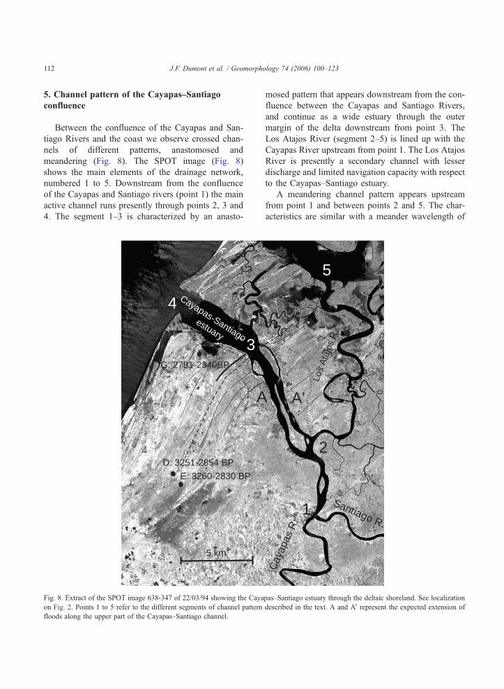
5. Channel pattern of the Cayapas–Santiago
confluence
Between the confluence of the Cayapas and San-
tiago Rivers and the coast we observe crossed chan-
nels of different patterns, anastomosed and
meandering (Fig. 8). The SPOT image (Fig. 8)
shows the main elements of the drainage network,
numbered 1 to 5. Downstream from the confluence
of the Cayapas and Santiago rivers (point 1) the main
active channel runs presently through points 2, 3 and
4. The segment 1–3 is characterized by an anasto-
D: 3251-2854 BP
G: 2781-2340BP
E: 3260-2830 BP
A
3
4
5 km
Cayapas-Santiago
estuary
Fig. 8. Extract of the SPOT image 638-347 of 22/03/94 showing the Caya
on Fig. 2. Points 1 to 5 refer to the different segments of channel pattern
floods along the upper part of the Cayapas–Santiago channel.
mosed pattern that appears downstream from the con-
fluence between the Cayapas and Santiago Rivers,
and continue as a wide estuary through the outer
margin of the delta downstream from point 3. The
Los Atajos River (segment 2–5) is lined up with the
Cayapas River upstream from point 1. The Los Atajos
River is presently a secondary channel with lesser
discharge and limited navigation capacity with respect
to the Cayapas–Santiago estuary.
A meandering channel pattern appears upstream
from point 1 and between points 2 and 5. The char-
acteristics are similar with a meander wavelength of
A'
1
2
5
Santiago R.
Cay
apas
R.
Los
Ata
jos
R.
pas–Santiago estuary through the deltaic shoreland. See localization
described in the text. A and A’ represent the expected extension of

J.F. Dumont et al. / Geomorphology 74 (2006) 100–123 113
3–5 km, a sinuosity of about 1.8 (River channel
length/river valley length) and channel width of
150–250 m. The ratio of meander wavelength to
channel width (L/W) allows characterization of a
meandering river, the standard value for an equili-
brated stream in tropical environment ranging
between 8 and 11 (Baker, 1978). The value of the
(L/W) ratio is 15 for the channel segment upstream
from point 1, and 13–17 between points 2 and 5 (not
considered the lowermost part influenced by tides).
These homogeneous values suggest that similar con-
ditions of meander formation characterize the Cayapas
River upstream from point 1 and the Atajos River
along segments 2–5. These values are a few higher
than the standard values of Baker (1978). But accord-
ing to Dury (1970) this difference may be interpreted
as a tendency to an underfit pattern, that is a wave-
length longer than the corresponding channel width,
due to a lower discharge than that of the equilibrated
pattern. However such a difference can also refer to
local climate and sediment transport conditions
(Schumm et al., 2000). These values are close to the
9–15 ratio observed in the Amazon regions of north-
ern Peru (Dumont, 1991). These parameters show that
the Atajos River represents the downstream continua-
tion of the Cayapas River. This continuity of equili-
brated meandering pattern along the lower Cayapas
and the Los Atajos rivers suggests that the anasto-
mosed channel pattern observed downstream from the
confluence of the Cayapas and Santiago rivers is
triggered by an excess discharge or sediment transport
issued from the Santiago River.
The morphology in point 2 suggests a channel
avulsion by a crevasse splay event initiated in the
meander curve. Crevasse splay and avulsion are gen-
erated by flood, and the reconstruction of a new
channel through the coastal plain involves successive
steps analyzed by Smith et al. (1989) and synthesized
in Collinson (1996). At the first stage the splay
expands rapidly into the marshes, forming a large
avulsion belt with a high density of anastomosed
channels. This avulsion belt appears on the SPOT
image and aerial photos as an area of homogeneous
grain and colour (A and AV, Fig. 8). Then the network
of anastomosing channels gradually coalesce into
fewer and larger channels. This is the step observed
on our example, and represented by the channel seg-
ment 2–3 (Fig. 8). Downstream from point 3 the
Cayapas–Santiago estuary presents a similar pattern
to the Boca de Limones and Bolivar tidal channels,
suggesting that the lower Cayapas–Santiago estuary
was also formed under tidal conditions. The last step
of a crevasse splay event is the formation of a new
meandering pattern similar to the one observed
upstream from the avulsion, but this step is not com-
pleted in our case. The difference between our case
and a classical model of avulsion (Collinson, 1996;
Smith et al., 1989) is that the evidence of changing
fluvial pattern does not occur at the initiation point of
the avulsion, but at the confluence between the San-
tiago and Cayapas rivers. This clearly means that the
flood and subsequent avulsion have been generated by
an excess discharge provided by the Santiago River.
Usually a river avulsion ends by the partial or total
abandon of the previous river channel (Collinson,
1996; Smith et al., 1989), giving characteristic under-
fit channel pattern if a reduced amount of water
supply is maintained in the old channel (Dumont,
1996; Dury, 1970). In the present case the Los Atajos
River has not been abandoned and does not present an
underfit pattern. The interpretation emphasizes that
the excess of water supply that generated the avulsion
did not end as is the case for a flood, but has been
definitive, because it is necessary to maintain enough
water supply along the Los Atajos river to preserve
the former channel pattern.
6. Morphologic pattern of the Cayapas–Santiago
delta
The Cayapas–Santiago and Mataje rivers join the
sea through a coastal plain showing an ubiquitous
pattern of estuary and delta (Fig. 4). Previous studies
qualified the Mataje River outlet of estuary, and the
Cayapas–Santiago of fluviodeltaic system (Tihay and
Usselmann, 1995). The Mataje River estuary and the
Bolivar channel are located in the north part of the
delta; they are deep and accessible to sea ships. The
Bolivar Channel gives access to the San Lorenzo
harbor through a 5 to 18 m deep natural tidal channel
(INOCAR, 2002, unpublished data from San Lorenzo
harbor master’s office), except at the outlet to the sea
where a sand ridge limits the low tide draw to 3 m (6–
7 during upper tides). On the contrary the Cayapas–
Santiago River outlet is almost closed at low tides by
O: 5450-5130 BP
1000 m
N: 5050-4860 BP
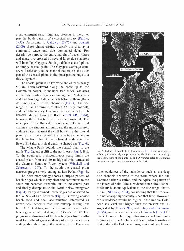
Fig. 9. Extract of aerial photo localized on Fig. 4, showing partly
submerged beach ridges represented by the linear structures along
the central part of the photo. N and O number refer to calibrated
radiocarbon ages. See commentary in the text.
J.F. Dumont et al. / Geomorphology 74 (2006) 100–123114
a sub-emergent sand ridge, and presents in the outer
part the bottle pattern of a classical estuary (Perillo,
1995). According to Galloway (1975) and Haslett
(2000) these characteristics classify the area as a
compound wave and tide dominated delta. For
descriptive purpose the entire margin of beach ridges
and mangrove crossed by several large tide channels
will be called Cayapas–Santiago deltaic coastal plain,
or simply coastal plain. The Cayapas–Santiago estu-
ary will refer only to the channel that crosses the outer
part of the coastal plain, as the inner part belongs to a
fluvial system.
The coastal plain is 15 km wide and extends nearly
50 km north-eastward along the coast up to the
Colombian border. It includes two fluvial estuaries
at the outer parts (Cayapas–Santiago and Mataje riv-
ers) and two large tidal channels between them (Boca
de Limones and Bolivar channels) (Fig. 4). The tide
range in San Lorenzo is of about 3.5 m (mesotidal),
and the ebb–flood cycle is asymmetrical, with the ebb
8%–9% shorter than the flood (INOCAR, 2004),
favoring the extraction of suspended material. The
inner part of the Boca de Limones and Bolivar tidal
channels are sinuous and intricate, the main channels
ending sharply against the cliff bordering the coastal
plain. Small rivers connect the large tide channels to
the hinterland, the Bolivar channel ending in the
Estero El Salto, a typical dendrite shaped ria (Fig. 6).
The Mataje Fault bounds the coastal plain to the
north (Fig. 2), and a cliff to the north-east (Fig. 4, B1).
To the south-east a discontinuous scarp limits the
coastal plain from a 5–10 m high alluvial terrace of
the Cayapas–Santiago River system (Winckell and
Zebrowski, 1997). To the south the coastal plain
narrows progressively ending at Las Penas (Fig. 4).
The delta morphology shows a striped pattern of
beach ridges which is very clear and continuous to the
south but becomes discontinuous in the central part
and finally disappears to the North below mangrove
(Fig. 4). Partly drowned beach ridges are observed to
the W–SW of San Lorenzo (Fig. 9), showing coarse
beach sand and shell accumulation interpreted as
upper tidal deposits that just outcrop during low
tide. A C14 dating on shell from the beach ridge
facies gave a calibrated age of 5450–5130 BP. The
progressive drowning of the beach ridges from south-
west to northeast gives evidence of a subsidence area
ending abruptly against the Mataje Fault. There are
other evidences of the subsidence such as the deep
tide channels observed to the north where the San
Lorenzo harbor is settled, and the typical ria pattern of
the Estero el Salto. The subsidence since about 5000–
6000 BP is about equivalent to the tide range, that is
3.5 m (INOCAR, 2004), considering that the sea level
did not change significantly since that time. However,
the subsidence would be higher if the middle Holo-
cene sea level was higher than the present one, as
suggested by Tihay (1989) and Tihay and Usselmann
(1995), and the sea level curve of Pirazzoli (1991) for
tropical areas. The clay, alluvium or volcanic con-
glomerate of the Cachabi and San Tadeo formations
that underly the Holocene transgression of beach sand

J.F. Dumont et al. / Geomorphology 74 (2006) 100–123 115
is not a favorable material to support the interpretation
of regional subsidence due to compacting, and the
increasing subsidence from south to north also favors
the interpretation of a tectonic subsidence.
The hydrographic map drawn from SPOT image
and aerial photos shows that the coastal plain presents
two longitudinal parts, defined on the basis of tidal
channel sinuosity and connections (dotted Z–ZVline,Fig. 4). The inner part presents the higher density of
tidal channels, and the outer part a more homogeneous
and relatively simple pattern, with all the small tidal
channels originating near the inner limit of the outer
part. Crossing the Z–ZVline the channel pattern of the
Santiago–Cayapas estuary changes significantly.
Through the inner belt the channel is relatively narrow
with a poorly anastomosed pattern, but it suddenly
widens, showing an inflexion or the trend to the west
in the outer part. Also the Los Atajos River, old
segment of the Cayapas river, reaches the Boca de
Limones tidal channel near the Z–ZVlimit (Fig. 1) in
an intricate area of broadening and merging of differ-
ent channels. A careful observation of the aerial photo
and the SPOT image shows that the beach ridges get
straight on the channel border in the inner part of the
deltaic coastal plain, but present a turn toward the
upstream direction in the outer part (Fig. 8). This
observation suggests that the inner part of the channel
cuts through pre-existing beach ridges, when the outer
wide channel was formed as a classical seaward
accretion delta. In other words, the present inner and
narrow channel of the Santiago–Cayapas estuary has
been opened through a pre-existing belt of beach
ridges by the time the shore line was near the Z–ZVlimit (Fig. 4). The later evolution of the coastal margin
built a classical bottle shaped estuary (Perillo, 1995).
7. The pattern of beach ridge accretion
The beach ridges are considered as an opportunity
to date the coastline when the avulsion event occurred
that formed the new Cayapas–Santiago channel (Fig.
2, point 3). We also analyzed the succession of the
beach ridges in order to get possible evidence of
irregularities in this process of accretion in relation
with the avulsion event.
The succession of beach ridges is determined using
19 radiocarbon dating, located on Fig. 10. The dating
points do not fit precisely with straight sections, prin-
cipally in the northern part of the coastal plain, due to
field conditions (mangrove, marshes, tide channels).
However, the lateral continuity of the beach ridge
traces, especially in the south part of the coastal
plain, allows interpolating dating using points that
are not exactly on the section line, assuming that the
lateral extension of a beach ridge may be considered
approximately as a time mark. We used 11 dates of
beach ridges from Tihay and Usselmann (1995),
sampled in the southern part of the littoral zone
(Fig. 4, points A to G and I to L). These dates were
made on shells from the ridges, recovered from 1 to 2
m deep holes. The 8 other dates (Fig. 6, points H and
M to Q) come from this study. Seven dates are
obtained on organic material (small wood fragments
or leaves accumulation) recovered at a depth of 1–2 m
by vibro-coring in the wetlands of ridge slack depos-
its, and one (sample O) comes from shell recovered in
beach ridge deposit recovered during low tide.
We checked the homogeneity of dating for the two
types of material by comparing the age of sample O
on shell from a beach ridge deposit with sample N
from organic matter in slack deposit close to the ridge
(Fig. 9). The ages are 5450–5130 BP for sample O
and 5050–4860 BP for sample N, that is 300–400
years less for the sample located 200 m on the seaside.
This result is coherent considering the 1–2 m y-1
mean rate of beach ridge accretion calculated for
this area (see below). The oldest age (6880–6660
BP, P) comes from a tree trunk found in the innermost
part of the Boca de Limones channel, near the foot of
the littoral cliff. This trunk is only partly emerged
during very low tide. Along the present beaches the
tree trunks that are brought to the shore are preserved
only in the upper part of the beach, near the top of the
beach ridges, or on their backside. The present posi-
tion of the old tree trunk imply a subsidence of at least
the value of the tide range (3.5 m) since 6880–6660
BP. The radiocarbon ages of the inner part of the
coastal plain range between 6880–6660 BP (P) and
4132–3686 BP (K), and those of the outer part
between 460–0 BP (H) and 3260–2830 BP (E). The
D–E and M samples which are laterally distant of
about 20 km along the same stripe of ridges have
similar ages. The dates have been plotted as a function
of their distance from the shoreline (Fig. 10A) or from
the inner cliff (Fig. 10B). Two diagrams are used to

5 100 15 km
1000
0
2000
3000
4000
5000
6000
7000
5 01015 km0
1000
2000
3000
4000
5000
6000
7000
Distance from the cliff
Distance from the shoreline
F
G
D M
KL
ON
IJ
P
Age
in y
ears
Age in years
P
IJ
O
N
KL
A B
F
H
G
D E
M
A
B
X1
X2
X3
X4
X1
X2
X3
X4
Y1
Y2
Y1
Y2
Sho
relin
e
400 yr margin of error
Slowaccretion
Slowaccretion
Fastaccretion
Fastaccretion
Slowaccretion
Slowaccretion
FA
FA
Fig. 10. Diagrams of the beach ridge construction of the littoral margin, using age and positions from Fig. 4, with the same letters. Isolated data
such as Q, and dating problem such as C are not used. The dotted line represents the mean accretion of the littoral margin. The lines X1–X2, X2–
X3 and Y1–Y2 associate data along sections positioned on Fig. 4, and represented respectively by open (X1–X2), grey (X3–X4, and black bar
lines ( Y1–Y2). The length of bar lines represents the margin of error. A: age versus distance measured from the present shoreline, and using all
the data. B: age versus distance measured from the inner cliff. The black point represents the present position of the shoreline along the Y1–Y2
segment.
J.F. Dumont et al. / Geomorphology 74 (2006) 100–123116
take into account the fact that the shoreline is not
exactly parallel to the inner cliff, the uncertainty
increasing with the distance; however the two dia-
grams present very similar patterns. The diagrams
give evidence of a mean rate of beach ridge accretion
of 2–2.5 m y�1 since about 6000 BP (dotted line Fig.
10). However a more detailed analysis suggests 3
groups of points, defining two periods of relatively
slow accretion and one period of faster accretion
between them. Sampling position allows definition
of two sections through the inner margin (Fig. 10:
X1–X2 and X3–X4) and one through the outer one
(Fig. 10: Y1–Y2). Across the inner margin the X1–X2
section shows mean rates of beach ridge construction
of 1.75 m yr�1 between 5935–5581 BP (I) and 4230–
3806 BP (L), and the section X3–X4 of 0.7–1 m yr�1
between: 6880–6660 BP (P) and 5050–4860 BP (N).
Data from the outer margin along section Y1–Y2 show
N
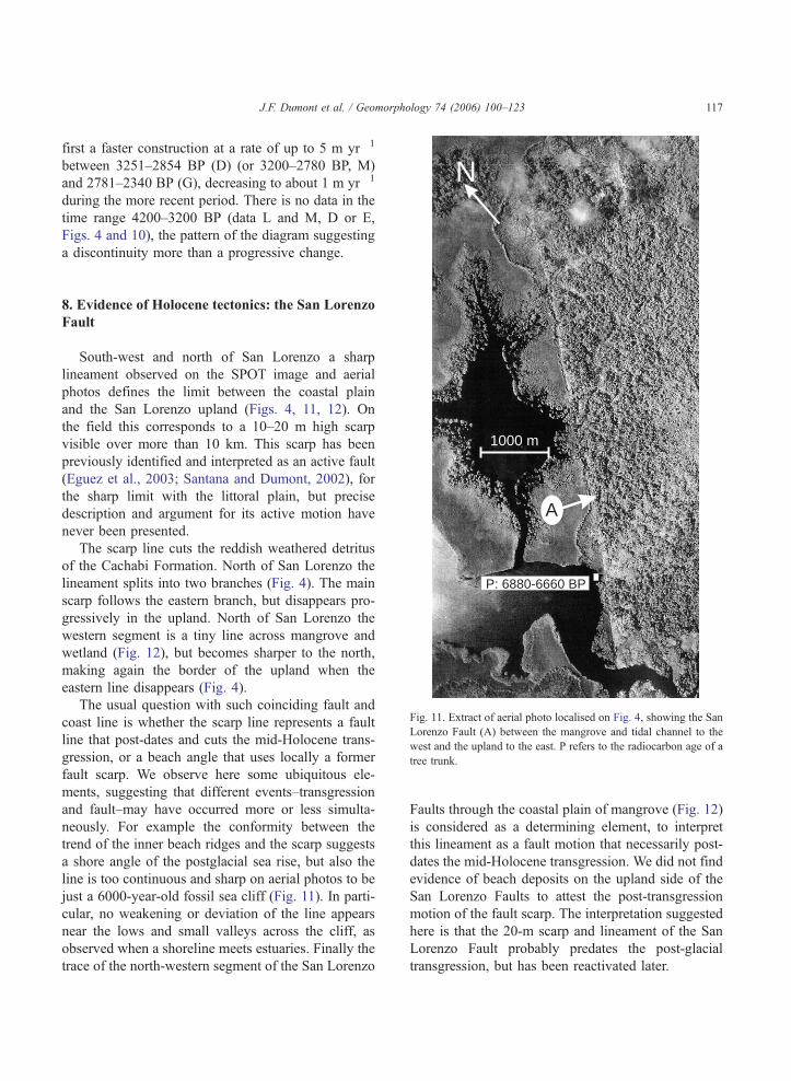
J.F. Dumont et al. / Geomorphology 74 (2006) 100–123 117
first a faster construction at a rate of up to 5 m yr�1
between 3251–2854 BP (D) (or 3200–2780 BP, M)
and 2781–2340 BP (G), decreasing to about 1 m yr�1
during the more recent period. There is no data in the
time range 4200–3200 BP (data L and M, D or E,
Figs. 4 and 10), the pattern of the diagram suggesting
a discontinuity more than a progressive change.
A
1000 m
P: 6880-6660 BP
Fig. 11. Extract of aerial photo localised on Fig. 4, showing the San
Lorenzo Fault (A) between the mangrove and tidal channel to the
west and the upland to the east. P refers to the radiocarbon age of a
tree trunk.
8. Evidence of Holocene tectonics: the San Lorenzo
Fault
South-west and north of San Lorenzo a sharp
lineament observed on the SPOT image and aerial
photos defines the limit between the coastal plain
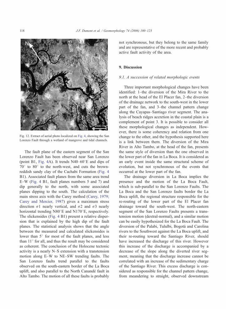
and the San Lorenzo upland (Figs. 4, 11, 12). On
the field this corresponds to a 10–20 m high scarp
visible over more than 10 km. This scarp has been
previously identified and interpreted as an active fault
(Eguez et al., 2003; Santana and Dumont, 2002), for
the sharp limit with the littoral plain, but precise
description and argument for its active motion have
never been presented.
The scarp line cuts the reddish weathered detritus
of the Cachabi Formation. North of San Lorenzo the
lineament splits into two branches (Fig. 4). The main
scarp follows the eastern branch, but disappears pro-
gressively in the upland. North of San Lorenzo the
western segment is a tiny line across mangrove and
wetland (Fig. 12), but becomes sharper to the north,
making again the border of the upland when the
eastern line disappears (Fig. 4).
The usual question with such coinciding fault and
coast line is whether the scarp line represents a fault
line that post-dates and cuts the mid-Holocene trans-
gression, or a beach angle that uses locally a former
fault scarp. We observe here some ubiquitous ele-
ments, suggesting that different events–transgression
and fault–may have occurred more or less simulta-
neously. For example the conformity between the
trend of the inner beach ridges and the scarp suggests
a shore angle of the postglacial sea rise, but also the
line is too continuous and sharp on aerial photos to be
just a 6000-year-old fossil sea cliff (Fig. 11). In parti-
cular, no weakening or deviation of the line appears
near the lows and small valleys across the cliff, as
observed when a shoreline meets estuaries. Finally the
trace of the north-western segment of the San Lorenzo
Faults through the coastal plain of mangrove (Fig. 12)
is considered as a determining element, to interpret
this lineament as a fault motion that necessarily post-
dates the mid-Holocene transgression. We did not find
evidence of beach deposits on the upland side of the
San Lorenzo Faults to attest the post-transgression
motion of the fault scarp. The interpretation suggested
here is that the 20-m scarp and lineament of the San
Lorenzo Fault probably predates the post-glacial
transgression, but has been reactivated later.
N
Fault
1000 m
Fig. 12. Extract of aerial photo localized on Fig. 4, showing the San
Lorenzo Fault through a wetland of mangrove and tidal channels.
J.F. Dumont et al. / Geomorphology 74 (2006) 100–123118
The fault plane of the eastern segment of the San
Lorenzo Fault has been observed near San Lorenzo
(point B1, Fig. 4A). It trends N40–608E and dips of
708 to 808 to the north-west, and cuts the brown-
reddish sandy clay of the Cachabi Formation (Fig. 4
B1). Associated fault planes from the same area trend
E–W (Fig. 4 B1, fault planes numbers 5 and 7) and
dip generally to the north, with some associated
planes dipping to the south. The calculation of the
main stress axis with the Carey method (Carey, 1979;
Carey and Mercier, 1987) gives a maximum stress
direction r1 nearly vertical, and r2 and r3 nearly
horizontal trending N808E and N1708E, respectively.The slickensides (Fig. 4 B1) present a relative disper-
sion that is explained by the high dip of the fault
planes. The statistical analysis shows that the angle
between the measured and calculated slickensides is
lower than 58 for most of the fault planes, and less
than 118 for all, and thus the result may be considered
as coherent. The conclusion of the Holocene tectonic
activity is a nearly N–S extension with a transtension
motion along E–W to NE–SW trending faults. The
San Lorenzo faults trend parallel to the faults
observed on the south-eastern border of the La Boca
uplift, and also parallel to the North Canande fault in
Alto Tambo. The motion of all these faults is probably
not synchronous, but they belong to the same family
and are representative of the more recent and probably
active fault activity of the area.
9. Discussion
9.1. A succession of related morphologic events
Three important morphological changes have been
identified: 1–the diversion of the Mira River to the
north at the head of the El Placer fan, 2–the diversion
of the drainage network to the south-west in the lower
part of the fan, and 3–the channel pattern change
along the Cayapas–Santiago river segment. The ana-
lysis of beach ridges accretion in the coastal plain is a
complement of point 3. It is possible to consider all
these morphological changes as independent. How-
ever, there is some coherency and relation from one
change to the other, and the hypothesis supported here
is a link between them. The diversion of the Mira
River in Alto Tambo, at the head of the fan, presents
the same style of diversion than the one observed in
the lower part of the fan in La Boca. It is considered as
an early event inside the same structural scheme of
evolution, but not synchronous of the events that
occurred at the lower part of the fan.
The drainage diversion in La Boca implies the
presence and the motion of the La Boca Fault,
which is sub-parallel to the San Lorenzo Faults. The
La Boca and the San Lorenzo faults border the La
Boca uplift, the regional structure responsible for the
re-routing of the lower part of the El Placer fan
drainage toward the south-west. The north-eastern
segment of the San Lorenzo Faults presents a trans-
tension motion (dextral-normal), and a similar motion
can be easily hypothesized for the La Boca Fault. The
diversion of the Palabi, Tululbi, Bogota and Carolina
rivers to the Southwest against the La Boca uplift, and
their re-routing toward the Santiago River, should
have increased the discharge of this river. However
this increase of the discharge is accompanied by a
decrease of the slope along the diverted river seg-
ment, meaning that the discharge increase cannot be
correlated with an increase of the sedimentary charge
of the Santiago River. This excess discharge is con-
sidered as responsible for the channel pattern change,
from meandering to straight, observed downstream
J.F. Dumont et al. / Geomorphology 74 (2006) 100–123 119
the confluence between the Santiago and Cayapas
rivers, and the avulsion that created downstream the
new Cayapas–Santiago estuary through the coastal
plain. The dual pattern of the Cayapas–Santiago estu-
ary through the coastal plain supports this interpreta-
tion: the narrow upstream part has the pattern of a
river avulsion channel opened through the pre-exist-
ing coastal margin of beach ridges, and the wide
downstream part has the classical tide-wave domi-
nated pattern of estuary.
We consider that the motion of the La Boca fault
created the favorable situation for the increase of the
discharge, but the precise time correlation between
fault motion and the onset of the avulsion event may
be discussed. An avulsion characterizes a peak of
discharge, that is also generally a peak of precipita-
tion elsewhere in the catchment area. In this area the
highest precipitation occurs generally during El Nino
periods, with two to three times more rain than during
normal periods, and concentration of the rain during
short periods (Perrin et al., 1998). That means that the
avulsion may have occurred during a period of high
precipitation following the re-routing of the drainage
along the La Boca uplift. However special attention to
the pattern of the avulsion leads us to discard a simple
climate induced avulsion: after the avulsion there is
no abandonment or even notable reduction of the
previous channel (the Los Atajos River). This
means that the discharge increase that generated the
avulsion did not really disappear after that event. A
peak of precipitation and flood may have triggered
the avulsion, but the return to normal conditions
would have left an underfit pattern for the Los Atajos
river, as observed for the avulsion events in the
western Amazonian basin (Dumont, 1996). This
means that the discharge increase is definitive, and
that a climate induced flood event is not the explana-
tion. This interpretation is coherent with the fact that
the channel pattern change which is associated with
the avulsion began at the confluence between the
Santiago and Cayapas rivers, and not just at the
avulsion point as is usually the case (Collinson,
1996; Smith et al., 1989).
9.2. Age of the drainage disruption
According to the proposed scenario the age of the
beach ridges at the point where the channel pattern of
the Cayapas–Santiago estuary changes from a fluvial
to an estuary pattern (Fig. 8, point 3) is indicative of
the age of the drainage diversion in La Boca and the
resulting avulsion of the Cayapas–Santiago River.
This age can be determined using the striped pattern
of beach ridges (Figs. 8 and 4). The D sample (3251–
2854 BP) (Fig. 4) is the closest point, the sudden
widening of the channel beginning about 200 m sea-
ward. Also the extrapolation of beach ridge traces on
Fig. 5 crosses the point of channel change at about
3000–3200 BP.
9.3. Post-seismic deformation of the coastal plain?
Before 4000 BP the rate of beach ridge construc-
tion is slow (0.7–1.7m/yr). After that we lack data in
the time range 4200–3200 BP. A period of fast
accretion (5 m/yr) appears after 4000–3600 BP, and
in the time range 3200–2700/2700–2300 BP (Fig.
10). The transition from the early period of slow
accretion to the period of fast accretion is not docu-
mented, but no progressive change is perceptible.
From 2000 BP to present we observe a progressive
slow down of the accretion rate (about 1 m/yr), but
the present rate (during the last century for example)
is not documented.
The faster beach ridge accretion may be due
either to an excess of sediment supply to the coast,
or to vertical motion of the coastal plain due to co-
or post-seismic deformation. We have observed that
the river diversion against the La Boca uplift corre-
sponds to a lower slope than the previous one, and
thus cannot be correlated with an increase of the
sedimentary supply to the coast. Short-term climatic
variations may be related to variation of the beach
ridge construction but at a higher frequency of var-
iation than the progressive change observed over a
3000-year period. Our data suggests to correlate the
fast beach ridge accretion in the time range 3200–
2300 BP with a co- or post-seismic uplift of the
coastal plain. This is more probably a post-seismic
motion because of the duration of the event and the
progressive variation to the recent period of slow
accretion. In a low sloping shore platform a small
uplift can give account of the formation of beach
ridges some hundreds of meters seaward. The pre-
sence of emerged banks of dead oysters in life
position (Fig. 4) supports this hypothesis.
J.F. Dumont et al. / Geomorphology 74 (2006) 100–123120
9.4. Relation with the seismic zone
The seismic activity of the Esmeraldas–Tumaco
area is originated in the subduction zone (Collot et
al., 2004, 2002; Herd et al., 1981). The motion of the
Las Boca and San Lorenzo faults cannot be directly
linked to the seismogenic zone, but only to the accom-
modation of the deformation in the upper crust of the
overriding plate. The comparison of stress tensor in
the subduction zone (Ego et al., 1996) and in the
upper plate in the San Lorenzo fault (Fig. 4) supports
this interpretation. The state of stress obtained from
the inversion of focal solutions from subduction earth-
quakes (Fig. 4 B2) shows a ENE–WSW shortening
(Ego et al., 1996). The comparison with the state of
stress of the San Lorenzo Fault (Fig. 4 B1) suggests a
permutation according to r1Yr2; r2Yr3 and
r3Yr1, that is coherent with an accommodation of
the deformation in the upper plate, favored by the
oblique subduction. This structural relation allows
discarding the effect of gravitational accommodation
in the upper inner edge of the continental shelf,
because the motion should be represented by E–W
or NW–SE trending extension instead of the observed
north–south one.
The seismic activity along the South American
Pacific margin is frequently accompanied by co-seis-
mic deformation (Barrientos, 1996; Barrientos and
Plafker, 1992). In the Esmeraldas-Tumaco seismic
zone similar vertical motion have been mentioned,
but have never been precisely quantified and located
relative to the earthquakes. The available information
from the Tumaco area reports generally co-seismic
subsidence (Herd et al., 1981), but also uplift adjust-
ment that seems to occur after the earthquake, and
reaching 33 mm in 28 years (Tihay and Usselmann,
1998). This data supports the hypothesis of a post
seismic uplift of the shore margin in the central part of
the Cayapas–Santiago delta.
10. Conclusion
The San Lorenzo area represents a good example
of how to provide evidences of active tectonics under
wet tropical regions. The tropical climate is not sui-
table for the preservation and the observation of fault
scarps, especially with low topography and soft mate-
rial. However drainage network is generally dense and
active, and may be a suitable morphological tool. New
faults showing recent or active motion have been
identified on the basis of morphologic analysis, the
North Canande, La Boca and Mataje faults, and pre-
cision has been brought on the Holocene motion of
the San Lorenzo fault. In these cases the morphologic
expression of active tectonics seems enhanced by the
change from shortening to extension tectonics in the
coastal margin that occurred during the Quaternary,
and particularly the recent N–S extension, that is
clearly associated with the disruption of the lower
part of the Pleistocene El Placer fan.
The regional evolution of the drainage network in
the San Lorenzo area describes the disruption of the
drainage network of the Pleistocene El Placer fan,
diverted to the north at the head of the fan and to
the southwest in the central part. This southwestward
diversion increases downstream the discharge of the
Santiago River, and triggered the avulsion of the
Cayapas–Santiago River through a new estuary
opened across the coastal plain of beach ridges. The
avulsion is dated 3200–2800 BP by the beach ridges
located at the point of changing pattern of the estuary,
showing anastomosed pattern for the avulsion channel
in the inner part and the new tide-wave dominated
estuary in the outer part. The avulsion event will be
called bLa Tolita eventQ from the position of the La
Tolita archeological site at the point where the avul-
sion channel reaches the coast.
The disruption of the El Placer fan and the related
morphological changes are clearly related to fault
motion. The diversion to the north of the Mira
River at the head of the fan is related to the motion
of the North Canande Fault and other N–S trending
faults. The motion of the La Boca Fault diverted the
drainage of the central part of the fan toward the
Santiago River, evidencing the La Boca uplift. This
uplift is bordered to the NW by the San Lorenzo
Fault, that makes the border of the coastal plain and
presents evidences of motion since the mid-Holo-
cene. These morphologic-fault relationships are inter-
preted as the effect of one or several strong
earthquakes in the time range 3200–2800 BP. How-
ever the northward diversion of the Mira River pre-
dates the river diversion observed against the La
Boca Fault, suggesting that the tectonic changes
that disrupted the El Placer fan migrated from the
J.F. Dumont et al. / Geomorphology 74 (2006) 100–123 121
upper part of the western Andean Cordillera to the
foothills and the littoral margin.
Additional and independent elements come from
the analysis of the pattern of beach ridges accretion. A
period of fast beach ridges accretion apparently
accompanied and continued after the 3200–2800 La
Tolita event. The transition to the recent period of
slow accretion is progressive. This progressive change
in beach ridge accretion cannot be related to climate
oscillations or increase of the sediment supply after
the avulsion event, but to small uplift of the coastal
margin in relation to one event or a crisis of seismic
events. The present period documented for the last
century is characterised by a high seismic activity, but
we do not know precisely what is the present rate of
beach ridge accretion in the area. This precision will
help to specify whether the present historic period that
includes the 1906 Tumaco Mw 8.8 earthquake may be
compared or not with the previous 3200–2800 BP
period of fast ridge accretion.
Finally a tentative relation can be made between the
morphologic and cultural evolution of the area. It is
worth noting the particular position of the La Tolita site,
at the point of the coast where the avulsion channel has
been opened (Fig. 4). The pre-Colombian occupation
of the studied area is dominated by the La Tolita
culture, one of the most important coastal occupations
along the South American coast (Bouchard, 1995;
Valdez, 1987). The settlement in La Tolita began
about 3000 BP, and the peak of the development
occurred between 2250 and 2000 BP (Valdez, 1987).
According to Valdez (1987) the location of the La
Tolita site in the Cayapas–Santiago estuary, close to
the Pacific Ocean, is the result of a specific strategy to
get easier access to areas along the littoral, but also
towards the hinterland. In the case of La Tolita the new
drainage network of the Santiago River may have made
the gold bearing area more accessible, thus increasing
the capacity of acquiring one of its major resources.
The seaport that was also now available afforded the
coastline trade along the Pacific and gave the La Tolita
center its cultural reputation and economic hegemony.
Acknowledgements
This study is part of the DEMA3-IRD (Institut de
Recherche pour le Developpement, France) project,
realized in cooperation with the bVariabilidad CosteraQINOCAR (Instituto Oceanografico de la Armada,
Ecuador) project. We are grateful to Edgar Rivas
(INOCAR) and Kervin Chunga (University of Guaya-
quil) for their help during field work, and to the
personal of the San Lorenzo Harbor Master’s Office
for their help in logistic organization of field work.
The final manuscript has benefited from comments
and suggestions from Martin Stokes and Edward A.
Keller, for which they are thanked. We thank Ben
Yates for the final correction of the text. This study
participates in the activity of the IGCP project 495,
Land Ocean Interaction. This is publication 756 of
UMR 6526-Geosciences Azur.
References
Aalto, K.R., Miller, W., 1999. Sedimentology of the Pliocene Upper
Onzole Formation, an inner-trench slope succession in north-
western Ecuador. Journal of South American Earth Sciences 12
(1), 69–85.
Alvarado, A., 1998. Variation du champ de contrainte et de defor-
mation et quantification des deformations actives du bloc cotier
de l’Equateur. DEA de Geodynamique et physique de la terre
Thesis, Paris XI, centre d’Orsay, Orsay, 54 pp.
Baker, V.R., 1978. Adjustment of fluvial system to climate and
source terrain in tropical and subtropical environments. In:
Miall, D. (Ed.), Fluvial Sedimentology. Canadian Society of
Petroleum Geology, pp. 211–230.
Baldock, J.W., 1982. Geologıa del Ecuador: Boletın de la explica-
cion del Mapa Geologico de la Republica del Ecuador, Esc.
1 :1V000.000. Min. Rec. Nat. Energ., Quito, 10., Quito.
Barrientos, S.E., 1996. On Predicting Coastal Uplift and Subsidence
Due to Large Earthquakes in Chile, Third ISAG. ORSTOM, St
Malo, France, pp. 145–148.
Barrientos, S.E., Plafker, G., 1992. Postseismic coastal uplift in
southern Chili. Geophysical Research Letters 19, 701–704.
Beck, S.L., Barrientos, S., Kausel, E., Reyes, M., 1998. Source
characteristics of historic earthquakes along the central Chile
subduction zone. Journal of South American Earth Science 11
(2), 115–129.
Bes de Berc, S., Soula, J.C., Baby, P., Souris, M., Christophoul, F.,
Rosero, J., 2005. Geomorphic evidence of active deformation
and uplift in a modern continental wedge-top-foredeep transi-
tion: example of the eastern Ecuadorian Andes. Tectonophysics
399, 351–380.
Bishop, P., 1995. Drainage rearrangement by river capture,
beheading and diversion. Progress in Physical Geography 19
(4), 449–473.
Booth-Rea, G., J.-M., A., Azor, A., Garcia-Duenas, V., 2004.
Influence of strike slip fault segmentation on drainage evolution
and topography. A case study: the Palomares Fault Zone (south-
eastern Betics, Spain). Journal of Structural Geology, in press.
J.F. Dumont et al. / Geomorphology 74 (2006) 100–123122
Bouchard, J.F., 1995. Altas Culturas y Medio Ambiente en el
Litoral Norte del Area Ecuatorial Andina, Cultura y Medio
Ambiente en el Area Andina Septentrional. Abya-Yala, Quito,
pp. 195–223.
Bowler, J.M., Harford, L.B., 1966. Quaternary tectonics and the
evolution of the Riverine Plain near Echuca, Victoria. Geologi-
cal Society of Australia 13, 339–354.
Carey, E., 1979. Recherche des directions principales de contra-
intes associees au jeu d’une population de failles. Revue de
Geographie Physique et de Geologie Dynamique 21 (1),
57–66.
Carey, E., Mercier, J.L., 1987. A numerical model for determining
the state of stress using focal mechanisms of earthquake
population: application to Tibetan teleseims and microseismi-
city of Southern Peru. Earth and Planetary Science Letters 82,
165–177.
Carver, G.A., McCalpin, J., 1996. Paleoseismology of compres-
sional tectonic environments. In: McCalpin, J. (Ed.), Paleoseis-
mology. International Geophysics Series. Academic Press,
London, pp. 183–270.
CERESIS, 1985. Mapa Neotectonico Preliminar de America del
Sur.
CODIGEM, 1993. Mapa Geologico de la Republica del Ecuador,
escala 1/1 000 0008. British Geological Survey.
Collinson, J.D., 1996. Alluvial sediments. In: Reading, H.G. (Ed.),
Sedimentary Environments: Processes, Facies and Stratigraphy.
Blackwell Science, London, pp. 37–82.
Collot, J.-Y., Charvis, P., Gutscher, M.-A., Operto, S., 2002. Explor-
ing the Ecuador–Colombia active margin and interplate seismo-
genic zone. EOS, Transactions, American Geophysical Union,
83(17): 185, 189–190.
Collot, J.Y., Marcaillou, B., Sage, F., Michaud, F., Agudelo, W.,
Charvis, P., Graindorge, D., Gutscher, M.-A., Spence, G., 2004.
Are rupture zone limits of great subduction earthquakes con-
trolled by upper plate structures ? Evidence from multichannel
seismic reflection data acquired across the Northern Ecuador–
southwest Colombian margin. Journal of Geophysical Research
109, B11103.
De Mets, C., Gordon, R.G., Argus, D.F., Stein, S., 1990. Current
plate motions. Geophys. J. Int. 101, 425–478.
Deniaud, Y., 2000. Enregistrements sedimentaire et structural de
l’evolution geodynamique des Andes Equatoriennes au cours du
Neogene: Etude des bassins d’avant arc et bilan de masse.
Geologie Alpine, Memoire HS (32), 159.
Dumont, J.F., 1991. Fluvial shifting in the Ucamara Depression, as
related to neotectonics of the Andean foreland–Brazilian craton
border. Geodynamique 6 (1), 9–20.
Dumont, J.F., 1993. Lake pattern as related to neotectonics in
subsiding basins: the example of the Ucamara Depression,
Peru. Tectonophysics 222, 69–78.
Dumont, J.F., 1996. Neotectonic of Subandes–Brazilian craton
boundaries using geomorphological data: the Maranon and
Beni Basins. Tectonophysics 257, 137–151.
Dumont, J.F., Fournier, M., 1994. Geodynamic environment of
Quaternary morphostructures of the subandean foreland basins
of Peru and Bolivia: characteristics and study methods. Qua-
ternary International 21, 129–142.
Dumont, J.F., Lavenu, A., Ortlieb, L., Guillier, B., Alvarado, A.,
Benitez, S., Jouannic, C., Martinez, C., Labrousse, B., Poli, J.T.,
1997. Extensional tectonics in the coastal block of Ecuador:
preliminary results and implications. Workshop on Late Qua-
ternary Coastal Tectonics, London.
Dumont, J.F., Santana, E., Vilema, W., 2005. Morphologic evidence
of active motion of the Zambapala Fault, Gulf of Guayaquil
(Ecuador). Geomorphology 65, 223–239.
Dury, G.H., 1970. General theory of meandering valleys and under-
fit streams. In: Dury, G.H. (Ed.), River and River Terraces. Mc
Millan, London, pp. 264–275.
Ego, F., Sebrier, M., Lavenu, A., Yepes, H., Eguez, A., 1996.
Quaternary state of stress in the Northern Andes and the
restraining bend model for the Ecuadorian Andes. Tectonophy-
sics 259, 101–116.
Eguez, A., Alvarado, A., Yepez, H., Machette, M.N., Costa, C., Dart,
R.L., 2003. Database andmapMap of Quaternary faults and folds
of the Ecuador and its offshore regions. International Lithosphere
Program Task Group II-2, Major Active faults of the world, U. S.
Department of the Interior, U. S. Geological Survey, Denver.
Evans, C.D.R., Whittaker, J.E., 1982. The geology of the western
part of the Borbon Basin, North west Ecuador: Trench forearc
Geology. Geological Society of London 10, 191–200.
Fitch, T.J., Scholz, C.H., 1971. Mechanism of underthrusting in
Southwest Japan: a model of convergent plate interactions.
Journal of Geophysical Research 76 (29), 7260–7292.
Galloway, W.E., 1975. Process framework for describing the mor-
phologic and stratigraphic evolution of deltaic depositional
systems. In: Broussard, M.L. (Ed.), Deltas: models for Explora-
tion. Huston Geological Society, Huston, pp. 87–98.
Gonzalez, J.L., Correa, I.D., Aristizabal, O., 2002. Evidencias de
subsidencia cosısmica en el delta del San Juan. In: Correa,
I.D.a.R.J.D. (Ed.), Geologıa y Oceanografıa del delta del Rıo
San Juan, Litoral Pacifico Colombiano. Universidad EAFIT,
Medellın, pp. 91–110.
Gutscher, M.A., Malavieille, J.S.L., Collot, J.-Y., 1999. Tectonic
segmentation of the North Andean margin: impact of the Car-
negie Ridge collision. Earth and Planetary Science Letters 168,
255–270.
Haslett, S.K., 2000. Coastal Systems. Routledge Introduction to
Environment. Routledge, London. 218 pp.
Herd, D.G., Youd, T.L., Meyer, H., Arango, C.J.L., Person, W.J.,
Mendoza, C., 1981. The Great Tumaco Colombia earthquake of
12 December 1979. Science 211, 441–445.
Huang, W., 1993. Morphologic patterns of stream channels on the
active Yishi Fault, southern Shandong Province, Eastern China:
implication for repeated great earthquake during the Holocene.
Tectonophysics 219, 283–304.
IGM, 1991. Esmeraldas, Hoja NII-NA 17-15. Instituto Geografico
Militar, Quito.
IGM, 1992a. Ibarra, Hoja NII,NA, 17,18,16. Instituto Geografico
Militar, Quito.
IGM, 1992b. San Lorenzo, Hoja NI, NA 17-12. Instituto Geografico
Militar, Quito.
INOCAR, 2004. Tablas de mareas y datos astronomicos del sol y la
luna. Republica del Ecuador, Instituto Oceanografico de la
Armada, Guayaquil. 117 pp.

J.F. Dumont et al. / Geomorphology 74 (2006) 100–123 123
Jackson, J., Norris, R., Youngson, J., 1996. The structural evolution
of active fault and fold systems in central Otago, New Zealand:
evidences revealed by drainage patterns. Journal of Structural
Geology 18, 217–234.
Kelleher, J.A., 1972. Ruptures zones of large South American
earthquakes and some predictions. Journal of Geophysical
Research 77 (11), 2087–2103.
Keller, E.A., Pinter, N., 2002. Active tectonics: Earthquakes, Uplift
and Landscape. Prentice Hall, Upper Saddle River. 206 pp.
Kellogg, J.N., Vega, V., 1995. Tectonic development of Panama,
Costa Rica, and the Colombian Andes: constraints from Global
Positioning System geodetic studies and gravity. In: Mann, P.
(Ed.), Geologic and Tectonic Development of the Caribbean
Plate Boundary in Southern Central America, Geol. Soc. Am.
Spec. Pap., vol. 295, pp. 75–90.
McCalpin, J. (Ed.), Paleoseismology. International Geophysics Ser-
ies, vol. 62. Academic Press, London. 588 pp.
Morner, N.A., 2003. Paleoseismicity of Sweden, a Novel Paradigm.
Jofo Grafiska AB, Stockholm. 320 pp.
Ortlieb, L., Barrientos, S., Guzman, N., 1996. Coseismic coastal
uplift and coraline algae record in northern Chile: the 1995
Antofogasta earthquake case. Quaternary Science Reviews 15,
949–960.
Pedoja, K., 2003. Les terrasses marines de la marge Nord Andine
(Equateur et Nord Perou): relations avec le contexte geodyna-
mique. Ph.D Thesis, Universite Pierre et Marie Curie, Paris,
350 pp.
Pedoja, K., Dumont, J.F., Sorel, D., Ortlieb, L., 2001. Marine
Terraces and Subducting Asperities: the Manta Case, Ecuador,
Fifth International Conference on Geomorphology. Transaction
of the Japanese Geomorphological Union, Tokyo, p. 187.
Perillo, G.M.E. (Ed.), Geomorphology and Sedimentology of Estu-
aries. Development in Geomorphology, vol. 53. Eslsevier.
471 pp.
Perrin, J.L., Jeanneau, J.L., Podwojeski, P., 1998. Deslizamientos de
Tierra, Inundaciones y Flujos de Lodo en Esmeraldas; Diagnos-
tico General de la Situacion Actual en la Ciudad, Mision de
Expertos. Informe ORSTOM, Quito. 020005212.
Pirazzoli, P.A. (Ed.), World Atlas of Holocene Sea-Level, vol. 58.
Elsevier Oceanography Series, Amsterdam. 171 pp.
Potter, P.E., 1978. Significance and origin of big rivers. Journal of
Geology 86, 13–33.
PRONAREG-ORSTOM, 1984a. Ibarra, Mapa Morfo-Pedologico.
Ministerio de Agricultura y Ganaderıa, Quitp.
PRONAREG-ORSTOM, 1984b. Tulcan, Mapa Morfo Pedologico.
Ministerio de Agricultura y Ganaderıa, Quito.
PRONAREG-ORSTOM, 1984. Valdez, Mapa Morfo-Pedologico.
Ministerio de Agricultura y Ganaderıa, Quito.
Santana, E., Dumont, J.F., 2002. The San Lorenzo Fault, a new
active fault in relation to the Esmeraldas–Tumaco seismic zone.
5th International Symposium on Andean Geodynamics. IRD,
Toulouse, pp. 577–580.
Santana, E., Dumont, J.F., King, A., 2001. Los efectos del feno-
meno El Nino en la ocurencia de una alta tasa de erosion costera
en el sector de Punta Gorda, Esmeraldas. Acta Oceanografica
del Pacifico 11 (1), 1–5.
Scheu, E., 1911. Le grand tremblement de terre de la Colombie
(Monographie de quelques grands seismes de l’annee 1906).
Catalogue Regional des Tremblements de Terre Ressentis Pen-
dant L’annee 1906, Strasbourg, France, pp. 36–44.
Schumm, S.A., Dumont, J.F., Holbrook, J.M., 2000. Active Tec-
tonics and Alluvial Rivers. Cambridge University Press, Cam-
bridge. 276 pp.
Smith, N.D., Cross, T.A., Dufficy, J.P., Clough, S.R., 1989. Anat-
omy of an avulsion. Sedimentology 36, 1–23.
Swenson, J.L., Beck, S.L., 1996. Historical 1942 Ecuador and 1942
Peru subduction earthquakes, and earthquakes cycles along
Colombian–Ecuador and Peru subduction segments. PAGEOPH
146 (1), 67–101.
Tihay, J.P., 1989. Aspects Geomorphologiques de L’environnement
du site Archeologique de la Tolita (Equateur). Universite de Pau
et des Pays de l’Adour, Pau.
Tihay, J.P., Usselmann, P., 1995. Medio ambiente y ocupacion
humana en el litoral Pacıfico Colombo-ecuatoriano. In: Guinea,
J.F.B.y.J.M.M. (Ed.), Cultura y Medio Ambiente en el Area
Andina Septentrional. Abya-Yala, Quito, pp. 377–399.
Tihay, J.P., Usselmann, P., 1998. Ambientes humedos de la costa
pacifica ecuatorial (Colombia y Ecuador) y uso antropico; geo-
dinamica y aportes de los sensores remotos. In: Mercedes
Guinea, J.M.a.J.F.B. (Ed.), El Area Septentrional Andina.
Abya-Yala, Quito, pp. 67–80.
Valdez, F., 1987. Proyecto Archeologico bLa TolitaQ. Museos del
Banco Central del Ecuador, Quito. 91 pp.
Winckell, A., Zebrowski, C., 1997. Los paisajes costeros. In:
Winckel, A. (Ed.), Los Paisajes Naturales del Ecuador. Geogra-
fıa Basica del Ecuador. CEDIG, Quito, pp. 208–319.
Witt, C., 2001. Analisis de la deformacion reciente y potencialmente
activa con base a imagenes radar, fotos aereas, DEM y obser-
vaciones microtectonicas en la provincia de Esmeraldas, Ecua-
dor. Tesis de ingeniero Thesis, Escuela Politecnica Nacional,
Quito, 122 pp.