Construction Agenda - July 6, 2021 - Orlando International ...
Upload
khangminh22Category
view
1download
0
ADDENDUM NO. 23 TO THE AGREEMENT DATED AUGUST 3, 2018
BETWEEN GREATER ORLANDO AVIATION AUTHORITY AND FAITH GROUP, LLC dba FAITH GROUP CONSULTING, LLC
Project: GIS Space Management Upgrade and Address Management System Assessment Consulting Services, Orlando International Airport
THIS ADDENDUM is effective this (,, jll.. day of j41lU"-~ , 20 Lf , by and between the GREATER ORLANDO AVIATION AUTHORIT("Authority"), and FAITH GROUP, LLC dba FAITH GROUP CONSUL TING, LLC ("Consultant').
WITNESSETH:
WHEREAS, by Agreement dated August 3, 2018, Authority and Consultant entered into an agreement for Consultant to provide information technology consulting services; and
WHEREAS, under the Agreement, Consultant agreed to perform such additional services for the Authority as are contained in any additional scope of work established by the Authority in any addendum to the Agreement and accepted in writing by the Consultant; and ·
WHEREAS, the Authority and the Consultant desire to enter into this Addendum to the Agreement to provide for additional services to be rendered by the Consultant under the terms of said Agreement.
NOW, THEREFORE, in consideration of the premises and the mutual covenants herein contained, the Authority and the Consultant do hereby agree as follows:
1. Consultant shall perform additional services in accordance with the terms of the Agreement and the attached Exhibit "A." Consultant shall be paid for such additional services according to the payment terms set forth in the Agreement.
2. Consultant shall be compensated for such additional services in the LUMP SUM amount of ONE HUNDRED NINETEEN THOUSAND SEVEN HUNDRED THIRTY-FIVE AND NO/100 DOLLARS ($119,735.00), broken down as follows:
Professional Fees: Professional Fees: Reimbursable Expenses:
Total:
NTE: LS: NTE:
$0.00 $119,735.00
$0.00
$119,735.00
3. A. Consultant hereby certifies that it is not on the Scrutinized Companies that Boycott Israel List and is not engaged in a boycott of Israel, as defined in Florida Statutes § 287 .135, as amended;
Addendum 23 to Agreement dated August 3, 2018
Page 1 of 2 Rev. 8/2017

AND
B. (applicable to agreements that may be $1,000,000 or more) - Consultant hereby certifies that it is: (1) not on the Scrutinized Companies with Activities in Sudan List or the Scrutinized Companies with Activities in the Iran Petroleum Energy Sector List as defined in Florida Statutes § 287 .135; and (2) not engaged in business operations in Cuba or Syria, as defined in Florida Statutes§ 287.135, as amended.
4. Authority may terminate the Agreement for cause and without the opportunity to cure if the Consultant is found to have submitted a false certification or has been placed on the Scrutinized Companies that Boycott Israel List or is engaged in a boycott of Israel.
In the event the Agreement is for One Million Dollars ($1 ,000,000.00) or more, Authority may terminate this Agreement for cause and without the opportunity to cure if the Consultant is found to have submitted a false certification or has been placed on the Scrutinized Companies with Activities in Sudan List or the Scrutinized Companies with Activities in the Iran Petroleum Energy Sector List or is engaged in business operations in Cuba or Syria.
5. Except as expressly modified in this Addendum, the Agreement dated August 3, 2018 and all prior addenda will remain in full force and effect.
IN WITNESS WHEREOF, the parti~ hereto by their duly authorized representatives, have executed this Addendum this 15 day of , ~a/\u~<'.'.'. , 20 -Zf .
Approved as to Form and Legality (for the benefit of GOAA only)
this \~ay ot:Ja dl • , 20.2._\
By: k,; ~~ NELSON MULLINSBROKo AND CASSEL, Legal Counsel Greater Orlando Aviation Authority
Addendum 23 to Agreement dated . August 3, 2018
6
By: \ Phillip N. Brow , AAE Chief Executive Office r
FAITH GROUP, LLC dba FAITH GROUP CONSUL TING, LLC
By:
V(/l l-fe,,f;
Printed Name
M~.A£:t( t.) q P1:2-t tJ C tf' faL Title
Page 2 o f 2 Rev. 8/2017
GREATER ORLANDO AVIATIOI HANDOUT 1/5/2021 PSC
Orlando lnterr Item 2 One Jeff Fl Revised Memo
Orlando, Flori ·-·, __ .,-__ ,,
Memorandum
To:
From:
Date:
Re:
Members of the Professional Services Committee
Peter Pelletier, Director, Information Technology (Prepared by Ian Brooks x3124)
January 6, 2021
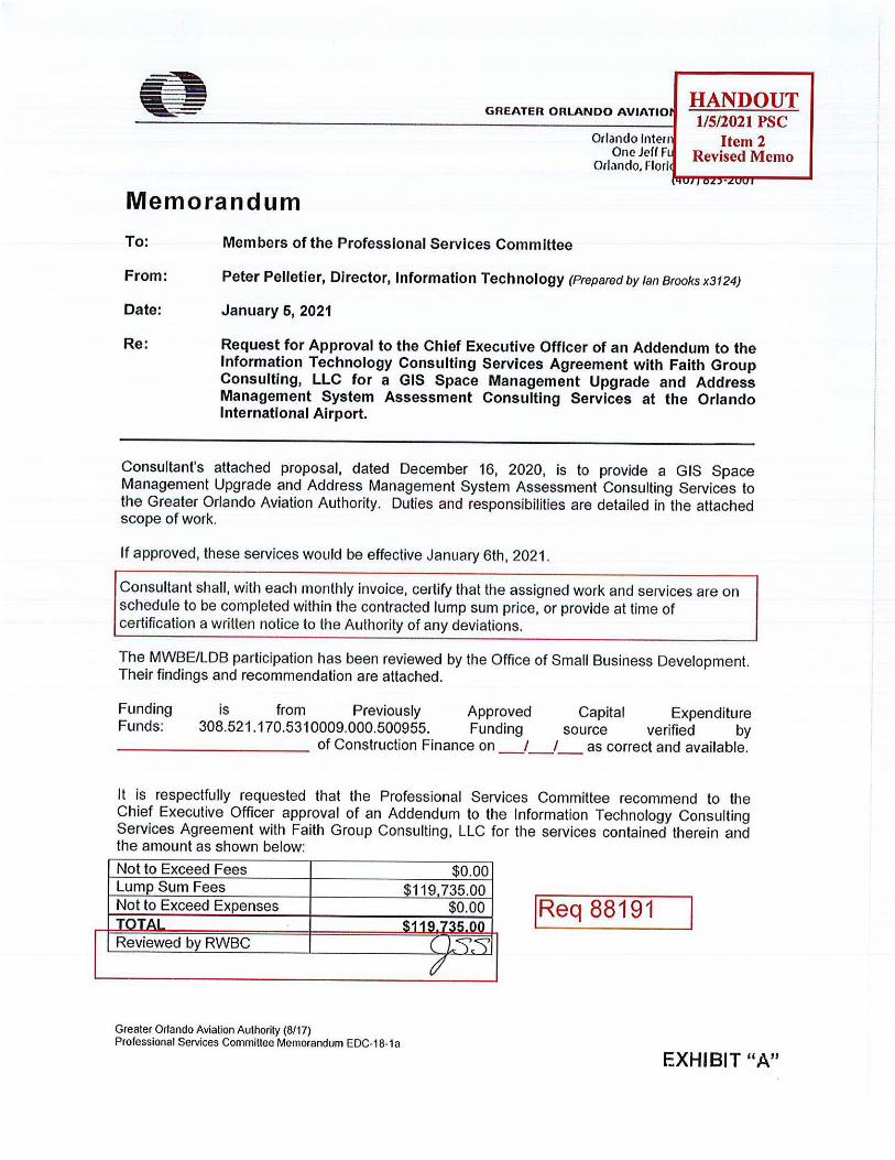
Request for Approval to the Chief Executive Officer of an Addendum to the Information Technology Consulting Services Agreement with Faith Group Consulting, LLC for a GIS Space Management Upgrade and Address Management System Assessment Consulting Services at the Orlando International Airport.
Consultant's attached proposal, dated December 16, 2020, is to provide a GIS Space Management Upgrade and Address Management System Assessment Consulting Services to the Greater Orlando Aviation Authority. Duties and responsibilities are detailed in the attached scope of work.
If approved, these services would be effective January 6th, 2021.
Consultant shall, with each monthly invoice, certify that the assigned work and services are on schedule to be completed within the contracted lump sum price, or provide at time of certification a written notice to the Authority of any deviations.
The MWBE/LDB participation has been reviewed by the Office of Small Business Development. Their findings and recommendation are attached.
Funding Funds:
is from Previously Approved Capital Expenditure 308.521.170.5310009.000.500955. Funding source verified by
____ ______ of Construction Finance on _ /_ /_ as correct and available.
It is respectfully requested that the Professional Services Committee recommend to the Chief Executive Officer approval of an Addendum to the Information Technology Consulting Services Agreement with Faith Group Consulting, LLC for the services contained therein and the amount as shown below:
Not to Exceed Fees $0.00 Lump Sum Fees $119 735.00 Not to Exceed Expenses jReq 88191 Reviewed b RWBC
Greater Orlando Aviation Authority (8117) Professional Services Committee Memorandum EDC-18-1a
EXHIBIT "A"

V
GIS Space Management Upgrade & Address Management System Assessment
Proposal Greater Orlando Aviation Authority
December 16th 2020 '
Faith Group
In partnership with
vV WOOLPEAT
DESIGN I GEOSPATIAL I INFRASTRUCTURE
~ GREATER ORLANDO ~ AVIATION AUTHORITY

GIS Space & Address Management
Table of Contents Section 1 Introduction and Overview ..................................... 3
Section 2 Background and Experience .................................. 4
2.1 Project Experience ............... ....................................... ....... ....... .......... .......... .............. ................ 4
2.2 Staff Experience ... ............................... ....... ... ...... ...................... ......... ..................... .................... 5
Section 3 Approach .................................................................. 8
3.1 Technology Overview ............... .. .... ........................... ............. .... ........................ ........................ 8
3.2 Project Approach ............................... ....... ....................................................... ......................... 10
3.3 Project Timeline .............................................. ............... ........................................................... 14
Section 4 Cost Estimate ...................... · .............. .................. ... 15
Section 5 Project Assumptions ........... ................. ............ ..... 16
Appendix A - Resumes ............................................................ 17
,t'!'!ZY VV'v Fc.1 ilh Group Page 2 of 28

GIS Space & Address Management
Section 1 Introduction and Overview In response to the Greater Orlando Aviation Authority's Request for Information Technology Consulting Services, Faith Group and our partner Woolpert (Faith Group Team) is pleased to provide this proposal for consulting services related to a GIS Space Management Upgrade, Address Management System Assessment (ADMA) and ArcGIS Enterprise Upgrade Estimate.
Faith Group will deliver this project as the Prime Contractor, and Woolpert will provide expertise and resources for the GIS Space Management Upgrade and the ADMA and ArcGIS Enterprise Upgrade Estimate. Together the two companies will be referred to as the Faith Group Team.
It is expected that at the completion of this engagement, GOAA shall have the following:
1. A deployment of new GIS Space Management Tools supported by user training and documentation
2. An analysis and proposal with suggested architecture and cost estimate for an Address Management System (ADMA) replacement
3. An analysis and proposal with suggested architecture and cost estimate for an ArcGIS Enterprise Upgrade
The Faith Group Team will execute this project in partnership with GOAA staff, with a combination of predominantly WebEx/remote work and on-site work as required.
Faith Group Page 3 of 28
GIS Space & Address Management
Section 2 Background and Experience 2.1 Project Experience
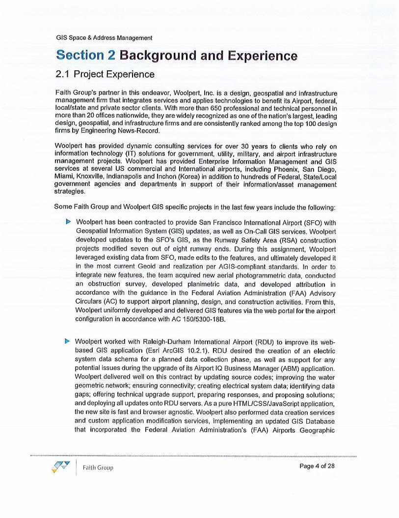
Faith Group's partner in this endeavor, Woolpert, Inc. is a design, geospatial and infrastructure management firm that integrates services and applies technologies to benefit its Airport, federal, local/state and private sector clients. With more than 650 professional and technical personnel in more than 20 offices nationwide, they are widely recognized as one of the nation's largest, leading design, geospatial, and infrastructure firms and are consistently ranked among the top 100 design firms by Engineering News-Record.
Woolpert has provided dynamic consulting services for over 30 years to clients who rely on information technology (IT) solutions for government, utility, military, and airport infrastructure management projects. Woolpert has provided Enterprise Information Management and GIS services at several US commercial and International airports, including Phoenix, San Diego, Miami, Knoxville, Indianapolis and Inchon (Korea) in addition to hundreds of Federal, State/Local government agencies and departments in support of their information/asset management strategies.
Some Faith Group and Woolpert GIS specific projects in the last few years include the following:
• Woolpert has been contracted to provide San Francisco International Airport (SFO) with Geospatial Information System (GIS) updates, as well as On-Call GIS services. Woolpert developed updates to the SFO's GIS, as the Runway Safety Area (RSA) construction projects modified seven out of eight runway ends. During this assignment, Woolpert leveraged existing data from SFO, made edits to the features, and ultimately developed it in the most current Geoid and realization per AGIS-compliant standards. In order to integrate new features, the team acquired new aerial photogrammetric data, conducted an obstruction survey, developed planimetric data, and developed attribution in accordance with the guidance in the Federal Aviation Administration (FAA) Advisory Circulars (AC) to support airport planning, design, and construction activities. From this, Woolpert uniformly developed and delivered GIS features via the web portal for the airport configuration in accordance with AC 150/5300-188.
• Woolpert worked with Raleigh-Durham International Airport (RDU) to improve its webbased GIS application (Esri ArcGIS 10.2.1). RDU desired the creation of an electric system data schema for a planned data collection phase, as well as support for a_ny potential issues during the upgrade of its Airport IQ Business Manager (ABM) application. Woolpert delivered well on this contract by updating source codes; improving the water geometric network; ensuring connectivity; creating electrical system data; identifying data gaps; offering technical upgrade support, preparing responses, and proposing solutions; and deploying all updates onto RDU servers. As a pure HTML/CSS/JavaScript application, the new site is fast and browser agnostic. Woolpert also performed data creation services and custom application modification services, implementing an updated GIS Database that incorporated the Federal Aviation Administration's (FAA) Airports Geographic
Faith Group Page 4 of 28

GIS Space & Address Management
Information Systems (AGIS) format with RDU along with best practices for managing the GIS system.
• Orlando International Airport, On-Call IT Consulting Services: R&R Design and GIS Beacon Registry - Faith Group was responsible for the design, configuration and support of a new Geographical Information System (GIS) based survey, used to gather all Existing Conditions in a living deliverable format. This point feature data was then used to design all IT and low voltage systems part of the R&R project (e.g. Access Control, Video Surveillance, Storage, Electrical, etc.). Other tasks also included the design, configuration, testing and training of a new ESRI GIS service and infrastructure. The solution (ESRI ArcGIS Enterprise) is leveraged for the collection of existing conditions data, focusing on Security Sensitive systems, then delivered in a geodatabase format to be later used for system design.
• Dallas Fort Worth International Airport, On-Call Consulting Services: Faith Group served a Senior GIS Specialist role for a technology focused on-call planning contract and was responsible for the coordination and support of a new Geographical Information System (GIS) based survey, used to gather all Existing Conditions in a living deliverable format. This point feature data is then used to design a new Physical Access Control system to replace the existing across the entire campus.
These projects are all unique in their application and deployment, but each leverage the Faith Group Team's design and engagement approach to yield client specific solutions.
2.2 Staff Experience
• Jason Wallace, FG - Sr Project Manager- Jason is a Senior Project Manager with more than 20 years of experience in the information technology managing: application development, infrastructure engineering, master data, enterprise information, data warehousing, and content management projects & organizations. He is experienced at leading and managing teams, mentoring and coaching employees, and encouraging a cohesive team environment. Jason is highly skilled in managing people and projects simultaneously, while easily gaining the respect of peers and the confidence of both senior leadership and customers. Over the years, Jason has successfully delivered on multiple multi-million-dollar project initiatives, consolidated and retired more than half a dozen legacy applications, provided continuous, improvement of numerous processes and mentored many employees on professional and career development, all while maintaining a high level of engagement and team morale.
• Rick Adams, FG - Sr. Systems Specialist - Rick is a result's driven systems and IT specialist with 13 years of experience in large-scale commercial and government technology initiatives. He excels at learning complex systems and concepts quickly, developing comprehensive and secure solutions, while playing a key role in all parts of the project and systems development lifecycle. He is a subject matter expert in a broad range of technologies and design patterns, leveraging experience to implement creative and
Faith Group Page 5 of 28

GIS Space & Address Management
practical solutions. He has worked on products from the industry leading manufacturers such as ESRI, Skyline Software Systems and Goggle Earth Enterprise in such tasks as:
• Full Stack software development including leveraging GIS manufacturer APls/SDKs (embedded, web, server and thick clients)
• GIS system architecture and detailed design, in support of Situational Awareness Platforms
• Use of GIS for real-time decision making and geo-based analytics (rules engines) • Real-time (push) integration of 3rd party solutions into a GIS environment
• Ed Copeland, WPT - GIS SME - Ed has more than 22 years of experience in a wide variety of disciplines including GIS, building information modeling, asset management, project delivery, systems integration, cloud services, and applications with a focus on the spatial integration of data. He is an active reviewer and contributor to the FAA's Airport GIS Data Standards development initiative which supports the NextGen program. Ed has been successful at integrating geospatial solutions at over 30 airports which includes operations, document management, asset management, properties, mobile, pavement and systems. Before joining Woolpert, Ed was AECOM's most qualified Airport GIS Project Manager from 1999 to 2018, developing and implementing innovative system solutions for clients' needs. He is proficient in the use of various CAD-GIS technologies for data processing including the Esri software suite, Autodesk, GeoMedia, FME, Oracle Spatial, SOE, and a variety of GPS systems.
• Cheryl Spencer, WPT - Geospatial Solutions Architect - Cheryl will provide technical leadership on the Esri stack, architecture, and solution alignment. Cheryl is an accomplished Solution Architect with 17 years of experience. She is an ArcGIS Suite expert, having worked with every version of the software since ArcGIS 9.1. Her extensive knowledge of ArcGIS includes, but is not limited to, multi-machine setups and security. She primarily works to conduct troubleshooting, perform server migration and installation, handle day-to-day maintenance, create new services, and coordinate with developers. Also, her extremely strong GIS background allows her to serve as a Subject Matter Expert on other projects. In addition to her ArcGIS knowledge, Cheryl is skilled at programming and application development using HTML, CSS, ArcXML, JavaScript, Dojo, VB Script, VB.NET, ASP, and ASP.Net.
a,.. Joseph McFadden, WPT - Geospatial Application Developer- Joseph McFadden is an Application Developer who is highly experienced in software design, development, testing, implementation, and ISO documentation. He implements geospatial solutions with integrated technologies using ArcGIS Desktop, Python packages, open source software, and SQL. In addition, Joseph has worked on numerous integration projects that has allowed him to increase his knowledge with other systems outside of the Esri Suite.
• Jason Stradtner, WPT - Geospatial Application Development - As an Application Developer with 19 years of experience, Jason Stradtner evaluates design specifications, writes code to meet those specifications, produces documentation, and communicates regularly and openly with team partners and clients to produce successful finished products. Jason became intrigued by the cause-and-effect nature of programming early on, and his later curiosity regarding spatial concepts such as GIS and remote sensing uniquely positioned him for success in the geospatial sector. After college, he got his professional start with a government contracting role for the National Oceanic and
<J'v'fl?' Fai th Group V
Page 6 of 28

GIS Space & Address Management
Atmospheric Association (NOAA) in Mississippi, working on coastal risk analysis related to storms and demographics. Projects that Jason has lent his development skills to-such as the Coastal Risk Atlas and Flood Risk Score-have contributed to improving governmental and industry ability to assess risk and provide mitigation to save property and lives in the future. Much of Jason's experience has been in desktop GIS development with ArcObjects and C#, but he has also done recent server- and mobile-focused work on the RESTful API and in Java. Additionally, Jason has small-project management experience through his involvement with the West Coast Observing System project for NOAA.
• Darren Johnson, WPT - GIS Database Specialist - Darren has extensive experience maintaining and performing as a server administrator for federal and state clients, and more recently as a GIS database specialist for spatial technology system design and Implementations. He has supported Air Force Master Planning through the administration of enterprise-wide geospatial technologies. Darren performs database and system administration on an enterprise geospatial network, ensuring 24/7 availability. He also ensures all geospatial data is compliant with Spatial Data Standards for Facilities, Infrastructure and Environment (SDSFIE) and that metadata is developed and maintained according to Federal Geographic Data Committee (FGDC) standards.
• Tyler Buente, WPT - IT Analyst - Tyler Buente is an IT Analyst. with experience in Information Technology: application development, intranet design and administration, and internal operations management. He is experienced with automating everyday workflows via low-code solutions including Python and Java. Tyler's problem-solving abilities prove advantageous in dynamic workloads. Over time, Tyler's abilities with automation have provided streamlining for many everyday processes, allowing for reallocation of time spent throughout the workplace.
Full key personnel resumes are included at the end of the Faith Group proposal, in Appendix A.
JW V 1/',/
V Faith Group Page 7 of 28
GIS Space & Address Management
Section 3 Approach 3.1 Technology Overview
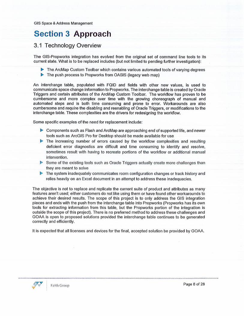
The GIS-Propworks integration has evolved from the original set of command line tools to its current state. What is to be replaced includes (but not limited to pending further investigation):
• The ArcMap Custom Toolbar which contains various automated tools of varying degrees • The push process to Propworks from OASIS (legacy web map)
An interchange table, populated with FQID and fields with other new values, is used to communicate space change information to Propworks. The interchange table is created by Oracle Triggers and certain attributes of the ArcMap Custom Toolbar. The workflow has proven to be cumbersome and more complex over time with the growing choreograph of manual and automated steps and is both time consuming and prone to error. Workarounds are also cumbersome and require the disabling and reenabling of Oracle Triggers, or modifications to the interchange table. These complexities are the drivers for redesigning the workflow.
Some specific examples of the need for replacement include:
• Components such as Flash and ArcMap are approaching end of supported life, and newer tools such as ArcGIS Pro for Desktop should be made available for use
.,._ The increasing number of errors caused by the workflow complexities and resulting deficient error diagnostics are difficult and time consuming to identify and resolve, sometimes result with having to recreate portions of the workflow or additional manual intervention.
• Some of the existing tools such as Oracle Triggers actually create more challenges than they are meant to solve
• The system inadequately communicates room configuration changes or track history and relies heavily on an Excel document in an attempt to address these inadequacies.
The objective is not to replace and replicate the current suite of product and attributes as many features aren't used; either customers do not like using them or have found other workarounds to achieve their desired results. The scope of this project is to only address the GIS integration pieces and ends with the push from the interchange table into Propworks (Propworks has its own tools for extracting information from this table, but the Propworks portion of the integration is outside the scope of this project). There is no preferred method to address these challenges and GOM is open to proposed solutions provided the interchange table continues to be generated correctly and efficiently.
It is expected that all licenses and devices for the final, accepted solution be provided by GOM.
~ i' • F,1ilh Group V
Page 8 of 28

GIS Space & Address Management
GOAA ArcGIS Enterprise Architecture (Domain: GOAA)
·w·O •::J n ff 1 --~-,
tii.G
-EE3
1,lCOl.l N;,1)11'>
l ott n'UtOM:M<OMA~ .•.·. ' .. , , .. . ....... ,,,,,oi,, m ~, o51 ,.,,,~~
•. ,a:r.. ~ -.. IEE ""°'°"'~'··· ,. W.-d'1Yt1 l 11 JibtN
PQl) l(iO
...... : ,,, .. ~, ... ~ , . '
ee ··•··:-·• "
£s!}Jj l r s,,: ., •~•• •"•"·••>
[!I -EE
. . ..I.. .. .. ··" .......... .
I ·········· 1 ······· .................. ..
:, , ' t:Bll ' •.• ·. -IEEI
Figure 1 Existing ArcGIS Architecture
: •. , .. ,,. ' , \b'I t 1 . ,.,.
. ..
' . : '.I·,• ·
.. ..... '
The Address Management System (ADMA) is a custom-built application and was developed to allow GOAA stakeholders from different departments to request new addresses. GOAA's Planning department wou ld then process these requests, creating the new addresses. The system was also designed to send out new address notifications to internal stakeholders and external parties.
Challenges faced by ADMA users include:
• Components such as Flash used by ADMA are approaching end of supported life • The current interface is not intuitive and has resulted in workarounds, which in turn have
introduced further challenges and introduces further errors. These errors result in notifications being improperly generated and at times manually created. Other errors include the dropping of requests.
The scope for this portion of the project is to analyze and reconcile GOAA's current addressing needs against ADMA and propose a new, more appropriate architecture of the address system including rough order of magnitude (ROM) replacement costs. It should be noted that while custom options are available, consideration will be given to the address management tools already available within ArcGIS Enterprise V10. 7.1 and V10.8.1.
Any proposed end design will account for all existing and to-be deployed technology solutions in the current GOAA GIS architecture. And all solutions utilized shall adhere to industry standards and shall not introduce undue risk into the project.
Faith Group Page 9 of 28

GIS Space & Address Management
3.2 Project Approach
In order to meet the stated objectives in the consulting services work order, the Faith Group Team will support the following phased (phases may be executed concurrently where possible) approach with associated tasks and deliverables:
Phase 1: Implementation of GIS Space Management Upgrade Components
Task 1 - Mobilization and Set Up
• Mobilize team and confirm phase and task schedule post NTP from GOAA • Submit person.nel for approval and remote access
• Submit and review Request for Information documentation to GOAA for all phases and activities
• Conduct Project Kick-off Meeting to review scope and schedule
• Working closely with the GOAA Project Manager and with the completed RFl's, develop a project plan and project schedule for all phases and activities.
• Present Project Plan and schedule for review and approval
Deliverables:
1. Requests for Information 2. Project Kick-off Meeting 3. Project Kick-off Meeting minutes 4. Project Plan for approval 5. Project Schedule for approval
Assumptions:
• The activities discussed in this section will begin once a Written Notice-to-Proceed is received from the Client.
Task 2 - Fact Finding, Requirements and Design Development
• Hold WebEx review workshops with GOAA IT stakeholders to review existing conditions and present potential reference architecture. Stakeholders may include:
o IT o Planning o Commercial Properties o Finance
l>' Review existing documentation, versions, and the use of Oracle Triggers • Consolidate feedback related to design, requirements, and deployment.
• Hold WebEx review workshop with GOAA stakeholders to present discoveries and review outstanding questions.
I> Gather and deliver to GOAA any costs/licensing changes needed for full scale deployment t> Update final requirements documentation • Submit documents for GOAA review and approval
Faith Group Page 10 of 28

GIS Space & Address Management
Deliverables:
1. Document outlining the Functional Requirements and Technical Design Configuration for approval ·
Assumptions:
• GOAA is responsible for any necessary communication and coordination with third-party party software vendors or consultants. This includes configuration of the third-party software if required in order to effectively support the system integrations
• GOAA is responsible for working with third-party software vendors to ensure that any configuration necessary to support the integration is tested by the vendor. GOAA will provide evidence of successful testing prior to Integration Acceptance Testing (IAT).
• GOAA will coordinate with third-party software vendor for support during testing • During requirements meetings, the requirements and technical specifications defined in
this scope will be refined and changed. It is expected that the changes will not represent a significant difference in the total level of effort required; however, if they do, Faith Group and GOAA will work together to determine what can be performed within the existing scope and determine options for addressing anything that exceeds the original scope.
• GOAA will license the necessary software • Capturing errors for the tools is included as part of the report development
Task 3 - Testing & Tool Development
• Based on approved functional specifications identify new GIS Space Management Tools • With assistance from GOAA technical resources, develop new workflow and associated
tools for GIS Propworks integration • Develop associated test scripts • Implement workflow to TEST environment • Generate defects report from UAT (responsibility of GOAA) • Conduct bug fixes • Final UAT • Develop user interface queries based on final requirements document
Deliverables:
1. Approved GIS Propworks integration workflow 2. Tested and implemented workflow across TEST environment 3. Test Scripts for approval 4. Defects Report and Issues Tracking Log 5. Update Tools Based on GOAA Feedback 6. User Interface and Reporting Capability
Assumptions: ))- GOAA testing efforts will remain focused on the scripts and criteria defined in the test
scripts
Faith Group Page 11 of 28

GIS Space & Address Management
• Only two iterations will be performed for testing by GOAA. Initial testing will be performed followed by fixes, retesting and then final updates to the tools after the retesting. • GOAA will ensure the key team members are available to support the testing updates that require additional off-site time. • GOAA will identify users that will be responsible for configuring and managing user interface and reports. • Two remote reviews will be conducted to finalize the queries and reports as per the final requirements • Reports and Queries will be developed within the allotted budget. A level of effort will be assigned based on the report or form required and GOAA will then determine the priority. The team will then develop as many of the high priority forms and reports as budget will allow.
Task 4 - User/Administrator Training
• From all learning and testing, the Faith Group Team will develop an Administration and User Training Guide
• The Team shall provide 3 hours of training for ArcPro Add-ins containing automation tools and 3 hours for GOAA GIS Enterprise approvals. This training session will be provided to administrators and power users under a train-the-trainer model
• Update Functional Requirements and Technical Design Documents with findings and details from POC.
• Follow up on any remaining questions or information from GOAA staff.
Deliverables:
1. Administration and User Guide 2. Conduct up to 6 hours of Training
Assumptions:
• GOAA will identify its trainees for the train-the-trainer approach
Task 5 - Deployment & Post Go-Live Support
• Develop Cutover Plan to deploy new tools within the PROD environment • Execute Cutover Plan against a copy of the PROD environment and test tools to ensure
accurate and successful deployment. )> Assist GOAA in the cutover from TEST to PROD utilizing the cutover plan as the guide for
success
• To provide remote go-live support during the deployment process for up to 20 hours. • Provide up to 8 hours support over a 25-business day period post-deployment support
Deliverables:
1. Cutover Plan for Production Deployment 2. Dedicated resource to provide remote support for PROD deployment 3. Resource available to provide to 8 hours support over a 25-business day period post
deployment support
/VV vv 'V Faith Group Page 12 of 28

GIS Space & Address Management
Assumptions
• GOM will provide project sign-off within agreed-upon timeframe following go-live.
Phase 2 - Address Management System (ADMA) Assessment
The objective is to provide GOM with a recommendation on architecture and associated cost to replace ADMA
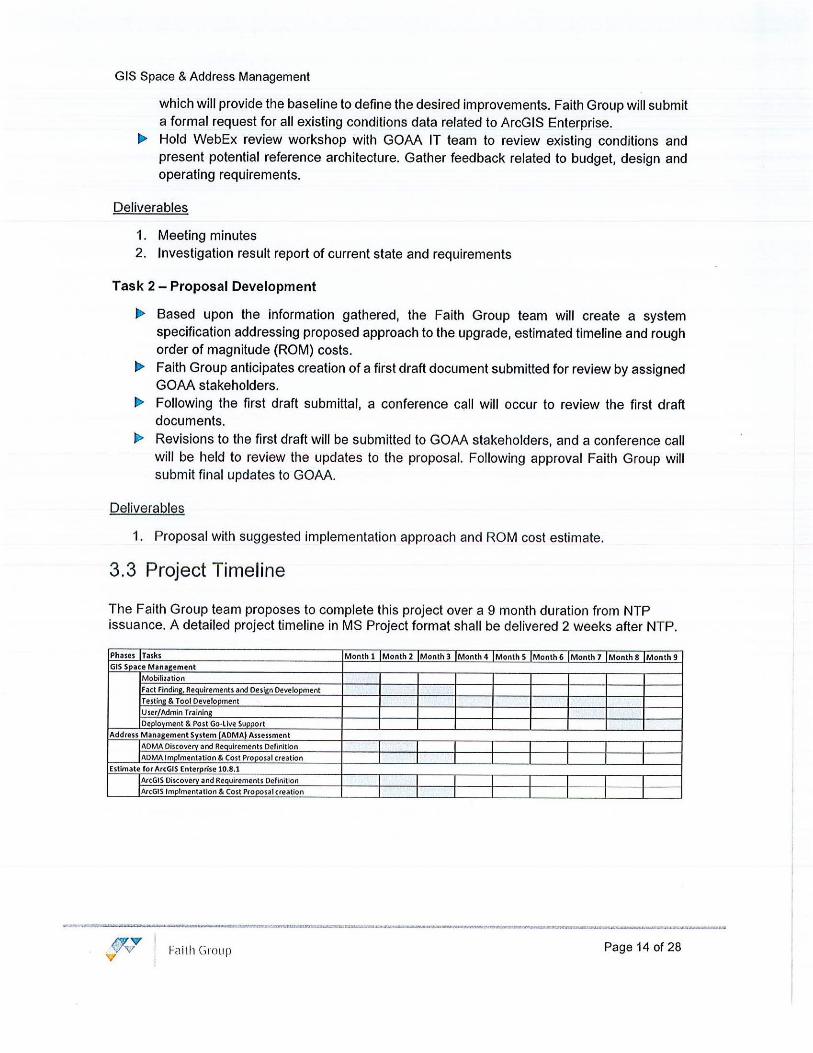
Task 1 - Discovery and Requirements Definition
• The Faith Group Team will begin gathering pertinent information regarding the existing installation and how it performs which will provide the baseline to define the desired improvements. Faith Group will submit a formal request for all existing conditions data related to ADMA.
• Hold WebEx review workshop with GOM IT team to review existing conditions and present potential reference architecture. Gather feedback related to budget, design and operating requirements.
Deliverables
1. Meeting minutes
Task 2 -Architecture Development
• Based upon the information gathered, the Faith Group Team will create a system specification addressing architecture and rough order of magnitude (ROM) costs.
• The Faith Group Team anticipates creation of a first draft document submitted for review by assigned GOM stakeholders.
J> Following the first draft submittal, a conference call will occur to review the first draft documents.
• Revisions to the first draft will be submitted to GOM stakeholders, and a conference call will be held to review the updates to the proposal. Following approval, the Faith Group Team will submit final updates to GOAA.
Deliverables
1. ADMA Architecture and ROM cost estimate
Phase 3 - Estimate for ArcGIS Enterprise 10.8.1
The objective is to evaluate the existing ArcGIS Enterprise implementation and provide GOM with a cost estimate for updating both Test and Production environments.
Task 1 - Discovery and Requirements Definition
• The Faith Group Team will begin gathering pertinent information regarding the existing installation including environments used, server architecture, and performance criteria,
Faith Group Page 13 of 28
GIS Space & Address Management
which will provide the baseline to define the desired improvements. Faith Group will submit a formal request for all existing conditions data related to ArcGIS Enterprise.
• Hold WebEx review workshop with GOM IT team to review existing conditions and present potential reference architecture. Gather feedback related to budget, design and operating requirements.
Deliverables
1. Meeting minutes 2. Investigation result report of current state and requirements
Task 2 - Proposal Development
• Based upon the information gathered, the Faith Group team will create a system specification addressing proposed approach to the upgrade, estimated timeline and rough order of magnitude (ROM) costs.
• Faith Group anticipates creation of a first draft document submitted for review by assigned GOM stakeholders.
Ji> Following the first draft submittal, a conference c~II will occur to review the first draft documents.
• Revisions to the first draft will be submitted to GOM stakeholders, and a conference call will be held to review the updates to the proposal. Following approval Faith Group will submit final updates to GOM.
Deliverables
1. Proposal with suggested implementation approach and ROM cost estimate.
3.3 Project Timeline
The Faith Group team proposes to complete this project over a 9 month duration from NTP issuance. A detailed project timeline in MS Project format shall be delivered 2 weeks after NTP.
Phases Tasks Month 1 Month 2 Month 3 Month 4 Month S Month 6 Month 7 Month 8 Month 9 GIS Soace Mana.ement
M obilization
Fact Findini, Requirements and Design Development
Testing & Tool Develooment User/Admin Training
Deolovment & Post Go-live Suoport Address Management System (ADMA) Assessment
AOMA Discovery and Reauirements Definition I ADM/\ lmplmentation & Cost Prooosal creation I
Est imate for ArcGIS Enterprise 10.8.1
AlcGIS Discovery and Requirements Definition
IArcGIS lmplmentation & Cost Proposal creation
/!'ITVV' I vv" Fcii lh Group Page 14 of 28
GIS Space & Address Management
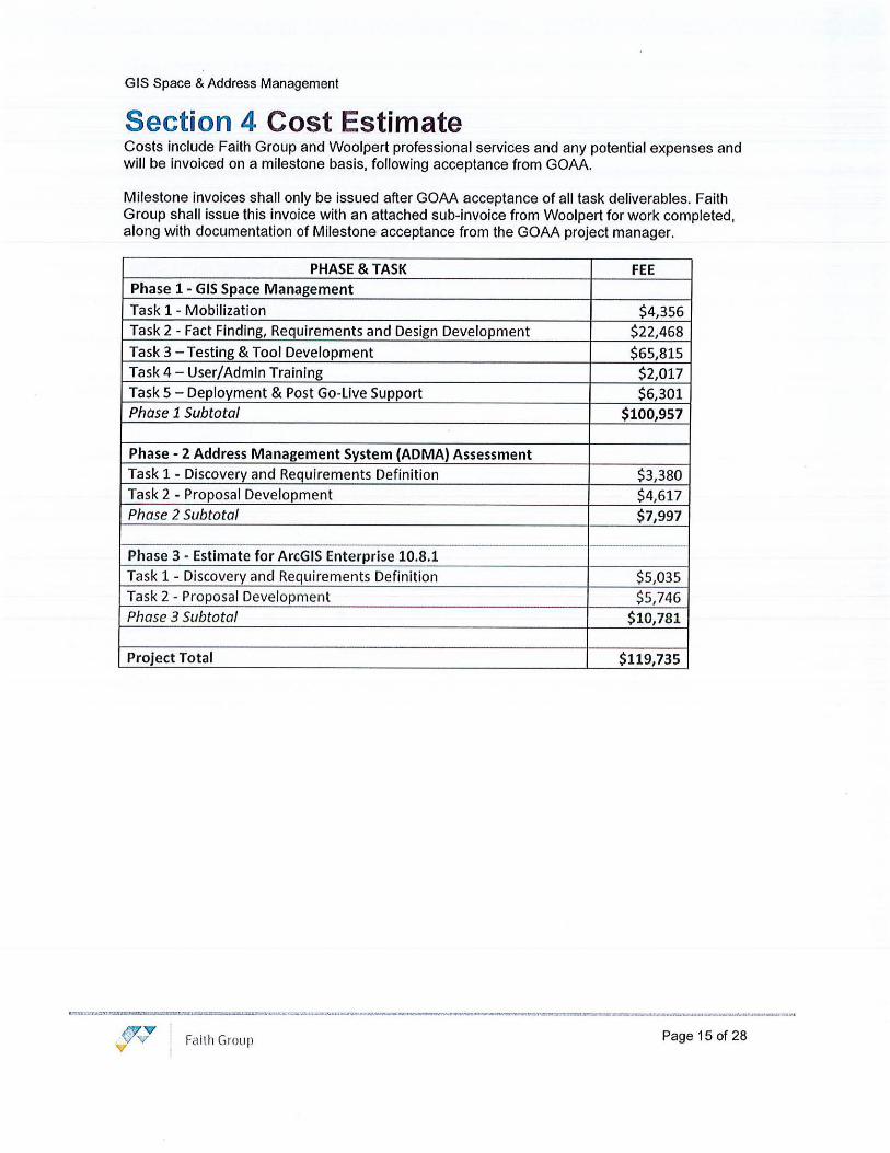
Section 4 Cost Estimate Costs include Faith Group and Woolpert professional services and any potential expenses and will be invoiced on a milestone basis, following acceptance from GOAA.
Milestone invoices shall only be issued after GOAA acceptance of all task deliverables. Faith Group shall issue this invoice with an attached sub-invoice from Woolpert for work completed, along with documentation of Milestone acceptance from the GOAA project manager.
PHASE & TASK Phase 1 - GIS Space Management
Task 1 - Mobilization
Task 2 - Fact Finding, Requirements and Design Development
Task 3 - Testing & Tool Development Task 4 - User/Admin Training
Task 5 - Deployment & Post Go-Live Support Phase 1 Subtotal
Phase - 2 Address Management System (ADMA) Assessment
Task 1 - Discovery and Requirements Definition
Task 2 - Proposal Development Phase 2 Subtotal
Phase 3 - Estimate for ArcGIS Enterprise 10.8.1 Task 1 - Discovery and Requirements Definition
Task 2 - Proposal Development Phase 3 Subtotal
Project Total
(J'vV I
Faith Group V
FEE
$4,356
$22,468
$65,815 $2,017
$6,301
$100,957
$3,380 $4,617
$7,997
$5,035
$5,746 $10,781
$119,735
Page 15 of 28

GIS Space & Address Management
Section 5 Project Assumptions
• All work will be conducted remotely and GOAA will provide remote access to servers via secure methods. In the event an onsite visit is required, a project change request and scope modification shall be submitted for approval.
• GOAA shall provide all relevant documentation, schematics and supporting information in a timely manner in accordance with the agreed upon schedule and to a degree of completeness that supports the ability to do much, or all or the work remotely.
• GOAA shall provide necessary support resources are available in accordance with the agreed upon project schedule. Provision of functional and technical subject matter experts for all phases of the project.
• GOAA shall work with the Faith Group Team to develop and produce a test plan and system testing. While Faith Group will track and manage defects, GOAA will be responsible for UAT.
• No equipment or licenses shall be delivered as a part of this SOW. It is presumed GOAA already has the necessary licensing for ArcGIS Desktop and Server and only recommendations can be made for software
• All preparation work prior to go-live shall be completed during normal business hours (8am - 5pm) • Cutover to the production environment will occur after hours.
• Faith Group team staff shall not be required to acquire GOAA Airport badges
/'iV V I vvv Faith Group Page 16 of 28
GIS Space & Address Management
Appendix A - Resumes
..,,.,,Y I Faith Group Page 17 of 28

GIS Space & Address Management
JASON WALLACE, PMP Senior Project Manager
Education:
Master of Business Administration, Management Information Systems
Franklin University Columbus, Ohio
Bachelor of Science in Business Administration, Management Information Systems
The Ohio State University Columbus, Ohio
Certifications:
Certified Scrum Master (CSM)
PM/ Project Management Professional (PMP)
Network+
ITIL Service Operations
ITIL v3 Foundation
Enterprise Content Mgmt. Practitioner (ECMp)
Affiliations:
PM/
Jason is a Senior Project Manager with more than 20 years of experience in the information technology managing: application development, infrastructure engineering, master data, enterprise information, data warehousing, and content management projects & organizations. He is experienced at leading and managing teams, mentoring and coaching employees, and encouraging a cohesive team environment. Jason is highly skilled in managing people and projects simultaneously, while easily gaining the respect of peers and the confidence of both senior leadership and customers. Over the years, Jason has successfully delivered on multiple multimillion-dollar project initiatives, consolidated and retired more than half a dozen legacy applications, provided continuous, improvement of numerous processes and mentored many employees on professional and career development, all while maintaining a high level of engagement and team morale.
Orlando International Airport, On-Call Services Contract - Orlando, FL Senior Technology Project Manager • Provide the Greater Orlando Aviation Authority (GOAA) management team with expert
feedback and solutions for issues, problems and challenges • Manage and control multiple projects while ensuring the budgeting, estimating, scheduling,
vendor contract administration & project documentation are complete • Uplift capabilities related to current processes and procedures to redefine and enhance the
current operations and project delivery for the organization • Develop strategic plans and roadmaps to further grow the adoption and maturity of the
Planview PPM application • Identify opportunities and create proposals to standardize processes to align with ITIL
(change, release, service level, configuration availability & risk management) • Evaluate and select new software packages to support business unit needs and implement
the new capabilities across the organization
Dallas Ft. Worth International A irport, IT St rateg ic Plan - Dallas, TX Senior Project Manager responsible for managing a large team focused on the development of an actionable roadmap and an integrated business & IT Strategic Plan (ITSP). This evaluates the existing conditions of Business Systems, Business Processes, Human Capital (Organization & Resources), and General Technologies (Wi-Fi, analytics, artificial intelligence, etc.). The report focuses on potential gaps with industry peers and best practices. The ITSP will result in multiple recommendations, a sequencing roadmap, and potential projects with budget estimates that can be prioritized over the next 3-5 years.
Walt Disney Parks & Resorts - Orlando, FL Senior Technical Project Management Consultant • Provided leadership and direction to initiatives impacting the Information Management
Services organization • Agile PM for 3 projects; Guest Experience & Insights, Legacy Modernization to Amazon Web
Services (AWS) & Financial Revenue Reporting • Partnered with Information Architects to explore Saas platform, application and infrastructure
solutions
• Drove results from cross functional teams delivering on data profiling, modeling and integration solutions
r,.. Interfaced with program leads to monitor key performance indicators of individual resources & overall projects
I> Managed and oversaw the entire information architecture and data modeling project portfolios
• Implemented CA Clarity PPM to improve processes & procedures related to demand & capacity management
• Led technical sessions for big data and cloud based solutions for large data-centric initiatives
Faith Group Page 18 of 28

GIS Space & Address Management
Competent Communicator Designation (Toastmasters)
Advanced Leader Bronze Designation (Toastmasters)
Atkins Global, Data Transfer Solutions - Orlando, FL Director, Project Management (PMO & Cloud) • Develop, build-out, and standardize an IT Project Management Office (PMO) • Create a roadmap and strategy for PPM adoption around technology, process, and people • Identify & implement governance and auditing processes and procedures • Understand and document different customer needs and prioritize across the entire project
portfolio • Collaborate & partner with implementation managers to successfully deploy software to
clients • Develop the cloud hosting roadmap, documentation, processes, and security hardening plan • Implement ITIL procedures, governance, and controls across all cloud-hosted platforms • Manage production assurance, incident management, problem management and automation
solutions.
Nationwide Insurance - Columbus, OH Director, IT Applications (Enterprise Information Management) • Developed the strategy and architectural roadmaps for four different software domains:
Enterprise Content Management & eSignature, Web eXperience Management (WXM), Data Integration & Managed File Transfer
• Implemented and deployed a new integrated Saas platform for an Enterprise eSignature capability
• Led the LEAN Application Maintenance program in partnership with McKinsey & Company to implement agile, optimize processes, reduce expenses and eliminate waste related to operations & production support
• Implemented an enterprise scale WXM Tridion platform that included personalization, analytics and archiving
• Drove enterprise scale SDLC projects for application and infrastructure currency, data center migrations, shared capability deployment & uplift and new feature development to align with business partner objectives
~ Managed over $16M in IT assets and application with a team of over 30 employees and contractors
• Reduced annual operational expenses by more than $1 mm by retiring legacy applications • Increased overall employee engagement scores, measured by Gallup, from 4.07 to 4.44
Nationwide Ins urance - Columbus, OH Manager, IT Applications (Enterprise Document Management) • Responsible for the ownership, strategic direction, planning implementation and coordination
of all technologies and applications (ASG Mobius) related to enterprise document management and archiving
• Initiated projects driving towards industry standard technologies by implementing Java web services, leveraging SOA and DataPower in support of document and content management solutions
• Reduced annual operational expenses by over $1 m by retiring legacy applications (IBM On Demand)
• Increased overall employee scores, measured by Gallup, from 3.77 to 4.33
Nat ionwide Insurance - Columbus, OH Lead Consultant, Identity & Access Management
I> Led two teams of nine engineers and four developers within the single sign on and network security space
• Created and implemented annual cost models for internal chargeback of new technologies and infrastructures
• Developed engagement and operational models for work flow processes for projects requiring single sign on
• Managed and exercised disaster recovery plans for the directory services and enterprise single sign on teams
Page 19 of 28

GIS Space & Address Management
W . RICK ADAMS, CCNA GIS SME Education:
Bachelor of Science in Computer Science Rowan University, Glassboro, NJ
Associate of Applied Science in Geospatial Technologies Rowan College at Burlington County, Mount Laurel, NJ
Certifications:
Cisco CCNA R&S (Exp. 2021.02.26)
Cisco CCENT (Exp. 2021.02.26)
Product Experience:
Routing & Switching: Juniper, Cisco, HPE/Aruba, Dell/Force 10, Alcatel, Juniper, Cisco, Meraki, Brocade/Foundry
Wireless LAN: Cisco AeronetRuckus Wireless, Cambium PTP Wireless, Clearsite Wireless Mesh, Fireticle Wireless Mesh, Aruba, Aerohive
Network Security: Dell EMC, Cisco, Juniper, Checkpoint, Aruba, Ubiquity
Network Controllers: Cisco DNA. Juniper Junos Space, OpenDaylight
Network Monitoring: Solarwinds, Alcatel
m v vv V
Fri ith Group
Rick is a result driven systems and networks designer with 13 years of experience in largescale aviation, commercial and government technology initiatives. He excels at learning complex systems and concepts quickly, developing comprehensive and secure solutions, while playing a key role in all parts of the project and systems development lifecycle. He is a subject matter expert in a broad range of technologies and design patterns, leveraging experience to implement creative and practical solutions. He is a subject matter expert in a broad range of technologies and design patterns, including the planning and integration of complex enterprise networks, video analytics, thermal screening, video management and other loT sensor systems. Since the COVID-19 pandemic first arose, Rick has personally led the design and development of infectious disease prevention solutions, focusing on people, process and technology used in a layered approach to addressing modern short- and longterm organizational challenges. Rick specializes in GIS integration to include: • Full Stack software development including leveraging GIS manufacturer APls/SDKs
(embedded, web, server and thick clients) • GIS system Architecture and detailed design, in support of Situational Awareness
Platforms • Use of GIS for real-time decision making and geo-based analytics (rules engines) • Real-time (push) integration of 3rd party solutions into a GIS environment • Management of GIS subcontractors • Knowledgeable of all leading manufacturers: ESRI, Skyline Software Systems, and
Google Earth Enterprise
Orlando International Airport, On-Call IT Consulting Services - Orlando, Florida Sr. Systems Consultant for a security and technology focused on-call planning contract. Task orders include:
• R&R Design - Rick was responsible for the design, configuration and support of a new Geographical Information System (GIS) based survey, used to gather all Existing Conditions in a living deliverable format. This point feature data was then used to design all IT and low voltage systems part of the R&R project (e.g. Access Control, Video Surveillance, Storage, Electrical, etc.).
Dallas Fort Worth International Airport - On-Call Consulting Services - Dallas, Texas Senior G/S Specialist for a technology focused on-call planning contract. Task orders include:
• Access Control System Upgrade Phase 2 - Rick was responsible for the coordination and support of a new Geographical Information System (GIS) based survey, used to gather all Existing Conditions in a living deliverable format. This point feature data is then used to design a new Physical Access Control system to replace the existing across the entire campus.
Situational Awareness Platform Design and Development -Abeo Technical Solutions, LLC. Software Architect & GIS Specialist responsible for design, software development, implementation, and maintenance of the situational awareness software suite, which leveraged a Service Oriented Architecture to create a real-time security and emergency response system. Integrated CCTV, video analytics, access control, radar, runway microwave sensors and BioRFID systems. The product was developed from the ground-up to perform anomalous behavior detection leveraging a rules engine back-end, distributed communication framework to provide a push messaging architecture, and GIS front end to provide actionable intelligence and remote procedure calls to integrated systems.
Internal Product Development, Faith Group, LLC - St. Louis, Missouri Sr. GJS Consultant for the design, configuration, testing and training of a new ESRI GIS service and infrastructure. The solution (ESRI ArcGIS Enterprise) is leveraged for the
Page 20 of 28

GIS Space & Address Management
Omnivista, CA Spectrum,
Wireless Modeling: Ekahau, Fluke, Cambium,
Cameras: FUR, Axis, Sony, Colw, Bosh, Pelco, Samsung, Panasonic
Video Management & Analytics Systems: Verint Nextiva, Axis, AiMetis Symphony, Genetec Omnicasf, OnSSI Ocularis, NICE Video Analytics: Mango DSP, Vidienf, Agent VI (Aspectus), Object Video, BriefCam, AiMetis
Access Control: SoftwareHouse CCURE, Genetec Synergis, Axis, Honeywell
Security Products: Delta Scientific Hydraulic Barriers, Low-profile Bollards, License Plate Readers (LPRs), Runway Microwave Sensors, Fiber Optic Intrusion Detection
Maritime Domain Awareness: Furuno, Sperry, VisSim VTMS, People Tracking Systems, AIS, VHF, UHF
Faith Group
collection of Client's existing conditions data, focusing on Security Sensitive systems, then delivered in a Geodatabase format to be later used for system design.
Orlando International Airport, On-Call IT Consulting Services • Orlando, Florida Sr. Systems Consultant for a security and technology focused on-call planning contract. Task orders include:
• CCTV Planning (Phase 1 & Phase 2) - Rick was responsible for the development of the IP network related content of the CCTV Planning Project's Basis of Design and Alternative Analysis reports. This effort provided design and planning for alternative network architectures, improved surveillance coverage, enriched forensic investigation, enhanced situational awareness and augmented monitoring capabilities for GOAA staff. An infrastructure assessment was developed to describe impacts to the existing network design given the proposed increased camera count with high-resolution camera equipment and video analytics.
• Information Technology Master Plan (ITMP) - Rick was responsible to develop content for the ITMP related to Geospatial Information Systems (GIS) and Passenger Facing Mobile Services. Each section detailed existing condit ions based on customer stakeholder interviews, a gap analysis comparing against industry standards, and recommendations.
Public Wellness Solution (Clean Campus) Design and Development - Faith Group, LLC Software Architect & Team Lead responsible for conceptual design, software development, and implementation of a new infectious disease prevention solution, leveraging integrated industry leading video analytic and thermal screening subsystems to provide actionable intelligence to Operations, while also providing executive dashboards for strategic decision making and compliance auditing. The product was developed from the ground-up to perform analysis of large and small campus environments, including social distancing, facemask detection, contract tracing, facial analytics, and occupancy monitoring.
San Francisco Intern ational Airport, Energy Management & Control System (EMCS) -San Francisco, CA QA/QC for the design and construction administration of the airport-wide integrated Smart Building Management and reporting solution's Energy Management & Control System (EMCS). The project implements technologies and analytics dashboards to monitor the Airport's environmental ecosystem, leveraging a secure network architecture following National Institute of Standards and Technology (NIST) publications and best practices for industrial control.
Oakland International Airport, Cybersecurity Assessment for Gatekeeper System -Oakland, CA QA/QC. The program included a comprehensive assessment of current conditions, a directed vulnerability assessment, and recommendations for a single on-premises service (Gatekeeper).
San Jose Internat ional Airport, Cybersecurity Assessment and Improvement Plan -San Jose, CA QA/QC. This work included an existing conditions assessment and gap analysis to determine the current state and readiness as it related to cybersecurity at the airport. Tasks included detailed vulnerability assessments and cybersecurity manufacturer product analysis in addition to other relevant network architecture and cybersecurity training tasks.
Phoenix Sky Harbor Internat ional Airport, Comprehensive Airport Security Act ion Plan Consulting Services - Phoenix, AZ Sr. Design Consultant for the Security Action Plan underway at the Airport. Faith Group is conducting a thorough assessment of the current cybersecurity threats and gaps. The work includes assessment of all aspects of readiness including system architecture, physical security of key assets, business continuity, governance and risk management, and education and training. The final report will provide recommendations for enhancements in all areas including a capital and O&M budget to support on-going operations.
Page 21 of 28

GIS Space & Address Management
Ed Copeland, GISP Project Manager Ed is an accomplished GIS program manager who has more than 22 years of experience in the aviation industry, and continuing education in the use of GIS for analysis in a wide variety of science and engineering projects. He prioritizes his client's vision and goals by listening and asking the right questions. In the day-to-day, Ed Is responsible for overall project management. His role brings subconsultants and stakeholders together to promote the discovery of critical goals and provide consensus on project success criteria. He is an active reviewer and contributor to the FAA's Airport GIS Data Standards development initiative. Additionally, Ed was GIS Lead on one of the first electronic Airport Layout Plan (eALP) pilot projects for the FAA and the first submittal into the new AGIS program in the nation.
Project Experience
TPA Airport GIS/CAD and Cltyworks Support, Hillsborough County Aviation Authority-Tampa, Florida. Program Director who Is conducting conference meetings with Airport staff and the Woolpert team to organize GIS, CAD, and Cityworks support. Ed is currently developing GIS and CAD standards in collaboration with the client and team. As part of a competitive bid process, the Hillsborough County Aviation Authority awarded Woolpert the Tampa International Airport (TPA) Cityworks and CAD/GIS Support project. Woolpert is developing a project plan and schedule to update interior and exterior CAD standards, creating GIS standards, and providing on-call consulting services. As part of updating and creating standards, Woolpert is reviewing existing data, developing standard documentation, generating a template GIS geodatabase as well as layer files.
RSW Airport GIS Implementation and Roadmap, Lee County Port Authority-Fort Myers, Florida. Program Director tasked with Woolpert is providing strategic consulting services to the Lee County Port Authority in order to develop a GIS implementation plan and roadmap for implementing an Enterprise GIS at the Southwest Florida International Airport (RSW). Woolpert began with a workshop with the Airport's GIS team and key
Professional Data
Experience
22 years
Education
Bachelor of Science, Geography & Cartographic Information Systems
Training and Certifications
FAA IDLE Certified, Level 3 for Advisory Circular 150/5300·16A, -17C, and -18B
WMX Esri Training
QUANTM Operator Level 1, DFIRM Tools In FEMA-MAPMOD Program, Visual Basic Programming, Trimble Mapping Systems and GPS Training
Remote Sensing-ERDA$ Imagine Training
Intergraph MGE Training
Professional Registration
Certified GIS Professional, National #91821
stakeholders to determine and document information (current workflows, GIS requirements, existing GIS products and architecture, constraints/obstacles, planned solutions, implementation priorities, and SOWT analysis) that will lead to a GIS roadmap. Following the on-sit workshop, Woolpert will work remotely with the Airport GIS team to finalize goals and develop a business case document that details needed resources, outlines data standards and geospatial processes, reduces duplication of effort, and increased GIS solutions and usage. Task 3 will be the agile development of the implementation plan with executable roadmap.
GOAA On-Call Information Technology Services- Orlando, Florida. GIS Lead who managed the conversion of over 450 existing CAD files to a new GIS standard (AClS0/5300-188) for an Enterprise Spatial Information System (SIS) using SOE, with modules dedicated to planning, properties, operations, maintenance, engineering, and finance departments within the Greater Orlando Aviation Authority. The SIS includes an Oracle relational database, Esri ArcGIS Server application server, and a custom-built, map-enabled web interface.
Fai th Group Page 22 of 28
GIS Space & Address Management
Data Visualization, Analysis, and Reporting System (DVARS), FAA-Washington DC. Program Director who is leading this effort to develop the FAA next generation of National Airspace System (NAS) data processing and analysis center monitoring the nation's air traffic. Woolpert was tasked with the design, development, and deployment of the geospatial visualization component of the DVARS Program. The team was initially responsible for data integration in an Enterprise GIS database for data visualization and reporting. The project consisted of a Trade Study, Critical Design Requirements, and substantial application development. Over the multi-year mission, our skilled geospatial data analysists and application developers will construct the key characteristic of the DVARS Program, 3D data visualization capability never utilized before. Woolpert's development of the DVARS solution will utilize a hybrid data system utilizing Hortonworks Data Platform (Big Data), PostgreSQL (Relational Database) for Esri Data Visualization and Tableau Bl/Reporting in the AWS GovCloud. Esri Web App builder is being utilized to meet all requirements for flight traffic visualization, analysis, and dash boarding.
XNA Airport Asset Management and GIS Services, Northwest Arkansas Regional Airport Authority-Bentonville, Arkansas. Program Director responsible for on-site Interview for requirements gathering, business case development, roadmap edits, and client communications. Woolpert was selected to work with the Northwest Arkansas Regional Airport (XNA) to create a roadmap to guide their GIS and Asset Management (AM) program development. This roadmap will involve the creation of procedures, standards of practice, and specifications for CAD/BIM (representing design and construction), GIS and a Computerized Maintenance Management System (CMMS, representing operations and maintenance) which will collectively be a part of the XNA AM program that effectively manages the entire lifecycle of all XNA assets.
MSP Airport Enterprise GIS Program-St. Paul, Minnesota. GIS Lead who created a needs assessment, project plan, and schedule for the consolidated Metropolitan Airports Commission GIS Program at Minneapolis-Saint Paul International Airport (MSP). This created the road map for the first phase of implementations of an Enterprise GIS at MSP. The first phase of implementation included development of a web-based GIS application for data viewing and the conversion of all data to GIS that met FAA standards set forth In Advisory Circular 150/5300-18B. The web application was built using Adobe Flex technology and all data was stored using Oracle and SOE. Ed supervised conversion of over 500 CAD layers to the Airports GIS.
PHL Airport Enterprise GIS-Philadelphia, Pennsylvania. GIS Lead for the initial phase of establishing the Airport's GIS portal, in order for the Philadelphia International Airport (PHL) to easily retrieve graphical information regarding airport utilities, property, ALP, maps, etc. The project involved development of a web-enabled, spatial data portal, using several open architecture technologies including Esri's ArcGIS Server. During Phase II of this project, Ed managed a subconsultant in the conversion of existing data to the new FAA GIS standard (Advisory Circular 150/5300-18B), which included all airfield data at PHL. The data was also converted from the geodatabase and uploaded into Oracle Spatial utilizing ArcSDE for the web application.
DEN Enterprise GIS and BIM Implementation-Denver, Colorado. GIS Lead for the implementation of Denver International Airport's (DEN) Enterprise GIS and Building Information Modeling (BIM). Ed developed a comprehensive needs assessment and multi-year implementation plan, which included an Enterprise SQL database with Workflow Manager schema. The implementation built upon DE N's basic GIS capabilities to update and expand them in support of new FAA Advisory Circular requirements for GIS data involving airport surveys and eALP updates. He developed new GIS data standards for the airport and designed a database to support these standards that included multiple schemas for GIS data storage. Ed managed eight employees during the course of this project and coordinated all data development with the City.
SJC Airport eALP and Enterprise GIS-San Jose, California. Project Manager who supervised subconsultants and the processes for quality assurance and technical services at Mineta San Jose International Airport (SJC). The project involved inventorying all existing utility data and assessing the condition of the data in order to assist in prioritizing what information would be input to the airport's Oracle GIS system. A database was created to organize the data and determine a quality base for the utility program. This created a cost savings for SJC, as it prioritized where funds should be spent. Three separate teams worked in unison with each other to complete the data capture in a timely and efficient process. The data as collected in different software and then converted to Oracle using FME to converts the datasets to SJC's database structure.
Fai th Group Page 23 of 28

GIS Space & Address Management
Cheryl Spencer Geospatial Specialist Cheryl is an accomplished GIS Analyst with Woolpert's Information Technology (IT) group. With over 19 years of experience, Cheryl is an expert on the ArcGIS Suite, having worked with every version of the software since ArcGIS 9.1. Her extensive knowledge of ArcGIS includes, but is not limited to, multi-machine setups and security. She routinely performs server migration and Installation, handles day-to-day maintenance, creates new services, and coordinates with developers.
Her extremely strong GIS background allows her to serve as a Subject Matter Expert on projects. In addition to her ArcGIS knowledge, Cheryl is skilled at programming and application development using HTML, CSS, ArcXML,
JavaScript, Dojo, VB Script, VB.NET, ASP, and ASP.Net. Professional Data
Project Experience Experience
RFD Airport Asset Management-Rockford, Illinois. Specialist who supported the development of an Asset Management Implementation Plan for the Chicago Rockford International Airport (RFD). Woolpert began the first phase of the Asset Management system implementation in 2014; this scope continued the AMS implementation by collecting the assets within the 27 facilities across the airport, assessing their condition and establishing preventive maintenance schedules for each. Woolpert's approach included many opportunities for our technical staff to work alongside RFD staff to transfer knowledge. The project plan and associated budget and schedule w ere developed based on assumptions from the documented interviews with RFD staff. Woolpert developed the data collection spreadsheets for the collection of asset attributes development of preventative maintenance.
RDU Airport GIS Support Services- Raleigh, North Carolina. Specialist who performed data creation services and custom applica tion modification services to Raleigh-Durham International Airport (RDU) Client's Enterprise Geographic Information System (GIS) in order to help the client address an issue that arose when data associated with the preparation of FAA's Airports Geographic Information Systems (AGIS) submittal was in a different format (as required by FAA) than the existing RDU GIS data. This put RDU in the position of needing to maintain two databases. Woolpert helped implement best practices for GIS systems with multiple users.
19 years
Education
Bachelor of Science, Earth Space Science, University of Indianapolis
Training and Certifications
Introduction to Arclnfo using ArcMap, ArcCatalog, and ArcToolbox, Indianapolis/IN, 2000
JavaScript Fundamentals/PERL Fundamentals, Indianapolis/IN, 2001
Upgrading Web Development Skills from ASP to ASP.NET, Dallas/TX, 2004
Introduction to Visual Basic for ESRI Software, Virtual, 2002
Introduction to Programming ArcObj ects with VBA, Indianapolis/IN, 2005
Total ASP, Indianapolis/IN, 2002
Professional Registration
Certified GIS Professional, National 1191812
DAY Airport GIS Implementation, City of Dayton, Ohio-Dayton, Ohio. Team Member responsible for the development of the land use websi te. For the Dayton International Airport (DAY), Woolpert implemented an enterprise GIS to suppor t the needs of the airport. The primary goals of DAY's enterprise GIS project were to provide increased efficiencies to everyday business practices, support ongoing and future capital programs through powerful analytical tools, and be able to share a common set of data- internally, as well as potentially with other external users such as airl ines, contractors, or other public agencies.
SAV Airport Cityworks Implementation-Savannah, Georgia. Specialist who engaged wi th Savannah Hilton Head International Airport (SAV) to implement an enterprise Cityworks Asset Management System (AMS), for the airfield operations and maintenance departments. This GIS-centric solution directly leverages the Esri geodatabase as the asset repository. The init ial tasks included business process planning, software installation, system design and configuration, evaluation of legacy data migration report and dashboard development, user acceptance testing, end user training and go-live support. Wooipert's technical staff worked alongside SAV staff to transfer knowledge and ensure the system is tailored to capably support service requests, work orders and inspection workflows.
Faith Group Page 24 of 28

GIS Space & Address Management
Darren Johnson Database Specia list
Darren has extensive experience maintaining and performing as a server administrator for federal and state clients, and more recently as a GIS database specialist for spatial technology system design and Implementations. He has supported Air Force Master Planning through the administration of enterprisewide geospatial technologies. Darren performs database and system administration on an enterprise geospatial network, ensuring 24/7 availability. He also ensures all geospatial data is compliant with Spatial Data Standards for Facilities, Infrastructure and Environment (SDSFIE) and that metadata is developed and maintained according to Federal Geographic Data Committee (FGDC) standards.
Additionally, he develops and Implements web-based applications to support geospatiai analysis, viewing, editing, and routine maintenance for installation data owners. Darren's expertise includes programming in VBA, ArcObjects, HTML, Java, ASP, PLSQL/SQL, XML, and .NET. In addition, he is skilled in ArcGIS 9.x and 8.x, ArclMS 9.x and 4.x, ArcSDE 9.x and 8.x, Oracle 91 and 10g, AutoCAD (r14-2009), Mlcrostation SE, Trimble Geomatics Office, Trimble Reference Station, GPS Pathfinder Office, ArcPad, ArcPad Application Builder, Visual Web Developer, Macromedia Studio Suite, SDSFIE Toolset, and Paint Shop Pro.
Project Experience
DAY Cityworks Implementation, City of Dayton- Dayton, Ohio. Database Specialist who worked on system design and configuration, as well as advanced AMS functionality upgrades. Woolpert was contracted by Dayton International Airport (DAY) to develop a GIS implementation plan, which included asset
Professional Data
Experience
23 years
Education
Associates, Construction Technology, Maxwell-Gunter Air Force Base, AL
Training and Certifications Esri International User Conference, San Diego, CA, 2014
Professional Registration Security+, National
management, inventory, and condition assessment of non-terminal facilities and airside. The project focused heavily on DAY's airfield assets with a future plan to move to terminal and building facilities. Cityworks software demonstrations provided an initial overview of the features and functions of the new software and will serve as a basis of ongoing software training and knowledge transfer that will increase in frequency and intensity as the project progressed through the subsequent implementation phases.
ArcGIS Upgrade and Redline Application Redesign, Targa Resources-Houston, Texas. Database Specialist responsible for application migration and testing connectivity. Woolpert performed an upgrade from ArcGIS 10.3 to 10.5.1, migration of the existing enterprise geodatabase from Oracle llg to SOL Server 2016, and creation of a new Redline web mapping application built on the latest Esri web mapping application platform. This replaced the existing application built on the Sllverlight platform, which was no longer supported. The project also required training for Targa staff and documentation, including a high-level disaster recovery plan and a GIS enterprise database administration guide.
Ohio Statewide Imagery Program Year 3, ODAS- Columbus, Ohio. Database Specialist tasked with application development of the web-based SmartView Connect site for users. The Ohio Statewide Imagery Program (OSIP) is a contract for the acquisition of professional mapping services such as orthophotography, lidar, oblique imagery, parcel conversion, and remote sensing analysis. The state and counties/cities that participated In the buy-up program used Woolpert' s SmartView Connect, a web-based software that allow ed participants to track, monitor, and comment on data and deliverables. With this software, the state (and counties/cities) can view the deliverables, take measurements, mark-up and make comments, review and track pending issues, and submit reports.
Enterprise GIS Production Support Program, Port of Portland, Oregon-Portland, Oregon. Database Specialist who provided GIS application development support tasks. Woolpert performed services to support the Port's enterprise GIS program, which involves producing new or enhanced features as requested. Services provided to-date include: impact analyses to upgrade to ArcGIS 10.2 and to change the data structure for inside building GIS data; implementation of Geocortex GIS vi ewers; addition of HTML 5 GIS viewers to system architecture; and new publicly-facing mobile web site for GIS information.
Failh Group Page 25 of 28

GIS Space & Address Management
Joseph Mcfadden, GISP Application Developer Joseph is an Application Developer who is highly experienced in software design, development, testing, implementation, and ISO documentation. He implements geospatial solutions with integrated technologies using ArcGIS Desktop, Python packages, open source software, and SQL. Joseph has an extensive background in ArcObjects for ArcMap and ArcCatalog. He is a proponent of open source software and open source Python packages in GIS tasks and workflows. Additionally, Joseph has a deep knowledge in how vector and raster data and GIS processes lead to customized workflows and tool development in areas of data capture, conversion, and QC.
Project Experience
RDU Airport Data Management Services-Raleigh, North Carolina. Application Developer tasked with data management services at Raleigh-Durham International Airport (RDU). Joseph also supported Esri software installation and administration. Woolpert facilitated a stakeholder meeting with representatives from the Authority, Duke Energy, and the FAA to establish/confirm the Airport Electrical System elements that require field investigation and documentation in the Authority's GIS. This included a workshop meeting with all stakeholders and focused field investigation with the Authority/Duke Energy representatives to make observations necessary to develop a scope of services for future field investigations and data entry into the Authority's GIS.
Data Visualization, Analysis, and Reporting System (DVARS), Federal Aviation Administration-Washington DC. Application Developer tasked with the development of a 3D geospatial data visualization component that will animate flight tracks, weather, airspaces, and facilities for FAA analysts. Woolpert's team completed a comprehensive design review process which included a trade study evaluating proprietary and open source options, production of detailed software design documentation, prototyping of data conversion tools, and file.readers for geospatial formats produced by the FAA. Woolpert, as a subcontractor to GDIT, was contracted to develop the geospatial visualization component of a custom air traffic analysis and reporting tool, DVARS, for
Professional Data
Experience
22 years
Education
Bachelor of Science, Software Development and Security, University of Maryland University College
Bachelor of Science, Natural Resources Management, Colorado State University
Associates, Computer Information Systems, Front Range Community College
Professional Registration
Certified GIS Professional, National #1160561
the National Air Space. DVARS is designed to run natively in the FAA's AWS GovCioud environment.
Ad-Hoc Support, PWCSA-Woodbridge, Virginia. Application Developer who provided AMS and Pll support services. The Prince William County Service Authority (PWCSA) sought to extend Cityworks AMS and Pll support services provided by Woolpert, which includes Work Order and Service Request template management, report management, system integration management, user functionality configuration and troubleshooting, GIS mapping functionality in Cityworks environment, Cityworks Mobile application support and configuration, general Cityworks AMS and Pll technical troubleshooting, and Cityworks integration troubleshooting and resolution post go-live.
Greenwood IN Cityworks INBiz Integration-Greenwood, Indiana. Applica tion Developer responsible for custom API Development for Greenwood Cityworks, for INBiz. The purpose of this project is for the City of Greenwood Indiana to have the ability to utilize the functionality of INBiz. INBiz is the State of Indiana's one-stop resource for business needs. Greenwood has previously implemented Cityworks PLL (Permits, Licensing and Land). Woolpert was responsible for integrating Cityworks with IN Biz by using widgets within the IN Biz environment to call and push data to and from Greenwood's Cityworks Pll database. The Woolpert team built APls that push and pull Greenwood's Cityworks data to IN Biz.
Cityworks Installation for Bureau of Utilities, Baltimore County- Baltimore County, Maryland. Application Developer tasked with data migration support. This Baltimore County Cityworks AMS implementation project follows the successful completion of an asset management readiness assessment and planning project for the County. Woolpert implementation services include configuration of Cityworks to support Service Request, Work Order, and Inspection Management for all Utilities divisions and the Storm Drains division in the Bureau of Engineering; implementation of
~ y I .,,,vv Faith Group Page 26 of 28
GIS Space & Address Management
Cityworks Storeroom; migration of legacy work activity records from Cass Works into the Cityworks database; custom report development; integration with POSM; and integration with CitySourced.
Cleveland Parks, Maintenance and Properties Cityworks Implementation, City of Cleveland-Cleveland, Ohio. Application Developer who provided migration services. The Department of Public Works currently utilized ARCHIBUS to manage the maintenance program for vacant properties. Three divisions, Parks Maintenance & Properties, 311 and Assessments & Licensing are involved with the direct maintenance of vacant properties, invoicing property owners for maintenance services or logging stakeholder calls for service. Woolpert performed this Cityworks implementation project to replace the functionality of ARCHIBUS and the protest database, as w ell as Integrate with CGI Advantage to generate invoices for services rendered.
ArcGIS Upgrade and Redline Application Redesign, Targa Resources-Houston, Texas. Application Developer tasked with SDE downloads and redline application support. Woolpert was approached by Targa Resources to perform an upgrade from ArcGIS 10.3 to 10.5.1, migration of the existing enterprise geodatabase from Oracle llg to SQL Server 2016, and creation of a new Redline web mapping application built on the latest Esri web mapping application platform. This will replace the existing application built on the Silverlight platform, which is no longer supported. The project also requires training for Targa staff and documentation, Including a high-level disaster recovery plan and a GIS enterprise database administration guide.
Cityworks Enterprise Asset Management System Implementation, Central Services & Parks Recreation, City of Augusta-Augusta County, Georgia. Application Developer who supported the Woolpert team in implementing Cityworks for the Central Services Department and the Parks and Recreation Department in the City of Augusta. The project includes Implementations of Cityworks Service AMS, Cityworks Storeroom and configuration of Cityworks AMS to work with Motorola CSR. The project will also include integration with a 3rd party 311 solution to be completed at a later date.
Operations and Maintenance AMS, Prince William County Service Authority- Prince William County, Virginia. Application Developer w ho supported integration, development, and deployment tasks. In order to manage its assets at the Advanced Water Reclamation Facility (AWRF) and in the Collection and Distribution Systems, Prince William County required the replacement of their current CMMS (WRF used MP2 and the Collection and Distribution systems used Hansen) w ith a Cityworks implementation. In addition, Woolpert was also contracted to integrate Cityworks with key software platforms already in place and implement improvements to the Service Authority's business processes using Cityworks.
<Yvv ' Faith Group V
Page 27 of 28

GIS Space & Address Management
Jason Stradtner Applic ation Developer As an Application Developer with 19 years of experience, Jason evaluates design specifications, writes code to meet those specifications, produces documentation, and communicates regularly and openly with team partners and clients to produce successful finished products. Jason became intrigued by the cause-and-effect nature of programming early on, and his later curiosity regarding spatial concepts such as GIS and remote sensing uniquely positioned him for success in the geospatial sector. After college, he got his professional start with a government contracting role for the National Oceanic and Atmospheric Association (NOAA) in Mississippi, working on coastal risk analysis related to storms and demographics.
Projects that Jason has lent his development skills to-such as the Coastal Risk Atlas and Flood Risk Score-have contributed to improving governmental and industry ability to asses risk and provide mitigation to save property and lives in the future. Much of Jason's experience has been in desktop GIS development with ArcObjects and Cl/, but he has also done recent serverand moblle-focused work on the RESTful API and in Java. Additionally, Jason has small-project management experience through his involvement with the West Coast Observing System project for NOAA.
Project Experience
Airport ELS Maintenance, CRAA- Columbus, Ohio. Application Developer tasked with script development, database updates, and related services. Woolpert provided Electronic Logging
Professional Data
Experience
19 years
Education
Bachelor of Science, Computer Science, Texas A&M University- Corpus Christi
System (ELS) maintenance support to the Columbus Regional Airport Authority (CRAA). Annual maintenance services included software patches and bug fixes to prevent service interruption, responding to and investigating software malfunctions; spatial and non-spatial data updates and import into GEO module; and monitoring of ELS error logs for those customers who allow authorized access into their IT environment. The Woolpert technical maintenance services included remotely accessing customer I systems; Installing ELS software on laptops and desktops; and form updates.
GeoEvent Server Upgrade, City of Columbus-Columbus, Ohio. Application Developer responsible for reviewing current GeoEvent workflow procedures and custom processor and redefining the workflow to use out-of-the-box technology to replace custom code. In this project, Woolpert has been tasked with updating and migrating an ArcGIS GeoEvent service that the City uses to process automatic vehicle location messages from city vehicles, including snowplows, mowers, and street sweepers. The service includes a custom processor that tracks the state of various sensors on city vehicles, such as the active state of the spreader sensor on snowplows. The scope of the project Includes updating the service for use in ArcGIS 10.7.1; authoring related documentation; and providing support during testing, implementation, and a defined post-production warranty period.
HydrantWeb Development, City of Columbus-Columbus, Ohio. Application Developer who worked on Esri WebApp Builder to redesign customer mapping interface. Woolpert was contracted to redevelop the city's existing HydrantWeb application, which is used for the management, inspection, and permitting of fire hydrants by the City of Columbus, the Department of Public Utilities (DPU) Division of Water (DOW), the DPU Permit workgroup, and the Columbus Fire Department (CFO). The interface included custom tools to handle user input and database updates. Jason also worked on a console application project that runs as a nightly scheduled task to update database values for the coming day. All cod ing projects were done in CII.
West Coast Observing System, NOAA National Coastal Data Development Center-Mississippi. Project Manager and Application Developer responsible for project coordination, working with National M arine Sanctuaries stakeholders, and for application development. The project focused on loading buoy in-situ data into a GIS database for ArclMS map display.
Coastal Risk Atlas, NOAA National Coastal Data Development Center-Mississippi. Application Developer who participated in product design and provided development support for a project combining coastal storm and demographic data into an online map. The map was made publicly available to allow anyone to search their location and asses their risk. ArcMap and then was later separated into a server application that would accept input fil es to run batches of properties. Output was a PDF document showing relevant map and tabular data for each property. Cl/ was used during code development.
.$5'vv ! Faith Group Page 28 of 28

TRUTH IN NEGOTIATION CERTIFICATION
The Consultant hereby certifies, covenants, and warrants that wage rates and other factual unit costs supporting the compensation for this project's agreement are accurate, complete, and current at the
time of contracting.
The Consultant further agrees that the original agreement price and any additions thereto sha·II be
adjusted to exclude any significant sums by which the Greater Orlando Aviation Authority determines
the agreement price was increased due to inaccurate, Incomplete, or noncurrent wage rates and other
factual unit costs. All such agreement adjustments shall be made withln one (1) year following the end
of the contract. For purposes of this certificate, the end of the agreement shall be deemed to be the date of final blllfng or acceptance of the work by the Greater Orlando Aviation Authority, whichever Is
later.
Consult:nt: Faith Group~
By: ~ _
Print Name: Wendy Wilke
Date: December 15, 2020
------------ --·- --·- --- -

MEMORANDUM
To: Members of the Professional Services Committee
GREATER ORLANDO AVIATION Orlando Intl
Sl Orlando, Fl<
From: Somdat Jiawan, Manager, Small Business Programs (sj)
Date: January 05, 2021
HANDOUT 1/5/2021 PSC
Item 2 NewOSBD
Re: Request for Approval to the Chief Executive Officer of an Addendum to the Information Technology Consulting Services Agreement with Faith Group Consulting, LLC for a GIS Space Management Upgrade and Address Management System Assessment Consulting Services at the Orlando International Airport.
We have reviewed the qualifications of the subject contract's MWBE/LDBNBE specifications and determined that, due to the specialized scope of the services to be provided, Faith Group Consulting, LLC does not propose small business participation on this Addendum.
Our analysis indicates that Faith Group Consulting, LLC is eligible for award of the subject Addendum.

Minute s o f the Professional Servic e s Committe e January 5, 2021 Page 2 of 4
REQUEST FOR RECOMMENDATION OF APPROVAL TO THE CHIEF EXECUTIVE OFFICER .OF AN ADDENDUM TO THE INFORMATION TECHNOLOGY CONSULTING SERVICES AGREEMENT WITH BARICH, INC. FOR VIRTUAL RAMP CONTROL (VRC) INTERFACE DEVELOPMENT SERVICES TO THE SOUTH TERMINAL C, PHASE I, IT SUPPORT SERVICES, AT THE ORLANDO INTERNATIONAL AIRPORT . 1. [Handouts were provided, which include a revised cover memorandum and the Small Business Development memorandum.] Mr . Brooks presented the memorandum, dated January 5 , 2021, along wi th t h e proposal from · Barich, Inc., dated December 10, 2020, for Virtual Ramp Control (VRC) Interface Development Services to the South Terminal C, Phase I, IT Support Services , at the Orlando International Airport . Services will include the use of the Aviation Authority ' s Airport Integrated Data Broker (AIDB) for the assessment , design , implementation, testing and production deployment and production support for additional AIDB interfaces with the VRC .
The Office o f Small Bu siness Development has reviewed the proposal by Barich, Inc ., and determi ned that , due to t h e specialized scope of the required services, Barich, Inc . does not prop ose any MWBE/LDB/VBE participation on this addendum .
Chairman Ruohomaki asked if the hourly rates are the same as previously approved. Mr. Brooks replied yes.
Ms . De n nis stated that t h ere is revised funding on the handout, and requested that the approval of this item be subject to revie w by Construction Finance .
Upon motion of Mr . Hunt , second by Ms. Dennis, vote carried, with all votes yea , to r ecommend to the Chief Executive Officer approval of an Addendum to the Information Technology Consulting Services Agreement with Barich, Inc ., for Virtual Ramp Control (VRC) Interface Developmen t Services to the South Terminal C, Phase I, IT Support Services , at the Orlando International Airport , for the tota l not-to-exceed fee amount of $110,187.00, with funding from previously-approved Capita l Expenditure Funds and General Airport Revenue Bonds; subject to review by Construction Finance. [Subsequent to the Construction Committee meeting, Construction Finance confirmed the funding, as outlined above . ]
REQUEST FOR RECOMMENDATION OF APPROVAL TO THE CHIEF EXECUTIVE OFFICER OF AN ADDENDUM TO THE INFORMATION TECHNOLOGY CONSULTING SERVICES AGREEMENT WITH FAITH GROUP CONSULTING, LLC FOR GEOSPATIAL INFORMATION SYSTEM (GIS) SPACE MANAGEMENT UPGRADE AND ADDRESS MANAGEMENT SYSTEM ASSESSMENT CONSULTING SERVICES, AT THE ORLANDO INTERNATIONAL AIRPORT . 2 . [Handouts were provided, which include a revised cover memorandum and the Small Business Development memorandum . ] Mr . Brooks presented the memorandum, d a ted January 5, 2021 , along with the proposal from Faith Group Consulting, LLC, dated December 16, 2020 , for Geo spatial Information System (GIS) Spac e Management Upgrade and Address Management System Assessment Consulting Services at t h e Orlando International Airport . Services will include , but are not limited to, the deployment of new GIS Space Management t ools supported by use r training and documentation, an analysis and proposal with s uggested architecture and cost estimate for an Address Management System (ADMA) replacement, and an a nalysis and proposal wi th suggested a r chitecture and cos t estimate for an ArcGIS Enterprise upgrade.
The Office of Small Business Development has reviewed the proposal by Faith Group Consulting , LLC , and d etermine d that, due t o the specialized scope of the required services, Faith Group Consulting, LLC does not propose a ny MWBE/LDB/VBE p a rticipation on this addendum.
Chairman Ruohomaki Consulting, LLC on
stated that Woolpert, this procurement, as
Inc. well
is a s ubconsul tant t o Faith Group as one of the Aviation Authority' s

Minutes of the Professional Services Committee January 5, 2021 Page 3 of 4
Continuing CAD/GIS/BIM Consultants , and stated that s t aff needs to ensure there will be no double-billing of services . Ms . Dennis asked if a process was in place to guarantee no double - billing . Mr . Brooks replied yes , that these servi ces are lump s um with well-defined progress milestones , and payment for these services will be made only after verification that the milestone scope of services is completed and accepted . Chairman Ruohomaki stated that Mr . Nguyen oversees the Continuing CAD/GIS/BIM scope of services , and wil l work closely with Mr . Brooks and Project Controls when invoices are submitted .
Upon motion of Mr. Hunt , second by Ms . Denn is , vote carried, with all votes yea , to recommend to the Chief Execut i ve Officer approva l of an Addendum t o the Informat i on Technology Consulting Services Agreement with Faith Group Consulting, LLC for Geospatial Information System (GIS) Space Management Upgrade and Address Management System Assessment Consulting Services at t he Orl ando I nternational Airport , for the total l ump s um fee amount of $11 9 , 735.00 , with funding from previously-approved Capital ._...,... Expenditure Funds .
REQUEST FOR RECOMMENDATION OF APPROVAL TO THE CHIEF EXECUTIVE OFFICER OF AN ADDENDUM TO THE INFORMATION TECHNOLOGY CONSULTING SERVICES AGREEMENT WITH FAITH GROUP CONSULTING, LLC FOR MAXIMO PROGRAM ENHANCEMENTS CONSULTING SERVICES, AT THE ORLANDO INTERNATIONAL AIRPORT. 3 . [A handout was provided, which includes the Small Business Development memorandum . } Mr . Brooks presented the memorandum, dated January 5 , 2021 , along with the proposal from Faith Group Consulting, LLC, dated December 15 , 2020, for Maximo Program Enhancements Consulting Services at the Orlando International Airport . Services will include , but are not limited to, upgrading Maximo to Version 7 . 6.1.2, Transportation Industry Solution to Version 7 .6. 2 . 5 , and Maximo Spatial Asset Management to Version 7.6.0 . 5 . All upgrades will be the latest releases at the start of the project along with applying the complementary interim fixes .
The Office of Small Business Development has revi ewed the proposal by Faith Group Consulting, LLC, and determined that Faith Group Consulting, LLC proposes 93.3% MWBE part icipation on this addendum .
Chairman Ruohomaki stated that the South Terminal C Program is being set up on the BIM platform and will need to be translated to Maximo, and asked if this will still b e possible after this upgrade . Mr . Furnari replie d yes . Mr . Hunt asked how long it will take for these latest versions to be installed . Mr . Furnari repl ied all upgrades will be fully installed by summer 2021 .
Upon motion of Mr . Hunt , second by Ms. Dennis , vote carried, with all votes yea , to recommend to the Chief Executive Officer approval of a n Addendum to the Informat i on Technology Consulting Services Agreement with Faith Group Consulting, LLC for Maximo Program Enhancement s Consulting Services at the Orlando International Airport , for the total not-to-exceed fee amount of $96 , 176 . 00 , with funding from previously-approved Capital Expenditure Funds.
ADJOURNMENT 4 . There being no further business for discussion, the meeting was ad j ourned at 9 : 22 a . m.
Davin D. Ruohomaki , Chairman Professional Services Committee Senior Director of Engineering and Construction
Copyright © 2022 FDOKUMEN