Excavation of the Town Defences at
41
Excavation of the Town Defences at Green Street, Northampton, 1995-6 by ANDY CHAPMAN with contributions by Paul Blinkhorn, Tora Hylton, lain Soden and Alex Thome SUMMARY Excavation at Green Street, Northampton has located the best preserved and most complete sequence of Northampton's town defences so far discovered. A clay bank with a timber revetment, and a substantial ditch were probably constructed in the earlier /0th century, either late in the Danish occup- ation or shortly after the late Saxon reconquest. The revetment was later rebuilt in stone, and a contemp- orary gateway with metalled road surfaces was aligned on the present Green Street, a minor lane that can now be seen as the fossilised remnant of a major early access road. The gateway was blocked in the 12th century at the construction of the medieval town wall. A final use of the defences in the Civil War is represanted by two shallow ditches cut into the largely filled medieval ditch. ENTRODUCTION The proposed development of a block of land at the western end of Green Street, Northampton for low-rise flats, at what is now Emerald Way, lay on the edge of the Saxon core of the town and south of both the former medieval castle and west gate (NGR: SP 74826034; Figs I and 2). The site therefore held the potential to contain significant remains of both the Saxon burh defences and the medieval town defences (Soden 1995). Evaluation trenches excavated in December 1995 demonstrated that a full sequence of the town defences were present, despite extensive recent ground disturbances (Chapman 1995). Having established that the site contained archaeological remains of national importance Northamptonshire 25 Heritage devised a mitigation strategy which called for a combination of further excavation, a watching brief to deal with threatened remains, and the preservation in-Situ of all remains which would not be disturbed by the development (Fig 2). This report draws together the evidence obtained in the various stages of investigation carried out between December 1995 and July 1996. The desktop assessment and all archaeological fieldwork was carried out by Northamptonshire Archaeology acting for the developer, Home Housing Association Ltd, and the work was funded through the Single Regeneration Budget. Northampton Borough Council sponsored site open days in April 1996 which attracted several hundred visitors and considerable attention from the local media. The fieldwork was directed by Andy Chapman, project assistants Rob Atkins and Paul Thompson were involved at all stages of excavation, and Tony Baker, Mark Holmes, Chris Jones and Steve Morris assisted with the excavation of trenches I and 2. Helen Keeley visited the site and provided advice on the environmental context of the Saxon bank. Mike Shaw has provided general advice and encourage- ment based on his many years of experience excavating in the town, and has drawn the author's attention to the relevant documentary evidence. However, all errors and omissions are the respons-. ibility of the author. The illustrations.are by Alex Thorne. TOPOGRAPHY AND GEOLOGY The site lies at 60-61m a O.D. on the lower slopes of the valley at the junction between the River Nene and the Brampton branch tributary (Fig I). The town Northamptonshire Archaeology 1998-99, 28
Transcript of Excavation of the Town Defences at
Excavation of the Town Defences atGreen Street, Northampton, 1995-6
by
ANDY CHAPMAN
with contributions by Paul Blinkhorn, Tora Hylton, lain Soden and Alex Thome
SUMMARY
Excavation at Green Street, Northampton haslocated the best preserved and most completesequence of Northampton's town defences so fardiscovered. A clay bank with a timber revetment, anda substantial ditch were probably constructed in theearlier /0th century, either late in the Danish occup-ation or shortly after the late Saxon reconquest. Therevetment was later rebuilt in stone, and a contemp-orary gateway with metalled road surfaces wasaligned on the present Green Street, a minor lanethat can now be seen as the fossilised remnant of amajor early access road. The gateway was blocked inthe 12th century at the construction of the medievaltown wall. A final use of the defences in the Civil Waris represanted by two shallow ditches cut into thelargely filled medieval ditch.
ENTRODUCTION
The proposed development of a block of land at thewestern end of Green Street, Northampton forlow-rise flats, at what is now Emerald Way, lay onthe edge of the Saxon core of the town and south ofboth the former medieval castle and west gate (NGR:SP 74826034; Figs I and 2). The site therefore heldthe potential to contain significant remains of boththe Saxon burh defences and the medieval towndefences (Soden 1995).
Evaluation trenches excavated in December 1995demonstrated that a full sequence of the towndefences were present, despite extensive recentground disturbances (Chapman 1995). Havingestablished that the site contained archaeologicalremains of national importance Northamptonshire
25
Heritage devised a mitigation strategy which calledfor a combination of further excavation, a watchingbrief to deal with threatened remains, and thepreservation in-Situ of all remains which would notbe disturbed by the development (Fig 2). This reportdraws together the evidence obtained in the variousstages of investigation carried out betweenDecember 1995 and July 1996.
The desktop assessment and all archaeologicalfieldwork was carried out by NorthamptonshireArchaeology acting for the developer, Home HousingAssociation Ltd, and the work was funded through theSingle Regeneration Budget. Northampton BoroughCouncil sponsored site open days in April 1996 whichattracted several hundred visitors and considerableattention from the local media.
The fieldwork was directed by Andy Chapman,project assistants Rob Atkins and Paul Thompsonwere involved at all stages of excavation, and TonyBaker, Mark Holmes, Chris Jones and Steve Morrisassisted with the excavation of trenches I and 2.Helen Keeley visited the site and provided advice onthe environmental context of the Saxon bank. MikeShaw has provided general advice and encourage-ment based on his many years of experienceexcavating in the town, and has drawn the author'sattention to the relevant documentary evidence.However, all errors and omissions are the respons-.ibility of the author. The illustrations.are by AlexThorne.
TOPOGRAPHY AND GEOLOGY
The site lies at 60-61m a O.D. on the lower slopes ofthe valley at the junction between the River Neneand the Brampton branch tributary (Fig I). The town
Northamptonshire Archaeology 1998-99, 28

ANDY CHAPMAN
Fig I Northampton, location of the excavations
26
Northamptonshire Archaeology 1998-99, 28
EXCAVATION OF THE TOWN DEFENCES AT GREEN STREET, NORTHAMPTON, 1995-6
--
Ii -
:-7
_i— -
______ -
--:-
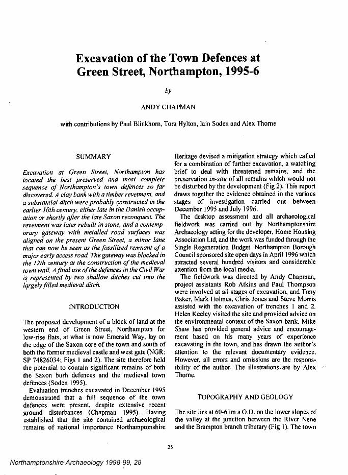
Plate I Trench I, looking south-west and showing: the medieval wall (centre), the Saxon bank partially obscured by later deposits(foreground) and the medieval and Civil War ditches (background), as first exposed in December 1995.
defences, the castle and the river were the dominanttopographical features of this area for severalcenturies and John Speed's map of 1610 provides anevocative image of the final decades of this medievallandscape prior to the extensive levelling of the townwalls following the restoration of the monarchy in1662 and the destruction of the old town in the fire of1675 (Fig 3).
Subsequent minor changes can be followedthrough the sequence of 19th century maps. At theend of that century the landscape at the western endof the town was totally transformed by the demol-ition of the castle and the lowering of the groundlevel by several metres to accommodate theconstruction of a new railway station and sidings.The adjacent stretch of the river was also canalisedand diverted westward at this time (Fig I).
The river channel bounding the southern side of
27
the Green Street site is a former mill leat flowing toMervyn's or (more recently) Cotton Mill (Z on Fig3), it can be equated with a channel depicted in mapsfrom 1610 onward.
The natural geology beneath the bank at theeastern end of trench I comprised an orange brownsandy clay with a slightly gritty texture, at a level of58.85m aOD. It appears to be a coarser mudstonelayer within the more typical blue-grey clays of theUpper Lias deposits which outcrop on the slopessurrounding the western end of the historic towncentre (Geological Survey of Great Britain, solid anddrift, Sheet 185). A similar clay was exposed at thebase of trench 2 but was more mottled and silty,probably as a result of later water action. TheNorthampton Sand with Ironstone, which coversmuch of the town centre area, was not present on thesite. Clean orange gravel and sand, hardened by iron
Northamptonshire Archaeology 1998-99, 28
ANDY CHAPMAN
panning, was encountered at the western end oftrench I at a level of 57.50m aOD. It appears to beundisturbed natural of first terrace river gravels.
PREVIOUS ARCHAEOLOGICALINVESTIGATIONS
The only previous archaeological evidence relatingto possible defensive works in this area of the towncomes from trenches excavated in 1987 at St. Peter'sWay (SP 74926030), to the east of trench 4 of thepresent excavations (Fig 2, 1987 trenches). This siteis unpublished, but in the less disturbed easterntrench there was the heavily robbed remains of astone wall, I .20m wide, on the inner edge of a ditchup to l3.40m wide (Shaw 1988).
These features were interpreted as the probable
28
remains of the medieval defences. However, they donot conform in structure or alignment with anyfeatures interpreted as defensive works in the GreenStreet excavations; the wall and ditch would lie insidewhat is now seen as the line of the defences. It istherefore unclear exactly what these features are, butthey seem most likely to represent activity within thedefensive circuit, perhaps buildings and quarry pits.
OBJECTIVES AND METHODOLOGY
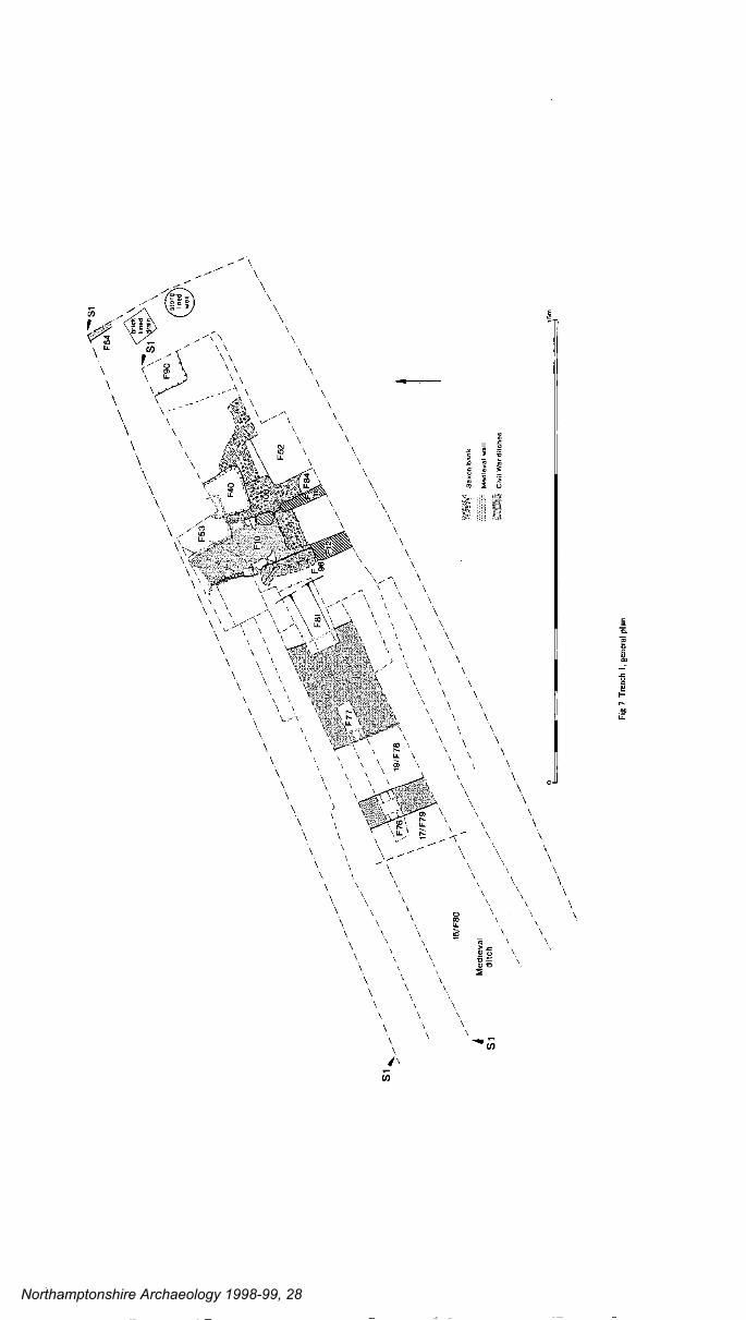
The first stage of evaluation comprised the machineexcavation of trench I to determine whether anyremains of the former defences were present on thesite. The trench was 43.Om long and 6.0-8.Om wide,descending in a series of c. I .Om steps (Figs 2 and 7;Plate I). Work commenced at the eastern end and the
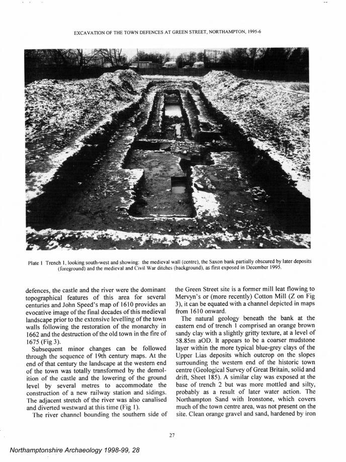
Plate 2 Trench I, Section across Saxon bank looking south-east (Fig. 10, S 13); with remnants of the late Saxon stone revetment(right), and the medieval town wall (left).
Northamptonshire Archaeology 1998-99, 28

Medieval
` di
tch
new
fla
ts
R. None
Trench 2 'y
Gre
en S
tree
t
Hanrahens
Restaurant
at^
Tre
nch
Car
par
k
wat
chin
g br
lat
Fig
2 G
reen
Str
eet,
tren
ch l
ocat
ion,
and
rec
onst
ntct
ion
of th
e lin
e of
the
defe
nces
. (T
he g
rid
of th
is m
ap i
s th
e N
atio
nal G
rid
take
n fr
om t
he O
rdna
nce
Surv
ey m
ap w
ith th
e pe
rmis
sion
of T
he C
ontr
olle
r of
Her
Maj
esty
's S
tatio
nary
Off
ice)
Northamptonshire Archaeology 1998-99, 28

EXCAVATION OF THE TOWN DEFENCES AT GREEN STREET, NORTHAMPTON, 1995-6
—',-,,' -,-v •— -,—-'-—-
:, -.- d'
— -r
- -
V - - .,$t *,. —.-—. — .. . -, ',' — *- d- - w
'',J —.
Plate 3 Trench I, section looking north-west (Fig. 10, S12) and showing: the late Saxon revetment slot (bottom left);the late Saxon road metalling; and the overlying medieval town wall, cut by a post-medieval tanning pit (right).
medieval town wall was soon located at a depth ofonlyO.SOm below modem ground level (Figs 4 and 5).Both the wall and an underlying clay bank wereexposed but not removed (Plates 2 and 3). Immed-iately to the west the modem layers dipped down-wards indicating the presence of underlying ditches,and the ditch fills were excavated to an agreedmaximum depth limit of 3.Qm below modem groundlevel, at which level the water table was encountered,
A trench perpendicular to the river, trench 2,located a further length of the clay bank and possibleremnants of a revetment wall (Figs 2 and 6), Only theupper fills at the inner edge of an adjacent ditch couldbe investigated. A third trench, trench 3, containedno early features; it lay at the northern end of a deeplycellared area and was also disturbed by a sewer pipe.
The mitigation strategy devised by Northampton-shire Heritage comprised three major elements of
29
archaeological investigation. The medieval wall andthe defensive bank in trench I was fully excavated inMarch 1996 as this area was threatened byfoundation trenches for the proposed new buildings(Plates 4 and 5). A further trench, 4, was excavatedin April 1996 to the south-east of trench 2 in the carpark of Hanrahan's restaurant, an area which had notpreviously been accessible for investigation. Theobjective was to locate the defensive bank in order toconfirm its alignment and to determine whether itwas threatened by proposed ground works for anaccess road to the new buildings (Figs 2 and 6, Plate6). The remainder of the development area and workfor the provision of parking bays along the northernside of Green Street was subject to a watching briefbetween May and July 1996. Particular emphasiswas given to the construction of the access road,where machine excavation using a toothless bucket
Northamptonshire Archaeology 1998-99, 28
ANDY CHAPMAN
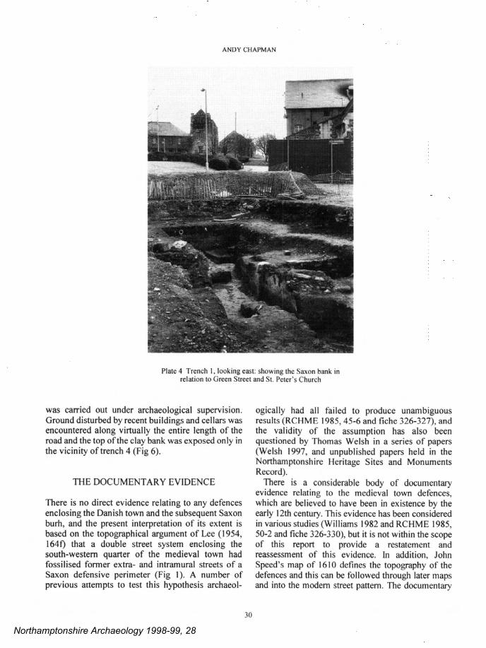
Plate 4 Trench I, looking east: showing the Saxon bank inrelation to Green Street and St. Peter's Church
was carried Out under archaeological supervision.Ground disturbed by recent buildings and cellars wasencountered along virtually the entire length of theroad and the top of the clay bank was exposed only inthe vicinity of trench 4 (Fig 6).
ThE DOCUMENTARY EVIDENCE
There is no direct evidence relating to any defencesenclosing the Danish town and the subsequent Saxonburh, and the present interpretation of its extent isbased on the topographical argument of Lee (1954,1640 that a double street system enclosing thesouth-western quarter of the medieval town hadfossilised former extra- and intramural streets of aSaxon defensive perimeter (Fig I). A number ofprevious attempts to test this hypothesis archaeol-
30
ogically had all failed to produce unambiguousresults (RCHME 1985, 45-6 and fiche 326-327), andthe validity of the assumption has also beenquestioned by Thomas Welsh in a series of papers(Welsh 1997, and unpublished papers held in theNorthamptonshire Heritage Sites and MonumentsRecord).
There is a considerable body of documentaiyevidence relating to the medieval town defences,which are believed to have been in existence by theearly 12th century. This evidence has been consideredin various studies (Williams 1982 and RCHME 1985,50-2 and fiche 326-330), but it is not within the scopeof this report to provide a restatement andreassessment of this evidence. In addition, JohnSpeed's map of 1610 defines the topography of thedefences and this can be followed through later mapsand into the modern street pattern. The documentary
Northamptonshire Archaeology 1998-99, 28

EXCAVATION OF THE TOWN DEFENCES AT GREEN STREET. NORTHAMPTON, 1995-6
-, I —.
'. .. .,.- -/ - 'I-
- -'Il I .-
.
- :L:-' _- :
. -.- - i&i
Plate 5 Trench I, looking north and showing: the medieval town wall (top centre, with the Saxon bank to the right and the ditches tothe left); disturbed by the post-medieval stone-lined pit (bottom centre).
evidence relating to the Civil War defences has beendiscussed more recently (Foard 1994).
Mike Shaw has drawn my attention to the followingspecific references to the Green Street area. A rental ofEdward I (PRO SC 12/13/28) from the end of the 13thcentury refers to the town wall (tenemento vastoWa/ten de Pedinton lukia murum yule usque aquam -
for the empty tenement of Walter of Pedinton next tothe town wall as far as the water). It is the first entryfor St Peter's parish and precedes entries mentioningTanner Street and Mervyn's Mill, which places thetenement somewhere around the Green Street area. Alater rental of 1504 (NRO Northampton BoroughRecords, Royal Charters 29) repeats the entry of theEdward I rental but includes a further mention of thewall and ditch in the area of Mervyn's Mill (unocurtilagio longo iuxta molendinum Mervyn iuxtamurum ville etfossam ibidem - for the long curtilage
31
next to Mervyn 's Mill by the town wall andditch there).Another early reference , from 1275, mentions of
the "Kings ditch" and a "common way" runningbetween the west gate and Mervyn's Mill (seeRCHME 1985, fiche 329).
This same area is described in some detail in anElizabethan terrier or survey of 1586 which is quotedby Cox (1898, 155) as follows (italics added foremphasis):-
"Landes in the Weste Quarter" include:-
1) "a piece of grounde sometime called the TowneDyke extendinge in Lengthe from the weste gatethrowghe the ground of Henry Walker to theRiver syde conteynthe in Lengthe Fowerscoreyardes and at the North end Syxe yardes And atSowthe End xvi yards and from the Crosse wall
Northamptonshire Archaeology 1998-99, 28

ANDY CHAPMAN
along the River Syde and xl yards in lengthe andFyfteyne yards in breadthe."
2) A house or tenement of nine bays, with a yard andgarden containing a great apple tree, seven otherapple trees, and a plum tree; also a piece of theTown Dy/ce with willows in it, seventy yards bynine yards; a back house of five bays; and a kilnhouse, with a dove house, and a small stable ofone bay, with a garden containing an apple tree,nine young ash trees, and other young apple trees;tenanted by Isabel Bradfield, rental 26s. gd•
3) A little house of two bays next to Bradfield'syard, once a parcel of the Town Dyke fourteenyards by ten; tenant John Ainsworth, rental gd•
4) "A piece of the Town Dyche From A Ayns-worthe 's litle house to Mervels Mylls with dyverswillows in it", tenant Henry Clarke, rental 5s• 8d•
This survey is quite specific in describing a townditch running between the west gate and the river andthen alongside the river as far east as Mervyn's orCotton Mill. Two of the accounts also provide a cleardescription of the state of the ditch. The references toa "piece of ground sometime called the town ditch"and to willows in the ditch indicate that it was not adeep open ditch but largely silted, and perhaps nomore than a slightly sunken and low lying area thatwas damp enough to favour the growth of willows,and perhaps therefore waterlogged in the wintermonths.
The most important of all the historic sources isJohn Speed's map of 1610 (Fig 3). It shows the towndefences in detail, but the area to the south of thecastle is shown unwalled between the West gate (N)and a point east of Mervyn's Mill (Z). However, in
Fig 3 John Speed's map of Northampton, 1610 (Northamptonshire Libraries)
32
Northamptonshire Archaeology 1998-99, 28

EXCAVATION OF THE TOWN DEFENCES AT GREEN STREET, NORTHAMPTON, 1995-6
the text accompanying the map Speed comments(1676, 55) " Upon the West part of this Town stand-eth a large Castle mounted upon a Hill whose agedcountenance do daily threaten the downfal of herwalls. To this upon the South the Towns wall adjoyn-eth and in a round circuit meeteth the river in thenorth extending in compass two thousand onehundred and twenty paces."
This appears to imply the presence of a town wallin the south-west quarter although the terrier of 1586makes no reference to a wall. Presumably Speed waseither assuming the former presence of a wall inassociation with the surviving, if overgrown, ditch,or there were still sufficient ruinous remnants of awall to denote its former presence.
THE TOWN DEFENCES AT GREEN STREET
The phased archaeological sequence is summarisedand discussed below. More detailed plans, sections,full descriptions of the excavated features, and thefinds reports are provided in subsequent sections.
THE ARCHAEOLOGICAL EVIDENCE
PREHISTORIC ACTIViTY
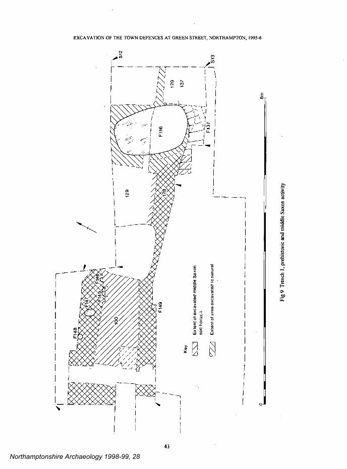
Evidence of Neolithic to early Bronze Age activitycomprises a scatter of worked flint, including a leafarrowhead, recovered from a soil horizon directlyoverlying the natural in trench I (Fig 5); a V-shapedditch may also be contemporary (Fig 9, F 137). Thisis consistent with the recovery of quantities ofworked flint and some prehistoric features at otherexcavations in this area of the town (RCHME 1985,fiche 322-323).
MIDDLE SAXON OCCUPATION, 800 -850 AD
A soil horizon overlying the prehistoric level andsealed by the defensive bank in trench I containedmiddle Saxon pottery associated with a few smallpostholes; a nearby deep pit may also be contemp-orary (Figs 5 and 9). This evidence for domesticoccupation extends the known limits of the middleSaxon town to the lower slopes immediately abovethe river. The recovery of Maxey-type ware but thelack of lpswich ware, as at other nearby sites, maysuggest that this activity dates to after c.800 AD.
33
THE SAXON DEFENCES, 900- IIOOAD
Two major episodes of early defensive works wereidentified in trench I (Figs 4 and 5); the evidencefrom trenches 2 and 4 is incomplete but it maysuggest that there was a slightly different construct-ional sequence alongside the river (Fig 6).
A date for the construction of the defences cannotbe precisely determined as only very small quantitiesof pottery were found associated with the constnict-ion of the clay bank, and no charcoal or othermaterial suitable for radiocarbon dating was recov-ered. The pottery comprises small and abradedsherds of Northampton Ware and some St. NeotsWare, and at its broadest this should be given a daterange of c. 900-975 AD.
It is tempting to associate the original ditch, bankand timber revetment with the documented presenceof the Danish army in Northampton in the early 10thcentury, but while the pottery dating is not incon-sistent with this interpretation it must also be acceptedthat the dating is so imprecise that an origin later in the10th century and, in particular, a date after the Saxonreconquest of the Danelaw in 917 AD, cannot be ex-cluded. The question of who constructed the originaldefences must therefore remain unresolved.
The original defences comprised a 6.Om wide claybank, probably utilising alluvial clays excavatedfrom the valley floor. It was no more than c. 650mmhigh in trench I, but in trench 2 it still stood to aheight of 900mm. How much has been lost from thetop of the bank is difficult to determine (Figs 10 andII, contexts 108-110; plate 5). In trench I the bankwas set immediately below the break of slope, sofrom the outside even a low bank and revetmentwould have created a visually impressive barrierwhen combined with the natural slope and the ditch,while from the inside there may have been no morethan a gentle slope. In trench 2, beside the river, thedefences were on slightly lower ground so the greatersurviving height may reflect the original arrangement.
A steep-sided, linear slot, with post-pits atintervals of 0.75m, ran along the outer face of thebank in trench I (Figs 10 and 12, context F97, andPlate 4). It would have held a timber revetmentwhich probably comprised substantial upright postssupporting horizontal planking. There is no evidencefor the use of any other substantial timbers inassociation with the bank. No similar slot was seen atthe front of the bank in trench 2 but the appropriatelevels were not fully investigated and it is possible
Northamptonshire Archaeology 1998-99, 28

wall
CivilWar ditch
ANDY CHAPMAN
Late Saxon I
extentrofbank
mm F1g4 Trench 1,thedevelopment of the defences
—
timber— revetment
LateSaxonditch
Late Saxon II
road— 1
000 000 0 oo Oo °•.0 00000 0.000
Urevetment
cen.
1Medieval & Civil War
medieval pits
r ——— ———
i°Z"O° Road
0
Bank Reinstated bank
34
0Northamptonshire Archaeology 1998-99, 28

tO x C
) >
-1 a z 0 2) -4 I 01 -I
0 tO
•1
01
C)
01
(n
-I
C)
01 z (1)
-4
01
-4 z 0 t
O
-4 I -4 0 '0
'0
A
Prehistoric and middle Saxon ground surfaces.
B
The late Saxon bank with slot for post and plank timber revetment.
C New revetment constructed in limestone and gateway inserted.
D
The 12th century ironstone wall of the medieval town defences.
E
The recutting of defensive ditches during the Civil War.
F
The 18th century, final levelling of the medieval town wall.
C
Industrial buildings conceal and disturb the remains of the defences
Fig 5
Tre
nch
1, i
som
etric
reco
nstr
uctio
n of
the
defe
nces
Northamptonshire Archaeology 1998-99, 28

ANDY CHAPMAN
that such a feature was either not seen or had beendamaged by later revetments.
The inner edge of a contemporary ditch lay only0.80m beyond the revetment in trench 1, it wasprobably c. 8.Om wide and more than 2.Om deep, butit was only partially investigated (Fig 10, contextF8 I). Alongside the river, in trench 2, there was asteeply inclined edge immediately beyond therevetment wall. This was the edge of either a ditch orof a water course that was a precursor to the presentmill race/river channel (Figs 6, 16 and 17).
The second major phase of defensive worksinvolved the provision of a stone revetment wall andthe insertion, or perhaps the widening or relocation,of a western gateway with a metalled road surface.There were few finds directly associated with thisphase. The gateway is likely to have been in usethrough the 11th century, but whether the intro-duction of the stone wall and gateway occurred onlyin the earlier 11th century or was perhaps a muchearlier feature, introduced in the 10th century, cannotbe determined. A stone wall was added to the Saxondefences at Hereford in the early to mid 10th century(Shoesmith 1982, 73-75, tables 9-10, fig 129), whilethe Anglo-Saxon Chroncile records the addition of astone wall to the defences at Towcester in 917 AD(Garmonsway 1972, 102), and the same may havebeen true at Northampton.
The absence of any direct evidence for timbersindicates that the timber revetment had beensystematically dismantled. The slot was backfilledand the ground surface had been raised with dumpedclay prior to the construction of a stone revetmentwall. This was built largely in flat-laid butunmortared limestone (Figs 4, 5, 10 and 13, contextF96). Only the inner part abutting the clay bank hadsurvived, but scattered pieces of limestone assoc-iated with patches of possible lime mortar maysuggest that its outer face and/or its upper levels hadbeen mortared. There may have been a similarrevetment wall in trench 2, suggesting that there wasa wide-spread refurbishment in stone, rather than alocalised rebuilding associated with the newgateway, but the only remains were a thin spread ofstone at the front of the bank.
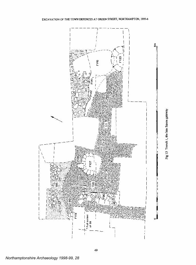
In trench I the bank was cut away to accommodatea gateway. A large post-pit in the terminal of thebank and a possible post-pit further to the westsuggest that there was a timber gatehouse, but as onlythe southern side was recovered the width of thegateway is unknown (Fig 13, contexts Fl07 and
36
Fl 19). Two layers of heavily worn road metallinghad survived; the lower surface comprised smallpieces of limestone and cobbles (Fig 13, context68/117), and the upper surface was of larger piecesof ironstone and limestone (Fig 14, context 92/104).The earlier road ran directly eastward, on the line ofthe present Green Street, and so appears to define theorigin of this street as the approach to an 11th centurytown gate. The later road extended further south-ward, and may have continued around the back of thebank, although the trench did not extend far enoughsouth to be certain of this. If so, it might relate to theintroduction an intra-mural road.
The discovery of a west gate through the earlytown defences raises fundamental questions aboutthe provision of access to and from the late Saxontown as a whole, and the arrangement of the earlystreet pattern. Does it represent merely an additional,and perhaps subsidiary, west gate? Or, does it denotethe location of the river crossing and the primarywestern access route within the late Saxon town?
Unfortunately, these questions cannot be resolvedfrom the available evidence. Taken at face value itappears that this gateway was not part of the originaldefences, which might imply that it was not the maingateway. However, as only the southern side waslocated it is possible that it represents a widening or aminor relocation of an earlier gateway. In thisinstance it can be suggested that Green Street mayhave been the access to the main west gate ofNorthampton throughout the late Saxon period, witha ford or timber bridge forming the original rivercrossing. It this is true then there would have been amajor reorganisation of at least the primary east-westaccess routes in the 12th century at the creation of themedieval defensive circuit.
THE MEDIEVAL DEFENCES, 1100- 1200 AD.
In the third major phase of defensive works, thegateway was taken Out of use when a substantial newwall was constructed on top of and at the front of theexisting bank. The wall ran right across the gatewayand the bank was reinstated behind it (Figs 4, 5 and15, context FlO). The new town wall was l.85mwide and was built largely in ironstone, with goodcourses of roughly squared facing stones and arubble core bonded with clay (Figs 10 and 12). Noevidence was recovered for a wall on top of the bankalongside the river, but it may be that a second stonespread in trench 2 had formed the base of a new
Northamptonshire Archaeology 1998-99, 28
0
/ N
/ N
C)
CD
CD
0•
0 C
0.
DC
'C
DC
/ / N
N N
N
/ N
/ /')
1 0 CD
C,
CD
—1
0- a C
o a CD
CC
C
C
/
-4
CD
'N 'N
. =
'N
r'j
V
/ / N
.7 \
7 'N
'N N
/N 1 /
N
/
V /
/ N
CD
C
DC
—
N
/ / N
N N
ii o C
DC
=
C)
CD
N
'N
\ /
N
DC
CC
=
CD
CD
DC
CD
D
C
N N
N 3
C
D
--a
CC
C
3
Northamptonshire Archaeology 1998-99, 28

ANDY CHAPMAN
revetment wall at the front of the bank. At less than2.Om wide this length of the town wall did not form aformidable barrier but, as discussed below, this is notlikely to be typical of the remainder of the medievaldefensive circuit.
The late Saxon ditch was replaced by a ditch up to25m wide, but as only the upper fills wereinvestigated it is impossible to tell whether thisrepresents a single massive ditch or was a result ofrecutting (Figs 7 and 8). To the south this ditchpresumably opened into the river channel flankingthe southern defences (Fig 2).
Dating evidence is again sparse, but the new wallwas probably constructed during the first half of the12th century, and is therefore to be identified as partof the medieval expansion of Northampton, when theSaxon burh defences were replaced by the muchenlarged circuit of the medieval town wall; the castlewas also under construction at this time. This workmay also have included the provision of both a newwestern river crossing and a new west gate, relocatednorthward to lie directly below the castle, where thewest bridge has remained to this day. With theblocking of the late Saxon gateway at the end ofGreen Street the street itself would have beendowngraded to the status of a minor back roadleading nowhere, and so it was to remain until thepresent today.
MEDIEVAL AND POST-MEDIE VAL ACT! VITY, 1250- I600AD
By the middle of the 13th century, and continuingthrough the 14th century, rubbish pits were cut intothe bank immediately inside the town wall (Figs 4and 15, contexts F40 and F90). At the same time itwould appear that the ditch running between theWest Gate and the river was not being maintained, sothat by the later 15th century it had largely silted anda stable soil horizon had become established. Therewould still have been a marked scarp at the front ofthe bank and the clayey silts in the top of the ditchsuggest that it was a boggy hollow, and thedocumentary evidence has told us that there werewillows growing there.
Subsequently, perhaps in the 16th century, ditchescut at both the outer and inner margins of themedieval ditch may have been property boundaries,or perhaps merely drainage ditches, but they wereevidently located in respect to the former defences.
The state of the medieval town wall between the14th and 16th centuries could not be determined
38
from the archaeological evidence in trench I, whereit lay directly beneath recent deposits. However, intrench 2 the stone spreads interpreted as the truncatedbases of revetment walls were sealed by a clay layerwhich may have been deposited at around the end ofthe 15th century or soon after. This layer may derivein part from bank material collapsed or raked downfollowing the demolition of the revetment wall. Thesurvey of 1586 makes no reference toa town walland this would appear to suggest that it was eitherfully levelled, as in trench 2, or at least largelyruinous, as may be the case in trench I.
John Speed's map of 1610 shows buildings,probably cottages, flanking the western end and thesouthern side of Green Street (Fig 3). The rear wallof a building and a stone-lined well recovered at theeastern end of trench I were not dated or investigatedin any detail, but they may relate to either thesecottages or successors to them (Figs 7 and 8, contextF54). They indicate that a first stage of domesticencroachment onto the defences comprised cottagesset immediately inside the bank but probably withyards extending across the bank.
POST MEDIE VAL TANNERIES, 1450 AD onward
Circular clay-lined pits were cut into the top of thebank in and around trench 4. They clearly denote thepresence of a tannery here during the 16th century,perhaps spanning the period 1450-1650 (Figs 6, 16and 17, contexts F410 and F411). This extends theevidence from the nearby trenches excavated in1987, where there was six circular tanning pits of15th century date (Fig 2 and Shaw 1996, 113).
This area would have been broadly contemporarywith, and probably similar in arrangement to, theextensively excavated tannery complex lOOm to thenorth-east at The Green, adjacent to Tanner Street(Shaw 1996). This was dated 1470-1700 and com-prised clusters of circular and rectangular tanningpits and remnants of the wall foundations of theassociated workshops.
The documentary evidence for the presence oftanneries within Northampton has also been dis-cussed in detail by Shaw (1996, 108-114). The nameTanner Street is mentioned in a town rental at the endof the 13th century, demonstrating the early presenceof tanneries in the south-western quarter of the town.The evidence from Green Street therefore makes asmall addition to our knowledge of early tannerylocations.
Northamptonshire Archaeology 1998-99, 28

Si
W
E
1F54 60m
60
3/
30m
Fig
8
Tre
nch
I, se
ctio
n ac
ross
the
def
ence
s
Northamptonshire Archaeology 1998-99, 28
S1
Si
Med
ieva
l di
tch
i
0
'; u+
x S
axon
oak
civi
l W
ardi
tcha
s
Si
Fig
7
Tre
nch
I, ge
nera
l pl
an
Northamptonshire Archaeology 1998-99, 28

EXCAVATION OF THE TOWN DEFENCES AT GREEN STREET, NORTHAMPTON, 1995-6
THE CIVIL WAR DEFENCES, 1640s
Two ditches lay at the foot of the scarp below theformer medieval wall in trench I (Figs 7 and 8,contexts F76 and F77). The V-shaped outer ditchwas I .Om deep and there was a fall of I .8m from thesurviving top of the bank to the base of the broad,flat-bottomed inner ditch. The cutting of theseditches may be interpreted as part of therefurbishment of the town defences between 1643and 1646 when Northampton was a majorparliamentarian garrison town during the Civil War,although the only dating evidence is an early claytobacco-pipe bowl dated to 1610-1640. The soilsfrom these ditches may have been used to supple-ment the existing bank, but no evidence for this hadsurvived.
There is considerable documentary evidencerelating to the Civil War defences, but no specificreferences to the refurbishment of the defences in thesouth quarter of the town, and it was concluded byFoard (1994,42) that this area, which had the river asa natural barrier, was given a low priority. This mayexplain the relatively insubstantial nature of theseworks.
THE LEVELLING OF THE DEFENCES, /650 - 1750 AD.
The lower fills of the Civil War ditches were stickyblack, waterlogged silts, and the upper fills weresealed by a layer containing scattered fragments andblocks of ironstone most probably derived froiji themedieval town wall (Fig 10, Sl2 context 37). Thisindicates that there was a deliberate levelling andclearance of the site in which remnants of the townwall were thrown down the pronounced scarpbetween the bank and the infilled ditches. It isuncertain whether this denotes that parts of the wallhad still been standing or whether they had merelybeen re-exposed and disturbed during this clearance.The date of this event has not been established but itmust have been either late in the 17th or early in the18th century.
The soil horizon above this contained substantialquantities of pottery and clay tobacco-pipes dating tothe middle of the 18th century, c. 1725-1775 (Fig 10,Sl2 context 35). It indicates an intensification inlocal domestic activity, in this case rubbish disposal,with a collection of tankards perhaps denoting thepresence of a nearby ale house.
39
RECENT BIJ1LDINGS, 1750 ONWARDS
From the mid-I 8th century onward much of the areabelow the west gate and alongside the river had beenoccupied by industrial buildings, although partsremained open ground until the late 19th century.The walls of these buildings had generally beenfounded above the level of the former defences, butthere had much disturbance from the cutting of pits,and more recently by buildings with extensivecellars. In trench I these included late 18th century,clay-lined tanning pits and tanning related animalbone deposits (Figs 7 and 10, contexts F52, F53 andFl 14); and the site was still a tannery at the end ofthe 19th century, as depicted on the 1st editionOrdnance Survey map of 1885.
THE FOSSIL ISA TION OF THE DEFENSiVE CiRCUIT
The location of the defences by excavation makes itpossible to examine the sequence of historic maps toidentifq property boundaries, and other featureswhich were aligned on the defences and have therebyfossilised its former presence. Building develop-ments over the past two centuries have gone a longway towards removing these features but someindicators have survived in the modern topography.To the north-west the alignment of the short northernarm of Green Street and the adjacent United SocialClub can be seen to respect the alignment of thedefences, while the rear of this building is situated atthe edge of the former scarp between the bank andthe ditch (Fig 2).
The School for the Deaf and the former MaltHouse, now Hanrahan's Restaurant, are both alignedon Green Street, but the property boundary to the rearof the School for the Deaf is aligned with theriverside defences. The area at the bottom of the carpark for Hanrahan's restaurant, now occupied by theaccess road to the new flats, was open ground untilthe end of the 19th century, comprising upper andlower lawns (see Ordnance Survey, 1st edition, 1885,sheets XLV 9.7 and 9.12). The buried remnant of aboundary wall which had retained this upper lawnwas seen in and around trench 4 (Fig 6), where it wasshown to be constructed at the front of the formerdefensive bank. This wall was later partially levelledwhen a small, brick cottage was built over the formerditch, with flagstone steps leading from the lowerlevel onto the higher ground over the former bank.
Northamptonshire Archaeology 1998-99, 28

ANDY CHAPMAN
With the demolition of this cottage and the creationof the car park the physical boundary was lost, butthe junction between the bank and the ditch was stillmarked by the steeply sloping surface of the car parkat the time of excavation.
TI-FE SIGNIFICANCE OF THE EXCAVATIONS
The recovery of a complete sequence of the towndefences is an important event in the archaeology ofNorthampton, perhaps the most important since theexcavation of the nearby site of the middle SaxonPalaces to the east of St.Peter's church (Williams eta! 1985). Many of the implications that arise fromthis work have already been considered, and themajor aspects of its contribution to the understandingof the development of the town as a whole are sum-marised below.
For the first time excavation has providedunequivocal details of the structural form of severalphases of the town defences, including the originallate Saxon defences, an early gateway, the medievaltown wall, and the Civil War defensive ditches.However, it must be noted that while the form of thelate Saxon defences at Green Street may be typical ofthe circuit as a whole, the medieval defences aremost probably completely atypical. The length oftown wall at Green Street flanks the south-westerncorner of the town in an area that was then welldefended by the natural barrier of the multiple riverchannels. The wall was therefore only the final lineof defence, and was perhaps provided more for thesake of completeness and visual appearance than forany real need for an effective physical barrier. Thesituation on the higher ground around the eastern andnorthern sides of the town, which have no naturaldefences, is completely different. These areas wouldclearly have required a much more substantial wall,such as the embattled wall wide enough for sixpeople to walk abreast on as recorded in the late 13thcentury (Brown 1915-16, 88).
The location of a probable early town gate and itsevident relationship to the location and alignment ofthe present Green Street has important implicationsfor the understanding of the development of thestreet pattern within the late Saxon and medievaltowns, as has already been mentioned. Attention hasrecently been drawn to several streets within theconfines of the late Saxon town which depart from aclosely rectilinear plan, including Green Street(Foard 1996, Ill), and archaeological evidence may
40
now be providing the explanation for at least some ofthese variations.
The evidence at Green Street has suggested thatthere was a relocation of the west gate at the estab-lishment of the new and much enlarged medievaldefensive circuit in the 12th century, and this eventmay have been the catalyst for a widespreadrealignment of the street pattern. Recent excavationhas indicated that Woolmonger Street, anothermisaligned street, had appeared at about this time (ISoden pers com).
The interpretation of the development of the St.Peter's Street area may also need reconsideration. Theexcavations have indicated that St.Peter's Street wasof post-Conquest origin and therefore may also date tothe 12th century reorganisation (Williams 1979 andWilliams et al 1985). The presence of a gatewayimmediately to the west of the St. Peter's Churchcomplex in the 10th and 11th centuries is therefore ofcrucial relevance to the consideration of access to thishigh status site, even though its status had apparentlydeclined with the stone "palace" having been replacedby fairly 'ordinary' timber buildings..
Finally, the location of the south-western corner ofthe defences provides a more reliable base for deter-mining future management policy of this archaeo-logical resource, and it may directly assist in thefuture location and identification of further lengthsof both the Saxon and medieval defensive circuits.
THE SURVIVAL OF THE ARCHAEOLOGICAL DEPOSITS
Archaeological deposits related to the former towndefences which could not be preserved within theagreed mitigation strategy were fully excavated.Other deposits were seen but were not excavated andso are known to survive beneath the new flats atEmerald Way, the access road provided by the newlength of Green Street, or in adjacent areas; and it ispossible to infer the partial survival of other elementsof the defences within areas that were not directlyobserved.
As the site therefore still contains a valuablearchaeological resource, with the potential to refineand expand the conclusions of this report, thefollowing notes are provided for future referenceconcerning the management of this resource.
TI-FE DEFENSIVE BANK
It is likely that the bank still partially survives
Northamptonshire Archaeology 1998-99, 28

EXCAVATION OF THE TOWN DEFENCES AT GREEN STREET, NORTHAMPTON, 1995-6
immediately to the north-west and south-east oftrench 1, although from trench 3 southward itappears to have been totally removed by recentcellars (Fig 2).
The length of bank parallel to the river appears tobe particularly well preserved; it stood up to I .Omhigh in trench 2 and was seen to survive across anextensive area under the new access road in andaround trench 4. South of the School for the Deafthe bank lay immediately below the pre-devel-opment ground surface and it has been preserved byraising this level with imported soil, but this stillsleaves it only shallowly covered and thereforevulnerable to accidental disturbance by any futuregroundwork.
THE ARCHAEOLOGICAL EVIDENCE
In this section the archaeological evidence isdescribed and illustrated in detail (Figs 7-17). Theevidence from trench 1 is considered first followedby trenches 2 and 4. Eight major phases of activityhave been defined and dated as follows:
Phase I: Prehistoric soil horizonPhase 2: Middle Saxon activity
Phase 3: The late Saxon defencesc. 800-850 AD
c. 900-975 ADPhase 4: Refurbishment of the defences
c. 900-1100 ADPhase 5: The medieval town wall
THE MEDIEVAL TOWN WALL
The survival of the medieval town wall is less easilydefined. In trench I it was disturbed by numerouspost-medieval features and similar disturbances mustoccur in the adjacent areas. However, it is likely thatit at least partially survives immediately to thenorth-west of trench I, where it is founded moredeeply within the earlier gateway. This area istherefore of prime importance as it still containsmuch potential to enhance our understanding of thedevelopment of the gateway and thus the devel-opment of the street pattern within the late Saxon andmedieval towns.
It is likely that the junction between the westernand the riverside defences has been destroyed bycellars, and there is therefore probably no possibilityof directly determining the relationship between thetimber revetment and stone walls in trench 1, and theremnants of probable revetment walls beside theriver in trench 2.
THE MEDIEVAL DITCH
Phase 6: Late Medieval activity
Phase 7: The Civil War defences
c. 1100-1200 AD
c. 1250-1600 AD
c. 1640-1750Phase 8: Post-medieval pits and building
post 1750
The majority of the published sections arecomposites of the individual faces of the steppedsides of the main trenches. Where possible thesecomposite sections were compiled on-site, so thatdetails and possible inconsistencies could beresolved at the time. In order to provide a cleardepiction of the stratigraphy, the breaks between thesteps have been omitted except where they denotediscontinuities in the layer boundaries. In addition,some sections have been reversed to maintaincontinuity of viewing direction (Fig 10, Sl3 reversedand Fig 17, S8R and Si 9R).
PHASE I: THE PREHISTORIC SOIL HORIZON
The area between the west gate and the river has beenraised by dumping over the past two centuries, sothat the Civil War and medieval ditches now lie wellbelow the modern building levels; they are thereforewell preserved and are likely to remain so. The upperfills of the ditch or river channel adjacent to thepresent river have been extensively disturbed bybuildings and cellars but the medieval levels areprobably well preserved and waterlogged.
41
Layers and features preserved beneath the defensive bank wereinvestigated in trench I A total area of 6m2 was exposed and4m2 was excavated to the natural. In trench 2 a small area of 3m2of pre-bank soil was exposed.
In trench I the natural was overlain by a uniform soil horizonof light brown to light yellow-brown gritty silty sand, up to220mm thick (69/129, Figs 9 and 10). To the east part of aV-shaped ditch, 0.50m deep and at least l.Om wide, lay withinthe excavation area, F 137. There was some iron panning of thenatural at the base of the ditch and the fill comprised a stone-free,whitish-brown to light yellow-brown compact gritty sand. Itsrelationship to the early soil horizon could not be established, butthe fill was similar in colour and texture and was similarly sealedby the middle Saxon soil horizon, 100/128.
Northamptonshire Archaeology 1998-99, 28

ANDY CHAPMAN
No finds were recovered from the ditch but II struck flints,including a fragment of a probable leaf arrowhead, came fromthe early soil horizon and a further three from the fill of the lateSaxon timber slot, F97.
PHASE 2: MIDDLE SAXON ACTIVITY
In trench I the upper pre-bank soil horizon was exposed and fullyexcavated (100/128, Figs 9 and 10). In a small area to the westthere were patchy deposits of orange-brown to brown gritty sandwith small ironstone chips and irregular pieces of pale yellow-brown sandstone, 126 (Fig l2a); it is typical of material derivedfrom the Northampton Sand and Ironstone deposits. The generallayer comprised a light brown to light grey-brown sandy loammoderately flecked with comminuted charcoal, it was up to200mm thick and contained occasional chips or small pieces ofironstone and some large sherds of middle Saxon Maxey Ware,100/ 128.
Five small postholes and stakeholes cut into this level,although some were only recognised after its removal. Thepostholes were up to 300mm in diameter by up to 230mm deepand two stakeholes were 130mm in diameter. They were all filledwith light grey clayey silt (Fig 9, F145-F149).
An oval pit, Fl 16, l.95m long by l.20m wide, lay beyond theeastern extent of the preserved middle Saxon soils; it was sealedby layers of road metalling and appears to pre-date the defences,although there was no direct relationship to the clay bank. Thesides undercut by at least 150mm, and lower down they werenear vertical to the limit of excavation at l.Om, where the watertable was encountered; probing suggested the presence of at leasta further 0.50m of fills.
The bulk of the excavated fill, 140, was a light to mediumbrown sandy silt with light blue-grey mottles and streaks. Anumber of near vertical sided, roughly circular "pipes" containeda much looser fill of mixed and mottled light blue-grey silt andmedium brown sandy silt, 139. The upper 250mm of the fill wasa loose and soft heavily mottled yellow, light brown, lightblue-grey to white sandy silt with sparse charcoal flecks, 138. Nopottery, other finds or animal bone was recovered. The functionof the pit and the origin of its fills is unknown; the characteristicyellow-green staining associated with cess deposits was absentbut the blue-grey coloration and the pungent smell would seemmost likely to derive from some form of organic content.
PHASE 3: THE LATE SAXON DEFENCES
The date of origin for the defences is based on four small sherdsof Northampton Ware and St. Neots Ware recovered from thebase of the clay bank in trench I, and six small sherds of North-ampton Ware from directly beneath the bank in trench 2.
THE TOPOGRAPHY OF THE DEFENCES
Beneath the rear of the bank the ground surface was nearly level,at 60.lOm'aOD (Fig 10). It sloped gently downward to thesouth-west, falling by 100mm in a distance of 3.Om, and mayhave fallen slightly more steeply immediately beyond therevetment slot, F97. The underlying ground therefore has a totalfall of 250-450mm in a distance of4.5m. In trench 2 the base ofthe bank was at 59.OOm aOD, indicating a I .Om fall in the groundlevel between trenches I and 2.
42
In trench I natural gravel was encountered 30m to thesouth-west of the bank, beyond the medieval ditches, at a level of57.50m aOD, up to l.35m lower than the natural beneath thebank (Fig 8). This indicates that the bank was constructed ongently sloping ground at the margin of a gradually steepeningnatural slope. The builders therefore took maximum advantageof the natural topography to enhance the height differentialbetween the bank and the ditch.
THE TIMBER REVETMENT
A 2.3m length of linear slot was excavated in trench I, F97 (Figs10 and II). It was 380-480mm deep, cutting through thepre-bank soil horizons and 50-100mm into the natural. The inneredge was steeply inclined and could be followed upward againstthe face of the bank for 250mm. The outer edge survived to aheight of only 150-300mm as a result of a later lowering of theground level. It was more gently inclined, ate 45 degrees, but it isuncertain whether this is original, perhaps serving to aid theinsertion of the timbers, or whether it was a result of thedismantling of the revetment, when digging out along the front ofthe slot would have aided the removal of the timbers.
The flat bottom of the slot was 220mm wide. A circularhollow, 40mm deep, 131, appears to be a timber impression;above this a loose and soft fill of grey sandy silt defined aprobable pipe, 100-120mm in diameter, within the more compactslot fills. An oval hollow to the north, 50-80mm deep, was onlyrecognised in the base of the trench.
Three post-pits were set along the inner edge of the slot at0.70m intervals centre-to-centre, F98, F132, and F133. Theywere only identified following the excavation of the bulk of theslot fill; the northem and cçntral pits were excavated from the topof the pre-bank soil horizon, at 440mm and 500mm deeprespectively. The presence, of the third pit, F 133, had beensuspected at this level, but it was only clearly defined at thenatural, a depth of 150mm. They had circular to oval bases, c150mm in diameter and c 100mm deeper than the slot (Fig 12, a).In the base of the northern post-pit there was a stakehole, 100mmin diameter by 100mm deep.
EARLY FEATURES/N TRENCH 2
The earliest features in trench 2 were only seen in a small areathat lay immediately above the watertable. A close parallel to thetimber slot in trench I was not found, but it is possible that itcould have been concealed beneath later features at the front ofthe bank. A number of features pre-dated the bank and shared thesame alignment, they therefore appear to relate to itsconstruction in some uncertain fashion.
The natural clay, 221 (Fig 17), merged into a more mixed layerof clean sandy clay and light brown to light grey-brown, charcoalflecked clays, 202, containing a few small sherds of late Saxonpottery. A length of wood, 216, at least 500mm long by50-I 10mm wide, laytowards the bottom of the layer (Figs 16 and17), it had been compressed to a thickness of less than 1mm andcontained no material substance that could be collected foranalysis. It was aligned with the bank and so may indicate thatthe accumulation of this layer was related to the construction ofthe defences, perhaps a layer of trampling and disturbance of theexisting ground surface.
The soil beneath the front of the bank, 219, was slightly greyer
Northamptonshire Archaeology 1998-99, 28
F14
8
/
a
129
F14
9
Key
512
—
4
Ext
ent
of e
xcav
ated
mid
dle
Sax
on
soil
horiz
ci
Ext
ent o
f ar
ea e
xcav
ated
to n
atur
al
j 0
129
137
01 x n C -I 0 T
1 -1
10 -t 0 a IT
t 01
IT
t z 0 01
In
-1 0 tO z In
-I
1'l
ITt -I z -I
-t 0 z %
0 '0
'a
1 —
—
I F
137
1S13
Fig
9 T
renc
h 1,
pre
hist
oric
and
mid
dle
Sax
on a
ctiv
ity
Sm
Northamptonshire Archaeology 1998-99, 28

Fig
10
Tre
nch
I, se
ctio
ns a
cros
s th
e de
fens
ive
bank
z
9.
F97
a a
Ego
rug
OrO
jecl
ed
—w
veoe
d
0
F13
7
1Cm
Northamptonshire Archaeology 1998-99, 28
EXCAVATION OF THE TOWN DEFENCES AT GREEN STREET, NORTHAMPTON, 19954
in colour and contained more charcoal flecking; it apparentlyfilled an ill-defined, shallowly sloping cut, F220, 300mm deep. Itwas aligned with the front of the bank and its outer edge had beenremoved by later activily. It therefore appears to be a linear cutunder the front of the bank, but was too shallow to havesupported any substantial timbers.
The disturbed soil horizon and the shallow cut were sealed bya compact spread, 203, of irregular pieces of ironstone, typically100-300mm long and lying flat but including some steeplypitched fragments and others inclining gently into 219. This toowas aligned with the bank and may have been laid immediatelyprior to its construction.
Stone layers 204 and 2t7 were only partially removed, so onlya small area of the underlying deposits was seen and evidence ofearlier activity could have been missed.
THE BANK
The bank was 6.Om wide in trench I and had a maximum heightof 650mm towards its outer face (Fig 10, S13); in trench 2 thebank stood 900mm high (Fig 17,S9 and S8). In trench 4 the topof the bank was uncovered but as it could not be investigated toany significant depth its height was not established (Fig 17, Sl8and S 19). In the watching brief the top of the bank was seen overan extensive area around trench 4 (Fig 6). It had a maximumwidth of 4.3m with a northern edge running near parallel to apost-medieval revetment wall, which therefore appears toclosely respect the alignment of the former bank.
In all three trenches the bank comprised a homogeneous cleanlight yellow-brown tenacious clay virtually devoid of stones; itcontained only the very occasional chip of ironstone no morethan 50mm in length. At the front of the bank in trench I it waspossible to discern three levels of make-up, with the upper andlower clays separated by a layer or lens of mixed clays withyellow and orange-brown sand (Fig 10, layer 109). Over theinner half of the bank, which stood 250-400mm high, only asingle layer could be identified, Ill. It is possible, however, thatadditional material was later added against the rear of the bank,where there was a darker deposit of sticky brown clayey loamwith some charcoal flecking. 127.
tn trench 2 there were two layers of yellow-brown tenaciousclays; the upper 600mm, 222, was more friable than the lower300mm, 208, with the change occurring at a sharp horizontalbreak (Fig 17). In trench 4 only the uppermost 300mm of thesurviving bank was excavated but it showed a similar sequenceto trench 2; comprising an upper clay layer, 412, 240mm thick,which was slightly more sandy and friable than the tenaciousclay beneath,4l3 (Fig 17).
The origin of the clay used to form the bank has not beenestablished. It is not the same as either the underlying naturalclay or the blue-grey has clays that outcrop on the slopes aroundmuch of the town. This suggests that most of the material wasprobably nol derived from the length of ditch running down tothe river. The most likely local source is the alluvial clays andsilts which cover the gravel across much of the valley floor.
THEDITCH
The inner edge of the early ditch in trench I was excavated to adepth of l.Om, FRI (Fig 10); the original width and depth areunknown but probing located the lower profile of the upper fills,
45
43, and this suggests that it was probably at least 8.Om wide andin excess of 2.Om deep (Fig 8).
The fill against the inner edge was a light grey sticky claycontaining small pieces of ironstone and limestone, 44. The mainfill was only seen between the Civil War ditches, it was awaterlogged, grey to grey-black silty clay, with heavy charcoalflecking and containing small pieces of wood, 43. The fill againstthe upper part of the inner edge was a light grey-brown silty claycontaining pieces of ironstone and limestone up to 250mm long,144. There was a suggestion in section that it may have filled ashallow recut.
The relationship between the ditch and the bank is uncertain.The fill at the inner edge, 144, was overlain by the outer part of aclay layer that post-dated the backfilling of the revetinent slot,99. This might suggest that the ditch was at least partially filledby the introduction of the stone revetment. However, this effectmay have been created by later slippage of the clay layer.
PHASE 4: REFURBISHMENT OF THE LATE SAXONDEFENCES
There is very little dating evidence for the various aspects of therefurbishment of the bank and the introduction and use of thegateway in trench 1. Only the end of the sequence can be dated; alayer sealing the road metalling, 87/88, contained 11th centurypottery, while a layer of clay directly beneath the medieval townwall, 67, is dated to the first halfofthe 12th century (1100-1150).This suggests that the gateway was in use through the 11thcentury and had been blocked at some point during the first halfof the 12th century before the construction of the medieval townwall. The levelling of the timber revetment and the creation of thestone wall and the gateway are therefore likely to have occurred bythe earlier 11th century at the latest, and with the possibility thatthey may actually date to some point in the tOth century.
THE LEVELLING OF THE TIMBER REVETMENT
The revetmenl slot in trench I was filled with mixed yellow tolight brown sticky clays heavily mottled with orange-brown sandand some light grey-brown charcoal flecked sandy silts, 101 (FigtO). The lack of evidence for the former presence of timbersindicates that it comprised a backfill following the systematicdismantling of the revetment. The material probably comprises amixture of the original backfill and material disturbed from thebank and the pre-bank soil horizons during the removal of thetimbers. The absence of stones suggests that there had probablybeen little use of any stone packing.
A number of events can be related to the dismantling of thetimber revetment. The lowering of the external ground surface to200mm below the base of the bank, and the cutting away of theouter edge of the slot may both have occurred at this time,probably to provide easier access to the timbers. The gentlyinclined inner sides of two post-pits, F132 and F133, and theundercutting of the lower side in post-pit Fl32 (Fig 12a), mighthave resulted from the posts being pulled over during theirremoval.
Over both the slot and the area in front of it, the ground levelwas rebuilt with a dumped layer of mottled yellow-brown stickyclay, 99, 500mm thick, similar to the original bank material (Fig10). It contained some pieces of limestone and ironstone,100-250mm in length. The larger pieces were most often found
Northamptonshire Archaeology 1998-99, 28

Fig
ii T
renc
h I,
the
late
Sax
on b
ank
and
reve
tmen
t sl
ot
L B
ank
rem
oved
-i
F98
1
100
I io
o
-I
I
/ B
ank
rem
oved
—
a F
81
—.
j?E
xten
t 1.
-otb
ank
'—
z a n > z
0
F12
3 --
-1
-U
Sm
Northamptonshire Archaeology 1998-99, 28

Fig 12 Trench I, sections: a) revetment slot and post-pit. b) & c) the medieval wall
at the base of the layer and pitched against the sloping surface ofthe slot backfill, 101, where they may have been deliberatelyplaced to provide a more solid base over the backfilled slot.
This clay extended 1.Om in front of the bank, and continuedbeyond this for a further 0.75m as a more mixed clay with somepieces of limestone embedded in the surface. The outer partmight derive from later slumping and erosion of the outer face ofboth the clay layer and the revetment wall F96. This distinction is
47
of importance as only the outer part post-dated the fill, 144,against the inner edge of the original ditch, F8 I (Fig 10).
THE STONE REVETMENT
The stone revetment, F96, stood on the dumped clay, 99, andagainst a vertical face cut into the existing bank (Fig 10, SI 2 and
LI
69
F97Natural
EXCAVATION OF THE TOWN DEFENCES AT GREEN STREET, NORTHAMPTON, 1995-6
a) Section 17
5900 mAODm -r
b) Section ii
5950 mAOD-C
Limestone
59-50 mAOD-C
c) Section 7
-r
0 im
Northamptonshire Archaeology 1998-99, 28

ANDY CHAPMAN
Fig 13). A total length of I .8m of the wall survived, standing to amaximum height of 400mm and comprising five rough, un-mortared courses of flat laid pieces of limestone and sandstone,with the larger slabs of limestone up to 400mm in length. Thewall was in excess of 0.60m wide, but the outer face had beenentirely lost to later disturbances. The wall stones were loose,with frequent voids between the stones, but this was at leastpartially due to outward slumping of the disturbed wall remnant.A later scatter of clay and limestone pieces against the truncatedwall and on the surfaces beyond, 58, appear to have come fromthe wall (Fig 10). The scatter included traces of possible decayedlime mortar and this may suggest that either the outer face or theupper courses of the wall had been mortared.
To the north only the bottom wall course partially survived,however, there was no indication of an eastward return and itappears that there had been only a square butt-end.
THE GATEWAY
A large sub-square pit, F 107, was cut into the sloping terminal ofthe bank. It was 0.96m square and 400mm deep, with steep tonear vertical sides and a flat base; a short slot projected from thenorthern side, 350mm long by 260mm wide and 330mm deep(Figs 10 and 13). The fill was of mixed light brown tenaciousclay and light grey-brown sandy clay with some small chips ofironstone and sparse charcoal flecking; it contained no evidencefor the former presence of a post.
To the west, beyond the revelment wall, there may have been afurther post-pit, but this feature lay in a corner of the excavatedarea and could not be fully investigated, Fl 19. It was defined bya tight cluster of steeply pitched pieces of limestone, capped bytwo slabs of limestone, set in a matrix of light brown claymottled with orange-brown sand which could not be clearlydifferentiated fromthe surrounding clay layer, 99. If this was of asimilar size to pit FIO7, and both were related to a singlegatehouse structure, they would have held posts set 3.Om apartcentre-to-centre. Post-pit Fl07 could have held a post 500-600mm square, while the adjacent slot might have held a verticalplank. If the post-pits defined the southem side of a timbergatehouse, it would have stood at an oblique angle to therevetment wall, F96, which would have abutted the southern sideof the structure.
THE ROAD SURFACES AND RELATED FEA TURES
The I .Om wide strip of excavated road metalling represents thesouthern margin of a road of unknown width. A change in thealignment of the southern boundary of the metalling suggeststhat the road probably tapered in to its narrowest point in linewith the revetment and beneath the postulated timber gatehouse.
Two layers of metalling survived. The lower surface was an80mm thick layer of limestone pieces and some cobbles set in amatrix of light grey-brown gritty sand, 68 and 117 (Figs 10 and13). The stones were typically tOO-200mm in length and hadbeen heavily worn. Where it was least disturbed by lateractivity, it formed a carefully laid continuous cobbled roadsurface.
Two clusters of small, steeply-pitched fragments of iron-stone at the edge of the road, F142 and FI4I, may markpostholes 200-400mm in diameter by up to 200mm deep,although it was impossible to define any cut edges. They may
48
suggest that there was some form of timber revetment along theentrance passage.
At the southern limit of excavation a shallow, circular, bowlshaped pit, F 123, lay at the rear of the bank. It was I.2m indiameter by 300mm deep and was filled with mixed and mottledclays.
The upper road surface, 104/92, was up to 140mm thick andcomprised large, heavily worn, flat-laid slabs of limestone andironstone, typically 200-400mm long, over a base of compactedironstone chips, typically measuring 30-80mm, in a matrix ofred-brown sand (Fig 14). The metalled surface had been partlylost but was well preserved where it was sealed beneath themedieval wall and to the east where it had subsided into anearlier pit. Over pit FI23 the basal layer comprised mixedironstone and limestone chips, 121, and may be a later relayingof the metalling over the soft pit fills.
A rectangular posthole, F91, 0.50m long by 0.25m wide and350mm deep with near vertical sides and flat bottom, lay at therear of the bank adjacent to the road metalling. The fill ofgrey-brown friable loam contained some steeply pitched piecesof ironstone and limestone which may have been displacedpacking stones. It may denote the provision of a timber revet-ment at the rear of the bank.
A nearby shallow, bowl-shaped hollow, Fl25, 0.65m indiameter by 150mm deep, was cut into the tail of the bank at theedge of the road metalling. It was filled with tightly packedpieces of ironstone and limestone in a matrix of brown clay. Thenorthern half of this feature had been removed by a rectangularsondage cut as part of the original site evaluation.
THE REVETMENTIN TRENCH 2
A spread of stone bedded in a clay matrix, 217 and 204, hasbeen interpreted as the probable remnant of two former stonerevetments of the outer face of the bank (Figs 16 and 17). It was2.5m wide in total but comprised two distinct halves. The outerpart, 217, was of compact fragments of limestone, with theoccasional piece of ironstone, embedded in clay includingpatches of pale cream lime mortar. It was at least I.Sm wide by250mm thick, but to the south-west it was truncated by theadjacent ditch. The inner half, 204, was I.Om wide, and com-prised a scatter of irregular pieces of ironstone resting on a layerof light brown tenacious clay up to 260mm thick. The inneredge at the foot of the bank was sharply defined and includedtwo large squared ironstone blocks set deeply into the under-lying clay.
The relationship of these abutting layers was unclear.However, as the walls in trench I were built in limestone andironstone respectively we can postulate a similar sequence fortrench 2. This would suggest that the outer layer, 217, would bethe earlier revetment, while the inner layer, which lay at aslightly higher level, would be the remnant of a medievalrevetment wall. This would imply that the bank had been cutback by just over a metre at this rebuilding.
PHASES: THE MEDIEVAL TOWN WALL
There is no direct evidence for the construction date of themedieval wall. The best evidence is from a clay layer, 67,directly sealed by the wall which contained pottery dated toc.I 100-1150.
Northamptonshire Archaeology 1998-99, 28
EXCAVATION OF THE TOWN DEFENCES AT GREEN STREET, NORTHAMPTON, 1995-6
E0,
CD
U-
L._._._ —
—F-
0)C000C
C)
C)
C)C0
en
00IL.
L.0,OC
0— IC' L
0
49
Northamptonshire Archaeology 1998-99, 28

o 8
Fig
14
Tre
nch
1, th
e up
per
road
met
allin
g
z
104
/ 11
2
CM
0
Roa
d m
etal
ling:
Ir
onst
one
Lim
esto
ne
of 9
9
—J
Ext
ent
of 8
7 I
Northamptonshire Archaeology 1998-99, 28
EXCAVATION OF THE TOWN DEFENCES AT GREEN STREET, NORTHAMPTON, 1995-6
THE BLOCKING OF THE ENTRANCE PASSAGE
The road metalling within the entrance passage in trench I wasoverlain by a layer of red to orange-brown gritty sand, 130 and87/88 (Fig 10), typically 100mm thick but up to 300mm thick tothe south-east where it contained large rounded fragments ofironstone and some disordered pieces of worn limestone fromdisturbed road metalling. There was no indication that this was afurther road surface, unless it formed a base for a layer of lostmetalling; it seems more likely to represent dumping within theentrance passage as a prelude to the creation of the medievaltown defences.
At the western end of the gateway a thin layer of clean clays,67, were directly overlain by the foundations of the medievaltown wall.
THE TOWN WALL
A direct relationship between the medieval wall, FlO, and theearlier revetment, F96, was not obtained; but the outer face of thelater wall would have overlapped with the rear of the earlierrevetment. It would therefore appear that the earlier revetmentmust have been levelled down to the top of the bank prior to theconstruction of the medieval wall, although it would still haveprovided a revetment at the front of the bank, where it wouldhave formed a projecting plinth.
A 3.Om length of the new wall, FlO, was recovered in trench I(Figs 10, 12, and 15). It had been disturbed by later pits, so thatonly l.Sm lengths of each wall face had survived, and a recentpipe trench cut diagonally across it. To the south only the bottomfoundation course survived, but to the north the wall had beenbuilt down into the hollow of the earlier gateway and survived uptoó courses. 0.55m, high.
The wall was l.85m wide at foundation level and was builtalmost entirely in ironstone derived from the NorthamptonSands with Ironstone beds which outcrop over much of the areaof the medieval town and beyond. The foundations of both theinner and outer wall faces comprised large, roughly squaredblocks typically 300-400mm in length and depth and ISO-300mm thick; the single limestone block was the largest stone,at 600mm long.
In the short surviving length of the outer wall face, thefoundation course was overlain by three courses of smallerroughly squared stones, 100-300mm long by 30-100mm thickand 160-200mm deep. At a height of 400mm there was an 80mmoffset and a final surviving course comprised larger ironstoneblocks, 150-200mm long by up to 350mm deep and tSO-l9Ommthick. The level of the offset course at the north is equivalent tothe foundation level on the bank to the south, so the offset mayonly be a localised feature defining the surface at which thefoundations filling the former entrance passage were brought to alevel.
The core of the wall was ironstone rubble, comprisingirregular fragments measuring 100mm or less up to small blocksat least 200mm long by 100mm thick, set in a matrix of lightbrown sticky clay; there was no evidence for the use of mortar.There was no surviving evidence of a construction trench for thewall. The foundation stones were bedded into the underlying claybank by up to 100mm, but this might have been purely a result ofsettlement. In the former entrance passage the wall sat directly ontop of the earlier deposits.
SI
THE REINSTATEMENT OF THE BANK
The bank was reinstated in the area of the former entrancepassage by the deposition of a layer of compact yellow-brownclay, 86, at least 400mm thick (Fig 10). This material presumablyabutted the inner face of the town wall, but the relationship hadbeen destroyed by later pits. Only the basal part of this layer wasexcavated in plan, the upper part was removed by machineexcavation where it had been extensively disturbed by later pits.
Brown to grey-brown slightly clayey loams, containing someironstone chips and charcoal flecking, 94 and 95, hadaccumulated to a depth of 300-400mm over the tail of the bank.This material was only observed in section, and would appear toderive from medieval activity immediately inside the defences, itwas cut by a late medieval pit, F90.
Against the outer face of the wall within the former entrancepassage there was an accumulation of sandy clays, 57. The lowerpart may have been deposited against the wall foundations soonafter construction, but the upper part represents a late 13thcentury accumulation of soils against the wall face.
THE TOWN DITCH
It was only possible to excavate to a maximum depth of 3.Ombelow modern ground level and, as a result, it was not possible tolocate with certainty the edges of the medieval ditches. A steeplyangled cut through the fills of the late Saxon ditch, F8 I - probablydefines the inner edge. F80, while a machine cut sondage locatednatural gravels which must lie immediately beyond the westemedge of the ditch (Fig 8). This suggests that the medieval ditch orditches were about I Sm wide. There appears to have been a 7.Omwide berm between the ditch and the bank. The ditch fills wereexcavated to a depth of 2.Om below the base of the town wall, butit is impossible to provide any accurate estimate of the full depth.
THE MEDIEVAL DEFENCES IN TRENCHES 2 AND 4
No features in trenches 2 and 4 can be specifically assigned to amedieval date bul, as already noted, the inner stone layer intrench 2, 204, probably represents the medieval rebuilding of arevetment wall along the front of the riverside bank.
Only the upper fills at the inner edge of the ditch or watercoursein trench 2 were investigated. The earliest excavated fill, a greyclayey ditch silt, 205, contained a small pottery assemblage datedto the late 12th or early 13th centuries (1150-1225), indicating thatthis feature was open at this time (Fig 17, S9).
PITS
PHASE 6: LATE MEDIEVAL ACTIVITY
Two medieval pits were cut into the bank inside the town wall intrench I (Figs 10 and IS). F40 lay only 0,25m from the inner faceof the wall, it was l.SOm square by 0.85m deep, vertical-sidedand flat-bottomed. The sandy loam fill contained frequentscattered pieces of ironstone and a localised dump of ironstonerubble. A second square, vertically-sided pit, F90, was onlypartially excavated. It was at least 0.60m deep and was cutthrough layer 94 which had accumulated over the tail of the bank.
Northamptonshire Archaeology 1998-99, 28
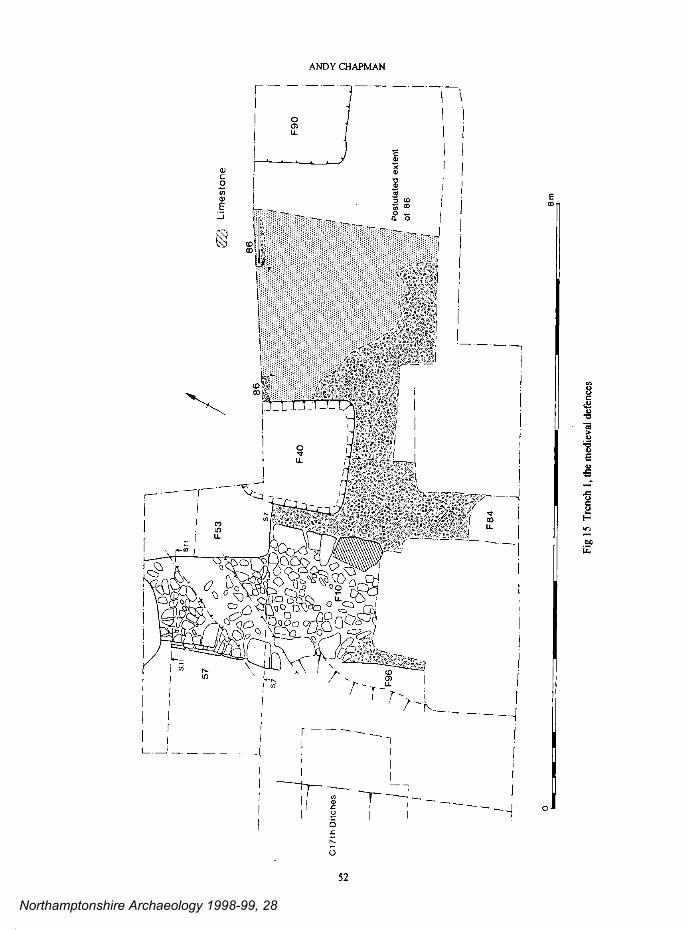
Fig
15
Tre
nch
I, th
e med
ieva
l de
fenc
es
L_
57
S.,
/ Li
mes
tone
86
F 4
0
1:
Cl7
th D
itche
s t.J
H
0
F90
I
Pos
tula
ted
exte
nt
of
86
/ F
84
I
8m
Northamptonshire Archaeology 1998-99, 28
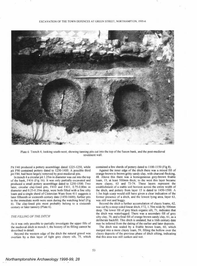
_.w
0..
_a0
.'2
'i1
n-tip
E',
:..
__.
500
-5-
-0.
°-,
?_3
O-'
c?3 N..
00E
S
ow=
e'+
y,,,
°'a y-=
...
-N- 00L
E=
L T
OY
°'w
"
.a.
0'C
.-.
9°'
.Op
0U0
.N.
Z`9
4..
t°-
EXCAVATION OF THE TOWN DEFENCES AT GREEN STREET, NORTHAMPTON, 1995-6
Plate 6 Trench 4, looking south-west, showing tanning pits cut into the top of the Saxon bank, and the post-medieval revetment wall.
Pit F40 produced a pottery assemblage dated 1225-1250, while pit F90 contained pottery dated to 1250-1400. A possible third pit F84, had been largely removed by post-medieval pits.
In trench 4 a circular pit I .25m in diameter was cut into the top of the bank, F416 (Fig 16). It was only partially excavated and produced a small pottery assemblage dated to 1250-1500. Two later, circular clay-lined pits, F410 and F411, 0.75-0.80m in diameter and 0.25-0.35m deep, were both filled with a fine silty loam and a single sherd of Cistercian Ware from 411 suggests a later fifteenth or sixteenth century date (1450-1600), further pits to the immediate north were seen during the watching brief (Fig 6). The clay-lined pits most probably belong to a sixteenth century or later tannery (Plate 6).
THE FILLING OF THE DITCH
As it was only possible to partially investigate the upper fills of the medieval ditch in trench 1, the history of its filling cannot be
described in detail. Beyond the western edge of the ditch the natural gravel was
overlain by a thin layer of light grey clayey silt, 75, which
contained a few sherds of pottery dated to 1100- 1150 (Fig 8). Against the inner edge of the ditch there was a mixed fill of
orange-brown to brown gritty sandy clay, with charcoal flecking, 48. Above this there was a homogeneous grey-brown friable loam, 15, at least 500mm thick; to the west this layer became more clayey, 63 and 73-74. These layers represent the establishment of a stable soil horizon across the entire width of the ditch, and pottery from layer 15 is dated to 1450-1500. A 1.5m high scarp would still have given a clear indication of the former presence of a ditch, and the lowest lying area, layer 63, was still wet and boggy.
Beyond the ditch a further accumulation of clayey loams, 62, was cut by a steep-sided linear ditch, F72, 1.70m wide by 500mm deep. The lower fill of grey black organic silt, 71, indicates that the ditch was waterlogged. There was a secondary fill of grey silty clay, 70, and a final fill of orange brown sandy clay, 61, as a deliberate backfill. This ditch is undated, but a 16th century date may be inferred from the dating of the earlier and later deposits.
the ditch was sealed by a friable brown loam, 60, which merged into a more clayey loam, 59, filling the hollow over the clayey deposits of the previous phase of ditch silting, indicating that this area was still sunken and wet.
53
Northamptonshire Archaeology 1998-99, 28

No'
two
E£°
.^
T
`°n
T°y
!OD
ta
n
°"o
".a
tan
0'e
°'a
0`<
tin
(/1
-'m
-_w
nom
O'0
v0,
tat
N9.
--1
=''
-°e
^.a
aim
two
tin
"'<
..T
O,,
W=
W
'°H
m_3
aft C.-
'E! C
ut
r09 T
'3 j,.
F'"
and
°'s
wry
.L..
... 44..
4.. d'.
c°'
.QC
A=
° H
s=
3'0 m
,- :'.
I--
>'c
t.=
ANDY CHAPMAN
At about this time a ditch or ditches were cut into the inner edge of the former medieval ditch, F79/F78. They were 0.90m deep, steep-sided and flat-bottomed, and spanned a total width of 5.0m. Later disturbances made it impossible to determine whether there were two ditches or a single broad ditch; the fills typically comprised compact brown sandy clays. They were only seen in section and are undated, but a late 16th to early 17th century date may be suggested.
In trench 2 the revetment wall was removed and the remnant of its foundations was sealed by a brown silty clay containing some small pieces of limestone and ironstone, 207 and 224. This is very similar to the bank material and probably derives from a collapse or partially levelling of the bank following the robbing of the wall (Fig 17). A small pottery assemblage from 207 is dated to c.1450-1500, indicating that the revetments had been levelled by the end of the 15th century or soon after. A compact deposit of limestone and ironstone within the ditch, 215, may derive from this event; the upper fill of mixed sandy clays, 213, contained a small pottery assemblage dated to the late 16th century.
cut-back in the side of the stepped trench left this uncertain (Fig 8). Layer 37 was a grey-brown friable loam with moderate charcoal flecking, and to the east it abutted the uppermost surviving courses of medieval town wall. It contained a scatter of blocks of ironstone, typically 200-300mm long, and some limestone. There is little doubt that this stone was derived from the medieval town wall, indicating that the remnant of the wall was either collapsing or was being dragged down as part of the levelling of the site. The main fill of the ditch, 30, was a friable and loose brown loam containing a scatter of mainly smaller pieces of ironstone.
These fills were sealed by a layer of friable grey-brown loam, 31; against the inner slope of the ditch a small area was excavated by hand, 35, and produced substantial quantities of pottery, clay tobacco-pipes and some fragments of hand-made bricks. The pottery is dated to around c.1730-1740 but the clay tobacco-pipes suggest a date for the final accumulation of this layer sometime after 1760. There is therefore no doubt that by the middle of the eighteenth century, at the latest, the medieval town wall had been totally levelled.
PHASE 7: THE CIVIL WAR DEFENCES
THE CIVIL WAR DITCHES
Patches of comminuted charcoal and cream coloured "mortar" (perhaps deposits of lime from the tanneries) lay on the surface of the upper fills of the medieval town ditch in trench I (Fig 8); they may relate to a general clearance and levelling of the area. Above this, a homogeneous soil horizon of grey sandy loam, 22/32, accumulated to a depth of up to 600mm.
Two substantial ditches were cut from this level; the outer ditch was V-shaped, 2.7m wide by 1.30m deep, F76; the inner ditch was 6.Om wide by 1.0m deep with steep sides and a broad flat-bottom, F77 (Figs 7 and 8). The inner edge was 1.0m from the face of the medieval wall and there was a fall of 1.8m with respect to the ground level at the wall. There was no evidence to determine whether they were contemporary or successive ditches; they spanned a total width of 9.Om with a narrow pinnacle between them.
The primary fills of both ditches comprised grey to grey-black waterlogged organic gritty silts, containing numerous small pieces of wood, 23 and 27. Only residual medieval pottery was recovered, but a single clay tobacco-pipe bowl from the primary fill of the inner ditch, 27, is an early form dated to 1610-1640 (see section 4.3). The secondary fill of the outer ditch comprised a grey-brown gritty clay, 24, containing a scatter of ironstone pieces in the looser fill against the outer slope. The later fills of the inner ditch are all related to the final levelling of the medieval town wall and are described below.
There is no evidence for any 17th century recutting of the ditch or Teat along the riverside in the trench 2, but this could easily have occurred beyond the excavated area.
THE LEVELLING OF THE MEDIEVAL WALL
Compact deposits of brown sandy clay containing some ironstone pieces, 28 and 29, accumulated against the sides of ditch F77 in trench I (Figs 8 and 10). They are probably- contemporary with a layer higher up the inner slope, 37, but a
PHASE 8: POST-MEDIEVAL PITS AND BUILDINGS
POST-MEDIEVAL HOUSES
At the eastern end of trench I the face of a wall constructed in roughly squared ironstone blocks, F54, was recovered in the very corner of the trench (Figs 10 and 7). It stood at least 800mm high but its base was not located. It may have been the rear wall of a building fronting onto Green Street. A nearby stone-lined well, which was not investigated, might also have been related.
POST- MEDIEVAL PITS
In trench I the medieval town wall and the bank were both extensively disturbed by post-medieval pits and other features. A square, clay-lined tanning pit, F53, of late eighteenth century date had cut away the inner face of the wall, and to the south the full width of the wall had been destroyed by a rectangular pit, stone-lined along the long sides, Fl I and Fl2 (Figs 7 and 8), and dated by clay tobacco-pipes to the early 19th century. A further probable tanning pit, F52, was not excavated and other pits were only seen in section, F134 and F135 (Fig 10); and the rear of the bank was largely removed by a series of pits filled with tenacious blue clays, 4.
Some of these features and related layers contained substantial animal bone deposits. Samples of this material were collected and will be retained in archive, but it has not been analysed in detail. Mike Shaw has briefly viewed the material to confirm that the high proportions of horn cores and sheep metapoidals are similar to deposits seen at The Green and other Northampton sites (Shaw 1996, 89-102), and is similarly indicative of tanning and related industries, including horn working.
In trench 2 a flat-bottomed platform was cut into the scarp at the foot of the former bank and clayey foams containing pieces of ironstone accumulated on this surface, 210 and 211 (Fig 17, S9). This area appears to have remained open ground and there were some indications that the upper accumulation of dark brown foams, 201/209, may have been cut by a number of pits.
54
Northamptonshire Archaeology 1998-99, 28

204.
..
Fig
T
renc
hes
2 an
d th
e ex
cava
ted
feat
ures
I
/
Northamptonshire Archaeology 1998-99, 28
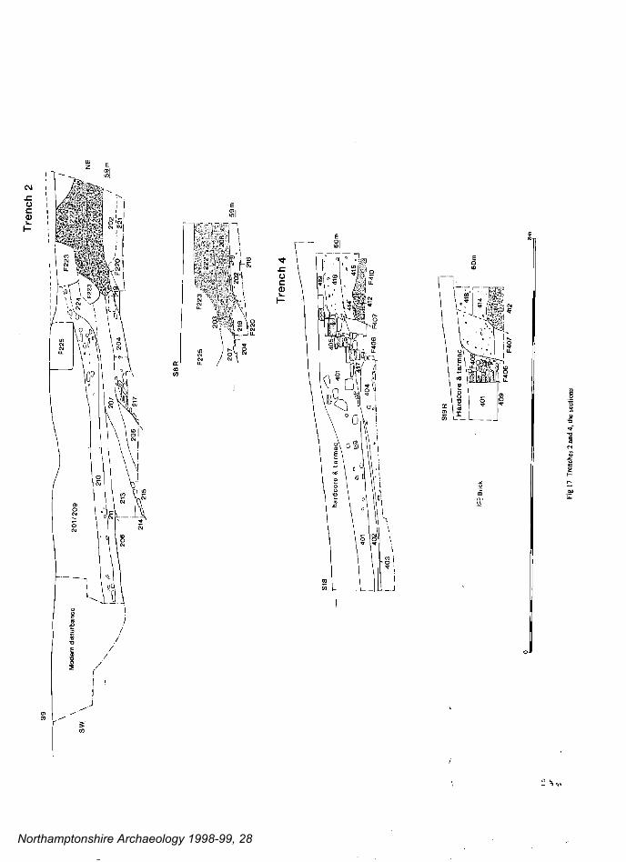
III
Ss'
L-7
0i1
S9
Trench 2
-------------
214~- _205
217 1
.1 l 215
207
20 -
/ p
204 F220-
-221 -----
R S
OR
204
516
401 402
403
/ D Q
hardcoro la=n
Dc 401
F406
Brick
' 2
-' 202 6a-
) '-
F220 216
F407 r
Fig t7
Tmnches 2
and 4,
the scctions
412
Northamptonshire Archaeology 1998-99, 28
EXCAVATION OF THE TOWN DEFENCES AT GREEN STREET. NORTHAMPTON, 1995-6
RECENT BUiLDINGS
Archaeological deposits relating to the buildings occupying thesite from 1800 onward were removed by machine excavation intrench I. They comprised the uppermost 800-900mm of thedeposits over the former medieval bank and up to 1400mm overthe medieval ditches. Outline details of these deposits, wererecorded in the drawn sections, but most of this is omitted fromthe published sections, and no attempt was made to record themin plan or to describe them in any detail (Figs 8 and 10).
In trench 2 a steep-sided trench F223 (Fig 17, S9 and S8R),0.90m wide by 0.80m deep and containing loose and disorderedblocks of ironstone, is probably a robber trench of a formerboundary wall. A further robber trench filled with ironstonerubble, F225, may be from either a later boundary wall or the firstmajor building on this area. Later brick buildings with cellarshad created much disturbance at the south-western end of thetrench.
In trench 4 the demise of the tannery is dated to the first half ofthe 17th century by pottery from the lowest part, 415, of a700mm thick accumulation of friable brown barns, 414 and 418(Fig 17). The historic town maps show that this area remainedopen ground until the end of the 19th century. An ironstonerevetment or retaining wall stood at the front of the bank, 406(Figs 16 and 17), it was observed in the watching brief for a totallength of l6m (Figs 16, 17 and 6). The wall was 0.60m thick andbuilt in flat-laid ironstone, and its construction trench, F407, wasbackfilled with fairly loose soil.
A wall at the front of the bank on the same alignment in trench2 had been totally robbed, F223.
At the end of the 19th century the retaining wall in trench 4was partially levelled and utilised as the base for one wall of abrick built cottage, F405, with a chequered floor of red and whitetiles, 409. To the north-west there was a yard surface of compactironstone chips, 402, over a base of ash and cinders, 403. Anexternal flight of flagstone steps, visible in section (Fig 17, SI 8),provided access to the higher ground over the former bank. Thefloor of this cottage lay just above the permitted maximum depthof excavation, so it was not possible to examine the nature of theunderlying archaeology in this area. The cottage was sealedbeneath its own demolition rubble, 401, and by the hardcore basefor the tarmac surface of the car park.
therecharacteristics.
THE POTTERYby Paul Blinkhom and lain Soden
A total of 400 sherds (7.49kg) of Saxon, medievaland post-medieval pottery was recovered. Themajority came from trench 1, 303 sherds, with afurther 36 sherds from trench 2 and 61 sherds fromtrench 4. The middle and late Saxon pottely has beenanalysed by Paul Blinkhorn and the medieval andpost-medieval pottery by lain Soden. Editing andcompilation of the report is by lain Soden and Andy
Chapman.
QUANTIFICATION
The material from trench I is broken down by stratigraphic phasewith the fabric types related to the County Type Series (CTS),table 1.The fabrics are as follows:
Romano-BritishEarly/middle SaxonRaunds Maxey-type Ware: 800-900 AD.St Neots.type Ware: 900-1100.Northampton Ware: 900-975 AD.Stamford Ware: 850-1100.St Neots-type Ware: 1000-1200.Shelly Coarseware: 1100-1400.Sandy Coarseware: 1100-1400.Sandy Coarseware: 1100-1400.Lyveden/Stanion A Ware: 1250-1400Developed Stamford Ware: 1100-1200Unprovenanced Glazed Ware: 1150-1300Lyveden/Stanion B Ware: 1250-1300Potterspury Ware: 1250-1500Lyveden/Stanion DWare: 1250-1500
and 3 have irregular edge damage resulting fromutilisation. The flakes from the prehistoric soilhorizon include 3 spalls only 9-11mm in length; 8flakes retain areas of cortex suggesting that theycome from relatively small flint pebbles or cobbles,probably local river gravel flint.
Given the small size of the assemblage and thepresence of only one diagnostic implement, only abroad Neolithic to early Bronze Age date may beproposed. The quantity recovered from the smallarea of early soils examined is consistent with therecovery of substantial quantities of worked flintfrom other excavations in this area of the town, suchas Chalk Lane, Marefair, St.Peter's Street and BlackLion Hill (RCHME 1985, fiche 322-323), although
are no pieces with evident Mesolithic
THE FENDS
THE WORKED FLINTby Andy Chapman
A total of 21 struck flints was recovered, II camefrom the prehistoric soil horizon preserved beneaththe late Saxon bank in trench 1, 69/129, and 3 wereresidual in the fills ofthe adjacent late Saxon slot, F97.
The majority of the pieces are in a good qualityvitreous flint, red-brown in colour; they comprise I 7flakes, 2 burnt pieces, a shattered piece, and abroken, pressure flaked implement that is probably aleaf arrowhead. Two of the flakes have edge retouch
RBEMS97100130205200330360302319331370320329322
55
Northamptonshire Archaeology 1998-99, 28
329
322
Total
7 7 4 18
I I
15 8 14 14 58 7 tO 126
MIDDLE SAXON
The soil horizon sealed beneath the bank in trench I, 100,produced 14 sherds from a single Raunds-type Maxey Warebar-tug vessel It was in a grey fabric with orange-brownsurfaces, the outer face of the vessel was heavily sooted.
Such vessels have a distribution throughout the south-eastmidlands and southern Lincolnshire, and are different in terms ofboth form and fabric from the eponymous Maxey Ware traditionof the Wetland valley. They have so far been rarely found inNorthamptonshire.
In common with other excavations within the boundaries ofthe late Saxon town the site has produced Maxey Ware but nolpswich Ware (a single sherd was recovered at Chalk Lane(Gryspeerdt 1981)). Therefore while Raunds Maxey-type Ware
56
can be given a general date-range of 650-850 AD. the lack oflpswich Ware might suggest that in this area of Northampton it isunlikely to date before c. 800 AD. The activity at Green Streetpre-dating the defences can therefore be dated to 800-850 AD.
LATE SAXON
The small quantity of St. Neots-type Ware contains vessel typeswhich come into use c. 900 AD (Types 11(1) and 11(3) in theNorthampton type series Denham; 1985, table II). This suggeststhat there was little nearby activity in the second half of the ninthcentury. All the pottery of this type were plain bodysherds, withthe exception ofa single strap handle, type Tl(2).
The small assemblage of Northampton Ware consists entirely
ANDY CHAPMAN
Table 1: Trench 1, stratigraphic phasing ofrecovered fabric types
CTS Ph2 Ph3 Ph4 Ph5 Ph6 Ph7 Ph8 TotalCode
15
17
EMS
97 14 1
100 3 1 1 5
130 5 8 4
205 1 1 2
200 2 2 4
330 1 4 36 41
360 1 1
302 2 2 4
319 3 2 5
331 1 I 1 3
370 2 I 3
320 5 5
Northamptonshire Archaeology 1998-99, 28
EXCAVATION OF THE TOWN DEFENCES AT GREEN STREET, NORTI-IAMPTON, 1995-6
of plain bodysherds, except for a single everted,lid-seated rimsherd from a small jar, a type typicalof the products of the industiy. A total of 22 sherdswere recovered comprising 17 from trench I,including 2 sherds from the defensive bank, whilethe 5 small sherds from trench 2 are all from layer202, which was directly sealed by the bank.
The appearance of Northampton Ware, with itsfinely potted vessels reminiscent of Stamfordproducts, marks a watershed in local ceramictraditions. This distinctive Northampton Warehorizon' is found throughout the area of the
Saxon town; it was first identified at St. PetersGardens where it was dated to c. 900-975 AD(Denham 1985, 55). It is the Northampton Wareassociated with the construction of the bank whichdates the original defences'to the tenth century.
MEDIEVAL
The medieval pottery from Green Street is sparse,comprising a total of 81 sherds from trench I(table I). A half of this total was made up of ShellyCoarsewares and there were some Sandy Coarse-wares. Of the finer, glazed wares Potterspuiy Wareis the most common, while Developed StamfordWare and Lyveden/ Stanion Wares are present insmall quantities. Few of the sherds are diagnosticand all of the types present are seen throughout thetown and its hinterland, and betoken ordinarydomestic activity nearby. Small assemblages wererecovered from pits cut into the top of the bank intrenches I and 4 (F40. F93, and F416) and fromthe final fills of ditches in trenches I and 2(Contexts 15 and 205). Individual context datesare given in the catalogue of the excavatedevidence. The remainder occurred as residualfinds in post-medieval contexts.
The scarcity of both late Saxon and medievalpottery is consistent with the nature of the sitethrough these periods, as defensive structures arenot commensurate with any density of occupationactivity.
LATE MEDIEVAL AND POST-MEDIEVAL
One hundred and seventy seven sherds of late med-ieval transitional and posl-medieval pottery wererecovered from sixteen contexts in Trench I. Smallquantities were also recovered from trenches 2 and 4.
The material from trench I is broken down bystratigraphic phase and the types related to theCounty Type Series (CTS) in table 2.
The post-medieval fabrics are listed below, theyinclude four new post-medieval types (435-438),along with production dates and the forms repres-ented in the assemblage:
Table 2: Late medieval and post-medieval pottery from Trench I
CTS Code Ph6 Ph7 Ph8 Total
1 1
4
2 2
I 1
407 10 10
1 1 2
3
9
5
40
1 15 16
1 11
2 2
424 2 2
6429
430
432
435
436
437 2 2
1 1
I I
1 1
I I
401 Late medieval oxidised Ware; dated c1450-lSSO. Nodiagnostic material.
403 Midland Purple Ware; dated c1400-1600. No diagnosticmaterial.
404 Cistercian Ware; dated c1450-l580. Cups.406 Midland Yellow Ware; dated c1530-l700. Non- diagnostic.407 Glazed earthenware; generally l6th-l7th century. Two
handled jars/pipkins.
401
403
404
406
4 8
408
409
410
41!
413
415
416
417
419
5 8
9 18
18 23
5 45
88
10
5 11
Total 1 92 84 177
57
Northamptonshire Archaeology 1998-99, 28
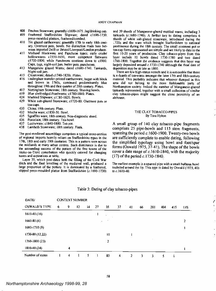
ANDY CHAPMAN
408 Frechen Stoneware; generallyc1600-l675. Jug/drinking cup.409 Feathered Staffordshire Slipware; dated c1690-1730.
press-moulded platters, feathered/combed.410 Tin glazed earthenware; generally 17th to early 18th cent-
ury. Ointment pots, bowls. No distinction made here bet-ween imported Delf or Bristol/Liverpool/London products.
41! Midland Blackware and Pancheon types; early cruderhollowwares c1550-1650, more competent flatwaresc1700-l800, while Pancheons continue down te c1900.Cups, tygs, night-soil jars, butter pots, pancheons.
413 Manganese glazed Wares; dated cl680-1740. Tankards,Night-soil jars.
415 Creamware; dated cI 740-I 820s. Plates.416 Underglaze transfer-printed earthenware; began with black
and brown in 1760s, continued predominantly bluethroughout 19th and first quarter of 20th century. Plates.
417 Nottingham Stoneware; 18th century. Shaving bowls.419 Blue shell-edged Peariwares; c1780-1840. Plates.424 Marbled Slipware; cI80-I82O. Bowls.429 White salt-glazed Stoneware; c1720-80. Ointment pots or
tea-cups.430 China; 19th century. Plate.432 Mocha ware; c1830-50. Bowl.435 Sgrafl'ito ware; 18th century. Non-diagnostic sherd.436 Porcelain; 18th century. Tea-bowl.437 Lustreware; c1840-l880. Tea pot.438 Lambeth Stoneware; l8th.centuiy. Flask.
The post-medieval assemblage comprises a typical cross-sectionof regional imports heavily reliant on Staffordshire types in the17th, 18th and early 19th centuries. This is a pattern seen acrossthe midlands at many urban Centres. Such dominance is due tothe astounding success of the potters of the five towns of theStoke-on-Trent conurbation who quickly catered for changingtastes and aspirations at table.
Layer 35, which post-dates both the filling of the Civil Warditch and the final levelling of the medieval wall, produced alarge proportion of the pottery. It is dominated by a feathered,slipped press-moulded platter from Staffordshire (c.1690-1730)
and 39 sherds of Manganese-glazed mottled wares, including 3tankards (c.1680-l740). A further key to dating comprises 6sherds of white salt-glazed stoneware, introduced during the.720s and the ware which brought Staffordshire to nationalprominence during the 18th century. The small ointment pot ortea-cup forms represented are simple and are likely to date to thefirst 10-20 years of production. Clay tobacco-pipes from thislayer include 10 bowls dated 1730-1780 and two dated1760-1800. Together the evidence suggests that this layer waslargely deposited around c. 1730-1740 although the final date ofdeposition may be as late as 1800.
There are few high-status vessels and it is noticeable that thereis a dearth of tea-wares amongst the later 17th and 18th-centurymaterial. This probably indicates that whoever dumped in thisarea did not belong to the more fashionable parts ofNorthampton society. Indeed the number of Manganese-glazedtankards represented, together with a small collection of similarclay tobacco-pipes might suggest the close proximity of analehouse.
THE CLAY TOBACCO-PIPESBy Tora Hylton
A small group of 140 clay tobacco-pipe fragmentscomprises 25 pipe-bowls and 115 stem fragments,spanning the period c. 1600-1900. Twenty-two bowlsare sufficiently complete to enable dating, followingthe simplified typology using bowl and foot/spurforms (Oswald 1975, 37-41). The shape of the bowlscover a date range of c. 1610-1840, with the majority(17) of the period c.l730-1840.
The earliest example is a spurred pipe with a small bulbous bowlrouletted around the lip. This type is dated by Oswald (1975, 40)to c.l6l0-40.
DATEJ
Table 3: Dating of clay tobacco-pipes
CONTEXT NUMBER
OSWALD'S TYPE 6 9 12 14 27 35 37 41 66 201 404 415 U/S
1610-40(16) I .
1660-80(6). 2
1680-1710 (9) I
1730-80(12,22) 10 1
1760-1800 (23) 2
1810-40(24) 4 I
(
Number of stems 1 4 I 5 I 85 4 2 3 3 5
58
Northamptonshire Archaeology 1998-99, 28
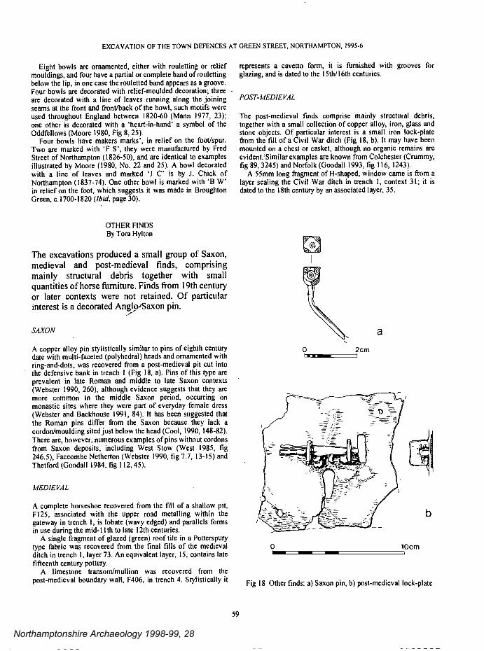
EXCAVATION OF THE TOWN DEFENCES AT GREEN STREET, NORTHAMPTON, 1995-6
Eight bowls are ornamented, either with rouletting or reliefmouldings, and four have a partial or complete band of roulettingbelow the lip, in one case the rouletted band appears as a groove.Four bowls are decorated with relief-moulded decoration; threeare decorated with a line of leaves running along the joiningscams at the front and front/back of the bowl, such motifs wereused throughout England between 1820-60 (Mann 1977, 23);one other is decorated with a 'heart-in-hand' a symbol of theOddfellows (Moore t980, Fig 8, 25).
Four bowls have makers marks', in relief on the foot/spur.Two are marked with 'F 5', they were manufactured by FredStreet of Northampton (1826-50), and are identical to examplesillustrated by Moore (1980, No. 22 and 25). A bowl decoratedwith a line of leaves and marked 'J C' is by J. Chick ofNorthampton (1837-74). One other bowl is marked with 'B W'in relief on the foot, which suggests it was made in BroughtonGreen, c. 1700-I 820 (mid, page 30).
OTHER FINDSBy Tora Hylton
The excavations produced a small group of Saxon,medieval and post-medieval finds, comprisingmainly structural debris together with smallquantities of horse furniture. Finds from 19th centutyor later contexts were not retained, Of particularinterest is a decorated Anglo-Saxon pin.
SAXON
A copper alloy pin stylistically similar to pins of eighth centurydate with multi-faceted (polyhedral) heads and omamented withring-and-dots, was recovered from a post-medieval pit cut intothe defensive bank in trench I (Fig 18, a). Pins of this type areprevalent in late Roman and middle to late Saxon contexts(Webster 1990, 260), although evidence suggests that they aremore common in the middle Saxon period, occurring onmonastic sites where they were part of everyday female dress(Webster and Backhouse t99l, 84). It has been suggested thatthe Roman pins differ from the Saxon because they lack acordon/moulding sited just below the head (Cool, 1990, 148-82).There are, however, numerous examples of pins without cordonsfrom Saxon deposits, including West Stow (West 1985, fig246.5), Faccombe Netherton (Webster 1990, fig 7.7, 13-15) andThetford (Goodall 1984, fig 112,45).
MEDIEVAL
A complete horseshoe recovered from the fill of a shallow pit,F125, associated with the upper road metalling within thegateway in trench I, is lobate (wavy edged) and parallels formsin use during the mid-I tth to late 12th centuries.
A single fragment of glazed (green) roof tile in a Potterspurytype fabric was recovered from the final fills of the medievalditch in trench I, layer 73. An equivalent layer, 15, contains latefifteenth century pottery.
A limestone transom/mullion was recovered from thepost-medieval boundary wall, F406, in trench 4. Stylistically it
59
represents a eavetto form, it is furnished with grooves forglazing, and is dated to the tsthll6th centuries.
POST-MEDiEVAL
The post-medieval finds comprise mainly structural debris,together with a small collection of copper alloy, iron, glass andstone objects. Of particular interest is a small iron lock-platefrom the fill of a Civil War ditch (Fig IS, b). tt may have beenmounted on a chest or casket, although no organic remains areevident. Similar examples are known from Colchester (Crummy,fig 89, 3245) and Norfolk (Goodall 1993, fig 116, 1243).
A 55mm long fragment of H-shaped, window came is from alayer sealing the Civil War ditch in trench 1, context 31; it isdated to the 18th century by an associated layer, 35.
a
19cm
Fig 18 Other finds: a) Saxon pin, b) post-medieval lock-plate
0 2cm
9
b
Northamptonshire Archaeology 1998-99, 28

ANDY CHAPMAN
Other finds include a complete post-medieval copper alloyspur, found unstratified in trench 4, and whetstones from pitsF4 10 and F416 in trench 4.
CATALOGUE OFJLLUSTRA TED FINDS
Multi-faceted pin, copper alloy (Fig 18, a). Cast with polyhedralhead, each face is ornamented with and ring a dot motif.Circular sectioned shaft, point missing.Length of shaft: 27mm Diameter of head: 7mmContext F53, Small find (SF) 28, fill of post-medieval pit.
Lock-plate, Ferrous (Fig 18, b). Damaged, square lock-plate,with holes for the key and the staple of the hasp, and cornerfixings. Mechanism incomplete; the sliding bolt, fixed bysquared loops, has corroded in the open position. Tumblermissing. The square-sectioned sliding bolt has twoprojections on the underside to allow the keyto throw the bolt.Size of plate: lOOxI 10mm Length of sliding bolt: 58mmContext 23. SF 24, Fill of civil war ditch F76, 17th century.
BIBLIOGRAPHY
Brown, R. W., 1915-16. The ancient fortifications of the town ofNorthampton, Northamptonshire Nat. list. Soc. and FieldClub.!, 18, 85-102.
Chapman, A., 1995. Archaeological evaluation of land off GreenStreet, Northampton, December 1995: An Interim Report,Norihamptonshire Archaeol. Rep.
Cool, H. E. M., 1990. Roman metal hairpins from southernBritain, ArchaeoL .1,., 148-82.
Cox, C. J., 1898. The Records of the Borough of Northampton,Second Volume, 1550-1835.
Crummy, N., 1988. The Post-Roman smallfind.s from excavationsin Co/chester 1971-85, Colchester Archaeol Rep, 5.
Denham, V., 1985. The Pottery, in Williams et al 1985.Fairbrother, J. R., 1990. Faccombe Netherton: Excavations of a
Saxon and Medieval Manorial Complex II, British Museum0cc. Pap., 74.
Foard, U., 1994. The Civil War defences of Northampton,,Vorthamptonshire Past and Present, IX. I, 4-44.
Foard, U., 1996. The early topography of Northampton and itssuburbs, Northamptonshire ArchaeoL , 26, 109-122.
Garmonsway, G.N., 1972. The Anglo-Saxon Chronicle.Goodall, A. R., 1984. Non-Ferrous Objects, in Rogerson and
Dallas 1984, 68-75.Goodall, I. H., 1993. Lock Furniture, Hasps and Keys, in
Margeson 1993.
60
Gryspeerdt, M., 1981. The Pottery, in Williams and Shaw 1981,108-118
Lee, F., 1954. A New Theory of the Origins and Early Growth ofNorthampton, Archaeol. J., 110, 164-74.
Mann, .1. E., 1977. Clay tobacco pipes from excavations inLincoln 1970-74.
Margeson, S., 1993. Norwich Households: The Medieval andPost-Medieval Finds from Norwich Survey Excavations 1971-/978 East Anglian Archaeol Rep, 58.
Moore, W. R. G., 1980. Northamptonshire Clay tobacco-pipesand pipemakers, Northampton Museums and Art Gallery.
Oswald, A., 1975. Clay pipes for the Archaeologist, BritishArchaeological Report, 14.
RCHME., 1985. An Inventory of the historical monuments of thecounty of Northampton: V: Archaeological sites and churchesin Northampton, Royal Commission on the Historical Monu-ments of England.
Rogerson, A., and Dallas, C., 1984. Excavations in Thetford/948-59 and 1973-80, East Anglian Archaeol. Rep, 22.
Shaw, M., 1988. Northampton sites, S. Midlands Archaeol., 18,62-3.
Shaw, M., 1996. The excavation of a late lSth-17th centurytanning complex .at The Green, Northampton, Post-medievalArchaeo/,, 30, 63-127.
Shaw, M., Chapman, A., and Soden, I., 1997. Northampton,Current Archaeology, 155, 408—415.
Shoesmith, R., 1982. Excavations on and close to the defences.Hereford City Excavations Volume 2, CBA Research Report46.
Soden, I., 1995. An archaeological assessment of/and at GreenStreet, Northampton, Northamptonshire Archaeol. Rep.
Speed, .1., 1676. The Theatre of the Empire of Great Britain.Webster, L. E., 1990. Anglo-Saxon Metalwork and Metalwork-
ing Debris, in Fairbrother 1990, 254ff.Webster, L. E., and Backhouse, J., (eds) t99l The making of
England, Anglo-Saxon culture AD 600-900, University ofToronto Press, Toronto.
Welsh, TA., t997, Northampton Alternatives: Conjecture andCounter-Conjecture. Norihamptonshire Archaeology, 27, 166 -176.
West, S., 1985. West Stow: The Anglo-Saxon Village Vol/I, EastAnglian Archaeol. Rep,, 24
Williams, J. H., 1979. St Peter's Street, Northampton. Excav-ations /973-6, Northampton Development Copr. mono., 2.
Williams, J. H., 1982. Four small excavations on Northampton'sMedieval defences and elsewhere, Northamptonshire Archaeol.,17, 141-152.
Williams, J. H., and Shaw, M., 1981. Excavations in Chalk Lane,Northampton, 1975-1978, Northamptonshire Archaeol., 16,87-135.
Williams, J. H., Shaw, M,, and Denham, V., 1985. Middle SaxonPalaces at Northampton, Northampton Development Corp.mono, 4.
Northamptonshire Archaeology 1998-99, 28