Evidence for hydraulic heterogeneity and anisotropy in the mostly carbonate Prairie du Chien Group,...
26
Evidence for hydraulic heterogeneity and anisotropy in the mostly carbonate Prairie du Chien Group, southeastern Minnesota, USA Robert G. Tipping a, * , Anthony C. Runkel a , E. Calvin Alexander Jr. b , Scott C. Alexander b , Jeffery A. Green c a Minnesota Geological Survey, 2642 University Avenue, Saint Paul, MN 55114, United States b University of Minnesota, Department of Geology and Geophysics, 310 Pillsbury Drive SE, Minneapolis, MN 55455, United States c Minnesota Department of Natural Resources, Division of Waters, Rochester, 2300 Silver Creek Road, Rochester, MN 55906, United States Abstract In southeastern Minnesota, Paleozoic bedrock aquifers have typically been represented in groundwater flow simulations as isotropic, porous media. To obtain a more accurate hydrogeologic characterization of the Ordovician Prairie du Chien Group, a new approach was tested, combining detailed geologic observations, particularly of secondary porosity, with hydraulic data. Lithologic observations of the depositional and erosional history of the carbonate-dominated bedrock unit constrained characterization of both primary (matrix) and secondary porosity from outcrops and core. Hydrostratigraphic data include outcrop and core observations along with core plug permeability tests. Hydrogeologic data include discrete interval aquifer tests, borehole geophysics, water chemistry and isotope data, and dye trace studies. Results indicate that the Prairie du Chien Group can be subdivided into the Shakopee aquifer at the top, consisting of interbedded dolostone, sandstone and shale, and the underlying Oneota confining unit consisting of thickly bedded dolostone. The boundary between these two hydrogeologic units does not correspond to lithostrati- graphic boundaries, as commonly presumed. Groundwater flow in the Shakopee aquifer is primarily through secondary porosity features, most commonly solution-enlarged bedding planes and sub-horizontal and vertical fractures. Regional scale preferential development of cavernous porosity and permeability along specific stratigraphic intervals that correspond to paleokarst were also identified, along with a general depiction of the distribution of vertical and horizontal fractures. The combination of outcrop and core investigations, along with borehole geophysics, discrete interval aquifer tests, water chemistry and isotope data and dye trace studies show that the Prairie du Chien Group is best represented hydrogeologically as heterogeneous and anisotropic. Furthermore, heterogeneity and anisotropy within the Prairie du Chien Group is mappable at a regional scale (N 15,000 km 2 ). D 2005 Elsevier B.V. All rights reserved. Keywords: Dolostone; Groundwater; Paleokarst; Prairie du Chien Group; Dual porosity; High-resolution flowmeter 1. Introduction The Lower Ordovician Prairie du Chien Group, along with the underlying Cambrian Jordan Sandstone, is a primary source of groundwater in southeastern Minnesota and southwestern Wisconsin (Fig. 1). This part of Minnesota was largely unglaciated during the most recent Pleistocene Late Wisconsin glacial ad- vance. As a result, bedrock is at depths of less than 15 m across most of the area, with overlying unconsol- idated material consisting primarily of loess and weath- ered bedrock residuum. The combination of shallow-to- bedrock conditions and permeable bedrock make these 0037-0738/$ - see front matter D 2005 Elsevier B.V. All rights reserved. doi:10.1016/j.sedgeo.2005.11.007 * Corresponding author. Fax: +1 612 627 4778. E-mail address: [email protected] (R.G. Tipping). Sedimentary Geology 184 (2006) 305 – 330 www.elsevier.com/locate/sedgeo
-
Upload
independent -
Category
Documents
-
view
3 -
download
0
Transcript of Evidence for hydraulic heterogeneity and anisotropy in the mostly carbonate Prairie du Chien Group,...

www.elsevier.com/locate/sedgeo
Sedimentary Geology 18
Evidence for hydraulic heterogeneity and anisotropy in the mostly
carbonate Prairie du Chien Group, southeastern Minnesota, USA
Robert G. Tipping a,*, Anthony C. Runkel a, E. Calvin Alexander Jr.b,
Scott C. Alexander b, Jeffery A. Green c
a Minnesota Geological Survey, 2642 University Avenue, Saint Paul, MN 55114, United Statesb University of Minnesota, Department of Geology and Geophysics, 310 Pillsbury Drive SE, Minneapolis, MN 55455, United States
c Minnesota Department of Natural Resources, Division of Waters, Rochester, 2300 Silver Creek Road, Rochester, MN 55906, United States
Abstract
In southeastern Minnesota, Paleozoic bedrock aquifers have typically been represented in groundwater flow simulations as
isotropic, porous media. To obtain a more accurate hydrogeologic characterization of the Ordovician Prairie du Chien Group, a new
approach was tested, combining detailed geologic observations, particularly of secondary porosity, with hydraulic data. Lithologic
observations of the depositional and erosional history of the carbonate-dominated bedrock unit constrained characterization of both
primary (matrix) and secondary porosity from outcrops and core. Hydrostratigraphic data include outcrop and core observations
along with core plug permeability tests. Hydrogeologic data include discrete interval aquifer tests, borehole geophysics, water
chemistry and isotope data, and dye trace studies. Results indicate that the Prairie du Chien Group can be subdivided into the
Shakopee aquifer at the top, consisting of interbedded dolostone, sandstone and shale, and the underlying Oneota confining unit
consisting of thickly bedded dolostone. The boundary between these two hydrogeologic units does not correspond to lithostrati-
graphic boundaries, as commonly presumed. Groundwater flow in the Shakopee aquifer is primarily through secondary porosity
features, most commonly solution-enlarged bedding planes and sub-horizontal and vertical fractures. Regional scale preferential
development of cavernous porosity and permeability along specific stratigraphic intervals that correspond to paleokarst were also
identified, along with a general depiction of the distribution of vertical and horizontal fractures. The combination of outcrop and
core investigations, along with borehole geophysics, discrete interval aquifer tests, water chemistry and isotope data and dye trace
studies show that the Prairie du Chien Group is best represented hydrogeologically as heterogeneous and anisotropic. Furthermore,
heterogeneity and anisotropy within the Prairie du Chien Group is mappable at a regional scale (N15,000 km2).
D 2005 Elsevier B.V. All rights reserved.
Keywords: Dolostone; Groundwater; Paleokarst; Prairie du Chien Group; Dual porosity; High-resolution flowmeter
1. Introduction
The Lower Ordovician Prairie du Chien Group,
along with the underlying Cambrian Jordan Sandstone,
is a primary source of groundwater in southeastern
0037-0738/$ - see front matter D 2005 Elsevier B.V. All rights reserved.
doi:10.1016/j.sedgeo.2005.11.007
* Corresponding author. Fax: +1 612 627 4778.
E-mail address: [email protected] (R.G. Tipping).
Minnesota and southwestern Wisconsin (Fig. 1). This
part of Minnesota was largely unglaciated during the
most recent Pleistocene Late Wisconsin glacial ad-
vance. As a result, bedrock is at depths of less than
15 m across most of the area, with overlying unconsol-
idated material consisting primarily of loess and weath-
ered bedrock residuum. The combination of shallow-to-
bedrock conditions and permeable bedrock make these
4 (2006) 305–330

Fig. 1. Map showing extent of the Prairie du Chien Group, southeastern Minnesota. Areas where the Prairie du Chien Group is the uppermost
bedrock layer is shown, as well as areas where it is overlain by younger bedrock. Locations are shown for boreholes, dye traces, quarries and other
features discussed in the text.
R.G. Tipping et al. / Sedimentary Geology 184 (2006) 305–330306
aquifers highly productive, but also highly susceptible
to contamination from activities at the land surface.
Paleozoic aquifers in southeastern Minnesota have
typically been treated in groundwater flow models as
equivalent porous media. Although models based on
this assumption work well for estimates of aquifer yield,
they have limited usefulness for predicting precise flow
paths and groundwater velocities. The goal of this study
was to test the hypothesis that the Prairie du Chien
Group is best characterized as hydraulically heteroge-
neous and anisotropic. The hydrogeology of thick, car-
bonate-dominated units has proven quite difficult to
characterize. Because the Paleozoic strata in this portion
of the central mid-continent are relatively undeformed,

R.G. Tipping et al. / Sedimentary Geology 184 (2006) 305–330 307
well exposed along river systems, and mapped exten-
sively, they provide a unique opportunity to combine
borehole hydrostratigraphic and hydraulic data with
outcrop observations of porosity and permeability. A
complex distribution of fractures and solution features,
combined with widely variable hydraulic properties
found in this study, is inconsistent with classification
of the Prairie du Chien Group as a single hydrogeologic
unit. Of particular importance to this study was the
identification of high permeability intervals within the
unit, along with intervals that confine underlying re-
gional aquifers. A variety of methods at different scales
were used to identify aquifer heterogeneity at different
scales, from cm to km.
2. Data and methods
Recent improvements to the hydrogeologic charac-
terization of Paleozoic aquifers have been based on
correlating hydraulic conductivity to stratigraphic fea-
tures (e.g., Muldoon et al., 2001). Our investigation of
Prairie du Chien Group hydrogeology follows the
methods applied to other Paleozoic rocks in southeast-
ern Minnesota (Runkel et al., 2003; Runkel et al.,
2006—this volume). Specifically, our characterization
of hydrogeologic attributes of the Prairie du Chien
Group is based on hydraulic data interpreted within
the context of hydrostratigraphic attributes.
According to Seaber (1988), hydrostratigraphic attri-
butes are assigned based on rock properties alone, and,
with the exception of plug-scale permeability testing,
are not based on hydraulic measurements of any kind.
This study assembles matrix porosity and permeability
estimates from plug samples taken from core and out-
crop (MUGSP, 1980; Setterholm et al., 1991). Second-
ary porosity in the form of fractures and solution
cavities was described directly from observations of
core, outcrop and indirectly from an inventory of sink-
holes and spring locations and stratigraphic positions.
Lithofacies are broadly grouped into three matrix
hydrostratigraphic components: (1) a carbonate compo-
nent consisting of limestone and dolostone; (2) a coarse
clastic component consisting of fine- to coarse-grained
quartz sandstone; and (3) a fine clastic component
consisting of very fine quartz sandstone, siltstone and
shale. Borehole geophysical methods included an as-
sessment of fracture density using video logs and mea-
sured fracture/solution feature aperture using caliper
logs.
Hydraulic data assembled for this study included
borehole-scale characterization based on high resolu-
tion electromagnetic (EM) flowmeter measurements,
discrete interval packer testing, hydrochemical logging,
temperature and fluid resistivity measurements, and a
review of historic conventional aquifer tests. Most log-
ging was performed on existing test wells that were free
of pumps or other obstructions. Additional logging was
performed on three test holes drilled as part of the
project.
The EM flowmeter was used to measure vertical
flow within the open borehole; positive values mea-
sured with the flowmeter indicate upflow in the bore-
hole, and negative values indicate downflow. Unlike
impeller-type flowmeters which require several liters
per minute in order to produce measurable flow, the
EM flowmeter can measure flows as low as to 0.01 l/
min. After fractures and zones within the open borehole
of equal diameter have been identified with a caliper
log, the flowmeter is btrolledQ upwards at a constant
speed to identify shifts that may indicate water moving
into or out of the borehole. Measurements are then
made at stationary positions above and below fractures,
in areas of equal hole diameter. Flow either up or down
from one transmissive zone to another indicates con-
finement between the two zones. In this way, flowmeter
data can be used to identify hydraulically active zones
within the borehole. Flowmeter logging was done under
ambient and stressed (either pumping or injection) con-
ditions. Using methods outlined by Paillet et al. (2000),
flowmeter logs under these conditions can be used to
estimate transmissivity for individual high permeability
zones by providing flow measurements under two dif-
ferent head gradients. Flow measurements from an
individual fracture under different head conditions
eliminates head dependence in the calculation of trans-
missivity from flow. In this study, high permeability
zones within the Prairie du Chien Group were typically
single fractures, or clusters of fractures, or zones of
cavernous porosity formed by a combination of frac-
tures and dissolution. Transmissivity estimates from
flowmeter logs for these zones were converted to hy-
draulic conductivity by dividing transmissivity by zone
thickness. In areas where zone thickness could not be
determined, a maximum thickness of approximately 0.3
m was used.
In addition to flowmeter logging, discrete interval
packer tests and hydrochemical logging was conducted
at two of the test holes drilled as part of this project.
Packers were used to isolate 4 m sections of the bore-
hole in order to measure yields and head levels. Loca-
tions of tested intervals were chosen in portions of the
open hole where upper and lower packers could be set
in competent, relatively unfractured bedrock. As a re-
sult, zones of major cavities in the lower Shakopee

R.G. Tipping et al. / Sedimentary Geology 184 (2006) 305–330308
Formation could not be tested. Pumping rates were
adjusted until water levels within the interval stabi-
lized. With the pump off, head levels were checked in
the open borehole by alternately opening the upper
and lower packer and measuring ambient head level.
Continuous temperature, pH, and chloride profiles of
portions of these two wells were measured using
hydrochemical logging sondes, providing additional
information on water movement within the open
borehole.
A combination of dye trace investigations con-
ducted as part of this study near a spring-fed fish
hatchery in Lanesboro, Minnesota, along with data
from previous dye traces provided useful information
at both borehole and regional scales on the stratigraph-
ic position of preferential flow within the Prairie du
Chien Group, and time-of-travel estimates. The Lanes-
boro trace was conducted in response to problems
encountered during the construction of a private well
near the hatchery. Shortly after encountering two 3 m
intervals of cavernous porosity and the loss of circu-
lation mud during drilling, the hatchery’s Main Spring
turned cloudy, indicating a connection between the
conduits encountered while drilling and the spring.
To quantify the connections to the spring and to assure
the efficacy of the grouting, the fluorescent water
tracing dye fluorescein was added with the gravel in
the lower conduit (at ~94 m below the land surface)
and eosin was added with the gravel in the upper
conduit (at ~70 m) and samples were taken at the
nearby spring.
Additional regional-scale hydraulic information as-
sembled as part of this study included hundreds of
specific capacity data from the state water well
database converted to hydraulic conductivity using
methods described in Bradbury and Rothschild
(1985). The results of borehole investigations, obser-
vations from core and outcrop, dye tracing and
conventional aquifer test and specific capacity data
were correlated regionally to provide a comprehen-
sive hydrogeologic characterization of the Prairie du
Chien Group.
3. Geology of the Prairie du Chien Group
The Prairie du Chien Group, ranging in thickness
from approximately 35 to 60 m, is divided into the
lower Oneota Dolomite and upper Shakopee Formation
(Fig. 2). An unconformity that separates the two for-
mations corresponds to the Sauk C1–Sauk C2 subse-
quence boundary (Smith et al., 1996). The bulk of the
Oneota Dolomite consists of thick beds of very fine
grained dolostone. Stromatolites and thrombolites are
common, and the lowermost part contains some silici-
clastic interbeds. The Shakopee Formation is a mixed
carbonate-siliciclastic unit. It contains thin to medium
beds of dolomudstone, oolitic dolostone, shale, sandy
dolostone, and sandstone. Much of the Shakopee For-
mation contains classic features of btropicalQ, peritidal,mixed siliciclastic/carbonate facies, including stromato-
lites, oolites, intraclastic beds, and desiccation cracks.
The Oneota Dolomite also contains features similar to
modern tropical carbonate settings, but differs from the
Shakopee Formation in the presence of thick, internal
structureless burrow-mottled, and thrombolitic beds
lacking siliciclastics that were deposited in a relatively
deep subtidal setting.
3.1. Karst features
Karst processes active early in the history of the
Prairie du Chien Group initiated the development of a
regionally extensive zone of high permeability both
above and below the sequence boundary between the
Shakopee Formation and Oneota Dolomite. First, sub-
areal exposure of lithified Oneota Dolomite sediments
prior to Shakopee Formation deposition exposed these
rocks to extensive weathering and dissolution over a
period of approximately 5 my (Smith et al., 1996).
Karst processes occurred at or near the water table
and saltwater interface (e.g., Choquette and James,
1988). At the end of Shakopee Formation deposition,
there was a still longer period of subareal exposure of
over 15 million years, corresponding to the Sauk-
Tippicanoe Sequence Boundary (Smith et al., 1996;
Sloss, 1963). Many of the karst features formed earlier
were likely re-activated and expanded.
The two episodes of major karst dissolution in the
Ordovician Period took place over a large area that
includes all of southeastern Minnesota and adjacent
areas, and under relatively stable geologic conditions.
The resulting paleokarst zone has a distinct character
and stratigraphic position within the Prairie du Chien
Group. A photograph from a quarry (Fig. 3) shows
weathering in the Oneota Dolomite, just below the
Shakopee Formation–Oneota Dolomite contact. Cavi-
ties in the upper Oneota paleokarst zone at this site are
1 to 2 m high, 1 to 4 m wide and occur around the entire
perimeter of the quarry. The cavities are partly or
entirely filled with a variety of sediment, including
fine-grained dolostone, carbonate and sandstone brec-
cia, loosely cemented sandstone, and unconsolidated
sediment ranging in grain size from clays to boulders.
A map of a cave in the Prairie du Chien Group that

Fig. 2. Bedrock stratigraphic column of the Prairie du Chien Group, southeastern Minnesota. The Prairie du Chien Group rock record, composed of
the Shakopee Formation and Oneota Dolomite, is early Ordovician in age, bounded above by the Middle Ordovician St. Peter Sandstone, and below
by the Upper Cambrian Jordan Sandstone. The Oneota Dolomite is a thickly bedded dolostone, in contrast to the Shakopee Formation, composed of
more thinly bedded sandy dolostone with subordinate beds of sandstone and shale. The Shakopee–Oneota contact is unconformable, characterized
above and below by paleokarst features such as collapse breccias and large cavities partially or completely filled with both lithified and
unconsolidated sediment.
R.G. Tipping et al. / Sedimentary Geology 184 (2006) 305–330 309
occurs in the same stratigraphic position as the paleo-
karst horizon shown in Fig. 3 provides a plan view of
the high-permeability zone (Fig. 4). The maze-like,
anastomosing morphology of this cave is characteristic
of caves that form in exposed carbonate platforms.
Similar caves are found in the Yucatan Peninsula and
other exposed carbonate platforms where large cavities
have developed at or just below either the present day,
or earlier Pleistocene water tables (Mylroie and Carew,
2000; Frank et al., 1998). This water table–subwater

Fig. 3. Photograph of a quarry north of Plainview in south-central Wabasha County, Minnesota, showing the paleokarst horizon just below the
contact of the Shakopee Formation and Oneota Dolomite. Cavities range in size from 1 to 2 m in height and 1 to 4 m in diameter. The morphology
of these caves is distinctly oblong, with broad openings occurring horizontally in series but apparently disconnected. Note person in lower left of the
photograph for scale. (Quarry location shown in Fig. 1.)
R.G. Tipping et al. / Sedimentary Geology 184 (2006) 305–330310
table (phreatic) cave network is distinctly different from
vadose (above the water table) joint controlled karst
cave systems, where enlarged orthogonal joints are
typical. Similar paleokarst horizons in Lower Ordovi-
cian dolostones have been recognized elsewhere across
North America (Kerans, 1988; Palmer and Palmer,
1989; Wilson et al., 1992), demonstrating the regional
significance of this process in early Ordovician time,
and the ubiquitous position of paleokarst within the
Prairie du Chien Group.
4. Hydrogeology of the Prairie du Chien Group
4.1. Hydrostratigraphic attributes: matrix porosity and
permeability
The Oneota Dolomite and overlying Shakopee For-
mation consist largely of carbonate rock with a matrix
porosity of less than 10% (Runkel et al., 2003). Vertical
hydraulic conductivity based on plug tests is low to
very low, with values ranging from 8.24�10�8 to
8.24�10�5 m/day (MUGSP, 1980; Setterholm et al.,
1991) (values converted from md to m/day using con-
version of 1 md=8.24�10�4 m/day at 20 8C). Hori-zontal permeability can be as much as 10 times greater
than vertical permeability in laminated samples (Runkel
et al., 2003). Fine- to coarse-grained clastic interbeds
are present in the lowest part of the Oneota Dolomite,
the Coon Valley Member, and as a subordinate compo-
nent of the Shakopee Formation (Fig. 2). Individual
sandstone beds within the Shakopee Formation are
typically less than 1 m thick. In the lower part of the
Shakopee Formation, siliciclastic beds can reach a
thickness of 12 m locally, where they are referred to
as the New Richmond or Root Valley Sandstone. Al-
though not measured, the New Richmond Sandstone is
expected to have a high matrix hydraulic conductivity,
with values as high as 8.24�10�1 m/day, measured in
the Jordan Sandstone (Runkel et al., 2003). The perme-
ability of subordinate shale beds within the Shakopee
Formation has also not been measured, but based on
measurements made of similar rocks, values of vertical
hydraulic conductivity as low as 8.24�10�5 m/day are
expected (Runkel et al., 2003), with horizontal perme-
ability at least an order of magnitude greater than
vertical permeability.

Fig. 4. Plan view of Kruger’s Cave, Plainview area, Wabasha County, Minnesota, showing the maze-like, anastomosing nature of the high
permeability zone. Note that bedrock continues east of the area shown. Plan depicts known passages as of November 1983. From a drawing by
David Gerboth, Minnesota Speleological Survey. (Cave location shown in Fig. 1.)
R.G. Tipping et al. / Sedimentary Geology 184 (2006) 305–330 311
4.2. Hydrostratigraphic attributes: secondary porosity
The distribution of fractures and solution features in
the Paleozoic bedrock of southeastern Minnesota has
been investigated and summarized by Runkel et al.
(2003). Fractures are divided into systematic and non-
systematic types. Systematic fractures are flat-sided
openings oriented perpendicular to bedding. They are
also referred to as bjointsQ, and are typically the most
prominent fractures in large outcrops—commonly evi-
dent in side view even at distances of hundreds of
meters as straight, vertical openings with apertures up
to several centimeters and a spacing of several meters.
Two or more joint sets with a preferred orientation
intersect one another to create an orthogonal network
in plan view. Nonsystematic fractures are irregular,
curved, to straight fractures that most commonly inter-
sect bedding at a lower angle than systematic fractures,
appear more randomly distributed, are more variable in
their orientation and shape, and generally have aper-
tures of less than 1 cm. They are more densely distrib-
uted than systematic fractures and commonly are no
more than a few meters in length. Secondary porosity
features preferentially aligned parallel to bedding are
referred to as bedding plane bfracturesQ in this report.
Secondary porosity and permeability within the
Prairie du Chien Group is present in solution-enlarged
systematic and nonsystematic fractures and along bed-
ding planes. Unlike younger bedrock in southeastern
Minnesota, tracing individual beds in outcrop for more
than a few meters within the Prairie du Chien is often
not possible, due to the recrystallized (dolomitized)
nature of this bedrock unit and because original bed-
ding was lenticular and irregular in thickness. Al-
though bedding planes are often obscured, linear
arrangements of multiple cavities within the Prairie
du Chien are not, and they typically can be traced
over distances of several tens of meters along a line
parallel to master bedding. Cavities along the same
plane range from a few centimeters to more than a
meter in height (Fig. 3).
In addition to preferential flow along bedding
planes, the origin of these cavities may also be attrib-
utable to the former presence of rock layers that are
more prone to dissolution, such as evaporite minerals.
Macroscopic secondary porosity features within the
Oneota Dolomite are chiefly restricted to a stromato-
litic facies that is as much as 20 m thick in the
uppermost part of the formation and along individual
beds less than a meter thick in the middle and lower
part of the formation. These high porosity intervals
within the Oneota Dolomite are separated from one
another by thick (N5 m) intervals of very fine-grained
dolostone, with minimal secondary porosity (Runkel et
al., 2003). Macroscopic secondary porosity features
within the Shakopee Formation are more ubiquitous

R.G. Tipping et al. / Sedimentary Geology 184 (2006) 305–330312
and include oomoldic pores and decimeter scale cavi-
ties in addition to enhanced permeability along stro-
matolitic horizons.
The distribution of macroscopic secondary porosity
is consistently associated with specific intervals within
the Prairie du Chien Group even in conditions where
the Prairie du Chien Group is buried under as much as
70 m of overlying bedrock in Minnesota, and under as
much as 300 m of overlying bedrock in Iowa (Des
Moines Water Works, 1995). Caliper and core logs
for selected wells in southeastern Minnesota illustrate
the characteristic distribution of secondary porosity
within the Prairie du Chien Group (Fig. 5). Enhanced
development of secondary porosity within the Shako-
pee Formation and upper Oneota Dolomite, particularly
near the Shakopee Formation–Oneota Dolomite contact
is clearly distinguishable from the lower Oneota Dolo-
mite, where fractures and solution features are less
common. Caliper logs are particularly useful in distin-
guishing between the Shakopee Formation and the
Oneota Dolomite. Unlike other Paleozoic rocks in
southeastern Minnesota where the presence of feld-
spathic strata at specific intervals makes the natural
gamma log a useful tool for stratigraphic correlation,
the scarcity of feldspathic strata within the Prairie du
Chien Group make it difficult to use natural gamma
logs to distinguish between Shakopee Formation and
Oneota Dolomite (compare natural gamma to caliper
logs, Figs. 7–9) Correlation of caliper logs as shown in
Fig. 5 clearly illustrates the characteristic distribution of
secondary porosity within the Prairie du Chien Group
over a broad region.
In shallow-to-bedrock (b60 m below bedrock sur-
face) conditions, both vertical and bedding plane frac-
tures are more ubiquitous and are the dominant
secondary porosity feature often regardless of lithology.
Most of what we know about the distribution of hori-
zontal and vertical fractures is based largely on natural
outcrops, road cuts and quarries, in settings where the
Prairie du Chien occurs as uppermost bedrock. Typical
fractures in such a setting, representative of a large area
of southeastern Minnesota, are shown in Fig. 6. The
Shakopee Formation is the uppermost bedrock unit, and
contains a high density of vertical nonsystematic and
systematic fractures, and closely spaced bedding plane
fractures. Based on a limited amount of data from core,
video and caliper logs, and outcrop, the size and fre-
quency of fractures diminish with depth. In the thickly
bedded Oneota, exposed at the bottom of the quarry
wall, only solution enlarged vertical systematic joints
have open apertures. In other quarries, where the same
thick beds are overlain by several tens of meters of
bedrock, apertures of the systematic joints close down-
ward and commonly do not penetrate these thick beds.
4.3. Hydraulic attributes: borehole-scale investigations
Hydraulic attributes of the Prairie du Chien Group at
the borehole-scale were largely determined using data
collected with the EM flowmeter. These results of this
logging demonstrate that at borehole scale, flow is
dominated by a few discrete (b2 m) intervals of sec-
ondary porosity that are hydraulically active. Intervals
of relatively unfractured rock serve as confining units.
Results of a borehole investigation on a well near the
city of Rochester, Minnesota (Paillet et al., 2000) are
shown in Fig. 7. Data were collected under ambient and
pumping conditions of 7.5 l/min. Slight upflow was
measured under ambient conditions, with water entering
the borehole from discrete fractures near the bottom of
the Shakopee Formation (well penetrates nearly full
thickness of the Shakopee Formation) and at two addi-
tional fractures, before exiting in fractures just below the
well casing (hydraulically active zones k1–k4 in Fig. 7).
Measurements repeated under pumping conditions show
similar trends. Inverse modeling using flowmeter mea-
surements under ambient and pumped conditions was
used to estimate transmissivity for individual fractures
(Paillet et al., 2000). Estimated hydraulic conductivities
for individual fractures shown in Fig. 7 were calculated
by dividing transmissivity estimates by 0.3 m. Results
show a range of values from 3 to 134 m/day for indi-
vidual fractures within the Shakopee Formation. Inter-
estingly, the largest fracture in the borehole as measured
by the caliper log is not hydraulically active (Fig. 7).
Flowmeter measurements made while changing hy-
draulic conditions surrounding the borehole in addition
to changing conditions within the borehole itself also
reveal distinct differences in hydraulic character of the
Shakopee Formation and Oneota Dolomite. The results
from a borehole investigation in Faribault, Minnesota
(Paillet et al., 2000) are shown in Fig. 8. Here, mea-
surements again were made under both ambient and
pumping conditions of 7.5 l/min. Large ambient down-
flow of up to 30 l/min was measured, with contribu-
tions coming from fractures just below the casing in the
upper part of the Shakopee Formation (zones k7, k6,
k5, Fig. 8). Water exits the borehole at several fractures
in the lower Shakopee Formation and one in the upper
Oneota Dolomite as indicated by step-wise reductions
in measured downflow below these zones (zones k4,
k3, k2 and k1, Fig. 8). Additional measurements were
made at this well while pumping a nearby municipal
well at several thousand liters per minute. The munic-

Fig. 5. Representative caliper and core logs showing the distribution of secondary porosity features in the carbonate-dominated Prairie du Chien Group across southeastern Minnesota. The depth of
burial beneath the bedrock surface (in meters) is listed beside each log. The sites range from deep bedrock (N60 m below bedrock surface) to shallow bedrock (b60 m below bedrock surface)
conditions. The distribution of pores, largely dissolution cavities, is stratigraphically controlled: the Shakopee Formation and upper part of the Oneota Dolomite have a high density of large cavities.
In contrast, secondary porosity in the middle to lower parts of the Oneota Dolomite is much lower.
R.G.Tippinget
al./Sedimentary
Geology184(2006)305–330
313

Fig. 6. Quarry exposing carbonate rock of the Shakopee Formation and Oneota Dolomite near Mankato in Blue Earth County. Nonsystematic
fractures are abundant in the upper part of the bedrock exposed in the quarry. Only widely spaced, systematic fractures are evident in the lower part
of the quarry. The depth to which nonsystematic and systematic fractures extend continuously beneath the bedrock surface will vary from place to
place in southeastern Minnesota (Runkel et al., 2003). (Quarry location shown in Fig. 1.)
R.G. Tipping et al. / Sedimentary Geology 184 (2006) 305–330314
ipal well, located 15 m away from the measured well, is
open to the full thickness of the Prairie du Chien and
underlying Jordan Sandstone. Pumping in the munici-
pal well produced turbulent flow in the monitoring
well, with downflow measurements exceeding the mea-
surement capacity of the EM flowmeter. No flow was
measured below hydraulic zone k2, with water exiting
along bedding plane fractures in the lower Shakopee,
connected to the open hole in the nearby municipal well
(Paillet et al., 2000).
Flowmeter results from wells with open holes
extending from the Shakopee Formation through the
Oneota Dolomite and into the underlying Jordan Sand-
stone show head differences between the Shakopee
Formation and Jordan Sandstone, indicating that por-
tions of the Oneota Dolomite act as a confining unit.
Ambient flow measurements from 3 wells with this
construction are shown in Fig. 9. In Well A, upflow of
several liters per minute was measured, with water
entering the borehole from the Jordan Sandstone, mov-
ing past the lower Oneota Dolomite, with most of the
upflow exiting the borehole near the Shakopee Forma-
tion–Oneota Dolomite contact. In addition, downflow
was measured in the same borehole, with water enter-
ing in fractures just below the casing, and exiting
though a series of fractures in the upper Shakopee
Formation. In Well B, located approximately 1 km
from Well A, upflow was again measured from the
Jordan Sandstone, past the Oneota Dolomite and into
the lower Shakopee Formation, this time at rates of up
to 12 l/min. In Well C, strong ambient downflow of up
to 15 l/min was measured in the upper Shakopee
Formation, with water entering in two fractures at the
top of the open hole, and exiting through a series of
fractures in the upper Oneota Dolomite.
In addition to borehole geophysical measurements,
discrete interval packer tests and water chemistry mea-
surements were made at several test holes as part of this

Fig. 7. Results of a borehole geophysical investigation of the carbonate-dominated strata of the Shakopee Formation in the city of Rochester (Fig. 1)
(Paillet et al., 2000). Flowmeter data from the open hole were collected under ambient conditions and while pumping 7.5 l/min out of the borehole.
Note that vertical borehole flow increases at discrete horizons, typically less than 30 cm thick, with estimated hydraulic conductivity as high as 134
m/day (see text for discussion of hydraulic conductivity estimates). Minnesota unique number 485610.
R.G. Tipping et al. / Sedimentary Geology 184 (2006) 305–330 315
study in order to investigate the hydraulic attributes of
the Prairie du Chien at the borehole scale. Results from
a test hole drilled in Northfield, Minnesota illustrates
the nature of groundwater flow within the Prairie du
Chien Group under shallow bedrock conditions (Fig.
10). At this site, the uppermost bedrock layer is the
Shakopee Formation. Depth to bedrock is 5.4 m. The
borehole is open to the full thickness of the Shakopee
Formation and Oneota Dolomite, and 14 m of the
underlying Jordan Sandstone. Video and caliper logs
show characteristic distribution of horizontal to sub-
horizontal fractures and solution cavities, with relative-
ly fewer major cavities in the Oneota Dolomite com-
pared to the Shakopee Formation. Largest voids in the
borehole occur in the lower Shakopee Formation. Pack-
er test pumping rates ranged from zones with yields
below the limit of the pump in the lower Oneota
Dolomite to 3.7 l/min in the upper Shakopee Forma-
tion. With the pump off, head levels were checked by
alternately opening the top and then bottom packer, and
measuring head levels under each condition. An up-
ward gradient measured through the Oneota Dolomite,
with the largest gradient of 2.4 m was measured in its
lowermost section (Fig. 10). A downward gradient
(maximum 1.5 m) was measured in the upper portion
of the borehole. Flowmeter measurements recorded
upflow out of the Jordan and past the Oneota at a rate
of 40 l/min. Upflow exited the borehole near the top of
the large zone of major cavities in the lower Shakopee
Formation, as indicated by a reduction in measured
upward (positive) flow above this zone, and a shift in
the trolling log (Fig. 10).

Fig. 8. Results of a borehole geophysical investigation of the carbonate dominated strata of the Shakopee Formation and uppermost Oneota
Dolomite strata at the city of Faribault (Fig. 1) (Paillet et al., 2000). Flowmeter data from the open hole were collected under ambient conditions and
while pumping 7.5 l/min out of the borehole. Note that vertical borehole flow increases through discrete horizons, typically less than 30 cm thick,
with hydraulic conductivity as high as 312 m/day. Ambient inflow to the well occurs in the upper half of the Shakopee Formation and outflow
occurs in the lower Shakopee Formation and uppermost Oneota Dolomite, demonstrating hydraulic separation of conduits within the Shakopee
Formation. Minnesota unique number 625327.
R.G. Tipping et al. / Sedimentary Geology 184 (2006) 305–330316
Additional temperature, pH, conductivity and chlo-
ride logging at the Northfield site was conducted in
April 2001 during spring snowmelt. Increasing temper-
ature and decreasing chloride concentrations and a shift
in pH with depth in the upper portion of the borehole
record (Fig. 10) the gradual influx of snowmelt water
(high chloride from road salt) through fractures in the
upper Shakopee Formation, mixing with warmer, more
dilute upflow from the underlying Jordan Sandstone.
4.4. Hydraulic attributes: regional-scale investigations
Results from dye traces conducted as part of this
study, along with results from previous investigations
provide hydraulic attribute information on the Prairie
du Chien Group at greater-than-borehole scale. At the
Lanesboro trace, the distance from the well where the
dyes were input to the spring at the hatchery is approx-
imately 680 m. This trace takes place through conduits

Fig. 9. Results of a borehole geophysical investigations of three boreholes open from the Shakopee Formation to the Jordan Sandstone. (A) Upflow
measured out of the Jordan, past the Oneota and exiting in the Shakopee formation. Minnesota unique well number 676444. (B) Upflow measured
out of the Jordan, past the Oneota and exiting in the Shakopee formation. Abrupt jumps in station measurement values indicate water entering or
exiting the borehole through fractures. Minnesota unique well number 676445. (C) Strong downflow measured from the upper to lower Shakopee
Formation. Caliper log shows characteristic smooth borehole wall through the Oneota, contrasted with an increase in log deviations in the borehole
wall in the Shakopee Formation, where there is a greater frequency of horizontal to sub-horizontal bedding plane fractures. Minnesota unique well
number 508116.
R.G. Tipping et al. / Sedimentary Geology 184 (2006) 305–330 317

Fig. 10. Results of a borehole geophysical investigation of the carbonate-dominated strata of the Prairie du Chien Group and underlying coarse clastic strata of the Jordan Sandstone at Carleton
College in Northfield, Minnesota.
R.G.Tippinget
al./Sedimentary
Geology184(2006)305–330
318
R.G. Tipping et al. / Sedimentary Geology 184 (2006) 305–330 319
in the lower Oneota Dolomite, in a stratigraphic posi-
tion considered to be part of the Oneota confining unit
under deep bedrock conditions. The presence of con-
duits within the Oneota Dolomite at this site is consid-
ered to be the result of its extensive fracturing and
karstification in bluff-side, shallow bedrock conditions.
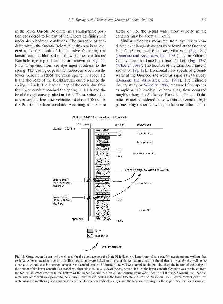
Borehole dye input locations are shown in Fig. 11.
Flow is upward from the dye input locations to the
spring. The leading edge of the fluorescein dye from the
lower conduit reached the main spring in about 1.5
h and the peak of the breakthrough curve reached the
spring in 2.4 h. The leading edge of the eosin dye from
the upper conduit reached the spring in 1.1 h and the
breakthrough curve peaked at 1.6 h. These values doc-
ument straight-line flow velocities of about 600 m/h in
the Prairie du Chien conduits. Assuming a curvature
Fig. 11. Construction diagram of a well used for the dye trace near the State
684602. After circulation was lost, drilling operations were halted until a
completed without causing further damage to the conduit system. Ultimately
the bottom of the lower conduit. Pea gravel was then added to the outside of t
the top of the lower conduit to the bottom of the upper conduit; pea grave
remainder of the well was grouted to the surface. Conduits are located in the
with enhanced weathering and karstification of the Oneota near bedrock val
factor of 1.5, the actual water flow velocity in the
conduits may be about a 1 km/h.
Similar velocities measured from dye traces con-
ducted over longer distances were found at the Oronoco
land fill (3 km), near Rochester, Minnesota (Fig. 12A)
(Donahue and Associates, Inc., 1991), and in Fillmore
County near the Lanesboro trace (4 km) (Fig. 12B)
(Wheeler, 1993). The location of the Lanesboro trace is
shown on Fig. 12B. Horizontal flow speeds of ground-
water at the Oronoco site were as rapid as 244 m/day
(Donahue and Associates, Inc., 1991). The Fillmore
County study by Wheeler (1993) measured flow speeds
as rapid as 10 km/day. At both sites, flow occurred
roughly along the Shakopee Formation–Oneota Dolo-
mite contact considered to be within the zone of high
permeability associated with paleokarst near the contact.
Fish Hatchery, Lanesboro, Minnesota. Minnesota unique well number
suitable resolution could be found that allowed for the well to be
, the well was completed by grouting from the bottom of the casing to
he casing until it filled the lower conduit. Grouting was continued from
l and cement grout were used to fill the upper conduit and then the
lower Oneota and near the Prairie du Chien–Jordan contact, consistent
leys, and the location of springs in the region. See text for discussion.

Fig. 12. Hydrogeologic character of the Prairie du Chien Group and Jordan Sandstone in shallow to deep bedrock conditions at a landfill near Oronoco (Olmsted County), and in eastern Fillmore
County. See Fig. 1 for location. (A) At Oronoco, a water-table aquifer lies in the Shakopee Formation and uppermost Oneota Dolomite, which have abundant fractures and dissolution features. The
Jordan Sandstone at this site is an intergranular aquifer with a regional groundwater system. The two aquifers are hydraulically separated by Oneota Dolomite with relatively few secondary porosity
features. This depiction is based on borehole videos, natural gamma and caliper logs, cuttings, dye tracing, water chemistry, and potentiometric levels. Modified from Donahue and Associates, Inc.
(1991). (B) Conduit flow in the Prairie du Chien Group in eastern Fillmore County based on dye trace investigations. Note the similarity of hydrogeologic conditions to those at Oronoco. Modified
from Alexander and Lively (1995).
R.G.Tippinget
al./Sedimentary
Geology184(2006)305–330
320

R.G. Tipping et al. / Sedimentary Geology 184 (2006) 305–330 321
Additional information on regional hydraulic attri-
butes of the Prairie du Chien Group comes from hy-
draulic conductivity estimates based on the state water
well database specific capacity data. Hydraulic conduc-
tivity was calculated from specific capacity for 807
wells, using the methods of Bradbury and Rothschild
(1985). Depths and calculated hydraulic conductivities
from Prairie du Chien wells in shallow and deeply
buried bedrock conditions are shown in Fig. 13. Wells
are finished almost exclusively within the Shakopee
Formation of the Prairie du Chien Group; under condi-
tions in which the top of the Prairie du Chien is the
uppermost bedrock layer and conditions where it is
overlain by younger bedrock, the majority of wells
penetrate less than 10 m into the Prairie du Chien
Group (Fig. 13A, C). Wells finished in the Shakopee
under conditions where the Prairie du Chien is upper-
Fig. 13. (A) Box plot of depth (m) in wells from the top of the Prairie du Ch
Prairie du Chien is the uppermost bedrock unit. (B) Box plot of hydraulic c
wells in conditions where Prairie du Chien is the uppermost bedrock unit. (C
the bottom of the casing (start of well open hole) in conditions where Prairie
conductivity values in m/day calculated from specific capacity data for wells i
most bedrock have higher yields than Shakopee wells
where the Prairie du Chien is not first bedrock, support-
ing the hypothesis that the Shakopee has greater frac-
ture density under shallow bedrock conditions (Fig.
13B, D). Wells are completed over a wider range of
depths in the Prairie du Chien Group under conditions
where the Prairie du Chien is not first bedrock (Fig.
13C, A), presumably because under deeper bedrock
conditions, the Shakopee Formation alone does not
provide sufficient yields.
5. Hydrogeologic synthesis
The results of observations from core and outcrop,
borehole investigations, dye tracing and conventional
aquifer test and specific capacity data provide an im-
proved hydrogeologic characterization of the Prairie du
ien to the bottom of the casing (start of open hole) in conditions where
onductivity values in m/day calculated from specific capacity data for
) Box plot of depth (m) in wells from the top of the Prairie du Chien to
du Chien is not the uppermost bedrock unit. (D) Box plot of hydraulic
n conditions where Prairie du Chien is not the uppermost bedrock unit.

R.G. Tipping et al. / Sedimentary Geology 184 (2006) 305–330322
Chien Group at both borehole and regional scales.
Unlike previous studies where the entire Prairie du
Chien Group and underlying Jordan Sandstone have
traditionally been treated as a single aquifer in Minne-
sota (e.g., Kanivetsky, 1978; Delin and Woodward,
1984), this study separates the Prairie du Chien
Group into the Shakopee aquifer consisting of the
Shakopee Formation and upper one-third of the Oneota
Dolomite, and the Oneota confining unit, consisting of
the lower two-thirds of the Oneota Dolomite.
Certain hydrogeologic characteristics are common to
both the Shakopee Formation and the Oneota Dolomite.
As seen from plug tests, intergranular porosity and
permeability are negligible in the recrystallized, dolos-
tone beds of both formations. The largest volumes of
groundwater flow are therefore almost entirely restrict-
ed to discrete intervals of parallel to bedding fractures,
joints, and secondary porosity features ranging in width
from centimeters to meters. The distribution of these
features changes from shallow (less than 60 m below
the bedrock surface) to deep (greater than 60 m below
the bedrock surface) settings. In shallow settings (Figs.
3 and 6), there is a greater density of nonsystematic
fractures, solution-enlarged conduits parallel and per-
pendicular to bedding than under deep settings. Cav-
ernous porosity is present in both shallow and deep
settings, and is characterized by anastomosing channels
as seen in cave maps (Fig. 4) and long-dye trace
breakthrough curves. Hydraulically active secondary
porosity intervals are separated by thicker intervals of
carbonate rock with few secondary pores, some of
which provide confinement at least at the borehole
scale.
A compilation of data tied to stratigraphic attributes
unique to the Shakopee Formation and Oneota Dolo-
mite reveals regional and therefore mappable and pre-
dictable hydrogeologic characteristics of these rocks.
The Shakopee Formation, composed of thin to medium
beds of sandy dolostone with minor sandstone and
shale, has a higher frequency of solution-enlarged bed-
ding plane fractures and secondary porosity features
than the thick, internally structureless beds of the
Oneota Dolomite. Secondary porosity and permeability
in the form of solution-enhanced bedding plane frac-
tures and cavernous porosity is present in the paleokarst
horizon both above and below the Shakopee Forma-
tion–Oneota Dolomite contact. This zone of high per-
meability is present in both shallow and deep bedrock
conditions, and can be traced regionally (Fig. 5). Tests
conducted on several deep wells in Iowa attribute the
primary production interval to a fracture zone near the
Shakopee Formation–Oneota Dolomite contact. Here,
the Prairie du Chien Group is deeply buried, with the
high production interval located between 700 and 716
m below the land surface, and over 300 m below the
bedrock surface (Des Moines Water Works, 1995).
Hydraulic conductivities calculated from water well
specific capacity data, along with the distribution of
open-hole intervals also reflect the regional distribution
of porosity and permeability within the Prairie du Chien
Group. Under shallow bedrock conditions, wells are
mostly finished within the uppermost Shakopee Forma-
tion (Fig. 13A) with hydraulic conductivities higher
than those found in Shakopee Formation wells in
deep bedrock conditions (Fig. 13C, D). Higher hydrau-
lic conductivites in shallow to bedrock Shakopee For-
mation wells are presumably the result of more
integrated fracture networks than under deep bedrock
conditions. Under deep bedrock conditions, casing
lengths are more variable (Fig. 13C), presumably the
result of decreased abundance of fractures perpendicu-
lar to bedding; drillers extend wells further into the
Prairie du Chien Group in order to intercept hydrauli-
cally active bedding plane fractures and/or cavernous
porosity. Under both shallow to bedrock and deep
bedrock conditions, wells are almost exclusively fin-
ished within the Shakopee Formation. No wells were
found that were open only to the Oneota Dolomite,
indicative of its regionally extensive low porosity and
permeability.
5.1. The Shakopee aquifer
Hydraulic data presented in this study, interpreted
in the context of fracture and secondary porosity fea-
ture distribution within the Prairie du Chien Group,
supports the subdivision of these rocks into the Sha-
kopee aquifer consisting of the Shakopee Formation
and upper one-third of the Oneota Dolomite. This
aquifer is broadly characterized by groundwater flow
through discrete bedding plane fractures, separated by
thicker intervals of carbonate rock, some of which
provide confinement within the aquifer, at least at
the borehole scale. Inflow and outflow in the Shako-
pee Formation near the city of Rochester was found to
be limited to a few fractures over 40 m of open
borehole (Paillet et al., 2000; Fig. 7). Calculated hy-
draulic conductivity for these fractures ranged over
two orders of magnitude (Paillet et al., 2000). Step-
wise jumps in the flowmeter station measurements
within the Shakopee Formation, indicative of sharp
breaks in flow in and out of the borehole, were also
found in other wells tested as part of this study (Fig.
9), and are characteristic of flowmeter profiles in open

R.G. Tipping et al. / Sedimentary Geology 184 (2006) 305–330 323
holes where flow occurs within a few discrete hydrau-
lically active fractures.
Typically, water enters (inflow) or exits (outflow) the
borehole in the upper part of the Prairie du Chien Group
(mostly Shakopee Formation), with the lower most
occurrence of inflow/outflow either just above or
below the Shakopee Formation–Oneota Dolomite con-
tact (Fig. 9). This lower most hydraulically active zone
corresponds to the paleokarst zone within the Prairie du
Chien Group discussed earlier. It marks the lower
boundary of the Shakopee aquifer, and is extends into
the upper one-third of Oneota Dolomite. This zone
often has the highest porosity and permeability within
the Prairie du Chien Group (Figs. 9 and 10).
Additional evidence for enhanced porosity and per-
meability near the Shakopee Formation–Oneota Dolo-
mite contact comes from dye trace studies presented
earlier. Rapid groundwater flow speeds measured with-
in this horizon at the Oronoco site and Fillmore County
Study attest to the high degree of hydraulic heteroge-
neity within the Prairie du Chien Group (Fig. 12).
These and other dye traces in shallow bedrock condi-
tions of southeastern Minnesota yielded relatively wide
breakthrough curves that have long tails and a fine-
scale structure. These breakthrough curves are different
from the narrow breakthrough curves and short tails
seen in the conduits of karst systems in Upper Ordovi-
cian and Devonian age rocks in Minnesota, and are
consistent with movement through complex anastomos-
ing, turbulent flow systems. The anastomosing charac-
ter of voids creates multiple flow paths and reservoirs
where dye can become trapped until mobilized by
subsequent recharge events.
5.2. The Oneota confining unit
In Minnesota, differences in static levels between the
upper part of the Prairie du Chien Group and Jordan
aquifer have been noted in at least seven counties (Hall
et al., 1911; Kanivetsky and Palen, 1982; Kanivetsky,
1984, 1988; Kanivetsky and Cleland, 1990, 1992;
Donahue and Associates, Inc., 1991; RMT, Inc., 1992;
Barr Engineering, 1996; Zhang and Kanivetsky, 1996).
These differences in potentiometric head levels have
typically been attributed to impermeable beds of limited
extent in the Prairie du Chien Group (for example
Kanivetsky and Palen, 1982; Kanivetsky, 1984, 1988;
Kanivetsky and Cleland, 1990, 1992), but no strati-
graphic evidence is provided to support the inter-
pretation that such beds are genuinely only locally
distributed. The results of this study support a different
interpretation: that the differences in head levels noted
in these many different areas reflect the ability of an
interval of rock that is of regional extent across south-
eastern Minnesota, the Oneota Dolomite, to provide
confinement.
Flowmeter results from wells with open holes
extending from the Shakopee Formation through the
Oneota Dolomite and into the underlying Jordan Sand-
stone show head differences between the Shakopee
Formation and Jordan Sandstone, indicating that por-
tions of the Oneota Dolomite act as a confining unit at
least at the borehole scale (Fig. 9A, B). Results in wells
in Fig. 9A and B show inflow into the borehole from
the Jordan Sandstone, strong upflow past the massive
dolostone beds of the lower Oneota Dolomite and
outflow into fractures in the Shakopee Formation.
Water does not enter or leave the open hole within
the lower portion of the Oneota Dolomite. Thickly
bedded, unfractured carbonate bedrock of the lower
Oneota Dolomite confines the underlying Jordan aqui-
fer, resulting in strong ambient upflow into the overly-
ing Shakopee Formation.
Low porosity and permeability in the lower Oneota
Dolomite at the borehole scale is also shown by the
results of packer tests at the Northfield site (Fig. 10).
Isolated 4-m sections of the open hole within the Oneota
Dolomite typically had yields less than the minimum
pumping rate of 1 l/min. Packers also showed that head
differences between the underlying Jordan aquifer and
the overlying Shakopee Formation were maintained
throughout the lower Oneota Dolomite, with a maxi-
mum head difference of 2.4 m in just above the Oneota
Dolomite–Jordan Sandstone contact. Maximum head
difference located over a relatively thin section of the
Oneota Dolomite may be due to a lithologic change in
the bedrock. The Coon Valley Member of the Oneota
Dolomite contains feldspathic sands and shales that may
inhibit the propagation of vertical fractures from the
Oneota Dolomite to the underlying Jordan Sandstone.
These results are similar to those studied by Eaton
(2002), who found sharp head differences over thin
beds within the Ordovician Maquoketa Formation, sug-
gesting that head differences may be due to the termi-
nation of vertical fractures within these beds.
Interpreting borehole results at a larger scale sup-
ports characterization of the Prairie du Chien Group
into a Shakopee aquifer and Oneota confining unit. A
cross section of the Prairie du Chien Group and the
Jordan Sandstone, extending from the Northfield test
hole (Fig. 10) to the Cannon River 425 m away, is
shown in Fig. 14. Snowmelt recharge and upflow from
the Jordan Sandstone exiting the test hole is inter-
preted to be flowing through the lower Shakopee

Fig. 14. Schematic cross section that includes the test hole at Carleton College from the test hole location to the Cannon River, approximately 425 m to the west of the site. Caliper, video,
temperature, borehole flowmeter, and chemistry logs from Fig. 10 have been included at the same vertical scale as the cross section. Water moving upward from the Jordan Sandstone and downward
from fractures in the upper Shakopee Formation exits the borehole near the elevation of the nearby Cannon River.
R.G.Tippinget
al./Sedimentary
Geology184(2006)305–330
324

Fig. 15. Potentiometric surfaces of the St. Peter aquifer (dashed line) and Jordan aquifer (solid line) in northeastern Iowa, demonstrating that part(s)
of the intervening Prairie du Chien Group strata serve as a confining unit that creates hydraulic separation of the two aquifers. Modified from Horick
(1989).
R.G. Tipping et al. / Sedimentary Geology 184 (2006) 305–330 325
Formation towards the Cannon River. Additional flow-
ing Jordan wells in the area support the conclusion
that Oneota Dolomite hydraulically separates ground-
water in the Shakopee Formation from groundwater in
the Jordan Sandstone. Aquifer tests in similar hydro-
geologic settings (Prairie du Chien uppermost bedrock

Fig. 16. Summary of hydraulic conductivity estimates along with additional information on travel times for the Prairie du Chien Group under deep and shallow bedrock conditions (Appendix A).
R.G.Tippinget
al./Sedimentary
Geology184(2006)305–330
326

R.G. Tipping et al. / Sedimentary Geology 184 (2006) 305–330 327
near a large river) have also measured confinement in
the lower Oneota (SEH, 2001; Barr Engineering,
1996). Additional aquifer tests in other settings show
a vertical bulk conductivity in the lower Oneota Do-
lomite of about 10�3 to 10�4 m/day (Fig. 15, Appen-
dix A, Fig. 16).
Further evidence for regional confining characteris-
tics of the Oneota come from water chemistry and
isotope analyses, where chemical and groundwater
age differences have been identified in nest wells of
Shakopee–Jordan pairs (Donahue and Associates, Inc.,
1991; Setterholm et al., 1991; Wall and Regan, 1994)
along with head level differences between wells in
similar configurations (Kanivetsky, 1988; Donahue
and Associates, Inc., 1991; Barr Engineering, 1996).
A study in northern Iowa by Horick (1989) provided
evidence that the lower part of the Prairie du Chien
Group provides effective confinement at a regional
scale (Fig. 15). Horick showed that the potentiometric
surface of water in the St. Peter aquifer is 15 to 60 m
higher than that of the Jordan Sandstone across much of
northeastern Iowa along its border with Minnesota. In
the absence of any known beds in the lower St. Peter
aquifer that could create such confinement, Horick
concluded that some part of the Prairie du Chien
Group is a bconfining intervalQ.As with all other confining units, the Oneota Do-
lomite provides confinement where it is not breached
by interconnected networks of secondary porosity fea-
tures, a situation that most commonly occurs locally in
shallow bedrock or bluff-side conditions. At the Lanes-
boro trace, the well used for dye input up gradient
from the spring encountered two conduits at different
levels within the Oneota Dolomite, both shown by
traces to be connected to the spring (Fig. 11). These
results indicate that the density of conduits in this part
of the flow system is very high. It also further illus-
trates the complexity of this karst conduit system as no
dye was found in Triple Spring, the other water source
for the hatchery. In 1992, Rhodamine WT was poured
into a stream sink 3400 m due south of the hatchery
and was detected in both springs. In the case of the
Lanesboro trace, groundwater flow occurs within the
Oneota Dolomite in bluff-side conditions, where frac-
tures and secondary porosity features extend to greater
depths.
The Oneota confining unit can be traced across all of
southeastern Minnesota area using outcrops, cores,
borehole logs, and cuttings. Although discrete beds
with a relatively great density of secondary porosity
features in the Oneota confining unit may be of high
horizontal hydraulic conductivity, there is strong evi-
dence that bulk vertical conductivity is low enough to
provide confinement, analogous in that respect to the
hydrogeologic attributes of other well established con-
fining units in Minnesota. Observations of secondary
porosity features in outcrop and in boreholes showing
diminished abundance, vertical extent and aperture of
fractures with depth in the Oneota is consistent with
confining characteristics in this unit measured with the
flowmeter and head measurements and aquifer tests,
and is consistent with hydraulic conductivity estimates
and open hole interval data obtained from the state
water well database.
6. Implications for groundwater management
One of the most important results of aquifer charac-
terization studies is that they help to identify paradigms
that have become intransigent in the interpretation of
hydrogeologic data. Hydrogeologic investigations of
the Prairie du Chien Group and Jordan Sandstone
have typically calculated transmissivity estimates
using the combined thicknesses of these units and a
lumped hydraulic conductivity value (for example,
Ruhl, 1999), or treated head differences between for-
mations as local perturbations, even though regional
data do not support these interpretations (Fig. 14),
and that head differences show considerable variation
within formations (Fig. 10).
These misinterpretations become most apparent,
and are perhaps most significant in groundwater mod-
eling studies used to calculate travel times to wells,
and the extent of wellhead protection areas. Dye traces
within the Prairie du Chien Group have measured flow
speeds up to 10 km/day (Wheeler, 1993). Clearly,
traditional methods of modeling carbonate aquifers
as equivalent porous media, with uniform hydraulic
conductivity over tens of meters of aquifer thickness,
misrepresents actual groundwater flow within aquifers
that have measured flow speeds this high. Ground-
flow dominated by a few discrete fractures or prefer-
ential flow over a long open hole interval has been
documented in carbonate rock (e.g., Gianniny et al.,
1996; Michalski and Britton, 1997; Morin et al., 1997;
Runkel et al., 2003) and in siliciclastics both at local
(Swanson, 2001) and regional scales (Runkel et al.,
2006—this volume). In addition, travel time estimates
based on uniform hydraulic conductivity over long
open holes has resulted in velocities that are orders
of magnitude too slow (Bradbury et al., 2000; Rayne
et al., 2001). Recognition of fracture flow within the
Shakopee Formation, along with a zone of high per-
meability near the Shakopee Formation–Oneota Dolo-

R.G. Tipping et al. / Sedimentary Geology 184 (2006) 305–330328
mite contact is essential for developing conceptual
models of groundwater flow in the Prairie du Chien
Group, and should be included in well head protection
and contaminant transport studies.
Recognition of a high permeability zone near the
Shakopee Formation–Oneota Dolomite contact also has
implications for land use management decisions that
effect water quality. This zone within the Prairie du
Chien Group has been associated sinkholes when close
to the land surface (Tipping et al., 2001) and is present
near the land surface in 3 documented cases of waste-
water treatment lagoon collapses in Minnesota (Alex-
ander and Book, 1984; Jannik et al., 1992; Alexander et
al., 1993).
The high permeability zone within the Prairie du
Chien Group is associated with a paleokarst horizon
and thus closely tied to the hydrologic history of the
rock. Porosity and permeability of Prairie du Chien
Group has evolved under a wide range of hydrologic
and hydrochemical conditions from diagenesis to
present day weathering by meteoric water. While
this hydrologic bimprintQ is recognized in the oil
industry as a means to identify zones of high produc-
tivity, it has received relatively less attention in
groundwater studies. An understanding of the geolog-
ic and hydrologic history of bedrock strata can greatly
improve its hydrogeologic characterization, which
improves management of groundwater resources in
the aquifer.
Acknowledgments
Funding for much of this research was provided by
the Legislative Commission on Minnesota Resources
Environmental Trust Fund, and from the Southeast
Minnesota Water Resources Board, administered by
Bea Hoffmann at Winona State University. The authors
would also like to thank Fred Paillet for his introduc-
tion to EM flowmeter operation and methods of data
analysis.
Appendix A. Summary of hydraulic conductivity
estimates along with additional information on
travel times for the Prairie du Chien Group under
deep and shallow bedrock conditions (Fig. 16)
Data are presented as a generalized stratigraphic
column of the Prairie du Chien Group in southeastern
Minnesota, showing matrix hydrostratigraphic compo-
nents, typical development of secondary porosity, and
hydraulic data compiled for this report. Figure is not to
scale. (Modified from Runkel et al., 2003.) Hydraulic
data for these figures (numbers in parentheses) are from
the following:
(1) Average value of conductivity calculated based
on specific capacity tests in the County Well
Index database.
(2) Fillmore County dye trace study by Wheeler
(1993).
(3) Standard aquifer test of Spring Grove municipal
well #4 (unique number 433257), Houston Coun-
ty (Eder and Associates, 1997).
(4) Discrete interval tests and dye trace studies at
Oronoco Landfill, Olmsted County, by Donahue
and Associates, Inc. (1991) and RMT, Inc.
(1992).
(5) Borehole flowmeter logging and pumping at
wells in: (A) Faribault (unique number 625327),
Rice County. (B) Rochester (unique number
485610), Olmsted County.
(6) Standard aquifer test of a well at Chatfield Fish
and Game Club in Fillmore County (unique num-
ber 227394).
(7) Twenty-six standard aquifer tests conducted in
southeastern Minnesota. Tests of 12 boreholes
located in the seven-county Twin Cities Metro-
politan area are reported by Runkel et al. (1999).
Tests of 14 boreholes outside of the metropolitan
area are from unpublished data compiled by the
U.S. Geological Survey and include the follow-
ing: Rochester Municipal wells 23 (unique num-
ber 220660), 27 (unique number 224212), 28
(unique number 180567), 29 (unique number
161425), 30 (unique number 239761), 31 (unique
number 434041), 32 (unique number 506819),
and 34 (unique number 463536), Rochester pub-
lic schools wells for Ridgeway (unique number
235583), Burr Oak (unique number 220615), and
Golden Hill (unique number 220679), all in
Olmsted County, and Rice County wells at Car-
leton College (unique number 171005), Dundas
(unique number 132294), and St. Olaf College
(no number).
(8) Standard aquifer tests at the New Brighton and
Arden Hills Twin Cities Army Ammunition Plant
site, Ramsey County, by Camp et al. (1991).
(9) Standard aquifer test by the Minnesota Depart-
ment of Natural Resources and Minnesota De-
partment of Health at Plainview in Wabasha
County, Minnesota.
(10) Seventy-two hour aquifer test of Woodbury Well
15 (unique number 676415), Washington County,
by Bonestroo and Associates (2003).

R.G. Tipping et al. / Sedimentary Geology 184 (2006) 305–330 329
(11) Re-analysis of 1984 Burnsville aquifer test by
SEH (2001).
References
Alexander Jr., E.C., Book, P.R., 1984. Altura, Minnesota lagoon
collapses. In: Beck, B.F. (Ed.), Sinkholes: Their Geology, Engi-
neering, and Environmental Impact. A.A. Balkema, Rotterdam,
pp. 311–318.
Alexander Jr., E.C., Lively, R.S., 1995. Karst—aquifers, caves and
sinkholes. In: Lively, R.S., Balaban, N.H. (Eds.), Text Supplement
to the Geologic Atlas of Fillmore County, Minnesota Geological
Survey County Atlas C-8, Part C, pp. 10–18.
Alexander Jr., E.C., Broberg, J.S., Kehren, A.R., Graziani, M.M.,
Turri, W.L., 1993. Bellechester Minnesota lagoon collapses. In:
Beck, B.F. (Ed.), Applied Karst Geology: Proceedings of the
Fourth Multidisciplinary Conference on Sinkholes and the Engi-
neering and Environmental Impacts of Karst, Panama City, Flor-
ida, 25–27 January. A.A. Balkema, Rotterdam, pp. 63–72.
Barr Engineering, 1996. Dakota County groundwater model, sum-
mary report. 90 pp.
Bonestroo and Associates, 2003. Woodbury Well 15: 72 hour aquifer
test. Report to the Woodbury East Wellfield Technical Advisory
Committee, March 14, 2003, on file at Minnesota Geological
Survey.
Bradbury, K.R., Rothschild, E.R., 1985. A computerized technique
for estimating the hydraulic conductivity of aquifers from specific
capacity data. Ground Water 23 (2), 240–245.
Bradbury, K.R., Rayne, T.W., Muldoon, M.A., 2000. Field verifica-
tion of capture zones for municipal wells at Sturgeon Bay, Wis-
consin. Wisconsin Geological and Natural History Survey,
Informal Final Report to the Wisconsin Department of Natural
Resources, 29 pp.
Camp, Dresser, McKee, 1991. Phase 1A: multi-point source ground-
water remedial investigation, New Brighton/Arden Hills, Minne-
sota. Minnesota Pollution Control Agency Report 90-00007,
vol. 1. 453 pp.
Choquette, P.W., James, N.P., 1988. Introduction. In: James, N.P.,
Choquette, P.W. (Eds.), Paleokarst. Springer-Verlag, New York,
pp. 1–21.
Delin, G.N., Woodward, D.G., 1984. Hydrogeologic setting and the
potentiometric surfaces of regional aquifers in the Hollandale
Embayment, southeastern Minnesota, 1970–1980. U.S. Geologi-
cal Survey Water-Supply Paper 2219 (56 pp.).
Des Moines Water Works, 1995. Aquifer storage and recovery dem-
onstration project. Phase II. Demonstration test results. Informal
report submitted by CH2MHILL to the Des Moines Water Works
Department, unpaginated.
Donahue and Associates, Inc., 1991. Olmsted County dye-trace
investigations [prepared for Olmsted County]—Final report, vol-
ume 1. On file at the Minnesota Pollution Control Agency. 155 pp.
Eaton, T.T., 2002. Fracture heterogeneity and hydrogeology of the
Maquoketa aquitard, southeastern Wisconsin. PhD dissertation,
University of Wisconsin, Madison. 211pp.
Eder and Associates, 1997. 1996 annual monitoring report for Spring
Grove, Minnesota: response action plan. Project 536-01, on file at
the Minnesota Pollution Control Agency.
Frank, E.F., Mylroie, J.E., Troester, J., Alexander, E.C., Carew, J.L.,
1998. Karst development and speleogenesis, Isla de Mona, Puerto
Rico. Journal of Caves and Karst Studies 60 (2), 73–83.
Gianniny, G.L., Muldoon, M.A., Simo, J.A., Bradbury, K.R., 1996.
Correlation of high-permeability zones with stratigraphic features
in the Silurian dolomite, Sturgeon Bay, Wisconsin. Wisconsin
Geological and Natural History Survey Open-File Report 1996-
7. 102 pp., 1 pl.
Hall, C.W., Meinzer, O.E., Fuller, M.L., 1911. Geology and under-
ground waters of southern Minnesota. U.S. Geological Survey
Water-Supply Paper 256 (406 pp.).
Horick, P.J., 1989. Water resources of northeast Iowa. Iowa Depart-
ment of Natural Resources, Geological Survey Bureau Water
Atlas vol. 8, 133 pp.
Jannik, N.O., Alexander Jr., E.C., Landherr, L.J., 1992. The sinkhole
collapse of the Lewiston, Minnesota waste water treatment facility
lagoon. In: Quinlan, J., Stanley, A. (Eds.), Proceedings of the 3rd
National Ground Water Association Conference on Hydrogeol-
ogy, Ecology, Monitoring, and Management of Ground Water in
Karst Terranes. Water Well Journal Publishing Company, Dublin,
OH, pp. 715–724.
Kanivetsky, R., 1978. Hydrogeologic map of Minnesota, bedrock
hydrogeology. Minnesota Geological Survey State Map S-2, 2
pls., scale 1:500,000.
Kanivetsky, R., 1984. Bedrock hydrogeology, pl. 4. In: Balaban,
N.H., Olsen, B.M. (Eds.), Geologic Atlas of Winona County,
Minnesota. Minnesota Geological Survey County Atlas C-2,
8 pls., scale 1:200,000.
Kanivetsky, R., 1988. Bedrock hydrogeology, pl. 5. In: Balaban,
N.H., (Ed.), Geologic Atlas of Olmsted County, Minnesota.
Minnesota Geological Survey County Atlas C-3, 9 pls., scale
1:100,000.
Kanivetsky, R., Cleland, J.M., 1990. Hydrogeology, pl. 5. In: Swan-
son, L., Meyer, G.N. (Eds.), Geologic Atlas of Washington Coun-
ty, Minnesota. Minnesota Geological Survey County Atlas C-5, 7
pls., scales 1:150,000 and 1:250,000.
Kanivetsky, R., Cleland, J.M., 1992. Bedrock hydrogeology, pl. 7. In:
Meyer, G.N., Swanson, L. (Eds.), Geologic Atlas of Ramsey
County, Minnesota. Minnesota Geological Survey County Atlas
C-7, 10 pls., scales 1:48,000 and 1:150,000.
Kanivetsky, R., Palen, B., 1982. Hydrogeology of Scott County, pl. 6.
In: Balaban, N.H., McSwiggen, P.L. (Eds.), Geologic Atlas of
Scott County, Minnesota. Minnesota Geological Survey County
Atlas C-1, 6 pls.
Kerans, C., 1988. Karst-controlled reservoir heterogeneity in Ellen-
burger Group carbonates of west Texas. American Association of
Petroleum Geologists Bulletin 72 (10), 1160–1183.
Michalski, A., Britton, R., 1997. The role of bedding fractures in the
hydrogeology of sedimentary bedrock—evidence from the New-
ark Basin, New Jersey. Ground Water 35 (2), 318–327.
Morin, R.H., Carleton, G.B., Poirier, S., 1997. Fractured-aquifer
hydrogeology from geophysical logs: the Passaic formation,
New Jersey. Ground Water 35 (2), 328–338.
MUGSP: Minnegasco Underground Gas Storage Project, 1980. Un-
published reports by the Minnesota Gas Company on the under-
ground gas storage project. On file at the Minnesota Geological
Survey.
Muldoon, M.A., Simo, J.A., Bradbury, K.R., 2001. Correlation of
hydraulic conductivity with stratigraphy in a fractured-dolomite
aquifer, northeastern Wisconsin, USA. Hydrogeology Journal 9,
570–583.
Mylroie, J.E., Carew, J.L., 2000. Speleogenesis in coastal and oceanic
settings. In: Klimchouk, A.B., Ford, D.C., Palmer, A.N., Drey-
brodt, W. (Eds.), Speleogenesis: Evolution of Karst Aquifers.
National Speleological Society, pp. 226–233.

R.G. Tipping et al. / Sedimentary Geology 184 (2006) 305–330330
Paillet, F.L., Lundy, J., Tipping, R.G., Runkel, A.C., Reeves, L.,
Green, J.A., 2000. Hydrogeologic characterization of six sites in
southeastern Minnesota using borehole flowmeters and other
geophysical logs. U.S. Geological Survey Water-Resources Inves-
tigation Report 00-4142, 33 pp.
Palmer, M.V., Palmer, A.N., 1989. Paleokarst of the United States.
In: Bosak, P., Ford, D.C., Glazek, J., Horacek, I. (Eds.), Paleo-
karst: A systematic and Regional Review. Elsevier, Amsterdam,
pp. 337–366.
Rayne, T.W., Bradbury, K.R., Muldoon, M.A., 2001. Delineation of
capture zones for municipal wells in fractured dolomite, Sturgeon
Bay, Wisconsin, USA. Hydrogeology Journal 9, 432–450.
RMT, Inc., 1992. Remedial investigation report: Olmsted County
sanitary landfill, Oronoco Township, Minnesota. On File at the
Minnesota Pollution Control Agency. 185 pp.
Ruhl, J.F., 1999. Hydraulic properties of the Prairie du Chien-Jordan
Aquifer, Shakopee Mdewakanton Sioux Community, southeastern
Minnesota. U.S. Geological Survey Water-Resources Investiga-
tions Report 99-4183, 10 pp.
Runkel, A.C., Kanivetsky, R., Tipping, R.G., 1999. Hydraulic and
hydrostratigraphic characteristics of the Prairie du Chien–Jordan
aquifer system in the Twin Cities metropolitan area, Minnesota:
Informal report submitted to the Minnesota Department of Health,
on file at Minnesota Geological Survey.
Runkel, A.C., Tipping, R.G., Alexander Jr., E.C., Green, J., Mossler,
J., Alexander, S.C., 2003. Hydrogeology of the Paleozoic bedrock
in southeastern Minnesota. Report of Investigations-Minnesota
Geological Survey 61 (105 pp., 2 pls).
Runkel, A.C., Tipping, R.G., Alexander Jr., E.C., Alexander, S.C.,
2006—this volume. Hydrostratigraphic characterization of inter-
granular and secondary porosity in part of the Cambrian sandstone
aquifer system of the cratonic interior of North America: improv-
ing predictability of hydrogeologic properties. Sedimentary Geol-
ogy 184, 281–304. doi:10.1016/j.sedgeo.2005.11.006.
Seaber, P.R., 1988. Hydrostratigraphic units. In: Back, W., Rosen-
shein, J.S., Seaber, P.R. (Eds.), Hydrogeology. Boulder, Colorado,
Geological Society of America, The Geology of North America
vol. O-2, pp. 9–14.
SEH, 2001. Re-analysis of 1984 Burnsville pumping test by Hickok
and Associates, SEH No. ABURNS0006.00 SP, SEH, Chippewa
Falls, Wisconsin, Technical memorandum by Erik Anderson to
Burnsville/Kraemer Well Groundwater Study, on file at Minnesota
Geological Survey.
Setterholm, D.R., Runkel, A.C., Cleland, J.M., Tipping, R.G.,
Mossler, J.M., Kanivetsky, R., Hobbs, H.C., 1991. Geologic
factors affecting the sensitivity of the Prairie du Chien-Jordan
aquifer. Minnesota Geological Survey Open-File Report 91-5.
29 pp., 12 pls.
Sloss, L.L., 1963. Sequences in the cratonic interior of North Amer-
ica. Geological Society of America Bulletin 74 (2), 93–113.
Smith, G.L., Byers, C.W., Dott Jr., R.H., 1996. Sequence stratigra-
phy of the Prairie du Chien Group, Lower Ordovician, Midcon-
tinent, USA. In: Witske, B.J., Ludvigson, G.A., Day, J. (Eds.),
Paleozoic Sequence Stratigraphy: Views from the North American
Craton, Geological Society of America Special Paper vol. 306,
pp. 23–33.
Swanson, S.K., 2001, Hydrogeologic controls on springflow near
Madison, Wisconsin. PhD dissertation, University of Wisconsin,
Madison. 436 pp.
Tipping, R.G., Green, J.A., Alexander, E.C. Jr., 2001. Karst features,
pl. 5. In: Runkel, A.C., project manager, Geologic Atlas of
Wabasha County, Minnesota. Minnesota Geological Survey
County Atlas C-14, pt. A, 7 pls., scale 1:100,000.
Wall, D.B., Regan, C.P., 1994. Water quality and sensitivity of the
Prairie du Chien-Jordan aquifer in western Winona County, Min-
nesota. Unpublished report by the Minnesota Pollution Control
Agency, Division of Water Quality, St. Paul, Minn., 65 pp.
Wheeler, B.J., 1993. Groundwater tracing in the Duschee Creek karst
basin in southeast Minnesota. Plan B Thesis paper submitted to
the Geology and Geophysics Department, University of Minne-
sota. 72 pp.
Wilson, J.L., Medlock, P.L., Fritz, R.D., Canter, K.L., Geesaman,
R.G., 1992. A review of Cambro-Ordovician breccias in North
America. In: Candelaria, M.P., Reed, C.L. (Eds.), Paleokarst,
Karst Related Diagenesis, and Reservoir Development: Examples
from Ordovician–Devonian Age Strata of West Texas and the
Mid-Continent, SEPM Publication vol. 92-33, pp. 19–29.
Zhang, H., Kanivetsky, R., 1996. Bedrock hydrogeology. pl. 6. In:
Falteisek, J., project supervisor, Geologic Atlas of Fillmore Coun-
ty, Minnesota. Minnesota Department of Natural Resources, Di-
vision of Waters County Atlas C-8, pt. B, 4 pls., scale 1:100,000.