third andhra pradesh irrigation project - srisailam right branch ...
REPUBLIC OF IRAQ MINISTRY OF HIGHER EDUCATION AND SCIENTIFIC RESEARCH UNIVERSITY OF BABYLON
Issn : 1819-2076
************************************************************************************** The Iraqi Journal for Mechanical – and Materials Engineering Babylon Univ./ Babylon/ Iraq P.O.Box(4) Tel: ++ 964 30 245387.(1155).
Email: - [email protected]
The Iraqi Journal For Mechanical And Material Engineering, Special Issue (B)
EVALUATION OF HILLA-KIFIL IRRIGATION PROJECT
Asst. Prof. Dr. Omran I. Mohammad Asst. Prof. Dr. Najim O. Al-Ghazali Hashim Isam Jameel Al-saffy
College of Engineering/University of Babylon
Abstract
In this study, a specified area of Hilla-Kifil irrigation project have been selected to be evaluated. For the lined Hilla main canal, the evaluation includes four stages, namely, Chemical, Hydraulic, Rheological and Evaluation of the surface water quality using the (GIS) software. For the chemical evaluation, the most important indicators for the salinity problem are (Electrical Conductivity, Total Dissolved Solids, Sodium Adsorption Ratio and Sodium Content). The test results showed that there is no harmful effects from these indicators on crops production. For the hydraulic evaluation, the measurements showed that the constructed and designed cross section of Hilla main canal are identical with regard to dimensions and slopes. The design discharge of this canal is (14.2 ), while the existing or available discharge (as a maximum value) is (12.4 ) in October 2009. This is because the discharge which delivered to Hilla main canal is insufficient amount due to the lack in the quantity of water of Euphrates river. Twenty locations are selected for the rheological evaluation. The test results showed that only (12) locations are within the limits of specifications. For the other (8) locations, the durability requirements are not satisfied. Therefore, these locations are vulnerable to erosion due to the flow of water or from the salts in irrigation water and it is important to protect them from erosion. The three dimensional spatial analysis using the GIS software (Arc Map V. 9.2) showed that the final model of the study area is of good surface water quality according to the classifications of irrigation water quality. Keywords: Chemical, Hydraulic, Rheological Evaluations, Surface Water Quality, GIS Software
181
الخالصة
لقناة الحلة الرئيـسية . تم اختيارها لكي تقيم كفل – حلة مساحة محددة من مشروع ري ، هذه الدراسة في ، يعني، التقييم الكيميائي، الهيـدروليكي، المـواد وتقيـيم نوعيـة المـاء مراحل أربعةالتقييمالمبطنة، يتضمن
الموصـلية الكهربائيـة ، المـواد (مية لمشكلة الملوحة هي للتقييم الكيميائي، إن المؤشرات األكثر أه . السطحي الفحوصات بأنـه لـيس نتائج بينت ). الصلبة الكلية الذائبة، نسبة امتزاز الصوديوم و نسبة محتوى الصوديوم
للتقييم الهيدروليكي، بينت القياسـات تطـابق . هناك تأثيرات مؤذية من هذه المؤشرات على إنتاج المحاصيل إن التصريف التـصميمي . عرضي المنفذ و المصمم لقناة الحلة الرئيسية فيما يتعلق باألبعاد و الميول المقطع ال
في تـشرين األول ) ثا/3 م 12.4(هو ) كقيمة عظمى (أما التصريف الفعلي أو الحالي ) ثا/3 م 14.2(لهذه القناة هو هذا بسبب إن التصريف المجهز لقناة الحلة الرئيسية هي كمية غير كافية بسبب نقص كمية ماء نهـر . 2009موقعا فقـط ) 12(بينت نتائج الفحص بان هنالك . موقعا لتقييم ديمومة خرسانة القناة نتم اختيار عشرو . الفرات
لذا ،فأن هذه المواقع هي . قع الثمانية األخرى متطلبات الديمومة لم تستوفي الموا . كانت ضمن حدود المواصفات لقد بين التحليل .حمايتها من التآكل المهم الري ومن في ماء األمالح جريان الماء أو عرضة للتآكل نتيجة
Evaluation of Hilla-Kifil Irrigation Project Dr. Omran I. Mohammad Dr. Najim O. Al-Ghazali Hashim Isam Jameel Al-saffy
النمـوذج بان GIS( (Arc Map V. 9.2)( باستخدام برنامج نظم المعلومات الجغرافية المكاني ثالثي األبعاد . ة حسب تصانيف نوعية مياه الريالسطحية للمياه جيدالنهائي لمنطقة الدراسة هو من النوعية ال
1- Introduction
Efficient use of limited lands and water resources can only be achieved by development, monitoring and evaluation of those lands and resources. The main reason for poor performance of irrigation projects is the lack of efficient irrigation management rather than the technical deficiencies in project planning, design and construction. Therefore, irrigation experts, project managers and decision makers are discussing on whether establishment of new irrigation projects or rehabilitation (evaluation) of existing ones with efficient irrigation management (Degirmenci et al., 2005). In recent years improving irrigation systems performance is more preferable than developing new irrigation areas because the water resources are too limited to open new schemes in the regions (Sener et al., 2007).
Project evaluation is a step-by-step process of collecting, recording and organizing information about project results, including short-term outputs (immediate results of activities) and longer-term project outcomes (changes in behavior, practice or policy resulting from the project). Project evaluation is used to conduct a systematic and comprehensive assessment of the relevance, performance and impact of the project in the context of its stated objectives. It makes analysis of the project inputs, activities and results and compares these with the designed bases. The results are used to adjust the planning or implementation strategy to ensure the required project results (Anonymous, 1991; Quoted from Degirmenci et al., 2005).
The aim of this study is to make evaluation for a specified area of Hilla-Kifil irrigation project. The evaluation program involves the effect of salinity on crops production. Hydraulic evaluation of Hilla main canal includes cross section and discharge. Rheological evaluation will be made to investigate the durability of the concrete lining materials of Hilla main canal. The GIS software (Arc Map V. 9.2) will be used to evaluate surface water quality in the specified area of the project.
2- Project Description
182
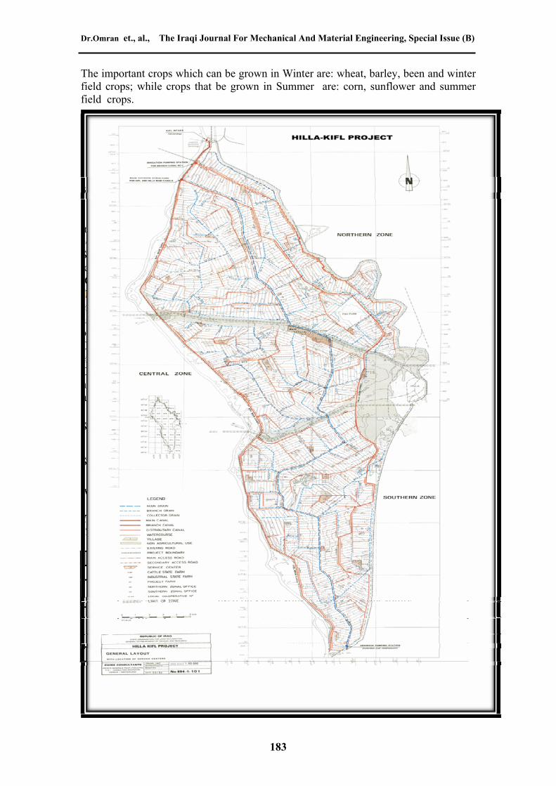
The study was conducted in Hilla-Kifil Irrigation Project which constructed in 1981. It is located between 44 13' to 44 28' eastern longitude and 32 12' to 32 44' northern latitude. The project area covers 57500 hectare and extends about 50 km from north to south and 20 km from west to east, at its broadest. The boundaries of the project area are formed by the Kifil Canal, running parallel to the Euphrates river on the west, Shatt Al-Hilla from the north to the east and by the road from Hilla on the east to Kifil on the south (as shown in Fig. (1)). The main source for the supplied water in the project is the Euphrates river. The climate in the project area is fractionally more moist and cooler to the north of the project than it is toward the south. The soils in the project area are typically of the Mesopotamia plain as a whole, with textures ranging from sandy loams to clays and varying very frequently both horizontally and vertically.
Dr.Omran et., al., The Iraqi Journal For Mechanical And Material Engineering, Special Issue (B)
The important crops which can be grown in Winter are: wheat, barley, been and winter field crops; while crops that be grown in Summer are: corn, sunflower and summer field crops.
Fig. (1)Location map of Hilla-Kifil irrigation project (Hilla-Kifil irrigation project management in Babylon)
3- The Chemical Evaluation
Irrigation water quality can have an important impact on crops production. All irrigation water contains dissolved mineral salts, but the concentration and the composition of the dissolved salts vary depending on the source of irrigation water. Salinity indicates the potential risk of damaging the plants. The term “salinity” is used to describe the concentration of (ionic) salt species, generally including: calcium (Ca+2), magnesium (Mg+2), sodium (Na+), potassium (K+), chloride ( ), bicarbonate
, carbonate , sulfate and others. Two types of salt problems exist which are very different: those associated with the total salinity and those associated with sodium. Soils may be affected only by salinity or by a combination of both salinity and sodium. Water salinity is usually measured by the EC (Electric Conductivity) or by the TDS (Total Dissolved Solids). Sodium hazard is usually expressed in terms of SAR (Sodium Adsorption Ratio) or in terms of Na% (Sodium Content) (Fipps, 2003). An approximate relation between (EC) and (TDS) for most natural water in the range of (100- 5000 µS/cm) of (EC) values leads to (1mg/l = 1.56 µS/cm) (Todd, 2005).
Sodium Adsorption Ratio is defined by (Todd, 2005): SAR = ……. (1)
Sodium Content is defined by (Todd, 2005): Na% = X100 …… (2)
Where all the concentration of the constituents are expressed in (mg/l). Table (1) shows the classification of irrigation water according to SAR. While Table (2) shows the classification of irrigation water according to Na%. Table (1) Classification of irrigation water based on SAR values (http//.cas.psu.edu/
docs/casdept. 2002; Quoted from Salar, 2006) Level SAR Hazard
S1 <10 No harmful effects from sodium.
S2 ≥10–<18
An appreciable sodium hazard in fine-textured soils but could be used on sandy soils with good permeability.
S3 ≥18–<26
Harmful effects could be anticipated in most soils and amendments such as gypsum would be necessary to exchange
sodium ions. S4 ≥26 Generally unsatisfactory for irrigation.
Table (2) Classification of irrigation water based on SSP (Todd, 2005)
183
Evaluation of Hilla-Kifil Irrigation Project Dr. Omran I. Mohammad Dr. Najim O. Al-Ghazali Hashim Isam Jameel Al-saffy
Water Class (Na%) Excellent < 20
Good ≥20 – <40 Permissible 40 – <60
Doubtful 60 – <80 Unsuitable > 80
Total hardness mainly reflects water contents of calcium and magnesium ions and it has an important effects on crops production. It is expressed by (Todd, 2005) :
TH (Total Hardness) = 2.5 Ca+2 + 4.1 Mg+2 …………(3)
Where TH, Ca+2, and Mg+2 are expressed in ppm. Letterman (1999) and Todd (2005) classified water according to TH into four-categories as shown in Table (3) .
Table (3) Total Hardness classifications of water
Total Hardness (PPM)
(Letterman, 1999) and (Todd , 2005)Water class
0-<75 Soft ≥75-<150 Moderately hard ≥150-<300 Hard ≥ 300 Very hard
High salts can reduce or even prohibit crops production and can reduce water infiltration which indirectly affect the crops. An understanding of the quality of water used for irrigation and its potential negative impacts on crop growth is essential to avoid salinity problems. Water quality and soil chemical analyses are necessary to determine which type of salts are present and the concentrations of these salts ( Stephen, 2002).
184
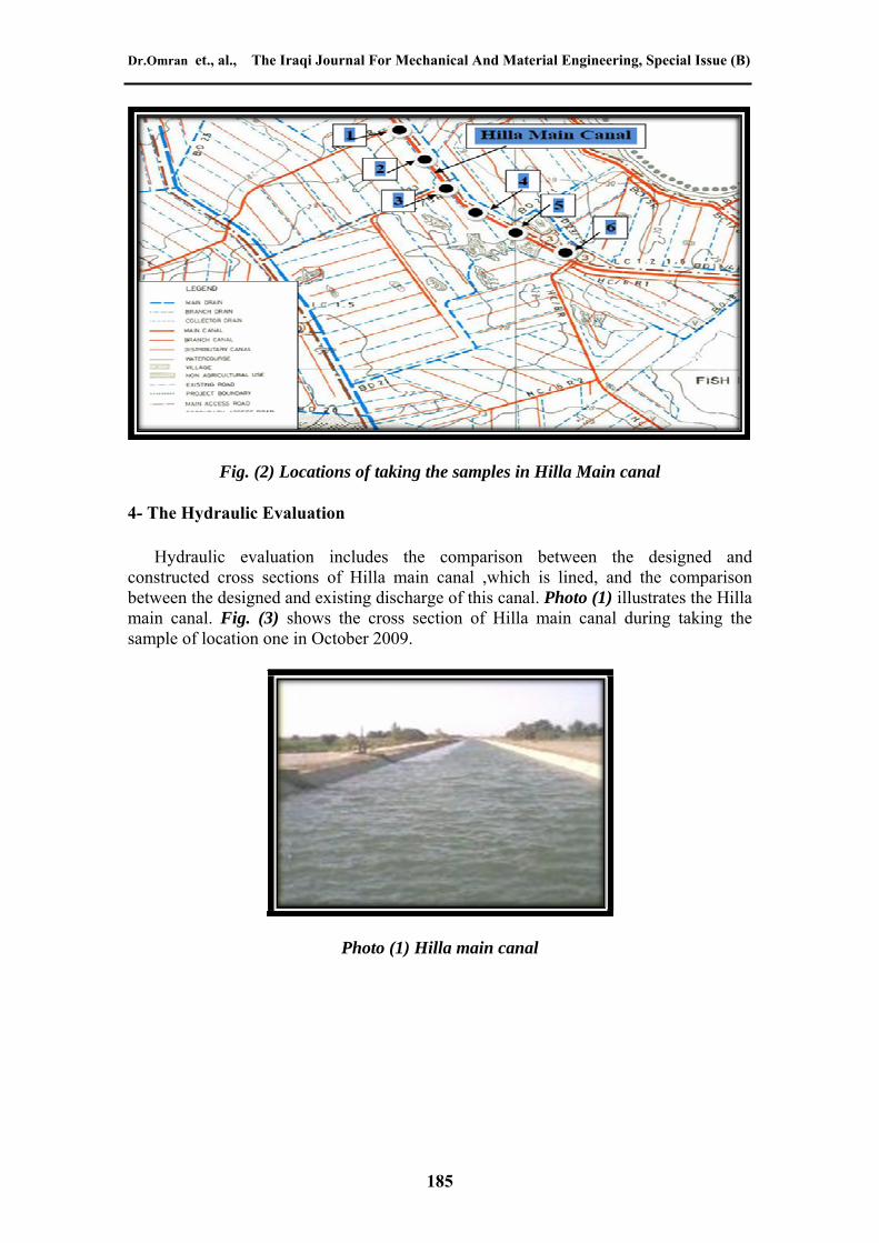
For the chemical evaluation, six samples were taken from six locations of Hilla main canal along six months (from Sep. 2009 to Feb. 2010). The nature of water of Hilla main canal is significantly identical with the nature of water of the river Euphrates because there is no source that cause the pollution of the water. Locations on Hilla main canal are marked by the black points as shown in Fig. (2). These samples were analyzed chemically for different elements to study the effect of salinity indicators on crops production and comparing these indicators with their standard limitations. These elements are: Calcium (Ca+2 ), Magnesium (Mg+2), Sodium (Na+), Potassium (K+) , Chloride ( ), Electrical Conductivity (EC),Total Dissolved Solids (TDS), (PH) values , and Total Hardness (TH). Sodium Adsorption Ratio (SAR) and Sodium Content Percentage (Na%) were also calculated to be compared with their standard limitations. The results of chemical analysis of surface water of Hilla main canal are shown in Table (1).
Dr.Omran et., al., The Iraqi Journal For Mechanical And Material Engineering, Special Issue (B)
Fig. (2) Locations of taking the samples in Hilla Main canal
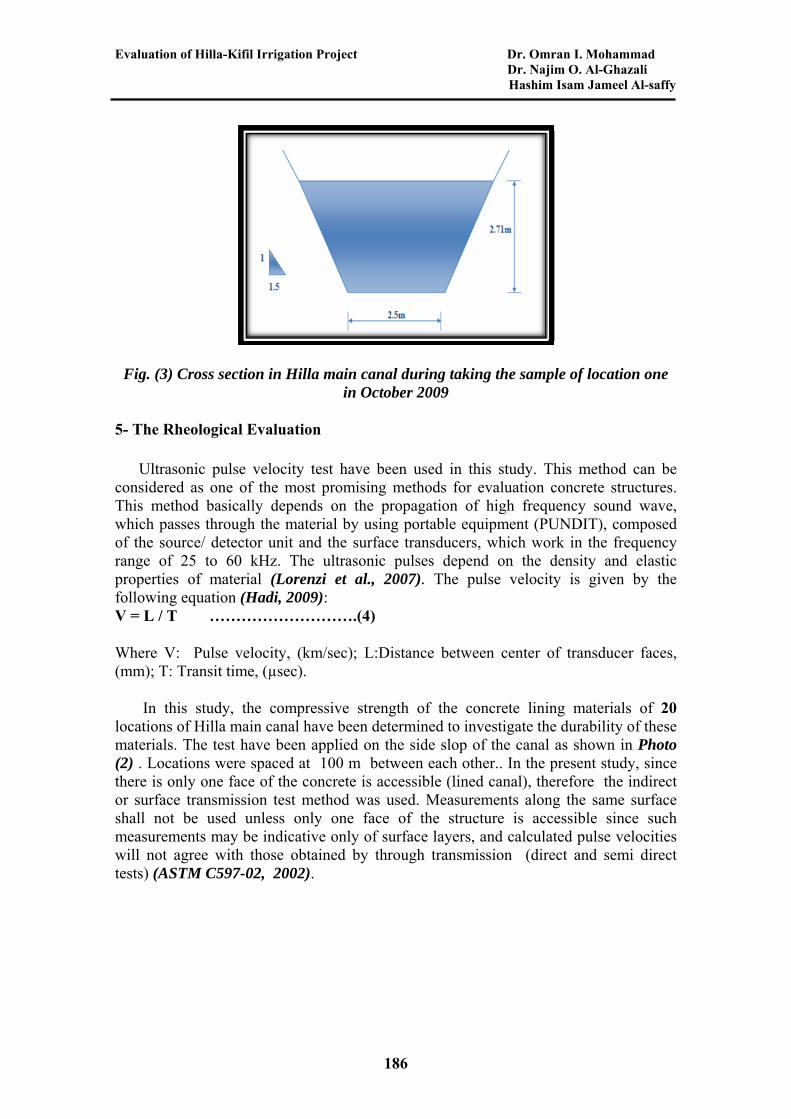
4- The Hydraulic Evaluation
Hydraulic evaluation includes the comparison between the designed and constructed cross sections of Hilla main canal ,which is lined, and the comparison between the designed and existing discharge of this canal. Photo (1) illustrates the Hilla main canal. Fig. (3) shows the cross section of Hilla main canal during taking the sample of location one in October 2009.
185
Photo (1) Hilla main canal
Evaluation of Hilla-Kifil Irrigation Project Dr. Omran I. Mohammad Dr. Najim O. Al-Ghazali Hashim Isam Jameel Al-saffy
Fig. (3) Cross section in Hilla main canal during taking the sample of location one in October 2009
5- The Rheological Evaluation
Ultrasonic pulse velocity test have been used in this study. This method can be considered as one of the most promising methods for evaluation concrete structures. This method basically depends on the propagation of high frequency sound wave, which passes through the material by using portable equipment (PUNDIT), composed of the source/ detector unit and the surface transducers, which work in the frequency range of 25 to 60 kHz. The ultrasonic pulses depend on the density and elastic properties of material (Lorenzi et al., 2007). The pulse velocity is given by the following equation (Hadi, 2009): V = L / T ……………………….(4)
Where V: Pulse velocity, (km/sec); L:Distance between center of transducer faces, (mm); T: Transit time, (µsec).
186
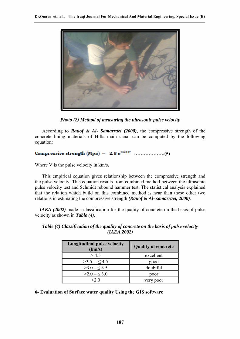
In this study, the compressive strength of the concrete lining materials of 20 locations of Hilla main canal have been determined to investigate the durability of these materials. The test have been applied on the side slop of the canal as shown in Photo (2) . Locations were spaced at 100 m between each other.. In the present study, since there is only one face of the concrete is accessible (lined canal), therefore the indirect or surface transmission test method was used. Measurements along the same surface shall not be used unless only one face of the structure is accessible since such measurements may be indicative only of surface layers, and calculated pulse velocities will not agree with those obtained by through transmission (direct and semi direct tests) (ASTM C597-02, 2002).
Dr.Omran et., al., The Iraqi Journal For Mechanical And Material Engineering, Special Issue (B)
Photo (2) Method of measuring the ultrasonic pulse velocity
According to Rauof & Al- Samarraei (2000), the compressive strength of the concrete lining materials of Hilla main canal can be computed by the following equation:
……………….(5)
Where V is the pulse velocity in km/s.
This empirical equation gives relationship between the compressive strength and the pulse velocity. This equation results from combined method between the ultrasonic pulse velocity test and Schmidt rebound hammer test. The statistical analysis explained that the relation which build on this combined method is near than these other two relations in estimating the compressive strength (Rauof & Al- samarraei, 2000).
IAEA (2002) made a classification for the quality of concrete on the basis of pulse velocity as shown in Table (4).
Table (4) Classification of the quality of concrete on the basis of pulse velocity (IAEA,2002)
Longitudinal pulse velocity (km/s)
Quality of concrete
> 4.5 excellent >3.5 – ≤ 4.5 good >3.0 – ≤ 3.5 doubtful >2.0 – ≤ 3.0 poor
<2.0 very poor
187
6- Evaluation of Surface water quality Using the GIS software
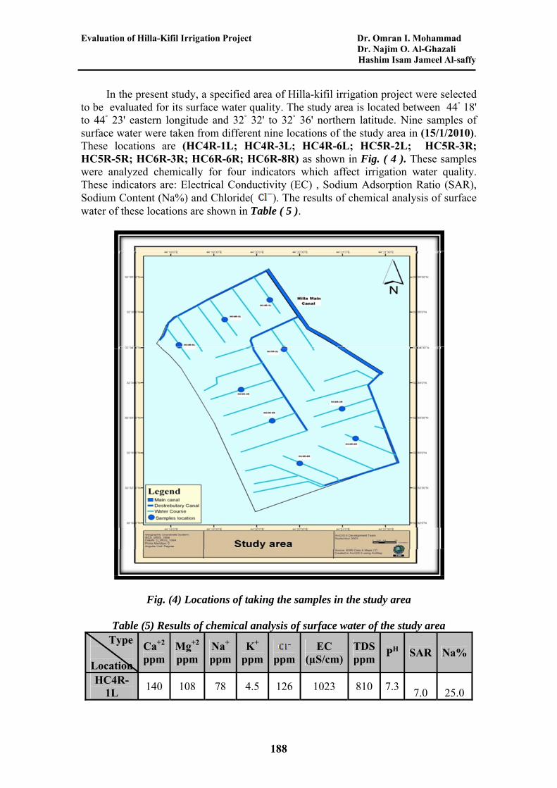
Evaluation of Hilla-Kifil Irrigation Project Dr. Omran I. Mohammad Dr. Najim O. Al-Ghazali Hashim Isam Jameel Al-saffy In the present study, a specified area of Hilla-kifil irrigation project were selected to be evaluated for its surface water quality. The study area is located between 44◦ 18' to 44◦ 23' eastern longitude and 32◦ 32' to 32◦ 36' northern latitude. Nine samples of surface water were taken from different nine locations of the study area in (15/1/2010). These locations are (HC4R-1L; HC4R-3L; HC4R-6L; HC5R-2L; HC5R-3R; HC5R-5R; HC6R-3R; HC6R-6R; HC6R-8R) as shown in Fig. ( 4 ). These samples were analyzed chemically for four indicators which affect irrigation water quality. These indicators are: Electrical Conductivity (EC) , Sodium Adsorption Ratio (SAR), Sodium Content (Na%) and Chloride( ). The results of chemical analysis of surface water of these locations are shown in Table ( 5 ).
Fig. (4) Locations of taking the samples in the study area
Table (5) Results of chemical analysis of surface water of the study area
SAR Na%PH TDSppm
EC (µS/cm)
ppm
K+ ppm
Na+ ppm
Mg+2
ppm Ca+2
ppm
Type
Location
25.0 7.0 7.3 810 1023 4.5 126
188
78 108 140 HC4R-
1L
Dr.Omran et., al., The Iraqi Journal For Mechanical And Material Engineering, Special Issue (B)
86 28.3 8.0
7.7 838 1035 140 5 100 130 HC4R-
3L
26.0 7.3 7.2 840 1060 124 4.3 79 90 146
HC4R-6L
27.9 7.9 7.5 817 1010 130 4.7 86 99 135
HC5R-2L
26.6 7.2 7.4 840 1052 128 4 84 124
HC5R-96
3R HC5R-
28.5 7.8 7.3 790 997 135 4.9 82 92 125
5R HC6R-
26.9 7.5 7.7 798 999 140 4.8 80 102 128
3R
78 7.3
7.5 794 1000 142 4.2 26.4
107 122 HC6R-
6R
25.6 132
HC6R-8R
1020 139 5 83 100 827 7.6 7.0
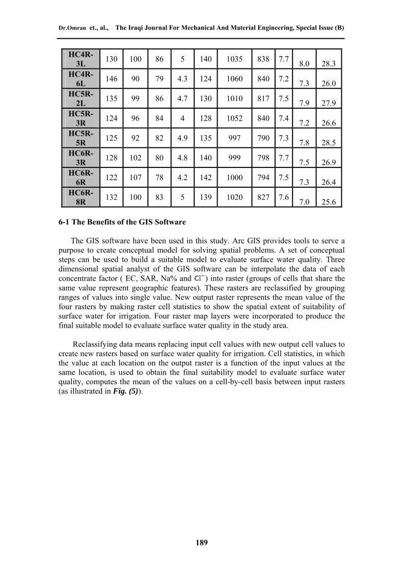
6-1 The Benefits of the GIS Software
The GIS software have been used in this study. Arc GIS provides tools to serve a purpose to create conceptual model for solving spatial problems. A set of conceptual steps can be used to build a suitable model to evaluate surface water quality. Three dimensional spatial analyst of the GIS software can be interpolate the data of each concentrate factor ( EC, SAR, Na% and ) into raster (groups of cells that share the same value represent geographic features). These rasters are reclassified by grouping ranges of values into single value. New output raster represents the mean value of the four rasters by making raster cell statistics to show the spatial extent of suitability of surface water for irrigation. Four raster map layers were incorporated to produce the final suitable model to evaluate surface water quality in the study area.
189
Reclassifying data means replacing input cell values with new output cell values to create new rasters based on surface water quality for irrigation. Cell statistics, in which the value at each location on the output raster is a function of the input values at the same location, is used to obtain the final suitability model to evaluate surface water quality, computes the mean of the values on a cell-by-cell basis between input rasters (as illustrated in Fig. (5)).
Evaluation of Hilla-Kifil Irrigation Project Dr. Omran I. Mohammad Dr. Najim O. Al-Ghazali Hashim Isam Jameel Al-saffy
Fig. (5) GIS modeling scheme
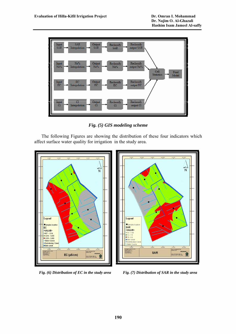
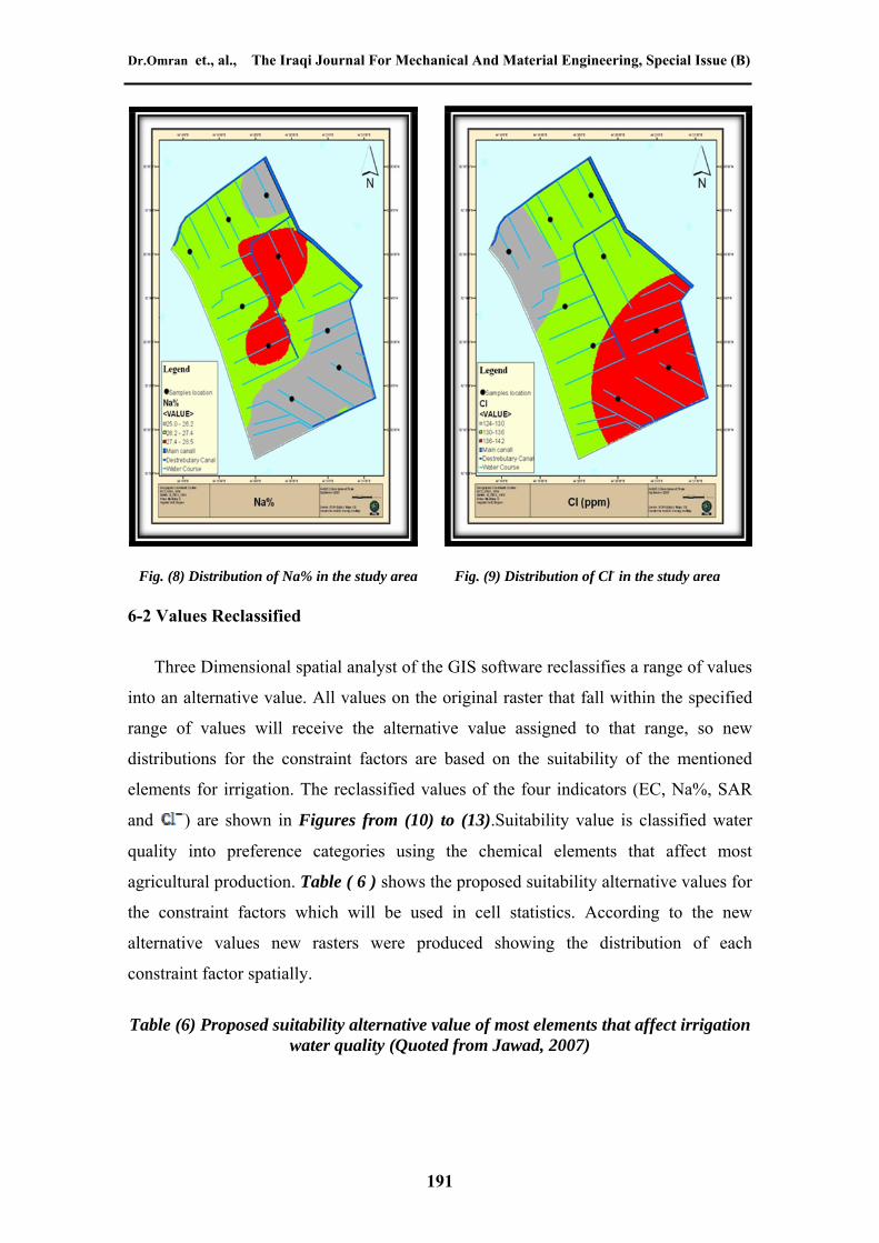
The following Figures are showing the distribution of these four indicators which affect surface water quality for irrigation in the study area.
Fig. (6) Distribution of EC in the study area Fig. (7) Distribution of SAR in the study area
190
Dr.Omran et., al., The Iraqi Journal For Mechanical And Material Engineering, Special Issue (B)
Fig. (8) Distribution of Na% in the study area Fig. (9) Distribution of Cl- in the study area
6-2 Values Reclassified
Three Dimensional spatial analyst of the GIS software reclassifies a range of values
into an alternative value. All values on the original raster that fall within the specified
range of values will receive the alternative value assigned to that range, so new
distributions for the constraint factors are based on the suitability of the mentioned
elements for irrigation. The reclassified values of the four indicators (EC, Na%, SAR
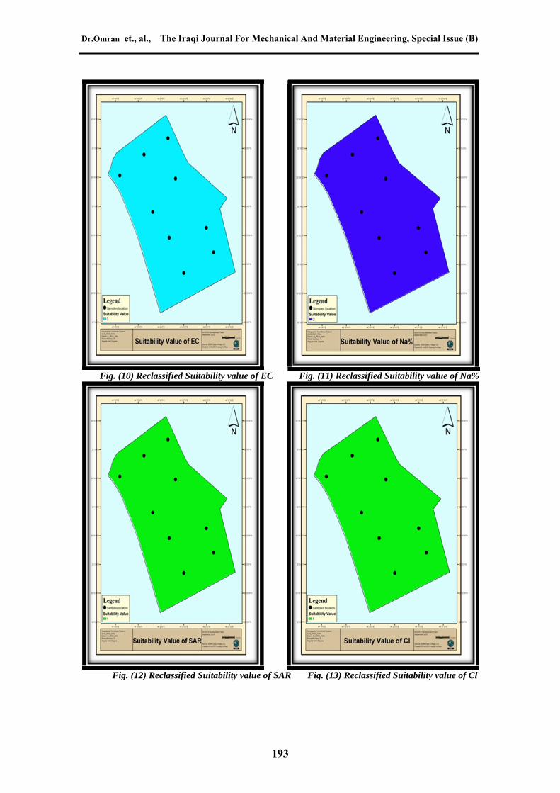
and ) are shown in Figures from (10) to (13).Suitability value is classified water
quality into preference categories using the chemical elements that affect most
agricultural production. Table ( 6 ) shows the proposed suitability alternative values for
the constraint factors which will be used in cell statistics. According to the new
alternative values new rasters were produced showing the distribution of each
constraint factor spatially.
Table (6) Proposed suitability alternative value of most elements that affect irrigation water quality (Quoted from Jawad, 2007)
191
Evaluation of Hilla-Kifil Irrigation Project Dr. Omran I. Mohammad Dr. Najim O. Al-Ghazali Hashim Isam Jameel Al-saffy
Suitable value
Element
1.0 2.0 3.0 4.0 5.0
EC (µS/cm)
(Wilcox, 1955)
<250
Excellent
≥250 - <750
Good
≥750 - <2000
Permissible
≥2000 - <3000
Doubtful
>3000
Unsuitable
Na%
(Wilcox, 1955)
<20
Excellent
≥20 - <40
Good
≥40 - <60
Permissible
≥60 - ≤ 80
Doubtful
>80
Unsuitable
Cl (ppm)
(Westcot, 1985)
<150
Excellent
≥150 - <250
Good
≥250 - <500
Permissible
≥500
Doubtful No data
SAR
(Todd, 1980)
<10
Excellent
≥10 - <18
Good
≥18 - <26
PermissibleNo data
> 26
Unsuitable
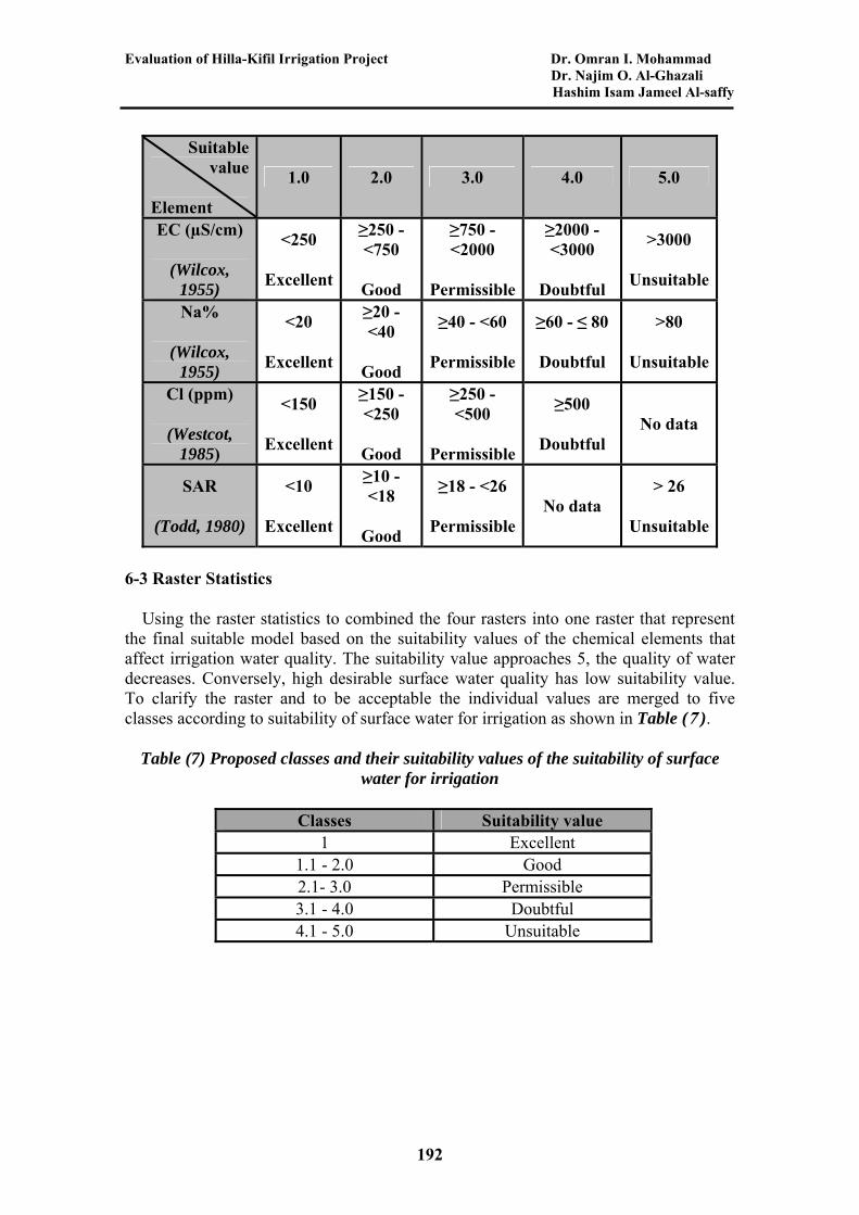
6-3 Raster Statistics
Using the raster statistics to combined the four rasters into one raster that represent the final suitable model based on the suitability values of the chemical elements that affect irrigation water quality. The suitability value approaches 5, the quality of water decreases. Conversely, high desirable surface water quality has low suitability value. To clarify the raster and to be acceptable the individual values are merged to five classes according to suitability of surface water for irrigation as shown in Table ( 7 ).
Table (7) Proposed classes and their suitability values of the suitability of surface water for irrigation
Classes Suitability value 1 Excellent
1.1 - 2.0 Good 2.1- 3.0 Permissible 3.1 - 4.0 Doubtful
192
4.1 - 5.0 Unsuitable
Dr.Omran et., al., The Iraqi Journal For Mechanical And Material Engineering, Special Issue (B)
Fig. (10) Reclassified Suitability value of EC Fig. (11) Reclassified Suitability value of Na%
Fig. (12) Reclassified Suitability value of SAR Fig. (13) Reclassified Suitability value of Cl-
193
Evaluation of Hilla-Kifil Irrigation Project Dr. Omran I. Mohammad Dr. Najim O. Al-Ghazali Hashim Isam Jameel Al-saffy 7- Results and Discussion
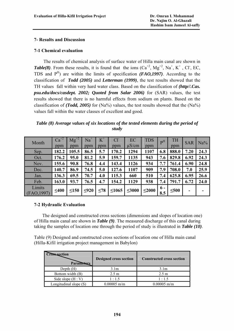
7-1 Chemical evaluation
The results of chemical analysis of surface water of Hilla main canal are shown in Table(8). From these results, it is found that the ions (Ca+2, Mg+2, Na+, K+ , Cl-, EC, TDS and PH) are within the limits of specification (FAO,1997). According to the classification of Todd (2005) and Letterman (1999), the test results showed that the TH values fall within very hard water class. Based on the classification of (http//.Cas. psu.edu/docs/casdept. 2002; Quoted from Salar 2006) for (SAR) values, the test results showed that there is no harmful effects from sodium on plants. Based on the classification of (Todd, 2005) for (Na%) values, the test results showed that the (Na%) values fall within the water classes of excellent and good.
Table (8) Average values of six locations of the tested elements during the period of study
Month Ca+2 ppm
Mg+2 ppm
Na+ ppm
K+ ppm
Cl- EC ppm µS/cm
TDS ppm
PH TH ppm
SAR Na%
Sep. 182.2 105.5 86.5 5.7 170.2 1294 1107 6.8 888.0 7.20 24.3 Oct. 176.2 95.0 81.2 5.9 159.7 1135 943 7.6 829.8 6.92 24.3 Nov. 155.6 90.8 76.8 4.4 143.4 1126 934 7.7 761.4 6.90 24.8 Dec. 140.7 86.9 74.5 5.0 127.6 1107 909 7.9 708.0 7.0 25.9 Jan. 136.3 69.5 70.7 4.0 115.3 660 510 7.4 625.8 6.95 26.6 Feb. 163.0 93.7 76.5 4.7 154.2 1129 938 7.4 791.7 6.72 24.0
Limits (FAO,1997)
≤400 ≤150 ≤920 ≤78 ≤1065 ≤3000 ≤20006 -8.5
≤500 - -
7-2 Hydraulic Evaluation
The designed and constructed cross sections (dimensions and slopes of location one) of Hilla main canal are shown in Table (9). The measured discharge of this canal during taking the samples of location one through the period of study is illustrated in Table (10).
Table (9) Designed and constructed cross sections of location one of Hilla main canal (Hilla-Kifil irrigation project management in Babylon)
194
Constructed cross section Designed cross section Cross section
Parameters 3.1m 3.1m Depth (H) 2.5 m 2.5 m Bottom width (B) 1 : 1.5 1 : 1.5 Side slope (H : V)
0.00005 m/m 0.00005 m/m Longitudinal slope (S)
Dr.Omran et., al., The Iraqi Journal For Mechanical And Material Engineering, Special Issue (B)
Table (10) The measured discharge of Hilla main canal during taking the samples of location one through the period of study
1/2/2010
1/1/2010
1/12/2009
1/11/2009
1/10/2009
1/9/2009
Date
2.00 2.40 2.70 2.68 2.71 2.55 Water Depth
(m)
6.5 9.55 12.3 12.1 12.4 10.87 Discharge
(m3/s)
Hilla main canal is lined, its length is (52.1 km). The discharge of this canal is controlled by gates along the time. The design discharge of this canal corresponding to the full depth of (3.1 m) is (14.2 m3/s), and the existing or available discharge (as maximum value) is (12.4 m3/s) in October 2009 which is corresponding to the depth of (2.71 m). This maximum value of discharge during the period of study is less than the design discharge because the discharge is controlled by gates and the water is delivered to villages around this canal according to their requirements of water at sequencing periods. When comparing the designed cross section (dimensions and slopes) of Hilla main canal with the constructed cross section, it founds that these cross sections are identical.
7-3 Rheological Evaluation
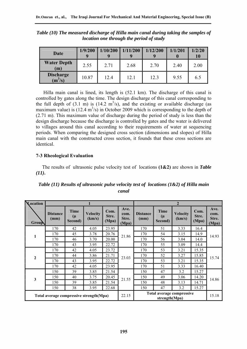
The results of ultrasonic pulse velocity test of locations (1&2) are shown in Table (11).
Table (11) Results of ultrasonic pulse velocity test of locations (1&2) of Hilla main canal
2 1 Ave. com. Stre.
(Mpa)
Com. Stre.
(Mpa)
Velocity (km/s)
Time (µ
Second)
Distance(mm)
Ave. com. Stre.
(Mpa)
Com. Stre.
(Mpa)
Velocity (km/s)
Time (µ
Second)
Distance (mm)
Location
Group
16.4 3.33 51 170 23.95 4.05 42 170 14.9 3.15 54 170 20.76 3.78 45 170 14.0 3.04 56 170 20.00 3.70 46 170
14.93
14.4 3.09 55 170
21.86
22.72 3.95 43 170
1
195
15.35 3.21 53 170 23.72 4.05 42 170 15.85 3.27 52 170 21.71 3.86 44 170 15.35 3.21 53 170 22.72 3.95 43 170
15.74
16.40 3.33 51 170
23.03
23.95 4.05 42 170
2
15.27 3.2 47 150 21.54 3.85 39 150 14.20 3.06 49 150 20.45 3.75 40 150 14.71 3.13 48 150 21.54 3.85 39 150
14.86
15.27 3.2 47 150
21.55
22.68 3.95 38 150
3
15.18 Total average compressive
strength(Mpa) 22.15 Total average compressive strength(Mpa)
Evaluation of Hilla-Kifil Irrigation Project Dr. Omran I. Mohammad Dr. Najim O. Al-Ghazali Hashim Isam Jameel Al-saffy The design requirements (specification limits) of concrete showed that the compressive strength of the concrete lining materials of Hilla main canal is 21 Mpa (i.e., C21 concrete). Durability requirements need to compressive strength at least 20 Mpa to satisfy these requirements.
According to the classification of the quality of concrete on the basis of pulse velocity test (IAEA, 2002), the test results showed that the quality of the concrete lining materials of Hilla main canal falls within the classes of good (locations 1,4,9,10,11,13,14,16,17,18,19,20) and doubtful quality (locations 2,3,5,6,7,8,12,15).
Iraqi Building Code Requirements for Reinforced Concrete paragraph (2.4.4 a&b) showed the limits of specifications in evaluation of concrete structures as follows:
a- The average strength determined from any four consecutive strength tests for laboratory cured specimen exceeds the characteristic compressive strength (fcu) by at least 3N/mm2,
b- No individual strength test result is below the required characteristic compressive strength (fcu) by more than 3N/mm2.
Each location of the tested locations contains 12 points which divided into three groups of four points. The test results showed that only (12) locations are within the limits of specifications. For the other (8) locations, the durability requirements are not satisfied. These eight locations are vulnerable to erosion either from the flow of water in the canal during the time (the canal is constructed since 1981) or from the salts in irrigation water. Therefore, it is important to protect these locations from erosion.
7-4 Evaluation of Surface Water Quality Using the GIS Software
196
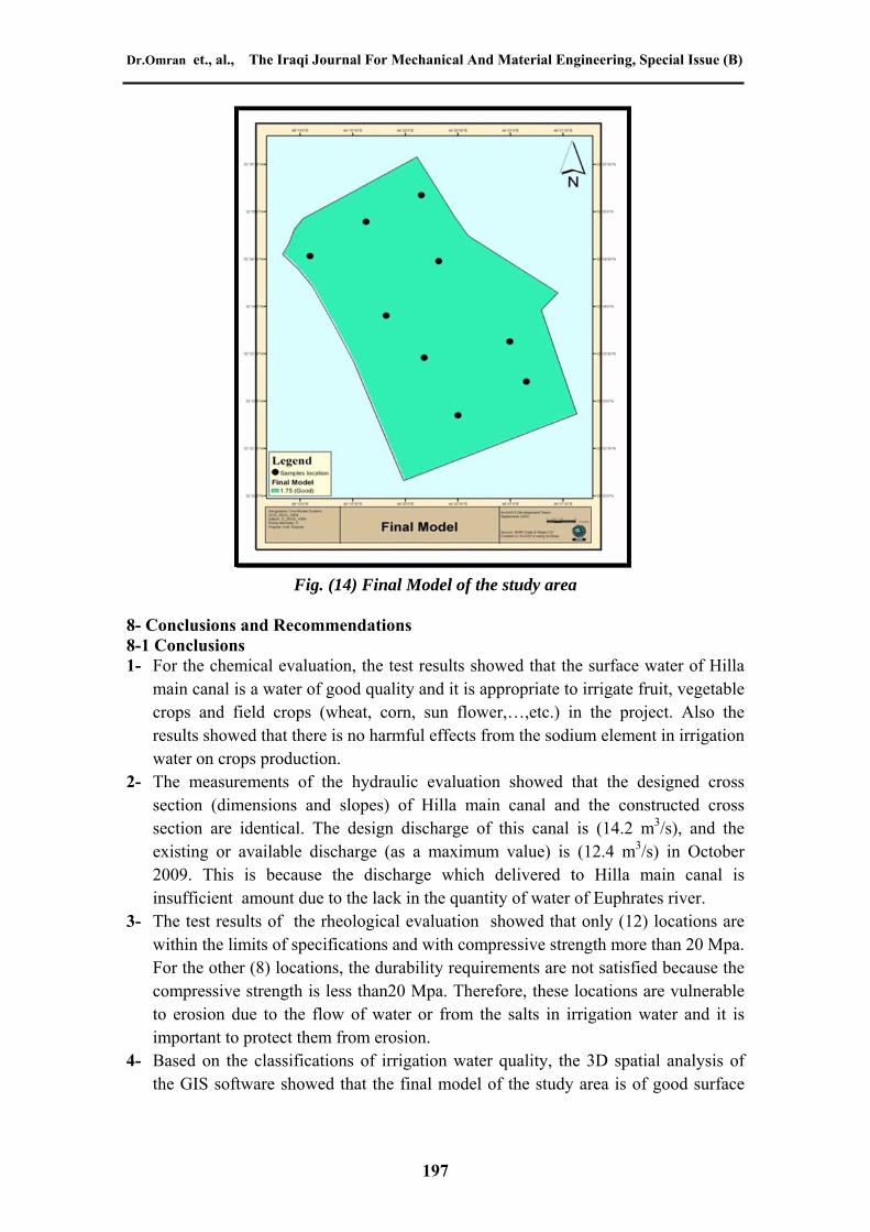
Three dimensional spatial analyst of the GIS software provide one raster representing the suitability model of surface water quality for irrigation after evaluations of four rasters of constraint factor. The final raster gives the spatial extensions of the suitability of surface water for irrigation. From the chemical analysis results of water samples of the study area, it founds that the (EC) value falls within the suitable value 3, (Na%) value falls within the suitable value 2, ) value falls within the suitable value 1 and (SAR) value falls within the suitable value 1. The sum. of these suitability values is equal to 7. The final model represents the mean of these suitability values on a cell-by-cell basis between input rasters, then the mean value is equal to (7/4 = 1.75) which fall within the range of (1.1 – 2.0). According to the statistical analysis of these four rastes, the water of the study area can be classified as a water of good irrigation quality. The final model is shown in Fig.(14 ).
Dr.Omran et., al., The Iraqi Journal For Mechanical And Material Engineering, Special Issue (B)
Fig. (14) Final Model of the study area
8- Conclusions and Recommendations 8-1 Conclusions 1- For the chemical evaluation, the test results showed that the surface water of Hilla
main canal is a water of good quality and it is appropriate to irrigate fruit, vegetable crops and field crops (wheat, corn, sun flower,…,etc.) in the project. Also the results showed that there is no harmful effects from the sodium element in irrigation water on crops production.
2- The measurements of the hydraulic evaluation showed that the designed cross section (dimensions and slopes) of Hilla main canal and the constructed cross section are identical. The design discharge of this canal is (14.2 m3/s), and the existing or available discharge (as a maximum value) is (12.4 m3/s) in October 2009. This is because the discharge which delivered to Hilla main canal is insufficient amount due to the lack in the quantity of water of Euphrates river.
3- The test results of the rheological evaluation showed that only (12) locations are within the limits of specifications and with compressive strength more than 20 Mpa. For the other (8) locations, the durability requirements are not satisfied because the compressive strength is less than20 Mpa. Therefore, these locations are vulnerable to erosion due to the flow of water or from the salts in irrigation water and it is important to protect them from erosion.
197
4- Based on the classifications of irrigation water quality, the 3D spatial analysis of the GIS software showed that the final model of the study area is of good surface
Evaluation of Hilla-Kifil Irrigation Project Dr. Omran I. Mohammad Dr. Najim O. Al-Ghazali Hashim Isam Jameel Al-saffy
water quality with a mean suitability value of 1.75 which fall within the range of (1.1 – 2.0).
8-2 Recommendations
1- More evaluations are required by using the GIS software to investigate the suitability of other water sources for irrigation purposes, such as ground water and drainage water.
2- Using another models by using the GIS software to make evaluation for another reach of Hilla-kifil irrigation project or any irrigation project in Iraq.
3- Making more evaluations to use other methods of irrigation such as sprinkler or drip irrigation and comparing the results of these methods with these results obtained from surface irrigation.
4- Studying the effect of radiation and toxic ions on crops production. 5- More and wider studies to creation of GIS supported database in irrigation project
management.
9- References
1- Al-Saffy, H., I., J. (2010) : "Evaluation of Hilla-Kifil Irrigation Project.", M. Sc. Thesis, College of Engineering, Civil Department, University Of Babylon.
2- ASTM C597-02 (2002): ''Standard Test Method for Pulse Velocity Through Concrete.'' American Society for Testing and Materials.
3- Degirmenci, H., Buyukcangaz, H., and Korukcu, A. (2005) : "Stakeholders and their Information Requirements in Monitoring and Evaluation (M&E) of Irrigation Projects." University of Uludag, Faculty of Agriculture, Agricultural Eng. Dept. Bursa/Turkey.
4- FAO, Food Agriculture Organization, (1994) : "Water Quality for Agriculture ". Rome, Italy.
5- Fipps, G. and Eric L. (2003) : "Study on Using the GIS Software as a Tool in Irrigation Districts and Projects." Biological and Agricultural Engineering, 2117 Texas A&M University, College Station, TX 77843-2117.
6- Hadi, A. M. J. (2009): "The Effect of Sulfates in Groundwater on Some Mechanical Properties of Self-Compacting Concrete." M. Sc. Thesis, College of engineering, Babylon University.
7- "Hilla – Kifil Irrigation Project Management." , Babylon City , Iraq, (2009). 8- International Atomic Energy Agency (IAEA) (2002) : "Guidebook on non-
destructive testing of concrete structures." Wagramer Strasse 5 P.O. Box 100 A-1400 Vienna, Austria.
198
9- Iraqi Building Code Requirements for Reinforced Concrete, Code 1/(1987), Building Research center , Scientific Research Council.
Dr.Omran et., al., The Iraqi Journal For Mechanical And Material Engineering, Special Issue (B)
199
10- Jawad, A. S. B. (2007) : "Suggested Classification to Evaluate Groundwater Suitability for Agriculture in Tikrit-Samarra Hydrological Basin." Senior Chief Geologist-Water Resources Ministry-National Center for Water Resources Management.
11- Letterman, R. D. (1999) : "Water Quality and Treatment. " A Handbook of Community Water Supplies, American Water Works Association, 5th Edition, McGraw-Hill, New York, ISBN 0-07-001659-3, 1194p.
12- Lorenzi, A., Tisbierek, F., and Filho, L. (2007) : ''Ultrasonic Pulse Velocity Analysis in Concrete Specimens.'' Published by: IV Conference Panamericana de End, Brazil, pp.(1-13).
13- Rauof, Z. A. A. and Al- samarraei , M. A. A. (2000) : "Non- Destructive Testing of Concrete." College of engineering: Al-Shareqa University.
14- Salar, S. G. (2006) : " Hydrogeology and Hydro geochemistry of Kifri Area (North of Iraq)." M. Sc. Thesis, College of Science University of Baghdad.
15- Sener, M., Yuksel, A.N., and Konukcu, F. (2007) : " Evaluation of Hayrabolu Irrigation Scheme in Turkey Using Comparative Performance Indicators." Namik Kemal University, Agricultural Faculty, Agricultural Structures and Irrigation Department, Tekirdag.
16- Stephen, R. G. (2002) : "Irrigation Water Salinity and Crops Production." Agricultural and Natural Resources Department, University of California, Davis.
17- Todd, D. K. (2005) : " Ground Water Hydrology. " 3rd edition, John Wiley and Sons, University of California, ISBN: 978-0-471-05937-0, 656 pages.
Copyright © 2022 FDOKUMEN