Evaluating the effects of climate change on environment, resource depletion, and culture in the...
27
Quaternary International 151 (2006) 106–132 Evaluating the effects of climate change on environment, resource depletion, and culture in the Palau Islands between AD 1200 and 1600 W. Bruce Masse a, , Jolie Liston b , James Carucci c , J. Stephen Athens b a Ecology Group, Los Alamos National Laboratory, Mailstop M887, Los Alamos, NM 87545, USA b International Archaeological Research Institute Inc., 2081 Young Street, Honolulu, HI 96826, USA c Cultural Resources Section, 30CES/CEVPC, Vandenberg Air Force Base, CA 93437, USA Available online 24 March 2006 Abstract The Palau archipelago is a sizeable and geologically diverse set of volcanic and coralline limestone islands in equatorial western Micronesia. Recent archeological fieldwork, pollen analyses, and radiocarbon assays have expanded our understanding of more than 3000 years of culture history in Palau, providing a potentially unique window on the relationship between climate, environment, human adaptation, and culture change in the tropical western Pacific. Our focus is on the period of AD 1200–1600, particularly as relates to the transition between the Medieval Warm Period and the onset of the Little Ice Age. This period encompasses the establishment of stonework villages throughout the archipelago, and ultimately their abandonment in the limestone islands. Paleoenvironmental and archeological data, including settlement pattern analyses, provide mixed but intriguing messages regarding the role of climate in Palauan culture change. Archeological deposits in Uchularois Cave contain domestic pig, Sus scrofa, large-eyed bream, Monotaxis grandoculis, parrotfish, Scarus sp., and the humped conch, Strombus gibberulus gibbosus, that together provide evidence of environmental degradation or overharvesting and the potential effects of climate change on culture. Our data suggest that a greater emphasis on high- resolution data is necessary to properly evaluate the role of climate in Pacific island culture change. r 2006 Elsevier Ltd and INQUA. All rights reserved. 1. Introduction Scholars have long debated the degree to which human societies are influenced by their environment. The debate has been spirited, ranging in breadth from those who espouse environmental determinism as the prime shaper of human cultures, to those who view technology as capable of overcoming both environmental constraints and envir- onmental change. Investigations of culture change during the Holocene are problematical, as many aspects of the range of variation in the natural environment are poorly understood, particularly in tropical oceanic settings. Discussion of the possible effects of climate change on culture are lacking in recent overviews of Micronesian prehistory (e.g., Rainbird, 2004). Our study focuses on climate and culture relationships between AD 1200 and 1600 in the Republic of Palau, an archipelago in western Micronesia (Fig. 1). Striking cultural changes in this time period include: (1) the construction of stonework villages in already occupied coastal settings and in marginally habitable limestone islands of the archipelago; (2) the overharvesting of marine fisheries and inshore reefs associated with these limestone island villages; (3) the eventual abandonment of the limestone island stonework villages; and (4) the probable extirpation of pig, a circumstance unique for any Pacific island group as large as Palau. The AD 1200–1600 period coincides with the beginning of the Little Ice Age (LIA), a period of global cooling starting between AD 1300 and 1500 and lasting until about 1850 that has been well described in the literature (Thompson et al., 1985, 1995; Lamb, 1995; Alley, 2000; Fagan, 2000). This also coincides with what Nunn (1999, 2000a, b, 2003) refers to as the ‘‘AD 1300 Event’’, a perceived pan-Pacific ‘‘environmental catastrophe’’ which he models as having occurred between AD 1270 and 1475 and representing the transition from the Little Climatic Optimum (Medieval Warm Period, MWP) to the LIA. Within this 200-year time span Nunn has identified two ARTICLE IN PRESS 1040-6182/$ - see front matter r 2006 Elsevier Ltd and INQUA. All rights reserved. doi:10.1016/j.quaint.2006.01.017 Corresponding author. Tel.: +1 505 665 9149; fax: +1 505 6670731. E-mail address: [email protected] (W.B. Masse).
-
Upload
independent -
Category
Documents
-
view
1 -
download
0
Transcript of Evaluating the effects of climate change on environment, resource depletion, and culture in the...

ARTICLE IN PRESS
1040-6182/$ - se
doi:10.1016/j.qu
�CorrespondE-mail addr
Quaternary International 151 (2006) 106–132
Evaluating the effects of climate change on environment, resourcedepletion, and culture in the Palau Islands between AD 1200 and 1600
W. Bruce Massea,�, Jolie Listonb, James Caruccic, J. Stephen Athensb
aEcology Group, Los Alamos National Laboratory, Mailstop M887, Los Alamos, NM 87545, USAbInternational Archaeological Research Institute Inc., 2081 Young Street, Honolulu, HI 96826, USA
cCultural Resources Section, 30CES/CEVPC, Vandenberg Air Force Base, CA 93437, USA
Available online 24 March 2006
Abstract
The Palau archipelago is a sizeable and geologically diverse set of volcanic and coralline limestone islands in equatorial western
Micronesia. Recent archeological fieldwork, pollen analyses, and radiocarbon assays have expanded our understanding of more than
3000 years of culture history in Palau, providing a potentially unique window on the relationship between climate, environment, human
adaptation, and culture change in the tropical western Pacific. Our focus is on the period of AD 1200–1600, particularly as relates to the
transition between the Medieval Warm Period and the onset of the Little Ice Age. This period encompasses the establishment of
stonework villages throughout the archipelago, and ultimately their abandonment in the limestone islands. Paleoenvironmental and
archeological data, including settlement pattern analyses, provide mixed but intriguing messages regarding the role of climate in Palauan
culture change. Archeological deposits in Uchularois Cave contain domestic pig, Sus scrofa, large-eyed bream, Monotaxis grandoculis,
parrotfish, Scarus sp., and the humped conch, Strombus gibberulus gibbosus, that together provide evidence of environmental
degradation or overharvesting and the potential effects of climate change on culture. Our data suggest that a greater emphasis on high-
resolution data is necessary to properly evaluate the role of climate in Pacific island culture change.
r 2006 Elsevier Ltd and INQUA. All rights reserved.
1. Introduction
Scholars have long debated the degree to which humansocieties are influenced by their environment. The debatehas been spirited, ranging in breadth from those whoespouse environmental determinism as the prime shaper ofhuman cultures, to those who view technology as capableof overcoming both environmental constraints and envir-onmental change. Investigations of culture change duringthe Holocene are problematical, as many aspects of therange of variation in the natural environment are poorlyunderstood, particularly in tropical oceanic settings.Discussion of the possible effects of climate change onculture are lacking in recent overviews of Micronesianprehistory (e.g., Rainbird, 2004).
Our study focuses on climate and culture relationshipsbetween AD 1200 and 1600 in the Republic of Palau,an archipelago in western Micronesia (Fig. 1). Striking
e front matter r 2006 Elsevier Ltd and INQUA. All rights re
aint.2006.01.017
ing author. Tel.: +1505 665 9149; fax: +1 505 6670731.
ess: [email protected] (W.B. Masse).
cultural changes in this time period include: (1) theconstruction of stonework villages in already occupiedcoastal settings and in marginally habitable limestoneislands of the archipelago; (2) the overharvesting of marinefisheries and inshore reefs associated with these limestoneisland villages; (3) the eventual abandonment of thelimestone island stonework villages; and (4) the probableextirpation of pig, a circumstance unique for any Pacificisland group as large as Palau.The AD 1200–1600 period coincides with the beginning
of the Little Ice Age (LIA), a period of global coolingstarting between AD 1300 and 1500 and lasting until about1850 that has been well described in the literature(Thompson et al., 1985, 1995; Lamb, 1995; Alley, 2000;Fagan, 2000). This also coincides with what Nunn (1999,2000a, b, 2003) refers to as the ‘‘AD 1300 Event’’, aperceived pan-Pacific ‘‘environmental catastrophe’’ whichhe models as having occurred between AD 1270 and 1475and representing the transition from the Little ClimaticOptimum (Medieval Warm Period, MWP) to the LIA.Within this 200-year time span Nunn has identified two
served.

ARTICLE IN PRESS
Fig. 1. Map of the Palau archipelago and its location with respect to other island groups in the western Pacific.
W.B. Masse et al. / Quaternary International 151 (2006) 106–132 107
separate periods of environmental flux involving a decreasein temperatures, the lowering of sea level, increasedstorminess, and a short-lived rise in precipitation. Stage 1occurs between AD 1270 and 1325, while Stage 2 occursaround AD 1455–1475.
In this paper, we examine the relationship of the LIAand Nunn’s modeled AD 1300 Event with that of ourcurrent understanding of Palauan archeological andpaleoenvironmental data. We also briefly touch upon othertime periods in which climate and Palauan culturalbehavior may be linked. While we find some support foraspects of Nunn’s model and for significant impacts toPalauan culture possibly caused by the onset of the LIA,the data also suggest that cultural groups in Palau had theirown unique response to these changing conditions.
2. Palau physical environment
Palau is an archipelago of more than 350 islandsstretched along a 150 km long north to southwest-trending
arc in the western Caroline Islands of Micronesia (Fig. 1).Centered at approximately 71N and 1341E, roughly 900 kmnorth of Irian Jaya and 870 km east of the Philippines, theislands are part of the Palau ridge crest, one of a series ofarcuate volcanic ridges separating the Philippine Sea andthe Pacific Ocean basins. Palau lies on the east edge of theAndesite Line, the most significant regional distinction inthe Pacific, which separates the deeper basalts of theCentral Pacific Basin from the partially submergedcontinental areas of andesites.Differences in the geological substrate of the archipelago
result in variations of topography, drainages, and soils thatsupport distinctly different vegetation communities. Theproximity of Palau to the Philippines and New Guinea hasresulted in the presence of a variety of endemic plants,birds, and reptiles, making for the greatest diversity ofterrestrial flora and fauna in Micronesia.The volcanic island of Babeldaob is the second largest in
Micronesia (behind Guam), and at 333 km2 (not countingmangrove forest) accounts for nearly three-fourths of

ARTICLE IN PRESS
Table 1
Soil types, area, and shoreline lengths of the larger islands and island groups in the Palau archipelago, from north to south (adapted from US Army, 1956)
Island name and
geological type
Total area
(km2)
Shoreline
length (km)
Mangrove
forest (km2)
Soil on
volcanics
(km2)
Alluvial
soils (km2)
Bog soils
(km2)
Shioya sand
(km2)
Soils on
limestone
(km2)
Limestone
outcrop
(km2)
Atoll
Kayangel atoll 1.72 10.61 0.21 1.14 0.42
Volcanic
Ngerechur 0.31 3.06 0.26 0.05
Ngerkelau 0.08 1.29 Trace 0.08
Babeldaob 366.48 157.52 33.67 313.36 11.19 5.85 1.35 1.06
Koror 8.89 26.55 1.55 4.56 0.08 0.03 2.67
Ngerekebesang 2.28 9.81 0.13 2.05
Malakal 0.47 4.18 0.44 0.03
Rock islands
Ngerchol 0.65 8.21 0.65
Ulebsechel 4.33 20.60 Trace 0.03 4.30
Ngeruktabel 18.62 91.55 0.05 18.57
Bungetiou 1.19 10.94 1.19
Ulong 0.59 4.67 0.05 0.54
Ngerukuid 0.47 6.92 0.03 0.44
Ngeanges 0.13 1.80 0.06 0.07
Mercherchar 8.03 43.44 0.03 8.00
Ngerchang 0.44 3.22 Trace 0.34 0.10 Trace
Babelomekang 0.21 3.38 0.21
Ngemelis group 1.18 14.32 Trace 0.30 0.88
Uchuangelokel 1.14 5.95 0.13 1.01
Ngedebus 1.04 6.28 0.88 0.03 0.13
Platform
Peleliu 14.84 39.90 2.46 0.70 1.53 1.76 8.39
Angaur 8.08 13.35 Trace 0.65 0.31 4.09 3.03
Fig. 2. Aerial view of a cluster of Rock Islands (high coralline limestone
islands) south of Koror. These islands rise to a height of approximately
100m a.s.l.
W.B. Masse et al. / Quaternary International 151 (2006) 106–132108
Palau’s total land mass (Table 1). The remaining 82 km2
are divided among three primarily volcanic islands (Koror,Ngerekebesang, Ngemelachel), two atolls (Kayangel,Ngeruangel), two platform-like reef islands (Peleliu,Angaur), and several hundred tectonically uplifted coral-line limestone islands locally referred to as the ‘‘RockIslands’’ (Fig. 2). Not included in this analysis are theSouthwest Islands—an isolated cluster of low limestoneislands and atolls approximately 500 km southwest of theremainder of the archipelago that have a differentcolonization history.
Palau’s volcanic substrate consists of breccias andinterbedded tuffs formed during the Eocene and Oligocene(US Army, 1956). Babeldaob’s interior uplands are formedby three low ridge systems, rising to a maximum elevationof 242m a.s.l., and aligned parallel to the island’s north–south axis. The heavily eroded, well-rounded peaks on thevolcanic islands create an undulating terrain containingsmall, narrow, and steep sided valley systems. Circling theuplands are coastal plains formed from the thick claydeposits of the weathered andesite, basalt, and dacite.
The Rock Islands are uplifted ancient reefs whosecalcareous detritus deposits are cemented by calcite(Mason, 1955). Most range between 10 and 100m a.s.l.although Ngeruktabel, the second largest island withapproximately 19 km2 of land area, has a maximum
elevation of 210m a.s.l. The karstic high limestone islands,defined by narrow, elongated, and precipitous ridges, datefrom the mid-Miocene to late Pliocene. The low corallineislands are primarily clustered along the southwesternbarrier reef and consist of less well-consolidated reefmaterial formed during the Pleistocene and Holocene(Kayanne et al., 2002). Some of these latter islands, such

ARTICLE IN PRESSW.B. Masse et al. / Quaternary International 151 (2006) 106–132 109
as the Ngemelis Island Group, are slightly uplifted portionsof the present living reef system. Palau is still tectonicallyactive, with Easton and Ku (1980) recording uplift of about80 cm on Ulebsechel Island during the past 2900 years and2m on Babeldaob and Koror during the past 4000 years.
Table 1 quantifies soil types, area, shoreline lengths, andthe extent of mangrove forest for the largest 22 islands andisland groups in Palau, demonstrating the considerablediversity of island types and terrestrial environments in thearchipelago. Approximately 75% of the volcanic islandssoils are severely leached and highly acidic latosols, withthe remainder shallow and poorly weathered lithosols,alluvial deposits, bog soils (muck and peat), and unconso-lidated calcareous sand (Shioya sand). Babeldaob exhibitsthe greatest diversity of landforms and soils, includingextensive clay deposits used in pottery making, as might beexpected for the largest island in the archipelago. Lime-stone outcrops and Shioya sand dominate the RockIslands. The two platform limestone islands are notablefor the presence of bog soils and other soils on limestone,and for an extensive mangrove forest on portions of Peliliu.
A barrier and fringing reef complex encloses all butAngaur and the northern atolls creating a shallow lagoonwith an estimated area of over 1200 km2. Marine biologistJohannes (1981) noted that Palau with its mangroveswamps, sandflats, estuaries, seagrass beds, marine lakes,and extensive reef systems contains a greater diversity ofmarine environments that any other area in the world ofcomparable size. Babeldaob maintains perennial streams, asmall lake, and a pond. Potable water sources in thelimestone islands are limited by the moderate porosity andhigh permeability of the carbonate soils, allowing theformation of only a few freshwater seeps and Ghyben-Herzberg lenses that can be tapped by wells (Mason, 1955).Peleliu and Angaur support larger freshwater lenses thoughduring periods of drought these may become brackish ordisappear completely. The Rock Island’s ca. 80 marinelakes connect to the ocean by various fissures and solutionchannels and respond to tidal changes.
Palau has a maritime tropical climate with a meanannual temperature of 27 1C, humidity of 82%, and annualrainfall averaging around 3800mm (US Army, 1956).There is little seasonal variation in these measures thoughFebruary–April is a slightly drier period. The mostpronounced seasonal climatic change is the variation inprevailing surface winds that affects rainfall, humidity,tides, currents, sea swells, and marine life. From June toSeptember the west or southwest trade winds are pre-dominant, while from October to April they originate fromthe northeast. During the westerlies Babeldaob’s west coastis buffeted by strong winds and pounded by large swellsand breakers, making fishing difficult and boat travelhazardous while the east coast is relatively protected. Theseconditions reverse during the northeasterlies. Johannes(1981) found a correlation between peak spawning periodsin many reef fishes and the change between the seasonswhen prevailing winds and currents are at their weakest.
As Palau is at the southern margin of the western Pacifictyphoon corridor it is rarely struck full force though duringtyphoon season several cyclones pass near enough to thearchipelago to cause a disturbance to the weather pattern.The effects of typhoon damage on reefs in westernMicronesia are well documented such as demonstrated byTyphoon Pamela in 1976 (Ogg and Kostow, 1978). Also,mass mortality of reef animals occur during periods ofunusually low mean sea level (Yamaguchi, 1975).Palau’s location within the boundaries of the Indo-
Pacific Warm Pool—the largest expanse in the world ofwater whose annual temperatures exceed 28 1C and one ofthe wettest tropical ocean regions on Earth (Gagan et al.,2004)—subjects Palau to dramatic potential effects fromthe El Nino-Southern Oscillation (ENSO). A study ofprecipitation anomalies associated with moderate to strongEl Nino events between 1900 and 1998 (Gagan et al., 2004,Fig. 5) indicates that Palau was within the area experien-cing the greatest deficit of annual rainfall, a loss of morethan 200mm, a relatively minor deficit considering Palau’saverage annual rainfall of 3800mm. Thus, the impact of ElNino events in Palau, despite their severity in absoluteterms, would have been relatively mild for most agricultureand other subsistence pursuits dependent on rainfall.Dense stands of mixed tropical forest covers 75% of
Palau’s land area with the majority of the remaindercapped by savanna (18%), agroforest, or secondaryvegetation (Cole et al., 1987). Forest vegetation typesinclude upland, swamp, mangrove, plantation, and lime-stone forests. The upland forests of the volcanic islands arethe most species diverse in Micronesia and commonlycontain Campnosperma brevipetiolata and Parinari corym-
bosa. The well-developed mangrove forests, dominated byRhizophora spp. and Bruguiera gymnorhiza, occupy 11% ofthe land area and almost completely encircle the volcanicislands. Prevalent to the extremely diverse limestone forestsof the Rock Island subtype are Gulubia palauensis,Semecarpus venenosus, and Cordia spp.At least 118 plant families, representing several hundred
individual species, are present in Palau (Otobed, 1977).Food plants observed at European contact in 1783 were thecoconut palm (Cocos nucifera), dry taro (Colocasia spp.),‘‘giant swamp’’ (wetland) taro (Cyrtosperma chamonissis),tropical almond (Terminalia catappa), banana (Musa spp.),breadfruit (Arctocarpus altilis), greater yam (Dioscorea
alata), and the malay apple (Eugenia malaccensis). Othereconomically important plants recorded include bamboo(Bambusa vulgaris), tumeric (Curcuma domestica), and thebetel nut palm (Areca catechu). The only quadrupeds listedin the early ethnographic accounts were cats (possiblyintroduced in late pre-European times by voyagers fromYap) and rats. Pigs (Sus scrofa) are not mentioned thoughtheir remains have been recovered from various arche-ological contexts. Their extirpation is explored in thisstudy. A variety of birds, the giant fruit bat (Pteropus sp.),and land crabs were among the few edible terrestrial faunathat contributed to human subsistence at contact.

ARTICLE IN PRESSW.B. Masse et al. / Quaternary International 151 (2006) 106–132110
Fish and other marine fauna were the primary proteinsources in the traditional Palauan diet. Fish taxonomistJohn Randall notes that the number of fish species in Palaulikely exceeds 1500 (Masse, 1989), while modern Palauansrecognize nearly 300 individual species (Helfman andRandall, 1973). Dominant shellfish food sources includedStrombus, Lambis, Cerithium, Turbo, Tridacna, Anadara,and Atactodea (Carucci, 1992). Other important marineresources included sea worms (Sipuncula), sea cucumbers(Holothurioidea), sea urchins (Echinoidea), starfish (Aster-oidea), octopus and squid (Cephalopoda), spiny lobsters(Palinuridae), shrimp (Nantantia), and crabs (Reptantia).A few important marine animals such as dugong (Dugong
dugong), hawksbill turtle (Eretmochelys imbricata), and thegreen turtle (Chelonia mydas) were considered statussymbols and were consumed only by villagers of high rank.
In contrast with many Pacific islands and island groups,Palau’s sizeable and diverse land mass and extraordinarymarine ecosystem should provide a resilient buffer againstthe effects of climate change.
3. Palau culture history
The pace of Palauan archeology has greatly acceleratedduring the past decade due to the construction a new roadaround Babeldaob (Wickler et al., 1997, 1998; Liston, 1999,2006). The 41 radiocarbon assays available in 1983 toreconstruct the Palauan cultural sequence (Masse et al.,1984), grew modestly to 71 a few years later (Osborne,1979; Masse et al., 1984), then increased substantially tothe ca. 470 radiocarbon assays now currently available(Liston, 2005). These new dates more than doubled thelength of the cultural sequence originally defined by Masse(1991) providing a strong foundation for developingchronological models and assisting in corrections to theoriginal calibration (Masse, 1989) of the Rock Islandmarine shell assays.
Varying interpretations of Palau’s extensive paleoenvir-onmental data and limited early archeological record haveresulted in the proposal of an earlier, ca. 2500 BC (Liston,1999; Athens and Ward, 2001), and a later, ca. 1300BC(Fitzpatrick, 2003; Clark, 2004, 2005), colonization chron-ology. Though a part of the expansion of Austronesianhorticulturalists out of insular Southeast Asia, the specificpoint of origin for these early settlers is unknown and couldhave been via Melanesia, Taiwan, the Indo-MalaysianArchipelago, or the Philippines (Osborne, 1958; Masse,1991; Irwin, 1992). Palau was likely populated by multiplemigrations and influxes of people from different points oforigin. Local tradition advocates ‘‘origin or invention ofcustomary practices, subsistence patterns, or socialgroups’’ in the south or the Rock Islands (Parmentier,1987).
Archeological data related to the initial settlement ofPalau are unclear, but this is not surprising given themultiple problems associated with radiocarbon datingarcheological deposits in Palau (Anderson et al., 2005;
Liston, 2005). Colonizers likely settled primarily onBabeldaob which provides a larger and more variedresource base than the smaller neighboring islands. Theearly subsistence economy likely relied on the cultivation ofwet and dryland taro, coconut, and banana. Taro andcoconut are present in the early pollen record thoughwhether these and banana are indigenous rather thanintroduced is still uncertain (banana pollen is notdiagnostic; Athens and Ward, 2005). It is probable thatcoastal settlements remained small, confined to a con-stricted, habitable shoreline. Extensive alluvial flats andswamplands for villages and wetland cultivation werelacking due to a higher sea level and lack of coastalsedimentation.By ca. 1300 BC, an upswing in savanna indicators in the
pollen record suggests the practice of a substantial amountof swidden agriculture for the cultivation of dryland crops.There is some evidence of breadfruit pollen at about thistime, but the earliest likely evidence of domesticatedbreadfruit currently dates at around 400BC (Athens andWard, 2005). It is unclear, however, to what degreebreadfruit may have been a major staple in pre-EuropeanPalauan subsistence economy. Archeological deposits inNgatpang, Ngiwal, and Ngaraard show evidence of land-scape modification potentially for agricultural purposesdating to the first and second millennia BC. Theagricultural expansion into the interior, a comparativelymarginal resource area, may have resulted from thepopulation outgrowing the lands suitable for wetland tarocultivation along the limited coastal margin. Due to theinfertile lateritic soils, the cultivators must have frequentlyrelocated across the lowland zone to access previouslyunexploited areas. Dietary staples remained much the samewith a reliance on marine resources and varieties of taro.The Rock Islands served as burial grounds (Fitzpatrick,2003) and bases for intermittent or short-term activities,such as fishing parties and transportation camps (Clarkand Wright, 2003).In the middle of the first millennium BC, the construc-
tion of monumental earthworks began. Villages and thenow expanded and intensified dryland fields were concen-trated inland on the long, narrow ridge systems, lowhillsides, and inland facing, wide bowls. This change insettlement pattern can be attributed to population growth,pressure on the limited coastal agricultural base, andcommensurate competition between villages (Liston andTuggle, 2006). In its infancy, the earthworks period isarcheologically defined by relatively small villages of earthplatforms spanning the width of the modified ridgelines,simple stone architecture of single-course pavings, paths,and rough facings along various earthworks, and denselithic and pottery scatters. On the surrounding slopes werebroad step-terraces for dryland agriculture. The settlementpattern shows an increasing attention to boundary defini-tion and its defense.By the beginning of the first millennium AD, the
comparatively simpler ridgeline systems had evolved to

ARTICLE IN PRESSW.B. Masse et al. / Quaternary International 151 (2006) 106–132 111
include morphologically diverse and often immense com-plexes of step-terraces, steep sided, flat-topped crowns,broad gullies, and deep ditches (Fig. 3). Created by acombination of cut, fill, and sculpting techniques thesemonumental features cover ca. X20% of Babeldaob. Theirspatial distribution and morphology indicate that thecomplexes primarily functioned as symbols of individualchiefly or polity power, perhaps to legitimize corporateclaims of land and other resources, besides creatingdefensible terrain (Liston and Tuggle, 1998, 2005; Liston,1999). Integrated into these more encompassing roles,individual earthworks served as dryland agriculture fields,habitation areas, ceremonial platforms, and burialgrounds. Settlements and cultivation areas were enclosedwithin a defensive perimeter of earthworks with extensivebuffer zones separating each unit. Ditches, some withpalisades, impeded access into populated and special useareas. Crowns were strategically placed to serve as fortifiedsentry posts, signal towers, boundary markers, and placesof refuge. Their relatively small surface area and lack ofoccupational deposits indicates they were not used forpermanent settlement. The largest and more elaboratecomplexes, reflecting supremacy as a sociopolitical unit, arein the modern states of Aimeliik, Ngatpang, Ngaremlengui,and Ngaraard.
Babeldaob’s coast was of some importance during theearthwork era but intact archeological deposits have beenfound only in Ngatpang where the population practicedboth wet and dry land agriculture, lived in pole and thatchstructures, and constructed earthworks in the adjacentlowlands (Liston, 2006). Grave goods of pearl shellscrapers and oval pots that likely contained offerings offood accompany some burial in earthwork sites and RockIsland caves (Tuggle, 1998a; Rieth and Liston, 2001;Fitzpatrick and Boyle, 2002). It is probable some RockIslands were more or less permanently inhabited (Clark,2005).
Fig. 3. Part of an earthwork terrace system in Ngatpang on Babeldaob.
Note the crown and encircling ditch in the upper center portion of the
photograph.
By about AD 500, the earthwork complexes in Ngaraardand Ngiwal, and perhaps elsewhere on Babeldaob, wereabandoned and no longer served a political integrativefunction. Various earthwork components continued to beused for special functions such as crowns for defensivepurposes until ca. AD 650. One Ngaraard crown was usedto bury high-ranking individuals until about AD 900(Tuggle, 2006). At European contact, the great complexeswere not in use, nor do they figure significantly in Palauanoral histories. The cause of their abandonment is likely dueto a change in the subsistence base from dryland topondfield agriculture. These changes resulted from acombination of upland soil infertility, environmentalchange, and the formation of large freshwater wetlands(for taro pondfields). The formation of freshwater wetlandsat this time opened the possibility for intensive tarofarming. These new wetlands had formed as a result ofthe accumulation of highly fertile hydromorphic soils alongthe coast, due to erosion and alluviation generated by thelarge-scale upland earthmoving during the preceding 1400years, perhaps accompanied by changes in sea level.Dryland agriculture continued on lowland step-terraces,as it does to this day, but not with the former intensity.Current archeological knowledge of Palau indicates a
transitional phase after the monumental earthworks periodof several hundred years, from ca. AD 700 to 1200, withcomparatively little cultural activity scattered acrossBabeldaob’s hills and coasts. While this could be due tothe effects of dramatic erosional events covering orwashing away archeological remains, it is more likely aresult of limited sampling: just two of the larger monu-mental earthwork complexes have been extensively ex-cavated, and only 17, or roughly 7%, of over 235stonework villages identified by Kramer (1919). Densemidden deposits on the Rock Islands indicate permanentoccupation by about AD 700–800 (Masse, 1989; Clark,2005). Peleliu was intensively inhabited by AD 1000 thoughadditional excavations will surely move this date back byseveral hundred years. Archeological excavations demon-strate that cultural activities were occurring at the sites ofstonework villages on Babeldaob before their construction,but the nature of these activities has yet to be determined.Sizeable villages characterized by elaborate stone archi-
tecture for permanent populations were established onboth Babeldaob’s coasts and the Rock Islands by aboutAD 1250. The Rock Islands seem to exhibit nearly identicalstonework village ceramic assemblages to those of thevolcanic islands (Snyder, 1989), but have not yet beenanalyzed and reported upon in any detail. The transforma-tion of settlement patterns and subsistence practices onBabeldaob was made possible by the vastly expandedcoastal wetlands. Their carrying capacity was now suffi-cient to support a large population with intensive swampand irrigated cultivation. Based on archeology, oralhistory, and early ethnographic accounts of volcanic islandsettlements, it is possible to roughly estimate populationsizes of stonework villages and polities (Masse, 1989).

ARTICLE IN PRESSW.B. Masse et al. / Quaternary International 151 (2006) 106–132112
Individual Rock Island villages and small groups of islandssuch as Ngemelis may have held 200–500 individuals. Thegroup of islands between Peleliu and Koror, likely had anoverall population variously ranging between 4000 and6000 individuals during the period AD 1250–1500. Theoverall population of Palau is estimated to have beenbetween ca. 25,000 (Kramer, 1919) and 50,000 (Semper,1982) by the late 1700s.
The Rock Island villages were eventually abandoned(discussed below) as only Peliliu, Angaur, and the fourvolcanic islands were inhabited at European contact in1783 (Masse, 1989; Nero, 2002). Some of the volcanicisland stonework villages have been continuously occupiedto the present; others were abandoned because of variousfactors, including severe depopulation during the 19thcentury, the German and Japanese programs of relocation,and the cessation of warfare between villages.
4. Stonework villages
The dearth of archeological remains on Babeldaobdating to the turn of the second millennium AD iscountered by only a slight rise in the frequency of RockIsland cultural deposits, but not enough to account for awholesale migration of the Babeldaob population to thesmaller islands. Possibly a simple byproduct of samplingbias, future archeological investigations will shed light onthis enigma. There is a dramatic rise in Babeldaob and(presumably) Rock Island radiocarbon dates at about AD1250, the Babeldaob assays significantly drop off at ca. AD1450, and fall again about 200 years later. These radio-carbon determinations are from stonework village sites oragricultural sites tied to the villages. Despite the currentgap in the data, the transformation of Palauan society isclear in the major changes in village organization,architecture, and defense.
Stonework villages were composed of various types ofelevated stone platforms—house platforms, meeting house(bai) foundations, cooking platforms, and resting plat-forms. Only in the case of the bai were platforms used asfoundations for structures; rather the titleholder’s housewas adjacent to the platform that served as a burial placefor high-ranking clan members. Other stone featuresincluded bathing places, docks, boathouses, shrines, wells,and stone paths. Stone monoliths marked the entrances tovillages, served as backrests on bai platforms, commemo-rated historical occasions, and exhibited carved faces. Moststone villages were constructed on small, low step-terraces,with each household unit on its own terrace.
Oral history and ethnographic accounts specify Ngimisas the paramount village of the Ngatpang polity during thelatter phase of the stonework village era (Fig. 4). Locatedalong the shores of the deep Ngermeduu Bay behind akilometer thick band of mangrove forest, surrounded bysubordinate villages, and flanked by a crown and ditchearthwork complex, its inhabitants were adequatelyprotected from enemy attack. Stone platforms for the
clans of the 10 village chiefs surround the main bai andstone paths crisscross the village and lead on to theadjacent villages and agricultural fields. A trench excavatedthrough a step-terrace riser in north Ngimis encountered adense midden deposit containing marine fauna and pigremains dated to ca. AD 1300–1600.The shift in village construction from simple stonework
on earth platforms that characterized earlier settlement onthe volcanic islands to the elaborate stone architecture ofthe stonework village period was due to practical andsymbolic considerations (Liston and Tuggle, 2005). Asmany of the villages were in swampy, alluvial areas,stonework served to elevate and protect village inhabitantsand superstructures. The stonework architecture, like themonumental earthworks of the previous era, became thesymbolic expression of status and power (Liston, 1999).Within villages, social hierarchy was expressed by varia-tions in the size and design of the architecture and thelocation of a clan’s platform in relation to the bai. Thoselower in clan rank had no stone platform and occupied theoutskirts of villages. Thus, settlements were much largerthan the core of stonework architecture (Liston, 1999).Social hierarchy was also recognized in burial ritual. Highstatus individuals were buried in ranked stone platformswith their grave markers proportionately larger and moreelaborate. Differences in rank, status, and power betweenvillages were expressed by settlement size, relative location,and differences in the quality, elaboration, and magnitudeof community stone features, especially the bai.Despite the jagged and uninviting physical nature of
most of the Rock Islands, a surprising number ofsubstantive stonework villages were established thereduring the early second millennium and subsequentlyabandoned sometime between AD 1450 and 1650 (Os-borne, 1966; Masse and Snyder, 1982; Masse et al., 1984;Masse, 1989). These include the Ulong Island group; theNgemelis Island Group; two locations on sizable Me-cherchar Island; Nerchong Island; five locations on largeNgeruktabel Island; Ngeanges Island; and at least onelocation on Ulebsechel Island (Fig. 1). Stonework villageson other Rock Islands have not been investigated so theirexact numbers are presently unknown.Rock Island stonework villages shared many character-
istics with their counterparts on Babeldaob noted abovebut lacked the associated fertile taro producing wetlandsand mangrove swamps. Many villages were forced tooccupy steep hillslopes not only for defense but alsobecause flat or mildly sloping terrain is so limited on theRock Islands. There has been little excavation of RockIsland platforms and it is not known if they contain rankedburials and grave markers as is the case on the volcanicislands. Ngemelis and the village of Mariar on NgeruktabelIsland provide examples, respectively, of stonework villageadaptations to the low and high limestone islands.The Ngemelis Island Group (Fig. 1), consists of four
sizeable low limestone islands, along with a dozen or somuch smaller islands. Detailed study was limited to the

ARTICLE IN PRESS
Fig. 5. View of Uchularois Island looking east from Ngemelis Island.
Arrows point to feature locations described in the text.
Fig. 4. Map of Ngimis stonework village in Ngatpang, Babeldaob Island. The midden deposits below the terrace edge north of the smaller bai, contained
numerous pig remains.
W.B. Masse et al. / Quaternary International 151 (2006) 106–132 113
stonework construction on the northernmost large island,Ngemelis, and that of tiny Uchularois, connected toNgemelis at low tide by a sandy tombolo (Fig. 5).
Ngemelis Island is approximately 1200m long (north-west–southeast) and 450m in maximum width. A narrow,low, limestone ridge, about 10m in maximum height with asizeable swale abutting its eastern side, runs the length ofthe western side of the island. More than 20 stoneplatforms of varying size and complexity are clustered intwo groups in the center of Ngemelis: one cluster (Ikulauol)on the low ridge and the other (Beluu Ngemelis)immediately northeast of the swale. North of BeluuNgemelis are two large midden areas, one (Tmasch) havingstone platforms. Another midden area with stone featuresis situated to the south. The eastern side of the swale isbound by an extensive artificial embankment that averagesabout 4m in width and currently rises about 1m above thesurrounding terrain. The embankment, which has a coral-line limestone chunk core, is clearly not defensive in nature,but most likely served as a causeway connecting the islandcomponents much like Babeldaob’s stone paths connectedvillages. It also served as a breakwater to protect nearly1 ha of wetland taro fields from saltwater intrusion. A small
Ghyben-Herzberg freshwater lens evidently supported thetaro fields and two limestone sink ‘‘wells’’ along the ridgeimmediately north of Ikulauol.Tiny Uchularois Island is a humpbacked narrow ridge of
limestone only 200m long and 75m wide, but which rises

ARTICLE IN PRESSW.B. Masse et al. / Quaternary International 151 (2006) 106–132114
an impressive 35m making it the highest point in theNgemelis Island Group (Fig. 5). Scattered across the steepslopes of the island is the village of Rois containing 11stone ‘‘terrace platforms’’, while another platform issituated at the back of the sandy tombolo leading toNgemelis Island. Terrace platforms are raised on threesides with the fourth side merging with the hillslope.Composed of limestone chunks, they likely served afunction similar to habitation platforms in the volcanicislands. Oral tradition suggests that the largest platform, atthe southern end of the island, may have served as theresidence of Uchelmelis, legendary chief of the Ngemelisgroup. A probable canoe landing dock near the chief’sresidence is situated next to and partly within the tombolo,suggesting that much of the sand is of recent origin. A well-defined trail system connects the terrace platforms and asmall observational ‘‘platform’’ is situated at the crest ofthe island. Uchularois Cave, situated along the ridge spinenear the top of Uchularois, figures prominently in ourdiscussions of climate and culture in Palau and is discussedat length below.
Mariar village on Ngeruktabel Island consists of a seriesof at least 36 stone platforms and terrace platforms andother associated features situated in two adjacent sandycoves and on the surrounding low hills (Masse et al., 1984;Masse, 1989). These coves and the several limestone sinksaround the backs of the coves would have providedsuitable locations for limited agriculture and arboriculture.The hillslope terrace platforms were of variable size andshape. The larger terrace platforms are impressive, havinga surface area of more than 30m2, plus numerous corallinelimestone chunks used for terrace retaining wall construc-tion. The two largest platforms are on the hilltops northand south of the larger beach cove. The southern, smallerplatform (ca. 80m2), was likely a bai or the residence of theruling chief of Mariar. The northern, larger platform(600m2) presumably, was the location of the primary bai
for Mariar village.There is a rich body of oral history that illuminates
stonework era settlement throughout Palau (Osborne,1966; Parmentier, 1987; Masse, 1989). As recorded in thishistory and in historical descriptions, the nature of Palauansocial organization during the stonework village periodappears to be one of loose alliances and confederations.Ethnographically, the elaborate hierarchical structure ofsocial organization consisted of three main political units:the villages, districts/states, and confederations. Dominantvillages were surrounded by subordinate hamlets. Rankeddominant villages in the same general area were organizedinto districts with one serving as the capital village.Confederations, temporary and shifting associations ofvillages from several districts and/or whole districts, wereprimarily based on expedient friendships to resolve conflictor less frequently on kinship ties. Competition among thepolitical units for power, status, and resources resulted inopen skirmishes, destruction of property, changing alli-ances, and the rise and fall of villages. The stories and
archeology indicate that the Rock Island population,although smaller than the volcanic islands, was largeenough to likewise form contemporaneous competingpolities.Socioeconomic and defensive concerns dictated the
positioning of Palauan villages on the landscape. OnBabeldaob, compact clusters of nucleated villages werenormally adjacent to mangrove swamps or expanses oftaro-producing wetlands that provided both access to avariety of key resources and a protective screen from attackvia the lagoon. The massive earthworks of the earlier eraformed the inland perimeter of the villages and served aslookouts and defensive positions against invasion from theinterior. Later Babeldaob stonework villages were onlyapproachable from the coast by long narrow channelsthrough the mangrove or stone paths guarded by highwalled entrances across the swamps. Shallow step-terracesplanted in dryland crops or irrigated taro fields joined thecapital village to its subordinate hamlets. Extensive bufferzones separated village clusters. With a diversity of easilyobtainable resources, each cluster was capable of sustainingitself during periods of warfare.Many Rock Island villages occupied steep hillslopes for
defense purposes. The small size of most Rock Islandsallowed for sweeping views of the surrounding lagoon sothat there was sufficient time to prepare for attack fromintruders.As the confederations during the stonework era were too
unstable to mobilize for defense of common territory, therewas pressure to construct defensive structures to protectindividual villages (Liston and Tuggle, 2006). The distribu-tion of defensive features on both Babeldaob and the RockIslands indicates that the focus of defense was theindividual village. Stonework fortifications barricadedindividual villages and enclosed village clusters. OnBabeldaob, massive stone causeways stretching from thereef to the shoreline monitored traffic up and down thecoastline by leaving only one guarded opening. Warrior bai
and/or tall walls on either side of the path protected villageentrances from enemy raiders. The concentrated coastalvillage settlement pattern and the magnitude and quantityof defensive features indicate a continued significantconcern with defense.Several villages on the Rock Islands, such as Mariar on
Ngeruktabel, have defensive walls spanning the widths ofthe coves (Masse et al., 1984; Masse, 1989). The bestpreserved of the Mariar walls originally stood about 2m inheight and width, and seemingly was flat-topped andvertically faced on the seaward side. The single entry isabout 2m wide and is bordered on either side by‘‘T’’-shaped platform-like projections that are higher thanthe wall itself so as to give an advantage to villagersdefending the gate. Other defensive features include agateless wall in the pass between the backs of the two covesand a system of well-delineated pathways flanked byvertically faced ‘‘guard’’ terrace platforms. At the foot ofone set of these walls is an extensive and seemingly

ARTICLE IN PRESSW.B. Masse et al. / Quaternary International 151 (2006) 106–132 115
purposeful apron of coral rubble, perhaps to make footingmore difficult for attackers.
Littoral and marine resources provided the bulk ofdietary protein for Palauans. Birds and fruits bats were alsoconsumed. Because of acidic soils on Babeldaob, there arefew preserved midden deposits, and those that areencountered are so differentially preserved that an incom-plete and skewed picture of subsistence is presented. Thetwo best-preserved Babeldaob village middens associatedwith stonework villages predominately have shells ofAnadara sp., and the bones of Scaridae and Sparidae,along with minor components of the shells of Hippopus
hippopus, Trachycardium sp., Lambis sp., Strombus sp., andTrochus sp., and the bones of Diodontidae, Balistidae,shark, and sea turtle (O’Day, 1999). Sus scrofa remains,one of the fragments displaying cut marks, were unearthedin all three layers of one of the middens (Wickler et al.,1997; O’Day, 1999). In contrast, the sand deposits and cavesites of the Rock Islands provide far better preservation fora truer picture of subsistence and activity residues(discussed below). Wetland taro, supplemented by drylandvarieties, was the primary starch consumed as documentedby the earliest historical descriptions. Arboriculture con-tinued to play a significant part in the resource economywith breadfruit now possibly preserved in pits and aboveground as it was at contact (Kramer, 1919).
Except for a few locations, such as Ngemelis, those livingin the Rock Islands would not have had access tosubstantive areas suitable for growing wetland taro, norwould the limestone hillslopes and thin soils of thelimestone sinks have significantly accommodated drylandcrops or arboriculture. However, it is probable that a tradenetwork between the volcanic and Rock Islands suppliedthe latter with vegetables and carbohydrates, along withceramics. Although most oral traditions designate warfareas the direct cause for the abandonment of the Rock Islandstonework villages, several traditions specifically indicatestarvation as another factor—some stories emphasizingthat people left the Rock Islands because the food was‘‘better’’ on the volcanic islands.
An especially poignant set of oral traditions (Osborne,1966; Masse, 1981, 1989) describe a storm that destroyedthree inhabited islands, one a low limestone island calledNgaruangel on the barrier reef east of Mecherchar, theothers east of Ngeruktabel Island and east of Ngiwal onBabeldaob. The survivors from Ngaruangel resettled inseveral different locations, including the Ngemelis Islandswhose earlier occupants had already moved to Babeldaob.Osborne (1966) noted that in 1919 the German ethnogra-pher Augustine Kramer calculated a date of around AD1700 for the Ngaruangel storm.
On Babeldaob, when settlement shifted to stoneworkvillages, there was a notable increase of ceramic vesselswith distinctive large flanged rims and a tendency towardthicker bodied vessels (Desilets et al., 1999). This mayreflect changes in subsistence.The Rock Islands seem toexhibit nearly identical stonework village ceramic assem-
blages to those of the volcanic islands, but have not yetbeen analyzed and reported upon in any detail. It ispresently unknown to what degree other aspects of Palauanmaterial culture reflect significant changes that may haveoccurred during the AD 1200–1600 period.Except for Palauan ceramics found in Ngulu Atoll and
Yap that show regular contact between possibly AD 800and 1400 there is little indication that Palauans partici-pated in external trade or were great seafarers (Intoh andDickinson, 2002). There is no evidence for the import ofstone for tools or of foreign pottery vessels. Oral traditionsand ethnohistoric records suggest Yapese Islanders madethe 400 km voyage to Palau for the purpose of quarryingstone money disks as early as AD 500 and with increasedfrequency from AD 1000 to 1400 (Berg, 1992). Arche-ological dating of the highly disturbed cave sites for diskquarrying is difficult but Fitzpatrick (2002, 2003) suggestsmanufacture perhaps as early as AD 1400. The nature anddating of Yapese voyaging appears to run counter toNunn’s (2000a) suggestion of reduced voyaging during theonset of the LIA.
5. Uchularois Cave
Uchularois Cave is highly informative regarding boththe application of a DR to Palauan radiocarbon dates andchanges in marine and terrestrial faunal populations duringthe period AD 1200–1600, which will be discussed in moredetail below. The cave complex consists of three smallchambers connected by crawlways allowing passagebetween the western and eastern sides of the island. Atroughly 7� 12m2, the larger west chamber offers the mostprotection from the elements, even though its entrancemeasures nearly 2m high� 3m wide. Prior to excavation,the floor of the northern half of the chamber was coveredwith marine foodshells, traditional pottery sherds, cordageof pandanus and coconut leaves, coconut shell cups, andseveral shell tools, while a thick carpet of bat guanocovered the southern half. Despite the surface presence ofmaterials of probable World War II origin—a fewJapanese beer bottles, boards, and crate fragments—therewas no evidence of historic subsurface disturbance ormodern fires.Three test units, excavation unit 1 (EU-1) and contig-
uous units to the north and west, were excavated by 10 cmarbitrary levels near the west chamber’s north wall (Fig. 6).Excavation reached a depth below surface of 130 cm beforelarge coral blocks of roof and wall fall halted excavation.Two additional levels were removed from a crevice between130 and 175 cm in the north extension, and probingindicated that deposits extended beyond 215 cm in depth.The subsurface deposits were surprisingly homogeneouswith low soil content and a high density of marine shell andother artifacts. The unconsolidated soil matrix was darkbrown, greasy due to its high organic content (includingbat guano), and appeared to be largely eolian thoughsubstantial material was also brought into the complex by

ARTICLE IN PRESS
Fig. 6. Excavations conducted in Uchularois Cave in 1981. The crouched
person with a hat is working near the junction of the three contiguous
excavation units.
W.B. Masse et al. / Quaternary International 151 (2006) 106–132116
termites. The total amount of excavated material wasaround 2m3 (including the 130–175 cm material), less than10% of the estimated overall volume of the west chamber.
Two lenses of ashy, dark gray soil were encountered. Thefirst lens extended from ca. 20 to 50 below surface with the75 cm long and 20–30 cm wide upper portion expandinginto a 70 cm in diameter circle. The second lens had anapproximate diameter of 45 cm and was located in thecenter of the west extension, between 30 and 45 cm belowsurface. The contents of these probable hearths resemblethe surrounding midden (Masse, 1989). Although noburied surfaces or floors were noted in the three test units,both lenses occurred at nearly the same depth. The hearthsdated to ca. AD 1250–1450, and were constructed directlyon earlier deposits dating to ca. AD 650–1000.
The substantial amount of artifactual material recoveredfrom the excavation units (Masse, 1989; Carucci, 1992) isactually underrepresented due to sampling of some levels.The deposits yielded 3461 pottery sherds, 146 shell tools,several stone and bone tools, along with the remains ofmore than 40,000 shellfish, 1265 fish, and four birds (twogulls or terns, a pigeon, and an unidentified). Alsorecovered were the remains of five pigs, four turtles, twodolphin- or porpoise-sized cetaceans, and a larger cetaceanapproximately the size of a pilot whale (Smith, 1983). Theremains of two species of rat (based on element size), likelyRattus exulans and R. tanezumi ( ¼ R. rattus mansorius),were ubiquitously present throughout all strata (Masse,1991; Wickler, 2003); regretfully, they were not quantified.
An analysis of faunal element matches and elementdistributions (Smith, 1983), breakage, and other patterns inthe shellfish remains indicate two, or possibly three, strata:0–40 cm below surface, 40–175 cm below, and a possiblebreak in the deeper stratum at around 100 cm. The faunalmatches include a porpoise- or dolphin-sized cetaceanscattered between 0 and 40 cm, a turtle between 20 and40 cm, and a pig between 50 and 100 cm. In addition, thebulk of the unmatched turtle remains occur above 40 cm,while most of the unmatched pig remains are scattered
between 40 and 100 cm. These distributions and theshellfish data and radiocarbon dates discussed belowindicate some mixing within each stratum, but littlebetween the strata. The radiocarbon dates likewise supportthese distinctions. The internal mixing evident within eachstratum has not greatly distorted patterns in the lengths offaunal elements of several marine species discussed belowand portrayed in Fig. 12.The stability of the cave midden deposits can be further
inferred by patterns in the frequency and distribution ofburned, broken, and hermited shells, the latter representingshells showing evidence of modification by hermit crabs(Carucci, 1992). In the Uchularois Cave deposits, brokenand hermited Strombus gibberulus (discussed below) arehighly correlated. Also, broken shells are negativelycorrelated with excavation level—deep levels contain morewhole shell than shallow levels with the uppermost levelcontaining the most broken shells. The modern surface andthe general level of the hearth features contain highnumbers of burned, broken, and hermited shells, denotingburied floors on which natural processes (e.g., hermit crabbehavior) and cultural activity (e.g., fire building, cooking,and trampling) had occurred (Carucci, 1992).
6. Rock Island marine shell radiocarbon assays and an
estimated DR for Palau
The Rock Islands have produced 35 radiocarbon assayswith conventional radiocarbon ages more recent thanabout 1500BP. Seven are charcoal or ceramic pot residuesamples, with the remaining 28 assays on marine shell.Rock Island radiocarbon assays of significantly older agesare either non-cultural or pertain to the recently definedfirst millennium BC occupation (Clark, 2005; Fitzpatrick,2003; Liston, 2005). Not considered here are radiocarbonassays from Ulebsechel Island (Takayama and Takasugi,1978; Takayama, 1979), whose contexts are difficult toassess given the preliminary nature of the reports.The marine shell calibration data presented in Table 2
were calculated using the Marine04 curve (Hughen et al.,2004), with a DR of 0. As no Palauan pre-1945 shells haveyet been assayed to determine the DR local correctionfactor for the marine reservoir effect in Palau the resultantcalibrated date ranges and midpoints may not be accurate.Masse (1989, 1991) proposed an estimated DR of �63 forPalau, but this estimate is flawed due to an error in theapplication of the marine reservoir effect to the data.Fitzpatrick (2002) has suggested a DR for Palau of between�200 and �300, although his stated evidence is notcompelling. Such uncertainty in the radiocarbon datinghas led to considerable differences in interpretations of theRock Island cultural chronology (e.g., Masse, 1989; Phearet al., 2003). Because the Rock Island marine shell assaysare of critical importance to our analysis of the relationshipbetween climate and cultural behavioral in Palau, weexplore the possibility of achieving a satisfactory estimateof DR based on current data.

ARTICLE IN PRESS
Table 2
Post-AD 500 marine shell radiocarbon ages from contexts in the Rock Islands
Lab no. Location Test unit
(cm below surface)
Context 14C age (BP) 2s calibrated date range
(AD)a midpoint: range
AA-40971 IR-2:24 Metuker ra Bisech, next to Airai TU-2, II (20–30 cm) Midden 423737 1887: 1819–1955
AA-40973 IR-2:24 Metuker ra Bisech, next to Airai TU-4, I (10–20 cm) Midden 446736 1879: 1803–1955 (97.5)%
AA-40972 IR-2:24 Metuker ra Bisech, next to Airai TU-4, I (0–10 cm) Midden 509736 1805: 1704–1906 (89.5%)
AA-40974 IR-2:24 Metuker ra Bisech, next to Airai TU-4, III (20–30 cm) Midden 529738 1794: 1687–1900 (95.1%)
DIC-2531 OR-16:8 Ngeanges village, Ngeanges Is. EU-1, (10–20) Platform 550735 1779: 1674–1884 (99.5%)
AA-40975 IR-2:24 Metuker ra Bisech, next to Airai TU-4, III (30–40 cm) Midden 565747 1774: 1654–1894 (98.4%)
DIC-2532 OR-15:1 Mariar village, Ngeruktabel Is. EU-8, (20–40) Platform 600740 1733: 1619–1846 (75.9%)
DIC-2530 OR-17:6 Ngemelis village, Ngemelis Is., Ngemelis
Island Group
EU-1, (40–50) Midden 600745 1722: 1588–1855
DIC-2529 OR-17:3 Rois village, Uchularois Is., Ngemelis
Island Group
EU-1, (20–30) Platform 650750 1650: 1527–1772 (97.5%)
NZ-6295 OR-15:1 Mariar village, Ngeruktabel Is. EU-10, (10–20) Midden 690735 1604: 1526–1682
NZ-6246 OR-17:1 Tmasch village, Ngemelis Is., Ngemelis
Island Group
EU-1, (30–40) Midden 745731 1569: 1490–1648
NZ-6253 OR-17:1 Tmasch village, Ngemelis Is., Ngemelis
Island Group
EU-1, (70–80) Midden 747732 1568: 1488–1648
NZ-6345 OR-16:7 Ngeanges Is., NW midden EU-2, (0–10) Midden 774735 1550: 1466–1634
NZ-6313 OR-16:6 Ngeanges Is., SE midden EU-1, (10–20) Midden 824743 1510: 1425–1594 (99.5%)
NZ-6245 OR-17:1 Tmasch village, Ngemelis Is., Ngemelis
Island Group
EU-1, (0–10) Midden 838735 1473: 1425–1541
NZ-6296 OR-15:1 Mariar village, Ngeruktabel Is. EU-12, (10–30) Platform 871735 1462: 1408–1515
NZ-6312 OR-16:6 Ngeanges Is., SE midden EU-1, (10–20) Midden 923735 1407: 1341–1473
NZ-6350 OR-16:7 Ngeanges Is., NW midden EU-2, (40–50) Midden 998736 1369: 1306–1431
NZ-6247 OR-17:8 Ikulauol, Ngemelis Is., Ngemelis Island
Group
EU-1, (0–10) Midden 1020740 1358: 1291–1424
ANU-11932 OR-15:5 Ulong Is. TP-1, (10–20) Midden 1070770 1315: 1197–1433
DIC-2388 OR-17:10 Uchularois Cave, Uchularois Is.,
Ngemelis Island Group
N. Ext., (163–175) Midden 1110750 1290: 1190–1390
NZ-6320 OR-16:7 Ngeanges Is. Midden 15, EU-1,
(20–30)
Midden 1225740 1173: 1074–1272
NZ-6352 OR-17:10 Uchularois Cave, Uchularois Is.,
Ngemelis Island Group
N. Ext., (90–100) Midden 1225740 1173: 1074–1272
AA-43051 IR-1:23 Chelechol ra Orrak, next to Airai TP-1, IV (20–30 cm) Midden 1245754 1160: 1048–1271
NZ-6254 OR-15:1 Mariar village, Ngeruktabel Is. Fea. 3, EU-4, (0–10) Midden 1300735 1114: 1029–1199
NZ-6290 OR-15:1 Mariar village, Ngeruktabel Is. Fea. 3, EU-4, (30–40) Midden 1310740 1109: 1015–1202
NZ-6351 OR-17:10 Uchularois Cave, Uchularois Is.,
Ngemelis Island Group
N. Ext., (90–100) Midden 1345740 1074: 975–1173
ANU-12096 OR-15:5 Ulong Is. TP-1, (20–30) Midden 1400760 1012: 865–1159
aCalibration data from CALIB REV5.0.1, Marine/INTCAL04, DR ¼ 0.
W.B. Masse et al. / Quaternary International 151 (2006) 106–132 117
Uchularois Cave provides an excellent context forcharcoal-shell matching given its bounded nature andlocation high above sea level. Using the logic of the Wilsonand Ward (1981) ‘‘Case II’’ clustering technique forsamples of unknown origin, the three charcoal samples inthe lower half of the deposit (NZ-5637, DIC-2387, NZ-5638), are statistically coeval, while in a similar manner thethree shell samples (NZ-6351, NZ-6352, DIC-2388), allderived from the short-lived gastropods Strombus gibber-
ulus and S. luhuanus, are similarly judged to be coeval(Masse, 1989). This suggests that the lower cave depositswere formed over a relatively short duration of time,perhaps just a few human generations. Given the ease ofcollecting S. gibberulus for food (discussed below) and thesizeable number of these molluscs required for a singlemeal, fairly rapid deposition of midden within the cave isprobable. The lack of recognizable activity surfaces in the
lower midden supports this view. The three charcoalsamples yielded a pooled calibrated midpoint of AD 860,while the shell samples yielded a pooled midpoint of AD1179 as calculated with a DR of 0 (Table 3). The differencebetween the charcoal and marine shell averaged midpointssuggests a DR of around �300.Similarly, radiocarbon ages from the two hearth features
in the uppermost stratum of Uchularois Cave were judgedstatistically coeval by the Wilson and Ward clusteringtechnique (Masse, 1989). Based on stratigraphic evidence,these hearths likely represent the resumption of cave useafter a substantial hiatus and are therefore likely coincidentwith the establishment and occupation of nearby Roisvillage. The hearth samples can be logically matched aspart of a de facto charcoal pair with S. gibberulus (DIC-2529) collected from the terrace platform attributed tochief Uchelmelis, 85m south of the cave. This match yields

ARTICLE IN PRESS
Table 3
Charcoal-shell potential matches for the estimation of DR in Palau
W.B. Masse et al. / Quaternary International 151 (2006) 106–132118
a DR value (ca. �300), similar to that derived from thelower deposits of the cave (Table 3).
These results are partially supported by eight potentialcharcoal-shell pairs of variable contextual relationship(Table 3) from two other Rock Island locations in Palau(Fitzpatrick, 2002; Clark, 2005). The conflicting values may
be due to differences in radiocarbon uptake amongdifferent species of shellfish, and possibly to differences inlocal marine reservoir values in various portions of thearchipelago.Fig. 7 depicts the data from Table 2 (DR ¼ 0), expressed
as midpoints and plotted for individual Rock Island

ARTICLE IN PRESS
Fig. 7. Chart showing the relationship of midden and stonework terrace platform radiocarbon calibrated midpoints for marine shell assays (DR ¼ 0) from
the Rock Islands. The shaded portion of the chart represents the presumed span of the stonework village era in the Rock Islands.
W.B. Masse et al. / Quaternary International 151 (2006) 106–132 119
contexts in 25-year increments. Of particular note are thefour marine shell samples unambiguously associated withstonework village platforms. The earliest such association,from one of the two hilltop platforms at Mariar, has amidpoint of ca. AD 1450. The other three stoneworkplatform associations have midpoints that range fromabout AD 1650 to 1775. If the earliest Rock Islandstonework village construction matches the earliest knownstonework village construction on Babeldaob, the latterbeing charcoal dated at around AD 1200–1250, this mightsuggest a DR of around �200 to �250 if the Mariarplatform is in fact among the earlier stonework villagefeatures constructed in the Rock Islands. In a similar vein,if the more recent dated stone platform usage in the RockIslands is related to the drop in Babeldaob radiocarbon
dates around AD 1450–1500 (hypothetically representingincreased Rock Island stonework village construction inresponse to possible immigration from Babeldaob), thislikewise would suggest a DR of around �200 to �250.However, additional radiocarbon dates from Rock Islandstonework village platforms will be needed to validate therange of dated platforms depicted in Fig. 7.The combined data tentatively suggest a DR for
Palau around �200 to �300 (�250750), thus matchingFitzpatrick’s (2002) estimate. Assuming this DR valueeventually proves correct, it would indicate that thetiming of the overharvesting of marine resources asevidenced in Uchularois Cave (discussed below) coincidesboth with the stonework village period and with the onsetof the LIA.

ARTICLE IN PRESSW.B. Masse et al. / Quaternary International 151 (2006) 106–132120
7. The extirpation of pig in Palau
Archeological and historic records document pig as acritically important economic and social resource inPolynesia, New Guinea, and elsewhere in Island SoutheastAsia (e.g., Rappaport, 1984; Kirch, 2000). Micronesia andparticularly Palau present us with a conundrum as herethey were absent at historic European contact (Intoh,1986). This is evident by their not being mentioned in theobservations of the 1783 shipwrecked crew of the BritishEast India packet Antelope (Keate, 1788, 2002), who,during the 13 weeks building their new ship in Palau,visited the islands of Koror and Peleliu, as well as thedistricts of Ngeremlengui, Aimeliik, Melekeok, and Airaion Babeldaob (Nero, 2002, p. 7). Pig was not includedamong the prestige foods brought to the crew of theAntelope by the paramount chief of Koror. Presumably dueto the absence of pigs, a breeding stock of five sows andtwo boars were specifically brought to Palau in 1791, alongwith cows, goats, sheep, and various domestic birds(Hockin, 2002). In 1798, it was noted (Hockin, 2002, p.321) that ‘‘Of the stock which had been conveyed to theseislands, the sheep only had failed; goat and pigs were asplentiful in the northern islands and districts of [Ngeteln-gal] and [Ngaraard], as at [Koror]’’.
Pigs were possibly present on Yap (Intoh, 1986).However, the only unambiguous cases in Micronesia arefound on Fais, a small coralline platform island approxi-mately 180 km east of Yap (Intoh and Shigehara, 2004),and on Palau. In Palau, pig remains have been recovered inthree clearly pre-European midden deposits: UchularoisCave and the stonework villages of Tmasch on NgemelisIsland and Ngimis on Babeldaob. Pig has also beenidentified at Mariar village on Ngeruktabel Island, and atNgerkedam, Ngerdubech, and Ngeburch villages onBabeldaob, but not in dated contexts (Masse and Snyder,1982; Masse, 1989; Liston, 2006). The question then isto what extent might the extirpation of pig be related tothe LIA?
The Ngemelis Island specimen consists of a single toothin association with three unidentified mammal bonefragments recovered at a depth of 50–60 cm (Masse,1989). These remains are bracketed by radiocarbon datedmarine shell samples (NZ-6246, NZ-6253) of virtuallyidentical ages, with a calibrated date range between AD1488 and 1648 (2s, DR ¼ 0). If a DR of �250750 wasapplied, as previously suggested, the combined date rangebecomes cal. AD 1286–1453 (2s).
With more than 100 elements and teeth likely represent-ing five individuals, Uchularois Cave yielded the mostinteresting collection of pig remains (Smith, 1983;Masse, 1989). The bone was scattered from the first levelto the bottom of the excavated deposits. One pigwas located at 0–40 cm (AD 1250–1450+), three indivi-duals from 40 to 100 cm (AD 650–1250), and one from120 to 175 cm (AD 650–1000). The four upper individualswere between 12 and 24 months old at time of death,
while the bottom individual was likely older than 24months.The Babeldaob material is composed of 25 elements and
teeth obtained from all three strata in excavations of adouble cultural horizon, dense midden (Fig. 4) in Ngimis(Wickler et al., 1997; Tuggle, 1998b). The upper culturalhorizon exhibited two defined strata (Ia and Ib), while thelower horizon had a single Stratum (II). The midden inStratum Ib was thought to be fairly recent (late prehistoricor historic) due to the excellent preservation, while StratumII was distinguished by different texture, color, and thetype and distribution of cultural remains. A charcoalsample from Stratum Ia yielded a modern date, Stratum Ibwas not dated, while two samples from Stratum II yieldedcalibrated (2s) date ranges of AD 1298–1633 (midpoint ofAD 1466) and AD 1281–1618 (midpoint of 1449), withboth midpoints likely to be actually slightly older based onthe statistical distribution of the calibrated data. StratumIa yielded a single pig cranium of an individual severalmonths old; Stratum Ib contained four crania and variousteeth and elements representing three individuals of 2–3,4–5, and 12 months old, and two individuals 8–10 monthsold; Stratum II yielded a single cranial fragment.The dating of the Ngimis pig remains is problematic (see
also Wickler, 2003). The single pig cranium in Stratum IIclearly dates to around AD 1450–1500 or earlier, but theother specimens are more uncertain with at least threepossible chronological scenarios. First, both Strata Ia andIb could date to the period of ca. AD 1450–1550 and stillbe substantively different in nature from the lower horizondue to differential preservation resulting from the denseStratum Ib midden capping Stratum II. Such a scenariowould be potentially consonant with the LIA playing a rolein Palauan pig extirpation. Second, Stratum Ib could dateto ca. AD 1550–1750 and represent the extirpation of piglong after the onset of the LIA and just prior to Europeancontact. Third, the upper cultural horizon could date fromca. AD 1790 to 1850, with the pig remains representing theprogeny of those brought as breeding stock in 1791; thus,the lower horizon pig remains could still signify arelationship between extirpation and the LIA after AD1450. However, no obvious post-contact materials wereassociated with the midden. Each of these alternatives hasgreatly different implications for the relationship of pigs,culture, and climate in Palau. Future accelerator massspectrometry radiocarbon dating of the Ngimis pig remainsand those from other ambiguous Palauan and Micronesiancontexts (for all bone dating samples we recommend use ofthe XAD resin protocol described by Stafford et al., 1991),and the attempt to identify subspecies (and thus potentialorigin) through metric analyses and genetic markers, mayhelp to shed light on these alternatives.Because of poor midden preservation on the volcanic
islands and the limited amount of archeological investiga-tions conducted thus far in the Rock Islands, the recoveryof pig remains in these three excavations together with thepossibility of pre-European pig at Mariar, Ngerkedam,
ARTICLE IN PRESS
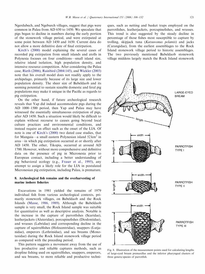
Fig. 8. Illustration of the measurement points used for calculating lengths
of large-eyed bream premaxillas and the inferior pharyngeal clusters of
three genera/species of parrotfish.
W.B. Masse et al. / Quaternary International 151 (2006) 106–132 121
Ngerdubech, and Ngeburch villages, suggest that pigs werecommon in Palau from AD 650 to 1450. We speculate thatpigs began to decline in numbers during the early portionof the stonework village period, and were extirpated atsome point between AD 1450 and 1650. Current data donot allow a more definitive date of final extirpation.
Kirch’s (2000) model explaining the several cases ofrecorded pig extirpation from small islands and atolls inPolynesia focuses on four conditions—small island size,relative island isolation, high population density, andintensive resource competition. After considering the Palaucase, Rieth (2006), Rainbird (2004:145), and Wickler (2003)note that his overall model does not readily apply to thearchipelago, primarily because of its large size and lowerpopulation density. The sheer size of Babeldaob and itsseeming potential to sustain sizeable domestic and feral pigpopulations may make it unique in the Pacific as regards topig extirpation.
On the other hand, if future archeological researchreveals that Yap did indeed accommodate pigs during theAD 1000–1500 period, then Yap and Palau may havewitnessed the essentially simultaneous extirpation of pigs,after AD 1450. Such a situation would likely be difficult toexplain without recourse to causes going beyond localculture practices and environmental conditions, andinstead require an effect such as the onset of the LIA. Ofnote is one of Kirch’s (2000) two dated case studies, thatfor Mangaia—a small eastern Polynesian island 52 km2 inarea—in which pig extirpation occurred at or shortly afterAD 1450. The other, Tikopia, occurred at around AD1700. However, without more comprehensive and definitivedata on the presence of pig in Micronesia prior toEuropean contact, including a better understanding ofpig behavioral ecology (e.g., Fraser et al., 1995), anyattempt to assign a likely role for the LIA in postulatedMicronesian pig extirpation, including Palau, is premature.
8. Archeological fish remains and the overharvesting of
marine inshore fisheries
Excavations in 1981 yielded the remains of 1979individual fish from various archeological contexts, pri-marily stonework villages, on Babeldaob and the RockIslands (Masse, 1986, 1989). Although the Babeldaobsample is very small, the Rock Island sample was suitablefor quantitative as well as descriptive analysis. Notable isthe increase in the capture of parrotfishes (Scaridae),leatherjackets (Aluteridae), porcupinefishes (Diodontidae),and wrasses (Labridae) and corresponding decline in thecapture of squirrelfishes (Holocentridae), snappers (Lutja-nidae), emperors (Lethrinidae), and sea breams (Mono-taxidae) during the Rock Island stonework village periodas compared with the preceding period.
This pattern suggests a movement away from the use ofless productive and reliable captures methods, such asdropline fishing used on squirrelfishes, snappers, emperors,and sea breams, to more reliable and productive techni-
ques, such as netting and basket traps employed on theparrotfishes, leatherjackets, porcupinefishes, and wrasses.This trend is also suggested by the steady decline inpercentage of those fishes most susceptible to capture bytrolling, skipjack tuna (Katsuwonus pelamis) and jacks(Carangidae), from the earliest assemblages to the RockIsland stonework village period to historic assemblages.The two previously mentioned Babeldaob stoneworkvillage middens largely match the Rock Island stonework

ARTICLE IN PRESS
Table 4
Length measurements of Monotaxis grandoculis premaxillas and Scarus sp. inferior pharyngeal clusters by stratum in Uchularois Cave
Species Stratum
(cm below surface)
Time period (AD) Number of
measured elements
Mean length (cm)
Large-eyed beam Monotaxis
grandoculis premaxillas
0–10 1450+ 6 2.7670.83
10–40 1250–1450 20 2.3870.67
40–80 650–1250 21 2.5470.70
80–175 650–1000 31 2.5870.86
Parrotfish Scarus sp. inferior
pharyngeal clusters
0–10 1450+ 23 1.6570.32
10–40 1250–1450 43 1.4570.41
40–80 650–1250 60 1.6070.36
80–175 650–1000 54 1.6070.47
W.B. Masse et al. / Quaternary International 151 (2006) 106–132122
village sample in terms of species present, but are too smalla sample for meaningful comparison.
The most intriguing pattern is the decrease in fish sizebased on measurement of cranial elements (Masse, 1989).The lengths of the most durable and available elements ofthe three more archeologically abundant species weredetermined. The sample consisted of premaxillas from 98large-eyed bream (Monotaxis grandoculis) and 29 porcupi-nefish (Diondontidae), and inferior pharyngeal clustersfrom 320 parrotfish (Scaridae) (Fig. 8). The parrotfishsample was further divided into three basic genera, withBulbometopon and possibly Cetoscarus (no ¼ 46) classifiedas Type I, Type II represented by Calotomus (no ¼ 21), andScarus (no ¼ 253) categorized as Type III. The Scarus
sample most likely includes more than one species, but theassumption was made that the relatively large samplecontained a similar species mix in the four strata. Theporcupinefish sample and Types I and II of the parrotfishsample are each too small for valid comparison and areomitted from this discussion.
Table 4 summarizes the lengths of the measured elementsof the large-eyed bream and Scarus sp. in four strata ofUchularois Cave. Both sets of data depict a similar markeddecline during the AD 1250–1450 period (charcoal dated),coincident with the initial Rock Island stonework villagesettlement system. Although a one-way ANOVA test onthe Scarus sp. sample produced a statistically non-significant result for size comparison among the four strata(F ¼ 1:827; df ¼ 3; p ¼ 0:144), the result was influenced bya single sizeable outlier in the 10–40 cm stratum, which at2.30 cm is 0.35 cm larger than the next largest-sizedspecimen. Masse (1989) argues that the data for both theparrotfish and the large-eyed bream are significant andcompare favorably with data produced by studies ofmodern fish stock overharvesting from inshore fisheries inthe Caribbean. These arguments gain currency in light ofthe shellfish data discussed below.
The large-eyed bream and parrotfish are typically subjectto very different capture techniques, line fishing vs. acombination of basket traps/netting/spears, respectively(Vince Blaiyok, 1984, pers. comm.). These data suggestthat the presumed overharvesting of inshore fisheries in
Palau from AD 1250 to 1450 affected multiple capturetechniques and could not be resolved by simple changes incapture techniques or by moving to new fishing grounds.
9. Archeological shellfish remains and the overharvesting of
marine inshore fisheries
Excavations in the western chamber of Uchularois Cave(0–130 cm) yielded a marine shell minimum number ofindividuals (MNI) count of 39,656 and a total shell weightof ca. 149.3 kg (Carucci, 1992). Excavated volume was ca.1.53m3, which equates to a concentration of 25,936 MNIand 97.65 kg/m3. Compared to the other Rock Islandcontrolled excavations (Masse and Snyder, 1982; Masse,1989), Uchularois Cave produced the most concentratedshell deposits by both MNI and weight (Carucci, 1992).The shell data reported here derive from both quantitativeand qualitative observations of Strombus gibberulus, thedominant species in Rock Island shell assemblages, todetermine evidence for human overharvesting of marinefoodshell.Of the cave’s total shell MNI, the top three are marine
gastropods: S. gibberulus (90.6%), S. luhuanus (4.7%), andNerita spp. (1.1%). By contrast, the most numerousbivalve, Atactodea striata, accounts for only 0.4% of thetotal cave MNI (n ¼ 161) and 32.8% of all identifiedbivalves. In terms of shell weight, S. gibberulus accounts for73.6% (106.7 kg), S. luhuanus 18.5% (26.8 kg), and thelarge, heavy turban shells (Turbo spp.), 1.6% (2.3 kg).Fragum unedo (0.36% total cave MNI) is the heaviestbivalve in total weight (2.0 kg), representing 46.6% of allbivalves.The ‘‘humped conch’’, S. gibberulus, subspecies gibbosus
is a herbivorous marine snail that feeds on algae anddetritus in shallow tropical waters. The ecology and lifehistory of this small animal suggest that it may have servedas a nearly inexhaustible source of food. For many of thesame reasons, archeological assemblages of S. gibberulus
are excellent data sets against which human overharvestingimpacts can be discerned.Although S. gibberulus may move seasonally to deep
water, its habitat is predictable in shallow water. While the

ARTICLE IN PRESSW.B. Masse et al. / Quaternary International 151 (2006) 106–132 123
snail can move fast enough to ‘‘outrun’’ some naturalpredators, human foragers can easily locate large coloniesand quickly glean several kilograms of meat. FavoredPalauan habitats include intertidal sandy beaches, shallow,often murky lagoon embayments, and the protected sandand seagrass flats of the Rock Islands (Hiro, 1936). Masseobserved a colony of several thousand individuals on theshallow sand flats between Ngemelis and UchularoisIslands.
Field studies of S. gibberulus have found that shells ofmales are slightly smaller than females. In three coloniesexamined in the field in the 1940s, 40% were male and 60%female. The females are extremely fecund; each is capableof producing thousands of mobile spawn that can grow tohalf their adult size in about 6 months. Average sizes of themollusc vary from area to area, but are fairly uniform inlocal populations (Abbott, 1949). Marked average sizedifferences in populations are thought to be caused by theamount of nitrogenous matter in the local ocean waters.Shell populations of small average size come from coralatolls; large shell specimens are associated with continentalwaters or larger, complex island groups. The average sizereported for coastal Australian waters is 60mm (Wilsonand Gillett, 1971) while a generalized description of thespecies in the Indo-Pacific reports that ‘‘large’’ shells areabout 58mm long; medium shells are 40mm, and smallshells are 30mm long (Abbott, 1960).
In summary, field studies describe a fast-growing marinesnail that exhibits slight sex-dependent size differences andlocalized populations of roughly similar average shell size.Larger shells are known from continental waters and areassurrounding larger, high islands. These facts: stable shellsizes in separate populations and slight sexual dimorphismsuggest that any significant decrease in shell size due tohuman predation would be a meaningful, robust finding.
Molluscan death is commonly caused by predatory crabscapable of crushing the body whorl’s uppermost portion(severing the spire of the shell) or ‘‘peeling’’ the shell bybreaking through the outer lip and continuing up the bodywhorl in a spiral pattern until the animal is exposed(Vermeij, 1978, 1979; Zipser and Vermeij, 1978; Vermeijand Zipser, 1986). These instinct-driven behaviors producepatterned shell damage. There are few peeled shells in theRock Island shell assemblages, but topless shell bodiesdisplaying sharp edges and related severed spires are fairlycommon (Carucci, 1992). If a predator attack is unsuccess-ful, the injured mollusc will mend its damaged shell if it isable. Such ‘‘repaired’’ shells usually exhibit scars on thebody whorl. Predatory crabs are also known to attackshells containing hermit crabs, but only living molluscs canrepair their damaged shells.
The hermit crab has a chitinous exoskeleton and iscommon to coastal areas and littoral zones throughout theworld. The unique requirement of this typically small crabis an empty gastropod shell to serve as its mobile home(Scully, 1983). Hermit crabs are limited by the size, shape,condition, and provenience of the shells they occupy, and
certain species of crab tend to repetitively seek the samedead molluscan species because of their size and weight,and the shape of the shell mouth. The crabs are incapableof digging deep to retrieve empty shells nor can they cleanout previously buried shells (Kellogg, 1976). As thisprecludes using shells buried on a beach or in a shellmidden, the process of finding and selecting a newprotective shell must occur on an exposed surface. Givenenough time, the dead shells that hermit crabs carry canshow enough evidence of physical alteration to make themeasily identifiable as ‘‘hermited’’. This phenomenon hasbeen little studied (see Carucci, 1992 for a detaileddiscussion of hermited characteristics) but is easilyidentifiable in well-preserved faunal shell collections. Allthe hermited shells from Uchularois Cave are thought torepresent natural hermit crab behavior, although somehermited shells could instead represent the cultural use ofthe crab for food or fish bait.Standardized MNI and shell weight analytical techni-
ques were used to characterize the Rock Island faunal shellassemblages (Grayson, 1979, 1984; Carucci, 1992; Claas-sen, 1998). All shells were sorted to the level of species (orgenus in some cases), and then counted and weighed toyield MNI counts and shell weight data pairs for allidentifiable shells. Subsamples of the largest middencomponent, S. gibberulus, were subjected to additionalanalysis. Individual S. gibberulus shells were randomlydrawn from each level bag using splitters and other randomsampling methods to insure that each shell in each level baghad an equal chance of being included in the resultingsubsample. All the following data sets and tests used therandomly sampled S. gibberulus shells. Each shell wasmeasured for length (to tenths of a millimeter) and weighed(to hundredths of a gram) before and after probing insidefor dirt. Qualitative observations were also recorded,including counts of healed crab attack scars (3 maximum),whether or not the shell was hermited, burned, or beach-worn, and judgments of shell breakage pattern, overallpreservation, and the completeness of the shell length(Carucci, 1992).After the length of each shell was measured, it was
qualitatively graded according to two broad categories; onebased on length and the other on preservation. Shellsgraded ‘‘1’’ in the length category were complete from apexto anterior with no damage affecting their length (althoughthey could exhibit breakage in other areas). In thepreservation category, shells were graded ‘‘1’’ if they werenearly whole and perfect, though they could have tinyfragments missing such as chipped anteriors or spire tipswhich would only slightly affect their length. Nearly allPreservation Category 1 shells were very well preserved butnot perfectly whole. They are represented in consistentlyhigher numbers than Length Category 1 shells. The twocategories are not independent of each other.Increasing human impact on local foodshell resources
would be reflected in longer mean shell lengths early in timeand significantly shorter mean shell lengths late in time.

ARTICLE IN PRESS
Table 5
Length measurements of Strombus gibberulus ‘‘Length Category 1’’ subsamples from Uchularois Cave grouped by stratum
Stratum
(cm below surface)
Time period
(AD)
Number of
measured
specimens
Mean length
(cm)
Standard
deviation
Variance Average of five
longest shells (cm)
10–40 1250–1450 167 3.3287 0.3191 0.1018 4.12
40–80 650–1250 104 3.4546 0.3100 0.0961 4.11
80–130 650–1000 134 3.4699 0.2991 0.0894 4.15
t-Test of sample means: do the mean shell length differ significantly from each other?
For: stratum 10–40 cm compared to stratum 80–130 cm
df: 299, t ¼ �3:88, significant at 0.001
All specimens were complete from apex to anterior.
Table 6
Length measurements of Strombus gibberulus ‘‘Preservation Category 1’’ subsamples from Uchularois Cave grouped by stratum
Stratum
(cm below surface)
Time period
(AD)
Number of
measured
specimens
Mean length
(cm)
Standard
deviation
Variance Average of five
longest shells (cm)
10–40 1250–1450 219 3.3135 0.3170 0.1005 4.13
40–80 650–1250 215 3.3919 0.3161 0.0961 4.18
80–130 650–1000 313 3.4325 0.2978 0.0886 4.26
t-Test of sample means: do the mean shell length differ significantly from each other?
For: stratum 10–40 cm compared to stratum 80–130 cm
df: 530, t ¼ �4:44, significant at 0.001
All specimens were whole shells.
W.B. Masse et al. / Quaternary International 151 (2006) 106–132124
For this test, the cave’s excavation levels were consolidatedinto three strata similar to those used in the previoussection’s fish remains analysis, with the exception that the0–10 cm stratum was combined with the 10–40 cm stratum(Carucci, 1992). Using Length Category 1, an SASs
statistical package tested whether the cave exhibitssignificantly larger shell at depth compared to the surface(Table 5). The calculated t-statistic is significant at 0.001;there is a difference in mean shell length of a little morethan a millimeter. The mean length of shells in the upperstratum (0–40 cm) is less than the mean length in thedeepest stratum (80–130 cm). This suggests that RockIsland harvesting pressure late in time affected shell size.
To reassess this expected pattern, a second t-test of themeans was performed on the same temporal strata but on aqualitatively different group of shells: Preservation Cate-gory 1 (Table 6). This category of whole shells increases thepooled sample sizes by 50–100%. Again the t-statisticindicates that the mean length of shells in the upper, laterdeposits is significantly less than the mean length of shellsin the lower, earlier deposits (significant to 0.001). In botht-tests, the mean length changes in the expected direction,and probability/significance is compelling.
A second, independent test of increasing human impactson the Rock Islands late in time was derived fromobservations of healed crab attack scars on S. gibberulus
shells. In a relatively pristine environment, moderately highnumbers of crab attack scars are expected, indicating that a
normal situation existed between predator (the crabs) andprey (the molluscs). As humans began to gather increasingquantities of foodshell and perhaps forage for predatorcrabs, the number of healed crab attack scars should drop.Using two slightly different sets of observations, a series ofw2 tests assessed the crab attack scar data. Old crab attackscars high on the spire of the shell are difficult to identifyand some were thus coded as ‘‘probable’’; newer scarslocated lower on the body whorl are relatively easy toidentify. Employing this conservative methodology, arestricted data set was created that counts only the large,obvious body whorl scars. A second, all-inclusive, orliberal, data set that includes the obvious and the probablescars was also created.The ‘‘one-sided chi-square test’’ (Conover, 1980) was
applied to compare the deep with the shallow cavedeposits. This yielded a w2 for the restricted data set of1.34 (significant at 0.09) and a w2 for the all-inclusive dataset of 2.56 (significant at 0.006). A second set ofcomparisons was conducted on a subsampled S. gibberulus
assemblage from a controlled excavation at the Tmaschvillage site on neighboring Ngemelis Island. This second setof w2 tests compared early (deep) shell deposits fromTmasch with the late (0–40 cm) excavations from Uchular-ois Cave. The results were a w2 of 3.08 (significant at 0.002)for the restricted data set and 3.31 for the all-inclusive dataset (significant at 0.001), meaning that, just as inUchularois Cave, the Tmasch deep shell deposits had

ARTICLE IN PRESSW.B. Masse et al. / Quaternary International 151 (2006) 106–132 125
significantly higher numbers of crab attack scars than thelater, shallow cave deposits.
The results of the w2 comparisons are cohesive andconvincing. Identified is a significant pattern of deeper,older Rock Island shell deposits exhibiting appreciablyhigher numbers of healed crab attack scars than morerecent deposits. It is noteworthy that the shell assemblageat the Tmasch site, located at sea level, displayed evidenceof having been subjected to ocean storm events (Carucci,1992). The lower deposits (50–70 cm) of the assemblagecontained some natural S. gibberulus shells mixed into theculturally derived food refuse midden. Thus, these parti-cular shells would be expected to present a more naturalpicture of early Rock Islands ecological history. Theexpected pattern was also confirmed in the UchularoisCave data, but the upper cave levels compared to the lowerdid not identify as sharp a contrast in part because all shellsin that comparison had been selectively collected byhumans.
These data, when coupled with the previously discussedanalyses of fish remains, offer powerful evidence thatportions of the marine inshore environment experiencedconsiderable stress seemingly coincident with the stone-work village occupation of the Rock Islands. The RockIslands shell assemblage may exhibit proof of predationpressure from a growing human population, a natural shiftin the local environment, changing climatic conditions, ormost likely a combination of these factors. Increasinghuman predation is a logical component of each of thescenarios. In the early period, fewer people ate fewer crabsand other marine invertebrates. In the later period, morepeople foraged for food and would have a greaterlikelihood of finding and consuming molluscs and crabs.With fewer crabs in the local ecosystem mollusc popula-tions would endure fewer attacks. The decrease in shell sizelate in time indicates that human foragers ‘‘overharvested’’;a decrease in crab attack scars indicates that humansincreasingly impacted the environment. If our recon-structed calibrated chronology for the Rock Islands isreasonably accurate, the onset of the LIA may well haveplayed an important role in this natural and culturaldrama.
10. Palau paleoenvironmental corings
Paleoenvironmental lake and wetland cores provideinformation on environmental and geomorphologicalchanges, among others, through sedimentary and pollenevidence. Sedimentary changes and pollen disturbanceindicators in the paleoenvironmental records can poten-tially reflect significant changes in sea level and increases inprecipitation, two of Nunn’s criteria marking the onset ofthe LIA in the tropical Pacific Basin. A third criterion, thatof a fall in temperature of one or two degrees, should havelittle influence on the natural environment in the warmtropics, and is not considered here. The extent to whichthe Palau paleoenvironmental coring evidence supports
Nunn’s assumption that the LIA significantly impacted theenvironment is evaluated below.Through standard paleoenvironmental wetland and lake
sampling procedures, 26 cores were recovered from thevolcanic islands of Babeldaob and Ngerekebesang, thevolcanic portion of Koror, and the raised limestone reef ofPeleliu. Detailed analyses, including sediment examinationand radiocarbon dating, were performed on 15 of the cores,and, pollen sequences were obtained for seven of these(Athens and Ward, 2002, 2005).The 19 Babeldaob cores were recovered from abandoned
taro pondfields bordering mangroves, near the landwardedge of mangrove swamp forests, and from a small interiorlake and a pond formed in natural depressions. Thirty-nineradiocarbon samples and 99 pollen samples were processedfor the eight analyzed cores. Most sedimentary sequencesextend back from the present to the seventh millenniumBP. The organic loams and peats composing most of thesequences are underlain by redeposited saprolitic alluvium.As marine sediments and not redeposited saprolite shouldbe found at the base of the near-coastal cores, W.R.Dickinson (2005, pers. comm.) believes Babeldaob issubsiding (Easton and Ku, 1980; Athens and Ward, 2002).Two of the three Ngerekebesang cores recovered from
lowland (near-coastal) taro pondfields were fully analyzed.The Ngikel-1 core reached a maximum depth of 414 cmbelow the surface, and the Irikl-1 core attained 1048 cm(Fig. 9). Distinctive thick layers of redeposited saproliticsediment, sandwiched between organic loams, were presentin the upper parts of both cores. In the Ngikel-1 core, thissediment is 60 cm thick (Layer IV) while in the Irikl-1 coreit is 22 cm thick (Layer II). This redeposited saprolitic layeris significant in its suggestion of substantial upland soildisturbance and transport that likely occurred over arelatively brief period. The initiating factor for the masswasting was probably the extensive earthworks construc-tion in the hills just above the pondfields, which removedvegetation cover and loosened the sediment over a broadarea. The downward transport of such a vast amount ofsediment could be the result of the onset of a period ofespecially heavy rains related to the LIA. However, it isequally plausible that a major tropical storm simplydumped rain on Palau over an extended period or thatupslope earthworks were unstable immediately afterconstruction.The chronology of this saprolite deposition is crucial for
connecting this wasting event to the onset of the LIA. Asshown in Fig. 9, the radiocarbon date immediately belowLayer IV in the Ngikel-1 core is calibrated at 370–125BC(1s) although there is no corresponding date to constrainthe age of the top of the deposit. However, a samplecollected a little above what is believed to be the samesaprolite layer (Layer II) in the Irikl core dates to AD1071–1257 (1s). Thus, it is uncertain whether the sedimen-tary unconformity, which was almost certainly deposited ina relatively brief period, is associated with the earlier or thelater date. Despite the limitations of the Ngerekebesang

ARTICLE IN PRESS
Fig. 9. Profiles of Ngikel-1 core (left) and Irikl-1 cores (right), from Ngerekebesang Island.
W.B. Masse et al. / Quaternary International 151 (2006) 106–132126
data, it is nevertheless clear that the saprolite layers in thewetland cores were formed before AD 1300, and could nothave formed following the MWP. Thus, the mass wastingin the Ngikel and Irikl cores does not appear to be relatedto the onset of the LIA.
One of the striking differences between the Ngerekebe-sang and the Babeldaob cores is the absence in the latter ofany indication of mass wasting in the later part of thesequences even though monumental earthworks are presentin the hills above the coring sites. Some of the cores,nevertheless, do show an abrupt transition from largelypeaty sediments to very organic-rich loam and clay atabout 550–450BC (Athens and Ward, 2003, 2005, p. 71).The appearance of these terrestrial sediments in the coastalwetlands roughly coincides with what is now known to bethe date for initial terrace construction in the uplands.
The inland Lake Ngerdok core does provide someprovocative evidence concerning whether or not heavyrains were associated with the onset of the LIA. Thesediment sequence of the 965 cm deep core consists almostentirely of redeposited saprolitic silty clay loam or clayloam with abundant microscopic organics. The exceptionsto this are Layers II and IV, which consist primarily of peatseparated by a thin gleyed clay layer. These deposits datebetween AD 1001–1284 (the base of Layer IV) and AD1280–1388 (the top of Layer II). The presence of peat
layers, which are autochthonous formations, suggests thatwater depth had declined sufficiently that a swampcommunity could form in the wetland. Furthermore, theabsence of saprolitic silty clay loam and silty clay in theselayers suggests the greatly diminished transport of hillslope sediment into the lake as compared to previous times.The Lake Ngerdok data can be interpreted to indicate
that between about AD 1000 and 1388, drier conditionsprevailed on Palau, roughly coincident with the end of theMWP, and wetter conditions returned afterward, roughlycoincident with the LIA. Conversely, the sedimentarysequence might simply document the abandonment ofhabitation and agriculture on the terraces as a result ofpopulation movement to the coastal stonework villages.Thus, with vegetation regeneration there was little sedimentto transport downslope and into the lake and betterretention of rainwater on the hill slopes.The near-coastal cores suggest that construction and use
of the earthworks resulted in the deposition of clays andloams in the near-coastal wetlands. Eventually, presumablyafter hundreds of years, these deposits became thickenough to rise above the high tide level, thereby becomingsuitable for cultivation of taro in pondfields. These newlyformed freshwater coastal wetlands were possibly firstintensively used for taro cultivation with the populationshift from the interior to the coastal stonework villages that

ARTICLE IN PRESS
Fig. 10. Graph of four disturbance/savanna indicators, Olbed-1 core,
Babeldaob Island.
Fig. 11. Graph of four disturbance/savanna indicators, Lake Ngerdok-2
core, Babeldaob Island.
W.B. Masse et al. / Quaternary International 151 (2006) 106–132 127
occurred about AD 1300–1400. There is no data in thesedimentary record to indicate that the shift occurredbecause massive amounts of sediments began to erode fromthe uplands at AD 1300–1400, quickly converting a slowinfilling process into a very rapid one. Such a scenariomight be expected with the onset of very heavy rains at theadvent of the LIA. However, it is recognized that suchevidence, if it ever existed, would have disappeared longago as a result of cultivation practices once the wetland hadbeen converted to taro pondfields.
The other characteristic of the LIA, a significant drop insea level, hypothetically could be indicated by unconfor-mities present in the near-coastal cores. With a drop in sealevel, shoreline erosion should occur. Then, once sea levelstabilized at a lower level, upland sediments could begin toaccumulate in the coastal lowlands. Barring other factors,the sedimentary record may reflect lowered sea level as anunconformity. For Palau, there is some evidence for anunconformity in the near-coastal cores prior to about AD450 and after about 2300BC. However, evidence for anunconformity coincident with the LIA is absent, though asnoted above this could be due to the blurring effect of tarofarming in the uppermost layers.
There is an interesting pattern in the Babeldaob andNgerekebesang pollen records regarding savanna forma-tion and expansion and corresponding forest reduction.Savanna formation (and forest reduction) began around1550–1050BC (Figs. 10 and 11). The savanna thencontracts, only to expand again later (a second time). Thislater expansion then begins to decline by roughly AD 700or possibly even a little earlier.
The climatic significance of this pattern is that savannacontraction and corresponding forest expansion may berelated to oscillating long-term wetter and drier conditionsin Palau. In terms of Nunn’s hypothesis, the latest savannacontraction occurred during the period he suggests dryconditions would have prevailed due to the MWP. Whilesubstantial abandonment of inland settlement and employ-ment of dryland agriculture at the close of the earthworks
era could have played a role in the later cycle of savannareduction and forest expansion, the earlier cycle suggeststhat climate and not human impact may have been thecrucial factor governing large-scale vegetation changes onPalau. Otherwise, it is difficult to see how the early cyclechanges could have occurred at a time when humanpopulation size must have been very low.
11. Were there climate-induced environmental crises in
Palau?
Nunn’s hypothesis of a pan-Pacific environmentalcatastrophe—the AD 1300 Event resulting from the onsetof the LIA—is provocative. Recent Northern Hemisphereclimate modeling using both low- and high-resolutionproxy data (Moberg et al., 2005, Fig. 2) reveal pronounceddrops in temperature that coincide with Stage 1, ca. AD1270–1325, and Stage 2, ca. AD 1455–1475, of Nunn’sevent. This suggests that Nunn’s modeling captures aspectsof worldwide climate change. Whether these two tempera-ture downturns are interpreted as occurring during the‘‘transition’’ between the MWP and the LIA (as doesNunn), or instead are viewed as initial processes of the LIAitself (as we have implied in this paper), is largely a matterof semantics for the purposes of this paper. A variety ofdata have been examined to determine whether the LIAcould be detected on Palau, and to what extent it may haveimpacted the environment and people.Evidence for sea level change in Palau is a difficult and
contradictory subject given the active tectonics and largesize of the archipelago. Both uplift (Rock Islands) andsubsidence (Babeldaob) seemingly have played variableand dynamic roles in the past several thousand years ofPalauan history. However, a concerted effort has notyet been undertaken in Palau to specifically look forevidence of sea level fall around AD 1270–1475, nor has itbeen determined to what extent late Holocene uplift inportions of Palau may have affected actual reef productiv-ity, such as occurred at around 3160 cal. yr BP (Eastonand Ku, 1980).

ARTICLE IN PRESSW.B. Masse et al. / Quaternary International 151 (2006) 106–132128
It was initially anticipated that the paleoenvironmentalcorings would give us the most conclusive data regardingthe LIA in Palau. Not necessarily reflecting the absence ofa signature in Palau’s sedimentary record, evidence forimpacts from the LIA is tenuous, contradictory, or non-existent, depending on how the data are weighted andinterpreted. For example, it is evident that the seeminglydefined abrupt expansion of forest/decrease in savanna onthe volcanic islands after AD 700 relates either to climatechange (the MWP) or to cultural landuse change. Thesedata roughly parallel archeological evidence for abandon-ment of studied upland earthwork systems (Ngaraard andNgiwal) between AD 500 and 1000. A modern analog isrepresented by the rapid reforestation of agricultural andvillage areas on Babeldaob following World War II(Endress and Chinea, 2001). However, there presently isno identifiable signature for vegetation change correspond-ing to the onset of the LIA.
What these investigations really suggest is a critical needfor paleoenvironmental data of higher resolution, focusedon the last 1500 years. Another important result of thispresentation of paleoenvironmental data has been that itforces investigators to seriously consider the possibility thatclimatic changes in Palau and elsewhere during the last1500 years may have contributed significantly to landscapeand culture change. A good example may be that of RapaNui (Easter Island) in relation to the onset of the LIA(Dumont et al., 1998; Mann et al., 2003).
Palau settlement data likewise provide mixed butinteresting messages. One of Nunn’s climate-inducedcultural changes is the start of warfare yet it is apparentthat warfare was endemic in Palau (Liston and Tuggle,2006), with some of the most spectacular defensive featuresassociated with the earthwork era of ca. 500BC to AD 650.The post-AD 1250 stonework village era also displays asimilar emphasis on warfare and defense, although by thattime defense had shifted from a regional focus to that ofsingle villages. It is frustrating and curious that evidencefor both settlement and warfare between AD 650 and 1250is largely lacking.
Perhaps this lack of evidence is significant in and ofitself. The abandonment of villages in the earthworkcomplexes radiocarbon dated at around AD 500 isintriguingly close to the AD 536–545 ‘‘years withoutsummer’’ climatic event (Baillie, 1999; Gunn, 2000), andthe lack of substantive evidence for warfare between AD650 and 1250 happens to coincide with the span of theMWP. The fact that there are far greater numbers of ElNino events immediately prior to and at the beginning ofthe MWP than at any other time in the Holocene (Gagan etal., 2004, Fig. 7), raises the possibility that presumedassociated deficits in precipitation in Palau may haveplayed a role in the demise of the earthwork complexes andassociated dryland agricultural systems. The increase inradiocarbon dates at AD 1250 on Babeldaob is near thebeginning of the stonework village era. Stonework is usedfor defense, for sociopolitical symbols of status and rank,
and presumably as a relief from wet environments—such asthe periods of heavy rainfall associated with the LIA. Ataround AD 1450 on Babeldaob, we again see a decline inradiocarbon dates and potentially an upswing in stoneworkvillage construction in the Rock Islands. To what extentthese cultural manifestations and their timing might becoincident with periods of rapid climate change is ofconsiderable interest, although sampling bias has poten-tially caused and/or heightened their appearance ofsignificance.The faunal data more clearly demonstrate the potential
relationship between climate and culture change. Thedownturn of species sizes—as evidenced in the UchularoisCave collections—during the early phase of the stoneworkvillage era (AD 1250–1450) is striking, as would be theextirpation of pig shortly after this time if eventuallyproven. These signatures of resource depletion and over-harvesting are strongest at the beginning of the LIA,coinciding within the span of Nunn’s two stages of climaticevent.Plotting the size distributions of three marine species in
the cave’s arbitrary excavation levels (Fig. 12) reveals anoticeable covariance. For example, not only is there apronounced decline in element size during the stoneworkvillage era—rapid for the two fish and a slower but steadydecline for the shellfish—but the three species also exhibit ashort but rapid period of decline and recovery in the90–100 cm level (ca. AD 650–1000). Because of thepresumed rapid midden deposition in the cave at this time,this latter period likely indicates a significant environ-mental event, perhaps a major storm or set of stormssimilar to that documented for Palau in conjunction withthe 1997/1998 ENSO event which led to significantbleaching and destruction of the Palau reefs (Bruno etal., 2001).The Uchularois Cave faunal data demonstrate that the
marine inshore reef environment is periodically thrown outof dynamic equilibrium with respect to its predators,including humans. However, the causes for the imbalancescan range from a single storm or tsunami event, tooverharvesting due to human factors, such as populationincrease and warfare, to broad climate shifts (e.g.,Swadling, 1976).In seeking explanations for these patterns, it cannot be
assumed that the tropical Pacific is any less sensitive to theeffects of rapid climate change than are more temperateclimes. Nor can it be assumed that every Pacific islandgroup reacted with similar cultural responses to changingclimatic and social conditions. The fact that the Palauarcheological and paleoenvironmental record can yield theinteresting data set presented here—even though none ofthese data were collected to specifically test the effects ofrapid climate change—suggests that higher-resolution dataon the topic remain to be productively gathered, analyzed,and applied. While we may eventually find that Nunn’smodel of the AD 1300 Event is not universally applicable inthe Pacific, his general thesis that rapid climate change has

ARTICLE IN PRESS
Fig. 12. Plot of the average length measurements by 10 cm excavation
level in Uchularois Cave of two inshore fish species and a marine snail as
an indicator of periods of potential human overharvesting and/or climate
and environment induced stress upon the respective populations. The gray
band in levels 1–5 is the suggested period of stonework villages in the
Ngemelis Island Group.
W.B. Masse et al. / Quaternary International 151 (2006) 106–132 129
the potential for significant cultural effects in the tropicalPacific is worthy of serious and continued attention.
Acknowledgments
Lively discussion with Patrick Nunn provided theoriginal impetus for this paper. We thank KathrynBennett, Geoffrey Clark, Michiko Intoh, Eugenia Lebsack,Emma M. Power, and Timothy Rieth for assistance withdata quality and paper production. The paper benefitedfrom the comments of two anonymous reviewers. BrianButler, George Gumerman, Foss Leach, David Snyder,Charles Streck, and David Tuggle provided logistical andintellectual support for field data collection and analyses.Past and present members of the Palau Division ofCultural Affairs and Historic Preservation Office havegreatly facilitated our work during the past 25 yearsincluding Moses Sam, Vicky N. Kanai, Vince KautchangBlaiyok, Walter Metes, and Rita Olsudong. This paper has
been assigned publication release number LA-UR-05-3418by Los Alamos National Laboratory.
References
Abbott, R.T., 1949. Sexual dimorphism in Indo-Pacific Strombus.
Nautilus 63 (2), 58–61.
Abbott, R.T., 1960. The genus Strombus in the Indo-Pacific. Indo-Pacific
Mollusca 1 (2), 33–146.
Alley, R.B., 2000. The Two Mile Time Machine. Princeton University
Press, Princeton, NJ.
Anderson, A., Chappell, J., Clark, G., Phear, S., 2005. Comparative
radiocarbon dating of lignite, pottery, and charcoal samples from
Babeldaob Island, Republic of Palau. Radiocarbon 47 (1), 1–9.
Athens, J.S., Ward, J.V., 2001. Paleoenvironmental evidence for early
human settlement in Palau: the Ngerchau core. In: Stevenson, C.M.,
Morin, F.J. (Eds.), Pacific 2000: Proceedings of the Fifth International
Conference on Easter Island and the Pacific. Easter Island Founda-
tion, Los Osos, pp. 165–178.
Athens, J.S., Ward, J.V., 2002. Holocene Paleoenvironmental Investiga-
tions on Ngerekebesang, Koror, South Babeldaob, and Peleliu Islands,
Palau. Report Prepared for Palau National Communications Cor-
poration, Koror, Palau. International Archaeological Research
Institute Inc., Honolulu.
Athens, J.S., Ward, J.V., 2005. Palau Compact Road, Archaeological
Investigations, Babeldaob Island, Republic of Palau. Phase I: Intensive
Archaeological Survey. Volume IV: Holocene Paleoenvironment and
Landscape Change. Report Prepared for the US Army Engineer
District, Honolulu, Ft. Shafter, Hawai’i. International Archaeological
Research Institute Inc., Honolulu.
Baillie, M., 1999. Exodus to Arthur: Catastrophic Encounters with
Comets. B.T. Batsford, London.
Berg, M.L., 1992. Yapese politics, Yapese money, and the Sawei tribute
network before World War I. Journal of Pacific History 27 (2),
150–164.
Bruno, J.F., Siddon, C.E., Witman, J.D., Colin, P.L., Toscano, M.A.,
2001. El Nino related coral bleaching in Palau, Western Caroline
Islands. Coral Reefs 20, 127–136.
Carucci, J., 1992. Cultural and natural patterning in prehistoric marine
foodshell from Palau, Micronesia. Unpublished Ph.D. Dissertation,
Southern Illinois University, Carbondale.
Claassen, C., 1998. Shells. Cambridge Manuals in Archaeology. Cam-
bridge University Press, Cambridge, UK.
Clark, G., 2004. Radiocarbon dates from the Ulong site in Palau and
implications for western Micronesian prehistory. Archaeology in
Oceania 39, 26–33.
Clark, G., 2005. A 3000-year culture sequence from Palau, western
Micronesia. Asian Perspectives 44, 349–380.
Clark, G., Wright, D., 2003. The colonization of Palau: preliminary results
from Angaur and Ulong. In: Sand, C. (Ed.), Pacific Archaeology:
Assessments and Prospects. Les Cahiers de l’Archeologie en Nouvelle-
Caledonie 15. Musee de Nouvelle-Caledonie, Noumea, pp. 85–94.
Cole, T.G., Falanruw, M.C., MacLean, C.D., Whitesell, C.D., Ambacher,
A.H., 1987. Vegetation survey of the Republic of Palau. Resource
Bulletin PSW-22. Pacific Southwest Forest and Range Experiment,
Forest Service, US Department of Agriculture.
Conover, W., 1980. Practical Nonparametric Statistics. Wiley, New York.
Desilets, M., Liston, J., Tuggle, H.D., 1999. Ceramic analysis. In:
Tomanari-Tuggle, M.J., Tuggle, H.D., Liston, J., Welch, D.J. (Eds.),
Archaeological Data Recovery for the Compact Road, Babeldaob
Island, Republic of Palau. Volume V: Lab Analysis, Synthesis, and
Recommendations. Draft Report Prepared for the US Army Engineer
District, Honolulu, Ft. Shafter, Hawai’i. International Archaeological
Research Institute Inc., Honolulu, pp. 181–230.
Dumont, H.J., Fontugne, M., Cocquyt, M., Arnold, L.L., Reyss, J.,
Bloemendal, F., Oldfield, C.L., Steenbergen, M., Korthals, H.J., Zeeb,

ARTICLE IN PRESSW.B. Masse et al. / Quaternary International 151 (2006) 106–132130
B.A., 1998. The end of moai quarrying and its effect on Rano Raraku,
Easter Island. Journal of Paleolimnology 20, 409–422.
Easton, W.H., Ku, T.-L., 1980. Holocene sea-level changes in Palau, West
Caroline Islands. Quaternary Research 14, 199–209.
Endress, B.A., Chinea, J.D., 2001. Landscape patterns of tropical forest
recovery in the Republic of Palau. Biotropica 33 (4), 555–565.
Fagan, B., 2000. The Little Ice Age: How Climate Made History
1300–1850. Basic Books, New York.
Fitzpatrick, S.M., 2002. A radiocarbon chronology of Yapese stone
money quarries in Palau. Micronesica 34 (2), 227–242.
Fitzpatrick, S.M., 2003. Early human burials in the western Pacific:
evidence for a ca. 3000 year old occupation on Palau. Antiquity 77
(298), 719–731.
Fitzpatrick, S.M., Boyle, J.E., 2002. The antiquity of pearl shell (Pinctada
sp.) burial artifacts in Palau, western Micronesia. Radiocarbon 44 (3),
691–699.
Fraser, D., Kramer, D.L., Pajor, E.A., Weary, D.M., 1995. Conflict and
cooperation: sociobiological principles and the behaviour of pigs.
Applied Animal Behavior Science 44, 139–157.
Gagan, M.K., Hendy, E.J., Haberele, S.G., Hantoro, W.S., 2004. Post-
glacial evolution of the Indo-Pacific Warm Pool and El Nino-Southern
Oscillation. Quaternary International 118–119, 127–143.
Grayson, D., 1979. On the quantification of vertebrate archaeofaunas. In:
Schiffer, M.B. (Ed.), Advances in Archaeological Method and Theory,
vol. 2. Academic Press, New York, pp. 199–237.
Grayson, D., 1984. Quantitative Zooarchaeology. Academic Press,
Orlando, FL.
Gunn, J.D., 2000. The Years without Summer: Tracing A.D. 536 and its
Aftermath. BAR International Series 872. Archaeopress, Oxford.
Helfman, G.S., Randall, J.E., 1973. Palauan fish names. Pacific Science 27
(2), 136–153.
Hiro, F., 1936. Notes on the molluscan fauna of Palao, Part 1: common
shells and their habitats (Venus 6:31–43); Part 2: Molluscs inhabiting
the outer reef and lagoon (Venus 6:208–221). Endo, R. (Translator)
March 1949. US Geological Survey Reports (typescript copy dated
July 1951), USGS Military Geology Branch, Tokyo, Japan.
Hockin, J.P., 2002. A supplement to the account of the Pelew Islands. In:
Nero, K.L., Thomas, N. (Eds.), Keate, G., An Account of the Pelew
Islands. Leicester University Press, London, pp. 270–325.
Hughen, K.A., Baillie, M.G.L., Bard, E., Beck, J.W., Bertrand, C.J.H.,
Blackwell, P.G., Buck, C.E., Burr, G.S., Cutler, K.B., Damon, P.E.,
Edwards, R.L., Fairbanks, R.G., Friedrich, M., Guilderson, T.P.,
Kromer, B., McCormac, G., Manning, S., Ramsey, C.B., Reimer, P.J.,
Reimer, R.W., Remmele, S., Southon, J.R., Stuiver, M., Talamo, S.,
Taylor, F.W., van der Plicht, J., Weyhenmeyer, C.E., 2004. Marine04
marine radiocarbon age calibration, 0–26 cal kyrBP. Radiocarbon 46
(3), 1059–1086.
Intoh, M., 1986. Pigs in Micronesia: introduction or re-introduction by the
Europeans. Man and Culture in Oceania 2, 1–26.
Intoh, M., Dickinson, W.R., 2002. Prehistoric pottery movements in
western Micronesia: technological and petrological study of potsherds
from Fais Island. In: Bedford, S., Sand, C., Burley, D. (Eds.), Fifty
Years in the Field: Essays in Honour and Celebration of Richard
Shutler Jr’s Archaeological Career, 25. New Zealand Archaeological
Association Monograph, pp. 123–134.
Intoh, M., Shigehara, N., 2004. Prehistoric pig and dogs remains from
Fais Island, Micronesia. Anthropological Science 112, 257–267.
Irwin, G., 1992. The Prehistoric Exploration and Colonization of the
Pacific. Cambridge University Press, Cambridge, UK.
Johannes, R., 1981. Words of the Lagoon: Fishing and Marine Lore in the
Palau District of Micronesia. University of California Press, Berkeley.
Kayanne, H., Yamano, Hiroya, Randall, R.H., 2002. Holocene sea-level
changes and barrier reef formation on an oceanic island, Palau Islands,
western Pacific. Sedimentary Geology 150, 47–60.
Keate, G., 1788. An Account of the Pelew Islands, Situated in the Western
Part of the Pacific Ocean, Composed from the Journals and
Communications of Captain Henry Wilson, and Some of His Officers,
Who, in August 1783, Were there Shipwrecked, in the Antelope, a
Packet Belonging to the Honourable East India Company. G. Nicol,
London.
Keate, G., 2002. An Account of the Pelew Islands. In: Nero, K.L.,
Thomas, N. (Eds.). Leicester University Press, London.
Kellogg, C., 1976. Gastropod shells: a potentially limiting resource for
hermit crabs. Journal of Experimental Marine Biology and Ecology
22, 101–111.
Kirch, P.V., 2000. Pigs, humans, and trophic competition on small
oceanic islands. In: Anderson, A., Murray, T. (Eds.), Australian
Archaeologist: Collected Papers in Honour of Jim Allen. Coombs
Academic Publishing, The Australian National University,
pp. 427–440.
Kramer, A., 1919. In: Thilenius, G. (Ed.), Ergebnisse der Sudsee-
Expedition 1908–1910. II. Ethnographie; B. Mikronesien. Band 3,
Teilband 2. Friederichsen, Hamburg (Human Relations Area File
typescript, translated by anonymous).
Lamb, H.H., 1995. Climate, History and the Modern World, second ed.
Routledge, New York.
Liston, J., 1999. Palau Compact Road, Archaeological Investigations,
Babeldaob Island, Republic of Palau. Phase II: Data Recovery.
Volume V: Laboratory Analysis, Synthesis, and Recommendations.
Draft Report Prepared for the US Army Engineer District, Honolulu,
Ft. Shafter, Hawai’i. International Archaeological Research Institute
Inc., Honolulu.
Liston, J., 2006. Palau Compact Road, Archaeological Investigations,
Babeldaob Island, Republic of Palau. Phase III: Archaeological
Monitoring. Volume XI: Laboratory Analysis and Comprehensive
Project Synthesis. Draft Report Prepared for the US Army Engineer
District, Honolulu, Ft. Shafter, Hawai’i. International Archaeological
Research Institute Inc., Honolulu. (scheduled for October publica-
tion).
Liston, J., 2005. An assessment of radiocarbon dates from Palau, western
Micronesia. Radiocarbon 47, 295–354.
Liston, J., Tuggle, H.D., 1998. The terraces of Palau: new information on
function and age. Paper presented at the 63rd Meeting of the Society
for American Archaeology, Seattle, WA, 25–29 March.
Liston, J., Tuggle, H.D., 2006. Prehistoric warfare in Palau. In: Arkush,
E., Allen, M.W. (eds.), The Archaeology of Warfare: Prehistories of
Raiding and Conquest. University Press of Florida, Gainseville.
(scheduled for May publication).
Mann, D., Chase, J., Edwards, J., Beck, W., Renier, R., Mass, M., 2003.
Prehistoric destruction of the primeval soils and vegetation of Rapa
Nui (Isla de Pascua, Easter Island). In: Loret, J., Tanacredi, J.T.
(Eds.), Easter Island: Scientific Exploration into the World’s Environ-
mental Problems in Microcosm. Kluwer Academic/Plenum Publishers,
New York, pp. 133–153.
Masse, W.B., 1981. Field Notes on Files at the Center for Archaeological
Investigations. Southern Illinois University, Carbondale.
Masse, W.B., 1986. A millennium of fishing in the Palau Islands,
Micronesia. In: Anderson, A. (Ed.), Traditional Fishing in the Pacific:
Ethnographic and Archaeological Papers from the 15th Pacific Science
Congress. Pacific Anthropological Records, 37. Bernice Pauahi Bishop
Museum, Honolulu, pp. 85–117.
Masse, W.B., 1989. The archaeology and ecology of fishing in the Belau
Islands, Micronesia. Unpublished Ph.D. Dissertation, Southern
Illinois University, Carbondale.
Masse, W.B., 1991. In: Hunter-Anderson, R. (Ed.), Radiocarbon Dating,
Sea-Level Change, and the Peopling of Belau. Micronesica Supplement
2, pp. 213–230.
Masse, W.B., Snyder, D., 1982. The Final Report of the 1981 Field
Season of the Southern Illinois University Palau Archaeolo-
gical Project. Report Prepared for Historic Preservation Office,
US Trust Territory of the Pacific Islands, Saipan. Center for
Archaeological Investigations, Southern Illinois University,
Carbondale.
Masse, W.B., Snyder, D., Gumerman, G.J., 1984. Prehistoric and historic
settlement in the Palau Islands, Micronesia. New Zealand Journal of
Archaeology 6, 107–127.

ARTICLE IN PRESSW.B. Masse et al. / Quaternary International 151 (2006) 106–132 131
Mason, A.C., 1955. Geology of the limestone islands, Palau,
Western Caroline Islands. Unpublished Ph.D. Dissertation, Depart-
ment of Geology, University of Illinois. University Microfilms, Ann
Arbor.
Moberg, A., Sonechkin, D.M., Holgrem, K., Datsenko, N.M., Karlen,
W., 2005. Highly variable northern hemisphere temperatures recon-
structed from low- and high-resolution proxy data. Nature 433,
613–617.
Nero, K., 2002. Keate’s account of the Pelew Islands: a view of
Koror and Palau. In: Nero, K.L., Thomas, N. (Eds.), Keate, G., An
Account of the Pelew Islands. Leicester University Press, London,
pp. 7–25.
Nunn, P.D., 1999. Environmental Change in the Pacific Basin: Chron-
ologies, Causes, Consequences. Wiley, London.
Nunn, P.D., 2000a. Environmental catastrophe in the Pacific Islands
around A.D. 1300. Geoarchaeology 15 (7), 715–740.
Nunn, P.D., 2000b. Illuminating sea-level fall around AD 1220–1510
(730–440 cal. yr BP) in the Pacific Islands: implications for environ-
mental change and cultural transformation. New Zealand Geographer
56, 4–12.
Nunn, P.D., 2003. Revising ideas about environmental determinism:
human–environment relations in the Pacific Islands. Asia Pacific
Viewpoint 44 (1), 63–72.
O’Day, S., 1999. Invertebrate faunal remains. In: Liston, J. (Ed.), Palau
Compact Road, Archaeological Investigations, Babeldaob Island,
Republic of Palau. Phase II: Data Recovery. Volume V: Laboratory
Analysis, Synthesis, and Recommendations. Draft Report Prepared
for the US Army Engineer District, Honolulu, Ft. Shafter, Hawai’i.
International Archaeological Research Institute Inc., Honolulu,
pp. 115–125.
Ogg, J.G., Kostow, J.A., 1978. The impact of Typoon Pamela (1976) on
Guam’s coral reefs and beaches. Pacific Science 32, 105–118.
Osborne, D., 1958. The Palau Islands: stepping stones into the Pacific.
Archaeology 11, 162–171.
Osborne, D., 1966. The Archaeology of the Palau Islands, an Intensive
Survey. BP Bishop Museum Bulletin 230. Bishop Museum Press,
Honolulu.
Osborne, D., 1979. Archaeological test excavations, Palau Islands,
1968–1969. Micronesia Supplement 1.
Otobed, D.O., 1977. Guide list of plants of the Palau Islands. Biology
Laboratory, Entomology Section, Koror, Palau, Trust Territory of the
Pacific Islands.
Parmentier, R.J., 1987. The Sacred Remains: Myth, History, and Polity in
Belau. The University of Chicago Press, Chicago.
Phear, S., Clark, G., Anderson, A., 2003. A radiocarbon chronology of
Palau. In: Sand, C. (Ed.), Pacific Archaeology: Assessments and
Prospects. Les Cahiers de l’Archeologie en Nouvelle-Caledonie 15.
Musee de Nouvelle-Caledonie, Noumea, pp. 255–263.
Rainbird, P., 2004. The Archaeology of Micronesia. Cambridge Uni-
versity Press, Cambridge, UK.
Rappaport, R.A., 1984. Pigs for the Ancestors: Ritual in the Ecology of a
New Guinea People, second ed. Waveland Press Inc., Prospect
Heights, IL.
Rieth, T.M., 2006. Vertebrate faunal remains. In: Liston, J. (Ed.), Palau
Compact Road, Archaeological Investigations, Babeldaob Island,
Republic of Palau. Phase III: Archaeological Monitoring. Volume
XI: Laboratory Analysis and Comprehensive Project Synthesis. Draft
Report Prepared for the US Army Engineer District, Honolulu, Ft.
Shafter, Hawai’i. International Archaeological Research Institute Inc.,
Honolulu. (scheduled for October publication).
Rieth, T.M., Liston, J., 2001. Archaeological Data Recovery at
Ngermereues Ridge, Ngesaol, Koror, Republic of Palau. Report
Prepared for Winzler and Kelly, Consulting Engineers, Palau.
International Archaeological Research Institute Inc., Honolulu.
Scully, E., 1983. The behavioral ecology of competition and resource
utilization among hermit crabs. In: Rebach, S., Dunham, D. (Eds.),
Studies in Adaptation: the Behavior of Higher Crustacea. Wiley,
New York, pp. 23–55.
Semper, K., 1982. The Palau Islands in the Pacific Ocean, Berg, M.
(Translator). Micronesian Area Research Center, University of Guam
(Orig. German edition, 1873).
Smith, I.W.G., 1983. Mammalian Faunal Remains from the 1981 Field
Season of the Southern Illinois University Palau Archaeological
Project. Ms. on File at Center for Archaeological Investigations.
Southern Illinois University, Carbondale.
Snyder, D., 1989. Towards chronometric models for Palauan prehistory:
ceramic attributes. Unpublished Ph.D. Dissertation, Southern Illinois
University, Carbondale.
Stafford Jr., T.W., Hare, P.E., Currie, L., Jull, A.J.T., Donahue, D.J.,
1991. Accelerator radiocarbon dating at the molecular level. Journal of
Archaeological Science 18, 35–72.
Swadling, P., 1976. Changes induced by human exploitation in prehistoric
shellfish populations. Mankind 10, 156–162.
Takayama, J., 1979. Archaeological investigation of PAAT-2 in the
Palaus: an interim report. In: Kusakabe, F. (Ed.), Cultural Anthro-
pological Research on the Folk Culture in the Western Caroline
Islands of Micronesia in 1977. Tokyo University of Foreign Studies,
Tokyo, pp. 81–103.
Takayama, J., Takasugi, H., 1978. Preliminary Report of the Archae-
ological Excavation of PAAT-2, in Palau. Overseas Scientific
Research, Ministry of Education, Japan. Tokyo University of Foreign
Studies, Tokyo. Ms. on file, Historic Preservation Office, Republic of
Palau, Koror.
Thompson, L.G., Mosley-Thompson, E., Bolzan, J.F., Koci, B.R., 1985.
A 1500-year record of tropical precipitation in ice cores from the
Quelccaya Ice Cap, Peru. Science 229, 971–973.
Thompson, L.G., Mosley-Thompson, E., Davis, M.E., Lin, P.N.,
Henderson, K.A., Cole-Dai, J., Bolzan, J.F., Liu, K.B., 1995. Late
glacial stage and Holocene tropical ice core records from Huascaran,
Peru. Science 269, 46–50.
Tuggle, H.D., 1998a. In: Liston, J., Tuggle, H.D., Tomanari-Tuggle, M.J.,
Desilets, M. (Eds.), Compact Road Archaeological Investigations,
Babeldaob Island, Republic of Palau, Phase II: Data Recovery.
Volume I: Fieldwork Reports. Draft Report Prepared for the US
Army Engineer District, Honolulu, Ft. Shafter, Hawai’i. International
Archaeological Research Institute Inc., Honolulu, pp. 81–129, 150–97,
314–424.
Tuggle, H.D., 1998b. Ngatpang excavations. In: Liston, J., Desilets, M.,
Tuggle, H.D. (Eds.), Compact Road Archaeological Investigations,
Babeldaob Island, Republic of Palau, Phase II: Data Recovery.
Volume II: Fieldwork Reports. Draft Report Prepared for the US
Army Engineer District, Honolulu, Ft. Shafter, Hawai’i. International
Archaeological Research Institute Inc., Honolulu, pp. 126–146.
Tuggle, H.D., 2006. Palau Compact Road, archaeological investigations,
Babeldaob Island, Republic of Palau. Phase III: archaeological
monitoring. Volume IX: Emergency data recovery. Draft Report
Prepared for the US Army Engineer District, Honolulu, Ft. Shafter,
Hawai’i. International Archaeological Research Institute Inc., Hono-
lulu. (scheduled for October publication).
US Army, 1956. Military Geology of Palau Islands, Caroline Islands. US
Geological Survey, Washington, DC.
Vermeij, G., 1978. Biogeography and Adaptation: Patterns of Marine
Life. Harvard University Press, Cambridge.
Vermeij, G., 1979. Shell architecture and causes of death of Micronesian
snails. Evolution 33, 686–696.
Vermeij, G., Zipser, E., 1986. A short-term study of growth and death in a
population of the gastropod Strombus gibberulus in Guam. The
Veliger 28, 314–317.
Wickler, S.K., 2003. Modelling colonisation and migration in Micronesia
from a zooarchaeological perspective. In: Mondini, M., Munoz, S.,
Wickler, S.K. (Eds.), Colonisation, Migration, and Marginal Areas: a
Zooarchaeological Approach. Oxbow Book, London, pp. 28–40.
Wickler, S.K., Addison, D.J., Kaschko, M.W., Dye, T.S., 1997. Palau
Compact Road, Archaeological Investigations, Babeldaob Island,
Republic of Palau. Phase I: Intensive Archaeological Survey. Volume
II: Area Survey Reports. Draft Report Prepared for the US Army

ARTICLE IN PRESSW.B. Masse et al. / Quaternary International 151 (2006) 106–132132
Engineer District, Honolulu, Ft. Shafter, Hawai’i. International
Archaeological Research Institute Inc., Honolulu.
Wickler, S.K., Welch, D.J., Tomonari-Tuggle, M.J., Liston, J., Tuggle,
H.D., 1998. Palau Compact Road, Archaeological Investigations,
Babeldaob Island, Republic of Palau. Phase I: Intensive Archae-
ological Survey. Volume I: Scope, Background, Results, Evaluation,
and Recommendations. Draft Report Prepared for the US Army
Engineer District, Honolulu, Ft. Shafter, Hawai’i. International
Archaeological Research Institute Inc., Honolulu.
Wilson, B.R., Gillett, K., 1971. Australian Shells. Charles E. Tuttle
Company, Rutland, VT.
Wilson, S.R., Ward, G.K., 1981. Evaluation and clustering of radiocarbon
determinations: procedures and paradigms. Archaeometry 23, 19–39.
Yamaguchi, M., 1975. Sea level fluctuations and mass mortalities of reef
animals in Guam, Mariana Islands. Micronesica 11, 227–243.
Zipser, E., Vermeij, G., 1978. Crushing behavior of tropical and temperate
crabs. Journal of Experimental Marine Biology and Ecology 31,
155–172.