Supporting Environmentally Sound Decisions for Construction ...
1 23
1 23
Your article is protected by copyright andall rights are held exclusively by Society forCommunity Research and Action. This e-offprint is for personal use only and shall notbe self-archived in electronic repositories.If you wish to self-archive your work, pleaseuse the accepted author’s version for postingto your own website or your institution’srepository. You may further deposit theaccepted author’s version on a funder’srepository at a funder’s request, provided it isnot made publicly available until 12 monthsafter publication.

ORIGINAL PAPER
Evaluating Medical Marijuana Dispensary Policies: SpatialMethods for the Study of Environmentally-Based Interventions
Bridget Freisthler • Nancy J. Kepple •
Revel Sims • Scott E. Martin
! Society for Community Research and Action 2012
Abstract In 1996, California was the first state to pass aCompassionate Use Act allowing for the legal use of mari-
juana for medical purposes. Here we review several current
policy and land use environmental interventions designed tolimit problems related to the influx of medical marijuana
dispensaries across California cities. Then we discuss the
special challenges, solutions, and techniques used forstudying the effects of these place-based policies. Finally,
we present some of the advanced spatial analytic techniques
that can be used to evaluate the effectiveness of environ-mental interventions, such as those related to reducing
problems associated with the proliferation of medical mar-
ijuana dispensaries. Further, using data from a premisesurvey of all the dispensaries in Sacramento, this study will
examine what characteristics and practices of these dis-
pensaries are related to crime within varying distances fromthe dispensaries (e.g., 100, 250, 500, and 1,000 feet).We find
that some security measures, such as security cameras and
having a door man outside, implemented by medical mari-juana dispensary owners might be effective at reducing
crime within the immediate vicinity of the dispensaries.
Keywords Environmental interventions !Marijuana dispensaries ! Medical marijuana !Bayesian space–time models
Environmental interventions are, at their core, designed tochange the locationswhere social problems occur and reduce
negative outcomes. Because these approaches are so inher-
ently tied to the places where these problems happen, loca-tion must be explicitly included as part of the strategy for
evaluating the effectiveness of such interventions. Thus
using spatial methods for the study of environmental meth-ods is integral for determining if such approaches work. This
has become especially true for evaluating policies regulating
the proliferation of medical marijuana dispensaries sincesome argue that they increase crime, youth access to mari-
juana, and recreational marijuana use (California Police
Chief’s Association 2009). A variety of environmentalapproaches have been enacted by states and local jurisdic-
tions in an attempt to regulate the supply and distribution of
marijuana, including restrictions on density and zoning ofdispensaries. These location-based approaches are designed
to prevent negative social problems that are perceived to
occur around these dispensaries. Thus understanding theeffects of these regulatory approaches on these problems are
tied closely to empirically studying those environmentswhere these problems transpire. We will apply our discus-
sion of these spatial analytic techniques to the perceived
relationship between dispensaries and crime.
Background
In 1996, California was the first state to pass a Compassionate
UseAct, which allowed the legal use ofmarijuana formedicalpurposes. Fifteen states and the District of Columbia have
passed similar legislation in recent years (Leiderman and
Devine 2011). Marijuana distribution for medical use oftenoccurs at dispensaries (or collectives) and is controversial due
to perceptions that these dispensaries increase crime and other
B. Freisthler (&) ! N. J. Kepple ! R. SimsUCLA Luskin School of Public Affairs,3250 Public Affairs Building, Box 951656,Los Angeles, CA 90095-1656, USAe-mail: [email protected]
S. E. MartinPrevention Research Center, Pacific Institute for Researchand Evaluation, 1995 University Ave., Suite 450,Berkeley, CA 94704, USA
123
Am J Community Psychol
DOI 10.1007/s10464-012-9542-6
Author's personal copy
problems in the neighborhoods where they are located (Cali-
fornia Police Chief’s Association 2009). Thus municipalitieshave implemented a variety of regulations to limit the prob-
lems perceived to occur in and around these medical mari-
juana dispensaries (California Police Chief’s Association2009). These include environmental interventions limiting
density of dispensaries based on population, land use ordi-
nances, building codes and permits, and hours of operation.Despite regulating dispensaries through many of these envi-
ronmental interventions, no empirical studies have examinedhow the characteristics of these dispensaries and their envi-
ronmental contexts are related to increased crime. Another
complicating factor is that while some states have legalizedthe use of marijuana, the classification has not changed at the
federal level. Thus the use of marijuana for any purpose is
deemed illegal by the federal government.Further, despite the increasing number of states legalizing
marijuana for medical purposes, there remains a dearth of
research examining the effects of these policies on localcommunities. In California’s case, regulating the dispensaries
has been tasked to local jurisdictions. Throughout the state of
California, cities and counties are struggling with developingordinances to regulate dispensaries through landuse polices or
taxation through business permits. Yet, the lack of empirical
research means that the effects of these policies on reducingproblems thought to be associated with medical marijuana
dispensaries (MMDs) are largely unknown.
In this paper we will first review several current policyand land use environmental interventions designed to limit
problems related to the influx of medical marijuana dis-
pensaries across various states and in California cities. Wealso will discuss the special challenges, solutions, and
techniques used for studying the effects of these environ-
mentally-based policies. Next, we will present advancedspatial analytic techniques available to evaluate the effec-
tiveness of environmental interventions, specifically those
related to reducing crime associated with the proliferationof medical marijuana dispensaries. The final section of this
paper uses data from a premise survey of all dispensaries
operating in Sacramento, California to examine whatcharacteristics and security measures implemented by dis-
pensaries are related to crime within varying distances
from the dispensaries (e.g., 100, 250, 500, and 1,000 feet).Thus, this survey of premises around each dispensary
examines how the local context of these dispensaries may
encourage or inhibit localized criminal activity.
Environmental Approaches Used to RegulateDispensaries
State-wide licensing of medical marijuana dispensaries andassociated regulations exist in eight out of the seventeen
states that allow marijuana for medical use. The other nine
states either do not recognize distribution through dispen-saries (e.g., Alaska) or defer to local jurisdictions for reg-
ulation (e.g., California) (National Organization for the
Reform of Marijuana Laws 2011). Tables 1 and 2 detailplace-based policies associated with these state-level reg-
ulations (Table 1) and local level regulations (Table 2) of
medical marijuana dispensaries.Most states defer to local entities to regulate the number
of dispensaries allowed to operate in their county or region.Arizona is the only state that specifies density regulations,
limiting the number of dispensaries to less than 125 for the
entire state. Local density controls tend to be conductedthrough limits per population after a period of moratoriums
on new dispensaries. Moratoriums on new dispensary
locations usually occur when concerns of MMD prolifer-ation mount and are often a precursor to more strict regu-
lations on density, location, and operations.
Distance buffers are designed to limit geographicavailability of marijuana as well as reduce problems typi-
cally assumed to co-occur in proximity to dispensary
locations, such as crime. The majority of states withlicensing programs mandate distance buffers ranging from
300 feet to 1,000 feet between MMDs and places associ-
ated with children, such as schools. Local jurisdictionshave imposed similar distance buffers around residential
zones (Los Angeles Ordinance No. 181069 2010; Phoenix
Ordinance G-5573 2010; Sacramento Ordinance 2010-0382010) and/or places where children and families frequent,
such as parks, youth-oriented facilities, cinemas, and places
of worship (La Paz County Ordinance No., 2011-02 2011;Sacramento Ordinance 2010-038 2010; The Lynn and Erin
Compassionate Use Act 2010). Buffers are also set around
establishments with potentially high-risk clientele, such asother MMDs, alcohol outlets, and drug treatment facilities
(Denver Council Bill No. 34 2010; La Paz County Ordi-
nance No., 2011-02 2011; Los Angeles Ordinance No.181069 2010; Sacramento Ordinance 2010-038 2010).
Phoenix has the most conservative buffer, requiring 5,280
feet (*a mile) between MMDs.Most states indicate only vague site-specific require-
ments, such as a need for a ‘‘security plan’’ or evidence
of ‘‘adequate security measures.’’ In fact, Colorado is theonly state to specify any security measures outside of an
alarm system. In addition, only Colorado and Vermont
regulate hours of operation at a state level. In all cases,states defer authority to local jurisdictions to impose
restrictions (or more severe restrictions) upon MMD
security, hours, and other operations resulting in a vari-ation of how environmental approaches are used. In the
case study presented later, security measures used by
dispensaries include the use of security cameras anddoormen.
Am J Community Psychol
123
Author's personal copy
Where no state-wide regulations exist, local jurisdic-
tions have utilized a variety of policy approaches. In
Washington, Spokane ordered all existing MMDs to shutdown (Cuniff 2011) while Seattle imposed regulations
limiting their proliferation (Seattle Ordinance No. 123661
2011). California local jurisdictions have varied approa-ches ranging from place-based regulations to no active
regulation (e.g. San Diego repealed regulations in July
2011; Kuhney 2011) to explicit bans (e.g., Burbank; Kel-lam 2011). Finally, pending Court cases and rulings in
some states have both stymied the enforcement of existing
regulations (e.g., Arizona, California) and placed pressureupon dispensaries to close (e.g., Michigan) (Arizona
Department of Health Services 2012; Hoeffel 2011; White
2011).The variety of state and local regulatory efforts creates
challenges for assessing the impact of these policies, espe-
cially when the effectiveness of some procedures beingimplemented (e.g., moratoriums) is not always known.
Since these interventions are so tied to the locations where
they are implemented understanding the effectiveness ofspecific procedures associated with regulating these dis-
pensaries can provide clarity about what outcomes to expect
from different environmental approaches.
Effectiveness of Environmental Approaches
Location restrictions, such as zoning codes and distance
buffers, have long been used to segregate activities and
control for negative externalities. More recently, zoning
restrictions have been used to protect residential popula-
tions from secondary effects such as crime and increasedavailability of unfavorable or controversial products asso-
ciated with businesses that sell alcohol, tobacco, firearms,
fast food, and pornography (Ashe et al. 2003; Holder et al.2000; Papayanis 2000). In a multi-component community
trials intervention, Holder et al. (2000) observed a decrease
in high risk drinking and alcohol-related injuries whenzoning regulations and distance buffers between alcohol
outlets and public places, such as schools and parks,
effectively limited alcohol access. However, a major cri-tique of these practices is that policies such as these con-
tribute to the marginalization and segregation of social
space by keeping ‘‘unwanted’’ individuals and businessesout of more affluent residential communities (Papayanis
2000) (Table 3).
Crime prevention through environmental design(CPTED) approaches target design and operational aspects
of business through surveillance, access/control, and terri-
toriality of place. The effectiveness of CPTED approachesis difficult to measure due to lack of controls and the multi-
component nature of most interventions (Casteel and Peek-
Asa 2000; Cozens et al. 2005; Mair and Mair 2003).Overall, multi-component intervention locations were
associated with 30–84 % reductions in robberies compared
to non-intervention locations, with the highest reductionsfor those sites that used individualized security plans
(Casteel and Peek-Asa 2000; Mair and Mair 2003). In fact,
Loomis et al. (2002) found the odds of workplace homicide
Table 1 State-wide medical marijuana dispensary regulations
State State licensing legislation Schoolbuffers
Densitycontrols
Security measures Hours ofoperation
Operations
Arizona Arizona Medical Marijuana Act (2010) 500 ft 1 per 10pharmacies
Alarm system, ‘‘adequatesecurity’’ to prevent theft
No on-siteconsumption
Colorado Colorado Medical Marijuana Code (2010) 1,000 ft Alarm system, cameras,lighting, safe for storageof cash/marijuana
7am–9pm
No on-siteconsumption
Delaware Delaware Medical Marijuana Act (2011) Perjurisdiction
Alarm system, security plan No visiblecultivation
Maine An Act to Amend the Maine MedicalMarijuana Act (2010)
500 ft Perjurisdiction
‘‘Appropriate securitymeasures’’ to preventunauthorized entrance
NewJersey
New Jersey Compassionate Use MedicalMarijuana Act (2010)
Perjurisdiction
‘‘Adequate security’’
NewMexico
The Lynn and Erin Compassionate Use Act(2010)
300 ft Alarm system, security plan
RhodeIsland
The Edward O. Hawkins and Thomas C. SlaterMedical Marijuana Act (2009)
500 ft Perjurisdiction
Alarm system, securitymeasures to preventunauthorized entrance
No on-siteconsumption
Vermont An Act Relating to Registering Four NonprofitOrganizations to Dispense Marijuana forSymptom Relief (2011)
1,000 ft Perjurisdiction
Alarm system, security planto prevent unauthorizedentrance
By apptonly
No on-siteconsumption
Am J Community Psychol
123
Author's personal copy

decreased with the presence of bright exterior lighting,
security alarms, cash drop boxes, and the implementationof at least five environmental interventions. These envi-
ronmental interventions ranged from placing barriers
between employees and the public to installing videocameras and mirrors. Other single component interventions
found to be effective include: employing a second clerk,
locked entrances, installation of security hardware, andhiring guards (Casteel and Peek-Asa 2000; Cozens et al.
2005; Loomis et al. 2002). Policies/ordinances regulating
CPTED practices were also associated with a decrease inrobberies post-intervention (Casteel and Peek-Asa 2000).
Table 2 Medical marijuana dispensary regulations by local jurisdictions
Policy for localjurisdiction
Zoning Residentialbuffers
Schoolbuffers
MMDbuffers
Densitycontrols
Security measures Hours ofoperation
Operations
La Paz County, AZ
Ordinance No.2011-02 (2011)
P commerciala 500 ft 500 ft Single securedentrance (SSE)
9am–4pm Sq ft limit, nodrive-thru, noseating, nodelivery
Phoenix, AZ
Ordinance G-5573(2010)
P commercialb 1,000 ft 1,320 ft 5,280ft
Los Angeles, CA
Ordinance No.181069 (2010)
None specified Notadjacent
1,000 ft 1,000ft
Perpopulation;cap atmoratorium
Cameras, alarm,SSE, outdoorlights, signage,safe for storage
10am–8pm
No on-siteconsumption;no visiblecultivation
Sacramento, CA
Ordinance2009-033 (2009);
Ordinances2010-037 and2010-038 (2010)
P commerciala
SUcommercialc
SU industriald
300 ft 600 ft 1,000ft
Cap atmoratorium
Cameras, alarm,SSE, securityguard, outdoorlights, signage,safe for storage
7am–9pm No on-siteconsumption;no visiblecultivation; sqft limit
Denver, CO
Council Bill No. 34(2010)
No residential 1,000 ft 1,000ft
Cameras, alarm,SSE, securityguard
7am–9pm
Washington, DC
Legalization ofMarijuana forMedicalTreatmentAmendment(2010)
No residential 300 ft 5–8 for city Alarm, outdoorlights, signage,safe for storage
Limitsindicated
No on-siteconsumption
Ann Arbor, MI
Ordinance No.
ORD-10-37 (2010)
P downtown;
P local andcampusbusinessdistricts;
P limited, light,and heavyindustrialdistricts;
P planned unitdevelopmentdistricts
1,000 ft Cameras, alarms,safe for storage
7am–9pm No on-siteconsumption;sq ft limit; nodrive-thru
Seattle, WA
Ordinance No.123661 (2011)
None specified 1,000 ft
P permitted, SU special use permit, CU conditional use permita C-2 ‘‘general commercial’’, b C-2 ‘‘intermediate commercial’’, c C-4 ‘‘heavy commercial zone’’, d M-1, M-1(S), M-2, M-2(S) ‘‘light’’ and‘‘heavy industrial’’
Am J Community Psychol
123
Author's personal copy
Casteel and Peek-Asa (2000) found in a review of the lit-erature on CPTED that individualize security plans helped
to effectively reduce crime. This requirement is popular
among state-level regulations on MMDs. Additionally,since the majority of crimes occur between the late after-
noon and early morning hours (Felson and Poulsen 2003),limiting access by regulating dispensaries operating hours
may reduce crime as well.
Although these approaches have not been studiedexplicitly with medical marijuana dispensaries, existing
evidence suggests these approaches might reduce problems
in areas where these dispensaries are located. However,studying the effects of environmental change often needs
specialized spatial techniques that take into account their
unique effects on place. Using spatial analysis methodsprovides robust statistical modeling of how places respond
to environmental interventions to reduce social problems.
Analytic Methods for Studying Environmental Changeof Medical Marijuana Dispensaries
Spatial Methods
By definition, environmental interventions are about
changing environment or place characteristics. Thus, thisissue of place must be adequately addressed when studying
the effects of these interventions. Two important consid-
erations in determining how best to evaluate these envi-ronmentally-based strategies is to think critically about
how and why places may be connected to each other and
then to find ways to model that relationship as part of theanalytic strategy. Spatial methods include the use of mea-
surement of problems across place, an assessment of the
correlations that occur across space, and use of spatialanalytic techniques, including spatial regression and
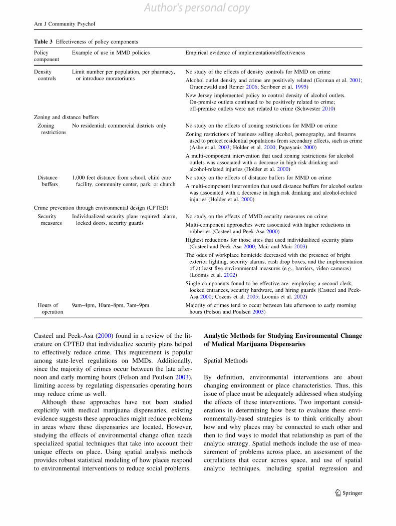
Table 3 Effectiveness of policy components
Policycomponent
Example of use in MMD policies Empirical evidence of implementation/effectiveness
Densitycontrols
Limit number per population, per pharmacy,or introduce moratoriums
No study of the effects of density controls for MMD on crime
Alcohol outlet density and crime are positively related (Gorman et al. 2001;Gruenewald and Remer 2006; Scribner et al. 1995)
New Jersey implemented policy to control density of alcohol outlets.On-premise outlets continued to be positively related to crime;off-premise outlets were not related to crime (Schwester 2010)
Zoning and distance buffers
Zoningrestrictions
No residential; commercial districts only No study on the effects of zoning restrictions for MMD on crime
Zoning restrictions of business selling alcohol, pornography, and firearmsused to protect residential populations from secondary effects, such as crime(Ashe et al. 2003; Holder et al. 2000; Papayanis 2000)
A multi-component intervention that used zoning restrictions for alcoholoutlets was associated with a decrease in high risk drinking andalcohol-related injuries (Holder et al. 2000)
Distancebuffers
1,000 feet distance from school, child carefacility, community center, park, or church
No study on the effects of distance buffers for MMD on crime
A multi-component intervention that used distance buffers for alcohol outletswas associated with a decrease in high risk drinking and alcohol-relatedinjuries (Holder et al. 2000)
Crime prevention through environmental design (CPTED)
Securitymeasures
Individualized security plans required; alarm,locked doors, security guards
No study on the effects of MMD security measures on crime
Multi-component approaches were associated with higher reductions inrobberies (Casteel and Peek-Asa 2000)
Highest reductions for those sites that used individualized security plans(Casteel and Peek-Asa 2000; Mair and Mair 2003)
The odds of workplace homicide decreased with the presence of brightexterior lighting, security alarms, cash drop boxes, and the implementationof at least five environmental measures (e.g., barriers, video cameras)(Loomis et al. 2002)
Single components found to be effective are: employing a second clerk,locked entrances, security hardware, and hiring guards (Casteel and Peek-Asa 2000; Cozens et al. 2005; Loomis et al. 2002)
Hours ofoperation
9am–4pm, 10am–8pm, 7am–9pm Majority of crimes tend to occur between late afternoon to early morninghours (Felson and Poulsen 2003)
Am J Community Psychol
123
Author's personal copy
Bayesian space–time models. In general, spatial regression
models build on traditional regression techniques but withassessments and controls for the spatial structure of the
data. These models are used when the unit of analysis is at
the level of a geographic area and can be in the form ofspatial error or spatial lag models. Spatial error models
treat the spatial structure as part of the error term while
spatial lag models assume that the spatial structure is afunction of the dependent measure (Bailey and Gatrell
1995).The first consideration is to determine how place or
location should be measured. This will depend, in part, on
how the policy or intervention being implemented purportsto change place. Limits to densities of MMDs will use
some measure of density as the unit of analysis. Here, one
will need to pay attention to whether density has beenprescribed per some areal unit (e.g., zip code, city) such as
in Washington D.C. or by population size (e.g., per 10,000
population) as is the case in Los Angeles. In absence of thisinformation, decisions about how to determine the appro-
priate density unit must be made.
In the case example below, we look at violent crimeevents at varying distance buffers around the dispensaries.
The purpose of these buffers is to determine whether or not
implementation of security measures are related to lowernumbers of violent crime at various distance thresholds.
Understanding how these distance buffers are related to
crime will provide information about how far-reachingacross areas the effects of negative consequences or out-
comes are or how the implementation of environmental
prevention efforts may reduce those negative effects. Forexample, if crime or other problems are higher near dis-
pensaries is this true at 200 feet? 500 feet? 1,500 feet?
Similarly if security measures are required by dispensariesto reduce problems, how local or far should these reduc-
tions in crime be seen? In essence buffer analyses allow for
a fine grain assessment of the distance at which problemsoccur in relation to the place of interest. Empirical obser-
vations of these relationships need to be conducted so that
environmental interventions are implemented using thebest available evidence that will ensure their effectiveness.
Concerns about the location of places during statistical
analysis arose because of spatial autocorrelation whichposits that places located next to each other are likely to be
similar to each other (Cliff and Ord 1973, 1981). The
presence of spatial autocorrelation can bias the tests of thecoefficients resulting in Type I or Type II errors (Freisthler
et al. 2006). Any application of these methods to studying
environmental interventions across geographic areas mustassess and control for spatial correlation found in the
models. Cohen et al. (2006) implemented a procedure to
adjust the standard errors due to correlations across space.After controlling for this spatial autocorrelation, these
authors found that surrenders of alcohol licenses were
related to lower gonorrhea rates (2006). They accounted forspatial autocorrelation by detecting levels of geographic
clustering and adjusting tests of significance to include
these assessments of spatial autocorrelation. To assessspatial autocorrelation, decisions must be made about how
spatial areas are connected. This is usually done through
the development of a connection matrix that providesinformation on which geographic areas are next to each
other (a simple adjacency matrix is where areas sharing aboundary are denoted with a ‘‘1’’ and nonadjacent units
with a ‘‘0’’) or a distance matrix that provides the inverse
distance from each geographic area to every other geo-graphic area (Freisthler et al. 2006). The idea here is that
areas closer to each other are weighted more heavily than
those further away. These connection matrices are alsoused in the development of more sophisticated spatial
statistical models, including spatial regression and Bayes-
ian space–time models.Gruenewald et al. (2010) take a slightly different
approach by explicitly modeling the spatial structure using
Bayesian conditionally autoregressive (CAR) space–timeanalyses in their study of the spread of methamphetamine
problems across California. They found that in California
when laws governing the sale of ephedrine or pseudoe-phedrine (a precursor chemical in the making of metham-
phetamine) were enacted rates of methamphetamine abuse
and dependence decreased (Gruenewald et al. 2010). UsingCAR procedures, the authors’ model how changes occur
over time and space in reaction to environmental changes
related to reduced availability. Here time trend variablesallow for the assessment of changes in legislation gov-
erning the distribution of products used in the manufac-
turing of methamphetamine. Although computationallyintensive to implement, the benefits for assessing the
effective of environmental interventions are great. Use of
these models can identify specific geographic areas that aremore or less responsive to environmental interventions
(Waller et al. 2007). Thus the use of these more sophisti-
cated spatial methods represents both an advancement ofthe science and an increased opportunity to understand and
document the effects of environmental change. However,
these methods alone do not address all the issues that comewith studying environmental change spatially.
Natural Experiments
The use of natural, quasi-experiments to study the effects
of changes in crime and other related problems because ofthe introduction of medical marijuana dispensaries became
possible recently as several California cities and many
states enacted ordinances restricting the density and
Am J Community Psychol
123
Author's personal copy
location of dispensaries. These policies and changes in
practices have created an opportunity to estimate theeffects of dispensaries on a variety of social problems—
including crime. By 2010 the number of cannabis dispen-
saries almost tripled in both Los Angeles and Sacramentofrom their 2007 levels (186–545 in Los Angeles; 16–40 in
Sacramento). Law enforcement officials cite concerns
about increases in crime rates due to the rising number ofdispensaries (California Police Chief’s Association 2009).
Both the city of Los Angeles and Sacramento have passedlegislation in 2010 that limited the density of dispensaries
based on population and regulated the locations in which
dispensaries could operate (e.g., cannot be within 1,000feet of schools) and mandated security measures at the
dispensaries be increased in response to the rising number
of MMDs. In the final section of this paper, we takeadvantage of the differential implementation of security
measures in Sacramento and present a case study that
examines how the presence or absence of different securitymeasures may be related to violent crime around
dispensaries.
Analyses of the effects of these policies can examineconditions before and after the policy was enacted. As
such, studies would be longitudinal in nature and rely on
the collection of readily available archival data, includingpolice incidents of violent and property crimes and hospital
discharge data related to cannabis abuse and dependence.
As described above, this approach has been used previ-ously to study extreme reduction in alcohol outlet densities
due to civil unrest in Los Angeles County (Cohen et al.
2006) and policies designed to reduce the physical avail-ability of methamphetamine in California (Gruenewald
et al. 2010) and provides valuable information on how to
study how problems change when environmental approa-ches to reducing problems are enacted. Both studies also
made adjustments to the analytic methods in order to assess
and control for the geographic cluster that occurs whenexamining the effects of environmental interventions
across areas.
Changes to regulations governing medical marijuanadispensaries often occur across entire cities or states.
Finally, through the use of archival data (often collected by
local agencies without the express intent of using them forresearch), evaluations of naturally occurring environmental
interventions are often less expensive to complete than
evaluations of individually-based interventions. Many ofthe archival data sources also include some location
information that make them ideal to use with spatial ana-
lytic methods. By utilizing data collected by other entitieson crime (police departments), health conditions (from
hospital discharges), or a variety of other social problems,
fewer resources are need to study potential effects of theseinterventions.
Challenges to Studying Environmental Change
The use of spatial models alone does not address somecommon problems that can arise when examining the
effectiveness of environmental interventions. These issues
arise when trying to determine the boundaries that definethe intervention units, the fact that these spatial units of
analysis are modifiable, and those boundaries in these areas
are permeable meaning effects of the interventions canspillover into adjacent areas. With regards to intervention
boundaries, environmental change often occurs over an
entire jurisdiction meaning that the ‘‘recipients’’ of suchchange are whole communities, cities, or states. Often-
times, however, the jurisdictions at which interventions are
implemented do not have discrete geographic boundaries(i.e., ‘‘neighborhoods’’). When this occurs decisions must
be made about the appropriate geographic level at which
the changes are expected. Are the environmental strategiesdesigned to change the structure of neighborhoods, such as
policies designed to limit densities of various business
establishments? If so, the unit of analysis for measurementmay be ‘‘neighborhoods’’ which can be measured using a
variety of administrative units (i.e., Census tracts) or
locally defined boundaries.Some environmental strategies are targeted at much
smaller areas: individual neighborhood areas or specific
business establishments. These require different assess-ments of the spatial relationships. For example, multivari-
ate analyses at the dispensary level might need to take into
account the distance of each dispensary from every otherdispensaries, with those being close to each other have
more weight (e.g., distance matrices see Freisthler et al.
2006). Thus deciding the correct level at which to evaluatethe effectiveness of environmental interventions is an
important step to studying the effects of those changes. In
the case study example described below, the securitymeasures examined are only expected to be related to
crime around the dispensary that has implemented those
measures. We, then, examine how different distancethresholds may be related to lower violent crimes around
medical marijuana dispensaries that employ a variety of
different security measures.Even once the geographic unit of analysis has been
adequately defined, concerns can still exist about how the
choice of one unit of analysis over another may differen-tially affect the results of an evaluation of an intervention.
The modifiable areal unit problem (MAUP) occurs when
studying problems at different areal units may result indifferent findings (Openshaw 1984). With the case of
medical marijuana dispensaries, it may be the case thatsecurity measures implemented by dispensaries may only
affect crime locally. Thus studying this phenomenon at the
level of a Census tract or postal zip code may obscure
Am J Community Psychol
123
Author's personal copy
findings of effectiveness of these interventions at lower
levels of geography.However, the smaller the geographic unit of analysis,
the greater the likelihood the effects of the intervention will
spill over into adjacent areas. This occurs, in part, becausethese geographic boundaries are permeable and practices
designed to reduce problems may be adopted by nearby
business or localities adjacent to the intervention area. Twoapproaches can allow for a crude assessment of these spill
over effects. First, distance buffers can be created thatsurround the intervention site which allows for the inclu-
sion of changes in practices within a specified distance
around the target area. The second is through the use ofspatial lags. Spatial lags are assessments of characteristics
of areas that share a boundary with the intervention site.
In the following case study, we attempt to examine howsecurity measures are related to violent crime rates using
different distance buffers. Here we attempt to address the
issue of modifiable area unit problem by determiningwhether or not security measures have an effect on crime
that is local or more distal to the dispensaries.
Sacramento: A Case Example
California was the first state to approve the use of cannabis
for medical purposes in 1996 via Proposition 215. Essen-
tially this legislation changed the Health and Safety Codeso that cannabis was no longer classified as a Schedule I
drug (i.e., illicit, highly addictive, and no medical pur-
poses) to Schedule II (i.e., high potential for abuse but hasaccepted use as medical treatment) in the state. Although
the first dispensaries began operating approximately at the
same time, they were quickly raided by the DrugEnforcement Agency and closed (Daley 1997). Over time,
more dispensaries were opened and federal enforcement
decreased. Due to concerns of the rapid proliferation ofdispensaries beginning in 2006, Sacramento declared a
moratorium on new dispensary locations and required
dispensaries to register with the city in July 2009. Not alldispensaries complied. Sacramento passed Measure C in
November 2010 which allowed the city to levy substantial
taxes (over $15,000 per year) specific to dispensaries.Kepple and Freisthler (2012) found no relationship
between densities of dispensaries and violent or property
crimes in Sacramento. This study relied on routine activi-ties theory which purports that crime occurs when the
following three conditions are met: a motivated offender, a
suitable target and a lack of guardianship (Cohen andFelson 1979). This finding suggests that one of these
conditions was not met in order for higher levels of crime
to occur in areas with higher densities of dispensaries.Jacobson et al. (2011) observed that crime rates increased
in areas surrounding dispensaries immediately after they
closed. One possible explanation provided is that dispen-saries provide adequate levels of security that help to deter
crime in areas immediately surrounding them. However,
present studies have not systematically evaluated the spe-cific security measures implemented by dispensaries and
associated crime incidents surrounding these locations.
Given that the majority of policies require adequate secu-rity at dispensaries with some going so far as to specify the
types of security features needed, we examined how thepresence or absence of a variety of security measures may
be related to crime at various distances from the
dispensaries.
Methods
We conducted a premise survey at each dispensary in
Sacramento between December 2010 and February 2011
using pretested protocols (Freisthler et al. 2003; Paschallet al. 2007). These surveys provided important information
about the locations where these dispensaries are located
and about their specific practices that may reduce problemsassociated with them.
Sampling and Data Collection Methods
A list of 51 medical marijuana dispensaries located within
the city limits of Sacramento was compiled from listings inlocal newspapers, trade publications, and the official listing
maintained by the city of Sacramento. Each location was
visited one time to determine its status (e.g., open, closed, outof business). For those dispensaries that were open, the data
collector recorded information about the hours of operation,
type of business model (e.g., pharmacy, social club), exteriorcondition, characteristics of the immediate area, interior
maintenance, and what security measures were present. If
dispensaries were closed at the time of the visit, appearing tobe out of business, or that could not be located, they received
a follow up visit by the data collector to conduct the premise
survey. Through this process it was determined that only 31of the original list of 51 dispensarieswere open and operating
within the city limits of Sacramento. Five locations had
either moved outside the city limits or were found to be aprior address of other dispensaries on the list. Fifteen dis-
pensaries were no longer in business. All 31 dispensaries in
business at the time of visit were successfully surveyed andtheir addresses geocoded. No purchases were made or sam-
ples accepted during the visit.
Measures
Violent Crime The dependent variable for this study isthe number of violent crimes within 1,000 feet of the
Am J Community Psychol
123
Author's personal copy

medical marijuana dispensaries. Data on violent crimes for
the year 2010 were obtained from the Sacramento PoliceDepartment website which archives all incidents of crime
on an annual basis. Here, violent crime includes homicide,
assaults, robbery, and aggravated assaults. Ninety-ninepercent of all violent crimes were geocoded to the street
address or intersection where the incident occurred. In
order to provide a measure of extremely local versus moredistal crime, we coded crime by distance from the
dispensary.
Security Measures During the premise survey, informa-
tion on visible security measures was recorded. These
included the presence or absence of a doorman, a lockedmetal screen door, a pass through on the door, security
cameras, and signs stating that a doctor’s recommendation/
prescription identification card were necessary for entry.
Data Analysis Procedures
Data were analyzed using t tests comparing the average
number of violent crimes for dispensaries that have each
type of security measure versus those that did not. Weanalyze the relationship between violent crime and security
measures utilized by dispensaries at 100, 250, 500, and
1,000 feet buffers around the dispensaries. Given the small
sample size and the exploratory nature of this analysis, we
include p values for both p\ .05 and p\ .10.
Results
Table 4 show the bivariate comparison of MMDs that
employ various security strategies with those that do not
within 100, 250, 500, and 1,000 feet buffers of the dis-pensaries. Dispensaries with security cameras and signs
requiring an identification prescription card had signifi-cantly lower levels of violence within 100 and 250 feet.
Two other security measures showed trends toward sig-
nificance but did not reach the p\ .05 significance level.Having a door man outside was related to lower levels of
crime at 250 and 100 feet, but neither relationship was
statistically significant likely due to the small sample size.There was no relationship between having a pass through
on the door and violent crime. Conversely, dispensaries
with a screened metal door had a significantly higheraverage of violent crime than those dispensaries without a
screened metal door within a 500 foot radius.
Discussion
The preliminary findings show that some security mea-sures, such as security cameras, having a door man outside,
Table 4 Bivariate comparisons of relationship of violent crime to presence of security measures at Sacramento medical marijuana dispensaries
Security measures n Violent crime
100 ft 250 ft 500 ft 1,000 ft
Locked metal screen door
Present [!x1 (SE)] 17 0.24 (0.14) 1.00 (0.28) 4.88 (1.55) 13.65 (3.34)
Not present [!x2 (SE)] 14 0.07 (0.07) 0.71 (0.24) 1.50 (0.51) 7.29 (1.91)
Difference [!x1 " !x2 (95 % CI)] 31 0.16 (-1.72, 0.50) 0.29 (-0.50, 1.07) 3.38 (-0.24, 7.01)! 6.36 (-1.99, 14.70)
Pass through door
Present [!x1 (SE)] 7 0.00 (0.00) 0.57 (0.43) 4.14 (1.47) 9.71 (3.76)
Not present [!x2 (SE)] 24 0.21 (0.10) 0.96 (0.21) 3.13 (1.12) 11.08 (2.49)
Difference [!x1 " !x2 (95 % CI)] 31 -0.21 (-0.61, 0.19) -0.39 (-1.32, 0.55) 1.02 (-3.54, 5.58) -1.37 (-11.69, 8.96)
Door man outside
Present [!x1 (SE)] 4 0.00 (0.00) 0.00 (0.00) 0.75 (0.48) 7.00 (3.51)
Not present [!x2 (SE)] 27 0.19 (0.09) 1.00 (0.21) 3.74 (1.04) 11.33 (2.33)
Difference [!x1 " !x2 (95 % CI)] 31 -0.19 (-0.69, 0.32) -1.00 (-2.11, 0.11)! -2.99 (-8.59, 2.60) -4.33 (-17.12, 8.46)
Security cameras
Present [!x1 (SE)] 4 0.07 (0.05) 0.70 (0.18) 3.37 (1.05) 10.74 (2.38)
Not present [!x2 (SE)] 27 0.75 (0.48) 2.00 (0.71) 3.25 (0.85) 11.00 (2.04)
Difference [!x1 " !x2 (95 % CI)] 31 -0.68 (-1.11, -0.24)* -1.30 (-2.37, -0.23)* 0.12 (-5.59, 5.83) -0.26 (-13.15, 12.63)
Signs about ID Rx card
Present [!x1 (SE)] 20 0.05 (0.05) 0.50 (0.18) 2.25 (0.73) 9.25 (2.80)
Not present [!x2 (SE)] 11 0.36 (0.20) 1.55 (0.34) 5.36 (2.17) 13.55 (2.87)
Difference [!x1 " !x2 (95 % CI)] 31 -0.31 (-0.65, 0.02)! -1.05 (-1.77, -0.32)* -3.11 (-6.94, 0.71) -4.30 (-13.18, 4.59)
! p\ .10, * p\ .05
Am J Community Psychol
123
Author's personal copy
and having signs requiring an identification prescription
card, taken by medical marijuana dispensary owners mightbe effective at reducing crime within the immediate
vicinity of the dispensaries. However, dispensaries with
locked metal doors had higher crimes within 500 feetradius. This finding may be more indicative of the location
of the dispensary than crime related to the dispensary itself.
In other words, dispensaries located in high crime areasmay already have locked metal doors on the building from
previous tenants to ward against crime in this high crimearea. These findings are limited by the small sample size
and cross-sectional nature of the data in one location.
Despite this, they point to some interesting, relativelyinexpensive, measures that can be taken that might result in
lower levels of crime within the immediate vicinity of
medical marijuana dispensaries.
Implications for Evaluating Environmental Change
Strategies
These findings suggest that some security measures might
be more likely to reduce crime rates than others. It isnoteworthy that certain environmental security measures
were associated with lower levels of crime considering the
limitations of a small, cross-sectional sample; these find-ings provide encouraging evidence that these security
measures may be effective in reducing violent crime.
Future studies capitalizing on the naturalistic studies uti-lizing the methods suggested in this paper can further
contribute to our understanding of the long-term efficacy of
these environmental strategy approaches.
Acknowledgments Research for and preparation of this manuscriptwere supported by NIDA Grant R01-DA-032715, NIAAA CenterGrant P60-AA-006282, and NIDA Training Grant T32-DA07272-19.
References
An Act Relating to Registering Four Nonprofit Organizations toDispense Marijuana for Symptom Relief, Vermont S.B. 17(2011, June 2). Retrieved September 28, 2011 from http://www.leg.state.vt.us/docs/2012/Acts/ACT065.pdf.
An Act to Amend the Maine Medical Marijuana Act, Maine LD 1811§ 1-51 (2010). Retrieved September 28, 2011 from http://www.mainelegislature.org/legis/bills/bills_124th/billpdfs/SP071901.pdf.
Ann Arbor, Michigan, Ordinance No. ORD-10-37 (2010).Arizona Department of Health Services. (2012). Arizona Medical
Marijuana Program:Lawsuits. RetrievedMarch 1, 2012 fromhttp://www.azdhs.gov/medicalmarijuana/dispensaries/lawsuits.htm.
Arizona Medical Marijuana Act, Ariz. Rev. Stat. § 36-2806.01(2010). Retrieved September 28, 2011 from http://www.azleg.gov/FormatDocument.asp?inDoc=/ars/36/02806-01.htm&Title=36&DocType=ARS.
Ashe, M., Jernigan, D., Kline, R., & Galaz, R. (2003). Land useplanning and the control of alcohol, tobacco, firearms, and fast
food restaurants. American Journal of Public Health, 93(9),1404–1408. doi:10.2105/AJPH.93.9.1404.
Bailey, T., & Gatrell, A. (1995). Interactive spatial data (pp.247–290). Essex, England: Addison Wesley Longman.
California Compassionate Use Act, Cal. Health & Saf. Code § 11362.5.(1996). Retrieved September 28, 2011 from http://www.cdph.ca.gov/programs/MMP/Pages/CompassionateUseact.aspx.
California Police Chief’sAssociation. (2009).White paper onmarijuanadispensaries. Task Force on Marijuana Dispensaries. Retrievedfrom http://www.californiapolicechiefs.org/files/marijuana_files/files/MarijuanaDispensariesWhitePaper_042209.pdf.
Casteel, C., & Peek-Asa, C. (2000). Effectiveness of crime preventionthrough environmental design (CPTED) in reducing robberies.American Journal of Preventive Medicine, 18(4), 99–115. doi:10.1016/S0749-3797(00)00146-X.
Cliff, A., & Ord, J. (1973). Spatial autocorrelation: Monographs inspatial and environmental systems analysis. London: PionLimited.
Cliff, A., & Ord, J. (1981). Spatial processes models and applications.London: Pion Limited.
Cohen, L. E., & Felson, M. (1979). Social change and crime ratetrends: A routine activity approach. American SociologicalReview, 588–608. doi:10.2307/2094589.
Cohen, D. A., Ghosh-Dastidar, B., Scribner, R. A., Miu, A., Scott, M.,Robinson, P., et al. (2006). Alcohol outlets, gonorrhea, and theLos Angeles civil unrest: A longitudinal analysis. Social Scienceand Medicine, 62(12), 3062–3071. doi:10.1016/j.socscimed.2005.11.060.
Colorado Medical Marijuana Code, Colo. Rev. Stat § 12-43.3 (2010).Retrieved September 28, 2011 from http://www.cdphe.state.co.us/hs/medicalmarijuana/1284_enr.pdf.
Cozens, P. M., Saville, G., & Hillier, D. (2005). Crime preventionthrough environmental design (CPTED): A review and modernbibliography. Property Management, 23(5), 328–356.
Cuniff, M.M. (2011, April 7). Spokanemedical marijuana dispensarieson federal notice: Operators, owners could face prosecution, TheSpokesman-Review. Retrieved from http://www.spokesman.com/stories/2011/apr/07/spokane-pot-shops-on-federal-notice/.
Daley, Y. (1997, 12/21/1997). California marijuana clubs under fire:Court says they aren’t dispensaries, The Boston Globe, p. A8.
Delaware Medical Marijuana Act, Title 16, Del. Health and SafetyFood and Drugs, Chapter 46A. (2011 May 13). RetrievedSeptember 28, 2011 from http://delcode.delaware.gov/title16/c049a/index.shtml.
Denver, Colorado, Council Bill No. 34 (2010).Felson, M., & Poulsen, E. (2003). Simple indicators of crime by time
of day. International Journal of Forecasting, 19(4), 595–601.doi:10.1016/S0169-2070(03)00093-1.
Freisthler, B., Gruenewald, P. J., Treno, A. J., & Lee, J. (2003).Evaluating alcohol access and the alcohol environment inneighborhood areas. Alcoholism: Clinical and ExperimentalResearch, 27(3), 477–484. doi:10.1097/01.ALC.0000057043.04199.B7.
Freisthler, B., Lery, B., Gruenewald, P. J., & Chow, J. (2006).Methods and challenges of analyzing spatial data for social workproblems: The case of examining child maltreatment geograph-ically. Social Work Research, 30(4), 198–210.
Gorman, D. M., Speer, P. W., Gruenewald, P. J., & Labouvie, E. W.(2001). Spatial dynamics of alcohol availability, neighborhoodstructure and violent crime. Journal of Studies on Alcohol, 62(5),628.
Gruenewald, P. J., Ponicki, W. R., Remer, L. G., Johnson, F. W.,Waller, L. A., Gorman, D.M., & Zhu, L. (2010). Spatial models ofthe growth and spread of methamphetamine abuse in California.In B. Deeds (ed.) Crime, space and place. New York: Springer.
Am J Community Psychol
123
Author's personal copy
Gruenewald, P. J., & Remer, L. G. (2006). Changes in outlet densitiesaffect violence rates. Alcoholism: Clinical and ExperimentalResearch, 30(7), 1184–1193. doi:10.1111/j.1530-0277.2006.00141.x.
Hoeffel, J. (2011, August 19). Medical marijuana dispensary ban caseheaded back to appeals court, Los Angeles Times. Retrieved fromhttp://latimesblogs.latimes.com/lanow/2011/08/medical-marijuana-dispensary-bans.html.
Holder, H. D., Gruenewald, P. J., Ponicki, W. R., Treno, A. J., Grube,J. W., Saltz, R. F., et al. (2000). Effect of community-basedinterventions on high-risk drinking and alcohol-related injuries.Journal of the American Medical Association, 284(18),2341–2347. doi:10.1001/jama.284.18.2341.
Jacobson, M., Chang, T., Anderson, J. M., MacDonald, J., Bluthen-thal, R. N., & Ashwood, J. S. (2011). Regulating medicalmarijuana dispensaries: An overview with preliminary evidenceof their impact on crime. RAND Corporation. Santa Monica,CA. Retrieved September 28, 2011 from http://www.rand.org/pubs/technical_reports/TR987.
Kellam, M. (2011, July 27). City moves ahead with ban on potdispensaries,Glendale News-Press. Retrieved from http://articles.glendalenewspress.com/2011-07-27/news/tn-gnp-glendale-moves-ahead-with-ban-on-pot-dispensaries-20110727_1_marijuana-dispensaries-medical-marijuana-zoning-laws.
Kepple, N. J., & Freisthler, B. (2012). Exploring the ecologicalassociation between crime and medical marijuana dispensaries.Journal of Studies on Alcohol and Drugs, 73, 523–530.
Kuhney, J. L. (2011, July 25). City’s medical marijuana shops in limbo,Sign On San Diego. Retrieved from http://www.signonsandiego.com/news/2011/jul/25/san-diego-medical-marijuana-ordinance-smoke/.
La Paz County, Arizona, Ordinance No. 2011-02 (2011).Legalization of Marijuana for Medical Treatment Amendment Act,
Council of the District of Columbia, Bill 18-622. (2010).Retrieved September 28, 2011 from http://medicalmarijuana.procon.org/sourcefiles/DCMJLawMay2010.pdf.
Leiderman, J., & Devine, J. B. (2011). Medical marijuana law inCalifornia. Washington, DC: NORML.
Loomis, D., Marshall, S. W., Wolf, S. H., Runyan, C. W., & Butts, J.D. (2002). Effectiveness of safety measures recommended forprevention of workplace homicide. Journal of the AmericanMedical Association, 287(8), 1011–1017. doi:10.1001/jama.287.8.1011.
Los Angeles, California, Ordinance No. 181069. (2010 February 3).Mair, J. S., & Mair, M. (2003). Violence prevention and control
through environmental modifications. Annual Review of PublicHealth, 24(1), 209–225. doi:10.1146/annurev.publhealth.24.100901.140826.
National Organization for the Reform of Marijuana Laws (NORML).(2011). Active state medical marijuana programs. Retrieved July20, 2011 from http://norml.org/index.cfm?Group_ID=3391.
New Jersey Compassionate Use Medical Marijuana Act, Pub. L. No.2009, c.307. (2010 October 1). Retrieved September 28, 2011from http://www.judiciary.state.nj.us/legis/307.pdf.
Openshaw, S. (1984). The modifiable areal unit problem. Norwich,England: Geo Books.
Papayanis, M. A. (2000). Sex and the revanchist city: Zoning outpornography in New York. Environment and Planning D, 18(3),341–354. doi:10.1068/d10s.
Paschall, M. J., Grube, J. W., Black, C., Flewelling, R. L., Ringwalt,C. L., & Biglan, A. (2007). Alcohol outlet characteristics andalcohol sales to youth: Results of alcohol purchase surveys in 45Oregon communities. Prevention Science, 8(2), 153–159. doi:10.1007/s11121-006-0063-0.
Phoenix, Arizona, Ordinance G-5573. (2010).Sacramento, California, Ordinance 2009-033. (2009).Sacramento, California, Ordinance 2010-037. (2010).Sacramento, California, Ordinance 2010-038. (2010).Schwester, R. (2010). Alcohol outlet densities, crime, and population
restrictions on alcohol licenses. Public Administration & Man-agement, 15(2), 365–380. Retrieved from http://www.spaef.com/file.php?id=1254.
Scribner, R. A., MacKinnon, D. P., & Dwyer, J. H. (1995). The risk ofassaultive violence and alcohol availability in Los AngelesCounty. American Journal of Public Health, 85(3), 335–340.doi:10.2105/AJPH.85.3.335.
Seattle, Washington, Ordinance No. 123661. (2011).The Edward O. Hawkins and Thomas C. Slater Medical Marijuana
Act, Chapter 016, H 5359 Substitute A, R.I. Gen. Laws. (2009June 16). Retrieved September 28, 2011 from http://www.rilin.state.ri.us/PublicLaws/law09/law09016.htm.
The Lynn and Erin Compassionate Use Act, N.M. Stat. § 26-2B(2010). Retrieved September 28, 2011 from http://www.nmlegis.gov/sessions/07%20Regular/final/SB0523.pdf.
Waller, L. A., Goodwin, B. J., Wilson, M. L., Ostfeld, R. S., Marshall,S. L., & Hayes, E. B. (2007). Spatio-temporal patterns in county-level incidence and reporting of Lyme disease in the northeasternUnited States, 1990–2000. Environmental and Ecological Sta-tistics, 14(1), 83–100. doi:10.1007/s10651-006-0002-z.
White, E. (2011, August 24).Medical marijuana: Michigan court banssale of pot through private shops. Retrieved September 1, 2011from http://www.huffingtonpost.com/2011/08/25/michigan-medical-marijuana_n_936214.html.
Am J Community Psychol
123
Author's personal copy
Copyright © 2022 FDOKUMEN