Establishing the Outer Limits of the Continental Shelf - the ...
149
“Establishing the Outer Limits of the Continental Shelf under the LOSC: Oman as a Case Study” Mubarak Al Hinai Supervisors: Dr. Andrew Serdy Mrs. Valentina Germani The United Nations-Nippon Foundation Fellowship Programme 2014-2015
-
Upload
khangminh22 -
Category
Documents
-
view
2 -
download
0
Transcript of Establishing the Outer Limits of the Continental Shelf - the ...
“Establishing the Outer Limits of the Continental Shelf
under the LOSC: Oman as a Case Study”
Mubarak Al Hinai
Supervisors:
Dr. Andrew Serdy
Mrs. Valentina Germani
The United Nations-Nippon Foundation Fellowship
Programme 2014-2015
I
Summary
Working Title:
Establishing the Outer Limits of the Continental Shelf under the
LOSC: Oman as a Case Study.
Supervisors:
Academic supervisor: Dr. Andrew Serdy
Programme supervisor: Mrs. Valentina Germany
II
Disclaimer
The views expressed herein are those of the author and do not necessarily reflect in any way or form the views of the Government of the Sultanate of Oman, the United Nations, the Nippon Foundation of Japan, or the Institute of Maritime Law at the University of Southampton in the UK. © 2014 Mubarak Al Hinai. All rights reserved.
Dedication
III
To the Sultanate of Oman
Acknowledgment
There are many people without their help this paper would not have been
accomplished. Firstly, I would like to thank enormously the Nippon Foundation of Japan for
IV
providing me with this great opportunity to increase and deepen my knowledge about ocean
affairs and the law of the sea, and to explore and write about an issue that is going to be
beneficial to my country. The same amount of thanks also extends to the United Nation
Division for Ocean Affairs and the Law of the Sea (DOALOS) and its staff starting with the
Director General for hosting me during the first phase of the fellowship and without whom I
would not have been able to write this acknowledgment. In particular, I am very grateful to
Valentina Germani for her guidance and supervision, and to Simone Dempsey for her
administrative support during the fellowship.
Moreover, I have been grateful to have Dr. Andrew Serdy in the Institute of Maritime
Law at the University of Southampton in the UK as my academic supervisor whose
assistance and guidance played a significant role in completing this paper successfully. I
equally thank Alan Evans from the National Oceanography Centre in Southampton for
sharing with me the vast experience he has in relation to the scientific and technical aspects
of the issues covered in the paper. Also, I would like to extend my appreciation to the
Institute of Maritime Law and its staff at the University of Southampton for the nice
hospitality and care I received during the second phase of the fellowship. A special
appreciation goes to Clare Brady the secretary of the Institute for the continuous support I
was provided from her.
I would like also to express my special thanks to the Ministry of Legal Affairs in the
Sultanate of Oman for nominating me to participate in this fellowship and facilitating my
absence from work during the period of the fellowship. I am also indebted to my family for
the invaluable support I was rendered with while away from home without which I would not
have been able to complete my paper. Finally, I acknowledge with gratitude the support I
received directly or indirectly from all people during the fellowship.
List of Abbreviations
CLCS Commission on the Limits of the Continental Shelf
DOALOS Division of Ocean Affairs and the Law of the Sea
V
DOALOS Manual DOALOS Training Manual for Delineation of the Outer Limits of the Continental
Shelf beyond 200 Nautical Miles and for Preparation of Submissions to the CLCS
EEZ Exclusive Economic Zone
ICJ International Court of Justice
ILC International Law Commission
LOSC United Nations Convention on the Law of the Sea
NM Nautical Mile
R.O. Royal Decree
ROP Rules of Procedure of the CLCS, CLCS/40/Rev.1, adopted at its Twenty First
Session, New York, 17 April 2008
SPLOS Meeting of States Parties to the LOSC
TALOS A Manual on Technical Aspects of the United Nations Convention on the Law of
the Sea – 1982 (Published by the International Hydrographic Organization,
Monaco. Edition 5.0.0-June 2014)
The Guidelines The Scientific and Technical Guidelines of the CLCS, CLCS/11, adopted by the
CLCS on 13 May 1999 at its fifth session
UNCLOS I First United Nations Conference on the Law of the Sea (1958)
UNCLOS II Second United Nations Conference on the Law of the Sea (1960)
UNCLOS III Third United Nations Conference on the Law of the Sea (1973-1982)
UN United Nations
List of Appendices
Page
Appendix 1: Number of Ratifications and Signatures of the 1958 Convention on the
Continental Shelf ....................................................................................................... 118
Appendix 2: Preliminary Analysis of the ‘Data and other Material’........................ 121
VI
Appendix 3: The Scientific and Technical Examination of the ‘Data and Other
Material’......................................................................................................... ............ 122
Appendix 4: The Correlation between the Provisions in Article 76 and the Various
Sciences that are Required to Implement Them ........................................................ 123
Appendix 5: Practical Suggestions Concerning the Final Preparation and Deposit of
Submissions to the CLCS through the Secretary General of the UN ........................ 125
Appendix 6: Summary Flow Chart of the Procedures Concerning a Submission made
to the CLCS ...................................................................................... ......................... 129
List of Cases
Page
Anglo-French Continental Shelf Delimitation Case (United Kingdom v. France),
Interpretative Decision of 14 March 1978, International Law Reports, Vol. 54, p.
139 ............................................................................................................................... 16
VII
Aegean Sea Continental Shelf Case (Greece/Turkey), Judgment, I.C.J. Reports 1978, p.
3 .................................................................................................. ............................... 16
Anglo-Norwegian Fisheries case (UK v. Norway), ICJ Reports 1951, p.
116..................................................................... ........................................................... 61
Case Concerning the Continental Shelf (Tunisia / Libyan Arab Jamahiriya), Judgment,
I.C.J. Reports 1982, p. 18....................................................................................... 17, 48
Case Concerning Delimitation of the Maritime Boundary in the Gulf of Maine Area
(Canada / United States of America) Judgment I.C.J. Reports 1984, p. 245.............. 17
Case Concerning the Continental Shelf (Libyan Arab Jamahiriya / Malta), Judgment,
I.C.J. Reports 1985, p. 12 .......................................................................................... . 17
Case of Arbitration between Petroleum Development (Trucial Coast) Limited and His
Excellency Sheikh Shakhbut Bin Sultan Bin Za’id, Ruler of Abu Dhabi and its
Dependencies (1951) 18 International Law Reports
144.................................................................. .............................................................. 15
The North Sea Continental Shelf Cases (Federal Republic of Germany/Denmark,
Federal Republic of Germany/Netherlands) I.C.J. Reports 1969, p. 3 ....................... 16
List of Figures
Page
Figure 1. The maritime zones established by the LOSC and their outer Limits............. 3
Figure 2. Illustration of the scientific continental shelf................................................ 20
Figure 3. The continental shelf up to the distance of 200 nautical miles from the
baselines from which the territorial sea is measured...................................................... 23
VIII
Figure 4. The components of the continental margin that determine the extent of the
continental shelf (shelf, slope and rise).......................................................................... 25
Figure 5. The location of the foot of the slope in the continental margin..................... 26
Figure 6. Delineation of the outer limits of the continental shelf beyond the distance of
200 nautical miles according to paragraphs 4 – 7 of Article 76 of the LOSC............... 27
Figure 7. Definition of the outer limits of the continental shelf beyond the distance of
200 nautical miles.............................................................................. ............................ 28
Figure 8. The geographic location of Oman................................................................. 56
Figure 9. The intended area of Oman’s submission as provided in its preliminary
information........................................................................................ ............................ 59
Figure 10. The three types of the baselines as envisaged in the LOSC....................... 62
Figure 11. The four areas along the coast of Oman on which straight baselines are
delineated ......................................................................................... ............................ 63
Figure 12. The Owen Basin and its connected features............................................... 67
Figure 13. The 350 nautical miles constraint as drawn in Oman’s preliminary
information........................................................................................ ............................ 72
Figure 14. The 2,500 metre isobath plus 100 nautical miles constraint as drawn in
Oman preliminary information..................................................................................... 73
Figure 15. The depth of water in the Owen Basin as provided in Oman’s preliminary
information....................................................................................... ............................ 75
Figure 16. The outer envelope or cut-off line of the two constraint lines identified by
Oman in its preliminary information........................................................................... 77
Figure 17. The location of Socotra Island.................................................................. 79
Figure 18. The outer limit of the continental shelf south east of Socotra Island as
provided by Yemen in its submission.......................................................................... 80
Page
Figure 19. The outer limits of Pakistan’s continental shelf as defined by it in its
submission.................................................................................................... ................... 82
Figure 20. The outer limits of India’s continental shelf in the western offshore region of
India in the Sea of Oman as defined by it in its submission........................................... 84
Figure 21. The continental margin of New Zealand in the Western region.................. 88
Figure 22. The Bollons Seamount in the Eastern region of New Zealand’s submission... 89

IX
Figure 23. The continental margin of Australia in the South Tasman Rise region....... 90
Figure 24. DOALOS model example for the national continental shelf delimitation
project................................................................................................. ............................ 96
Figure 25. Oman maritime boundaries delimitation agreements............................. 104
Figure 26. The region where the potential overlap between Oman, Pakistan, and India
might occur ................................................................................................................ 106
List of Tables
Page
Table 1. The current number of submissions to extend the continental shelf beyond 200
nautical miles and their dates...................................................................... .......................... 6-7
Table 2. The number and date of Oman’s preliminary information amongst other coastal
states’ preliminary information.......................................................................................... ..... 8
Table 3. Current members of the CLCS and their nationalities.........................................32-33
X
Table 4. The number and type of copies that constitute the submission............................... 44
Abstract
Article 76 (1) of the United Nations Convention on the Law of the Sea stipulates that
‘the continental shelf of a coastal State comprises the seabed and subsoil of the submarine
areas that extend beyond its territorial sea throughout the natural prolongation of its land
territory to the outer edge of the continental margin, or to a distance of 200 nautical miles
from the baselines from which the breadth of the territorial sea is measured where the outer
edge of the continental margin does not extend up to that distance’. Proceeding from the
historical nexus between Oman and the sea, and in implementation of the said Article, Oman
is embarking on making a submission to the international Commission on the Limits of the

XI
Continental shelf (CLCS) to establish the outer limits of its continental shelf that extends
beneath the sea beyond the distance of 200 nautical limits from the baselines. Achieving this
goal would confer to Oman more rights as well as obligations up to the future outer limits of
its continental shelf which will consequently enhance and strengthen the existing nexus
between Oman and the sea that overlooks its shores.
Making a submission is, however, not simple as it seems. Resources have to be
allocated, people to be trained, and offshore field surveys to be conducted over a long period
of time. More importantly, the requirements contained in the LOSC and its relevant
documents must be carefully followed and acted upon. Then, the submission shall be written
and lodged with the CLCS to be followed by an engagement with the latter until its final
recommendations are provided. Thereafter, the outer limits of Oman’s continental shelf
beyond the distance of 200 nautical miles from the baselines shall be established and given
due publicity by depositing them with the Secretary General of the United Nations (UN).
Towards this objective, Oman submitted preliminary information to the Secretary General of
the UN in May 2009 indicative of the outer limits of its continental shelf beyond 200 nautical
miles from the baselines and confirmed that it is actively involved in preparing a submission
which will be presented within a period of 10 years from the said date. The objective is
apparently clear but how to achieve it successfully in accordance with the requirements of
Article 76 of the LOSC is what significantly matters. Therefore, Oman, as it moves towards
lodging its submission, should ensure that the provisions of the LOSC and its relevant
documents are complied with and any challenge arising will be dealt with efficiently and
effectively with the ultimate aim of establishing the outer limits of the continental shelf with
certainty and exercising the rights emanating therefrom with confidence.
Table of Contents
Page
Summary ...................................................................................................................... . i
Disclaimer ...................................................................................................... ................ ii
Dedication ....................................................................................... ............................... iii
Acknowledgment ........................................................................... ............................... iv
List of Abbreviations ................................................................................................... v
List of Appendices ........................................................................................................ vi
XII
List of Cases .................................................................................................................. vii
List of Figures ..................................................................................................... .......... viii - ix
List of Tables ................................................................................................................ . x
Abstract ......................................................................................... ................................ xi
1. Chapter One: Introduction ...................................................................................... 1
1.1. Background and Context .............................................................................. 1
1.2. Scope and Objectives ................................................................................... 9
1.3. Methodology and Approach ........................................................................ . 10
1.4. Structure of Thesis ....................................................................................... . 11
(First Part)
2. Chapter Two: The Continental Shelf ...................................................................... 12
2.0. Introductory Remarks .................................................................................. 12
2.1. Historical Background ................................................................................. 13
2.1.1. State Practice ....................................................................................... 13
2.1.2. International Case Law........................................................................ 15
2.1.3. Treaty Law ......................................................................................... . 18
2.2. Definition of the Continental Shelf under the LOSC .................................. 20
2.2.1. The Continental Shelf up to the Distance of 200 nautical miles ......... 21
2.2.2. The Continental Shelf beyond the Distance of 200 nautical miles ..... 24
Page
2.3. Concluding Remarks.................................................................................. 29
3. Chapter Three: The Submission Process............................................................... 30
3.0. Introductory Remarks ................................................................................ 30
3.1. The CLCS ................................................................................................. . 30
3.1.1. Membership and Structure................................................................. 30
3.1.2. Role and Functions ........................................................................... . 36
3.2. Submission ................................................................................................ 41
3.2.1. Procedure .......................................................................................... . 41
XIII
3.2.2. Benefits and Costs ............................................................................. 48
3.3. Concluding Remarks ................................................................................ 53
(Second Part)
4. Chapter Four: Oman’s Submission ..................................................................... 55
4.0. Introductory Remarks ............................................................................... 55
4.1. Defining the Outer Limits of the Continental Shelf ................................. 60
4.1.1. Baselines .......................................................................................... . 60
4.1.2. Foot of the Continental Slope ........................................................... 65
4.1.3. Formula Lines .................................................................................. . 69
4.1.4. Constraint Lines ............................................................................... . 71
4.1.5 Delineating the Outer Limits of the Continental Shelf ...................... 76
4.2. Submissions by Neighbouring States and Recommendations for States Having a
Continental Shelf Similar to that of Oman ................................................ 78
4.2.1. Submissions by Opposite and Adjacent Neighbouring States .......... 78
4.2.2. Submissions by states having a continental shelf similar to that of Oman ... 86
4.3. Concluding Remarks ................................................................................ 93
5. Chapter Five: Challenges ..................................................................................... 95
5.0. Introductory Remarks ...............................................................................
Page
5.1. Technical and legal ................................................................................. 95
5.1.1. Pre-Submission ................................................................................ 95
5.1.2. During Submission .......................................................................... 101
5.2. Possible Areas of Overlap ..................................................................... 103
5.2.1. Location of Areas of Overlap ......................................................... 103
5.2.2. Solutions ......................................................................................... 106
5.3. Concluding Remarks ............................................................................ 111
6. Chapter six: Conclusion .................................................................................... 112

XIV
Appendices ............................................................................................................. 118
List of References .................................................................................................. 132

1
1. Introduction
1.1. Background and Context
‘Even in the case of Article 76 on the continental shelf, the article contains new law in
that it has expanded the concept of the continental shelf to include the continental
slope and the continental rise. This concession to the broad margin States was in
return for their agreement for revenue-sharing on the continental shelf beyond 200
miles’.
The above remarks were expressed by the President of the Third United Nations
Conference on the Law of the Sea (UNCLOS III), Tommy T.B. Koh. of Singapore, on the
occasion of adopting the United Nations Convention on the Law of the Sea (LOSC) on 10
December 19821. Calling the latter the ‘Constitution for the Oceans’, Koh went on to say that
‘we created a new record in legal history. Never in the annals of international law had a
Convention been signed by 119 countries on the very first day on which it was opened for
signature. Not only was the number of signatures a remarkable fact but just as important was
the fact that the Convention had been signed by States from every region of the world, from
the North and from the South, from East and from the West, by coastal States as well as land-
locked and geographically disadvantaged States’ 2. These words summarize explicitly the
value of the achievement that was made. Twelve years later, this important body of law
entered into force, specifically on 16 November 1994; 12 months after Guyana became the
60th State to deposit an instrument of ratification or accession with the Secretary General of
the United Nations (UN). At the time of writing, 165 states and the European Union are
parties to this multilateral convention, making it one of the most successful multi-lateral
treaties3. While the international community is still struggling to follow the success achieved
with this convention on other important global issues such as climate change and world trade,
States Parties to the LOSC (SPLOS) celebrated in 2014 the 20th anniversary of its entry into
force. On commemorating this occasion, the Secretary General of the UN referred to the
LOSC ‘as one of the most significant and visionary multilateral instruments of the twentieth
1 Adapted from statements by the President on 6 and 11 December 1982 at the final session of the Conference at Montego Bay, at p. xxxiv, available online at: http://www.un.org/depts/los/convention_agreements/texts/koh_english.pdf [last accessed 25/09/2014]. 2 Ibid, at p. xxxiii. 3 See Chronological lists of ratifications of, accessions and successions to the Convention and the related Agreements as at 29 October 2013, available online on the website of the Division of Ocean Affairs and the Law of the Sea of the Office of Legal Affairs of the UN at: http://www.un.org/depts/los/reference_files/chronological_lists_of_ratifications.htm#The United Nations Convention on the Law of the Sea [last accessed 26/09/2014].
Commented [LS1] :To be updated
2
century’ noting that ‘it had shown its dynamic character through its ability to address new
challenges’4.
The LOSC comprises 320 articles and nine annexes, governing all aspects that are
related to the uses and resources of oceans and seas, such as economic and commercial
activities, conservation and management of living marine resources, delimitation,
environmental control and protection, marine scientific research, transfer of technology, and
the settlement of maritime disputes. It was the first time in the history of the law of the sea
that all these aspects were dealt with together in a collective (package) manner. After decades
of disagreement, ambiguity and envisioning the ocean space from the perspective of
navigation only, one of the great achievements of the LOSC is the establishment of maritime
zones and setting out their outer limits precisely, upon which everything else will depend
[Maritime zones already existed before UNCLOS. It may be more accurate to say that
UNCLOS made their regime clearer (e.g. by eliminating the ambiguity of the ‘exploitability’
criterion in the 1958 C.Shelf Convention). According to it, maritime space, that covers almost
70% of the planet5, shall consist of [Add: internal waters] the territorial sea (Articles 2-32),
contiguous zone (Article 33), archipelagic waters (Articles 46-54), exclusive economic zone
(Articles 55-75), high seas (Articles 86-120), and the sea floor beneath the EEZ and high seas
shall either be the continental shelf (Articles 76-85) and/or the international seabed area
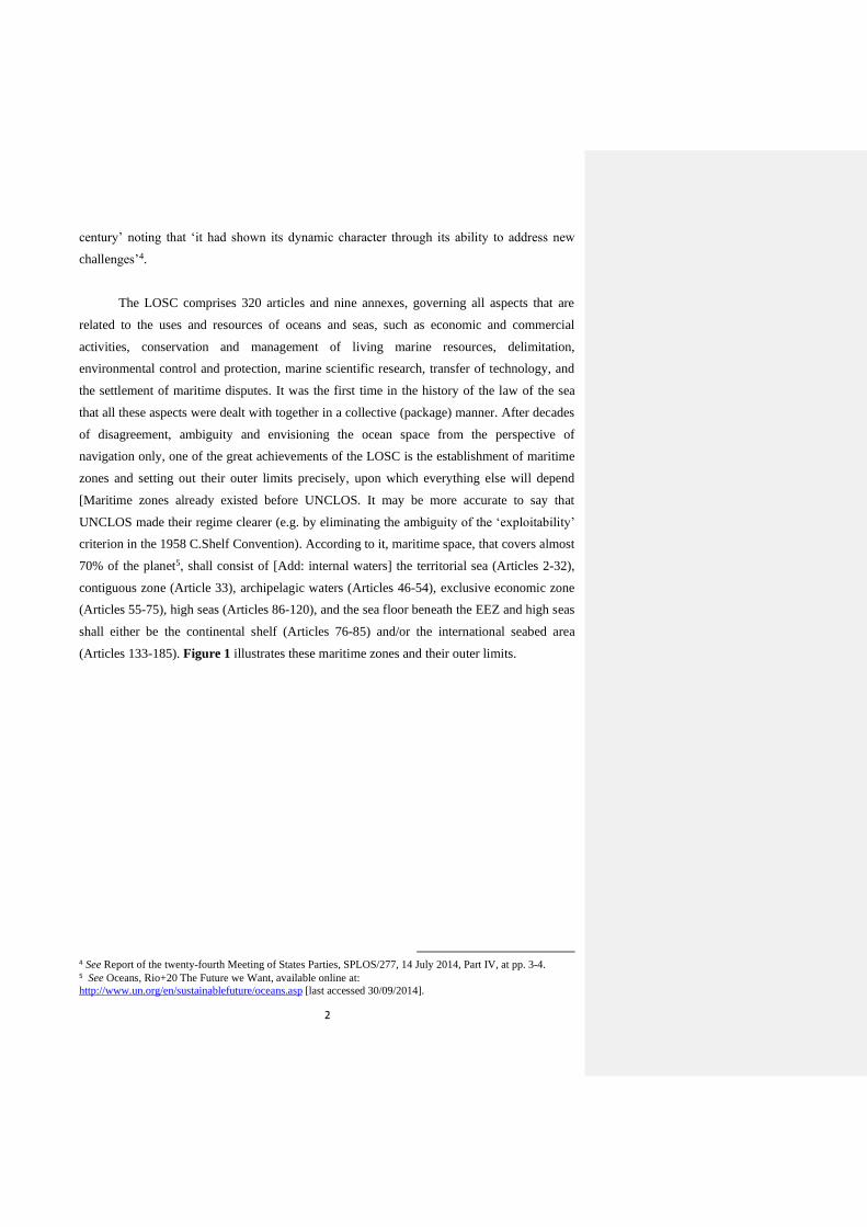
(Articles 133-185). Figure 1 illustrates these maritime zones and their outer limits.
4 See Report of the twenty-fourth Meeting of States Parties, SPLOS/277, 14 July 2014, Part IV, at pp. 3-4. 5 See Oceans, Rio+20 The Future we Want, available online at:
http://www.un.org/en/sustainablefuture/oceans.asp [last accessed 30/09/2014].
3
Figure 1: The maritime zones established by the LOSC and their outer Limits
Source: TALOS at Chapter 5-3.
Given the above in the quote referred to from Koh concerning the continental
shelf, he points out that a new law [law is not appropriate here… maybe ‘rule’ or ‘principle’
or ‘concept’… I’m not sure what Mr. Mubarak means exactly with ‘law’] has been
introduced by Article 76 of the LOSC whereby the concept of the continental shelf has
expanded to include the continental slope and the continental rise which can be extended
beyond 200 nautical miles in return for revenue sharing. Apparently therefore, unlike the
other maritime zones, the outer limits of the continental shelf have not been defined by
reference to a ‘bredth-criterion’ as they are subject to expansion [this word is ambiguous… it
conveys the impression that they can be continuously expanded]. This is attributed to the fact
that, in contrast with other maritime zones apart from the international seabed area (Area), the
continental shelf is physical in nature which, as a result, differs from one state to another or
from one maritime area to another for natural reasons such as tectonic history and
development of the continental crusts. Therefore, at the time of negotiating the LOSC, it was
not clear if all coastal states would have continental shelves beyond 200 nautical miles and if
they would, no data was available to determine the breadth of such continental shelves from
the landmass of every coastal state. Having realized that, ‘the new law contained in Article 76
Commented [LS2] :There's a new and very recent edition of TOALOS (available online). Make sure that the TALOS references are
to this latest edition
4
of the LOSC’ was required by necessity. As generally established, laws are in principle [does
he mean ‘of an abstract nature’?] and theory come into existence to achieve such ends [this
last part of the sentence is not clear]. From this perspective, Article 76, being described as a
law [what does ‘being described as a law’ mean?], lays down legal rules [all articles of the
Convention are legal in nature] to be followed by coastal states in the determination of the
extent of expansion seawards of their continental shelf inclusive of the continental slope and
rise upon which the outer limits of the continental shelf will be clearly established if they are,
as figure 1 above shows, up to a distance of 200 nautical miles or beyond. Obviously, if these
limits do not go beyond 200 nautical miles, only a distance measurement, similarly to the
other maritime zones, is required to draw them at that point [up to that distance]. In case of
further expansion, the new ‘law of Article 76’ will obviously come into operation and
application to determine the actual distance [Article 76 is ‘new’ compared to the 1958 regime
also for the part of the provision that applies up to 200 nautical miles]. Given that, would it be
wise and appropriate to leave everything in the hands of the coastal state to determine the
expansion of its continental shelf seawards knowing that states, as entities, are generally
driven by national political and economic interests in their engagement vis-à-vis the rest of
the world?
The answer is both ‘yes’ and ‘no’. As regards the former, coastal states have been
given the right to delineate the outer limits of the other maritime zones, so why not the
continental shelf. Hence, the continental shelf constitutes physically, as mentioned above,
part and parcel of the landmass on which the costal state sits and exercises its powers as a
state for which it needs to know obviously where its external boundaries are located. In this
vein, besides being an inherent responsibility, delineating its outer boundaries is a matter
taken for granted by every state. In respect of the latter, leaving everything completely to the
coastal state without checks and balances might affect, in the language of interests, the
maritime zone of the Area considered as the ‘common heritage of mankind’6. Therefore, the
outer limits established by a particular coastal state need to be recognized and accepted by the
international community. For this purpose and the purpose of clarity, the legal rules laid
down by the new ‘law of Article 76’ come up with the appropriate solution. The latter lies in
making a submission of the outer limits of the continental shelf that ‘expand’ beyond 200
nautical miles by the coastal state to an independent body to verify these limits and ensure
they are in line with the said rules. In this case, the right of the coastal state is protected, and
the right of the international community is duly not prejudiced. Obviously, the referred to
6 Article 136 of the LOSC provides that ‘The Area and its resources are the common heritage of mankind’.
Formatted: Highlight
Formatted: Highlight
Formatted: Highlight

5
solution is conducted through a process which deals, differently from the other maritime
zones, with a physical part that lies over areas at deep depths in the oceans. The Division of
Ocean Affairs and the Law of the Sea of the Office of the Legal Affairs of the UN
(DOALOS) also adds that ‘The legal regime established by the LOSC for the delineation of
the outer limits of the extended continental shelf is very complex. It combines both legal and
scientific concepts, rendering its interpretation challenging for both legal practitioners with
no scientific background, and marine scientists without legal training’7.
At the time of negotiating the LOSC, a list was drawn up by the UN Secretariat
containing 33 names of coastal states with a continental shelf extending beyond a 200
nautical miles from the baselines from which the territorial sea is measured8. Another list was
published, not by the Secretariat this time, in 1998 with 56 states9. After the entry into force
of the LOSC and beginning of implementation of the provisions of Article 76 contained
therein, the number of actual submissions made to extend the continental shelf beyond 200
nautical miles has gradually increased to reach, at the time of writing, 75 [figure to be
updated] submissions made by 68 coastal states. Table 1 shows the current number of
submissions and their dates.
7 See DOALOS Manual, at p. xix. 8 See Peter F. Croker, ‘The CLCS: a Further Update on the Work of the Commission’ published in The
Establishment of the Outer Limits of the Continental Shelf beyond 200 Nautical Miles- Its International Circumstances, and its Scientific and Technical Aspects, (Ocean Policy Research Foundation, Tokyo, 2007) at p. 14. 9 Ibid.
Formatted: Highlight
Formatted: Highlight

6
Table 1: The current number of submissions to extend the continental shelf beyond 200
nautical miles and their dates.
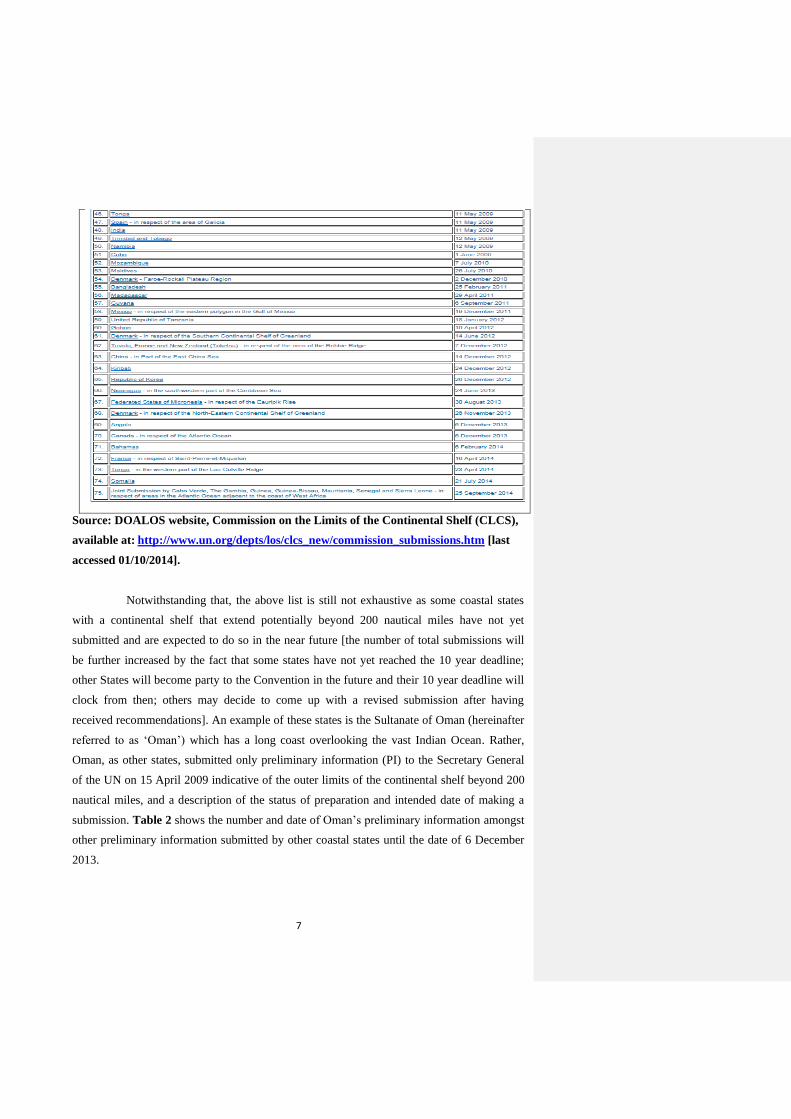
7
Source: DOALOS website, Commission on the Limits of the Continental Shelf (CLCS),
available at: http://www.un.org/depts/los/clcs_new/commission_submissions.htm [last
accessed 01/10/2014].
Notwithstanding that, the above list is still not exhaustive as some coastal states
with a continental shelf that extend potentially beyond 200 nautical miles have not yet
submitted and are expected to do so in the near future [the number of total submissions will
be further increased by the fact that some states have not yet reached the 10 year deadline;
other States will become party to the Convention in the future and their 10 year deadline will
clock from then; others may decide to come up with a revised submission after having
received recommendations]. An example of these states is the Sultanate of Oman (hereinafter
referred to as ‘Oman’) which has a long coast overlooking the vast Indian Ocean. Rather,
Oman, as other states, submitted only preliminary information (PI) to the Secretary General
of the UN on 15 April 2009 indicative of the outer limits of the continental shelf beyond 200
nautical miles, and a description of the status of preparation and intended date of making a
submission. Table 2 shows the number and date of Oman’s preliminary information amongst
other preliminary information submitted by other coastal states until the date of 6 December
2013.

8
Table 2: The number and date of Oman’s preliminary information amongst other
coastal states’ preliminary information.

9
Source: DOALOS website, Commission on the Limits of the Continental Shelf (CLCS),
available at: http://www.un.org/depts/los/clcs_new/commission_preliminary.htm [last
accessed 02/10/2014].
10
Notwithstanding the fact that submitting preliminary information per se is a step
towards making a full submission, not being able to do the latter directly can be construed as
a sign of difficulty. On the other side, it can be construed by others as an advantage to have
the time that is necessary to make a submission in accordance with the referred to law of
Article 76 and other relevant requirements. Moreover, it might also be considered as an
opportunity to learn from the submissions made already by other coastal states and the
recommendations provided by the CLCS for them. Indeed, establishing ultimately the outer
limits of the continental shelf beyond 200 nautical miles by all coastal states is a great move
towards defining clearly the limits of the oceans [certainty of the limits is not connected by
the distance at which the limits are drawn]. It also enables the right of the coastal states to
explore and exploit economically the natural resources that lie in their continental shelves
beyond the distance of 200 nautical miles from the baselines to be exercised with confidence
and certainty. It is undoubtedly a long way until that goal is finally reached and establishing
the outer limits of the continental shelf on the basis of the recommendations provided by the
CLCS constitutes the first half of this way. That being said, this paper aims to provide an
early assessment of Oman’s forthcoming submission to the CLCS to establish the outer limits
of its continental shelf beyond the distance of 200 nautical miles from the baselines from the
angles of the referred to Article 76 of the LOSC and all other relevant documents to the
submission process with the aim to put it on the right path.
1.2. Scope and Objectives
The scope of this paper is generally [to provide an overview of? ]the submission
process before the CLCS and specifically the forthcoming submission of the Sultanate of
Oman to extend the outer limits of its continental shelf beyond the distance of 200 nautical
miles from the baselines against the background of the preliminary information it submitted
in 2009, Article 76 of the LOSC and Annex II to it, the Scientific and Technical Guidelines
of the CLCS and its Rules of Procedure and the submissions made by neighbouring and other
coastal states and their relevant recommendations. This is followed by an examination of the
challenges that Oman might encounter in the process of making the submission and during
the submission process with the aim of finding the right solutions and the best ways to move
forward. Although Oman’s forthcoming submission, which is under preparation, is the main
focus of this paper, the approach of assessment followed herein could be used for other
submissions to be made by other coastal states. The primary objective [a research paper
cannot have this goal as it has no formal role in the making of a submission] is to ensure that
Formatted: Highlight
11
Oman’s forthcoming submission meets the legal and technical requirements contained in
Article 76 of the LOSC, Annex II to the Convention, and the other documents associated with
the submission process in order to minimise and mitigate the obstacles that night be faced and
thus to be on the right track until the deposit of geographic information of the established
outer limits with the Secretary General of the UN.
1.3. Methodology and Approach
In attempting to achieve the above objectives, the paper consists of two parts
whereby the analysis of the second part builds on the contents of the first part. It relies mainly
on literature review, namely books, articles and official UN documents related to the
submission process and work of the CLCS. Also, Oman’s relevant legislation, international
case law, submissions made by some coastal states and the recommendations approved by the
CLCS are reviewed and referred to throughout the discussion of some parts of the paper.
There is no field work or survey carried out during the writing of this paper except in section
one of chapter five where a meeting held with a senior scientist in the National Oceanography
Centre in the UK. It has to be stated as well that while more emphasis has be given to legal
aspects, considerable attention has been devoted also to technical and scientific issues to
support the discussion.
In order to provide the detailed background necessary for a full appreciation of the
issue under examination, the first part of the paper provides a historical background of the
development of the concept of the continental shelf and the definition provided finally to it by
the adoption of the LOSC. The analysis then extends to discuss thoroughly the role and
structure of the CLCS and the submission in terms of procedure, costs and benefits. Taking
part one as its background and the preliminary information submitted by Oman in 2009, part
two of the paper will then conduct a thorough examination of Oman’s forthcoming
submission [methodologically speaking: how can part two contain a thorough examination of
a submission that has not been made yet + even if it had been met it would not be available to
the public for review? So at most it could be a review of a future executive summary] by
taking into account the submissions made by states with opposite and adjacent coasts,
submissions and recommendations of some coastal states with a continental margin wholly or
partially similar to that of Oman, and the different types of challenges that might be
encountered on the way towards making the submission and afterwards.
12
1.4. Structure of the Thesis
The paper is divided into six chapters. The first one is this chapter which provides
an introduction and brief background to the research under examination. Then the paper will
take, as outlined above, the form of two parts whereas the second and third chapters make the
first part, and chapters four and five make the second part respectively as the following:
Chapter two introduces the historical development of the concept of the continental shelf
until the adoption of the LOSC. It also analyses the definition of the continental shelf
provided in Article 76 of the LOSC and the way that the outer limits of the continental shelf
beyond 200 nautical miles should be delineated by the coastal state.
Chapter three examines the body established by the LOSC to review the submissions made
by coastal states (CLCS) in terms of membership, structure and role as well as the submission
process brought before it by States Parties to the LOSC, and the benefits and costs arising
from that process for these states.
Chapter four discusses the forthcoming submission by Oman in light of the preliminary
information it submitted in 2009 against: first, the provisions of Article 76 and the Scientific
and Technical Guidelines of the CLCS in terms of defining the outer limits of its continental
shelf; and second, the submissions made by states with opposite and adjacent coasts, and the
recommendations provided by the CLCS in respect of some of the submissions which share a
feature similar to that of Oman’s continental margin.
Chapter five is devoted to examine the types of challenges that Oman’s submission might
potentially encounter and the way forward.
Finally, the paper will be concluded by chapter six (conclusion) which will
provide a summary of findings and recommendations.
13
First Part:
What are the origin and legal framework of the concept of the ‘continental shelf’?
What is its definition? And how its limits are established and by whom? These questions
constitute important elements that every coastal state should be fully aware of when it decides
to lodge a submission with the Commission on the Limits of the Continental Shelf (CLCS) in
order to extend the outer limits of its continental shelf beyond 200 nautical miles from the
baselines from which the territorial sea is measured. Having said that, this part of the paper
will consist of two chapters each of which will be devoted to provide thorough answers to the
above questions.
2. The Continental Shelf
2.0. Introductory Remarks
As in the case of international law in general, the development of the law of the sea
has been driven by the needs of states. So has the development of the legal concept of the
continental shelf. Furthermore, the latter constitutes a good example for understanding the
process through which most of the principles of international law, including those codified by
the LOSC, have progressively evolved and formed. Initially, the concept started its
evolutionary journey in state practice and then entered the sphere of case law until it
eventually achieved universality through a hard law. Finding a precise definition for it
accepted generally and uniformly by all states was the key milestone in this journey. This was
successfully achieved through the LOSC which marked the end of contributions made by
three main sources of international law, as enshrined in Article 38 of the Statute of
International Court of Justice10, in the development of the regime of the continental shelf. In
light of this, this chapter aims to analyse this historical journey as chronologically developed,
followed by an examination of its recognized definition as provided by the LOSC.
10 The said article provides that ‘The Court, whose function is to decide in accordance with international law such disputes as are submitted to it, shall apply: (a) international conventions, whether general or particular, establishing rules expressly recognized by the contesting states; (b) international custom, as evidence of a general practice accepted as law; (c) the general principles of law recognized by civilized nations; (d) subject to the provisions of Article 59, judicial decisions and the teachings of the most highly qualified publicists of the various nations, as subsidiary means for the determination of rules of law’. Chapter II: Competence of the Court.
Formatted: Highlight
14
2.1. Historical Background:
2.1.1. State Practice
Prior to 1945, claims over the continental shelf differed in nature and content, and
were limited to the resources of specific areas of the sea bed11. This can be attributed to the
lack of knowledge at that time of what was beneath the continental shelf as a result of the lack
of or little technological and scientific capabilities available. Only in 1945 did states start to
take a practical approach regarding their claims to the continental shelf. This movement was
firstly initiated by President Harry S. Truman of the United States of America (USA) who
proclaimed, what later became known as Truman’s Proclamation, on 28 September 1945 that
“ […] having concern for the urgency of conserving and prudently utilizing its natural
resources, the Government of the United States regards the natural resources of the subsoil and
sea-bed of the continental shelf beneath the high seas but contiguous to the coasts of the United
States as appertaining to the United States, subject to its jurisdiction and control ”12. It is clear
from the wording of this proclamation that it was driven significantly by economic factors.
According to Gary Knight and Hungdah Chiu, American geologists believed and expected at
that time that valuable deposits of oil and minerals extended beyond the traditional limit of
national jurisdiction 13 . Despite that, the proclamation did not interfere with the rights of
navigation in the waters over the shelf and was confined to natural resources of the subsoil and
sea-bed of the continental shelf14.
Truman’s Proclamation, having come to be regarded as the starting point of the
positive law on the continental shelf, provoked other states to follow suit. The President of
Mexico immediately on the 29th of October 1945 issued a declaration asserting Mexican
jurisdiction, control and protection over the continental shelf bordering its territory15. Almost a
year later, the President of Argentina passed a decree on the 11th of October 1946 declaring
Argentina’s continental shelf to be subject to the sovereign power of the nation, followed by a
11 Examples of these claims are Portugal’s claim in 1910, the Russian Empire’s Pronouncement in 1916, Ceylon’s claim in 1925, and Treaty of the Gulf of Paria between the United Kingdom and Venezuela in 1942. See Gary Knight & Hungdah Chiu, The International Law of the Sea: Cases, Documents, and Readings (Elsevier Applied Science, London, 1991) at pp. 406- 409. 12 Cited in Henry F. Holland, ‘The Juridical Status of the Continental Shelf’ (1952) 30 Texas Law Review at p. 590. The USA reaffirmed the proclamation in 1953 in the Submerged Lands Act and the Outer Continental Shelf Act. 13 See footnote no. 11 at pp. 410-411. 14 See Edwin Borchard, ‘Resources of the Continental Shelf’ (1946) 40 American Journal of International Law
1 at p.53. 15 See Richard Young, ‘Recent Developments with Respect to the Continental Shelf’ (1948) 42 American Journal of International Law 4 at pp. 851-852.
Commented [LS3] :Capitaliaze "States" through the whole thesis
15
similar declaration by Nicaragua on the 1st of May 194716. Moreover, deviating from the
approach adopted by Truman’s Proclamation, Chile by a Presidential declaration on the 23rd
June 1947, announced that the Government of Chile confirmed and proclaimed national
sovereignty over the continental shelf and water column above it up to a line of 200 miles from
the coast17. Likewise, Peru and Costa Rica followed the same approach in their claims on the
1st of August 1947, and the 28th of July 1948 respectively18. Also, other claims of various
natures were put forward, through different legislative mechanisms, by, inter alia, Guatemala,
the Philippines, Iceland, the United Kingdom, Honduras, Pakistan, Ecuador, Brazil and some
Arab states19.
The advance and emergence of technical possibilities to explore and exploit natural
resources in the subsoil of the continental shelf facilitated this process and made the
exploration and exploitation of seabed minerals possible 20 . With the help of the new
technology, states became able to reach deeper to the sea bed and farther beyond the traditional
limit of the territorial sea. The above claims marked the formation of a new norm in
international law. However, there was a disagreement as whether they constituted at the time a
norm of customary international law since they were not generally and uniformly recognised
and accepted by all states21. Hence, some states objected to each other’s claims. Josef L. Kunz
described the situation as one of confusion and abuse22. Confusion in the sense that they were
different from each other, and abuse of the concept of sovereignty and legal regime of the high
seas and its traditional freedoms. Furthermore, none of the claims provided a clear definition of
the continental shelf particularly in terms of breadth and associated rights.
Consequently, there was a need to place consistent and clear limits to the
claims of the continental shelf, and importantly to put an end to unilateralism, inconsistency
and uncertainty.
16 Ibid at pp. 852-853. Argentina’s continental shelf is known to be of large size and length. 17 Ibid at pp. 853-854. 18 Ibid at pp. 854-855. Differently from Argentina’s wide continental shelf and earlier claims, Chile and Peru claimed full sovereignty over a 200 nautical miles continental shelf, while they do not seem to have physically real continental shelves. This extravagant move was, to a large extent, motivated by a desire to limit the access of distant-water fishing fleets and to control the depletion of fish stocks in their adjacent seas. See Josef L. Kunz, ‘Continental Shelf and International Law: Confusion and Abuse’ (1956) 50 American Journal of International Law 4 at pp. 834-835. 19 See David Lehman, ‘The Legal Status of the Continental Shelf’ (1960) 20 Louisiana Law Review at pp. 648-649. Most of these claims also represented a departure from the traditional three mile limit of the territorial sea. 20 See A.A. Kovalev, Contemporary Issues of the Law of the Sea: Modern Russian Approaches (Eleven International Publishing, 2003, the Netherlands, edited and translated by W.W. Butler in 2004) at p. 87. 21 See Josef L. Kunz, ‘Continental Shelf and International Law: Confusion and Abuse’ (1956) 50 American Journal of International Law 4 at p.828. 22 Ibid at p. 828.
Commented [LS4] :The examples of State practice cited above are not themselves a norm. But, rather, they contributed to the shaping of international practice that led to the emergence of a
new rule of international customary nature
16
2.1.2. International Case Law
Similarly to the national level, courts’ decisions have been making a significant
contribution at the international level in developing international law and recognizing rules of
customary international law. It has been established therefore that ‘the content of customary
international law may be influenced or even determined by a judgment of the Court […] the
intrinsic authority of the Court’s decisions and the coherence of its case-law are fundamental
factors which enable it to contribute to the development of international law’23. The above
mentioned unilateral claims of the continental shelf by littoral states were generally motivated
by the interest of these states to secure offshore resources and/or prevent others from doing
so. As a result, competition, tension, and maritime disputes emerged to the surface leading to
destabilization of peace and regional security. To peacefully avoid and prevent this scenario,
some states resorted to arbitration and internationally recognized judicial bodies whose
decisions, consequently, provided clarity to the concept of continental shelf, and contributed
towards the crystallization of the concept as a generally accepted rule.
Historically, the first attempt in this respect was rendered by Lord Asquith
(Arbitrator) in the Case of Arbitration between the Petroleum Development (Trucial Coast)
Limited and His Excellency Sheikh Shakhbut Bin Sultan Bin Za’id, Ruler of Abu Dhabi and
its Dependencies24 in 1951 wherein he stated that the doctrine of the continental shelf was not
yet ‘admitted to the canons of international law’. Obviously, this case, by applying a
restrictive view, did not create a platform for a progressive development. On the other side,
the North Sea Continental Shelf Cases25 of 1969 is traditionally regarded as an important
landmark in the development of the rules governing the continental shelf which paved the
way for a further role to be played by case law in the formation of the regime of the
continental shelf and importantly in the establishment of treaty law. In these cases, the
International Court of Justice (I.C.J.) concluded that ‘the rights of the coastal State in respect
of the area of continental shelf that constitutes a natural prolongation of its land territory into
and under the sea exist ipso facto and ab initio, by virtue of its sovereignty over the land, and
23 Cited in Barbara Kwiatkowska, Decisions of the World Court Relevant to the UN Convention on the Law of the Sea (Kluwer Law International, the Hague, 2002) at p. xiii. 24 18 International Law Reports 144, p.253. For a commentary, see Edwin J. Cosford Jr., ‘The Continental Shelf and the Abu Dhabi Award’ (1953) 1 McGill Law Journal at pp.109-127. Note however that there is a controversy in regarding this case as an international case due to the commercial nature of the dispute and type of the parties involved. 25 See North Sea Continental Shelf Cases (Federal Republic of Germany/Denmark, Federal Republic of
Germany/Netherlands) I.C.J. Reports 1969.
Commented [LS5] :Are you referring to 'international courts'? Otherwise the juxtaposition with 'national level' is not clear
Commented [LS6] :ICJ?
17
as an extension of it in an exercise of sovereign rights for the purpose of exploring the sea-
bed and exploiting its natural resources. In short, there is here an inherent right. In order to
exercise it, no special legal acts had to be performed’26. These set of principles eventually, as
will be illustrated below, found their way into treaty law. The Court noted that the continental
shelf belongs simply to a coastal state by reason of its ‘sovereignty over its land territory’ of
which the continental shelf constitutes a natural extension. Eight years later, the Arbitral
Tribunal in the Anglo-French Continental Shelf Delimitation Case 27 , stated that ‘in
international law, the concept of the continental shelf is a juridical concept which connotes
the natural prolongation under the sea not of a continent or geographical land mass but of the
land territory of each state’28. Differently from the North Sea Continental Shelf Cases, the
Tribunal in this case was of the view that ‘ […] in these cases, the effect to be given to the
principle of natural prolongation of the coastal State's land territory is always dependent not
only on the particular geographical and other circumstances but also on any relevant
considerations of law and equity’29.
Following these two cases, the I.C.J. had the opportunity to elaborate further in the
evolution of the doctrine of the continental shelf notably at other important junctures. The
first one was the Aegean Sea Continental Shelf Case30 whereby the court emphasized its
decision of the North Sea Continental Shelf Cases by stating that ‘ […] legally a coastal
State’s rights over the continental shelf are both appurtenant to and directly derived from
State’s sovereignty over the territory abutting on that continental shelf […] the continental
shelf is a legal concept in which the principle is applied that the land dominates the sea […]
in short, the continental shelf rights are legally both an emanation from and automatic adjunct
of the territorial sovereignty of the coastal State’ 31 . The same approach particularly the
principle of ‘the land dominates the sea’ was reaffirmed again in the Case Concerning the
Continental Shelf (Tunisia / Libyan Arab Jamahiriya)32. In 1984, the I.C.J. reiterated also in
26 Ibid, paragraphs 18-20. In this regard, it is worth recalling that states, according to Article 1 of the Montevideo Convention on the Rights and Duties of States of 26 December 1933, have 3 fundamental components: (i) a territory; (ii) a population; (iii) a government exercising its exclusive power over such territory and population. The power of a state over its territory – referred to as ‘territorial sovereignty – covers not only its land but also certain areas of the sea adjacent to it. 27 United Kingdom v. France [1977] Decision of 30 June 1977; Interpretative Decision of 14 March 1978, Published in International Law Reports, Vol. 54. For a commentary about this case, see E.D. Brown, ‘The Anglo – French Continental Shelf Case’, (1979) 16 San Diego Law Review 3 at pp. 461-530. 28 Ibid, Para. 191. 29 Ibid, para. 194. 30 Judgment, I.C.J. Reports 1978. 31 Ibid, para. 86. 32 Judgment, I.C.J. Reports 1982, para. 73. For a commentary about this case, see Mark B. Feldman ‘The Tunisia-Libya Continental Shelf Case, Geographic Justice of Judicial Compromise’ (1983) 77 American Journal of International Law 2 at pp. 219-238.
18
the Case Concerning Delimitation of the Maritime Boundary in the Gulf of Maine Area
(Canada / United States of America)33 that ‘in the Chamber’s opinion it is therefore correct to
say that international law confers on the coastal State a legal title to an adjacent continental
shelf or to a maritime zone adjacent to its coasts’34. In the following year, the court went on
to state in the Case Concerning the Continental Shelf (Libyan Arab Jamahiriya / Malta)35 that
‘The capacity to engender continental shelf rights derives not from the landmass, but from
sovereignty over the landmass; and it is by means of the maritime front of this landmass, in
other words by its coastal opening, that this territorial sovereignty brings its continental shelf
into effect’36.
Temporally speaking, this body of case law has undoubtedly played a progressive role
in the development of the new-emerging doctrine of the continental shelf and clarification of
the existing state practice. In this respect, it is worth noting that this case law had been
moving in parallel and side by side with state practice, and sometimes even after attempts of
codification via multilateral conventions. Therefore, a complementary dimension was in
progress. Notwithstanding that, the above case law was primarily concerned with finding the
rules and principles of delimiting the continental shelf between states in dispute. Therefore,
the controversial problems remained unsettled. No precise meaning of the concept of the
continental shelf was provided and its limits were left undetermined. While the doctrine of
the continental shelf has not itself weakened, adopting an international instrument of a
universal character generally agreed upon by states was a necessity.
2.1.3. Treaty Law
There was an attempt at a relatively early stage in the twentieth century to examine
the issue of jurisdiction and property rights over marine resources by the Hague Conference
of 1930 but this issue went undiscussed 37 . Two decades later and after realizing the
consequences of states’ unilateral claims over the continental shelf particularly their impact
33 Judgment I.C.J. Reports 1984. For a commentary about this case, see L. H. Legault and Blair Hankey, ‘From Sea to Seabed: The Single Maritime Boundary in the Gulf of Maine Case’ (1985) 79 American Journal of International Law 4 at pp. 961-991. 34 Ibid, para. 103. 35 Judgment, I.C.J. Reports 1985. For a commentary about this case, see L. A. Willis, ‘From Precedent to Precedent: The Triumph of Pragmatism in the Law of Maritime Boundaries’ (1986) 24 Canadian Yearbook of International Law at pp. 3-60. 36 Ibid, para. 49. 37 See R. R. Churchill & A. V. Lowe, The Law of the Sea (Manchester University Press, Manchester, 1999, 3rd edition) at pp. 142-143.
Commented [LS7] :clarify
19
on the legal regime of the high seas and its freedoms, the International Law Commission
(ILC) tried, in preparation for the First United Nations Conference on the Law of the Sea
(UNCLOS I) in Geneva, to address in its Draft Articles Concerning the Law of the Sea the
concept of the continental shelf; however, the seaward limit of the shelf was not satisfactorily
resolved by the ILC or by states38. Despite that, these articles formed the basis for the four
Geneva Conventions, including the Convention on the Continental Shelf of 195839.
In its early years, the 1958 Convention on the Continental Shelf made a success with
58 ratifications and 43 signatories (see Appendix 1). Nevertheless, it failed the test of time as
a result of the definition it provided for the concept of the continental shelf which was heavily
criticized for various reasons but mainly for the use of ‘exploitability’ as a criterion to
determine the seaward limits of the continental shelf40. Clearly, this criterion was open-ended
and introduced a continuing uncertainty about the precise extent of offshore claims, for the
possibility of exploitation is a variable factor dependent on the state of technology at any
given time at the expense of the regime of the high seas and for the benefit of only those few
states possessing the necessary technology for exploitation 41 . This even led the United
Nations General Assembly by a resolution in 1969 to state that the Convention on the
Continental Shelf ‘does not define with sufficient precision the limits of the area over which a
coastal State exercises sovereign rights for the purpose of exploration and exploitation of the
natural resources’42.
Consequently, the matter was revisited during the Third United Nations Conference
on the Law of the Sea (UNCLOS III), at a time when a large number of states were gaining
38 See Donald R Rothwell & Tim Stephens, The International Law of the Sea (Hart Publishing Ltd, Oxford, 2010) at p. 102. The Draft Articles (67-73) were adopted by the ILC in 1956 and defined the outer limit of the continental shelf by reference to ‘where the depth of the superjacent waters admits of the exploitation of the natural resources of the seabed and subsoil. In fear of uncertainty and disputes, the ILC added this criterion to the criteria of 200 metres isobath, which was using previously to determine the outer limit of the continental shelf. 39 Ibid. The four Geneva Conventions were the Convention on the Territorial Sea and Contiguous Zone, Convention on the High Seas, Convention on Fishing and Conservation of the Living Resources of the High Seas, and Convention on the Continental Shelf which were all adopted by UNCLOS I in 1958. 40 Article 1 of the Convention, in a repetition of what the ILC earlier articulated, stipulates that ‘’the term ‘continental shelf’ is used as referring to (a) to the seabed and subsoil of the submarine areas adjacent to the coast but outside the area of the territorial sea, to a depth of 200 metres or, beyond that limit, to where the depth of the superjacent waters admits of the exploitation of the natural resources of the said areas; (b) to the seabed and subsoil of similar areas adjacent to the coasts of islands’. The other criticisms of this definition centred on the imprecise and vague meanings of the words ‘adjacent’ and ‘natural resources’. 41 See Richard Young, ‘The Geneva Convention on the Continental Shelf: A First Impression’ (1958) 52 American Journal of International Law 4 at p. 735. See also Shigeru Oda, ‘Proposals for Revising the Convention on the Continental Shelf’ (1968) 7 Columbia Journal of Transnational Law 1 at p. 9. 42 UNGA Resolution 2574 A (XXIV) (1969), Preamble. Furthermore, the UN General Assembly went on to adopt another Resolution in 1970 where it declared, inter alia, that ‘the seabed and ocean floor, and the subsoil thereof, beyond the limits of national jurisdiction [...] as well as the resources of the area, are the common heritage of mankind’. See Resolution 2749 (XXV) (1970) para. 1.
20
independence, whose priorities in the uses of the seas differed from those of the states which
negotiated and ratified the 1958 Convention on the Law of the Sea43. Therefore, a new
definition for the continental shelf was inevitable to accommodate and strike a fair balance
among the interests of states with narrow continental shelves, states with large continental
shelves exceeding 200 nautical miles, states with no access to the sea, and the international
community at large44. The outcome was the adoption in 1982 of a new comprehensive and
codifying convention (LOSC) for the regulation of all uses and activities of the oceans with a
part (Part VI) solely devoted to the regime of the continental shelf. The relevant articles
spelled out for the latter were, to a large extent, those of the 1958 Convention on the
Continental Shelf except those concerning the definition of the continental shelf and
establishment of its seaward outer limits (to be discussed in section two below). In addition, a
body was to be established under the LOSC to supervise and provide recommendations in
relation to the areas where the limits of continental shelf extend beyond 200 nautical miles to
ensure that the rights of other states and the Area are not prejudiced (to be discussed in
Chapter three below).
In short, the 1958 Convention on the Continental Shelf and the LOSC not only
codified the relevant rules of customary international law but they also assisted the
progressive development of the law in the sense that they embodied new legal norms. More
importantly, the regime of the continental shelf contained in Part VI of the LOSC (Articles
76-85) finally brought the certainty, clarity, and stability that gained the general acceptance
of the participant states in UNCLOS III through which an end was brought to the previously
existing dilemma and a new era for claiming a continental shelf peacefully and confidently
came to light.
2.2. Definition of the Continental Shelf under the LOSC:
As shown in section one above, the definition of the continental shelf has developed
over time until it was enshrined in the LOSC in what remains its current definition. As it will
43 See Tullio Treves, ‘United Nations Convention on the Law of the Sea’ United Nations Audio-visual Library of International Law (http://untreaty.un.org/cod/avl/pdf/ha/uncls/uncls_e.pdf) (2008) at pp. 1-2. Following the failure to include the issue of the continental shelf as part of the agenda of the Second United Nations Conference on the Law of the Sea (UNCLOS II) and upon a strong call from Malta’s Ambassador to the UN in 1967 for "an effective international regime over the seabed and the ocean floor beyond a clearly defined national jurisdiction”, UNCLOS III convened in 1973 and lasted for 9 years till the adoption of the LOSC and its opening for signature on the 10th of December 1982. It is worth noting here that the Sultanate of Oman became a member in the United Nations on the 7th of October 1971; two years or less before UNCLOS III was launched. 44 This also paved the way for the introduction of the Exclusive Economic Zone as a new maritime zone.
Commented [LS8] :Not sure that this qualification is needed here. The Convention not only codified. It also contributed to the
progressive development of the L.o.S.
Commented [LS9] :It is always most accurate to use the language of the Convention. You may wish to use the language of
Art. 2.1 of Annex II to UNCLOS to describe the Commission's functions (or at least its main function))
21
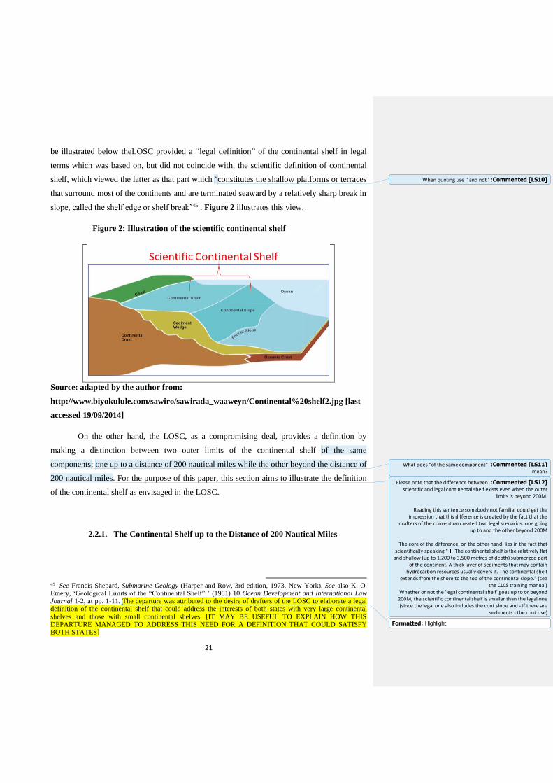
be illustrated below theLOSC provided a “legal definition” of the continental shelf in legal
terms which was based on, but did not coincide with, the scientific definition of continental
shelf, which viewed the latter as that part which ‘constitutes the shallow platforms or terraces
that surround most of the continents and are terminated seaward by a relatively sharp break in
slope, called the shelf edge or shelf break’45 . Figure 2 illustrates this view.
Figure 2: Illustration of the scientific continental shelf
Source: adapted by the author from:
http://www.biyokulule.com/sawiro/sawirada_waaweyn/Continental%20shelf2.jpg [last
accessed 19/09/2014]
On the other hand, the LOSC, as a compromising deal, provides a definition by
making a distinction between two outer limits of the continental shelf of the same
components; one up to a distance of 200 nautical miles while the other beyond the distance of
200 nautical miles. For the purpose of this paper, this section aims to illustrate the definition
of the continental shelf as envisaged in the LOSC.
2.2.1. The Continental Shelf up to the Distance of 200 Nautical Miles
45 See Francis Shepard, Submarine Geology (Harper and Row, 3rd edition, 1973, New York). See also K. O. Emery, ‘Geological Limits of the “Continental Shelf” ’ (1981) 10 Ocean Development and International Law Journal 1-2, at pp. 1-11. The departure was attributed to the desire of drafters of the LOSC to elaborate a legal definition of the continental shelf that could address the interests of both states with very large continental shelves and those with small continental shelves. [IT MAY BE USEFUL TO EXPLAIN HOW THIS DEPARTURE MANAGED TO ADDRESS THIS NEED FOR A DEFINITION THAT COULD SATISFY BOTH STATES]
Commented [LS10] :When quoting use " and not '
Commented [LS11] :What does "of the same component" mean?
Commented [LS12] :Please note that the difference between scientific and legal continental shelf exists even when the outer
limits is beyond 200M.
Reading this sentence somebody not familiar could get the impression that this difference is created by the fact that the
drafters of the convention created two legal scenarios: one going up to and the other beyond 200M
The core of the difference, on the other hand, lies in the fact that
scientifically speaking " The continental shelf is the relatively flat and shallow (up to 1,200 to 3,500 metres of depth) submerged part
of the continent. A thick layer of sediments that may contain hydrocarbon resources usually covers it. The continental shelf
extends from the shore to the top of the continental slope." (see the CLCS training manual)
Whether or not the 'legal continental shelf' goes up to or beyond 200M, the scientific continental shelf is smaller than the legal one (since the legal one also includes the cont.slope and - if there are
sediments - the cont.rise)
Formatted: Highlight
22
The two criteria of ‘depth of 200 metres’ and ‘exploitability’ used by the 1958
Continental Shelf Convention to establish the outer limits of the continental shelf did not
define precisely the actual breadth of the continental shelf of a coastal state. Having noticed
that, the drafters of the LOSC came to a conclusion that a precise and flexible definition for
the continental shelf applicable at all times cannot be realized without using science.
Therefore, Paragraph 1 of Article 76 of the LOSC, by applying an interdisciplinary approach,
stipulates that ‘the continental shelf of a coastal State comprises the sea-bed and subsoil of
the submarine areas that extend beyond its territorial sea through the natural prolongation of
its land territory to the outer edge of the continental margin, or to a distance of 200 nautical
miles from the baselines from which the breadth of the territorial sea is measured where the
outer edge of the continental margin does not extend up to that distance’. As an illustration,
‘landmass’ and ‘continental margin’ are scientific (geomorphological) concepts, whose
application is subject to different scientific methodologies such as geology, geophysics, and
geomorphology, whereas ‘land territory’ and ‘continental shelf’ are legal concepts 46. The
Scientific and Technical Guidelines of the CLCS47 reflect this when they stipulate that ‘the
Convention makes use of scientific terms in a legal context which at times departs
significantly from accepted scientific definitions and terminology’48. That being clarified, this
section however is going to examine the legal definition of the continental shelf in terms of
the first type of its outer limits as provided in the second part of the referred to paragraph.
First of all, it is worth noting that Paragraph 1 of Article 76 of the LOSC
reemphasises explicitly that the right for a continental shelf exists ipso facto and ab initio, by
virtue of sovereignty over the land, and as a natural continuation of it into and under the sea.
Hence, it is further stressed in the following Article that this right does not depend on
occupation, effective or notional, or on any express proclamation 49 . Clearly therefore,
Paragraph 1 of Article 76 upholds the principle set by international case law that the ‘land
dominates the sea’50and discarded the term ‘submarine areas adjacent to the coast but outside
the area of the territorial sea’ used by the 1958 Convention on the Continental Shelf51. With
respect to no proclamation needed though, this is only true whenever the outer limits of the
continental shelf of the coastal state do not extend beyond the prescribed limits of 200
46 See DOALOS Manual at I-18. 47 CLCS/11, Fifth Session, New York, 13 May 1999. 48 Ibid, Paragraph 1.3. 49 Paragraph 3. 50 See footnotes no. 26 and 31. 51 See footnote no. 40.
Commented [LS14] :This sentence may be a little misleading for a reader not familiar with UNCLOS:
The 'reliability' of the definition contained in UNCLOS does not
depend on its being rooted in science, but in its inclusion of criteria that are not open-ended.
In 1958 the '200 meter' definition was perfecly reliable. The
problem was the fact that the 'exploitability criterion' opened the way for lack of certainty.
In 1982 no 'open-ended' criteria were included in the Convention.
Commented [LS15] : This is not "explicitly" stated in Art. 76.
These principles, which come from the ICJ case law, are however reflected in the Convention as Art. 77.3 states that "The rights of
the coastal State over the continental shelf do not depend on occupation, effective or notional, or on any express proclamation."
Moreover para. 1 of Art. 76 does not contain this principle. That's
really in art. 77.3
What art. 76.1 contains is the principle that the c.s. is the underwater prolongation of the main land
Reading that sentence the reader not familiar with the Convention
may think that "ipso facto and ab initio" is written in the Convention verbatim
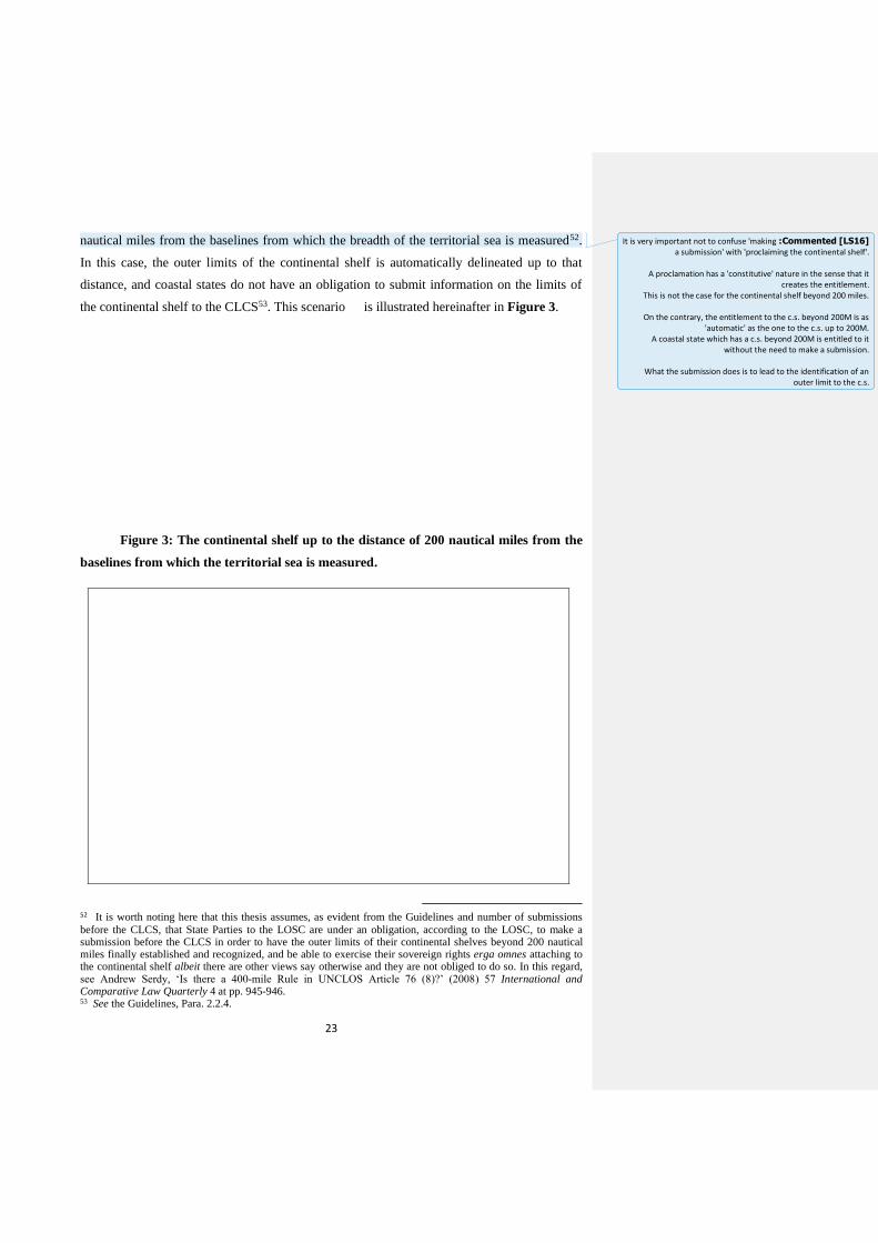
23
nautical miles from the baselines from which the breadth of the territorial sea is measured52.
In this case, the outer limits of the continental shelf is automatically delineated up to that
distance, and coastal states do not have an obligation to submit information on the limits of
the continental shelf to the CLCS53. This scenario is illustrated hereinafter in Figure 3.
Figure 3: The continental shelf up to the distance of 200 nautical miles from the
baselines from which the territorial sea is measured.
52 It is worth noting here that this thesis assumes, as evident from the Guidelines and number of submissions
before the CLCS, that State Parties to the LOSC are under an obligation, according to the LOSC, to make a submission before the CLCS in order to have the outer limits of their continental shelves beyond 200 nautical miles finally established and recognized, and be able to exercise their sovereign rights erga omnes attaching to the continental shelf albeit there are other views say otherwise and they are not obliged to do so. In this regard, see Andrew Serdy, ‘Is there a 400-mile Rule in UNCLOS Article 76 (8)?’ (2008) 57 International and Comparative Law Quarterly 4 at pp. 945-946. 53 See the Guidelines, Para. 2.2.4.
Commented [LS16] :It is very important not to confuse 'making a submission' with 'proclaiming the continental shelf'.
A proclamation has a 'constitutive' nature in the sense that it
creates the entitlement. This is not the case for the continental shelf beyond 200 miles.
On the contrary, the entitlement to the c.s. beyond 200M is as
'automatic' as the one to the c.s. up to 200M. A coastal state which has a c.s. beyond 200M is entitled to it
without the need to make a submission.
What the submission does is to lead to the identification of an outer limit to the c.s.
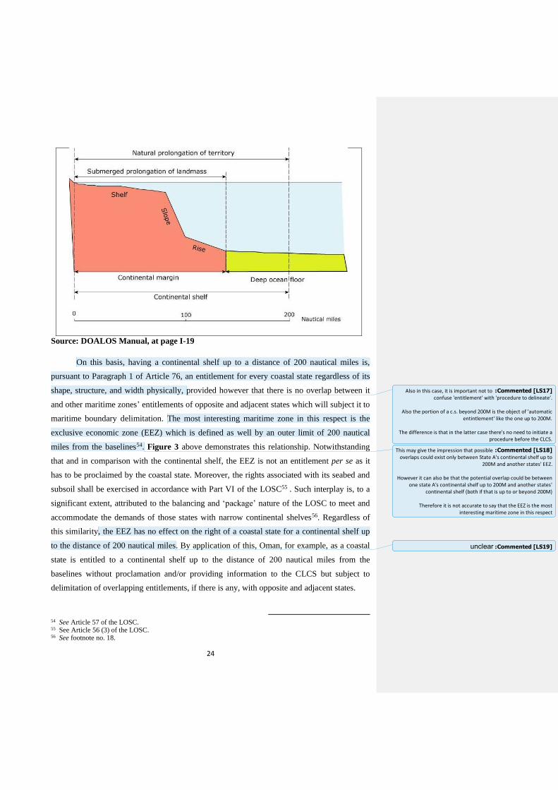
24
Source: DOALOS Manual, at page I-19
On this basis, having a continental shelf up to a distance of 200 nautical miles is,
pursuant to Paragraph 1 of Article 76, an entitlement for every coastal state regardless of its
shape, structure, and width physically, provided however that there is no overlap between it
and other maritime zones’ entitlements of opposite and adjacent states which will subject it to
maritime boundary delimitation. The most interesting maritime zone in this respect is the
exclusive economic zone (EEZ) which is defined as well by an outer limit of 200 nautical
miles from the baselines54. Figure 3 above demonstrates this relationship. Notwithstanding
that and in comparison with the continental shelf, the EEZ is not an entitlement per se as it
has to be proclaimed by the coastal state. Moreover, the rights associated with its seabed and
subsoil shall be exercised in accordance with Part VI of the LOSC55 . Such interplay is, to a
significant extent, attributed to the balancing and ‘package’ nature of the LOSC to meet and
accommodate the demands of those states with narrow continental shelves56. Regardless of
this similarity, the EEZ has no effect on the right of a coastal state for a continental shelf up
to the distance of 200 nautical miles. By application of this, Oman, for example, as a coastal
state is entitled to a continental shelf up to the distance of 200 nautical miles from the
baselines without proclamation and/or providing information to the CLCS but subject to
delimitation of overlapping entitlements, if there is any, with opposite and adjacent states.
54 See Article 57 of the LOSC. 55 See Article 56 (3) of the LOSC. 56 See footnote no. 18.
Commented [LS17] :Also in this case, it is important not to confuse 'entitlement' with 'procedure to delineate'.
Also the portion of a c.s. beyond 200M is the object of 'automatic
entintlement' like the one up to 200M.
The difference is that in the latter case there's no need to initiate a procedure before the CLCS.
Commented [LS18] :This may give the impression that possible overlaps could exist only between State A's continental shelf up to
200M and another states' EEZ.
However it can also be that the potential overlap could be between one state A's continental shelf up to 200M and another states'
continental shelf (both if that is up to or beyond 200M)
Therefore it is not accurate to say that the EEZ is the most interesting maritime zone in this respect
Commented [LS19] :unclear

25
2.2.2. The Continental Shelf beyond the Distance of 200 Nautical Miles
At the time of negotiating the LOSC, some states57 argued, by contrast with their
counterparts with narrow continental shelves, that the 200 nautical miles limit is neither
applicable to nor reflects accurately the actual size of their continental shelves as they
geologically extend more than this limit when measured from the baselines. Yet, the outer
limits of those continental shelves were not then accurately identified and this was believed to
be detrimental to the legal regime of the high seas, and rights of opposite and adjacent states.
Once again, to achieve a fair balance as a package convention acceptable by all states, the
LOSC accommodated this position in its definition of the continental shelf in paragraph 1 of
Article 76 of the LOSC referred to above by stating that such coastal states have the right to a
continental shelf, through the natural prolongation of their land territories beyond the
territorial sea, to ‘the outer edge of the continental margin’58. Unlike the continental shelf up
to the distance of 200 nautical miles discussed above and other legal maritime zones
established by the LOSC whose breadth is based on a ‘distance criterion’, the extent of this
continental shelf is not uniform and varies from one state to another depending on the new
criterion of the ‘continental margin’. The key question was therefore to find instead uniform
rules, through this new criterion, to be applicable on equal footing on all coastal states that
are entitled to continental shelves beyond the distance of 200 nautical miles from the
baselines.
By taking lessons from the past, the LOSC did not leave this issue indefinite or to
states’ unpredictable and unilateral application. Therefore, Article 76 of the LOSC, in a
logical order, goes on to set forth that ‘the continental shelf of a coastal State shall not extend
beyond the limits provided for in paragraphs 4 and 6’59. Before identifying these limits, it
first defines the ‘continental margin’ as comprising ‘the submerged prolongation of the
landmass of the coastal State, and consists of the seabed and subsoil of the shelf, the slope
and the rise. It does not include the deep ocean floor with its oceanic ridges or the subsoil
thereof’ 60 . Briefly, it states, by using geological terms in a legal language, that the
57 Examples of these states are Australia, Canada, France, Argentina, the former Soviet Union and the USA. 58 See M.W. Lodge, ‘The International Seabed Authority-Its Future Directions’ in M.H.Nordquist, J. Norton Moore and T.H. Heidar (eds.), Legal and Scientific Aspects of Continental Shelf Limits (Leiden, Martinus Nijhoff Publishers, 2004) at p. 403. The drafters of LOSC recognized that all problems concerning oceans are closely related and should be dealt with in a cohesive and holistic manner. See the Preamble. 59 Paragraph 2. 60 Paragraph 3.
Commented [LS20] :Why? I t may be useful to explain, at least in a footnote
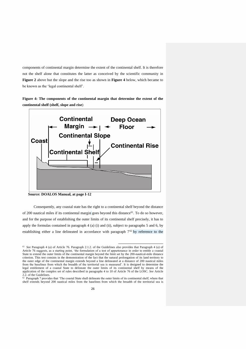
26
components of continental margin determine the extent of the continental shelf. It is therefore
not the shelf alone that constitutes the latter as conceived by the scientific community in
Figure 2 above but the slope and the rise too as shown in Figure 4 below, which became to
be known as the ‘legal continental shelf’.
Figure 4: The components of the continental margin that determine the extent of the
continental shelf (shelf, slope and rise)
Source: DOALOS Manual, at page I-12
Consequently, any coastal state has the right to a continental shelf beyond the distance
of 200 nautical miles if its continental margin goes beyond this distance61. To do so however,
and for the purpose of establishing the outer limits of its continental shelf precisely, it has to
apply the formulas contained in paragraph 4 (a) (i) and (ii), subject to paragraphs 5 and 6, by
establishing either a line delineated in accordance with paragraph 762 by reference to the
61 See Paragraph 4 (a) of Article 76. Paragraph 2.1.2. of the Guidelines also provides that Paragraph 4 (a) of Article 76 suggests, as a starting point, ‘the formulation of a test of appurtenance in order to entitle a coastal State to extend the outer limits of the continental margin beyond the limit set by the 200-nautical-mile distance criterion. This test consists in the demonstration of the fact that the natural prolongation of its land territory to the outer edge of the continental margin extends beyond a line delineated at a distance of 200 nautical miles from the baselines from which the breadth of the territorial sea is measured’. It is designed to determine the legal entitlement of a coastal State to delineate the outer limits of its continental shelf by means of the application of the complex set of rules described in paragraphs 4 to 10 of Article 76 of the LOSC. See Article 2.2. of the Guidelines. 62 Paragraph 7 provides that ‘The coastal State shall delineate the outer limits of its continental shelf, where that shelf extends beyond 200 nautical miles from the baselines from which the breadth of the territorial sea is
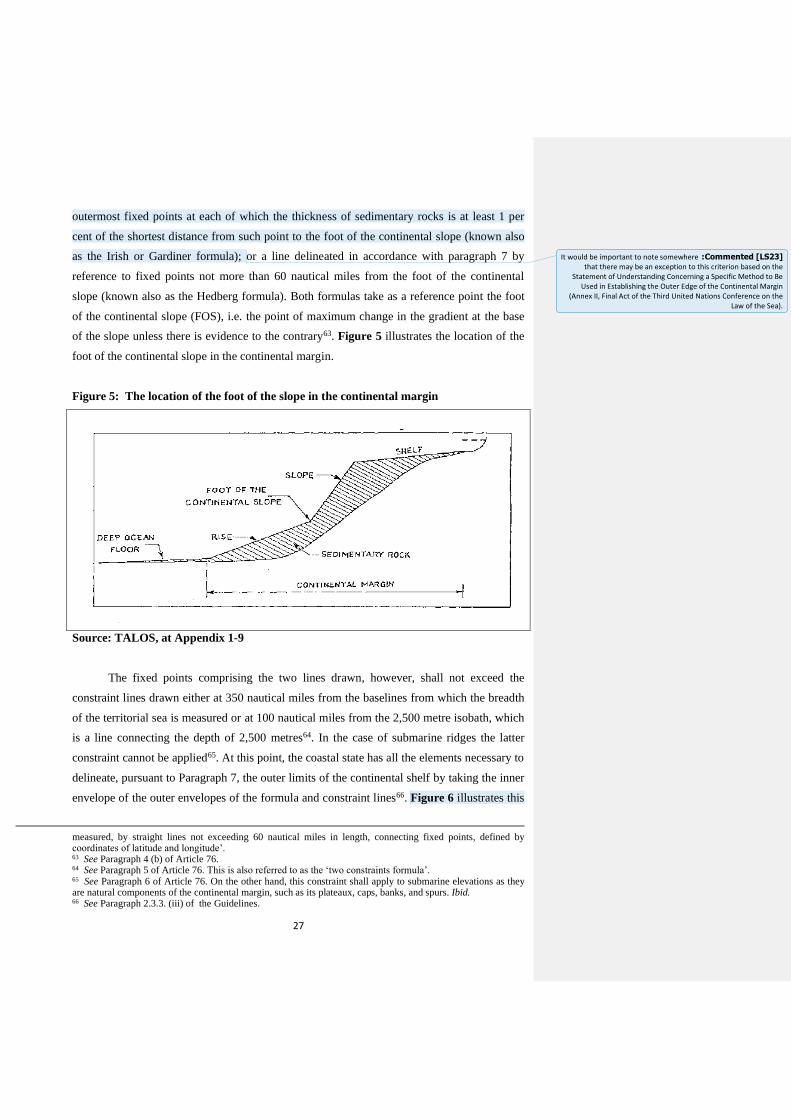
27
outermost fixed points at each of which the thickness of sedimentary rocks is at least 1 per
cent of the shortest distance from such point to the foot of the continental slope (known also
as the Irish or Gardiner formula); or a line delineated in accordance with paragraph 7 by
reference to fixed points not more than 60 nautical miles from the foot of the continental
slope (known also as the Hedberg formula). Both formulas take as a reference point the foot
of the continental slope (FOS), i.e. the point of maximum change in the gradient at the base
of the slope unless there is evidence to the contrary63. Figure 5 illustrates the location of the
foot of the continental slope in the continental margin.
Figure 5: The location of the foot of the slope in the continental margin
Source: TALOS, at Appendix 1-9
The fixed points comprising the two lines drawn, however, shall not exceed the
constraint lines drawn either at 350 nautical miles from the baselines from which the breadth
of the territorial sea is measured or at 100 nautical miles from the 2,500 metre isobath, which
is a line connecting the depth of 2,500 metres64. In the case of submarine ridges the latter
constraint cannot be applied65. At this point, the coastal state has all the elements necessary to
delineate, pursuant to Paragraph 7, the outer limits of the continental shelf by taking the inner
envelope of the outer envelopes of the formula and constraint lines66. Figure 6 illustrates this
measured, by straight lines not exceeding 60 nautical miles in length, connecting fixed points, defined by coordinates of latitude and longitude’. 63 See Paragraph 4 (b) of Article 76. 64 See Paragraph 5 of Article 76. This is also referred to as the ‘two constraints formula’. 65 See Paragraph 6 of Article 76. On the other hand, this constraint shall apply to submarine elevations as they are natural components of the continental margin, such as its plateaux, caps, banks, and spurs. Ibid. 66 See Paragraph 2.3.3. (iii) of the Guidelines.
Commented [LS23] :It would be important to note somewhere that there may be an exception to this criterion based on the
Statement of Understanding Concerning a Specific Method to Be Used in Establishing the Outer Edge of the Continental Margin
(Annex II, Final Act of the Third United Nations Conference on the Law of the Sea).
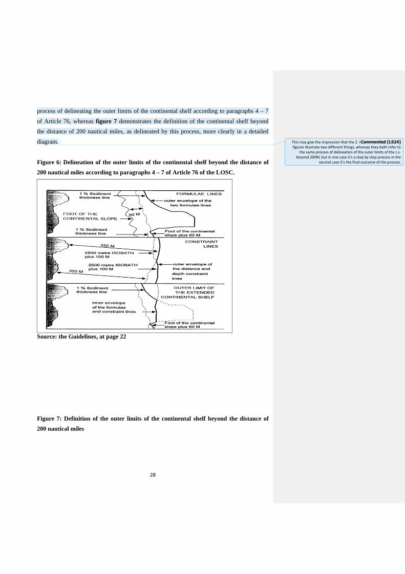
28
process of delineating the outer limits of the continental shelf according to paragraphs 4 – 7
of Article 76, whereas figure 7 demonstrates the definition of the continental shelf beyond
the distance of 200 nautical miles, as delineated by this process, more clearly in a detailed
diagram.
Figure 6: Delineation of the outer limits of the continental shelf beyond the distance of
200 nautical miles according to paragraphs 4 – 7 of Article 76 of the LOSC.
Source: the Guidelines, at page 22
Figure 7: Definition of the outer limits of the continental shelf beyond the distance of
200 nautical miles
Commented [LS24] :This may give the impression that the 2 figures illustrate two different things, whereas they both refer to
the same process of delineation of the outer limits of the c.s. beyond 200M, but in one case it's a step by step process in the
second case it's the final outcome of the process.
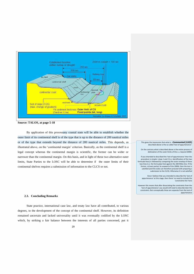
29
Source: TALOS, at page 5-18
By application of this processany coastal state will be able to establish whether the
outer limit of its continental shelf is of the type that is up to the distance of 200 nautical miles
or of the type that extends beyond the distance of 200 nautical miles. This depends, as
illustrated above, on the ‘continental margin’ criterion. Basically, as the continental shelf is a
legal concept whereas the continental margin is scientific, the former can be wider or
narrower than the continental margin. On this basis, and in light of these two alternative outer
limits, State Parties to the LOSC will be able to determine if the outer limits of their
continental shelves requires a submission of information to the CLCS or not.
2.3. Concluding Remarks
State practice, international case law, and treaty law have all contributed, to various
degrees, to the development of the concept of the continental shelf. However, its definition
remained uncertain and lacked universality until it was eventually codified by the LOSC
which, by striking a fair balance between the interests of all parties concerned, put it
Commented [LS25] :This gives the impression that what is described above is the so called 'test of appurtenance'.
On the contrary what is described above is the entire process of
delineation of the outer limits of the c.s. beyond 200M.
If you intended to described the 'test of appurtenance' then the procedure is simpler: steps 1 and 2 (i.e. identification of the two
formuale lines) is followed by comparing the outer envelop of these two lines (i.e. the formualae line) against the 200 Miles line. If the
former, at least partial, lie seaward of the 200M, then the test is satisfied (and the state can therefore proceed with preparing a
submission to the CLCS). Otherwise it is not satisfied
Since I believe that you intended to describe the 'test of appurtenance' at this stage, then there' no need to include the
'constraints line' here
However this means that after dissociating the constraints from the 'test of appurtenance' you would still need to describe later the
constraints. But conceptually these are separate from the test of appurtenance

30
successfully in a generally acceptable legal framework. The latter is Part VI of the former
which defines the concept of the continental shelf and its outer limits precisely. In short, it
establishes that a coastal state’s right to a continental shelf is inherent as a natural
prolongation of its territory into the sea which can extend automatically up to the distance of
200 nautical miles without proclamation, or beyond if the outer limits of the continental
margin successfully meets the conditions or criteria provided by Article 76, subject to
information being submitted to the CLCS and its recommendations on those limits in return.
The practice of coastal states and the CLCS that will contribute to further develop this regime
by applying the complex criteria of article 76 to the diverse geomorphological realities of
coastal States.
3. The Submission Process
3.0. Introductory Remarks
At UNCLOS III, States faced the question: should each coastal state have the right to
establish the outer limits of the continental shelf beyond 200 nautical miles unilaterally, or
should there be some international oversight of outer limits lines and what is the best way to
do it? This did not mean that states with 200 nautical miles continental shelves would not be
Commented [LS26] :See earlier comment on 'proclamation' vs. delimitation '
31
obliged to delineate precisely the outer limits of these continental shelves too. However, as
the former would probably, if left unchecked, encroach excessively on the Area, and infringe
the rights of landlocked and geographically disadvantaged states, and of opposite and
adjacent states, establishing a mechanism to scrutinize coastal states’ delineation of the outer
limits of their continental shelves beyond 200 nautical miles was argued for to avoid going to
square one and repeating the mistakes of the past. Therefore, in addition to prescribing the
process of delineating the outer limits as illustrated in chapter two, a body was established
under the LOSC to verify and ensure the correct application of the delineation formulae and
constraints as envisaged in Article 76 by its States Parties67. That is the Commission on the
Limits of the Continental Shelf (CLCS) before which States Parties to the LOSC, through a
submission, establish definitely and precisely the outer limits of their continental shelves
beyond 200 nautical miles. Having said that and in light of its role vis–a-vis each State
Party’s submission, the following chapter aims to examine this important body in terms of
membership, structure and role as well as the submission process brought before it by States
Parties to the LOSC, and the benefits and costs arising from that process on these states.
3.1. The CLCS
3.1.1. Membership and Structure
In addition to the CLCS, the LOSC established two other bodies to assist in the
application and implementation of its provisions; the first one is the International Seabed
Authority (ISA)68 whereas the other is the International Tribunal for the Law of the Sea
(ITLOS)69. But unlike them, the LOSC does not spell out the rules that govern the work of
the CLCS. Furthermore, it does not establish a secretariat to facilitate discharging its
responsibilities. The provision of secretariat services has been assigned to the Secretary
General of the UN, who discharges this function through the Division of Ocean Affairs and
the Law of the Sea (DOALOS) of the Office of Legal Affairs71. In addition, the sessions of
the CLCS and its sub-commissions are held at United Nations Headquarters in New York72.
67 See Article 1 of Annex II to the LOSC which states that ‘in accordance with the provisions of article 76, a Commission on the Limits of the Continental Shelf beyond 200 nautical miles shall be established in conformity with the following article’. To establish the CLCS was firstly proposed by the United States of America at UNCLOS III. See Proposal of the United States on the Definition and Limits of the Continental Shelf, 3 May 1975, Third United Nations Conference on the Law of the Sea, Documents of the Second Committee, Document A/CONF.62/C.2/L.99, Official Records, Vol. XI, at p. 500. 68 See Section 4 of Part XI of the LOSC. 69 See Annex VI to the LOSC. 71 See Article 2 (5) of Annex II to the LOSC & Rule 16 of the Rules of Procedure of the CLCS, CLCS/40/Rev.1, Twenty First Session, New York, 17 April 2008. The Secretary General of the UN exercises also the function of providing secretariat services to the Meetings of State Parties (SPLOS) that take place in
Commented [LS27] :An additional aspect is the fact that whereas the 200M line can be delineated in way that was relatively
simply, and easy to verify by other States. On the contrary the complex criteria for the limits beyond 200M
would be more complex and therefore it would be more difficult to
verify whether a State applied them correctly.
In addition: the idea of a mechanism of verification was directly linked to the idea that outer limits established on the basis of the
recommendations of the CLCS are 'final and binding'. And this characteristic would be important to ensure certainty to the shape
and extent of the international seabed area
Commented [LS28] :It's always best to use the exact language of the Convention.
To describe the functions of the Convention please see Annex II to the Convention - art. 2.3
Commented [LS29] :This section does not seem to fall under the header 'membership and structure'
Maybe a subheader called "introduction" could be added?
Commented [LS30] :Not very accurate and probably not very useful. Suggest deletion
32
As further evidence of the technical nature of Article 76 of the LOSC, the CLCS
shall, as envisaged by Article 2 of Annex II to the LOSC, ‘consist of 21 members who shall
be experts in the field of geology, geophysics or hydrography’73. It is ‘the only technical and
scientific commission of its kind that is established by a multilateral convention’ 74 and
without it ‘the implementation of Article 76 would have posed technical and scientific
difficulties for coastal States that did not possess sufficient and appropriate technology and
scientific capabilities’75. The CLCS was established in 1997, following the LOSC’s entry into
force on the 16th of November 1994, whereas the second, third and the fourth (current)
memberships were elected in 2002, 2007, and 2012 respectively76. Therefore, the term of
service is five years77. The members shall be ‘elected by States Parties to the LOSC from
among their nationals, having due regard to the need to ensure equitable geographical
representation, who shall serve in their personal capacities’78. ‘At least three months before
the date of each election, the Secretary General of the UN shall address a letter to the States
Parties, inviting the submissions of nominations, after appropriate regional consultations,
within three months, and shall prepare a list in alphabetical order of all persons thus
nominated and submit it to all States Parties’79. The persons elected to the CLCS shall be
those nominees who obtain a two-thirds majority of the votes of the representatives of States
Parties present and voting at a meeting of States Parties convened by the Secretary General of
the UN at the UN headquarters for this purpose80. Of the 21 members, not less than three
shall be elected from each geographical region81. These regions are Africa, Asia, Eastern
accordance with the LOSC. See Article 319 (2) (e) of the LOSC. It can be said also, in light of the secretariat services it provides to the CLCS, that the secretariat acts as an interface between the submitting State and the CLCS. 72 This is in pursuance of Rule 4 of the ROP. The Secretary General also shall ensure the safe custody of the submission of every state and the attachments and annexes thereto at the UN Headquarters in New York until such time as they are required by the CLCS. See Annex II (1) to the ROP. Despite that, the Chairperson of the CLCS reiterated in 2009 the possibility to establish a dedicated and permanent secretariat to service the CLCS. See Item 28 (121) of the Statement made by the Chairman of the CLCS on the progress of work in the CLCS, CLCS/64, Twenty-fourth session, New York, 10 August – 11 September 2009. 73 This is obvious from the curricula vitae of the (current) members which are available on the CLCS website at: http://www.un.org/depts/los/clcs_new/commission_members.htm#Members [Last accessed 21/08/2014]. Considering the roles of the CLCS, its members might come as well from other disciplines such as geography and geodesy. 74 See footnote no. 70 at p. 75. 75 See footnote 70 at p. 78. 76 See Membership of the Commission from 1997 to 2007, CLCS, available online at: http://www.un.org/depts/los/clcs_new/commission_members_1997_2012.htm [last accessed 22/08/2014]. 77 See also Article 2 (4) of Annex II to the LOSC which states that ‘The members of the Commission shall be elected for a term of five years. They shall be eligible for re-election’. 78 See Article 2 (1) of Annex II to the LOSC. See also Article 76 (8) of the LOSC. 79 See Article 2 (2) of Annex II to the LOSC. 80 See Article 2 (3) of Annex II to the LOSC. 81 See Article 2 (3) of Annex II to the LOSC.
Commented [LS31] :The reader may wonder why it took three years. You may wish to explain the reason behind the lag
Commented [LS32] :This should come after where you explain the fact taht the term of service is 5
years .
From a logical flow perspective it is the duration of the term of service that establishes when the elections take place and not
viceversa
Commented [LS33] :If you use quotation marks like you do here you should quote the exact
language. UN therefore should be written in extenso
Commented [LS34] :Again: it is preferable to use exact quotations of the provisions of the Commission. For instance, the
provision you recall in this footnote does not include the words "For this purpose"
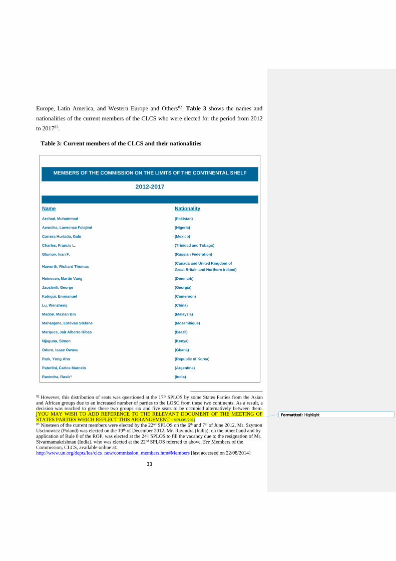
33
Europe, Latin America, and Western Europe and Others82. Table 3 shows the names and
nationalities of the current members of the CLCS who were elected for the period from 2012
to 201783.
Table 3: Current members of the CLCS and their nationalities
MEMBERS OF THE COMMISSION ON THE LIMITS OF THE CONTINENTAL SHELF
2012-2017
Name Nationality
Arshad, Muhammad (Pakistan)
Awosika, Lawrence Folajimi (Nigeria)
Carrera Hurtado, Galo (Mexico)
Charles, Francis L. (Trinidad and Tobago)
Glumov, Ivan F. (Russian Federation)
Haworth, Richard Thomas (Canada and United Kingdom of
Great Britain and Northern Ireland)
Heinesen, Martin Vang (Denmark)
Jaoshvili, George (Georgia)
Kalngui, Emmanuel (Cameroon)
Lu, Wenzheng (China)
Madon, Mazlan Bin (Malaysia)
Mahanjane, Estevao Stefane (Mozambique)
Marques, Jair Alberto Ribas (Brazil)
Njuguna, Simon (Kenya)
Oduro, Isaac Owusu (Ghana)
Park, Yong Ahn (Republic of Korea)
Paterlini, Carlos Marcelo (Argentina)
Ravindra, Rasik1 (India)
82 However, this distribution of seats was questioned at the 17th SPLOS by some States Parties from the Asian and African groups due to an increased number of parties to the LOSC from these two continents. As a result, a decision was reached to give these two groups six and five seats to be occupied alternatively between them. [YOU MAY WISH TO ADD REFERENCE TO THE RELEVANT DOCUMENT OF THE MEETING OF STATES PARTIES WHICH REFLECT THIS ARRANGEMENT - SPLOS/201] 83 Nineteen of the current members were elected by the 22nd SPLOS on the 6th and 7th of June 2012. Mr. Szymon Uscinowicz (Poland) was elected on the 19th of December 2012. Mr. Ravindra (India), on the other hand and by application of Rule 8 of the ROP, was elected at the 24th SPLOS to fill the vacancy due to the resignation of Mr. Sivarmamakrishnan (India), who was elected at the 22nd SPLOS referred to above. See Members of the Commission, CLCS, available online at: http://www.un.org/depts/los/clcs_new/commission_members.htm#Members [last accessed on 22/08/2014]
Formatted: Highlight
34
Roest, Walter R. (Netherlands)
Urabe, Tetsuro (Japan)
Uścinowicz, Szymon (Poland)
Source: The CLCS, Members of the Commission at:
http://www.un.org/depts/los/clcs_new/commission_members.htm#Members [last accessed
22/08/2014]
Despite the fact that the members shall serve in their personal capacities84 and seek or
receive no instructions from any government or from any authority external to the CLCS85,
the State Party which submitted the nomination of one of the members shall defray the
expenses of that member while in performance of the commission duties86. This as a result
might cause some implications. For instance, nominating someone and paying his or her
expenses might create a way of putting influence on the nominee by the nominator
particularly if the former used to be an employee of the latter. This relationship per se made
the CLCS to be described as ‘a technical body in a political world’87 and triggered calls for
‘new accountability mechanisms for the CLCS’88. Conversely, the nominating state might, as
repeatedly announced by the Chairperson of the CLCS 89 , fail to cover these expenses
including medical coverage which consequently lead to the inability of the member
specifically and the CLCS generally to perform their duties expeditiously and efficiently. As
regards the first implication however, it is clearly established that in addition to making a
solemn declaration, before assuming duties, to perform the duties honourably, faithfully,
impartially and conscientiously90, the member nominated by a particular state shall not be a
member of the sub-commission dealing with the submission of that state and the submission
84 See footnote 78. 85 See Rule 11 of Annex II to the LOSC. They also shall refrain from any action which might reflect negatively on their position as members of the CLCS. Ibid. 86 See Article 2 (5) of Annex II to the LOSC and Rule 9 (a) of the ROP. 87 See Ted L. McDorman, ‘The Role of the Commission on the Limits of the Continental Shelf: A Technical Body in a Political World’ (2002) 17 The International Journal of Marine and Coastal Law 3 at pp. 311-313. 88 See Anna Cavnar, ‘Accountability and the Commission on the Limits of the Continental Shelf: Deciding who
Owns the Ocean Floor’ (2009) 42 Cornell International Law Journal at pp. 412-435. 89 See, for example, Item 4 of the Statement by the Chair on the Progress of Work in the CLCS, CLCS/83, Thirty-fourth session, New York, 27 January – 14 March 2014 at p. 4 & Letter dated 14 April 2014 from the Chair of the CLCS addressed to the President of the twenty-fourth SPLOS, SPLOS/270, 14 April 2014, paragraphs 12-26 and its Annex. Due to this issue and upon a request from the Chairperson, the UN General Assembly, in October 2000, at its 55th session, by Resolution 55/7, requested the Secretary General to establish a voluntary fund for the purpose of defraying the cost of participation of the members of the CLCS from developing States. However, the trust fund did not solve the problem fully as evident from the statement and letter of the Chairperson in 2014 referred to above, and extended to include even members from developed States. The latest decision taken in this respect as of 27th of August 2014 is the decision regarding the conditions of service of the members of the CLCS, SPLOS/276, at the Twenty Fourth Meeting of States Parties to the LOSC, New York, 9-13 June 2014 which called upon both nominating States and other States to ensure the full participation of all members by defraying their expenses. 90 See Rule 10 of the ROP.
Commented [LS35] :You may wish to recall that in the performance of 'advisory functions' this does not hold true: this is
in the same provision of Annex II
35
of a state he/she has assisted by providing scientific and technical advice with respect to the
delineation of the outer limits of its continental shelf beyond 200 nautical miles91. This leads
us to the internal structure of the CLCS through which most of the examination of
submissions takes place.
The CLCS shall, unless it decides otherwise, ‘functions by way of sub-commissions
composed of seven members, appointed in a balanced manner taking into account the specific
elements of each submission by a coastal state’92. Three sub-commissions shall, unless the
Commission decided otherwise, function simultaneously while considering submissions93 and
any member of the CLCS ‘can be appointed to be a member of more than one sub-
commission’94 which ‘shall extend from the time of the sub-commission’s appointment to the
time that the submitting State deposits, in accordance with Article 76, paragraph 9 of the
LOSC, the charts and relevant information regarding the outer limits of the continental shelf
for which the submission was originally made’95. However, the CLCS, at its thirty-second
session, due to the growing workload and submissions, decided to hold, in 2014 just as in
2013, three sessions of seven weeks each, including plenary meetings, for a total of 21 weeks
of meetings of the CLCS and its sub-commissions, as well as adopting new working
arrangements for its sub-commissions96. At its thirty-fourth session, the CLCS established
new sub-commissions, bringing to nine the total number of active sub-commissions 97 .
Apparently, owing to considerable working pressure, this might responsively and eventually
lead to a full time CLCS or to an increase of its annual working sessions or probably to a
reduction in the number of members in each sub-commission98.
91 See Article 5 of Annex II to the LOSC and Rule 42 (1) (a) of the ROP. This also applies if any member of the CLCS may, for other reasons, be perceived to have a conflict of interest regarding the submission, e.g., members are nationals of a state which may have a dispute or unresolved border with the coastal State. See Rule 42 (1) (b) of the ROP. Despite that, all members of the CLCS ‘have the right to participate as members in the proceedings of the CLCS concerning any submission’ and may be invited, by prior consultation and agreement within the sub-commission, ‘to participate in the proceedings of the sub-commission on specific issues concerning a particular submission without the right to vote’. See Article 5 of Annex II to the LOSC, Rule 42 (3) of the ROP and Annex III (10) (2) to the ROP. 92 See Article 5 of Annex II to the LOSC and Rule 42 (1) (c) & (d) of the ROP. It is stated as well that the Rules of Procedure of the CLCS ‘apply mutatis mutandis to the conduct of business of the sub-commissions and other subsidiary bodies’. See Rule 44 (2) of the ROP. 93 See Rule 51 (4 bis) of the ROP. 94 See Rule 42 (3) of the ROP. 95 See Rule 42 (2) of the ROP. 96 See Statement by the Chair on the progress of work in the CLCS, CLCS/80, thirty-second session, New York, 15 July – 30 August 2013, Item 17 (88-89). 97 See Statement by the Chair on the progress of work in the CLCS, CLCS/83, thirty-fourth session, New York, 27 January-14 March 2014, Item 19 (92). 98 It is noteworthy here that an Open-Ended Working Group has been established by the twenty-third Meeting of States Parties to consider the conditions of service of the members of the CLCS, which has been reporting to the Meetings of States Parties about this issue and how to address it ever since. See SPLOS/263, paragraph 77. Moreover, the burden of the CLCS workload extends by de facto to DOALOS since it is the provider of
Commented [LS36] :You may wish to add the decision taken on this poin at the 37th session
Commented [LS37] :These measures could be adopted. But this would not be a consequence of the decision of the CLCS to
work 21 weeks a year

36
In addition to the sub-commissions, the CLCS ‘may establish such other subsidiary
bodies composed of its members as may be required for the effective performance of its
functions’99. At the time of writing, the CLCS has established four subsidiary bodies; (a)
Committee on confidentiality, (b) Committee on provision of scientific and technical advice
to coastal states, (c) Editorial Committee, (d) Training Committee100. The Rules that apply to
the conduct of business of these subsidiary bodies are those of the CLCS and its sub-
commissions 101 . The CLCS may also cooperate, to the extent considered necessary and
useful, with other competent organizations which might be of assistance in discharging its
responsibilities102 and/or consult specialists in any field relevant to its work103. In terms of
immunities and privileges, the CLCS members, by established precedent in respect of similar
treaty organs, are considered as ‘experts on missions’ covered by Article VI of the General
Convention on the Privileges and Immunities of the United Nations104.
3.1.2. Role and Functions
Unlike prescribing the process of delineating the outer limits of the continental shelf
beyond 200 nautical miles, Article 76 of the LOSC does not provide much detail in relation
to the functions or mandate of the CLCS. It only stipulates that ‘the Commission shall make
recommendations to coastal States on matters related to the establishment of the outer limits
of their continental shelf. The limits of the shelf established by a coastal State on the basis of
these recommendations shall be final and binding’105.Annex II to the LOSC contains more
detailed provisions albeit not to the extent of covering the organization of the CLCS’s daily
work which is regulated by its own Rules of Procedure as is the case of most international
bodies. In particular, Article 3 of Annex II to the LOSC provides that ‘the functions of the
Commission shall be:
secretariat services to the CLCS which complicates the problem further. Currently, the CLCS is permitted, pursuant to Article 9 (2) of Annex III (Modus Operandi) to the ROP, to assign further work to its members during inter-sessional periods. However, this is subject to the approval of the coastal state due to confidentiality of the information submitted. 99 See Rule 43 of the ROP. 100 See the CLCS, Subsidiary Bodies, available online at: http://www.un.org/depts/los/clcs_new/commission_members.htm#Subsidiary bodies: [Last accessed 28/08/2014]. 101 See Rule 44 (2) of the ROP. 102 See Article 3 (2) of Annex II to the LOSC. Examples of these organizations are the Intergovernmental Oceanographic Commission of UNESCO, and the International Hydrographic Organization. Ibid. 103 See Rule 57 of the ROP. 104 See Letter dated 11 March 1998 from the Legal Counsel, Under-Secretary-General of the UN for Legal Affairs, addressed to the CLCS, CLCS/5, 11 March 1998, available online at: http://daccess-dds-ny.un.org/doc/UNDOC/GEN/N98/062/67/PDF/N9806267.pdf?OpenElement [last accessed 28/08/2014]. 105 See Paragraph 8.
Commented [LS38] :If you look at the Statements of the Chair there have been a number of 'ad hoc' working groups also
37
(a) to consider the data and other material submitted by coastal States concerning the
outer limits of the continental shelf in areas where those limits extend beyond 200
nautical miles, and to make recommendations in accordance with Article 76 and the
Statement of Understanding adopted on 29 August 1980 by the Third United
Nations Conference on the Law of the Sea;
(b) to provide scientific and technical advice, if requested by the coastal State
concerned during the preparation of the data referred to in subparagraph (a)’106.
To fulfil these two functions, the CLCS is also guided by the Scientific and Technical
Guidelines, and its Rules of Procedure. It is apparent from its mandate that the CLCS acts as
a reference body for coastal States’ submissions to establish finally and clearly the outer
limits of the continental shelf beyond 200 nautical miles, or as a ‘legitimator’ as described by
some writers107. Such a role is a result of the ‘delicate package deal’ of the LOSC which, as
mentioned above, aims to create certainty and precision to the limits of the continental shelf
that extend beyond 200 nautical miles from the baselines. Notwithstanding that, there are a
few points, inter alia, that can be realized from the two functions conferred to the CLCS
above. First, its primary role is ‘to consider data and other material’. Clearly therefore,
establishing the outer limits of the continental shelf beyond 200 nautical miles rests with the
coastal state on which the CLCS exercises its role by verifying whether this coastal state has
established the outer limits correctly in accordance with Article 76 or not. Basically, it is a
means to assist coastal states in defining the outer limits of their continental shelves beyond
200 nautical miles precisely and peacefully. Using the term ‘to consider’ rather than ‘to
decide’ also indicates that the review of submissions is of a collaborative nature rather than
adversarial. This is further evident from allowing coastal states to provide clarification and
further information during the interaction with the CLCS108 as well as to make a revised
submission if not satisfied with the CLCS’s recommendations109. However, this might have a
106 See Paragraph 1. 107 See footnote no. 87 at pp.319-320. McDorman in his article argues that the nature of the functions of the CLCS, as provided under Article 76 and Annex II to the LOSC, is merely ‘procedural’ and ‘informational’, and the recommendations it provides do not entail any binding force either on the submitting State or on other states as a whole. 108 See Paragraphs 6 and 10 (1) of Annex III (Modus Operandi) to the ROP and Annex II-bis to the ROP. 109 See Article 8 of Annex II to the LOSC which states that ‘in the case of disagreement by the coastal State with the recommendations of the Commission, the coastal State shall within a reasonable time, make a revised or new submission to the Commission’. See also Rule 53 (4) of the ROP. See also letter dated 25 August 2005 from the Legal Counsel, Undersecretary–General of the UN for Legal Affairs, addressed to the Chairman of the CLCS, CLCS/46, Sixteenth session,7 September 2005. Examples of states that have made revised submissions are the Russian Federation on 28 February 2013 in respect of the Okhotsk Sea, and Barbados on 25 July 2011. See table 1 above.
38
negative impact by making the submission as an open-ended process between the coastal
state and the CLCS.
Second, the ‘data and other material’ submitted to the CLCS to consider shall be from
the coastal state only. This is attributed to the fact, as illustrated in section 2 of chapter two,
that the coastal state’s right to a continental shelf exists as an entitlement via the natural
prolongation of its land territory into and under the sea. It does not ‘depend on occupation,
effective or notional, or on any express proclamation’. Therefore, the CLCS, in this respect,
does not act as a court where other concerned stakeholders such as adjacent and opposite
states, and the ISA, can ask for an intervention even though their rights under the LOSC
might be at stake. Furthermore, it is emphasised that the coastal state’s rights over the
continental shelf are exclusive and no one may undertake any relevant activity on its
continental shelf without its express consent110. On this basis, the CLCS’s role is confined to
consider the data and other material submitted by the coastal state only. In other words, these
‘data and other material’ are the ‘submission’ of the coastal state which contains the scientific
evidences, as laid down in accordance with Article 76 of the LOSC, of the outer limits of its
continental shelf beyond 200 nautical miles.
Third, the CLCS shall consider the ‘data and other material’ submitted by the coastal
state concerning the outer limits of the continental shelf in areas where those limits extend
beyond 200 nautical miles only. If the limits are up to or less than 200 nautical miles, the
coastal state is not obliged to submit ‘data and other material’ before the CLCS and is entitled
to the continental shelf in this case, and as shown in section 2 of chapter two, automatically.
By the same token, the CLCS has no mandate or duty to review any submission of a
continental shelf if its outer limits do not exceed 200 nautical miles from the baselines. For
this purpose, the CLCS begins its examination of submissions by ensuring first that the
submitting state has positively and successfully satisfied the ‘test of appurtenance’ to be
entitled to extend the outer limits of its continental shelf beyond 200 nautical miles from the
baselines111.
CONTINUE FROM HERE………..
110 See Article 77 (1) of the LOSC. 111 See Paragraph 5 (1) (a) of Annex III (Modus Operandi) to the ROP. See also footnote no. 61.
Commented [LS39] :In this connection, maybe in a footnote, however, it should be recalled that other States may have at least
one role: that of addressing comments based on the Executive Summary of a submission, and this may lead to a decision to defer
the examination of that submission if it becomes evident that there's a dispute
39
Fourth, the CLCS and its sub-commissions shall consider the data and other material
submitted by the coastal state and make recommendations in accordance with Article 76 and
the Statement of Understanding adopted on 29 August 1980 by the Third United Nations
Conference on the Law of the Sea. The latter two therefore constitute the mirror against
which the CLCS reviews submissions. Article 76 lays down, as illustrated above in section 2
of chapter two, the process of delineation of the outer limits of the continental shelf beyond
200 nautical miles whereas the Statement of Understanding of 1980 embodies a request to the
CLCS to use a specific method in establishing the outer edge of the continental margin of
these states in the southern part of the Bay of Bengal112. Consequently, the CLCS is tasked
with applying the provisions of Article 76 and the Statement only, so it may not go further, as
in case law, by developing other rules than those envisaged thereto. It may not also interpret
the provisions differently as contained therein. Nevertheless, the CLCS, as mentioned above,
is also guided by its Rules of Procedure and the Guidelines in exercising its functions.
Despite that, the latter is not binding on coastal states when preparing their submissions and
they can use other scientific and technical methodologies to implement the provisions of
Article 76 113 . Generally speaking, such restriction has both negative and positive
implications. On one side, it ties the hand of the CLCS from developing progressive rules on
the basis of its findings, as it moves forward, in one submission to apply them to another as
well as from moving in parallel with the developments occurring at the level of scientific
knowledge of oceans. On the other side, it allows coastal states to understand clearly how the
CLCS and its sub-commissions review submissions, and accordingly they prepare their
submissions. Appendices 2 and 3 illustrate how the CLCS and its sub-commissions
preliminarily analyse the ‘data and other material’ in accordance with Article 76, and how
they examine them scientifically and technically based on the Guidelines. An important
additional feature to this point is that using the term ‘recommendations’ rather than
‘decisions’ indicates that the outcome of considering the data and other material by the CLCS
is merely of a persuasive nature and its application is left to the desire of the coastal state.
Nonetheless, it is explicitly emphasised in Article 76 that ‘the limits of the shelf established
by a coastal State on the basis of these recommendations shall be final and binding’114, and
112 See the Final Act of UNCLOS III, Annex II, available online at: http://www.un.org/depts/los/clcs_new/documents/final_act_annex_two.htm [last accessed 03/09/2014]. Due to the mathematical average of the thickness of sedimentary rock in the southern part of the Bay of Bengal, the States there, by the Statement, are allowed, ‘notwithstanding the provisions of Article 76 of the LOSC, to establish the outer edge of its continental margin by straight lines not exceeding 60 nautical miles in length connecting fixed points, defined by latitude and longitude, at each of which the thickness of sedimentary rock is not less than 1 Kilometre’. 113 See Paragraph 1.4 of the Guidelines. See also Rule 46 (2) of the ROP. 114 See Paragraph 8.
Commented [LS40] :You may wish to note here that according to some States the Bengal rule can apply also in other parts of the
world which meet the criteria described in teh statement of understanding

40
that using the term ‘recommendations’ is attributed to the compromise reached during
UNCLOS III 115 . In general, the CLCS shall consider, draft, amend and approve the
recommendations in accordance with Rule 53 of its ROP and Part V of Annex III (Modus
Operandi) to the ROP. Despite that, neither the LOSC nor the ROP address the event
whereby these recommendations are ignored by the coastal states and decides to act
otherwise.
Fifth, besides the function explained above, the CLCS shall provide scientific and
technical advice, if requested by the coastal state concerned during the preparation of the
data. For this purpose, the CLCS has established a subsidiary body (Committee) devoted to
the provision of scientific and technical advice for coastal states which intend to make a
submission116. It has also developed, with the assistance of DOALOS, ‘a five-day training
course for delineation of the outer limits of the continental shelf beyond 200 nautical miles
and for preparation of a submission of a coastal State to the CLCS’117 the latest of which was
conducted in Guayaquil, Ecuador118. In addition, a coastal state is allowed to seek advice
from any member, acting in his/her personal capacity, in preparing its submission provided
that it discloses his/her name in its submission in order to be excluded from the sub-
commission that will review the submission. It is recognized as well that the Guidelines and
DOALOS Manual, which is based on the former and was prepared with the assistance of two
of the CLCS members, were adopted to primarily serve and assist coastal states in preparing
their submissions119 . Such a role obviously enhances the fact that the CLCS is a body
established by the drafters of the LOSC mainly to assist coastal states to define precisely the
outer limits of their continental shelves beyond 200 nautical miles. It is worth mentioning
though that as of 31 March 2014, no coastal State has made a request to seek scientific and
technical advice from the CLCS.120
Finally, it should be noted as well, albeit not being dealt with under Article 76, that ‘the
actions of the Commission shall not prejudice matters relating to delimitation of boundaries
115 See footnote no. 70 at pp. 77-79. 116 See Rule 55 of the ROP. 117 See outline for a five-day training course for delineation of the outer limits of the continental shelf beyond 200 nautical miles and for preparation of a submission of a coastal State to the CLCS, CLCS/24, Eighth session, 1 September 200. 118 See Statement by the Chair on the progress of the work in the CLCS, CLCS/83, thirty-fourth session, 31 March 2014, Item 18. The course in Guayaquil, Ecuador was held, with regional participation, from 2 to 11 December 2013. 119 See the preface of the Guidelines at p. 6 and Introduction of DOALOS Manual at pp. xvii-xix. 120 See Statement by the Chair on the Progress of Work in the CLCS, CLCS/83, thirty-fourth session, 31 March 2014, Item 17.
41
between States with opposite and adjacent coasts’121. Therefore, ‘in cases where a land or
maritime dispute exists, the Commission shall not consider and qualify a submission made by
any of the States concerned in the dispute’122 until a later stage, as queued in the order in
which it was received, to allow these states to take advantage of avenues available to them
including the provisional arrangements of a practical nature outlined in Annex I to its ROP123.
The rationale behind this is that the CLCS is a technical body composed of scientists who are
not qualified legally to settle disputes between states. Moreover, it is recognized that this
competence rests with States124 which may settle any maritime boundary delimitation dispute
between them either bilaterally or through the dispute settlement mechanisms provided under
the LOSC125.
3.2. Submission
3.2.1. Procedure
As illustrated in section two of chapter two, the provisions of Article 76 of the LOSC
flow in a logical order. They begin first by upholding the right of a coastal state to a
continental shelf and providing a clear definition for the continental shelf as a legal concept.
Then, they go on to prescribe the process/rules according to which the outer limits of the
continental shelf beyond 200 nautical miles should be delineated by the coastal state as ‘not
to extend beyond the limits provided for in paragraphs 4 to 6’. Having done that, the coastal
state then ‘shall establish the outer limits of the continental shelf in conformity with the
provisions of Article 76, paragraph 8, and in accordance with the appropriate national
procedures’126. Paragraph 8 of the said Article stipulates that ‘information on the limits of the
continental shelf beyond 200 nautical miles from the baselines from which the breadth of the
territorial sea is measured shall be submitted by the coastal State to the CLCS’. Annex II to
121 See Article 9 of Annex II to the LOSC. 122 See Paragraph 5 (a) of Annex I to the ROP. 123 Objections to other states’ submissions due to the existence of a land or maritime dispute are done by sending a note verbale stating so to the Secretary General of the UN after making public by the latter, pursuant to Rule 50 of the ROP, of the executive summary including all charts and coordinates, referred to in paragraph 9 (1) (4) of the Guidelines, of the submission. As of 14 April 2014, the CLCS deferred, due to the existence of a dispute, the consideration of the submissions made by Myanmar; Yemen, the United Kingdom of Great Britain and Northern Ireland, in respect of the Hatton Rockall Area; Ireland, in respect of Hatton-Rockall Area; Fiji; and Malaysia and Viet Nam in the Southern part of the South China Sea. See Letter dated 14 April 2014 from the Chair of the CLCS addressed to the President of the twenty-fourth SPLOS, SPLOS/270, twenty-fourth Meeting, 14 April 2014, Paragraph 5. Also, the CLCS deferred the consideration, due to an objection from other states, of Japan’s claim of the Southern Kyushu-Palau Ridge Region (KPR). See Summary of Recommendations of the CLCS in Regard to the Submission made by Japan on 12 November 2008, adopted by the Sub-commission on 12 August 2011, adopted by the Commission, with amendments, on 19 April 2012, Part IV (A), at pp. 4-5. 124 See Paragraph 1 of Annex I to the ROP. 125 This is in accordance with Part XV of the LOSC. 126 See Article 7 of Annex II to the LOSC.
42
the LOSC further provides that ‘where a coastal State intends to establish, in accordance with
Article 76, the outer limits of its continental shelf beyond 200 nautical miles, it shall submit
particulars of such limits to the Commission along with supporting scientific and technical
data as soon as possible but in any case within 10 years of the entry into force of this
Convention for that State. The coastal State shall at the same time give the names of any
Commission members who have provided it with scientific and technical advice’127.
That being said, it is apparent, first and foremost, that Article 76 puts the burden of
establishing the outer limits of the continental shelf beyond 200 nautical miles on the coastal
state. The latter is the one who ‘shall’ ‘delineate’ and ‘submit data and other material’,
whereas the CLCS’s role is mainly, as illustrated above, to consider these ‘data and other
material’ and provide ‘recommendations’. Undoubtedly, coastal states may delineate the
outer limits of their continental shelves beyond 200 nautical miles at any time but making a
submission before the CLCS has to be ‘within 10 years of the entry into force of the LOSC
for that State’. Consequently, meeting this time limit was not possible especially by
developing countries and would cause unfairness for those states that ratified the LOSC
before the CLCS was constituted128 and had drafted its Rules of Procedure as well as that no
scientific and technical guidelines were made available to assist coastal states in how to apply
the provisions of Article 76 and make a submission129. Having realized this, States Parties to
the LOSC decided that ‘in the case of a State Party for which the LOSC entered into force
before 13 May 1999, the date of adopting the Guidelines, it is understood that the ten-year
time period referred to in Article 4 of Annex II to the LOSC shall be taken to have
commenced on 13 May 1999; and that the general issue of the ability of States, particularly
developing ones, to fulfil the requirements of Article 4 of Annex II to the LOSC be kept
under review’130. Following this decision, the Russian Federation, Brazil and Australia were
the first states to make submissions on 20 December 2001, 17 May 2004 and 15 November
2004 respectively131. On the other side, the majority of other States Parties to the LOSC with
a potential continental shelf that exceed 200 nautical miles, driven by the aim to meet the new
deadline of the time limit, submitted either a full submission to the CLCS or preliminary
127 See Article 4. 128 The LOSC provides that the CLCS shall be established within 18 months after the date of entry into force of the LOSC (before 16 May 1996); however, the election of the first membership of the CLCS was postponed until March 1997 by a decision of the Third Meeting of States Parties to the LOSC, held from 27 November to 1 December. See SPLOS/5, 22 February 1996, Paragraph 20. 129 See Decision regarding the date of commencement of the 10-year period for making submissions to the CLCS set out in Article 4 of Annex II to the LOSC, SPLOS/72, Eleventh meeting, 29 May 2001, Preamble. 130 Ibid, paragraphs (a) and (b). 131 See table 1 above.
43
information to the Secretary General of the UN in 2009132. This as a result increased the
workload of the CLCS as compared to the early years of the 10 year period. For other states
that will become parties to the LOSC in the future, making a submission has to be within 10
years of the entry into force of the LOSC for them.
It is well recognized that ‘the establishment of the outer limits of the continental shelf
beyond 200 nautical miles under Article 76 is a complex process, which requires a coastal
State to dedicate significant resources’133. The coastal State has to use various scientific
methodologies to apply the provisions of Article 76 which are time-consuming, and require a
lot of financial resources and technical expertise. For instance, geomorphology is necessary
to prove the natural prolongation of the continental margin into and under the sea134. So are
bathymetry to locate precisely the foot of the slope of the continental margin from which the
Gardiner and Hedberg (formulae) lines are measured 135 , seismic data to determine the
sediment thickness that is used for applying the Gardiner formula136, and geodetic datum to
identify the distance requirements of Article 76 and finally draw the points making the outer
limit lines of the continental shelf137. Appendix 4 underlines the correlation between the
provisions in Article 76 and the various sciences that are required to implement them. Having
realised this, some States Parties to the LOSC sought to submit, within the 10 year period
limit, only preliminary information to the Secretary General of the UN rather than making a
full submission to the CLCS in order to give themselves more time to be able to meet the
requirements of Article 76138. The General Assembly of the UN also established, following a
request by States Parties to the LOSC, a trust fund for the purpose of facilitating the
132 See tables 1 and 2 above. 133 See Alex G. Oude Elferink, ‘Article 76 of the LOSC on the Definition of the Continental Shelf: Questions concerning its Interpretation from a Legal Perspective’ (2006) 21 The International Journal of Marine and Coastal Law 3 at p. 270. 134 See Module IV of DOALOS Manual. 135 See Chapter 5 of the Guidelines. In case there is exceptionally ‘evidence to the contrary’ to the general rule in Article 76, paragraph 4 (b), geological and geophysical evidence can be used. See Chapter 6 of the Guidelines. 136 See Chapter 8 of the Guidelines. 137 See Chapter 3 of the Guidelines. 138 This is pursuant to the ‘Decision regarding the workload of the Commission on the Limits of the Continental
Shelf and the ability of States, particularly developing States, to fulfill the requirements of Article 4 of annex II to the United Nations Convention on the Law of the Sea, as well as the decision contained in SPLOS/72, paragraph (a)’, SPLOS/183, adopted at the Eighteenth Meeting of States Parties of the LOSC, 20 June 2008, whereby States Parties to the LOSC decided that ‘It is understood that the time period referred to in article 4 of annex II to the Convention and the decision contained in SPLOS/72, paragraph (a), may be satisfied by submitting to the Secretary-General preliminary information indicative of the outer limits of the continental shelf beyond 200 nautical miles and a description of the status of preparation and intended date of making a submission in accordance with the requirements of article 76 of the Convention and with the Rules of Procedure and the Scientific and Technical Guidelines of the Commission on the Limits of the Continental Shelf’. See Article 1 (a).
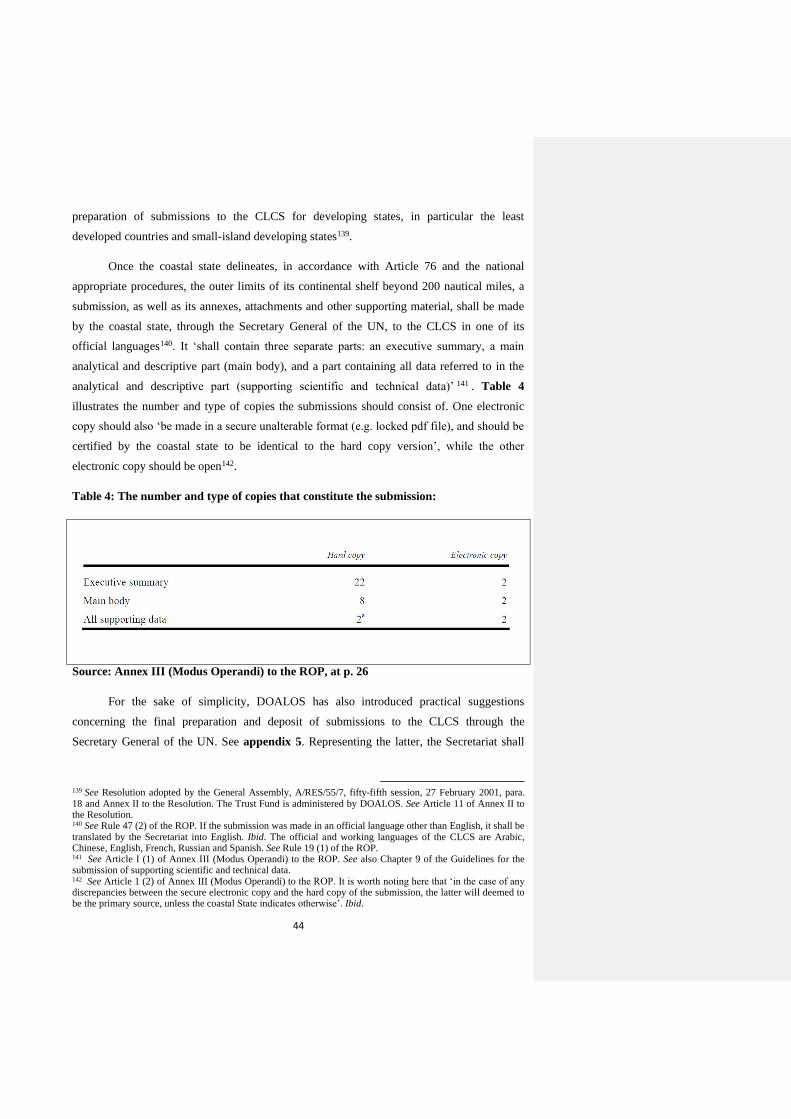
44
preparation of submissions to the CLCS for developing states, in particular the least
developed countries and small-island developing states139.
Once the coastal state delineates, in accordance with Article 76 and the national
appropriate procedures, the outer limits of its continental shelf beyond 200 nautical miles, a
submission, as well as its annexes, attachments and other supporting material, shall be made
by the coastal state, through the Secretary General of the UN, to the CLCS in one of its
official languages140. It ‘shall contain three separate parts: an executive summary, a main
analytical and descriptive part (main body), and a part containing all data referred to in the
analytical and descriptive part (supporting scientific and technical data)’ 141 . Table 4
illustrates the number and type of copies the submissions should consist of. One electronic
copy should also ‘be made in a secure unalterable format (e.g. locked pdf file), and should be
certified by the coastal state to be identical to the hard copy version’, while the other
electronic copy should be open142.
Table 4: The number and type of copies that constitute the submission:
Source: Annex III (Modus Operandi) to the ROP, at p. 26
For the sake of simplicity, DOALOS has also introduced practical suggestions
concerning the final preparation and deposit of submissions to the CLCS through the
Secretary General of the UN. See appendix 5. Representing the latter, the Secretariat shall
139 See Resolution adopted by the General Assembly, A/RES/55/7, fifty-fifth session, 27 February 2001, para. 18 and Annex II to the Resolution. The Trust Fund is administered by DOALOS. See Article 11 of Annex II to the Resolution. 140 See Rule 47 (2) of the ROP. If the submission was made in an official language other than English, it shall be translated by the Secretariat into English. Ibid. The official and working languages of the CLCS are Arabic, Chinese, English, French, Russian and Spanish. See Rule 19 (1) of the ROP. 141 See Article I (1) of Annex III (Modus Operandi) to the ROP. See also Chapter 9 of the Guidelines for the submission of supporting scientific and technical data. 142 See Article 1 (2) of Annex III (Modus Operandi) to the ROP. It is worth noting here that ‘in the case of any discrepancies between the secure electronic copy and the hard copy of the submission, the latter will deemed to be the primary source, unless the coastal State indicates otherwise’. Ibid.
45
record, upon receipt, the submission143, acknowledge its receipt to the coastal state144, and
more importantly notify promptly the CLCS and all States Members of the UN of the receipt
of the submission, and make public the executive summary including all charts and
coordinates referred to in paragraph 9.1.4 of the Guidelines and contained in that summary145.
The submission shall then be included in the provisional agenda of the next ordinary session
of the CLCS provided that it is held not earlier than three months after the date of publication
by the Secretary General of the UN of the Executive Summary146 for which the coastal state
shall be notified and invited to send its representatives to participate, without the right to
vote, in the proceedings of the CLCS pursuant to section VI of Annex III to the ROP147.
Generally speaking, ‘the submission shall be considered in accordance with the rules on
confidentiality contained in annex II to the ROP’148 and the meetings of the CLCS and its
sub-commissions shall be held in private, unless the CLCS decides otherwise149. Despite that,
there have been voices, even from the CLCS itself, calling for more transparency in the work
of the CLCS and not to restrict the circulation of the communications received from the
submitting states to the CLCS members only150.
In the case that no objection was raised, following the publication of the Executive
Summary, due to the existence of an unresolved land or maritime dispute with another state
143 See Rule 48 of the ROP. ‘The record shall contain the date of receipt of the submission, a list of attachments and annexes thereto and the date of entry into force of the LOSC for the coastal State which made the submission’. Ibid. 144 See Rule 49 of the ROP. 145 See Rule 50 of the ROP. 146 See Rule 51 (1) of the ROP and Article 2 of Annex III (Modus Operandi) to the ROP. It is worth mentioning that ‘if the next ordinary session of the CLCS is not scheduled within a reasonable time, the Chairperson of the CLCS may, upon the notification by the Secretary General of the receipt of the submission in accordance with Rule 50, request an additional session to be convened in accordance with Rule 2, within a suitable time for the purpose of considering the submission’. See Rule 51 (2) of the ROP. 147 See Article 5 of Annex II to the LOSC and Rule 52 of the ROP. Section VI of Annex III (Article 15 (1)) to the ROP stipulates that ‘the CLCS understands that there are three proceedings deemed relevant for all submissions: (a) the meeting at which, in accordance with paragraph 2 (a) of section II, coastal State representatives make a presentation to the CLCS concerning the submission; (b) meeting at which the sub-commission invites representatives of the coastal State for consultation; and (c) meetings at which the representatives of the coastal State wish to provide additional clarification to the sub-commission on any matters relating to the submission, including those referred to in paragraph 10.4’. 148 See Rule 51 (3) of the ROP. Annex II to the ROP allows coastal States to classify as confidential any ‘data and other material’, not otherwise publicly available, that it submits to the CLCS, and access to them shall be confined to the members of the CLCS, and the Secretary General of the UN and other members of the Secretariat designated for that purpose. Also, it provides that any confidential information coming to the knowledge of the CLCS members by reason of their duties in relation to the CLCS shall not be disclosed by them after they cease to be members. Hence, a standing Committee on Confidentiality shall be elected from the CLCS members to deal with the issue of confidentiality. 149 See Rule 23 and Rule 44 bis (4) of the ROP. Hence, the latter goes on to state that no records of the personal notes distributed among the 7 members of the sub-commission and oral deliberations shall be disclosed to other members of the CLCS who are not members of the sub-commission. 150 See letter dated 14 April 2014 from the Chair of the CLCS addressed to the President of the twenty-fourth
Meeting of States Parties, SPLOS/270, twenty-fourth Meeting, 14 April 2014, Paragraph 27. See also footnote no. 88 at pp. 431-435.
46
which will render the submission to be deferred 151 , the CLCS shall move forward by
establishing a sub-commission of 7 members in accordance with Rule 42 of the ROP for the
consideration of the submission152. Before that though, the submission shall be queued in the
order it is received until it becomes next in line to be taken for consideration by a sub-
commission and that is only after one of the three working sub-commissions presents its
recommendations to the CLCS153. Obviously, the period of waiting for a submission in the
queue will depend on the number of submissions that have already been sitting in the queue.
As an illustration, since its deposition on 12 May 2009, the submission made by Namibia, the
last submission to be made in 2009 before the end of the 10 year period, has not been, as of
the date of 11 September 2014, put before a sub-commission154.
After being established, the sub-commission shall undertake a thorough analysis of
the submission in accordance with Article 76 of the LOSC and the Guidelines in order to
determine the precise extent of the continental shelf beyond 200 nautical miles of the coastal
state. During its preliminary analysis, the sub-commission can estimate the time required by
it to review all the data and prepare its recommendations for the CLCS155, and accordingly
notify, through the Secretariat, the coastal state of the preliminary timetable for the
examination of its submission156. It may also, as illustrated above, interact with, and seek
clarifications and further information from the coastal state towards drafting its final
recommendations. To reach this stage, the sub-commission shall make every effort to reach
agreement on substantive matters by way of consensus and there shall be no voting, pursuant
to Rule 37 of the ROP, on such matters until all efforts to achieve consensus have been
exhausted157. Prior to the end of the examination, the delegation of the coastal state shall be
invited to be provided with the final conclusions regarding which the delegation may
respond158. Subsequently, the sub-commission will submit, in writing, its recommendations
to the CLCS159 in which it shall state, backed by the rationale, if it agrees with the outer limits
established by the coastal state, disagrees with these outer limits and proposes alternatives, or
that the submission does not contain sufficient data and a revised or new submission is
151 See footnotes no. 121 and 122. 152 See Rule 51 (4) of the ROP. 153 See Rule 51 (4 ter) of the ROP. 154 See table 1 above. 155 See Articles 5 (e) and 8 (1) of Annex III (Modus Operandi) to the ROP. 156 See Article 8 (2) of Annex III (Modus Operandi) to the ROP. 157 See Rule 35 (2) of the ROP. This rule also applies to the CLCS as a whole. Ibid. Rule 37 of the ROP reemphasises what is stated in Article 6 (2) of Annex II to the LOSC that, failing agreement based on consensus, decisions on all matters of substance shall be taken by a two-thirds majority of the members present and voting. 158 See Article 10 (3) and (4) of Annex III (Modus Operandi) to the ROP. 159 See Article 14 of Annex III (Modus Operandi) to the ROP.
47
needed160. The CLCS shall then, unless it decides otherwise, consider these recommendations
in the next session following their submission by the sub-commission 161 for which the
delegation of the coastal state will be invited again to give, if it chooses so, a presentation for
the last time without engaging in any discussion162. Following that, the CLCS will adopt the
final recommendations163, based on which the outer limits of the continental shelf under
examination shall be established, and submit them in writing to the coastal state and the
Secretary General of the UN164.
Apparently therefore, describing the process of consideration of submissions by the
CLCS as merely ‘procedural’165 is unarguably true; however, the determining factor is the
outcome of this process as the CLCS has the right, as evident from above, to recommend
different outer limits for the continental shelf than those of the coastal state or even to
recommend that a revised or new submission is necessary. For instance, on the basis of the
CLCS’s recommendations, both the Russian Federation and Barbados made revised
submissions 166 , and different outer limits were recommended with respect to the UK’s
submission regarding Ascension Island than those submitted by the UK167. More importantly,
‘the limits of the shelf established on the basis of the CLCS’s recommendations shall be final
and binding’168, and charts and relevant information, including geodetic data, permanently
describing them shall be deposited with the Secretary General of the UN by the coastal state
to give them due publicity169. However, it is not clear if they are binding on the coastal state
alone or on all States Parties to the LOSC including opposite and adjacent states170. The only
authentic text of the LOSC that states explicitly that the CLCS recommendations shall have a
160 See Article 12 (4-6) of Annex III (Modus Operandi) to the ROP. 161 See Rule 53 (1) of the ROP. 162 See Article 15 (1 bis) of Annex III (Modus Operandi) to the ROP. For this presentation, the delegation of the
coastal state may be allowed up to half a day to present any matter related to its submission to the plenary of the CLCS without engaging in any discussion. Ibid. 163 See Rule 53 (1) of the ROP. The CLCS, in making its final recommendations, shall either approve or amend
the recommendations prepared by the sub-commission. Ibid. 164 See Article 6 (3) of Annex II to the LOSC and Rule 53 (3) of the ROP. 165 See footnote no. 107. 166 See table 1 above. 167 See Summary of the Recommendations of the CLCS in regard to the Submission made by the United Kingdom of Great Britain and Northern Ireland in respect of Ascension Island on 9 May 2008, adopted by the CLCS with amendments on 15 April 2010, available online at: http://www.un.org/depts/los/clcs_new/submissions_files/gbr08/gbr_asc_isl_rec_summ.pdf [last accessed 11/09/2014]. 168 See Article 76 (8) of the LOSC. 169 See Article 76 (9) of the LOSC. The purpose of due publicity at the stage is clearly to allow all States
Members of the UN, particularly States with opposite and adjacent coasts to the coastal state, to know transparently the recommended final outer limits by the CLCS for the continental shelf of the coastal state. 170 According to Paragraph 2.3.11 of the Guidelines, the CLCS acknowledges that according to paragraph 2 of
Article 76 of the LOSC, coastal States shall not extend the outer limits of their continental shelf beyond the limits established on the basis of its recommendations.
48
binding force on all states is the Russian text, whose interpretation vis-à-vis the other
authentic texts of the LOSC, if it is read pursuant to Article 33 (4) of the Vienna Convention
on the Law of Treaties of 1969, shall be adopted171. Coastal state is required, upon receipt of
the recommendations, to delimit any area of overlap with its opposite and adjacent states in
accordance with Article 83 of the LOSC172. Subject to this and unless the coastal state is in
disagreement with the CLCS recommendations, the outer limit lines of the continental shelf
shall be ultimately shown on charts of a scale or scales adequate for ascertaining their
position, such as lists of geographical coordinates of points specifying the geodetic datum,
and give them due publicity as well as deposit a copy of each such chart or list with the
Secretary General of the UN and with the Secretary General of the ISA173. Appendix 6
illustrates, in summary, the above procedures through which a submission goes until the
deposit of the final recommendations.
3.2.2. Benefits and Costs
As illustrated in Chapter two, the development of the regime of the continental shelf
was significantly driven by economic factors. Saying so of course does not underestimate the
fact that the continental shelf is a land-based principle and exists as an entitlement per se for
the coastal state. But undoubtedly, this fact has strengthened and gained more momentum
after states became aware, via advancement of technology, that the continental shelf contains
a huge quantity of minerals and other natural resources. For instance, in the Case Concerning
the Continental Shelf (Tunisia / Libyan Arab Jamahiriya), the ICJ stated ‘in their pleadings,
as well as in their oral arguments, both Parties appear to have set so much store by economic
factors in the delimitation process that the Court considers it necessary here to comment on
171 Article 33 of the Vienna Convention on the Law of Treaties stipulates that ‘(1) when a treaty has been
authenticated in two or more languages, the text is equally authoritative in each language, unless the treaty provides or the parties agree that, in case of divergence, a particular text shall prevail; (2) a version of the treaty in a language other than one of those in which the text was authenticated shall be considered an authentic text only if the treaty so provides or the parties so agree; (3) the terms of the treaty are presumed to have the same meaning in each authentic text; (4) except where a particular text prevails in accordance with paragraph 1, when a comparison of the authentic text discloses a difference of meaning which the application of articles 31 and 32 does not remove, the meaning which best reconciles the texts, having regard to the object and purpose of the treaty, shall be adopted’. 172 Article 83 (1) & (2) of the LOSC stipulate that ‘the delimitation of the continental shelf between States with opposite or adjacent coasts shall be effected by agreement on the basis of international law, as referred to in Article 38 of the Statute of the International Court of Justice, in order to achieve an equitable solution, and if no agreement can be reached within a reasonable period of time, the States concerned shall resort to the procedures provided for in Part XV’. 173 See Article 84 of the LOSC. Obviously, these charts and lists of coordinates are crucial for the ISA as the
establishment of the outer limits of continental shelves beyond 200 nautical miles determine the limits of the Area to be managed by it.

49
the subject’174 and that ‘[...] a country might be poor today and become rich tomorrow as a
result of an event such as the discovery of valuable economic resources [...]’175. There was
even a belief that ‘the continental shelf may well be the site of the last totally unexplored
great source of petroleum’176. It has been established that ‘the resources that occur on the
world’s continental margins may include oil, natural gas, gas hydrates, manganese nodules,
sand, gravel, titanium, thorium, iron, nickel, copper, cobalt, gold and diamonds’ 177 .
Moreover, ‘given the economic significance of sources of energy supplies, it must be
expected that current technological limits will advance gradually, and with these
improvements, it may be anticipated that the exploitation of the continental shelf beyond 200
nautical miles will take place in the near future’178.
The participants in UNCLOS III having realized this, a balance had to be essentially
struck, by way of rights and duties, to ensure the rights of the coastal state over its continental
shelf on one hand and protect the rights of the international community on the other hand.
Therefore, Part VI of the LOSC goes on, consistently with the other maritime zones, to spell
out specifically the elements of this balance. It begins by establishing explicitly that ‘the
coastal state exercises over the continental shelf sovereign rights for the purpose of exploring
it and exploiting its natural resources’179. These rights are exclusive in the sense that no one
may undertake these activities without the express consent of the coastal state even if the
coastal state does not explore the continental shelf or exploit its natural resources180. The
‘sovereign rights’ include, according to the ILC, ‘all rights necessary for and connected with
the exploitation of the continental shelf [...] including jurisdiction in connection with the
prevention and punishment of violations of the law’181. Whereas the referred to ‘natural
resources’ consist of ‘the mineral and other non-living resources of the seabed and subsoil
together with living organisms belonging to sedentary species that is to say, organisms which,
at the harvestable stage, are either immobile on or under the seabed or are unable to move
except in constant physical contact with the seabed or the subsoil’182. Examples of sedentary
species are oysters, clams and abalone but it is still controversial whether crabs and lobsters
174 See footnote 32, at p.77, para.106. 175 Ibid, at pp. 77-78, para. 107. 176 See footnote 14 at p.53. 177 See Jean-Pierre Levy, The International Seabed Authority: 20 years (International Seabed Authority, Jamaica, 2014), available online at: http://www.isa.org.jm/files/documents/EN/Pubs/ISBA-20.pdf [last accessed 13/09/2014] at p. 45. 178 Ibid, at p. 46. 179 See Article 77 (1) of the LOSC. 180 See Article 77 (2) of the LOSC. 181 See Yearbook of the ILC, 1959, Vol. II, Report of the ILC to the General Assembly Document A/3159, at p.
297. 182 See Article 77 (4) of the LOSC.
50
fall under this category183. In connection with exploration and exploitation, the coastal state
shall have also ‘the exclusive right to authorize and regulate drilling on the continental shelf
for all purposes’184 and the right ‘to exploit the subsoil by means of tunnelling, irrespective of
the depth of water above the subsoil’185. Furthermore, it shall ‘have the exclusive right to
construct and to authorize and regulate the construction, operation and use of artificial
islands; installations and structures for the purposes provided for in Article 56 of the LOSC
and other economic purposes; and installations and structures which may interfere with the
exercise of the rights of the coastal State in the continental shelf’186. In addition, the coastal
state has, in the exercise of its jurisdiction, the right to regulate, authorize and conduct marine
scientific research on its continental shelf in accordance with the relevant provisions of the
LOSC187. More importantly, and as mentioned above, these rights of the coastal state over its
continental shelf do not depend on occupation, effective or notional, or on any express
proclamation188.
On the other hand, Part VI of the LOSC provides that ‘the rights of the coastal State
over the continental shelf do not affect the legal status of the superjacent waters or of the air
space above those waters’189. Furthermore, the coastal state must not, in exercising its rights
over its continental shelf, ‘infringe or result in any unjustifiable interference with navigation
and other rights and freedoms of other States as provided in the LOSC’190. Other states or
competent organizations shall also be granted the consent of the coastal state, without delay
or unreasonable denial, to conduct scientific research projects on its continental shelf for
peaceful purposes and in order to increase scientific knowledge of the marine environment
for the benefit of all mankind, except in the circumstances provided under paragraph 5 of
Article 246 of the LOSC191. Moreover, the coastal state shall adopt laws and regulations to
prevent, reduce, and control pollution of the marine environment arising from or in
connection with seabed activities subject to its jurisdiction and from artificial islands,
183 See footnote no. 37 at pp. 151-152. For more elaboration about the provision of ‘sedentary species’, see
L.F.E. Goldie, ‘Sedentary Fisheries and Article 2 (4) of the Convention on the Continental Shelf – A Plea for a Separate Regime’ (1969) 63 American Journal of International Law at pp. 86-97. 184 See Article 81 of the LOSC. 185 See Article 85 of the LOSC. 186 See Articles 80 and 60 (1) of the LOSC. The coastal state ‘shall have exclusive jurisdiction over such
artificial islands, installations and structures, including jurisdiction with regard to customs, fiscal, health, safety and immigration laws and regulations’ and ‘may, where necessary, establish reasonable safety zones around such artificial islands, installations and structures’. See Article 60 (2) & (4) of the LOSC. 187 See Article 246 (1) of the LOSC. The second paragraph of this Article also stipulates that ‘marine scientific
research […] on the continental shelf shall be conducted with the consent of the coastal State’. 188 See Article 77 (3) of the LOSC. 189 See Article 78 (1) of the LOSC. 190 See Article 78 (2) of the LOSC. 191 See Article 246 (3) of the LOSC. For this purpose, the coastal state shall establish rules and procedures. Ibid.
51
installations and structures under its jurisdiction, pursuant to article 60 and 80 of the
LOSC 192 . In this connection, attention has to be paid regarding the conservation and
protection of marine biodiversity in light of the developments that are taking place regarding
this issue at the UN through the Ad Hoc Open-Ended Informal Working Group established
for this purpose whose work, which has been going on for years now, might lead to a new
implementing agreement for the LOSC193. Article 79 of the LOSC also stipulates that ‘all
States are entitled to lay submarine cables and pipelines on the continental shelf’194 and ‘[...]
the coastal State may not impede the laying or maintenance of such cables or pipelines’195.
Notwithstanding that, this entitlement is subject to the right of the coastal state to ‘take
reasonable measures for the exploration of the continental shelf, the exploitation of its natural
resources and the prevention, reduction and control of pollution from pipelines’196 and to its
consent regarding the delineation of the course for the laying of such pipelines on its
continental shelf197.
Generally speaking, the above balance between rights and corresponding duties of the
coastal state vis-à-vis the other states applies on the continental shelf regardless of the extent
of its outer limits whether they are 200 nautical miles or beyond. However, it is worth
mentioning that in case of the former there will be an overlap with another maritime zone
namely the exclusive economic zone whose outer limit too is defined by the distance of 200
nautical miles198. In such a situation, further rights shall be conferred to the coastal state
pertaining to the water column above the subsoil and seabed of its 200 nautical miles
continental shelf, provided that it proclaims this EEZ or zone reliant on it such as an
exclusive fishing zone199, otherwise that water column will be part of the regime of the high
seas and the rights associated with it will not extend beyond the 200 nautical miles limit200.
That being said, the coastal state, by making a submission to the CLCS, will consequently, if
192 See Article 208 (1) of the LOSC. These laws, regulations and measures shall not be less effective than
international rules, standards, and recommended practices and procedures. Ibid, paragraph (3). 193 This group was established by Resolution No. 59/24 of the UN General Assembly of 17 November 2004,
paragraph 73, to study issues relating to the conservation and sustainable use of marine biological diversity beyond areas of national jurisdiction. Ever since, it has been conducting its work, and in 2014, two meetings, pursuant to Resolution 68/70, paragraph 200, have been convened by the Secretary General of the UN so far (1 to 4 April and 16 to 19 June 2014). 194 See Paragraph (1). 195 See Paragraph (2). 196 See Article 79 (2) of the LOSC. 197 See Article 79 (3) of the LOSC. Also, the coastal state’s right to ‘establish conditions for cables or pipelines
entering its territory or territorial sea, or its jurisdiction over cables and pipelines constructed or used in connection with the exploration of its continental shelf or exploitation of its resources or the operation of artificial islands, installations and structures under its jurisdiction’ shall not be affected. Ibid, paragraph (4). 198 See Article 57 of the LOSC. 199 Regarding these rights associated with the EEZ, see Part V of the LOSC. 200 The provisions of the legal regime of the high seas are contained under Part VII of the LOSC.
52
it has met the requirements of Article 76, have the right to extend the rights attributed to the
continental shelf to the finally established outer limits. However, as such extension, if it is not
made, would be part of the Area which and its resources are ‘the common heritage of
mankind’, the coastal state is under a duty to make annually payments or contributions in
kind in respect of the exploitation of the non-living resources of the continental shelf to the
ISA, unless it is a developing state which is a net importer of a mineral resource produced
from its continental shelf201. The ISA shall then ‘distribute these payments or contributions to
the States Parties to the LOSC, on the basis of equitable sharing criteria, taking into account
the interests and needs of the developing States, particularly the least developed and the land-
locked among them’ 202 . This provision led some commentators to point out that it is
‘instituted in a such manner that the concept of the common heritage of mankind plays a role
in controlling over-expansion of the exclusive interests of coastal States in their continental
shelves’203.
More importantly, the coastal state, whether the outer limits of its continental shelf are
up to the distance of 200 nautical miles or beyond, is required to delimit its continental shelf
if it overlaps with the continental shelves of other states with opposite or adjacent coasts. This
delimitation shall be effected by agreement on the basis of international law, as referred to in
Article 38 of the Statute of the ICJ, in order to achieve an equitable solution204. Pending
agreement, the states concerned shall make, in a spirit of cooperation and understanding,
‘every effort to enter into provisional arrangements of a practical nature and, during this
transitional period, not to jeopardize or hamper the reaching of the final agreement’205. If the
states concerned fail to reach an agreement within a reasonable period, they shall then resort
201 See Article 82 (1, 2 & 3) of the LOSC. These payments and contributions shall be made ‘with respect to all
production at a site after a first 5 years of production at that site. For the 6th year, the rate of payment or contribution shall be 1 per cent of the value or volume of production at the site. The rate shall increase by 1 per cent for each subsequent year until the 12th year and shall remain at 7 percent thereafter. Production does not include resources used in connection with exploitation’. Ibid, Paragraph (3). 202 See Article 82 (4) of the LOSC. For more information, see George Mingay, ‘Article 82 of the LOSC
Convention – Revenue Sharing – The Mining Industry’s Perspective’ (2006) 21 The International Journal of Marine and Coastal Law 3 pp. 335-346 203 Cited in David M. Ong, ‘A Legal Regime for the Outer Continental Shelf? An Inquiry as to the Rights and
Duties of Coastal States with the Outer Continental Shelf’, published on the website of the International Hydrographic Organization (IHO) at: http://www.iho.int/mtg_docs/com_wg/ABLOS/ABLOS_Conf3/PAPER7-4.PDF [last accessed 19/09/2014] at p. 3. Article 82 is also referred to as the ‘quid pro quo' by which the international community is not fully deprived of the benefits derived by the coastal state in recognizing its sovereign rights over the continental shelf beyond 200 nautical miles. See footnote no. 37 at p. 157. 204 See Article 83 (1) of the LOSC. In the case ‘there is an agreement in force between the States concerned,
questions relating to the delimitation of the continental shelf shall be determined in accordance with the provisions of that agreement’. Ibid, Paragraph (4). 205 See Article 83 (3) of the LOSC. In any case, these arrangements shall be without prejudice to the final
delimitation. Ibid.
53
to the procedures provided for in Part XV of the LOSC206. Conversely, due publicity, as
illustrated above207, shall be given to the outer limits of the continental shelf and deposited
with the Secretary General of the UN.
From a practical point of view, the extension of the continental shelf beyond 200
nautical miles has also costs and benefits for the coastal state. As mentioned above208, the
process of delineating the outer limits, making a submission, interacting with the CLCS and
depositing the final outer limits, inter alia, is so complex scientifically, legally, politically
and financially that a lot of states, especially developing ones, find themselves unable for one
reason or another to meet its requirements or need assistance to do so. On the other hand, this
process allows the coastal states to determine the outer limits of their continental shelves
precisely and peacefully, and consequently exercise their sovereign rights emanating from the
continental shelf with confidence and certainty. Moreover, it leads to the build-up of a
national expertise in various fields of sciences that will be a source of knowledge for the
coastal states in the future in multiple ways, and a scientific reference for other states that
seek to make a submission. By the same token, surveying and collecting data from the sea
floor enhance the coastal state’s understanding of the tectonic history and geophysical nature
of its continental shelf which facilitate the establishment of a well-detailed database and the
exploitation of minerals and other non-living resources of the continental shelf such as oil and
gas. Apparently therefore, besides its existence as an inherent entitlement, extending the
continental shelf beyond 200 nautical miles embodies the features of an investment for the
future. In return for the costs that the coastal state bears in making that happen, it gains a lot
of benefits.
3.3. Concluding Remarks
Since its emergence in the international arena, the legal regime of the
continental shelf has traced a long journey of evolution from seven decades ago until 1994;
the year of entry into force of the LOSC. At present, while clarity and certainty in terms of
the definition and limits of the continental shelf are in place, states are focusing on the
practical aspects of exercising the rights stemming from their entitlement over the continental
shelf. In addition, it has become simply well established with the adoption of the LOSC that
206 See Article 83 (2) of the LOSC. 207 See footnote no. 173. 208 See footnote no. 133.
54
if the natural prolongation of the continental margin of a coastal state is within 200 nautical
miles from the baselines, no proclamation action is required from that state to exercise its
sovereign rights over the continental shelf up to that distance. And in case the continental
margin of the coastal state exceeds 200 nautical miles, the outer limits have to be delineated
in accordance with the requirements envisaged in Article 76, and a submission made to the
CLCS to establish finally the precise location of these outer limits. Doing so is undoubtedly a
complex process and costs will be incurred; however, sovereign rights and a lot of economic
benefits will be gained by the coastal state209. Having said that, lodging a submission with the
CLCS is neither the only element nor the ending point as processes, inter alia, of preparation,
submission of information and interaction are necessary to complete the full picture. In this
context therefore, understanding the historical development of the continental shelf, its
definition, the functions and role of the CLCS, and the procedures of the submission play a
significant role towards the successful submission of data to the CLCS to extend the
continental shelf beyond 200 nautical miles with the aim of realizing the final objective of
establishing precisely its outer limits.
209 Apparently, this will be dependent on the discovery of minerals and other no-living resources.

55
Second Part:
In light of the aforementioned, it is clear now that States Parties to the LOSC shall
prepare and deposit their submissions to extend their continental shelves beyond the distance
of 200 nautical miles with the CLCS in order to finally establish the outer limits of those
continental shelves. Article 76, Annex II to the LOSC, Rules of Procedure of the CLCS and
its annexes, the Guidelines and DOALOS Manual constitute and provide collectively the
basis upon which all parties involved in the submission shall act and the submission process
is conducted. The submissions that have already been considered and given recommendations
by the CLCS play also an auxiliary role for other submissions that have not yet been
considered or even deposited. As mentioned above, Oman is one of the coastal states which
have potentially a continental shelf that extends beyond 200 nautical miles from the baselines
which requires a submission, pursuant and subject to the above rules and process, to be
deposited with the CLCS to establish its final outer limits. Having said that and given it will
be submitted in the near future, this part aims to focus on Oman’s submission in light of the
first part from different legal and technical angles, submissions made by neighbouring and
other states, and the different types of challenges it might face and how to overcome them
with the aim of putting it on the right track.
4. Oman’s Submission
4.0. Introductory Remarks
Before examining Oman’s case to extend its continental shelf beyond 200 nautical
miles in light of the provisions of Article 76 of the LOSC, it is worth at the outset giving a
background of Oman as a coastal state from the perspective of its consideration to make a
submission to the CLCS to establish the outer limits of the continental shelf. In terms of
geography, Oman is situated in the south-eastern corner of the Arabian Peninsula in the
western part of the Asian continent, between latitudes 16.40 and 26.30 N and longitudes
51.50 and 59.40 E’210. It has a coastline that stretches over 3165 kilometres from ‘the Strait of
Hormuz in the North to the Republic of Yemen in the South’211. This coastline overlooks, as
illustrated in Figure 8, one gulf, one international strait, and two seas, and opposes and aligns
with the coasts of four states; the Islamic Republic of Iran and the United Arab Emirates in
210 See Geographic Location of Oman, Oman News Agency, available online at:
http://www.omannews.gov.om/ona/GeographicLocation.jsp [last accessed 06/10/2014]. 211 Ibid.
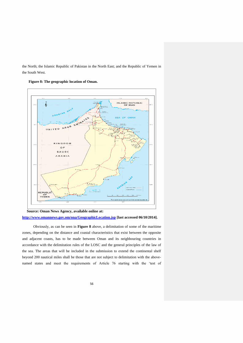
56
the North; the Islamic Republic of Pakistan in the North East; and the Republic of Yemen in
the South West.
Figure 8: The geographic location of Oman.
Source: Oman News Agency, available online at:
http://www.omannews.gov.om/ona/GeographicLocation.jsp [last accessed 06/10/2014].
Obviously, as can be seen in Figure 8 above, a delimitation of some of the maritime
zones, depending on the distance and coastal characteristics that exist between the opposite
and adjacent coasts, has to be made between Oman and its neighbouring countries in
accordance with the delimitation rules of the LOSC and the general principles of the law of
the sea. The areas that will be included in the submission to extend the continental shelf
beyond 200 nautical miles shall be those that are not subject to delimitation with the above-
named states and meet the requirements of Article 76 starting with the ‘test of
57
appurtenance’212. As regards the LOSC, Oman signed it on 1 July 1983 and was the 41st state
to ratify or accede to it on 17 August 1989; being therefore one of the 60 ratifying or
acceding States that brought the LOSC into force on 16 November 1994213. Interestingly,
before the commencement of UNCLOS III that led to the adoption of the LOSC on 10
December 1982, Oman issued a Royal Decree concerning the territorial waters, continental
shelf and the exclusive fishing zone on 20 July 1972 in which it claimed sovereignty over its
territorial waters up to 12 nautical miles from the baselines214, sovereign rights over an
exclusive fishing zone up to 38 nautical miles from the outer limits of the territorial waters215,
and sovereign rights over its continental shelf for the purpose of exploring and exploiting its
natural resources216. In addition, Article 4 of this Royal Decree stated that ‘the continental
shelf of the Sultanate shall include the seabed and natural resources that lie upon and beneath
the seabed adjacent to the main landmass or the coast of an island, rock, reef, or shoal but
outside the territorial waters of the Sultanate and up to a depth of 200 metres or further depths
which allow for the exploitability of natural resources’. Obviously, the wording of this
Article reflected those of the Geneva Convention on the Continental Shelf of 1958217 and the
prevailing state practice of the time218. Article 9 of the Decree went on to state that an official
notification of the entry into force of this law shall be sent to the secretariat of the UN
Committee responsible for the peaceful uses of the seabed and subsoil of the oceans beyond
national jurisdiction. This Royal Decree was amended by another Royal Decree No. 44/77 of
15 June 1977 in which the outer limits of the proclaimed exclusive zone were extended to the
distance of 200 nautical miles seawards from the baselines from which the breadth of the
territorial sea is measured219. However, both Royal Decrees were repealed by another No.
15/81 on 10 February 1981 which, besides spelling out Oman’s rights over the territorial
sea220, internal waters221 and the EEZ222, provides that ‘the Sultanate of Oman exercises
sovereign rights over its continental shelf for the purposes of exploring and exploiting its
212 See footnote no. 51. 213 See Consolidated Table of Signatures and Ratifications/Accessions of the LOSC, available online at
DOALOS website at: http://www.un.org/depts/los/reference_files/status2010.pdf [last accessed 07/10/2014]. 214 See Articles 1 & 2. 215 See Articles 5 & 6. 216 See Article 3. It is noteworthy here that the translation of the provisions of Royal Decrees in this paper from the Arabic language to the English language represents the author’s effort and does not reflect an official translation made by the Government of the Sultanate of Oman. 217 See footnote no. 40. 218 See footnote no. 19. 219 See Article 1 (1). 220 See Articles 1 & 2. 221 See Article 3. 222 See Articles 4 & 5.
58
natural resources’ 223 and it ‘will be issuing a declaration for delimiting the span of its
continental shelf’224. During a general debate, on 10 July 1974, at UNCLOS III, Oman’s
delegate criticised the definition of the continental shelf that was adopted in the 1958
Continental Shelf Convention stating that ‘most of the States present at the Conference had
not participated in the definition of the principles endorsed by the 1958 Geneva Conventions,
including the concept of the continental shelf. For many delegations, the criterion of
exploitability was doubtless, ambiguous and even dangerous’225. By comparison with the
former Decrees, Royal Decree No. 15/81 reflected the outcome of UNCLOS III and the
compromise reached by the participating states therein regarding the continental shelf as it
abolished the use of ‘200 metres depth’ and ‘exploitability’ criteria to determine the outer
limits of the continental shelf. The language used in the latter is relatively broad and left the
determination of the extent of the continental shelf to a later stage. The ratification of the
LOSC on 17 August 1989 by Royal Decree No. 67/89, through which it gained the force of
law in Oman pursuant to Article 3 of the Law Regulating the Executive Body of the State of
the year 1975 issued by Royal Decree No. 26/75226, achieved this purpose.
Following the entry into force of the LOSC, establishment of the CLCS and adoption
of its ROP and the Guidelines, and in accordance with SPLOS/72 regarding the date of
commencement of the 10-year period for making submissions to the CLCS 227 , and
SPLOS/183 regarding the workload of the CLCS and the ability of states, particularly
developing states, to fulfil the requirements of article 4 of annex II to the LOSC, as well as
the decision contained in SLPOS/72228, Oman submitted, as illustrated in table 2 above,
preliminary information on 15 April 2009 to the Secretary General of the UN indicative of
the outer limits of its continental shelf beyond 200 nautical miles and a description of the
status of preparation and intended date of making a submission. Furthermore, the preliminary
information stated that ‘the Sultanate of Oman confirms that it is actively involved in
preparing such a submission and plans to present its submission within a period of 10 years
223 Ibid, Article 6. 224 Ibid, Article 7. 225 Cited in Ahmad Razavi, Continental Shelf Delimitation and Related Maritime Issues in the Persian Gulf
(The Hague, Kluwer Law International, 1997) at p. 96. 226 This status was further enhanced following the issuance in 1996 of the Basic Statute of the State in which
Article 76 provides that ‘treaties and agreements shall not have the force of law except after their ratification. In no case shall treaties and agreements have secret terms contradicting their declared ones’. The Basic Statute of the State is commonly referred to as the ‘constitution’ which was issued by Royal Decree No. 101/96 on 6 November 1996, available online at: http://www.mola.gov.om/eng/basicstatute.aspx [last accessed 08/10/2014]. 227 See footnote no. 130. 228 See footnote no. 138.
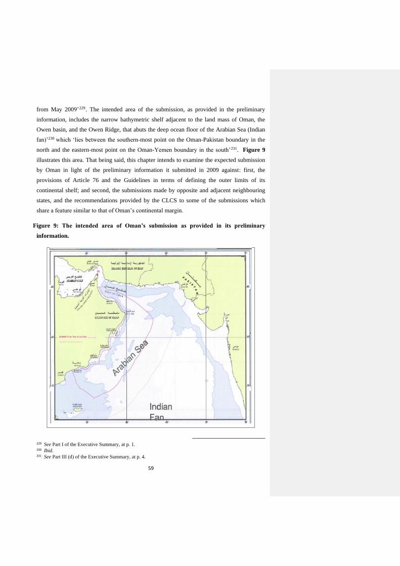
59
from May 2009’229. The intended area of the submission, as provided in the preliminary
information, includes the narrow bathymetric shelf adjacent to the land mass of Oman, the
Owen basin, and the Owen Ridge, that abuts the deep ocean floor of the Arabian Sea (Indian
fan)’230 which ‘lies between the southern-most point on the Oman-Pakistan boundary in the
north and the eastern-most point on the Oman-Yemen boundary in the south’231. Figure 9
illustrates this area. That being said, this chapter intends to examine the expected submission
by Oman in light of the preliminary information it submitted in 2009 against: first, the
provisions of Article 76 and the Guidelines in terms of defining the outer limits of its
continental shelf; and second, the submissions made by opposite and adjacent neighbouring
states, and the recommendations provided by the CLCS to some of the submissions which
share a feature similar to that of Oman’s continental margin.
Figure 9: The intended area of Oman’s submission as provided in its preliminary
information.
229 See Part I of the Executive Summary, at p. 1. 230 Ibid. 231 See Part III (d) of the Executive Summary, at p. 4.
60
Source: Executive Summary of Oman’s preliminary information, figure 1.
4.1. Defining the outer limits of the continental shelf
4.1.1. Baselines
Throughout the provisions of Article 76 of the LOSC, the term ‘beyond 200 nautical
miles from the baselines from which the breadth of the territorial sea is measured’ is used
consistently in defining the outer limits of the continental shelf beyond 200 nautical miles232.
Likewise, ‘from the baselines’ is also used by the LOSC to determine the breadths of the
territorial sea, contiguous zone and the EEZ. Therefore, the baselines constitute the reference
point from which the outer limits of the continental shelf beyond 200 nautical miles shall be
calculated and delineated by the coastal state233. Although the CLCS ‘is not entitled by the
Convention to issue any recommendations with respect to the delineation of the baselines
from which the breadth of the territorial sea is measured’234, it may make a potential request
‘for information about the geodetic position and definition of the baselines used in a
submission made by a coastal state’235. According to the Guidelines, the CLCS might request
geodetic information about baselines in only two instances; ‘first, it must be satisfied that the
test of appurtenance has been positively met; secondly, if the 350 nautical miles limit is
employed as a constraint in a submission, the CLCS might also find it useful to make
recommendations in relation to the methodology employed in the delineation of this limit’236.
Furthermore, during the consideration of a submission, the CLCS may request the following
geodetic information about baselines; ‘source of the data; positioning survey technique; time
and date of the survey; corrections applied to the data; a priori or a posteriori estimates of
random and systematic errors; geodetic reference system; and geometric definition of
straight, archipelagic and closing lines’237. Generally speaking, since the outer limits of a
coastal state’s entitlement to a continental shelf beyond 200 nautical miles are dependent on
the ‘continental margin’ criterion as envisaged in Article 76, whatever the methodology used
by the coastal state to determine the location of the baselines, it does not play a significant
role in the actual extent of such entitlement.
232 See paragraph 1 and paragraph 4 (a), (5), (6), (7) and (8). 233 According to paragraph 3.4.9. of the Guidelines, ‘[...] those States aiming to achieve the highest standards of
accuracy in the determination of their outer limits should focus first on the accuracy of their baselines’. 234 See paragraph 3.3.1. of the Guidelines 235 Ibid. 236 See paragraph 3.3.2. of the Guidelines. 237 See paragraph 3.3.9. of the Guidelines.
61
Notwithstanding that, it is important for the coastal state to delineate the baselines
from which the territorial sea is measured as a first step knowing that the information
included in its submission shall be transferred into geodetic datum to be reviewed by the
CLCS and eventually due publicity to be given to the recommended outer limits on charts
and lists of geographical coordinates. Most coastal states have undoubtedly done so when
they delineated the outer limits of their territorial sea and other maritime zones, if they have
been proclaimed, namely the contiguous zone and the EEZ; consequently, these states have
lifted the burden off their shoulders of the need to conduct new studies to determine the
location of the points making their baselines if they have the intention to make a submission
to extend the outer limits of their continental shelves beyond 200 nautical miles from these
baselines. However, this does not exclude the fact that an amendment of the baselines might
be needed to reflect any changes that might have occurred since their delineation. According
to the LOSC, there are three types of baselines whose application depends on the geographic
characteristics and shape of the coastline. The first one is the ‘normal baseline’ which is
identified by the low-water line along the coast, and in the case of islands situated on atolls or
of islands having fringing reefs, the seaward low-water line of the reef238. The second type is
‘straight baselines’ which are drawn by joining appropriate points in localities where the
coastline is deeply indented or cut into, or if there is a fringe of islands along the coast in its
immediate vicinity239, or the coastline is highly unstable because of the presence of a delta or
other natural conditions240, or the presence of mouths of rivers or bays241. This type of
baselines was first recognized in the Anglo-Norwegian Fisheries case of 1951 where the ICJ
held that the straight baseline system used by Norway to connect the outermost points of
countless islands, islets, rocks and reefs known as the skjaergaard is in conformity with
international law242. The last type of baselines is the ‘archipelagic baselines’ which are drawn
by straight lines ‘connecting the outermost points of the outermost islands and drying reefs of
the archipelago provided that within such baselines are included the main islands and an area
in which the ratio of the area of the water to the area of the land, including atolls, is between
1 to 1 and 9 to 1’243. Examples of archipelagic states where these baselines can be applied
are, inter alia, Indonesia, and the Philippines. Figure 10 illustrates these types of the
baselines.
238 See Articles 5 and 6 of the LOSC respectively. 239 See Article 7 (1) of the LOSC. 240 See Article 7 (2) of the LOSC. 241 See Articles 9 and 10 of the LOSC respectively. 242 [1951], judgment, ICJ Rep. 116. 243 See Article 47 (1) of the LOSC.

62
Figure 10: The three types of the baselines as envisaged in the LOSC.
Source: I Made Andi Arsana, ‘The Delineation of Indonesia’s Outer Limits of its
Extended Continental Shelf and Preparation for its Submission: Status and Problems’,
UN-Nippon Foundation Fellowship Programme 2007-2008, at p. 17.
On the basis of the referred to types of baselines, every coastal state applies the one
that suits best its coastline 244 . With respect to Oman, Royal Decree No. 38/82 on the
methodology of using straight baselines to determine the baselines for the territorial sea,
internal waters, and enclosed areas was issued on 22 May 1982 in which it is stated that ‘in
application of Article 2 (c) of Royal Decree No. 15/81245, straight baselines shall be fixed for
any part of the Sultanate and the lines for enclosed waters lying between bays and gulfs as
well as the waters in between islands and the mainland coast in accordance with the attached
document to this decree’246. The latter, pursuant to Article 2 of the Royal Decree and in
fulfilment of Article 16 (2) of the LOSC, was deposited with the Secretary of the UN by
Notice of 1 June 1982 (94) (1) from the Minister Responsible of Foreign Affairs in the
244 Article 14 of the LOSC also provides that ‘the coastal State may determine baselines in turn by any of the
methods provided for in the foregoing articles to suit different conditions’. 245 See footnote no. 220 . Paragraph (c) of Article 2 of Royal Decree No. 15/81 provides that ‘the Government
of the Sultanate of Oman will be issuing a directive in which the application of the system of straight baselines will set forth and which will, in accordance thereof, determine the baselines for any part of the coast of the Sultanate of Oman, so also the lines relating to the closed waters lying within gulfs and bays or in between islands and the mainland coast. Any line described therein will be regarded as the baseline. Provided it is so required, the Government of the Sultanate of Oman may amend or revoke any provisions which will be promulgated under this clause’. 246 See Article 1.
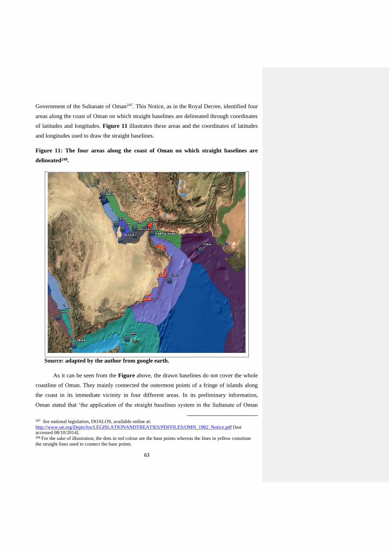
63
Government of the Sultanate of Oman247. This Notice, as in the Royal Decree, identified four
areas along the coast of Oman on which straight baselines are delineated through coordinates
of latitudes and longitudes. Figure 11 illustrates these areas and the coordinates of latitudes
and longitudes used to draw the straight baselines.
Figure 11: The four areas along the coast of Oman on which straight baselines are
delineated248.
Source: adapted by the author from google earth.
As it can be seen from the Figure above, the drawn baselines do not cover the whole
coastline of Oman. They mainly connected the outermost points of a fringe of islands along
the coast in its immediate vicinity in four different areas. In its preliminary information,
Oman stated that ‘the application of the straight baselines system in the Sultanate of Oman
247 See national legislation, DOALOS, available online at:
http://www.un.org/Depts/los/LEGISLATIONANDTREATIES/PDFFILES/OMN_1982_Notice.pdf [last accessed 08/10/2014]. 248 For the sake of illustration, the dots in red colour are the base points whereas the lines in yellow constitute
the straight lines used to connect the base points.
64
was issued by a notice of 1 June 1982 of the Government of the Sultanate of Oman. In
addition to the notice, a baselines database has been established from the largest available
navigation charts and maps for the whole coast of Oman. However, these will need to be
updated for the final submission’249. And whereas the intended area of the submission, as
illustrated in figure 9 above, ‘lies between the southern-most point on the Oman-Pakistan
boundary in the north and the eastern-most point on the Oman-Yemen boundary in the
south’, priority should be given therefore to this area in the preparation of the submission.
Two of the four coastal areas covered by straight baselines, as mentioned above, are located
in the intended area of the submission which indicates that for the rest of coastline within this
area, the normal baseline system might be applied except in those areas where gulfs and bays
exist250. Given that, drawing the rest of the baselines is not going to constitute a complex task
particularly when a baseline database is already available which needs only to be updated.
However, attention should be paid to the above-mentioned requests that might be made by
the CLCS and the need to transfer the base points of the drawn baselines into geodetic datum.
Moreover, the CLCS, in accordance with established state practice, ‘shall accept the
definition of straight, closing and archipelagic baselines as either geodesics or loxodromes,
and only one line definition can be consistently selected by a submitting state for all of its
baselines’251. Also, the CLCS ‘strongly discourages the use of apparent straight lines as
literally drawn on various paper nautical charts employing a variety of map projections’252.
With respect to the normal baseline system, although the LOSC does not provide guidance to
the exact meaning of the term ‘low water line’, the CLCS ‘feels that there is a uniform and
extended state practice which justifies the acceptance of multiple interpretations of the low
water line and all of them are regarded as equally valid in a submission’253. In addition, the
outer limits can be determined by means of the methods of traces paralleles from straight
baselines and/or envelopes of arcs from normal baselines254. Having said that, taking these
points into account during the preparation of the submission will reduce the errors that might
occur in applying the formula and constraint lines laid down in Article 76, calculating
precisely the distance of the outer limits, and avoiding any requests from the CLCS for
further information.
4.1.2. Foot of the Continental Slope
249 See Part III (c) of the Executive Summary, at p. 3. 250 This conclusion can be drawn from Article 2 (b) of Royal Decree No. 15/81, which was issued on 10
February 1981. 251 See paragraph 3.3.8. of the Guidelines. 252 Ibid. 253 See paragraph 3.3.5. of the Guidelines. 254 See Module II (Geodetic Methodologies) of DOALOS Manual, at pp. II-34 – II-47.
65
After the coastal state establishes that its continental shelf extends beyond its
territorial sea throughout the natural prolongation of its land territory to the outer edge of the
continental margin and before applying the ‘test of appurtenance’ that determines its
entitlement to extend its continental shelf beyond 200 miles by making a submission to the
CLCS, it has to identify the location of the foot of the continental slope within its continental
margin. The rationale behind this is that the two formula lines (Gardiner and Hedberg), which
constitute the ‘test of the appurtenance’, are measured from the foot of the continental slope.
Also, the CLCS ‘recognizes that the foot of the continental slope is an essential feature that
serves as the basis for entitlement to the extended continental shelf and the delineation of its
outer limits’255. Article 76 provides that ‘in the absence of evidence to the contrary, the foot
of the continental slope shall be determined as the point of maximum change in the gradient
at its base’256. Therefore, a dual regime is provided for the identification of the location of the
foot of the continental slope. The first one is ‘the point of maximum change in the gradient at
the continental slope’s base’. This applies in the ideal situations where the three components
of the continental margin (see figure 5 above) can be clearly determined and by following
two steps; ‘first, the identification of the region defined as the base of the continental slope;
and second, the determination of the location of the point of maximum change in the gradient
at the base of the continental slope’257. To identify the former, bathymetric and geological
data will be used, whereas for the latter only bathymetric information will be used258.
The other one is ‘evidence to the contrary to the general rule’ which is ‘designed to
allow coastal states to use the best geological and geophysical evidence available to them to
locate the foot of the continental slope at its base when the geomorphological evidence given
by the maximum change in the gradient does not or cannot locate reliably the foot of the
continental slope’259. Such a situation occurs in scenarios when the curvature of the seabed
along the base of the continental slope is constant and where the maximum change in the
gradient may not clearly render the location of the foot of the slope at its base due to irregular
seabed topography that reveals a number of local maxima in the change of the gradient at the
255 See paragraph 5.1.1. of the Guidelines. 256 See paragraph 4 (b) of Article 76 of the LOSC. 257 See paragraph 5.1.3. of the Guidelines. Also, ‘for the purpose of identifying the region defined as the base,
the CLCS defines the continental slope as the outer portion of the continental margin that extends from the shelf edge to the upper part of the rise or to the deep ocean floor where a rise is not developed. The rise, in turn, is the wedge-shaped sedimentary body having a smaller gradient than the continental slope’. Ibid, paragraph 5.4.4. . The CLCS also ‘defines the base of the continental slope as a region where the lower part of the slope merges into the top of the continental rise, or into the top of the deep ocean floor where a continental rise does not exist’. Ibid, paragraph 5.4.5. 258 See paragraph 5.2.1. of the Guidelines. 259 See paragraph 6.3.1. of the Guidelines.
66
base of the slope 260 . In these scenarios, ‘geological evidence may be introduced as an
alternative for determining the location of the foot of the continental slope at its base’261
noting though that invoking such evidence by coastal states will be regarded as an exception
by the CLCS262. Moreover, the latter recognizes that difficulties might arise from invoking
this evidence as the boundary separating the continental crust from the oceanic crust may not
be clearly defined owing to a variety of tectonic and geological reasons263. And to simplify
the matter for coastal states, the Guidelines provide a list of types of continental margins to
which it might be applicable264.
Either way, the coastal state shall furnish the CLCS with information of the
methodologies used to locate the foot of the continental slope. Furthermore, the CLCS will
require a full technical description of ‘the bathymetric database used in the implementation of
the first evidence’265 and of ‘the geological and geophysical database’ if evidence to the
contrary is invoked 266 . In light of the foregoing, Oman, in its preliminary information,
affirmed, first of all, that ‘there is continuous prolongation from the territory of the Sultanate
of Oman, across a relatively narrow bathymetric shelf and the large plateau of the Owen
Basin, to the boundary with the deep ocean floor of the Arabian Sea marked by the Owen
Ridge. The Owen Basin is morphologically continuous with the Omani landmass, and
exhibits characteristics typical of the continental crust’267. And although the Owen Basin, the
main feature of the southeast Oman continental shelf, is ‘a large faulted plateau of relatively
smooth seafloor between 3000 and 3500 m depth adjacent to the South East coast of
Oman’ 268 , ‘geological and geophysical data gathered in the basin show that the crustal
structure and composition of the Owen Basin are characteristic of continental rather than
oceanic crust, and that it shares the geological characteristics of the Omani landmass’269. The
Owen Basin is bounded to the east by the Owen Ridge which is ‘an asymmetric feature with
a moderately dipping western flank and an extremely steep eastern flank’ and to the south ‘by
260 See paragraphs 6.3.2. and 6.3.3. of the Guidelines. 261 See paragraph 6.3.4. of the Guidelines. 262 See paragraph 5.4.12 of the Guidelines. 263 See paragraph 6.2.4. of the Guidelines. 264 See paragraph 6.2.6. to paragraph 6.3.13. of the Guidelines. 265 See paragraph 5.2.3. of the Guidelines. 266 See paragraph 6.4.1. of the Guidelines. 267 See Part II of the Executive Summary, at p. 1. 268 Ibid. 269 Ibid, at p. 2. These data are listed in the Executive Summary. Ibid.
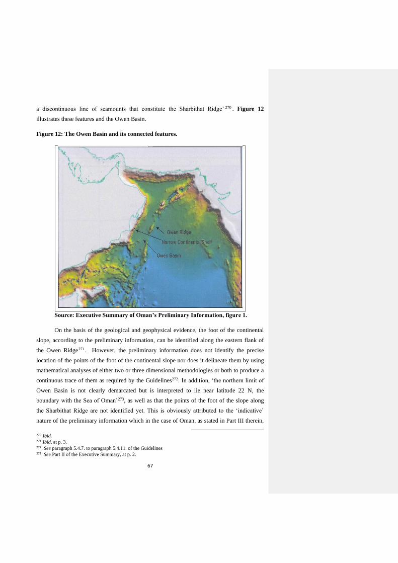
67
a discontinuous line of seamounts that constitute the Sharbithat Ridge’ 270 . Figure 12
illustrates these features and the Owen Basin.
Figure 12: The Owen Basin and its connected features.
Source: Executive Summary of Oman’s Preliminary Information, figure 1.
On the basis of the geological and geophysical evidence, the foot of the continental
slope, according to the preliminary information, can be identified along the eastern flank of
the Owen Ridge271. However, the preliminary information does not identify the precise
location of the points of the foot of the continental slope nor does it delineate them by using
mathematical analyses of either two or three dimensional methodologies or both to produce a
continuous trace of them as required by the Guidelines272. In addition, ‘the northern limit of
Owen Basin is not clearly demarcated but is interpreted to lie near latitude 22 N, the
boundary with the Sea of Oman’273, as well as that the points of the foot of the slope along
the Sharbithat Ridge are not identified yet. This is obviously attributed to the ‘indicative’
nature of the preliminary information which in the case of Oman, as stated in Part III therein,
270 Ibid. 271 Ibid, at p. 3. 272 See paragraph 5.4.7. to paragraph 5.4.11. of the Guidelines 273 See Part II of the Executive Summary, at p. 2.
68
was based, inter alia, on a desktop study done in 2002 and other information acquired ever
since as well as bathymetric data. Consequently, further collection and analysis of scientific
data are necessary to determine the exact location of every point of the foot of the continental
slope, and the methodology to be used for that. Subsequently, every location should be
transferred into geodetic datum. Also, as the Owen Ridge is characterised by extensive
faulting and complex morphology, and the Sharbithat Ridge is discontinuous, evidence to the
contrary may be invoked, if necessity requires, in case the point of maximum change in the
gradient at the base of the continental slope cannot be identified. In any case, attention should
be paid to the possibility that, as mentioned above, the CLCS will ask for information and a
technical description of the evidence that has been invoked to determine the location of every
foot of the continental slope274. The latter will also be one of the items that will be presented
to the CLCS by the coastal state in its initial session before establishing a sub-commission to
review the submission275. Furthermore, besides having the right to request the full disclosure
of the original information, the information submitted will go through filtering and
smoothing, as illustrated in the Guidelines, by the CLCS in order to facilitate the
identification of the location of the foot of the continental slope 276. Having said that, Oman
is obviously required to complete the preliminary information it submitted regarding the foot
of the continental slope by identifying the precise location of every foot of the continental
slope based on which the formula lines will be delineated with the aim to meet positively the
‘test of appurtenance’. By looking at the methodologies involved, doing so is clearly a
complex task; nonetheless, it is a step that subsequently paves the way, during the preparation
of the submission, for the application of the other requirements of Article 76 and delineation
of the outer limits of the continental shelf.
4.1.3. Formula Lines
As stated above, identifying the precise location of the foot of the continental slope
will facilitate the application of the formula lines. Oman, in its preliminary information,
identified it along the eastern flank of the Owen Ridge. Moreover, it can be said that it will
also be located along the eastern side of the Sharbithat Ridge since the Owen Basin is
274 See footnotes No. 265 and 266. 275 See Article 2 (a) of Annex III (Modus Operandi) to the ROP. 276 See paragraph 5.3.
69
morphologically continuous with the Omani landmass, and exhibits characteristics typical of
the continental crust. The two formula lines, as provided in Article 76 of the LOSC, ‘shall be
either:
(i) a line delineated in accordance with paragraph 7 by reference to the outermost
fixed points at each of which the thickness of sedimentary rocks is at least 1 per
cent of the shortest distance from such point to the foot of the continental slope
(Gardiner formula); or
(ii) a line delineated in accordance with paragraph 7 by reference to fixed points not
more than 60 nautical miles from the foot of the continental slope (Hedberg
Formula)’.
Therefore, employing either one of the two formulas, the one that is more advantageous
to the coastal state, will suffice to satisfy the test of appurtenance. After establishing the
natural prolongation and identifying the location of the foot of the continental slope, Oman’s
preliminary information goes on to state that ‘based on the above and on the application of
the 1% sediment thickness formula contained in article 76 (4) (a) (i), the preliminary
indicative outer limit of the Omani continental shelf extends to the constraint lines’ 277 .
Apparently therefore, one formula was invoked by Oman when it prepared the preliminary
information of the outer limits of its continental shelf.
According to Gardiner as quoted in the Guidelines, ‘the sediment thickness formula is
based on a model in which the sediments of the rise thin gradually in a seaward direction.
This model links the outer limit of the rise to the thickness of the sediments beneath it’278.
Generally speaking, ‘the basement of the sediment wedge can be oceanic, continental or a
combination of both. In the simplest cases, the sediments of the rise rest on oceanic basement
all the way from the foot of the continental slope’279. To determine the thickness of the
sediments, there are different means which vary in terms of complexity, methodology and
cost, such as drilling, bathymetric and seismic reflection and refraction measurements,
gravity, and magnetics280. The data provided by seismic reflection and seismic refraction
surveys will be regarded by the CLCS as the primary source of evidence for mapping and
277 See Part II of the Executive Summary, at p.3. 278 See paragraph 8.1.3. of the Guidelines. The latter also provides that ‘the sediment thickness at any location
on the continental margin is the vertical distance from the sea floor to the top of the basement at the base of the sediments, regardless of the slope of the sea floor or the slope of the top basement surface’. See paragraph 8.1.8. 279 See paragraph 8.2.15 of the Guidelines. 280 See paragraph 8.2. of the Guidelines.
70
determining the sediment thickness whereas magnetic and gravimetric data may be provided
at all times as complementary sources of evidence281.
That being said, to the eastern side of the location of the foot of the continental slope,
identified by Oman in its preliminary information, along the eastern flank of the Owen ridge
lies the deep ocean floor of the Arabian Sea (Indian fan). The latter is of a great depth;
therefore, a combination of the means referred to above might be necessary to be employed
by Oman in calculating and mapping the 1% thickness of the sediments from the nearest
point of the foot of the continental slope. Some of these means have already been relied on by
Oman, in its preliminary information 282 , to establish the natural prolongation of its
continental margin to the Owen Basin in a way that matches those contained in paragraph
8.2.2. of the Guidelines. Whatever means is employed, the survey must be designed to prove
the continuity of the sediments by fixed points to the foot of the slope and the data collected
must be documented 283 . The fixed points shall then be delineated, in accordance with
paragraph 7 of Article 76, by straight lines not exceeding 60 nautical miles in length and
defined by coordinates of latitude and longitude. The latter obviously requires the transfer of
the outermost location of the fixed points into geodetic datum as for the measurement
between the fixed points and the nearest point of the foot of the slope. Likewise, the
estimation of sediment thickness requires the documentation and depth conversion of the
interpreted profiles and maps of the sea floor 284. Having said that, it is apparent that
possessing the knowledge to put the above mentioned into practice is the most determining
factor which will play a significant role in reducing the errors that might occur in calculating
the sedimentary thickness, knowing that all data will be thoroughly verified by the CLCS.
On the other side, Oman might also, based on the collection and analysis of data during
the preparation of the submission, opt to employ the Hedberg formula which is identified by
‘60 nautical miles from the foot of the continental slope’ in the case it is more advantageous,
compared to the ‘1% sediment thickness formula’, in drawing the outer envelope line.
Generally speaking, employing either formula will depend on the structure and composition
of the ‘continental margin’. As mentioned above, the Owen and Sharbithat ridges, along
whose eastern sides the foot of the slope is located, are characterised by faults; therefore,
employing both formulas is expected. In contrast with its counterpart in terms of complexity
and the methodologies involved, the Hedberg formula is obviously easier since its fixed
281 See paragraph 8.2.1. of the Guidelines. 282 See Part II of the Executive Summary, at p. 2. 283 See paragraph 8.2.21. of the Guidelines. 284 See paragraph 8.3.1. of the Guidelines.
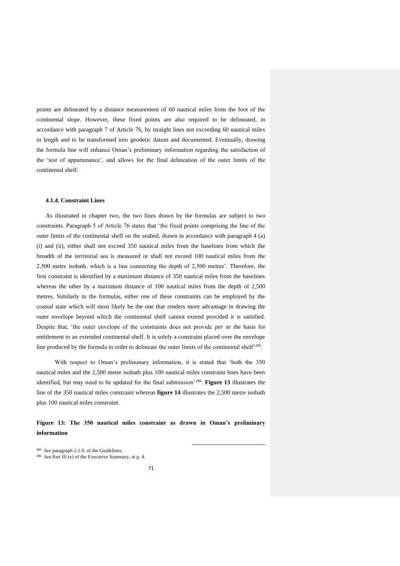
71
points are delineated by a distance measurement of 60 nautical miles from the foot of the
continental slope. However, these fixed points are also required to be delineated, in
accordance with paragraph 7 of Article 76, by straight lines not exceeding 60 nautical miles
in length and to be transformed into geodetic datum and documented. Eventually, drawing
the formula line will enhance Oman’s preliminary information regarding the satisfaction of
the ‘test of appurtenance’, and allows for the final delineation of the outer limits of the
continental shelf.
4.1.4. Constraint Lines
As illustrated in chapter two, the two lines drawn by the formulas are subject to two
constraints. Paragraph 5 of Article 76 states that ‘the fixed points comprising the line of the
outer limits of the continental shelf on the seabed, drawn in accordance with paragraph 4 (a)
(i) and (ii), either shall not exceed 350 nautical miles from the baselines from which the
breadth of the territorial sea is measured or shall not exceed 100 nautical miles from the
2,500 metre isobath, which is a line connecting the depth of 2,500 metres’. Therefore, the
first constraint is identified by a maximum distance of 350 nautical miles from the baselines
whereas the other by a maximum distance of 100 nautical miles from the depth of 2,500
metres. Similarly to the formulas, either one of these constraints can be employed by the
coastal state which will most likely be the one that renders more advantage in drawing the
outer envelope beyond which the continental shelf cannot extend provided it is satisfied.
Despite that, ‘the outer envelope of the constraints does not provide per se the basis for
entitlement to an extended continental shelf. It is solely a constraint placed over the envelope
line produced by the formula in order to delineate the outer limits of the continental shelf’285.
With respect to Oman’s preliminary information, it is stated that ‘both the 350
nautical miles and the 2,500 metre isobath plus 100 nautical miles constraint lines have been
identified, but may need to be updated for the final submission’286. Figure 13 illustrates the
line of the 350 nautical miles constraint whereas figure 14 illustrates the 2,500 metre isobath
plus 100 nautical miles constraint.
Figure 13: The 350 nautical miles constraint as drawn in Oman’s preliminary
information
285 See paragraph 2.1.9. of the Guidelines. 286 See Part III (e) of the Executive Summary, at p. 4.
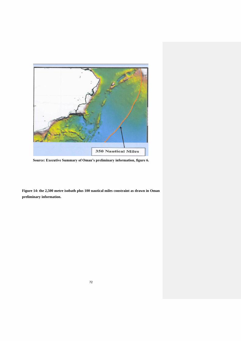
72
Source: Executive Summary of Oman’s preliminary information, figure 6.
Figure 14: the 2,500 metre isobath plus 100 nautical miles constraint as drawn in Oman
preliminary information.
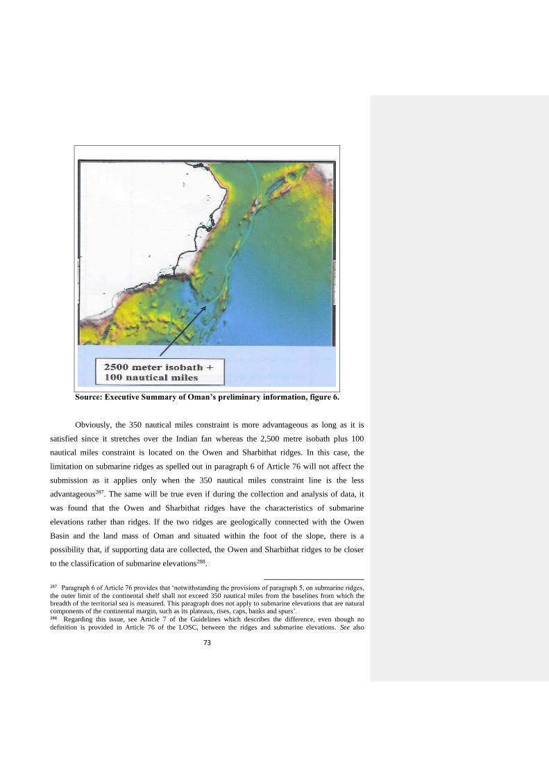
73
Source: Executive Summary of Oman’s preliminary information, figure 6.
Obviously, the 350 nautical miles constraint is more advantageous as long as it is
satisfied since it stretches over the Indian fan whereas the 2,500 metre isobath plus 100
nautical miles constraint is located on the Owen and Sharbithat ridges. In this case, the
limitation on submarine ridges as spelled out in paragraph 6 of Article 76 will not affect the
submission as it applies only when the 350 nautical miles constraint line is the less
advantageous287. The same will be true even if during the collection and analysis of data, it
was found that the Owen and Sharbithat ridges have the characteristics of submarine
elevations rather than ridges. If the two ridges are geologically connected with the Owen
Basin and the land mass of Oman and situated within the foot of the slope, there is a
possibility that, if supporting data are collected, the Owen and Sharbithat ridges to be closer
to the classification of submarine elevations288.
287 Paragraph 6 of Article 76 provides that ‘notwithstanding the provisions of paragraph 5, on submarine ridges,
the outer limit of the continental shelf shall not exceed 350 nautical miles from the baselines from which the breadth of the territorial sea is measured. This paragraph does not apply to submarine elevations that are natural components of the continental margin, such as its plateaux, rises, caps, banks and spurs’. 288 Regarding this issue, see Article 7 of the Guidelines which describes the difference, even though no
definition is provided in Article 76 of the LOSC, between the ridges and submarine elevations. See also
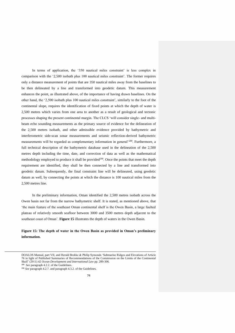
74
In terms of application, the ‘350 nautical miles constraint’ is less complex in
comparison with the ‘2,500 isobath plus 100 nautical miles constraint’. The former requires
only a distance measurement of points that are 350 nautical miles away from the baselines to
be then delineated by a line and transformed into geodetic datum. This measurement
enhances the point, as illustrated above, of the importance of having drawn baselines. On the
other hand, the ‘2,500 isobath plus 100 nautical miles constraint’, similarly to the foot of the
continental slope, requires the identification of fixed points at which the depth of water is
2,500 metres which varies from one area to another as a result of geological and tectonic
processes shaping the present continental margin. The CLCS ‘will consider single- and multi-
beam echo sounding measurements as the primary source of evidence for the delineation of
the 2,500 metres isobath, and other admissible evidence provided by bathymetric and
interferometric side-scan sonar measurements and seismic reflection-derived bathymetric
measurements will be regarded as complementary information in general’289. Furthermore, a
full technical description of the bathymetric database used in the delineation of the 2,500
metres depth including the time, date, and correction of data as well as the mathematical
methodology employed to produce it shall be provided290. Once the points that meet the depth
requirement are identified, they shall be then connected by a line and transformed into
geodetic datum. Subsequently, the final constraint line will be delineated, using geodetic
datum as well, by connecting the points at which the distance is 100 nautical miles from the
2,500 metres line.
In the preliminary information, Oman identified the 2,500 metres isobath across the
Owen basin not far from the narrow bathymetric shelf. It is stated, as mentioned above, that
‘the main feature of the southeast Oman continental shelf is the Owen Basin, a large faulted
plateau of relatively smooth seafloor between 3000 and 3500 metres depth adjacent to the
southeast coast of Oman’. Figure 15 illustrates the depth of waters in the Owen Basin.
Figure 15: The depth of water in the Owen Basin as provided in Oman’s preliminary
information.
DOALOS Manual, part VII, and Herald Brekke & Philip Symonds ‘Submarine Ridges and Elevations of Article 76 in light of Published Summaries of Recommendations of the Commission on the Limits of the Continental Shelf’ (2011) 42 Ocean Development and International Law pp. 289-306. 289 See paragraph 4.2.2. of the Guidelines. 290 See paragraph 4.2.7. and paragraph 4.3.2. of the Guidelines.
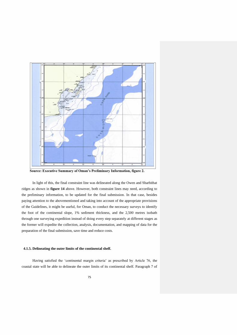
75
Source: Executive Summary of Oman’s Preliminary Information, figure 2.
In light of this, the final constraint line was delineated along the Owen and Sharbithat
ridges as shown in figure 14 above. However, both constraint lines may need, according to
the preliminary information, to be updated for the final submission. In that case, besides
paying attention to the abovementioned and taking into account of the appropriate provisions
of the Guidelines, it might be useful, for Oman, to conduct the necessary surveys to identify
the foot of the continental slope, 1% sediment thickness, and the 2,500 metres isobath
through one surveying expedition instead of doing every step separately at different stages as
the former will expedite the collection, analysis, documentation, and mapping of data for the
preparation of the final submission, save time and reduce costs.
4.1.5. Delineating the outer limits of the continental shelf.
Having satisfied the ‘continental margin criteria’ as prescribed by Article 76, the
coastal state will be able to delineate the outer limits of its continental shelf. Paragraph 7 of
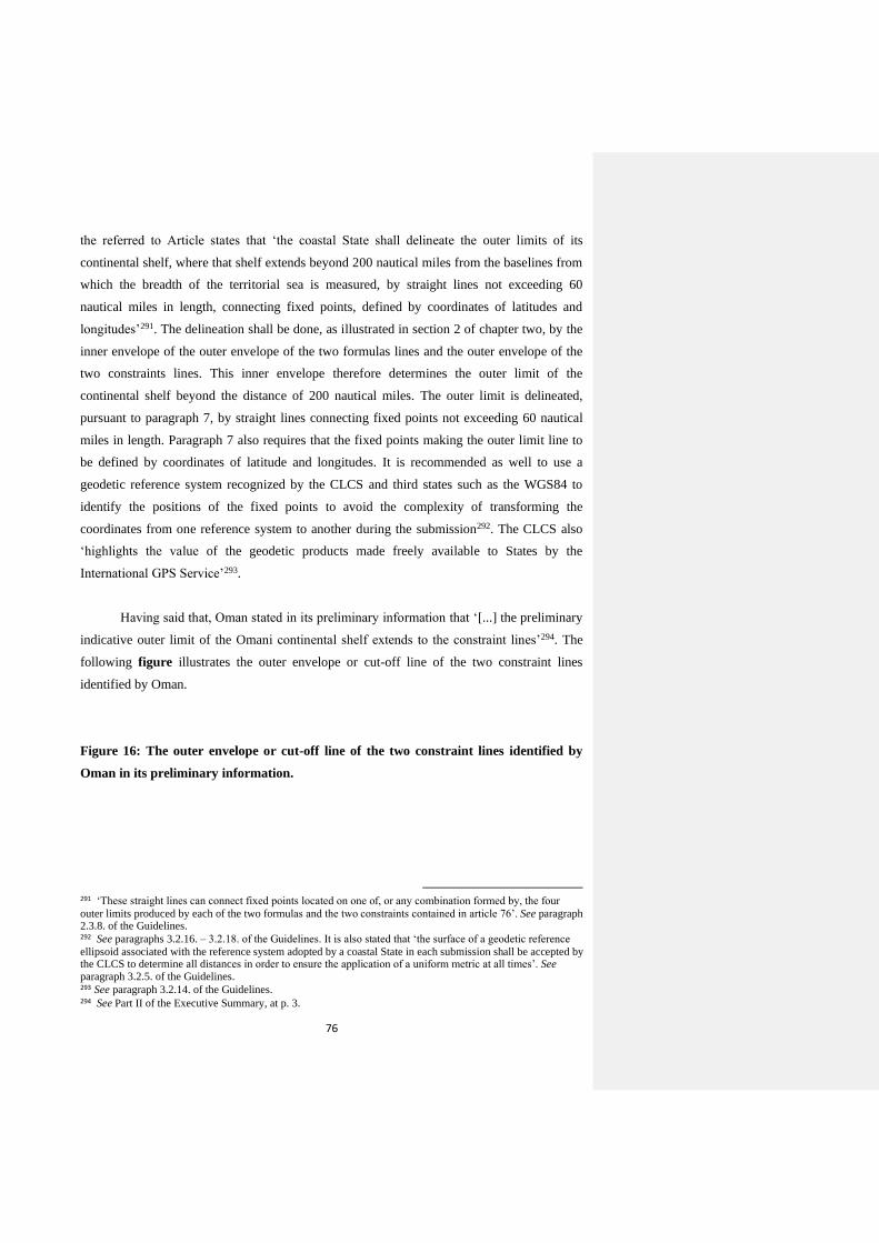
76
the referred to Article states that ‘the coastal State shall delineate the outer limits of its
continental shelf, where that shelf extends beyond 200 nautical miles from the baselines from
which the breadth of the territorial sea is measured, by straight lines not exceeding 60
nautical miles in length, connecting fixed points, defined by coordinates of latitudes and
longitudes’291. The delineation shall be done, as illustrated in section 2 of chapter two, by the
inner envelope of the outer envelope of the two formulas lines and the outer envelope of the
two constraints lines. This inner envelope therefore determines the outer limit of the
continental shelf beyond the distance of 200 nautical miles. The outer limit is delineated,
pursuant to paragraph 7, by straight lines connecting fixed points not exceeding 60 nautical
miles in length. Paragraph 7 also requires that the fixed points making the outer limit line to
be defined by coordinates of latitude and longitudes. It is recommended as well to use a
geodetic reference system recognized by the CLCS and third states such as the WGS84 to
identify the positions of the fixed points to avoid the complexity of transforming the
coordinates from one reference system to another during the submission292. The CLCS also
‘highlights the value of the geodetic products made freely available to States by the
International GPS Service’293.
Having said that, Oman stated in its preliminary information that ‘[...] the preliminary
indicative outer limit of the Omani continental shelf extends to the constraint lines’294. The
following figure illustrates the outer envelope or cut-off line of the two constraint lines
identified by Oman.
Figure 16: The outer envelope or cut-off line of the two constraint lines identified by
Oman in its preliminary information.
291 ‘These straight lines can connect fixed points located on one of, or any combination formed by, the four
outer limits produced by each of the two formulas and the two constraints contained in article 76’. See paragraph 2.3.8. of the Guidelines. 292 See paragraphs 3.2.16. – 3.2.18. of the Guidelines. It is also stated that ‘the surface of a geodetic reference
ellipsoid associated with the reference system adopted by a coastal State in each submission shall be accepted by the CLCS to determine all distances in order to ensure the application of a uniform metric at all times’. See paragraph 3.2.5. of the Guidelines. 293 See paragraph 3.2.14. of the Guidelines. 294 See Part II of the Executive Summary, at p. 3.
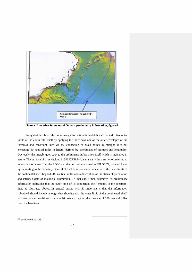
77
Source: Executive Summary of Oman’s preliminary information, figure 6.
In light of the above, the preliminary information did not delineate the indicative outer
limits of the continental shelf by applying the inner envelope of the outer envelopes of the
formulas and constraint lines via the connection of fixed points by straight lines not
exceeding 60 nautical miles in length, defined by coordinates of latitudes and longitudes.
Obviously, this merely goes back to the preliminary information itself which is indicative in
nature. The purpose of it, as decided in SPLOS/183295, is to satisfy the time period referred to
in article 4 of annex II to the LOSC and the decision contained in SPLOS/72, paragraph (a),
by submitting to the Secretary General of the UN information indicative of the outer limits of
the continental shelf beyond 200 nautical miles and a description of the status of preparation
and intended date of making a submission. To that end, Oman submitted its preliminary
information indicating that the outer limit of its continental shelf extends to the constraint
lines as illustrated above. In general terms, what is important is that the information
submitted should include enough data showing that the outer limit of the continental shelf,
pursuant to the provisions of article 76, extends beyond the distance of 200 nautical miles
from the baselines.
295 See footnote no. 138.
78
Besides updating what needs to be updated, as stated in the preliminary information,
regarding the baselines and constraint lines, it is necessary for Oman towards the completion
of the submission to collect and analyse further scientific data to delineate precisely the outer
limits of its continental shelf through a well-documented scientific study backed by the
necessary evidences pursuant to the requirements of Article 76 and as prescribed by the
Guidelines. Also, it is necessary to do so by adhering to the scientific methodologies and
technical requirements prescribed by the CLCS in the Guidelines, albeit not binding, to avoid
any complexity during the preparation and review of the submission.
4.2. Submissions by Neighbouring States and Recommendations for States
Having a Continental Shelf Similar to that of Oman
Undoubtedly, the early submissions of coastal states and recommendations given to
them by the CLCS set a trend for the later submissions by other states to follow and learn
from. Despite the fact that the CLCS’s role to review submissions shall be exercised in
accordance with fixed rules which are applicable equally to all states, the whole process
provides the latter with an opportunity to avoid the legal and technical mistakes of each other
towards making a successful submission until the receipt of final recommendations from the
CLCS. Specifically speaking, the attention paid should focus more on the submissions made
by opposite and adjacent coastal states since their continental crusts are more likely to have
closely emerged out of the same tectonic history, and on the submissions made by coastal
states that have a continental shelf of similar characterises to the one of the concerned state.
Based on that, it will be useful for Oman, towards making its submission to review the
submission made by opposite and adjacent states, and of those states that have a continental
shelf similar to its own as illustrated above.
4.2.1. Submissions by Opposite and Adjacent Neighbouring States
There are three coastal states opposite and adjacent to Oman which have made
submissions to extend all or part of their continental shelves beyond 200 nautical miles with
the CLCS. The first state is the Republic of Yemen which made a submission on 20 March
2009 in respect of the area south east of Socotra Island 296 . The consideration of the
296 See the submission made by the Republic of Yemen in respect of the area south east of Socotra Island,
available online at DOALOS website at: http://www.un.org/depts/los/clcs_new/submissions_files/submission_yem.htm [last accessed 21/10/2010].
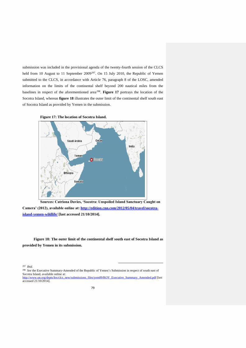
79
submission was included in the provisional agenda of the twenty-fourth session of the CLCS
held from 10 August to 11 September 2009297. On 15 July 2010, the Republic of Yemen
submitted to the CLCS, in accordance with Article 76, paragraph 8 of the LOSC, amended
information on the limits of the continental shelf beyond 200 nautical miles from the
baselines in respect of the aforementioned area298. Figure 17 portrays the location of the
Socotra Island, whereas figure 18 illustrates the outer limit of the continental shelf south east
of Socotra Island as provided by Yemen in the submission.
Figure 17: The location of Socotra Island.
Sources: Catriona Davies, ‘Socotra: Unspoiled Island Sanctuary Caught on
Camera’ (2012), available online at: http://edition.cnn.com/2012/05/04/travel/socotra-
island-yemen-wildlife/ [last accessed 21/10/2014].
Figure 18: The outer limit of the continental shelf south east of Socotra Island as
provided by Yemen in its submission.
297 Ibid. 298 See the Executive Summary-Amended of the Republic of Yemen’s Submission in respect of south east of
Socotra Island, available online at: http://www.un.org/depts/los/clcs_new/submissions_files/yem09/ROY_Executive_Summary_Amended.pdf [last accessed 21/10/2014].
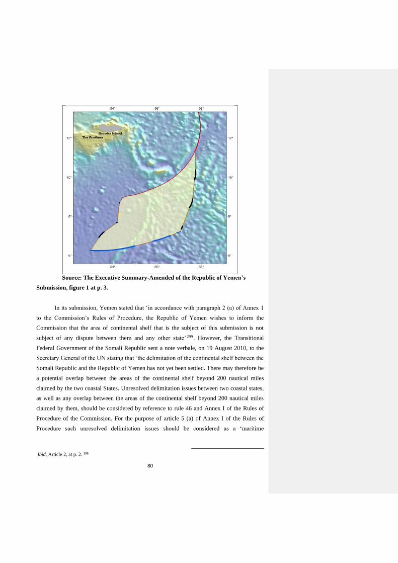
80
Source: The Executive Summary-Amended of the Republic of Yemen’s
Submission, figure 1 at p. 3.
In its submission, Yemen stated that ‘in accordance with paragraph 2 (a) of Annex 1
to the Commission’s Rules of Procedure, the Republic of Yemen wishes to inform the
Commission that the area of continental shelf that is the subject of this submission is not
subject of any dispute between them and any other state’ 299 . However, the Transitional
Federal Government of the Somali Republic sent a note verbale, on 19 August 2010, to the
Secretary General of the UN stating that ‘the delimitation of the continental shelf between the
Somali Republic and the Republic of Yemen has not yet been settled. There may therefore be
a potential overlap between the areas of the continental shelf beyond 200 nautical miles
claimed by the two coastal States. Unresolved delimitation issues between two coastal states,
as well as any overlap between the areas of the continental shelf beyond 200 nautical miles
claimed by them, should be considered by reference to rule 46 and Annex I of the Rules of
Procedure of the Commission. For the purpose of article 5 (a) of Annex I of the Rules of
Procedure such unresolved delimitation issues should be considered as a ‘maritime
299Article 2, at p. 2. Ibid,
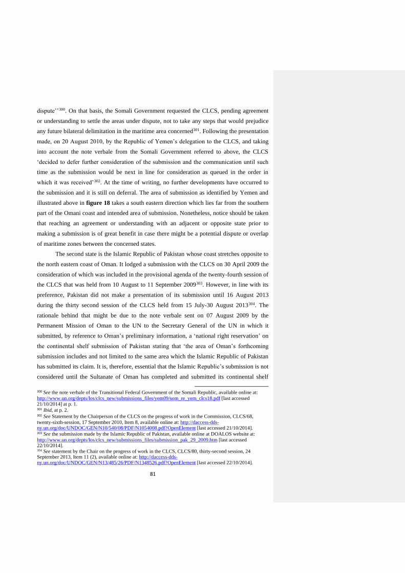
81
dispute’’300. On that basis, the Somali Government requested the CLCS, pending agreement
or understanding to settle the areas under dispute, not to take any steps that would prejudice
any future bilateral delimitation in the maritime area concerned301. Following the presentation
made, on 20 August 2010, by the Republic of Yemen’s delegation to the CLCS, and taking
into account the note verbale from the Somali Government referred to above, the CLCS
‘decided to defer further consideration of the submission and the communication until such
time as the submission would be next in line for consideration as queued in the order in
which it was received’302. At the time of writing, no further developments have occurred to
the submission and it is still on deferral. The area of submission as identified by Yemen and
illustrated above in figure 18 takes a south eastern direction which lies far from the southern
part of the Omani coast and intended area of submission. Nonetheless, notice should be taken
that reaching an agreement or understanding with an adjacent or opposite state prior to
making a submission is of great benefit in case there might be a potential dispute or overlap
of maritime zones between the concerned states.
The second state is the Islamic Republic of Pakistan whose coast stretches opposite to
the north eastern coast of Oman. It lodged a submission with the CLCS on 30 April 2009 the
consideration of which was included in the provisional agenda of the twenty-fourth session of
the CLCS that was held from 10 August to 11 September 2009303. However, in line with its
preference, Pakistan did not make a presentation of its submission until 16 August 2013
during the thirty second session of the CLCS held from 15 July-30 August 2013304. The
rationale behind that might be due to the note verbale sent on 07 August 2009 by the
Permanent Mission of Oman to the UN to the Secretary General of the UN in which it
submitted, by reference to Oman’s preliminary information, a ‘national right reservation’ on
the continental shelf submission of Pakistan stating that ‘the area of Oman’s forthcoming
submission includes and not limited to the same area which the Islamic Republic of Pakistan
has submitted its claim. It is, therefore, essential that the Islamic Republic’s submission is not
considered until the Sultanate of Oman has completed and submitted its continental shelf
300 See the note verbale of the Transitional Federal Government of the Somali Republic, available online at:
http://www.un.org/depts/los/clcs_new/submissions_files/yem09/som_re_yem_clcs18.pdf [last accessed 21/10/2014] at p. 1. 301 Ibid, at p. 2. 302 See Statement by the Chairperson of the CLCS on the progress of work in the Commission, CLCS/68,
twenty-sixth-session, 17 September 2010, Item 8, available online at: http://daccess-dds-ny.un.org/doc/UNDOC/GEN/N10/540/08/PDF/N1054008.pdf?OpenElement [last accessed 21/10/2014]. 303 See the submission made by the Islamic Republic of Pakistan, available online at DOALOS website at: http://www.un.org/depts/los/clcs_new/submissions_files/submission_pak_29_2009.htm [last accessed 22/10/2014]. 304 See statement by the Chair on the progress of work in the CLCS, CLCS/80, thirty-second session, 24 September 2013, Item 11 (2), available online at: http://daccess-dds-ny.un.org/doc/UNDOC/GEN/N13/485/26/PDF/N1348526.pdf?OpenElement [last accessed 22/10/2014].

82
extension claim’305. Nonetheless, following the presentation made by Pakistan’s delegation
referred to above and taking into account the communication from Oman, the CLCS decided
to establish a sub-commission to consider the submission by Pakistan306. According to the
executive summary of the latter, Pakistan defined the outer limits of its continental shelf by
the line 350 nautical miles from the baselines as illustrated in the following figure.
Figure 19: The outer limits of Pakistan’s continental shelf as defined by it in its
submission.
Source: Executive summary of Pakistan’s submission, figure 1, at p. 8.
The established sub-commission completed the preliminary analysis of the
submission during the thirty third session of the CLCS held from 7 October to 11 November
2013 but it transmitted a communication to Pakistan requesting clarification on the
305 See the note verbale from the Permanent Mission of Oman to the UN to the Secretary General of the UN, dated 07 August 2009, available online at: http://www.un.org/depts/los/clcs_new/submissions_files/pak29_09/omn_re_pak_2009.pdf [last accessed 22/10/2014]. 306 See footnote no. 304.
83
submission307. Another communication was transmitted by the sub-commission to Pakistan
requesting further clarifications on the submission based on the exchange of views during the
meetings held with the Pakistani side during the thirty fourth-session of the CLCS held from
27 January to 14 March 2014308. Having fulfilled that, the sub-commission planned, during
the thirty fifth session of the CLCS, ‘to prepare and deliver its presentation pursuant to
paragraph 10.3 of annex III to the rules of procedure during the thirty-sixth session, following
which it would prepare its draft recommendations’309. Obviously, the outcome of the sub-
commission and CLCS’s recommendations will be of a significant importance to Oman’s
submission since, as noted above, there might be a potential overlap between the two states’
continental shelves beyond the distance of 200 nautical miles. By virtue of that, the outcome
shall be present when Oman prepares for its final submission. Furthermore, due to proximity
and the intersection that might occur between Oman’s continental shelf and Pakistan’s
continental shelf over the Murray ridge and the Indian fan, it will be necessary and useful to
know how Pakistan located the foot of the slope, and determined the 1% sediment thickness,
its location and seaward direction in the Indian fan. These technical points will most likely
prompt the CLCS and its sub-commissions to seek clarifications from the submitting state
during the review of the submission as was the case with Pakistan abovementioned.
Notwithstanding that, ‘in the Article 76 context, this would necessitate a full disclosure of
information pertaining to the delimitation of the continental shelf, as well as an explanation
of the interpretation process that has led to the conclusion at issue. The process, evidently,
would require a willingness to share data and a readiness to acknowledge conflicting but
equally plausible interpretations’.310
The third neighbouring state is the Republic of India whose western coast faces the
eastern part of Oman’s coast. It made a partial submission to extend its continental shelf
beyond 200 nautical miles with the CLCS, almost two weeks after Pakistan made its own, on
11 May 2009 in three regions311. One of these regions is the western offshore region of India
307 See statement by the Chair on the progress of work in the CLCS, CLCS/81, thirty third-session, 13 December 2013, paragraphs 25-29, available online at: http://daccess-dds-ny.un.org/doc/UNDOC/GEN/N13/621/29/PDF/N1362129.pdf?OpenElement [last accessed 22/10/2014]. 308 See statement by the Chair, CLCS/83, thirty fourth-session, 31 March 2014, Item 12, available online at: http://daccess-dds-ny.un.org/doc/UNDOC/GEN/N14/284/31/PDF/N1428431.pdf?OpenElement [last accessed 22/10/2014]. 309 See statement by the Chair on the progress of work in the CLCS, CLCS/85, thirty fifth-session, 24 September 2014, Item 11, available online at: http://daccess-dds-ny.un.org/doc/UNDOC/GEN/N14/547/71/PDF/N1454771.pdf?OpenElement [last accessed 22/10/2014]. 310 See Ron Macnab, ‘The Case for Transparency in the Delimitation of the Outer Continental Shelf in
accordance with UNCLOS 76’ (2004) 35 Ocean Development and International Law at p. 11. 311 See the submission made by the Republic of India, available online at DOALOS website at: http://www.un.org/depts/los/clcs_new/submissions_files/submission_ind_48_2009.htm [last accessed 22/10/2014].
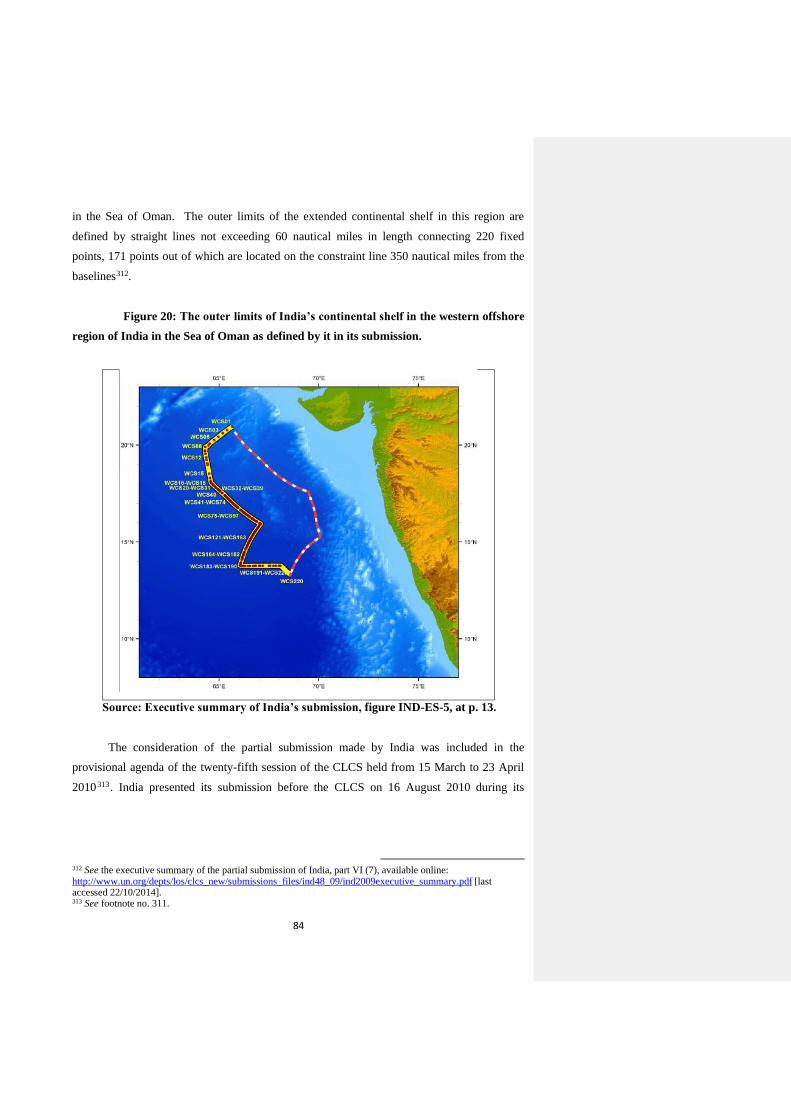
84
in the Sea of Oman. The outer limits of the extended continental shelf in this region are
defined by straight lines not exceeding 60 nautical miles in length connecting 220 fixed
points, 171 points out of which are located on the constraint line 350 nautical miles from the
baselines312.
Figure 20: The outer limits of India’s continental shelf in the western offshore
region of India in the Sea of Oman as defined by it in its submission.
Source: Executive summary of India’s submission, figure IND-ES-5, at p. 13.
The consideration of the partial submission made by India was included in the
provisional agenda of the twenty-fifth session of the CLCS held from 15 March to 23 April
2010313. India presented its submission before the CLCS on 16 August 2010 during its
312 See the executive summary of the partial submission of India, part VI (7), available online: http://www.un.org/depts/los/clcs_new/submissions_files/ind48_09/ind2009executive_summary.pdf [last accessed 22/10/2014]. 313 See footnote no. 311.

85
twenty-sixth session held from 2 August to 3 September 2010314. Following the presentation,
the CLCS decided that the part of the submission concerning the offshore region in the sea of
Oman would be addressed by way of a sub-commission in accordance with rule 51,
paragraph 4 ter, of the ROP, at a future session; whereas the consideration of the other parts
of the submission concerning the regions in the Gulf of Bengal and Andaman Islands were
deferred due to two notes verbales submitted by Myanmar, and Bangladesh invoking
paragraph 5 (a) of annex I to the ROP315. Regarding the former part, Oman also sent a
diplomatic note to the Secretary General of the UN stating that ‘Oman acknowledges that the
area of continental shelf contained in India’s submission overlaps with the area to be included
in Oman’s submission [...] the overlap area is, therefore, subject to the delimitation of a
continental shelf boundary between Oman and India’ 316 . At the time of writing, no
developments have occurred in relation to the partial submission of India particularly to the
part concerning the offshore region in the Sea of Oman which must be still queued waiting
for the establishment of a sub-commission to review it. As illustrated in chapter three, the
CLCS has nine active sub-commissions317 and whenever recommendations are finally issued
for a particular submission, the next submission in line from the queue shall be taken for a
consideration by a sub-commission unless it ought to be further deferred due to the non-
settlement of a raised dispute.
Similarly with Pakistan, necessity requires Oman to follow closely the review process
of India’s submission, while it prepares its own submission, with the aim of knowing the
precise location that will be identified for the outer limits of India’s continental shelf since
there is a potential overlap already existing between the outer limits claimed by both states. In
view of that, it will be necessary to understand how India applied the provisions of Article 76
technically especially the 1% sediment thickness formula and 350 nautical miles constraint
on which India relied significantly to delineate the outer limits of its continental shelf318.
Again, the confidentiality issue might stand as a barrier to have an access to important
information of this kind even though it is of important relevance and concern to Oman.
Moreover, the recommendations disclosed by the CLCS take the form of a ‘summary’ and do
not provide the detailed examinations that take place in relation to the consideration of
314 See statement by the Chairperson of the CLCS on the progress of work in the Commission, CLCS/68, twenty-sixth session, 17 September 2010, Item 8 (e), available online at: http://daccess-dds-ny.un.org/doc/UNDOC/GEN/N10/540/08/PDF/N1054008.pdf?OpenElement [last accessed 23/10/2014]. 315 Ibid. 316 See diplomatic note from the Government of the Sultanate of Oman to the Secretary General of the UN on India’s continental shelf submission, dated 19 May 2010, available online at: http://www.un.org/depts/los/clcs_new/submissions_files/ind48_09/clcs_48_2009_los_omn.pdf [last accessed 23/10/2014]. 317 See footnote No. 97. 318 See appendix 3 to the executive summary of India’s submission, at pp. 39-48.
86
submissions. The overlap area, as acknowledged by Oman in its diplomatic note referred to
above, seems to lie around the same location of the potential overlap with the outer limits of
Pakistan’s continental shelf as defined in its submission regarding which Oman submitted a
national right reservation. This issue will be further elaborated in chapter five below. India’s
submission also provides an example of the lengthy period that a submission remains in the
queue until the CLCS establishes a sub-commission to review it; a point that Oman should
take into account while it moves towards lodging its final submission.
4.2.2. Submissions by states having a continental shelf similar to that of Oman.
In an ideal situation, the shelf, slope and rise of the continental margin can be easily
identified; however, this is not the case with most continental margins around the world
which have complex shapes and structures according to their tectonic formation and
development. This fact is clearly reflected in the Guidelines. As a result, the nature and
complexity of the continental margin varies from one coastal state to another based on which
the scientific requirements of Article 76 are correspondingly invoked and applied to draw the
matching precise outer limits of the continental shelf beyond 200 nautical miles.
Notwithstanding that, in some situations, the continental margin of a coastal state might share
characteristics similar to that of other coastal states. The similarity can be in one or more than
one aspect such as existence of a submarine ridge or a narrow shelf. So far, most of the
submissions that received recommendations from the CLCS are made by islands or about
islands. These submissions and their recommendations obviously provide, to various degrees,
useful information to other island states that intend to make a submission to extend their
continental shelves beyond 200 nautical miles particularly those ones situated nearby, albeit
that most of the information is not disclosed by the CLCS due, as outlined above, to
confidentiality upon a requirement from the concerned coastal state.
In defining the indicative outer limits of its continental shelf in the preliminary
information submitted to the Secretary General of the UN, Oman describes the continuous
prolongation from its territory to those limits, by way of a sequence, as a relatively narrow
shelf, then a large deep plateau of a basin (Owen Basin) up to the boundary with the deep
ocean floor of the Sea of Oman marked by submarine ridges namely the Owen and Sharbithat
ridges319. See figure 12 above. The foot of the slope has been identified across the eastern
319 See footnote no. 276.
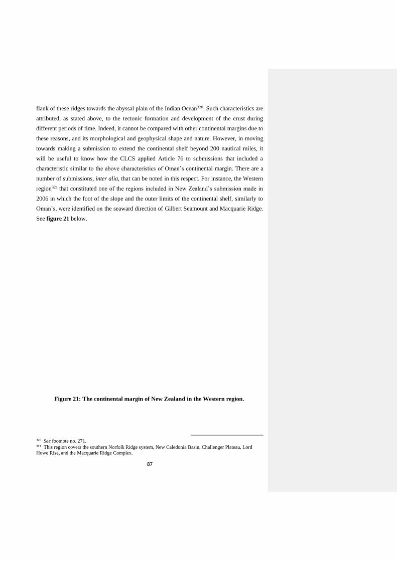
87
flank of these ridges towards the abyssal plain of the Indian Ocean320. Such characteristics are
attributed, as stated above, to the tectonic formation and development of the crust during
different periods of time. Indeed, it cannot be compared with other continental margins due to
these reasons, and its morphological and geophysical shape and nature. However, in moving
towards making a submission to extend the continental shelf beyond 200 nautical miles, it
will be useful to know how the CLCS applied Article 76 to submissions that included a
characteristic similar to the above characteristics of Oman’s continental margin. There are a
number of submissions, inter alia, that can be noted in this respect. For instance, the Western
region321 that constituted one of the regions included in New Zealand’s submission made in
2006 in which the foot of the slope and the outer limits of the continental shelf, similarly to
Oman’s, were identified on the seaward direction of Gilbert Seamount and Macquarie Ridge.
See figure 21 below.
Figure 21: The continental margin of New Zealand in the Western region.
320 See footnote no. 271. 321 This region covers the southern Norfolk Ridge system, New Caledonia Basin, Challenger Plateau, Lord
Howe Rise, and the Macquarie Ridge Complex.
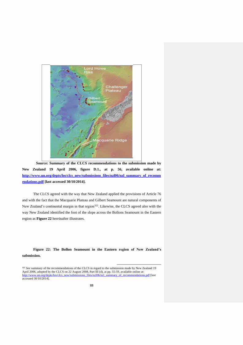
88
Source: Summary of the CLCS recommendations to the submission made by
New Zealand 19 April 2006, figure D.1., at p. 56, available online at:
http://www.un.org/depts/los/clcs_new/submissions_files/nzl06/nzl_summary_of_recomm
endations.pdf [last accessed 30/10/2014].
The CLCS agreed with the way that New Zealand applied the provisions of Article 76
and with the fact that the Macquarie Plateau and Gilbert Seamount are natural components of
New Zealand’s continental margin in that region322. Likewise, the CLCS agreed also with the
way New Zealand identified the foot of the slope across the Bollons Seamount in the Eastern
region as Figure 22 hereinafter illustrates.
Figure 22: The Bollon Seamount in the Eastern region of New Zealand’s
submission.
322 See summary of the recommendations of the CLCS in regard to the submission made by New Zealand 19
April 2006, adopted by the CLCS on 22 August 2008, Part III (d), at pp. 55-59, available online at: http://www.un.org/depts/los/clcs_new/submissions_files/nzl06/nzl_summary_of_recommendations.pdf [last accessed 30/10/2014].
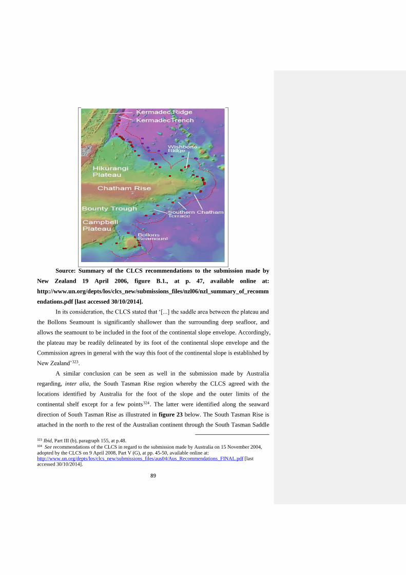
89
Source: Summary of the CLCS recommendations to the submission made by
New Zealand 19 April 2006, figure B.1., at p. 47, available online at:
http://www.un.org/depts/los/clcs_new/submissions_files/nzl06/nzl_summary_of_recomm
endations.pdf [last accessed 30/10/2014].
In its consideration, the CLCS stated that ‘[...] the saddle area between the plateau and
the Bollons Seamount is significantly shallower than the surrounding deep seafloor, and
allows the seamount to be included in the foot of the continental slope envelope. Accordingly,
the plateau may be readily delineated by its foot of the continental slope envelope and the
Commission agrees in general with the way this foot of the continental slope is established by
New Zealand’323.
A similar conclusion can be seen as well in the submission made by Australia
regarding, inter alia, the South Tasman Rise region whereby the CLCS agreed with the
locations identified by Australia for the foot of the slope and the outer limits of the
continental shelf except for a few points324. The latter were identified along the seaward
direction of South Tasman Rise as illustrated in figure 23 below. The South Tasman Rise is
attached in the north to the rest of the Australian continent through the South Tasman Saddle
323 Ibid, Part III (b), paragraph 155, at p.48. 324 See recommendations of the CLCS in regard to the submission made by Australia on 15 November 2004,
adopted by the CLCS on 9 April 2008, Part V (G), at pp. 45-50, available online at: http://www.un.org/depts/los/clcs_new/submissions_files/aus04/Aus_Recommendations_FINAL.pdf [last accessed 30/10/2014].
90
having seafloor depths in the order of 3000 metres 325 . In view of invoking the depth
constraint criterion, the CLCS agreed with the classification of South Tasman Rise as a
submarine elevation that is a natural component of the continental margin in accordance with
Article 76, paragraph 6, and paragraph 7.3.1.b of the Guidelines326.
Figure 23: The continental margin of Australia in the South Tasman Rise region.
Source: Recommendations of the CLCS in regard to the submission made by
Australia on 15 November 2004, figure G.2, at p. 47, available online at:
http://www.un.org/depts/los/clcs_new/submissions_files/aus04/Aus_Recommendations_
FINAL.pdf [last accessed 30/10/2014].
On the other hand, the CLCS disagreed in its recommendations on the Brazilian
submission made in 2004 with the classification of the Northern Brazilian and Fernando de
Noronha ridges as natural components of the Brazilian continental margin in that region327.
325 Ibid, Article 1 (152), at p. 45. 326 Ibid, paragraph 6.1.1., at p. 51. 327 See summary of the recommendations of the CLCS in regard to the submission made by Brazil on 17 May
2004 of information on the proposed outer limits of its continental shelf beyond 200 nautical miles, adopted by the CLCS, with amendments, on 24 August 2011, Part (IV), at pp. 15-17, available online at: http://www.un.org/depts/los/clcs_new/submissions_files/bra04/Summary_Recommendations_Brazil.pdf [last accessed 30/10/2010].
91
Instead, it recommended to Brazil to carry out further investigations, including additional
geophysical data and information, to establish the natural prolongation between the Brazilian
landmass and the two ridges for the determination of the outer limits of the continental shelf
beyond 200 nautical miles328. Also, as regards the Vitoria-Trindade ridge region, the CLCS
recommended to Brazil to make a revised or new submission to determine the status of
Vitoria-Trindade ridge and the exact position of the outer limit of the continental shelf in this
region329. To the south of Brazil’s coast, the submissions made by Uruguay and Argentina are
also of interest. Although the recommendations have not been finally provided yet, it would
be useful to understand how the CLCS treats the continental margins of Uruguay and
Argentina in the northern part of its submission particularly the locations where the foot of
the slope should be established. The same thing can also be said regarding the submission
made by Iceland specifically the western and southern parts of Reykjanes Ridge. As
mentioned above, if Oman, during the collection of data, finds out that its continental margin
up to the Owen and Sharbithat Ridges, as preliminary classified as such, is elevated above the
oceanic crust of the Indian Ocean, then the Owen and Sharbithat features may be classified as
submarine elevations. Due to the deep depth of the Indian Fan as recognized in the
preliminary information, this is likely to be the case. So far, it seems the above illustrated
continental margins of New Zealand constitute good examples for Oman in terms of the
location of the foot of the slope and consideration of Gilbert and Bollons Seamounts as
natural components of the continental margins of New Zealand by the CLCS.
Another interesting submission is the one made by Japan in 2008 which included
various regions of different types of continental margins330. In all of the regions, there is a
ridge, a high, a seamount or a rise. Some of those features were not considered by the CLCS
as constituting natural components of the prolongation of Japan’s landmass. As regards the
Southern Kyushu-Palau Ridge region, the CLCS decided that it was not in a position to take
action to make recommendations until such time as the matters highlighted in the notes
verbales from China and South Korea have been resolved331. On the other hand, it agreed
with Japan on the way the outer limits of the continental shelves are drawn in the Minami-Io
328 Ibid, Article (c), at p. 17. 329 Ibid, Part (V), at pp. 18-19. 330 See the submission made by Japan, available online at DOALOS website at: http://www.un.org/depts/los/clcs_new/submissions_files/submission_jpn.htm [last accessed 04/11/2014]. 331 See summary of the recommendations of the CLCS in regard to the submission made by Japan on 12
November 2008, adopted by the CLCS, with amendments, on 19 April 2012, Part IV (A), at pp.4-5, available online at: http://www.un.org/depts/los/clcs_new/submissions_files/jpn08/com_sumrec_jpn_fin.pdf [last accessed 04/11/2014].
92
To Island region, the Ogasawara Plateau region, and the Southern Oki-Daito Ridge region,
and the Shikoku Basin region with some amendments to certain points pertaining to the
application of Article 76332. Regarding the remaining two regions namely the Minami-Tori
Shima Island region and the Mogi Seamount region, the CLCS concluded that ‘the foot of the
slope points contained in the submission do not fulfil the requirements of article 76 and
chapter 5 of the Guidelines’ and ‘recommended that these foot of the slope points do not form
the basis for the establishment of the outer edge of the continental margin in these two
regions’333. Obviously, with the variety of features included in Japan’s submission, useful
information is provided by the CLCS on where to locate the foot of the slope and draw the
final outer limits of the continental shelf beyond 200 nautical miles in the event that a similar
situation such as a submarine ridge or a seamount is found in another submission like that of
Oman. Moreover, thorough illustration of the basis upon which the CLCS concluded if there
is or is not a natural prolongation between such features and the landmass of Japan is
provided. Actually, the same examinatory process has been by applied by the CLCS with all
the submissions that has reviewed so far; therefore, it will undoubtedly be useful for Oman
overall, while it is collecting and analysing data for its continental margin, to compare and
contrast the relevant parts of the latter with those of other submissions that have been or will
be reviewed by the CLCS with the aim to make a successful submission by taking into
account the points previously raised by the CLCS.
Generally speaking, it can be realized as a common characteristic that the CLCS
always gives priority to the morphological evidence in reviewing the submissions of coastal
states and treats on the other hand the geological and geophysical evidences as supplementary.
The recommendations to date clearly illustrate this conclusion. Moreover, in reaching its
recommendations, the CLCS analyses any scientific literature that is available about the
continental margin under examination as evident, inter alia, in the submission made by Brazil.
More importantly, it seems so far that that the CLCS has considerably agreed, or agreed
during the consideration, with the points and lines identified and drawn by the coastal states
for their continental shelves unless there was a clear departure from the correct application of
Article 76 and the Guidelines. Having said that, it can be arguably concluded that the CLCS,
with the recommendations provided so far, has set a precedent for other coastal states to
follow in their submissions; consequently, agreement will gradually prevail over
disagreement leading to the speed up of reviewing the other submissions. Notwithstanding
332 Ibid, Part IV (B), (E), (F), and (G), at pp. 5-10 and 13-32 respectively. 333 Ibid, Part IV (C) and (D), at pp. 10-13. See also the relevant figures to all regions attached at pp. 32-60.

93
that, a lot of coastal states made their submissions before 2009, the end of the 10-year period,
so they did not have the opportunity to benefit considerably from the submissions made by
other coastal states and their relevant recommendations. Moreover, the process is not
transparent enough to provide coastal states with information they might need as well as the
membership of the CLCS changes regularly which might affect any precedents that might
have been set by previous memberships. As a result and as it has been evident from the CLCS
recommendations so far, the key and determining factor at the end of the day is the strict
compliance by the coastal state with the provisions of Article 76 and the Guidelines in
drawing the outer limits of its continental shelf upon which the recommendations of the
CLCS are based. In view of that, besides learning from the recommendations of the CLCS
provided on submissions that included a similar feature to that of Oman’s continental margin
as outlined above, Article 76 and the Guidelines shall be primarily the main references for
Oman in drawing the outer limits of its continental shelf during the preparation of its
submission.
4.3. Concluding remarks
The preliminary information submitted by Oman to the Secretary General of the UN
in 2009 contains important scientific data on its entitlement to a continental shelf beyond 200
nautical miles and the outer limits to which it potentially extends. However, these data need
to be complemented by further collection and analysis of data towards making a full
submission to the CLCS, within 10 years from the submission date of the preliminary
information, to delineate precisely the outer limits of the continental shelf in accordance with
the provisions of Article 76 and the Guidelines. In the logical order as adopted by the latter,
the process should start by updating and drawing the baselines, then identifying and drawing
the formula and constraints lines via the identification of the foot of the slope and 2,500
metres isobath, and finally delineating the lines that make the outer limits of the continental
shelf. To do so, different scientific methodologies, and tools of documentation, mapping and
transfer of information into geodetic datum have to be applied and invoked as provided in the
Guidelines. In addition, it is of significant importance to review and follow the submissions
made by coastal states whose coasts are opposite or adjacent to that of Oman to know how
they might affect the submission that will be made by Oman in terms of any possible overlap
as well as taking into account any relevant technical points included in them while moving
towards making a submission. Also, the same thing can be extended to other submissions

94
made by coastal states whose continental margins share a feature similar to that of Oman’s
continental margin to know how these features have affected their submissions and were
treated by the CLCS in its recommendations. Doing so will obviously allow Oman to have a
clear idea about the challenges that it might encounter during the preparation and review of
its submission, and consequently identify the best ways to overcome them and move forward.
5. Challenges
5.0. Introductory Remarks
Making a submission to the CLCS to extend the continental shelf beyond the distance
of 200 nautical miles from the baselines is a complex process which is not free of challenges.
The latter are numerous and vary in nature, to some extent, from one coastal state to another
depending on a number of reasons including the submission itself. Oman submitted prior to
95
the end of the 10 year period limit in 2009 only preliminary information rather than a full
submission within which it set itself the challenge of making the full submission within a
further 10 years. And as Oman ‘is actively involved in preparing such a submission’, an early
identification of the challenges that might be encountered throughout the submission’s stages
whether they are of a technical or legal nature would enable Oman to apply the right solutions
to them at the right time which would consequently ensure the success of its submission.
Having said that, this chapter aims to examine the types of challenges that Oman’s
submission might potentially encounter and the way forward.
5.1. Technical and Legal
5.1.1. Pre-Submission
It is well recognized that preparing the submission is the most crucial stage in which
most of the work is done. And the biggest part of the latter lies in the collection of data that
are necessary to write the submission and fulfil the requirements of Article 76 of the LOSC.
It is also the most challenging stage and due to the same reasons. The challenges that can be
faced by a coastal state and in our case Oman can be put under three categories. First and
foremost is the national expertise and human resources that are required to prepare and make
the submission. If they are not available wholly or partially, the initial task then for the
coastal state is to build them. In doing so, all stakeholders who have an interest in the project
need to be included in order to have an inter-departmental spectrum reflecting the inter-
disciplinary approach of Article 76 334 . In any case, at least a marine geologist, marine
geochemist, hydrographer, marine geophysicist and geographic information system officer
from the technical side, and a lawyer and diplomat from the legal side should be on board.
Oman established a Committee through a decision passed by the Council of Ministers in
March 2008 to supervise and manage the preparation and deposit of Oman’s submission to
extend its continental shelf beyond the distance of 200 nautical from the baselines in which
the ministries or governmental bodies that should be part of the Committee were identified,
and the Ministry of Foreign Affairs was named as the Chair335. The model followed for the
structure of the Committee reflects almost or to a great extent the one suggested by
DOALOS’s Manual as can be seen in Figure 24 below which is commonly adopted by
334 See DOALOS’s Manual, Module VIII, at p. VIII-2. 335 See Muscat Daily, ‘Oman signs Consultancy Contract for Extension of Continental Shelf’, published on 13
November 2013, available online at: http://www.muscatdaily.com/Archive/Oman/Oman-signs-consultancy-contract-for-extension-of-continental-shelf-2pc7 [last accessed 23/11/2014].
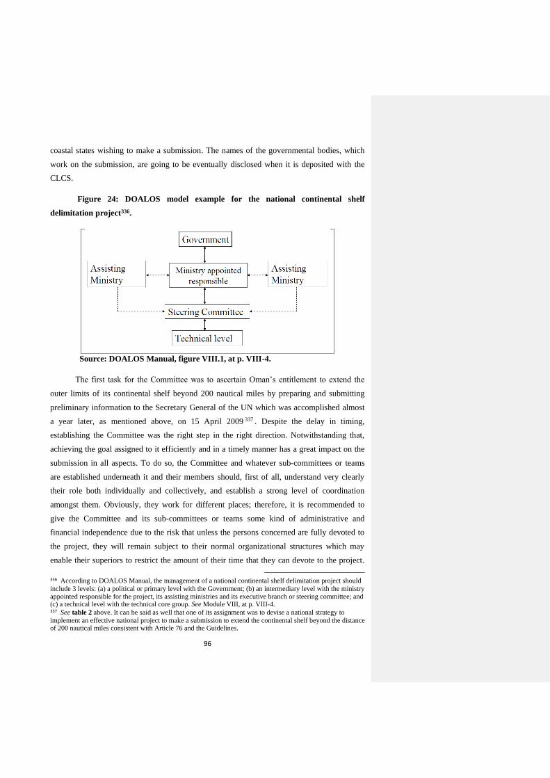
96
coastal states wishing to make a submission. The names of the governmental bodies, which
work on the submission, are going to be eventually disclosed when it is deposited with the
CLCS.
Figure 24: DOALOS model example for the national continental shelf
delimitation project336.
Source: DOALOS Manual, figure VIII.1, at p. VIII-4.
The first task for the Committee was to ascertain Oman’s entitlement to extend the
outer limits of its continental shelf beyond 200 nautical miles by preparing and submitting
preliminary information to the Secretary General of the UN which was accomplished almost
a year later, as mentioned above, on 15 April 2009 337 . Despite the delay in timing,
establishing the Committee was the right step in the right direction. Notwithstanding that,
achieving the goal assigned to it efficiently and in a timely manner has a great impact on the
submission in all aspects. To do so, the Committee and whatever sub-committees or teams
are established underneath it and their members should, first of all, understand very clearly
their role both individually and collectively, and establish a strong level of coordination
amongst them. Obviously, they work for different places; therefore, it is recommended to
give the Committee and its sub-committees or teams some kind of administrative and
financial independence due to the risk that unless the persons concerned are fully devoted to
the project, they will remain subject to their normal organizational structures which may
enable their superiors to restrict the amount of their time that they can devote to the project.
336 According to DOALOS Manual, the management of a national continental shelf delimitation project should
include 3 levels: (a) a political or primary level with the Government; (b) an intermediary level with the ministry appointed responsible for the project, its assisting ministries and its executive branch or steering committee; and (c) a technical level with the technical core group. See Module VIII, at p. VIII-4. 337 See table 2 above. It can be said as well that one of its assignment was to devise a national strategy to
implement an effective national project to make a submission to extend the continental shelf beyond the distance of 200 nautical miles consistent with Article 76 and the Guidelines.
97
Besides being non-permanent, conferring such status in Oman is limited to public entities.
Alternatively, this can be done, to a great extent, through secondment and deputation as long
as the employers of those persons (entities where they work) decide so. By virtue of its
establishing decision referred to above, the Committee is neither independent financially nor
administratively and conversely, it has to report to the body that established it; the Council of
Ministers. On the other hand, this can be considered as something positive since the
submission is of a political nature whereby national interests are at stake and a high level of
involvement within the state’s apparatus is necessary when making and presenting the
submission before the CLCS and in case there is any potential overlap with opposite and
adjacent states’ maritime zones. Such high level of involvement can be seen, inter alia, in the
submission made by Australia338. Nonetheless, it is a bureaucratic way which would slow
down the submission’s preparations for which time is very critical.
Moreover, possessing the expertise necessary, as mentioned above, to undertake the
requirements of Article 76 and the Guidelines is very crucial; otherwise, training will be
needed. In addition, ‘the lack of technical expertise and committed personnel contributes
significantly to a slow down progress’339. Oman can apply, as stated in Chapter three, for
scientific and technical advice from the CLCS340. However, Oman opted to hire a consultant
to assist it in the preparation of its submission whereby a three year contract was signed in
November 2011 with GNS Science from New Zealand for this purpose341. Consequently,
‘GNS Science will be involved in all stages of the project including planning marine surveys,
processing and analysing marine data, preparing the submission document, and supporting
Oman in its discussions with the UN’ 342 . Besides being costly, having a consultant is
counterproductive in relation to building the national expertise and capabilities, and
confidentiality of the data. This can be overcome, however, through the transfer of expertise
from the consultant to the national capabilities by training and working closely together
338 See Mark Alcock, ‘Australia’s continental shelf submission-approaches and implications’ published in The
establishment of the Outer Limits of the Continental Shelf beyond 200 nautical miles-Its International Circumstances, and its Scientific and Technical Aspects, (Ocean Policy Research Foundation, Tokyo, 2007) at pp. 81-82. 339 See Mathew Yamada Chigiyal, ‘National Report-Federated States of Micronesia’ published in The
establishment of the Outer Limits of the Continental Shelf beyond 200 nautical miles-Its International Circumstances, and its Scientific and Technical Aspects, (Ocean Policy Research Foundation, Tokyo, 2007) at p. 53. 340 See footnote no. 116. 341 See ‘GNS Science takes marine geology skills to Oman – 14/11/2013’, available online at:
http://www.gns.cri.nz/Home/News-and-Events/Media-Releases/skills-to-Oman [last accessed 24/11/2014]. See also Oman Observer, ‘Contract signed for extending Sultanate’s continental shelf’, available online at: http://main.omanobserver.om/contract-signed-for-extending-sultanates-continental-shelf/ [last accessed 24/11/2014]. 342 Ibid.
98
throughout the preparation of the submission. In terms of management, apart from the fact
that the Committee is chaired by the Ministry of Foreign Affairs, having an independent
project manager attached to the Committee will be of significant benefit for Oman to ensure
that the submission-related work is done on time according to plan and budget.
The second category is the availability or possession of the technical means that are
necessary to carry out the collection and analysis of data. Oman, as stated in the preliminary
information, had already conducted a thorough desktop study which was reviewed in light of
information acquired since 2002 as well as having compiled bathymetric data from single and
multi-beam surveys by Omani Authorities and from international surveys 343 .It had also
gathered data from oil exploration databases and results from the JOIDES ocean drilling
programme – leg 117344. This obviously provided answers to a lot of technical questions such
as the ‘test of appurtenance’ but also enables Oman, unless other sources of databases are still
to be collected whether available internally or internationally345, to identify and plan the cost,
type and location of the surveys that are necessary to fill in the gaps towards completing the
full submission in accordance with Article 76 and the Guidelines346. Consequently, time and
money will be saved. Notwithstanding that, most of the data provided in the preliminary
information were, as highlighted in chapter four above, indicative rather than precise.
Moreover, it is stated explicitly that update and/or further collection and analysis of data are
needed to complete the submission347. As a result, the extent of the necessary surveys might
exceed the expected or planned. For this purpose and similarly to what was decided regarding
the consultant, it has been announced that Oman will hire a specialised vessel to conduct the
surveys and collection of data for the extension of the continental shelf project348. Again, in
addition to the time that will be spent on tendering349, hiring such a ship will give rise to
further costs to be borne by the government as well as that the crew on board will not be
related to the project who have to be accompanied by the relevant people in the Committee
and of the consultant. From a general perspective, having a good planning, based on the
desktop study and existing data, for the survey’s tracks and locations will undoubtedly be of
343 See the Executive Summary, part III, at p. 3. 344 Ibid, part II, (c) & (d), at p. 2. 345 Annex I to the Guidelines, for instance, provides a list of available sources of data at the international level. Another useful list of sources of data is provided in DOALAS Manual in Module VIII, at pp. VIII-19 – VIII-21. 346 Also, detailed surveys will provide a clear picture on the available resources on the continental shelf. 347 See, for instance, part III (a), (c) and (e) of the Executive Summary at pp. 3 and 4 respectively. 348 See also Oman Observer, ‘Contract signed for extending Sultanate’s continental shelf’, published on 13
November 2013, available online at: http://main.omanobserver.om/contract-signed-for-extending-sultanates-continental-shelf/ [last accessed 24/11/2014]. 349 In this regard, DOALOS Manual provides valuable information regarding the tendering process which is
available in Module VIII at pp. VIII-29 – VIII-37.
99
pivotal significance in this respect. And for the purpose of efficiency and reduction of cost
and time, it will be useful for Oman to establish regular contacts with the ships of opportunity
that might be visiting the region or planning to work close to the intended area of Oman’s
submission. It is well recognized that this stage is largely time-consuming which usually lasts
for years depending on the size of the geographic region of survey and the need to collect
data of high quality. In addition to that, the data collected need to be analysed using the right
methodologies, and then carefully archived, compiled, transformed and documented (data
management) in the forms that meet the requirements of the Guidelines such as, inter alia,
maps and custom designed computerized database (GIS). For the sake of time and efficiency,
the Committee should have people assigned for every part of the submission in a well-
planned, collaborative and organized manner. Furthermore, it ‘must be equipped with well-
furnished offices, possibly high-tech computers and relevant state-of-the-art software and
other logistic facilities’350 . Arrangements should also be put in place to ensure the safe
storage, maintenance and effective retrieval of data for future use. Once all data are available,
the submission should be prepared in accordance with the outline proposed by the CLCS351.
The third category is the financial resources upon which the above two categories
actually depend and without which any progress is difficult. As mentioned above, the
Committee established by the Omani government to supervise the extension of the
continental shelf project is not financially independent; consequently, its budget and expenses
have to be determined by the Council of Ministers (as the parent body) and approved in
accordance with the applicable financial laws in Oman. Failing to approve any cost on time
will consequently have a negative impact on the programme of work and timeline planned for
preparing and completing the submission. Oman is an oil-producing state whereby oil
revenues make up 83% of its income and are heavily depended on352. And as the current oil
prices are taking a downwards trend, a difficulty might be faced in meeting the expenses
arising from the extension of the continental shelf project unless a certain budget has already
been estimated and allocated. Otherwise, other sources of funding have to be secured. Apart
from borrowing from the internal or international financial market, this can be done by
reaching out to the oil firms working in Oman for whom the surveys and data collected about
the continental shelf will be of significant interest in return for priority for commercial
agreements in the future. If possible, Oman should take into account the experience gained
350 See DOALOS Manual, Module VIII, at p. VIII-13. 351 See footnotes no. 140-142, table 4 above, and appendix 5. 352 See Saleh Al Shaibany, ‘Lower Oil Prices in Oman to hit Fiscal Budget: Experts’ published on 14 of October
2014, Times of Oman, available online at: http://www.timesofoman.com/News/41278/Article-Lower-oil-prices-in-Oman-to-hit-fiscal-budget-Experts [last accessed 27/11/2014].
100
from previous submissions to the CLCS by other coastal states. Given it is a developing
country, Oman may obtain funding from the trust fund established by the General Assembly
of the UN for the purpose of facilitating the preparation of submissions to the CLCS for
developing states 353 . Notwithstanding that, this trust fund gives a priority to the least
developed countries and small-island developing states, as well as that it cannot be allocated
for data acquisition and functions but only for project planning and desktop study which has
already been done by Oman 354 . Despite that, it can be relied on for training, advisory
consultancy, working out plans for the acquisition of necessary additional data and mapping
projects, and preparations of final submission documents355. In general, preparing and making
a submission with the CLCS demands a lot of financial resources which developing states, in
particular, find it hard to bear unless there is a strong belief at the high levels of the state that
the project is an investment for the future and next generations. And as abovementioned,
having a project manager will be of significance in making the project cost-effective.
5.1.2. During Submission
Some of the challenges, because of their nature, accompany the submission even after
being deposited with the CLCS. For instance, further costs, but to a lesser degree, will be
incurred for travelling and representing the submission in New York. It is worth noting in this
respect that ‘preparing the staff who are to make the presentation to the CLCS is an important
task which must not be underestimated. The delegation of the coastal state should include a
team of technical experts who are very conversant with the submission. Such a team should
be put together early on in the national continental shelf delimitation project so as to allow its
members to fully familiarize themselves with all aspects of the submission as it evolves’356.
Although the focal point between the CLCS and the coastal state (in our case Oman) during
the consideration of the submission will obviously be the Permanent Mission of the coastal
state (Oman) to the UN in New York, having some of the referred to members in New York
will be necessary to inter act with the CLCS during the consideration period. The interaction
with the CLCS will take different forms of various complexities such as written questions,
353 See footnote no. 139. 354 Ibid. 355 Ibid. Annex II to the Resolution provides details on the process of application, consideration and granting of
financial assistance. 356 See DOALOS Manual, Module VIII, at p. VIII-38.
101
clarifications enquiries, additional information or making presentations357. A good example in
this respect is the recommendations of the CLCS in regard to the partial submission made by
Ireland on 25 May 2005 on the proposed outer limits of its continental shelf beyond 200
nautical miles in the area abutting the Porcupine Abyssal Plain in which the full
communications that took place between the CLCS and Ireland are disclosed358. Putting a
strategy, therefore, on place for this stage will be of vital importance for Oman to ensure that
there is a proper communication between the CLCS and the team in New York, and between
the latter and the Committee or some of its assigned members in Oman.
More importantly, the workload and working pressure of the CLCS, as illustrated in
chapter three, has increased rapidly as a result of the rising number of submissions received
from coastal states359. Consequently, the time for every submission to spend in the queue
until a sub-commission is established by the CLCS to review it has gone up as well. For
instance, the partial submission made by India, as mentioned in Chapter four above, is still
queued since it was lodged with the CLCS on 11 May 2009. Furthermore, the period of
waiting in the queue is expected to length if more submissions are made by coastal states to
the CLCS which needs to be taken seriously into account by Oman for two reasons. The first
lies in the strong likelihood that the people who worked on preparing the submission might
not be available any more. The same applies to the consultant that Oman hired to assist it in
preparing it especially the scientific and technical parts of it around which most of the
CLCS’s questions and clarification enquiries are mainly centred. In a book published by
UNEP/GRID-Arendal, it is stated that ‘when States made submissions they did not
necessarily anticipate that it would take many years to receive recommendations. These
countries face institutional memory loss if the process does not speed up. It may be necessary
in the future to change the workings of the Commission in order to issue recommendations
more quickly so as not to disadvantage States. This can only be decided by States Parties’360.
While Oman is still in the early stages of preparing its submission, it is highly recommended
that the Committee includes this matter with importance in the national strategy it adopted for
making Oman’s submission. Assuming that Oman might lodge its submission in 2018, the
period of waiting in the queue would not be less than 6 to 7 years in light of the number of
submissions that are already in the queue and the current working trend of the CLCS. In
357 See Article 6 and 10 of Annex III (Modus Operandi) to the ROP. 358 Adopted by the CLCS on 5 April 2007, available online at:
http://www.un.org/depts/los/clcs_new/submissions_files/irl05/irl_rec.pdf [last accessed 28/11/2014]. 359 See footnotes no. 96 to 98. 360 See Tina Schoolmeester et al, Continental Shelf the Last Maritime Zone (UNEP/GRID-Arendal, Norway,
2009) at p. 13, available online at: http://www.unep.org/dewa/Portals/67/pdf/Continental_Shelf.pdf [last accessed 29/11/2014].
102
terms of solutions, this can be overcome, to a large extent, by having an agreed process for
rapidly replacing those who leave and training those recruited to succeed them, as well as for
keeping some sort of skeleton team together during the queuing period. For this purpose, the
members of this team should be involved closely with the main team in the preparation of the
submission all the way until its deposit with the CLCS. The involvement shall continue
afterwards, during the waiting period in the queue, by holding meetings regularly at different
intervals. The other benefit of this is that the national expertise which Oman will build and
gain from making the submission will increase in numbers.
The other reason lies in keeping in line with any development that might occur,
during the period of waiting in the queue, with any of the scientific methodologies and
custom designed computerized software that have been adopted by the CLCS and followed
by the coastal state (in our case Oman) in preparing and making its submission. For instance,
the GIS software that Oman uses in its submission might be updated or/and the CLCS might
adopt new ones different from that used by Oman. The latter might itself find, during this
period, new scientific methodologies and software to better support or illustrate the evidence
contained in its submission. For instance, ‘Australia used ArcView to present its submission,
and ArcGIS to prepare most of its maps. However, ArcView, however, is an application that
is no longer being developed and fully supported by the vendor’361. In a meeting with Alan
Evans362 from the National Oceanography Centre in the UK on 21 November 2014, he
pointed out that ‘it is not certain whether in 25 to 30 years time the software that will be used
today will still be in circulation or of any use then. It is important therefore to focus on
retaining generic data formats that can be used in a variety of software (some of which may
not have been developed yet) and ensuring that these, along with a copy of the submission,
will be kept securely’. In light of the aforementioned, it is of vital significance to follow
closely the work of the CLCS while the submission is still queued, and revisit the submission
regularly to check if any updates are needed. According to Evans, ‘since the LOSC allows
the coastal state to modify its submission should it wishes to do so, an eye needs to be kept on
issues relating to interpretation, jurisprudence and other evolving trends that can be benefited
from so they can be addressed closer to the time’.
361 See Mark Alcock, footnote no. 338 at p. 101. 362 Evans is a senior scientist in the National Oceanography Centre in Southampton, the UK, who worked on all
the UK continental shelf submissions to the CLCS, and provided advice on the interpretation and implementation of Article 76 of the LOSC to more than 20 governments, which resulted in the completion of a number of submissions for continental shelf.

103
5.2. Possible Areas of Overlap
5.2.1. Location of Areas of Overlap
Oman shares, as illustrated in chapter four, maritime boundaries with four opposite
and adjacent coastal states. Of the Gulf States, it is the only one that has a continental shelf
stretching into the Indian Ocean. At the time of writing, three maritime delimitation
agreements have been concluded between Oman and some of its opposite and adjacent states.
The first one concerns delimitation of the continental shelf between the Sultanate of Oman
and Iran in the Strait of Hormuz which was signed on 25 July 1974 and entered into force on
28 May 1975363. The second one is the Muscat Agreement on the delimitation of the maritime
boundary between the Sultanate of Oman and the Islamic Republic of Pakistan which was
signed on 12 June 2000 and entered into force on 21 November 2000364. The third and final
agreement is on the delimitation of the maritime boundary between the Sultanate of Oman
and the Republic of Yemen in the Arabian Sea which was signed on 14 December 2003 and
entered into force on 3 July 2004365. The delimitation lines of these agreements are illustrated
in the following figure.
Figure 25: Oman Maritime Boundaries Delimitation Agreements
363 See Agreement concerning Delimitation of the Continental Shelf between Iran and Oman 25 July 1974,
available online at: http://www.un.org/Depts/los/LEGISLATIONANDTREATIES/PDFFILES/TREATIES/IRN-OMN1974CS.PDF [last accessed 02/12/2014]. 364 See Muscat Agreement on the Delimitation of the Maritime Boundary between the Sultanate of Oman and
the Islamic Republic of Pakistan, 12 June 2000 (1), available online at: http://www.un.org/Depts/los/LEGISLATIONANDTREATIES/PDFFILES/TREATIES/OMN-PAK2000MB.PDF [last accessed 02/12/2014]. 365 See Agreement on the Delimitation of the Maritime Boundary between the Sultanate of Oman and the
Republic of Yemen, UN Treaty Series, 2005, Volume 2309, 1-41170, available online at: https://treaties.un.org/doc/Publication/UNTS/Volume%202309/v2309.pdf [last accessed 02/12/2014] at pp. 249-259.
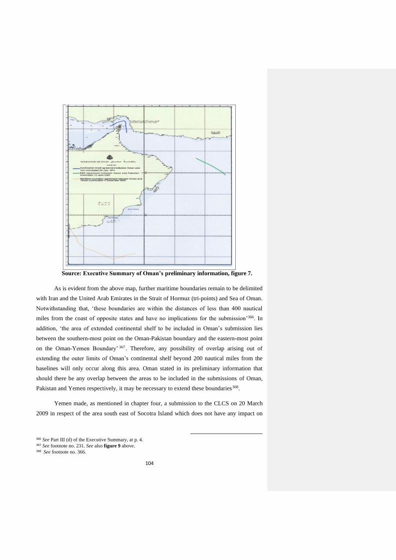
104
Source: Executive Summary of Oman’s preliminary information, figure 7.
As is evident from the above map, further maritime boundaries remain to be delimited
with Iran and the United Arab Emirates in the Strait of Hormuz (tri-points) and Sea of Oman.
Notwithstanding that, ‘these boundaries are within the distances of less than 400 nautical
miles from the coast of opposite states and have no implications for the submission’366. In
addition, ‘the area of extended continental shelf to be included in Oman’s submission lies
between the southern-most point on the Oman-Pakistan boundary and the eastern-most point
on the Oman-Yemen Boundary’ 367 . Therefore, any possibility of overlap arising out of
extending the outer limits of Oman’s continental shelf beyond 200 nautical miles from the
baselines will only occur along this area. Oman stated in its preliminary information that
should there be any overlap between the areas to be included in the submissions of Oman,
Pakistan and Yemen respectively, it may be necessary to extend these boundaries368.
Yemen made, as mentioned in chapter four, a submission to the CLCS on 20 March
2009 in respect of the area south east of Socotra Island which does not have any impact on
366 See Part III (d) of the Executive Summary, at p. 4. 367 See footnote no. 231. See also figure 9 above. 368 See footnote no. 366.
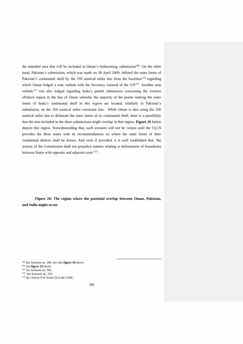
105
the intended area that will be included in Oman’s forthcoming submission369. On the other
hand, Pakistan’s submission, which was made on 30 April 2009, defined the outer limits of
Pakistan’s continental shelf by the 350 nautical miles line from the baselines370 regarding
which Oman lodged a note verbale with the Secretary General of the UN371. Another note
verbale 372 was also lodged regarding India’s partial submission concerning the western
offshore region in the Sea of Oman whereby the majority of the points making the outer
limits of India’s continental shelf in this region are located, similarly to Pakistan’s
submission, on the 350 nautical miles constraint line. While Oman is also using the 350
nautical miles line to delineate the outer limits of its continental shelf, there is a possibility
that the area included in the three submissions might overlap in that region. Figure 26 below
depicts this region. Notwithstanding that, such scenario will not be certain until the CLCS
provides the three states with its recommendations on where the outer limits of their
continental shelves shall be drawn. And even if provided, it is well established that ‘the
actions of the Commission shall not prejudice matters relating to delimitation of boundaries
between States with opposite and adjacent costs’373.
Figure 26: The region where the potential overlap between Oman, Pakistan,
and India might occur.
369 See footnote no. 296. See also figure 18 above. 370 See figure 19 above. 371 See footnote no. 305. 372 See footnote no. 316. 373 See Article 9 of Annex II to the LOSC.
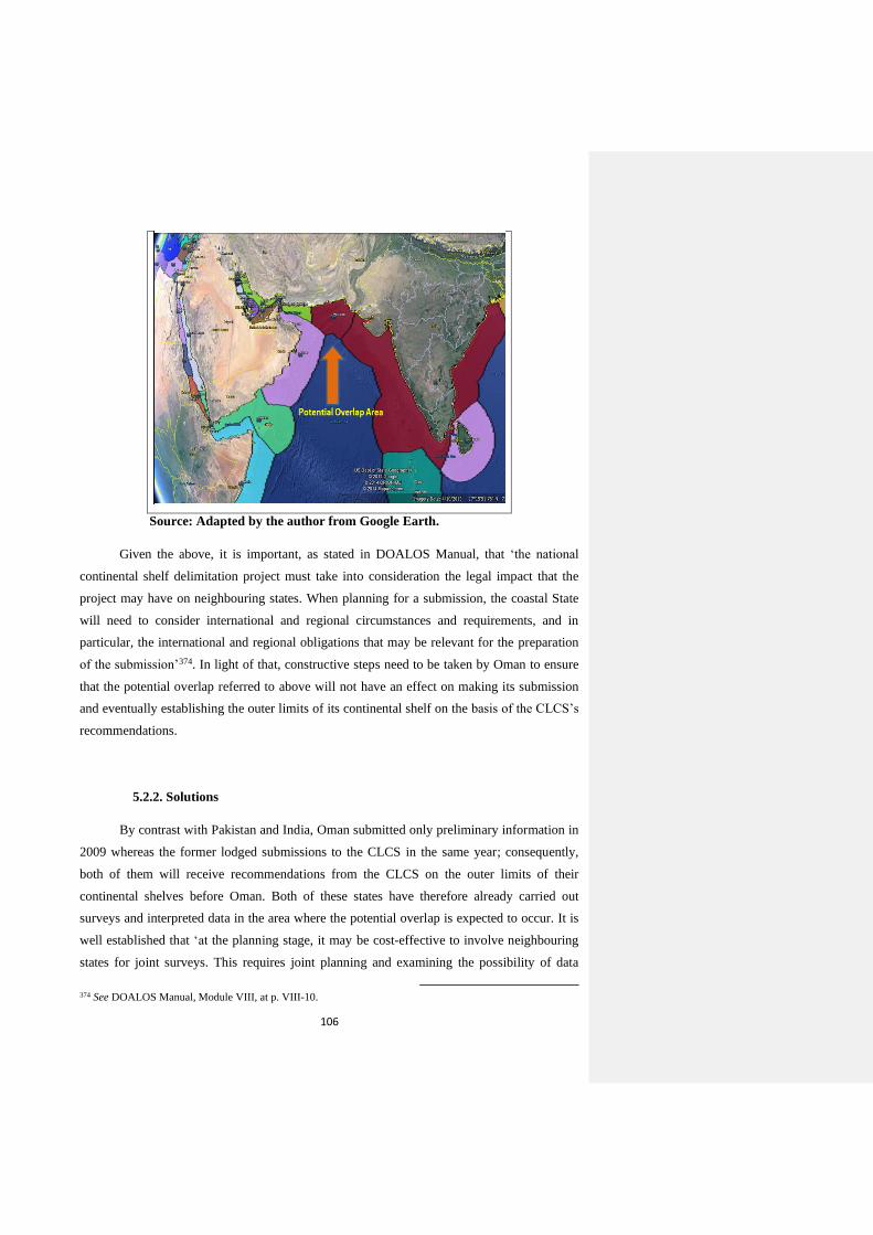
106
Source: Adapted by the author from Google Earth.
Given the above, it is important, as stated in DOALOS Manual, that ‘the national
continental shelf delimitation project must take into consideration the legal impact that the
project may have on neighbouring states. When planning for a submission, the coastal State
will need to consider international and regional circumstances and requirements, and in
particular, the international and regional obligations that may be relevant for the preparation
of the submission’374. In light of that, constructive steps need to be taken by Oman to ensure
that the potential overlap referred to above will not have an effect on making its submission
and eventually establishing the outer limits of its continental shelf on the basis of the CLCS’s
recommendations.
5.2.2. Solutions
By contrast with Pakistan and India, Oman submitted only preliminary information in
2009 whereas the former lodged submissions to the CLCS in the same year; consequently,
both of them will receive recommendations from the CLCS on the outer limits of their
continental shelves before Oman. Both of these states have therefore already carried out
surveys and interpreted data in the area where the potential overlap is expected to occur. It is
well established that ‘at the planning stage, it may be cost-effective to involve neighbouring
states for joint surveys. This requires joint planning and examining the possibility of data
374 See DOALOS Manual, Module VIII, at p. VIII-10.
107
exchange and interpretation. If such cooperation is positive, this will be the basis for mutually
agreed-upon procedures on the final submission’ 375 . Although Pakistan and India have
already done this stage and it is not possible; as a result, to make a joint submission376 for that
particular area, Oman can still approach them for exchange of data. Despite the possibility of
refusal on grounds of confidentiality, however, doing so is more likely going to have a
positive impact on how the three states will view the matter, from a perspective of
cooperation and collaboration.
In terms of timing, the potential overlap shall be dealt with by Oman as early as
possible in the national strategy adopted for preparing and lodging the submission. The best
approach is to deal with the matter and collection and analysis of data concurrently.
Generally speaking, Oman has good relations with both Pakistan and India at a high level in
many areas. Joint committees have been established with both states which meet regularly
and in each country to discuss and improve the bilateral level of cooperation. The three states
are also members in regional organizations such as the Indian Ocean Tuna Commission
(IOTC), the South Asia and Africa Regional Port Stability Cooperative (SAARPSCO), and
the Asian-African Legal Consultative Organization (AALCO). Given that, an exchange of
information, if requested by Oman, might be welcomed by Pakistan and India. If not, it will
at least establish a platform for reaching an understanding for the future.
An example of a similar situation can be seen, inter alia, in the partial submission
made by Denmark together with the Government of the Faroes in respect of the continental
shelf north of the Faroe Islands on 29 April 2009, whereby Denmark, Norway, Iceland and
the Government of the Faroes reached an understanding to allow the CLCS to consider any
submission to be made by any of them in that area where a potential overlap might occur
between their submissions377. From a general point of view, ‘‘most areas of continental shelf
beyond 200 nautical miles involve more than one coastal state’378. Therefore, reaching an
understanding will ensure that Annex I to the ROP will not be invoked by any of the
concerned states.
375 Ibid, at pp. VIII-25 – VIII-26. 376 There is a number of neighbouring states that made joint submissions together. See table 1 above. 377 See the submission made by Denmark together with the Government of the Faroes in respect of the
continental shelf north of the Faroe Islands, and the notes verbales lodged by Iceland and Norway thereto, available online at DOALOS website at: http://www.un.org/depts/los/clcs_new/submissions_files/submission_dnk_28_2009.htm [last accessed 08/12/2014]. 378 See Alex G. Oude Elferink, ‘Article 76 of the LOSC on the Definition of the Continental Shelf: Questions
concerning its Interpretation from a Legal Perspective’ (2006) 21 The International Journal of Marine and Coastal Law 3 at p. 283.
108
Oman might have already held discussions with the Pakistani and Indian sides
regarding the subject matter since it has been noted during the submission of the preliminary
information in 2009. This can be drawn from the note verbale sent by Oman to the Secretary
General of the UN regarding Pakistan’s submission where it is stated that ‘the Sultanate of
Oman affirms its willingness to cooperate as well as discuss with its neighbours its intended
submission’379. If no discussions have been initiated yet, it is of significant importance to do
so as soon as possible while Oman is preparing its submission, knowing that vessels will be
sent to the potential overlapping area to conduct surveys. Indeed, assurances from all sides
that the outer limits of the continental shelves established on the basis of the CLCS’s
recommendations shall not prejudice matters relating to the delimitation of boundaries
between them have to be confirmed and exchanged.
Oman has already stated explicitly in its preliminary information that ‘this
preliminary information is provided without prejudice to [...] any eventual delimitation that
may be required’ 380 . So too has India in its submission381 . Including such a statement
expressly in the submission conforms to the requirement of the CLCS contained in articles 2
(b) and 6 of its ROP. Notwithstanding that, it is always better to have any agreed-upon
understanding in a written form to avoid any uncertainty that might arise in the future. It does
not necessarily have to be sent to the CLCS separately as long as it is clearly reflected in the
submission and adhered to by the concerned states.
Reaching an understanding will therefore ensure that each coastal state will receive
recommendations from the CLCS determining precisely the location of the outer limits of its
continental shelf beyond 200 nautical miles from the baselines. Following that, the concerned
states are free to decide what to do next. It is useful to include this stage as well in the agreed-
upon understanding. Otherwise, another understanding has to be discussed and concluded.
The first state that is going to receive recommendations from the CLCS on the outer limits of
its continental shelf is Pakistan. India and Oman will follow consecutively.
Once the recommendations are received and the overlap, if any and between whom, is
confirmed, the three states, whether bilaterally or collectively depending on the location of
the overlap, have two options to consider. The first one is to delimit the continental shelf
between them which ‘shall be effected by agreement on the basis of international law, as
referred to in Article 38 of the Statute of the International Court of Justice, in order to achieve
379 See footnote no. 305 at p. 2. 380 See Part III (d) of the Executive Summary, at p. 4. 381 See footnote no. 312, part V (2), at p. 4.
109
an equitable solution’382. Pending that agreement, the concerned states shall, in a spirit of
understanding and cooperation, ‘make every effort to enter into provisional arrangements of a
practical nature and, during this transitional period, not to jeopardize or hamper the reaching
of the final agreement’383. This option is possible since legislation in all three states calls for a
maritime boundary that does not extend beyond a line that is equidistant from their baselines.
In Oman, Royal Decree No. 15/81 states that ‘in the case there is a coast of another state
opposite or adjacent to that of the Sultanate of Oman, the outer limit of the territorial waters,
the EEZ and continental shelf shall be determined by a median line whereby each part of it
shall be equal in distance from the nearest base points from which the breadth of the
territorial sea of the Sultanate and the territorial sea of the other opposite and adjacent states
are measured’ 384 . Section 9 of India’s Territorial Waters, Continental Shelf, Exclusive
Economic Zone and other Maritime Zones Act, 1976, provides also that ‘the maritime
boundaries between India and any State whose coast is opposite or adjacent to that of India in
regard to their respective territorial waters, contiguous zones, continental shelves, exclusive
economic zones and other maritime zones shall be as determined by agreement (whether
entered into before or after the commencement of this section) between India and such State
and pending such agreement between India and any such State, and unless any other
provisional arrangements are agreed to between them, the maritime boundaries between India
and such State shall not extend beyond the line every point of which is equidistant from the
nearest point from which the breadth of the territorial waters of India and of such State are
measured’. Likewise, article 1 (b) of section 8 of Pakistan’s Territorial Waters and Maritime
Zones Act, 1976, adopted a similar wording to that of India’s which both followed the line of
Article 83 of the LOSC. Proceeding from these grounds, delimitation of a continental shelf’s
overlap seems to be easily approachable and acceptable by the three states whether on
bilateral or collective basis.
The other option is to find another acceptable solution other than delimitation to deal
with the overlap. This can be drawn from the submissions that are made by other coastal
states. A good and obvious example is to transform the area of overlap to a joint management
area whereby a body, through agreements, is established by the three states or two of them,
depending on the eventual location of the overlap, to exercise the rights pertaining to the
continental shelf under the LOSC on behalf of them. Notwithstanding that, this tends to
happen more likely when states make joint submissions as the political will and
382 See article 83 (1) of the LOSC. 383 Ibid, paragraph 3. 384 See article 8.
110
understanding to act jointly have already been established. This kind of solution can be seen,
inter alia, in the post-CLCS recommendations of the joint submission made by the Republic
of Mauritius and Republic of Seychelles in 2008 where the two states decided to establish the
world’s first joint management zone concerning the overlapping area between their
continental shelves beyond 200 nautical miles in the Mascarene Plateau region, and a joint
commission to manage and coordinate the development, conservation, exploration and
exploitation of the non-living resources of the seabed within that area385. Although it is too
early to evaluate its success, the two states have set a guiding model for other states to follow
through which the obstacles associated with the activities of managing and securing the
benefits of the continental shelf beyond 200 nautical miles are shared in a collective manner.
Having said that, it is important for Oman to follow a step-by step approach to deal
with the aforementioned potential overlap as it moves towards making its submission to the
CLCS and receiving recommendations on the outer limits of its continental shelf beyond 200
nautical miles. At the preparation stage, the matter has to be included in the national strategy
of preparing the submission and discussed with the concerned states, as early as possible,
towards reaching an understanding preferably in a written form. Alternatively, the submission
should be made with an assurance stating it is ‘without prejudice to matters relating to the
delimitation of boundaries between states’. Upon receipt of the recommendations, the overlap
can then be settled, through agreements, either by way of delimitation in accordance with the
LOSC or other peaceful mechanisms such as the establishment of a joint management area.
5.3. Concluding Remarks
The fact of having submitted only preliminary information indicates that Oman
understands the complexity and challenges that might be encountered in making a full
submission to the CLCS to extend the outer limits of its continental shelf beyond 200 nautical
miles from the baselines. On the other hand, having done that allowed Oman to bypass some
of those challenges and have more time to address the rest. The key factor here is to foresee
the challenges associated with the submission and adopt the right strategy to deal with them
efficiently and in a timely manner according to their nature. The different types of challenges
outlined above are what Oman, as any other coastal state, is likely to face while preparing its
submission and afterwards. Being able to address them in a well-planned manner will ensure
385 See ‘Seychelles and Mauritius Sign Landmark Treaties for Joint Management of Continental Shelf’,
Ministry of Foreign Affairs of the Republic of Seychelles, available online at: http://www.mfa.gov.sc/static.php?content_id=36&news_id=278 [last accessed 10/12/2014].
111
significantly the success of Oman’s submission. At the same time, following closely the work
of the CLCS and any developments associated with the submission process is of an equal
significance.
6. Conclusion
More than sixty years before today, the world was divided on how to define the
continental shelf. Today, the Commission on the Limits of the Continental Shelf is struggling
to find a way to cope with the increasing working pressure and handle the growing number of
submissions made by coastal states to extend their continental shelves beyond the distance of
200 nautical miles from the baselines. In the meantime, eligible coastal states are to secure
their legal entitlements to the seabed by establishing precisely the outer limits of their
continental shelves. This will enable them to access valuable natural resources, such as
minerals, oil, and gas, as well as sedentary species. This kind of stability and certainty would
have not been possible without the LOSC whose adoption and entry into force marked the
beginning of a new era in the law of the sea after decades of evolution in state practice,
112
international case law and treaty law. The effect of its provisions on the continental shelf is
that practically all seabed natural gas and oil resources fall under the control of coastal states.
It became clear that ‘the resources to be derived from the continental shelf are enormous and,
in the future, the shelf area will be the main source of world oil and gas supplies. Offshore oil
production in the year 2000 was estimated at 1.23 billion tons, and natural gas at 650 billion
cubic metres’386. Therefore, clearly established and recognized outer limits of the continental
shelf will confer legal stability for the coastal states to exercise sovereign rights over those
valuable natural resources.
To reach that end though is a long process. It is not only the interests of the coastal
states that are at stake but also of other states and the Area represented by the international
community. Article 76 of the LOSC sets, in a logical order, the rules according to which
eligible coastal states should establish their entitlement to extend the outer limits of their
continental shelves beyond 200 nautical miles from the baselines. Unlike the outer limits of
other maritime zones which are determined by distance measurement, a combination of
measurement, analysis, and interpretation of the depth of the water, distance, shape of the
seabed, and thickness of sedimentary material are necessary to delineate the outer limits of
the continental shelf where various and complex scientific methodologies and techniques are
involved. Furthermore, all this scientific complexity has to be done in a legal framework
pursuant to the provisions of Article 76 and Annex II to the LOSC by preparing and
depositing a submission to the CLCS in accordance with a specified time limit. The
submission, in terms of form and contents, has to meet further requirements as required by
the CLCS in the ROP. The process continues by entering into engagement with the CLCS
which lasts for numerous years towards finally establishing the outer limits of the continental
shelf. Then, the coastal state, if it has accepted the outcome, has to meet other obligations by
delimiting the new boundary with opposite and adjacent coastal states, and depositing charts
or a list of geographic information of the final outer limits with the Secretary General of the
UN and the Secretary General of the International Seabed Authority. Therefore, every step
and body associated with the submission process is regulated by rules and regulations which
coastal states have to understand, follow, and comply with. Volumes of books and articles
have been written about the 10 paragraphs of Article 76 of the LOSC, let alone the
Guidelines and DOALOS Manual. Furthermore, they continue to be the subject of and attract
ongoing writings and thorough examination whether for the purpose of criticism or further
analysis and elaboration. Therefore, if understanding the essence of Article 76 is of this level
386 See DOALOS Manual, Module VIII at p. VIII-2.
113
of complexity, the putting of it into practice by coastal states would be expected to be even
more so. In view of this fact, the first part of this paper sheds light on the development of the
concept of the continental shelf, its status and definition as provided in the LOSC, the
functions and structure of the CLCS, and the submission process and its rules knowing the
importance of understanding them for any coastal state wishing to make a submission to the
CLCS to extend the outer limits of its continental shelf beyond 200 nautical miles from the
baselines.
To explore the subject matter further but from a practical angle, the paper takes the
submission to be made by the Sultanate of Oman as a case to study in light of the
aforementioned. Oman met the time threshold by submitting only preliminary information in
2009 indicative of the outer limits of its continental shelf, with a lot remaining to be done
towards making the submission. Examining the data provided in the preliminary information
against the background of the provisions of Article 76 and all other documents associated
with the submission process, conclusions can be drawn on what Oman shall do for that
purpose. The preliminary information per se achieved its objective by temporarily securing
Oman’s entitlement to extend the outer limits of its continental shelf beyond the EEZ limit of
200 nautical miles through the collection and provision of scientific data supporting its case.
Furthermore, the preparation of the preliminary information must have made Oman
get the sense of how complex and challenging preparing the submission will be. So 10 years
were set as a target by Oman for preparing and making finally its submission. Currently, it is
the sixth year. What have been done so far and what more is still to be accomplished will
determine if that time target will be met by Oman. If an external eye views this broadly, it
will get the impression that Oman is facing a difficulty in making its submission. It is not
alone though as, to varying degrees, this is true also of those coastal states that have lodged
only preliminary information and are working towards making a submission. The common
factor between them is that most of them are developing states.
There is no doubt that the preliminary information provided Oman with answers to
many scientific questions and a road map on how to move forward. Despite that, it seems to
have relied, to a great extent, on a desktop study and compilation of existing data.
Consequently, the difficult parts of the work represented in the collection of data through
field surveys, interpretation and documentation of these data in accordance with the
Guidelines, and writing the submission are yet to be done which constitute most of the
submission. In order to achieve this aim, Oman, as outlined above, established a national
114
Committee, appointed a consultant, and hired a vessel to conduct the necessary surveys.
Looking at this in light of the preliminary information on one side, and against the
background of Article 76 of the LOSC and all other documents associated with the
submission process on the other side, it can be said that Oman needs to pay attention to the
following issues:
First: time is pivotally crucial. Making the submission without delay will ensure that
Oman will get the recommendations upon which the outer limits of its continental shelf to be
established early. As a result, it will have an early access to the benefits of the natural
resources of its continental shelf. The period a submission takes until it is provided with
recommendations has been gradually increasing while 3 sub-commissions of the CLCS could
function simultaneously. Hence, this period is expected to increase with more submissions
continuously being lodged by coastal states unless States Parties to the LOSC do something
about it. The governing rule therefore is that the earlier you submit, the less time the
submission will spend until fully reviewed by the CLCS.
Second: the submission is of a very complicated nature where different legal and
scientific requirements should be complied with and fulfilled. Therefore, the scientific side
must not be given more emphasis over the legal side, and vice versa. Instead, they should go
hand in hand. This is attributed to the inter-disciplinary approach of Article 76 and the
established fact that the submission is a scientific study prepared and presented in a legal
framework.
Third: most of the data included in the preliminary information are of indicative
nature. As result, precise data of high quality need to be furnished to support the application
of the provisions of Article 76 in drawing the outer limits of the continental shelf. The
primary mirror here should be the Guidelines on which the CLCS reviews the submission. At
the same time, an eye should be kept open at the work of the latter and any developments that
might arise pertaining to the submission process. In the same vein, submissions by coastal
states that are already considered by the CLCS and received recommendations should be also
followed closely to find out how the CLCS applies the provisions of Article 76 and the
Guidelines on the data included therein which might be of relevance to features that will be
included in Oman’s submission. Although there is a difficulty in getting enough information
due to the confidentiality issue surrounding the submission process and ambiguity of setting
precedents by the CLCS as a result of the periodical change in its membership, the situation
might change in the future as demands have been increasingly voiced out even from the
115
CLCS calling for more transparency. Going thoroughly through the preliminary information,
updates and further collection of data must be conducted to fulfil the requirements laid down
in Article 76 starting from drawing the baselines to the delineation of the outer limits of the
continental shelf using the formulae and constraints lines. The surveys probably have
commenced recently or are about to start; therefore, making sure that the methods used to
collect, interpret, visualise and manage the data are of a high quality is of crucial importance
knowing that by the time the submission is considered by the CLCS, new methods are likely
to emerge to the surface and over take the old ones. Equally important is the avoidance of
unwanted errors by paying the utmost care in identifying the locations where the formulae
and constraints lines should be drawn particularly the foot of the slope owing to its critical
position in the whole process.
Fourth: preparing and making the submission is a costly exercise to which a lot of
financial resources need to be devoted. Oman is a developing state and might view allocating
budgets for the provision of tangible public services such as constructing schools and
hospitals as having greater priority than the continental shelf project. Indeed, most of the
financial resources required for preparing and making the submission will be spent on the
surveys that are going to cover a geographic area double the size of its landmass. However,
funds should be readily available until the recommendations are received from the CLCS, and
waiting on the queue should not affect this position. Having said that, there should be a strong
belief among the government’s circles, especially those ones that are heavily involved in
preparing the submission, that the submission is of a top priority to Oman and the next
generations as well as it is an investment for the future because it constitutes a right that
touches upon the sovereignty of the state. Therefore, the national Committee should consider
the establishment of this belief as one of the important tasks it should work on. And the
guiding principle should be that without funds, there is not progress.
Fifth: any potential overlap of entitlements with other coastal states should not be left
to the last minute to negotiate. Given the effect it might have on the submission overall, it is
of importance to deal with it as early as possible. Differently from other obstacles (legal and
technical) which can be dealt with individually by and within the state, this one involves
another person of international law. Therefore, reaching an understanding with opposite and
adjacent states with whom there might be an overlap of maritime entitlement as a result of
making the submission should be part and parcel of the preparation of the submission. Again,
timing plays a significant role in this respect.
116
Sixth: the abovementioned will not be achieved without sound planning and having a
clear strategy in place according to which all works are executed. The strategy shall be
comprehensive and considered as the compass for the national Committee and all people
involved in preparing the submission. The key factor here is the human resource which
should both understand and implement the strategy as planned in terms of time and targets. If
the said resource is not devoted for the continental shelf project, there will obviously be a
lack of efficiency.
To conclude, this paper provided an early assessment of Oman’s forthcoming
submission to extend the outer limits of its continental shelf beyond the distance of 200
nautical miles from the baselines in light of the general process associated with submissions
before the CLCS at a time when the submission to be made by Oman is still under
preparation. It is the first time the subject is studied thoroughly from different angles at this
important stage. Most of the data that has been consulted and discussed throughout the paper
are those that are publicly available, and it has been realized that neither enough discussion
nor researches of the subject exist among the media and academic communities in Oman.
Such situation is actually disadvantageous as public awareness of this kind of issues plays a
significant role in securing support to the project. This paper will be useful to those people
who are working on the submission to understand the nature and tasks of continental shelf
project in light of the big picture. It will also be useful for further research in the future
whether during the consideration of the submission by the CLCS or after receipt of
recommendations and establishment of the outer limits. As a final word, Article 76 is one of
the most delicate articles of the LOSC which produces a law in its own. With all complexity
and duties that are associated with it, the benefits that will be gained from its implementation
are tremendous in many fields at a time the world is turning its eyes to the oceans for
sustainable development and exploitation of resources as well as management and regulation.
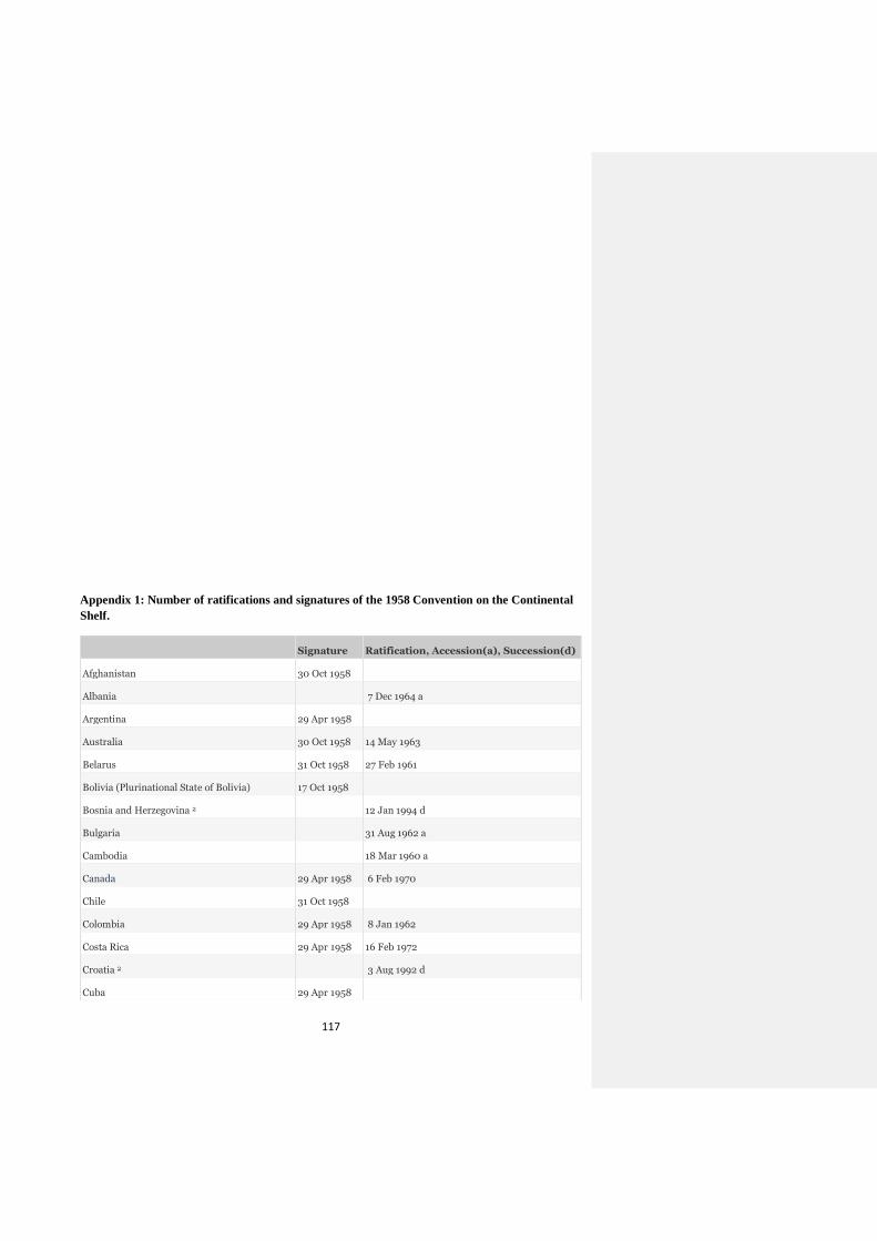
117
Appendix 1: Number of ratifications and signatures of the 1958 Convention on the Continental
Shelf.
Signature Ratification, Accession(a), Succession(d)
Afghanistan 30 Oct 1958
Albania 7 Dec 1964 a
Argentina 29 Apr 1958
Australia 30 Oct 1958 14 May 1963
Belarus 31 Oct 1958 27 Feb 1961
Bolivia (Plurinational State of Bolivia) 17 Oct 1958
Bosnia and Herzegovina 2 12 Jan 1994 d
Bulgaria 31 Aug 1962 a
Cambodia 18 Mar 1960 a
Canada 29 Apr 1958 6 Feb 1970
Chile 31 Oct 1958
Colombia 29 Apr 1958 8 Jan 1962
Costa Rica 29 Apr 1958 16 Feb 1972
Croatia 2 3 Aug 1992 d
Cuba 29 Apr 1958
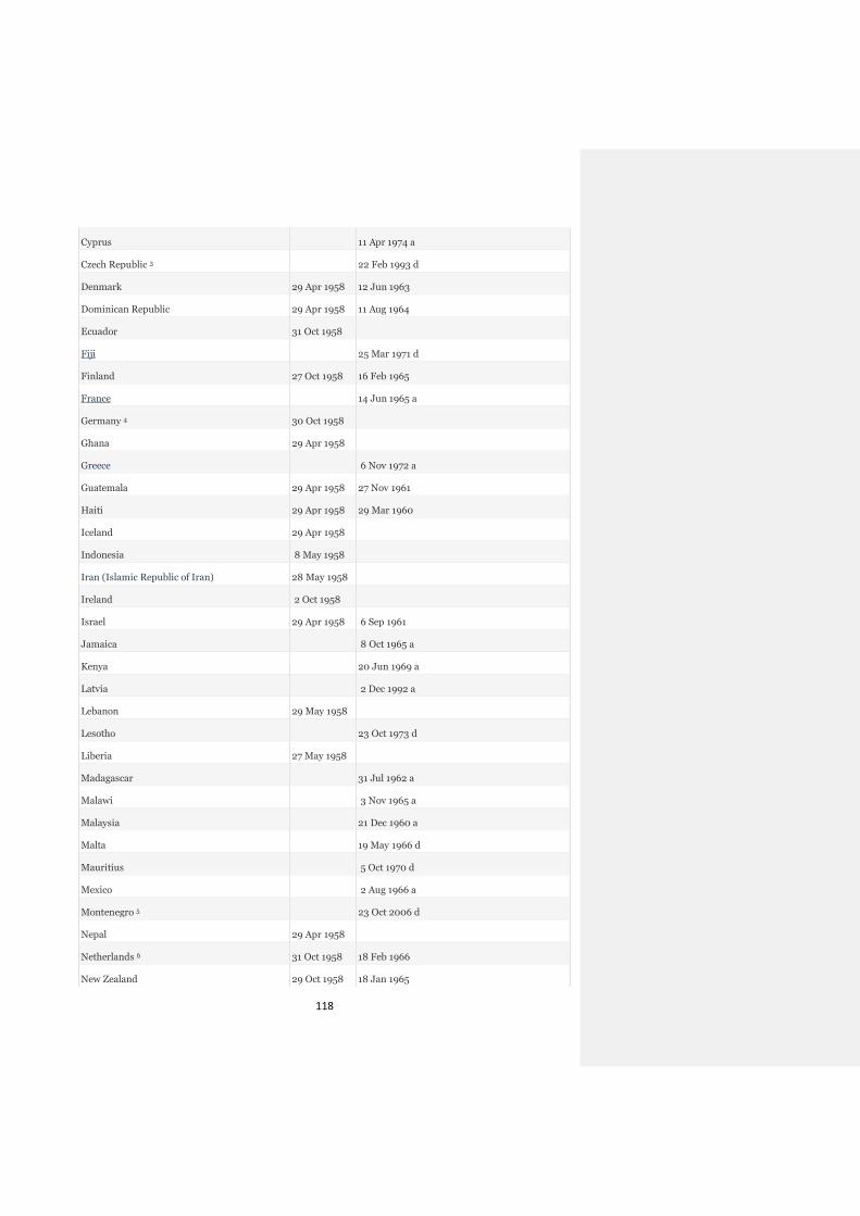
118
Cyprus 11 Apr 1974 a
Czech Republic 3 22 Feb 1993 d
Denmark 29 Apr 1958 12 Jun 1963
Dominican Republic 29 Apr 1958 11 Aug 1964
Ecuador 31 Oct 1958
Fiji 25 Mar 1971 d
Finland 27 Oct 1958 16 Feb 1965
France 14 Jun 1965 a
Germany 4 30 Oct 1958
Ghana 29 Apr 1958
Greece 6 Nov 1972 a
Guatemala 29 Apr 1958 27 Nov 1961
Haiti 29 Apr 1958 29 Mar 1960
Iceland 29 Apr 1958
Indonesia 8 May 1958
Iran (Islamic Republic of Iran) 28 May 1958
Ireland 2 Oct 1958
Israel 29 Apr 1958 6 Sep 1961
Jamaica 8 Oct 1965 a
Kenya 20 Jun 1969 a
Latvia 2 Dec 1992 a
Lebanon 29 May 1958
Lesotho 23 Oct 1973 d
Liberia 27 May 1958
Madagascar 31 Jul 1962 a
Malawi 3 Nov 1965 a
Malaysia 21 Dec 1960 a
Malta 19 May 1966 d
Mauritius 5 Oct 1970 d
Mexico 2 Aug 1966 a
Montenegro 5 23 Oct 2006 d
Nepal 29 Apr 1958
Netherlands 6 31 Oct 1958 18 Feb 1966
New Zealand 29 Oct 1958 18 Jan 1965
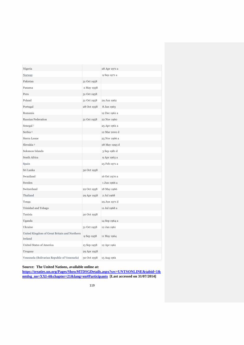
119
Nigeria 28 Apr 1971 a
Norway 9 Sep 1971 a
Pakistan 31 Oct 1958
Panama 2 May 1958
Peru 31 Oct 1958
Poland 31 Oct 1958 29 Jun 1962
Portugal 28 Oct 1958 8 Jan 1963
Romania 12 Dec 1961 a
Russian Federation 31 Oct 1958 22 Nov 1960
Senegal 7 25 Apr 1961 a
Serbia 2 12 Mar 2001 d
Sierra Leone 25 Nov 1966 a
Slovakia 3 28 May 1993 d
Solomon Islands 3 Sep 1981 d
South Africa 9 Apr 1963 a
Spain 25 Feb 1971 a
Sri Lanka 30 Oct 1958
Swaziland 16 Oct 1970 a
Sweden 1 Jun 1966 a
Switzerland 22 Oct 1958 18 May 1966
Thailand 29 Apr 1958 2 Jul 1968
Tonga 29 Jun 1971 d
Trinidad and Tobago 11 Jul 1968 a
Tunisia 30 Oct 1958
Uganda 14 Sep 1964 a
Ukraine 31 Oct 1958 12 Jan 1961
United Kingdom of Great Britain and Northern
Ireland
9 Sep 1958 11 May 1964
United States of America 15 Sep 1958 12 Apr 1961
Uruguay 29 Apr 1958
Venezuela (Bolivarian Republic of Venezuela) 30 Oct 1958 15 Aug 1961
Source: The United Nations, available online at:
https://treaties.un.org/Pages/ShowMTDSGDetails.aspx?src=UNTSONLINE&tabid=1&
mtdsg_no=XXI-4&chapter=21&lang=en#Participants [Last accessed on 31/07/2014]
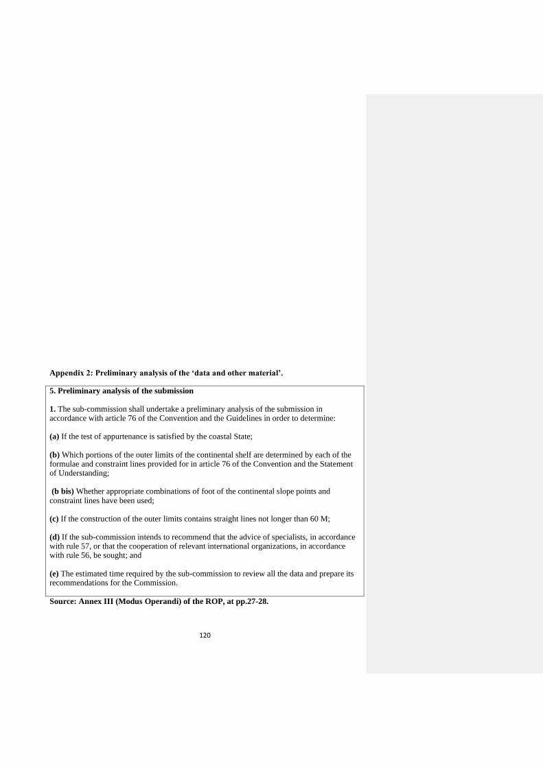
120
Appendix 2: Preliminary analysis of the ‘data and other material’.
5. Preliminary analysis of the submission 1. The sub-commission shall undertake a preliminary analysis of the submission in accordance with article 76 of the Convention and the Guidelines in order to determine: (a) If the test of appurtenance is satisfied by the coastal State; (b) Which portions of the outer limits of the continental shelf are determined by each of the formulae and constraint lines provided for in article 76 of the Convention and the Statement of Understanding; (b bis) Whether appropriate combinations of foot of the continental slope points and constraint lines have been used; (c) If the construction of the outer limits contains straight lines not longer than 60 M; (d) If the sub-commission intends to recommend that the advice of specialists, in accordance with rule 57, or that the cooperation of relevant international organizations, in accordance with rule 56, be sought; and (e) The estimated time required by the sub-commission to review all the data and prepare its recommendations for the Commission.
Source: Annex III (Modus Operandi) of the ROP, at pp.27-28.
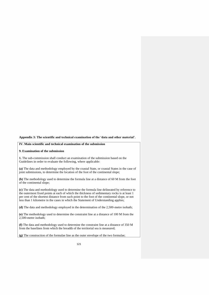
121
Appendix 3: The scientific and technical examination of the ‘data and other material’.
IV. Main scientific and technical examination of the submission 9. Examination of the submission 1. The sub-commission shall conduct an examination of the submission based on the Guidelines in order to evaluate the following, where applicable: (a) The data and methodology employed by the coastal State, or coastal States in the case of joint submissions, to determine the location of the foot of the continental slope; (b) The methodology used to determine the formula line at a distance of 60 M from the foot of the continental slope; (c) The data and methodology used to determine the formula line delineated by reference to the outermost fixed points at each of which the thickness of sedimentary rocks is at least 1 per cent of the shortest distance from such point to the foot of the continental slope, or not less than 1 kilometre in the cases in which the Statement of Understanding applies;
(d) The data and methodology employed in the determination of the 2,500-metre isobath; (e) The methodology used to determine the constraint line at a distance of 100 M from the 2,500-metre isobath; (f) The data and methodology used to determine the constraint line at a distance of 350 M from the baselines from which the breadth of the territorial sea is measured; (g) The construction of the formulae line as the outer envelope of the two formulae;
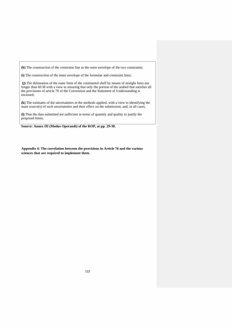
122
(h) The construction of the constraint line as the outer envelope of the two constraints; (i) The construction of the inner envelope of the formulae and constraint lines; (j) The delineation of the outer limit of the continental shelf by means of straight lines not longer than 60 M with a view to ensuring that only the portion of the seabed that satisfies all the provisions of article 76 of the Convention and the Statement of Understanding is enclosed;
(k) The estimates of the uncertainties in the methods applied, with a view to identifying the main source(s) of such uncertainties and their effect on the submission; and, in all cases, (l) That the data submitted are sufficient in terms of quantity and quality to justify the proposed limits.
Source: Annex III (Modus Operandi) of the ROP, at pp. 29-30.
Appendix 4: The correlation between the provisions in Article 76 and the various
sciences that are required to implement them.
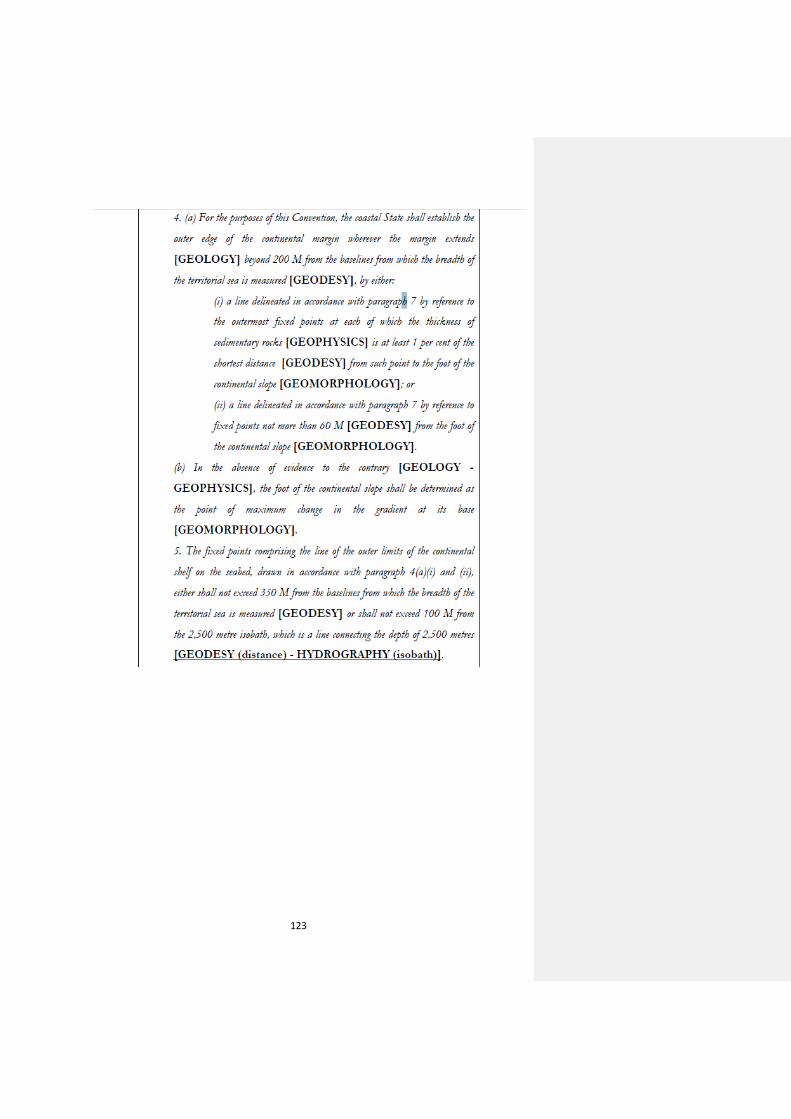
123
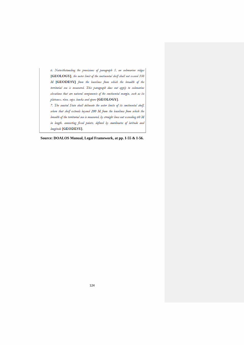
124
Source: DOALOS Manual, Legal Framework, at pp. I-55 & I-56.
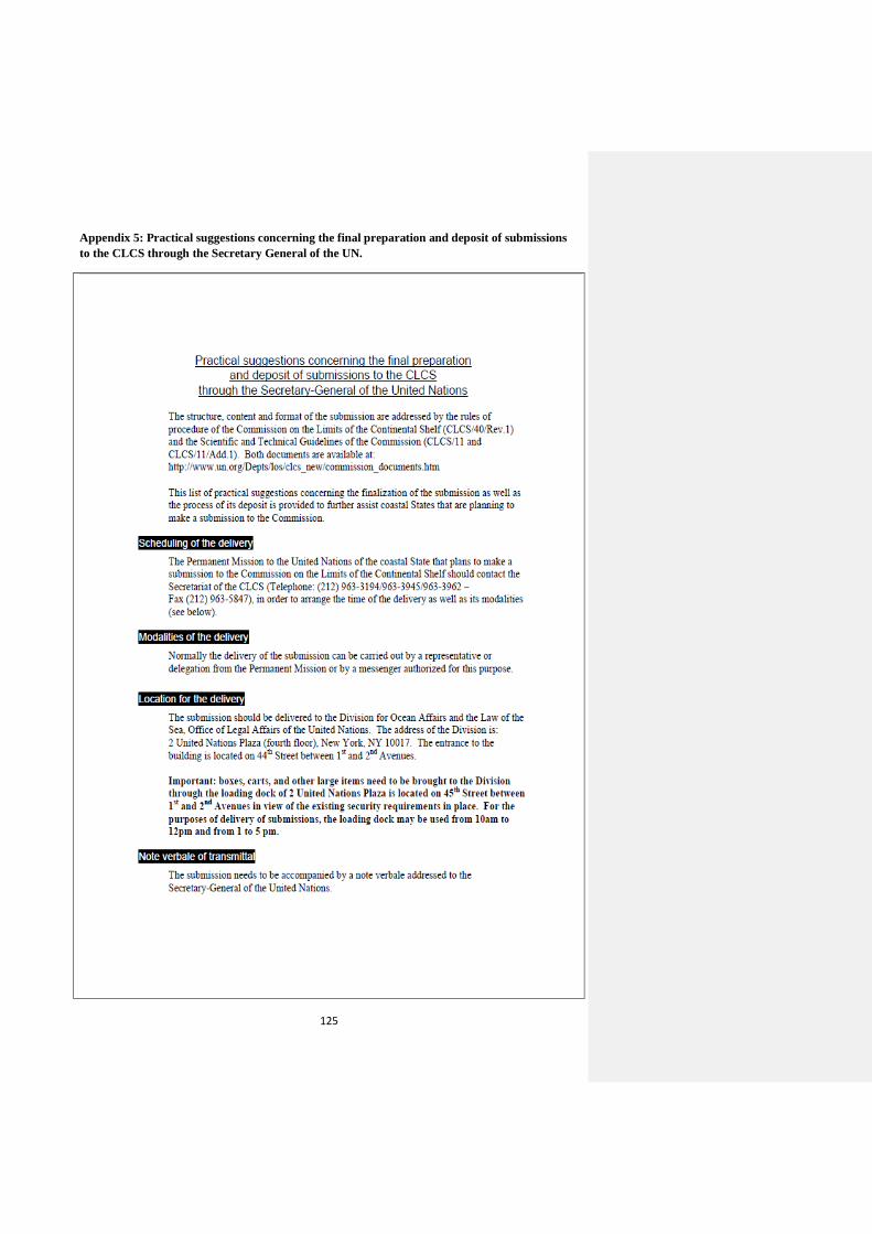
125
Appendix 5: Practical suggestions concerning the final preparation and deposit of submissions
to the CLCS through the Secretary General of the UN.
126
127
128
Source: DOLAOS, CLCS webpage, available at:
http://www.un.org/depts/los/clcs_new/practicalsuggestions.pdf [last accessed 12/09/2014].
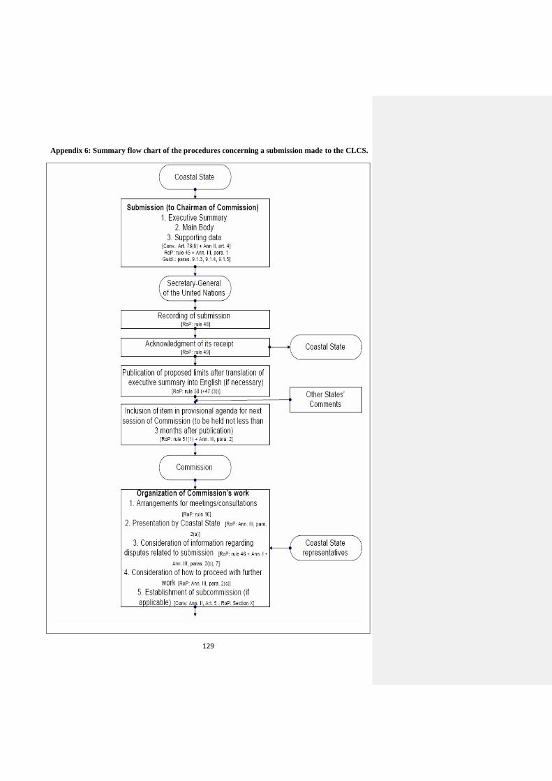
129
Appendix 6: Summary flow chart of the procedures concerning a submission made to the CLCS.
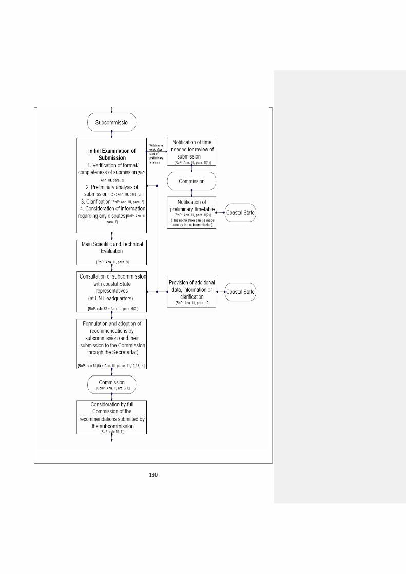
130
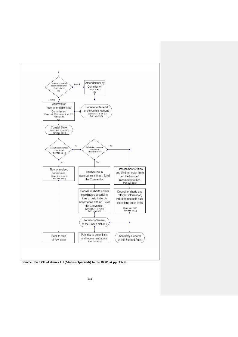
131
Source: Part VII of Annex III (Modus Operandi) to the ROP, at pp. 33-35.
132
List of References
Books:
Churchill R. R. & Lowe A. V., The law of the Sea (Manchester: Manchester University Press,
3rd edition, 1999)
Knight G. & Chiu H., The International Law of the Sea: Cases, Documents, and Readings
(Elsevier Applied Science, London, 1991)
Kovalev A.A., Contemporary Issues of the Law of the Sea: Modern Russian Approaches
(Eleven International Publishing, 2003, the Netherlands, edited and translated by W.W.Butler
in 2004)
Kwiatkowska B, Decisions of the World Court Relevant to the UN Convention on the Law of
the Sea (Kluwer Law International, The Hague, 2002)
Ocean Policy Research Foundation in cooperation with the Ministry of Foreign Affairs of
Japan, United Nations University and Japan Coast Guard, The Establishment of the Outer
Limits of the Continental Shelf beyond 200 Nautical Miles – Its International Circumstances,
and its Scientific and Technical Aspects (Japan: Ocean Policy Research Foundation, 2007)
Razavi A., Continental Shelf Delimitation and Related Maritime Issues in the Persian Gulf
(The Hague, Kluwer Law International, 1997)
Rothwell D. & Stephens T., The International Law of the Sea (Hart Publishing Ltd, Oxford,
2010)
Suarez S., The Outer Limits of the Continental Shelf Legal Aspects of their Establishment
(Berlin: Springer, 2008)
Shepard F., Submarine Geology (Harper and Row, 3rd edition, 1973, New York)
Chapters in Edited Books:
Lodge M. W., ‘The International Seabed Authority-Its Future Directions’ in Nordquist M.H.,
Norton Moore J. and Heidar T.H. (eds.), Legal and Scientific Aspects of Continental Shelf
Limits (Leiden, Martinus Nijhoff Publishers, 2004)
Articles:
Brekke H. & Symonds P., ‘Submarine Ridges and Elevations of Article 76 in light of
Published Summaries of Recommendations of the Commission on the Limits of the
Continental Shelf’ (2011) 42 Ocean Development and International Law pp. 289-306
Borchard E., ‘Resources of the Continental Shelf’ (1946) 40 American Journal of
International Law 1 pp.53-70
133
Brown E.D., ‘The Anglo – French Continental Shelf Case’ (1979) 16 San Diego Law Review
3 pp. 461-530
Cosford Jr. E. , ‘The Continental Shelf and the Abu Dhabi Award ’ (1953) 1 McGill Law
Journal pp.109-127
Cavnar A., ‘Accountability and the Commission on the Limits of the Continental Shelf:
Deciding who Owns the Ocean Floor’ (2009) 42 Cornell International Law Journal pp. 387-
440
Emery K.O., ‘Geological Limits of the “Continental Shelf” ’ (1981) 10 Ocean Development
and International Law Journal 1-2 pp. 1-11
Friedmann W., ‘The North Sea Continental Shelf Cases – A Critique’ (1970) 64 American
Journal of International Law pp. 229-240
Feldman M. B., ‘The Tunisia-Libya Continental Shelf Case, Geographic Justice of Judicial
Compromise’ (1983) 77 American Journal of International Law 2 pp. 219-238
Goldie L.F.E., ‘Sedentary Fisheries and Article 2 (4) of the Convention on the Continental
Shelf – A Plea for a Separate Regime’ (1969) 63 American Journal of International Law pp.
86-97
Holland H. F., ‘The Juridical Status of the Continental Shelf’ (1952) 30 Texas Law Review
pp. 587-598
Kunz J. L., ‘Continental Shelf and International Law: Confusion and Abuse’ (1959) 50
American Journal of International Law 4 pp.828-853
Lehman D., ‘The Legal Status of the Continental Shelf’ (1960) 20 Louisiana Law Review pp.
646-656
Legault L. H. and Hankey B., ‘From Sea to Seabed: The Single Maritime Boundary in the
Gulf of Maine Case’ (1985) 79 American Journal of International Law 4 pp. 961-991
Macnab R., ‘The Case for Transparency in the Delimitation of the Outer Continental Shelf in
accordance with UNCLOS 76’ (2004) 35 Ocean Development and International Law pp. 1-
17
McDorman T. L., ‘The Role of the Commission on the Limits of the Continental Shelf: A
Technical Body in a Political World’ (2002) 17 The International Journal of Marine and
Coastal Law 3 pp. 301-324
Mingay G., ‘Article 82 of the LOSC Convention – Revenue Sharing – The Mining Industry’s
Perspective’ (2006) 21 The International Journal of Marine and Coastal Law 3 pp. 335-346.
Oude Elferink A. G., ‘Article 76 of the LOSC on the Definition of the Continental Shelf:
Questions concerning its Interpretation from a Legal Perspective’ (2006) 21 The
International Journal of Marine and Coastal Law 3 pp. 269-285

134
Ong D. M., ‘A Legal Regime for the Outer Continental Shelf? An Inquiry as to the Rights
and Duties of Coastal States with the Outer Continental Shelf’, published on the website of
the International Hydrographic Organization (IHO) at:
http://www.iho.int/mtg_docs/com_wg/ABLOS/ABLOS_Conf3/PAPER7-4.PDF [last
accessed 19/09/2014] pp. 1-10
Oda S., ‘Proposals for Revising the Convention on the Continental Shelf’ (1968) 7 Columbia
Journal of Transnational Law 1 pp. 1-31
Serdy A., ‘Is there a 400-mile Rule in UNCLOS Article 76 (8)?’ (2008) 57 International and
Comparative Law Quarterly 4 pp. 941-954
Willis L. A., ‘From Precedent to Precedent: The Triumph of Pragmatism in the Law of
Maritime Boundaries’ (1986) 24 Canadian Yearbook of International Law 3 pp. 3-60
Young R., ‘Recent Developments with Respect to the Continental Shelf’ (1948) 42 American
Journal of International Law 4 pp. 849-857
Young R., ‘The Geneva Convention on the Continental Shelf: A First Impression’ (1958) 52
American Journal of International Law 4 pp. 733-738
Internet Sources:
Treves T., ‘United Nations Convention on the Law of the Sea’ United Nations Audio-visual
Library of International Law (http://untreaty.un.org/cod/avl/pdf/ha/uncls/uncls_e. pdf) (2008)
pp. 1-6