Environmental setting and effects on water quality in the Great and Little Miami River Basins, Ohio...
106
U.S. Department of the Interior U.S. Geological Survey Environmental Setting and Effects on Water Quality in the Great and Little Miami River Basins, Ohio and Indiana By Linda M. Debrewer, Gary L. Rowe, David C. Reutter, Rhett C. Moore, Julie A. Hambrook, and Nancy T. Baker National Water-Quality Assessment Program Water-Resources Investigations Report 99-4201 Columbus, Ohio 2000
-
Upload
independent -
Category
Documents
-
view
1 -
download
0
Transcript of Environmental setting and effects on water quality in the Great and Little Miami River Basins, Ohio...

U.S. Department of the InteriorU.S. Geological Survey
Environmental Setting and Effectson Water Quality in the Great and LittleMiami River Basins, Ohio and Indiana
By Linda M. Debrewer, Gary L. Rowe, David C. Reutter,Rhett C. Moore, Julie A. Hambrook, and Nancy T. Baker
National Water-Quality Assessment ProgramWater-Resources Investigations Report 99-4201
Columbus, Ohio2000

ForewordThe mission of the U.S. Geological Survey
(USGS) is to assess the quantity and quality of theearth resources of the Nation and to provide informa-tion that will assist resource managers and policymak-ers at Federal, State, and local levels in making sounddecisions. Assessment of water-quality conditions andtrends is an important part of this overall mission.
One of the greatest challenges faced by water-resources scientists is acquiring reliable informationthat will guide the use and protection of the Nation’swater resources. That challenge is being addressed byFederal, State, interstate, and local water-resourceagencies and by many academic institutions. Theseorganizations are collecting water-quality data for ahost of purposes that include: compliance with permitsand water-supply standards; development of remedia-tion plans for specific contamination problems; opera-tional decisions on industrial, wastewater, or water-supply facilities; and research on factors that affectwater quality. An additional need for water-qualityinformation is to provide a basis on which regional-and national-level policy decisions can be based. Wisedecisions must be based on sound information. As asociety we need to know whether certain types ofwater-quality problems are isolated or ubiquitous,whether there are significant differences in conditionsamong regions, whether the conditions are changingover time, and why these conditions change fromplace to place and over time. The information can beused to help determine the efficacy of existing water-quality policies and to help analysts determine theneed for and likely consequences of new policies.
To address these needs, the U.S. Congress appro-priated funds in 1986 for the USGS to begin a pilotprogram in seven project areas to develop and refinethe National Water-Quality Assessment (NAWQA)Program. In 1991, the USGS began full implementa-tion of the program. The NAWQA Program buildsupon an existing base of water-quality studies of theUSGS, as well as those of other Federal, State, andlocal agencies. The objectives of the NAWQA Programare to:
• Describe current water-quality conditions for alarge part of the Nation’s freshwater streams,rivers, and aquifers.
• Describe how water quality is changing overtime.
• Improve understanding of the primary naturaland human factors that affect water-qualityconditions.
This information will help support the developmentand evaluation of management, regulatory, and moni-toring decisions by other Federal, State, and localagencies to protect, use, and enhance water resources.
The goals of the NAWQA Program are beingachieved through ongoing and proposed investigationsof more than 50 of the Nation’s most important riverbasins and aquifer systems, which are referred toas Study Units. These Study Units are distributedthroughout the Nation and cover a diversity of hy-drogeologic settings. More than two-thirds of theNation’s freshwater use occurs within these StudyUnits and more than two-thirds of the people servedby public water-supply systems live within theirboundaries.
National synthesis of data analysis, based onaggregation of comparable information obtained fromthe Study Units, is a major component of the program.This effort focuses on selected water-quality topicsusing nationally consistent information. Comparativestudies will explain differences and similarities inobserved water-quality conditions among study areasand will identify changes and trends and their causes.The first topics addressed by the national synthesis arepesticides, nutrients, volatile organic compounds, andaquatic biology. Discussions on these and other water-quality topics will be published in periodic summariesof the quality of the Nation’s ground and surface wateras the information becomes available.
This report is an element of the comprehensivebody of information developed as part of the NAWQAProgram. The program depends heavily on the advice,cooperation, and information from many Federal,State, interstate, Tribal, and local agencies and thepublic. The assistance and suggestions of all aregreatly appreciated.
Robert M. HirschChief Hydrologist

iv Environmental Setting and Effects on Water Quality, Great and Little Miami River Basins, Ohio and Indiana
ContentsAbstract . . . . . . . . . . . . . . . . . . . . . . . . . . . . . . . . . . . . . . . . . . . . . . . . . . . . . . . . . . . . . . . . . . . . . . . . . . . . . . . . . . . . 1Introduction . . . . . . . . . . . . . . . . . . . . . . . . . . . . . . . . . . . . . . . . . . . . . . . . . . . . . . . . . . . . . . . . . . . . . . . . . . . . . . . . . 2
Purpose and Scope . . . . . . . . . . . . . . . . . . . . . . . . . . . . . . . . . . . . . . . . . . . . . . . . . . . . . . . . . . . . . . . . . . . . . . . 3Acknowledgments . . . . . . . . . . . . . . . . . . . . . . . . . . . . . . . . . . . . . . . . . . . . . . . . . . . . . . . . . . . . . . . . . . . . . . . 5
Environmental Setting . . . . . . . . . . . . . . . . . . . . . . . . . . . . . . . . . . . . . . . . . . . . . . . . . . . . . . . . . . . . . . . . . . . . . . . . . 5Climate . . . . . . . . . . . . . . . . . . . . . . . . . . . . . . . . . . . . . . . . . . . . . . . . . . . . . . . . . . . . . . . . . . . . . . . . . . . . . . . . 5
Precipitation and Temperature. . . . . . . . . . . . . . . . . . . . . . . . . . . . . . . . . . . . . . . . . . . . . . . . . . . . . . . . 8Precipitation Quality . . . . . . . . . . . . . . . . . . . . . . . . . . . . . . . . . . . . . . . . . . . . . . . . . . . . . . . . . . . . . . . 8
Physiography . . . . . . . . . . . . . . . . . . . . . . . . . . . . . . . . . . . . . . . . . . . . . . . . . . . . . . . . . . . . . . . . . . . . . . . . . . . 10
Geology and Stratigraphy. . . . . . . . . . . . . . . . . . . . . . . . . . . . . . . . . . . . . . . . . . . . . . . . . . . . . . . . . . . . . . . . . . 13
Ordovician Rocks. . . . . . . . . . . . . . . . . . . . . . . . . . . . . . . . . . . . . . . . . . . . . . . . . . . . . . . . . . . . . . . . . . 16Silurian Rocks . . . . . . . . . . . . . . . . . . . . . . . . . . . . . . . . . . . . . . . . . . . . . . . . . . . . . . . . . . . . . . . . . . . . 16Devonian Rocks . . . . . . . . . . . . . . . . . . . . . . . . . . . . . . . . . . . . . . . . . . . . . . . . . . . . . . . . . . . . . . . . . . . 18Quarternary Glacial Deposits. . . . . . . . . . . . . . . . . . . . . . . . . . . . . . . . . . . . . . . . . . . . . . . . . . . . . . . . . 18
Soils . . . . . . . . . . . . . . . . . . . . . . . . . . . . . . . . . . . . . . . . . . . . . . . . . . . . . . . . . . . . . . . . . . . . . . . . . . . . . . . . . . 18
Hydrologic Setting . . . . . . . . . . . . . . . . . . . . . . . . . . . . . . . . . . . . . . . . . . . . . . . . . . . . . . . . . . . . . . . . . . . . . . . 20Streams. . . . . . . . . . . . . . . . . . . . . . . . . . . . . . . . . . . . . . . . . . . . . . . . . . . . . . . . . . . . . . . . . . . . . . . . . . 22Streamflow Characteristics . . . . . . . . . . . . . . . . . . . . . . . . . . . . . . . . . . . . . . . . . . . . . . . . . . . . . . . . . . 23Floods and Droughts . . . . . . . . . . . . . . . . . . . . . . . . . . . . . . . . . . . . . . . . . . . . . . . . . . . . . . . . . . . . . . . 26Reservoirs . . . . . . . . . . . . . . . . . . . . . . . . . . . . . . . . . . . . . . . . . . . . . . . . . . . . . . . . . . . . . . . . . . . . . . . 30Wetlands . . . . . . . . . . . . . . . . . . . . . . . . . . . . . . . . . . . . . . . . . . . . . . . . . . . . . . . . . . . . . . . . . . . . . . . . 33Major and Minor Aquifers . . . . . . . . . . . . . . . . . . . . . . . . . . . . . . . . . . . . . . . . . . . . . . . . . . . . . . . . . . . 34
Ecoregions . . . . . . . . . . . . . . . . . . . . . . . . . . . . . . . . . . . . . . . . . . . . . . . . . . . . . . . . . . . . . . . . . . . . . . . . . . . . . 38
Biological Communities. . . . . . . . . . . . . . . . . . . . . . . . . . . . . . . . . . . . . . . . . . . . . . . . . . . . . . . . . . . . . . . . . . . 40
Population. . . . . . . . . . . . . . . . . . . . . . . . . . . . . . . . . . . . . . . . . . . . . . . . . . . . . . . . . . . . . . . . . . . . . . . . . . . . . . 44
Land Use. . . . . . . . . . . . . . . . . . . . . . . . . . . . . . . . . . . . . . . . . . . . . . . . . . . . . . . . . . . . . . . . . . . . . . . . . . . . . . . 44Agriculture . . . . . . . . . . . . . . . . . . . . . . . . . . . . . . . . . . . . . . . . . . . . . . . . . . . . . . . . . . . . . . . . . . . . . . . 47Urban Development and Industry . . . . . . . . . . . . . . . . . . . . . . . . . . . . . . . . . . . . . . . . . . . . . . . . . . . . . 55Recreation . . . . . . . . . . . . . . . . . . . . . . . . . . . . . . . . . . . . . . . . . . . . . . . . . . . . . . . . . . . . . . . . . . . . . . . 55Mineral, Oil, and Gas Resources . . . . . . . . . . . . . . . . . . . . . . . . . . . . . . . . . . . . . . . . . . . . . . . . . . . . . . 56
Waste Disposal . . . . . . . . . . . . . . . . . . . . . . . . . . . . . . . . . . . . . . . . . . . . . . . . . . . . . . . . . . . . . . . . . . . . . . . . . . 58
Water Use . . . . . . . . . . . . . . . . . . . . . . . . . . . . . . . . . . . . . . . . . . . . . . . . . . . . . . . . . . . . . . . . . . . . . . . . . . . . . . 64

Contents v
Contents—ContinuedEffects of Environmental Setting on Water Quality . . . . . . . . . . . . . . . . . . . . . . . . . . . . . . . . . . . . . . . . . . . . . . . . . . 67
Surface-Water Quality . . . . . . . . . . . . . . . . . . . . . . . . . . . . . . . . . . . . . . . . . . . . . . . . . . . . . . . . . . . . . . . . . . . . 67Streambed-Sediment and Fish-Tissue Quality . . . . . . . . . . . . . . . . . . . . . . . . . . . . . . . . . . . . . . . . . . . . . . . . . . 73Ground-Water Quality . . . . . . . . . . . . . . . . . . . . . . . . . . . . . . . . . . . . . . . . . . . . . . . . . . . . . . . . . . . . . . . . . . . . 76
Major Environmental Subdivisions of the Great and Little Miami River Basins . . . . . . . . . . . . . . . . . . . . . . . . . . . . 82Hydrogeomorphic Regions . . . . . . . . . . . . . . . . . . . . . . . . . . . . . . . . . . . . . . . . . . . . . . . . . . . . . . . . . . . . . . . . . 82Environmental Settings for Surface-Water and Ecological Studies . . . . . . . . . . . . . . . . . . . . . . . . . . . . . . . . . . 82Environmental Settings for Ground-Water Studies . . . . . . . . . . . . . . . . . . . . . . . . . . . . . . . . . . . . . . . . . . . . . . 85
Summary . . . . . . . . . . . . . . . . . . . . . . . . . . . . . . . . . . . . . . . . . . . . . . . . . . . . . . . . . . . . . . . . . . . . . . . . . . . . . . . . . . . 87References Cited . . . . . . . . . . . . . . . . . . . . . . . . . . . . . . . . . . . . . . . . . . . . . . . . . . . . . . . . . . . . . . . . . . . . . . . . . . . . . 90
Illustrations
1. Map showing location of the Great and Little Miami River Basins and eight-digit hydrologic units . . . 42. Map and graphs showing mean monthly temperature and precipitation at selected National Weather
Service stations and mean annual precipitation in the Great and Little Miami River Basins, Ohioand Indiana, 1961–90. . . . . . . . . . . . . . . . . . . . . . . . . . . . . . . . . . . . . . . . . . . . . . . . . . . . . . . . . . . . . . . . . 9
3–9. Maps showing:3. Mean annual atmospheric wet deposition of hydrogen ion and selected major constituents
measured at National Atmospheric Deposition Program stations, 1993–97 . . . . . . . . . . . . . . . . . . 114. Physiographic relief in the Great and Little Miami River Basins, Ohio and Indiana . . . . . . . . . . . . 125. Structural geology of the Great and Little Miami River Basins and surrounding area. . . . . . . . . . . 156. Generalized bedrock geology in the Great and Little Miami River Basins, Ohio and Indiana . . . . 177. Generalized glacial geology in the Great and Little Miami River Basins, Ohio and Indiana. . . . . . 198. Major soil regions in the Great and Little Miami River Basins, Ohio and Indiana . . . . . . . . . . . . . 219. Location of streamflow-gaging stations in the Great and Little Miami River Basins, Ohio and
Indiana. . . . . . . . . . . . . . . . . . . . . . . . . . . . . . . . . . . . . . . . . . . . . . . . . . . . . . . . . . . . . . . . . . . . . . . . 24
10.–13. Graphs showing:10. Mean daily discharge by 5-year intervals for the Great Miami River at Hamilton, Ohio;
Little Miami River at Milford, Ohio; and Whitewater River at Alpine, Indiana . . . . . . . . . . . . . . . 2711. Annual 7-day low flow for the Little Miami River at Milford, Ohio . . . . . . . . . . . . . . . . . . . . . . . . 2812. Flow-duration curves for three sites representing different hydrogeomorphic regions in the
Great and Little Miami River Basins, Ohio and Indiana . . . . . . . . . . . . . . . . . . . . . . . . . . . . . . . . . 2813. Mean monthly discharge at selected U.S. Geological Survey streamflow-gaging stations in
the Great and Little Miami River Basins, Ohio and Indiana, 1968–97 . . . . . . . . . . . . . . . . . . . . . . 2914. Diagram showing major aquifer types in the Great and Little Miami River Basins, Ohio and Indiana . . 35

vi Environmental Setting and Effects on Water Quality, Great and Little Miami River Basins, Ohio and Indiana
Contents—ContinuedIllustrations—Continued
15.–16. Maps showing:15. Ecoregions and subecoregions in the Great and Little Miami River Basins, Ohio and Indiana . . . 3916. Population density in the Great and Little Miami River Basins, Ohio and Indiana, 1990 . . . . . . . . 45
17. Graph showing population growth in the Great and Little Miami River Basins, Ohio and Indiana,1800–1995 . . . . . . . . . . . . . . . . . . . . . . . . . . . . . . . . . . . . . . . . . . . . . . . . . . . . . . . . . . . . . . . . . . . . . . . . . 46
18.–26. Maps showing:18. Land use and land cover in the Great and Little Miami River Basins, Ohio and Indiana . . . . . . . . 4819. Percent of land planted in corn, soybeans, and wheat in the Great and Little Miami River
Basins, Ohio and Indiana, 1997 . . . . . . . . . . . . . . . . . . . . . . . . . . . . . . . . . . . . . . . . . . . . . . . . . . . . 4920. Livestock raised in the Great and Little Miami River Basins, Ohio and Indiana. . . . . . . . . . . . . . . 5021. Fertilizer application rates in the Great and Little Miami River Basins, Ohio and Indiana, 1991 . . 5222. Nitrogen and phosphorus from animal manure in the Great and Little Miami River Basins,
Ohio and Indiana, 1992 . . . . . . . . . . . . . . . . . . . . . . . . . . . . . . . . . . . . . . . . . . . . . . . . . . . . . . . . . . 5323. Location of mineral industries and oil and gas wells in the Great and Little Miami River
Basins, Ohio and Indiana . . . . . . . . . . . . . . . . . . . . . . . . . . . . . . . . . . . . . . . . . . . . . . . . . . . . . . . . . 5724. Comprehensive Environmental Response, Compensation, and Liability Information System
sites in the Great and Little Miami River Basins, Ohio and Indiana . . . . . . . . . . . . . . . . . . . . . . . . 6025. Toxic Release Inventory sites in Great and Little Miami River Basins, Ohio and Indiana . . . . . . . 6126. Location and discharge amounts from industrial and municipal wastewater-treatment plants
under the U.S. Environmental Protection Agency Permit Compliance System in the Greatand Little Miami River Basins, Ohio and Indiana . . . . . . . . . . . . . . . . . . . . . . . . . . . . . . . . . . . . . . 63
27. Graph showing estimated water use in the Great and Little Miami River Basins, Ohio and Indiana,1995 . . . . . . . . . . . . . . . . . . . . . . . . . . . . . . . . . . . . . . . . . . . . . . . . . . . . . . . . . . . . . . . . . . . . . . . . . . . . . . 65
28. Map showing locations of public and non-public water supplies withdrawing surface water orground water at rates exceeding 100,000 gallons per day in the Great and Little Miami RiverBasins, Ohio and Indiana. . . . . . . . . . . . . . . . . . . . . . . . . . . . . . . . . . . . . . . . . . . . . . . . . . . . . . . . . . . . . . 66
29. Trilinear diagram illustrating major-ion chemistry of selected streams in the Great and LittleMiami River Basins, Ohio and Indiana . . . . . . . . . . . . . . . . . . . . . . . . . . . . . . . . . . . . . . . . . . . . . . . . . . . 69
30.–33. Graphs showing:30. Specific conductance, pH, and percent saturation of dissolved oxygen for selected streams
in the Great and Little Miami River Basins, Ohio and Indiana . . . . . . . . . . . . . . . . . . . . . . . . . . . . 7031. Dissolved orthophosphate, total phosphorus, and dissolved nitrite plus nitrate as nitrogen
concentrations from selected streams in the Great and Little Miami River Basins, Ohio andIndiana . . . . . . . . . . . . . . . . . . . . . . . . . . . . . . . . . . . . . . . . . . . . . . . . . . . . . . . . . . . . . . . . . . . . . . . 72
32. Temporal patterns of atrazine and metolachlor concentrations and discharge, August 1996to August 1997, for the Great Miami River at Miamisburg, Ohio . . . . . . . . . . . . . . . . . . . . . . . . . . 74
33. Water quality for major aquifer types in the Great and Little Miami River Basins, Ohio andIndiana . . . . . . . . . . . . . . . . . . . . . . . . . . . . . . . . . . . . . . . . . . . . . . . . . . . . . . . . . . . . . . . . . . . . . . . 78

Contents vii
Contents—ContinuedIllustrations—Continued
34. Map showing hydrogeomorphic regions in the Great and Little Miami River Basins, Ohioand Indiana. . . . . . . . . . . . . . . . . . . . . . . . . . . . . . . . . . . . . . . . . . . . . . . . . . . . . . . . . . . . . . . . . . . . . . . . . 83
35. Diagram showing environmental settings for the surface-water/ecological component of the Greatand Little Miami River Basins, Ohio and Indiana. . . . . . . . . . . . . . . . . . . . . . . . . . . . . . . . . . . . . . . . . . . 85
36. Map showing distribution of surface-water/ecological settings defined by bedrock geology, hydro-geomorphic regions, and land use in the Great and Little Miami River Basins, Ohio and Indiana . . . . . 86
37. Diagram showing environmental settings for the ground-water component of the Great and LittleMiami River Basins, Ohio and Indiana . . . . . . . . . . . . . . . . . . . . . . . . . . . . . . . . . . . . . . . . . . . . . . . . . . . 87
Tables
1. Cause and source of impairment to surface- and ground-water quality and aquatic ecosystemsin the Great and Little Miami River Basins, Ohio and Indiana . . . . . . . . . . . . . . . . . . . . . . . . . . . . . . . . . 6
2. Median mean annual wet-deposition data and loading estimates for the Oxford, Ohio, NationalAtmospheric Deposition Program/National Trends Network station in the Great and Little MiamiRiver Basins, 1993–97. . . . . . . . . . . . . . . . . . . . . . . . . . . . . . . . . . . . . . . . . . . . . . . . . . . . . . . . . . . . . . . . 8
3. Geologic chart showing selected formations and generalized hydrogeologic units in the Great andLittle Miami River Basins, Ohio and Indiana . . . . . . . . . . . . . . . . . . . . . . . . . . . . . . . . . . . . . . . . . . . . . . 14
4. Average water budget for the Great and Little Miami River Basins, Ohio and Indiana, 1961–90 . . . . . . 225. Summary of daily mean streamflow characteristics at selected streamflow-gaging stations in the
Great and Little Miami River Basins, Ohio and Indiana, 1968–97 water years . . . . . . . . . . . . . . . . . . . . 256. Chronology of major and other noteworthy floods and droughts in Ohio and Indiana, 1773 to 1997 . . . 317. Reservoirs and flood-control structures in the Great and Little Miami River Basins, Ohio and
Indiana, with a normal capacity of at least 5,000 acre-feet or a maximum capacity of at least25,000 acre-feet . . . . . . . . . . . . . . . . . . . . . . . . . . . . . . . . . . . . . . . . . . . . . . . . . . . . . . . . . . . . . . . . . . . . . 33
8. Major features of aquifer settings in the Great and Little Miami River Basins, Ohio and Indiana. . . . . . 359. Population of the Great and Little Miami River Basins, including major urban areas, Ohio and
Indiana . . . . . . . . . . . . . . . . . . . . . . . . . . . . . . . . . . . . . . . . . . . . . . . . . . . . . . . . . . . . . . . . . . . . . . . . . . . . 4410. Estimated agricultural pesticide use in the Great and Little Miami River Basins, Ohio and Indiana. . . . 5411. Large municipal solid-waste landfills in the Great and Little Miami River Basins, Ohio and Indiana . . 5812. Estimated water use in the Great and Little Miami River Basins, Ohio and Indiana, 1995 . . . . . . . . . . . 6413. Biological and water-quality surveys conducted in the Great and Little Miami River Basins, Ohio
and Indiana. . . . . . . . . . . . . . . . . . . . . . . . . . . . . . . . . . . . . . . . . . . . . . . . . . . . . . . . . . . . . . . . . . . . . . . . . 6814. Characteristics of hydrogeomorphic regions in the Great and Little Miami River Basins,
Ohio and Indiana . . . . . . . . . . . . . . . . . . . . . . . . . . . . . . . . . . . . . . . . . . . . . . . . . . . . . . . . . . . . . . . . . . . . 84

viii Environmental Setting and Effects on Water Quality, Great and Little Miami River Basins, Ohio and Indiana
Conversion Factors, Vertical Datum, Water-Quality Units, and Abbreviations
Multiply By To obtain
inch 25.4 millimeterinch per year (in/yr) 25.4 millimeter per year
foot (ft) 0.3048 meterfoot per day (ft/d) 0.3048 meter per day
foot per mile (ft/mi) 0.1894 meter per kilometerfoot squared per day1(ft2/d) 0.0929 meter squared per daycubic foot per second (ft3/s) 0.02832 cubic meter per second
mile (mi) 1.609 kilometersquare mile (mi2) 2.590 square kilometer
people per square mile (people/mi2) 0.3861 people per square kilometercubic foot per second per square mile (ft3/s/mi2) 0.01093 cubic meter per second per
square kilometeracre 0.4047 hectare
acre-foot (acre-ft) 1,233 cubic meterpound per day (lb/d) 0.4536 kilogram per day
pound per acre (lb/acre) 1.121 kilogram per hectaregallon per minute (gal/min) 3.785 liter per minute
million gallons (Mgal) 3,785 cubic metermillion gallons per day (Mgal/d) 0.04381 cubic meter per second
1Transmissivity: The standard unit for transmissivity is cubic foot per day per square foot times foot of aquifer thickness [(ft3/d)/ft2]ft. In thisreport, the mathematically reduced form, foot squared per day (ft2/d), is used for convenience.
Air temperature is given in degrees Fahrenheit (°F), which can be converted to degrees Celsius (°C) as follows:°C = (°F – 32) / 1.8
Water temperature is given in degrees Celsius (°C), which can be converted to degrees Fahrenheit (°F) as follows:°F = 1.8 x °C + 32

Contents ix
Conversion Factors, Vertical Datum, Water-Quality Units, and Abbreviations—Continued
Vertical datum: In this report, "sea level" refers to the National Geodetic Vertical Datum of 1929 (NGVD of1929)—a geodetic datum derived from a general adjustment of the first-order level nets of the United States andCanada, formerly called Sea Level Datum of 1929.
Water year: In U.S. Geological Survey reports, water year is the 12-month period, October 1 through September 30.The water year is designated by the calendar year in which it ends. Thus, the year ending September 30, 1990, iscalled the "1990 water year."
Water-quality units used in this report: Chemical concentrations, atmospheric chemical loads, and watertemperature are given in metric units. Chemical concentration is given in milligrams per liter (mg/L) or microgramsper liter (mg/L). Milligrams per liter is a unit expressing the concentration of chemical constituents in solution asweight (milligrams) of solute per unit volume (liter) of water. One thousand micrograms per liter is equivalent to onemilligram per liter. For concentrations less than 7,000 mg/L, the numerical value is the same as for concentrations inparts per million. Chemical loads are given in milligrams per square meter (mg/m2), a unit that expresses the weight(milligrams) of a chemical constituent per unit area (square meter).
The following abbreviations are used in this report:
Abbreviation DescriptionCERCLIS Comprehensive Environmental Response, Compensation,
and Liability Information SystemGIRAS Geographic Information Retrieval and Analysis SystemIDEM Indiana Department of Environmental ManagementMCD Miami Conservancy District
NASQAN National Stream Quality Accounting NetworkNAWQA National Water-Quality Assessment
NPDES National Pollutant Discharge Elimination SystemORSANCO Ohio River Valley Water Sanitation Commission
PCS Permit Compliance SystemRCRA Resource Conservation and Recovery Act
STATSGO State Soil Geographic Data BaseUSEPA U.S. Environmental Protection Agency
USGS U.S. Geological Survey
MCL Maximum Contaminant LevelAMCL Alternative Maximum Contaminant LevelSMCL Secondary Maximum Contaminant Level
pH Negative log (base-10) of the hydrogen ion activity,in moles per liter
7Q10 The average streamflow for 7 consecutive days belowwhich streamflow recedes on average once every10 years
Kg/ha kilograms per hectarepCi/L picocuries per liter

Abstract 1
Environmental Setting and Effects on Water Qualityin the Great and Little Miami River Basins,Ohio and IndianaBy Linda M. Debrewer, Gary L. Rowe, David C. Reutter, Rhett C. Moore,Julie A. Hambrook, and Nancy T. Baker
Abstract
The Great and Little Miami River Basinsdrain approximately 7,354 square miles insouthwestern Ohio and southeastern Indianaand are included in the more than 50 majorriver basins and aquifer systems selectedfor water-quality assessment as part of theU.S. Geological Survey’s National Water-Quality Assessment Program. Principalstreams include the Great and Little MiamiRivers in Ohio and the Whitewater River inIndiana. The Great and Little Miami RiverBasins are almost entirely within the TillPlains section of the Central Lowland physio-graphic province and have a humid continentalclimate, characterized by well-defined summerand winter seasons. With the exception of afew areas near the Ohio River, Pleistoceneglacial deposits, which are predominantly till,overlie lower Paleozoic limestone, dolomite,and shale bedrock. The principal aquifer isa complex buried-valley system of sand andgravel aquifers capable of supporting sustainedwell yields exceeding 1,000 gallons per min-ute. Designated by the U.S. EnvironmentalProtection Agency as a sole-source aquifer, theBuried-Valley Aquifer System is the principalsource of drinking water for 1.6 million peoplein the basins and is the dominant source ofwater for southwestern Ohio. Water use in theGreat and Little Miami River Basins averaged745 million gallons per day in 1995. Of thisamount, 48 percent was supplied by surfacewater (including the Ohio River) and 52 per-cent was supplied by ground water.
Land-use and waste-management prac-tices influence the quality of water found instreams and aquifers in the Great and LittleMiami River Basins. Land use is approxi-mately 79 percent agriculture, 13 percenturban (residential, industrial, and commercial),and 7 percent forest. An estimated 2.8 millionpeople live in the Great and Little Miami RiverBasins; major urban areas include Cincinnatiand Dayton, Ohio. Fertilizers and pesticidesassociated with agricultural activity, dischargesfrom municipal and industrial wastewater-treatment and thermoelectric plants, urbanrunoff, and disposal of solid and hazardouswastes contribute contaminants to surfacewater and ground water throughout the studyarea.
Surface water and ground water inthe Great and Little Miami River Basins areclassified as very hard, calcium-magnesium-bicarbonate waters. The major-ion composi-tion and hardness of surface water andground water reflect extensive contact withthe carbonate-rich soils, glacial sediments,and limestone or dolomite bedrock. Dieldrin,endrin, endosulfan II, and lindane are the mostcommonly reported organochlorine pesticidesin streams draining the Great and Little MiamiRiver Basins. Peak concentrations of the her-bicides atrazine and metolachlor in streamscommonly are associated with post-applicationrunoff events. Nitrate concentrations in surfacewater average 3 to 4 mg/L (milligrams perliter) in the larger streams and also show strongseasonal variations related to application peri-ods and runoff events.

2 Environmental Setting and Effects on Water Quality, Great and Little Miami River Basins, Ohio and Indiana
Ambient iron concentrations in groundwater pumped from aquifers in the Greatand Little Miami River Basins often exceedthe U.S. Environmental Protection AgencySecondary Maximum Contaminant Level(300 micrograms per liter). Chloride concen-trations are below aesthetic drinking-waterguidelines (250 mg/L), except in ground waterpumped from low-yielding Ordovician shale;chloride concentrations in sodium-chloride-rich ground water pumped from the shalebedrock can exceed 1,000 mg/L. Some ofthe highest average nitrate concentrationsin ground water in Ohio and Indiana arefound in wells completed in the buried-valleyaquifer; these concentrations typically arefound in those parts of the sand and gravelaquifer that are not overlain by clay-richtill. Atrazine was the most commonly detectedherbicide in private wells. Concentrations ofvolatile organic compounds in ground watergenerally were below Federal drinking-waterstandards, except near areas of known or sus-pected contamination.
Evaluation of fish and macroinvertebratecommunity performance in streams and riversdraining the Great and Little Miami RiverBasins indicates that most streams meet basicaquatic-life-use criteria set by the Ohio Envi-ronmental Protection Agency for warmwaterhabitat. Stream reaches whose biologicalcommunity performance meet aquatic-life-use criteria defined for exceptional warmwaterhabitat are found in Twin Creek, the UpperGreat Miami River, the Little Miami River,and the Whitewater River Basins. Otherstreams have exhibited significant improve-ments in biological community performance(and water quality) that are attributed primarilyto reduced pollutant loadings from wastewater-treatment plants upgraded since 1972.
Four hydrogeomorphic regions weredelineated in the Great and Little MiamiRiver Basins based on distinct and relativelyhomogeneous natural characteristics. Primaryfeatures used to delineate the hydrogeomor-phic regions include bedrock geology, surficial
geology, physiography, hydrology, soil types,and vegetation. These four regions—TillPlains, Drift Plains/Unglaciated, Interlobate,and Fluvial—are used in the Great and LittleMiami River Basins study to assess the influ-ence of natural features of the environmentalsetting on surface- and ground-water quality.
Introduction
In 1991, the U.S. Geological Survey (USGS)began the National Water-Quality Assessment(NAWQA) Program. The NAWQA Program isdesigned to describe water-quality conditions fora large, representative part of the Nation's surface-and ground-water resources; define long-termtrends in water quality; and identify the natural andhuman factors that affect observed water-qualityconditions and trends (Hirsch and others, 1988).The goal of the NAWQA Program is to providewater-quality information to policy makers andresource managers at the Federal, state, and locallevel so they can better prioritize and managewater resources in diverse hydrologic and land-usesettings. Results of the NAWQA studies also canbe used to consider the effects of key natural pro-cesses and human activities on water quality whenmanagement strategies and policies designed torestore and protect the Nation's waters are beingdeveloped.
The NAWQA Program focuses on waterquality in more than 50 major river basins andaquifer systems that range in size from about 1,200to about 48,000 mi2 (square miles). Investigationsin these basins, referred to as “Study Units,” usea nationally consistent scientific approach andstandardized methods. Together, the Study Unitsrepresent about 60 percent of the population servedby public water systems and about 50 percent ofthe total land area of the conterminous UnitedStates (Gilliom and others, 1995). The consistentdesign of the NAWQA Program allows investi-gations of local conditions and trends withinindividual study areas, while also providing thebasis to make comparisons among individualStudy Units. The comparisons demonstrate thatwater-quality patterns are related to the environ-

Introduction 3
mental setting (chemical use, land use, climate,geology, topography, soils) and thereby improveour understanding of how and why water qualityvaries regionally and nationally.
The Great and Little Miami River Basinsmake up one of the NAWQA Study Units whereNAWQA activities began in 1997. The Great andLittle Miami River Basins (referred to as the “studyarea” in the remainder of this report), encompass7,354 mi2 in southwestern Ohio (80 percent) andsoutheastern Indiana (20 percent) (fig. 1). Principalstreams are the Great and Little Miami Rivers inOhio and the Whitewater River in Indiana; allmajor streams drain south-southwest into the OhioRiver. Estimated population in the study area wasabout 2.8 million in 1995. Most land in the studyarea is devoted to agricultural activities, primarilyrow-crop production of corn, soybeans, and wheat.Urban land use concentrated along the heavilyindustrialized Dayton-Cincinnati corridor affectswater quality in the study area. The study areacontains one of the most productive glacial aqui-fer systems in the Nation; the Buried-ValleyAquifer System (BVAS) is the principal sourceof drinking water for nearly 1.6 million people.The study area also contains many streamsclassified as being in full or partial attainmentof exceptional warmwater habitat criteria, includ-ing nearly the entire length of the main stemLittle Miami River (a designated State of Ohioand National Scenic River), the Stillwater River(a State of Ohio Scenic River), the Upper GreatMiami River and its tributaries in Ohio, and theWhitewater River in Indiana.
The study area contains important agri-cultural and urban land-use settings that arecharacteristic of the midwestern United States.Major water-quality issues being addressed bywater suppliers and water-resource managersinclude the following:
• contamination of the sole-source sandand gravel aquifer by synthetic organicchemicals, trace elements, and radio-nuclides;
• degradation of surface-water and ground-water quality by urban and agriculturalsources of nutrients and pesticides;
• determination of the relative contribu-tions of point and nonpoint sources tocontaminant loads in streams and rivers;
• the effect of rapid urbanization on waterquality, stream habitat, and aquatic biota;
• assessment of the role of surface-water/shallow ground-water interactions onground-water quality;
• the effect of land use and combined-sewer overflows on the distribution andoccurrence of waterborne pathogens instreams and shallow ground water; and
• the effect of dams and impoundments onfish and benthic-invertebrate communities.
Purpose and Scope
This report describes the environmentalsetting of the Great and Little Miami River Basinsstudy area and the various factors that may affectcurrent and future water-quality conditions. Thescope of this report is limited to a description ofthe major natural (physiography, geology, soils,climate, and hydrology) and human (population,land and water use, and waste-disposal practices)components of the environmental setting and someexamples of their effect on water quality in thestudy area. A detailed evaluation of how naturaland human components of the environmentalsetting affect water-quality conditions and trendsis beyond the scope of this report. This report alsodescribes how various components of the environ-mental setting were used to prioritize watershedand aquifer settings that will be targeted forplanned NAWQA surface-water, ecological, andground-water-quality studies. The report is in-tended as a reference document for subsequent,topical NAWQA reports addressing specific water-quality issues in the study area and for synthesisreports that will integrate results from NAWQAinvestigations across the Nation.

4 Environmental Setting and Effects on Water Quality, Great and Little Miami River Basins, Ohio and Indiana
Figure 1. Location of the Great and Little Miami River Basins and eight-digit hydrologic units. Inset shows relationof study area (MIAM) to nearby NAWQA Study Units: Kentucky River Basin (KNTY), Lake Erie–Lake St. ClairBasin (LERI), Lower Illinois River Basin (LIRB), Upper Illinois River Basin (UIRB), and White River Basin (WHIT).
Springfield
Dayton
Cincinnati
Richmond
BrookvilleLake
ActonLake
CaesarCreekLake
Cowan Lake
East ForkLake
C.J. BrownLake
LakeLoramie
IndianLake
LOGANSHELBY
MIAMI
CHAMPAIGN
AUGLAIZE
HARDIN
DARKE
MERCER
CLARK
GREENE
PREBLE
WAYNE
RANDOLPH
HENRY
UNION
FAYETTE
FRANKLIN
RUSH
DECATURRIPLEY
DEARBORN
BUTLER
HAMILTON
WARREN
CLERMONT
BROWNHIGHLAND
CLINTON
MADISON
84o
39o
40o
84o
85o
40o
85o
Middletown
Ohio River
Wes
tFo
r kW
h ite
wat
erR
East
For k
Whit
ewat
erR
W
hitewate r R
Grea
t
Mi a mi
Rive
rFou r M ile Cr
Twin
Cre ek
Gre enville Cr
Stillwate r Rive r
Great
Miami River
M
ad
Riv er
CaesarCreek
Little
Mia mi
River
Todd
Fork
East
For k Littl
eMiam
i
Rive
r
INDI
ANA
OHI
O
Base from U.S. Geological Survey digital data, 1:100,000, 1983Albers Equal Area projectionStandard parallels 29o 30' and 45o 30', central meridian -86o
Mi llCr
Hamilton
Sev enmil e
Cr
MONTGOMERY
EXPLANATION
Upper Great Miami River Basin
Whitewater River BasinLittle Miami River BasinMill Creek Basin
Lower Great Miami River Basin
05080001
05090202
05090203
05080002
05080003
LERI
WHITMIAM
UIRB
LIRB
KNTY
0 10 20 30 MILES
0 10 20 30 KILOMETERS
Connersville
Brookville
Fairfield
Miamisburg

Environmental Setting 5
Acknowledgments
The authors wish to acknowledge the sig-nificant contributions of the many Federal, state,and local agencies that provided information anddata vital to this report. We thank the Ohio Depart-ment of Natural Resources, Division of Waterand Division of Geological Survey; Ohio Environ-mental Protection Agency; Indiana Departmentof Natural Resources; Indiana Department ofEnvironmental Management; Indiana GeologicalSurvey; Purdue University Cooperative Exten-sion; Indiana and Ohio Agricultural StatisticsServices; Midwestern Climate Center; MiamiConservancy District; Miami Valley RegionalPlanning Commission; Ohio-Kentucky-IndianaRegional Council of Governments; U.S. Environ-mental Protection Agency; U.S. Bureau ofthe Census; Shelby County (Ohio) Soil andWater Conservation District; Darke, Shelby,and Miami County Extensions (Ohio); andWayne and Union County Extensions (Indiana).
Environmental Setting
Natural and human factors affect the physi-cal, chemical, and biological quality of surfaceand ground water in the study area. These factors,which collectively constitute the environmentalsetting, also will influence short- and long-termtrends in water quality. Ambient water quality andthe richness and diversity of aquatic ecosystemswill be affected by natural factors such as climate,physiography, geology, soil, and ecology. Moresignificant effects, such as degraded water qualityor impaired biotic response, may be caused byhuman factors related to land use, water use, orwaste-disposal activities. Significant nonpointsources of contamination include (1) agriculturalactivities resulting in sediment loss as well aspesticide and nutrient runoff and (2) urban devel-opment resulting in removal of riparian vegetationand increased urban runoff. Point sources ofcontamination include industrial and wastewaterdischarges of toxic substances, pathogens, andnutrients. Table 1 summarizes important causesand sources of water-quality degradation and
aquatic-ecosystem impairment related to humanactivities in the study area. Subsequent sectionsdescribe the natural and human factors that con-stitute the environmental setting and how theyaffect the quality of streams and aquifers.
Climate
Hydrologic cycles of streams and aquifersare controlled by seasonal variations in precipita-tion, runoff, and evapotranspiration. Climaticfactors, including temperature and humidity, influ-ence rates of physical and chemical weathering ofrocks and soils; constituents from the breakdownof these media are carried into streams and lakesby runoff and into ground water through infiltra-tion. Temperature determines growing seasons andgoverns evapotranspiration. Precipitation, carryingairborne contaminants, influences water chemistry.
The study area has a temperate continentalclimate characterized by well-defined winter andsummer seasons that are accompanied by largeannual temperature variations. Seasonal tempera-ture variations reflect the dominance of polarcontinental air masses in the fall and winter andtropical maritime air masses in the late spring,summer, and early fall. The main sources ofmoisture are tropical maritime air masses from theGulf of Mexico and the western Atlantic Ocean.Additional moisture is derived from local andupwind sources, including water recycled throughthe land-vegetation-air interface. The area experi-ences frequent cyclonic disturbances caused bytropical air masses moving northeast from theGulf of Mexico. These storms interact with arcticair masses moving south and can transport consid-erable amounts of moisture (Indiana Department ofNatural Resources, 1988; U.S. Geological Survey,1991). In the spring and summer, most precipita-tion is associated with thunderstorms produced bydaytime convection or passing cold fronts. Becausethe spatial distribution of rainfall is influenced byrelative proximity to the humid tropical maritimeair masses, mean annual precipitation increasesfrom north to south (fig. 2).

6 Environmental Setting and Effects on Water Quality, Great and Little M
iami River Basins, Ohio and Indiana
Table 1. Cause and source of impairment to surface- and ground-water quality and aquatic ecosystems in the Great and Little Miami River Basins,Ohio and Indiana[Modified from Ohio Environmental Protection Agency, 1997a]
Cause Source Potential adverse effects
Sedimentation/siltation Agricultural activitiesMining operationsUrban /residential development
1) Destroy fish habitat2) Decrease recreational value of surface-water bodies3) Increase wear on water-supply pumps and distribution systems4) Increase treatment costs for water supplies5) Allow adsorbed nutrients and toxic substances to enter aquatic food chains
Nutrient/organic enrichment(nitrogen, phosphorus,organic carbon)
Agricultural activities (erosion andrunoff)
Wastewater dischargesIndustrial dischargesSeptic-system leachateAnimal wastesDecay of organic matter
1) Support growth of excessive algae and aquatic plants, leading to eutrophication2) Reduce dissolved oxygen below aquatic-life-support levels3) Affect health and diversity of fish and macroinvertebrate communities4) Affect taste and odor of treated drinking water
Pathogens(bacteria, viruses)
Septic systemsAnimal wastesAgricultural activitiesIndustrial activitiesWastewater discharges
1) Transmit waterborne diseases to humans2) Degrade public water supply3) Limit recreational activities
Toxic substances(metals, organiccompounds)
Urban runoffWastewater treatmentIndustrial dischargesSpillsUnderground-storage tanks
1) Dissolve in runoff or attach to sediment or organic material reaching surface waters2) Infiltrate through soil to ground water3) Enter the food chain4) Degrade habitat and affect public water supplies
Pesticides Agricultural activitiesUrban runoff
1) Dissolve in runoff or attach to sediment or organic material reaching surface waters2) Infiltrate through soil to ground water3) Enter the food chain4) Degrade habitat and affect public water supplies
Thermal stress/sunlight Industrial dischargesHydromodification
1) Elevate stream temperatures2) Reduce dissolved oxygen and promote growth of nuisance algae

Environmental Setting 7
Table 1. Cause and source of impairment to surface- and ground-water quality and aquatic ecosystems in the Great and Little Miami River Basins,Ohio and Indiana—Continued
Cause Source Potential adverse effects
pH Atmospheric deposition (wet and dry)Industrial discharges
1) Alter the reproduction and development patterns of fish and amphibians2) Decrease microbial activity3) Release toxic metals adsorbed to sediment4) Accelerate deterioration of acid-sensitive building materials
Salinity(dissolved solids)
Urban runoff (road deicing)Oil extraction
1) Alter the taste of drinking water2) Increase risks to human health and aquatic life3) Degrade shallow ground-water quality
Habitat modification ChannelizationUrban/residential development
Change land useRemove riparian vegetation
DredgingStreambank modification
1) Alter streamflow2) Alter physical structure of aquatic and riparian ecosystems3) Affect health and diversity of fish and macroinvertebrate communities
Refuse, litter, other debris Urban runoffIndustrial activitiesUrban/residential development
1) Clog fish-spawning areas2) Reduce water clarity3) Impede water-treatment-plant operations4) Impair recreational uses

8 Environmental Setting and Effects on Water Quality, Great and Little Miami River Basins, Ohio and Indiana
Precipitation and Temperature
Data gathered from 11 National WeatherService (NWS) stations over a 30-year period(1961–90) are used to characterize mean annualtemperature and precipitation in the study area.The mean annual temperature ranges from 49° to55°F (Fahrenheit). Mean monthly temperaturesrange from 68° to 77°F in the summer and from26° to 33°F during the winter (fig. 2). On average,temperatures exceed 90°F about 19 days a year anddrop below 0°F about 6 days a year (MidwesternClimate Center, 1997).
Mean annual precipitation is 39 in. (inches)in the study area. Precipitation ranges from lessthan 36 to more than 42 in., increasing towardsthe south (fig. 2). Annual extremes in the studyarea were recorded at the Greenville Water Plantin Darke County, Ohio, (22.15 in. in 1963) andat the Brookville NWS station in Franklin County,Ind. (63.73 in. in 1990). March through Augusttend to be the wettest months, averaging about3.8 in. of rainfall per month; January and Februarytend to be the driest (fig. 2). Precipitation eventsduring the fall and winter months tend to be longerand of mild intensity; convective storms duringthe spring and summer tend to be shorter and moreintense. Mean annual snowfall ranges from 11 to30 in. across the study area. Based on 30-year datacollected in Cincinnati and Dayton, Ohio, the esti-mated evapotranspiration rate is 26.5 in. per year(Traci Hasse, Midwestern Climate Center, writtencommun., 1998).
Precipitation Quality
Natural and human factors contribute tothe chemistry of precipitation. Atmosphericdepositional processes are subdivided into “wet”and “dry” deposition. In wet deposition, contami-nants are dissolved in or are adsorbed onto rain,snow, sleet, dew, or hail. Wet deposition and itsentrained contaminants then are deposited ontothe land surface or water bodies. In dry deposition,pollutants are removed from the atmosphere byadsorption onto dust particles. Although dry depo-sition is believed to be a larger contributor ofpollutants than is wet deposition, little dry-
deposition data are available. Major constituentsmeasured in wet-deposition samples include acid-ity (pH), calcium, magnesium, potassium, sodium,chloride, ammonium, nitrate, and sulfate.
Trends in the quality of atmospheric depo-sition in the United States have been monitoredby the National Atmospheric Deposition Program/National Trends Network (NADP/NTN) since1978. The program, run by the cooperative effortsof Federal, state, and local agencies, monitorsrural background concentrations at more than 200atmospheric-deposition-sampling stations in theUnited States. In the study area, long-term tempo-ral trends in atmospheric chemistry are measuredat the Oxford NADP/NTN station in northwesternButler County, Ohio. Precipitation-weighted, meanannual atmospheric wet-deposition chemistryand loading estimates for the 5-year period from1993–97 at the Oxford station are presented intable 2.
Table 2. Median mean annual wet-deposition dataand loading estimates for the Oxford, Ohio, NationalAtmospheric Deposition Program/National TrendsNetwork station in the Great and Little Miami RiverBasins, 1993–97[mg/L, milligrams per liter; mg/m2, milligrams per square meter;data from National Atmospheric Deposition Program/National TrendsNetwork, 1998]
1Median-concentration data given in units of mg/L, except foracidity value which is given in standard pH units.
Component
Medianconcentration1
(mg/L)
Medianload
(mg/m2)
Acidity (pH) 4.37 47
Calcium .130 136
Magnesium .020 23
Potassium .029 25
Sodium .067 66
Chloride .140 134
Ammonium .290 290
Nitrate 1.460 1,558
Sulfate 2.230 2,245

Environmental Setting 9
Figure 2. Mean monthly temperature and precipitation at selected National Weather Service stationsand mean annual precipitation in the Great and Little Miami River Basins, Ohio and Indiana, 1961–90.(Data from Midwestern Climate Center, 1997.)
Urbana (WWTP)
Franklin
CambridgeCity
84o
39o
40o
84o
85o
40o
85o
INDI
ANA
OHI
O
Jan
Feb
Mar Apr
May Jun Jul
Aug
Sep
Oct
Nov
Dec
MONTH
0
80
0
10
20
30
40
50
60
70TE
MPE
RATU
RE
2
5
2
3
4
PREC
IPIT
ATIO
N
Jan
Feb
Mar Apr
May Jun Jul
Aug
Sep
Oct
Nov
Dec
MONTH
0
80
10
20
30
40
50
60
70
TEM
PERA
TURE
2
5
2
3
4
PREC
IPIT
ATIO
N
Jan
Feb
Mar Apr
May Jun Jul
Aug
Sep
Oct
Nov
Dec
MONTH
0
80
0
10
20
30
40
50
60
70
TEM
PERA
TURE
2
5
2
3
4
PREC
IPIT
ATIO
N
Cambridge City, IndianaUrbana Wastewater- Treatment Plant, Ohio
Franklin, Ohio Cincinnati Lunken Airport, Ohio
0
80
0
10
20
30
40
50
60
70
TEM
PERA
TURE
Jan
Feb
Mar Apr
May
Jun Jul
Aug
Sep
Oct
Nov
MONTH
Dec
2
5
2
3
4
PREC
IPIT
ATIO
N
Cincinnati (Lunken)42
38
40
EXPLANATIONMean annualprecipitation, in inches (1961-1990)
GraphsMean monthly temperaturein degrees Fahrenheit(1961-1990)
Mean monthly precipitation in inches (1961-1990)
42

10 Environmental Setting and Effects on Water Quality, Great and Little Miami River Basins, Ohio and Indiana
Major-ion concentrations measured in atmos-pheric wet deposition are small compared toconcentrations measured in surface and groundwater; however, constituent loading (mass distrib-uted over a specific area) from atmosphericwet deposition can be substantial. For example,the amount of nitrogen derived from the atmos-phere on an annual basis in the study area mayapproach or exceed the amount of nitrogen appliedas manure and may constitute upwards of 10 per-cent of the total amount of nitrogen applied aschemical fertilizer (Puckett, 1995). Nitrogen, sul-fate, and associated acidity are major contributorsto wet-deposition chemistry and are derived prima-rily from the burning of fossil fuel, particularlycoal, for electric-power generation. The estimatedmean annual wet-deposition rate for inorganicnitrogen (5.8 kg/ha [kilograms per hectare]) forthe study area is generally lower than 5-year aver-ages recorded at other midwestern NADP/NTNsites for the period 1993–97 (fig. 3). In contrast,sulfate and hydrogen ion-deposition rates (23 and0.46 kg/ha, respectively) are relatively high andfollow regional trends towards increased deposi-tion rates south and east of the study area. Despitethe high deposition rates, stormwater in the studyarea rarely has acidic pH values because of theabundance of acid-neutralizing carbonate materialfound in soils, unconsolidated glacial sediments,and limestone and dolomite bedrock.
Physiography
The study area is almost entirely withinthe Till Plains section of the Central Lowlandphysiographic province (Fenneman, 1938). Withthe exception of a few areas near the Ohio River,nearly all of the study area was affected by Pleis-tocene glaciation. Advance and retreat of theglacial ice sheets produced a flat to gently rollingland surface that is cut by steep-walled rivervalleys of low to moderate relief (fig. 4). In thesouthern part of the study area, glacial deposits arethin or absent, and erosion of less-resistant shalehas produced a dissected hilly terrain of higherstream density. The general topographic gradientis from north to south. The study area containsthe highest and lowest elevations in the State ofOhio—Campbell Hill in Logan County, with anelevation of 1,550 ft (feet) above sea level, andareas along the banks of the Ohio River in Hamil-ton County (fig. 1), with an elevation of 451 ft.
The Till Plains section of the Central Low-land province is divided further in the study area.The physiographic subunits were defined indi-vidually for Ohio and Indiana, and no referencecurrently exists that correlates subunit boundariesacross the Ohio-Indiana state line. In westernOhio, the Till Plains section has been dividedinto four subunits—the Central Ohio Clayey TillPlain, Southern Ohio Loamy Till Plain, IllinoianTill Plain, and the Dissected Illinoian Till Plain(Brockman, 1998). Topographic variations in eachsubunit depend largely on the bedrock geologyand glacial history of the region. In east-centralIndiana, the Till Plain subunits defined by Malott(1922) are distinguished by the thickness ofglacial till; this distinction is not made under theclassification scheme defined by Brockman (1998)for Ohio.
In southwestern Ohio, the Central OhioClayey Till Plain is characterized by clayey tillwith ground moraines and intermorainal lakebasins, landforms resulting from till deposits thatform a moderately flat blanket over existing bed-rock or older glacial sediment. Indian Lake, whichmarks the headwater of the Great Miami River,occupies one of the larger intermorainal lakebasins in western Ohio. The Southern Ohio LoamyTill Plain, which includes most of the northern andcentral parts of the Great and Little Miami drain-age basins, is characterized by end and recessionalmoraines between relatively flat-lying groundmoraine. These morainal features are cut by steep-valleyed streams, with alternating broad andnarrow flood plains. Buried valleys filled withglacial-outwash deposits are common. This sub-unit also contains interlobate areas (for example,the Mad River Basin) characterized by extensiveoutwash deposits, outwash terraces, and bordermoraines; as such, they are areas of focusedground-water discharge in the form of cold,perennial, ground-water-fed springs and streams.Glacial deposits in both regions are underlain byDevonian and Silurian carbonates (north and east)and by Ordovician shale and limestone (south).
The Illinoian Till Plain in the southern partof the study area is characterized by rolling groundmoraines of older till and numerous buried valleys.The southwestern corner of the study area is char-acterized by the Dissected Illinoian Till Plain.

Environmental Setting 11
Figure 3. Mean annual atmospheric wet deposition of hydrogen ion and selected major constituents measured atNational Atmospheric Deposition Program stations, 1993–97.
36
31
33
34
49
4648
4842
50
55
42
3434
36
41
41 45
53
48
4034
32
32 35 39
34
5.7
6.4
5.9
6.2
6.0
6.0
6.8
6.6 6.9
7.0
6.9
5.7
4.14.5
6.15.47.0
5.6
5.8
7.2
6.0
6.7
6.1
6.5 7.35.9
6.7
12
13
15
19
15
1621 24
17
18
2122
23
28
29
33
2226
23
2321
18 17
22
25
27
17
.30
.48 .42.35
.50.45
.42
.46.64
.71
.64
.51
.43.51
.36.37
.32
.18
.12
.09 .22
.30
.31
.22 .29 .31
less than or equal to .1.1 to .15.15 to .20.20 to .25.25 to .30.30 to .35.35 to .40.40 to .45.45 to .50greater than .50
Hydrogen ion estimated deposition (kilograms per hectare)
less than or equal to 1212 to 1515 to 1818 to 2121 to 2424 to 27greater than 27
Sulfate ion estimated deposition (kilograms per hectare)
4.0 to 5.05.0 to 6.06.0 to 7.0greater than 7.0
Total inorganic nitrogen estimated deposition (kilograms per hectare)
less than or equal to 3030 to 3535 to 4040 to 4545 to 5050 to 5555 to 60greater than 60
Total precipitation (inches)
.39Kentucky
Ohio
Illinois
Tennessee
WestVirginia
Virginia
Penn-sylvania
Michigan
Indiana
Wisconsin
Iowa
MissouriKentucky
Ohio
Illinois
Tennessee
WestVirginia
Virginia
Penn-sylvania
Michigan
Indiana
Wisconsin
Iowa
Missouri
Kentucky
Ohio
Illinois
Tennessee
WestVirginia
Virginia
Penn-sylvania
Michigan
Indiana
Wisconsin
Iowa
MissouriKentucky
Ohio
Illinois
Tennessee
WestVirginia
Virginia
Penn-sylvania
Michigan
Indiana
Wisconsin
Iowa
Missouri


Environmental Setting 13
This subunit is a former till plain where glacialdeposits have been eroded from valley sides,resulting in a hilly topography and higher streamdensity. Stream channels in the Illinoian andDissected Illinoian Till Plain typically flowover exposed Ordovician shale and limestone.
The Whitewater River Basin in Indiana isdivided into the Tipton Till Plain and the DearbornUpland (Malott, 1922). The flat to gently rollingtopography of the Tipton Till Plain covers thenorthern one-third of the basin. This subunit isunderlain by glacial till with a thickness of lessthan 50 ft near the southern boundary to greaterthan 400 ft in the northern part of the basin (Wood-field, 1994). The Tipton Till Plain consists ofgeomorphic features dominated by moraines and,to a lesser extent, kames (mounds of stratified driftdeposited by glacial meltwater), ice channel fills(eskers), outwash plains, and valley trains. Bed-rock is exposed at the southern margin whereheadwater tributaries have cut into the Tipton TillPlain. The broad southern transition boundary ofthe Tipton Till Plain is thin and reveals the bed-rock relief of the Dearborn Upland. The southernboundary of the Wisconsinan glaciation extends tothe lower one-third of the Whitewater River Basininto the Dearborn Upland subunit. The DearbornUpland is a bedrock plateau with rugged reliefcovering the southern two-thirds of the WhitewaterRiver Basin. The plateau is overlain by 15 to 50 ftof glacial till (Woodfield, 1994). Bedrock in theDearborn Upland consists of Silurian dolomite andlimestone and Ordovician shale and limestone.
Geology and Stratigraphy
Geology of the study area is dominatedby Quaternary glacial deposits that overlie athick sequence of Ordovician, Silurian, andDevonian sedimentary rocks (table 3). Geologiccharacteristics of the unconsolidated glacialdeposits and underlying bedrock affect the physi-cal characteristics of the land (topography, soiltype, runoff, land use) and the quality of surface-and ground-water resources. The distribution of
various types of geologic materials in the sub-surface governs the transport and storage of groundwater in aquifers; reactions between water, soil,and aquifer materials can influence the concentra-tion of major ions, trace elements, radionuclides,and synthetic organic chemicals in ground waterand surface water.
The Cincinnati Arch is the dominant geologicstructure in the study area. The axis of the Cincin-nati Arch is poorly defined and appears as a broad,low uplift that traverses southwestern Ohio in anorth-south orientation before turning northwest,where it joins the Kankakee Arch in east-centralIndiana (Casey, 1996) (fig. 5). Along the axisof the arch, bedrock is nearly horizontal but over-all dips 5 to 10 ft/mi (feet per mile) towards thenorth-northwest. The crest of the structure isapproximately 75 mi (miles) wide. During thePaleozoic Era, the arch was an area of emergentland in shallow seas, and its flanks were the sites ofextensive sediment deposition. Near the end of thePaleozoic Era the shallow seas receded and along episode of erosion occurred, forming a flaterosional surface that subsequently was dissectedby streams. Because of this post-depositional ero-sion, older rocks are found in the center of the arch;younger rocks outcrop along the margins. TheBellefontaine Outlier (fig. 5), a prominence inthe northeastern corner of the study area, con-tains the only outcrops of Middle and UpperDevonian rock in the study area (Swinford andSlucher, 1995). The origin of the BellefontaineOutlier is controversial; Swinford and Slucher(1995) summarize the alternate hypotheses forthe origin of this feature.
The most significant preglacial erosionalfeature in the study area is the Teays RiverValley (fig. 5). The Teays River Valley is a seriesof buried valleys that represent the drainage net-work carved out of bedrock by the Teays Riverand its tributaries prior to the first Pleistoceneglaciation. Headwater streams of the Teays Riveroriginated in the Piedmont of North Carolina andflowed westward across West Virginia, Ohio,Indiana, and Illinois, and ultimately into theMississippi River Basin (Stout and others, 1943;

14 Environmental Setting and Effects on Water Quality, Great and Little M
iami River Basins, Ohio and Indiana
Table 3. Geologic chart showing selected formations and generalized hydrogeologic units in the Great and Little Miami River Basins, Ohio and Indiana[Shaded areas represent unconformities caused by periods of non-deposition or erosion; geologic names and descriptions from Larsen, Ohio Department of Natural Resources, written commun.,1998; Casey, 1992; 1996; Schumacher, 1993; Indiana Department of Natural Resources, 1988; Shaver and others, 1986; Gray and others, 1985; Shaver, 1985. Nomenclature may vary from that ofthe U.S. Geological Survey]
SystemSeries or
Group
Generalized geologic units Lithology
Hydrologic unitEast-centralIndiana Southwestern Ohio
East-centralIndiana Southwestern Ohio
Qua
tern
ary Holocene Recent alluvial deposits
Unconsolidated gravel, sand, silt, and clay Glacial aquifers andconfining tillsPleistocene Glacial alluvial deposits
Dev
onia
n Upper Ohio Shale Shale Upper confining unit(where present)
MiddleColumbus-Lucas Undifferentiated Dolomite
Carbonate-bedrockaquifer
Lower
Silu
rian
Upper Salina Group Dolomite, shale
Lower
Salamonie Dolomite
Lock
port
Dol
omite
Cedarville Dolomite Peebles Dolomite
Dolomite, limestone;argillaceous inlower part to thesouth
DolomiteSpringfield Dolomite Lilley Formation
Euphemia Dolomite Bisher Formation
Sub-
Lock
port
Und
iffer
entia
ted Massie Shale
Estill Shale Dolomite, lime-
stone, shaleLaurel DolomiteOsgood ShaleDayton Limestone
Brassfield Limestone Brassfield Dolomite/Limestone Dolomite/Limestone
Ord
ovic
ian Cincinna-
tian
Maq
uoke
taG
roup
WhitewaterFormation
Undifferentiated Cincinnatian rocks Shale, limestone Shale, limestone
Upper weathered zoneMinor aquifer
DillsboroFormation
Basal confining unitKope
FormationMiddle Trenton Limestone Limestone, dolomite Oil and gas producer

Environmental Setting 15
Figure 5. Structural geology of the Great and Little Miami River Basins and surrounding area. (Modified fromGoldthwait, 1991; Teller and Goldthwait, 1991; Gray, 1991; Melhorn and Kempton, 1991.)
KENTUCKY
Ohio River
INDI
ANA
OHI
O
EXPLANATION
Teays River Valley and tributaries
Great and Little Miami River Basin
Bellefontaine Outlier
Axis of geologic structural arch
Cincinnati
Dayton
Cincinnati Arch
Bellefontaine Outlier
TeaysRiv er Valley
Old K
entu
cky
RiverSy st
em

16 Environmental Setting and Effects on Water Quality, Great and Little Miami River Basins, Ohio and Indiana
Fullerton, 1986; Goldthwait, 1991). The TeaysRiver entered Ohio near Portsmouth, where itflowed north then turned northwest, flowing acrossClark, Champaign, Logan, Shelby, and MercerCounties in the study area before continuing intoIndiana and Illinois. The main-stem buried valleythat marks the ancestral Teays River Valley isabout 10 mi north of Springfield, Ohio, and is filledto depths exceeding 600 ft, with glacial sedimentsconsisting primarily of silt and clay; despite thedepth of the main-stem valley, it is not a majoraquifer. In contrast, a tributary valley to the TeaysRiver Valley that generally is followed by thepresent-day course of the Great Miami River(fig. 5) (the Old Kentucky River of Teller andGoldthwait [1991] or the Hamilton River of Stoutand others [1943]) was deepened later and filledwith glacial-outwash deposits consisting primarilyof sand and gravel. The thickness of sand andgravel deposits in this buried-valley systemapproaches 300 ft. The Old Kentucky River (or theHamilton River) Buried-Valley Aquifer System isthe primary source of water to Dayton and othercommunities along the Miami Valley.
Consolidated deposits in the study area aremostly from the Ordovician and Silurian System(fig. 6). Because of extensive glacial deposits,outcrops of bedrock at land surface are uncommon.Most outcrops are found in the walls of streamvalleys where glacial cover has eroded away orin quarries. As noted previously, the distributionand thickness of bedrock is controlled largely bythe Cincinnati Arch and post-depositional erosionevents. Of the latter, erosion that occurred alongmain-stem and tributary valleys of the Teays RiverValley before, during, and after the Illinoian andWisconsinan glaciations was most important indetermining the current topography of the bedrocksurface (Goldthwait, 1991; Lloyd and Lyke, 1995;Casey, 1996). Stratigraphic relations, lithology, andgeneralized hydrogeologic units of consolidatedand unconsolidated deposits in the study area areshown in table 3.
Ordovician Rocks
The oldest rocks that crop out in the studyarea are from the Upper Ordovician System (fig. 6)and were derived from marine sediments depositedapproximately 450 million years ago. These sedi-ments formed thick beds of shale interbeddedwith thin beds of coarse, fossiliferous limestone.The thin limestone beds constitute approximately20 percent of the sequence and are most commonin the uppermost part of the Ordovician sequence(Gray, 1972). With the exception of weatheredand fractured strata at or near land surface, theOrdovician bedrock is impermeable and forms thebasal confining unit for the overlying carbonate-bedrock aquifer. The confining unit thickenstoward the east as it dips into central and easternOhio; from west to east, the thickness of the basalconfining unit ranges from approximately 800to 1,100 ft (Casey, 1992, 1996). The shale confin-ing unit prevents the upward migration of oil,natural gas, and associated brines from the under-lying Middle Ordovician Trenton Limestone. Inthe southern half of the study area, erosion andglaciation have removed the overlying carbonatebedrock; in areas where glacial deposits are thin orabsent, outcrops of Ordovician rocks are common.
Silurian Rocks
Silurian System bedrock subcrops in thenorthern half of study area (fig. 6) and consistsmostly of thick beds of crystalline limestone anddolomite interbedded with thin layers of shale.In some areas, the limestones and dolomites areargillaceous (impure and mixed with mudstone).Variable depositional environments as well aspost-depositional erosion and dissolution resultedin sequences of brecciated dolomite, shaleydolomite, fossiliferous limestone and dolomite,and karst (Bugliosi, 1990). Upper Silurian forma-tions are absent in the Whitewater River Basinin Indiana and are restricted in southwesternOhio to occurrences of Salina Group rocks inthe northeastern part of the study area near theBellefontaine Outlier (fig. 5).

Environmental Setting 17
Figure 6. Generalized bedrock geology in the Great and Little Miami River Basins, Ohio and Indiana.(Modified from Casey, 1996.)
Springfield
Dayton
Cincinnati
Richmond
BrookvilleLake
ActonLake
CaesarCreekLake
Cowan Lake
East ForkLake
C.J. BrownLake
LakeLoramie
IndianLake
LOGANSHELBY
MIAMI
CHAMPAIGN
AUGLAIZE
HARDIN
DARKE
MERCER
CLARK
GREENEPREBLE
WAYNE
RANDOLPH
UNIONFAYETTE
FRANKLIN
RUSH
DECATURRIPLEY
DEARBORN
BUTLER
HAMILTON
WARREN
CLERMONT
BROWNHIGHLAND
CLINTON
MADISON
0 10 20 30 MILES
0 10 20 30 KILOMETERS
84o
39o
40o
84o
85o
40o
85o
Middletown
Ohio River
Wes
tFo
r kW
h ite
wat
erR
East
For k
Whit
ewat
erR
W
hitewate r R
Grea
t
Mi a mi
Rive
rFou r M ile Cr
Twin
Cre ek
Gre enville Cr
Stillwate r Rive r
Great
Miami River
M
ad
Riv er
CaesarCreek
Little
Mia mi
River
Todd
Fork
East
For k Littl
eMiam
i
Rive
r
INDI
ANA
OHI
O
Base from U.S. Geological Survey digital data, 1:100,000, 1983Albers Equal Area projectionStandard parallels 29o 30' and 45o 30', central meridian -86o
Mi llCr
Hamilton
Sev enmil e
Cr
MONTGOMERY
EXPLANATION
DevonianSilurianOrdovician
HENRY
BellefontaineOutlier

18 Environmental Setting and Effects on Water Quality, Great and Little Miami River Basins, Ohio and Indiana
In most parts of the study area, thicknessof Silurian bedrock is less than 100 ft; however,the Silurian sequence thickens in the northeasternpart of the study area. In the vicinity of the Belle-fontaine Outlier, total thickness of the Silurianrocks increases to several hundred feet (Swin-ford and Slucher, 1995). Two formations—theCedarville Dolomite and Springfield Dolomite—form hard, resistant cliffs that yield scenic gorgesand waterfalls in the Little Miami and Mad RiverBasins. The oldest Silurian formation is the Brass-field Limestone that unconformably overlies theOrdovician shale and is up to 30 ft thick. The lowerpart of the Brassfield is massively bedded andvery pure. The Brassfield, along with other Siluriandolomites and limestones, is extensively quarriedfor production of building stone, Portland cement,road ballast and aggregate, and agricultural lime.
Devonian Rocks
Devonian System rocks subcrop only in thenortheastern section of the study area in the Belle-fontaine Outlier in Logan County, Ohio (fig. 6).Bedrock in this area includes Middle Devoniandolomite and Upper Devonian shale (table 3).The dolomite unit is 85 to 100 ft thick; the over-lying shale has a total thickness exceeding 200 ft(Swinford and Slucher, 1995). In some areas, theMiddle Devonian dolomite contains chert andis interbedded with shale. The Upper Devoniansequence is predominantly brownish-black shalewith some thin layers of siltstone.
Quaternary Glacial Deposits
Unconsolidated glacial deposits from threeepisodes of Pleistocene glaciation are found inthe study area. The oldest deposits are undifferenti-ated drift associated with pre-Illinoian glaciationsthat occurred more than 300,000 years ago; thesedeposits are exposed along the Ohio River nearCincinnati. Glacial drift deposited during theIllinoian glaciation (130,000 to 300,000 yearsago) is confined mostly to the southeastern partof the study area, mainly in the Todd Fork andEast Fork Little Miami River subbasins of theLittle Miami River Basin. The remainder of theglaciated regions is covered with glacial sedimentsdeposited during the most recent glaciation, theWisconsinan, which occurred between 14,000and 24,000 years ago (Hansen, 1997).
Several types of unconsolidated glacialsediment were deposited throughout the studyarea. These deposits can be subdivided into threegeneral categories based on lithology: (1) till(sediment consisting of an unsorted mixture ofclay, silt, sand, and gravel); (2) outwash (coarse-grained stratified sediment consisting of well-sorted sand and gravel); and (3) lacustrine deposits(fine-grained stratified sediment consisting of alter-nating well-sorted silt and clay layers) (fig. 7). Tillwas deposited by advancing glaciers or by meltingstagnant ice. Coarse-grained stratified sedimentswere deposited by glacial meltwater and are termed“outwash deposits.” When the ice sheets melted,large volumes of meltwater flowed through streamvalleys carved out by previous erosional eventsand filled them with well-sorted sand and gravel.Such outwash deposits are found beneath mostmajor stream valleys in the study area. Outwashdeposits were deposited during Pleistocene glacialdisintegration and were covered by recent alluvialdeposits. Fine-grained stratified sediments con-sisting of layered silt and clay were depositedin lacustrine environments formed in basins orvalleys dammed by glacial ice. The most extensivedeposits of fine-grained lacustrine sediments arefound in the vicinity of Indian Lake in the north-eastern corner of the study area (fig. 7). Patchesof Quaternary sediment in the southern part of thestudy area are composed of glacial and recentlydeposited alluvium with some exposed bedrock.Quaternary sediment is absent or sparse near thelimit of glaciation and in the dissected area withinthe glaciated region (Soller, 1992).
Glacial deposits in most parts of the studyarea are relatively thin (less than 100 ft) butincrease in thickness to as much as 400 ft to thenorth in Indiana. Till and outwash deposits severalhundred feet thick fill buried valleys associatedwith the ancient Teays River. Clay and silt con-fining units and sand and gravel sediments arecomplexly distributed throughout the basin (Lloydand Lyke, 1995).
Soils
Soil characteristics influence ground- andsurface-water quality. Soils are classified by com-position of parent material, native vegetation,texture, color, structure, depth, and arrangement

Environmental Setting 19
Figure 7. Generalized glacial geology in the Great and Little Miami River Basins, Ohio and Indiana.Exposed glacial deposits of Illinoian age are restricted to the southernmost part of the study area;the boundary marking the southernmost advance of the Illinoian ice sheets is south of the study area.(Data from Soller, 1993, 1998.)
Springfield
Dayton
Cincinnati
Richmond
BrookvilleLake
ActonLake
CaesarCreekLake
Cowan Lake
East ForkLake
C.J. BrownLake
LakeLoramie
IndianLake
LOGANSHELBY
MIAMI
CHAMPAIGN
AUGLAIZE
HARDIN
DARKE
MERCER
CLARK
GREENE
PREBLE
WAYNE
RANDOLPH
UNION
FAYETTE
FRANKLIN
RUSH
DECATURRIPLEY
DEARBORN
BUTLER
HAMILTON
WARREN
CLERMONT
BROWNHIGHLAND
CLINTON
MADISON
84o
39o
40o
84o
85o
40o
85o
Middletown
Ohio River
Wes
tFo
r kW
h ite
wat
erR
East
For k
Whit
ewat
erR
Whitew
ate r R
Grea
t
Mi a mi
Rive
rFou r M ile Cr
Twin
Cre ek
Gre enville Cr
Stillwate r Rive r
Great
Miami River
M
ad
Riv er
CaesarCreek
Little
Mia mi
River
Todd
Fork
East
For k Littl
eMiam
i
Rive
r
INDI
ANA
OHI
O
Base from U.S. Geological Survey digital data, 1:100,000, 1983Albers Equal Area projectionStandard parallels 29o 30' and 45o 30', central meridian -86o
Mi llCr
Hamilton
Sev enmil e
Cr
MONTGOMERY
Till
Patchy Quaternary sedimentExposed bedrock or sediment not of glacial origin
Coarse-grained outwash stratified sediment
EXPLANATION
0 10 20 30 MILES
0 10 20 30 KILOMETERS
HENRY
Wisconsinan
Glacial
Bou n dary
Fine-grained lacustrine stratified sediment

20 Environmental Setting and Effects on Water Quality, Great and Little Miami River Basins, Ohio and Indiana
and thickness of horizons (Ulrich, 1966). Physicalproperties of soils influence runoff, sedimentation,and infiltration rates. Chemical properties con-trolled by organic material, microorganisms, andgases available in soils influence dissolution,precipitation, adsorption, and oxidation-reductionreactions.
The 11 soil regions of the study area can begrouped into four types developed (1) from loessor glacial till (81 percent), (2) along flood plains(12 percent), (3) from bedrock (5 percent), and(4) from lake sediments (2 percent) (fig. 8). Soilsdeveloped from loess or glacial till are the mostcommon and cover large, generally continuousareas throughout the study area. These soils mostlycomprise Wisconsin-age loamy and clayey glacialtill that often are overlain by thin to moderatelythick loess. These soils typically have poor tomoderate drainage, high base content, and highfertility. Soils developed along flood plains ofmajor streams and tributaries include alluvial andoutwash deposits. These soils generally are welldrained and fertile and have high base contents.Till and outwash soils support intensive row-cropagriculture and livestock farming (Woods andothers, 1998). Soils developed from bedrock areless common in the study area. These soils com-prise discontinuous loess over weathered limestoneand shale, mainly in the southernmost unglaciatedparts of the study area, and loamy till over lime-stone bedrock, mainly in parts of Miami Countyadjacent to the Stillwater and Great Miami Rivers(fig. 8). These soils generally are well drained (SoilConservation Service, 1982). Soils developed fromlake sediments are less common in the study areaand mainly are composed of silty and clayey lakedeposits and are poorly drained. Areas with thesetypes of soils typically are ditched or have tiledrains installed to improve drainage.
The substratum soils of the study area arefertile and have a relatively high lime contentbecause of the limestone, dolomite, and limyshale bedrock. In Ohio, soils in the central partof the study area are coarser grained than thoseto the north (Ohio Department of Natural Re-sources, 1996). Most of the soils have more than3 percent organic matter in the upper 10 in. Soilsto the south have lower organic contents than
the rest of the study area. The southernmost bound-ary of the study area is characterized by older,more weathered, and less fertile soils derived fromIllinoian and pre-Illinoian glacial deposits. Thesesoils tend to be acidic and have a higher clay con-tent and less organic matter than those in the rest ofthe study area. In Indiana, the northern two-thirdsof the Whitewater River Basin is predominantlyloamy and silty soils derived from loess and loamyWisconsin-age glacial till (Indiana Department ofNatural Resources, 1988). The southwestern partof the Whitewater River Basin is characterized bymoderately thick to thin and discontinuous loessover weathered parent materials. Stream valleysthroughout the study area are characterized bymoderate to well-drained soils developed from fineto coarse-grained flood-plain deposits that overlieolder alluvial or outwash sediments.
Hydrologic Setting
The hydrologic setting of the study area isdescribed by characterizing surface- and ground-water flow and surface-water/ground-waterinteractions. Precipitation, runoff, evapotranspira-tion, and infiltration rates affect the transport andfate of chemicals and sediments introduced tosurface- and ground-water systems. Dissolvedsolutes and microbiota can be transferred fromsurface-water bodies to aquifers under naturaland induced hydraulic gradients. Streamwaterchemistry may be influenced by the compositionof ground water discharged into streams as baseflow. Water quality within the basin is affectedby the composition and volume of these inputs.
A water budget for the study area was pre-pared, assuming steady state conditions and usingdata averaged over the 30-year period 1961–90for three major natural components: precipitation,streamflow, and evapotranspiration (table 4). Thesedata are expressed in units of acre-feet (x106) orinches of water spread evenly over the surface ofthe study area. The water budget shows that a littlemore than two-thirds of the 39 in. of precipitationthat falls on the land surface is returned to theatmosphere by evapotranspiration. The remainingthird flows into the Ohio River as streamflow.

Environmental Setting 21
Figure 8. Major soil regions in the Great and Little Miami River Basins, Ohio and Indiana. (Data from Franzmeierand others, 1989; William Hosteter, Indiana Natural Resources Conservation Service, written commun., 1998;John Gerken, Ohio Natural Resources Conservation Service, written commun., 1998.)
Springfield
Dayton
Cincinnati
Richmond
BrookvilleLake
ActonLake
CaesarCreekLake
Cowan Lake
East ForkLake
C.J. BrownLake
LakeLoramie
IndianLake
LOGANSHELBY
MIAMI
CHAMPAIGN
AUGLAIZE
HARDIN
DARKE
MERCER
CLARK
GREENE
PREBLE
WAYNE
RANDOLPH
UNION
FAYETTE
FRANKLIN
RUSH
DECATURRIPLEY
DEARBORN
BUTLER
HAMILTON
WARREN
CLERMONT
BROWNHIGHLAND
CLINTON
MADISON
0 10 20 30 MILES
0 10 20 30 KILOMETERS
84o
39o
40o
84o
85o
40o
85o
Middletown
Ohio River
Wes
tFo
r kW
h ite
wat
erR
East
For k
Whit
ewat
erR
W
hitewate r R
Grea
t
Mi a mi
Rive
rFou r M ile Cr
Twin
Cre ek
Gre enville Cr
Stillwate r Rive r
Great
Miami River
M
ad
Riv er
CaesarCreek
Little
Mia mi
River
Todd
Fork
East
For k Littl
eMiam
i
Rive
r
INDI
ANA
OHI
O
Base from U.S. Geological Survey digital data, 1:100,000, 1983Albers Equal Area projectionStandard parallels 29o 30' and 45o 30', central meridian -86o
Mi llCr
Hamilton
Sev enmil e
CrMONTGOMERY
Loamy glacial tillClayey glacial tillThin loess over loamy glacial tillModerately thick loess over loamy glacial tillModerately thick loess over weathered loamy glacial tillAlluvial depositsOutwash depositsDiscontinuous loess over weathered limestone and shaleLoamy till over limestone bedrockSandy and loamy lake deposits and eolian sandSilty and clayey lake deposits
EXPLANATION
Soils developedfrom loess orglacial tills
Soils developedalong flood plainsSoils developedfrom bedrock
Soils developedfrom lakesediments
HENRY

22 Environmental Setting and Effects on Water Quality, Great and Little Miami River Basins, Ohio and Indiana
Table 4. Average water budget for the Great and LittleMiami River Basins, Ohio and Indiana, 1961–90
[Inflow and outflow totals differ slightly because of computations fromindependent data sets. Data from Midwestern Climate Center, 1997;Shindel and others, 1997; Stewart and others, 1997; Traci Hasse,Midwestern Climate Center, written commun., 1998]
In contrast with other large watersheds, thewater budget for the study area is simple. Exceptfor water pumped from the Ohio River to supplythe City of Cincinnati and subsequently dischargedback to the Ohio River as wastewater, no majorintrabasin water transfers (artificial or natural)occur across the study-area boundaries. Within thestudy area, minor transfers across subbasin bound-aries occur; these typically involve the transfer ofground water pumped from one basin to a wateruser in an adjacent basin. For example, groundwater pumped from the Great Miami buried-valleyaquifer near Fairfield, Ohio (fig. 1), is pumped toindustrial users that discharge their wastewaterinto the Mill Creek Basin in Cincinnati. Such trans-fers occur on a regular basis and do not affectthe water-budget data given in table 4. Similarly,water-use data are not included in the basin-widewater budget; they represent a “closed-loop sys-tem” within the study area in which water pumpedfrom a stream or aquifer is later returned to nearbystreams as wastewater. Significant changes inground-water storage are unlikely over the period1961–90, and the net flux of ground water into andout of major aquifers in the study area is assumedto be zero.
Basin inflow(average annual values)
Basin outflow(average annual values)
Acre-feet(x106) Inches Acre-feet
(x106) Inches
Precipitation Runoff from streamflow
15.4 39.1 4.7 12.1
Evapotranspiration
10.4 26.5
Total Total
15.4 39.1 15.1 38.6
Streams
Streams in the study area are tributary tothe Ohio River, which represents the southernboundary of the study area (fig. 1). The GreatMiami River drains the largest area in the studyarea (5,330 mi2) and includes the Upper GreatMiami River Basin (2,480 mi2), the LowerGreat Miami River Basin (1,390 mi2), and theWhitewater River Basin (1,460 mi2) (Seaber andothers, 1987). The Little Miami River drains a1,757-mi2 area (Cross, 1967). The remainderof the study area consists of several small basinswhose streams are direct tributaries of the OhioRiver in the vicinity of Cincinnati. The largestof these is Mill Creek, which drains an area of164 mi2 (Cross, 1967). Headwater streams origi-nate in northern and eastern parts of the studyarea in agricultural areas consisting of rollinghills and steep-walled but shallow valleys. Largestreams usually are underlain by buried bedrockvalleys filled with sand and gravel deposited byglacial meltwaters. Stream drainage is generallysouth-southwest into the Ohio River and ultimatelyto the Mississippi River.
The subsequent sections include descriptionsof major tributaries within each basin.
Great Miami River Basin
Indian Lake in Logan County, Ohio, marksthe headwaters of the Great Miami River (fig. 1).The Great Miami River and its tributaries drainthree large cities in the study area—Dayton,Hamilton, and Springfield, Ohio. Significant tribu-taries in the Upper Great Miami River Basin arethe Stillwater River (676 mi2), designated an OhioState Scenic River, and the Mad River (657 mi2)(Cross, 1967). The confluence of the Stillwaterand Mad Rivers with the Great Miami River isnear downtown Dayton, Ohio. Before the cons-truction of flood-control dams in the Dayton area,parts of the Miami Valley downstream from theconfluence were particularly prone to flooding.Major tributaries in the Lower Great Miami Basininclude Twin Creek (316 mi2) and Four Mile Creek(315 mi2). The Great Miami River joins the OhioRiver west of Cincinnati.

Environmental Setting 23
The headwaters of the Whitewater Riverare split between the West Fork (842 mi2) andEast Fork (382 mi2) Whitewater Rivers. TheWest Fork and East Fork drain the largest citiesin the Whitewater River Basin—Connersvilleand Richmond, Ind., respectively. The two tributar-ies join near Brookville in Franklin County, Ind.The confluence of the Whitewater and GreatMiami Rivers is in Hamilton County, Ohio.
Little Miami River Basin
The headwaters of the Little Miami Riverare in the southeastern part of Clark County, Ohio(fig. 1). Major tributaries of the Little Miami Riverare Caesar Creek (242 mi2), Todd Fork (261 mi2),and East Fork Little Miami River (499 mi2) (Cross,1967). The headwaters of these tributaries arealong the far eastern part of the study area; theconfluence of the Little Miami River with theOhio River is just east of Cincinnati. The LittleMiami River is a designated State of Ohio andNational Scenic River because of its high-qualityaquatic communities, a largely intact ripariancorridor, scenic views, and historic sites.
Mill Creek Basin
Mill Creek (fig. 1) drains central HamiltonCounty, including the industrial sector of Cin-cinnati, the largest city in the study area. Theheadwaters to Mill Creek are east of the city ofHamilton, Ohio. The creek joins the Ohio Riverin Cincinnati. The Mill Creek Basin became one ofthe major industrial centers of the Cincinnati areabecause of its flat topography and its proximityto the Ohio River, a major route of transportation(Spieker and Durrell, 1961).
Streamflow Characteristics
Variations in streamflow were determinedby use of discharge data collected at USGSstreamflow-gaging stations. The USGS in 1999operated 14 streamflow-gaging stations in thestudy area (fig. 9). Seven of these streamflow-gaging stations are in the Great Miami RiverBasin (including the Whitewater River Basin inIndiana), one is in the Mill Creek Basin, and sixare in the Little Miami River Basin. An additional21 streamflow-gaging stations are operated on a
cooperative basis with the Miami ConservancyDistrict (MCD) as part of MCD’s flood-controlprogram in the Great Miami River Basin. The flowpatterns described in this report are based onthe daily mean streamflow data collected by theUSGS and MCD; streamflow data are stored inthe USGS National Water Information System(NWIS) data base.
The daily mean streamflow, the 7-daylow-flow rates, and flow-duration curves weredetermined for select sites and are discussed below.The 7-day low-flow rate of a stream is the 7-dayminimum discharge for a specified recurrenceinterval. Flow-duration curves also are used todescribe the flow characteristics of a streamthroughout the range of measured discharge values.A flow-duration curve is a cumulative frequencycurve that shows the percentage of time that aspecified discharge value is equaled or exceededduring a given period (Searcy, 1959; Johnson andMetzker, 1981). The daily mean streamflow char-acteristics at selected gages with data collectedover the 30-year period 1968–97 also are presentedin a flow-duration table (table 5). The Great MiamiRiver at Hamilton, Ohio, has a median flow rateof 2,030 ft3/s (cubic feet per second); the LittleMiami River at Milford, Ohio, has a median flowrate of 632 ft3/s; the Whitewater River at Brook-ville, Ind., has a median flow rate of 772 ft3/s.
Streamflow is regulated by reservoirs, dams,or intrabasin transfers in some parts of the studyarea. Dams associated with large reservoirs wereconstructed on the Mad, Whitewater, and LittleMiami River Basins in the 1960’s and 1970’s,partly for flood control and partly for recreationand supply purposes. In addition, there are five“dry” dams and associated retarding basins thatwere constructed for the sole purpose of floodcontrol in the Great Miami River Valley; thesestructures do not regulate streamflow, exceptduring floods. There are eight low dams alongthe main stem of the Great Miami River, startingat Dayton. The low dams were constructed to pro-vide pooled areas for recreation or to provide waterto power plants for cooling or steam generation.Recently, low dams on other streams, including theLittle Miami River, have been removed in an effortto restore streamflow and instream habitat to morenatural conditions (Robert Gable, Ohio Departmentof Natural Resources, oral commun., 1998).

24 Environmental Setting and Effects on Water Quality, Great and Little Miami River Basins, Ohio and Indiana
Figure 9. Location of streamflow-gaging stations in the Great and Little Miami River Basins, Ohio and Indiana.
Springfield
Dayton
Cincinnati
Richmond
BrookvilleLake
ActonLake
CaesarCreekLake
Cowan Lake
East ForkLake
C.J. BrownLake
LakeLoramie
IndianLake
LOGANSHELBY
MIAMI
CHAMPAIGN
AUGLAIZE
HARDIN
DARKE
MERCER
CLARK
GREENE
PREBLE
WAYNE
RANDOLPH
UNION
FAYETTE
FRANKLIN
RUSH
DECATURRIPLEY
DEARBORN
BUTLER
HAMILTON
WARREN
CLERMONT
BROWNHIGHLAND
CLINTON
MADISON
0 10 20 30 MILES
0 10 20 30 KILOMETERS
84o
39o
40o
84o
85o
40o
85o
Middletown
Ohio River
Wes
tFo
r kW
h ite
wat
erR
East
For k
Whit
ewat
erR
W
hitewate r R
Grea
t
Mi a mi
Rive
rFou r M ile Cr
Twin
Cre ek
Gre enville Cr
Stillwate r Rive r
Great
Miami River
M
ad
Riv er
CaesarCreek
Little
Mia mi
River
Todd
Fork
East
For k Littl
eMiam
i
Rive
r
INDI
ANA
OHI
O
Base from U.S. Geological Survey digital data, 1:100,000, 1983Albers Equal Area projectionStandard parallels 29o 30' and 45o 30', central meridian -86o
Mi llCr
Hamilton
Sev enmil e
Cr
MONTGOMERY
EXPLANATIONU.S. Geological Survey streamflow-gaging stations
Miami (Ohio) Conservancy District and U.S. Geological Survey cooperative streamflow-gaging stations
HENRY
03266560
0326070603261950
03262000
03261500
03264000 03265000 03262700
03267000
03269500
03267900
0324150003240000
032475000324550003259000
03274000
03272100
03272700
03271800
0327200003271601
0327050003271000
0326600003263000
03270000
03274650
03274750
03275600
03275000
03276000
03276500
03242050
03246500

Environmental Setting 25
Table 5. Summary of daily mean streamflow characteristics at selected streamflow-gaging stations in the Great and Little Miami River Basins, Ohio and Indiana,1968–97 water years[mi2, square miles; %, percent; ft3/sec, cubic feet per second]
Station
Drainagearea,(mi2)
Percentage of time that daily mean streamflowwas greater than or equal to value shown,
in cubic feet per second90%a
[ft3/s/mi2] 95% 90% 75% 50% 25% 10% 5% 1%
Massies Creek at Wilberforce, Ohio 03241500 63.2 4.42 5.89 13.9 33.9 74.9 161.8 250 610 0.09
Little Miami River at Oldtown, Ohio 03240000 129 16.2 20.7 37.4 74.9 147 281 429 1,010 .16
Little Miami River at Milford, Ohio 03245500 1,203 145 182 301 632 1,480 3,520 5,240 11,400 .15
East Fork Little Miami River at Williamsburg, Ohio 03246500b 237 1.50 3.67 20.9 64.2 220 707 1,580 3,850 .02
Mill Creek at Carthage, Ohio 03259000 115 10.8 13.4 22.1 46.9 117 325 576 1,250 .11
Mad River near Dayton, Ohio 03270000 635 226 257 339 499 785 1,300 1,830 3,600 .40
Stillwater River at Englewood, Ohio 03266000 650 40.2 55.0 102 241 565 1,600 3,150 5,600 .08
Great Miami River at Troy, Ohio 03262700 926 65.0 82.2 145 349 859 2,350 3,910 8,110 .09
Great Miami River at Dayton, Ohio 03270500 2,511 307 389 646 1,306 2,650 5,950 9,970 18,600 .15
Great Miami River at Hamilton, Ohio 03274000 3,630 517 645 1,020 2,030 4,080 8,620 13,600 24,500 .18
Whitewater River at Alpine, Indiana 03275000 529 95.5 115 175 331 635 1,280 2,150 5,500 .22
East Fork Whitewater River at Abington, Indiana 03275600 200 27.6 34.5 54.0 117 232 466 770 2,200 .17
Whitewater River at Brookville, Indiana 03276500 1,224 178 227 394 772 1,590 3,260 4,770 11,700 .18aIndicator of base flow.bPeriod of record 1968 to 1974.

26 Environmental Setting and Effects on Water Quality, Great and Little Miami River Basins, Ohio and Indiana
Intrabasin transfers of ground water also affectstreamflow in a few subbasins; the approximately17 Mgal/d (million gallons per day) of groundwater pumped from the Great Miami buried-valleyaquifer to industrial users in the Mill CreekBasin in 1998 accounted for nearly 23 percentof the median long-term streamflow (46.9 ft3/s;table 5) recorded for Mill Creek at Carthage, Ohio(streamflow-gaging station 03259000, fig. 9).
Five-year averages were calculated fromdaily mean discharges of the Great Miami River,the Little Miami River, and the WhitewaterRiver (fig. 10). The data show an increase instreamflow for the Great Miami River and White-water River since 1966; little change is observedin the 5-year averages for the Little Miami River.The sharp decrease in discharge after the 1961–65 interval probably was caused by droughtconditions in Ohio and Indiana. A trend analysis(Mann-Kendall trend test) was performed on the7-day low-flow data for the Little Miami Riverat Milford, Ohio, to determine whether there wasa statistically significant increase in discharges.The test indicated a statistically significant increasein the 7-day low flow for the Little Miami River(fig. 11) has occurred over the period analyzed(1927–97). This trend has been attributed to in-creases in the discharge of treated wastewaterin the Little Miami River that have accompaniedrapid urban development in Greene and WarrenCounties (Buchberger and others, 1997).
The 90-percent low-flow data were usedto calculate base flow, the component of stream-flow that is contributed from ground water, instreams throughout the study area (Todd, 1980).The 90-percent low-flow rate of a stream is thestreamflow value that is exceeded 90 percent ofthe time. The highest unit base-flow values areobserved at streamflow-gaging stations on theMad River in Ohio and the Whitewater River atAlpine, Ind. (table 5). The drainage basins for thesestreams consist mainly of glacial interlobate areasthat have extensive glacial-outwash deposits. Inthe Mad River Basin, these deposits form high-yielding aquifers that discharge large amounts ofground water into area streams (Koltun, 1995).In contrast, streams draining the Till or Drift Plains
areas of the study area, such as the Stillwater Riveror East Fork of the Little Miami River, have unitbase-flow values that are much lower than thoseobserved in the Mad River. These differencesare related to soil type, thickness and lithologyof glacial sediments and bedrock, and local topog-raphy. Flow-duration curves for the Mad River,Stillwater River, and East Fork Little MiamiRiver illustrate these differences for sites repre-senting three different hydrogeomorphic settingsin the study area (fig. 12). The flow-durationcurve for the Mad River has a flatter slope thanthe other two rivers because of the large amountof ground-water discharge to the Mad River;the flow-duration curve for the Stillwater River,which drains a Till Plains setting, has a moderateslope; the curve for the East Fork Little MiamiRiver Basin has the steepest slope of the threerivers. The East Fork Little Miami River drainagebasin is underlain mostly by impermeable Ordovi-cian shale, has poorly drained soils, and has ahilly terrain that is conducive to high runoff rates.As a result, the flow-duration curve for the EastFork Little Miami River declines sharply around70 percent, and its watershed has the lowest unitbase-flow value in the study area (0.02 ft3/s/mi2[cubic feet per second per square mile]; table 5).
Mean monthly discharge at several sitesthroughout the study area show similar seasonalvariations in streamflow, with highest flows ob-served during late winter and spring and lowestflows observed during summer and early fall(fig. 13). Periods of highest monthly streamflowdo not correspond exactly with periods of highestmonthly precipitation. The highest monthly precip-itation typically occurs during spring and earlysummer (fig. 2). As a result of higher evapotranspi-ration and greater water use, however, streamflowis lower in summer than in spring, even thoughthe amount of rainfall is comparable.
Floods and Droughts
Floods and droughts can adversely affectwater quality. During floods, large quantities ofwater and sediments are flushed into streams,

Environmental Setting 27
Figure 10. Mean daily discharge by 5-year intervals for the Great Miami River at Hamilton, Ohio;Little Miami River at Milford, Ohio; and Whitewater River at Alpine, Indiana.
0
6,000
0
2,000
4,000
DISC
HARG
E, IN
CUB
IC F
EET
PER
SECO
ND
0
1,000
0
200
400
600
800
DISC
HARG
E, IN
CUB
IC F
EET
PER
SECO
NDGreat Miami River at Hamilton, Ohio
1951 - 1955
Little Miami River at Milford, Ohio
Whitewater River at Alpine, Indiana
1956 - 1960
1961 - 1965
1966 - 1970
1991 - 1995
1971 - 1975
1976 - 1980
1981 - 1985
1986 - 1990
0
2,000
0
500
1,000
1,500
DISC
HARG
E, IN
CUB
IC F
EET
PER
SECO
ND

28 Environmental Setting and Effects on Water Quality, Great and Little Miami River Basins, Ohio and Indiana
Figure 11. Annual 7-day low flow for the Little Miami River at Milford, Ohio.
1920 20001930 1940 1950 1960 1970 1980 1990WATER YEAR
0
350
25
50
75
100
125
150
175
200
225
250
275
300
325AN
NUAL
7-D
AY L
OW
FLO
W, I
N CU
BIC
FEET
PER
SEC
OND
miss
ing
data
Mann-Kendall regression line
flow = 1.3(year) - 2,460tau = 0.48, p < 0.001
Figure 12. Flow-duration curves for three sites representing different hydrogeomorphic regions in theGreat and Little Miami River Basins, Ohio and Indiana.
0 1000 10 20 30 40 50 60 70 80 90PERCENT OF TIME THAT FLOW WAS EQUALED OR EXCEEDED
0.01
100,000
0.02
0.050.10.2
0.512
51020
50100200
5001,0002,000
5,00010,00020,000
50,000
DISC
HARG
E, IN
CUB
IC F
EET
PER
SECO
ND
EXPLANATION
Mad River near Dayton, Ohio
Stillwater Riverat Englewood, Ohio
East Fork Little Miami Riverat Williamsburg, Ohio

Environmental Setting 29
Figure 13. Mean monthly discharge at selected U.S. Geological Survey streamflow-gaging stations in the Great and Little Miami River Basins, Ohioand Indiana, 1968–97.
84o
39o
40o
84o
85o
40o
85o
INDI
ANA
OHI
O
0
250
50
100
150
200
Little Miami River at Oldtown, Ohio03240000
0
50
100
150
200
250
Mad River near Urbana, Ohio03267000
2,500
0
500
1,000
1,500
2,000
Little Miami River at Milford, Ohio03245500
250
0
100
150
200
Mill Creek at Carthage, Ohio03259000
1,200
0
200
400
600800
1,000
Stillwater River at Englewood, Ohio03266000
8,000
0
2,000
4,000
6,000
Great Miami River at Hamilton, Ohio03274000
2,500
0
500
1,000
1,500
2,000
Disc
harg
e,in
cub
ic fe
et p
er s
econ
d
Whitewater River at Brookville, Ind.03276500
J F M A M J J A S O N DMonth
Disc
harg
e,in
cub
ic fe
et p
er s
econ
d
Disc
harg
e,in
cub
ic fe
et p
er s
econ
dDi
scha
rge,
in c
ubic
feet
per
sec
ond
Disc
harg
e,in
cub
ic fe
et p
er s
econ
d
Disc
harg
e,in
cub
ic fe
et p
er s
econ
d
Disc
harg
e,in
cub
ic fe
et p
er s
econ
d
J F M A M J J A S O N DMonth
J F M A M J J A S O N DMonth
J F M A M J J A S O N DMonth
J F M A M J J A S O N DMonth
J F M A M J J A S O N DMonth
J F M A M J J A S O N DMonth
50Base maps from U.S. Geological Surveydigital data, 1:100,000, 1983Albers Equal Area projectionStandard parallels 29o 30' and 45o 30', central meridian -86o

30 Environmental Setting and Effects on Water Quality, Great and Little Miami River Basins, Ohio and Indiana
lakes, and reservoirs, disrupting sensitive habitats.Although often diluted by large volumes of water,contaminants in water or sediment rapidly aretransported downstream. Floods also are beneficial;they provide nutrients and soils to flood plains,recharge ground water to unconsolidated andbedrock aquifers, and form and shape the streamchannel. During droughts, ground-water levelsmay decline, decreasing the amount of base flowin streams and the amount of water available forsupply and wildlife. Reduced streamflow can causethe percentage of treated wastewater or other con-taminants in the stream to increase. Because ofreduced streamflow, these contaminants may notbe diluted. Major floods and droughts recorded inthe study area are listed in table 6.
Floods can be local or regional and varyin length from a few hours to several days.Widespread flooding results from excessivefrontal-system precipitation, often in combina-tion with snowmelt in late winter. Local floodingis caused by precipitation from convection storms,mainly in spring and summer. The historic floodof 1913 was the largest and deadliest on recordin Ohio and Indiana, with the greatest loss of livesand property in the Great Miami River Valley.From March 23 to March 27, 9 to 11 in. of rainfell on ground already saturated with previousrainfall and snowmelt; nearly 4 trillion gallonsof water flowed through the Great Miami RiverValley during the flood (Becker and Nolan, 1988).Although communities throughout the study areawere affected by flood waters, the Dayton areawas particularly hard hit because it is at the conflu-ence of four large streams—Wolf Creek, the Still-water River, the Mad River, and the Great MiamiRiver. In response to the devastation wrought bythe 1913 flood, a series of flood-retention damsand levees were constructed on the Great MiamiRiver and its tributaries by the Miami ConservancyDistrict. The flood-control project was designedto contain a flood 40-percent larger than the 1913flood. The design was shown to be effective duringthe 1959 flood—the largest since the 1913 flood—when the Great Miami River channel near Daytononly filled to 60-percent capacity and none of thefive retarding basins exceeded a storage capacityof 32 percent (Becker and Nolan, 1988; Paulsonand others, 1991).
Droughts are caused by weather patternsthat divert storms or prevent moisture from enter-ing an area. Atmospheric circulation patternsthat cause droughts are influenced by sea andland-surface-temperature anomalies originatingoutside the study area. Long-duration droughts inIndiana and Ohio can be attributed to two causes.First, as the Bermuda High forms over the Gulfof Mexico or the Atlantic Ocean in spring andsummer, it strengthens and moves northwest-ward over the southeastern states. The hot, dryair transported with the high diverts cyclonicstorms and prevents moisture from reaching thestudy area. Second, in winter, persistent north-westerly winds in the upper atmosphere canprevent moisture in the Gulf from entering thearea (Paulson and others, 1991). Droughts gener-ally begin and end subtly and are measured inmonths and years. Surface runoff, soil moisture,stream discharge, and ground water are affectedby drought conditions.
Reservoirs
The study area contains many manmadereservoirs that are used for flood control, watersupply, and recreation. The effects of natural andhuman influences on water quality in reservoirsdepend on land use in the surrounding areas, useof the water bodies, and management of wastes andother by-products of human activities. The naturalprocesses of eutrophication and sedimentation canaffect reservoir water quality. Recreational activi-ties, agricultural practices, and urban areas alsoaffect reservoir water quality.
The two largest reservoirs in the study areaare Indian Lake in Ohio (5,800 acres) and Brook-ville Lake in Indiana (5,280 acres) (table 7). IndianLake, originally a cluster of small natural lakesformed by Pleistocene glacial activity, is near theheadwaters of the Great Miami River. Four tribu-taries contribute to the lake—South Fork and NorthFork Great Miami River, Black Hawk Creek, andVan Horn Creek. Indian Lake (formerly calledLewiston Reservoir) was constructed in 1860 asa water supply for the Miami and Erie Canalsystem (Ohio Department of Natural Resources,written commun., 1998). In 1898, as use of thecanal system declined, the lake was opened tothe public for recreational use.

Environmental Setting 31
Table 6. Chronology of major and other noteworthy floods and droughts in Ohio and Indiana, 1773 to 19971
Floods/droughts Date Area affected
Recurrenceinterval(years) Remarks
Ohio
Flood 1773 Great Miami River Unknown Largest of record at several sites in Great Miami River Basin before floodof March 1913.2
Flood March 1907 Great Miami River 10 to >100 Caused by intense rain on previously saturated ground.Flood March to April 1913 Statewide 50 to >100 Largest of record in Ohio. Multistate, caused by intense rain. Deaths, at
least 467; damage, $143 million. Most deaths and property damage inGreat Miami River Basin.
Drought 1930 to 1936 Statewide 20 to 70 Regional, with serious water shortages; loss of gross farm income esti-mated at $58 million during 1930.
Flood January 1937 Southern part of State 2 to 5 Considered first major test of flood-control system built in the GreatMiami River Basin after the flood of 1913. Retarding basins onGreat Miami River and its tributaries filled 10 to 15 percent with noserious flooding reported in basin.
Drought 1939 to 1946 Statewide 15 to 60 Water shortages.Drought 1952 to 1957 Statewide 10 to 60 Regional; more severe in southwestern Ohio than drought of 1930–36.Flood January 1959 Wide band from southwestern
to northeastern Ohio2 to >100 Intense rain on frozen, snow-covered ground. Deaths, 16; damage,
$101 million.Drought 1959 to 1968 Statewide 10 to 60 Most severe in east-central and northwestern Ohio.Flood March 1963 Scattered areas in southern
part of State10 to >100 Intense rain on frozen, snow-covered ground. Deaths, 2; damage,
$28 million.Flood March 4 to 12, 1964 Southern part of State 2 to 100 Intense rain on saturated ground. Deaths, 8; damage, $30 million.Drought 1975 to 1977 Southwestern part of State 5 to 15 Mild; interrupted periods of greater-than-average streamflow (1968–87).Drought 1988 Statewide Unknown Short but severe. Rapid declines in streamflow, ground-water levels, and
reservoir levels. Mandatory water-use restrictions instituted in manymunicipalities.
Flood May 1989 Wide band from southwesternto northeastern part of State
15 to 25 Several lives lost when temporary bridge spanning Great Miami Rivernear Miamitown, Ohio (Hamilton County), collapsed during high-flowconditions; estimated damage statewide, $20 million.
Flood June 1990 Southern and eastern partof State
25 to >100 Localized flooding caused by intense thunderstorms. Deaths, 26; damage,$10 million.
Drought 1991 to mid-1992 Statewide Unknown For Ohio, 1991 ranks as eighth-driest year of 109 years of record. Short butmoderately severe drought ended by above-normal rainfall in July 1992.

32 Environmental Setting and Effects on Water Quality, Great and Little M
iami River Basins, Ohio and Indiana
Table 6. Chronology of major and other noteworthy floods and droughts in Ohio and Indiana, 1773 to 19971—Continued
1Data from Morgan, 1951; Paulson and others, 1991; Shindel, 1991; Cashell, 1989, 1990, 1991, 1992, 1996; Jackson and Vivian, 1997, and G.F. Koltun, U.S. Geological Survey,written commun., 1998.
2Citing historical data, Becker and Nolan (1988) report that prior to the great flood of 1913, flooding occurred in the Great Miami River Basin during the years 1805, 1814, 1828, 1832,1847, 1866, 1882, 1884, 1893, 1897, 1898, 1904, 1906, 1907, 1908, 1909, 1910, and 1911.
Floods/droughts Date Area affected
Recurrenceinterval(years) Remarks
Ohio—Continued
Flood July 1992 Statewide Unknown Logan and Shelby Counties in northern part of Great Miami RiverBasin among hardest hit counties. Deaths, 2.
Flood May to June 1996 Statewide Unknown 1996, one of wettest years on record; Butler and ClermontCounties among 14 Ohio counties designated as FederalDisaster Areas.
Flood March 1997 Ohio River corridor fromWest Virginia to Cincinnati
<2 to >100 Worst flooding on Ohio River in 30 years. Deaths, 5; propertydamage; $180 million. Great and Little Miami River Basins onlyminimally affected.
Indiana
Flood March 1913 Statewide 25 to >100 Worst in Indiana history. Multistate flood. Deaths, at least 90;damage, $15 million.
Drought March 1930 to August 1931 Statewide 10 to 20 Began decade of low-flow conditions. Streamflow generallygreater than 7-day, 10-year value in central and northernIndiana.
Drought June 1933 to September 1936 Statewide 25 to 60 Streamflow less than 7-day, 10-year value in central and northernIndiana.
Flood January to February 1937 Whitewater River Basin 10 to >100 Caused by widespread rainfall.Drought May 1939 to January 1942 Statewide 20 to 60 Central Indiana severely affected. Most streams had flow less
than 7-day, 10-year value.Drought April 1952 to March 1957 Statewide 10 to 60 Streamflow less than 7-day, 10-year value.Flood January to February 1959 Whitewater River Basin 5 to >50 Caused by runoff from rainfall on frozen ground during two
storms. Ice jams on larger rivers. Deaths, 3.Drought April 1962 to November 1966 Statewide 20 to 60 Streamflow less than 7-day, 10-year value. Floods occurred in
1963 and 1964 in central and southern Indiana.Flood March 1963 Whitewater River Basin 5 to >50 Intense rains falling on deeply frozen ground covered by snow.
Deaths, 2; widespread damage.Flood June to August 1979 Whitewater River Basin 5 to >100 Three storms in central and southern Indiana. July storms were
remnants of hurricanes. Damage, $50 million.Drought December 1986 to December 1988 Statewide Unknown Nationwide attention. Affecting agriculture, water supply, and
electric-power generation.

Environmental Setting 33
Table 7. Reservoirs and flood-control structures in the Great and Little Miami River Basins, Ohio and Indiana, witha normal capacity of at least 5,000 acre-feet or a maximum capacity of at least 25,000 acre-feet[Normal capacity equals total volume at normal retention level; maximum capacity equals total volume at maximum attainable water-surfaceelevation; mi2, square mile; C, flood control; R, recreation; S, water supply. Data from Ruddy and Hitt, 1990, and Miami Conservancy District,1998]
1Flood-control structures (C) retain water only during flood events.
Name of reservoir orflood-control structure Name of stream
Capacity (acre-feet)
Normal Maximum
Surfacearea
(acres)
Drainagearea(mi2)
Yearcompleted Use1
Acton LakeCowan LakeClarence J. Brown
ReservoirIndian LakeLockington ReserveWilliam A. Harsha Lake
Caesar Creek LakeGermantown ReserveHuffman ReserveBrookville Lake
Taylorsville ReserveEnglewood Reserve
Four Mile CreekCowan CreekBuck Creek
Great Miami RiverLoramie CreekEast Fork
Little MiamiRiver
Caesar CreekTwin CreekMad RiverEast Fork
Whitewater RiverGreat Miami RiverStillwater River
7,65010,27336,900
45,90070,00090,400
102,000106,000167,000184,008
186,000312,000
19,50024,97463,700
69,900126,000284,470
242,200142,000297,000694,366
386,000413,000
625648
2,120
5,8004,0204,450
2,8303,6009,1805,280
11,0007,900
1025182
100261342
237275635379
1,155650
195619481973
186019221973
1976192219221974
19221922
RRCR
RCCRS
CRSCCCRS
CC
Brookville Lake in Indiana is used for floodcontrol, recreation, and water supply. BrookvilleLake receives runoff from a 379-mi2 drainage area,reducing flood stages in the Whitewater Valley andcontributing to the reduction in flood flows to theOhio River (U.S. Army Corp of Engineers, 1998).Since the start of dam operations, flooding down-stream from Brookville Lake has been reducedsignificantly; the 100-year-flood discharge on theWhitewater River at Brookville is estimated to be30,000 ft3/s less than expected in the absence ofregulated flow. Discharge during the 25-year and10-year floods was reduced by 22,500 ft3/s and16,000 ft3/s, respectively (Indiana Department ofNatural Resources, 1988). Daily mean dischargesnear zero have been recorded on occasion; suchvalues are likely a result of maintenance activitiesat the reservoir.
In 1923, five flood-control dams and associ-ated retarding basins were completed in the MiamiValley: Lockington Dam, Germantown Dam,
Huffman Dam, Taylorsville Dam, and EnglewoodDam (table 7). Constructed by the Miami Conser-vancy District after the 1913 floods, the damswere designed with conduits that allowed waterto pass through the dam during periods of normalstreamflow (Spieker and Durrell, 1961). Retardingbasins behind the dams are dry normally but,during floods, excess water is stored in thosebasins; subsequently, the water is released in acontrolled manner that greatly reduces the magni-tude of flood peaks.
Wetlands
An estimated 45 mi2 of the study area arewetlands. Wetlands have numerous environ-mental functions: (1) regulate water quality asvegetation filters sediment, nutrients, and toxicchemicals from water entering a stream or lake;(2) decrease land erosion and increase stability;(3) decrease the velocity of floodwaters, capturing

34 Environmental Setting and Effects on Water Quality, Great and Little Miami River Basins, Ohio and Indiana
water and releasing it gradually; and (4) supportrich biotic communities by providing unique habi-tats for waterfowl, fish, plants, and other terrestrialand aquatic animals.
Wetlands are classified according to theirvegetation, soil type, and frequency of flooding.They are formed in areas periodically or perma-nently flooded by runoff, ground-water discharge,or precipitation. Soils in these areas are saturatedand poorly drained. Runoff, evaporation, transpira-tion, and subsurface seepage are the only naturalmechanisms for water removal. Water in wetlandsis characterized by low dissolved-oxygen concen-trations and high dissolved-organic-carbonconcentrations; it may be moderately acidic orhighly alkaline, and it may have low concentra-tions of nitrogen and phosphorus (Fretwell andothers, 1996).
Palustrine and riverine wetlands are foundalong the Great Miami River and its tributariesand along the Little Miami River in Ohio. Palus-trine wetlands are freshwater wetlands foundin open water bodies and are characterized bytrees, shrubs, erect-rooted herbaceous plants, andsubmerged/floating plants. Riverine wetlands arecharacterized by fresh flowing waters in a channeland nonpersistent emergent plants (Stone andLindley-Stone, 1994). In the Ohio part of thestudy area, natural wetland areas that have beenthe focus of special preservation and/or restorationefforts include Cedar Bog in Champaign County,the Beavercreek Wetlands in Greene County, andflood-plain wetlands at the mouth of the GreatMiami River in Hamilton County. The WhitewaterRiver Basin contains approximately 28 mi2 and38 mi2 of wetlands and deepwater habitats, respec-tively (Indiana Department of EnvironmentalManagement, 1996). Deepwater habitats, whichare permanently flooded environments below thedeepwater boundary of wetlands, are distributedalong the East Fork Whitewater River in Indiana.
Major and Minor Aquifers
Aquifers in the study area are consideredto be part of the Midwestern Basins and ArchesGlacial and Carbonate Regional Aquifer System
(Casey, 1996). The hydrogeologic setting of aqui-fers used for water supply in the study area canbroadly be characterized by two major categories:(1) unconsolidated glaciofluvial sediments thatfill buried valleys that often underlie present-daystream valleys, and (2) upland areas where groundwater is withdrawn from unconsolidated and con-solidated aquifers (fig. 14). Of these two settings,the coarse-stratified glaciofluvial deposits that fillthe preglacial buried valleys constitute the mostimportant aquifer system and, collectively, aretermed the Buried-Valley Aquifer System (BVAS).In upland areas, three aquifers are used for watersupply: (1) discontinuous sand and gravel lensesfound in clay-rich till, (2) fractured and permeablezones in Silurian/Devonian carbonate bedrock;and (3) water-bearing fractured and weatheredzones in Ordovician shale bedrock. Major featuresof the four aquifers used for water supply in thestudy area are summarized in table 8.
The BVAS consists of highly permeable sandand gravel deposits filling in buried ancestral rivervalleys—the preglacial Teays River Valley (fig. 5).The BVAS supplies the greatest quantity of waterin the study area and has been designated by theU.S. Environmental Protection Agency (USEPA)as a sole-source aquifer (U.S. EnvironmentalProtection Agency, 1998a); it is the principalsource of drinking water for 1.6 million peoplein the study area (Yost, 1995). Supply wellscompleted in the BVAS commonly yield morethan 1,000 gal/min (gallons per minute) and,when placed next to large streams, are capableof sustained yields approaching 2,000 gal/min(Norris and Spieker, 1966; Spieker, 1968; Indi-ana Department of Natural Resources, 1988;Ohio-Kentucky-Indiana Regional Council ofGovernments, 1988; Miami Valley Regional Plan-ning Commission, 1991; Dumouchelle, 1998a).
The BVAS deposits range in thickness from0 to nearly 400 ft; typical thickness of most BVASdeposits is 150 to 200 ft (Norris and Spieker, 1966;Ohio-Kentucky-Indiana Regional Council of

Environmental Setting 35
Figure 14. Major aquifer types in the Great and Little Miami River Basins, Ohioand Indiana
Buried valley Upland area
EXPLANATION
Sand and gravel
Clay-rich till
Silurian/Devonian carbonate bedrock
Ordovician shale
Table 8. Major features of aquifer settings in the Great and Little Miami River Basins, Ohio and Indiana[Mgal/d, million gallons per day; Ag, Agriculture]
1Does not include withdrawal estimates for domestic use or withdrawals from supply wells whose source aquifer is unknown.
Aquifer
Regionalaquifersystem
Physiographicprovince
Majorgeology
Percentagesof
dominantland uses
Contamination potential
Estimatedwithdrawals
in 1995(Mgal/d)1
Buried-valleysand andgraveldeposits
Surficial aquifersystem
Central Lowland Recent fluvialand glacialoutwashdeposits
Urban:Ag:
21.569.4
High 304.4
Discontinuoussand andgravel inclay-rich till
Surficial aquifersystem
Central Lowland Wisconsinan till Urban:Ag:
11.980.8
Low to medium 38.8
Silurian/Devoniancarbonate
Carbonatebedrockaquifer
Central Lowland Carbonate bedrock Urban:Ag:
6.190.8
Low to medium 5.3
Ordovicianshale
Ordovicianaquifersystem
Central Lowlandand InteriorLow Plateau
Shaly carbonatebedrock
Urban:Ag:Forest:
20.168.911.4
Low to medium 5.2

36 Environmental Setting and Effects on Water Quality, Great and Little Miami River Basins, Ohio and Indiana
Governments, 1988; Miami Valley Regional Plan-ning Commission, 1991; Woodfield, 1994; Casey,1996; Dumouchelle, 1998a). In most parts of thestudy area, deep parts of the buried valleys werecarved out of nearly impermeable Ordovician shaleso that recharge from the bedrock to BVAS depos-its is minimal (Dumouchelle and others, 1993).In the upper parts of the study area, valley wallsmay consist of more permeable Silurian/Devoniancarbonate rock; flow of ground water from thebedrock to the BVAS may occur locally and isexpressed as springs that crop out along the contactbetween the carbonate bedrock and the under-lying Ordovician shale (Norris and Spieker, 1966;Dumouchelle and others, 1993). Static water levelsin most parts of the BVAS are less than 30 ft belowland surface (Indiana Department of Natural Re-sources, 1988; Yost, 1995). In some locations,laterally extensive till sheets may divide the BVASinto two or more distinct aquifer zones. Semi-confined or confined conditions may exist in thedeeper BVAS subunits and, in some cases, artesianwells may occur (Norris and Spieker, 1966).
Regional ground-water flow within the BVAStends to follow the regional topographic gradient.Along the main-stem buried-valley aquifer thatunderlies the Miami Valley, this flow is roughlynortheast to southwest, with an average regionalgradient of about 11 ft/mi (Ohio-Kentucky-Indiana Regional Council of Governments, 1988).On a local scale, ground water in the BVAS tendsto flow from adjacent upland areas toward localstreams, where it discharges as base flow. The widerange of hydraulic properties of the glacial sedi-ments, variations in the topographic gradient ofthe buried-valley floor, and localized effectsof pumping, however, make prediction of ground-water-flow directions difficult. Only in areas wherethe hydrogeology of the BVAS deposits is wellcharacterized can ground-water-flow directionsbe predicted with a reasonable degree of certainty.Alternatively, the rate and direction of ground-water flow in complex BVAS deposits can besimulated with computer-generated numerical flowmodels at regional or local scales. Many local-scalemodels of the BVAS have been developed for thepurpose of wellhead protection or for modeling thefate and transport of contaminants away from
known or suspected hazardous-waste sites(Dumouchelle and others, 1993; Sheets and others,1998). Regional-scale ground-water-flow modelsof the BVAS are less common; Dumouchelle(1998a) describes a three-dimensional, steady statenumerical flow model of the BVAS in a 241-mi2area in and around Dayton, Ohio.
Of the three aquifer subunits found in theupland areas, discontinuous sand and gravelaquifers in clay-rich till are the second largestsource of ground water in the study area; however,withdrawals from the till deposits are approxi-mately an order of magnitude less than those fromthe BVAS (table 8). The till-rich deposits overlieSilurian/Devonian carbonate bedrock in northernand eastern parts of the study area and Ordovicianshale and shale-rich limestone in other parts of thestudy area. Till deposits in upland areas are richin clay and silt; discontinuous lenses of sand andgravel are scattered across the upland terrain.Norris (1959) reported that water-bearing sandand gravel layers with reasonable yields often arefound just above the till-bedrock contact. The sizeand thickness of overlying clay-rich till depositsultimately determines the yield of wells developedin the till-rich aquifers. Large-diameter, hand-dugwells completed in clay-rich till may yield enoughwater to supply a hand pump; drilled wells com-pleted in sand and gravel layers in the clay-rich tillcommonly yield 10 to 25 gal/min and, infrequently,upwards of 100 gal/min (Norris, 1948, 1950, 1959;Norris and others, 1952; Schmidt, 1984; Spahr,1991). Because of smaller amounts of recharge andstorage, however, upland till aquifers generallyyield much less water than the coarse-stratifiedoutwash and valley-train deposits found in theBVAS. Till deposits in the Ohio and Indiana partsof the study area range from less than 100 ft thickto as much as 600 ft thick along the main-stemburied valley of the preglacial Teays River; thethickest till deposits are found in the northwesternpart of the study area. Water-bearing sand andgravel layers in the till range from 0 to 20 or 30 ftthick.
The Silurian/Devonian carbonate-bedrockaquifer is found mainly in the northern and easternparts of the study area. Thick Devonian-age

Environmental Setting 37
units are the upper boundary of the carbonate-bedrock aquifer system on the northern, western,and eastern margins of the Silurian/Devoniansubcrop (Bugliosi, 1990). In the northwesternpart of the study area, Upper Silurian and LowerDevonian rocks have been removed by erosionand the carbonate aquifer consists primarily ofSilurian consolidated dolomite; limestone andshale are present in the Lower Silurian. Thecarbonate-bedrock aquifer is confined in mostareas but is unconfined locally along the TeaysRiver Valley or where it is covered by thin layersof coarse-grained glacial deposits or fractured till(Norris and Fidler, 1973; Bugliosi, 1990). In someareas, joints, fractures, and solution features mayproduce enough water for domestic and livestockneeds. The Silurian/Devonian aquifer is used forwater supply in upland areas where water-bearingsand and gravel lenses in till are thin or absent; theaquifer typically yields between 5 and 60 gal/min(Woodfield, 1994). Well yields of several hundredgallons per minute are possible, however, in areaswhere uncased bedrock wells intersect a zone ofsolution-enhanced permeability found at the baseof the Upper Silurian Salina Group strata andthe top of the underlying Lockport Dolomite(the Newburg Zone of drillers) (Norris and Fidler,1973; Norris, 1974; Casey, 1996). In the studyarea, these high-yield zones are restricted to se-lected parts of Champaign and Logan Counties(Norris and Fidler, 1973).
The Silurian/Devonian carbonate aquiferranges from 0 to 100 ft thick in the study area.The thick beds of dolomite and limestone areinterbedded and interlaminated with shale. TheSilurian/Devonian carbonate aquifer thickens awayfrom the crest of the Cincinnati Arch towards thenortheastern part of the study area; it is underlainin all parts of the study area by Ordovician shale,which is considered to be a regional basal confin-ing unit (Norris and Fidler, 1973; Bugliosi, 1990;Casey 1996). Flow of ground water in the Ordovi-cian shale generally is restricted to weatheredand fractured strata near the top of the sequence;
wells completed in the shale bedrock rarelyyield more than a few gallons per minute(Dumouchelle and others, 1993; Joseph andEberts, 1994; Casey, 1996).
Available aquifer-test data for the studyarea show that hydraulic conductivities typicallyrange from 0.33 to 2,500 ft/d (feet per day) inthe BVAS, 0.1 to 500 ft/d in the Silurian/Devoniancarbonate aquifer, and from 1.6x10⁻³ to 12 ft/din the Ordovician shale (Norris and Spieker,1966; Spieker, 1968; Ohio-Kentucky-IndianaRegional Council of Governments, 1988, 1991;Miami Valley Regional Planning Commission,1991; Casey, 1992, 1996; Joseph and Eberts, 1994;Dumouchelle, 1998a). Transmissivities range from4,170 to 60,300 ft2/d (feet squared per day) andstorage coefficients range from 5x10⁻⁵ to 0.21in the BVAS. Transmissivities in the Silurian/Devonian carbonate aquifer range from 130 to22,100 ft2/d (Joseph and Eberts, 1994).
The amount of ground water availablefor use is influenced by the source and rate ofaquifer recharge, physical properties of aquifersediments and bedrock, surface-water/ground-water interactions, and rates of withdrawal bysupply wells. In fine-grained tills, recharge ratesare 3 to 5 in/yr (inches per year) or less; in areaswhere coarse-grained glacial materials are ex-posed at land surface, recharge rates between 6and 15 in/yr are possible (Norris and Spieker,1966; Dumouchelle and others, 1993, Dumou-chelle, 1998a). Estimated recharge rates for theSilurian/Devonian carbonate aquifer vary from 3to 6 in/yr (Bugliosi, 1990).
Induced infiltration of streamwater occurswhen pumping of supply wells near streamsreverses the local hydraulic gradient and causesstreamwater to flow through the streambed intothe shallow aquifer. Induced infiltration is animportant source of water for many high-yieldingsupply wells in the study area; the City of Daytondiverts river water from the Mad and Great MiamiRivers into artificial recharge lagoons to maintainhigh rates of pumping at both of its municipal wellfields (Norris and Spieker, 1966; Dumouchelle,1998a; Rowe and others, 1999). Supply wells

38 Environmental Setting and Effects on Water Quality, Great and Little Miami River Basins, Ohio and Indiana
placed near streams also withdraw ground waterthat ultimately would discharge into streams; there-fore, overpumping near small streams potentiallycan influence the quantity and quality of stream-water during periods of base flow.
The hydrogeology of the BVAS makesit vulnerable to contamination (Miami ValleyRegional Planning Commission, 1990). Thehighly permeable sand and gravel deposits allowcontaminants to travel rapidly throughout thesystem. Results from a ground-water age-datingstudy in 1993–94 of the BVAS in and aroundDayton indicated that shallow parts of the aquiferare recharged in a few months or years; mostground water from deeper parts of the BVASwas 5 to 25 years old (Shapiro and others, 1998).At locations affected by induced infiltration ofstreamwater, even deep parts of the BVAS wererecharged within a few weeks or months; thus,well fields that rely on induced infiltration can bevulnerable to spills or other accidents that severelyaffect stream quality on a short-term basis (Shapiroand others, 1998). Prior to the 1970’s, most indus-trial and commercial development took place onor adjacent to major stream valleys directly ontop of the BVAS. Waste generated by industrialand commercial facilities often was disposed ofin abandoned gravel pits or unlined landfills, pro-viding direct routes for transport of contaminantsto the BVAS (Miami Valley Regional PlanningCommission, 1990).
Aquifers in the upland settings have variablelevels of vulnerability to contamination, dependingon the thickness and permeability of overlyingsurficial deposits and on land use. Most land inupland areas is used for agriculture; urban andindustrial development and areas of high popula-tion density are distributed irregularly. Mostcontaminants in these areas are derived fromnonpoint sources. The major source of rechargeto the Silurian/Devonian carbonate aquifer is infil-tration through glacial deposits. The carbonateaquifer is most vulnerable in areas where it is indirect contact with overlying sand and gravel aqui-fers and where secondary porosity featuresare present (Miami Valley Regional PlanningCommission, 1990).
Ecoregions
Ecoregions are distinguished by similaritiesin ecosystem and environmental resources and areidentified by similarities in geology, physiography,vegetation, climate, soils, land use, wildlife, andhydrology (Omernik, 1987; U.S. EnvironmentalProtection Agency, 1997). Ecoregion characteris-tics influence surface- and ground-water quality,biological communities, and the types of humanactivities that will occur in an area.
The study area lies within the Eastern CornBelt Plains and the Interior Plateau ecoregions.Most of the study area is in the Eastern Corn BeltPlains, which is characterized by rolling till plainswith local moraines; rich soils; and extensivecorn, soybean, and livestock production. TheEastern Corn Belt Plains contain more than 75-percent cropland agriculture on till plains withend moraines, sheet, kames, and outwash plains(Rankin and others, 1997a). In Indiana and Ohio,the Eastern Corn Belt Plains ecoregion has beendivided into six subecoregions—the Clayey, HighLime Till Plains; Loamy, High Lime Till Plains;Mad River Interlobate Area; Pre-WisconsinanDrift Plains; Darby Plains; and Whitewater Interlo-bate Area (Woods and others, 1998) (fig. 15).The Northern Bluegrass subecoregion representsthe Interior Plateau ecoregion in the study area.
The Clayey and Loamy, High Lime TillPlains subecoregions cover 4,357 mi2 (60 percent)of the study area. The Till Plains subecoregionsdrain from north to south-southwest towardCincinnati; they are characterized by high lime,late Wisconsinan glacial till with a well-developeddrainage network and fertile soils. The originalbeech forests and elm/ash swamp forests havebeen replaced by corn, soybean, wheat, live-stock, and dairy farming on artificially drainedclayey soils. Soils of the Loamy, High Lime TillPlains have better drainage than the clay-richsoils of the Clayey, High Lime Till Plains sub-ecoregion. Like the Clayey, High Lime Till Plains,the Loamy, High Lime Till Plains once werecovered with beech forests and elm/ash swamp

Environmental Setting 39
Figure 15. Ecoregions and subecoregions in the Great and Little Miami River Basins, Ohio and Indiana.(Data from Woods and others, 1998.)
Springfield
Dayton
Cincinnati
Richmond
BrookvilleLake
ActonLake
CaesarCreekLake
Cowan Lake
East ForkLake
C.J. BrownLake
LakeLoramie
IndianLake
LOGANSHELBY
MIAMI
CHAMPAIGN
AUGLAIZE
HARDIN
DARKE
MERCER
CLARK
GREENE
PREBLE
WAYNE
RANDOLPH
UNION
FAYETTE
FRANKLIN
RUSH
DECATURRIPLEY
DEARBORN
BUTLER
HAMILTON
WARREN
CLERMONT
BROWNHIGHLAND
CLINTON
MADISON
0 10 20 30 MILES
0 10 20 30 KILOMETERS
84o
39o
40o
84o
85o
40o
85o
Middletown
Ohio River
Wes
tFo
r kW
h ite
wat
erR
East
For k
Whit
ewat
erR
W
hitewate r R
Grea
t
Mi a mi
Rive
rFou r M ile Cr
Twin
Cre ek
Gre enville Cr
Stillwate r Rive r
Great
Miami River
M
ad
Riv er
CaesarCreek
Little
Mia mi
River
Todd
Fork
East
For k Littl
eMiam
i
Rive
r
INDI
ANA
OHI
O
Base from U.S. Geological Survey digital data, 1:100,000, 1983Albers Equal Area projectionStandard parallels 29o 30' and 45o 30', central meridian -86o
Mi llCr
Hamilton
Sev enmil e
Cr
MONTGOMERY
Clayey, High Lime Till PlainsLoamy, High Lime Till PlainsMad River Interlobate AreaPre-Wisconsinan Drift PlainsDarby PlainsWhitewater Interlobate Area
Northern Bluegrass
EXPLANATION
Interior Plateau
Eastern Cornbelt Plains
HENRY

40 Environmental Setting and Effects on Water Quality, Great and Little Miami River Basins, Ohio and Indiana
forests; oak/sugar-maple forests also were present.Corn, soybean, wheat, and livestock farming iswidespread on the Loamy, High Lime Till Plainsas well (Woods and others, 1998).
The Mad River Interlobate Area drainsthe northeastern part of the study area, totaling616 mi2 (8 percent of the study area). It is distin-guished by extensive glacial-outwash deposits thatare high-yielding aquifers. Historically, this areacontained beech forest, mixed oak forest, and wetprairies; some wooded areas can be seen todayalong steep slopes and riparian corridors (Woodsand others, 1998). Current land use includes corn,soybean, dairy, and livestock farming as well asresidential, commercial, and industrial activity.
The Pre-Wisconsinan Drift Plains subeco-region covers the southeastern part of the studyarea in Ohio and the southwestern part of thestudy area in Indiana, totaling 1,081 mi2 (14 per-cent of the study area). It is characterized bydissected, deeply leached, acidic, clay-loam glacialtill and thin loess (Wood and others, 1998). Thesoils in this region are poorly drained. Historically,beech forests and elm/ash swamp forests werecommon. Soybean, corn, tobacco, and livestockfarming are common in nonurbanized parts of thissubecoregion.
The Darby Plains subecoregion is 1 per-cent of the study area. Loamy, high lime, lateWisconsinan drift material covers carbonate bed-rock. This subecoregion is characterized by anabundance of prairies; mixed oak forests; andproductive corn, soybean, and wheat farming(Woods and others, 1998).
The Whitewater Interlobate Area coversmost of the Whitewater River Basin in Indianaand Ohio, totaling 822 mi2 (11 percent of thestudy area). It is characterized by high-volume,ground-water-fed streams. The area containsloamy, high lime, Wisconsinan glacial till; out-wash; and alluvium covering limestone, calcareousshale, and dolomitic mudstone. Beech forest andelm/ash swamp forest are common. The area ischaracterized by corn, soybean, and livestockfarming and some riparian woodlands (Woodsand others, 1998).
The Northern Bluegrass subecoregion is inthe southern and southeastern section of the studyarea, totaling 384 mi2 (5 percent of the study area).It is characterized by rugged terrain; woodlands;and hay, grain, cattle, hog, and poultry farming(Woods and others, 1998). Unlike the soils inthe Eastern Corn Belt Plains, Northern Bluegrasssoils are derived predominantly from sandstone,siltstone, shale, and limestone bedrock. Thesubecoregion has a mixture of glaciated and un-glaciated soils and is characterized by limestonebedrock, flat rubble streambeds, and high reliefnear the Ohio River (Woods and others, 1998).
Biological Communities
Biological communities form in responseto five main environmental factors—chemistry,energy source, habitat, flow regime, and biotic(Karr and others, 1986). Changes in these factorsare caused by natural and human processes that,in turn, are reflected in aquatic biological commu-nities. Response time to these changes variesamong different classes of aquatic biota; amongthe groups traditionally used for environmentalmonitoring, algae and benthic invertebratesrespond quickly (days to weeks) while fish com-munities respond to changes in their environmentover longer time scales (months to decades).
Biological criteria for the protection ofaquatic life were developed by the Ohio Environ-mental Protection Agency (Ohio EPA) to restoreand maintain the physical, chemical, and biologicalintegrity of surface waters (Ohio EnvironmentalProtection Agency, 1987a, b; 1989a, b). Biologicalcriteria are incorporated into the Ohio WaterQuality Standards (WQS) (Ohio EnvironmentalProtection Agency, 1990) and primarily are usedto determine protection and restoration require-ments as part of regular water-quality surveys.Fish and macroinvertebrates are used as the routinemonitoring organisms for two reasons: (1) theyhave been used widely in environmental assess-ments; and (2) differences in their response toenvironmental stressors, spatially and temporally,tend to be complementary in an environmentalevaluation.

Environmental Setting 41
Biological communities in the Ohio partof the study area have been characterized indetail by the Ohio EPA (Ohio EnvironmentalProtection Agency, 1983; 1984a, b; 1985; 1986;1991; 1992a, b; 1994a, b; 1995a, b; 1996a, b;1997b, c), and criteria for five different aquatic-life-use categories have been established. Thethree aquatic-life-use designations that broadlycharacterize the study area are Warmwater Habitat(WWH), Exceptional Warmwater Habitat (EWH),and Coldwater Habitat (CWH). These designationsare based on biological and physical criteria deter-mined by a series of numeric values. The valuesaccount for the diversity and sensitivity of thefish and macroinvertebrate populations and con-sider attributes of habitat that may be importantin explaining the composition of the fish com-munities (Ohio Environmental Protection Agency,1987b; Rankin, 1989). Criteria associated withthe WWH aquatic-life-use designation representthe principal restoration targets for the majorityof water-resource-management efforts in the studyarea; the EWH aquatic-life-use designation repre-sents a protection goal for watershed-managementefforts in the highest-quality watersheds in thestudy area.
Criteria used to determine the aquatic-life-use designation of a specific stream reach arebased on biological indices that provide numericscores for sites where surveys of fish, macro-invertebrates, and stream habitat are conducted.Biological indices developed and used by theOhio EPA include the Index of Biotic Integrity(IBI) and Modified Index of Well-Being (MIwb),both of which are based on fish-survey data; theInvertebrate Community Index (ICI), which isbased on macroinvertebrate-survey data; andthe Qualitative Habitat Evaluation Index (QHEI),which scores the quality of stream habitat by rank-ing characteristics such as substrate, instreamcover, channel quality, riparian/erosion, pool/riffle,and gradient (Ohio Environmental ProtectionAgency, 1987a, b; 1989a, b; Rankin, 1989). TheICI is influenced positively by taxa richness andthe percentage of mayflies (Ephemeroptera), stone-flies (Plecoptera), and caddisflies (Trichoptera).The ICI is negatively influenced by pollution-tolerant species such as aquatic segmented worms
(Oligochaeta), selected midge species (Cricitopusbicintus and Polypedilum illinoense), limpetsFerrissia spp., and the pond snail Physella spp.(Ohio Environmental Protection Agency, 1987b).Criteria for the biological index are specified foreach of Ohio’s five ecoregions (as describedby Omernik, 1987) and are organized further byorganism group, index, site type, and aquatic-life-use designation (Ohio Environmental ProtectionAgency, 1996a).
The WWH aquatic-life-use designation refersto streams that support the “typical” warmwaterassemblage of aquatic organisms found throughoutmuch of the Great Miami River Basin. Certain fishare associated with the designated WWH streamsin the Great Miami River Basin, including the red-horse (Moxostoma genus), blackbass (Micropterusgenus), carpsuckers (Carpiodes genus), and vari-ous darters (Etherostoma and Percina genera)(Harrington, 1999). Protecting and maintainingexisting WWH-designated streams is the principalgoal of water-resource-management efforts in theGreat Miami River Basin. Mill Creek, which drainsthe industrial sector of Cincinnati, is an example ofa stream with impaired habitat and biological com-munity (Ohio Environmental Protection Agency,1994a). Other examples of impaired habitat canbe found in the main stem Great Miami Riverdownstream from Dayton (Ohio EnvironmentalProtection Agency, 1997b) in pooled areas behindlow dams and in reaches affected by industrialand wastewater discharges, combined-sewer over-flows, and nonpoint sources of pollution. Highnumbers of the Oligochaeta worms in the GreatMiami River downstream from the Mad River andWolf Creek (in Dayton, Ohio) raised the percent-age of tolerant organisms, resulting in a decline inperformance of the macroinvertebrate communitydownstream from these tributaries. High percent-ages of tolerant organisms without a decline in thediversity (as observed in these examples) usuallyindicate nutrient enrichment (Ohio EnvironmentalProtection Agency, 1997b). Another indication ofnutrient enrichment is heavy growth of narrow-leafpondweed (Potamogeton), the alga Cladophorawhich was abundant in the upper sections of theMad River, and watercress (Nasturtium) whichwas abundant where the riparian canopy was open

42 Environmental Setting and Effects on Water Quality, Great and Little Miami River Basins, Ohio and Indiana
(Ohio Environmental Protection Agency, 1986).High densities of Cladophora also were noted dur-ing a survey of 12 sites in the Little Miami Riverconducted by the University of Cincinnati. Duringsummer low-flow periods (1996–98), blooms ofplanktonic algae turned pooled areas of the LowerGreat Miami River green (Dr. Michael C. Miller,University of Cincinnati, oral commun., 1999).
The EWH aquatic-life-use designation isreserved for waters that support “unusual andexceptional” assemblages of aquatic organisms.EWH streams are characterized by diverse num-bers of species, particularly those that are highlyintolerant, rare, threatened, or endangered (de-clining species). Endangered fishes in Ohio thathave been collected in the main stem of the LittleMiami River (Ohio’s longest EWH stream) in-clude the mooneye (Hiodon tergisus), silverchub (Macrhybopsis storeriana), river redhorse(Moxostoma carinatum), mountain madtom(Noturus eleuthrus), blue sucker (Cycleptuselongatus), and tonguetied minnow (Exoglossumlaurae) (Harrington, 1999). Although selectedreaches of the Little Miami River have receivedthe EWH aquatic-life-use designation, the chemi-cal and biological integrity of the Little MiamiRiver as a whole has not been able to achieve fullattainment of EWH. Only 9 of the 35 sites on themain stem of the Little Miami River monitoredin 1994 were rated as being in full attainment ofthe EWH aquatic-life-use criteria (Ohio Environ-mental Protection Agency, 1995a). The bestexample of an exceptional macroinvertebrate com-munity and the second most-exceptional fishcommunity in Ohio is in Twin Creek, a tributaryto the Great Miami River (Ohio EnvironmentalProtection Agency, 1997b). Twin Creek, isdownstream from Dayton and upstream fromMiddletown. With a drainage area of 316 mi2,Twin Creek provides habitat for many niche-specific organisms that inhabit cool, oxygen-richriffles; these organisms include the rare mayfliesAcerpenna macdunnoughi and Paracloeodes sp. 3,caddisfly Chimarra aterrima, snail-cased caddis-fly Helicopsyche borealis, and flathead mayflyStenonema mediopunctatum. In addition, thecoldwater fishfly, Nigronia fasciatus, that in-habits coldwater boulder-strewn riffles and runsis found there (Ohio Environmental Protection
Agency, 1987b, 1997b). Twin Creek was ratedas being in full attainment of the EWH ratingthroughout the 46 river miles of the main stem,with the exception of two reaches that were desig-nated as being in partial attainment of EWH. Ofthese two reaches, one is a wetland/headwater siteand the other site is near a large gravel quarry.
Other tributaries to the Great Miami River,such as the Stillwater River above Dayton, havebeen classified EWH; however, parts of theStillwater River and its tributaries have beenrecommended for WWH designation (Ohio Envi-ronmental Protection Agency, 1991). In 1990,44 percent of the 41 sites sampled in the Still-water River Basin were rated as being in fullattainment of EWH status, 51 percent were inpartial attainment, and 5 percent were in non-attainment. Causes of partial and nonattainmentwere attributed to point-source contamination fromwastewater-treatment plants, habitat modifications(channelization, impoundments), and nonpoint-source contamination (runoff from animal-feedlotoperations, failing on-site septic systems). Theseaquatic-life-use designations reflect agriculturalimpacts in the Upper Stillwater Basin (DarkeCounty, Ohio), which is the part of the studyarea subject to intense row-crop and livestockproduction; the lower main stem of the StillwaterRiver above Dayton, however, maintains an intactriparian corridor and an EWH aquatic-life-usedesignation.
In 1997, the Indiana Department of Environ-mental Management (IDEM) conducted a detailedbiological and water-quality assessment of 19 loca-tions in the Upper Whitewater River Basin. Thesurvey focused on wadeable streams and foundexceptional water quality and fish communitiesat many of the sites sampled. The occurrence ofendangered species such as the variegate darter(Etheostoma varigatum) and the redside dace(Clinostomus elongatus), which had not beenrecorded in Indiana in the past 100 years, addedto the exceptional character of the fish communi-ties (Harrington, 1999). IDEM is developingaquatic-life-use criteria for Indiana, based onchemical and biological assessments of more than830 stream segments throughout the State. On the

Environmental Setting 43
basis of the preliminary statewide model, theWhitewater River Basin ranks among the highest-scoring watersheds in Indiana (Ronda Dufour,Indiana Department of Environmental Manage-ment, written commun., 1999). The LowerWhitewater River in Ohio was upgraded fromWWH to EWH status (Ohio Environmental Pro-tection Agency, 1997b).
The CWH aquatic-life-use designationdescribes waters capable of supporting assem-blages of coldwater organisms and/or those waterbodies that are stocked with salmonids with theintent of providing a recreational fishery on ayear-round basis. Streams meeting the CWHaquatic-life-use designation are found in the MadRiver Basin and include the main stem Mad River(Ohio’s longest CWH stream) and its tributariesnorth of Springfield, Ohio (Ohio EnvironmentalProtection Agency, 1986). Although many fishspecies associated with WWH such as northernhog sucker (Hypentelium nigricans), rock bass(Ambloplites rupestris), and central mottledsculpin (Cottus bairdi) also are found in CWHstreams such as the Mad River, certain cold-water species such as the brown and rainbowtrout (Salmo trutta and Oncorhynchus mykiss) arefound only in CWH streams (Harrington, 1999).Although not native to Ohio, trout were introducedfor sport fishing in the early 1900’s, with varyingdegrees of success, into ponds and streams in theMad River Basin (Trautman, 1981). To maintaina viable trout fishery, brown and rainbow troutare stocked in the Mad River by the Ohio Depart-ment of Natural Resources, Division of Wildlife.Coolwater to coldwater macroinvertebrate taxa,found in the Mad River main stem include thecaddisflies Chimarra atterima, Lype diversa,Symphitopsyche slossonae, Symphitopsychesparna, Glossosoma sp. and the midge groupsEukiefferiella devonica and Tvetenia bavaria,which rarely have been collected in streamsexceeding 20°C (Bode, 1983).
Biological recovery of many streams in thestudy area is indicated by the reoccurrence ofmore intolerant taxa such as the endangered bluesucker (Cycleptus elongatus) and several redhorsespecies. This recovery is attributed to upgrades
made at many wastewater-treatment plants since1972 and to stricter enforcement of regulationsgoverning point-source releases of industrial andsewage effluent. Still, a relatively high percentageof fish with external abnormalities (deformities,erosion of fins, lesions, and tumors—“DELTanomalies”) has been recorded at main-stem siteson the Great and Little Miami Rivers during recentwater-quality surveys (Ohio Environmental Protec-tion Agency, 1995a, 1997b). The percentage of fishwith DELT anomalies is found to increase down-stream from wastewater-treatment plants. Suchanomalies are believed to be a response mechanismto stress caused by marginal dissolved-oxygenconcentrations and/or chronic or acute exposureto toxic contaminants (Ohio Environmental Protec-tion Agency, 1995a, 1997b; Sanders and others,1999).
In addition to traditional water-qualityproblems such as eutrophication caused by therelease of nutrient-rich effluent, the role of otherchemicals released in industrial and wastewater-treatment-plant effluent on the health of aquatic(and terrestrial) organisms is being investigated inthe study area and elsewhere in the Nation. Thesechemicals include endocrine disruptors, whichare chemicals that interfere with or mimic naturalhormones responsible for the development, main-tenance, reproduction, and/or behavior of anorganism (Smith and Muir, 1998). Potential endo-crine disruptors include pesticides, insecticides,fungicides, phenols, phthalates, polychlorinatedbiphenyls (PCB’s) and synthetic and natural hor-mones excreted in human and animal waste. Muchof the recent research on the effects of endocrinedisruptors has focused on fish health and repro-duction (Jobling and others, 1998; Smith and Muir,1998). The Proctor and Gamble Company, usingriver water pumped from the East Fork of the LittleMiami River, has conducted research on the effectsof specific chemicals (such as household-cleaningproducts and surfactants) on invertebrate and algalcommunities (Belanger and others, 1994). Suchstudies provide information on seasonal effectsand the relative sensitivity of the different classesof organisms to specific chemicals and can helpprovide a better understanding of the effects of

44 Environmental Setting and Effects on Water Quality, Great and Little Miami River Basins, Ohio and Indiana
chemical stressors associated with wastewater-treatment-plant effluent on the environment(Belanger 1994; Belanger and others, 1995).The effect of wastewater on the health of aquaticorganisms is a water-quality issue that will con-tinue to receive attention from regulators andwater-resource managers in the study area; sig-nificant and recurring residential/commercialdevelopment near urban areas will result inincreased amounts of treated wastewater dis-charged to streams.
Population
Estimated population in the study area in1995 was 2.8 million. Major urban areas in thestudy area include Cincinnati and Dayton, Ohio.In 1990, the Cincinnati Metropolitan Area wasthe 31st largest in the United States, the Dayton-Springfield Metropolitan Area was 54th, and theHamilton-Middletown Metropolitan Area wasthe 146th largest (American Map Corporation,1993). The population of the individual basinsand major cities and towns (populations greaterthan 35,000) in the study area are listed in table 9.The population-density distribution clearly de-fines a nearly continuous urban corridor thatextends southwest along the Miami Valley fromSpringfield to Cincinnati (fig. 16). Approximately62 percent of the total population of the studyarea live in Hamilton, Montgomery, and ButlerCounties in Ohio; these counties represent onlyabout 18 percent of the total study area.
Population in the study area increasedapproximately 44 percent from 1940–45, withthe most rapid rise occurring from 1940–70 whenlarge factories associated with post-World War IIexpansion were built in Dayton and Cincinnati.Since 1970, the overall rate of population growthin the study area has slowed significantly (fig. 17).In contrast, the populations of Cincinnati andDayton have declined steadily since peaking inthe 1960’s. This trend reflects the migration ofcity residents into suburban areas that surroundCincinnati and Dayton. Such migration usually
is accompanied by the conversion of agriculturalland to residential and commercial areas, resultingin development that adversely can affect waterquality and aquatic ecosystems. This migrationis reflected in the high growth rates experiencedby counties that border the Cincinnati and DaytonMetropolitan Areas—Clermont County (80 per-cent), Warren County (77 percent), Greene County(75 percent), and Butler County (62 percent).These counties had the highest growth rates inthe study area from 1940–95.
Table 9. Population of the Great and Little Miami RiverBasins, including major urban areas, Ohio and Indiana[1995 data estimated from 1990 census data. Data from U.S. Bureau ofthe Census, 1998a; Donald Arvin and Ronald Veley, U.S. GeologicalSurvey, written commun., 1998]
Land Use
Historically, streams and aquifers of the studyarea have played a significant role in the develop-ment of the region’s economy and land-usepatterns. European settlement of the Cincinnatiand Dayton areas in the late 1700’s was tied to the
Basin 1995 Population
Upper Great Miami 584,041
Lower Great Miami 784,916
Little Miami 647,779
Mill Creek 617,599
Whitewater 161,587
Cities 1995 Population
Cincinnati, Ohio 349,027
Dayton, Ohio 174,459
Springfield, Ohio 67,951
Hamilton, Ohio 62,117
Kettering, Ohio 58,671
Middletown, Ohio 47,931
Fairfield, Ohio 41,826
Huber Heights, Ohio 38,927
Richmond, Indiana 37,900
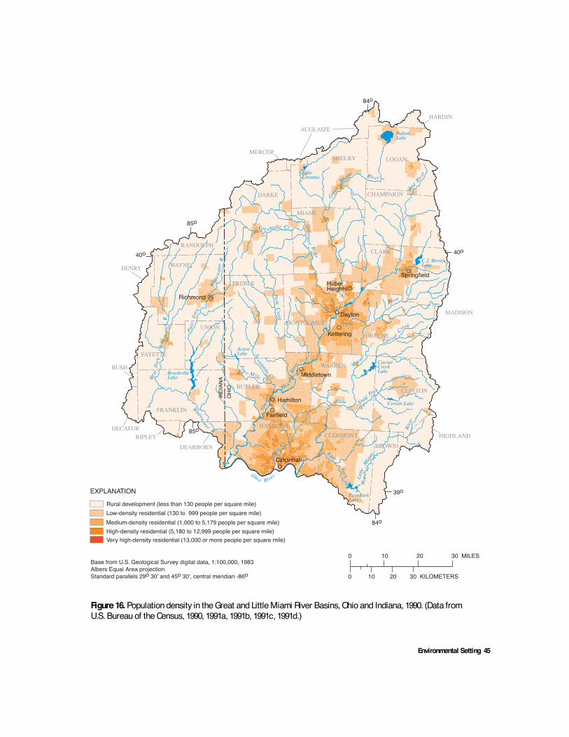
Environmental Setting 45
Figure 16. Population density in the Great and Little Miami River Basins, Ohio and Indiana, 1990. (Data fromU.S. Bureau of the Census, 1990, 1991a, 1991b, 1991c, 1991d.)
Springfield
Dayton
Cincinnati
Richmond
BrookvilleLake
ActonLake
CaesarCreekLake
Cowan Lake
East ForkLake
C.J. BrownLake
LakeLoramie
IndianLake
LOGANSHELBY
MIAMI
CHAMPAIGN
AUGLAIZE
HARDIN
DARKE
MERCER
CLARK
GREENE
PREBLE
WAYNE
RANDOLPH
UNION
FAYETTE
FRANKLIN
RUSH
DECATURRIPLEY
DEARBORN
BUTLER
HAMILTON
WARREN
CLERMONT
BROWNHIGHLAND
CLINTON
MADISON
0 10 20 30 MILES
0 10 20 30 KILOMETERS
84o
39o
40o
84o
85o
40o
85o
Middletown
Ohio River
Wes
tFo
r kW
h ite
wat
erR
East
For k
Whit
ewat
erR
W
hitewate r R
Grea
t
Mi a mi
Rive
rFou r M ile Cr
Twin
Cre ek
Gre enville Cr
Stillwate r Rive r
Great
Miami River
M
ad
Riv er
CaesarCreek
Little
Mia mi
River
Todd
Fork
East
For k Littl
eMiam
i
Rive
r
INDI
ANA
OHI
O
Base from U.S. Geological Survey digital data, 1:100,000, 1983Albers Equal Area projectionStandard parallels 29o 30' and 45o 30', central meridian -86o
Mi llCr
Hamilton
Sev enmil e
Cr
MONTGOMERY
EXPLANATION
Rural development (less than 130 people per square mile)
Medium-density residential (1,000 to 5,179 people per square mile)High-density residential (5,180 to 12,999 people per square mile)Very high-density residential (13,000 or more people per square mile)
Low-density residential (130 to 999 people per square mile)
HENRY
Fairfield
Kettering
HuberHeights

46 Environmental Setting and Effects on Water Quality, Great and Little Miami River Basins, Ohio and Indiana
Figure 17. Population growth in the Great and Little Miami River Basins, Ohio and Indiana, 1800–1995.(Data from John Bittle, State Library of Ohio, written commun., 1998; U.S. Bureau of the Census, 1998b.)
1800
2000
1820
1840
1860
1880
1900
1920
1940
1960
1980
YEAR
0
3.0
0.5
1.0
1.5
2.0
2.5
POPU
LATI
ON,
IN M
ILLI
ONS
Estimated population in the Great and Little Miami River Basins
Estimated population in Cincinnati, Ohio
Estimated population in Dayton, Ohio
sites’ proximity to large, navigable rivers. Farms ofthe early settlers were concentrated on fertile floodplains next to streams and rivers. Rapid economicgrowth in the study area followed completionof the Miami Canal in 1829. The canal, whichlinked Dayton to Cincinnati, provided low-costtransportation of agricultural products to nationaland world markets. Canal traffic peaked in 1850and declined as railroads were constructed acrossthe study area. Rail transportation promoted therise of manufacturing in towns and cities, andby the 1870’s Cincinnati and Dayton were nation-ally important industrial centers (Becker andNolan, 1988). As towns and factories in thestudy area grew, more wells were completed in
the buried-valley aquifer. The abundant supplyof ground water was critical to the developmentthat continued through the twentieth century.Deforestation and urbanization that accompaniedthe transition from an agrarian to industrial society,however, adversely affected the quality of waterin streams and aquifers in the study area.
Population increases that accompaniedsettlement and subsequent industrial developmentaffected stream habitat and biological communitiesin the study area (Trautman, 1981; Harrington,1999). Before the 1800’s, streams normally wereclear and contained little soil in suspension, exceptduring floods. The native fish population required

Environmental Setting 47
clear waters with clean stream bottoms of sand,gravel, boulders, bedrock, and organic debrisand/or aquatic vegetation. As human populationincreased, there was a corresponding increasein the amounts of forest removed, land ditchedand drained, and virgin prairie plowed. Conversionof forest land to farms and towns was accompaniedby construction of dams and water mills andpollution by sawdust, brewery, and slaughter-house waste. In the 1900’s, discharge of increasingamounts of industrial- and domestic-sewage wastesfurther contributed to modifications of the instreamfauna (Trautman, 1981; Harrington, 1999).
Land-use and land-cover information forthe study area is based on a national data setcompiled from topographic maps and high-altitude aerial photographs. The land-use andland-cover data from 1973 to 1981 are availableas Geographic Information and Retrieval System(GIRAS) files (U.S. Geological Survey, 1990).The USGS land-use and land-cover data set iscoded by use of the Anderson classificationsystem (Anderson, 1976), which is a hierarchi-cal system of general (Level 1) to more specific(Level 2) classes. Although the data base is some-what outdated and of relatively coarse resolution,it can be used to illustrate general patterns of landuse and to establish a base line for evaluatingchanges in land use since the mid-1970’s. TheGIRAS data set was used as the foundation fora refined land-use-classification scheme that usedU.S. Bureau of the Census 1990 population datato define areas of new urban and residential devel-opment in the study area (Hitt, 1994a, b).
The updated Level 1 land-use data showthat agriculture is the principal land use throughoutthe study area, encompassing more than 79 percentof the total land area (fig. 18). Urban land use(residential, industrial, and commercial) makesup slightly more than 13 percent of total land use.While urban land use has increased from 10.7 per-cent in the 1970’s to 13.1 percent in 1990, otheruses have remained relatively constant. The re-maining land consists of forest (7 percent) mainly
in the southern part of the study area, water bodiesor wetlands (0.7 percent), and barren land (0.3 per-cent). Strip mines, quarries, and exposed bedrockare considered “barren land.”
Agriculture
Most land in the study area is used for agri-cultural activities. More than 3 million acres offarmland are in the study area, and approximately84 percent are used for crop production. Countiesin the northern part of the study area have thehighest percentage of farmland used for crop pro-duction. More than 90 percent of the cropland inthe study area was planted in corn, soybeans, andwheat (fig. 19), with production highest in DarkeCounty, Ohio, in 1997. Corn and soybeans areplanted in the spring and early summer and har-vested in the fall. Winter wheat crops are plantedin the fall and harvested in the summer. Hogs, pigs,and cattle were the main livestock raised in thestudy area (fig. 20), with the highest productionin Darke County, Ohio. Based on 1995 county-level data, an estimated 720,000 hogs and pigswere raised in the study area; county-level dataare not available after 1995 in Indiana. Based on1997 data, an estimated 300,000 cattle were raisedin the study area.
The use of fertilizers and chemical pesticidesoften are associated with agricultural practicesand the degradation of surface- and ground-waterquality. Commercial fertilizers (nitrogen, phos-phate, and potash) are used widely in the studyarea. Micronutrients, livestock manure, sulfur,and lime also are applied alone or in combinationwith commercial fertilizers (Indiana AgriculturalStatistics Service, 1996). Fertilizer and manureassociated with row-crop farming and livestockproduction are major sources of nutrients in surfaceand ground water. Nutrients applied in quantitiesexceeding the amount used by crops and held bysoil are carried to surface water through runoffand subsurface drainage systems and to groundwater through infiltration (Nokes and Ward, 1997).

48 Environmental Setting and Effects on Water Quality, Great and Little Miami River Basins, Ohio and Indiana
Figure 18. Land use and land cover in the Great and Little Miami River Basins, Ohio and Indiana.(Data from U.S. Geological Survey, 1990; Hitt, 1994a.)
Springfield
Dayton
Cincinnati
Richmond
BrookvilleLake
ActonLake
CaesarCreekLake
Cowan Lake
East ForkLake
C.J. BrownLake
LakeLoramie
IndianLake
LOGANSHELBY
MIAMI
CHAMPAIGN
AUGLAIZE
HARDIN
DARKE
MERCER
CLARK
GREENE
PREBLE
WAYNE
RANDOLPH
UNION
FAYETTE
FRANKLIN
RUSH
DECATURRIPLEY
DEARBORN
BUTLER
HAMILTON
WARREN
CLERMONT
BROWNHIGHLAND
CLINTON
MADISON
0 10 20 30 MILES
0 10 20 30 KILOMETERS
84o
39o
40o
84o
85o
40o
85o
Middletown
Ohio River
Wes
tFo
r kW
h ite
wat
erR
East
For k
Whit
ewat
erR
W
hitewate r R
Grea
t
Mi a mi
Rive
rFou r M ile Cr
Twin
Cre ek
Gre enville Cr
Stillwate r Rive r
Great
Miami River
M
ad
Riv er
CaesarCreek
Little
Mia mi
River
Todd
Fork
East
For k Littl
eMiam
i
Rive
r
INDI
ANA
OHI
O
Base from U.S. Geological Survey digital data, 1:100,000, 1983Albers Equal Area projectionStandard parallels 29o 30' and 45o 30', central meridian -86o
Mi llCr
Hamilton
Sev enmil e
Cr
MONTGOMERY
EXPLANATION
Urban land (includes residential, industrial and commercial land)
Agricultural landForest landWaterWetlandBarren land (includes quarries and mines)
Residential land developed between 1980 and 1990
HENRY

Environmental Setting 49
Figure 19. Percent of land planted in corn, soybeans, and wheat in the Great and Little Miami River Basins, Ohioand Indiana, 1997. (Data from Indiana Agricultural Statistics Service, 1998; Ohio Department of Agriculture, 1998.)
LOGAN
SHELBY
MIAMI
CHAMPAIGN
AUGLAIZEHARDIN
DARKE
MERCER
CLARK
GREENEPREBLE
WAYNE
RANDOLPH
UNIONFAYETTE
FRANKLIN
RUSH
DECATURRIPLEY
DEARBORN
BUTLER
HAMILTON
WARREN
CLERMONT
BROW
N HIGHLAND
CLINTON
MADISON
84o
39o
40o
84o
85o
40o
85o
INDI
ANA
OHI
O
MONTGOMERY
LOGANSHELBY
MIAMI
CHAMPAIGN
AUGLAIZEHARDIN
DARKE
MERCER
CLARK
GREENEPREBLE
WAYNE
RANDOLPH
UNIONFAYETTE
FRANKLIN
RUSH
DECATURRIPLEY
DEARBORN
BUTLER
HAMILTON
WARREN
CLERMONT
BROW
N HIGHLAND
CLINTON
MADISON
84o
39o
40o
84o
85o
40o
85o
INDI
ANA
OHI
O
MONTGOMERY
EXPLANATIONPercentage of county planted in soybeans
0 to 910 to 1920 to 2930 or greater
EXPLANATIONPercentage of county planted in corn
0 to 910 to 1920 to 2930 or greater
LOGANSHELBY
MIAMICHAMPAIGN
AUGLAIZEHARDIN
DARKE
MERCER
CLARK
GREENEPREBLE
WAYNE
RANDOLPH
HENRY
UNIONFAYETTE
FRANKLIN
RUSH
DECATURRIPLEY
DEARBORN
BUTLER
HAMILTON
WARREN
CLERMONT
BROW
N HIGHLAND
CLINTON
MADISON
84o
39o
40o
84o
85o
40o
85o
INDI
ANA
OHI
O
MONTGOMERY
EXPLANATIONPercentage of county planted in wheat
0 to 2.02.1 to 4.04.1 to 6.0Greater than 6.0
Base maps from U.S. Geological Surveydigital data, 1:100,000, 1983Albers Equal Area projectionStandard parallels 29o 30' and 45o 30', central meridian -86o
HENRY HENRY
Wheat
Corn Soybeans

50 Environmental Setting and Effects on Water Quality, Great and Little Miami River Basins, Ohio and Indiana
Figure 20. Livestock raised in the Great and Little Miami River Basins, Ohio and Indiana.(Data from Indiana Agricultural Statistics Service, 1996; Ohio Department of Agriculture,1997.)
LOGANSHELBY
MIAMI
CHAMPAIGN
AUGLAIZEHARDIN
DARKE
MERCER
CLARK
GREENEPREBLE
WAYNE
RANDOLPH
UNIONFAYETTE
FRANKLIN
RUSH
DECATURRIPLEY
DEARBORN
BUTLER
HAMILTON
WARREN
CLERMONT
BROW
N HIGHLAND
CLINTON
MADISON
84o
39o
40o
84o
85o
40o
85o
INDI
ANA
OHI
O
MONTGOMERY
LOGANSHELBY
MIAMI
CHAMPAIGN
AUGLAIZEHARDIN
DARKE
MERCER
CLARK
GREENEPREBLE
WAYNE
RANDOLPH
UNIONFAYETTE
FRANKLIN
RUSH
DECATURRIPLEY
DEARBORN
BUTLER
HAMILTON
WARREN
CLERMONT BROW
N HIGHLAND
CLINTON
MADISON
84o
39o
40o
84o
85o
40o
85oIN
DIAN
AO
HIO
MONTGOMERY
EXPLANATIONNumber raised in each county
Less than 10,00010,000 to 39,99940,000 to 69,99970,000 or greater
EXPLANATIONNumber raised in each county
Less than 5,0005,000 to 9,99910,000 to 19,99920,000 or greater
HENRY
Base maps from U.S. Geological Surveydigital data, 1:100,000, 1983Albers Equal Area projectionStandard parallels 29o 30' and 45o 30', central meridian -86o
HENRY
Cattle
Hogs and pigs

Environmental Setting 51
Nitrogen and phosphorus fertilizer-applicationrates were estimated from county-level data for1991 (fig. 21). Application rates were highestin Rush and Decatur Counties, Ind., and MercerCounty, Ohio. Estimates of the nitrogen and phos-phorus content of animal manure produced in1992 were highest in Mercer and Darke Counties,Ohio; nitrogen content is also high in DecaturCounty, Ind. (fig. 22). Although the timing ofapplications varies by crop, fertilizers generallyare applied in the fall before planting. Manure isapplied in the fall and winter (Dennis Baker, DarkeCounty Extension, oral commun., 1998). For corn,fertilizers generally are applied at the time of plant-ing or in the spring before planting. For wheat,phosphorus is applied at planting; nitrogen maybe applied in spring through mid-April. Applica-tion methods vary with the type of product andcrop and most frequently include broadcast,banded, and injection methods.
Pesticides are applied to agricultural crop-lands to enhance crop production and to controlweeds (herbicides), insects (insecticides), andfungi (fungicides). These chemicals enter streamsby way of runoff and eroded soil, wind transportto water bodies, and subsurface tile drains in areasof poor drainage. In areas underlain by permeableglacial deposits, leaching of pesticides to shallowground water and subsequent discharge to localstreams is another potential transport mechanism.In addition to leaching through the soil profile,contamination of aquifers can occur through poorlyconstructed wells or by induced infiltration ofsurface water that contains pesticides.
Estimated agricultural pesticide use in thestudy area indicates that 25 commonly appliedpesticides accounted for nearly 95 percent of allagricultural pesticide use in the study area in 1992(table 10). Of these, the most commonly appliedpesticides were atrazine and metolachlor, whichare used as pre- and post-emergent herbicides tocontrol broadleaf and grassy weeds for corn andsoybean production. Pesticides are applied mainlyin spring and early summer by ground application;air application is rare. Farmers in the study areaoften rely on pre-plant herbicide applications forcorn and soybeans (late April and early May).
Post-planting applications (in June) often areapplied for rescue treatment on corn and soybeansand occasionally on wheat crops, although fewfarmers rely solely on this method (Roger Bender,Shelby County Extension, oral commun., 1998).
Chlorpyrifos and terbufos are the mostcommonly applied insecticides in the study area(table 10). Insecticides generally are applied inthe spring. Seed corn generally is treated with acombination insecticide/fungicide at low rates(Roger Bender, Shelby County Extension, oralcommun., 1998). Although efforts are being madeby the agricultural community to reduce insecticideuse, applications are required during infestationsand spot applications are applied in late summer.Soybean and wheat crops typically do not receiveinsecticide treatment. Fungicides are used as a seedtreatment or seed-box treatment for soybeans.
Many agricultural activities traditionally re-sult in the degradation or removal of native streamvegetation and instream habitat or bank erosionthat cause sedimentation and siltation. Much ofthe observed stream-quality degradation in thestudy area is related to poor agricultural practicesthat often result in habitat modification aroundthe banks of streams and other surface-waterbodies (Rankin and others, 1997b). Often thesemodifications reduce riparian buffers and allownutrients and sediment to enter streams. Runofffrom fertilizers and organic wastes from livestockcontribute to nutrient and organic enrichment ofreceiving waters. Buffers and filter strips (grassyareas planted next to drainage paths) filter sedimentand chemicals before they reach waterways as wellas reduce the loss of soil, fertilizers, and pesticides(Roger Bender, Shelby County Extension Office,oral commun., 1998). Preserving riparian vegeta-tion adjacent to streams can provide a buffer zonethat helps surface-water bodies better assimilaterunoff from agricultural land use.
Sedimentation from poor agricultural prac-tices is the largest nonpoint-source threat to streamand river integrity (Rankin and others, 1997a, b).Soils in the study area have a high erosion poten-tial that makes nonpoint-source-managementactivities a priority for water- and soil-resourcemanagers.

52 Environmental Setting and Effects on Water Quality, Great and Little Miami River Basins, Ohio and Indiana
Figure 21. Fertilizer application rates in the Great and Little Miami River Basins, Ohio andIndiana, 1991. (Data from Battaglin and Goolsby, 1994; Puckett and others, 1998.)
LOGANSHELBY
MIAMI
CHAMPAIGN
AUGLAIZEHARDIN
DARKE
MERCER
CLARK
GREENEPREBLE
WAYNE
RANDOLPH
UNIONFAYETTE
FRANKLIN
RUSH
DECATURRIPLEY
DEARBORN
BUTLER
HAMILTON
WARREN
CLERMONT
BROW
N HIGHLAND
CLINTON
MADISON
84o
39o
40o
84o
85o
40o
85o
INDI
ANA
OHI
O
MONTGOMERY
LOGANSHELBY
MIAMI
CHAMPAIGN
AUGLAIZEHARDIN
DARKE
MERCER
CLARK
GREENEPREBLE
WAYNE
RANDOLPH
UNIONFAYETTE
FRANKLIN
RUSH
DECATURRIPLEY
DEARBORN
BUTLER
HAMILTON
WARREN
CLERMONT BROW
N HIGHLAND
CLINTON
MADISON
84o
39o
40o
84o
85o
40o
85o
INDI
ANA
OHI
O
MONTGOMERY
EXPLANATIONTons per square mileby county
Less than 1010 to 14.915 to 19.920 or greater
HENRY
Base maps from U.S. Geological Surveydigital data, 1:100,000, 1983Albers Equal Area projectionStandard parallels 29o 30' and 45o 30', central meridian -86o
HENRY
EXPLANATIONTons per square mileby county
Less than 55 to 7.47.5 to 9.910 or greater
Nitrogen from fertilizer
Phosphorusfrom fertilizer

Environmental Setting 53
Figure 22. Nitrogen and phosphorus from animal manure in the Great and Little MiamiRiver Basins, Ohio and Indiana, 1992. (Data from Puckett and others, 1998.)
LOGANSHELBY
MIAMI
CHAMPAIGN
AUGLAIZEHARDIN
DARKE
MERCER
CLARK
GREENEPREBLE
WAYNE
RANDOLPH
UNIONFAYETTE
FRANKLIN
RUSH
DECATURRIPLEY
DEARBORN
BUTLER
HAMILTON
WARREN
CLERMONT
BROW
N HIGHLAND
CLINTON
MADISON
84o
39o
40o
84o
85o
40o
85o
INDI
ANA
OHI
O
MONTGOMERY
LOGANSHELBY
MIAMI
CHAMPAIGN
AUGLAIZEHARDIN
DARKE
MERCER
CLARK
GREENEPREBLE
WAYNE
RANDOLPH
UNIONFAYETTE
FRANKLIN
RUSH
DECATURRIPLEY
DEARBORN
BUTLER
HAMILTON
WARREN
CLERMONT BROW
N HIGHLAND
CLINTON
MADISON
84o
39o
40o
84o
85o
40o
85o
INDI
ANA
OHI
O
MONTGOMERY
EXPLANATIONTons per square mile by county
Less than 1.01.0 to 2.42.5 to 4.95 or greater
EXPLANATIONTons per square mileby county
Less than 55 to 7.47.5 to 9.910 or greater
HENRY
Base maps from U.S. Geological Surveydigital data, 1:100,000, 1983Albers Equal Area projectionStandard parallels 29o 30' and 45o 30', central meridian -86o
HENRY
Nitrogen from manure
Phosphorusfrom manure

54 Environmental Setting and Effects on Water Quality, Great and Little Miami River Basins, Ohio and Indiana
Table 10. Estimated agricultural pesticide use in the Great and Little Miami River Basins, Ohio and Indiana[Data modified from Michael S. Majewski, written commun., U.S. Geological Survey, 19981; lb, pound; lb/acre, pound per acre]
1Pesticide-use estimates are based on data taken from National Center for Food and Agricultural Policy and 1992 Census of Agriculturedata bases. Sources and limitations of the data used to produce the estimates are described by U.S. Geological Survey (1998).
Application rate ofactive ingredient
(lb/acre)
Compound Type
Active ingredientapplied
(lb)Acrestreated
Treatedcropland
Totalstudy area
2,4-d Herbicide 141,284 297,729 0.47 0.03
Acetochlor Herbicide 439,270 216,950 2.02 .09
Alachlor Herbicide 439,130 227,553 1.93 .09
Atrazine Herbicide 1,042,409 843,791 1.24 .22
Bentazon Herbicide 94,904 124,668 .76 .02
Butylate Herbicide 182,492 51,781 3.52 .04
Carbofuran Insecticide 24,680 22,830 1.08 .01
Chlorpyrifos Insecticide 84,644 79,940 1.06 .02
Clomazone Herbicide 24,688 37,414 .66 .01
Cyanazine Herbicide 471,913 220,984 2.14 .10
Dicamba Herbicide 103,086 325,427 .32 .02
Dimethenamid Herbicide 53,960 54,505 .99 .01
Eptc Herbicide 89,614 22,218 4.03 .02
Ethalfluralin Herbicide 25,205 28,061 .90 .01
Fonofos Insecticide 31,282 31,000 1.01 .01
Glyphosate Herbicide 245,929 411,757 .60 .05
Linuron Herbicide 52,754 87,311 .60 .01
Metolachlor Herbicide 966,176 498,051 1.94 .21
Metribuzin Herbicide 55,746 173,436 .32 .01
Paraquat Herbicide 38,493 66,342 .58 .01
Pendimethalin Herbicide 238,539 255,835 .93 .05
Phorate Insecticide 43,257 36,731 1.18 .01
Simazine Herbicide 68,409 63,337 1.08 .01
Terbufos Insecticide 69,070 59,939 1.15 .01
Trifluralin Herbicide 60,294 58,147 1.04 .01

Environmental Setting 55
Sedimentation increases turbidity of waters,which reduces light penetration, alters oxygenavailability, and reduces food supply for aquaticorganisms. Sediments also cover spawning beds,reducing fish populations and increasing nutrientlevels. Phosphorus attached to soil particles is car-ried into water during erosion (Hill and Mannering,1995), and increased nutrient concentrations maycause algal blooms.
Many farmers have adopted conservation-tillage practices to control soil loss and reducerunoff. Conservation tillage is defined as any till-age and planting system that covers 30 percentor more of the soil surface with crop residue afterplanting to reduce soil loss from wind and watererosion (Anne Baird, Ohio State University Exten-sion, Southwest District, written commun., 1998).Conservation-tillage systems reduce erosion ratesby at least 50 to 60 percent and include no-till,ridge-till, strip-till, and mulch-till methods (Hilland Mannering, 1995). After harvesting season,plant residue generally is chiseled under or lefton top of the soil. No-till and ridge-till methodsand forms of strip tillage leave the soil undisturbeduntil planting and leave residual plant material onthe soil surface. While conservation-tillage prac-tices generally are increasing, no-till methods aredecreasing in some areas because destructive cropdiseases sometimes are carried over to the nextseason (Dennis Baker, Darke County Extension,oral commun., 1999). Conservation-tillage systemsalso may change physical properties of soilsover time. Under the right conditions, untilledmacropores (small channels created by earth-worm activities, soil cracking, and root growth)can increase infiltration rate and increase the poten-tial for leaching of fertilizers and pesticides intoshallow aquifers (Hill and Mannering, 1995).
Tile-drain systems are common in areaswhere natural soil drainage is poor. New andreplaced tiles generally are composed of plastic;older tiles are ceramic. Poorly permeable, clay-richsoils that require tile drainage generally are foundin the northern part of the study area and coverlarge areas of Darke and Shelby Counties, Ohio(fig. 8). Surface-drainage systems are usedthroughout the basin and include ditches andgrass waterways that drain and filter soils.
Urban Development and Industry
Since the 1970’s, the percentage of urbanland in the study area has increased about 2.4 per-cent (approximately 177 mi2). Most of the recenturbanization is the result of conversion of agri-cultural land to new suburban and residentialdevelopments and is concentrated in zones border-ing the major metropolitan areas of Dayton andCincinnati (fig. 18). The effects of convertingagricultural land to residential and commercialuses on water quality and aquatic organisms arenot fully known. The effects may include increasederosion and channel instability, sediment loads,loss of aquatic habitat, runoff, and floodingfrequency and intensity; reductions in ground-water recharge; and introduction of “urban”contaminants (deicing chemicals, heavy metals,volatile and semi-volatile organic compounds) tostreams and aquifers. Residential and commercialdevelopment also will increase the amount oftreated sewage effluent discharged into streamsso that treated wastewater may become the domi-nant source of water to a stream during periodsof low flow. This appears to have occurred inthe Little Miami River in response to developmentin Greene and Warren Counties, Ohio, in the lastcouple of decades (Buchberger and others, 1997).
Major industries in the study area produceautomobile and aircraft parts, business andcomputer equipment, steel, chemicals, householdgoods and appliances, paper products, and pro-cessed foods and beverages (Rowe and Baker,1997). Industrial facilities generally are withinor near the large urban areas of Dayton andCincinnati. Liquid and solid wastes produced byindustrial processes are a significant source ofcontamination as treated wastewater and coolingwaters are discharged to streams and solid wastesare disposed of in landfills or by incineration.
Recreation
Recreational activities and facilities are avail-able at 14 state parks in the study area. Many ofthese parks are developed around lakes wherethe use of boats and other watercraft can affectwater quality. Many parks restrict the type and

56 Environmental Setting and Effects on Water Quality, Great and Little Miami River Basins, Ohio and Indiana
size of boat motors in an attempt to protect waterresources. Reservoirs, constructed for flood con-trol, also provide outdoor activities like hunting,fishing, camping, swimming, hiking, and boating.Camp sites along these protected areas often haveprimitive latrines that can threaten water quality.Hundreds of lakes, ponds, and gravel pits in thestudy area also are used for recreation, fishing,or aesthetic purposes (Indiana Department ofNatural Resources, 1988).
Mineral, Oil, and Gas Resources
Industrial minerals mining accounts forless than 1 percent of land use in the study area.Industrial minerals are mined for commercialand industrial uses, as opposed to coal and gasthat primarily are mined for energy production.Consolidated and unconsolidated geologic materi-als (limestone, shale, sand, and gravel) are minedfor their economic value. There are approximately176 active stone quarries in the study area. Activequarries include sand and gravel; limestone anddolomite; crushed stone; and several peat, clay, andshale operations. These industries require variableamounts of water to process their products.
Mining-related water withdrawals fromstreams can reduce streamflow; the discharge ofwaste or process water to surface-water bodiesfrom quarries can alter the quality of the receivingwaters (Herricks and others, 1974). Ground-waterresources also are affected; mining operationsmay remove protective surficial materials, creatinglarge cavities and exposing the water table tosurface-derived contaminants. Mining operationsalso can disrupt ground-water flowpaths and alterrecharge rates to aquifers; higher infiltration ratescan increase aquifer storage but may increase thepotential for ground-water contamination. Wherepumping is done to keep mines and quarries freeof water, ground-water levels near the quarry oper-ation may decline (Howard and Wright, 1974).Mining and associated activities also can reduce oreliminate terrestrial and aquatic habitat (Herricksand others, 1974).
The spatial distribution of industrial mineralsoperations and oil and gas wells in the study areareflects geologic and economic factors (fig. 23).Limestone and dolomite quarries are located in thenorthern half of the study area, where sufficientlythick deposits of high-quality Silurian limestoneand dolomite beds are accessible below thin (lessthan 75 ft thick) glacial drift (Stout, 1941). Mostactive quarries in the study area extract lime-stone and dolomite from the Salamonie Dolomite,Brassfield Limestone, Dayton Limestone, or LaurelDolomite formations. Quarries in Clinton, Greene,and Miami Counties were the three largest produc-ers of limestone and dolomite in the Ohio part ofthe study area and, together, produced 67 percentof the total tonnage sold in the study area in 1997(Wolfe, 1998). Production data were not availablefor counties in Indiana. Limestone and dolomiteproduced in the study area are used for commer-cial building stone; road construction; and theproduction of Portland cement, lime, and agricul-tural lime.
Sand and gravel mining operations generallyfollow the spatial distribution of coarse-stratifiedglacial deposits in the study area (fig. 7) and areclustered along main-stem segments of the Greatand Little Miami Rivers (fig. 23). Sand and graveloperations are found in 16 counties of the studyarea, with the majority of sand and gravel pitsconcentrated near major transportation corridorsin the Dayton and Cincinnati Metropolitan Areas.Hamilton and Butler Counties ranked first andthird in Ohio in 1997 sand and gravel production,respectively, and together were responsible forproducing nearly half the total tonnage sold inthe entire study area (Wolfe, 1998). Minor amountsof crushed stone, clay, shale, and peat also are pro-duced in the study area.
Minor amounts of oil and natural gas areproduced in the study area, primarily from wellscompleted in the Ordovician Trenton Limestonealong the Lima-Indiana trend. The Lima-Indiana

Environmental Setting 57
Figure 23. Location of mineral industries and oil and gas wells in the Great and Little Miami River Basins,Ohio and Indiana. (Data from Wolfe, 1998; Nelson Shaffer, Indiana Geological Survey, written commun.,1998.)
Springfield
Dayton
Cincinnati
Richmond
BrookvilleLake
ActonLake
CaesarCreekLake
Cowan Lake
East ForkLake
C.J. BrownLake
LakeLoramie
IndianLake
LOGANSHELBY
MIAMI
CHAMPAIGN
AUGLAIZE
HARDIN
DARKE
MERCER
CLARK
GREENE
PREBLE
WAYNE
RANDOLPH
HENRY
UNION
FAYETTE
FRANKLIN
RUSH
DECATURRIPLEY
DEARBORN
BUTLER
HAMILTON
WARREN
CLERMONTBROWN
HIGHLAND
CLINTON
MADISON
0 10 20 30 MILES
0 10 20 30 KILOMETERS
84o
39o
40o
84o
85o
40o
85o
Middletown
Ohio River
Wes
tFo
r kW
h ite
wat
erR
East
For k
Whit
ewat
erR
W
hitewate r R
Grea
t
Mi a mi
Rive
rFou r M ile Cr
Twin
Cre ek
Gre enville Cr
Stillwate r Rive r
Great
Miami River
M
ad
Riv er
CaesarCreek
Little
Mia mi
River
Todd
Fork
East
For k Littl
eMiam
i
Rive
r
INDI
ANA
OHI
O
Base from U.S. Geological Survey digital data, 1:100,000, 1983Albers Equal Area projectionStandard parallels 29o 30' and 45o 30', central meridian -86o
Mi llCr
Hamilton
Sev enmil e
Cr
MONTGOMERY
EXPLANATIONSand and gravelClay/shaleLimestone/dolomitePeatOil and gas wellsDry wells

58 Environmental Setting and Effects on Water Quality, Great and Little Miami River Basins, Ohio and Indiana
oil and gas trend was the first giant petroleumfield developed in the United States and was drilledextensively in the late 1800’s and early 1900’s(Wickstrom and others, 1992). The Lima-Indianaoil and gas fields trend northeast along thenorthwestern boundary of the study area; pastproduction of oil and natural gas occurred inDarke, Logan, and Shelby Counties, Ohio, andin Randolph and Wayne Counties, Ind. There werea total of 146 active oil and gas wells in the studyarea in 1997, with most located in Shelby andLogan Counties, Ohio (fig. 23). Leakage ofpetroleum hydrocarbons or saline brines fromabandoned or improperly sealed oil wells intoadjacent surface-water bodies or underlying fresh-water aquifers can degrade water supplies. Suchdegradation has been reported in other parts ofIndiana and Ohio but is not considered to be asignificant problem in the study area.
Waste Disposal
Waste-disposal practices differ by wastetype and can have an adverse effect on waterresources. Methods of waste disposal includelandfills, treatment facilities, subsurface injection,and incineration. In Ohio, more than 80 percentof solid waste is landfilled, and landfill capacitiesrange between 5 and 10 years. Almost 70 percentof Indiana’s solid waste is disposed of in land-fills with capacities greater than 10 years (Levy,1997a). Municipal and private solid-waste landfills
receive materials from residential, commercial,and industrial sources and contain paper, plastic,household garbage, metal, glass, and yard trash.Permitted landfills are regulated by the Ohio EPAand IDEM. Clay and rubber liners, caps, andleachate-collection systems are used to help pre-vent liquids from entering or leaving the sites;ground-water-monitoring networks are installedto detect the migration of contaminants from thelandfill. Numerous landfills, particularly alongthe Great Miami River, are old sand and gravel pitsthat have been filled with municipal and industrialwaste. Such sites were used for waste disposalwith little regard to their potential effect on theenvironment; at the time many of these sites werein operation, the effects of waste disposal on theenvironment were neither widely known norconsidered. As a result, contaminants in landfillleachate have migrated to the BVAS or nearbysurface-water bodies, and many of these sitesare undergoing remediation and cleanup.
Of the 35 solid-waste landfills in the studyarea, 6 have capacities greater than 750 tons perday (table 11). Two facilities within the studyarea are among the 10 solid-waste landfills in Ohiowith the largest waste receipts (Ohio Environmen-tal Protection Agency, 1997d). These facilities,in Hamilton and Montgomery Counties, receivedapproximately 1.3 million and 603,000 tons ofwaste in 1996, respectively.
Table 11. Large municipal solid-waste landfills in the Great and Little Miami River Basins, Ohio and Indiana[Modified from Levy, 1997b]
Name LocationCapacity
(tons per day)
ELDA Recycling and Disposal Facility Hamilton County, Ohio 1,500 to 2,000
Rumpke Sanitary Landfill, Inc. Hamilton County, Ohio >2,000
Cherokee Run/Bellefontaine Landfill Logan County, Ohio 1,000 to 1,499
Stoney Hollow Landfill Montgomery County, Ohio >2,000
Bigfoot Run Landfill Warren County, Ohio 1,000 to 1,499
Randolph Farms Landfill Randolph County, Indiana 750 to 999

Environmental Setting 59
Hazardous wastes are those wastes that havetoxic, ignitable, explosive, corrosive, reactive, orradioactive properties, making them harmful tohuman health (Miami Valley Regional PlanningCommission, 1987). Management and disposalof solid, hazardous, and medical wastes and under-ground storage tanks are regulated under theResource Conservation and Recovery Act (RCRA)passed by Congress in 1976. Prior to RCRA, manywastes were disposed of improperly, includingindiscriminate dumping of hazardous waste onthe ground, in waterways, and in unlined landfillsand disposal pits dug out of permeable sand andgravel deposits. In 1980, through the Comprehen-sive Environmental Response, Compensation,and Liability Act (CERCLA), Congress createda tax on the chemical and petroleum industries.This tax provides a trust fund for the cleanup ofabandoned or uncontrolled hazardous-waste sites(“Superfund” sites). Hazardous-waste sites (ware-houses, manufacturing facilities, processing plants,and landfills) are tracked by the USEPA on theComprehensive Environmental Response, Com-pensation, and Liability Information System(CERCLIS) list; 68 CERCLIS sites are in the studyarea (fig. 24). Of these, 12 sites are listed on theNational Priority List and receive Federal fundingfor cleanup. Nine sites are privately owned andrepresent a mix of old landfills and industrialfacilities. The other three sites (fig. 24) are Fed-eral facilities: the Feed Materials ProductionCenter in Fernald, Ohio; the Mound Plant inMiamisburg, Ohio; and Wright-Patterson Air ForceBase in Fairborn, Ohio.
The Feed Materials Production Center, inoperation from 1952 to 1989, processed uraniumore for nuclear-weapon reactors for the U.S. De-partment of Energy. Waste-disposal practicesresulted in on-site contamination, uranium-bearingeffluent leaving the site through a storm-sewerditch, and wastewater lines discharging to theGreat Miami River (U.S. Environmental ProtectionAgency, 1998b). Wastes at the Production Centerinclude low-level radioactive waste, mixed hazard-ous and radioactive waste, oils, solvents, and flyash. The Mound Plant, in operation since 1948,is a research, development, and production facility
formerly operated by the U.S. Department ofEnergy, with an emphasis on small explosivecomponents and nuclear technology. Potentialsources of ground- and surface-water contamina-tion include tritium, plutonium, and volatileorganic compounds (VOC’s) in contaminated soilsand in ditches, canals, and ponds carrying surfacewater from the facility to the Great Miami River(U.S. Environmental Protection Agency, 1998c).At Wright-Patterson Air Force Base, wastes (sol-vents, contaminated thinners, degreasing sludges,and miscellaneous hazardous chemicals) were dis-posed of in several unlined waste-disposal areas(U.S. Environmental Protection Agency, 1998d).Leaks of jet fuel and other hazardous materialsfrom on-site storage facilities also have occurred.Surface water and ground water have been affectedby releases of contaminants from several locationson the Base (Schalk and others, 1996).
The USEPA also regulates facilities thatrelease, store, or transfer toxic chemicals and com-pounds. These facilities are monitored by use ofthe Toxic Release Inventory (TRI) and representsites where spills or improper handling of hazard-ous materials could lead to the accidental releaseof contaminants to the environment. As of 1998,627 facilities in the study area were listed in theTRI data base; most of these are found in or nearthe Dayton or Cincinnati Metropolitan Areas(fig. 25).
Improper on-site disposal of human wastesalso can cause water-quality problems. Septictanks and soil-adsorption systems are commonfeatures of on-site treatment facilities used to treatdomestic sewage and wastewater in rural areas(Mancl, 1997). Septic tanks remove solids fromwastewater. Soil adsorption fields filter and treatthe clarified septic-tank effluent. Failed septic tanksallow solids to enter and clog the soil adsorptionfield, thereby releasing nutrient-rich effluent intothe surrounding areas where it can migrate tounderlying aquifers or flow to nearby surface-water bodies, possibly leading to eutrophicationand nuisance algae blooms.
Residential, commercial, and industrialwastewater and some stormwater runoff areprocessed through wastewater-treatment plants.

60 Environmental Setting and Effects on Water Quality, Great and Little Miami River Basins, Ohio and Indiana
Figure 24. Comprehensive Environmental Response, Compensation, and Liability Information System sites inthe Great and Little Miami River Basins, Ohio and Indiana.
Springfield
Dayton
Cincinnati
Richmond
BrookvilleLake
ActonLake
CaesarCreekLake
Cowan Lake
East ForkLake
C.J. BrownLake
LakeLoramie
IndianLake
LOGANSHELBY
MIAMI
CHAMPAIGN
AUGLAIZE
HARDIN
DARKE
MERCER
CLARK
GREENE
PREBLE
WAYNE
RANDOLPH
HENRY
UNION
FAYETTE
FRANKLIN
RUSH
DECATURRIPLEY
DEARBORN
BUTLER
HAMILTON
WARREN
CLERMONT
BROWNHIGHLAND
CLINTON
MADISON
0 10 20 30 MILES
0 10 20 30 KILOMETERS
84o
39o
40o
84o
85o
40o
85o
Middletown
Ohio River
Wes
tFo
r kW
h ite
wat
erR
East
For k
Whit
ewat
erR
W
hitewate r R
Grea
t
Mi a mi
Rive
rFou r M ile Cr
Twin
Cre ek
Gre enville Cr
Stillwate r Rive r
Great
Miami River
M
ad
Riv er
CaesarCreek
Little
Mia mi
River
Todd
Fork
East
For k Littl
eMiam
i
Rive
r
INDI
ANA
OHI
O
Base from U.S. Geological Survey digital data, 1:100,000, 1983Albers Equal Area projectionStandard parallels 29o 30' and 45o 30', central meridian -86o
Mi llCr
Hamilton
Sev enmil e
Cr
MONTGOMERY
EXPLANATIONComprehensive Environmental Response, Compensation, andLiability Information System siteUrban land (includes residential, industrial, and commercial land)Residential land developed between 1980 and 1990
Fairborn
Fernald
Miamisburg

Environmental Setting 61
Figure 25. Toxic Release Inventory sites in the Great and Little Miami River Basins, Ohio and Indiana.
Springfield
Dayton
Cincinnati
Richmond
BrookvilleLake
ActonLake
CaesarCreekLake
Cowan Lake
East ForkLake
C.J. BrownLake
LakeLoramie
IndianLake
LOGANSHELBY
MIAMI
CHAMPAIGN
AUGLAIZE
HARDIN
DARKE
MERCER
CLARK
GREENE
PREBLE
WAYNE
RANDOLPH
HENRY
UNION
FAYETTE
FRANKLIN
RUSH
DECATURRIPLEY
DEARBORN
BUTLER
HAMILTON
WARREN
CLERMONT
BROWNHIGHLAND
CLINTON
MADISON
0 10 20 30 MILES
0 10 20 30 KILOMETERS
84o
39o
40o
84o
85o
40o
85o
Middletown
Ohio River
Wes
tFo
r kW
h ite
wat
erR
East
For k
Whit
ewat
erR
W
hitewate r R
Grea
t
Mi a mi
Rive
rFou r M ile Cr
Twin
Cre ek
Gre enville Cr
Stillwate r Rive r
Great
Miami River
M
ad
Riv er
CaesarCreek
Little
Mia mi
River
Todd
Fork
East
For k Littl
eMiam
i
Rive
r
INDI
ANA
OHI
O
Base from U.S. Geological Survey digital data, 1:100,000, 1983Albers Equal Area projectionStandard parallels 29o 30' and 45o 30', central meridian -86o
Mi llCr
Hamilton
Sev enmil e
Cr
MONTGOMERY
EXPLANATIONToxic Release Inventory siteUrban land (includes residential, industrial, and commercial land)Residential land developed between 1980 and 1990

62 Environmental Setting and Effects on Water Quality, Great and Little Miami River Basins, Ohio and Indiana
Wastewater contaminants include bacteriaand viruses, suspended solids, organic solvents,nitrogen from human waste, phosphorus fromdetergents and water softeners, and oxygen-demanding wastes. Paint and paint removers,oven cleaners, floor-care products, insecticidesand herbicides, automobile antifreeze, and wasteoil are common chemicals that are transportedto wastewater-treatment plants by drains andsewer lines.
Combined sewers collect and transportsanitary and industrial wastewater as well asstormwater runoff to treatment plants (Ohio Envi-ronmental Protection Agency, 1998a). Untreatedwater exceeding the capacity of the sewers duringstorms overflows into ditches, streams, rivers, orlakes. Such combined-sewer overflows (CSO’s)are often a contributing cause of water-qualityviolations and designated-use impairments forsurface-water bodies. The Lower Little MiamiRiver, for example, receives periodic dischargesof raw sewage and other pollutants from 55 CSO’s,contributing to its partial- and non-attainmentrecord. During a 12-month period, 13 of the 55combined-sewer overflows in Hamilton Countydischarged 295 times and released a total 230 Mgalof untreated water into receiving water bodies(Ohio Environmental Protection Agency, 1995a).
Primary wastewater treatment involves pro-cesses like screening and settling that are capableof removing coarse solids; a reduction of 30 to50 percent of the solids usually is possible. Second-ary treatment turns waste to biomass by creating anenvironment that promotes the growth of naturallyoccurring microbes that digest waste products andincorporate the waste into new biomass. This bio-mass is separated from the treated water priorto discharge and recycled for further use. Excessbiomass (sludge) is removed and disposed of byincineration or landfilling. Many facilities in thestudy area recycle sludge by applying it to soilon cropland. While secondary treatment normallyis considered to provide 85-percent reduction inpollutants, many systems achieve efficiencies of95 percent or more (James Simpson, Ohio Envi-ronmental Protection Agency, Southwest District,written commun., 1998). All large wastewater-
treatment plants (processing 1 Mgal/d or more) inthe study area use advanced secondary treatment.Advanced secondary treatment, also called tertiarytreatment, includes a variety of processes thatexceed the capabilities of conventional secondarytreatment. It can provide further reduction of con-ventional pollutants such as suspended solids oroxygen demand, or it can target specific wasteconstituents such as ammonia or phosphorus. Inthe Ohio part of the study area, most advancedsecondary treatment is directed towards reducingwastewater ammonia loads (Richard Shoemaker,Ohio Environmental Protection Agency, SouthwestDistrict, oral commun., 1998).
Discharges from municipal and industrialwastewater-treatment plants are regulated underthe National Pollutant Discharge EliminationSystem (NPDES) Permit Program. A NPDESpermit restricts the allowable amount of pollutantsdischarged into a stream as well as the concentra-tion of pollutants in the effluent water. The USEPAtracks information regarding discharges fromindustrial and municipal wastewater-treatmentplants under the Permit Compliance System (PCS)data base. There are 382 PCS facilities in thestudy area (fig. 26); of these, 251 were municipalwastewater-treatment plants. In 1995, these plantsdischarged an average 1,760 Mgal/d of treatedwastewater to study-area streams or directly intothe Ohio River (U.S. Geological Survey, 1995).Treatment plants typically are located near streamsin low-elevation areas with permeable sand- orgravel-rich soils (Miami Valley Regional PlanningCommission, 1987) and discharge treated waterinto surface-water bodies, where streamwater isused to dilute the effluent. Some wastewater is pre-treated before it reaches a treatment facility. Underthe Federal Clean Water Act, industrial facilitiesdischarging wastewater to publicly owned treat-ment plants are required to pretreat the effluentto remove or greatly reduce the concentration ofharmful chemicals (Ohio Environmental Protec-tion Agency, 1998b). Because publicly ownedtreatment plants typically are not designed to treatthese chemicals, pretreatment programs are usedto eliminate these substances before they can bereleased into public sewer systems.

Environmental Setting 63
Figure 26. Location and discharge amounts from industrial and municipal wastewater-treatment plantsunder the U.S. Environmental Protection Agency Permit Compliance System in the Great and Little MiamiRiver Basins, Ohio and Indiana.
Springfield
Dayton
Cincinnati
Richmond
BrookvilleLake
ActonLake
CaesarCreekLake
Cowan Lake
East ForkLake
C.J. BrownLake
LakeLoramie
IndianLake
LOGANSHELBY
MIAMI
CHAMPAIGN
AUGLAIZE
HARDIN
DARKE
MERCER
CLARK
GREENE
PREBLE
WAYNE
RANDOLPH
UNION
FAYETTE
FRANKLIN
RUSH
DECATURRIPLEY
DEARBORN
BUTLER
HAMILTON
WARREN
CLERMONT
BROWNHIGHLAND
CLINTON
MADISON
0 10 20 30 MILES
0 10 20 30 KILOMETERS
84o
39o
40o
84o
85o
40o
85o
Middletown
Ohio River
Wes
tFo
r kW
h ite
wat
erR
East
For k
Whit
ewat
erR
W
hitewate r R
Grea
t
Mi a mi
Rive
rFou r M ile Cr
Twin
Cre ek
Gre enville Cr
Stillwate r Rive r
Great
Miami River
M
ad
Riv er
CaesarCreek
Little
Mia mi
River
Todd
Fork
East
For k Littl
eMiam
i
Rive
r
INDI
ANA
OHI
O
Base from U.S. Geological Survey digital data, 1:100,000, 1983Albers Equal Area projectionStandard parallels 29o 30' and 45o 30', central meridian -86o
Mi llCr
Hamilton
Sev enmil e
Cr
MONTGOMERY
HENRY
EXPLANATIONDischarge, in million gallons per year
Less than 55 to 910 to 4950 to 99
100 to 499500 to 9991,000 to 4,9995,000 or greater

64 Environmental Setting and Effects on Water Quality, Great and Little Miami River Basins, Ohio and Indiana
Pollution from point sources such asindustrial plants, wastewater-treatment plants,and CSO’s declined substantially from 1988to 1996 because of stronger regulations andfinancial-assistance efforts to improve wastewatertreatment. Nonpoint sources (for example, urbanand agricultural runoff and hydromodification)have increased in importance as major sources ofimpairment of rivers and streams in the study area(Rankin and others, 1997a, b). These sources ofpollution are major factors that affect surface-water quality and aquatic life. Throughout Ohio,problems resulting from nutrients, habitat modifi-cation, and siltation have increased; problemsassociated with organic enrichment, ammonia, andmetals have declined (Rankin and others, 1997b).Contamination of streams and stream sediments byheavy metals derived from industrial point sourcesat levels that violate human-health standards oraquatic-life-use criteria are uncommon and arerestricted to a few localized parts of the study area.
Watershed assessments conducted by theOhio EPA in the Little Miami and Upper GreatMiami River Basins (Ohio Environmental Protec-tion Agency, 1995a, 1996a) and the PreliminaryAssessment of Use Attainability (PAUSE) studyconducted by the University of Cincinnati (Buch-berger and others, 1997) in the Little Miami RiverBasin found that point and nonpoint sources areimportant contributors to the total nutrient load inboth watersheds. Although the PAUSE study foundthat nonpoint sources were the greatest contribu-tors of total phosphorus to the Little Miami River,the study also found that point sources and non-point sources contribute about equally to the loadof soluble reactive phosphorus in the Little MiamiRiver. Results of an Ohio EPA survey of theMiddle and Lower Great Miami River Basin showa general improvement in the water-quality condi-tions (Ohio Environmental Protection Agency,1997b). Throughout the study area, improve-ments in the water-quality conditions and theuse-attainment status of streams largely are attrib-uted to upgrades at major wastewater-treatmentplants in the study area. For example, mean annualammonia loads discharged to the Great MiamiRiver from five major wastewater-treatment plants
were reduced from approximately 750 lb/d (poundsper day) in 1985 to less than 300 lb/d in 1995(Ohio Environmental Protection Agency, writtencommun., 1996). Improvements in water qualityin the main stem Little Miami River also havebeen attributed to upgrades at major wastewater-treatment plants in the basin.
Water Use
Water from streams and aquifers in the Greatand Little Miami River Basins is used for munici-pal, industrial, and rural water supplies; irrigation;and the generation of energy. Instream water usesinclude hydroelectric-power generation, waste-water assimilation, recreational boating, fish andwildlife habitat, and swimming (Clark, 1980).Estimated water withdrawals from streams andaquifers in the study area averaged 745 Mgal/din 1995 (table 12); of this amount, approximately48 percent was derived from surface-water bodies(including the Ohio River) and 52 percent waspumped from study-area aquifers (fig. 27).
Table 12. Estimated water use in the Great andLittle Miami River Basins, Ohio and Indiana, 1995[Mgal/d, million gallons per day; data from U.S. Geological Survey,1995]
1Column does not sum to 100 percent due to rounding.2The City of Cincinnati withdrew an average of 114 million
gallons per day from the Ohio River in 1995.
Category
Totalwithdrawal
(Mgal/d)
Percent oftotal
water use1
Public supply2 377.46 50.6
Domestic 30.58 4.1
Commercial 20.33 2.7
Industrial/mining 97.57 13.1
Agricultural(irrigation/livestock/animal specialties)
14.09 1.9
Thermoelectric power 205.34 27.5
Total 745.37

Environmental Setting 65
Figure 27. Estimated water use in the Great and Little Miami River Basins, Ohio and Indiana, 1995.
Thermoelectric199 (55 percent)
Public126 (35 percent)
Industrial28 (8 percent)
Irrigation7 (2 percent)
Public252 (65 percent)
Domestic30 (8 percent)
Commercial20 (5 percent)
Industrial70
(18 percent) Irrigation7 (2 percent)
Thermoelectric6 (2 percent)
Surface water(360 million gallons per day)
Ground water(385 million gallons per day)
Water use in million gallons per day
Alternate sources of drinking water includesmall sand and gravel lenses in till, bedrockaquifers, and surface impoundments throughoutthe study area. In the Ohio part of the study areaunderlain by the BVAS, nearly 100 percent of theprivate and approximately 85 percent of the publicwater supply is obtained from wells completed inthe buried-valley aquifer (Ohio-Kentucky-IndianaRegional Council of Governments, 1988). Only afew suppliers in the Ohio part of the study area relyon surface water instead of ground water: Piqua(Miami County), Wilmington (Clinton County),Greenville (Darke County), Batavia (ClermontCounty), and Arlington Heights and Norwood(Hamilton County). In Indiana, almost 100 per-cent of the public and private water supply inthe BVAS area comes from ground water. A fewsmall users concentrated in Wayne and FranklinCounties (Ohio-Kentucky-Indiana Regional Coun-cil of Governments, 1991) rely on surface water.None of the surface-water sources, however, hasthe capacity to supply the 11 Mgal/d of groundwater drawn from the BVAS in Indiana.
In terms of overall water use, the largestuse categories in the study area were publicsupply (51 percent) and thermoelectric-powergeneration (28 percent). Public supply consumes65 percent (252 Mgal/d) of total ground-waterwithdrawals. Of the 126 Mgal/d of surface waterused for public supply, approximately 90 percent(114 Mgal/d) was water withdrawn by the Cityof Cincinnati from the Ohio River. Instream with-drawals for thermoelectric-power generation andcooling water represent 55 percent (199 Mgal/d)of total surface water used in 1995.
Ground water is the primary source of drink-ing water in the study area. The distribution ofpublic and non-public ground-water users makingwithdrawals greater than 100,000 gal/d shows thatmost ground water is pumped from glaciofluvialsand and gravel deposits of the BVAS; most wellfields are located near major streams or their tribu-taries (fig. 28). Water use is generally greater nearlargely populated or industrial areas. Freshwaterwithdrawals are greatest in the counties includingand surrounding Dayton and Cincinnati, Ohio(Lloyd and Lyke, 1995).

66 Environmental Setting and Effects on Water Quality, Great and Little Miami River Basins, Ohio and Indiana
Figure 28. Locations of public and non-public water supplies withdrawing surface water or ground water atrates exceeding 100,000 gallons per day in the Great and Little Miami River Basins, Ohio and Indiana.
Coarse-grained outwash stratified sediment
Springfield
Dayton
Cincinnati
Richmond
BrookvilleLake
ActonLake
CaesarCreekLake
Cowan Lake
East ForkLake
C.J. BrownLake
LakeLoramie
IndianLake
LOGANSHELBY
MIAMI
CHAMPAIGN
AUGLAIZE
HARDIN
DARKE
MERCER
CLARK
GREENE
PREBLE
WAYNE
RANDOLPH
HENRY
UNION
FAYETTE
FRANKLIN
RUSH
DECATURRIPLEY
DEARBORN
BUTLER
HAMILTON
WARREN
CLERMONT
BROWNHIGHLAND
CLINTON
MADISON
0 10 20 30 MILES
0 10 20 30 KILOMETERS
84o
39o
40o
84o
85o
40o
85o
Middletown
Ohio River
Wes
tFo
r kW
h ite
wat
erR
East
For k
Whit
ewat
erR
W
hitewate r R
Grea
t
Mi a mi
Rive
rFou r M ile Cr
Twin
Cre ek
Gre enville Cr
Stillwate r Rive r
Great
Miami River
M
ad
Riv er
CaesarCreek
Little
Mia mi
River
Todd
Fork
East
For k Littl
eMiam
i
Rive
r
INDI
ANA
OHI
O
Base from U.S. Geological Survey digital data, 1:100,000, 1983Albers Equal Area projectionStandard parallels 29o 30' and 45o 30', central meridian -86o
Mi llCr
Hamilton
Sev enmil e
CrMONTGOMERY
< 0.100.10 to 0.991.00 to 4.995.00 to 9.9910.0 to 99.9> 100
Surfacewater
Groundwater
Water withdrawals in millions of gallonsper day
EXPLANATION
Public water-supply withdrawalsNon-public water-supply withdrawals

Effects of Environmental Setting on Water Quality 67
Effects of Environmental Settingon Water QualitySurface-Water Quality
Surface-water quality in the study area isaffected by a variety of natural and human factors.Natural factors include climate, physiography,geology, soil type, and ecology. Human factorsinclude population density; land use; and releaseof contaminants to air, water, and soils from avariety of sources including industrial facilities,municipal wastewater-treatment plants, CSO’s,and urban and agricultural nonpoint sources.
Federal, State, and regional governmentagencies and local universities collect water-quality data at a variety of locations in the studyarea. The Ohio EPA collects nutrient and major-ion samples at five sites on a routine (monthly)basis within the Ohio part of the study area.These sites are on the Little Miami River atOldtown (streamflow-gaging station 03240000,fig. 9), the Stillwater River at Pleasant Hill(03265000, fig. 9), the Mad River at EagleCity (03267900, fig. 9), and the Great MiamiRiver at Dayton (03270500, fig. 9) and Miamis-burg (fig. 1) (water-quality-monitoring station03271510). To assess current water-quality condi-tions in individual watersheds, the Ohio EPAand IDEM conduct comprehensive biological andwater-quality synoptic surveys on a rotational basiswithin the study area. A list of recent watershedsurveys is shown in table 13. Other agenciesconducting water-quality sampling include theOhio River Valley Water Sanitation Commission(ORSANCO), which collects monthly water-quality samples at two sites near the mouths ofthe Great and Little Miami Rivers. These data havebeen collected since 1975 as part of ORSANCO’smanual sampling program and include determi-nations of pH, alkalinity, sulfate, major metals,nutrients, bacteria, and selected trace elements(Ohio River Valley Water Sanitation Commission,1990). ORSANCO also conducts studies thatexamine specific water-quality issues, such as arecent study examining 1995 herbicide loadingsin the Lower Ohio River Basin that included datafrom the Lower Great Miami River and the LowerLittle Miami River (Ohio River Valley Water Sani-tation Commission, 1997).
Two universities conducting water-qualitywork in the study area are Heidelberg Collegeand the University of Cincinnati. Since 1996,Heidelberg College has collected major-ion,nutrient, and herbicide samples at the Great MiamiRiver at Miamisburg (David Baker, HeidelbergCollege, written commun., 1997). The Universityof Cincinnati collected nutrient data within theLittle Miami River Basin in 1996 and 1997(Buchberger and others, 1997).
Water-quality samples were collected rou-tinely by the USGS at four locations in the studyarea from the 1970’s through 1993 as part ofthe National Stream Quality Accounting Net-work (NASQAN) Program. Sampling sites werelocated at the Little Miami River at Milford,Ohio (near streamflow-gaging station 03245500,fig. 9), Great Miami River at New Baltimore,Ohio (streamflow-gaging station 03274600,which is 14.3 mi downstream from 03274000 onfig. 9), and Whitewater River at Brookville, Ind.(03276500, fig. 9). The latter site was relocatedto the Whitewater River near Alpine, Ind.(03275000, fig. 9), in 1984. Data collected fromNASQAN sites are used to characterize surface-water quality in the study area. The NASQANdata indicate that the rivers and streams in thestudy area generally have a calcium-magnesium-bicarbonate composition. The trilinear diagramin figure 29 graphically groups water types onthe basis of the milliequivalent percentages ofmajor cations and anions in the water. Only aslight variation in the major-ion chemistry ofsurface water can be seen, indicating that themajor-ion chemistry of the stream water does notvary significantly despite seasonal changes instreamflow and runoff composition (fig. 29).The Great Miami River data show a high percent-age of sulfate and chloride relative to other sites,possibly caused by the influence of treated waste-water. The median values for water hardness atall sites were more than 180 mg/L (milligrams perliter) as calcium carbonate (CaCO3); concentra-tions above this level are considered to be veryhard (Durfor and Becker, 1964) and usually requiresoftening prior to domestic or industrial use.
Measurements of pH indicate slightly alka-line waters, with recorded pH values generallybetween 7.7 and 8.5 (fig. 30). The median

68 Environmental Setting and Effects on Water Quality, Great and Little Miami River Basins, Ohio and Indiana
alkalinity values range from 209 mg/L as CaCO3for the Great Miami River at New Baltimore, Ohio,to 279 mg/L as CaCO3 for the Whitewater Riverat Alpine, Indiana. Specific conductance values arelowest at the Whitewater River sites and highestfor the Great Miami River at New Baltimore, Ohio(fig. 30). Median values of percent saturation ofdissolved oxygen were more than 90 percent atall four sites. Median values at the two locationson the Whitewater River were above 100 percent.Dissolved-oxygen concentrations vary seasonablyand diurnally in streams within the study area.Seasonal changes in concentrations are largelytemperature driven, with higher concentrationsduring the cooler months and lower concentra-tions during the warmer months. Diurnal variationsreflect variations caused by biologic activity, suchas photosynthesis. Other short-term changes maybe in response to inputs of oxygen-consuming
substances during storms or accidental dischargesof organic-rich wastewater from industrial ormunicipal treatment plants.
Water quality in most streams and riversin the study area is considered to be good andoften exceeds minimum Clean Water Act goalcriteria. Parts of the Great Miami River have hadpoor to very poor water quality in the past butrecently have improved substantially. Results of anOhio EPA 1995 survey of the Middle and LowerGreat Miami River show a marked improvement inwater quality relative to results of previous surveysconducted in 1980 and 1989 (Ohio EnvironmentalProtection Agency, 1997b). The 1993 Ohio EPAsurvey of the Little Miami River also found im-proved water quality relative to previous surveysconducted in 1982 and 1983, with 96 percentof the total possible physical, chemical, and
Table 13. Biological and water-quality surveys conducted in the Great and Little Miami River Basins, Ohio and Indiana
Watershed Sampling year Reference
Ohio Environmental Protection Agency surveys
East Fork Little Miami River 1984 Ohio Environmental Protection Agency, 1985
Mad River 1985 Ohio Environmental Protection Agency, 1986
Stillwater River 1990 Ohio Environmental Protection Agency, 1991
Sevenmile Creek 1991 Ohio Environmental Protection Agency, 1992a
Mill Creek Basin (Cincinnati) 1992 Ohio Environmental Protection Agency, 1994a
Lower Mad River and Hebble Creek 1993 Ohio Environmental Protection Agency, 1994b
Little Miami River 1993 Ohio Environmental Protection Agency, 1995a
Mill Creek (Dayton) 1994, 1995 Ohio Environmental Protection Agency, 1995b, 1996b
Upper Great Miami River 1994 Ohio Environmental Protection Agency, 1996a
Middle and Lower Great Miami River 1995 Ohio Environmental Protection Agency, 1997b
Twin Creek 1995 Ohio Environmental Protection Agency, 1997c
Indiana Department of Environmental Management surveys
Whitewater River Basin 1997 Holdeman and others, 1999

Effects of Environmental Setting on Water Quality 69
Figure 29. Trilinear diagram illustrating major-ion chemistry of selected streams in the Great and Little MiamiRiver Basins, Ohio and Indiana.
100
80
40
20
0
60
100
80
40
20
60
0100
80 40 2060
EXPLANATION
Great Miami River at New Baltimore, Ohio
Whitewater River near Alpine, Indiana 03275000
Little Miami River at Milford, Ohio 03245500
100
80
4020
0
60
100
80
4020
0
60
100
80
40
20
0
60
1008040200 60
0
100
80
40
20
60
0
10080
4020
60
0
100
80
40
20
60
0
PERC
ENT
SULF
ATE
+ CH
LORI
DE
MAGNE
SIUM
CALCIUM + MAGNESIUM
CARB
ONAT
E +
BICA
RBON
ATE
SODIUM + POTASSIUM
PERCENT
SULFATE
CALCIUMPERCENT
CHLORIDE

70 Environmental Setting and Effects on Water Quality, Great and Little Miami River Basins, Ohio and Indiana
Figure 30. Specific conductance, pH, and percent saturation of dissolved oxygen for selected streams in theGreat and Little Miami River Basins, Ohio and Indiana.
(76)(57)
(225)(258)
7.0
9.5
7.0
7.5
8.0
8.5
9.0
pH, I
N ST
ANDA
RD U
NITS
EXPLANATION
10th percentile
25th percentile
Median
75th percentile
90th percentile(57)Number of observations
(75)
(56)
(226)
(260)
200
1,200
200
400
600
800
1,000
SPEC
IFIC
CO
NDUC
TANC
E, IN
MIC
ROSI
EMEN
S PE
R CE
NTIM
ETER
AT
25 D
EGRE
ES C
ELSI
US
(15)(51)
(143)
(150)
80
100
120
140
PERC
ENT
SATU
RATI
ON
OF
DISS
OLV
ED O
XYG
EN
Whitew
ater R
iver
at Alpin
e, Ind
.
Whitew
ater R
iver
at Alpin
e, Ind
.
Whitew
ater R
iver
at Alpin
e, Ind
.
Whitew
ater R
iver
at Broo
kville,
Ind.
Whitew
ater R
iver
at Broo
kville,
Ind.
Whitew
ater R
iver
at Broo
kville,
Ind.
Great M
iami R
iver
at New
Baltim
ore, O
hio
Great M
iami R
iver
at New
Baltim
ore, O
hio
Great M
iami R
iver
at New
Baltim
ore, O
hio
Little
Miam
i Rive
r
at Milfo
rd, O
hio
Little
Miam
i Rive
r
at Milfo
rd, O
hio
Little
Miam
i Rive
r
at Milfo
rd, O
hio
60
160

Effects of Environmental Setting on Water Quality 71
microbial test results meeting or exceeding OhioWater Quality Standards (WQS) criteria and guide-lines (Ohio Environmental Protection Agency,1995a). The most common WQS exceedancesfor the Little Miami River Basin were for fecalbacteria and total phosphorus. The 1995 OhioEPA survey of the Middle and Lower GreatMiami River yielded even better results, with over98 percent of all chemical-test results meeting orexceeding Ohio WQS criteria (Ohio Environmen-tal Protection Agency, 1997b).
Water quality in the Mill Creek Basin inCincinnati has been impaired severely over theyears by industrial development, failing on-siteseptic systems, combined-sewer overflows, urbanrunoff, and inadequate wastewater treatment.Results of the comprehensive water-quality surveyof Mill Creek and its major tributaries conductedby Ohio EPA documented numerous WQS exceed-ances pertaining to fecal coliform and Escherichiacoli (E. coli) bacteria, dissolved oxygen, ammonia-N, cyanide, several trace elements (selenium,copper, lead) and numerous organic compounds(organochlorine pesticides, VOC’s) (Ohio En-vironmental Protection Agency, 1994a). Majorrestoration efforts by the Metropolitan SewerDistrict of Cincinnati, the U.S. Army Corps ofEngineers, private industry, and local watershedgroups are underway to improve water qualityand restore stream habitat in the Mill Creek Basin.
Since 1990, the Ohio EPA visited approxi-mately 270 sites within the Ohio part of the studyarea and collected approximately 1,500 watersamples for metals analysis. Most of these sampleswere measured for total concentrations of arsenic,cadmium, calcium, copper, chromium, lead, mag-nesium, nickel, selenium, and zinc. Fifty-two watersamples collected from 20 sites also were analyzedfor mercury. Of the water samples collected,cadmium, copper, iron, lead, mercury, selenium,and zinc exceeded the Ohio WQS at least once.Copper and iron, however, were the only metalsto have more than 10 exceedances (Ohio Environ-mental Protection Agency, 1994a; 1995a; 1996a;1997b, c). Values of WQS’s for metals vary as afunction of water hardness.
The water-quality samples collected atthe four NASQAN sampling sites show thatconcentrations of total phosphorus and dissolvedorthophosphate (the soluble reactive form ofphosphorus, or “SRP”) are higher in the GreatMiami River and Little Miami River than in theWhitewater River (fig. 31). Data collected bythe Ohio EPA suggest that the higher phosphorusconcentrations in the Great and Little MiamiRivers are caused by phosphorus loadings fromwastewater-treatment plants (Ohio Environmen-tal Protection Agency, 1995a and 1997c). Themedian nitrite plus nitrate concentrations werebelow 5 mg/L for all of the stations and showedno statistically significant differences between thestations. Concentrations of nitrate greater thanthe USEPA Maximum Contaminant Level (MCL)1
of 10 mg/L nitrate as nitrogen were found occa-sionally in water samples collected from theGreat Miami River at New Baltimore, Ohio(streamflow-gaging station 03274600, which is14.3 mi downstream from 03274000 on fig. 9).
The Ohio EPA, IDEM, the Ohio Depart-ment of Agriculture, Heidelberg College, andORSANCO collect pesticide data in surfacewater within the study area. Available Ohio EPAmonitoring-program pesticide data are restrictedto organochlorine pesticides. Ohio EPA samplescollected in reaches within the Little Miami andGreat Miami Rivers showed dieldrin, endrin, endo-sulfan II, and lindane to be the most commonlydetected organochlorine pesticides (Ohio Envi-ronmental Protection Agency, 1995a, 1997b).Personnel of the Heidelberg College Water QualityLaboratory have been collecting pesticide samplesat the Great Miami River at Miamisburg (fig. 1)(water-quality-monitoring station 03271510) sinceMarch 1996 as part of their Ohio Tributary Load-ing Program (David Baker, Heidelberg College,written commun., 1998). Their data indicatethat atrazine, alachlor, and metolachlor are themost common herbicides detected in the GreatMiami River. The herbicides cyanazine, acetochlor,simazine, and trifluralin also commonly are
1Maximum Contaminant Level is an enforceable, health-basedregulation that establishes allowable annual average concentrations forconstituents known or anticipated to cause adverse health effects inhumans (U.S. Environmental Protection Agency, 1996).

72 Environmental Setting and Effects on Water Quality, Great and Little Miami River Basins, Ohio and Indiana
Figure 31. Dissolved orthophosphate, total phosphorus, and dissolved nitrite plus nitrate as nitrogenconcentrations from selected streams in the Great and Little Miami River Basins, Ohio and Indiana.
(20)
(22)(50) (46)
(75) (75)(70) (71)
0.005
10
0.01
0.02
0.05
0.1
0.2
0.5
1
2
5
Orth
opho
spha
te o
r Tot
al P
hosp
horu
s Co
ncen
tratio
n, in
Milli
gram
s pe
r Lite
r
Whitewater Riverat Alpine, Ind.
Whitewater Riverat Brookville, Ind.
Great Miami Riverat New Baltimore, Ohio
Little Miami Riverat Milford, Ohio
Whitewater Riverat Alpine, Ind.
Whitewater Riverat Brookville, Ind.
Great Miami Riverat New Baltimore, Ohio
Little Miami Riverat Milford, Ohio
Maximum Contaminant Level
Detection limit
(45)(54) (102)
(95)
0.05
20
0.070.1
0.20.30.40.50.7
1
23457
10
Orthophosphate
Total phosphorus
EXPLANATION
10th percentile
25th percentile
Median
75th percentile
90th percentile(57)Number of observations
Nitri
te p
lus
Nitra
te C
once
ntra
tion,
in M
illigr
ams
per L
iter a
s N

Effects of Environmental Setting on Water Quality 73
detected, but only during the spring and summer.Peak concentrations of most pesticides typicallyare observed between May and July followingpost-application runoff (fig. 32). Similar resultswere reported for atrazine for sites on the mainstem Great and Little Miami Rivers in a 1995 studyconducted by ORSANCO (Ohio River ValleyWater Sanitation Commission, 1997).
In 1997, IDEM conducted a detailed pesti-cide study at three locations in the WhitewaterRiver Basin (Grady, 1998). Atrazine, metolachlor,and acetochlor were the most commonly detectedherbicides with maximum concentrations 34, 35,and 5.1 mg/L (micrograms per liter), respectively.The data indicated that, on average, atrazine con-centrations in the Whitewater River exceeded theMCL for drinking water (3 mg/L) two months outof the year (Grady, 1998). This finding is consistentwith the data reported by the Heidelberg WaterQuality Laboratory for the Great Miami River atMiamisburg. It is also consistent with the resultsof pesticide monitoring conducted by the NAWQAProgram in other parts of the country, includingthe White River Basin and Lake Erie-Lake St. ClairBasins which are adjacent to the study area (fig. 1).These studies indicate that post-application runofffrom agricultural areas causes spikes in the con-centrations of the more mobile and frequentlyapplied herbicides and pesticides, often in tempo-rary exceedance of USEPA MCL’s (Crawford,1995; Fenelon, 1998; Jeffrey Frey, U.S. GeologicalSurvey, oral commun., 1998; Larson and others,1999). The MCL is based on the annual averageconcentration of the chemical in question in treatedwater. Despite occasional, seasonally based ex-ceedances of the MCL during post-applicationrunoff events, the annual average concentrationof atrazine and other pesticides is usually less thanthe respective MCL’s. To reduce peak concentra-tions of atrazine and other pesticides to acceptablelevels, many of the larger water utilities haveimplemented policies whereby activated carbon isadded as a treatment when pesticide concentrationsin source waters exceed a set target (Ohio RiverValley Water Sanitation Commission, 1997).
From a regional perspective, a study byORSANCO conducted in 1995 found that theGreat Miami River contributed 11 percent ofthe atrazine load measured in the lower half of theOhio River, whereas the Little Miami River con-tributed less than 1 percent (Ohio River ValleyWater Sanitation Commission, 1997). The seasonalpeaks in pesticide concentrations described aboveimply that most of the annual pesticide load instudy-area streams will be transported duringpost-application runoff between May and July(Fenelon, 1998).
Streambed-Sediment and Fish-Tissue Quality
Trace elements and hydrophobic organiccompounds that persist in the environment andthat have the potential to bioaccumulate in fishand other wildlife can degrade the quality offish for human consumption, disrupt the normalendocrine function of fish and wildlife, and makecleanup and remediation of contaminated riversediments difficult and costly. The most contami-nated sediments—those that have the potential tocause reproductive impairment, tumors, lesions, orother abnormalities in fish and wildlife—generallyare found downstream from industrial outfalls,wastewater-treatment plants, landfills, CSO’s, orother sites affected by urban runoff. Areas wheresediments with high concentrations of trace ele-ments and organic compounds are found includeselected reaches of the Lower Great Miami Riverand its tributaries within and downstream fromDayton, the Little Miami River near its confluencewith the Ohio River, and Mill Creek and its tribu-taries in Cincinnati.
Since 1990, the Ohio EPA has collected morethan 100 stream-sediment samples in the GreatMiami River, Little Miami River, and Mill CreekBasins as part of its 5-year watershed assessmentprogram (Ohio Environmental Protection Agency,1994b; 1995a, b; 1996a, b; 1997b, c). All sedimentsamples were analyzed for a suite of heavy metals(arsenic, cadmium, copper, chromium, lead,mercury, nickel, and zinc) and selected samples

74 Environmental Setting and Effects on Water Quality, Great and Little Miami River Basins, Ohio and Indiana
Figure 32. Temporal patterns of atrazine and metolachlor concentrations and discharge, August 1996to August 1997, for the Great Miami River at Miamisburg, Ohio. (Data from David Baker and PeterRichards, Heidelberg College, written commun., 1998.)
A M J J A S O N D J F M A1996 1997
DATE
0
6
1
2
3
4
5CO
NCEN
TRAT
ION,
IN M
ICRO
GRA
MS
PER
LITE
R
atrazine
metolachlor
A M J J A S O N D J F M A1996 1997
DATE
0
35,000
5,000
10,000
15,000
20,000
25,000
30,000
DISC
HARG
E, IN
CUB
IC F
EET
PER
SECO
ND
discharge
sample collected

Effects of Environmental Setting on Water Quality 75
were analyzed for VOC’s, semi-volatile organiccompounds including polycyclic aromatic hydro-carbons (PAH’s), organochlorine pesticides, andpolychlorinated biphenyls (PCB’s). In the GreatMiami River Basin, results of Ohio EPA surveysindicate that nearly two-thirds of all sites sampledhad metal concentrations at background or slightlyabove background levels. Zinc was the traceelement most commonly found at elevated (abovebackground) levels in sediment samples collectedat main-stem and tributary sites in the Lower GreatMiami River. Elevated concentrations of alumi-num, arsenic, barium, cadmium, chromium, andcopper were found in samples from 10 of 13 siteson the main stem Lower Great Miami River belowDayton. The highest trace-element concentrations(including lead and mercury) were found in sedi-ment samples below CSO’s or in streams affectedby industrial discharges (for example, Dicks Creekbelow Middletown, Ohio, which receives treatedeffluent from a large steel mill).
Similar results were reported for 39 sites inthe Little Miami River Basin (Ohio EnvironmentalProtection Agency, 1995a), with most sites havingnon-elevated or slightly elevated trace-elementconcentrations. Elevated concentrations of arsenicand zinc were found in samples at three sites.The main stem Little Miami River site with thegreatest number of elevated metal concentrationswas 3.5 mi north of the confluence with the OhioRiver. This site is immediately downstream fromDuck Creek, a stream affected by urban runoff,CSO’s, spills, and other sources. Some of thehighest trace-element concentrations in the studyarea were found in the lower half of Mill Creek,which is heavily affected by CSO’s, industrialand wastewater-treatment-plant effluent, and dis-charges from leaking landfills. Concentrations oflead and mercury were found at levels consideredto be elevated (Ohio Environmental ProtectionAgency, 1994a).
Although commonly detected in study-area sediments, the concentrations of persistenthydrophobic organic compounds such as PCB’s,PAH’s, and various organochlorine pesticidesgenerally are low and, in the absence of specificpoint sources, are found at levels believed to pose
minimal risks to the health of aquatic organisms(Ohio Environmental Protection Agency, 1994a;1995a, b; 1996a, b; 1997b, c). Dieldrin, a bannedinsecticide previously used for termite control, wasthe most frequently detected organochlorine pesti-cide in sediment samples. DDT and its breakdownproducts, alpha-, beta-, and gamma-BHC; aldrin;heptachlor; endosulfan; methoxychlor; and mirexalso have been detected (many pesticides currentlyused in the study area such as atrazine, glyphosate,2-4-D, and metolachlor are not detected by themethods used by the Ohio EPA). Anthracene,bis(2-ethylhexyl) phthalate, benzo[b]fluoranthene,benzo[k]fluoranthene, fluoranthene, and pyrene,are the among the PAH’s most frequently detectedin study-area sediment samples. At sites down-stream from industrial and military facilities andwastewater-treatment plants, concentrations ofindividual PAH compounds have been found ator above levels considered to be harmful to ben-thic organisms. Detections of PCB’s mostly arerestricted to the main stem of the Middle andLower Great Miami River and to smaller streamsheavily affected by industrial discharges, such asMill Creek in Cincinnati and Dicks Creek belowMiddletown, Ohio.
In the Whitewater River Basin, IDEM col-lected sediment samples at 19 sites on the Eastand West Fork Whitewater Rivers during a 1997survey. Samples were analyzed for chloride,cyanide, phosphorus, forms of sulfur and nitrogen,total organic carbon, and more than 30 traceelements. Fractions of cadmium, copper, lead,mercury, nickel, and zinc in the acid-volatilesulfide fraction of the sediment also were deter-mined. Organic analyses included determinationof base-neutral compounds, organochlorine pesti-cides, PCB’s, and various phenols (Cynthia Martin,Indiana Department of Environmental Manage-ment, written commun., 1999).
The use of organochlorine pesticides andPCB’s has been banned or severely reduced inthe United States since the early 1970’s, and con-centrations of these chemicals in fish and wildlifehave declined. Many of these chemicals, however,are resistant to degradation and, once releasedinto the environment, will persist for many years

76 Environmental Setting and Effects on Water Quality, Great and Little Miami River Basins, Ohio and Indiana
or decades. In aquatic systems, organochlorinecompounds such as PCB’s will be biomagnifiedin the aquatic food chain in such a way that con-centrations in the tissue of top-level predatoryfish may reach levels that pose a threat to humanhealth when these fish are consumed. In Ohio,contaminant levels in fish tissue are monitored bya State interagency work group consisting of theOhio Environmental Protection Agency, the OhioDepartment of Natural Resources, the Ohio De-partment of Health, and the Ohio Department ofAgriculture (Johnson, 1998). The Ohio Depart-ment of Health is responsible for issuing fish-consumption advisories for the State. In Indiana,the Indiana Department of Natural Resources, theIndiana Department of Health, and the IndianaDepartment of Environmental Management areresponsible for reviewing results of fish-tissuemonitoring and for developing and issuingstatewide fish-consumption advisories (IndianaDepartment of Health, 1999). Both states collectdata on organochlorine pesticides, PCB’s, andselected metals (cadmium, lead, mercury) con-centrations in fish tissue from a variety of species.Species targeted include sport fish and species atvarious levels of the aquatic food chain.
Fish-consumption advisories vary from stateto state because of current scientific uncertaintiesregarding the health effects of eating contaminatedfish. People who regularly eat sport fish, womenof child-bearing age, nursing or pregnant women,and children are advised to restrict their intakeof fish to avoid potential adverse health effectsassociated with the buildup of contaminants inthe human body (Indiana Department of Health,1999). All waters of the study area are underlimited-consumption advisories restricting con-sumption of fish from these waters to either onemeal per week or one per month. These advisoriespertain to channel catfish, common carp, severalbass species, and sauger and are related to lead,mercury, and PCB contamination. “Do not eat”advisories caution against the consumption ofsucker species at Dicks Creek, the HamiltonHydraulic Canal, and the Great Miami Riverfrom Dayton to the Ohio River because of PCB
contamination. Limited-consumption advisoriesalso have been issued for the Mad River, StillwaterRiver, and Mill Creek Basins because of mercuryor PCB contamination. In the Whitewater RiverBasin (Indiana), limited-consumption advisorieshave been issued for the East and West Fork White-water Rivers and Brookville Reservoir becauseof mercury and PCB levels. Fish species underthis advisory include channel catfish, small-mouth bass, white crappie, black redhorse,largemouth bass, quillback, and freshwater drum.
Ground-Water Quality
Many factors contribute to the chemicalmakeup of ground water, including the initial com-position of recharge water infiltrating the soil zone,composition and solubility of solid materials inthe soil or aquifer matrix, water temperature,partial pressure of carbon-dioxide gas, acid-basereactions, and oxidation-reduction reactions(Indiana Department of Natural Resources,1988; Hem, 1985). Other factors that will affectground-water quality include mixing, adsorption-desorption, and the residence time of water inthe aquifer. The initial composition of groundwater in an aquifer will be determined largely bywater-soil-gas reactions that occur in the unsatur-ated zone as well as by the introduction of anycontaminants during the recharge process. Olderground water will be affected by chemical andmicrobial reactions that occur as the ground waterflows from recharge to discharge areas; such reac-tions may increase the concentration of naturallyderived contaminants that are leached from aquifersolids or may decrease the concentration of con-taminants derived from human activities at the landsurface.
Ground water in the study area generally isconsidered to be of high quality; where it is not,it can be made adequate for human consumptionor industrial use by treatment. Most ground waterhas a calcium-magnesium-bicarbonate composi-tion (Lloyd and Lyke, 1995) and is characterizedby high alkalinity, high hardness, and slightlyalkaline pH. Data from the USGS National Water

Effects of Environmental Setting on Water Quality 77
Information System and the Indiana Department ofNatural Resources (1988) were used to character-ize the general quality of ground water in differentaquifer types in the study area (fig. 33). Some limi-tations and bias are inherent in these data sets; thedata are for samples collected from a range ofwell types (for example, monitoring versus domes-tic versus high-capacity supply wells) that weresampled for different purposes, using a varietyof analytical methods. Despite the potential inade-quacies, these data provide general insights intothe quality of ground water in the study area. Thenumber of analyses available for each aquifer typeis a reflection of water availability in the aquifers.Abundant data exist for wells completed in thehighly productive sand and gravel aquifers thatmake up the BVAS; little data exist for wells com-pleted in the marginally productive Ordovicianbedrock.
Ground water in the study area is generallyvery hard, as defined by Durfor and Becker(1964), with median hardness values for groundwater pumped from the BVAS, till, and Silurian/Devonian carbonate aquifers greater than300 mg/L as CaCO3 (fig. 33). Hardness at theselevels typically requires treatment; most largetreatment plants in the study area add lime orsoda ash to precipitate out calcium and magne-sium and soften the finished water. Chlorideconcentrations generally are below the SecondaryMaximum Contaminant Level (SMCL)2 of250 mg/L, except in ground water from theOrdovician bedrock where concentrations rangefrom 15.7 to 1,160 mg/L. Chloride concentrationsin Ordovician bedrock that exceed the SMCL havebeen attributed to the presence of saline porewaters, sodium-chloride cementing material inthe shale, or longer ground-water-residence timesthat allow enhanced leaching of sodium and chlo-ride from the shale (Indiana Department of NaturalResources, 1988).
2Secondary Maximum Contaminant Levels are suggestedconcentration limits for substances in water that do not result inadverse health effects but may limit the use of water because ofunpleasant taste, odor, or color. SMCL’s are recommended only asreasonable goals and commonly are exceeded in untreated groundwater (U.S. Environmental Protection Agency, 1996).
Chloride concentrations above the SMCL, incombination with corresponding concentrationsof sodium, can impart a salty taste to drinkingwater; such high chloride concentrations also canaccelerate corrosion of metal fixtures. Concentra-tions of dissolved solids are lowest in the BVASand may be caused by shorter residence times ora lack of more soluble minerals in the BVAS sedi-ments relative to the other three aquifer types.The 10th-percentile dissolved-solids concentra-tions in the three other aquifer types are above theSMCL of 500 mg/L (U.S. Environmental Protec-tion Agency, 1996). Like chloride, dissolved-solidsconcentrations greater than the SMCL may causea disagreeable taste and/or accelerated corrosion ofmetal plumbing fixtures.
The concentration of dissolved iron in groundwater from study-area aquifers often exceedsthe established SMCL of 300 mg/L (U.S. Envi-ronmental Protection Agency, 1996) (fig. 33).Manganese concentrations also often approachor exceed the SMCL of 50 mg/L (Schalk andothers, 1996). As discussed by Hem (1985), con-centrations of dissolved iron and manganese in thetens, hundreds, or even thousands of microgramsper liter are typical of anaerobic ground water.Such conditions are common in the BVAS, wheredissolved oxygen in shallow ground water tendsto react quickly with organic material in glacialsediments. The reaction causes reducing conditionsthat promote the dissolution of iron and manganeseoxyhydroxide minerals. Under near-neutral toslightly alkaline pH conditions typically foundin the BVAS and Silurian/Devonian carbonateaquifer, iron concentrations in excess of severalmilligrams per liter are possible. Water with ironor manganese concentrations that exceed theSMCL’s can be treated to avoid a metallic tasteand staining of laundry and bath fixtures.
Approximately 1 percent of the ground-watersamples collected from study-area aquifers hadnitrate concentrations greater than the USEPAMCL of 10 mg/L nitrate (as nitrogen). Mediannitrate concentrations for all four aquifers areless than 0.5 mg/L. The highest median nitrateconcentration is found in the BVAS (fig. 33), areflection of the permeable, well-drained sandand gravel deposits that make up this aquifer

78 Environmental Setting and Effects on Water Quality, Great and Little Miami River Basins, Ohio and Indiana
Figure 33. Water quality for major aquifer types in the Great and Little Miami River Basins, Ohio and Indiana.
(83) (39)(148) (7)
BVA
S
TILL SI
L
ORD
0.1
3,000
0.2
12
1020
100200
1,0002,000
CHLO
RIDE
CO
NCEN
TRAT
ION,
INM
ILLI
GRA
MS
PER
LITE
R
EXPLANATION
10th percentile25th percentileMedian75th percentile90th percentile
(103) Number of observations
(74) (15)(227) (7)
BVA
S
TILL SI
L
ORD
200
1,400
200
400
600
800
1,000
1,200
DISS
OLV
ED-S
OLI
DS C
ONC
ENTR
ATIO
N,IN
MIL
LIG
RAM
S PE
R LI
TER
(87) (41)(243) (7)
BVA
S
TILL SI
L
ORD
0
3,000
0
500
1,000
1,500
2,000
2,500
IRO
N CO
NCEN
TRAT
ION,
IN
MIC
ROG
RAM
S PE
R LI
TER
(74) (40)(232) (7)
BVA
S
TILL SI
L
ORD
0
800
0
200
400
600
HARD
NESS
, IN
MIL
LIG
RAM
S PE
R LI
TER
AS C
ALCI
UM C
ARBO
NATE
(86) (21)(216) (16)
BVA
S
TILL SI
L
ORD
0.01
50
0.02
0.1
0.2
1
2
10
20
DISS
OLV
ED O
R TO
TAL
NITR
ATE,
IN M
ILLI
GRA
MS
PER
LITE
R AS
N
Aquifers:BVASTILL
SILORD
-- Sand and gravel outwash/fluvial aquifers-- Confined sand and gravel aquifers interspersed within glacial till-- Aquifers in Silurian/Devonian bedrock-- Aquifers in Ordovician bedrock
Detected concentration: For data sets with insufficient data to construct boxplots (less than 10 samples)
Detection limitMaximum Contaminant LevelSecondary Maximum Contaminant Level
AQUIFER TYPE

Effects of Environmental Setting on Water Quality 79
system. Concentrations of nitrate greater thanthe MCL in drinking water are potentially hazard-ous to human health and can result in “blue babysyndrome” (a condition that reduces the amountof oxygen in the blood of infants to low, and some-times fatal, levels).
The Water Quality Laboratory of HeidelbergCollege measured nitrate concentrations in privatewells throughout Ohio and Indiana in the late1980’s and early 1990’s as part of its cooperativePrivate Well Testing Program (CPWTP); ground-water samples from more than 2,500 domesticwells were collected within the study area (Bakerand others, 1989; Barnett and others, 1994). Thewells were not randomly selected because partici-pation in the study was voluntary; therefore, thedata may yield a biased picture of the distributionand occurrence of nitrate in private wells. Thespatial distribution of wells throughout the studyarea, however, was good; the only county with asignificant amount of land in the study area that didnot participate in the testing program was DarkeCounty, Ohio. Although most of the wells testedwere in agricultural settings, the CPWTP studydid not distinguish between nitrate contaminationderived from agricultural activities and contamina-tion from other nonpoint and point sources, suchas on-site septic systems. Despite these limitations,the large data set provides general insight into theextent of nitrate contamination in private wells andsome of the factors that affect well vulnerability.Some of the highest nitrate concentrations in Ohioand Indiana were found in ground-water samplesfrom wells in counties within the study area. Sev-eral counties in the study area had a relatively highpercentage of wells with a nitrate concentrationgreater than the MCL; more than 10 percent ofthe wells sampled in Wayne, Fayette, Union, andFranklin Counties in Indiana and Warren Countyin Ohio had nitrate concentrations that exceededthe MCL. Nitrate concentrations were comparedto well characteristics and aquifer properties. Ingeneral, wells that were old, uncased, cased justbelow ground surface, or shallow were found tobe more vulnerable to nitrate contamination thandeep wells that were fully cased to the screened
interval. The highest levels of nitrate contami-nation were found in wells completed in thepermeable sand and gravel deposits of the BVAS.
Although nitrate concentrations greater thana few milligrams per liter have been reported inthe BVAS and other aquifers in the study area,available data indicate that such concentrationsgenerally are found in shallow, oxygenated partsof the aquifer where ground water is young. Tem-poral trends were derived from water-qualitydata (135 ground-water samples collected fromwells completed in the BVAS near Dayton, Ohio)and results of a tritium-helium age-dating study(Shapiro and others, 1998). The data indicatethat detectable concentrations of nitrate usuallyare found in ground water that had recharged theBVAS within the last 5 to 10 years (Rowe andothers, 1999). Concentrations of nitrate were foundto decrease markedly in the absence of detectableconcentrations of dissolved oxygen. This obser-vation, along with dissolved-gas data that showedsignificant amounts of excess nitrogen gas inground-water samples, suggests that bacteriallymediated denitrification occurs when anaerobicconditions exist in the aquifer (Rowe and others,1999). These findings suggest that, given suffi-cient time, high concentrations of nitrate in shallowparts of study-area aquifers may be reduced bydenitrification as ground water flows from shallow,oxygenated recharge areas to deeper, anaerobicparts of the aquifer.
The CPWTP survey also tested for the pres-ence of pesticides in more than 600 private ruralwells in 1988 and 1989 (Baker and others, 1989).About 130 wells in the study area were sampled forseven herbicides commonly used in the study area:four triazines (atrazine, cyanazine, metribuzin,and simazine), two acetanilides (alachlor and meto-lachlor), and one urea (linuron). Samples wereanalyzed by gas chromatography; the detectionlimit for all seven compounds was 0.05 mg/L.The wells targeted for pesticide sampling werewells known from previous sampling roundsto have high concentrations of nitrate and, there-fore, were suspected of being vulnerable to con-tamination by surficial sources of pollutants.

80 Environmental Setting and Effects on Water Quality, Great and Little Miami River Basins, Ohio and Indiana
Statewide, the majority of pesticide detections inground water were below 1 mg/L. Within the studyarea, approximately 4 percent of the herbicidesanalyzed were detected above 0.05 mg/L. Fewdetections were found to be greater than USEPAdrinking-water standards. Wells with concentra-tions exceeding the standards were often proximalto a point source or had questionable construc-tion integrity. Atrazine was the most commonlydetected pesticide. A combination of mobility,persistence, and high use makes atrazine the mostfrequently detected pesticide in the Midwest andUnited States (Kolpin and others, 1996; Larsonand others, 1999).
Ohio EPA samples wells for pesticides aspart of its Ambient Ground Water Monitoring Net-work. The purpose of the network is to assess thebackground quality of ground water from variousaquifers in the State of Ohio. Wells that are knownto be affected by point-source contamination arenot included in the network. Most of the wells inthe study area that are part of the Ohio EPA moni-toring network are supply wells screened at variousdepths in the BVAS. Many are located in heavilypopulated areas along the Great Miami, LittleMiami, and Mad Rivers. A total of 37 wells weresampled and analyzed for six common herbi-cides (alachlor, atrazine, cyanazine, metolachlor,metribuzin, and simazine) in spring 1996, 1997,and 1998. Three wells were sampled more thanonce. Pesticide concentrations were determinedby gas chromatography; detection limits for indi-vidual compounds ranged from 0.1 to 0.2 mg/L.Few detections of the six compounds were re-corded; in one well, atrazine was detected ata concentration of 0.4 mg/L.
The absence of detectable concentrationsof pesticides in study-area ground water is some-what unexpected. Most of the wells sampled bythe Ohio EPA Ambient Ground Water MonitoringNetwork are completed in the BVAS, a significantpercentage of which is overlain by soils that havea moderately high sensitivity to pesticide leaching(Schalk, 1998). The absence of pesticide detectionsrecorded in the Ohio EPA data set may be related to
one or more of the following factors: (1) the wellssampled do not target shallow aquifers that aremost vulnerable to nonpoint-source contamination,(2) the wells sampled do not target agriculturalsettings where pesticide use is the heaviest, or(3) production wells sampled as part of the OhioEPA monitoring network typically have long wellscreens and high pumping rates that can integratewater from more than one water-bearing zoneand dilute depth-dependent differences in waterquality. The lack of detections reported is consis-tent, however, with the findings of the committeeresponsible for formulating the State of Ohio’sPesticide Management Plan (State CoordinatingCommittee on Ground Water, 1996) and the re-sults of the Heidelberg College CPWTP survey,the latter of which targeted wells in areas of heavypesticide use.
Contaminants associated with urban andindustrial activities also can be introduced intostudy-area aquifers by nonpoint sources. Nonpoint-source contamination is generally more areallyextensive and exhibits lower concentrations thanpoint-source contamination. Urban land surfacesand urban air are considered important nonpointsources of VOC’s to surface water and shallowground water (Squillace and others, 1996; Lopesand Bender, 1998). Ohio EPA samples wells forVOC’s as part of the Ambient Ground WaterMonitoring Network. Thirty-two wells weresampled in the study area for more than 50 VOC’sbetween 1994 and 1997. Some wells were sampledmore than once. Detection limits were 0.5 mg/L formost compounds. Samples from seven wells haddetectable concentrations of VOC’s (ChristopherKenah, Ohio Environmental Protection Agency,written commun., 1998). Samples from onlytwo wells had detectable concentrations of morethan one VOC. Most detections were well belowUSEPA drinking-water standards; however, inone well, dichloromethane and trichloroethenewere each detected above their respective MCL’s.The production wells sampled for the AmbientGround Water Monitoring Network do not targetthe shallow ground water that is most vulnerable tononpoint-source contamination (see for example,

Effects of Environmental Setting on Water Quality 81
Rowe and others, 1999). These data, however,suggest that VOC contamination of study-areaaquifers derived from nonpoint sources is notsignificant.
Trace-element analyses indicate thatground water obtained from wells completed inthe Silurian/Devonian carbonate aquifer in thenorthern part of the study area is characterizedby unusually high concentrations of strontium.Although usually found at concentrations of lessthan 1 mg/L (Hem, 1985), concentrations of 5to 10 mg/L are common in ground-water samplesfrom the Silurian/Devonian carbonate aquifer, withmaximum concentrations in excess of 30 mg/Lreported (Feulner and Hubble, 1960; Dumouchelle,1998b). The source of strontium is celestite, astrontium-sulfate mineral that is a minor constit-uent of the limestone and dolomite bedrock,particularly in the Upper Silurian Salina Grouprocks that subcrop in the northeastern part of thestudy area. High strontium concentrations havebeen reported in the Mad River and its tributariesand have been used to estimate the amount of baseflow contributed by the Silurian/Devonian aquiferto the Mad River Watershed (Feulner and Hubble,1960; Sheets and Yost, 1994).
Two naturally occurring trace elements thathave received attention in the study area are arsenicand radon. These elements, both of which areclassified by USEPA as known human carcinogens(U.S. Environmental Protection Agency, 1999a, b),have been found at above-background concentra-tions in ground water from the Silurian/Devoniancarbonate aquifer. Dumouchelle (1998b) reportedthat arsenic concentrations in 25 ground-watersamples collected from domestic wells completedin the Silurian Lockport Dolomite ranged fromless than 1 mg/L to 29 mg/L; 17 out of the 25 wellshad arsenic concentrations greater than 10 mg/L.Similar findings were reported by the Ohio EPAin a small case study of six domestic wells com-pleted in the Silurian/Devonian carbonate aquiferin Montgomery County (Rich Bendula, Ohio Envi-ronmental Protection Agency, written commun.,1997). The maximum arsenic concentration re-ported in these studies (34 mg/L) did not exceedthe current MCL of 50 mg/L (U.S. Environmental
Protection Agency, 1996). The drinking-waterstandard for arsenic is under review by the USEPAand may be lowered to a value close to the 10-mg/Lstandard set by the World Health Organizationbecause of potential health risks associated withlong-term exposure to this known human carcino-gen (World Health Organization, 1996). Althougharsenic may be derived from anthropogenicsources such as pesticides, it is believed that arse-nic in the Silurian/Devonian carbonate aquifersystem is derived from weathering of naturallyoccurring arsenic-bearing minerals in the bedrock(Rich Bendula, Ohio Environmental ProtectionAgency, written commun., 1997).
Data regarding the distribution and occur-rence of radon in study-area aquifers have beenreported by Baldwin and Treick (1991), Baldwinand others (1992), and Gall and others (1995). Thisresearch was motivated by the work of Paul andLindstrom (1987), who found that 47 percent of163 locations in and around the Dayton area hadindoor-air radon concentrations above the USEPAguideline of 4 pCi/L (picocuries per liter in air).Radon concentrations measured in ground-watersamples collected at various depths in the Silurian/Devonian carbonate aquifer at two locationsranged from approximately 250 to 2,000 pCi/L(Gall and others, 1995), with the majority ofsamples having radon concentrations greaterthan the USEPA proposed MCL of 300 pCi/L.The reported concentrations, however, are wellbelow the proposed USEPA Alternative MaximumContaminant Level (AMCL) of 4,000 pCi/L (seeU.S. Environmental Protection Agency, 1999b,for details on the proposed drinking-water rulefor radon and its AMCL). Data regarding the con-centration of radon in the BVAS within the studyarea were not available; however, radon concen-trations in ground-water samples from 48 shallowwells completed in unconsolidated glaciofluvialaquifers in the White River Basin of Indianaranged from 140 to 1,620 pCi/L, with a medianconcentration of 420 pCi/L (Fenelon and Moore,1996).

82 Environmental Setting and Effects on Water Quality, Great and Little Miami River Basins, Ohio and Indiana
Major Environmental Subdivisionsof the Great and Little MiamiRiver Basins
The preceding sections of this report describemany factors that affect the source, behavior,and effects of contaminants on water-quality con-ditions observed in the Great and Little MiamiRiver Basins. The environmental setting includesnatural and human-related factors such as climate,soils, geology, population, and land use that pro-vide a unifying framework for making comparativeassessments of water quality within the study area.The environmental setting, along with results ofprevious water-quality studies, is used by theNAWQA Program to compare and contrast find-ings on water quality within and among study areasin relation to causative factors and to develop infer-ences about the status and trends of water qualityin areas that have yet to be studied (Gilliom andothers, 1995).
The environmental setting initially ischaracterized by dividing the study area intoseveral subareas that have distinct and relativelyhomogeneous combinations of natural features(climate, geology, and soil type) and land use(urban, agricultural) that affect surface- andground-water quality. These subareas are mapped,and a conceptual stratification of the most im-portant natural and human factors that affectsurface- and ground-water quality is developed.This general, geographically based characteriza-tion is done for each NAWQA Study Unit, andthe resulting environmental stratifications areused to design and prioritize data-collectionactivities at the Study Unit and at the national level(Gilliom and others, 1995). In the following sec-tions, the rationale used to define homogeneoussubareas for water-quality assessment is described.Properties of each subareas (termed “hydrogeo-morphic regions” hereafter) are summarized.Stratification diagrams are developed to providethe environmental framework needed to designsurface-water, ecological, and ground-water data-collection activities in the Great and Little MiamiRiver Basins study area.
Hydrogeomorphic Regions
The study area was subdivided into four dis-crete hydrogeomorphic regions (fig. 34) to aid in
the design of NAWQA studies that will examinethe effects of natural factors on water quality. Sub-ecoregions defined by Woods and others (1998)(see Ecoregions section of this report) with similarcharacteristics were combined to delineate threehydrogeomorphic regions—the Till Plains region,the Drift Plains region, and Interlobate region(table 14). These hydrogeomorphic regions canbe used to examine natural factors that affectsurface-water quality and aquatic biologicalcommunities. The Till Plains region (55 percentof the study area, fig. 34) is formed by com-bining the Clayey, High Lime Till Plains; Loamy,High Lime Till Plains; and the Darby Plains eco-regions. The Drift Plains/Unglaciated region(18 percent, fig. 34) is formed by combiningthe Pre-Wisconsinan Drift Plains and NorthernBluegrass ecoregions. The Interlobate region(14 percent, fig. 34) is formed by combining theMad River and Whitewater Interlobate ecoregions.Together, these three hydrogeomorphic regionsrepresent upland areas that are adjacent to majorstream valleys and flood plains. The fourth hydro-geomorphic region, the Fluvial region (13 percent,fig. 34), generally occupies the major streamvalleys and associated flood plains and is definedby the occurrence of coarse, stratified glacial-outwash deposits and recently deposited alluvium.The Fluvial region overlies the most productiveparts of the BVAS and was included as a separatehydrogeomorphic region to address factors affect-ing ground-water quality in the most importantaquifer system in the study area. The Fluvialregion is also the setting where ground-water/surface-water interactions can have a significantimpact on ground-water quality.
Environmental Settings for Surface-Waterand Ecological Studies
To determine which environmental settingsshould be emphasized in planned NAWQAsurface-water quality and ecological studies inthe study area, individual watersheds in the studyarea were stratified according to an environmentalframework of bedrock geology, hydrogeomorphicregions, and land use (fig. 35). Bedrock geology isused to subdivide watersheds into those underlain

Major Environmental Subdivisions of the Great and Little Miami River Basins 83
Figure 34. Hydrogeomorphic regions in the Great and Little Miami River Basins, Ohio and Indiana.
Springfield
Dayton
Cincinnati
Richmond
BrookvilleLake
ActonLake
CaesarCreekLake
Cowan Lake
East ForkLake
C.J. BrownLake
LakeLoramie
IndianLake
LOGANSHELBY
MIAMI
CHAMPAIGN
AUGLAIZE
HARDIN
DARKE
MERCER
CLARK
GREENE
PREBLE
WAYNE
RANDOLPH
UNION
FAYETTE
FRANKLIN
RUSH
DECATURRIPLEY
DEARBORN
BUTLER
HAMILTON
WARREN
CLERMONT
BROWNHIGHLAND
CLINTON
MADISON
0 10 20 30 MILES
0 10 20 30 KILOMETERS
84o
39o
40o
84o
85o
40o
85o
Middletown
Ohio River
Wes
tFo
r kW
h ite
wat
erR
East
For k
Whit
ewat
erR
W
hitewate r R
Grea
t
Mi a mi
Rive
rFou r M ile Cr
Twin
Cre ek
Gre enville Cr
Stillwate r Rive r
Great
Miami River
M
ad
Riv er
CaesarCreek
Little
Mia mi
River
Todd
Fork
East
For k Littl
eMiam
i
Rive
r
INDI
ANA
OHI
O
Base from U.S. Geological Survey digital data, 1:100,000, 1983Albers Equal Area projectionStandard parallels 29o 30' and 45o 30', central meridian -86o
Mi llCr
Hamilton
Sev enmil e
Cr
MONTGOMERY
EXPLANATION
Till PlainsDrift Plains/Unglaciated Interlobate Fluvial
HENRY

84 Environmental Setting and Effects on Water Quality, Great and Little Miami River Basins, Ohio and Indiana
by Silurian/Devonian carbonate rocks and thoseunderlain by Ordovician shale. The lithologyof bedrock units will influence the major-ionchemistry of smaller streams (for example,sodium-chloride waters for shale bedrock andcalcium-magnesium-bicarbonate waters forcarbonate bedrock). The differences in the physi-cal and hydrogeologic properties of the Silurian/Devonian and Ordovician rocks also will result innoticeable differences in stream geomorphology,sediment loads, aquatic biota, and base flow.
Differences in climate, soil type, physiog-raphy, and surficial geology also will affectthe quality of streams and aquatic communities;these characteristics are incorporated into thehydrogeomorphic regions derived from the sub-ecoregions. Combined with bedrock type, thehydrogeomorphic regions are stratified into fivesecond-order settings (fig. 35). The Fluvial hydro-geomorphic region is not explicitly included inthe surface-water settings because areas draininghigher-order streams and rivers in the study area
Table 14. Characteristics of hydrogeomorphic regions in the Great and Little Miami River Basins, Ohio and Indiana[mi2, square mile; - -, not applicable]
CharacteristicTill Plains
region Drift Plains/
Unglaciated region Interlobate
regionFluvialregion
Studyarea
Estimated population(1990)a
1,132,300 830,800 238,800 510,500 2,712,400
Population density(people/mi2)
314 673 232 555 369
Area (mi2) 4,074 1,315 1,034 919 7,342
Perc
ent l
and
useb
Agriculture 86.3 56.4 86.7 69.3 79.9
Old urban 8.1 15.8 7.3 18.7 10.7
New urbanc
(square miles)2.0
(82.2)4.5
(59.5).8
(8.2)2.9
(27.1)2.4
(177)
Forest 3.0 22.4 4.8 5.1 7.0
Water andwetlands
.5 .4 .2 2.6 .7
Barren .1 .4 .1 1.2 .3
Typical soilcharacteristics
slowly per-meablecalcareoussilt loams
thin, acidic, poorly per- meable silt loam
well-drained sandy loam to slowly permeable silt loam
well- drained calcare- ous sand and silt loams
- -
Commonly usedaquifers
Siluriancarbon-ate; sandandgravellensesin till
sand and gravel in till; allu- vial deposits along Ohio River; weathered fractured shale
sand and gravel in buried valleys and till; Silurian carbonate
sand and gravel in buried valleys
- -
aPopulation data from U.S. Bureau of the Census, 1990.bLand-use data from Hitt (1994a, b). For percent land use, some columns do not sum to 100 percent because of rounding.cNew urban land use defined by the overlap of 1970’s land-use coverage with 1990 population data updates by Hitt (1994b).

Major Environmental Subdivisions of the Great and Little Miami River Basins 85
Figure 35. Environmental settings for the surface-water/ecological component of the Great andLittle Miami River Basins, Ohio and Indiana.
Silurian/Devonian Ordovician shale
Drift Plains/Till Plains
Fore
st
Bedr
ock
geol
ogy
Hydr
ogeo
mor
phic
regi
onLa
nd u
se
UnglaciatedInterlobate
region regionInterlobate
regionTill Plainsregion
Priority settings for National Water-Quality Assessment Program
Agric
ultu
re
Urba
n
Agric
ultu
re
Urba
n
Agric
ultu
re
Urba
n
Agric
ultu
re
Urba
n
Agric
ultu
re
Urba
n
carbonate
surface-water and ecological studies
Unglaciated agricultural areas (10.2 percent);and (4) carbonate Interlobate/agricultural areas(10 percent) (fig. 36). These four settings will bepriority settings (based on land use, population,and total area) for identifying candidate watershedsfor NAWQA surface-water quality and ecologicalmonitoring sites (Gilliom and others, 1995).Other priority settings include basins drainingshale Interlobate/agricultural areas, carbonateTill Plains/urban areas, and shale Till Plains andshale Drift Plains/Unglaciated urban areas.
Environmental Settings forGround-Water Studies
The Till Plains, Interlobate, and Drift Plains/Unglaciated hydrogeomorphic regions are com-
are mostly outside the Fluvial region. The thirdfactor used to stratify the watersheds is land use,which is used to assess human effects on waterquality and aquatic ecosystems. Agriculture andurban are the dominant land-use categories in thestudy area; extensive forested areas are found pre-dominantly in less populated, hillier areas of theDrift Plains/Unglaciated region.
Consideration of the major land-use categoriesyields 11 environmental settings that can be usedto examine the effects of natural settings and landuse on surface-water quality and aquatic communi-ties in the study area (fig. 35). Of these, four ofthe settings occupy more than 10 percent of thestudy area: (1) carbonate Till Plains/agriculturalareas (33.4 percent); (2) shale Till Plains/agricul-tural areas (17.6 percent); (3) shale Drift Plains/

86 Environmental Setting and Effects on Water Quality, Great and Little Miami River Basins, Ohio and Indiana
Figure 36. Distribution of surface-water/ecological settings defined by bedrock geology, hydrogeomorphic regions,and land use in the Great and Little Miami River Basins, Ohio and Indiana.
Springfield
Dayton
Cincinnati
Richmond
BrookvilleLake
ActonLake
CaesarCreekLake
Cowan Lake
East ForkLake
C.J. BrownLake
LakeLoramie
IndianLake
LOGANSHELBY
MIAMI
CHAMPAIGN
AUGLAIZE
HARDIN
DARKE
MERCER
CLARK
GREENE
PREBLE
WAYNE
RANDOLPH
UNION
FAYETTE
FRANKLIN
RUSH
DECATURRIPLEY
DEARBORN
BUTLER
HAMILTON
WARREN
CLERMONT
BROWNHIGHLAND
CLINTON
MADISON
0 10 20 30 MILES
0 10 20 30 KILOMETERS
84o
39o
40o
84o
85o
40o
85o
Middletown
Ohio River
Wes
tFo
r kW
h ite
wat
erR
East
For k
Whit
ewat
erR
W
hitewate r R
Grea
t
Mi a mi
Rive
rFou r M ile Cr
Twin
Cre ek
Gre enville Cr
Stillwate r Rive r
Great
Miami River
M
ad
Riv er
CaesarCreek
Little
Mia mi
River
Todd
Fork
East
For k Littl
eMiam
i
Rive
r
INDI
ANA
OHI
O
Base from U.S. Geological Survey digital data, 1:100,000, 1983Albers Equal Area projectionStandard parallels 29o 30' and 45o 30', central meridian -86o
Mi llCr
Hamilton
Sev enmil e
Cr
MONTGOMERY
Till Plains/urban landTill Plains/agricultural landInterlobate/urban landInterlobate/agricultural landTill Plains/urban landTill Plains/agricultural landInterlobate/urban landInterlobate/agricultural landDrift Plains/urban landDrift Plains/agricultural landDrift Plains/forest
EXPLANATION
Carb
onat
eSh
ale
HENRY

Summary 87
Figure 37. Environmental settings for the ground-water component of the Great and Little Miami RiverBasins, Ohio and Indiana.
Urba
n
Agric
ultu
re
Hydr
ogeo
mor
phic
Uplands
Lith
olog
y
Sand and gravelSilurian/Devonian
Land
use
carbonate
Priority settings for National Water-Quality Assessment Program
regi
on
Buried valleys
Sand and gravelin clay-rich till
Ordovician shale
(Fluvial region) (Till Plains, Interlobate, Drift Plains/Unglaciated regions)
ground-water studies
Agric
ultu
re
Urba
n
Agric
ultu
re
Urba
n
Agric
ultu
re
Urba
n
NAWQA ground-water studies (fig. 37). Based onwater-use data and susceptibility to contamination,priority environmental settings for NAWQAground-water studies will be those parts of theBVAS overlain by agricultural and urban areas.
Summary
The Great and Little Miami River Basinsstudy area is one of more than 50 large riverbasins and aquifer systems across the UnitedStates selected for the U.S. Geological Survey’sNational Water Quality Assessment (NAWQA)Program. The study area encompasses morethan 7,354 square miles of southwestern Ohio(80 percent) and southeastern Indiana (20 per-
bined into a single setting, the Uplands area, for thepurpose of identifying environmental settings forNAWQA ground-water studies. The Fluvial regionis now termed “buried valleys” because the uplandand buried-valley terminology more accuratelyreflects the geomorphic setting of the aquifers usedfor water supply in the study area. With respect tothe amount of water withdrawn for public anddomestic supply, the most important aquifer is theBVAS, followed by isolated sand and graveldeposits in clay-rich till, the Silurian/Devonian car-bonate aquifer, and fractured and weathered zonesin Ordovician shale. Subdividing the aquifers onthe basis of major land-use categories (agricultural,urban) results in eight environmental settingsthat can be used to design and prioritize planned

88 Environmental Setting and Effects on Water Quality, Great and Little Miami River Basins, Ohio and Indiana
cent). Principal streams are the Great Miami Riverand Little Miami River in Ohio and the WhitewaterRiver in Indiana. The study area is almost entirelywithin the Till Plains section of the Central Low-land physiographic province. With the exceptionof a few areas near the Ohio River, the study areais covered with Pleistocene glacial deposits com-posed predominantly of clay-rich till. These glacialdeposits overlie a thick sequence of Ordovician,Silurian, and Devonian bedrock composed mostlyof dolomite, limestone, and shale of marine origin.
The estimated population of the study areawas 2.8 million in 1995. Major urban areas with-in the study area include Cincinnati and Dayton,Ohio. Population density is greatest along theurban corridor that extends from Springfield toCincinnati along the Miami River Valley. Despitethe presence of three major urban areas, land usein the study area is devoted primarily to agricul-tural uses. Of the 3 million acres of farmland inthe study area, more than 90 percent of cropland isdevoted to row-crop production of corn, soybeans,and wheat. The most intense agricultural activityis found in the northern parts of the study area.Agricultural activities resulting in sediment lossas well as pesticide and nutrient runoff to surfacewater are significant nonpoint sources of contami-nation in the study area. The impact of agriculturalactivities and other nonpoint sources of pollutionon surface- and ground-water quality are decreas-ing in selected parts of the study area. Upgrades towastewater-treatment plants have improved thequality of point-source discharges.
Major industries in the study area produceautomobile and aircraft parts, business and com-puter equipment, steel, chemicals, household goodsand appliances, paper products, and processedfoods and beverages. Industrial facilities are gener-ally within or adjacent to the large urban areas ofDayton and Cincinnati, Ohio. Waste produced byindustrial, government, and military facilities in thestudy area has been a significant source of contam-ination to streams and aquifers in the study area.
Bedrock valleys carved out before, during,and after Pleistocene glaciations were filled withsand and gravel deposited by melting Pleistoceneglaciers. These outwash deposits make up theprincipal aquifer in the study area, the Buried-Valley Aquifer System. The aquifer is the principalsource of drinking water for 1.6 million peopleand has been designated by the U.S. EnvironmentalProtection Agency as a sole-source aquifer. Supplywells in this aquifer frequently yield 1,000 gallonsper minute. Estimated water withdrawals fromstreams and aquifers in the study area averaged745 million gallons per day in 1995. Approxi-mately 48 percent of the total water withdrawnwas derived from surface-water supplies (includingthe Ohio River) and 52 percent from ground-watersupplies. Excluding the 114 Mgal/d withdrawnfrom the Ohio River by Cincinnati, more than90 percent of the public supply was derived fromground water, with the majority provided by supplywells completed in the Buried-Valley AquiferSystem.
Results of fish and macroinvertebratesurveys conducted in the study area revealthat most streams meet the Warmwater Habitataquatic-life-use criteria. Such streams supportassemblages of warmwater fish and macro-invertebrates considered to be typical of thosefound elsewhere in the Eastern Cornbelt Plainsand Interior Plateau ecoregions in areas relativelyunaffected by human activities. In several basins—notably Twin Creek, the Great Miami Riverabove Dayton, the Little Miami River, and theWhitewater River—a significant percentage ofthe main-stem and tributary stream segmentsmeet criteria set for the Exceptional WarmwaterHabitat aquatic-life-use designation. Such seg-ments possess relatively undisturbed high-qualityhabitat and are characterized by a high diversityof species including those that are highly intoler-ant, rare, threatened, or endangered. In addition,recent surveys of basins such as the Middle andLower Great Miami River below Dayton thatare affected by urban sources of pollution indicatesignificant improvements in the fish and macro-invertebrate communities.

Summary 89
These improvements largely are attributed toimproved wastewater treatment that has resultedin large reductions in point-source loadings ofnutrients and other oxygen-demanding wastes.Despite these improvements, continued residential/commercial development in suburban areas border-ing Dayton and Cincinnati likely will increasethe amount of treated wastewater discharged intostudy-area streams.
Water quality in the study area is influencedby a variety of natural and human factors. Interac-tion of infiltrating rain water with carbonate-richsoils, glacial sediments, and bedrock leads to theformation of very hard, calcium-magnesium-bicarbonate-type surface and ground water.Dissolution of minerals contained in the glacialsediments and carbonate bedrock can lead toabove-background concentrations of iron, man-ganese, sulfate, strontium, and arsenic in groundwater. Chloride concentrations are generally belowaesthetic limits, except in Ordovician bedrock.Under the reducing conditions commonly foundin study-area aquifers, background iron and man-ganese concentrations often exceed aestheticlimits, and treatment is required to prevent ironstaining of clothing and household fixtures. Someof the highest nitrate concentrations in Ohio andIndiana are found in wells from the study area.Nitrate (as nitrogen) concentrations are highestin the permeable, well-drained sand and graveldeposits. Under the reducing conditions commonlyfound in the Buried-Valley Aquifer System, how-ever, denitrification of nitrate occurs and naturalremoval of nitrate from these aquifers is possible.
Pesticides enter surface and ground waterthrough runoff, leaching, and infiltration, mainlyfrom agricultural lands. Dieldrin, endrin, endo-sulfan II, and lindane are the most commonlydetected organochlorine pesticides in the studyarea. Commonly used herbicides such as atrazineand metolachlor frequently are found in study-
area streams at low levels; concentrations of thesecompounds can exceed U.S. Environmental Pro-tection Agency Maximum Contaminant Levels(MCL’s) during post-application runoff. Despiteoccasional exceedances of MCL’s during springand summer storms, the annual average concen-tration of pesticides in streams is usually wellbelow the MCL. In contrast, pesticides rarely aredetected in ground water. This may indicate thatclay-rich soils and associated tills protect under-lying aquifers or that available data sets do notreflect the true distribution and occurrence of thesecompounds. Atrazine was the most commonlydetected pesticide in private wells in the study area.The few volatile organic compounds detected inwells generally were found at concentrations belowrespective MCL’s.
Environmental settings for planned NAWQAsurface-water quality and ecological studies inthe Great and Little Miami River Basins werecharacterized using a framework based on bed-rock geology, hydrogeomorphic regions, andland use. Four major environmental settingswere identified, each of which occupies at least10 percent of the study area: (1) carbonate TillPlains/agricultural areas (33.4 percent), (2) shaleTill Plains/agricultural areas (17.6 percent);(3) shale Drift Plains/Unglaciated agriculturalareas (10.2 percent), and (4) carbonate Interlobate/agricultural areas (10 percent) settings. Basinsthat drain these four settings will be the focusof planned surface-water quality and ecologicalmonitoring activities. Environmental settings forplanned ground-water studies were characterizedby use of a framework based on major aquifertype and dominant land use. Eight environmentalsettings were identified for potential ground-waterstudies; based on water-use data and susceptibilityto contamination, the primary environmentalsetting for planned ground-water studies will bethe Buried-Valley Aquifer System in urban andagricultural areas.

90 Environmental Setting and Effects on Water Quality, Great and Little Miami River Basins, Ohio and Indiana
References Cited
American Map Corporation, 1993, Business controlatlas: New York, American Map Corporation,p. 153.
Anderson, J.R., Hardy, E.E., Roach, J.T., andWitmer, R.E., 1976, A land use and land coverclassification system for use with remote sensingdata: U.S. Geological Survey Professional Paper964, 28 p.
Baker, D.B., Wallrabenstein, L.K., Richards, R.P., andCreamer, N.L., 1989, Nitrate and pesticides inprivate wells of Ohio-—A state atlas: Tiffin, Ohio,Heidelberg College, Water Quality Laboratory,304 p.
Baldwin, A.D., Jr., Gall, I.K., and Ritzi, R.W., Jr., 1992,The source of elevated radon in ground waterof southwestern Ohio: Geological Society ofAmerica Abstracts with Programs, v. 24, no. 7,p. A282–283.
Baldwin, A.D., Jr., and Treick, R.W., 1991, Geologiccontrols on radon activities in ground water fromsouthwestern Ohio: Geological Society of AmericaAbstracts with Programs, v. 23, no. 3, p. A3.
Barnett, J.D., Wallrabenstein, L.K., Richards, R.P., andBaker, D.B, 1994, Nitrate and pesticides in privatewells of Indiana: Indiana Farm Bureau, Inc., 38 p.
Battaglin, W.A., and Goolsby, D.A., 1994, Spatial datain geographic information system format onagricultural chemical use, land use, and croppingpractices in the United States: U.S. GeologicalSurvey Water-Resources Investigations Report94-4176, 87 p.
Becker, C.M., and Nolan, P.B., 1988, Keeping thepromise—A pictorial history of the MiamiConservancy District: Dayton, Ohio, LandfallPress, 208 p.
Belanger, S.E., 1994, Review of experimental micro-cosm, mesocosm, and field tests used to evaluatethe potential hazard of surfactants to aquatic lifeand the relation to single species data, in Hill I.R.,Heimbach, F., Leeuwangh, P., and Matthiessen, P.,eds., Freshwater field tests for hazard assessmentof chemicals: CRC Press, Inc., Lewis Publishers,Boca Raton, Fla., p. 287–314.
Belanger, S.E., Barnum, J.B., Woltering, D.M., Bowl-ing, J.W., Ventullo, R.M., Schermerhorn, S.D., andLowe, R.L., 1994, Algal periphyton structure andfunction in response to consumer chemicals instream mesocosms, in Graney, R.L., Kennedy, J.H.,and Rodgers, J.H., eds., Utilization of simulatedecosystems in risk assessment: CRC Press, Inc.,Lewis Publishers, Boca Raton, Fla., p. 534–568.
Belanger, S.E., Rupe, K.L., and Bausch, R.G., 1995,Responses of invertebrates and fish to alkyl sulfateand alkyl ethoxylate sulfate anionic surfactantsduring chronic exposure: Bulletin of Environmen-tal Contamination Toxicology, v. 55, p. 751–758.
Bode, R.W., 1983, Larvae of North American Eukieffer-iella and Tvetenia (Diptera—Chironomidae):New York State Museum Bulletin 452, 40 p.
Brockman, C.S., 1998, Physiographic regions of Ohio:Ohio Division of Geological Survey, map (scale1:2,000,000) with table.
Buchberger, Steven, Staley, Adam, Miller, Mike, andEvans, Rebecca, 1997, Little Miami River Prelimi-nary Assessment of Use Attainability (PAUSE)—Final report: University of Cincinnati, 53 p.
Bugliosi, E.F., 1990, Plan of study for the Ohio-Indianacarbonate-bedrock and glacial-aquifer system:U.S. Geological Survey Open-File Report 90-151,26 p.
Casey, G.D., 1992, Hydrogeology of the basal confiningunit of the carbonate-aquifer system in the Mid-western Basins and Arches Region of Indiana,Ohio, Michigan, and Illinois: U.S. GeologicalSurvey Open-File Report 92-489, 2 sheets,scale 1:1,000,000.
_______1996, Hydrogeologic framework of the Mid-western Basins and Arches Region in parts ofIndiana, Ohio, Michigan, and Illinois: U.S. Geolog-ical Survey Professional Paper 1423-B, 46 p., 2 pls.
Cashell, D.H., 1989, Monthly water inventory report,May 1989: Ohio Department of Natural Resources,Division of Water, 4 p.
_____1990, Monthly water inventory report, June 1990:Ohio Department of Natural Resources, Division ofWater, 4 p.
_____1991, Monthly water inventory report, December1991: Ohio Department of Natural Resources.Division of Water, 4 p.
_____1992, Monthly water inventory report, July 1992:Ohio Department of Natural Resources, Division ofWater, 4 p.
_____1996, Monthly water inventory report, June 1996:Ohio Department of Natural Resources, Division ofWater, 4 p.
Clark, G.D., ed., 1980, The Indiana water resource—Availability, uses, and needs: Indiana Departmentof Natural Resources, 508 p.
Crawford, C.G., 1995, Occurrence of pesticides in theWhite River, Indiana, 1991–95: U.S. GeologicalSurvey Fact Sheet 233-95, 4 p.

References 91
References Cited—Continued
Cross, W.P., 1967, Drainage areas of Ohio streams,supplement to Gazeteer of Ohio streams: OhioDepartment of Natural Resources, Ohio WaterPlan Inventory Report 12a, 61 p.
Dumouchelle, D.H., 1998a, Simulation of ground-waterflow, Dayton area, southwestern Ohio: U.S. Geo-logical Survey Water-Resources InvestigationsReport 98-4048, 57 p., 1 pl.
_____1998b, Selected ground-water-quality data of theLockport Dolomite in Darke, Miami, Montgomery,and Preble Counties, Ohio: U.S. Geological SurveyOpen-File Report 98-655, 13 p.
Dumouchelle, D.H., Schalk, C.W., Rowe, G.L., andde Roche, J.T., 1993, Hydrogeology, simulatedground-water flow, and ground-water quality,Wright-Patterson Air Force Base, Ohio: U.S. Geo-logical Survey Water-Resources InvestigationsReport 93-4047, 152 p.
Durfor, C.N., and Becker, Edith, 1964, Public watersupplies of the 100 largest cities in the UnitedStates, 1962: U.S. Geological Survey Water-SupplyPaper 1812, 364 p.
Fenelon, J.M., 1998, Water quality in the White RiverBasin, Indiana, 1992–96: U.S. Geological SurveyCircular 1150, 34 p.
Fenelon, J.M., and Moore, R.C., 1996, Radon in thefluvial aquifers of the White River Basin, Indiana,1995: U.S. Geological Survey Fact Sheet 124-96,2 p.
Fenneman, N.M., 1938, Physiography of eastern UnitedStates: New York, McGraw-Hill Co., Inc., 714 p.
Feulner, A.J., and Hubble, J.H., 1960, Occurrence ofstrontium in the surface and ground waters ofChampaign County, Ohio: Economic Geology,v. 55, p. 176–186.
Franzmeier, D.P., Steinhardt, G.C., Sinclair, H.R., Jr.,and Hosteter, W.D., [1989], Taxonomic andenvironmental factor keys to the soils of Indiana:West Lafayette, Ind., Purdue University Coopera-tive Extension Service, 20 p.
Fretwell, J.D., Williams, J.S., and Redman, P.J., comps.,1996, National water summary on wetlandresources: U.S. Geological Survey Water-SupplyPaper 2425, 431 p.
Fullerton, D.S., 1986, Stratigraphy and correlation ofglacial deposits from Indiana to New Yorkand New Jersey, in Sibrava, V., Bowen, D.Q., andRichmond, G.M., eds., Quaternary glaciations inthe Northern Hemisphere: Pergamon Press,Oxford, England, p. 23–37.
Gall, I.K., Ritzi, R.W., Jr., Baldwin, A.D., Jr., Pushkar,P.D., Carney, C.K., and Talnagi, J.F., Jr., 1995,The correlation between bedrock uranium anddissolved uranium in ground water of a fracturedcarbonate aquifer in southwestern Ohio: GroundWater, v. 33, no. 2, p. 197–206.
Gilliom, R.J., Alley, W.M., and Gurtz, M.E., 1995,Design of the National Water-Quality Assess-ment Program—Occurrence and distribution ofwater-quality conditions: U.S. Geological SurveyCircular 1112, 33 p.
Goldthwait, R.P., 1991, The Teays Valley problem—A historical perspective, in Melhorn, W.N., andKempton, J.P., eds., Geology and hydrogeologyof the Teays-Mahomet bedrock-valley system:Geological Society of America Special Paper 258,p. 3–8.
Grady, S.K., 1998, An assessment of pesticides in theWhitewater River and White River Basins: IndianaDepartment of Environmental Management,IDEM/32/02/011/1998, 39 p., [appendixes]variously paged.
Gray, H.H., 1972, Lithostratigraphy of the MaquoketaGroup (Ordovician) in Indiana: Indiana GeologicalSurvey Special Report 7, 31 p.
_____1991, Origin and history of the Teays DrainageSystem—The view from midstream: GeologicalSociety of America Special Paper 258, p. 43–50.
Gray, H.H., Droste, J.B., Patton, J.B., Rexroad, C.B.,and Shaver, R.H., 1985, Correlation chart showingPaleozoic stratigraphic units of Indiana: IndianaGeological Survey Miscellaneous Map 48 supple-mental chart.
Hansen, M.C., 1997, The ice age in Ohio, (revised edi-tion): Ohio Department of Natural Resources,Division of Geological Survey, EducationalLeaflet No. 7.
Harrington, S.D., 1999, Occurrence and distributionof fish species in the Great and Little MiamiRiver Basins, Ohio and Indiana, Pre-1900 to 1998:U.S. Geological Survey Water-Resources Investi-gations Report 99-4198, 20 p.
Hem, J.D., 1985, Study and interpretation of thechemical characteristics of natural water (3d ed.):U.S. Geological Survey Water-Supply Paper 2254,264 p., 2 pls.

92 Environmental Setting and Effects on Water Quality, Great and Little Miami River Basins, Ohio and Indiana
References Cited—Continued
Herricks, E.E., Cairns, J., Jr., and Shanholtz, V.O., 1974,Preplanning mining operations to reduce the envi-ronmental impact of mining drainage on streams inHadley, R.F., and Snow, D.T., eds., Water resourcesproblems related to mining: Minnesota, AmericanWater Resources Association, p. 1–11.
Hill, P.R., and Mannering, J.V., 1995, Conservationtillage and water quality: Lafayette, Ind., Coopera-tive Extension Service, Purdue University,Factsheet wq-20, from URL http://hermes.ecn.purdue.edu:8001/cgi/convwqtest?wq-20.in.ascii,accessed February 25, 1998, HTML format.
Hirsch, R.M., Alley, W.M., and Wilber, W.G., 1988,Concepts for a national water-quality assessmentprogram: U.S. Geological Survey Circular 1021,42 p.
Hitt, K.J., 1994a, Digital map file of 1990 Census blockgroup boundaries for 1994 NAWQA study areasprocessed from Bureau of the Census 1990 TIGER/Line files: Washington, D.C., The Bureau of theCensus (producer and distributor), 1:100K scale,ARC/INFO format.
_____1994b, Refining 1970’s land-use data with 1990population data to indicate new residential devel-opment: U.S. Geological Survey Water-ResourcesInvestigations Report 94-4250, 14 p.
Holdeman, M.A., Gibson, S.C., McFall, J.L., Beckman,T.J., Christensen, C.C., and Erwin, V.A., 1999;1997 synoptic sampling surveys in the WhitewaterRiver Basin: Indiana Department of EnvironmentalManagement, Office of Water Management,Assessment Branch, Surveys Section, IDEM032/02/010/1999.
Howard, J.F., and Wright, R.E., 1974, Evaluation proce-dure of critical factors of mining impact on groundwater resources in Hadley, R.F., and Snow, D.T.,eds., Water resources problems related to mining:Minnesota, American Water Resources Associa-tion, p. 22–31.
Indiana Agricultural Statistics Service (comp.), 1996,Indiana Agricultural Statistics 1995–96:U.S. Department of Agriculture, National Agricul-tural Statistics Service and Purdue University,140 p.
_____1998, Indiana agricultural statistics 1997–98:U.S. Department of Agriculture, National Agricul-tural Statistics Service and Purdue University,134 p.
Indiana Department of Environmental Management,1996, Indiana 305(b) report 1994–95: Office ofWater Management, 316 p.
Indiana Department of Natural Resources, 1988; Waterresource availability in the Whitewater RiverBasin, Indiana: Indiana Department of NaturalResources, Water Resource Assessment 88-2,126 p.
Indiana State Department of Health, 1999; 1998 Indianafish consumption advisory: From URL http://www.state.in.us/isdh/dataandstats/fish/fish98.html,accessed February 10, 1999, HTML format.
Jackson, K.S., and Vivian, S.A., 1997, Flood ofMarch 1997 in southern Ohio: U.S. GeologicalSurvey Water-Resources Investigations Report97-4149, 21 p.
Jobling, S., Nolan, M., Tyler, C.R., Brighty, G., andSumpter, J.P., 1998, Widespread sexual disruptionin wild fish: Environmental Science and Technol-ogy, v. 32, no. 17, p. 2,498–2,506.
Johnson, D.P., and Metzker, K.D., 1981, Low-flowcharacteristics of Ohio streams: U.S. GeologicalSurvey Open-File Report 81-1195, 285 p.
Johnson, R.L., 1998, Fish tissue monitoring report—Analytical data 1996: Ohio Department of Health,Columbus, Ohio, 46 p.
Joseph, R.L., and Eberts, S.M., 1994, Selected data oncharacteristics of glacial-deposit and carbonate-rock aquifers, Midwestern Basins and ArchesRegion: U.S. Geological Survey Open-FileReport 93-627, 43 p.
Karr, J.R., Fausch, K.D., Angermier, P.L., Yant, P.R.,and Schlosser, I.J., 1986, Assessing biologicalintegrity in running waters—A method and itsrationale: Illinois Natural History Survey SpecialPublication 5, 28 p.
Kolpin, D.W., Thurman, E.M., and Goolsby, D.A.,1996, Occurrence of selected pesticides and theirmetabolites in near-surface aquifers of the mid-western United States: Environmental Scienceand Technology, v. 30, p. 335–340.
Koltun, G.F., 1995, Determination of base-flow charac-teristics at selected streamflow-gaging stationson the Mad River, Ohio: U.S. Geological SurveyWater-Resources Investigations Report 95-4037,12 p.
Larson, S.J., Gilliom, R.J., and Capel, P.D., 1999,Pesticides in streams of the United States—Initialresults of the National Water-Quality AssessmentProgram: U.S. Geological Survey Water-ResourcesInvestigations Report 98-4222, 92 p.

References 93
References Cited—Continued
Levy, S.L., ed., 1997a, revised, Municipal solid wastefactbook—Landfill capacity: U.S. EnvironmentalProtection Agency, from URL http://www.epa.gov/epaoswer/non-hw/muncpl/factbook/internet/mswf/states.htm#l0, accessed April 23, 1998, HTMLformat.
_____1997b, revised, Municipal solid waste factbook—Large (>750 tons per day) landfills: U.S. Environ-mental Protection Agency, from URL’s http://www.epa.gov/epaoswer/non-hw/muncpl/factbook/internet/mswf/states/oh.htm#6 and http://www.epa.gov/epaoswer/non-hw/muncpl/factbook/internet/mswf/states/in.htm#6, accessed April 23,1998, HTML format.
Lipps, P.E., 1988, Wheat disease control in Ohio:Columbus, The Ohio State University, OhioAgricultural Research and Development Center,Bulletin 785, from URL http://ohioline.ag.ohio-state.edu/b785/index.html, accessed February 25,1998, HTML format.
Lloyd, O.B., and Lyke, W.L., 1995, Ground water atlasof the United States, Segment 10; Illinois, Indiana,Kentucky, Ohio, Tennessee: U.S. Geological Sur-vey Hydrologic Investigations Atlas 730-K, 30 p.
Lopes, T.J., and Bender, D.A., 1998, Nonpoint sourcesof volatile organic compounds in urban areas–Relative importance of land surfaces and air:Environmental Pollution, v. 101, p. 221–230.
Malott, C.A., 1922, The physiography of Indiana, inLogan, W.N., and others, Handbook of Indianageology: Indiana Department of Conservation,Division of Geology Publication 20, 1,120 p.
Mancl, K.M., 1997, Septic tank maintenance: Ohio StateUniversity Extension, Factsheet AEX-740, fromURL http://ohioline.ag.ohio-state.edu/aexfact/0740.html, accessed March 1, 1998, HTML format.
Melhorn, W.N., and Kempton, J.P., eds., 1991, Geologyand hydrogeology of the Teays-Mahomet bedrock-valley system: Geological Society of AmericaSpecial Paper 258, 128 p.
Miami Conservancy District, 1998, Flood protectiondams: From URL http://www.conservancy.com/dams/dams.asp#dams, accessed August 18, 1998,HTML format.
Miami Valley Regional Planning Commission, 1987,Potential pollutant source guidelines for groundwater protection in the Miami Valley Region—Report on model land use/potential pollutantsource guidelines for ground water protectionof the Great Miami/Little Miami Buried ValleyAquifer: Dayton, Ohio, Miami Valley RegionalPlanning Commission, 159 p.
_____1990, A ground water protection strategy for theMiami Valley Region—Draft regional framework:Dayton, Ohio, Miami Valley Regional PlanningCommission, v. 2 [variously paged].
_____1991, Annotated bibliography of hydrogeologyfor the Miami Valley Region: Dayton, Ohio, MiamiValley Regional Planning Commission, 49 p.
Midwestern Climate Center, 1997, Historical climatesummaries: From URL http://mcc.sws.uiuc.edu/Summary/index.html, accessed March 2, 1998,HTML format.
Morgan, A.E., 1951, The Miami Conservancy District,McGraw-Hill Book Co., New York, 504 p.
National Atmospheric Deposition Program/NationalTrends Network, 1998, National AtmosphericDeposition Program monitoring station oh09—1993–1997: From URL http://nadp.sws.uiuc.edu/nadpdata/siteinfo.asp?id=OH09&net =NADP,accessed May 5, 1998, HTML format.
Nokes, Sue, and Ward, Andy, 1997, Surface waterquality best management practices summary guide:Columbus, The Ohio State University ExtensionFactsheet aex-464, from URL http://ohioline.ag.ohio-state.edu/aex-fact/0464.htrnl, accessed Febru-ary 25, 1998, HTML format.
Norris, S.E., 1948, The water resources of MontgomeryCounty, Ohio, with sections on Climate andsurface-water resources by William P. Crossand Glacial geology by Richard P. Goldthwait:Ohio Water Resources Board Bulletin 12, 83 p.
_____1950, The water resources of Greene County,Ohio, with sections on Surface water resources byWilliam P. Cross and Wisconsin glacial depositsby Richard P. Goldthwait: Ohio Division of WaterBulletin 19, 52 p.
_____1959, Vertical leakage through till as a sourceof recharge to a buried-valley aquifer at Dayton,Ohio: Ohio Department of Natural Resources,Division of Water Technical Report 2, 16 p.
_____1974, Regional flow system and ground-waterquality in western Ohio: Journal of Research,U.S. Geological Survey, v. 2, no. 5, p. 527–531.
94 Environmental Setting and Effects on Water Quality, Great and Little Miami River Basins, Ohio and Indiana
References Cited—Continued
Norris, S.E., Cross, W.P., Goldthwait, R.P., and Sander-son, E.E., 1952, The water resources of ClarkCounty, Ohio: Ohio Department of NaturalResources, Division of Water, Bulletin 22, 82 p.
Norris, S.E., and Fidler, R.E., 1973, Availability ofwater from limestone and dolomite aquifers insouthwest Ohio and the relation of water quality tothe regional flow system: U.S. Geological SurveyWater-Resources Investigations 17-73, 42 p.
Norris, S.E., and Spieker, A.M., 1966, Ground-waterresources of the Dayton area, Ohio: U.S. Geologi-cal Survey Water-Supply Paper 1808, 167 p.
Ohio Department of Agriculture, 1997; 1996 OhioDepartment of Agriculture annual report andstatistics: Ohio Department of Agriculture, 135 p.
_____1998; 1997 Ohio Department of Agricultureannual report and statistics: Ohio Department ofAgriculture, 137 p.
Ohio Department of Natural Resources, 1996, Soilregions of Ohio: Division of Soil and Water Con-servation, The Ohio State University Departmentof Agronomy, Factsheet, 6 p.
Ohio Environmental Protection Agency, 1983, Amend-ments to the Great Miami River Basin waterquality management plan, East Fork WhitewaterRiver, Comprehensive water quality report:Division of Wastewater Pollution Control, 63 p.
_____1984a, Upper Great Miami River comprehensivewater quality report: Division of WastewaterPollution Control [variously paged].
_____1984b, Little Miami River comprehensive waterquality report: Division of Wastewater PollutionControl [variously paged].
_____1985, East Fork Little Miami River comprehen-sive water quality report: Little Miami RiverBasin—Clermont, Highland, Brown, and ClermontCounties, Ohio: Division of Wastewater PollutionControl [variously paged].
_____1986, Biological and water quality study of theMad River and six tributaries—Logan, Champaign,Clark, Greene, and Montgomery Counties, Ohio:Division of Wastewater Pollution Control [vari-ously paged].
_____1987a, Biological criteria for the protection ofaquatic life, Volume I, The role of biological datain water quality assessment: Division of WaterQuality Monitoring and Assessment, 44 p.
_____1987b, Biological criteria for the protection ofaquatic life, Volume II, Users manual for biologicalfield assessment of Ohio surface waters: Divisionof Water Quality Monitoring and Assessment [vari-ously paged].
_____1989a, Addendum to Volume II, Users manualfor biological field assessment of Ohio surfacewaters: Division of Water Quality Monitoring andAssessment, 21 p.
_____1989b, Biological criteria for the protection ofaquatic life, Volume III, Standardized biologicalfield sampling and laboratory methods for assess-ing fish and macroinvertebrate communities:Division of Water Quality Monitoring and Assess-ment [variously paged].
_____1990, Water quality standards: Ohio Administra-tive Code, chap. 3745-1, May 1, 1990, p. 2–6and 21–64.
_____1991, Biological and water quality study of theStillwater River Basin—Darke, Miami, and Mont-gomery Counties, Ohio—and trend assessment,1982 to 1990: Ohio Environmental ProtectionAgency Technical Report EAS/1991-5-1 Ecologi-cal Assessment Section, 66 p.
_____1992a, Biological and water quality study of theSevenmile Creek—Preble and Butler Counties,Ohio: Ohio Environmental Protection AgencyTechnical Report EAS/1992-11-9, 38 p.
_____1992b, Biological and habitat investigation ofgreater Cincinnati area streams; The impactsof interceptor sewer line construction and mainte-nance—Hamilton and Clermont Counties, Ohio:Ohio Environmental Protection Agency TechnicalReport EAS/1992-5-1, 43 p.
_____1994a, Biological and water quality study of theMill Creek—Cincinnati: Ohio Environmental Pro-tection Agency Technical Report SWS/1993-12-9,43 p.
_____1994b, Biological, sediment, and water qualitystudy of the Mad River/Hebble Creek: Ohio Envi-ronmental Protection Agency Technical ReportEAS/1994-6-9, 48 p.
_____1995a, Biological and water quality study ofthe Little Miami River and selected tributaries—Clark, Greene, Montgomery, Warren, Clermont,and Hamilton Counties, Ohio: Ohio Environmen-tal Protection Agency Technical Report MAS/1994-12-11, v. 1, 237 p.; v. 2, appendixes [vari-ously paged].
_____1995b, Biological and water quality study ofthe Mill Creek, Dayton International Airport—Miami and Montgomery Counties, Ohio: OhioEnvironmental Protection Agency TechnicalReport MAS/1995-2-2, 20 p.

References 95
References Cited—Continued
Ohio Environmental Protection Agency, 1996a, Biologi-cal and water quality study of the Upper GreatMiami River and selected tributaries—Montgom-ery, Miami, Shelby, Logan, Clark, Hardin andAuglaize Counties, Ohio: Ohio EnvironmentalProtection Agency Technical Report MAS/1995-12-13, 141 p.
_____1996b, Biological and water quality study of theMill Creek, 1995, Dayton International Airport—Miami and Montgomery Counties, Ohio: OhioEnvironmental Protection Agency TechnicalReport MAS/1996-8-4, 24 p.
_____1997a, Causes and sources of use impairment:Ohio Environmental Protection Agency, Divisionof Surface Water Programs, from URL http://chagrin.epa.state.oh.us/watershed/causetbl.htm,accessed October 12, 1998, HTML format.
_____1997b, Biological and water quality study of theMiddle and Lower Great Miami River and selectedtributaries, 1995—Montgomery, Warren, Butler,and Hamilton Counties, Ohio: Ohio EnvironmentalProtection Agency Technical Report MAS/1996-12-8, v. 1, 293 p.; v. 2 [appendixes] variouslypaged.
_____1997c, Biological and water quality study of TwinCreek and selected tributaries, 1995—Darke,Preble, Montgomery, and Warren Counties, Ohio:Ohio Environmental Protection Agency TechnicalReport MAS/1996-12-9, 97 p.
_____1997d, 1997 Ohio solid waste facility data report:Ohio Environmental Protection Agency, Divisionof Solid and Infectious Waste Management, 127 p.
_____1998a, Combined sewer overflow control pro-gram: Ohio Environmental Protection Agency,Division of Surface Water Programs, fromURL http://chagrin.epa.state.oh.us/programs/csoindex.html, accessed October 13, 1998, HTMLformat.
_____1998b, Pretreatment Program: Ohio Environ-mental Protection Agency, Division ofSurface Water Programs, from URL http://chagrin.epa.state.oh.us/programs/pretreat.html,accessed October 13, 1998, HTML format.
Ohio-Kentucky-Indiana Regional Council of Govern-ments, 1988, Petition for sole source aquiferdesignation of the Great Miami Buried ValleyAquifer System in Butler, Clermont, Hamiltonand Warren Counties, Ohio: Cincinnati, Ohio,Ohio-Kentucky-Indiana Regional Council ofGovernments, 116 p.
_____1991, Petition for sole source aquifer desig-nation of the Whitewater Valley Aquifer Systemin Dearborn, Fayette, Franklin, Union, andWayne Counties, Indiana: Cincinnati, Ohio,Ohio-Kentucky-Indiana Regional Council ofGovernments, 49 p.
Ohio River Valley Water Sanitation Commission, 1990,Water quality trends, Ohio River and its tributaries:Cincinnati, Ohio, Ohio River Valley Water Sanita-tion Commission, 26 p. plus appendixes.
_____1997, Herbicides in the Lower Ohio RiverBasin—An investigation focusing on waterpollution from atrazine and its sources: Cincinnati,Ohio, Ohio River Valley Water Sanitation Commis-sion, 29 p.
Omernik, J.M., 1987, Ecoregions of the conterminousUnited States (map supplement): Annals of theAssociation of American Geographers, v. 77, no. 1,scale 1:7,500,000, p. 118–125.
Paul, J.A., and Lindstrom, A.B., 1987, Testimonyfor the Regional Air Pollution Control Agency,Dayton, Ohio, before the U.S. House of Represen-tatives Subcommittee on Transportation, Tourism,and Hazardous Materials.
Paulson, R.W., Chase, E.B., Roberts, R.S., and Moody,D.W., comps., 1991, National water summary1988–89—Hydrologic events and floods anddroughts: U.S. Geological Survey Water-SupplyPaper 2375, p. 271–278 and 443–450.
Puckett, Larry, 1995, Identifying the major sources ofnutrient water pollution: Environmental Scienceand Technology, v. 29, no. 9, p. 408–414.
Puckett, Larry, Hitt, Kerie, and Alexander, Richard,1998, County-based estimates of nitrogen andphosphorus content of animal manure in the UnitedStates for 1982, 1987, and 1992: U.S. GeologicalSurvey, from URL http://water.usgs.gov/lookup/getspatial?manure, accessed October 27, 1998.
Rankin, E.T., 1989, The qualitative habitat evaluationindex (QHEI)—Rationale, methods, and applica-tion: Ohio Environmental Protection Agency,Division of Water Quality Monitoring and Assess-ment, Ecological Assessment Section, 54 p.
Rankin, E.T., Yoder, C.O., and Mishne, Dennis, 1997a;1996 Ohio water resource inventory, Volume I—Summary, status, and trends: Ohio EnvironmentalProtection Agency, Division of Surface WaterMonitoring & Assessment Section, 198 p.
_____1997b; 1996 Ohio water resource inventory,Executive summary—Summary, conclusions, andrecommendations: Ohio Environmental ProtectionAgency, Division of Surface Water Monitoring &Assessment Section, 75 p.

96 Environmental Setting and Effects on Water Quality, Great and Little Miami River Basins, Ohio and Indiana
References Cited—Continued
Rowe, G.L., and Baker, N.T., 1997, Great and LittleMiami River Basins, National Water-QualityAssessment Program: U.S. Geological Survey FactSheet FS-117-97, 4 p.
Rowe, G.L., Shapiro, S.D., and Schlosser, P., 1999,Use of environmental tracers to evaluate ground-water age and water-quality trends in a buried-valley aquifer, Dayton area, southwestern Ohio:U.S. Geological Survey Water-Resources Investi-gations Report 99-4113, 81 p.
Ruddy, B.C., and Hitt, K.J., 1990, Summary of selectedcharacteristics of large reservoirs in the UnitedStates and Puerto Rico, 1988: U.S. GeologicalSurvey Open-File Report 90-163, p. 99–103 and202–208.
Sanders, R.E., Miltner, R.J., Yoder, C.O., and Rankin,E.T., 1999, The use of external deformities,erosion, lesions, and tumors (DELT anomalies)in fish assemblages for characterizing aquaticresources—A case study of seven Ohio streams,in Simon, T.P., ed., Assessing the sustainabilityand biological integrity of water resources usingfish communities: Boca Raton, Fla., CRC Press,Inc., Lewis Publishers, p. 225–246.
Schalk, C.W., 1998, Analysis of the sensitivity of soilsto the leaching of agricultural pesticides in Ohio:U.S. Geological Survey Water-Resources Investi-gations Report 98-4108, 15 p.
Schalk, C.W., Cunningham, W.L., and others, 1996,Results of the basewide monitoring program atWright-Patterson Air Force Base, Ohio, 1993–1994: U.S. Geological Survey Water-ResourcesInvestigations Report 96-4125, 176 p.
Schmidt, J.J., 1984, Ground-water resources, MiamiCounty, Ohio: Ohio Department of NaturalResources, Division of Water, 1 map sheet,scale 1:62,500.
Schumacher, G.A., 1993, Regional bedrock geologyof the Ohio portion of the Piqua, Ohio-Indiana30 x 60 minute quadrangle: Ohio Department ofNatural Resources, Division of Geological Survey,map no. 6, scale 1:100,000.
Seaber, P.R., Kapinos, F.P., and Knapp, G.L., 1987,Hydrologic Unit Maps: U.S. Geological SurveyWater-Supply Paper 2294, 63 p., 1 map sheet,scale: 1:500,000.
Searcy, J.K., 1959, Flow-duration curves: U.S. Geologi-cal Survey Water-Supply Paper 1542-A, 33 p.
Shaver, R.H., regional coordinator, 1985, MidwesternBasins and Arches Region correlation chart:Tulsa, Okla., American Association of PetroleumGeologists, [Correlation of Stratigraphic Unitsof North America (COSUNA) Project] 1 sheet,scale 1:2,000,000.
Shaver, R.H., Ault, C.H., Burger, A.M., Carr, D.D.,Droste, J.B., Eggert, D.L., Gray, H.H., Harper,Denver, Hasenmueller, N.R., Hasenmueller, W.A.,Horowitz, A.S., Hutchinson, H.C., Keith, B.D.,Keller, S.J., Patton, J.B., Rexroad, C.B., andWier, C.E., 1986, Compendium of Paleozoic rock-unit stratigraphy in Indiana—A revision: IndianaGeological Survey Bulletin 59, 203 p., 2 pls.
Shapiro, S.D., Rowe, G., Schlosser, P., Ludin, A., andStute, M., 1998, Tritium-helium 3 dating undercomplex conditions and hydraulically stressedareas of a buried-valley aquifer: Water ResourcesResearch, v. 34, no. 5, p. 1,165–1,180.
Sheets, R.A., Bair, E.S., and Rowe, G.L., 1998, Use of3H/3He ages to evaluate and improve ground waterflow models in a complex buried-valley aquifer:Water Resources Research, v. 34, no. 5,p. 1,077–1,089.
Sheets, R.A., and Yost, W.P., 1994, Ground-watercontribution from the Silurian/Devonian carbonateaquifer to the Mad River Valley, southwesternOhio: Ohio Journal of Science, v. 5, p. 138–146.
Shindel, H.L., 1991, Flood of June 14–15, 1990, inBelmont, Jefferson, and Harrison Counties, Ohio,with emphasis on Pipe and Wegee Creek Basinsnear Shadyside: U.S. Geological Survey Water-Resources Investigations Report 91-4147,33 p.
Shindel, H.L., Mangus, J.P., and Trimble, L.E., 1997,Water resources data—Ohio water year 1996:U.S. Geological Survey, Water-Data ReportOH-96-1, 290 p.
Smith, S.B., and Muir, T.A., 1998, Investigations ofendocrine disruption in aquatic systems associatedwith the National Water-Quality Assessment(NAWQA) Program: U.S. Geological Survey FactSheet FS-081-98, 4 p.
Soil Conservation Service, 1982, Map of soil associa-tions of Indiana: West Lafayette, U.S. Departmentof Agriculture and Purdue University CooperativeExtension Service, Purdue Extension PublicationAY-209, scale 1:500,000.
Soller, D.R., 1992, Text and references to accompanymap showing the thickness and character ofQuaternary sediments in the glaciated UnitedStates east of the Rocky Mountains: U.S. Geo-logical Survey Bulletin 1921, 54 p.

References 97
References Cited—Continued
Soller, D.R., 1993, Maps showing the thickness andcharacter of Quaternary sediments in the glaciatedUnited States east of the Rocky Mountains—Northeastern states, the Great Lakes, and parts ofsouthern Ontario and the Atlantic offshore area(east of 80° 31’ west longitude): U.S. GeologicalSurvey Miscellaneous Investigations Series MapsI-1970-A, scale 1:1,000,000.
_____1998, Maps showing the thickness and characterof Quaternary sediments in the glaciated UnitedStates east of the Rocky Mountains—NorthernGreat Lake states and central Mississippi Valleystates and southern Ontario (80° 31’ to 93°west longitude): U.S. Geological Survey Miscella-neous Investigations Series Maps I-1970-B,scale 1:1,000,000.
Spahr, P.N., 1991, Ground water pollution potential ofDarke County, Ohio: Ohio Department of NaturalResources, Division of Water, Report No. 25, 99 p.,1 map, scale: 1:63,360.
Spieker, A.M., 1968, Ground-water hydrology andgeology of the Lower Great Miami River Valley,Ohio: U.S. Geological Survey Professional Paper605-A, p. Al–A37.
Spieker, A.M., and Durrell, R.H., 1961, A guide to thegeohydrology of the Mill Creek and Mad RiverValleys Ohio—Field trip 6 in Geological Societyof America Guidebook for field trips, Cincinnatimeeting, 1961, p. 215–251.
Squillace, P.J., Zogorski, J.S., Wilber, W.G., andPrice, C.V., 1996, Preliminary assessment of theoccurrence and possible sources of MTBE inground water in the United States, 1993–1994:Environmental Science and Technology, v. 30,p. 1,721–1,730.
State Coordinating Committee on Ground Water, 1996,Proposal for pesticide management plan for theState of Ohio, Part I—The generic SMP: Reynolds-burg, Ohio, Ohio Department of Agriculture, 79 p.with appendix.
Stewart, J.A., Keeton, C.R., Benedict, B.L., andHammil, L.E., 1997, Water resources data,Indiana, water year 1996: U.S. Geological SurveyWater-Data Report IN-96-1, 338 p.
Stone, A.W., and Lindley-Stone, A.J., 1994, Wetlandsand ground water in the United States: Dublin,Ohio, American Ground Water Trust, 100 p.
Stout, W.E., 1941, Dolomites and limestones of westernOhio: Ohio Department of Natural Resources,Division of Geologic Survey, 4th Series,Bulletin 42, 468 p.
Stout, W.E., Ver Steeg, K., and Lamb, G.F., 1943,Geology of water in Ohio: Ohio Department ofNatural Resources, Division of Geologic Survey,4th Series, Bulletin 44, 694 p.
Swinford, E.M., and Slucher, E.R., 1995, Regionalbedrock geology of the Bellefontaine, Ohio,30 x 60 minute quadrangle: Ohio Department ofNatural Resources, Division of Geological Survey,map no. 8, scale 1:100,000.
Teller, J.T., and Goldthwait, R.P., 1991, The OldKentucky River: A major tributary to the TeaysRiver, in Melhorn, W.N., and Kempton, J.P., eds.,Geology and hydrogeology of the Teays-MahometBedrock-Valley System: Geological Society ofAmerica Special Paper 258, p. 29–41.
Todd, D.K., 1980, Groundwater hydrology (2d ed.):New York, Wiley, 225 p.
Trautman, M.L., 1981, The fishes of Ohio: Columbus,Ohio State University Press, 782 p.
Ulrich, H.P., 1966, Soils, in Lindsey, A.A., ed., Naturalfeatures of Indiana: Indianapolis, Indiana Academyof Science, p. 57–90.
U.S. Army Corp of Engineers—Louisville District,1998, Brookville Lake information: From URLhttp://www.lrl.usace.army.mil/or/bvl.htm,accessed July 29, 1998, HTML format.
U.S. Bureau of the Census, 1990, TIGER—The coastto coast digital map, Data base: 18 p.
_____1991a, Census of population and housing, 1990:Public Law 94-171 data (United States), Washing-ton, D.C. [machine readable data files].
_____1991b, Census of population and housing, 1990–Public Law 94-171 data technical documentation:Washington, D.C.
_____1991c, TIGER/Line Census Files, 1990, Washing-ton, D.C. [machine-readable data files].
_____1991d, TIGER/Line Census Files, 1990, technicaldocumentation: Washington, D.C.
_____1998a, Estimates of the population of places—Annual time series: From URL’s http://www.census.gov/population/estimates/metro-city/scts96/sc96t_OH.txt and http://www.census.gov/population/estirnates/metro-city/scts96/sc96t_IN.txt, accessed May 27, 1998, HTML format.
_____1998b, Population of counties by decennialcensus—1900 to 1990: From URL’s http://www.census.gov/population/cencounts/oh190090.txt and http://www.census.gov/population/cencounts/inl90090.txt, accessedMay 27, 1998, HTML format.

98 Environmental Setting and Effects on Water Quality, Great and Little Miami River Basins, Ohio and Indiana
References Cited—Continued
U.S. Environmental Protection Agency, 1996, Drinkingwater regulations and health advisories: U.S. Envi-ronmental Protection Agency, Office of Water,EPA 822-B-96-002, 18 p.
_____1997, Level III ecoregions of the ContinentalUnited States, Map (revision of Omernik, 1987):Corvallis, Oreg., National Health and Environ-mental Effects Research Laboratory.
_____1998a, National summary of sole-source aquiferdesignations: U.S. Environmental ProtectionAgency, Office of Water, Office of GroundWater and Drinking Water, from URL http://www.epa.gov/ogwdw/swp/sumssa.html, accessedMarch 27, 1998, HTML format.
_____1998b, NPL site narrative at listing—FeedMaterials Production Center: U.S. EnvironmentalProtection Agency, from URL http://www.epa.gov/superfund/sites/npl/nar1251.htm, accessed August18, 1998, HTML format.
_____1998c, NPL site narrative at listing—MoundPlant: U.S. Environmental Protection Agency,from URL http://www.epa.gov/superfund/sites/npl/nar1253.htm, accessed August 18, 1998,HTML format.
_____1998d, NPL site narrative at listing—Wright-Patterson Air Force Base: U.S. EnvironmentalProtection Agency, from URL http://www.epa.gov/superfund/sites/npl/nar706.htm, accessedAugust 18, 1998, HTML format.
_____1999a, Drinking water priority rulemaking—Arsenic: U.S. Environmental Protection Agency,from URL http://www.epa.gov/OGWDW/ars/arsenic.html, accessed October 19, 1999, HTMLformat.
_____1999b, Proposed radon in drinking water rule—Technical factsheet: U.S. Environmental ProtectionAgency, from URL http://www.epa.gov/safewater/radon/fact.html, accessed October 19, 1999,HTML format.
U.S. Geological Survey, 1990, Land use and land coverdigital data from 1:250,000- and 1:100,000-scalemaps, Data user guide 4: U.S. Geological Survey,25 p.
_____1991, National water summary 1988–89—Hydrologic events and floods and droughts:U.S. Geological Survey Water-Supply Paper 2375,591 p.
_____1995, Water use in the United States: U.S. Geo-logical Survey, from URL http://water.usgs.gov/public/watuse, accessed July 24, 1998, HTMLformat.
_____1998, Sources and limitations of data used to pro-duce maps of national pesticide use: NationalWater-Quality Assessment—Pesticide NationalSynthesis Project, from URL http://water.wr.usgs.gov/pnsp/use92/mapex.html, accessedMarch 1, 1998, HTML format.
Wickstrom, L.H., Gray, J.D., and Stieglitz, R.D., 1992,Stratigraphy, structure, and production history ofthe Trenton Limestone (Ordovician) and adjacentstrata in northwestern Ohio: Ohio Department ofNatural Resources, Division of Geological SurveyReport of Investigations 143, 78 p., 1 pl.
Wolfe, M.E., 1998; 1997 Report on Ohio mineral indus-tries: Ohio Department of Natural ResourcesDivision of Geological Survey, 132 p., 1 pl.
Woodfield, M.C., 1994, Whitewater River Basin, inFenelon, J.M., Bobay, K.E., and others, Hydrogeo-logic atlas of aquifers in Indiana: U.S. GeologicalSurvey Water-Resources Investigations Report92-4142, p. 157–165.
Woods, A.J., Omernik, J.M., Brockman, C.S., Gerber,T.D., Hosteter, W.D., and Azevedo, S.H., 1998,Ecoregions of Indiana and Ohio: U.S. GeologicalSurvey, two-sided color poster with map (scale1:500,000), descriptive text, summary tables, andphotographs.
World Health Organization, 1996, Guidelines fordrinking-water quality, Volume 2, Health criteriaand other supporting information: Geneva, Swit-zerland, p. 156–167.
Yost, W.P., 1995, Data on ground-water levels andground-water/surface-water relations in the GreatMiami River and Little Miami River Valleys,southwestern Ohio: U.S. Geological SurveyOpen-File Report 95-357, 57 p.