Environmental changes during the Holocene climatic optimum in central Europe - human impact and...
47
Quaternary Science Reviews 22 (2003) 33–79 Environmental changes during the Holocene climatic optimum in central Europe - human impact and natural causes Arie J. Kalis a , Josef Merkt b ,J . urgen Wunderlich c, * a Seminar f . ur Vor- und Fr . uhgeschichte, J.W. Goethe-Universit . at Frankfurt am Main, D-60054 Frankfurt am Main, Germany b Ritter-Eccartstrae 5, D-88518 Herbertingen, Germany c Institut f . ur Physische Geographie, J.W. Goethe-Universit . at Frankfurt am Main, D-60054 Frankfurt am Main, Germany Abstract The priority programme ‘‘Changes of the Geo-Biosphere’’ aimed to reconstruct the environmental history of central Europe with emphasis on the time interval from 9000 to 5500 cal BP (time-slice II), coinciding with the Holocene climatic optimum. During this period, the onset of human activities such as settlement, agriculture and animal husbandry caused environmental changes. Studies of different landscape units in Germany were carried out to identify these anthropogenically induced changes and to distinguish them from natural effects on the environmental system. The investigated archives included laminated lake sediments, fluvial sediments, colluvia and soils, speleothems, peat and coastal sediments. The different archives were examined using refined research methods including a variety of sedimentary and geochemical analyses, together with pollen analysis and dating methods for the establishment of a reliable chronology. The results of the various research groups are summarised and critically discussed. Based on these results, the climatic optimum can be subdivided into three periods: (1) the Early Atlantic from 9000 to 7500 cal BP with negligible human impact and stable environmental conditions; (2) the Late Atlantic during Early and Middle Neolithic from 7500 to 6300 cal BP with pollen evidence for vegetation changes but only negligible changes detectable in other proxy records; and (3) the Late Atlantic during the Younger Neolithic (Jungneolithikum), after 6300 cal BP, with human impact observed in many archives and proxy records especially in the pollen record but also in lacustrine and fluvial sediments. During the whole climatic optimum natural causes, such as minor shifts of temperature, did not induce substantial environmental changes, though some changes, such as temporary droughts, may have facilitated and amplified the observed human impact. r 2002 Elsevier Science Ltd. All rights reserved. Contents 1. Introduction ................................................. 34 2. First human impact as reflected in pollen records from different regions in Germany ............ 34 2.1. Settlement history ........................................... 34 2.2. Palynological reflection of early farming activities ........................... 37 2.2.1. Non-arboreal pollen component and, in particular, cultural indicators ............ 38 2.2.2. Arboreal pollen component .................................. 39 2.3. Regions (from south to north) ..................................... 42 3. Evidence for mid-holocene changes and human impact from floodplain deposits, colluvia and soils .... 54 3.1. Floodplain deposits ........................................... 54 3.2. Colluvia and soils ........................................... 59 4. Lacustrine sediments, bogs and speleothems as archives for human and non-human induced environmental change .................................................... 60 4.1. Climate ................................................. 60 4.2. Seasonality ............................................... 71 *Corresponding author. E-mail address: [email protected] (J. Wunderlich). 0277-3791/02/$ - see front matter r 2002 Elsevier Science Ltd. All rights reserved. PII:S0277-3791(02)00181-6
-
Upload
uni-frankfurt -
Category
Documents
-
view
9 -
download
0
Transcript of Environmental changes during the Holocene climatic optimum in central Europe - human impact and...

Quaternary Science Reviews 22 (2003) 33–79
Environmental changes during the Holocene climatic optimum incentral Europe - human impact and natural causes
Arie J. Kalisa, Josef Merktb, J .urgen Wunderlichc,*aSeminar f .ur Vor- und Fr .uhgeschichte, J.W. Goethe-Universit .at Frankfurt am Main, D-60054 Frankfurt am Main, Germany
bRitter-Eccartstra�e 5, D-88518 Herbertingen, Germanyc Institut f .ur Physische Geographie, J.W. Goethe-Universit .at Frankfurt am Main, D-60054 Frankfurt am Main, Germany
Abstract
The priority programme ‘‘Changes of the Geo-Biosphere’’ aimed to reconstruct the environmental history of central Europe with
emphasis on the time interval from 9000 to 5500 cal BP (time-slice II), coinciding with the Holocene climatic optimum. During this
period, the onset of human activities such as settlement, agriculture and animal husbandry caused environmental changes. Studies of
different landscape units in Germany were carried out to identify these anthropogenically induced changes and to distinguish them
from natural effects on the environmental system. The investigated archives included laminated lake sediments, fluvial sediments,
colluvia and soils, speleothems, peat and coastal sediments. The different archives were examined using refined research methods
including a variety of sedimentary and geochemical analyses, together with pollen analysis and dating methods for the establishment
of a reliable chronology. The results of the various research groups are summarised and critically discussed. Based on these results,
the climatic optimum can be subdivided into three periods: (1) the Early Atlantic from 9000 to 7500 cal BP with negligible human
impact and stable environmental conditions; (2) the Late Atlantic during Early and Middle Neolithic from 7500 to 6300 cal BP with
pollen evidence for vegetation changes but only negligible changes detectable in other proxy records; and (3) the Late Atlantic
during the Younger Neolithic (Jungneolithikum), after 6300 cal BP, with human impact observed in many archives and proxy
records especially in the pollen record but also in lacustrine and fluvial sediments. During the whole climatic optimum natural
causes, such as minor shifts of temperature, did not induce substantial environmental changes, though some changes, such as
temporary droughts, may have facilitated and amplified the observed human impact.
r 2002 Elsevier Science Ltd. All rights reserved.
Contents
1. Introduction . . . . . . . . . . . . . . . . . . . . . . . . . . . . . . . . . . . . . . . . . . . . . . . . . 34
2. First human impact as reflected in pollen records from different regions in Germany . . . . . . . . . . . . 34
2.1. Settlement history . . . . . . . . . . . . . . . . . . . . . . . . . . . . . . . . . . . . . . . . . . . 34
2.2. Palynological reflection of early farming activities . . . . . . . . . . . . . . . . . . . . . . . . . . . 37
2.2.1. Non-arboreal pollen component and, in particular, cultural indicators . . . . . . . . . . . . 38
2.2.2. Arboreal pollen component . . . . . . . . . . . . . . . . . . . . . . . . . . . . . . . . . . 39
2.3. Regions (from south to north) . . . . . . . . . . . . . . . . . . . . . . . . . . . . . . . . . . . . . 42
3. Evidence for mid-holocene changes and human impact from floodplain deposits, colluvia and soils . . . . 54
3.1. Floodplain deposits . . . . . . . . . . . . . . . . . . . . . . . . . . . . . . . . . . . . . . . . . . . 54
3.2. Colluvia and soils . . . . . . . . . . . . . . . . . . . . . . . . . . . . . . . . . . . . . . . . . . . 59
4. Lacustrine sediments, bogs and speleothems as archives for human and non-human induced environmental
change . . . . . . . . . . . . . . . . . . . . . . . . . . . . . . . . . . . . . . . . . . . . . . . . . . . . 60
4.1. Climate . . . . . . . . . . . . . . . . . . . . . . . . . . . . . . . . . . . . . . . . . . . . . . . . . 60
4.2. Seasonality . . . . . . . . . . . . . . . . . . . . . . . . . . . . . . . . . . . . . . . . . . . . . . . 71
*Corresponding author.
E-mail address: [email protected] (J. Wunderlich).
0277-3791/02/$ - see front matter r 2002 Elsevier Science Ltd. All rights reserved.
PII: S 0 2 7 7 - 3 7 9 1 ( 0 2 ) 0 0 1 8 1 - 6
1. Introduction
Environmental changes are not only driven by avariety of natural forces but also by human impact. Theinteraction of both forces induces complex processeswith profound effects on the environmental system. Thecourse of environmental change can be reconstructedfrom natural archives, e.g. lake sediments, fluvialsediments, colluvia and soils, speleothems, peat andcoastal sediments. However, it is difficult to distinguishto what extent natural, as opposed to human forcing, isresponsible for the observed changes. The priorityprogramme ‘‘Changes of the Geo-Biosphere’’ wasestablished to clarify such matters (Litt, 2002). Timeslice II, i.e. the interval ca 9000 – 5500 cal BP, focusseson the onset of farming in central Europe, which isassociated with the Neolithic Bandkeramik culture, at ca7500 cal BP. Placing the focus on this aspect is entirelyappropriate in that the introduction of farming broughtwith it for the first time the possibility of substantialhuman impact on the natural environment.When the research programme was launched, time
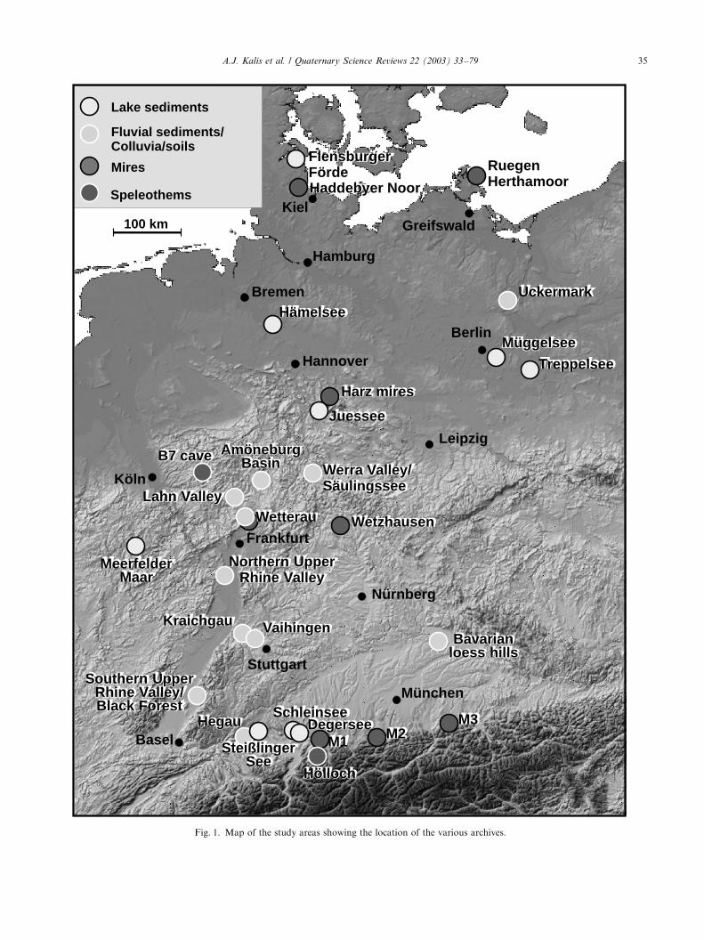
slice II, coinciding with the Atlantic period, wasregarded as the period of climatic optimum but withlittle variability from the viewpoint of climate and othernatural developments. However, anthropogenic activ-ities such as settlement and agriculture, along withdomestication of plants and animals, occurred duringthis time in central Europe, and various cultural periodshave been distinguished within this time slice on thebasis of archaeological findings. Furthermore, palaeo-botanical and faunal analyses indicate that land-use andsettlement practices varied in time and space. Even ifthese first human activities were less pronounced thanduring later phases, which experienced increased popu-lation and better technology, the potential for impact onthe natural environment was still great. It was one of theaims of the priority programme to identify these effectsand to distinguish between natural and human causes byusing refined research methods to investigate appro-priate archives from different landscape units (Fig. 1).The investigated archives, mentioned above, providedifferent tools to identify the style, intensity, and causesof environmental changes at different temporal resolu-tions. Comparison of the results allows the complex
processes and interactions within the environment,which characterised this phase, to be identified.
2. First human impact as reflected in pollen records from
different regions in Germany
The first substantial human impact on naturalecosystems resulted from the Neolithic way of life.The principal features of the Neolithic economy werearable and pastural farming, and these activities haveleft a distinct imprint on the European landscape.Indeed, the present-day landscape cannot be understoodwithout taking into account the enormous impactagriculture has had on the shaping of Europe eversince. An important part of our research within timeslice II was to pinpoint how and when farming began inour region.As cultivated plants, e.g. cereals, require open areas
that are more or less devoid of trees, clearance in theuntil then dense forests was an a priori requirement forarable farming. This transition from closed woodland toopen, or at least partially open landscape is readilydetectable in the palaeobotanical record.
2.1. Settlement history
Before considering Neolithic impact on vegetation, wepresent a short overview of early farming communitiesin Germany, their temporal and spatial distribution,their settlement patterns and, last but not least, theireconomy (subdivision, names and chronology of theNeolithic after L .uning (1996); archaeological chronol-ogy is in calendar years BC as generally used inarchaeological literature).At the beginning of the Holocene period, Europe was
already inhabited by Mesolithic hunters and gathererswho lived in small groups, mainly along lakes and riversand in coastal areas. The Early Mesolithic, i.e. from thePreboreal and early Boreal, is well known from manyarchaeological finds. During the Late Boreal and EarlyAtlantic periods the number of inland archaeologicalsites decreases, which contrasts with the coastal areas ofthe North Sea and the Baltic Sea, where highlydeveloped Mesolithic societies flourished.
4.3. Eutrophication . . . . . . . . . . . . . . . . . . . . . . . . . . . . . . . . . . . . . . . . . . . . . 71
4.4. Regionality . . . . . . . . . . . . . . . . . . . . . . . . . . . . . . . . . . . . . . . . . . . . . . . 72
4.5. Human impact . . . . . . . . . . . . . . . . . . . . . . . . . . . . . . . . . . . . . . . . . . . . . 73
5. Conclusion . . . . . . . . . . . . . . . . . . . . . . . . . . . . . . . . . . . . . . . . . . . . . . . . . . 74
Acknowledgement . . . . . . . . . . . . . . . . . . . . . . . . . . . . . . . . . . . . . . . . . . . . . . . . . 74
References . . . . . . . . . . . . . . . . . . . . . . . . . . . . . . . . . . . . . . . . . . . . . . . . . . . . . 75
A.J. Kalis et al. / Quaternary Science Reviews 22 (2003) 33–7934
Harz mires
Haddebyer Noor
Juessee
B7 cave
Wetterau
Hegau
Hölloch
M1 M2M3Schleinsee
Hämelsee
FlensburgerFörde
Uckermark
RuegenHerthamoor
Treppelsee
Wetzhausen
Müggelsee
MeerfelderMaar
Kraichgau VaihingenBavarian
loess hills
SteißlingerSee
Southern UpperRhine Valley/Black Forest
Northern UpperRhine Valley
Degersee
Lahn Valley
Werra Valley/Säulingssee
AmöneburgBasin
München
Stuttgart
Frankfurt
Köln
Hamburg
Bremen
Hannover
Leipzig
Berlin
KielGreifswald
Nürnberg
Lake sediments
Fluvial sediments/Colluvia/soils
Speleothems
Mires
100 km
Basel
Fig. 1. Map of the study areas showing the location of the various archives.
A.J. Kalis et al. / Quaternary Science Reviews 22 (2003) 33–79 35
The first farmers of the Early Neolithic LinearBandkeramik culture reached Germany about 5500 calBC. They settled on loess areas between Hungary inthe east, the Rhine in the west, the Danube (Donau)in the south and the loess belt near the present-day cityof Hannover in the north. A second wave of expansionfollowed approximately two centuries later, duringwhich the Bandkeramik farmers settled in almost everyloess landscape north of the Alps. The northernboundary of distribution reached the Baltic Sea nearthe mouth of the river Oder, following a line throughHannover—Soest – Maastricht – Dunkirk, reachingthe English Channel and Normandy in the west andextending eastwards as far as the river Dnjepr in Russia(L .uning, 1988). The farmers of the Linear Bandkeramiklived in large long-houses that occurred as isolatedhouses or in small groups along brooklets and smallrivers (L .uning, 1997). The single family farmswere economically self-sufficient, but finds such asamphibolite adzes from Czechoslovakia or Sphondylus
shells from the Black Sea, show that networks of long-distance contacts existed within these society (L .uning,2000, p. 15).These peoples were full-time farmers. Hunting
was initially important but very soon played a negligiblerole, with the exception of areas in the most southernpart of Germany. The Bandkeramik farmers cultivatedthe cereals einkorn (Triticum monococcum), emmer(T. dicoccum) and barley (Hordeum vulgare) (emmerwas generally the most important), the legumes pea(Pisum sativum) and lentil (Lens culinaris), and the oilplants poppy (Papaver setigerum) and linseed (Linum
usitatissimum) (Willerding, 1980). The arable systemof the Bandkeramik was not swidden cultivation ashas been frequently assumed in the older literature.The farmers of the Bandkeramik grew their cropson permanent fields near their houses, and usuallywithout fallow phases (Kn .orzer, 1986). The houseswere used for only 20–25 years, but the succeedinghouses were built on almost the same spot, whichsupported the idea that the fields remained fixed (Stehli,1989). Moreover, there is evidence that the settlementsand fields were surrounded by permanent hedges(Groenman-van Waateringe, 1971; Castelletti andSt.auble, 1997). The arable system was seemingly verystable and successful because hardly any change isnoticeable during the five centuries of Bandkeramikculture (Kn .orzer, 1986). Cattle was the main domesticanimal, but sheep, goats and pigs were also kept(Uerpmann, unpublished data). The animals grazedin the woodlands, the only available pastureland inthose days. During the summer the animals wereprobably kept in more distant upland areas like theGerman Highlands, where the better grazing possibi-lities were exploited (Kalis and Zimmermann, 1988;Kubitz, 2000).
The Earliest Bandkeramik farmers constituted only asparse population and grew emmer, einkorn and tosome extent barley or millet (Kreuz, 1990). Cattle wasthe most important domestic animal and hunting waslocally still important. The more densely populatedLater Bandkeramik (ca 360 000 people within formerWestern Germany; L .uning and Kalis, 1992), showssomewhat greater regional variability in both crops andanimals. Willerding (1980) and L .uning (2000, Abb. 13)have mapped the crop distribution patterns.Outside the loess landscape, in the greater part of
Europe, people were still practising a life of hunting andgathering. Direct influence of the Neolithic culture on itsMesolithic neighbours is barely noticeable, with thepossible exception of the La-Hoguette and the Limburggroups (L .uning et al., 1989) who lived to the southwestand west of the Bandkeramik culture respectively. Theyproduced pottery and most probably practised animalhusbandry to some degree. Finds of potsherds withinBandkeramik settlements show that contacts andexchange of goods took place between these groups(L .uning et al., 1989). The La-Hoguette group, howeverwere not farmers, but seem to have continued to liveaccording to Mesolithic practises (Kalis et al., 2001;Strien and Tilmann, 2001).Because of the variability of the atmospheric 14C
content, the chronology of the Bandkeramik, whichrelies mainly on 14C dating, is rather imprecise. The 14Ccurve in the interval 6400–6000 BP has many ‘‘wiggles’’so that the age range of calibrated 14C dates from thisinterval, which is critical from the viewpoint of datingthe Bandkeramik, is rather large (Weninger et al., 2001,Fig. 2). The discovery of a 14-m-deep well constructedfrom oak wood at the Bandkeramik settlement ofK .uckhoven (Weiner, 1992) provided well-preservedwood for dendrochronological dating (Schmidt et al.,1998). For the first time a phase of the ceramicchronology could be fixed, which enabled the end ofthe Bandkeramik culture to be dated to ca 5000 BC(6950 cal BP). The beginnings and successive phases arestill to be dated in detail.The so-called Middle Neolithic is regarded as begin-
ning at 5000 BC (6950 cal BP). By that time, north-western Europe was no longer inhabited by one singleculture, extending from the Dnjepr in Russia to theEnglish Channel; instead there was now a pronouncedregional differentiation of Neolithic cultures. At thehousehold level also another way of life had emerged.The isolated farm houses were no longer the self-sufficient nucleus of society. Small hamlets emerged,consisting of several large farmhouses which wereprobably inhabited by more than one family. Thenumber of settlements was smaller but they remainedin use over longer periods (L .uning, 1982). Thearchitecture of the houses was more diverse, possiblyreflecting social differences. Large constructions for cult
A.J. Kalis et al. / Quaternary Science Reviews 22 (2003) 33–7936
purposes express growing communal elements withinMiddle Neolithic society (L .uning, 2000). These newlyestablished social structures seem to have been a moreeffective means to explore and open-up new land. This isseen in the extension of farming onto other soil typesand even to other regions. Newly claimed areas includedthose between the loess landscapes, the pre-Alpine area(Alpenvorland) and several areas with fertile soils in thelowlands of northern Germany. Even the hunter–gatherer societies that still occupied the greater part ofNorthern Germany now showed Neolithic elementsoriginating from the Middle Neolithic. The Swifterbantculture, situated between the North Sea and the riverElbe, and the Erteb�lle culture from east of the Elbeand southern Scandinavia, both adopted the use andproduction of pottery (Raemaekers, 1999 resp. Schwa-bedissen, 1980) and animal husbandry (Hartz et al.,2000).The Middle Neolithic began with the Hinkelstein
group in southern Germany, the Gro�gartach group insouthwestern Germany and the Stichbandkeramikculture in eastern Germany. At ca 4700 BC (6650 calBP) the R .ossen culture developed, which is probably thebest known Middle Neolithic culture. The MiddleNeolithic came to an end at ca 4300 BC (6250 cal BP)with the Bischheim and M .unchshofen groups.Agriculture was the economic base of Middle
Neolithic society. Einkorn (Triticum monococcum) andemmer (T. dicoccum) were the most important cultivatedplants, but the proportions of free-threshing barley(Hordeum vulgare) were increasing, especially in LowerBavaria (Niederbayern) and Saxony (Sachsen). Theoverall impression of continuity in arable farming fromthe Early to the Middle Neolithic is corroborated by thealmost identical spectrum of arable weeds, showing thatseed-times, methods of tillage, harvesting, crop proces-sing, etc., remained relatively constant from the EarlyBandkeramik onwards. However, the introduction ofnew, cultivated plants such as barley and the edaphicallymore demanding bread-wheat (Triticum aestivum) and adifferent spectrum of charcoal remains, which suggeststhat the fields and settlements were no longer sur-rounded by hedges, indicate that the arable farmingeconomy was not identical to that of the Early Neolithicsettlers. Regarding animal husbandry, there was littlechange. Cattle were still the most important domes-ticate. On the basis of age at slaughter, they wereprobably kept as dairy cows (Glass, 1991) but they alsoremained the most important source of meat, because,apart from certain areas in southern Germany, huntingplayed only a minor role.At ca 4400 BC (6350 cal BP) the Younger Neolithic
(Jungneolithikum) began. In archaeology, this periodis commonly regarded as a continuation of the MiddleNeolithic and is characterised by a range of onlyregionally important culture groups (‘‘Aichb .uhl’’
around Lake Constance, ‘‘Schwieberdingen’’ followedby ‘‘Schussenried’’ in Neckarland, and ‘‘M .unchshofen’’followed by ‘‘Altheim’’ in Niederbayern. In the Parisbasin the Michelsberg culture developed and expandedinto south-western Germany. The eastern part of centralGermany was occupied by the Gatersleben group).In the lowlands of northern Germany the Mesolithictradition persisted in the Swifterbant and Erteb�llecultures. Nevertheless, a further Neolithic elementpenetrated into these cultures at ca 4200 BC (6150 calBP), namely the cultivation of the cereals emmerand barley (Swifterbant: Brinkkemper et al., 1999;Bakker, 2002; Erteb�lle: Kalis and Meurers-Balke,1998). From 4200 BC (6150 cal BP), this developmentgradually led to Neolithisation in eastern Holstein(Hartz et al., 2000). The appearance of the FunnelBeaker culture signals a new development in Neolithicsociety which became at 3500 BC (5450 cal BP)the dominant culture of the Late Neolithic in northernGermany, Poland and Scandinavia. (Hoika, 1987,2000).New developments characterise Younger Neolithic
arable farming. For instance the introduction of theplough; one cannot rule out the possibility thatploughing had been practised earlier, but the oldestknown plough marks date from the beginning of the 4thmillennium BC (Tegtmeier, 1993). Compared with theMiddle Neolithic, the spectrum of cultivated plants andthe relative abundances of the various crops alsochanged drastically. An overall view of arable farmingin the Younger Neolithic is beyond the scope of thepresent review, as each region appears to have its owndistinctive features. Emmer, einkorn, free-threshingbarley and wheat were grown in all regions but indiffering proportions. In the pre-Alpine area betweenZ .urichsee and Federsee free-threshing wheat, i.e. theMediterranean species Triticum durum was the maincrop (Maier, 1996, 2002). Further east, emmer andeinkorn dominated (K .uster, 1991). This increaseddiversity appears to have brought with it positiveconsequences for the spread of agriculture because, bythe end of the Younger Neolithic i.e. by ca 3400 BC(5350 cal BP), arable farming was established in allregions of central Europe. Animal husbandry continuedto be based on cattle, but within the Michelsberg culturepig assumed importance. On the other hand sheep andgoat remained unimportant and hunting was insignif-icant, except in several pre-Alpine areas.
2.2. Palynological reflection of early farming activities
At present, the central European landscape is more orless entirely determined by human activity. Variousforms of exploitation are associated with specificvegetation types such as arable weeds communities,meadows, heath, woodland, etc. The plants that
A.J. Kalis et al. / Quaternary Science Reviews 22 (2003) 33–79 37
constitute these communities produce vast amounts ofpollen annually. As a consequence, the vegetation isreflected by its pollen production which in turn can bestudied by pollen analysis.The most obvious way to demonstrate Neolithic
impact is by excavating sites where the farmers lived,kept their animals, prepared their food, etc. Here onecan expect to find remains derived from crop procession,food of humans, fodder for domesticated animals andartefacts that give insight into all aspects of daily life.Although at most sites only charred plant remains areleft, there are exceptions where also uncharred organicmaterial occurs in good condition and so providesfurther opportunities for the reconstruction of humanactivity and the palaeoenvironment generally(Schlichtherle, 1991). However, such ‘on-site’ evidencewere not the subject of research in the present priorityprogramme. Rather, the aim was to investigate humanimpact at a broader landscape level and, in particular, tomake reconstructions based on detailed pollen profilesderived from lakes and peat bogs. The principlesunderlying the interpretation of the various pollencomponents in a typical pollen profile are nowconsidered.
2.2.1. Non-arboreal pollen component and, in particular,
cultural indicators
AP/NAP ratio. The study of present-day surfacepollen samples shows to what extent different vegetationtypes can be palynologically recognised. Such pollen/vegetation studies illustrate that the largest contrastoccurs between woodland on the one hand and treelessvegetation on the other. A critical inspection shows thatthe contrast is heavily biased by the broad spectrum ofgrassland plants, which characterise the present land-scape (Gaillard et al., 1998). Comparable studies inareas with woodland and arable fields but withoutextensive grassland show that the contrast in pollenspectra between woodland and treeless vegetation is notthat obvious (Hicks, 1998). The conclusion is thatgrassland (in the broadest sense) is the plant formationwhich, in pollen diagrams, best reflects the presence ofman in the landscape of central Europe (especially in theAP/NAP ratio). In the context of the Holocene as awhole, however, man-made grassland is a rather recentphenomenon. Intensive woodland grazing can admit-tedly lead to treeless vegetation, but plant species aregrazed selectively by the animals based on the taste ofthe particular species. A park landscape with shrubsrather than purely open grassland results (Pott andH .uppe, 1991). Maintenance of grassland is distinctlyfavoured by mowing on a regular basis and preferablyonce a year. This in turn necessitates appropriate toolsfor mowing. It is therefore no coincidence that thedevelopment of man-made grassland vegetation isassociated with the Early Iron Age (K .orber-Grohne,
1990; Behre and Jacomet, 1991) with possibly someearly examples in the Bronze Age (R .osch, 1993; Stobbe,1996).From a palynological point of view, human impact on
the landscape is most readily detectable from the timethat synanthropic grasslands first existed, i.e. from theIron Age (and possibly the Late Bronze Age) onwards.This does not necesserily mean that, prior to this, therewere fewer inhabitants or that human impact was less. Itsimply means that the impact is not as readily detectablein the pollen analytical data. As a consequence, thecommonly used AP/NAP may not be the most appro-priate for visualizing human impact before the LateBronze Age. Many authors conclude from the lowamounts of NAP in their pollen diagrams that humanimpact was negligable or absent during the Neolithic,though this view is often contradicted by archaeologistson the basis of large-scale excavations in the same area.This was also the case within the present priorityprogramme. Although archaeologists have no doubtabout the presence of man near the studied lakes, inseveral instances, pollen diagrams from lake depositsshow very low NAP-percentages during this time slicedespite incontrovertible archaeological evidence for asubstantial human presence. This makes further reflec-tions on this archaeo-palynological paradox appropriatebecause there are, besides the AP/NAP ratio, otherpalynological indicators of farming activity and itsimpact on the natural environment.
Cultivated plants. The most certain evidence of arablefarming in pollen diagrams is the pollen of cultivatedplants. The pollen of cereals, pea, lentil, linseed andpoppy have sufficient morphological features to con-fidenly enable identification (i.e. Beug, 1961; Kalis, 1980;Punt and Den Breejen, 1981; Faegri and Iversen, 1989).Unfortunately, most cultivated plants are cleistogamic(self-pollinating) and so do not readily emit pollen intothe atmosphere. Hence they are largely invisible in theregional pollen rain. This is also the case with Neolithiccereals, where the pollen remains within the glumes.Fortunately, Neolithic people were interested in thegrain rather than the glumes, so that the cereals werethreshed, the grains dehusked and the pollen liberatedinto the atmosphere. Furthermore, the products ofthreshing were winnowed which again favoured pollendispersal. The size of the cereal pollen curve is thereforerelated to the proportion of cereal processed for humanconsumption rather than the amount of cereals culti-vated or the location of the fields vis-a-vis the samplingsite. Incidentally, cereal-type pollen have been recordedthroughout the entire early Holocene. Non-cultivatedgrass species of the genera Elymus and Hordelymus alsoproduce cereal-type pollen (Hordeum type, Beug, 1961).Such plants occur today on sand dunes along sea shoresor in some rare types of forest on damp, fertile soils.Scattered finds of pollen of the Hordeum type or
A.J. Kalis et al. / Quaternary Science Reviews 22 (2003) 33–7938

Cerealia indet. in pollen spectra without further indica-tions of human presence have to be ascribed to thesewild grass species (O’Connell, 1987; Schweizer, 2001).However, regular finds of Cerealia indet. pollen and allfinds of Triticum-type pollen (ascribable exclusively tocultivated wheat species; Beug, 1961) are invariablyyounger than 5500 BC and indicate cereal growing.Although no direct relation between pollen percentagesand the extent of cereal cultivation can be deduced, thepollen of cereals remains the best indicator of arablefarming.
Weeds and ruderals. At least one characteristic weedplant community occurred in cereal fields on loess soilsduring the whole of the Early and Middle Neolithic i.e.the Bromo-Lapsanetum praehistoricum (Kn .orzer,1971). During the Younger Neolithic in the pre-Alpineregion Jacomet et al. (1989) found characteristic weedsfor flax fields, and it is likely that other crops had alsotheir own characteristic weed communities. Becausemost weed species, like cultivated plants, originate fromtreeless vegetation outside central Europe (often fromsteppes), they are confined to arable habitats and aretherefore, in addition to the crop plants, also reliableindicators of arable farming. Unfortunately, this doesnot make them always usable as cultural indicators inpollen diagrams from the Neolithic. Most of the present-day weed species had not yet entered Central Europeduring the Neolithic (Behre, 1981; Kn .orzer, 1988). Thegreater proportion of weeds already present werecleistogamic or zoogamic and therefore poorly repre-sented in Neolithic pollen records. Furthermore, theanemogamic plants in the Neolithic weed assemblageshave pollen that is not readily identifiable to specificlevel. Often, they can only be assigned to indigenousfamilies such as Poaceae and Chenopodiaceae or to thegenus Rumex. With regard to these groups, the pollen ofweeds cannot be distinguished from that of speciesalready present in the natural vegetation. Thus thevegetation of arable fields during the Neolithic remains,to a large extent, indistinguishable in the pollen record(L .uning and Kalis, 1992). The results of the pollenanalyses in the present priority programme corroboratethis.
Forest clearings. The extent of arable cultivation alsoregards detection in the palynological record. Althoughvery few Neolithic fields could be excavated in situ, onecan, in thoroughly excavated landscapes, reflect ontheir range. Several estimates of the extent of cultivationhave been published, especially for the Early Neolithic.Kn .orzer (1986) suggested that during the Early andMiddle Neolithic, arable land on loess soils waspermanently used without fallow phases. The cerealproduction of 1 ha of such fields can feed three persons.Based on large-scale excavations near Aachen, apopulation density of 17 inhabitants per km2 hasbeen suggested for the period of Bandkeramik settle-
ment in that site (L .uning, 1988). To feed this populationca 5–6 ha arable land per km2 was needed. The questionarises as to whether such a relatively small area wouldbe visible in the pollen diagrams. It is assumed thatthe fields were situated close to each other. But evena large arable area in a forested landscape seems difficultto detect. In surface pollen samples from a Finnishwoodland, Hicks (1998) could not detect a 2500-haarea of arable fields at a distance of only 250m. Thisempirically observed fact corroborates the computersimulations of Sugita (1998), which show that distur-bances of 4100 and 2500 ha at only 100m away froma lake do not create detectable decreases in APpollen loading of any of the taxa. Only a disturbanceof 100-ha extent, when it occurs at the lake shore,generates more than 20% decline of AP pollen loadingsand shifts the pollen percentage representation. Thusthe poor reflection of the Early and Middle Neolithicarable cultivation areas in the pollen diagrams from‘off-site’ lake deposits is quite understandable.From this point of view, the results from the twosites presented here in which Early Neolithic arablefarming is clearly represented, assume added interest.It implies that the sites in question, i.e. peat bogs inthe Wetterau (Fig. 4, Schweizer, 2001) and Grabfeld(Fig. 7, Reichart, in preparation), which are situated inriver valleys, were bordered by Bandkeramik fieldsand that these extended over at least 100 ha near thesesites. A detailed archaeological field survey of theWetterau near the pollen site (Schade, 2001) has shownthat the Bandkeramik settlement pattern meets thisrequirement.The lake pollen diagrams from the present priority
programme inevitably show that ‘off-site’ pollenanalysis is not an appropriate tool to illustrate theintensity and extent of Early Neolithic arable farming.This only changes when:
1. the extent of arable farm land increases greatly,2. the diversity of weed species increases, especially
wind-pollinated species,3. the arable system is changed, for instance from
permanent tillage to swidden cultivation or othertypes of agriculture.
Several authors have dealt with these aspects withregard to Late Neolithic arable farming (cf. R .osch,1990), but that period is beyond the scope of this review.
2.2.2. Arboreal pollen component
The potential of palynology for showing plantcommunities with high amounts of wind-pollinatedplant species such as forest, shrubs, tall herb commu-nities and grasslands ensures that their composition andtheir succession processes are well documented in thepollen diagrams.
A.J. Kalis et al. / Quaternary Science Reviews 22 (2003) 33–79 39
Primary forest. The general view has been that duringthe postglacial climatic optimum the vegetation cover ofEurope developed to give natural climax vegetation. Ithas also been commonly held that both Mesolithic andNeolithic man had little overall effect on the naturalvegetation. This view requires further consideration, atleast for the Early and Middle Neolithic, as we shalldiscuss below. Even Mesolithic cultures had an impacton the natural vegetation insofar as they may havefavoured Early Postglacial expansion of hazel (see Bosand Urz, 2002). Therefore, vegetation was at its mostnatural in periods with the fewest traces of humanoccupation, which in the case of Central Europe,appears to be the Late Mesolithic, i.e. the Early Atlanticperiod.During the Early Atlantic period, Europe was covered
with forest. Undisturbed forest development favourslate-successional tree species such as Carpinus betulus,Fagus sylvatica, Tilia cordata and Ulmus laevis inlowlands and lower uplands, and F. sylvatica, Abies
alba and Ulmus glabra in the highlands. During theEarly Atlantic period, however, the most importantpresent-day late-successional species Carpinus betulus
and Fagus sylvatica had not yet entered Central Europe.Instead, the primary forest was dominated by Tilia
cordata on fertile soils, Ulmus minor and U. laevis inriver valleys and along brooks, Alnus glutinosa on mires,and U. glabra in the highlands (Pott, 2000). Oak speciesplayed a subordinate role on fertile soils, but wereimportant in river valleys, highlands and in forests onpoor soils. During the Early Atlantic period, regionswith a low annual precipitation were covered with pine(Pinus sylvestris), rather than deciduous forests.
Regional variation. Within the extensive research areaof the present priority programme, there is a largediversity of landscapes which is reflected in both thepresent and the former vegetation patterns. Zonalvegetation within Germany is mainly differentiatedalong two gradients, namely a vertical gradient corre-lated with height above sea-level, and a horizontalgradient that reflects degrees of oceanity/continentality.Edaphic conditions also play a major role. In this study,the vertical gradient is not of major importance since theselected sites are from below 350m a.s.l. (with theexception of Degersee). Plant response to this diversityin the Early Atlantic period is well mirrored in the pollendiagrams. Coarsely put, the following regions can bedistinguished from south to north:
Pre-Alpine moraine landscape of the W .urm glaciation.This area is hilly to mountainous with a mosaic offertile, poor and wet soils. In the Early Atlantic period itwas covered with oak–lime woods in the fertile uplands,oak–ash–elm woods in the river valleys and elm woodsat higher altitudes of the montane vegetation belt. Alderwas rare (Hegau–Stei�linger See, Fig. 2; Allg.au–Deger-see, Fig. 3)
In the loess areas in southern Germany characterisedby continental conditions, for instance in Niederbayern(Peters, in preparation) and in the southern UpperRhine Valley (profil Wasenweiler Ried, Friedmann,1999), pine constitutes the Early Atlantic climaxvegetation (not illustrated by a pollen diagram).
Continental loess landscapes within the highland zone.These are hilly areas with fertile soils, dominated by pinewoods on the upland soils and some oak–elm woods inthe river valleys. Alder carr had not yet developed(Magdeburger B .orde–M .uller, 1953; Litt, 1992a,b; Wet-terau–Salzwiese, Fig. 4).
The mountainous and sub-mountainous vegetation belts
of the German Highlands with their moist climatewere covered with oak–lime woods at lower altitudesand oak–elm woods at higher altitudes (Werra-Fulda highlands–S.aulingssee, Fig. 6; Unterfranken–Wetzhausen, Fig. 7; Eifel highlands–Meerfelder Maar,Fig. 5).
Oceanic loess landscapes within the highland zone.These are hilly areas with fertile, loess soils, which weredominated by lime on the upland soils, and elm in theriver valleys, along brooks and on the damp, lowerfringe of slopes. Mires were rare and hence few aldercarrs existed (Untereichsfeld–Jues-See, Fig. 8).
The older morainic landscape of the northern German
Lowlands. This area was covered by the ice during thepenultimate (Saale) but not during the last (Weichselian)glaciation. It is a flat, undulating area with poor, sandysoils (Geest) and often high water tables. Alder carrdominated on wet soils, while in the upland soils limeand oak flourished and elm and oak where soils weremore fertile (H.amelsee, Fig. 9).
The younger morainic landscape along the Baltic Sea.This is a hilly area with fertile soils and many lakes andmires. Lime woods dominated the uplands, elm woodsgrew along rivers, brooks and at the lower fringe of hills,and alder carr was common on mires (R .ugen–Hertha-moor, Fig. 12; Schleswig-Holstein–Haddebyer Noor,Fig. 11; Flensburger F .orde, Fig. 10).It is noteworthy that the distribution of pine reached
remarkably further westward than today, which sug-gests that the gradient from oceanic to continentalclimate in Germany during the Early Atlantic differedfrom that of today. The distribution pattern of pinewoods cannot be ascribed to a delayed spread ofdeciduous trees which, by now, had reached the rivervalleys of the dry loess landscapes. Elm was present insmall quantities and lime and alder expanded at a latertime, but not earlier than the Subboreal. This also pointsto a more continental precipitation regime during theEarly Atlantic in southern and eastern Germany.
Secondary forest cycles. Woodland was the dominantplant formation during the Neolithic. Almost allactivities of the Neolithic peoples had consequencesfor the vegetation and resulted in changes to its
A.J. Kalis et al. / Quaternary Science Reviews 22 (2003) 33–7940
composition. The use of wood as fuel and buildingmaterial, the creation of treeless areas for arable fieldsand settlements on the one hand, and woodland pastureincluding leaf fodder for animals on the other hand,resulted in all types of secondary woodland, shrubformations and tall herb communities. This is clearlyreflected in the regional pollen rain. In 1941, Johs.Iversen was the first palynologist who recognised this.Against generally accepted view of his time, hepostulated that the disappearance of primary forest inDenmark during the transition from the Atlantic to theSubboreal was not caused by climatic change, but ratherby farming activities of the Funnel Beaker culture. Theexpansion of arable activity and animal husbandrydestroyed the climax elm and lime forests and caused thedevelopment of secondary woodland consisting merelyof alder, birch and hazel, which characterised the EarlySubboreal pollen spectra (Iversen, 1973). The correla-tion between the so-called ‘‘Iversen landnam’’ and theexpansion of agriculture in Denmark is now commonlyaccepted and used in the interpretation of the pollendiagrams from Schleswig-Holstein (D .orfler, 2001).Iversen’s ecological explanation of the palynologicalphenomena reflecting the natural regeneration processesin woodlands is also applicable to earlier phases of theNeolithic. Undisturbed forest development favours‘late-successional species’ (after Berglund et al., 1991,p. 405) such as Fagus sylvatica, Tilia cordata and Ulmus
spp., whereas forest disturbances lead to high propor-tions of ‘early successional tree species’ (Berglund, 1991)such as Alnus glutinosa, Betula pendula, B. pubescens,Corylus avellana and Fraxinus excelsior. These areindicators of the so-called secondary forest cycle, a partof the natural succession in which secondary forestsregenerate in several stages towards primary forest. Theearly successional species also include oak and pine,although they are of intermediate status. Quercus robur,which grows best in secondary woodland is also foundhowever in undisturbed forests on poorer soils. Pinus
sylvestris, on the other hand, was the naturallydominant tree in the more arid parts of Germanyduring the Atlantic period (see Regional variation).The above-mentioned tree species produce and emit
so much pollen that they are clearly visible in theregional pollen rain. The succession of woodlandvegetation, especially within the secondary forest cycles,is therefore the most visible palynological feature ofearly human impact (cf. M .uller, 1962; Aaby, 1986;Ammann, 1988; Kalis, 1988).Every forest clearing results in edge communities
where forest regeneration starts again. The hedges of theEarly Neolithic fields and settlements consisted more orless of the same species as found in woodland edges.Early successional species dominated the vegetation inabandoned fields and settlements and in any otherabandoned treeless area. Consequently, high percentage
representation of early successional species in pollendiagrams from the Atlantic period point to the existenceof secondary forest. They are the indirect reflection ofEarly Neolithic arable farming that cannot otherwise bedemonstrated directly by palynology.Animal husbandry was another Neolithic activity
which clearly affected woodland vegetation. In theabsence of grassland, livestock were kept in the forest.This posed no insuperable problems to cattle andpigs, as they derived originally from wooded habitats.Present-day observations show that sheep and goats canalso survive in such habitats. Woodland grazing,however has severe consequences for the forest itself.As seedlings and young trees are eaten, the forest’snatural rejuvenation is hindered. Bark and twigsare bitten off, seriously affecting tree species such aslime and beech. Oak, on the other hand, was avoidedby livestock because its bark and leaves are unpalatable.On the other hand, rooting by pigs has a positive effecton the germination of oak (Stobbe, 1996). In summary,grazing had a decided effect on the composition ofthe Atlantic woodlands. Early successional species werefavoured as long as woodland pasture was maintained.With its dense shrub vegetation, secondary forest ismore attractive for livestock than natural forest. It has amuch higher biomass production, especially leavesand twigs which grows conveniently low for grazersduring the early years. Furthermore, the tall herbvegetation is much more luxuriant than the sparseunderstorey of primary forest. Neolithic farmers mayhave acted to permanently maintain woodland in anearly successional stage, as was probably done earlieron a smaller scale by Mesolithic peoples so as to attractgame (see Bos and Urz, 2002). Iversen (1941) hadalready considered this when he claimed that thelarge-scale woodland fires, which characterise thebeginning of the Subboreal in Denmark, were deliberatewith a view to creating secondary forest as grazing forlivestock.The effects of forest clearance and woodland grazing
on arable farming are reflected in the regional pollenrain. Cycles of forest regeneration are recognised inpollen diagrams from southern Germany (M .uller, 1962)and from the Swiss Plateau (Ammann, 1989). The cyclesbegin with tall herbs, followed by the pioneer trees birchor alder, then ash and hazel, leading to the secondaryforest where oak mainly dominates. The cycle than endsin the original forest type. Not every clearing leads to acomplete succession. Firstly, the succession should notbe interrupted by another clearance. Secondly, the rateand direction of forest succession depends largely onlocal edaphic conditions. The cycles are most visible inareas with fertile soils, because here forest regenerationis rapid. On poor soils, clearings can easily lead toirreversible degradation of the soil. In such cases,woodland needs much more time to regenerate, if at all.
A.J. Kalis et al. / Quaternary Science Reviews 22 (2003) 33–79 41
All three possibilities are reflected by examples in thepresent pollen diagrams. In the Salzwiese diagram fromthe Wetterau (Hessen) only one clearance is recorded,i.e. that one at ca 5500 BC (7450 cal BP) caused bythe Early Neolithic Bandkeramik people (Fig. 4, above224 cm). Although numerous farming systems havesucceeded each other from the Early Neolithic up tothe present, the area was not abandoned and forestregeneration has not taken place in this fertile area afterthe first clearing 7450 years ago (Stobbe, 2000;Schweizer, 2001). On the other hand, some fine examplesof secondary forest cycles are recorded in the otherprofiles. Examples are given in discussing the individualpollen diagrams.
Forest fires. Analyses of lake deposits and peat bogsreveal that fire played an increasing role in landscapemanagement during the Neolithic. Since Lateglacialtimes, charcoal plant fragments are ubiquitous in manytypes of deposits in Germany including lacustrine, bogor eolian deposits. Not all fires are attributable tohumans, especially when conifer woodlands are in-volved, as conifers may catch fire spontaneously.However, according to recent experiences in Germany(forest fires in northern Germany; experimental archae-ology), sound, deciduous forest is almost fire-proof.Noticeable peaks of charcoal in pollen diagrams,ocurring after the establishment of the Atlantic decid-uous forest types, may therefore be considered aspossibly due to human activity. This is especially truewhen the charcoal is connected with secondary forestcycles. Such peaks, accompanied by secondary forestcycles, are reported from the Schleinsee (Clark et al.,1989) and the Degersee (Kleinmann et al., in prepara-tion) from 6250 BC (8200 cal BP) onwards, at intervalsof 200–300 years. Fire signals increasingly accompaniedby the alga Bosmina longirostris, which points toeutrophication by fire, are found after 6900 BC (8850cal BP). A surprisingly early example from the EarlyMesolithic in the valley of the Lahn near Marburg(Hessen) is described by Bos and Urz (2002). Near anEarly Mesolithic camp site on the levees of an oxbowlake of the river Lahn, lake sediments were examined forpollen and plant macroremains. Both the camp site andthe deposits proved to be Early Boreal and the spectrumof macroremains showed plant species, indicating a highdegree of nitrification caused by a local human presence(Urz, 2000). Besides the local vegetation, the regionalvegetation is also reflected in the pollen diagram. It isclear that the vegetation around the camp was regularlyand deliberately burnt so that the Early Boreal pinewoods were temporarily replaced by tall herb vegeta-tion, including Artemisia sp., Chenopodiaceae and evenPlantago lanceolata, and hazel shrub. However, pinesoon regained its former dominance. After the distur-bance of the primary pine forest, the vegetation reactedwith the development of fast growing vegetation to close
the gap and restore the original forest. Tall herbvegetation was followed by secondary woodland andfinally by the original woodland type. At least five cyclescould be detected.Fire and forest cycles with increased magnitude occur
later in Schleinsee around 5450 BC (7400 cal BP), 5250BC (7200 cal BP) and 5000 BC (6950 cal BP),contemporary with the Early Neolithic. Another featureindicating the burning of vegetation are the finds ofpollen grains that have been subjected to substantialheating. Andersen (1988) first described the alterationsin the morphology of pollen grains that had beenexposed to fire. He connected the high number of suchgrains found in Neolithic pollen spectra in Denmarkwith the agricultural system of the Funnel Beakerculture. Here, fire was used to create pasture from thesecondary forest. Such pollen grains also appear inpollen spectra from much earlier times. Schweizer (2001)found them in mire profiles in the Wetterau from theLate Mesolithic onwards, with increasing quantities inthe Early Neolithic.Elevated Betula representation is another indirect
indicator of woodland fires. Betula pendula germinatesextremely well in the ashes of newly burnt woodland,independently of the quality of the soil. Therefore itfrequently dominates the first stage in woodlandsuccession after burning (Dengler, 1935, p. 214). A highfrequency of fires causes elevated Betula representationin regional pollen diagrams. Lower fire frequency, andthus cycles of longer duration, stimulates the developmentof hazel. High pollen concentrations of Betula andCorylus, in combination with a high content of charcoaldust in the regional pollen rain of the Younger Neolithicin southwestern Germany, led R.osch (1990) to postulate a‘slash and burn’ agriculture for the entire Younger andLater Neolithic. However, Lechterbeck (2000) could notconfirm the correlation of the high Betula and Corylus
values with charcoal representation in the nearbyStei�linger See. Further research is required to clarify this.
2.3. Regions (from south to north)
Pre-Alpine moraine landscape of the W .urm glaciation:western Lake Constance (Bodensee): Stei�linger See(Lechterbeck, 2000), Fig. 2; eastern Lake Constance:Degersee (M .uller, in preparation), Fig. 3.Stei�linger See lies in the pre-Alpine younger moraine
landscape of the Hegau in Baden-W .urttemberg, ca 7 kmnorth-west of Lake Constance. From the point of viewof both archaeology and vegetation history, this is oneof the best-known landscapes of southern Germany.Intensive archaeological research is conducted from theresearch station of Hemmenhofen (Schlichtherle, 1991).High-resolution pollen diagrams are available fromDurchenbergried and Hornstaad (R .osch, 1990, 1993)which lie 4.5 and 12 km, respectively south-east of
A.J. Kalis et al. / Quaternary Science Reviews 22 (2003) 33–7942
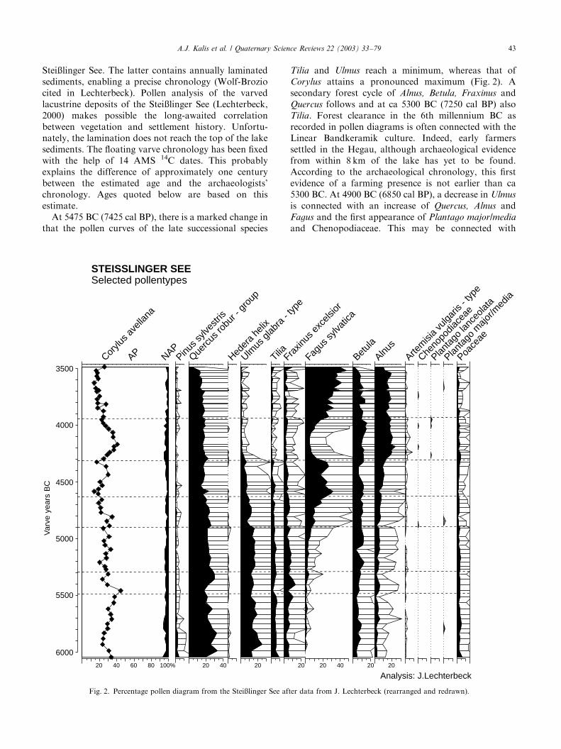
Stei�linger See. The latter contains annually laminatedsediments, enabling a precise chronology (Wolf-Broziocited in Lechterbeck). Pollen analysis of the varvedlacustrine deposits of the Stei�linger See (Lechterbeck,2000) makes possible the long-awaited correlationbetween vegetation and settlement history. Unfortu-nately, the lamination does not reach the top of the lakesediments. The floating varve chronology has been fixedwith the help of 14 AMS 14C dates. This probablyexplains the difference of approximately one centurybetween the estimated age and the archaeologists’chronology. Ages quoted below are based on thisestimate.At 5475 BC (7425 cal BP), there is a marked change in
that the pollen curves of the late successional species
Tilia and Ulmus reach a minimum, whereas that ofCorylus attains a pronounced maximum (Fig. 2). Asecondary forest cycle of Alnus, Betula, Fraxinus andQuercus follows and at ca 5300 BC (7250 cal BP) alsoTilia. Forest clearance in the 6th millennium BC asrecorded in pollen diagrams is often connected with theLinear Bandkeramik culture. Indeed, early farmerssettled in the Hegau, although archaeological evidencefrom within 8 km of the lake has yet to be found.According to the archaeological chronology, this firstevidence of a farming presence is not earlier than ca5300 BC. At 4900 BC (6850 cal BP), a decrease in Ulmus
is connected with an increase of Quercus, Alnus andFagus and the first appearance of Plantago major/media
and Chenopodiaceae. This may be connected with
Analysis: J.Lechterbeck
3500
4000
4500
5000
5500
6000
Var
veye
ars
BC
20 40 60 80 100%
APCorylu
s avell
ana
NAP
STEISSLINGER SEESelected pollentypes
20 40
Querc
usro
bur - gr
oup
Heder
ahe
lix
20
Ulmus
glabr
a- typ
e
Tilia
20
Fraxin
usex
celsi
or
20 40
Fagus
sylva
tica
20
Betula
20
Alnus
Artem
isia
vulga
ris- typ
e
Cheno
podia
ceae
Planta
golan
ceola
ta
Planta
gom
ajor/m
edia
Poace
ae
Pinus sy
lvestr
is
Fig. 2. Percentage pollen diagram from the Stei�linger See after data from J. Lechterbeck (rearranged and redrawn).
A.J. Kalis et al. / Quaternary Science Reviews 22 (2003) 33–79 43
Middle Neolithic human activity. Also the expansion ofbeech (Fagus sylvatica) is often connected with humanimpact on the natural (lime) forests (Pott, 2000).Whether it was deliberately introduced or behaved asan ‘‘oversized weed’’ (Bottema, 1988) remains unclear.After its establishment as a pioneer, beech behaves as alate-successional species and the high pollen valuesbetween 4600 and 4400 BC seem to reflect woodlandregeneration. At ca 4300 BC (6450 cal BP) all late-successional tree species decrease sharply and the curvesfor Alnus, Betula, Corylus and Quercus increase,indicating a strong human impact on the landscape.This feature is characteristic for all lowland pollendiagrams from southwest Germany and pre-AlpineSwitzerland. M .uller (1962) assumes, on the basis ofthe pollen percentage values, that at 6250 cal BP in thecatchment area of the Schleinsee, the beech-, elm- andlime woodland had declined to less than 10% of itsclimatic potential as a result of clearances. Thepopulation which was responsible for this impactbelonged to the Younger Neolithic Aichb .uhl group.Several authors have tried to explain these features.R .osch (1990, 1993) postulates a shifting cultivation with‘slash and burn’-like temporary clearings. This wouldexplain the drastic reduction of natural forest vegeta-tion. A whole landscape dominated by secondary forestis envisaged. R .osch assumes that woodland burning waspractised to make way for arable farming. Maier inDieckmann et al. (2002), however, proposed permanentarable farming, based on evidence from plant macro-remains. High percentages of charcoal dust in thesediments indicate forest fires. If firing was not carriedout to benefit arable farming, then the reason is, as yet,unclear. This intense human impact lasted until about3950 BC (5900 cal BP). After forest regeneration ofnearly four centuries, the next large impact begins withthe Horgen culture at about 3400 BC.The Degersee, east of Lake Constance, lies at an
altitude of 478m, i.e. in the montane vegetation whereprecipitation is higher than near the Stei�linger See. Thepollen diagram (Fig. 3) reflects this. Percentages of elmand ash, characteristic of Atlantic mountain forests arehigher, whereas representation of the lowland speciesoak and lime is much lower than at Stei�linger See. Thehuman impact record is also different. Until 5000 BC(6950 BP varve age) all pollen curves reflect naturalvegetation dynamics. The decline of elm beginning at5000 BC is probably caused by the expansion of beech inthe elm forests of the montane vegetation belt andhuman impact is not detectable until 4450 BC (6400 BPvarve age). A slight decline of the curves for beech, limeand elm is associated with an increase in hazel, grassesand the first finds of cereal pollen which suggests arablefarming by people of the R .ossen culture. After aclassical forest regeneration between 4300 and 4200BC (6250 and 6150BP varve age), a renewed forest
clearance occurs between 4050 and 3800 BC, the late-successional species beech and lime reaching a mini-mum, birch hazel and alder containing a maximum.Archaeological evidence for a corresponding YoungerNeolithic culture is yet to be found. After some forestregeneration, another remarkable forest clearance oc-curred at ca 3650 BC that lasted about a century (Pfyn-Altheim?). The pollen profiles from Stei�linger See andDegersee corroborate the archaeological evidence,which shows that the landscapes east and west of LakeConstance had quite different settlement histories,especially during the Younger Neolithic.
Continental loess landscapes within the highland zone:Hessen: Wetterau (Schweizer, 2001), Fig. 4. The Wetter-au is an intra-montane basin between the highlands ofthe Rheinisches Schiefergebirge in the west and Vogels-berg in the east. Its sheltered position results infavourable climatic conditions. Combined with fertileloess soils, this makes the Wetterau one of the bestagricultural areas of Germany. Arable farming wasestablished here as early as 5500 BC and has remainedthe most important human activity ever since. Along theriver Wetter, a chain of mires have developed since theEarly Holocene. The peat deposits facilitate palynolo-gical investigations. In contrast to the surroundinghighlands where lime and elm woodland prevailed, theEarly Atlantic vegetation was dominated by pine forest.This reflects the specific meso-climate of this basin in therain shadow of the highlands. The arrival of EarlyBandkeramik farmers is marked by a sharp decrease inpine and an increase in NAP. It is one of the very fewpollen diagrams where the Early Neolithic forestclearings are reflected by an increase of NAP (theLuttersee in Untereichsfeld is another example; Beug,1992). This can only be explained by the existence ofextensive woodland clearings with arable fields besidethe investigated peat deposits which is supported by thearchaeological evidence (Schade, 2001). Preceeding theEarly Neolithic, the pollen diagrams show an increase ofCorylus from 5700 BC onwards, which points to somekind of woodland clearing. Schweizer ascribes this to theactivities of the Late Mesolithic La-Hoguette group.This group was living at the periphery of the EarlyNeolithic in northeastern France. There are hardly anychanges in the pollen profile between the Early andMiddle Neolithic. The Middle Neolithic was beyond thescope of Schweizer’s study and therefore not analysed.
The western German highland zone: Eifel - MeerfelderMaar (Kubitz, 2000), Fig. 5. The Meerfelder Maar, acrater lake of a former volcano located in a side valley ofthe river Mosel, is situated at an altitude of 344m a.s.l.in the Moseleifel, a part of the Eifel Highlands. Fromthe Early Neolithic onwards, the Mosel valley itself wasinhabited by farmers (L .ohr, 1986). There is archae-ological evidence for human presence in the vicinity ofthe Maar (L .ohr, 1986; Nakoinz in Kubitz, 2000),
A.J. Kalis et al. / Quaternary Science Reviews 22 (2003) 33–7944
though permanent settlements are lacking. The lakesediments are annually laminated, so that the pollenprofile may have a precise and accurate chronology. Thelaminae or varves extend from the Early Boreal to theMiddle Ages, but unfortunately not up to the present.Thus, the varve chronology is a floating chronology thatis anchored with the help of 14C dates Two chronologieshave been made by C. Endres and A. Brauer (in Kubitz,2000, p. 23); ages quoted below are based on the latter(Fig. 5).A strong AP signal marks Early Neolithic impact.
Percentage representation of late successional speciesfall sharply at 5500 BC (7450 cal BP), while Corylus andFraxinus peak. A secondary forest succession with
Alnus, Betula and Quercus starts and within ca 100years this gives way to lime-dominated woodland similarto that which existed prior to the disturbance. Kubitz(2000) ascribes this to the effects of woodland pasture byEarly Neolithic farmers from the nearby Mosel valley.Another secondary forest cycle of 130 years is visiblebetween 5320 and 5150 BC (7270 and 7100 cal BP). Bothcycles are ascribed to the Linear Bandkeramik culture,although they pre-date by approximately one centurythe corresponding phases of human activity as detectedand dated by archaeologists. After a woodland regen-eration phase during which Quercus values fall andUlmus and Tilia increase, the reverse process began at4950 BC (6900 cal BP) and lasted for 225 years. This
3500
4000
4500
5000
5500
6000
Var
ve y
ears
BC
20 40 60 80 100%
APCorylu
s avell
ana
NAP
DEGERSEESelected pollentypes
20
Querc
usro
bur - gr
oup
Heder
ahe
lix
20 40
Ulmus
glabr
a- typ
e
Tilia
20
Fraxin
usex
celsi
or
20 40
Fagus
sylva
tica
20
Betula
20 40
Alnus
Artem
isia
vulga
ris- typ
e
Cheno
podia
ceae
Planta
golan
ceola
ta
Cerea
lia
Poace
ae
Analysis: H.Müller
Pinus sy
lvestr
is
Fig. 3. Percentage pollen diagram from the Degersee after data from H. M .uller (rearranged and redrawn).
A.J. Kalis et al. / Quaternary Science Reviews 22 (2003) 33–79 45
corresponds to the Middle Neolithic, though therelevant cultural period i.e. R .ossen, too dates toapproximately one century later. Human impact nearthe lake also affected water quality. The alga, Pedia-
strum, is better represented, which indicates eutrophica-tion, which in turn, has been linked to the pasture oflivestock in the catchment area during the MiddleNeolithic. After a short regeneration and decreasingPediastrum values which began at 4500 BC (6450 calBP), Ulmus values decline again, and Fraxinus and alsoPediastrum increase, again pointing to nearby woodlandpasture. This lasted 160 years and may be ascribed to theBischheim culture.
The changes in AP representation during the Atlanticare rather slight in comparison to those recorded from4220 BC (6170 cal BP) onwards. The pollen curves forQuercus, Ulmus, Fraxinus and Alnus decrease substan-tially, while Corylus greatly increases. The authorascribes this to large-scale clearances within the Eifeluplands. The Eifel was not only used for woodlandpasture and hunting but, during the Younger Neolithicarable farmers of the Michelsberg culture settled in theuplands and had arable plots in woodland clearings.This is therefore another example of the use of the Eifelby people of the Michelsberg culture, as assumed byKalis and Meurers-Balke (1997). After a maximum of
211
212
213
214
215
216
217
218
219
220
221
222
223
224
225
226
227
228
229
230
231
Dep
th/c
m
20 40 60 80 100%
Corylu
s avell
ana
NAP
20
Querc
usro
bur -
grou
p
Heder
ahe
lix
Ulmus
glabr
a- t
ype
Tilia
Fagu
s sylva
tica
Frax
inus ex
celsi
or
Betula
Alnus
Artem
isia
vulga
ris- t
ype
Planta
golan
ceola
ta
Planta
gom
ajor/m
edia
Cheno
podia
ceae
indet
.
Cerea
lia
20 40
Poace
ae
SALZWIESE (Wetterau/Hessen)Selected pollentypes
5941±39
6384±39
6868±45
8406±48
14 C-dat
es
Analysis: A.Schweizernot includedin pollen sum
20 40 60
Pinus sy
lvestr
is
AP
Fig. 4. Percentage pollen diagram from the Salzwiese after data from A. Schweizer (rearranged and redrawn).
A.J. Kalis et al. / Quaternary Science Reviews 22 (2003) 33–7946
Corylus that lasted 100 years, Alnus representationincreases. Kubitz’s (2000) interpretation is that erosion,caused by woodland clearances, lead to the formation ofalluvial deposits suitable for alder.
The eastern German highland zone: Th .uringen: Wer-ratal—S.aulingssee (Schneider 2002) Fig. 6; Bayern:Unterfranken—Wetzhausen (Reichardt, in preparation)Fig. 7.The S.aulingssee is located at 232.5m a.s.l. in a valley
within the Werra-Fulda Highlands on the borderbetween Hessen and Th .uringen. This area was formerlysituated between Hessen and East Germany. Prior to1989, archaeological research was impossible in thisborder region. Hence, its early settlement history ispractically unknown. High-resolution pollen analysiswith a 14C-based chronology illustrates the vegetation
history around the S.aulingssee (M.ausbacher et al., 2001;Schneider, 2002a, b). The peat deposit of Wetzhausenlies at 295m a.s.l. in a valley between the Rh .onmountains and the Ha�berge. Both deposits range fromLateglacial to the Middle Ages.During the middle of the 6th millennium BC, slight
changes in AP representation at S.aulingssee, accompa-nied by the first records of Plantago lanceolata, Cerealiaand Chenopodiaceae indicate Early Neolithic humanimpact (Fig. 6, depth 615 cm). The most obvious featureis the increase in Fraxinus, which in other places in thehighlands has been correlated with animal husbandry byEarly Neolithic farmers (Kalis and Meurers-Balke,1997). Stray finds of the Linear Bandkeramik cultureare known from adjacent areas in Hessen andTh .uringen, but modern archaeological research is
3500
4000
4500
5000
5500
6000
Var
ve y
ears
BC
20 40 60 80 100%
AP Corylu
s avell
ana
NAPPinu
s sylve
stris
20
Querc
usro
bur - gr
oup
Heder
ahe
lix
20
Tilia
20
Ulmus
glabr
a- typ
e
20
Fraxin
usex
celsi
or
Fagus
sylva
tica
20 40
Alnus glu
tinos
a
Betula
pend
ula
Artem
isia
vulga
ris- typ
e
Cheno
podia
ceae
Planta
golan
ceola
ta
Planta
gom
ajor/m
edia
Poace
ae
Pedias
trum
MEERFELDER MAARSelected pollentypes
Analysis: B. Kubitznot includedin pollen sum
Fig. 5. Percentage pollen diagram from the Meerfelder Maar after data from B. Kubitz (rearranged and redrawn).
A.J. Kalis et al. / Quaternary Science Reviews 22 (2003) 33–79 47
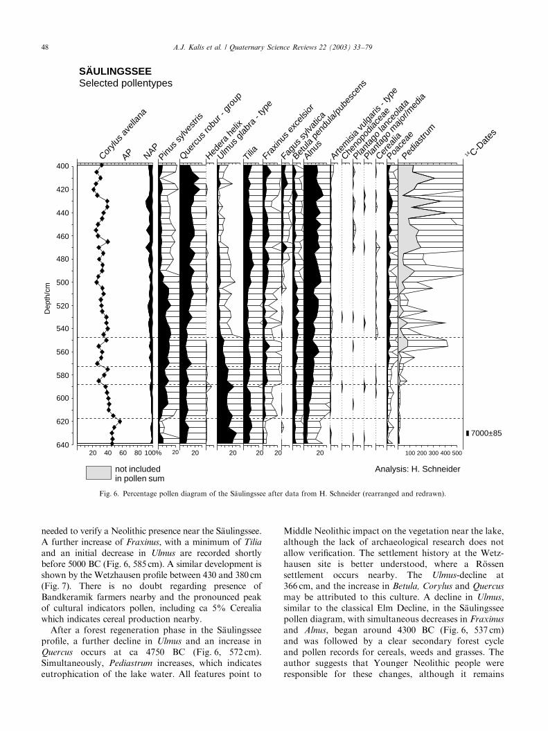
needed to verify a Neolithic presence near the S.aulingssee.A further increase of Fraxinus, with a minimum of Tilia
and an initial decrease in Ulmus are recorded shortlybefore 5000 BC (Fig. 6, 585 cm). A similar development isshown by the Wetzhausen profile between 430 and 380 cm(Fig. 7). There is no doubt regarding presence ofBandkeramik farmers nearby and the pronounced peakof cultural indicators pollen, including ca 5% Cerealiawhich indicates cereal production nearby.After a forest regeneration phase in the S.aulingssee
profile, a further decline in Ulmus and an increase inQuercus occurs at ca 4750 BC (Fig. 6, 572 cm).Simultaneously, Pediastrum increases, which indicateseutrophication of the lake water. All features point to
Middle Neolithic impact on the vegetation near the lake,although the lack of archaeological research does notallow verification. The settlement history at the Wetz-hausen site is better understood, where a R .ossensettlement occurs nearby. The Ulmus-decline at366 cm, and the increase in Betula, Corylus and Quercus
may be attributed to this culture. A decline in Ulmus,similar to the classical Elm Decline, in the S.aulingsseepollen diagram, with simultaneous decreases in Fraxinus
and Alnus, began around 4300 BC (Fig. 6, 537 cm)and was followed by a clear secondary forest cycleand pollen records for cereals, weeds and grasses. Theauthor suggests that Younger Neolithic people wereresponsible for these changes, although it remains
400
420
440
460
480
500
520
540
560
580
600
620
640
Dep
th/c
m
20 40 60 80 100%
APCorylu
s avell
ana
NAP
SÄULINGSSEESelected pollentypes
20
Querc
usro
bur -
grou
p
Heder
ahe
lix
20
Ulmus
glabr
a- t
ype
20
Tilia
20
Frax
inus ex
celsi
or
Fagu
s sylva
tica
Betula
pend
ula/p
ubes
cens
20
Alnus
Artem
isia
vulga
ris- t
ype
Cheno
podia
ceae
Planta
golan
ceola
ta
Planta
gom
ajor/m
edia
Cerea
lia
Poace
ae
7000±85
14 C-Dat
es
100 200 300 400 500
Pedias
trum
Analysis: H. Schneider
20
Pinus sy
lvestr
is
not includedin pollen sum
Fig. 6. Percentage pollen diagram of the S.aulingssee after data from H. Schneider (rearranged and redrawn).
A.J. Kalis et al. / Quaternary Science Reviews 22 (2003) 33–7948
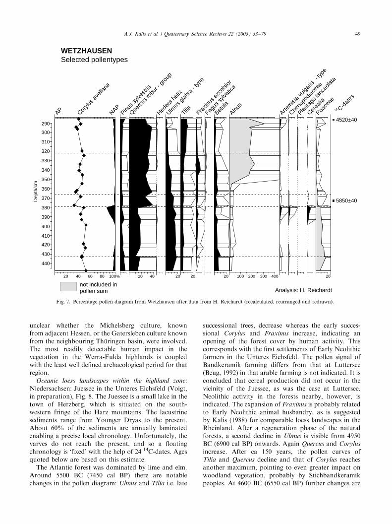
unclear whether the Michelsberg culture, knownfrom adjacent Hessen, or the Gatersleben culture knownfrom the neighbouring Th .uringen basin, were involved.The most readily detectable human impact in thevegetation in the Werra-Fulda highlands is coupledwith the least well defined archaeological period for thatregion.
Oceanic loess landscapes within the highland zone:Niedersachsen: Juessee in the Unteres Eichsfeld (Voigt,in preparation), Fig. 8. The Juessee is a small lake in thetown of Herzberg, which is situated on the south-western fringe of the Harz mountains. The lacustrinesediments range from Younger Dryas to the present.About 60% of the sediments are annually laminatedenabling a precise local chronology. Unfortunately, thevarves do not reach the present, and so a floatingchronology is ‘fixed’ with the help of 24 14C-dates. Agesquoted below are based on this estimate.The Atlantic forest was dominated by lime and elm.
Around 5500 BC (7450 cal BP) there are notablechanges in the pollen diagram: Ulmus and Tilia i.e. late
successional trees, decrease whereas the early succes-sional Corylus and Fraxinus increase, indicating anopening of the forest cover by human activity. Thiscorresponds with the first settlements of Early Neolithicfarmers in the Unteres Eichsfeld. The pollen signal ofBandkeramik farming differs from that at Luttersee(Beug, 1992) in that arable farming is not indicated. It isconcluded that cereal production did not occur in thevicinity of the Juessee, as was the case at Luttersee.Neolithic activity in the forests nearby, however, isindicated. The expansion of Fraxinus is probably relatedto Early Neolithic animal husbandry, as is suggestedby Kalis (1988) for comparable loess landscapes in theRheinland. After a regeneration phase of the naturalforests, a second decline in Ulmus is visible from 4950BC (6900 cal BP) onwards. Again Quercus and Corylus
increase. After ca 150 years, the pollen curves ofTilia and Quercus decline and that of Corylus reachesanother maximum, pointing to even greater impact onwoodland vegetation, probably by Stichbandkeramikpeoples. At 4600 BC (6550 cal BP) further changes are
290
300
310
320
330
340
350
360
370
380
390
400
410
420
430
440
Dep
th/c
m
20 40 60 80 100%
AP Corylu
s avell
ana
NAPPinu
s sylve
stris
20 40
Querc
usro
bur - gr
oup
Heder
ahe
lix
20
Ulmus
glabr
a- typ
e
20
Tilia Fraxin
usex
celsi
or
Fagus
sylva
tica
20
Betula
100 200 300 400
Alnus
Artem
isia
vulga
ris- typ
e
Cheno
podia
ceae
Planta
golan
ceola
ta
Cerea
lia
20
Poace
ae
WETZHAUSENSelected pollentypes
5850±40
4520±40
14 C-dat
es
not included inpollen sum Analysis: H. Reichardt
Fig. 7. Percentage pollen diagram from Wetzhausen after data from H. Reichardt (recalculated, rearranged and redrawn).
A.J. Kalis et al. / Quaternary Science Reviews 22 (2003) 33–79 49
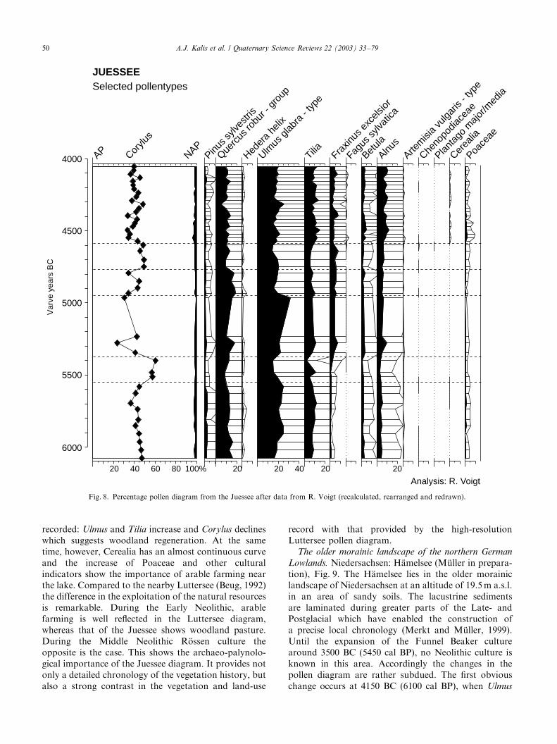
recorded: Ulmus and Tilia increase and Corylus declineswhich suggests woodland regeneration. At the sametime, however, Cerealia has an almost continuous curveand the increase of Poaceae and other culturalindicators show the importance of arable farming nearthe lake. Compared to the nearby Luttersee (Beug, 1992)the difference in the exploitation of the natural resourcesis remarkable. During the Early Neolithic, arablefarming is well reflected in the Luttersee diagram,whereas that of the Juessee shows woodland pasture.During the Middle Neolithic R .ossen culture theopposite is the case. This shows the archaeo-palynolo-gical importance of the Juessee diagram. It provides notonly a detailed chronology of the vegetation history, butalso a strong contrast in the vegetation and land-use
record with that provided by the high-resolutionLuttersee pollen diagram.
The older morainic landscape of the northern German
Lowlands. Niedersachsen: H.amelsee (M .uller in prepara-tion), Fig. 9. The H.amelsee lies in the older morainiclandscape of Niedersachsen at an altitude of 19.5m a.s.l.in an area of sandy soils. The lacustrine sedimentsare laminated during greater parts of the Late- andPostglacial which have enabled the construction ofa precise local chronology (Merkt and M .uller, 1999).Until the expansion of the Funnel Beaker culturearound 3500 BC (5450 cal BP), no Neolithic culture isknown in this area. Accordingly the changes in thepollen diagram are rather subdued. The first obviouschange occurs at 4150 BC (6100 cal BP), when Ulmus
4000
4500
5000
5500
6000
Var
ve y
ears
BC
20 40 60 80 100%
AP Corylu
s
NAP
JUESSEESelected pollentypes
Analysis: R. Voigt20
Querc
usro
bur - gr
oup
Heder
ahe
lix
20 40
Ulmus
glabr
a- typ
e
20
Tilia Fraxin
usex
celsi
or
Fagus
sylva
tica
Betula
20
Alnus
Artem
isia
vulga
ris- typ
e
Cheno
podia
ceae
Planta
gom
ajor/m
edia
Cerea
lia
Poace
ae
Pinus sy
lvestr
is
Fig. 8. Percentage pollen diagram from the Juessee after data from R. Voigt (recalculated, rearranged and redrawn).
A.J. Kalis et al. / Quaternary Science Reviews 22 (2003) 33–7950
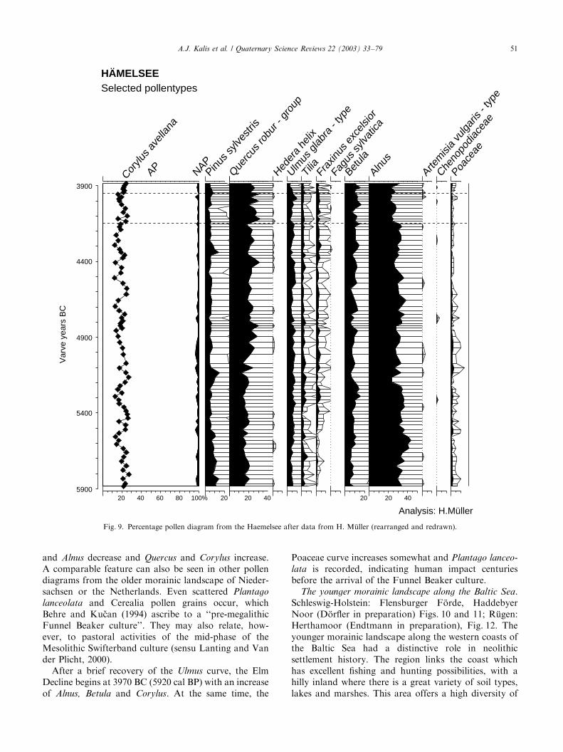
and Alnus decrease and Quercus and Corylus increase.A comparable feature can also be seen in other pollendiagrams from the older morainic landscape of Nieder-sachsen or the Netherlands. Even scattered Plantago
lanceolata and Cerealia pollen grains occur, whichBehre and Ku$can (1994) ascribe to a ‘‘pre-megalithicFunnel Beaker culture’’. They may also relate, how-ever, to pastoral activities of the mid-phase of theMesolithic Swifterband culture (sensu Lanting and Vander Plicht, 2000).After a brief recovery of the Ulmus curve, the Elm
Decline begins at 3970 BC (5920 cal BP) with an increaseof Alnus, Betula and Corylus. At the same time, the
Poaceae curve increases somewhat and Plantago lanceo-
lata is recorded, indicating human impact centuriesbefore the arrival of the Funnel Beaker culture.
The younger morainic landscape along the Baltic Sea.Schleswig-Holstein: Flensburger F .orde, HaddebyerNoor (D .orfler in preparation) Figs. 10 and 11; R .ugen:Herthamoor (Endtmann in preparation), Fig. 12. Theyounger morainic landscape along the western coasts ofthe Baltic Sea had a distinctive role in neolithicsettlement history. The region links the coast whichhas excellent fishing and hunting possibilities, with ahilly inland where there is a great variety of soil types,lakes and marshes. This area offers a high diversity of
3900
4400
4900
5400
5900
Var
ve y
ears
BC
20 40 60 80 100%
APCor
ylusav
ellana
NAP
HÄMELSEESelected pollentypes
Analysis: H.Müller
20 40
Que
rcus
robu
r -gr
oup
Heder
ahe
lix
Ulmus
glab
ra- t
ype
Tilia
Frax
inus
exce
lsior
Fagu
ssy
lvatic
a
20
Betula
20 40
Alnus
Artemisi
avu
lgar
is- t
ype
Cheno
podiac
eae
Poace
ae
20
Pinus sy
lvestr
is
Fig. 9. Percentage pollen diagram from the Haemelsee after data from H. M .uller (rearranged and redrawn).
A.J. Kalis et al. / Quaternary Science Reviews 22 (2003) 33–79 51
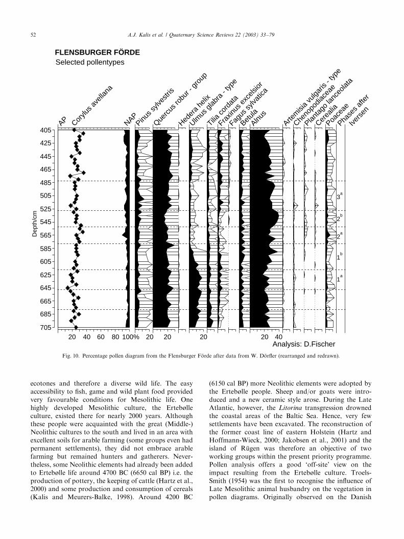
ecotones and therefore a diverse wild life. The easyaccessibility to fish, game and wild plant food providedvery favourable conditions for Mesolithic life. Onehighly developed Mesolithic culture, the Erteb�lleculture, existed there for nearly 2000 years. Althoughthese people were acquainted with the great (Middle-)Neolithic cultures to the south and lived in an area withexcellent soils for arable farming (some groups even hadpermanent settlements), they did not embrace arablefarming but remained hunters and gatherers. Never-theless, some Neolithic elements had already been addedto Erteb�lle life around 4700 BC (6650 cal BP) i.e. theproduction of pottery, the keeping of cattle (Hartz et al.,2000) and some production and consumption of cereals(Kalis and Meurers-Balke, 1998). Around 4200 BC
(6150 cal BP) more Neolithic elements were adopted bythe Erteb�lle people. Sheep and/or goats were intro-duced and a new ceramic style arose. During the LateAtlantic, however, the Litorina transgression drownedthe coastal areas of the Baltic Sea. Hence, very fewsettlements have been excavated. The reconstruction ofthe former coast line of eastern Holstein (Hartz andHoffmann-Wieck, 2000; Jakobsen et al., 2001) and theisland of R .ugen was therefore an objective of twoworking groups within the present priority programme.Pollen analysis offers a good ‘off-site’ view on theimpact resulting from the Erteb�lle culture. Troels-Smith (1954) was the first to recognise the influence ofLate Mesolithic animal husbandry on the vegetation inpollen diagrams. Originally observed on the Danish
405
425
445
465
485
505
525
545
565
585
605
625
645
665
685
705
Dep
th/c
m
20 40 60 80 100%
AP Corylu
s avell
ana
NAP
20
Pinus sy
lvestr
is
20
Querc
usro
bur - gr
oup
Heder
ahe
lix
20
Ulmus
glabr
a- typ
e
Tiliaco
rdat
a
Fraxin
usex
celsi
or
Fagus
sylva
tica
Betula
20 40
Alnus
Artem
isia
vulga
ris- typ
e
Cheno
podia
ceae
Planta
golan
ceola
ta
Cerea
lia
Poace
ae
FLENSBURGER FÖRDESelected pollentypes
Analysis: D.Fischer
Phase
s afte
r
Ivers
en
3a
2a
1b
1a
2b
Fig. 10. Percentage pollen diagram from the Flensburger F .orde after data from W. D .orfler (rearranged and redrawn).
A.J. Kalis et al. / Quaternary Science Reviews 22 (2003) 33–7952
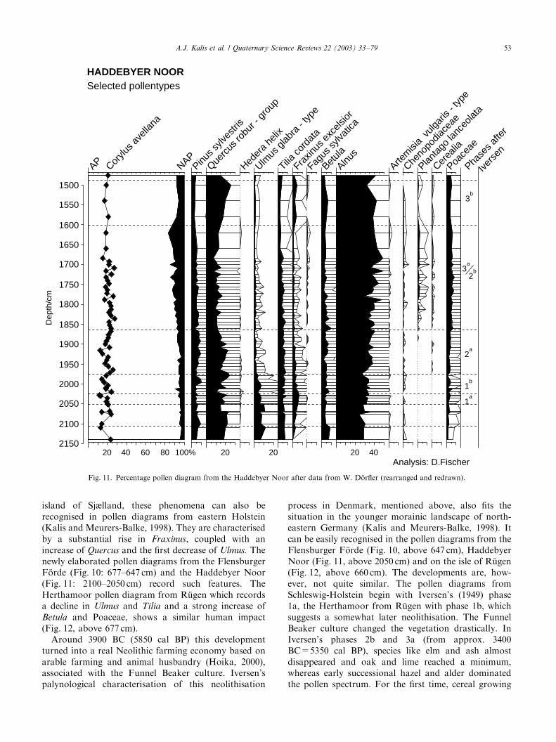
island of Sjælland, these phenomena can also berecognised in pollen diagrams from eastern Holstein(Kalis and Meurers-Balke, 1998). They are characterisedby a substantial rise in Fraxinus, coupled with anincrease of Quercus and the first decrease of Ulmus. Thenewly elaborated pollen diagrams from the FlensburgerF .orde (Fig. 10: 677–647 cm) and the Haddebyer Noor(Fig. 11: 2100–2050 cm) record such features. TheHerthamoor pollen diagram from R .ugen which recordsa decline in Ulmus and Tilia and a strong increase ofBetula and Poaceae, shows a similar human impact(Fig. 12, above 677 cm).Around 3900 BC (5850 cal BP) this development
turned into a real Neolithic farming economy based onarable farming and animal husbandry (Hoika, 2000),associated with the Funnel Beaker culture. Iversen’spalynological characterisation of this neolithisation
process in Denmark, mentioned above, also fits thesituation in the younger morainic landscape of north-eastern Germany (Kalis and Meurers-Balke, 1998). Itcan be easily recognised in the pollen diagrams from theFlensburger F .orde (Fig. 10, above 647 cm), HaddebyerNoor (Fig. 11, above 2050 cm) and on the isle of R .ugen(Fig. 12, above 660 cm). The developments are, how-ever, not quite similar. The pollen diagrams fromSchleswig-Holstein begin with Iversen’s (1949) phase1a, the Herthamoor from R .ugen with phase 1b, whichsuggests a somewhat later neolithisation. The FunnelBeaker culture changed the vegetation drastically. InIversen’s phases 2b and 3a (from approx. 3400BC=5350 cal BP), species like elm and ash almostdisappeared and oak and lime reached a minimum,whereas early successional hazel and alder dominatedthe pollen spectrum. For the first time, cereal growing
1500
1550
1600
1650
1700
1750
1800
1850
1900
1950
2000
2050
2100
2150
Dep
th/c
m
20 40 60 80 100%
AP Corylu
s avell
ana
NAPPinu
s sylve
stris
20
Querc
usro
bur - gr
oup
Heder
ahe
lix
20
Ulmus
glabr
a- typ
e
Tiliaco
rdat
a
Fraxin
usex
celsi
or
Fagus
sylva
tica
Betula
20 40
Alnus
Artem
isia
vulga
ris- typ
e
Cheno
podia
ceae
Planta
golan
ceola
ta
Cerea
lia
Poace
ae
HADDEBYER NOORSelected pollentypes
Analysis: D.Fischer
Phase
s afte
r
Ivers
en
3b
2b
1b
1a
2a
3a
Fig. 11. Percentage pollen diagram from the Haddebyer Noor after data from W. D .orfler (rearranged and redrawn).
A.J. Kalis et al. / Quaternary Science Reviews 22 (2003) 33–79 53
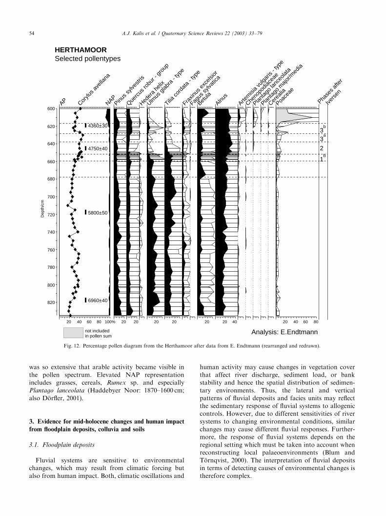
was so extensive that arable activity became visible inthe pollen spectrum. Elevated NAP representationincludes grasses, cereals, Rumex sp. and especiallyPlantago lanceolata (Haddebyer Noor: 1870–1600 cm;also D .orfler, 2001).
3. Evidence for mid-holocene changes and human impact
from floodplain deposits, colluvia and soils
3.1. Floodplain deposits
Fluvial systems are sensitive to environmentalchanges, which may result from climatic forcing butalso from human impact. Both, climatic oscillations and
human activity may cause changes in vegetation coverthat affect river discharge, sediment load, or bankstability and hence the spatial distribution of sedimen-tary environments. Thus, the lateral and verticalpatterns of fluvial deposits and facies units may reflectthe sedimentary response of fluvial systems to allogeniccontrols. However, due to different sensitivities of riversystems to changing environmental conditions, similarchanges may cause different fluvial responses. Further-more, the response of fluvial systems depends on theregional setting which must be taken into account whenreconstructing local palaeoenvironments (Blum andT .ornqvist, 2000). The interpretation of fluvial depositsin terms of detecting causes of environmental changes istherefore complex.
600
620
640
660
680
700
720
740
760
780
800
820
Dep
th/c
m
AP Corylu
s avell
ana
NAPPinu
s sylve
stris
Querc
usro
bur - gr
oup
Heder
ahe
lix
Ulmus
glabr
a- typ
e
Tiliaco
rdat
a- typ
e
Fraxin
usex
celsi
or
Fagus
sylva
tica
Betula
Alnus
Artem
isia
vulga
ris- typ
e
Cheno
podia
ceae
Planta
golan
ceola
ta
Planta
gom
ajor/m
edia
Cerea
lia
Poace
ae
4360±30
4750±40
5800±50
6960±40
Phase
s afte
r
Ivers
en
20 40 60 80 100% 20 20 20 20 20 20 40 20 40 60 80
not includedin pollen sum
Analysis: E.Endtmann
3b
1b
2
3a
HERTHAMOORSelected pollentypes
Fig. 12. Percentage pollen diagram from the Herthamoor after data from E. Endtmann (rearranged and redrawn).
A.J. Kalis et al. / Quaternary Science Reviews 22 (2003) 33–7954
For this reason, investigations of alluvial depositsshould emphasise the establishment of a stratigraphicframework based on a comprehensive data set. Thestudies should concentrate on valleys of small tomedium rivers as the fluvial deposits in these valleysclosely reflect the conditions of the individual catchmentareas, whereas the floodplain deposits of large rivers,with extended drainage basins, integrate the variableeffects of different sub-catchments. Several study groupsof the priority programme, dealing with the mid-Holocene period, met these conditions in their studyareas (e.g. M.ackel and Friedmann 1999; Niller, 1998;Bubenzer, 2000; Schulte and Stumb .ock, 2000; Andreset al., 2001; M.ausbacher et al., 2001). The fluvial historyof the Rhine river received special attention (Dambeckand Sabel, 2001; Dambeck and Thiemeyer 2002).In some study areas, fluvial sediments were exposed
in outcrops within gravel pits and trenches but most ofthe compilation of cross sections was based on coringswhich facilitated reconstruction of the sedimentaryrecord. The description of cores was complemented byvarious analyses (e.g. grain size distribution, organicmatter, calcium carbonate and heavy metals). Magneticsusceptibility and heavy mineral analyses have beenapplied in order to acquire information on theprovenance of the deposits. Thin sections of differenthorizons were examined to determine the soil formingprocesses. Furthermore, the stable isotope data, i.e.d13C, d15N, d34S, yielded information on changingdepositional environments. The chronological frame-work was based on physical dating methods, e.g. 14C-dating (AMS and conventional beta-counting) andoptical stimulated luminescence (OSL), and relativepollen chronologies. As shown in Section 2.1, pollenrecords and botanical macroremains enabled recon-struction of vegetation history and climate changes,and were used to assess human impact on the environ-ment.Sedimentary records of most of the rivers investigated
in the course of the priority programme indicate thatduring the Late Pleistocene and Early Holocene therewere marked changes in fluvial conditions (Litt et al.,2002). For instance, at the beginning of the YoungerDryas the rejuvenation of braided river systems andreworking of older deposits took place in severaldrainage basins. However, during the later part of thisperiod alluvial sediments changed from gravelly toorganic-rich silt or fine sand indicating the shift tomeandering systems. A further change in conditions,associated with the deposition of highly organic mudand peat in abandoned channels, occurred at thebeginning of the Preboreal. This Late Pleistocene toEarly Holocene succession is chronologically controlledby numerous 14C-data (Wunderlich, 1998; Nolte, 2000;cf. Andres et al., 2001; M.ausbacher et al., 2001; Houbenet al., 2001).
At several localities, the organic deposits of Preborealage grade into a clay-rich, mostly black sediment layerthat is mostly covered by brown overbank fines. Theblack deposit is not restricted to abandoned channelsbut also extends to larger areas within the floodplainand locally encompasses the adjacent slopes. This blacklayer has been described by a number of researchersworking on river systems of different sizes throughoutcentral Europe (cf. reviews by Eberhardt, 1998; Wun-derlich, 1998; Nolte, 2000; Rittweger, 2000). Severalworking groups of the priority programme also con-centrated on this feature. The distinctive layer, the so-called ‘Black Floodplain Soil (BFS)’ according toRittweger (2000), has been examined in small to mediumdrainage basins as well as in the northern UpperRhinegraben, where Dambeck and Sabel (2001) re-corded a ‘‘black clay’’.Generally, the black layer is characterised by high clay
content. In the Wetterau, Nolte (2000) measuredaverage clay contents of 50.6% with maximum valuesof 84.6%. Occasionally the silt content increases toaverage values of 44%, especially in the lower partsof the formation. The organic content of the blackmaterial is low to moderate with an average value of ca4% and not exceeding 12% dry weight. Calciumcarbonate content is negligible. At some localitiesorganic material from the lower part of the BFS yieldedradiocarbon dates that indicate formation during theBoreal (Houben, 1997; Nolte, 2000; Andres et al., 2001;Houben et al., 2001). Urz (1995) suggested thatthe development of the black layer started as early asthe Preboreal. Ages from the upper part of the layer arerare due to the lack of sufficient organic materialallowing for reliable AMS 14C-dating. Thus the fewdates available come from radiocarbon dating of bulksamples so that contamination cannot be excluded. Inthe floodplain of the Wetter river, bulk 14C-samplesyielded ages ranging from ca 9000 to 6000 cal BP (Nolte,2000). This fits the results from the Upper Rhinegraben,where Dambeck and Thiemeyer (in print) also suggestthat the black clay was deposited in the late Atlanticperiod. Similar conclusions have been previously drawnby other authors mostly based on palynologic andstratigraphic evidence (e.g. M.ackel, 1969, 1970; Bork,1983; Hiller et al., 1991).The obvious lack of reliable 14C-dates from the
Atlantic period is illustrated in Fig. 13 which showsthe frequency of 14C-dates from fluvial sedimentssampled in the northern Wetterau and the Am .oneburgbasin, both being loess covered depressions within theHessische Senke, Germany (cf. Wunderlich, 1998; Nolte,2000). However, this lack of data is not restricted tostudy areas in central Europe. Similar results werepresented by Macklin and Lewin (1993) from Britishdrainage basins. In their study areas only a negligiblenumber of dated alluvial units fit to the period from
A.J. Kalis et al. / Quaternary Science Reviews 22 (2003) 33–79 55
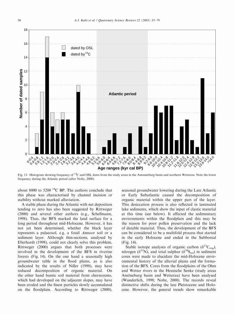
about 8000 to 5200 14C BP. The authors conclude thatthis phase was characterised by channel incision orstability without marked alluviation.A stable phase during the Atlantic with net deposition
tending to zero has also been suggested by Rittweger(2000) and several other authors (e.g., Schellmann,1998). Thus, the BFS marked the land surface for along period throughout mid-Holocene. However, it hasnot yet been determined, whether the black layerrepresents a palaeosol, e.g. a fossil Anmoor soil or asediment layer. Although thin-sections, analysed byEberhardt (1998), could not clearly solve this problem,Rittweger (2000) argues that both processes wereinvolved in the development of the BFS in riverineforests (Fig. 14). On the one hand a seasonally highgroundwater table in the flood plains, as is alsoindicated by the results of Niller (1998), may havereduced decomposition of organic material. Onthe other hand humic soil material from chernozems,which had developed on the adjacent slopes, may havebeen eroded and the finest particles slowly accumulatedon the floodplain. According to Rittweger (2000),
seasonal groundwater lowering during the Late Atlanticor Early Subatlantic caused the decomposition oforganic material within the upper part of the layer.This desiccation process is also reflected in laminatedlake sediments, which show the input of clastic materialat this time (see below). It affected the sedimentaryenvironments within the floodplain and this may bethe reason for poor pollen preservation and the lackof datable material. Thus, the development of the BFScan be considered to be a multifold process that startedin the early Holocene and ended in the Subboreal(Fig. 14).Stable isotope analyses of organic carbon (d13Corg),
nitrogen (d15N), and total sulphur (d34Stot) in sedimentcores were made to elucidate the mid-Holocene envir-onmental history of the alluvial plains and the forma-tion of the BFS. Cores from the floodplains of the Ohmand Wetter rivers in the Hessische Senke (study areasAm .oneburg basin and Wetterau) have been analysed(Wunderlich, 1998; Nolte, 2000). The records revealdistinctive shifts during the late Pleistocene and Holo-cene. However, the general trends show remarkable
0
2
4
6
8
10
12
14
16
18
dated by OSL
dated by C14
Age ranges (kyr cal BP)
Nu
mb
ero
fd
ated
sam
ple
s
0-0.4
0.4-0.8
0.8-1.2
1.2-1.6
1.6-2.0
2.0-2.4
2.4-2.8
2.8-3.2
3.2-3.6
3.6-4.0
4.0-4.4
4.4-4.8
4.8-5.2
5.2-5.6
5.6-6
.0
6.0-6
-4
6.4-6
.8
6.8-7
.2
7.2-7
.6
7.6-8
.0
8.0-8
.4
8.4-8
.8
8.8-9
.2
9.2-
9.6
9.6-
10.0
10.0
-10.
4
10.4
-10.
8
10.8
-11.
2
11.2
-11.
6
11.6
-12.
0
12.0
-12.
4
12.4
-12.
8
12.8
-13.
2
13.2
-13.
6
13.6
-14.
0>1
4.0
Atlantic period
Fig. 13. Histogram showing frequency of 14C and OSL dates from the study areas in the Amoeneburg basin and northern Wetterau. Note the lower
frequency during the Atlantic period (after Nolte, 2000).
A.J. Kalis et al. / Quaternary Science Reviews 22 (2003) 33–7956
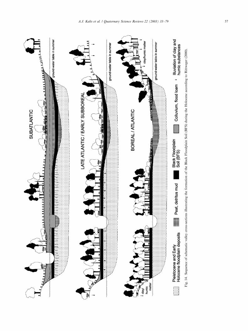
Fig.14.Sequence
ofschem
aticvalley
cross-sectionsillustratingtheform
ationoftheBlack
Floodplain
Soil(BFS)duringtheHoloceneaccordingto
Rittweger
(2000).
A.J. Kalis et al. / Quaternary Science Reviews 22 (2003) 33–79 57
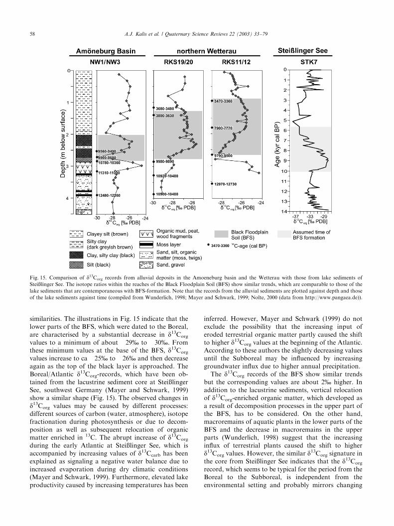
similarities. The illustrations in Fig. 15 indicate that thelower parts of the BFS, which were dated to the Boreal,are characterised by a substantial decrease in d13Corg
values to a minimum of about �29% to �30%. Fromthese minimum values at the base of the BFS, d13Corg
values increase to ca �25% to �26% and then decreaseagain as the top of the black layer is approached. TheBoreal/Atlantic d13Corg-records, which have been ob-tained from the lacustrine sediment core at Stei�lingerSee, southwest Germany (Mayer and Schwark, 1999)show a similar shape (Fig. 15). The observed changes ind13Corg values may be caused by different processes:different sources of carbon (water, atmosphere), isotopefractionation during photosynthesis or due to decom-position as well as subsequent relocation of organicmatter enriched in 13C. The abrupt increase of d13Corg
during the early Atlantic at Stei�linger See, which isaccompanied by increasing values of d13Ccarb has beenexplained as signaling a negative water balance due toincreased evaporation during dry climatic conditions(Mayer and Schwark, 1999). Furthermore, elevated lakeproductivity caused by increasing temperatures has been
inferred. However, Mayer and Schwark (1999) do notexclude the possibility that the increasing input oferoded terrestrial organic matter partly caused the shiftto higher d13Corg values at the beginning of the Atlantic.According to these authors the slightly decreasing valuesuntil the Subboreal may be influenced by increasinggroundwater influx due to higher annual precipitation.The d13Corg records of the BFS show similar trends
but the corresponding values are about 2% higher. Inaddition to the lacustrine sediments, vertical relocationof d13Corg-enriched organic matter, which developed asa result of decomposition processes in the upper part ofthe BFS, has to be considered. On the other hand,macroremains of aquatic plants in the lower parts of theBFS and the decrease in macroremains in the upperparts (Wunderlich, 1998) suggest that the increasinginflux of terrestrial plants caused the shift to higherd13Corg values. However, the similar d13Corg signature inthe core from Stei�linger See indicates that the d13Corg
record, which seems to be typical for the period from theBoreal to the Subboreal, is independent from theenvironmental setting and probably mirrors changing
Fig. 15. Comparison of d13Corg records from alluvial deposits in the Amoeneburg basin and the Wetterau with those from lake sediments of
Stei�linger See. The isotope ratios within the reaches of the Black Floodplain Soil (BFS) show similar trends, which are comparable to those of the
lake sediments that are contemporaneous with BFS-formation. Note that the records from the alluvial sediments are plotted against depth and those
of the lake sediments against time (compiled from Wunderlich, 1998; Mayer and Schwark, 1999; Nolte, 2000 (data from http://www.pangaea.de)).
A.J. Kalis et al. / Quaternary Science Reviews 22 (2003) 33–7958
hydrological and climatic conditions. The affect ofincreasing human impact can also be excluded. In thestable isotope records from Stei�linger See, the anthro-pogenic signal has not been observed prior to theSubatlantic (Mayer and Schwark, 1999).The data discussed above do not clearly show that the
onset of settlement and agriculture during the earlyNeolithic period caused severe environmental changesand alterations of the sedimentation pattern withmarked aggradation of overbank fines. On the otherhand, it has been reported by Litt (1988, 1992a,b) andHiller et al. (1991) that in the drainage basin of theWeisse Elster (Eastern Germany) alluviation occurredduring the early Neolithic period. In these studies adetailed stratigraphy of Holocene floodplain depositscontrolled by 14C-data allows phases of flood loamdeposition to be related to early Neolithic settlementphases. But the results also indicate that deposition offlood loam is spatially and temporally differentiated.This depends on the settlement pattern and its variationthrough time. Moreover, Huckriede (1972) suggests thatflood loam might have been deposited in the Lahn valleyduring the Atlantic period due to human impact andBarsch et al. (1993) found evidence for thick accumula-tion of floodplain deposits induced by late Neolithicland use. However, the compilation of Niller (1998)shows that substantial accumulation of overbank finesstarted in the Subboreal and reached maximum levelsduring the Iron age.From the investigation of fluvial deposits in small to
medium but also in large drainage basins it can beconcluded that the Atlantic is characterised by relativelystable conditions within the floodplains indicatingthat neither secondary climatic shifts nor the increaseof human impact caused severe instability or widespreadaggradation of flood loam. The latter may have startedat the end of the Atlantic, at ca 6000 cal BP, andincreased during the Subboreal.
3.2. Colluvia and soils
The lack of overbank fines from the early Neolithicperiod in most central-European valleys agrees withresults extracted from other natural archives such assoils and colluvia. Truncated soil profiles give evidencethat soil material was eroded, although in general thetruncation cannot be related to distinctive time periods.As mentioned above eroded material partly leaves thedrainage basin but some is also re-deposited in localsinks represented by the floodplains, where the erodedmaterial accumulates as flood loam. Other sinks arelocated on the slopes and especially the lower slopes,where the eroded material forms colluvium. Colluviatherefore have a key role in the estimation of the amountof soil eroded. If the colluvial deposits are stratified, theyeven allow several phases of soil erosion to be
distinguished. Furthermore, relative and physical datingmethods allow the time and magnitude of soil erosion tobe estimated.Colluvial deposits, dated to the Atlantic period, have
been observed in different regions and landscape units(e.g. Bork, 1983; Thiemeyer, 1989, 1991; Semmel, 1995).In general the authors concede that the thickness of theearly and part of late Neolithic colluvia is less than thatof deposits of the Bronze Age and Iron Age and inparticular the Middle Ages. Similar conclusions havealso been made by several working groups of thepriority programme (Rittweger, 1997; Niller, 1998; Langand H .onscheidt, 1999; Fischer-Zujkov, 2000; Wunder-lich, 2000). In the study area of the Am .oneburg basinstratified colluvium has been investigated using a multi-proxy approach including the above-mentioned datingmethods (Fig. 16). An extended Bandkeramik settle-ment was also excavated (Meyer, 2000). Palaeobotanicaland mollusc records (Rittweger, 1999) revealed evidenceof forest clearance during the same period. However, theevidence suggests only negligible deposition of soilmaterial associated with these developments (Fig. 16).Thus, it appears that early Neolithic land use did notcause major soil erosion (Wunderlich, 2000).Similar results have been observed in other regions
(e.g. Niller, 1998; Lang and H .onscheidt, 1999).Niller (1998) found evidence for linear soil erosion atabout 9500 cal BP. However, this single result cannotbe extrapolated over a larger area nor should a periodcharacterised by soil instability be inferred. Accordingto the above authors the lack of noteworthy Neolithiccolluvia may be explained in terms of eroded materialbeing trapped in local sinks on the slope and re-deposited at later periods as mentioned above. Langand H .onscheidt (1999) illustrated these processes in asimple model depicted in Fig. 17. Soil erosion andre-deposition led to a pattern of colluvial deposits thatwas rather variable in space and that changed throughtime. This complicates a quantitative approach tocalculating the amount of soil erosion during distinctiveperiods. Remnants of a trapped deposit of earlyNeolithic times may be the black deposit which hasbeen identified in the Uckermark by Fischer-Zujkov(2000).The better understanding of the soil erosion processes
during the Atlantic, that resulted from the investigationswithin the priority programme, has benefited greatlyfrom refined dating methods and especially OSL dating.As was elegantly illustrated by Lang and H .onscheidt(1999), ages of buried organic material as well asarchaeological evidence (e.g. potsherds) only yieldmaximum ages for the time of deposition of colluvia.Although OSL dates have error ranges of ca 10%, theircombination with archaeological evidence, pollen re-cords and 14C-dating, facilitates tight constraint of thechronological framework of the erosion history of a
A.J. Kalis et al. / Quaternary Science Reviews 22 (2003) 33–79 59
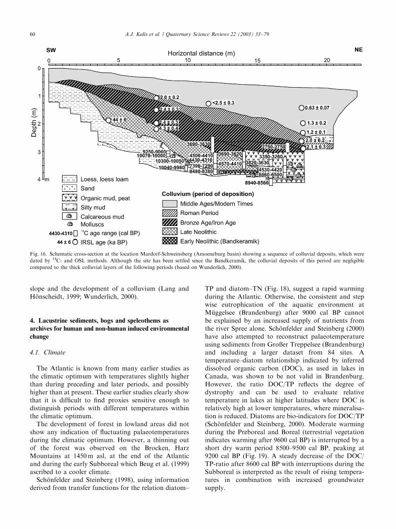
slope and the development of a colluvium (Lang andH .onscheidt, 1999; Wunderlich, 2000).
4. Lacustrine sediments, bogs and speleothems as
archives for human and non-human induced environmental
change
4.1. Climate
The Atlantic is known from many earlier studies asthe climatic optimum with temperatures slightly higherthan during preceding and later periods, and possiblyhigher than at present. These earlier studies clearly showthat it is difficult to find proxies sensitive enough todistinguish periods with different temperatures withinthe climatic optimum.The development of forest in lowland areas did not
show any indication of fluctuating palaeotemperaturesduring the climatic optimum. However, a thinning outof the forest was observed on the Brocken, HarzMountains at 1450m asl, at the end of the Atlanticand during the early Subboreal which Beug et al. (1999)ascribed to a cooler climate.Sch .onfelder and Steinberg (1998), using information
derived from transfer functions for the relation diatom–
TP and diatom–TN (Fig. 18), suggest a rapid warmingduring the Atlantic. Otherwise, the consistent and stepwise eutrophication of the aquatic environment atM .uggelsee (Brandenburg) after 9000 cal BP cannotbe explained by an increased supply of nutrients fromthe river Spree alone. Sch .onfelder and Steinberg (2000)have also attempted to reconstruct palaeotemperatureusing sediments from Gro�er Treppelsee (Brandenburg)and including a larger dataset from 84 sites. Atemperature–diatom relationship indicated by inferreddissolved organic carbon (DOC), as used in lakes inCanada, was shown to be not valid in Brandenburg.However, the ratio DOC/TP reflects the degree ofdystrophy and can be used to evaluate relativetemperature in lakes at higher latitudes where DOC isrelatively high at lower temperatures, where mineralisa-tion is reduced. Diatoms are bio-indicators for DOC/TP(Sch .onfelder and Steinberg, 2000). Moderate warmingduring the Preboreal and Boreal (terrestrial vegetationindicates warming after 9600 cal BP) is interrupted by ashort dry warm period 8500–9500 cal BP, peaking at9200 cal BP (Fig. 19). A steady decrease of the DOC/TP-ratio after 8600 cal BP with interruptions during theSubboreal is interpreted as the result of rising tempera-tures in combination with increased groundwatersupply.
Fig. 16. Schematic cross-section at the location Mardorf-Schweinsberg (Amoeneburg basin) showing a sequence of colluvial deposits, which were
dated by 14C- and OSL methods. Although the site has been settled since the Bandkeramik, the colluvial deposits of this period are negligible
compared to the thick colluvial layers of the following periods (based on Wunderlich, 2000).
A.J. Kalis et al. / Quaternary Science Reviews 22 (2003) 33–7960
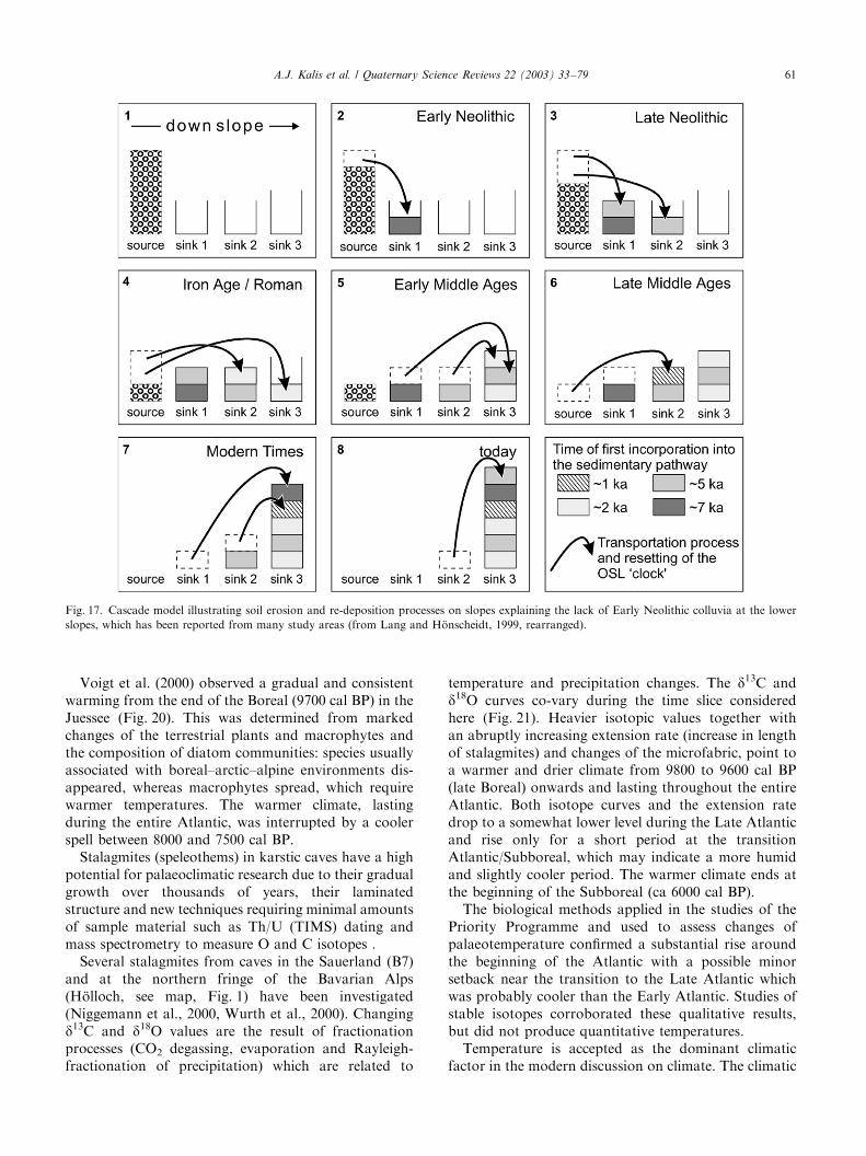
Voigt et al. (2000) observed a gradual and consistentwarming from the end of the Boreal (9700 cal BP) in theJuessee (Fig. 20). This was determined from markedchanges of the terrestrial plants and macrophytes andthe composition of diatom communities: species usuallyassociated with boreal–arctic–alpine environments dis-appeared, whereas macrophytes spread, which requirewarmer temperatures. The warmer climate, lastingduring the entire Atlantic, was interrupted by a coolerspell between 8000 and 7500 cal BP.Stalagmites (speleothems) in karstic caves have a high
potential for palaeoclimatic research due to their gradualgrowth over thousands of years, their laminatedstructure and new techniques requiring minimal amountsof sample material such as Th/U (TIMS) dating andmass spectrometry to measure O and C isotopes .Several stalagmites from caves in the Sauerland (B7)
and at the northern fringe of the Bavarian Alps(H .olloch, see map, Fig. 1) have been investigated(Niggemann et al., 2000, Wurth et al., 2000). Changingd13C and d18O values are the result of fractionationprocesses (CO2 degassing, evaporation and Rayleigh-fractionation of precipitation) which are related to
temperature and precipitation changes. The d13C andd18O curves co-vary during the time slice consideredhere (Fig. 21). Heavier isotopic values together withan abruptly increasing extension rate (increase in lengthof stalagmites) and changes of the microfabric, point toa warmer and drier climate from 9800 to 9600 cal BP(late Boreal) onwards and lasting throughout the entireAtlantic. Both isotope curves and the extension ratedrop to a somewhat lower level during the Late Atlanticand rise only for a short period at the transitionAtlantic/Subboreal, which may indicate a more humidand slightly cooler period. The warmer climate ends atthe beginning of the Subboreal (ca 6000 cal BP).The biological methods applied in the studies of the
Priority Programme and used to assess changes ofpalaeotemperature confirmed a substantial rise aroundthe beginning of the Atlantic with a possible minorsetback near the transition to the Late Atlantic whichwas probably cooler than the Early Atlantic. Studies ofstable isotopes corroborated these qualitative results,but did not produce quantitative temperatures.Temperature is accepted as the dominant climatic
factor in the modern discussion on climate. The climatic
Fig. 17. Cascade model illustrating soil erosion and re-deposition processes on slopes explaining the lack of Early Neolithic colluvia at the lower
slopes, which has been reported from many study areas (from Lang and H .onscheidt, 1999, rearranged).
A.J. Kalis et al. / Quaternary Science Reviews 22 (2003) 33–79 61
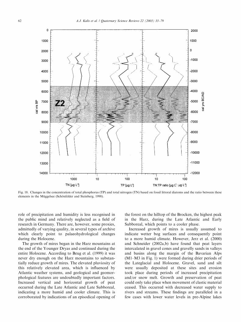
role of precipitation and humidity is less recognised inthe public mind and relatively neglected as a field ofresearch in Germany. There are, however, some proxies,admittedly of varying quality, in several types of archivewhich clearly point to palaeohydrological changesduring the Holocene.The growth of mires began in the Harz mountains at
the end of the Younger Dryas and continued during theentire Holocene. According to Beug et al. (1999) it wasnever dry enough on the Harz mountains to substan-tially reduce growth of mires. The elevated pluviosity ofthis relatively elevated area, which is influenced byAtlantic weather systems, and geological and geomor-phological features are undoubtedly important factors.Increased vertical and horizontal growth of peatoccurred during the Late Atlantic and Late Subboreal,indicating a more humid and cooler climate. This iscorroborated by indications of an episodical opening of
the forest on the hilltop of the Brocken, the highest peakin the Harz, during the Late Atlantic and EarlySubboreal, which points to a cooler phase.Increased growth of mires is usually assumed to
indicate wetter bog surfaces and consequently pointto a more humid climate. However, Jerz et al. (2000)and Schneider (2002a,b) have found that peat layersintercalated in gravel cones and gravelly sands in valleysand basins along the margin of the Bavarian Alps(M1–M3 in Fig. 1) were formed during drier periods ofthe Lateglacial and Holocene. Gravel, sand and siltwere usually deposited at these sites and erosiontook place during periods of increased precipitationand/or snow melt. Growth and preservation of peatcould only take place when movement of clastic materialceased. This occurred with decreased water supply torivers and streams. These findings are paralleled in afew cases with lower water levels in pre-Alpine lakes
Fig. 18. Changes in the concentration of total phosphorus (TP) and total nitrogen (TN) based on fossil littoral diatoms and the ratio between these
elements in the M .uggelsee (Sch .onfelder and Steinberg, 1998).
A.J. Kalis et al. / Quaternary Science Reviews 22 (2003) 33–7962
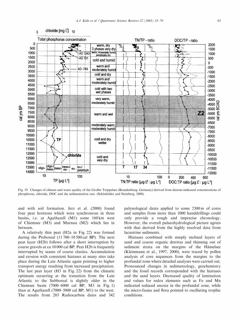
and with soil formation. Jerz et al. (2000) foundfour peat horizons which were synchronous in threebasins, i.e. at Agathazell (M1) some 160 km westof Chiemsee (M3) and Murnau (M2) which lies inbetween.A relatively thin peat (H2a in Fig. 22) was formed
during the Preboreal (11 700–10 500 cal BP). The nextpeat layer (H2b) follows after a short interruption bycoarse gravels at ca 10 000 cal BP. Peat H2b is frequentlyinterrupted by seams of coarse clastics. Accumulationand erosion with consistent hiatuses at many sites takeplace during the Late Atlantic again pointing to highertransport energy resulting from increased precipitation.The last peat layer (H3 in Fig. 22) from the climaticoptimum occurring at the transition from the LateAtlantic to the Subboreal is slightly older in theChiemsee basin (7000–6000 cal BP, M3 in Fig. 1)than at Agathazell (7000–5000 cal BP, M1) to the west.The results from 203 Radiocarbon dates and 342
palynological dates applied to some 2300m of coresand samples from more than 1000 handdrillings couldonly provide a rough and imprecise chronology.However, the overall palaeohydrological picture agreeswith that derived from the highly resolved data fromlacustrine sediments.Hiatuses combined with steeply inclined layers of
sand and coarse organic detritus and thinning out ofsediment strata on the margins of the H.amelsee(Kleinmann et al., 1997, 2000), were traced by pollenanalysis of core sequences from the margins to theprofundal zone where detailed analyses were carried out.Pronounced changes in sedimentology, geochemistryand the fossil records corresponded with the hiatusesand the sand layers. Decreased quality of laminationand values for redox elements such as Fe and Mnindicated reduced anoxia in the profundal zone, whilethe micro-fauna and flora pointed to oscillating trophicconditions.
Fig. 19. Changes of climate and water quality of the Gro�er Treppelsee (Brandenburg, Germany) derived from diatom-indicated concentrations of
phosphorus, chloride, DOC and the sedimentation rate. (Sch .onfelder and Steinberg, 2000).
A.J. Kalis et al. / Quaternary Science Reviews 22 (2003) 33–79 63
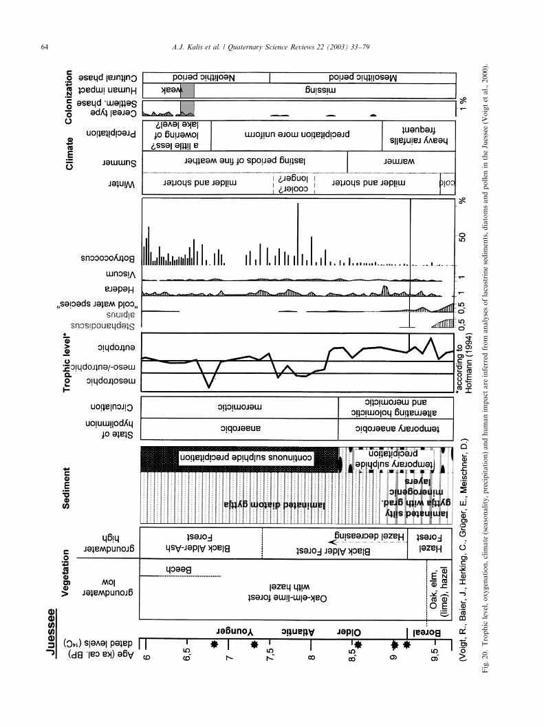
Fig.20.Trophiclevel,oxygenation,climate(seasonality,precipitation)andhumanimpactare
inferred
from
analysesoflacustrinesediments,diatomsandpollen
intheJuessee(Voigtetal.,2000).
A.J. Kalis et al. / Quaternary Science Reviews 22 (2003) 33–7964
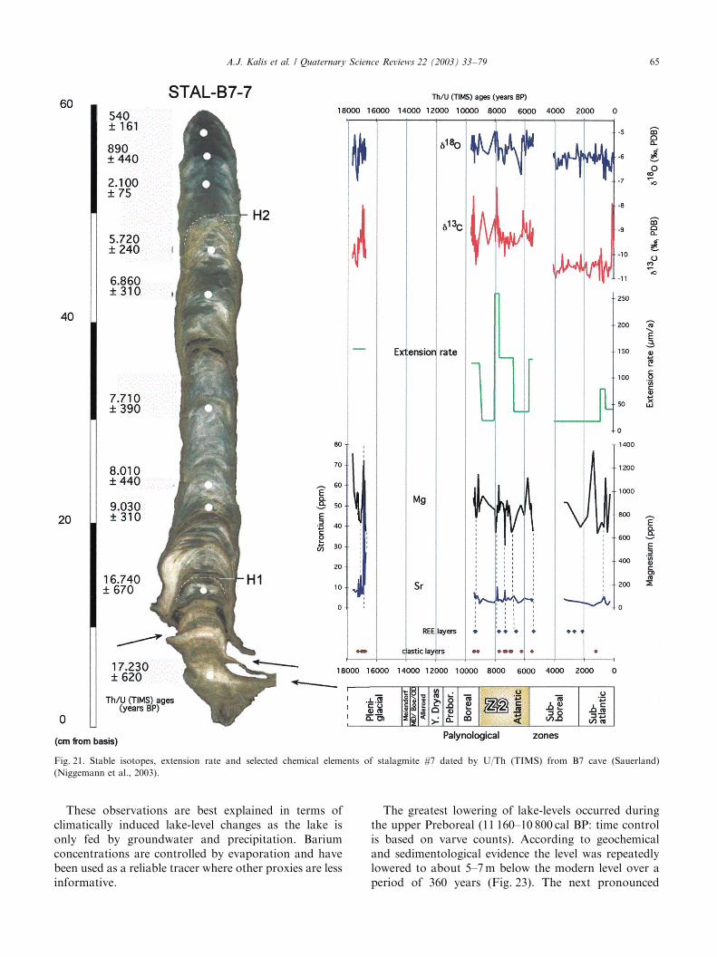
These observations are best explained in terms ofclimatically induced lake-level changes as the lake isonly fed by groundwater and precipitation. Bariumconcentrations are controlled by evaporation and havebeen used as a reliable tracer where other proxies are lessinformative.
The greatest lowering of lake-levels occurred duringthe upper Preboreal (11 160–10 800 cal BP: time controlis based on varve counts). According to geochemicaland sedimentological evidence the level was repeatedlylowered to about 5–7m below the modern level over aperiod of 360 years (Fig. 23). The next pronounced
Fig. 21. Stable isotopes, extension rate and selected chemical elements of stalagmite #7 dated by U/Th (TIMS) from B7 cave (Sauerland)
(Niggemann et al., 2003).
A.J. Kalis et al. / Quaternary Science Reviews 22 (2003) 33–79 65
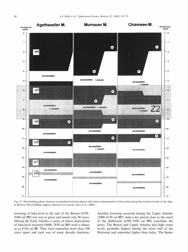
lowering of lake-level at the end of the Boreal (9250–9340 cal BP) was not so great and lasted only 90 years.During the Early Atlantic a series of minor depressionsof lake-level occurred (8800–7850 cal BP) with a climaxat ca 8120 cal BP. They were somewhat more than 100years apart and each was of some decades duration.
Another lowering occurred during the Upper Atlantic(7000–6750 cal BP). And a dry period close to the onsetof the Subboreal (6200–5950 cal BP) concludes theseries. The Boreal and Upper Atlantic had high waterlevels, probably highest during the lower half of theHolocene and somewhat higher than today. The limnic
Fig. 22. Peat-building phases between accumulation/erosion phases with clastic sedimentation in three mires along the northern border of the Alps,
in Bavaria. Peat-building suggests reduced river activity (Jerz et al., 2000).
A.J. Kalis et al. / Quaternary Science Reviews 22 (2003) 33–7966
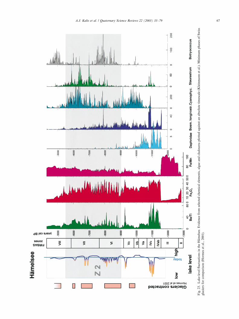
Fig.23.Lake-levelfluctuationsintheH. amelsee.Evidence
fromselected
chem
icalelem
ents,algaeandcladocera
plotted
againstanabsolutetimescale(K
leinmannetal.).MinimumphasesofSwiss
glaciersforcomparison(H
orm
esetal.,2001).
A.J. Kalis et al. / Quaternary Science Reviews 22 (2003) 33–79 67
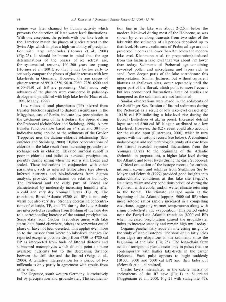
regime was later changed by human activity whichprevents the detection of later water level fluctuations.With one exception, the periods with low lake levels inthe H.amelsee match the phases of glacier retreat in theSwiss Alps which implies a high variability of precipita-tion with large amplitudes (Hormes et al., 2001)(Fig. 23). It should be borne in mind that the agedeterminations of the phases of ice retreat are,for systematical reasons, 100–200 years too young(Hormes et al., 2001), so that it may be too early toseriously compare the phases of glacier retreats with lowlake-levels in Germany. However, the age ranges ofglacier retreat of 9910–9550, 9010–7980, 7250–6500 and6150–5950 cal BP are promising. Until now, onlyadvances of the glaciers were considered in palaeohy-drology and parallelled with high lake-levels (Haas et al.,1998; Magny, 1998).Low values of total phosphorus (TP) inferred from
transfer functions applied to diatom assemblages in theM .uggelsee, east of Berlin, indicate low precipitation inthe catchment area of the tributary, the Spree, duringthe Preboreal (Sch .onfelder and Steinberg, 1998). A newtransfer function (now based on 84 sites and 304 bio-indicative taxa) applied to the sediments of the Gro�erTreppelsee uses the diatom–chloride relationship (Sch-.onfelder and Steinberg, 2000). Higher concentrations ofchloride in the lake result from increasing groundwaterrecharge rich in chloride. Elevated surficial runoff ispoor in chloride and indicates increased precipitation,possibly during spring when the soil is still frozen andsealed. These indications in conjunction with otherparameters, such as inferred temperature (see above),inferred nutrients and bio-indications from diatomanalysis, provided information on relative humidity.The Preboreal and the early part of Boreal arecharacterised by moderately increasing humidity aftera cold and very dry Younger Dryas (Fig. 19). Thetransition, Boreal/Atlantic (9200 cal BP) is not onlywarm but also very dry. Strongly decreasing concentra-tions of chloride, TP, and TN during the Late Atlanticare interpreted as resulting from flushing of the lake dueto a corresponding increase of the annual precipitation.Some data from Gro�er Treppelsee agree with lakestatus data found elsewhere, others are somewhat out ofphase or have not been detected. This applies even moreso to the Juessee from where no lake-level changes arereported except a possible drop from 6750 to 4780 calBP as interpreted from finds of littoral diatoms andsubmersed macrophytes which do not point to moreavailable nutrients but to the decreasing distancebetween the drill site and the littoral (Voigt et al.,2000). A tentative interpretation for a period of twomillennia is only partly in agreement with results fromother sites.The Degersee, south western Germany, is exclusively
fed by precipitation and groundwater. The sedimenta-
tion line in the lake was about 2–2.5m below themodern lake-level during most of the Holocene, as wasshown by cores along transects from two sides of thelake with the sediments of all periods deposited up tothat level. However, sediments of Preboreal age are notpreserved in cores shallower than 9m below the modernlake level. Kleinmann et al. (in preparation) deducedfrom this hiatus a lake level that was about 7m lowerthan today. Sediments of Preboreal age containingreworked pollen and microfauna and layers rich insand, from deeper parts of the lake corroborate thisinterpretation. Similar features, but without apparenthiatuses at shallower sites, occur repeatedly until theupper part of the Boreal, which point to more frequentbut less pronounced fluctuations. Detailed studies arehampered as the sediments are not laminated.Similar observations were made in the sediments of
the Stei�linger See. Erosion of littoral sediments duringthe Preboreal as a result of low lake-level ceased after10 450 cal BP indicating a lake-level rise during theBoreal (Eusterhues et al., in press). Increased detritalinput around 8200 cal BP is again attributed to a lowlake-level. However, the 8.2 k event could also accountfor the clastic input (Eusterhues, 2000), which in turnagrees with the isotopic record (see below). A combinedmalacological and sedimentological study of a core fromthe littoral revealed repeated fluctuations from theYounger Dryas to the beginning of the Atlantic(Schmidt, in preparation), a higher lake level duringthe Atlantic and lower levels during the early Subboreal.Critical evaluation of the isotope records for carbon,
nitrogen, oxygen and sulphfur from Stei�linger See byMayer and Schwark (1999) provided good insights intopalaeoclimatic conditions at this lake site (Fig. 24).Relatively warm and dry conditions prevailed during thePreboreal, with a cooler and/or wetter climate returningin the Boreal. The climate changed again at thebeginning of the Atlantic (approx. 9000 cal BP) whenmost isotopic ratios rapidly increased in a compellingcovariance suggesting warmer temperatures along withrising productivity and evaporation. This period endednear the Early/Late Atlantic transition (8000 cal BP)when increased precipitation caused the groundwaterinflux to increase steadily and remain high until today.Organic geochemistry adds an interesting insight to
the study of stable isotopes. The short-chain fatty acidsfrom algae are ubiquitous in the sediments since thebeginning of the lake (Fig. 25). The long-chain fattyacids of terrigenous plants occur only in pulses that arecontemporary with higher lake-levels in the earlierHolocene. Each pulse appears to begin suddenly(10 000, 8000 and 6000 cal BP) and then fades out(Schwark et al., submitted).Clastic layers intercalated in the calcite matrix of
speleothems of the B7 cave (Fig. 1) in Sauerland(Niggemann et al., 2000, Fig. 21 with stalagmite #7),
A.J. Kalis et al. / Quaternary Science Reviews 22 (2003) 33–7968
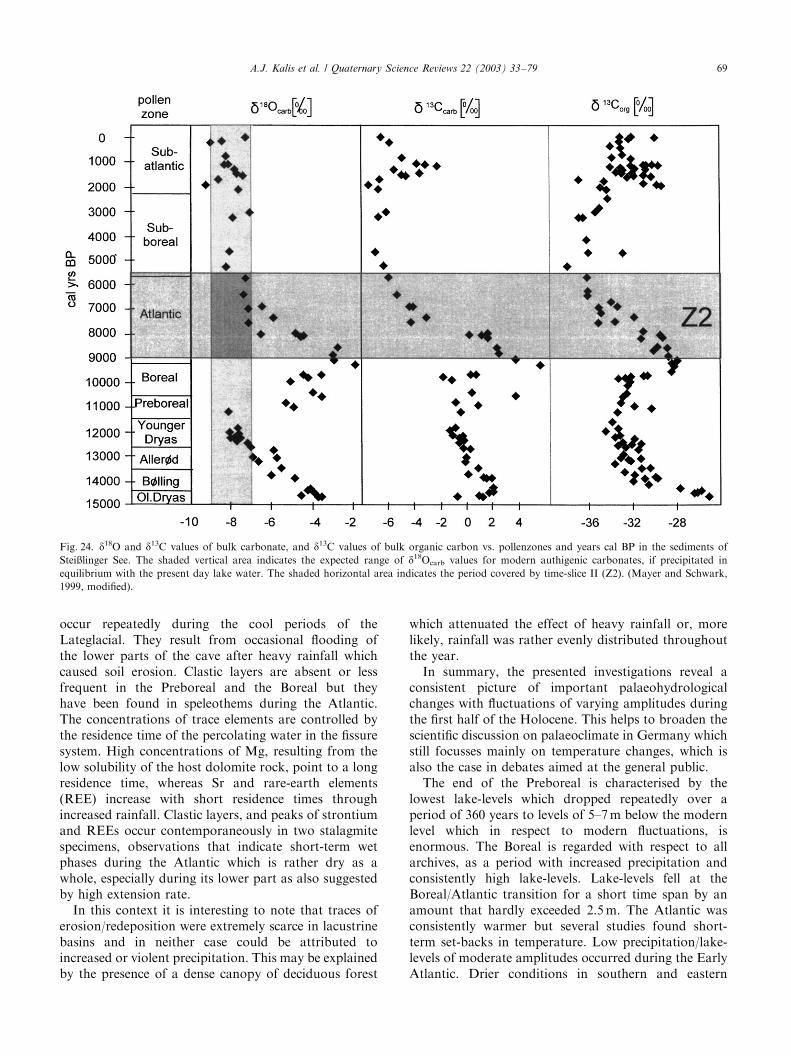
occur repeatedly during the cool periods of theLateglacial. They result from occasional flooding ofthe lower parts of the cave after heavy rainfall whichcaused soil erosion. Clastic layers are absent or lessfrequent in the Preboreal and the Boreal but theyhave been found in speleothems during the Atlantic.The concentrations of trace elements are controlled bythe residence time of the percolating water in the fissuresystem. High concentrations of Mg, resulting from thelow solubility of the host dolomite rock, point to a longresidence time, whereas Sr and rare-earth elements(REE) increase with short residence times throughincreased rainfall. Clastic layers, and peaks of strontiumand REEs occur contemporaneously in two stalagmitespecimens, observations that indicate short-term wetphases during the Atlantic which is rather dry as awhole, especially during its lower part as also suggestedby high extension rate.In this context it is interesting to note that traces of
erosion/redeposition were extremely scarce in lacustrinebasins and in neither case could be attributed toincreased or violent precipitation. This may be explainedby the presence of a dense canopy of deciduous forest
which attenuated the effect of heavy rainfall or, morelikely, rainfall was rather evenly distributed throughoutthe year.In summary, the presented investigations reveal a
consistent picture of important palaeohydrologicalchanges with fluctuations of varying amplitudes duringthe first half of the Holocene. This helps to broaden thescientific discussion on palaeoclimate in Germany whichstill focusses mainly on temperature changes, which isalso the case in debates aimed at the general public.The end of the Preboreal is characterised by the
lowest lake-levels which dropped repeatedly over aperiod of 360 years to levels of 5–7m below the modernlevel which in respect to modern fluctuations, isenormous. The Boreal is regarded with respect to allarchives, as a period with increased precipitation andconsistently high lake-levels. Lake-levels fell at theBoreal/Atlantic transition for a short time span by anamount that hardly exceeded 2.5m. The Atlantic wasconsistently warmer but several studies found short-term set-backs in temperature. Low precipitation/lake-levels of moderate amplitudes occurred during the EarlyAtlantic. Drier conditions in southern and eastern
Fig. 24. d18O and d13C values of bulk carbonate, and d13C values of bulk organic carbon vs. pollenzones and years cal BP in the sediments of
Stei�linger See. The shaded vertical area indicates the expected range of d18Ocarb values for modern authigenic carbonates, if precipitated in
equilibrium with the present day lake water. The shaded horizontal area indicates the period covered by time-slice II (Z2). (Mayer and Schwark,
1999, modified).
A.J. Kalis et al. / Quaternary Science Reviews 22 (2003) 33–79 69
Germany during this period are also indicated by theregional pattern of the primary forest (see Section 2.2).Wet conditions with higher lake-levels prevailed in allarchives during the Late Atlantic. A final intermediate
drop in lake-levels occurred near the transition Atlantic/Subboreal.It is obvious that the events detected in most of the
archives cannot be dated with the precision necessary
Fig. 25. Reconstruction of input and lake redox state via carboxylic acid pattern and photic zone anoxia pigments. Arrows at the right side:
occurrence of sulfphur bacteria (Chlorobiaceae) indicating anoxia. Symbols inside denote the chronological position of the analysed sample, e.g.
asterisk=Alleroed, full circle=Atlantic a.s.o. (Zink et al., 2000, modified).
A.J. Kalis et al. / Quaternary Science Reviews 22 (2003) 33–7970
for more detailed interpretation. Difficulties with datingare even encountered in lacustrine sediments which areperhaps best suited for palaeohydrological studies, aslake-level changes are easy to detect in shallow watersbut, are difficult to date accurately. Suitable proxies, areon the other hand, often not available in cores from theprofundal zone of the lakes, where high resolutionrecords and accurate dating are more easily achieved.Minor temporal offsets in different archives are there-fore not suitable for assessing sensitivities of variouslakes to drought, and using leads and lags to find causesand effects. An example is the mismatch of low lake-level at 9250–9340 cal BP in the H.amelsee and glacierretreat in Switzerland at 9910–9550 cal BP (Fig. 23).Substantial progress in this respect is unlikely until amore precise time control is available. Meanwhile, it canbe stated that the parallels between glacier advancesand high lake-levels/moist periods as detailed inMagny (1998) and Haas et al. (1998) match roughlythe results of the studies presented here, while thecorrespondence between the times of glacier retreat(Hormes et al., 2001) and low lake-levels in theH.amelsee is still closer.
4.2. Seasonality
Varves are seasonal laminations and therefore asedimentary expression of cyclical seasonal changesproviding information on the nature of the seasons.This information, however is modified by the complexlacustrine systems before being recorded in thesediment. The possibilities for interpretation are mani-fold, as has been demonstrated with studies carried outon sediments of Late Glacial age, around the transitionto the Holocene (Merkt, 1994; Zolitschka, 1998; Merktand M .uller, 1999) and also during its older part(Brathauer et al., 2000), but can be ambiguous whencomplex interrelations are involved which is generallythe case.The microfabric and the internal succession (annual
model based on seasonal sequence) of mid-Holocenevarves is rather uniform in all the German lakes so farstudied. Changes in thickness and varve quality areusually explained in terms of eutrophication or exposureto winds from changed tree vegetation and varyingwater depth as a result of lake-level fluctuations. Thesefactors are not seasonal. Changes in the pattern ofannual sequence or sub-elements of the varves pointingto changed characters of the seasons have not beenobserved. It is, however, noteworthy that many lakespreserved varved sediments during the climatic opti-mum. This not only points to favourable internalconditions of the lacustrine systems, but also to aparticular seasonality supporting lamination during theAtlantic, as the sediments of many of these lakes arebioturbated before and after this period.
In the study of the Juessee sediments (Fig. 20), anattempt has been made to focus on seasonality byamalgamating sedimentological, geochemical, and bio-logical data from the lake and its surroundings (Voigtet al., 2000). Summer warming began already in theBoreal. Milder and shorter winters occurred only 200years later (9500 cal BP). This phase was possiblyinterrupted by a spell of cooler winters (7500–8000 calBP) with a reversal to mesotrophic conditions, whereassummers had long periods of fine weather from 8400 calBP onwards as reflected by algal blooms and stabilisedmeromixis. Precipitation was characterised by frequentheavy rainfall until 8800 cal BP, as inferred from clasticlayers containing aerophilous diatoms. Rainfall waslater more evenly distributed but it was moderatethroughout the time slice and indicated a rathercontinental climate prevailing during the climate opti-mum. This multidisciplinary study leading to theassessment of seasonality is a valuable approach thoughnot unambiguous.Sch .onfelder and Steinberg (2000) and Sch .onfelder
et al. (2000) applied similar multi-proxy considerations,mainly based on inferred limnochemical data and bio-indications from diatom analyses of the sediments fromthe Gro�er Treppelsee. Long cold winters and evenlydistributed low levels of precipitation prevailed duringthe Preboreal and the Boreal. Moderate warmingespecially during the summer prevailed in the earlyHolocene. Strong seasonality with stable, long stagna-tion periods and substantial circulation in the mildspring after clearly shorter winters were typical for theAtlantic, the younger part of which had intensiverainfall.
4.3. Eutrophication
Increased bioproduction following the Preboreal inthe Juessee (Fig. 20, Voigt et al., 2000) is explained asresulting from the rise of summer temperatures, as thereis no indication of increased supply of nutrients duringthis period. The trophic status, as inferred from diatoms,remains high during the Boreal and the first millenniumof the Atlantic (with algal blooms), it becomesmesotrophic for a short period which is interpreted asbeing somewhat cooler (8170 – 7500 cal BP), after whichthere is an increase in the eutrophic status.Sch .onfelder and Steinberg (1998) created a new
diatom training set from 65 sites in Brandenburg (NorthGermany) with 284 significant species and developedtransfer functions for the diatom-nutrient relation usingstatistical techniques. Inferred TN and TP concentra-tions in the M .uggelsee indicated a rapid and stepwiseeutrophication (Fig. 18) reaching modern levels as earlyas 7200 cal BP, which was exclusively ascribed toclimatic factors, e.g. rising temperatures and substan-tially increased precipitation, leading to enhanced water
A.J. Kalis et al. / Quaternary Science Reviews 22 (2003) 33–79 71

flow in the river Spree, and therefore increased supply ofnutrients. The slight rise in diatom-inferred TP concen-tration in the Gro�er Treppelsee (Sch .onfelder andSteinberg, 2000 and Fig. 19) indicates a mesotrophicsituation during the Atlantic with seasonal eutrophicpeaks in spring as inferred from specific diatom blooms.Eutrophication has not been ascribed to human
activity in any of the lakes studied in northern Germany.Even substantial increase in the concentration ofcharcoal during the final centuries of the time slice,suggesting human activity close to the lakes, does notseem to parallel any noticeable disturbances of thelacustrine systems or increase in their productivity.Schwark et al. (submitted) used a geochemical
approach to assess changing lacustrine eutrophication.Increased input of terrigenous plants into the Stei�lingerSee in conjunction with higher lake levels wereparallelled and followed by an additional load ofnutrients which in turn supported the growth of greensulphur bacteria (Chlorobiaceae), identified on the basisof pigments (arrows in Fig. 25). Thus, anoxic conditionsat higher levels in the water column could be demon-strated using biomarkers.Eutrophy is a prerequisite for organic production,
and this in turn is a precondition for anoxia in thedeeper water body (hypolimnion) of lakes. Anoxichypolimnia are required to suppress bioturbation andguarantee the preservation of varves and/or the pre-cipitation of siderite. Organic production duringthe entire Holocene was sufficient to establish anoxiawhen climatic conditions and basin morphologieswere favourable. Varves and siderite are thereforeindicative of at least a moderate trophic level, but arenot suited for discrimination between different levels ofeutrophy.
4.4. Regionality
Regional differentiation is visible at many sites andexpressed in proxies. However, due to the multitude ofinterfering climatic, geographic, biologic and partlyanthropogenic parameters it is generally not possibleto unambiguously attribute discrete processes or causesto the observed features. The comparison of the forestcomposition at the Stei�linger See and the Schleinsee/Degersee only 70 km apart from each other may serve asan example. The former, sheltered by the Black Forest,is in a warmer and much drier landscape (Hegau) thanthe latter. Neolithic man favoured the dry region andconsequently used the forest intensively.A stalagmite from the H .olloch, Bavarian Alps
(Niggemann et al., 2000) with elevated extension ratesfrom the Early Altlantic onwards and co-varying curvesfor d13C and d18O as in the B7 cave, show only minorisotopic oscillations on a medium level during theclimatic optimum which is either due to the much
higher elevation of the site (1445m a.s.l.) or to a stablevegetation cover during this period.The initial formation of mires in Bavaria, intercalated
between gravel beds (Schneider, 2002), appears to betime transgressive (Fig. 22) as they seem to becomeyounger from east to west. The migration of spruce is inthe same direction during the Atlantic. However, it isnot clear whether this temporal succession is due to theregional climate or to altitudinal differences as thewestern-most mire is 200m higher.The pattern of sedimentary development, resulting
from lake-level oscillations during the Early Holocene,is remarkably similar in the Degersee and the shallowpart of the Stei�linger See, southern Germany, anddifferent from the H.amelsee in northern Germany. Thelowest lake-levels detected in the early Holocene areroughly contemporary in northern and southern Ger-many. At first glance one might suspect that climaticfactors could account for the differences, but, hydro-logical and geological factors in the catchment area mayalso control the sensitivity of the lakes in reacting to anddisplaying fluctuations in water levels. The results fromthese three lakes do not provide a good basis to makeany definite conclusions.Different patterns of lacustrine sediments, which are
usually expected on a transect from western- to eastern-Germany, e.g. from a humid-oceanic to a morecontinental climate with less but more intense precipita-tion and stable accentuated summers and winters, werenot found during the climatic optimum.There are two exceptions to the ambiguous situation
mentioned above. Firstly, the natural composition of theforest reflects differences that are due to regional climateand/or elevation, and also migration patterns (seeSection 2.2). Secondly, the geological/pedological set-ting is another regional feature which unequivocallycontrols lacustrine sedimentology and, in part, humansettlement.The lakes situated in areas with limestones or inside
the terminal moraines of the last glaciation, in northernand southern Germany, have the potential to producecalcareous deposits. The precipitation/preservation ofcalcite in the lakes of southern Germany show commonfeatures which vary gradually depending on themorphology (depth and size) of the lake basins. Thedeposits in the central part of most of the lakes have ahigh and uniform calcite concentration during theclimatic optimum, whereas the sediments of the Borealare poor in calcite and those of Preboreal age are largelydevoid of it. The calcite content is lower and fluctuatesfrequently during the Subboreal. The interrelationbetween climatic forcing and internal lacustrine pro-cesses is still not understood. Within the aboveboundary conditions, the precipitation/preservation ofcalcite appears to be primarily, but not exclusively,controlled by climate in its broadest sense. These
A.J. Kalis et al. / Quaternary Science Reviews 22 (2003) 33–7972
common features do not apply to northern Germanlakes of the same type.Soils in non-limestone areas or with soils arising from
older glaciations are deeply leached by pedogenicprocesses during the Eemian and the Late Glacial–EarlyHolocene, and are therefore devoid of calcite. Thesediments in lake basins with catchments of Saalian ageare non-calcareous in the Holocene. Iron is readilymobilised from these leached soils and transported intothe lakes. Only minor amounts of pyrite are precipitatedunder anoxic conditions within the freshly depositedsediment as sulfphur is usually sparse in freshwaterlakes. Siderite (iron carbonate) is precipitated at themud/water interface under medium anoxic and neutralto basic conditions and almost independent fromthe trophic state. Sediments are formed which contain10–15%, sometimes up to 50% iron (H.amelsee, maarlakes in the Eifel).
4.5. Human impact
The possibility to detect the very first imprints of earlyhuman activity in the environment is very limited.Speleothems and mires are not prone to react to weakhuman influence. Lacustrine systems, however, givemore sensitive archives.No indication of erosion ascribable to human
interference was recorded in the investigated lakes,mires or speleothems during the Atlantic. This absenceof allochthonous input to lacustrine systems contrastswith evidence of human presence on the lake shores andof anthropogenically induced erosion and redepositionof flood loam (Auelehm) in fluvial environments in theLate Atlantic (Hiller et al., 1991). Hiller et al. (1991),however, stress the point that early Neolithic people wasvery particular about where they settled. Not all rivervalleys experienced accumulation of flood loam beforethe Bronze Age as relatively dry, preferentially loess-covered areas were favoured by the Bandkeramik. TheBindersee near Halle, central Germany, is in an area ofthis type and the calcareous sedimentation in theshallow lake is, from the mid-Atlantic onwards,frequently and increasingly interrupted by humic siltwashed into the lake from the loess covered catchment(Litt, 1994; Kleinmann et al., in preparation). Addi-tionally, the lack of redeposited sediments in many lakesmay be partly explained by the fact that most lakes arecored in the profundal zone to obtain highly resolvedrecords without hiatuses. Cores retrieved along transectsshow that sediments eroded from the shores are oftenredeposited on the sloping margins and do not reach theprofundal parts of the basins.Human impact is beyond any doubt first recorded
towards the end of the time window discussed. Massiveoccurrences of charcoal, along with closed curves frompollen of cereals and ruderal plants connected with
forest clearances and also the first sedimentologicalsignals as clastic input and partly drastic changes in thecarbonate content have been reported from the lakesstudied. This major onset of late Neolithic humanimpact is, within the range of the error in varve-dating,amazingly contemporaneous in the Juessee (Voigt et al.,2000), Stei�linger See (Lechterbeck, 2000), Schleinseeand Degersee (Clark et al., 1989; Kleinmann et al., inpreparation), in northern and southern Germany anddates to around 6300 cal BP. It is consistent with thedecline of the first peak of Fagus in south-westernGermany and Switzerland (Richoz et al. (1994) andAmmann (1989), whose age determinations made onedecade ago were too young, as was the chronology inClark et al. (1989). For the next six millennia there areunmistakeable signals of human settlement followingeach other in consecutive pulses (Ammann, 1989) ofprehistoric cultures, as evidenced by artifacts andsettlements. They are accompanied by charcoal, second-ary forest cycles, and the increased input of erosionalclastics and nutrients into the lakes. It is furthermore,most interesting that there are parallels between theoccupation phases and low lake levels (Richoz et al.,1994).The question arises as to whether there is
any indication of human activity before 6300 cal BP,with or without direct proof of human presence nearthe lakes? Are we allowed to extend into the past thereasoning accepted for the period after 6300 cal BP,and what is the relevant evidence? Are thereplausible parallels between human activity and naturalvariability?Secondary forest cycles (see Section 2.2), existing
as consecutive peaks of NAP, hazel, ash, lime, elm,oak, and after 6500 cal BP, beech, accompanied byfire are reported from the Schleinsee (Clark et al., 1989)and Degersee (Kleinmann et al., in preparation)with frequencies of 200-300 years from 8200 cal BPonwards. Fire signals are observed after 8850 cal BP.Cereal-type pollen are found from 8200 cal BP onwards(Triticum/Hordeum: Schleinsee, Clark et al., 1989), 8000cal BP (Degersee, Kleinmann et al., in prep.), 8800 calBP (Juessee, Voigt et al., 2000). Fire with increasedmagnitude and forest cycles occur later in the Schleinseearound 7400, 7200 and 6950 cal BP. Lechterbeck(2000) argues for the first man-made forest disturbanceat 7425 cal BP in the Stei�linger See. Apartfrom charcoal, neither compositional nor structuralchanges of the sediments deposited during the Bandker-amik culture and attributable to human impacthave been found in any of the lakes mentionedabove.Secondary forest cycles, occurring in temporal dis-
tances of some centuries, constitute deep incisions in theforest. Especially the later examples point to anextensive and contemporary utilisation of land in the
A.J. Kalis et al. / Quaternary Science Reviews 22 (2003) 33–79 73
immediate vicinity of the lakes and also in the largercatchment areas. Migrating slash and burn cultures,occupying isolated patches in an otherwise forestedlandscape, are expected to give noisy pollen diagrams,but without the distinct patterns of secondary forestcycles which cannot be produced by continuousprocesses alone.It is interesting to consider in this context that the
Neolithic cultures are not presented as the resultof evolving continua, but largely disappear and re-appear with new cultural acquisitions, suggestingthe breakdown and renewal of settlements. The causesof the pulsating occupation may be social inthe broadest sense (this is beyond the scope of thispaper), or environmental. Climatic changes, especiallydroughts, affect large areas at the same time, and henceare the probable agent to control man and theenvironment, e.g. by facilitating forest fire (Richozet al., 1994).A causal connection between lake-levels, droughts,
glacier retreats and secondary forest cycles is stillnot proven, but it is a reasonable assumption.A climatic control of the presence and favouring ofNeolithic people, who in turn produce secondary forestcycles that are favoured by drought, is increasinglyplausible.
5. Conclusion
According to the results presented here, which refer totime slice II of the priority programme, the Holoceneclimatic optimum can be subdivided into three distinc-tive phases encompassing the intervals from 9000 to7500 cal BP, the Mesolithic, ca 7500–6300 cal BP, theEarly and Middle Neolithic, and the Younger Neolithicafter 6300 cal BP.The first phase is characterised by stable environ-
mental conditions. The investigated archives, except thespeleothems, do not show consistent changes in palaeo-temperature. This also applies to the following phasesuntil the end of the climatic optimum. Compared withthe preceding Boreal, low lake-levels occurred duringthe Early Atlantic, probably reflecting periods ofdecreased precipitation. In general, the sedimentaryrecords indicate calm meteorological conditions. Thepollen records suggest that the vegetation was inequilibrium and had already reached its interglacialclimax stage. The plant cover resulted in soil stabilisa-tion including sloping ground, so that only negligibleaccumulation of clastic sediments occurred in restrictedareas on floodplains and in lakes. Although the presenceof Mesolithic people is documented by archaeologicalfinds and, at times, considerable amounts of charcoalfragments in lake sediments, evidence for major
anthropogenic impact on the environment has not beendetected.In the second phase, during the Early and Middle
Neolithic, particularly high lake levels provide evidenceof a wetter climate, probably induced by increasedprecipitation. Pollen records from the lowlands ofsouthern and central Germany show noticeable changeswithin the forest vegetation. The most striking are theso-called secondary forest cycles, indicating stepwiseanthropogenic clearances in the Atlantic primevalforest. Human activity, however, hardly caused anychanges in the deposition of colluvia, floodplain depositsor lake sediments. This indicates that Early Neolithicfarming activities were enacted within the bufferingcapacities of the forest ecosystems on rich soils.Clearances were restricted to the minimum needed forarable farming and the woodlands were only manipu-lated in such a way that sufficient fodder for thelivestock could be extracted. Therefore, in spite ofthe woodland clearances, Early Neolithic life seems tohave remained strongly adapted to the forest ecosystemand evidently remained part of it.While high lake-levels prevailed during the second
phase of the climatic optimum, lake-levels fell for severalcenturies at ca 6300 cal BP, the beginning of the thirdphase. Moreover, this was an important time marker invarious respects: The pollen diagrams from southernGermany show large-scale woodland clearances, indi-cating substantial changes in land use from this timeforward. Those from northern Germany show theadoption of agriculture by Mesolithic people. They allshow a new approach by Neolithic farmers in dealingwith the landscape. Previous Early and Middle Neolithicadaption to the forest ecosystem was abandoned duringthe Younger Neolithic in favour of an agriculturalsystem exploiting the environment. The introduction ofnew agricultural technologies, e.g. ploughing, and newcrops, also characterises this period.Increased thickness of colluvia and the deposition of
flood loam point to an increase of soil erosion withserious effects on the landscape. Remarkable changes inthe composition and the fabric of lacustrine sediments,with a rising proportion of clastics and raised amountsof charcoal particles, also mirror more vigorous humanimpact on the environment, which may be amplified bythe contribution of natural variables like droughts. It istempting to relate the changes in the fluvial andlacustrine records to the newly introduced use of theplough. Ploughing led to destruction of soil texture, andthus facilitated soil erosion.
Acknowledgements
Our sincere thanks go to the leaders and the many co-workers of the projects presented here for providing
A.J. Kalis et al. / Quaternary Science Reviews 22 (2003) 33–7974
papers, unpublished reports, data and valuable com-ments. Several also contributed figures that theyprepared especially for this paper. While it is not possibleto list all contributors, the authors wish to acknowledgethe substantial contributions, including primary data, bythe following: H.-J. Beug, W. D .orfler, E. Endtmann, K.Eusterhues, S. H .onscheidt, A. Kleinmann, B. Kubitz, A.Lang, J. Lechterbeck, H. M .uller, S. Niggemann, S.Nolte, H. Reichardt, D. Richter, H. Rittweger, A.Schweizer, H. Schneider, T. Schneider, I. Sch.onfelder,L. Schwark, R. Voigt. The authors wish also to thankCh. Bendall and K. Bie who improved the Englishlanguage. In addition, the authors are indebted to M.O’Connell and an anonymous reviewer for providingcritical and helpful comments and for linguisticallyamending the manuscript. The various investigationswere funded by the Deutsche Forschungsgemeinschaft(DFG). The research was carried out as contribution tothe interdisciplinary priority programme ‘‘Changes ofthe Geo-Biosphere during the last 15 000 years —continental sediments as evidence for changing environ-mental conditions’’. Most of the data presented here areavailable from the PANGAEA information systemhttp://www.pangaea.de/Projects/GeoBio15k.
References
Aaby, B., 1986. Trees as anthropogenic indicators in regional pollen
diagrams from Eastern Denmark. In: Behre, K.E. (Ed.), Anthro-
pogenic Indicators in Pollen Diagrams. Balkema, Rotterdam/
Boston, p. 73–93.
Ammann, B., 1989. Late-Quaternary palynology at Lobsigersee.
Regional vegetation history and local lake development. Disserta-
tiones Botanicae 137, 157pp.
Andersen, S.T., 1988. Pollen spectra from the Double Passage-Grave,
Klekkendeh .oj, on M .on — evidence of swidden cultivation in the
Neolithic of Denmark. Journal of Danish Archaeology 7, 77–92.
Andres, W., Bos, J.A.A., Houben, P., Kalis, A.J., Nolte, S., Rittweger,
H., Wunderlich, J., 2001. Environmental change and fluvial activity
during the Younger Dryas in Central Germany. Quaternary
International 79, 89–100.
Bakker, R., 2002. The emergence of agriculture on the Drenth plateau.
A paleobotanical study supported by high resolution dating.
Dissertation Groningen.
Barsch, D., M.ausbacher, R., Schukraft, G., Schulte, A., 1993. Die.Anderungen des Naturraumpotentials im Jungneolithikum des
n .ordlichen Kraichgaus dokumentiert in fluvialen Sedimenten.
Zeitschrift f .ur Geomorphologie N. F., Suppl. 93, 175–187.
Behre, K.-E., 1981. The interpretation of anthropogenic indicators in
pollen diagrams. Pollen et Spores 23, 225–245.
Behre, K.-E., Jacomet, S., 1991. The ecological interpretation of
archaeobotanical data. In: van Zeist, W., Wasylikowa, K., Behre,
K.-E. (Eds.), Progress in Old World Palaeoethnobotany. A
Retrospective View on the Occasion of 20 Years of the Interna-
tional Working Group for Palaeoethnobotany. Balkema, Rotter-
dam/Brookfield, pp. 81–108.
Behre, K.-E., Ku$can, D., 1994. Die Geschichte der Kulturlandschaft
und des Ackerbaus in der Siedlungskammer Fl .ogeln, Niedersach-
sen, seit der Jungsteinzeit. Probleme der K .ustenforschung 21,
227pp.
Berglund, B.E., Hjelmroos, M., Kolstrup, E., 1991. The K .opinge area
— vegetation and landscape through time. In: B.E. Berglund (Ed.),
The Cultural Landscape during 6000 years in Southern Sweden —
the Ystad Project. Ecological Bulletin 41, 109–112.
Beug, H.-J., 1961. Leitfaden der Pollenbestimmung f .ur Mitteleuropa
und angrenzende Gebiete. Fischer, Stuttgart, 65pp.
Beug, H.-J., 1992. Vegetationsgeschichtliche Untersuchungen .uber die
Besiedlung im Unteren Eichsfeld, Landkreis G .ottingen, vom
fr .uhen Neolithikum bis zum Mittelalter. Neue Ausgrabungen
und Forschungen in Niedersachsen 20, 261–339.
Beug, H.-J., Henrion, I., Schm.user, A., 1999. Landschaftsgeschichte
im Hochharz. Die Entwicklung der W.alder und Moore seit dem
Ende der letzten Eiszeit. 454 S., 220 Abb., 67 Tab., 1Kt. 1:25000,
Papierflieger Verlag, Clausthal - Zellerfeld.
Blum, M.D., T .ornqvist, T.E., 2000. Fluvial responses to climate and
sea-level change: a review and look forward. Sedimentology 47,
Suppl. 1, 2–48.
Bork, H.R., 1983. Die holoz.ane Relief- und Bodenentwicklung in
L .ossgebieten. Beispiele aus dem s .ud .ostlichen Niedersachsen. In:
Bork, H.R., Ricken, W. (Eds.), Bodenerosion, Holoz.ane und
Pleistoz.ane Bodenentwicklung. Catena Supplement 3, 1–93.
Bos, J.A.A., Urz, R., 2002. Local impact of Early Mesolithic man on
the environment in the middle Lahn river valley (Hessen), central-
west Germany — pollen and macrofossil evidence. Vegetation
History and Archaeobotany 21.
Bottema, S., 1988. Back to Nature? Objectives of nature managment in
view of archaeological research. In: Bierma, J.H., Harsema, O.H.,
Zeist, W. van (Eds.), Archaeologie en Landschap. Biologisch-
Archaeologisch Instituut Groningen, pp. 185–205.
Brathauer, U., Brauer, A., Negendank, J.F.W., Zolitschka, B., 2000.
Rasche Klima.anderungen am Beginn der heutigen Warmzeit.
Zweijahresbericht, GeoForschungsZentrum Potsdam, 1998/1999,
29-33, 6 Abb., Potsdam.
Brinkkemper, O., Hogestijn, W.-J., Peeters, H., Visser, D., Whitton,
C., 1999. The early Neolithic site at Hoge Vaart, Almere, the
Netherlands, with particular reference to non-diffusion of crop
plants, and the significance of site function and sample location.
Vegetation History and Archaeobotany 8, 79–86.
Bubenzer, O., 2000. Sedimentologische und Gerinnegeomorpholo-
gische Befunde im Einzugsgebiet der Schw .ulme (S .udniedersachsen)
zur Rekonstruktion der Sp.atglazialen bis Mittelholoz.anen Mor-
phodynamik. Zeitschrift f .ur Geomorphologie N. F., Suppl. 121,
23–44.
Castelletti, L., St.auble, H., 1997. Holzkohlenuntersuchungen zu ur-
und fr .uhgeschichtlichen Siedlungen der Aldenhovener Platte und
ihrer Umgebung (Niederrheinische Bucht). In: L .uning, J. (Ed.),
Studien zur neolithischen Besiedlung der Aldenhovener Platte und
ihrer Umgebung. Beitr.age zur Neolithischen Besiedlung der
Aldenhovener Platte, 6. Rheinische Ausgrabungen 43, 685–714.
Clark, J.S., Merkt, J., M .uller, H., 1989. Post-glacial fire, vegetation,
and human history on the northern Alpine forelands, south-
western Germany. Journal of Ecology 77, 897–925.
Dambeck, R., Sabel, K.-J., 2001. Sp.at- und postglazialer Wandel der
Flusslandschaft am n .ordlichen Oberrhein und Altneckar im
Hessischen Ried. Jahresberichte und Mitteilungen des Oberrhei-
nischen Geologischen Vereins N. F. 83, 131–143.
Dambeck, R., Thiemeyer, H., 2002. Fluvial history of the northern
Upper Rhine river (south-western Germany) during the Lateglacial
and Holocene times. Quaternary International 93–94, 53–63.
Dengler, A., 1935. Waldbau auf .okologischer Grundlage. Berlin.
Dieckmann, B., Maier, U., Vogt, R., 2002. Hornstaad, zur inneren
Dynamik einer jungsteinzeitlichen Dorfanlage am westlichen
Bodensee. Neue Ergebnisse der Arch.aologie, Botanik und Bod-
enkunde. In: Lippert, A., Schultz, M., Shennan, S., Teschler-
Nicola, M. (Eds.), Mensch und Umwelt im Neolithikum und der
Fr .uhbronzezeit in Mitteleuropa. Ergebnisse interdisziplin.arer
A.J. Kalis et al. / Quaternary Science Reviews 22 (2003) 33–79 75
Zusammenarbeit zwischen Arch.aologie, Klimatologie, Biologie
und Medizin. Fortschritte in Pal.aopathologie und Osteoarch-
.aologie 3,
D .orfler, W., 2001. Von der Parklandschaft zum Landschaftspark.
Rekonstruktion der neolithischen Landschaft anhand von Pollen-
analysen aus Schleswig-Holstein. In: Kelm, R. (Ed.), Zur .uck zur
Steinzeitlandschaft. Arch.aologische und .okologische Forschung
zur jungsteinzeitlichen Kulturlandschaft und ihrer Nutzung in
Nordwestdeutschland. Albersdorfer Forschungen zur Arch.aologie
und Umweltgeschichte 2, 39–55.
Eberhardt, E., 1998. Mikromorphologische Untersuchungen zur
Genese des ‘‘Schwarzen Auenbodens’’ im Bereich des Am .one-
burger Beckens (Hessen). Diploma Thesis, FB Geographie,
Universit.at Marburg, 119 pp.
Eusterhues, K., 2000. Die Sedimente des Stei�linger Sees (Hegau,
S .uddeutschland) — Ein Archiv f .ur zeitlich hochaufgel.oste geo-
chemische Untersuchungen zu Umweltver.anderungen im Holoz.an.
Dissertation on CD-Rom, Universit.at G .ottingen.
Eusterhues, K., Lechterbeck J., Schneider, J., Wolf-Brozio, U. in press.
Late- and Postglacial evolution of Lake Steisslingen (I). Sedimen-
tary history, palynological record and inorganic geochemical
indicators. Palaeogeography, Palaeoclimatology Palaeoecology.
Fægri, K., Iversen, J., 1989. Textbook of Pollen Analysis. Wiley,
Chichester, New York, Brisbane, Toronto, Singapore, 328pp.
Fischer-Zujkov, U., 2000. Die Schwarzerden Nordostdeutschlands —
ihre Stellung und Entwicklung im holoz.anen Landschaftswandel.
Thesis, Humboldt-Universit.at Berlin, 173 pp (http://dochost.rz.hu-
berlin.de/dissertationen/fischer-zujkov-ute-2000–12–05/).
Friedmann, A., 1999. Die sp.at- und postglaziale Landschafts- und
Vegetationsgeschichte des s .udlichen Oberrheintieflands
und Schwarzwalds. Habilitationsschrift der Geowissenschaftlichen
Fakult.at der Albert-Ludwigs-Universit.at Freiburg i. Br.,
231 pp.
Gaillard, M.-J., Birks, H.J.B., Ihse, M, Runborg, S., 1998. Pollen/
landscape calibrations based on modern pollen assemblages from
surface-sediment samples and landscape mapping — a pilot study
in South Sweden. In: Gaillard, M.-J., Berglund, B.E. (Eds.),
Quantification of Land Surfaces Cleared of Forest during the
Holocene — Modern Pollen/Vegetation/Landscape Relationships
as an Aid to the Interpretation of Fossil Pollen Data. Pal-
.aoklimaforschung 27, 31–52.
Glass, M., 1991. Animal production systems in Neolithic central
Europe. BAR, International Series 572, Oxford.
Groenman-van Waateringe, W., 1971. Hecken im westeurop.aischen
Fr .uhneolithikum. Berichte van de Rijksdienst voor Oudheidkundig
Bodemonderzoek 20–21, 295–299.
Haas, J.N., Richoz, I., Tinner, W., Wick, L., 1998. Synchronous
holocene climatic oscillations recorded on the Swiss Plateau and at
timberline in the Alps. The Holocene 8 (3), 301–309.
Hartz, S., Hoffmann-Wieck, G., 2000. K .ustenbesiedlung und Land-
schaftsentwicklung im 5. Jahrtausend v.Chr. am Beispiel des
Oldenburger Grabens in Ostholstein. In: Kelm, R. (Ed.), Vom
Pfostenloch zum Steinzeithaus. Arch.aologische Forschung und
Rekonstruktion jungsteinzeitlicher Haus- und Siedlungsbefunde im
nordwestlichen Mitteleuropa. Albersdorfer Forschungen zur Arch-
.aologie und Umweltgeschichte 1, 70–87.
Hartz, S., Heinrich, D., L .ubke, H., 2000. Fr .uhe Bauern an der K .uste.
Neue 14C-daten und aktuelle Aspekte zum Neolithisierungsproze�im norddeutschen Ostseek .ustengebiet. Pr.ahistorische Zeitschrift 75
(2), 129–152.
Hicks, S., 1998. Fields, boreal forests and forest clearings as recorded
by modern pollen deposition. In: Gaillard, M.-J., Berglund, B.E.
(Ed.), Quantification of Land Surfaces Cleared of Forest during the
Holocene — Modern Pollen/Vegetation/Landscape Relationships
as an Aid to the Interpretation of Fossil Pollen Data. Pal.ao-
klimaforschung 27, 53-66.
Hiller, A., Litt, Th., Eissmann, L., 1991. Zur Entwicklung der
Jungquart.aren Tieflandst.aler im Saale-Elbe-Raum unter Beson-
derer Ber .ucksichtigung von 14C-Daten. Eiszeitalter und Gegenwart
41, 26–46.
Hoika, J., 1987. Das Mittelneolithikum zur Zeit der Trichterbecher-
kultur in Nordostholstein. Untersuchungen zur Arch.aologie und
Landschaftsgeschichte. Offa-B .ucher 61.
Hoika, J., 2000. Grenzfragen oder: James Watt und die Neolithisie-
rung. In: Kelm, R. (Ed.), Vom Pfostenloch zum Steinzeithaus.
Arch.aologische Forschung und Rekonstruktion jungsteinzeitlicher
Haus- und Siedlungsbefunde im nordwestlichen Mitteleuropa.
Albersdorfer Forschungen zur Arch.aologie und Umweltgeschichte
1, 53-69.
Hormes, A., M .uller, B.U., Schl .uchter, C., 2001. The Alps with little
ice: evidence for eight Holocene phases of reduced glacier extent in
the Central Swiss Alps. The Holocene 11 (3), 255–265.
Houben, P., 1997. Late-glacial and Holocene fluvial sedimentation in a
small upland catchment in Hesse (Germany). Zeitschrift f .ur
Geomorphologie N. F. 41, 461–478.
Houben, P., Nolte, S., Rittweger, H., Wunderlich, J., 2001. Lateglacial
and Holocene environmental change indicated by fluvial deposits
of the Hessian Depression (Central Germany). In: Maddy, D.,
Macklin, M.G., Woodward, J.C. (Eds.), River Basin Sediment
Systems — Archives of Environmental Change. Balkema, Rotter-
dam, pp. 249–264.
Iversen, J., 1949. Landnam i Danmarks stenalder (Land occupation in
Denmark’s Stone Age). Danmarks geologiske unders .ogelse II (66),
68pp.
Iversen, J., 1973. The development of Denmark’s Nature since the Last
Glacial. Danmarks geologiske unders .ogelse V (7c), 126pp.
Iverson, J., 1949. The influence of prehistornic man on vegetation.
Danmarks geologiske unders .ogelse IV R, 3, 6, 5–25.
Jacomet, S., Brombacher, C., Dick, M., 1989. Arch.aobotanik am
Z .urichsee. Ackerbau, Sammelwirtschaft und Umwelt von neo-
lithischen und bronzezeitlichen Seeufersiedlungen im Raum Z .urich.
Ergebnisse von Untersuchungen pflanzlicher Makroreste der Jahre
1979–1987. Berichte der Z .urcher Denkmalpflege Monographien 7,
348pp.
Jakobsen, O., Hoffmann-Wieck, G., Thiede, J., 2001. Neue Ergebnisse
der geoarch.aologischen Forschung in der westlichen Oldenburger-
Graben-Niederung: Rekonstruktion der fr .uhneolithischen Land-
schaft. In: Kelm, R. (Ed.), Zur .uck zur Steinzeitlandschaft. Arch-
.aologische und .okologische Forschung zur jungsteinzeitlichen
Kulturlandschaft und ihrer Nutzung in Nordwestdeutschland.
Albersdorfer Forschungen zur Arch.aologie und Umweltgeschichte
2, 89–95.
Jerz, H., Schneider, Th., Krause, K.-H., 2000. Zur Entwicklung der
Schwemmf.acher und Schwemmkegel in Randbereichen des Mur-
nauer Mooses: mit Ergebnissen der GLA-Forschungsbohrungen
bei Grafenaschau und Eschenlohe. Geologica Bavarica 105,
253–266.
Kalis, A.J., 1980. Papaveraceae. In: Punt, W., Clarke, G.C.S. (Eds.),
The Northwest European Pollen Flora, Vol. 2, pp. 209–260.
Elsevier.
Kalis, A.J., 1988. Zur Umwelt des fr .uhneolithischen Menschen: ein
Beitrag der Pollenanalyse. Forschungen und Berichte zur Ur- u.
Fr .uhgeschichte in Baden-W .urttemberg 31, 125–138.
Kalis, A.J., Meurers-Balke, J., 1997. Landnutzung im Neolithikum. In:
Richter, J. Neolithikum. Geschichtlicher Atlas der Rheinlande,
Beihefte II/2.1–II/2.2, 25–55.
Kalis, A.J., Meurers-Balke, J., 1998. Die Landnam’’-Modelle von
Iversen und Troels-Smith zur Neolithisierung des Westlichen
Ostseegebeites — ein versuch ihrer aktualisierung. Pr.ahistorische
Zeitschrift 73, 1–24.
Kalis, A.J., Zimmermann, A., 1988. An integrative model for the use
of different landscapes in Linearbandceramic times. In: Bintliff,
A.J. Kalis et al. / Quaternary Science Reviews 22 (2003) 33–7976
J.L., Davidson, D.A., Grant, E.G. (Eds.), Conceptual Issues
in Environmental Archaeology. University press Edinburgh,
pp. 145-152.
Kalis, A.J., Meurers-Balke, J., van der Borg, K., von der Driesch, A.,
R.ahle, W., Tegtmeier, U., Thiemeyer, H., 2001. Der La-Hoguette-
Fundhorizont in der Wilhelma von Stuttgart-Bad Cannstatt.
Anthrakologische, arch.aopalynologische, bodenkundliche, mala-
kozoologische, radiometrische und s.augetierkundliche Untersu-
chungen. In: Gehlen, B., Heinen, M., Tilmann, A. (Eds.), Zeit-
R.aume — Gedenkschrift f .ur Wolfgang Taute. Arch.aologische
Berichte 14, 649-672.
Kleinmann, A., Merkt, J., M .uller, H., 1997. Lake level fluctuations in
the uppermost Preboreal in Lake H.amelsee. Seventh International
Symposium on Palaeolimnology, Abstract Volume, W .urzburger
Geographische Manuskripte 41, 107–108.
Kleinmann, A., Merkt, J., M .uller, H., 2000. Climatic lake-level
changes in German lakes during the Holocene? Terra Nostra 2000/
7, 55–63, Potsdam.
Kleinmann, A., Litt, T., Merkt, J., M .uller, H. in preparation.
Sedimentology, Vegetation History and Geochemistry of the
Bindersee.
Kleinmann, A., Merkt, J., M .uller, H. in preparation. Sedimentology,
Vegetation History and Geochemistry of the Degersee.
Kn.orzer, K.H., 1971. Urgeschichtliche Unkr.auter im Rheinland. Ein
Beitrag zur Entstehung der Segetalgesellschaften. Vegetatio 23, 89–111.
Kn .orzer, K.H., 1986. Vom neolithischen Ackerbau in Rheinland.
Arch.aologie in Deutschland. 1986 (1), 32–37.
Kn .orzer, K.H., 1988. Zur Auswertung von Wildpflanzenfunden aus
dem Neolithikum des Rheinlandes. Archaeologische Informatio-
nen 11 (1), 20–32.
K .orber-Grohne, U., 1990. Gramineen und Gr .unlandvegetation vom
Neolithikum bis zum Mittelalter in Mitteleuropa. Bibliotheca
Botanica 139.
Kreuz, A., 1990. Die erste Bauern Mitteleuropas. Eine archaeobota-
nische Untersuchung zu Umwelt und Landwirtschaft der .altesten
Bandkeramik. Analecta Prehistoria Leidensia 23, 256pp.
Kubitz, B., 2000. Die Holoz.ane Vegetations- und Siedlungsgeschichte
in der Westeifel am Beispiel eines Hochaufl .osenden Pollendia-
grammes aus dem Meerfelder Maar. Dissertationes Botanicae 339,
106 pp.
K .uster, H., 1991. Mitteleuropa s .udlich der Donau, einschlie�lichAlpenraum. In: W. van Zeist, K. Wasylikowa, K.E. Behre (Eds.),
Progress in Old World Palaeoethnobotany. A Retrospective View
on the Occasion of 20 Years of the International Working
Group for Palaeoethnobotany. Balkema, Rotterdam/Brookfield,
pp. 179–187.
Lang, A., H .onscheidt, S., 1999. Age and source of soil erosion derived
colluvial sediments at Vaihingen-Enz, Germany. Catena 38/2,
89–107.
Lanting, J.N., Van der Plicht, J., 2000. De 14C-chronologie van de
nederlandse pre- en protohistorie. III. Neolithikum. Palaeohistoria
41/42, 1–110
Lechterbeck, J., 2000. ‘‘Human Impact’’ oder ‘‘Climate Change’’? Zur
Vegetationsgeschichte des Sp.atglazials und Holoz.ans in hochauf-
l .osenden Pollenanalysen laminierter Sedimente des Stei�linger Sees(S .udwestdeutschland). Dissertation on CD-Rom, Univ. T .ubingen.
Litt, Th., 1988. Stratigraphische Belege f .ur Anthropogen Ausgel .oste
Bodenverlagerung vom Neolithikum bis zur Fr .uhen Eisenzeit im
Circumhercynen Raum. Ethnographisch-Arch.aologische Zeits-
chrift 29, 129–137.
Litt, Th., 1992a. Investigations on the extent of the early Neolithic
settlement in the Elbe-Saale region and on its influence on the
natural environment. In: Frenzel, B. (Ed.), Evaluation of Land
Surfaces Cleared from Forest by Prehistoric Man in Early
Neolithic Times and the Times of Migrating German Tribes;
Pal.aoklimaforschung 8, 83–91.
Litt, Th., 1992b. Fresh investigations into the natural and anthro-
pogenically influenced vegetation of the earlier Holocene in the
Elbe-Saale Region, central Germany. Vegetation History and
Archaeobotany 1, 69–74.
Litt, Th., 1994. Bindersee, 146–150 In: Pal.ao .okologie, Pal.aobotanik
und Stratigraphie des Jungquart.ars im nordmitteleurop.aischen
Tiefland. Unter besonderer Ber .ucksichtigung des Elbe-Saale-
Gebietes. Dissertationes Botanicae (Berlin) 227, 185 pp.
Litt, Th., 2003. Environmental response to climatic and human impact
in central Europe during the last 15 000 years — a German
contribution to PAGES-PEP III. Quaternary Science Reviews, this
issue (PII: S0277-3791(02)00178-6).
Litt, Th., Schmincke, H.U., Kromer, B., 2003. Environmental
response to climatic and volcanic events in central Europe during
the Weichselian Lateglacial. Quaternary Science Reviews, this issue
(PII: S0277-3791(02)00180-4).
L .ohr, H., 1986. Eine .Ubersichtskarte zun .alteren Neolithikum im
Moselgebiet. Arch.aologisches Korrespondenzblatt 16, 267–278.
L .uning, J., 1982. Siedlung und Siedlungslandschaft in bandkera-
mischer und R .ossener Zeit. Offa 39, 9–33.
L .uning, J., 1988. Fr .uhe Bauern in Mitteleuropa im 6. and 5. v. Chr.
Jahrbuch des R .omisch-Germanischen Zentralmuseums Mainz 35,
27–93.
L .uning, J., 1996. Erneute Gedanken zur Benennung der neolithischen
Perioden. Germania 67, 233–237.
L .uning, J., 1997. Haus, Hof and Siedlung im .Alteren Neolinthikum am
Beispiel der Aldenhovener Platte in der Niederrheinische Bucht. In:
Beck, H., Steuer, H. (Eds.), Haus und Hof in Ur- und
fr .uhgeschichtlicher Zeit. G .ottingen, pp. 70–85.
L .uning, J., 2000. Steinzeitliche Bauern in Deutschland. Die Land-
wirtschaft im Neolithikum. Universit.atsforschungen zur pr.a-
historischen Arch.aologie 58, 285pp.
L .uning, J., Kalis, A.J., 1992. The influence of Early Neolithic settlers
on the vegetation of the Lower Rhinelands and the determination
of cleared areas based on archaeological and palynological criteria.
In: Frenzel, B. (Ed.), Evaluation of Land Surfaces cleared from
Forest by Prehistoric Man in Early Neolithic Times and the
Time of Migrating Germanic Tribes. Pal.aoklimaforschung 8,
41–46.
L .uning, J., Kloos, U., Albert, S., 1989. Westliche Nachbarn der
Bandkeramischen Kultur: la Hoguette und Limburg. Germania 67,
355–393.
M.ackel, R., 1969. Untersuchungen zur jungquart.aren Flu�geschichteder Lahn in der Gie�ener Talweitung. Eiszeitalter u. Gegenwart 20,138–174.
M.ackel, R., 1970. Die Entwicklung des Gie�ener Lahntales im Sp.at-
und Postglazial Berichte der Oberhessischen Gesellschaft f .ur
Natur- und Heilkunde N.F. Naturwissenschaftliche Abteilung 37,
45–68.
M.ackel, R., Friedmann, A., 1999. Holoz.aner Landschaftswandel im
s .udlichen Oberrheintiefland und Schwarzwald. Eiszeitalter und
Gegenwart 49, 1–20.
Macklin, M.G., Lewin, J., 1993. Holocene river alluviation in Britain.
Zeitschrift f .ur Geomorphologie N. F. 88, 109–122.
Magny, M., 1998. Reconstruction of Holocene lake-level changes in
the French Jura: methods and results. In: Frenzel, B. (Ed.),
Palaeohydrology as Reflected in Lake-level Changes as Climatic
Evidence for Holocene Times. G. Fischer-Verlag, Stuttgart,
pp. 67–85.
Maier, U., 1996. Morphological studies of free-threshing wheat
ears from a Neolithic site in Southwest Germany, and the history
of the naked wheats. Vegetation History and Archaeobotany 5,
39–55.
Maier, U., 2002. Arch.aobotanische Untersuchungen in Hornstaad-
H .ornle IA. Mit Beitr.agen von Matthias Ahrens und Richard Vogt.
Siedlungsarch.aologie im Alpenvorland 6.
A.J. Kalis et al. / Quaternary Science Reviews 22 (2003) 33–79 77

M.ausbacher, R., Schneider, H., Igl, M., 2001. Influence of late glacial
climate changes on sediment transport in the River Werra
(Thuringia, Germany). Quaternary International 79, 101–109.
Mayer, B., Schwark, L., 1999. A 15 000-year stable isotope record from
sediments of Lake Steisslingen, Southwest Germany. Chemical
Geology 161, 315–337.
Merkt, J., 1994. The Aller�d — duration and climate as derived from
laminated lake sediments. Terra Nostra 1/94, Bonn, pp. 59–63.
Merkt, J., M .uller, H., 1999. Varve chronology and palynology of
the Lateglacial in Northwest Germany from lacustrine sediments of
H.amelsee in Lower Saxony. Quaternary International 61, 41–59.
Meyer, M., 2000. Ein Hausgrundriss aus der lat"ene- und kaiserzeitli-
chen Siedlung Mardorf 23, Kr. Marburg-Biedenkopf. Berichte der
Kommission f .ur Arch.aologische Landesforschung in Hessen 5,
115–121.
M .uller, H., 1953. Zur sp.at- und nacheiszeitlichen Vegetations-
geschichte des mitteldeutschen Trockengebietes. Nova Acta Leo-
poldina, N.F. 16 (1 1 0), 67pp.
M .uller, H., 1962. Pollenanalytische Untersuchung eines Quart.arprofils
durch die sp.at- und nacheiszeitlichen Ablagerungen des Schleinsees
(S .udwestdeutschland). Geologisches Jahrbuch (Hannover) 79,
493–526.
Niggemann, S., Frank, N., Mangini, A., Richter, D.K., Wurth, G.,
2000. Holoz.ane Stalagmiten des Sauerlandes (Deutschland) als
Klimaarchive. Mitteilungen des Verbandes deutscher H .ohlen- u.
Karstforscher (M .unchen) 46/1/2, 84–90.
Niggemann, S., Mangini, A., Richter, D.K., Wurth, G., 2003 A
palaeoclimate record of the last 17 600 years in stalagmites from the
B7 cave, Sauerland, Germany. Quaternary Science Review, in
press.
Niller, H.-P., 1998. Pr.ahistorische Landschaften im L .o�gebiet bei
Regensburg–Kolluvien, Auenlehme und B .oden als Archive
der Pal.aoumwelt. Regensburger Geographische Schriften 31,
1–429.
Nolte, S., 2000. Auensedimente der Wetter als Indikatoren f .ur
die sp.atglaziale und holoz.ane fluviale Morphodynamik in der n .ord-
lichen Wetterau, Hessen. Shaker, Aachen, 206 pp.
O’Connell, M., 1987. Early cereal-type pollen records from Con-
nemara, western Ireland and their possible significance. Pollen et
Spores 29, 207–224.
Pott, R., 2000. Die Entwicklung der Europ.aischen Buchenw.alder in
der Nacheiszeit. Rundgespr.ache der Kommission f .ur .Okologie 18,
49–75.
Pott, R., H .uppe, J., 1991. Die Hudelandschaften Nordwestdeutsch-
lands. Abhandlungen des Westf.alischen Museums f .ur Naturkunde
53 (1/2), 1–314.
Punt, W., Den Breejen, P., 1981. Linaceae. In: Punt, W., Clarke,
G.C.S. (Eds.), The North west European Pollen Flora, Vol. 3,
pp. 75–115. Elsevier.
Raemaekers, D.C.M., 1999. The articulation of a ‘‘New Neolithic’’.
The meaning of the Swifterbant culture for the process of
neolithisation in the western part of the North European Plain
(4900–3400 BC). Archaeological Studies 3, 224pp.
Richoz, I., Gaillard, M.-J., Magny, M., 1994. The influence of human
activities and climate an the development of vegetation at Seedorf,
Southern Swiss Plateau during the Holocene: a case study. In:
Lotter, A.F., Ammann, B. (Eds.), Festschrift Gerhard Lang.
Dissertationes Botanicae 234, 423–445.
Rittweger, H., 1997. Sp.atquart.are Sedimente im Am .oneburger Becken
— Archive der Umweltgeschichte einer mittelhessischen Altsiedel-
landschaft. Materialien zur Vor- und Fr .uhgeschichte Hessens 20,
1–242.
Rittweger, H., 1999. Eine boreale-subboreale Molluskensukzession als
Spiegel der Vegetationsgeschichte in der Ohmniederung bei
Marburg/Lahn. Frankfurter geowissenschaftliche Arbeiten D 24,
197–220.
Rittweger, H., 2000. The ‘‘Black Floodplain Soil’’ in the Am .oneburger
Becken, Germany: a lower Holocene marker horizon and indicator
of an upper Atlantic and Subboreal dry period in Central Europe.
Catena (Special Issue) 41, 143–164.
R .osch, M., 1990. Vegetationsgeschichtliche Untersuchungen am
Durchenbergried. Forschungen und Berichte zur Ur- und Fr .uh-
geschichte in Baden-W.urttemberg 37, 9–56.
R .osch, M., 1993. Prehistoric land use as recorded in a lake-shore
core at Lake Constance. Vegetation History and Archaeobotany 2,
213–232.
Schade, C., 2001. Landschaftsarch.aologie in der M .orlener Bucht:
Zentralit.at und Rohstoffvorkommen — Ein bandkeramischer
Zentralort mit Nebensiedlungen in der Gemarkung von Butz-
bach-Fauerbach v.d.H. Berichte der Kommission f .ur Arch.ao-
logische Landesforschung in Hessen 6, 9–30.
Schellmann, G., 1998. Sp.atglaziale und holoz.ane Bodenentwicklung in
einigen mitteleurop.aischen T.alern unter dem Einflu� sich
.andernder Umweltbedingungen. GeoArchaeoRhein 2, 183–193.
Schlichtherle, H., 1991. Aspekte der siedlungsarch.aologischen Er-
forschung von Neolithikum und Bronzezeit im s .udwestdeutschen
Alpenvorland. Berichte der R .omisch-Germanische Kommission
71, 208–244.
Schmidt, H., in preparation Gastropodenfaunenanalysen und Fazie-
sinterpretation an den sp.at- bis postglazialen Litoralsedimenten des
Stei�linger Sees, Hegau. Diplom-Arbeit, Univ. T .ubingen, unpub-
lished.
Schmidt, B., H .ofs, E., Khalessi, M., Schemainda, P., 1998. Dendro-
chronologische Befunde zur Datierung des Brunnens von Erkelenz-
K .uckhoven in das Jahr 5090 vor Christus. In: Koschik, H. (Ed.),
Brunnen der Jungsteinzeit. Materialien zur Bodendenkmalpflege
im Rheinland 11, 279–289.
Schneider, H., 2002a. Die sp.at- und postglaziale Vegetationsgeschichte
des oberen und mittleren Werratals — pal.aobotanische Untersu-
chungen unter besonderer Ber .ucksichtigung anthropogener Ein-
fl .usse. Dissertation Friedrich Schiller-Universit.at Jena.
Schneider, Th., 2002b. The development of alluvial cones and bogs
along the northern border of the Alps - the Murnauer Moos in
Upper Bavaria. Zeitschrift f .ur Geomorphologie N.F. Suppl., in
preparation.
Sch .onfelder, I., Steinberg, C.E.W., 1998. Pal.aolimnologische Analyse
fluviatiler Sedimente der Spree. Final report DFG, 35 pp., Berlin.
Sch .onfelder, I., Steinberg, C.E.W., 2000. Quantitative Rekonstruction
klimatisch bedingter Umweltver.anderungen im Sp.atglazial und
Holoz.an in Sedimenten der Schlaube durch Diatomeenanalysen.
Final report DFG, 46pp.
Sch .onfelder, I., Giesecke, T.H., Gelbrecht, J., Steinberg, C.E.W., 2000.
Paleolimnological investigations on Late Glacial and Holocene
sediments of lake Gro�er Treppelsee (Brandenburg). Berichte desIGB 10, 171–184.
Schulte, A., Stumb .ock, M., 2000. Sedimentologische Befunde f .ur den
neolithischen und bronzezeitlichen Landschaftswandel im Hegau,
SW-Deutschland — Erste Ergebnisse. Zeitschrift f .ur Geomorpho-
logie N.F., Suppl. 121, 151–169.
Schwabedissen, H., 1980. Erteb .olle/Ellerbek — Mesolithikum oder
Neolithikum? Ver .offentlichungen des Museums f .ur Vor- u. Fr .uh-
geschichte in Potsdam 14/15, 129–142.
Schwark, L., Zink, K-G., Lechterbeck, J., Leythaeuser, D., Mayer, B.
submitted. Postglacial evolution of Lake Steisslingen II—variations
in geochemical composition of laminated sediments induced by
postglacial climatic and anthropogenic processes.Palaeogeography,
Palaeoclimatology, Palaeoecology.
Schwark, L., Zink. , K-G., Lechterbeck, J. submitted. Distribution of
long-chain n-alkanes as a tool for reconstruction of postglacial
vegetation development—linking the geochemical, the palynologi-
cal record. Organic Geochemistry.
A.J. Kalis et al. / Quaternary Science Reviews 22 (2003) 33–7978
Schweizer, A., 2001. Arch.aopalynologische Untersuchungen zur
Neolithisierung der n .ordlichen Wetterau. Mit einem methodischen
Beitrag zur Pollenanalyse in L .o�gebieten. Dissertationes Botanicae158pp.
Semmel, A., 1995. Bodenkundliche Hinweise auf Ackernutzung und
intensive Bodenerosion um 8000 B.P. im Rhein-Main-Gebiet.
Arch.aologisches Korrespondenzblatt 25, 157–163.
Stehli, 1989. Merzbachtal Umwelt und Geschichte einer Bandker-
amischen Siedlungskammer. Germania 67, 51–76.
Stobbe, A., 1996. Die holoz.ane Vegetationsgeschichte der n .ordlichen
Wetterau. Pal.ao .okologische Untersuchungen unter besonderer
Ber .ucksichtigung anthropogener Einfl .usse. Dissertationes Botani-
cae, 216pp.
Strien, H.C., Tilmann, A., 2001. Die La-Hoguette-Fundstelle von
Stuttgart-Bad Cannstatt: Arch.aologie. In: Gehlen, B., Heinen, M.,
Tilmann, A. (Eds.), Zeit-R.aume — Gedenkschrift f .ur Wolfhang
Taute. Arch.aologische Berichte 14, 673–681.
Sugita, S., 1998. Modelling pollen representation of vegetation. In:
Gaillard, M.-J., Berglund, B.E. (Eds.), Quantification of Land
Surfaces Cleared of Forest during the Holocene — Modern Pollen/
Vegetation/Landscape Relationships as an Aid to the Interpreta-
tion of Fossil Pollen Data. Pal.aoklimaforschung, 27, 1–16.
Tegtmeier, U., 1993. Neolithische und bronzezeitliche Pflugspuren in
Norddeutschland und den Niederlanden. Arch.aologische Berichte
(Bonn) 3, 143pp.
Thiemeyer, H., 1989. Holoz.ane Dellenentwicklung durch Bodenero-
sion — Beispiele aus L .o�gebieten. Bayreuther geowissenschaftlicheArbeiten 14, 95–102.
Thiemeyer, H., 1991. Geomorphologische und bodenkundliche As-
pekte des bandkeramischen Siedlungsplatzes Friedberg-Bruchen-
br .ucken, Wetteraukreis. Wetterauer Geschichtsbl.atter 40, 107–116.
Troels-Smith, J., 1954. Erteb�llekultur — Bondekultur. Resultater af
de sidste 10 Aars Unders�gelser i Aamosen, Vestsjælland.
Aarb�ger 1953 (1954), 5–46.Urz, R., 1995. Jungquart.ar im Auenbereich der mittleren Lahn.
Stratigraphische und pal.aontologische Untersuchungen zur
Rekonstruktion vergangener Flu�landschaften. Dissertation
Fachbereich Geowissenschaften Universit.at Marburg, 219pp.
Urz, R., 2000. Begraben unter Auelehm: Fr .uhmesolithische Siedlungs-
spuren im mittleren Lahntal. Arch.aologisches Korrespondenzblatt
30/1, 33–43.
Voigt, R., Baier, J., Herking, CH., Gr .uger, E., Meischner, D., 2000.
Lake Jues in Herzberg, Harz Mountains. Sedimentology, geochem-
istry, palynology and diatomology of laminated limnic muds. In
Andres, W. (Ed.), Final Colloquium of the DFG priority
programme ‘‘Changes of the Geo- Biosphere during the last
15.000 years’’, http:// www.uni-frankfurt.de/fb11/ipg/spp/poster-
gallery/ Poster gif/ Poster Voigt etal.gif., Bonn.
Weiner, J., 1992. Der .alteste erhaltene Holzbau der Welt—Ein
Brunnen der Linearbandkeramik aus Erkelenz-K .uckhoven. Arch-
.aologie in Deutschland 1992 (1), 54–55.
Weninger, B., Norkus, E., Velicky, P, Freundlich, J., 2001. The K .oln
University Laboratory (1963-2000). In: Gehlen, B., Heinen, M.,
Tilmann, A. (Eds.), Zeit-R.aume — Gedenkschrift f .ur Wolfgang
Taute. Arch.aologische Berichte 14, 33–41.
Willerding, 1980. Zum Ackerbau der Bandkeramiker. In: Kr .uger, Th.,
Stephan, H.G. (Eds.), Beitr.age zur Arch.aologie Nordwestdeutsch-
lands und Mitteleuropas. Materialhefte zur Ur- und Fr .uh-
geschichte in Niedersachsen 16, 421–456.
Wunderlich, J., 1998. Pal .okologische Untersuchungen zur sp.at-
glazialen und holoz.anen Entwicklung im Bereich der Hessischen
Senke — ein Beitrag zur internationalen Global Change-For-
schung. Habilitation thesis, Universit.at Marburg, 206pp.
Wunderlich, J., 2000. Pr.ahistorische und historische Bodenerosion im
Am .oneburger Becken - Abgeleitet aus einer Sequenz datierter
Kolluvien. Berichte der Kommission f .ur Arch.aologische Landes-
forschung in Hessen 5, 9–15.
Wurth, G.,Niggemann, S., Frank, N., Mangini, A., Richter, D.K.,
2000. Jungquart.are Stalagmiten aus H .ohlen des Gottesackerge-
bietes (Allg.auer Alpen) als Archiv f .ur Pal.aoumweltbedingungen.
Karst und H .ohle 2000, 183–197, M .unchen.
Zink, K.-G., Leythaeuser, D., Mayer, B., Lechterbeck, J., Schwark, L.,
2000. Variations in geochemical composition of laminated sedi-
ments from Lake Stei�lingen (SW-Germany), induced by post-
glacial paleoenvironmental/climatic and anthropogenic processes.
In: Andres, W. (Ed.), Final Colloquium of the DFG priority
programme ‘‘Changes of the Geo-Biosphere during the last 15.000
years’’. http:// www.uni-frankfurt.de/fb11/ipg/spp/postergallery/
Poster gif/, Bonn
Zolitschka, B., 1998. Pal.aoklimatische Bedeutung laminierter Sedi-
mente. Relief, Boden, Pal.aoklima 13, 176pp, Borntraeger, Berlin,
Stuttgart.
A.J. Kalis et al. / Quaternary Science Reviews 22 (2003) 33–79 79