The significance of high-boreal to subarctic maerl deposits in northern Norway to reconstruct...
25
25 315-340 Taf. 80-83 14Abb. 1 Tab. ERLANGEN 1991 FACIES The Significance of High-Boreal to Subarctic Maerl Deposits in Northern Norway to Reconstruct Holocene Climatic Changes and Sea Level Oscillations Die Bedeutung hochborealer bis subarktischer Maerlablagerungen Nordnorwegens for die Rekonstruktion holoz~ner Klimaschwankungen und Meeresspiegelfluktuationen Andr~ Freiwald, R0digerHenrich, PriskaSchMer, HorstWillkomm, Kiel KEYWORDS: CORALLINE ALGAE - MAERL - FACIES SUCCESSION - FACIES DISTRIBUTION - ISOSTATIC UPLIFT - CLIMATE - RADIOCARBON - REGRESSION - AGE ESTIMATION - NORWAY - HOLOCENE CONTENT Summary - Zusammenfassung 1 Introduction 1.1 Purpose of study 1.2 Previous work 2 Regional setting & methods 2.1 Morphologic and geologic setting 2.2 Hydrographic and oceanographic setting 2.3 Methods 3 Results 3.1 Impact of hydrodynamic and topographic conditions on major facies belts 3.1.1 The autochthonous maerl bank facies 3.1.2 The autochthonous muddy algal gravel facies 3.1.3 The parautochthonous clean algal gravel facies 3.1.4 The mollusc-echinoderm arenite facies 3.1.5 The Corallina-gastropod rudite facies 3.1.6 The intertidal sand and gravel facies 3.1.7 The coquina lag deposit facies 3.1.8 The mud facies 3.1.9 Thefacies of subtidal fjord cobble and hardrock biota 3.2 Morphology and regional distribution patterns of Holocene carbonate terraces and beach ridges 3.3 Facies successions and stratigraphic evolution of exposed terraces and roadcut prof'des 3.3.1 The glaciomarine sediments and the onset of carbonate sedimentation 3.3.2 Holocene autochthonous carbonate deposits 4 Discussion 4.1 Reconstruction of Early Holocene to Recent facies successions in the fjord and skerry environments of northern Norway Generalized facies model of high-boreal to subarctic maerl deposits in northern Norway 4.2 4.3 Comparison with other maerl facies models 5 Conclusions References SUMMARY This paper describes (i) the Recent distribution pattern of various types of carbonate sediments in Troms county (northern Norway), and (ii) the onset of carbonate sedimentation after the final deglaciation of the Fennoscandian ice-shield. The distribution of major facies belts is strongly dependent on hydrographic and topographic constraints. The main bulk of carbonate deposits is derived from maerl-producing coralline algal biotopes that are restricted to the photic zone of wave- protected areas and influenced by tidal currents. Furthermore, extended mollusc and echinoderm-rich arenites are present in the area investigated. In deeper subtidal areas, terrigenous sediments of Late Weichselian to Early Holocene age are preserved. However, these are slrongly influenced by later winnowing processes, generating a coquina lag deposit that serves as a secondary hardground for a diverse fouling com- munity. The Holocene facies successions can be seen in several raised outcrops, containing the transition from glacigenic to Recent non-glacigenic depositional conditions. Autochthonous radiocarbon dated rhodolith banks, which mark the onset of carbonate sedimentation, yielded surprisingly young ages of 5,500 YBP. Around 5,500 YBP, present-day oceanographic and climatic conditions had already been firmly established. This time-lag can be explained with the behaviour of postglacial sea level fluctuations in the area. From 10,000 Addresses: Dipl. Geol. A. Freiwald und Dr. R. Henrich GEOMAR - Forschungszentrum f'tir Marine Geowissenschaften, Wischhofstrage 1-3, D-2300 Kiel 14; Prof. Dr. P. Sch~fer, Geologisch-Pal~ontologisches Institut der Universitat Kiel, Olshausenstral~e 40-60, D-2300 Kiel 1; Prof. Dr. H. Willkomm, Institut fiir Reine und Angewandte Kernphysik der Universit/it Kiel, Olshausenstral~e 40, D-2300 Kiel 1
Transcript of The significance of high-boreal to subarctic maerl deposits in northern Norway to reconstruct...

25 315-340 Taf. 80-83 14Abb. 1 Tab. ERLANGEN 1991 FACIES
The Significance of High-Boreal to Subarctic Maerl Deposits in Northern Norway to Reconstruct
Holocene Climatic Changes and Sea Level Oscillations
Die Bedeutung hochborealer bis subarktischer Maerlablagerungen Nordnorwegens for die Rekonstruktion
holoz~ner Klimaschwankungen und Meeresspiegelfluktuationen
Andr~ Freiwald, R0diger Henrich, Priska SchMer, Horst Willkomm, Kiel
KEYWORDS: CORALLINE ALGAE - MAERL - FACIES SUCCESSION - FACIES DISTRIBUTION - ISOSTATIC UPLIFT - CLIMATE - RADIOCARBON - REGRESSION - AGE ESTIMATION - NORWAY - HOLOCENE
CONTENT
Summary - Zusammenfassung 1 Introduction 1.1 Purpose of study 1.2 Previous work 2 Regional setting & methods 2.1 Morphologic and geologic setting 2.2 Hydrographic and oceanographic setting 2.3 Methods 3 Results 3.1 Impact of hydrodynamic and topographic conditions on
major facies belts 3.1.1 The autochthonous maerl bank facies 3.1.2 The autochthonous muddy algal gravel facies 3.1.3 The parautochthonous clean algal gravel facies 3.1.4 The mollusc-echinoderm arenite facies 3.1.5 The Corallina-gastropod rudite facies 3.1.6 The intertidal sand and gravel facies 3.1.7 The coquina lag deposit facies 3.1.8 The mud facies 3.1.9 Thefacies of subtidal fjord cobble and hardrock biota 3.2 Morphology and regional distribution patterns of
Holocene carbonate terraces and beach ridges 3.3 Facies successions and stratigraphic evolution of exposed
terraces and roadcut prof'des 3.3.1 The glaciomarine sediments and the onset of carbonate
sedimentation 3.3.2 Holocene autochthonous carbonate deposits 4 Discussion 4.1 Reconstruction of Early Holocene to Recent facies
successions in the fjord and skerry environments of northern Norway Generalized facies model of high-boreal to subarctic maerl deposits in northern Norway
4.2
4.3 Comparison with other maerl facies models 5 Conclusions References
SUMMARY
This paper describes (i) the Recent distribution pattern of various types of carbonate sediments in Troms county (northern Norway), and (ii) the onset of carbonate sedimentation after the final deglaciation of the Fennoscandian ice-shield. The distribution of major facies belts is strongly dependent on hydrographic and topographic constraints. The main bulk of carbonate deposits is derived from maerl-producing coralline algal biotopes that are restricted to the photic zone of wave- protected areas and influenced by tidal currents. Furthermore, extended mollusc and echinoderm-rich arenites are present in the area investigated. In deeper subtidal areas, terrigenous sediments of Late Weichselian to Early Holocene age are preserved. However, these are slrongly influenced by later winnowing processes, generating a coquina lag deposit that serves as a secondary hardground for a diverse fouling com- munity. The Holocene facies successions can be seen in several raised outcrops, containing the transition from glacigenic to Recent non-glacigenic depositional conditions. Autochthonous radiocarbon dated rhodolith banks, which mark the onset of carbonate sedimentation, yielded surprisingly young ages of 5,500 YBP. Around 5,500 YBP, present-day oceanographic and climatic conditions had already been firmly established. This time-lag can be explained with the behaviour of postglacial sea level fluctuations in the area. From 10,000
Addresses: Dipl. Geol. A. Freiwald und Dr. R. Henrich GEOMAR - Forschungszentrum f'tir Marine Geowissenschaften, Wischhofstrage 1-3, D-2300 Kiel 14; Prof. Dr. P. Sch~fer, Geologisch-Pal~ontologisches Institut der Universitat Kiel, Olshausenstral~e 40-60, D-2300 Kiel 1; Prof. Dr. H. Willkomm, Institut fiir Reine und Angewandte Kernphysik der Universit/it Kiel, Olshausenstral~e 40, D-2300 Kiel 1

316
YBP to 6,000 YBP rapid sea level oscillations occurred as a response to compensative movements of the former ice- laden Fennoscandian craton. Since 6,000 YBP, when this dramatic ice-isostatic compensation was finished, more or less uniform elevation rates with minor syngressions at around 5,500 YBP, 4,500 YBP, and younger occurred. We conclude from the known datings that the coralline algae were able to keep pace by forming extensive maerl banks only during periods of retarded sea level displacements, when a syngression compensates crustal uplifting.
ZUSAMMENFASSUNG
In dieser Publikation werden i) rezente Verbreitungs- muster unterschiedlicher Karbonatablagerungen aus dem Bezirk Troms, Nordnorwegen, und ii) der Beginn der Kar- bonatsedimentation nach dem Abschmelzen des fennoskan- dischen Eisschildes, beschrieben. Die Verteilung der domi- nanten Faziesgtirtel unterliegen starken hydrographischen und topographischen Steuerungsmechanismen. Der Haupt- anteil der Karbonatsedimente wird in Kalkalgenbiotopen gebildet, die auf die photische Zone im wellengeschtitzten abet gezeitendurchstrOmten Bereich beschr~nkt sind. Zudem sind ausgedehnte mollusken- und echinodermenreiche Arenite im Untersuchungsgebiet vorhanden. In grtl3eren Wassertiefen des Subtidals wird der Meeresboden von sp~it- pleistoz~en bis jungholozanen terrigenen Sedimenten be- deckt. Diese unterliegen Auswaschungsprozessen, die zur Bildung von Coquina Restsedimentdecken ftihren. Die se- kundgtr angereicherten Muschelschalen dienen als Hart- grtinde ftir diverse Fouling-Gemeinschaften.
Die holozane litho- und biofazielle Entwicklung l~Bt sich mit Hilfe einiger tiber den Meerespiegel gehobener Aufschltisse erschlieBen, in welchen der 0-bergang von glazigenen zu rezenten Ablagerungsbedingungen sichthar wird. Autochthone Radiokarbon-datierte Rhodolithb~lnke, die den Beginn der Karbonatsedimentation markieren, er- brachten tiberraschend junge Alter um 5.500 Jvh. Den heu- tigen Verh~tnissen vergleichbare ozeanographische und ldimatologische Bedingungen haben sich um etwa 7.800 Jvh eingestellt. Diese zeitliche Differenz kann mit dem Verhalten nacheiszeitlicher Meeresspiegelfluktuationen im untersuchten Gebiet erklart werden. Von 10.000 Jvh bis etwa 6.000 Jvh traten rapide Meeresspiegelschwankungen auf, die mit Kompensationsbewegungen des ehedem eis- beladenen Fennoskandischen Schildes verkntipft sind. Seit 6.000 Jvh, als diese dramatischen Ausgleichsbewegungen weitgehend ausklangen, sind betont gleichfOrmige Hebungsraten zu verzeichnen. Kleinere Syngressionsepi- soden um 5.500 Jvh, 4.500 Jvh und jiinger kompensierten die Hebungsraten der Kruste, so ~ in diesen Perioden Kalkalgen gtinstige Umweltbedingungen vorfanden und ausgedehnte Maerl B~tnke bilden konnten.
1 INTRODUCTION
Since C i~w (1967) clearly pointed out that carbonate sedimentation is not restricted to shallow warm-water shelves, several authors have described a number of examples of
non-tropical carbonates. A compilation of some compre- hensive articles on Recent and fossil non-tropical carbonates is given by NELSON (1988). However, carbonate build-ups and their related deposits from locations above the Polar Circle still seemed to be unusual. Actually, carbonate sed- iments accumulated as skeletal fragments of various types of biota exist in different settings along the northeastern margin of the Norwegian-Greenland Sea from northern Norway to Svalbard. These carbonate secreting producers are benthonic foraminifers, azooxanthellate corals, serpulid and spirorbid polychaetes, barnacles, bivalves, echinoids, ophiuroids, bryozoans, brachiopods and coralline algae. Locally abundant are sabellarid polychaetes, ostracods, and gastropods, including planktonic forms. All these taxonomic groups are constitutive elements of the 'foramor lithofacies and are characteristic of non-tropical carbonates (LEEs & BULL~ 1972).
1.1 Purpose of study
The oceanographic conditions, e.g. intrusion of warm Atlantic waters into the high north with the Norwegian Current, and lack of terrigenous sediment supply, facilitates the extensive growth of carbonate secreting organisms. This setting offers a unique opportunity to observe the response of these biota to extreme seasonality in solar radiation and temperature north of the Polar Circle. In addition, the northern shelves also offer the possibility for studying the evolution and ecological succession of communities since the Early Holocene in response to ice sheet retreat from the area investigated at about 10 KY BP (Tr~oMSEN & VOPa~N 1986). The subsequent Holocene climatic evolution from arctic to high-boreal conditions combined with rapid sea level fluc- tuations is represented by marked sedimentary facies successions, indicating a shift from restricted glaciomarine surface water environments to open marine warm Atlantic water realms. As a result of ice-isostatic uplift of the area during Holocene time, the early carbonate deposits, especially those comprised ofcoralline algae, were exposed in various terraces. These terraces are still situated close to the modern biotopes and can be easily accessed. In this study we con- centrate on the principle distribution and lithofacies patterns of Recent and Holocene maerl and associated carbonate sediments in Troms, northern Norway (Fig. 1). Supported by radiocarbon dated material, a preliminary model of the fate of this type of high-latitude maerl is introduced.
1.2 Previous work
Deposits derived from coralline algae are distributed from arctic to tropical environments (AI)E~, & Maclm'vi~ 1973, BosL~cm 1983b). The Breton term 'maed' refers to unattached branched or nodular coraUine algae and algal gravels, including their deposits. Recent studies have shown that the occurrence of coralline algae on the genus and species level is constrained to narrow ecological conditions, and their occurrence can be used as a tool for reconstructing past environments (JOHNSON 1962, AI)E~' 1976, AI)L~Y & MAClNT',XE 1973, BOSENCE 1983a,b, W~, t 1979, WOEL-
317
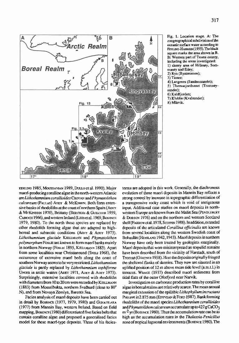
Fig. 1. Location maps. A: The zoogeographical subdivision of the oceanic surface water according to FEVI~G-HAreSSmq (1955). Theblack square marks the area shown in B. B: Western part of Troms county, including the areas investigated: 1) skerry area of Hilles~y, Som- mar0y and EdCy; 2) Rya (Rystraumen); 3) Tisnes; 4) Langenes (Sandnessundet); 5) Thomasjordneset (TromsCy- sundet); 6) Kaldfjorden; 7) Klubba (Kvalsundet); 8) M~vik.
rZRL~G 1985, MOUSSAVlAN 1989, DOLLO et al. 1990). Major maed-producing coraUine algae in the north-western Atlantic are Lithothamnium coraUioides CROUAN and Phymatolithon calcareum (PALLAS) ADEY & McKmB~. Both form exten- sive banks of rhodoliths at the coast of northern Spain (ADEv & MCKSrOBtN 1970), Brittany (BERaZaOIS & GtaLCnER 1959, CABIOCH 1966), and western Ireland (LEEs et al. 1969, Bos~,~CE 1979, 1980). To the north these species are replaced by other rhodolith forming algae that are adapted to high- boreal and subarctic conditions (ADEv & ADEY 1973). Lithothamnium glaciale K_mLLMA~ and Phymatolithon polymorphum FOSLm are known to form maerl banks mainly in northern Norway (FosLm 1895, KrELLMAZ~ 1883). Apart from some localities near Christiansund (Sr~u 1968), the occurrence of extensive maerl beds along the coast of southern Norway seems to be very restricted. Lithothamnium glaciale is partly replaced by Lithothamnium tophiforme UNGER in arCtiC waters (Army 1971, AD~ & ADEV 1973). Surprisingly, extensive localities covered with rhodoliths with diameters from 10 to 20 cm were recorded by KJELL~-N (1883) from Mosselbukta, northern Svalbard (close to 80" N), and from Novaya Zemlya, Barents Sea.
Facies analysis of maerl deposits have been camed out in detail by BOSENCE (1977, 1979, 1980) and G t r N A ~ (1977) from Mannin Bay, western Ireland. Based on field mapping, Bosm,~cF.(1980) differentiated five facies belts that contain coralline algae and proposed a generalized facies model for these maerl-type deposits. Three of his facies-
terms are adopted in this work. Generally, the diachronous evolution of these maerl deposits in Mannin Bay reflects a strong control by increase in topographic differentiation of a transgressive rocky coast which is void of terrigenous input. Additional case studies on maerl deposits in north- western Europe are known from the Malin Sea (PEr~Ot~at~v & DOBSON 1976) and on the northern and western Scotland shelf(FAm~OW etal. 1978, ScomN 1988). In addition, extended deposits of the articulated Corallina officinalis are known from several localities along the western Swedish coast of Bohusl~n (t-IEsstar~ 1942,1943). Maerl deposits in northern Norway have only been treated by geologists marginally. Maerl deposits that were misinterpreted as serpulid remains have been described from the vicinity of Harstadt, south of Yroms0 (GXRT~-~ 1958). Here the deposits originally fringed the sheltered flanks of skerries. They now are situated in an uplifted position of 12 m above mean tide level (a.m.t.l.) in terraces. W~GE (1937) described maerl sediments from tidal flats of the outer Ofotfjord near Narvik.
Investigation on carbonate production rates by coralline algae in boreal realms are relatively scarce. The mean annual marginal extension of the epilithic Lithophyllum incrustans PFm~r~ is 2.875 mm (Eo~cE~,~ &FORD 1987). Bank forming rhodoliths of the maerl species Lithothamnium corallioides and Phymatolithon calcareum accumulate up to 422 g CaCO 3 m -2 yr (BOSENCE 1980). Thus the accumulation rate can be as high as the accumulation rates in the Thalassia-Penicillus zone of tropical lagoonal environmen ts (BosENCE 1980). The

318
Fig. 2. Bathymetry and hydrography of the skerry area (= Location 1 in Fig. 1). The strandflat (0 to approx. 50 m water depth) is dissected by fjord troughs. The main tracklines of the shifting tidal currents axe indicated by arrows. Black arrows mark strong current activity and weak current activity is given by dotted arrows. The evaluation of current force is deduced from the sedimentary facies (see Fig. 5).
yearly increase of growth layers of two coralline algae from Ria de Vigo, northern Spain, has been determined as 0.105 mm and 0.486 mm, for L. corallioides and P. calcareum respectively (AD~'& McKmB~ 1970). This is up to an order of magnitude lower compared to production rates of tropical coralline algae ( S ~ et al. 1977). Field data for growth rates from high-boreal to subarctic coralline algae are known from Clathromorphum circumscriptum FosLm and C. compactum Rosm,~ts~ from the Gulf of Maine, with marginal extension rates of 3 mm/yr and 0.23 - 0.33 mm/yr respectively (ADEY 1970). The latter is not found in Norway. Highest daily growth rates of coraUine algae from Troms have been measured in Lithothamnium glaciale and Phy- matolithonpolymorphum under laboratory conditions (ADEV 1970). The maximum daily increment was 13 Ixm/day and 15 lam/day, for L. glaciale and P. polymorphum respectively. Both are the major rhodolith contributing coralline algae in the boreal-subarctic realm.
2 REGIONAL SETTING & METHODS
The area of maerl biotopes and deposits studied is situated well beyond the Polar Circle at 69~ to 70 ~ 1 I'N. Pronounced seasonality triggered by changes in solar rad- iation is observed. The intensity of solar radiation shifts from total winter darkness (late November to mid-January) to midnight sun conditions (late May to mid-July). Due to the influence of the northward-flowing and relatively warm
Atlantic water masses, the climatic regime of Troms is humid- temperate with a mean annual temperature of 2.3~ The wannest month is July with 12~ and the coldest is February with -5~
2.1 Morphologic and geologic setting
The western part of Troms and the inner shelfoffTroms is underlain by metamorphosed Cambro-Silurian rocks that were folded during Caledonian orogeny and uplifted in Tertiary times as part of rifting processes that led to the opening of the Norwegian-Greenland Sea. Cyclic fluctuations in orbital parameters caused drastic climatic shifts that correspond to glacial-interglacial sedimentary cycles during the past 2.56 Ma in the Norwegian-Greenland Sea, bearing evidence for a repetitive waxing and waning of large ice sheets on the Fennoscandian Shield ~ c a 1989, 1990, VomtE~ et al. 1989). Due to the abrasive activities of the glaciers, Troms county is dissected into fjords and sounds, as well as into mountainous peninsulas and islands (Fig. 1). The summits of the mountain ranges can reach up to 1.500 m, some are still covered by small glaciers today. In sharp morphological contrast, the western flanks of some mountainous islands are fringed by small islets and numerous skerries and shoals (P1. 80/1), where most of the maerl deposits are located. The submarine morphology of the skerry area is also relatively flat and shallow, with smooth surface contours that are dissected by shallow channels and

319
Fig. 3. Shipboard sampling stations in the skerry area (A; location 1 in Fig. 1) and in Kvalsundet (B; location 7 in Fig. 1).
small troughs with water depths not exceeding 60 m. The platform that fringes the islet and skerry area in front of the mountainous islands is known as strandflat (Ev~s 1962, HOL~DAHL 1962) (Fig. 2). The typical glacially sculptured morphological features continue onto the outer shelf (AN- DERSEN 1968, ROKOENGEN et al. 1977, DEr~o & ROKOENGEN 1980, VORREN et al. 1983).
2.2 Hydrographic and oceanographic setting
The oceanographic conditions on the shelfoffTroms are determined by two northward flowing current regimes, the Norwegian Current (NC), with salinities >35 ppt and the Norwegian Coastal Current (NCC), with salinities ranging from 27 to 34 ppt (SooT-RYEN 1934). In a westward thinning wedge, the NCC overlies the more saline Atlantic water masses of the NC (S&'IRE & LIOEN 1972). More information on the surface water current regime is given by EngE (1978) and SUNDAY (1983). The hydrographic conditions in the skerry and islet area studied are determined by the NCC mixing with fresh waterrun-offfrom the melt-water discharge during the summer period. This can reduce the salinity to 25 ppt in surface water layers (SooT-RYEN 1934, SAa~N 1950). The mean tidal range measured close to TromsCy is 1.78 m, the maximum range is 2.93 m (S~TRE 1972). Due to this range violent currents with several knots of velocity can occur between the skerries and islets having a strong imprint on maerl facies distribution. These tidal currents can change their direction at different times (SOOT-RYEN 1934). As evidenced by the distribution of current affected types of sediments, the main pathways of stronger and weaker tidal currents can be deduced in the skerry area studied (Fig. 2). The hydrographic conditions of the sounds and of the fjords, differ markedly from that of the open seas. Thresholds at the narrowest parts of Rystraumen near Rya and east and west of TromsOy with minimum water depths of 55 m, 8 m, and 9 m, respectively, restrict water exchange. However, tidal
currents are very strong in the areas mentioned above. In the Troms~ys- undet current velocities of up to 168 cm/s were measured (S~zrm~ 1972). The net transport of water in the Rys- traumen - TromsCy area is directed northward. Main bulk of water trans- port passes Tromsey through Sand- nessundet (En_.~RTS~et al. 1981) with water temperatures ranging from 1 ~ to 12~ in February and August re- spectively. Within the same period salinity varies from 33 pptin February to 29 ppt in August.
2.3 Methods
Several transects selected from specific bathymetric features seen in the nautical maps of the area, beginning in the shallow subtidal and ending in fjord troughs, give evidence of the bathymetric setting. The distribution of different sedimentary facies was evaluated from 65 grab sampling stations (Van Veen Grab) and 6 dredge stations (Triangle dredge) (Fig. 3). The sediments were photographed, described and stored in plastic bags. Living floral and faunal elements were preserved with ethanol and/or with formaline after determination. Field mapping of selected areas of tidal flats was carried out on AvlCysbukta (HiUesOy), Sandvik (KvalCy), Klubba (Kvalsundet) and Mfisvik (RebbenesOy). Based on these data, a facies map was drawn which provides in- formation on the spadal distribution and the sampling points of different intertidal facies. The samples were eithercollected from the surface or as short core sections. Raised Holocene terraces and beach ridges were levelled and the different niveaus were mapped in the region of Hilles0y, Sommaroy and Brensholmen. Roadcuts and coastal exposures at Thomasjordneset, Tisnes and Langenes on TromsOy were measured, described and sampled at selected levels.
All samples were stored at4~ Floral and faunal elements were studied under the binocular microscope and the scanning electron microscope (SEM). The taxonomical study on crustose corallinaceans is still in progress.The sediment was washed, weighed and wet-sieved to gain an overview on the general grain-size distribution. The carbonate con- tent of some selected homogenized samples was measured with a LECO CNS 125 carbonate analyser.
Radiocarbon datings were performed on a number of carbonate samples that were considered to be of Holocene origin (Tab. 1). The radiocarbon dated material is derived from bivalves and coralline algae found in life position. They were dated at the Radiocarbon Laboratory of the Kiel University. The calculated ages given in years BP (BP = before present = before AD 1950) are based on the conven- tional radiocarbon age (half-life 5,568 years and recent

320
S a m p l e No. Ob jec t Loca l i t y 8 1 3 C C 1 4 - a g e Posi t ion (in m above mean tide level)
. . . . . . . . . . . . . . . . . . . . . . . . . . . . . . . . . . . . . . . . . . . . . . . . . . . . . . . . . . . . . . . . . . . . . . . . . . . . . . . . . . . . . . . . . . . . . . . . . . . . . . . . . . . . . . . . . . . . . . . . . . . . . . . . . . KI-3246.04 Astarteborealis TromseyProlilell +1.48 4.230+65 KI-3246.05 Rhodolilh Tromsey Profile II - 3.55 5.520+80 KI-3247.02 Myat/uncata Avleysbu kta (Hilles~ y) +1.56 4.340+80 KI-3248 Myatruncata -i3snes +0.91 9.100+90 KI-3249.01 M. modiolu$ M&svik(Rebbenesey) +0.04 4.450+70 KI-3249.02 Rhodolith M&svik(Rel0beneSey) - 3.39 4.530• KI-3250(Rer Rhodolith E'ofSommarey -0 .45 (103.93:1:0.44)% KI-3251 Rhodolith Avloysbukla(Hilles~y) - 3.76 5.450+60 K1-3252 (Rer M. modiolus Rystraumen +0.56 (96.6+0.5)%
+5.19 m +4.15 m -0.20 rn +0.45 m
0.00 m -0.15 m
Tab. 1. C14-dated autochthonous rhodolithes and bivalves. The C t4 age is corrected for ~aC = -25 ppt. 400 years are subtracted as 'milieu-effect'.
10-11 m waterdepth (I) - 0.50 m 18-26 m water depth (I)
activity at all times equal to the standard recent value). The ages are normalized to 813C = -25 ppt according to Tcorr = T + 16 (~il 3 C + 25). A 'milieu-effec t' of 400 years is subtrac ted assuming the recent activity in the surface layer of the sea to be 5% less than in wood or terrestrial plants (see also M _ ~ L r D & Gta.LmS~.N 1975, WmLgOMM 1976). Only for samples with atomic bomb effect this correction was not made.
3 RESULTS
Fragments of coralline algae are the most prominent contributors to the budget of Recent carbonate deposits in the coastal areas ofTroms. Subtidal maerl deposits, ranging from 2 m to 52 m water depth are located in wave-protected environments in the strandflat area of the skerries. Maerl is also found in sounds of the island belt of Troms, e.g. in Kvalsundet and Rystraumen. Additional important macro- carbonate skeletons are bivalves and, to a lesser degree, gastropods, scaphopods, barnacles, serpulids, and brachio- pods. Sand and silt fraction carbonate constituents include fragments of above mentioned biogenics. In addition, abun- dant benthonic forarninifers, common echinoderm fragments, and rare ostracods and pieces of disarticulated cyclostome bryozoans are present. Maerl type deposits in the area studied were piled up locally during the Holocene to a thickness of 6 m to 9 m.
3.1 Impact of hydrodynamic and topographic conditions on major facies belts
Eight distinct sedimentary facies belts havebeen mapped in Troms. The texture, composition, and distribution of the sediments indicate that local hydrographic and topographic conditions are the major constraints during growth, destruction, and redeposition of maerl type carbonates. The submarine topography of the skerry landscape in the sur- roundings of Hilles~y, S ommarr and EdCy reflects all the typical features ofa strandflat plain that fringes the coastlines in several bathymetric niveaus from 10 m down to ap- proximately 50 m water depth (Fig. 2). The strandflat system is surrounded by main fjord troughs which slope down to water depths ofl00 m to 412 m and also by the transversal troughs on the inner shelf. Small-scaled glacially eroded and now drowned channel systems are major internal features of the strandflats. This submarine setting is influenced by two major hydrographic forces, the open ocean waves and the tidal current regime. The waves are most effective on the exposed western flanks of the skerry zone and also on specific'relatively unprotected sectors of the inner skerry zone, e.g. the subtidal flank of Edr The sheltered areas of the inner skerry zone are predominantly influenced by the tidal current regime. A similar configuration is found in the sound areas, e.g. Kvalsundet and Rystaumen. The principle
Fig. 4. Idealized profile of a glacially sculptured st~andflat and fjord topography with major sedimentary facies belts. The overgrowth of the winnowed valves of the coquina lag deposit facies depends on position relative to the lower boundary of the photic zone (during Bummer).

321
Fig. 5. Distribution of different sedimentary facies in the skerry and Kvalsundet areas. A) Sketch map of the selected areas studied. B) Facies belts in the skerry area. C) Enlargement of the sound channel between Sommarcy and Brensholmen, where all major facies belts are present. D) Facies belts in Kvalsundet. The intertidal sand and gravel facies as well as the Corallina-gastropodrud~te facies are not indicated, because of their small-dimensioned occurrences.
vertical facies succession and the spatial distribution in the subtidal zone is shown in figures 4 and 5a-d respectively. The recognized different sedimentary facies are listed below:
The maerl bank facies developed on flanks and shoals that are not affected by vigorous tidal currents, but which still reveal moderately agitated current regimes (Fig. 5b-d, PI. 80/2). On shoals and tidal flats in the surroundings of the maerl bank facies, wide extended areas are covered by parautochthonous to allochthonous clean algal gravel facies (P1. 80/5). The muddy algal gravel facies is developed in sounds and embayments that are weakly influenced by tidal currents (PI. 80/4). The descriptive terms of the maerl dominated sediment types are introduced by BOSENCE (1980). The mollusc-echinoderm arenite facies is established in wave-
affected areas, e.g. east of EdOy, as well as in almost com- pletely wave-protected areas, e.g. the Sandvik bay, and the outer shallow subtidal zone east of AvlCysbukta on Hillesoy (Fig. 5b, PI. 83/9). Temporary beach deposits lying as a thin veneer on the semi wave-exposed rocks comprise the Cor- allina-gastropod rudite facies, e.g. at Jevik on HillesOy (P1. 80/6 and 84/10). Depositional features of the intertidal sand and gravel facies of the protected inlets are controlled by small-scaled tidal currents. Different sediment components are supplied from the surrounding facies belts and are uncovered by tidal scour from terraces flanking the tidal flats. The coquina lag deposit facies predominantly occurs in channels of the inner skerry zone that are affected by strong tidal bottom currents (P1.81/6). Another important feature of

322
this facies is that it is only found at water depths below the zone of luxuriant growth of coralline algae (Fig. 5b, c). A pure mud facies is deposited in the deeper fjord troughs, e.g. the Kattfjord Trough and the Malangen Trough (Fig. 5b, c).
The spatial facies distribution of the Kvalsundet fjord shoulders resembles that of the skerry zone. However, a clean algal gravel facies and a coquina lag deposit facies are lacking there. The bathymetric setting differs from sound to sound and, the facies belts may also differ. As an example, a specific Sabellaria facies was found on the deep flank of Rya in the Rystraumen. In the semi-protected shallow and deeper subtidal zones of outer fjords and sounds, different hardrock biota encrusted outcropping crystalline rocks as well as cobbles and boulders. Dense populations of the pectinid Chlamys islandica forming extended shell beds are known from several locations in Troms.
3.1.1 The autochthonous maerl bank facies
The autochthonous maerl bank facies consists of predominantly living unattached coralline algae which form a semi-rigid carpet of rhodoliths (PI. 80/2). Two rather narrow depth intervals are occupied by the dense maerl bank communities (9 to 12 m and 17 to 20 m water depth). The hydrodynamic environments of the maerl bank facies reflects a permanent influence of tidal currents of intermediate strength. These conditions prevail on the higher flanks near the entrance of sound channels and as a belt fringing the flanks of shoaling mamillated rock grounds (Fig. 5c, d). Both principal environmental settings can be developed in the inner wave-protected skerry zone as well as in sounds in the island belt of northern Norway.
The banks lie parallel to the main current direction and can reach a length of several tens of meters and a width of three to six meters. In the skerry zone the maerl bank facies laterally grades into the muddy algal gravel facies or the clean algal gravel facies. In the Kvalsundet fjord environment, the maerl bank facies is completely rimmed by the muddy algal gravel facies. The shapes of the thalli vary from ellipsoidal to spheroidal. The apices of the spheroidal rho- doliths are often abraded and thus give evidence of rolling movements on the ground during nodule growth. Discoidal shapes have only been rarely observed. Another rhodolith type is irregularly shaped, forming internal caves or cryptic habitats (PI. 80/3). The rhodoliths are open branched or densely branched.
Bivalves are the most prominent biogenic admixtures that have been incorporated in maerl deposits, e.g. single valves ofMya truncata, Astarte sp., Modiolus modiolus and Cyprina islandica. Most of them are overgrown b y entrusting coralline algae (PI. 83/4). Almost all rhodoliths exceeding a size of 5 cm reveal one or more borings by Hiatella arctica.
Comparing all sites of autochthonous maerl bank facies, the differences in the faunal and floral assemblages can be attributed to bathymetry (as a function of light penetration into water column). A much broader spectrum of growth forms and species seems to be present in the Kvalsundet fjord environment. Rhodoliths in the skerry zone comprise mainly open-branched growth forms developed by only a
single, not yet taxionomically determined, species (P1. 83/ 3). In contrast, densely branched (PI. 83/2) and nodular forms appear (PI. 83/1) at Kvalsundet in water depths more than 15 m. At both localities, the associated flora and fauna reveal a much higher diversity in water depths greater than 15 m. This holds true for hydrozoans, bryozoans, brachiopods, bivalves and encrusting coralline algae together with illa- mentous red algae. Corallinaofficinalisonly appears in maerl bank facies shallower than 10 m.
3.1.2 The autochthonous muddy algal gravel facies
The muddy algal gravel facies is composed of abraded algal gravel in a matrix of muddy sand (PI. 80/4). It occurs in sheltered positions from 6 m in the shallow subtidal down to 52 m. The main distribution area is located in a shallow sound between Sommar~y and the skerries around the island of Lille Sommaroy (Fig. 5b). This sound is not strongly affected by shifting tidal currents (Fig. 2), since the main water transport by tidal currents is forced along the coastline of KvalOy.Beside this rather extended muddy algal gravel facies outcrop, isolated patches of muddy algal gravel facies occur in the lower part of the deeper strandflat. The algal debris and the bivalve shells (e.g. most abundant Mya truncata) of these localities are iron-stained and show a pitted surface, indicating arelatively long period of exposure at the sea floor. We assume this algal gravel was derived from the higher positioned maerl bank facies in the region. In Kvalsundet the muddy algal gravel facies is concentrated in areas affected by medium current activity (Fig. 5d).
The coarse carbonate fraction (>2 mm) of the muddy algal gravel facies consists of coralline algae (>80%) and mollusc debris (< 18%). The algal material consists either of abraded branches of dead rhodoliths or of intact living small open branched rhodoliths. The boundary between the auto- chthonous muddy algal gravel and the maerl bank facies is not distinct. Epifauna within the muddy algal gravel facies grows only on the maerl fragments and rhodoliths. The floral and faunal elements are equal as in the maerl bank facies, but a l e r a r e r .
3.1.3 The parautochthonous clean algal gravel facies
The clean algal gravel facies is distributed along the flanks and the bottoms of shallow sound channels in the skerry zone affected by strong tidal currents. Additionally, the sediments of this facies fringe the intertidal to shallow subtidal flanks of the inner skerries, forming elongated gravel bars and tombolas. The sediment of the clean algal gravel facies consists predominantly of abraded branches of rhodoliths (PI. 80/5 and PI. 83/11). Megaripples with wave lengths of 2 to 3 m and heights of approximately 0.5 m created by strong tidal currents are commonly found in the sound channels. In the skerry zone, the clean algal gravel facies covers areas close to the maerl bank facies or to the muddy algal gravel facies (Fig. 5b, c).
At Leirstrand on RebbenesCy, beach ridge systems with a maximum heigth of 1.50 m and a 15 m long luv zone have accumulated. The beach ridge is built up by alternating

323
Fig. 6. The tidal inlet of Avlcysbukta on Hilles~y, showing intertidal sand and gravel facies with characteristic sedimental 7 structures. This area reveals a specific mode of redeposition of winnowed Holocene rhodoliths by kelp-rafting (el. Fig. 12). (rn.a.m.t.1. = meters above mean tide level)
layers of maerl (PI. 83/11) and bivalve-rich horizons with occasional intercalations of terrigenous sediments.
3.1.4 The mollusc-echinoderm arenite facies
The mollusc-echinoderm arenite facies is found at the exposed habitats of the shallow subtidal zone along the eastern coastline of Edcy, ranging from 7 m to 11 m water depth. This facies definitely has a much larger distribution around the shallowest areas of the strandflats that fringe the skerries (Fig. 5b). Additionally, the mollusc-echinoderm arenite facies cover wide areas at semi-sheltered locations, where living conditions for coralline algae are not favorable because of insufficient water motion (algal borers and grazers prefer quiet water conditions (ArPAN & FARROW (1985)) and too increased light penetration, e.g. on the outer intertidal flat east of Hillescy. In Kvalsundet this facies has been found in areas affected by strong tidal currents (Fig. 5d). The carbonate content derives mainly from bivalve fragments and disarticulated echinoderm skeletons (PI. 83/9). Maerl is only rarely admixed into this facies. Since the supply of terrigenous components is shut off in the Recent environ- ments, the biogenic components gain greater importance in sediment composition. The mollusc-echinoderm arenite facies grades laterally into several other facies: the muddy algal gravel facies, the coquina lag deposit facies and the intertidal sand and gravel facies.
The Mollusc-Echinoderm facies of the rocky coastlines crosses the kelp-belt. Huge rounded pebbles and adult Modiolus modiolus serve as settling ground for the strong
laminarian holdfasts. Laminaria hyperborea is a habitat for several organisms. The holdfast region of this brown algae is often overgrown by Corallina officinalis. The long leaves of kelps are overgrown by the bryozoan Membranipora membranacea. The prosobranch Helcion pellucidus was commonly found on the kelps. According to VAnE (1983), Helcion is adapted to a life on kelp by the ability of mucus drifting between the leaves of Lam/nar/a when the limpet is dislodged. Apart from thebivalve Venusgallina, otherinfauna was rarely observed in this turbulent environment. The outer intertidal flats are inhabited by brown algae (Fucus vesicu- losus, Fucus serratus and Ascophyllum nodosum) attached to single pebbles, bivalve shells or redeposited rhodoliths. In the shallow subtidal zone, down to approximately 20 m, living epifauna is sparse. Single uncovered valves serve as holdfasts for the long brown algae Chorda filum. The undersides of the valves form a cryptic habitat inhabited by grazing gaslropods (Acmaea sp., Patella sp.) and chitonids.
3.1.5 The Corallina-gastropod rudite facies
This facies is restricted to wave-exposed localities of the outer island flanks. A thin veneer of this rudite covers the abraded crystalline rocks, e.g. at Jevik on Hillescy (PI. 80/6). The sediments are piled up to a maximum thickness of 35 cm in sWandwalls parallel to the coast line. This facies is accumulated mainly by storm waves or, totally eroded in the next storm event. The sediment consists almost exclusively of gaslropod and Corallina remains. Of minor importance are conches of Patella vulgaris, Gibbula cineraria, NuceUa

324
Fig. 7. Elevated Holocene carbonate deposits at the eastern coastline of Hillescy and on SommarCy reflect different erosional stages, dependent on the grade of exposure to fetch, tidal currents, alongshore drift, and waves. (meters = meters above mean tide level)
lapillus, Helcion pellucidus, Lunatia sp. and Mar garites sp., as well as plates of barnacles (PI. 83/10). Depending on the frequency and intensity ofreworkingprocesses, the gastropod tests show different stages of destruction. Quartz gravels and crystalline rock fragments occur at certain levels. The strandwalls reveal classical examples of sorting with gastropod enrichment in the high turbulent zone and enrichment of the delicate CoraUina segments in the swell zone. The carbonate material derives from a well-developed broad Fucus-belt that fringes the crystalline rocks between the high-tide mark and the shallow subtidal (PI. 80/7). This belt serves as a habitat for rich populations of Littorina. Corallina lives in tidal-pools that exist in depressions of the crystalline rocks (P1. 80/8).
3.1.6 The intertidal sand and gravel facies
This facies is restricted to the protected inner intertidal flats, e.g. Avll~ysbukta on Hillesoy (P1. 81/1), M~svik on RebbenesOy, and Sandvik on KvalOy (Fig. 6). It is also present in small sheltered pockets at Klubba in KvalsundeL
The intertidal sand and gravel facies consists either of biogenic carbonate-dominated sediments or terrigenous particle-dominated sediments as well as of mixtures of both. Grain sizes range from fine sand to gravel. The spectrum comprises more or less well-sorted maerl debris, well-sorted quartz sands enriched with mollusc and echinoderm particles, and amixtureofboth. These sediments show different stages of sorting maturity which are controlled by tidal activities and by small wave swell entering the inlet during high-tides. The latter creates temporarily pronounced zonated trash lines (PI. 81/2-4). The supratidal sediments reveal aeolian transport, as indicated by small aeolian oscillating ripples. The intertidal fiats reveal a variety of typical sedimentologic
features, e.g. tidal channels of 2 to 3 m width and 0.4 m depth surrounded by tidal bars and sand flats, as well as a char- acteristic coastal zone with various strand walls and beach deposits.
The well-sorted quartz sand patches are strongly bio- turbated by Arenicola marina. The coarse maerl gravel patches near the low water line are inhabited by Mytilus edulis attached by byssus to several gravel components, thus enhancing the stability of the sediment (P1. 81/5). In places 'gravel-clumps' several centimeters high are held tightly together by byssus fixation of Mytilus. Dense bank-forming settlements of Mytilus are not developed in the maerl gravel patches but rather on the well-sorted sand fiats and overwashed sand bars of the Sandvik intertidal flat. The outer well-sorted sand bars are inhabited by Mya arenaria and to a smaller degree by Cerastoderma edule. The maerl type constituents in the intertidal flats are derived from two prominent sources. One is the subfossil maerl carbonate, either rafted into the tidal flat by fucoid brown algae (see chapter 3.3.2) or eroded and redeposited from terraces. Almost all of the maerl sediments from AvlOysbukta are subfossil, according to 14C data ofrhodoliths. Many sand- sized carbonate components reveal borings of endolithic algae, fungi and bacteria (PI. 83/15-16).
3.1.7 The coquina lag deposit facies
The coquina lag deposit facies covers the deeper channels of the inner skerry strandflat, where the bulk of water transport is due to pumping tidal currents (Fig. 2 and 5b, c). Two major channels are situated along the coastline of Kvalr passing Brensholmen, and between Hilles0y and EdCy. Both join together south of Eddy, sloping down into the Malangen Trough. Here sandy surface sediments enriched

325
Fig. 8. Elevated Holoeene carbonate deposits at Brensholmen area, southeast of HillesCy and S ommarCy. Almost all higher terrace s are protected against erosional forces by crystalline rocks. The legend is given in Fig. 7.
with infaunal shells indicate bottom current activities down to water depths of at least 89 m.
Biogenic debris consists of bivalves, gastropods, bar- nacles, serpulids, brachiopods and scapholxxls. CoraUine algal gravel occurs subordinately, but frequently crusts of red algae are found on exposed shells in water depths down to 35 m (PI. 83/5). These current excavated, formerly infaunal bivalves are densely overgrown by barnacles (Balanus ba- lanus), encrusting sponges, serpulids, hydrozoans and f'damentous red algae (PI. 81/6 and PI. 83/6). In addition, bivalves (Chlamys islandica, Modiolus modiolus) and brachiopods (Hemithyris psittacea, Macandrevia cranium, Terebratulina retusa) settle on these secondary hardgrounds. The empty tests of barnacles serve as microenvironment for Hiatella arctica, which burrow into the fine grained sand trapped within the barnacles. The thick shells of Cyprina islandica are heavily infested with boring sponges (Cliona sp.), phoronids (Phoronis ovalis), and sipunculids, thus indicating a long period of exposure on the sea bottom (P1. 83/13-14).
3.1.8 The mud facies
This facies covers almost all bottom areas of the fjord troughs sampled (e.g. outer Kattfjord Trough: 153 m water
depth; and Malangen Trough: 412 m water depth; Fig. 5b, c). The sediment of the mud facies consists of silt and clay (>88%) with an admixture of fine sand (<11%). Taxodont bivalves are the most important biogenic carbonate constituents. Additionally, thin- valved pectinids and valves of Thyasira sp. occur. Scaphopods and otoliths are of minor importance.
3.1.9 The facies of the subtidal fjord cobble and hardrock biota
These biota live on cobbles exposed on the flanks of fjords and sounds as well as on steep slopes in areas that are affected by strong tidal currents. Two different types have been sampled. The cobbles of the shallowest subtidal zone are encrusted with epilithic crustose coralline algae (outer Kaldfjorden). Numerous cobbles are fringed by 'microtrottoirs' of crustose algae (PI. 81/8). Dense populations of Stron gylocentrotus droebachiensis, chitonids, acmaeidand patellid gastrolxxls graze on these crustose algae (P1. 81/7). This facies reaches down to the Lam/nar/a-belt (HAGEN 1983).
Near Rya in theRystraumen, another hard- ground biota was sampled in water depth of
more than 40 m. Here, sabellarid polychaetes, forming dense calcareous tube-colonies together with poriferans, ascidians, caprellid crustaceans and bryozoans occur, indicating a strong currentregime. The sabellarid colonies are intensively bored by HiateUa arctica (PI. 83/'7-8). Additionally, the clam Chlamys islandica forms extended shell beds, particularly in northern Norwegian fjords that are provided with a shallow
Fig. 9. Shoreline displacement curve from Sommarcy based on MOLL~(pers. comm.). The terraces in Fig. 7 and 8, were formed in the Subboreal and Subatlantic stages of the Holocene (arrows).

326
by raised carbonate deposits. Holocene shorelines are indicated by at least three distinct levels. The lowest level lies between 1.70 m and 1.80 m above the present mean tide level (using the B. balanoides-belt as base line slightly above mean tide level), the second level ranges from 2.45 m to 3.50 m, the third level ranges from 5.80 m to 6.80 m. According to the relative shore level displacement curve of SommarCy the raised terraces havebeen formed during syngressions in the Subboreal and Subatlantic s t a g e s ~ 1986,1989, pers. comm.; Fig. 9). The wide ranges of the second and third level can be ex- plained by differently intense tides, storms and surface erosion. This results in an overall smoothing of the elevation range. All three levels are present on HillesOy and in Brensholmen area. On SommarCy, only two clearly raised levels were detected. Some sediments situated on higher, unterraced positions are known. Other raised Holocene car- bonates are present at several localities near Tromsey and in Kvalsundet, e.g. along the coastline from Tisnes to Klub- ben, at KvalCysletta, at Thomasjord- neset, and Langenes on Tromsey (Fig. 1).
Fig. 10. Different types of carbonate deposits from two profiles at Langenes on Tromscy. Profile I: The sedimentary sequences above the unconformity consist predominantly of carbonate debris, whereas terrigenous sediments dominate the sequences below the unconformity. Profile 11: The circuit enlargement points to details of an autochthonous hardground community found in the pebble horizon: Modiolus modiolus, Chlamys is landica, Balanus balanus, encrusting bryozoans and crustose corallinaceans. (Legend see Fig. 11)
threshold near theentmnce (WmoRO 1963,Strrozr 1988).The sedimentation, clams serve as a habitat for a diverse fouling community (ScaXFER & FP, SaVALO 1990).
3.3 Facies successions and stratigraphic evolution of exposed
terraces and roadcut profiles
Raised Holocene carbonate deposits can be observed at several coastal and roadcut exposures, yielding information on: - the underlying Early Holocene gla- ciomarine sediments and fossils, - their transition to the onset of carbonate
- the development of distinct Late Holocene autochthonous carbonate facies leading to the present day situation.
3.2 Morphology and regional distribution patterns of Holocene carbonate terraces and beach ridges
Raised carbonate sediments have been mapped on Hillescy, Sommarey (Fig. 7) and Brensholmen area (Fig. 8). Here, raised Holocene terraces and beach ridges (PI. 82/1) with at least three distinct erosional levels are present in locations that are sheltered by crystalline elevations. Nearly the entire eastern part of Hillescy, as well as the central part of Sommar~y, are covered by Holocene carbonate deposits and are sheltered between prominent crystalline elevations. In the vicinity of Brensholmen, wide plane areas are underlain
3.3.1 The glaciomadne sediments and the onset of carbonate sedimentation
Glaciomarine deposits overlain by carbonate sediments have been mapped near Tisnes, AvlCysbukta on Hilles0y and Sandvik on KvalCy. The most detailed information comes from two roadcuts at Langenes near the Tromsr international airport (Profile I and II in Fig. I0). At the base of Prot-le I, a bluegrey clay, partly laminated, with sand lenses was dug out (PI. 82/3). Randomly dispersed well- rounded pebbles (up to 20 cm in diameter) are present in the clay. Extremely thick-valved Mya truncata and HiateUa

327
Fig. 11. Two short cores revealing the transition from terrigenous to carbonaceous depositional environ- ments. The Mya truncata found in life position in the diamict of the Times core yields an age of 9,100 YBP. The sediment of the core from the tidal flat of Avl~ysbukta (HiUescy; see Fig. 6) is dominated by terrigenous components. The exception is a pro- nounced layer comprised of echinoderm- and barnacle fragments and Littorina-conches.
arctica have been found in life position. In addition,Arctinula (Pecten) greenlandica, Heteranomia squamula, plates of Verruca stroemia and fish vertebrae were found. The clay grades into a poorly sorted terrigenous sand enriched with fragmented plates of barnacles, bivalves and echinoderms in the uppermost part. In this section a Modiolus modiolus - horizon is intercalated. On top, numerousMya truncata with 'normal' valve thickness are found in life position in a quartz sand rich layer (PI. 82/4). A marked unconformity separates the sections described above from a series of coarse carbonate foreset lobes primarily composed of reworked plates of Balanus balanus. The foreset lobes with a mean dipping angle of 20 ~ towards SE cover the eastern flank of a mam- iUated rock complex.
Near Tisnes (Loc. 3; Fig. 1), the transition between the glaciomarine clay sequence and the overlying carbonate sediments is exposed close to the beach (Fig. 11). Thick- valved Mya truncata found in life position (dated at 9,100 + 90 YBP) are embedded in a bluegrey clay. This clay is enriched with pebbles and sand lenses approaching the transition zone. Many branches of coralline algae, valves of H. arctica, H. squamula, Astarte borealis, Astarte elliptica, Cardium sp, and conches of Acmaea sp., Punctuella noa- china, Margarites sp. indicate a more turbid environment than in the underlying clay section. Numerous spines and teeth of the echinoid Strongylocentrotus droebachiensis are present. The terrigenous sediments diminish gradually, finally resulting in a pure maerl deposit. Some peat horizons (1 to 2 cm thick) are intercalated just above the transition zone.
Another transition zone sediment has been dug out in the inner part of AvlCysbukta (Fig. 11). The profile starts with a pebble layer admixed with single bivalves at the base. Outlined by a sharp boundary, a layer composed of spines and plates of the echinoid Strongylocentrotus sp. and plates ofB. balanus follows on top (PI. 83/12). This horizon was replaced by a layer rich in Littorina-conches. The covering unit is a terrigenous sand with a winnowed surface resulting in a coarse sand top layer deposited in the intertidal zone.
3.3.2 Holocene autochthonous carbonate deposits
Exposures comprising autochthonous Holocene carbonate
structures have been mapped at Langenes on TromsCy, Avl0ysbukta on HillesCy, and Mhsvik on RebbenesCya.
At Langenes near the Tromsr international airport (Loc. 4; Fig. 1), Profile II gives information on the biofacial development of the coralline algae (Fig. 10; PI. 82/5). Profile II is situated closer to the modern shore. The distance between Profiles I and II is approximately 90 m. At the base of this profile the gradual transition from bluegrey clay with dispersely distributed pebbles to a quartzose sand is exposed with someMya truncata in lifeposition. With a sharp contact to the section below, a pebble horizon overlies. Nearly all upper surfaces of the pebbles are encrnsted by crnstose coralline algae. Additionally, encrusting bryozoans and colonies ofBalanus balanus grow on the overhangs o fpebbles (PI. 82/6). Complete bivalves of Modiolus modiolus and Chlamys islandica, which were attached by byssus to the pebbles, also lived in this turbid environment (Fig. 10). The upper boundary of the pebble horizon grades into a coralline algal gravel layer with Mya truncata in life position. This sediment is overlain by a marked rhodolith horizon (dated with C TM to 5,520 + 80 YBP). The shape of the thalli is ellipsoidal to spheroidal. Most of them are intensely bored by Hiatella arctica. Cracked thalli contain up to six borings by H. arctica. In the overlain carbonate sand layer reworked parts of rhodoliths and valves of M. modiolus are inserted. The carbonate is derived from highly fragmentedB, balanus and to a lesser degree from bivalves (Crenella decussata) and echinoderm spines ( Str on gylocentr otus droebachiensis). Mya truncata is present in life position. Above a sharp boundary a second rhodolith horizon of 5 to 15 cm in thickness is exposed. This horizon in turn, is overlain by barnacle debris with Mya truncata in life position and by a coarse carbonate sand layer with many reworked valves of Chlamysislandica, M. modiolus, Astarte borealis, Cyprinaislandica and conches of Littorina littorea. Numerous polymict and imbricated pebbles are intercalated that are not overgrown by encrusters. Mya truncata, Cyprina islandica and Macoma sp. have been found in life position. A radiocarbon dated valve of Astarte borealis yields an age of 4,230 + 65 YBP.
At the outer part of the tidal inlet of AvlCysbukta a crystalline mamillated rock is fringed by a belt of rhodoliths (Fig. 12). Excavations around this rock have shown that the

328
Fig. 12. Schematic model of the development of therhodolith-gravel beds, pointing to the complexity of redeposition phenomena in the AvlCysbukta tidal flat.
rhodoliths are only present close to the rock surface. The age ofa rhodolith is 5,450_+ 60 YBP. This is nearly the same age as for the lower rhodolith horizon of the Langenes Profile II. After burial of the rhodolith belt, the substrate was inhabited by Mya truncata. A radiocarbon dated valve pair found in life position yielded an age of 4,340 + 80 YBP. This rhodolith belt is autochthonous and, due to ice-isostatic uplift, this belt has reached now the modern low water tide mark of the intertidal flat. At the sediment surface the
rhodoliths as well as the associated M. modiolus, serve as substrate for several brown algae (Laminaria hyperborea, Fucus serratus, Chorda filum) and Corallina officinalis (P1. 82/2). During storms, when the bouyancy of the algae was high enough, the rhodoliths were dragged onto the intertidal flats. This kelp-rafting or algal-weed-rafting process caused a temporary dense accumulation of stranded redeposited Holocene rhodoliths along the luv flanks of outer sandbars (see PI. 81/3). Here the rhodoliths are disaggregated to algal
P l a t e 80
Fig. 1.
Fig. 2.
Fig. 3.
Fig. 4.
Fig. 5.
Fig. 6.
Fig. 7.
ig. 8.
High-boreal to subarctic maerl deposits of northern Norway - Carbonate sedimentary facies from the skerry area of Troms
View of the skerry area of Hillesr (upper right), Sommarr (central right), and Edcy (upper left) from Ornflcya Mt. (154 m.a.s.l.), Brensholmen area. The arrow indicates the elevated strandflat along the eastern coastline of Hillescy.. Autochthonous maerl bank facies from the southern entrance of the tidal current influenced sound between SommarCy and Brensholmen. The dredge haul (Station 48) was taken from a flat plateau, ranging from 10 to 11 m water depth. The tips of the valves ofModiolus modiolus (Valve length: 15 cm) are encrusted by crustose coralline algae. Furthermore, ophiuroids (Ophiopholis aculeata), echinoids (Strongylocentrotus droebachiensis), and filamentous rhodophyta are visible. Irregularly formed rhodolith, as a result of intergrowth of several small rhodoliths (length: 15 cm; dryweight: 220 g). The cryptic habitats of this rhodolith type are colonized by bivalves (Chlamys islandica, Modiolus mod/olus) and brachiopods (Hemithyris psittacea). Filamentous rhodophyta settle on the light-exposed surfaces.
Autochthonous muddy algal gravel facies from the sound south of Sommarcy (Station 4; water depth: 19 m). The algal material consists of living rhodoliths originating from adjacent maerl bank facies, and of dead rhodolith fragments, embedded in a muddy sand or sandy mud subslrate. The length of the arrow is 12 cm. Parautochthonous clean algal gravel facies from the highest subtidal zone of the southern coast of Sommarcy. This facies is often comprised of Recent and Holocene algal gravels. The length of theMacoma balthica-valve is 1.8 cm.
Veneer of Corallina-gastropod rudites, resting on wave exposed crystalline rocks at Jevik (HillesCy). Different trash line directions indicate a high mobility of this facies. The length of the spade is 1.20 m. Belt of fucoid algae, fringing the crystalline rocks at Jevika (HillesCy). The algal leaves provide habitats for rich gastropod populations which contribute to the Corallina-gastropod rudite facies postmortally. Tidal rock-pools with colonies of Corallina officinalis, which contribute to the Corallina-gastropod rudite facies postmortally. The colonies are surrounded by the fucoid algaAscophyllum nodosum. In the foreground, conceptacles ofFucus spiralis are visible. The length of the bottle is 35 cm.

P l a t e 80 329

330
Fig. 13. Glacial limits at the Younger Dryas period (Late Weich- selian) in the area investigated according to VORRE~ & R~NNEVlK (1980). Almost all of the skerry area (H) was drowned at that time. During deglaciation in the Early Holocene, glaciomarine diamicts were deposited in an iceberg-enviro'rtment. These diamicts were overlain by carbonate deposits during the Late Holocene, as has been shown from TromsCy Profiles I and II (T; Fig. 10) and Tisnes (l'i; Fig. 11). The deposits from the Lyfjorden (L) locality were used by HALD & VORREN (1983) tO reconstruct a Holocene shore- level displacement curve. (For orientation see Fig. 1)
gravel deposits by mechanical destruction (Fig. 12; see P1. 81/4). This algal-rafting process is a common mode of redeposition in temperate regions of both hemispheres (KUDRASS 1974, GILBERT 1984, WOODBORNE et al. 1989).
In the tidal inlet of Mgtsvik (Loc. 8; Fig. 1), a raised Holocene Rhodolith-M. modiolus thanatocoenosis is also exposed slightly above the low water tide mark (PI. 82/7). Here, Modiolus modiolus is found in life position with valve pairs, which exhibit gerontic valve characteristics (P1.'82/8). Radiocarbon dated ages ofa rhodolith and a M. modiolus in life position are available, with 4,530 + 75 YBP and 4,450 _+ 70 YBP, respectively. This is slightly younger than the rhodolith ages of AvlOysbukta and Langenes Profile II.
4 DISCUSSION
Crustose coralline algal growth has been observed at man y locations along the rocky coastline of Norway (FosLrE 1895).
P l a t e 81
Fig. 1.
Fig. 2.
Fig. 3.
Fig. 4.
Fig. 5.
Fig. 6.
Fig. 7.
Fig. 8.
High-boreal to subarctic maerl deposits of northern Norway - Carbonate sedimentary facies from the skerry area of Troms, northern Norway
View of the tidal inlet of AvlCysbukta, eastern coast of Hilles0y during low tide. The entrance of this inlet is blocked by a sandbar (central part). The tidal flat is drained by a tidal channel fed by run-off waters from the Hillesoy mounts (211 meters above sea level.). Raised Holocene terraces surround the inlet. Trash line zonation on a strand flat of Avl0ysbukta (Hilles0y). Dark trash lines reveal heavy mineral components, bright trash lines consist of abraded algal gravel and/or mollusc and echinoderm fragments. The width of the strand is approximately 8 m. Detail from the luv flank of the outer sandbar from the Avl0ysbukta tidal flat (see PI. 81/1). Here, numerous algal-rafted rhodoliths of Holocene age are stranded and subsequently fragmented. The photographed section has a width of 2 m. Fragmented algal gravel, forming gravel sheets on the lee flank of the outer sandbar. Almost all of the algal gravel are of Holocene age. Settlement of Mytilus edulis from the M~svik tidal flat on Rebbenes0y. The settlement exists on a small ridge, consisting of trapped sediment particles which were transported by shifting tidal currents. Additionally, pellets produced by bivalves and gastropods are found here. The bivalves are colonized by thin filamentous green algal mats, which serve as a habitat for Littorina-snails. The length of the pencil is 20 cm. Coquina-lag deposit facies from the strandflat west of Brensholmen. The dredge haul was taken from 41 to 43 m waterdepth (Station 46). Infaunal clams ofCyprina islandica were winnowed and subsequently colonized by a diverse fouling-community, consisting of Balanus balanus, Hemithyris psittacea, Macandrevia cranium, Terebratulina retusa, sponges, bryozoans, hydrozoans, and filamentous rhodophyta. As a result of a long exposure on the sediment surface, the valves of C. islandica are heavily infested by endolithic organisms (see PI. 83/13-14). The length of the arrow is 12 cm. Fjord cobble encrusting coralline algal biotope from outer Kaldfjorden (KvalOy). The crustose coralline algae live in the high subtidal zone at a water depth of 3 to 7 m below mean tide level. In the foreground the deepest part of the Fucus spiralis-belt is visible. The algal crusts are predated by echinoids (Strongylocentrotus droebachiensis), chitonids, and acmaeid gastropods. The photographed section has a width of approximately of 1.50 m. Detail of a single cobble taken from the high subtidal zone of outer Kaldfjorden. The surface is colonized by dense well-rounded bushes of Corallina officinalis. On the cobble flanks, thick crusts of coralline algae form pronounced 'microtrottoirs'.

P l a t e 81 331

332
However, luxuriant growth of coralline algae resulting in maerl banks shows a much more restricted distribution pattern. This indicates that maerl bank communities are strongly controlled by specific environmental constraints with defined ecologic preferences. With this in mind, eoralline algae are useful tools for reconstructing past well-determined paleoceanographic constellations viewed on a large and on a small scale (ADEY 1976, WRAY 1979). Generally, coralline algae are restricted to the photic zone. The deepest living coralline algae in the area investigated were sampled from 38 m (Sommaroy) and 74 m water depth (Malangsgrunnen shelf bank). The coralline algae living in these maximum depths form only thin crusts. Rhodoliths with intergrowth of branched thalli are restricted to a narrow water depth interval from 9 m to 20 m controlled by the intensity of light penetration. Crustose coralline algae living at shallower depths tend to produce epilithic crusts with marked 'micro- trottoirs' at the flanks of pebbles (PI. 81/8). In areas with strong current exposure they are replaced by articulated coralline algae. A comprehensive study on light and tem- perature conditions versus growth rate of crustose coralline algae by ADEu (1970, 1971) indicated a major influence of these parameters on species distribution which vary from coast to fjord sites along the Norwegian coastline. Results from our observations in addition to ADEV'S data indicate that rhodolith environments arecontrolled by multiple constraints: (1) Lack of terrigenous dilution, e.g. the fjord troughs have to act as effective sediment traps. (2) Shifting medium current regimes forced by tides and not
by waves. (3) Flat bottom conditions surrounded by a structured topography, providing partial protection from strong open ocean waves but still facilating the development of intermediate current strength.
The optimal combination of these major environmental constraints in a narrow-spaced interval of the photic zone is the principle reason for these restricted occurrences along the entire Norwegian coast. In northern Norway, where extensive rhodolith banks occur, the modern topography of the strandflats provides excellent settings for the luxuriant growth of coralline algae. On the strandflat, with its small- scaled topography (intersected skerries and shoalings of mamillated rocks and sound channels in between), the optimum conditions for maerl-type deposits are found in many places. However, due to ice-isostatic movements of the Scandinavian craton and of eustatic sea level fluctuations during the Holocene, this setting is a rather unique and geologically short-lived situation. Nevertheless, the rapid environmental changes from arctic to boreal conditions in postglacial time are well documented in carbonate facies successions and the evolution of different communities has adapted to these rapid climatic changes.
4.1 Early Holocene to Recent facies successions in the fjord and skerry environment of northern Norway
Parts of the area studied were covered by a final glacial re-advance at the end of the Late Weichselian (Younger
P l a t e 82
Fig. 1. Fig. 2.
Fig. 3.
Fig. 4.
Fig. 5.
Fig. 6.
Fig. 7.
Fig. 8.
High-boreal to subarctic maerl deposits of northern Norway - Holocene autochthonous and allochthonous carbonate deposits from Troms, northern Norway
Raised beach ridges at the inner part of the Sandvik inlet on KvalCy. Rhodolith of the subtidal zone of Holocene age, redeposited to the tidal zone at the southeastern coast of HiUes0y. Here, the rhodolith was colonized by Recent Corallina officinalis, which is present near the tidal zone in the area investigated. The time-lag between the rhodolith and the basal crusts of the articulated algae is approximately 4,000 to 5,500 years. Profile I at Langenes on TromsCy. This outcrop reveals the lithofacies succession from glaciomarine conditions at the base, to present-day conditions. The boundary between the different sedimentary environments is marked by a pronounced unconformity. The deposits above the unconformity are predominantly comprised of allochthonous barnacle debris and bivalve fragments. The exposed sequence has a thickness of slightly more than 2 m. Detail of the Profile I at Langenes (TromsCy), showing seven Mya truncata in life position. These bivalves lived 10 to 20 cm below the unconformity, indicating a former sea bottom that was subsequently covered by foreset beds consisting of barnacle debris. The photographed section has a width of 30 cm. Profile II at Langenes on Troms0y. This section shows the lower rhodolith bank (5,520 + 80 YBP), that was formed during the Tapes-III syngression (see hand). Towards the top, calcareous sandy gravelly layers followed, which were inhabited by Mya truncata found in life position. The second rhodolith bank (arrow) was probably formed during the Tapes-IV syngression at around 4,500 YBP. The photographed section of Profile II has a thickness of 1,20 m. Detail of the Profile II at Langenes (TromsCy), showing a redeposited Paleozoic metamorphosed carbonate pebble that was colonized by Balanus balanus. Additionally, the pebble reveal borings ofPolydora sp. The camera lens cup has a diameter of 6 cm. Raised Holocene subtidal strandflat at MAsvik (Rebbenes0y). The modern tidal flat reveals an in-situ sea bottom of Atlantic stage with numerous Modiolus modiolus (PI. 82/8) and rhodoliths in life position. During the Holocene the skerries (central part of Figure) acted as shoals and were fringed by rhodolith banks. Modiolus modiolus in life position from the tidal flat of M,Ctsvik (RebbenesCy). The bivalves yielded an radiocarbon dated age of 4,450 + 70 YBP. Note, that the valve tips reveal gerontic growth characteristics.

P l a t e 82 333

334
Fig. 14. Correlation of lithological units from Profile II (Fig. 10) with Holocene shore-level displacement rates according to MfilLI.ER (pers.comm.). The regression minimum of the Boreal stage coincides with the pebble horizon. The autochthonous rhodolith banks have been formed at periods, when regressive tendencies, caused by uplift movements of the crust, were compensated by syngressions. This compensation results in an invariable sea lev el that facilitate the formation ofrhodolith carpets. The dotted line of the Tapes-IV-syngression peak is an assumption that must be prooved by detailed shore-level displacement rates at that period. Note, that the shore-level displacement curve gives the altitudes of terraces and beach ridges in the tidal or supratidal zones while the rhodolith banks are situated in the subtidal z o n e .
Dryas Event, e.g. 10,600-10,200 YBP). The limits of the ice margin reached TromsCy and the eastern entrance of the Rys~aumen (ANDERSEN 1968) (Fig. 13). A short time later, at 9,100 YBP, the Tisnes area situated 4 km south of TromsCy, was already deglaciated. According to CORNER (1980), periods of relatively rapid, climatically induced, glacier retreat appear to have occurred around 10,100 + 150 YBP and 9,700 YBP in the Lyngen-Storfjord area, which is situated about 50 km east of Troms0y. Due to the onset of isostatic uplift, a pronounced regression is observed in all of Scandinavia. The shorelines, deduced from shore displace- ment curves, were about 30 m higher than they are today at 10,350 YBP (Co~rm~ 1980, HaLo & VOR~N 1983). The shore-level displacement rate was at least 1.25 m/100 yr during the Early Holocene regression ~ & VOm~N 1983). The glaciomarine diamicts from Tisnes and Troms~y Profiles I and II were deposited during the deglaciation period. Thick-valved Mya truncata and Hiatella arctica are characteristic representatives of a community that developed during times when the glacier front retreated on land and the rates of sedimentation were moderate (SYvrrsrd et al. 1989). Regressive tendencies are indicated by coarsening up se- quences of the diamicts. Fine clastic sediment was winnow- ed as a result of increased bottom currents.
A model for the evolution of relative sea level fluctuations during the Holocene has been proposed by HALO & Vom~zN (1983) and MOLLER (pers. comm.) for the Lyfjorden and SommarCy areas (Fig. 9 and Fig. 14). According to these
shore level displacement curves the regression maximum occurs between 9,000 and 8,500 YBP in the Boreal stage (MOLLF~ 1987). At Lyfjorden, as well as on SommarCy the relative sea level during the time of maximum regression was about 4 to 5 m higher than today (HaLo & VOmREN 1983, MOLI~R 1989). During regression the strandflat, as well as the fjord shoulders, pass through the depth interval which is hospitable for the luxuriant growth of coralline algae. Water temperatures were already comparable to present-day tem- peratures, at least on the shelf off Troms (Vom~ENet al. 1988). However, there is no evidence of Boreal stage maerl deposits. Possibly the suspension load in the fjords was still too high at that time. This factor has to be ruled out for the skerry area, because the fjord troughs act as sediment traps, ensuring that no major terrigenous input was deposited on the shelf off Troms (VoRREN etal. 1989). Itappearsthatclimatepersecan not be regarded as a major control factor for the onset of high-boreal lo subarctic carbonate sedimentation. We assume that the regressive shore level displacement rate was too rapid for the rhodolith forming coralline algae to keep pace with the sea level fluctuations. A similar situation is envisaged for the succeeding transgressive phase, lasting from 8,000 to at least 6,600 YBP. According to HALO & VORREN (1983), the rate of shore level displacement was 0.5 m/100 yr. The Tapes-transgression began in the Atlantic period and lasted to the early stage of the Subboreal. Four transgression maxima have been found: TI-6,600 YBP, TII-6,250 YBP, TIII-5,500 YBP, and TIV-4,500 YBP (MARTrnNUSSEN 1962).

335
Possibly, the thin epilithic coralline algal crusts covering the pebbles in the TromsCy Profile II represent older Tapes stages when the sea level was at least 10 m higher than today. The oldest maerl deposits we have dated come from Hilles~y and TromsCy Prof'de II, with 5,450 + 60 YBP and 5,520 + 80 YBP respectively (Tab. 1). These radiocarbon datings coincide with stage TIII. The autochthonous rhodoliths and in-situ Modiolus modiolus from MSsvik lived at the time of TIV-maximum. Based on the shore line displacement curves kindly provided by MOLt,E~ (pers. comm.) and HALD & VoPatm~ (1983), the autochthonous maerl banks from Hillescy, M/tsvik, as well as from Troms~y, were formed in a water depth of 8 to 13 m. This fits well the observed modern water depths of the maerl bank facies and demonstrates their suitabilty as a tool forreconstructingpastenvironments. The raised shore lines from HillesCy, SommarCy, and Brens- holmen may coincide with syngressions during the Late Subboreal stage and the Early Subatlantic stage (Figs. 7-9). No autochthonous maerl banks of these younger stages are known. Refering to the shore level displacement rates, these possibly existing banks are situated now below modern sea level.
4.2 Generalized facies model of high-boreal to subarctic maerl deposits in northern Norway
The maerl deposits of northern Norway are formed in an environmental setting that has been strongly affected by uplift movements of the underlying crust (MORNER 1979). Due to the rapid sea level fluctuations, the autochthonous maerl banks were comparatively short-lived. Under favorable physical conditions, the coralline algal banks developed only during times of reduced shore level displacement rates, which occurred during relative sea level stillstands when eustatic sea level rise (syngressions) compensated crustal uplift movement. According to MORN~ (1979, 1981), the relative sea level fluctuations of Scandinavia during Holocene times can be divided into two steps, a typical glacial isostatic uplift period with rapid (exponential) sea level fluctuations and a linear uplift period. The latter started at 6,000 YBP at the end of the Tapes-transgression maxima (MOLLEa 1986). Holocene maerl bank formation coincides with eustatic high-stands (syngressions) at 5,500 YBP and 4,500 YBP.
Due to specific characteristics of glacial morphology, generally steep sloped features prevail, e.g. the fjord flanks, but flat elements are likewise present (strandflat, fjord shoulders). This implies that during rapid shore-line dis- placement rates carbonate production by coraUine algae was not able to keep pace with fluctuations because the specific strandflat morphology was only established at distinct levels. This topography resulted in a more or less insular occurrence of Holocene carbonate facies. On a large scale, areas of extended autochthonous maerl deposition possibly shifted over a great latitude along the entire Norwegian coast during the Holocene. More regionally, the insular appearance of Holocene and Recent autochthonous maerl deposits can be studied east of Hilles~y. The raised terraces (up to 6.75 m a.m.t.l.) and the autochthonous maerl bank facies accumulated during the Atlantic stage, indicating a vast accumulation of
carbonate, predominantly by coralline algae. The geometry of the autochthonous maerl bank facies is developed both linear (parallel to current axis) and circular (rock fringe occurrence). Today no noteworthy amounts of living coral- line algae can be found in the subtidal east of HillesCy. A well-developed maerl bank facies is located in the sound area between SommarCy and KvalCy today, where all conditions are most favorable for its growth.
5.3 Comparison with other maerl facies models
We have proposed a schematic facies model for maerl deposits in northern Norway in a regressive scenario of an interactive sea level and ice-isostatic uplift. A contrasting facies model was proposed for boreal coralline algal bio- topes from the Irish Mannin Bay by BosEr~cE (1980). Here, transgressive sea level fluctuations and an increasing complexity of the topography of the shoreline provide opti- mal environmental conditions for the luxuriant growth of maerl producing algae. Another model pointing in the same direction was proposed by WILSON (1988). His model relates temporal changes in the faunal composition of shell gravels during a transgression on the continental shelf around the British Isles to a shoreward migration of carbonate bedform zones. The same can be concluded for the maerl producing areas in the nearshore zone of western Ireland (BoSENCE 1980) as well as of Norway. When terrigenous sediment supply was sparse during transgression widespread carbonate deposits of different compositions with laterally shifting facies belts due to changes in habitats, relief and water depths can be formed on the shelves.
On coasts affected by a regression (e.g., in northern Norway), the resulting carbonate facies belts gained more and more an insular or disjunct character. Under these regressive conditions new maerl biotopes can also develop if the underlying topography and the hydrographic settings offer a suitable environment. Summarizing, we predict a complete retreat of the maerl facies when the strandflat area of northern Norway has vanished by emergence. Areas without the protection provided by the small islands in nearshore skerry areas conditions are notsuitable for extensive growth of coralline algal banks because of the strength of open ocean wave scour and bottom currents (e.g., the rather flat banks of the outer shelf off Troms).
5 CONCLUSIONS
Carbonate sediments are common along the northern coastal areas, particularly in skerry and sound environments. Their distribution patterns reflect the strong imprint of hydrographic and topographic controls.
The maerl producing biotopes are developed in the photic zone on the plain strandflat or on fjord shoulders that are wave-protected but influenced by tidal currents. The mollusc-echinoderm arenite facies and the Corallina-gas- tropod rudite facies cover the sea bottom and strand areas of the wave-exposed parts of the strandflat or the fjord bottoms, which are affected by strong tidal currents. Relict terrigenous sediments containing a coquina lag deposit facies arepresent

336
on the tidal current as well as on the wave-affected strandflat that is situated below the photic zone. A terrigenous mud facies is restricted to the deep fjord troughs.
Radiocarbon dated autochthonous rhodohths and bivalves collected from raised Holocene outcrops indicate a control by postglacial sea level fluctuations. The oldest autochthonous rhodolith banks developed in a period when a boreal climate was already estabhshed. The onsetofcarbonate sedimentation coincides with a phase of reduced shore level displacement rates which began at around 6,000 YBP. The hnear uplift
rates that can be deduced from that time caused a regressive scenario that was compensated by syngressions. During these periods stable hydrographic and topographic conditions lasted over sufficient time for coralline algae to produce maerl banks.
ACKNOWLEDGMENTS
We thank the Institute for Geology and Biology, the Geological Department of the TromsO Museum, and the Station of Marine Biology of the University of TromsO for
P l a t e 83
Fig. 1.
Fig. 2.
Fig. 3.
Fig. 4.
Fig. 5.
Fig. 6.
Fig. 7.
Fig. 8.
Fig. 9.
Fig. 10.
Fig. 11.
Fig. 12.
Fig. 13.
Fig. 14.
Fig. 15. Fig. 16.
High-boreal to subarctic maerl deposits of northern Norway - Growth forms of coralline algae and other carbonate build-ups with characteristic types of carbonate sediments and bioerosional features
A Recent nodular rhodolith from a dredge haul in Kvalsundet (Station 65, water depth: 15 to 20 m). The maximum length is 15 cm and the dryweight is 317 g. This rhodolith is colonized by bushy colonies of the bryozoan Dendrobeania murrayana. A densely branched spheroidal rhodolith from the Mhsvik tidal flat. This rhodolith was taken from 15 cm below mean tide level (Sample M 15C) and yielded an age of 4,530 + 75 YBP. The diameter is 11 cm and the dryweight is 437 g. A Recent open-branched rhodolith from the inner skerry area of Hilles0y and SommarOy. The diameter is 6 cm and the dryweight is 36 g (Station 11; water depth: 17 m). Recent crustose coralline algae, encrusting a valve ofModiolus modiolus from a dredge haul in Rystraumen (Station 50; water depth: 18 to 26 m). The length of the valve is 10 cm. A winnowed valve of Cyprina islandica from the sound west of Brensholmen. This sample was taken from the coquina-lag deposit facies that is situated in the photic zone. Here, the dominant encrusters are thick coralline algal crusts (Station 47; water depth: 23 to 32 m). The width of the valve is 8 cm. A winnowed valve of Cyprina islandica from the sound west of Brensholmen. This sample was taken from the coquina-lag deposit facies that is situated below the zone of luxuriant growth conditions ofcoralline algae. The dominant encrusters are barnacles (Balanus balanus) (Station 46; water depth: 41 to 43 m). The width of the valve is 7.5 cm. A colony of sabellarid polychaetes from a dredge haul (Station 49; water depth: 59 to 63 m). The calcareous worm-tube colonies were bored by bivalves (Hiatella arctica) and colonized by ophiuroids (Ophiopholis aculeata), encrusting sponges, bryozoans, barnacles (Balanus balanus), serpulid polychaetes and caprellid crustaceans. The maximum length of the colony is 20 cm and the dryweight is 191 g. Detail of the sabellarid colony, showing the dense arrangement of the fihgran meshwork. The scale bar is 2 mm. Detail of the mollusc-echinoderm arenite facies from the eastern flank of EdCy (Station 30; water depth: 8 m). The well-sorted sand is predominantly comprised of bivalve (1) and echinoid (2) fragments. Of minor importance are fragments of gastropods (3), asteroids (4), ophiuroids, and benthonic foraminifers (5). Width of section is 3 cm. Detail of the CoraUina-gastropod rudite facies (1, 2) from Jevika on Hillescy (Sample J 3). This type of sediment is indicative for wave exposed hardrock locahties, which are fringed by a broad Fucus-belt. Fur- thermore, echinoid (3), spirorbid (4), bivalve (5), and barnacle (6) fragments, as well as coarse terrigenous components (7) are visible. Width of section is 3 cm. Coarse fraction (>2000 larn) from a beach ridge on RebbenesCy, consisting of abraded algal gravel (Sample LE 1). Width of section is 3 cm. Sample (HK 11C) was taken from a short core of the AvlCysbukta tidal flat. The sediment predominantly consists of echinoderm plates (1), spines (2), and teeth (3) (Strongylocentrotus droebachiensis), as well as of barnacle plates (4) (Balanus balanus). This type of deposit is found close to exposed crystalline rocks and can be compared with the CoraUina-gastropod rudite facies. Width of section is 3 cm. Radiography ofa Cyprina islandica valve that was heavily in fested by boring sponges (Cliona sp.) and phoronids (Station 46; see P1. 81/6 for further information). The width of the valve is 8 cm. SEM-photography of the entrance of a Cliona borehole on a valve of Chlamys islandica. The pitted outfit of the ultrastructure of the clam is a result of etching activities of the boring sponge, that leads to the formation of charcteristic micrite-chips. The scale bar is 100 lain. SEM-photography of Cibicides lobatulus. Total view of the abraded test. The scale bar is 100 lain. Detail of the algal and fungi bored test of Cibicides lobatulus. The sample was taken from the tidal inlet of AvlCysbukta, Hillesoy (Sample H 14). The scale bar is 30 lain.

P l a t e 83 337

338
their cooperation in this project. We address our sincere thanks specifically to Prof. T. O. Vorren, Dr. M. I-la__ld, Dr. B. Guiliksen, Dr. J. Hansen, Dr. J.J. MOiler, Dr. E. Thomsen, and Dr. G. Comer for their dedicate help in organizing our field trips in Troms and for extensive scientific discussions. Special thanks to capitain K. Bendiksen for his patience and professional skill while operating the vessel ' OTTAR' in the skerry area even under bad weather conditions. S. Rasmussen and G. Ellingsen assisted during the cruises and very kindly introduced us to the Norwegian way of life. Special thanks to the two reviewers (Prof. Dr. W.-Ch. DuUo and anonymus) for their critical but constructive remarks. J. Welling and Dr. M. Kaminski improved the language of the final version of the manuscript. This project is part o f the German Science Foundation's main research program 'Globale und regionale Steuerungsprozesse biogener Sedimentation". Financial support was kindly provided by the Deutsche Forschungs- gemeinschaft (He 1671/1-1, 2).
R E F E R E N C E S
ADEY, W.H. (1970): The effects of light and temperature on growth rates in boreal-subarctic crustose corallines. - J. Phycol., 6, 269-276, 7 Figs., 1 Tab., Baltimore
-- (1971): The sublittoral distribution of crustose corallines on the Norwegian coast.- Sarsia, 46, 41-58, 21 Figs., Bergen
-- (1976): Crustose coralline algae as microenvironmental indicators for the Tertiary. - In: GRAY, J. & BOLrCOT, A.J.: Historical biogeography, plate tectonics, and the changing environment.- 459-464, 2 Figs., 1 Tab., Corvallis (Oregon State University Press)
An~.v, W.H. & ADEV, P.J. (1973): Studies on the biosys tematics and ecology of the epilithic crustose corallinaceae of the British Isles. - Br. phycol. J., 8, 343-407, 71 Figs., London
AnEV, W.H. & MAClm~E, I.G. (1973): Crustose coralline algae: A re-evaluation in the geological sciences. - Geol. Soc. Am. Bull., 84, 883-904, 31 Figs., 6 Tabs., Boulder
ADEV, W.H. & McKman~, D.L. (1970): Studies on the maerl species Phymatolithon calcareum (PALLAS) nov. comb. and Lithothamnium corallioides CROtJAN in the Ria de Vigo. - Bot. Mar., 8, 100-106, 16 Figs., Washington
Am,~, E.B. & FARROW, G.E. (1985): Shell bioerosion in high- latitude low energy environments: Firths of Clyde and Lorne, Scotland. -Marine Geology, 67, 139-150, 8 Figs., Amsterdam
ANDERSEN, B.G. (1968): Glacial geology of western Troms, north Norway. -Norges Geol. Undersek., 256,1-160, 3 Pls., 29 Figs., 7 Tabs., Oslo
BERTnOtS, L. & GtaLCnEa, A. (1959): Les bancs de Saint Marc etdu MoulinBlanc (Rade de Brest) et remarques sur la sedimentation du Maerl (Lithothamnion calcareum).- Cahiers Oc6anogra- phiques, 11, 13-23, 4 Pls., Paris
Boston, D.W.J. (1977): Ecological studies on two carbonate sediment-producing algae.-In: FLOGEL, E. (Ed.): Fossil Algae. - 270-278, 1 PI., 4 Figs, Berlin (Springer)
-- (1979): Live and dead faunas from coralline algal gravels, Co. Galway. - Palaeontology, 22/2 449-478, 2 Pls., 5 Figs., 7 Tabs., London
-- (1980): Sedimentary facies, production rates and facies models for recent coralline algal gravels, Co. Galway, Ireland.- Geol. J., 15, 91-111, 1 PI., 7 Figs., 4 Tabs., Liverpool
-- (1983a): Descriptionandclassificationofrhodoliths (rhodoids, rhodolites).- In: P~r r , T. (Ed.): Coated Grains. - 217-224, 4 Figs., 1 Tab., Berlin (Springer)
-- (1983b): The occurrence andecology of recent rhodoliths - A review.-In: P~'t'r, T. (Ed.): Coated Gralns.-225-242, 5 Figs., 1 Tab., Berlin (Springer)
CAaIOCH, J. (1966): Contribution it l'~tude morphologique, ana- tomique et syst&natique de deux M61ob6siges: Lithothamnium calcar eum (PALLAS) A~cnotrG et Lithothamnium corallioides CROtJAS. - Bot. Mar., 9, 33-53, 4 Pls., 4 Figs., Hamburg
CnAv~ K.E. (1967): Recent carbonate sediments- anurroanventional view. - J. Geol. Educat., 15/5, 200-204, 3 Figs., 2 Tabs., Washington
Com'~a~, G.D. ( 1980): Preboreal deglaciation chronology and marine limits of the Lyngen-Storfjord area, Troms, North Norway. - Boreas, 9, 239-249, 8 Figs., 1 Tab~ Oslo
I~KKO, T. & ROKOEr~O~, K. (1980): Submerged beaches offTroms, north Norway.- InsL Kontinentalsokkelundersek., 101, 5-34, 15 Figs., Trondheim
DULLO, W.-C., MOUSSAW_AN, E. & BRACn~T, T.C. (1990): The foralgal crust facies of the deeper fore reefs in the Red Sea: A deep diving survey by submersible. - Geobios, 23/3, 261-281, 4 Pls., 3 Figs., Lyon
EDYV~AN, R.G.J. & FORD, H. (1987): Growth rates of Lithophyllum incrustans (Corallinales, Rhodophyta) from South West Wa- les. - Br. phycol. J., 22, 139-146, 5 Figs., 1 Tab., London
EtDE, L.I. (1978 ): Ocean currents on the Halten and Malang sgrunnen banks.-Inst. Kontinentalsokkelunders0k., 97,1-302,132Figs., Trondheim
EmZRa'SEN, H.C., FALK-PE1~SEr~, S., HOPKINS, C C.E. & T~rD8, K. (1981): Ecological investigations on the plankton community of Balsfjorden, northern Norway. - Sarsia, 66, 25-34, 11 Figs., Bergen
Eves, W. (1962): The problem of coastal genesis, with special reference to the 'strandflat', the 'banks', or 'grounds', and 'deep channels' of the Norwegian and Greenland coasts. - J. Geol., 70, 621-630, 8 Figs., Chicago
FARROW, G.E., Cirri_a, M. & Sr T.P. (1978): Calcareous sediments on the nearshore continental shelf of western Scotland.- Proc. R. Soc. Edinburgh, 76B, 55-75, 5 Pls., 8 Figs., 7 Tabs., Edinburgh
FEVL~-H~ssE~, R.W. (1955): Stratigraphy of the marine Late Pleistocene ofBillefjorden, Vestspitsbergen.- Norsk Polarinst. Skr., 107, 1-226, 27 Pls., 57 Figs., 3 Tabs., Olso
FosLm, M. (1895): The Norwegian forms ofL/thothamn/on.-Kong. norske Vidensk. Selsk. Skrifter 1894, 29-209, 23 Pls., Trondheim
GXRTSER, H.R.v. (1958): Vorkommen von Serpelriffen n6rdlich des Polarkreises ander norwegischen Kllste.-Geol. RundsctL, 47, 72-73, 1 Fig., Stuttgart
GnBE~T, R. (1984): The movement of gravel by the alga Fucus vesicolosus (L.) on an Arctic intertidal fiat.- J. Sed. Petrol., 54/ 2, 463-468, 5 Figs., Tulsa
Gtn~ArmAKA, A. (1977): Recent carbonate sedimentation in Connemara, Western Ireland. - Estuarine Coast. Mar. Sei., 5, 609-631, 6 Figs., 2 Tabs., London
HAO~, N.T. (1983): Destructive grazing of kelp beds by sea urchins in Vesffjord, northern Norway. - Sarsia, 68, 177-190, 7 Figs., 2 Tabs., Bergen
HALO, M. & VORRF.~, T.O. (1983): A shore displacement curve from the Tromsr district, North Norway.-Norsk Geol. Tidsskr., 63, 103-110, 6 Figs., Oslo
~ c H , R. (1989): Glacial/Interglacial cycles in the Norwegian Sea: Sedimentology, paleoceanography, and evolution of Late Pliocene to Quaternary northern hemisphere climate. - In: ELDIIOL~, O. et al.: Proc. of the Ocean Drilling Program. - Scientific Results, 104, 189-232, 3 Pls., 2,1 Figs., 5 Tabs., Washington
-- (1990): Cycles, rhythms, and events in Quaternary Arctic and Antarctic glaciomarine deposits. - In: Bt.~., U. & TnmDE, l.(Eds.): Geological history of the Polar Oceans: Arctic versus Antarctic.- 213-244,16 Figs., Kluwer Acad. Press, Netherlands
HESSLm'~rO, I. (1942): I~ber subfossile Massenvorkommen yon Corallina officinalis L~,n~. - Senekenbergiana leth., 25, 19- 40, 14 Figs., 4 Tabs., Frankfurt
-- (1943): Marine SchalenablagerungenNord-Bohusl~as.- Bull.

339
Geol. Inst. Uppsala, 31, 1-346, 4 Pls., 115 Figs., Uppsala HOLTI~DArlL, H. (1962): The problem of coastal genesis, with
special reference to the 'strandflat', the ~oanks', or 'grounds', and 'deep charmels' of the Norwegian and Greenland coasts: a
discussion. - J. Geol., 70, 631-633, Chicago JomqsoN, J.H. (1962): The algal gonus L/thothamn/um and its fossil
representatives. - Quart. Colorado School of Mines, 57/1, 1- 11 I, 13 Pls., 14 Tabs., Golden
ICdma.MA~, F.R. (1883): The algae of the Arctic.- Kongl. Svenska Vetensk. Akad. Handling., 20/5, 1-350, 31 Pls., Stockholm
KUDRASS, H.-R. (1974): Experimental study of nearshore transportation of pebbles with attached algae. -Marine Geology, 16, M9-M 12, 2 Figs., Amsterdam
I..E~, A. & B tJlaZ~, AT. (1972): Modem temperam-water and warm- water shelf carbonate sediments contrasted. -Marine Geology, 13, M67-M73, 3 Figs., Amsterdam
~.~, A., BuLt.Sa, A.T. & ScoTt, J. (1969): Marine carbonate sedimentation processes, Connemara, Ireland.- Reading Univ. Geol. Repts., 2, 1-63, 6 Pls., 39 Figs., Dublin
M~OEatrD, J. & Gtnaz~s~, S. (1975): Apparent radiocarbon ages of recent marine shells from Norway, Spitsbergen. and Arctic Canada. - Quart. Res., 5,263-273, 4 Figs., 1 Tab., Washington
MXRT~mqUSSE~, M. (1962): C14-datings referring to shore lines, transgressions, and glacial substages in Northern Norway. - Norges. Geol. Underseg. Arbog, 215, 37-67, 2 Pls., 1 Tab., Oslo
M6Rt~, N.-A. (1979): The Fennoscandian uplift and Late Cenozoic geodynamics: Geological evidence. - Geo Journal, 3/3, 287- 318, 33 Figs., 3 Tabs., Wiesbaden
-- (1981): Crustal movements and geodynamics in Fennoscan- dia.- Tectonophysics, 71, 241-251, 4 Figs., Amsterdam
MoussAv~N, E.(1989): Ober die systematische Stellung und die Bestimmungskriteriender Solenoporaceen (Rhodophyceae).- Cour. Forsch. Inst. Senck., 109, 51-91, Frankfurt
M~R.t.F_.R, J.J. (1986): Holocene transgression maximum about 6000 years BP at RamsL Vester/den, North Norway.-Norsk geogr. Tidsskr., 40, 77-84, 8 Figs., 1 Tab., Oslo
-- (1987): Shoreline relation and prehistoric settlement in north- em Norway. - Norsk geogr. Tidsskr., 41, 45-60, 11 Figs., 2 Tabs., Oslo
-- (1989): Geometric simulation and mapping of Holocene rela- tive sea-level changes in northemNorway.- J. Coastal Research, 5/3,403-417, 11 Figs., 1 Tab., Charlottesville
NELSON, C.S.(Ed.) (1988): Non-tropical shelf carbonates -modem and ancient. - Sedimentary Geology, 60, 367 p., 177 Figs., Amsterdam
Psrn~.88t~Y, D.C. & DOBSON, M.R. (1976): Sediment and macro- faunal distributions in the eastern Malin Sea, as determined by side-scan sonar and sampling. - Scott. J. Geol., 11/4, 315-332, 5 Figs., 1 Tab., Edinburgh
Rozoo~c, EN, K., BELL G., BOOOE, T., I~KKO, T., Gtmt.SmSSLrD, T., I_.a~, R., l.~aLtLr~ M. & VmR~, J.O. (1977): Prcvetaking av fjellgrunn og lCsmasser utenfor deler av Nord Norge i 1976. - Inst. Kontinentalsokkelunders~L, 91,1-65, 26 Figs., Trondheim
Scrt~,~, P. & FRmW~D, A. (1990): Besiedlungsstrategien yon Fouling-Gemeinsehaften auf lebenden Chlamys islandica, Tromsr Nord-Norwegen. - Nachr. Dt. Geol. Ges., 43, 86, Hannover
Soor~. T.P. (1988): The environments of production and deposition of calcareous sediments on the shelf west of Scotland. - In: Nm.sor~, C.S. (Ed.): Nun-tropical shelf carbonates - modern and ancient. - Sedimentary Geology, 60, 107-124, 6 Figs., 1 Tab., Amsterdam
S~LI, J.-A. (1968): TheLithothamnion community in Nord-M6re, Norway, with notes on the epifauna of Desmarestia viridis (MOLL~).-- Sarsia, 31, 69-74, 1 Tab., 2 Figs., Bergen
Soor-RYl~,T. (1934): Hydrographicalinvestigations in theTromsr district 1930. -Troms0 Museums Arshefter, 52, 1-78,1 Pl., 82 Figs., 28 Tabs., Tromsr
STEXRS, C.W., S ~ , T P. & MART~,~DXt.8, W. (1977): Calcium
carbonate budget of a fringing reef on the west coast of Barbados. I. Zonation and productivity. - Bull. Mar. Sci., 27/ 3: 479-510, 28 Figs., 11 Tabs., Miami
SUNDBY, S. (1983): Influence of bottom topography on the cixculation at the continental shelf of northern Norway. - Fiskeridir. Skr. Set. Havforskningsunders., 15 pp., Bergen
SUNDET, J.H. (1988): Haneskjellets utbredelser og fangst av haneskjell. - Ottar, 170, 8-12, 4 Figs., Tromsr
SYvrrsK~ J.PaVl., FARROW, G.E., AT~NSON, R.J.A., MOOR~, P.G. & A~DRL:WX, J.T. (1989): Baffin Island fjord macrobenthos: Bottom communities and environmental significance.- Arctic, 42/3, 232-247, 11 Figs., 4 Tabs., Montreal
S ~ , O.H. (1950): The hydrography of some fjords in northern Norway. - TromsO Museums Arshefter, 70/1, 1-93, 10 Pls., 42 Figs., Tromsr
S~TRE, H.J. (1972): StremmAlinger i Tromseysundet og Sandnessundet, februar 1972. - Rep. Norw. Hydrodyn. Lab., 1-20, Trondheim
S~rn~ R. & LJOEN, R. (1972): The Norwegian Coastal Current. - Proc. 1 st. Int. Conf. on Port and Ocean engineering under arctic conditions, 1, 514-535.11 Figs., Trondheim
THOMSF_~, E.T. & Vomu~, T.O. (1986): Macro faunal palaeoecology and stratigraphy in Late Quaternary sheli'sediments off northern Norway. - Pal aeogeogr., Palaeoclim., Palaeoecol., 56,103-150, 8 PIs., 13 Figs., 3 Tabs., Amsterdam
VArIL, O. (1983): Mucus drifting in the limpet Helcion (=Patina) pellucidgs (Prosobranchia, Patellidae).- S arsia, 68. 209-21 I, 2 Figs., 1 Tab., Bergen
VORgEN, T.O., HOLD, M., EDV~DS~, M. & L,acD-H~seN, O.-W. (1983): Glacigenic sediments and sedimentary environments on continental shelves: General principles with a case study from theNorwegianshelf.-In: EHt.EgS, J. (Ed.): Glacial deposits in North-West Europe, 61-73, 8 Figs., Rotterdam
VORRF~, T.O., HaLt), M. & LEBZSaYE, E. (1988): Late Cenozoic environments in the Barents Sea.- Paleoceanography, 3/5,601- 612, 7 Figs., Washington
VORgEN, T.O., I_Z~ESBYP., E., ANDR~ASSEN, K. & l.a~szN, K.-B. (1989): Glacigenic sediments on a passive continental margin as exemplified by the B arents Sea.-Marine Geology, 85, 251- 272, 21 Figs., Amsterdam
VoRg~, T.O. & Re~h't~wK, H.C. (1980): Sokkelens naturhistorie. - Ottar, 118, 9-26, 20 Figs., Tromsr
WmORO, K.F. (1963): Some observations on the Iceland scallop C hlamys islandica (MOLL~ ) in Norwegian waters,- Fiskeridir. Skr. Set. Hay forskningsunders., 13/6, 38-53, 12 Figs., 1 Tab., Bergen
WILLKOMM, H. (1976): Altersbestimmungen im Quartltr. Datierungen mit Radiokohlenstoff und anderen kemphysi- kalischen Methoden. - 276pp., Mtlnchen
WmsoN, J.B. (1988): A model for temporal changes in the faunal composition of shell gravels during a transgression on the continental shelf around the British Isles. - In: NEt.soN, C.S.(Ed.): Non-tropical shelf carbonates - modern and ancient. -Sedimentary Geology, 60, 95-105, 4 Figs., 1 Tab., Amsterdam
WOm.gERLmO, W.J. (1988 ): The coralline red algae: An analysis of the genera and subfamilies of nongeniculate corallinaceae. - Brit. Mus. (Nat. Hist.), 268 pp., London (Oxford University Press)
Wootmom~ M.W., Roo~s, J. & J~,~t~, N. ( 1989): The geological significance of kelp-rafted rock along the west coast of South Africa. - Geo-Marine Letters, 9, 109-118, 13 Figs., New York
WRAOS, W. (1937): Wattbildungen an der nordnorwegischen Ktl- ste. - Ann. d. Hydr., 65/3, 97-104, 1 PI., 18 Figs., Hamburg
WRAY, J.L. (1979): Paleoenvironmental reconstructions using benthicealcareons algae.-Bull. Cent. Rech. Explor. Prod. Elf- Aquitaine, 3/2, 873-879, 6 Figs., Pau
Manuscript received March 3, 1991 Revised manuscript accepted April 9, 1991