'deddoeaooi:d sdadrl$c' e:dr &ea. * 'Boddrd &r1rd:j' aodded: ?
Upload
khangminh22Category
view
3download
0
United States Department of the Interior Bureau of Land Management
Environmental Assessment DOI-BLM-MTM0020-2016-0006-EA
July 20, 2016
Project Title: Oil and Gas Lease Parcel Sale, October 18, 2016
Location: Hiline District (See attached Appendix A for list of lease parcels by number and legal description and Maps)
U.S. Department of the Interior
Bureau of land management Great Falls Oil and Gas Field Office
1101 15th Street North Great Falls, MT 59401 Phone: 406-791-7700 FAX: 406-731-5303

HiLine District Oil and Gas Lease Sale EA DOI-BLM-MTM020-2016-0006-EA
CONTENTS 1.0 PURPOSE AND NEED ...................................................................................................................... 1
1.1 Introduction ................................................................................................................................ 1
1.2 Purpose and Need for the Proposed Action ............................................................................... 1
1.3 Conformance with Land Use Plan(s) ......................................................................................... 2
1.4 Public Scoping and Identification of Issues ............................................................................... 2
2.0 DESCRIPTION OF ALTERNATIVES, INCLUDING PROPOSED ACTION ................................ 3
2.1 Alternative A - No Action .......................................................................................................... 3
2.2 Alternative B – Proposed Action ............................................................................................... 3
2.3Alternatives Considered, but Eliminated from further Analysis ................................................. 4
3.0 AFFECTED ENVIRONMENT .......................................................................................................... 4
3.1 Introduction ................................................................................................................................ 4
3.2 Air Resources ............................................................................................................................. 5
3.3 Soil Resources .......................................................................................................................... 12
3.4 Water Quality and Quantity (Surface and Ground) ................................................................. 13
3.5 Vegetation Resources ............................................................................................................... 16
3.6 Special Status Species .............................................................................................................. 19
3.7 Fish and Wildlife...................................................................................................................... 20
3.8 Cultural Resources ................................................................................................................... 21
3.9 Native American Religious Concerns ...................................................................................... 28
3.10 Paleontology .......................................................................................................................... 29
3.11 Visual Resources .................................................................................................................... 31
3.12 Lands and Realty.................................................................................................................... 32
3.13 Minerals ................................................................................................................................. 33
3.14 Special Designations .............................................................................................................. 34
3.15 Social and Economic Conditions ........................................................................................... 34
4.0 ENVIRONMENTAL IMPACTS ...................................................................................................... 38
4.1 Assumptions and Reasonably Foreseeable Development Scenario Summary ........................ 38
4.2 Direct Effects Common to All Resources ................................................................................ 39
5.0 CONSULTATION AND COORDINATION .................................................................................. 55

5.1 Persons, Agencies, and Organizations Consulted .................................................................... 55
5.2 Summary of Public Participation ............................................................................................. 55
6.0 REFERENCES ................................................................................................................................. 56
7.0 DEFINITIONS .................................................................................................................................. 65
Appendix A. Lease Parcel Summary Table ............................................................................................. 66
Appendix B. Lease Stipulation Key ........................................................................................................ 110
Appendix C. Maps. ............................................................................................................................... 118
Map Set 1. Havre Field Office ..................................................................................................... 118
Map Set 2. Malta Field Office ...................................................................................................... 127
Map Set 3. Glasgow Field Office ................................................................................................. 132
Appendix D. Soils. ................................................................................................................................. 139
FIGURES Figure 1. Visibility Trends at Fort Peck Indian Reservation .......................................................... 8 Figure 2. Visibility Trends at UL Bend Wilderness Area .............................................................. 9 Figure 3. Relative distribution of riparian-wetland types located in the lease parcels (Montana National Heritage Program, April, 2016 & National Wetlands Inventory, 2009) ........................ 19 TABLES Table 1. US EPA – Air Data Air Quality Index Report (2012-2015) ............................................ 6 Table 2. Monitored Concentrations Representative of the Study Area ......................................... 7 Table 3. Mapped hydrologic features located in the lease parcels (NHD V.210). ...................... 13 Table 4. Mapped riparian-wetland areas located in the lease parcels (Montana National Heritage Program, April, 2016) ................................................................................................................... 17 Table 5. BLM Special Status Species (Animals) ......................................................................... 20 Table 6. Terrestrial Wildlife Habitat ............................................................................................ 21 Table 7. Summary of Cultural Resource Locations, Inventory Reports and Percent of Lease Parcels surveyed to Class III Standards ........................................................................................ 22 Table 8. Lease Parcels with identified Paleontological remains.................................................. 31 Table 9. VRM Classes for the analysis area ................................................................................. 31 Table 10. Existing Development Activity on Lands Administered by the Hiline District .......... 34 Table 11. Oil and Gas leasing and Existing Development within Townships Containing Lease Parcels ........................................................................................................................................... 34 Table 12. Population Estimates and Percent of Population that is Minority or Below Poverty, 2014 Estimates .............................................................................................................................. 36 Table 13. Estimated Federal, State, and County Revenue in 2016 dollars. ................................. 54 Table 14. List of Preparers ........................................................................................................... 55


1
Hiline District Oil and Gas Lease Sale EA DOI-BLM-MTM00200-2016-0006-EA
1.0 PURPOSE AND NEED
1.1 Introduction It is the policy of the Bureau of Land Management (BLM) to make mineral resources available for use and to encourage development of mineral resources to meet national, regional, and local needs. This policy is based on various laws, including the Mineral Leasing Act of 1920 and the Federal Land Policy and Management Act of 1976. The Federal Onshore Oil and Gas Leasing Reform Act of 1987 Sec. 5102(a)(b)(1)(A) directs the BLM to conduct quarterly oil and gas lease sales in each state whenever eligible lands are available for leasing. The Montana State Office conducts mineral estate lease auctions for lands managed by the federal government, whether the surface is managed by the Department of the Interior (BLM or Bureau of Reclamation), United States Forest Service, or other departments and agencies. In some cases the BLM holds subsurface mineral rights on split estate lands where the surface estate is owned by another party, other than the federal government. Federal mineral leases can be sold on such lands as well. The Montana State Office has historically conducted five lease sales per year. Members of the public file Expressions of Interest (EOI) to nominate parcels for leasing by the BLM. From these EOIs, the Montana State Office provides draft parcel lists to the appropriate field offices for review. BLM field offices then review legal descriptions of nominated parcels to determine: if they are in areas open to leasing; if new information has come to light which might change previous analyses conducted during the land use planning process; if there are special resource conditions of which potential bidders should be made aware; and which stipulations should be identified and included as part of a lease. Ultimately, all of the lands in proposed lease sales are nominated by private individuals, companies, or the BLM, and therefore represent areas of high interest. This environmental assessment (EA) has been prepared to disclose and analyze the potential environmental consequences from leasing nominated lease parcels located in the Hiline District to be included as part of a competitive oil and gas lease sale tentatively scheduled to occur in October 2016. Of the 101 nominations, 14 are located within Greater Sage-Grouse habitat; refer to Section 2.3 – Alternatives Considered but Dismissed from Further Analysis for additional information and rationale as to why 14 parcels are not considered in detail. . The analysis area includes 87 nominated parcels in Toole, Liberty, Hill, Choteau, Glacier, Phillips, and Valley County (See Map Sets 1, 2, and 3 located in Appendix C for location).
1.2 Purpose and Need for the Proposed Action The purpose of offering parcels for competitive oil and gas leasing is to provide opportunities for private individuals or companies to explore for and develop federal oil and gas resources after receipt of necessary approvals and to sell the oil and gas in public markets.

This action is needed to help meet the energy needs of the people of the United States. By conducting lease sales, the BLM provides for the potential increase of energy reserves for the U.S., and at the same time meets the requirement identified in the Energy Policy Act, Sec. 362(2), Federal Oil and Gas Leasing Reform Act of 1987, and the Mineral Leasing Act of 1920, Sec. 17. The decision to be made is whether to sell and issue oil and gas leases on the lease parcels identified, and, if so, identify stipulations that would be included with specific lease parcels at the time of lease sale.
1.3 Conformance with Land Use Plan(s) This EA is tiered to and conforms to the information and analysis contained in the Rocky Mountain Region Record of Decision and Approved HiLine Resource Management Plan (Hiline RMP). The Hiline RMP was approved in 2015 to guide management of all resources within the Hiline District. The parcels to be offered are within areas open to oil and gas leasing. Analysis of the 87 parcels is documented in this EA, and was conducted by Havre, Malta, and Glasgow Field Offices, HiLine Division of Oil and Gas District Office, and Montana State Office resource specialists who relied on professional knowledge of the areas involved, review of current databases and file information, and site visits to ensure that appropriate stipulations were recommended for a specific parcel. At the time of this review it is unknown whether a particular parcel will be sold and a lease issued. It is unknown when, where, or if future well sites, roads, and facilities might be proposed. Assessment of potential activities and impacts was based on potential well densities discerned from the Reasonably Foreseeable Development (RFD) Scenario developed for the Hiline District. Detailed site-specific analysis and mitigation of activities associated with any particular lease would occur when a lease holder submits an application for permit to drill (APD). A more complete description of mitigation, BMPs, and conditions of approval related to oil and gas lease activities can be found in the Surface Operating Standards and Guidelines for Oil and Gas Exploration and Development-The Gold Book, and online at http://www.blm.gov/wo/st/en/prog/energy/oil_and_gas/best_management_practices. html. Offering the parcels for sale and issuing leases would not be in conflict with any local, county, or state laws or plans.
1.4 Public Scoping and Identification of Issues Public scoping for this project was conducted through a 15-day scoping period advertised and posted on the BLM eplanning website. Scoping was initiated March 22, 2016. Few scoping comments were received and pertained to general concerns related to mineral ownership and split estate questions. The BLM coordinates with Montana Fish, Wildlife and Parks (MFWP), and the United States Fish and Wildlife Service (USFWS) to manage wildlife habitat because BLM management decisions can affect wildlife populations which depend on the habitat. The BLM manages

habitat on BLM lands, while MFWP is responsible for managing wildlife species populations. The USFWS also manages some wildlife populations but only those federal trust species managed under mandates such as the Endangered Species Act, Migratory Bird Treaty Act, and the Bald and Golden Eagle Protection Act. Managing wildlife is factored into project planning at multiple scales and is to be implemented early in the planning process. Coordination with BOR, COE, MFWP and USFWS was conducted for 87 parcels being reviewed. BLM has coordinated with MFWP and USFWS in the completion of this EA in order to prepare analysis, identify protective measures, and apply stipulations associated with these parcels being analyzed. The BLM consults with Native Americans under Section 106 of the National Historic Preservation Act. BLM sent letters to Tribal Presidents and THPO’s of the Blackfeet, Gros Ventre, Assiniboine, Sioux, Flathead (Salish) Kootenai, Shoshone, Bannock, Northern Cheyenne, Little Shell Tribe of Chippewa, Nez Perce, Crow, and Cree Tribes on March 21, 2016 informing them of the potential for the 87 parcels to be leased and inviting them to submit issues and concerns BLM should consider in the environmental analysis. No specific issues were identified with the 87 parcels to be leased. BLM will send a second letter to the tribes informing them about the 30 day public comment period for the EA and solicit any information BLM should consider before making a decision.
2.0 DESCRIPTION OF ALTERNATIVES, INCLUDING PROPOSED ACTION
2.1 Alternative A - No Action For EAs on externally initiated Proposed Actions, the No Action Alternative generally means that the Proposed Action would not take place. In the case of a lease sale, this would mean that all expressions of interest to lease (parcel nominations) would be denied or rejected. The No Action Alternative would exclude all nominated parcels within the Hiline District from the lease sale. Surface management would remain the same and ongoing oil and gas development would continue on surrounding federal, private, and state leases.
2.2 Alternative B – Proposed Action The Proposed Action Alternative would be to offer 87 parcels of federal minerals for oil and gas leasing, covering 17,931.18 acres administered by the Glasgow Field Office, in conformance with the existing land use planning decisions. The parcels are located in the Hiline District, including Glacier, Toole, Choteau, Liberty, Hill, Phillips, and Valley Counties, Montana. Parcel number, size, and detailed locations and associated stipulations are listed in Appendix A. Map sets 1-3 contain the detailed location of each parcel. Appendix B, contains a detailed explanation of each stipulation. Some offered parcels are split estate (private surface) and the BLM has provided courtesy notification to private landowners that their lands are considered in this NEPA analysis and would be considered for inclusion in an upcoming lease sale. If any activity were to occur on such split estate parcels, the lessee and/or operator would be responsible for adhering to BLM

requirements as well as reaching an agreement with the private surface landowners regarding access, surface disturbance and reclamation. Standard lease terms, stipulations, conditions, and operating procedures would apply to these parcels. Oil and gas leases would be issued for a 10-year period and would continue for as long thereafter as oil or gas is produced in paying quantities. If a lessee fails to produce oil and gas, does not make annual rental payments, does not comply with the terms and conditions of the lease, or relinquishes the lease, ownership of the minerals leased would revert back to the federal government, and the lease could be resold. Drilling of wells on a lease would not be permitted until the lease owner or operator secures approval of a drilling permit and a surface use plan specified at 43 CFR 3162.
2.3Alternatives Considered, but Eliminated from further Analysis An alternative that included leasing all nominations, including the 14 parcels that are located within Priority Habitat Management Areas (PHMA) and General Habitat Management Areas (GHMA) was not considered. It is the State Director’s discretion to not carry forward parcels within sage-grouse habitat pending implementation guidance on the 2015 approved Hiline District Resource Management Plan. These 14 nominations will be reconsidered once guidance is finalized.
3.0 AFFECTED ENVIRONMENT
3.1 Introduction This chapter describes the affected existing environment (i.e., the physical, biological, social, and economic values and resources) within the analysis area that could be affected by implementation of the alternatives described in Chapter 2. The existing environment is described by the different resources found throughout the analysis area. Within each resource description, lease parcels containing the resource will be listed and analyzed further in Chapter 4. If the lease parcel does not contain the resource, then the lease parcel will be omitted from the description of that specific resource. Unless otherwise stated, resource analysis in this chapter, and Chapter 4, will be described in approximate acres due to the scaling and precision parameters associated with the Geographic Information System (GIS), in addition to being referenced to a different land survey. The public land in the Hiline District is both contiguous in large blocks of land and is also scattered tracts, intermingled with private and state-owned tracts. The general climate in north-central Montana is Middle Latitude Steppe. This is a semi-arid region characterized by low rainfall, low humidity, clear skies, and wide ranges in annual and diurnal temperatures. Average annual precipitation is about 14 inches with about one third of that falling in May and June. The driest period is from November to February. Heavy snows are not unusual during the winter. Strong downslope winds known as Chinooks have a thawing and drying effect, and snow seldom accumulates to great depths.

The topography in north-central Montana is general rolling plains, punctuated with steep coulees as one travels nearer to the Missouri River breaks. Only those aspects of the affected environment that are potentially impacted by this project are described in detail. Resources and resource uses that were determined to be not present or not potentially impacted will not be discussed further in this EA.
3.2 Air Resources Air resources include air quality, air quality related values (AQRVs), and climate change. As part of the planning and decision making process, BLM considers and analyzes the potential effects of BLM and BLM-authorized activities on air resources. Air resource impacts are affected by pollutant emissions and emission characteristics, atmospheric chemistry, dispersion meteorology, and terrain. AQRVs include effects on soil and water, such as sulfur and nitrogen deposition and lake acidification, and aesthetic effects, such as visibility. The Environmental Protection Agency (EPA) has primary responsibility for setting ambient air quality standards, including those for six criteria air pollutants subject to National Ambient Air Quality Standards (NAAQS). Pollutants regulated under NAAQS include carbon monoxide (CO), lead, nitrogen dioxide (NO2), ozone, particulate matter with a diameter less than or equal to 10 microns (PM10), particulate matter with a diameter less than or equal to 2.5 microns (PM2.5), and sulfur dioxide (SO2). Two additional pollutants, nitrogen oxides (NOx) and volatile organic compounds (VOCs) are regulated because they form ozone in the atmosphere. The EPA also sets national emission standards for many types of equipment and activities. Many air quality permitting and regulation activities are delegated to the Montana Department of Environmental Quality (MDEQ), which has also set state ambient air quality standards (MAAQS). Hazardous air pollutants (HAPs) are pollutants that are known or suspected to cause cancer or other serious health problems, which include chronic respiratory disease, reproductive disorders, or birth defects. Potential concentrations of HAPs are compared to health-based thresholds to estimate the risk of health effects. Climate is the composite of generally prevailing weather conditions of a particular region throughout the year, averaged over a series of years. Climate change includes both historic and predicted climate shifts that are beyond normal weather variations.
3.2.1 Air Quality The proposed parcels being considered for this sale are within an air quality region that is in attainment with all of the NAAQS. Air quality for any region is influenced by the amount of pollutants that are released within the vicinity and up wind of that area, and can be highly dependent upon the contaminants’ chemical and physical properties. Additionally, an area’s topography or terrain (such as mountains and valleys) and weather (such as wind direction and speed, temperature, air turbulence, air pressure, rainfall, and cloud cover) would have a direct

influence on how pollutants accumulate or disperse. Monitoring data is limited, and all pollutants are not monitored at all monitoring locations, and thus localized monitoring data relative to the proposed action area may not be available. The following discussion of available monitoring data provides an assessment of current air quality conditions within the proposed lease sale area. MDEQ performs regulatory air quality monitoring of NO2, ozone, SO2, PM10, and PM2.5 in order to determine compliance with NAAQS and MAAQS. Air pollutant concentration monitoring networks in the study area include the State and Local Air Monitoring Stations (SLAMS), a National Core (NCore) monitoring site. The EPA air quality index (AQI) is an index used for reporting daily air quality to the public (https://www.airnow.gov/). The index tells how clean or polluted an area’s air is and whether associated health effects might be a concern. The EPA calculates the AQI for five criteria air pollutants regulated by the Clean Air Act (CAA): ground-level ozone, particulate matter, carbon monoxide, sulfur dioxide, and nitrogen dioxide. For each of these pollutants, EPA has established NAAQS to protect public health. An AQI value of 100 generally corresponds to the primary NAAQS for the pollutant. The following terms help interpret the AQI information: Good – The AQI value is between 0 and 50. Air quality is considered satisfactory and air pollution poses little or no risk. Moderate – The AQI is between 51 and 100. Air quality is acceptable; however, for some pollutants there may be a moderate health concern for a very small number of people. For example, people who are unusually sensitive to ozone may experience respiratory symptoms. Unhealthy for Sensitive Groups – When AQI values are between 101 and 150, members of “sensitive groups” may experience health effects. These groups are likely to be affected at lower levels than the general public. For example, people with lung disease are at greater risk from exposure to ozone, while people with either lung disease or heart disease are at greater risk from exposure to particle pollution. The general public is not likely to be affected when the AQI is in this range. Unhealthy – The AQI is between 151 and 200. Everyone may begin to experience some adverse health effects, and members of the sensitive groups may experience more serious effects. Very Unhealthy – The AQI is between 201 and 300. This index level would trigger a health alert signifying that everyone may experience more serious health effects. AQI data show that there is little risk to the general public from air quality in the analysis area (Table 1). Based on available 2012–2015 data for Phillips County in the central eastern portion of the planning area, 97 percent of the days where data was collected, were rated “good” and the four-year median daily AQI was 30. Table 1. US EPA – Air Data Air Quality Index Report (2012-2015)
County1 # Days in Period
# Days with valid
data
# Days Rated Good
Percent of Days Rated
Good
# Days Rated
Moderate
# Days Rated Unhealthy
for Sensitive Groups
# Days Rated
Unhealthy
# Days Rated Very
Unhealthy

Phillips 1,460 1,247 1,205 97% 33 5 4 0
1 The Phillips County SLAMS air monitor is located in Malta, MT. Source: EPA 2016. Regional air quality surrounding the Hiline District is in compliance with all NAAQS and MAAQS. Air monitoring data from two stations representative of the study area are shown in Table 2 for 2013 – 2015. The data show that concentrations of measured air pollutants are well below health based standards. Table 2. Monitored Concentrations Representative of the Study Area
Pollutant NAAQS Monitored Values a
Year Location Value Location Value
NO2
100 ppb (1 hour)
2015
Malta
6
2014 8
2013 6
53 ppb (Annual)
2015 0.62
2014 0.78
2013 0.49
O3 0.070 ppm (8 hours)
2015
Malta
0.061
Seiben Flats
0.058
2014 0.052 0.058
2013 0.053 0.054
PM10 150 g/m3
(24 hours)
2015
Malta
177
2014 55
2013 26
PM2.5
35 g/m3
(24 hours)
2015
Malta
38.6
Seiben Flats
27.50 2014 16.2 11.2
2013 9.2 11.0
12 g/m3
(Annual)
2015 6.7 4.58
2014 4.41 3.11
2013 3.58 4.42
CO
35 ppm (1 hour)
2015
Seiben Flats
1.11
2014 0.71
2013 0.46
9 ppm (8 hours)
2015 1
2014 0.6
2013 0.30

SO2 75 ppb
(1 hour)
2015
Seiben Flats
1.7
2014 1.6
2013 1.9
Source: EPA, https://www3.epa.gov/airdata/ accessed April 2016 Representative concentrations are based on data from the Malta SLAMS monitoring station in Phillips County and the Seiben
Flats N-Core monitoring station in Lewis and Clark County.
Air resources also include visibility, which can be assessed in terms of the standard visual range (in kilometers or miles) that a person can distinguish a large dark object on the horizon. Visibility degradation is primarily due to anthropogenic sulfate, nitrate, and particulate emissions and natural emissions such as wildfires. Air pollutants affecting visibility can be transported hundreds of miles. Figure 1and Figure 2 illustrate visibility trends based on monitoring data from the Interagency Monitoring of Protected Visual Environments (IMPROVE) network for the years 2003-2014 at the two Class I areas near the analysis area: the Fort Peck Indian Reservation and the UL Bend Wilderness. Because visibility is highly variable throughout the year, it is characterized by three groupings: the clearest 20% days, average 20% days, and haziest 20% days. A slight improving trend in standard visual range is apparent on average and clearest days at the Fort Peck Indian Reservation, while improvement in the haziest days has remained static. At the UL Bend Wilderness, visual range was relatively stable for the average 20% days, with a slight improvement for the 20% haziest and 20% clearest days.
Figure 1. Visibility Trends at Fort Peck Indian Reservation
Source: http://vista.cira.colostate.edu/improve/Data/IMPROVE/summary_data.htm, accessed April 2016
0
50
100
150
200
250
300
2003 2004 2005 2006 2007 2008 2009 2010 2012 2013 2014
Stan
dard
Vis
ual R
ange
(km
)
Year
Fort Peck Indian Reservation
Clearest 20%
Average 20%
Haziest 20%

Figure 2. Visibility Trends at UL Bend Wilderness Area
Source: http://vista.cira.colostate.edu/improve/Data/IMPROVE/summary_data.htm, accessed April 2016 3.2.2 Climate and Climate Change Climate is the combination of temperature, humidity, atmospheric pressure, wind, rainfall, sunshine, cloudiness, and other meteorological characteristics in a given region over a long period of time. Climate differs from weather, which is the present condition of these characteristics and their variations over shorter periods. Climate change involves long-term trends indicating a noticeable shift in climate. Primary climate indicators that can be monitored include ambient air temperature, atmospheric pressure, wind, relative humidity, precipitation amounts and timing, annual snow pack levels, stream flow volume and timing, and solar radiation.
Climate change is defined by the Intergovernmental Panel on Climate Change (IPCC) as “a change in the state of the climate that can be identified (e.g., by using statistical tests) by changes in the mean and/or the variability of its properties, and persist for an extended period, typically decades or longer. Climate change may be due to natural internal processes or external forcings such as modulations of the solar cycles, volcanic eruptions and persistent anthropogenic changes in the composition of the atmosphere or in land use.” (IPCC 2013). Climate change and climate science are discussed in detail in the Climate Change Supplementary Information Report for Montana, North Dakota, and South Dakota, Bureau of Land Management (Climate Change SIR, 2010). This document is incorporated by reference into this EA.
The IPCC states, Warming of the climate system is unequivocal, and since the 1950s, many of the observed changes are unprecedented over decades to millennia. The atmosphere and ocean have warmed, the amounts of snow and ice have diminished, sea level has risen, and the concentrations of greenhouse gases have increased.” (IPCC 2013) The global average surface temperature has increased approximately 1.5°F from 1880 to 2012 (IPCC 2013). Warming has
0
50
100
150
200
250
300
350
2003 2004 2005 2006 2007 2008 2009 2010 2011 2012 2013 2014
Stan
dard
Vis
ual R
ange
(km
)
Year
UL Bend Wilderness
Clearest 20%
Average 20%
Haziest 20%

occurred on land surfaces, oceans and other water bodies, and in the troposphere (lowest layer of earth’s atmosphere, up to 4-12 miles above the earth). Other indications of global climate change described by the IPCC (BLM 2010) include:
• Rates of surface warming increased in the mid-1970s and the global land surface has been warming at about double the rate of ocean surface warming since then;
• Eleven of the last 12 years rank among the 12 warmest years on record since 1850;
• Lower-tropospheric temperatures have slightly greater warming rates than the earth’s surface from 1958-2005.
As summarized in the climate change SIR, Earth has a natural greenhouse effect wherein naturally occurring gases such as water vapor, carbon dioxide (CO2), methane (CH4), and nitrous oxide (N2O) absorb and retain heat. Without the natural greenhouse effect, earth would be approximately 60°F cooler (BLM 2010). Current ongoing global climate change is caused, in part, by the atmospheric buildup of greenhouse gases (GHGs), which may persist for decades or even centuries. Each GHG has a global warming potential that accounts for the intensity of each GHG’s heat trapping effect and its longevity in the atmosphere (BLM 2010). The buildup of GHGs such as CO2, methane, N2O, and halocarbons since the start of the industrial revolution has substantially increased atmospheric concentrations of these compounds compared to background levels. At such elevated concentrations, these compounds absorb more energy from the earth’s surface and re-emit a larger portion of the earth’s heat back to the earth rather than allowing the heat to escape into space than would be the case under more natural conditions of background GHG concentrations.
A number of activities contribute to the phenomenon of climate change, including emissions of GHGs (especially CO2 and methane) from fossil fuel development, large wildfires, activities using combustion engines, changes to the natural carbon cycle, and changes to radiative forces and reflectivity (albedo). It is important to note that GHGs will have a sustained climatic impact over different temporal scales due to their differences in global warming potential (described above) and lifespans in the atmosphere. For example, CO2 may last 50 to 200 years in the atmosphere while methane has an average atmospheric life time of 12 years (BLM 2010). Based on the global warming potentials put forth in EPA regulations (40 Code of Regulations Part 98), companies must report GHG emissions using global warming potentials of 1 for CO2, 21 for methane, and 310 for N2O. The BLM uses these global warming potentials to provide consistent comparisons with federal GHG emission inventories.
Some information and projections of impacts beyond the project scale are becoming increasingly available. Chapter 3 of the Climate Change SIR (BLM 2010) describes impacts of climate change in detail at various scales, including the state scale when appropriate. The USEPA identifies western North Dakota as part of the Great Plains region. The following summary characterizes potential changes identified by the U.S. Climate Change Science Program (CCSP 2008) that are expected to occur at the regional scale, where the Proposed Action and its alternatives are to occur.
• The region is expected to experience warmer temperatures with less snowfall.

• Temperatures are expected to increase more in winter than in summer, more at night than in the day, and more in the mountains than at lower elevations.
• Earlier snowmelt means that peak stream flow would be earlier, weeks before the peak needs of ranchers, farmers, recreationalist, and others. In late summer, rivers, lakes, and reservoirs would be drier.
• More frequent, more severe, and possibly longer-lasting droughts are expected to occur.
• Crop and livestock production patterns could shift northward; less soil moisture due to increased evaporation may increase irrigation needs.
• Drier conditions would reduce the range and health of ponderosa and lodgepole pine forests, and increase the susceptibility to fire. Grasslands and rangelands could expand into previously forested areas.
• Ecosystems would be stressed and wildlife could be further stressed.
Other impacts could include:
• Increased particulate matter in the air as drier, less vegetated soils experience wind erosion.
• Shifts in vegetative communities which could threaten plant and wildlife species.
• Changes in the timing and quantity of snowmelt which could affect both aquatic species and agricultural needs.
Projected and documented broad-scale changes within ecosystems of the U.S. are summarized in the Climate Change SIR (BLM 2010). Some key aspects include:
• Large-scale shifts have already occurred in the ranges of species and the timing of the seasons and animal migrations. These shifts are likely to continue. Climate changes include warming temperatures throughout the year and the arrival of spring an average of 10 days to 2 weeks earlier through much of the U.S. compared to 20 years ago. Multiple bird species now migrate north earlier in the year.
• Fires, insect epidemics, disease pathogens, and invasive weed species have increased and these trends are likely to continue. Changes in timing of precipitation and earlier runoff would increase fire risks.
More specific to Montana, additional projected changes associated with climate change described in Section 3.0 of the Climate Change SIR (2010) include:
• Temperature increases in Montana are predicted to be between 3 to 5°F at the mid-21st century. As the mean temperature rises, more heat waves are predicted to occur.
• Precipitation increases in winter and spring in Montana may be up to 25 percent in some areas. Precipitation decreases of up to 20 percent may occur during summer, with potential increases or decreases in the fall.

• For most of Montana, annual median runoff is expected to decrease between 2 and 5 percent. Mountain snowpack is expected to decline, reducing water availability in localities supplied by meltwater.
• Water temperatures are expected to increase in lakes, reservoirs, rivers, and streams. Fish populations are expected to decline due to warmer temperatures, which could also lead to more fishing closures.
• Wildland fire risk is predicted to continue to increase due to climate change effects on temperature, precipitation, and wind. One study predicted an increase in median annual area burned by wildland fires in Montana based on a 1°C global average temperature increase to be 241 to 515 percent.
While long-range regional changes might occur within this analysis area, it is impossible to predict precisely when they could occur.
3.3 Soil Resources Soils were identified from the Natural Resources Conservation Service’s (NRCS) Web Soil Survey (WSS) website (2016) (http://websoilsurvey.nrcs.usda.gov/app/). Soil surveys were performed by the NRCS according to National Cooperative Soil Survey standards. Soils within the lease parcels developed from glacial till; residuum weathered from sandstone, siltstone, and shale; and, alluvium from mixed sources. Landforms consist of nearly level to steep dissected glacial till plains and hillslopes; moderately steep to very steep escarpments and badlands; and, nearly level to gently sloping alluvial fans, terraces, floodplains, and depressions. There are areas of barren or nearly barren land dissected by many drainage channels. Within these areas there is exposure of sedimentary bedrock. Soil patterns are complex and physical and chemical properties can vary within short distances (less than 5 feet) resulting in ecological site variability on the landscape. Many of the soils have accumulated salt and/or sodium from the parent materials. Moderately to strongly saline and/or sodic soil conditions limit reclamation potential. Appendix D provides the Soil Map Units within each lease parcel and provides acres and soil ratings. Sensitive soils and areas of rock outcrop and/or badlands are included. These areas, once disturbed, are the most difficult and costly to stabilize and reclaim (poorly suited for reclamation) to standards. Sensitive soils have severe water and/or wind erosion hazard rating as determined using a combination of slope and soil erodibility. Soil Map Unit descriptions are available from the WSS. Toole, Liberty, Hill, and Glacier County Soils Soils generally developed from Late Wisconsin loamy glacial till; residuum weathered from Kevin Member shale and Judith River Formation sandstone, siltstone and shale; Quaternary alluvium; and, Holocene lake clay, silt, sand, and gravel deposits (Fullerton et al., 2012b, c). Surface textures are predominately clay loam, but range from loam to silty clay loam. Soils can contain high amounts of accumulated salts and/or sodium. Slopes commonly range from 4 to 15 percent, but can be as steep as 70 percent. Sensitive soils and badlands occur within the lease parcels (see Appendix D). Choteau County Soils

Soils generally developed from undivided glacial deposits, residuum weathered from Kevin Member shale; and, alluvium of modern (Holocene) channels and floodplains (Berg and Vuke, 2002). Landforms commonly consist of steep to very steep hillslopes and escarpments with a range of 25 to 75 percent slope. Potential runoff is very high, and erosion is active. Soils are shallow (less than 20 inches in depth) and contain accumulated salts and/or sodium. Many of the parcels contain sensitive soils and rock outcrop (see Appendix D). There are areas of flatter terrain where slopes range from 0 to 15 percent. Phillips County Soils Soils generally developed from Late Wisconsin loamy glacial till; residuum weathered from Claggett shale and Judith River Formation; glacial fluvial deposits; and, alluvium of modern (Holocene) channels and floodplains (Fullerton et al., 2012a). Landforms commonly consist of nearly level to steep (1 to 35 percent slope) ground and stagnation moraines. There are areas of steep hillslopes and escarpments, with shallow soils, where slopes can be up to 65 percent. Sensitive soils occur within the lease parcels (see Appendix D). Valley County Soils Soils generally developed from Late Illinoian loamy or sandy glacial till; residuum weathered from Bearpaw shale and Judith River Formation; and, alluvium of modern (Holocene) channels and floodplains (Fullerton et al., 2012a). Surface textures are predominantly clay loam, but range from loam to silty clay loam. Slopes commonly range from 4 to 15 percent, but can be as steep as 35 percent. Sensitive soils occur within the lease parcels (see Appendix D).
3.4 Water Quality and Quantity (Surface and Ground) Water in the lease area is owned by the state of Montana, however, the right to use surface and groundwater is administered by the Department of Natural Resources and Conservation (DNRC). The water quality standards of Montana support other Federal laws such as the Clean Water Act of 1977, the Water Resources Planning Act of 1962, the Pollution Prevention Act of 1990, and the Safe Drinking Water Act of 1977 and are administered by the Montana Department of Environmental Quality (MDEQ). 3.4.1 Surface Water The lease parcels are located in the Missouri-Marias (HUC 1003) and Milk (HUC 1005) subregions (WBD, 3/18/16), which contain unique and complex hydrologic systems of stream, prairie wetland, and lake features that vary in hydrologic permanence. Water resources in the area are essential to the residents for agriculture, public water supplies, industry, and recreation. Additionally, water resources and the corresponding riparian-wetland areas are crucial to the survival of fish and wildlife, including many BLM-sensitive fish, reptiles, birds, and amphibians.
According to the National Hydrography Dataset (NHD V.210), the parcels contain ~0.3 miles of perennial stream, 66 miles of ephemeral & intermittent stream, 3 springs, and 327 acres of waterbodies (Table 3). Streamflow varies seasonally, with the largest flows commonly occurring in the spring or early summer. Although there are no mapped floodplains in the parcels, flooding in response to intense thunderstorms and/or rapid snowmelt is well documented in the region.
Table 3. Mapped hydrologic features located in the lease parcels (NHD V.210).

Parcel Name (HUC 8) Perennial Stream (mi)
Intermittent/Ephemeral Stream (mi)
Impaired Stream (mi)
Waterbody (acres)
SWP Area (acres)
MTM 102757-6K Porcupine 0.14 0.55 --- 1.48 --- MTM 102757-G4 Lower Milk --- 0.90 --- --- --- MTM 102757-G6 Lower Milk, Rock --- 3.61 --- 8.90 --- MTM 102757-GW Lower Milk --- --- --- --- --- MTM 102757-J7 Lower Milk --- 0.37 --- --- --- MTM 102757-J8 Lower Milk --- 0.64 --- --- --- MTM 102757-J9 Lower Milk --- 0.03 --- 7.05 --- MTM 102757-KA Lower Milk --- --- --- --- --- MTM 102757-KB Lower Milk --- --- --- --- --- MTM 102757-KC Lower Milk --- 0.40 --- --- --- MTM 102757-KE Lower Milk --- 0.08 --- 2.24 --- MTM 102757-QH Lower Milk --- --- --- --- --- MTM 102757-QJ Lower Milk --- --- --- --- --- MTM 102757-QK Lower Milk --- --- --- --- --- MTM 102757-QL Lower Milk --- --- 0.16 --- --- MTM 102757-QM Lower Milk --- --- --- 0.15 --- MTM 102757-QN Lower Milk --- 0.26 --- --- --- MTM 102757-QQ Lower Milk --- --- --- --- --- MTM 102757-QU Lower Milk --- 0.57 --- --- --- MTM 102757-RM Lower Milk --- 0.83 --- 2.58 --- MTM 102757-WC Willow 0.14 0.27 --- --- --- MTM 105431-FG Marias --- 0.01 --- --- --- MTM 105431-FK Middle Milk,
--- --- --- 45.28 ---
MTM 105431-FL Middle Milk,
--- --- --- 15.97 --- MTM 105431-FM Middle Milk --- 0.68 --- 4.75 --- MTM 105431-FN Whitewater --- 1.18 --- --- --- MTM 105431-FP Whitewater --- 1.71 --- 0.95 --- MTM 105431-FQ Whitewater --- 0.21 --- 0.31 --- MTM 105431-FR Whitewater --- 0.45 --- --- --- MTM 105431-FT Whitewater --- 0.86 --- 5.75 --- MTM 105431-FU Whitewater --- 1.92 --- 5.44 --- MTM 105431-FV Whitewater --- 3.13 --- 14.68 --- MTM 105431-FW Whitewater --- 2.82 --- 2.49 --- MTM 105431-H3 Middle Milk --- 0.17 --- 4.50 --- MTM 105431-HU Marias --- 1.65 --- 0.15 --- MTM 105431-HV Marias --- --- --- 30.47 --- MTM 105431-J4 Teton --- 1.42 --- --- --- MTM 105431-J5 Teton --- 0.84 --- --- --- MTM 105431-J6 Teton --- 3.28 --- --- --- MTM 105431-J8 Teton --- 0.05 --- --- --- MTM 105431-J9 Teton --- 1.08 --- --- --- MTM 105431-K4 Whitewater --- 1.56 0.84 --- --- MTM 105431-K5 Marias --- 0.34 --- --- --- MTM 105431-K6 Marias --- 2.52 --- 0.21 --- MTM 105431-K8 Willow --- --- --- 3.62 --- MTM 105431-K9 Marias --- 0.11 0.04 --- --- MTM 105431-KA Marias --- --- --- 2.05 --- MTM 105431-KB Marias --- 1.23 --- --- --- MTM 105431-KC Marias --- 0.36 --- --- --- MTM 105431-KD Marias --- 0.23 --- --- --- MTM 105431-KE Marias --- 0.38 --- --- --- MTM 105431-KF Marias --- 0.36 --- 0.57 --- MTM 105431-LA Marias --- 0.27 --- --- --- MTM 105431-LB Marias --- 0.04 --- --- --- MTM 105431-LC Marias --- 0.33 --- --- --- MTM 105431-LD Marias --- 1.17 --- 8.95 --- MTM 105431-LE Marias --- 0.09 --- 0.31 --- MTM 105431-LF Marias --- 4.33 --- --- --- MTM 105431-LG Willow --- 0.22 --- 1.10 --- MTM 105431-LH Willow --- --- --- --- --- MTM 105431-LJ Willow --- 0.33 --- --- --- MTM 105431-LK Marias, Willow --- 0.10 --- --- --- MTM 105431-Q3 Marias, Lower Milk --- 0.62 --- 1.02 --- MTM 79010-7J Lower Milk --- 2.14 --- 2.88 --- MTM 79010-A2 Whitewater --- 2.24 --- --- --- MTM 79010-A9 Middle Milk --- 0.28 --- --- ---

Parcel Name (HUC 8) Perennial Stream (mi)
Intermittent/Ephemeral Stream (mi)
Impaired Stream (mi)
Waterbody (acres)
SWP Area (acres)
MTM 79010-B2 Middle Milk --- 1.86 --- 0.29 --- MTM 79010-BV Teton --- --- --- --- --- MTM 79010-BX Teton --- --- --- --- --- MTM 79010-F4 Marias --- 0.41 --- 1.45 --- MTM 79010-F5 Marias --- --- --- --- --- MTM 79010-F6 Marias --- 0.19 --- 1.49 --- MTM 79010-FB Upper Milk --- --- --- 11.69 --- MTM 79010-P5 Teton --- 0.31 --- --- --- MTM 79010-P7 Teton --- 3.11 --- --- --- MTM 79010-Q2 Marias, Teton --- 0.18 --- --- --- MTM 79010-ZR Lower Milk --- 2.50 --- --- --- MTM 79010-ZS Lower Milk --- 0.65 --- 0.35 125.00 MTM 97300-4G Teton --- 0.66 --- --- --- MTM 97300-4M Teton --- 0.59 --- --- --- MTM 97300-4N Teton --- --- --- --- --- MTM 97300-4V Teton --- 2.85 --- --- --- MTM 97300-4W Teton --- 2.68 --- --- --- MTM 97300-BO Marias --- 0.31 --- 85.17 --- MTM 97300-CC Marias --- 0.23 --- 52.45 ---
Water quality varies naturally with streamflow and is largely dependent on the relative contributions of runoff and groundwater. Metals are the number one cause of water quality degradation in the region, followed by nutrients, stream alteration, and sediment (Montana 303(d)/305(b) Integrated Report, 2014). Three of the parcels contain stream segments where one or more applicable beneficial uses have been assessed as being impaired or threatened (MTM 102757-QL, MTM 105431-K9, and MTM 105431-K4) and may require additional mitigation to avoid further impairment. Many of the parcels contain depressional wetlands (Montana National Heritage Program, 4/20/2016). Some are shallow, highly dependent on annual precipitation, and frequently dry out by late summer. Others have sufficient storage capacity to hold water year-round, unless there is a prolonged drought. As with the streams, water quality is highly dependent on the relative contributions of runoff and groundwater.
Parcel MTM 79010-ZR contains ~125 acres that are classified as a source water protection area, as well as the actual point of diversion (Montana Department of Environmental Quality, 2016). Consequently, surface occupancy and use associated with any future development will be prohibited in this area (NSO 11-71) to prevent impacts that could contaminate surface and/or groundwater that support the corresponding public water supplies. 3.4.2 Groundwater The average depth to groundwater among the lease parcels is grossly estimated from well logs to be ~42 feet below ground surface, but varies between 0 and 280 feet (Montana Bureau of Mines and Geology) and occurs in unconsolidated materials (alluvium, glacial outwash, or terrace deposits) and in consolidated rocks such as sandstones, shaley sandstones, coal, limestone, or igneous rocks. Shallow groundwater, where present, can be found in alluvial deposits along the larger stream valleys and in buried preglacial alluvial channels. Aquifers are occasionally present at the contact between terrace gravel deposits and the underlying Bearpaw shale. These aquifers usually appear as low yield springs and seeps (less than 2 gpm) on hillsides above drainages.

The quality of water in aquifers underlying the region varies significantly and influences the types of beneficial uses that are possible from the various water sources. Water discharging from the contact springs is generally suitable for livestock, but not for domestic use. Concentrations of dissolved solids are typically greatest in aquifers formed in alluvial and glacial deposits, the Judith River Formation, and Eagle Sandstone. The smallest concentrations occur in deep aquifers below the Eagle Sandstone.
3.5 Vegetation Resources The vegetation within the analysis area is characteristic of the Northern Glaciated Plains in the 10-14 inch precipitation zone. Vegetation is comprised of both tall and short grasses as well as both warm and cool season grasses. A variety of grass-like plants, forbs, shrubs and trees also add to the vegetative diversity of this rangeland type. Plant species diversity increases in woody draws and riparian/wetland zones. Existing influences on local distribution of plant communities include soils, topography, and surface disturbance, availability of water, management boundary fence lines, and soil salinity. Vegetation communities have been affected by human activities for over a century. Some of these activities include: infrastructure developments (roads, power lines, pipelines, etc.), chemical applications, logging, livestock grazing, farming, and wildfire rehabilitation, prevention, manipulation, and suppression.
Five vegetation communities have been identified within the analysis area: native mixed grass prairie, sagebrush/mixed grasslands, agricultural lands, improved or restored pastures, and riparian-wetlands. There are numerous ecological sites identified within the analysis area, but the primary ones include the following; Claypan (Cy), Sandy (Sy), Sandy-Steep (SyStp), Shallow (Sw), Shallow Clay (SwC), Silty (Si), and Silty- Steep (SiStp). The total dry-weight production expected to be found on these sites during a normal growing season ranges from approximately 800 to 1,500 lbs. /acre.
3.5.1 Vegetation Communities: Upland The native mixed grassland community is dominated by perennial grasses. Perennial grasses can be both warm season and cool season grasses. These perennial grasses can also be both tall and short grasses. Some of the more common grasses include western wheatgrass (Pascopyrum smithii), needle-and-thread (Hesperostipa comata), green needlegrass (Nassella viridula), blue grama (Bouteloua gracilis), and prairie junegrass (Koeleria macrantha). Various forbs and shrubs are present but, occur as a minor species composition component throughout the community. The shrub/mixed grassland community occurs on lower valley slopes near drainages, especially where soils are deeper. This community can include individuals or a combination of silver sagebrush (Artemisia cana), Wyoming big sagebrush (Artemisia tridentata ssp. wyomingensis), greasewood (Sarcobatus vermiculatus), Gardner’s saltbush (Atriplex gardneri). The shrub/mixed grassland vegetation community has a perennial grass and forb understory, similar to the species found in a mixed native grassland community. The expected species composition on this community consists of 70-75% native grass species, 10-15% forbs, and 5-10% shrubs and half-shrubs. This community type comprises a very small portion of the project area.

Improved or restored pastures consists of cultivated areas planted with introduced grasses (crested wheatgrass, smooth brome (Bromus inermis), intermediate wheatgrass (Thinopyrum intermedium), and alfalfa (Medicago sativa), specifically for the improved vegetation production for livestock consumption. This setting is limited in the analysis area. The cultivated plant community is comprised of monocultures of crops which may include small grains, alfalfa, or other crops grown primarily as supplemental feed sources for livestock production operations. These areas have been completely disturbed from the native vegetation potentials. This setting is common in the analysis area. 3.5.2 Vegetative Communities: Wetland/Riparian Riparian-wetland areas are among the most productive and important ecosystems, comprising approximately one percent of all national public lands. Characteristically, riparian-wetland areas display a greater diversity of plant, fish, wildlife, and other animal species and vegetative structure than adjoining ecosystems. Some of the more common vegetative species that occur in these areas include: prairie cordgrass, switchgrass, Canada wildrye, western wheatgrass, sedges (Carex spp.), rushes (Juncus spp.), willow, chokecherry, buffaloberry, and plains cottonwood. Healthy riparian-wetland systems reduce flooding, filter and purify water as it moves through the riparian-wetland zone, reduce sediment loads and enhance soil stability, provide micro-climate moderation when contrasted to temperature extremes in adjacent areas, and contribute to ground water recharge and base flow (USDI, BLM, 1987b).
There are 1,340 acres of mapped riparian-wetland habitat inside the lease parcel boundaries. Freshwater emergent wetlands are the dominant feature, but river/stream, forested riparian, riparian scrub-shrub, riparian emergent, and freshwater ponds are also present (Figure 3).
Table 4. Mapped riparian-wetland areas located in the lease parcels (Montana National Heritage Program, April, 2016)
Parcel Name (HUC 8) Riparian-Wetland (acres) MTM 102757-6K Porcupine 0.39 MTM 102757-G4 Lower Milk 0.00 MTM 102757-G6 Lower Milk, Rock 9.97 MTM 102757-GW Lower Milk 0.00 MTM 102757-J7 Lower Milk 4.26 MTM 102757-J8 Lower Milk 1.59 MTM 102757-J9 Lower Milk 12.90 MTM 102757-KA Lower Milk 0.00 MTM 102757-KB Lower Milk 0.00 MTM 102757-KC Lower Milk 0.50 MTM 102757-KE Lower Milk 2.65 MTM 102757-QH Lower Milk 15.92 MTM 102757-QJ Lower Milk 4.83 MTM 102757-QK Lower Milk 13.32 MTM 102757-QL Lower Milk 27.48 MTM 102757-QM Lower Milk 11.86 MTM 102757-QN Lower Milk 0.00 MTM 102757-QQ Lower Milk 27.53 MTM 102757-QU Lower Milk 6.18 MTM 102757-RM Lower Milk 3.05 MTM 102757-WC Willow 0.00 MTM 105431-FG Marias 0.00 MTM 105431-FK Middle Milk, Whitewater 80.11 MTM 105431-FL Middle Milk, Whitewater 57.12

Parcel Name (HUC 8) Riparian-Wetland (acres) MTM 105431-FM Middle Milk 31.00 MTM 105431-FN Whitewater 21.70 MTM 105431-FP Whitewater 15.02 MTM 105431-FQ Whitewater 26.02 MTM 105431-FR Whitewater 5.83 MTM 105431-FT Whitewater 22.53 MTM 105431-FU Whitewater 19.52 MTM 105431-FV Whitewater 39.31 MTM 105431-FW Whitewater 6.19 MTM 105431-H3 Middle Milk 0.00 MTM 105431-HU Marias 0.21 MTM 105431-HV Marias 33.79 MTM 105431-J4 Teton 0.00 MTM 105431-J5 Teton 0.75 MTM 105431-J6 Teton 1.09 MTM 105431-J8 Teton 0.00 MTM 105431-J9 Teton 0.41 MTM 105431-K4 Whitewater 10.33 MTM 105431-K5 Marias 0.00 MTM 105431-K6 Marias 0.48 MTM 105431-K8 Willow 7.42 MTM 105431-K9 Marias 0.00 MTM 105431-KA Marias 139.77 MTM 105431-KB Marias 0.00 MTM 105431-KC Marias 26.78 MTM 105431-KD Marias 147.64 MTM 105431-KE Marias 0.00 MTM 105431-KF Marias 1.25 MTM 105431-LA Marias 0.00 MTM 105431-LB Marias 0.00 MTM 105431-LC Marias 0.00 MTM 105431-LD Marias 148.44 MTM 105431-LE Marias 2.24 MTM 105431-LF Marias 0.52 MTM 105431-LG Willow 0.92 MTM 105431-LH Willow 2.91 MTM 105431-LJ Willow 0.00 MTM 105431-LK Marias, Willow 0.00 MTM 105431-Q3 Marias, Lower Milk 6.98 MTM 79010-7J Lower Milk 9.03 MTM 79010-A2 Whitewater 8.24 MTM 79010-A9 Middle Milk 0.00 MTM 79010-B2 Middle Milk 11.47 MTM 79010-BV Teton 0.01 MTM 79010-BX Teton 3.12 MTM 79010-F4 Marias 1.20 MTM 79010-F5 Marias 0.00 MTM 79010-F6 Marias 1.20 MTM 79010-FB Upper Milk 0.00 MTM 79010-P5 Teton 0.00 MTM 79010-P7 Teton 0.00 MTM 79010-Q2 Marias, Teton 0.22 MTM 79010-ZR Lower Milk 15.94 MTM 79010-ZS Lower Milk 0.04 MTM 97300-4G Teton 3.78 MTM 97300-4M Teton 0.00 MTM 97300-4N Teton 0.00 MTM 97300-4V Teton 0.49 MTM 97300-4W Teton 0.00 MTM 97300-BO Marias 145.87 MTM 97300-CC Marias 140.02

Figure 3. Relative distribution of riparian-wetland types located in the lease parcels (Montana National Heritage Program, April, 2016 & National Wetlands Inventory, 2009)
3.5.3 Vegetative Communities: Invasive, Non-Native Species, Noxious Weeds All of the parcels are split estate with private surface over federal minerals. Noxious weed control on private land is the responsibility of the landowner or in the case of CRP (Conservation Reserve Program), the Natural Resources Conservation Service. The BLM works collaboratively with the County Weed Districts to control and prevent the spread of noxious and invasive species on public and private lands. Noxious weeds that are introduced as a result of oil and gas development on split estate require coordination between the landowner and the oil and gas leas operator to control the infestation.
3.6 Special Status Species 3.6.1 Special Status Animal Species 3.6.1.1 Threatened, Endangered, Candidate, and Proposed Species According to the U.S. Fish & Wildlife Service Ecological Services Montana Field Office, there are six wildlife species that occur or may occur within the HiLine District that are protected under section 7(c) of the Endangered Species Act (ESA) as amended in 1973 including: Pallid Sturgeon (Scaphirhynchus albus); Least Tern (Sterna antillarum); Piping Plover (Charadrius melodus); Whooping Crane (Grus americana); Red Knot (Calidris canutus rufa) and Black-footed Ferret (Mustela nigripes). The proposed lease parcels within the HiLine District do not contain suitable habitat for these listed species.
542, 63%
35, 4%
156, 18%
75, 9%
29, 3%
2, 0% 1, 0% 29, 3%
Mapped Riparian-Wetland Habitat in Parcels (acres)
Freshwater Emergent Wetland
Freshwater Pond
Lake
Riparian Forrested
Riparian Emergent
Freshwater Forested/Shrub Wetland
Riparian Scrub-Shrub
Riverine

Sprague’s Pipit was listed as a Federal Candidate species. On April 5, 2016, the U.S. Fish & Wildlife Service determined that the Sprague’s Pipit does not warrant protection under the Endangered Species Act and is no longer considered a candidate species. Table 5. BLM Special Status Species (Animals)
Special Status Species Parcels Sprague’s pipit* 79010-FB, 105431-H3, 105431-FG, 105431-LA, 105431-K9, 105431-LC,
105431-LB, 105431-K6, 105431-LL, 105431-LF, 105431-LE, 105431-LD, 97300-BO, 97300-CC, 105431-KA, 105431-KB, 105431-KC, 105431-KD, 105431-LH, 105431-LJ, 102757-WC, 105431-HU, 105431-HV, 102757-QH, 102757-J7, 102757-J8, 102757-KC, 102757-KE, 105431-Q3, 102757-GW, 102757-G4, 102757-G6, 791010-ZT, 102757-QU, 79010-ZR, 79010-ZS, 79010-7J, 102757-RM, 102757-6K, 79010-A9, 79010-B2, 105431-FK, 105431-FL, 105431-FM, 105431-FN, 105431-FP, 79010-A2, 105431-K4, 79010-B9, 79010-C1, 105431-FQ, 105431-FT, 105431-FU, 105431-FV, 105431-FW, 105431-FR
Greater short-horned lizard* 79010-P7, 97300-4N, 97300-4V, 79010-P5, 97300-4W Ferruginous hawk* and Golden Eagle* nesting
105431-LL, 105431-LF, 105431-LE, 105431-K5
Sauger 79010-FB Spiny soft-shell turtle* 79010-BX *Denotes BLM Sensitive Species 3.6.1.2 Aquatic Wildlife Northern Redbelly Dace have been documented in north Phillips County in Whitewater Creek. Montana lists this species as a Potential Species of Concern due to their similarity in appearance and habitat needs to the Northern Redbelly X Finescale Dace and Pearl Dace, both of which are BLM Sensitive Species. Hybrid and Pearl Dace have been found in Assiniboine Creek which is located in the same watershed so the presence of these species in Whitewater Creek is highly likely. Whitewater Creek runs through parcel 105431-K4.
3.7 Fish and Wildlife Havre – There are 48 nominations in the Havre Field Office, one was deferred due to Greater sage-grouse general habitat. Of the non-deferred nominations; 13 are on BLM surface, 5 State surfaces, 27 Private surface and two a combination of the three.
Nominations in the Kevin Rim area include habitat for raptor nesting, particularly near the Kevin Rim ACEC which has been identified to possess significant raptor values.
Nominations in the Vimy Ridge area, near Loma, Montana include habitats along the Teton River and the associated river “breaks”. Habitat along the Teton River provides nesting habitat for Neotropical birds and nesting habitat for raptors. The “breaks” habitat also provides important winter range habitat for mule deer.
While some split-estate nominations include portions that have been farmed, native habitat provides nesting opportunity for grassland birds such as Sprague’s pipit and long-billed curlews.

Glasgow – There are 36 nominations in the Glasgow Field Office, 11 were deferred due to being located inside a Greater Sage-Grouse Priority Habitat Management Area (PHMA) or General Habitat Mangement Area (GHMA). Twelve of the remaining 25 parcels are located in the State of Montana designated connectivity habitat found in Montana Executive Order No. 12-2015. Of the non-deferred nominations; 8 are on private surface the other nominations are on BLM surface.
The majority of the parcels are located in central Valley County and are within ten miles of the Milk River. The habitat in this area is within mule deer and pronghorn antelope winter range. This area also provides habitat for all life cycles of sharp-tailed grouse, including; leks, breeding, nesting and brood-rearing. Nominated parcels within the Milk River corridor are on private surface and contain Merriam’s turkey and Neotropical bird habitat. One nomination is located near the Golden Valley Road in north central Valley County and is an isolated parcel of BLM lands surrounded by private lands that have been farmed.
There are 17 nominations in the Malta Field Office all located in north Phillips County. Two of these nominations were deferred due to Greater Sage-grouse GHMA. All of the nominations in Phillips County provide medium to high value habitat for grassland birds such as Sprague’s Pipit, Long-billed Curlew and Baird’s Sparrow. Portions of two parcels are located near Sharp-tailed Grouse leks and provide nesting and feeding habitat for this species. Those parcels near the Milk River corridor provide winter habitat for Mule Deer and Pronghorns while Swift Fox may occur in those parcels farther north. Several of the Phillips County nominations contain prairie potholes and reservoirs and provide habitat for a variety of aquatic species such as the Northern Leopard Frog. Whitewater Creek, which runs through one parcel, may contain Pearl and Hybrid Dace among other prairie stream species. All nominations within Phillips County consist of rangeland and the majority is BLM-administered surface.
Table 6. Terrestrial Wildlife Habitat
Habitat Type Parcel Mule deer and/or pronghorn winter range
MTM 79010-FB, 79010-BX, 105431-J5, 105431-J9, 105431-J4, 97300-4G, 79010-BV, 105431-J8, 79010-Q2, 105431-J6, 97300-4M, 79010-P7, 97300-4N, 97300-4V, 79010-P5, 97300-4W, 102757-QH,102757-J7, 102757-J8, 102757-J9, 102757-KA, 102757-KB, 102757-KC, 102757-KE, 105431-Q3, 102757-GW, 102757-G4, 102757-G6, 79010-ZT, 102757-QU, 79010-ZR79010-ZS, 105431-FW
Raptor nesting 79010-BX, 105431-J5, 105431-J9, 105431-J4, 97300-4G, 79010-BV, 105431-J8, 79010-Q2, 105431-J6, 97300-4M, 79010-P7, 97300-4V, 79010-P5, 97300-4W
Sharptailed grouse nesting habitat
102757-QH, 102757-QJ, 10257-QK, 102757-QL, 102757-QM, 203868-QN, 102757-QQ, 102757-J9, 102757-KA, 102757-KB, 102757-KC, 102757-KE, 105431-Q3, 102757-G4, 102757-G6, 79010-ZT, 102757-QU, 79010-ZR, 79010-ZS, 79010-7J, 102757-RM, 102757-6K, 105431-FL, 79010-B2
3.8 Cultural Resources The BLM is responsible for identifying, protecting, managing, and enhancing cultural resources which are located on public lands, or that may be affected by BLM undertakings on non-Federal lands, in accordance with the National Historic Preservation Act (NHPA) of 1966, as amended. The procedures for compliance with the NHPA are outlined in regulation under 36 CFR 800. Cultural resources include archaeological, historic, and architectural properties, as well as

traditional life-way values and/or traditional cultural properties important to Native American groups. Table 7summarizes the existing level of Class III Cultural Resource inventory (by estimated percentage) which has occurred to date within the proposed lease parcel boundaries. Furthermore; potentially affected sites, Class III inventory records numbers, and a brief description of the adequacy of the inventories performed is also included. Table 7. Summary of Cultural Resource Locations, Inventory Reports and Percent of Lease Parcels surveyed to Class III Standards
PARCEL NUMBER
FIELD OFFICE
CULTURAL LOCATIONS WITHIN PARCEL SECTION
INVENTORIES W/N PARCEL
EST. % OF PARCEL
SURVEYED COMMENTS
102757-WC HFO 24TL1010 (UE, TIPI RING) NONE LESS THAN 1%
NONE
105431-K8 HFO NONE 83-MT-066-06 83-MT-066-1
10% NONE
105431-FG HFO NONE NONE 0% NONE 105431-LA HFO NONE NONE 0% NONE 105431-K9 HFO NONE NONE 0% NONE 105431-LB HFO NONE NONE 0% NONE 105431-LC HFO NONE NONE 0% NONE 79010-Q2 HFO NONE NONE 0% NONE 97300-4G HFO SEC 2- NONE
SEC 3 – 24CH0707 (UE, ROCK CAIRN
24CH0708 (UE, ROCK CAIRN)
SEC 2 – 89-MT-060-1 SEC 3 – 89-MT-060-1
82-MT-068-023
100% (CA. 1988)
PREVIOUS CLASS III
INVENTORY PERFORMED
BUT NOT ADEQUETE
79010-BV HFO NONE 89-MT-060-1 100% (CA. 1988)
PREVIOUS CLASS III
INVENTORY PERFORMED
BUT NOT ADEQUETE
105431-J4 HFO 24CH0707 (UE, ROCK CAIRN
24CH0708 (UE, ROCK CAIRN)
89-MT-060-1 82-MT-068-023
100% (CA. 1988)
PREVIOUS CLASS III
INVENTORY PERFORMED
BUT NOT ADEQUETE
105431-J5 HFO 24CH0705 (UE, FCR &
LITHIC SCATTER) 89-MT-060-1 100% (CA.
1988) PREVIOUS CLASS III
INVENTORY PERFORMED
BUT NOT ADEQUETE
105431-J6 HFO SEC 11 – 24CH0709 (UE,
ROCK CAIRN) SEC 11 – 89-MT-060-1
15-MT-066-005 10% NONE

24CH0710 (UE, ROCK CAIRN)
24CH0711 (UE, TIPI RINGS, FCR)
SEC 12 - NONE
SEC 12 – NONE
105431-J8 HFO NONE 89-MT-060-1 LESS THAN 1%
NONE
79010-BX HFO NONE NONE 0% NONE 105431-J9 HFO 24CH0706 (UE, TIPI
RINGS, LITHIC SCATTER) 89-MT-060-1 100% (CA.
1988) PREVIOUS CLASS III
INVENTORY PERFORMED
BUT NOT ADEQUETE
79010-P7 HFO SEC 4 – NONE
SEC 5 - NONE SEC 4 – 89-MT-060-1 SEC 5 – CH 6 30009
10% NONE
97300-4M HFO NONE NONE 0% NONE 97300-4N HFO SEC 8 – NONE
SEC 9 – 24CH0889 (HISTORIC BRIDGE)
SEC 8 – CH 6 3009 SEC 9 – ZZ 4 24227
CH 6 30009 CH 5 30161
10% NONE
79010-P5 HFO NONE ZZ 6 28440 LESS THAN 1%
NONE
97300-4V HFO SEC 33 – NONE SEC 34 - NONE
SEC 33 – NONE SEC 34 – NONE
0% NONE
97300-4W HFO NONE ZZ 6 28440 0% NONE 79010- FB HFO 24HL1033 (UE, HISTORIC
DUMP) 24HL1034 (UE, ROCK
CAIRN)
HL 6 4061 HL 6 16992
10% NONE
105431 – H3 HFO NONE NONE 0% NONE 105431 –
LG HFO 24TL0430 (UE,
HOMESTEAD), 24TL1062 (UE, HISTORIC
MATERIAL) 24TL1089 (UE, TIPI RING)
TL 6 34045 TL 6 38084
75 % NONE
105431-LH HFO 24TL0424 (UE, ROCK CAIRN)
241102 (UE, TIPI RING)
TL 6 34045 TL 6 38084
75% NONE
105431-LJ HFO NONE TL 6 34045 TL 6 38084
75% NONE
105431-LK HFO 24TL1056 (UE, HOMESTEAD)
TL 6 34045 50% NONE
97300-BO HFO 24TL0171 (E, RAILROAD) NONE LESS THAN 1%
NONE
105431-KA HFO 24TL0110 (UE, ROCK CAIRN)
16-MT-066-004 TL 2 9870
25% NONE
105431-HU HFO SEC 14 – 24TL0817 (UE, TIPI RING)
SEC 15 – 24TL0171 (UE, RAILROAD)
24TL0236 (UE, TIPI RING)
SEC 14 – 07-MT-066-023
SEC 15 – 92-MT-067-004 91-MT-067-003
10% SEC 15 - PREVIOUS CLASS III
INVENTORY PERFORMED
BUT NOT

ADEQUETE
105431-HV HFO 24TL0171 (UE, RAILROAD)
NONE 0% NONE
105431-LD HFO SEC 1 – 24TL0089 (UE, TIPI RING)
24TL0090 (UE, TIPI RING) 24TL0091 (UE, TIPI RING) 24TL0189 (UE, TIPI RING,
LITHIC CONCENTRATION)
24TL0191 (UE, TIPI RING, LITHIC
CONCENTRATION) 24TL0835 (UE, ROCK
CAIRN) SEC 12 – 24TL0171 (E,
RAILROAD) 24TL0441 (UE, HISTORIC
INDUSTRIAL)
SEC 1 – TL 2 20342, 20343, 20344, 20348, 20346, 20341, 20347,
20345 SEC 12 - NONE
15% SEC 1 - PREVIOUS CLASS III
INVENTORY PERFORMED
BUT NOT ADEQUETE
105431-K5 HFO 24TL0808 (UE, TIPI RING, LITHIC
CONCENTRATION) 24TL0812 (UE, HISTORIC
INDUSTRIAL) 24TL0933 (UE, TIPI RING)
09-MT-066-012, MT-08-066-001
75% PREVIOUS INVNETORY ADEQUETE
105431-LE HFO SEC 4 – NONE SEC 5 – 24TL0055 (UE,
BUFFALO JUMP), 24TL0770 (UE, TIPI RING,
LITHIC CONCENTRATION) 24TL0906 (UE, TIPI
RINGS, ROCK CAIRN) 24TL0929 (UE, TIPI RING)
24TL0930 (UE, TIPI RINGS, ROCK CAIRN)
SEC 4 – 81-MT-060-68-13, 09-MT-066-012 SEC 5 – 09-MT-066-
012
90% PARCEL IS LOCATED
W/N KEVIN RIM
CULTURAL ACEC,
PORTIONS OF
PREVIOUS INVENTORY ADEQUETE
97300-CC HFO SEC 12 – 24TL0171 (UE, RAILROAD), 24TL0441
(UE, HISTORIC INDUSTRIAL)
SEC 13 – 24TL0078 (UE, TIPI RING)
24TL0171 (UE, RAILROAD)
SEC 12 – NONE SEC 13 – 15-MT-066-002, 14-MT-066-003,
85-MT-068-107
10% NONE
105431-KB HFO SEC 13 – 24TL0078 (UE, TIPI RING)
24TL0171 (UE, RAILROAD)
SEC 14 – 24TL0161 (UE, TIPI RING), 24TL0996 (UE, TIPI RING), 24TL0997 (UE,
TIPI RING)
SEC 13 – 15-MT-066-002, 14-MT-066-003,
85-MT-068-107 SEC 14 – 13-MT-066-
008, TL 6 30591
10% NONE
105431-KC HFO SEC 23 & 24 – 24TL0171(UE, RAILROAD)
SEC 23 – 08-MT-066-019
10% NONE

SEC 24 – 81-MT-060-68-33
105431-KD HFO SEC 25 – NONE SEC 26 – 24TL0171 (UE, RAILROAD), 24TL1108
(UE, TIPI RING), 24TL1109 (UE, TIPI RING)
SEC 25 – 08-MT-066-019
SEC 26 – 15-MT-066-002, 84-MT-068-114G,
TL 4 9900
10% SEC 26 - PREVIOUS CLASS III
INVENTORY PERFORMED
BUT NOT ADEQUETE
105431-LL HFO 24TL0076 (UE, TIPI RING
& LITHIC CONCENTRATION)
09-MT-066-012, 85-MT-068-106
50% PARCEL IS LOCATED
W/N KEVIN RIM
CULTURAL ACEC,
PORTIONS OF
PREVIOUS INVENTORY ADEQUETE
105431-LF HFO SEC 32- NONE SEC 33 – NONE
SEC 32 – NONE SEC 33 – 78-MT-06-68-34, 88-MT-068-4,
TL 2 12106
5% PREVIOUS CLASS III
INVENTORY PERFORMED
BUT NOT ADEQUETE
79010-F4 HFO 24TL0171 (E, RAILROAD) GL 6 37249 10% NONE 105431-KE HFO SEC 5 – 24TL0171 (E,
RAILROAD) SEC 6 – NONE
SEC 5- GL 6 37249 SEC 6 – NONE
10% NONE
105431-KF HFO NONE NONE 0% NONE 79010-F6 HFO 24TL0171 (UE,
RAILROAD), 24TL0295 (HISTORIC
COMMERICAL DEVELOPMENT)
GL 6 37249 10% NONE
105431-K6 HFO NONE NONE 0% NONE 79010-F5 HFO NONE NONE 0% NONE 79010-A9 MFO NONE 88-MT-066-5 1% NONE 79010-B2 MFO NONE
NONE 0% NONE
105431-FK MFO SEC 3 – 24PH2217 (UE, TIPI RING), SEC 4 –
24PH2218 (UE, TIPI RING) SEC 10 – 24PH2217 (UE,
TIPI RING)
SEC 4- MT-065-81-126, MT-065-81-90, MT-065-81-89, MT-
065-82-129 SEC 4 – MT-065-81-88, MT-065-84-224
SEC 10 – MT-065-81-89
5% PREVIOUS CLASS III
INVENTORY PERFORMED
BUT NOT ADEQUETE
105431-FL MFO SEC 4 – 24PH2218 (UE, TIPI RING)
SEC 9 - NONE
SEC 4 – MT-065-81-88, MT-065-84-224
SEC 9 – MT-065-81-125
5% PREVIOUS CLASS III
INVENTORY PERFORMED
BUT NOT

ADEQUETE 105431-FP MFO 24PH3492 (UE, TIPI RING) 98-MT-065-011 1% NONE 79010-A2 MFO 24PH4292 (UE, LITHIC
MATERIAL) 24PH4298 (UE, ROCK CAIRN, TIPI
RING) 24PH4299 (UE, TIPI RING) 24PH4303 (UE, TIPI RING) 24PH4305 (UE, TIPI RING) 24PH4332 (UE, TIPI RING ,
LITHIC CONCENTRATION)
24PH4333 (UE, TIPI RING, ROCK CAIRN)
10-MT-065-023, 10-MT-065-016, MT-065-85-05, 15-MT-065-004,
10-MT-065-003
30% NONE
105431-FM MFO NONE NONE 0% NONE 105431-FN MFO SEC 5 – NONE
SEC 6 – 24PH3210 (UE, LITHIC
CONCENTRATION)
SEC 5 – NONE SEC 6 – PH 6 16607
0% NONE
105431-K4 MFO 24PH4292 (UE, LITHIC CONCENTRATION),
24PH4293 (UE, MULTI-COMP HOMESTEAD AND
LITHICS)
15-MT-066-004, 08-MT-065-037, 10-MT-
065-003
10% NONE
105431-FQ MFO NONE NONE 0% NONE 105431-FT MFO NONE NONE 0% NONE 105431-FU MFO NONE NONE 0% NONE 105431-FV MFO SEC 11- 24PH0514 (UE,
TIPI RING, LITHIC CONCENTRATION)
SEC 14- 24PH3478 (UE, ROCK CAIRN)
SEC 11 – MT-065-84-270/278
SEC 14 – 98- MT-065-011, MT-065-84-
269/277
3% PREVIOUS CLASS III
INVENTORY PERFORMED
BUT NOT ADEQUETE
105431-FW MFO NONE MT-065-83-197, 98-MT-065-011
1% PREVIOUS CLASS III
INVENTORY PERFORMED
BUT NOT ADEQUETE
105431-FR MFO 24PH3478 (UE, ROCK CAIRN)
98-MT-065-011, MT-065-84-269/277
1% PREVIOUS CLASS III
INVENTORY PERFORMED
BUT NOT ADEQUETE
102757-QH GFO SEC 2- 24VL0098 (UE,
HISTORIC ROAD), 24VL1275 (UE, LITHIC
CONCENTRATION) SEC 11- NONE
SEC 2 – VL 4 10565, MT-060-58-79-12, VL
2 38264 SEC 11 - NONE
5% NONE
102757 – QJ GFO 24VL0099 (E, RAILROAD) 24VL1194 (UE, IRRIGATION) 24VL1501 (UE,
MR-93-45, MR-95-51, 15-MT-064-002,
MTAO MT-03-002, GL6 22630
30% NONE

IRRIGATION) 24VL1502 (UE, HOMESTEAD)
24VL1503 (UE, HISTORIC CAMP)
24VL1520 (UE, LITHIC CONCENTRATION)
24VL1521, 1522, 1523,1524,1525 &1526
(UE, LITHIC CONCENTRATIONS)
102757-QK GFO 24VL0099 (E, RAILROAD)
24VL1194 (UE, IRRIGATION)
MR-95-51 5% NONE
102757– QL GFO SEC 14 – NONE SEC 23 – 24VL0099 (E, RAILROAD), 24VL1194
(UE, IRRIGATION), 24VL1865 (UE, HISTORIC
ROAD)
SEC 14 – NONE SEC 23 – VL 6 24820, MR-95-51, GL 6 22630
15% NONE
102757-QM GFO 24VL0099 (E, RAILROAD) 24VL1185 (UE, COW
CAMP) 24VL1214 (UE, BRIDGE) 24VL1561 (UE, SCHOOL)
24VL1562 (UE, STOCK RAISING)
24VL1865 (UE, HISTORIC TRAIL)
MR-95-51, 94-MT-064-004, BR9053(8), GL 6
22630
15% NONE
102757-QN GFO NONE NONE 0% NONE 102757-QQ GFO 24VL1194 (E,
IRRIGATION) MR-95-51, GL 6 22630 3% NONE
102757-J7 GFO 24VL1378 (UE, IRRIGATION)
NONE 0% NONE
102757-J8 GFO NONE 13-MT-064-004 1% NONE 102757- J9 GFO NONE NONE 0% NONE 102757-KA GFO NONE NONE 0% NONE 102757-KB GFO NONE NONE 0% NONE 102757-KC GFO 24VL1986 (UE, TIPI RING)
24VL1987 (UE, TIPI RING) 12-MT-064-003, 13-
MT-064-004 5% NONE
102757-KE GFO NONE NONE 0% NONE 105431-Q3 GFO SEC 18 – NONE
SEC 19 – NONE SEC 20 – 24VL0782 (UEE,
HOMESTEAD)
SEC 18– 94-MT-066-028
SEC 19 – 94-MT-066-028
SEC 20 – VL 2 38264
15% NONE
102757-GW GFO SEC 19 – NONE SEC 20 – 24VL0782 (UE,
HOMESTEAD) SEC 21 – 24VL0750 (UE,
TIPI RING), 24VL0773 (UE, HISTORIC DEPRESSION),
24VL0774 (UE, LITHIC
SEC 19 – 94-MT-066-028
SEC 20 – VL 2 38264 SEC 21 – ZZ 6 31897,
VL 2 38264 SEC 27 – ZZ 6 37177,
ZZ 6 37178
15% NONE

CONCENTRATION) SEC 27 – NONE
SEC 28 – 24VL1942 9UE, MULTI-COMPONENT)
SEC 29 - NONE
SEC 28 – NONE SEC 29 – 92-MT-064-
53
102757-G4 GFO NONE 92-MT-064-53 3% NONE 102757-G6 GFO SEC 31 - NONE
SEC 32 – 24VL1278 (UE,TIPI RING)
SEC 31 – NONE SEC 32 – 92-MT-064-
53
1% NONE
79010-ZT GFO SEC 2 –NONE SEC 3 – 24VL0951 (UE,
TIPI RING) SEC 10 – 24VL0971 (UE,
ROCK CARIN & TIPI RING)
SEC 15 – 24VL0098 (UE, HISTORIC ROAD),
24VL0598 (UE, HISTORIC BRIDGE), 24VL1373 (UE, ROCK CAIRN), 24VL2079
(UE, ROCK CAIRN) SEC 19 – NONE
SEC 2 –NONE SEC 3 – PH 2 21182
SEC 10 – PH 2 21182 SEC 15 – ZZ 6 32535,
PH 2 14975, VL 2 9964, VL 2 10419, VL 2 38264, 13-MT-064-
004, PH 2 21182, VL 6 34316
SEC 19 – PH 2 21182
15% PREVIOUS CLASS III
INVENTORY PERFORMED
BUT PORTIONS
NOT ADEQUETE
102757-QU GFO NONE NONE 0% NONE 79010-ZR GFO SEC 4 – NONE
SEC 9 – 24VL0098 (UE, HISTORIC TRAIL),
24VL0896 (UE, TIPI RING), 24VL1949 (UE, HISTORIC
TRAIL), 24VL2121 (UE, TIPI RING)
SEC 4 – NONE SEC 9 – ZZ 6 32535,
PH 2 14975, VL 2 10937, VL 2 9964, ZZ 6 37178, VL 2 38264, 80-MT-06-48-24, 13-
MT-064-004
30% NONE
79010-ZS GFO 24VL0098 (UE, HISTORIC TRAIL) 24VL0598 (UE, HISTORIC BRIDGE), 24VL1373 (UE ROCK
CAIRN), 24VL2079 (UE, ROCK CAIRN)
ZZ 6 32535, PH 2 14975, VL 2 9964, VL 2 10419, VL 2 38264,
VL 2 37100, PH 2 21182, VL 6 34316
30% NONE
79010-7J GFO SEC 34 – 24VL0038 (UE, FOUNDATION)
SEC 35 – 24VL0037 (UE, HOMESTEAD)
SEC 34 – PH 2 7175 SEC 35 – VL 2 9964,
PH 2 7175
10% PREVIOUS CLASS III
INVENTORY PERFORMED
BUT NOT ADEQUETE
102757-RM GFO 24VL1573 (UE,HOMESTEAD),
24VL1905 (UE, ROCK CAIRN)
ZZ 6 32535, ZZ 6 31897, ZZ 6 32536, VL 6 16207, ZZ 6 37178,
ZZ 2 34046
15% NONE
102757-6K GFO SEC 4 – NONE SEC 9 – NONE
SEC 4 – NONE SEC 9 – NONE
0% NONE
*IE= Ineligible, UR= Unresolved, UD= Undetermined, ND= No data available *GFO = Glasgow Field Office, MFO = Malta Field Office, HFO = Havre Field Office
3.9 Native American Religious Concerns BLM’s management of Native American Religious concerns is guided through its 8120 Manual: Tribal Consultation Under Cultural Resources Authorities and 8120 Handbook: Guidelines for

Conducting Tribal Consultation. Further guidance for consideration of fluid minerals leasing is contained in BLM Washington Office Instruction Memorandum 2005-003: Cultural Resources, Tribal Consultation, and Fluid Mineral Leasing. The 2005 memo notes leasing is considered an undertaking as defined in the National Historic Preservation Act. Generally areas of concern to Native Americans are referred to as “Traditional Cultural Properties” (TCPs) which are defined as cultural properties eligible for the National Register because of its association with cultural practices or beliefs that (a) are rooted in that community’s history and (b) are important in maintaining the continuing cultural identity of the community. The area that makes up the proposed lease parcels was at one time the aboriginal lands of multiple tribes. These tribes include Piegan, Blood, Blackfeet, Gros Ventre, Assinboine, Sioux, Flathead (Salish), and Cree Tribes. Previous consultation with tribes indicates that they use certain areas for religious and cultural purposes. Certain types of archaeological sites have cultural and religious significance. These include vision quest sites, monumental/ anthropomorphic/zoomorphic rock features, rock art sites, burials, habitation sites with special purpose ceremonial structures, and ceremonial and/or dance grounds. No defined Traditional Cultural Properties have been identified within the proposed lease parcels however; a significant cultural location (Kevin Rim ACEC) has been identified nearby. The Kevin Rim ACEC contains an abundance of archaeological sites with unique characteristics and scientific values which warrant special attention. The ACEC consists of numerous large sites which contain bison kills and ceremonial and habitation sites. These sites are characterized by unique stone surface features and multiple occupation episodes. Other important, but lesser known sites nearby are unnamed bison kills, drive lines, meat processing sites and tipi ring concentrations.
3.10 Paleontology Occurrences of paleontological resources are closely related to the geologic units that contain them, and the potential for finding important paleontological resources can be broadly predicted by the presence of the pertinent geologic units at or near the surface (Error! Reference source not found.Table 8). Therefore, geologic mapping can be used as a proxy for assessing the potential occurrence of important paleontological resources. The Potential Fossil Yield Classification (PFYC) system adopted by the BLM in 2008 uses geologic units as base data. The PFYC system provides a uniform tool to assess potential occurrences of paleontological resources and evaluate possible impacts.
Under the PFYC system, geologic units are classified based on the relative abundance of vertebrate fossils or uncommon invertebrate or plant fossils and their sensitivity to adverse impacts, with a higher class number indicating a higher potential. This classification is best applied at the geologic formation or member level. It is not intended to be an assessment of whether important fossils are known to occur occasionally in these units (i.e. a few important fossils or localities widely scattered throughout a formation does not necessarily indicate a higher class), nor is it intended to be applied to specific sites or areas. The classification system is intended to provide baseline guidance to assessing and mitigating impacts to paleontological

resources. In many situations, the classification should be an intermediate step in the analysis, and should be used to assess additional mitigation needs. The PFYC classes are defined in detail below:
Class 1: Units unlikely to contain recognizable fossil remains. This includes units that are igneous or metamorphic in origin (but excludes tuffs), as well as units that are Precambrian in age or older. Management concern for paleontological resources in Class 1 units is negligible or not applicable. No assessment or mitigation is needed except in very rare circumstances. The occurrence of significant fossils in Class 1 units is non-existent or extremely rare.
Class 2: Sedimentary geologic units that are not likely to contain vertebrate fossils or scientifically significant nonvertebrate fossils. This includes units in which vertebrate or significant nonvertebrate fossils are unknown or very rare, units that are younger than 10,000 years before present, units that are Aeolian in origin and units which exhibit significant physical changes in rock (i.e. compaction, cementation, mineral replacement). The potential for impacting vertebrate fossils or uncommon invertebrate or plant fossils is low. Management concern for paleontological resources is low, and management actions are not likely to be needed. Localities containing important resources may exist, but would be rare and would not influence the classification.
Class 3: Fossiliferous sedimentary geologic units where fossil content varies in significance, abundance, and predictable occurrence; or sedimentary units of unknown fossil potential. These units are often marine in origin with sporadic known occurrences of vertebrate fossils. Vertebrate fossils and uncommon nonvertebrate fossils are known to occur inconsistently and predictability is known to be low. Two subsets to Class 3 units are described below:
Class 3a includes a broad range of potential impacts. Geologic units of unknown potential, as well as units of moderate or infrequent fossil occurrence are included. Assessment and mitigation efforts also include a broad range of options. Surface-disturbing activities will require sufficient assessment to determine whether significant fossil resources occur in the area of a proposed action, and whether the action could affect the paleontological resources.
Class 3b includes units that are poorly studied and/or poorly documented, so that the potential yield cannot be assigned without ground reconnaissance. Management concern for paleontological resources in these units is moderate, or cannot be determined from existing data. Surface-disturbing activities may require field assessment to determine a further course of action.
Class 4: These are Class 5 geologic units (see below) that have lowered risks of human-caused adverse impacts and/or lowered risk of natural degradation. They include bedrock units with extensive soil or vegetative cover, bedrock exposures that are limited or not expected to be impacted, units with areas of exposed outcrop that are smaller than two contiguous acres, units in which outcrops form cliffs of sufficient height and slope so that impacts are minimized by topographic effects, and units where other characteristics are present that lower the vulnerability of both known and unidentified fossil localities.
Class 5: Highly fossiliferous geologic units that regularly and predictably produce vertebrate fossils or uncommon invertebrate or plant fossils, and that are at risk of human-caused adverse

impacts or natural degradation. These include units in which vertebrate fossils or uncommon invertebrate or plant fossils are known and documented to occur consistently, predictably, or abundantly. Class 5 pertains to highly sensitive units that are well exposed with little or no soil or vegetative cover, units in which outcrop areas are extensive, and exposed bedrock areas that are larger than two contiguous acres.
Table 8. Lease Parcels with identified Paleontological remains
PARCEL NUMBER PFYC CLASSIFICATION
102752 Invertebrate fossil (PFYC Class 3b Bearpaw shale)
3.11 Visual Resources The parcels within this proposal are located in three different Visual Resource Management (VRM) classes. The VRM classes only apply to BLM surface and are based on a process that considers scenic quality, sensitivity to changes in the landscape and distance zone. The four VRM classes are numbered I to IV; the lower the number, the more sensitive and scenic the area. Each class has a management objective which prescribes the level of acceptable change in the landscape. The objectives are guidelines to be used with the visual resource contrast rating system during new project-level planning. The management objectives will not preclude the maintenance of existing structures and range improvements.
The VRM class objectives are defined as follows:
Class II: The objective of this class is to preserve the existing character of the landscape. The level of change to the characteristic landscape should be low. Management activities may be seen, but should not attract the attention of the casual observer. Any changes must repeat the basic elements of form, line, color, and texture found in the predominant natural features of the characteristic landscape.
Class III: The objective of this class is to partially retain the existing character of the landscape. The level of change to the characteristic landscape should be moderate. Management activities may attract attention, but should not dominate the view of the casual observer. Changes should repeat the basic elements found in the predominant natural features of the characteristic landscape.
Class IV: The objective of this class is to provide for management activities which require major modifications of the existing character of the landscape. The level of change to the characteristic landscape can be high. These management activities may dominate the view and be the major focus of viewer attention. However, every attempt should be made to minimize the impact of these activities through careful location, minimal disturbance, and repeating the basic elements of form, line, color, and texture in the natural characteristic landscape.
In VRM Class I, II, III, and IV areas the BLM may prohibit surface-disturbing activities if such activities are not designed to meet the intent of the VRM Class objectives.
In VRM Class II areas the BLM will reduce the visual contrast on BLM land in the existing landscape by utilizing proper site selection, reducing soil and vegetative disturbance, choice of color, and over time, returning the disturbed areas to a seamless, natural landscape.
Table 9. VRM Classes for the analysis area
Leasing Areas Bold=Kevin Rim ACEC
VRM Class II
VRM Class III Acres
VRM Class IV Acres

Italic=Split Surface Ownership Acres
MTM 105431- LE, LL, K5, KA, KB, KD, Q3 K6,WC, FK, FL, FM, FP, K4, FQ, FR, FT, FU, FV, FW, HV, J6, QX, QY
1760
4120
320 MTM 97300-BO, CC, 4V, 4W 4M
1040
0
160 MTM 79010-P5 A2, A9, B2, B9, C1 BX, 7K, 7J, ZR, ZS, ZT
40
1120
1915 MTM 102757-GL, GV, G4, G6 G3, G7, J8, KB, KC, QH, QU, RF, RG, RJ, RL, RM, 6K
1920
0
4880
3.12 Lands and Realty Havre Field Office Seventeen of the forty-seven lease parcels have lands that are not split estate; the surface and minerals being held in federal ownership. Three of these parcels have BLM authorized rights-of-ways (ROW) within the proposed lease parcels. Parcel number MTM 105431-J6, has an associated aerial power line (MTM108329). Parcel number MTM105431-J9 has an associated ROW for a reservoir (MTGF026852). Parcel number MTM105431-KB has an associated ROW an aerial power line (MTM57790). It is also noted that lease parcel MTM 97300-BO, MTM 105431-HU, MTM 105431-HV, MTM 105431-LD, MTM 97300-CC, MTM 105431-KC, MTM 105431-KD, and MTM 79010-F4, all have a railroad ROW (MTM-041123) associated. Right-of-way holders will be notified of the lease sale, if offered, no additional action is necessary. Therefore Lands and Realty will not need to be further discussed. Malta Field Office Fifteen of the seventeen lease parcels have lands that are not split estate; the surface and minerals being held in federal ownership (some acquired). None of these parcels have BLM authorized rights-of-ways within the proposed lease parcels. No action is necessary; therefore Lands and Realty will not need to be further discussed. Glasgow Field Office Twenty for of the thirty six parcels have lands that are not split estate; the surface and minerals being held in federal ownership (some acquired). Nine of these parcels have BLM authorized

rights-of-ways within the proposed lease parcels. Parcel number MTM 102757-QH has an associated ROW for an aerial power line (MTM60025) and a road ROW (MTM044685). Parcel number MTM 102757-GV has an associated ROW for a reservoir (MTGF066337). Parcel number MTM 102757-GW has associated ROWs for an aerial power line (MTM60025) and a ROW for a buried telecommunications cable (MTM28895). Parcel number MTM 79010-ZT has associated ROWs for a road (MTM044766) and a buried telecommunication cable (MTM43824). Parcel number MTM 79010-ZR has associated ROWs for a road and rest area (MTM44766), a material site (MTM44775), a buried telecommunications cable (MTM43824), and an aerial power line (MTM60025). Parcel number MTM 79010-ZS has associated ROWs for a road ROW (MTM44766), a buried telecommunications cable (MTM43824) and an aerial power line (MTM60025). Parcel number MTM 102757-RJ has an associated ROW for a buried electrical distribution line (MTM102681). Parcel number MTM 102757-RL has an associated ROW for a buried electrical distribution line (MTM102681). Parcel number MTM 102757-RM has an associated ROW for a buried water pipeline (MTM98441). Parcel number 102757-QM has an associated ROW for an aerial power line (MTM60025) and a buried telecommunications cable, but the surface is no longer in BLM ownership. Right-of-way holders will be notified of the lease sale, if offered, no additional action is necessary. Therefore Lands and Realty will not need to be further discussed.
3.13 Minerals 3.13.1 Fluid Minerals It is the policy of the BLM to make mineral resources available for use and to promote development of these resources to meet national, regional, and local needs, consistent with national objectives of an adequate supply of minerals at reasonable prices. Concurrently, the BLM ensures that proposed mineral development adheres to all applicable environmental laws and regulations. The BLM administers approximately 2,437,000 acres of public land and 4,240,000 acres of federal minerals within the planning area in the Montana Hiline District. These lands and minerals are managed by three BLM Field Offices in Havre, Malta, and Glasgow along with the Hiline Division of Oil and Gas. These offices have 1,039 Federal oil and gas leases covering approximately 607,957 acres. The number of acres leased and the number of leases are prone to vary on a daily basis as leases are relinquished, expired, or are terminated. Information on numbers and status of wells on these leases and well status and numbers of private and state wells within the external boundary of the field offices is displayed in Table 10. Numbers of townships, lease acres within those townships, and development activity for all jurisdictions are summarized in Table 11. Exploration and development activities can only occur after a lease is issued and the appropriate permit is approved. Exploration and development proposals require completion of a separate environmental document to analyze specific proposals and site-specific resource concerns before BLM approved the appropriate permit.

Table 10. Existing Development Activity on Lands Administered by the Hiline District
FEDERAL WELLS PRIVATE AND STATE WELLS Drilling Well(s) 2 0 Producing Gas Well(s) 1038 1113 Producing Oil Well(s) 199 86 Water Injection Well(s) 13 53 Shut-in Well(s) 133 192 Temporarily Abandoned Well(s) 10 14
Table 11. Oil and Gas leasing and Existing Development within Townships Containing Lease Parcels
Existing Lease Parcels for the Hiline District Number of Townships Containing Lease
Parcels 30
691,200 Total Acres Within Applicable Township(s)
Acres of Federal Oil and Gas Minerals 136,330*
19% Percent of Township(s)
Acres of Leased Federal Oil and Gas Minerals
40,524**
5% Percent of Township(s) Acres of Leased Federal Oil and Gas
Minerals Suspended 0
0% Percent of Township(s)
Federal Wells 51 producing, 9 shut in, and 61 PA wells.***
Private and State Wells 24 producing, 4 shut in, and 93 PA wells.*** *From Master title Plat dated 11/12/2010 for 34N 40E and 1/25/2011 for 35N 40E **From Oil & Gas Plat dated 11/12/2010 for 34N 40E and 1/25/2011 for 35N 40E ***Source: AFMSS 04/18/2016 3.14 Special Designations he 3.14.1 Areas of Critical Environmental Concern (ACECs) The following three parcels are located within the Kevin Rim ACEC; MTM 105431-LL, MTM 105431-LF, and MTM 105431-LE. The purpose of the Kevin Rim ACEC is to protect the diverse archeological resources and significant raptor values. The BLM will retain the ACEC (4,557 acres) to protect the diverse archeological resources and significant raptor habitat (Hiline RMP June 2015, Appendix A2, Map M). The ACEC will include stipulation NSO 11-144 for oil and gas leasing which states, “Surface occupancy and use is prohibited within the Kevin Rim ACEC.” The ACEC will be open to mineral entry and location.
3.15 Social and Economic Conditions 3.15.1 Social and Environmental Justice

The social section focuses on the seven counties in which parcels are proposed for leasing. The counties include Valley County in the Glasgow Field Office; Choteau, Glacier, Hill, Liberty, and Toole counties in the Havre Field Office; and Phillips County in the Malta Field Office. The social environment of these counties is described in more detail in the HiLine Final EIS (p. 369 through 378; BLM, 2015a) so there is only a brief description provided here. Population estimates for 2014 for the counties with parcels proposed for leasing range from a high of 16,596 residents in Hill County to a low of 2,359 residents in Liberty County both of which are in the Havre Field Office (U.S. Census Bureau, 2015a). The 2014 population estimates for the remaining counties with parcels proposed for leasing by field office are: Glasgow Field Office: Valley County has 7,640 residents; Havre Field Office: Choteau County has 5,894 residents; Glacier County has 13,696 residents; and Toole County has 5,150 residents; and in the Malta Field Office, Phillips County has 4,192 residents (U.S. Census Bureau, 2015a). Environmental Justice Executive Order 12898, Federal Actions to Address Environmental Justice in Minority Populations and Low-Income Populations, states “each Federal agency shall make achieving environmental justice part of its mission by identifying and addressing, as appropriate, disproportionately high and adverse human health or environmental effects of its programs, policies, and activities on minority populations and low-income populations…” (Executive Order 12989). Executive Order 12898 also fully applies to Indian tribes and therefore, it is important to determine whether any Indian tribes are present in the area. “Indian Tribe” means any federally recognized Indian or Alaska Native tribes, bands, nations, pueblos, villages or communities that the Secretary of the Interior recognizes to be eligible for special programs and services provided by the United States to Indians because of their status as Indians (25 U.S.C. 479a). Minority populations as defined by Council on Environmental Quality (CEQ) guidance under the National Environmental Policy Act (CEQ 1997) include individuals in the following population groups: American Indian or Alaskan Native; Asian or Pacific Islander; Black, not of Hispanic origin; or Hispanic. A minority population is identified where “(a) the minority population of the affected area exceeds 50 percent or (b) the minority population percentage of the affected area is meaningfully greater…” (CEQ 1997). Additionally, “[a] minority population also exists if there is more than one minority group present and the minority percentage, as calculated by aggregating all minority persons, meets one of the above-stated thresholds” (CEQ 1997). Low-income populations are determined by the U.S. Census Bureau based upon poverty thresholds developed every year. U.S. Census Bureau data is used to determine whether the populations residing in the study area constitute an “environmental justice population” through meeting either of the following criteria:
• At least one-half of the population is of minority or low-income status; or • The percentage of population that is of minority or low-income status is at least 10
percentage points higher than for the entire State of Montana. CEQ guidance does not provide specific criteria for determining low-income populations as it does for minority populations so for this planning effort we will use the criteria for minority populations, which are discussed above, as the criteria for low-income populations. We identify
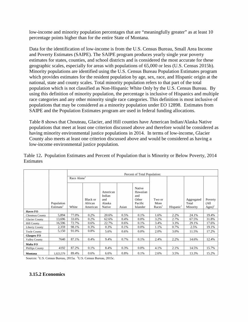
low-income and minority population percentages that are “meaningfully greater” as at least 10 percentage points higher than for the entire State of Montana. Data for the identification of low-income is from the U.S. Census Bureau, Small Area Income and Poverty Estimates (SAIPE). The SAIPE program produces yearly single year poverty estimates for states, counties, and school districts and is considered the most accurate for these geographic scales, especially for areas with populations of 65,000 or less (U.S. Census 2015b). Minority populations are identified using the U.S. Census Bureau Population Estimates program which provides estimates for the resident population by age, sex, race, and Hispanic origin at the national, state and county scales. Total minority population refers to that part of the total population which is not classified as Non-Hispanic White Only by the U.S. Census Bureau. By using this definition of minority population, the percentage is inclusive of Hispanics and multiple race categories and any other minority single race categories. This definition is most inclusive of populations that may be considered as a minority population under EO 12898. Estimates from SAIPE and the Population Estimates program are used in federal funding allocations. Table 8 shows that Chouteau, Glacier, and Hill counties have American Indian/Alaska Native populations that meet at least one criterion discussed above and therefore would be considered as having minority environmental justice populations in 2014. In terms of low-income, Glacier County also meets at least one criterion discussed above and would be considered as having a low-income environmental justice population.
Table 12. Population Estimates and Percent of Population that is Minority or Below Poverty, 2014 Estimates
Population Estimate1
Percent of Total Population: Race Alone1
Two or More
Races1 Hispanic1
Aggregated Total Minority
Poverty (All Ages)2 White
Black or African American
American Indian and Alaska Native Asian
Native Hawaiian and Other Pacific Islander
Havre FO Chouteau County 5,894 77.0% 0.2% 20.6% 0.5% 0.1% 1.6% 2.2% 24.1% 19.4% Glacier County 13,696 33.6% 0.2% 62.6% 0.4% 0.0% 3.2% 2.7% 67.5% 31.8% Hill County 16,596 72.7% 0.6% 22.7% 0.6% 0.1% 3.4% 3.3% 29.1% 17.6% Liberty County 2,359 98.1% 0.3% 0.3% 0.1% 0.0% 1.1% 0.7% 2.5% 19.1% Toole County 5,150 91.0% 0.8% 5.6% 0.6% 0.0% 2.0% 3.0% 11.5% 17.2% Glasgow FO Valley County 7640 87.1% 0.4% 9.4% 0.7% 0.1% 2.4% 2.2% 14.6% 12.4% Malta FO Phillips County 4192 87.2% 0.1% 8.4% 0.3% 0.0% 4.1% 2.1% 14.5% 15.7%
Montana 1,023,579 89.4% 0.6% 6.6% 0.8% 0.1% 2.6% 3.5% 13.3% 15.2% Sources: 1U.S. Census Bureau, 2015a. 2U.S. Census Bureau, 2015c.
3.15.2 Economics

The economic section focuses on the seven counties in which parcels are proposed for leasing. The counties include Valley County in the Glasgow Field Office; Choteau, Glacier, Hill, Liberty, and Toole counties in the Havre Field Office; and Phillips County in the Malta Field Office. Economic conditions and trends are discussed in the HiLine RMP FEIS (BLM 2015a, p. 305-318) so this discussion is focused on economic aspects related to oil and gas lease sales. Current BLM leases exist in all seven counties with Phillips County having the most acres under lease (over 337,000 acres) and Hill County having the least (approximately 11,200 acres)(BLM LR2000, 2016). The leasing and development of Federal fluid minerals supports local employment and income and generates public revenue for surrounding communities. The level of economic contributions from Federal fluid minerals are largely influenced by the number of acres leased and estimated levels of production and can be measured in terms of the jobs, income, and public revenue it generates. Additional details on the economic contribution of Federal fluid minerals are discussed in the HiLine RMP FEIS (BLM 2015a, p. 312-314). Mineral rights can be owned by private individuals, corporations, Indian tribes, or by local, State, or Federal Governments. Typically companies specializing in the development and extraction of oil and gas lease the mineral rights for a particular parcel from the owner of the mineral rights. Federal oil and gas leases are generally issued for 10 years unless drilling activities result in one or more producing wells. Once production has begun on a Federal lease, the lease is considered to be held by production and the lessee is required to make royalty payments to the Federal Government. Currently there are over 393,000 acres held by production across the four counties (BLM LR2000, 2016).
Competitive Federal oil and gas leases generate a one-time lease “bonus” bid as well as annual rents. The minimum lease bonus bid is $2.00 per acre. If no bonus bids are received, the parcels are later made available as noncompetitive leases where no bonus bids are collected. Over the past 10 years, bonus bids for all acres leased in the planning area averaged $10.35 per acre. Lease rental is $1.50 per acre per year for the first five years and $2.00 per acre per year thereafter. Typically, oil and gas leases expire after 10 years unless held by production. Annual lease rentals continue until one or more wells are drilled that result in production and associated royalties. The leased acres changes daily as leases expire and other parcels are leased. Generally, within the HiLine district, public domain Federal minerals account for about three-fourths of the acres leased; Bankhead-Jones lands account for about one-fourth of the acres leased; and the other authorities for acquired minerals account for less than 1% of federal leased acres (BLM 2015a, p. 313). Additionally, Federal oil and gas production in Montana is subject to production taxes or royalties. These federal oil and gas royalties generally equal 12.5% of the value of production (43 CFR 3103.3.1).
Total federal revenue associated with oil and gas royalties and leasing revenue (rent and bonus bids) in 2014 for the counties with parcels proposed for leasing in the Havre FO totaled over $715,000 with 64 percent generated in Toole County; Valley County (Glasgow FO) totaled over $240,000; and Phillips County (Malta FO) totaled over $2.9 million (Office of Natural Resource Revenue, 2015). A portion of the revenues collected by the Federal government is distributed to the state and counties. The amount that is distributed is determined by the federal authority under which the Federal minerals are being managed. Forty-nine percent of Federal revenue associated

with from oil and gas from public domain lands are distributed to the state. In Montana, 25% of the royalty revenues that the state receives are redistributed to the counties of production (Title 17-3-240, MCA). Twenty-five percent of royalties and revenues associated with oil and gas development from Bankhead-Jones lands are distributed to counties of production. Distribution of federal royalties and leasing revenues to the state for oil and gas development on other federal acquired lands differs based upon the authority associated with those lands.
4.0 ENVIRONMENTAL IMPACTS
4.1 Assumptions and Reasonably Foreseeable Development Scenario Summary At this stage of the leasing process, the act of leasing parcels would not result in any activity that might affect various resources. Even if lease parcels are leased, it remains unknown whether development would actually occur, and if so, where specific wells would be drilled and where facilities would be placed. This would not be determined until the BLM receives an Application for Permit to Drill (APD) in which detailed information about proposed wells and facilities would be provided for particular leases. Therefore, this EA discusses potential effects that could occur in the event of development. Upon receipt of an APD, the BLM would initiate a more site-specific NEPA analysis to more fully analyze and disclose site-specific effects of specifically identified activities. In all potential exploration and development scenarios, the BLM would require the use of BMPs documented in “Surface Operating Standards and Guidelines for Oil and Gas Exploration and Development” (USDI and USDA 2007), also known as the “Gold Book.” The BLM could also identify APD COAs, based on site-specific analysis that could include moving the well location, restrict timing of the project, or require other reasonable measures to minimize adverse impacts (43 CFR 3101.1-2 Surface use rights; Lease Form 3100-11, Section 6) to protect sensitive resources, and to ensure compliance with laws, regulations, and land use plans. For split-state leases, the BLM would notify the private landowners that oil and gas exploration or development activities are proposed on their lands and they are encouraged to attend the onsite inspection to discuss the proposed activities. In the event of activity on such split estate leases, the lessee and/or operator would be responsible for adhering to BLM requirements as well as reaching an agreement with the private surface landowners regarding access, surface disturbance, and reclamation. This chapter presents the potential environmental, social, and economic effects from the actions described in each alternative in Chapter 2, as well as potential effects from lease exploration and development activities. Environmental consequences are discussed below by alternative to the extent possible at this time for the resources described in Chapter 3. As per NEPA regulations at 40 CFR 1502.14(f), 40 CFR 1502.16(h), and 40 CFR 1508.20, mitigation measures to reduce, avoid, or minimize potential impacts are identified by resource below. The duration of the possible effects is analyzed and described as either short-term or long-term. Short-term effects generally last less than five years and long-term effects generally last more than five years. 4.1.1 Reasonably Foreseeable Development Scenario Summary The following assumptions are from the RFD developed for the HiLine Planning Area (the HiLine planning area includes the Malta, Glasgow, and Havre Field Offices). The BLM

administers approximately 3,483,000 acres of federal minerals of federal fluid minerals available for leasing within the HiLine Planning Area. The RFD forecasts the following level of development in the HiLine Planning Area. The RFD scenario for the HiLine RMP forecasts up to 6,866 wells in the planning area between 2007 and 2026. Up to 150 of these wells could be coalbed natural gas (CBNG) wells. Of the 6,716 conventional wells, 1,351 wells are located within the boundaries of the Bowdoin Dome area. In the HiLine planning area, high development potential indicates two to 20 wells per township. Very low development potential indicates two wells or less per township. All of the offered parcels are located in ‘very low development potential’ areas. These well numbers are only an estimate based on historical drilling and mineral resources present, and may change in the future if new technology is developed or new fields and formations are discovered. 4.1.2 Alternative A (No Action Alternative) Under the No Action Alternative, the proposed parcels would not be leased. There would be no new impacts from oil and gas production on the parcel lands. No additional natural gas or crude oil would enter the public markets, and no royalties and leasing revenues would accrue to the federal or state treasuries. The No Action Alternative would result in the continuation of the current land and resource uses on the parcels. Unless specifically indicated by resource area, no further analysis of the No Action Alternative is presented in the following sections. 4.1.3 Analysis Assumptions for Alternative B By itself, the act of leasing the parcels would have no direct impacts on any natural resources in the area administered by the Hiline District. Standard terms and conditions as well as special stipulations would apply to the lease parcels. All impacts would link to as yet undetermined future levels of lease development. If the lease parcels are developed, short-term impacts would be stabilized or mitigated rapidly (within two to five years). Long-term impacts are those that would substantially remain for more than five years.
4.2 Direct Effects Common to All Resources Under Alternative A, the 87 parcels would not be offered for competitive oil and gas lease sale. Under this alternative, the state and private minerals could still be leased in surrounding areas. There would be no new impacts from oil and gas exploration or production activities on the federal lease parcel lands. No additional natural gas or crude oil would enter the public markets, and no royalties would accrue to the federal or state treasuries from the parcel lands. The No Action Alternative would result in the continuation of the current land and resource uses on the lease parcels. Economic contributions from activities associated with oil and gas development would remain consistent with existing conditions discussed in this EA Section 3.18.2 Economics

above, as well as the economic conditions discussed on pages 312-314 of the HiLine RMP Final EIS (BLM, 2015). 4.2.1 Air Resources and Climate 4.2.1.1 Direct and Indirect Effects Leasing the subject parcels would have no direct impacts on air quality. Any potential effects on air quality from activities on these lease parcels would occur if and when the leases were developed. Potential impacts of development could include increased airborne soil particles blown from new well pads or roads; exhaust emissions from drilling equipment, compressors, vehicles, and dehydration and separation facilities, as well as potential releases of GHGs and VOCs during drilling and production activities. Increased emissions cannot be precisely quantified at this time since it is not known for certain how many wells might be drilled, the types of equipment needed if a well were to be completed successfully (e.g., compressor, flare, separator, gas dehydrator), or what technologies may be employed by a given company for drilling any new wells. The degree of impact would also vary according to the characteristics of the geologic formations from which production occurs, as well as the scope of specific activities proposed in an APD. Current monitoring data show that criteria pollutant concentrations are below applicable air quality standards, indicating good air quality. The level of potential development on 461 acres would generate too few criteria pollutants emissions to adversely affect air quality in the study area. Emissions from any future sources would be regulated through the use of state-issued air quality permits, air quality registrations, and well permit applications developed by the state of North Dakota. If the leases are developed, hazardous air pollutants (HAPs) would be emitted from oil and gas operations, including well drilling, well completion, and gas and oil production. Recent air quality modeling performed for the Hiline Resource Management Plan indicates that concentrations of benzene, ethylbenzene, formaldehyde, n-hexane, toluene, and xylene would be less than applicable health-based reference concentrations and that the additional risk of cancer would be less than 0.23 in one million (BLM Hiline RMP, 2015). The direct, indirect, and cumulative impacts from oil and gas development on air resources and climate are discussed in Chapter 4 of the HiLine Proposed Resource Management Plan (RMP) and Final Environmental Impact Statement (EIS) (pages 461 through 483) and Appendix B and are incorporated by reference into this EA. This analysis included discussion of short term and long term impacts. Application of CSU 12-23 and LN 14-18 would provide for conservation of air resources. The RFD for the proposed alternative would be in conformance with the emission impacts described in the document; and therefore are analyzed for air resources in the HiLine Proposed RMP and Final EIS (BLM Hiline RMP, 2015, ). 4.2.2 Soil Resources 4.2.2.1 Direct and Indirect Effects

Leasing the parcels would have no direct impacts on soil resources. Any potential effects from the sale of leases could occur at the time the leases are developed. Potential site-specific effects would be addressed in more detail at the APD stage. The direct, indirect, and cumulative impacts from fluid mineral development on soil resources are discussed in Chapter 4 of the HiLine Final EIS (USDI–BLM, 2015a) and are incorporated by reference into this EA. Construction and operation of well pads, access roads, pipelines, power lines, reserve pits, and other facilities would result in the exposure of mineral soil, soil compaction and rutting, mixing of soil horizons, loss of soil productivity, and increased susceptibility to wind and water erosion. The likelihood and magnitude of these occurrences is dependent upon local site characteristics, climatic events, and the specific mitigation applied. Effects would be both short-term (well pads and pipelines) and long-term (production areas and access roads). Areas needed for production, access roads, and facilities would require a long-term commitment of the soil resource. These sites remain non-productive and continue to be at risk of erosion and compacted until abandonment and final reclamation. Generally sites would be revegetated and erosion would return to natural rates within 5 years. Exceptions would be sites with sensitive soils, rock outcrop and/or badlands. These areas, once disturbed, are the most difficult and costly to stabilize and reclaim. Lease parcels containing sensitive soils, rock outcrop and/or badlands would have CSU 12-62 and/or NSO 11-69 stipulations attached (see Appendix A). These stipulations would provide protections to maintain the chemical, physical, and biotic properties of soils. Also, the stipulations would prevent excessive soil erosion and avoid disturbing areas subject to potential reclamation failure. 4.2.2.2 Mitigation In the event of exploration/development, a number of measures would be taken to prevent, minimize, or mitigate effects to soil resources. Prior to authorization, proposed actions would be evaluated on a case-by-case basis and would be subject to mitigation measures in order to maintain soil resources. Typical measures include, but are not limited to: • Avoiding areas with sensitive soils, badlands, rock outcrop, and areas susceptible to mass failure; • Requiring special reclamation of the prime farmlands, if irrigated, to ensure there is no unnecessary and irreversible conversion of prime farmland to nonagricultural uses; • Limiting the total area of disturbance; • Stripping and stockpiling topsoil separate from sub-soils/spoil; • Applying erosion/sediment control/containment products and structures, such as mulch, straw wattles, water bars, rolling dips, silt fence, bale filters, erosion control blankets and mats, cover crops, etc.; • Alleviating compaction; • Applying soil amendments, when necessary; • Re-contouring to approximate original contours or blend with surrounding topography; • Re-seeding with desired vegetation; • Completing interim reclamation on all disturbed areas associated with producing well locations and associated facilities;

• Monitoring for reclamation success and applying additional measures as needed; and/or, • Upon abandonment of wells and/or when access roads are no longer needed, the authorized officer would issue instructions and/or orders for surface reclamation/restoration of the disturbed areas as described in attached conditions of approval (COA). Measures included in the Gold Book (USDI-BLM, 2007), Appendix N: Oil and Gas Best Management Practices (USDI-BLM, 2015b), and Appendix M: Reclamation (USDI-BLM, 2015b) would be applied. Additional mitigation measures and/or BMPs, if necessary, would be applied once a site-specific plan of development is proposed. 4.2.3 Water Resources 4.2.3.1 Direct and Indirect Effects Leasing the parcels would have no direct impacts on water resources. Any potential effects from the sale of lease parcels could occur at the time the leases are developed. The magnitude of potential impacts from exploration and development of oil and gas to water resources would be dependent on the specific activity, season, proximity to waterbodies, location in the watershed, upland and riparian vegetation condition, effectiveness of mitigation, and the time until reclamation success. Surface disturbance effects typically are localized, short-term, and have the potential to be reduced through vegetation reestablishment. As acres of surface disturbance increase within a watershed, so could the effects on water resources. Oil and gas exploration and development of a lease parcel could cause the removal of vegetation, soil compaction, and soil disturbance in uplands within the watershed, floodplains of non-major streams, and non-riparian, ephemeral waterbodies. The potential effects from these activities are accelerated erosion, increased overland flow, decreased infiltration, increased water temperature, channelization, and water quality degradation associated with increased sedimentation, turbidity, nutrients, metals, and other pollutants. Erosion potential can be further increased in the long term by soil compaction and low permeability surfacing (e.g. roads and well pads), which increases the energy and amount of overland flow by decreasing infiltration, which in turn changes flow characteristics, reduces groundwater recharge, and increases sedimentation and erosion (DEQ 2007). Spills or produced fluids could potentially impact surface and ground water resources in the long term. Oil and gas exploration/development could contaminate aquifers with salts, drilling fluids, fluids and gases from other formations, detergents, solvents, hydrocarbons, metals, and nutrients; change vertical and horizontal aquifer permeability; and increase hydrologic communication with adjacent aquifers (EPA 2004). Groundwater removal could result in a depletion of flow in nearby streams and springs if the aquifer is hydraulically connected to such features. Typically, produced water from conventional oil and gas wells is from a depth below useable aquifers or coal seams (FSEIS 2008). 4.2.3.2 Mitigation Stipulations addressing waterbodies, streams, floodplains, riparian areas, and wetlands would minimize potential impacts and would be included with the lease, where required (Appendix B). In the event of exploration or development, measures would be taken to reduce, avoid, or

minimize potential impacts to water resources including application of appropriate mitigation. Mitigation measures that minimize the total area of disturbance, control wind and water erosion, reduce soil compaction and runoff, maintain vegetative cover, control nonnative species, and expedite rapid reclamation (including interim reclamation) would minimize negative impacts to water resources. Methods to reduce erosion and sedimentation could include: reducing surface disturbance acres; installing and maintaining adequate erosion control; proper road design, road surfacing, and culvert design; road/infrastructure maintenance; use of low water crossings; and use of isolated or bore crossing methods for waterbodies and floodplains. In addition, applying mitigation to maintain adequate, undisturbed, vegetated buffer zones around waterbodies and floodplains could reduce sedimentation and maintain water quality. Appropriate well completion, the use of Spill Prevention Plans, and Underground Injection Control regulations would mitigate groundwater impacts. Site-specific mitigation and reclamation measures would be described in the COAs. 4.2.4 Vegetation Resources 4.2.4.1 Direct and Indirect Effects Leasing the parcels would have no direct impacts on vegetation resources. Any potential effects on vegetation resources from sale of lease parcels would occur at the time the leases are developed. Impacts to vegetation would depend on the vegetation type/community, soil community and the topography of the lease parcels. Disturbance to vegetation is of concern because protection of soil resources, maintenance of water quality, conservation of wildlife habitat, and livestock production capabilities may be diminished or lost over the long-term through direct loss of vegetation (including direct loss of both plant communities and specific plant species). Other direct impacts, such as invasive species and noxious weed invasion could result in loss of desirable vegetation. Invasive species and noxious weeds may also reduce livestock grazing forage, wildlife habitat quality, and native species diversity. Cheatgrass is an invasive species well known for completely replacing native vegetation and changing fire regimes. Additionally, surface disturbing activities directly affect vegetation by destroying habitat, churning soils, impacting biological crusts, disrupting seedbanks, burying individual plants, and generating sites for competitive non-native plants including weedy species. In addition, other vegetation impacts could also be caused from soil erosion and result in loss of the supporting substrate for plants, or from soil compaction resulting in reduced germination rates. Impacts to plants occurring after seed germination but prior to seed set could be particularly harmful as both current and future generations would be affected.
Fugitive dust generated by construction activities and travel along dirt roads can affect nearby plants by depressing photosynthesis, disrupting pollination, and reducing reproductive success. Oil, fuel, wastewater or other chemical spills could contaminate soils as to render them temporarily unsuitable for plant growth until cleanup measures were fully implemented. If cleanup measures were less successful, longer term vegetation damage could be expected.

4.2.4.2 Mitigation Mitigation would be addressed at the site specific APD stage of exploration and development. If needed, COAs would potentially include revegetation with desirable plant species, soil enhancement practices, direct live haul of soil material for seed bank revegetation, reduction of livestock grazing, fencing of reclaimed areas, and the use of seeding strategies consisting of native grasses, forbs, and shrubs, would be identified and addressed at the APD stage.
4.2.5 Riparian-Wetland Habitats 4.2.5.1 Direct and Indirect Effects Leasing the parcels would have no direct impacts on riparian-wetland habitats. Any potential effects on riparian-wetland habitats from the sale of lease parcels would occur at the time the leases are developed. The exploration and development of oil and gas within uplands, adjacent to riparian-wetland areas, or stream crossings could reduce riparian/wetland functionality by changing native plant productivity, composition, richness, and diversity; accelerating erosion; increasing sedimentation; and changing hydrologic characteristics. Impacts that reduce the functioning condition of riparian and wetland areas could impair the ability of riparian/wetland areas to reduce nonpoint source pollution (MDEQ 2007) and provide other ecosystem benefits. The magnitude of these effects would be dependent on the specific activity, season, proximity to riparian-wetland areas, location in the watershed, upland and riparian-wetland vegetation condition, mitigation applied, and the time until reclamation success. Erosion increases typically are localized, short term, and occur from implementation through vegetation reestablishment. As acres of surface-disturbance increase within a watershed, so would the effects on riparian-wetland resources.
4.2.5.2 Mitigation Stipulations addressing sensitive soils, waterbodies, streams, floodplains, and riparian-wetland areas would minimize potential impacts and be included with all leases that contain the aforementioned features (refer to Appendix A). In the event of exploration or development, site-specific mitigation measures would be identified to avoid or minimize potential impacts to riparian-wetland areas prior to land disturbance. Mitigation measures that minimize the total area of disturbance, control wind and water erosion, reduce soil compaction & runoff, maintain vegetative cover, control nonnative species, maintain biodiversity, maintain vegetated buffer zones, and expedite rapid reclamation (including interim reclamation) would maintain riparian/wetland resource conditions.
4.2.6 Wildlife 4.2.6.1 Direct and Indirect Effects Leasing the 87 nominated parcels will have no direct impacts to wildlife or wildlife habitat. Potential effects to wildlife from the leasing of any parcels will occur during lease development. Standard lease terms and stipulations will minimize, but may not preclude impacts to wildlife. Any development which results in surface disturbance my directly and indirectly impact wildlife species. These impacts may include a loss or reduction in habitat suitability, provide habitat for undesirable competitors, cause nest abandonment, increase predation, fragment habitat, or displace wildlife. The scale, location, and pace of development will influence the impact severity to individual species and habitats.

4.2.6.1.1 Threatened, Endangered Proposed, and Candidate Species According to the U.S. Fish & Wildlife Service Ecological Services Montana Field Office, there are seven wildlife species that occur or may occur in the HiLine District that are protected under section 7(c) of the Endangered Species Act (ESA) as amended in 1973 including: Pallid Sturgeon (Scaphirhynchus albus); least tern (Sterna antillarum); piping plover (Charadrius melodus); whooping crane (Grus americana); Red Knot (Calidris canutus rufa); Canada Lynx (Lynx canadensis) and black-footed ferret (Mustela nigripes). Habitat within the nominated parcels does not exist to support Threatened, Endangered, and Proposed or Candidate species. Greater Sage-Grouse was listed as a Federal Candidate species. On September 22, 2015, the U.S. Fish & Wildlife Service determined that the Greater Sage-Grouse does not warrant protection under the Endangered Species Act and is no longer considered a candidate species. Sprague’s Pipit was listed as a Federal Candidate species. On April 5, 2016, the U.S. Fish & Wildlife Service determined that the Sprague’s Pipit does not warrant protection under the Endangered Species Act and is no longer considered a candidate species. 4.2.6.1.2 BLM Sensitive Species As many as 46 wildlife species that BLM has designated as “sensitive” have the potential to occur within the parcel areas. Stipulations are not provided for all BLM sensitive species in the current Resource Management Plans. Impacts to BLM sensitive species would be similar to those described above, unless they are afforded protective measures from other regulations such as the Migratory Bird Treaty Act (MBTA) (16 U.S.C. 703.) BLM does not consult with the USFWS on “sensitive” species and likewise would not receive terms and conditions from USFWS requiring additional protections of those species. Twelve of the parcels are located within the Montana-Saskatchewan Connectivity Area designated by the State of Montana. The State of Montana Executive Order No. 12-2015 for Sage-Grouse provides for the use of stipulations to be applied by the State. The HiLine Resource Management Plan does not include designation of the Valley County Connectivity Area. Stipulations do not exist specifically for the protection of BLM sensitive songbirds. The MBTA prohibits the take, capture or kill of any migratory bird, any part, nest or eggs of any such bird (16 U.S.C 703 (a)). NEPA analysis pursuant to Executive Order 13186 (January 2001) requires BLM to ensure that MBTA compliance and the effects of Bureau actions and agency plans on migratory birds are evaluated, should reduce take of migratory birds and contribute to their conservation. Effects to migratory birds from oil and gas development at the APD stage could include direct loss of habitat from roads, well pads and other infrastructure, disturbance, power line strikes and accidental direct mortality, fragmentation of habitat, change in use of habitats, and potential threats and competition from edge species. Mitigation measures would be assigned at the APD stage to ensure there would be no measurable negative effect on migratory bird populations, in compliance with Executive Order 13186 and MBTA. These mitigation measures would be required as Conditions of Approval.

4.2.6.1.3 Other Fish and Wildlife The types and extent of impacts to wildlife species and habitats from development are similar to those described above for other species. Impacts include loss of habitat from development infrastructure, mortalities resulting from collisions with vehicles and power lines, electrocution on power lines, and displacement of wildlife species from initial disturbance caused by human presence. Indirect impacts would include habitat fragmentation and subsequent vehicle traffic, human presence, and other continual development activities. Initial disturbance would change the occupation of those areas to disturbance-oriented species or species with more tolerance for disturbances. These changes would also be expected to decrease the diversity of wildlife. Although bladed corridors would be reclaimed after the facilities are constructed, some changes in vegetation would occur along the reclaimed areas. The goal of reclamation is to restore disturbed areas to pre-disturbed conditions. The outcome of reclamation, unlike site restoration, will therefore not always mimic pre-disturbance conditions and offer the same habitat values to wildlife species. It is anticipated that some development may occur adjacent to existing disturbances of some type. Depending on proximity and species tolerance, wildlife species within these areas would either have acclimated to the surrounding conditions, previously been displaced by construction activities, or may be caused to be displaced to other areas with or without preferred habitat. Potential impacts to aquatic wildlife from development could include: overland oil spills, underground spills from activities associated with horizontal drilling or other practices, spills from drilling mud or other extraction and processing chemicals, and surface disturbance activities that create a localized erosion zone. Oil spills and other pollutants from the oil extraction process could harm the aquatic wildlife species in two different ways if the spill substances enter the habitat. First, toxicological impacts from direct contact could have immediate lethal effects to eggs, larvae, juveniles, and adults. Second, toxic effects to lower food web levels would indirectly affect fish, amphibian, and reptile species by degrading water quality and degrading or eliminating food resources. 4.2.6.2 Mitigation Measures would be taken to prevent, minimize, or mitigate impacts to fish and wildlife animal species from exploration and development activities. Prior to authorization, activities would be evaluated on a case-by-case basis, and the project would be subject to mitigation measures. Mitigation could include rapid revegetation, project relocation, or pre-disturbance wildlife species surveying. If oil and gas development is proposed in suitable habitat for threatened or endangered species, consultation with the USFWS would occur to determine if additional terms and conditions would need to be applied. 4.2.7 Cultural Resources Leasing a nominated parcel gives a basic right to the operator to develop the lease. Leasing would not, however, result in effects to cultural resources at this stage. It is only when the lease is developed that there is a potential for cultural resources to be affected by the proposed action.

That is when the drilling location is known and cultural resource investigations can be centered on that location and other related developments such as roads, transmission lines, and pipelines.
At the APD stage when specific oil and gas development actions are proposed, the area of potential effect (APE) will be defined and assessments of the impacts on cultural resources will be undertaken in order to comply with Section 106 of the National Historic Preservation Act (NHPA) and BLM’s 8100 Manual Series. A Class III cultural resource inventory will be necessary for those parcels not previously surveyed and for those parcels which have been judged inadequately surveyed in the past. Lease Stipulations 11-137, 12-60 and14-24 will apply to all parcels (Appendix A). In the event that cultural resources are identified within the APE, an evaluation of National Register eligibility will occur for each identified cultural resource. Mitigation measures for cultural resources determined to be eligible to the National Register of Historic Places (NRHP) will have to be followed for those cultural resources directly and/or indirectly impacted by the proposed development.
Direct and indirect impacts are not anticipated from leasing nominated parcels. It is at the APD stage of development that specific impacts can be correctly assessed. Potential direct impacts to cultural resources at the APD stage include damage to archaeological sites through construction activities (e.g. pad construction, road building, well drilling), increased erosion from surface activities, and increased travel and vandalism resulting from improved access to the area. Potential indirect impacts include abrasive dust and vibrations from drilling equipment and damage to rock art sites from gas emissions. Conversely, cultural resource investigations associated with development adds to our understanding of the prehistory and history of the area under investigation.
Indirect effects from surface disturbances associated with exploration and development activities after leasing have the potential to alter the characteristics of a significant cultural or historic property by diminishing the integrity of the property's location, design, setting, materials, workmanship, feeling, or association. Other effects to cultural resources from proposed surface disturbance activities include the destruction, damage, or alteration to all or part of the cultural resource and diminishing the property’s significant historic features as a result of the introduction of visual, atmospheric, or audible elements. This could include altering or diminishing the elements of a National Register eligible property and diminish an eligible property’s eligibility status. Cultural resource investigations associated with development potentially adds to our understanding of the prehistory/history of the area under investigation and discovery of sites that would otherwise remain undiscovered due to burial or omission during review inventories. Climate change may have an effect on cultural resources by changing the frequency and severity of natural events, such as heavy rain and wildfires (Agee 1993; Maslin 2004). Heavy rain increases the likelihood of flooding and soil erosion which could impact an archaeological site by exposing, removing, and displacing archaeological materials. Wildfires can affect the morphology of artifacts through fracturing and discoloration which can reduce an artifact’s ability to render information about the past (Winthrop 2004). Wildfires can also destroy organic materials such as bone, wood, and pollen that provide information about past environments and subsistence. Furthermore, fire suppression activities (e.g. fire retardant and fire line construction)

and increased artifact exposure from vegetation burn-off, can also have an adverse impact on archaeological sites.
4.2.7.1 Mitigation Specific mitigation measures, such as site avoidance or data recovery through excavation, would have to be determined when project specific development proposals are received. In almost all situations, direct impacts to cultural resources could be avoided by relocating well sites and pipelines. Given the relatively small number of acres to be disturbed by anticipated development it is unlikely that it would be necessary to mitigate adverse impacts to archaeological sites through data recovery efforts. It should be noted that BLM has discretional control over mitigation stipulations measures imposed on a project. Although a lessee has a right to develop a lease, BLM may require development activities to be moved up to 200 meters in any direction. This should allow nearly all sites to be avoided. Should development uncover subsurface sites, the lessee is required to halt all work until the site can be evaluated and proper mitigation measures can be implemented The use of standard lease terms protects vulnerable significant cultural resource values on these lease parcels (refer to Appendix A). The application of these requirements at the leasing phase provide protection to cultural values or at least notification to the lessee that potentially valuable cultural resource values are or are likely to be present on the lease parcels. Specific mitigation measures, including but not limited to, possible site avoidance, excavation or data recovery would have to be determined when site-specific development proposals are received. However, in most surface-disturbing situations cultural resources would be avoided by project redesign or relocation. If significant properties cannot be avoided, appropriate strategies would be implemented to mitigate potential impacts in accordance with existing federal regulations. In addition, each nominated lease parcel would have the standard lease notice attached and the special cultural resource stipulation as written in the HiLine RMP. Refer to Appendix A of this document for pertinent parcel-specific lease stipulations as needed. 4.2.8 Native American Religious Concerns Leasing the parcels would have no direct impacts on Native American religious concerns. Any potential effects from the sale of leases would occur at the time the leases are developed. The BLM WO IM-2005-003 notes that while a lease does not authorize specific on-the-ground activities, and no ground disturbance can occur without further authorization from BLM and the surface management agency, but unless proscribed by stipulation, lessees can expect to drill somewhere on a lease unless precluded by law. Leasing would not have an impact on TCPs and/or areas of religious or cultural importance to tribes. A lease sale would not interfere with the performance of traditional ceremonies and rituals pursuant to the American Indian Religious Freedom Act (AIRFA) or EO 13007. It would not prevent tribes from visiting sacred sites or prevent possession of sacred objects. Indirect effects from site specific development proposals could have an impact to Native American religious practices and TCPs. 4.2.8.1 Mitigation

The application of Stipulation 14-24 to all lease parcels ensures that BLM’s obligations under NHPA, American Indian Religious Freedom Act, Native American Graves Protection and Repatriation Act, E.O. 13007, and other statutes as applicable will be met. At the APD stage when specific oil and gas development actions are proposed, the area of potential effect (APE) will be defined and federally recognized tribes will be consulted if necessary. Additional NSO or CSU Stipulations may be necessary if TCPs or properties of religious and cultural importance are identified at the APD stage. 4.2.9 Paleontology Leasing the parcels would have no direct impacts on paleontological resources. Any potential effects from the sale of leases would occur at the time the leases are developed. The surface disturbances associated with oil and gas exploration and development activities could have indirect effects to paleontological resources primarily in areas classified as Potential Fossil Yield Classification (PFYC) 4 or 5 areas. Surface-disturbing activities could potentially alter the characteristics of paleontological resources through damage, fossil destruction, or disturbance of the stratigraphic context in which paleontological resources are located, resulting in the loss of important scientific data. However, in most surface-disturbing situations, paleontological resources would be avoided by project redesign or relocation before project approval which would negate the need for the implementation of mitigation measures. Conversely, surface-disturbing activities can also potentially lead to the discovery of paleontological localities that would otherwise remain undiscovered due to burial or omission during review inventories. The scientific study to retrieve and interpret important paleontological resource information provides a better understanding of the nature and distribution of those resources. The retrieval and interpretation of information is most successful and meaningful when a site is left intact. Once a parcel is leased, the application of standard lease terms (movement of activities by 200 meters or delay of up to 60 days) would protect vulnerable significant paleontological resource values on these lease parcels. In most instances this may be sufficient to provide the necessary protection to paleontological values. However, the application of standard lease terms may not always adequately protect paleontological values. In order to protect paleontological values, paleontological resources management relies on the application of Lease stipulation11-139 and 12-61, applied at the leasing phase to provide protection to paleontological resources or at least notification to the lessee that potentially significant paleontological resources are or are likely to be present on the lease parcels should the lease parcel fall within one of the designated PFYC Class 4 or 5 significant geologic formations which have a record of producing significant fossils. The paleontological lease notice would be applied to those lease parcels that fall within the PFYC 4 or 5 areas, requiring a field survey prior to surface disturbance. Paleontological resource surveys conducted prior to surface-disturbing activities could locate additional paleontological resources and would result in a better understanding of the nature and distribution of those resources. 4.2.9.1 Mitigation

The use of standard lease terms and lease stipulations protect paleontological resource values on these lease parcels (refer to Appendix A). The application of these requirements at the leasing phase provides protection to paleontological values. The paleontological lease notice would be applied to those lease parcels that fall within the PFYC 4 or 5 areas, requiring a field survey prior to surface disturbance. These inventory requirements should result in the identification of paleontological resources and avoidance or mitigation of significant localities before permit approval and prior to surface disturbance. However, the application of standard lease terms only allows the relocation of activities up to 200 meters, unless documented in the NEPA document, and cannot result in moving the activity off lease. Specific mitigation measures could include, but are not limited to, site avoidance or excavation. Avoidance of paleontological properties would be a best management practice. However, should a paleontological locality be unavoidable, significant properties would be mitigated prior to implementation of a project. These measures would be determined when site specific development proposals are received. 4.2.10 Visual Resources 4.2.10.1 Direct and Indirect Effects Based on the BMPs and existing stipulations, potential impacts from oil and gas development would be extremely low. Development activities on all parcels located on BLM surface would be mitigated so that contrasts conform to VRM class guidelines. Oil and gas development activities on private surface would be guided by BMPs and other resource mitigation measures. 4.2.10.2 Mitigation Should any new oil and gas developments occur, they would be subject to BLM BMPs for VRM in order to minimize contrasts to the existing landscape. This include such things as proper site selection, minimizing disturbance, selecting color schemes that blend with the background, and reclaiming areas that are not in active use. Overall, the goal is to minimize impacts to the existing visual resources that currently exist and to ensure conformance with the VRM class of the area. All BLM parcels have CSU stipulations in order to mitigate disturbances and ultimately conform to the appropriate VRM classifications. The HiLine RMP Appendix E.4 states “In order to retain the existing character of the landscape (VRM Class II Objective), oil and gas development activities will be located, designed, constructed, operated, and reclaimed so that activities should not attract attention to the casual observer within 2 years from initiation of construction. This stipulation does not apply to the operation and maintenance activities.” See Table 9 for VRM classes for the analysis area.
4.2.11 Lands and Realty 4.2.11.1 Direct and Indirect Effects Leasing the parcels would have no direct impacts on lands and realty. Any potential effects from the sale of leases would occur at the time the leases are developed.

Facilities associated with oil and gas development on the 87 parcels would not cause any additional rights of way activity until development of lease sale parcels. Additional rights-of-way could be required across federal surface for “off-lease” or third party facilities required for potential development of the parcel. 4.2.11.2 Mitigation Any new “off-lease” or third party rights of way required across federal surface for future exploration and/or development of the 87 parcels would be subject to stipulations to protect other resources as determined by environmental analyses which would be completed on a case-by-case basis. 4.2.12 Minerals 4.2.12.1 Fluid Minerals 4.2.12.1.1 Direct and Indirect Effects Leasing the parcels would have no direct impacts on fluid minerals. Any potential effects from the sale of leases would occur at the time the leases are developed. Issuing a lease provides opportunities to explore for and develop oil and gas. Additional natural gas or crude oil produced from any or all of the four parcels would enter the public markets. The production of oil and gas results in the irreversible and irretrievable loss of these resources. Royalties and taxes would accrue to the federal and state treasuries from the lease parcel lands. There would be a reduction in the known amount of oil and gas resources. Stipulations applied to various areas with respect to occupancy, timing limitation, and control of surface use could affect oil and gas exploration and development, both on and off the federal parcel. Leases issued with major constraints (NSO stipulations) may decrease some lease values, increase operating costs, and require relocation of well sites, and modification of field development. Leases issued with moderate constraints (timing limitation and controlled surface Use (CSU) stipulations) may result in similar but reduced impacts, and delays in operations and uncertainty on the part of operators regarding restrictions. Under Alternative B, the 87 lease parcels would be offered for lease subject to standard lease terms and conditions. 4.2.13 Special Designations The following three parcels are located within the Kevin Rim ACEC; MTM 105431-LL, MTM 105431-LF, and MTM 105431-LE. The purpose of the Kevin Rim ACEC is to protect the diverse archeological resources and significant raptor values. The BLM will retain the ACEC (4,557 acres) to protect the diverse archeological resources and significant raptor habitat (Hiline RMP June 2015, Appendix A2, Map M). The ACEC will include stipulation NSO 11-144 for oil and gas leasing which states, “Surface occupancy and use is prohibited within the Kevin Rim ACEC.” The ACEC will be open to mineral entry and location. 4.2.14 Social and Economic Conditions 4.2.14.1 Social and Environmental Justice

Leasing the parcels would have minimal to no direct, indirect or cumulative impacts on social conditions and environmental justice populations. Any potential direct, indirect and cumulative effects from the sale of leases would occur at the time the leases are developed. The pace and scale of oil and gas development can be of concern to local communities. Rapid development can drive important social changes due to the influx of people to these areas who find employment in the oil and gas industry and ancillary service industries. Rapid population growth for unprepared communities can cause stress on community resources such as educational infrastructure, roads and utilities, emergency services, and community cohesion. Should oil and gas leasing and subsequent development occur, impacts to people living near or using the area in the vicinity of the lease would potentially occur. Oil and gas exploration, drilling, or production, would potentially inconvenience these people through increased traffic and traffic delays, noise, and visual impacts. These impacts would be particularly noticeable in rural areas in which oil and gas development has not occurred previously. The level of inconvenience would depend on the activity affected, traffic patterns within the area, noise levels, the length of time and season in which these activities occurred, and other factors. Creation of new access roads would potentially allow increased public access and exposure of private property to vandalism. For leases in which the surface is privately owned and the mineral estate is federally owned, surface owner agreements, standard lease stipulations, and BMPs would potentially address many of the concerns of private surface owners. Executive Order 12898 requires the analysis of disproportionately high and adverse human health effects and environmental effects on environmental justice populations. Environmental effects may include “ecological, cultural, human health, economic, or social impacts on minority communities, low-income communities, or Indian tribes when those impacts are interrelated to impacts on the natural or physical environment” (page 26; CEQ, 1997). As discussed previously, Chouteau, Glacier, and Hill counties met the criteria for having environmental justice populations which are heavily influenced by the American Indian/Native American populations in the counties. Adverse effects to historical and current cultural and traditional uses and values in this area are correlated to the amount of surface-disturbing or other disruptive activities allowed under this alternative. Please refer to sections 4.3.10 Cultural Resources and 4.3.11 Native American Religious Concerns for the discussion of potential impacts associated with this alternative. The BLM has considered all input from persons or groups regardless of age, income status, race, or other social or economic characteristics. The outreach and public involvement activities for this effort, including the consultation of tribes, are described in sections 1.4 Public Scoping and Identification of Issues, 5.1 Persons, Agencies, and Organizations Consulted, and 5.2 Summary of Public Participation. 4.2.14.2 Economics 4.2.14.2.1 Direct and Indirect Effects The leasing of parcels would result in the collection of revenues. Revenues generated by leasing Federal minerals are the bonus bids paid at the lease auction and annual rents collected on leased parcels not held by production. Forty-nine percent of Federal revenue associated with oil and gas from public domain lands are distributed to the state. In Montana, 25% of the royalty revenues that the state receives are redistributed to the counties of production (Title 17-3-240, MCA). Distribution of Federal leasing revenues to the state for parcels on other Federal acquired lands

differs based upon the authority associated with those lands. Rent payments are $1.50 per acre for the first five years and $2.00 per acre for the second five years of the lease. Federal leasing revenue estimates (lease rent and bonus bids) are initially based upon the number of acres being offered, however it is unknown whether all of the parcels proposed will be sold. Given this uncertainty, revenue estimates were calculated at fifty percent, seventy-five percent, and one hundred percent of proposed parcels being sold. Federal leasing revenue estimates provided in Table 13 are associated with the parcels offered under Alternative B and do not include existing lease rents. To estimate annual rent revenue it was assumed that rent would be collected during the full term of the leases (10 years) since it is unknown if and when the lease will be held by production, terminated, or relinquished. This calculation of rent revenue provides the maximum amount of annual rent revenue that may be collected. Bonus bids were calculated using the minimum rate of $2.00 per acre. The minimum bonus bid rate reflects bonus bid rates that have occurred in recent Federal lease sales in Phillips and Valley counties. Table 13 provides estimates on annual rent and the potential one-time bonus bid revenue collected by the Federal government and then redistributed to the state and counties. Hill, Phillips, and Valley counties include both parcels of public domain land and parcels associated with other Federal acquired lands. Due to the complexity of revenue distribution associated with Federal acquired lands, the state and county revenue estimates reflect only the acres associated with public domain lands therefore underestimating potential revenues for these three counties. Based upon one hundred percent of the proposed parcels being sold, Valley County (Glasgow FO) would generate the greatest amount of Federal revenue with annual rent ranging from $7,821 for the first five years and $10,428 for the second five years and one-time bonus bid revenue of $10,428. For the counties with proposed parcels for lease in the Havre FO, Toole County would generate the greatest amount of Federal revenue with annual rent ranging from $6,604 for the first five years and $8,805 for the second five years and one-time bonus bid revenue of $8,805, assuming one hundred percent of the proposed parcels are sold. Phillips County in the Malta FO would generate $6,930 of annual rent for the first five years, $9,241 of annual rent for the second five years and one-time bonus bid revenue of $9,241 if all proposed acres are sold. The direct, indirect, and cumulative impacts from potential oil and gas development within the Hiline District are discussed in Chapter 4 of the Hiline RMP FEIS (pages 497-511; BLM 2015a). On annual average, the leasing and production of fluid minerals administered by the HiLine District are estimated to generate $12.9 million in federal revenue, with approximately $1.9 million being returned to the counties in which rents and royalties were generated (Tables 4.35 and 4.36; BLM 2015a).

Table 13. Estimated Federal, State, and County Revenue in 2016 dollars.
Federal Revenue State Revenue County Revenue
Average Annual One time revenue Average Annual
One time revenue Average Annual
One time revenue
Rent-first 5 years
Rent-second 5 years Bonus Bid
Rent-first 5 years
Rent-second 5 years Bonus Bid
Rent-first 5 years
Rent-second 5
years Bonus Bid Field Office County Acres Offered % Acres Sold $1.50/acre $2.00/acre minimum $2.00
Glasgow Valley1 5214.100 50% $ 3,910.58 $ 5,214.10 $ 5,214.10 $ 680.62 $ 907.49 $ 907.49 $ 170.15 $ 226.87 $ 226.87 75% $ 5,865.86 $ 7,821.15 $ 7,821.15 $ 1,020.93 $ 1,361.23 $ 1,361.23 $ 255.23 $ 340.31 $ 340.31
100% $ 7,821.15 $ 10,428.20 $ 10,428.20 $ 1,361.23 $ 1,814.98 $ 1,814.98 $ 340.31 $ 453.74 $ 453.74
Havre Choteau 2953.070 50% $ 2,214.80 $ 2,953.07 $ 2,953.07 $ 1,085.25 $ 1,447.00 $ 1,447.00 $ 271.31 $ 361.75 $ 361.75 75% $ 3,322.20 $ 4,429.61 $ 4,429.61 $ 1,627.88 $ 2,170.51 $ 2,170.51 $ 406.97 $ 542.63 $ 542.63
100% $ 4,429.61 $ 5,906.14 $ 5,906.14 $ 2,170.51 $ 2,894.01 $ 2,894.01 $ 542.63 $ 723.50 $ 723.50
Havre Glacier 16.140 50% $ 12.11 $ 16.14 $ 16.14 $ 5.93 $ 7.91 $ 7.91 $ 1.48 $ 1.98 $ 1.98 75% $ 18.16 $ 24.21 $ 24.21 $ 8.90 $ 11.86 $ 11.86 $ 2.22 $ 2.97 $ 2.97
100% $ 24.21 $ 32.28 $ 32.28 $ 11.86 $ 15.82 $ 15.82 $ 2.97 $ 3.95 $ 3.95
Havre Hill1 127.485 50% $ 95.61 $ 127.49 $ 127.49 $ 29.40 $ 39.20 $ 39.20 $ 7.35 $ 9.80 $ 9.80 75% $ 143.42 $ 191.23 $ 191.23 $ 44.10 $ 58.80 $ 58.80 $ 11.03 $ 14.70 $ 14.70
100% $ 191.23 $ 254.97 $ 254.97 $ 58.80 $ 78.40 $ 78.40 $ 14.70 $ 19.60 $ 19.60
Havre Liberty 597.310 50% $ 447.98 $ 597.31 $ 597.31 $ 219.51 $ 292.68 $ 292.68 $ 54.88 $ 73.17 $ 73.17 75% $ 671.97 $ 895.97 $ 895.97 $ 329.27 $ 439.02 $ 439.02 $ 82.32 $ 109.76 $ 109.76
100% $ 895.97 $ 1,194.62 $ 1,194.62 $ 439.02 $ 585.36 $ 585.36 $ 109.76 $ 146.34 $ 146.34
Havre Toole 4402.570 50% $ 3,301.93 $ 4,402.57 $ 4,402.57 $ 1,617.94 $ 2,157.26 $ 2,157.26 $ 404.49 $ 539.31 $ 539.31 75% $ 4,952.89 $ 6,603.86 $ 6,603.86 $ 2,426.92 $ 3,235.89 $ 3,235.89 $ 606.73 $ 808.97 $ 808.97
100% $ 6,603.86 $ 8,805.14 $ 8,805.14 $ 3,235.89 $ 4,314.52 $ 4,314.52 $ 808.97 $ 1,078.63 $ 1,078.63
Malta Phillips1 4620.500 50% $ 3,465.38 $ 4,620.50 $ 4,620.50 $ 1,058.17 $ 1,410.90 $ 1,410.90 $ 264.54 $ 352.72 $ 352.72 75% $ 5,198.06 $ 6,930.75 $ 6,930.75 $ 1,587.26 $ 2,116.34 $ 2,116.34 $ 396.81 $ 529.09 $ 529.09
100% $ 6,930.75 $ 9,241.00 $ 9,241.00 $ 2,116.34 $ 2,821.79 $ 2,821.79 $ 529.09 $ 705.45 $ 705.45
1State and county revenue reflects only proposed acres associated with public domain lands. The percent of acres associated with public domain lands for Valley, Hill, and Phillips counties are approximately 35.5%, 62.8%, and 62.3% respectively.

4.2.14.2.2 Cumulative Impacts to Economic Conditions The direct, indirect, and cumulative economic impacts from potential oil and gas development within the Hiline District are discussed in Chapter 4 of the Hiline RMP FEIS (pages 497-511; BLM 2015a). On annual average, the leasing and production of fluid minerals administered by the HiLine District are estimated to generate $12.9 million in federal revenue, with approximately $1.9 million being returned to the counties in which rents and royalties were generated (Tables 4.35 and 4.36; BLM 2015a).
5.0 CONSULTATION AND COORDINATION
5.1 Persons, Agencies, and Organizations Consulted Coordination with MFWP and USFWS was conducted for the four lease parcels being reviewed. BLM has coordinated with MFWP and USFWS in the completion of this EA in order to prepare analysis, identify protective measures, and apply stipulations associated with these parcels being analyzed. The BLM consults with Native Americans under Section 106 of the National Historic Preservation Act. BLM sent letters to tribes in Montana, North and South Dakota and Wyoming at the beginning of the 15 day scoping period informing them of the potential for the 87 parcels to be leased and inviting them to submit issues and concerns BLM should consider in the environmental analysis. Letters were sent to the Tribal Chairperson/Presidents and THPO or other cultural contacts for the Blackfeet, Gros Ventre, Assiniboine, Sioux, Flathead (Salish) Kootenai, Shoshone, Bannock, Northern Cheyenne, Little Shell Tribe of Chippewa, Nez Perce, Crow, and Cree Tribes. BLM will send a second letter to the tribes informing them about the 30 day public comment period for the EA and soliciting any information BLM should consider before making a decision whether to offer any or all of the 87 parcels for sale.
5.2 Summary of Public Participation Scoping: Public scoping for this project was conducted through a 15-day scoping period advertised on the BLM eplanning website. Scoping was initiated March 22, 2016 and scoping comments were received through April 9, 2016. Surface owner notification letters were also distributed briefly explaining the oil and gas leasing process and planning process. The surface owner notification letter requested written comments regarding any issues or concerns that should be addressed in the environmental analysis. Few scoping comments were received and pertained to general concerns related to mineral ownership and split estate questions. Table 14. List of Preparers
Name Title Responsible for the Following Section(s) of this Document
Tessa Wallace Natural Resource Specialist NEPA Lead

Melissa Hovey Air Resource Specialist Air Quality Abel Guevara Wildlife Biologist Wildlife and Special Status Species Glasgow
FO Craig Miller Wildlife Biologist Wildlife and Special Status Species Havre FO Kathy Tribby Wildlife Biologist Wildlife and Special Status Species Malta FO Jeremy McKellar Rangeland Management Specialist Vegetation Resources/Livestock Grazing Jerry Rich GIS Specialist Mineral Estate and GIS Randy Schardt GIS Specialist GIS Josh Chase Archeologist Cultural Resources Micah Lee Realty Specialist Lands and Realty Kahindo Kamau Petroleum Engineer Fluid Minerals Jason Snellman Outdoor Recreation Planner VRM, Recreation Josh Sorlie Soil Scientist Soils Jessica M Montag Socioeconomic Specialist Social and Economic Analysis Alden Shallcross Hydrologist Water, Riparian Craig Towery Geologist Solid Minerals
6.0 REFERENCES 50 CFR Part 17 [Docket No. FWS–R6–ES–2009–0081] [MO 92210-0-0008] Aaberg, S.A., R. Hanna, C. Crofutt, J. Green, and M. Vischer. 2006. Miles City Resource
Management Plan (RMP) and Environmental Impact Statement (EIS) Class I Overview of Paleontological & Cultural Resources in Eastern Montana (March 2006). Prepared by Aaberg Cultural Resource Consulting Service under subcontract to ALL Consulting and prepared for the United States Department of the Interior, Bureau of Land Management, Miles City Field Office. March 2006, Billings, MT.
Adair, Ann and Scott Rickard, 2005 “The Economic and Fiscal Impacts of Montana’s Petroleum
and Natural Gas Industry in 2003”, Montana State University-Billings, Center for Applied Research.
Agee, J. 1993. Fire Ecology of Pacific Northwest Forests. Island Press. Washington. Albers, Patricia and William James 1984 A History of Joint Migrations, Water and Land-Use
By the Assiniboine, Cree, Chippewa And Metis In The Northern Plains From Prehistoric Times to 1879. Consultant’s report prepared for the Billings Area Office, Bureau of Indian Affairs.
Arno, Stephen F. and George E. Gruell. 1983. Fire history at the forest grassland ecotone in southwestern Montana. Journal of Range Management. 36(3): 332-336.
Bainbridge, DA. 2007. A Guide for Dryland Restoration: New Hope for Arid Lands. Island
Press. Washington, DC. Bald Eagle Protection Act of 1940 (16 U.S.C. 668-668d, 54 Stat. 250) as amended -- Approved
June 8, 1940, and amended by P.L 86-70 (73 Stat. 143) June 25, 1959; P.L. 87-884 (76 Stat. 1346) October 24, 1962; P.L. 92-535 (86 Stat. 1064) October 23, 1972; and P.L. 95-616 (92 Stat. 3114) November 8, 1978.

Barton, B. and S. Crispin. 2003. Globally Significant Plants in Southeastern Big Horn and
Southwestern Rosebud Counties, Montana. Montana Natural Heritage Program, Helena, MT. 27pp. + app.
Berg, R.B., and Vuke, S.M., 2002, Geologic map of the Fort Benton 30' x 60' quadrangle, north-
central Montana: Montana Bureau of Mines and Geology Open-File Report 460, 13 p., 1 sheet, scale 1:100,000.
Bergantino, R.N., 2001. Revised 2007, Geologic and Structure Contour Map of the Opheim 30’ x 60’ Quadrangle, Northeast Montana. Montana Bureau of Mines and Geology Open File Report MBMG 440, scale 1:100,000.
Berger, K.M., J.P. Beckmann, and J. Berger. 2007. Wildlife and Energy Development:
Pronghorn of the Upper Green River Basin – Year 2 Summary. Wildlife Conservation Society, Bronx, NY.
Bureau of Land Management (BLM). 2014. 2014 Montana/Dakotas Special Status Species List. Instruction Memorandum No. MT-2014-067 (August 18, 2014). http://web.mt.blm.gov/staff/websters/records/fy14/MT_IM_Spreadsheet.htm http://web.mt.blm.gov/staff/websters/records/fy14/14mtm067_at1.pdf
BLM Federal Land Status Records (LSR), 2010, Montana Master Title Plats (MTPs), October 6,
2010. BLM LR2000, 2010, Authorized Leases/Leases Held by Production, May 21, 2010 BLM LR2000, 2010, Authorized Leases/Leases Held by Production, March 11, 2013
BLM LR2000, 2010, Authorized Rights-of-Way, October 6, 2010 Bramblett, R.G., T.R. Johnson, A.V. Zale, and D.G. Heggem. 2005. Development and evaluation
of a fish assemblage index of biotic integrity for Northwestern Great Plains streams. Transactions of the American Fisheries Society. 134: 624-640.
Braun, C.E., O.O. Oedekoven, and C.L. Aldridge. 2002. Oil and gas development in western
North America: effects on sagebrush steppe avifauna with particular emphasis on sage grouse. Transactions of the North American Wildlife and Natural Resources Conference 67:337-349.
Bureau of Land Management. 1998. Areas of Critical Environmental Concern Environmental
Assessment and Proposed Amendment of the Billings, Powder River and South Dakota Resource Management Plans. August 1998. Bureau of Land Management, Miles City Field Office. Miles City, MT.

Canadian Wildlife Service and U.S. Fish and Wildlife Service. 2007. International recovery plan for the whooping crane. Ottawa: Recovery of Nationally Endangered Wildlife (RENEW), and U.S. Fish and Wildlife Service, Albuquerque, New Mexico. 162 pp. http://ecos.fws.gov/docs/recovery_plan/070604_v4.pdf
CAPS, 2010. Montana, Fish, Wildlife and Parks Crucial Area Planning System.
http://fwp.mt.gov/gis/maps/caps/) Carlson, J. C. and S. V. Cooper. 2003. Plant and Animal resources and Ecological Condition of
the Forks Ranch Unit of the Padlock Ranch, Big Horn County, Montana and Sheridan County, Wyoming. Report to the Padlock Ranch and Montana BLM. Montana Natural Heritage Program, Helena, MT. 27pp. + app.
Center for Climate Strategies (CCS). 2007. Montana Greenhouse Gas Inventory and Reference
Case Projections 1990-2020. Center for Climate Strategies and Montana Department of Environmental Quality. September 2007.
CEQ, 1997. Environmental Justice: Guidance under the National Environmental Policy Act.
Council for Environmental Quality (CEQ).
Clark, Lance R. and R. Neil Sampson. 1995. Forest Ecosystem Health in the Inland West: A Science and Policy Reader. Forest Policy Center, American Forests.
Climate Change SIR. 2010. Climate Change Supplementary Information Report for Montana,
North Dakota, and South Dakota, Bureau of Land Management. Report on Greenhouse Gas Emissions and Climate Change for Montana, North Dakota, and South Dakota. Technical report prepared for the Montana/Dakotas Bureau of Land Management by URS Corporation. URS Project 22241790.
Coates, Ladd. 2005. Personal communication with Ladd Coates, Miles City Field Office Outdoor
Recreation Planner, on recreation in the Miles City Field Office area. January, 27, 2005. Cymore, J. 2010. Personal communication with Meghan Burns, Landscape Ecologist, Montana
Natural Heritage Program (MTNHP) 11/1/2010.
DeMaillie, Raymond and David Miller 2001 Assiniboine. In: Plains, Raymond DeMallie (Editor), Pp: 572-595, Handbook of North American Indians Volume 13. Smithsonian Institution Press, Washington D.C
Division, Annual Review 2000-2008County Drilling and Production Statistics Dodds, W.K., K. Gido, M.R. Whiles, K.M. Fritz, and W.J. Matthews. EPA, 2004 Study to Evaluate the Impacts to USDWs by Hydraulic Fracturing of Coalbed
Methane Reservoirs http://www.epa.gov/safewater/uic/wells_coalbedmethanestudy.html accessed 5/26/10.

Eubanks, Ellen. 2004. Riparian Restoration. 0423 1201P. San Dimas, CA: U.S. Department of Agriculture, Forest Service, San Dimas Technology and Development Center. 137 p. http://www.fs.fed.us/t-d/php/library_card.php?p_num=0423%201201P
Federal Register: September 15, 2010 (Volume 75, Number 178)] Foresman, K.R. 2001. The Wild Mammals of Montana. Special publication No 12. American
Society of Mammologists. Lawrence, KS.: Allen Press. Fullerton, D.S., Colton, R.B., and Bush, C.A., 2012a. Quaternary geologic map of the Glasgow
1' x 2' quadrangle, Montana: U.S. Geological Survey Open-File Report 2012-1217, scale 1:250,000.
Fullerton, D.S., Colton, R.B., and Bush, C.A., 2012b. Quaternary geologic map of the Havre 1' x 2' quadrangle, Montana: U.S. Geological Survey Open-File Report 2012-1025, scale 1:250,000.
Fullerton, D.S., Colton, R.B., and Bush, C.A., 2012c. Quaternary geologic map of the Shelby 1' x 2' quadrangle, Montana: U.S. Geological Survey Open-File Report 2012-1170, scale 1:250,000.
GlasgowMontana.com, 2013. Accessed 4/23/2013: http://www.glasgowmontana.com/glasgowMontanaHistory.php
Friesen, Nathan. 2010. E-mail dated 10/06/2010 from Nathan Friesen of the Heritage Resources Branch of Saskatchewan Tourism, Parks, Culture and Sport to Mark Sant, BLM Montana State Office concerning Montana Oil and Gas lease near the Canadian Border.
Hamlin, K.L. 1978. Population ecology and habitat relationships of mule deer and white-tailed deer in the prairie agricultural habitats of eastern Montana. Montana Deer Studies. Montana Department of Fish, Wildlife and Parks, Project W-120-R-10, Job Progress Report.
Hanebury, L. 2010. Personal communication. Fish and Wildlife Biologist, USFWS, March 11,
2010. Hansen, P.L., W. H. Thompson, J. G. Massey, and M. Thompson. 2008. Classification and
management of upland, riparian, and wetland sites of USDI Bureau of Land Management’s Miles City Field Office, Eastern Montana, USA. Prepared for the Miles City Field Office by Ecological Solutions Group, LLC. Stevensville, MT.
Holloran, M. J, and S. H. Anderson. 2005b. Spatial Distribution of Greater Sage-Grouse nests in
Relatively Contiguous Sagebrush Habitats. The Condor, 107:742–752. Holloran, M.J. 2005. Greater Sage-Grouse (Centrocercus urophasianus) Population Response to
Natural Gas Development in Western Wyoming. December, 2005. (Doctoral

Dissertation, University of Wyoming). Laramie, WY. Available at: http://www.uwyo.edu/wycoopunit/showthesis.asp?thesisid=182.
Holloran, M.J. and S.H. Anderson. 2005a. Greater sage-grouse population response to natural
gas development in western Wyoming: are regional populations affected by relatively localized disturbances? In Wildlife Management Institute (Ed.), Transactions from the 70th North American Wildlife and Natural Resources Conference (March 16–19, 2005, Arlington, VA). Wildlife Management Institute.
Ingelfinger, F. 2001. The Effects of Natural Gas Development on Sagebrush Steppe Passerines in
Sublette County, Wyoming. Thesis. University of WY, Laramie, Wyoming. Jerde, Tom and Dennis Joyes 2009 Pots from the Hills: Prehistoric Ceramics from Northeastern
Montana. Archaeology in Montana 50(1): 33-68.
Lenard, S., J. Carlson, J. Ellis, C. Jones, and C. Tilly. P.D. Skarr’s Montana Bird Distribution, 2003 6th Edition. Montana Audubon, Helena, Montana.
Levick, L., J. Fonseca, D. Goodrich, M. Hernandez, D. Semmens, J. Stromberg, R. Leidy, M.
Scianni, D. P. Guertin, M. Tluczek, and W. Kepner. 2008. The Ecological and Hydrological Significance of Ephemeral and Intermittent Streams in the Arid and Semi-arid American Southwest. U.S. Environmental Protection Agency and USDA/ARS Southwest Watershed Research Center, EPA/600/R-08/134, ARS/233046, 116 pp. http://azriparian.org/docs/arc/publications/EphemeralStreamsReport.pdf accessed 7/22/10.
Life on the edge: The ecology of Great Plains prairie streams. 2004. BioScience, 54(3): 205 –
216. Logan R. 2001. Water Quality BMPs for Montana Forests. Montana State University Extension
Service. Bozeman, MT. Mackie, R.J., D. Pac, K. Hamlin, and G. Dusek. 1998. Ecology and Management of Mule Deer
and White-tailed Deer in Montana. Fed. Aid in Wildlife Restor. Proj. W-120-R. Mont. Dept. Fish, Wildl. And Parks, Helena. 180 pgs.
Mackie, R.J., D. Pac, K. Hamlin, and G. Dusek. Ecology and Management of Mule Deer and
1998 White-tailed Deer in Montana. Fed. Aid in Wildlife Restor. Proj. W-120-R. Mont. Dept. Fish, Wildl. And Parks, Helena. 180 pgs.
Maley T.S., 1979, Handbook of Mineral Law: M.M.R.C. Publications, Boise, Idaho, 2nd ed. Maslin, Mark. 2004. Global Warming: A Very Short Introduction. Oxford University Press.
New York. MDEQ 2007. Montana Nonpoint Source Management Plan http://montananps319grants.
pbworks.com/f/NPSPlan.pdf accessed 7/15/10

MFWP 2010. Montana Fish, Wildlife and Parks, Fisheries Information System
http://fwp.mt.gov/fishing/mFish/ Migratory Bird Treaty Act of 1918 (16 U.S.C. 703-712; Ch. 128; July 13, 1918; 40 Stat. 755) as
amended by: Chapter 634; June 20, 1936; 49 Stat. 1556; P.L. 86-732; September 8, 1960; 74 Stat. 866; P.L. 90-578; October 17, 1968; 82 Stat. 1118; P.L. 91-135; December 5, 1969; 83 Stat. 282; P.L. 93-300; June 1, 1974; 88 Stat. 190; P.L. 95-616; November 8, 1978; 92 Stat. 3111; P.L. 99-645; November 10, 1986; 100 Stat. 3590 and P.L. 105-312; October 30, 1998; 112 Stat. 2956.
Minerals Management Service, Stacey Browne, 2008 Montana Field Guide, 2010. Montana Plants Field Guide (http://fieldguide.mt.gov, 9 November
2010). Montana Natural Heritage Program, Montana State Library, Helena, Montana. 2010. Montana Natural Heritage Program. Natural Heritage Tracker Program
(http://mtnhp.org/Tracker/NHTMap.aspx, October 2010). “National Wetlands Inventory.” Geospatial Data Presentation Form: map. U.S. Fish & Wildlife
Service, National Wetlands Inventory. Department of the Interior. Madison, WI. 1979-1994. <http://www.fws.gov/wetlands/>
Office of Natural Resources Revenue (ONRR). 2015. Reported Revenue Data by County and by Sales Year 2014. BLM requested data provided by ONRR.
Perrow, MR and AJ Davy. 2003. Handbook of Ecological Restoration: Vol. 1 Principles of Restoration. Cambridge University Press. New York, NY.
Peterson L. and S. Deaver. 2002. An Ethnographic Overview of Southeast Montana, February
2001. Prepared for the BLM State Office, Billings, MT. Prichard, D., et al. 1993, Revised 1995. Riparian Area Management. Process for Assessing
Proper Functioning Condition. U.S. Department of the Interior Bureau of Land Management. Technical Reference 1737-9. 51 pp. ftp://ftp.blm.gov/pub/nstc/techrefs/Final%20TR%201737-7.pdf
Ramseur, J.L. 2007. State greenhouse gas emissions: Comparison and analysis. Congressional
Research Service Report RL34272 for Congress. December 5, 2007. Sawyer, H., R. Nielson, D. Strickland, and L. McDonald. 2005. Annual Report. Sublette Mule
Deer Study (Phase II): Long-term monitoring plan to assess potential impacts of energy development on mule deer in the Pinedale Anticline Project Area. Western Ecosystems Technology, Inc. Cheyenne, WY.

Smeins, F. E. and S. D. Fuhlendorf. 1997. Biology and ecology of Ashe juniper. In: Juniper
Symposium Proceedings. Texas A&M University, College Station, Texas, USA. Tack, J.D. 2010. Sage Grouse and the Human Footprint: Implications for Conservation of Small
and Declining Populations. Thesis. University of Montana, Missoula, MT. USA. U.S. Census Bureau, 2015a. Table PEPSR6H: Annual Estimates of the Resident Population by
Sex, Race, and Hispanic Origin for the United States, States, and Counties: April 1, 2010 to July 1, 2014. Release date June 2015. U.S. Census Bureau, Population Division. Accessed on April 20, 2016 from http://factfinder.census.gov/faces/nav/jsf/pages/index.xhtml.
U.S. Census Bureau, 2015b. Description of Income and Poverty Data Sources. Last revised
September 16, 2015. U.S. Census Bureau, Social, Economic, and Housing Statistics Division: Poverty. Accessed on April 22, 2016 from http://www.census.gov/hhes/www/poverty/about/datasources/description.html
U.S. Census Bureau, 2015c. 2014 Poverty and Median Household Income Estimates-Counties,
States, and National. U.S. Census Bureau, Small Area Income and Poverty Estimates (SAIPE) Program. Release date December 2015.
United States Department of Agriculture, Natural Resources Conservation Service (NRCS. Web
Soil Survey. Available online at http://websoilsurvey.nrcs.usda.gov/. Accessed [4/2016].
U.S. Department of the Interior, Bureau of Land Management (BLM). 2015a. HiLine Proposed Resource Management Plan and Final Environmental Impact Statement. HiLine District Office. Great Falls, Montana, ppg. 619, 632, 634.
U.S. Department of the Interior, Bureau of Land Management (BLM). 2015b. HiLine Record of
Decision and Approved Resource Management Plan. HiLine District Office. Great Falls, Montana.
U.S. Department of the Interior, Bureau of Land Management (BLM) and United States
Department of Agriculture (USDA). 2007. Surface Operating Standards and Guidelines for Oil and Gas Exploration and Development. BLM/WO/ST-06/021+3071/REV 07. Bureau of Land Management. Denver, Colorado. 84 pp.
U. S. Fish and Wildlife Service. 2010. Black-footed ferret website
http://www.fws.gov/mountain-prairie/species/mammals/blackfootedferret/ U.S. Fish and Wildlife Service (USFWS) 2010. Classification of Wetlands and Deepwater
Habitats of the United States. U.S. Department of the Interior, Fish and Wildlife Service, Washington, DC. FWS/OBS-79/31. http://www.fws.gov/wetlands/ USGS 2009. National Hydrography Dataset (NHD). http://nhd.usgs.gov/ accessed 11/2009.

U.S. Fish and Wildlife Service (USFWS) 2010. Pallid Sturgeon species description and ESA status and review. http://www.fws.gov/mountain-prairie/missouririver/moriver _pallidsturgeon.htm
U.S. Fish and Wildlife Service (FWS). 2016. Endangered, Threatened, Proposed and Candidate
Species Montana Counties. Ecological Services Montana Field Office (April, 2016). http://www.fws.gov/montanafieldoffice/Endangered_Species/Listed_Species.html
U.S. Fish and Wildlife Service. 1989. Black footed ferret survey guidelines for compliance with
the Endangered Species Act. 15 pgs. U.S. Fish and Wildlife Service. 2002. Endangered and Threatened Wildlife and Plants;
Designation of Critical Habitat for the Northern Great Plains Breeding Population of the Piping Plover; Final Rule5 0 CFR Part 17. 57638 Federal Register / Vol. 67, No. 176. http://www.fws.gov/mountain-prairie/species/birds/pipingplover/.
U.S. Fish and Wildlife Service. 2010. Endangered and Threatened Wildlife and Plants; 12-Month
Finding on a Petition to List Sprague’s Pipit as Endangered or Threatened throughout Its Range.
USDA, NRCS. 2010. The PLANTS Database (http://plants.usda.gov, 9 November 2010).
National Plant Data Center, Baton Rouge, LA 70874-4490 USA. USDI (United States Department of the Interior) and USDA (United States Department of
Agriculture). 2007. Surface Operating Standards and Guidelines for Oil and Gas Exploration and Development. BLM/WO/ST-06/021+3071/REV 07. Bureau of Land Management. Denver, Colorado. 84 pp.
USDI BLM November 1982, Heffern E.L., Cormier G.P., Hansen D., Geology, Minerals and
Paleontology of the Powder River Resource Area Southeastern Montana, Regional Paper. USDI BLM. 2009. Instruction Memorandum No. MT-2009-039. 2009 Montana/Dakota’s
Special Status Species List. USDI Bureau of Land Management. 1984. Powder River Resource Area Resource Management
Plan/ Environmental Impact Statement for the Powder River Resource Area of the Miles City District. Final. U.S. Department of the Interior, Bureau of Land Management.
USDI Bureau of Land Management. 1992. Final Oil and Gas RMP/EIS Amendment for the
Billings, Powder River and South Dakota Resource Areas. U.S. Department of the Interior, Bureau of Land Management, Miles City District.
USDI Bureau of Land Management. 1995. Big Dry Resource Management Plan/ Environmental
Impact Statement for the Big Dry Resource Area of the Miles City District. Final. U.S. Department of the Interior, Bureau of Land Management.

USEPA. 2008. Knowledge Building Series: Climate Change 101. EPA Climate Change Information, USEPA Region 8.
Walker, B. L., D, E. Naugle, K.E. Doherty. 2007. Greater Sage Grouse Population Response to
Energy Development and Habitat Loss. Journal of Wildlife Management 71(8):2644-2654; 2007).
Werner, J. K., B.A. Maxwell, P. Hendricks, D.L. Flath. 2004. Amphibians and Reptiles of
Montana. Missoula, MT.: Mountain Press Publishing Company. Wheaton et al. 2008. Wheaton, J.J., Reddish-Kuzara, S., Meredith, E., Donato, T. A. , 2007
Annual coalbed methane regional ground-water monitoring report: Northern portion of the Powder River Basin, Montana Bureau of Mines and Geology: Open-File Report 576, 99 p., 6 sheet(s).
Wildlife Survey Protocol For Coal Bed Natural Gas Development, Powder River Basin Wildlife
Taskforce. 2005. 41pgs. Winthrop, K. 2004. Bare Bones Guide to Fire Effects on Cultural Resources for Cultural Resource Specialists. U.S. Department of the Interior, Bureau of Land Management, Denver, Colorado. Youmans, H.B. and Swenson, J.E. 1982. Winter distribution of habitat use by mule deer and
white-tailed deer in southeastern Montana. Appendix to Big Game Survey and Inventory (Deer).
Zelt et al. 1999 Environmental Setting of the Yellowstone River Basin, Montana, North Dakota,
and Wyoming, Water-Resources Investigations Report 98-4269 http://pubs.usgs.gov/wri/wri984269/ accessed 7/15/10.

7.0 DEFINITIONS The North American Industry Classification System (NAICS) is the standard used by federal statistical agencies in classifying business establishments for the purpose of collecting, analyzing, and publishing statistical data related to the U.S. business economy. NAICS was developed under the auspices of the Office of Management and Budget (OMB), and adopted in 1997 to replace the Standard Industrial Classification (SIC) system and to allow for a high level of comparability in business statistics among the North American countries. IMPLAN: The IMPLAN Model is the most flexible, detailed and widely used input-output impact model system in the U.S. It provides users with the ability to define industries, economic relationships and projects to be analyzed. It can be customized for any county, region or state, and used to assess "multiplier effects" caused by increasing or decreasing spending in various parts of the economy. This can be used to assess the economic impacts of resource management decisions, facilities, industries, or changes in their level of activity in a given area. The current IMPLAN input-output database and model is maintained and sold by MIG, Inc. (Minnesota IMPLAN Group). The 2010 data set was used in this analysis.

66
Appendix A. Lease Parcel Summary Table Havre Field Office PARCEL NUMBER
PARCEL DESCRIPTION PROPOSED STIPULATIONS FOR ENTIRE PARCEL IF LEASED
PROPOSED FOR DEFERRAL- NO LEASING
MTM 102757-WC T. 35 N, R. 1 E, PMM, MT SEC. 31 SESW; TOOLE COUNTY 40.00 AC PD
CR 16-1 (ALL LANDS) CSU 12-23 (ALL LANDS) CSU 12-25 (ALL LANDS) CSU 12-60 (ALL LANDS) CSU 12-61 (ALL LANDS) CSU 12-64 (ALL LANDS) LN 14-18 (ALL LANDS) LN 14-24 (ALL LANDS) NSO 11-70 (ALL LANDS) NSO 11-71 (ALL LANDS) NSO 11-137 (ALL LANDS) NSO 11-139 (ALL LANDS) STANDARD 16-3 (ALL LANDS) TES 16-2 (ALL LANDS) TL 13-47 (ALL LANDS)
MTM 105431-K8 T. 34 N, R. 4 E, PMM, MT SEC. 15 NE,NESE; LIBERTY COUNTY 200.00 AC PD
CR 16-1 (ALL LANDS) CSU 12-23 (ALL LANDS) CSU 12-25 (ALL LANDS) CSU 12-60 (ALL LANDS) CSU 12-61 (ALL LANDS) CSU 12-64 (ALL LANDS) LN 14-18 (ALL LANDS) LN 14-24 (ALL LANDS) NSO 11-70 (ALL LANDS) NSO 11-71 (ALL LANDS) NSO 11-137 (ALL LANDS) NSO 11-139 (ALL LANDS) STANDARD 16-3 (ALL LANDS) TES 16-2 (ALL LANDS)

MTM 105431-FG T. 35 N, R. 4 E, PMM, MT SEC. 13 NWNW; LIBERTY COUNTY 40.00 AC PD This parcel is within Communitization Agreement (CA) MTM 106831 which includes the NWNW of Section 13 and communitizes the first and second Bow Island, Spike and All other formations above the top of the Kootenai Formation. The CA was effective June 1, 2012. These lands are committed to the CA, and joinder is not required. The CA operator may require the successful bidder to pay certain administrative and operating costs.
CR 16-1 (ALL LANDS) CSU 12-23 (ALL LANDS) CSU 12-25 (ALL LANDS) CSU 12-60 (ALL LANDS) CSU 12-61 (ALL LANDS) CSU 12-64 (ALL LANDS) LN 14-18 (ALL LANDS) LN 14-24 (ALL LANDS) NSO 11-70 (ALL LANDS) NSO 11-71 (ALL LANDS) NSO 11-137 (ALL LANDS) NSO 11-139 (ALL LANDS) STANDARD 16-3 (ALL LANDS) TES 16-2 (ALL LANDS) TL 13-47 (ALL LANDS)
MTM 105431-LA T. 35 N, R. 5 E, PMM, MT SEC. 30 LOT 1; LIBERTY COUNTY 37.31 AC PD
CR 16-1 (ALL LANDS) CSU 12-23 (ALL LANDS) CSU 12-25 (ALL LANDS) CSU 12-60 (ALL LANDS) CSU 12-61 (ALL LANDS) CSU 12-64 (ALL LANDS) LN 14-18 (ALL LANDS) LN 14-24 (ALL LANDS) NSO 11-70 (ALL LANDS) NSO 11-71 (ALL LANDS) NSO 11-137 (ALL LANDS) NSO 11-139 (ALL LANDS) STANDARD 16-3 (ALL LANDS) TES 16-2 (ALL LANDS) TL 13-47 (ALL LANDS)

MTM 105431-K9 T. 35 N, R. 5 E, PMM, MT SEC. 30 SENE,E2SE; SEC. 31 NWNE; SEC. 32 NWNW; LIBERTY COUNTY 200.00 AC PD
CR 16-1 (ALL LANDS) CSU 12-23 (ALL LANDS) CSU 12-25 (ALL LANDS) CSU 12-60 (ALL LANDS) CSU 12-61 (ALL LANDS) CSU 12-62 (ALL LANDS) CSU 12-64 (ALL LANDS) LN 14-18 (ALL LANDS) LN 14-24 (ALL LANDS) NSO 11-70 (ALL LANDS) NSO 11-71 (ALL LANDS) NSO 11-137 (ALL LANDS) NSO 11-139 (ALL LANDS) STANDARD 16-3 (ALL LANDS) TES 16-2 (ALL LANDS) TL 13-47 (ALL LANDS)
MTM 105431-LB T. 35 N, R. 5 E, PMM, MT SEC. 31 SESW; LIBERTY COUNTY 40.00 AC PD
CR 16-1 (ALL LANDS) CSU 12-23 (ALL LANDS) CSU 12-25 (ALL LANDS) CSU 12-60 (ALL LANDS) CSU 12-61 (ALL LANDS) CSU 12-62 (ALL LANDS) CSU 12-64 (ALL LANDS) LN 14-18 (ALL LANDS) LN 14-24 (ALL LANDS) NSO 11-70 (ALL LANDS) NSO 11-71 (ALL LANDS) NSO 11-137 (ALL LANDS) NSO 11-139 (ALL LANDS) STANDARD 16-3 (ALL LANDS) TES 16-2 (ALL LANDS) TL 13-47 (ALL LANDS)
MTM 105431-LC T. 35 N, R. 5 E, PMM, MT SEC. 32 N2NE; LIBERTY COUNTY 80.00 AC PD
CR 16-1 (ALL LANDS) CSU 12-23 (ALL LANDS) CSU 12-25 (ALL LANDS) CSU 12-60 (ALL LANDS) CSU 12-61 (ALL LANDS) CSU 12-64 (ALL LANDS) LN 14-18 (ALL LANDS) LN 14-24 (ALL LANDS) NSO 11-70 (ALL LANDS) NSO 11-71 (ALL LANDS) NSO 11-137 (ALL LANDS) NSO 11-139 (ALL LANDS) STANDARD 16-3 (ALL LANDS) TES 16-2 (ALL LANDS) TL 13-47 (ALL LANDS)

MTM 79010-Q2 T. 24 N, R. 7 E, PMM, MT SEC. 1 LOTS 1,2,3; CHOUTEAU COUNTY 114.73 AC PD
CR 16-1 (ALL LANDS) CSU 12-23 (ALL LANDS) CSU 12-25 (ALL LANDS) CSU 12-60 (ALL LANDS) CSU 12-61 (ALL LANDS) CSU 12-62 (ALL LANDS) CSU 12-64 (ALL LANDS) LN 14-18 (ALL LANDS) LN 14-24 (ALL LANDS) NSO 11-70 (ALL LANDS) NSO 11-71 (ALL LANDS) NSO 11-137 (ALL LANDS) NSO 11-139 (ALL LANDS) NSO 11-157 (ALL LANDS) STANDARD 16-3 (ALL LANDS) TES 16-2 (ALL LANDS) TL 13-45 (ALL LANDS) TL 13-47 (ALL LANDS) TL 13-48 (ALL LANDS)
MTM 97300-4G T. 24 N, R. 7 E, PMM, MT SEC. 2 LOT 4; SEC. 2 SWNW,N2SW; SEC. 3 NESE; CHOUTEAU COUNTY 199.54 AC PD
CR 16-1 (ALL LANDS) CSU 12-23 (ALL LANDS) CSU 12-25 (ALL LANDS) CSU 12-60 (ALL LANDS) CSU 12-61 (ALL LANDS) CSU 12-62 SEC. 2 LOT 4; SEC. 2 SWNW; CSU 12-64 (ALL LANDS) LN 14-18 (ALL LANDS) LN 14-24 (ALL LANDS) NSO 11-69 SEC. 2 N2SW; SEC. 3 NESE; NSO 11-70 (ALL LANDS) NSO 11-71 (ALL LANDS) NSO 11-137 (ALL LANDS) NSO 11-139 (ALL LANDS) NSO 11-157 (ALL LANDS) STANDARD 16-3 (ALL LANDS) TES 16-2 (ALL LANDS) TL 13-45 (ALL LANDS) TL 13-47 (ALL LANDS) TL 13-48(ALL LANDS)

MTM 79010-BV T. 24 N, R. 7 E, PMM, MT SEC. 2 SESW; CHOUTEAU COUNTY 40.00 AC PD
CR 16-1 (ALL LANDS) CSU 12-23 (ALL LANDS) CSU 12-25 (ALL LANDS) CSU 12-60 (ALL LANDS) CSU 12-61 (ALL LANDS) CSU 12-64 (ALL LANDS) LN 14-18 (ALL LANDS) LN 14-24 (ALL LANDS) NSO 11-69 (ALL LANDS) NSO 11-70 (ALL LANDS) NSO 11-71 (ALL LANDS) NSO 11-137 (ALL LANDS) NSO 11-139 (ALL LANDS) NSO 11-157 (ALL LANDS) STANDARD 16-3 (ALL LANDS) TES 16-2 (ALL LANDS) TL 13-45 (ALL LANDS) TL 13-48 (ALL LANDS)
MTM 105431-J4 T. 24 N, R. 7 E, PMM, MT SEC. 3 SENW,N2SW,SWSE; CHOUTEAU COUNTY160.00 AC PD
CR 16-1 (ALL LANDS) CSU 12-23 (ALL LANDS) CSU 12-25 (ALL LANDS) CSU 12-60 (ALL LANDS) CSU 12-61 (ALL LANDS) CSU 12-62 SEC. 3 N2SW; CSU 12-64 (ALL LANDS) LN 14-18 (ALL LANDS) LN 14-24 (ALL LANDS) NSO 11-69 SEC. 3 SENW,SWSE; NSO 11-70 (ALL LANDS) NSO 11-71 (ALL LANDS) NSO 11-137 (ALL LANDS) NSO 11-139 (ALL LANDS) NSO 11-157 (ALL LANDS) STANDARD 16-3 (ALL LANDS) TES 16-2 (ALL LANDS) TL 13-45 (ALL LANDS) TL 13-48 (ALL LANDS)

MTM 105431-J5 T. 24 N, R. 7 E, PMM, MT SEC. 4 SWNE,SENW,SWSW; CHOUTEAU COUNTY 120.00 AC PD
CR 16-1 (ALL LANDS) CSU 12-23 (ALL LANDS) CSU 12-25 (ALL LANDS) CSU 12-60 (ALL LANDS) CSU 12-61 (ALL LANDS) CSU 12-64 (ALL LANDS) LN 14-18 (ALL LANDS) LN 14-24 (ALL LANDS) NSO 11-69 (ALL LANDS) NSO 11-70 (ALL LANDS) NSO 11-71 (ALL LANDS) NSO 11-137 (ALL LANDS) NSO 11-139 (ALL LANDS) NSO 11-157 (ALL LANDS) STANDARD 16-3 (ALL LANDS) TES 16-2 (ALL LANDS) TL 13-45 (ALL LANDS) TL 13-48 (ALL LANDS)
MTM 105431-J6 T. 24 N, R. 7 E, PMM, MT SEC. 11 SENE,NWSW,NESE; SEC. 12 S2N2,N2SW,SWSW, NWSE; CHOUTEAU COUNTY 440.00 AC PD
CR 16-1 (ALL LANDS) CSU 12-23 (ALL LANDS) CSU 12-25 (ALL LANDS) CSU 12-60 (ALL LANDS) CSU 12-61 (ALL LANDS) CSU 12-62 SEC. 11 NWSW; SEC. 12 SENW; CSU 12-64 (ALL LANDS) LN 14-18 (ALL LANDS) LN 14-24 (ALL LANDS) NSO 11-69 SEC. 11 SENE,NESE; SEC. 12 S2NE,SWNW,N2SW, SWSW,NWSE; NSO 11-70 (ALL LANDS) NSO 11-71 (ALL LANDS) NSO 11-137 (ALL LANDS) NSO 11-139 (ALL LANDS) NSO 11-157 (ALL LANDS) STANDARD 16-3 (ALL LANDS) TES 16-2 (ALL LANDS) TL 13-45 (ALL LANDS) TL 13-47 (ALL LANDS) TL 13-48 (ALL LANDS)

MTM 105431-J8 T. 24 N, R. 7 E, PMM, MT SEC. 14 S2NW; CHOUTEAU COUNTY 80.00 AC PD
CR 16-1 (ALL LANDS) CSU 12-23 (ALL LANDS) CSU 12-25 (ALL LANDS) CSU 12-60 (ALL LANDS) CSU 12-61 (ALL LANDS) CSU 12-62 (ALL LANDS) CSU 12-64 (ALL LANDS) LN 14-18 (ALL LANDS) LN 14-24 (ALL LANDS) NSO 11-70 (ALL LANDS) NSO 11-71 (ALL LANDS) NSO 11-137 (ALL LANDS) NSO 11-139 (ALL LANDS) NSO 11-157 (ALL LANDS) STANDARD 16-3 (ALL LANDS) TES 16-2 (ALL LANDS) TL 13-45 (ALL LANDS) TL 13-47 (ALL LANDS) TL 13-48 (ALL LANDS)
MTM 79010-BX T. 25 N, R. 7 E, PMM, MT SEC. 33 SWSW; CHOUTEAU COUNTY 40.00 AC PD
CR 16-1 (ALL LANDS) CSU 12-23 (ALL LANDS) CSU 12-25 (ALL LANDS) CSU 12-60 (ALL LANDS) CSU 12-61 (ALL LANDS) CSU 12-62 (ALL LANDS) CSU 12-64 (ALL LANDS) LN 14-18 (ALL LANDS) LN 14-24 (ALL LANDS) NSO 11-70 (ALL LANDS) NSO 11-71 (ALL LANDS) NSO 11-137 (ALL LANDS) NSO 11-139 (ALL LANDS) NSO 11-157 (ALL LANDS) STANDARD 16-3 (ALL LANDS) TES 16-2 (ALL LANDS) TL 13-45 (ALL LANDS) TL 13-47 (ALL LANDS) TL 13-48 (ALL LANDS)
MTM 105431-J9 T. 25 N, R. 7 E, PMM, MT SEC. 34 NENW,NESE,S2SE; CHOUTEAU COUNTY 160.00 AC PD
CR 16-1 (ALL LANDS) CSU 12-23 (ALL LANDS) CSU 12-25 (ALL LANDS) CSU 12-60 (ALL LANDS) CSU 12-61 (ALL LANDS) CSU 12-62 (ALL LANDS) CSU 12-64 (ALL LANDS) LN 14-18 (ALL LANDS) LN 14-24 (ALL LANDS) NSO 11-69 SEC. 34 SWSE; NSO 11-70 (ALL LANDS) NSO 11-71 (ALL LANDS) NSO 11-137 (ALL LANDS) NSO 11-139 (ALL LANDS) NSO 11-157 (ALL LANDS) STANDARD 16-3 (ALL LANDS) TES 16-2 (ALL LANDS) TL 13-45 (ALL LANDS) TL 13-47 (ALL LANDS) TL 13-48 (ALL LANDS)
MTM 79010-P7 T. 24 N, R. 8 E, PMM, MT SEC. 4 LOTS 1,2; SEC. 4 SWNE,SWNW,N2SW; SEC. 5 SENE,NESW,N2SE,SESE; CHOUTEAU COUNTY 445.78 AC PD
CR 16-1 (ALL LANDS) CSU 12-23 (ALL LANDS) CSU 12-25 (ALL LANDS) CSU 12-60 (ALL LANDS) CSU 12-61 (ALL LANDS) CSU 12-62 SEC. 4 LOTS 1,2; SEC. 4 SWNE: SEC. 5 NESW,SESE; CSU 12-64 (ALL LANDS) LN 14-18 (ALL LANDS) LN 14-24 (ALL LANDS) NSO 11-69 SEC. 4 SWNW,N2SW; SEC. 5 SENE,N2SE; NSO 11-70 (ALL LANDS) NSO 11-71 (ALL LANDS) NSO 11-137 (ALL LANDS) NSO 11-139 (ALL LANDS) NSO 11-157 (ALL LANDS) STANDARD 16-3 (ALL LANDS) TES 16-2 (ALL LANDS) TL 13-45 (ALL LANDS) TL 13-47 (ALL LANDS) TL 13-48 (ALL LANDS)

MTM 97300-4M T. 24 N, R. 8 E, PMM, MT SEC. 7 LOTS 1,2; SEC. 7 E2NW; CHOUTEAU COUNTY 153.02 AC PD
CR 16-1 (ALL LANDS) CSU 12-23 (ALL LANDS) CSU 12-25 (ALL LANDS) CSU 12-60 (ALL LANDS) CSU 12-61 (ALL LANDS) CSU 12-62 SEC. 7 LOTS 1,2; SEC. 7 SENW; CSU 12-64 (ALL LANDS) LN 14-18 (ALL LANDS) LN 14-24 (ALL LANDS) NSO 11-69 SEC. 7 LOT 1; SEC. 7 NENW; NSO 11-70 (ALL LANDS) NSO 11-71 (ALL LANDS) NSO 11-137 (ALL LANDS) NSO 11-139 (ALL LANDS) NSO 11-157 (ALL LANDS) STANDARD 16-3 (ALL LANDS) TES 16-2 (ALL LANDS) TL 13-45 (ALL LANDS) TL 13-47 (ALL LANDS) TL 13-48(ALL LANDS)
MTM 97300-4N T. 24 N, R. 8 E, PMM, MT SEC. 8 SENE; SEC. 9 SWNW; CHOUTEAU COUNTY 80.00 AC PD
CR 16-1 (ALL LANDS) CSU 12-23 (ALL LANDS) CSU 12-60 (ALL LANDS) CSU 12-61 (ALL LANDS) CSU 12-62 (ALL LANDS) CSU 12-64 (ALL LANDS) LN 14-18 (ALL LANDS) LN 14-24 (ALL LANDS) NSO 11-71 (ALL LANDS) NSO 11-137 (ALL LANDS) NSO 11-139 (ALL LANDS) STANDARD 16-3 (ALL LANDS) TES 16-2 (ALL LANDS) TL 13-47 (ALL LANDS) TL 13-48 (ALL LANDS)

MTM 79010-P5 T. 25 N, R. 8 E, PMM, MT SEC. 26 SWSW; CHOUTEAU COUNTY 40.00 AC PD
CR 16-1 (ALL LANDS) CSU 12-23 (ALL LANDS) CSU 12-25 (ALL LANDS) CSU 12-60 (ALL LANDS) CSU 12-61 (ALL LANDS) CSU 12-62 (ALL LANDS) CSU 12-64 (ALL LANDS) LN 14-18 (ALL LANDS) LN 14-24 (ALL LANDS) NSO 11-70 (ALL LANDS) NSO 11-71 (ALL LANDS) NSO 11-137 (ALL LANDS) NSO 11-139 (ALL LANDS) NSO 11-157 (ALL LANDS) STANDARD 16-3 (ALL LANDS) TES 16-2 (ALL LANDS) TL 13-45 (ALL LANDS) TL 13-47 (ALL LANDS) TL 13-48 (ALL LANDS)
MTM 97300-4V T. 25 N, R. 8 E, PMM, MT SEC. 33 E2SE; SEC. 34 E2NE,S2S2,NESE; CHOUTEAU COUNTY 360.00 AC PD
CR 16-1 (ALL LANDS) CSU 12-23 (ALL LANDS) CSU 12-25 (ALL LANDS) CSU 12-60 (ALL LANDS) CSU 12-61 (ALL LANDS) CSU 12-62 SEC. 33 E2SE; SEC. 34 SESE; CSU 12-64 (ALL LANDS) LN 14-18 (ALL LANDS) LN 14-24 (ALL LANDS) NSO 11-69 SEC. 34 S2SW,NESE,SWSE; NSO 11-70 (ALL LANDS) NSO 11-71 (ALL LANDS) NSO 11-137 (ALL LANDS) NSO 11-139 (ALL LANDS) NSO 11-157 (ALL LANDS) STANDARD 16-3 (ALL LANDS) TES 16-2 (ALL LANDS) TL 13-45 (ALL LANDS) TL 13-47 (ALL LANDS) TL 13-48(ALL LANDS)

MTM 97300-4W T. 25 N, R. 8 E, PMM, MT SEC. 35 NENE,S2NE,NW,N2SW, SE; CHOUTEAU COUNTY 520.00 AC PD
CR 16-1 (ALL LANDS) CSU 12-23 (ALL LANDS) CSU 12-25 (ALL LANDS) CSU 12-60 (ALL LANDS) CSU 12-61 (ALL LANDS) CSU 12-62 SEC. 35 S2NE,SE; CSU 12-64 (ALL LANDS) LN 14-18 (ALL LANDS) LN 14-24 (ALL LANDS) NSO 11-69 SEC. 35 NENE,NW,N2SW; NSO 11-70 (ALL LANDS) NSO 11-71 (ALL LANDS) NSO 11-137 (ALL LANDS) NSO 11-139 (ALL LANDS) NSO 11-157 (ALL LANDS) STANDARD 16-3 (ALL LANDS) TES 16-2 (ALL LANDS) TL 13-45 (ALL LANDS) TL 13-47 (ALL LANDS) TL 13-48 (ALL LANDS)
MTM 79010-FB T. 33 N, R. 14 E, PMM, MT SEC. 6 N2 OF LOT 3; SEC. 6 N2,SW OF LOT 4; HILL COUNTY 47.485 AC ACQ
CR 16-1 (ALL LANDS) CSU 12-23 (ALL LANDS) CSU 12-25 (ALL LANDS) CSU 12-60 (ALL LANDS) CSU 12-61 (ALL LANDS) CSU 12-64 (ALL LANDS) LN 14-18 (ALL LANDS) LN 14-24 (ALL LANDS) NSO 11-69 (ALL LANDS) NSO 11-70 (ALL LANDS) NSO 11-71 (ALL LANDS) NSO 11-137 (ALL LANDS) NSO 11-139 (ALL LANDS) STANDARD 16-3 (ALL LANDS) TES 16-2 (ALL LANDS) TL 13-47 (ALL LANDS) TL 13-48 (ALL LANDS) BOR 17-1 (ALL BOR LANDS) BOR 17-2 (ALL BOR LANDS)

MTM 105431-H3 T. 34 N, R. 16 E, PMM, MT SEC. 15 S2SW; HILL COUNTY 80.00 AC PD This parcel is within Communitization Agreement (CA) MTM 101569 which includes the S2SW of Section 15 and communitizes the Niobrara Formation. The CA was effective September 20, 2006. These lands are committed to the CA, and joinder is not required. The CA operator may require the successful bidder to pay certain administrative and operating costs.
CR 16-1 (ALL LANDS) CSU 12-23 (ALL LANDS) CSU 12-25 (ALL LANDS) CSU 12-60 (ALL LANDS) CSU 12-61 (ALL LANDS) CSU 12-62 (ALL LANDS) CSU 12-64 (ALL LANDS) LN 14-18 (ALL LANDS) LN 14-24 (ALL LANDS) NSO 11-70 (ALL LANDS) NSO 11-71 (ALL LANDS) NSO 11-137 (ALL LANDS) NSO 11-139 (ALL LANDS) STANDARD 16-3 (ALL LANDS) TES 16-2 (ALL LANDS) TL 13-47 (ALL LANDS)
MTM 79010-PX T. 32 N, R. 22 E, PMM, MT SEC. 2 LOT 1 EXCL 1.96 AC IN RSVR ROW; SEC. 2 LOT 4;SEC. 2 S2NW,NESW,N2SE,SESE; BLAINE COUNTY 320.50 AC PD This parcel is within Communitization Agreement (CA) MTM 97310 which includes all of Section 2 and communitizes the Eagle Formation. The CA was effective September 1, 2006. These lands are committed to the CA, and joinder is not required. The CA operator may require the successful bidder to pay certain administrative and operating costs.
It is the State Director's discretion to not carry forward parcels within sage-grouse habitat pending implementation guidance on the 2015 approved Hiline District Resource Management Plan.

MTM 105431-LG T. 36 N, R. 1 W, PMM, MT SEC. 23 NWSW; TOOLE COUNTY 40.00 AC PD
CR 16-1 (ALL LANDS) CSU 12-23 (ALL LANDS) CSU 12-25 (ALL LANDS) CSU 12-60 (ALL LANDS) CSU 12-61 (ALL LANDS) CSU 12-64 (ALL LANDS) LN 14-18 (ALL LANDS) LN 14-24 (ALL LANDS) NSO 11-70 (ALL LANDS) NSO 11-71 (ALL LANDS) NSO 11-137 (ALL LANDS) NSO 11-139 (ALL LANDS) STANDARD 16-3 (ALL LANDS) TES 16-2 (ALL LANDS) TL 13-47 (ALL LANDS)
MTM 105431-LH T. 36 N, R. 1 W, PMM, MT SEC. 24 E2SW; TOOLE COUNTY 80.00 AC PD
CR 16-1 (ALL LANDS) CSU 12-23 (ALL LANDS) CSU 12-25 (ALL LANDS) CSU 12-60 (ALL LANDS) CSU 12-61 (ALL LANDS) CSU 12-64 (ALL LANDS) LN 14-18 (ALL LANDS) LN 14-24 (ALL LANDS) NSO 11-70 (ALL LANDS) NSO 11-71 (ALL LANDS) NSO 11-137 (ALL LANDS) NSO 11-139 (ALL LANDS) STANDARD 16-3 (ALL LANDS) TES 16-2 (ALL LANDS) TL 13-47 (ALL LANDS)
MTM 105431-LJ T. 36 N, R. 1 W, PMM, MT SEC. 25 NESE; TOOLE COUNTY 40.00 AC PD
CR 16-1 (ALL LANDS) CSU 12-23 (ALL LANDS) CSU 12-25 (ALL LANDS) CSU 12-60 (ALL LANDS) CSU 12-61 (ALL LANDS) CSU 12-64 (ALL LANDS) LN 14-18 (ALL LANDS) LN 14-24 (ALL LANDS) NSO 11-70 (ALL LANDS) NSO 11-71 (ALL LANDS) NSO 11-137 (ALL LANDS) NSO 11-139 (ALL LANDS) STANDARD 16-3 (ALL LANDS) TES 16-2 (ALL LANDS)

MTM 105431-LK T. 36 N, R. 1 W, PMM, MT SEC. 34 W2NE; TOOLE COUNTY 80.00 AC PD
CR 16-1 (ALL LANDS) CSU 12-23 (ALL LANDS) CSU 12-25 (ALL LANDS) CSU 12-60 (ALL LANDS) CSU 12-61 (ALL LANDS) CSU 12-62 (ALL LANDS) CSU 12-64 (ALL LANDS) LN 14-18 (ALL LANDS) LN 14-24 (ALL LANDS) NSO 11-70 (ALL LANDS) NSO 11-71 (ALL LANDS) NSO 11-137 (ALL LANDS) NSO 11-139 (ALL LANDS) STANDARD 16-3 (ALL LANDS) TES 16-2 (ALL LANDS) TL 13-47 (ALL LANDS)
MTM 97300-BO T. 35 N, R. 2 W, PMM, MT SEC. 7 LOT 1 EXCL 6.62 AC IN RR ROW; SEC. 7 LOT 2 EXCL 1.71 AC IN RR ROW; SEC. 7 LOTS 3,4; SEC. 7 E2NW; TOOLE COUNTY 207.39 AC PD
CR 16-1 (ALL LANDS) CSU 12-23 (ALL LANDS) CSU 12-25 (ALL LANDS) CSU 12-60 (ALL LANDS) CSU 12-61 (ALL LANDS) CSU 12-64 (ALL LANDS) LN 14-18 (ALL LANDS) LN 14-24 (ALL LANDS) NSO 11-70 (ALL LANDS) NSO 11-71 (ALL LANDS) NSO 11-137 (ALL LANDS) NSO 11-139 (ALL LANDS) STANDARD 16-3 (ALL LANDS) TES 16-2 (ALL LANDS) TL 13-47 (ALL LANDS)
MTM 105431-KA T. 35 N, R. 2 W, PMM, MT SEC. 18 LOTS 1,2,3; SEC. 18 SENW,E2SW; TOOLE COUNTY 223.10 AC PD
CR 16-1 (ALL LANDS) CSU 12-23 (ALL LANDS) CSU 12-25 (ALL LANDS) CSU 12-60 (ALL LANDS) CSU 12-61 (ALL LANDS) CSU 12-64 (ALL LANDS) LN 14-18 (ALL LANDS) LN 14-24 (ALL LANDS) NSO 11-70 (ALL LANDS) NSO 11-71 (ALL LANDS) NSO 11-137 (ALL LANDS) NSO 11-139 (ALL LANDS) STANDARD 16-3 (ALL LANDS) TES 16-2 (ALL LANDS) TL 13-47 (ALL LANDS)

MTM 105431-HU T. 33 N, R. 3 W, PMM, MT SEC. 14 SW,W2SE; SEC. 15 W2NE,E2NW,N2SE,SESE; TOOLE COUNTY 520.00 AC PD
CR 16-1 (ALL LANDS) CSU 12-23 (ALL LANDS) CSU 12-25 (ALL LANDS) CSU 12-60 (ALL LANDS) CSU 12-61 (ALL LANDS) CSU 12-62 SEC. 14 E2SW; CSU 12-64 (ALL LANDS) LN 14-18 (ALL LANDS) LN 14-24 (ALL LANDS) NSO 11-69 (NESW, SESW) NSO 11-70 (ALL LANDS) NSO 11-71 (ALL LANDS) NSO 11-137 (ALL LANDS) NSO 11-139 (ALL LANDS) STANDARD 16-3 (ALL LANDS) TES 16-2 (ALL LANDS) TL 13-47 (ALL LANDS)
MTM 105431-HV T. 33 N, R. 3 W, PMM, MT SEC. 22 NWNW; TOOLE COUNTY 40.00 AC PD
CR 16-1 (ALL LANDS) CSU 12-23 (ALL LANDS) CSU 12-25 (ALL LANDS) CSU 12-60 (ALL LANDS) CSU 12-61 (ALL LANDS) CSU 12-64 (ALL LANDS) LN 14-18 (ALL LANDS) LN 14-24 (ALL LANDS) NSO 11-70 (ALL LANDS) NSO 11-71 (ALL LANDS) NSO 11-137 (ALL LANDS) NSO 11-139 (ALL LANDS) STANDARD 16-3 (ALL LANDS) TES 16-2 (ALL LANDS) TL 13-47 (ALL LANDS)

MTM 105431-LD T. 35 N, R. 3 W, PMM, MT SEC. 1 E2SW,W2SE; SEC. 12 NE EXCL 4.9 AC IN RR ROW; SEC. 12 E2NW; TOOLE COUNTY 395.10 AC PD
CR 16-1 (ALL LANDS) CSU 12-23 (ALL LANDS) CSU 12-25 (ALL LANDS) CSU 12-60 (ALL LANDS) CSU 12-61 (ALL LANDS) CSU 12-62 (ALL LANDS) CSU 12-64 (ALL LANDS) LN 14-18 (ALL LANDS) LN 14-24 (ALL LANDS) NSO 11-70 (ALL LANDS) NSO 11-71 (ALL LANDS) NSO 11-137 (ALL LANDS) NSO 11-139 (ALL LANDS) STANDARD 16-3 (ALL LANDS) TES 16-2 (ALL LANDS) TL 13-47 (ALL LANDS)
MTM 105431-K5 T. 35 N, R. 3 W, PMM, MT SEC. 3 LOT 3;SEC. 3 SENW; TOOLE COUNTY 79.58 AC PD
CR 16-1 (ALL LANDS) CSU 12-23 (ALL LANDS) CSU 12-25 (ALL LANDS) CSU 12-60 (ALL LANDS) CSU 12-61 (ALL LANDS) CSU 12-62 (ALL LANDS) CSU 12-64 (ALL LANDS) LN 14-18 (ALL LANDS) LN 14-24 (ALL LANDS) NSO 11-70 (ALL LANDS) NSO 11-71 (ALL LANDS) NSO 11-137 (ALL LANDS) NSO 11-139 (ALL LANDS) NSO 11-144 (ALL LANDS) NSO 11-157 (ALL LANDS) STANDARD 16-3 (ALL LANDS) TES 16-2 (ALL LANDS) TL 13-45 (ALL LANDS) TL 13-47 (ALL LANDS)

MTM 105431-LE T. 35 N, R. 3 W, PMM, MT SEC. 4 LOTS 3,4; SEC. 5 LOTS 1,2; SEC. 5 S2NE; TOOLE COUNTY 236.91 AC PD
CR 16-1 (ALL LANDS) CSU 12-23 (ALL LANDS) CSU 12-25 (ALL LANDS) CSU 12-60 (ALL LANDS) CSU 12-61 (ALL LANDS) CSU 12-62 (ALL LANDS) CSU 12-64 (ALL LANDS) LN 14-18 (ALL LANDS) LN 14-24 (ALL LANDS) NSO 11-70 (ALL LANDS) NSO 11-71 (ALL LANDS) NSO 11-137 (ALL LANDS) NSO 11-139 (ALL LANDS) NSO 11-144 (ALL LANDS) NSO 11-157 (ALL LANDS) STANDARD 16-3 (ALL LANDS) TES 16-2 (ALL LANDS) TL 13-45 (ALL LANDS) TL 13-47 (ALL LANDS)
MTM 97300-CC T. 35 N, R. 3 W, PMM, MT SEC. 12 N2SE EXCL 6.60 AC IN RR ROW; SEC. 12 SESE EXCL 3.73 AC IN RR ROW; SEC. 13 E2NE; TOOLE COUNTY 189.67 AC PD
CR 16-1 (ALL LANDS) CSU 12-23 (ALL LANDS) CSU 12-25 (ALL LANDS) CSU 12-60 (ALL LANDS) CSU 12-61 (ALL LANDS) CSU 12-62 (ALL LANDS) CSU 12-64 (ALL LANDS) LN 14-18 (ALL LANDS) LN 14-24 (ALL LANDS) NSO 11-70 (ALL LANDS) NSO 11-71 (ALL LANDS) NSO 11-137 (ALL LANDS) NSO 11-139 (ALL LANDS) STANDARD 16-3 (ALL LANDS) TES 16-2 (ALL LANDS) TL 13-47 (ALL LANDS)

MTM 105431-KB T. 35 N, R. 3 W, PMM, MT SEC. 13 W2SW; SEC. 14 S2NE; TOOLE COUNTY 160.00 AC PD
CR 16-1 (ALL LANDS) CSU 12-23 (ALL LANDS) CSU 12-25 (ALL LANDS) CSU 12-60 (ALL LANDS) CSU 12-61 (ALL LANDS) CSU 12-64 (ALL LANDS) LN 14-18 (ALL LANDS) LN 14-24 (ALL LANDS) NSO 11-70 (ALL LANDS) NSO 11-71 (ALL LANDS) NSO 11-137 (ALL LANDS) NSO 11-139 (ALL LANDS) STANDARD 16-3 (ALL LANDS) TES 16-2 (ALL LANDS) TL 13-47 (ALL LANDS)
MTM 105431-KC T. 35 N, R. 3 W, PMM, MT SEC. 23 NENE; SEC. 24 W2W2 EXCL 9.73 AC IN RR ROW; TOOLE COUNTY 190.27 AC PD
CR 16-1 (ALL LANDS) CSU 12-23 (ALL LANDS) CSU 12-25 (ALL LANDS) CSU 12-60 (ALL LANDS) CSU 12-61 (ALL LANDS) CSU 12-64 (ALL LANDS) LN 14-18 (ALL LANDS) LN 14-24 (ALL LANDS) NSO 11-70 (ALL LANDS) NSO 11-71 (ALL LANDS) NSO 11-137 (ALL LANDS) NSO 11-139 (ALL LANDS) STANDARD 16-3 (ALL LANDS) TES 16-2 (ALL LANDS) TL 13-47 (ALL LANDS)
MTM 105431-KD T. 35 N, R. 3 W, PMM, MT SEC. 25 NW; SEC. 26 E2NE EXCL 12.14 AC IN RR ROW; TOOLE COUNTY 227.86 AC PD
CR 16-1 (ALL LANDS) CSU 12-23 (ALL LANDS) CSU 12-25 (ALL LANDS) CSU 12-60 (ALL LANDS) CSU 12-61 (ALL LANDS) CSU 12-62 (ALL LANDS) CSU 12-64 (ALL LANDS) LN 14-18 (ALL LANDS) LN 14-24 (ALL LANDS) NSO 11-70 (ALL LANDS) NSO 11-71 (ALL LANDS) NSO 11-137 (ALL LANDS) NSO 11-139 (ALL LANDS) STANDARD 16-3 (ALL LANDS) TES 16-2 (ALL LANDS) TL 13-47 (ALL LANDS)

MTM 105431-LL T. 36 N, R. 3 W, PMM, MT SEC. 17 S2NE,N2SE,SWSE; TOOLE COUNTY 200.00 AC PD
CR 16-1 (ALL LANDS) CSU 12-23 (ALL LANDS) CSU 12-25 (ALL LANDS) CSU 12-60 (ALL LANDS) CSU 12-61 (ALL LANDS) CSU 12-62 (SWNE;NWSE) CSU 12-64 (ALL LANDS) LN 14-18 (ALL LANDS) LN 14-24 (ALL LANDS) NSO 11-69 SEC. 17 NESE,SWSE,SESE NSO 11-70 (ALL LANDS) NSO 11-71 (ALL LANDS) NSO 11-137 (ALL LANDS) NSO 11-139 (ALL LANDS) NSO 11-144 (ALL LANDS) NSO 11-157 (ALL LANDS) STANDARD 16-3 (ALL LANDS) TES 16-2 (ALL LANDS) TL 13-45 (ALL LANDS) TL 13-47 (ALL LANDS)
MTM 105431-LF T. 36 N, R. 3 W, PMM, MT SEC. 32 E2SE; SEC. 33 ALL; TOOLE COUNTY 720.00 AC PD
CR 16-1 (ALL LANDS) CSU 12-23 (ALL LANDS) CSU 12-25 (ALL LANDS) CSU 12-60 (ALL LANDS) CSU 12-61 (ALL LANDS) CSU 12-62 SEC. 32 E2SE; SEC. 33 W2NE,NW,SW,N2SE, SWSE; CSU 12-64 (ALL LANDS) LN 14-18 (ALL LANDS) LN 14-24 (ALL LANDS) NSO 11-69 SEC. 33 E2NE,SESE; NSO 11-70 (ALL LANDS) NSO 11-71 (ALL LANDS) NSO 11-137 (ALL LANDS) NSO 11-139 (ALL LANDS) NSO 11-157 (ALL LANDS) STANDARD 16-3 (ALL LANDS) TES 16-2 (ALL LANDS) TL 13-45 (ALL LANDS) TL 13-47 (ALL LANDS)

MTM 79010-F4 T. 32 N, R. 4 W, PMM, MT SEC. 5 LOT 1 EXCL 2.03 AC IN RR ROW; SEC. 5 LOT 2 EXCL 6.28 AC IN RR ROW; SEC. 5 NWSE; TOOLE COUNTY 65.36 AC PD
CR 16-1 (ALL LANDS) CSU 12-23 (ALL LANDS) CSU 12-25 (ALL LANDS) CSU 12-60 (ALL LANDS) CSU 12-61 (ALL LANDS) CSU 12-64 (ALL LANDS) LN 14-18 (ALL LANDS) LN 14-24 (ALL LANDS) NSO 11-70 (ALL LANDS) NSO 11-71 (ALL LANDS) NSO 11-137 (ALL LANDS) NSO 11-139 (ALL LANDS) STANDARD 16-3 (ALL LANDS) TES 16-2 (ALL LANDS)
MTM 105431-KE T. 32 N, R. 4 W, PMM, MT SEC. 5 SWSW; SEC. 6 LOT 7; SEC. 6 E2SE; TOOLE COUNTY 147.33 AC PD
CR 16-1 (ALL LANDS) CSU 12-23 (ALL LANDS) CSU 12-25 (ALL LANDS) CSU 12-60 (ALL LANDS) CSU 12-61 (ALL LANDS) CSU 12-62 (ALL LANDS) CSU 12-64 (ALL LANDS) LN 14-18 (ALL LANDS) LN 14-24 (ALL LANDS) NSO 11-70 (ALL LANDS) NSO 11-71 (ALL LANDS) NSO 11-137 (ALL LANDS) NSO 11-139 (ALL LANDS) STANDARD 16-3 (ALL LANDS) TES 16-2 (ALL LANDS)
MTM 105431-KF T. 32 N, R. 4 W, PMM, MT SEC. 8 NESW,NWSE; TOOLE COUNTY 80.00 AC PD
CR 16-1 (ALL LANDS) CSU 12-23 (ALL LANDS) CSU 12-25 (ALL LANDS) CSU 12-60 (ALL LANDS) CSU 12-61 (ALL LANDS) CSU 12-64 (ALL LANDS) LN 14-18 (ALL LANDS) LN 14-24 (ALL LANDS) NSO 11-70 (ALL LANDS) NSO 11-71 (ALL LANDS) NSO 11-137 (ALL LANDS) NSO 11-139 (ALL LANDS) STANDARD 16-3 (ALL LANDS) TES 16-2 (ALL LANDS) TL 13-47 (ALL LANDS)

MTM 79010-F6 T. 33 N, R. 4 W, PMM, MT SEC. 32 E2NE,N2SE; TOOLE COUNTY 160.00 AC PD This parcel is within Communitization Agreement (CA) MTM 106888 which includes the E2NE and the N2SE of Section 32 and communitizes the Blackleaf and first Bow Island Formations. The CA was effective July 1, 2010. These lands are committed to the CA, and joinder is not required. The CA operator may require the successful bidder to pay certain administrative and operating costs.
CR 16-1 (ALL LANDS) CSU 12-23 (ALL LANDS) CSU 12-25 (ALL LANDS) CSU 12-60 (ALL LANDS) CSU 12-61 (ALL LANDS) CSU 12-64 (ALL LANDS) LN 14-18 (ALL LANDS) LN 14-24 (ALL LANDS) NSO 11-70 (ALL LANDS) NSO 11-71 (ALL LANDS) NSO 11-137 (ALL LANDS) NSO 11-139 (ALL LANDS) STANDARD 16-3 (ALL LANDS) TES 16-2 (ALL LANDS)
MTM 105431-K6 T. 35 N, R. 4 W, PMM, MT SEC. 17 NENW,NESW,S2S2,NESE; TOOLE COUNTY 280.00 AC PD
CR 16-1 (ALL LANDS) CSU 12-23 (ALL LANDS) CSU 12-25 (ALL LANDS) CSU 12-60 (ALL LANDS) CSU 12-61 (ALL LANDS) CSU 12-62 (ALL LANDS) CSU 12-64 (ALL LANDS) LN 14-18 (ALL LANDS) LN 14-24 (ALL LANDS) NSO 11-70 (ALL LANDS) NSO 11-71 (ALL LANDS) NSO 11-137 (ALL LANDS) NSO 11-139 (ALL LANDS) STANDARD 16-3 (ALL LANDS) TES 16-2 (ALL LANDS) TL 13-47 (ALL LANDS)
MTM 79010-F5 T. 32 N, R. 5 W, PMM, MT SEC. 1 LOT 1; GLACIER COUNTY 16.14 AC PD
CR 16-1 (ALL LANDS) CSU 12-23 (ALL LANDS) CSU 12-60 (ALL LANDS) CSU 12-61 (ALL LANDS) CSU 12-64 (ALL LANDS) LN 14-18 (ALL LANDS) LN 14-24 (ALL LANDS) NSO 11-71 (ALL LANDS) NSO 11-137 (ALL LANDS) NSO 11-139 (ALL LANDS) STANDARD 16-3 (ALL LANDS) TES 16-2 (ALL LANDS)

Malta Field Office PARCEL NUMBER PARCEL DESCRIPTION PROPOSED STIPULATIONS
FOR ENTIRE PARCEL IF LEASED
PROPOSED FOR DEFERRAL- NO LEASING
MTM 79010-A9 T. 35 N, R. 29 E, PMM, MT SEC. 10 NESW; PHILLIPS COUNTY 40.00 AC PD This parcel is described as part of Tract No. 28 of the Martin Lake Unit. These lands were committed to the unit by the Authorized Office at the time of unit approval. Joinder to the unit will not be required.
CR 16-1 (ALL LANDS) CSU 12-23 (ALL LANDS) CSU 12-25 (ALL LANDS) CSU 12-60 (ALL LANDS) CSU 12-61 (ALL LANDS) CSU 12-62 (ALL LANDS) CSU 12-64 (ALL LANDS) LN 14-18 (ALL LANDS) LN 14-24 (ALL LANDS) NSO 11-70 (ALL LANDS) NSO 11-71 (ALL LANDS) NSO 11-137 (ALL LANDS) NSO 11-139 (ALL LANDS) STANDARD 16-3 (ALL LANDS) TES 16-2 (ALL LANDS) TL 13-47 (ALL LANDS)
MTM 79010-B2 T. 35 N, R. 29 E, PMM, MT SEC. 11 W2E2,E2SW; PHILLIPS COUNTY 240.00 AC ACQ This parcel is described as a part of Tract No. 28 of the Martin Lake Unit. These lands were committed to the unit by the Authorized Office at the time of unit approval. Joinder to the unit will not be required.
CR 16-1 (ALL LANDS) CSU 12-23 (ALL LANDS) CSU 12-25 (ALL LANDS) CSU 12-60 (ALL LANDS) CSU 12-61 (ALL LANDS) CSU 12-62 (ALL LANDS) CSU 12-64 (ALL LANDS) LN 14-18 (ALL LANDS) LN 14-24 (ALL LANDS) NSO 11-70 (ALL LANDS) NSO 11-71 (ALL LANDS) NSO 11-137 (ALL LANDS) NSO 11-139 (ALL LANDS) NSO 11-158 SEC. 11 E2SW; STANDARD 16-3 (ALL LANDS) TES 16-2 (ALL LANDS) TL 13-47 (ALL LANDS)

MTM 105431-FK T. 36 N, R. 29 E, PMM, MT SEC. 3 S2S2; SEC. 4 SESE; SEC. 10 N2; PHILLIPS COUNTY 520.00 AC PD This parcel is described as a part of Tract No. 27 of the Martin Lake Unit. These lands were committed by the Authorized Officer at the time the prior lease was relinquished. Joinder to the unit will not be required.
CR 16-1 (ALL LANDS) CSU 12-23 (ALL LANDS) CSU 12-25 (ALL LANDS) CSU 12-60 (ALL LANDS) CSU 12-61 (ALL LANDS) CSU 12-62 (ALL LANDS) CSU 12-64 (ALL LANDS) LN 14-18 (ALL LANDS) LN 14-24 (ALL LANDS) NSO 11-70 (ALL LANDS) NSO 11-71 (ALL LANDS) NSO 11-137 (ALL LANDS) NSO 11-139 (ALL LANDS) NSO 11-158 SEC. 4 SESE; STANDARD 16-3 (ALL LANDS) TES 16-2 (ALL LANDS) TL 13-47 (ALL LANDS)
MTM 105431-FL T. 36 N, R. 29 E, PMM, MT SEC. 4 LOTS 1,2; SEC. 4 N2SE,SWSE; SEC. 9 E2; PHILLIPS COUNTY 542.14 AC ACQ This parcel is described as a part of Tract No. 24 of the Martin Lake Unit. These lands were committed by the Authorized Officer at the time the prior lease was relinquished. Joinder to the unit will not be required.
CR 16-1 (ALL LANDS) CSU 12-23 (ALL LANDS) CSU 12-25 (ALL LANDS) CSU 12-60 (ALL LANDS) CSU 12-61 (ALL LANDS) CSU 12-64 (ALL LANDS) LN 14-18 (ALL LANDS) LN 14-24 (ALL LANDS) NSO 11-70 (ALL LANDS) NSO 11-71 (ALL LANDS) NSO 11-137 (ALL LANDS) NSO 11-139 (ALL LANDS) NSO 11-158 (Lots 1,2) STANDARD 16-3 (ALL LANDS) TES 16-2 (ALL LANDS) TL 13-47 (ALL LANDS)

MTM 105431-FM T. 36 N, R. 29 E, PMM, MT SEC. 22 W2; PHILLIPS COUNTY 320.00 AC ACQ This parcel is described as a part of Tract No. 24 of the Martin Lake Unit. These lands were committed by the Authorized Officer at the time the prior lease was relinquished. Joinder to the unit will not be required.
CR 16-1 (ALL LANDS) CSU 12-23 (ALL LANDS) CSU 12-25 (ALL LANDS) CSU 12-60 (ALL LANDS) CSU 12-61 (ALL LANDS) CSU 12-64 (ALL LANDS) LN 14-18 (ALL LANDS) LN 14-24 (ALL LANDS) NSO 11-70 (ALL LANDS) NSO 11-71 (ALL LANDS) NSO 11-137 (ALL LANDS) NSO 11-139 (ALL LANDS) STANDARD 16-3 (ALL LANDS) TES 16-2 (ALL LANDS) TL 13-47 (ALL LANDS)
MTM 105431-FN T. 37 N, R. 29 E, PMM, MT SEC. 5 S2SE; SEC. 6 SWNE; PHILLIPS COUNTY 120.00 AC PD This parcel is described as a part of Tract No. 28R of the Martin Lake Unit. These lands were committed by the Authorized Officer at the time the prior lease was relinquished. Joinder to the unit will not be required.
CR 16-1 (ALL LANDS) CSU 12-23 (ALL LANDS) CSU 12-25 (ALL LANDS) CSU 12-60 (ALL LANDS) CSU 12-61 (ALL LANDS) CSU 12-64 (ALL LANDS) LN 14-18 (ALL LANDS) LN 14-24 (ALL LANDS) NSO 11-70 (ALL LANDS) NSO 11-71 (ALL LANDS) NSO 11-137 (ALL LANDS) NSO 11-139 (ALL LANDS) STANDARD 16-3 (ALL LANDS) TES 16-2 (ALL LANDS) TL 13-47 (ALL LANDS)
MTM 105431-FP T. 37 N, R. 29 E, PMM, MT SEC. 21 N2; PHILLIPS COUNTY 320.00 AC PD This parcel is described as a part of Tract No. 23 of the Martin Lake Unit. These lands were committed by the Authorized Officer at the time the prior lease was relinquished. Joinder to the unit will not be required.
CR 16-1 (ALL LANDS) CSU 12-23 (ALL LANDS) CSU 12-25 (ALL LANDS) CSU 12-60 (ALL LANDS) CSU 12-61 (ALL LANDS) CSU 12-62 (ALL LANDS) CSU 12-64 (ALL LANDS) LN 14-18 (ALL LANDS) LN 14-24 (ALL LANDS) NSO 11-70 (ALL LANDS) NSO 11-71 (ALL LANDS) NSO 11-137 (ALL LANDS) NSO 11-139 (ALL LANDS) STANDARD 16-3 (ALL LANDS) TES 16-2 (ALL LANDS) TL 13-47 (ALL LANDS)

MTM 79010-A2 T. 37 N, R. 29 E, PMM, MT SEC. 23 N2NE,SWNE; PHILLIPS COUNTY 120.00 AC ACQ This parcel is described as a part of Tract No. 28 of the Martin Lake Unit. These lands were committed to the unit by the Authorized Office at the time of unit approval. Joinder to the unit will not be required.
CR 16-1 (ALL LANDS) CSU 12-23 (ALL LANDS) CSU 12-25 (ALL LANDS) CSU 12-60 (ALL LANDS) CSU 12-61 (ALL LANDS) CSU 12-62 (ALL LANDS) CSU 12-64 (ALL LANDS) LN 14-18 (ALL LANDS) LN 14-24 (ALL LANDS) NSO 11-70 (ALL LANDS) NSO 11-71 (ALL LANDS) NSO 11-137 (ALL LANDS) NSO 11-139 (ALL LANDS) STANDARD 16-3 (ALL LANDS) TES 16-2 (ALL LANDS) TL 13-47 (ALL LANDS)
MTM 105431-K4 T. 37 N, R. 29 E, PMM, MT SEC. 24 NWSW,S2SE; PHILLIPS COUNTY 120.00 ACA CQ This parcel is described as a part of Tract No. 28 of the Martin Lake Unit. These lands were committed to the unit by the Authorized Office at the time of unit approval. Joinder to the unit will not be required.This parcel is within Communitization Agreement (CA) MTM 107307 which includes the NWSW and S2SE of Section 24 and communitizes the Bowdoin Formation. The CA was effective November 1, 2008. These lands are committed to the CA, and joinder is not required. The CA operator may require the successful bidder to pay certain administrative and operating costs.
CR 16-1 (ALL LANDS) CSU 12-23 (ALL LANDS) CSU 12-25 (ALL LANDS) CSU 12-60 (ALL LANDS) CSU 12-61 (ALL LANDS) CSU 12-62 (ALL LANDS) CSU 12-64 (ALL LANDS) LN 14-18 (ALL LANDS) LN 14-24 (ALL LANDS) NSO 11-70 (ALL LANDS) NSO 11-71 (ALL LANDS) NSO 11-137 (ALL LANDS) NSO 11-139 (ALL LANDS) STANDARD 16-3 (ALL LANDS) TES 16-2 (ALL LANDS) TL 13-47 (ALL LANDS)
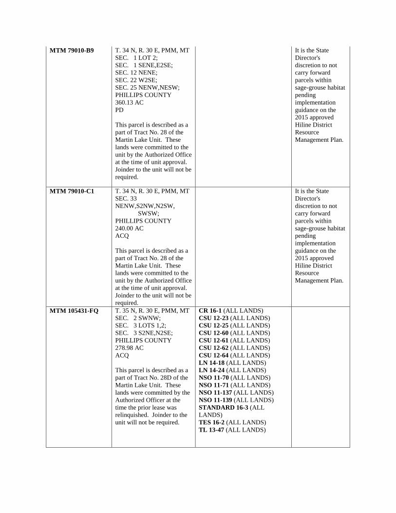
MTM 79010-B9 T. 34 N, R. 30 E, PMM, MT SEC. 1 LOT 2; SEC. 1 SENE,E2SE; SEC. 12 NENE; SEC. 22 W2SE; SEC. 25 NENW,NESW; PHILLIPS COUNTY 360.13 AC PD This parcel is described as a part of Tract No. 28 of the Martin Lake Unit. These lands were committed to the unit by the Authorized Office at the time of unit approval. Joinder to the unit will not be required.
It is the State Director's discretion to not carry forward parcels within sage-grouse habitat pending implementation guidance on the 2015 approved Hiline District Resource Management Plan.
MTM 79010-C1 T. 34 N, R. 30 E, PMM, MT SEC. 33 NENW,S2NW,N2SW, SWSW; PHILLIPS COUNTY 240.00 AC ACQ This parcel is described as a part of Tract No. 28 of the Martin Lake Unit. These lands were committed to the unit by the Authorized Office at the time of unit approval. Joinder to the unit will not be required.
It is the State Director's discretion to not carry forward parcels within sage-grouse habitat pending implementation guidance on the 2015 approved Hiline District Resource Management Plan.
MTM 105431-FQ T. 35 N, R. 30 E, PMM, MT SEC. 2 SWNW; SEC. 3 LOTS 1,2; SEC. 3 S2NE,N2SE; PHILLIPS COUNTY 278.98 AC ACQ This parcel is described as a part of Tract No. 28D of the Martin Lake Unit. These lands were committed by the Authorized Officer at the time the prior lease was relinquished. Joinder to the unit will not be required.
CR 16-1 (ALL LANDS) CSU 12-23 (ALL LANDS) CSU 12-25 (ALL LANDS) CSU 12-60 (ALL LANDS) CSU 12-61 (ALL LANDS) CSU 12-62 (ALL LANDS) CSU 12-64 (ALL LANDS) LN 14-18 (ALL LANDS) LN 14-24 (ALL LANDS) NSO 11-70 (ALL LANDS) NSO 11-71 (ALL LANDS) NSO 11-137 (ALL LANDS) NSO 11-139 (ALL LANDS) STANDARD 16-3 (ALL LANDS) TES 16-2 (ALL LANDS) TL 13-47 (ALL LANDS)

MTM 105431-FT T. 35 N, R. 30 E, PMM, MT SEC. 2 SW; SEC. 3 LOT 3; SEC. 3 S2SE; PHILLIPS COUNTY 279.38 AC PD This parcel is described as a part of Tract No. 25 of the Martin Lake Unit. These lands were committed by the Authorized Officer at the time the prior lease was relinquished. Joinder to the unit will not be required.
CR 16-1 (ALL LANDS) CSU 12-23 (ALL LANDS) CSU 12-25 (ALL LANDS) CSU 12-60 (ALL LANDS) CSU 12-61 (ALL LANDS) CSU 12-62 (ALL LANDS) CSU 12-64 (ALL LANDS) LN 14-18 (ALL LANDS) LN 14-24 (ALL LANDS) NSO 11-70 (ALL LANDS) NSO 11-71 (ALL LANDS) NSO 11-137 (ALL LANDS) NSO 11-139 (ALL LANDS) STANDARD 16-3 (ALL LANDS) TES 16-2 (ALL LANDS) TL 13-47 (ALL LANDS)
MTM 105431-FU T. 35 N, R. 30 E, PMM, MT SEC. 10 NE,NENW,S2NW,SW; PHILLIPS COUNTY 440.00 AC PD This parcel is described as a part of Tract No. 25 of the Martin Lake Unit. These lands were committed by the Authorized Officer at the time the prior lease was relinquished. Joinder to the unit will not be required.
CR 16-1 (ALL LANDS) CSU 12-23 (ALL LANDS) CSU 12-25 (ALL LANDS) CSU 12-60 (ALL LANDS) CSU 12-61 (ALL LANDS) CSU 12-62 (ALL LANDS) CSU 12-64 (ALL LANDS) LN 14-18 (ALL LANDS) LN 14-24 (ALL LANDS) NSO 11-70 (ALL LANDS) NSO 11-71 (ALL LANDS) NSO 11-137 (ALL LANDS) NSO 11-139 (ALL LANDS) STANDARD 16-3 (ALL LANDS) TES 16-2 (ALL LANDS) TL 13-47 (ALL LANDS)

MTM 105431-FV T. 35 N, R. 30 E, PMM, MT SEC. 11 N2,N2S2,S2SW,SWSE; SEC. 14 NESE; PHILLIPS COUNTY 640.00 AC PD This parcel is described as a part of Tract No. 25 of the Martin Lake Unit. These lands were committed by the Authorized Officer at the time the prior lease was relinquished. Joinder to the unit will not be required.
CR 16-1 (ALL LANDS) CSU 12-23 (ALL LANDS) CSU 12-25 (ALL LANDS) CSU 12-60 (ALL LANDS) CSU 12-61 (ALL LANDS) CSU 12-62 (ALL LANDS) CSU 12-64 (ALL LANDS) LN 14-18 (ALL LANDS) LN 14-24 (ALL LANDS) NSO 11-70 (ALL LANDS) NSO 11-71 (ALL LANDS) NSO 11-137 (ALL LANDS) NSO 11-139 (ALL LANDS) STANDARD 16-3 (ALL LANDS) TES 16-2 (ALL LANDS) TL 13-47 (ALL LANDS)
MTM 105431-FW T. 35 N, R. 30 E, PMM, MT SEC. 12 N2,NESW,SE; PHILLIPS COUNTY 520.00 AC PD This parcel is described as a part of Tract No. 25 of the Martin Lake Unit. These lands were committed by the Authorized Officer at the time the prior lease was relinquished. Joinder to the unit will not be required.
CR 16-1 (ALL LANDS) CSU 12-23 (ALL LANDS) CSU 12-25 (ALL LANDS) CSU 12-60 (ALL LANDS) CSU 12-61 (ALL LANDS) CSU 12-62 (ALL LANDS) CSU 12-64 (ALL LANDS) LN 14-18 (ALL LANDS) LN 14-24 (ALL LANDS) NSO 11-70 (ALL LANDS) NSO 11-71 (ALL LANDS) NSO 11-137 (ALL LANDS) NSO 11-139 (ALL LANDS) STANDARD 16-3 (ALL LANDS) TES 16-2 (ALL LANDS) TL 13-47 (ALL LANDS) TL 13-48 (ALL LANDS)

MTM 105431-FR T. 35 N, R. 30 E, PMM, MT SEC. 14 SWNE,S2NW; PHILLIPS COUNTY 120.00 AC ACQ This parcel is described as a part of Tract No. 26 of the Martin Lake Unit. These lands were committed by the Authorized Officer at the time the prior lease was relinquished. Joinder to the unit will not be required.
CR 16-1 (ALL LANDS) CSU 12-23 (ALL LANDS) CSU 12-25 (ALL LANDS) CSU 12-60 (ALL LANDS) CSU 12-61 (ALL LANDS) CSU 12-62 (ALL LANDS) CSU 12-64 (ALL LANDS) LN 14-18 (ALL LANDS) LN 14-24 (ALL LANDS) NSO 11-70 (ALL LANDS) NSO 11-71 (ALL LANDS) NSO 11-137 (ALL LANDS) NSO 11-139 (ALL LANDS) STANDARD 16-3 (ALL LANDS) TES 16-2 (ALL LANDS) TL 13-47 (ALL LANDS)
Glasgow Field Office PARCEL NUMBER
PARCEL DESCRIPTION PROPOSED STIPULATIONS FOR ENTIRE PARCEL IF LEASED
PROPOSED FOR DEFERRAL - NO LEASING
MTM 102757-QH T. 30 N, R. 37 E, PMM, MT SEC. 2 W2SE; SEC. 11 N2NE; VALLEY COUNTY 160.00 AC ACQ
CR 16-1 (ALL LANDS) CSU 12-23 (ALL LANDS) CSU 12-25 (ALL LANDS) CSU 12-60 (ALL LANDS) CSU 12-61 (ALL LANDS) CSU 12-64 (ALL LANDS) LN 14-18 (ALL LANDS) LN 14-24 (ALL LANDS) NSO 11-70 (ALL LANDS) NSO 11-71 (ALL LANDS) NSO 11-137 (ALL LANDS) NSO 11-139 (ALL LANDS) NSO 11-157 (ALL LANDS) STANDARD 16-3 (ALL LANDS) TES 16-2 (ALL LANDS) TL 13-45 (ALL LANDS) TL 13-46 (ALL LANDS) TL 13-47 (ALL LANDS) TL 13-48 (ALL LANDS)

MTM 102757-QJ T. 30 N, R. 37 E, PMM, MT SEC. 7 LOT 3; VALLEY COUNTY 6.33 AC PD
CR 16-1 (ALL LANDS) CSU 12-23 (ALL LANDS) CSU 12-25 (ALL LANDS) CSU 12-60 (ALL LANDS) CSU 12-61 (ALL LANDS) CSU 12-64 (ALL LANDS) LN 14-18 (ALL LANDS) LN 14-24 (ALL LANDS) NSO 11-70 (ALL LANDS) NSO 11-71 (ALL LANDS) NSO 11-137 (ALL LANDS) NSO 11-139 (ALL LANDS) NSO 11-150 (ALL LANDS) NSO 11-157 (ALL LANDS) STANDARD 16-3 (ALL LANDS) TES 16-2 (ALL LANDS) TL 13-42 (ALL LANDS) TL 13-45 (ALL LANDS) TL 13-46 (ALL LANDS) BOR 17-1 (ALL BOR LANDS) BOR 17-2 (ALL BOR LANDS)
MTM 102757-QK T. 30 N, R. 37 E, PMM, MT SEC. 9 LOT 3; VALLEY COUNTY 16.97 AC PD
CR 16-1 (ALL LANDS) CSU 12-23 (ALL LANDS) CSU 12-25 (ALL LANDS) CSU 12-60 (ALL LANDS) CSU 12-61 (ALL LANDS) CSU 12-64 (ALL LANDS) LN 14-18 (ALL LANDS) LN 14-24 (ALL LANDS) NSO 11-70 (ALL LANDS) NSO 11-71 (ALL LANDS) NSO 11-137 (ALL LANDS) NSO 11-139 (ALL LANDS) NSO 11-150 (ALL LANDS) NSO 11-157 (ALL LANDS) STANDARD 16-3 (ALL LANDS) TES 16-2 (ALL LANDS) TL 13-42 (ALL LANDS) TL 13-45 (ALL LANDS) TL 13-46 (ALL LANDS)

MTM 102757-QL T. 30 N, R. 37 E, PMM, MT SEC. 14 LOTS 6,9; SEC. 23 LOTS 3,9; VALLEY COUNTY 90.51 AC PD
CR 16-1 (ALL LANDS) CSU 12-23 (ALL LANDS) CSU 12-25 (ALL LANDS) CSU 12-60 (ALL LANDS) CSU 12-61 (ALL LANDS) CSU 12-64 (ALL LANDS) LN 14-18 (ALL LANDS) LN 14-24 (ALL LANDS) NSO 11-70 (ALL LANDS) NSO 11-71 (ALL LANDS) NSO 11-137 (ALL LANDS) NSO 11-139 (ALL LANDS) NSO 11-150 (ALL LANDS) NSO 11-157 (ALL LANDS) STANDARD 16-3 (ALL LANDS) TES 16-2 (ALL LANDS) TL 13-42 (ALL LANDS) TL 13-45 (ALL LANDS) TL 13-46 (ALL LANDS)
MTM 102757-QM T. 30 N, R. 37 E, PMM, MT SEC. 15 LOTS 4,11; SEC. 15 SWSW; VALLEY COUNTY 74.11 AC PD
CR 16-1 (ALL LANDS) CSU 12-23 (ALL LANDS) CSU 12-25 (ALL LANDS) CSU 12-60 (ALL LANDS) CSU 12-61 (ALL LANDS) CSU 12-64 (ALL LANDS) LN 14-18 (ALL LANDS) LN 14-24 (ALL LANDS) NSO 11-70 (ALL LANDS) NSO 11-71 (ALL LANDS) NSO 11-137 (ALL LANDS) NSO 11-139 (ALL LANDS) NSO 11-150 (ALL LANDS) NSO 11-157 (ALL LANDS) STANDARD 16-3 (ALL LANDS) TES 16-2 (ALL LANDS) TL 13-42 (ALL LANDS) TL 13-45 (ALL LANDS) TL 13-46 (ALL LANDS)

MTM 102757-QN T. 30 N, R. 37 E, PMM, MT SEC. 19 LOT 1; SEC. 19 N2NE,NENW; VALLEY COUNTY 158.48 AC PD
CR 16-1 (ALL LANDS) CSU 12-23 (ALL LANDS) CSU 12-24 (ALL LANDS) CSU 12-60 (ALL LANDS) CSU 12-61 (ALL LANDS) CSU 12-62 (ALL LANDS) CSU 12-64 (ALL LANDS) LN 14-18 (ALL LANDS) LN 14-24 (ALL LANDS) NSO 11-70 (ALL LANDS) NSO 11-71 (ALL LANDS) NSO 11-137 (ALL LANDS) NSO 11-139 (ALL LANDS) NSO 11-157 (ALL LANDS) STANDARD 16-3 (ALL LANDS) TES 16-2 (ALL LANDS) TL 13-45 (ALL LANDS) TL 13-46 (ALL LANDS) TL 13-48 (ALL LANDS)
MTM 102757-QQ T. 30 N, R. 37 E, PMM, MT SEC. 24 LOTS 6,7; SEC. 24 SESW; VALLEY COUNTY 86.30 AC PD
CR 16-1 (ALL LANDS) CSU 12-23 (ALL LANDS) CSU 12-25 (ALL LANDS) CSU 12-60 (ALL LANDS) CSU 12-61 (ALL LANDS) CSU 12-64 (ALL LANDS) LN 14-18 (ALL LANDS) LN 14-24 (ALL LANDS) NSO 11-70 (ALL LANDS) NSO 11-71 (ALL LANDS) NSO 11-137 (ALL LANDS) NSO 11-139 (ALL LANDS) NSO 11-150 (ALL LANDS) NSO 11-157 (ALL LANDS) STANDARD 16-3 (ALL LANDS) TES 16-2 (ALL LANDS) TL 13-42 (ALL LANDS) TL 13-45 (ALL LANDS) TL 13-46 (ALL LANDS) BOR 17-1 (ALL BOR LANDS) BOR 17-2 (ALL BOR LANDS)

MTM 79010-7K T. 30 N, R. 37 E, PMM, MT SEC. 30 LOT 1; SEC. 30 NENW; SEC. 31 LOTS 2,3,4; SEC. 31 NENE,SWNE,SENW, E2SW,SE; VALLEY COUNTY 542.88 AC PD
It is the State Director's discretion to not carry forward parcels within sage-grouse habitat pending implementation guidance on the 2015 approved Hiline District Resource Management Plan.
MTM 102757-J7 T. 31 N, R. 37 E, PMM, MT SEC. 5 LOT 1; VALLEY COUNTY 39.60 AC PD
CR 16-1 (ALL LANDS) CSU 12-23 (ALL LANDS) CSU 12-25 (ALL LANDS) CSU 12-60 (ALL LANDS) CSU 12-61 (ALL LANDS) CSU 12-64 (ALL LANDS) LN 14-18 (ALL LANDS) LN 14-24 (ALL LANDS) NSO 11-70 (ALL LANDS) NSO 11-71 (ALL LANDS) NSO 11-137 (ALL LANDS) NSO 11-139 (ALL LANDS) NSO 11-157 (ALL LANDS) STANDARD 16-3 (ALL LANDS) TES 16-2 (ALL LANDS) TL 13-45 (ALL LANDS) TL 13-46 (ALL LANDS) TL 13-47 (ALL LANDS) TL 13-48 (ALL LANDS)

MTM 102757-J8 T. 31 N, R. 37 E, PMM, MT SEC. 13 W2SE; VALLEY COUNTY 80.00 AC PD
CR 16-1 (ALL LANDS) CSU 12-23 (ALL LANDS) CSU 12-25 (ALL LANDS) CSU 12-60 (ALL LANDS) CSU 12-61 (ALL LANDS) CSU 12-62 (ALL LANDS) CSU 12-64 (ALL LANDS) LN 14-18 (ALL LANDS) LN 14-24 (ALL LANDS) NSO 11-70 (ALL LANDS) NSO 11-71 (ALL LANDS) NSO 11-137 (ALL LANDS) NSO 11-139 (ALL LANDS) NSO 11-157 (ALL LANDS) NSO 11-158 (ALL LANDS) STANDARD 16-3 (ALL LANDS) TES 16-2 (ALL LANDS) TL 13-45 (ALL LANDS) TL 13-46 (ALL LANDS) TL 13-47 (ALL LANDS) TL 13-48 (ALL LANDS)
MTM 102757-J9 T. 31 N, R. 37 E, PMM, MTS EC. 19 W2SE; VALLEY COUNTY 80.00 AC PD
CR 16-1 (ALL LANDS) CSU 12-23 (ALL LANDS) CSU 12-25 (ALL LANDS) CSU 12-62 (ALL LANDS) CSU 12-60 (ALL LANDS) CSU 12-61 (ALL LANDS) CSU 12-64 (ALL LANDS) LN 14-18 (ALL LANDS) LN 14-24 (ALL LANDS) NSO 11-70 (ALL LANDS) NSO 11-71 (ALL LANDS) NSO 11-137 (ALL LANDS) NSO 11-139 (ALL LANDS) NSO 11-157 (ALL LANDS) STANDARD 16-3 (ALL LANDS) TES 16-2 (ALL LANDS) TL 13-45 (ALL LANDS) TL 13-46 (ALL LANDS) TL 13-48 (ALL LANDS)

MTM 102757-KA T. 31 N, R. 37 E, PMM, MT SEC. 20 SWNE; VALLEY COUNTY 40.00 AC PD
CR 16-1 (ALL LANDS) CSU 12-23 (ALL LANDS) CSU 12-60 (ALL LANDS) CSU 12-61 (ALL LANDS) CSU 12-64 (ALL LANDS) LN 14-18 (ALL LANDS) LN 14-24 (ALL LANDS) NSO 11-71 (ALL LANDS) NSO 11-137 (ALL LANDS) NSO 11-139 (ALL LANDS) NSO 11-157 (ALL LANDS) STANDARD 16-3 (ALL LANDS) TES 16-2 (ALL LANDS) TL 13-45 (ALL LANDS) TL 13-46 (ALL LANDS) TL 13-48 (ALL LANDS)
MTM 102757-KB T. 31 N, R. 37 E, PMM, MT SEC. 23 W2SW; VALLEY COUNTY 80.00 AC PD
CR 16-1 (ALL LANDS) CSU 12-23 (ALL LANDS) CSU 12-60 (ALL LANDS) CSU 12-61 (ALL LANDS) CSU 12-64 (ALL LANDS) LN 14-18 (ALL LANDS) LN 14-24 (ALL LANDS) NSO 11-71 (ALL LANDS) NSO 11-137 (ALL LANDS) NSO 11-139 (ALL LANDS) NSO 11-157 (ALL LANDS) STANDARD 16-3 (ALL LANDS) TES 16-2 (ALL LANDS) TL 13-45 (ALL LANDS) TL 13-46 (ALL LANDS) TL-13-48 (ALL LANDS)

MTM 102757-KC T. 31 N, R. 37 E, PMM, MT SEC. 24 W2NW; VALLEY COUNTY 80.00 AC ACQ
CR 16-1 (ALL LANDS) CSU 12-23 (ALL LANDS) CSU 12-25 (ALL LANDS) CSU 12-60 (ALL LANDS) CSU 12-61 (ALL LANDS) CSU 12-64 (ALL LANDS) LN 14-18 (ALL LANDS) LN 14-24 (ALL LANDS) NSO 11-70 (ALL LANDS) NSO 11-71 (ALL LANDS) NSO 11-137 (ALL LANDS) NSO 11-139 (ALL LANDS) NSO 11-157 (ALL LANDS) NSO 11-158 (ALL LANDS) STANDARD 16-3 (ALL LANDS) TES 16-2 (ALL LANDS) TL 13-45 (ALL LANDS) TL 13-46 (ALL LANDS) TL 13-47 (ALL LANDS) TL 13-48 (ALL LANDS)
MTM 102757-KE T. 31 N, R. 37 E, PMM, MT SEC. 29 SENW; VALLEY COUNTY 40.00 AC PD
CR 16-1 (ALL LANDS) CSU 12-23 (ALL LANDS) CSU 12-25 (ALL LANDS) CSU 12-60 (ALL LANDS) CSU 12-61 (ALL LANDS) CSU 12-62 (ALL LANDS) CSU 12-64 (ALL LANDS) LN 14-18 (ALL LANDS) LN 14-24 (ALL LANDS) NSO 11-70 (ALL LANDS) NSO 11-71 (ALL LANDS) NSO 11-137 (ALL LANDS) NSO 11-139 (ALL LANDS) NSO 11-157 (ALL LANDS) STANDARD 16-3 (ALL LANDS) TES 16-2 (ALL LANDS) TL 13-45 (ALL LANDS) TL 13-46 (ALL LANDS) TL 13-47 (ALL LANDS) TL 13-48 (ALL LANDS)
MTM 102757-GL T. 32 N, R. 37 E, PMM, MT SEC. 5 SESW; SEC. 7 E2NE,NESW,NESE; SEC. 8 NW,N2SW,SESW; VALLEY COUNTY 480.00 AC ACQ
It is the State Director's discretion to not carry forward parcels within sage-grouse habitat pending implementation guidance on the 2015 approved

Hiline District Resource Management Plan.
MTM 102757-GV T. 32 N, R. 37 E, PMM, MT SEC. 17 SW; SEC. 18 LOTS 1,2; SEC. 18 E2,E2NW; VALLEY COUNTY 627.67 AC ACQ
It is the State Director's discretion to not carry forward parcels within sage-grouse habitat pending implementation guidance on the 2015 approved Hiline District Resource Management Plan.
MTM 105431-Q3 T. 32 N, R. 37 E, PMM, MT SEC. 18 LOTS 3,4; SEC. 18 E2SW; SEC. 19 LOTS 1,2; SEC. 19 NE,NENW; SEC. 20 NW; VALLEY COUNTY 575.05 AC ACQ
CR 16-1 (ALL LANDS) CSU 12-23 (ALL LANDS) CSU 12-25 (ALL LANDS) CSU 12-60 (ALL LANDS) CSU 12-61 (ALL LANDS) CSU 12-64 (ALL LANDS) LN 14-18 (ALL LANDS) LN 14-24 (ALL LANDS) NSO 11-70 (ALL LANDS) NSO 11-71 (ALL LANDS) NSO 11-137 (ALL LANDS) NSO 11-139 (ALL LANDS) NSO 11-157 (ALL LANDS) STANDARD 16-3 (ALL LANDS) TES 16-2 (ALL LANDS) TL 13-45 (ALL LANDS) TL 13-46 (ALL LANDS) TL 13-47 (ALL LANDS) TL 13-48 (ALL LANDS)

MTM 102757-GW T. 32 N, R. 37 E, PMM, MT SEC. 19 SENW; SEC. 20 SWSE; SEC. 21 N2NE,NESW,S2SW; SEC. 27 NWNW,S2N2; SEC. 28 S2N2; SEC. 29 SESW; VALLEY COUNTY 680.00 AC PD
CR 16-1 (ALL LANDS) CSU 12-23 (ALL LANDS) CSU 12-25 (ALL LANDS) CSU 12-60 (ALL LANDS) CSU 12-61 (ALL LANDS) CSU 12-62 (ALL LANDS) CSU 12-64 (ALL LANDS) LN 14-18 (ALL LANDS) LN 14-24 (ALL LANDS) NSO 11-70 (ALL LANDS) NSO 11-71 (ALL LANDS) NSO 11-137 (ALL LANDS) NSO 11-139 (ALL LANDS) NSO 11-157 (ALL LANDS) STANDARD 16-3 (ALL LANDS) TES 16-2 (ALL LANDS) TL 13-45 (ALL LANDS) TL 11-46 (ALL LANDS) TL 13-47 (ALL LANDS) TL 13-48 (ALL LANDS)
MTM 102757-G3 T. 32 N, R. 37 E, PMM, MT SEC. 27 SW; SEC. 28 E2SE; SEC. 33 NENE; SEC. 34 NWNW; VALLEY COUNTY 320.00 AC ACQ
It is the State Director's discretion to not carry forward parcels within sage-grouse habitat pending implementation guidance on the 2015 approved Hiline District Resource Management Plan.

MTM 102757-G4 T. 32 N, R. 37 E, PMM, MT SEC. 29 NW; VALLEY COUNTY 160.00 AC ACQ
CR 16-1 (ALL LANDS) CSU 12-23 (ALL LANDS) CSU 12-25 (ALL LANDS) CSU 12-60 (ALL LANDS) CSU 12-61 (ALL LANDS) CSU 12-64 (ALL LANDS) LN 14-18 (ALL LANDS) LN 14-24 (ALL LANDS) NSO 11-70 (ALL LANDS) NSO 11-71 (ALL LANDS) NSO 11-137 (ALL LANDS) NSO 11-139 (ALL LANDS) NSO 11-157 (ALL LANDS) STANDARD 16-3 (ALL LANDS) TES 16-2 (ALL LANDS) TL 13-45 (ALL LANDS) TL 13-46 (ALL LANDS) TL 13-47 (ALL LANDS) TL 13-48 (ALL LANDS)
MTM 102757-G6 T. 32 N, R. 37 E, PMM, MT SEC. 31 LOTS 1,2; SEC. 31 NE,E2NW; SEC. 32 W2; VALLEY COUNTY 627.03 AC ACQ
CR 16-1 (ALL LANDS) CSU 12-23 (ALL LANDS) CSU 12-25 (ALL LANDS) CSU 12-60 (ALL LANDS) CSU 12-61 (ALL LANDS) CSU 12-64 (ALL LANDS) LN 14-18 (ALL LANDS) LN 14-24 (ALL LANDS) NSO 11-70 (ALL LANDS) NSO 11-71 (ALL LANDS) NSO 11-137 (ALL LANDS) NSO 11-139 (ALL LANDS) NSO 11-157 (ALL LANDS) STANDARD 16-3 (ALL LANDS) TES 16-2 (ALL LANDS) TL 13-45 (ALL LANDS) TL 13-46 (ALL LANDS) TL 13-47 (ALL LANDS) TL 13-48 (ALL LANDS)
MTM 102757-G7 T. 32 N, R. 37 E, PMM, MT SEC. 33 SENE,NESE,S2SE; SEC. 34 E2NE,SWNW,SESW; VALLEY COUNTY 320.00 AC PD
It is the State Director's discretion to not carry forward parcels within sage-grouse habitat pending implementation guidance on the 2015 approved Hiline District Resource

Management Plan.
MTM 79010-ZT T. 30 N, R. 38 E, PMM, MT SEC. 2 LOT 4; SEC. 3 LOT 4; SEC. 3 SWNW,SESE; SEC. 10 SESE; SEC. 15 S2NW; SEC. 19 LOT 6; VALLEY COUNTY 300.55 AC PD
CR 16-1 (ALL LANDS) CSU 12-23 (ALL LANDS) CSU 12-25 (ALL LANDS) CSU 12-60 (ALL LANDS) CSU 12-61 (ALL LANDS) CSU 12-62 (ALL LANDS) CSU 12-64 (ALL LANDS) LN 14-18 (ALL LANDS) LN 14-24 (ALL LANDS) NSO 11-70 (ALL LANDS) NSO 11-71 (ALL LANDS) NSO 11-137 (ALL LANDS) NSO 11-139 (ALL LANDS) NSO 11-157 (ALL LANDS) STANDARD 16-3 (ALL LANDS) TES 16-2 (ALL LANDS) TL 13-45 (ALL LANDS) TL-13-46 (ALL LANDS) TL 13-47 (ALL LANDS) TL 13-48 (ALL LANDS) BOR 17-1 (ALL BOR LANDS) BOR 17-2 (ALL BOR LANDS)
MTM 102757-QU T. 30 N, R. 38 E, PMM, MT SEC. 4 LOTS 3,4; VALLEY COUNTY 79.17 AC PD
CR 16-1 (ALL LANDS) CSU 12-23 (ALL LANDS) CSU 12-25 (ALL LANDS) CSU 12-60 (ALL LANDS) CSU 12-61 (ALL LANDS) CSU 12-62 (ALL LANDS) CSU 12-64 (ALL LANDS) LN 14-18 (ALL LANDS) LN 14-24 (ALL LANDS) NSO 11-70 (ALL LANDS) NSO 11-71 (ALL LANDS) NSO 11-137 (ALL LANDS) NSO 11-139 (ALL LANDS) NSO 11-157 (ALL LANDS) STANDARD 16-3 (ALL LANDS) TES 16-2 (ALL LANDS) TL 13-45 (ALL LANDS) TL 13-46 (ALL LANDS) TL 13-47 (ALL LANDS) TL 13-48 (ALL LANDS)

MTM 79010-ZR T. 30 N, R. 38 E, PMM, MT SEC. 4 S2NW,N2SW; SEC. 9 S2NW,SW,W2SE; VALLEY COUNTY 480.00 AC ACQ
CR 16-1 (ALL LANDS) CSU 12-23 (ALL LANDS) CSU 12-25 (ALL LANDS) CSU 12-60 (ALL LANDS) CSU 12-61 (ALL LANDS) CSU 12-62 (ALL LANDS) CSU 12-64 (ALL LANDS) LN 14-18 (ALL LANDS) LN 14-24 (ALL LANDS) NSO 11-70 (ALL LANDS) NSO 11-71 (ALL LANDS) NSO 11-137 (ALL LANDS) NSO 11-139 (ALL LANDS) NSO 11-157 (ALL LANDS) STANDARD 16-3 (ALL LANDS) TES 16-2 (ALL LANDS) TL 13-45 (ALL LANDS) TL 13-46 (ALL LANDS) TL 13-47 (ALL LANDS) TL 13-48 (ALL LANDS)
MTM 79010-ZS T. 30 N, R. 38 E, PMM, MT SEC. 15 S2; VALLEY COUNTY 320.00 AC ACQ
CR 16-1 (ALL LANDS) CSU 12-23 (ALL LANDS) CSU 12-25 (ALL LANDS) CSU 12-60 (ALL LANDS) CSU 12-61 (ALL LANDS) CSU 12-62 (ALL LANDS) CSU 12-64 (ALL LANDS) LN 14-18 (ALL LANDS) LN 14-24 (ALL LANDS) NSO 11-70 (ALL LANDS) NSO 11-71 (ALL LANDS) NSO 11-137 (ALL LANDS) NSO 11-139 (ALL LANDS) NSO 11-157 (ALL LANDS) STANDARD 16-3 (ALL LANDS) TES 16-2 (ALL LANDS) TL 13-45 (ALL LANDS) TL 13-46 (ALL LANDS) TL 13-47 (ALL LANDS) TL 13-48 (ALL LANDS)

MTM 79010-7J T. 30 N, R. 38 E, PMM, MT SEC. 27 E2; SEC. 34 N2NE; SEC. 35 NWNW; VALLEY COUNTY 440.00 AC ACQ
CR 16-1 (ALL LANDS) CSU 12-23 (ALL LANDS) CSU 12-25 (ALL LANDS) CSU 12-60 (ALL LANDS) CSU 12-61 (ALL LANDS) CSU 12-62 (ALL LANDS) CSU 12-64 (ALL LANDS) LN 14-18 (ALL LANDS) LN 14-24 (ALL LANDS) NSO 11-70 (ALL LANDS) NSO 11-71 (ALL LANDS) NSO 11-137 (ALL LANDS) NSO 11-139 (ALL LANDS) NSO 11-157 (ALL LANDS) NSO 11-158 (ALL LANDS) STANDARD 16-3 (ALL LANDS) TES 16-2 (ALL LANDS) TL 13-45 (ALL LANDS) TL 13-46 (ALL LANDS) TL 13-47 (ALL LANDS)
MTM 102757-RF T. 30 N, R. 39 E, PMM, MT SEC. 22 SW; SEC. 27 SW; VALLEY COUNTY 320.00 AC ACQ
It is the State Director's discretion to not carry forward parcels within sage-grouse habitat pending implementation guidance on the 2015 approved Hiline District Resource Management Plan.
MTM 102757-RG T. 30 N, R. 39 E, PMM, MT SEC. 24 E2,W2NW,NWSW, S2SW; SEC. 25 ALL; SEC. 26 E2NE; VALLEY COUNTY 1240.00 AC ACQ
It is the State Director's discretion to not carry forward parcels within sage-grouse habitat pending implementation guidance on the 2015 approved Hiline District Resource Management Plan.

MTM 105431-QY T. 30 N, R. 39 E, PMM, MT SEC. 24 E2NW,NESW; VALLEY COUNTY 120.00 AC ACQ
It is the State Director's discretion to not carry forward parcels within sage-grouse habitat pending implementation guidance on the 2015 approved Hiline District Resource Management Plan.
MTM 105431-QX T. 30 N, R. 39 E, PMM, MT SEC. 27 NW; VALLEY COUNTY 160.00 AC ACQ
It is the State Director's discretion to not carry forward parcels within sage-grouse habitat pending implementation guidance on the 2015 approved Hiline District Resource Management Plan.
MTM 102757-RJ T. 30 N, R. 39 E, PMM, MT SEC. 28 S2; SEC. 29 S2; VALLEY COUNTY 640.00 AC ACQ
It is the State Director's discretion to not carry forward parcels within sage-grouse habitat pending implementation guidance on the 2015 approved Hiline District Resource Management Plan.
MTM 102757-RL T. 30 N, R. 39 E, PMM, MT SEC. 32 ALL; SEC. 33 NW,S2; VALLEY COUNTY 1120.00 AC ACQ
It is the State Director's discretion to not carry forward parcels within sage-grouse habitat pending implementation guidance on the 2015 approved Hiline District Resource Management Plan.

MTM 102757-RM T. 30 N, R. 39 E, PMM, MT SEC. 35 SW,SWSE; VALLEY COUNTY 200.00 AC ACQ
CR 16-1 (ALL LANDS) CSU 12-23 (ALL LANDS) CSU 12-25 (ALL LANDS) CSU 12-60 (ALL LANDS) CSU 12-61 (ALL LANDS) CSU 12-64 (ALL LANDS) LN 14-18 (ALL LANDS) LN 14-24 (ALL LANDS) NSO 11-70 (ALL LANDS) NSO 11-71 (ALL LANDS) NSO 11-137 (ALL LANDS) NSO 11-139 (ALL LANDS) NSO 11-157 (ALL LANDS) STANDARD 16-3 (ALL LANDS) TES 16-2 (ALL LANDS) TL 13-45 (ALL LANDS) TL 13-46 (ALL LANDS) TL 13-47 (ALL LANDS)
MTM 102757-6K T. 34 N, R. 40 E, PMM, MT SEC. 4 S2SW; SEC. 9 NW,N2SW; VALLEY COUNTY 320.00 AC ACQ
CR 16-1 (ALL LANDS) CSU 12-23 (ALL LANDS) CSU 12-25 (ALL LANDS) CSU 12-60 (ALL LANDS) CSU 12-61 (ALL LANDS) CSU 12-62 (ALL LANDS) CSU 12-64 (ALL LANDS) LN 14-18 (ALL LANDS) LN 14-24 (ALL LANDS) NSO 11-70 (ALL LANDS) NSO 11-71 (ALL LANDS) NSO 11-137 (ALL LANDS) NSO 11-139 (ALL LANDS) NSO 11-157 (ALL LANDS) STANDARD 16-3 (ALL LANDS) TES 16-2 (ALL LANDS) TL 13-45 (ALL LANDS) TL 13-46 (ALL LANDS) TL 13-47 (ALL LANDS) TL 13-48 (ALL LANDS)

Appendix B. Lease Stipulation Key Stipulation Number
Stipulation Name/Brief Description
Bureau of Land Management
CR 16-1 CULTURAL RESOURCES LEASE STIPULATION
This lease may be found to contain historic properties and/or resources protected under the National Historic Preservation Act (NHPA), American Indian Religious Freedom Act, Native American Graves Protection and Repatriation Act, E.O. 13007, or other statutes and executive orders. The BLM will not approve any ground disturbing activities that may affect any such properties or resources until it completes its obligations under applicable requirements of the NHPA and other authorities. The BLM may require modification to exploration or development proposals to protect such properties, or disapprove any activity that is likely to result in adverse effects that cannot be successfully avoided, minimized or mitigated."
CSU 12-23 AIR RESOURCES
Surface occupancy and use is subject to the requirement that each diesel-fueled non-road engine with greater than 200 horsepower design rating to be used during drilling or completion activities meets one of the following two criteria: (1) the engine was manufactured to meet USEPA NOx emission standards for Tier 4 non-road diesel engines, or (2) the engine emits NOx at rates less than or equal to USEPA emission standards for Tier 4 non-road diesel engines.
CSU 12-25 RIPARIAN,WETLANDS
Surface occupancy and use is subject to the following operating constraints: prior to surface occupancy and use within 300 feet of riparian and/or wetland areas, a plan must be approved by the AO with design features that demonstrate how all actions would maintain and/or improve the functionality of riparian/wetland areas. The plan would address:
• potential impacts to riparian and wetland resources,

Stipulation Number
Stipulation Name/Brief Description
• mitigation to reduce impacts to acceptable levels (including timing restrictions),
• post-project restoration, • monitoring (the operator must conduct monitoring capable of
detecting early signs of changing riparian and/or wetland conditions).
CSU 12-60 CULTURAL RESOURCE SURVEY
An inventory of those portions of the leased lands subject to proposed disturbance may
be required prior to any surface disturbance to determine if cultural resources are present and to identify needed mitigation measures. Prior to undertaking any surface-disturbing activities on the lands covered by this lease, the lessee or operator shall:
1. Engage the services of a cultural resource consultant acceptable to the Surface Management Agency (SMA) to conduct a cultural resource inventory of the area of proposed surface disturbance. The operator may elect to inventory an area larger than the standard ten-acre minimum to cover possible site relocation which may result from environmental or other considerations. An acceptable inventory report is to be submitted to the SMA for review and approval no later than that time when an otherwise complete application for approval of drilling or subsequent surface-disturbing operation is submitted.
2. Implement mitigation measures required by the SMA. Mitigation may include the relocation of proposed lease-related activities or other protective measures such as data recovery and extensive recordation. Where impacts to cultural resources cannot be mitigated to the satisfaction of the SMA, surface occupancy on that area must be prohibited. The lessee or operator shall immediately bring to the attention of the SMA any cultural resources discovered as a result of approved operations under this lease, and shall not disturb such discoveries until directed to proceed by the SMA.
CSU 12-61 PALEONTOLOGICALRESOURCEINVENTORY
Prior to any surface-disturbing activity in areas known to have a high

Stipulation Number
Stipulation Name/Brief Description
potential (Class 4 and 5) for containing significant paleontological resources, the lessee shall be required to conduct a paleontological inventory. The lessee must engage the services of a qualified paleontologist, acceptable to the surface management agency (SMA), to conduct the inventory. An acceptable inventory report is to be submitted to the SMA for review and approval at the time a surface-disturbing plan of operations is submitted.
CSU 12-62 SOILS – SENSITIVE SOILS Surface occupancy and use will be controlled on sensitive soils. Sensitive soils are determined using a combination of slope and soil erodibility. Prior to surface disturbance on sensitive soils, a reclamation plan must be approved by the AO. The plan must demonstrate the following: (1) no other practicable alternatives exist for relocating the activity, (2) the activity will be located to reduce impacts to soil and water resources, (3) site productivity will be maintained or restored, (4) surface runoff and sedimentation will be adequately controlled, (5) on- and off-site areas will be protected from accelerated erosion, (6) that no areas susceptible to mass wasting would be disturbed and (7) surface-disturbing activities will be prohibited during extended wet periods.
CSU 12-64 VISUALRESOURCES In order to retain the existing character of the landscape (VRM Class II Objective), oil and gas development activities will be located, designed, constructed, operated, and reclaimed so that activities should not attract attention to the casual observer within 2 years from initiation of construction. This stipulation does not apply to the operation and maintenance activities.
LN 14-18 AIR RESOURCE ANALYSIS The lessee/operator is given notice that prior to project-specific approval, additional air resource analyses may be required in order to comply with the NEPA, FLPMA, and/or other applicable laws and regulations. Analyses may include equipment and operations information, emission inventory development, dispersion modeling or photochemical grid modeling for air quality and/or air quality related value impact analysis, and/or emission control determinations. These analyses may result in the imposition of additional project-specific control measures to protect air resources.

Stipulation Number
Stipulation Name/Brief Description
LN 14-24 CULTURAL RESOURCES AND TRIBAL CONSULATION This lease may be found to contain historic properties or resources protected under NHPA, the American Indian Religious Freedom Act (42 U.S.C. 1996), Native American Graves Protection and Repatriation Act (25 U.S.C. 3001 et seq.), Executive Order 13007 (May 24, 1996), or other statutes and executive orders. The BLM will not approve any ground-disturbing activities that may affect any such properties or resources until it completes its obligations (e.g., state historic preservation officer and tribal consultation) under applicable requirements of the NHPA and other authorities. The BLM may require modification to exploration or development proposals to protect such properties, or disapprove any activity that is likely to result in adverse effects that cannot be successfully avoided, minimized, or mitigated.
NSO 11-69 BADLANDS,ROCK OUTCROP Surface occupancy and use is prohibited on badlands and rock outcrop.
NSO 11-70 STREAMS,WATERBODIES, RIPARIAN,WETLAND, AND FLOODPLAINS Surface occupancy and use is prohibited within perennial or intermittent streams, lakes, ponds, reservoirs, 100-year floodplains, wetlands, and riparian areas.
NSO 11-71
SOURCEWATER PROTECTION AREAS Surface occupancy and use is prohibited within State-designated Source Water Protection Areas.
NSO 11-137 NATIONAL REGISTER OF HISTORIC PLACES (NRHP) ELIGIBLE PROPERTIES/DISTRICTS Occupancy and use is prohibited within the boundaries of cultural properties and archaeological/ historic districts determined to be eligible or potentially eligible to the National Register of Historic Places.
NSO 11-139 PALEONTOLOGICAL RESOURCES Surface occupancy and use is prohibited within designated paleontological sites/locales.
NSO 11-144 KEVIN RIM ACEC Surface occupancy and use is prohibited within the Kevin Rim ACEC.
NSO 11-150 COLONIALWATERBIRDS Surface occupancy and use is prohibited within 1/4 mile of a waterbird nesting colony.
NSO 11-157 RAPTORS Surface occupancy and use is prohibited within 1/4 mile of raptor nest

Stipulation Number
Stipulation Name/Brief Description
sites that were active within the past 7 years. NSO 11-158 SHARP-TAILEDGROUSE LEKS
Surface occupancy and use is prohibited within 1/4 mile of sharp-tailed grouse leks.
Standard 16-3 STANDARD LEASE STIPULATION
ESTHETICS--To maintain esthetic values, all surface-disturbing activities, semipermanent and permanent facilities may require special design including location, painting and camouflage to blend with the natural surroundings and meet the intent of the visual quality objectives of the Federal Surface Managing Agency (SMA).
EROSION CONTROL--Surface-disturbing activities may be prohibited during muddy and/or wet soil periods.
CONTROLLED OR LIMITED SURFACE USE STIPULATION --This stipulation may be modified, consistent with land use documents, when specifically approved in writing by the Bureau of Land Management (BLM) with concurrence of the SMA. Distances and/or time periods may be made less restrictive depending on the actual on ground conditions. The prospective lessee should contact the SMA for more specific locations and information regarding the restrictive nature of this stipulation.
The lessee/operator is given notice that the lands within this lease may include special areas and that such areas may contain special values, may be needed for special purposes, or may require special attention to prevent damage to surface and/or other resources. Possible special areas are identified below. Any surface use or occupancy within such special areas will be strictly controlled, or if absolutely necessary, excluded. Use or occupancy will be restricted only when the BLM and/or the SMA demonstrates the restriction necessary for the protection of such special areas and existing or planned uses. Appropriate modifications to imposed restrictions will be made for the maintenance and operations of producing oil and gas wells.
After the SMA has been advised of specific proposed surface use or occupancy on the leased lands, and on request of the lessee/operator, the Agency will furnish further data on any special areas which may

Stipulation Number
Stipulation Name/Brief Description
include:
• 100 feet from the edge of the rights-of-way from highways, designated county roads and appropriate federally-owned or controlled roads and recreation trails.
• 500 feet, or when necessary, within the 25-year flood plain from reservoirs, lakes, and ponds and intermittent, ephemeral or small perennial streams: 1,000 feet, or when necessary, within the 100-year flood plain from larger perennial streams, rivers, and domestic water supplies.
• 500 feet from grouse strutting grounds. Special care to avoid nesting areas associated with strutting grounds will be necessary during the period from March 1, to June 30. One-fourth mile from identified essential habitat of state and federal sensitive species. Crucial wildlife winter ranges during the period from December 1 to May 15, and in elk calving areas during the period from May 1 to June 30.
• 300 feet from occupied buildings, developed recreational areas, undeveloped recreational areas receiving concentrated public use and sites eligible for or designated as National Register sites.
• Seasonal road closures, roads for special uses, specified roads during heavy traffic periods and on areas having restrictive off-road vehicle designations.
• On slopes over 30 percent or 20 percent on extremely erodible or slumping soils.
APPLICATIONS FOR PERMIT TO DRILL (APDs)--The appropriate BLM field offices are responsible for the receipt, processing, and approval of APDs. The APDs are to be submitted by oil and gas operators pursuant to the requirements found in Onshore Oil and Gas Order No. 1 -- Approval of Operations on Onshore Federal and Indian Oil and Gas Leases (Circular No. 2538). Additional requirements for the conduct of oil and gas operations can be found in the Code of Federal Regulations Title 43, Part 3160. Copies of Onshore Oil and Gas Order No. 1, and pertinent regulations, can be obtained from the BLM field offices in which the operations are proposed. Early coordination with these offices on proposals is encouraged.
CULTURAL AND PALEONTOLOGICAL RESOURCES--The SMA is responsible for assuring that the leased lands are examined to

Stipulation Number
Stipulation Name/Brief Description
determine if cultural resources are present and to specify mitigation measures. Prior to undertaking any surface-disturbing activities on the lands covered by this lease, the lessee or operator, unless notified to the contrary by the SMA, shall:
• Contact the appropriate SMA to determine if a site-specific cultural resource inventory is required. If an inventory is required, then:
• Engage the services of a cultural resource specialist acceptable to the SMA to conduct a cultural resource inventory of the area of proposed surface disturbance. The operator may elect to inventory an area larger than the area of proposed disturbance to cover possible site relocation which may result from environmental or other considerations. An acceptable inventory report is to be submitted to the SMA for review and approval no later than that time when an otherwise complete application for approval of drilling or subsequent surface-disturbing operation is submitted.
• Implement mitigation measures required by the SMA. Mitigation may include the relocation of proposed lease-related activities or other protective measures such as testing salvage and recordation. Where impacts to cultural resources cannot be mitigated to the satisfaction of the SMA, surface occupancy on that area must be prohibited.
The operator shall immediately bring to the attention of the SMA any cultural or paleontological resources discovered as a result of approved operations under this lease, and not disturb such discoveries until directed to proceed by the SMA.
ENDANGERED OR THREATENED SPECIES--The SMA is responsible for assuring that the leased land is examined prior to undertaking any surface-disturbing activities to determine effects upon any plant or animal species, listed or proposed for listing as endangered or threatened, or their habitats. The findings of this examination may result in some restrictions to the operator's plans or even disallow use and occupancy that would be in violation of the Endangered Species Act of 1973 by detrimentally affecting endangered or threatened species or their habitats.
The lessee/operator may, unless notified by the authorized officer of the SMA that the examination is not necessary, conduct the examination on the leased lands at his discretion and cost. This

Stipulation Number
Stipulation Name/Brief Description
examination must be done by or under the supervision of a qualified resources specialist approved by the SMA. An acceptable report must be provided to the SMA identifying the anticipated effects of a proposed action on endangered or threatened species or their habitats.
TES 16-2 ENDANGERED SPECIES ACT SECTION 7 CONSULTATION STIPULATION
The lease area may now or hereafter contain plants, animals, or their habitats determined to be threatened, endangered, or other special status species. BLM may recommend modifications to exploration and development, and require modifications to or disapprove proposed activity that is likely to result in jeopardy to proposed or listed threatened or endangered species or designated or proposed critical habitat.
TL 13-42 COLONIALWATERBIRDS Surface occupancy and use is prohibited within 1/2 mile of a waterbird nesting colony from April 1 through July 15.
TL 13-45 RAPTORS Surface occupancy and use is prohibited within 1/2 mile of active raptor nest sites from March 1 through July 31.
TL 13-46 SHARP-TAILED GROUSE NESTING HABITAT Surface occupancy and use is prohibited within 1/2 mile of sharp-tailed grouse leks from March 15 through June 30.
TL 13-47 SPRAGUE’S PIPIT Surface occupancy and use is prohibited from April 15 through July 15 in Sprague’s pipit habitat.
TL 13-48 WINTER RANGE – BIG GAME Surface occupancy and use is prohibited from December 1 through May 15 in big game winter range.

118
Appendix C. Maps. Map Set 1. Havre Field Office


Map Set 2. Malta Field Office


Map Set 3. Glasgow Field Office


139
Appendix D. Soils.
Toole County Parcel Number Map Unit Acres1 Water Erosion Hazard2 Wind Erosion Hazard3 Badland/Rock
Outcrop
MTM 102757-WC
402A 8.3 Slight Slight
42B 30.4 Slight Slight
971C 1.2 Slight Moderate
MTM 105431-LG
402A 4.8 Slight Slight
793D 35.3 Moderate Moderate
MTM 105431-LH
241C 58.1 Slight Slight
28A 4.3 Slight Slight
79D 13.4 Moderate Slight
98B 4.2 Slight Slight
MTM 105431-LJ
252D 11.8 Moderate Moderate
37C 26 Slight Slight
421C 2.3 Slight Slight
MTM 105431-LK
213E 35.3 Severe Moderate
378B 19 Slight Slight
38B 16.3 Slight Slight
793D 6.6 Moderate Moderate
971C 2.9 Slight Moderate
MTM 97300-BO
14A 84.7 Slight Moderate
22E 39.4 Moderate Moderate
23A 2.4 Slight Slight
30B 5.1 Slight Moderate
427B 24.6 Slight Slight
44B 4.1 Slight Slight
482A 21.7 Slight Moderate
64B 26.1 Slight Moderate
MTM 105431-KA
22E 39.8 Moderate Moderate
421C 57.2 Slight Slight
421D 20 Moderate Slight
427B 23.7 Slight Slight
44B 23.1 Slight Slight
48B 48.1 Slight Moderate
64B 9.5 Slight Moderate
MTM 105431-HU
200F 17.1 Not Rated Not Rated X
222E 44.8 Moderate Moderate
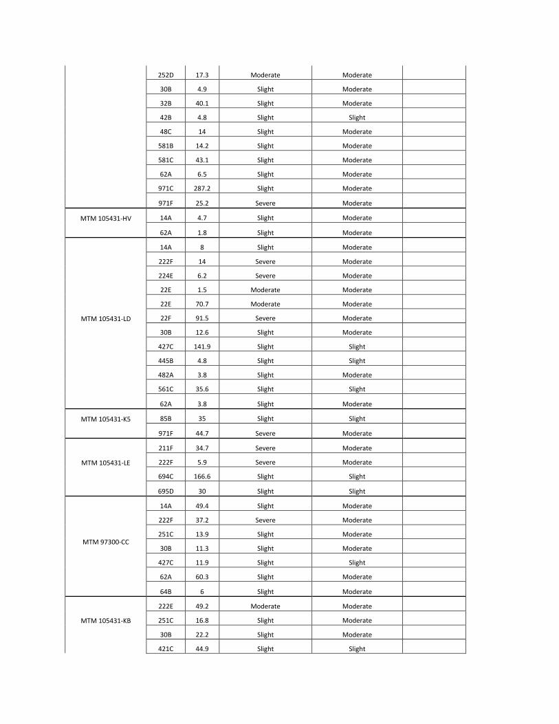
252D 17.3 Moderate Moderate
30B 4.9 Slight Moderate
32B 40.1 Slight Moderate
42B 4.8 Slight Slight
48C 14 Slight Moderate
581B 14.2 Slight Moderate
581C 43.1 Slight Moderate
62A 6.5 Slight Moderate
971C 287.2 Slight Moderate
971F 25.2 Severe Moderate
MTM 105431-HV
14A 4.7 Slight Moderate
62A 1.8 Slight Moderate
MTM 105431-LD
14A 8 Slight Moderate
222F 14 Severe Moderate
224E 6.2 Severe Moderate
22E 1.5 Moderate Moderate
22E 70.7 Moderate Moderate
22F 91.5 Severe Moderate
30B 12.6 Slight Moderate
427C 141.9 Slight Slight
445B 4.8 Slight Slight
482A 3.8 Slight Moderate
561C 35.6 Slight Slight
62A 3.8 Slight Moderate
MTM 105431-K5
85B 35 Slight Slight
971F 44.7 Severe Moderate
MTM 105431-LE
211F 34.7 Severe Moderate
222F 5.9 Severe Moderate
694C 166.6 Slight Slight
695D 30 Slight Slight
MTM 97300-CC
14A 49.4 Slight Moderate
222F 37.2 Severe Moderate
251C 13.9 Slight Moderate
30B 11.3 Slight Moderate
427C 11.9 Slight Slight
62A 60.3 Slight Moderate
64B 6 Slight Moderate
MTM 105431-KB
222E 49.2 Moderate Moderate
251C 16.8 Slight Moderate
30B 22.2 Slight Moderate
421C 44.9 Slight Slight

421D 10.7 Moderate Slight
42B 14.6 Slight Slight
MTM 105431-KC
14A 5.9 Slight Moderate
222E 12.6 Moderate Moderate
22E 26.1 Moderate Moderate
251C 12.4 Slight Moderate
30B 36.2 Slight Moderate
402A 1.3 Slight Slight
421C 19.1 Slight Slight
481A 3.3 Slight Moderate
64B 9.1 Slight Moderate
79C 50.5 Slight Slight
79D 13.1 Moderate Slight
MTM 105431-KD
14A 156.1 Slight Moderate
224E 17.5 Severe Moderate
32B 19.2 Slight Moderate
421D 12.9 Moderate Slight
44B 4.1 Slight Slight
481A 0.1 Slight Moderate
62A 2.5 Slight Moderate
64B 15.8 Slight Moderate
MTM 105431-LL
201F 71.3 Severe Moderate X
211F 66.9 Severe Moderate X
48B 12.8 Slight Moderate
69A 40.3 Slight Slight
793C 8.1 Slight Moderate
MTM 105431-LF
211F 211.3 Severe Moderate X
482A 13.8 Slight Moderate
694C 205.6 Slight Slight
85B 15.8 Slight Slight
971F 272.9 Severe Moderate
MTM 79010-F4
311B 20.9 Slight Slight
38B 5 Slight Slight
423B 37 Slight Moderate
423C 2.8 Slight Moderate
MTM 105431-KE
224E 100.8 Severe Moderate
38B 4.7 Slight Slight
423C 14.1 Slight Moderate
561C 27.3 Slight Slight
MTM 105431-KF
224E 1.7 Severe Moderate
423C 33.6 Slight Moderate

42C 24.2 Slight Slight
50B 20.7 Slight Slight
MTM 79010-F6
423B 51.8 Slight Moderate
423C 108.2 Slight Moderate
MTM 105431-K6
181D 1.1 Moderate Moderate
203E 2.8 Moderate Moderate
421C 13.1 Slight Slight
42C 24.7 Slight Slight
694C 1.9 Slight Slight
695D 14.6 Slight Slight
721E 18.7 Severe Moderate
72F 203.5 Severe Moderate
Liberty County
MTM 105431-K8
224E 28.9 Moderate Moderate
28A 15.9 Slight Slight
311B 1.5 Slight Slight
421C 153.8 Slight Slight
MTM 105431-FG
712E 20.9 Slight Slight
71D 5.2 Slight Slight
87C 14.1 Slight Slight
MTM 105431-LA
54C 30.5 Slight Moderate
695E 6.8 Moderate Slight
MTM 105431-K9
221E 9.4 Moderate Moderate
224E 7.6 Moderate Moderate
22F 44 Severe Moderate
30C 5.7 Slight Moderate
37B 0.5 Slight Slight
441C 19.1 Slight Slight
503B 74.7 Slight Slight
503C 8.6 Slight Slight
601A 2.9 Slight Slight
695E 26 Moderate Slight
MTM 105431-LB
30B 8.2 Slight Moderate
92D 16.9 Moderate Moderate
92F 14.1 Severe Moderate
MTM 105431-LC
224E 22.3 Moderate Moderate
421C 32.4 Slight Slight
503B 7.7 Slight Slight
561B 8.9 Slight Slight
601A 8.8 Slight Slight

Hill County
MTM 79010-FB
211F 29.6 Severe Moderate X
503B 3.9 Slight Slight
561B 2.8 Slight Slight
MTM 105431-H3
22E 23.6 Severe Moderate
37A 23.9 Slight Slight
421C 5.9 Slight Slight
99A 26.8 Slight Moderate
Glacier County MTM 79010-F5 Sk 15.8 Slight Slight
Chouteau County
MTM 79010-Q2
221E 16.4 Moderate Moderate
311B 6.8 Slight Slight
37B 26 Slight Slight
441C 16.9 Slight Slight
561B 48.3 Slight Slight
MTM 97300-4G
2 22.6 Not Rated Not Rated
30B 4.5 Slight Moderate
32B 12.4 Slight Moderate
32C 11.2 Slight Moderate
37B 2.2 Slight Slight
442C 23.1 Slight Slight
44B 21.4 Slight Slight
603A 2.6 Slight Slight
972F 95.4 Severe Moderate X
99 3.4 Slight Moderate
MTM 79010-BV 972F 39.3 Severe Moderate X
MTM 105431-J4
30B 3.3 Slight Moderate
311B 6.2 Slight Slight
37B 4.4 Slight Slight
38B 7.9 Slight Slight
972F 137.6 Severe Moderate X
974F 1.9 Severe Moderate
MTM 105431-J5
32B 2.4 Slight Moderate
38B 8.9 Slight Slight
603A 7.5 Slight Slight
972F 16 Severe Moderate X
974F 85.7 Severe Moderate

MTM 105431-J6
15E 109 Severe Moderate
15F 54.4 Severe Moderate
2 1.4 Not Rated Not Rated
37C 17.2 Slight Slight
441C 13.6 Slight Slight
79B 13.4 Slight Slight
79C 4.4 Slight Slight
972F 226.2 Severe Moderate X
MTM 105431-J8
15E 9 Severe Moderate
15F 55 Severe Moderate
37B 7.6 Slight Slight
38B 5.5 Slight Slight
972F 2.6 Severe Moderate X
MTM 79010-BX
15F 8.7 Severe Moderate
2 11.3 Not Rated Not Rated
375B 8.6 Slight Slight
603A 11.1 Slight Slight
MTM 105431-J9
15E 10.4 Severe Moderate
15F 10.1 Severe Moderate
2 2.4 Not Rated Not Rated
30C 1.3 Slight Moderate
32B 3.7 Slight Moderate
37B 28.3 Slight Slight
58C 6.9 Slight Moderate
602A 5.8 Slight Slight
60A 2.6 Slight Slight
79B 3 Slight Slight
81A 1.2 Slight Moderate
972F 37.6 Severe Moderate X
974F 46.4 Severe Moderate
MTM 79010-P7
15E 27.7 Severe Moderate
15F 157.7 Severe Moderate
32B 1.2 Slight Moderate
37C 12.8 Slight Slight
38B 6.6 Slight Slight
503B 2 Slight Slight
503C 9.6 Slight Slight
58C 14.8 Slight Moderate
79D 11.7 Moderate Slight
972F 188.4 Severe Moderate X
MTM 97300-4M 15E 23.3 Severe Moderate

15F 54.5 Severe Moderate
385B 2.3 Slight Slight
972F 73.2 Severe Moderate X
MTM 97300-4N
15F 23.8 Severe Moderate
32B 39 Slight Moderate
32C 9.5 Slight Moderate
38B 4.5 Slight Slight
79B 3.2 Slight Slight
MTM 79010-P5
182F 30.3 Severe Moderate
503B 9.6 Slight Slight
MTM 97300-4V
15F 101.2 Severe Moderate
182F 113 Severe Moderate
37C 14.9 Slight Slight
503B 6.5 Slight Slight
58C 2.2 Slight Moderate
972F 120.6 Severe Moderate X
MTM 97300-4W
15F 147.3 Severe Moderate X
182F 302.3 Severe Moderate X
37B 35.1 Slight Slight
37C 12.8 Slight Slight
58C 11.1 Slight Moderate
Phillips County
MTM 79010-A9
110C 1.9 Slight Slight
1221F 12.1 Severe Moderate
1441D 26.1 Slight Slight
MTM 79010-B2
1030D 51.7 Moderate Moderate
1221F 107.7 Severe Moderate
1441D 72.8 Slight Slight
1443E 8.2 Slight Slight
MTM 105431-FK
1221F 102.7 Severe Moderate
1443E 330.1 Slight Slight
170A 51.4 Slight Slight
444C 6.5 Slight Slight
563C 4.9 Slight Slight
921D 18.4 Slight Moderate
MTM 105431-FL
1221F 15.9 Severe Moderate
1443E 359.7 Slight Slight
444C 47.5 Slight Slight
561B 37.5 Slight Slight
563C 82.4 Slight Slight

MTM 105431-FM
1441D 177.3 Slight Slight
1443E 58.8 Slight Slight
446D 5.3 Slight Slight
563C 4.8 Slight Slight
566C 73.5 Slight Slight
MTM 105431-FN
1037D 45.1 Slight Slight
1262A 32.9 Slight Slight
1392B 2.3 Slight Slight
37B 27.9 Slight Slight
60A 2.4 Slight Slight
94C 9.7 Slight Moderate
MTM 105431-FP
1221F 41.8 Severe Moderate
1441D 257.5 Slight Slight
563C 19.6 Slight Slight
MTM 79010-A2
1030D 25.2 Moderate Moderate
1037D 12.3 Slight Slight
1221F 28.1 Severe Moderate
1262A 17.5 Slight Slight
1392B 36.2 Slight Slight
MTM 105431-K4
1030D 3.6 Moderate Moderate
1037D 14.4 Slight Slight
1090B 28.3 Slight Moderate
1221F 37.3 Severe Moderate
1392B 17.8 Slight Slight
1441D 19 Slight Slight
MTM 79010-B9
1022F 26.5 Severe Moderate
1030D 1.6 Moderate Moderate
221D 24.2 Slight Moderate
221E 29.3 Moderate Moderate
37C 106.7 Slight Slight
563C 28.7 Slight Slight
56B 28.6 Slight Slight
604A 50.9 Slight Slight
902A 14.3 Slight Moderate
971F 48.1 Severe Moderate
MTM 79010-C1
1022F 8.5 Severe Moderate
1221F 115.6 Severe Moderate
1441D 76.9 Slight Slight
311B 12.9 Slight Slight
563C 22.7 Slight Slight
56B 3.7 Slight Slight

MTM 105431-FQ
1441D 254.1 Slight Slight
220E 6.8 Moderate Moderate
221E 9.3 Moderate Moderate
563C 11.9 Slight Slight
MTM 105431-FT
1221F 1.1 Severe Moderate
1441D 240.5 Slight Slight
1443E 6.3 Slight Slight
220E 30.7 Moderate Moderate
221E 1.2 Moderate Moderate
MTM 105431-FU
1441D 93.6 Slight Slight
1443E 95.7 Slight Slight
220E 163.2 Moderate Moderate
37B 24.7 Slight Slight
38B 2.1 Slight Slight
563C 39.1 Slight Slight
56B 23.2 Slight Slight
MTM 105431-FV
1037D 143 Slight Slight
1221F 239.4 Severe Moderate
1441D 188.6 Slight Slight
1443E 65.4 Slight Slight
170A 1 Slight Slight
MTM 105431-FW
1221F 195.8 Severe Moderate
1251E 32.9 Severe Moderate
1441D 293 Slight Slight
563C 1.4 Slight Slight
MTM 105431-FR
1221F 20.9 Severe Moderate
1441D 98.5 Slight Slight
Valley County
MTM 102757-6K
2 2.7 Slight Moderate
29 41 Severe Moderate
57 70.4 Slight Slight
65 204.4 Slight Slight
79 1.3 Water Water
MTM 102757-G4
46 56.9 Slight Slight
49 103.9 Slight Slight
MTM 102757-G6
2 24.8 Slight Moderate
23 21.1 Slight Moderate
46 269.4 Slight Slight
49 195.5 Slight Slight
52 36.7 Slight Slight

59 23.1 Moderate Slight
60 2.6 Severe Moderate
75 46.2 Slight Slight
79 9.9 Water Water
MTM 102757-GW
11 5.6 Slight Slight
38 8.4 Slight Moderate
39 60.3 Moderate Slight
46 142 Slight Slight
49 28 Slight Slight
49 70 Slight Slight
57 71.7 Slight Slight
59 20.3 Moderate Slight
60 162.1 Severe Moderate
61 17.2 Severe Moderate
68 43.2 Moderate Moderate
69 15.5 Slight Slight
70 19.2 Severe Moderate
75 17.7 Slight Slight
MTM 102757-J7
2 3.8 Slight Moderate
59 36 Moderate Slight
MTM 102757-J8
49 7.2 Slight Slight
59 13.7 Moderate Slight
60 26.6 Severe Moderate
69 4.5 Slight Slight
75 27.7 Slight Slight
MTM 102757-J9
46 13.3 Slight Slight
47 1.6 Slight Slight
60 54.2 Severe Moderate
MTM 102757-KA
46 1.9 Slight Slight
50 4.5 Slight Slight
69 33.7 Slight Slight
MTM 102757-KB
46 13 Slight Slight
49 48.1 Slight Slight
59 19 Moderate Slight
MTM 102757-KC
46 76 Slight Slight
49 3.7 Slight Slight
MTM 102757-KE
60 28.6 Severe Moderate
69 11.5 Slight Slight
MTM 102757-QH
27 8 Slight Moderate
42 11.8 Slight Slight
46 24.8 Slight Slight

47 82.9 Slight Slight
60 5.8 Severe Moderate
7 27 Slight Slight
MTM 102757-QJ
23 2.4 Slight Moderate
26 2.9 Slight Moderate
MTM 102757-QK
25 1.3 Slight Moderate
26 16.2 Slight Moderate
MTM 102757-QL
25 50.3 Slight Moderate
26 19.1 Slight Moderate
79 9.1 Water Water
MTM 102757-QM
23 51.4 Slight Moderate
25 3.5 Slight Moderate
26 8.8 Slight Moderate
32 9.7 Slight Moderate
MTM 102757-QN
12 21.4 Slight Slight
15 8.9 Slight Slight
39 32.7 Moderate Slight
6 94.5 Severe Moderate
MTM 102757-QQ
13 5.5 Slight Slight
23 4.5 Slight Moderate
25 55.7 Slight Moderate
59 20.8 Moderate Slight
MTM 102757-QU
46 22.7 Slight Slight
60 30.2 Severe Moderate
75 15.8 Slight Slight
8 10.5 Slight Moderate
MTM 102757-RM
27 7.9 Slight Moderate
49 189.1 Slight Slight
60 4.8 Severe Moderate
MTM 105431-Q3
42 3.5 Slight Slight
46 30.1 Slight Slight
49 349 Slight Slight
57 191.9 Slight Slight
58 1.6 Slight Slight
MTM 79010-7J
46 26.2 Slight Slight
47 254.9 Slight Slight
49 26.1 Slight Slight
60 129.5 Severe Moderate
MTM 79010-ZR
46 150.2 Slight Slight
60 207.2 Severe Moderate

75 105.6 Slight Slight
8 17.6 Slight Moderate
MTM 79010-ZS
46 28.6 Slight Slight
49 113.1 Slight Slight
52 133.4 Slight Slight
59 3.1 Moderate Slight
60 5.7 Severe Moderate
70 35.9 Severe Moderate
MTM 79010-ZT
25 20.6 Slight Moderate
27 28 Slight Moderate
34 27.5 Severe Moderate
46 5.5 Slight Slight
52 22.4 Slight Slight
60 103 Severe Moderate
61 65.6 Severe Moderate
69 7.2 Slight Slight
70 10.9 Severe Moderate
75 9.5 Slight Slight
Copyright © 2022 FDOKUMEN