Enhancing spatial and textual analysis with EUPEG - arXiv
32
Enhancing spatial and textual analysis with EUPEG: an extensible and unified platform for evaluating geoparsers Jimin Wang and Yingjie Hu GeoAI Lab, Department of Geography, University at Buffalo, NY 14260, USA Abstract A rich amount of geographic information exists in unstructured texts, such as Web pages, social media posts, housing advertisements, and historical archives. Geoparsers are use- ful tools that extract structured geographic information from unstructured texts, thereby enabling spatial analysis on textual data. While a number of geoparsers were developed, they were tested on different datasets using different metrics. Consequently, it is difficult to compare existing geoparsers or to compare a new geoparser with existing ones. In recent years, researchers created open and annotated corpora for testing geoparsers. While these corpora are extremely valuable, much effort is still needed for a researcher to prepare these datasets and deploy geoparsers for comparative experiments. This paper presents EUPEG: an Extensible and Unified Platform for Evaluating Geoparsers. EUPEG is an open source and Web based benchmarking platform which hosts a majority of open corpora, geoparsers, and performance metrics reported in the literature. It enables direct comparison of the hosted geoparsers, and a new geoparser can be connected to EUPEG and compared with other geoparsers. The main objective of EUPEG is to reduce the time and effort that re- searchers have to spend in preparing datasets and baselines, thereby increasing the efficiency and effectiveness of comparative experiments. Keywords: geoparsing, benchmarking platform, toponym, spatial and textual analysis, geospatial semantics, geographic information retrieval 1. Introduction Many studies and applications nowadays need an integration of spatial and textual anal- ysis. In disaster response, it is often necessary to recognize, geo-locate, and analyze the place names mentioned in short text messages or social media posts in order to understand who needs help and where (MacEachren et al., 2011; Gelernter and Balaji, 2013; Lan et al., 2014; Pezanowski et al., 2018). Studying place relations and interactions in virtual or cognitive Wang, J. and Hu, Y. (2019): Enhancing spatial and textual analysis with EUPEG: an extensible and unified platform for evaluating geoparsers, Transactions in GIS, accepted. DOI: https://www.doi.org/10.1111/tgis.12579 Contact info: Jimin Wang (jiminwan@buffalo.edu); Yingjie Hu (yhu42@buffalo.edu) 1 arXiv:2007.04524v1 [cs.IR] 9 Jul 2020
-
Upload
khangminh22 -
Category
Documents
-
view
1 -
download
0
Transcript of Enhancing spatial and textual analysis with EUPEG - arXiv

Enhancing spatial and textual analysis with EUPEG: an extensible
and unified platform for evaluating geoparsers
Jimin Wang and Yingjie Hu
GeoAI Lab, Department of Geography, University at Buffalo, NY 14260, USA
Abstract
A rich amount of geographic information exists in unstructured texts, such as Web pages,social media posts, housing advertisements, and historical archives. Geoparsers are use-ful tools that extract structured geographic information from unstructured texts, therebyenabling spatial analysis on textual data. While a number of geoparsers were developed,they were tested on different datasets using different metrics. Consequently, it is difficultto compare existing geoparsers or to compare a new geoparser with existing ones. In recentyears, researchers created open and annotated corpora for testing geoparsers. While thesecorpora are extremely valuable, much effort is still needed for a researcher to prepare thesedatasets and deploy geoparsers for comparative experiments. This paper presents EUPEG:an Extensible and Unified Platform for Evaluating Geoparsers. EUPEG is an open sourceand Web based benchmarking platform which hosts a majority of open corpora, geoparsers,and performance metrics reported in the literature. It enables direct comparison of thehosted geoparsers, and a new geoparser can be connected to EUPEG and compared withother geoparsers. The main objective of EUPEG is to reduce the time and effort that re-searchers have to spend in preparing datasets and baselines, thereby increasing the efficiencyand effectiveness of comparative experiments.
Keywords: geoparsing, benchmarking platform, toponym, spatial and textual analysis,geospatial semantics, geographic information retrieval
1. Introduction
Many studies and applications nowadays need an integration of spatial and textual anal-ysis. In disaster response, it is often necessary to recognize, geo-locate, and analyze the placenames mentioned in short text messages or social media posts in order to understand whoneeds help and where (MacEachren et al., 2011; Gelernter and Balaji, 2013; Lan et al., 2014;Pezanowski et al., 2018). Studying place relations and interactions in virtual or cognitive
Wang, J. and Hu, Y. (2019): Enhancing spatial and textual analysis with EUPEG: an extensible and unifiedplatform for evaluating geoparsers, Transactions in GIS, accepted.DOI: https://www.doi.org/10.1111/tgis.12579Contact info: Jimin Wang ([email protected]); Yingjie Hu ([email protected])
1
arX
iv:2
007.
0452
4v1
[cs
.IR
] 9
Jul
202
0

spaces usually involves extracting place names from texts, such as Wikipedia pages or newsarticles, and analyzing their co-occurrences with spatial distances (Hecht and Moxley, 2009;Liu et al., 2014; Geiß et al., 2015; Salvini and Fabrikant, 2016; Hu et al., 2017). To developplace-based GIS, researchers may need to examine human experiences encoded in texts, suchas in travel blogs, and how these human experiences are related to spatial locations (Adamsand McKenzie, 2013; Ballatore and Adams, 2015; Gao et al., 2017). In addition, there ex-ists various geographic knowledge in Web pages (Jones et al., 2008), housing advertisements(McKenzie et al., 2018), business documents (Faulconbridge et al., 2008), historical archives(Grossner et al., 2016), and other types of texts.
Geoparsing is a critical process for extracting spatial information from textual data. It isrecognized as an important research topic in the broader field of geographic information re-trieval (GIR) (Jones and Purves, 2008; Purves et al., 2018). A geoparsing system is called ageoparser which takes unstructured textual data as the input and outputs a set of recognizedplace names and their spatial footprints (Freire et al., 2011; Leidner, 2008).
While a number of geoparsers have already been developed, it is difficult to directly com-pare their performances. Examples of the developed geoparsers include MetaCarta (Franket al., 2006), GeoTxt (Karimzadeh et al., 2013), the Edinburgh Geoparser (Alex et al.,2015), TopoCluster (DeLozier et al., 2015), and CamCoder (Gritta et al., 2018b). Twofactors make the direct comparison difficult. First, many geoparsers were tested on project-specific datasets that are not shared publicly. Besides the additional effort for making dataready for sharing, there also exist policy restrictions (e.g., Twitter forbids sharing the contentof tweets) and privacy concerns that prevent researchers from sharing their data publicly.As a result, geoparsers cannot be fairly compared since the same geoparser can have verydifferent performances depending on the testing datasets (Leidner, 2006; Ju et al., 2016).Second, different performance metrics were usually used for evaluating geoparsers. Someresearchers used the metrics of precision, recall, and F-score adopted from the field of infor-mation retrieval, while some others used metrics based on spatial distances, such as mean ormedian error distance. Due to both factors, we cannot compare geoparsers by juxtaposingthe performance numbers reported in their papers.
To effectively compare existing geoparsers or to compare a new geoparser with existingbaselines, one would ideally find and deploy the geoparsers in the literature and use the samedatasets and metrics to test their performances. However, such a process is time-consumingand labor-intensive. First, one needs to find openly shared and annotated datasets. While thecommunity has already made great efforts to share datasets, such as the Local-Global Lexicon(LGL) corpus (Lieberman et al., 2010), WikToR (Gritta et al., 2018c), and GeoCorpora(Wallgrun et al., 2018), researchers still need to spend much time preparing these datasetsfor experiments. For example, GeoCorpora is a valuable dataset containing human annotatedtweets. Due to Twitter’s policy restriction, GeoCorpora contains only the IDs of tweets ratherthan their full content. To use GeoCorpora, one needs to apply for a developer account forusing Twitter’s Application Programming Interface (API) and write a program to rehydratethe dataset. Even for the datasets that are more readily available, they are often in differentformats and need to be harmonized into the same format before an experiment. Second, ittakes a considerable amount of time to find, deploy, and re-run existing geoparsers. Thisprocess can take even longer when no direct download link is provided for a geoparser orwhen there is a lack of deployment instructions. Third, a set of performance metrics need to
2

be implemented to compare geoparsers. Although implementing these metrics may not bedifficult, one needs to harmonize the heterogeneous output formats of different geoparsersand compare their outputs with ground truth annotations. In sum, conducting an effectivecomparative experiment of geoparsers costs a lot of time and human resources. While thosecosts are probably fine for a single research group, the entire community can lose a lot oftime if every individual research group has to prepare datasets, geoparsers, and metrics inorder to run an experiment.
This paper presents EUPEG: an Extensible and Unified Platform for Evaluating Geop-arsers. EUPEG is designed as an open source and Web based platform. It hosts a majorityof the open corpora, geoparsers, and performance metrics reported in the literature. Onecan directly compare these hosted geoparsers on the same datasets using the same metrics,or can connect a new geoparser to EUPEG and compare it with the existing ones. Thevalue of EUPEG can be seen from the perspectives of both geoparser users and researchers.For a user who would like to find a suitable geoparser to process a corpus, EUPEG offersa comprehensive view on the advantages and limitations of different geoparsers (e.g., somemay have higher precision while some others may have higher recall) and their performanceson different types of corpora (e.g., short messages or long articles). For researchers whowould like to develop a new geoparser, they can focus on inventing new methods rather thanpreparing datasets and baselines. In addition, EUPEG automatically archives the resultsand configurations of experiments, such as the date and time of an experiment, the selecteddatasets, used geoparsers, and performance metrics. Researchers can share experiment re-sults with their colleagues or even the general public more easily via an experiment ID. Thecontributions of this paper are as follows:
• We propose and develop a benchmarking platform, EUPEG, for effective and efficientcomparison of geoparsers. EUPEG currently hosts eight annotated geographic corpora,nine geoparsers, and eight performance metrics. New geoparsers and datasets canalso be connected to it. Experiment results and configurations are recorded and canbe shared via experiment IDs. A demo of EUPEG can be accessed at: https://geoai.geog.buffalo.edu/EUPEG.
• We provide a systematic review on the geoparsing resources hosted on EUPEG. Thecorpora are in four different text genres, ranging from news articles to social mediaposts; the geoparsers are developed using different methods, such as heuristics and ma-chine learning; and the performance metrics are from information retrieval or based onspatial distances. EUPEG serves as a one-stop platform that unifies the heterogeneousdatasets, geoparsers, and performance metrics.
• We share the source code of EUPEG on GitHub, along with the hosted resources underpermitted licenses (e.g., GNU General Public License). The code repository can beaccessed at: https://github.com/geoai-lab/EUPEG. The shared source codeenables researchers to run EUPEG on a local computer, or to add more datasets andgeoparsers at the source-code level. One can also extend EUPEG with new features,such as new performance metrics suitable for a project.
While EUPEG is designed for geoparsing, the idea of developing benchmarking plat-forms can be extended to other research topics in geography, such as land use and land
3

cover (LULC) classification, where different solutions are developed for addressing the sameproblem. This paper is a major extension of our previous short paper (Hu, 2018). The re-mainder of this paper is organized as follows. Section 2 reviews related work on geoparsing,corpora building, and benchmarking platforms. Section 3 presents the design details of EU-PEG, including the overall architecture and the hosted datasets, geoparsers, and performancemetrics. Section 4 demonstrates the implemented EUPEG and provides an analytical eval-uation on the approximate time that can be saved by EUPEG for comparative experiments.Finally, Section 5 summarizes this work and discusses future directions.
2. Related Work
In this section, we provide a review on related studies. We start by introducing thebackground knowledge of geoparsing and major geoparsers developed so far, and continueto discuss the efforts made by the community to create and share open and annotatedcorpora. We then discuss the recent movement towards developing benchmarking platformsfor effective and efficient comparisons of different solutions to the same problems.
2.1. Geoparsing and geoparsers
Geoparsing is a research topic often studied in GIR (Jones and Purves, 2008; Purves et al.,2018). The goal of geoparsing is to recognize place names mentioned in texts and resolvethem to the corresponding place instances and location coordinates (Freire et al., 2011;Barbaresi, 2017; Gritta et al., 2018c). Geoparsing is typically performed in two consecutivesteps: toponym recognition and toponym resolution. The first step recognizes place namesfrom texts without identifying the particular place instance referred by a name, while thesecond step aims to resolve any ambiguity of the place name and locates it to the rightspatial footprint. Figure 1 illustrates the input and output of geoparsing and its two steps.
Figure 1: The input and output of geoparsing and its two main steps.
Many methods have been proposed for these two steps. For toponym recognition, earlyresearch used gazetteer-based entry matching and grammatical rules (Woodruff and Plaunt,1994; Purves et al., 2018), while more recent approaches employed machine learning and nat-ural language processing techniques. Particularly, the Stanford Named Entity Recognition(NER) tool was used in many studies for toponym recognition (Lieberman et al., 2010; Gel-ernter and Mushegian, 2011; Karimzadeh et al., 2013; DeLozier et al., 2015). For toponymresolution, various heuristics were developed to resolve place name ambiguity (Amitay et al.,2004; Leidner, 2008). A simple method is to resolve a place name to the place instance that
4

has the highest population or the largest total geographic area (Li et al., 2002; Ladra et al.,2008). Machine learning models were also developed for toponym resolution by exploitingvarious features, such as toponym co-occurrences (Overell and Ruger, 2008), words in the lo-cal context (Speriosu and Baldridge, 2013), distances among toponyms (Santos et al., 2015),topics of the local context (Ju et al., 2016), and a combination of multiple features (Nesiet al., 2016; Gritta et al., 2018b).
A number of geoparsers were developed which can function as end-to-end systems forcompleting both steps. GeoTxt, developed by Karimzadeh et al. (2013), is a Web-basedgeoparser that leverages Stanford NER and two other NER tools for toponym recogni-tion and uses GeoNames and a set of heuristic rules for toponym resolution. TopoClus-ter, by DeLozier et al. (2015), can perform geoparsing without using a gazetteer. It usesStanford NER to recognize toponyms from texts and then resolves toponyms based onthe geographic profiles of words in the surrounding context. Cartographic Location AndVicinity INdexer (CLAVIN) is an open source geoparser that employs Apache OpenNLPfor toponym recognition and utilizes a gazetteer and fuzzy search for toponym resolu-tion. The Edinburgh Geoparser is a geoparsing system developed by the Language Tech-nology Group at Edinburgh University (Alex et al., 2015). It uses their in-house soft-ware tool, called LT-TTT2, for toponym recognition, and the toponym resolution step isbased on a gazetteer such as GeoNames. CamCoder is a deep learning based geoparserdeveloped by Gritta et al. (2018b), which integrates convolutional neural networks, wordembeddings, and the geographic vector representations of place names. There also ex-ist commercial geoparsers, such as Geoparser.io (https://geoparser.io), which of-ten charge a fee. Some commercial geoparsers, such as Yahoo! PlaceSpotter (https://developer.yahoo.com/boss/geo/docs/PM_KeyConcepts.html), provide rel-atively permissive rate limitations for free requests (e.g., 2,000 calls per hour).
2.2. Efforts in sharing open and annotated corpora
While many geoparsers exist, it is difficult to directly compare them due to a lack of openand annotated corpora. In recent years, researchers made great efforts to address this issue.Lieberman et al. (2010) shared a human annotated dataset called Local-Global Lexicon(LGL) containing 588 news articles published by local newspapers from highly ambiguousplaces. Hu et al. (2014) contributed an automatically annotated corpus containing shortsentences retrieved from the home pages of cities with ambiguous names such as Washington.Ju et al. (2016) shared a corpus of short sentences from various Web pages, which wasautomatically collected and annotated using a script based on the Microsoft Bing SearchAPI. Gritta et al. (2018c) contributed WikToR which is a corpus of Wikipedia articles withambiguous names, such as Lima, Peru and Lima, Oklahoma, automatically annotated by aPython script. Wallgrun et al. (2018) contributed GeoCopora which is a dataset of tweetsmanually annotated using a hybrid approach with both users on Amazon’s Mechanical Turkand researchers in the domain of geography. Gritta et al. (2018b) and Gritta et al. (2018a)shared two human annotated corpora, GeoVirus and GeoWebNews, which contain 229 and200 news articles respectively. TR-News is another news article corpus which contains 118articles manually annotated by Kamalloo and Rafiei (2018). In addition to contemporarycorpora, some historical datasets were also made available, such as War Of The Rebellion(WOTR) by DeLozier et al. (2016). Leidner (2006) developed the TR-CoNLL corpus which
5

contains 946 annotated news articles from Reuters; however, it is not publicly available to thebest of our knowledge. The ACE 2005 English SpatialML is an annotated news corpus sharedon the Linguistic Data Consortium (Mani et al., 2008), but it charges a fee ($1,000) for non-members. While these annotated corpora greatly facilitate the development and testing ofgeoparsers, finding, downloading, and preparing these corpora require considerable amountsof time and effort.
2.3. Benchmarking platforms
The importance and necessity of evaluating geoparsers in a systematic manner havealready been recognized by the research community (Monteiro et al., 2016; Melo and Martins,2017; Richter et al., 2017; Gritta et al., 2018c; Wallgrun et al., 2018). Melo and Martins(2017) argued that the fact that one geoparser performed worse than another geoparser onone particular dataset did not mean that this geoparser would still perform worse than theother if a different dataset were used. Gritta et al. (2018c) compared the performances of fivegeoparsers on two corpora using a set of standard performance measures, such as precision,recall, F-score, and median error distance. In their more recent work, the authors furtherproposed a pragmatic guide to geoparsing evaluation (Gritta et al., 2018a). In addition topublications, Gritta et al. (2018c,a) also released their source code and the annotated corporawhich greatly facilitated the reproduction of their experiments. EUPEG is built on thefoundational work of (Gritta et al., 2018c,a), but extends their work in three aspects. First,EUPEG provides a benchmarking platform which offers datasets and baseline geoparsers thatare ready for use. While Gritta et al. (2018c,a) have shared the source code of comparingfive geoparsers, a lot of effort is still needed to understand, deploy, and run these geoparsers.Some geoparsers do not function on certain operating systems (OS) (e.g., the EdinburghGeoparser is not supported on Windows) or require extra database configurations (e.g.,TopoCluster requires PostgreSQL and PostGIS), which can add additional requirements ontheir deployments. EUPEG directly hosts these geoparsers, along with annotated corporaand performance metrics. Researchers can directly run experiments on EUPEG, and canconnect their own geoparsers and datasets to the platform. Second, EUPEG extends thecorpora and geoparsers from Gritta et al. (2018c,a). We provide eight annotated corpora infour different text genres, which include news articles, Wikipedia articles, social media posts,and Web pages. We provide nine geoparsing methods which include not only specializedgeoparsers (e.g., GeoTxt and CLAVIN) but also a number of geoparsing systems extendedfrom general NER tools, such as DBpedia Spotlight, Stanford NER, and spaCy NER. Third,EUPEG offers the capability of archiving research experiments. Each experiment is assigneda unique ID that allows researchers to share first-hand research outcomes and to search theresults of previous experiments.
The demand for benchmarking platforms is also witnessed in other research fields beyondgeography. Cornolti et al. (2013) developed a framework for systematically evaluating anumber of named entity annotators, such as AIDA, Illinois Wikifier, and DBpedia Spotlight,on the same datasets. Building on the work of Cornolti et al. (2013), Usbeck et al. (2015)developed GERBIL which is a platform for agile, fine-grained, and uniform evaluations ofnamed entity annotation tools. The practice of comparing different methods on the samedatasets was also seen in computer science conferences, such as the Message UnderstandingConference (MUC) (Sundheim, 1993), the Conference on Computational Natural Language
6

Learning (CoNLL) (Tjong Kim Sang and De Meulder, 2003), and the Making Sense ofMicroposts workshop series (MSM) (Cano et al., 2014). Such a practice is especially effectivewhen multiple solutions exist for the same research problem, and can reveal the advantagesand limitations of different solutions. Sharing datasets for comparing methods can fuelthe advancement in a particular research area as well. For example, the availability of theImageNet dataset was a critical boost to the remarkable development of deep learning incomputer vision (Deng et al., 2009). To the best of our knowledge, EUPEG is the firstbenchmarking platform for the research problem of geoparsing.
3. EUPEG
3.1. Overall architecture
EUPEG is designed as a Web based and open source benchmarking platform. It providestwo main functions:
• It enables effective and efficient comparison of different geoparsers on the same datasetsusing the same performance metrics.
• It facilitates the sharing of experiments by archiving evaluation results and configura-tions and supporting the search of previous experiments.
The overall architecture of EUPEG is shown in Figure 2. Two major modules are de-signed. The Experiment Module hosts a majority of openly available resources includingannotated corpora, existing geoparsers, and performance metrics. The Archiving and SearchModule records experiment results and supports the search of previous experiments. Forgeoparser researchers who would like to develop new geoparsers, they can connect a newgeoparser to EUPEG and compare it with others on the hosted datasets using the sameperformance metrics. Researchers can also upload one or multiple customized datasets andcompare the new geoparser with existing baselines on these customized datasets. For userswho would like to find a suitable geoparser for processing a corpus, they can compare exist-ing geoparsers directly on EUPEG to see their advantages and limitations. The experimentconfigurations (e.g., the used datasets, geoparsers, and metrics) and results are recorded ina database in the Archiving and Search Module. One can search previous experiments basedon their experiment IDs automatically generated by EUPEG. In the following, we presentdetails about the datasets, geoparsers, and metrics.
3.2. Datasets
EUPEG hosts a majority of annotated geographic corpora reported in the literature.Two criteria are used for selecting these datasets. First, they have to be formally describedby existing papers; second, the datasets should be openly available without a fee (e.g., adataset shared on GitHub under the MIT license). In addition, we focus on geographiccorpora, namely those with toponyms and spatial footprints annotated. There exist generalNER corpora whose annotations contain other types of entities (e.g., persons and concepts)and do not provide spatial footprints. Those general NER corpora are not included.
The corpora hosted on EUPEG are in four different text genres: news articles, Wikipediaarticles, social media posts, and Web pages. Having multiple genres rather than a single
7
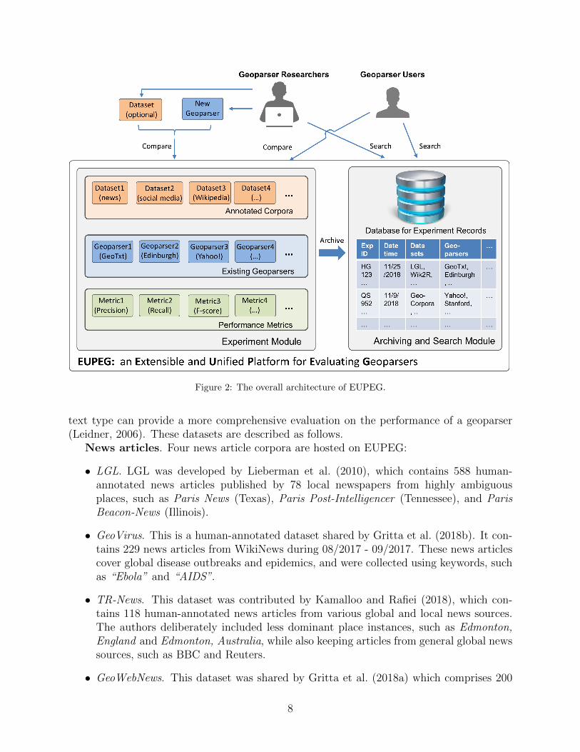
Figure 2: The overall architecture of EUPEG.
text type can provide a more comprehensive evaluation on the performance of a geoparser(Leidner, 2006). These datasets are described as follows.
News articles. Four news article corpora are hosted on EUPEG:
• LGL. LGL was developed by Lieberman et al. (2010), which contains 588 human-annotated news articles published by 78 local newspapers from highly ambiguousplaces, such as Paris News (Texas), Paris Post-Intelligencer (Tennessee), and ParisBeacon-News (Illinois).
• GeoVirus. This is a human-annotated dataset shared by Gritta et al. (2018b). It con-tains 229 news articles from WikiNews during 08/2017 - 09/2017. These news articlescover global disease outbreaks and epidemics, and were collected using keywords, suchas “Ebola” and “AIDS”.
• TR-News. This dataset was contributed by Kamalloo and Rafiei (2018), which con-tains 118 human-annotated news articles from various global and local news sources.The authors deliberately included less dominant place instances, such as Edmonton,England and Edmonton, Australia, while also keeping articles from general global newssources, such as BBC and Reuters.
• GeoWebNews. This dataset was shared by Gritta et al. (2018a) which comprises 200
8

human-annotated news articles from 200 globally distributed news sites collected fromApril 1st to 8th in 2018. The authors randomly selected one article from each domainuntil they reached 200 news articles for creating this dataset.
Wikipedia articles. One Wikipedia article corpus is hosted on EUPEG.
• WikToR. This corpus was provided by Gritta et al. (2018c). It was automaticallygenerated by a script using those Wikipedia articles about places. It contains 5,000articles with ambiguous names, such as Lima, Peru, Lima, Ohio, and Lima, Oklahoma.One limitation of WikToR is that it does not annotate all toponyms in the textsbut only those that are the description target of a Wikipedia article. As a result,some performance metrics, such as precision, recall, and F-score, cannot be used forquantifying the performance of geoparsers based on WikToR.
Social media posts. EUPEG hosts one social media dataset, GeoCorpora, contributedby Wallgrun et al. (2018).
• GeoCorpora. This is a tweet corpus that contains 1,639 human-annotated tweet posts.These posts were first annotated using a crowdsourcing approach by workers on Ama-zon’s Mechanical Turk and then further annotated (with disagreements resolved) byresearchers in geography. It is worth noting that the original paper reported 2,122tweets with toponyms annotated. Due to the data sharing restriction of Twitter,Wallgrun et al. (2018) could not share the full content of tweets but only tweet IDs.When rehydrating tweets, we were able to recover only 1,639 tweets, since some tweetswere deleted by their authors. The number of tweets that can be recovered will onlydecrease as the time goes by. Thus, we believe that another value of EUPEG is itscapability of preserving valuable contributions from previous research by sidesteppingsome policy restrictions (in this case, EUPEG does not provide any direct downloadof the tweets).
Web pages. Two Web page corpora are hosted on EUPEG.
• Hu2014. This is a small corpus contributed by Hu et al. (2014), which was automati-cally constructed by a script. The authors focused on two highly ambiguous US placenames, Washington and Greenville, and retrieved textual descriptions from the web-sites of related cities. The texts in these Web pages were then divided into shortersentences. Overall, this dataset contains 134 entries. Not all toponyms in the sen-tences are annotated, and therefore precision, recall, and F-score cannot be applied toevaluating the geoparsing results based on this dataset (similar to WikToR).
• Ju2016. This is another automatically constructed corpus. It was contributed by Juet al. (2016) who made use of a list of highly ambiguous US place names on Wikipedia,and then used Microsoft Bing Search API to retrieve sentences from various Web pages(Wikipedia articles were removed from these Web pages) that contain the searchedplace names. This corpus contains 5,441 entries. Similar to WikToR and Hu2014, thisdataset does not annotate all toponyms and cannot use the performance metrics ofprecision, recall, and F-score.
9

Table 1: A summary of the open and annotated corpora hosted on EUPEG.
Dataset GenreTextDate
EntryCount
Average Wordsper Entry
Average Toponymper Entry
LGL News 03/2009 588 315 8.0GeoVirus News 08-09/2017 229 276 9.4TR-News News 2009-2017 118 324 10.8
GeoWebNews News 04/2018 200 404 12.6WikToR Wikipedia 03/2016 5000 213 6.3
GeoCorpora Social Media 2014-2015 1639 19 2.1Hu2014 Web Pages 08/2014 134 27 1.3Ju2016 Web Pages 11/2016 5441 21 1.2
In total, EUPEG hosts eight geographic corpora in four different text genres. Table 1summarizes the attributes of these datasets.
There also exist open and annotated historical corpora. For example, WOTR is a US civilwar corpus with toponyms focusing on the southern US (DeLozier et al., 2016). However,geoparsing such corpora requires special configurations such as adding historical gazetteersand processing older languages (e.g., the texts of WOTR are from 1860s). The currentversion of EUPEG aims to compare geoparsers based on their default configurations anddoes not include historical corpora.
It is worth noting that the definition of toponym can vary across different corpora. Itseems that different researchers often have their own opinions on what should be considered astoponyms and what should not. This definition difference affects the ground-truth toponymannotation in a corpus. For example, LGL considers demonyms (e.g., Canadian) as toponymsand annotates them to point coordinates (e.g., the center of Canada), whereas GeoVirus doesnot annotate building names, point-of-interest (POI) names, street names, and river names.In a recent work, Gritta et al. (2018a) provided a pragmatic taxonomy of toponyms whichfurther divided toponyms into literal and associative toponyms with 13 sub categories. Inthis work, we do not attempt to define toponym from one single perspective, but allowthe datasets with different toponym definitions to co-exist. Such diversity allows users andresearchers to see the different performances of a geoparser across corpora. One can thenchoose a geoparser that performs the best on a corpus that has a toponym definition similarto theirs. Table 2 summarizes the different annotations of toponyms contained in each ofthe corpora hosted on EUPEG. As can be seen, all datasets include administrative unitsin their annotations but have different coverage on other types of entities. Some of thesedifferences come from the corpus building process (e.g., WikToR, Hu2014, and Ju2016 wereautomatically constructed based on the names of cities and towns only), while some othersoriginate from the different views of researchers on the definition of toponym. It seemsthat domain knowledge plays a major role in the annotation of toponyms. For example,GeoCorpora is a dataset contributed by geographers, and its annotations contain only thenames that can be pinned down to a certain location on the surface of the Earth. By contrast,GeoWebNews, TR-News, and LGL are contributed by linguists and computer scientists whotend to annotate any terms that may have a geographic meaning (e.g., “Canadian” and
10

Table 2: Toponym annotations in different corpora.
Dataset
Adminunits
(cities,towns,
...)
Naturalfeatures(rivers,
mountains,...)
Facilities(buildings,
roads,airports,
...)
Demonyms(Canadian,
Syrian,American,
...)
Metonymies(London
announceda new policy
)
Modifiers(Spanishsausage,UK beef,
)LGL *
GeoVirusTR-News *
GeoWebNewsWikToR
GeoCorporaHu2014Ju2016
* indicates that the dataset contains toponym annotations in that category but does not provide geographiccoordinates for the annotated toponyms.
“Spanish sausage”).
3.3. Geoparsers
We select geoparsers for EUPEG using the following criteria. First, the selected geop-arsers should function as end-to-end systems, i.e., they can take textual documents as theinput and output spatial coordinates. Second, for academic geoparsers, the accompanyingpapers should be published after 2010 and they should provide publicly accessible API ordownloadable software packages. Due to technological advancements, geoparsers developedbefore 2010 generally do not have performances close to the state of the art, and their sourcecodes can be hard to obtain and may not run on a modern OS. Third, for industrial geop-arsers, they should provide an API that either allows free access or has a permissive ratelimitation for free requests. These three criteria follow the foundational work of Gritta et al.(2018c), and the geoparsers below are provided on EUPEG.
• GeoTxt. GeoTxt is an academic geoparser developed by the GeoVISTA center ofPennsylvania State University (Karimzadeh et al., 2013, 2019). It was initially designedto geoparse microblogs (e.g., tweets), but can be applied to longer texts as well. GeoTxtprovides a publicly accessible and free API at http://www.geotxt.org, and isbeing maintained by its researchers. EUPEG does not host a local instance of GeoTxtbut connects to its API. An advantage of such an online connection is that new updatesof GeoTxt will be reflected on EUPEG. On the flip side, EUPEG cannot use GeoTxtwhen its online service is down. EUPEG connects to version 2.0 of GeoTxt which usesits local GeoNames gazetteer deployed in July 2017.
• The Edinburgh Geoparser. The Edinburgh Geoparser is an academic geoparser de-veloped by the Language Technology Group (LTG) at The University of Edinburgh(Alex et al., 2015). A publicly available package of this geoparser is provided at:https://www.ltg.ed.ac.uk/software/geoparser. EUPEG hosts version
11

1.1 of the Edinburgh Geoparser which uses the online service of GeoNames as itsgazetteer. While supported on Linux and MacOS, it cannot run on Windows.
• TopoCluster. TopoCluster is an academic geoparser developed by DeLozier et al.(2015) at the University of Texas at Austin. It performs geoparsing based on the geo-graphic profiles of words characterized by the local Getis-Ord G˚i statistic. While theirmethodology focuses on toponym resolution, their source code (https://github.com/grantdelozier/TopoCluster) provides an end-to-end system for complet-ing both steps of geoparsing. TopoCluster does not provide an official version number.We host its latest version shared on GitHub which was updated in November 2016.
• CLAVIN. Cartographic Location And Vicinity INdexer is an open source geoparserthat employs Apache OpenNLP Name Finder for toponym recognition, and a numberof heuristics and fuzzy search for toponym resolution. CLAVIN does not come withan academic paper, but its descriptions and source code can be obtained from GitHub(https://github.com/Berico-Technologies/CLAVIN) and Maven Central.We host CLAVIN 2.1.0 on EUPEG and it employs a local GeoNames gazetteer deployedin April 2019.
• Yahoo! PlaceSpotter. Yahoo! PlaceSpotter is an industrial geoparser which offers anonline REST API. As a proprietary geoparser, PlaceSpotter does not describe the ex-act methods behind but provides some descriptions on its functions and outputs at:https://developer.yahoo.com/boss/geo/docs/PM_KeyConcepts.html.PlaceSpotter is requested via YQL (Yahoo! Query Language), and its rate limit forfree requests is relatively permissive (2,000 calls per hour; a corpus with 5,000 entriescan be parsed within 3 hours). EUPEG connects to Yahoo! PlaceSpotter via its onlineREST API which employs its Where-on-Earth ID (WOEID) for referencing places.
• CamCoder. CamCoder is an academic geoparser developed by Gritta et al. (2018b) atthe Language Technology Lab of the University of Cambridge. CamCoder is a deeplearning based geoparser that leverages Convolutional Neural Networks (CNNs) withglobal maximum pooling and map-based word vector representations. The source codeof CamCoder is available at: https://github.com/milangritta/Geocoding-with-Map-Vector. Running CamCoder requires configurations on the local com-puting environment to include deep learning libraries, such as Tensorflow and Keras.EUPEG hosts the latest version of CamCoder shared on GitHub (updated in Septem-ber 2018) which uses its local GeoNames gazetteer prepared in July 2018.
In addition to the six specialized geoparsers above, EUPEG also provides three geoparsingsystems extended from general NER tools (e.g., Stanford NER). These systems are includedbecause previous research argued that geoparsing can be considered as a sub task of NER, anda geoparser can be developed by limiting the entities recognized by an NER tool to toponymsand adding spatial footprints via a gazetteer (Inkpen et al., 2017). Thus, including theseNER-based geoparsing systems can help provide more comprehensive comparisons. Thefollowing three systems are hosted on EUPEG:
12

• Stanford NER + Population. Stanford NER is a powerful and open source NER tooldeveloped by the Stanford Natural Language Processing Group. It has been usedin numerous previous studies, including some specialized geoparsers, such as GeoTxtand TopoCluster. We extend Stanford NER to a geoparsing system by assigning therecognized toponyms to the place instances with highest populations. This simpleheuristic is used because previous research has shown that assigning place names tothe instances with the highest populations is a strong baseline for geoparsing andcan sometimes surpass more complex models (Speriosu and Baldridge, 2013; DeLozieret al., 2015; Gritta et al., 2018a). We use Stanford CoreNLP toolbox (version 3.9.2)integrated with the online service of GeoNames.
• spaCy NER + Population. spaCy is a free and open source library for natural languageprocessing tasks in Python. Released in 2014, it has already been used in many studiesand applications due to its good performance (Choi et al., 2015; Jiang et al., 2016).We integrate spaCy NER (version 2.0.18) with the online service of GeoNames, andassign the recognized toponyms to the place instances with the highest populations.
• DBpedia Spotlight. DBpedia Spotlight is a general named entity recognition and link-ing (NERL) tool (Mendes et al., 2011; Daiber et al., 2013). This type of tool notonly recognizes entities from texts but also links them to the corresponding URLs in aknowledge base (such as DBpedia) which provides geographic coordinates for the rec-ognized places. We convert DBpedia Spotlight into a geoparser by limiting the outputto toponyms and extracting their coordinates from DBpedia pages via the geo:lat andgeo:long properties. While there exist other NERL tools such as AIDA (Hoffart et al.,2011) and TagMe (Ferragina and Scaiella, 2010), DBpedia Spotlight is a widely-usedNERL tool whose performance is among the state of the art (Van Erp et al., 2013;Cornolti et al., 2013; Usbeck et al., 2014). EUPEG hosts DBpedia Spotlight 1.0.0 withcoordinates retrieved from online DBpedia pages.
In total, EUPEG provides nine geoparsing systems for comparative experiments. Table 3summarizes these systems and their main components. These systems include six specializedgeoparsers that can be directly deployed, and three baseline systems that are extended fromgeneral NER or NERL tools via further developments and gazetteer configurations.
3.4. Performance metrics
EUPEG provides a number of performance metrics based on which different geoparserscan be evaluated and compared. There is no general agreement on which metrics shouldbe used for evaluating geoparsers. As a result, we select eight metrics that were used in avariety of previous studies. In the following, we discuss these metrics individually.
• Precision. Precision measures the percentage of correctly identified toponyms (truepositives) among all the toponyms recognized by a geoparser. Precision was used inprevious studies, such as (Leidner, 2008; Lieberman et al., 2010; Inkpen et al., 2017).Precision is calculated using the following equation:
Precision “tp
tp` fp(1)
13

Table 3: Geoparsing systems hosted on EUPEG and their main components.
GeoparserToponym
RecognitionToponymResolution
Gazetteer
GeoTxt(Version 2.0)
Stanford NER Heuristic rulesGeoNames(July 2017)
Edinburgh(Version 1.1)
LT-TTT2 Heuristic rulesGeoNames
(Online)
TopoCluster(Nov. 2016)
Stanford NERGeo-profiles
of words
GeoNames+Natural Earth
(Nov. 2016)
CLAVIN(Version 2.1.0)
ApacheOpenNLP
Heuristic rulesGeoNames(Apr. 2019)
Yahoo!PlaceSpotter
(Online)
Proprietary ProprietaryWOEID
(Where on Earth ID)(Online)
CamCoder(Sept. 2018)
spaCy NERCNNs+Map-based
word vectorsGeoNames(July 2018)
Stanford NER+ Population(Version 3.9.2)
Stanford NERHighest
populationGeoNames
(Online)
spaCy NER+ Population
(Version 2.0.18)
spaCy NERHighest
populationGeoNames
(Online)
DBpediaSpotlight
(Version 1.0.0)
LingPipe ExactDictionary Chunker
Contextsimilarity
DBpedia(Online)
where tp represents true positive and fp represents false positive.
• Recall. Recall measures the percentage of correctly identified toponyms among all thetoponyms that should be identified (i.e., the toponyms that are annotated as groundtruth). Recall was used in previous studies, such as (Leidner, 2008; Lieberman et al.,2010; Inkpen et al., 2017). Recall is calculated using the equation as below:
Recall “tp
tp` fn(2)
where fn represents false negative.
• F-score. F-score is the harmonic mean of precision and recall. F-score is high whenboth precision and recall are fairly high and is low if either of the two is low. F-scorewas used in previous studies, such as (Leidner, 2008; Lieberman et al., 2010; Inkpen
14

et al., 2017). F-score is calculated using the equation below:
F -score “ 2 ¨PrecisionˆRecall
Precision`Recall(3)
F-score is also called F-measure or F1-score.
• Accuracy. This metric is suitable for measuring performances on those corpora thatdo not have all toponyms annotated. For example, both WikToR and Ju2016 onlyannotate a subset of all the toponyms mentioned in the text. In these situations,precision, recall, and F-score are no longer suitable, since we do not have all toponymsannotated. Accuracy can be used to quantify the percentage of the annotated toponymsthat are also recognized by a geoparser. Accuracy was used in previous studies, suchas (Gelernter and Mushegian, 2011; Karimzadeh, 2016; Gritta et al., 2018c). It iscalculated using the equation below:
Accuracy “|AnnotatedXRecognized|
|Annotated|(4)
where Annotated represents the set of toponyms provided in the annotation, andRecognized represents the set of toponyms recognized by the geoparser.
Precision, recall, F-score, and accuracy quantify the ability of a geoparser in correctlyrecognizing place names from texts rather than geo-locating these names. Accordingly, theymeasure the performance of a geoparser in the toponym recognition step. The establishmentof matching between ground-truth annotations and geoparsing outputs is a topic that is worthdiscussing since it can directly affect the obtained measures. Previous work has discussedboth exact matching and inexact matching (Gritta et al., 2018c). For a sentence such as“The Town of Amherst has been a leader in providing online geographic information”, ageoparser may recognize “Amherst” as a toponym, while the ground-truth annotation maybe “Town of Amherst”. For exact matching, this will be considered as both a fp and a fn,since the output of the geoparser does not match the ground truth. For inexact matching, itwill be considered as a tp. We adopt inexact matching to accommodate such syntacticallyinconsistent but semantically meaningful outputs, and use the same implementation as in(Gritta et al., 2018c) for determining matches.
To measure the performance of a geoparser in geo-locating toponyms, the following fourmetrics are provided on EUPEG.
• Mean Error Distance (MED). MED computes the mean of the Euclidean distancesbetween the annotated location and the location output by a geoparser. MED wasused in previous studies, such as (Cheng et al., 2010; Speriosu and Baldridge, 2013;Santos et al., 2015). It is calculated using the equation below:
MED “
řNi“1
a
pxi ´ x1iq2 ` pyi ´ y1iq
2
N(5)
where N is the number of annotated toponyms that are recognized and geo-locatedby a geoparser. pxi, yiq is the annotated coordinates, and px1i, y
1iq is the geoparsed
15

coordinates. The toponyms, which are only in the geoparsing output or only in theannotations, are not included in computing MED; those mismatches are evaluated bythe previous four metrics.
• Median Error Distance (MdnED). MED is sensitive to outliers which means a smallnumber of geoparsed toponyms that are located far away from their ground-truthlocations can largely distort the evaluation result. MdnED computes the median valueof the error distances and is robust to outliers. MdnED was used in previous studies,such as (Speriosu and Baldridge, 2013; DeLozier et al., 2015; Santos et al., 2015).MdnED is calculated as below:
MdnED “ Medianptedi|edi “a
pxi ´ x1iq2 ` pyi ´ y1iq
2, i P r1, N suq (6)
where edi represents the ith error distance.
• Accuracy@161. This metric calculates the percentage of the toponyms that are geo-located within 161 kilometers (100 miles) of the ground truth locations. Accuracy@161was used in previous studies, such as (Cheng et al., 2010; DeLozier et al., 2015; Grittaet al., 2018c). A main motivation of having this metric is that the geographic coordi-nates of a place in a gazetteer used for geoparsing may be different from the annotatedcoordinates. Thus, an error distance can exist even when a geoparser correctly resolvesa toponym to the right place instance. Accuracy@161 considers the result as correctas long as the resolved location is within 100 miles of the annotated location. Thismetric is calculated as below.
Accuracy@161 “|tedi|edi “
a
pxi ´ x1iq2 ` pyi ´ y1iq
2, i P r1, N s, edi ď 161 kmu|
N(7)
• Area Under the Curve (AUC). AUC is a metric that quantifies the overall deviationbetween geoparsed locations and ground-truth annotations. AUC is computed by firstplotting a curve of the normalized log error distance and then calculating the totalarea under the curve. AUC was used in previous studies, such as (Jurgens et al., 2015;Gritta et al., 2018c,b). Figure 3 shows an example of the error distance curve. Thehorizontal axis represents the index of the toponyms ranked from small to large errordistances. A majority of toponyms are typically located at the correct locations, andtherefore have errors as zero. However, once the error distance starts to appear, itcan increase rapidly. The vertical axis represents the normalized log error distanceof the geoparsed toponyms. AUC is the total area under the curve calculated usingEquation 8, where Max Error is the maximum possible error distance (half of theEarth’s circumference) between the ground truth and the geoparsed location. A bettergeoparser should have a lower AUC.
AUC “
ż N
i“1
lnpedi ` 1q
lnpMax Errorqdi (8)
Calculating the error distance is a fundamental step for the four metrics above. Currently,
16

Figure 3: An illustration of AUC for quantifying the overall error distance of a geoparser.
the error distance is calculated based on point locations only. This is because all the geo-graphic corpora we have reviewed contain only point-based annotations, and all the discussedgeoparsing systems only output point-based locations. To some degree, this point-based an-notation and geoparsing facilitate the comparison of geoparsing outputs and ground-truthannotations: it may be more difficult to reach an agreement on how to compare a geoparsingoutput that contains points, lines, and polygons with a ground-truth dataset that contains,e.g., points only. However, geo-locating a toponym to a single point is not ideal when thetoponym refers to a large geographic area (e.g., a country or a river). Geographic scale fur-ther complicates this issue: it may be fine to locate a city name to a point if a study focuseson the country scale, but we may want a city name or even a neighborhood name to be rep-resented as a polygon if the study is at the city scale. While existing geoparsers only outputpoint-based locations, future geoparsers could provide other geometries to represent the spa-tial footprints of the recognized toponyms. When geoparsers and annotated datasets withvarious footprints have become available, EUPEG could be extended with error distancescalculated using other methods such as Frchet distance and Hausdorff distance.
In sum, EUPEG provides eight metrics for quantifying the performances of geoparsers.Four of these metrics examine the percentage of the toponyms correctly recognized fromtexts, while the other four metrics are based on the error distances between the geoparsedlocations and their ground-truth locations. There also exist ranking-based metrics, suchas Mean Reciprocal Rank (MRR) and normalized Discounted Cumulative Gain (nDCG)(Purves et al., 2018). However, these metrics require a geoparser to output a ranked list ofcandidate places. Some end-to-end systems only output one single result rather than a list
17

of places. Thus, these ranking-based measures are not included.
3.5. Resource unification
The corpora and geoparsers hosted on EUPEG are from different sources and are highlyheterogeneous. They can be annotated using different data formats. For example, LGL,GeoVirus, TR-News, GeoWebNews, and WikToR use Extensible Markup Language (XML),and organize data into hierarchical structures; Hu2014 and Ju2016 use TXT or Comma-Separated Values (CSV), and organize data using simple line-by-line text annotations witheach line representing one data record; GeoCorpora uses the format of Tab-Separated Val-ues (TSV) and one data record can be put into multiple lines if it contains more than onetoponym. The outputs of geoparsers are also in different formats. GeoTxt and Yahoo!PlaceSpotter use JavaScript Object Notation (JSON) to format their outputs; the Edin-burgh Geoparser employs XML; TopoCluster uses its own text-based geoparsing output;and CLAVIN provides an API that allows a user to format the output in a customized man-ner. Even if the resources are in the same format, they can still use different vocabularies toorganize similar content (which will be discussed in Section 3.6).
EUPEG serves as a platform for unifying these heterogeneous geoparsing resources.Building on the foundational work of Gritta et al. (2018c), we unify these resources inthe following steps. First, we write a customized computer script for each geographic corpusto convert it into two parts: a collection of individual text files (with each file containing onetext entry) and a single ground-truth text file (with each line containing the ground-truthannotation for one file in the collection). Such a design was used in Gritta et al. (2018c).While it seems to be rather an engineering design, we re-use it since EUPEG is built onthe work of Gritta et al. (2018c) and doing so can avoid reinventing the wheel. Second,we write a customized wrapper for each geoparser hosted on EUPEG. These wrappers con-vert the heterogeneous geoparsing outputs into the same format in which each line containsthe recognized toponyms from one text file. Third, a comparison function is developed tocompare the standardized geoparsing outputs with the ground-truth files, and measure theperformances of the geoparsers by computing the eight metrics. In sum, EUPEG unifies theheterogeneous resources by first converting them into the same formats and then comparingthe performances of geoparsers based on the same metrics.
3.6. Resource extension
The resources on EUPEG can be extended with new corpora and geoparsers. A newlycreated geographic corpus can be uploaded to EUPEG for testing the performances of geop-arsers. To enable the upload of any new corpus to EUPEG, we need an agreed format fororganizing the text entries and ground-truth annotations in a new corpus. Although sometoponym annotation languages, such as TRML (Leidner, 2006) and SpatialML (Mani et al.,2010), have been proposed, many publicly shared corpora, such as LGL and WikToR, usetheir own formats, probably due to a lack of access to example datasets of TRML and Spa-tialML. Here, we specify the format of a new corpus to be connected to EUPEG based onLGL, GeoVirus, TR-News, GeoWebNews, and WikToR. Although these five corpora are allin XML format, they employ different XML tags for organizing their content. For example,GeoVirus uses the XML tag xarticley to represent each text entry, while WikToR uses thetag xpagey to represent each entry (since the text entries are Wikipedia pages). Similarly,
18

TR-New uses the tag xgaztagy to provide location information obtained from a gazetteer,while GeoWebNews does not use the tag xgaztagy at all. Learning from these existing cor-pora, we build an XML format that has a small number of required core tags and offers theflexibility of including optional tags. Listing 1 shows this format.
<?xml version="1.0" encoding="utf-8"?><entries>
<entry><text>Paris is a city in Texas...</text><toponyms>
<toponym><start>0</start><end>4</end><phrase>Paris</phrase><place>
<footprint>-95.5477 33.6625</footprint><placename>City of Paris</placename> #optional<placetype>ADM3</placetype> #optional
</place>... # other optional attributes
</toponym><toponym>
... # another annotated toponym</toponym>...
</toponyms></entry><entry>
... # another entry in the dataset</entry>
...</entries>
Listing 1: The format for a new corpus to be uploaded to EUPEG.
A corpus to be uploaded to EUPEG will be organized into one XML file using the formatabove. This file can contain multiple text xentriesy, and the xentryy tag is used to organizeeach individual data entry. The xtexty tag contains the text to be geoparsed, which can bea news article, a tweet, a Web page, or others. The xtoponymsy tag contains the toponymsin the ground-truth annotation. For each ground-truth xtoponymy, it should contain thexstarty position (in character index) and the xendy position of the toponym in the text.The xphrasey tag contains the name of the place mentioned in the text, which can be notonly an official name but also a name abbreviation, a colloquial name, or other aliases. Thexplacey tag contains the annotated information of the place. The required core informationfor a xplacey is xfootprinty which is in the form of longitude and latitude. Other optionalinformation, such as xplacenamey and xplacetypey, can also be included.
A newly developed geoparser can be connected to EUPEG and compared with otherhosted geoparsers. To do so, one needs to make the new geoparser accessible via a RESTAPI and organize the geoparsing output using an agreed format. As far as we know, thereis no standard way for organizing geoparsing output. Accordingly, we specify the output
19

format based on that of an existing geoparser, GeoTxt. As an academic geoparser, GeoTxtis available freely and publicly with a REST API and accompanied by scholarly publications(Karimzadeh et al., 2013, 2019). GeoTxt uses JSON to format its output. The originaloutput of GeoTxt contains elements specific to the used gazetteer, GeoNames, such as geoN-ameId and featureCode. These elements are not required in this format since a new geoparsermay not necessarily employ GeoNames as its gazetteer. Similar to the format of a new cor-pus, we also classify the information elements in the geoparsing output as required coreelements and optional ones. A geoparser can output only the four core elements for sim-ple implementation, or can include additional and optional information for a comprehensiveoutput. The proposed output format for a new geoparser is shown in Listing 2.
This format organizes the geoparsing output into a JSON object. It starts with a rootattribute toponyms whose value is an array of JSON objects. Each JSON object containsthe information for a toponym recognized by the geoparser. The attribute start contains thestart position (in character index) of the toponym, while the attribute end contains the endposition of the recognized toponym. The attribute phrase represents the toponym mentionedin the text which could be an official name or other alternative names. The attribute placecontains more detailed information about the recognized place. The required element isfootprint which takes the value of a JSON array following the format of GeoJSON. For atypical point-based footprint, the JSON array contains the longitude and latitude of theplace. Other optional information, such as placename and placetype, can also be included.
{toponyms:[
{start:0,end:4,phrase:"Paris",place:{
footprint:[[-95.5477,33.6625]],placename:"City of Paris", # optionalplacetype:"ADM3" # optional
},... # other optional attributes
},{
... # another recognized toponym},...
]}
Listing 2: The format for the output of a new geoparser to be connected to EUPEG.
3.7. Experiment archiving and search
Another important function of EUPEG is archiving experiments. A database is createdto store information about an experiment, such as Experiment ID, Date and Time, Datasets,Geoparsers, Metrics, and Experiment Results. An experiment ID is a 16-digit serial number
20

that uniquely identifies an experiment. All other information is based on the configurationsspecified by an user at the time of running an experiment. One can search experiments basedon their IDs and see their results.
The value of this function can be seen in two aspects. First, it facilitates the sharing ofexperiment results. A researcher or a geoparser user can quickly share the result of an ex-periment with colleagues by embedding the experiment ID in, e.g., an email. The colleagueswho receive this experiment ID can check it on EUPEG and see the experiment results andconfigurations themselves. Second, the independently-recorded experiment results providefurther evidence for researchers to demonstrate their work, and allow others to verify theoutcome of a study more easily. Accordingly, EUPEG can help enhance the reproducibilityand replicability of scientific research.
3.8. Summary
We have presented the overall architecture, resources, and functions of EUPEG. In sum-mary, EUPEG has the following features:
• Comprehensiveness. EUPEG provides eight annotated corpora, nine geoparsingsystems, and eight performance metrics for evaluating geoparsers. The annotated cor-pora are in four different text genres; the geoparsing systems include both specializedgeoparsers and those extended from general named entity recognizers; and the perfor-mance metrics include both information retrieval based metrics and those based onerror distances.
• Unification. EUPEG can be considered as a one-stop platform where corpora, geop-arsers, and performance metrics are unified. EUPEG also unifies geoparser users andgeoparser researchers: users can use EUPEG to select the most suitable geoparserfor their own corpora, while researchers can leverage the hosted resources to performeffective and efficient evaluation experiments.
• Extensibility. EUPEG offers extensibility for the hosted geoparsing resources. Anewly created corpus can be uploaded to EUPEG for testing the hosted geoparsers.A newly developed geoparser can be connected to EUPEG and compared with othergeoparsers. We also provide the source code of EUPEG, and one can further extendEUPEG by adding new performance metrics or other features for evaluating geoparsers.
• Documentation. EUPEG documents experiment results and configurations, and pro-vides a search function for retrieving previous experiments. Such an archiving featureprovides researchers with further evidence to demonstrate their research outcome. Italso enables researchers and users to share experiment results more easily, e.g., byembedding the experiment ID in an email.
4. Implementation and Analytical Evaluation
4.1. Implementation and demonstration
Based on the proposed architecture, we have implemented EUPEG as a Web-based plat-form that can be accessed online at: https://geoai.geog.buffalo.edu/EUPEG.
21

Figure 4: A screenshot of EUPEG and the (1)-(2)-(3) workflow for running an experiment.
Figure 4 shows a screenshot of its main interface. EUPEG offers a (1)-(2)-(3) workflowfor conducting an experiment: a user selects (1) datasets, (2) geoparsers, and (3) metrics,and then clicks the “Run this experiment” button to start the experiment (Figure 4). Onecan also click the “Add corpus...” or “Add geoparser...” buttons to add their own resources.Once an experiment is finished, the user will be provided with an experiment ID which canthen be used by the user or others to search for this experiment. Figure 5 shows an exampleof searching a previous experiment and seeing its results. The returned results contain notonly the performance information of the compared geoparsers based on the selected cor-pora and metrics, but also the date and time of this experiment and the versions of thegeoparsers and their used gazetteers. Such information allows one to see the detailed config-uration of an experiment. A reader can also try this example by searching the experimentID “8380NII17XEKM0GD” on EUPEG.
EUPEG is implemented using a technology stack of multiple programming languages,software libraries, and development tools. Java JDK 11 is used on the server side for im-plementing servlets, database connections, and external API requests. Javascript , HTML5,CSS3, and other libraries, such as Bootstrap and JQuery, are employed on the client sidefor implementing the user interface and AJAX-based HTTP requests and responses. SQLite3 is used for storing the experiment records, which is a light-weight, high-reliability, andpublic-domain database. To reduce the time of experiments and avoid running the sameexperiment many times, we store and re-use the results if the datasets and geoparsers se-lected by a user were tested in a previous experiment. Such an implementation increasesexperiment efficiency and decreases computational cost, since running an experiment cantake from hours to days depending on the selected datasets and geoparsers. In addition,we use the following approaches to keep the hosted geoparsers up-to-date. For the geop-arsers that are connected to EUPEG via online APIs, a computational thread is developed
22

Figure 5: Searching a previous experiment and seeing its result.
which runs in the background and automatically updates the geoparsing results of thesegeoparsers once per month to reflect any possible changes. For the geoparsers that are de-ployed locally on our server, we plan to check their websites once every three to six monthsand will update our local instances when new stable versions have become available. Whilewe plan to maintain EUPEG for the next few years, resource limitation may not allow usto maintain it for a long time. Thus, we also share the source code of EUPEG, alongwith the datasets under permitted licenses (e.g., GNU General Public License), on GitHubat: https://github.com/geoai-lab/EUPEG, and invite the community to furtherenhance and extend it.
4.2. Analytical evaluation
A main goal of EUPEG is to reduce the time that researchers have to spend in preparingdatasets and baselines for experiments. This section attempts to estimate the amount of thetime that could be saved by EUPEG. One possible approach to providing such an estimate isto invite a number of researchers, ask them to prepare all the corpora and geoparsers hostedon EUPEG by themselves, and measure the average time they spend. Such a process,however, can be very tedious for the invited researchers, and depending on their particularfields and technical skills, their used time may not represent the time that others may needfor preparing these experiment resources. Here, we provide an analytical evaluation on the
23

amount of time that could be saved based on our own experience of developing EUPEG andfocus on the lower bound of the time. In the following, we first analyze the steps that aresearch group typically has to complete if they were to prepare datasets and baselines foran experiment themselves. These identified steps are shown in Figure 6. We then estimatethe minimum amount of time that is necessary to complete each step.
Figure 6: Typical steps for preparing datasets and geoparsers for experiments.
Read literature and identify resources. This is generally the first step, in which one studiesprevious research and identifies resources that can be re-used. For this step, EUPEG doesnot save much time. Although it makes various resources ready for use, researchers may stillneed to read the related publications to understand the methods under the hood. EUPEGand this paper, however, can serve as an entry point for new researchers. The time that canbe saved in this step is estimated as zero.
Search, find, and download resources. After identifying resources from the literature,one needs to obtain them. For most datasets hosted on EUPEG, we were able to obtaineach of them within half an hour, thanks to the authors who shared relevant URLs in theirpapers. For GeoCorpora, while the authors have kindly provided its URL, much time isstill needed to rehydrate this dataset due to the data sharing restriction of Twitter. It tookus more than 5 person-hours to recover this dataset, and additional time has to be spentin applying for a Twitter developer account before one can start to recover the dataset.We estimate a minimum of 8.5 person-hours for obtaining the datasets hosted on EUPEG.For the geoparsers, we were able to download the source codes or compiled versions of theEdinburgh Geoparser, TopoCluster, CLAVIN, and CamCoder within half an hour each. Theother five geoparsers are either connected to EUPEG via their APIs or are further developedbased on general NER tools. About half an hour is needed for finding each of these resources.In total, about 13 person-hours are needed for this step.
Read and understand documentation. After the source codes of previous geoparsers areobtained, one needs to read documents and understand how to deploy and run them. Back-ground knowledge on different programming languages (e.g., Python and Java) and systemarchitectures (e.g., REST Web services) is necessary for understanding the installation in-structions. Based on our own experience, we estimate an average of two person-hours foran experienced developer to read and understand the documents of one geoparsing system.Thus, this step takes about 18 person-hours.
Deploy and configure geoparsers. This step is particularly time-consuming and requiresa lot of expertise. First, different geoparsers can be implemented in different programming
24

languages. Accordingly, a researcher needs to have some basic knowledge on the multiplelanguages in order to deploy them. Second, there exist specific configuration requirementsfor some geoparsers. For example, geoparsers available via Web APIs require one to havethe expertise of handling HTTP requests and responses; a geoparser (e.g., TopoCluster) mayrequire the installation of a database and its spatial extension, or may require a researcher tobe familiar with certain deep learning libraries (e.g., CamCoder). Third, including generalNER tools as baselines requires further developments and gazetteer configurations to convertthese general tools into geoparsers. We estimate an average of 24 person-hours to successfullydeploy and configure one geoparser and thus a total of 216 person-hours.
Harmonize the formats of resources. The annotated datasets and the outputs of geop-arsers are often in different formats and structures. To conduct an experiment on theseheterogeneous resources, one needs to harmonize these datasets and geoparser outputs bywriting programs to convert them into the same format. We estimate an average of threeperson-hours for processing one resource (a dataset or a geoparser), and in total, this steptakes about 51 person-hours.
Implement performance metrics. Performance metrics, such as precision, recall, andAUC, need to be implemented for evaluating geoparsers. In addition, some programmingwork is necessary for comparing geoparsing outputs to ground-truth annotations. In total,we estimate eleven person-hours for completing this step (eight hours for eight metrics plusthree hours for developing the code for comparing outputs with ground-truth annotations).
Run experiments with resources. Once everything is prepared , we can run experiments toobtain evaluation results. The running time of different geoparsers can vary largely. Figure7 reports the empirical time of the nine geoparsers on the same machine for processing theGeoCorpora dataset. TopoCluster took the longest time (660.51 minutes), while CLAVIN isthe fastest geoparser that took only 0.28 minute to process the same dataset. Longer pro-
Figure 7: Running time of different geoparsers on GeoCorpora.
cessing time, however, does not mean better performance. Figure 8 shows the performances
25

of different geoparsers on GeoCorpora. The time that can be saved by EUPEG in this stepis estimated as zero, since one can work on other tasks when an experiment is running.
Figure 8: The performances of different geoparsers on GeoCorpora.
Summarize experiment results. When experiments are finished, one often needs to collectthe obtained results and organize them into a report. For this step, we estimate the savedtime as zero, since it has to be done with or without EUPEG.
Table 4 provides a summary of the approximate number of person-hours that can besaved by EUPEG.
Table 4: The estimated amount of time that can be saved by EUPEG.
Task for preparing experimentsEstimated time(person-hours)
Read literature and identify resources 0Search, find, and download resources 13Read and understand documentation 18Deploy and configure geoparsers 216Harmonize the formats of resources 51Implement performance metrics 11Run experiments with resources 0Summarize experiment results 0Total 309
In total, we estimate 309 person-hours if another research group were to prepare the sameresources hosted on EUPEG. This estimate is close to a lower bound, as it is based on theassumption that researchers have all the necessary knowledge and technical skills and doesnot take into account the time spent on trials and errors.
26

5. Conclusions and Future Work
In this work, we present EUPEG, an Extensible and Unified Platform for EvaluatingGeoparsers. With large amounts of textual data available from various sources, geoparsershave become increasingly important given their capabilities of extracting geographic infor-mation from textual documents. Many studies in spatial data science and digital humanitieshave leveraged geoparsers under various contexts (e.g., disaster responses, platial studies,and event detection) to integrates spatial and textual analysis. While a number of geop-arsers were developed, they were tested on different datasets using different performancemetrics. Consequently, the reported evaluation results cannot be directly compared. In ad-dition, a new geoparser often needs to be compared with existing baselines to demonstrateits merits. However, preparing baselines and testing datasets can take much time and ef-fort from different research groups. In this context, we propose and develop EUPEG as abenchmarking platform for evaluating geoparsers and eventually enhancing spatial and tex-tual analysis. It is implemented as a Web based and open source platform with four majorfeatures. (1) Comprehensiveness: EUPEG provides eight open corpora, nine geoparsing sys-tems, and eight performance metrics for evaluating geoparsers; (2) Unification: EUPEG canbe considered as a one-stop platform where heterogeneous corpora, geoparsers, and metricsare unified; (3) Extensibility: EUPEG allows the hosted resources to be extended with newcorpora and geoparsers; (4) Documentation: EUPEG documents experiment results andconfigurations, and allows the search of previous experiments.
The main goal of EUPEG is to enable effective and efficient comparisons of geoparserswhile reducing the time that researchers and end users have to spend in preparing datasetsand baselines. Based on our analytical evaluation, EUPEG can save one single researchgroup approximately 309 hours for preparing the same datasets, geoparsers, and metrics.The number of saved hours will be multiplied when multiple research groups attempt todevelop and compare geoparsers. While EUPEG serves as a benchmarking platform, it isnot to replace project-specific evaluations necessary for highlighting certain unique featuresof a geoparser but to supplement existing evaluations.
The development of EUPEG also reveals several issues that may need future work. First,there is a lack of commonly-agreed standards on corpus annotation. While languages, suchas TRML (Leidner, 2006) and SpatialML (Mani et al., 2010), were proposed, they werenot adopted by the recently available and publicly shared corpora, such as LGL, WikToR,and GeoCorpora. Having a commonly-agreed standard can facilitate the development ofdatasets that are more readily usable by others in future experiments. Second, a similarsituation happens to the outputs of geoparsers, where a commonly-agreed output formatis not available. Most geoparsers organize their outputs in a format that they considersuitable. While it is feasible to harmonize these heterogeneous outputs by writing wrapperprograms (as done in EUPEG), a standard output format can make it easier for othersto use a geoparser or to combine multiple geoparsers. In this work, we have developeda simple format based on GeoTxt to allow new geoparsers to be connected to EUPEG.However, further efforts are needed from the community to develop an agreed and standardoutput format for geoparsers. Third, the current version of EUPEG focuses on English-basedgeoparsers and corpora only. Resources for other languages could be added in the future tosupport multilingual geoparsing evaluations. With the source code shared, new extensions
27

could be added to EUPEG to further enhance it and help it better serve our community.
Acknowledgments
The authors would like to thank Dr. Morteza Karimzadeh and Dr. Alan M. MacEachrenfor providing further technical information about GeoTxt. We thank the anonymous review-ers for their constructive comments and suggestions.
References
References
Adams, B., McKenzie, G., 2013. Inferring thematic places from spatially referenced naturallanguage descriptions. In: Crowdsourcing geographic knowledge. Springer, pp. 201–221.
Alex, B., Byrne, K., Grover, C., Tobin, R., 2015. Adapting the Edinburgh geoparser forhistorical georeferencing. International Journal of Humanities and Arts Computing 9 (1),15–35.
Amitay, E., Har’El, N., Sivan, R., Soffer, A., 2004. Web-a-where: geotagging web content.In: Proceedings of the 27th annual international ACM SIGIR conference on Research anddevelopment in information retrieval. ACM, New York, NY, USA, pp. 273–280.
Ballatore, A., Adams, B., 2015. Extracting place emotions from travel blogs. In: Proceedingsof AGILE. Vol. 2015. pp. 1–5.
Barbaresi, A., 2017. Towards a toolbox to map historical text collections. In: Proceedings ofthe 11th Workshop on Geographic Information Retrieval. ACM, p. 5.
Cano, A. E., Rizzo, G., Varga, A., Rowe, M., Stankovic, M., Dadzie, A.-S., 2014. Makingsense of microposts: (#microposts2014) named entity extraction & linking challenge. In:CEUR Workshop Proceedings. Vol. 1141. pp. 54–60.
Cheng, Z., Caverlee, J., Lee, K., 2010. You are where you tweet: a content-based approachto geo-locating twitter users. In: Proceedings of the 19th ACM international conferenceon Information and knowledge management. ACM, pp. 759–768.
Choi, J. D., Tetreault, J., Stent, A., 2015. It depends: Dependency parser comparisonusing a web-based evaluation tool. In: Proceedings of the 53rd Annual Meeting of theAssociation for Computational Linguistics and the 7th International Joint Conference onNatural Language Processing (Volume 1: Long Papers). Vol. 1. pp. 387–396.
Cornolti, M., Ferragina, P., Ciaramita, M., 2013. A framework for benchmarking entity-annotation systems. In: Proceedings of the 22nd international conference on World WideWeb. ACM, pp. 249–260.
Daiber, J., Jakob, M., Hokamp, C., Mendes, P. N., 2013. Improving efficiency and accuracyin multilingual entity extraction. In: Proceedings of the 9th International Conference onSemantic Systems. ACM, pp. 121–124.
DeLozier, G., Baldridge, J., London, L., 2015. Gazetteer-independent toponym resolutionusing geographic word profiles. In: Proceedings of the AAAI Conference on ArtificialIntelligence. AAAI Press, Palo Alto, CA, USA, pp. 2382–2388.
DeLozier, G., Wing, B., Baldridge, J., Nesbit, S., 2016. Creating a novel geolocation cor-pus from historical texts. In: Proceedings of The 10th Linguistic Annotation Workshop.Association for Computational Linguistics, pp. 188–198.
28

Deng, J., Dong, W., Socher, R., Li, L.-J., Li, K., Fei-Fei, L., 2009. Imagenet: A large-scalehierarchical image database. In: Computer Vision and Pattern Recognition, 2009. CVPR2009. IEEE Conference on. IEEE, pp. 248–255.
Faulconbridge, J. R., Hall, S. J., Beaverstock, J. V., 2008. New insights into the internation-alization of producer services: organizational strategies and spatial economies for globalheadhunting firms. Environment and Planning A 40 (1), 210–234.
Ferragina, P., Scaiella, U., 2010. Tagme: on-the-fly annotation of short text fragments (bywikipedia entities). In: Proceedings of the 19th ACM international conference on Infor-mation and knowledge management. ACM, pp. 1625–1628.
Frank, J. R., Rauch, E. M., Donoghue, K., October 2006. Spatially coding and displayinginformation. US Patent 7,117,199.
Freire, N., Borbinha, J., Calado, P., Martins, B., 2011. A metadata geoparsing system forplace name recognition and resolution in metadata records. In: Proceedings of the 11thannual international ACM/IEEE joint conference on Digital libraries. ACM, New York,NY, USA, pp. 339–348.
Gao, S., Janowicz, K., Montello, D. R., Hu, Y., Yang, J.-A., McKenzie, G., Ju, Y., Gong, L.,Adams, B., Yan, B., 2017. A data-synthesis-driven method for detecting and extractingvague cognitive regions. International Journal of Geographical Information Science 31 (6),1245–1271.
Geiß, J., Spitz, A., Strotgen, J., Gertz, M., 2015. The wikipedia location network: overcom-ing borders and oceans. In: Proceedings of the 9th workshop on geographic informationretrieval. ACM, p. 2.
Gelernter, J., Balaji, S., 2013. An algorithm for local geoparsing of microtext. GeoInformatica17 (4), 635–667.
Gelernter, J., Mushegian, N., 2011. Geo-parsing messages from microtext. Transactions inGIS 15 (6), 753–773.
Gritta, M., Pilehvar, M. T., Collier, N., 2018a. A pragmatic guide to geoparsing evaluation.arXiv preprint arXiv:1810.12368.
Gritta, M., Pilehvar, M. T., Collier, N., 2018b. Which melbourne? augmenting geocodingwith maps. In: Proceedings of the 56th Annual Meeting of the Association for Computa-tional Linguistics (Volume 1: Long Papers). Vol. 1. pp. 1285–1296.
Gritta, M., Pilehvar, M. T., Limsopatham, N., Collier, N., 2018c. What’s missing in geo-graphical parsing? Language Resources and Evaluation 52 (2), 603–623.
Grossner, K., Janowicz, K., Keßler, C., 2016. Place, period, and setting for linked datagazetteers. Placing Names: Enriching and Integrating Gazetteers, 80–96.
Hecht, B., Moxley, E., 2009. Terabytes of tobler: evaluating the first law in a massive,domain-neutral representation of world knowledge. In: International conference on spatialinformation theory. Springer, pp. 88–105.
Hoffart, J., Yosef, M. A., Bordino, I., Furstenau, H., Pinkal, M., Spaniol, M., Taneva,B., Thater, S., Weikum, G., 2011. Robust disambiguation of named entities in text. In:Proceedings of the Conference on Empirical Methods in Natural Language Processing.Association for Computational Linguistics, pp. 782–792.
Hu, Y., 2018. EUPEG: Towards an Extensible and Unified Platform for Evaluating Geop-arsers. In: Proceedings of the 12th Workshop on Geographic Information Retrieval.
29

GIR’18. ACM, New York, NY, USA, pp. 3:1–3:2.Hu, Y., Janowicz, K., Prasad, S., 2014. Improving Wikipedia-based place name disambigua-
tion in short texts using structured data from dbpedia. In: Proceedings of the 8th workshopon geographic information retrieval. ACM, pp. 1–8.
Hu, Y., Ye, X., Shaw, S.-L., 2017. Extracting and analyzing semantic relatedness be-tween cities using news articles. International Journal of Geographical Information Science31 (12), 2427–2451.
Inkpen, D., Liu, J., Farzindar, A., Kazemi, F., Ghazi, D., 2017. Location detection anddisambiguation from twitter messages. Journal of Intelligent Information Systems 49 (2),237–253.
Jiang, R., Banchs, R. E., Li, H., 2016. Evaluating and combining name entity recognitionsystems. In: Proceedings of the Sixth Named Entity Workshop. pp. 21–27.
Jones, C. B., Purves, R. S., 2008. Geographical information retrieval. International Journalof Geographical Information Science 22 (3), 219–228.
Jones, C. B., Purves, R. S., Clough, P. D., Joho, H., 2008. Modelling vague places with knowl-edge from the web. International Journal of Geographical Information Science 22 (10),1045–1065.
Ju, Y., Adams, B., Janowicz, K., Hu, Y., Yan, B., McKenzie, G., 2016. Things and strings:improving place name disambiguation from short texts by combining entity co-occurrencewith topic modeling. In: European Knowledge Acquisition Workshop. Springer, pp. 353–367.
Jurgens, D., Finethy, T., McCorriston, J., Xu, Y. T., Ruths, D., 2015. Geolocation predictionin twitter using social networks: A critical analysis and review of current practice. ICWSM15, 188–197.
Kamalloo, E., Rafiei, D., 2018. A coherent unsupervised model for toponym resolution. In:Proceedings of the 2018 World Wide Web Conference on World Wide Web. InternationalWorld Wide Web Conferences Steering Committee, pp. 1287–1296.
Karimzadeh, M., 2016. Performance evaluation measures for toponym resolution. In: Pro-ceedings of the 10th Workshop on Geographic Information Retrieval. ACM, New York,NY, USA, p. 8.
Karimzadeh, M., Huang, W., Banerjee, S., Wallgrun, J. O., Hardisty, F., Pezanowski, S.,Mitra, P., MacEachren, A. M., 2013. Geotxt: a web api to leverage place references intext. In: Proceedings of the 7th workshop on geographic information retrieval. ACM, NewYork, NY, USA, pp. 72–73.
Karimzadeh, M., Pezanowski, S., MacEachren, A. M., Wallgrun, J. O., 2019. Geotxt: Ascalable geoparsing system for unstructured text geolocation. Transactions in GIS 23 (1),118–136.
Ladra, S., Luaces, M. R., Pedreira, O., Seco, D., 2008. A toponym resolution service followingthe ogc wps standard. In: International Symposium on Web and Wireless GeographicalInformation Systems. Springer, pp. 75–85.
Lan, R., Adelfio, M. D., Samet, H., 2014. Spatio-temporal disease tracking using news arti-cles. In: Proceedings of the Third ACM SIGSPATIAL International Workshop on the Useof GIS in Public Health. ACM, pp. 31–38.
Leidner, J. L., 2006. An evaluation dataset for the toponym resolution task. Computers,
30

Environment and Urban Systems 30 (4), 400–417.Leidner, J. L., 2008. Toponym resolution in text: Annotation, evaluation and applications
of spatial grounding of place names. Universal-Publishers, Irvine, CA, USA.Li, H., Srihari, R. K., Niu, C., Li, W., 2002. Location normalization for information extrac-
tion. In: Proceedings of the 19th international conference on Computational linguistics-Volume 1. Association for Computational Linguistics, pp. 1–7.
Lieberman, M. D., Samet, H., Sankaranarayanan, J., 2010. Geotagging with local lexiconsto build indexes for textually-specified spatial data. In: 2010 IEEE 26th InternationalConference on Data Engineering (ICDE). IEEE, Long Beach, CA, USA, pp. 201–212.
Liu, Y., Wang, F., Kang, C., Gao, Y., Lu, Y., 2014. Analyzing relatedness by toponymco-occurrences on web pages. Transactions in GIS 18 (1), 89–107.
MacEachren, A. M., Jaiswal, A., Robinson, A. C., Pezanowski, S., Savelyev, A., Mitra, P.,Zhang, X., Blanford, J., 2011. Senseplace2: Geotwitter analytics support for situationalawareness. In: Visual analytics science and technology (VAST), 2011 IEEE conference on.IEEE, pp. 181–190.
Mani, I., Doran, C., Harris, D., Hitzeman, J., Quimby, R., Richer, J., Wellner, B., Mardis,S., Clancy, S., 2010. Spatialml: annotation scheme, resources, and evaluation. LanguageResources and Evaluation 44 (3), 263–280.
Mani, I., Hitzeman, J., Richer, J., Harris, D., 2008. ACE 2005 english spatialML annotations.Linguistic Data Consortium, Philadelphia.
McKenzie, G., Liu, Z., Hu, Y., Lee, M., 2018. Identifying urban neighborhood names throughuser-contributed online property listings. ISPRS International Journal of Geo-Information7 (10), 388.
Melo, F., Martins, B., 2017. Automated geocoding of textual documents: A survey of currentapproaches. Transactions in GIS 21 (1), 3–38.
Mendes, P. N., Jakob, M., Garcıa-Silva, A., Bizer, C., 2011. Dbpedia spotlight: sheddinglight on the web of documents. In: Proceedings of the 7th international conference onsemantic systems. ACM, pp. 1–8.
Monteiro, B. R., Davis Jr, C. A., Fonseca, F., 2016. A survey on the geographic scope oftextual documents. Computers & Geosciences 96, 23–34.
Nesi, P., Pantaleo, G., Tenti, M., 2016. Geographical localization of web domains and organi-zation addresses recognition by employing natural language processing, pattern matchingand clustering. Engineering Applications of Artificial Intelligence 51, 202–211.
Overell, S., Ruger, S., 2008. Using co-occurrence models for placename disambiguation.International Journal of Geographical Information Science 22 (3), 265–287.
Pezanowski, S., MacEachren, A. M., Savelyev, A., Robinson, A. C., 2018. Senseplace3: ageovisual framework to analyze place–time–attribute information in social media. Cartog-raphy and Geographic Information Science 45 (5), 420–437.
Purves, R. S., Clough, P., Jones, C. B., Hall, M. H., Murdock, V., et al., 2018. Geographicinformation retrieval: Progress and challenges in spatial search of text. Foundations andTrends R© in Information Retrieval 12 (2-3), 164–318.
Richter, L., Geiß, J., Spitz, A., Gertz, M., 2017. Heidelplace: An extensible framework forgeoparsing. In: Proceedings of the 2017 Conference on Empirical Methods in NaturalLanguage Processing: System Demonstrations. pp. 85–90.
31

Salvini, M. M., Fabrikant, S. I., 2016. Spatialization of user-generated content to uncoverthe multirelational world city network. Environment and Planning B: Planning and Design43 (1), 228–248.
Santos, J., Anastacio, I., Martins, B., 2015. Using machine learning methods for disam-biguating place references in textual documents. GeoJournal 80 (3), 375–392.
Speriosu, M., Baldridge, J., 2013. Text-driven toponym resolution using indirect supervision.In: ACL (1). ACL, pp. 1466–1476.
Sundheim, B. M., 1993. Tipster/MUC-5: information extraction system evaluation. In: Pro-ceedings of the 5th conference on Message understanding. Association for ComputationalLinguistics, pp. 27–44.
Tjong Kim Sang, E. F., De Meulder, F., 2003. Introduction to the CoNLL-2003 sharedtask: Language-independent named entity recognition. In: Proceedings of the seventhconference on Natural language learning at HLT-NAACL 2003-Volume 4. Association forComputational Linguistics, pp. 142–147.
Usbeck, R., Ngomo, A.-C. N., Roder, M., Gerber, D., Coelho, S. A., Auer, S., Both, A., 2014.Agdistis-graph-based disambiguation of named entities using linked data. In: InternationalSemantic Web Conference. Springer, pp. 457–471.
Usbeck, R., Roder, M., Ngonga Ngomo, A.-C., Baron, C., Both, A., Brummer, M., Ceccarelli,D., Cornolti, M., Cherix, D., Eickmann, B., et al., 2015. Gerbil: general entity annotatorbenchmarking framework. In: Proceedings of the 24th International Conference on WorldWide Web. International World Wide Web Conferences Steering Committee, Republic andCanton of Geneva, Switzerland, pp. 1133–1143.
Van Erp, M., Rizzo, G., Troncy, R., 2013. Learning with the web: Spotting named entitieson the intersection of nerd and machine learning. In: Proceedings of the 3rd workshop onMaking Sense of Microposts (#MSM’13). pp. 27–30.
Wallgrun, J. O., Karimzadeh, M., MacEachren, A. M., Pezanowski, S., 2018. Geocorpora:building a corpus to test and train microblog geoparsers. International Journal of Geo-graphical Information Science 32 (1), 1–29.
Woodruff, A. G., Plaunt, C., 1994. GIPSY: Automated geographic indexing of text docu-ments. Journal of the American Society for Information Science 45 (9), 645–655.
32