Téléphonie et mobilité au Mali - Scholarly Publications Leiden ...

95
The name Mali [turac1 has long been known in
archaeology as an Eneolithic copper mine. The
mine was discovered in 1980 during recon-
naissance works on Mt. Rudnik in the preparation for
a new project.2 The first archaeological investigations
were done in 1981 when potential entrances into two
shafts (Shafts 1 and 2) were discovered. The explo-
rations continued in1987 when four additional shafts
were found (Shafts 3, 4, 5 and 6) but further excava-
tions of the already detected shafts have never been
done. Shafts 5 and 6 have been extensively studied and
their approaching platforms, with visible mining adits,
ENEOLITHIC MINE PRLJU[A – MALI [TURACARCHAEOLOGICAL AND GEOPHYSICAL INVESTIGATIONS
DRAGANA ANTONOVI], The Institute of Archaeology, Belgrade
MOMIR VUKADINOVI], Institute for the Development of Water Resources “Jaroslav ^erni”, Belgrade
UDK: 902.3:550.83(497.11)"2011" ; 903:622"636"(497.11) DOI: 10.2298/STA1262095A
Preliminary communication
e-mail: [email protected]
Received: February 16, 2012Accepted: June 21, 2012
Abstract. – The Eneolithic copper mine at Mali [turac was discovered in 1980 and subsequently investigated to a smaller extent
from 1981 to 1987. In 2010 the investigations at Prlju{a were reactivated with the aim of defining how much and how long the
mine had been exploited during prehistory. Pilot geophysical studies were followed by more extensive explorations in 2011. They
focused on a zone related to Shafts 4 and 6, discovered in 1987. The geophysical explorations have comprised the methods of self-
potential – SP, electrical scanning – ES and seismic profiling with one geophone – SGRP. The explorations covered a surface of
400 m² including five sections, each 50 m long, with 2 m intervals between them. These investigations identified underground
channels in Shaft 4 and Shaft 6. Three meters below Shaft 4, a large underground gallery was found and in the continuation of the
entrance of Shaft 6, a 10 m long horizontal channel was detected. Northwards from Shaft 4 and Shaft 6, at a distance of 6–8 m, at
least six mining shafts were detected. However, they are not visible on the surface because their entrances are filled with loose
material. The investigations carried out in 2011 proved that geophysical investigations are an efficient method for studying old
mining works and, therefore, it has been decided to continue with this type of exploration.
Key words. – copper mine, geophysical investigations, Eneolithic, archaeometallurgy, Serbia.
1 The Eneolithic mine is located at the Prlju{a site, which is
situated at the top of Mali [turac. However, the site appeared in lite-
rature with this second name and it is better known according to it. 2 In 1980 the project entitled “Project of investigations of old
mining and metallurgy on Mt. Rudnik” started. It finished in 1989
and it was completed in cooperation with the Archaeological Insti-
tute of Belgrade, the National Museum of ^a~ak, the Institute for
Cultural Heritage Preservation of Kraljevo and the National Museum
of Kraljevo. The coordinator of the project was Dr. Borislav Jovano-
vi} from the Archaeological Institute. The project aimed at investi-
gating physical traces, indirect evidence and other cultural remnants
related to old mining and metallurgy in the area of Mt. Rudnik, from
Prehistory to the Medieval Age (Jovanovi} 1988, 11, footnote. 2).
* The article is the result of the projects: Archaeology of Serbia: cultural identity, integration factors, technological processes and the role ofthe Central Balkans in the development of European prehistory (no 177020) and Cultural changes and population movements in the early pre-history of the Central Balkans (no 177023) financed by the Ministry of Education, Science and Technological Development of the Republic
of Serbia. The investigations at Prlju{a have been done with the support of the Ministry of Culture, Media and Information Society of the
Republic of Serbia and the Municipality of Gornji Milanovac.

ANTONOVI], VUKADINOVI], Eneolithic mine Prlju{a – Mali [turac (95–106)
indicate that a few ore veins might have been exposed
at this place. Poor archaeological material collected
during the excavations comprised numerous mining
hammers, broken mining tools originally made of deer
horns as well as small fragments of Late Eneolithic or
Early Bronze age ceramics.3 Two years later, in 1989,
geodetic surveys were carried out on the part of the
slope where shafts had been detected and these were
the last investigations carried out in this area. However,
during the last decades significant advancements were
made in the study of the beginning of metallurgy in the
territory of Serbia. The earliest occurrences of copper
were dated to the period of the end of the early phase of
the Vin~a Culture (the transition from Vin~a–Turda{ II
to Gradac Phase), i.e. 5000 years BC.4 Intensive metal-
lurgic activity was recorded at a few sites in Serbia (Belo-
vode, Plo~nik and Vin~a),5 and it raised the question as
to where the copper ore, which was melted and produced
the first metal in this area, came from (Fig. 1). Until now
there was only one unequivocally documented mine
from the period of the Vin~a Culture – Rudna Glava in
eastern Serbia, while the locality of Jarmovac near Priboj
is considered to have been exploited during the late Vin-
~a Culture, mainly based on the fact that, in the neighbo-
urhood, a settlement of the same period exists.6 Taking
STARINAR LXII/2012
96
3 Jovanovi} 1988, 8; Bogosavqevi} 1988, 21, 31.4 Radivojevi} et al. 2010, 2778.5 Antonovi} 2002; Radivojevi} 2007; [ljivar et al. 2006.6 Jovanovi} 1982; Derikonji} et al. 2011.
Fig. 1. The earliest copper ore mines and copper finds in Serbia: 1) Prlju{a; 2) Vin~a; 3) Belovode; 4) Rudna Glava; 5) Jarmovac; 6) Plo~nik
Sl. 1. Najstariji rudnici bakrai nalazi od bakra u Srbiji: 1) Prqu{a; 2. Vin~a; 3) Belovode; 4) Rudna Glava; 5) Jarmovac; 6) Plo~nik
ANTONOVI], VUKADINOVI], Eneolithic mine Prlju{a – Mali [turac (95–106)
into account the evidence of intensive metallurgic acti-
vity, there is no doubt that at that time, as well as later
on, there were several active mines in the territory of
Serbia and that one of them was Mali [turac. Until now,
however, there has been a lack of material evidence
regarding the exploration at Prlju{a during the Vin~a
culture. Due to this fact, and because of the size of the
locality and the volume of ore reserves of Mali [turac,
there was a growing need for a more intensive investi-
gation of this site. This was the major reason for re-
newing investigations at Prlju{a in 2010.7 These studies,
principally focused on geophysical methods, are hoped
to define the extent at which the Prlju{a site was explo-
ited during prehistory.
ABOUT THE LOCALITY
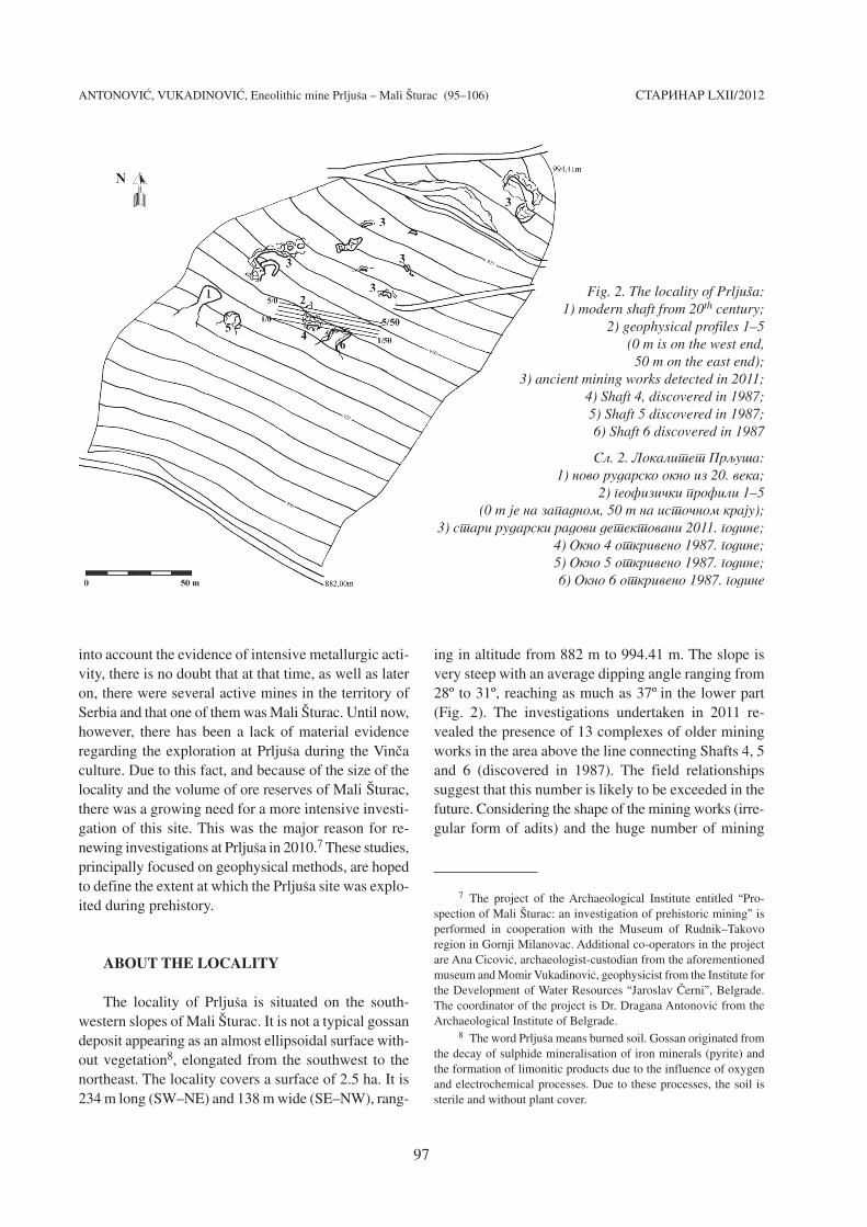
The locality of Prlju{a is situated on the south-
western slopes of Mali [turac. It is not a typical gossan
deposit appearing as an almost ellipsoidal surface with-
out vegetation8, elongated from the southwest to the
northeast. The locality covers a surface of 2.5 ha. It is
234 m long (SW–NE) and 138 m wide (SE–NW), rang-
ing in altitude from 882 m to 994.41 m. The slope is
very steep with an average dipping angle ranging from
28º to 31º, reaching as much as 37º in the lower part
(Fig. 2). The investigations undertaken in 2011 re-
vealed the presence of 13 complexes of older mining
works in the area above the line connecting Shafts 4, 5
and 6 (discovered in 1987). The field relationships
suggest that this number is likely to be exceeded in the
future. Considering the shape of the mining works (irre-
gular form of adits) and the huge number of mining
STARINAR LXII/2012
97
7 The project of the Archaeological Institute entitled “Pro-
spection of Mali [turac: an investigation of prehistoric mining” is
performed in cooperation with the Museum of Rudnik–Takovo
region in Gornji Milanovac. Additional co-operators in the project
are Ana Cicovi}, archaeologist-custodian from the aforementioned
museum and Momir Vukadinovi}, geophysicist from the Institute for
the Development of Water Resources “Jaroslav ^erni”, Belgrade.
The coordinator of the project is Dr. Dragana Antonovi} from the
Archaeological Institute of Belgrade. 8 The word Prlju{a means burned soil. Gossan originated from
the decay of sulphide mineralisation of iron minerals (pyrite) and
the formation of limonitic products due to the influence of oxygen
and electrochemical processes. Due to these processes, the soil is
sterile and without plant cover.
Fig. 2. The locality of Prlju{a: 1) modern shaft from 20th century;
2) geophysical profiles 1–5 (0 m is on the west end,
50 m on the east end); 3) ancient mining works detected in 2011;
4) Shaft 4, discovered in 1987; 5) Shaft 5 discovered in 1987; 6) Shaft 6 discovered in 1987
Sl. 2. Lokalitet Prqu{a: 1) novo rudarsko okno iz 20. veka;
2) geofizi~ki profili 1–5 (0 m je na zapadnom, 50 m na isto~nom kraju);
3) stari rudarski radovi detektovani 2011. godine; 4) Okno 4 otkriveno 1987. godine; 5) Okno 5 otkriveno 1987. godine; 6) Okno 6 otkriveno 1987. godine

ANTONOVI], VUKADINOVI], Eneolithic mine Prlju{a – Mali [turac (95–106)
hammers with grooves which were found on the surface
along the slope, it can be supposed that these were
Eneolithic and Bronze Age shafts.
The Mt. Rudnik area is characterised by a complex
geological framework.9 It consists of sedimentary,
igneous and contact-metamorphic rocks. The most
abundant sedimentary rocks are Cretaceous flysches.
The origin of igneous rocks is explained by volcanic
activity in the Mt. Rudnik area during the Oligocene
and Miocene. Dacite-andesites were formed in the
Oligocene, while the majority of volcanic rocks are re-
presented by quartzlatites which erupted in the Miocene
as huge irregular masses and tiny dikes and sills, wide-
spread in the “Rudnik” ore district. Contact-metamor-
phic rocks are represented by weakly metamorphosed,
marl-clayey sediments, sandstones and conglomerates,
as well as by products of higher grade metamorphic
rocks, such as hornfels and skarn. Intrusions of dacite-
andesites and quartzlatites were mainly controlled by
NE–SW fault systems.
The “Rudnik” lead-zinc ore deposit is polymetallic
in character and consists of a few tens of ore bodies.
The geological framework of the deposit is composed
of several rock complexes, different in genesis, age and
composition. Four main groups can be distinguished:
1. Cretaceous sedimentary complex (sandstone, breccia,
conglomerate, marl and limestone), 2. Tertiary igneous
rocks (dacite-andesite, quartzlatite and rare granitoid
rocks), 3. Contact-metamorphic complex (hornfels,
epidosite, marble, garnetite, skarn, etc.); these are
important because they host the mineralisation, and 4.
Hydrothermal breccia complex; these rocks are signif-
icant because they originated simultaneously to the
mineralisation.
GEOPHYSICAL INVESTIGATIONS
Field geophysical investigations at Prlju{a were
conducted in order to detect the spatial distribution of
subsurface mining galleries which, presumably, exist
in this area as well as to plan future excavations. It was,
therefore, decided to first investigate the space above
Shafts 6 and 4 (discovered in 1987) (Fig. 2). Pottery
shards that were found at the access platform of Shaft
6 defined the shaft chronologically as belonging to the
Late Eneolithic or Early Bronze age. The fact that the
entrance to the mining channel was discovered is the
reason to believe it is a real mining shaft. The entrance
was discovered in 1987.
Geophysical explorations were done using the
methods of self-potential – SP, electrical scanning –
ES and seismic profiling with one geophone – SGRP.
The measurements were carried out along the terrain
surface delineated by five, 50 m long, parallel sections
at 2 m intervals. The measured points at the sections
were located at every 2 m, and the sections were oriented
approximately east-west, according to archaeological
and geological facts.
Self-potential measurements were taken along the
same sections. Vertical, two-dimensional (2D) terrain
sections were defined by electrical scanning on the
basis of specific electrical resistivity. These measure-
ments, along with the measurements taken by seismic
profiling were taken along sections 1, 4 and 5.
Self-potential methodThe self-potential method (SP) is based on the
investigation of natural electrical currents which spon-
taneously appear in material below the terrain surface.
The most frequent occurrences of self-potential are
connected with the movement (i.e. filtration) of ground
water through rock masses. The most intensive appear-
ances of self potential are those related to the presence
of metallic ore deposits, where the self potential is ge-
nerated as the consequence of electrochemical proces-
ses occurring in response to interactions between ore
bodies and ground water.10
Due to the simplicity and efficacy in performing
the SP method in the field, and because of the speed
with which qualitative data can be obtained, this geo-
physical method was selected for detecting ore occur-
rences and the prehistoric mining works ,chambers
and shafts, from which the ore was extracted.
The efficacy of this method was practically exam-
ined at the Prlju{a site in 2010. On that occasion, two,
51 m long, sections were allocated – one immediately
below and another above Shafts 6 and 4 from 1987.11
After having obtained satisfactory results by the SP
method, it was decided to apply the same method of in-
vestigation to the majority of the area above the two shafts.
STARINAR LXII/2012
98
9 All information about the geological framework of the Mt.
Rudnik area presented in the paper has been obtained by the cour-
tesy of the Geological Service at “AD Rudnik i flotacija ‘Rudnik’”
in Rudnik. The authors are very grateful to geologists of the Service
for their very kind cooperation. 10 Vukadinovi} 2011, 79.11 Antonovi}, Vukadinovi} 2011.

ANTONOVI], VUKADINOVI], Eneolithic mine Prlju{a – Mali [turac (95–106) STARINAR LXII/2012
99
The SP measurements were conducted at all 5 sec-
tions; the measured points were placed at 2 m intervals
throughout a regular network of 50 x 8 m.12 The
obtained data were used for constructing a map of
potential isolines in the interval range of -30 to 45 mV
(Fig. 3).
In accordance with the physical laws and explana-
tions of the origin of self-potential in ore-bearing areas,
anomaly zones were delineated on the map. These
anomalies are controlled by negative values which in-
dicate the presence of mineralisation, e.g. the presence
of copper ore bodies. The defined anomaly zones have
a value of -10 to -30 mV (Fig. 3, from orange to red
colour in the legend).
The zones of anomalies defined by positive self-
potential values represent the zones of compact, inten-
sively silicified rock masses in which there is no mine-
ralisation. A strong silicification is also inferred by the
presence of abundant quartz aggregates on the surface.
During the measuring of the self-potential at Prlju{a
it was observed that if, in the zone of mineralisation or
ore deposit, a prehistoric pit was opened, there were
pre-conditions for the subsequent filling of the shaft with
atmospheric water. This gave rise to electrochemical
processes which generated self-potential. Furthermore,
if the shaft was not opened, the mineralisation remained
hermetically captured in compact and water-imper-
meable, highly silicified rocks. In such a scenario,
atmospheric water cannot enter and self-potential can-
not be generated. On the basis of this explanation, it
could be concluded that the detection of self-potential
anomalies at Prlju{a is most probably related to the
presence of prehistoric pits.
Electrical scanning measurementsElectrical scanning by direct current (Direct
Current Resistivity Imaging) is a commonly used tech-
nique in archaeology. It is aimed at getting 2D (two-
dimensional) terrain models in the form of a vertical
section according to a specific electrical resistivity
parameter.13 The scanning represents a method of
investigating a certain area at several depth levels
below the surface in order to detect subsurface struc-
tures (cultural remnants) and to determine their spatial
Fig. 3. Self-potential map: I) with position of adits in Shafts 4 and 6 discovered in 1987; II) with position of the zones of anomalies which represent ore deposit or prehistoric mining works
Sl. 3. Karta sopstvenog potencijala: I) sa ozna~enim ulazima u Okno 4 i Okno 6 iz 1987. godine; II) sa ozna~enim anomalijskim zonama koje predstavqaju orudwewe odnosno potencijalne stare rudarske radove
12 In the field, self-potential was measured by milivoltmetre
Voltcraft type M–3630B. The nonpolarised electrodes are of
Canadian production (Scintrex Company).13 Vukadinovi} 2011, 55.

position. Moreover, it is possible to use different types
of electrodes, depending on the aims of the investiga-
tion and the desired outcome.
At the Prlju{a site, the electrical scanning method
was chosen with the goal of creating spatial 2D detec-
tions of ore occurrences and mineralisations, i.e. pre-
historic mining works, such as mining chambers or adits
from where the ore was extracted.
After having analysed the results obtained by the
self-potential method, we concluded that the electrical
scanning should be done along sections 1, 4 and 5 be-
cause it is along these sections that the most significant
anomaly zones, indicating the presence of mineralisa-
tion extracted from prehistoric shafts, were identified.
Along the above mentioned sections, the electrical
scanning measurements were conducted at intervals of
1 m. The protocol pole-pole was used14, and a penetration
of around 10 m was achieved. The data obtained by the
measurements were processed using inversion proce-
dures and in this way 2D electrical models were pro-
duced (Fig. 4).
On these 2D electrical models, different geological
units are detected in the range between 170 and 18 000
Ohmm. The lowest values of electrical resistivity cor-
respond to copper ore (malachite), while high resistiv-
ity values indicate the presence of crystalline and sili-
cified rocks with abundant aggregates of quartz
crystals.
Based on the obtained 2D models it is observed
that copper mineralisation (malachite) is distributed in
the form of irregular steep, vertical channels. The cop-
per mineralisation has an electrical resistivity from
170 to 300 Ohmm (Fig. 4, dark blue and blue colour in
legend). These channels were created by the deposi-
tion of mineralisation during the post-magmatic
hydrothermal phase. The circulating hydrothermal flu-
ids leached copper and accompanying elements and
precipitated them along the channels, forming charac-
teristic north-northwest-south-southeast stretching ore
veins.
In section 1 (Fig. 4), two large zones with anomalies
were distinguished. The first zone is close to the terrain
surface and stretches between the 12th and 19th metre
of the section. It further reaches depths of around 10 m
where it continues from the 18th to 34th metre along
section 1. The aforementioned zone is most probably in
functional connection with Shaft 4 which has a 2–3 m
long, vertical entrance. The second anomaly zone is
isolated in the right-hand side of the 2D electrical sec-
tion, between the 38th and 48th metre along the section.
This zone is detected at depths of around 5 m and it is
most probably in functional connection with Shaft 6.
This shaft continues horizontally towards the east, i.e.
towards the central part of the mineralisation zone.
Given that there are no known shafts for correla-
tion with the results of the electrical scanning, we have
only reported the position of three anomaly zones that
have the lowest electrical resistivity in section 4 (Fig. 4).
These anomaly zones could indicate that buried shafts,
not visible from the terrain surface, also exist. The first
zone was detected at depths of around 4 m and between
the 4th and 15th metre along the section. The second
zone was detected at similar depths from the 27th to
29th metre along the section. The third zone was found
at depths of 4–5 m and from the 34th to 43rd metre along
the section.
Neither of the section 5 prehistoric shafts, whose
position can be used for correlation with the results of
electrical scanning, are present (Fig. 4). In this section
three anomaly zones with low electrical resistivity are
detected, suggesting that some shafts may be present.
The first anomaly zone is located from the 16th to 18th
metre along the section and runs vertically more than
10 m in depth. The second anomaly zone is situated from
the 25th to 27th metre, reaching depths of around 3 m.
The third anomaly zone is almost vertical and stretches
from the 37th to 42nd metre and is as deep as 10 m.
Seismic profilingThe SGRP method (Single Geophone Refraction
Profiling) represents a procedure of seismic terrain map-
ping with one or two geophones. It relies on methodo-
logical approaches used for carrying out refraction or
reflective seismic methods. The SGRP method enables
the detection of the lateral influences of geological ma-
terials and distinguishing hollowed spaces as decom-
pression zones beneath the terrain surface. In addition,
it allows the detection of vertical and subvertical dis-
continuities between various geological materials cha-
racterised by differences in seismic wave velocities.15
The application of the SGRP method at Prlju{a was
aimed at distinguishing hard and silicified rock masses
from disintegrated zones and subsurface cavities from
which prehistoric miners had extracted the raw material,
malachite.
14 The device Geophysical Resistivity & Self Potential Meter
RPM–12 IP was used for the measurements.15 Vukadinovi} 2011, 43.
ANTONOVI], VUKADINOVI], Eneolithic mine Prlju{a – Mali [turac (95–106) STARINAR LXII/2012
100

ANTONOVI], VUKADINOVI], Eneolithic mine Prlju{a – Mali [turac (95–106) STARINAR LXII/2012
101
Fig. 4. 2D resistivity sections along the profiles 1, 4 and 5
Sl. 4. Geoelektri~ni preseci po profilima 1, 4 i 5
ANTONOVI], VUKADINOVI], Eneolithic mine Prlju{a – Mali [turac (95–106)
The SGRP method was conducted using a measu-
rement network composed of an excitation point, Tx
and two reception points, Rx1 and Rx2.16 It required
acquiring the variation of seismic waves coming
between the two reception points in order to easily
recognise the influences of lateral lithological changes
or the presence of underground empty spaces, i.e. pre-
historic mining shafts.
The above described seismic profiling was perfor-
med along sections 1, 4 and 5 in order to enable easier
correlation with the results obtained by the self-potential
and electrical scanning procedures.
In section 1 (Fig. 5) two anomaly zones with con-
siderably longer arrival times of seismic waves were
observed. The first zone (from the 18th to 34th metre
along the section) with a maximum of almost 30 ms
(milliseconds) overlaps with the anomaly in electrical
resistivity, which was observed by the scanning method.
The second anomaly zone is characterised by shorter
arrival times, below 15 ms, and corresponds to the ano-
maly in the resistivity parameter, which was observed
from the 38th to 48th metre along section 1.
The SGRP measurements in section 4 (Fig. 5) de-
tected several anomaly zones characterised by longer
arrival times of seismic waves. They are essentially lo-
cated at the beginning and the end of the section. The
first anomaly established by this method is located
from the beginning to the 15th metre along section 4.
The second, smaller anomaly of longer arrival times of
seismic waves is detected around the 20th metre along
the section. It is most probably connected to the elec-
trical resistivity anomaly zone found occurring at depths
of around 8 m. The third and fourth anomaly indications
are situated between the 30th and 35th metre and between
the 45th and 50th metre along the section, respectively.
The identification of anomaly zones obtained by the
SGRP method on this section was difficult due to fre-
STARINAR LXII/2012
102
16 To measure the arrival time of seismic waves an Iskrascope
LCD type ODU0401 device was used. SN–3 geophones with a fre-
quency range of 10–14 Hz were used as geophones.
Fig. 5. Diagrams of seismic profiling along the profiles 1, 4 and 5. Position of adits in Shafts 4 and 6 discovered in 1987 is marked on the profile 1
Sl. 5. Dijagrami seizmi~kog profilisawapo profilima 1, 4 i 5. Ulazi u Okna 4 i 6 iz 1987. godine su ozna~eni na profilu 1
ANTONOVI], VUKADINOVI], Eneolithic mine Prlju{a – Mali [turac (95–106)
quent lithological changes and vertical and/or steeply
dipping structures.
The same SGRP measurements were performed
along section 5 (Fig. 5). The estimated arrival times of
seismic waves revealed the presence of two anomaly
zones situated from the 15th to 20th metre and from the
30th to 40th metre along the section. These two anomaly
zones spatially overlap with the locations of the ano-
malies detected by electrical scanning.
CONCLUSION
The field measurements performed using the geo-
physical methods of self-potential, electrical scanning
and seismic profiling at the Prlju{a site provided some
useful data and conclusions.
The self-potential method conducted along five
sections, each 50 m long, revealed the existence of
malachite mineralisation zones inferred from distinc-
tive negative values (Fig. 3). The acquired results sug-
gest that the observed anomalies are most probably the
result of the presence of subsurface prehistoric shafts.
These shafts were subsequently filled with atmospheric
water creating the necessary electrochemical conditions
for the formation of self-potential.
Electrical scanning performed on sections 1, 4 and
5 gave clearer definitions of the anomaly zones obtained
by the self-potential method. The results of these two
methods enabled the correlation and connection with
the opened prehistoric Shafts 4 and 6. This gave rise to
the detection of old mining operations in the whole
zone covered by geophysical investigations (Fig. 6).
Thus, the reconstruction of mining operations in the
zone of Shaft 6 was achieved. In section 1, from the 38th
metre to the end of the section and at depths of around
5 m, a mineralisation zone (malachite) was detected. The
altitude of this almost horizontal zone is 936 m and is
directed towards the east. The beginning of the minera-
lisation zone at the 38th metre overlaps with the entrance
of Shaft 6, which was discovered in 1987 at the eastern
end of the entrance platform. Hence, it could be expected
that the mining channel continues from the entrance
horizontally to the east for the next ten metres, and then
abruptly goes vertically down. Its termination point is
still not known because that part of the shaft was not
covered by geophysical investigations.
In section 1, from the 18th to 19th metre, there is
inferred mineralisation which has an almost vertical
position and is in direct connection with Shaft 4 (dis-
covered during archaeological excavations in 1987).
The entrance of Shaft 4 is covered with loose material
and is not visible today. According to the geophysical
data, we expect that the shaft stretches vertically down
for around 3 m from the surface and then continues
further, forming a huge, almost horizontal, underground
gallery. In fact, it is possible that it is a larger gallery or
a crossroad of two vertical mining corridors which are
situated deeper than 10 m from the surface. In this case,
geophysical investigations reaching more than 10 m
would resolve a large anomaly detected in section 1
where it connects with Shaft 4 (discovered in 1987).
If we combine the results obtained from section 1
with those acquired during the archaeological investi-
gations in 1987, and apply them to the image provided
by our geophysical studies in sections 4 and 5, we may
conclude that there were at least six mining shafts
whose entrances were situated 6 m and 8 m northwards
from shafts 4 and 6, respectively. Some of these works
penetrated 4 m in depth (2D electrical section 4: 4th–15th
metre, 27th–29th metre, 34th–43rd metre, 2D electrical
section 5: 25th–27th metre, Fig. 4) while others had depths
greater than 10 m (2D electrical section 5: 16th–18th
metre, 37th–42nd metre; Fig. 4).
The SGRP seismic profiling confirmed, albeit not
so precisely, the most probable presence of mining shafts
at the locations where anomaly zones were distin-
guished according to the parameters of self-potential
and specific electrical resistivity.
Numerous pieces of evidence of mining operation
works testify to intensive mining activity at the Prlju{a
site. The size of the entrances into some underground
galleries led previous researchers to suppose that these
shafts originated from periods younger than prehistory,
possibly even from the Medieval Age. However, the fact
that at Prlju{a malachite was found – the carbonate
copper ore which had not been exploited since the Iron
Age. i.e. since the mastering of iron melting technology,
along with the large number of stone mining hammers
located on the surface from the top to the bottom of the
locality, especially in the zone below the shafts, addi-
tionally suggest that Prlju{a was a large prehistoric mine.
The exploitation in the upper parts was carried out dur-
ing the late Eneolithic and early Bronze Age, and this is
confirmed by typical finds from Shaft 6. We presume
that in the lower parts of the slope, now covered by
thick layers of loose material, the exploitation could
have been even earlier.
Due to all these facts, we argue that geophysical
investigations should be continued along the whole
STARINAR LXII/2012
103

ANTONOVI], VUKADINOVI], Eneolithic mine Prlju{a – Mali [turac (95–106)
slope. In the upper part, above the mining works dis-
covered during the 1980’s, geophysical investigations
should be conducted in the zone where the majority of
potential shafts were detected in 2011. Such investiga-
tions should also be carried out in the lower parts of the
slope as there is a reasonable possibility that old min-
ing works and archaeological objects are hidden below
the thick layers of loose material. According to the
acquired results and taking into consideration the fore-
seen activities, it is concluded that the application of
self-potential (SP) and electrical scanning (ES) meth-
ods in using 2D and 3D variants would be most appro-
priate and most economic. The self-potential measure-
ments should cover almost the entire locality and only
at places revealing negative anomaly values, would
the presence of prehistory mining works be proved by
electrical scanning.
Translated by Kristina [ari} and Vladica Cvetkovi}
STARINAR LXII/2012
104
Fig. 6. Correlation of self-potential measurements and 2D electrical scanning along the profile 1 with the prehistoric Shafts 4 and 6 discovered in 1987; on the right is a photo of the entrance to the mining channel
of the Shaft 6 when it was discovered
Sl. 6. Korelacija rezultata merewa sopstvenog potencijala i elektri~nog skenirawa po profilu 1, sa ozna~enim u Oknima 4 i 6 iz 1987. godine; desno je slika ulaza u Okno 6 iz vremena kada je otkriven

Antonovi} 2002 – D. Antonovi}, Copper processing
in Vin~a: new contribution to the thesis about metallur-
gical character of Vin~a culture, Starinar LII (2002),
27–45.
Antonovi}, Vukadinovi} 2011 – D. Antonovi},
M. Vukadinovi}, Prqu{a – Mali [turac: novaistra`ivawa praistorijskog rudnika na Rudniku,
Na{a pro{lost 12, 35–45.
Bogosavqevi} 1988 – V. Bogosavqevi}, Pokret-ni materijal sa praistorijskog rudnika na Malom[turcu, Zbornik radova Narodnog muzeja XVIII
(1988), ^a~ak, 13–35.
Derikonji} et al. 2011 – S. Derikonji}, M. Radivo-
jevi}, E. Pernicka and Th. Rehren, The Vin~a culture
mining complex in Jarmovac, southwest Serbia, in A.
Hauptmann, D. Modarressi-Tehrani & M. Prange eds.,International Conference Archaeometallurgy in EuropeIII, 29 June – 1st July 2011, Bochum, Metalla Sonderheft
4, Bochum, 39.
Jovanovi} 1982 – B. Jovanovi}, Rudna Glava: naj-starije rudarstvo bakra na centralnom Balkanu, Bor,
Beograd.
Jovanovi} 1988 – B. Jovanovi}, Prqu{a – Mali[turac: praistorijski rudnik bakra i gorskog kri-stala na Rudniku, Zbornik radova Narodnog muzejaXVIII, ^a~ak, 5 – 12.
Radivojevi} 2007 – M. Radivojevi}, Evidence forearly copper smelting in Belovode, a Vin~a culture sitein Eastern Serbia, Unpublished MSc Thesis, London
UCL Institute of Archaeology, 2007.
Radivojevi} et al. 2010 – M. Radivojevi}, T. Rehren,
E. Pernicka, D. [ljivar, M. Brauns, D. Bori}, On the
origins of extractive metallurgy: new evidence from
Europe, Journal of Archaeological Science 37 (2010),
2775–2787.
[ljivar et al. 2006 – D. [ljivar, J. Kuzmanovi}-
Cvetkovi}, D. Jacanovi}, Belovode – Plo~nik, new con-
tributions regarding the copper metallurgy in the Vin~a
culture, in: Homage to Milutin Gara{anin (N. Tasi}, C.
Grozdanov, eds.), Serbian Academy for Science and Arts,
Belgrade, 251 – 266.
Vukadinovi} 2011 – M. Vukadinovi}, Primena geo-fizike u arheologiji, Kraljevo.
BIBLIOGRAPHY:
ANTONOVI], VUKADINOVI], Eneolithic mine Prlju{a – Mali [turac (95–106) STARINAR LXII/2012
105
Ime Malog [turca odavno je poznato u arheologiji kao na-ziv eneolitskog rudnika bakra. Do wegovog otkri}a do{loje jo{ davne 1980. godine tokom rekognoscirawa planineRudnik u okviru jednog novog projekta. Arheolo{ka istra-`ivawa vr{ena su od 1981. do 1989. godine. Tada su otkri-vene ulazne platforme u {est praistorijskih rudarskihokana. Daqe iskopavawe detektovanih okana nikada nijeizvr{eno. Malobrojan arheolo{ki materijal prikupqentokom iskopavawa sastojao se od ve}eg broja rudarskih ba-tova, ulomaka rudarskih alatki od jelenskog roga i malihfragmenata keramike iz kasnog eneolita ili ranog bronza-nog doba. Kako je u me|uvremenu, tokom proteklih deceni-ja, u~iwen znatan pomak u prou~avawu po~etaka metalurgijena tlu Srbije, pitawe porekla rude bakra od koje se topio
prvi metal na ovom tlu postalo je vrlo aktuelno. Do sada jena ovim prostorima pouzdano dokumentovan samo jedan rud-nik iz vremena vin~anske kulture – Rudna Glava u isto~nojSrbiji. Nema sumwe da je u to vreme, ali i kasnije, s obzi-rom na intenzivnu metalur{ku aktivnost, bilo vi{e aktiv-nih rudnika na teritoriji Srbije i da je Mali [turac biojedan od wih.
Lokalitet Prqu{a nalazi se na jugozapadnoj padiniMalog [turca. Re~ je o ne ba{ tipi~nom „gvozdenom {e{i-ru“ – povr{ini bez vegetacije, skoro elipsoidno izdu`enojpravcem jugozapad–severoistok. Lokalitet ima povr{inuoko 2,5 ha i prostire se od 882 m u podno`ju do 994,41 mnadmorske visine pri vrhu padine. Re~ je o veoma strmojpadini sa nagibom od 28º do 37º. Tokom istra`ivawa 2011.
Kqu~ne re~i. – rudnik bakra, geofizi~ka istra`ivawa, eneolit, arheometalurgija, Srbija.
Rezime: DRAGANA ANTONOVI], Arheolo{ki institut, Beograd
MOMIR VUKADINOVI], Institut za vodoprivredu „Jaroslav ^erni“, Beograd
ENEOLITSKI RUDNIK PRQU[A – MALI [TURAC
ARHEOLO[KA I GEOFIZI^KA ISTRA@IVAWA

ANTONOVI], VUKADINOVI], Eneolithic mine Prlju{a – Mali [turac (95–106) STARINAR LXII/2012
106
godine na delu padine iznad linije koju ~ine okna 4, 5 i 6,otkrivena 1987. godine, konstatovano je 13 kompleksa starihrudarskih radova. Prema izgledu rudarskih radova (ulazinepravilnog oblika) i velikom broju kamenih batova sa`lebom, na koje se nailazi na povr{ini do samog vrha pa-dine, pretpostavqamo da je re~ o eneolitskim i bronzano-dobnim oknima.
Geofizi~ka istra`ivawa sprovedena 2011. godine uzoni, veli~ine 400 m², iznad Okna 4 i Okna 6 dala su nekekorisne podatke i zakqu~ke.
Metodom sopstvenog potencijala, du` pet profila po-jedina~ne du`ine od po 50 m, detektovana su mesta odnosnozone orudwewa malahita na osnovu izrazito negativnihvrednosti (sl. 3). Prema dobijenim rezultatima mo`e sezakqu~iti da se anomalije najverovatnije stvaraju iskqu-~ivo u zoni praistorijskih okana koja su tokom vremena za-puwena i u koje je u{la atmosferska voda, koja je stvorilaneophodan uslov za elektrohemijsko generisawe sopstve-nog potencijala.
Geoelektri~no skenirawe izvedeno na profilima 1, 4 i5 jasnije je definisalo anomalijske zone dobijene metodomsopstvenog potencijala (sl. 4). Na osnovu dobijenih rezul-tata pomo}u ove dve metode sa~iwena je me|usobna korela-cija i veza sa otkrivenim praistorijskim oknima 4 i 6 (sl.6), a prema tome i detektovawe starih rudarskih radova uceloj zoni obuhva}enoj geofizi~kim istra`ivawima. Takoje izvr{ena rekonstrukcija rudarskih radova u zoni Okna 6.Na profilu 1, po staciona`i od 38. metra do kraja profi-la, sa dubinom zalegawa od oko 5 m, detektovana zona orudwe-wa (malahit) prostire se ka istoku, nalazi se pribli`nona koti 936 m i ima skoro horizontalni polo`aj. Po~etakzone orudwewa na 38. metru poklapa se sa ulazom u Okno 6,koji je 1987. godine otkriven na isto~nom kraju ulazneplatforme. Zato se mo`e o~ekivati da se od ulaza rudarskikanal horizontalno nastavqa ka istoku narednih deset me-tara, a da se zatim naglo vertikalno spu{ta u dubinu. Krajmu za sada nije detektovan, po{to taj deo hodnika nije obu-hva}en geofizi~kim snimawem.
Na profilu 1, na staciona`i od 18. do 19. metra detek-tovano je prisustvo orudwewa koje ima skoro vertikalniprostorni polo`aj i u neposrednoj je vezi sa Oknom 4 otkri-venim arheolo{kim iskopavawem 1987. godine. Ulaz u Okno4 zasut je siparom i danas se vi{e ne vidi. Prema rezultati-ma geofizi~kog ispitivawa o~ekujemo da se okno vertikalnospu{ta oko tri metra od povr{ine tla, a da zatim prelazi uskoro horizontalnu prostranu podzemnu galeriju. Zapravo,mogu}e je da je re~ ili o ve}oj galeriji ili o ukr{tawu dvavertikalna hodnika koja se spu{taju dubqe od 10 m ispodpovr{ine tla. Geofizi~ko ispitivawe sa dubinskim za-hvatom ve}im od 10 m dalo bi u ovom slu~aju razre{ewe ve-
like anomalije konstatovane na profilu 1 u delu koji sepovezuje sa Oknom 4 iz 1987. godine.
Ako se rezultati koji su dobijeni za profil 1 i wiho-va korelacija sa rezultatima arheolo{kih ispitivawa iz1987. godine primene na sliku dobijenu geofizi~kim sni-mawem za profile 4 i 5, onda se mo`e re}i da je postojalobar {est rudarskih okana ~iji su se ulazi nalazili na uda-qenosti od 6 m i 8 m severno od okana 4 i 6. Neki od ovihradova i{li su do dubine od 4 m (2D geoelektri~ni presekprofila 4: 4–15. metra, 27–29. metra, 34–43. metra; 2D geo-elektri~ni presek profila 5: 25–27. metra; sl. 4), a nekisu imali dubinu ve}u od 10 m (2D geoelektri~ni presekprofila 5: 16–18. metra, 37–42. metra; sl. 4).
Primenom seizmi~kog profilisawa metodom SGRP
potvr|eno je, mada ne potpuno precizno, najverovatnije po-stojawe rudarskih okana na mestima gde se pojavquju ano-malijske zone po parametrima sopstvenog potencijala ispecifi~ne elektri~ne otpornosti.
O intenzivnoj rudarskoj aktivnosti na Prqu{i svedo-~e brojni vidqivi stari rudarski radovi. Veli~ina ulazau podzemne galerije kod nekih od wih navela je nekada{weistra`iva~e na pretpostavku da se radi o oknima iz perio-da mla|ih od praistorije, mogu}e ~ak iz sredweg veka. Me|u-tim, ~iwenica da je na Prqu{i va|en malahit, karbonatnaruda, kao i veliki broj kamenih rudarskih batova koji senalaze svuda po povr{ini lokaliteta, a posebno oko okana,govori u prilog tome da je cela Prqu{a bila jedan velikipraistorijski rudnik. U gorwim delovima eksploatacijaje vr{ena tokom kasnog eneolita i ranog bronzanog doba,{to je potvr|eno karakteristi~nim nalazima iz Okna 6.Pretpostavqamo da je u dowim delovima padine, sada pre-krivenim debelim slojem sipara, i pre ovog vremena moglabiti vr{ena eksploatacija rude.
Zato bi svakako trebalo da se nastave geofizi~ka ispi-tivawa na celoj padini. U gorwem delu, iznad rudarskih ra-dova otkrivenih tokom osamdesetih godina dvadesetog veka,ispitivawe geofizi~kim metodama trebalo bi izvesti uzoni ve}ine potencijalnih okana koja su detektovana 2011.godine. U dowem delu padine bi tako|e trebalo izvr{itiispitivawa ove vrste, po{to postoji mogu}nost da se ispoddebelih naslaga sipara kriju stari rudarski radovi i arhe-olo{ki objekti. Prema dobijenim rezultatima dosada{wihgeofizi~kih istra`ivawa na lokalitetu Prqu{a zakqu~e-no je da bi u sklopu budu}ih radova primena metoda sopstve-nog potencijala (SP) i elektri~nog skenirawa (EK) u vari-jantama 2D i 3D bila najsvrsishodnija i najekonomi~nija.Merewem pomo}u metode sopstvenog potencijala prekrio bise ve}i prostor lokaliteta, a samo na mestima sa negativnimanomalijskim vrednostima bi se elektri~nim skenirawempotvrdilo prisustvo rudarskih radova iz praistorije.
Copyright © 2022 FDOKUMEN